Phase Two Environmental Site Assessment, 683 and 685 ...
139
REPORT Phase Two Environmental Site Assessment, 683 and 685 Warden Avenue, Toronto, Ontario Part 2 of Contaminated Site Assessment Submitted to: Choice Properties Limited Partnership 22 St Clair Ave E. Suite 700 Toronto, ON M4T 2S5 Submitted by: Golder Associates Ltd. #1, 215 Shields Court, Markham, Ontario, L3R 8V2, Canada +1 905 475 5591 20139596(3000) June 28, 2021
-
Upload
khangminh22 -
Category
Documents
-
view
0 -
download
0
Transcript of Phase Two Environmental Site Assessment, 683 and 685 ...

REPORT
Phase Two Environmental Site Assessment, 683 and 685 Warden Avenue, Toronto, Ontario Part 2 of Contaminated Site Assessment
Submitted to:
Choice Properties Limited Partnership 22 St Clair Ave E. Suite 700 Toronto, ON M4T 2S5
Submitted by:
Golder Associates Ltd. #1, 215 Shields Court, Markham, Ontario, L3R 8V2, Canada
+1 905 475 5591
20139596(3000)
June 28, 2021

June 28, 2021 20139596(3000)
i
Distribution List
1 copy (.pdf) - Choice Properties Limited Partnership
1 copy (.pdf) - Golder Associates Ltd.

June 28, 2021 20139596(3000)
ii
Executive Summary
Golder Associates Ltd. (“Golder”) was retained by Choice Properties Limited Partnership (the “Client”) to undertake a Phase Two Environmental Site Assessment (“Phase Two ESA”) at 683-685 Warden Avenue, Toronto, Ontario (hereinafter referred to as the “Site” or the “Phase Two Property”), as shown on Figure 1.
Golder previously completed a Phase One ESA for the Site, the results of which were documented in the report titled “Phase One Environmental Site Assessment, 683 and 685 Warden Avenue, Toronto, Ontario”, dated April 20, 2020. Based on the findings of the Phase One ESA, Golder completed this Phase Two ESA investigation.
The analytical results from the sampling and analysis program indicated that all parameters tested in soil and groundwater, as defined by Ontario Regulation (“O. Reg.) 153/04, at the Phase Two Property meet the applicable Ministry of Environment, Conservation and Parks (“MECP”) Table 3 Site condition standards.
Based on the above and in support of the filing of a Record of Site Condition (“RSC”), a Modified Generic Risk Assessment (“MGRA”) is not required.
It is noted that although all soil and groundwater samples collected during this Phase Two ESA satisfied the generic Table 3 site condition standards (“SCS”), historic environmental investigations indicate the potential presence of polycyclic aromatic hydrocarbon (“PAH”) impacts to shallow soil at unspecified locations across the Site. As such, it is recommended that shallow soil be stripped and tested for PAH as part of Site preparation for future redevelopment prior to removal from, or reuse on the Site.

June 28, 2021 20139596(3000)
iii
Table of Contents
1.0 INTRODUCTION ............................................................................................................................................. 1
1.1 Site Description .................................................................................................................................... 1
1.2 Property Ownership ............................................................................................................................. 1
1.3 Current and Proposed Future Uses ..................................................................................................... 1
1.4 Applicable Site Condition Standards .................................................................................................... 2
2.0 BACKGROUND INFORMATION .................................................................................................................... 2
2.1 Physical Setting .................................................................................................................................... 3
2.2 Past Investigations ............................................................................................................................... 3
2.2.1 Phase One ESA .............................................................................................................................. 3
2.2.2 Previous Environmental Investigations ........................................................................................... 6
3.0 SCOPE OF THE PHASE TWO ESA INVESTIGATION ................................................................................. 6
3.1 Overview of Site Investigation .............................................................................................................. 6
3.2 Media Investigated ............................................................................................................................... 7
3.3 Phase One Conceptual Site Model ...................................................................................................... 7
3.4 Deviations from Sampling and Analysis Plan ...................................................................................... 9
3.5 Impediments ......................................................................................................................................... 9
4.0 INVESTIGATION METHOD ............................................................................................................................ 9
4.1 General ................................................................................................................................................. 9
4.2 Drilling ................................................................................................................................................ 10
4.3 Soil: Sampling .................................................................................................................................... 10
4.4 Soil: Field Screening Measurements ................................................................................................. 10
4.5 Groundwater: Monitoring Well Installation ......................................................................................... 11
4.6 Groundwater: Field Measurements for Water Quality Parameters ................................................... 11
4.7 Groundwater: Development, Purging and Sampling ......................................................................... 11
4.8 Sediment: Sampling ........................................................................................................................... 12
4.9 Analytical Testing ............................................................................................................................... 12

June 28, 2021 20139596(3000)
iv
4.10 Residue Management Procedures .................................................................................................... 12
4.11 Elevation Surveying ........................................................................................................................... 12
4.12 Quality Assurance and Quality Control Measures ............................................................................. 12
5.0 REVIEW AND EVALUATION ....................................................................................................................... 13
5.1 Geology .............................................................................................................................................. 14
5.2 Groundwater: Elevations and Flow Direction ..................................................................................... 14
5.3 Groundwater: Hydraulic Gradients ..................................................................................................... 15
5.4 Soil: Texture ....................................................................................................................................... 15
5.5 Soil: Field Screening .......................................................................................................................... 15
5.6 Soil: Quality ........................................................................................................................................ 15
5.7 Groundwater: Quality ......................................................................................................................... 16
5.8 Sediment Quality ................................................................................................................................ 16
5.9 Quality Assurance and Quality Control Results ................................................................................. 16
5.10 Phase Two Conceptual Site Model .................................................................................................... 17
5.10.1 Phase One ESA Information ......................................................................................................... 17
5.10.2 Potentially Contaminating Activities .............................................................................................. 17
5.10.3 Areas of Potential Environmental Concern ................................................................................... 21
5.10.4 Subsurface Structures and Utilities ............................................................................................... 26
5.10.5 Physical Setting ............................................................................................................................. 27
5.10.5.1 Topography ................................................................................................................................... 27
5.10.5.2 Stratigraphy ................................................................................................................................... 27
5.10.5.3 Hydrogeological Characteristics ................................................................................................... 27
5.10.6 Applicable Standards .................................................................................................................... 28
5.10.7 Contaminated Media ..................................................................................................................... 28
5.10.8 Contaminants Exceeding Applicable Standards at the Site ......................................................... 28
5.10.9 Description of Areas of Contamination on the Property ............................................................... 29
5.10.10 Potential Influence of Utilities on Contaminant Migration ............................................................. 29
5.10.11 Description of Contaminants ......................................................................................................... 29
5.10.12 Migration of Contaminants ............................................................................................................ 29

June 28, 2021 20139596(3000)
v
5.10.13 Meteorological and Climatic Considerations ................................................................................. 29
5.10.14 Potential for Soil Vapour Intrusion ................................................................................................ 29
6.0 CONCLUSIONS ............................................................................................................................................ 29
7.0 REFERENCES .............................................................................................................................................. 30
8.0 LIMITATIONS ................................................................................................................................................ 30
9.0 CLOSURE ..................................................................................................................................................... 31
TABLES
No table of figures entries found.
Table 1: Monitoring Well Construction Details
Table 2: Groundwater Elevations
Table 3: Summary of Soil Samples Submitted for Laboratory Analysis
Table 4: Summary of Groundwater Samples Submitted for Laboratory Analysis
Table 5A: Summary of Soil Analytical Results – Metals, Hydride Metals and ORP
Table 5B: Summary of Soil Analytical Results – Polycyclic Aromatic Hydrocarbons
Table 5C: Summary of Soil Analytical Results – Petroleum Hydrocarbons
Table 5D: Summary of Soil Analytical Results – Volatile Organic Compounds
Table 5E: Summary of Soil Analytical Results – Biphenyls Polychlorinated
Table 6A: Summary of Groundwater Analytical Results – Metals, Hydride Metals and ORP
Table 6B: Summary of Groundwater Analytical Results – Polycyclic Aromatic Hydrocarbons
Table 6C: Summary of Groundwater Analytical Results – Petroleum Hydrocarbons
Table 6D: Summary of Groundwater Analytical Results – Volatile Organic Compounds
Table 6E: Summary of Groundwater Analytical Results – Biphenyls Polychlorinated
FIGURES
No table of figures entries found.
Figure 1: Key Plan
Figure 2: Potentially Contaminating Activities
Figure 3: Areas of Potential Environmental Concern
Figure 4: Phase Two Property Plan

June 28, 2021 20139596(3000)
vi
Figure 5A: Cross Section A-A’
Figure 5B: Cross Section B-B’
Figure 6: Groundwater Elevations – March 26, 2020
APPENDICES
APPENDIX A Legal Plan of Survey
APPENDIX B Laboratory Certificates of Analysis
APPENDIX C Correspondence with the Municipality Regarding Use of Non-Potable Standards
APPENDIX D Sampling and Analysis Plan
APPENDIX E Record of Borehole Sheets

June 28, 2021 20139596(3000)
1
1.0 INTRODUCTION 1.1 Site Description Golder was retained by Choice Properties Limited Partnership to conduct a Phase Two ESA of the following property:
Municipal Address 683 and 685 Warden Avenue, Toronto, Ontario
Property Identification Number 06449-0174 (LT), 06449-0173 (LT), 06449-0270 (LT)
Legal Description Part of Lot 32, Concession B, City of Toronto; designated as Parts 1-25 on Reference Plan 66R-24263.
Size of the Phase Two Property 6.52 acres
The location of the Phase Two Property is provided in Figure 1. The above referenced Plan of Survey are provided in Appendix A. The boundaries of the Phase Two Property as provided by the client, which are the same as the RSC property boundaries, is shown in Figure 2.
The Site (shown in Figure 2) consists of approximately 2.63 hectares (6.52 acres) of land. At the time of the field investigation, which was initiated in March 2020, the Site was an empty land parcel partially covered with gravel areas on the south and grassed areas on the central and north portions. The Site building and associated parking area was demolished in 2009.
1.2 Property Ownership Authorization to proceed with this investigation was received from Mr. Farid Malek of Choice Properties REIT on January 24, 2020. The contact information for the Client and the Phase One Property owner is:
Site Owner / Client Address Contact Name Choice Properties REIT 175 Bloor Street East
North Tower, Suite 1400 Toronto, Ontario M4W 3R8
Mr. Farid Malek Telephone: 416-324-7913 Email: [email protected]
1.3 Current and Proposed Future Uses The Site is currently undeveloped with soil and vegetated areas on the northern and central portion of the Site, and gravel areas on the southern area of the Site. The proposed future use of the Phase Two Property is a residential development. Given the former use of the Site and the proposed land use change, it is understood that a Record of Site condition is required for the Site, as per O. Reg. 153/04. The future land use is considered residential under O.Reg. 153/04.

June 28, 2021 20139596(3000)
2
1.4 Applicable Site Condition Standards The analytical results of soil and groundwater samples collected for this Phase Two ESA were compared to the Table 3 generic Site conditions standards (residential/parkland/institutional property use, medium to fine soil texture) presented in the Ontario Ministry of the Environment (MOE1) document titled “Soil, Ground Water and Sediment Standards for Use under Part XV.1 of the Environmental Protection Act, April 15, 2011”. The applicable Site condition standards were selected based on the following rationale:
The Phase Two Property is not located in an area designated in a municipal official plan as a well-head protection area or other designation identified by the municipality for the protection of ground water;
No water bodies were identified on the Phase Two Property;
The proposed future use of the Site is residential;
Based on field observations and grain size analysis results (refer to Appendix B) from soil samples collected from boreholes, the soil present at the Site is estimated to consist of soil having a grain size distribution with 50 percent or more by mass of particles that are smaller than 75 µm mesh. Under the definition presented in O. Reg. 153/04, the soil at the Site is therefore considered to be medium and fine textured;
The Site and surrounding properties located in whole or in part within 250 metres of the Site are within an area that is municipally serviced by a water supply that does not rely on potable groundwater as its source;
The closest water body is Massey Creek, which is located approximately 180 m west of the Site;
There are no features on the Phase Two Property that would meet the conditions of an environmentally sensitive Site, as described in Section 41;
The pH of soil at the Site is greater than 5 and less than 9;
The overburden thickness is greater than 2 metres over more than one-third of the Phase Two Property; and
The average depth to groundwater at the Site is 5.27 mbgs.
Based on the above, the MECP 2011 Table 3 Standards, which includes quality standards for soil and groundwater, were used to assess the environmental conditions at the Site.
2.0 BACKGROUND INFORMATION This section presents the background conditions of the Phase Two Property including a description of the physical setting and a summary of past investigations conducted.
The objectives of the Phase Two ESA were to obtain information about environmental conditions in the soil and groundwater on, in or under the Site, and to develop the information necessary to complete a Record of Site Condition (“RSC”) for the property. The objectives of this Phase Two ESA were achieved by:
Developing an understanding of the geological and hydrogeological conditions at the Site; and
1 MOE was renamed the MECP; however, the generic site condition standards and associate guidance documents were released by the MOE
and the standards are still legally referred to as the MOE standards.

June 28, 2021 20139596(3000)
3
Conducting field sampling for all contaminants of concern (“COCs”) associated with each area of potential environmental concern (“APEC”) identified in the Phase One ESA.
2.1 Physical Setting The site consists of a rectangular parcel of land with a strip of land on the northeast corner of the property that goes behind the neighbouring property to the north. The Site is located on the east side of the Warden Avenue, in Toronto. The nearest water body is Massey Creek which is located approximately 180 m west of the Site, which flows south and then west to Don River East Branch (4.4 Km west). Land uses surrounding the Site are community, residential, commercial and industrial.
The topography of the central to northern portion of the Site was generally higher than the southern portion of the Site and surrounding areas. Generally, a gentle slope to the south is present. There are no surface water drainage feature on the Phase Two ESA Site.
2.2 Past Investigations 2.2.1 Phase One ESA Golder conducted a Phase One ESA entitled, “Phase One Environmental Site Assessment, 683 and 685 Warden Avenue, Toronto, Ontario”, dated April, 2020, to assess the likelihood of soil and/or groundwater contamination resulting from historic or present activities at the Site and surrounding area. This included a review of available historical information on the Site and surrounding area, interviews with persons familiar with the Site and a Site reconnaissance. The location of Potentially Contaminating Activities identified via the Phase One ESA are shown on Figure 2. The location of APECs identified based on the Phase One ESA are shown on Figure 3 and summarized below:
PCA #
Area of Potential Environmental Concern1
Location of Area of Potential Environmental Concern on Phase One Property
Potentially Contaminating Activity2
Location of PCA (on-Site or off-Site)
Contaminants of Potential Concern3
1 APEC A1 - Fill was reported to be present at the Site up to a maximum depth of 5.5 m below grade. In addition, stockpiles of material are noted at ground surface.
Across the Site #30. Importation of Fill Material of Unknown Quality
On-Site PHC, PAH, metals, hydride metals and ORP
2 APEC A2 - Previously identified soil exceedance of anthracene (the exact location of this exceedance is unknown).
Site wide Other On-Site PAH
3 APEC A3 - Previously identified soil exceedance of benzo(a)pyrene (the exact location of this exceedance is unknown).
Site wide Other On-Site PAH

June 28, 2021 20139596(3000)
4
PCA #
Area of Potential Environmental Concern1
Location of Area of Potential Environmental Concern on Phase One Property
Potentially Contaminating Activity2
Location of PCA (on-Site or off-Site)
Contaminants of Potential Concern3
4 APEC B1 - The Site was historically operated as an industrial facility for the manufacturing of metal sash windows between 1955 and the early 1970s.
Former building area #34. Metal Fabrication
On-Site PHC, PAH, VOC, metals, hydride metals and ORP
5 APEC B2 - The former industrial activities included painting activities and storage. This included spray painting and powder paint applications.
Former building area #39. Paints Manufacturing, Processing and Bulk Storage
On-Site VOC
6 APEC B3 - The Site was historically operated as a glass manufacturing facility between the late 1970s and the 1980s.
Former building area #29. Glass Manufacturing
On-Site VOC, metals, hydride metals and ORP
7 APEC B4 - The Site was historically operated as a mattress manufacturing facility between the 1990s and 2009.
Former building area #54. Textile Manufacturing and Processing
On-Site PHC, BTEX, VOC
8 APEC B5 - The Site was historically operated as a transformer manufacturing facility during the 1970s.
Former building area #55. Transformer Manufacturing, Process and Use
On-Site PHC, PCB
9 APEC B6 - An oil-water interceptor was historically located within the former industrial building.
Former building area Other On-Site PHC, BTEX, VOC
10 APEC B7 - A concrete box filled with impacted soil was previously identified within the former building.
Former building area Other On-Site PHC, PAH, VOC
11 APEC C1 - Two transformers were previously located in the northwest portion of the Site (northwest of the former building).
Area north of the western portion of former building.
#55. Transformer Manufacturing, Process and Use
On-Site PCB

June 28, 2021 20139596(3000)
5
PCA #
Area of Potential Environmental Concern1
Location of Area of Potential Environmental Concern on Phase One Property
Potentially Contaminating Activity2
Location of PCA (on-Site or off-Site)
Contaminants of Potential Concern3
12 APEC D1 - A fuel oil UST was previously located northwest of the former building. In addition, groundwater exceedances of PHC F3 and F4 were previously identified in the vicinity of the former UST.
Area north of the western portion of former building.
#28. Gasoline and Associated Products Storage in Fixed Tanks
On-Site PHC, BTEX, PAH
13 APEC E1 - A railway spur was previously located north of the building, entering from the east. The spur was removed at some point between 1975 and 1985.
Northern and eastern portions of the Site.
#46. Rail Yards, Tracks and Spurs
On-Site PHC, PAH, metals, hydride metals and ORP
14 APEC F1 - An engine derailment, resulting in a release of 500 L of diesel fuel to the ground was reported at 689 Warden Avenue (immediately north) in 1991. It is inferred that this property had a diesel tank.
Northern boundary of the Site
#28. Gasoline and Associated Products Storage in Fixed Tanks
Off-Site PHC, BTEX
15 APEC F2 - Various industrial activities were reported at the facility located at 689 Warden Avenue (immediately north). This included the generation of various hazardous wastes.
Northern boundary of the Site
Other Off-Site PHC, PAH, BTEX, VOC, metals, hydride metals and ORP
16 APEC F3 - A facility called Toronto Winsun Laundry was previously located at 689 Warden Avenue (immediately north), and reported a release of “blowdown water”. It is unknown if any dry cleaning operations took place at this location.
Northern boundary of the Site
#37. Operation of Dry Cleaning Equipment (where chemicals are used)
Off-Site VOC
Notes: 1 Area of potential environmental concern means the area on, in or under a phase one property where one or more contaminants are potentially
present, as determined through the phase one environmental Site assessment, including through, •(a) identification of past or present uses on, in or under the phase one property, and •(b) identification of potentially contaminating activity
2 Potentially contaminating activity means a use or activity set out in Column A of Table 2 of Schedule D that is occurring or has occurred in a phase one study area
3 Contaminants of potential concern specified using the method groups as identified in the "Protocol for in the Assessment of Properties under Part XV.1 of the Environmental Protection Act, March 9, 2004, amended as of July 1, 2011
4 Metals – Antimony (As), Arsenic (As), Ba (Barium), Beryllium (Be), Boron (B), Cadmium (Cd), Chromium (Cr), Cobalt (Co), Copper (Cu), Lead (Pb), Molybdenum (Mo), Nickel (Ni), Selenium (Se), Silver (Ag), Thallium (Th), Uranium (U), Vanadium (V), Zinc (Zn); ORP – Hexavalent Chromium (Cr-VI), Sodium (Na), Mercury (Hg), Hot Water Soluble Boron (B-HWS), Chloride (Cl-), Cyanide (CN-), Sodium Adsorption Ratio (SAR), Electrical Conductivity (EC); PHC – Petroleum Hydrocarbons; BTEX – Benzene, Toluene, Ethylbenzene and Xylenes; VOC – Volatile Organic Compounds; PAH – Polycyclic Aromatic Hydrocarbons.

June 28, 2021 20139596(3000)
6
2.2.2 Previous Environmental Investigations Several previous environmental investigations have been carried out at the Site and are summarized in the Phase One ESA report, as referenced above. The findings of these previous investigations were considered as part of the Phase One ESA. None of the analytical data from these previous investigations has been incorporated into this Phase Two ESA.
3.0 SCOPE OF THE PHASE TWO ESA INVESTIGATION The objective of this Phase Two ESA was to assess the presence or absence of impact associated with the APECs as identified in the Phase One ESA, to assess the vertical extent of soil and groundwater contaminants identified at the Site, and to support the filing of a RSC for the Site.
3.1 Overview of Site Investigation The Phase Two ESA was carried out in March 2020 and included the following tasks:
Health and Safety Plan: A Health and Safety Plan for internal and subcontractor use was prepared prior to initiating fieldwork at the Site in 2020.
Subsurface utilities in the areas of investigation: Prior to drilling, Golder contacted local public utilities and retained the services of a private contractor to locate and identify potential buried services within the general areas of the proposed test locations before commencing intrusive investigations at the Site.
Sampling and analysis plan: Golder prepared a sampling and analysis plan prior to conducting the filed investigation (refer to Appendix C).
Borehole drilling and monitoring well installation: The borehole drilling program was conducted between March 9 and 12, 2020 and included drilling of seven boreholes, of which, six were completed as groundwater monitoring wells. The location of the boreholes and monitoring wells are provided in Figure 4. The monitoring well construction details are presented in Table 1.
Soil sampling: Selected soil samples were collected between March 9 and 12, 2020 from the boreholes. Soil samples were submitted for chemical analysis of one or more of the following: petroleum hydrocarbons (“PHCs”) plus benzene, toluene, ethylbenzene and xylenes (“BTEX”), volatile organic compounds (“VOCs”), polycyclic aromatic hydrocarbons (“PAHs”), polychlorinated biphenyls (“PCBs”), metals and inorganics.
Well development, groundwater monitoring and sampling: Golder collected groundwater samples on March 26, 2020 from six newly installed monitoring wells (BH20-1 to BH20-6). The groundwater samples were submitted for one or more of VOCs, PHCs, BTEX, PAHs, PCBs, metals and inorganics. A summary of the groundwater samples submitted for analysis is presented in Table 3.
Surveying: An elevation survey for the boreholes and monitoring wells used in conjunction with this Phase Two ESA was completed by Golder on March 27, 2020
Reporting: Golder complied and assessed the field and laboratory results from the above noted activities into this report.
The Phase Two ESA investigation was carried out in general accordance with Golder’s standard operating procedures which conform to the requirements of O. Reg. 153/04. The Sampling and Analysis Plan for this Phase Two ESA is provided in Appendix C. The data from this Phase Two ESA investigation completed by Golder at the

June 28, 2021 20139596(3000)
7
Site were incorporated into a single Phase Two ESA report following the Phase Two ESA report format and content required by O. Reg. 153/04.
There were no impediments or access limitations that would affect the conclusions of the Phase Two ESA report.
3.2 Media Investigated To address the potential environmental issues identified in the Phase One ESA, the Phase Two ESA field program included sampling of soil from boreholes, and groundwater from monitoring wells screened within overburden at the Site. No sediment was present at the Site and therefore no sediment sampling was completed. Details of the parameters analysed in soil and groundwater samples are presented in Tables 3 and 4. The sampling and analysis plan (refer to Appendix C) outlines the rationale for the field investigation activities carried out at the Site and the associated methodologies used to meet the objectives of this Phase Two ESA.
3.3 Phase One Conceptual Site Model The following key Site features (as required by O.Reg. 153/04) are presented in Figures 1, 2, and 3:
Existing buildings and structures;
Water bodies and areas of natural significance located in the Phase One Study Area;
Drinking water wells on the Phase One Property;
Roads (including names) within the Phase One Study Area;
Uses of properties adjacent to the Phase One Property; and,
Location of identified PCAs in the Phase One Study Area (including any storage tanks).
The following describes the Phase One ESA CSM based on the information obtained and reviewed as part of this Phase One ESA:
The Phase One Property consisted of a 2.6 hectare parcel of undeveloped land. No buildings or structures were noted on the Phase One Property. The surrounding properties within the Phase One Study Area included residential, commercial, industrial and parkland land uses;
No water bodies or areas of natural significance were identified on or within 30 m of the Phase One Property;
Potable water in the vicinity of the Phase One Property is provided by the City of Toronto and is obtained from Lake Ontario. No potable water wells were identified on the Phase One Property or within the Phase One Study Area;
Historically, the Phase One Property was previously used for agricultural purposes since prior to 1947 and was later developed with an industrial building in 1955, with an addition constructed in 1966. The Site historically operated as an industrial facility for the manufacturing of metal sash windows between 1955 and the early 1970s, manufacturing of transformer during the 1970s, glass manufacturing between the late 1970s and the 1980s; and for the manufacturing of mattresses between the 1990s and 2009. The building was demolished in 2009 and the Site has remained undeveloped since this time. Following demolition, a portion of the Site was previously used for the storage of construction materials and construction office trailers;

June 28, 2021 20139596(3000)
8
The following relevant PCAs and contaminants of concern were identified on the Phase One Property or in the Phase One Study Area:
#30 Importation of Fill Material of Unknown Quality – Fill was reported to be present at the Site, consisting of a mixture of sandy silt or clayey silt with sand and gravel, topsoil and occasionally wooden ties, brick and asphalt pieces up to a maximum depth of 5.5 mbgs. In addition, in February 2020, surficial fill and stockpiled materials were observed. During the current Phase One ESA site visit, stockpiled materials were observed on the eastern central portion of the Site.;
#34. Metal Fabrication – The Site was historically operated as an industrial facility for the manufacturing of metal sash windows between 1955 and the early 1970s;
#55. Transformer Manufacturing, Process and Use – Two transformers were previously located in the northwest portion of the Site (northwest of the former building);
#28. Gasoline and Associated Products Storage in Fixed Tanks – A fuel oil UST was previously located northwest of the former on-Site building. Previously identified groundwater exceedances of PHC F3 and F4 in the vicinity of the former UST;
#46. Rail Yards, Tracks and Spurs – A railway spur was previously located north of the on-Site building, entering from the eastern portion of the Site. The spur was removed at some point between 1975 and 1985;
#39. Paints Manufacturing, Processing and Bulk Storage – The former on-Site industrial activities included painting activities and storage. This included spray painting and powder paint applications;
#55. Transformer Manufacturing, Process and Use – The Site was historically operated as a transformer manufacturing facility during the 1970s;
#29. Glass Manufacturing – The Site was historically operated as a glass manufacturing facility between the late 1970s and the 1980s;
#54. Textile Manufacturing and Processing – The Site was historically operated as a mattress manufacturing facility between the 1990s and 2009;
Other – An oil-water interceptor was historically located within the former on-Site industrial building;
Other – A concrete box filled with impacted soil was previously identified within the former on-Site building;
Other – Previously identified soil exceedance of anthracene on the Site (the exact location of this exceedance is unknown);
Other – Previously identified soil exceedance of benzo(a)pyrene on the Site (the exact location of this exceedance is unknown);
#28. Gasoline and Associated Products Storage in Fixed Tanks – An engine derailment, resulting in a release of 500 L of diesel fuel to the ground was reported at 689 Warden Avenue (immediately north) in 1991. It is inferred that this property had a diesel tank;

June 28, 2021 20139596(3000)
9
Other – Various industrial activities were reported at the facility located at 689 Warden Avenue (immediately north). This included the generation of various hazardous wastes; and,
#37. Operation of Dry Cleaning Equipment (where chemicals are used) – A facility called Toronto Winsun Laundry was previously located at 689 Warden Avenue (immediately north), and reported a release of “blowdown water”. It is unknown if any dry cleaning operations took place at this location.
Underground utility drawings for the Site were not available and may be present based on the previous development of the Site;
Based on previous subsurface investigations completed at the Site, stratigraphy was described as fill, generally consisting of a mixture of sandy silt or clayey silt with sand and gravel, topsoil and occasionally wooden ties, brick and asphalt pieces up to a maximum depth of 5.5 m below grade, overlying native till including sandy silt till deposit, clayey silt till, and sand/sandy till up to a maximum depth of approximately 6.6 m below grade;
Bedrock in the vicinity of the Site is anticipated to include shale, limestone, dolostone and/or siltstone. Depth to bedrock is anticipated to be 76.2 m below grade;
Regional groundwater flow in the underlying aquifers is typically to the southeast toward Lake Ontario located 2.2 km southeast of the Site. Local groundwater flow may be influenced by Taylor Creek, which is located 180 m west of the Site. Based on the Site topography, the inferred direction of shallow groundwater flow is to the southwest; and,
Based on previous subsurface investigations completed at the Site, groundwater was identified at depths ranging from 0.5 to 3.8 m below grade.
3.4 Deviations from Sampling and Analysis Plan The soil and groundwater sampling were carried out in general accordance with the Phase Two ESA work program documented in the sampling and analysis plans (Appendix C).
3.5 Impediments No physical impediments to the Phase Two ESA investigation were encountered. Access to the Phase Two Property was not denied or restricted.
4.0 INVESTIGATION METHOD 4.1 General The following sections describe the field investigation methods employed during the Phase Two ESA. The fieldwork was carried out in March 2020.
Prior to the commencement of field activities, Golder developed a Site-specific health and safety plan. The plan identified potential health and safety concerns anticipated for the work to be done at the Site, prescribed work procedures to mitigate these concerns, specified personal protective equipment requirements for Site work and established procedures to be followed by Golder staff in the event of an emergency. The document was reviewed and signed on-Site by field personnel prior to commencing work. Additionally, prior to the commencement of intrusive investigations, Golder contacted public underground utilities locators to co-ordinate clearances of

June 28, 2021 20139596(3000)
10
potential underground services (e.g., telephone, sewers, water lines, and gas lines). Golder also retained the services of a private local underground utilities’ locator, to scan the general investigation areas.
4.2 Drilling A total of seven boreholes were drilled by Landshark Drilling Inc. (“Landshark”) for the purpose of soil and lithology description, soil sampling, installation of monitoring wells and groundwater sampling. Six of the seven boreholes were equipped as monitoring wells. The borehole and monitoring well locations are shown on Figure 4. The Record of Borehole Logs are provided in Appendix D.
Borehole drilling and monitoring well installation were undertaken between March 9 to 12, 2020 using a GtechDrill G8 multifunctional track mounted mud rotary drill rig, equipped with hollow stem augers and split spoon samplers for soil sampling and monitoring well installation.
During drilling, split spoons were cleaned and decontaminated between each soil sampling interval by washing with an Alconox detergent solution and rinsing with potable water to reduce the potential for cross contamination between soil sampling intervals.
4.3 Soil: Sampling Soil samples were retrieved from the boreholes using a split-spoon sampler at 0.76 m intervals until 3.04 m below ground surface (“bgs”) and after that, every 1.52 m until final depth. The retrieved samples were split in the field into two components. One component of each sample was placed into labelled laboratory-supplied glass jars (hermetic sampling devices or in-field methanol preserved glass vials for volatile parameters) and stored in a cooler with ice for possible subsequent chemical analyses. The second component of the sample was placed inside a labelled plastic bag for subsequent field testing and screening using soil headspace vapour measurements.
Soil samples were stored on ice in a cooler until delivered to the laboratory for analysis under chain of custody. Selection of soil samples for laboratory analysis was based on the APEC being investigated, results of the headspace screening and conditions encountered at each test location including visual (e.g., staining, discolouration) and olfactory observations (if any). A summary of the soil samples submitted for analysis is provided in Table 3.
Geologic descriptions, visual and olfactory observations and results of the field headspace screening are presented on the Record of Borehole Sheets in Appendix D.
4.4 Soil: Field Screening Measurements Soil headspace vapour measurements were conducted on the soil samples collected for combustible gas and organic vapour concentrations using the equipment described in the following table.
Equipment Make and Model
Parameters Detected
Detection Limits
Precision Accuracy Calibration Standard
Calibration Procedure
Photo-ionization Detector
RKI Eagle 2 Organic vapour
0 – 2,000 parts per million (ppm)
± 1 ppm Varies by specific VOC.
Isobutylene In the warehouse prior to fieldwork
Combustible gas meter
Combustible gas
0 – 11,000 parts per million (ppm)
0-200: ±5 ppm 200–1,000:± 10 ppm 1000–11000: ± 50 ppm
± 50 ppm or ± 10% of reading
Hexane In the warehouse prior to fieldwork

June 28, 2021 20139596(3000)
11
The results of soil headspace measurements are presented on the Record of Borehole Sheets included in Appendix D.
4.5 Groundwater: Monitoring Well Installation Golder personnel supervised the completion of a total of seven borehole locations, six of which were equipped with monitoring wells (i.e., BH20-1 to BH20-6). The monitoring wells were constructed using threaded 51-mm (2 inch) ID Schedule 40, PVC well screens and riser pipe. The annulus of the borehole around the monitoring well screens was backfilled with commercially supplied silica sand to a level of approximately 30 cm above the screen. The remainder of the annulus was sealed with hole-plug and bentonite grout to a depth of approximately 30 cm bgs and concrete to ground surface to minimize the potential for infiltration of surface water or shallower groundwater into the screened interval.
Each monitoring well was completed with a monument protective casing set in concrete and sealed with a PVC J-plug. Well construction details are provided on the respective Record of Borehole sheets provided in Appendix D. The monitoring well locations are shown on Figure 4.
4.6 Groundwater: Field Measurements for Water Quality Parameters Groundwater indicator parameters, including temperature, pH, conductivity, were measured prior to sampling to ensure adequate well development and purging. Hanna multi-parameter meter was used to measure groundwater quality during monitoring well development and groundwater sampling. The instruments were calibrated by the supplier and/or using factory supplied solutions for electrical conductivity (1413 micro Siemens per centimetre (µS/cm)) and pH (4.01 pH and 7.01 pH) parameters. Specifications for the water quality metre are summarized in the following table:
Parameter Measurement Range Precision Accuracy pH 0.00 to 14.00 pH 0.01 pH ±0.2 pH
Conductivity 0.00 to 3999 µS/cm 0.01 mS/cm ± 0.5% Temperature -5 to 45 ºC 0.1 ºC ± 0.15 ºC
4.7 Groundwater: Development, Purging and Sampling Golder measured groundwater levels in monitoring wells on March 23, 2020. Groundwater monitoring details are summarized in Table 2. Golder did not observe any evidence of free non-aqueous liquids in the monitoring.
Prior to groundwater monitoring and sampling, development of each monitoring well at the Site was conducted by Golder personnel to remove fine-grained material and stabilize the sand filter pack. Development was completed by using dedicated Waterra® tubing equipped with a surge block and a foot valve to pump groundwater. Purge water was collected into plastic pales and left on-Site for disposal by the Client.
During the groundwater monitoring well development events, groundwater quality parameters were measured throughout the process of development. Measurements were recorded for temperature, pH, electrical conductivity (“EC”), using a Hanna multi-parameter meter, as noted above.
Groundwater samples were collected from the six newly installed monitoring wells on March 26, 2020. Depth to water was determined using an electric water level meter. Prior to groundwater sampling, each monitoring well was purged using dedicated Waterra® tubing equipped with a footvalve pump to remove standing groundwater. Monitoring wells were considered as low yield, since most of them could not produce enough water for purging and sampling. Purging was completed upon removal a total volume of approximately half of the standing water

June 28, 2021 20139596(3000)
12
volume in the well. Field measurements of water quality parameters including temperature, pH and EC were recorded from the produced groundwater.
Groundwater sampling was conducted according to Golder Standard Operational Procedures (“SOP”). The portions of the samples to be analyzed for dissolved metals were field filtered at the time of collection using a 0.45 µm high capacity inline filter. Groundwater sampling was completed by collecting groundwater samples into pre-cleaned laboratory-supplied sample containers and stored in a cooler until delivered to the analytical laboratory under chain of custody. A summary of the groundwater samples submitted for analysis is provided in Table 4.
4.8 Sediment: Sampling Sediment was not present at the Site, therefore no sediment samples were collected as part of this investigation.
4.9 Analytical Testing The contact information for the analytical laboratory is included below.
AGAT Laboratories 5835 Coopers Ave
Mississauga, Ontario, L5N 2L8 Laboratory Contact: Vishwas Pandya
905.712.5126
The analytical laboratory is accredited in accordance with the International Standard ISO/IEC 17025 (CALA) (General Requirement for the Competence of Testing and Calibration Laboratories, May 5, 2005, as amended) and the standards for proficiency testing developed by the Standards Council of Canada, the Canadian Association for Laboratory Accreditation or another accreditation body accepted by the MECP.
4.10 Residue Management Procedures Soil cuttings generated from the borehole drilling was deemed clean according to the headspace measurements and placed on the ground. Wastewater generated during well development and groundwater monitoring was contained in labelled drums/pales and left on-Site. The data from this investigation can be used to arrange for disposal of the wastes.
4.11 Elevation Surveying Elevations were determined relative to a remaining Catch-basin ("CB") located east of old building footprint, in the central east portion of the side (Published Elevation = 145.62 metres above sea level (“masl”) obtained from the attached “Plan of Survey with photography of Part of Lot 32 Concession B, City of Toronto (Formerly City of Scarborough) and the following permanent and recoverable benchmark:
City of Toronto Benchmark No. MT 71, having a reported elevation of 147.557 masl.
4.12 Quality Assurance and Quality Control Measures Golder’s quality assurance program for environmental investigations was implemented to ensure that analytical data obtained by the investigation were valid and representative. The quality assurance program included the following measures:
The use of standard operating procedures for all field investigation activities;

June 28, 2021 20139596(3000)
13
All monitoring wells were developed following installation to remove fine particles from the filter pack and any fluids introduced during drilling;
Monitoring wells were appropriately purged prior to groundwater sample collection to remove stagnant water from the well bore and improve sample representativeness, minimizing sample agitation and aeration to the extent practicable;
The collection of field duplicate samples at a minimum frequency of one duplicate for every ten samples;
The analysis of a field and trip blank associated with the March 2020 groundwater sampling event;
Initial calibration of field equipment was performed at the start of each field day, with daily checks of calibration, as needed, using a standard of known concentration;
Soil and groundwater samples were handled and stored in accordance with the sample collection and preservation requirement of the Ministry of the Environment (MOE) Protocol for Analytical Methods Used in the Assessment of Properties Under Part XV.I of the Environmental Protection Act, July 1, 2011. Samples were collected directly into pre-cleaned, laboratory-supplied sample containers with the appropriate preservative for the analyte group. Upon collection, samples were placed in insulated coolers with ice for storage and transport to the analytical laboratory under chain-of-custody;
Dedicated sampling equipment (tubing and footvalves) and clean disposable Nitrile™ gloves were used at each sampling location to prevent cross-contamination. All non-dedicated sampling equipment (e.g., water level meters, split spoons) was decontaminated between sampling locations. Sampling equipment in contact with soil, groundwater, or sediment was: cleaned by mechanical means; washed with a phosphate-free, laboratory-grade detergent (e.g., LiquiNox) and, if necessary, an appropriate desorbing wash solution; and thoroughly rinsed with analyte-free water;
Detailed field records documenting the methods and circumstances of collection for each field sample were prepared at the time of sample collection. Each sample was assigned a unique sample identification number recorded in the field notes, along with the date and time of sample collection, the sample matrix, and the requested analyses; and
The submission of samples to the analytical laboratory in accordance with standard chain of custody procedures.
Below is a summary of the primary and duplicate samples collected in March, 2020:
Date Soil Samples ID Duplicate ID Trip Blanks March 9, 2020 BH20-7 SA3 DUP1 Not applicable
Date Groundwater Samples ID Duplicate ID Field/Trip Blanks March 26, 2020 MW20-6 DUP Field/Trip Blank
5.0 REVIEW AND EVALUATION This section of the report presents a review and evaluation of the results of the borehole and monitoring well drilling and installation, monitoring and sampling activities conducted as part of the Phase Two ESA described herein.

June 28, 2021 20139596(3000)
14
5.1 Geology The soil conditions encountered during the borehole drilling and test pitting are presented in the Record of Borehole sheets and provided in Appendix D as well as in the cross sections presented in Figure 5A and 5B. The following presents a summary of the subsurface soil conditions encountered during the investigation.
Boreholes were advanced to a maximum depth of 15.85 mbgs. It should be noted that the logs presented have been inferred from discontinuous samples and that geologic contacts noted on the logs represent a transition from one soil type to another rather than an exact plane of geologic change. Further, it should be noted that subsurface conditions encountered will vary between and beyond borehole sampling locations.
In general, the subsurface soil conditions encountered in the boreholes consisted a layer of fill (present at all test locations) underlain by native soil. In the boreholes, the fill consisted of gravelly sand and sandy silty clay, trace gravel and presence of rootlets up to an average depth of 2.20 mbgs and maximum depth of 4.11 mbgs. In general, the native soil below the fill consisted of sandy silt with trace gravel, silty to sandy clay and sandy silty to silty sand to the maximum borehole depth of 15.85 mbgs. Bedrock was not encountered during drilling. According to Geology Ontario, the reported depth to bedrock in the area of the Phase One Property is approximately 76.2 mbgs.
Based on the soil conditions encountered in the boreholes, the native soil is not considered a significant water bearing formation.
5.2 Groundwater: Elevations and Flow Direction All monitoring wells drilled during the 2020 program were used in the interpretation of shallow groundwater contours and shallow groundwater flow direction. Any temporary fluctuation in water levels on the Phase Two Property is not anticipated to affect the conclusions of the Phase Two ESA.
The location and depth of the screens for the six new monitoring wells were selected based on the issues being investigated, conditions observed during drilling and were installed to straddle the anticipated water table. The base of the well screens monitored as part of this assessment range from approximately 7.62 to 15.24 metres bgs. A summary of the monitoring well construction details are presented in Table 1. No evidence of petroleum hydrocarbon free product or sheen in groundwater was observed.
The elevations of the potentiometric surface at each monitoring well are summarized in Table 2. Groundwater elevations ranged from 140.28 to 146.15 masl (0.31 to 6.62 mbgs) on March 26, 2020. Based on the interpreted groundwater elevation contours presented in Figure 6, the inferred groundwater flow in a south direction, towards Lake Ontario, with a local component to the southwest towards Massey Creek .
Seasonal fluctuation in water levels on the Site should be expected. Given the limited number of monitoring events, seasonal trends could not be identified; however, shallow groundwater water levels are typically highest following the spring recharge and decline throughout the summer and fall months into the winter. Any temporary fluctuation in water levels at the Phase Two Property is not anticipated to affect the conclusion of the Phase Two ESA. At the time of groundwater sample collection (March 26, 2020), the saturated screen length at the sampled locations was more than 3.1 m in all of the monitoring wells. The presence of the water table above the well screen interval is not considered to affect the conclusions of this Phase Two ESA given the observations during drilling, results of the field screening and the results of the analytical testing (i.e., no soil or groundwater impacts were identified).

June 28, 2021 20139596(3000)
15
5.3 Groundwater: Hydraulic Gradients The average horizontal hydraulic gradient was estimated for shallow groundwater conditions based on water levels collected on March 26, 2020, and the inferred groundwater contours are presented in Figure 6. The average horizontal hydraulic gradient for shallow groundwater conditions was 0.034 m/m. The maximum horizontal hydraulic gradient for shallow groundwater conditions was 0.066 m/m and the minimum horizontal hydraulic gradient for shallow groundwater conditions was 0.001m/m. Variability in hydraulic gradients calculated at the Phase Two property may be related to the presence of fill throughout the Site.
Vertical hydraulic gradients were not calculated as nested monitoring wells were not installed as part of this Phase Two ESA Investigation.
5.4 Soil: Texture Five soil samples from the Site were collected and submitted to Golders’ geotechnical laboratory for grain size distribution analysis by sieve and hydrometer. The grain size information and interpretation for these samples are presented in the laboratory certificate of analysis in Appendix B.
Based on grain size analysis results, the overburden in the subsurface of the Site contains more than 50% particles (by mass) in the soil which were smaller than 75 µm in mean diameter. Per the definitions in O. Reg. 153/04, the soil on the Site is therefore considered to be medium and fine textured.
5.5 Soil: Field Screening Headspace vapour measurements were conducted on the soil samples collected from the boreholes. Combustible gas vapour ranged from non-detect to 5 ppm and organic vapour measurements ranged from non-detect to 5 ppm.
The results of headspace vapour measurements did not identify indications of impacts and are presented on the Record of Borehole sheets in Appendix D.
5.6 Soil: Quality For the purpose of assessing soil quality data, sample locations across the Site were evaluated relative to the applicable Site condition standards. Table 3 provides a summary of the soil samples submitted for analysis and the associated test parameters. The analytical results of soil samples are presented in Tables 5A through 5E and the laboratory certificates of analyses, provided in Appendix B.
A summary of the number of soil samples analysed and the number of soil samples exceeding the MECP Table 3 Standards is provided below:
Parameter Number of Soil Samples Analysed (including duplicates)
Number Soil Samples Exceeding the Table 3 Standards
VOCs 8 0 Metals & ORP 7 0 PHC F1-F4/BTEX 8 0 PAH 7 0 PCB 1 0
All soil samples submitted for analysis met the applicable Site condition standards, for the parameters tested. The distance from Site centre to the nearest downgradient water body was measured to be 180 m west.

June 28, 2021 20139596(3000)
16
5.7 Groundwater: Quality For the purpose of assessing groundwater chemistry data, sample locations across the Site were evaluated relative to the applicable Site condition standards. Monitoring well construction details are summarized in Table 1 and a list of groundwater samples submitted for laboratory analysis is provided in Table 4. The analytical results for groundwater samples are presented in Tables 6A through 6E and the laboratory certificates of analyses are provided in Appendix B.
A summary of the number of groundwater samples analysed and number of samples exceeding the MECP Table 3 Standards is provided below:
Parameter Number of Groundwater Samples Analysed (including duplicates)
Number of Groundwater Samples Exceeding the 2011 Table 3
Standards VOCs 8 0 Metals & ORP 7 0 PHC F1-F4/BTEX 8 0 PAH 7 0 PCB 1 0
No groundwater concentrations were found to exceed the applicable standards.
5.8 Sediment Quality Sediment was not present at the Site, therefore, no sediment samples were collected as part of this investigation.
5.9 Quality Assurance and Quality Control Results A certificate of analysis was received for each sample submitted for analysis. The results for QA/QC samples are presented in full in the laboratory certificates of analysis (Appendix B). QA/QC including calculation of relative percent differences (“RPD”) of the reported results was conducted in accordance with the MOE document: Protocol for Analytical Methods Used in the Assessment of Properties under Part XV.1 of the Environmental Protection Act, April 15, 2011.
To determine the precision of the analytical methods and field sampling procedures, blind duplicate samples were collected during soil and groundwater sampling. Precision is determined by the relative percent difference (“RPD”) between the duplicate and original samples and was calculated as follows:
RPD=|x1 −x2 | x m
Where: x1 - initial sample results
x2 - duplicate sample results
xm - mean of x1, x2
The analytical results of the primary and duplicate soil and groundwater samples indicated a satisfactory correlation between the primary and duplicate samples and were within the 30% recommended control limit in the Analytical Protocol.

June 28, 2021 20139596(3000)
17
Trip blank and equipment blank data for VOC/PHC F1 analysis indicated acceptable results with no detectable concentrations. Further QA/QC procedures included laboratory run duplicates, spikes and blanks indicating acceptable laboratory analytical data.
All certificates of analysis or analytical reports received pursuant to clause 47 (2) (b) of the regulation comply with subsection 47(3). A certificate of analysis or analytical report has been received for each sample submitted for analysis and is provided in Appendix B. The analytical laboratory did not qualify any of the analytical results.
Accordingly, the analytical data generated during the investigation are valid and representative and may be used in this Phase Two ESA without further qualification.
5.10 Phase Two Conceptual Site Model This section summarizes Conceptual Site Model (“CSM”) for the property located at 683-685 Warden Avenue, Toronto (i.e., the “Site”). As per Section 43 of O.Reg. 153/04, this CSM establishes the current condition of the Site.
5.10.1 Phase One ESA Information The Site consists of approximately 2.63 hectares (6.52 acres) of land. At the time the Phase One ESA, the Site was a empty land parcel partially covered with gravel areas on the south and grassed areas on the central and north portions. The Site building and associated parking area was demolished in 2009. Adjacent land uses included residential, commercial, institutional, parkland, industrial and undeveloped land. Figure 1 indicates the Site location and Figure 2 show the Phase One Property and Phase One Study Area.
Based on information reviewed as part of the Phase One ESA, the the Phase One Property was previously used for agricultural purposes since prior to 1947 and was later developed with an industrial building in 1955, with an addition constructed in 1966. The Site historically operated as an industrial facility for the manufacturing of metal sash windows between 1955 and the early 1970s, manufacturing of transformer during the 1970s, glass manufacturing between the late 1970s and the 1980s; and for the manufacturing of mattresses between the 1990s and 2009. The building was demolished in 2009 and the Site has remained undeveloped since this time. Following demolition, a portion of the Site was previously used for the storage of construction materials and construction office trailers.
5.10.2 Potentially Contaminating Activities Based on the information obtained as part of the Phase One ESA, the following potentially contaminating activities (“PCAs”) were identified in association with the Site. The location of PCAs is provided on Figure 2.
Location Potentially Contaminating Activity Information Source
Rationale for Potential Contribution of the PCA to an APEC
Phase One Property
#30 Importation of Fill Material of Unknown Quality
Previous report and Site observations, EcoLog ERIS
The PCA is located on the Phase One Property and must be identified as an APEC.
#34. Metal Fabrication 1956 FIP, 1967 PUR, city directories
The PCA is located on the Phase One Property and must be identified as an APEC.

June 28, 2021 20139596(3000)
18
Location Potentially Contaminating Activity Information Source
Rationale for Potential Contribution of the PCA to an APEC
#55. Transformer Manufacturing, Process and Use
1956 FIP, 1967 PUP, previous reports
The PCA is located on the Phase One Property and must be identified as an APEC.
#28. Gasoline and Associated Products Storage in Fixed Tanks
1956 FIP, 1967 PUP, 1976 PUR, previous reports
The PCA is located on the Phase One Property and must be identified as an APEC.
#46. Rail Yards, Tracks and Spurs 1956 FIP, 1967 PUP, aerial photographs
The PCA is located on the Phase One Property and must be identified as an APEC.
#39. Paints Manufacturing, Processing and Bulk Storage
1956 FIP, 1967 PUP, 1976 PR
The PCA is located on the Phase One Property and must be identified as an APEC.
#55. Transformer Manufacturing, Process and Use
1976 PUR The PCA is located on the Phase One Property and must be identified as an APEC.
#29. Glass Manufacturing City directories The PCA is located on the Phase One Property and must be identified as an APEC.
#54. Textile Manufacturing and Processing
City directories, EcoLog ERIS, previous reports
The PCA is located on the Phase One Property and must be identified as an APEC.
Other – (oil-water interceptor was historically located within the former on-Site industrial building.
Previous reports The PCA is located on the Phase One Property and must be identified as an APEC.
Other – (concrete box filled with impacted soil was previously identified within the former on-Site building.
Previous reports The PCA is located on the Phase One Property and must be identified as an APEC.
Other – (soil exceedance of anthracene - the exact location of this exceedance is unknown).
Previous reports The PCA is located on the Phase One Property and must be identified as an APEC.
Other – (soil exceedance of benzo(a)pyrene - the exact location of this exceedance is unknown).
Previous reports The PCA is located on the Phase One Property and must be identified as an APEC.

June 28, 2021 20139596(3000)
19
Location Potentially Contaminating Activity Information Source
Rationale for Potential Contribution of the PCA to an APEC
Phase One Study Area (excluding the Phase One Property)
#46 Railyards, Tracks and Spurs Aerial photographs, previous reports
The nature of impacts associated with this PCA typically do not migrate through groundwater and are not anticipated to impact the Phase One Property.
#46 Railyards, Tracks and Spurs Aerial photographs and Site observations
The nature of impacts associated with this PCA typically do not migrate through groundwater and are not anticipated to impact the Phase One Property.
Other – (dairy manufacturing facility was historically located at 671/681 Warden Avenue (immediately south to 135 m south) between the 1970s and the 1990s.
City directories, EcoLog ERIS
The nature of the operations associated with this PCA, and a previously filed RSC for this location, this PCA is not anticipated to impact the Phase One Property.
#28. Gasoline and Associated Products Storage in Fixed Tanks – The facility at 681 Warden Avenue 135 m south) was historically listed with two 22,730 L diesel-containing USTs installed in 1991. It is noted that these tanks are no longer present.
EcoLog ERIS Based on the separation distance, and the down-gradient location from the Site, PCA is not anticipated to impact the Phase One Property. In addition, it is noted that an RSC has been filed for this property.
#46 Railyards, Tracks and Spurs – A Toronto Transit Commission Subway Station is present at 701 Warden Avenue (200 m north).
City directories, Site observations, aerial photographs
The nature of impacts associated with this PCA typically do not migrate through groundwater and are not anticipated to impact the Phase One Property.
#18 Electricity Generation, Transformation and Power Stations – An electrical generating station is present at 699 Warden Avenue (70 m north).
City directories, Site observations, aerial photographs, EcoLog ERIS
The nature of impacts associated with this PCA typically do not migrate through groundwater and are not anticipated to impact the Phase One Property.
#28. Gasoline and Associated Products Storage in Fixed Tanks – An engine derailment, resulting in a release of 500 L of diesel fuel to the ground was reported at 689 Warden Avenue (immediately north) in 1991. It is inferred that this property had a diesel tank.
EcoLog ERIS Based on the up-gradient location of this PCA to the Site, and the nature of impacts associated with this PCA which may migrate through groundwater, the presence of this PCA may impact the Phase One Property.

June 28, 2021 20139596(3000)
20
Location Potentially Contaminating Activity Information Source
Rationale for Potential Contribution of the PCA to an APEC
Other – Various industrial activities were reported at the facility located at 689 Warden Avenue (immediately north). This included the generation of various hazardous wastes.
City directories, EcoLog ERIS
Based on the up-gradient location of this PCA to the Site, and the nature of impacts associated with this PCA which may migrate through groundwater, the presence of this PCA may impact the Phase One Property.
#37. Operation of Dry Cleaning Equipment (where chemicals are used) – A facility called Toronto Winsun Laundry was previously located at 689 Warden Avenue (immediately north), and reported a release of “blowdown water”. It is unknown if any dry cleaning operations took place at this location.
EcoLog ERIS Based on the up-gradient location of this PCA to the Site, and the nature of impacts associated with this PCA which may migrate through groundwater, the presence of this PCA may impact the Phase One Property.
Other – The property at 682 Warden Avenue (25 m west), reported the disposal of PCB wastes during the 1990s.
EcoLog ERIS The nature of impacts associated with this PCA typically do not migrate through groundwater and are not anticipated to impact the Phase One Property.
#28. Gasoline and Associated Products Storage in Fixed Tanks – The facility at 400 Danforth Road (210 m east) was listed with various USTs and ASTs containing diesel fuel and other liquids (not described). The tanks were installed between 1988 and 2000.
EcoLog ERIS Based on the separation distance, and the cross-gradient location from the Site, PCA is not anticipated to impact the Phase One Property.
#28. Storage, maintenance, fuelling and repair of equipment, vehicles, and material used to maintain transportation systems – The facility at 400 Danforth Road (210 m east) is noted to be a service garage (Birchmount Garage) for the Toronto Transit Commission. This includes the generation of various wastes, including halogenated solvents, as well as several releases of diesel, coolants and motor oil.
EcoLog ERIS, Site observations
Based on the separation distance, and the cross-gradient location from the Site, PCA is not anticipated to impact the Phase One Property.

June 28, 2021 20139596(3000)
21
Location Potentially Contaminating Activity Information Source
Rationale for Potential Contribution of the PCA to an APEC
Other – Various industrial activities were reported at the facility located at 663 Warden Avenue (240 m south). This included the generation of various hazardous wastes.
EcoLog ERIS, city directories
Based on the separation distance, and the down-gradient location from the Site, PCA is not anticipated to impact the Phase One Property.
#55. Transformer Manufacturing, Process and Use – The presence of pole and pad-mounted transformers located within the Phase One Study Area.
Site observations The nature of impacts associated with this PCA typically do not migrate through groundwater and are not anticipated to impact the Phase One Property.
5.10.3 Areas of Potential Environmental Concern As per the above, four PCAs were identified as APECs given their location on the Site and the associated potential for these activities to have contributed to contamination at the Site. A summary of the APECs identified at the Phase Two Property based on the findings of the Phase One ESA is provided below along with a summary of the associated Phase Two ESA testing and findings. The location of each APEC is shown on Figure 3. The Phase Two ESA test locations are shown along with the APEC locations on Figure 4.
APEC ID
Area of Potential Environmental Concern1
Location of Area of Potential Environmental Concern on Phase One Property
Potentially Contaminating Activity2
Location of PCA (on-Site or off-Site)
Contaminants of Potential Concern3
Media Potentially Impacted (Groundwater, soil and/or Sediment)
A APEC A1 - Fill was reported to be present at the Site up to a maximum depth of 5.5 m below grade. In addition, stockpiles of material are noted at ground surface.
Across the Site #30. Importation of Fill Material of Unknown Quality
On-Site PHC, PAH, metals, hydride metals and ORP
Soil
APEC A2 - Previously identified soil exceedance of anthracene (the exact location of this exceedance is unknown).
Site wide Other On-Site PAH Soil

June 28, 2021 20139596(3000)
22
APEC ID
Area of Potential Environmental Concern1
Location of Area of Potential Environmental Concern on Phase One Property
Potentially Contaminating Activity2
Location of PCA (on-Site or off-Site)
Contaminants of Potential Concern3
Media Potentially Impacted (Groundwater, soil and/or Sediment)
APEC A3 - Previously identified soil exceedance of benzo(a)pyrene (the exact location of this exceedance is unknown).
Site wide Other On-Site PAH Soil
B APEC B1 - The Site was historically operated as an industrial facility for the manufacturing of metal sash windows between 1955 and the early 1970s.
Former building area
#34. Metal Fabrication
On-Site PHC, PAH, VOC, metals, hydride metals and ORP
Soil and groundwater
APEC B2 - The former industrial activities included painting activities and storage. This included spray painting and powder paint applications.
Former building area
#39. Paints Manufacturing, Processing and Bulk Storage
On-Site VOC Soil and groundwater
APEC B3 - The Site was historically operated as a glass manufacturing facility between the late 1970s and the 1980s.
Former building area
#29. Glass Manufacturing
On-Site VOC, metals, hydride metals and ORP
Soil and groundwater
APEC B4 - The Site was historically operated as a mattress manufacturing facility between the 1990s and 2009.
Former building area
#54. Textile Manufacturing and Processing
On-Site PHC, BTEX, VOC
Soil and groundwater
APEC B5 - The Site was historically operated as a transformer manufacturing facility during the 1970s.
Former building area
#55. Transformer Manufacturing, Process and Use
On-Site PHC, PCB Soil and groundwater

June 28, 2021 20139596(3000)
23
APEC ID
Area of Potential Environmental Concern1
Location of Area of Potential Environmental Concern on Phase One Property
Potentially Contaminating Activity2
Location of PCA (on-Site or off-Site)
Contaminants of Potential Concern3
Media Potentially Impacted (Groundwater, soil and/or Sediment)
APEC B6 - An oil-water interceptor was historically located within the former industrial building.
Former building area
Other On-Site PHC, BTEX, VOC
Soil and groundwater
APEC B7 - A concrete box filled with impacted soil was previously identified within the former building.
Former building area
Other On-Site PHC, PAH, VOC
Soil
C APEC C1 - Two transformers were previously located in the northwest portion of the Site (northwest of the former building).
Area north of the western portion of former building.
#55. Transformer Manufacturing, Process and Use
On-Site PCB Soil
D APEC D1 - A fuel oil UST was previously located northwest of the former building. In addition, groundwater exceedances of PHC F3 and F4 were previously identified in the vicinity of the former UST.
Area north of the western portion of former building.
#28. Gasoline and Associated Products Storage in Fixed Tanks
On-Site PHC, BTEX, PAH
Soil and groundwater
E APEC E1 - A railway spur was previously located north of the building, entering from the east. The spur was removed at some point between 1975 and 1985.
Northern and eastern portions of the Site.
#46. Rail Yards, Tracks and Spurs
On-Site PHC, PAH, metals, hydride metals and ORP
Soil

June 28, 2021 20139596(3000)
24
APEC ID
Area of Potential Environmental Concern1
Location of Area of Potential Environmental Concern on Phase One Property
Potentially Contaminating Activity2
Location of PCA (on-Site or off-Site)
Contaminants of Potential Concern3
Media Potentially Impacted (Groundwater, soil and/or Sediment)
F APEC F1 - An engine derailment, resulting in a release of 500 L of diesel fuel to the ground was reported at 689 Warden Avenue (immediately north) in 1991. It is inferred that this property had a diesel tank.
Northern boundary of the Site
#28. Gasoline and Associated Products Storage in Fixed Tanks
Off-Site PHC, BTEX Groundwater
APEC F2 - Various industrial activities were reported at the facility located at 689 Warden Avenue (immediately north). This included the generation of various hazardous wastes.
Northern boundary of the Site
Other Off-Site PHC, PAH, BTEX, VOC, metals, hydride metals and ORP
Groundwater
APEC F3 - A facility called Toronto Winsun Laundry was previously located at 689 Warden Avenue (immediately north), and reported a release of “blowdown water”. It is unknown if any dry cleaning operations took place at this location.
Northern boundary of the Site
#37. Operation of Dry Cleaning Equipment (where chemicals are used)
Off-Site VOC Groundwater
APEC A1 – Fill Material
Fill was reported to be present at the Site up to a maximum depth of 5.5 m below grade. In addition, stockpiles of material are noted at ground surface. Seven soil and six groundwater samples from the fill were collected and submitted for laboratory analysis for this APEC.

June 28, 2021 20139596(3000)
25
The COCs associated with this APEC were identified to include PHC, PAH, metals, hydride metals and ORP with the potential for soil and groundwater impacts.
The investigation of this APEC included the collection and analysis of soil and groundwater samples (BH20-1 to BH20-7) for the identified COCs. The reported concentrations were below the applicable Site condition standards.
APEC A2 and A3– Previously identified soil exceedance of anthracene and benzo(a)pyrene
According to previous Phase One ESA executed by others, anthracene and benzo(a)pyrene exceedances were identified in soil samples to be present at the Site, although the location of this exceedance was not provided by the historical reports.
The COCs associated with these APECs were identified to include PAH with the potential for soil and groundwater impacts.
The investigation of these APECs included the collection and analysis of soil and groundwater samples (BH20-1 to BH20-7) for the identified COCs. The reported concentrations were below the applicable Site condition standards.
APEC B1 to B7 – Historical Industrial Operations
Based on the Phase One ESA, the following are known about these APECs:
The Site was historically operated as an industrial facility for the manufacturing of metal sash windows between 1955 and the early 1970s. The former industrial activities included painting activities and storage. This included spray painting and powder paint applications. The Site was also historically operated as a glass manufacturing facility between the late 1970s and the 1980s, then operated as a transformer manufacturing facility during the 1970s and operated as a mattress manufacturing facility between the 1990s and 2009. An oil-water interceptor was historically located within the former industrial building and a concrete box filled with impacted soil was previously identified within the former building.
The COCs associated with these APECs were identified to include VOC, PHC F1-F4, BTEX, PAH, PCB, metals hydride metals and ORP with the potential for soil and groundwater impacts.
The investigation of these APECs included the collection and analysis of soil (BH20-3, BH20-6 and BH20-7) and groundwater samples (BH20-3 and BH20-6) for the identified COCs. The reported concentrations for the tested COCs were below the applicable Site condition standards.
APEC C - Former Pad-Mounted Transformer
Based on the Phase One ESA, the following is known about the former pad-mounted transformer APEC:
A former pad-mounted transformer had been located at the northwest portion of the former Site building and that it had been removed at the time the building was demolished. No reports were indicated to be available regarding the disposal of the transformer nor the dielectric oil.
The COC associated with this APEC was identified to include PCB with the potential for soil impacts.
The investigation of this APEC included the collection and analysis of soil a sample (BH20-6) for the identified COC. The reported concentrations were below the applicable Site condition standards.

June 28, 2021 20139596(3000)
26
APEC D - Former Fuel Oil UST
Based on the Phase One ESA, the following is known about the former fuel oil UST:
According to previous Phase One report executed by others and OPTA Enviroscan report, a fuel oil UST had been located at the northwest portion of the facade of the former Site building at two different positions and that it had been removed at the time the building was demolished. No reports were indicated to be available regarding the removal of the UST. The UST was not identified or investigated as part of any of the previous Site investigations and no further information was available.
The COCs associated with this APEC were identified to include PAH, PHC F1-F4 and BTEX with the potential for soil and groundwater impacts.
The investigation of this APEC included the collection and analysis of soil and groundwater samples (BH20-1) for the identified COCs. The reported concentrations were below the applicable Site condition standards.
APEC D - Former Rail Spur
Based on the Phase One ESA, the following are known about this APEC:
According to previous Phase One report executed by others and ERIS report, a railway spur was previously located north of the building, entering from the east. The spur was removed at some point between 1975 and 1985. .
The COCs associated with this APEC were identified to include PHC, PAH, metals, hydride metals and ORP with the potential for soil and groundwater impacts.
The investigation of this APEC included the collection and analysis of soil and groundwater (BH20-4) for the identified COCs. The concentrations of the tested COCs were below the applicable Site condition standards.
APEC F1 to F3 – Off-Site Potentially Contaminating Activities
The footprint of APEC L occupies the Northen portion of the Phase Two Property, due to potential groundwater migration from PCAs located currently or historically to the north of the Phase Two Property. Two boreholes and one monitoring well were installed to investigate this APEC including BH20-6 and BH20-7.
The COCs associated with these APECs were identified to include one or all of the following PHC, PAH, BTEX, VOC, metals, hydride metals and ORP with the potential for soil and groundwater impacts.
The investigation of these APECs included the collection and analysis of soil and groundwater (BH20-6 and BH20-7) for the identified COCs. The concentrations of the tested COCs were below the applicable Site condition standards.
5.10.4 Subsurface Structures and Utilities No underground utility drawings were available for the Phase Two Property. However, the former Site building and surrounding area are believed to have been serviced by underground water, gas, phone, sanitary and storm sewers. Similarly, developed lands to the immediate north, west and south of the Site are also serviced.
Golder retained the services of All Clear Locates, a local, private underground utilities locator, to scan the general investigation areas as part of the Phase Two ESA investigation. All Clear Locates cleared drilling locations and no

June 28, 2021 20139596(3000)
27
buried services were located in the vicinity of the test locations. A scan of the entire Site was not conducted as part of the Phase Two ESA.
Based on Golder’s review of previous environmental reports in the 2020 Phase One ESA, no underground utility drawings were available for the Phase Two Property.
Based on the above and the findings of the Phase Two ESA, the absence of buried utility drawings is not considered to have impacted this assessment or the findings.
5.10.5 Physical Setting 5.10.5.1 Topography The Site and surrounding area are generally flat, with a gradual slope toward the southwest towards Massey Creek. The Site is at a similar grade to the adjoining properties, with the exception of a gradual slope towards Massey Creek, situated approximately 180 m west of the Site. Generally, a gentle slope to the south is present.
5.10.5.2 Stratigraphy Representative geologic cross-sections of the Site are presented in Figure 6A and 6B. In general, the subsurface soil conditions encountered in the boreholes consisted a layer of fill (present at all test locations) underlain by native soil. In the boreholes, the fill consisted of gravelly sand and sandy silty clay, trace gravel and presence of rootlets up to an average depth of 2.20 mbgs and maximum depth of 4.11 mbgs. In general, the native soil below the fill consisted of sandy silt with trace gravel, silty to sandy clay and sandy silty to silty sand to the maximum borehole depth of 15.85 mbg. Bedrock was not encountered during drilling. According to Geology Ontario, the reported depth to bedrock in the area of the Phase Two Property is approximately 75 mbgs.
5.10.5.3 Hydrogeological Characteristics The regional groundwater flow direction is expected to be towards Lake Ontario, located approximately 2.1 km to the south/southeast. The direction of local groundwater flow at the Site was measured to be to the southwest (Figure 6). Groundwater elevations ranged from 140.28 to 146.15 masl (0.31 to 6.62 mbgs) on March 26, 2020. The water levels are presented on Figure 6 and are considered representative of static conditions.
The average horizontal hydraulic gradient was estimated for shallow groundwater conditions based on water levels collected on March 26, and the inferred groundwater contours are presented in Figure 6. The average horizontal hydraulic gradient for shallow groundwater conditions was 0.034 m/m. Vertical hydraulic gradients were not calculated, as nested monitoring wells were not installed as part of this Phase Two ESA investigation. No free product or aquitards were identified during the course of the Phase Two ESA.
The following additional observations are provided:
There are no areas of natural significance at the Site or within 30m of the Site. Selected soil samples were tested for pH and were noted to be within a normal range with readings between 7.38 to 8.62;
Section 43.1(a) of Ontario Regulation 153/04 does not apply at the Site. Bedrock was not encountered during the Phase Two investigation and is deeper than 2 mbgs. The reported depth to bedrock in the Phase One ESA is 75 mbgs;
No water bodies or areas of natural significance were identified on or within 30 m of the Phase One Study Area. Massey Creek is located approximately 180 m west of the Site;

June 28, 2021 20139596(3000)
28
Potable water in the vicinity of the Phase One Property is provided by the City of Toronto and is obtained from Lake Ontario. No potable water wells were identified on the Phase One Property;
Soil has not been brought from another property and placed on, in or under the Site as part of this Phase Two ESA or during the course of the Phase Two ESA; and
The Site is to be redeveloped for residential use.
5.10.6 Applicable Standards The analytical results of soil and groundwater samples collected for this Phase Two ESA were compared to the Table 3 generic site conditions standards (residential/parkland/institutional property use, medium to fine soil texture) presented in “Soil, Ground Water and Sediment Standards for Use under Part XV.1 of the Environmental Protection Act, April 15, 2011”. The applicable Site condition standards were selected based on the following rationale:
The Phase Two Property is not located in an area designated in a city official plan as a well-head protection area or other designation identified by the city for the protection of ground water;
No water bodies were identified on the Phase Two Property;
The proposed future use of the Site as residential;
Based on field observations and grain size analysis results, the soil present at the Site is estimated to consist of soil having a grain size distribution with 50 percent or more by mass of particles that are smaller than 75 µm mesh. Under the definition presented in O. Reg. 153/04, the soil at the Site is therefore considered to be medium and fine textured;
The Site and surrounding properties located in whole or in part within 250 metres of the Site are within an area that is municipally serviced by a water supply that does not rely on potable groundwater as its source;
The closest water body is Massey Creek, which is located approximately 180 m west of the Site;
There are no features on the Phase Two Property that would meet the conditions of an environmentally sensitive Site, as described in Section 41;
The pH of soil at the Site is greater than 5 and less than 9; and
The overburden thickness is greater than 2 metres over more than one-third of the Phase Two Property.
Based on the above, the MOE 2011 Table 3 Standards were used to assess the soil and groundwater conditions at the Site.
5.10.7 Contaminated Media No exceedances were identified in soil and/or groundwater upon comparison with the Table 3 Standards. Sediment is not present at the Site. Based on the results of the soil and groundwater analysis, it was determined that soil vapour testing was not required.
5.10.8 Contaminants Exceeding Applicable Standards at the Site No exceedances were identified in soil and/or groundwater.

June 28, 2021 20139596(3000)
29
5.10.9 Description of Areas of Contamination on the Property The are no areas of contamination on the property.
5.10.10 Potential Influence of Utilities on Contaminant Migration No exceedances were observed in analyzed soil and groundwater samples, thus no utilities influenced on the migration of contaminates.
5.10.11 Description of Contaminants The are no contaminants on the property.
5.10.12 Migration of Contaminants
There is no contamination on the property. Therefore, there is no migration of any contaminants.
5.10.13 Meteorological and Climatic Considerations
Seasonal fluctuation in water levels on the Site should be expected. Given the limited number of monitoring events, seasonal trends could not be identified, however shallow groundwater water levels are typically highest following the spring recharge and decline throughout the summer and fall months into the winter.
5.10.14 Potential for Soil Vapour Intrusion No exceedances were observed in analyzed soil and groundwater samples. Therefore, there is no potential for soil vapour intrusion.
6.0 CONCLUSIONS The following conclusions are drawn from the findings of this Phase Two ESA:
The soil conditions below the surface cover consisted of fill material, native soil and bedrock were not encountered during this Phase Two ESA investigation. The groundwater levels were present within the native material and the inferred direction of groundwater flow was to the southwest, towards Massey Creek and downgradient towards Lake Ontario.
Seven soil samples were analyzed for Metal and ORP, PAH, PHC, VOC from seven locations and PCB was sampled and analyzed in one location at the Site, which its concentrations met the Table 3 Standards;
Six groundwater samples were analyzed for Metal and ORP, PAH, PHC, VOC from seven locations and PCB was sampled and analyzed in one location at the Site, which its concentrations met the Table 3 Standards;
As the Phase Two ESA had not identified impacts in excess of the applicable Site condition standards (the Table 3 Standards), a Risk Assessment as per O. Reg. 153/04 is not required for the Site, in support of the filing of a Record of Site Condition; and
It is noted that although all soil and groundwater samples collected during this Phase Two ESA satisfied the generic Table 3 site condition standards (“SCS”), historic environmental investigations indicate the potential presence of polycyclic aromatic hydrocarbon (“PAH”) impacts to shallow soil at unspecified locations across the Site. As such, it is recommended that shallow soil be stripped and tested for PAH as part of Site preparation during future redevelopment prior to removal from, or reuse on the Site.

June 28, 2021 20139596(3000)
30
7.0 REFERENCES Phase One Environmental Site Assessment, 683 to 685 Warden Avenue, Toronto, Ontario, dated April, 2020 (revised)
Quaternary Geology of Ontario, Southern Sheet. Map 2556. Ontario Ministry of Development and Mines dated
1991 (Map No. 2556, Quaternary Geology of Ontario, Southern Sheet, 1991).
Bedrock Geology of Ontario, Southern Sheet. Map 2544. Ontario Ministry of Development and Mines dated 1991
Map No. 2544, Bedrock Geology of Ontario, Southern Sheet, 1991).
8.0 LIMITATIONS This report was prepared for the exclusive use of Choice Properties REIT. The report, which specifically includes all tables, figures and appendices, is based on data and information, collected during conducting the Phase Two ESA, and is based solely on the conditions of the property at the time of conducting investigations, supplemented by historical information and data obtained by Golder Associates Ltd. as described in this report.
The assessment of environmental conditions at this Site has been made using the results of field screening techniques and chemical analysis of soil and groundwater samples at a limited number of locations. The Site conditions between sampling locations have been inferred based on conditions observed at the sampling locations. Conditions may vary from these sample locations. Additional study, including further investigation, can reduce the inherent uncertainties associated with this type of study. However, it is never possible, even with exhaustive sampling and testing, to dismiss the possibility that part of a Site may be contaminated and remain undetected.
The services performed as described in this report were conducted in a manner consistent with that level of care and skill normally exercised by other members of the engineering and science professions currently practicing under similar conditions, subject to the time limits and financial and physical constraints applicable to the services.
Any use which a third party makes of this report, or any reliance on, or decisions to be made based on it, are the responsibilities of such third parties. Golder Associates Ltd. accepts no responsibility for damages, if any, suffered by any third party (other than as noted above) as a result of decisions made or actions based on this report.
The content of this report is based on information collected during the drilling, soil and groundwater sampling activities, our present understanding of the Site conditions, and our professional judgement in light of such information at the time of this report. This report provides a professional opinion and therefore no warranty is expressed, implied, or made as to the conclusions, advice and recommendations offered in this report. This report does not provide a legal opinion regarding compliance with applicable laws. With respect to regulatory compliance issues, it should be noted that regulatory statutes and the interpretation of regulatory statutes are subject to change.
The findings and conclusions of this report are valid only as of the date of this report. If new information is discovered in future work, including excavations, borings or other studies, Golder Associates Ltd. should be requested to re-evaluate the conclusions of this report, and to provide amendments as required.

June 28, 2021 20139596(3000)
31
The monitoring wells installed as part of this project have been constructed using licensed drilling/well contractors employing licensed well technicians. It is owner’s responsibility to have a licensed well technician properly abandon all monitoring wells, if required.
9.0 CLOSURE We trust that this report meets your current requirements. Should any clarification or further information be required, please contact the undersigned.

June 28, 2021 20139596(3000)
Signature Page
Golder Associates Ltd.
Daniel Stabile, B.Sc., EPt, MBA T.A. McIelwain, P.Eng. Environmental Scientist Principal, Environmental Management Division
DS/TAM/ds;lh
Golder and the G logo are trademarks of Golder Associates Corporation
https://golderassociates.sharepoint.com/sites/123368/project files/6 deliverables/3000 - phase two esa/final/20139596 rpt 2021'06'07 phtwo esa 683-685 warden ave rsc-rev0.docx

June 28, 2021 20139596(3000)
TABLES

April 2020 Table 1Monitoring Well Construction Details
683-685 Warden Avenue, Toronto, Ontario
20139596 (3000)
Monitoring Well ID
Date Installed Installed by
Well Diameter
(mm)
Screen Length (m)
Screen Interval (mbgs)
Borehole Depth (mbgs)
Soil Lithology Description at Screened Section
BH20-1 10-Mar-20 Golder 50 3.05 12.19 to 15.24 15.24 Sandy SILTBH20-2 11-Mar-20 Golder 50 3.05 4.57 to 7.62 7.62 SILT to Sandy SILTBH20-3 11-Mar-20 Golder 50 3.05 4.57 to 7.62 7.62 SILT, trace sandBH20-4 10-Mar-20 Golder 50 3.05 12.19 to 15.24 15.24 SILT, trace sandBH20-5 12-Mar-20 Golder 50 3.05 12.19 to 15.24 15.24 Sandy SILT to SILTBH20-6 09-Mar-20 Golder 50 3.05 4.57 to 7.62 7.62 Sandy SILTY CLAY, trace gravel
Notes:mm = millimetresm = metresmbgs = metres below ground surface
Table to be read in conjunction with accompanying report
1

April 2020 Table 2Groundwater Elevations
683-685 Warden Avenue, Toronto, Ontario
20139596 (3000)
Monitoring Well ID
Date of Monitoring
Ground Surface Elevation (masl)
Top of Pipe Elevation (masl) Stick-Up Pipe
Depth to Water March 26, 2020
(mbtop)
Depth to Water (mbgs)
Groundwater Elevation (masl)
Free Phase Product
ObservationBH20-1 26-Mar-20 147.02 148.10 1.09 7.71 6.62 140.39 NoBH20-2 26-Mar-20 146.36 147.38 1.02 7.10 6.08 140.28 NoBH20-3 26-Mar-20 146.79 147.70 0.91 2.29 1.38 145.41 NoBH20-4 26-Mar-20 146.03 147.10 1.07 4.40 3.33 142.70 NoBH20-5 26-Mar-20 145.76 146.77 1.01 5.93 0.31 140.84 NoBH20-6 26-Mar-20 146.66 147.72 1.06 1.57 0.51 146.15 No
Notes:
mbtop = metres below top of pipembgs = metres below ground surfacemasl = metres above sea level
Table to be read in conjunction with accompanying report
Elevations are geodetic (CGVD-1928:1978) and are referred to a remaining Catch-basin ("CB") located east of old building footprint, in the central east portion of the side (ELEV=145.62masl - obtained from provided survey plan).
2

April 2020 Table 3 Summary of Soil Samples Submitted for Laboratory Analysis
683-685 Warden Avenue, Toronto, Ontario
20139596 (3000)
Gastech (ppm) PID (ppm)
SA1 10-Mar-20 0.10 to 0.60 Fill – Sandy SILT, trace to some gravel 2 2 Metals and ORP
SA6 10-Mar-20 4.57 to 5.18 SILTY CLAY, some sand, trace gravel (Till) 0 0 VOC, PHC F1-F4, BTEX, PAH
SA2 10-Mar-20 0.76 to 1.37 Fill – Sandy SILTY CLAY, trace gravel 0 2 Metals and ORP
SA7 10-Mar-20 2.28 to 2.89 Sandy SILT, trace gravel (Till) 0 2 VOC, PHC F1-F4, BTEX, PAH
SA2 11-Mar-20 0.76 to 1.37 Fill – Sandy SILTY CLAY, trace gravel 0 3 Metals and ORP
SA7 11-Mar-20 6.09 to 6.70 SILTY CLAY to CLAYEY SILT, some gravel, trace sand (till) 0 3 VOC, PHC F1-F4, BTEX, PAH
SA1 9-Mar-20 0.10 to 0.60 Fill – SAND and GRAVEL, some fines 0 4 Metals and ORP
SA6 9-Mar-20 4.57 to 5.18 Sandy CLAYEY SILT, trace gravel (Till) 0 2 VOC, PHC F1-F4, BTEX, PAH
SA2 12-Mar-20 0.76 to 1.37 Fill – Sandy SILTY CLAY, trace to some gravel 0 3 Metals and ORP
SA3 12-Mar-20 1.52 to 2.13 Fill – Sandy SILTY CLAY, trace to some gravel 0 3 VOC, PHC F1-F4, BTEX, PAH
SA1 9-Mar-20 0.10 to 0.60 Fill – SILTY Clay, some sand and gravel 0 2 Metals and ORP
SA6 9-Mar-20 4.57 to 5.18 Sandy SILTY CLAY, trace gravel (Till) 0 5 VOC, PHC F1-F4, BTEX, PAH, PCB
SA1 9-Mar-20 0.10 to 0.60 Fill – SILTY CLAY, some sand, trace gravel 5 5 Metals and ORP
SA3
DUP1
Notes:m bgs = metres below ground surfaceORP = other regulated parametersBTEX = benzene, toluene, ethylbenzene, xyleneVOC = volatile organic compoundsPHC = petroleum hydrocarbonsPAH = polycyclic aromatic hydrocarbonsPCB = polychlorinated biphenilsppm = parts per million
Table to be read in conjunction with accompanying report
BH20-2
VOC, PHC F1-F4, BTEX, PAH9-Mar-20 1.52 to 2.13 Sandy SILT, trace gravel (Till) 0 4
Headspace ReadingsParameters AnalyzedSoil Lithology Sample Description
Sample Depth (mbgs)
Sampling DateSample IDSample
Locations
BH20-7
Total Depth (mbgs)
15.37
15.62
15.84
15.85
15.85
7.87
8.23
BH20-1
BH20-5
BH20-6
BH20-3
BH20-4
3

April 2020 Table 4 Summary of Groundwater Samples Submitted for Laboratory Analysis
683-685 Warden Avenue, Toronto, Ontario
20139596 (3000)
Well ID Sample ID Well Depth (m bgs)
Lithology Description at Screened Section
Screen Interval (mbgs) Parameters Analyzed
BH20-1 BH20-1 15.24 Sandy SILT 12.19 to 15.24 VOC, PHC (F1-F4), BTEX, metals and ORP
BH20-2 BH20-2 7.62 SILT to Sandy SILT 4.57 to 7.62 VOC, PHC (F1-F4), BTEX, metals and ORP
BH20-3 BH20-3 7.62 SILT, trace sand 4.57 to 7.62 VOC, PHC (F1-F4), BTEX, metals and ORP
BH20-4 BH20-4 15.24 SILT, trace sand 12.19 to 15.24 VOC, PHC (F1-F4), BTEX, metals and ORP
BH20-5 BH20-5 15.24 Sandy SILT to SILT 12.19 to 15.24 VOC, PHC (F1-F4), BTEX, metals and ORP
BH20-6 BH20-6 7.62 Sandy SILTY CLAY, trace gravel 4.57 to 7.62 VOC, PHC (F1-F4), BTEX, PCB, metals and ORP
Notes:m bgs = metres below ground surfaceORP = other regulated parametersBTEX = benzene, toluene, ethylbenzene, xyleneVOC = volatile organic compoundsPHC = petroleum hydrocarbonsPAH = polycyclic aromatic hydrocarbonsPCB = polychlorinated biphenils
Table to be read in conjunction with accompanying report
4
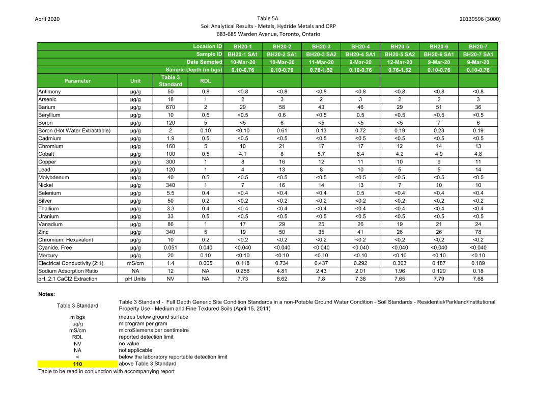
April 2020 Table 5A Soil Analytical Results - Metals, Hydride Metals and ORP
683-685 Warden Avenue, Toronto, Ontario
20139596 (3000)
BH20-1 BH20-2 BH20-3 BH20-4 BH20-5 BH20-6 BH20-7BH20-1 SA1 BH20-2 SA1 BH20-3 SA2 BH20-4 SA1 BH20-5 SA2 BH20-6 SA1 BH20-7 SA110-Mar-20 10-Mar-20 11-Mar-20 9-Mar-20 12-Mar-20 9-Mar-20 9-Mar-200.10-0.76 0.10-0.76 0.76-1.52 0.10-0.76 0.76-1.52 0.10-0.76 0.10-0.76
Parameter Unit Table 3 Standard RDL
Antimony µg/g 50 0.8 <0.8 <0.8 <0.8 <0.8 <0.8 <0.8 <0.8Arsenic µg/g 18 1 2 3 2 3 2 2 3Barium µg/g 670 2 29 58 43 46 29 51 36Beryllium µg/g 10 0.5 <0.5 0.6 <0.5 0.5 <0.5 <0.5 <0.5Boron µg/g 120 5 <5 6 <5 <5 <5 7 6Boron (Hot Water Extractable) µg/g 2 0.10 <0.10 0.61 0.13 0.72 0.19 0.23 0.19Cadmium µg/g 1.9 0.5 <0.5 <0.5 <0.5 <0.5 <0.5 <0.5 <0.5Chromium µg/g 160 5 10 21 17 17 12 14 13Cobalt µg/g 100 0.5 4.1 8 5.7 6.4 4.2 4.9 4.8Copper µg/g 300 1 8 16 12 11 10 9 11Lead µg/g 120 1 4 13 8 10 5 5 14Molybdenum µg/g 40 0.5 <0.5 <0.5 <0.5 <0.5 <0.5 <0.5 <0.5Nickel µg/g 340 1 7 16 14 13 7 10 10Selenium µg/g 5.5 0.4 <0.4 <0.4 <0.4 0.5 <0.4 <0.4 <0.4Silver µg/g 50 0.2 <0.2 <0.2 <0.2 <0.2 <0.2 <0.2 <0.2Thallium µg/g 3.3 0.4 <0.4 <0.4 <0.4 <0.4 <0.4 <0.4 <0.4Uranium µg/g 33 0.5 <0.5 <0.5 <0.5 <0.5 <0.5 <0.5 <0.5Vanadium µg/g 86 1 17 29 25 26 19 21 24Zinc µg/g 340 5 19 50 35 41 26 26 78Chromium, Hexavalent µg/g 10 0.2 <0.2 <0.2 <0.2 <0.2 <0.2 <0.2 <0.2Cyanide, Free µg/g 0.051 0.040 <0.040 <0.040 <0.040 <0.040 <0.040 <0.040 <0.040Mercury µg/g 20 0.10 <0.10 <0.10 <0.10 <0.10 <0.10 <0.10 <0.10Electrical Conductivity (2:1) mS/cm 1.4 0.005 0.118 0.734 0.437 0.292 0.303 0.187 0.189Sodium Adsorption Ratio NA 12 NA 0.256 4.81 2.43 2.01 1.96 0.129 0.18pH, 2:1 CaCl2 Extraction pH Units NV NA 7.73 8.62 7.8 7.38 7.65 7.79 7.68
Notes:
Table 3 Standard
m bgsµg/g
mS/cmRDLNVNA<
110Table to be read in conjunction with accompanying report
above Table 3 Standard
reported detection limit
Location IDSample ID
Date Sampled
Table 3 Standard - Full Depth Generic Site Condition Standards in a non-Potable Ground Water Condition - Soil Standards - Residential/Parkland/Institutional Property Use - Medium and Fine Textured Soils (April 15, 2011)metres below ground surfacemicrogram per gram
Sample Depth (m bgs)
microSiemens per centimetre
no valuenot applicablebelow the laboratory reportable detection limit

April 2020 Table 5B Soil Analytical Results - PAH
683-685 Warden Avenue, Toronto, Ontario
20139596 (3000)
BH20-1 BH20-2 BH20-3 BH20-4 BH20-5 BH20-6 BH20-7BH20-1 SA6 BH20-2 SA4 BH20-3 SA7 BH20-4 SA6 BH20-5 SA3 BH20-6 SA3 BH20-7 SA310-Mar-20 10-Mar-20 11-Mar-20 9-Mar-20 12-Mar-20 9-Mar-20 9-Mar-204.52-5.18 2.28-2.89 6.09-6.70 4.52-5.18 1.52-2.13 1.52-2.13 1.52-2.13
Parameter Unit Table 3 Standard RDL
Naphthalene µg/g 28 0.05 <0.05 <0.05 <0.05 <0.05 <0.05 <0.05 <0.05Acenaphthylene µg/g 0.17 0.05 <0.05 <0.05 <0.05 <0.05 <0.05 <0.05 <0.05Acenaphthene µg/g 29 0.05 <0.05 <0.05 <0.05 <0.05 <0.05 <0.05 <0.05Fluorene µg/g 69 0.05 <0.05 <0.05 <0.05 <0.05 <0.05 <0.05 <0.05Phenanthrene µg/g 16 0.05 <0.05 <0.05 <0.05 <0.05 <0.05 <0.05 <0.05Anthracene µg/g 0.74 0.05 <0.05 <0.05 <0.05 <0.05 <0.05 <0.05 <0.05Fluoranthene µg/g 9.6 0.05 <0.05 <0.05 <0.05 <0.05 <0.05 <0.05 <0.05Pyrene µg/g 96 0.05 <0.05 <0.05 <0.05 <0.05 <0.05 <0.05 <0.05Benz(a)anthracene µg/g 0.96 0.05 <0.05 <0.05 <0.05 <0.05 <0.05 <0.05 <0.05Chrysene µg/g 9.6 0.05 <0.05 <0.05 <0.05 <0.05 <0.05 <0.05 <0.05Benzo(b)fluoranthene µg/g 0.96 0.05 <0.05 <0.05 <0.05 <0.05 <0.05 <0.05 <0.05Benzo(k)fluoranthene µg/g 0.96 0.05 <0.05 <0.05 <0.05 <0.05 <0.05 <0.05 <0.05Benzo(a)pyrene µg/g 0.3 0.05 <0.05 <0.05 <0.05 <0.05 <0.05 <0.05 <0.05Indeno(1,2,3-cd)pyrene µg/g 0.95 0.05 <0.05 <0.05 <0.05 <0.05 <0.05 <0.05 <0.05Dibenz(a,h)anthracene µg/g 0.1 0.05 <0.05 <0.05 <0.05 <0.05 <0.05 <0.05 <0.05Benzo(g,h,i)perylene µg/g 9.6 0.05 <0.05 <0.05 <0.05 <0.05 <0.05 <0.05 <0.05
2-and 1-methyl Naphthalene µg/g 42 0.05 <0.05 <0.05 <0.05 <0.05 <0.05 <0.05 <0.05
Notes:
Table 3 Standard
m bgsµg/gRDLNVNA<
110Table to be read in conjunction with accompanying report
below the laboratory reportable detection limitabove Table 3 Standard
Sample DescriptionDate Sampled
Location ID
Table 3 Standard - Full Depth Generic Site Condition Standards in a non-Potable Ground Water Condition - Soil Standards - Residential/Parkland/Institutional Property Use - Medium and Fine Textured Soils (April 15, 2011)metres below ground surfacemicrogram per gram
Sample Depth (m bgs)
reported detection limitno valuenot applicable

April 2020 Table 5BSoil Analytical Results - PHC
683-685 Warden Avenue, Toronto, Ontario
20139596 (3000)
BH20-1 BH20-2 BH20-3 BH20-4 BH20-5 BH20-6BH20-1 SA6 BH20-2 SA4 BH20-3 SA7 BH20-4 SA6 BH20-5 SA3 BH20-6 SA3 BH20-7 SA3 DUP 110-Mar-20 10-Mar-20 11-Mar-20 9-Mar-20 12-Mar-20 9-Mar-204.52-5.18 2.28-2.89 6.09-6.70 4.52-5.18 1.52-2.13 1.52-2.13
Parameter Unit Table 3 Standard RDL Field Duplicate
F1 (C6 to C10) µg/g 65 5 <5 <5 <5 <5 <5 9 <5 <5F1 (C6 to C10) minus BTEX µg/g 65 5 <5 <5 <5 <5 <5 9 <5 <5F2 (C10 to C16) µg/g 250 10 13 <10 <10 <10 <10 <10 <10 <10F2 (C10 to C16) minus Naphthalene µg/g NV 10 13 <10 <10 <10 <10 <10 <10 <10F3 (C16 to C34) µg/g 2500 50 71 <50 <50 <50 <50 <50 <50 <50F3 (C16 to C34) minus PAHs µg/g NV 50 71 <50 <50 <50 <50 <50 <50 <50F4 (C34 to C50) µg/g 6600 50 <50 <50 <50 <50 <50 <50 <50 <50Gravimetric Heavy Hydrocarbons µg/g 6600 50 NA NA NA NA NA NA NA NA
Notes:
Table 3 Standard
m bgsµg/gRDLNVNA<
110Table to be read in conjunction with accompanying report
no valuenot applicablebelow the laboratory reportable detection limitabove Table 3 Standard
Sample DescriptionDate Sampled
Sample Depth (m bgs)9-Mar-201.52-2.13
reported detection limit
Location ID
Table 3 Standard - Full Depth Generic Site Condition Standards in a non-Potable Ground Water Condition - Soil Standards - Residential/Parkland/Institutional Property Use - Medium and Fine Textured Soils (April 15, 2011)metres below ground surfacemicrogram per gram
BH20-7

April 2020 Table 5DSoil Analytical Results - VOC
683-685 Warden Avenue, Toronto, Ontario
20139596 (3000)
BH20-1 BH20-2 BH20-3 BH20-4 BH20-5 BH20-6BH20-1 SA6 BH20-2 SA4 BH20-3 SA7 BH20-4 SA6 BH20-5 SA3 BH20-6 SA3 BH20-7 SA3 DUP 110-Mar-20 10-Mar-20 11-Mar-20 9-Mar-20 12-Mar-20 9-Mar-204.52-5.18 2.28-2.89 6.09-6.70 4.52-5.18 1.52-2.13 1.52-2.13
Parameter Unit Table 3 Standard RDL Field
DuplicateDichlorodifluoromethane µg/g 25 0.05 <0.05 <0.05 <0.05 <0.05 <0.05 <0.05 <0.05 <0.05Vinyl Chloride ug/g 0.25 0.02 <0.02 <0.02 <0.02 <0.02 <0.02 <0.02 <0.02 <0.02Bromomethane ug/g 0.05 0.05 <0.05 <0.05 <0.05 <0.05 <0.05 <0.05 <0.05 <0.05Trichlorofluoromethane ug/g 5.8 0.05 <0.05 <0.05 <0.05 <0.05 <0.05 <0.05 <0.05 <0.05Acetone ug/g 28 0.50 <0.50 <0.50 <0.50 <0.50 <0.50 <0.50 <0.50 <0.501,1-Dichloroethylene ug/g 0.48 0.05 <0.05 <0.05 <0.05 <0.05 <0.05 <0.05 <0.05 <0.05Methylene Chloride ug/g 2 0.05 <0.05 <0.05 <0.05 <0.05 <0.05 <0.05 <0.05 <0.05Trans- 1,2-Dichloroethylene ug/g 2.5 0.05 <0.05 <0.05 <0.05 <0.05 <0.05 <0.05 <0.05 <0.05Methyl tert-butyl Ether ug/g 2.3 0.05 <0.05 <0.05 <0.05 <0.05 <0.05 <0.05 <0.05 <0.051,1-Dichloroethane ug/g 0.6 0.02 <0.02 <0.02 <0.02 <0.02 <0.02 <0.02 <0.02 <0.02Methyl Ethyl Ketone ug/g 88 0.50 <0.50 <0.50 <0.50 <0.50 <0.50 <0.50 <0.50 <0.50Cis- 1,2-Dichloroethylene ug/g 2.5 0.02 <0.02 <0.02 <0.02 <0.02 <0.02 <0.02 <0.02 <0.02Chloroform ug/g 0.18 0.04 <0.04 <0.04 <0.04 <0.04 <0.04 <0.04 <0.04 <0.041,2-Dichloroethane ug/g 0.05 0.03 <0.03 <0.03 <0.03 <0.03 <0.03 <0.03 <0.03 <0.031,1,1-Trichloroethane ug/g 12 0.05 <0.05 <0.05 <0.05 <0.05 <0.05 <0.05 <0.05 <0.05Carbon Tetrachloride ug/g 0.71 0.05 <0.05 <0.05 <0.05 <0.05 <0.05 <0.05 <0.05 <0.05Benzene ug/g 0.4 0.02 <0.02 <0.02 <0.02 <0.02 <0.02 <0.02 <0.02 <0.021,2-Dichloropropane ug/g 0.68 0.03 <0.03 <0.03 <0.03 <0.03 <0.03 <0.03 <0.03 <0.03Trichloroethylene ug/g 0.61 0.03 <0.03 <0.03 <0.03 <0.03 <0.03 <0.03 <0.03 <0.03Bromodichloromethane ug/g 1.9 0.05 <0.05 <0.05 <0.05 <0.05 <0.05 <0.05 <0.05 <0.05Methyl Isobutyl Ketone ug/g 210 0.50 <0.50 <0.50 <0.50 <0.50 <0.50 <0.50 <0.50 <0.501,1,2-Trichloroethane ug/g 0.11 0.04 <0.04 <0.04 <0.04 <0.04 <0.04 <0.04 <0.04 <0.04Toluene ug/g 9 0.05 <0.05 <0.05 <0.05 <0.05 <0.05 <0.05 <0.05 <0.05Dibromochloromethane ug/g 2.9 0.05 <0.05 <0.05 <0.05 <0.05 <0.05 <0.05 <0.05 <0.05Ethylene Dibromide ug/g 0.05 0.04 <0.04 <0.04 <0.04 <0.04 <0.04 <0.04 <0.04 <0.04Tetrachloroethylene ug/g 2.5 0.05 <0.05 <0.05 <0.05 <0.05 <0.05 <0.05 <0.05 <0.051,1,1,2-Tetrachloroethane ug/g 0.11 0.04 <0.04 <0.04 <0.04 <0.04 <0.04 <0.04 <0.04 <0.04Chlorobenzene ug/g 2.7 0.05 <0.05 <0.05 <0.05 <0.05 <0.05 <0.05 <0.05 <0.05Ethylbenzene ug/g 1.6 0.05 <0.05 <0.05 <0.05 <0.05 <0.05 <0.05 <0.05 <0.05m & p-Xylene ug/g NV 0.05 <0.05 <0.05 <0.05 <0.05 <0.05 <0.05 <0.05 <0.05Bromoform ug/g 1.7 0.05 <0.05 <0.05 <0.05 <0.05 <0.05 <0.05 <0.05 <0.05Styrene ug/g 43 0.05 <0.05 <0.05 <0.05 <0.05 <0.05 <0.05 <0.05 <0.051,1,2,2-Tetrachloroethane ug/g 0.094 0.05 <0.05 <0.05 <0.05 <0.05 <0.05 <0.05 <0.05 <0.05o-Xylene ug/g NV 0.05 <0.05 <0.05 <0.05 <0.05 <0.05 <0.05 <0.05 <0.051,3-Dichlorobenzene ug/g 12 0.05 <0.05 <0.05 <0.05 <0.05 <0.05 <0.05 <0.05 <0.051,4-Dichlorobenzene ug/g 0.57 0.05 <0.05 <0.05 <0.05 <0.05 <0.05 <0.05 <0.05 <0.051,2-Dichlorobenzene ug/g 1.7 0.05 <0.05 <0.05 <0.05 <0.05 <0.05 <0.05 <0.05 <0.05Xylenes (Total) ug/g 30 0.05 <0.05 <0.05 <0.05 <0.05 <0.05 <0.05 <0.05 <0.051,3-Dichloropropene (Cis + Trans) µg/g 0.081 0.04 <0.04 <0.04 <0.04 <0.04 <0.04 <0.04 <0.04 <0.04n-Hexane µg/g 88 0.05 <0.05 <0.05 <0.05 <0.05 <0.05 <0.05 <0.05 <0.05
Notes:
Table 3 Standard
m bgsµg/gRDLNVNA<
110Table to be read in conjunction with accompanying report
above Table 3 Standard
Sample Depth (m bgs) 1.52-2.139-Mar-20
microgram per gramreported detection limitno valuenot applicablebelow the laboratory reportable detection limit
metres below ground surface
Location ID BH20-7Sample Description
Date Sampled
Table 3 Standard - Full Depth Generic Site Condition Standards in a non-Potable Ground Water Condition - Soil Standards - Residential/Parkland/Institutional Property Use - Medium and Fine Textured Soils (April 15, 2011)

April 2020 Table 5E Soil Analytical Results - PCB
683-685 Warden Avenue, Toronto, Ontario
20139596 (3000)
BH20-6BH20-6 SA1
9-Mar-200.00-0.76
Parameter Unit Table 3 Standard RDLPCBs µg/g 1.1 0.1 <0.1
Notes:
Table 3 Standard
m bgs metres below ground surfaceµg/g microgram per gramRDL reported detection limitNV no valueNA not applicable< below the laboratory reportable detection limit
110 above Table 3 StandardTable to be read in conjunction with accompanying report
Location IDSample Description
Date SampledDepth (m bgs)
Table 3 Standard - Full Depth Generic Site Condition Standards in a non-Potable Ground Water Condition - Soil Standards - Residential/Parkland/Institutional Property Use - Medium and Fine Textured Soils (April 15, 2011)

April 2020 Table 6A Groundwater Analytical Results - Metals, Hydride Metals and ORP
683-685 Warden Avenue, Toronto, Ontario
20139596 (3000)
MW20-1 MW20-2 MW20-3 MW20-4 MW20-5MW20-1 MW20-2 MW20-3 MW20-4 MW20-5 MW20-6 DUP1
03/26/2020 03/26/2020 03/26/2020 03/26/2020 03/26/2020 03/26/2020 03/26/202012.19 to 15.24 4.57 to 7.62 4.57 to 7.62 12.19 to 15.24 12.19 to 15.24 4.57 to 7.62
Parameter Unit Table 3 Standard RDL RDL RDL RDL Field Duplicate
Dissolved Antimony µg/L 6 1.0 <1.0 1.0 <1.0 <1.0 1.0 <1.0 1.0 <1.0 <1.0 <1.0Dissolved Arsenic µg/L 25 1.0 1 1.0 <1.0 <1.0 1.0 4.6 1.0 1.8 <1.0 <1.0Dissolved Barium µg/L 1000 2.0 277 2.0 81.8 95.4 2.0 144 2.0 263 64.1 65.6Dissolved Beryllium µg/L 4 0.50 <0.50 0.50 <0.50 <0.50 0.50 <0.50 0.50 <0.50 <0.50 <0.50Dissolved Boron µg/L 5000 10.0 30.9 10.0 59.6 18.5 10.0 36.5 10.0 28.7 98.3 103Dissolved Cadmium µg/L 2.7 0.20 <0.20 0.20 <0.20 <0.20 0.20 <0.20 0.20 <0.20 <0.20 <0.20Dissolved Chromium µg/L 50 2.0 <2.0 2.0 <2.0 <2.0 2.0 <2.0 2.0 <2.0 <2.0 <2.0Dissolved Cobalt µg/L 3.8 0.50 <0.50 0.50 0.98 1.28 0.50 <0.50 0.50 <0.50 <0.50 <0.50Dissolved Copper µg/L 87 1.0 <1.0 1.0 2.3 <1.0 1.0 <1.0 1.0 <1.0 1.1 <1.0Dissolved Lead µg/L 10 0.50 <0.50 0.50 <0.50 <0.50 0.50 <0.50 0.50 0.54 <0.50 <0.50Dissolved Molybdenum µg/L 70 0.50 13.7 0.50 1.72 1.81 0.50 17.4 0.50 10.2 2.48 2.11Dissolved Nickel µg/L 100 1.0 1.4 1.0 8.7 3.8 1.0 <1.0 1.0 <1.0 <1.0 <1.0Dissolved Selenium µg/L 10 1.0 <1.0 1.0 <1.0 <1.0 1.0 <1.0 1.0 <1.0 <1.0 <1.0Dissolved Silver µg/L 1.5 0.20 <0.20 0.20 <0.20 <0.20 0.20 <0.20 0.20 <0.20 <0.20 <0.20Dissolved Thallium µg/L 2 0.30 <0.30 0.30 <0.30 <0.30 0.30 <0.30 0.30 <0.30 <0.30 <0.30Dissolved Uranium µg/L 20 0.50 1.01 0.50 0.97 4.56 0.50 3.07 0.50 0.62 <0.50 <0.50Dissolved Vanadium µg/L 6.2 0.40 0.74 0.40 1.84 0.62 0.40 0.5 0.40 0.8 <0.40 <0.40Dissolved Zinc µg/L 1100 5.0 <5.0 5.0 <5.0 <5.0 5.0 <5.0 5.0 <5.0 <5.0 <5.0Mercury µg/L 1 0.02 <0.02 0.02 <0.02 <0.02 0.02 <0.02 0.02 <0.02 <0.02 <0.02Chromium VI µg/L 25 5 <5 5 <5 <5 5 <5 5 <5 <5 <5Cyanide, Free µg/L 66 2 <2 2 <2 <2 2 <2 2 <2 <2 <2Dissolved Sodium µg/L 490000 50 47200 250 169000 26700 50 97600 50 39700 13800 14500Chloride µg/L 790000 500 66300 1000 387000 378000 500 28200 200 51400 6640 6700Electrical Conductivity uS/cm NV 2 984 2 2130 1990 2 940 2 772 700 720pH pH Units NV NA 7.85 NA 7.91 7.72 NA 7.98 NA 8.04 7.94 7.96
Notes:Table 3 Standard
m bgs metres below ground surfaceµg/L microgram per litre
uS/cm microsiemens per centimeterRDL reported detection limitNV no valueNA not applicable< below the laboratory reportable detection limit
110 above Table 3 StandardTable to be read in conjunction with accompanying report
Table 3 Standard - Full Depth Generic Site Condition Standards in a non-Potable Ground Water Condition - Non-Potable Groundwater Standards - All Types of Property Use (April 15, 2011)
Location IDSample Description
Date SampledScreen Section (m bgs)
MW20-6

April 2020 Table 6BGroundwater Analytical Results - PAH
683-685 Warden Avenue, Toronto, Ontario
20139596 (3000)
MW20-1 MW20-2 MW20-3 MW20-4 MW20-5MW20-1 MW20-2 MW20-3 MW20-4 MW20-5 MW20-6 DUP1
03/26/2020 03/26/2020 03/26/2020 03/26/2020 03/26/2020 03/26/2020 03/26/202012.19 to 15.24 4.57 to 7.62 4.57 to 7.62 12.19 to 15.24 12.19 to 15.24 4.57 to 7.62
Parameter Unit Table 3 Standard RDL Field Duplicate
Naphthalene µg/L 11 0.20 <0.20 <0.20 <0.20 <0.20 <0.20 <0.20 <0.20Acenaphthylene µg/L 1 0.20 <0.20 <0.20 <0.20 <0.20 <0.20 <0.20 <0.20Acenaphthene µg/L 4.1 0.20 <0.20 <0.20 <0.20 <0.20 <0.20 <0.20 <0.20Fluorene µg/L 120 0.20 <0.20 <0.20 <0.20 <0.20 <0.20 <0.20 <0.20Phenanthrene µg/L 1 0.10 <0.10 <0.10 <0.10 <0.10 <0.10 0.17 0.2Anthracene µg/L 2.4 0.10 <0.10 <0.10 <0.10 <0.10 <0.10 <0.10 <0.10Fluoranthene µg/L 0.41 0.20 <0.20 <0.20 <0.20 <0.20 <0.20 <0.20 <0.20Pyrene µg/L 4.1 0.20 <0.20 <0.20 <0.20 <0.20 <0.20 <0.20 <0.20Benz(a)anthracene µg/L 1 0.20 <0.20 <0.20 <0.20 <0.20 <0.20 <0.20 <0.20Chrysene µg/L 0.1 0.10 <0.10 <0.10 <0.10 <0.10 <0.10 <0.10 <0.10Benzo(b)fluoranthene µg/L 0.1 0.10 <0.10 <0.10 <0.10 <0.10 <0.10 <0.10 <0.10Benzo(k)fluoranthene µg/L 0.1 0.10 <0.10 <0.10 <0.10 <0.10 <0.10 <0.10 <0.10Benzo(a)pyrene µg/L 0.01 0.01 <0.01 <0.01 <0.01 <0.01 <0.01 <0.01 <0.01Indeno(1,2,3-cd)pyrene µg/L 0.2 0.20 <0.20 <0.20 <0.20 <0.20 <0.20 <0.20 <0.20Dibenz(a,h)anthracene µg/L 0.2 0.20 <0.20 <0.20 <0.20 <0.20 <0.20 <0.20 <0.20Benzo(g,h,i)perylene µg/L 0.2 0.20 <0.20 <0.20 <0.20 <0.20 <0.20 <0.20 <0.202-and 1-methyl Naphthalene µg/L 3.2 0.20 <0.20 <0.20 <0.20 <0.20 <0.20 <0.20 <0.20
Notes:
Table 3 Standard
m bgs metres below ground surfaceµg/L microgram per litreRDL reported detection limitNV no valueNA not applicable< below the laboratory reportable detection limit
110 above Table 3 StandardTable to be read in conjunction with accompanying report
MW20-6
Table 3 Standard - Full Depth Generic Site Condition Standards in a non-Potable Ground Water Condition - Non-Potable Groundwater Standards - All Types of Property Use (April 15, 2011)
Location IDSample Description
Date SampledScreen Section (m bgs)

April 2020 Table 6CGroundwater Analytical Results - PHC
683-685 Warden Avenue, Toronto, Ontario
20139596 (3000)
MW20-1 MW20-2 MW20-3 MW20-4 MW20-5 Field Blank Trip BlankMW20-1 MW20-2 MW20-3 MW20-4 MW20-5 MW20-6 DUP1 Field Blank Trip Blank
03/26/2020 03/26/2020 03/26/2020 03/26/2020 03/26/2020 03/26/2020 03/26/2020 03/26/2020 03/26/202012.19 to 15.24 4.57 to 7.62 4.57 to 7.62 12.19 to 15.24 12.19 to 15.24 4.57 to 7.62
Parameter Unit Table 3 Standard RDL Field
DuplicateF1 (C6-C10) µg/L 750 25 <25 <25 <25 <25 <25 <25 <25 <25 <25F1 (C6 to C10) minus BTEX µg/L 750 25 <25 <25 <25 <25 <25 <25 <25 <25 <25F2 (C10 to C16) µg/L 150 100 <100 <100 <100 <100 <100 <100 <100 NA NAF2 (C10 to C16) minus Naphthalene µg/L 100 <100 <100 <100 <100 <100 <100 <100 NA NAF3 (C16 to C34) µg/L 500 100 <100 <100 <100 <100 <100 190 170 NA NAF3 (C16 to C34) minus PAHs µg/L 100 <100 <100 <100 <100 <100 190 170 NA NAF4 (C34 to C50) µg/L 500 100 <100 <100 <100 <100 <100 <100 <100 NA NAGravimetric Heavy Hydrocarbons µg/L 500 500 NA NA NA NA NA NA NA NA NA
Notes:
Table 3 Standard
m bgs metres below ground surfaceµg/L microgram per litreRDL reported detection limitNV no valueNA not applicable< below the laboratory reportable detection limit
110 above Table 3 StandardTable to be read in conjunction with accompanying report
Table 3 Standard - Full Depth Generic Site Condition Standards in a non-Potable Ground Water Condition - Non-Potable Groundwater Standards - All Types of Property Use (April 15, 2011)
Location IDSample Description
Date SampledScreen Section (m bgs)
MW20-6

April 2020 Table 6DGroundwater Analytical Results - VOC
683-685 Warden Avenue, Toronto, Ontario
20139596 (3000)
MW20-1 MW20-2 MW20-3 MW20-4 MW20-5 Field Blank Trip BlankMW20-1 MW20-2 MW20-3 MW20-4 MW20-5 MW20-6 DUP1 Field Blank Trip Blank
03/26/2020 03/26/2020 03/26/2020 03/26/2020 03/26/2020 03/26/2020 03/26/2020 03/26/2020 03/26/202012.19 to 15.24 4.57 to 7.62 4.57 to 7.62 12.19 to 15.24 12.19 to 15.24 4.57 to 7.62
Parameter Unit Table 3 Standard RDL Field Duplicate
Dichlorodifluoromethane µg/L 590 0.20 <0.20 <0.20 <0.20 <0.20 <0.20 <0.20 <0.20 <0.20 <0.20Vinyl Chloride µg/L 1.7 0.17 <0.17 <0.17 <0.17 <0.17 <0.17 <0.17 <0.17 <0.17 <0.17Bromomethane µg/L 0.89 0.20 <0.20 <0.20 <0.20 <0.20 <0.20 <0.20 <0.20 <0.20 <0.20Trichlorofluoromethane µg/L 150 0.40 <0.40 <0.40 <0.40 <0.40 <0.40 <0.40 <0.40 <0.40 <0.40Acetone µg/L 2700 1.0 <1.0 <1.0 <1.0 <1.0 <1.0 <1.0 <1.0 <1.0 <1.01,1-Dichloroethylene µg/L 14 0.30 <0.30 <0.30 <0.30 <0.30 <0.30 <0.30 <0.30 <0.30 <0.30Methylene Chloride µg/L 50 0.30 <0.30 <0.30 <0.30 <0.30 <0.30 <0.30 <0.30 <0.30 <0.30trans- 1,2-Dichloroethylene µg/L 17 0.20 <0.20 <0.20 <0.20 <0.20 <0.20 <0.20 <0.20 <0.20 <0.20Methyl tert-butyl ether µg/L 15 0.20 <0.20 <0.20 <0.20 <0.20 <0.20 <0.20 <0.20 <0.20 <0.201,1-Dichloroethane µg/L 5 0.30 <0.30 <0.30 <0.30 <0.30 <0.30 <0.30 <0.30 <0.30 <0.30Methyl Ethyl Ketone µg/L 1800 1.0 <1.0 <1.0 <1.0 <1.0 <1.0 <1.0 <1.0 <1.0 <1.0cis- 1,2-Dichloroethylene µg/L 17 0.20 <0.20 <0.20 <0.20 <0.20 <0.20 <0.20 <0.20 <0.20 <0.20Chloroform µg/L 22 0.20 <0.20 <0.20 <0.20 <0.20 <0.20 <0.20 <0.20 <0.20 <0.201,2-Dichloroethane µg/L 5.0 0.20 <0.20 <0.20 <0.20 <0.20 <0.20 <0.20 <0.20 <0.20 <0.201,1,1-Trichloroethane µg/L 200 0.30 <0.30 <0.30 <0.30 <0.30 <0.30 <0.30 <0.30 <0.30 <0.30Carbon Tetrachloride µg/L 5.0 0.20 <0.20 <0.20 <0.20 <0.20 <0.20 <0.20 <0.20 <0.20 <0.20Benzene µg/L 5.0 0.20 <0.20 <0.20 <0.20 <0.20 <0.20 <0.20 <0.20 <0.20 <0.201,2-Dichloropropane µg/L 5 0.20 <0.20 <0.20 <0.20 <0.20 <0.20 <0.20 <0.20 <0.20 <0.20Trichloroethylene µg/L 5 0.20 <0.20 <0.20 <0.20 <0.20 <0.20 <0.20 <0.20 <0.20 <0.20Bromodichloromethane µg/L 16 0.20 <0.20 <0.20 <0.20 <0.20 <0.20 <0.20 <0.20 <0.20 <0.20Methyl Isobutyl Ketone µg/L 640 1.0 <1.0 <1.0 <1.0 <1.0 <1.0 <1.0 <1.0 <1.0 <1.01,1,2-Trichloroethane µg/L 5 0.20 <0.20 <0.20 <0.20 <0.20 <0.20 <0.20 <0.20 <0.20 <0.20Toluene µg/L 24 0.20 <0.20 <0.20 <0.20 <0.20 <0.20 <0.20 <0.20 <0.20 <0.20Dibromochloromethane µg/L 25 0.10 <0.10 <0.10 <0.10 <0.10 <0.10 <0.10 <0.10 <0.10 <0.10Ethylene Dibromide µg/L 0.2 0.10 <0.10 <0.10 <0.10 <0.10 <0.10 <0.10 <0.10 <0.10 <0.10Tetrachloroethylene µg/L 17 0.20 <0.20 <0.20 <0.20 <0.20 <0.20 <0.20 <0.20 <0.20 <0.201,1,1,2-Tetrachloroethane µg/L 1.1 0.10 <0.10 <0.10 <0.10 <0.10 <0.10 <0.10 <0.10 <0.10 <0.10Chlorobenzene µg/L 30 0.10 <0.10 <0.10 <0.10 <0.10 <0.10 <0.10 <0.10 <0.10 <0.10Ethylbenzene µg/L 2.4 0.10 <0.10 <0.10 <0.10 <0.10 <0.10 <0.10 <0.10 <0.10 <0.10m & p-Xylene µg/L 0.20 <0.20 <0.20 <0.20 <0.20 <0.20 <0.20 <0.20 <0.20 <0.20Bromoform µg/L 25 0.10 <0.10 <0.10 <0.10 <0.10 <0.10 <0.10 <0.10 <0.10 <0.10Styrene µg/L 5.4 0.10 <0.10 <0.10 <0.10 <0.10 <0.10 <0.10 <0.10 <0.10 <0.101,1,2,2-Tetrachloroethane µg/L 1 0.10 <0.10 <0.10 <0.10 <0.10 <0.10 <0.10 <0.10 <0.10 <0.10o-Xylene µg/L 0.10 <0.10 <0.10 <0.10 <0.10 <0.10 <0.10 <0.10 <0.10 <0.101,3-Dichlorobenzene µg/L 59 0.10 <0.10 <0.10 <0.10 <0.10 <0.10 <0.10 <0.10 <0.10 <0.101,4-Dichlorobenzene µg/L 1 0.10 <0.10 <0.10 <0.10 <0.10 <0.10 <0.10 <0.10 <0.10 <0.101,2-Dichlorobenzene µg/L 3 0.10 <0.10 <0.10 <0.10 <0.10 <0.10 <0.10 <0.10 <0.10 <0.101,3-Dichloropropene µg/L 0.5 0.30 <0.30 <0.30 <0.30 <0.30 <0.30 <0.30 <0.30 <0.30 <0.30Xylenes (Total) µg/L 300 0.20 <0.20 <0.20 <0.20 <0.20 <0.20 <0.20 <0.20 <0.20 <0.20n-Hexane µg/L 520 0.20 <0.20 <0.20 <0.20 <0.20 <0.20 <0.20 <0.20 <0.20 <0.20
Notes:Table 3 Standard
m bgs metres below ground surfaceµg/L microgram per litreRDL reported detection limitNV no valueNA not applicable< below the laboratory reportable detection limit
110 above Table 3 StandardTable to be read in conjunction with accompanying report
Table 3 Standard - Full Depth Generic Site Condition Standards in a non-Potable Ground Water Condition - Non-Potable Groundwater Standards - All Types of Property Use (April 15, 2011)
Location IDSample Description
Date SampledScreen Section (m bgs)
MW20-6

April 2020 Table 6EGroundwater Analytical Results - PCB
683-685 Warden Avenue, Toronto, Ontario
20139596 (3000)
MW20-6 DUP103/26/2020 03/26/20204.57 to 7.62
Parameter Unit Table 3 Standard RDL
PCBs µg/L 3 0.1 <0.1 <0.1
Notes:
Table 3 Standard
m bgs metres below ground surfaceµg/L microgram per litreRDL reported detection limitNV no valueNA not applicable< below the laboratory reportable detection limit
110 above Table 3 StandardTable to be read in conjunction with accompanying report
Table 3 Standard - Full Depth Generic Site Condition Standards in a non-Potable Ground Water Condition - Non-Potable Groundwater Standards - All Types of Property Use (April 15, 2011)
Location IDSample Description
Date SampledScreen Section (m bgs)
MW20-6

June 28, 2021 20139596(3000)
FIGURES

638000
638000
640000
640000
4840
000
4840
000
4842
000
4842
000
PATH
: S:\C
lient
s\C
hoic
e_P
rope
rties
\Sca
rbor
ough
_War
den_
Ave
_683
_685
\99_
PR
OJ\
2013
9596
\40_
PR
OD
\000
2_P
hase
_II_
ES
A\2
0139
596-
0002
-HS
-000
1.m
xd P
RIN
TED
ON
: 202
0-04
-16
AT: 4
:32:
30 P
M
IF T
HIS
ME
AS
UR
EM
EN
T D
OE
S N
OT
MAT
CH
WH
AT IS
SH
OW
N, T
HE
SH
EE
T S
IZE
HA
S B
EE
N M
OD
IFIE
D F
RO
M: A
NS
I A25
mm
0
LEGEND
STUDY AREA
REFERENCE(S)BASE MAP SOURCES: ESRI, HERE, GARMIN, INTERMAP, INCREMENT P CORP., GEBCO, USGS, FAO,NPS, NRCAN, GEOBASE, IGN, KADASTER NL, ORDNANCE SURVEY, ESRI JAPAN, METI, ESRI CHINA(HONG KONG), (C) OPENSTREETMAP CONTRIBUTORS, AND THE GIS USER COMMUNITYPROJECTION: TRANSVERSE MERCATOR DATUM: NAD 83 COORDINATE SYSTEM: UTM ZONE 17N
0002 A 1PROJECT NO. CONTROL FIGURE
CONSULTANT
REV.
2020-04-16
JT
JT
DS
YYYY-MM-DD
DESIGNED
PREPARED
REVIEWED
APPROVED 20139596
TITLE
CLIENT
Choice Properties Limited PartnershipPROJECT
SUBMISSION OF RECORD OF SITE CONDITION683 TO 685 WARDEN AVENUE, TORONTO, ONTARIO
KEY PLAN
0 500 1,000
1:25,000 METRES
TAM

LEGEND
FORMER_RAILWAYFORMER BUILDINGSTUDY AREA
!(
!(
!(
!(
!(
!(
PILKINGTON DRIVE
BELL ESTATEROAD
SANTAMONICA BOULEVARD
WARDEN AVENUE
FORMERBUILDING
1, 12, 13
2, 6, 7, 8,9, 10, 11
3
4
5
14,15,16
638700
638700
638800
638800
638900
638900
4840
700
4840
700
4840
800
4840
800
4840
900
4840
900
PATH
: S:\C
lient
s\C
hoic
e_P
rope
rties
\Sca
rbor
ough
_War
den_
Ave
_683
_685
\99_
PR
OJ\
2013
9596
\40_
PR
OD
\000
2_P
hase
_II_
ES
A\2
0139
596-
0002
-HS
-000
2.m
xd P
RIN
TE
D O
N: 2
020-
04-2
9 AT
: 8:3
9:10
PM
IF T
HIS
ME
AS
UR
EM
EN
T D
OE
S N
OT
MAT
CH
WH
AT IS
SH
OW
N, T
HE
SH
EE
T S
IZE
HA
S B
EE
N M
OD
IFIE
D F
RO
M: A
NS
I B25
mm
0
NOTE(S)
REFERENCE(S)
1. ALL LOCATIONS ARE APPROXIMATE.
CLIENT
Choice Properties Limited Partnership
PROJECT
SUBMISSION OF RECORD OF SITE CONDITION683 TO 685 WARDEN AVENUE, TORONTO, ONTARIOTITLE
POTENTIALLY CONTAMINATING ACTIVITIES
20139596 0002 2
2020-04-20
JT
JT
JS
CONSULTANT
PROJECT NO. CONTROL REV. FIGURE
YYYY-MM-DD
DESIGNED
PREPARED
REVIEWED
APPROVED
0 25 50
1:1,000 METRES
BASE DATA - MNR LIO, OBTAINED 2017PRODUCED BY GOLDER ASSOCIATES LTD UNDER LICENCE FROM ONTARIO MINISTRY OFNATURAL RESOURCES, © QUEENS PRINTER 2018BASE IMAGERY SOURCE: ESRI, DIGITALGLOBE, GEOEYE, EARTHSTAR GEOGRAPHICS,CNES/AIRBUS DS, USDA, USGS, AEROGRID, IGN, AND THE GIS USER COMMUNITYPROJECTION: TRANSVERSE MERCATOR DATUM: NAD 83 COORDINATE SYSTEM: UTM ZONE17N
ID Potentially Contaminating Activity
1#30 Im po rtatio n o f Fill Material o f Unkno wn Quality – Fill was repor ted to be presen t at the Site up to a m axim um d epth of 5.5 m below grad e. In ad d ition, surficial fill an d s tockpiled m aterials have been observed in 2020.
2 #34. Metal Fabricatio n – The Site was his torically operated as an in d us trial facility for the m an ufacturin g of m etal sash win d ow s between 1955 an d the early 1970s.
3#55. Transfo rm er Manufacturing, Pro cess and Use – Two tran sfor m er s were previously located in the nor thwes t por tion of the Site (nor thwes t of the form er build in g).
4#28. Gaso line and Asso ciated Pro ducts Sto rage in Fixed Tanks – A fuel oil UST was previously located n or thwes t of the form er build in g. Previously id en tified groun d water exceed an ces of PHC F3 an d F4 in the vicinity of the form er UST.
5#46. Rail Yards, Tracks and Spurs – A railway spur was previously located n or th of the on-Site build in g, en terin g from the eas ter n por tion of the Site. The spur was rem oved at som e poin t between 1975 an d 1985.
6#39. Paints Manufacturing, Pro cessing and Bulk Sto rage – The form er in d us trial activities includ ed pain tin g activities an d s torage. This includ ed spray pain tin g an d pow d er pain t application s.
7 #55. Transfo rm er Manufacturing, Pro cess and Use – The Site was his torically operated as a tran sfor m er m an ufacturin g facility d urin g the 1970s.
8 #29. Glass Manufacturing – The Site was his torically operated as a glas s m an ufacturin g facility between the late 1970s an d the 1980s.
9 #54. Textile Manufacturing and Pro cessing – The Site was his torically operated as a m attres s m an ufacturin g facility between the 1990s an d 2009.
10 Oth er – An oil-water in terceptor was his torically located within the form er on-Site in d us trial build in g.
11 Oth er – A concrete box filled with im pacted soil was previously id en tified within the form er on-Site build in g.
12 Oth er – Previously id en tified soil exceed an ce of an thracene (the exact location of this exceed an ce is unkn ow n ).
13 Oth er – Previously id en tified soil exceed an ce of ben zo(a)pyren e (the exact location of this exceed an ce is unkn ow n ).
14
#28. Gaso line and Asso ciated Pro ducts Sto rage in Fixed Tanks – A release of 500 L of d iesel fuel (from engine d erailm en t) to the groun d was repor ted at 689 War d en Avenue (im m ed iately nor th) in 1991. It is infer red that this proper ty had a d iesel tan k.
15Oth er – Various in d us trial activities were repor ted at the facility located at 689 War d en Avenue (im m ed iately nor th). This includ ed the generation of various hazar d ous was tes.
16
#37. Operatio n o f Dry Cleaning Equipm ent (w h ere ch em icals are used) – A facility called Toron to Win sun Laun d r y was previously located at 689 War d en Avenue (im m ed iately nor th), an d repor ted a release of “blow d ow n water”. It is unkn ow n if an y d r y cleanin g operation s took place at this location.
TAM

LEGEND
FORMER_RAILWAYSTUDY AREA
AREAS OF POTENTIAL ENVIRONMENTAL CONCERN (APEC)APEC A1-A3APEC B1-B7APEC CAPEC DAPEC EAPEC F
PILKINGTON DRIVE
BELL ESTATEROAD
SANTAMONICA BOULEVARD
WARDEN AVENUE
FORMERBUILDING
APEC C
APEC D
APEC E
APEC F
APEC B1-B7
APEC A1-A3
638700
638700
638800
638800
638900
638900
4840
700
4840
700
4840
800
4840
800
4840
900
4840
900
PAT
H: S
:\Clie
nts\
Cho
ice_
Pro
perti
es\S
carb
orou
gh_W
arde
n_A
ve_6
83_6
85\9
9_P
RO
J\20
1395
96\4
0_P
RO
D\0
002_
Pha
se_I
I_E
SA
\201
3959
6-00
02-H
S-0
003.
mxd
PR
INTE
D O
N: 2
020-
04-2
9 AT
: 5:1
3:52
PM
IF T
HIS
ME
AS
UR
EM
EN
T D
OE
S N
OT
MAT
CH
WH
AT IS
SH
OW
N, T
HE
SH
EE
T S
IZE
HA
S B
EE
N M
OD
IFIE
D F
RO
M: A
NS
I B25
mm
0
CLIENT
CHOICE PROPERTIES REIT
NOTE(S)
REFERENCE(S)
1. ALL LOCATIONS ARE APPROXIMATE.
PROJECT
SUBMISSION OF RECORD OF SITE CONDITION683 TO 685 WARDEN AVENUE, SCARBOROUGH, ONTARIOTITLE
AREAS OF POTENTIAL ENVIRONMENTAL CONCERN
20139596 0002 3
2020-04-21
JT
JT
JS
TAM
CONSULTANT
PROJECT NO. CONTROL REV. FIGURE
YYYY-MM-DD
DESIGNED
PREPARED
REVIEWED
APPROVED
0 25 50
1:1,000 METRES
BASE DATA - MNR LIO, OBTAINED 2017PRODUCED BY GOLDER ASSOCIATES LTD UNDER LICENCE FROM ONTARIO MINISTRY OFNATURAL RESOURCES, © QUEENS PRINTER 2018BASE IMAGERY SOURCE: ESRI, DIGITALGLOBE, GEOEYE, EARTHSTAR GEOGRAPHICS,CNES/AIRBUS DS, USDA, USGS, AEROGRID, IGN, AND THE GIS USER COMMUNITYPROJECTION: TRANSVERSE MERCATOR DATUM: NAD 83 COORDINATE SYSTEM: UTM ZONE17N
ID Potentially Contaminating Activity
APEC A1 – SITE WIDE#31. Importation of Fill Material of Unknown Quality – Fill was reported to be present at the Site up to a maximum depth of 5.5 m below grade. In addition, stockpiles of material are noted at ground surface.
APEC A2 – SITE WIDE OTHER - Previously identified soil exceedance of anthracene (the exact location of this exceedance is unknown).
APEC A3 – SITE WIDE OTHER - Previously identified soil exceedance of benzo(a)pyrene (the exact location of this exceedance is unknown).
APEC B1 – FORMER BUILDING AREA
#34. Metal Fabrication - The Site was historically operated as an industrial facility for the manufacturing of metal sash windows between 1955 and the early 1970s.
APEC B2 - FORMER BUILDING AREA
#39. Paints Manufacturing, Processing and Bulk Storage - The former industrial activities included painting activities and storage. This included spray painting and powder paint applications.
APEC B3 - FORMER BUILDING AREA
#29. Glass Manufacturing - The Site was historically operated as a glass manufacturing facility between the late 1970s and the 1980s.
APEC B4 - FORMER BUILDING AREA
#54. Textile Manufacturing and Processing - The Site was historically operated as a mattress manufacturing facility between the 1990s and 2009.
APEC B5 - FORMER BUILDING AREA
#55. Transformer Manufacturing, Process and Use - The Site was historically operated as a transformer manufacturing facility during the 1970s.
APEC B6 - FORMER BUILDING AREA
OTHER - An oil-water interceptor was historically located within the former industrial building.
APEC B7 - FORMER BUILDING AREA
OTHER - A concrete box filled with impacted soil was previously identified within the former building.
APEC C1 – AREA NORTH OF THE WESTERN PORTION OF THE FORMER BUILDING
#55. Transformer Manufacturing, Process and Use - Two transformers were previously located in the northwest portion of the Site (northwest of the former building).
APEC D1 – AREA NORTH OF THE WESTERN PORTION OF THE FORMER BUILDING
#28. Gasoline and Associated Products Storage in Fixed Tanks - A fuel oil UST was previously located northwest of the former building. In addition, groundwater exceedances of PHC F3 and F4 were previously identified in the vicinity of the former UST.
APEC E1 – AREA NORTH OF THE WESTERN PORTION OF THE FORMER BUILDING
#46. Rail Yards, Tracks and Spurs - A railway spur was previously located north of the building, entering from the east. The spur was removed at some point between 1975 and 1985.
APEC F1 – NORTHERN BOUNDARY OF SITE
#28. Gasoline and Associated Products Storage in Fixed Tanks - An engine derailment, resulting in a release of 500 L of diesel fuel to the ground was reported at 689 Warden Avenue (immediately north) in 1991. It is inferred that this property had a diesel tank.
APEC F2 – NORTHERN BOUNDARY OF SITE
OTHER - Various industrial activities were reported at the facility located at 689 Warden Avenue (immediately north). This included the generation of various hazardous wastes.
APEC F3 – NORTHERN BOUNDARY OF SITE
#37. Operation of Dry Cleaning Equipment (where chemicals are used) - A facility called Toronto Winsun Laundry was previously located at 689 Warden Avenue (immediately north), and reported a release of “blowdown water”. It is unknown if any dry cleaning operations took place at this location.

LEGEND
@A BOREHOLE LOCATIPN
@? MONITORING WELL LOCATIONJ
J GEOLOGICAL CROSS SECTION LINESTUDY AREA
J
J
J
J
@?
@?
@?
@?
@?
@?
@A
PILKINGTON DRIVE
BELL ESTATEROAD
SANTAMONICA BOULEVARD
WARDEN AVENUE
BH20-1
BH20-2
BH20-3
BH20-4
BH20-5
BH20-6
BH20-7
B'
A'
B
A
638800
638800
4840
800
4840
800
PAT
H: S
:\Clie
nts\
Cho
ice_
Pro
perti
es\S
carb
orou
gh_W
arde
n_A
ve_6
83_6
85\9
9_P
RO
J\20
1395
96\4
0_P
RO
D\0
002_
Pha
se_I
I_E
SA
\201
3959
6-00
02-H
S-0
004.
mxd
PR
INTE
D O
N: 2
020-
04-2
8 AT
: 1:0
3:35
PM
IF T
HIS
ME
AS
UR
EM
EN
T D
OE
S N
OT
MAT
CH
WH
AT IS
SH
OW
N, T
HE
SH
EE
T S
IZE
HA
S B
EE
N M
OD
IFIE
D F
RO
M: A
NS
I B25
mm
0
NOTE(S)
REFERENCE(S)
1. ALL LOCATIONS ARE APPROXIMATE.
CLIENT
Choice Properties Limited Partnership
PROJECT
SUBMISSION OF RECORD OF SITE CONDITION683 TO 685 WARDEN AVENUE, TORONTO, ONTARIOTITLE
PHASE TWO SITE PLAN
20139596 0002 4
2020-04-16
JT
JT
DS
CONSULTANT
PROJECT NO. CONTROL REV. FIGURE
YYYY-MM-DD
DESIGNED
PREPARED
REVIEWED
APPROVED
0 25 50
1:1,000 METRES
BASE DATA - MNR LIO, OBTAINED 2017PRODUCED BY GOLDER ASSOCIATES LTD UNDER LICENCE FROM ONTARIO MINISTRY OFNATURAL RESOURCES, © QUEENS PRINTER 2018BASE IMAGERY SOURCE: ESRI, DIGITALGLOBE, GEOEYE, EARTHSTAR GEOGRAPHICS,CNES/AIRBUS DS, USDA, USGS, AEROGRID, IGN, AND THE GIS USER COMMUNITYPROJECTION: TRANSVERSE MERCATOR DATUM: NAD 83 COORDINATE SYSTEM: UTM ZONE17N
TAM

ELEV
ATIO
N (m
)
ELEV
ATIO
N (m
)
A'
HORIZONTAL DISTANCE (m)
A
129
130
131
132
133
134
135
136
137
138
139
140
141
142
143
144
145
146
147
148
129
130
131
132
133
134
135
136
137
138
139
140
141
142
143
144
145
146
147
148
0 20 40 60 80 100 120 140 160 180 200 220 240 248
March 26, 2020
O/S 3.9 mBH20-2
March 26, 2020
O/S -0.4 mBH20-3
March 26, 2020
O/S 0.7 mBH20-4
March 26, 2020
O/S -62.6 mBH20-5
025
mm
20139596CONTROL FIGURE
5A----
2020-04-20
MK
DS
CROSS SECTION A-A' TITLE
PROJECT NO. REV.
PROJECTSUBMISSION OF RECPRD OF SITE CONDITION 683 TO 685 WARDEN AVENUE TORONTO ONTARIO
CLIENTChoice Properties Limited Partnership
CONSULTANT
PREPARED
DESIGNED
REVIEWED
APPROVED
YYYY-MM-DD
Path
: \\g
olde
r.gds
\gal
\Mis
siss
auga
\SIM
\Clie
nts\
Cho
ice_
Prop
ertie
s\Sc
arbo
roug
h_W
arde
n_Av
e_68
3_68
5\99
_PR
OJ\
2013
9596
\40_
PRO
D\0
002_
Phas
e_II_
ESA\
| F
ile N
ame:
201
3959
6-00
02-H
S-00
05.d
wg
| L
ast E
dite
d By
: mke
enan
Dat
e: 2
020-
04-2
0 T
ime:
5:35
:39
PM |
Prin
ted
By: H
JLin
D
ate:
202
1-06
-09
Tim
e:5:
18:3
4 PM
IF T
HIS
MEA
SUR
EMEN
T D
OES
NO
T M
ATC
H W
HAT
IS S
HO
WN
, TH
E SH
EET
SIZE
HAS
BEE
N M
OD
IFIE
D F
RO
M: A
NSI
B
NOT FOR CONSTRUCTION
0
1:750
12.5 25
METRES
1:150
0 2.5 5
METRESVERTICAL SCALE
HORIZONTAL SCALE
SANDY SILT
FILL
SILTO/S 8.5 m
BH
GROUT
BENTONITE
SCREEN
SAND
BOREHOLELABEL
BOREHOLE STRATASYMBOL
OFFSET FROM PROFILE LINE+ NORTH OF PROFILE LINE- SOUTH OF PROFILE LINE
MONITORING WELLWATER LEVEL MEASURED
MARCH 26, 2020
LEGEND
SANDY SILT/SILTY SAND TILL
SILTY CLAY
SILTY CLAY TILL
CLAYEY SILT TILL
TAM

ELEV
ATIO
N (m
)
ELEV
ATIO
N (m
)
B'
HORIZONTAL DISTANCE (m)
B
129
130
131
132
133
134
135
136
137
138
139
140
141
142
143
144
145
146
147
148
129
130
131
132
133
134
135
136
137
138
139
140
141
142
143
144
145
146
147
148
0 20 40 60 80 100 120 140 160 180 200 220221
March 26, 2020
O/S -5.9 mBH20-1
March 26, 2020
O/S -6.8 mBH20-4
March 26, 2020
O/S 8.3 mBH20-6
O/S 6.2 mBH20-7
025
mm
20139596CONTROL FIGURE
5B----
2020-04-20
MK
DS
CROSS SECTION B-B' TITLE
PROJECT NO. REV.
PROJECTSUBMISSION OF RECPRD OF SITE CONDITION 683 TO 685 WARDEN AVENUE TORONTO, ONTARIO
CLIENTChoice Properties Limited Partnership
CONSULTANT
PREPARED
DESIGNED
REVIEWED
APPROVED
YYYY-MM-DD
Path
: \\g
olde
r.gds
\gal
\Mis
siss
auga
\SIM
\Clie
nts\
Cho
ice_
Prop
ertie
s\Sc
arbo
roug
h_W
arde
n_Av
e_68
3_68
5\99
_PR
OJ\
2013
9596
\40_
PRO
D\0
002_
Phas
e_II_
ESA\
| F
ile N
ame:
201
3959
6-00
02-H
S-00
05.d
wg
| L
ast E
dite
d By
: hjlin
Dat
e: 2
020-
04-2
0 T
ime:
5:35
:39
PM |
Prin
ted
By: H
JLin
D
ate:
202
1-06
-09
Tim
e:5:
20:3
2 PM
IF T
HIS
MEA
SUR
EMEN
T D
OES
NO
T M
ATC
H W
HAT
IS S
HO
WN
, TH
E SH
EET
SIZE
HAS
BEE
N M
OD
IFIE
D F
RO
M: A
NSI
B
NOT FOR CONSTRUCTION
0
1:750
12.5 25
METRES
1:150
0 2.5 5
METRESVERTICAL SCALE
HORIZONTAL SCALE
LEGEND
SANDY SILT
FILL
SILT
SANDY SILT/SILTY SAND TILL
SILTY CLAY
SILTY CLAY TILL
CLAYEY SILT TILL
ORGANICSO/S 8.5 m
BH
GROUT
BENTONITE
SCREEN
SAND
BOREHOLELABEL
BOREHOLE STRATASYMBOL
OFFSET FROM PROFILE LINE+ NORTH OF PROFILE LINE- SOUTH OF PROFILE LINE
MONITORING WELLWATER LEVEL MEASURED
MARCH 26, 2020
TAM

LEGEND
@A BOREHOLE LOCATIPN
@? MONITORING WELL LOCATIONJ
J GEOLOGICAL CROSS SECTION LINEGROUNDWATER CONTOURS (M)INFERRED GROUNDWATER FLOW DIRECTIONSTUDY AREA
J
J
J
J
@?
@?
@?
@?
@?
@?
@A
PILKINGTON DRIVE
BELL ESTATEROAD
SANTAMONICA BOULEVARD
WARDEN AVENUE
BH20-1(140.39)
BH20-2(140.28)
BH20-3(145.41)
BH20-4(142.70)
BH20-5(140.84)
BH20-6(146.15)
BH20-7
B'
A'
B
A
146
145
144143
141
142
638800
638800
4840
800
4840
800
PAT
H: S
:\Clie
nts\
Cho
ice_
Pro
perti
es\S
carb
orou
gh_W
arde
n_A
ve_6
83_6
85\9
9_P
RO
J\20
1395
96\4
0_P
RO
D\0
002_
Pha
se_I
I_E
SA
\201
3959
6-00
02-H
S-0
006.
mxd
PR
INTE
D O
N: 2
020-
04-2
8 AT
: 1:0
5:35
PM
IF T
HIS
ME
AS
UR
EM
EN
T D
OE
S N
OT
MAT
CH
WH
AT IS
SH
OW
N, T
HE
SH
EE
T S
IZE
HA
S B
EE
N M
OD
IFIE
D F
RO
M: A
NS
I B25
mm
0
NOTE(S)
REFERENCE(S)
1. ALL LOCATIONS ARE APPROXIMATE.2. masl = GROUNDWATER ELEVATION
CLIENT
CHOICE PROPERTIES REIT
PROJECT
SUBMISSION OF RECORD OF SITE CONDITION683 TO 685 WARDEN AVENUE, TORONTO, ONTARIOTITLE
GROUNDWATER ELEVATIONS – MARCH 26, 2020
20139596 0002 6
2020-04-16
JT
JT
DS
CONSULTANT
PROJECT NO. CONTROL REV. FIGURE
YYYY-MM-DD
DESIGNED
PREPARED
REVIEWED
APPROVED
0 25 50
1:1,000 METRES
BASE DATA - MNR LIO, OBTAINED 2017PRODUCED BY GOLDER ASSOCIATES LTD UNDER LICENCE FROM ONTARIO MINISTRY OFNATURAL RESOURCES, © QUEENS PRINTER 2018BASE IMAGERY SOURCE: ESRI, DIGITALGLOBE, GEOEYE, EARTHSTAR GEOGRAPHICS,CNES/AIRBUS DS, USDA, USGS, AEROGRID, IGN, AND THE GIS USER COMMUNITYPROJECTION: TRANSVERSE MERCATOR DATUM: NAD 83 COORDINATE SYSTEM: UTM ZONE17N
GROUNDWATER ELEVATION (masl)(140.39)
TAM

June 28, 2021 20139596(3000)
APPENDIX A
Legal Plan of Survey


June 28, 2021 20139596(3000)
APPENDIX B
Laboratory Certificates of Analysis

CLIENT NAME: GOLDER ASSOCIATES LTD.100 SCOTIA COURTWHITBY, ON L1N8Y6 (905) 723-2727
5835 COOPERS AVENUEMISSISSAUGA, ONTARIO
CANADA L4Z 1Y2TEL (905)712-5100FAX (905)712-5122
http://www.agatlabs.com
Amanjot Bhela, Inorganic Lab ManagerSOIL ANALYSIS REVIEWED BY:
Oksana Gushyla, Trace Organics Lab SupervisorTRACE ORGANICS REVIEWED BY:
DATE REPORTED:
PAGES (INCLUDING COVER): 22
Apr 13, 2020
VERSION*: 1
Should you require any information regarding this analysis please contact your client services representative at (905) 712-5100
*Notes
Disclaimer:· All work conducted herein has been done using accepted standard protocols, and generally accepted practices and methods. AGAT test methods may
incorporate modifications from the specified reference methods to improve performance.· All samples will be disposed of within 30 days following analysis, unless expressly agreed otherwise in writing. Please contact your Client Project
Manager if you require additional sample storage time.· AGAT’s liability in connection with any delay, performance or non-performance of these services is only to the Client and does not extend to any other
third party. Unless expressly agreed otherwise in writing, AGAT’s liability is limited to the actual cost of the specific analysis or analyses included in the services.
· This report shall not be reproduced or distributed, in whole or in part, without the prior written consent of AGAT Laboratories.· The test results reported herewith relate only to the samples as received by the laboratory.· Application of guidelines is provided “as is” without warranty of any kind, either expressed or implied, including, but not limited to, warranties of
merchantability, fitness for a particular purpose, or non-infringement. AGAT assumes no responsibility for any errors or omissions in the information contained in this document.
· All reportable information as specified by ISO/IEC 17025:2017 is available from AGAT Laboratories upon request.
20T585542AGAT WORK ORDER:
ATTENTION TO: Daniel Stabile
PROJECT: 20139596
Laboratories (V1) Page 1 of 22
AGAT Laboratories is accredited to ISO/IEC 17025 by the Canadian Association for Laboratory Accreditation Inc. (CALA) and/or Standards Council of Canada (SCC) for specific tests listed on the scope of accreditation. AGAT Laboratories (Mississauga) is also accredited by the Canadian Association for Laboratory Accreditation Inc. (CALA) for specific drinking water tests. Accreditations are location and parameter specific. A complete listing of parameters for each location is available from www.cala.ca and/or www.scc.ca. The tests in this report may not necessarily be included in the scope of accreditation. Measurement Uncertainty is not taken into consideration when stating conformity with a specified requirement.
Association of Professional Engineers and Geoscientists of Alberta (APEGA)Western Enviro-Agricultural Laboratory Association (WEALA)Environmental Services Association of Alberta (ESAA)
Member of:

BH20-2 SA1BH20-1 SA1 BH20-3 SA2 BH20-4 SA1 BH20-5 SA2 BH20-6 SA1 BH20-7 SA1SAMPLE DESCRIPTION:
SoilSoilSoil Soil Soil Soil SoilSAMPLE TYPE:
2020-03-122020-03-10 2020-03-11 2020-03-092020-03-10 2020-03-09 2020-03-09DATE SAMPLED:
1032218 1032245 1032247 1032250 1032253 1032256 1032259G / S: A RDLUnit G / S: BParameter
<0.8[<A] <0.8[<A] <0.8[<A] <0.8[<A] <0.8[<A] <0.8[<A] <0.8[<A]Antimony 0.87.5µg/g 7.5
2[<A] 3[<A] 2[<A] 3[<A] 2[<A] 2[<A] 3[<A]Arsenic 118µg/g 18
29[<A] 58[<A] 43[<A] 46[<A] 29[<A] 51[<A] 36[<A]Barium 2390µg/g 390
<0.5[<A] 0.6[<A] <0.5[<A] 0.5[<A] <0.5[<A] <0.5[<A] <0.5[<A]Beryllium 0.55µg/g 5
<5[<A] 6[<A] <5[<A] <5[<A] <5[<A] 7[<A] 6[<A]Boron 5120µg/g 120
<0.10[<A] 0.61[<A] 0.13[<A] 0.72[<A] 0.19[<A] 0.23[<A] 0.19[<A]Boron (Hot Water Extractable) 0.101.5µg/g 1.5
<0.5[<A] <0.5[<A] <0.5[<A] <0.5[<A] <0.5[<A] <0.5[<A] <0.5[<A]Cadmium 0.51.2µg/g 1.2
10[<A] 21[<A] 17[<A] 17[<A] 12[<A] 14[<A] 13[<A]Chromium 5160µg/g 160
4.1[<A] 8.0[<A] 5.7[<A] 6.4[<A] 4.2[<A] 4.9[<A] 4.8[<A]Cobalt 0.522µg/g 22
8[<A] 16[<A] 12[<A] 11[<A] 10[<A] 9[<A] 11[<A]Copper 1180µg/g 180
4[<A] 13[<A] 8[<A] 10[<A] 5[<A] 5[<A] 14[<A]Lead 1120µg/g 120
<0.5[<A] <0.5[<A] <0.5[<A] <0.5[<A] <0.5[<A] <0.5[<A] <0.5[<A]Molybdenum 0.56.9µg/g 6.9
7[<A] 16[<A] 14[<A] 13[<A] 7[<A] 10[<A] 10[<A]Nickel 1130µg/g 130
<0.4[<A] <0.4[<A] <0.4[<A] 0.5[<A] <0.4[<A] <0.4[<A] <0.4[<A]Selenium 0.42.4µg/g 2.4
<0.2[<A] <0.2[<A] <0.2[<A] <0.2[<A] <0.2[<A] <0.2[<A] <0.2[<A]Silver 0.225µg/g 25
<0.4[<A] <0.4[<A] <0.4[<A] <0.4[<A] <0.4[<A] <0.4[<A] <0.4[<A]Thallium 0.41µg/g 1
<0.5[<A] <0.5[<A] <0.5[<A] <0.5[<A] <0.5[<A] <0.5[<A] <0.5[<A]Uranium 0.523µg/g 23
17[<A] 29[<A] 25[<A] 26[<A] 19[<A] 21[<A] 24[<A]Vanadium 186µg/g 86
19[<A] 50[<A] 35[<A] 41[<A] 26[<A] 26[<A] 78[<A]Zinc 5340µg/g 340
<0.2[<A] <0.2[<A] <0.2[<A] <0.2[<A] <0.2[<A] <0.2[<A] <0.2[<A]Chromium, Hexavalent 0.210µg/g 10
<0.040[<A] <0.040[<A] <0.040[<A] <0.040[<A] <0.040[<A] <0.040[<A] <0.040[<A]Cyanide, Free 0.0400.051µg/g 0.051
<0.10[<A] <0.10[<A] <0.10[<A] <0.10[<A] <0.10[<A] <0.10[<A] <0.10[<A]Mercury 0.101.8µg/g 1.8
0.118[<A] 0.734[>B] 0.437[<A] 0.292[<A] 0.303[<A] 0.187[<A] 0.189[<A]Electrical Conductivity (2:1) 0.0050.7mS/cm 0.7
0.256[<A] 4.81[<A] 2.43[<A] 2.01[<A] 1.96[<A] 0.129[<A] 0.180[<A]Sodium Adsorption Ratio NA5NA 5
7.73 8.62 7.80 7.38 7.65 7.79 7.68pH, 2:1 CaCl2 Extraction NApH Units
Results relate only to the items tested. Results apply to samples as received.
DATE RECEIVED: 2020-03-17
Certificate of Analysis
ATTENTION TO: Daniel StabileCLIENT NAME: GOLDER ASSOCIATES LTD.
AGAT WORK ORDER: 20T585542
DATE REPORTED: 2020-04-13
PROJECT: 20139596
O. Reg. 153(511) - Metals & Inorganics (Soil)
SAMPLED BY:SAMPLING SITE:
5835 COOPERS AVENUEMISSISSAUGA, ONTARIO
CANADA L4Z 1Y2TEL (905)712-5100FAX (905)712-5122
http://www.agatlabs.com
CERTIFICATE OF ANALYSIS (V1)
Certified By:Page 2 of 22

Results relate only to the items tested. Results apply to samples as received.
DATE RECEIVED: 2020-03-17
Certificate of Analysis
ATTENTION TO: Daniel StabileCLIENT NAME: GOLDER ASSOCIATES LTD.
AGAT WORK ORDER: 20T585542
DATE REPORTED: 2020-04-13
PROJECT: 20139596
O. Reg. 153(511) - Metals & Inorganics (Soil)
SAMPLED BY:SAMPLING SITE:
5835 COOPERS AVENUEMISSISSAUGA, ONTARIO
CANADA L4Z 1Y2TEL (905)712-5100FAX (905)712-5122
http://www.agatlabs.com
Comments: RDL - Reported Detection Limit; G / S - Guideline / Standard: A Refers to Table 2: Full Depth Generic Site Condition Standards in a Potable Ground Water Condition - Soil - Residential/Parkland/Institutional Property Use - Medium and Fine Textured Soils, B Refers to Table 3: Full Depth Generic Site Condition Standards in a Non-Potable Ground Water Condition - Soil - Residential/Parkland/Institutional Property Use - Medium and Fine Textured SoilsGuideline values are for general reference only. The guidelines provided may or may not be relevant for the intended use. Refer directly to the applicable standard for regulatory interpretation.
1032218-1032259 EC was determined on the DI water extract obtained from the 2:1 leaching procedure (2 parts DI water:1 part soil). pH was determined on the 0.01M CaCl2 extract prepared at 2:1 ratio. SAR is a calculated parameter.
Analysis performed at AGAT Toronto (unless marked by *)
CERTIFICATE OF ANALYSIS (V1)
Certified By:Page 3 of 22

BH20-2 SA4BH20-1 SA6 BH20-3 SA7 BH20-4 SA6 BH20-5 SA3 BH20-6 SA3 BH20-7 SA3SAMPLE DESCRIPTION:
SoilSoilSoil Soil Soil Soil SoilSAMPLE TYPE:
2020-03-122020-03-10 2020-03-11 2020-03-092020-03-10 2020-03-09 2020-03-09DATE SAMPLED:
1032232 1032246 1032249 1032252 1032255 1032257 1032260G / S: A RDLUnit G / S: BParameter
<0.05[<A] <0.05[<A] <0.05[<A] <0.05[<A] <0.05[<A] <0.05[<A] <0.05[<A]Naphthalene 0.050.75µg/g 0.75
<0.05[<A] <0.05[<A] <0.05[<A] <0.05[<A] <0.05[<A] <0.05[<A] <0.05[<A]Acenaphthylene 0.050.17µg/g 0.17
<0.05[<A] <0.05[<A] <0.05[<A] <0.05[<A] <0.05[<A] <0.05[<A] <0.05[<A]Acenaphthene 0.0529µg/g 58
<0.05[<A] <0.05[<A] <0.05[<A] <0.05[<A] <0.05[<A] <0.05[<A] <0.05[<A]Fluorene 0.0569µg/g 69
<0.05[<A] <0.05[<A] <0.05[<A] <0.05[<A] <0.05[<A] <0.05[<A] <0.05[<A]Phenanthrene 0.057.8µg/g 7.8
<0.05[<A] <0.05[<A] <0.05[<A] <0.05[<A] <0.05[<A] <0.05[<A] <0.05[<A]Anthracene 0.050.74µg/g 0.74
<0.05[<A] <0.05[<A] <0.05[<A] <0.05[<A] <0.05[<A] <0.05[<A] <0.05[<A]Fluoranthene 0.050.69µg/g 0.69
<0.05[<A] <0.05[<A] <0.05[<A] <0.05[<A] <0.05[<A] <0.05[<A] <0.05[<A]Pyrene 0.0578µg/g 78
<0.05[<A] <0.05[<A] <0.05[<A] <0.05[<A] <0.05[<A] <0.05[<A] <0.05[<A]Benz(a)anthracene 0.050.63µg/g 0.63
<0.05[<A] <0.05[<A] <0.05[<A] <0.05[<A] <0.05[<A] <0.05[<A] <0.05[<A]Chrysene 0.057.8µg/g 7.8
<0.05[<A] <0.05[<A] <0.05[<A] <0.05[<A] <0.05[<A] <0.05[<A] <0.05[<A]Benzo(b)fluoranthene 0.050.78µg/g 0.78
<0.05[<A] <0.05[<A] <0.05[<A] <0.05[<A] <0.05[<A] <0.05[<A] <0.05[<A]Benzo(k)fluoranthene 0.050.78µg/g 0.78
<0.05[<A] <0.05[<A] <0.05[<A] <0.05[<A] <0.05[<A] <0.05[<A] <0.05[<A]Benzo(a)pyrene 0.050.3µg/g 0.3
<0.05[<A] <0.05[<A] <0.05[<A] <0.05[<A] <0.05[<A] <0.05[<A] <0.05[<A]Indeno(1,2,3-cd)pyrene 0.050.48µg/g 0.48
<0.05[<A] <0.05[<A] <0.05[<A] <0.05[<A] <0.05[<A] <0.05[<A] <0.05[<A]Dibenz(a,h)anthracene 0.050.1µg/g 0.1
<0.05[<A] <0.05[<A] <0.05[<A] <0.05[<A] <0.05[<A] <0.05[<A] <0.05[<A]Benzo(g,h,i)perylene 0.057.8µg/g 7.8
<0.05[<A] <0.05[<A] <0.05[<A] <0.05[<A] <0.05[<A] <0.05[<A] <0.05[<A]2-and 1-methyl Naphthalene 0.053.4µg/g 3.4
11.5 11.4 10.7 8.0 15.1 15.4 10.6Moisture Content 0.1%
Acceptable LimitsUnitSurrogate
99 111 104 102 100 100 108Naphthalene-d8 % 50-140
108 109 111 112 112 107 118Acenaphthene-d10 % 50-140
108 110 107 114 112 107 105Chrysene-d12 % 50-140
Comments: RDL - Reported Detection Limit; G / S - Guideline / Standard: A Refers to Table 2: Full Depth Generic Site Condition Standards in a Potable Ground Water Condition - Soil - Residential/Parkland/Institutional Property Use - Medium and Fine Textured Soils, B Refers to Table 3: Full Depth Generic Site Condition Standards in a Non-Potable Ground Water Condition - Soil - Residential/Parkland/Institutional Property Use - Medium and Fine Textured SoilsGuideline values are for general reference only. The guidelines provided may or may not be relevant for the intended use. Refer directly to the applicable standard for regulatory interpretation.
1032232-1032260 Results are based on the dry weight of the soil.Note: The result for Benzo(b)Fluoranthene is the total of the Benzo(b)&j)Fluoranthene isomers because the isomers co-elute on the GC column.2- and 1-Methyl Naphthalene is a calculated parameter. The calculated value is the sum of 2-Methyl Naphthalene and 1-Methyl Naphthalene.
Analysis performed at AGAT Toronto (unless marked by *)
Results relate only to the items tested. Results apply to samples as received.
DATE RECEIVED: 2020-03-17
Certificate of Analysis
ATTENTION TO: Daniel StabileCLIENT NAME: GOLDER ASSOCIATES LTD.
AGAT WORK ORDER: 20T585542
DATE REPORTED: 2020-04-13
PROJECT: 20139596
O. Reg. 153(511) - PAHs (Soil)
SAMPLED BY:SAMPLING SITE:
5835 COOPERS AVENUEMISSISSAUGA, ONTARIO
CANADA L4Z 1Y2TEL (905)712-5100FAX (905)712-5122
http://www.agatlabs.com
CERTIFICATE OF ANALYSIS (V1)
Certified By:Page 4 of 22

DUP 1SAMPLE DESCRIPTION:
SoilSAMPLE TYPE:
2020-03-09DATE SAMPLED:
1032394G / S: A RDLUnit G / S: BParameter
<5[<A]F1 (C6 to C10) 565µg/g 65
<5[<A]F1 (C6 to C10) minus BTEX 565µg/g 65
<10[<A]F2 (C10 to C16) 10150µg/g 150
<50[<A]F3 (C16 to C34) 501300µg/g 1300
<50[<A]F4 (C34 to C50) 505600µg/g 5600
NA[<A]Gravimetric Heavy Hydrocarbons 505600µg/g 5600
10.3Moisture Content 0.1%
Acceptable LimitsUnitSurrogate
119Terphenyl % 60-140
Comments: RDL - Reported Detection Limit; G / S - Guideline / Standard: A Refers to Table 2: Full Depth Generic Site Condition Standards in a Potable Ground Water Condition - Soil - Residential/Parkland/Institutional Property Use - Medium and Fine Textured Soils, B Refers to Table 3: Full Depth Generic Site Condition Standards in a Non-Potable Ground Water Condition - Soil - Residential/Parkland/Institutional Property Use - Medium and Fine Textured SoilsGuideline values are for general reference only. The guidelines provided may or may not be relevant for the intended use. Refer directly to the applicable standard for regulatory interpretation.
1032394 Results are based on sample dry weight.The C6-C10 fraction is calculated using toluene response factor.C6–C10 (F1 minus BTEX) is a calculated parameter. The calculated value is F1 minus BTEX.The C10 - C16, C16 - C34, and C34 - C50 fractions are calculated using the average response factor for n-C10, n-C16, and n-C34.Gravimetric Heavy Hydrocarbons are not included in the Total C16-C50 and are only determined if the chromatogram of the C34 - C50 hydrocarbons indicates that hydrocarbons >C50 are present.The chromatogram has returned to baseline by the retention time of nC50.Total C6 - C50 results are corrected for BTEX contribution.This method complies with the Reference Method for the CWS PHC and is validated for use in the laboratory.nC6 and nC10 response factors are within 30% of Toluene response factor.nC10, nC16 and nC34 response factors are within 10% of their average.C50 response factor is within 70% of nC10 + nC16 + nC34 average.Linearity is within 15%.Extraction and holding times were met for this sample.Fractions 1-4 are quantified without the contribution of PAHs. Under Ontario Regulation 153, results are considered valid without determining the PAH contribution if not requested by the client.
Analysis performed at AGAT Toronto (unless marked by *)
Results relate only to the items tested. Results apply to samples as received.
DATE RECEIVED: 2020-03-17
Certificate of Analysis
ATTENTION TO: Daniel StabileCLIENT NAME: GOLDER ASSOCIATES LTD.
AGAT WORK ORDER: 20T585542
DATE REPORTED: 2020-04-13
PROJECT: 20139596
O. Reg. 153(511) - PHCs F1 - F4 (-BTEX) (Soil)
SAMPLED BY:SAMPLING SITE:
5835 COOPERS AVENUEMISSISSAUGA, ONTARIO
CANADA L4Z 1Y2TEL (905)712-5100FAX (905)712-5122
http://www.agatlabs.com
CERTIFICATE OF ANALYSIS (V1)
Certified By:Page 5 of 22

BH20-2 SA4BH20-1 SA6 BH20-3 SA7 BH20-4 SA6 BH20-5 SA3 BH20-6 SA3 BH20-7 SA3SAMPLE DESCRIPTION:
SoilSoilSoil Soil Soil Soil SoilSAMPLE TYPE:
2020-03-122020-03-10 2020-03-11 2020-03-092020-03-10 2020-03-09 2020-03-09DATE SAMPLED:
1032232 1032246 1032249 1032252 1032255 1032257 1032260G / S: A RDLUnit G / S: BParameter
<5[<A] <5[<A] <5[<A] <5[<A] <5[<A] 9[<A] <5[<A]F1 (C6 to C10) 565µg/g 65
<5[<A] <5[<A] <5[<A] <5[<A] <5[<A] 9[<A] <5[<A]F1 (C6 to C10) minus BTEX 565µg/g 65
13[<A] <10[<A] <10[<A] <10[<A] <10[<A] <10[<A] <10[<A]F2 (C10 to C16) 10150µg/g 150
13 <10 <10 <10 <10 <10 <10F2 (C10 to C16) minus Naphthalene 10µg/g
71[<A] <50[<A] <50[<A] <50[<A] <50[<A] <50[<A] <50[<A]F3 (C16 to C34) 501300µg/g 1300
71 <50 <50 <50 <50 <50 <50F3 (C16 to C34) minus PAHs 50µg/g
<50[<A] <50[<A] <50[<A] <50[<A] <50[<A] <50[<A] <50[<A]F4 (C34 to C50) 505600µg/g 5600
NA[<A] NA[<A] NA[<A] NA[<A] NA[<A] NA[<A] NA[<A]Gravimetric Heavy Hydrocarbons 505600µg/g 5600
11.5 11.4 10.7 8.0 15.1 15.4 10.6Moisture Content 0.1%
Acceptable LimitsUnitSurrogate
110 91 79 86 111 110 108Terphenyl % 60-140
Comments: RDL - Reported Detection Limit; G / S - Guideline / Standard: A Refers to Table 2: Full Depth Generic Site Condition Standards in a Potable Ground Water Condition - Soil - Residential/Parkland/Institutional Property Use - Medium and Fine Textured Soils, B Refers to Table 3: Full Depth Generic Site Condition Standards in a Non-Potable Ground Water Condition - Soil - Residential/Parkland/Institutional Property Use - Medium and Fine Textured SoilsGuideline values are for general reference only. The guidelines provided may or may not be relevant for the intended use. Refer directly to the applicable standard for regulatory interpretation.
1032232-1032260 Results are based on sample dry weight.The C6-C10 fraction is calculated using toluene response factor.C6–C10 (F1 minus BTEX) is a calculated parameter. The calculated value is F1 minus BTEX.The C10 - C16, C16 - C34, and C34 - C50 fractions are calculated using the average response factor for n-C10, n-C16, and n-C34.Gravimetric Heavy Hydrocarbons are not included in the Total C16-C50 and are only determined if the chromatogram of the C34 - C50 hydrocarbons indicates that hydrocarbons >C50 are present.The chromatogram has returned to baseline by the retention time of nC50.Total C6 - C50 results are corrected for BTEX and PAH contributions.C>10 – C16 (F2- Naphthalene) is a calculated parameter. The calculated value is F2 - Naphthalene.C>16 - C34 (F3-PAH) is a calculated parameter. The calculated value is F3-PAH (PAH: sum of Phenanthrene, Benzo(a)anthracene, Benzo(b)fluoranthene, Benzo(k)fluoranthene, Benzo(a)pyrene, Fluoranthene, Dibenzo(a,h)anthracene, Indeno(1,2,3-c,d)pyrene and Pyrene).This method complies with the Reference Method for the CWS PHC and is validated for use in the laboratory.nC10, nC16 and nC34 response factors are within 10% of their average.C50 response factor is within 70% of nC10 + nC16 + nC34 average.Linearity is within 15%.Extraction and holding times were met for this sample.
Analysis performed at AGAT Toronto (unless marked by *)
Results relate only to the items tested. Results apply to samples as received.
DATE RECEIVED: 2020-03-17
Certificate of Analysis
ATTENTION TO: Daniel StabileCLIENT NAME: GOLDER ASSOCIATES LTD.
AGAT WORK ORDER: 20T585542
DATE REPORTED: 2020-04-13
PROJECT: 20139596
O. Reg. 153(511) - PHCs F1 - F4 (with PAHs and VOC) (Soil)
SAMPLED BY:SAMPLING SITE:
5835 COOPERS AVENUEMISSISSAUGA, ONTARIO
CANADA L4Z 1Y2TEL (905)712-5100FAX (905)712-5122
http://www.agatlabs.com
CERTIFICATE OF ANALYSIS (V1)
Certified By:Page 6 of 22

BH20-2 SA4BH20-1 SA6 BH20-3 SA7 BH20-4 SA6 BH20-5 SA3 BH20-6 SA3 BH20-7 SA3SAMPLE DESCRIPTION:
SoilSoilSoil Soil Soil Soil SoilSAMPLE TYPE:
2020-03-122020-03-10 2020-03-11 2020-03-092020-03-10 2020-03-09 2020-03-09DATE SAMPLED:
1032232 1032246 1032249 1032252 1032255 1032257 1032260G / S: A RDLUnit G / S: BParameter
<0.05[<A] <0.05[<A] <0.05[<A] <0.05[<A] <0.05[<A] <0.05[<A] <0.05[<A]Dichlorodifluoromethane 0.0525µg/g 25
<0.02[<A] <0.02[<A] <0.02[<A] <0.02[<A] <0.02[<A] <0.02[<A] <0.02[<A]Vinyl Chloride 0.020.022ug/g 0.022
<0.05[<A] <0.05[<A] <0.05[<A] <0.05[<A] <0.05[<A] <0.05[<A] <0.05[<A]Bromomethane 0.050.05ug/g 0.05
<0.05[<A] <0.05[<A] <0.05[<A] <0.05[<A] <0.05[<A] <0.05[<A] <0.05[<A]Trichlorofluoromethane 0.055.8ug/g 5.8
<0.50[<A] <0.50[<A] <0.50[<A] <0.50[<A] <0.50[<A] <0.50[<A] <0.50[<A]Acetone 0.5028ug/g 28
<0.05[<A] <0.05[<A] <0.05[<A] <0.05[<A] <0.05[<A] <0.05[<A] <0.05[<A]1,1-Dichloroethylene 0.050.05ug/g 0.05
<0.05[<A] <0.05[<A] <0.05[<A] <0.05[<A] <0.05[<A] <0.05[<A] <0.05[<A]Methylene Chloride 0.050.96ug/g 0.96
<0.05[<A] <0.05[<A] <0.05[<A] <0.05[<A] <0.05[<A] <0.05[<A] <0.05[<A]Trans- 1,2-Dichloroethylene 0.050.75ug/g 0.75
<0.05[<A] <0.05[<A] <0.05[<A] <0.05[<A] <0.05[<A] <0.05[<A] <0.05[<A]Methyl tert-butyl Ether 0.051.4ug/g 1.4
<0.02[<A] <0.02[<A] <0.02[<A] <0.02[<A] <0.02[<A] <0.02[<A] <0.02[<A]1,1-Dichloroethane 0.020.6ug/g 11
<0.50[<A] <0.50[<A] <0.50[<A] <0.50[<A] <0.50[<A] <0.50[<A] <0.50[<A]Methyl Ethyl Ketone 0.5044ug/g 44
<0.02[<A] <0.02[<A] <0.02[<A] <0.02[<A] <0.02[<A] <0.02[<A] <0.02[<A]Cis- 1,2-Dichloroethylene 0.022.5ug/g 30
<0.04[<A] <0.04[<A] <0.04[<A] <0.04[<A] <0.04[<A] <0.04[<A] <0.04[<A]Chloroform 0.040.18ug/g 0.18
<0.03[<A] <0.03[<A] <0.03[<A] <0.03[<A] <0.03[<A] <0.03[<A] <0.03[<A]1,2-Dichloroethane 0.030.05ug/g 0.05
<0.05[<A] <0.05[<A] <0.05[<A] <0.05[<A] <0.05[<A] <0.05[<A] <0.05[<A]1,1,1-Trichloroethane 0.053.4ug/g 3.4
<0.05[<A] <0.05[<A] <0.05[<A] <0.05[<A] <0.05[<A] <0.05[<A] <0.05[<A]Carbon Tetrachloride 0.050.12ug/g 0.12
<0.02[<A] <0.02[<A] <0.02[<A] <0.02[<A] <0.02[<A] <0.02[<A] <0.02[<A]Benzene 0.020.17ug/g 0.17
<0.03[<A] <0.03[<A] <0.03[<A] <0.03[<A] <0.03[<A] <0.03[<A] <0.03[<A]1,2-Dichloropropane 0.030.085ug/g 0.085
<0.03[<A] <0.03[<A] <0.03[<A] <0.03[<A] <0.03[<A] <0.03[<A] <0.03[<A]Trichloroethylene 0.030.52ug/g 0.52
<0.05[<A] <0.05[<A] <0.05[<A] <0.05[<A] <0.05[<A] <0.05[<A] <0.05[<A]Bromodichloromethane 0.051.9ug/g 13
<0.50[<A] <0.50[<A] <0.50[<A] <0.50[<A] <0.50[<A] <0.50[<A] <0.50[<A]Methyl Isobutyl Ketone 0.504.3ug/g 4.3
<0.04[<A] <0.04[<A] <0.04[<A] <0.04[<A] <0.04[<A] <0.04[<A] <0.04[<A]1,1,2-Trichloroethane 0.040.05ug/g 0.05
<0.05[<A] <0.05[<A] <0.05[<A] <0.05[<A] <0.05[<A] <0.05[<A] <0.05[<A]Toluene 0.056ug/g 6
<0.05[<A] <0.05[<A] <0.05[<A] <0.05[<A] <0.05[<A] <0.05[<A] <0.05[<A]Dibromochloromethane 0.052.9ug/g 9.4
<0.04[<A] <0.04[<A] <0.04[<A] <0.04[<A] <0.04[<A] <0.04[<A] <0.04[<A]Ethylene Dibromide 0.040.05ug/g 0.05
<0.05[<A] <0.05[<A] <0.05[<A] <0.05[<A] <0.05[<A] <0.05[<A] <0.05[<A]Tetrachloroethylene 0.052.3ug/g 2.3
<0.04[<A] <0.04[<A] <0.04[<A] <0.04[<A] <0.04[<A] <0.04[<A] <0.04[<A]1,1,1,2-Tetrachloroethane 0.040.05ug/g 0.05
<0.05[<A] <0.05[<A] <0.05[<A] <0.05[<A] <0.05[<A] <0.05[<A] <0.05[<A]Chlorobenzene 0.052.7ug/g 2.7
<0.05[<A] <0.05[<A] <0.05[<A] <0.05[<A] <0.05[<A] <0.05[<A] <0.05[<A]Ethylbenzene 0.051.6ug/g 15
<0.05 <0.05 <0.05 <0.05 <0.05 <0.05 <0.05m & p-Xylene 0.05ug/g
Results relate only to the items tested. Results apply to samples as received.
DATE RECEIVED: 2020-03-17
Certificate of Analysis
ATTENTION TO: Daniel StabileCLIENT NAME: GOLDER ASSOCIATES LTD.
AGAT WORK ORDER: 20T585542
DATE REPORTED: 2020-04-13
PROJECT: 20139596
O. Reg. 153(511) - VOCs (Soil)
SAMPLED BY:SAMPLING SITE:
5835 COOPERS AVENUEMISSISSAUGA, ONTARIO
CANADA L4Z 1Y2TEL (905)712-5100FAX (905)712-5122
http://www.agatlabs.com
CERTIFICATE OF ANALYSIS (V1)
Certified By:Page 7 of 22

BH20-2 SA4BH20-1 SA6 BH20-3 SA7 BH20-4 SA6 BH20-5 SA3 BH20-6 SA3 BH20-7 SA3SAMPLE DESCRIPTION:
SoilSoilSoil Soil Soil Soil SoilSAMPLE TYPE:
2020-03-122020-03-10 2020-03-11 2020-03-092020-03-10 2020-03-09 2020-03-09DATE SAMPLED:
1032232 1032246 1032249 1032252 1032255 1032257 1032260G / S: A RDLUnit G / S: BParameter
<0.05[<A] <0.05[<A] <0.05[<A] <0.05[<A] <0.05[<A] <0.05[<A] <0.05[<A]Bromoform 0.050.26ug/g 0.26
<0.05[<A] <0.05[<A] <0.05[<A] <0.05[<A] <0.05[<A] <0.05[<A] <0.05[<A]Styrene 0.052.2ug/g 2.2
<0.05[<A] <0.05[<A] <0.05[<A] <0.05[<A] <0.05[<A] <0.05[<A] <0.05[<A]1,1,2,2-Tetrachloroethane 0.050.05ug/g 0.05
<0.05 <0.05 <0.05 <0.05 <0.05 <0.05 <0.05o-Xylene 0.05ug/g
<0.05[<A] <0.05[<A] <0.05[<A] <0.05[<A] <0.05[<A] <0.05[<A] <0.05[<A]1,3-Dichlorobenzene 0.056ug/g 6
<0.05[<A] <0.05[<A] <0.05[<A] <0.05[<A] <0.05[<A] <0.05[<A] <0.05[<A]1,4-Dichlorobenzene 0.050.097ug/g 0.097
<0.05[<A] <0.05[<A] <0.05[<A] <0.05[<A] <0.05[<A] <0.05[<A] <0.05[<A]1,2-Dichlorobenzene 0.051.7ug/g 4.3
<0.05[<A] <0.05[<A] <0.05[<A] <0.05[<A] <0.05[<A] <0.05[<A] <0.05[<A]Xylenes (Total) 0.0525ug/g 25
<0.04[<A] <0.04[<A] <0.04[<A] <0.04[<A] <0.04[<A] <0.04[<A] <0.04[<A]1,3-Dichloropropene (Cis + Trans) 0.040.081µg/g 0.083
<0.05[<A] <0.05[<A] <0.05[<A] <0.05[<A] <0.05[<A] <0.05[<A] <0.05[<A]n-Hexane 0.0534µg/g 34
Acceptable LimitsUnitSurrogate
102 102 103 102 103 103 103Toluene-d8 % Recovery 50-140
84 84 85 85 83 91 884-Bromofluorobenzene % Recovery 50-140
Results relate only to the items tested. Results apply to samples as received.
DATE RECEIVED: 2020-03-17
Certificate of Analysis
ATTENTION TO: Daniel StabileCLIENT NAME: GOLDER ASSOCIATES LTD.
AGAT WORK ORDER: 20T585542
DATE REPORTED: 2020-04-13
PROJECT: 20139596
O. Reg. 153(511) - VOCs (Soil)
SAMPLED BY:SAMPLING SITE:
5835 COOPERS AVENUEMISSISSAUGA, ONTARIO
CANADA L4Z 1Y2TEL (905)712-5100FAX (905)712-5122
http://www.agatlabs.com
CERTIFICATE OF ANALYSIS (V1)
Certified By:Page 8 of 22

DUP 1SAMPLE DESCRIPTION:
SoilSAMPLE TYPE:
2020-03-09DATE SAMPLED:
1032394G / S: A RDLUnit G / S: BParameter
<0.05[<A]Dichlorodifluoromethane 0.0525µg/g 25
<0.02[<A]Vinyl Chloride 0.020.022ug/g 0.022
<0.05[<A]Bromomethane 0.050.05ug/g 0.05
<0.05[<A]Trichlorofluoromethane 0.055.8ug/g 5.8
<0.50[<A]Acetone 0.5028ug/g 28
<0.05[<A]1,1-Dichloroethylene 0.050.05ug/g 0.05
<0.05[<A]Methylene Chloride 0.050.96ug/g 0.96
<0.05[<A]Trans- 1,2-Dichloroethylene 0.050.75ug/g 0.75
<0.05[<A]Methyl tert-butyl Ether 0.051.4ug/g 1.4
<0.02[<A]1,1-Dichloroethane 0.020.6ug/g 11
<0.50[<A]Methyl Ethyl Ketone 0.5044ug/g 44
<0.02[<A]Cis- 1,2-Dichloroethylene 0.022.5ug/g 30
<0.04[<A]Chloroform 0.040.18ug/g 0.18
<0.03[<A]1,2-Dichloroethane 0.030.05ug/g 0.05
<0.05[<A]1,1,1-Trichloroethane 0.053.4ug/g 3.4
<0.05[<A]Carbon Tetrachloride 0.050.12ug/g 0.12
<0.02[<A]Benzene 0.020.17ug/g 0.17
<0.03[<A]1,2-Dichloropropane 0.030.085ug/g 0.085
<0.03[<A]Trichloroethylene 0.030.52ug/g 0.52
<0.05[<A]Bromodichloromethane 0.051.9ug/g 13
<0.50[<A]Methyl Isobutyl Ketone 0.504.3ug/g 4.3
<0.04[<A]1,1,2-Trichloroethane 0.040.05ug/g 0.05
<0.05[<A]Toluene 0.056ug/g 6
<0.05[<A]Dibromochloromethane 0.052.9ug/g 9.4
<0.04[<A]Ethylene Dibromide 0.040.05ug/g 0.05
<0.05[<A]Tetrachloroethylene 0.052.3ug/g 2.3
<0.04[<A]1,1,1,2-Tetrachloroethane 0.040.05ug/g 0.05
<0.05[<A]Chlorobenzene 0.052.7ug/g 2.7
<0.05[<A]Ethylbenzene 0.051.6ug/g 15
<0.05m & p-Xylene 0.05ug/g
Results relate only to the items tested. Results apply to samples as received.
DATE RECEIVED: 2020-03-17
Certificate of Analysis
ATTENTION TO: Daniel StabileCLIENT NAME: GOLDER ASSOCIATES LTD.
AGAT WORK ORDER: 20T585542
DATE REPORTED: 2020-04-13
PROJECT: 20139596
O. Reg. 153(511) - VOCs (Soil)
SAMPLED BY:SAMPLING SITE:
5835 COOPERS AVENUEMISSISSAUGA, ONTARIO
CANADA L4Z 1Y2TEL (905)712-5100FAX (905)712-5122
http://www.agatlabs.com
CERTIFICATE OF ANALYSIS (V1)
Certified By:Page 9 of 22

DUP 1SAMPLE DESCRIPTION:
SoilSAMPLE TYPE:
2020-03-09DATE SAMPLED:
1032394G / S: A RDLUnit G / S: BParameter
<0.05[<A]Bromoform 0.050.26ug/g 0.26
<0.05[<A]Styrene 0.052.2ug/g 2.2
<0.05[<A]1,1,2,2-Tetrachloroethane 0.050.05ug/g 0.05
<0.05o-Xylene 0.05ug/g
<0.05[<A]1,3-Dichlorobenzene 0.056ug/g 6
<0.05[<A]1,4-Dichlorobenzene 0.050.097ug/g 0.097
<0.05[<A]1,2-Dichlorobenzene 0.051.7ug/g 4.3
<0.05[<A]Xylenes (Total) 0.0525ug/g 25
<0.04[<A]1,3-Dichloropropene (Cis + Trans) 0.040.081µg/g 0.083
<0.05[<A]n-Hexane 0.0534µg/g 34
Acceptable LimitsUnitSurrogate
103Toluene-d8 % Recovery 50-140
844-Bromofluorobenzene % Recovery 50-140
Comments: RDL - Reported Detection Limit; G / S - Guideline / Standard: A Refers to Table 2: Full Depth Generic Site Condition Standards in a Potable Ground Water Condition - Soil - Residential/Parkland/Institutional Property Use - Medium and Fine Textured Soils, B Refers to Table 3: Full Depth Generic Site Condition Standards in a Non-Potable Ground Water Condition - Soil - Residential/Parkland/Institutional Property Use - Medium and Fine Textured SoilsGuideline values are for general reference only. The guidelines provided may or may not be relevant for the intended use. Refer directly to the applicable standard for regulatory interpretation.
1032232-1032394 The sample was analyzed using the high level technique. The sample was extracted using methanol, a small amount of the methanol extract was diluted in water and the purge & trap GC/MS analysis was performed. Results are based on the dry weight of the soil.Xylenes total is a calculated parameter. The calculated value is the sum of m&p-Xylene + o-Xylene.1,3-Dichloropropene total is a calculated parameter. The calculated value is the sum of Cis-1,3-Dichloropropene and Trans-1,3-Dichloropropene.
Analysis performed at AGAT Toronto (unless marked by *)
Results relate only to the items tested. Results apply to samples as received.
DATE RECEIVED: 2020-03-17
Certificate of Analysis
ATTENTION TO: Daniel StabileCLIENT NAME: GOLDER ASSOCIATES LTD.
AGAT WORK ORDER: 20T585542
DATE REPORTED: 2020-04-13
PROJECT: 20139596
O. Reg. 153(511) - VOCs (Soil)
SAMPLED BY:SAMPLING SITE:
5835 COOPERS AVENUEMISSISSAUGA, ONTARIO
CANADA L4Z 1Y2TEL (905)712-5100FAX (905)712-5122
http://www.agatlabs.com
CERTIFICATE OF ANALYSIS (V1)
Certified By:Page 10 of 22

BH20-6 SA1SAMPLE DESCRIPTION:
SoilSAMPLE TYPE:
2020-03-09DATE SAMPLED:
1032256G / S: A RDLUnit G / S: BParameter
<0.1[<A]PCBs 0.10.35µg/g 0.35
10.7Moisture Content 0.1%
Acceptable LimitsUnitSurrogate
84Decachlorobiphenyl % 60-130
Comments: RDL - Reported Detection Limit; G / S - Guideline / Standard: A Refers to Table 2: Full Depth Generic Site Condition Standards in a Potable Ground Water Condition - Soil - Residential/Parkland/Institutional Property Use - Medium and Fine Textured Soils, B Refers to Table 3: Full Depth Generic Site Condition Standards in a Non-Potable Ground Water Condition - Soil - Residential/Parkland/Institutional Property Use - Medium and Fine Textured SoilsGuideline values are for general reference only. The guidelines provided may or may not be relevant for the intended use. Refer directly to the applicable standard for regulatory interpretation.
1032256 Results are based on the dry weight of soil extracted.
Analysis performed at AGAT Toronto (unless marked by *)
Results relate only to the items tested. Results apply to samples as received.
DATE RECEIVED: 2020-03-17
Certificate of Analysis
ATTENTION TO: Daniel StabileCLIENT NAME: GOLDER ASSOCIATES LTD.
AGAT WORK ORDER: 20T585542
DATE REPORTED: 2020-04-13
PROJECT: 20139596
Total PCBs (soil)
SAMPLED BY:SAMPLING SITE:
5835 COOPERS AVENUEMISSISSAUGA, ONTARIO
CANADA L4Z 1Y2TEL (905)712-5100FAX (905)712-5122
http://www.agatlabs.com
CERTIFICATE OF ANALYSIS (V1)
Certified By:Page 11 of 22

1032245 ON T2 S RPI MFT O. Reg. 153(511) - Metals & Inorganics (Soil) Electrical Conductivity (2:1) 0.7 0.734BH20-2 SA1 mS/cm
1032245 ON T3 S RPI MFT O. Reg. 153(511) - Metals & Inorganics (Soil) Electrical Conductivity (2:1) 0.7 0.734BH20-2 SA1 mS/cm
Results relate only to the items tested. Results apply to samples as received.
Guideline Violation
ATTENTION TO: Daniel StabileCLIENT NAME: GOLDER ASSOCIATES LTD.
AGAT WORK ORDER: 20T585542
PROJECT: 20139596
SAMPLEID GUIDELINE ANALYSIS PACKAGE PARAMETER GUIDEVALUE RESULTSAMPLE TITLE UNIT
5835 COOPERS AVENUEMISSISSAUGA, ONTARIO
CANADA L4Z 1Y2TEL (905)712-5100FAX (905)712-5122
http://www.agatlabs.com
GUIDELINE VIOLATION (V1) Page 12 of 22

O. Reg. 153(511) - Metals & Inorganics (Soil)
Antimony 1033425 <0.8 <0.8 NA < 0.8 138% 70% 130% 105% 80% 120% 93% 70% 130%
Arsenic 1033425 3 3 NA < 1 113% 70% 130% 102% 80% 120% 104% 70% 130%
Barium 1033425 66 68 3.0% < 2 103% 70% 130% 99% 80% 120% 98% 70% 130%
Beryllium 1033425 <0.5 <0.5 NA < 0.5 99% 70% 130% 110% 80% 120% 92% 70% 130%
Boron
1033425 7 7 NA < 5 79% 70% 130% 102% 80% 120% 73% 70% 130%
Boron (Hot Water Extractable) 1032218 1032218 <0.10 <0.10 NA < 0.10 94% 60% 140% 99% 70% 130% 96% 60% 140%
Cadmium 1033425 <0.5 <0.5 NA < 0.5 112% 70% 130% 101% 80% 120% 101% 70% 130%
Chromium 1033425 17 17 NA < 5 101% 70% 130% 98% 80% 120% 86% 70% 130%
Cobalt 1033425 5.8 5.9 1.7% < 0.5 96% 70% 130% 99% 80% 120% 94% 70% 130%
Copper
1033425 12 12 0.0% < 1 102% 70% 130% 97% 80% 120% 82% 70% 130%
Lead 1033425 8 8 0.0% < 1 108% 70% 130% 92% 80% 120% 88% 70% 130%
Molybdenum 1033425 <0.5 <0.5 NA < 0.5 98% 70% 130% 100% 80% 120% 84% 70% 130%
Nickel 1033425 12 12 0.0% < 1 93% 70% 130% 100% 80% 120% 90% 70% 130%
Selenium 1033425 <0.4 <0.4 NA < 0.4 123% 70% 130% 101% 80% 120% 100% 70% 130%
Silver
1033425 <0.2 <0.2 NA < 0.2 96% 70% 130% 97% 80% 120% 90% 70% 130%
Thallium 1033425 <0.4 <0.4 NA < 0.4 93% 70% 130% 101% 80% 120% 100% 70% 130%
Uranium 1033425 <0.5 <0.5 NA < 0.5 98% 70% 130% 100% 80% 120% 105% 70% 130%
Vanadium 1033425 25 26 3.9% < 1 99% 70% 130% 97% 80% 120% 87% 70% 130%
Zinc 1033425 38 39 2.6% < 5 93% 70% 130% 101% 80% 120% 91% 70% 130%
Chromium, Hexavalent
1037393 < 0.2 < 0.2 NA < 0.2 97% 70% 130% 86% 80% 120% 82% 70% 130%
Cyanide, Free 1033694 <0.040 <0.040 NA < 0.040 91% 70% 130% 100% 80% 120% 97% 70% 130%
Mercury 1033425 <0.10 <0.10 NA < 0.10 117% 70% 130% 107% 80% 120% 111% 70% 130%
Electrical Conductivity (2:1) 1032218 1032218 0.118 0.118 0.0% < 0.005 111% 80% 120% NA NA
Sodium Adsorption Ratio 1032218 1032218 0.256 0.260 1.6% NA NA NA NA
pH, 2:1 CaCl2 Extraction
1032610 6.53 6.61 1.2% NA 101% 80% 120% NA NA
Comments: NA signifies Not Applicable.pH duplicates QA acceptance criteria was met relative as stated in Table 5-15 of Analytical Protocol document.If the RPD value is NA, the results of the duplicates are under 5X the RDL and will not be calculated.QA Qualifier for metals - Antimony: For a multi-element scan up to 10% of analytes may exceed the quoted limits by up to 10% absolute.
Certified By:
Results relate only to the items tested. Results apply to samples as received.
SAMPLING SITE: SAMPLED BY:
AGAT WORK ORDER: 20T585542
Dup #1 RPDMeasured
ValueRecovery Recovery
Quality Assurance
ATTENTION TO: Daniel Stabile
CLIENT NAME: GOLDER ASSOCIATES LTD.
PROJECT: 20139596
Soil Analysis
UpperLower
AcceptableLimits
BatchPARAMETERSample
IdDup #2
UpperLower
AcceptableLimits
UpperLower
AcceptableLimits
MATRIX SPIKEMETHOD BLANK SPIKEDUPLICATERPT Date: Apr 13, 2020 REFERENCE MATERIAL
MethodBlank
5835 COOPERS AVENUEMISSISSAUGA, ONTARIO
CANADA L4Z 1Y2TEL (905)712-5100FAX (905)712-5122
http://www.agatlabs.com
QUALITY ASSURANCE REPORT (V1) Page 13 of 22
AGAT Laboratories is accredited to ISO/IEC 17025 by the Canadian Association for Laboratory Accreditation Inc. (CALA) and/or Standards Council of Canada (SCC) for specific tests listed on the scope of accreditation. AGAT Laboratories (Mississauga) is also accredited by the Canadian Association for Laboratory Accreditation Inc. (CALA) for specific drinking water tests. Accreditations are location and parameter specific. A complete listing of parameters for each location is available from www.cala.ca and/or www.scc.ca. The tests in this report may not necessarily be included in the scope of accreditation. RPDs calculated using raw data. The RPD may not be reflective of duplicate values shown, due to rounding of final results.

Total PCBs (soil)
PCBs 1025476 < 0.1 < 0.1 NA < 0.1 98% 60% 140% 100% 60% 140% 93% 60% 140%
O. Reg. 153(511) - VOCs (Soil)
Dichlorodifluoromethane 1035936 < 0.05 < 0.05 NA < 0.05 86% 50% 140% 84% 50% 140% 72% 50% 140%
Vinyl Chloride 1035936 < 0.02 < 0.02 NA < 0.02 93% 50% 140% 100% 50% 140% 93% 50% 140%
Bromomethane 1035936 < 0.05 < 0.05 NA < 0.05 74% 50% 140% 71% 50% 140% 86% 50% 140%
Trichlorofluoromethane 1035936 < 0.05 < 0.05 NA < 0.05 83% 50% 140% 96% 50% 140% 83% 50% 140%
Acetone
1035936 < 0.50 < 0.50 NA < 0.50 102% 50% 140% 97% 50% 140% 91% 50% 140%
1,1-Dichloroethylene 1035936 < 0.05 < 0.05 NA < 0.05 115% 50% 140% 112% 60% 130% 73% 50% 140%
Methylene Chloride 1035936 < 0.05 < 0.05 NA < 0.05 91% 50% 140% 113% 60% 130% 111% 50% 140%
Trans- 1,2-Dichloroethylene 1035936 < 0.05 < 0.05 NA < 0.05 106% 50% 140% 93% 60% 130% 110% 50% 140%
Methyl tert-butyl Ether 1035936 < 0.05 < 0.05 NA < 0.05 87% 50% 140% 97% 60% 130% 106% 50% 140%
1,1-Dichloroethane
1035936 < 0.02 < 0.02 NA < 0.02 113% 50% 140% 106% 60% 130% 111% 50% 140%
Methyl Ethyl Ketone 1035936 < 0.50 < 0.50 NA < 0.50 82% 50% 140% 99% 50% 140% 89% 50% 140%
Cis- 1,2-Dichloroethylene 1035936 < 0.02 < 0.02 NA < 0.02 99% 50% 140% 106% 60% 130% 115% 50% 140%
Chloroform 1035936 < 0.04 < 0.04 NA < 0.04 88% 50% 140% 93% 60% 130% 118% 50% 140%
1,2-Dichloroethane 1035936 < 0.03 < 0.03 NA < 0.03 112% 50% 140% 107% 60% 130% 94% 50% 140%
1,1,1-Trichloroethane
1035936 < 0.05 < 0.05 NA < 0.05 100% 50% 140% 115% 60% 130% 90% 50% 140%
Carbon Tetrachloride 1035936 < 0.05 < 0.05 NA < 0.05 92% 50% 140% 87% 60% 130% 106% 50% 140%
Benzene 1035936 < 0.02 < 0.02 NA < 0.02 78% 50% 140% 93% 60% 130% 78% 50% 140%
1,2-Dichloropropane 1035936 < 0.03 < 0.03 NA < 0.03 85% 50% 140% 78% 60% 130% 72% 50% 140%
Trichloroethylene 1035936 < 0.03 < 0.03 NA < 0.03 103% 50% 140% 99% 60% 130% 100% 50% 140%
Bromodichloromethane
1035936 < 0.05 < 0.05 NA < 0.05 91% 50% 140% 79% 60% 130% 97% 50% 140%
Methyl Isobutyl Ketone 1035936 < 0.50 < 0.50 NA < 0.50 104% 50% 140% 87% 50% 140% 93% 50% 140%
1,1,2-Trichloroethane 1035936 < 0.04 < 0.04 NA < 0.04 105% 50% 140% 105% 60% 130% 98% 50% 140%
Toluene 1035936 < 0.05 < 0.05 NA < 0.05 111% 50% 140% 107% 60% 130% 100% 50% 140%
Dibromochloromethane 1035936 < 0.05 < 0.05 NA < 0.05 83% 50% 140% 73% 60% 130% 95% 50% 140%
Ethylene Dibromide
1035936 < 0.04 < 0.04 NA < 0.04 94% 50% 140% 98% 60% 130% 117% 50% 140%
Tetrachloroethylene 1035936 < 0.05 < 0.05 NA < 0.05 117% 50% 140% 113% 60% 130% 87% 50% 140%
1,1,1,2-Tetrachloroethane 1035936 < 0.04 < 0.04 NA < 0.04 104% 50% 140% 100% 60% 130% 112% 50% 140%
Chlorobenzene 1035936 < 0.05 < 0.05 NA < 0.05 116% 50% 140% 119% 60% 130% 84% 50% 140%
Ethylbenzene 1035936 < 0.05 < 0.05 NA < 0.05 107% 50% 140% 110% 60% 130% 106% 50% 140%
m & p-Xylene
1035936 < 0.05 < 0.05 NA < 0.05 110% 50% 140% 107% 60% 130% 96% 50% 140%
Bromoform 1035936 < 0.05 < 0.05 NA < 0.05 90% 50% 140% 81% 60% 130% 100% 50% 140%
Styrene 1035936 < 0.05 < 0.05 NA < 0.05 96% 50% 140% 104% 60% 130% 70% 50% 140%
1,1,2,2-Tetrachloroethane 1035936 < 0.05 < 0.05 NA < 0.05 94% 50% 140% 103% 60% 130% 86% 50% 140%
o-Xylene 1035936 < 0.05 < 0.05 NA < 0.05 112% 50% 140% 113% 60% 130% 79% 50% 140%
1,3-Dichlorobenzene
1035936 < 0.05 < 0.05 NA < 0.05 97% 50% 140% 109% 60% 130% 105% 50% 140%
1,4-Dichlorobenzene 1035936 < 0.05 < 0.05 NA < 0.05 93% 50% 140% 105% 60% 130% 94% 50% 140%
Results relate only to the items tested. Results apply to samples as received.
SAMPLING SITE: SAMPLED BY:
AGAT WORK ORDER: 20T585542
Dup #1 RPDMeasured
ValueRecovery Recovery
Quality Assurance
ATTENTION TO: Daniel Stabile
CLIENT NAME: GOLDER ASSOCIATES LTD.
PROJECT: 20139596
Trace Organics Analysis
UpperLower
AcceptableLimits
BatchPARAMETERSample
IdDup #2
UpperLower
AcceptableLimits
UpperLower
AcceptableLimits
MATRIX SPIKEMETHOD BLANK SPIKEDUPLICATERPT Date: Apr 13, 2020 REFERENCE MATERIAL
MethodBlank
5835 COOPERS AVENUEMISSISSAUGA, ONTARIO
CANADA L4Z 1Y2TEL (905)712-5100FAX (905)712-5122
http://www.agatlabs.com
QUALITY ASSURANCE REPORT (V1) Page 14 of 22
AGAT Laboratories is accredited to ISO/IEC 17025 by the Canadian Association for Laboratory Accreditation Inc. (CALA) and/or Standards Council of Canada (SCC) for specific tests listed on the scope of accreditation. AGAT Laboratories (Mississauga) is also accredited by the Canadian Association for Laboratory Accreditation Inc. (CALA) for specific drinking water tests. Accreditations are location and parameter specific. A complete listing of parameters for each location is available from www.cala.ca and/or www.scc.ca. The tests in this report may not necessarily be included in the scope of accreditation. RPDs calculated using raw data. The RPD may not be reflective of duplicate values shown, due to rounding of final results.

1,2-Dichlorobenzene 1035936 < 0.05 < 0.05 NA < 0.05 82% 50% 140% 88% 60% 130% 89% 50% 140%
1,3-Dichloropropene (Cis + Trans) 1035936 < 0.04 < 0.04 NA < 0.04 102% 50% 140% 108% 60% 130% 89% 50% 140%
n-Hexane 1035936 < 0.05 < 0.05 NA < 0.05 91% 50% 140% 94% 60% 130% 103% 50% 140%
O. Reg. 153(511) - PAHs (Soil)
Naphthalene 1014992 <0.05 <0.05 NA < 0.05 116% 50% 140% 97% 50% 140% 101% 50% 140%
Acenaphthylene 1014992 <0.05 <0.05 NA < 0.05 112% 50% 140% 96% 50% 140% 99% 50% 140%
Acenaphthene 1014992 <0.05 <0.05 NA < 0.05 119% 50% 140% 96% 50% 140% 96% 50% 140%
Fluorene 1014992 <0.05 <0.05 NA < 0.05 114% 50% 140% 97% 50% 140% 95% 50% 140%
Phenanthrene
1014992 <0.05 <0.05 NA < 0.05 106% 50% 140% 95% 50% 140% 91% 50% 140%
Anthracene 1014992 <0.05 <0.05 NA < 0.05 101% 50% 140% 86% 50% 140% 84% 50% 140%
Fluoranthene 1014992 <0.05 <0.05 NA < 0.05 112% 50% 140% 95% 50% 140% 92% 50% 140%
Pyrene 1014992 <0.05 <0.05 NA < 0.05 111% 50% 140% 96% 50% 140% 93% 50% 140%
Benz(a)anthracene 1014992 <0.05 <0.05 NA < 0.05 110% 50% 140% 82% 50% 140% 83% 50% 140%
Chrysene
1014992 <0.05 <0.05 NA < 0.05 119% 50% 140% 97% 50% 140% 95% 50% 140%
Benzo(b)fluoranthene 1014992 <0.05 <0.05 NA < 0.05 99% 50% 140% 92% 50% 140% 74% 50% 140%
Benzo(k)fluoranthene 1014992 <0.05 <0.05 NA < 0.05 115% 50% 140% 95% 50% 140% 101% 50% 140%
Benzo(a)pyrene 1014992 <0.05 <0.05 NA < 0.05 117% 50% 140% 92% 50% 140% 88% 50% 140%
Indeno(1,2,3-cd)pyrene 1014992 <0.05 <0.05 NA < 0.05 118% 50% 140% 89% 50% 140% 87% 50% 140%
Dibenz(a,h)anthracene
1014992 <0.05 <0.05 NA < 0.05 111% 50% 140% 85% 50% 140% 89% 50% 140%
Benzo(g,h,i)perylene 1014992 <0.05 <0.05 NA < 0.05 112% 50% 140% 86% 50% 140% 84% 50% 140%
O. Reg. 153(511) - PHCs F1 - F4 (with PAHs and VOC) (Soil)
F1 (C6 to C10) 1032394 1032394 < 5 < 5 NA < 5 98% 60% 140% 104% 60% 140% 96% 60% 140%
F2 (C10 to C16) 1031462 < 10 < 10 NA < 10 109% 60% 140% 115% 60% 140% 86% 60% 140%
F3 (C16 to C34) 1031462 < 50 < 50 NA < 50 104% 60% 140% 116% 60% 140% 87% 60% 140%
F4 (C34 to C50) 1031462 < 50 < 50 NA < 50 102% 60% 140% 103% 60% 140% 104% 60% 140%
Comments: When the average of the sample and duplicate results is less than 5x the RDL, the Relative Percent Difference (RPD) will be indicated as Not Applicable (NA).
Certified By:
Results relate only to the items tested. Results apply to samples as received.
SAMPLING SITE: SAMPLED BY:
AGAT WORK ORDER: 20T585542
Dup #1 RPDMeasured
ValueRecovery Recovery
Quality Assurance
ATTENTION TO: Daniel Stabile
CLIENT NAME: GOLDER ASSOCIATES LTD.
PROJECT: 20139596
Trace Organics Analysis (Continued)
UpperLower
AcceptableLimits
BatchPARAMETERSample
IdDup #2
UpperLower
AcceptableLimits
UpperLower
AcceptableLimits
MATRIX SPIKEMETHOD BLANK SPIKEDUPLICATERPT Date: Apr 13, 2020 REFERENCE MATERIAL
MethodBlank
5835 COOPERS AVENUEMISSISSAUGA, ONTARIO
CANADA L4Z 1Y2TEL (905)712-5100FAX (905)712-5122
http://www.agatlabs.com
QUALITY ASSURANCE REPORT (V1) Page 15 of 22
AGAT Laboratories is accredited to ISO/IEC 17025 by the Canadian Association for Laboratory Accreditation Inc. (CALA) and/or Standards Council of Canada (SCC) for specific tests listed on the scope of accreditation. AGAT Laboratories (Mississauga) is also accredited by the Canadian Association for Laboratory Accreditation Inc. (CALA) for specific drinking water tests. Accreditations are location and parameter specific. A complete listing of parameters for each location is available from www.cala.ca and/or www.scc.ca. The tests in this report may not necessarily be included in the scope of accreditation. RPDs calculated using raw data. The RPD may not be reflective of duplicate values shown, due to rounding of final results.

O. Reg. 153(511) - Metals & Inorganics (Soil)
Antimony 138% 70% 130% 105% 80% 120% 93% 70% 130%BH20-1 SA1
Comments: NA signifies Not Applicable.pH duplicates QA acceptance criteria was met relative as stated in Table 5-15 of Analytical Protocol document.If the RPD value is NA, the results of the duplicates are under 5X the RDL and will not be calculated.QA Qualifier for metals - Antimony: For a multi-element scan up to 10% of analytes may exceed the quoted limits by up to 10% absolute.
Results relate only to the items tested. Results apply to samples as received.
Sample DescriptionMeasured
Value
AGAT WORK ORDER: 20T585542
Recovery Recovery
QA Violation
ATTENTION TO: Daniel Stabile
CLIENT NAME: GOLDER ASSOCIATES LTD.
PROJECT: 20139596
UpperLower
AcceptableLimitsPARAMETER Sample Id
UpperLower
AcceptableLimits
UpperLower
AcceptableLimits
MATRIX SPIKEMETHOD BLANK SPIKERPT Date: Apr 13, 2020 REFERENCE MATERIAL
5835 COOPERS AVENUEMISSISSAUGA, ONTARIO
CANADA L4Z 1Y2TEL (905)712-5100FAX (905)712-5122
http://www.agatlabs.com
QUALITY ASSURANCE REPORT (V1) Page 16 of 22
AGAT Laboratories is accredited to ISO/IEC 17025 by the Canadian Association for Laboratory Accreditation Inc. (CALA) and/or Standards Council of Canada (SCC) for specific tests listed on the scope of accreditation. AGAT Laboratories (Mississauga) is also accredited by the Canadian Association for Laboratory Accreditation Inc. (CALA) for specific drinking water tests. Accreditations are location and parameter specific. A complete listing of parameters for each location is available from www.cala.ca and/or www.scc.ca. The tests in this report may not necessarily be included in the scope of accreditation.

Soil Analysis
Antimony MET-93-6103modified from EPA 3050B and EPA 6020B and ON MOECC
ICP-MS
Arsenic MET-93-6103modified from EPA 3050B and EPA 6020B and ON MOECC
ICP-MS
Barium MET-93-6103modified from EPA 3050B and EPA 6020B and ON MOECC
ICP-MS
Beryllium MET-93-6103modified from EPA 3050B and EPA 6020B and ON MOECC
ICP-MS
Boron MET-93-6103modified from EPA 3050B and EPA 6020B and ON MOECC
ICP-MS
Boron (Hot Water Extractable) MET-93-6104modified from EPA 6010D and MSA PART 3, CH 21
ICP/OES
Cadmium MET-93-6103modified from EPA 3050B and EPA 6020B and ON MOECC
ICP-MS
Chromium MET-93-6103modified from EPA 3050B and EPA 6020B and ON MOECC
ICP-MS
Cobalt MET-93-6103modified from EPA 3050B and EPA 6020B and ON MOECC
ICP-MS
Copper MET-93-6103modified from EPA 3050B and EPA 6020B and ON MOECC
ICP-MS
Lead MET-93-6103modified from EPA 3050B and EPA 6020B and ON MOECC
ICP-MS
Molybdenum MET-93-6103modified from EPA 3050B and EPA 6020B and ON MOECC
ICP-MS
Nickel MET-93-6103modified from EPA 3050B and EPA 6020B and ON MOECC
ICP-MS
Selenium MET-93-6103modified from EPA 3050B and EPA 6020B and ON MOECC
ICP-MS
Silver MET-93-6103modified from EPA 3050B and EPA 6020B and ON MOECC
ICP-MS
Thallium MET-93-6103modified from EPA 3050B and EPA 6020B and ON MOECC
ICP-MS
Uranium MET-93-6103modified from EPA 3050B and EPA 6020B and ON MOECC
ICP-MS
Vanadium MET-93-6103modified from EPA 3050B and EPA 6020B and ON MOECC
ICP-MS
Zinc MET-93-6103modified from EPA 3050B and EPA 6020B and ON MOECC
ICP-MS
Chromium, Hexavalent INOR-93-6068modified from EPA 3060 and EPA 7196
SPECTROPHOTOMETER
Cyanide, Free INOR-93-6052modified from ON MOECC E3015 and SM 4500-CN- I
TECHNICON AUTO ANALYZER
Mercury MET-93-6103modified from EPA 3050B and EPA 6020B and ON MOECC
ICP-MS
Electrical Conductivity (2:1) INOR-93-6036modified from MSA PART 3, CH 14 and SM 2510 B
EC METER
Sodium Adsorption Ratio INOR-93-6007McKeague 4.12 & 3.26 & EPA SW-846 6010C
ICP/OES
pH, 2:1 CaCl2 Extraction INOR-93-6031modified from EPA 9045D and MCKEAGUE 3.11
PH METER
Results relate only to the items tested. Results apply to samples as received.
SAMPLING SITE: SAMPLED BY:
AGAT WORK ORDER: 20T585542
Method Summary
ATTENTION TO: Daniel Stabile
CLIENT NAME: GOLDER ASSOCIATES LTD.
PROJECT: 20139596
AGAT S.O.P ANALYTICAL TECHNIQUELITERATURE REFERENCEPARAMETER
5835 COOPERS AVENUEMISSISSAUGA, ONTARIO
CANADA L4Z 1Y2TEL (905)712-5100FAX (905)712-5122
http://www.agatlabs.com
METHOD SUMMARY (V1) Page 17 of 22

Trace Organics Analysis
Naphthalene ORG-91-5106modified from EPA SW-846 3541 & 8270E
GC/MS
Acenaphthylene ORG-91-5106modified from EPA SW-846 3541 & 8270E
GC/MS
Acenaphthene ORG-91-5106modified from EPA SW-846 3541 & 8270E
GC/MS
Fluorene ORG-91-5106modified from EPA SW-846 3541 & 8270E
GC/MS
Phenanthrene ORG-91-5106modified from EPA SW-846 3541 & 8270E
GC/MS
Anthracene ORG-91-5106modified from EPA SW-846 3541 & 8270E
GC/MS
Fluoranthene ORG-91-5106modified from EPA SW-846 3541 & 8270E
GC/MS
Pyrene ORG-91-5106modified from EPA SW-846 3541 & 8270E
GC/MS
Benz(a)anthracene ORG-91-5106modified from EPA SW-846 3541 & 8270E
GC/MS
Chrysene ORG-91-5106modified from EPA SW-846 3541 & 8270E
GC/MS
Benzo(b)fluoranthene ORG-91-5106modified from EPA SW-846 3541 & 8270E
GC/MS
Benzo(k)fluoranthene ORG-91-5106modified from EPA SW-846 3541 & 8270E
GC/MS
Benzo(a)pyrene ORG-91-5106modified from EPA SW-846 3541 & 8270E
GC/MS
Indeno(1,2,3-cd)pyrene ORG-91-5106modified from EPA SW-846 3541 & 8270E
GC/MS
Dibenz(a,h)anthracene ORG-91-5106modified from EPA SW-846 3541 & 8270E
GC/MS
Benzo(g,h,i)perylene ORG-91-5106modified from EPA SW-846 3541 & 8270E
GC/MS
2-and 1-methyl Naphthalene ORG-91-5106modified from EPA SW-846 3541 & 8270E
GC/MS
Moisture Content ORG-91-5106 Tier 1 Method BALANCE
Naphthalene-d8 ORG-91-5106modified from EPA SW-846 3541 & 8270E50
GC/MS
Acenaphthene-d10 ORG-91-5106modified from EPA SW-846 3541 & 8270E
GC/MS
Chrysene-d12 ORG-91-5106modified from EPA SW-846 3541 & 8270E
GC/MS
F1 (C6 to C10) VOL-91-5009modified from CCME Tier 1 Method, SW846 5035
P&T GC/FID
F1 (C6 to C10) minus BTEX VOL-91-5009modified from CCME Tier 1 Method, SW846 5035
P&T GC/FID
F2 (C10 to C16) VOL-91-5009 modified from CCME Tier 1 Method GC/FID
F3 (C16 to C34) VOL-91-5009 modified from CCME Tier 1 Method GC/FID
F4 (C34 to C50) VOL-91-5009 modified from CCME Tier 1 Method GC/FID
Gravimetric Heavy Hydrocarbons VOL-91-5009 modified from CCME Tier 1 Method BALANCE
Moisture Content VOL-91-5009 modified from CCME Tier 1 Method BALANCE
Terphenyl VOL-91-5009 modified from CCME Tier 1 Method GC/FID
F1 (C6 to C10) VOL-91-5009 modified from CCME Tier 1 Method P&T GC/FID
F1 (C6 to C10) minus BTEX VOL-91-5009 modified from CCME Tier 1 Method P&T GC/FID
F2 (C10 to C16) minus Naphthalene VOL-91-5009 modified from CCME Tier 1 Method GC/FID
Results relate only to the items tested. Results apply to samples as received.
SAMPLING SITE: SAMPLED BY:
AGAT WORK ORDER: 20T585542
Method Summary
ATTENTION TO: Daniel Stabile
CLIENT NAME: GOLDER ASSOCIATES LTD.
PROJECT: 20139596
AGAT S.O.P ANALYTICAL TECHNIQUELITERATURE REFERENCEPARAMETER
5835 COOPERS AVENUEMISSISSAUGA, ONTARIO
CANADA L4Z 1Y2TEL (905)712-5100FAX (905)712-5122
http://www.agatlabs.com
METHOD SUMMARY (V1) Page 18 of 22

F3 (C16 to C34) VOL-91-5009 modified from CCME Tier 1 Method GC/FID
F3 (C16 to C34) minus PAHs VOL-91-5009 modified from CCME Tier 1 Method GC/FID
Dichlorodifluoromethane VOL-91-5002modified from EPA 5035C and EPA 8260D
(P&T)GC/MS
Vinyl Chloride VOL-91-5002modified from EPA 5035C and EPA 8260D
(P&T)GC/MS
Bromomethane VOL-91-5002modified from EPA 5035C and EPA 8260D
(P&T)GC/MS
Trichlorofluoromethane VOL-91-5002modified from EPA 5035C and EPA 8260D
(P&T)GC/MS
Acetone VOL-91-5002modified from EPA 5035C and EPA 8260D
(P&T)GC/MS
1,1-Dichloroethylene VOL-91-5002modified from EPA 5035C and EPA 8260D
(P&T)GC/MS
Methylene Chloride VOL-91-5002modified from EPA 5035C and EPA 8260D
(P&T)GC/MS
Trans- 1,2-Dichloroethylene VOL-91-5002modified from EPA 5035C and EPA 8260D
(P&T)GC/MS
Methyl tert-butyl Ether VOL-91-5002modified from EPA 5035C and EPA 8260D
(P&T)GC/MS
1,1-Dichloroethane VOL-91-5002modified from EPA 5035C and EPA 8260D
(P&T)GC/MS
Methyl Ethyl Ketone VOL-91-5002modified from EPA 5035C and EPA 8260D
(P&T)GC/MS
Cis- 1,2-Dichloroethylene VOL-91-5002modified from EPA 5035C and EPA 8260D
(P&T)GC/MS
Chloroform VOL-91-5002modified from EPA 5035C and EPA 8260D
(P&T)GC/MS
1,2-Dichloroethane VOL-91-5002modified from EPA 5035C and EPA 8260D
(P&T)GC/MS
1,1,1-Trichloroethane VOL-91-5002modified from EPA 5035C and EPA 8260D
(P&T)GC/MS
Carbon Tetrachloride VOL-91-5002modified from EPA 5035C and EPA 8260D
(P&T)GC/MS
Benzene VOL-91-5002modified from EPA 5035C and EPA 8260D
(P&T)GC/MS
1,2-Dichloropropane VOL-91-5002modified from EPA 5035C and EPA 8260D
(P&T)GC/MS
Trichloroethylene VOL-91-5002modified from EPA 5035C and EPA 8260D
(P&T)GC/MS
Bromodichloromethane VOL-91-5002modified from EPA 5035C and EPA 8260D
(P&T)GC/MS
Methyl Isobutyl Ketone VOL-91-5002modified from EPA 5035C and EPA 8260D
(P&T)GC/MS
1,1,2-Trichloroethane VOL-91-5002modified from EPA 5035C and EPA 8260D
(P&T)GC/MS
Toluene VOL-91-5002modified from EPA 5035C and EPA 8260D
(P&T)GC/MS
Dibromochloromethane VOL-91-5002modified from EPA 5035C and EPA 8260D
(P&T)GC/MS
Ethylene Dibromide VOL-91-5002modified from EPA 5035C and EPA 8260D
(P&T)GC/MS
Tetrachloroethylene VOL-91-5002modified from EPA 5035C and EPA 8260D
(P&T)GC/MS
1,1,1,2-Tetrachloroethane VOL-91-5002modified from EPA 5035C and EPA 8260D
(P&T)GC/MS
Results relate only to the items tested. Results apply to samples as received.
SAMPLING SITE: SAMPLED BY:
AGAT WORK ORDER: 20T585542
Method Summary
ATTENTION TO: Daniel Stabile
CLIENT NAME: GOLDER ASSOCIATES LTD.
PROJECT: 20139596
AGAT S.O.P ANALYTICAL TECHNIQUELITERATURE REFERENCEPARAMETER
5835 COOPERS AVENUEMISSISSAUGA, ONTARIO
CANADA L4Z 1Y2TEL (905)712-5100FAX (905)712-5122
http://www.agatlabs.com
METHOD SUMMARY (V1) Page 19 of 22

Chlorobenzene VOL-91-5002modified from EPA 5035C and EPA 8260D
(P&T)GC/MS
Ethylbenzene VOL-91-5002modified from EPA 5035C and EPA 8260D
(P&T)GC/MS
m & p-Xylene VOL-91-5002modified from EPA 5035C and EPA 8260D
(P&T)GC/MS
Bromoform VOL-91-5002modified from EPA 5035C and EPA 8260D
(P&T)GC/MS
Styrene VOL-91-5002modified from EPA 5035C and EPA 8260D
(P&T)GC/MS
1,1,2,2-Tetrachloroethane VOL-91-5002modified from EPA 5035C and EPA 8260D
(P&T)GC/MS
o-Xylene VOL-91-5002modified from EPA 5035C and EPA 8260D
(P&T)GC/MS
1,3-Dichlorobenzene VOL-91-5002modified from EPA 5035C and EPA 8260D
(P&T)GC/MS
1,4-Dichlorobenzene VOL-91-5002modified from EPA 5035C and EPA 8260D
(P&T)GC/MS
1,2-Dichlorobenzene VOL-91-5002modified from EPA 5035C and EPA 8260D
(P&T)GC/MS
Xylenes (Total) VOL-91-5002modified from EPA 5035C and EPA 8260D
(P&T)GC/MS
1,3-Dichloropropene (Cis + Trans) VOL-91-5002modified from EPA 5035C and EPA 8260D
(P&T)GC/MS
n-Hexane VOL-91-5002modified from EPA 5035C and EPA 8260D
(P&T)GC/MS
Toluene-d8 VOL-91-5002modified from EPA 5035C and EPA 8260D
(P&T)GC/MS
4-Bromofluorobenzene VOL-91-5002modified from EPA 5035C and EPA 8260D
(P&T)GC/MS
PCBs ORG-91-5113modified from EPA SW-846 3541 & 8082
GC/ECD
Decachlorobiphenyl ORG-91-5113modified from EPA SW-846 3541 & 8082
GC/ECD
Moisture Content Tier 1 method BALANCE
Results relate only to the items tested. Results apply to samples as received.
SAMPLING SITE: SAMPLED BY:
AGAT WORK ORDER: 20T585542
Method Summary
ATTENTION TO: Daniel Stabile
CLIENT NAME: GOLDER ASSOCIATES LTD.
PROJECT: 20139596
AGAT S.O.P ANALYTICAL TECHNIQUELITERATURE REFERENCEPARAMETER
5835 COOPERS AVENUEMISSISSAUGA, ONTARIO
CANADA L4Z 1Y2TEL (905)712-5100FAX (905)712-5122
http://www.agatlabs.com
METHOD SUMMARY (V1) Page 20 of 22

Page 21 of 22

Page 22 of 22

CLIENT NAME: GOLDER ASSOCIATES LTD.100 SCOTIA COURTWHITBY, ON L1N8Y6 (905) 723-2727
5835 COOPERS AVENUEMISSISSAUGA, ONTARIO
CANADA L4Z 1Y2TEL (905)712-5100FAX (905)712-5122
http://www.agatlabs.com
Neli Popnikolova, Senior ChemistTRACE ORGANICS REVIEWED BY:
Amanjot Bhela, Inorganic Lab ManagerWATER ANALYSIS REVIEWED BY:
DATE REPORTED:
PAGES (INCLUDING COVER): 20
Apr 13, 2020
VERSION*: 1
Should you require any information regarding this analysis please contact your client services representative at (905) 712-5100
*Notes
Disclaimer:· All work conducted herein has been done using accepted standard protocols, and generally accepted practices and methods. AGAT test methods may
incorporate modifications from the specified reference methods to improve performance.· All samples will be disposed of within 30 days following analysis, unless expressly agreed otherwise in writing. Please contact your Client Project
Manager if you require additional sample storage time.· AGAT’s liability in connection with any delay, performance or non-performance of these services is only to the Client and does not extend to any other
third party. Unless expressly agreed otherwise in writing, AGAT’s liability is limited to the actual cost of the specific analysis or analyses included in the services.
· This report shall not be reproduced or distributed, in whole or in part, without the prior written consent of AGAT Laboratories.· The test results reported herewith relate only to the samples as received by the laboratory.· Application of guidelines is provided “as is” without warranty of any kind, either expressed or implied, including, but not limited to, warranties of
merchantability, fitness for a particular purpose, or non-infringement. AGAT assumes no responsibility for any errors or omissions in the information contained in this document.
· All reportable information as specified by ISO/IEC 17025:2017 is available from AGAT Laboratories upon request.
20T588625AGAT WORK ORDER:
ATTENTION TO: Daniel Stabile
PROJECT: 20139596(3000)
Laboratories (V1) Page 1 of 20
AGAT Laboratories is accredited to ISO/IEC 17025 by the Canadian Association for Laboratory Accreditation Inc. (CALA) and/or Standards Council of Canada (SCC) for specific tests listed on the scope of accreditation. AGAT Laboratories (Mississauga) is also accredited by the Canadian Association for Laboratory Accreditation Inc. (CALA) for specific drinking water tests. Accreditations are location and parameter specific. A complete listing of parameters for each location is available from www.cala.ca and/or www.scc.ca. The tests in this report may not necessarily be included in the scope of accreditation. Measurement Uncertainty is not taken into consideration when stating conformity with a specified requirement.
Association of Professional Engineers and Geoscientists of Alberta (APEGA)Western Enviro-Agricultural Laboratory Association (WEALA)Environmental Services Association of Alberta (ESAA)
Member of:

MW20-2MW20-1 MW20-3 MW20-4 MW20-5 MW20-6 DUP1SAMPLE DESCRIPTION:
WaterWaterWater Water Water Water WaterSAMPLE TYPE:
2020-03-262020-03-26 2020-03-26 2020-03-262020-03-26 2020-03-26 2020-03-26DATE SAMPLED:
1053196 1053209 1053210 1053211 1053212 1053213 1053216G / S: A RDLUnit G / S: BParameter
<0.20[<A] <0.20[<A] <0.20[<A] <0.20[<A] <0.20[<A] <0.20[<A] <0.20[<A]Naphthalene 0.2011µg/L 6400
<0.20[<A] <0.20[<A] <0.20[<A] <0.20[<A] <0.20[<A] <0.20[<A] <0.20[<A]Acenaphthylene 0.201µg/L 1.8
<0.20[<A] <0.20[<A] <0.20[<A] <0.20[<A] <0.20[<A] <0.20[<A] <0.20[<A]Acenaphthene 0.204.1µg/L 1700
<0.20[<A] <0.20[<A] <0.20[<A] <0.20[<A] <0.20[<A] <0.20[<A] <0.20[<A]Fluorene 0.20120µg/L 400
<0.10[<A] <0.10[<A] <0.10[<A] <0.10[<A] <0.10[<A] 0.17[<A] 0.20[<A]Phenanthrene 0.101µg/L 580
<0.10[<A] <0.10[<A] <0.10[<A] <0.10[<A] <0.10[<A] <0.10[<A] <0.10[<A]Anthracene 0.102.4µg/L 2.4
<0.20[<A] <0.20[<A] <0.20[<A] <0.20[<A] <0.20[<A] <0.20[<A] <0.20[<A]Fluoranthene 0.200.41µg/L 130
<0.20[<A] <0.20[<A] <0.20[<A] <0.20[<A] <0.20[<A] <0.20[<A] <0.20[<A]Pyrene 0.204.1µg/L 68
<0.20[<A] <0.20[<A] <0.20[<A] <0.20[<A] <0.20[<A] <0.20[<A] <0.20[<A]Benz(a)anthracene 0.201µg/L 4.7
<0.10[<A] <0.10[<A] <0.10[<A] <0.10[<A] <0.10[<A] <0.10[<A] <0.10[<A]Chrysene 0.100.1µg/L 1
<0.10[<A] <0.10[<A] <0.10[<A] <0.10[<A] <0.10[<A] <0.10[<A] <0.10[<A]Benzo(b)fluoranthene 0.100.1µg/L 0.75
<0.10[<A] <0.10[<A] <0.10[<A] <0.10[<A] <0.10[<A] <0.10[<A] <0.10[<A]Benzo(k)fluoranthene 0.100.1µg/L 0.4
<0.01[<A] <0.01[<A] <0.01[<A] <0.01[<A] <0.01[<A] <0.01[<A] <0.01[<A]Benzo(a)pyrene 0.010.01µg/L 0.81
<0.20[<A] <0.20[<A] <0.20[<A] <0.20[<A] <0.20[<A] <0.20[<A] <0.20[<A]Indeno(1,2,3-cd)pyrene 0.200.2µg/L 0.2
<0.20[<A] <0.20[<A] <0.20[<A] <0.20[<A] <0.20[<A] <0.20[<A] <0.20[<A]Dibenz(a,h)anthracene 0.200.2µg/L 0.52
<0.20[<A] <0.20[<A] <0.20[<A] <0.20[<A] <0.20[<A] <0.20[<A] <0.20[<A]Benzo(g,h,i)perylene 0.200.2µg/L 0.2
<0.20[<A] <0.20[<A] <0.20[<A] <0.20[<A] <0.20[<A] <0.20[<A] <0.20[<A]2-and 1-methyl Naphthalene 0.203.2µg/L 1800
Acceptable LimitsUnitSurrogate
103 94 97 83 90 82 103Naphthalene-d8 % 50-140
112 110 111 118 107 113 106Acenaphthene-d10 % 50-140
115 112 113 98 104 96 107Chrysene-d12 % 50-140
Comments: RDL - Reported Detection Limit; G / S - Guideline / Standard: A Refers to Table 2: Full Depth Generic Site Condition Standards in a Potable Ground Water Condition - Potable Ground Water - All Types of Property Uses - Medium and Fine Textured Soils, B Refers to Table 3: Full Depth Generic Site Condition Standards in a Non-Potable Ground Water Condition - Non-Potable Ground Water - All Types of Property Uses - Medium and Fine Textured SoilsGuideline values are for general reference only. The guidelines provided may or may not be relevant for the intended use. Refer directly to the applicable standard for regulatory interpretation.
1053196-1053216 Note: The result for Benzo(b)Fluoranthene is the total of the Benzo(b)&(j)Fluoranthene isomers because the isomers co-elute on the GC column.2- and 1-Methyl Naphthalene is a calculated parameter. The calculated value is the sum of 2-Methyl Naphthalene and 1-Methyl Naphthalene.
Analysis performed at AGAT Toronto (unless marked by *)
Results relate only to the items tested. Results apply to samples as received.
DATE RECEIVED: 2020-03-27
Certificate of Analysis
ATTENTION TO: Daniel StabileCLIENT NAME: GOLDER ASSOCIATES LTD.
AGAT WORK ORDER: 20T588625
DATE REPORTED: 2020-04-13
PROJECT: 20139596(3000)
O. Reg. 153(511) - PAHs (Water)
SAMPLED BY:SAMPLING SITE:
5835 COOPERS AVENUEMISSISSAUGA, ONTARIO
CANADA L4Z 1Y2TEL (905)712-5100FAX (905)712-5122
http://www.agatlabs.com
CERTIFICATE OF ANALYSIS (V1)
Certified By:Page 2 of 20

MW20-2MW20-1 MW20-3 MW20-4 MW20-5 MW20-6 DUP1SAMPLE DESCRIPTION:
WaterWaterWater Water Water Water WaterSAMPLE TYPE:
2020-03-262020-03-26 2020-03-26 2020-03-262020-03-26 2020-03-26 2020-03-26DATE SAMPLED:
1053196 1053209 1053210 1053211 1053212 1053213 1053216G / S: A RDLUnit G / S: BParameter
<25[<A] <25[<A] <25[<A] <25[<A] <25[<A] <25[<A] <25[<A]F1 (C6-C10) 25750µg/L 750
<25[<A] <25[<A] <25[<A] <25[<A] <25[<A] <25[<A] <25[<A]F1 (C6 to C10) minus BTEX 25750µg/L 750
<100[<A] <100[<A] <100[<A] <100[<A] <100[<A] <100[<A] <100[<A]F2 (C10 to C16) 100150µg/L 150
<100 <100 <100 <100 <100 <100 <100F2 (C10 to C16) minus Naphthalene 100µg/L
<100[<A] <100[<A] <100[<A] <100[<A] <100[<A] 190[<A] 170[<A]F3 (C16 to C34) 100500µg/L 500
<100 <100 <100 <100 <100 190 170F3 (C16 to C34) minus PAHs 100µg/L
<100[<A] <100[<A] <100[<A] <100[<A] <100[<A] <100[<A] <100[<A]F4 (C34 to C50) 100500µg/L 500
NA[<A] NA[<A] NA[<A] NA[<A] NA[<A] NA[<A] NA[<A]Gravimetric Heavy Hydrocarbons 500500µg/L 500
Acceptable LimitsUnitSurrogate
105 102 129 111 131 135 95Terphenyl % 60-140
Comments: RDL - Reported Detection Limit; G / S - Guideline / Standard: A Refers to Table 2: Full Depth Generic Site Condition Standards in a Potable Ground Water Condition - Potable Ground Water - All Types of Property Uses - Medium and Fine Textured Soils, B Refers to Table 3: Full Depth Generic Site Condition Standards in a Non-Potable Ground Water Condition - Non-Potable Ground Water - All Types of Property Uses - Medium and Fine Textured SoilsGuideline values are for general reference only. The guidelines provided may or may not be relevant for the intended use. Refer directly to the applicable standard for regulatory interpretation.
1053196-1053216 The C6-C10 fraction is calculated using toluene response factor.C6–C10 (F1 minus BTEX) is a calculated parameter. The calculated value is F1 minus BTEX.The C10 - C16, C16 - C34, and C34 - C50 fractions are calculated using the average response factor for n-C10, n-C16, and n-C34.Gravimetric Heavy Hydrocarbons are not included in the Total C16-C50 and are only determined if the chromatogram of the C34 - C50 hydrocarbons indicates that hydrocarbons >C50 are present.The chromatogram has returned to baseline by the retention time of nC50.Total C6 - C50 results are corrected for BTEX and PAH contributions.C>10 – C16 (F2- Naphthalene) is a calculated parameter. The calculated value is F2 - Naphthalene.C>16 - C34 (F3-PAH) is a calculated parameter. The calculated value is F3-PAH (PAH: sum of Phenanthrene, Benzo(a)anthracene, Benzo(b)fluoranthene, Benzo(k)fluoranthene, Benzo(a)pyrene, Fluoranthene, Dibenzo(a,h)anthracene, Indeno(1,2,3-c,d)pyrene and Pyrene).This method complies with the Reference Method for the CWS PHC and is validated for use in the laboratory.nC10, nC16 and nC34 response factors are within 10% of their average.C50 response factor is within 70% of nC10 + nC16 + nC34 average.Linearity is within 15%.Extraction and holding times were met for this sample.
Analysis performed at AGAT Toronto (unless marked by *)
Results relate only to the items tested. Results apply to samples as received.
DATE RECEIVED: 2020-03-27
Certificate of Analysis
ATTENTION TO: Daniel StabileCLIENT NAME: GOLDER ASSOCIATES LTD.
AGAT WORK ORDER: 20T588625
DATE REPORTED: 2020-04-13
PROJECT: 20139596(3000)
O. Reg. 153(511) - PHCs F1 - F4 (with PAHs and VOC) (Water)
SAMPLED BY:SAMPLING SITE:
5835 COOPERS AVENUEMISSISSAUGA, ONTARIO
CANADA L4Z 1Y2TEL (905)712-5100FAX (905)712-5122
http://www.agatlabs.com
CERTIFICATE OF ANALYSIS (V1)
Certified By:Page 3 of 20

Trip BlankField BlankSAMPLE DESCRIPTION:
WaterWaterSAMPLE TYPE:
2020-03-262020-03-26DATE SAMPLED:
1053217 1053219G / S: A RDLUnit G / S: BParameter
<25[<A] <25[<A]F1 (C6-C10) 25750µg/L 750
<25[<A] <25[<A]F1 (C6 to C10) minus BTEX 25750µg/L 750
Comments: RDL - Reported Detection Limit; G / S - Guideline / Standard: A Refers to Table 2: Full Depth Generic Site Condition Standards in a Potable Ground Water Condition - Potable Ground Water - All Types of Property Uses - Medium and Fine Textured Soils, B Refers to Table 3: Full Depth Generic Site Condition Standards in a Non-Potable Ground Water Condition - Non-Potable Ground Water - All Types of Property Uses - Medium and Fine Textured SoilsGuideline values are for general reference only. The guidelines provided may or may not be relevant for the intended use. Refer directly to the applicable standard for regulatory interpretation.
1053217-1053219 The C6-C10 fraction is calculated using Toluene response factor.Total C6-C10 results are corrected for BTEX contributions.Xylenes total is a calculated parameter. The calculated value is the sum of m&p-Xylene and o-Xylene.C6–C10 (F1 minus BTEX) is a calculated parameter. The calculated value is F1 minus BTEX.This method complies with the Reference Method for the CWS PHC and is validated for use in the laboratory.nC6 and nC10 response factors are within 30% of Toluene response factor.Extraction and holding times were met for this sample.NA = Not Applicable
Analysis performed at AGAT Toronto (unless marked by *)
Results relate only to the items tested. Results apply to samples as received.
DATE RECEIVED: 2020-03-27
Certificate of Analysis
ATTENTION TO: Daniel StabileCLIENT NAME: GOLDER ASSOCIATES LTD.
AGAT WORK ORDER: 20T588625
DATE REPORTED: 2020-04-13
PROJECT: 20139596(3000)
O. Reg. 153(511) - PHCs F1/BTEX (Water)
SAMPLED BY:SAMPLING SITE:
5835 COOPERS AVENUEMISSISSAUGA, ONTARIO
CANADA L4Z 1Y2TEL (905)712-5100FAX (905)712-5122
http://www.agatlabs.com
CERTIFICATE OF ANALYSIS (V1)
Certified By:Page 4 of 20

MW20-2MW20-1 MW20-3 MW20-4 MW20-5 MW20-6 DUP1SAMPLE DESCRIPTION:
WaterWaterWater Water Water Water WaterSAMPLE TYPE:
2020-03-262020-03-26 2020-03-26 2020-03-262020-03-26 2020-03-26 2020-03-26DATE SAMPLED:
1053196 1053209 1053210 1053211 1053212 1053213 1053216G / S: A RDLUnit G / S: BParameter
<0.20[<A] <0.20[<A] <0.20[<A] <0.20[<A] <0.20[<A] <0.20[<A] <0.20[<A]Dichlorodifluoromethane 0.20590µg/L 4400
<0.17[<A] <0.17[<A] <0.17[<A] <0.17[<A] <0.17[<A] <0.17[<A] <0.17[<A]Vinyl Chloride 0.171.7µg/L 1.7
<0.20[<A] <0.20[<A] <0.20[<A] <0.20[<A] <0.20[<A] <0.20[<A] <0.20[<A]Bromomethane 0.200.89µg/L 56
<0.40[<A] <0.40[<A] <0.40[<A] <0.40[<A] <0.40[<A] <0.40[<A] <0.40[<A]Trichlorofluoromethane 0.40150µg/L 2500
<1.0[<A] <1.0[<A] <1.0[<A] <1.0[<A] <1.0[<A] <1.0[<A] <1.0[<A]Acetone 1.02700µg/L 130000
<0.30[<A] <0.30[<A] <0.30[<A] <0.30[<A] <0.30[<A] <0.30[<A] <0.30[<A]1,1-Dichloroethylene 0.3014µg/L 17
<0.30[<A] <0.30[<A] <0.30[<A] <0.30[<A] <0.30[<A] <0.30[<A] <0.30[<A]Methylene Chloride 0.3050µg/L 5500
<0.20[<A] <0.20[<A] <0.20[<A] <0.20[<A] <0.20[<A] <0.20[<A] <0.20[<A]trans- 1,2-Dichloroethylene 0.2017µg/L 17
<0.20[<A] <0.20[<A] <0.20[<A] <0.20[<A] <0.20[<A] <0.20[<A] <0.20[<A]Methyl tert-butyl ether 0.2015µg/L 1400
<0.30[<A] <0.30[<A] <0.30[<A] <0.30[<A] <0.30[<A] <0.30[<A] <0.30[<A]1,1-Dichloroethane 0.305µg/L 3100
<1.0[<A] <1.0[<A] <1.0[<A] <1.0[<A] <1.0[<A] <1.0[<A] <1.0[<A]Methyl Ethyl Ketone 1.01800µg/L 1500000
<0.20[<A] <0.20[<A] <0.20[<A] <0.20[<A] <0.20[<A] <0.20[<A] <0.20[<A]cis- 1,2-Dichloroethylene 0.2017µg/L 17
<0.20[<A] <0.20[<A] <0.20[<A] <0.20[<A] <0.20[<A] <0.20[<A] <0.20[<A]Chloroform 0.2022µg/L 22
<0.20[<A] <0.20[<A] <0.20[<A] <0.20[<A] <0.20[<A] <0.20[<A] <0.20[<A]1,2-Dichloroethane 0.205.0µg/L 12
<0.30[<A] <0.30[<A] <0.30[<A] <0.30[<A] <0.30[<A] <0.30[<A] <0.30[<A]1,1,1-Trichloroethane 0.30200µg/L 6700
<0.20[<A] <0.20[<A] <0.20[<A] <0.20[<A] <0.20[<A] <0.20[<A] <0.20[<A]Carbon Tetrachloride 0.205.0µg/L 8.4
<0.20[<A] <0.20[<A] <0.20[<A] <0.20[<A] <0.20[<A] <0.20[<A] <0.20[<A]Benzene 0.205.0µg/L 430
<0.20[<A] <0.20[<A] <0.20[<A] <0.20[<A] <0.20[<A] <0.20[<A] <0.20[<A]1,2-Dichloropropane 0.205µg/L 140
<0.20[<A] <0.20[<A] <0.20[<A] <0.20[<A] <0.20[<A] <0.20[<A] <0.20[<A]Trichloroethylene 0.205µg/L 17
<0.20[<A] <0.20[<A] <0.20[<A] <0.20[<A] <0.20[<A] <0.20[<A] <0.20[<A]Bromodichloromethane 0.2016µg/L 85000
<1.0[<A] <1.0[<A] <1.0[<A] <1.0[<A] <1.0[<A] <1.0[<A] <1.0[<A]Methyl Isobutyl Ketone 1.0640µg/L 580000
<0.20[<A] <0.20[<A] <0.20[<A] <0.20[<A] <0.20[<A] <0.20[<A] <0.20[<A]1,1,2-Trichloroethane 0.205µg/L 30
<0.20[<A] <0.20[<A] <0.20[<A] <0.20[<A] <0.20[<A] <0.20[<A] <0.20[<A]Toluene 0.2024µg/L 18000
<0.10[<A] <0.10[<A] <0.10[<A] <0.10[<A] <0.10[<A] <0.10[<A] <0.10[<A]Dibromochloromethane 0.1025µg/L 82000
<0.10[<A] <0.10[<A] <0.10[<A] <0.10[<A] <0.10[<A] <0.10[<A] <0.10[<A]Ethylene Dibromide 0.100.2µg/L 0.83
<0.20[<A] <0.20[<A] <0.20[<A] <0.20[<A] <0.20[<A] <0.20[<A] <0.20[<A]Tetrachloroethylene 0.2017µg/L 17
<0.10[<A] <0.10[<A] <0.10[<A] <0.10[<A] <0.10[<A] <0.10[<A] <0.10[<A]1,1,1,2-Tetrachloroethane 0.101.1µg/L 28
<0.10[<A] <0.10[<A] <0.10[<A] <0.10[<A] <0.10[<A] <0.10[<A] <0.10[<A]Chlorobenzene 0.1030µg/L 630
<0.10[<A] <0.10[<A] <0.10[<A] <0.10[<A] <0.10[<A] <0.10[<A] <0.10[<A]Ethylbenzene 0.102.4µg/L 2300
<0.20 <0.20 <0.20 <0.20 <0.20 <0.20 <0.20m & p-Xylene 0.20µg/L
Results relate only to the items tested. Results apply to samples as received.
DATE RECEIVED: 2020-03-27
Certificate of Analysis
ATTENTION TO: Daniel StabileCLIENT NAME: GOLDER ASSOCIATES LTD.
AGAT WORK ORDER: 20T588625
DATE REPORTED: 2020-04-13
PROJECT: 20139596(3000)
O. Reg. 153(511) - VOCs (Water)
SAMPLED BY:SAMPLING SITE:
5835 COOPERS AVENUEMISSISSAUGA, ONTARIO
CANADA L4Z 1Y2TEL (905)712-5100FAX (905)712-5122
http://www.agatlabs.com
CERTIFICATE OF ANALYSIS (V1)
Certified By:Page 5 of 20

MW20-2MW20-1 MW20-3 MW20-4 MW20-5 MW20-6 DUP1SAMPLE DESCRIPTION:
WaterWaterWater Water Water Water WaterSAMPLE TYPE:
2020-03-262020-03-26 2020-03-26 2020-03-262020-03-26 2020-03-26 2020-03-26DATE SAMPLED:
1053196 1053209 1053210 1053211 1053212 1053213 1053216G / S: A RDLUnit G / S: BParameter
<0.10[<A] <0.10[<A] <0.10[<A] <0.10[<A] <0.10[<A] <0.10[<A] <0.10[<A]Bromoform 0.1025µg/L 770
<0.10[<A] <0.10[<A] <0.10[<A] <0.10[<A] <0.10[<A] <0.10[<A] <0.10[<A]Styrene 0.105.4µg/L 9100
<0.10[<A] <0.10[<A] <0.10[<A] <0.10[<A] <0.10[<A] <0.10[<A] <0.10[<A]1,1,2,2-Tetrachloroethane 0.101µg/L 15
<0.10 <0.10 <0.10 <0.10 <0.10 <0.10 <0.10o-Xylene 0.10µg/L
<0.10[<A] <0.10[<A] <0.10[<A] <0.10[<A] <0.10[<A] <0.10[<A] <0.10[<A]1,3-Dichlorobenzene 0.1059µg/L 9600
<0.10[<A] <0.10[<A] <0.10[<A] <0.10[<A] <0.10[<A] <0.10[<A] <0.10[<A]1,4-Dichlorobenzene 0.101µg/L 67
<0.10[<A] <0.10[<A] <0.10[<A] <0.10[<A] <0.10[<A] <0.10[<A] <0.10[<A]1,2-Dichlorobenzene 0.103µg/L 9600
<0.30[<A] <0.30[<A] <0.30[<A] <0.30[<A] <0.30[<A] <0.30[<A] <0.30[<A]1,3-Dichloropropene 0.300.5µg/L 45
<0.20[<A] <0.20[<A] <0.20[<A] <0.20[<A] <0.20[<A] <0.20[<A] <0.20[<A]Xylenes (Total) 0.20300µg/L 4200
<0.20[<A] <0.20[<A] <0.20[<A] <0.20[<A] <0.20[<A] <0.20[<A] <0.20[<A]n-Hexane 0.20520µg/L 520
Acceptable LimitsUnitSurrogate
100 99 94 75 99 100 99Toluene-d8 % Recovery 50-140
91 93 92 93 92 86 854-Bromofluorobenzene % Recovery 50-140
Results relate only to the items tested. Results apply to samples as received.
DATE RECEIVED: 2020-03-27
Certificate of Analysis
ATTENTION TO: Daniel StabileCLIENT NAME: GOLDER ASSOCIATES LTD.
AGAT WORK ORDER: 20T588625
DATE REPORTED: 2020-04-13
PROJECT: 20139596(3000)
O. Reg. 153(511) - VOCs (Water)
SAMPLED BY:SAMPLING SITE:
5835 COOPERS AVENUEMISSISSAUGA, ONTARIO
CANADA L4Z 1Y2TEL (905)712-5100FAX (905)712-5122
http://www.agatlabs.com
CERTIFICATE OF ANALYSIS (V1)
Certified By:Page 6 of 20

Trip BlankField BlankSAMPLE DESCRIPTION:
WaterWaterSAMPLE TYPE:
2020-03-262020-03-26DATE SAMPLED:
1053217 1053219G / S: A RDLUnit G / S: BParameter
<0.20[<A] <0.20[<A]Dichlorodifluoromethane 0.20590µg/L 4400
<0.17[<A] <0.17[<A]Vinyl Chloride 0.171.7µg/L 1.7
<0.20[<A] <0.20[<A]Bromomethane 0.200.89µg/L 56
<0.40[<A] <0.40[<A]Trichlorofluoromethane 0.40150µg/L 2500
<1.0[<A] <1.0[<A]Acetone 1.02700µg/L 130000
<0.30[<A] <0.30[<A]1,1-Dichloroethylene 0.3014µg/L 17
<0.30[<A] <0.30[<A]Methylene Chloride 0.3050µg/L 5500
<0.20[<A] <0.20[<A]trans- 1,2-Dichloroethylene 0.2017µg/L 17
<0.20[<A] <0.20[<A]Methyl tert-butyl ether 0.2015µg/L 1400
<0.30[<A] <0.30[<A]1,1-Dichloroethane 0.305µg/L 3100
<1.0[<A] <1.0[<A]Methyl Ethyl Ketone 1.01800µg/L 1500000
<0.20[<A] <0.20[<A]cis- 1,2-Dichloroethylene 0.2017µg/L 17
<0.20[<A] <0.20[<A]Chloroform 0.2022µg/L 22
<0.20[<A] <0.20[<A]1,2-Dichloroethane 0.205.0µg/L 12
<0.30[<A] <0.30[<A]1,1,1-Trichloroethane 0.30200µg/L 6700
<0.20[<A] <0.20[<A]Carbon Tetrachloride 0.205.0µg/L 8.4
<0.20[<A] <0.20[<A]Benzene 0.205.0µg/L 430
<0.20[<A] <0.20[<A]1,2-Dichloropropane 0.205µg/L 140
<0.20[<A] <0.20[<A]Trichloroethylene 0.205µg/L 17
<0.20[<A] <0.20[<A]Bromodichloromethane 0.2016µg/L 85000
<1.0[<A] <1.0[<A]Methyl Isobutyl Ketone 1.0640µg/L 580000
<0.20[<A] <0.20[<A]1,1,2-Trichloroethane 0.205µg/L 30
<0.20[<A] <0.20[<A]Toluene 0.2024µg/L 18000
<0.10[<A] <0.10[<A]Dibromochloromethane 0.1025µg/L 82000
<0.10[<A] <0.10[<A]Ethylene Dibromide 0.100.2µg/L 0.83
<0.20[<A] <0.20[<A]Tetrachloroethylene 0.2017µg/L 17
<0.10[<A] <0.10[<A]1,1,1,2-Tetrachloroethane 0.101.1µg/L 28
<0.10[<A] <0.10[<A]Chlorobenzene 0.1030µg/L 630
<0.10[<A] <0.10[<A]Ethylbenzene 0.102.4µg/L 2300
<0.20 <0.20m & p-Xylene 0.20µg/L
Results relate only to the items tested. Results apply to samples as received.
DATE RECEIVED: 2020-03-27
Certificate of Analysis
ATTENTION TO: Daniel StabileCLIENT NAME: GOLDER ASSOCIATES LTD.
AGAT WORK ORDER: 20T588625
DATE REPORTED: 2020-04-13
PROJECT: 20139596(3000)
O. Reg. 153(511) - VOCs (Water)
SAMPLED BY:SAMPLING SITE:
5835 COOPERS AVENUEMISSISSAUGA, ONTARIO
CANADA L4Z 1Y2TEL (905)712-5100FAX (905)712-5122
http://www.agatlabs.com
CERTIFICATE OF ANALYSIS (V1)
Certified By:Page 7 of 20

Trip BlankField BlankSAMPLE DESCRIPTION:
WaterWaterSAMPLE TYPE:
2020-03-262020-03-26DATE SAMPLED:
1053217 1053219G / S: A RDLUnit G / S: BParameter
<0.10[<A] <0.10[<A]Bromoform 0.1025µg/L 770
<0.10[<A] <0.10[<A]Styrene 0.105.4µg/L 9100
<0.10[<A] <0.10[<A]1,1,2,2-Tetrachloroethane 0.101µg/L 15
<0.10 <0.10o-Xylene 0.10µg/L
<0.10[<A] <0.10[<A]1,3-Dichlorobenzene 0.1059µg/L 9600
<0.10[<A] <0.10[<A]1,4-Dichlorobenzene 0.101µg/L 67
<0.10[<A] <0.10[<A]1,2-Dichlorobenzene 0.103µg/L 9600
<0.30[<A] <0.30[<A]1,3-Dichloropropene 0.300.5µg/L 45
<0.20[<A] <0.20[<A]Xylenes (Total) 0.20300µg/L 4200
<0.20[<A] <0.20[<A]n-Hexane 0.20520µg/L 520
Acceptable LimitsUnitSurrogate
117 116Toluene-d8 % Recovery 50-140
86 834-Bromofluorobenzene % Recovery 50-140
Comments: RDL - Reported Detection Limit; G / S - Guideline / Standard: A Refers to Table 2: Full Depth Generic Site Condition Standards in a Potable Ground Water Condition - Potable Ground Water - All Types of Property Uses - Medium and Fine Textured Soils, B Refers to Table 3: Full Depth Generic Site Condition Standards in a Non-Potable Ground Water Condition - Non-Potable Ground Water - All Types of Property Uses - Medium and Fine Textured SoilsGuideline values are for general reference only. The guidelines provided may or may not be relevant for the intended use. Refer directly to the applicable standard for regulatory interpretation.
1053196-1053219 Xylenes total is a calculated parameter. The calculated value is the sum of m&p-Xylene and o-Xylene.1,3-Dichloropropene total is a calculated parameter. The calculated value is the sum of Cis-1,3-Dichloropropene and Trans-1,3-Dichloropropene.
Analysis performed at AGAT Toronto (unless marked by *)
Results relate only to the items tested. Results apply to samples as received.
DATE RECEIVED: 2020-03-27
Certificate of Analysis
ATTENTION TO: Daniel StabileCLIENT NAME: GOLDER ASSOCIATES LTD.
AGAT WORK ORDER: 20T588625
DATE REPORTED: 2020-04-13
PROJECT: 20139596(3000)
O. Reg. 153(511) - VOCs (Water)
SAMPLED BY:SAMPLING SITE:
5835 COOPERS AVENUEMISSISSAUGA, ONTARIO
CANADA L4Z 1Y2TEL (905)712-5100FAX (905)712-5122
http://www.agatlabs.com
CERTIFICATE OF ANALYSIS (V1)
Certified By:Page 8 of 20

DUP1MW20-6SAMPLE DESCRIPTION:
WaterWaterSAMPLE TYPE:
2020-03-262020-03-26DATE SAMPLED:
1053213 1053216G / S: A RDLUnit G / S: BParameter
<0.1[<A] <0.1[<A]PCBs 0.13µg/L 15
Acceptable LimitsUnitSurrogate
74 79Decachlorobiphenyl % 60-130
Comments: RDL - Reported Detection Limit; G / S - Guideline / Standard: A Refers to Table 2: Full Depth Generic Site Condition Standards in a Potable Ground Water Condition - Potable Ground Water - All Types of Property Uses - Medium and Fine Textured Soils, B Refers to Table 3: Full Depth Generic Site Condition Standards in a Non-Potable Ground Water Condition - Non-Potable Ground Water - All Types of Property Uses - Medium and Fine Textured SoilsGuideline values are for general reference only. The guidelines provided may or may not be relevant for the intended use. Refer directly to the applicable standard for regulatory interpretation.
Analysis performed at AGAT Toronto (unless marked by *)
Results relate only to the items tested. Results apply to samples as received.
DATE RECEIVED: 2020-03-27
Certificate of Analysis
ATTENTION TO: Daniel StabileCLIENT NAME: GOLDER ASSOCIATES LTD.
AGAT WORK ORDER: 20T588625
DATE REPORTED: 2020-04-13
PROJECT: 20139596(3000)
Total PCBs (water)
SAMPLED BY:SAMPLING SITE:
5835 COOPERS AVENUEMISSISSAUGA, ONTARIO
CANADA L4Z 1Y2TEL (905)712-5100FAX (905)712-5122
http://www.agatlabs.com
CERTIFICATE OF ANALYSIS (V1)
Certified By:Page 9 of 20

MW20-1 MW20-2 MW20-3 MW20-4SAMPLE DESCRIPTION:
WaterWater Water WaterSAMPLE TYPE:
2020-03-26 2020-03-262020-03-26 2020-03-26DATE SAMPLED:
1053196 RDL 1053209 1053210 RDL 1053211G / S: A RDLUnit G / S: BParameter
<1.0[<A] 1.0 <1.0[<A] <1.0[<A] 1.0 <1.0[<A]Dissolved Antimony 1.06µg/L 20000
1.0[<A] 1.0 <1.0[<A] <1.0[<A] 1.0 4.6[<A]Dissolved Arsenic 1.025µg/L 1900
277[<A] 2.0 81.8[<A] 95.4[<A] 2.0 144[<A]Dissolved Barium 2.01000µg/L 29000
<0.50[<A] 0.50 <0.50[<A] <0.50[<A] 0.50 <0.50[<A]Dissolved Beryllium 0.504µg/L 67
30.9[<A] 10.0 59.6[<A] 18.5[<A] 10.0 36.5[<A]Dissolved Boron 10.05000µg/L 45000
<0.20[<A] 0.20 <0.20[<A] <0.20[<A] 0.20 <0.20[<A]Dissolved Cadmium 0.202.7µg/L 2.7
<2.0[<A] 2.0 <2.0[<A] <2.0[<A] 2.0 <2.0[<A]Dissolved Chromium 2.050µg/L 810
<0.50[<A] 0.50 0.98[<A] 1.28[<A] 0.50 <0.50[<A]Dissolved Cobalt 0.503.8µg/L 66
<1.0[<A] 1.0 2.3[<A] <1.0[<A] 1.0 <1.0[<A]Dissolved Copper 1.087µg/L 87
<0.50[<A] 0.50 <0.50[<A] <0.50[<A] 0.50 <0.50[<A]Dissolved Lead 0.5010µg/L 25
13.7[<A] 0.50 1.72[<A] 1.81[<A] 0.50 17.4[<A]Dissolved Molybdenum 0.5070µg/L 9200
1.4[<A] 1.0 8.7[<A] 3.8[<A] 1.0 <1.0[<A]Dissolved Nickel 1.0100µg/L 490
<1.0[<A] 1.0 <1.0[<A] <1.0[<A] 1.0 <1.0[<A]Dissolved Selenium 1.010µg/L 63
<0.20[<A] 0.20 <0.20[<A] <0.20[<A] 0.20 <0.20[<A]Dissolved Silver 0.201.5µg/L 1.5
<0.30[<A] 0.30 <0.30[<A] <0.30[<A] 0.30 <0.30[<A]Dissolved Thallium 0.302µg/L 510
1.01[<A] 0.50 0.97[<A] 4.56[<A] 0.50 3.07[<A]Dissolved Uranium 0.5020µg/L 420
0.74[<A] 0.40 1.84[<A] 0.62[<A] 0.40 0.50[<A]Dissolved Vanadium 0.406.2µg/L 250
<5.0[<A] 5.0 <5.0[<A] <5.0[<A] 5.0 <5.0[<A]Dissolved Zinc 5.01100µg/L 1100
<0.02[<A] 0.02 <0.02[<A] <0.02[<A] 0.02 <0.02[<A]Mercury 0.021µg/L 2.8
<5[<A] 5 <5[<A] <5[<A] 5 <5[<A]Chromium VI 525µg/L 140
<2[<A] 2 <2[<A] <2[<A] 2 <2[<A]Cyanide, Free 266µg/L 66
47200[<A] 250 169000[<A] 26700[<A] 50 97600[<A]Dissolved Sodium 50490000µg/L 2300000
66300[<A] 1000 387000[<A] 378000[<A] 500 28200[<A]Chloride 500790000µg/L 2300000
984 2 2130 1990 2 940Electrical Conductivity 2uS/cm
7.85 NA 7.91 7.72 NA 7.98pH NApH Units
Results relate only to the items tested. Results apply to samples as received.
DATE RECEIVED: 2020-03-27
Certificate of Analysis
ATTENTION TO: Daniel StabileCLIENT NAME: GOLDER ASSOCIATES LTD.
AGAT WORK ORDER: 20T588625
DATE REPORTED: 2020-04-13
PROJECT: 20139596(3000)
O. Reg. 153(511) - Metals & Inorganics (Water)
SAMPLED BY:SAMPLING SITE:
5835 COOPERS AVENUEMISSISSAUGA, ONTARIO
CANADA L4Z 1Y2TEL (905)712-5100FAX (905)712-5122
http://www.agatlabs.com
CERTIFICATE OF ANALYSIS (V1)
Certified By:Page 10 of 20

MW20-6MW20-5 DUP1SAMPLE DESCRIPTION:
WaterWaterWaterSAMPLE TYPE:
2020-03-26 2020-03-262020-03-26DATE SAMPLED:
1053212 1053213 1053216G / S: A RDLUnit G / S: BParameter
<1.0[<A] <1.0[<A] <1.0[<A]Dissolved Antimony 1.06µg/L 20000
1.8[<A] <1.0[<A] <1.0[<A]Dissolved Arsenic 1.025µg/L 1900
263[<A] 64.1[<A] 65.6[<A]Dissolved Barium 2.01000µg/L 29000
<0.50[<A] <0.50[<A] <0.50[<A]Dissolved Beryllium 0.504µg/L 67
28.7[<A] 98.3[<A] 103[<A]Dissolved Boron 10.05000µg/L 45000
<0.20[<A] <0.20[<A] <0.20[<A]Dissolved Cadmium 0.202.7µg/L 2.7
<2.0[<A] <2.0[<A] <2.0[<A]Dissolved Chromium 2.050µg/L 810
<0.50[<A] <0.50[<A] <0.50[<A]Dissolved Cobalt 0.503.8µg/L 66
<1.0[<A] 1.1[<A] <1.0[<A]Dissolved Copper 1.087µg/L 87
0.54[<A] <0.50[<A] <0.50[<A]Dissolved Lead 0.5010µg/L 25
10.2[<A] 2.48[<A] 2.11[<A]Dissolved Molybdenum 0.5070µg/L 9200
<1.0[<A] <1.0[<A] <1.0[<A]Dissolved Nickel 1.0100µg/L 490
<1.0[<A] <1.0[<A] <1.0[<A]Dissolved Selenium 1.010µg/L 63
<0.20[<A] <0.20[<A] <0.20[<A]Dissolved Silver 0.201.5µg/L 1.5
<0.30[<A] <0.30[<A] <0.30[<A]Dissolved Thallium 0.302µg/L 510
0.62[<A] <0.50[<A] <0.50[<A]Dissolved Uranium 0.5020µg/L 420
0.80[<A] <0.40[<A] <0.40[<A]Dissolved Vanadium 0.406.2µg/L 250
<5.0[<A] <5.0[<A] <5.0[<A]Dissolved Zinc 5.01100µg/L 1100
<0.02[<A] <0.02[<A] <0.02[<A]Mercury 0.021µg/L 2.8
<5[<A] <5[<A] <5[<A]Chromium VI 525µg/L 140
<2[<A] <2[<A] <2[<A]Cyanide, Free 266µg/L 66
39700[<A] 13800[<A] 14500[<A]Dissolved Sodium 50490000µg/L 2300000
51400[<A] 6640[<A] 6700[<A]Chloride 200790000µg/L 2300000
772 700 720Electrical Conductivity 2uS/cm
8.04 7.94 7.96pH NApH Units
Results relate only to the items tested. Results apply to samples as received.
DATE RECEIVED: 2020-03-27
Certificate of Analysis
ATTENTION TO: Daniel StabileCLIENT NAME: GOLDER ASSOCIATES LTD.
AGAT WORK ORDER: 20T588625
DATE REPORTED: 2020-04-13
PROJECT: 20139596(3000)
O. Reg. 153(511) - Metals & Inorganics (Water)
SAMPLED BY:SAMPLING SITE:
5835 COOPERS AVENUEMISSISSAUGA, ONTARIO
CANADA L4Z 1Y2TEL (905)712-5100FAX (905)712-5122
http://www.agatlabs.com
CERTIFICATE OF ANALYSIS (V1)
Certified By:Page 11 of 20

Results relate only to the items tested. Results apply to samples as received.
DATE RECEIVED: 2020-03-27
Certificate of Analysis
ATTENTION TO: Daniel StabileCLIENT NAME: GOLDER ASSOCIATES LTD.
AGAT WORK ORDER: 20T588625
DATE REPORTED: 2020-04-13
PROJECT: 20139596(3000)
O. Reg. 153(511) - Metals & Inorganics (Water)
SAMPLED BY:SAMPLING SITE:
5835 COOPERS AVENUEMISSISSAUGA, ONTARIO
CANADA L4Z 1Y2TEL (905)712-5100FAX (905)712-5122
http://www.agatlabs.com
Comments: RDL - Reported Detection Limit; G / S - Guideline / Standard: A Refers to Table 2: Full Depth Generic Site Condition Standards in a Potable Ground Water Condition - Potable Ground Water - All Types of Property Uses - Medium and Fine Textured Soils, B Refers to Table 3: Full Depth Generic Site Condition Standards in a Non-Potable Ground Water Condition - Non-Potable Ground Water - All Types of Property Uses - Medium and Fine Textured SoilsGuideline values are for general reference only. The guidelines provided may or may not be relevant for the intended use. Refer directly to the applicable standard for regulatory interpretation.
1053196-1053216 Elevated RDLs indicate the degree of sample dilutions prior to the analysis to keep analytes within the calibration range or reduce matrix interference.
Analysis performed at AGAT Toronto (unless marked by *)
CERTIFICATE OF ANALYSIS (V1)
Certified By:Page 12 of 20

O. Reg. 153(511) - VOCs (Water)
Dichlorodifluoromethane 1048741 < 0.20 < 0.20 NA < 0.20 97% 50% 140% 97% 50% 140% 107% 50% 140%
Vinyl Chloride 1048741 < 0.17 < 0.17 NA < 0.17 81% 50% 140% 115% 50% 140% 115% 50% 140%
Bromomethane 1048741 < 0.20 < 0.20 NA < 0.20 90% 50% 140% 95% 50% 140% 107% 50% 140%
Trichlorofluoromethane 1048741 < 0.40 < 0.40 NA < 0.40 90% 50% 140% 103% 50% 140% 112% 50% 140%
Acetone
1048741 < 1.0 < 1.0 NA < 1.0 103% 50% 140% 99% 50% 140% 91% 50% 140%
1,1-Dichloroethylene 1048741 < 0.30 < 0.30 NA < 0.30 91% 50% 140% 116% 60% 130% 93% 50% 140%
Methylene Chloride 1048741 < 0.30 < 0.30 NA < 0.30 128% 50% 140% 91% 60% 130% 91% 50% 140%
trans- 1,2-Dichloroethylene 1048741 < 0.20 < 0.20 NA < 0.20 98% 50% 140% 107% 60% 130% 109% 50% 140%
Methyl tert-butyl ether 1048741 < 0.20 < 0.20 NA < 0.20 91% 50% 140% 111% 60% 130% 99% 50% 140%
1,1-Dichloroethane
1048741 < 0.30 < 0.30 NA < 0.30 114% 50% 140% 104% 60% 130% 93% 50% 140%
Methyl Ethyl Ketone 1048741 < 1.0 < 1.0 NA < 1.0 103% 50% 140% 91% 50% 140% 101% 50% 140%
cis- 1,2-Dichloroethylene 1048741 < 0.20 < 0.20 NA < 0.20 122% 50% 140% 117% 60% 130% 89% 50% 140%
Chloroform 1048741 < 0.20 < 0.20 NA < 0.20 93% 50% 140% 91% 60% 130% 111% 50% 140%
1,2-Dichloroethane 1048741 < 0.20 < 0.20 NA < 0.20 111% 50% 140% 108% 60% 130% 91% 50% 140%
1,1,1-Trichloroethane
1048741 < 0.30 < 0.30 NA < 0.30 91% 50% 140% 93% 60% 130% 108% 50% 140%
Carbon Tetrachloride 1048741 < 0.20 < 0.20 NA < 0.20 104% 50% 140% 107% 60% 130% 89% 50% 140%
Benzene 1048741 < 0.20 < 0.20 NA < 0.20 91% 50% 140% 80% 60% 130% 92% 50% 140%
1,2-Dichloropropane 1048741 < 0.20 < 0.20 NA < 0.20 88% 50% 140% 71% 60% 130% 88% 50% 140%
Trichloroethylene 1048741 < 0.20 < 0.20 NA < 0.20 94% 50% 140% 95% 60% 140% 113% 50% 140%
Bromodichloromethane
1048741 < 0.20 < 0.20 NA < 0.20 100% 50% 140% 99% 60% 130% 111% 50% 140%
Methyl Isobutyl Ketone 1048741 < 1.0 < 1.0 NA < 1.0 104% 50% 140% 93% 50% 140% 100% 50% 140%
1,1,2-Trichloroethane 1048741 < 0.20 < 0.20 NA < 0.20 109% 50% 140% 84% 60% 130% 114% 50% 140%
Toluene 1048741 < 0.20 < 0.20 NA < 0.20 93% 50% 140% 105% 60% 130% 107% 50% 140%
Dibromochloromethane 1048741 < 0.10 < 0.10 NA < 0.10 85% 50% 140% 91% 60% 130% 106% 50% 140%
Ethylene Dibromide
1048741 < 0.10 < 0.10 NA < 0.10 89% 50% 140% 94% 60% 130% 114% 50% 140%
Tetrachloroethylene 1048741 < 0.20 < 0.20 NA < 0.20 111% 50% 140% 112% 60% 130% 108% 50% 140%
1,1,1,2-Tetrachloroethane 1048741 < 0.10 < 0.10 NA < 0.10 90% 50% 140% 116% 60% 130% 93% 50% 140%
Chlorobenzene 1048741 < 0.10 < 0.10 NA < 0.10 111% 50% 140% 109% 60% 130% 113% 50% 140%
Ethylbenzene 1048741 < 0.10 < 0.10 NA < 0.10 105% 50% 140% 93% 60% 130% 114% 50% 140%
m & p-Xylene
1048741 < 0.20 < 0.20 NA < 0.20 116% 50% 140% 101% 60% 130% 119% 50% 140%
Bromoform 1048741 < 0.10 < 0.10 NA < 0.10 91% 50% 140% 91% 60% 130% 113% 50% 140%
Styrene 1048741 < 0.10 < 0.10 NA < 0.10 108% 50% 140% 91% 60% 130% 109% 50% 140%
1,1,2,2-Tetrachloroethane 1048741 < 0.10 < 0.10 NA < 0.10 109% 50% 140% 92% 60% 130% 112% 50% 140%
o-Xylene 1048741 < 0.10 < 0.10 NA < 0.10 113% 50% 140% 109% 60% 130% 93% 50% 140%
1,3-Dichlorobenzene
1048741 < 0.10 < 0.10 NA < 0.10 91% 50% 140% 120% 60% 130% 109% 50% 140%
1,4-Dichlorobenzene 1048741 < 0.10 < 0.10 NA < 0.10 111% 50% 140% 118% 60% 130% 89% 50% 140%
1,2-Dichlorobenzene 1048741 < 0.10 < 0.10 NA < 0.10 88% 50% 140% 106% 60% 130% 113% 50% 140%
1,3-Dichloropropene 1048741 < 0.30 < 0.30 NA < 0.30 98% 50% 140% 90% 60% 130% 88% 50% 140%
n-Hexane 1048741 < 0.20 < 0.20 NA < 0.20 107% 50% 140% 97% 60% 130% 103% 50% 140%
Results relate only to the items tested. Results apply to samples as received.
SAMPLING SITE: SAMPLED BY:
AGAT WORK ORDER: 20T588625
Dup #1 RPDMeasured
ValueRecovery Recovery
Quality Assurance
ATTENTION TO: Daniel Stabile
CLIENT NAME: GOLDER ASSOCIATES LTD.
PROJECT: 20139596(3000)
Trace Organics Analysis
UpperLower
AcceptableLimits
BatchPARAMETERSample
IdDup #2
UpperLower
AcceptableLimits
UpperLower
AcceptableLimits
MATRIX SPIKEMETHOD BLANK SPIKEDUPLICATERPT Date: Apr 13, 2020 REFERENCE MATERIAL
MethodBlank
5835 COOPERS AVENUEMISSISSAUGA, ONTARIO
CANADA L4Z 1Y2TEL (905)712-5100FAX (905)712-5122
http://www.agatlabs.com
QUALITY ASSURANCE REPORT (V1) Page 13 of 20
AGAT Laboratories is accredited to ISO/IEC 17025 by the Canadian Association for Laboratory Accreditation Inc. (CALA) and/or Standards Council of Canada (SCC) for specific tests listed on the scope of accreditation. AGAT Laboratories (Mississauga) is also accredited by the Canadian Association for Laboratory Accreditation Inc. (CALA) for specific drinking water tests. Accreditations are location and parameter specific. A complete listing of parameters for each location is available from www.cala.ca and/or www.scc.ca. The tests in this report may not necessarily be included in the scope of accreditation. RPDs calculated using raw data. The RPD may not be reflective of duplicate values shown, due to rounding of final results.

O. Reg. 153(511) - PHCs F1 - F4 (with PAHs and VOC) (Water)
F1 (C6-C10) 1041074 < 25 < 25 NA < 25 96% 60% 140% 101% 60% 140% 104% 60% 140%
F2 (C10 to C16) TW < 100 < 100 NA < 100 100% 60% 140% 110% 60% 140% 84% 60% 140%
F3 (C16 to C34) TW < 100 < 100 NA < 100 94% 60% 140% 99% 60% 140% 102% 60% 140%
F4 (C34 to C50) TW < 100 < 100 NA < 100 89% 60% 140% 95% 60% 140% 106% 60% 140%
O. Reg. 153(511) - PAHs (Water)
Naphthalene TW < 0.20 < 0.20 NA < 0.20 85% 50% 140% 86% 50% 140% 90% 50% 140%
Acenaphthylene TW < 0.20 < 0.20 NA < 0.20 97% 50% 140% 106% 50% 140% 111% 50% 140%
Acenaphthene TW < 0.20 < 0.20 NA < 0.20 111% 50% 140% 102% 50% 140% 106% 50% 140%
Fluorene TW < 0.20 < 0.20 NA < 0.20 85% 50% 140% 91% 50% 140% 87% 50% 140%
Phenanthrene
TW < 0.10 < 0.10 NA < 0.10 73% 50% 140% 86% 50% 140% 82% 50% 140%
Anthracene TW < 0.10 < 0.10 NA < 0.10 98% 50% 140% 109% 50% 140% 110% 50% 140%
Fluoranthene TW < 0.20 < 0.20 NA < 0.20 98% 50% 140% 106% 50% 140% 103% 50% 140%
Pyrene TW < 0.20 < 0.20 NA < 0.20 86% 50% 140% 102% 50% 140% 98% 50% 140%
Benz(a)anthracene TW < 0.20 < 0.20 NA < 0.20 75% 50% 140% 105% 50% 140% 88% 50% 140%
Chrysene
TW < 0.10 < 0.10 NA < 0.10 90% 50% 140% 96% 50% 140% 86% 50% 140%
Benzo(b)fluoranthene TW < 0.10 < 0.10 NA < 0.10 110% 50% 140% 94% 50% 140% 92% 50% 140%
Benzo(k)fluoranthene TW < 0.10 < 0.10 NA < 0.10 91% 50% 140% 82% 50% 140% 81% 50% 140%
Benzo(a)pyrene TW < 0.01 < 0.01 NA < 0.01 118% 50% 140% 81% 50% 140% 80% 50% 140%
Indeno(1,2,3-cd)pyrene TW < 0.20 < 0.20 NA < 0.20 115% 50% 140% 78% 50% 140% 77% 50% 140%
Dibenz(a,h)anthracene
TW < 0.20 < 0.20 NA < 0.20 115% 50% 140% 91% 50% 140% 80% 50% 140%
Benzo(g,h,i)perylene TW < 0.20 < 0.20 NA < 0.20 115% 50% 140% 77% 50% 140% 84% 50% 140%
Comments: Tap water analysis has been performed as QC sample testing for duplicate and matrix spike due to insufficient sample volume.When the average of the sample and duplicate results is less than 5x the RDL, the Relative Percent Difference (RPD) will be indicated as Not Applicable (NA).
Total PCBs (water)
PCBs 106099 < 0.1 < 0.1 NA < 0.1 103% 60% 140% 104% 60% 140% 106% 60% 140%
Certified By:
Results relate only to the items tested. Results apply to samples as received.
SAMPLING SITE: SAMPLED BY:
AGAT WORK ORDER: 20T588625
Dup #1 RPDMeasured
ValueRecovery Recovery
Quality Assurance
ATTENTION TO: Daniel Stabile
CLIENT NAME: GOLDER ASSOCIATES LTD.
PROJECT: 20139596(3000)
Trace Organics Analysis (Continued)
UpperLower
AcceptableLimits
BatchPARAMETERSample
IdDup #2
UpperLower
AcceptableLimits
UpperLower
AcceptableLimits
MATRIX SPIKEMETHOD BLANK SPIKEDUPLICATERPT Date: Apr 13, 2020 REFERENCE MATERIAL
MethodBlank
5835 COOPERS AVENUEMISSISSAUGA, ONTARIO
CANADA L4Z 1Y2TEL (905)712-5100FAX (905)712-5122
http://www.agatlabs.com
QUALITY ASSURANCE REPORT (V1) Page 14 of 20
AGAT Laboratories is accredited to ISO/IEC 17025 by the Canadian Association for Laboratory Accreditation Inc. (CALA) and/or Standards Council of Canada (SCC) for specific tests listed on the scope of accreditation. AGAT Laboratories (Mississauga) is also accredited by the Canadian Association for Laboratory Accreditation Inc. (CALA) for specific drinking water tests. Accreditations are location and parameter specific. A complete listing of parameters for each location is available from www.cala.ca and/or www.scc.ca. The tests in this report may not necessarily be included in the scope of accreditation. RPDs calculated using raw data. The RPD may not be reflective of duplicate values shown, due to rounding of final results.

O. Reg. 153(511) - Metals & Inorganics (Water)
Dissolved Antimony 1048258 < 1.0 < 1.0 NA < 1.0 106% 70% 130% 103% 80% 120% 101% 70% 130%
Dissolved Arsenic 1048258 < 1.0 < 1.0 NA < 1.0 104% 70% 130% 100% 80% 120% 100% 70% 130%
Dissolved Barium 1048258 189 192 1.6% < 2.0 101% 70% 130% 99% 80% 120% 97% 70% 130%
Dissolved Beryllium 1048258 < 0.50 < 0.50 NA < 0.50 100% 70% 130% 97% 80% 120% 106% 70% 130%
Dissolved Boron
1048258 43.8 47.2 NA < 10.0 101% 70% 130% 102% 80% 120% 107% 70% 130%
Dissolved Cadmium 1048258 < 0.20 < 0.20 NA < 0.20 99% 70% 130% 99% 80% 120% 97% 70% 130%
Dissolved Chromium 1048258 < 2.0 < 2.0 NA < 2.0 100% 70% 130% 102% 80% 120% 98% 70% 130%
Dissolved Cobalt 1048258 < 0.50 < 0.50 NA < 0.50 101% 70% 130% 102% 80% 120% 96% 70% 130%
Dissolved Copper 1048258 3.9 4.3 NA < 1.0 100% 70% 130% 102% 80% 120% 92% 70% 130%
Dissolved Lead
1048258 7.52 7.24 3.8% < 0.50 97% 70% 130% 93% 80% 120% 82% 70% 130%
Dissolved Molybdenum 1048258 0.75 0.86 NA < 0.50 102% 70% 130% 104% 80% 120% 102% 70% 130%
Dissolved Nickel 1048258 1.4 1.6 NA < 1.0 103% 70% 130% 102% 80% 120% 93% 70% 130%
Dissolved Selenium 1048258 1.6 1.8 NA < 1.0 93% 70% 130% 92% 80% 120% 98% 70% 130%
Dissolved Silver 1048258 < 0.20 < 0.20 NA < 0.20 100% 70% 130% 102% 80% 120% 91% 70% 130%
Dissolved Thallium
1048258 0.78 0.64 NA < 0.30 93% 70% 130% 98% 80% 120% 93% 70% 130%
Dissolved Uranium 1048258 0.67 0.66 NA < 0.50 105% 70% 130% 99% 80% 120% 98% 70% 130%
Dissolved Vanadium 1048258 < 0.40 < 0.40 NA < 0.40 101% 70% 130% 101% 80% 120% 102% 70% 130%
Dissolved Zinc 1048258 < 5.0 < 5.0 NA < 5.0 101% 70% 130% 100% 80% 120% 95% 70% 130%
Mercury 1053196 1053196 <0.02 <0.02 NA < 0.02 103% 70% 130% 101% 80% 120% 99% 70% 130%
Chromium VI
1053186 <5 <5 NA < 5 100% 70% 130% 101% 80% 120% 97% 70% 130%
Cyanide, Free 1051294 <2 <2 NA < 2 86% 70% 130% 92% 80% 120% 94% 70% 130%
Dissolved Sodium 1053196 1053196 47200 47400 0.4% < 50 97% 70% 130% 96% 80% 120% 98% 70% 130%
Chloride 1053138 69400 69200 0.3% < 100 96% 70% 130% 108% 80% 120% 105% 70% 130%
Electrical Conductivity 1051636 1920 1930 0.5% < 2 104% 90% 110% NA NA
pH
1051636 7.53 7.47 0.8% NA 101% 90% 110% NA NA
Comments: NA signifies Not Applicable. If the RPD value is NA, the results of the duplicates are under 5X the RDL and will not be calculated.
O. Reg. 153(511) - Metals & Inorganics (Water)
Electrical Conductivity 1053210 1053210 1990 2000 0.5% < 2 105% 90% 110% NA NA
pH 1053210 1053210 7.72 7.76 0.5% NA 102% 90% 110% NA NA
Comments: NA signifies Not Applicable. If the RPD value is NA, the results of the duplicates are under 5X the RDL and will not be calculated.
Certified By:
Results relate only to the items tested. Results apply to samples as received.
SAMPLING SITE: SAMPLED BY:
AGAT WORK ORDER: 20T588625
Dup #1 RPDMeasured
ValueRecovery Recovery
Quality Assurance
ATTENTION TO: Daniel Stabile
CLIENT NAME: GOLDER ASSOCIATES LTD.
PROJECT: 20139596(3000)
Water Analysis
UpperLower
AcceptableLimits
BatchPARAMETERSample
IdDup #2
UpperLower
AcceptableLimits
UpperLower
AcceptableLimits
MATRIX SPIKEMETHOD BLANK SPIKEDUPLICATERPT Date: Apr 13, 2020 REFERENCE MATERIAL
MethodBlank
5835 COOPERS AVENUEMISSISSAUGA, ONTARIO
CANADA L4Z 1Y2TEL (905)712-5100FAX (905)712-5122
http://www.agatlabs.com
QUALITY ASSURANCE REPORT (V1) Page 15 of 20
AGAT Laboratories is accredited to ISO/IEC 17025 by the Canadian Association for Laboratory Accreditation Inc. (CALA) and/or Standards Council of Canada (SCC) for specific tests listed on the scope of accreditation. AGAT Laboratories (Mississauga) is also accredited by the Canadian Association for Laboratory Accreditation Inc. (CALA) for specific drinking water tests. Accreditations are location and parameter specific. A complete listing of parameters for each location is available from www.cala.ca and/or www.scc.ca. The tests in this report may not necessarily be included in the scope of accreditation. RPDs calculated using raw data. The RPD may not be reflective of duplicate values shown, due to rounding of final results.

Trace Organics Analysis
Naphthalene ORG-91-5105modified from EPA SW-846 3510C & 8270E
GC/MS
Acenaphthylene ORG-91-5105modified from EPA SW-846 3510C & 8270E
GC/MS
Acenaphthene ORG-91-5105modified from EPA SW-846 3510C & 8270E
GC/MS
Fluorene ORG-91-5105modified from EPA SW-846 3510C & 8270E
GC/MS
Phenanthrene ORG-91-5105modified from EPA SW-846 3510C & 8270E
GC/MS
Anthracene ORG-91-5105modified from EPA SW-846 3510C & 8270E
GC/MS
Fluoranthene ORG-91-5105modified from EPA SW-846 3510C & 8270E
GC/MS
Pyrene ORG-91-5105modified from EPA SW-846 3510C & 8270E
GC/MS
Benz(a)anthracene ORG-91-5105modified from EPA SW-846 3510C & 8270E
GC/MS
Chrysene ORG-91-5105modified from EPA SW-846 3510C & 8270E
GC/MS
Benzo(b)fluoranthene ORG-91-5105modified from EPA SW-846 3510C & 8270E
GC/MS
Benzo(k)fluoranthene ORG-91-5105modified from EPA SW-846 3510C & 8270E
GC/MS
Benzo(a)pyrene ORG-91-5105modified from EPA SW-846 3510C & 8270E
GC/MS
Indeno(1,2,3-cd)pyrene ORG-91-5105modified from EPA SW-846 3510C & 8270E
GC/MS
Dibenz(a,h)anthracene ORG-91-5105modified from EPA SW-846 3510C & 8270E
GC/MS
Benzo(g,h,i)perylene ORG-91-5105modified from EPA SW-846 3510C & 8270E
GC/MS
2-and 1-methyl Naphthalene ORG-91-5105modified from EPA SW-846 3510C & 8270E
GC/MS
Naphthalene-d8 ORG-91-5105modified from EPA SW-846 3510C & 8270E
GC/MS
Acenaphthene-d10 ORG-91-5105modified from EPA SW-846 3510C & 8270E
GC/MS
Chrysene-d12 ORG-91-5105modified from EPA SW-846 3510C & 8270E
GC/MS
F1 (C6-C10) VOL-91- 5010 modified from MOE PHC-E3421 P&T GC/FID
F1 (C6 to C10) minus BTEX VOL-91-5010 modified from MOE PHC-E3421 P&T GC/FID
F2 (C10 to C16) VOL-91-5010 modified from MOE PHC-E3421 GC/FID
F2 (C10 to C16) minus Naphthalene VOL-91-5010 modified from MOE PHC-E3421 GC/FID
F3 (C16 to C34) VOL-91-5010 modified from MOE PHC-E3421 GC/FID
F3 (C16 to C34) minus PAHs VOL-91-5010 modified from MOE PHC-E3421 GC/FID
F4 (C34 to C50) VOL-91-5010 modified from MOE PHC-E3421 GC/FID
Gravimetric Heavy Hydrocarbons VOL-91-5010 modified from MOE PHC-E3421 BALANCE
Terphenyl VOL-91-5010 modified from MOE PHC-E3421 GC/FID
F1 (C6-C10) VOL-91- 5010 modified from MOE E3421 (P&T)GC/FID
F1 (C6 to C10) minus BTEX VOL-91-5010 modified from MOE E3421 P&T GC/FID
Dichlorodifluoromethane VOL-91-5001modified from EPA SW-846 5030C & 8260D
(P&T)GC/MS
Results relate only to the items tested. Results apply to samples as received.
SAMPLING SITE: SAMPLED BY:
AGAT WORK ORDER: 20T588625
Method Summary
ATTENTION TO: Daniel Stabile
CLIENT NAME: GOLDER ASSOCIATES LTD.
PROJECT: 20139596(3000)
AGAT S.O.P ANALYTICAL TECHNIQUELITERATURE REFERENCEPARAMETER
5835 COOPERS AVENUEMISSISSAUGA, ONTARIO
CANADA L4Z 1Y2TEL (905)712-5100FAX (905)712-5122
http://www.agatlabs.com
METHOD SUMMARY (V1) Page 16 of 20

Vinyl Chloride VOL-91-5001modified from EPA SW-846 5030C & 8260D
(P&T)GC/MS
Bromomethane VOL-91-5001modified from EPA SW-846 5030C & 8260D
(P&T)GC/MS
Trichlorofluoromethane VOL-91-5001modified from EPA SW-846 5030C & 8260D
(P&T)GC/MS
Acetone VOL-91-5001modified from EPA SW-846 5030C & 8260D
(P&T)GC/MS
1,1-Dichloroethylene VOL-91-5001modified from EPA SW-846 5030C & 8260D
(P&T)GC/MS
Methylene Chloride VOL-91-5001modified from EPA SW-846 5030C & 8260D
(P&T)GC/MS
trans- 1,2-Dichloroethylene VOL-91-5001modified from EPA SW-846 5030C & 8260D
(P&T)GC/MS
Methyl tert-butyl ether VOL-91-5001modified from EPA SW-846 5030C & 8260D
(P&T)GC/MS
1,1-Dichloroethane VOL-91-5001modified from EPA SW-846 5030C & 8260D
(P&T)GC/MS
Methyl Ethyl Ketone VOL-91-5001modified from EPA SW-846 5030C & 8260D
(P&T)GC/MS
cis- 1,2-Dichloroethylene VOL-91-5001modified from EPA SW-846 5030C & 8260D
(P&T)GC/MS
Chloroform VOL-91-5001modified from EPA SW-846 5030C & 8260D
(P&T)GC/MS
1,2-Dichloroethane VOL-91-5001modified from EPA SW-846 5030C & 8260D
(P&T)GC/MS
1,1,1-Trichloroethane VOL-91-5001modified from EPA SW-846 5030C & 8260D
(P&T)GC/MS
Carbon Tetrachloride VOL-91-5001modified from EPA SW-846 5030C & 8260D
(P&T)GC/MS
Benzene VOL-91-5001modified from EPA SW-846 5030C & 8260D
(P&T)GC/MS
1,2-Dichloropropane VOL-91-5001modified from EPA SW-846 5030C & 8260D
(P&T)GC/MS
Trichloroethylene VOL-91-5001modified from EPA SW-846 5030C & 8260D
(P&T)GC/MS
Bromodichloromethane VOL-91-5001modified from EPA SW-846 5030C & 8260D
(P&T)GC/MS
Methyl Isobutyl Ketone VOL-91-5001modified from EPA SW-846 5030C & 8260D
(P&T)GC/MS
1,1,2-Trichloroethane VOL-91-5001modified from EPA SW-846 5030C & 8260D
(P&T)GC/MS
Toluene VOL-91-5001modified from EPA SW-846 5030C & 8260D
(P&T)GC/MS
Dibromochloromethane VOL-91-5001modified from EPA SW-846 5030C & 8260D
(P&T)GC/MS
Ethylene Dibromide VOL-91-5001modified from EPA SW-846 5030C & 8260D
(P&T)GC/MS
Tetrachloroethylene VOL-91-5001modified from EPA SW-846 5030C & 8260D
(P&T)GC/MS
1,1,1,2-Tetrachloroethane VOL-91-5001modified from EPA SW-846 5030C & 8260D
(P&T)GC/MS
Chlorobenzene VOL-91-5001modified from EPA SW-846 5030C & 8260D
(P&T)GC/MS
Ethylbenzene VOL-91-5001modified from EPA SW-846 5030C & 8260D
(P&T)GC/MS
Results relate only to the items tested. Results apply to samples as received.
SAMPLING SITE: SAMPLED BY:
AGAT WORK ORDER: 20T588625
Method Summary
ATTENTION TO: Daniel Stabile
CLIENT NAME: GOLDER ASSOCIATES LTD.
PROJECT: 20139596(3000)
AGAT S.O.P ANALYTICAL TECHNIQUELITERATURE REFERENCEPARAMETER
5835 COOPERS AVENUEMISSISSAUGA, ONTARIO
CANADA L4Z 1Y2TEL (905)712-5100FAX (905)712-5122
http://www.agatlabs.com
METHOD SUMMARY (V1) Page 17 of 20

m & p-Xylene VOL-91-5001modified from EPA SW-846 5030C & 8260D
(P&T)GC/MS
Bromoform VOL-91-5001modified from EPA SW-846 5030C & 8260D
(P&T)GC/MS
Styrene VOL-91-5001modified from EPA SW-846 5030C & 8260D
(P&T)GC/MS
1,1,2,2-Tetrachloroethane VOL-91-5001modified from EPA SW-846 5030C & 8260D
(P&T)GC/MS
o-Xylene VOL-91-5001modified from EPA SW-846 5030C & 8260D
(P&T)GC/MS
1,3-Dichlorobenzene VOL-91-5001modified from EPA SW-846 5030C & 8260D
(P&T)GC/MS
1,4-Dichlorobenzene VOL-91-5001modified from EPA SW-846 5030C & 8260D
(P&T)GC/MS
1,2-Dichlorobenzene VOL-91-5001modified from EPA SW-846 5030C & 8260D
(P&T)GC/MS
1,3-Dichloropropene VOL-91-5001modified from EPA SW-846 5030C & 8260D
(P&T)GC/MS
Xylenes (Total) VOL-91-5001modified from EPA SW-846 5030C & 8260D
(P&T)GC/MS
n-Hexane VOL-91-5001modified from EPA SW-846 5030C & 8260D
(P&T)GC/MS
Toluene-d8 VOL-91-5001modified from EPA SW-846 5030C & 8260D
(P&T)GC/MS
4-Bromofluorobenzene VOL-91-5001modified from EPA SW-846 5030C & 8260D
(P&T)GC/MS
PCBs ORG-91-5112 EPA SW-846 3510 & 8082 GC/ECD
Decachlorobiphenyl ORG-91-5112 EPA SW-846 3510 & 8082 GC/ECD
Results relate only to the items tested. Results apply to samples as received.
SAMPLING SITE: SAMPLED BY:
AGAT WORK ORDER: 20T588625
Method Summary
ATTENTION TO: Daniel Stabile
CLIENT NAME: GOLDER ASSOCIATES LTD.
PROJECT: 20139596(3000)
AGAT S.O.P ANALYTICAL TECHNIQUELITERATURE REFERENCEPARAMETER
5835 COOPERS AVENUEMISSISSAUGA, ONTARIO
CANADA L4Z 1Y2TEL (905)712-5100FAX (905)712-5122
http://www.agatlabs.com
METHOD SUMMARY (V1) Page 18 of 20

Water Analysis
Dissolved Antimony MET-93-6103modified from EPA 200.8 and EPA 3005A
ICP-MS
Dissolved Arsenic MET-93-6103modified from EPA 200.8 and EPA 3005A
ICP-MS
Dissolved Barium MET-93-6103modified from EPA 200.8 and EPA 3005A
ICP-MS
Dissolved Beryllium MET-93-6103modified from EPA 200.8 and EPA 3005A
ICP-MS
Dissolved Boron MET-93-6103modified from EPA 200.8 and EPA 3005A
ICP-MS
Dissolved Cadmium MET-93-6103modified from EPA 200.8 and EPA 3005A
ICP-MS
Dissolved Chromium MET-93-6103modified from EPA 200.8 and EPA 3005A
ICP-MS
Dissolved Cobalt MET-93-6103modified from EPA 200.8 and EPA 3005A
ICP-MS
Dissolved Copper MET-93-6103modified from EPA 200.8 and EPA 3005A
ICP-MS
Dissolved Lead MET-93-6103modified from EPA 200.8 and EPA 3005A
ICP-MS
Dissolved Molybdenum MET-93-6103modified from EPA 200.8 and EPA 3005A
ICP-MS
Dissolved Nickel MET-93-6103modified from EPA 200.8 and EPA 3005A
ICP-MS
Dissolved Selenium MET-93-6103modified from EPA 200.8 and EPA 3005A
ICP-MS
Dissolved Silver MET-93-6103modified from EPA 200.8 and EPA 3005A
ICP-MS
Dissolved Thallium MET-93-6103modified from EPA 200.8 and EPA 3005A
ICP-MS
Dissolved Uranium MET-93-6103modified from EPA 200.8 and EPA 3005A
ICP-MS
Dissolved Vanadium MET-93-6103modified from EPA 200.8 and EPA 3005A
ICP-MS
Dissolved Zinc MET-93-6103modified from EPA 200.8 and EPA 3005A
ICP-MS
Mercury MET-93-6100modified from EPA 245.2 and SM 3112 B
CVAAS
Chromium VI INOR-93-6034 modified from SM 3500-CR B SPECTROPHOTOMETER
Cyanide, Free INOR-93-6052modified from ON MOECC E3015 and SM 4500-CN- I
TECHNICON AUTO ANALYZER
Dissolved Sodium MET-93-6105 modified from EPA 6010D ICP/OES
Chloride INOR-93-6004 modified from SM 4110 B ION CHROMATOGRAPH
Electrical Conductivity INOR-93-6000 SM 2510 B PC TITRATE
pH INOR-93-6000 modified from SM 4500-H+ B PC TITRATE
Results relate only to the items tested. Results apply to samples as received.
SAMPLING SITE: SAMPLED BY:
AGAT WORK ORDER: 20T588625
Method Summary
ATTENTION TO: Daniel Stabile
CLIENT NAME: GOLDER ASSOCIATES LTD.
PROJECT: 20139596(3000)
AGAT S.O.P ANALYTICAL TECHNIQUELITERATURE REFERENCEPARAMETER
5835 COOPERS AVENUEMISSISSAUGA, ONTARIO
CANADA L4Z 1Y2TEL (905)712-5100FAX (905)712-5122
http://www.agatlabs.com
METHOD SUMMARY (V1) Page 19 of 20

Page 20 of 20

GRAIN SIZE DISTRIBUTIONMTO LS-602 FIGURE
Date: 25-Mar-20
Project Number: 20139596
Checked By: Golder Associates
LEGEND
BOREHOLE SAMPLE DEPTH(m)
20-01 13
SYMBOL
0.00010.0010.010.11101000
10
20
30
40
50
60
70
80
90
100
GRAIN SIZE, mm
PE
RC
EN
TF
INE
RT
HA
N
6" 3"4¼" 1½" 1" ¾" ½" 3/8" 3 4 8 10 16 20 30 40 50 60 100 200| | | | | | | | | | | | | | | | | | | |
Size of openings, inches U.S.S Sieve size, meshes/inch
COBBLE
SIZE
COARSE FINE COARSE MEDIUM FINE SILT AND CLAY SIZES
GRAVEL SIZE SAND SIZE FINE GRAINED

SOIL SIEVE ANALYSIS
Initial weight of dry sample = 140.8(g)
COARSE SIEVING
SIEVE CUM. MASSRETAINED (g)
% RETAINED PARTICLESIZE(mm)
% PASSING
26.5mm 0.00 0.00 26.50 100.019.0mm 0.00 0.00 19.00 100.016mm 0.00 0.00 16.00 100.0
13.2mm 0.00 0.00 13.20 100.09.5mm 0.00 0.00 9.50 100.04.75mm 0.00 0.00 4.75 100.0
PAN 140.80 100.00 0.00 0.0
HYDROMETER BACK SIEVING
SIEVE CUM. MASSRETAINED (g)
% RETAINED PARTICLESIZE(mm)
% PASSING
2.36mm 2.90 2.06 2.36 97.91.18mm 5.40 1.78 1.18 96.2600µm 6.50 0.78 0.60 95.4
300µm 7.10 0.43 0.30 95.0150µm 7.90 0.57 0.15 94.475µm 15.60 5.47 0.08 88.9
Project NumberProject Task
Borehole NumberSample Number
DepthUnits
Testing DateTested By
Checked By
201395961000
20-0113
Metric
2020-03-25 5:29:20 PMSieve - LB
____________________________ LabID 20-286
Golder Associates

GRAIN SIZE DISTRIBUTIONMTO LS-602 FIGURE
Date: 25-Mar-20
Project Number: 20139596
Checked By: Golder Associates
LEGEND
BOREHOLE SAMPLE DEPTH(m)
20-02 10
SYMBOL
0.00010.0010.010.11101000
10
20
30
40
50
60
70
80
90
100
GRAIN SIZE, mm
PE
RC
EN
TF
INE
RT
HA
N
6" 3"4¼" 1½" 1" ¾" ½" 3/8" 3 4 8 10 16 20 30 40 50 60 100 200| | | | | | | | | | | | | | | | | | | |
Size of openings, inches U.S.S Sieve size, meshes/inch
COBBLE
SIZE
COARSE FINE COARSE MEDIUM FINE SILT AND CLAY SIZES
GRAVEL SIZE SAND SIZE FINE GRAINED

SOIL SIEVE ANALYSIS
Initial weight of dry sample = 242.9(g)
COARSE SIEVING
SIEVE CUM. MASSRETAINED (g)
% RETAINED PARTICLESIZE(mm)
% PASSING
26.5mm 0.00 0.00 26.50 100.019.0mm 0.00 0.00 19.00 100.016mm 0.00 0.00 16.00 100.0
13.2mm 0.00 0.00 13.20 100.09.5mm 0.00 0.00 9.50 100.04.75mm 0.00 0.00 4.75 100.0
PAN 242.70 100.00 0.00 0.0
HYDROMETER BACK SIEVING
SIEVE CUM. MASSRETAINED (g)
% RETAINED PARTICLESIZE(mm)
% PASSING
2.36mm 0.00 0.00 2.36 100.01.18mm 0.00 0.00 1.18 100.0600µm 0.50 0.21 0.60 99.8
300µm 1.00 0.21 0.30 99.6150µm 2.30 0.54 0.15 99.075µm 73.30 29.25 0.08 69.8
Project NumberProject Task
Borehole NumberSample Number
DepthUnits
Testing DateTested By
Checked By
201395961000
20-0210
Metric
2020-03-25 5:32:07 PMSieve - LB
____________________________ LabID 20-287
Golder Associates

GRAIN SIZE DISTRIBUTIONMTO LS-602 FIGURE
Date: 25-Mar-20
Project Number: 20139596
Checked By: Golder Associates
LEGEND
BOREHOLE SAMPLE DEPTH(m)
20-3 4
SYMBOL
0.00010.0010.010.11101000
10
20
30
40
50
60
70
80
90
100
GRAIN SIZE, mm
PE
RC
EN
TF
INE
RT
HA
N
6" 3"4¼" 1½" 1" ¾" ½" 3/8" 3 4 8 10 16 20 30 40 50 60 100 200| | | | | | | | | | | | | | | | | | | |
Size of openings, inches U.S.S Sieve size, meshes/inch
COBBLE
SIZE
COARSE FINE COARSE MEDIUM FINE SILT AND CLAY SIZES
GRAVEL SIZE SAND SIZE FINE GRAINED

SOIL SIEVE ANALYSIS
Initial weight of dry sample = 277.7(g)
COARSE SIEVING
SIEVE CUM. MASSRETAINED (g)
% RETAINED PARTICLESIZE(mm)
% PASSING
26.5mm 0.00 0.00 26.50 100.019.0mm 0.00 0.00 19.00 100.016mm 0.00 0.00 16.00 100.0
13.2mm 0.00 0.00 13.20 100.09.5mm 0.00 0.00 9.50 100.04.75mm 5.00 1.80 4.75 98.2
PAN 272.50 98.20 0.00 0.0
HYDROMETER BACK SIEVING
SIEVE CUM. MASSRETAINED (g)
% RETAINED PARTICLESIZE(mm)
% PASSING
2.36mm 5.10 1.84 2.36 96.41.18mm 10.30 1.87 1.18 94.5600µm 15.80 1.98 0.60 92.5
300µm 26.20 3.75 0.30 88.8150µm 52.40 9.44 0.15 79.375µm 92.30 14.38 0.08 64.9
Project NumberProject Task
Borehole NumberSample Number
DepthUnits
Testing DateTested By
Checked By
201395961000
20-34
Metric
2020-03-25 5:59:39 PMSieve - LB
____________________________ LabID 20-290
Golder Associates

GRAIN SIZE DISTRIBUTIONMTO LS-602 FIGURE
Date: 25-Mar-20
Project Number: 20139596
Checked By: Golder Associates
LEGEND
BOREHOLE SAMPLE DEPTH(m)
20-05 9
SYMBOL
0.00010.0010.010.11101000
10
20
30
40
50
60
70
80
90
100
GRAIN SIZE, mm
PE
RC
EN
TF
INE
RT
HA
N
6" 3"4¼" 1½" 1" ¾" ½" 3/8" 3 4 8 10 16 20 30 40 50 60 100 200| | | | | | | | | | | | | | | | | | | |
Size of openings, inches U.S.S Sieve size, meshes/inch
COBBLE
SIZE
COARSE FINE COARSE MEDIUM FINE SILT AND CLAY SIZES
GRAVEL SIZE SAND SIZE FINE GRAINED

SOIL SIEVE ANALYSIS
Initial weight of dry sample = 212.6(g)
COARSE SIEVING
SIEVE CUM. MASSRETAINED (g)
% RETAINED PARTICLESIZE(mm)
% PASSING
26.5mm 0.00 0.00 26.50 100.019.0mm 0.00 0.00 19.00 100.016mm 0.00 0.00 16.00 100.0
13.2mm 0.00 0.00 13.20 100.09.5mm 0.00 0.00 9.50 100.04.75mm 5.70 2.68 4.75 97.3
PAN 206.90 97.32 0.00 0.0
HYDROMETER BACK SIEVING
SIEVE CUM. MASSRETAINED (g)
% RETAINED PARTICLESIZE(mm)
% PASSING
2.36mm 6.50 3.06 2.36 94.31.18mm 11.10 2.16 1.18 92.1600µm 14.10 1.41 0.60 90.7
300µm 17.90 1.79 0.30 88.9150µm 37.00 8.98 0.15 79.975µm 101.20 30.20 0.08 49.7
Project NumberProject Task
Borehole NumberSample Number
DepthUnits
Testing DateTested By
Checked By
201395961000
20-059
Metric
2020-03-25 5:34:15 PMSieve - LB
____________________________ LabID 20-288
Golder Associates

GRAIN SIZE DISTRIBUTIONMTO LS-602 FIGURE
Date: 25-Mar-20
Project Number: 20139596
Checked By: Golder Associates
LEGEND
BOREHOLE SAMPLE DEPTH(m)
20-07 7
SYMBOL
0.00010.0010.010.11101000
10
20
30
40
50
60
70
80
90
100
GRAIN SIZE, mm
PE
RC
EN
TF
INE
RT
HA
N
6" 3"4¼" 1½" 1" ¾" ½" 3/8" 3 4 8 10 16 20 30 40 50 60 100 200| | | | | | | | | | | | | | | | | | | |
Size of openings, inches U.S.S Sieve size, meshes/inch
COBBLE
SIZE
COARSE FINE COARSE MEDIUM FINE SILT AND CLAY SIZES
GRAVEL SIZE SAND SIZE FINE GRAINED

SOIL SIEVE ANALYSIS
Initial weight of dry sample = 96(g)
COARSE SIEVING
SIEVE CUM. MASSRETAINED (g)
% RETAINED PARTICLESIZE(mm)
% PASSING
26.5mm 0.00 0.00 26.50 100.019.0mm 0.00 0.00 19.00 100.016mm 0.00 0.00 16.00 100.0
13.2mm 0.00 0.00 13.20 100.09.5mm 0.00 0.00 9.50 100.04.75mm 1.40 1.46 4.75 98.5
PAN 94.60 98.54 0.00 0.0
HYDROMETER BACK SIEVING
SIEVE CUM. MASSRETAINED (g)
% RETAINED PARTICLESIZE(mm)
% PASSING
2.36mm 2.50 2.60 2.36 95.91.18mm 4.50 2.08 1.18 93.9600µm 6.30 1.87 0.60 92.0
300µm 9.80 3.65 0.30 88.3150µm 21.60 12.29 0.15 76.175µm 38.30 17.40 0.08 58.7
Project NumberProject Task
Borehole NumberSample Number
DepthUnits
Testing DateTested By
Checked By
201395961000
20-077
Metric
2020-03-25 5:36:17 PMSieve - LB
____________________________ LabID 20-289
Golder Associates

June 28, 2021 20139596(3000)
APPENDIX C
Correspondence with the Municipality Regarding Use of Non-
Potable Standards

June 28, 2021 20139596(3000)
APPENDIX D
Sampling and Analysis Plan

Golder Associates Ltd. 100 Scotia Court Whitby, Ontario, L1N 8Y6 Canada
T: +1 905 723 2727 +1 905 723 2182
Golder and the G logo are trademarks of Golder Associates Corporation golder.com
This sampling and analysis plan has been prepared to document the details of Phase Two Environmental Site Assessment (ESA) planned investigation activities for the site located at 683-685 Warden Avenue, Toronto, Ontario (the Site or Property).
OBJECTIVE The intent of Phase Two environmental site assessment (“ESA”) is to investigate soil and groundwater quality associated with issues of potential environmental concern identified by the Phase One ESA prepared by Golder entitled “Phase One Environmental Assessment, 683-685 Warden Avenue, Toronto, Ontario” dated March 26, 2019.
SITE BACKGROUND The site consists of rectangular 2.63 hectares (6.52 acres) of land. It is currently undeveloped, with soil and vegetated areas on the northern and central portion of the Site, and gravel areas on the southern area of the Site. The proposed future use of the Phase Two Property is a low to medium-rise residential development. The Site was historically used for commercial/industrial purposes. Given the former use of the Site and the proposed land-use change, it is understood that a Record of Site Condition is required for the Site, as per O. Reg. 153/04. The future land use is considered residential under O.Reg. 153/04.
Overburden geology is anticipated to consist of fine-textured material, composed by sandy silts, silts and clayey silts to silty clays. The nearest waterbody to the Site is Massey Creek, located approximately 180 m to the west.
SITE ACCESS REQUIREMENTS Access Concern Information
Site Contact Mr. Farid Malek - Email: [email protected]
Access Driveway off Warden Avenue. Call Site contact for access into inside areas.
Hours of Work 8:00am – 4:00pm
Site Check-in Procedure Check in with PM upon arrival.
SAMPLING AND ANALYSIS PLAN REVIEWED BY Tom McIelwain DATE March 05, 2020
CC Ravi Patel, Amreen Murji
PREPARED BY Daniel Stabile Project No. 20139596 (3000)
SAMPLING AND ANALYSIS PLAN, 683-685 WARDEN AVENUE, TORONTO, ONTARIO

20139596 (3000)
March 09, 2020
2
Access Concern Information
Photography No restrictions outside.
On-Site Orientation or Training Standard daily tailgate meeting
GENERAL REQUIREMENTs Follow standard operating procedures.
Complete JSA before commencing any fieldwork.
Complete a Daily Log for every day of fieldwork. Use standard field forms.
Initial calibration of field equipment should be performed at the start of each field day, with a daily check of calibration using a standard of known concentration.
Clean disposable latex or Nitrile™ gloves will be used at each sampling location to prevent cross-contamination.
All non-dedicated sampling equipment (e.g., water level meters, split spoons) will be decontaminated between sampling locations. Sampling equipment in contact with soil will be: cleaned with a brush, washed with a laboratory-grade detergent solution (e.g., phosphate-free LiquiNox or AlcoNox) and thoroughly rinsed with analyte-free water.
All sample containers will be shipped to AGAT Labs
BOREHOLE DRILLING, MONITORING WELL INSTALLATION AND DEVELOPMENT
** Confirm that every drilling location has been cleared by the private locator **
A detailed description of the drilling scope and well construction details is provided in the driller work order
Seven (7) boreholes should be drilled to a maximum depth of 15.85 m bgs
Screen soil samples at 2.5 foot intervals using a photoionization detector (“PID”) and combustible gas detector
At each borehole location minimum, two soil (surface and subsurface) samples shall be submitted for analysis of the parameters list on the table below
Observe any evidence of contamination (visual/olfactory)
Drilling to be completed using a track-mounted drill rig (Landshark)
Private locates to be completed by All Clear Locates
Collect additional soil samples from locations along the borehole that exhibit any evidence of contamination. Additional samples and/or other parameters for analysis should be added if warranted based on field observations. Contact the project manager if visible impacts are encountered.

20139596 (3000)
March 09, 2020
3
Table 1 Borehole and soil sampling plan
Location BH ID Well Installed
(Y/N)
Depth (m bgs)
Minimum Soil Samples*
Duplicate Samples
Located in the northwest corner of the Site
BH20-1 Y 15.0 1 x Metals & ORP 1 x PHC F1-F4 + BTEX 1 x VOC 1 x PAH
None
Located in the southwest corner of the Site
BH20-2 Y 15.0 1 x Metals & ORP 1 x PHC F1-F4 + BTEX 1 x VOC 1 x PAH
None
Located in the centre of the Site
BH20-3 Y 15.0 1 x Metals & ORP 1 x PHC F1-F4 + BTEX 1 x VOC 1 x PAH
None
Located in the northeast corner of the Site
BH20-4 Y 15.0 1 x Metals & ORP 1 x PHC F1-F4 + BTEX 1 x VOC 1 x PAH
None
Located in the southeast corner of the Site
BH20-5 Y 15.0 1 x Metals & ORP 1 x PHC F1-F4 + BTEX 1 x VOC 1 x PAH
None
Located within the northern portion of the property
BH20- 6 Y 8.0 1 x Metals & ORP 1 x PHC F1-F4 + BTEX 1 x VOC 1 x PAH 1 x PCB
1 x PHC F1-F4 + BTEX 1 x VOC
Located within the northern portion of the property
BH20-7 N 8.0 1 x Metals & ORP 1 x PHC F1-F4 + BTEX 1 x VOC 1 x PAH
None
Notes: Metals – Antimony (As), Arsenic (As), Ba (Barium), Beryllium (Be), Boron (B), Cadmium (Cd), Chromium (Cr), Cobalt (Co), Copper (Cu), Lead
(Pb), Molybdenum (Mo), Nickel (Ni), Selenium (Se), Silver (Ag), Thallium (Th), Uranium (U), Vanadium (V), Zinc (Zn);
ORP – Hexavalent Chromium (Cr-VI), Sodium (Na), Mercury (Hg), Hot Water Soluble Boron (B-HWS), Chloride (Cl-), Cyanide (CN-), Sodium
Adsorption Ratio (SAR), Electrical Conductivity (EC);
PHC – Petroleum Hydrocarbons;
BTEX – Benzene, Toluene, Ethylbenzene and Xylenes;
VOC – Volatile Organic Compounds;
PAH – Polycyclic Aromatic Hydrocarbons.

20139596 (3000)
March 09, 2020
4
For well installation: 2 inches inside diameter (ID) Schedule 40 polyvinyl chloride (PVC) casing and 2 inch ID Schedule 40 PVC well screens (3 metres in length, #10 slot size); sand pack surrounding each screen will be #0N; each monitoring well will be completed at ground surface with a stick up protective casing set in concrete and sealed with a PVC j-plug.
Upon completion, the monitoring wells will be locked with a Golder lock.
Mark the reference point at the top of the well pipe with a small notch. Install Waterra tubing and foot valve in each new monitoring well.
Develop monitoring wells in accordance with Golder’s standard operating procedure (SOP5). Use Waterra for well development. Record development information on standard field form.
Table 2: Monitoring Well Construction Design
Borehole ID Depth of Screen Base (m bgs)
Screen Length (m) Well Diameter (inches)
Protective casing Type
BH20-1 15.0 3.0 2 Monument Casing
BH20-2 8.0 3.0 2 Monument Casing
BH20-3 8.0 3.0 2 Monument Casing
BH20-4 15.0 3.0 2 Monument Casing
BH20-5 15.0 3.0 2 Monument Casing
BH20-6 8.0 3.0 2 Monument Casing
GROUNDWATER MONITORING AND SAMPLING
Before measuring the water levels, open the J-plugs to allow air in the casing to vent and the water level to stabilize (make note on daily log if venting occurs).
Collect a round of water level measurements using the water level meter following the standard operating procedures (SOP2). Use the “Static Water Level Field Form”.
The multi-parameter meter should be initially calibrated the equipment supplier and thereafter at the start of each day. Check calibration to known pH and conductivity concentration at mid-day. If equipment is out of calibration (i.e., reading is off by more than 10%), call Daniel.
Purge and sample using conventional techniques, as per standard operating procedures (SOP9). Consider wells to be low yield. Proceed with the purging and sampling accordingly.
Collect quality assurance samples as indicated in Table 3. The duplicate groundwater sample should be labelled in a manner in which the laboratory cannot readily identify the sample as a duplicate.
Please call Daniel if you see or suspect that there is product in any monitoring well.
Use the “Groundwater Sample Collection” form to collect all data during groundwater sampling.

20139596 (3000)
March 09, 2020
5
Table 3: Groundwater Sampling Plan
Monitoring Well ID Field Parameter Measurement
Groundwater Analyses to be Requested
Duplicate Samples QA/QC Samples
BH20-1
pH, EC and temp. 1 x Metals & ORP 1 x PHC F1-F4 + BTEX 1 x VOC 1 x PAH
None Field and Trip blank sample
BH20-2
1 x Metals & ORP 1 x PHC F1-F4 + BTEX 1 x VOC 1 x PAH
BH20-3
1 x Metals & ORP 1 x PHC F1-F4 + BTEX 1 x VOC 1 x PAH
BH20-4
1 x Metals & ORP 1 x PHC F1-F4 + BTEX 1 x VOC 1 x PAH
BH20-5
1 x Metals & ORP 1 x PHC F1-F4 + BTEX 1 x VOC 1 x PAH
BH20-6
1 x Metals & ORP 1 x PHC F1-F4 + BTEX 1 x VOC 1 x PAH 1 x PCB
1 x PHC F1-F4 + BTEX 1 x VOC
SURVEYING
Survey to be completed using manual or Laser level (or equivalent) for obtaining the coordinates of the new borehole locations
Use provided plan of survey to tie out elevations to a know local benchmark.
CHAIN-OF-CUSTODY
Chain-of-Custody Item Information
Analytical Laboratory AGAT
Generic Site Condition Standards Table 2 residential property use, medium to fine textured soil (but ensure analysis to Table 1 as well)
Use Record of Site Condition analytical procedures? Yes
Turn-around Time Regular
Golder Reporting Contact [email protected]

20139596 (3000)
March 09, 2020
6
Chain-of-Custody Item Information
Project-Specific Quote Number (if applicable) None
Golder Billing Contact [email protected]
Is an EQuiS EDD Required? No
MANAGEMENT OF INVESTIGATION DERIVED WASTE
Place all soil cuttings, development water and purge water in drums if deemed contaminated, otherwise please on the surface. If soil is contaminated, keep waste soil and water segregated into separate drums
Label drums for waste management purposes, project number, date and drum contents (soil, purge water)
Discuss best location to store drums with site contact
Record inventory of waste containers on Daily Log
SPECIAL INSTRUCTIONS
Check in with Daniel at start and end of each day and following drilling of each borehole (prior to well installation)
Give field file to Daniel in Whitby or scan and save all project related files into the SharePoint site at: https://golderassociates.sharepoint.com/:f:/r/sites/123368/Project%20Files/5%20Technical%20Work/3000%20-%20Phase%20Two%20ESA/Field%20Work?csf=1&e=t7qtlB
DS/TAM
https://golderassociates.sharepoint.com/sites/123368/Project Files/6 Deliverables/3000 - Phase Two ESA/Final/Appendix D - Sampling and Analysis Plan/20139596 SAP 20'05'03 Ph Two
683 Warden Ave DRAFT.docx

June 28, 2021 20139596(3000)
APPENDIX E
Record of Borehole Sheets

CM
E 7
5 T
RA
CK
MO
UN
TE
D
SS
SS
SS
SS
SS
SS
SS
SS
SS
1
2
3
4
5
6
7
8
9
4
9
14
33
24
14
21
50/0.08
50/0.13
METALS,ORP
PHC,VOC,PAH
90 m
m M
ud R
otar
y D
rilli
ng
FILL - (ML) sandy SILT, trace to somegravel; brown, trace rootlets;non-cohesive, moist, very loose tocompact
(ML) sandy SILT, trace gravel; brown(TILL), oxidization staining; non-cohesive,moist, compact to dense
(CL) SILTY CLAY, some sand, tracegravel; grey (TILL); cohesive w~PL, stiffto very stiff
(CL-ML) SILTY CLAY to CLAYEY SILT,some sand, trace gravel; grey (TILL);cohesive, w~PL, hard
2.21
4.11
7.16
144.81
142.91
139.86
137.04
ND
ND
ND
ND
ND
ND
ND
ND
ND
ND
ND
ND
50 mm DiameterMonitoring Well
Bentonite Seal
March 26, 2020
TY
PE
BORING DATE: March 10, 2020
NU
MB
ER
Wl
PIEZOMETEROR
STANDPIPEINSTALLATION
HYDRAULIC CONDUCTIVITY, k, cm/s
Wp W
WATER CONTENT PERCENT
BO
RIN
G M
ET
HO
D
ELEV.
AD
DIT
ION
AL
LAB
. TE
ST
ING
SOIL PROFILE
ST
RA
TA
PLO
T
BLO
WS
/0.3
m 10-6 10-5 10-4 10-3
10 20 30 40
SHEET 1 OF 2
SPT/DCPT HAMMER: MASS, 64kg; DROP, 760mm HAMMER TYPE: AUTOMATIC
RECORD OF BOREHOLE: 20-1
SAMPLES
DEPTH(m)
DESCRIPTION
GROUND SURFACE
CONTINUED NEXT PAGE
LOGGED:
CHECKED:
DATUM: Geodetic
PROJECT: 20139596
LOCATION: See Figure 4
RP
0.00147.02
DEPTH SCALE
1 : 50
DE
PT
H S
CA
LEM
ET
RE
S
0
1
2
3
4
5
6
7
8
9
10
AD
GT
A-B
HS
001
S:\C
LIE
NT
S\C
HO
ICE
_P
RO
PE
RT
IES
\SC
AR
BO
RO
UG
H_W
AR
DE
N_A
VE
_683
_68
5\0
2_D
AT
A\G
INT
\201
3959
6.G
PJ
GA
L-M
IS.G
DT
20-
4-9
MLK
Mar
. 202
0
HEADSPACE COMBUSTIBLEVAPOUR CONCENTRATIONS [PPM]ND = Not Detected
HEADSPACE ORGANIC VAPOURCONCENTRATIONS [PPM]ND = Not Detected
100 200 300 400
100 200 300 400

CM
E 7
5 T
RA
CK
MO
UN
TE
D
SS
SS
SS
SS
10
11
12
13
50/0.13
50/0.10
50/0.25
50/0.13 MH
90 m
m M
ud R
otar
y D
rilli
ng
(ML) sandy SILT; grey; non-cohesive,slight plasticity, moist to wet, very dense
END OF BOREHOLE
NOTES:
1. Borehole open upon completion ofdrilling.
2. Groundwater level measured inmonitoring well as follows:
Date Depth(m) Elev. (m)23/03/2020 7.79 139.226/03/2020 7.71 139.3
9.98
15.37131.65
ND
ND
ND
ND
ND
ND
ND
ND
Bentonite Seal
Silica Sand Filter
TY
PE
BORING DATE: March 10, 2020
NU
MB
ER
Wl
PIEZOMETEROR
STANDPIPEINSTALLATION
HYDRAULIC CONDUCTIVITY, k, cm/s
Wp W
WATER CONTENT PERCENT
BO
RIN
G M
ET
HO
D
ELEV.
AD
DIT
ION
AL
LAB
. TE
ST
ING
SOIL PROFILE
ST
RA
TA
PLO
T
BLO
WS
/0.3
m 10-6 10-5 10-4 10-3
10 20 30 40
SHEET 2 OF 2
SPT/DCPT HAMMER: MASS, 64kg; DROP, 760mm HAMMER TYPE: AUTOMATIC
RECORD OF BOREHOLE: 20-1
SAMPLES
DEPTH(m)
DESCRIPTION
LOGGED:
CHECKED:
--- CONTINUED FROM PREVIOUS PAGE ---
DATUM: Geodetic
PROJECT: 20139596
LOCATION: See Figure 4
RPDEPTH SCALE
1 : 50
DE
PT
H S
CA
LEM
ET
RE
S
10
11
12
13
14
15
16
17
18
19
20
AD
GT
A-B
HS
001
S:\C
LIE
NT
S\C
HO
ICE
_P
RO
PE
RT
IES
\SC
AR
BO
RO
UG
H_W
AR
DE
N_A
VE
_683
_68
5\0
2_D
AT
A\G
INT
\201
3959
6.G
PJ
GA
L-M
IS.G
DT
20-
4-9
MLK
Mar
. 202
0
HEADSPACE COMBUSTIBLEVAPOUR CONCENTRATIONS [PPM]ND = Not Detected
HEADSPACE ORGANIC VAPOURCONCENTRATIONS [PPM]ND = Not Detected
100 200 300 400
100 200 300 400

CM
E 7
5 T
RA
CK
MO
UN
TE
D
SS
SS
SS
SS
SS
SS
SS
SS
SS
1
2
3
4
5
6
7
8
9
7
8
22
27
21
21
35
52/0.13
50/0.08
METALS,ORP
PHC,VOC,PAH
90 m
m M
ud R
otar
y D
rilli
ng
FILL - (CL) sandy SILTY CLAY, tracegravel; brown, trace rootlets and organicmaterial; cohesive, w~PL, firm
(ML) sandy SILT, trave gravel; brown(TILL), oxidation staining; non-cohesive,moist, compact
(CL) SILTY CLAY, some sand, tracegravel; brown (TILL), oxidation staining;cohesive, w~PL, very stiff
(ML) sandy SILT, trace gravel; brown(TILL); non-cohesive, moist to wet, denseto very dense
(ML) SILT to sandy SILT; brown to grey;non-cohesive, moist to wet, very dense
1.45
2.97
5.64
8.53
144.91
143.39
140.72
137.83
ND
ND
ND
ND
ND
ND
ND
ND
ND
ND
ND
ND
ND
ND
ND
ND
ND
ND
50 mm DiameterMonitoring Well
Bentonite Seal
Silica Sand Filter
March 26, 2020
TY
PE
BORING DATE: March 11, 2020
NU
MB
ER
Wl
PIEZOMETEROR
STANDPIPEINSTALLATION
HYDRAULIC CONDUCTIVITY, k, cm/s
Wp W
WATER CONTENT PERCENT
BO
RIN
G M
ET
HO
D
ELEV.
AD
DIT
ION
AL
LAB
. TE
ST
ING
SOIL PROFILE
ST
RA
TA
PLO
T
BLO
WS
/0.3
m 10-6 10-5 10-4 10-3
10 20 30 40
SHEET 1 OF 2
SPT/DCPT HAMMER: MASS, 64kg; DROP, 760mm HAMMER TYPE: AUTOMATIC
RECORD OF BOREHOLE: 20-2
SAMPLES
DEPTH(m)
DESCRIPTION
GROUND SURFACE
CONTINUED NEXT PAGE
LOGGED:
CHECKED:
DATUM: Geodetic
PROJECT: 20139596
LOCATION: See Figure 4
RP
0.00146.36
DEPTH SCALE
1 : 50
DE
PT
H S
CA
LEM
ET
RE
S
0
1
2
3
4
5
6
7
8
9
10
AD
GT
A-B
HS
001
S:\C
LIE
NT
S\C
HO
ICE
_P
RO
PE
RT
IES
\SC
AR
BO
RO
UG
H_W
AR
DE
N_A
VE
_683
_68
5\0
2_D
AT
A\G
INT
\201
3959
6.G
PJ
GA
L-M
IS.G
DT
20-
4-9
MLK
Mar
. 202
0
HEADSPACE COMBUSTIBLEVAPOUR CONCENTRATIONS [PPM]ND = Not Detected
HEADSPACE ORGANIC VAPOURCONCENTRATIONS [PPM]ND = Not Detected
100 200 300 400
100 200 300 400

CM
E 7
5 T
RA
CK
MO
UN
TE
D
SS
SS
SS
SS
10
11
12
13
50/0.08
50/0.13
80
93/0.23
MH
90 m
m M
ud R
otar
y D
rilli
ng
- Becomes grey at a depth of about10.0 m(ML) SILT to sandy SILT; brown to grey;non-cohesive, moist to wet, very dense
END OF BOREHOLE
NOTES:
1. Borehole open upon completion ofdrilling.
2. Groundwater level measured inmonitoring well as follows:
Date Depth(m) Elev. (m)23/03/2020 7.06 139.326/03/2020 7.10 139.3
15.62130.74
ND
ND
ND
ND
ND
ND
ND
ND
TY
PE
BORING DATE: March 11, 2020
NU
MB
ER
Wl
PIEZOMETEROR
STANDPIPEINSTALLATION
HYDRAULIC CONDUCTIVITY, k, cm/s
Wp W
WATER CONTENT PERCENT
BO
RIN
G M
ET
HO
D
ELEV.
AD
DIT
ION
AL
LAB
. TE
ST
ING
SOIL PROFILE
ST
RA
TA
PLO
T
BLO
WS
/0.3
m 10-6 10-5 10-4 10-3
10 20 30 40
SHEET 2 OF 2
SPT/DCPT HAMMER: MASS, 64kg; DROP, 760mm HAMMER TYPE: AUTOMATIC
RECORD OF BOREHOLE: 20-2
SAMPLES
DEPTH(m)
DESCRIPTION
LOGGED:
CHECKED:
--- CONTINUED FROM PREVIOUS PAGE ---
DATUM: Geodetic
PROJECT: 20139596
LOCATION: See Figure 4
RPDEPTH SCALE
1 : 50
DE
PT
H S
CA
LEM
ET
RE
S
10
11
12
13
14
15
16
17
18
19
20
AD
GT
A-B
HS
001
S:\C
LIE
NT
S\C
HO
ICE
_P
RO
PE
RT
IES
\SC
AR
BO
RO
UG
H_W
AR
DE
N_A
VE
_683
_68
5\0
2_D
AT
A\G
INT
\201
3959
6.G
PJ
GA
L-M
IS.G
DT
20-
4-9
MLK
Mar
. 202
0
HEADSPACE COMBUSTIBLEVAPOUR CONCENTRATIONS [PPM]ND = Not Detected
HEADSPACE ORGANIC VAPOURCONCENTRATIONS [PPM]ND = Not Detected
100 200 300 400
100 200 300 400

CM
E 7
5 T
RA
CK
MO
UN
TE
D
SS
SS
SS
SS
SS
SS
SS
SS
SS
1
2
3
4
5
6
7
8
9
5
5
4
25
41
67
47
73/0.23
50/0.1
METALS,ORP
MH
PHC,VOC,PAH
90 m
m M
ud R
otar
y D
rilli
ng
FILL - (CL) sandy SILTY CLAY, travegravel; brown, trace rootlets and organicmatter; cohesive, w~PL, soft to firm
(SM/ML) SILTY SAND to sandy SILT,trace to some gravel; brown (TILL),oxidation staining; non-cohesive, moist,compact to very dense
(CL-ML) SILTY CLAY to CLAYEY SILT,travel gravel; grey (TILL); cohesive, w~pLto w<pL, hard
(ML) SILT, trace sand; grey;non-cohesive, slight plasticity, moist towet, very dense to dense
2.21
5.64
8.56
144.58
141.15
138.23
ND
ND
ND
ND
ND
ND
ND
ND
ND
ND
ND
ND
ND
ND
ND
ND
ND
ND
50 mm DiameterMonitoring Well
Bentonite Seal
Silica Sand Filter
Bentonite Seal
March 26, 2020
TY
PE
BORING DATE: March 11, 2020
NU
MB
ER
Wl
PIEZOMETEROR
STANDPIPEINSTALLATION
HYDRAULIC CONDUCTIVITY, k, cm/s
Wp W
WATER CONTENT PERCENT
BO
RIN
G M
ET
HO
D
ELEV.
AD
DIT
ION
AL
LAB
. TE
ST
ING
SOIL PROFILE
ST
RA
TA
PLO
T
BLO
WS
/0.3
m 10-6 10-5 10-4 10-3
10 20 30 40
SHEET 1 OF 2
SPT/DCPT HAMMER: MASS, 64kg; DROP, 760mm HAMMER TYPE: AUTOMATIC
RECORD OF BOREHOLE: 20-3
SAMPLES
DEPTH(m)
DESCRIPTION
GROUND SURFACE
CONTINUED NEXT PAGE
LOGGED:
CHECKED:
DATUM: Geodetic
PROJECT: 20139596
LOCATION: See Figure 4
RP
0.00146.79
DEPTH SCALE
1 : 50
DE
PT
H S
CA
LEM
ET
RE
S
0
1
2
3
4
5
6
7
8
9
10
AD
GT
A-B
HS
001
S:\C
LIE
NT
S\C
HO
ICE
_P
RO
PE
RT
IES
\SC
AR
BO
RO
UG
H_W
AR
DE
N_A
VE
_683
_68
5\0
2_D
AT
A\G
INT
\201
3959
6.G
PJ
GA
L-M
IS.G
DT
20-
4-9
MLK
Mar
. 202
0
HEADSPACE COMBUSTIBLEVAPOUR CONCENTRATIONS [PPM]ND = Not Detected
HEADSPACE ORGANIC VAPOURCONCENTRATIONS [PPM]ND = Not Detected
100 200 300 400
100 200 300 400

CM
E 7
5 T
RA
CK
MO
UN
TE
D
SS
SS
SS
SS
10
11
12
13
50/0.08
50/0.05
50/0.13
47
90 m
m M
ud R
otar
y D
rilli
ng
(ML) SILT, trace sand; grey;non-cohesive, slight plasticity, moist towet, very dense to dense
END OF BOREHOLE
NOTES:
1. Borehole open upon completion ofdrilling.
2. Groundwater level measured inmonitoring well as follows:
Date Depth(m) Elev. (m)23/03/2020 1.84 145.026/03/2020 2.29 144.5
15.85130.94
ND
ND
ND
ND
ND
ND
ND
ND
Bentonite Seal
TY
PE
BORING DATE: March 11, 2020
NU
MB
ER
Wl
PIEZOMETEROR
STANDPIPEINSTALLATION
HYDRAULIC CONDUCTIVITY, k, cm/s
Wp W
WATER CONTENT PERCENT
BO
RIN
G M
ET
HO
D
ELEV.
AD
DIT
ION
AL
LAB
. TE
ST
ING
SOIL PROFILE
ST
RA
TA
PLO
T
BLO
WS
/0.3
m 10-6 10-5 10-4 10-3
10 20 30 40
SHEET 2 OF 2
SPT/DCPT HAMMER: MASS, 64kg; DROP, 760mm HAMMER TYPE: AUTOMATIC
RECORD OF BOREHOLE: 20-3
SAMPLES
DEPTH(m)
DESCRIPTION
LOGGED:
CHECKED:
--- CONTINUED FROM PREVIOUS PAGE ---
DATUM: Geodetic
PROJECT: 20139596
LOCATION: See Figure 4
RPDEPTH SCALE
1 : 50
DE
PT
H S
CA
LEM
ET
RE
S
10
11
12
13
14
15
16
17
18
19
20
AD
GT
A-B
HS
001
S:\C
LIE
NT
S\C
HO
ICE
_P
RO
PE
RT
IES
\SC
AR
BO
RO
UG
H_W
AR
DE
N_A
VE
_683
_68
5\0
2_D
AT
A\G
INT
\201
3959
6.G
PJ
GA
L-M
IS.G
DT
20-
4-9
MLK
Mar
. 202
0
HEADSPACE COMBUSTIBLEVAPOUR CONCENTRATIONS [PPM]ND = Not Detected
HEADSPACE ORGANIC VAPOURCONCENTRATIONS [PPM]ND = Not Detected
100 200 300 400
100 200 300 400

CM
E 7
5 T
RA
CK
MO
UN
TE
D
SS
SS
SS
SS
SS
SS
SS
SS
SS
1
2
3
4
5
6
7
8
9
5
7
6
20
28
22
33
43
50/0.13
METALS,ORP
PHC,VOC,PAH
90 m
m M
ud R
otar
y D
rilli
ng
FILL - (SP/GP) SAND and GRAVEL,some fines; brown; non-cohesive, moist,loose
FILL - (CL) sandy SILTY CLAY, tracegravel; brown and grey, trace organicmatter; cohesive, w~pL, firm
(ML) sandy CLAYEY SILT, trace gravel;brown to grey (TILL); cohesive, w~pL tow<pL, very stiff
- Becomes grey at a depth of about4.1 m
(SM/ML) SILTY SAND to sandy SILT,trace to some gravel; grey (TILL);non-cohesive, moist, dense to verydense
0.69
2.21
5.64
145.31
143.79
140.36
136.02
ND
ND
ND
ND
ND
ND
ND
ND
ND
ND
ND
ND
ND
ND
ND
ND
ND
ND
50 mm DiameterMonitoring Well
Bentonite Seal
March 26, 2020
TY
PE
BORING DATE: Mar 09, 2020
NU
MB
ER
Wl
PIEZOMETEROR
STANDPIPEINSTALLATION
HYDRAULIC CONDUCTIVITY, k, cm/s
Wp W
WATER CONTENT PERCENT
BO
RIN
G M
ET
HO
D
ELEV.
AD
DIT
ION
AL
LAB
. TE
ST
ING
SOIL PROFILE
ST
RA
TA
PLO
T
BLO
WS
/0.3
m 10-6 10-5 10-4 10-3
10 20 30 40
SHEET 1 OF 2
SPT/DCPT HAMMER: MASS, 64kg; DROP, 760mm HAMMER TYPE: AUTOMATIC
RECORD OF BOREHOLE: 20-4
SAMPLES
DEPTH(m)
DESCRIPTION
GROUND SURFACE
CONTINUED NEXT PAGE
LOGGED:
CHECKED:
DATUM: Geodetic
PROJECT: 20139596
LOCATION: See Figure 4
RP
0.00146.00
DEPTH SCALE
1 : 50
DE
PT
H S
CA
LEM
ET
RE
S
0
1
2
3
4
5
6
7
8
9
10
AD
GT
A-B
HS
001
S:\C
LIE
NT
S\C
HO
ICE
_P
RO
PE
RT
IES
\SC
AR
BO
RO
UG
H_W
AR
DE
N_A
VE
_683
_68
5\0
2_D
AT
A\G
INT
\201
3959
6.G
PJ
GA
L-M
IS.G
DT
20-
4-9
MLK
Mar
. 202
0
HEADSPACE COMBUSTIBLEVAPOUR CONCENTRATIONS [PPM]ND = Not Detected
HEADSPACE ORGANIC VAPOURCONCENTRATIONS [PPM]ND = Not Detected
100 200 300 400
100 200 300 400

CM
E 7
5 T
RA
CK
MO
UN
TE
D
SS
SS
SS
SS
10
11
12
13
50/0.05
50/0.05
50/0.10
53
90 m
m M
ud R
otar
y D
rilli
ng
(ML) SILT to sandy SILT, trace gravel;grey; non-cohesive, slight plasticity, wet,very dense
END OF BOREHOLE
NOTES:
1. Borehole open upon completion ofdrilling.
2. Groundwater level measured inmonitoring well as follows:
Date Depth(m) Elev. (m)23/03/2020 4.44 141.626/03/2020 4.40 141.6
9.98
15.85130.15
ND
ND
ND
ND
ND
ND
Bentonite Seal
Silica Sand Filter
TY
PE
BORING DATE: Mar 09, 2020
NU
MB
ER
Wl
PIEZOMETEROR
STANDPIPEINSTALLATION
HYDRAULIC CONDUCTIVITY, k, cm/s
Wp W
WATER CONTENT PERCENT
BO
RIN
G M
ET
HO
D
ELEV.
AD
DIT
ION
AL
LAB
. TE
ST
ING
SOIL PROFILE
ST
RA
TA
PLO
T
BLO
WS
/0.3
m 10-6 10-5 10-4 10-3
10 20 30 40
SHEET 2 OF 2
SPT/DCPT HAMMER: MASS, 64kg; DROP, 760mm HAMMER TYPE: AUTOMATIC
RECORD OF BOREHOLE: 20-4
SAMPLES
DEPTH(m)
DESCRIPTION
LOGGED:
CHECKED:
--- CONTINUED FROM PREVIOUS PAGE ---
DATUM: Geodetic
PROJECT: 20139596
LOCATION: See Figure 4
RPDEPTH SCALE
1 : 50
DE
PT
H S
CA
LEM
ET
RE
S
10
11
12
13
14
15
16
17
18
19
20
AD
GT
A-B
HS
001
S:\C
LIE
NT
S\C
HO
ICE
_P
RO
PE
RT
IES
\SC
AR
BO
RO
UG
H_W
AR
DE
N_A
VE
_683
_68
5\0
2_D
AT
A\G
INT
\201
3959
6.G
PJ
GA
L-M
IS.G
DT
20-
4-9
MLK
Mar
. 202
0
HEADSPACE COMBUSTIBLEVAPOUR CONCENTRATIONS [PPM]ND = Not Detected
HEADSPACE ORGANIC VAPOURCONCENTRATIONS [PPM]ND = Not Detected
100 200 300 400
100 200 300 400

CM
E 7
5 T
RA
CK
MO
UN
TE
D
SS
SS
SS
SS
SS
SS
SS
SS
SS
1
2
3
4
5
6
7
8
9
4
6
5
15
25
32
31
80/0.28
83/0.2
METALS,ORP
PHC,VOC,PAH
MH
90 m
m M
ud R
otar
y D
rilli
ng
FILL - (CL) sandy SILTY CLAY, trace tosome gravel; brown and grey, traceorganic matter; cohesive, w>pL, soft tofirm
(ML) sandy SILT, trace gravel; brown(TILL), oxidation staining; non-cohesive,moist, compact
(CL-ML) SILTY CLAY TO CLAYEY SILT,some sand, trace gravel; grey (TILL);cohesive, w<pL, hard
(ML) sandy SILT, trace gravel; grey(TILL); non-cohesive, moist, dense
(SM/ML) SILTY SAND to sandy SILT;trace gravel; grey; non-cohesive, slightplasticity, wet, very dense
2.21
4.11
5.64
7.16
143.59
141.69
140.16
138.64
ND
ND
ND
ND
ND
ND
ND
ND
ND
ND
ND
ND
ND
ND
ND
ND
ND
ND
50 mm DiameterMonitoring Well
Bentonite
March 26, 2020
TY
PE
BORING DATE: Mar 12, 2020
NU
MB
ER
Wl
PIEZOMETEROR
STANDPIPEINSTALLATION
HYDRAULIC CONDUCTIVITY, k, cm/s
Wp W
WATER CONTENT PERCENT
BO
RIN
G M
ET
HO
D
ELEV.
AD
DIT
ION
AL
LAB
. TE
ST
ING
SOIL PROFILE
ST
RA
TA
PLO
T
BLO
WS
/0.3
m 10-6 10-5 10-4 10-3
10 20 30 40
SHEET 1 OF 2
SPT/DCPT HAMMER: MASS, 64kg; DROP, 760mm HAMMER TYPE: AUTOMATIC
RECORD OF BOREHOLE: 20-5
SAMPLES
DEPTH(m)
DESCRIPTION
GROUND SURFACE
CONTINUED NEXT PAGE
LOGGED:
CHECKED:
DATUM: Geodetic
PROJECT: 20139596
LOCATION: See Figure 4
RP
0.00145.80
DEPTH SCALE
1 : 50
DE
PT
H S
CA
LEM
ET
RE
S
0
1
2
3
4
5
6
7
8
9
10
AD
GT
A-B
HS
001
S:\C
LIE
NT
S\C
HO
ICE
_P
RO
PE
RT
IES
\SC
AR
BO
RO
UG
H_W
AR
DE
N_A
VE
_683
_68
5\0
2_D
AT
A\G
INT
\201
3959
6.G
PJ
GA
L-M
IS.G
DT
20-
4-9
MLK
Mar
. 202
0
HEADSPACE COMBUSTIBLEVAPOUR CONCENTRATIONS [PPM]ND = Not Detected
HEADSPACE ORGANIC VAPOURCONCENTRATIONS [PPM]ND = Not Detected
100 200 300 400
100 200 300 400

CM
E 7
5 T
RA
CK
MO
UN
TE
D
SS
SS
SS
SS
10
11
12
13
50/0.05
50/0.08
73
84
90 m
m M
ud R
otar
y D
rilli
ng
(SM/ML) SILTY SAND to sandy SILT;trace gravel; grey; non-cohesive, slightplasticity, wet, very dense
END OF BOREHOLE
NOTES:
1. Borehole open upon completion ofdrilling.
2. Groundwater level measured inmonitoring well as follows:
Date Depth(m) Elev. (m)23/03/2020 5.23 140.626/03/2020 5.93 139.9
15.85129.95
ND
ND
ND
ND
ND
ND
ND
ND
Bentonite
Sand
Screen and Sand
TY
PE
BORING DATE: Mar 12, 2020
NU
MB
ER
Wl
PIEZOMETEROR
STANDPIPEINSTALLATION
HYDRAULIC CONDUCTIVITY, k, cm/s
Wp W
WATER CONTENT PERCENT
BO
RIN
G M
ET
HO
D
ELEV.
AD
DIT
ION
AL
LAB
. TE
ST
ING
SOIL PROFILE
ST
RA
TA
PLO
T
BLO
WS
/0.3
m 10-6 10-5 10-4 10-3
10 20 30 40
SHEET 2 OF 2
SPT/DCPT HAMMER: MASS, 64kg; DROP, 760mm HAMMER TYPE: AUTOMATIC
RECORD OF BOREHOLE: 20-5
SAMPLES
DEPTH(m)
DESCRIPTION
LOGGED:
CHECKED:
--- CONTINUED FROM PREVIOUS PAGE ---
DATUM: Geodetic
PROJECT: 20139596
LOCATION: See Figure 4
RPDEPTH SCALE
1 : 50
DE
PT
H S
CA
LEM
ET
RE
S
10
11
12
13
14
15
16
17
18
19
20
AD
GT
A-B
HS
001
S:\C
LIE
NT
S\C
HO
ICE
_P
RO
PE
RT
IES
\SC
AR
BO
RO
UG
H_W
AR
DE
N_A
VE
_683
_68
5\0
2_D
AT
A\G
INT
\201
3959
6.G
PJ
GA
L-M
IS.G
DT
20-
4-9
MLK
Mar
. 202
0
HEADSPACE COMBUSTIBLEVAPOUR CONCENTRATIONS [PPM]ND = Not Detected
HEADSPACE ORGANIC VAPOURCONCENTRATIONS [PPM]ND = Not Detected
100 200 300 400
100 200 300 400

CM
E 7
5 T
RA
CK
MO
UN
TE
D
SS
SS
SS
SS
SS
SS
SS
SS
1
2
3
4
5
6
7
8
2
8
22
50
26
18
28
50/0.1
METALS,ORP,PCB
PHC,VOC,PAH
140
mm
Hol
low
Ste
m A
uger
s
FILL - (CL) SILTY CLAY, some sand,some gravel; brown; cohesive, w>pL,very soft to stiff
FILL - (SP/GP) SAND and GRAVEL,some fines; brown; non-cohesive, moist,compact to very dense
(CL-ML) sandy SILTY CLAY to CLAYEYSILT, trace gravel; grey (TILL); cohesive,w~pL, very stiff to hard
END OF BOREHOLE
NOTES:
1. Borehole open upon completion ofdrilling.
2. Groundwater level measured inmonitoring well as follows:
Date Depth(m) Elev. (m)23/03/2020 1.71 145.026/03/2020 1.57 145.1
1.45
4.11
7.87
145.25
142.59
138.83
ND
ND
ND
ND
ND
ND
ND
ND
ND
ND
ND
ND
ND
ND
50 mm DiameterMonitoring Well
Bentonite Seal
Silica Sand Filter
March 26, 2020
TY
PE
BORING DATE: March 9, 2020
NU
MB
ER
Wl
PIEZOMETEROR
STANDPIPEINSTALLATION
HYDRAULIC CONDUCTIVITY, k, cm/s
Wp W
WATER CONTENT PERCENT
BO
RIN
G M
ET
HO
D
ELEV.
AD
DIT
ION
AL
LAB
. TE
ST
ING
SOIL PROFILE
ST
RA
TA
PLO
T
BLO
WS
/0.3
m 10-6 10-5 10-4 10-3
10 20 30 40
SHEET 1 OF 1
SPT/DCPT HAMMER: MASS, 64kg; DROP, 760mm HAMMER TYPE: AUTOMATIC
RECORD OF BOREHOLE: 20-6
SAMPLES
DEPTH(m)
DESCRIPTION
GROUND SURFACE
LOGGED:
CHECKED:
DATUM: Geodetic
PROJECT: 20139596
LOCATION: See Figure 4
RP
0.00146.70
DEPTH SCALE
1 : 50
DE
PT
H S
CA
LEM
ET
RE
S
0
1
2
3
4
5
6
7
8
9
10
AD
GT
A-B
HS
001
S:\C
LIE
NT
S\C
HO
ICE
_P
RO
PE
RT
IES
\SC
AR
BO
RO
UG
H_W
AR
DE
N_A
VE
_683
_68
5\0
2_D
AT
A\G
INT
\201
3959
6.G
PJ
GA
L-M
IS.G
DT
20-
4-9
MLK
Mar
. 202
0
HEADSPACE COMBUSTIBLEVAPOUR CONCENTRATIONS [PPM]ND = Not Detected
HEADSPACE ORGANIC VAPOURCONCENTRATIONS [PPM]ND = Not Detected
100 200 300 400
100 200 300 400

CM
E 7
5 T
RA
CK
MO
UN
TE
D
SS
SS
SS
SS
SS
SS
SS
SS
1
2
3
4
5
6A
6B
7
8
7
14
18
39
71/0.28
8484
44
38
METALS,ORP
PHC,VOC,PAH
MH
140
mm
Hol
low
Ste
m A
uger
s
TOPSOILFILL - (CL) SILTY CLAY, some sand,trace gravel; brown, trace rootlets;cohesive, w>pL, firm
FILL - (SP/GP) SAND and GRAVEL,some fines; brown; non-cohesive, moist,compact
(SM/ML) SILTY SAND to sandy SILT,trace gravel; brown to grey (TILL);non-cohesive, moist, compact to verydense
- Becomes grey at a depth of 3.4 m
(CL-ML) SILTY CLAY to CLAYEY SILT,some gravel; grey (TILL); cohesive,w<pL, hard
END OF BOREHOLE
NOTE:
1. Borehole open upon completion ofdrilling.
0.10
0.69
1.45
7.16
8.23
145.81
145.05
139.34
138.27
ND
ND
ND
ND
ND
ND
TY
PE
BORING DATE: March 9, 2020
NU
MB
ER
Wl
PIEZOMETEROR
STANDPIPEINSTALLATION
HYDRAULIC CONDUCTIVITY, k, cm/s
Wp W
WATER CONTENT PERCENT
BO
RIN
G M
ET
HO
D
ELEV.
AD
DIT
ION
AL
LAB
. TE
ST
ING
SOIL PROFILE
ST
RA
TA
PLO
T
BLO
WS
/0.3
m 10-6 10-5 10-4 10-3
10 20 30 40
SHEET 1 OF 1
SPT/DCPT HAMMER: MASS, 64kg; DROP, 760mm HAMMER TYPE: AUTOMATIC
RECORD OF BOREHOLE: 20-7
SAMPLES
DEPTH(m)
DESCRIPTION
GROUND SURFACE
LOGGED:
CHECKED:
DATUM: Geodetic
PROJECT: 20139596
LOCATION: See Figure 4
RP
0.00146.50
DEPTH SCALE
1 : 50
DE
PT
H S
CA
LEM
ET
RE
S
0
1
2
3
4
5
6
7
8
9
10
AD
GT
A-B
HS
001
S:\C
LIE
NT
S\C
HO
ICE
_P
RO
PE
RT
IES
\SC
AR
BO
RO
UG
H_W
AR
DE
N_A
VE
_683
_68
5\0
2_D
AT
A\G
INT
\201
3959
6.G
PJ
GA
L-M
IS.G
DT
20-
4-9
MLK
Mar
. 202
0
HEADSPACE COMBUSTIBLEVAPOUR CONCENTRATIONS [PPM]ND = Not Detected
HEADSPACE ORGANIC VAPOURCONCENTRATIONS [PPM]ND = Not Detected
100 200 300 400
100 200 300 400

golder.com