PETROGLYPHS OF THE BLUE TIER MOUNTAINS, TASMANIA
10
161 Rock Art Research 2007 - Volume 24, Number 2, pp. 161-170. R. G. BEDNARIK, G. ANDREWS, S. CAMERON and E. BEDNARIK KEYWORDS: Petroglyph – Natural rock mark – Cupule – North-eastern Tasmania PETROGLYPHS OF MEENAMATTA, THE BLUE TIER MOUNTAINS, TASMANIA Robert G. Bednarik, Gloria Andrews, Stephen Cameron and Elfriede Bednarik Abstract. The discovery of petroglyph sites in the Blue Tier mountains (Meenamaa) of north- eastern Tasmania is reported, which raises two specific issues. The occurrence of aligned cupules is identified as a distinctive characteristic of Tasmanian rock art, and evidence for ritual use of mountain peaks is recognised for the first time in Australia. Dating evidence presented suggests that the Blue Tier sites were used in the second half of the Holocene, and cupules are identified as the most common rock art motif of Tasmania. Also briefly raised are the implications of the ‘mountain sanctuaries’ reported here to the interpretation of Tasmanian ethnography and cosmology. Introduction Rock art is not a commonly found feature in Tasmania, with few more than thirty sites known on the island. Most of them occur along or near the west coast and in the regions of Hobart and Devonport- Launceston. No confirmed sites are known in north- eastern Tasmania (Sims 1977). Leaving aside a few caves with a very limited repertoire of red pictograms (e.g. Cosgrove and Jones 1989), the most widely held concept of Tasmanian rock art appears to be determined by just three petroglyph sites, Sundown Point, Greenes Creek and Preminghana (Mt Cameron West) (e.g. Maynard 1976, 1977). These are dominated by specific forms of circle motifs (Franklin 2007), as indeed a few other sites are, such as Launceston Gorge and the boulder at Trial Harbour. Although Sims (1977) provided an admirably comprehensive review of all sites known in Tasmania three decades ago, which shows that Tasmanian petroglyphs are of a wider range, this view of a rather uniform tradition persists (Franklin 2007). It has been challenged also by new discoveries made in recent years, such as a sloping rockshelter wall in south-western Tasmania that is densely covered by distinctly figurative images (anthropomorphs), or the Blue Tier sites we report here. What we present not only challenges the notion of a fairly uniform corpus of rock art, it also introduces two aspects of Indigenous culture in Tasmania that have remained neglected: the high incidence of aligned cupules and the occurrence of ‘mountain sanctuaries’. This term denotes a specific kind of rock art site that is topographically related, and quite inherently so, to a high mountain peak, which suggests the inclusion of the peak’s prominence in the perceived significance of the site (Querejazu Lewis 1994; Reinhard 1985, 1992). Such sites occur in specific parts of the world, e.g. in Andean regions, where they are oſten regarded as ceremonial features, but so far no rock art site has been reported in Australia from a conspicuous and high mountaintop. Here we report three such sites from the Blue Tier mountains of north-eastern Tasmania. The Blue Tier, located in north-eastern Tasmania just north-west of St Helens (Fig. 1), rises to almost 800 m at Mt Michael, which commands extensive views of the surrounding country. The ranges are covered by wet eucalypt forest and cool temperate rainforest, their upper reaches feature sub-alpine flora. Myrtles, Nothofagus cunninghamii , sassafras, Atherosperma moschatum, native pepper, Tasmannia lanceolata, ferns, mosses and liverworts are remnants of an ancient past, the Gondwana link, and the area is a very important glacial refugia area. It is essentially a batholith structure, the remains of which rise to around 800 m above the current sea level. This granitoid body
Transcript of PETROGLYPHS OF THE BLUE TIER MOUNTAINS, TASMANIA
161Rock Art Research 2007 - Volume 24, Number 2, pp. 161-170. R. G. BEDNARIK, G. ANDREWS, S. CAMERON and E. BEDNARIK
KEYWORDS: Petroglyph – Natural rock mark – Cupule – North-eastern Tasmania
PETROGLYPHS OF MEENAMATTA,THE BLUE TIER MOUNTAINS, TASMANIA
Robert G. Bednarik, Gloria Andrews,Stephen Cameron and Elfriede Bednarik
Abstract. The discovery of petroglyph sites in the Blue Tier mountains (Meenamatt a) of north-eastern Tasmania is reported, which raises two specifi c issues. The occurrence of aligned cupules is identifi ed as a distinctive characteristic of Tasmanian rock art, and evidence for ritual use of mountain peaks is recognised for the fi rst time in Australia. Dating evidence presented suggests that the Blue Tier sites were used in the second half of the Holocene, and cupules are identifi ed as the most common rock art motif of Tasmania. Also briefl y raised are the implications of the ‘mountain sanctuaries’ reported here to the interpretation of Tasmanian ethnography and cosmology.
IntroductionRock art is not a commonly found feature in
Tasmania, with few more than thirty sites known on the island. Most of them occur along or near the west coast and in the regions of Hobart and Devonport-Launceston. No confi rmed sites are known in north-eastern Tasmania (Sims 1977). Leaving aside a few caves with a very limited repertoire of red pictograms (e.g. Cosgrove and Jones 1989), the most widely held concept of Tasmanian rock art appears to be determined by just three petroglyph sites, Sundown Point, Greenes Creek and Preminghana (Mt Cameron West) (e.g. Maynard 1976, 1977). These are dominated by specifi c forms of circle motifs (Franklin 2007), as indeed a few other sites are, such as Launceston Gorge and the boulder at Trial Harbour. Although Sims (1977) provided an admirably comprehensive review of all sites known in Tasmania three decades ago, which shows that Tasmanian petroglyphs are of a wider range, this view of a rather uniform tradition persists (Franklin 2007). It has been challenged also by new discoveries made in recent years, such as a sloping rockshelter wall in south-western Tasmania that is densely covered by distinctly fi gurative images (anthropomorphs), or the Blue Tier sites we report here. What we present not only challenges the notion of a fairly uniform corpus of rock art, it also introduces
two aspects of Indigenous culture in Tasmania that have remained neglected: the high incidence of aligned cupules and the occurrence of ‘mountain sanctuaries’. This term denotes a specifi c kind of rock art site that is topographically related, and quite inherently so, to a high mountain peak, which suggests the inclusion of the peak’s prominence in the perceived signifi cance of the site (Querejazu Lewis 1994; Reinhard 1985, 1992). Such sites occur in specifi c parts of the world, e.g. in Andean regions, where they are oft en regarded as ceremonial features, but so far no rock art site has been reported in Australia from a conspicuous and high mountaintop. Here we report three such sites from the Blue Tier mountains of north-eastern Tasmania.
The Blue Tier, located in north-eastern Tasmania just north-west of St Helens (Fig. 1), rises to almost 800 m at Mt Michael, which commands extensive views of the surrounding country. The ranges are covered by wet eucalypt forest and cool temperate rainforest, their upper reaches feature sub-alpine fl ora. Myrtles, Nothofagus cunninghamii, sassafras, Atherosperma moschatum, native pepper, Tasmannia lanceolata, ferns, mosses and liverworts are remnants of an ancient past, the Gondwana link, and the area is a very important glacial refugia area. It is essentially a batholith structure, the remains of which rise to around 800 m above the current sea level. This granitoid body
Rock Art Research 2007 - Volume 24, Number 2, pp. 161-170. R. G. BEDNARIK, G. ANDREWS, S. CAMERON and E. BEDNARIK162
formed by in situ fractional crystallisation of a single magma. The Upper Devonian granites (about 367 ± 15 Ma; Yim et al. 1985) present a sequence of early biotite and/or hornblende granodiorites followed by biotite adamellites and late muscovite biotite granites. This is overlain by Eocene olivine basalts on the eastern boundary. Because the intrusion of the granite occurred at considerable depth, the acidic magma cooled slowly, which yielded comparatively large crystals of the individual minerals. The cooling of the rock reduced its volume, resulting in reticulate joint fracturing, which is now refl ected in the orientation of stream courses and the region’s topography. The ultimate product of the magma’s fractional crystallisation was a water-saturated melt, enriched in incompatible elements, whose crystallisation resulted in signifi cant tin mineralisation. There has been extensive tin mining by the Mt Lyell Company in the area, as well as small-scale panning, and traces of the mining activities of about a century ago can still be observed frequently.
The petroglyph sitesOf the three petroglyph sites discussed here, only
the fi rst has been reported before, and it has been controversial since its fi rst mention in print precisely half a century ago (Sharland 1957). Two are located at the highest elevations of specifi c mountain spurs, the third is close to a mountain top. Their locations are not provided here because the state government of Tasmania is incapable of protecting rock art sites, as its record since the 1950s has amply demonstrated. At least a quarter of the sites of the island have been vandalised, some extensively so and quite recently (Sims 2006). Just as in Western Australia, the gross neglect of indigenous heritage by successive
governments has encouraged public contempt for rock art, and its destruction and looting. In these circumstances, confi dentiality is a site’s only eff ective protection, and in the case of the Blue Tier petroglyph sites, their future is rightly in the hands of one of us (GA), being the indigenous Traditional Custodian of the area.
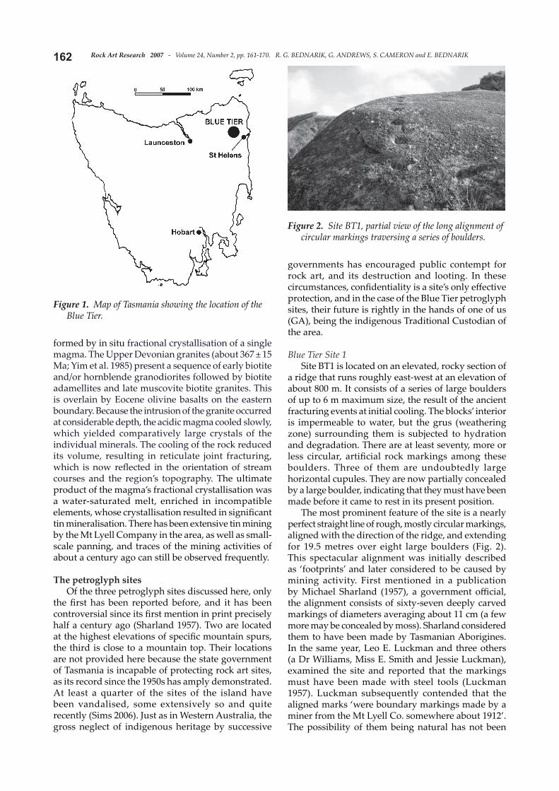
Blue Tier Site 1Site BT1 is located on an elevated, rocky section of
a ridge that runs roughly east-west at an elevation of about 800 m. It consists of a series of large boulders of up to 6 m maximum size, the result of the ancient fracturing events at initial cooling. The blocks’ interior is impermeable to water, but the grus (weathering zone) surrounding them is subjected to hydration and degradation. There are at least seventy, more or less circular, artifi cial rock markings among these boulders. Three of them are undoubtedly large horizontal cupules. They are now partially concealed by a large boulder, indicating that they must have been made before it came to rest in its present position.
The most prominent feature of the site is a nearly perfect straight line of rough, mostly circular markings, aligned with the direction of the ridge, and extending for 19.5 metres over eight large boulders (Fig. 2). This spectacular alignment was initially described as ‘footprints’ and later considered to be caused by mining activity. First mentioned in a publication by Michael Sharland (1957), a government offi cial, the alignment consists of sixty-seven deeply carved markings of diameters averaging about 11 cm (a few more may be concealed by moss). Sharland considered them to have been made by Tasmanian Aborigines. In the same year, Leo E. Luckman and three others (a Dr Williams, Miss E. Smith and Jessie Luckman), examined the site and reported that the markings must have been made with steel tools (Luckman 1957). Luckman subsequently contended that the aligned marks ‘were boundary markings made by a miner from the Mt Lyell Co. somewhere about 1912’. The possibility of them being natural has not been
Figure 1. Map of Tasmania showing the location of the Blue Tier.
Figure 2. Site BT1, partial view of the long alignment of circular markings traversing a series of boulders.

163Rock Art Research 2007 - Volume 24, Number 2, pp. 161-170. R. G. BEDNARIK, G. ANDREWS, S. CAMERON and E. BEDNARIK
considered.So far we have not had the opportunity to
examine these markings as closely as we must before formulating our judgment about their status, but we can confi dently exclude the possibility that they are natural features, such as xenoliths. However, the discovery of nearby Site BT2, with its four rows of similarly aligned and undisputable cupules, the aligned cupules at BT3 and those elsewhere in Tasmania render the defi nition of the larger series at BT1 as mining marks specious. We consider that there are three possibilities to explain them:
1. They are petroglyphs made by indigenous Tasmanians.
2. They were made by tin miners a century ago that had observed such rows of cupules nearby, prompting them to copy these alignments. This is possible but the heavy cover of turf on most rocks (see BT2) renders it unlikely.
3. That they are miner’s marks and their similarity to nearby petroglyphs is purely coincidental. Again, this is possible, but not very likely.
We will endeavour to clarify this issue in due course, on the basis of the principles established in
Bednarik (1994).
Blue Tier Site 2This site was discovered by one of us (SC) in 2005,
when he glimpsed some markings on one of the few exposed rock panels near a mountain peak not far from Site BT1. He stripped back the turf layer, exposing a fl at rock panel of about 9 m2, densely covered with petroglyphs. The panel features essentially two types of petroglyphs: percussion grooves and typical cupules. Its maximum dimensions are 4.6 m by 3.5 m, and it slopes about 24° due south. It consists largely of alkali feldspar, but there is a broad band comprising a high proportion of quartz, which occurs in the form of granular intrusions measuring several millimetres in size. Unfortunately, no petroglyphs occur within this zone running down the central part of the panel (Fig. 3). This is almost certainly because the feldspar is easier to pound than the quartz-rich zone. However, there is a second, smaller patch of the quartz-rich facies in the western part of the panel, measuring about one quarter square metre, and here one of the linear petroglyphs extends clearly into the quartz zone. Within these two facies, quartz grains protrude typically one or two millimetres above the retreating
Figure 3. Site BT2, general view. The light-coloured areas indicate where the turf has been removed during discovery in 2005.
Rock Art Research 2007 - Volume 24, Number 2, pp. 161-170. R. G. BEDNARIK, G. ANDREWS, S. CAMERON and E. BEDNARIK164
feldspar, even more where grains are large enough. This indicates that the surface retreat of the feldspar is about 2 mm since the production of the petroglyphs, all of which are heavily weathered due to gradual solution of the feldspar.
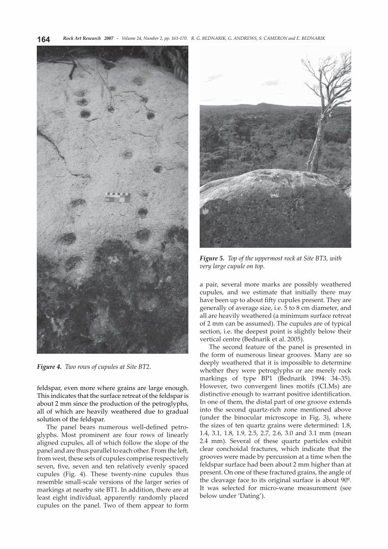
The panel bears numerous well-defi ned petro-glyphs. Most prominent are four rows of linearly aligned cupules, all of which follow the slope of the panel and are thus parallel to each other. From the left , from west, these sets of cupules comprise respectively seven, fi ve, seven and ten relatively evenly spaced cupules (Fig. 4). These twenty-nine cupules thus resemble small-scale versions of the larger series of markings at nearby site BT1. In addition, there are at least eight individual, apparently randomly placed cupules on the panel. Two of them appear to form
a pair, several more marks are possibly weathered cupules, and we estimate that initially there may have been up to about fi ft y cupules present. They are generally of average size, i.e. 5 to 8 cm diameter, and all are heavily weathered (a minimum surface retreat of 2 mm can be assumed). The cupules are of typical section, i.e. the deepest point is slightly below their vertical centre (Bednarik et al. 2005).
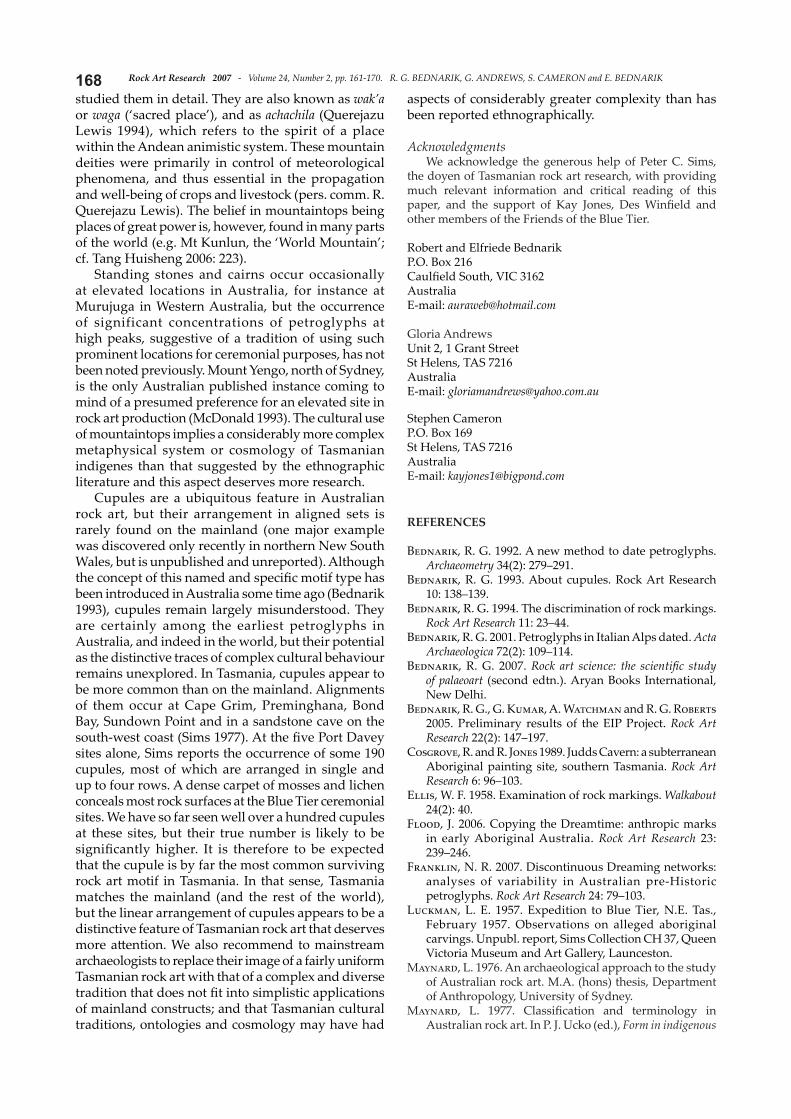
The second feature of the panel is presented in the form of numerous linear grooves. Many are so deeply weathered that it is impossible to determine whether they were petroglyphs or are merely rock markings of type BP1 (Bednarik 1994: 34–35). However, two convergent lines motifs (CLMs) are distinctive enough to warrant positive identifi cation. In one of them, the distal part of one groove extends into the second quartz-rich zone mentioned above (under the binocular microscope in Fig. 3), where the sizes of ten quartz grains were determined: 1.8, 1.4, 3.1, 1.8, 1.9, 2.5, 2.7, 2.6, 3.0 and 3.1 mm (mean 2.4 mm). Several of these quartz particles exhibit clear conchoidal fractures, which indicate that the grooves were made by percussion at a time when the feldspar surface had been about 2 mm higher than at present. On one of these fractured grains, the angle of the cleavage face to its original surface is about 90º. It was selected for micro-wane measurement (see below under ‘Dating’).
Figure 4. Two rows of cupules at Site BT2.
Figure 5. Top of the uppermost rock at Site BT3, with very large cupule on top.

165Rock Art Research 2007 - Volume 24, Number 2, pp. 161-170. R. G. BEDNARIK, G. ANDREWS, S. CAMERON and E. BEDNARIK
Blue Tier Site 3Site BT3 is located at the furthest western
point of a ridge’s elevated part, representing its highest aspect. At its very peak lies a prominent boulder of about 2 m length (Fig. 5). Its central upper surface, i.e. the highest point of the mountain, bears a large, perfectly round and deeply cup-shaped horizontal cupule. It is of 115 mm diameter and 40 mm deep, and its conspicuous positioning at the mountain’s uppermost point is arguably intentional (Fig. 6). There is a second cupule of similar size on the sloping surface of another boulder on which the fi rst rests. Numerous smaller cupules occur in the vicinity, covering much of the available rock surface. These can be found orientated in any direction from horizontal to nearly vertical, and their general distribution seems to be random. However, in some cases they form discrete clusters (Fig. 7) or occur in distinctive linear alignments (Fig. 8). There is no indication that these numerous cupules were made in Historic times and they all need to be examined microscopically to see if any fractured quartz grains have survived in them, thus determining their susceptibility to microerosion analysis.
The site also features a number of linear grooves, but we have detected no evidence so far that they are anthropic. There should be no doubt that the site was used for ceremonial purposes, therefore it is perfectly possible that its former users incorporated natural rock markings in their cultural uses of the site, even that they were prompted by them to add petroglyphs. Mainland Australian Indigenes are known to have made no cultural distinction between natural and artifi cial rock markings (Flood 2006), regarding both as having been made ‘when the rocks were soft ’, typically by creation heroes, and it is feasible that similar attitudes pertained in Tasmania. Moreover, the possibility exists that natural rock grooves of the type described from BT4 may on occasion have been modifi ed in the course of ritual activities.
The comparatively fi ne-grained musco-vite biotite granites tend to be weathered more deeply, about 12 mm to 14 mm and even more, whereas the coarser rock at BT1 and BT2 shows a thinner weathering zone. The deepest cupules have been hammered well beyond the thickness of this grussifi ed (modified) zone, i.e. into the unaltered rock.
Figure 6. The cupule on top of the boulder in Figure 5.
Figure 7. Cluster of small cupules at Site BT3.
Figure 8. Small cupules at Site BT3, some occurring in alignment.
Rock Art Research 2007 - Volume 24, Number 2, pp. 161-170. R. G. BEDNARIK, G. ANDREWS, S. CAMERON and E. BEDNARIK166
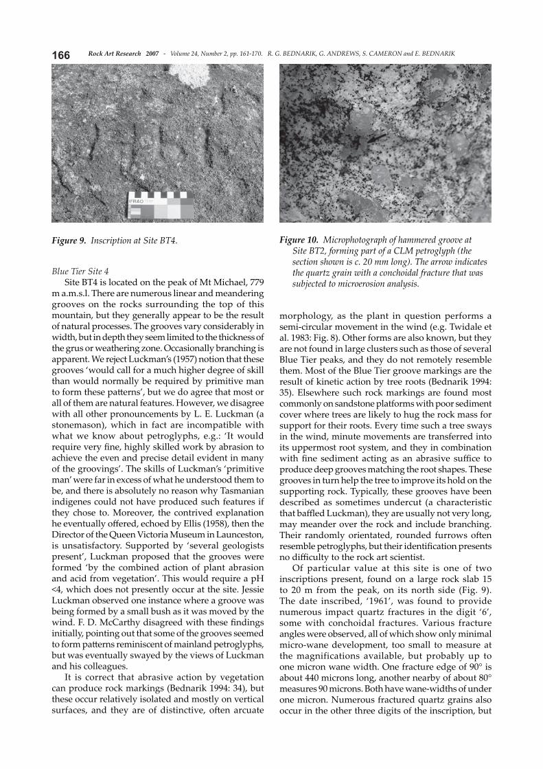
Blue Tier Site 4Site BT4 is located on the peak of Mt Michael, 779
m a.m.s.l. There are numerous linear and meandering grooves on the rocks surrounding the top of this mountain, but they generally appear to be the result of natural processes. The grooves vary considerably in width, but in depth they seem limited to the thickness of the grus or weathering zone. Occasionally branching is apparent. We reject Luckman’s (1957) notion that these grooves ‘would call for a much higher degree of skill than would normally be required by primitive man to form these patt erns’, but we do agree that most or all of them are natural features. However, we disagree with all other pronouncements by L. E. Luckman (a stonemason), which in fact are incompatible with what we know about petroglyphs, e.g.: ‘It would require very fi ne, highly skilled work by abrasion to achieve the even and precise detail evident in many of the groovings’. The skills of Luckman’s ‘primitive man’ were far in excess of what he understood them to be, and there is absolutely no reason why Tasmanian indigenes could not have produced such features if they chose to. Moreover, the contrived explanation he eventually off ered, echoed by Ellis (1958), then the Director of the Queen Victoria Museum in Launceston, is unsatisfactory. Supported by ‘several geologists present’, Luckman proposed that the grooves were formed ‘by the combined action of plant abrasion and acid from vegetation’. This would require a pH <4, which does not presently occur at the site. Jessie Luckman observed one instance where a groove was being formed by a small bush as it was moved by the wind. F. D. McCarthy disagreed with these fi ndings initially, pointing out that some of the grooves seemed to form patt erns reminiscent of mainland petroglyphs, but was eventually swayed by the views of Luckman and his colleagues.
It is correct that abrasive action by vegetation can produce rock markings (Bednarik 1994: 34), but these occur relatively isolated and mostly on vertical surfaces, and they are of distinctive, oft en arcuate
morphology, as the plant in question performs a semi-circular movement in the wind (e.g. Twidale et al. 1983: Fig. 8). Other forms are also known, but they are not found in large clusters such as those of several Blue Tier peaks, and they do not remotely resemble them. Most of the Blue Tier groove markings are the result of kinetic action by tree roots (Bednarik 1994: 35). Elsewhere such rock markings are found most commonly on sandstone platforms with poor sediment cover where trees are likely to hug the rock mass for support for their roots. Every time such a tree sways in the wind, minute movements are transferred into its uppermost root system, and they in combination with fi ne sediment acting as an abrasive suffi ce to produce deep grooves matching the root shapes. These grooves in turn help the tree to improve its hold on the supporting rock. Typically, these grooves have been described as sometimes undercut (a characteristic that baffl ed Luckman), they are usually not very long, may meander over the rock and include branching. Their randomly orientated, rounded furrows oft en resemble petroglyphs, but their identifi cation presents no diffi culty to the rock art scientist.
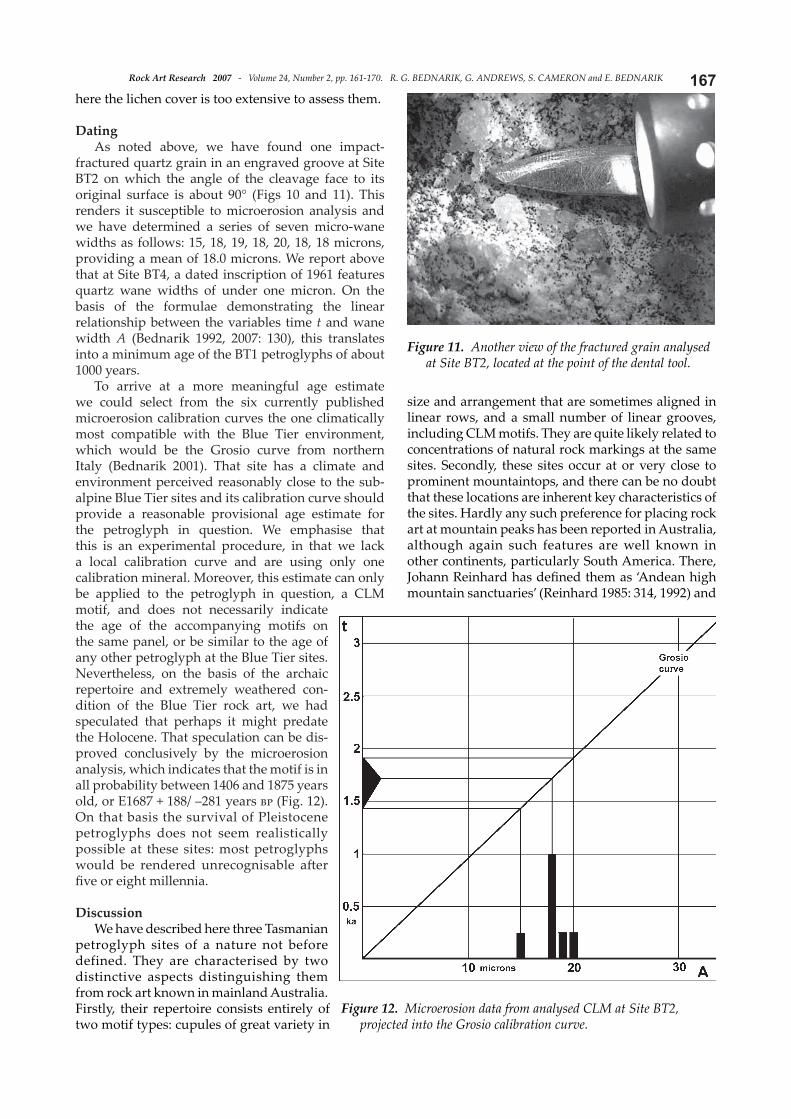
Of particular value at this site is one of two inscriptions present, found on a large rock slab 15 to 20 m from the peak, on its north side (Fig. 9). The date inscribed, ‘1961’, was found to provide numerous impact quartz fractures in the digit ‘6’, some with conchoidal fractures. Various fracture angles were observed, all of which show only minimal micro-wane development, too small to measure at the magnifications available, but probably up to one micron wane width. One fracture edge of 90° is about 440 microns long, another nearby of about 80° measures 90 microns. Both have wane-widths of under one micron. Numerous fractured quartz grains also occur in the other three digits of the inscription, but
Figure 9. Inscription at Site BT4. Figure 10. Microphotograph of hammered groove at Site BT2, forming part of a CLM petroglyph (the section shown is c. 20 mm long). The arrow indicates the quartz grain with a conchoidal fracture that was subjected to microerosion analysis.
167Rock Art Research 2007 - Volume 24, Number 2, pp. 161-170. R. G. BEDNARIK, G. ANDREWS, S. CAMERON and E. BEDNARIK
here the lichen cover is too extensive to assess them.
DatingAs noted above, we have found one impact-
fractured quartz grain in an engraved groove at Site BT2 on which the angle of the cleavage face to its original surface is about 90° (Figs 10 and 11). This renders it susceptible to microerosion analysis and we have determined a series of seven micro-wane widths as follows: 15, 18, 19, 18, 20, 18, 18 microns, providing a mean of 18.0 microns. We report above that at Site BT4, a dated inscription of 1961 features quartz wane widths of under one micron. On the basis of the formulae demonstrating the linear relationship between the variables time t and wane width A (Bednarik 1992, 2007: 130), this translates into a minimum age of the BT1 petroglyphs of about 1000 years.
To arrive at a more meaningful age estimate we could select from the six currently published microerosion calibration curves the one climatically most compatible with the Blue Tier environment, which would be the Grosio curve from northern Italy (Bednarik 2001). That site has a climate and environment perceived reasonably close to the sub-alpine Blue Tier sites and its calibration curve should provide a reasonable provisional age estimate for the petroglyph in question. We emphasise that this is an experimental procedure, in that we lack a local calibration curve and are using only one calibration mineral. Moreover, this estimate can only be applied to the petroglyph in question, a CLM motif, and does not necessarily indicate the age of the accompanying motifs on the same panel, or be similar to the age of any other petroglyph at the Blue Tier sites. Nevertheless, on the basis of the archaic repertoire and extremely weathered con-dition of the Blue Tier rock art, we had speculated that perhaps it might predate the Holocene. That speculation can be dis-proved conclusively by the microerosion analysis, which indicates that the motif is in all probability between 1406 and 1875 years old, or E1687 + 188/ –281 years bp (Fig. 12). On that basis the survival of Pleistocene petroglyphs does not seem realistically possible at these sites: most petroglyphs would be rendered unrecognisable aft er fi ve or eight millennia.
DiscussionWe have described here three Tasmanian
petroglyph sites of a nature not before defined. They are characterised by two distinctive aspects distinguishing them from rock art known in mainland Australia. Firstly, their repertoire consists entirely of two motif types: cupules of great variety in
size and arrangement that are sometimes aligned in linear rows, and a small number of linear grooves, including CLM motifs. They are quite likely related to concentrations of natural rock markings at the same sites. Secondly, these sites occur at or very close to prominent mountaintops, and there can be no doubt that these locations are inherent key characteristics of the sites. Hardly any such preference for placing rock art at mountain peaks has been reported in Australia, although again such features are well known in other continents, particularly South America. There, Johann Reinhard has defi ned them as ‘Andean high mountain sanctuaries’ (Reinhard 1985: 314, 1992) and
Figure 11. Another view of the fractured grain analysed at Site BT2, located at the point of the dental tool.
Figure 12. Microerosion data from analysed CLM at Site BT2, projected into the Grosio calibration curve.
Rock Art Research 2007 - Volume 24, Number 2, pp. 161-170. R. G. BEDNARIK, G. ANDREWS, S. CAMERON and E. BEDNARIK168studied them in detail. They are also known as wak’a or waga (‘sacred place’), and as achachila (Querejazu Lewis 1994), which refers to the spirit of a place within the Andean animistic system. These mountain deities were primarily in control of meteorological phenomena, and thus essential in the propagation and well-being of crops and livestock (pers. comm. R. Querejazu Lewis). The belief in mountaintops being places of great power is, however, found in many parts of the world (e.g. Mt Kunlun, the ‘World Mountain’; cf. Tang Huisheng 2006: 223).
Standing stones and cairns occur occasionally at elevated locations in Australia, for instance at Murujuga in Western Australia, but the occurrence of significant concentrations of petroglyphs at high peaks, suggestive of a tradition of using such prominent locations for ceremonial purposes, has not been noted previously. Mount Yengo, north of Sydney, is the only Australian published instance coming to mind of a presumed preference for an elevated site in rock art production (McDonald 1993). The cultural use of mountaintops implies a considerably more complex metaphysical system or cosmology of Tasmanian indigenes than that suggested by the ethnographic literature and this aspect deserves more research.
Cupules are a ubiquitous feature in Australian rock art, but their arrangement in aligned sets is rarely found on the mainland (one major example was discovered only recently in northern New South Wales, but is unpublished and unreported). Although the concept of this named and specifi c motif type has been introduced in Australia some time ago (Bednarik 1993), cupules remain largely misunderstood. They are certainly among the earliest petroglyphs in Australia, and indeed in the world, but their potential as the distinctive traces of complex cultural behaviour remains unexplored. In Tasmania, cupules appear to be more common than on the mainland. Alignments of them occur at Cape Grim, Preminghana, Bond Bay, Sundown Point and in a sandstone cave on the south-west coast (Sims 1977). At the fi ve Port Davey sites alone, Sims reports the occurrence of some 190 cupules, most of which are arranged in single and up to four rows. A dense carpet of mosses and lichen conceals most rock surfaces at the Blue Tier ceremonial sites. We have so far seen well over a hundred cupules at these sites, but their true number is likely to be signifi cantly higher. It is therefore to be expected that the cupule is by far the most common surviving rock art motif in Tasmania. In that sense, Tasmania matches the mainland (and the rest of the world), but the linear arrangement of cupules appears to be a distinctive feature of Tasmanian rock art that deserves more att ention. We also recommend to mainstream archaeologists to replace their image of a fairly uniform Tasmanian rock art with that of a complex and diverse tradition that does not fi t into simplistic applications of mainland constructs; and that Tasmanian cultural traditions, ontologies and cosmology may have had
aspects of considerably greater complexity than has been reported ethnographically.
AcknowledgmentsWe acknowledge the generous help of Peter C. Sims,
the doyen of Tasmanian rock art research, with providing much relevant information and critical reading of this paper, and the support of Kay Jones, Des Winfi eld and other members of the Friends of the Blue Tier.
Robert and Elfriede BednarikP.O. Box 216Caulfi eld South, VIC 3162AustraliaE-mail: [email protected]
Gloria AndrewsUnit 2, 1 Grant StreetSt Helens, TAS 7216AustraliaE-mail: [email protected]
Stephen CameronP.O. Box 169St Helens, TAS 7216AustraliaE-mail: [email protected]
REFERENCES
Bednarik, R. G. 1992. A new method to date petroglyphs. Archaeometry 34(2): 279–291.
Bednarik, R. G. 1993. About cupules. Rock Art Research 10: 138–139.
Bednarik, R. G. 1994. The discrimination of rock markings. Rock Art Research 11: 23–44.
Bednarik, R. G. 2001. Petroglyphs in Italian Alps dated. Acta Archaeologica 72(2): 109–114.
Bednarik, R. G. 2007. Rock art science: the scientifi c study of palaeoart (second edtn.). Aryan Books International, New Delhi.
Bednarik, R. G., G. Kumar, A. Watchman and R. G. Roberts 2005. Preliminary results of the EIP Project. Rock Art Research 22(2): 147–197.
Cosgrove, R. and R. Jones 1989. Judds Cavern: a subterranean Aboriginal painting site, southern Tasmania. Rock Art Research 6: 96–103.
Ellis, W. F. 1958. Examination of rock markings. Walkabout 24(2): 40.
Flood, J. 2006. Copying the Dreamtime: anthropic marks in early Aboriginal Australia. Rock Art Research 23: 239–246.
Franklin, N. R. 2007. Discontinuous Dreaming networks: analyses of variability in Australian pre-Historic petroglyphs. Rock Art Research 24: 79–103.
Luckman, L. E. 1957. Expedition to Blue Tier, N.E. Tas., February 1957. Observations on alleged aboriginal carvings. Unpubl. report, Sims Collection CH 37, Queen Victoria Museum and Art Gallery, Launceston.
Maynard, L. 1976. An archaeological approach to the study of Australian rock art. M.A. (hons) thesis, Department of Anthropology, University of Sydney.
Maynard, L. 1977. Classifi cation and terminology in Australian rock art. In P. J. Ucko (ed.), Form in indigenous
169Rock Art Research 2007 - Volume 24, Number 2, pp. 161-170. R. G. BEDNARIK, G. ANDREWS, S. CAMERON and E. BEDNARIK
art: schematisation in the art of Aboriginal Australia and prehistoric Europe, pp. 387–402. Australian Institute of Aboriginal Studies, Canberra.
McDonald, J. 1993. On a clear day, you can see Mount Yengo. Or: investigating the archaeological manifestations of culturally signifi cant foci in the prehistoric landscape. In J. Steinbring, A. Watchman, P. Faulstich and P. S. C. Taçon (eds), Time and space: dating and spatial considerations in rock art research, pp. 84–91. Occasional AURA Publication 8, Australian Rock Art Research Association, Melbourne.
Querejazu Lewis, R. 1994. Contemporary indigenous use of traditional rock art sites at Yaraque, Bolivia. Rock Art Research 11: 3–9.
Reinhard, J. 1985. Sacred mountains: an ethno-archaeological study of high Andean ruins. Mountain Research and Development 5(4): 299-317.
Reinhard, J. 1992. Sacred peaks of the Andes. National Geo-graphic 181(3): 84–111.
Sharland, M. S. R. 1957. Symbols of an extinct race. Walkabout 23(10): 38, 41–42.
Sims, P. C. 1977. Variations in Tasmanian petroglyphs. In P. J. Ucko (ed.), Form in indigenous art: schematisation in the art of Aboriginal Australia and prehistoric Europe, pp. 429–438. Australian Institute of Aboriginal Studies, Canberra.
Sims, P. C. 2006. Rock art vandalism in Tasmania. Rock Art Research 23: 119–122.
Tang Huisheng 2006. Opposition and unity: shamanistic dualism in Tibetan and Chinese pre-Historic art. Rock Art Research 23: 217–226.
Twidale, C. R., E. M. Campbell and J. A. Bourne 1983. Granite forms, karsts and lunett es. In M. J. Tyler, C. R. Twidale. K. J. Ling and J. W. Holmes (eds), Natural history of the South East, pp. 25-37. Royal Society of South Australia Inc., Adelaide.
Yim, W. W., A. J. W. Gleadow and J. C. V. Moort 1985. Fission track dating of alluvial zircons and heavy mineral provenance in northeast Tasmania. Journal of the Geological Society 142(2): 351–356.
RAR 24: 834
COMMENTRock art in high placesBy PETER C. SIMS
When revisiting this site in June 2007, aft er my fi rst visit in 1973, I fi rstly looked at the geographical location and its proximity to known Aboriginal sites and secondly att empted to determine the vegetation of early pre-European times.
Looking at the geographical position of Blue Tier, it is a range with the highest point Mt Michael at almost 800 m, which commands extensive views of the surrounding country, including the eastern Bass Strait Islands (Clarke and Cape Barren, remnants of the land bridge exposed when the sea level was lower during the last Ice Age) to the north, Great Musselroe Bay, Eddystone Point and the Bay of
Fires to the east, the coastal town of St Helens, and to the inland mountains (Mt Victoria, Mt Albert and the 1500 m Ben Lomond plateau, oft en snow-capped in winter). The Tier is a forested backdrop to the coast with several river valleys that would have provided access to the high country, being just under 25 km from the coast and the same distance to nearby Mt Victoria, with signifi cant Aboriginal sites at both areas. The Tier would have provided an ideal place for communication by way of smoke signals to other Aboriginal people and would therefore be signifi cantly important.
Having climbed most of Tasmania’s mountain peaks (the state’s highest, Mt Ossa, is 1617 m) and ex-plored much of the high country, I have encountered Aboriginal cultural material on the Central Plateau (1100 m) and at the lower slopes (950 m) of Cradle Mountain (1545 m) but have found no evidence of rock art on mountaintops. Although on a clear day the summits of the mountain peaks off er extensive views and are powerful and spiritually uplift ing to me, they are not places where one would linger as they are exposed to changeable and oft en severe weather conditions. I have observed that all of the Tasmanian rock art sites are in areas of outstanding scenic beauty and some sites on the coast are adjacent to high cliff s that command extensive vistas, are close to shelter and had plentiful food sources.
The forests on top of and surrounding Blue Tier would have provided shelter and protection from severe weather conditions and this part of Tasmania is much milder than the West Coast. These native forests that surround the Tier contain cool temperate rainforest trees up to 600–700 years old, its evolution from the beginnings in Gondwana to the present, and the existence of tall old-growth wet eucalypt forests are an indication of wildfi res 300–400 years ago (Go-vernment of Tasmania 1987). The high country of the Tier now has re-emergent rainforest that is slowly recovering from timber extraction and extensive fi res that resulted in land clearance for tin mining early last century.
When I fi rst observed site BT1 thirty-four years ago, I had limited fi rst-hand knowledge of Aboriginal rock art and was guided by Luckman, Ellis and others, and I was convinced the row of markings in the rock were not caused by natural processes. As the area had been extensively subjected to mineral exploration and mining I was inclined to think that they were as a result of such activities. The random linear markings on some rocks and not on others were always a puzzle to me and I could not accept the ‘tree root’ theory. It is therefore an important breakthrough that additional rock markings discovered by Cameron, coupled with a deep understanding of the Aboriginal signifi cance of Blue Tier as experienced by Andrews, has now received the att ention of Bednarik, an internationally recognised authority who now unravels some of the questions of this site. Additional exploration of the

Rock Art Research 2007 - Volume 24, Number 2, pp. 161-170. R. G. BEDNARIK, G. ANDREWS, S. CAMERON and E. BEDNARIK170
area will most likely reveal Aboriginal occupation sites nearby which will add weight to the use of Blue Tier for communication and other cultural tra-ditions.
It is indeed an indictment on successive Tasmanian governments that they have been incapable of pro-tecting rock art sites (Sims 2006), and whilst the present Labor Government has made promises, these have so far not materialised.
Peter C. Sims OAM
P.O. Box 692Quoiba, TAS 7310AustraliaE-mail: [email protected]
REFERENCES
Government of Tasmania 1987. The rainforest of Tasmania. Tasmanian Government Printer, Hobart.
Sims, P. C. 2006. Rock art vandalism in Tasmania. Rock Art Research 23: 119–122.
RAR 24-835
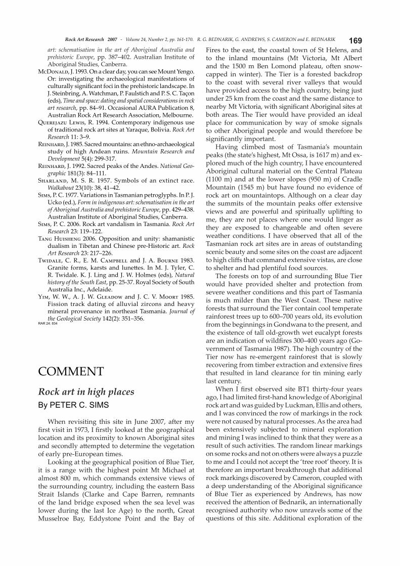
Figure 13. The Traditional Custodian of Meenamatt a (Blue Tier), Gloria Andrews, descended fromTasmanian indigenes, with large cupule on mountain top (photograph by P. C. Sims).
Please visit the Save the Dampier Rock Art site at htt p://mc2.vicnet.net.au/home/dampier/web/index.html
and sign the Dampier Petition. Thank you!