PDF - Art is Open Source
428
-
Upload
khangminh22 -
Category
Documents
-
view
1 -
download
0
Transcript of PDF - Art is Open Source


DATA TO THEPEOPLE
PROCEEDINGS OF THE 3RD INTERNATIONAL BIENNIAL CONFERENCE
ATHENS, 17-19 SEPTEMBER 2015NATIONAL AND KAPODISTRIAN UNIVERSITY OF ATHENS
EDITED BY:IOULIANI THEONA
DIMITRIS CHARITOS
UNIVERSITY RESEARCH INSTITUTE OF APPLIED COMMUNICATIONATHENS 2015

SUPPORTED BY
COLLABORATING INSTITUTIONS & PLATFORMS
ORGANIzED BY
UNIVERSITY RESEARCH INSTITUTE OF APPLIED COMMUNICATION (URIAC),UNIVERSITY OF ATHENS1 Sofokleous str., 3rd fl., 105 59, Athens,Greece | Tel: 210 3689413www.media.uoa.gr/institute
ISBN 978-960-99791-2-2
© 2015 by the University Research Institute of Applied Communication (URIAC), the Editors & AuthorsFirst published in 2015 by University Research Institute of Applied Communication (URIAC), National & Kapodistrian University of Athens, Athens, Greece
This work is licensed under the Creative Commons Attribution-NonCommercial-NoDerivs 3.0 Unported License. [CC BY-NC-ND 3.0]https://creativecommons.org/licenses/by-nc-nd/3.0/
This publication is Open Access, which means that you are free to copy, distribute, display, and perform the work as long as you clearly attribute the work as indicated, that you do not use this work for commercial gain in any form whatsoever, and that you in no way alter, transform, or build upon the work outside of its normal use in academic scholarship without express permission of the author/s, the edi-tors and the publisher of this volume. For any reuse or distribution, you must make clear to others the license terms of this work.
Please attribute as follows:
• For the whole book: <Editors’ last names> <Editors’ first names> (2015) Hybrid City 2015: Data to the People, Athens: URIAC
• For a specific chapter: <Author’s last name> <Author’s first name> (2015) in <Editors’ last names> <Editors’ first names> (2015) Hybrid City 2015: Data to the People, Athens: URIAC
Faculty of Communication and Media Studies
HELLENIC REPUBLIC
National and KapodistrianUniversity of Athens
HELLENIC REPUBLIC
National and KapodistrianUniversity of Athens

PREFACE 11
HYBRID CITY 2015 COMMITTEES 14
KEYNOTE PRESENTATIONCitizen Centered Design for Humane and Sociable Hybrid Cities 17 Norbert Streitz
CHAPTER 1 – URBAN COMMONS AND SMART CITIzENSHIPFrom online communities to applied intervention - The case of the “Dome Project” 22 and “Solidarity networks”: Grassroots solidarity practices within and beyond borders Martha Bouziouri
Data and the City: Moving from surveillance and control to the Ubiquitous Commons 26 Salvatore Iaconesi, Oriana Persico
From (Not)Doing-It-Yourself to Doing-It-(Cheaper)-With-Others: The rise of a Workshop Culture 40 in the Greek Economic Dystopia Marinos Koutsomichalis, Nikolaos Rodousakis
The New Cross Triangle, the Founding of an Urban Myth: DIY Place-Making as Auto-Valorization 49 The New Cross Triangle Psychogeographical Association
An Environmentalism for Environmental Media: Ambient Commoning as Cultural Technique 57 in the Sentient Semiosphere Soenke Zehle
CHAPTER 2 – HYBRID SPACE AND DATA / NETwORK OwNERSHIPDIY networking as a facilitator for interdisciplinary research on the hybrid city 65Panayotis Antoniadis, Ileana Apostol, Mark Gaved, Michael Smyth, Andreas Unteidig
From Community Networks to Off-the-cloud toolkits: Art and DIY networking 73Daphne Dragona
Life at the Local Scale: An alternative perspective on the urban 82Michael Smyth, Ingi Helgason
The Hybrid Meeting Point: An urban infrastructure for interacting across boundaries of difference 87Andreas Unteidig, Bianca Herlo, Lutz Reiter
CHAPTER 3 – OPEN URBAN ENVIRONMENTAL DATAAbsence in Context: Recontextualizing civic data, critical cartographies, and gentrification in New York City 96 Justin Blinder
Cloud Computing in the Kampung 103Marc Böhlen, Ilya Maharika
Data and the City: Accessibility and Openness. A Cybersalon paper on open data 111Sophia Drakopoulou, Eva Pascoe, Benjamin Greenaway, James Moulding, Wendy Grossman, Ilze Black
particleBox: Visualizing Particulate Matter. Air Quality Sensors, Democratizing Data and Public Health 117Joann Hoffman, Carl McKinney
Discussing the scope and potential of open urban data from broader perspectives: 121 open government, open data, policy-making, smart citiesEvika Karamagioli, Dimitris Gouscos
Technology mediation and visualizing urban energy data 125Kristian Kloeckl
Mapping Vacancy: The collective inventory of abandoned urban properties 133Daniela Patti, Levente Polyak

Implications of open urban data on the social production of space and urban land policies: 142 The real-estate applications effectConstantina Theodorou
CHAPTER 4 – URBAN MEDIA FOR EMPOwERING CITIzENSMeasuring Amsterdam: A participatory mapping tool for citizen empowerment 147Maarten Groen, Wouter Meys
Participatory Design and the Hybrid City: The Living Lab Mehringplatz, Berlin, and the Project 151 “Community Now? Conflicts, Interventions, New Publics”Bianca Herlo, Florian Sametinger, Jennifer Schubert, Andreas Unteidig
Empowering science parks for disabled persons using Boxes 161Lucas H. M. Lazaro, Enlai L. Cheng, Lucas N. Couceiro, Lucia V. L. Filgueiras, James Ohene-Djan
Empowering Citizens and their Input on Civic Issues through Urban Media 167Ian McArthur, Martin Tomitsch, Luke Hespanhol
Dynamic Street Light Management: Towards a citizen centred approach 175Nabil Ouerhani, Nuria Pazos, Marco Aeberli, Julien Senn, Stéphane Gobron
Transforming a City into a Sociable Smart City 179Dimitrios Ringas, Eleni Christopoulou
CHAPTER 5 – DESIGNING THE HYBRID CITYThe Image of The City in The Information Era: Analyzing the effect of digital mobile devices 185 on city imaging processNegar Ahmadpoormobarakeh, Tim Heath
Lessons from Game Design: Understanding Participatory Processes through Game Mechanics 189Cristina Ampatzidou, Katharina Gugerell, Jeremiah Diephuis
The urban myths of open data 196Christian Ulrik Andersen
Understanding Discursive Design and Social Data in Architectural Processes 203Kjeld S. Hansen, Tor-Morten Grønli, Synne Skjulstad, Vesma Kontere McQuillan
The Space of Engagement: Participatory design through serious urban gaming – the case of euREKA 207 digital simulation game Milena Ivković, Milica Anđelković
Street-level City Analytics: Mapping the Amsterdam Knowledge Mile 211 Sabine Niederer, Gabriele Colombo, Michele Mauri, Matteo Azzi
CHAPTER 6 – ENVIRONMENTAL SENSING AND HYBRID OBjECTSThe Hybrid Object: augmenting objects and transforming their relationship with humans 218 Dimitris Charitos, Maria Kerasia Andrikaki
HexSpace: Technological Layering of Domestic Environments 222Stavros Didakis
Sensing the Workspace: An Innovative Way to Improve Eco-Awareness at Work 227Anna Karagianni, Panagiotis Parthenios
Identification of Things in a Smart City 230Stella Simitropoulou, George Charamis, Achilles Kameas
CHAPTER 7 – URBAN DATA VISUALIzATION AND MAPPINGMapito.org: Open Geographic Platform for Locative Media Apps 239 Konstantinos Chorianopoulos, Konstantinos Pardalis
Business Intelligence for Primary Healthcare Management: The case of PEDY Network 243 in Athens Metro Area Dimitris Drakopoulos, Dr Annie Tubadji, Amalia Maria Koutsogianni, Stelios Dontas

Exploring Urban Mobility and Accessibility through Transport Data: A study of London Oyster card data 248 and disabilityGareth Simons, Andrew Hudson Smith, Martin Zaltz Austwick, Katerina Skroumpelou, Stylianos Tsaparas, Gianfranco Gliozzo
The role of Electroencephalography (EEG) in Understanding the Differences 256 in Urban-Environmental PerceptionsKaterina Skroumpelou, Panagiotis Mavros, Dr. Andrew Hudson Smith
CHAPTER 8 – AUGMENTED [URBAN] SPATIAL ExPERIENCES“Ghost - Athens”: A mobile application about the unknown buildings and street art of Athens 264Stavroula Bampatzia, Angela Antoniou, George Lepouras, Violeta Bampatzia, Athena Lountzi
The Lure of CyberPark: Synergistic Outdoor Interactions between Public Spaces, Users 268 and Locative TechnologiesKonstantinos Ioannidis, Carlos Smaniotto Costa, Ina Suklje-Erjavec, Marluci Menezes, Alfonso BahilloMartínez
The Palimpsest Project: postalphabetical augmented museum of participatory storytelling 278Polyxeni Mantzou, Angeliki Matami, Georgios Kapraras, Christina Charistou
Enriching the city environment with mobile Augmented Reality edutainment applications 286 for residents and tourists: The case of “Roads of Rhodes” gameDimitrios Markouzis, Georgios Fessakis
Designing for Mixed Embodied Presence in a Virtual Setting 294Chrissa Papasarantou, Charalampos Rizopoulos
Hackable Urban Experiences 302Marinela Telo, Konstantinos-Alketas Oungrinis
CHAPTER 9 – AUDIOVISUAL NARRATIVES IN THE CITYSCAPE Readable City Soundscapes: reading visual noise in the hybrid city 309 Katerina Antonaki, Eleni Glinou, Irene Mavrommati, George Birbilis
Media Walks: Culture, Media and Design 313Nikos Bubaris
Two Worlds: A Hybrid Local-Remote Interactive Sound Installation 320Yiannis Colakides, Iannis Zannos, Yiannis Christides
Hello Citizen! Registering the sound of the smart city 323Teresa Dillon
Locative media soundwalks: A rhizomatic approach to urban public space sound art 330Dana Papachristou
ICTs and Contemporary Art: a platform for the urban well-being 335Anastasia Zoi Souliotou
Walking-with-Sound: wellbeing, citizen empowerment and agency through mobile sound art 341Katerina Talianni
CHAPTER 10 – PLACEMAKING IN THE HYBRID URBAN CONTExTDourgouti Island Hotel: An “UrbanDig for Neighborhoods” Case Study 346Christos Ananiadis, Dikaia Chatziefstathiou, George Sachinis
The ‘street’, the ‘body’ and the ‘move’:A hybrid space design for knowledge urban circulation 349Anna Chronaki
Placemaking and place identity in social media: Snapshots from Facebook 357Mariza Georgalou Mapping the urban narratives: the works of Larissa Fassler 367Zacharias Ouranos

10
The Secret School: An installation on Migration involving the public through text and media contributions 371 in a closed networkIoannis Zannos, Loukas Basoukos, Evan Light
CHAPTER 11 – ARCHITECTURAL PERSPECTIVES ON HYBRID SPACED-D_D-P_H-S: data-driven de-professionalized hybrid-subjectivities 375 Christos Chondros
Content Architectures and Digital Modernity: ‘E-scapes’ into urbanities of data, or the information architect 382 as an architect ‘in formation’Aristotelis Dimitrakopoulos
A Strategy for the Reactivation of Residual Urban Voids: Multidimensional Comparative Analysis 390 and ClassificationAnna Laskari
Urban P.E.T.s.: Urban Public Embedded Thresholds 397Polyxeni Mantzou, Francisco García Triviño, Katerina Psegiannaki
Parallel Structures. The Electronic Urbanism of Takis Ch. Zenetos: 1962-1974 403Maria D. Papadimitriou
The unknown city: Rethinking the role of the ‘akalyptos’ in the historic center of Thessaloniki 411Anastasia Papadopoulou, Venetia Tsakalidou, Ioannis A. Tsalikidis
CHAPTER 12 – wORKSHOP PRESENTATIONS The Hackable City 420
Wave Your Open Data Magic Wand. Cybersalon Hackathon 421
CONTACT: Facilitating information sharing between strangers with DIY networking 422
Metaxication Inc. 423
noTours: recording-editing-audiowalking 424

11
Preface
During the first two decades of the 21st century, we have experienced a multi-faceted crisis that’s challenging the current condition and structural paradigm, locally as well as globally, in most areas of the planet. This crisis is not only economic; it is also social, political and environ-mental. As such, it has a very prominent urban dimension, exposing cities to a diverse spectrum of distress. Acute natural disasters -earthquakes, fires, or phenomena related to climate change; floods, severe snowfall, fires etc.- precarious access to basic resources such as food and water, lack of opportunities for employment, inefficient social services, e.g. healthcare and education, along with ever increasing unforeseeable acts of violence –a complex and manifold phenomenon on its own right- render living in urban areas vulnerable.
The third Hybrid City Conference seeks to investigate Information Communication Technolo-gies (ICTs) as a means of supporting more Sustainable Cities and Resilient, Self-Reliant Com-munities as well as for empowering Citizens. By proclaiming “Data to the People” the Hybrid City Conference adopts a citizen centered approach and seeks to highlight bottom-up projects, initiatives and processes of technological mediation, which assist individuals, communities and cities in responding and adapting to the above mentioned new challenges. The Hybrid City Con-ference aims to offer insights into the complexity of factors that weaken the city fabric and affect urban wellbeing. Furthermore, it aims at investigating the potential of ICTs to support proactive and collective design towards future cities, focusing on real needs and maintaining a critical stand towards the prevailing “smart-everything” rhetoric.
The Hybrid City 2015 announcements invited contributions both employing a theoretical and/or a practical approach in presenting concepts, case studies, projects, works of art and best practices promoting the discussion on the theme. Emphasizing the inherently interdisciplinary nature of technologically mediated urban activity, we welcomed proposals discussing concepts or documenting projects of urban innovation, that through originality contribute to shaping the future of the hybrid city and offer useful insights into the hybridization process of the urban environment.
Submissions were expected to critically examine a series of significant relevant topics that we and the other members of the Program Committee (Daphne Dragona, Mike Phillips, Penny Travlou, Martijn de Waal) suggested, or other relevant lines of research within the Hybrid City context. Some of the proposed topics were: Environmental sensing and the Internet of things: regaining control; Open urban data, capturing and visualization; Environmental perception, cognition, immersion and presence in the context of hybrid urban spaces; Psychosocial perspec-tives into the impact of locative and pervasive media use; Placemaking, place attachment and place identity in the hybrid city; New public spaces: From creative spatial re-use to urban farm-ing; Peer to peer urbanism: From open source to doing it with others; Collaborative economies and sharing cities practices; Urban self-reliance: Alternative collectives and support networks; Resilience and sustainability: Emerging citizen-driven toolkits, methodologies and prototypes; Artworks, and urban interventions for citizen empowerment; Transmedia location-aware sto-rytelling; Performative bodies, gendered spaces and technofeminism in the Hybrid City; Infra-structural fails and alternative communication systems: Critical perspectives and responses to stacktivism; Autonomous, offline file-sharing and communication networks; Open hardware and sustainability.

12
Following the peer-review process and the submission of the final manuscripts, we introduced a new categorization to the content of the conference, corresponding with the main concepts dis-cussed through the finally submitted papers, this categorization led to the structure of the volume of proceedings into the following chapters:
• Urban Commons and Smart Citizenship• Hybrid Space and Data/ Network Ownership• Open Urban Environmental Data• Urban Media for Empowering Citizens• Designing the Hybrid City• Environmental Sensing and Hybrid Objects• Urban Data Visualization and Mapping• Augmented [Urban] Spatial Experiences• Audiovisual Narratives in the Cityscape• Placemaking in the Hybrid Urban Context• Architectural Perspectives on Hybrid Space
These chapters are very much in line with the structure of the final conference program and the titles of the sessions that it comprises.
In addition to the above, the 3rd Hybrid City conference hosted a series of workshops and paral-lel events. These workshops were organized in collaboration with renowned researchers, artists, platforms and collectives and aimed to further expand on this year’s theme “Data to the People” and aspire to shed light on the complex technosocial recombination that shapes urban life in Athens today:
• Wave Your Open Data Magic Wand: Cybersalon Hackathon Cybersalon team: Sophia Drakopoulou, Benjamin Greenaway, James Moulding, Eva Pascoe, Simon Sarginson • CONTACT: Facilitating information sharing between strangers with DIY networking Ileana Apostol, Panayotis Antoniadis (NetHood), Katalin Hausel (unMonastery) Special guests: Andreas Unteidig, James Stevens, Mathias Jud & Christophe Wachter, Michael Smyth, Minuette Le• Metaxication Inc. The Athens Subsumption Group Jeff Andreoni, Maria Juliana Byck , Ismini Epitropou. Maria Saridaki, Penny Travlou, Marilia Trogada, Maria Athina Tzioka, Constantinos Venis• noTours: recording-editing-audiowalking Akoo-o collective: Nikos Bubaris, Sofia Grigoriadou , Dana Papachristou, Giorgos Samantas, Geert Vermeire• The Hackable City Martijn de Waal
HYBRID CITY 2015 | DATA TO THE PEOPLE

13
The workshops took place during 15-17 of September 2015, and were hosted in the premises of the Faculty of Communication and Media Studies of the University of Athens. Finally, we would like to extend our thanks and appreciation to:
• the fellow members of the program committee: Daphne Dragona, Mike Phillips, Penny Travlou, Martijn de Waal, for helping us since the beginning of the conference organiza-tion with their ideas and feedback
• the numerous members of the scientific committee who supported the reviewing process
• the authors who honored us with submitting their creative work
• the workshop organizers listed above for bringing in the conference their platforms and colleagues, thus significantly enriching the event with exciting hands on experimentation and creative activities
• the University Research Institute of Applied Communication (URIAC), the New Tech-nologies Laboratory, the Faculty of Communication and Media Studies and the School of Economics and Political Sciences of the National and Kapodistrian University of Athens for hosting the event once again
• the Perfomigrations project and research team who linked their forces with us this year
• the embassy of Austria for supporting the conference once again
• all research associates, graduate students and other colleagues who helped to make this happen with their help and support
• all of you who attended the conference or read the proceedings
• the Hybrid City community who follow our activities online and contribute creatively.
We hope that with your help and support, we will be able to realize more Hybrid City conferences and other relevant events in the future.
Iouliani TheonaDimitris Charitos
Preface
14
ΟRGANISING COMMITTEEDimitris Charitos, Assistant Professor at the Faculty of Communication and Media Studies, University of Athens, Greece.Michael Meimaris, Professor at the Faculty of Communication and Media Studies, University of Athens, Greece. PROGRAM COMMITTEEDaphne Dragona, Curator / Researcher, Faculty of Communication and Media Studies, University of Athens, Greece.Mike Phillips, Professor of Interdisciplinary Arts at Plymouth University, UK, Director of Research at i-DAT.org and a Principal Supervisor for the Planetary Collegium.Iouliani Theona, Architect / Researcher, School of Architecture, National Technical University of Athens, Greece.Penny Travlou, Lecturer in Cultural Geography and Theory at the Edinburgh School of Architecture and Landscape Architecture, University of Edinburgh, UK.Martijn de Waal, Researcher on Citizen Empowerment at the Amsterdam University of Applied Sciences, Assistant Professor at the department of Media studies at the University of Amsterdam, Netherlands. SCIENTIFIC COMMITTEEPanayotis Antoniadis, Senior Researcher, Communications Systems Group, ETH Zürich, Switzerland.Vassilis Bourdakis, Architect, Professor, Department of Architecture, University of Thessaly, Greece.Nikolaos Bubaris, Assistant Professor, Department of Cultural Technology and Communication, University of the Aegean, Greece.Kostas Daflos, Assistant Professor, School of Architecture, National Technical University of Athens, Greece.Katerina Diamantaki, Adjunct Faculty, Open University of Cyprus, Cyprus.Sophia Drakopoulou, Senior Lecturer, School of Media and Performing Arts, Middlesex University, UK.Andreas Floros, Assistant Professor, Department of Audiovisual Arts, Ionian University, Greece.Dimitris Gouscos, Assistant Professor, Faculty of Communication and Media Studies, University of Athens, Greece.Achilles Kameas, Associate Professor, School of Science and Technology, Hellenic Open University, Greece.Denisa Kera, Assistant Professor, Department of Communications and New Media, National University of Singapore, Singapore.Eric Kluitenberg, Independent Theorist and Writer / Researcher, Art Science Interfaculty, The Hague, Netherlands.Vasilis Kostakis, Political Economist, Founder of the P2P Lab, Senior Research Fellow, Ragnar Nurkse School of Innovation and Governance, Tallinn University of Technology, Estonia.Michiel de Lange, Part-time Lecturer in New Media Studies, Department of Media and Culture Studies, Utrecht University, Co-founder of The Mobile City, Netherlands.Georgios Lepouras, Associate Professor, Department of Informatics and Telecommunications, University of Peloponnese, Greece.Polixeni Mantzou, Associate Professor, Department of Architectural Engineering, Democritus University of Thrace, Greece.Irene Mavrommati, Assistant Professor, School of Applied Arts, Hellenic Open University, Greece.Kostas Mourlas, Associate Professor, Faculty of Communication and Media Studies, University of Athens, Greece.Dietmar Offenhuber, Assistant Professor, Department of Art+Design and Public Policy, Northeastern University, USΑ.Giorgos Papakonstantinou, Associate Professor, Department of Architecture, University of Thessaly, Greece.Martin Rieser, Visiting Professor, Digital Cultures Research Centre, University of the West of England, UK.
HYBRID CITY 2015 | DATA TO THE PEOPLE

15
Committees
Maria Roussou, Interaction Designer, Adjunct Lecturer, Department of Informatics and Telecommunications, University of Athens, Greece.Chris Speed, Chair of Design Informatics, School of Design, University of Edinburgh, UK.Athena Stavridou, Lecturer, School of Architecture, National Technical University of Athens, Greece.Georgios Styliaras, Assistant Professor, Department of Cultural Heritage Management and New Technologies, University of Patras, Greece.Katharine Willis, Associate Professor, School of Architecture, Design and Environment, Faculty of Arts and Humanities, University of Plymouth, UK.Socrates Yiannoudes, Lecturer, School of Architectural Engineering, Technical University of Crete, Greece.Nikoleta Yiannoutsou, Senior Researcher, Educational Texhnology Lab, University of Athens, HCI Group, University of Patras, Greece.Ioannis Zannos, Professor, Department of Audio & Visual Arts, Ionian University, Greece.
Content editing Iouliani TheonaWeb design & development Penny PapageorgopoulouCover design of Hybrid City Proceedings PH!DSecretarial support Roula Lavva

KEYNOTEPRESENTA-TION

Citizen-Centred Design for Humane and Sociable Hybrid Cities
Norbert A. Streitz Scientific Director
Smart Future Initiative Frankfurt, Germany
Abstract. This keynote addresses opportunities and risks of smart hybrid cities. Contrasting the mainly technology-driven approaches, a citizen-environment-interaction perspective for the challenge of urban life management is presented. The proposed people-oriented, empowering smartness design approach where “smart spaces make people smarter” by keeping the “human in the loop” allows also to support privacy and informational self-determination. The paper builds on a vision for reconciling humans and technology by arguing for a citizen-centred design resulting in Humane and Sociable Smart Hybrid Cities.
Keywords: urban age, smart city, hybrid city, humane city, sociable city, citizen-centred design, experience design, human-in-the-loop, privacy, transient spaces, location-based services
I. URBAN AGE We have entered the ‘Urban Age’ with more than half
of the world population living in cities already in 2008. According to the United Nations, word population will rise from 7.2 billion (in 2013) to 9.5 billion in 2050. At that time, around 70 % will live in cities with the growth taking place especially in Asia and Africa. Population in cities will rise to about 6.5 billion in 2050.
Cities have been and will increasingly become the central hubs of determining life in the 21th century, especially in terms of providing opportunities. This results in an increased influx of people moving from the rural areas to the cities in order to live their “dream of a better life”. With more than 50% of the population living in urban contexts, cities are being confronted with huge problems. One has to distinguish between different developments of the resulting ‘megacities’: areas as, e.g., Tokyo, with a good, sometimes high-technology infrastructure and numerous work and creative life opportunities are in contrast with megacities as, e.g., Mumbai, with insufficient infrastructures, slums, etc. combined with disappointment, because expectations about the opportunities were not met (only low-paid jobs exist).
While this context is always to be kept in mind, the focus of this paper is the role of information and
communication technology for designing smart cities. Of course, there is a wide range of other issues as, e.g., socio-economic aspects and issues with respect to implementing ecological, sustainable, green cities. They are very important but beyond the scope here. Furthermore, it should be made clear that smart cities could be one way of addressing some of the problems of the urban age, but it is only one perspective and not a solution for all of them.
II. SMART, HYBRID CITIES The notion of a ‘smart city’ has too many facets to be
covered here. I can only highlight a conceptual framework with some examples in order to stimulate a comprehensive holistic view. There are many individual, often separated activities that contribute to the overall ‘smart city’ agenda.
There are different usages and concepts associated with the term ‘smart city’: Digital or also Virtual City which is an early notation for virtual worlds (e.g., Second Life), usually without concrete relations to ‘real’ physical cities; Ubiquitous City (or u-City) with the primary focus on technology and infrastructure; Green or Sustainable City, where ‘smartness’ is being used with respect to ecological and environmental aspects.
The Smart City, I am referring to in this paper, is based on the deployment of information and communication technology (ICT) for its realization. By putting pervasive computing and ambient intelligence infrastructures in place, urban environments are transformed into interactive spaces that are meant to be adaptive and smart. Combining information and experience spaces with ubiquitous computing in urban context results in what is being called ‘smart cities’.
Hybrid City is another term being used, also in the title of this conference (http://uranus.media.uoa.gr/hc3). I appreciate the choice of this term very much, because it reflects also my understanding that we have to address the connection, balance and interaction of real worlds and virtual worlds, if we want to get the full picture of what is relevant for the design of our future cities, resp. for the city of the future.
17
Keynote Presentation

III. DESIGN GOALS AND VALUES There are many ways of addressing the challenges
and issues of designing our future living and working environments. The question, we have to ask, is: What kind of world do we want to live in? In a technology-driven and device-dominated one? Probably not!
The goal of designing future and ‘updating’ existing cities should be: A Humane Sociable (smart, hybrid) City reconciling humans and technology, allowing
citizens to exploit their individual, creative, social and economic potential and to live a self-determined life.
to motivate citizens to get involved, to understand themselves as part of a community, and to be actively engaged by contributing to the public good and welfare (collective intelligence, aspects of the Greek ‘agora’).
to meet some of the challenges of the urban age by enabling people to experience and enjoy everyday life and work.
to establish enabling but calm technology that supports and respects individual and social life by keeping the “human in the loop”.
IV. DESIGN APPROACH The overall design approach that I have propagated
and employed over the last 30 years is a people-centred design of information, interaction and experiences and to “keep the human in the loop”. One has to observe and maintain an interaction and balance of mental structures (cognitive, emotional), information structures, social structures and architectural structures which refer in this context to the physical built environment. This requires interdisciplinary teams with backgrounds in computer science, electrical engineering, product and graphic design, art, architecture, psychology, sociology, economics.
As part of the development towards an experience economy, an important change of emphasis took place over the last 15 years, i.e. the shift from information design to experience design. Designing experiences and controlling them became the relevant goal orientation. In this context, one has to distinguish between ‘direct experiences/ perceptions’, using our human senses, and ‘indirect, mediated experiences’ by making ‘invisible’ phenomena ‘visible/perceptible’ by mapping parameters on modalities accessible to the basic human senses.
A classic example arises from physics, where the level of radioactivity is measured by the Geiger-Müller counter where the output can also be communicated via auditory/sound feedback. A similar approach has been used in information technology, where, e.g., the amount of traffic on a computer network was mapped on sound samples of street noise.
The next step is to aggregate parameters in order to convey higher level concepts (e.g., activities of a person, atmosphere or ambience of a space, a building) or even
to communicate social experiences (e.g., awareness, connectedness).
The underlying idea of this paper is that human-/people-centred design principles that have proven useful can be applied here as citizen-centred design. But one has to keep in mind that the smart city poses also new challenges. Smart city design should be a well-defined problem, but – unfortunately – it is an ill-defined problem due to multiple vested interests.
Economic prosperity and quality of life will largely depend on the ability of cities to exploit their full potential. In order to design it, it is important to explore the type and range of different activities in urban environments. At the same time, contemporary life styles become less focused and increasingly multidimensional. People’s lives are taking place betwixt and between multiple offers and options. People’s roles change within short time frames due to parallel activities in co-located situations. The public dimension of cities can be characterized to a large degree via activities taking place in ‘transient spaces’.
V. INFRASTRUCTURE AND OPPORTUNITIES The basis for designing a smart city is, of course, to
establish an ICT-infrastructure that allows augmenting all kinds of physical objects (including humans, animals, plants) in the real world. Beyond having different types of connectivity (wired and wireless networks) in place, the emphasis is on attached or embedded sensors and actuators and - at a more advanced level (see below) – integrated smart materials. This infrastructure is also known as the Internet of Things (IoT), by some also called Internet of Everything (IoE). It is well-known and will therefore not be described here in more detail, except for one comment.
Towards Smart Ecosystems: while the current approach is mainly determined by embedding individual sensors and actuators, I propagate and predict a shift towards a computing, communication, sensing and interaction substrate that can be handled at the application or domain level. Examples would be smart table-cloth, smart wall-paper and smart street-surfaces. This requires a seamless integration of components with a high degree of diffusion which would lead to an ‘emergent’ smartness of the overall environment that might soon parallel other existing ecosystems. Especially in the context of a smart city, the computer as a ‘visible’ distinctive device disappears, either physically due to being integrated in the environment or mentally from our perception [4], [5], providing the basis for establishing a calm technology.
Within the urban environment, data are collected, aggregated, evaluated, and processed in multiple ways. The resulting data facilitate creating knowledge about citizens, states of existing objects and their changes (devices, smartphones, vehicles, streets, parking lots, shops, restaurants, hotels, office buildings, public and semi-public spaces, infrastructures, etc.).
On the basis of collected and processed data, smart services are being provided as offers to people based on
18
HYBRID CITY 2015 | DATA TO THE PEOPLE

a combination of personal profiles and interests via matching processes with options and possibilities that are available at these places (location‐based services).
As mentioned before, the public part of urban environments (streets, places, buildings, shopping malls, train stations, airports) can be characterized as transient spaces. They offer also the option to orchestrate them by different media resulting, e.g., in media façades.
VI. APPLICATIONS There are a number of applications that can be
considered as examples of functionalities one expects from a smart city. In this context, ‘smart’ often means adaptive, personalized, location-based service. Central issues of the smart city are the implications of profiles and tracking data for designing mobility and logistics. Thus, it is not surprising, that many smart city applications deal with public and individual transportation (optimized bus routes; smart navigation; autonomous driverless cars) smart streets (adaptive lighting, solar roadways: www.solarroadways.com, adaptive tolls), smart parking (on- and off-the-street based on different monitoring and scanning methods resulting in adaptive parking space recommendations).
Another central aspect is that the ‘smartness of a city’ can also be characterized by how much the city knows about itself and how this is communicated to the citizens. Examples are feedback on air and sound pollution level in the city, respectively in the local space around my current location. Providing awareness and experiences in public spaces is one way to convey the status of the city which in turn requires exploiting different human senses (e.g., visual, audio, tactile). One can use different ways of communication: information by posting real time data on websites, using ambient displays in transient public spaces, providing personalized/ individualized awareness, using visual information via overlay displays (e.g., augmented reality type glasses), using local sound (in earphones) or tactile hints using vibrations conveyed by your clothes.
At a larger scale, media façades on buildings or even cooling towers of power plants (e.g., in Brussels) provide numerous opportunities to communicate content to the citizens passing by or even having them actively involved in determining and shaping the presentations via text messaging, a web interface or even a physical manipulation device. Here, the often more conceptually used term “the city is the interface” [1] actually gets real.
Collecting the necessary data can also involve the active and consenting participation of citizens and local communities as in the ‘civic computing’ approach. A good example is the work by Konomi et al. [2] on measuring urban congestion in trains of the Tokyo subway system. It is combined with a clever approach of using indirect measures (the CO2 level in the train compartments) for determining the congestion level.
VII. PROBLEMS AND RISKS It should be obvious to everybody that the smart city
approach highlights again the already existing dependency on a working ICT-infrastructure increasing
it to a yet unexperienced degree. Besides having black-outs of the underlying electrical power grids, hardware (servers, networks, sensors, actuators) and software failures will also result in the loss of data and breakdown of functionality, e.g., identity recognition in the smart building does not function anymore, assignment of wrong data to people (due to data base errors), etc. Another risk dimension is security, including ‘standard’ criminal manipulation, but also political, military, terrorist motivated cyber attacks; and the new credo that all data are supposed to be in the ‘Cloud’ contributes to many of the security risks.
The third major risk for the citizens of a smart city is the loss of privacy in terms of losing the control over their personal data. The current discussions on privacy focus mainly on situations in the virtual world (misuse in social media networks). The more prevalent issues will surface in the smart city context concerning the personal data of citizens in the real, resp. hybrid world.
VIII. SMARTNESS WITH HUMANS IN THE LOOP When discussing ‘smartness’, I like to distinguish
between “system-oriented, importunate smartness” and “people-oriented, empowering smartness” [3]. The first refers to the more or less automated or even autonomous behaviour of a system based on a set of collected data. Take the smart home (formerly home automation, domotics) as an example. It became soon clear that the ‘smart refrigerator’ had limitations, e.g., it ordered depleted items although they would not be consumed due to reasons beyond the refrigerator's knowledge, such as unanticipated absence, illness, etc.
In order to remedy the problems of proactively driven actuators, we propagated already some time ago the “people-oriented, empowering smartness” [3], which implies that the system is not automated or autonomous, but that the human is in the loop comparing several options and then making the final decision, partly based on suggestions from the system. The implication of “keeping the human in the loop” can also be stated as “smart spaces make people smarter”, because people can base their decisions on the data collected and processed and thus take more mature and informed actions based on recommendations and suggestions of the system. This approach is getting increasingly popular as work on soft actuation in pervasive computing shows. But there is a caveat to it: How much feedback do we want? How many data can we process? At which level of the data collection and aggregation process do we want or are we able to be involved? As often with this kind of dichotomies, there is no either-or. In the end, it will be a combination of some degree of automation and pre-processing followed by human decisions and actions. The important point is that human intervention and control is possible, i.e. the data belong to the people, and the degree of automation is configurable by the human.
IX. PRIVACY Beyond the issue of having the human in the loop,
there is a tricky trade-off for creating smartness. A smart system will usually be smarter with respect to a service offered if it has more knowledge about you compared to
19
Keynote Presentation

20
a system with no or insufficient data about you. Thus, there is an interaction and balance between being able to provide smart support based on collected and processed data for selecting and tailoring functionality to make the system ‘smart’ and your right - in general the right of citizens - to be in control over which data are being collected, by whom, how they are used, i.e. the issue of privacy.
As a side comment here and to be discussed later, it is interesting to observe that many people are willing to provide their data for certain benefits (e.g., loyalty/ payback cards, sweepstakes, lotteries, and more recently fitness/ smart health apps).
Besides the principal privacy aspects, there are obvious design issues and implications for privacy: How can people know what is going on, when they are not aware of it, when they cannot ‘see’ the different sensors, the manifold devices distributed in the environment? Thus, we argue for so called Privacy Enhancing Technologies (PETs) [4] and for making them a standard part of system design by addressing the conflict of unobtrusive data collection/ provision with human control and attention in an open fashion and at an early stage of design.
Privacy used to be a legal and moral right and in many cases a socially negotiated feature. Now, privacy is turning into a commodity you pay for and you can trade – with the implication that privacy is becoming a privilege. In many cases, people are not really aware that the loss of their privacy is the price they pay for a seemingly free product or service, because they pay with their data. When discussing privacy, one should distinguish two aspects: Outgoing data (being collected via logging, tracking, surveillance) vs. incoming data (resulting from intrusion, unsolicited communication). Both aspects have different but severe consequences.
Although privacy is already an issue, it will become even more important in smart urban environments. While in the virtual world, you can – to a certain degree – still use fake identities and anonymization services, it will be more difficult to achieve this kind of disguise in the real world. The data that exist about you in the virtual world are now complemented and augmented by real world data and vice versa. Cameras are showing pictures of you entering a building, a shop or a public space with known locations, while face recognition identifies your personal identity. Real objects you are wearing, carrying, using, buying will be recognized by sensors in the environment because they are tagged.
The bicycle or car you are driving is a tagged object broadcasting its location and properties resulting in trajectories of your driving; but also your walking behaviour is transparent when carrying a smart phone (based on radio signal multilateration or GPS). It will become more and more difficult to avoid all kinds of object and related person tracking, because soon all objects and their parts will be tagged and respectively have integrated IDs. This is also the result of another development under the name of ‘digital/ semantic product memory’ which, on the other hand, can have
advantages for consumers due to the principal availability of data about the origin of the product, the history of transportation (was the cooling chain interrupted or not?) and other valuable information (does this food cause allergies to some people?).
Location-based services in a smart city exploit not only your location and preferences but can be used to build up a complete profile of activities by monitoring what you did (e.g., buying goods, eating food, looking at public displays/ads, contacting people, …), when and where, including also other people present or involved in the situation. Unsolicited offers and advertising on your mobile phones and soon on public displays you are looking at, may compromise your preferences in public to people around you. This future predicted for 2054 in the movie ‘Minority Report’ (created in 2002) seems to be close.
As a final comment, nobody really knows what is happening or can predict what will happen to all the data generated in the real environment and then stored up in the ‘clouds’ of numerous service providers and manufacturers. In some cases, they are even voluntary uploaded by the citizens, be it their unsolicited ‘selfies’, general pictures, videos, augmented glasses views and recordings of their activities or their health data as part of a fitness or ‘quantified self’ app. In other cases, citizens seem to have no choice anymore when using many applications. Data exchange or synchronisation between devices is only possible via a cloud service.
X. CONCLUSIONS The smart city proposal provides many opportunities
but also risks which require weighing the pros and cons. The proposal will only survive and be successful if our future cities are designed as Humane Sociable (smart, hybrid) Cities reconciling humans and technology. This includes to start or to revive activities taking a stand for personality rights, privacy and data security, in Germany known as ‘informational self-determination’, so that data belong to the citizens. This claim will be more than a liberal rights movement as some might denigrate it. I am convinced it could even be an advantage, a USP (unique selling proposition) in the global market, where Europe could take a lead by reflecting on its basic democratic and ethical values.
REFERENCES [1] de Waal, M. (2014), The City as Interface. NAI 010. [2] Konomi, S., Shoji, K., Ohno, W. (2013). Rapid Development of
Civic Computing Services: Opportunities and Challenges. In: N. Streitz & C. Stephanidis (Eds.), Distributed, Ambient, and Pervasive Interactions. Springer, LNCS 8028, pp. 309 – 315.
[3] Streitz, N., et. al. (2005). Designing Smart Artifacts for Smart Environments. IEEE Computer (March 2005), pp. 41-49.
[4] Streitz, N., Kameas, A., Mavrommati, I. (Eds.), The Disappearing Computer: Interaction Design, System Infrastructures and Applications for Smart Environments. Springer, LNCS 4500, 2007.
[5] Streitz, N., Nixon, P. (2005). The Disappearing Computer. Guest Editors' Introduction to Special Issue. Communications of the ACM (March 2005), pp. 33-35.
HYBRID CITY 2015 | DATA TO THE PEOPLE

URBANCOMMONSAND SMART CITIzENSHIP
From online communities to applied intervention - The case of the “Dome Project”
and “Solidarity networks” Grassroots solidarity practices within and beyond borders
Martha Bouziouri Panteion University of Social and Political Sciences, Dpt. of Social Anthropology
Member of Cultural Innovators Network Athens, Greece
Abstract. The initiatives introduced in this paper - the Dome Project and Solidarity Networks - emerged as a spontaneous response to the recent developments in the Mediterranean over the last five years. They constitute inextricably related projects that follow the different aspects of crisis that occur in our neighborhood and reflect a dynamic, hybrid structure. By sharing the sociopolitical framework, tools and objectives of these projects, we aspire to stimulate debate on both the positive impact and the challenges that derive from initiatives which combine diverse tools, transcend different disciplines and incorporate both online and offline activities.
Keywords: solidarity; sustainability; resilience; active citizenship; grassroots initiatives; crisis; cross-mediality; digital activism; Greece; Mediterranean.
I. INTRODUCTION
In an attempt to define the sociopolitical contexts of The Dome Project and Solidarity Networks, one could argue that they are both derivatives of systems in crisis. The term crisis, a conveniently generalized word, has been recently introduced to the Greek society, connoting a merely economic dimension and failing to encompass the wider systemic elaborations that transcend the boundaries of a single country. Respectively, this is the case with any other crisis nomination, being financial, political, environmental or humanitarian – they all simplify and obscure the causes of composite phenomena. It is not in the scope of this paper to elaborate on the causes of diverse crises but rather on a particular out-turn: the emergence of new or reinvented structures of social solidarity within adverse crisis-scapes.
Empirical observation and research demonstrate not only the remarkable proliferation of social solidarity practices in the neuralgic fields of society - education, health, economy, entrepreneurship, human rights - but the transformation of a solidarity culture into a culture
of awareness, collective responsibility and active citizenship. Based on this evidence, we envisage the development of two overlapping projects that utilize interdisciplinary methods and tools in order to better scrutinize the transformative processes in the region and achieve the maximum of civic engagement. Both projects propose the combination of diverse outputs in order to map, promote and empower grassroots initiatives of solidarity and attempt a reflective insight into the interdependence of online and offline environments. The Dome Project and Solidarity Networks do not claim technological innovation – they are facilitated by technological mediation in order to provide sustainable alternatives that respond to current challenges.
II. THE DOME PROJECT: TOWARDS A WEB ONTOLOGY OF SOLIDARITY
The Dome Project as conceived in the framework of CINi as an online platform of grassroots solidarity initiatives, projects and organizations across the Mediterranean. It addresses a rhizomatic web ontology, attempting to identify, classify and connect dispersed but like-minded resources and facilitate knowledge exchange. Practically, one can browse the website according to their research criteria and realize an advanced search, based on:
i. areas of interest (e.g. economy, education, health, food, arts & culture, media, employment, human rights)
ii. target groups (e.g. children, refugees, homeless, ROMA, victims of trafficking, unemployed)
iii. regions or countries
i Cultural Innovators Network is a cross-sectoral network of young activists from countries north and south of the Mediterranean which promotes mechanisms of democratic, inclusive discourse, exchange of working experiences, acceptance of innovative approaches, and mutual consultation and cooperation (http://culturalinnovators.org/).
22
HYBRID CITY 2015 | DATA TO THE PEOPLE
iv. specialized tags (from ethical banking and eco-villages to citizen journalism and open source software)
Under this perspective, the Dome Project is not cartography of already existing initiatives. It is a matrix of social change activities, designed towards a community-based direction with the aspiration to build a growing knowledge database and motivate its users to share and exchange their own resources and views. The Dome’s sustainability and impact are merely dependent on them and their active engagement.
The Dome Project emerged out of current emergencies. Its geographical and thematic focus is defined by the major, topical challenges and transformations that occur at a local and/or regional level. For this reason, each year proposes a “target issue” following the stream of geopolitical developments. During its kick-off phase (2013-2014), the emphasis was put on the European South and those countries affected by the so-called “financial crisis” (Portugal, Italy, Greece, Spain). In this framework, we attempted to map and highlight solidarity and sustainability initiatives that - despite a deficient environment of instability, precarity and deprivation of basic social achievements - contribute to the empowerment of social responsibility and advocate new practices of collaboration and mutual support as counter-narratives to a crisis-scape.
During its second phase (2014-2015), the Dome focuses on the growing humanitarian crisis depicted on the massive flows of refugees fleeing their homelands and heading to Europe in seek of a safe and decent life. This crisis entails both sides of the Mediterranean and affects the stability and well-being of a whole region and its people. The ongoing war conflicts and escalating tragedies in a Europe of closed borders blatantly violate the right to unhampered mobility, safety and dignity rendered to every human being.
The Dome Project borrows its tagline from Mahatma Gandhi’s iconic moto “Be the change you want to see”, claiming that an alternative map of solidarity is not an abstract concept or utopian thought but the aggregation of collective knowledge proliferated by individual action. Dome’s concept is influenced by the philosophical stream of Castoriadis’ thought which establishes a link between imagination and resistance, arguing that imagination, intentionality and action are inseparable (1998: 194). Unlike the notion of a fantasy or unrealistic thought (Graeber 2007), imagination is understood as a social activity that carries forward “internationality, project and action of a kind” (Barassi 2015: 39).
III. MERGING DIGITAL ACTIVISM AND APPLIED INTERVENTION: TOPICAL APPLICATIONS OF CROSS-
MEDIALITY While developing a digital initiative, a question
became apparent: How do we handle the possibilities of the web? And, mainly, is an online project the best shot we can give when dealing with these issues? Attempting some self-reflection, the Dome Project has
not utterly achieved its goal to actively engage its users and evolve into a vivid online community. It has been established as a reference, but the majority of its content is administrated by its team. Visitors remain isolated consumers of its resources and not regular contributors to a common cause. Data is provided to the people but not circulated by the people. After almost three years of different communication strategies, I came to reconfirm a fundamental piece of knowledge: commitment is cultivated and empowered by a sense of belonging. But web’s promise of contact and proximity, of “trumping even the most utopian urban environment by enabling strangers to develop relationships along shared lines of interest”, as Laing argues, “does not necessarily mean intimacy” (2015). And, one step forward, it definitely does not mean systematic engagement or commitment.
A reasonable solution to the problem of stimulating commitment to an online project is to provide the occasions for face-to-face interaction and collaboration. Online and offline environments are communicating vessels. If web can prove a tool for applied social and political engagement, coexistence in real time and space can equally act as a stimulus to strengthen the bonds among netizens of online communities. Internet - this virtual public space - for all its virtues and miraculous possibilities for new forms of social organization and political life (Castells, 2009) will never replace the psychological impact of embodied togetherness. The point here is not to criticize techno-optimistic analyses of the transformative qualities of the web (Benkler, 2006, Shirky, 2008) but to examine at which point real and virtual action can complement and boost each other.
Under this perspective, the Dome Project seeks to expand and, at the same time, strengthen, its virtual presence. What appears as a challenge is to establish a fertile ground for both the dissemination and application of empirical and theoretical knowledge. The project still functions as a knowledge resource (mapping and classification of grassroots solidarity initiatives) while supporting applied activities that derive from its own contents. An indicative example in the framework of the Dome’s focus on the refugees issue is the invitation of the Italian association of filmmakers and social workers Zalabii to implement a workshop following the retrospective of their participatory films. Initiated by the recognition that a humanitarian crisis culminates in both Greece and Italy and that refugees undergo similar risks in their precarious transit to both countries, we attempted to
ii Based in Rome, Zalab produces, distributes and promotes social documentaries and cultural projects. So far, they have produced participatory video laboratories in the Tunisian desert, in a Palestinian village in the West Bank, in Bologna, Rome, Padua, in the Aeolian Islands, in the suburbs of Barcelona, in Melbourne, Australia, involving migrants, children and asylum seekers. Moreover, ZaLab promotes advocacy campaigns aimed to spread democracy and minority rights, especially through a grassroots distribution network, built over the years to promote an independent and non commercial distribution of its documentaries.
23
1 | Urban Commons and Smart Citizenship

24
provide some space for the exchange of good practices and challenges between people working in the field.
Overall, the Dome Project can be seen as an umbrella platform under which seed projects and side activities emerge and overlap. During its mapping phase and while clustering solidarity initiatives across the Mediterranean, we came up with a qualitative finding: new solidarity initiatives and grassroots organizations - in contrast to past structures - do not aspire to substitute a deficient welfare state but seek to cultivate a new citizenship culture which is guided by the principles of collaboration and collectiveness as structural components of a participatory and humane social organization. These new structures represent not only the conscious desire to ameliorate the quality of life within a difficult socio-economic context but also to apply a reinvented model of active citizenship (Ladson-Billings, 2005: 71) on the basis of democratic responsibility, self-regulation and collective action.
IV. SOLIDARITY NETWORKS: OFFSHOOT PROJECTS AND FURTHER OUTPUTS
The above realization took the shape of a new, cross-media project as the organic continuation of the Dome from an ethnographic perspective. Its starting point has been the scientific study “Networks and Practices of Solidarity in the Urban Web: New Aspects of Citizenship in Athens During the Crisis”iii. The study aimed at the qualitative mapping of grassroots solidarity initiatives, the documentation of their special features and subsequently, the production of updated knowledge about the socio-political processes and transformative dynamics of the Greek civic society in transition. The field research took place in Athens, focusing on initiatives that emerged during the last four years (2010-2014) and constitute spontaneous clusters of citizens’ society and not governmental or established public and private institutions (political parties, Church, media, regional or local authorities).
As regards their qualitative features, they appear as self-organized, horizontal hubs of social solidarity and manifest their objection for a top-down, hierarchical structure. They also distant themselves from the corpus of philanthropic, charitable initiatives, as the latter reflect a hegemonic gesture of humanism which goes against their inclusive, participatory motivations. In many cases, the boundaries between the “benefactors” and the “beneficiaries” are blurred, in a sense that the people who initiate an activity are the same who benefit from it. In some of them, the initiators are in the precarious state of a downwards social mobility, deprived from fundamental social assets (low-paids, unemployed or homeless). In any event, the people involved in such initiatives reflect upon their political identity and are determined to retain a non-passive attitude towards the imposed effects of a system in
iii Bouziouri, Martha – Pigou Repousi, Myrto “Networks and Practices of Solidarity in the Urban Web: New Aspects of Citizenship in Athens During the Crisis”, research study developed with the support of J.Latsis Public Benefit Foundation, 2014, in press.
crisis: financial, political, societal or humanitarian overall.
Upon the completion of the study, the project “Solidarity Networks” has been developing a new round of activities that span different means in an effort to maximize the dissemination of its outputs to different audiences. These activities include:
i. the launch of the project’s websiteiv in Greek and English. The website acts as a specialized, editorial platform, publishing news and updates on social solidarity in the form of videos, interviews and commentaries. In the tradition of the Dome Project, we additionally foresee its upgrade to an interactive, online platform, were users are welcomed to upload their own solidarity resources and create their own, customized “hubs of solidarity”
ii. the organization or participation in visibility and networking eventsv. In order to boost visibility and initiate a productive dialogue with affiliated communities, organizations and individuals, the project organizes or joins events of related research institutions and civic society organizations.
iii. the production of a documentary web seriesvi. The series consists of twelve episodes, highlighting good-practices of social solidarity through an anthropocentric perspective. Each mini-doc features an individual who has been affected, directly or indirectly, by the consequences of crisis - social, financial, psychological or other - during his/her engagement with a certain practice of social solidarity either as initiator, supporter or beneficiary. The documentaries are available via the project’s website and are screened during project’s events with the participation of their protagonists.
The project, through its diverse outputs, aspires to:
1. establish a dynamic point of reference for the production and circulation of scientific and applied knowledge on social solidarity.
2. highlight and promote new forms of local good-practices in a globalised world (“glocal” approach)
3. contribute to the updated values of active citizenship, sharing and solidarity.
iv http://solidaritynetworks.gr/ v Sharing Innovation Empowering Solidarity: event organized in the framework of Cultural Innovation Days in Thessaloniki, Algiers, Beirut, Baghdad and Berlin, 14 November 2014, Goethe Institute Thessaloniki, https://www.facebook.com/events/700894953340087/. vi So far, the project has produced two episodes: Episode 1 - "Social Kitchen Τhe Other Human" (English subs) and Episode 2 - "Shedia Street Paper", http://solidaritynetworks.gr/minidocs/episodes/.
HYBRID CITY 2015 | DATA TO THE PEOPLE

25
4. maintain a replicable structure, able to adjust to the dynamics of additional countries beyond Greece
5. provide sharing and networking opportunities for like-minded initiatives, networks or individuals.
ACKNOWLEDGEMENTS A previous draft of this paper, titled “A for Athens:
contents and (re) contextualizations of social solidarity in a crisis-scape”, was presented in the framework of FixEurope Campus organised by European Alternatives, 21-24 October 2014, Berlin, http://www.euroalter.com/wp-content/uploads/2014/09/ProgramCampusfixeurope-web.pdf.
REFERENCES [1] Arnsperger, C. and Varoufakis, Y., “Toward a Theory of
Solidarity”, Erkennthis, September 2003, 59 (2), 157-188, 2003.
[2] Barassi, Veronica, Activism on the Web: Everyday Struggles Against Digital Capitalism, Νew Υork: Routledge, 2015.
[3] Benkler, Y., The Wealth of Networks: How Social Production Transforms Markets and Freedom, Yale: Yale University Press, 2006.
[4] Castells, M., Communication Power, Oxford, UK: Oxford University Press, 2009.
[5] ____ Networks of Outrage and Hope: Social Movements in the Internet Age, Cambridge, UK: Polity Press, 2012.
[6] Castoriadis, Cornelius, The Imaginary Institution of Society, USA: MIT Press, 1998.
[7] Chevalier, M., Jacques & Buckles, J. Daniel, Participatory Action Research-Theory and Methods for Engaged Inquiry, London: Rootledge, 2013.
[8] Dalakoglou, Dimitris, “The Crisis before ‘The Crisis’: Violence and Urban Neoliberalization in Athens”. Social Justice, 39 (1), 24-42, 2012.
[9] Durkheim, Emile, The Division of Labour in Society, Νew York: The Free Press, 1984.
[10] Earl, J. and Kimport, K., Digitally Enabled Social Change: Activism in the Internet Age, Cambridge, MA: MIT Press, 2011.
[11] Graeber, David, Possibilities: Essays on Hierarchy, Rebellion, and Desire. Oakland, CA: AK Press, 2007.
[12] Gusfield, R. Joseph, ed., Protest, Reform and Revolt: A Reader in Social Movements, New York: Wiley, 1970.
[13] Hechter, M., Principles of Group Solidarity, Berkeley, Los Angeles, London: University of California Press, 1987.
[14] Jasper, James, M., The Art of Moral Protest: Culture, Biography, and Creativity in Social Movements, Chicago: The University of Chicago Press, 1997.
[15] Keane, J., Civil society: Old images, new visions. Stanford, CA: Stanford University Press, 1998.
[16] Komter, Aaf. E., Social Solidarity and the Gift, UK: Cambridge University Press, 2005.
[17] Ladson-Billings, G., “The evolving role of critical race theory in educational scholarship”. Race Ethnicity and Education, 8(1), 115-119, 2005.
[18] Laing, Olivia, “The future of loneliness”, The Guardian, 1 April 2015 (on the occasion of her upcoming book The Lonely City, Canongate, in press.
[19] Mason, David, S., “Solidarity as a New Social Movement” in Political Science Quarterly, 104 (1), 41-58, 1989.
[20] Sassen, Saskia, Globalization and its Discontents: Essays on the New Mobility of People and Money, New York: New Press, 1999.
[21] Shirky, C., Here comes Everybody: The Power of Organizing Without Organizations, London and New York: Penguin Books, 2008.
[22] Standing, Guy, The Precariat: The New Dangerous Class, New York: Bloomsbury Academic, 2011.
[23] Sterno, S., Solidarity in Europe: The history of an idea, Cambridge: Cambridge University Press, 2004.
[24] Touraine, Alain, Solidarity: The Analysis of a Social Movement, Cambridge: Cambridge University Press, 1983.
[25] Wolf, Eric, “Ownership and Political Ecology”. Anthropological Quarterly, 45(3), 201-205, 1972.
1 | Urban Commons and Smart Citizenship
26
Data and the city Moving from surveillance and control to the Ubiquitous Commons
Salvatore Iaconesi, Oriana Persico Dept. of Communication Design
ISIA Design Florence, Italy
Abstract. Social networks and ubiquitous technologies have transformed the ways in which we communicate, learn, work, consume, express emotions, relate to each other, create and share information and knowledge.
Major operators create digitally mediated public and private spaces using hardware and software user interfaces, iconic and symbolic architectures, communication strategies and patterns.
This scenario creates private/public spheres in which users leave digital traces which are used to commoditize human behaviour and expression: for marketing, surveillance, social experiments and more, all without explicit participant consent: current modalities are not sufficient in enabling users to control the ways in which their data is used.
Algorithmic production of information is yet another space in which confusion and opacity are created in people's perception of how their information will be used: they are not transparent and accountable, and laws, regulations and habits are not structurally able to confront with their continuous, fluid evolution.
This results in the systematic transgression of multiple human rights and expectations. This scenario describes a critical situation which must be confronted with.
In this article we propose a two-phase methodology whose objective is to find resolutive solutions for the presented context, starting from a focus on major social networks (Facebook, Twitter, Instagram).
The first phase is exemplified through a city-based project called Human Ecosystems which, at the time of writing, has been started in multiple cities (Rome, Sao Paulo, Montreal, New Haven, among others).
The project has four steps: re-appropiation; sharing; education; performance.
In the re-appropriation step, public data generated by users on major social networks is harvested and processed, to understand the Relational Ecosystems of the city, and the topic/emotion networks which are expressed by city-dwellers, thus being able to describe information and knowledge flows across communities.
In the sharing stage, all of the harvested and processed information is made available under the form of a source of real-time open data, released under with a peer-production license.
In the education stage, widely accessible workshops are used to engage the population in the understanding of the implications generated by the availability of such data, and of how this data can be used for citizens' self-organization, civic action, to understand the cities' cultures and communities, and for participatory decision-making processes.
In the performance stage, an inclusive laboratory is created in the city in which students, researchers, public administrators, designers, artists and organizations receive support in building these scenarios, understanding them and their critical implications.
In the second phase of the methodology is the Ubiquitous Commons are defined. They come under the form of legal and technological toolkits which describe a “protocol” used to declare the intended use of element of ubiquitous information generated by users. It is an evolution of the concept of the Creative Commons, in the era ubiquitous information and dealing with the qualitative, quantitative, technical, technological and legal implications of these new forms of data.
Keywords: formatting; style; styling; insert (key words)
I. PUBLIC SPACE VS DIGITAL PUBLIC SPACE
In present times, many of our practices have implications in digital domains, causing our relationships and interactions among human beings, communities, organizations and systems to take the form of digital transactions in which data, information, knowledge, emotions and opinions are shared or transmitted.
This phenomenon is becoming so diffused across our daily lives that it is progressively more difficult to discern where physical reality ends, and where the digital begins: ubiquitous digital information influences the actions and interactions of our daily lives just as much as they are the place for generation and exchange of digital data,
HYBRID CITY 2015 | DATA TO THE PEOPLE
27
information and knowledge, producing what is progressively becoming a continuum.
This has repercussions on the public, private and intimate spaces which we perceive in our daily lives, and in which we perform from technical, legal, practical and cognitive points of view.
We live within a peculiar condition in which major technological services providers – ranging from social networks to ubiquitous technologies, including wearables, bio-technologies and mobile communications – enact great efforts to synthesize the perception of the availability of a digitally mediated public space. Hardware and software user interfaces, wearable technologies, domotics, iconic and symbolic architectures, as well as digitally mediated communication strategies and practices, all combine to form what are perceived to be accessible, usable, open, shared, free, personalizable spaces for presence, identity, knowledge, discussion, debate and, in general, expression.
These are complex spaces, whose characteristics in terms of publicness, privacy or intimacy are opaque.
Here we will focus on the characterization of public spaces.
All of these digital spaces do not manifest the characteristics of Public Space, in its definitions from Habermas, Lefebvre, Arendt, Mitchell and more.
Jürgen Habermas' “The Structural Transformation of the Public Sphere” [1] defined the public sphere as “made up of private people gathered together as a public and articulating the needs of society with the state.”
Through acts of assembly and dialogue, the public sphere generates opinions and attitudes which serve to affirm or challenge – and, therefore, to guide – the affairs of state. In ideal terms, the public sphere is the source of public opinion needed to “legitimate authority in any functioning democracy“ [2].
According to Habermas the success of the public sphere depends on:
the extent of access, which should be as close to universal as possible,
the degree of autonomy, according to which the citizens must be free of coercion,
the rejection of hierarchy, so that each might participate with equal dignity,
the rule of law and, specifically, the subordination of the state,
the quality of participation.
Habermas writes of a “refeudalization” of power, in those scenarios in which an illusion of public sphere is maintained to confirm the decisions of the leaders, and
warns about the misuse of publicity, defining it as “manipulative”.
Reflecting onto this view, Rutherford concludes [2] that
“The [public] sphere remains a site for the production of public opinion that is given concrete form by surveys and polls which, to a degree, actually fashion the opinion through the process of asking certain questions (and not asking others). Because of an excess of goods and risks competing for attention, the sphere continues to be a contested arena; however, much of the excess is manufactured by people and institutions with money, moral clout, or other forms of power. The mass media play out a double roll here, both as the vehicle for competitive spectacles and as the source of news, a different kind of discourse, though again a monologue and now contaminated by the ubiquity of publicity.”
The role of the discursive dimensions of public space constituted the central argument of Lefevbre's definition of the social space. Adding a specific urban element to the discussion, the phrase “the right to the city” captures individuals' rights of access not only to physical public spaces, but also to the public spheres of discursive political participation which are enabled by such sites.
The social space described by Lefebvre [4] is a stratified space, a morphology in which discrete units are embedded one into another in a definite order, and in which interaction among the different layers can be symbiotic or conflictual.
According to him, public space can also be appropriated, it “may outlive its original purpose and the raison d'etre which determines its forms, functions, and structures; it may thus in a sense become vacant, and susceptible of being diverted, re-appropriated and put to a use quite different from its initial one.”
For Arendt, the space of appearance and the common world constitute two different, interrelated and fundamental characteristics of the public sphere.
The state of appearance is a space of political freedom and equality, and “is formed wherever men share modes of discourse and action” [5] in a “temporary agreement of many wills and intentions”, and, in this, it “anticipates and precedes any formal constitution of the public sphere.” It, thus, refers to the performability of space, the possibility for aggregation and expression. It forms the basis of the theories of the relationships between visibility and power, shared with Foucault: the common visibility of actors generates power, understood as a potential for collective action.
The common world is a shared and public world of human artefacts, institutions and settings, both material and immaterial, which provide an accessible, inclusive and relatively permanent and durable context for our actions and agency [6].
1 | Urban Commons and Smart Citizenship
28
The state of appearance and the common world, in Arentd's view, are essential for the practice of citizenship, providing space where it can flourish as well as a stable background in which the public spaces of action and deliberation can arise.
For Arendt the public sphere is, first, artificial, constructed, it is a cultural achievement allowing to fashion a world in which free political action and discourse can flourish. Second, it is spatial, located in public space where people can freely meet, assemble, discuss, debate their differences and search for collective solutions to problems: for this people would need to be able to see each other, in this space, transparently. And, third, it is the place where the distinction between public and private interests become manifest, in their differences, where public interests becomes clear in its determination as the interest of a public world which we share as citizens and which we can pursue and enjoy only by going beyond our private interest. It is the place in which a collective identity may take form, to exercise political agency.
Mitchell [7] goes even further in this direction, envisioning a public space as a space marked by freedom of interaction and by the absence of coercion by powerful institutions. They are spaces which can be differentiated using Lefebvre's definitions of representational space (appropriated, lived space; space-in-use) and representations of space (planned, controlled, ordered space). “Public space often, though not always, originates as a representation of space [...] but as people use these spaces, they also become representational spaces, appropriated in use.”
Going beyond this distinction, Mitchell notes how public spaces are also spaces for representation, places in which “places in which a political movement can stake out the space that allows it to be seen” and in which “they can represent themselves to a larger population.” According to Mitchell “only in public space can the homeless, for example, represent themselves as a legitimate part of 'the public'”.
Using all of these (and possibly others) definitions of public spaces and spheres, it is possible to go back to the initial focus and try to use them to understand if any of the digital spaces which individuals, social groups and organizations have available have these characteristics.
We will analyze this from a composition of perspectives through which we will argue how, on the one hand, it is currently impossible to understand the architecture of digital spaces and the implications in terms of freedom of expression, assembly, performance, privacy, surveillance and, in general, to understand how the data, information and knowledge we produce is used; and how, on the other hand, it is also currently impossible to express and control how this data/information/knowledge should be used. Adding up the implications of these two issues, we will show how no currently available digital space – with, possibly, the only exceptions of borderline spaces, on the edge of
illegality and transgression – has the characteristics of a Public Space.
We will then expose a working hypothesis on how to re-appropriate digital spaces in order to be able to produce public, private and intimate spheres which are freely performable.
II. LAW, TERMS OF SERVICE, INTERFACES, ALGORITHMS: OPACITY AND
IMPOSSIBILITY The scenario can be analysed from a variety of points
of view.
For example the one of the law (and its many declinations in the various national legislative systems, as well as those laws which regulate international and global transactions), in which a substantial body of legislation regulates privacy issues; publicity of data; handling of sensible information; transparency of data and information within governments and institutions; mechanisms for accessibility and usability of services; surveillance practices; and rights in the public sphere; anonymity among the masses; freedom of expression and assembly; and more, ranging from technicalities to fundamental human rights.
Or we could shift to the space of private contracts, which are also ruled by laws, but which constitute a separate case. Terms of Service agreements are progressively being attached not only to services – both online and offline –, but also to objects, processes, wearable devices, cars, domotics and more, becoming a pervasive presence. SaaS (Software as a Service) techniques are influencing the ways in which products are conceived and distributed [8], radically transforming concepts such as ownership and property, expanding to the Internet of Things and to the ways in which many common objects are commercialized. In this process, Terms of Service agreements rule the limits and extensions according to which the user is able to own and use anything from their home appliances to networked connected prosthetics, including the data which is generated in their usage.
On the popular TechCrunch article “The Internet of Someone Else's Things” [9] Jon Evans describes how “ownership will become a three-legged stool: who physically owns a thing; who legally owns it; …and who has the ultimate power to command it. Who, in short, has root.”
This is becoming standard behaviour, with notable impacts on cars [10], mobile phones [11], networking devices [12], agriculture [13], and is spreading quickly across all domains of human activity, so much that authors like Bruce Sterling [14] have started to identify the end of the Internet (intended as the network built upon the availability of open, transparent, decentralized protocols) and to define the insurgence of other subjects which are centralized and enacting this kind of control, directly or through their controlled companies.
HYBRID CITY 2015 | DATA TO THE PEOPLE

29
This transition is regulated by technological systems as well as by the private contracts which go with them, mostly under the form of Terms of Service agreements.
These contracts, which users have to sign (digitally or physically) when they access a service for the first time are complex legal documents.
Studies (for example in Acquisti [15]) show how even the practice of using detailed terms of service agreements to be undersigned by users when accessing social networks can be considered as being critical, and not capable of enabling awareness in users of the actual usage of their own personal data, whether it is marked as private or public.
Research [16, 17] shows how even basic issues such as understanding privacy settings (not to mention their perception and importance) is a complex issue which is not really helped by the explanations provided in the legal agreements and on the interfaces: not many people, for instance, understand that when they configure their privacy settings on social networks, they are in fact configuring them towards their fellow social networking users, not towards the social network providers, who can access whatever they want and use it for their own purposes.
Continuing in the analysis, we could take this fact to migrate the observation to interfaces, by noting that interfaces exist in different modalities and purposes. There are interfaces which are intended for use by humans (GUIs, Graphical User Interfaces), and by other software products and systems (APIs, Application Programming Interfaces). There are also ones of a mixed types, for example the so-called Social Logins, in which the user logs into a certain website (which we'll call A) using the services provided by a certain other Social Network (which we'll call F). By logging in to the A site, a series of things happen: A learns about the user a variable set of information, coming from F; F learns an undisclosed number and types of information about the user, through his/her activity on A; F can use the information about the user visiting A to website/service B; B could, then, recognize the user without having ever come across him/her before, have the availability of their data (bought from F) without ever having asked for it to the user.
The scenario described by all of these types of interfaces creates a false expectation of privacy/publicness which is systematically used by private operators to commoditize human behaviour and expression, to be used for multiple purposes: from marketing, to surveillance, to social experiments and more, all without explicit participant consent.
Currently, none of these types of interfaces allows for transparency, completeness of information, visibility and free performability.
While presenting themselves as mechanisms for free, autonomous interaction, user interfaces and APIs actually offer unexpected levels of opacity.
Starting from user interfaces, a good starting point for the analysis may come from Eli Parser's concept of the Filter Bubble [18]. According to Parser, those same mechanisms which were supposed to allow users to deal with the overload of available information by personalizing the content which users are shown (in search results, social network feeds and more) through their preferences and interests is actually creating a bubble around us. While the narrative of search engines and social networks is to enable users to access 'all' the available knowledge and information, a large part of it becomes actually unreachable, as it is excluded by profile-based filters: they show only what, in their 'opinion' we will like best, or find more relevant.
This fact is not controllable (there is no option on search engines and social networks to switch off the Filter Bubble), and it brings on a peculiar cognitive state: while we are convinced that, for example, through an Internet search we will be able to potentially access all available knowledge, some of it will never be reachable. So much that we will never know of its existence.
This potentially useful mechanism, thus, turns out to be a potentially dangerous one, causing impacts on knowledge discovery and creating an overall homogenization process, according to which we will be tendentially exposed to what is similar to us, excluding differences and our ability to deal with them and value them.
On top of that, the algorithmic domains make the situation even worse.
Bubbles are created not only to allow us to avoid being overloaded by information, but also to allow companies to pursue their business objectives.
Users have no control over such mechanisms, which is all in the hands of operators and service providers, which can intervene in the flow of the information to which we are exposed: just as an audio engineer could move the bands of an equalizer to filter out specific sound frequencies, operators can adjust filters to favour certain promoted contents over others, to allow commercial and even political strategies to take place.
As a side effect, the impossibility to effectively understand how many people – and of what kind – will have accessibility to the data, information or knowledge which we produce is a fact, as demonstrated by studies like [19] and others.
Having control of the content, data, information which is available and/or accessible to specific people, and also being able to control or influence how they are shared, forwarded, discussed and more, constitutes an enormous power.
Researcher Zeynep Tufekci calls this Computational Politics [20]: “big data and computational practices which allow for massive, latent data collection and sophisticated computational modeling, increasing the capacity of those with resources and access to use these
1 | Urban Commons and Smart Citizenship

30
tools to carry out highly effective, opaque and unaccountable campaigns of persuasion and social engineering in political, civic and commercial spheres.”
Operators like Facebook have no problem in publicly expressing how they conduct not one but “over a thousand experiments each day,” [21] and a former Facebook data scientist recently revealed [22] that “experiments are run on every user at some point.” A 2012 study in Nature [23] showed that a single tweak modifying an “I voted” button on Facebook increased turnout in the 2010 congressional elections by about 340,000 votes.
Jonathan Zittrain [24] goes even further in this direction, expressing how “... as more and more of what shapes our views and behaviours comes from inscrutable, artificial-intelligence-driven processes, the worst-case scenarios should be placed off limits in ways that don’t trip over into restrictions on free speech. Our information intermediaries can keep their sauces secret, inevitably advantaging some sources of content and disadvantaging others, while still agreeing that some ingredients are poison—and must be off the table.”
The scenario gets even more complicated with APIs.
As described above, APIs constitute software mechanisms through which it is supposedly possible to capture data from major services. The modalities largely depend on the context: public feeds, users' personal feeds, geo-located public feeds and so on. APIs are at the center of multiple types of business models and strategic interests, as they permit the integration of different services to achieve specific goals. The narrative behind APIs is the one of openness, interoperability and of the possibility of public, constructive, civic usage of data. Potentially, the narrative affirms, anyone with sufficient technical knowledge can use APIs to gather data which can be used to organize citizens, create innovative services and more. Instead, the fact that APIs suffer from major limitations (in the number, quality and characteristics of data which is capturable by using them), as well as the fact that operators maintain the algorithmic control of what data is capturable through APIs, render this narrative only partially true.
Even more, all of these mechanisms of communicated openness and accessibility hide the fact that the actual content (for example on social networks) constitutes only a minimal part of the information which companies and operators are able to extract, none of which is available for public inspection, or exposed in its inner workings to be able to understand what type of information is generated from them.
We have no way to discern what data and information we generate. For example, if we were to post a picture of our holidays in Bahamas, we would not only publishing a picture but also the fact that we could afford to go to Bahamas on vacation; the fact that Bahamas constitutes a desirable target for us; the fact that, through that picture, we would have established a number of relations (with
the people featured or tagged in the picture, or with the people expressing appreciation for it); the fact that other people were in Bahamas at the same time, in ways which, put all together, could form interesting patterns; the fact that operators could mix and integrate this information with some other coming from different sources (credit cards, mobile phone usage; tolls; energy usage; biotechnologies...) to gather even more information.
We would also have no idea (we cannot have it) about how all of this information would be used.
Companies like Acxiom [25] constantly perform large-scale data fusion actions of this kind. Other like Zest Finance [26] (claiming to have the availability of more than 70000 data points, including how people type and use their phone) already help banks decide whether online applicants are worthy of a loan. In the crisis-based scenario, people are starting to also volunteer in atypical configurations, to be able to pull off better debt-deals by surrendering their data, as in the case of Lenddo [27]. Other companies are moving on to other domains, starting to include the biological in these kinds of processes, like, for example, 23andME [28], for which Esther Dyson [29] expressed herself by saying that the service is “like the ATM that gives you access to the wealth locked within your genes.” Starting from Zest Finance's payoff “all data is credit data”, Evgeny Morozov declared [30] “well, if all data is credit data, then all life — captured by digital sensors in the world around us — beats to the rhythms of debt.”
Summing up the previous issues, in essence, it becomes clear how, currently, it is impossible for data-subjects to understand how the data, information and knowledge they produce (whether it is on social networks, on their mobile pones, on their wearable device, on their smart refrigerator, etc.) is used, and how it is also impossible to effectively express how they want it to be used. Not only the protection mechanisms are inoperable: also the expressive mechanisms are not in place. Not only you cannot protect yourself (basically because you have no idea of what is effectively going on), you cannot construct with your data, too.
By simple inspection of the definitions of public space given in the previous sections, it is clear that none of the aforementioned approaches ensures the availability of accessible, performable public, private and intimate spaces:
access is not universal;
autonomy is not free of coercion;
dignity is not equal;
the quality of participation is decided by operators in opaque ways;
manipulative processes are present;
public space cannot be appropriated;
HYBRID CITY 2015 | DATA TO THE PEOPLE

31
visibility is artificially limited, and far from transparent;
spatiality and assembly are limited and manipulated;
the distinction between public and private interests is opaque;
freedom of interaction is ruled in unclear ways by powerful institutions.
It is possible to start connecting the dots in this discussion, to try to confront, once again, with the initial research question: how is it possible to construct meaningful forms of public/private/intimate spaces in the age of the convergence and fluid interactions between physical and digital realms?
III. RECLAIMING PUBLIC SPACE In this section we will use the considerations
performed in the previous sections, to describe a possible hypothesis for the configuration (spatial, philosophical, legal) of public, private and intimate spaces, across physical and digital domains, and, then, we will introduce a technological and legal solution which uses these approaches and which may be used as a working prototype of the desired outcome, in answer to the initial research question.
I. The Third Infoscape Gilles Clément describes the Third Landscape [31] as
an uncoded space, the space of biodiversity which is able to host the genetic reservoir of the planet. The Planetary Garden it a space for the future, for the emergence of possibility [32]. It is also a connective tissue composed by the unison of residual spaces which assume fluid forms, which are able to escape form and governance. They are places which cannot be preserved through administrative dimensions, which would destroy their characteristics. Barrell’s Dark Side of the Landscape [33] comes up to mind, and his description of the ways in which the natural landscape of cities derives from the imposition of the point of view of a single social class. Clément, instead, speaks about a light side, as the Third Landscape does not represent an exclusive model, but an inclusive one, a shared fragment of a collective consciousness. It is a multiplication of narratives, a planetary remix (brassage) in which perennial mutating spaces incorporate the presence of multiple representations: syncretic maps which describe the geographies of the mutation of the city.
Clément also tells us about the need to educate our gaze to recognize the Third Landscape, to recognize emergence and to transform it into shared knowledge.
This is similar to the concept of ruin expressed by Marco Casagrande.
A ruin represents the progressive reunion of objects and architectures with nature: nature and human beings ruin buildings and objects, transforming them into ruins.
From a different point of view, these actions bring objects and buildings in a different state. A ruin is also the evidence of the history of human and natural action, of the daily usage patterns. From this point of view ruins expose everyday life, in all of its complex manifestations.
Therefore, ruins can be considered as the progressive layering of stories, as a source of information and knowledge.
Casagrande uses the concept of the ruin to define the Third Generation City as the «ruin of the industrial city» [34] and as the «industrial city ruined by people – human nature as part of nature.» [35]
The concept of Open Source infiltrates in the text:
«Like a weed creeping into an air-conditioning machine the industrial city will be ruined by rumors and by stories. The common subconscious will surface to the street level and architecture will start constructing for the stories – for the urban narrative. This will be soft, organic and as an open source based media, the copyrights will be violated. The author will no longer be an architect or an urban planner, but somehow a bigger mind of people. In this sense the architects will be like design shamans merely interpreting what the bigger nature of the shared mind is transmitting.»
In this vision the city assumes the shape of a body in perennial mutation, including both architectures and the constant and emergent layering of stories and knowledge which originate from the daily lives of citizens and nature.
At this point, it is possible to go back to our original narrative, to the concept of ubiquitous and emergent knowledge, and to connect it to this vision, to Clément’s and Casagrande’s vision.
The new types of information, the ones which converge in our perception of the city and, thus, into our interaction with human beings, architectures, spaces, places and organizations, be them emotional, semantic, linguistic, relational, relative to the possibility to identify multi-modal and multi-layered patterns which can be localized anywhere in space-time, whether they are generative or algorithmic, whether they derive from sensors or other interactions… all of these instances of data, information and knowledge, today, often have digital form and ubiquitous manifestations.
We experience them through smartphones, applications, social networks, interactive services and systems which are disseminated, distributed or even pulverized through space and time. Through them we can interact with the world, express ourselves, collaborate, work, express emotions, consume, study, entertain ourselves.
Following the previous examples it is, thus, possible to attempt the definition of the Third Informational Landscape: the Third Infoscape.
1 | Urban Commons and Smart Citizenship

32
The First Infoscape refers to the information and knowledge generated through the modalities of the pre-industrial city. The Second Infoscape refers to the information and knowledge generated in the industrial city (the Second Generation City, the city of infrastructures, transactions, sensors…).
The Third Infoscape refers to the information and knowledge generated through the myriads of micro-histories, through the progressive, emergent and polyphonic sedimentation of the expressions of the daily lives of city dwellers.
The vision of the new paradigms of interaction with the city are centered on the Third Infoscape.
II. A Scenario for Future Cities Graham [36] wondered how it could be possible to
imagine a real time city by taking in consideration the ways in which telecommunications reconfigure our notions of time and urban space. This goes in the direction of the definition of a communicational environment, a diffused cloud of sense and meaning which goes beyond the dynamics of screens, and which is not virtual anymore, but impalpable and mental.
This atmosphere is found in the spaces which are in-between, interstitial, ubiquitous. It is not an idealized representation, but a mobilization of imperceptible urban matter, manifesting itself through pervasive computation which is both automatic and relational.
To all effects, with the development of wireless sensors, of smart dust, and with the possibility to engage human beings in urban sensing processes, the dimension of virtuality collapses. Heading towards a state which is basically comparable to the one of telepathy (among human beings, human beings and machines, machines and machines…), reconfiguring urban ecologies so that mapping virtuality or physicality would not be needed anymore, and replacing this need with the possibility to create recombinant inventories of the telepathic migration of dusts, of the myriads of pulverized sensors which are disseminated, diffused.
This telepathic form is, thus, a form of invisible communication which describes the ways in which the city talks to itself, circulating messages and reprogramming urban ecologies.
The circulation of messages represents and moves physical shifts and transformations. The city itself moves, as phenomenon and meta-phenomenon. A feedback loop, thus, is created, in which we find ourselves simultaneously immersed and unaware of the – telepathic – exchanges which surround us.
We can imagine information mutating into landscape, delineating an urban space which is not determined by distance and time, but from the transformation of densities and presences.
Gabrys [37] states that:
«The wireless city is a space for the production of dust in all its modalities. The city abounds with compressed and errant signals. Yet instead of dissolving urban space, as so many writers suggest, these communication and sensing technologies fill it with signals.»
It is interesting to note, after all, how it is not important that messages arrive to destination and accurately assemble themselves, but that it possible to understand how these are filtered by noise and dust, and the ways in which the most relevant and valued composition come into being.
It is interesting to note, after all, how it is not important that messages arrive to destination and accurately assemble themselves, but that it possible to understand how these are filtered by noise and dust, and the ways in which the most relevant and valued composition come into being.
«This is the telepathic imperative. Data exists everywhere in excess. In the wireless city, it floats and settles in a hazy surround. Sifting through the modalities of dust to sense and communicate through the urban medium will ultimately require a well tuned telepathic sense.»
In his Amusing Ourselves to Death [38], Neil Postman hypothizes how the realization of these complex media ecologies would expose us to this type of issue: for the quantity and quality of information; for their structural configuration (in the sense of the type of media and, within it, of the architecture of information); for their shape (this hypothesis was even more strongly confirmed in Informing Ourselves to Death). The problem, according to Postman, is not in the availability of information, but in the possibility to extract meaning from information.
This type of problem has been highlighted multiple times, and defined as information overload, data smog, spam, or under the constructivist form of the attention economy described by Davenport and Beck [39]. The technological solutions at this level are also problematic, at least when they are not oriented towards providing usable, accessible and inclusive mechanisms for content classification, filter and for the expression of their relevance. And – also in these latter cases –, the algorithmic dimensions of these processes isolate us from the possibility to comprehend the meaning of information, however remixed.
Technical solution apart – and their corresponding algorithms, systems, interfaces, constantly more advanced to be able to enormous amounts of data, information and knowledge – the most interesting results come from the transmedia character of information, and from their participatory performability.
From the first point of view, following Jenkins‘ [40] definitions, transmediality allows us to simplify the extraction of meaning from enormous amounts of information, and making its access more immersive and
HYBRID CITY 2015 | DATA TO THE PEOPLE

33
accessible: content which is sharable; spreadable; which offer opportunities for mutual interconnection, across different media.
From the second point of view – which becomes important also evaluating the first one –, the problem of overload and of the impossibility to extract meaning becomes easier to confront to when messages are freely accessible and performable, and when the ways in which they have been generated is transparent and also accessible, just as the way in which it should be possible to intervene in the flows of of their generation, processing – and remix/recombination –, and their propagation.
In synthesis, this equals to the need to create legibility for the relational graphs related to the generation, processing and propagation of data, information and knowledge, and to make accessible – in ways which are inclusive – the possibility to intervene, infiltrate and add in any stage of the process: enabling information to be performable.
Both mechanisms require intellectual property management techniques which are more refined, advanced and just, if compared to the ones we have available now, from legal and perceptive points of view.
In the next parts of this section we will describe a solution which mixes legal and technological toolkits to use the conceptual approach of the Third Infoscape and a commons based approach to ubiquitous data/information/knowledge re-appropriation under the umbrella of a diffused high-quality relational model to create an autonomous, inclusive, participatory space which can be used to realize public, private and intimate spaces, for one's self, and for communities.
III. Human Ecosystems The first part of the working hypothesis presented
here is constituted by the Human Ecosystems [41]. In the following sections we will refer to it as HE.
This is a city-based project (with some experimentations also happening in rural areas) which takes place over a number of different phases.
The overall objective is to reclaim the public data landscape, and to turn it into a commons, addressing the issues introduced in the last section.
The project focuses on the capacity to capture the ever changing essence of the Third Infoscape, harvesting its continuous, emergent data and, thus, by transforming into a commons, making it legible and accessible in inclusive ways.
The project has already been started in several cities around the world such as Rome, Sao Paulo, New Haven, Berlin, Lecce, Bari, as well as some others which are in the process of being started.
When HE is started in a city, a massive harvesting process commences, capturing tendentially all of the public data which is generated in the city.
'Public', in this case, is a difficult to define. As we have seen in the previous sections, whether we're dealing with social networks, Internet of Things, network connected devices, sensors, wearables or other things, defining whether a certain element of data or information is public, private or something else is no easy task.
For this reason, we adopt a very simple definition, opting for the possibility to enact (even radically) different practices using Ubiquitous Commons, described in the next section. Our working definition of 'public' data/information is that contained in those communication elements (messages, comments, bits of sensor data, etcetera) which is fully accessible with no barrier, without requiring any authentication, identification, or qualification process to be accessed; data/information which can be accessed by anyone – as long as they have the technology and literacy to do so – because the user who published it, published it in a way which required no identification for it to be accesses. For example, if you mark a certain Facebook or Twitter post as 'readable by anyone', meaning that you wouldn't even have to log it to Facebook or Twitter to read it, that would be public data in this sense. Data which, when you're publishing it in that way, it's as if you were publishing it on the New York Times, or some other major news outlet.
Even this simple definition is not enough, as it turned out in a number of occasions.
For example, people do not always realize how exactly they are publishing information on social networks: they may not realize the implications or effect brought on by a certain publishing technique or by the usage of a certain privacy setting, and the examples could continue indefinitely. We confront with this issue in two ways: first, by addressing it in an education process (see below); and, second, we include in the representations of this data experiences which are intended to question and critique this type of scenario, in order to transform it into a public, performative, inclusive matter of discussion.
Summing things up, when HE starts in the city, a massive data/information harvesting process begins, capturing in real-time public data and information from major social networks, sensors, energy, land registry, mobile activity, Open Data, and more. All of these sources of data are stored and processed in a number of ways. Here we will give a short, non-technical, explanation of the harvesting and processing processes. For a more detailed, technical explanation it is possible to look at [42].
The data is processed in multiple ways. First of all, it is geo-referenced, wherever possible. This can be done by using the GPS coordinates of smartphones and network connected devices generating the information, or, for example, by recording the positioning of sensors and devices, and associating this geographical position to the incoming data generated by them. Further possibilities for geo-positioning come from the natural language analysis described next.
1 | Urban Commons and Smart Citizenship

34
Wherever data and information includes textual data (such as in social networking messages), this is processed using natural language analysis. This includes a complex set of techniques and technologies whose purpose is to analyse text in order to infer from it structured data, such as the indications of what topics the text is dealing with, the emotions expressed, the language it's written into.
The first technique of this kind which is applied falls under the category of discourse analysis techniques. Here, a structural analysis of the text is used to understand how it splits up into relevant chunks such as complete sentences, questions, answers, Yes/No questions and answers, and more. This allows the software to understand the overall structure of the texts, and to infer many useful information about it, such as the possibility to understand the flows of information. For example, if during this stage of analysis it turns out that a certain text produced by user A constitutes a question on a certain topic, and that, later, another user, B, provides an answer to this question, and the answer is appreciated by A, we could infer that B is an information provider to A about that certain topic.
The second technique which is applied is called Named Entity Recognition (NER), with the sub-category of Geographical NER (GNER). These two techniques allow to recognize (through the structure of sentences and phrases, through the use of vocabularies and more) whether the texts mention proper names: of people, events, places, restaurants, etc. This allows building information about the contents, understanding what people were mentioned in them, what places tey were talking about, how the users related to them (was the user in a certain place? Going there? Returning from there? etcetera). This is another source of information for the possibility to spatially locate information.
The third type of technique is Latent Semantic Analysis [43]. Latent Semantic Analysis (LSA) is a theory and method for extracting and representing the contextual-usage meaning of words by statistical computations applied to a large corpus of text. The underlying idea is that the aggregate of all the word contexts in which a given word does and does not appear provides a set of mutual constraints that largely determines the similarity of meaning of words and sets of words to each other. For this type of analysis large reference datasets are used containing words and concepts and their relevance to certain topics. One of these datasets is Wordnet, in which the concepts are called synsets. If we imagine the synsets laid out in an n-dimensional space whose axes are related to how these synsets are relevant to certain topic, we could imagine to lay out the words of a certain sentence according to these axes, under the form of an n-dimensional vector whose coordinates match how relevant the single word is to all the observed topic or modality. We can, also, imagine to take all of these representations for a certain sentence, and add the vectors up (vectorial sum). In this way, we would have defined a way in which it is possible to represent any possible sentence. These sentences, thus,
represented in this way, would end up in a certain area of this n-dimensional space. As shown in [43] certain areas would form which are more relevant to certain topics. We could assume that sentences whose LSA representation comes close to these areas, the sentences would be relevant to the correlated topic. Using this method it is possible to perform accurate topic analysis, when the topics are already known, and to perform topic discovery processes, once we realize that a number of sentences fall consistently into a certain area of this space and, by visual inspection we choose a name of the relative topic, thus defining it.
In this way, it is also possible to perform the emotional analysis of texts. If axes like arousal and comfort/discomfort are chosen, it would be possible, thus, to understand how sentences would be relevant to them and, thus to the variables which constitute the basics of emotional analysis (for example using the axes of the circumplex model of emotions described in [44]).
The last process which is applied is that of network analysis. Data and their relations (for example the relations established between users while using social networks) are analysed and expressed under the form of a graph whose nodes are the users and the links are the relations between them. These, their patters and their transformation in time constitute what we define as the Relational Ecosystem of the city. The Relational Ecosystem is also the tool which allows to understand the models according to which data, information, knowledge, opinions and emotions flow across human networks, allowing to define mechanisms of influence, amplification, bridging among different communities and more.
All of this data and information constitutes the Third Infoscape of the city and, in the next phase, is released under the form of a source of real-time Open Data. This is a very important step as it includes the first part of the construction of a public space, for its accessibility, performability, legibility and usability.
Using this data, and, thus, the Third Infoscape of the city, a museum is created, called the Real Time museum of the City (RTMC). The RTMC is constituted by a series of experiences in which visitors can understand about the life of the city, in all its captured complexity, in engaging ways. They can learn to ask questions to the city, receiving massively polyphonic answers, and to interpret them in meaningful ways, using information visualizations, devices, interactive experiences and more.
Critical visions are also offered. For example, among the other experiences, the possibility of finding ones self is offered to visitors. By performing a social login using major social networks, people can find themselves in the representations, connected to their relations, topics, emotions and more. This can be an intense experience, and quite an upsetting one. In this context “Why am I in a museum?” instantly becomes an interesting question: people might not desire to be featured in the museum; they might not understand how they ended up there in the
HYBRID CITY 2015 | DATA TO THE PEOPLE
35
first place; they might want to understand how to leave being represented in the museum; or, on the other hand, they might wish to appear more, or to understand how to establish more connections, and who the other people are, and if they are relevant to them. The experiences are designed in ways which can suggest critical reflection on all of these issues, including considerations on privacy and surveillance, as well as the possibility to learn techniques with which to modulate digital presence, protection and promotion.
The RTMC makes the Third Infoscape usable, performable and fully interactive.
The last stage of HE is constituted by a wide, inclusive, education program.
The program takes place in the RTMC, and is intended to be as inclusive as possible, being available to children, teens, adults, elderly, artists, designers, researchers, public administrators, entrepreneurs and, in general, to citizens. In the program people learn how to use all of this data for their own purposes, through workshops, laboratories and mentorships. Whether it is for creating generative artworks, new services, data-driven toys, to foster participative decision making processes, to understand more about the city, to create collaborative practices, research, shared policy shaping processes and more, the education program shows people, using different methods, how to use the Third Infoscape, how to perform it.
A number of usage cases have already been activated, and can be found with full documentation on the project's website [41], including a selection of published scientific publications describing them in detail.
Uniting all of its elements, HE transforms the Third Infoscape into a commons, making it accessible, usable and performable, and opening up to the second stage of the working hypothesis, dedicated to creating a transparent, clear, trusted, high-quality relational environment dedicated to co-managing this novel form of public space.
IV. Ubiquitous Commons The commons are composed by a Common Pool
Resource (CPR) and by a High Quality Relational Environment (HQRE) [45].
The CPR can be material or immaterial, scarce or abundant, physical or digital.
The HQRE represents the network of relations contributing and participating to the self-management of the commons.
The commons do follow a regime that figures out an alternative to the management of public properties, communal owned resources and private goods. They are owned by no-one and are managed by communities, in dynamic or adaptive, flowing, emergent ways.
The existence (and sustainability) of the commons depends on the existence of the HQRE, which all
evidence shows as being the only thing allowing to avoid the Tragedy of the Commons [46] (and the emergence of the Comedy of the Commons [47]).
Ideally, the commons emerge in local communities, facilitated by a CPR whose boundaries are well defined, sustained by a relational environment (allowing to self-organize dynamically and emergently adaptive forms of governance, as well as cheap and easily accessible forms of conflict resolution), supported by the effective supervising possibilities of monitors who are part of (or accountable to) the commoners, and with minimal interference of the institutional actors.
In the global society it is easy to see how very few (or none) of these structures actually take place.
Interesting opportunities arise at local and trans-local levels, with the possibilities to use technology in order to generate peer-to-peer networks, which might eventually be able to create these pre-requisites. Current Information and Communication Technologies (ICT) can technically enable these processes.
The transition creates a parallel between the current (and historical) commons and the Ubiquitous Commons (UC) [48].
Ubiquitous Commons is a shared global research effort dedicated to understanding the transformation of data, information and knowledge in the age of ubiquitous technologies and networks. The project aims to create a legal, technological and philosophical toolkit transforming the ownership of data into a relational concept, in which individuals and communities can actively cooperate in the attribution/definition of rights/duties of access to the data through digital interactions (from social networks, to apps, sensors, wearable technologies, devices, Internet of Things, CCTV cameras, security and surveillance schemes, algorithms and processes of various types and so on, consciously or unconsciously).
The first prototype of the technological toolkit is dedicated to social networks and web/online services. It is a browser plugin combining encryption, p2p networks (the Block Chain, the p2p network behind BitCoin, the most popular digital currency) and a mechanism for “user generated license”. Once installed, the plugin intercepts the content we are to publish, encrypts it, and allows you to generate and apply the desired license and, only then, sends it to the service. Both the decryption keys and the licenses are distributed on Block Chain, meaning that people can decide by whom and under what conditions the content may be used. The result is a cooperative, relational and totally p2p mechanism in which individuals, communities, institutions, companies and organizations - beyond the unspoken “law of Tos” (Terms of Services) established by the service providers - can have their say about how their data are used, creating new types of licenses: civic, for research, commercial, for a fee, or entirely personal, based on an open, interoperable and inclusive protocol.
1 | Urban Commons and Smart Citizenship

36
If the traditional commons depict, as it has been said, the strong relation between the material CPR and the HQRE, the UC highlights the strong relation between the immaterial CPR and the HQRE created by establishing a peer-to-peer network (P2P).
It is a double transition:
from the scarce, material resources to the abundant, immaterial resources;
from the physical relational environment, to a relational environment that can be either physical, digital or hybrid, and which is expressed through a P2P network enacted through person-to-person relationships, social networks, Internet of Things (IoT), sensors, network connected devices, databases and processes, using the Ubiquitous Commons and keeping the quality standards.
It is here, in the P2P network, that the purpose of social conscience, imaginary and sense of responsibility – which are typical of the HQRE – are enacted, and here is the place where they form the feedback loop to P2P network itself, constituting a second-order cybernetic system.
It is here that the identities can be expressed, in multiple forms (anonymous, individual, collective, nomadic, temporary).
It is here that all of these identities can express their will and desires.
It is here that access and experience do start.
The actors can take the form of one of the possible UC types of identities:
anonymous: a participant to the P2P network whose identity may be undisclosed for particular reasons;
individual: a participant whose identity is associated to the one of a certain, single, legal person (e.g.: John Smith, or ABC Ltd.);
collective: a participant whose identity is associated to a concept describing a set of subjects (e.g.: farmers, citizens of town X, the people associated to the Y association) or a goal (e.g.: civic action, ethical scientific research, ancient seeds cultivation);
nomadic: a participant whose identity is associated to a shifting set of legal persons, one at the time, for particular reasons (e.g.: first it is John Smith, then John Smith passes it on to Mark White, then Mark White passes it on to ABC ltd, etc.);
temporary: a participant (of the anonymous, individual, collective, or nomadic types) whose identity is limited in time, for particular reasons (e.g.: for an event, for a project).
Each identity corresponds to a public/private crypto-key:
the members of the identity have the private key (whether it is the single member of the individual identity, or the multiple members of a collective identity);
it is up to the responsibility of the members of a collective identity to keep, share or manage their collective private key.
These subjects enter the P2P network through a trust mechanism creating that sense of responsibility that fuels the entire relational environment:
the trust mechanism can be enacted in multiple ways, for example by direct inclusion, through reputation mechanisms, through “citizenship” mechanisms (e.g.: each new citizen receives the “private crypto-key to the city”, thus becoming effective part of the collective identity of the citizens), and more;
these actors are related through a set of relationships that express, for the scope of the P2P network, one or more purposes or goals (e.g.: collaboration, research, business, consumption); goals can evolve and change over time;
these actors generate or access a variety of types of immaterial products: data, information, knowledge, networks, processes, recipes, insights, wisdom;
these immaterial products can be produced/ expressed through a variety of means and media, including social networks, databases, transactions, sensors, IoT, network connected devices, smartphones, biometrics, and more;
these types of immaterial products, when produced, are shared on UC together with one or more “relation”, which also indicates a scope and a purpose (for example, I could share my data of type X with individual identity Y, with the collective identity “citizens of my city” or “Innovative Farmers X”, with a temporary identity for a certain event, etc.);
using the UC mechanisms, the actors indicated would be the only ones to be able to access the information;
if any improper use was made, it would be up to the quality of the relational environment to handle the situation, and to solve the conflict;
this is one of the parts of the model where the HRQE becomes evident and
HYBRID CITY 2015 | DATA TO THE PEOPLE

37
needed, highlighting the dependence of any commons-based model on it;
so, immaterial products are shared through the Block Chain and self-governed through the P2P network;
immaterial products become accessible and usable, in this way, for several scopes and relations, and can be harvested (in realtime or offline, as needed) through the Human Ecosystems - HE (for example, the mayor of a city could use HE to fetch through UC “all of the civic relevant messages shared on social networks by the members of citizens of city X collective identity, shared for this purpose”, without having to pay social network providers and suffer their limitations, and reclaiming the data/information which was generated for public/civic purposes);
all of these immaterial products therefore, can be used to create Apps, visualizations, maps, services, gadgets, artworks, designs, games, education processes, researches, public screens or anything respecting the expressed purpose;
on the Block Chain every transaction would be logged, so that it could become fairly easy to track down any improper use of it;
the transactions can also have validity as micro contracts, since they are certified and encrypted through strong crypto-keys;
since the transactions live on the Block Chain, which is also the P2P infrastructure meant to handle Bitcoin transactions and providing the possibility for paid transactions, the whole system would be fairly easy and direct (e.g.: “free for collective identity citizens of city X, paid 0.005 bitcoins for all the rest.”).
This model can be instanced in multiple ways. It can be specified and designed for:
a series of types of actors/participants of the P2P network
their relations and purposes
the types of immaterial products they produce/experience, and where they are found (social networks, databases, IoT, Apps, devices, networks, processes..);
the logics (relations + purposes + flows) according to which these immaterial products are shared in the commons;
the description of the outputs of the process, and how they are used (an App? a service? a visualization? a process? an action? an event? …).
IV. CONCLUSIONS In the discussion about the Planetary Garden,
Clément proposes specific questions regarding property which are of fundamental importance in all of this discussion. Ecological dynamics assume the restructuring of the applicability of private property, from the point of view of a mutation of the concept of value, and from the point of view of the emergence of what can be described as the dreaming economist, guarantor of a dynamic, mutating and mutant landscape, not a definitive one.
«Emergent ecosystems could be a source of wealth, but being misunderstood by the system, they are misunderstood by us, as well.»
These dynamics attribute a central role to knowledge and to its free accessibility, recombination, remix, both in terms of usage and in the ones of imagination, education and sharing.
The redefinition processes for the concept of property (intellectual, in this case) – and on its implications on accessibility, inclusiveness and usability – become necessary when objects themselves undergo radical transformation.
Complex mutations have already happened to be able to confront with entire market disruptions brought on by the diffusion of mp3, videos, images and other simple media (simple, in the sense of mono-media). Thus, it can become intuitive how even more radical transitions and transformations will be needed to adapt these concepts to data, information and knowledge which, now, are of a completely different type.
Services like Google, Facebook, Twitter, Amazon, Apple, produce data, information, knowledge, identities which are diffused across different and multiple devices and modalities, interacting in profound ways with the things we know – and that we can know – about the world, its inhabitants, and with the ways in which we experience places, events, monuments, schools, restaurants, workplaces and a lot more.
Messaging applications reach us ubiquitously.
Devices, sensors, gadgets, wearable technologies, prosthetics and, soon, entire body and neural extensions interconnect bodies, emotions, health information, movements, gestures, sensations, exhibiting them on social networks and sharing them – knowing or unknowing, whether we like it or not – with diverse types of services and processes, with human beings and machines.
Furthermore, algorithms create additional dimensions, in which each gesture, movement or action
1 | Urban Commons and Smart Citizenship

38
can be recombined with others, and transformed into information and knowledge.
These are territories for which there are no maps, yet. We find ourselves within a grey area in which laws, regulations and people’s perceptions are not defined.
In this scenario it could be desirable to actuate a shared, open and inclusive effort to define the Ubiquitous Commons, the commons in the era of ubiquitous technologies. [1] J. Habermas, “The Structural Transformation of the Public
Sphere: An Inquiry into a category of Bourgeois Society.”, Trans. Thomas Burger with Frederick Lawrence. Cambridge, MA: MIT Press, 1991
[2] P. Rutherford, “Endless Propaganda: The Advertising of Public Goods.”, Toronto: University of Toronto Press, 2000.
[3] H. Lefebvre, “The Right to the City.” in E. Kofman and E. Lebas(eds.), “Writings on Cities.”, Oxford: Blackwell, 1996.
[4] H. Lefebvre, “State, Space, World.”, N. Brenner and S. Elden (eds.), Trans G. Moore, N. Brenner and S. Elden, London: Minnesota University Press, 2009.
[5] H. Arendt, “Between Past and Future. Eight Exercises in Political Thought” (1961), London: Pinguin Books, 1993.
[6] H. Arendt, “The Human Condition.”, Chicago: University of Chicago Press, 1958.
[7] D. Mitchell, “The End of Public Space? People's Park, Definitions of the Public, and Democracy.” in Annals of the Association of American Geographers, Vol. 85, No. 1. (Mar., 1995), pp. 108-133.
[8] M. Turner, D. Budgen, P. Brereton, “Turning Software into a Service”, in Computer, 36 (10), pp. 38–44.
[9] J. Evans, “The Internet of Someone Else's Things” in TechCrunch, October 11, 2014, accessible at http://techcrunch.com/2014/10/11/the-internet-of-someone-elses-things/ (last retrieved July 7th 2015).
[10] M. Corkery, J. Silver-Greenberg, “Miss a Payment? Good Luck Moving That Car” in New York Times, September 24, 2014, accessible at http://dealbook.nytimes.com/2014/09/24/miss-a-payment-good-luck-moving-that-car/ (last retrieved July 7th 2015).
[11] S. Resnick, “Leave your Cellphone Home” in N+1 Magazine, June 10 2013, accessible at https://nplusonemag.com/online-only/online-only/leave-your-cellphone-at-home/ (last retrieved July 7th 2015).
[12] M. Burns, “Belkin Explains Why Its Routers Stopped Working” in TechCrunch, October 8 2014, accessible at http://techcrunch.com/2014/10/08/belkin-explains-why-its-routers-stopped-working/ (last retrieved July 7th 2015).
[13] K. Wiens, “We Can’t Let John Deere Destroy the Very Idea of Ownership” in Wired, April 21, 2015, accessible at http://www.wired.com/2015/04/dmca-ownership-john-deere/ (last retrieved July 7th 2015).
[14] A. C. Madrigal, “Bruce Sterling on Why It Stopped Making Sense to Talk About 'The Internet' in 2012” in The Atlantic, December 27 2012, accessible at http://www.theatlantic.com/technology/archive/2012/12/bruce-sterling-on-why-it-stopped-making-sense-to-talk-about-the-internet-in-2012/266674/ (last retrieved July 7th 2015).
[15] A. Acquisti, R. Gross, F. Stutzman, “Face Recognition and Privacy in the Age of Augmented Reality,” in Journal of Privacy and Confidentiality: Vol. 6: Iss. 2, Article 1, 2014, accessible at http://repository.cmu.edu/jpc/vol6/iss2/1
[16] G. J. Nowak, J. Phelps, “Understanding privacy concerns. An assessment of consumers' information-related knowledge and beliefs” in Journal of Interactive Marketing 6(4), 2006, pp.28–39.
[17] D. Svantesson, R. Clarke, “Privacy and consumer risks in cloud computing” in Computer Law & Security Review 26(4), 2010, pp. 391–397.
[18] E. Parser, “The Filter Bubble: What the Internet Is Hiding from You”, New York: Penguin Books, 2012.
[19] R. Gross, A. Acquisti, “Information revelation and privacy in online social networks” in WPES '05 Proceedings of the 2005 ACM workshop on Privacy in the electronic society, pp. 71–80, 2005.
[20] Z. Tufekci, “Engineering the Public: Big Data, Surveillance and Computational Politics” in First Monday 19(7), 2014.
[21] E. Bakshy, “Big experiments: Big data’s friend for making decisions”, available at https://www.facebook.com/notes/facebook-data-science/big-experiments-big-datas-friend-for-making-decisions/10152160441298859 (last retrieved July 7th 2015).
[22] K. Hill, “Ex-Facebook Data Scientist: Every Facebook User Is Part Of An Experiment At Some Point”, available at http://www.forbes.com/sites/kashmirhill/2014/07/07/ex-facebook-data-scientist-every-facebook-user-is-part-of-an-experiment-at-some-point/ (last retrieved July 7th 2015).
[23] Z. Corbyn, “Facebook experiment boosts US voter turnout”, available at http://www.nature.com/news/facebook-experiment-boosts-us-voter-turnout-1.11401 (last retrieved July 7th 2015).
[24] J. Zittrain, “Facebook Could Decide an Election Without Anyone Ever Finding Out”, available at http://www.newrepublic.com/article/117878/information-fiduciary-solution-facebook-digital-gerrymandering (last retrieved July 7th 2015).
[25] Acxiom, http://www.acxiom.com/ [26] Zest Finance, http://www.zestfinance.com/ [27] Lenddo, https://www.lenddo.com/ [28] 23andME, https://www.23andme.com/ [29] E. Dyson, “23andMe….and me: Interview with Esther Dyson”,
on 23andME blog, December 7 2009, available at http://blog.23andme.com/news/23andme%E2%80%A6-and-me-interview-with-esther-dyson/ (last retrieved July 7th 2015).
[30] E. Morozov, “How much for your data?” in Le Monde Diplomatique, August 2014, available at http://mondediplo.com/2014/08/07data (last retrieved July 7th 2015).
[31] G. Clément, “The Third Landscape.” available at http://www.gillesclement.com/art-454-tit-The-Third-Landscape (last retrieved July 7th 2015).
[32] G. Clément, “Le Jardin Planétaire. Reconcilier L’homme et La Nature.”, Paris: Albin Michel, 1999.
[33] J. Barrell, “The Dark Side of the Landscape: The Rural Poor in English Painting, 1730-1840.” New York: Cambridge University Press, 1980.
[34] M. Casagrande, “Third Generation City.”, available at http://casagrandetext.blogspot.it/2013/10/third-generation-city.html (last retrieved July 7th 2015).
[35] M. Casagrande, “Cross-over Architecture.”, available at http://www.epifanio.eu/nr9/eng/cross-over.html (last retrieved July 7th 2015).
[36] S. Graham, “Cities in the Real-Time Age: The Paradigm Challenge of Telecommunications to the Conception and Planning or Urban Space.” in Environment and Planning A 29, no. 1 (1997): 105–27.
[37] J. Gabrys, “Telepathically Urban.” In Circulation and the City: Essays on Urban Culture, edited by A.Boutros and W. Straw, 48–63. Montreal: McGill-Queen’s University Press, 2010.
[38] N. Postman, “Amusing Ourselves to Death: Public Discourse in the Age of Show Business.”, New York: Penguin, 1985.
[39] T. H. Davenport, J. C. Beck, “The Attention Economy: Understanding the New Currency of Business.”, Cambridge: Harvard Business School Press, 2001.
HYBRID CITY 2015 | DATA TO THE PEOPLE

39
[40] H. Jenkins, “Convergence Culture: Where Old and New Media Collide.”, New York: NYU Press, 2006.
[41] Human Ecosystems, accessible at http://www.human-ecosystems.com , (last retrieved July 7th 2015).
[42] S. Iaconesi, O. Persico, “Urban Acupuncture in the era on Ubiquitous Media” in Journal of Community Informatics, 10(3), 2014.
[43] T. K. Landauer, P. W. Foltz, D. Laham, “An Introduction to Latent Semantic Analysis” in Discourse Processes, 25, 259–284.
[44] J. Russell, “A Circumplex Model of Affect” in Journal of Personality and Social Psycology 39(6), pp.1161–1178, 1980.
[45] E. Ostrom, “Governing the commons: the evolution of institutions for collective action.”, Cambridge New York: Cambridge University Press, 1990.
[46] G. Hardin, “The Tragedy of the Commons”. Science Vol. 162 no. 3859, pp. 1243-1248, 1968.
[47] C. M. Rose, “The Comedy of the Commons: Commerce, Custom, and Inherently Public Property” in Faculty Scholarship Series: Paper 1828, 1986.
[48] Ubiquitous Commons, accessible at http://www.ubiquitouscommons.org , (last retrieved July 7th 2015).
1 | Urban Commons and Smart Citizenship

40
From (Not-)Doing-It-Yourself to Doing-It-(Cheaper)-With-Others
The rise of a Workshop Culture in the Greek Economic Dystopia
Marinos Koutsomichalis Department of Technology
De Montfort University Leicester, U.K.
Nikolaos Rodousakis Department of Public Administration
Panteion University Athens, Greece
Abstract. The so-called “Greek debt crisis” has led a whole generation of emergent and mid-career artists to seek plausible ways to finance themselves and their ar-tistic projects. The same time, all sorts of project spaces, laboratories, workshops, participatory art projects and relevant activities started to appear across Greece’s capital, mainly, as well as in various other cities. For their greatest part, such workshops would zero in open-source software and/or hardware technologies as well as in various aspects of contemporary digital art/culture and urbanism. More, they would advertise themselves as ad-dressing creative individuals of all sorts of backgrounds and disciplines and they would be organised/hosted by a wide range of dedicated or semi-dedicated venues, festivals and institutions, such as for example Frown Tails, Space Under, Athens Digital Arts Festival, the Onassis Cultural Foundation and others. In due course, and following broader international trends, a broader—still topical—‘Workshop Culture’ has been advanced and eventually standardised. In those years of severe finan-cial recession, Greek audiences had been given the chance to engage with all sorts of local or international artists in order to implement a diverse range of art pro-jects, this way suggesting a rather participatory ap-proach to art making. Such a workshop culture ac-counted for a shift towards a culturally dispersed and multi-disciplinary Do-It-With-Others approach. More im-portantly, a viable solution to a very difficult economic condition has been reached, so that prospective artists and art-enthusiasts could be guaranteed relatively cheap access to specialised education and so that professional and semi-professional artists could acquire the neces-sary resources to realise projects. Workshops turned out to be one of the most important means of artistic produc-tion in the Greek economic dystopia. This paper is a first attempt to account for the Greek D.I.W.O. movement, and to examine its signification for the Greek artistic landscape. Eventually, it is shown that such a D.I.W.O.-driven economical model does not necessarily qualify as an ‘alternative’ one but, rather, as a contingency of the dominant commerce-based model of our times.
Keywords: D.I.Y., D.I.W.O., Workshop, Recession, Cri-sis, Dystopia, Collaborative Space, Project Spaces, Hacking.
I. INTRODUCTION Following a series of political preparations, two pre-
liminary austerity packages and the prime minister’s formal request for an international bailout, Greece has been officially abided with an emergency aid package, formed by the European Union, the European Central Bank and the International Monetary Fund, the spring of 2010. All sorts of major austerity measures, as well as miscellaneous governmental reforms, have been gradu-ally advanced henceforth. In turn, the social fabric and the financial life of the country have been dramatically refashioned, eventually leading to the unprecedented moments that followed a later government’s announce-ment for a referendum—the 27th of June, 2015. Accord-ing to [1], the so-called debt-crisis is not a crisis at all, but, instead, the consequences of the gradual adaptation of the Greek economy to new conditions caused by the participation of Greece in the European Union and, es-pecially, in the Eurozone. In that vein, the events of 2010 ignited a, still ongoing, transition towards a new economic order.
From the very inception of this newly established situation, it has been explicit that non-institutionalised art was about to suffer a dramatic lack of financial re-sources—one that could could condemn a whole gener-ation of emergent and mid-career artists to obscurity. Nevertheless, Greece, and in particular its capital city, Athens, came to met what the authors understand as a noteworthy artistic Spring. For the years to follow, Athenians would witness an ever-going stream of per-formances, concerts, exhibitions and all sorts of relevant art-oriented events; at least as far the exploratory/exper-imental/avant-garde kind of art is concerned, there had not been such a prosperous period for years. More im-portantly, all sorts of workshops and hands-on laborato-ries would be staged in various dedicated or semi-dedi-cated organisations, as well as within the context of var-ious festivals. For their greatest parts such workshops would pinpoint new technologies, open-source soft-ware/hardware, art, digital fabrication and urbanism. In due course, and following existent international trends, a Greek D.I.W.O. movement has been eventually ad-vanced. As to be shown subsequently, such a movement
HYBRID CITY 2015 | DATA TO THE PEOPLE

41
has affected the way local audiences and artists under-stand themselves and the ways in which they interact with one another and with international artists. The im-pact of such a turn has been tremendous to the the cul-tural life of Greece. By means of engaging artists and audiences into a mutually productive interlocking, the overall æsthetic orientation as well as the broader cura-torial norms have been to a certain extend shifted to other directions. A culturally dispersed and multi-disci-plinary Do-It-Together approach has been this way ad-vanced and, appears to, henceforth, imbue several as-pects of a new, still forming, artistic scene.
It is difficult and probably erroneous to attribute such a ‘workshop turn’ to just the new economical con-ditions, also given pre-existent local tendencies in art and education and the influence of the various interna-tional trends. Indeed, there have been cases of D.I.W.O. related activities well before 2010. Consider e.g. the art-ist-run project space Platformes, the Centre for Musical Composition and Performance, or the Synch Festival, all of which would regularly host workshops in Athens. Still, given their frequency and their overall orientation, such events hardly account for a “movement”. And even if there have been prior cases of indigenous D.I.Y./D.I.W.O.-related, movements in the not so dis-tant past—consider, e.g. the so-called “Athenian under-ground” in the 1960/70s [2] or the Greek punk-rock scene of the 1980s—their actual influence in present-day workshop culture is debatable. Indeed, such move-ments have been rather limited in scope, bound to cer-tain kinds of audiences and characterised by a more or less explicit political orientation. On the contrary, and as to be corroborated by the examples in the next sec-tion, the contemporary Greek D.I.W.O. culture seems to address all kinds of audiences irrespective of their social status. However, we can argue that the Greek D.I.W.O. culture is indebted to relevant international trends: in al-most all cases subsequently discussed, all involved ends—be them artists, instructors or curators—have ei-ther studied and/or lived abroad for some time, or are foreigners themselves.
Regardless of what initially sparkled it, the Greek workshop culture has being paramount for the local ar-tistic landscape and did offer pragmatic solutions to very specific economical/financial problems. Indeed, pro-spective artists and art-enthusiasts have been guaranteed relatively cheap access to specialised education and, in turn, emergent professionals have been given the oppor-tunity of paid work in times of severe recession. More importantly, artists have been provided both the re-sources and motivation needed to implement projects and to create new artworks. As argued herein, work-shops turned out to be the most accessible means of ar-tistic production in the Greek economic dystopia. There-fore, we can safely assume that the eventual standardi-sation of the Greek D.I.W.O. movement is closely closely related to the particular economic condition of the last few years.
Despite its significance, however, and unlike the global D.I.Y./D.I.W.O. movement, the Greek ‘work-shop turn' remains largely unaccounted for. As far as the
former is concerned, there is an abundance of relevant recourses; regarding, for instance, particular projects and practices [3], [4], [5], broader movements/trends [6], [7], [8], [9], [10] and their genealogy [11], [12], the supportive role of the internet, of free/open-source digi-tal technologies and of alternative social/community media [13], [14]. In this vein, the present paper intents to delineate the (still ongoing) Greek D.I.W.O. move-ment, and to theoretically examine its consequences. In particular, it is attempted herein to:
• account for the rise and the standardisation of the workshop culture in contemporary Greece, provid-ing a series of indicative examples and with refer-ences to relevant venues and organisations
• discuss what such a “workshop turn” means for Greek artists and audiences
• examine whether such a workshop culture suggests an alternative economic rationality, or if it is just an intrinsic contingency of the dominant commerce-based of our times
The last two questions are approached both theoret-ically, and with respect to the particularities of the Greek D.I.W.O. movement. The first one, however, is largely approached empirically: the two authors have had sig-nificant first experience of the the Athenian cultural life well before and during the rise of the herein described “workshop culture”. More importantly, they have been personally involved as instructors, curators and/or par-ticipants in various cases and they are personally ac-quainted with several of the movement’s protagonists—be them curators, artists or audience members. While in several cases the websites of the various organisa-tions/venues have been the source of additional infor-mation, the following section should be understood as being primarily based on personal testimonies and own experience.
II. THE CHRONICLES OF A WORKSHOP CULTURE It is impossible to account herein for all workshops
and relevant events that took place between 2010 and 2015. Some of the most relevant venues and organisa-tions are subsequently presented, instead, along with with brief descriptions of example activities. It has to be underscored, however, that the Greek D.I.W.O. move-ment does not merely lie in those workshops. It has ra-ther been the result of the wider hybrid of artistic/maker related activities throughout the country—these also comprise all sorts of performances, exhibitions, artist-in-residence programs, networkings, individual collab-orations, artistic collectives and other activities. Con-sider that several of venues to be discussed below have been prolific in both hosting workshops as well as per-formances/exhibitions; in several cases (e.g. Frown Tails, or Space Under) they have also functioned as the more or less temporal studios of various artists, art col-lectives and professionals of various backgrounds. There have also been cases of organisations/venues that are closely link to a D.I.W.O. movement even if they have only hosted limited, if any, relevant activities. Con-sider for example in the cases of the occupied theatre
1 | Urban Commons and Smart Citizenship

42
Embros, the now obsolete Knot and About galleries, or the 3 137 artist space, all of which primarily focus(ed) on performances and exhibitions, yet, they address(ed) more or less the same audiences and artists that have been responsible for the rise of the Greek workshop cul-ture. Accordingly, the true story of the Greek D.I.W.O. movement is to be sought in the particular characteris-tics of the individual networks that have been enacted between various audiences, artists, curators, organisa-tions and various others. As to be shown, the latter demonstrate an impressive contextual diversity—they enact a varying manifold which is, nevertheless, the point of convergence for all sorts of different/disparate realities.
An indicative selection of various organisa-tions/venues that played important role in the establish-ment of a Greek workshop culture, follows.
A. Frown (Tails) Frown Tails (later renamed to Frown) has been
formed in 2010 and operated as a project space up to 2014. During this period it hosted numerous perfor-mances, theatrical plays, concerts and, more im-portantly, a series of both technologically and craft ori-ented workshops/laboratories—in two different loca-tions in central Athens. Frown has had an explicit focus in free/open-source technologies as well as on new/al-ternative media. They have been responsible for more than 40 workshops in less than 5 years, including ones held in collaboration with third parties. Some indicative cases follow:
• How to Build a New Legal Identity, led by Heath Bunting. The workshop addressed the issue of the social construction of identity and how it may de-velop within various networks and systems It fo-cused on how a new legal identity could be built in contemporary Greece. The workshop resulted in a special publication [15].
• Contact mic, led by Andreas Monopolis and revolv-ing around the construction and use of contact mi-crophones. The workshop concluded with the Au-dio Trifles collaborative installation.
• Creative Coding and New Media, led by, yours truly, Marinos Koutsomichalis. The workshop re-volved around the hacking/tinkering and re-appro-priation of found domestic appliances through tech-nological means. It concluded with the production of the DownTime: Post-Domestic Fiction installa-tion—the latter has proven very successful and has been exhibited internationally many times ever since.
• Garduino Workshop: Alternative ways of living and practices of autonomy, led by Valentina Karga and organised in collaboration with the Greek National Museum of Contemporary Art. The workshop ex-plored the possibilities of a sustainable way of liv-ing in Athens and concluded with the construction of several “Garduinos”— automated irrigation sys-tems for urban gardens.
• Minimalistic HCI human-computer interface de-sign, led by Martin Reiche. The workshop revolved around simplistic interfaces as the means to interac-tive audiovisual installations and concluded with a series of projects by the participants.
• transmission+interference, led by David Strang and Vincent Van Uffelen. The participants have been guided to building various kinds of tools used to either create, receive or interfere with light and sound, and subsequently improvised with them in a public audiovisual performance.
• Gün: Women’s Networks, led by Arzu Ozkal and Claudia Costa Pederson; organsed in collaboration with Goethe-Institut Athen in the context of the Home/s exhibition at the Benaki Museum. The workshop resulted in material relevant to the broad notion of home in today’s networked era, for possi-ble inclusion in the artists’ Gün project—the latter is described in [16].
B. Datenspiel Datenspiel has been organised by the Goethe-Insti-
tut Athen, in collaboration with the University of Athens and in the context of the hybrid cities conference the spring of 2013. It comprised a cluster of workshops dealing with networks, data and free/open-source soft-ware/hardware. For instance:
• Covert Computing, led by Julian Oliver and revolv-ing around the use and deployment of tiny comput-ers.
• Netless, led by Danja Visalia and revolving around the definition and implementation of an alternative data exchange network based on the existing city transportation infrastructure.
• City CPU mapping, led by Gordan Savicic. The workshop explored how online-mapping tools can be used to create new narrations between the city and the data that flow within it.
• Εlectromagnetic Cityscape, leb by Sabrina Basten and Audrey Samson and revolving around wearable devices which cast electromagnetic fields audible.
C. Syros Sound Meetings / Syros Institute / Syros Film Festival Syros Institute is an umbrella platform responsible
for several activities that took place in the Cycladic is-land of Syros. Syros Sound Meetings (launched in 2012 by two members of the, then active, Athenian Knot Gal-lery) and the Syros International Film Festival are both affiliated with the Syros Institute. The activities of all three organisation take place primarily in the old Jesuit Monastery in Ano Syros, as well as in a series of other locations within the island. Amongst their other activi-ties, all three organisation have been responsible for a series of hands-on workshops and artist-in-residence programs. For instance:
HYBRID CITY 2015 | DATA TO THE PEOPLE

43
• Composing with Field Recordings and Environ-mental Sounds, led by, yours truly Marinos Kout-somichalis.
• Experimentation and improvisation on sound find-ings and local traditions. Artist in residency pro-gram, featuring Viv Corringham (guest artist) as well as several participants from Greece and abroad—including yours truly, Nikolaos Rodousa-kis. The residency resulted in a public presentation of the projects developed therein.
• Landscape Scores: A site‐ specific summer work-shop on verbal & graphic scores, led by Αlexis Porfiriadis and Danae Stefanou. Guest artists in-cluded Andrew Raffo Dewar and Sabu Toyozumi. The project concluded, amongst other outcomes, with a new composition by Alexis Porfiriadis which has been publicly presented by the participants.
• Khôra: residency program for cinema and sound artists—featuring Michael Pisaro and Deborah Stratman as well as a series of local participants. The project is being realised as of writing.
• World Wide Lab: A theatrical workshop led by an international collective with members from various countries. World Wide Lab has been already real-ised in Brooklyn Theater in New York and Teatro Due in Rome and will take place in the Jesuit Mon-astery in Ano Syros the summer of 2015. The pro-ject is expected to conclude with three public per-formances, according to the official press release.
D. Space Under Space Under is an independent research centre
founded in 2014 and located in downtown Athens. Its particular foci include architecture, arts and innovative software/hardware technologies. Albeit a very young in-itiative, they have already been responsible for several workshops, concerts and exhibitions, as well as for the production of series of artefacts and prototypes. A list of their more important workshops follows:
• CNC & Laser Cutting. The workshop revolved around laser cutting techniques and resulted in a number of 1:1 scale prototypes created by the par-ticipants.
• 3D printing algorithms, led by Pavlos Bakagiannis, Nota Tsekoura, Marilena Georgantzi. The work-shop resulted in several artefacts that have been 3d-printed by the participants.
• Parametric Construction. A series of three work-shops revolving around non-linear computational design methods and strategies in the context of ar-chitectural design. The series concluded with sev-eral 1:1 scale prototypes.
• Sonic Dimensions: sound, space and multichannel audio, led by, yours truly, Marinos Koutsomichalis.
A hands-on workshop that explored sound spatiali-sation techniques. The workshop resulted in a series of projects realised by the participants.
• Embedded computing synthesisers, led by Alexan-dros Drymonitis. The participants have been guided into building their own board-computer based syn-thesisers.
E. New Babylon Revisited New Babylon Revisited has been organised by the
Goethe Institute of Athen the fall of 2014. It comprised a series of events and workshops that attempt to revisit the concept of an utopian city, as perceived and de-signed in the 1960/70s by Constant Nieuwenhuys [17]. New babylon Revisited took place in various Athenian venues such as Space Under, Frown, 3 137 and others. Amongst other events, the following workshops have been realised:
• Octo-Apps, led by Telekommunisten and Errands collectives. A participative installation project based upon the presentation and activation of a pneumatic distribution system in-situ.
• reStreet: Workshop & Node to Node Drift, led by James Stevens, Antonios Galanopoulos and Adnan Hadzi. Exploring alternative ways to exchange me-dia and to communicate in the public space.
• Enclosures of New Athens / Glossary of Subsump-tion: Sightseeing new Localizations of Power, led by Adnan Hadzi and Oliver Lerone Schultz. The workshop attempted to create a glossary of con-cepts, terminologies and terms related to the con-temporary use of the commons, their enclosure and subsumption that can be experienced within Ath-ens.
F. Circuits and Currents Circuits and Currents is run by students of the Ath-
ens School of Fine Arts since 2014. Currently it is sup-ported by DAAD (The German Academic Exchange Service) via the Academy of Fine Art Munich. It is pri-marily oriented in hosting exhibitions, talks and work-shops, bringing together artists, theoreticians and spe-cialists from various fields. For instance:
• Bluetooth Cinema, led by Lee Campbell. A work-shop intermeshing live cinema, performance and audience participation in public space.
• Psyched – Our Informatization, led by Kerstin Stakemeier—revolving around the investigation of psycho-physiological being, labour, and the pros-thetics of life under digitised capital.
• Waste will tear us apart: modalities of the abject, led by Evangelia Ledaki. The workshop addressed a rethinking of waste produced by contemporary culture.
• Constitution Workshop, led by Transmission Gal-lery (Glasgow, GB). The workshops focus was on possible models for collectively-run art spaces.
1 | Urban Commons and Smart Citizenship

44
G. Athens Digital Art Festival Athens Digital Art Festival is the evolution of the
Athens Video Art Festival (founded in 2005), an ambi-tious platform originally dedicated to video art, installa-tions and live performances which gradually staged all sorts of creative projects dealing with digital technol-ogy. The festival has hitherto hosted all sorts of artists and projects. Amongst other things they have hosted nu-merous workshops, such as:
• Dirty Electronics, led by John Richards—revolving around the making of a D.I.Y. synthesiser and con-cluded with rehearsals of actual pieces—see also [7] and [18].
• Introduction to OpenFrameworks, led byRoy McDonald—revolving around computer graphics.
• Collaborative Manufacturing, led by Areti Mar-kopoulou and revolving around 3d printing technol-ogies.
• Archisonic Frequency Electronics, led by Julien Ottavi. Participants have been guided into creating simple synths that “deconstruct the surrounding ar-chitecture”.
• Leave a Message, led by Yoana Buzova—revolv-ing around the making of a D.I.Y. voice mailbox designed to be installed in public spaces.
• Offensive Computing, led by Martin Reiche. Partic-ipants have been guided into creating self-propagat-ing and otherwise “offensive” software.
• Occupy WiFi, led by Yoav Lifshitz and Tal Mess-ing (a.k.a Israeli Pirates)—revolving around inter-net as a field of free expression and around the use of relevant equipment as in the revolution of infor-mation.
H. AddNoise In 2015 and following its tenth anniversary, Athens
Digital Arts Festival inaugurated the AddNoise pro-ject—a meeting point between artists and audience of all sorts. Several workshops have been also realised in this context, for instance:
• Making Your Own Electronic Fuzz Pedal, led by the Jam Pedals Group.
• Public Acts: A Workshop On Creative Documenta-tion, led by Tzeni Argyriou. The workshop focused on performance and creative documentation.
• PublicSpaces, led by Artemis Papageorgiou. Partic-ipants have been guided to collectively create a dig-itally-empowered modular sculpture comprised of micro-controllers, conductive materials and paper.
• Sound Art Workshop, led by Luc Messinezis—ex-ploring sound as a means of creative expression.
• Circuit Bending Workshop, led by Tasos Stamou. Revolving around the construction of D.I.Y. musi-cal instruments out of found devices and music toys.
I. Adhocracy The spring of 2015 the Onassis Cultural Centre cu-
rated an art exhibition, a conference and two “hacka-thons”, all under the Adhocracy umbrella. The latter is understood as the continuation of the research started for the 1st Istanbul Design Biennial (2012) which revolved around the relation of design, culture, and society as well around local art, architecture and D.I.W.O. prac-tices. The Adhocracy exhibition has also been presented in New York (New Museum, 2013) and London (Lime-Wharf, 2013).
In particular, the two hackathons have been con-ceived as 36-hours design marathons that aim to engage the public into D.I.W.O. practices as well as with open-source software/hardware. For each of the two hacka-thons, four renowned experts in various fields have been invited to present their work and to lead a number of co-working groups established between the participants into creating projects that combine technology with craftsmanship. Each hackathon concluded in a public presentation of the participant groups’ projects. Partici-pants have been selected after an open call. The mentors for the first hackathon have been: Ebru Kurbak, Petros Morris, Lorenzo Romagnoli, Danja Vassilev, and for the second: Alessandro Contini, Ingo Randolf, Mika Satomi, Petros Babasikas.
J. Other It is impossible to enumerate all the protagonists of
the Greek Workshop Culture. The aforementioned cases are just a small sample. There have been numerous other venues/institutions that staged workshops and relevant events or that otherwise advanced a D.I.W.O. approach to art and creative fabrication. Consider for example the three main Greek hackerspaces (see [19] for more on hackerspaces) in Athens, Heraklion and Thessaloniki. Then, two of the biggest private cultural organisations in Greece, namely the Onassis Cultural Center and the Stavros Niarchos Foundation Cultural Centre, regularly include workshops and educational acts amongst their other projects. The department of Music Studies of the Ionian University hosts a series of summer workshops and relevant activities since several years. Then, Music Village is an annual session of music workshops/mas-terclasses that occurs in the village of Agios Lavrentions the last 10 years. Consider also ksymeclass the hands-on class on sound synthesis and electronic music led by, yours truly, Marinos Koutsomichalis at the Centre of Contemporary Music Research (KSYME-CMRC) since 2011.
To boot, an interesting initiative is that of the Medea Electronique collective has been responsible for several workshops and collective projects as well as for the Koumaria Residency (situated near Sparta). The latter takes place each year since 2009 and brings together a number of artists and professionals from various disci-plines to collectively work on new projects—the regular
HYBRID CITY 2015 | DATA TO THE PEOPLE
45
collaboration between the Koumaria Residency and the McGill University (CA) is worth mentioning. Another interesting case is that of the Athens Plaython,—an in-ternational street games festival founded in Athens in 2011 to host games and technology workshops for all ages. Hitherto, two festival took place: in 2012 and 2013, respectively. Consider also Haptic City, a collab-orative project between Afroditi Psarra and Artemis Pa-pageorgiou, which has been initiated as a workshop that took place on January 2013 in Athens; the project con-tinued in the form of several D.I.W.O. workshops un-dertaking the creation of embroidered interactive maps of the various hosting cities.
The presence of numerous others of independent venues and organisations which have (occasionally or regularly) hosted workshop and other relevant events has to be highlighted; to name just a few (all situated in Athens): Bios, metamatic:taf, TwixtLab, EDW, Camp, Booze Cooperativa, Romantso, 6 D.O.G.S., Beton7 Fi-nally, one should consider the various academic or non-striclty academic conferences and festivals which do regularly include workshops in their program; consider the Hybrid Cities conference, the Athens Science Festi-val, the joint International Computer Music Conference / Sound and Music Computing Conference (2014) and others.
III. DOING IT (CHEAPER) WITH OTHERS The abundance of D.I.W.O. related activities in such
a small country makes it explicit that a workshop culture has been well-standardised in the Greek contemporary art scene. So, what does such a shift really mean for Greek artists and audiences and in what ways it affects the ways in which they interact with each other? Gener-ally speaking, D.I.W.O. practices suggest a fundamen-tally different paradigm to art-making. In the D.I.W.O. era, the role of the artist no longer that of a maker/crea-tor [20]—not even that of a supervisor [21] or others—but rather that of a “node” interconnected to a broader production hybrid. Even if the artist is typically assigned more important responsibilities in such a hybrid, their primarily role is neither to create, nor to supervise—s/he is rather expected to creatively “engage” and “interact” with others. The D.I.W.O. paradigm suggests that teach-ing, creating, exploring, researching and collaborating with one another are inextricably interwound at all lev-els of artistic production—from the conception of an idea to the specifics of its implementation. (It is worth noting that such an approach resembles the various com-munal and exploration-based approaches to education (eg. [22], [23]) as well as the idea of “practice-based” research in general [24]). Accordingly, D.I.W.O. aes-thetics are in bold disagreement with post-romanti-cism/modernism—where the artist is to be understood as an exceptionally talented and genius individual who through their original and unique creations expresses their emotions and/or endeavours the sublime—as well as with the eclectic, transgressive and deconstructive aesthetics of post-modernism [25].
Instead, a workshop culture inaugurates a new kind of æsthetics, enacted on top of participation, engage-ment and a rather loose distinction between artists and
audiences. It takes little effort to find common grounds with the functional, socially-relevant and experiential-centric æsthetics of John Dewey [26]. Indeed, a D.I.W.O. culture, especially the way it manifests in con-temporary Greece, does suggest a similar approach to art-making: D.I.W.O. art is art to be involved with, not art to merely survey. The true artwork is neither some artefact nor some final event, but, instead, the whole workshop experience that lead us there. John Richards understands such workshops as ‘living installations’ [7]. He further elaborates on the idea of “delegated perfor-mance”, where D.I.Y. instruments are being made and played by ‘non-experts’ so that a naïve, albeit authentic, approach to music is established throughout (Ibid)—an idea which can be extrapolated to account for non-per-formative forms of art. In that sense, D.I.W.O. practices can be said to advance “relational aesthetics”, the way the latter are envisaged in the seminal writings of Nico-las Bourriaud et al. [27]. Therein, the artwork is under-stood as belonging to the realm of human interactions and their social context, rather than to some kind of sym-bolic space. In other words, a D.I.W.O. culture does not emphasise the final artefact/event nor its signification but, instead, the socially empowered experience of its own making—again echoing Dewey’s call for “imme-diacy of experience” [26]. It is worth noting herein, that forms of art based on (occasionally unprompted) collab-orations and audience participation are not at all uknown to indigenous Greek culture; on the contrary, certain id-ioms of folk music, dance and even literature appears to be participation-based, at least up to a certain extend. Consider for example the tradition of ‘Mantinades’: short haiku-style rhyming phrases that, more often than not, are the outcome of informal collective impromptus practiced by ordinary people and, not necessarily, by artists.
D.I.W.O. approaches not only call for new kinds of—less hegemonic—artists, they also call for com-pletely new kind of audiences: ones that wish to actively engage with the production of art. Such kinds of audi-ences—given also the interdependence of contemporary D.I.W.O. practices with pervasive computing, new me-dia and open-source technologies, social media and the digital revolution in general—account for a completely different type of citizenship, to boot. According to Hart-ley [28] the D.I.Y./D.I.W.O. kind of citizenship is more individuated and privatised than other types, being driven by voluntarist choices and affiliations and fol-lowing a “connect-collaborate-create” attitude. Again echoing Dewey, a D.I.W.O culture seems to strive in or-der to be relevant with broader social contexts and func-tional within them and, why not, to change the latter when possible. Yet, Hartley makes the common mistake to associate such a model with contributory citizenship, conversational democracy and gift-economy. While the a D.I.W.O. kind of citizenship does facilitate the ex-change of knowledge/expertise and while it certainly democratises media to a certain extend, Hartley’s sug-gestions are not corroborated in any real-life situation, at least none of a plausible impact/duration. More to this, D.I.W.O. practices are also closely linked with the, rather incompatible to Hartley’s arguments, spirit of en-trepreneurship—see e.g. [29].
1 | Urban Commons and Smart Citizenship

46
The social relevance/functionality of the D.I.W.O. paradigm is crystal clear in the case of Greece. Regard-less what ignited it, the Greek D.I.W.O. movement has not been standardised because of any particular ideolog-ical or aesthetic traits, but because it did offer very prag-matic responses to concrete problems—e.g. the lack of resources, funding and/or motivation. Accordingly it does have a very specific, albeit complex and still fickle, function in the social fabric. This is partly corroborated in that (still active) artists of previous generations are largely indifferent to the Greek D.I.W.O. movement, and partly in the very structure of the Greek D.I.W.O. landscape which appears to transcend social, contextual and financial stratifications. The indifference to D.I.W.O. practices from older generation artists cannot be merely attributed aesthetic/ideological differences, in our point of view. Those artists have already arrived at careers that are somehow self-sustainable and, there-fore, they do not have to resort to leading/participating-in workshops in order to realise their artistic projects. However, for a whole generation of emergent and/or mid-career Greek artists, workshops have been the means to cover production costs, achieve some financial compensation for their work and, more importantly, to socialise oneself in a period of generalised social de-pression. On their behalf, audiences have been granted access to invaluable resources, knowledge and exper-tise: with a just a few euros one can join a team of indi-viduals, engage with creative people, learn from highly experienced instructors, use expensive tools and equip-ment. Note that it is quite common for local artists them-selves to participate in other people's workshops—the line between audiences and artists has been blurred sig-nificantly the ver last years.
As far as the particular structure of the Greek D.I.W.O. movement is concerned, consider that despite the contextual diversity and the often disparate aes-thetic, political or other orientations of the various ends, they, more or less, address the same artists and audi-ences—collaborations between various organisations are also fairly common. Generally speaking, D.I.W.O. culture seems to draw upon disparate cultures, namely from both the European alternative/squat culture of self-organisation and political activism and the American spirit of entrepreneurship—see also [30]—as well as from the academic tradition. As already discussed int he previous section, in the case of Greece we also encoun-ter significant support by big private institutions, such as the Goethe Institut Athen, or Onassis Cultural Foun-dation. All the rest tendencies are also explicit in the Greek case: we encounter everything from academia to mainly artist-run venues and from small businesses to TEDx-style festivals or Hackerspaces. The particular aims, aspirations and ideas shared by each individual end can be very different and, occasionally, antagonistic to each other. Nevertheless, throughout the last few years we have witnessed all sorts of collaborations and artists’ exchanges between the various ends—even be-tween the ones belonging in apparently different worlds. Consider that all sorts of collaborations and interactions do regularly occur both at the level of organisations/art-ists and audiences.
In that respect, the Greek D.I.W.O. movement seems to suggest a particular kind of citizenship where individ-uals are comfortable and productive in all sorts of dif-ferent contexts. The distance from the underground to the academic and from the institutional to the fashiona-ble appears to be very short for contemporary Greek DIWO-ists.
IV. NON-ALTERNATIVE ECONOMIC RATIONALITIES As shown, the Greek D.I.W.O. movement has been
primarily fuelled by concrete necessity, rather than by ideological motivations. However its ethical aspects should not be overlooked: it the end of the day we do witness a generalised spirit of collaboration Theorists, such as Arvidsson draw upon the ethical aspects of D.I.W.O. approaches, to suggest that they can be also proposed as alternative “economic rationalities”—see e.g. [31], [32]. Such arguments have been opposed by many scholars on the grounds that D.I.W.O.-related models are perfectly compliant with the dominant eco-nomic system of our times. Enlightening is the debate between Arvidsson and Zwick [33], [34], [35], [36].
According to standard economic theory, in order for any kind of “alternative economic rationality” to be truly alternative, it has to be demonstrated that within a given framework of commodity production there can be an autonomous and self-reproducible economic (sub-)system that holds no direct or indirect relationships with the former. That is to say that such a (sub-)system should be capable of reproducing itself without relying on input flows originating from some commodity pro-duction process. We are not aware of any such case, at least of a plausible size. The Greek case is definitely no exception to this; on the contrary, it is explicit that in the majority, if not all, cases, mentioned hitherto, there is a direct or indirect flow of resources from the outside—be them in terms of money, technology, materials, or in-frastructure, etc. Even in those rare cases where instruc-tors are not directly paid for their services, they are given access to those resources needed to realise an art-work or they implicitly “advertise” their activities to certain circles so that they may later liquify them some-how. In the same vein, even when audience participation is free of charge, a workshop or some relevant activity still occurs within a broader financial reality. In the end of the day workshops are often used as the means to pro-mote/advertise other activities or in the context of spon-sored events/organisations. More importantly, even the most basic workshop does implicitly involve third-par-ties—e.g. the press, various media, dedicated material suppliers, utility networks, services and even transpor-tation networks and/or local food/drink sellers. The lat-ter all operate within the standard economic system of our times. Therefore, there is a clear cut relationship be-tween (D.I.W.O.) artistic production and financial re-sources—the latter define the limits of the former. In or-der to accurately delineate these limits, however, a se-ries of special studies have to be conducted, also taking into account plausible financial models and art policy principles.
HYBRID CITY 2015 | DATA TO THE PEOPLE

47
V. CONCLUSION Having briefly described a series of relevant
D.I.W.O. related activities and having analysed their particular characteristics, we can safely arrive at a series of conclusions. Firstly, a D.I.W.O. movement did hap-pen in Greece and did change the local artistic landscape in various respects. The standardisation of such a move-ment cannot be attributed to pre-existent domestic tendencies and—despite being also indebted to interna-tional influences—has to be understood as primarily fuelled by the unprecedented changes in local economy. As shown, the Greek D.I.W.O. movement did offer very pragmatic solutions to very specific real-life problems and, hence, proved sustainable in those new conditions. On its turn, such a workshop turn to a certain extend changed the rules of artistic production, eventually sug-gesting a completely new type of “relational aesthetics” and, following, a less strict distinction between artists and audiences. Then, while it has been suggested that D.I.W.O. approaches advance economic rationalities that are some how alternative to the existent, there are no concrete evidences to support such a claim. On the contrary, it is trivial to show that the contemporary D.I.W.O. movement in general, and the Greek one in particular, appears to be nothing but an intrinsic contin-gency of the dominant commodity-based systems of our times. Nevertheless, and as shown hereinbefore, such a contingency can be perfectly both economically and eth-ically functional and did offer pragmatic solutions to concrete problems related with artistic production, self-sustainability, entrepreneurship and education in con-temporary Greece. Accordingly, if we understand the current situation as a newly established economical re-ality, rather than as a temporal “crisis” to be smoothened out some time soon, [1] we can also understand the Greek D.I.W.O. movement as a model which will most likely determine artistic production in the near future. We may also expect similar models to rise in other areas of the social and economical life of contemporary Greece.
REFERENCES
1. T. Mariolis Greece, European Union and Economic Crisis (in Greek), Athens: Matura, 2011.
2. T. Moutsopoulos. (ed). Athenian Underground 1964-1983 (in Greek). Athens: Athens Voice, 2013.
3. “5 dimensions”. Retrieved from http://is-suu.com/apo33/docs/5_dimen-sions_10_juin/11?e=6402316/10883424 [Accessed July 5, 2015].
4. “We have a situation”. Retrieved from http://is-suu.com/apo33/docs/whas-v11-web/23?e=6402316/5125267 [Accessed July 5, 2015].
5. D. Kera, “NanoŠmano Lab in Ljubljana: disruptive proto-types and experimental governance of nanotechnologies in the hackerspaces”, Jcom, vol 11, issue 04, December 2012.
6. F.D. Rimini (Ed). A Handbook for Coding Cultures. Syd-ney: d/Lux/MediaArts and Campbelltown Arts Centre, 2007.
7. J. Richards. “Beyond D.I.Y. in electronic music”. Organ-ised Sound, vol 18, issue 3, pp. 274-281, December 2013.
8. Jo, K., Parkinson, A., & A. Tanaka. “Workshopping Partic-ipation in Music”. Organised Sound, vol 18, issue 3, pp. 282-291, December 2013.
9. M. Meyer. “Build your own lab: Do-it-yourself biology and the rise of citizen biotech-economies”. Journal of Peer Pro-duction, vol. 2. 2012. Retrieved from https://hal-mines-paristech.archives-ouvertes.fr/hal-00710829 [Accessed July, 6, 2015].
10. M. Hatch. The maker movement manifesto. New York, NY: McGraw-Hill Education, 2014.
11. D.M. Sperling, P.C. Herrera, & R. Scheeren. “Migratory Movements of Homo Faber: Mapping Fab Labs in Latin America. In Computer-Aided Architectural Design Futures” In Proceedings of 16th International Conference on Com-puter-Aided Architectural Design Futures, CAAD (São Paulo, July 2015): The Next City-New Technologies and the Future of the Built Environment. pp. 405-421. Berlin: Springer, 2015.
12. S. Kuznetsov & E. Paulos. “Rise of the expert amateur: D.I.Y. projects, communities, and cultures”. In Proceed-ings of the 6th Nordic Conference on Human-Computer In-teraction: Extending Boundaries. pp. 295-304. ACM. Oc-tober 2010.
13. C. Atton (Ed). The Routledge Companion to Alternative and Community Media. New York, NY: Routledge, 2015.
14. J.G. Tanenbaum, A.M. Williams, A. Desjardins, & K. Tanenbaum. “Democratizing technology: pleasure, utility and expressiveness in D.I.Y. and maker practice”. In Pro-ceedings of the SIGCHI Conference on Human Factors in Computing Systems, pp. 2603-2612. ACM, April 2013.
15. K. Gkoutziouli, M. Christophi, M. Varela (Eds). Heath Bunt-ing, How to Build a New Legal Identity: A close look at Heath Bunting's work and the workshop in Athens. Athens: Frown Publishing, 2014.
16. A. Ozkal. “A D.I.Y. Book Project on women’s networks: De-sign process of Gün: Women’s Networks”. Retrieved from https://www.aca-demia.edu/12156184/A_D.I.Y._Book_Pro-ject_on_women_s_networks [Accessed July 6, 2015].
17. C. Nieuwenhuys. “New Babylon”. Constant: New Babylon, 154, 1974. Retrieved from http://isites.har-vard.edu/fs/docs/icb.topic709752.files/WEEK%207/CNieuwenhuis_New%20Babylon.pdf [Accessed July 5, 2015].
18. J. Richards. “Getting the hands dirty”. Leonardo Music Journal, vol 18, pp. 25-31, November, 2008.
19. A. Toombs, S. Bardzell, & J. Bardzell. “Becoming Makers: Hackerspace Member Habits, Values, and Identities”. Journal of Peer Production, 2014. Retrieved from http://peerproduction.net/wp-content/uploads/2014/09/be-coming-makers.pdf [Accessed July 6, 2015].
20. M.C. Nahm The Artist as Creator, an Essay of Human Freedom. Baltimore, MD: John Hopkins Press, 1956.
21. R. Serra. “From the Yale Lecture”. In C. Harrison & P. Wood (Eds.) Art in Theory 1900-1990: An anthology of Changing Ideas, pp. 1124-1127. Malden, MA: Blackwell Publ. 1992.
22. J. Dewey. Democracy and Education. New York, NY: Do-ver Publications, 2004.
23. C. Rinaldi. In Dialogue with Reggio Emilia: Listening, Re-searching and Learning. New York, NY: Routledge, 2006.
24. M. Cobussen. “The Trojan Horse: Epistemological Explo-rations Concerning Practice Based Research”. Dutch Journal of Music Theory, vol 12, issue 1, pp.18-33, 2007.
25. D. Novitz. “Post Modernism: Barthes and Derrida”. In B. Gaut & D.M. Lopes (Eds.) The Routledge Companion to Æsthetics, pp. 213-224. New York, NY: Routledge, 2001.
26. J. Dewey. Art as Experience. New York, NY: Perigee Books, 2005.
27. N. Bourriaud, S. Pleasance, F. Woods & M. Copeland. Re-lational aesthetics. Dijon: Les presses du réel, 2002.
1 | Urban Commons and Smart Citizenship

48
28. J. Hartley. “Silly citizenship”. Critical Discourse Studies, vol 7 issue 4, pp. 233-248, September 2010.
29. M. Stacey. The FAB LAB Network: A Global Platform for Digital Invention, Education and Entrepreneurship. Innova-tions, vol 9 issues 1-2, pp. 221-238. Winter-Spring 2014.
30. D. Kera. “Grassroots R&D, Prototype Cultures and D.I.Y. Innovation: Global Flows of Data, Kits and Protocols”. In A. Ferscha (ed), Pervasive Adaptation: The Next Genera-tion Pervasive Computing Research Agenda. Linz: Insti-tute for Pervasive Computing, Johannes Kepler University. 2011. Retrieved from http://www.soft.uni-linz.ac.at/fet11/RAB.pdf#page=51 [Accessed July 5, 2015].
31. A. Arvidsson ‘The ethical economy: Towards a post-capi-talist theory of value’, Capital and Class, vol 33 issue 1, pp. 13-29. Spring 2009.
32. A. Arvidsson. “The ethical economy of customer coproduc-tion”, Journal of Macromarketing, vol 28, issue 4, pp. 326-338, December 2008.
33. D. Zwick. “Utopias of ethical economy: A response to Adam Arvidsson”. Ephemera: theory & politics in organiza-tion, vol 13, issue 2, pp. 393-405, 2013.
34. D. Zwick. “The myth of metaphysical enclosure: A second response to Adam Arvidsson”. Ephemera: theory & politics in organization, vol 13, issue 2, pp. 413-419. 2013.
35. A. Arvidsson. “Thinking beyond neo-liberalism: A response to Detlev Zwick". Ephemera: theory & politics in organiza-tion, vol 13, issue 2, pp. 407-412, 2013.
36. A. Arvidsson. “The potential of consumer publics”. Ephem-era: Theory & politics in organization, vol 13, issue 2, pp. 367-391, 2013.
HYBRID CITY 2015 | DATA TO THE PEOPLE

49
The New Cross Triangle, the Founding of an Urban Myth
DIY Place-Making as Auto-Valorization
The New Cross Triangle Psychogeographical Association [email protected]
Abstract. This paper presents a theoretical and practical approach to the art of place-making based in the Autonomist Marxist notion of “auto-valorization” (Negri, 1991). Strategically examining the status of artistic labour in urban circuits of valorization, particularly through the phenomenon of apparent artist-led gentrification (Ley 1996, 2003, Lloyd 2002), we aim to describe and analyse our own “psychogeographical” place-making activities through this frame.
Noting the implication of psychogeography within urban valorization processes, we offer a dialectical critique of artist-led gentrification. We argue the “artistic” production of space is a response to real social need, but one that becomes alienated via its role in the valorization of capitial. Developing this theoretical approach from our own practical place-making activities, we show how a dialectical understanding of that common trope in capitalist place-making, the developers’ “triangle” - beginning perhaps with Manhattan’s “Tribeca” - led us to produce our own “New Cross Triangle”. Through this we aimed for a similarly dialectical inversion of the above artistic valorizations of urban capital, turning our labour instead towards an attempted auto-valorization. From this understanding, we developed a range of potential place-making tactics against the gentrification processes we describe, drawn from wider class struggle and counter to purely discursive re-significations of place characteristic of much psychogeograhy. Finally, against the tendency to oppose the so-called “surveillance society” to one of “spectacle”, we propose the dialectical understanding of appearance and disappearance suggested by these tactical considerations represents a minimum starting point for potential trajectories of resistance within today’s hybrid cities.
Keywords: Place-making; Auto-Valorization; Art; Gentrification; Psychogeography.
I. INTRODUCTION This paper presents a theoretical and practical
account of our attempts at exploring the prospects for “auto-valorization” in the art of place-making. We attempt to strategically examine the status of artistic and symbolic labour in urban circuits of valorization, particularly visible, for instance, in the phenomenon of artist-led gentrification. We aim to describe and analyse what we call our own “psychogeographical” place-making activities through this frame.
Autovalorizzazione is a notion arising in Italian autonomist Marxism. Articulated perhaps most famously in the work of Antonio Negri it is best understood as a kind of dialectical inversion of the valorization of capital [1]. Valorization, in traditional Marxist analysis, is the reproduction and expansion of value in the production process and its realisation via the movement of capital through the entirety of its circuits of accumulation. Auto-valorization is proposed as the process by which the working class, in its broadest sense, can similarly reproduce and expand itself beyond simply functioning to facilitate the reproduction and expansion of capital. Autonomist Marxists understand the working class as exceeding simply workers in the traditional sense, because they hold valorization is a process that happens across the whole of society, therefore the working class encompasses all those who labour in this “social factory” to produce, however indirectly, value for capital - including, for example, those who contribute to social reproduction such as by caring for children or maintaining a home. This labour has a dual character however, in that it does not necessarily only produce value in terms of capital, but is also the means by which the working class reproduces itself. Auto-valorization, thus refers to this labour of social reproduction and its autonomous expansion through struggle: the day to day reproduction of the working class more and more through and for itself, and less and less through and for capital.
Understanding artists as cultural workers, labouring at the production of meanings, we seek to use this concept of auto-valorization to challenge the liberal idealist register upon which many self-congratulatory appeals to spatial “re-coding” or symbolic “re-appropriation” by artistic, or post-Situationist “psychogeographical” place-making interventions are implicitly founded. Mobilising a dialectical approach, we attempt to understand our position and agency in the circuits of (urban) valorization strategically, as cultural workers, with the aim – as the Situationists put it – to ‘[re]produce ourselves rather than things that enslave us’ [2].
In making this argument, we will first introduce ourselves and the specific activities that we have been involved with, activities that have lead us to this particular thinking through of our strategic approach. This will involve a brief account of our organization, its foundation and context, before we go on to elaborate the
1 | Urban Commons and Smart Citizenship

50
theoretical position that informs our undertakings. We will thus contextualise our activities in relation to the phenomenon we have called artist-led gentrification (although “artist-facilitated” is perhaps less controversial – see Neil Smith, 1996) - understood as a specific tactic of capital in the era of its neoliberal “return to the city” [3]. Such gentrification forms an important contemporary nexus of localized valorization when viewed from the perspective of the totality of capital’s circuits of accumulation, one often especially facilitated and enabled by the symbolic labour of cultural workers.
Having thus contextualised our position, we go on to argue that the place-making activity known as “psychogeography” is particularly invested in the above process. As a practice with significant inheritances from art, which in many senses might even be labelled as a “post-art” form of cultural production, but also as a practice intimately concerned with the interpretation and reproduction of urban aesthetics and meaning, we argue psychogeography both inherits and amplifies art’s role in the symbolic facilitation of this urban theatre of the valorization process. In short, as an activity especially concerned with the “art” of “place-making”, psychogeography holds a position of particular strategic importance.
Rather than attempting to deny the implication of cultural workers, not least psychogeographers, in the above macro-economic valorization processes, we seek to understand and strategically mobilise this position. Offering a dialectical critique of this artist-led gentrification, we use it to show how we have sought to in turn develop a dialectical understanding of our own labours of valorization and how they might themselves be set against the very interests of capital that seek to enlist and deploy them.
This informs our approach to place-making against those ultimately liberal and voluntarist tactics founded upon the symbolic “re-signification” of urban space. Instead we suggest, firstly, a tactical approach akin to industrial sabotage to disrupt these circuits, secondly, a kind of withdrawal or “strike” from those foci through which the artistic reproduction and expansion of capital occurs and, thirdly, an approach based in “auto-valorization”; a valorization of living labour and the labour of living as opposed to a valorization of capital (i.e. our aggregated dead labour).
Through this theoretical frame, we will briefly discuss the practical activities via which we arrived at such understandings, specifically through the attempted auto-valorizing, auto-institution of a place known as the New Cross Triangle. We will thus present the various experimental means through which we have so far sought to advance these undertakings – attempts to render a new “mythopoetic” form of place-making as a tool of autonomous social reproduction.
Finally we will conclude with speculations as to the implication of such approaches for a dialectic of appearance and disappearance. We offer this as a minimum strategic approach to the contemporary convergence of the so-called surveillance society with
what the Situationists famously labelled “the Society of the Spectacle”.
We begin, therefore, by attempting to briefly contextualise the outline presented above in terms of our own specific endeavours.
II. LUDIBRIA AND TRIANGLES The first thing to say is that we present this account,
not as individuals, but as an organization, an organization however, whose existence remains in doubt.
The New Cross Triangle Psychogeographical Association (NXTPA) was founded with a reverse circumnavigation of the Greenwich Meridian on 15th February 2014, exactly 120 years after French anarchist Martial Bourdin had attempted to blow up the Greenwich observatory. Bourdin’s ill-fated efforts had been an assault on the idea of absolute time and with it the value-form, which according to Marx’s critique of political economy, enabled the measure of abstract labour by which workers are exploited. This act of measurement - or “grammatization”, in the words of Bernard Stiegler – was also, we argue, the transition from one scopic regime to another, a certain shift in relative relations of opacity and visibility.
Since that day, the NXTPA newsletter FP (Future Psychogeographies) has been counting backwards from issue 5, recording the organization’s various adventures, explorations, field trips and campaigns, until one year later, it reached issue 1, with an historical re-enactment of its previous foundation. It was launched, literally, in a small rocket, over the observatory, restarting its run through an autonomous federation of independent times. This federation drew in other psychogeographers from across Europe and beyond, into a renewed collaborative project, attempting to re-think the practice of psychogeography for the so-called “Smart Cities” of the 21st Century. Part of this was the desire to get away from what we saw as an effectively liberal approach to psychogeography, which understood its political agency as discursive, as lying in the symbolic re-appropriation, or re-coding of spaces. This was a kind of place-making that we observed, despite its radical pretensions, often simply functioned as a means of reproducing and expanding capital, creating a valorizing discourse via which processes of gentrification, for example, could be advanced. Whilst these psychogeographers fretted about critiquing and re-signifying certain spaces in allegedly liberatory ways, we observed that this very generation of critique and signification itself was part of the means by which capital was valorized in these spaces.
We choose the terrain of psychogeography for two reasons: firstly, for its aforementioned strategic position within contemporary circuits of valorization, and hence, class struggle. Secondly, because the practice, devoid of novelty, has long fallen out of fashion amongst the academic left, thus allowing us breathing space from their self-aggrandising, valorizing discourses, as well as enabling us to “hide in plain sight” – a secret society that distains to conceal its views and aims. This in turn has empowered us to move away from the false divisions between “occultist” and situationist psychogeographies.
HYBRID CITY 2015 | DATA TO THE PEOPLE
51
Indeed, we suggested some years ago that the real division was between those psychogeographic practices whose place-making labours served as a valorization of capital and those - which we sought to further develop - that functioned as a strategic intervention in such valorizing circuits and, possibly, as a form of auto-valorization. It was to explore and develop on these observations that we set about our own form of place-making, creating a new place in the locality in which we lived, one that we called “the New Cross Triangle”.
In his recent book examining walking, particularly urban walking, as a form of art practice, English academic Phil Smith draws attention to the notion of a “ludibrium”. Smith is here discussing the 1990s counter-cultural “con-dividual” the London Psychogeographical Association (LPA), whose own existence is something an open question. A ludibrium, meaning a plaything, connotes a farce, or practical joke, that in some sense is also, or perhaps later becomes, a “real” entity [4].
The indefinable LPA were simultaneously one and many and their activities lay somewhere between revolutionary agitation, ontological terrorism and futurist antiquarianism; an autonomous “(oc)cultural” movement and a form of institutional critique. Smith highlights a text in which a prominent member of the LPA uses the concept of a ludibrium to draw comparisons between the mid-twentieth century avant-garde movement the Situationist International, famed for popularising the practice of psychogeography, and the 17th Century secret society, the Rosicrucian Brotherhood. The LPA charge both groups with the use of a ludibrium, in that like the Rosicrucians, historical accounts of whom began to circulate before the group’s actual foundation, the Situationists could be said to be a group who through their own self-institutionalising, self-historicising practices and semi-fictional interventions - from Strasbourg to May ’68 - successfully wrote themselves into existence as a social myth. In the 1990s the LPA drew on these illustrious predecessors to try to do likewise.
In turn deriving and dériving from the LPA’s activities, along with the pataphysical researches of myriad other psychogeographical associations active around the world since the 1950s, one of the reasons we founded the NXTPA, was to explore such ludibria as both a function of, but also a mode of the critique of, urban valorization processes. We set out, amongst other things, to investigate the means by which ludibria were put into service as very real devices for the valorization of capital, often through urban real estate. In short, we sought to both explore and challenge the myth-making practices used by urban developers in the process of attempted valorization. In this we speak of the relatively common experience introduced above, one especially acute in London, of art and youth culture being mobilised by capital in service of gentrification, not simply as a mask or diversion for capital’s expropriations, but arguably as itself an active generator of value. We observed that developers would use artists – as producers of meaning – to engage in a form of place-making, in which places were literally brought into existence, as the
product of collective cultural labour, with the end of valorizing the real estate within them [5].
As noted, for all its good intentions, the practice of psychogeography has often functioned as one such link in these very same valorizing circuits. It has done so via its input into the branding of urban real estate, whose dual function, as David Harvey has analyzed, serves increasingly as both an asset sink for international capital at a given stage in its circuit of valorization, but also as a means of parasitically extracting rent. As automation increases and faced with the growing difficulty of extracting profit directly from productive labour, capital increasingly resorts to rentier solutions and debt financed speculations; wagered against future labour, real estate becomes both commodity and means of extracting - via rent - value from labour across multiple time frames. Psychogeography, once conceived as a revolutionary tool, has often been little more than an extension of the advertising industry in the service of such aims.
Yet, as the onetime Situationist psychogeographer Asger Jorn said, all art is - at its most basic – advertising [6]. Instead of either denying this, or psychogeography’s artistic patrimony, we attempted to turn it on its head, through what the Italian’s call autovalorizzazione. That is the self-determined, autonomous development of our own spatial “mythopoesis” as a valorisation, not of capital, but of our own class. In doing so, we sought to investigate the way in which spatial myths are created. Specifically, we opted to explore how “triangles” pop up everywhere in developers’ literature as a means to rebrand localities for investors. This is evident, to cite a few examples, in the “Shoreditch Triangle”, “Bankside Triangle” and “Surrey Canal Triangle” in London, the so-called Golden Triangles of Fujian, China; of Missouri, USA; of Ottowa, Canada; “St. Peter’s Triangle”, Sydney or “the Triangle”, Berlin, all starting perhaps, with the famous “Tribeca” (“Triangle below Canal Street”) redevelopment in New York. In light of this we asked, just what is it in the semiology of the triangle that makes it so useful to the mythmakers of gentrification?
We took this question and fused it with the triangle’s resonances as an occult symbol, creating a mythological disruption of the communicative circuits of desire-led gentrification. As stated, we ritually designated the small area of London in which some of us live to be henceforth known as the “New Cross Triangle”. It was through these efforts that it became a kind of ludibrium, coming into existence as a kind of localised social myth.
Before we detail our attempted auto-valorization activities however, or examine the tactical conclusions to which they lead us, we will first contextualise our arguments by detailing how we understand much existing psychogeographic place-making has potentially functioned as a means of valorizing capital.
III. PSYCHOGEOGRAPHIC PLACE-MAKING AND ARTIST-LED GENTRIFICATION
Since at least the 1970s, the tendency for artists to move into depressed post-industrial areas, in the process significantly transforming their class and cultural composition has been well noted. Furthermore it has been
1 | Urban Commons and Smart Citizenship

52
observed that this trend regularly functions as a driver of so-called “regeneration”, or “gentrification” [7]. The word “gentrification” was defined by Ruth Glass in 1964, but has since been largely understood as the transformation of an area from one of working class habitation into one in which the wealthier classes sink over-accumulated capital into real estate, in response to the emergence of a differential rent gap [8]. We argue that it is the artistic valorization of existing fixed capital in an area, through the creative living labour of heterogeneous place-making, that causes this gap between desirability and price - current and potential ground rent – to emerge. In this we thus reconcile two of the leading theories of gentrification – Ley’s culture-led understanding and Smith’s more materialist perspective [9].
Artists, as the most visible “urban pioneers” (the language of colonisation is telling), have often been disingenuously lauded as a panacean “creative class” and have usually been eagerly supported by municipal administrations and property developers in their capacity for “adaptively recycling”, that is to say resurrecting, dormant fixed capital in such areas, arresting its entropy by catalysing various layers of valorization and realization [10]. The loft conversions of Manhattan, the incessant cultural expansionism of London’s Shoreditch, or the gradually regularised squatting movement of East Berlin are often taken as the primary and paradigmatic examples of this process. It has thus long been noted that “[T]he urban artist commonly acts as the expeditionary force for the inner-city gentrifiers,” [11]. Furthermore, this results in the “surfeit of meanings in places frequented by artists becoming a valued resource for the entrepreneur” [12]. Artists thus often serve as “the stalking horses for the desires of investment capital to revalorize urban neighbourhoods” [13].
Simultaneously, neoliberalism has caused a rescaling of planning towards the municipal, a privatisation of government activities and a shift towards supply-led international competition for investment [14]. The result has been to increase the “real” and not simply “formal” subsumption – to put it in Marx’s terms – of urban space. The commodification and subsequent transformation of places and cultures is just one means by which urban space no longer functions simply as a useful resource for generating value, rather becomes itself increasingly structured and produced by the value-form. Lefebvre argues that contemporary capitalism operates through the production of space: crises in industrial production are deferred into a secondary cycle of urban production, surpluses are directed into real estate [15]. It is through this process that capitalism ultimately produces what Lefebvre calls “abstract space” whereby space is mediated through value, thus becoming equivalent, commensurable and homogenised. David Harvey agrees that when capital surpluses are redirected into the secondary cycle of urban investment, abstract space ultimately predominates, causing a concurrent decline in the autonomous production of space by local working class inhabitants [16].
It is our contention therefore, that such homogenised and abstract spaces logically follow on from the smaller scale processes of artistic valorization described above. Place-making valorizes space, literally enlivening it with living labour; value, in turn, remakes the space in its own image - as abstract space - a dead space shaped by dead labour, capital. This “urbicidal” process is what we mean by real subsumption.
Defining what he calls “urbicide” in relation to the destruction of urban fabric during the 1990s Balkans conflicts, Martin Coward suggests that certain places function as a material facilitation of being-in-common [17]. At stake in their destruction is the possibility of the urban condition itself, defined as plural, heterogeneous space and the heterogeneous communities it engenders. By destroying the conditions constitutive of heterogeneous community, urbicide eliminates possibilities for a heterogeneous political: the material conditions of autonomous, heterogeneous spatial and political practices are occluded and replaced by the monoculture, perhaps akin to that Marc Augé famously labelled ‘non-place’ [18]. Although Coward explicitly rules urbicide out in referring to non-conflict situations, we argue capital’s social war upon the working class, its institutions and capacity for autonomous spatial productions constitutes a striking parallel [19].
Since, as Marx pointed out, capital is essentially parasitic dead labour, feeding off the living labour of the working class, we speculate that capital is in itself incapable of producing the kind of heterogeneous space that is generative of value, particularly within the aforementioned neoliberal framework. This task, as ever, falls to the working class themselves and through the enforced division of labour is increasingly channelled via the specialised and professionalised conduit of what are neologistically labelled “creatives”. It is thus through the heterogeneous production of urban space, the making of a space into an interesting, pleasant and enjoyable place to inhabit and do business, that capital is able to valorize it. However, in the process, as this living labour becomes ossified into dead labour in the form of capital, the space becomes increasingly mediated by value, becomes abstract and commensurable, eventually becoming the bland and lifeless real estate that comprises the final stages of the gentrification cycle.
To put it more simply, an influx of artists frequently precipitates a cycle that drives (often deliberately) run-down urban districts through a “neo-bohemian” transition period, into a “hot” market, in which property entrepreneurs from wealthier classes become alert to the potential for exploiting the rent gap between current and potential ground rent, price and desirability [20]. We argue this gap is in fact the symptom of a localised imbalance between labour and capital. A relative over-abundance of living labour enlivens the space, but since living labour is key to producing value, it also cannot help but valorized the space’s existing capital in the course of its own reproduction, thus expanding and raising the relative capital in the space. This in turn parasitically feeds on this labour, leading to a reversal and the eventual domination of capital, or dead labour,
HYBRID CITY 2015 | DATA TO THE PEOPLE

53
over the space. This is an urbicidal act of real subsumption: “the moderate cost of living necessary to maintaining the balance of cultural offerings in neo-bohemian neighbourhoods is confounded by the classic growth machine pressures for ever rising rents and property prices” [21]. As a result, the former living labour of such neighbourhoods, often including the artists themselves, is pushed out and the space becomes increasingly abstract and “dead”. In this, a process identified as long ago as 1872 in Engels’ The Housing Question takes place: social deprivation is, in Engels’ words, ‘not abolished’ but ‘merely shifted elsewhere!’ [22].
Psychogeographers have directly played their part in such processes, indeed members of former Situationist offshoot King Mob, Dave and Stuart Wise, in collaboration with pro-situ Nick Brandt, have even gone so far as to declare that:
Although you cannot doubt the beautiful contribution of Ivan Chtcheglov [an early proto-Situationist psychogeographer] to a wider subversion in Paris in the late 1950s […contemporary efforts are more akin to] financially anchored theme-ing which uses ghost and shadow of the past city ambience through the aid of psychogeographic memory as a means of estate agent hype’ [23].
As the study and production of “psychic” geographies, clearly psychogeography stands at the strategic nexus of symbolic place-making activities, making it an obvious vehicle through which urban valorization might take place. The Wise brothers have further published a text, from authors writing as “The Monstrous Bastards”, which makes a similar point, aggressively criticising numerous contemporary psychogeographers. The text, entitled Origins and Reflections on the Crap Surrounding an Aestheticised, Lowest Common Denominator, Mass-Marketed, Neo-Psychogeography asserts that psychogeography has become: ‘aestheticized valorization and cash nexus, quite the opposite of subversive experiment and revolutionary praxis’ [24]. Echoing the almost theologically “pro-situ” position of Michel Prigent – who in a 1996 leaflet spoke of ‘the Recuperation of the Situationist Revolt’ through ‘Unitary Suburbanism’, ‘Psychogeography and Buying Your Own Home’ and ‘Detournement and Home Decorating’ - they make much reference to former Situationist-inspired Big Flame activist and alleged Angry Brigader John Barker’s more nuanced critique [25]. Barker, himself a former campaigner on housing issues, stated in 2006 that ‘the psychogeographical style with a situationist edge […] had a subversive sting but it has become a stuck-in-time aesthetic’ that ‘does bear some responsibility for the incessant colonial process [of real estate valorisation by the production of Bohemian atmospheres]’ [26].
Where such critiques fall short however, is in their failure to analyse such processes dialectically, precisely in their contradictions. Capital, as both Marx and Asger Jorn understood, being in itself unproductive, needs labour and relative differentiation to produce and realise value. The contradiction arises in the fact that in the
transformation of useful labour into abstract labour in the process of valorization, to paraphrase Marx and Engels’ famous phrase in a slightly different context, it becomes its own gravedigger. Only through the particular, concrete, differential useful instances of labour can value be produced – in response to real social needs - but simultaneously the act of valorization is precisely that abstracting, generalising, homogenising process by which useful labour is subsumed. This contradiction falls under Marx’s definition of alienation. It is not therefore that psychogeographers or artists are merely the engines of homogenising and oppressive instances of valorization (such as the ultimate effects of gentrification upon a given space), rather it is precisely in their differential, useful and particular spatial production, as a relative abundance of living labour in response to real social needs – and only through this - that artists and psychogeographers can function as engines of valorization in the first place. Thus artists should not be understood simply as agents of capital in its social war of gentrification, but in fact as an alienated workforce, meeting real, useful social needs – a workforce whose alienate labour is then made to stand opposed to them and their class, to oppress them as dead labour, i.e. capital.
Similarly, the incessant quest for authenticity on the part of the gentrifiers, is not to be understood as a unilateral oppression of so kind of genuine authenticity, but merely as false answers to true questions. In 2005 Jamie Peck suggested that what gentrifiers seek out is authentic historical buildings, art and live music spaces and “indigenous” street culture [27]. Yet we propose this is also the desire – and real social need - for heterogeneous spatial production as an attempt to escape the stultifying mediation of value. Understood dialectically in this way, gentrification’s unending, nostalgic quest for authenticity, undertaken exclusively through the commodity form, much like the fetishistic presentation of triangles as the semiotic vehicle of urban cool, might thus also be understood dialectically, as the false realisation of real imaginary demands. Such spaces become beacons of valorization, precisely because they (temporarily) represent a space of relative freedom from the structure of value.
Thus developers’ triangles can be seen as the fantastic realisation of psychogeographic communities, since in the world at large these psychogeographic communities have not acquired any lasting reality. The struggle against the gentrifiers’ triangles is, therefore, indirectly the struggle against that world whose psychogeographical aroma is gentrification.
The developers’ triangles are, at one and the same time, the expression of real triangles and the absence of meaningful triangulations. The abolition of developers’ triangles as the illusory happiness of the community is the demand for our real happiness. To call on us to give up illusions about our condition is to call on us to give up a condition that requires illusions. The gentrifiers unrealised quest for authenticity is the unarticulated real demand for a transcendence of the commodity form and the abolition of capitalist relations. The never-ending pursuit of something that feels “real”, original and
1 | Urban Commons and Smart Citizenship

54
meaningful is simply the expression of a contradiction that finds its false resolution in the commodity, unaware that its true realisation would entail the instantiation of that real counter-cultural movement which abolishes the present state of things.
The developers’ triangles try to answer demands for an authentic past and a fully realised future, whilst remaining trapped in the unending and alienating spectacle of the present. To this we must reply: ‘all the questions are true; the responses, however, are false.’
IV. OUR ACTIVITIES: ORIGINALITY BENEATH CONTEMPT
Like the ludibria of the LPA and their Rosicrucian Situationism, like Asger Jorn’s “Imaginist” - neé “Imaginary” – Bauhaus, or the avant-garde movement Neoism and its con-dividual manipulations, the NXTPA drew its approach to place-making from a long history of auto-instituting social myths. As prominent Neoist tENTATIVELY a cONVENIENCE notes, Neoism was ‘a movement to create the illusion that there’s a movement called Neoism’ [28]. This multi-layering of paradox is testified to by the fact that the movement’s apparent founder, Istvan Kántor insisted that it began as simply a name - collectively, contradictorily and largely anonymously elaborated through a dialectic of self-historification and selective opacity [29]. It was through the plagiarism of such a position that we set out to produce the space of the New Cross Triangle. We do not have time here to go into all of the means by which we set out to conduct this form of place-making, but we list a few examples in order to present a general impression for those previously unfamiliar with our organization.
1: The first appearance of the New Cross Triangle was in the context of a missing person’s enquiry, propagated through street posters and local press. They announced the disappearance of aging Bermudian psychogeographer Alf Kipper, friend and comrade of Fundi, the so-called “Caribbean Situationist”. Visiting family in the UK, Alf had last been seen somewhere within a certain triangle of South London bars. We used the hoax to call for the decolonisation of the (still remaining) British colony and tax haven of Bermuda and to initiate a street party in collaboration with the area’s Bermudian and wider Caribbean community. Through this we also worked to strengthen links between sections of the community and local anti-raids and migrant solidarity activists. In drawing away the attention of local bureaucrats towards the search for Alf, we hoped to give breathing space to all the real run-aways who do not wish to be found.
2: In another instance, we announced the controversial “levitation” of a local pub by art students from the nearby college, in response to the area’s alleged “up and coming” status and rising property prices. Billed as offering even better views than nearby Peckham’s gentrified rooftop-art-gallery-car-park, the levitation attracted a curious crowd, only to be rendered an abject failure by a staged counter-demonstration. This resulted in a traffic-stopping mini-riot between levitators and anti-levitators – later triggering what the press labelled as a
“battle royale” at the junction of two of South East London’s busiest roads.
3: In a third activity, we drew upon the long-standing tradition amongst pub landlords to claim a haunting to boost patronage. Announcing in the press an evidently fake ghost sighting of famous playwright Christopher Marlowe – ritually murdered in one of the area’s pubs - we sought to head off and discredit what we identified as burgeoning attempts to mobilise Marlowe in service of the area’s heritage-led gentrification. To this end we also picketed a number of “Marlowe Myths Busted” events occurring at the nearby Deptford Heritage Festival.
4: In response to the seemingly ceaseless flow of leftist academics billed to talk at the area’s university - unbeknownst to and unattended by the area’s working class residents - we advertised, amongst certain leftists, an audience with a famous revolutionary from the 1960s (who has actually been dead for a number of years). We then treated the assembled guests to a “séance” via “Electronic Voice Phenomenon” - in reality playing them loud white noise until they attacked the audio equipment in annoyance and our operatives were forced to flee for their own safety.
5: Not all of our activities have been so overt. Our main manifestation takes the form of a semi-regular newssheet, collectively produced and printed on a commonly-owned printer at a commonly-run nearby social centre. The frictional, physical circulation of the newsletter, which seeks to actively resist all forms of digitisation, constitutes the real space of the triangle, along with the range of word-of-mouth rumours we spread both through and outside of the newssheet.
Whilst we have undertaken many other activities over the course of our non-existence, the above selection should potentially give an impression of a few approaches. This selection may appear somewhat sparse, largely as a result of our anti-digitisation, anti-documentation policy, we thus leave it to interested parties to follow up the examples as they wish.
V. TACTICAL IMPLICATIONS We argue that understanding our position as that of
cultural workers implies that to be politically effective, psychogeographers cannot simply continue to pursue discursive tactics through the so-called symbolic re-appropriation of spaces or their re-coding with alternative meanings. To do so consigns our efforts to merely become a kind of industrialised critique, an alienated dead labour that is turned against us, to confront us as something outside ourselves, standing against us as capital, furthering that which helps to enslave us. If our production of meaning thus functions to valorize capital, it becomes an alienated form of labour. Rather than comprehending our position as “artists” who make a political critique of such valorizations through the content of our work then, understanding ourselves as cultural workers informs a turn to tactics drawn from wider class struggle; a learning from forms of sabotage, strike and the building of infra-political solidarities. The idea that art is not a form of alienated labour is a persistent one, but, we argue, inaccurate when seen in the
HYBRID CITY 2015 | DATA TO THE PEOPLE

55
context of the urban valorizations of which we speak. The refusal to see art as labour is precisely the form of mystification that enabled its thorough integration into these valorizing circuits to go effectively unchallenged for so long.
As cultural workers we do not hold there is much to be gained from denying, obfuscating or attempting to simply criticise our implication in the circuits of valorization we identify. In such an instance, in the specific contexts of which we speak, our academic or artistic critique simply moves through, and functions as, another form of the very cultural production and valorization it seeks to indict. Rather, we hold, there is a potentially more effective strategy to be elaborated in seeking a form of agency precisely arising in our very position of implication itself. In short, understanding our labours dialectically suggests that our sabotage needs to be “noological”, and not just ideological.
Alienated creative labour in the form of valorized real estate enslaves us just as the construction of machines – the fixed capital of dead labour – does factory workers. Like those machines, we can either seize them for ourselves and put them to work in the service of our own reproduction (auto-valorization), and/or sabotage them, as a direct attack on, or devalorization of, capital (with the consequent risks to our own reproduction this entails).
To seize the production of meanings would be to remove it from localized circuits of valorization and appearance and to situate it in the wider auto-valorization of certain autonomous networks, such as for example, the psychogeographers of the 1990s attempted through the mail art movement and the use of what Brian Holmes – following “Boris Karloff” - has labelled “collective phantoms” [30]. Examples of this practice included the Luther Blissett multiple name, games such as three-sided football, auto-institutions such as the Association of Autonomous Astronauts and even the production of social myths, like psychogeography itself. To this same end, the New Cross Triangle was initiated as a kind of collective phantom and rather than simply becoming a transparent and readable place, it grew into a self-contradictory hoax that constantly undermined its own possibility of stabilisation beyond the continual collective cultural reproduction it facilitated. Thus tactically we sought to introduce this “place” through various media, with those “outward-facing” instances, such as in the press, were always brief, opaque and contradictory, indeed often downright false; sparks in search of a powder keg and a kind of dialectical inversion of so-called dog-whistle politics, written to find comrades. Conversely, “inward-facing” means, such as word of mouth, rumours, or small-circulation newssheets functioned to reproduce a collective and autonomous range of meanings. They were political not especially in their content, but rather in their materiality; their localized material production and circulation constituted a form of infra-political solidarity that could not be smoothly integrated into spatial circuits of valorization as a form of place-making. We understood this as a kind of attempt at auto-valorization that simultaneously actively
refused to appear in artistic or otherwise readable contexts – a kind of strike from the production of meaning within the recognised nexuses of capital valorization. The place that this created, this “New Cross Triangle”, thus mainly existed simply as, in, and through the circulation of its material manifestations and the social relations that constituted the NXTPA. If, as Doreen Massey claims, place is in essence a bundle of social relations, then the place created as the New Cross Triangle is the attempt to compose this bundle of relations autonomously, not through the mediation of value [31].
The inverse side of the dialectical strategy that our position as cultural workers suggests, in parallel to such auto-valorizations, is a simultaneous de-valorization of capital, that is to say a kind of industrial sabotage. If the above auto-valorization suggested a kind of disappearance or opacity, then this de-valorization would suggest appearance, but through incompatible forms, forms that challenge the very basis of spectacular operability – not ideologically, but noologically, that is to say, not as content, but in very operability of content. These appearances would aim to literally disrupt the production of meaning and thus its function in valorization by damaging its ability to operate successfully, for example undermining and polluting its truth regimes, rejecting its at least nominal insistence on the production of originality and sabotaging its modes of self-replication, such as its codes of “professional” ethical standards. Former psychogeographer Guy Debord already said as much, conveying the Gypsy aphorism (in French, we might add) ‘one is never compelled to speak the truth except in one’s language; in the enemy’s language, the lie must reign’ [32]. This is the real lesson, still not learned, from the Situationists: the dialectic of dis/appearance.
VI. CONCLUSION This paper has sought to explain how we examined
the involvement of psychogeographers in circuits of urban valorization, through the auto-valorizing, auto-institution of the New Cross Triangle. Developing our theoretical approach in terms of the implication of heterogeneous place-making in processes of gentrification, we went on to illustrate the various means through which we have so far advanced our own undertakings, attempting to render mythopoesis into a tool of autonomous social reproduction. Finally we considered the tactical and strategic implications of our approach, arguing that today’s hybrid city necessitates going beyond a simplistic re-signification or symbolic re-appropriation, instead understanding any notion of urban hybridity as contested through the dialectical interplay of labour and capital. This is not to say we will be successful, urban valorization is often achieved through other, more openly violent and confrontational means: the construction of critical infrastructure, or the use of State-backed enforcement. Even in our own theatre of operations, the “soft power” of which art functions as an exemplary form, there will be those whose continuing reproduction necessarily ties them to such valorizations, or else whose class interests stand diametrically opposed to ours.
1 | Urban Commons and Smart Citizenship

56
The hybrid nature of the ludibria at work in place-making is evident in the dialectic of dis/appearance - now hidden, now open - they activate. It gestures towards one possible approach to that contemporary convergence of surveillance with what the Situationists famously labelled “the Society of the Spectacle”. Foucault was wrong when he stated: ‘Our society is not one of spectacle, but of surveillance … we are much less Greeks than we believe’ [33]. The invasive valorization and grammatization of our subjectivities through “big data” does not preclude the mobilisation of subjective, creative labours in the spectacular production of meaning. Rather than counter-posing surveillance and spectacle, we suggest these poles represent the dual nature of the contemporary hybrid city. It is this that the New Cross Triangle sets out to triolectically oppose, experimentally introducing a third pole, the ludibrium, into this dialectic.
REFERENCES [1] A. Negri, Marx beyond Marx: lessons on the Grundrisse, ed. Jim
Fleming, New York; London: Autonomedia; Pluto, 1991. [2] G. Debord, “Theses on Cultural Revolution,” in Situationist
International Anthology, ed.; trans. Ken Knabb, Berkeley: Bureau of Public Secrets, 2006, 53.
[3] N. Smith, The New Urban Frontier: Gentrification and the Revanchist City, London: Routledge, 1996.
[4] P. Smith, Walking’s New Movement, Axminster: Triarchy Press, 2015, 22.
[5] D. Harvey, Rebel Cities: From the Right to the City to the Urban Revolution, London; New York: Verso, 2012, 78.
[6] A. Jorn, “Værdi og økonomi” in Kritik af den økonomiske politik og udbytningen af det enestående, Copenhagen: Borgens Forlag, 1962, 119.
[7] S. Zukin, Loft Living: Culture and Capital in Urban Change, Baltimore: Johns Hopkins University Press, 1982; D. Ley, The New Middle Classes and the Remaking of the Central City, Oxford: Oxford University Press, 1996; D. Ley, “Artists, aestheticisation and the field of gentrification”, Urban Studies 40:12, 2003, pp.2527-2544.
[8] R. Glass, London: Aspects of Change London: MacGibbon & Kee, 1964; N. Smith, “Towards a theory of gentrification: a back to the city movement by capital, not people” Journal of the American Planning Association 45, 1979, pp.538-448; N. Smith, “Of yuppies and housing: Gentrification, social restructuring, and the urban dream”, Society and Space 5, 1987, pp.151-72; N. Smith, 1996.
[9] Ley, 1996, 2003; N. Smith, 1996. [10] B.J.L. Berry, “Islands of renewal in seas of decay” in P.E.
Peterson (ed.), The New Urban Reality, Washington D.C., Brookings Institute, 1985, 78-79; R. Florida, The Rise of the Creative Class, New York, Perseus Book Group, 2002; J. Dickinson, “Monuments of tomorrow: Industrial ruins at the millennium”, Critical Perspectives on Urban Redevelopment 6, 2001, pp.359-80, 70.
[11] Ley, 1996.
[12] Ley, 2003. [13] S. Cameron, J. Coaffee, Art and gentrification: from the artist as
a pioneer to public arts, Newcastle: Global Urban Research Unit, Newcastle University, 2004.
[14] M. Purcell, “Excavating Lefebvre: The right to the city and its urban politics of the inhabitant” in Staeheli et al., 2002,100; D. Harvey, “From Managerialism to Entrepreneurialism: The Transformation in Urban Governance in Late Capitalism.” Geografiska Annaler 71:1, 1989, pp.3-17.
[15] H. Lefebvre, The Production of Space, Oxford: Blackwell, 1991; H. Lefebvre, The Urban Revolution, Minneapolis, Minnesota University Press, 2003
[16] D. Harvey, Social Justice and the City, London: Edward Arnold, 1973; D. Harvey, “Class-monopoly rent, finance capital and the urban revolution”, Reg. Studies 8, 1974, pp.239-255; D. Harvey, “The Right to the City” New Left Review 53, 2008, pp.23-40; Harvey, 2012.
[17] M. Coward, Urbicide: The Politics of Urban Destruction, Abingdon: Routledge, 2009.
[18] Marc Augé, Non-Places, London; New York: Verso, 1995. [19] Coward, 131. [20] R. Lloyd, "Neo-Bohemia: Art and Neighborhood
Redevelopment in Chicago", Journal of urban affairs 24:5, 2002, pp.517-532; R.A. Beauregard, “The chaos and complexity of gentrification” in N. Smith and P. Williams Gentrification of the City Winchester: Allen & Unwin, 1986, pp.35-55.
[21] J. Logan, H. Molotch, Urban Fortunes, Berkeley: University of California Press, 1987.
[22] F. Engels, The Housing Question, New York: International Publishers, 1935, p.77.
[23] D. Wise, King Mob: A Critical Hidden History, Place of publication not identified: Bread & Circuses, 2014, 88.
[24] The Monstrous Bastards, “Origins and Reflections on the Crap Surrounding an Aestheticised, Lowest Common Denominator, Mass-Marketed, Neo-Psychogeography,” Revolt Against Plenty, 2012 <http://www.revoltagainstplenty.com/index.php/recent/195-the-london-olympics-and-mass-market-neo-psychogeography.html> accessed 14, June, 2015.
[25] The Reception Committee, The Bastille Must Be Built: On the Recuperation of Situationist Revolt (pamplet), (place of publication not identified), January 1996.
[26] J. Barker, “Reader Flattery - Iain Sinclair and the Colonisation of East London,” Mute 2:4, January 2007, 101, 105.
[27] J. Peck, “Struggling with the Creative Class,” International Journal of Urban and Regional Research 29:4, December 2005, pp.740–70.
[28] tENTATIVELY A. cONVENIENCE, History Begins Where Life Ends (pamphlet), Baltimore: Self-published, nd, 5.
[29] G. Perneczky, The Magazine Network, Koln: Soft Geometry, 1993, 157.
[30] B. Holmes, “Unleashing the Collective Phantom (Resistance to Networked Individualism)”, Mute 1:24, 2002.
[31] D. Massey, Space, Place and Gender, Minneapolis: University of Minnesota Press, 1994.
[32] G. Debord, Panegyric, London; New York: Verso, 2009, 9. [33] M. Foucault, Discipline and punish: The birth of the prison,
London: Penguin, 1977, 217.
HYBRID CITY 2015 | DATA TO THE PEOPLE

57
An Environmentalism for Environmental Media Ambient Commoning as Cultural Technique
Soenke Zehle xm:lab – Experimental Media Lab
Academy of Fine Arts Saar (HBKsaar) Saarbruecken, Germany
Abstract. As envisioned by the pioneers of ambient intelligence, the technologies of communication, networking, and sensing are disappearing into the ‘ambient commons’ of our urban environments. This essay explores the ethical and political stakes of the enclosure of this ambient commons as a new cross-sectoral sustainability concern that arises in the wake of informatization, the rise of an internet of everything, and the establishment of smart city infrastructures.
Keywords: ambient commons, cultural technique, collective governance, depletion design, economic and environmental justice, infrastructure studies, parametric politics, seamfulness, subjective economy
I. INTRODUCTION In the age of ambient media, environmentalism and
sustainability refer not only to the transformation of our material environments, but to the ways in which ambient media affects the way we experience, communicate, create knowledge, engage with others in the pursuit of life and labor. Taking the framing concept of an „ambient commons“ as its point of departure [1], this essay develops ambient commoning in relation to ambient media, the subjective economy, strategies of depletion design and the question of citizen agency. An overview of key concepts is followed by a brief account of the enclosure of the ambient commons in processes of infrastructural informatization. To explore this enclosure and focus on questions of economic and environmental justice, the essay defines ambient commoning as a cultural technique, elaborated in relation to the dynamics of collaborative constitution, worldmaking, and a parametric politics.
II. KEY CONCEPTS
A. Ambient Media Ambient media refers to the ‘environmentalization’
of media: from media as (separate) tool to media as environment.
Technologically, this shift is driven by a series of overlapping ICT developments, including ambient intelligence, pervasive / ubiquitous computing, the availability of real-time networking infrastructures, and the deployment of sensor networks especially in urban contexts. In terms of interface design, the
‘disappearance’ of media into our environments is a consequence of the shift from command line / graphic user interfaces toward natural user interfaces (gesture / touch, speech, eye / motion tracking).
Economically, this shift is supported by new economies of capture and commodification aiming to integrate the data (exhaust) we generate into new value chains, driven (in the US) by the “Big Five” (Amazon / Apple / Facebook / Google / Microsoft), a GE-led “Industrial Internet” coalition (including AT&T, IBM, Cisco, and Intel) hoping to automate infrastructures, and a host of lesser-known actors in the emergent ecosystem of a commercial “sharing” economy [2].
Politically, this shift has been supported by enthusiasm for big data and internet-of-things policies and strategies as well as the prioritization of technological over cultural, economic or social innovation [3]. Raising hopes for the democratization of processes of governance, it has also met with growing resistance to surveillance, both private (commercial / corporate) and public (intelligence / security) [4].
Culturally, this shift has raised a number of concerns, including the disappearance of ‘the public’ as more or less homogeneous phenomenon (constituted and maintained by centralized and highly coordinated forms of mass media) and the rise of divergent-yet-overlapping ‘micro-publics’ (enabled by a wide array of mobile and networked communication media). Analyses of exhaustion have explored the increasing difficulty to maintain clear boundaries between labor and leisure, resonating with a long tradition of cultural ambivalence regarding new forms of techno-social organization [(5), (6)]. Challenging the disciplinary divisions of knowledge production, this shift has also been accompanied by cross-disciplinary analyses of digital infrastructures [7].
B. Subjective Economy As a condition and consequence of the
individualization and personalization of digital goods and services, experience itself has become a key terrain of economic valorisation. The concept of a „subjective economy“ shifts attention from goods and services to the implications of these developments for individual personhood and the ways in which they constitute and constrain the agency of individual and collective subjects
1 | Urban Commons and Smart Citizenship

58
[8]. As the individual subject becomes the focus of new growth paradigms, the question of agency – its constitution, scope, and forms of articulation - acquires a new relevance as the subjective economy exhausts, exploits, and empowers us at the same time.
The branding choice of Apple’s ‘iDevices’, for example, explicitly refers to the space of communicative experience and self-relation as exemplary terrain of capture. This data capture does not follow a model of repression but of enjoyment and incentivization. The more data we share, the more comprehensive our online profiles become, the better recommendation algorithms work, for example. The experience economy follows a logic of affirmation, at odds with the logic of conflictual encounter and dissensus that is a core dynamic of democracy. Facebook’s like is exemplary of this logic of active affirmation that is now an integral part of communication and consumption (we are invited to ‘like’ friends, goods, services, corporations, politicians). This means that new media monopolies have the power to change the way we relate to each other. And even if we use social media to organize, we still have to agree to end-user licence agreements that give platform owners wide-ranging rights over our data [9].
As many of these services are offered without fees, discussions of this trade-off have been limited, often cast in the narrow terms of privacy rather than as broader design or sustainability issues [10]. Because of this, ambient commoning combines the analytical focus on questions of ownership and media concentration (political economy) with a focus on the transformation of experience (anthropology, cognition science, philosophy). As new goods and services increasingly revolve on the design of new experiences (rather than simply improvements in efficiency or performance), arts-and-technology alliances are becoming more important both to the dynamic of ambient media (note the interest of corporations like Intel or Lego in partnerships with art schools and design academies, as well as the popularity of experience design approaches) and its critical analysis.
C. Ambient Commons To address these developments, we can comprehend
the contemporary media environment as an ambient commons that is threatened by new forms of enclosure and calls for a new approach to sustainability. The focus on ‘ambience’ captures the environmental character of media [(11), (12)], but also recalls the holistic interest in the ethical implications of ambient media shared by ambient intelligence pioneers but a minor concern in current ambient intelligence / pervasive computing / ubicomp research [(13), (14)].
A commons is a general term for shared resources in which each user has an equal interest. Relations among users are based on collective governance frameworks of interdependence, cooperation, and shared use rather than exclusive property rights. In the analysis of sustainability, the commons has been one of the most significant concepts, increasingly applied to computational environments [15]. Long dominated by ahistorical accounts of the so-called ‘tragedy of the commons’ (overuse as a consequence of the absence of
regulation, an ‚absence’ that effectively ignored the rich tradition of governance systems based on neither state nor market), contemporary analyses have emphasized commoning as a form of collective self-determination aimed at maintaining and reproducing commons for present and future use. Because its cultural, economic, and political conditions of possibility are distributed and regulated across multiple layers of governance, a commons is always both local and translocal. To engage the enclosure, these layers must come into view as possible terrains of intervention [16].
D. Depletion Design In the age of ambient media, environmentalism and
sustainability refer not only to the transformation of our natural / physical environments [17], but to the ways in which ambient media affects the way we experience, communicate, create knowledge, engage with others in the pursuit of life and labor.
A collaborative transdisciplinary framework for research and design, depletion design is a response the conceptual and methodological demands of ‘post-normal times’ of crisis and the depletion of both physical and psycho-social resources as a consequence of the growing stress on natural and social environments. It places the commoning of design strategies in a broader transcultural horizon [18], taking into account post-growth approaches to economic development (ecological economics, social progress indicators), focuses on environmentalisms that bridge the culture/nature divide (ecological urbanism, environmental justice, social and political ecology, anthropocene studies), and combines these with experimental approaches to design [(19), (20), (21)].
E. Citizenship as Field of Conflict To follow and assess the development of smart
citizenship paradigms, attention to the historical dimensions and structural transformation of citizenship approaches citizenship not as a given but as a field of conflict. The “states of shock” [22] in the wake of modern political economy and its attendant transformations in the psycho-social sphere leave many people without a powerful sense of their own agency - regardless of their citizenship status. As the smart city-discourse has already begun to give way to reflections on “smart citizenship” [23], new opportunities arise to affirm smart citizenship not as the subsumption of the exercise of individual and collective rights under the technological solutionism of infrastructure informatization, but as coupling of comprehensive media literacies with collaborative forms of mutual engagement that acknowledge and address these conflictual dynamics.
III. ENCLOSURE OF THE AMBIENT COMMONS The idea of an ambient commons takes its point of
departure our position in the subjective economy, combining attention to the transformation of experience with analyses of the infrastructural changes that make this transformation possible. Reflecting on the ethical responsibilities of technology designers, ambient intelligence and ubiquitous computing pioneer Mark Weiser has famously offered „Weiser's Principles of
HYBRID CITY 2015 | DATA TO THE PEOPLE

59
Inventing Socially Dangerous Technology: 1. Build it as safe as you can, and build into it all the safeguards to personal values that you can imagine. 2. Tell the world at large that you are doing something dangerous“ [13]. This is not what has come to pass: the key actors promoting the environmentalization of media insist that they ‘do no evil’ (Google), arguing that the corporate ownership both of data and its attendant massive-scale information infrastructures is, in the end, the best way to increase individual freedom.
Early visions of a democratization through technology need to be revisited in light of what is almost a decade of experience with attempts to integrate urban environments into the dynamic of informatization. The growing adoption of sensor-based ‘internet-of-things’ technologies and the becoming-ubiquitous of media in the ‚smart cities’ in which we live and work establish new forms of enclosure no longer subject to collective decision-making and governance. The development of logistical infrastructures for surveillance-based service delivery („platform capitalism“) has neither increased the scope of citizen involvement nor strengthened the cause of civil rights [(24), (25)].
As both the flaneurist freedom that characterized early visions of the urban experience and the situationist subversion of architectural attempts to structure our experience are crowded out by the vision of the city as a machine of capture, the very idea of an urban commons – of sites and spaces open to reappropriation, the invention of new uses, the provision of public goods, and the autonomous constitution of collectivities – disappears. If the ambient media environment becomes a major interface to the city, as foreseen in smart city visions of a multi-layered information architecture, this directly effects the way we exercise our individual and collective freedoms.
IV. COMMONING AS CULTURAL TECHNIQUE Since ambient media confronts us with a new set of
environmental concerns, we need to comprehend media both as a set of discrete technologies (subject to co-design, reappropriation, and collective governance) and a condition, changes in which call for a more comprehensive politics of sustainability. As core dynamic of such a politics, commoning can be understood as a cultural technique. The concept has been adapted from the domain of agricultural engineering to address processes of cultural constitution and counter the analytical tendency to explore the symbolic rather than the material (ontological) dimensions of culture [26]. As such, cultural technique offers a way to acknowledge the cultural, economic, and social registers of commoning and comprehend multiple articulations of resistance and resource governance.
Such a cultural technique is both hybrid in its adaptation of existing practices and perspectives, and distributed across different political forms and practices. Comprehending it in term of collaborative constitution, worldmaking, and a parametric politics, it can be developed along multiple vectors of activity.
A. Commoning as Collaborative Constitution The less our interaction with a world of ambient
media is based on prior knowledge, structured searches, and deliberate choices, the more our environments have to know about us, our location, our preferences, our histories of interaction: we are, by definition, not only on the terrain of discourse and deliberation but of experience, of affect, of sensation. Because the subjective economy of ambient media operates on the commons of our affective and cognitive capacities for communication, commoning engages the question of access to the conditions of subjectivity [27]. The ambient commons is not only about standards or technologies open to multiple forms of reappropriation, but about who we become when we communicate. Which is why, „if ‚commoning’ has any meaning, it must be the production of ourselves as a common subject“, as the practices of creating and recreating the commons necessarily involve processes of individual and collective self-constitution [28].
The concept of cultural technique resonates with philosophical accounts of the co-evolution (or co-originarity) of technology and the human [29]. These have become a point of departure for analyses of the physiological and psychological implications of the environmentalization of media [30]. To understand ambient media, we have to let go of concepts of agency as a capacity that is always already given and attend to the dynamics of subjective constitution – to the ways in which (ambient) media affect our capacity for cognition and relation.
Interfaces are experience architectures [31]. The valorization of “invisible interfaces,” a a major element in the environmentalization of media and an influential aesthetic principle, has far-reaching normative implications [(32), (33)]. Such design approaches focus on constraining (in the name of efficiency, freedom, and simplicity rather than control) the powers and potentialities of the “complete user” implied in the comprehension of computing as a general purpose technology [34]. Hiding the materiality of technical systems not only limits our capacity to use them in creative ways. It also regulates access to the very means involved in our individual and collective self-constitution.
This is not to deny the effects of empowerment through design, or to automatically attribute political prescience to (bad) design decisions that yield unexpected or unwelcome outcomes. But we need to explore the aims and agendas of such empowerment and expectation. An increase in individual freedom (especially if pursued by following the rather limited freedom model of choice) is not necessarily accompanied by an increase in social freedom: the freedom to have a say regarding the nature and number of choices available, the freedom to be involved in processes of collaborative creation. So instead of imagining ambient media as a seamless space of frictionless communication, we imagine it as a bordered space of conflict [35] and recall that what is cast as friction in visions of “frictionless capitalism” (Bill Gates) or “frictionless sharing” (Mark
1 | Urban Commons and Smart Citizenship

60
Zuckerberg) is the conflictual dynamic engaged by commoning strategies. The enjoyment of rights to public goods, to the city itself is only possible in common [36]. To think design only in relation to individual freedom makes this commonality disappear as a „matter of concern“ [37].
B. Commoning as Worldmaking By way of historical analogy and to draw attention to
the link between insivible design and the mediation of labor, we might say that a commoning of interface design strategies is to “invisible design” what experimental film is to continuity editing, i.e. the disappearance of the work and workings of montage. Whereas seamless invisible design makes work (and with it alternative forms of agency and expression) disappear, the seam can become a potential site of critical engagement - “seamful” rather than seamless design [38].
Above and beyond its mobilizations in ubicomp contexts, the organic idiom of seams links to the processes of becoming-topological across algorithmic cultures, from the “fabric” topologies in software-defined networking infrastructures [39] to the “folding” of citizens into smart city systems [40]. As a mining term, the seam also relates to the geological registers of sustainability-focused reconceptualizations of human agency based on the designation of our era as an “Anthropocene” characterized by the consequences of human activity [41]. Finally, it refers back to the extractivist dynamics (data mining, sentiment analysis) of the subjective economy. At the affective and cognitive seams of the subjective economy historical forms of commons-based resource governance connect to the commoning of ambient media.
Any new politics of sustainability calls for a new (or renewed) concept of the environment. Almost two decades ago, James Boyle suggested reinventing „the commons“ as a shared point of reference to bring about a convergence of info-political initiatives comparable to the way the then-novel notion of „the environment“ had succeeded in consolidating ecopolitical efforts in the 1960s [42]. The idea of depletion design is both a concrete set of design strategies and an attempt to establish an architecture for commoning that situates and affirms our individual and collective agency under the conditions of mediation. While ambient media is a rather recent development, we are already aware of its ecological and social costs: natural resource exhaustion, increasing energy use, rebound effects of mass consumption that outpace any efficiency gains, new waste streams, occupational health and safety concerns across supply chains and workplaces, and the need for sustainable design – all of which have been the focus of electronics activism [43]. The focus on depletion links attention to these concerns with the ways in which the socio-technological systems of new media ecologies transform and threaten to exhaust our capacities for relation and reflection [(44), (45)].
Commoning cuts across and couples ecologies, not least because in our experience they already flow together. Rights to informational self-determination or privacy and rights to non-toxic technologies, for
example, are not exercised in different worlds. Their separation is not a given but an effect of governance by different epistemological and political regimes - concern over climate change notwithstanding, we continue to analyse and govern “the economy” and “the environment” by separate institutions.
Commoning has existed long before research and policy started to selectively appreciate citizen’s resistance and resilience to the imposition of new forms of government and governance as a form of social innovation [46]. A focus on the enclosure of the ambient commons broadens the horizon of analysis beyond the digital society and the short history of ambient media, linking contemporary practices of commoning to the archive of historical practices of self-determination and collective governance [(47), (48)].
While commoning has been a powerful historical current, analyses have only occasionally acknowledged and explored the coloniality [49] of this tradition, including the controversial role played by (settler) commons [50] but also the campaigns for a New World Information and Communication Order that accompanied the processes of decolonization and inspired contemporary campaigns for citizen-driven infrastructure governance [51]. The history of these conflicts and their contemporary resonances help translate ambient commoning from a local dynamic into the translocal terms of infrastructure analysis and governance. Rather than addressing only national or international actors, ambient commoning is an exercise in „extrastatecraft“ to engage with the distribution of governance across multiple registers [52].
The shared history of commoning is also one of the sources of identification for a (post-national) sense of citizenship. Whatever their differences, people across the world have expressed deep and shared concerns regarding the implications of ambient media developments. Beyond any “internationalism” that comprehends these commonalities only in relationship to the statist categories of national belonging, such concerns indicate a shared sensibility that no longer foregrounds or fetishizes the act of border crossing but takes the distribution of human agency across a wide terrain already as point of departure. It seems that rather than experiencing ambient media as a discrete set of tools, we have already learned to live and think within its environmental horizon. And we already know there is no outside: all consequences of our actions remain in the same space of shared experience.
The ambient commons not only suggest new cartographies of this shared space, beyond the social geometries of state, market, and civil society. It challenges the spatial imagination of our sense of the political. Following “the incorporation of topography into topology,” as “the second nature of build form is subsumed into a third nature of standardized mediation,” ambient media infrastructures have already been described as “post-political” [53]. It is yet unclear whether we can expand our sense of the political to include the kinds of engagements needed to shape these environments. Design will be a part of it - at least if,
HYBRID CITY 2015 | DATA TO THE PEOPLE

61
beyond a narrowly defined aesthetic practice, design becomes a strategy of worldmaking, imagining „total configurations“ [54] that cut across processes of technical and subjective constitution.
C. Commoning as Parametric Politics The age of ambient media is by no means an
exclusively urban phenomenon, quite the contrary - one of the main consequences of ambient media is the levelling of differences between urban and rural, or at least semi-urban territories. Accompanied by the rise of ‘smart city’ frameworks, the city is still the main site where new visions of informatization are implemented.
The link between urbanism and computing is much older than the visions of infrastructural informatization in the digital society. Historically, the city is not only a medium, the city (as address space or routing system) is the model of computational organization [55]. A comprehensive imagination of these infrastructures as dynamic system brings into view the protocols and parameters that define their operations [56]. This can mean building on maker and design thinking approaches as well as embodied cognition research for hands-on methods to imagine and co-design new interfaces that can operate as sites of commoning and commons-based production, but also the codes of new currencies aiming to reorganize the distribution of wealth [57]. In the sense of commoning as a cultural technique that links actors and objects in new chains of operation, to engage in remaking this world of ambient media is to envision a redesign of its operational infrastructures.
Attending to the „seamfulness“ of existing urban infrastructures (taking out copper, putting in fibre), we can better appreciate the normative implications of the call for invisible interfaces. A construction site maybe a nuisance, but it is above all a reminder of the need to access existing infrastructures in processes of reconfiguration. The distribution of power lines and the location of power plants have already been focal points of political contestation, suggesting that whenever infrastructures become visible, they also become graspable as potential objects of a politics [58]. Such terrains of common experience are a reminder of the direct link between shared use and infrastructural design. For many, life in the city has meant the enjoyment of urban commons like pedestrian areas, play grounds or public parks; more recently, commons research has begun to elaborate commons-based approaches to urban governance [59]. And while the scope of ‚smart’ citizenship is also determined in relation to the possibilities of a reconfiguration of urban spaces, ambient commoning in a more comprehensive sense also connects a free wifi zone, or more generally the geography of a „sentient city“ to the datacenter distribution of ambient media systems.
Yet part of what it makes it difficult to comprehend contemporary urban systems is the notion of the digital itself. The notion of the digital society, for example, is useful in calling attention to the distinctiveness of the computational conjuncture, of the ways in which the conceptual and operational logics of computation affect cultural, economic, and social processes. But the digital
may be misleading if it limits our attention to a comparative account that not only revolves around the analog/digital divide, but seeks in the affirmation of the analog a politics to address the shortcomings of the digital. The positive effects of offline pleasures notwithstanding, a comprehension of culture and nature as distinct ontological spheres makes it difficult to grasp the environmentalization of media – of the technicity of our being-in-the-world, of the key role played by technology in making us human, and of the ways in which the rise of ambient media affects this humanity by determining our capacities for cognition and relation.
Similarly, the replacement of the digital with „software“ offers only a partial solution - little is gained when a hardware determinism is replaced with a software determinism. However, attention to the semiotics of software, a key concern of software studies, facilitates the comprehension of the mixed semiotics of the subjective economy, an economy in which the a-signifying semiotics of machinic communication sustain the operation of semi-autonomous systems that redefine the scope and structure of human agency. In the context of ambient media, it makes perfect sense to ask: „What does it mean to be a citizen in the software society?“ [60]. So instead of focusing on the marginalization by the machine, ambient commoning develops the parametric rather than the representational registers of politics to address the mediation of agency.
Because attention to agency necessarily includes the transformation of labor, a parametric politics of sustainability must address both economic and environmental justice. It may come as a surprise that the question of labor surfaces in the conceptual outline of a new environmentalism. But the separation of the politics of labor and those of the environment, one of the consequences of our collective insistence on culture-nature distinctions, does not make sense in the context of commoning. The occupational health and safety of workers have always been linked to the pollution of sites of production, for example. In such contexts, „commoning“ includes the creation of rights to know, creating shared access for workers and communities to information about the toxicity of materials – key issues in the highly chemicalized processes of electronics production and disposal [61]. In such a context, the protection of production processes as intellectual property directly pits possible forms of social innovation that protect the well-being of consumers and workers (we need to know) against the technological innovation of a trademarked product (we cannot tell you). To find alternative solutions is a matter of urgency rather than simply the choice of granting a „sharing economy“ or „open innovation“ a niche existence in an economy of closed IP. Beyond open technology schemes in comprehensive maker and media literacies, such protocols and parameters (including export bans for toxic wastes and attempts to establish „fair“ value chains in electronics production) are on the agenda of ambient commoning.
A politics of labor limiting itself to the translation of productivity gains into wage increases will find it
1 | Urban Commons and Smart Citizenship
62
difficult to take seriously the inseparability of economic and environmental justice. At the same time, labor organizations realize that the politicization of consumption (fair trade, organic food, ethical investment) has met with rather limited success in garnering support both among and for their traditional constituencies. One of the (few) benefits of the notion of the „prosumer,“ suggesting the simultaneity of production and consumption, is to draw attention to these linkages. Because they predate the digital society, they might help sustain commoning alliances that cut across the analog/digital divide that separates political milieus and organizational forms.
Beyond culture/nature distinctions, ambient commoning refuses the disempowerment of many „critical“ anti-technology positions. We already suspect that the autonomous technical systems we are setting in motion are not governable, at least not by traditional forms of politics. The deterritorializing discharge from electricity gemeration and electronics production, for instance, not only cuts across the geographies of sovereignty - toxic dusts, flows, and seepages also remind us of the leakiness of our conceptual containers. To tease out the extent to which agency (and with it the possibilities of attributing responsibility) is currently being distributed across systems requires new knowledges, not simply of technical objects but of the processes of their computational constitution. A coding seminar will not (directly) put anyone in a position to regulate the subjective economy. But as we have seen, even the black boxes of algorithmic trading can not only be opened, they can be redesigned [62]. We are beginning to understand the operational infrastructures sustaining the lifestream logistics of stock markets and social media. Coupling the „episodic structure“ [63] of design thinking with the speculative sensibilities of design fictions [64], we can now take this knowledge to design commoning architectures [65].
V. TO OUR FRIENDS For the philosopher Kostas Axelos, “Friendship
towards technology – neither wanting to dominate it, nor submitting to it – is a present and future task“ [66]. To imagine the ambient commons as a space of friendship seems less than ambitious, even naive, given the stakes of the global ambient media game and the inevitability of conflict. Friendship is not easily mapped onto the topologies of our antagonistic comprehensions of the political. It calls them into question [67]. It also reminds us that before commoning becomes a politics, we encounter it everday as an ethos. So why share? Because we already do – if only in the sense of distributing the consequences of our decisions across a terrain beyond the reach of any technology of the self. We have learned to embrace the technicity of our logics of existentialization, perhaps inspired by the conviction that if we can transform something into a technology (self-relation, for instance) it becomes governable. But friendship towards technology is not only a way to question that technicity and governability are inevitably and irreversibly coupled [68]. It is a reminder that even if all we want is a sense of the distribution of our own agency, we need to create
technologies of the common. And once we have them, we can put them to other uses.
ACKNOWLEDGEMENT The conceptual and political idiom sketched here
continues to develop in an ongoing conversation across multiple contexts. It takes seriously the idea that “we are our gestures” (Vilém Flusser) of speaking, thinking, and writing, and that whatever knowledges we create are immanent in specific social relations. So thank you all.
REFERENCES [1] M. McCullough, Ambient Commons: Attention in the Age of
Embodied Information. Cambridge, MA: MIT Press, 2013. [2] B. Sterling, The Epic Struggle for the Internet of Things,
Moscow: Strelka Press, 2014. [3] V. Mayer-Schoenberger and K. Cukier, Big Data: A Revolution
That Will Transform How We Live, Work, and Think, New York: Houghton Mifflin Harcourt, 2013.
[4] B. Schneier, Data and Goliath: The Hidden Battles to Collect Your Data and Control Your World, New York: W. W. Norton & Company, 2015.
[5] A. Ehrenberg, The Weariness of the Self: Diagnosing the hHistory of Depression in the Contemporary Age, Montreal: McGill-Queen’s University Press, 2009.
[6] G. Simmel, “The metropolis and mental life” (1903) in K. H. Wolf, Ed., The Sociology of Georg Simmel, Glencoe, IL: The Free Press, 1950, pp. 409-424.
[7] G. C. Bowker, F. Miller and D. Ribes, “Toward information infrastructure studies: ways of knowing in a networked environment,” in J. Hunsinger, L. Klastrup and M. M. Allen, Eds., International Handbook of Internet Research, Berlin: Springer Science+Business Media B.V., 2010, pp. 97-117.
[8] M. Lazzarato, Signs and Machines: Capitalism and the Production of Subjectivity, Los Angeles: Semiotext(e), 2014.
[9] C. Hoback, Terms & Conditions May Apply, 2013, http://tacma.net/.
[10] A. Balkan, “Free is a lie,” RCA House, 2014, https://www.thersa.org/events/2014/04/free-is-a-lie/.
[11] G. Boehme, “Atmosphere as the fundamental concept of a new aesthetics,” Thesis Eleven 36, pp. 113-126, 1993.
[12] J. Gabrys, „Atmospheres of communication,“ in B. Crow, M. Longford and K. Sawchuk, Eds. The Wireless Spectrum: The Politics, Practices, and Poetics of Mobile Media. Toronto: University of Toronto Press, pp. 46- 59.
[13] M. Weiser, „The technologist’s responsibilities and social change,“ Computer-Mediated Communication Magazine, Vol. 2, Issue 4, p. 17, April 1995.
[14] R. Gold, „Art in the age of ubiquitous computing,“ American Art, Vol. 7 Issue 4, pp. 2-11, Autumn 1993.
[15] P. De Filippi and F. Tréguer, „Expanding the internet commons,“ Journal of Peer Production, Issue 6, January 2015, http://peerproduction.net/issues/issue-6-disruption-and-the-law/peer-reviewed-articles/expanding-the-internet-commons-the-subversive-potential-of-wireless-community-networks/
[16] M. De Angelis and D. Harvie, “The commons,” in M. Parker, G. Cheney, V. Fournier and C. Land, Eds., The Routledge Companion to Alternative Organization. New York: Routledge, pp. 280-294.
[17] U. Grober, Die Entdeckung der Nachhaltigkeit, Munich: Verlag Antje Kunstmann, 2013.
[18] S. Zehle, “Transcultural Media Studies,” in G. Ritzer, Ed., The Wiley-Blackwell Encyclopedia of Globalization, Chichester, West Sussex; Malden, MA: Wiley Blackwell, 2012.
[19] V. Borgonuovo and S. Franceschini, Eds., Global Tools 1973 - 1975, Istanbul: SALT/Garanti Kültür AŞ, 2015.
HYBRID CITY 2015 | DATA TO THE PEOPLE

63
[20] C. Wiedemann and S. Zehle, Eds., Depletion Design: A Glossary of Network Ecologies. Amsterdam: Institute of Network Cultures, 2012.
[21] S. Zehle, “Reclaiming the ambient commons: strategies of depletion design in the subjective economy,” International Review of Information Ethics, Issue 22, pp. 32-41, December 2014.
[22] B. Stiegler, States of Shock: Stupidity and Knowledge in the 21st Century. John Wiley & Sons, 2014.
[23] D. Hemment, „The smart city is dead, long live the smart citizen,“ 2013, http://futureeverything.org/news/the-smart-city-is-dead-long-live-the-smart-citizen/
[24] T. Scholtz, “The politics of the sharing economy,” 2014, http://collectivate.net/journalisms/2014/5/19/the-politics-of-the-sharing-economy.html/
[25] F. Pasquale, Black Box Society: The Secret Algorithms that Control Money and Information, Cambridge, MA: Harvard University Press, 2015.
[26] G. Winthrop-Young, „Cultural Techniques: Preliminary Remarks,” Theory, Culture & Society Vol. 30 Issue 6, pp. 3-19, 2013.
[27] J. Read, “The production of subjectivity: from transindividuality to the commons,” New Formations Vol. 70, pp. 113-118, Winter 2011.
[28] S. Federici, Revolution at Point Zero: Housework, Reproduction, and Feminist Struggle. Oakland, CA: PM Press, 2012.
[29] B. Siegert, Cultural Techniques: Grids, Filters, Doors, and Other Articulations of the Real. Fordham University Press: New York, 2015.
[30] B. N. Hansen, „Engineering preindividual potentiality: technics, transindividuation, and 21st century media,“ SubStance, Vol. 41, No. 3, pp. 32–59, March 2012.
[31] J. Drucker, „Humanities approaches to interface theory,“ Culture Machine Vol. 12, Issue 23, 2011, http://www.culturemachine.net/index.php/cm/issue/view/23/
[32] M. Ratto, „Ethics of seamless infrastructures: resources and future directions,” International Review of Information Ethics, Vol. 8, December 2007, http://www.i-r-i-e.net/inhalt/008/008_4.pdf
[33] T. Arnall, „No to nonui,“ Cooper Journal, August 2012, http://www.cooper.com/journal/2012/08/the-best-interface-is-no-interface/
[34] O. Lialina, “Turing complete user,” 2012, http://contemporary-home-computing.org/turing-complete-user/
[35] S. Mezzadra and B. Neilson, “Translating the common,“ in: Border as Method, Duke University Press, 2013, pp. 277-312.
[36] D. Harvey, “The right to the city,” New Left Review 53, pp. 23-40, September-October 2008.
[37] B. Latour, „Why has critique run out of steam? From matters of fact to matter of concern,“ Critical Inquiry Issue 30, pp. 225-248, Winter 2004.
[38] M. Chalmers and I. MacColl, “Seamful and seamless design in ubiquitous computing,” in Proceedings of Workshop At the Crossroads: The Interaction of HCI and Systems Issues in UbiComp, 2003.
[39] A. Andreyev, “Introducing data center fabric, the next-generation Facebook data center network,” fb, 2014, https://code.facebook.com/posts/360346274145943/introducing-data-center-fabric-the-next-generation-facebook-data-center-network/
[40] C. Vander Veen, “Without smart, connected people there are no smart cities,” Future Structure, 2015, http://www.govtech.com/fs/Without-Smart-Connected-People-There-Are-No-Smart-Cities.html
[41] B. Latour, “Agency at the time of the Anthropocene,” New Literary History Vol. 45 Issue, pp. 1-18, Winter 2014.
[42] J. Boyle, “A politics of intellectual property: environmentalism for the net?,” Duke Law Journal Vol. 47, Issue 1, pp. 87-116, October 1997, http://scholarship.law.duke.edu/dlj/vol47/iss1/2/;
also see J. Boyle, The Public Domain: Enclosing the Commons of the Mind, New Haven: Yale University Press, 2008.
[43] Good Electronics: International Network on Human Rights and Sustainability in Electronics, http://goodelectronics.org/
[44] F. Berardi, Precarious Rhapsody: Semiocapitalism and the Pathologies of the Post-Alpha Generation, London: Minor Compositions, 2009.
[45] B. Stiegler, La société automatique, Paris: Fayard, 2015. [46] DSI, Growing a digital social innovation system for Europe,
Digital Social Innovation, 2015. http://waag.org/sites/waag/files/public/media/publicaties/dsireport.pdf
[47] P. Linebaugh, The Magna Carta Manifesto: Liberties and Commons for All, Berkeley, CA: University of California Press, 2008.
[48] P. Linebaugh, Stop, Thief!: The Commons, Enclosures, and Resistance. Oakland, CA: PM Press, 2014.
[49] M. Driscoll, “Looting the theory commons: Hardt and Negri's Commonwealth,” Postmodern Culture Vol. 20, Issue 1, January 2010.
[50] B. Maddison, “Radical commons discourse and the challenges of colonialism,” Radical History Review, Issue 108, pp. 29-48, Fall 2010.
[51] S. Zehle, “New World Information and Communication Order,” in G. Ritzer, Ed., The Wiley-Blackwell Encyclopedia of Globalization, Chichester, West Sussex; Malden, MA: Wiley Blackwell, 2012.
[52] K. Easterling, Extrastatecraft: the power of infrastructure space, New York: Verso, 2014.
[53] K. Wark, “Post-political infrastructures”, Public Seminar, 2014, http://www.publicseminar.org/2014/11/postpolitical-infrastructures/
[54] D. Rams, “Design by Vitsœ,“ New York: Vitsœ, 1976. [55] F. Kittler, “The city is a medium,” New Literary History Vol. 27,
Issue 4, pp. 717-29, 1996. [56] E. Ben-Joseph, The Code of the City: Standards and the Hidden
Language of Place Making. Cambridge, MA: MIT Press, 2005. [57] T. Terranova, „Red stack attack: algorithms, capital and the
automation of the common,“ in R. Mackay and A. Avanessian, Eds., #Accelerate: The Accelerationist Reader, Falmouth: Urbanomic, 2014, pp. 379-397.
[58] P. De Soto, P., D. Delinikolas and D. Dragona,”Mapping the urban commons: a new representation system for cities through the lens of the commons,” in D. Charitos, I. Theona, D. Dragona and C. Rizopoulos, Eds., Hybrid City II: SubtlerEvolutions Proceedings, Athens: University Research of Applied Communication, 2013, pp. 167 – 172.
[59] LabGov, http://www.labgov.it/ [60] L. Manovich, „The algorithms of our lives,“ The Chronicle of
Higher Education, 2013, http://chronicle.com/article/The-Algorithms-of-Our-Lives-/143557/
[61] T. Smith, D. A. Sonnenfeld, and D. N. Pellow, Eds., Challenging the Chip: Labor Rights and Environmental Justice in the Global Electronics Industry, Philadelphia: Temple University Press, 2006.
[62] M. Lewis, Flash Boys: A Wall Street Revolt, New York: Norton & Company, 2014.
[63] P. Rowe, Design Thinking, Cambridge, MA: MIT Press, 1987. [64] A. Dunne and F. Raby, Speculative Everything: Design, fiction,
and social dreaming, Cambridge, CA: MIT Press, 2013. [65] K. Axelos and S. Elden, “Interview: mondialisation without the
world,” Radical Philosophy 130, pp. 25-8, March/April 2005. [66] The Invisible Committee, To Our Friends, Cambridge, MA: MIT
Press, 2015. [67] J. Derrida, “Politics of friendship,” American Imago, Vol. 50
Issue 3, pp. 353-391, 1993.
1 | Urban Commons and Smart Citizenship

HYBRID SPACEAND DATA /NETwORK OwNERSHIP

DIY networking as a facilitator for interdisciplinary research on the hybrid city
Panayotis Antoniadis and Ileana Apostol NetHood
Zurich, Switzerland
Mark Gaved The Open University Milton Keynes, UK
Michael Smyth Edinburgh Napier University
Edinburgh, UK
Andreas Unteidig Berlin University of the Arts
Berlin, Germany
Abstract. DIY networking is a technology with special characteristics compared to the public Internet, which holds a unique potential for empowering citizens to shape their hybrid urban space toward conviviality and collective awareness. It can also play the role of a “boundary object” for facilitating interdisciplinary interactions and participatory processes between different actors: researchers, engineers, practitioners, artists, designers, local authorities, and activists. This position paper presents a social learning framework, the DIY networking paradigm, that we aim to put in the centre of the hybrid space design process. We first introduce our individual views on the role of design as discussed in the fields of engineering, urban planning, urban interaction design, design research, and community informatics. We then introduce a simple methodology for combining these diverse perspectives into a meaningful interdisciplinary collaboration, through a series of related events with different structure and framing. We conclude with a short summary of a selection of these events, which serves also as an introduction to the CONTACT workshop on facilitating information sharing between strangers, in the context of the Hybrid City III conference.
Keywords: DIY networking, offline networks, hybrid space, collective awareness, interdisciplinarity
I. INTRODUCTION The rapid advances of information and
communication technologies (ICTs) and mass online participation have increased the expectations for the long awaited visions of e-democracy, e-participation, and more recently for the vision of the smart city. In these visions citizens play a central role, and both construct dialogues and/or provide information for pre-determined inquiries, within paradigms such as e-deliberation, citizen science and crowdsourcing. Collected data is constantly processed by sophisticated algorithms to create collective and individual awareness about the multiple threats, among others, which our society is facing nowadays at social, environmental and political levels, and make decisions
with respect to more efficient uses of resources, eventually toward sustainability. In context, however, there are still many challenges that need to be addressed related to privacy, data ownership and control, and various types of digital divides to be overcome.
This interdisciplinary collaboration wishes to address a specific objective of critical importance: the bottom-up generation of information and knowledge through local interactions between people in physical proximity over short or long time duration; a grassroots collective awareness at the local (even hyperlocal) scale.
To achieve this objective in a way that provides autonomy, and ownership of the design process and the information generated, to those involved –the citizens themselves–, we combine various independent strands of research and action:
1. the advances of wireless technology and open hardware that make local wireless community networks, or DIY networking, easier to deploy,
2. the free and open source software platforms for distributed online social networking, collaboration, and data collection and analysis,
3. the emerging interdisciplinary fields of urban informatics, community informatics and urban interaction design that try to address the growing complexity of hybrid, physical and digital, urban space,
4. the numerous variations of citizen engagement practices in design within different fields and research methodologies including participatory planning, participatory design, informal learning, design research, action research, and living labs.
5. the growing social movements for the right to the city, privacy, freedom of expression, self-determination, sustainable lifestyles, and the provision of local solutions for local problems.
65
2 | Hybrid Space and Data / Network Ownership

66
To bring together effectively all these different perspectives, we have chosen to follow a methodology which is, on the one hand, ambitious regarding the level of diversity of actors involved, and modest, on the other hand, in the expected outcome of the corresponding exchanges and collective actions. More specifically, starting from the Dagstuhl seminar on Do-It-Yourself Networking in January 2014 [5], the authors have participated in various events, which followed a number of common principles: 1) a balanced mixture of many different perspectives, 2) a high-level introduction of the background and knowledge of each participant, not necessarily implying efforts for integration, 3) a very specific question to be addressed, for instance, “Why DIY?”, and 4) an urbane and somewhat convivial atmosphere providing opportunities for socialization as well as for keeping a detached and reflective attitude. There were also important differences in key organizational details including the overall framing, the duration, and the specific competencies.
In the following, we briefly introduce the concept of DIY networking and its important role for empowering citizens to claim their right to the (hybrid) city [3]. We then provide an overview of different existing perspectives on the concept of design informed from the fields of engineering, urban planning, urban interaction design, design research, and community informatics. Finally, we summarize the outcome of a selected set of events that the authors participated. Note that in this paper we do not attempt to provide a synthesis of our activity so far, and even less final conclusions, as we keep the key questions opened to be answered over time through future exchanges and applied activities within the proposed interdisciplinary research methodology, which include the CONTACT workshop at the Hybrid City III conference.
II. DIY NETWORKING Wireless technology, low-cost open hardware and FLOSS software make it increasingly easy for people with less-technical inclinations to build their own local networks. They can thus become hosts of local communications between those in physical proximity, without a need to be connected to the commercial Internet, and to buy a domain name or online space in commercial platforms. The coverage can vary in range, and thus the relevant types of applications, depending on the number of connected network nodes.
In the simplest scenario, a single wireless router can host the local application, and the coverage radius could extend up to several hundred meters. Through the formation of a network of such devices (which may be technically configured as a ‘mesh’), often called a wireless community network, the network can organically grow according to the voluntary contributions of individuals or communities. Links between distant locations can only be prevented by
physical obstacles, and thus such a network can expand as far as line-of-sight allows.
Depending on the number of their nodes they can cover geographic areas of various sizes, ranging from a small public square or a small urban neighbourhood [20][7]; to a small town like Leiden in the Netherlands [35]; or large city-regions such as Barcelona (guifi.net), Berlin (freifunk.net) and Athens (awmn.net). Most of the existing operational wireless community networks are built by groups of tech savvy users, and outsiders see them mainly as gateways to free Internet access (e.g., [18][36]).
However, one of the most important qualities of these WiFi networks is that they can offer options for communication outside the public Internet as highlighted by Antoniadis et al. [2]. There are community wireless networks today that prioritize the importance of local communications such as the Redhook WiFi initiative [7]; or the Air-stream wireless community in South Australia.
As stressed by the ethnographer Kat Jungnickel [29], one of Air-Stream’s “unique features is that it is not built for the purpose of sharing the internet. While many community wireless groups around the world use WiFi to provide free or low-cost access to the internet, Air-Stream are essentially making their own version of the internet, hence the description, 'Ournet, not the internet'”. (p.26). But even in such cases the core communities of highly motivated and tech savvy members hardly succeed to open up their local services beyond their close social circles (ibid, p.51-2).
To build communities of proximity over local wireless networks, one must build applications of high quality that are both highly attractive and usable, but also easy to adjust to the specific local context (i.e. what Facebook and Twitter are not able to do, given the nature of their construction). The Redhook WiFi initiative illustrates that this is an attainable objective, and the availability of guidelines on how to install and deploy a local wireless network (such as the Commotion Construction Kit or the numerous online guides on how to transform a Raspberry Pi to a local wireless network) provide the means to many people interested to innovate in this area.
Despite the technological advances and the increasing interest on DIY networking, for this technical approach to be adopted by communities –as a means for enabling locally focused community interactions– there are many challenges to be addressed. Perhaps the most important is the ease of access to well-established and publicized Internet based community platforms, such as Facebook, which offer highly developed existing social spaces. However, these commercial platforms come with risks to users’ privacy, freedom of expression, diversity, and self-determination due to their underlying business models. A number of high profile stories covered by international media have recently brought the risks to a
HYBRID CITY 2015 | DATA TO THE PEOPLE

67
wider public awareness, along with discussions of alternatives.
On the other hand, DIY networking based solutions as an alternative, or complementary, option to Internet-based community platforms, specifically for mediating local interactions, do not come without their own challenges. For example, the capabilities of the technology are not well communicated, its usability is not yet at a satisfactory level, novel governance structures and legal frameworks need to be devised to avoid abuses, and the complexity of the design space requires the combination of different skills and knowledge to enable informed decisions at different levels.
Note also that the tendency of many urbanites to protect their anonymity and autonomy, by avoiding 'the other' and interactions with strangers (selective exposure), appears as an important barrier for the proliferation of such technology that is meant to promote local exchanges. “I don't really want to interact with my neighbours” is the answer of many people being introduced to the capabilities of DIY networks. Should we accept and respect such tendencies or try to reverse them in the name of social cohesion, conviviality, and collective awareness?
Sociologist Mark Gaved’s PhD research [21] explored challenges to implementation of DIY networking within a community following a participatory design approach to develop their network infrastructures and software services for two groups, which proved to be very difficult; a number of challenges were encountered, which lead to 8 hypotheses for why researchers might find limited community take up in this context, drawing in part from three key approaches [6][13][22]: H1: Critical mass – the need for sufficient users, lead volunteers, and content; H2: Unsuitable application of technology – the technology does not suit the purpose of the participants (e.g. a monthly shared community meal might be better at developing community interactions than a social media platform); H3: Local versus ego – based interactions: people may value relationships based on interest more than location – not so interested in who lives next to them, more interested in friends across the city who like the same social activities; H4: Local resistance to outside intervention – community technology is not perceived as having come from within the community but has been pushed by outsiders: resistance at being told what is good for them by outsiders; H5: Domestication – the ‘solution’ may be alien to people’s social practices, and they can’t get used to it, it doesn’t fit into their daily routines. As a result it is dropped; H6: Sponsorship – technological and political support of the concept. Locally respected community leaders need to support the project. Financial and other resource sponsorship; H7: Upkeep – resources to keep a community tool running. Ongoing management of the service (making sure it runs well, solving people’s problems, updating
content); H8: Surprise – new content and new resources to make sure users find something new and interesting on the service, new innovations in functionality.
One of our key objectives is exactly to highlight the important reasons why local communities should invest in building their own local network infrastructure and provide the means to do so in a participatory way, in order to address the above challenges.
To see the importance of DIY networking one needs to notice that in addition to providing cheap access to the Internet, DIY infrastructures offer a rich set of special characteristics and affordances for offering local services, that are operated outside the public Internet: the ownership and control of the infrastructure and the whole design process; the de facto physical proximity of those connected (meaning that all users are physically present within the reach of the WIFI signal) without the need for disclosing private location information, such as GPS coordinates, to third parties; the easy and inclusive access through the use of a local captive portal launched automatically when one joins the network; the independence from network providers and big tech companies; the opportunity for private interactions within a local network and not share details beyond the network, and have the option of anonymity; the materiality of the network itself; a novel mode of communication that can attract curiosity and interest.
Then there are many potential benefits by taking advantage of these affordances during the design process, such as
The design for intimate communication, yet without commitments, between those in physical proximity, and collective action by building the community network.
The empowerment of citizens to claim their right to the hybrid city, including access, participation, representation, and ownership.
The availability of useful complementary infrastructures in case of disasters that offer resiliency.
The facilitation of interdisciplinary exchanges around the design of hybrid space and the role of ICTs in society.
III. THE RIGHT TO THE HYBRID CITY The “right to the city” formulation that French
philosopher Henri Lefebvre coined in 1968 [31], has been used in the last four decades as a form of resistance to the homogenizing planetary urbanization, and as a ubiquitous ‘cry’ for the democratization of urban space (refer to [11][19][26][31]). The right to the city becomes, according to Mayer, “rather an oppositional demand, which challenges the claims of
2 | Hybrid Space and Data / Network Ownership

68
the rich and powerful” ([11], p.71), manifested through resistance and political action.
It seems, however, that there is little awareness of the public role of technical professionals engaged with urban issues, not only through the spatial materiality of their work but also through their potential informed engagement in the civic life.
At the end of the 1960s, Lefebvre urged us to take seriously into consideration the political struggle for the right to the city, as a means to renew the urban society and to renovate centrality –an essential right– that means "regrouping of differences in relation to each other" ([31], p.19). The right to difference “is a 'right' whose only justification lies in its content; it is thus diametrically opposed to the right of property, which is given validity by its logical and legal form as the basic code of relationship under the capitalist mode of production” ([30], p.396). It provides the access to the city as specific places, and by contrast, top-down decision-making processes turn urban locations into abstract spaces. That applies as well to the hybrid space that the global and non-specific Internet infrastructure lays over localities. The abstract 'conceptual' space denies differences, by disabling that natural ability to produce them. Thus the right to difference is a perpetual struggle necessary to generate living space.
For example, in the neighbourhood of Exarchia in Athens, an empty lot that the municipality meant to turn into a car parking was transformed into a public park by the name ‘Parko’. After years of activists' struggle, in the summer of 2009 volunteers self-organized, and brought this small place under citizen control following the slogan “Their parking, our park” (similar to the “Ournet, not the internet” motto of the Air-stream wireless community network in South Australia, cited above). They liberated the ground from the asphalt, they planted instead trees and flowers, and created an urban garden and a children playground. The neighbourhood residents 'own' this space as they have fought for it, created it, use it intensely and keep defending their rights over it, in order to preserve this small green oasis in the centre of Athens.
To be more specific, as part of the struggle for the right to the city, the following important individual rights help to draw analogies between physical and virtual, digital, spaces: the right to access the core resources of the city; the right to be represented, to be part of the collective identity; the right to participate in important decisions regarding urban policies and design; the right to ownership of the urban commons, referring to commonly held property, use, stewardship and management of the available and produced resources.
It is important that these different fundamental rights are also conveyed—explicitly or implicitly—to those active in the digital space of the hybrid city. Unlike the physical urban space that it overlays, this new and rapidly emerging “virtual” space has
practically no capacity constraints. However, it is subject to inequalities in terms of access, representation, participation, and ownership. Indeed, today it is mostly large corporations like Google, Facebook and Twitter that control the digital social interactions at a global scale, but also at localities offering, among others, location-based services, or locative media, that allow people to connect with friends and similar others while in physical proximity [16]. Alas, to offer this service, these companies record over time the locations of all interested parties, and store them in servers located very far away from the actual place where these ICT-mediated “contacts” occur, a huge privacy cost which is not necessary if DIY networking technologies are used [4].
Note that even if these online social networks have been positively connected with recent urban uprisings and political struggles for the “right to the city” (e.g. Gezi Park in Istanbul), they are themselves highly privatized spaces. Their owners have significant power over the design of important software details and the management of all collected data, ranging from multimedia content (e.g. photos and videos) to private information (e.g. location and profile) and patterns of activity (e.g. reactions to stimulation and time spent online). This complete lack of ownership and control of these platforms on the users’ behalf poses significant threats related to privacy, surveillance, censorship, and manipulation, which should not be underestimated (e.g., [33][42]).
These concerns raise the issue of the citizens’ right to the digital city, and if both the physical and virtual are considered together, the “right to the hybrid city” [3]. However, there is a gap today between those that fight for our rights to the city with those that fight for our rights to ICTs, despite the fact that in the times of the smart city, these two objectives are more and more interwoven. To this end the role of DIY networking can be critical since it provides the means for building local network infrastructures that can be owned, designed, and controlled by citizens themselves.
But hackers and technology enthusiasts are not always sensitive to the potential social impact that these networks could have if they were opened to the wider population (or if they are, they do not always have the skills required to engage the local communities). At the same time, urban scholars and activists are not always aware of the capabilities of technology and often underestimate the threats by the domination of a few tech corporations in mediating our online interactions in the city.
IV. PARTICIPATORY PRACTICES AND DESIGN A. Citizen participation in planning processes
At the time when Henri Lefebvre published his revolutionary ideas regarding the right to the city, an American activist engaged in community development
HYBRID CITY 2015 | DATA TO THE PEOPLE

69
studies for the commons, Sherry R. Arnstein wrote a paper on citizen participation from her experience with community work in the US [1]. She proposed an hierarchy of different degrees of citizen engagement in decision-making processes, which she called "the ladder of citizen participation", aiming to provide a finer grain of detail to this generic and ubiquitous term that implies various degrees of citizen power in urban politics. Until today this journal article became a reference for the topic, despite the more 'top-down' organization of participatory processes that she experienced at the time of writing it. So she argued that the degrees of power granted to citizens in participatory decision-making processes vary on eight rungs of the ladder, from nonparticipation (i.e. manipulation, and therapy) through tokenism (i.e. informing, consultation and placation) reaching citizen power (i.e. partnership, delegated power and citizen control).
Since then there are variations of practices to engaging citizens in decision-making processes, which have been theorized under different names such as participatory, deliberative, communicative, or collaborative planning (e.g., [17][25]). Despite all these efforts, there are many concerns regarding the effectiveness of these processes due to various challenges related to the limited time allocated to political activities, and also necessary skills, in addition to power games, top-down settings etc. In spite of many voices claiming that ICTs can solve some of these problems, the promises of e-planning, e-deliberation, and e-democracy are still to be realized; however, the issue of digital divides adds to all of the previous concerns that do not seem to be properly tackled in the digital scenario as well.
B. Participatory design
When decision-making refers to the design of technology to address social needs, Participatory Design [37][38] has been gaining attention worldwide and refers to the activity of designers and non-designers working together in development processes. The concepts of living labs, action research, and co-creation are all variations of the main principle behind the Participatory Design practice: the people who are being addressed by design are no longer seen simply as users, consumers or customers. Instead, they are seen as the experts in understanding their own ways of living and working. They are valuable partners in the development process.
Although Participatory Design has been rewarded with much attention, at the same time some critics have raised concerns about idealized and un-reflected assumptions and the neglect of power relations. Thus the intent for a more inclusive and emancipated design raises high hopes, but also some important questions: What are the mechanisms through which people can be triggered to become active members in their communities? How can a participatory procedure be sensible to actors with unequal resources? And who
should be integrated in the design process anyway? In this context, community informatics is a field that works closely with local communities to design ICTs toward social cohesion and conviviality, among other social objectives. Experience has shown that it is very important to gain community trust and commitment – if a project is seen as an outside intervention with no lasting value it will be rejected. This is particularly true of an intervention, which involves not only an infrastructure but also a repository for community resources and conversations: if the ‘intervention’ is removed or fails to function there is not only a loss of infrastructure but also of community memory [34]. One of our critical concerns of our investment in DIY networking as the base for hybrid space design is to understand whether we’ll just be re-encountering the same challenges or the new developments (critical mass of Internet users, privacy threats, etc.) will change the game.
C. Critical design
Another approach in empowering citizens to become part of decision-making processes is to provide concrete and tangible potential future scenarios. These accessible and provoking scenarios can be used to inspire activities that lead to strategy discussions and agenda setting. Critical Design [14] presents design as a catalyst or provocation for thought. It is a strategy for exploring the space that lies tantalisingly beyond the current and the now. By contextualising this approach at the edges of our knowledge, it is possible to use design to create ‘design fictions’ [9]. The role of design fictions is to activate the imagination rather than specify technology or make claims about the future. The key attribute of design fiction is that it is meant to start conversations [10].
For example, Lukic, in his book entitled NonObject [32], created an array of near-future objects as a means of surveying the bounds of the believable and pressing against the perimeter of the possible. This characterisation of design as a means of ‘cultural research’ closely parallels the aspirations of Critical Design. The UrbanIxD project [39] provided examples of fictions that challenge our assumptions and preconceptions about the role that products and services play in everyday life. The challenge facing such early stage concept generation is to project forward by tapping into higher level needs and desires that are often not obviously apparent.
D. DIY culture and infrastructures Another way to empower people to shape
technologies according to their own needs is the DIY culture, which is based on provision of general tools and methodologies that provide the means to non-experts to become designers of their own technology without the intervention of researchers or decision-makers. These novel ways to easily produce and sell something through digital tools like online marketplaces and Open Source resources, shared online
2 | Hybrid Space and Data / Network Ownership

70
enable virtually anyone to become “a designer”, as Gerritzen & Lovink put it [23]: “sharing open source, allowing open access, and fostering open innovation are principles of a digital society that speeded up production processes, innovation and even research processes. Through adapting, recycling or remixing, it becomes much easier to create value” [28].
In an era where not just engineers or designers are in fact undertaking acts of innovation, it becomes clear that the fantasy of professionally anticipating and fulfilling of people‘s needs, wishes and preferences has to be adapted. The public is no longer expected to silently appropriate the things served to them, and, consequently, designers and engineers have to experiment, to study, to adapt and to learn [27].
One promising development of participatory design was described by Pelle Ehn and colleagues as Design as Infrastructuring [8][15]. This approach foresees experimentation through the construction of long-lasting structures and the development of design tools in order to understand and shape the capabilities of professionals and layman alike to partake in the shaping of our societies in a socially, economically and culturally sustainable way. Instead of looking at the designer as the problem solver, Design as Infrastructuring creates possibilities, in and through which others can create their own solutions to their own issues. Depending on the given particularities, these structures can consist out of virtually anything like tools, physical spaces, shared language or protocols.
This approach to deploying the resources of designers and technologists are often seen as potentially more sustainable, as societal, political, neighbourly problems are by definition constantly evolving and thus can never be entirely solved: “Having durable socio-material structures in place that enable neighbours to tackle their own problems equipped with novel tools and methods can have more long-lasting and profound societal impact on a neighbourhood than the solution to a concrete problem” [27].
E. Engineering
From an engineering perspective, technology is treated as a generic enabler, as a tool, and the objective is to make it work well according to various performance metrics in order to be used by others in ways that are often considered only in a speculative way, if any. Many technologies were indeed made popular for different purposes than those initially anticipated, even for cases that today might seem obvious such as the phone or the SMS. The Internet is perhaps the best example for such a technology made by engineers without asking different "communities" about their specific needs, but which was appropriated in numerous ways to address exactly such needs. As argued by David Clark, one of the Internet’s architects, and his colleagues [12], the Internet was built
according to the “design for tussle” principle, according to which network designers should avoid to implement hard decisions in the network core, allowing it to adapt according to different social or economic conditions, and other forces.
V. INTERDISCIPLINARY INTERACTIONS Despite the numerous research projects and
different technological solutions for the design of ICTs for communities, there is a long way to understand the complexity introduced by the hybridity of space. The most challenging question to address in the future is the extent to which single actors, institutions or local communities can together imagine tangible possibilities, urban interaction design fictions [39], and structure the available design options at different levels. Can then those individual efforts generate shared knowledge and improve the usability and customization options of the developed tools?
In this context, the question of interdisciplinarity in the design of the hybrid urban environment becomes urgent. Social scientists need to become more aware of the capabilities of technology and also get involved in the design processes, while engineers should tackle legitimate local social issues and their inherent complexity, by coming to an understanding beyond simple optimization techniques and data analyses.
In the following sections we provide a brief summary of our team experiments with interdisciplinary exchanges related to the design of hybrid space, which have treated DIY networking as their main “boundary object.”1
F. The Dagstuhl seminar on DIY networking The DIY Networking community was initiated
during a successful Dagstuhl seminar in January 2014, when also the term was coined [5]. A balanced mix of researchers from the fields of networking, media studies, human-computer interaction, urban and community informatics, together with artists and activists worked together on different applications areas of hybrid space design based on DIY networks. Among various collaborations initiated in that seminar, a series of interdisciplinary workshops on DIY networking will be hosted every year in a conference of a different related field; see http://diynetworking.net.
Some key lessons learned from this first gathering include the importance of low expectations, the balance between different disciplines and perspectives, but also the requirement to focus on the problems that are collectively identified as urgent or necessary to be addressed, rather than on the need to develop novel technologies. As Mark Gaved mentioned, from his research experience with community catalysts “the two
1 More details, multimedia material, and summary reports on all the events are available at http://nethood.org/events.php
HYBRID CITY 2015 | DATA TO THE PEOPLE
71
technologies that turned out to be important for social networking were 'tea' and 'cake'” [5].
G. The EINS summer school Just as DIY networking was placed as a boundary
object at the crossing of various disciplines within the Dagstuhl seminar, in July 2014 we initiated the first of a series of summer schools that place the city at the core of the collaborative work. The 2014 case aimed to initiate a collective and interactive portrait of the city of Volos in Greece, by means of creating points of interest and exchanges between citizens. For instance, among the imagined hybrid urban applications by the urban interaction design working group, led by Michael Smyth and Andreas Unteidig, in collaboration with the DIY networking group, led by Mark Gaved and Harris Niavis (University of Thessaly), is a colourful chair together with an explanatory board, which could attract the attention of passers-by – locals as well as tourists – and invite them to take pictures of themselves (selfies) with that particular urban frame in the background, becoming a promotion sign of the city. These images are then automatically uploaded to a website that can only be accessed by a local network at the location, as the chair has a Raspberry Pi device that can connect smartphones with the website in a local network. Once four pictures were submitted and displayed next to each other, the older pictures vanish with the submission of new ones, creating a playful and ephemeral approach to representing oneself in a semi-public, hybrid space.
During the feedback session with representatives from the city authorities, Pantelis Skayannis raised the issue of density for the placement of these chairs, as well as the difficulty of sustaining interest in them over time. For this and other potential hybrid applications, bureaucratic obstacles, security and safety issues like the need to protect the containers of different devices were raised together with concerns about, the digital divide/knowledge gap; many participants valued Vasilis Sgouris' suggestion to combine within a project entity the different proposals technically, and especially administration-wise.
H. The Community Now? symposium At the Community Now symposium, in Berlin in
February 2015, we organized the workshop “Empowering Citizens to Shape Their Hybrid Space.” The goal of this workshop was to explore a variety of methods for empowering citizens to build understandings of the fast evolving hybrid space of their cities, in order to participate more actively in city formation, and to use it for (self-)representation and engagement in local interactions. This process will increase the possibilities for claiming our right to the (hybrid) city from profit-driven development and tech corporations.
In this context the concept of diversity plays a key role. First, the design process needs to integrate elements from urban studies, social sciences, urban interaction design, and computer science, among
others, which means that people with very different backgrounds and perspectives need to work together. Second, in practice, the developed ICTs that aim to facilitate hybrid interactions, like those based on DIY networking, have to address the diversity of people that happen to be in physical proximity for small or long time durations. Within this logic, after a short presentation of the workshop aims Ileana Apostol and Panayotis Antoniadis invited the participants to introduce themselves through a personal story on experiencing with diversity, and these thirty, approximately, narratives shaped the workshop content.
Every personal experience brought a new element in better understanding the concept of diversity and its role in facilitating contact between strangers in the city. The exchange levels varied from the simple exposure, (eye) contact and awareness, through speech expressed in language –also touching the issues of using different vocabulary in deliberations– to actions, where the examples ranged from knowledge sharing and service exchange, to personal strategies to 'survive' in either diverse or in homogeneous environments, to collective engagement, governance and long-term practices, including the provision of alternative media, collective construction of knowledge, and education.
A brief overview of the possibilities that DIY technology open up generated a discussion in light of the previous stories, on how to use and also advance the technology as mediator of collective awareness and/or triangulator between strangers in public life. On the one hand, it was suggested that people may be more motivated to use it creatively, if digital technology has a physical expression and a more 'human' friendly face, which could turn it attractive, as well as the inclusion in the design process of perspectives toward better usability, that do not always come from tech-savvy users. On the other hand, it was generally agreed that some sort of moderation is needed while using the technology, with the possibility over time also to reverse 'anonymity', as well as customization according to values toward affirming differences without exclusion.
VI. CLOSING NOTES As one may draw from the above narratives, our
recent interdisciplinary exchanges around the topic of DIY networking opened up various avenues for collaboration, yet this is an ongoing process of shaping shared vocabularies, understandings, and practices.
Perhaps the most important lesson we have learned from the above collaborations, and many more not covered in this paper, is that interdisciplinary research is a challenging process that cannot easily advance under tight deadlines and ambitious plans. As such, it is critical to devise clear frameworks and 'boundary objects' for collective action, and allow for reiterations and turns into the spiral-like paths of the hybrid design process for localities, which finds inspiration in the laboratory of everyday practice.
2 | Hybrid Space and Data / Network Ownership

72
REFERENCES [1] S. Arnstein. (1969). A Ladder of Citizen Participation, Journal
of the American Planning Association, 35 (4): 216-224. [2] P. Antoniadis, B. Le Grand, A. Satsiou, L. Tassiulas, R. Aguiar,
J.P. Barraca, and S. Sargento. (2008). Community building over Neighborhood Wireless Mesh Networks IEEE Technology and Society, 27(1):48-56.
[3] P. Antoniadis and I. Apostol. (2014). The right(s) to the hybrid city and the role of DIY networking, Journal of Community Informatics, special issue on Community Informatics and Urban Planning, vol. 10, 2014.
[4] P. Antoniadis, I. Apostol, A. Unteidig, and G. Joost. CONTACT: Facilitating Information Sharing between Strangers Using Hyper-local Community Wireless Networks, UrbanIxD Symposium 2014, Venice, Italy.
[5] P. Antoniadis, J. Ott, and A. Passarella (eds.), Do It Yourself Networking: an interdisciplinary approach (Dagstuhl seminar 14042), Dagstuhl reports, 4(1): 125-151.
[6] M. Arnold, M. R. Gibbs, and P. Wright. (2003). Intranets and local community: “Yes, an intranet is all very well, but do we still get free beer and a barbeque?”. Communities and Technologies 2003. Huysman, M., Wenger, E. and Wulf, V. (eds.) Amsterdam, Kluwer Academic Publishers.
[7] J. Baldwin. (2011). TidePools: Social WiFi, Parsons The New School for Design: Master Thesis. Available at http://www.scribd.com/doc/94601219/TidePools-Social-WiFi-Thesis.
[8] T. Binder, G. De Michelis, P. Ehn, G. Jacucci, P. Linde, and I. Wagner. (2011). Design Things. Cambridge, London: MIT Press.
[9] J. Bleeker and N. Nova. (2009) A synchronicity: Design Fictions for Asynchronous Urban Computing, The Architectural League of New York http://www.situatedtechnologies.net
[10] J. Bleeker. (2012) High-Tech crap you might find at the corner store of tomorrow, The Atlantic.
[11] N. Brenner, P. Marcuse, and M. Mayer (eds.). (2012). Cities for People, Not for Profit: Critical Urban Theory and the Right to the City. New Yirk: Routledge.
[12] D. Clark, J. Wroclawski, K. Sollins, and R. Braden. (2005). Tussle in Cyberspace: Defining Tomorrow’s Internet. IEEE ACM Transactions on Networking 13(3): 462–475.
[13] J. Damsgaard and R. Scheepers. (2000). "Managing the crises in intranet implementation: a stage model." Information Systems Journal 10(2): pp. 131- 149.
[14] A. Dunne. (1999) Hertzian Tales – Electronic Products, Aesthetic Experience and Critical Design, RCA/CRD Research Publications, Royal College of Art, London.
[15] P. Ehn. (2009). Design Things and Living Labs. Participatory Design and Design in Infrastructurung. in: Multiple Ways of Design Research. Swiss Design Network (pp. 52-63).
[16] J. Farman. (2012). Mobile Interface Theory: Embodied Space and Locative Media. New York: Routledge.
[17] J. Forester. (1999). The Deliberative Practitioner: Encouraging Participatory Planning Processes. MIT Press
[18] L. Forlano. (2008). Anytime? Anywhere?: Reframing Debates Around Municipal Wireless Networking, The Journal of Community Informatics, 4(1).
[19] J. Friedmann. (1993). The right to the city. In M. Morse & J. Hardoy (Eds.), Rethinking the Latin American city(pp. 135-151). Baltimore: Johns Hopkins University Press.
[20] M. Gaved and P. Mulholland. (2008). Pioneers, subcultures, and cooperatives: the grassroots augmentation of urban places. In A. Aurigi & F. De Cindio (Eds.), Augmented urban spaces: articulating the physical and electronic city (pp. 171-184). Surrey, UK: Ashgate.
[21] M. Gaved. (2011). An investigation into grassroots initiated networked communities as a means of addressing the digital divide. PhD thesis, The Open University.
[22] W. Gaver, J. Bowers, T. Kerridge, A. Boucher, and N. Jarvis. (2009). Anatomy of a failure: how we knew when our design went wrong, and what we learned from it. Proceedings of the 27th international conference on Human factors in computing systems, CHI '09.
[23] M. Gerritzen and G. Lovink. (2001). Everyone is a Designer: Manifest for the Design Economy. In: Emigre 58.
[24] H. Hadron et al. (eds.). (2008). Handbook of Transdisciplinary Research. Springer.
[25] P. Healey. (1996). Collaborative Planning: Shaping Places in Fragmented Societies, Basingstoke and London: Macmillan
[26] D. Harvey. (2008). The right to the city. New Left Review, 53, 23-40.
[27] W. Jonas. (2006). Research through DESIGN through research – a problem statement and a conceptual sketch. In: Proceedings of the Design Research Society conference Wonderground.
[28] G. Joost and A. Unteidig. (2015): Design and Social Change. The changing environment of a discipline in flux. In: Jonas, W. (Ed.): Transformation Design. Basel, New York: Birkhäuser.
[29] K. Jungnickel. (2014). DIY WIFI: Re-imagining Connectivity. London, UK: Palgrave Pivot.
[30] H. Lefebvre. (1991 [1974]). The Production of Space. Oxford, UK: Blackwell Publishers.
[31] H. Lefebvre. (1996 [1968]). The right to the city. In H. Lefebvre (auth), E. Kofman & E. Lebas (Eds.), Writings on Cities (63-184). Cambridge, MA: Blackwell.
[32] B. Lukic. (2011) NonObject, MIT Press, Cambridge, Mass. [33] E. Morozov. (2013). To Save Everything Click Here: The Folly
of Technological Solutionism. New York: Public Affairs. [34] P. Mulholland, M. Gaved, T. Collins, Z. Zdrahal, and T. Heath.
(2006). Using ICT to support public and private community memories: case studies and lessons learned. In: Proceedings: 3rd Prato International Community Informatics Conference.
[35] E. van Oost, S. Verhaegh, and N. Oudshoorn. (2009). From Innovation Community to Community Innovation User-initiated Innovation in Wireless Leiden. Science, Technology, & Human Values, vol. 34 (2), 182-205.
[36] A. Powell. (2011). Metaphors, Models and Communicative Spaces: Designing local wireless infrastructure. Canadian Journal of Communication, 36(1).
[37] C. Ritas. (2003). Speaking truth, creating power: a guide to policy work for community-based participatory research practitioners. Available at:
http://depts.washington.edu/ccph/pdf_files/ritas.pdf [38] D. Schuler and A. Namioka. (1993). Participatory design:
Principles and practices. Hillsdale, NJ: Erlbaum. [39] M. Smyth, I. Helgason, M. Brynskov, I. Mitrovic, and G.
Zaffiro. (2013). UrbanIxD: designing human interactions in the networked city. In CHI '13 Extended Abstracts on Human Factors in Computing Systems.
[40] M. Smyth and I. Helgason. (2013). Tangible possibilities — envisioning interactions in public space, Digital Creativity, 24.
[41] S. Star and J. Griesemer. (1989). Institutional Ecology, 'Translations' and Boundary Objects: Amateurs and Professionals in Berkeley's Museum of Vertebrate Zoology, 1907-39.” In: Social Studies of Science. 19 (4): 387–420.
[42] Z. Tufekci. (2014). Engineering the public: Big data, surveillance, and computational politics. First Monday, 19 (7).
[43] A. Unteidig and G. Joost. (2014). Design as Curator for Urban Discourses, UrbanIxD Symposium 2014, Venice, Italy.
HYBRID CITY 2015 | DATA TO THE PEOPLE

73
From Community Networks to Off-the-cloud toolkits
Art and DIY networking
Daphne Dragona Department of Communication and Media Studies,
National and Kapodistrian University of Athens Athens, Greece
Abstract. The last fifteen years, and especially parallel to the increasing datafication of everyday life, an emerging scene of network practitioners from different fields has been actively involved in building alternative networks of communication and file-sharing. Among the practitioners of this DIY networking scene, a growing number of artists have been playing a crucial role offering alternatives and critical perspectives. The aim of this paper is to present and discuss these particular initiatives locating them as a response to the needs of the particular time-period.
Keywords: DIY networking, art, community networks, ad hoc networks, offline sharing, network commons
I. INTRODUCTION In the Post-Digital period, there is no room left for
promises or illusions. As Florian Cramer has nicely put it, after the Snowden disclosures users are more and more faced with a contemporary disenchantment with digital information systems and media gadgets [1]. The other side of today’s datafied world is the one shadowed by what we don't know about the networks and the platforms we are using. While our lives are becoming more and more transparent, network infrastructures are becoming invisible and little do we know about how processes and architectures work. The networked world is a world of opacity and this is one of the fundamental asymmetries between the users and the networks. “Without edges we cannot know where we are nor through whom we speak” artist Julian Oliver writes while artist Danja Vasiliev also remarks that “we hardly know what our device does behind our back” [2, 3].
Reaching the point where ‘the internet does not exist’, where all we know is the presence of the Cloud, new facts need to be taken into consideration [4]. When technology is becoming invisible, we as users at the same time are losing our rights on it, Olia Lialina claims. We can no longer protect or delete our files, we cannot get them back, nor can we see technology itself [5]. The
emergence of the Invisible User is therefore according to Lialina more important than the one of the Invisible Computer. In the era of stacktivism, a term which derives from Benjamin Bratton’s ‘Black Stack’, we slowly realize that we might no longer have an understanding of infrastructures or have access to them. The ‘stack’ ‘staged the death of the user’ and allowed other nonhuman Users, like the sensors and the algorithms, to become actors [6]. This phenomenon can also be seen as the blackboxing of society and culture [7]. The sciences of behaviorism, game theory and cybernetics which are prevailing today have assisted in the formation of a system which is recording it and predicting it all, carefully exposing only its ‘inputs’ and ‘outputs’ [8]. As Latour has written “the more science and technology succeed, the more opaque and obscure they become.” [9]. What was a constituent element for the cybernetic philosophy, of how entities and systems would be conceived, has passed now to our networked everyday life. Contemporary infrastructure space has become “the secret weapon of the most powerful people in the world precisely because it orchestrates activities that can remain unstated but are nonetheless consequential.” [10] So what is there to be done?
Networks should be made visible, computerized systems should become transparent, and technologies should be made responsive and available, Saskia Sassen writes[11]. The right to infrastructure can be reclaimed by reclaiming and reappropriating networks and infrastructures [12]. But for this to happen, a new form of ownership and a new form of literacy directly related to infrastructures therefore seems to be needed which connects to what Greenfield has also framed as a need for translators, for “people capable of opening these occult systems, demystifying them and explaining their implications” to the others. [13,14,15].
The last fifteen years, and especially parallel to the increasing datafication of everyday life, an emerging scene of network practitioners from different fields has
2 | Hybrid Space and Data / Network Ownership
74
been actively involved in building alternative networks of communication and file-sharing. Building their own infrastructures and using open hardware and software, they have been developing and communicating models that can be considered as current counter-infrastructures, as alternatives that aim to provoke change from below. Community networks, ad hoc offline networks and local WiFi access points are examples of such infrastructures that users themselves can own, manage and control. Among the practitioners of this DIY networking scene, a growing number of artists have been playing a crucial role offering alternatives and critical perspectives. The aim of this paper is to present and discuss these particular initiatives locating them as a response to the needs of the particular time-period.
II. FROM ORGANISATIONAL AESTHETICS TO THE NETWORK COMMONS
Don't hate the machine. Be the machine.” Matteo Pasquinelli wrote back in 2004, addressing a call for “radical machines” that would function “as places of autonomy and autopoiesis” which would allow the sharing of knowledge, tools and spaces [16]. Just when web 2.0 was about to emerge, such responses as ‘radical machines’ could already be seen coming from the field of art. Becoming the machine, becoming an apparatus or a network could be translated as designing a set of relationships, deciding the topology and the protocols that will define the organization between links and nodes and the exchange among them.
This idea however of becoming the machine or even the system and the node can be traced already back in previous decades of art history; Mail Art, the Fluxus as well as Systems Art, are the predecessors of Net and Network based art. Hans Haacke was writing in 1969: “The working premise is to think in terms of systems; the production of systems, the interferences with and exposure of existing systems. Such an approach is concerned with the operational structure of organisations, in which transfer of information, energy and/or material occurs” [17]. Process was primary for the work which was commenting on the influence of cybernetics, on the systematization of society and lived experience [18]. Mail art on the other hand, was an early community network born and expanded as a virus by artists who were exchanging small scale works using the postal system or sending instructions for the creation of DIY products [19]. Participation, sharing, openness, and inclusiveness were fundamental features for an early network that in a way opened the way for the early net art communities that followed. An open channel of communication and free exchange was being proposed.
“To analyse networking dynamics therefore requires reflection and consciousness in the use of technology and media” Bazzichelli argues [20] and this is a process that artists building systems and networks greatly need to engage in. Olga Goriunova in her book about art platforms similarly remarks that “the art platform is a conceptual device that allows for a differentiation and problematization of networks... It is not only a way of looking, but also a dynamic of assembling and coming up with such a body” [21]. And in order to underline and
express this dynamic of assembling that can be found in art, Goriunova uses the term organizational aesthetics that is more than a way of looking. “Organizational aesthetics is a process of emergence and a mode of enquiry that gives us a way to understand a digital object, process, or body” [22]. Adopting this term, Fuller also notes that the aesthetic undertaking can be found “in the development, movement and transformation of a loosely, precipitously or precisely assembled system of people, technologies, words, signals, the sense of those cohering, evaporating and reshaping over time” as well as “in the ethical dimensions of relations between processes, forms of access, cultures and their carriers, whether they are people, languages or technologies” [23]. Similarly, we can also recall Lovink’s codeword about ‘distributed aesthetics’, that is of the wish to move on to an approach that no longer highlights technology as something revolutionary or disruptive and that manages to point the social formations that the technologies of connectivity provoke” [24].
Having these last points into consideration, that is the assembling not only among people but also among languages and technologies and the attention paid on issues of access, openness and inclusion when such networks are developed, I wish to present and discuss the alternative DIY networks, platforms and initiatives that are being proposed by artists as a response to today’s datafied and controlled connected world. At the same time I wish to examine these organisational dynamics as decisive factors for the formation of what Armin Medosch framed as ‘Network Commons’ [25]. Involving both social and technological topologies and being based on the fundamental cultural commons such as the languages, the affects and the codes, these new infrastructures are significant for the fact that they are “constructed, possessed, managed and distributed by all”, adopting the approach of Hardt and Negri on the commons [26]. Becoming the machine, to return to Pasquinelli’s older call, can only be possible by commoning the machine and therefore assigning to it new properties and values.
III. DIY NETWORKING AND ART The fundamental idea behind DIY networking is that
it offers its users the possibility of owing the infrastructure as well as all generated digital information [27]. Being based on affordable infrastructure, open source software and hardware and on topologies that are distributed or decentralized, it opposes today’s centralized control, formulating “an interesting alternative for an autonomous option for communication” [28]. Local offline networks not only ensure connectivity based on physical proximity offering new opportunities for a combination of virtual and physical contact among diverse people but they also allow anonymity and protect privacy creating feelings of ownership and independence [29]. DIY networking can be regarded therefore as a substantial alternative to today’s centralized communication, escaping the fears of surveillance and commodification of our datafied world.
Aiming to locate art’s contribution in this field, a categorisation of offline networks based on their services
HYBRID CITY 2015 | DATA TO THE PEOPLE

75
and aims is proposed and followed. Community Networks, Tactical Mesh Networks, Toolkits for offline interaction and Fictional networks are discussed as the main fields where artistic initiatives can be located. While highlighting artists’ role for each section separately, common conclusions are drawn at the end in order to define the features and aims of the initiatives.
A. Community networks “The sleeping beauty of mesh has been kissed into life
by the community”
Elektra [30]
The need to connect offline is not new. Although mesh networking has become especially known in the last few years as a response to issues connected to state surveillance, data profiling and Internet blackouts, its first peak is located in the first half of the previous decade. This is when the well known mesh networks such as the Spanish Guifi, the German Freifunk, the Austrian Funkfeuer and the Athenian AWMN were built, establishing their first urban mesh nodes and links. While their popularity in the big metropoleis at first grew quickly thanks to the greater speed their connections offered, especially compared to the slow Internet of the time, it soon became clear that the potentiality and the outreach of these networks would go far beyond that.
In his analysis about why it is important building wireless free networks, written in 2006, Mike Lenczner lists the following points [31]:
- they are free as in speech; they are based on network-neutrality and non interference.
- they are free as in beer; they provide free metropolitan traffic.
- they raise awareness; they make people aware of other ways of doing things.
- they bring in alternative design values for networks; they offer opportunities to have a group’s priorities reflected in the infrastructure of the community.
- they invite people to think globally but act locally; they bring people together physically in order to build and sustain the network.
Similarly, Armin Medosch, mentions that what was, and is, of central importance for community networks is the fact that they are formulating a different dispositif based on the idea of network and communication freedom: they offer “the ability to connect without having to apply to a central point of governance” and the “ability of people to express themselves and communicate freely without top-down hierarchical control” [32].
Artists were involved in the development of mesh networks from the very beginning. James Stevens, founder of Backspace, and Julian Priest, artist-designer-entrepreneur, as Medosch explains started designing a model of community networking already back in 1999, naming it at first ‘Model 1’ after Henry Ford’s first mass produced car [33]. Being interested in this “freedom to
connect”, from node to node, from user to user, they proceeded in building an actual mesh network prototype, called ‘Consume.net’, in collaboration with artist Alexei Blinov and a team of theorists, developers and admins working on relevant fields at the period [34]. The network was brought in different areas of UK with workshops run by the artists between 2000 and 2002. Right after London, this same team of people went to Berlin to influence the birth and creation of Freifunk, Berlin’s popular mesh network in 2002 [35]. The new ‘growing’ infrastructure of Consume came to a city with no functional broadband and no proper infrastructure at the time and was activated by them and pioneers in wireless networking along with artists, theorists and practitioners who were active in new technologies, radio and electronics in the city [36, 37]. Interestingly, as Medosch explains, in Austria the free network Funkfeuer was also build by an artist, Franz Xaver, who designed it initially for a company but as the plan did not come through it passed to the hands of active volunteers. [38]
Apart from being initiators, artists in the last decade were also invited to use and animate networks in order to communicate their advantages to the citizens. Such was for instance the case of the SonicScene project which was developed in 2005 for the ISF network in Montreal; although the network is principally a network of independent free wifi access point, for the citizens of Montreal the nodes were connected through a group of artworks. Artists Michelle Teran, Kate Armstrong, Michelle Kasprzak and Tobias van Veen created fragmented artworks that could be experienced when the visitor would drift from one access point to the next. “Each fragment is unique to its hotspot, developing a relation between wireless art and its physical space—one must travel to a certain hotspot to experience a particular fragment” [39]. The aim of the initiators was to encourage, discover and use creatively the nodes of the networks in the city. A playful invite to discover the nodes of a mesh network was planned as a workshop by Adnan Hadzi and James Stevens in Luneburg in 2013. Wishing to empower Freifunk they invited inhabitants to walk around and discover QR code stickers that were adjacent to the nodes of the network [40].
The involvement of artists in community networks is not to be traced only in known urban mesh nets of big metropoleis; their role has been especially significant in cases where community networks were built for distant villages, poor areas and socially isolated populations. Such an example were the efforts of activist Elektra, a member of Freifunk, in Valparaiso and Santiago. Valparaiso Mesh for instance was a network aimed to build mesh nodes in a part of a city that was destroyed by a fire burn. Electra run workshops in a local hackerspace where she taught people the basics of wireless mesh networking and involved them in practical networking building [41]. In these cases it is important to remember that free connectivity among inhabitants was meant to build not only an infrastructure after their needs, but also to build strong links among the members of the community and a sense of shared responsibility for its maintenance.
2 | Hybrid Space and Data / Network Ownership

76
Other artists develop mesh networks, merging their artistic practice with activism . Such is the case of Christoph Wachter and Mathias Jud who are known for their sociopolitical projects and interventions, working with different groups and populations in different countries. The low cost routers they use for their mesh projects are empowered by a simple hack. Once a tin can is attached to the antenna of the router the signal becomes directional from round and can travel a bigger distance [42]. One of their well known projects in Hotel Gelem developed in collaboration with Roma Communities living in settlements in different cities [43]. Hotel Gelem was an awareness tourism project inviting citizens and tourists to live some days with the community. As part of it, they also built a community network to empower the Roma people living there. This was the community’s greatest wish as the French government requires an address of a permanent residence and a bank account in order to provide a SIM card and therefore mobile Internet access [44]. For their network they used qual.net, a platform that allows free connectivity from device to device via WiFi and their low cost router antennas empowered with simple tin cans. Once the community network was established they also equipped it with a bicycle carrying an antenna and a computer. When driven around it would first collect the wishes of the community members for downloads and then when taken to the city it would connect to hotspots and download the requests. At a later stage internet connection was also provided to them through the neighbours [45].
The works of Wachter and Jud as well as the initiatives taken by the artists mentioned before are all examples of networks designed for particular communities or urban territories. In a way they are works that perfectly respond to what Matthew Fuller had written when discussing early forms of aesthetic organization: “The question is to make something happen: Don’t moan, organize” [46]. The significance of them can be found in this exact element, that is in the disposition and interest of the artists to use the technology in order to build social links that will endure the community while also opening up prospects for an infrastructural literacy responding to the community’s needs.
B. Tactical Mesh Networks The use of tactical mesh networks is connected to cases of emergency. In periods of insurrections or of environmental disasters when Internet black outs might occur, ad hoc networks can establish communication within a vicinity; connectivity used in this case is independent to the default one that is no longer functional. Ad hoc networks are most often dependent on mobile devices or on routers with mobile clients formulating a distributed network being called on demand. “An ad hoc network is a collection of wireless computers (nodes), communicating among themselves over possibly multihop paths, without the help of any infrastructure such as base stations or access points” Hu et all explain [47]. The topology of such networks is therefore dynamic and in constant change; a node is free to connect to any other node creating singles sessions of
data exchange whereas failures or drop outs do not significantly affect the network [48]. It is robust and flexible thanks to its independent nodes. Nodes cooperate to send packets to each other, allowing messages to spread like viruses. Although ad hoc is the term most often used in literature review for such networks, I prefer the use of the word tactical as it implies the need and the intention behind such networks. This also clarifies the differentiation from community mesh networks that often share the same infrastructure. A known recent example of an Ad Hoc network is Firechat, which became especially known during the time of the student protests in Hong Kong in 2014. Firechat is an app, launched by the Open Garden Start Up company, which allows users who are at a certain proximity to communicate with each other with no internet access; using Bluetooth or Multi-peer connectivity on their mobile devices suffices. Firechat though has not been considered secure; it is public, with no encryption possible allowing everyone in the particular area to read the messages being exchanged [49]. Activists and artists have been responding to the emergency conditions with tactical mesh networks and actual tools, involving devices and technologies that the citizens either already have in their possession or get at at low cost and set up themselves. Fluid Nexus (2010) for instance by Nicholas Knouf was a model that in a way resembles today’s Firechat. It was “a mobile phone application designed to enable activists and relief workers to send messages and data amongst themselves independent of a centralized mobile phone network.” [50, 51] Planned for peer-to-peer, node-to-node connection, the network necessitated the physical movement and presence of people at the same location. Once the application was downloaded from the web to the phone, text, images, audio and video could be transmitted using blue-tooth anonymously from one device to the next. Messages were encrypted when stored at the device but not when sent to the next node. Knouf’s project though raised concerns in the US for the reason that it could also become a weapon in the hands of terrorists having thus a negative rather than a positive impact. Qual.net (2011), by Matthias Jud and Christoph Wachter, mentioned before as part of Hotel Gelem, is actually also an ad-hoc network project, created as a response to communication blackouts and natural disasters. The artists refer particularly to the need to connect freely and independently that occurred after the shut downs of internet and mobile connections in Cairo in 2011 and the atrocious earthquakes in Haiti in 2010 [52]. The interesting aspect of Qual.net is that it is a software and a mesh net at the same time. Joining the network is quick and easy via any device. Once a qual.net node is located in the area, the software can be instantly downloaded, installed and the new node can
HYBRID CITY 2015 | DATA TO THE PEOPLE

77
join. This is of great importance as no internet is needed; the software can be downloaded and installed by any non experienced user. Computers, mobile phones and tablets can all become part of the network. Chat, twitter function and movie streaming are all possible. Qual.net offered therefore a wide spectrum of options that users could install and use according to their needs when wanting to connect to other people nearby. Tactical mesh networks are therefore activating at the same time nodes and people in order to facilitate communication. They can offer opportunities for “political action in the network”, “guided deliberately by human actors” to follow here Galloway and Thacker’s words. [53] Compared to community mesh networks, the case here is not only about people building up and maintaining a node, but about users actually activating the nodes purposefully only when needed. The field of art has presented different examples of ad hoc communication, often with a critical, playful or challenging disposition towards the structure itself. Ad hoc networks have also been associated to sneakernets and clandestine modes of communication, where information is transmitted secretly and anonymously to serve different purposes. One can recall here the project Dead Drops (2010) by Aram Bartholl, an ad hoc network of USB sticks mounted on walls in cities around the world waiting for users to go, attach their computers and share files surpassing fears and concerns of copyright and trust [54]. Or another playful example is Telekommunisten’s Deadswap (2009/2015), a social game of exchanging data in USB sticks, notified through an anonymous SMS gateway. In such cases, questions arise for the very use and functioning of such networks. How easy it is for users to trust and organize their communication or file sharing through a network? Does it really work? The team of Telecommunication purposefully uses the provocative descriptions ‘platforms of miscommunication’ for their works. Their project R15N (2012) was a great example of such a critique inviting people to use an ad hoc phone network in order to try and communicate with each other when phone calls and messages come in randomly. The ‘revolutionisation of communication’ as the artists called it, highlighted that the merging of the social and the technological is not necessarily a granted success. Ad hoc organization might not be such a simple task for the citizens of the connected world.
C. Off –the-cloud toolkits
The user of the future will own her own computer. She will own and control her own identity and her own data. She will even host her own apps. She will not be part of someone else's Big Data. She will be her own Little Data. Unless she's a really severe geek, she will pay some service to store and execute her ship - but she can move it anywhere else, anytime, for the cost of the bandwidth.
‘Future User’, Lil Data [57]
The challenge for the future of DIY networking might be in successfully providing tools for our networked everyday life. Just like community network infrastructures appeared in relation to the restrictions of early internet connectivity and ad hoc topologies responded to times of emergency, new counter-infrastructures are expected nowadays to provide users with the hardware, the platforms and the knowledge that will help them escape the sovereignty of the Cloud. Having reached a point when “States are evolving into Cloud Platforms just as Cloud Platforms come to take on traditional functions of States” [59], allowing the interests of the market and the government to meet, it becomes clear that what Castells once called a ‘space of flows’ is now being divided to many privately owned internets [59]. The cloud(s) of Facebook, of Google and Amazon for instance are such clouds, storing the data of users that the latter have no control of. As Miss Data and the Israeli pirates write about their work the Internets (2015), where five routers generate five closed internets, the internet space is now nothing but a monitored space, governed by corporations [60]. Fears about constant surveillance and the commodification of users’ data are directly connected to the formations of the cloud(s).
Having this contextualization as a starting point, I wish to refer to a new family of projects introduced by artists and hacktivists and examine them as possible counter-infrastructures and ‘off-the-cloud’ initiatives. With the term ‘off-the cloud’, I wish to discuss a new constellation of offline WiFi access points, sharing networks, autonomous mesh networks, personal servers and syncing platforms that together not only bring in alternative infrastructures but also communicate the new forms of literacies needed. In other words, it is not only about sharing and storing data safely and locally but also about knowing how to set up the system, how to use it, maintain it, control it and own it. It is not enough only knowing that you can share locally files with your colleagues; it is important to know how it is done and what other possibilities such a system has.
The projects discussed in this section are introduced by their initiators mostly as toolkits. All information about their set up can be found online while some have plug-n-play ready solutions are sold by the artists almost at the cost of the equipment used. Instructions, fora as well as public talks and workshops often are planned in order to support them. As it will also be shown, off-the-clouds toolkits are by their nature open, gaining the features and the life their owners want them to gain.
One of the predecessors of today’s projects addressing the need of a critical perspective to centralized infrastructures was Hive Networks, a project initiated by Alexei Blinov, Vladimir Grafoc and Ciron Edwards of Raylab back in 2006. Described by their creators as networks that could “watch, listen, sense and touch the world around them”, Hive Networks (2007) were designed to “actively source, distribute and create content” promising to “turn the world on” and to empower users with autonomous networked systems [61]. Nodes of the network could therefore capture data, disseminate data and store data. The project emerged in
2 | Hybrid Space and Data / Network Ownership

78
a period of ‘embedded capitalism’ and of growing discussions around the ‘internet of things’ and its invisible connections [62]. To respond, the artists used a logic addressed as ‘creative exposure’ inviting users to learn how to build and set up their own devices [63]. Hive Networks was based on open hardware, open software and open spectrum (WIFI), and at the center of its philosophy was the idea that low cost, off-the-shelf technology could be repurposed to offer systems that users themselves could own and control. The creators of Hive Networks were making clear at the time that they were proposing a new model, a new creative solution. It was no longer “the artists asking technicians for a creative solution”, but rather the engineer-artists who were proposing “a new framework for artists and other media practitioners”, “a hiving network of desires and artistic creations” [64].
This idea of providing a new cell, a tool to artists to use as a starting point for their work is met some years later in Sarah Grant’s Subnodes project [65]. Subnodes (2012) is an open source initiative proposing an offline mesh network that users can set up themselves in order to communicate, share and distribute content within the immediate geographical location. The nodes are Raspberry Pi devices configured as WIFI access points, working as web servers not connected to the internet. The selection of a Raspberry Pi, a micro-computer used to learn how to program is not of course accidental. The artist although she runs workshops open to the public, she is mainly interested in how it can be used by artists “to express ideas” and by educators to use it in their activities. “It is important to also ask people what they will do with the network, to make them think about it” she argues [66]. A derivative of Subnodes was her project Hot probs (2013), a WiFi access point, a Raspberry Pi where users could connect to in order to chat anonymously [67]. This also brings to one’s mind Dan Phiffer’s more well known Occupy Here (2011), a WiFi access point built with an inexpensive router for the New Yorkers in Zucotti Park [68].
In the last few years, this openness towards the use of alternative infrastructures became more and more apparent. The toolkits offer multiple functions and different services. One of the most well known examples is the PirateBox (2011-2015) introduced by artist and NYU Professor, David Darts [69]. Initially conceived as a local offline access point where users could connect to and share files, PirateBox became known as a counter-proposal to the piracy laws. The latest version of PirateBox does more than sharing though. Built with an inexpensive router and a USB stick, and configured with firmware of the artist, it also allows users to chat and to stream videos from the device while the possibility of creating a mesh network, connecting node to node, pirate box to pirate box is also under development. It is also important to mention that different variations of the PirateBox have been introduced by users and colleagues: such a case is for instance the Library Box, a portable digital file distribution tool especially addressing people working in education and healthcare [70]. Similar to the Library Box is the Datafield project by Herny Warwick, a Network Attached Storage Unit, that works as a
Temporary Autonomous Field indexing and sharing files openly wherever it moves [71].
Superglue is a project that opens up to a different direction [72]. The particular toolkit, using the same infrastructure with PirateBox, that is off-the-self technology, a USB stick and a modified firmware, offers users a web authoring tool and a small personal server in the size of a plug where their data is stored. While the toolkit was officially launched in 2014, its team – led by artist Danja Vasiliev- is working towards its next step and the creation of a social network that Supeglue would support. “We need to try to optimize it the whole time. It needs to stand for what we claim, to fulfill functionality and exhibit the qualities that it proposes” Vasiliev explains pointing out the disposition of the creators to constantly upgrade the tools that they make available [73].
This shift towards off-the-cloud initiatives is also embraced and empowered by artists developing systems in relation to today’s existing infrastructures. Such an example is Dowse, a project by Jaromil and the team of Dyne, that aims to counterbalance the asymmetry of the Internet of Things and the automation that happens beyond users’ control [74]. Dowse is a ‘transparent’ proxy for home network privacy that aims to connect objects and people in a new friendly, conscious and responsible manner. It offers users the possibility to become aware when new devices connect to their network notifying them with a light signal and a noise and to decide what kind of access is granted to them, which “flows of data comes in and which goes out”. At the same time it filters web traffic removing undesired content and advertisements. Dowse just like Superglue and the other aforementioned initiatives place the user in the center of their design, highlighting the importance not only of awareness but also of decision and permission for their data.
Off-the-cloud projects are initiatives still in progress at the time of writing this paper. Artists keep working on them, while offering them to the users for further exploration and use. The right to infrastructure signals the rise of the prototype Jimenez writes and he interestingly refers to Fuller and Haque [75]. Prototypes are always ‘pre-broken’, open to deconstruction and re-assembling. They are actually released as such, so that they can be re-used and re-purposed. This might also mean tools that are inexpensive and easy to build. As Vasiliev says, the point is to use the “existing topologies and infrastructures but separate them from the topology of the internet. Maybe there is no way for an individual to own infrastructure. Maybe we should use new ways to use what we are provided with. This would be much more pragmatic” [76].
IV. CONCLUSIONS As the paper has shown, artists have been involved in
different directions of DIY networking which respectively respond to different needs of today’s users. Going offline and off-the-cloud not only is a way of escaping data surveillance and commodification but it also assists in building new bonds among a community,
HYBRID CITY 2015 | DATA TO THE PEOPLE
79
in connecting in times of emergency, and in having control of one’s data. Despite the different features and aims mentioned, the following remarks can be made in order to draw some common conclusions about the initiatives, toolkits and forms of organization coming from the field of arts.
Firstly, all networks discussed follow a user-centered approach. The human and non human elements that a network involves are balanced by always allowing the users to have control of the nodes of the network; setting them up, controlling them and sustaining them. In the era of algorithmic automation and control, it s important to remember what Munster and Lovink wrote, that the rise of networks should be made understood as an all too human behaviour [77]. Whereas as Medosch says ‘in ubiquitous computing, it is usually the devices which get smarter and the people who remain stupid’, in the cases of such initiatives a ‘new Internet of People’, following here Nold and van Kranenburg, and can emerge against the Internet of things [78, 79].
Secondly, the topologies of DIY networking are exposed and understood by a merging of the social and the technological. As a user is always behind a node and in control of a node, it is easier to realize the edges and nodes, the architecture and potentiality of the network. This idea of “becoming the machine” that Pasquinelli mentioned can be understood as becoming the node and gaining control of the network.
Thirdly, all infrastructures of different scale are based on open software and hardware leaving open to the users the possibility for modifying and even repurposing them for their own needs; this way not only the DIY but also the DIWO ethos is encouraged embracing the logic of thinking, sharing, working together. This in a manifestation of what Hardt and Negri have stated when they argued that “being with” is no longer enough”; a “doing with” is necessary [80]. Alternatives based on collaboration and sociality are introduced to spread and teach people how not only to modify and use infrastructures but also to make decisions, possibly based on criteria which are qualitative and humanistic [81]. Staying out of the market of centralized systems and platforms, a new system and theory of value is embraced. Encouraging forms of exchange economy and providing tools and knowledge freely and openly, a significant effort is made for social value to outbalance market value, for sharing networks to surpass zones of property.
Fourthly, and in continuation of the above arguments the infrastructures proposed can be seen as part of the new ‘Network Commons’ as Armin Medosch puts it. Although Medosch refers primarily to the community networks, this can greatly stand for the wider family of offline sharing networks as they are systems in terms of infrastructure and content that are meant to be constructed, possessed and managed by all. Through such platforms, users are invited “to speak and think, to become informed and to participate”, as Stavrides has put it for the necessity of the contemporary commons [82]. The making of the common in the case of infrastructures is therefore a process based on
potentialities, skills and affects of the users and this can be approached as meaningful acts of commoning.
Finally, to sum up all of the above and to understand the contributory role of art, it is useful to turn again to the notion of organizational aesthetics used by Goriunova and Fuller as well as to the distributed aesthetics coined by Lovink. The forms of organization artists introduce as part of a DIY networking practice capture not only social and technological topologies but also experiences, languages, codes, driven we could say by affect. Just like Goriunova wrote for the art platforms that she studied, one can point out about artistic offline sharing networks that they are not only a type of practice, but also types of networks and network organization; following her approach, these forms of organization mobilize and reinvent network systems and cultures, conditioning and co-creating new forms of life [84]. To understand this, one only needs to think how a community network might have changed the life of the Roma, how a PirateBox toolkit facilitated a university course or how a flying mesh network in a balloon in the sky could have triggered discussion about free communication and sharing in the networked world. This is how the “cultural, the individual and the social” is constantly produced and organised [84].
The special role that the artists seem to take, is therefore the one of the facilitator, the mediator, the commoner of knowledge and experience. Perhaps we can see them as those that can invite us “to a participatory journey aiming to capture the not yet described and yet visualized, going beyond poles as real, virtual, new, old, offline, online, global and local” and therefore as the ones that can unite all these different elements in the experience of networking [85]. Or they might be the ones that respond to the exact need that Michael de Lange mentions:
“We must shift attention from technologies that seamlessly blend in with everyday life, towards technologies that move people and enable them to move others’ [86].
ACKNOWLEDGEMENT This research has been co-financed by the European Union (European Social Fund – ESF) and Greek national funds through the Operational Program "Education and Lifelong Learning" of the National Strategic Reference Framework (NSRF) - Research Funding Program: Heracleitus II. Investing in knowledge society through the European Social Fund.
REFERENCES
[1] F.Cramer, 'What is Post-Digital" in a Peer Reviewed Journal about Post-Digital Research, 3 (1), 2014. http://www.aprja.net/?p=1318 (accessed 10 June 2015)
[2] J.Oliver, “Stealth Infrastructure” in Rhizome, http://rhizome.org/editorial/2014/may/20/stealth-infrastructure/ (assessed 10 June 2014)
2 | Hybrid Space and Data / Network Ownership

80
HYBRID CITY 2015 | DATA TO THE PEOPLE
[3] D.Vasiliev, “Critical Exploits”, video documentation of a lecture with Julian Oliver in the Lighthouse Arts, http://www.youtube.com/watch?v=v8IlNpefM6s (accessed 10 June 2014)
[4] J.Aranda, B. Kuan Wood, A.Vidokle, "The Internet Does Not Exist" in e-flux, http://www.e-flux.com/books/the-internet-does-not-exist/, (accessed 10 June 2014)
[5] O. Lialina. “Turing complete user” in http://contemporary-home-computing.org/turing-complete-user/ (accessed 10 June 2014)
[6] B. Bratton, “The Black Stack” in e-flux 53, 3 (2014) http://www.e-flux.com/journal/the-black-stack/
[7] F. Pasquale. The Black Box Society: The Secret Algorithms that Control Money and Information, Harvard University Press, 2015
[8] A.Galloway "Black Box, Black Bloc", 2010, unpublished, http://cultureandcommunication.org/galloway/pdf/Galloway,%20Black%20Box%20Black%20Bloc,%20New%20School.pdf
[9] B. Latour, Pandora's hope: essays on the reality of science studies. Cambridge, Massachusetts: Harvard University Press, 1999
[10] K. Easterling, Extrastatecraft: The Power of Infrastructure Space, NY: Verso, 2014
[11] S. Sassen,, “Talking back to your intelligent city” in http://voices.mckinseyonsociety.com/talking-back-to-your-intelligent-city/ (Accessed 10 June 2015)
[12] A. Corsín Jiménez, “The right to infrastructure: a prototype for open source urbanism”, Environment and Planning D: Society and Space, volume 32, 2014, 342 – 362
[13] M. de Lange, M. de Waal., Virtueel Platform Research: Ownership in the Hybrid City, Amsterdam: Virtueel Platform, 2012
[14] L. Parks, "Flow Favorites: Around the Antenna Tree: The Politics of Infrastructural Visibility:, in http://flowtv.org/2010/03/flow-favorites-around-the-antenna-tree-the-politics-of-infrastructural-visibilitylisa-parks-uc-santa-barbara/ (Accessed 10 June 2015)
[15] A.Greenfield, "The kind of program a city is" in Speedbird http://speedbird.wordpress.com/2009/10/08/the-kind-of-program-a-city-is-2/ (Accessed 10 June 2015)
[16] M. Pasquinelli, "Radical machines against the techno-empire. From utopia to network" in http://eipcp.net/transversal/0603/pasquinelli/en, 2004 (accessed 10 June 2014)
[17] B.Graham and S. Cook, Rethinking Curating, Cambridge/London: The MIT Press, 2010, pp 52-53
[18] Ibid [19] T.Bazzichelli, Networked Disruption, Aarhus: Digital
Aesthetics Research Center, 2013, 73 [20] ibid , 27 [21] O. Goriunova, Art Platforms and Cultural Production on the
Internet, London. New York: Routledge, 2012, 3 [22] ibid, 17 [23] M. Fuller, "Foreword: The telephone and its Keys" in The
Social Telephony Files, Southend on Sea: YoHa Limited, 2010, 4 – 9
[24] G.Lovink, "These on Distributed Aesthetics" in Zero Comments, New York: Routledge, 2008, 225-238
[25] A. Medosch, "The Rise of the Network Commons" in the Next Layer http://www.thenextlayer.org/node/1231
[26] M. Hardt & A. Negri, Declaration, New York: Melanie Jackson Agency, 2012
[27] P. Antoniadis and I. Apostol. "The Right (s) to the Hybrid City and the Role of DIY Networking." The Journal of Community Informatics 10.3, 2014.
[28] P. Antoniadis, J.Ott and A. Passarella. "Do-it-yourself Networking: an Interdisciplinary Approach", Dagstuhl Reports, Vol 4, Issue 1, 2014, 125- 151
[29] Ibid
[30] A. Medosch. "The Obsessive Utopia of Mesh Networks" in http://www.thenextlayer.org/node/1317 (Accessed 10 June 2015)
[31] M. Lenczner, "WSFII Free Networks - Why to" in Media Mutandis: a Node .London Reader. M.Vishmidt with M.A. Francis, J. Walsh and L. Sykes. London: NODE.London, 2006, pp 228-229
[32] A. Medosch. "The Rise of Network Commons" in http://www.thenextlayer.org/node/1231.
[33] Ibid [34] A. Medosch. "Consume the Net: The Internationalisation of an
Idea" in http://www.thenextlayer.org/node/1284 [35] Ibid [36] Ibid [37] G. Petersen. http://p2pfoundation.net/Freifunk [38] A. Medosch, "Fly, Freifunk, Fly!" in
http://www.thenextlayer.org/node/1285 [39] http://www.ilesansfil.org/welcome/projects/ [40] A. Hadzi, "Taking care of things" in
http://resync.ug/wp/?p=942 [41] I. Nieto "Free Mesh Networks. Two Cases from Chile" in
http://www.thenextlayer.org/node/1325 [42] D. Landwehr, "Tools for the Revolution" in Political
Interventions, Dominik Landwerh ed, Zurich: Christoph Merian Verlag and Migros Kulturprozent, 2014, 126 - 139
[43] http://www.hotel-gelem.net/ [44] Landwerh, ibid [45] Ibid [46] M. Fuller, "Foreword: The telephone and its Keys" in The
Social Telephony Files, Southend on Sea: YoHa Limited, 2010, pp. 4 – 9
[47] Y-C. Hu, D. Johnson, A. Perrig. "SEAD: secure efficient distance vector routing for mobile wireless ad hoc networks" in Ad Hoc Networks 1. 2003. pp. 175–192
[48] D.Namiot,On Mobile Mesh Networks." International Journal of Open Information Technologies 3.4. 2015. pp 38-41.
[49] C. Baraniuk. "Protesters adore Firechat but it's still not secure in Wired http://www.wired.co.uk/news/archive/2014-09/30/firechat-app-hong-kong-protesters (accessed 10 June 2015)
[50] https://fluidnexus.net/ [51] N.Knouf "Transmetworks and the Fluid Nexus Project". 2009.
in https://fluidnexus.net/static/pdfs/DCM2009Submitted.pdf (accessed 10 June 2015) p 15
[52] http://qual.net/ [53] A.Galloway & E. Thacker.The Exploit. A Theory of Networks.
Minneapolis/London: University of Minnesota Press, 2007. p 30
[54] http://deaddrops.com/ [55] http://telekommunisten.net/deadswap/ [56] http://telekommunisten.net/r15n/ [57] Lil Data, Future User in
http://dismagazine.com/disco/mixes/74428 [58] B. Bratton, Machine Vision, Benjamin Bratton in conversation
with Mike Pepi and Marvin Jordan http://dismagazine.com/discussion/73272/benjamin-bratton-machine-vision/ (Accessed 10 June 2015)
[59] M. Castells. The space of flows. 1996 New Jersey: Wiley‐Blackwell
[60] http://www.adaf.gr/programme-2015/#openModal11735 [61] http://hivenetworks.net/ [62] A. Medosch, "Meshing in the Future- The free configuration of
everything and everyone with Hive Networks" in Media Mutandis: a Node .London Reader. M.Vishmidt with M.A. Francis, J. Walsh and L. Sykes. London: NODE.London, 2006, pp 234-245
[63] V.Granof and A. Blinov, Hive Networks: Models of networking in post-Google Age, workshop description

http://www.asquare.org/networkresearch/2007/hive-small-mobile-open-source-networks (accessed 10 June 2015)
[64] A.Blinov, Introducing Hive, Conference abstract http://rixc.lv/waves/en/10.html (accessed 10 June 2015)
[65] http://subnod.es/ [66] personal communication with the artist [67] http://hotprobs.com/ [68] http://occupyhere.org/ [69] http://piratebox.cc/ [70] http://librarybox.us/ [71] H.Warwick. Radical Tactics of the Offline Library, Amsterdam:
Institute of Network Cultures. 2014 [72] http://superglue.it/ [73] personal communication with the artist [74] https://www.dyne.org/software/dowse/ [75] A. Corsin Jimenez, ibid 12 [76] personal communication with the artist [77] A.Munster & G.Lovink. Theses on Distributed Aesthetics. Or,
What a Network is Not. The Fibreculture Journal. Issue 7. 2005: distributed aesthetics. http://seven.fibreculturejournal.org/fcj-040-theses-on-distributed-aesthetics-or-what-a-network-is-not/
[78] A.Medosch, 2006 ibid [79] C. Nold and R. van Kranenburg, R.. The Internet of People for
a Post-Oil World in Situated Technologies Pamphlets 8 (p 45). The Architectural League, New York . 2011 p 45
[80] M. Hardt and A. Negri, Declaration, New York: Melanie Jackson Agency, 2012
[81] David Bollier and Silke Helfrich, “The Wealth of the Commons: A World Beyond Market and State”, 2013, Kindle edition
[82] An Architectur, “On the Commons: A Public Interview with Massimo De Angelis and Stavros Stavrides”, e-flux, issue 17, 2010 http://www.e-flux.com/journal/on-the-commons-a-public-interview-with-massimo-de-angelis-and-stavros-stavrides/
[83] O.Goriunova, ibid. pp1.3 [84] Ibid [85] A. Munster, G.Lovink ibid [86] M. de Lange, “The Smart City you Love to Hate: Exploring the
role of affect in Hybrid Urbanism” in., Subtle Revolutions Proceedings of the 2nd International Hybric City Connference. Chartitos, D., Theona, I., Dragona, D., Rizopoulos, H. eds. URIAC, Athens . 2013. pp77-84
81
2 | Hybrid Space and Data / Network Ownership

82
Life at the Local Scale An alternative perspective on the urban
Michael Smyth Centre for Interaction Design Edinburgh Napier University
Edinburgh, UK [email protected]
Ingi Helgason Centre for Interaction Design Edinburgh Napier University
Edinburgh, UK [email protected]
Abstract. The study of cities has risen to the top of research agendas in the last decade, raising the question of how to study something as vast and eclectic as cities. This paper proposes a return to a focus on the local as an appropriate scale to investigate the needs and requirements of the livable city. A critical design approach is described, together with two design fictions that speculate on the relationship of the local to the city and how this could be mediated through data. The paper concludes by claiming that the local can reveal many of the subtleties and nuances associated with urban living and at the wider level can provide indicators to why this style of living is increasingly desirable to a growing urban community.
Keywords: urban, local, critical design, interaction
I. INTRODUCTION Research into cites continues to raise particular issues
for technologists and researchers, in particular, the question of what is an appropriate level of granularity for the investigation of urban life. On the one hand, commercial initiatives in the context of the smart city have adopted a systemic approach to the city and have focused on the improvement of efficiency and productivity. These large urban development projects address infrastructure issues such as transport, pollution, sustainability and security; they reflect ‘big thinking’ at an urban level.
This paper presents an alternative stance, inspired by interaction design, based on the adoption of a grassroots view of how cities develop. By taking this approach, it is contended that it enables researchers to re-think what intelligent connected communities of the future might look like. The work reported here draws on the experience of the UrbanIxD project that was funded under the European Commission Future and Emerging Technologies (FET) Open programme. The 2 year project was tasked with building a research network around the domain of data-rich urban environments focusing on human activities, experiences and behaviours.
By considering cities at the human scale, the project reaffirmed that contemporary urban life consists of a wide range of behaviours and experiences all of which will have to be addressed by technological advances. It is
argued that, to achieve this and to complement the systemic approach, a focus on interactions at a local level is required.
In the drive towards the smart city, in all its guises, local neighbourhoods and communities should not be ignored. Ultimately it is these, as has always been the case, which will stitch together to form the patchwork that is the city now and in the future.
Cities have always been the location for social, economic and technical change. They concentrate people, power and wealth; they are the engines of a nation. Today the situation is further amplified by the rising numbers of people whose major lived experience is urban, and also by the rapid technologisation of everyday urban life. These trends have dominated the view of cities over the last decade and as a result we now experience public and private spaces that are filling up with smaller and smarter technologies. Software, as much as architects and planners, is organising and managing urban life. This raises questions about what this will mean for us as citizens, employees, consumers and, most importantly, social beings.
II. EXPERIENCING THE CITY Urban environments are rapidly becoming
augmented with a myriad of novel networked technologies. Sensors are embedded in the fabric of the city and citizens carry with them ever more sophisticated communication devices. The interface between people and the city is a complex design space. People carry a range of mobile devices that enable access to multiple, geo-located applications. Data can be consumed at will and on the move. This relationship with data is made more complex with the increasing number of monitoring devices that allow the tracking and quantification of any number of activities, from steps taken to calories consumed. People now have the capacity to create and publish data as well as to consume it.
As the technological capabilities of people increases, so do those of cities. Initially this was characterized in the provision of the networks necessary to support the connected citizen. What we are witnessing now are cities that are taking a more active role in the gathering of data. This process is manifest in a transformation that is taking
HYBRID CITY 2015 | DATA TO THE PEOPLE

83
place in how our cities work. Cities are being laced with sensors, which in turn create new interaction possibilities by imbuing physical space with real-time behavioural data [1]. A digital landscape overlays our physical world and is expanding to offer ever-richer experiences. In the cities of the future, computing isn't just with us; it surrounds us, and it uses the context of our environment to empower us in more natural, yet powerful ways [2].
The vision of Ubicomp is currently being manifest in Pervasive Computing, and the Internet of Things, but rather than casting the human at the centre of this vision, as proscribed by [3], today’s citizens appear to be engaged either as consumers or nodes in the vast network that comprises the city. What is clear is that the urban fabric itself is becoming increasingly reflexive and responsive, and this in turn has numerous implications for the design and experience of cities.
III. URBAN INTERACTION DESIGN Urban Interaction Design is an emerging field that
has developed in response to the changes that are taking place in cities. Its focus is at the point of contact between people and cities. This is a design space in which interaction plays a key role in both mediating how we derive meaning from the multiple, heterogeneous data sources that characterise the hybrid city but also how these meanings inform subsequent decisions.
At its core Urban Interaction Design is concerned about people at a human scale, their activities, experiences and behaviours in data-rich urban environments. This focus complements the approach to cities expressed by the growing interest in tactical urbanism [4]. These authors describe tactical urbanism as having a focus at the local level. While taking inspiration from urban planning and architecture, tactical urbanism shares many of the humanistic aspirations of urban interaction design and both approaches strive towards the creation of more livable cities. Indeed, Lydon & Garcia go as far as to say that extra small (XS) is the missing size from Koolhaas’s S, M, L, XL nomenclature from the book of the same title [5]. This book documented a series of real and imagined projects from Koolhaas’s OMA studio, it emphasized the issue of architectural scale and its relationship with the city. In one essay, entitled ‘The Generic City’, Koolhaas declares that the city and the street are things of the past, that ‘the city is no longer’. Such a claim was prompted in the main by what was considered to be the urban stereotypes that cities had become. The result was the commodification of cities and the building of a series of indistinguishable cityscapes. This position underpins Koolhaas’s subsequent view that architecture should be about more than ‘making buildings’ and that it should aspire to a contribution at the socio-cultural level.
This view complements the grander scale aspirations of many cities, where L might equate to shopping malls and XL to infrastructure projects at a city wide scale. Tactical urbanism conceives of projects at the XS scale and proposes that these offer the opportunity not only to envision a different future, but to experience it too. This position echoes the stance of seminal researchers [6 & 7]
who worked in the 1960s and 70s and whose focus was at the level of the local in their attempt to better understand the human needs of the livable city. Key to the success of both tactical urbanism and urban interaction design, with its more explicit technological perspective, is the incorporation of criticality, and through this to raise questions about what our shared urban futures might be like.
IV. CRITICAL DESIGN AND DESIGN FICTIONS Design practice is conventionally grounded in reality
and in the possible. Critical design exploits these pragmatic limitations to question our assumptions and preconceptions about the roles that products and services play in everyday life. The creation of fictionalised designs is a strategy for exploring the space that lies tantalisingly beyond the current and the now. By situating design prototypes at the edges of our knowledge, it is possible to create ‘design fictions’ [8]. These potential objects and services have been described as ‘diagetic prototypes’ [9]. Just as props are used to support narrative in cinema, these prototypes are intended to suspend disbelief. The role of design fictions is to activate the imagination rather than to specify technology or make particular claims about the future. By extrapolating current weak signals into the future, design fictions confront us with the now as well as the possible by tracing out the often conflicting trajectories ahead. The key attribute of design fiction is its ability to start conversations around this tension between present and future(s) [10]. The fictions create stories that unpack and humanise the future, enabling us to focus on the minutiae of behaviour and the subsequent questions and discourses that are raised through the exposure of our needs, desires, habits, rituals, values and priorities. With this explicit emphasis on the future, both critical design and design fictions offer a natural fit for considering future visions of the networked hybrid city.
It is this method that both tactical urbanism and urban interaction design seek to exploit through the presentation of future scenarios whether in the form of small scale installations or as design fictions, they utilize design practice to create provocations that act as catalysts for debate. These challenge us to ask questions and to consider the world that these designs might inhabit [11]. The subsequent debate can help to achieve technological futures that reflect what [12] characterize as the complex, troubled people that we are, rather than the easily satisfied consumers and uses that we are supposed to be.
V. THE URBANIXD PROJECT As part of the UrbanIxD FET Open project (2013-14)
a series of design fictions were developed to explore and describe possible scenarios for future urban living. At a wider level, the project was tasked with building a research community around the emergent topic of urban interaction design. The design fictions played a pivotal role in engaging the wider community and cutting across the various disciplines that could contribute to shaping this emergent field. The resulting discussions focused on how we might experience urban living and what it might be like in the near-future. To further disseminate the work of the project a research manifesto was produced [13].
2 | Hybrid Space and Data / Network Ownership

84
This document contains a statement of beliefs about the field of urban interaction design. It sets out a research programme, identifies the key themes that emerged from the UrbanIxD project and suggests methods by which these could be explored as a contribution to the making of livable cities. One of these themes was the idea of Negotiation of Space.
VI. NEGOTIATION OF SPACE A recurring question that emerged from the
UrbanIxD project was how interactive technology might be used to maximize the use of space within urban areas for positive outcomes that enhance the experience of city living. The question has particular resonance with the scale and granularity at which city life is experienced. Indeed, the sheer scale and magnitude of cities, let alone the predictions for the next generation of mega-cities, raises significant challenges for the methods researchers could adopt to enable their study. It is too easy to become stalled by the sheer magnitude of the subject of study.
What this paper proposes is that inspiration can be taken from the concept of extra small (XS), as described by those working in tactical urbanism, and that the human scale of study could usefully be at the level of the local. Cities are, after all, comprised of a series of smaller parts, be these communities, quarters, zones or neighbourhoods. The important question is how these elements are composed in order to fit within the urban plan for the city. This can be seen as a balance between, what will be referred to here as the zoned city and the fractal city.
The zoned city is based on the plan that different areas of a city serve distinct purposes. At a large scale this could be the demarcation between living and working zones. Typically, this consists of purpose built zones usually located at the edges of the city where people travel to and from work by car or public transport. At a smaller scale, the zoned city could be manifest in a concentration of a particular type of shop or service, for example the location of vehicle showrooms on a main arterial road leading into and out of a city. At the other end of the continuum lies the fractal city that can be characterized as a self sustaining unit. Rather than specialization, these areas provide access to the vast majority of services and supplies that people need on a daily basis. They are, in effect, cities within cities. The creation of a local community centred around the provision of housing, shops and services has the potential to create the texture and variety that is so essential to the support of a thriving local community. It is contended that a key aspect of the livable city is that it should consist of a patchwork of these self sustaining, both in a social and economic sense, neighbourhoods. But also that these neighbourhoods have access to a city-wide infrastructure of public transport, healthcare and education. It is contended that the local neighbourhood is a microcosm of the larger city and, as such, can be a viable ‘unit of study’ from the perspective of urban interaction design.
While exploring the theme of the negotiation of space several of the design fictions that were created during the UrbanIxD project, articulated a vision of how the data
collected at the city level could impact at the local level. The fictions extrapolated the idea and speculated on how such data could be transformed (or hacked) to affect a more positive quality of life for citizens. A second design fiction explored the idea of how citizens make choices about how to use and share space at the local level in order to achieve longer term social and economic benefits for the community. Both these design fictions will be described in more detail in the remainder of the paper.
VII. MOMI – MINISTRY OF MISINFORMATION This piece speculates on a future where a fictional
city is experiencing a dramatic influx of people. Associated with those people comes an increase in data, both in the form of personal and collective histories but also new data that is created by the city. The design fiction raises the question of what might happen if people became discontented with this future, one where data has become inextricably enmeshed with the realities, desires and decisions of those living in the physical world. How might such an increase in data change how we relate to the city and who might be using this data to influence our decisions? MoMi is a design fiction that questions the concept of the datafied human and explores one possible scenario in response to this possibility. This design fiction speculates on the growth of the Ministry of Misinformation (MoMi). It conceives this as an emergent, populist digital DIY movement with the purpose of distorting reality by ‘glitching’ urban data. In this vision of the future people are adopting MoMi tactics, both benevolent and sometimes mischievous, to create acts of misinformation to influence their world by adding surprise and serendipity. Examples of this style of activism could include the manipulation of tourist recommendation data to ensure that all local shops and restaurants benefited from tourism.
In its role as an activist organisation MoMi was also presented as a source of information about how to disrupt the datified city. One example was how to make a DIY device to trick car-parking sensors into reporting that a space was occupied when in fact it was free. The effect of this intervention would be to free the streets from cars and traffic and thereby enable impromptu activities to take place on the streets of the neighbourhood (Figures 1-4). The work questions the impact of global data and how activists might effect change at the micro level.
VIII. CUBA – CO-ORDINATION OF URBAN BUSY AREAS
This work was developed from observations of how citizens make use of city spaces. In particular, how local people explicitly share urban space with tourists. In one
HYBRID CITY 2015 | DATA TO THE PEOPLE

85
Fig. 1. MoMi Activists describing how to create a DIY device to confuse sensors.
Fig. 2. Deploying the DIY devices on to car parking sensors.
Fig. 3. City dashboards display false data indicating occupied parking spaces that are in reality vacant.
Fig. 4. MoMi Activists re-appropriate the streets.
case, members of the local population were observed to use a secondary less shaded square at midday so as to free a more popular square for the use of tourists. Further discussions revealed the understanding of local people of the economic benefits brought by tourism to the community and also that they were willing to forgo
Fig. 5. The fictional cost associated with the use of urban space.
certain usage of public spaces at peak times in order enhance the tourist experience of the city.
Taking this observation as its inspiration, the work explored mechanisms for the optimization of public space through the analysis of data. It speculated about a fictitious future where, in order to deal with the increased level of tourism so vital to a local economy, citizens are required to balance their usage of certain areas of the historical centre according to specific regulations that are managed by the CUBA system. As part of the work a CUBA app was developed that was based around a personalized credit system where local people could be rewarded for a reduced use of city locations at peak tourist times (Figure 5). Underpinning the work were the concepts of the monetisation of short-term space usage and how this could be made to benefit a local community. This piece was in direct contrast to many current systems that were viewed as syphoning money out of local communities, rather than contributing to the overall wellbeing of the local setting.
IX. CONCLUSIONS This paper argues that it is essential to study cities at
a human scale, as it is at the level of the local community that our needs, desires, habits, rituals, values and priorities will begin to be revealed. The community or neighbourhood is presented as a viable unit of study as it is contended that it exhibits highly individualistic behavior as well as canonical patterns that can usefully be transposed to other areas of the city. The phrase Fractal City was adopted to describe the characteristic of the local and how it represents a microcosm of the city.
By way of explanation of the approach the paper describes two urban speculations conducted at the local level that explored the relationship of the local to the city and how this could be mediated through data. MoMi – Ministry of Misinformation, speculated a future where community activists could gain access to city data and alter it for the social and economic benefit of the local area. While the CUBA app presented a future where local citizens could receive benefits for giving up the use of popular urban locations during the peak of the tourist season. Thereby raising the question of what we would be willing to forgo for the good of the community.
The systemic analysis of the city should not be ignored and the argument presented here is not a
2 | Hybrid Space and Data / Network Ownership

86
suggestion for the replication of services across the city. Rather it is a reminder that the local can reveal many of the subtleties and nuances associated with urban living and at the wider level can provide indicators to why this style of living is increasingly desirable to a growing urban community.
ACKNOWLEDGEMENT The work described here was carried out as part of the
work of UrbanIxD: Designing Human Interactions in the Networked City, A Coordination Action project funded by the European Commission under FP7 Future and Emerging Technologies (FET Open). 2013 – 2014 Project Number: 323687
REFERENCES [1] Hill, D. (2010) New Soft City, Interaction Design Association,.
http://www.ixda.org/resources/dan-hillnew-soft-city [2] Rolston, M. (2011) Building the Meta-City. Frog Design
http://picnicnetwork.org/mark-rolston-1 [3] Weiser, M. (1991) "The Computer for the 21st Century" -
Scientific American Special Issue on Communications, Computers, and Networks, September, vol 265, no 3, pp 94-104.
[4] Lydon, M. & Garcia, A. (2015) Tactical Urbanism – Short-term Action for Long-term Change, Island Press.
[5] Koolhaas, R. & Mau, B (1995) S, M, L, XL, Monacelli Press. [6] Jacobs, J. (1961) The Death and Life of Great American Cities,
Random House, Vintage Books edition (1992). [7] Whyte, W. H. (1980) The Social Life of Small Urban Spaces,
Conversational Foundation. [8] Bleeker, J. and Nova, N. (2009) A synchronicity: Design Fictions
for Asynchronous Urban Computing, The Architectural League of New York http://www.situatedtechnologies.net
[9] Sterling, B, (2012) in “Sci-Fi Writer Bruce Sterling Explains the Intriguing New Concept of Design Fiction” interview by Torie Bosch, The Slate. http://www.slate.com/blogs/future_tense/2012/03/02/bruce_sterling_on_design_fictions_.html
[10] Bleeker, J. (2012) High-Tech crap you might find at the corner store of tomorrow, The Atlantic, http://www.theatlantic.com/technology/archive/2012/03/the-high-tech-crap-you-might-find-at-the-corner-store-of-tomorrow/254784/
[11] Auger, J. (2013) Speculative design: crafting the speculation, Digital Creativity, Vol 24, Issue 1, 11-35.
[12] Dunne, A. & Raby, F. (2011) What If …. http://www.dunneandraby.co.uk/content/bydandr/496/0
[13] The UrbanIxD Manifesto – Interaction Design in the Networked City, http://urbanixd.eu/documents-publications/
HYBRID CITY 2015 | DATA TO THE PEOPLE

87
The Hybrid Meeting Point An urban infrastructure for interacting across boundaries of difference
Andreas Unteidig, Bianca Herlo, Lutz Reiter Berlin University of the Arts
Design Research Lab [email protected]
Abstract. The Hybrid Meeting Point is an interactive installation first realized for the Israel Festival in Jerusalem in June 2015. It is a location-specific platform for exchange and discussion that allows visitors to interact with each other and the event at large. The visitors can use their own mobile devices or local terminals. Their interactions are projected onto a big screen. The setup consists of a locally constrained WIFI network and experimental user interfaces like the Hybrid Letterbox. It aims at connecting participants by provoking social interaction between strangers and providing an infrastructure for discourse during an event. The network functions as tool for alternative political engagement while supporting concepts of self-organization. This paper introduces a site-specific case study and reflects on the interrelations of publics, design and technologies. The site study is used as an example to advocate for a radical understanding of design as a political actor that, rather than being defined as problem solver, builds tools and socio-material infrastructures that draw potential for acting as enablers through being decisively open for appropriation.
Keywords: Offline Networks, Participatory Design, Urban Technology, Political Design
I. INTRODUCTION In recent years, the field of design has been the object of thorough discussions inside and outside its community. Long after designers started to withdraw from traditional roles of supplying mercantile circulations with forms, narratives and other distinctive selling points, the question of how to apply designerly ways of thinking and acting to political action, of how to contribute to society more substantially, became paramount. In other words, the question of what to design increasingly supersedes the traditional inquiry about how we design [30]. In today‘s post-industrial era, this change becomes more and more apparent, as the very object of designer‘s ambitions for change become increasingly directed towards the design of societal processes, interactions, rules and narratives – a development some described as a “social turn” of design [15][22][31].
In this paper, we will first elaborate on the present situation of thinking design as a political actor and reflect
on some of the difficulties that arise. Beyond critical design perspectives and design activism as two of most common tendencies in the positioning of design as a political act, we propose to reflect on the design of technology-based civic infrastructures as a promising perspective. For that, we will introduce two concepts that seem helpful in regards to these reflections, namely design as infrastructuring [5][6][13] and civic tech-nology [12][26], and make use of these concepts to speculate on design‘s role in our technologically mediated, future cities. Following that, we will describe the case study of the Hybrid Meeting Point and reflect on some of the learnings made during its process.
II. DESIGN AS POLITICAL ACTOR A myriad of terms such as design activism, design as politics, critical design, design for debate, social design or design for social innovation stand at the center of academic and professional discourses and signify design’s need to be understood – and to understand itself – as a political actor. This development of course is not a new one; various institutions and schools such as Deutscher Werkbund, Bauhaus, HfG Ulm and others have been very clear about their political ambitions ever since the 1920s [18]. Nonetheless, recent developments seem to exhibit a novel quality in regards to societal processes as the very object of design. Reflecting on the complexities of current processes of change due to technological developments and their impact on the dynamics of our everyday lives brings design as a discursive practice into focus. Therefore, looking at the prerequisites for this development, two closely interwoven factors seem to be instrumental, namely the developments in participatory design (PD) and current concepts of the publics in their relationship to Design.
PD, especially in its Scandinavian tradition since the 1970s, has shaped one of the basic conditions for thinking of design as a political actor: The focus on enabling individuals, of creating processes and tools that give agency to people was a radical shift away from looking at them as mere consumers and users [24]. While these developments focused on the inclusion of laymen into processes of design and production, today’s approaches focus on inclusion of citizens in broader societal
2 | Hybrid Space and Data / Network Ownership
88
processes. The concept of participation as an ideal seems to shift from what once was the question about how to design to the question of what to design. One central debate in this regard, which has taken place in recent years within the academic design community, focuses on the relationship of design and the construction of publics [19][10][11]. Underlying those discussions are concepts of radical democracy, as found in the writings of John Dewey [9] or Chantal Mouffe [25], that focus on dissent and heterogeneity as the central denominator of what constitutes publics, with the ability to empathically engage in long-ranging negotiation processes as the very characteristic of civic and democratic behavior. Designerly approaches that can be allocated in this recent movement essentially pursue the politicization of citizens, for example, through information design or critical design: through creating artifacts that trigger or support the formation of political consciousness that potentially leads to action.
III. DESIGN AND THE HYBRID CITY Looking at design’s possible role(s) regarding technological development and, more specifically, the incorporation of information and communications technology (ICT) into our cities, these approaches appear to carry some major challenges. If we use designerly skills of conveying and spreading information, the question of information hegemony and, with it, paternalism has to be asked. Who gets to decide which version of the truth gets told to whom in which way? If we use design to solve this or that concrete problem, let’s say in a particular neighborhood, who decides which problem is to be worked upon by whom, how and why? As being socially engaged as a designer becomes more and more en vogue, are we at risk of fabricating problems that are comfortable to work on instead of engaging with more crucial, but hard-to-solve issues? If society becomes the object of design, how dangerously close are we to social engineering [14, cited in 23]?
Our urban spaces are becoming increasingly hybrid, meaning that urban space – or any space, for that matter – is more and more being complimented by layers of sensors and code [17]. Cities operate on data, people move through the city guided by streams of data and their urban lives produce more and more data, in short: Data becomes an actor itself in the production of space: “The places we visit, the meanings we attach to them and our contracts with others are all changing because of the rise of mobile media” [8: p.8]. Technology is and will be shaping our perceptions, our social interactions and the emergence of our social and political thoughts and opinions with a significance that expands dramatically.
In regards to what Henri Lefebvre conceptualized with his famous term “Right to the City” [21], this poses some significant questions. We have to translate Lefebvre’s concerns into questions about our new urban phenomenons. Antoniadis & Apostol, for example, reflect on the »Right to the Hybrid City« [2] and raise questions about accessibility to resources, discourses and
decision-making processes, to representation and ownership of commons [ibid.: p. 4]: Looking at the tech giants, such as Facebook, Google and the like, we have to think about ownership in the perspective of the smart city and ask ourselves questions about censorship, privacy and surveillance. But also beyond the hegemonial relationships between those who provide digital services and those who use them, between those who posses the knowledge and infrastructure and those who have no choice but to shape their lives on these infrastructures, we run into problems of exclusion: If more and more societal, political and cultural processes become digitized, we must think about who gets to shape and to take part in those processes and who doesn‘t, about who gets to set the protocols and programs that determine the way we communicate or inform ourselves. Terms like “digital stranger” or “digital gap” serve as headlines for this problem. As early as 1997, Danny Krueger wrote the following sentences:
Evidence of ICT use shows fairly predictable patterns of inclusion and exclusion, of “information haves” and “information have-nots”. Typical have-nots are the old, the poor, the unskilled. . . . A system initially designed for and by academics still retains the characteristics of an exclusive ivory tower, despite or because of its appropriation by business. [20: p. 320]
Mechanisms of exclusion and information hegemony still, continuously and increasingly predetermine significant parts of our everyday lives and their agency becomes most apparent if taken into perspective of the political dimensions of our societies. Online petitions, concepts like adhocracy, online voting and even “ordinary” social networks, such as Facebook and Twitter, have already initiated huge power shifts not only in the Arab and Eastern European worlds but globally. These tools will increasingly alter the way we experience ourselves as citizens. They transform the mechanisms of policy, politics and the political. The classical forms of sociopolitical engagement, like being involved in a political party, seem to be losing significance, while novel forms of organization, both bottom up and top down, are gaining significance. But these frameworks are predetermined by ideologies about how to apply technology, how to create publics, and ultimately about how to think about the concept of city life.
At first sight, approaches deriving out of participatory design seem to be promising, at least in terms of problems related to patronization since they center around the inclusion and enablement of people in processes. Projected into the realms of civic engagement though, we encounter a different problem: negotiation processes may be compared but never interchanged, and procedural achievements made in project A are seldomly transferrable in a way that enables productiveness for project F. Furthermore, it seems rather illusory to assume the possibility of including the representative sections of
HYBRID CITY 2015 | DATA TO THE PEOPLE

all relevant actors in a respective issue or case into a participatory design project, or to try to conduct such a project free from one’s own interests, ideologies, priorities and programmatic tendencies.
IV. INFRASTRUCTURING & CIVIC TECHNOLOGY The metaphor of infrastructures, which provides different access points and paths for things to happen, seems to be a promising line of thought. “Design as infrastructuring” [5][6][13] stands in opposition to framing design as a problem solver. Instead this concept is about “mere” creation of possibilities in and through which stakeholders can create their own solutions. Rather than reducing third parties to mere users, infrastructures allow and demand the appropriation, change and adaption to the respective context. Acknowledging the usually rather short life-span of any solution, this approach is often seen as more sustainable, since it focuses on creating underlying structures that enable others to actualize and use them for multiple constructions. Depending on the situation, these structures can denote virtually anything from tools, physical spaces, shared language, protocols, boundary objects [27]. This of course also means rethinking design as something that moves away from its identity as problem solver, from its tradition in solutionism, towards the design of infrastructures where we as designers have less and less influence on the concrete outcomes of our designs but facilitate access and provide transformative tools open for diverse ways of appropriation [4]. One seemingly analog development to such a perspective on design that strives to empower third parties through equipping them with tools and frameworks that make action possible is the focus on open hardware, critical making, tactical tech and civic technology [12][26]: “Open” microprocessors such as Arduino or the Raspberry Pi enable users without specific expertise to easily and cheaply develop one‘s own technological applications. Those infrastructures gain significance and considerably change the ways that technology development, research and problem solving are being conducted [7]; so-called mesh-technologies are increasingly becoming appropriated in contexts of equipping oppressed minoritiesi with the means to
i e.g. Firechat in the Umbrella Revolution in Hong Kong, Quaul.net in the Middle East, Freifunk in the context of Berlin‘s refugee movements.
ii e.g. the tactical use of Twitter or Facebook within and around the various movements of the Arab Spring
iii www.drlab.org
participate in public processes in situations where free access to ICT is becoming hegemonial. Furthermore, even the “traditional” forms of ICT are increasingly being used to include, activate and to empower individuals to take part in societal negotiation processes.ii
Corresponding to what has been described above, our current research projectsiii explore conceptual approaches that synthesize a technological perspective to creating frameworks and structures for others to act. Without claiming the successful and total circumvention of the obstacles described above, these projects experiment with the creation of living labs [16], temporary or semi-permanent places that are equipped with adaptable and transformative tools for public interventions. In order to understand and strengthen the opportunities for designers to partake in the shaping of our societies, these projects employ open technologies, like the Raspberry Pi, and introduce them into open environments, where contents are being created by the individuals using them. In doing so, they aim at providing flexible frameworks for participatory processes and strive to create opportunities for scaling and appropriation of emerging outcomes, for instance, by releasing digital and analog prototypes as open source instead of proprietary. In order to exemplify this, we will now present one of the latest projects, which included the use of our prior developments like the “Hybrid Letterbox” or the “De:Routing” Application [16][29]. We synthesized these two inventions into an interactive offline network deployed on the border between West and East Jerusalem.
V. THE HYBRID MEETING POINT (HMP) HMP is an interactive installation that was realized for our German-Israeli design research project called “Community Now?”iv in June 2015, located in the Hamesila-Park and under the Dov Joseph Bridge in Jerusalem between the Jewish neighborhoods of Pat and Katamonim, and the Arab neighborhood Beit Safafa – an area that adjoins to our local partner, the Jewish-Arab Max Rayne Hand in Hand Education Center.v The installation was part of the larger “Meeting Point: Under the Bridge” structure and program, initiated by the
iv “Community Now?” is a German-Israeli design research project (2013–2017), a cooperation between The Design Research Lab/Berlin University of the Arts, the German Society for Design Theory and Research (DGTF) and the Bezalel Academy for Arts and Design Jerusalem. The first research phase was concluded in February 2014 in Berlin with an international conference, exhibition and a series of neighborhood walks and interventions funded by the German-Israeli Future Forum Foundation (DIZF): www.community-now.org
v Having researched and implemented there several interventions within the Community Now Project over the last two years, the location and its specifics were already well known to us. For this event, we partnered up with the Muslala collective.
89
2 | Hybrid Space and Data / Network Ownership

90
Jerusalem-based art collective “Muslala” and built in cooperation with architecture students of TU Berlin as an official site for the annual Israel Festival. Matan Israeli, Muslala’s artistic director, described the programmatic goal of the Meeting Point as follows:
The event was created with the inspiration of the watermelon shacks that popped every summer in the Jerusalem Seam Line in the 1970’s, temporarily transforming the no man’s land into a space of flickering lights where everybody, regardless of religion, race or sex was invited and welcome. Those watermelon shacks are no longer with us, but their memory is cherished by many. . . . The Meeting Point project is led by the Muslala group together with the Israel Festival, in cooperation with the community councils of Katamonim and Pat, the Hand in Hand school, and numerous groups and people who wholeheartedly believe that at the end of the day the similarities amongst us are greater than the differences, that simple pleasures are the most exquisite, and that all of us every hot Jerusalem summer share a common desire for a chilled watermelon while an Oud player plucks a chord nearby. (Muslala 2015vi)
Fig. 1. The »Meetingpoint under the Bridge« as seen from the Yad be Yad bilingual school, constructed underneath the Dov-Yosef-Bridge
This part of the Israel Festival was conceptualized and conducted in the belief that peaceful and productive moments of coexistence ripen when focusing on the very individual level, when aiming for the creation of meaningful interactions between those whose respective identity is framed by difference – political, religious, cultural. A ten-day program brought together neighbors and passers-by in an area that is in the midst of these
vi https://www.facebook.com/events/941420192577315/ [last view June 24th, 2015]
differences. Its location is right on the “Green Line” that separates East and West Jerusalem,vii which is where, albeit in a highly segregated urban structure, inhabitants of these very different, yet firmly interconnected lifeworlds come into direct contact with one another.
Fig. 2. The ten-days-program featured a wide range of Jewish and Arab artists
Upon invitation, our team created “The Hybrid Meeting Point” as a permanent and interactive installation that consists of an open and exclusively local Wifi network, the Hybrid Letterbox [29] and a digital projector for displaying contents. This installation was concept-ualized as a second layer to the ongoings of the program at the site in order to allow interactions to happen not only one-to-one in real time but additionally one-to-many across the ten days, creating an ongoing discourse and body of contributions that complemented the festival program. In order to allow anybody who visited the Meeting Point to create and share content and to interact with one another, the installation was implemented in three languages: English, Hebrew and Arabic. Depending on the day’s program, the Hybrid Meeting Point featured different topics, questions and information about which visitors interacted with each other. This collectively created content was then displayed in a responsive projection. Over time, a dynamic collage of handwritten as well as typed messages in three different languages, drawings and photographs emerged and functioned as a mirror of the encounters, interactions and experiences shared by the visitors of the Meeting Point.
The core of the installation is the local, or “offline” network [1], through which interactions are confined to the physical space around the bridge – only visitors that are present can contribute or access the content created.
vii After the six day war in 1967, Israel enlarged its control areas. Thus, the Green Line that divides the city of Jerusalem into East and West, demarcates the border after the 1948 Arab-Israeli War and is, contrary to the Israeli official perspective, internationally recognized by the UN et al. as the Israeli border. (see The Federal Foreign Office, http://www.auswaertiges-amt.de [last view June 24th, 2015])
HYBRID CITY 2015 | DATA TO THE PEOPLE

91
Anybody who is physically present can access the Hybrid Meeting Point either through their personal devices like smartphones, tablets or laptops, or through the Hybrid Letterbox, while it remains inaccessible to those that are not there in person.
Fig. 3. Example of a figure caption. (figure caption)
A. Technical and operational details The HMP provides three interfaces: the projection for output, the Hybrid Letterbox for input and the web app for in- and output, supplied over an open Wifi.
This open Wifi is generated by a TP-Link TL-MR3020 router, which runs OpenWRT firmware. The OpenWRT firmware allows the creation of the open Wifi and the modification of the dnsmasq-entries to redirect all HTTP requests to an NGINX Webserver running on an Raspberry PI. Once a user logs into the unsecured Wifi, he/she would be redirected to the web application’s splash page. The router and Raspberry PI were built into the Hybrid Letterbox, spanning a wireless offline network of about 50m around the box. The Hybrid Letterbox itself consists of a Raspberry PI, a light sensor to detect postcards and a mechanism to eject the postcards after they were scanned by its build-in 5 megapixel camera. A tablet is installed in the front side of the letterbox that displays scanned content and gives feedback to the user when a contribution is made. The projection is written as a Javascript application which is also installed on the Raspberry PI’s web server. It can be displayed simply by connecting a projector to a
notebook, logged into the Wifi network, and calling up the respective web address on the Raspberry PI.
Consequently, there were two ways for users to contribute content: the Hybrid Letterbox, an analog-digital device that instantly digitizes and broadcasts messages or drawings submitted on a postcard; alternatively, an application automatically pops up when the user logs into the open Wifi with the SSID “The Meeting Point” with their device. They are asked to choose one of the three offered languages. Following there, the visitor was presented with three different categories, The People (1), The Space (2) and The Meeting Point (3):
Fig. 4. Screenshots of the mobile captive portal
1) The People allowed the user to introduce themselves or others through photographs and texts. They could either choose a picture from their own library or use the application to easily take a new one. The app would ask the user for his or her name and prompt them to write a message to the Meeting Point Community. 2) The Space asked questions about the installation and the wider Meeting Point setting itself.
2 | Hybrid Space and Data / Network Ownership
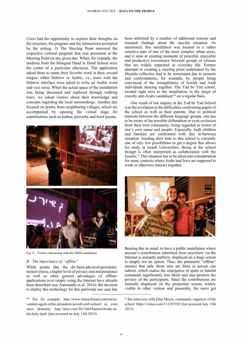
92
Users had the opportunity to express their thoughts on the structure, the program and the interactions prompted by the setting. 3) The Meeting Point mirrored the respective cultural program that was presented at the Meeting Point on any given day. When, for example, the students from the bilingual Hand in Hand School were the center of a particular afternoon. The application asked them to name their favorite word in their second tongue, either Hebrew or Arabic, i.e., users with the Hebrew interface were asked to write an Arabic word and vice versa. When the actual space of the installation was being discussed and explored through walking tours, we asked visitors about their knowledge and concepts regarding the local surroundings. Another day focused on poetry from neighboring villages, which we accompanied by opening the virtual stage for contributions such as haikus, proverbs and brief poems.
Fig. 5. Visitors interacting with the HMP installation
B. The importance of “offline” While points like the de-facto-physical-proximity, inclusiveness, a higher level of privacy and independence as well as other general advantages of offline-applications over simply using the Internet have already been described (see Antoniadis et al. 2014), the decision to deploy this technology for this particular use case has
viii See for example: http://www.timesofisrael.com/racist-vandals-again-strike-jerusalem-jewish-arab-school/ or, even more dramatic, http://time.com/3617664/burned-books-in-the-holy-land/ (last accessed on July 15th 2015)
been informed by a number of additional reasons and research findings about the specific situation. As mentioned, this installation was located in a rather sensitive part of one of the most complex urban areas, and it aims at creating moments of peaceful, enjoyable and productive coexistence between groups of citizens that are widely separated in everyday life. Former attempts at creating a meeting point undertaken by the Muslala collective had to be terminated due to protests and confrontations, for example, by people being convinced of the wrongfulness of Jewish and Arab individuals dancing together. The Yad be Yad school, located right next to the installation, is the target of (mostly anti-Arab) vandalismviii on a regular basis.
One result of our inquiry at the Yad be Yad School was the revelation at the difficulties confronting pupils of the school as well as their parents: Due to political tensions between the different language groups, one has to be aware of the possible diffamation or even exclusion from their own community, being regarded as traitor of one’s own cause and people. Especially Arab children and families are confronted with this in-between situation: Sending their kids to this school is currently one of very few possibilities to get a degree that allows for study at Israeli Universities. Being at the school though is often interpreted as collaboration with the Israelis.ix This situation has to be taken into consideration for many contexts where Arabs and Jews are supposed to work or otherwise interact together.
Bearing this in mind, to have a public installation where anyone’s contribution submitted from anywhere via the Internet is instantly publicly displayed on a huge screen is simply not an option. Thus, the parameter “offline” ensures that only those who are there in person can submit, which makes the emergence of spam or hateful comments significantly less likely and also protects the privacy of the participants. Since the contributions are instantly displayed on the projection screen, widely visible to other visitors and passersby, the users get
ix See interview with Efrat Meyer, community organizer of the school: https://vimeo.com/113187182 (last accessed July 15th 2015)
HYBRID CITY 2015 | DATA TO THE PEOPLE

93
immediate feedback from other visitors, while resting assured that any data, under no circumstance, leaves the locally constrained place of the Meeting Point (which makes moderation significantly easier as well). Hereby, we point to an apparent, but potentially highly productive, contradiction: The offline application makes interactions less anonymous (social pressure, self-censorship, reduced risk of trolling) while, at the same time, protecting the user in terms of data privacy (no metadata is collected, any data stays on the local Raspberry Pi instead of going through a globally distributed server architecture. As any contributing user is by definition present in situ, contributions are more likely to be directly influenced by or linked to other visitors, the festival, the space, moods and reactions perceived at the very moment the input is generated. Furthermore, this solution allows visitors to interact through the application without the need of installing any software or giving away any personal data, as the application opens as a captive portal upon connecting to the Wifi network.
Fig. 6. The installation was staged in the center of the festival site
Fig. 7. Children using the Hybrid Letterbox to submit drawings
VI. REFLECTIONS By contributing drawings, photos, messages and
opinions, the festival’s guests curated a collective identity for the event which was broadly visible also to
x As the researchers in situ spoke neither Hebrew nor Arabic, this point will remain to be subject of inquiry.
people who were just walking by. Over the ten days of the festival, the projection generated a visual documentation of the past events, written collaboratively by its visitors and participants. Furthermore, the HMP installation opened up another communication channel that allowed one-to-many and also inter-temporal communication, acting as a bridge between people across the digital and analog space and (by utilizing the Hybrid Letterbox) also between the tech-savvys and techno-phobes. By this means, it generated a hybrid space that works as a triangulator between individuals and parties that usually do not interact: It provided a tool for visitors to alter the festival’s space, its mood and its talking points. However, through permitting communication to be spread across space and time, it also provided an ease for different lifeworlds to represent themselves, react onto each other, take notice of the other and eventually interact within a semi-virtual and thus protected framework. By actively taking part in the growing and processual installation, a collaboratively curated collection of impressions and opinions emerged; and with it, a visually recorded history of shared experiences that merged into the representation of a collective identity. For this process to happen, the fact that the installation operated over a digital network but “outside the Internet” [1][2] was paramount: First of all, the already mentioned dynamics of constrained accessibility and self-censorship was of central importance. But also the fact that contributions were produced and displayed exclusively in the place where they were generated enabled the emergence of a somewhat protected space, in which the fear of publicly engaging with the “wrong” people was tempered by the semi-private characteristic. An assumption that still awaits verification is the productivity of the additional layer of interaction in regards to sparking, informing and framing the conversations and encounters happening in the physical space.x
In summary, the installation operates with the social and political dimensions of space, questioning the borders between private and public spheres as well as the notion of alternative digital networks for locally engaged participants and individuals. It has the potential to generate a hybrid space for characterizing a place in which people and technologies temporary cohabit in a synergic way, as a bridge between diverse individuals that are moving in the same (hybrid) space. Furthermore, by this example we are able to address the fusion between people, technologies and spaces, working to make technologies and artifacts embedded in socio-political interactions in the local space useable, adaptable and controllable by the local people.
A. Challenges & Outlook Reflecting on the challenges of creating the Hybrid Meeting Point, mainly two aspects come to mind. First, operating in different languages presents itself as highly
2 | Hybrid Space and Data / Network Ownership

94
problematic, especially when dealing with handwritten input. There might be a technological solution for this around the corner, but today we still face a serious obstacle when trying to instantly digitize and translate the handwritten notes of a large number of different contributors. Second, user-friendliness also appears to be a valid point to focus on in the next iteration: What sounds fairly self-explanatory in regards to the automatized appearance of an anchor page on the user’s device proved to be a source of irritation and various mistakes in the real-life application. Since different devices (depending on the operating system and version) handle the opening of captive splash pages in various different ways – as an example: Android 4 does not allow picture taking and upload from a captive page; instead, users had to open the captive page manually in the device’s browser and then take a picture. Moreover, connecting to the open Wifi does not always trigger the splash page automatically. The user has to notice a small icon in the status bar to open the application.
As the installation Hybrid Meeting Point will further be implemented and tested in several contexts (e.g., in September 2015 during the Transeurope Festival in Belgrade and in Berlin), we hope to be able to provide clarity and depth to the process of using hybrid tools and infrastructures to induce critical engagement and enable people to use technology based alternative formats of exchange and debate. We look forward to facilitating locally based and politically engaged public discourse in effective ways – as a mode of political action. Referring back to our effort in developing and providing tools that are flexible and open enough for being appropriated, altered and recontextualized by others, the HMP is hereby seen as an infrastructure, which can be repurposed towards different contexts, contents and interactions with every future application.
ACKNOWLEDGEMENTS This work was partly funded by the German-Israeli Future Forum Foundation (DIZF) and would not have been possible without the generous help from many people such as Panayotis Antoniadis, Wolf Schleicher, Matan Israeli, Oron Elior, Eyal Lawit, Rachel Har-Zahav and others.
REFERENCES [1] Antoniadis, P., Apostol, I., Unteidig, A., Joost, G. (2014):
CONTACT: Facilitating Information Sharing Between Strangers Using Hyperlocal Community Wireless Networks. UrbanIxD, Venice.
[2] Antoniadis, P., Apostol, I. (2014): The right(s) to the hybrid city and the role of DIY networking. Journal of Community Informatics, vol.10.
[3] Bell, B.; Wakeford, K.; Badanes, S.; Feldman, R. (2008). Expanding Architecture: Design as Activism. Metropolis, New York.
[4] Bergmann, M., Herlo, B., Sametinger, F., Schubert, J., Unteidig, A. (2013): Community Infrastructuring – Designwerkzeuge zur partizipatorischen Stadtgestaltung. In: Lange, B., Präsenz, G., Saeco, H. (2013): Ortsentwürfe. Urbanität im 21. Jahrhundert. Jogis Verlag, Berlin. p. 62-67
[5] Binder, T., De Michelis, G., Ehn, P., Jacucci, G., & Wagner, I. (2011). Design Things. The MIT Press, Cambridge.
[6] Björgvinsson, E., Ehn, P., & Hillgren, P. A. (2010). Participatory design and democratizing innovation. Proceedings of the 11th Biennial Participatory Design Conference (S. 41–50). ACM.
[7] Cuartielles, D. (2014). How deep is your Love? On Open-Source Hardware. In: Ehn, P.; Nilsson, E.; Topgaard, R. (2014). Making Futures. MIT Press, Cambridge.
[8] De Waal, M. (2014). The City as Interface. nai 010 publishers, Rotterdam.
[9] Dewey, J. (2006). The Public and its Problems. An Essay in Political Inquiry. Ohio University Press, Athens, OH.
[10] DiSalvo, C. (2012). Adversarial Design. MIT Press, Cambridge. [11] DiSalvo, C. (2009). Design and the Construction of Publics, MIT
Press, Cambridge. [12] Dourish, P. (2010). The Politics of Information and Participation:
Digital Citizenship and Public Science. Critical Making: Science.
[13] Ehn, P. (2008). Participation in Design Things. In: Proceedings of the Partipatory Design Conference 2008. ACM Press.
[14] Etzemüller, T. (2009). Die Ordnung der Moderne. Social Engineering im 20. Jahrhundert. Transcript, Berlin.
[15] Fuad-Luke, A. (2009). Design Activism: Beautiful Strangeness for a Sustainable World. Earthscan, New York.
[16] Herlo, B., Sametinger, F., Schubert, J., Unteidig, A. (2015): Participatory Design and the Hybrid City. The Living Lab Mehringplatz, Berlin, and the Project “Community Now? Conflicts, Interventions, New Publics”. Hybrid City, Athens (unpublished).
[17] Hill, D. (2010): New Soft City, Interaction Design Association. http://www.ixda.org/resources/dan-hill-new-soft-city
[18] Hörning, K. (2012). Praxis und Ästhetik. Das Ding im Fadenkreuz sozialer und kultureller Praktiken. In: Moebius, S.; Prinz, S. (2012): Das Design der Gesellschaft. Zur Kultursoziologie des Designs. transcript, Berlin.
[19] Keshavarz, M.; Mazé, R. (2014). Design and dissensus: framing and staging participation in design research. Design Philosophy Papers, 1.
[20] Krueger, D. (2004): Access Denied. In: Graham, S. (Ed.): The Cybercities Reader. Routledge, New York, p. 320-323.
[21] Lefebvre, H. (1968): The right to the city. In: Lefebvre, H. (auth), Kofman E., Lebas, E. (Eds.): Writings on Cities (63-184). Blackwell, Cambridge.
[22] Manzini, E.; Jégou, F. (2003): Sustainable Everyday: Scenarios of Urban Life. Edizioni Ambiente.
[23] Mareis, C. (2014): Theorien des Designs. Junius, Hamburg. [24] Mareis, C. (2013): Wer gestaltet die Gestaltung? Zur
ambivalenten Verfassung von partizipatorischem Design. In: Mareis, C.; Held, M.; Joost, G. (Eds.): Wer gestaltet die Gestaltung? Transcript, Berlin.
[25] Mouffe, C. (2013): Agonistics: Thinking The World Politically, Verso, New York.
[26] Ratto, M.; Boler, M.(2014): DIY Citizenship: Critical Making and Social Media. MIT Press, Cambridge.
[27] Star, S.; Griesemer, J, (1989): Institutional Ecology, ‘Translations’ and Boundary Objects: Amateurs and Professionals in Berkeley’s Museum of Vertebrate Zoology, 1907-39, Social Studies of Science, 19.
[28] Thorpe, A. (2012): Architecture & Design versus Consumerism: How Design Activism Confronts Growth. Routledge, New York.
[29] Unteidig, A., Joost, G: (2014): Design as Curator for Urban Discourse. UrbanIxD, Venice.
[30] Willis, A. M. (2013): Design, change and politics. Design Philosophy Papers 1/2013.
[31] Wood, J. (2007): Design for Micro-Utopias: Making the Unthinkable Possible (Design for Social Responsibility). Ashgate, Farnham.
HYBRID CITY 2015 | DATA TO THE PEOPLE

OPENURBANENVIRON-MENTALDATA

96
Absence in Context Recontextualizing civic data, critical cartographies, and gentrification
in New York City
Justin Blinder (Independent Artist) Brooklyn, New York, United States of America
Abstract. Corporate mapping tools, such as Google Maps, have become a common lens through which we view geographical data. These tools normalize what is filtered. Such de-contextualization is not mere happenstance. Numerous mapped datasets obscure and obfuscate the original context in which data was collected and more importantly, who or what was omitted from it. In response, I draw upon the development and implementation of my art project Vacated, which re-contextualized both the New York city government’s PLUTO dataset and Google Street View, to document and examine patterns of gentrification in new ways. Vacated emphasizes street-level perspectives of data points to reflect on, and engage with, the larger datasets that they exist within. Contextualizing the images also renders more visible the continuous ecosystem of surveillance in which they were taken. I conclude with reflections on further possibilities for critical cartography and usable tools for everyday citizens and users.
Keywords: critical cartography; data visualization; big data; surveillance; gentrification; Google Street View
I. INTRODUCTION In March 2014, the small town of Agloe, NY
suddenly disappeared from Google Maps. Yet, this disappearance was no accident; the town never existed in the first place. Agloe was a “paper town,” a fictitious settlement embedded on a map to help the original cartographers detect copyright infringement. It was fabricated by Otto G. Lindberg and Ernest Alpers for the General Drafting Company; an anagram containing the first letters of their full names was the town’s namesake. Yet somehow, when the major map company Rand McNally was sued for publishing Agloe in their commercial maps, Rand McNally was found not guilty. Their defense was that the location did exist; a small business owner had opened “Agloe General Store” in that area, aptly naming the store based on what appeared in a map [1].
This anecdote reminds us of Alfred Korzybski’s quip that “the map is not the territory”; in this case, the almost hegemonic power of corporate cartography suggests how, sometimes, the map can become the territory.
Corporate mapping tools, such as Google Maps, have become a common lens through which we view and analyze geographical data, normalizing what is filtered, as well as contestations that remain off the map. In particular, as the tools used to render them advance, digital maps are becoming more transient and ephemeral. Corporations now also customize how maps are rendered to coincide with certain countries’ political claims. For example, Google Maps alters territorial borders based on the user’s location, to correspond to different nations’ conflicting land claims. When viewing a Google Map from within the U.S., Crimea is depicted as part of Ukraine; in Russia, Crimea appears as part of Russian territory [2]. This example illustrates how corporations customize maps to appease users as customers, with profit rather than even contentious political claims as their primary motivator and criterion.
In the course of data collection and processing, what contexts are obfuscated and lost? Can we render this whole process more visible, and in doing so, begin to articulate and engage in a dialogue that stands as a mode of resistance against corporate cartographies?
In the remainder of this article, I briefly discuss emerging themes in corporate mapping and attempts at critical cartography, specifically regarding the ways in which digital maps represent, enable access to, and imply ownership of underlying data. Specifically, the proliferation of “free,” corporate mapping services has led to consistent de-contextualization of “big data.” I argue that such de-contextualization is not just a lamentable side effect or mere happenstance; companies capitalize on context obfuscation when collecting, generating, and mapping big data. When the general public accesses data on a Google Map, the data has in fact been highly processed and filtered, but it is marketed (and generally consumed by the public) as if it were raw, true.
In response, an essential element of critical cartography must then lie in re-contextualizing data. Doing so can help the public to ask critical questions about data obfuscation and ownership. In particular, focusing on “small data” can act as a countervailing form of resistance, facilitating contextual analyses and multiple perspectives that are largely erased or obscured in corporate mapping.
HYBRID CITY 2015 | DATA TO THE PEOPLE
II. EASE AND OBFUSCATION At first glance, Google Maps is so widely used
simply because it makes our lives easier. When searching for specific locations, markers highlight or virtually erase points of interest according to our perceived preferences– some markers are displayed in varying sizes, based on implied relevance, while others are rendered invisible. Further, Google Maps simplifies the process of cartography, allowing users to overlay various datasets onto maps with relative ease. One might, for instance, not just superimpose a local map with all of the best affordable ethnic restaurants for a visiting friend, but thousands of instances of reported bicycle accidents for a journalist, allowing us to conduct sophisticated spatial analyses of so-called “big data” sets.
Such ease comes at a cost, however. Maps are never neutral documents, but instead representations of landscapes that inevitably highlight certain aspects of our environs and obscure others. The ubiquity of digital mapping and the financial power and surveilling data collection resources of corporate mapping inform how we most commonly see and now expect to see data represented.
Further, and more importantly for this paper’s inquiry, the simplicity of such mapping toolkits can abstract the context of the data they represent, and in turn, shift how we examine and interpret the underlying data. Inquiries about where the data came from or what it actually represents become subservient to what the mapped data can tell us about an issue. For example, in 2011 the city of Boston, Massachusetts developed a smartphone app, named “Street Bump,” to crowd source which areas of the city had greater pothole issues. The app would detect when a driver hit a pothole using the phone’s accelerometer, and send the location data to the city. After viewing this mapped data early on, the city noticed that low-income areas contained much fewer potholes than wealthier ones. Although this analysis was inaccurate, the data was not flawed, but how the program collected data was. Since wealthier residents were more likely to own smartphones, their neighborhoods were significantly overrepresented within the program [3]. While Boston city workers were able to identify and address these flaws in the data, what about datasets for which the context is not nearly as transparent or accessible?
When Google Street View began in 2007, the company captured raw images and later blurred out features such as faces and license plates. As Google expanded the project internationally, the company faced numerous challenges in complying with stricter privacy laws in Europe. In addition to blurring features in images, several countries asked Google to limit how long it retains copies of raw Street View imagery. These concerns were also elevated by the 2010 revelation that Google Street View cars had been additionally capturing Wi-Fi router and unencrypted wireless network traffic. In negotiating terms to keep Street
View in Germany, Google introduced a feature that allowed German citizens to request their property to be blurred on the service, which around 3% of German citizens chose to do [4].
In response to these privacy tensions with Germany, Google CEO Eric Schmidt suggested that those with privacy concerns “can just move,” emphasizing that Google Street View only ever captured a location once. Following up on Schmidt’s response, Google’s Public Relations team added, “Our Street View service provides only a static picture in time, and doesn’t provide real-time imagery or provide any information about where people are” [5]. Since Google Street View was deemed legal by German courts, many speculate that the immense effort to manually remove these locations is what led Google to abandon Street View in Germany in 2011. Google continues to show imagery taken in 2011 on the service.
At the same time, echoing a popular sentiment, Jeff Jarvis, journalist and author of “What Would Google Do?”, argued that Google is simply capturing what is already public:
Now you can drive to Oberstaufen and stand across the street between the bookstore and Dr. Fassnacht’s building – and look at the building all you want because you would be exercising your right to be in public. But not online, not in the land of Deutchnet, you can’t. Germany has not diminished the public. It has stolen from the public. [6]
According to Jarvis, Google’s Street View service is a gift to the public, despite the fact that Google Street View cars had already been capturing private Wi-Fi data, and despite the fact the public does not own Google Street View images. Google has copyright ownership for all of its Street View imagery, and public usage of these images is subject to Google’s terms of service agreements. More pointedly, Jarvis’ argument assumes that Google’s user-facing data is raw and unrestricted, when it is in fact highly processed. Google keeps private the raw, uncensored data.
In this model, Google capitalizes on abstracting an image’s context– blurring out specific features— as it improves their private image processing algorithms with raw, uncensored images. In doing so, they ostensibly protect the privacy of the public.
Further, only showing “one static picture in time” serves Google well, as it masks the fact that the company systematically photographs the same streets over time. Over the course of its history, Google has increasingly obfuscated the context of Street View imagery, where and when images were taken, and who or what is in them.
Cumulatively, such corporate algorithms can be seen as evolving with the larger history of neoliberal cartography—cartography that serves to atomize the public into individual consumers, and to privatize ownership of what has been heretofore thought of as public. To critically examine corporate maps, then, we
97
3 | Open Urban Environmental Data
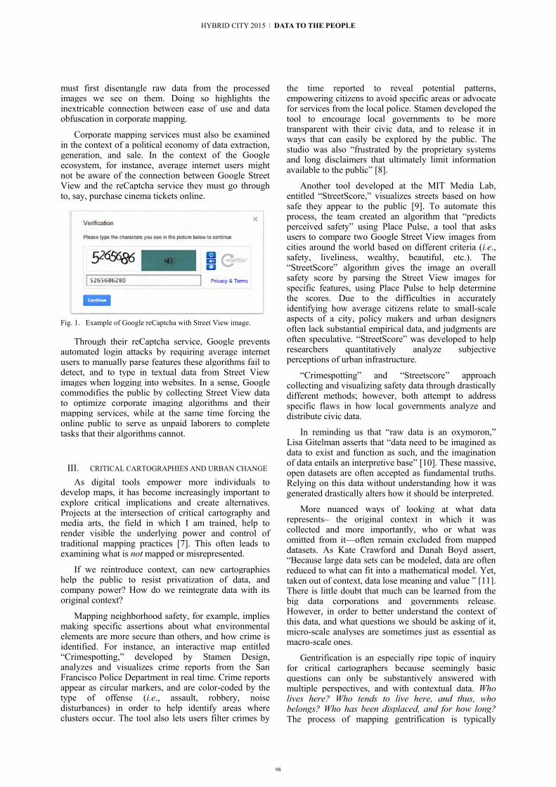
98
must first disentangle raw data from the processed images we see on them. Doing so highlights the inextricable connection between ease of use and data obfuscation in corporate mapping.
Corporate mapping services must also be examined in the context of a political economy of data extraction, generation, and sale. In the context of the Google ecosystem, for instance, average internet users might not be aware of the connection between Google Street View and the reCaptcha service they must go through to, say, purchase cinema tickets online.
Fig. 1. Example of Google reCaptcha with Street View image.
Through their reCaptcha service, Google prevents automated login attacks by requiring average internet users to manually parse features these algorithms fail to detect, and to type in textual data from Street View images when logging into websites. In a sense, Google commodifies the public by collecting Street View data to optimize corporate imaging algorithms and their mapping services, while at the same time forcing the online public to serve as unpaid laborers to complete tasks that their algorithms cannot.
III. CRITICAL CARTOGRAPHIES AND URBAN CHANGE As digital tools empower more individuals to
develop maps, it has become increasingly important to explore critical implications and create alternatives. Projects at the intersection of critical cartography and media arts, the field in which I am trained, help to render visible the underlying power and control of traditional mapping practices [7]. This often leads to examining what is not mapped or misrepresented.
If we reintroduce context, can new cartographies help the public to resist privatization of data, and company power? How do we reintegrate data with its original context?
Mapping neighborhood safety, for example, implies making specific assertions about what environmental elements are more secure than others, and how crime is identified. For instance, an interactive map entitled “Crimespotting,” developed by Stamen Design, analyzes and visualizes crime reports from the San Francisco Police Department in real time. Crime reports appear as circular markers, and are color-coded by the type of offense (i.e., assault, robbery, noise disturbances) in order to help identify areas where clusters occur. The tool also lets users filter crimes by
the time reported to reveal potential patterns, empowering citizens to avoid specific areas or advocate for services from the local police. Stamen developed the tool to encourage local governments to be more transparent with their civic data, and to release it in ways that can easily be explored by the public. The studio was also “frustrated by the proprietary systems and long disclaimers that ultimately limit information available to the public” [8].
Another tool developed at the MIT Media Lab, entitled “StreetScore,” visualizes streets based on how safe they appear to the public [9]. To automate this process, the team created an algorithm that “predicts perceived safety” using Place Pulse, a tool that asks users to compare two Google Street View images from cities around the world based on different criteria (i.e., safety, liveliness, wealthy, beautiful, etc.). The “StreetScore” algorithm gives the image an overall safety score by parsing the Street View images for specific features, using Place Pulse to help determine the scores. Due to the difficulties in accurately identifying how average citizens relate to small-scale aspects of a city, policy makers and urban designers often lack substantial empirical data, and judgments are often speculative. “StreetScore” was developed to help researchers quantitatively analyze subjective perceptions of urban infrastructure.
“Crimespotting” and “Streetscore” approach collecting and visualizing safety data through drastically different methods; however, both attempt to address specific flaws in how local governments analyze and distribute civic data.
In reminding us that “raw data is an oxymoron,” Lisa Gitelman asserts that “data need to be imagined as data to exist and function as such, and the imagination of data entails an interpretive base” [10]. These massive, open datasets are often accepted as fundamental truths. Relying on this data without understanding how it was generated drastically alters how it should be interpreted.
More nuanced ways of looking at what data represents– the original context in which it was collected and more importantly, who or what was omitted from it—often remain excluded from mapped datasets. As Kate Crawford and Danah Boyd assert, “Because large data sets can be modeled, data are often reduced to what can fit into a mathematical model. Yet, taken out of context, data lose meaning and value ” [11]. There is little doubt that much can be learned from the big data corporations and governments release. However, in order to better understand the context of this data, and what questions we should be asking of it, micro-scale analyses are sometimes just as essential as macro-scale ones.
Gentrification is an especially ripe topic of inquiry for critical cartographers because seemingly basic questions can only be substantively answered with multiple perspectives, and with contextual data. Who lives here? Who tends to live here, and thus, who belongs? Who has been displaced, and for how long? The process of mapping gentrification is typically
HYBRID CITY 2015 | DATA TO THE PEOPLE

99
framed through major changes, such as increased housing costs or construction. The aggregate consequences of this process are easy to discern, but the process itself, and the micro changes that occur, are rarely visible.
Journalists and social scientists have documented widespread gentrification—the physical, economic, social, and cultural transformation of lower-income neighborhoods into ones aimed at higher-income households and visitors—for more than two decades, and popular attention to gentrification has especially intensified over the past few years, with the advent of widening inequalities amidst the current financial crisis. Still, it remains difficult for both researchers and average citizens to translate these large, complex political economic shifts into comprehensible terms, or to pinpoint exactly what is happening.
By looking at city streets as a kind of database, critical cartographers can extract the cultural or social signifiers that hopefully represent urban change more profoundly than just numbers or strings of text. Is there a way to document urban change both from a street-level perspective, and en masse?
The proliferation of large, open city datasets has created unprecedented forms of civic research on urban change and gentrification. However, the methods used to collect and catalog these data can have a major impact on how they are interpreted. Can re-contextualizing certain datasets, through street-level photographs, perhaps let us see nuances we might have otherwise overlooked when viewing this data in aggregate? In the remainder of this paper, I draw upon Vacated, based on New York City data, as a case to examine how these datasets simultaneously document, police/ surveil, and reshape cities in decidedly non-neutral ways.
IV. VACATED – COMBINING DATASETS, PERSPECTIVES, UNITS OF ANALYSIS
Since 2007, Google Street View cars have been collecting historical environmental images worldwide en masse. This type of ubiquitous and pervasive corporate mapping is primarily sold as a service to individual end-users. Meanwhile, governments release public data primarily for social scientists to better understand larger-scale trends and changes, but in ways that remain illegible to average residents and users. The Bloomberg administration also released massive amounts of such civic data.
In 2013, I was commissioned by a New York-based organization called More Art to develop a project that reflected on how New York City had changed under the twelve-year Bloomberg Administration. During his tenure as mayor, Bloomberg rezoned 37% of New York City. Ensuing widespread development rapidly changed the urban landscape, and during this rezoning, many of the promised affordable housing opportunities were never realized [12]. Many scholars tie this rezoning to
widespread gentrification and displacement of long-term residents.
The project that emerged from the More Art commission, entitled Vacated, began from a desire to use this newly released data in order to visualize how Bloomberg’s massive rezoning had transformed New York, from a street-level perspective.
Vacated merges civic data with Google Street view to present cached, street-level perspectives of urban change over time, shifts that are typically depicted from an aerial view, on a macro scale. By contrast, Vacated emphasizes ways that we can use micro-scale data to reflect on, and engage with, the larger datasets that they exist within.
Vacated was inspired by artists using traditional techniques, such as photography, to document changes that we now often end up mapping instead. One such project, Camilo José Vergara’s “Tracking time,” is an assemblage of photographs of specific locations captured multiple times over years, portraying processes of urban neglect or impending gentrification [13].
By contrast, these images, when viewed individually, form visual narratives about distinct locations. Obvious changes occur over time, such as buildings disappearing or new developments replacing empty lots. However, there are also more nuanced changes, such as surveillance cameras appearing on the lamppost, energy infrastructure improvements like solar panels, and even new trees being planted over time. When looking at the earliest and latest images side by side, it is not major developments alone, but more often the small changes to infrastructure, that in aggregate transform the feel of a particular neighborhood. While many tend to view gentrification through large-scale changes, Vergara’s project highlights how more nuanced forms of infrastructure also shift along the way. Can these less noticeable urban shifts be used to ask other questions about the surrounding neighborhood?
Vacated asks whether we can look to the physical infrastructure of our streets as a database in order to fill the gaps between corporate and civic datasets. When I started the project in 2013, Google Street View only ever showed a single image in time for a given location. Still, I was curious if perhaps there were cached, older, historical images, hiding in plain sight. It appeared that Google updated their Street View imagery in New York fairly often. Given that such rapid development occurred in the span of only a few years, I began examining how buildings constructed since 2007 (the year Street View launched) appeared on Google Street View.
To start finding locations that might contain cached imagery, I used the New York City Department of City Planning’s PLUTO dataset, which attempts to provide detailed information, such as building age and alteration data, about properties in all five boroughs. I queried the PLUTO dataset for property lots that had been developed or renovated since 2007. Then, I wrote custom software to scrape each location’s panoramic imagery from Google Street View and saved it to a new
3 | Open Urban Environmental Data

100
database. Most of the resulting images revealed vacant lots, or buildings that had since been demolished, which confirmed that historical cached images could be mined from Google Street View.
In order to depict change, however, I needed to compare this collection of images against the current physical state of each of these lots. Traveling to and photographing each location manually would require months of effort. Instead, I focused my research on how Google Street View cars navigate through a city. Do the drivers capture an entire neighborhood at once, or capture only specific streets at a time? Since a Street View car would need to drive down two separate streets in order to fully capture an intersection, focusing on street intersections could potentially reveal temporal inconsistencies. I found that when visiting specific intersections on Google Street View, cars would sometimes capture one intersecting street months, or even years, before photographing the perpendicular street.
The PLUTO dataset provides a “lot type” field for every entry, which indicates “the location of the tax lot to another tax lot and/or the water.” One of these types specifies lots that reside on the corner of two intersecting streets. This identifier allowed me to query every new development, or renovation, since 2007 that was located on an intersection. Using this new subset of data, I created custom software that visited each location in Google Street View and programmatically moved back and forth across the intersection, saving the output as a video file in a database. Numerous videos depicted drastic transformations between the two images, contextualizing the time and frequency that Google captured specific streets. In the end, the collected data was presented in the form of still images, composite “before” and “after” images, videos, and animated gifs.
V. LOOKING FOR NEW, CONTEXTUAL MARKERS OF GENTRIFICATION
Vacated generated robust online discussions on gentrification in New York City (and other cities), and it also compelled some to think of both the city government’s PLUTO dataset and Google Street View in new ways. For example, the conspicuous presence of Google Street View cars in the physical world is only reflected in the surrounding environment they capture: the glances of pedestrians, reflections off of shop windows, rogue shadows. Location imagery is collected over the years; however, this model of surveillance has no persistent infrastructure. The images provide innuendos about the time and context in which they were captured, but Google ultimately curates which data to share with the greater public.
Specific images from Vacated reflect the complexities of social impact and urban change in gentrifying neighborhoods. For instance, the image below illustrates the transition of a small residential building, also housing the culturally significant “Mars
Bar,” into a massive luxury condo development and a bank.
Fig. 2. Before (cached) and after Google Street View images superimposed. (11 2nd Avenue, New York, NY)
Such a dramatic transition might be expected to represent violent gentrification; however, in this instance, the developers worked closely with the former residents, offering them $10 apartments in the new development and even naming the building “Jupiter 21,” an homage to the “Mars Bar.” Such relatively amicable negotiations are not common, but further examining the context of these images reveals the underlying dynamics that prefaced this transformation.
In other instances, the images themselves help to narrate the changing micro-communities that come with displacement.
Fig. 3. Street View images from 2007, 2011, 2013, and 2014 for 233 34th Street, Brooklyn, NY.
This scene depicts what looks like a stable, vibrant neighborhood in 2007. Then, a vacant lot appears and remains unused for five years. In 2014, a new development is constructed. Here, only the initial image was accessible using the data mining approaches from Vacated; the subsequent images were later accessed using the “Time Machine” tool (further discussed below). In this series, the residents play a crucial role in revealing the shifting community demographics and dynamics.
Subtle differences in urban infrastructure can begin to serve as milestones—markers in time—when likening this street imagery to a database. Knowing the year a building was constructed or a lamppost was installed can help to pinpoint when these images were taken. Thus, this information extracts Google’s
HYBRID CITY 2015 | DATA TO THE PEOPLE

101
behaviors through means not accessible from any standard dataset. Instead of solely relying on mapped civic data as conclusions to certain research questions, Vacated exemplifies how merging multiple datasets can serve as a starting point for more nuanced inquiries that might get overlooked when viewing gentrification from a macro level.
VI. CACHE AS AN ARCHIVE AND NARRATIVE TOOL Six months after Vacated launched and received
significant press coverage, Google released a tool called “Time Machine” that makes locations’ historical images publicly available, instead of just showing one image from a single point in time [14]. For seven years, Google had hidden these images from users; their existence could only be teased out by finding cached zones and glitches. Throughout the course of the Street View project, Google had increasingly obfuscated the dates on which images were captured. In releasing this historical imagery, Google also released a timeline of its systematic capture routes.
Researchers have already begun using the “Time Machine” tool to examine gentrification and urban blight in various studies. One study, developed by Jackelyn Hwang and Robert Sampson at Harvard University, used Google’s “Time Machine” tool to identify signifiers of gentrification—cleaner streets, new constructions, home renovations—in Chicago and score each census tract accordingly. They compared their findings to those of a similar, albeit painstakingly manual, survey Sampson had performed in the mid-1990s. Their study revealed a strong correlation between gentrifying neighborhoods and their racial composition; gentrification persisted in predominantly white neighborhoods [15].
Another project, entitled “GooBing Detroit”, uses Google’s “Time Machine” tool to document widespread suburban decay in Detroit, Michigan [16]. Originally comparing Google Street View to Bing’s counterpart, the blog displays Google Street View images from different dates to depict the drastic neglect that has befallen residents. In some photos, new and well-maintained properties transform into dilapidated, overgrown lots within just a few years.
Cache thus serves as a potentially powerful narrative tool, one that helps viewers to identify and disentangle emotive, powerful indicators of change (whether gentrification or neglect) in our immediate built environments. Even as these indicators, such as cleaner streets, remain missing from aerial maps, they can be systematically tested and help us to think through the causal processes of urban change in rigorous ways.
VII. WHITHER COUNTERVEILLANCE? Still, with the increased collection and release of
civic datasets also comes an increase in surveillance. Google Street View’s history in Germany is a prominent example of public counterveillance. Requests
that Google Street View blur buildings, in aggregate, were arguably overwhelming enough to keep Google Street View’s collection efforts at bay for years.
Perhaps by focusing on absence and marginalization within large sets of data, we can not only emphasize how the process of knowledge documentation is never a neutral one, but also render the deliberative process of who/ where/ what to map more conspicuous. Indeed, when searching for specific locations on a Google Maps, markers highlight or virtually erase points according to our perceived interests– some displayed in varying sizes based on implied relevance, others rendered invisible within a corporate cartography. Results outside the periphery of our recommendations become extinct through obscurity— thereby reshaping our digital landscapes, and in turn, reconfiguring our physical ones.
Vacated highlights how cache can serve as powerful narrative tool, as it is composed of both familiar and hidden data. By reverse engineering how and when Google’s cars capture data, we gain more knowledge about their overall policies. This can help to systematically locate and reveal data that is hidden in plain sight. It can also be drawn upon as a tool for countervailing inquiry and watching the watchers. How many images are rewritten over time for a single location, and is there a reason certain regions are captured more often than others? Contextualizing the images renders more visible the continuous ecosystem of surveillance in which they were taken.
VIII. CONCLUSION With new, massive amounts of accessible data, maps
can play a crucial role in helping the public to quickly glean the spatial distribution of different large-scale patterns and changes—in housing prices, migration, or whatever else. Yet, in this process, how this data is depicted obscures the human imprint at the core of the story. While maps are never neutral, the different computational layers now used to make them can further complicate not just where the bias lies but who is culpable. The tools that have democratized cartography can also alter maps’ underlying meanings. Critical cartography renders visible the ways in maps are both political and authoritative; still, who is in control remains a complicated query.
The images extracted in Vacated are always incomplete depictions of change. However, the urban elements that they expose—the apartments, bike lanes, trees, cars and people—increasingly exist within massive, evolving datasets that we could potentially merge with tools like Google Street View, to better understand their contexts. At times, these images may overtly depict gentrification, at other times urban neglect.
They are most valuable when we look at them not as conclusions, but as starting points for lines of inquiry we can ask of other datasets. In this sense, Vacated is not a replacement of other mapping approaches, but
3 | Open Urban Environmental Data

102
rather an additional lens to further critically examine existing representations and mapping tools.
The temporal glitches hidden in Google Street View help to narrate the process of how these photographs are collected. The vast layers of these archives that remained hidden from the broader public render explicit the demarcation of corporate-private and user-facing data. In this context, cache serves as a palimpsest of the digital age, extracting the systematic processes and archives that are typically inaccessible to the public.
REFERENCES
[1] S. Roberts, "Seeking a Town on the Border of Fiction and Reality," in The New York Times, ed. New York, 2014. [2] (2014, September 3) How Google represents disputed borders between countries. The Economist. Available: http://www.economist.com/blogs/economist-explains/2014/09/economist-explains-1 Access Date June 23, 2015 [3] T. Harford, "Big data: A big mistake?," Significance, vol. 11, pp. 14-19, 2014. [4] A. Türk. (2010, October 21). How many German households have opted-out of Street View? Available: http://googlepolicyeurope.blogspot.com/2010/10/how-many-german-households-have-opted.html Access Date June 23, 2015. [5] J. Letzing. (2010, October 22). Wary of Google Street View? Move, CEO says. Available: http://www.marketwatch.com/story/wary-of-google-street-view-move-ceo-says-2010-10-22 Access Date June 23, 2015.
[6] J. Jarvis. (2010, November 2). Google, What Have You Done? Available: http://buzzmachine.com/2010/11/02/germany-what-have-you-done/ Access Date June 23, 2015. [7] J. W. Crampton and J. Krygier, "An introduction to critical cartography," ACME: an International E-journal for Critical Geographies, vol. 4, pp. 11-33, 2005. [8] Stamen Design. (2009). San Francisco Crimespotting. Available: http://sanfrancisco.crimespotting.org/ Access Date June 23, 2015. [9] J. P. Nikhil Naik, Ramesh Raskar and César A. Hidalgo. (2014). StreetScore. Available: http://streetscore.media.mit.edu/ Access Date June 23, 2015. [10] L. Gitelman, Raw data is an oxymoron. Cambridge, MA: MIT Press, 2013. [11] D. Boyd and K. Crawford, "Critical questions for big data: Provocations for a cultural, technological, and scholarly phenomenon," Information, communication & society, vol. 15, pp. 662-679, 2012. [12] A. Gabbatt, "Michael Bloomberg's 12 years at the helm of New York City come to an end," in The Guardian, ed. London, 2015. [13] C. J. Vergara. (2013). Tracking Time. Available: http://www.camilojosevergara.com/About-This-Project/1 Access Date June 23, 2015. [14] V. Shet. (2014, April 23). Go back in time with Street View. Available: http://google-latlong.blogspot.com/2014/04/go-back-in-time-with-street-view.html Access Date June 23, 2015. [15] J. Hwang and R. J. Sampson, "Divergent pathways of gentrification racial inequality and the social order of renewal in Chicago neighborhoods," American Sociological Review, vol. 79, pp. 726-751, 2014. [16] (2015). GooBing Detroit. Available: http://www.goobingdetroit.com/ Access Date June 23, 2015.
HYBRID CITY 2015 | DATA TO THE PEOPLE

103
3 | Open Urban Environmental Data
Cloud Computing in the Kampung
Marc Böhlen Department of Media Study
University at Buffalo USA
Ilya Maharika Department of Architecture Universitas Islam Indonesia
Indonesia
Abstract. The rise of 'cloud' data platforms brings computing services to all parts of the planet. While the reach of this global network allows for new uses of data in the public realm and the commons, the infrastructure on which it is transported, managed and stored is in the hands of private industry. Furthermore, there is a new divide between areas of the world that have privileged access to cloud services and those that do not. This paper describes a cloud connected, community driven well water management project in the Terban district of Yogyakarta, Indonesia, and how it situates itself in the larger context of emerging economies in the global cloud.
Keywords: cloud computing; emerging economies; globalization; kampung; environmental monitoring; private- public; natural commons, knowledge commons
I. INTRODUCTION The metaphor of the cloud was concocted by marketing departments to invoke celestial and magical properties of networked computing. Indeed, the marketing effort has been successful, and the nebulous term has taken hold. From the science studies perspective, cloud computing belongs to a growing cohort of 'promise technologies' [1], while the urbanism discourse regards cloud computing as a key to effective urban development with ‘building blocks of digitally enabled cities’ from which ‘smartness’ may emerge [2]. As opposed to other promise technologies, the promise of ubiquitous connectivity has been largely fulfilled in the developed world. However, in emerging economies the situation is quite different. Not only is the promise of ubiquitous connectivity illusive, but the desires attached to connectivity and computing are also complex. National identities, economic pressures, postcolonial dependencies and global aspirations combine along complex pathways. In this context, the dynamics of global information and communications technology (ICT) infrastructure, development and deployment play a special role.
This paper has three parts. First, it illustrates the scope of global cloud computing through a description of the most prominent provider of global computing services. Second, it describes a specific response to and struggle with global connectivity in the context of a research project and urban intervention in the emerging economy of Indonesia, set in the Terban district of Yogyakarta. It ends with a broader discussion of global computing resources and hybrid models that combine local control and responsibility for data production and management with global computing services.
II. PRIVATE INDUSTRY’S PUBLIC CLOUD
The list of cloud computing providers is increasing and the services they offer are expanding. Amazon, Google, Microsoft, Rackspace, SAP, Digital Ocean, OVH and others all provide a mix of data storage and computing services to address a growing need (and desire for) large-scale computing opportunities without massive investments in hardware, software and networking gear. Private industry has an odd interpretation of the term ‘public’ when used in coinages such as the 'public cloud'. Here, public is not a political category but rather an aspirational category, one that alludes to the audience of potential customers across the globe. In practical terms, public clouds are private cloud networks with fewer access limitations, allowing customers data access from various locations or across different branches of an enterprise. A public cloud, in the deep sense of the word public, does not currently exist. Nonetheless, cloud computing is popular. Advantages of cloud computing are easy enough to list: data availability, improved uptime, dynamic optimization of hardware resources, on-demand scalability, easy and inexpensive setup, 24/7 technical support, etc. [3]. While established companies and institutions outside of ICT have been more reluctant to move into the cloud, young companies in data-intensive industries have readily

104
HYBRID CITY 2015 | DATA TO THE PEOPLE
embraced the new computing paradigm. In Europe, many companies avoid US based computing services not for lack of interest in cloud computing, but in protest and fear of widespread surveillance practices [4]. Fig. 1. Distribution of Amazon's 11 AWS global computing regions.
The financial industry’s relationship to cloud computing is ambivalent. A new alliance has formed between financial services and computing hardware providers in the form of the Open Compute Project. Just as the term 'public' has a particular inflection in the current public cloud, so does the term 'open' in the Open Compute initiative, originally launched by Facebook [5]. The openness in this initiative is directed towards data warehousing optimization, including sharing best practices in data center design, reduction of energy consumption and cost minimization. The goal is not to outsource data warehousing as the cloud paradigm suggests. With a strong desire for secrecy, financial services companies such as Goldman Sachs and Bank of America are working together with the Open Compute initiative to employ cost savings and best practices in data center optimization in order to retain as much information as possible on their own premises and out of the security compromised cloud [6].
A. Size matters Consider the case of Amazon’s globe-spanning computing infrastructure [7], [Fig. 1, 2]. Amazon’s IaaS (Infrastructure as a service) currently represents the state of the art in global networking. IaaS as a strategy allows one to construct Software-as-a-Service (SaaS) and Platform-as-a-Service (PaaS) layers on top of IaaS to achieve comprehensive data curation ecologies. For example, Amazon has created a global computing network of 11 regions, divided into 28 availability zones (AZ), where each AZ usually has two (or more) data centers [8]. Each data center, in turn, houses in excess of 50,000 servers. The placement of these compute regions is not based on national boundaries but rather on Amazon’s current and anticipated customer base distribution and concentration. However, governmental jurisdiction requirements do
inflect the map configuration. For example, a German region was created because German privacy laws disallow businesses and governments to store data in the previously established Amazon-Irish region [9]. These and other constraints combine to create a newly configured global map of privately funded information resources. A recent presentation by Amazon engineers offers some insight into the scale of the investments the company has been making over the past few years [10] to create this system. Because networking costs have been the limiting factor in scaling up operations, Amazon has built its own private fiber-optic links to interconnect its computing regions. In support of these networking centers, Amazon has constructed an elaborate mesh of energy supply contracts with mostly renewable energy providers to power the network. The overall system is remarkably effective and resilient. Latency is very low between AZs (<2ms), and peak traffic between AZs reaches 25TB/s [9]. While there are other private organizations that offer storage and computing services, no other private entity has this level of control over data flow velocities across the planet. The result of these massive investments is a globe-spanning fast and robust computing infrastructure that radically reduces the cost of doing large-scale informatics. Efficiencies of this scale have consequences. The complaints most commonly voiced against Amazon's data management dominance include potentially compromised security, uncontrollable privacy, a general lack of trust and vendor lock-in [11], [12], [13]. Indeed, many private and public entities are choosing not to use the AWS system, to the advantage of smaller competitors. However, in emerging economies, monopoly concerns are at the moment a second order problem. Likewise, the highly charged privacy anxieties prevalent in established economies are less articulated in emerging economies. There are simply other priorities at the fringes of the global computing grid; privacy is a privilege that not all have the luxury to care about.
III. AN UNEVEN DISTRIBUTION OF COMPUTING RESOURCES
Even within the global North, computing resources are unevenly distributed. In the global North this unevenness is defined not so much by technical constraints as by legal and political gradients. For example, prior to 2014, Microsoft's Office 365 licensed to Swiss schools would move some of the customer-produced data from Switzerland to US data centers for 'company internal uses'. The Swiss privacy commission forced a change so that all data produced in educational contexts using Microsoft's Office 365 products would remain stored in Europe, under EU privacy laws, granting Swiss courts
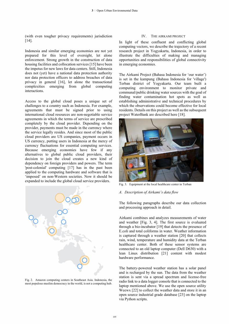
105
3 | Open Urban Environmental Data
(with even tougher privacy requirements) jurisdiction [14]. Indonesia and similar emerging economies are not yet prepared for this level of oversight, let alone enforcement. Strong growth in the construction of data housing facilities and collocation services [15] have been the impetus for new laws for data centers. Still, Indonesia does not (yet) have a national data protection authority nor data protection officers to address breaches of data privacy in general [16], let alone the transactional complexities emerging from global computing interactions. Access to the global cloud poses a unique set of challenges to a country such as Indonesia. For example, agreements that must be signed prior to using international cloud resources are non-negotiable service agreements in which the terms of service are prescribed completely by the cloud provider. Depending on the provider, payments must be made in the currency where the service legally resides. And since most of the public cloud providers are US companies, payment occurs in US currency, putting users in Indonesia at the mercy of currency fluctuations for essential computing services. Because emerging economies have few if any alternatives to global public cloud providers, their decision to join the cloud creates a new kind of dependency on foreign providers and powers. The term 'post-colonial' computing [17] has in the past been applied to the computing hardware and software that is ‘imposed’ on non-Western societies. Now it should be expanded to include the global cloud service providers. Fig. 2. Amazon computing centers in Southeast Asia. Indonesia, the most populous muslim democracy in the world, is not a computing hub.
IV. THE AIRKAMI PROJECT In light of these confluent and conflicting global computing vectors, we describe the trajectory of a recent research project in Yogyakarta, Indonesia, in order to illustrate the difficulties of making and managing opportunities and responsibilities of global connectivity in emerging economies. The Airkami Project (Bahasa Indonesia for ‘our water’) is set in the kampung (Bahasa Indonesia for 'village') Terban district of Yogyakarta. Our team built a computing environment to monitor private and communal/public drinking water sources with the goal of finding water contamination hot spots as well as establishing administrative and technical procedures by which the observations could become effective for local residents. Details on this project as well as the subsequent project WaterBank are described here [18].
Fig. 3. Equipment at the local healthcare center in Terban
A. Description of Airkami’s data flow The following paragraphs describe our data collection and processing approach in detail. Airkami combines and analyzes measurements of water and weather [Fig. 3, 4]. The first source is evaluated through a bio-incubator [19] that detects the presence of E.coli and total coliforms in water. Weather information is captured through a weather station [20] that collects rain, wind, temperature and humidity data at the Terban healthcare center. Both of these sensor systems are connected to an old laptop computer (Dell D630) with a lean Linux distribution [21] content with modest hardware performance. The battery-powered weather station has a solar panel and is recharged by the sun. The data from the weather station is sent via a spread spectrum and license-free radio link to a data logger console that is connected to the laptop mentioned above. We use the open source utility Weewx [22] to collect the weather data and store it in an open source industrial grade database [23] on the laptop via Python scripts.
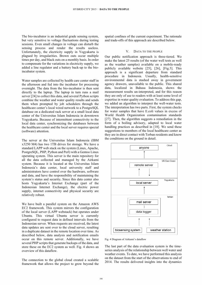
106
HYBRID CITY 2015 | DATA TO THE PEOPLE
The bio-incubator is an industrial grade sensing system, but very sensitive to voltage fluctuations during testing sessions. Even small changes in voltage can disturb the sensing process and render the results useless. Unfortunately, the electricity supply in Yogyakarta is plagued by irregularities. Brown outs occur multiple times per day, and black outs on a monthly basis. In order to compensate for the variations in electricity supply, we added a line regulator and a battery back-up to the bio-incubator system. Water samples are collected by health care center staff in the afternoon and fed into the incubator for processing overnight. The data from the bio-incubator is then sent directly to the laptop. The laptop in turn runs a mail server [24] to collect this data, and several Python scripts combine the weather and water quality results and sends them when prompted by job schedulers through the healthcare center’s local wired network to a PostgreSQL database on a dedicated rack server at a small local data center of the Universitas Islam Indonesia in downtown Yogyakarta. Because of intermittent connectivity to the local data center, synchronizing the databases between the healthcare center and the local server requires special (software) attention. The server at the Universitas Islam Indonesia (IBM x3250 M4) has two 1TB drives for storage. We have a standard LAPP web stack on the system (Linux, Apache, PostgreSQL, PHP, Python and Perl) with a Gentoo Linux operating system. This server is the main repository for all the data collected and managed by the Airkami system. Because it is located at the Universitas Islam Indonesia’s data center, local university staff and administrators have control over the hardware, software and data, and have the responsibility of maintaining the system’s status and security. Since this data center also hosts Yogyakarta’s Internet Exchange (part of the Indonesian Internet Exchange), the electric power supply, internet connectivity and physical security are relatively robust. We have built a parallel system on the Amazon AWS EC2 framework. This system mirrors the configuration of the local server (LAPP webstack) but operates under Ubuntu. This virtual Ubuntu server is currently configured to request data in defined intervals from the Indonesian server. When requests are received, the latest data updates are sent over to the cloud server, resulting in a duplicate dataset in the remote location over time. As described below, data analysis and notification emails occur on this remote server. Additionally, we have several PHP scripts that generate backups of the data, and store these on the EC2 system as well. Fig. 4 shows an overview of this dataflow. The connection to the global cloud created a scalable framework that allows the project to grow beyond the
spatial confines of the current experiment. The rationale and trade-offs of this approach are described below.
V. DATA TO THE PEOPLE Our public notification approach is three-tiered. We make the latest 25 results (of the water well tests as well as the weather samples) available on a mobile-ready publicly available website [25], [26], [Fig.5]. This approach is a significant departure from standard procedure in Indonesia. Usually, health-sensitive environmental data is stashed away in government agency drawers, unavailable to the public. This shared data, localized in Bahasa Indonesia, shows the measurement results un-interpreted, and for this reason they are only of use to readers with at least some level of expertise in water quality evaluation. To address this gap, we added an algorithm to interpret the well-water tests. The interpretation has two parts. First, the system checks for water samples that have E.coli values in excess of World Health Organization contamination standards [27]. Then, the algorithm suggests a remediation in the form of a boiling advisory, adapted to local water handling practices as described in [18]. We send these suggestions to members of the local healthcare center as they are in direct contact with Terban residents and know the conditions on the ground in detail. Fig. 4 Diagram of Airkami’s dataflow
The last part of the data evaluation system is the time-series analysis of the relationship between well water and weather events. To date, we have performed this analysis on the dataset from the start of the observations to end of 2014. The results delivered insights into the dynamics

107
3 | Open Urban Environmental Data
between well water contamination and rain fall dynamics that are described in more detail elsewhere [18], [Fig.6].
VI. LEARNING FROM AIRKAMI While Airkami truly does bring a new class of publicly relevant data to the district of Terban, the project suffers from various deficiencies. The next paragraphs describe some of the important problems we encountered, and how they might be generative for the future of the project. Fig. 5 Public website with water well results on a mobile phone
When Airkami started in 2011, sending SMS to Terban residents required a custom SMS servicing system as the plethora of services (Raja-sms, Freesms4us, SmS-anda, Aksimaya and others) available in 2015 were not yet in operation. Even in 2013 developers were struggling with making global cloud services compatible with local SMS providers in Indonesia [28]. Furthermore, some carriers in Indonesia charge mobile phone users additional fees for receiving SMS data from abroad. We chose not to use global providers of SMS services (such as Twilio) due to these problems and the ensuing lack of transparency, costs, and API lock-in. In the end, we moved away from SMS altogether to email delivery for yet another reason. Terban residents would frequently change mobile
numbers to catch the latest and best deals, resulting in a constantly outdated database of mobile phone numbers on our local server.
Fig. 6 Summary of relationships between rainfall and well contamination for two different water well categories. Site 3 (top) has increased contamination during the dry season. Site 1 (bottom) has increased contamination during the rain season. Statistial analysis in R under Python.
When we transitioned from SMS to email, we also reconsidered the data flow along the last meter. We focused direct notification on health care professionals working at or with the local health care center as these individuals walk the paths of Terban daily and make the 'last meter' connection with residents when necessary. By ensuring that the data reached the health care workers before the start of the workday, we reduced the barrier to useful action. By choosing not to contact residents directly and automatically, we left the communication of potentially bad news to human actors. But even with this approach, the communication pathways have not always performed robustly. A serious stumbling block was, and remains, network connectivity. More often than not, our data logger at the healthcare center is disconnected from the network due to every possible outage scenario imaginable: broken wiring, ill-fitting cheap plastic connectors, networking gear failing under tropical weather, severe storms, volcano eruptions and otherwise erratic electricity supply interruptions. Our backup system in the cloud gave us a level of data security we would not have had otherwise. It also allowed us to experiment with software options we would have been reluctant to use on the local production server. And on more than one occasion, our backup cloud system sent lost datasets back to the local server. These are significant gains produced by the hybrid solution.

108
HYBRID CITY 2015 | DATA TO THE PEOPLE
Compromised infrastructure is part of daily life in Indonesia. But the connectivity woes are also interesting insomuch as they mirror, on a miniature scale, a major challenge of global computing: connectivity, not storage, is the current bottleneck limiting performance. In some cases, we were hampered by our own faulty assumptions. We designed an elaborate database system to handle the dependencies between weather data, private and public wells, water well tests, water well owners and users, recommendations and emergencies. We applied care to optimize for speed and size, worrying about future scalability, diligently normalizing the individual database tables. As a result, our well-designed database required multiple steps for maintenance. For example, simple tasks such as changing the use patterns of water well users required a series of database queries and insertions. Certainly one can address such development deficiencies with better code. But that code was not produced, and the lopsided optimization effort prevented non-programmers charged with maintaining the system in Indonesia from easily and autonomously making changes. Some of the programmers on the US development team had little understanding of or sympathy with such concerns. They were reluctant to change a good database design for such 'minor' issues. A better distribution of software labor and more initiative on the part of the Indonesian team could have been effective. But uneven priorities and varied expectation towards what the project should ultimately deliver have made the project less robust than it could be. What works in the context of mature economies simply does not map directly over to emerging economies [29], [30]. This truism makes itself apparent even in quotidian networking challenges. In some situations, as in the database design described above, optimal solutions and technical best practices can generate social friction in a completely different context. In cross-cultural ICT, technically sub-optimal solutions tuned to local constraints can be not only socially appropriate but operationally robust.
VII. MORE LESSONS FROM AIRKAMI - TOWARD GLOBAL COMPUTING FOR THE COMMONS
In addition to the empirical results produced by the Airkami experiment we offer in the subsequent paragraphs a set of more speculative observations. Airkami brings to the foreground unresolved assumptions about the utility of sharing data in general. Personal data generated by social media have been at the forefront of the data culture discussion in the recent past [12]. The kind of data Airkami produces is delicate for entirely different reasons. While we are not collecting sensitive social data in the sense of bank accounts or government identification numbers, we are recording potentially sensitive communal data. Environmental data
is a new kind of communal mirror that depicts hidden relationships and dependencies. While the measurements show water well contamination, the correlation with weather data makes deep-seated water management and human waste disposal infrastructure deficiencies visible. Not everyone is comfortable with such disclosures. Bad water wells can decrease the value of a house so homeowners might not want their water well results made public, in a similar manner as some cities, on a much larger scale, do not want to have their air pollution values made public [31]. Interests collide in unusual ways where new data brings old secrets to light. Contamination knows no national boundaries. Waste produced by private entities and ill-managed by communal organizations and public institutions, accumulates to a threat to the commons. Data production has a potential to act on this linked chain, provided it is shared. But even experimental data sharing mechanisms in place are largely inadequate to deal with the demands of environmental problems. Consider the case of FreeNet [32]. This system allows anonymous data sharing and the distributed storage of potentially censored pollution data, but it is hampered by its preferential positioning of popular materials. The approach of allowing ‘unpopular’ files to be deleted to ‘make way for more popular content’ [33] stems from a focus on ‘frivolous’ personal music or video data; hardly the kind of thoughtful policy required for a future global database of resource contamination. The dependencies between the care of the commons and the knowledge economy continue to be intensely debated amongst social scientists [34]. But experimental approaches that take on the problem in the field remain rare. Despite Airkami’s deficiencies, our approach demonstrates the potential of straddling the divide between the private and public realm for the oversight of common goods through a hybrid data handling approach. By placing a front line data center at the source of data creation, we give the makers and caretakers of the data at the local level ultimate control and responsibility over their own data production. By linking selectively to the global cloud, access can be gained to opportunities that would otherwise not be available. This model has clear advantages for emerging economies that can offload high end computing infrastructure, but it could also be usefully applied in mature economies for the advantage of robust data control on the local level. The underlying philosophy is to keep essentials ‘at home’ in small, cheap, local nodes and move data deemed sharable selectively to the cloud. One could imagine ‘interesting’ legal push-pull dynamics from a distributed hybrid approach, with stricter environmental protection laws (from the country of data origin or the country of data hosting) pulling the counterpart in its direction.

109
3 | Open Urban Environmental Data
Distributed infrastructure initiatives are gaining attention in other areas of computing. Block-chaining [35] is moving from exclusively financial contexts to resource management in general, where costs create barriers to entry. While still largely a software project, Ethereum [36], 'a platform for decentralized applications', is at least showing a new degree of ambition in using distributed software running on dispersed hardware to manage trust systems in general. Independent of data distribution mechanism, the economics of computing remain decisive. Certainly a hybrid system that must maintain multiple data repositories and manage the interactions between them would be more costly than a single located approach. One way to address that barrier is to reframe the question. One might ask: Why is data free? Why would an emerging economy that 'shares' its environmental data not receive some form or remuneration for that data? This line of thought is similar to that expressed in Nelson's Xanadu project [37] and recently expanded by Lanier [38]. The Lanier version foresees a two-way information flow, linking sources of information to the places and processes it flows to, thus enabling data producers to be reimbursed (in the form of micropayments) for the data they generate. Might one not apply the principle to monitoring of environmental conditions across the globe? While a bi-directional exchange would create a technology for such transactions, it would not generate a societal impetus to deploy the strategy. Recent experiments in ‘monitorial citizenship' are interesting in this regard. The term was coined in the context of Promise Tracker, a project that allows people to track politicians' political promises over time [39]. Could such an approach be carried over to the monitoring of environmental conditions where the value of data flows could be associated with the significance of the shared problems they describe? The fact that almost any environmental quality indicator can be collected in real time, stored at low cost, and shared with others, does not automatically put it to ‘good use’. From the perspective of urban design the particularities of ‘good use’ remain contested. While cloud enabled systems show high levels of adaptability and have been able to enact the kind of smartness that forecasts and manages urban traffic flows, designing an ‘inviting’ [40] urban place remains elusive. Interactive media do not necessarily generate urban participation. Only recently have urban data designers started to address this problem systematically by surveying city inhabitants for their opinions on various urban participation technologies [41] in order to develop design criteria for effective and meaningful participation in urban activities. But just as each city has its own flavor, data enabled participation will likely differ from city to city in the future.
What we have learned from the Airkami experiment is that the frictions experienced in cloud computing in the kampung are largely a result of the growing pains of an emerging economy. However, these frictions are also an opportunity to question the usefulness of the global cloud and consider alternatives to cloud monopolies. Despite a need for a globally coordinated informatics for the care of the commons, the global cloud will likely remain firmly in the hands of private actors in the near future. Despite (and because of) the high performance these computing services offer, they should be held in check, for example with new dependencies on the data sources they rely on. While a technology-only approach to the care of the commons will remain inadequate, ignoring the new potentials of the cloud will render efforts to manage global environmental data less effective.
ACKNOWLEDGEMENTS This research was supported in part by grants from Amazon AWS education and Intel Research Labs. Special thanks to Derek Curry for insightful comments.
REFERENCES [1] A. Mackenzie. Realizing the promise of biotechnology:
Infrastructural-icons in synthetic biology, Futures, Volume 48, April 2013, pp. 5-12, 2013.
[2] Hodgkinson S. Is Your City Smart Enough? Ovum. 2001. http://www.cisco.com/web/strategy/docs/Is_your_city_smart_enough-Ovum_Analyst_Insights.pdf
[3] W. Venters, E. Whitle. A critical review of cloud computing: researching desires and realities. Journal of Information Technology, 27, pp. 179–197. 2012.
[4] S. Rosenbush. The Snowden Effect on Cloud is Real, Hightail CEO says. IN: Wall Street Journal, Sept 19, 2013. http://blogs.wsj.com/cio/2013/09/18/the-snowden-effect-on-cloud-is-real-hightail-ceo-says/
[5] Opencompute: http://www.opencompute.org/ [6] Y. Sverdlik. Wall Street Rethinking Data Center Hardware. IN:
Datacenter Knowledge. March 11, 2014. http://www.datacenterknowledge.com/archives/2015/03/11/open-compute-wall-street-rethinking-data-center-hardware/
[7] Amazon AWS: http://aws.amazon.com/?nc2=h_ls [8] B. Kepes. Scale Beyond Comprehension – Some AWS
Numbers, Forbes Magazine, 11/25/2014 [9] T. Morgan. A rare peek into the massive scale of AWS. In:
Enterprisetech, Systems Edition, November14, 2014. http://www.enterprisetech.com/2014/11/14/rare-peek-massive-scale-aws/
[10] J. Hamilton. AWS Innovation at Scale. Conference Presentation re:Invent 2014, Las Vegas, NV, 2014. http://mvdirona.com/jrh/talksandpapers/JamesHamiltonReInvent2014.pdf
[11] M. Dekker. Critical Cloud Computing. European Network and Information Security Agency, 2012.
[12] European Commission. Unleashing the Potential of Cloud Computing in Europe. Brussels, 2012.
[13] S. Goyal. Public vs Private vs Hybrid vs Community – Cloud Computing: A Critical Review. I.J. Computer Network and Information Security, 3, pp. 20-29, 2014.
[14] H. Steier. Microsoft Schweiz beugt sich Druck der Datenschützer. Neue Zürcher Zeitung, 19 March, 2014.

110
HYBRID CITY 2015 | DATA TO THE PEOPLE
http://www.nzz.ch/digital/microsoft-privatim-datenschutz-cloud-1.18266124
[15] Equinix: http://www.equinix.com/locations/indonesia-colocation/jakarta-data-center/
[16] DLA Piper Data Protection Laws of the World Handbook, 2015. www.dlapiperdataprotection.com/#handbook/
[17] L. Irani, J. Vertesi, P. Dourish, K. Philip, R. Grinter. Postcolonial computing: a lens on design and development. ACM, pp. 1311-1320. 2010.
[18] M. Böhlen, I. Maharika, Y. Ziyan, I. Hakim. Biosensing in the Kampung, Intelligent Environments (IE), 2014.
[19] Tecta: http://technomaps.veoliawatertechnologies.com/tecta/en/ [20] Davisnet:
http://www.davisnet.com/product_documents/weather/spec_sheets/6152_62_53_63_SS.pdf
[21] Xubuntu: http://xubuntu.org/about/ [22] Weewx: http://www.weewx.com/ [23] Postgresql: http://www.postgresql.org/ [24] Postfix: https://help.ubuntu.com/lts/serverguide/postfix.html [25] 25 water results: 54.235.133.52/hasil_air_25.php [26] 25 weather readings: 54.235.133.52/hasil_cuaca_25.php [27] World Health Organization. Guidelines for drinking-water
quality: incorporating first addendum. Vol. 1, Recommendations. – 3rd edition. 2006. http://www.who.int/water_sanitation_health/dwq/gdwq0506.pdf
[28] Kheimeri. The confusing state of cloud SMS. TIER. Technology and Infrastructure for Emerging Regions. January 14, 2013. tier.cs.berkeley.edu/drupal/node/193
[29] R. Heeks. EGovernment for Development: Success/Failure Rates Survey Overview, 2003. http://www.egov4dev.org/success/sfrates.shtml
[30] D. Dada, “The Failure of E-Government in Developing Countries: A Literature Review,” The Electronic Journal of Information Systems in Developing Countries, 2006. http://www.ejisdc.org/ojs2/index.php/ejisdc/article/view/277/176
[31] T. Stoerk. Statistical corruption in Beijing's air quality data has likely ended in 2012. Working paper 194, London School of
Economics and Political Science. May, 2015. http://www.lse.ac.uk/GranthamInstitute/wp-content/uploads/2015/05/Working-Paper-194-Stoerk.pdf
[32] I. Clarke, O. Sandberg, B. Wiley, and T. Hong. Freenet: a distributed anonymous information storage and retrieval system. In International workshop on Designing privacy enhancing technologies: design issues in anonymity and unobservability, Hannes Federrath (Ed.). Springer-Verlag New York, Inc., New York, NY, USA, 46-66. 2001. http://dl.acm.org/citation.cfm?id=371977
[33] Freenet: https://freenetproject.org/whatis.html [34] C. Vercellone et al. Managing the commons in the knowledge
economy. FP7 - CAPS Project no. 610349. Decentralised Citizens ENgagement Technologies (D-CENT). 2015. www.nesta.org.uk/sites/default/files/d-cent_managing_the_commons_in_the_knowledge_economy.pdf
[35] J. Brito and A. Castillo. Bitcoin: A Primer for Policymakers. Mercatus Center. George Mason University. 2013. http://mercatus.org/sites/default/files/Brito_BitcoinPrimer.pdf
[36] V. Buterin. Ethereum: A Next-Generation Cryptocurrency and Decentralized Application Platform. Bitcoin Magazine, January 23, 2014. https://bitcoinmagazine.com/9671/ethereum-next-generation-cryptocurrency-decentralized-application-platform
[37] Xanadu: http://xanadu.com/ [38] J. Lanier. Who Owns the Future? Simon and Schuster, 2013. [39] Monitorial citizenship: https://civic.mit.edu/category/blog-
tags/monitorial-citizenship [40] K. Nowicka, Smart City logistics on cloud computing model.
Procedia - Social and Behavioral Sciences, 151, 266-281. 2014. http://doi.org/10.1016/j.sbspro.2014.10.025
[41] F. Salim, U. Haque. Urban computing in the wild: A survey on large scale participation and citizen engagement with ubiquitous computing, cyber physical Systems, and internet of Things. International Journal of Human-Computer Studies, 81, 31-48. 2015. http://doi.org/10.1016/j.ijhcs.2015.03.003

111
Data and the City – Accessibility and Openness. A Cybersalon paper on open data.
Sophia Drakopoulou
Cybersalon and Middlesex University London, UK
Benjamin Greenaway
Cybersalon London, UK
Wendy Grossman
Cybersalon London, UK
Eva Pascoe Cybersalon London, UK
James Moulding
Cybersalon and OpenSensors.io London, UK
Ilze Black
Cybersalon and Queen Mary University London
London, UK
Abstract. This paper showcases examples of bottom–up open data and smart city applications and identifies lessons for future such efforts. Examples include Changify, a neighbourhood-based platform for residents, businesses, and companies; Open Sensors, which provides APIs to help businesses, startups, and individuals develop applications for the Internet of Things; and Cybersalon’s Hackney Treasures. a location-based mobile app that uses Wikipedia entries geolocated in Hackney borough to map notable local residents. Other experiments with sensors and open data by Cybersalon members include Ilze Black and Nanda Khaorapapong's The Breather, a "breathing" balloon that uses high-end, sophisticated sensors to make air quality visible; and James Moulding's AirPublic, which measures pollution levels. Based on Cybersalon's experience to date, getting data to the people is difficult, circuitous, and slow, requiring an intricate process of leadership, public relations, and perseverance. Although there are myriad tools and initiatives, there is no one solution for the actual transfer of that data.
Keywords: Open data; open data sensors; smart city; Cybersalon;
I. INTRODUCTION The blurring boundary between virtual and physical
brought by ubiquitous computing is of increasing concern to Cybersalon's members and audiences, who are especially engaged with the controversies surrounding social control, personal security, democratic participation, and the consequences for our struggling civic systems. Over the coming decade, the Internet of Things will permeate every aspect of everyday life.
i Incubated by the Open Data Foundation.
Workplaces, homes, and the outside world will contain millions of sensors that will track, measure, and automate the world around us, enabling everything from smart buildings to reactive streets and connected cars to real-time algorithmic advertising. Cybersalon's three principal areas of concern are the inconsistency of data gathering across the city, the incomplete and fragmented nature of key datasets, and the lack of user-friendly tools for non-specialists such as small businesses, citizens, and decision-makers.
Overall, we argue for the importance of easy access to datasets and open sensors and unimpeded access to clean data that is compliant with established best practices for interoperability and accessibility. There are countless opportunities to participate and engage with the data debate in every location, and we encourage everyone to download the tools available at Changify.org, subscribe to OpenSensors.io's free prototyping and messaging platform, or organise a hackathon. Most important, we call for better access to tools that can be used to extract, clean, and visualise data in order to make it meaningful and usable to general audiences. Getting data to the people is not enough by itself.
This paper showcases examples of bottom–up open data and smart city applications and identifies lessons for future such efforts. Examples include Changify, a neighbourhood-based platform for residents, businesses, and companies; Open Sensorsi, which provides APIs to help businesses, startups, and individuals develop
3 | Open Urban Environmental Data

112
applications for the Internet of Things; and Cybersalon’s Hackney Treasures. a location-based mobile app that uses Wikipedia entries geolocated in Hackney borough to map notable local residents. Other experiments with sensors and open data by Cybersalon members include Ilze Black and Nanda Khaorapapong's The Breather, a "breathing" balloon that uses high-end, sophisticated sensors to make air quality visible; and James Moulding's AirPublic, which measures pollution levels.
II. CYBERSALON AND THE HYPERHABITAT SERIES Cybersalon is a collective and think-tank focusing on
digital culture and new technologies that has run monthly events in London since 1997.ii Its members and audiences include entrepreneurs, technologists, hackers, activists, government officials, business and community leaders, academics, artists, creatives, and designers. Audiences are encouraged to debate and contribute to the broader discourse through workshops, exhibitions, experimental showcases, and public events. Many Cybersalon members and invited speakers deliver products for the creative industries or produce research within the broad field of the digital humanities; their combined creative experience ranges across building networks, big data, the quantified self, social media, and privacy, the evolution of cyborgs, education, and gaming. Currently, Cybersalon is writing a Digital Citizenship Bill of Rights to present for debate in the British Parliament in September 2015.iii
The 2014-2015 HyperHabitat series of events,
projects, and presentations investigated the changing nature of our living environments. Besides other activities, the series included Cybersalon events, participation in the London Hackney Council's “Hack-ney-thon: 24 Hours to Hack for Hackney”, and a study of data gathering for the retail industry. This paper showcases some of these projects and discusses their effectiveness, and also draws on the presentations given at our events by two CEOs whose companies engage with open data and smart city planning: Yodit Stanton, founder and CEO of OpenSensors.io, and Priya Prakash, founder and CEO of Design for Social Change and Changify.
A. Open Data Web inventor Tim Berners-Lee and University of
Southampton computer scientist Kieron O’Hara [1] have argued that the "web of linked data" is the key to the continued character of the web as an open resource and to create new value and knowledge. For them, the web is fundamentally a read/write medium, and keeping it editable by all is key in sustaining online openness. In
ii Produced in partnership with the Media Department and the Lansdown Centre at Middlesex University. Cybersalon is a UK-based digital collective that focuses on the process and effect of the digital revolution in industry and society. Originally founded in 1997, from 1999 to 2003 Cybersalon ran monthly events at the Institute of Contemporary Art. From 2003 to 2006 Cybersalon was housed at the Dana Centre at the British Science Museum. Cybersalon re-launched in 2013 at the Arts Catalyst in London, and is now based at the DigitasLBi agency in Brick Lane, Shoreditch, in the heart of London’s
that vision, mobile apps pose a problem by generating data that is not shared with the web. They proposed a new mode of sharing data: open data.
What makes a dataset "open" is a licence that states it may be used freely, albeit with conditions such as giving credit to the publisher (attribution) or releasing any results of combining it with other datasets must also be released as open data). Open data may be linked to, freely shared, and discussed; ideally, it's available in a standard format so it can be readily processed and reused. To make it reliable, open data needs guaranteed availability, consistency over time, and traceability to its original owner.
Open data is widely presented as a new technology, but it's not really new. In various ways, academia and others have been accessing each other's data for centuries, and much of the movement's ethos derives from the 35-year-old open source community. However, today open data has a centre-stage role to play in developing successful applications that involve citizens, the civil service, and the commercial sector in the process of shaping the Internet of Things.
The idea behind opening up data collected by public bodies that historically kept it inaccessible is to enable informed decisions of interest to the public as well as local officials, government and state agencies, and services (Black, 2012) [2]. Raw data from research trials is beginning to be shared in academia and the sciences. For example, the Incorporated Research Institutions for Seismology provides geological data from hundreds of stations to inspire new collaborative projects and research initiatives (Tananbaum, 2008) [3] and the All Trials campaign pushes for the publication of raw data from clinical trials. Swivel, an early attempt to create a "YouTube for data", failed but showed the potential.iv
There are many problems. One is that many datasets being opened up were never intended for external use, and figuring out what they are and how they're structured is hard work. A second one is that there is no set way to handle and create open data or applications made with it. Organisations observe different principles (Kitchin 2014) [4]; computer scientists practice different methods of data mining (Shelton, 2015) [5].
A second problem is quantifying success. An analysis of government-led open data initiatives (Susha et al.) [6], including ODRA (World Bank), found many attempts to create benchmarks evaluating the success and impact of
Tech City. In addition to monthly meetings, Cybersalon curates real and virtual spaces for people involved in digital creativity to participate and feed back their knowledge, curiosity, and concern to the wider community. See: cybersalon.org iii See http://www.cybersalon.org/digital-bill-of-rights-uk iv See https://eagereyes.org/criticism/the-rise-and-fall-of-swivel.
HYBRID CITY 2015 | DATA TO THE PEOPLE

113
open data projects: ODB (Open Data Institute and World Wide Web Foundation), ODI (Open Knowledge Foundation), the PSI Scoreboard (ePSI Platform), and the Open Data Economy (Capgemini Consulting). Such efforts typically include examining aspects including policies, readiness, implementation, adoption, impact, and ecosystems, which may include publication, organisational transformation, community building, user support, and feedback loops. After studying the effectiveness, differences, and limitations of benchmarking open data, Susha et al. conclude that such efforts should include developing administrative levels from global to local as well as providing support for improving the existing situation, and that benchmarks must be a continuous process of measurement, research, and updates in order to meet the requirements of rapidly changing development (Susha et al. 2014).
However, a bigger issue is that benchmarking can be interpreted as establishing a standard, drawing focus from practice by artists, entrepreneurs, and academics, among others. For the purposes of this paper more interesting are the diversity of raw data, the intricacies of each particular organisation, the improvements made to services, and the involved communities, all of which turn using and creating with open data into an elaborate process, albeit one that can be modified as the situation demands. The projects and events discussed here showcase bottom-up approaches from the artistic and commercial sectors and demonstrate the possibilities offered by existing technologies while highlighting the issues surrounding acquiring public domain data. We also discuss the modes and processes that are available to assist small start-ups and other businesses to create projects that aim to create social change. Changify provides a good example: although it does not directly use open data, the way it combines the interests of multiple parties displays the spirit of openness required to build smart cities that serve their citizens.
B. Data and the city Cybersalon's research strand on civic data challenges,
led by Eva Pascoe, is an effort to map current methods of municipal data gathering to improve the way it's processed and how the findings are communicated to and used by the people who need them. Pascoe's conclusions are based on many experiences: work with former Wickes chief executive Bill Grimsey producing the 2013 review "The Vanishing High Street UK"v; Cybersalon events; city hackathons; helping organise the Consumer Data conference in Oxford; writing a regular blog for city and retail planners; and building iBeacon projects for the fashion industry, which led her to create WeBeacon, a location-based companion app for conferences and festivals that has been used at events such as the 2014 London Wikimania Festival.
v See http://www.vanishinghighstreet.com/ vi See http://www.localdatacompany.com/
Her work on urban and retail regeneration using London as a case study has found three impediments to providing comprehensive city-wide open data: patchy and irregular data gathering; incomplete datasets; and the lack of user-friendly analysis tools for non-expert users such as small businesses, citizens, and decision-makers. To combat these problems, cities will need to shift from limiting data gathering to city or council functionaries, who have decreasing resources and insufficient knowledge of IT, to collaborative efforts by all parties in order to create complete datasets such as footfall, retail opening and closing times, real-time parking slots, transport hub utilisation, and many others.
Collaborative practice would have every citizen and business contributing to local data gathering using easy smartphone-based tools. The data thus collected could then be collated and published as open data by specialists such as Local Data Companyvi or the Open Data Institutevii to enable city management and regeneration projects. Wikidata, OpenStreetMap, and Guy Lansley’s London Twitter footfall analysis projects [2] are all examples of delivering collaborative, high-quality results at low cost.
Performing data analysis requires making easy-to-use interactive tools available via a city-wide data portal that enables all who need to make better decisions to query, visualise, and perform simple trend analysis. With those capabilities in place to accept the right inputs and produce the right outputs, city services will be able to manage and regenerate with confidence as decision-making will be based on real-time, accurate, and complete information. In this model, cooperation among civil services, companies, and citizens gathering their own data can bring real benefits to city services.
The key to all this is open data - but that by itself won't be enough. Completing datasets will require safe storage for data that has been anonymised to protect privacy, and some closed data will be needed to support the knowledge derived from open data. Closed data will need cities’ institutional support. In the UK, this is emerging in the form of the ESRC-funded, multi-university Consumer Data Research Centre,viii which offers cities, retailers, and transport businesses a data platform for secure, anonymised storage for shared research projects.
III. PRACTICAL APPLICATIONS OF OPEN DATA Open data development and policies are at the
forefront of decision-making at the governmental level in both the US and the UK, where open data is seen as part of government transparency. Both governments
vii See http://www.theodi.org viii See http://cdrc.ac.uk/
3 | Open Urban Environmental Data
114
emphasise the potential benefits to society and the economy (Susha et al. 2014). An example in the UK is Hack-ney-thon: 24 Hours To Hack For Hackney, organised by Hackney London Borough Council; in the US, New York City's Big App organises regular events at which programmers, developers, designers and entrepreneurs use open data to devise solutions to civic problems. The talks given at Cybersalon events by Priya Prakash and Yodit Stanton highlight openness and cooperation as essential to solve problems in civic systems and services.
Prakash founded and runs the neighbourhood
platform Changify and the urban experience studio Design for Social Change. Both efforts focus on building smart cities from the bottom up based on a citizen-centric architecture. Changify's design was informed by Prakash’s experience of attending civic meetings where data gathering was considered more important than data sharing. Her solutions are presented as design patterns that allow locals to use the Changify social network to share both the things they would like to change and the things they love in their neighbourhoods.
In her Cybersalon presentation,ix Prakash
demonstrated the continuous stream of data and activity that results from collaborative creation for the smart city and that, given the tools her studio has been developing, can be powered solely by citizens. On Changify, people socialise about things that matter to them by taking and uploading photos, exchanging ideas, solutions, and skills, or making their own prototypes. Participants are invited to walk their local area and collectively identify issues, then talk with local businesses to gain insight and generate support, before completing a citizens' canvass of stakeholders, volunteers, and other interested parties. Finally, they build on the prototypes and contacts they have developed to gain backing from local businesses, city councils, and others to help finance and realise the changes they wish to make. This model of engagement between residents and their neighbourhood as well as among companies, shops, and residents, shows the value of applying open data models to specific locales and communities.
Prakash's vision assumes that citizens will collect
their own data. However, to create solutions that serve all parties and create cohesion, businesses, municipal services, and communities will need to come together and share the data each has collected. At present, this model of cooperation is difficult to attain as there is no set process for it, as Yodit Stanton highlighted.
ix 'Reclaim the City', Cybersalon 26 November 2014. x See opensensors.io xi OpenSensor 2015
A software engineer, Stanton is founder and CEO of OpenSensors.io,x an Open Data Institute-incubated startup that provides software and platforms for the Internet of Things. The goal is to create a "commons" around real-time data for all kinds of internet-connected devices.xi Stanton's Cybersalon presentationxii detailed the circuitous route she had to follow to acquire publicly owned datasets from government agencies and companies when she was commissioned by Westminster Council to analyse its parking and footfall data. After three months of trying, neither those who had commissioned the study nor those who had provided the systems that generated and collected the data could provide access. Incomprehensible outsourcing contracts, a chain of custody involving eight separate companies, and tortuous chains of conversions between file types as the data travelled from sensor device to data analyst all helped create the blockage.
While Stanton's experience showed her that local authorities are keen to open up their data and appreciate its usefulness in delivering insight and improving the civic space, she notes they often don't know how. Further, they fear liability for future abuse or misuse. Stanton challenged us to forget the hype surrounding future smart cities and focus instead on the tangible problems we can solve today by simplifying the costly, increasingly complex, publicly owned digital infrastructures that councils must manage. She cited Bristol's efforts to create a "programmable city" as an example of getting it right.
In a final example of building civic systems, in mid-November 2014, with the cooperation of the Government Digital Service and support from MiniBar Labs, Hackney Borough Council organised the weekend-long Hack-ney-thon: 24 Hours To Hack For Hackney.xiii The brief was for software creatives and cultural industry practitioners living in and around Hackney to collaborate intensively to make Hackney's council services more efficient and user-friendly. As part of the event, the Cybersalon team developed Hackney Treasures, an app that links location data to historical Wikipedia articles to celebrate the work all the creative and interesting minds that live and have lived in the Hackney area .
Hackathons regularly use product prototyping and engineering experimentation, as are common in the technology industries, to create practical applications. In the public sphere hackathons can kickstart individuals' understanding of code and provide general-purpose spaces for focused innovation efforts. The purpose of the Hackney event was to draw on the talent in London’s
xii 'unSmart Cities: The New Hyperhabitat', Cybersalon 26 February 2015 xiii See http://news.hackney.gov.uk/hacking-for-hackney--the-first-council-hack-ney-thon/
HYBRID CITY 2015 | DATA TO THE PEOPLE
115
Tech City to find and create local solutions. A variety of technology partners provided API access and mapping tools to augment government open data sources. Simple solutions like the Hackney Treasures app demonstrate that technologies can be modified to meet the requirements, needs, and recreational activities of a particular group as well as represent an area in a specific context.
This section has discussed entrepreneurial initiatives that are opening up communication between communities and the public and private sectors. What follows presents the work of artists and practitioners who are experimenting with the forms that sensor-generated data might take and ways the public might engage with and use them.
IV. EXPLORING THE POSSIBILITIES Two projects - The Breather and AirPublic - have
experimented with both the interaction between sensors and the public and the way data is generated. They offer solutions but also raise questions such as how best to apply sensors in public spaces and which responsibilities citizens might take on in everyday life to make measuring, distributing, and exploiting open data meaningful.
A. The Breather The Breather,xiv developed at Queen Mary University
London by Ilze Black and Nanda Khaorapapongin as the ODI's first art commission, is a prototype large-scale, interactive, data-driven balloon-like object intended for future city environments. The main objective behind the project was to find a way to make real-time data readable in the physical world and to create an interactive interface that responds to changes in air quality as measured by networked sensors, rendering visible what was previously invisible through the perceptible movement of a breathing object. Work on The Breather was fuelled by imagining a large balloon on every street corner that signalled the air quality at that particular spot via the depth of each "breath": a living, breathing informer that helps city dwellers choose the best route to navigate ever-more dense city streets and their pollution levels.
However, The Breather's public reception at a busy London roundabout told an unexpected story. The playfulness of its movement and softness of its surface invited passersby to stop and hug it, or tune into and listen to its breathing.
B. AirPublic In a second prototype using environmental sensors,
James Moulding created AirPublic to measure London’s air pollution. AirPublic piggybacks on existing transport
xiv See http://spacebreather.wordpress.com/
networks - chiefly municipal bike-hire schemes - in order to improve the availability of air quality data. Moulding has found that even in the best-monitored locations, like London, current information on urban pollution is patchy at best. In the many locations across London where air pollution is not monitored, the only available information is what can be inferred from computer modelling, which has proven to be unreliable in some cases. While this basic level of information has been good enough to draw government attention to the issue of dangerous urban air quality, the data presently available is not detailed or current enough to help individuals.
Moulding’s mission is to build reliable, organic, real-time information about air quality that relates to people's everyday lives and movements. The knowledge AirPublic develops will allow those who call these cities home to learn how pollution affects them as individuals and how they can reduce their exposure, plus suggest how, together, we can create healthier environments. Increasing the resolution of air quality data and creating accessible real-time measurements are key to making air quality data relevant, increasing awareness of air pollution, and encouraging wider society to take action.
Both these examples showcase forms that sensors and data representation may take in the interests of engaging people directly with specific goals. The Falmouth University researcher Magda Tyzlik-Carver [7] advocates a new aesthetics of experience of the commons in the context of the participatory arts. She also argues that we need to recognise the existence and importance of active non-human elements in post-participatory culture, as well as "new forms of collective subjectivities" that extend beyond our old ideas of community. Applying this Latourian [8] idea of social assemblages to data objects and their moving interfaces, we could argue that the presence of data generated by air quality - something common to all of us - is what makes these objects pleasant, and therefore things whose presence we comfortably accept. Tyzlik-Carver suggests that experiencing such objects together establishes their shared value, leading her to propose that empathy lies at the core of this post-participatory culture. In other words, she argues that such an object "makes empathy possible".
V. CONCLUSION
Based on Cybersalon's experience to date, getting data to the people (or at least to the API) is difficult, circuitous, and slow, requiring an intricate process of leadership, public relations, and perseverance. Although there are myriad tools and initiatives, there is no one solution for the actual transfer of that data. The route raw
3 | Open Urban Environmental Data

116
data takes from the company that owns the sensors and collects the data they spit out to the company that will develop the API or the creative practitioner who will create a user application or visualisation is difficult and inefficient. Others involved in smart cities and open data initiatives have also noted this. The Open Knowledge Foundation, for example, after highlighting the barriers between different countries and databases, created a “central easily accessible place” that allows access to all.xv
In an ironic twist, even the broadband infrastructure and plethora of startups and bottom-up projects that exist in an advanced country like the UK do not speed getting data to the people. Despite regulations published in July 2015 that made government data open by law,xvi data is not so open in practice. As this paper shows, London is home to a number of initiatives attempting to bridge this gap and eliminate the bottlenecks. The efforts that are effective are those that concentrate on local solutions.
Throughout the HyperHabitat series, Cybersalon members and contributors highlighted the need for bottom-up approaches. Their practice demonstrated that engagement with the local community is a powerful force for real social change. Through their efforts, we have seen that applying the practice of open data may unlock new and valuable intelligence from the growing dataset of the Internet of Things. We argue that smarter, more broadly informed and engaged citizens are the key requirement for a smart city.
Experience also shows that cities, like national governments, must change from being solely data gatherers to also being data publishers. The change will present a challenge, given their ever-decreasing resources and general lack of knowledge of IT, interoperability issues, and data publishing methodologies. But it is also an opportunity.
REFERENCES
[1] Tim Berners-Lee and Kieron O’Hara, “The read–write Linked
Data Web,” 2013 DOI: 10.1098/rsta.2012.0513 [2] Black, A., Open Data Movement, PM.Public Management, vol.
94, no. 6, pp. 22. 2012 [3] Tananbaum, G., "Adventures in open data", Learned Publishing,
vol. 21, no. 2, pp. 154-156. 2008 [4] Rob Kitchin, “The Data Revolution Big Data, Open Data, Data
Infrastructures and Their Consequences” Sage, London. 2014 [5] Taylor Shelton. Research resource review. In Progress in
Physical Geography 2015, Vol. 39(3) 412–413, 2015 [6] Iryna Susha, Anneke Zuiderwijk, Marijn Janssen, and Ake
Gronlund, Benchmarks for Evaluating the Progress of Open Data Adoption: Usage, Limitations, and Lessons Learned, Social Science Computer Review 1-18. 2014
[7] Magda Tyzlik-Carver, Towards an Aesthetics of Common/s: Beyond Participation and its Post. 2014 Available at http://www.newcriticals.com/towards-aesthetics-of-commons-beyond-participation-and-its-post
[8] Bruno Latour, Reassembling the Social: An Introduction to Actor–Network Theory, Oxford ; New York, Oxford: University Press, 2005
xv See http://ckan.org/ xvi The Re-use of Public Sector Information Regulations 2015.
HYBRID CITY 2015 | DATA TO THE PEOPLE

particleBox:Visualizing Particulate Matter Air Quality Sensors, Democratizing Data and Public Health
Joann Hoffman MPH, PhD Institute of Social Innovation Fielding Graduate Institute
Santa Barbara, USA [email protected]
Carl McKinney PhD Department of Communication
University of California, San Diego San Diego, USA
Abstract. Clean air is a human right; however, recent data from the World Health Organization estimates 3.3 million people die each year from poor air quality, and another 100 million lose years of life or suffer from chronic disease as a result of poor air quality. Because air pollution is a “slow crisis,” it has been minimized in the arena of global health issues, but it is becoming increasingly urgent as developing countries suffer disproportionately, and as climate change exacerbates the issue. Addressing the problem requires a complex of high-tech and high-touch solutions. Rather than focusing on sollutions to air pollution, this paper takes an upstream approach consisting of data-informed public health solutions to assist populations in poor air quality areas. The authors discuss existing technology limitations, government policies, and public health strategies moving towards this goal. Solutions proposed are different than existing high-cost, scattered, or even nonexistent sensor technology and mobile apps. We use the case study of developing particleBox™, from the experience of living with poor air quality to the establishment of a proof of concept and working prototype. The prototype provides local, real-time, air quality measurement and maps air quality data using a citizen science open source model. Deployment of available technology to provide low-cost, non-technical data visualization within cultural contexts and the use of real time measurement of air quality to mitigate public health risk are also discussed.
Keywords: air quality sensing technology, data visualization, public health, particulate matter
I. INTRODUCTION In the era of big data, cities are charged with
providing data that serves the public health needs of their citizenry. Concern with air-born particle pollution has been growing in recent years. Particulate matter (PM) in the air has been linked to numerous health problems, including respiratory ailments like asthma and emphysema, retarded lung development, increased blood pressure, elevated levels in the body of damaging free radicals and oxidants, cardiovascular morbidity,
infant mortality, DNA mutation, and an overall reduction in life expectancy. Particles smaller than 10 microns, invisible to the naked eye, have the most adverse health effects due to their ability to enter the bloodstream through capillaries in the lungs. Children and the elderly are especially susceptible to the health effects of this air particle pollution. Only recently has the United States Environmental Protection agency released public risk guidelines for particulate matter measuring 2.5 microns (PM 2.5).
In cities where PM data is gathered there are often only a few Air Quality (AQ) sensors, yet urban topography and current weather conditions determine radically different local concentrations of PM at the level of specific neighborhoods, blocks, and streets, and at different times of the year, week, and day. And particulate matter is almost never measured indoors, yet PM is not only generated by indoor sources but is also largely impervious to walls, windows, and doors. As a result, there is currently no public access to data or applications that map the connections between sources of PM pollution, geographic and temporal dispersion, local weather, and current air quality in any given location.
Moreover, while PM data is increasingly being made publicly available in developing countries, it is rarely publicized in ways that make people take notice, or in ways that people associate with poor health outcomes. So although the effects of air pollution are seen and felt, actions to mitigate risks are not emphasized. When available, AQ data is often not visualized in easily understandable ways. Neither is the connection between AQ data, health impacts, and possible proactive measures.
II. BACKGROUND
A. Context During post doctoral research conducted during the winter of 2014 in Ulaan Bataar, Mongolia, poor air quality, lack of government monitoring, and low public
117
3 | Open Urban Environmental Data

118
health awareness became a lived experience. The air quality in Ulaanbaatar is some of the worst in the world, with particulate matter (PM) some 17 to 35 times levels recommended by the World Health Organization. These high PM levels are due to the natural geography of Ulaanbaatar, which is situated between two mountain ranges, the high concentration of the population that use traditional stoves to heat poorly insulated felt tents, and the subarctic climate that requires indoor heating up to nine months out of the year. The Ger type housing that surrounds the city is heated by coal burning stoves. The coal is low-cost "dirty coal" and adds to the air pollution, especially during the winter. There are few other heating options available to the country.
Recently the US invested in over 1 million dollars to provide clean-burning stoves for the GER district. However, the stoves are not being widely used because they do not produce enough heat, and are more expensive to run. There was no education program accompanying the deployment of stoves and none of the residents who were questioned regarding this issue related dirty burning stoves to poor health outcomes. Clearly more education is needed, and a risk perception needs assessment is critical to deliver a culturally appropriate program.
In partnership with the Mongolian based Foundation for Public Health Promotion (FPHP), a community World Café workshop was conducted with WHO and the local community to determine how to educate the public about risks and mitigating harms from poor air quality. At the time, the Mongolian government did not make air quality data available. A website was developed to transfer air quality data from a private rogue sensor to provide publicly available live data. The website also translated recent US Environmental Protection Agency (EPA) level warnings into Mongolian and served to conduct informal polling about air quality risk perception. The lack of publicly available health data prompted the author to develop a risk perception survey and a pilot study plan. Before departing Mongolia, the author forged a partnership between Dr. Ooodno Brown and the FPHP board to embed the research in this respected community organization. The foundation focuses on collaboration and public health issues.
This problem is not unique to Mongolia but exists in
congested developing cities from New Delhi to Tehran. Ironically, poor air quality has recently been recognized as a result of natural phenomenon such as weather changes in Paris, drought in Central California, and VOG (volcanic smog) from erupting volcanoes on the Big Island of Hawaii. Air quality is an issue which is becoming increasingly relevant to all who breathe.
B. Governmental Policy Limitations Government agencies, health advocacy groups, and multi-lateral organizations such as the World Health Organization and the United Nations have been working in recent years to monitor PM, and to alert, inform, and educate the public about its dangers. A number of factors have limited these efforts, including: The cost of measuring and gathering data, which has minimized the number of data points; a focus on areas where air pollution is known to be a problem, which has largely contained these data points to large urban centers; and inadequate articulation and dissemination of the data that is gathered, which fails to engage the public in proactive responses to PM.
The high cost of accurate data sensors and low awareness of health and financial costs limit government prioritization of comprehensive air quality policies. The climate change debate has exacerbated the problem by confusing the categorization of air quality as either an issue of public health or climate change. Moreover, in countries or cities dependent on tourism there is concern about a decrease in visitors if the air quality issue becomes public, and thus lack of actionable air quality information can also be an issue of data secrecy. See Figure 1.
Figure 1. Research Practices Spectrum
C. Limitations in Air Quality Sensing Technology
Air quality sensors have been high-tech, high-cost machines that are usually the purview of academic researchers and technical advisors to governments. While the technology for measuring workplace and city-level air quality has been available for years , the ability to produce and share data has been limited by the size, cost, and type of sensors available. Recent advances in measuring particle size, the availability of low-cost sensors from China, and the availability of mobile technology and cloud storage have motivated research and efforts to make this data more widely available for public use. Interpretation of this technical data is still needed, however, as is translation to actionable data.
Several problems exist with even the latest innovations in sensing technology. The market availability of sensors, mostly originating in China, is
HYBRID CITY 2015 | DATA TO THE PEOPLE

unreliable. Calibration is also an issue with these low-cost sensors, and the variability of particle size results in low accuracy. These sensors also draw a lot of power, and so create limitations on mobility
C. Lack of Public Health Prioritization Air-born particulate matter is rarely measured in
rural areas or on the suburban fringe, yet the byproducts of agriculture, landscaping, burning wood and fossil fuels for heat and electricity are significant sources of PM pollution. In cities where PM data is gathered there are often only a few sensors, yet urban topography and current weather conditions determine radically different local concentrations of PM at the level of specific neighborhoods, blocks, and streets, and at different times of the year, week, and day. And particulate matter is almost never measured indoors, yet PM is not only generated by indoor sources but is also largely impervious to walls, windows, and doors. As a result, there is not substantial data for analyzing and mapping connections between sources of PM pollution, geographic and temporal dispersion, local weather, and adverse health effects.
Moreover, while PM data is increasingly being made publicly available, it is rarely publicized in ways that make people take notice. It must be sought out. Where found, data is often not visualized in easily understandable ways, nor are clear connections made between the data, health impacts, and possible proactive measures. The public is thus left uniformed, unknowledgeable, unengaged, and unable to act in their best interests regarding the problem of PM.
The dearth of rich data and an uninformed public means that chronic health problems stemming from exposure to elevated levels of PM continue to increase. Economically challenged segments of the public in developing nations, rural areas, and sub/urban neighborhoods proximate to industrial sites and busy roadways are disproportionately affected by both PM and lack of access to actionable data.
III. SOLUTIONS
A. Policy Paradigm Shifts As more governments move to alleviate the
economic burden of disease, preventing those risky situations and behaviors reduces unnecessary government expenditures. As the Internet of Things becomes more of a reality, the role of the government in mediating data availability will be decreased. As more tech startups provide access and as open source data becomes the norm, governments will move to facilitate data availability as a public relations necessity. This was the case when the Chinese government was pushed by the US Embassy in Beijing to monitor and publish air quality data, and public opinion and pressure shifted government policy from suppression to disclosure.
The term Big Data has become ubiquitous, but
although we have more and more data we have less useful connections to data and less will to make sense or take action as a result of data. More emphasis is placed on protecting data and assuring data privacy than opening up data and connecting it to empowering actions by the public.
Forward-looking governments will continue to open
up data and create citizen science projects that will enable creative and crowd-sourced solutions to public health and other civic issues. Indeed, if governments will not, the public will. An excellent example of this is the Safecast Project, which grew out of MIT researcher Joi Ito’s concern for his parent’s exposure to radiation near their home in Fukashima. Frustrated with the government’s lack of radiation data, he created the biggest citizen science project ever, and not only engaged a community in creating low-cost radiation sensors, but now broadcasts live radiation data worldwide. One of many local-level civic projects is ELM, which publishes air quality data for local municipalities and provides a mobile application for local residents.
B. Next Gen Technology Innovations and the Internet of Everything (IoE)
Writing in Foreign Affairs, Cisco CEO John Chambers and Executive Vice President Wim Elfrink discuss the promise of the internet and interconnectivity.
“That next phase, which some call the Internet of Things and which we call the Internet of Everything, is the intelligent connection of people, processes, data, and things. Although it once seemed like a far-off idea, it is becoming a reality for businesses, governments, and academic institutions worldwide. Today, half the world’s population has access to the Internet; by 2020, two-thirds will be connected. Likewise, some 13.5 billion devices are connected to the Internet today; by 2020, we expect that number to climb to 50 billion” (Chambers, 2014).
Recent improvements in, and accessibility to, technologies for environmental sensing, for data gathering and visualization, and for social networking, offer new and low-cost ways to address the growing problem of air-born particulate matter. particleBox is our effort to use these technologies to do so. particleBox is a wireless, networked, environmental sensor that measures PM and other relevant data, provides a warning when PM concentration become unhealthy, and makes environmental data available to local network devices such as computers, tablets, or smartphones. The future development of a corresponding particleApp, which can be installed on local devices, will allow for real-time monitoring, mapping, and visualization of this data, and will make this data accessible via an open source particleCloud service to researchers, public health
119
3 | Open Urban Environmental Data

120
advocates, and environmental activists. These technologies will provide information and cues for taking action to alleviate the unhealthy effects of PM. This project has reached the proof of concept stage and a prototype exists for sensing PM concentrations and wirelessly pushing data to the cloud. See Figure 2..particleBox provides a model for what is possible in the provision of real-time data to those who need it most. Both a non-wired and wireless version is envisioned so the box can stand alone and work as a particle alarm in the absence of wireless connections. Figure 2. particleBox Cloud Data
C. Public Health and Risk in a Connected World Smog is risky. Risk itself is a social construct, and limitations arise on what is seen as risky within a population at risk. Risk perception is a subjective judgment that people make about the characteristics and severity of a risk. Scientists and lay people use different criteria when determining risks. Scientists use data, which provides evidence of risk. Lay persons use personal information and experiences in assessing risk. Successful adaptation to risk depends on several preconditions, including the awareness of a problem and its causes, and the availability of measures and information about effective and efficient intervention methods, i.e. what works and how to protect oneself and one’s family (Patt, 2006). It is important to know your
audience rather than focus on message construction (McComas, 2001).
Two levels of cognition influence awareness with
regards to air pollution. One is the nature and level of air pollution and the other is the publicity about it. People also might understand increased risk of air pollution, but not know how or what the precise health links are, i.e., sore throats, headaches, and fatigue and long term effects. There is little research on the social and behavioral impact of air pollution, but there is an 84% increase in awareness if there is available air quality information (K. Bickerstaff, 2001). Before we can change people’s minds about engaging in risky behaviors, we need to understand how they perceive and understand risk. Risk perception has been a social determinant to action from public health to fiscal derivatives in when and how people engage knowingly and unknowingly with risk.
Risk perception is affected by gender, income,
educational level, cultural factors, worldview and political contexts. Trust is also an issue (Slovic, 1999). Given all of this noise, how do we help citizens and governments communicate risk in a way to maximize potential for change behavior? Recent behavior change models have benefited from Neuroscience research, Social Network Analysis, and Behavioral Economics. We have yet to synthesize and translate this research to build “stickier” public health interventions. Yet we hope that strategic deployment of low-cost sensing partnered with intelligently designed user interfaces should make air quality public health interventions more relevant and also more likely to have measurable impact.
ACKNOWLEDGEMENTS Authors thank the Foundation for Public Health Promotion in Mongolia, Dr. Kurt Smith of the University of California, Berkeley, the US Embassy in Mongolia, and the Foundation for Public Health Promotion in Mongolia.
REFERENCES [1] W. Pratt and K Unruh. 2006. Communication of the Association
of Computer Machinery, Vol. 49, no.1, pp. 51-55. [2] K. McComas, C.W. Trumbo. 2001. Risk Analysis , vol. 21, no.
3, pp. 467-480. [3] J. Chambers and W. Elfrink. “The Future of Cities-The Internet
of Everything and how it will change how we live,” Foreign Affairs. Council of Foreign Relations, October 14, 2014.
[4] P. Slovic. Trust, Emotion, Sex, Politics, and Science: Surveying the Risk-Assessment Battlefield. Risk Analysis, Vol. 19, No. 4 1999. Pp 689-697.
[5] K. Bickerstaff and G. W. 2001. Public Understanding of Air Pollution: the 'localisation' of environmental risk. Global Environmental Change , 133-145.
HYBRID CITY 2015 | DATA TO THE PEOPLE
Discussing the scope and potential of open urban data from broader perspectives: open government, open data, policy-making,
smart cities
Evika Karamagioli Faculty of Communication and Media Studies
University of Athens Athens, Greece
Dimitris Gouscos Faculty of Communication and Media Studies
University of Athens Athens, Greece
Abstract. Opening up urban data is becoming one of the latest trends in cities planning and governance. Having these data freely available to the public creates many new opportunities and leads to many success stories enabling cities to deliver services effectively, efficiently, and sustainably while keeping their citizens safe, healthy, prosperous, and well-informed. As these initiatives are fairly recent, the landscape of open urban data remains unexplored. The objective of the study to be reported in this paper is twofold. Firstly, to discuss the concept of open urban data from a number of perspectives including those of open government and open data, policy-making and smart cities. Secondly, to explore three research questions: Can these perspectives shed further light on the concept of open urban data and serve to substantiate a more inclusive and better informed approach towards the multiple facets and implications that open urban data exhibit? and can these perspectives provide evidence for untapped application potential and new research directions on open urban data ?
Keywords: open urban data; open government; open data; policy-making; smart cities; hybrid urban infrastructures; open urban data research and practice
I. INTRODUCTION Opening up urban data is becoming one of the latest
trends in cities planning and governance. Having these data freely available to the public creates many new opportunities and leads to many success stories enabling cities to deliver services effectively, efficiently, and sustainably while keeping their citizens safe, healthy, prosperous, and well-informed [1].
As these initiatives are fairly recent, the landscape of open urban data remains unexplored [2]. The challenge therefore lies in making sense of all the data so that they can be used effectively to answer the right questions in
ways that can actually lead to policy improvements or more effective use of resources and infrastructure [1].
The objective of the study to be reported in this paper is twofold. Firstly, to discuss the concept of open urban data from a number of perspectives; these primarily include those of open government and open data, whereas additional perspectives such as those of policy-making and smart cities will also be considered. Secondly, to explore three research questions: Can these perspectives shed further light on the concept of open urban data and serve to substantiate a more inclusive and better informed approach towards the multiple facets and implications that open urban data exhibit? And can these perspectives provide evidence for untapped application potential and new research directions on open urban data?
II. THE MULTI-FACETED CONCEPT AND SCOPE OF OPEN URBAN DATA
A. From open data to open government and beyond Open data refers to data which is freely accessible
online, while there are no technical or legal restrictions to reuse it [3]. Open government data is defined as “open data produced by government” [4]. According to the Open Data Handbook, the access, sharing and reuse of public data has a strong social and commercial value as by opening up data, governments can help drive the creation of innovative business and services. Furthermore citizens are enabled to be much more directly informed and involved in decision-making. This is more than transparency: it’s about making a full “read/write” society, not just about knowing what is happening in the process of governance but being able to contribute to it [4].
Their use introduces a new model of government (open government) which ensures that all aspects of the
121
3 | Open Urban Environmental Data

way that government and public services are administered and operated are open to effective public scrutiny and oversight. It entails redesigning the way public authorities act and react so as to establishing a new, stronger and better trusted relationship between them, citizens and businesses, enabling public employees to work in smarter and better informed ways but also governments to be open to external ideas and innovation as it is to making their own information and processes open to the public [5], [6]. According to OGPi, open data increase the effectiveness of governments, which benefit from people’s knowledge, ideas and ability to provide oversight. They contribute to making policy formulation and decision making processes more transparent, creating and using channels to solicit public feedback, and deepening public participation in developing, monitoring and evaluating government activities.
Indicative examples of open government data on the national level are data.gov (U.S.), data.gov.uk (United Kingdom), digitaliser.dk (Denmark), data.gouv.fr (France) and publicdata.eu (European Union).
B. From open urban data to smart cities and beyond When open government data that are analysed and
used in a bottom up or top down way to provide services for citizens on the local level they are defined as open urban data. There are 3 major types of sources for open urban data: official statistics, sensor-based data, and user-generated content [6]. Official statistics include data on population, businesses and economics, jobs, crimes and justice, health, etc. city-specific official data collections. Sensor networks include real-time data from sensors placed in the city, e.g., street lighting, humidity, temperature, gas, electrical resistivity, acoustics, air pressure, movements, speeds, data from closed circuit television (CCTV), or the progress of trains and buses. Finally user-generated content include for example, GPS-based data from mobile devices [7], social media and gaming technology.ii
By bringing together those type of data flows within and across city systems while exploiting technologies such as sensors, cloud services, mobile devices, analytics, social media etc.) we provide the building blocks that enable cities to rapidly shift from fragmented operations to include predictive effective operations, and novel ways of engaging and serving city stakeholders. They therefore are transformed to smart organizations (smart cities), in a way that it has tangible and measurable positive outcomes at local level (e.g. increase energy efficiency, reduce traffic congestion and emissions, create (digital) innovation ecosystems) [8].
In the case of Amsterdam for example, the municipal government has "scanning cars" that register license plates and charge for parking accordingly. It also has
i The Open Government Partnership is a multilateral initiative that aims to secure concrete commitments from governments to promote transparency, empower citizens, fight corruption, and harness new technologies to strengthen governance. In the spirit of multi-stakeholder collaboration, OGP is overseen by a Steering Committee including representatives of governments and civil society organizations.
systems to log the total numbers of cars in registered car parks, as well as in-time data on Park & Ride usage. Layered within these datasets is information on historic parking patterns, from which probable parking availability can then be extrapolated. In New Orleans in 2010 the BlightSTAT program was launched, through which city officials as well as citizens can evaluate the city's progress in confronting urban blight. Using this data, NOLA also created "BlightStatus"—a nifty map where residents can pull up blight-related information on any address (below). These data-driven elements guided the ongoing decisions of the mayor's fight against blight—which, according to Governing, the city is winning. In 2014, New Orleans announced that it reached a milestone by cutting down blight by roughly 30 percent since 2010. In San Francisco, to better inform restaurant-goers about unsanitary venues, the municipality piloted a collaboration with Yelp—fusing the city's restaurant health inspection data onto the site's restaurant review pages.
However as existing and new urban data sources offer great opportunities to explore and understand both the context and possible effects of policy choices, a number of issues and gaps in the process of citizen and stakeholder engagement, such as trust and manipulation, challenge of policy making to provide satisfactory decisions for the entire population and all social groups as well as strategies to overcome the issues are put forward. Translating smart cities cases into concrete policy actions in practices is frequently hampered by a number of barriers that lay in systemic aspects, disciplinary foci as well as motivation and benefit for engaging with “the other side”[9].
In the Pan European data portal, providing access to open, freely reusable datasets from local, regional and national public bodies across Europe, we can identify more than417 datasets of open urban data across Europe (e.g. London tube map, to city of Edmonton, city of San Francisco, Chicago etc). In the UN-Habitat Urban Data portaliii open data from 741 cities from 220 countries, classified in using 103 indicators can be found.
III. CHALLENGES AND OPPORTUNITIES FOR INTEGRATING OPEN URBAN DATA
Cities are complex systems. [10] Complexity arises from the fact that cities are comprised of multiple systems, sub-systems, and components that interact with each other in both predictable and unpredictable manners giving rise to emergent outcomes [11].
The growing availability of user-friendly, freely licensed open-source data analytics tools and open-data sets is considered as a source for civic innovation, creating engagement and building trust toward public decision makers. There is great value in opening up urban
iiGaming and visualisation can be powerful tools for learning and communication in an urban transformation context: they can help to capture the knowledge from different stakeholders, clarify preconditions, frame opportunities and barriers, and motivate stakeholders to deal with urban complexity. iiiUN-Habitat Urban Data portal, available at http://urbandata.unhabitat.org as assessed 30 July 2015.
122
HYBRID CITY 2015 | DATA TO THE PEOPLE

data as a mean to both increase transparency and enable new uses and applications for the data so as to introduce a new model for collaborative, participatory, equitable cities [2].
A. Transforming urban data to a public good with the help of technology
There are many examples of success stories where urban planners have recognized the value of self-organisation and self-realisation, and moved from top-down, blueprint planning to facilitating and enabling bottom-up initiatives of urban stakeholders (e.g. based on data for the population, resilience, city prosperity, streets, transport, health, education, crime, land area ).
The use of such data can enable businesses, social enterprises and other organisations to better understand and respond to the interrelated challenges facing our cities. When combined with more traditional kinds of data, we become able to add significant value to our knowledge of everyday urban lives and to create new kinds of products and services, which meet the needs of urban citizens, governance and other businesses.
Clearly we are discussing at this point innovative governance approaches addressing urban sustainability in addition to a better developed evidence-basis. According to Drs. Wart Mandersloot “Effective governance arrangements for sustainable urban development aim to overcome the governance challenges by promoting ‘connectivity’ and ‘integration’ – aligning public and private responsibilities and interests; ensuring coordination in a fragmented public administration; connecting short-term and long-term goals; harmonise sustainability dimensions (‘triple P’); promoting a fair distribution of costs and benefits (in time and in space) and effectively utilising creativity of urban stakeholders”.iv
B. Barriers to overcome while introducing an open urban data-driven smart city Whether or not data can be used easily depends
largely on how it has been formatted and how easy it is to be found. While many data sets are available, they can be hard to find. Additionally the data may have been entered correctly and able to be read and analyzed by a computer, but it should also be made readily available to anyone who wishes to use it basic requirement must be to make useful data available. According to recent bibliography homogenization of data tables seems to be missing. Cities still vary in the way they present their data, which can hamper its meaningful use by residents, researchers and policymakers [1].
Most barriers are related to the quality of data and their protection. They can be categorized as follows:
ivDrs Wart Mandersloot is Business Line Manager for Urban Environmental Quality, innovation area Urban Development, at TNO. His comments at Open data research portal of the Fraunhofer institute is available at http://open-data.fokus.fraunhofer.de/en/termine/conference/redner/ as assessed 30 July 2015.
economic – resources, funding
technical – standards, technical capacity
cultural – organizational cultural
administrative – security, policy
legal – legislation, licensing
quality – language differences
cost - provisioning and delivery
risk – data protection.
There is substantial heterogeneity across the data sets; many different terms are used for a given attribute, and a given term can be used to represent different concepts. Mechanisms and tools are needed that assist users in identifying (potential) links between data sets [1].Incentives for citizen to explore their full potential seems to be missing and up to know their use stays an sector for internet geeks.
C. New research directions in order to explore the full potential of open urban data As previously mentioned the open urban data sector
is a new research field and considered to be still in an experimentation stage. Indicative on-going projects that try to map this challenging domain are:
The Programmable City project. It undertakes a sustained programme of research on how software makes a difference to how social, spatial and economic life takes place, providing a comprehensive and groundbreaking interdisciplinary analysis of the two core inter-related aspects of the emerging programmable city: (a) Translation: how cities are translated into code, and (b) Transduction: how code reshapes city life.In order to examine how software makes a difference to contemporary urbanism, the analysis is organized with respect to four key urban practices – understanding, managing, working, and living in the city, with each sub-project focusing on a particular question.v
The Urban Data Design project. It examines emerging spatial, technological and environmental interactions and characteristics that influence user awareness and behaviour and tries to demonstrate how relevant data can impact decision making processes and ultimately be used to power design and enhanced user experiences.vi
vProgrammable City project available at http://www.maynoothuniversity.ie/progcity/aboutas assessed30 July 2015. viUrban Data Design project available at http://www.urbandatadesign.org/about/ as assessed 30 July 2015
123
3 | Open Urban Environmental Data

The Cities Science project. In an effort to improve our understanding of cities, the project examines however the social relevance of urban environments and the availability of new strategies for city-scale interventions that are enabled by emerging technologies. Leveraging advances in data analysis, sensor technologies, and urban experiments, City Science provides new insights into creating a data-driven approach to urban design and planningvii
While there has been substantial research in information integration technology by itself will not make a city smarter: building a smart city requires a political understanding of technology, a process approach to manage the emerging smart city and a focus on both economic gains and other public values [12].
Research is needed to understand those dynamics and the potential impact on the planning and governance of cities e.g. identifying the security and privacy implications that arise from data provision, key social and governance dilemmas. We need to understand what tools will help deal with the massive volumes; how to incentivise data owners to make pertinent data available to third parties; how to work with varying data quality and what formats will best support data interoperability; how to ensure that citizens and city officials have the right skills and understanding of data so that it can be effectively used; how to manage perceived and real privacy issues; how to offer customers a choice in data usage; and what regulations and policies must change [7].
IV. CONCLUDING REMARKS The introduction of tools and technologies exploring
open urban data is recognized as a key factor in order to upgrade the way cities deliver their services in the sense of efficiency, and sustainability. However according to existing bibliography governing a smart city is about crafting new forms of human collaboration through the use of information and communication technologies. Technology by itself will not make a city smarter: building a smart city requires a political understanding of technology, a process approach to manage the emerging smart city and a focus on both economic gains and other
public values[12],[13]. For local authorities therefore, the challenge is not so much to install the latest infrastructures or adopt the newest technologies, but to take the lead in guiding a new process where the public sphere re-gains its pre-eminent role in civic life, guaranteeing an open and transparent playing field in which citizen-driven innovation processes can unfold [14].
REFERENCES [1] L. Barbosa, K. Pham Kien, C. Silva, M. Vieira and J. Freire, “Big
Data”, 2(3): 144-154, September 2014, doi:10.1089/big.2014.0020.
[2] B Goldstein, L Dyson, “Beyond Transparency: Open Data and the Future of Civic Innovation”, San Francisco: Code for America Press, 2013.
[3] T. Jetzek., M. Avital, andN. Bjørn-Andersen, “Generating value from open government data”. In Thirty FourthInternational Conference on Information Systems, Milan, 2013.
[4] Open Knowledge Foundation, “Open Data Handbook”, 2012 [5] Centre for Technology Policy Research, “OPEN
GOVERNMENT some next steps for the UK ”, 2010 [6] D. López-de-Ipiña.,P. Vanhecke, , O., De Nies, T. and
E.Mannens, “Citizen-centric linked data apps for smart cities.” In Lecture Notes in Computer Science, 8276, 2013, pp. 70-77.
[7] EIP SCC, “Strategic Implementation Plan. European Innovation Partnership on Smart Cities and Communities”, 2013.
[8] D. boyd, and K. Crawford, K, “Critical questions for big data. Provocations for a cultural, technological, andscholarly phenomenon”, in Information, Communication & Society, 15(5), 2012 pp. 662-678
[9] eGovPoliNet, “Grand Challenges of Research on ICT-supported Governance and Policy Modelling” eGovPoliNet Policy Community, 2015.
[10] M, Batty “Building a Science of Cities” in UCL working paper no 210, 2011
[11] K.C, Desouza, “Designing and Planning for Smart(er) Cities” in Practicing Planner, 10 (4), 2012, pp1-12
[12] K.C, Desouzaand KL. Smith, K.L. “Big Data for Social Innovation,” Stanford Social Innovation Review, 12 (3), 2014, 38-43.
[13] Meijer, A. and Rodriguez Bolivar, M.P. (2015) Governing the smart city: a review of the literature on smart urban governance. International Review of Administrative Sciences first published on April 29, 2015. DOI: 10.1177/0020852314564308
[14] World Bank, “Citizen-Driven Innovation A guidebook for city mayors and public administrators” , Washington, 2015.
viiCity Science project https://www.media.mit.edu/special/groups/city-science as assessed 30 July 2015.
124
HYBRID CITY 2015 | DATA TO THE PEOPLE

125
3 | Open Urban Environmental Data
Technology mediation and visualizing urban energy data
Kristian Kloeckl Department of Art and Design, School of Architecture
Northeastern University Boston (MA), USA
Abstract. This paper discusses the ‘Northeastern Energy Flows’ research project that explores novel ways to valorize data from urban energy systems and complementary social and environmental data to better understand and optimize the energy consumption of buildings, support stakeholder engagement and decision making. A prototype of a data visualization system is presented that uses the Northeastern University campus in Boston as a testbed. The data visualization is analyzed as a tool in the context of mediation theory and the paper explores how this theoretical framework developed in the philosophy of technology can inform the design process of this kind of data driven interactive tools.
Keywords: energy; urban systems data; data visualization; mediation theory,
I. INTRODUCTION With cities accounting for approximately two thirds
of the global demand for energy, it is of particular interest to work with data generated by their energy systems to optimize energy usage. Large non-domestic buildings are a particular focus of attention, due to their sizable demands and associated environmental impacts such as CO2 emissions. Commercial buildings account for nearly 20% of the US national energy consumption, and 12% of the national contribution to annual global greenhouse gas emissions [23].
This paper discusses the ‘Northeastern Energy Flows’ research project that explores novel ways to valorize data from urban energy systems and complementary social and environmental data to better understand and optimize the energy consumption of buildings. The comprehensive research initiative uses the Northeastern University campus in Boston as a ‘city-in-a-city’ testbed and focuses on developing methods to identify drivers of energy consumption, predict accurate energy needs, and explore new modes of access to this information (through visual, physical and ambient interfaces). This paper discusses the first project phase that consists in a system of interactive data visualization to support data exploration. This system provides domain experts and stakeholders access to fine-grain data on electricity consumption, building occupancy, ambient climatic conditions and social activities to concurrently explore multiple dimensions
for a deeper understanding of the dynamics related to energy consumption and to support decision making. The paper frames the data visualization system as a tool within the framework of mediation theory to explore the ways in which such a tool takes on a mediating role between the user and the environment and thus alters their relation.
“I have all the data but I do not have the tools to access them in the right way and at the right time in order to use them effectively in my workflow” is a phrase that is increasingly heard in environments pervaded by networked digital systems such as our cities today. This phrase was used by the energy manager at Northeastern University in an interview and has also inspired this research.
The phrase summarizes three key points for the work with urban systems data. The first is the fact that data exists. In fact, with the proliferation of networked digital technologies in the management of urban infrastructure, sensors of various kinds now monitor and log minute details of industrial operations, which used to require tedious manual readings. This data is now generated as a side product of the systems core operations [9]. It is useful to remember that systems data are for the most part not generated for the purpose of further analysis or use for novel urban service operations. Instead, they are generated as a function of the system’s core operations. The result of this circumstance is that data generated by the system is biased towards the utility for said operations and it is in most cases not in an adequate form for other operations. Despite this, data exists and is continuously generated in real time as urban systems operate, providing a potentially rich source of information about a variety of contingent urban dynamics. The data is generated by systems that are in one way or another, in contact with people and thus the data directly or indirectly reflects human dynamics in urban space. Significant research is being done in this field [6; 22].
The second point is about having access to relevant data and at the right time. While data abounds and is generated at an ever increasing speed, the result is a lot of numbers filling more or less well structured databases that as such are hard to make sense of. When we speak of urban systems we speak of large numbers of data points generated from large numbers of sources that are

126
HYBRID CITY 2015 | DATA TO THE PEOPLE
involved in multiple operations with their environment and capture diverse sets of values at any one time. Being able to read this data in appropriate ways and at the right times requires a translation of these numbers into an adequate form for both the audience as well as the context of consultation [17].
This brings us to the third point which is the workflow. Professionals develop a practice in which they carry out their work and utilize any tools that supports them. A new tool introduces the potential for new opportunity as well as new friction. The way data is represented for the consultation will both impact the practice of the user as well as the user will expect the tool to consider its way of working in order to accept it within its workflow [5; 26]. This points toward considering the situated activity that the audience of a data visualization system is engaged with.
The visual representation of urban systems data has become a particularly effective method both in the process of analysis as well as in the development of tools that allow stakeholders from diverse disciplinary backgrounds to join the conversation and develop novel functionalities [3; 10]. “Words and sentences must, by necessity, come only one at a time in linear, logical order. Systems happen all at once […] To discuss them properly, it is necessary somehow to use a language that shares some of the same properties as the phenomena under discussion. Pictures work for this language better than words, because you can see all the parts of a picture at once” [15].
Data visualization can effectively support processes of data exploration and data mining by "integrating the human in the data exploration process, applying its perceptual abilities to the large data sets available in today's computer systems" [8]. Systems that support humans in visual exploration of large amounts of data are particularly effective in early stages of analysis when the different types of data and their relation are not yet well understood and when specific questions for analysis are still being formulated. Visual data exploration can help in the formulation of questions and hypotheses that can then be more specifically addressed in automated statistical and machine learning techniques.
This aspect of visual data exploration renders the data visualization system proposed as a case study in this paper a tool. A tool, that provides a different view of the world. It is a tool that provides a representation of operations of technology systems that are integrated more or less tightly in an environment inhabited by people. Users of such a visual tool will have a view of the world that is very different from the view with a naked eye. It will differ depending on how this representation is structured and designed. In any case, however, a data visualization will take on a mediating role between the human and the world. The way this mediation happens is important to understand both for the designer as well as the user. Firstly, in order to be aware of this process of mediation as a function of design choices and for the latter, to understand that and how the tool provides a mediated view of the world and
how it impacts the users understanding of the world in relation to the nature of the tool itself [25].
II. RELATED WORK The move towards connected digital metering of
electricity consumption has facilitated the main objective: billing. In doing so, it has however also created a new situation of availability of data describing the behavior of buildings in terms of energy usage at a fairly fine granularity that has since inspired researchers and industry in seeking new uses for this data. One direction of these investigations focuses on the modeling of building energy consumption. This is complex because of the many factors of influence such as ambient climate conditions, building structure, and energy systems structure.
The availability of fine-grained consumption data over long stretches of time as well as the availability of this data in real-time has allowed for increasing work done on evidence based analysis and empirical models developed from historical performance data. The three main approaches to developing building energy consumption predictions are engineering methods, statistical methods, and neural network based methods [28]. Some studies consider building occupancy in their models. The challenge there consists in measuring occupancy and activity levels reliably. Multiple strategies have been developed to obtain finer grain occupancy monitoring. Using CO2 sensors, passive infrared detection systems, image and sound detection systems, computer and network activity detection systems, etc. [13] Obtaining comprehensive fine-grained occupancy information for buildings remains difficult both due to the stochastic nature of human behavior as well as the limitation of available detection tools [11]. In all these approaches a common limitation is that the more accurate predictions are obtained by models that are highly complex and difficult to perform.
As part of many work processes both in research and in industry, data collected on building energy consumption as well as data generated by predictive models is made accessible to users and stakeholders in the form of data visualizations. The objective of these visualizations are manifold and include presentation of data for operations management, research, public and stakeholder engagement, public policy, etc.
As an example for public engagement and public policy, the New York City Building Energy Map [20], developed at Columbia University provides an estimate of the building energy consumption through a choropleth map interface that allows block level inspection of detailed information. The interface mediates effectively between a global overview as well as detailed finer grain information that can be easily accessed without loosing the higher level overview.
Similarly, the City of Philadelphia Building Energy Benchmarking 2014 [1] project provides building-level energy performance data for the nearly 2,000 properties required to report utility information as part of Philadelphia’s energy benchmarking law. A graduated symbols map is used to convey energy performance

127
3 | Open Urban Environmental Data
through variable circle sizes with circle color indicating building type.
Fig. 1. New York City Building Energy Map
Three filter menus allow for reducing the number of buildings shown by type, category and energy performance. This level of interactivity provides a strong draw for users to engage with the visualization and with the data represented.
Fig. 2. City of Philadelphia Building Energy Benchmarking
In the context of building management systems (BMS), several systems exist from different developers that provide high and low level representations of systems functioning predominantly using pie charts, bar and line charts to represent data from building systems.
Fig. 3. Schneider Electric StruxureWare Power Monitoring Expert
The level of detail shown typically depends on the specific system setup. Limitations that have been identified regard the lack of integration in the case of different technology systems in place, lack of
integration with data from other related contexts, and lack of effective combination of high-level overview and drill-down capabilities in the visualization setup [12].
Throughout the studies and projects discussed in this section two limitations can be observed with regard to the aspect of data visualization. Firstly, high-level views such as geographic maps ted to be offered for studies that regard large geographic areas and no or little building level information, while vice versa, in visualizations involving building level data, there tends to be a lack of high-level context in their representation. Secondly, while research in mathematical models and prediction techniques involve data from sources complementary to energy readings, there is a lack in data visualization approaches that offer users the possibility to visually interpret energy readings side by side with other types of data that would provide a richer description of the context.
III. MEDIATION AS FRAMEWORK FOR SYSTEMS DATA VISUALIZATION
In the process of working with large systems data, data visualization has become a powerful tool for both the representation of information as well as for the exploration of datasets and results of statistical analyses. Data visualization techniques can be used for presenting data in a specific way determined by the designer/developer as well as for exploring the data by offering the user direct manipulation with regard to what data is filtered/visualized and in what way. When affording exploration, a data visualization is a tool for seeing the world in a different perspective. As a conceptual metaphor, the macroscope has been invoked to describe tools that "help us understand complex systems" [21] in the wider design field as such and in the context of data visualization specifically [2; 4; 19]. Joël de Rosnay, the source of this inspiration, in his eponymous book, describes the macroscope as being a tool for the big picture, a tool that enables humans to see and understand the connections between the parts and the kinds of their relations: "Today we are confronted with another infinite: the infinitely complex. We are confounded by the number and variety of elements, of relationships, of interactions and combinations on which the functions of large systems depend. […] Now a new tool is needed by all those who would try to understand and direct effectively their action in this world […] I shall call this instrument the macroscope (from macro, great, and skopein, to observe)" [18]. In this perspective, data visualization as a macroscope becomes a tool - similar in nature to the microscope or the telescope - that stands in between the human and the world. A tool that conditions the very way a human perceives the world and interprets it. A tool that mediates a human experience of the world.
A. Mediation in the postphenomenological perspective As a tool for exploration of aspects of the world, a
visualization of urban systems data stands in between the human observer and the world. As a conceptual macroscope such a tool takes on a mediating role. How

128
HYBRID CITY 2015 | DATA TO THE PEOPLE
such a mediating role plays out, how a tool mediates between the world and a human observer is of great interest to designers in the process of transforming systems data into artifacts. They will shape users' interpretation and experience of the world they operate in and condition their behavior and actions. A better understanding of this mediating role can inform the design process as well as clarify the role of the artifact for the user.
While much attention has been given to the representational character of data visualizations, these data visualizations themselves become a tool at the moment of enactment, a tool that affords a new way of perceiving the world and ultimately of being in the world. This paper proposes to frame the data driven visual artifact in terms of its character of mediation and how it conditions processes of mutual constitution between humans and their world.
In the postphenomenological perspective within the philosophy of technology, a central focus is the analysis of the kinds of relations that human beings can have with different technologies and how reality’s presence to humans is shaped by technologies [7]. The two dimensions for this analysis that Paul Verbeek discusses, based on Don Ihde’s work, are hermeneutical and existential [25]. In hermeneutical terms, artifacts mediate the way in which humans have access to the world in terms of the role they play in the human experience. This dimension is concerned with questions such as the way in which others are present to us when we communicate to them through information technologies or how we have access to the world through tools such as the microscope, a night vision system, etc. In existential terms, human existence is mediated by artifacts and the focus is on questions such as how information technologies impact our social relations or how the cellphone conditions how we subdivide our day.
Don Ihde starts his analysis of the relation between human beings and their world with experience. He distinguishes two dimensions of experience that are always co-present, that cannot be separated and mutually require each other: (1) Micro-perception, in terms of the bodily experience on a sensory level. (2) Macro-perception, as the framework within which the sensory perception becomes meaningful.
B. Seven kinds of tool mediated relations Based on these two dimensions of experience, the
postphenomenological perspective articulates different kinds of relations between humans and their world, afforded by technologies, while putting particular emphasis on the mediation character of tools and technologies. Ihde proposes four different kinds of such relations that can exist between humans and their world when artifacts are involved [7; 26]:
1) Embodiment relation: This case is closest to Heidegger’s case of present-at-hand equipment and which Merleau-Ponty later expands further as embodiment [16]. The tool that mediates between human being and world withdraws from awareness in
its use, it is transparent and becomes one with the human experiencing the world. The world is perceived through the artifact. Examples for this kind of relation are eyeglasses, microscope, telephone, etc. We look through eyeglasses rather than at them.
2) Hermeneutic relation: In a hermeneutic relation with the world, a technology mediates by affording the interpretation of the world. Technology and world form a unity, we read the world by experiencing a form of representation provided by the tool which in this case does not withdraw, does not become transparent. It provides a representation of the world, it requires interpretation and must be read. Examples would be maps, brain activity represented by an MRI, hygrometer, etc. The world is perceived by means of the artifact in this case.
3) Alterity relation: In both the above first cases of mediated relation, tools transform the experience a human has of the world, they mediate between humans and their world. The third kind regards technology as quasi-others, with which humans can interact. The relation is in the world but between humans and artifact which is present as itself in this relation. Examples being the vast amount of objects such as, dispensing machines, toll booths, etc.
4) Background relation: In Ihde’s fourth kind of relation, technologies are considered that are in the background, that form a closer tie with the context of our perception. Air conditioning units and central heating, refrigerators and lighting systems are not at the center of our perception of the world but they condition the context of our perception of the world. They rise to awareness mainly through their absence or malfunctioning.
Verbeek extends these four types of relations by three more categories in order to consider new kinds of technologies which do not fit well in any of Ihde’s four types [26]. They are:
5) Cyborg relation: This relation regards technologies that are even more intimate with the human body than embodiment, such as brain implants. Not only do they withdraw from awareness, they are literally subtracted from what can be perceived within the domain of Ihde’s micro-perceptions.
6) Immersion: The recent embedding of technologies with sensing, actuating, and computational capacities in the built environment goes beyond what can be described as background relation. Through these technologies the background becomes activated itself and part of interactive processes.
7) Augmentation: Finally, technologies such as smart-glasses or heads-up displays (HUD) can be neither considered only embodied nor hermeneutic, while a person perceives the world through them, this happens also through a process of interpretation and reading of the layered representation that is added.

129
3 | Open Urban Environmental Data
These technologies have been referred to as augmented reality and Verbeek uses this term for this last kind of relation.
Verbeek illustrates the application this mediation theory can have for designers, intent to give shape to artifacts and he focuses in particular on the field of industrial design and on the object and process of that discipline [25]. This paper, instead, explores the possibility of applying the perspective of tool mediation to hybrid artifacts whose nature lies in actively bridging the digital and the physical domains and in particular to the case study described in the following section 4.
IV. A CASE STUDY As part of the ‘Northeastern Energy Flows’ research
project an initial prototype for an interactive data visualization system has been developed. This system provides domain experts and stakeholders access to fine grain data on energy consumption, building occupancy, climatic conditions and social activities to concurrently explore multiple dimensions for a deeper understanding of the dynamics related to energy consumption, to foster engagement across disciplinary boundaries and to support decision making.
Key to this system has been to not only focus on energy data alone, but to emphasize how a better understanding of dynamics related to energy consumption can be explored by connecting data from other domains. That is, complementing data from the techno-sphere (energy data) with data from the socio-sphere (events and academic calendar, twitter data as proxy for social activity) and from the bio-sphere (weather data). This has been a key point that emerged from interviews with the energy manager from our testbed environment as well as some of the literature [12].
The focus in the first phase of the project was to develop a system capable of providing interactive visual access to information contained in the above data types in order to facilitate exploration of possible connections between the different dynamics and formulate hypotheses for further analysis. A particular focus is on connections between urban climate conditions and energy consumption [28], as well as between building occupancy and energy consumption to explore the use responsiveness [11] of different buildings.
A. Context The project uses the Northeastern University
campus in Boston as a testbed. The spatial organization of institutional buildings in the form of a campus represents somewhat a ‘city-in-a-city’, a model of a comprehensive city. The setting of Northeastern’s campus is urban and consists in 46 buildings over 73 acres with a population of some 22,000 students, faculty and staff. The campus is characterized by rather sophisticated energy systems due to the recent implementation of energy saving technologies and energy monitoring systems (Northeastern ranked in the top 10 among 301 schools from 60 countries in the 2014 Green-Metric Ranking of World Universities [24]). A
growing number of sensors provide real-time monitoring of energy flows as well as readings of room occupancy (using motion sensors, CO2 sensors, and people counters at doors).
B. System setup Data used for this visualization system come from
different sources posing challenges both in terms of data integration as well as data structuring. We are using the following types of data in this first project phase:
TABLE I. DATA TYPES USED IN PROJECT
Data type Description Electricity consumption
46 buildings are metered at 15 minute intervals and the data is accessed remotely through the campus-wide data management system. While most buildings are monitored at a building level, some buildings are monitored at a higher level of granularity including networked meter readings for individual activity areas within buildings. Period: 2012-2014.
Building information
All 46 buildings are described in terms of surface area, number of floors, use type, year of construction, etc.
Planned classroom occupancy
Data indicating number of students in room as scheduled according to number of registered students for a class and room number of class. Period: 2012-2014
Climate data Outdoor temperature, humidity, wind speed, cloud coverage, precipitation, etc. as measured by the city's meteorological station at Logan Airport. Period: 2012-2014.
Twitter data Twitter data used as proxy for campus related activities and events. Number of tweets sent from University accounts. Period: 2012-2014.
Academic calendar
Class times, holidays, events, exams. Period: 2012-2015.
Data are received from a range of departments on campus as well as in a wide range of formats ranging from real time streams from the energy group’s building management system (BMS) to static csv files.
To structure and manage the data for the data visualizations a mongodb database was set up on a remote server accessed through a secure connection. Mongodb provides a Java MongoDB Driver which is used to connect to the database from within the Java based Processing IDE which is used to develop the data visualizations. From within the Processing environment, Javascript functions were used to execute queries to the mongodb database. A Processing library was developed that contains a collection of classes and functions specifically written to facilitate the database access and queries and allow for more effective focus on the data visualization tool development itself.
C. Visual representation and interaction Our focus in this first phase of the project is to
provide a system that is capable of providing interactive visual access to information contained in the above data types in order to facilitate exploration of possible connections between the different dynamics and formulate hypotheses for further analysis. The data driven visual interface we developed consists of two

130
HYBRID CITY 2015 | DATA TO THE PEOPLE
distinct visual areas: a map area in the upper half and what we call a data-score area in the lower half.
1) Data-score area: The data-score area is inspired by the score structure of sheet music in musical notation for ensemble. In musical notation for multiple voices each voice is written on one five lined staff with multiple staffs connected by a vertical bracket that illustrates functional groupings of voices that function as a unit. On the left of each staff a label indicates the type of voice/instrument and at the beginning of the staff the clef indicates the pitch. In line with these conventions, our system proposes multiple data staffs, each representing data from a specific source in order to afford a parallel reading of dynamics from a diverse set of realms (socio-, bio-, techno-sphere). This data-score section is designed in a modular way allowing for different data types to be flexibly combined. It currently contains rows representing these data types: aggregate campus-level electricity consumption, ambient temperature (dry-bulb), aggregate planned campus classroom occupancy, academic activities, Twitter activity.
Fig. 4. Northeastern Energy Flows. Overview: Monthly view of
comprehensive interface.
2) Flexible data-score combination: The purpose of this setup is to afford a parallel reading of data from different sources and contexts in order to visually explore possible correlations. While the establishment of correlations does require deeper analysis over bigger time frames, the challenge of any data analysis is the formulation of meaningful questions to begin with. It is to this point that this data visualization system aims to contribute and to stimulate exploration of multiple data dimensions to explore starting points for more in-depth analysis.
The data-scores can be dynamically composed in that the specific data types to be visualized can be changed and the order among them can be modified to support different modalities of exploration. As such the number of data-scores can be changed, we have set a current maximum of 5 rows.
Fig. 5. Northeastern Energy Flows. Detail: Data-score area. Rows
with cleff/label indication of data type and interface for data type selection and order.
3) Map area: The map area shows the geographical map with campus buildings indicating the predominant use type by color. Overlaid on top of these buildings are the building-level indicators for electricity use and by opening a pop-up label, building level classroom occupancy data can be observed in addition.
Fig. 6. Northeastern Energy Flows. Detail: Map Area with Building
detail label.
The electrical load indication can be toggled between three different values: building load at 15 minute intervals in kW, load normalized over square-feet of building surface in kW/sq ft, and a percentage indicator showing at what percentage of daily peak load the current load stands.
Using the geographic map as an entry point emerged as valuable from conversations with the campus energy group. Operators are extremely familiar with the location of buildings within the campus space and conceive of a number of campus wide systems through their spatial structure.
4) Time line and temporal scale: The primary entry point for the user is the interactive timeline which informs about the time associated with the represented data and indicates the time range the data will be looped through. By changing the zoom level of the timeline (day, week, month, year), the user also determines the temporal level of aggregation displayed. By interacting with the timeline and with the data indicators on the right side of the time line, the temporal scale can be changed providing views of the following time ranges: year, month, week, day. The

131
3 | Open Urban Environmental Data
objective of this is to allow the exploration of patterns and dynamics related to daily and weekly cycles, as well as to seasonal and semester related changes.
At the prototype's current state, we hope that enabling a broader audience to explore large amounts of systems data from diverse sources on energy consumption and social/environmental factors will facilitate greater awareness, understanding and ultimately better decision making for the optimization of energy usage. Future work will focus on additional data types as well as the inclusion of data from simulations and predictions based on these data.
D. A perspective of tool mediation on a data visualization system By analyzing the mediating roles, outlined in section
3, that the case study system is involved in, we can distinguish between two levels of mediation. On the first level, this data visualization tool is made up of connections (data streams) to technologies (electricity system and connected devices, temperature sensors, occupancy monitors, etc.) that are present in the environment and that condition themselves the relation between humans and their environment in different ways. On a second level, the visualization tool itself is a technology that mediates between users and their world. The co-presence of these two levels of mediation is a key characteristic of connected hybrid artifacts. These are artifacts that appear as such in front of the user, affording direct interaction, at the same time as they are connected to other technologies. While these connected technologies can be spatially remote, there exists a real-time connection that forms a constitutive part in the existence of the hybrid artifact. Both levels of mediation are required. It cannot exist without appearing in the world as a tool as such, but can neither do away with its digital connections to other technology systems in order to unfold its functionalities.
In looking more closely at the first level of mediation in the case study, we can identify technologies related to electricity systems, Twitter broadcasts, and room occupancy monitoring. While the building level electricity data currently used in this project does not provide information on end-use appliances, a substantial part of eletricity consumption in office buildings relate to lighting and HVAC (heading, ventilation, air conditioning) systems. Both these groups of systems condition the context of a human's relation with their environment in a way described as background relation.
Twitter data is a result of a user engaging with a Twitter client on a smartphone, tablet, laptop, PC, or similar, in what we can describe as embodiment relation. A user of a Twitter client does not so much interact with that client software but acts through it when broadcasting messages.
In the current state of the case study prototype, room occupancy is based on the registrar's database of classroom occupation. While updated on a daily basis and reflecting variation in class attendance, it cannot be considered an accurate reflection of people's presence in
rooms as such but rather of planned presence. This data is used as we prepare for the inclusion of data from occupancy sensors installed in multiple classrooms. These sensors are embedded in the room infrastructure and are based on different technologies (camera based people counters, CO2 sensors, motion sensors). The primary use for these sensors is to fine tune the functioning of the HVAC systems, ensuring proper temperature and ventilation for the number of room occupants and enabling reduced energy consumption as fewer people occupy rooms. These sensors are also used to control temperature settings and room lighting, providing auto-switch-off functionality when rooms are empty, to reduce energy consumption. As such, this layer of technologies is part of relations of both background and immersive nature, conditioning the context of perception as well as activating that background under specific conditions.
Considering the second level of mediation, the data visualization tool becomes itself an element that conditions the way a user perceives an environment.
The data dealt with in this project is generated by systems that are complex in themselves and that have complex interrelations with each other and with their environment. The representation of this data offers users a view of their environment that is impossible to obtain with the naked eye. The types of data represented, the statistical processes employed and the visual encoding will condition a user's view of the world.
There is naturally a focus on the hermeneutical kind of relation in that data visualization involves the design of representations of systems and their operations. Enabling users to create their own data compositions in the data-score area of the project allows them to take part in the composition of the tool for the interpretation of their environment. Having a user engage in the process of tool composition, then, creates awareness about the way the tool conditions the view of the world, allowing for the tool use as such to become a more conscious one in the formulation of reality.
A tool mediated relation of embodiment necessarily involves the practice of using the tool. It involves the physical device (PC or mobile device) that is used to access the data visualization and which is not part of this project phase. It does, however, also involve levels of familiarity with the visual encoding of information and the relation of such encoding with existing elements of formal and informal knowledge as well as planned and situated actions in the work process. Choosing a map view besides time series charts as a key element of the interface was an acknowledgement that this high-level view of the environment of operation of both expert and non-expert stakeholders provides an extremely familiar perspective that comes naturally to a wide range of users. By arranging campus buildings by their geographic location and in relation to each other as opposed to building names, use categories or other aggregations, we make use of an experience of campus exploration that is fully embodied when moving across campus on ones own feet, as is customary to all stakeholders of the system.

132
HYBRID CITY 2015 | DATA TO THE PEOPLE
An interesting dynamic emerges between the systems data visualization tool in regards to the background relation involving building lighting and HVAC systems. The data visualization tool brings effects of these technologies from the background to the center of attention. We become aware of energy consumption levels driven by technologies that condition the background of our relation to our environment. The data visualization tool, in this way, is capable of altering the kind of mediation that connected technologies are part of. It changes the nature of mediation of other technologies, by bringing them from background to foreground. This adds a novel facet to the discussion on the scarcity of attention in information rich environments for further exploration [14; 27].
V. CONCLUSION This paper proposes a mediation theory based
perspective for the analysis and the design of dynamic visual tools based on urban systems data. As pervasive digital technology networks in urban environments generate increasing amounts of data in real time, there is an increasing potential for new use scenarios and tools based on these data streams. Frameworks for the analysis and the development of such new tools though are still in their infancy and this paper proposes an approach rooted in the philosophy of technology and specifically in the postphenomenological perspective to better grasp the nature of these new tools.
A case study is presented in which data from urban energy systems and complementary sources is used as a basis for the development of a data driven visual tool to support data exploration, stakeholder engagement, and support decision making. The prototype of this project is described in terms of system setup, its interface and interaction design components and is then analyzed in the context of the mediation theory framework.
While this approach has been applied towards the design of physical artifacts and the domain of industrial design, this paper proposes its relevance for the analysis and design process of hybrid digital-physical artifacts and networked systems due to their involvement in relations of mediation on multiple levels.
Acknowledgements: I am grateful for the support of the following students at Northeastern University: Jeffrey Weng, Corey Hoard, Peyton Tiroff, Mavez Dabas, Yuecan Fan; the University's Energy group, Registrar's office, Marketing and Communications office. Funding for this project is provided by Northeastern's College of Arts, Media and Design, and the Senior Vice Provost for Research and Graduate Education.
VI. REFERENCES [1] City of Philadelphia Building Energy Benchmarking 2014,
http://visualization.phillybuildingbenchmarking.com/#/map, 2014
[2] K. Börner, “Plug-and-play macroscopes,” Communications of the ACM, 54, 2011, ACM, pp. 60-69.
[3] F. Calabrese, K. Kloeckl, and C. Ratti, “WikiCity: Real-Time Location-Sensitive tools for the city,” IEEE Pervasive Computing, Mobile and Ubiquitous Systems, 6, July - September 2007, IEEE Computer Society, pp. 52-53.
[4] P. Ciuccarelli, M. I. Sessa, and M. Tucci, “CoDe: a Graphic language for complex system visualization,” Proc. Italian Assoc. for Information Systems (ItAIS), 2010,
[5] P. Dourish, Where the Action Is: The Foundations of Embodied Interaction, The MIT Press, 2001.
[6] M. Foth, Handbook of Research on Urban Informatics: The Practice and Promise of the Real-Time City: The Practice and Promise of the Real-Time City, IGI Global, 2008.
[7] D. Ihde, Technology and the lifeworld: From garden to earth, (560), Indiana University Press, 1990.
[8] D. Keim, “Information visualization and visual data mining,” Visualization and Computer Graphics, IEEE Transactions on, 8, 2002, IEEE, pp. 1-8.
[9] K. Kloeckl, “The City as a Digital Public Space – Notes for the Design of Live Urban Data Platforms,” in Decoding the City: Urbanism in the Age of Big Data, Birkhäuser, Basel, 2014, pp.82-95.
[10] K. Kloeckl, O. Senn, and C. Ratti, “Enabling the real-time city: LIVE Singapore!,” Journal of Urban Technology, 19, 2012, pp. 89-112.
[11] T. Labeodan et al., “Occupancy measurement in commercial office buildings for demand-driven control applications—A survey and detection system evaluation,” Energy and Buildings, 93, 2015, Elsevier, pp. 303-314.
[12] D. Lehrer, and J. Vasudev, “Visualizing Information to Improve Building Performance: A study of expert users,” Center for the Built Environment, 2010,
[13] C. Martani et al., “ENERNET: Studying the dynamic relationship between building occupancy and energy consumption,” Energy and Buildings, 47, 2012, Elsevier, pp. 584-591.
[14] M. McCullough, Ambient Commons: Attention in the Age of Embodied Information, The MIT Press, 2013-03-22.
[15] D. H. Meadows, Thinking in Systems: A Primer, Chelsea Green Publishing, 2008-12-03.
[16] M. Merleau-Ponty, Phenomenology of perception, Routledge, London ; New York, 1962.
[17] A. V. Moere, and D. Hill, “Designing for the situated and public visualization of urban data,” Journal of Urban Technology, 19, 2012, Taylor \& Francis, pp. 25-46.
[18] J. D. Rosnay, The macroscope: A new world scientific system, Harper & Row, 1979.
[19] M. Stefaner, “Process and Progress: A Practitioner’s Perspective on the How, What and Why of Data Visualization New Challenges for Data Design,” in Springer, 2015, pp.391-404.
[20] New York City Building Energy Map, http://sel-columbia.github.io/nycenergy/index.html, 2012
[21] J. Thackara, In the Bubble: Designing in a Complex World, The MIT Press, 2006-04-01.
[22] A. M. Townsend, “Life in the real-time city: Mobile telephones and urban metabolism,” Journal of urban technology, 7, 2000, Taylor \& Francis, pp. 85-104.
[23] Renewable Energy Consumption and Electricity Preliminary 2006 Statistics, http://www.eia.gov/cneaf/solar.renewables/page/prelim_trends/rea_prereport.html,
[24] UI GreenMetric World University Ranking 2014, http://greenmetric.ui.ac.id/ranking/year/2014,
[25] P.-P. Verbeek, What Things Do: Philosophical Reflections on Technology, Agency, and Design, Penn State University Press, 2005-09-01.
[26] P.-P. Verbeek, “COVER STORY: Beyond Interaction: A Short Introduction to Mediation Theory,” interactions, 22, pr 2015, ACM, pp. 26-31.
[27] M. Weiser, The Computer for the 21st Century, 09-1991. [28] H.- Zhao, and F. Magoulès, “A review on the prediction of
building energy consumption,” Renewable and Sustainable Energy Reviews, 16, 2012, Elsevier, pp. 3586-3592.
133
Mapping Vacancy The collective inventory of abandoned urban properties
Daniela Patti EUTROPIAN Research and Planning
Rome, Italy [email protected]
Levente Polyak EUTROPIAN Research and Planning
Budapest, Hungary [email protected]
Abstract.
In many European and North American cities, the most unevenly distributed and scarcely available resource is space. However, in the past years, as a consequence of the real estate bubble’s explosion and the resulting financial meltdown, a significant surplus in available square meters emerged even in the most dynamic city economies. Consequently, the questions of vacant properties as urban commons and their temporary use have become a critical topic in the discourses of urban planning, governance and participation.
By soliciting transparency in the management of publicly owned real estate, by giving priority to the use-value of urban real estate over its exchange value, by establishing alternative legal and economic frameworks for real estate management, by introducing into planning the notion of in-between time, as well as by inviting citizens to compile crowdsourced databases and by offering an alternative reading of the city’s recyclable infrastructure as existing resource, contemporary approaches to reusing and converting vacant properties have increasing influence on contemporary urban development scenarios and the corresponding urban research.
This paper corresponds to the research component of a series of urban regeneration projects focusing on vacant urban properties and their possibilities in urban development. In the text, after very briefly introducing the contemporary discourse on vacant properties, we elaborate on the questions of enumeration and mapping of abandoned real estate: focusing on various case studies, we look at the relationship between municipal databases and civil initiatives, as well as the social dynamics, accuracy, reliability and limitations of community mapping understood here as a social movement.
Keywords: community mapping, social movements, real estate, data management, urban regeneration
I. INTRODUCTION: THE PROBLEM OF VACANCY
Vacant real estate is an important element of all property systems; without available properties, it would be impossible to find flats, shops, offices to rent. However, above a certain rate, vacancy is harmful to everyone. Owners pay charges after their unrented shops, apartments, offices as well, unused properties are deteriorating, losing their value throughout the process. The commercial activity of a neighborhood is gradually degraded with the presence of vacant properties that don’t generate any traffic and deprive neighboring shops from entire groups of potential customers. Boarded-up houses and shops with lowered shutters worsen the public safety of an area, where nobody sees what happens on the street.
Municipal offices have very different strategies in tackling vacancy: some municipalities create online maps about the available vacant properties (Amsterdam); others offer business incubation and financial help to candidates for empty spaces (Paris) or launch a framework to establish legal and financial incentives to encourage the temporary use of unrented shops (Vienna). In the following pages, we will look at the municipal strategies or their absence of enumerating vacant properties, and the citizen initiatives responding to them.
The three cities were chosen because of their different governance models and approaches to tackle the problem of vacancy, as well as because of the various relationships between municipal programs and citizen initiatives. The choice of the three cities is also relevant in this chapter, as these municipalities all dispose of different strategies and resources to inventory the vacant properties of the respective cities.
If among the three cities, Amsterdam has suffered the most from the crisis, the Dutch capital is also home to a great variety of bottom-up architecture and planning initiatives to regenerate abandoned buildings and even entire neighborhoods through innovative architectural interventions and management models (Van’t Klooster, 2013), surveyed and examined
3 | Open Urban Environmental Data

134
by municipal administrations and government offices who often intend to insert them into their local and national development strategies.
Paris, with its particularly developed social welfare system and high quality municipal services, offers another model of municipal engagement: based on its high-fidelity databases, the municipality is capable of effectuating very punctual interventions in local commerce and in the use of commercial properties, an experience the City Hall is ready to share with other municipalities in the form of a research and policy advice package.
In Vienna, while the municipality looks at other European cities and models to launch its own program of temporary use, it also engages with local civil organizations to elaborate the program, whose implementation is nevertheless subject to political support as well as to cooperation with private property owners.
During the research, we studied all existing municipal documentation about programs and initiatives related to vacant properties and their reuse. We also examined the related studies and research findings available in the municipal libraries and publications. In parallel, we followed and investigated various civil initiatives aiming at systematically intervening in empty properties and inventorying them. In the studied cities, we conducted interviews with representatives of municipalities in Amsterdam, Paris and Vienna, as well as with initiators of community mapping projects.
II. THE INCOMPLETE INVENTORY: MUNICIPAL DATABASES AND THE
DECENTRALIZATION OF CARTOGRAPHY
Systematic responses to vacancy begin with enumeration. Cities are increasingly aiming at controlling their infrastructure, mobility and energy consumption with the help of refined datasets about the urban environment. As Adam Greenfield describes in his text „Against the Smart City”, corporations like Siemens, IBM or Cisco offer municipalities “autonomous, intelligently functioning IT systems that will have perfect knowledge of users’ habits and energy consumption, and provide optimum service…The goal of such a city is to optimally regulate and control resources by means of autonomous IT systems.” (Greenfield 2013) Statements of these corporations about the future of cities imply that all processes of a city are „perfectly knowable, its contents enumerable, and their relations capable of being meaningfully encoded in the state of a technical system, without bias or distortion.” (Greenfield, ibid.)
This requires municipal databases that cover various fields, including data on real estate. In their real estate management systems, municipalities dispose of
the cadastral map, the registration number of each property, their geographical location and size, and consequently, the geographical information systems and cartographical tools using all this datasets. However, what municipalities rarely dispose of is the key to address the problem of vacancy: precise data on the used and vacant properties. Besides the reluctance of real estate developers and municipalities alike to disclose their vacancy data (fearing that this information may damage their reputations and commercial perspectives), many authorities simply do not have relevant records and thus have no means to inventory their vacant spaces.
There is a diversity of strategies municipalities employ to identify vacant premises: methods vary from collecting information from municipal bodies and partners, through statistical operations to field surveys, but always with serious limitations. This diversity shows how standard urban management is incapable of giving sufficient information that could serve as a basis for policies systematically addressing the problem of vacancy. In the following pages, we will present the approach to the identification of vacant properties by three cities, Amsterdam, Paris and Vienna.
The Netherlands was one of the first countries in
Europe where mass vacancy was identified as a development problem at a national scale, and where the revitalization of vacant properties has been declared as a core component of the national architectural strategy (Patteeuw, 2008). As a result of the recent economic crisis, the Netherlands, known for the extreme density of its settlements and the lack of space, counts over 6 million m2 of office space, that is, the 16% of the country’s total office capacity, laying abandoned. This proportion is even higher in Amsterdam where it reaches 18%, the equivalent of 1.3 million m2. According to a study by the Delft University, for an approximate 400-800.000 of this stock it is virtually impossible to find a tenant, because of their obsolete spatial organization or disadvantageous location (Geraedts, R.P., and D.J.M. van der Voordt, 2003). In the meanwhile, the fate of office buildings has reached many other building types, namely school buildings, factories, workshop buildings, commercial spaces and residential buildings all across the country.
The municipality of Amsterdam has been engaged with the problem of vacant office buildings, but had limited options in their undertaking. In their attempt to inventory vacant office buildings and publish them in an online map (http://maps.amsterdam.nl/leegstaande_kantoren/), municipal officers encountered resistance that restricted their field of action:
“We have a map of empty office buildings that we call the discussion map because the owners of the offices got angry and they wanted to sue us if we published it as a map of vacancy.“ (Hoogendoorn, 2012)
HYBRID CITY 2015 | DATA TO THE PEOPLE

135
The Amsterdam municipality had an easier task in enumerating vacant lots or „wastelands” (http://maps.amsterdam.nl/braakliggende_terreinen/), 90% of which are owned by the local administration. In the process of creating the online map in 2011, the municipality relied on its own data, provided by various agencies of the city, including land use surveys and construction permits, but municipal officers acknowledge the possibility of inaccuracy in the online platform and invite corrections from the business and civil communities: “We update the map every two months but we have a disclaimer if the map is not correct, you can help to make it more accurate.” (Hoogendoorn, 2012)
While the vacant office space discussion map is approximate, the wasteland map gives a precise idea about vacant lots in the city. Moreover, the map goes further than being only a medium of spatial visualization: by offering access to contact persons representing the lands’ owners, it also invites citizens to propose temporary uses for the chosen territory: by 2013, the municipal initiative helped citizens create more than 80 temporary use projects, ranging from playgrounds, parks and gardens to catering facilities, BMX tracks or incubator spaces.
However, with visualizing a number of office buildings and a portion of vacant land, the city did not manage to create a full overview of empty properties in the city, many of which are residential, commercial and industrial buildings: the task of identifying them was left open, eventually to be answered by citizen initiatives.
The Paris municipality uses different resources in
addressing the problem of vacancy. Paris is one of the prime real estate markets of the world. While in 2013, real estate prices reached and bypassed pre-crisis levels (Vérier, 2013), the debate on vacant properties has been very intense at the national as well as at the municipal level. The Paris municipality started addressing the problem of vacancy in the late 1990s. Focusing on ground-floor stores and commercial units. The city has been engaged with creating a better understanding of commerce and commercial properties for about 15 years. (Mohrt, 2013) The municipality’s research body, the Atelier Parisien d’Urbanisme (APUR) invented various methods to inventory shops and ground-floor businesses, through a complex statistical experiment. The APUR first looked at the statistics containing the data of enterprises. While examining the Syrene datasheets of the French Statistical Institute (INSEE), which includes data of about 200.000 companies registered in Paris, the researchers immediately found themselves face to the problem of the insufficiency of statistical data.
While the INSEE datasheet proved to be of limited accuracy, researchers of the APUR insisted in using its data, in combination with tax data referring to shop signs. The APUR hoped that crossing the two
datasets would enhance their accuracy and would result in a clear inventory of ground-floor shops but the results did not correspond to the findings of field investigations. After the failure of the statistical experiment, researchers of the APUR decided upon a completely different methodology: they chose to observe the changes in street commerce through field studies.
“In that moment, we chose to head towards a full investigation. Since 2000, every three years, for about two months, there are 25 investigators who ply the streets of Paris, to identify all the shops. They start with an inventory of the shops that existed 3 years ago, the datasheet of the previous investigation. They revisit the same streets and note what has changed. Maybe a store has been physically altered or it incorporated the adjacent business: all these differences are recorded. It’s enough to see the changes. We calculated that the street commerce changed by 10-15% a year that means at least a 30-40% change after every 3 years. Conversely, there is 60-70% that does not change. Doing this survey every three years, we can miss some changes that unfold unperceived, but the main trends are identified. It gives us a very accurate and precise image of commerce, allowing us to know almost everything about the shops’ evolution.” (Mohrt, 2013)
If a segment of vacant real estate, commercial premises are well-mapped and integrated in the Parisian urban regeneration policy, other segments, like housing are much less depicted; and housing is the real focus of debates on vacancy in the French capital. The French law gives the government various measures to fight vacancy, among which the most important is the right to requisition any property owned by a legal person and vacant for more than 12 months, in order to turn them into social and emergency housing facilities. However, in practice, the deployment of these measures encounters various obstacles, notably, the difficulty of identifying the vacant buildings, and among them, the ones subject to requisition.
While according to the statistics, almost 7% of all housing in Paris is vacant, equivalent to 100.000 units (INSEE, 2009), the prefecture of the Ile-de-France region only indentified 44 requisitionable buildings in December 2012 (Léchenet, 2013). Facing the insufficiency of data on vacant housing, the minister of housing, Cécile Duflot invited all public services to join the process of identifying vacant properties in the capital and across the country:
"It is certain that there is a significant patrimony of housing built for of teachers, ministry employees and large companies, which are unoccupied and can be made available (for requisition). This hidden heritage is very difficult to identify, so we have to raise awareness to this question in all public services. Administrations, professionals...all those who have knowledge of these buildings and vacant units are invited to share this with the services of the state, the prefectures.” (Béguin and Rollot, 2012)
3 | Open Urban Environmental Data

136
Although regularly praised for its high living standards and well-managed welfare system, the City of Vienna has much less instruments to define the dimension and spatial distribution of its vacant properties, regarding both vacant lots and empty buildings, shops or apartments.
“We don't have exact data about empty properties. The last Grosszahlung was in 2001 and we don't have any more Hauser- or Wohnungzahlung. We only have personal data from those registered, but it's not allowed to work with these data on an individual basis, only by Baublocks. Many properties that look empty, they aren't really empty. With young artists I went around in the 2nd district because they're so much interested in the 2nd district, it's an active part of the town. They brought me to a line of empty shops. We thought there must have been hundreds of empty shops. But one had an old contract, another one was so ruined that it was impossible to use…so in the whole street only a few potential shops remained.” (Kleedorfer, 2012)
However, the Vienna Municipality sees the
importance of an inventory of empty spaces, and envisions it through an online map:
We think it's necessary to have a platform, including a digital platform where ground owners or house owners can offer their properties. They may say ‘this is a question of marketing for us, this is our house, old and bad, we have to transform it but we are interested in making it better known in Vienna.’” (Kleedorfer, 2012)
For Jutta Kleedorfer, who runs the municipality’s temporary and multiple use program “Einfach-Mehrfach”, the key to the success of such survey is the clarity of vision behind the inventory process, where all stakeholders see the importance and objective of mapping vacant properties:
“We think it's necessary to have a platform, including a digital platform where ground owners or house owners can offer their properties. They may say ‘this is a question of marketing for us, this is our house, old and bad, we have to transform it but we are interested in making it better known in Vienna.’ (…) It has to be the interest of both sides, and then the inventory is not systematic but is based on the contributions of the interested parties.” (Kleedorfer, 2012)
III. THE DECENTRALIZED INVENTORY: ALTERNATIVE AND PARTICIPATORY
CARTOGRAPHIES
We saw that municipalities employ different strategies and methods to create their surveys of vacant properties. However, the inventories based on their official databases, data collections or field visits are limited in scope, accuracy and actuality, and by no means can be realized without cooperation with the business and civil communities. The inaccessibility or
lack of government, municipal and corporate databases makes it difficult to estimate the real proportions of vacant real estate and the potential of their conversion and reuse, delaying the elaboration of related development and management plans as well as policy proposals. The insufficiency of centralized real estate inventories raises the question of the necessity of decentralized surveys.
In many contexts, where citizens or professionals are not satisfied with government or municipal services, bottom-up initiatives take up on tasks corresponding to public responsibility. The survey of a city’s available real estate is such a task. Where public databases are not covering all segments of the building stock (Amsterdam, Paris) or do not have updated and accurate information (Vienna), citizens organize themselves to create datasets and maps on their own. However, the emergence of community-built databases also raises the question of transparency: how to create a database that is accessible and in which both centralized administrative knowledge and disperse citizen knowledge are represented?
The relationship between centralized databases and citizen knowledge, official and community maps is complex. Maps are networks composed of a set of ties and alliances between human and non-human agents, actor-networks in which a variety of positions, interests, technologies, and pools of knowledge arte pulled together and which serve to maintain and reproduce the socio-political context in which they are created. (Bockman and Eyal 2002:312)
If the recognition on the non-neutrality of cartographical representation found its supporting arguments in the 'spatial turn' of social sciences, unfolding from the early 1980s, “related to the post-structuralist doubt in universal explications and one-sided historical narratives, and to the recognition that position and context play a central role in the production of any knowledge,” (Cosgrove 1999:7) it also gave birth to emergent critical practices of cartography within the fields or art, architecture, planning and urban activism that use various means of data collection and cartographical representation in order to shape research and to articulate arguments.
Social movements in the 1960s as well as the emergence of information and communication technologies a few decades later brought about radical changes in mapping techniques and consequently in the access to cartographical representation. Indigenous cartographies, as Bjørn Sletto explains, use the political potential of these tools: “Participatory mapping in indigenous landscapes, whether to support indigenous claims for territorial rights or to facilitate more participatory management of state-controlled lands, are inherently interventionist, political projects that shape relations of power in unpredictable and sometimes paradoxical ways.” (Sletto, 2009:148)
The fact that local knowledge and counter-expertise are organised into maps is crucial in making
HYBRID CITY 2015 | DATA TO THE PEOPLE

137
visible alternative visions of the land, highlighting features hidden in official maps and databases. Contested issues that surface with the help of indigenous cartographies include visibility claims, disputes over names of places and other conflicts of representation, where different social, political or ethnic groups struggle to have the dominant voice in defining a territory or in describing a spatial phenomenon.
Participatory mapping is another ambiguous project of critical geographers and cartographers (Wood 2010). Following the Detroit Geographical Expedition and Institute initiated by Bill Bunge in 1968, in which ghetto residents set themselves to explore and map the geography of the city, a number of community mapping projects emerged throughout the United Stated. These projects brought about innovative studies of health hazard, income and traffic flows, death rates, school redistricting, prison geographies and other variables of concern.
Participatory mapping enhances the public’s ability “to construct it's own facts.” (Wood 2010:167) The public’s own facts raise serious questions about the usability of these facts: concerns of the reliability and commensurability of community-produced data have haunted alternative mapping practices, and keep increasingly doing so with the development of web 2.0 and participatory technologies.
In the past years, many new mapping platforms have been created purposefully for citizens and not experts. As Juliana Rotich, founder of the crisis mapping platform Ushahidi, explains:
“With many technology deployments, there are people who would rather only engage experts and deploy technology, but we tend to disagree. There is a lot of power in people to self-organize around a specific issue and if they'd like to use technology to self-organize and to figure out things around issues, we totally believe that they should have the capability and the choice to do that.” (Rotich, 2011)
IV. THE CARTOGRAPHY OF VACANCY: COMMUNITY INITIATIVES AND MAPPING
FRAMEWORKS
If governmental or municipal agencies only dispose of a part of the necessary data to launch relevant policies addressing vacancy, initiatives of community mapping are particularly important in this context: they are symptomatic of the ambiguous relationship between centralized city administrations and grassroots urban initiatives. The task of mapping vacant properties requires cooperation between institutional and non-institutional sources of information. To complement the official information, participating citizens have their everyday observations and memories that they can transform into timelines telling about the duration of vacancy of each property, the previous occupations,
their success or failure: this may give a more complex picture of the issue of vacancy, of small commerce as well as of housing shortage or the process of post-industrialization. In the crowdmaps’ website, therefore, citizens can upload their observations, in a way that they constitute a database comparable to the municipal set.
Vacancy mapping is among the most consequential deployments of community cartography: organizations in cities with as diverse development contexts as New York, Amsterdam, Paris, Hamburg, Vienna or Budapest initiated the collective mapping of vacant properties. In New York, Brian Lehrer, a radio host at WNYC invited listeners to contribute to his “Halted Development” crowdmap open in July 2009, by indicating abandoned development sites on a shared map of the city, portraying a landscape of failed construction sites, that is, the geography of bankruptcy (Lehrer 2010). The community map (Lehrer 2010), indicating unfinished construction sites, gave a significant help with its revelatory power and arguments to the policy initiative as a result of which unfinished luxury condos were converted into social housing. The New York-based homeless-rights organization “Picture the Homeless” used a similar strategy when its members created a map of empty properties in the city; and similar initiatives are taken up by (im)possible living in Italy, Leerstandsmelder in the German-speaking countries, and by Lakatlan in Budapest. Community mapping projects, by developing new mapping techniques and by learning new methods, tools and technologies from each other, may contribute to a greater visibility of the vacancy problem: therefore a participatory mapping campaign can help shaping the policy concerning vacant units of real estate as well as put pressure on municipalities to formulate new policies in this issue.
In Amsterdam, and in the Netherlands, the lack
of precise records incited the architecture office Rietveld Landscape to launch its research on vacant properties. When they presented their findings in the exhibition “Vacant NL” at the 2010 Venice Biennial of Architecture, in which the agency inventoried about five thousand empty public buildings across the Netherlands, they took position in support of a new architectural paradigm.
If the project was conceived as an “appeal to the Dutch government to make the potential of unused buildings owned by state institutions available for the creative knowledge economy” (Mackic 2012), it was highly successful: the exhibition and the accompanying catalogue, the “Dutch Atlas of Vacancy” exploded in the national architectural discourse like a bomb, and offered a strong new orientation to the country’s architecture policies: instead of new developments, architects should focus on abandoned buildings.
The material outcome of the initiative, the Dutch Atlas of Vacancy does not only pinpoint vacancy, it also wants to show the possibilities. The Atlas presents
3 | Open Urban Environmental Data

138
vacant public buildings and their possibilities: it highlights each building’s potentials in terms of infrastructure, facilities, the specific conditions of the building, the institutional and cultural environment, and the technical constraints and zoning regulations. In this sense, this map is not simply documentation, but an agent of change: it invites activities and proposals to find their place on the map, to intervene, to turn the problem of vacancy into an opportunity.
In Paris, debates around the housing shortage and
about the government’s incapacity to repertory the buildings subject to requisitioning according to the loi Duflot, provoked action from the civil society. In response to the government’s efforts to identify vacant properties that could be turned into social housing, the housing-rights organization “Jeudi noir”, together with the online magazine Mediapart launched an inventory of long-time empty buildings. At its launch, the website included a map, indicating “squattable” of “requisitionnable” buildings, and an interface where coordinates of additional buildings could be uploaded:
We walk in the streets of Paris, we remark the buildings, we indentify them, visit the sites to know where are empty buildings. But anyone who knows an empty building, can also send us the address through our website, and then we verify the building. They need to be checked as there are many buildings that are only partially empty, because the owner leaves one or two apartments occupied in the building, to avoid having the building squatted. If the building is completely empty, it is much easier, both legally and practically, to squat. If the building is only partially vacant, it is much more complicated.” (Driesbach 2012)
The map of Jeudi noir is as much a political statement as a resource for squattable buildings. In reality, as the verification process shows, less than 50% of the buildings indicated on the site are really empty. Many of the listed buildings are in very bad conditions, dangerous to enter or to move in. These buildings remain on the map to highlight the vacancy problem in a city where the access to housing reaches crisis levels.
In Vienna, the lack of public records on vacancy
instigated the organization IG Kultur to launch its crowdmap, inviting citizens to research and map empty properties. Joining the Hamburg-based Leerstandmelder network, IG Kultur decided to use the existing platform to distribute its call for mapping vacancy. The political motivation as well as the expectations from the municipality or the government are manifest in the group’s discourse:
“The city has to know what they own and what is empty among their properties, but we don't have access to this information, it's not public. This is a big problem as in general, people who live in a city should know what belongs to them, that is also for them to use, that is part of the commons in a way. Information
about real estate holdings owned by the city should be public, but it's not.” (Hejda 2012)
The map aims at making visible the empty spaces in the city, by allowing users to place red dots where they encounter abandoned properties. For members of the IG Kultur, the map helps users visualize how changes in ownership and use take place, allowing them to add photos, stories and descriptions to each property. The map does not offer spaces to rent, nor gives contact to owners, but is conceived to be the first step towards a system of using empty spaces for social and cultural purposes.
V. DYNAMICS OF COMMUNITY MAPPING
The success of community maps depends on engagement and the intensity of participation. The factors of community dynamics include the level of engagement from community members, the size of the community, the duration of the mapping deployment, the transparency of the mapping process, the horizontality of the organization, that is, the interactivity between various members and the community-building dimension of the process, and the clarity of goals, crucial to the success of the deployment.
Crowdmaps, used by many of the vacancy mapping deployments, were originally designed for crisis situations but can also be adapted to long-term mapping processes. According to Juliana Rotich,
“the platform can work for flashpoint events or slow-burn events. The strategies are different. If it's a flashpoint event, there is usually lots of attention, and people are more likely to provide information, as they are paying attention. For slower crises or slower events, you have to think about incentives and involvement for people to report.” (Rotich 2011)
Engagement and incentives are key to the success of mapping deployments. As in most of the crowdmapping initiatives, participating individual or groups must engage with a goal, the initiating organization needs to establish the goals trough a public campaign, that reveals the necessity of action in the chosen field. The pace of data collection largely depends on the urgency of the case and the structure of the initiating organization itself, and its community networks:
“We first started by collecting empty spaces by ourselves. We had around 100 entries collected just to give a first impetus and raise an interest in the people for this platform, but within a week we had around 300 entries, which is the number right now. It's a bit stuck at the moment as we spend a lot of energy on other projects. The map follows its pace but it's slow: every week, there are a few more items. We have to push it constantly. Also, there are lots of changes in the meanwhile, there is a lot of fluctuation. This is where the community comes in. If you want real-time adaption, the community has to be as big as possible.
HYBRID CITY 2015 | DATA TO THE PEOPLE

139
Otherwise it has to be us to upload and verify the data.” (Dumpe 2012)
Another important factor in community dynamics is interactivity: when users can read and write information, but also react to each other’s posts and comments and thus engage in dialogues. This helps refining the collected data, by bringing up questions regarding the accuracy and coherence of entries. This is a feature pre-programmed in the used platforms:
“In the platform, you can comment on reports. Having dialogue about a specific report is very useful: if you have a geolocated report and you have interaction about that specific report, this is where you can have impact and perhaps agreement on what can be accomplished. You can have the metaview, but in relation to one report, one incident, the hope is that people engage with finding solutions to the given problem.” (Rotich 2011)
Interactivity also contributes to the community-building feature of crowdmaps: the question-answer dynamics of comments turns the maps into veritable vehicles of critical discourse:
“People can give comments to the posts, they add elements to the story, and it often generates a discussion about the property. The more dots a city gets on the map, the more discussion is generated in the city. For example in Bremen, where the map has been online for a year, there are over 400 registrations of empty spaces. For some of the objects, there are 5-10 posting details, and this helps stories unfold about buildings, especially around heritage protection, speculation, neighborhood initiatives, etc.” (Hejda 2012)
Community mapping might rely upon existing communities or contribute to the emergence of new communities:
“If people congregate around an issue, they will, in fact, create a community around that issue. The most successful deployments are the ones where people are congregating around an issue and have a channel for them to participate. In a way, you can just use the platform if you have a critical number of agents who can send you information. Otherwise you have to think about what community you're appealing to. Our insistence on partnership, and in particular on-the-ground partnership has become very important because context is everything.” (Rotich 2011)
VI. LIMITATIONS OF THE CROWDMAPS: QUESTIONS OF ACCURACY AND RELIABILITY
Besides generating discourse and dialogue
between members of a community, or generating new engagements and strengthening community ties, community databases have a peculiar status between official and individual datasets. While they are cannot be claimed to be entirely subjective, the accuracy of entries in community maps is often questioned. The most frequent critique of crowdmapping adresses the issue of
fidelity and reliability of crowdsourced data. But this critique also addresses the accuracy of centralized datasets. In their pamphlet Suspicious Images, Latent Interfaces, Benjamin H. Bratton and Natalie Jeremijenko explain why official data sources should be distrusted:
“What I have observed is that the designers of these types of projects use extant data sets from the toxic relief inventory, federal databases, and do so without criticism, without asking how the data is generated, who collected it and under what conditions. The criticism of how the data is produced is left out; unless this criticism is engaged, it doesn’t make for a meaningful visualization. If we don’t question how the data is made, we cannot make sense of it.” (Bratton and Jeremijenko, 2008:12)
Much of the data in centralized datasets is produced to comply with regulations; their format and accuracy is to be understood in this light:
“Environmental data is mainly collected in response to regulatory compliance issues. This means the data is being collected by hired engineering firms or staff, not by people who have a professional reputation invested in what that data means or why it is being collected. This is different from academic research, under the scientific regime, where if you don’t collect good data, your reputation is at stake.” (Bratton and Jeremijenko, 2008:12)
The dichotomy between factual government and municipal databases and subjective community datasets is, consequently, increasingly challenged by protagonists of neogeography and new technologies. Community knowledge has a different epistemological status than centralized datasets. The accuracy of collected data here is not tested by scientific methods, but according to different principles:
“There is no such thing as an objective map. In presenting information in a certain way, you are making an opinion. Of you are presenting information and aggregating it around a specific issue. Instead of objectivity or subjectivity, we're talking about verification.” (Rotich 2011)
The question of verification is thus crucial in community databases, and consequentially, in comunity maps. There are various concepts of verification. One believes in the community’s capacity to oversee its data:
“The verification happens through the people who use the map: there is a step of administrating the posts, but it's mostly about deleting diffamating comments or deleting real estate advertisement because this is not the place for these activities. It's only for documenting.” (Hejda 2012)
The other believes in the personal verification of each case, where the community’s role is somewhat reduced to that of data provider, but it does not play a regulatory role in the building of the database:
“To verify a building, we go to the site, we knock on the door in different hours of the day to see whether it is really completely empty. We also check the yellow pages to see if there is someone who lives in, if there is a phone number related to the building, if the
3 | Open Urban Environmental Data
140
indicated phone number rings there or elsewhere. We also try to verify if there is a project, a building permit, for example; if works begin in the building in 3 months, it’s not worth moving in. We will seek to find out who is the owner. In the same time, we both conduct a survey at the internet, to collect everything we can find about the building, and on site, to check if people are coming in and out, if there is a guard who comes every day.” (Driesbach, 2012)
Besides incorrect data that distorts the overall interpretation of the distribution of the studied phenomena in the territory, community maps have another important risk: to endanger initiatives by tracing them and making them public on a map.
“To avoid endangering the places, we carefully sort the properties that are on this map. Most addresses that we receive, we keep as secret. We never communicate about addresses of possible squatting. Disposing of the codes, we can see the addresses, but somebody who visits the site does not have access to them. Many of the addresses that appear on the site are posted as comments. We need to be careful that these buildings are not revealed. On the other hand, the police knows the empty buildings much better than us. They know the buildings very well, they know what is empty and what is not empty. The police is rarely surprised to find that a building was empty, but they do not have the means to put someone permanently in the buildings. We would like to avoid that owners remark that we spotted their building. This is why we pay maximal attention to what can be published on the internet.” (Driesbach, 2012)
VII. COMMUNITY MAPPING AS SOCIAL MOVEMENT
As the previous examples demonstrated,
community mapping deployments are not isolated cases; on the contrary, they are often inspired by each other, and their platforms shared, borrowed or copied in order to launch other local deployments. Social movements are by definition dynamic processes, where group action develops from the recognition of insufficiencies in society’s functioning and from the definition of common objectives and means to achieve them. Movements are commonly informed by social and intellectual currents whose circulation consists of linking individuals and groups in communities of convictions.
In his foundational book on urban social movements, the City and the Grassroots, Manuel Castells explores a number of cases in which different forms of social movements take place in cities across the globe. In arguing for a comparative method, he justifies this juxtaposition with emphasizing that they all contribute to a general process of urban change, thus their fate is linked:
“How does such a pattern of relationships vary in different historical contexts? (…) How far are the fates of cities and societies linked in the process of
historical development? (…) How do contemporary urban movements contribute to the formation of new historical actors, and, therefore, to the general process of social change?” (Castells 1983:xix)
If we consider critical cartography as an intellectual movement and counter-mapping initiatives as segments of a social movement, it is important to look not only at how these initiatives are embedded in local situations, but also at the extent to which they serve as media of intellectual and social currents responding to global constellations of modernization and post-colonial development.
The German-language Leerstandmelder platform is a good example for the spreading of a theme-based community mapping initiative through a professional and civil network, to become a social movement. Similarly to IG Kultur in Vienna, many organizations in other (mostly German-speaking) cities launch their own sub-site, to invite residents of their cities to join the mapping effort.The existing Leerstandmelder map is a great facility for the project and it clearly helps spreading the initiative:
“The good side of Leerstandsmelder is simplicity: after a few minutes, almost everybody understands how it works and is able to use it. It makes it very adaptable by other cities as well.” (Dumpe 2012)
In the case of critical cartography and the various community mapping initiatives, comparison and the use of case studies gain their legitimacy by many of the arguments listed above. Community mapping projects are often defined as segments of a wide-scale movement, where shared concepts, convictions, arguments, methods, techniques and technologies tend to link them, turning them into a network of similar situations, events and actions. These similarities are further enforced by international organizations, funding institutions, open government and other civil society initiatives. Furthermore, technology’s homogenizing force also enhances the use of standard methods and protocols both in state-sponsored and social cartography. Nevertheless, these parallels have to be explored carefully, without disregarding concerns of translation and differences of access.
VIII. PERSPECTIVES
Mapping is only the first step in strategies to reuse vacant properties. The responses given to the problem of empty properties appear at various levels of urban planning. The inflexible planning system characteristic of the modernist era has been gradually replaced by “soft urbanism”, allowing for experimentation and for trying possible functions at test-sites, before fixing them by large investments. This open-ended planning system also gives more emphasis to the temporal dimension of developments, enabling temporary uses and successive phases in the development process.
To consider the “in-between time” opening between the moment a property goes vacant and its new use as an
HYBRID CITY 2015 | DATA TO THE PEOPLE

141
opportunity, design professions were also helped by new considerations of the limits of the shrinking market and the discovery of areas ignored by official planning mechanisms. This approach gives preference to small-scale, often temporary, community-oriented interventions over extensive construction projects, responding to the needs of local communities instead of to the requirements of speculation-driven investments.
Despite the efforts of municipal and governmental actors, the incubation function is best realized by NGOs: many European cities witnessed the establishment of “in-between use agencies” helping the cultural and social reuse of empty properties, in order to help strengthen these spheres, as well as to support neighborhood renewal. The employment of in-between or temporary use as a tool for urban development is a delicate process, based on establishing communication between owners and potential users, on network building, and on the identification of resources and the collection of data. This requires a flexible legal framework, a fast decision-making process, local sensibility and the continuous integration of experiences in the model. This process may be significantly facilitated by the establishment of an intermediate organizations, independent enough from but cooperating and exchanging information with municipalities, whose functioning is not decelerated by the system’s cumbersome bureaucracy. Organizations of this kind (like Berlin’s Coopolis or Leipzig’s Haushalten) build databases and cooperation networks, involve and connect competent actors, delegate tasks and assure the constant flow of information between offer and demand. Transforming empty properties to allow them adopt new uses offers advantages to all: owners profit with the renovation and preservation of the building, users access affordable work and living spaces, residents enjoy their revitalized neighborhoods, merchants benefit increasing traffic and sales, and the design professions gain new work opportunities and expanded professional perspectives.
IX. REFERENCES
Bratton, Benjamin H. and Natalie Jeremijenko: Situated Advocacy: Suspicious Images, Latent Interfaces. Situated Technologies Pamphlets 3, New York, Architectural League of New York, 2008
Bockman, Johanna and Gil Eyal: Eastern Europe as a Laboratory of Economic Knowledge. The Transnational Roots of Neoliberalism. AJS 108, 2, 2002. p.312.
Castells, Manuel. The City and the Grassroots: a Cross-Cultural Theory of Urban Social Movements. California Series in Urban Development no 2, University of California Press, Berkeley & Los Angeles, 1983
Cosgrove, Denis (ed.): Mappings, London, Reaktion Books, 1999
Geraedts, R.P., and D.J.M. van der Voordt (2003), Offices for living in: An instrument for measuring the potential for transforming offices into homes. Open House International Vol. 28 no. 3, 80-90.
Greenfield, Adam. Against the Smart City. London, Verso, 2013
Lechenet, Alexandre. Immobilier : des logements vacants, mais pas toujours disponibles. Le Monde, 08.01.2013
Lehrer, Brian. Halted Development. http://beta.wnyc.org/shows/bl/articles/scrapbook/2009/07/15/halted-development/, accessed on 15 March 2010
Patteeuw, Véronique (ed.) Re-public. ZUS (Elma van Boxel and Kristian Koreman). Rotterdam, 2008
Sletto, Bjørn: Indigenous cartographies. In: Cultural Geographies, 16/2009
Van’t Klooster, Indira. Re-activate! Innovators of Dutch architecture. Transcity/Valiz 2013.
Wood, Denis. Rethinking the Power of Maps. New York and London: The Guilford Press, 2010
3 | Open Urban Environmental Data

142
Implications of open urban data on the social production of space and urban land policies
The real-estate applications effect
Constantina Theodorou "Architektones" editorial committee
SADAS-PEA Athens, Greece
consteodoro@gmail
Abstract. The Open Government Data movement is gaining rapidly a strong momentum fuelled by the first economic statistics on it. Till now main criticism on OGD concerned on social discriminations and exclusions produced by their illegible technological format. Free government databases are practically available and accessible by the wide public only through third party apps which now compete in offering the most readable visualization of them. This paper examines whether this app- enabled accessibility to a wide range of geospatial data can enhance socio-spatial segregation too. Navigating through third party apps which intervene immediately in socio-spatial procedures it focuses on real estate related apps. They are examined by the location indexes that are used to describe an area and the ways in which being easily accessed by the public may trigger phenomena of socio-spatial segregation. What comes as a result is that direct economic benefit of the app developer and the implicit t benefit of the potential user is transferred as a long-term negative balance in real space concluding mainly in high-rocketing social segregation.
Keywords: real-estate apps; neighbourhood stigma; open government data; geospatial data
I. INTRODUCTION The movement for open government data (OGD),
supported by the first economic reports (World Bank 2014) which confirm huge profits for business, gains more and more momentum among governments and municipalities which finally open their databases to the public. These are offered in most cases as xl lists or other non-readable formats which need further processing to extract some meaning. Private third party apps come to fill the gap between the OGD and the wide audience visualizing and integrating different types of data and other apps in data mash up. In this whole new highly antagonistic field of entrepreneurship various apps are trying to expand their possible "audience", and attract it offering the most of information in the most readable format. Their efforts are put in trying to make highly
user-friendly apps with a universal appeal to every possible user, ranging from just curious navigators of open data sets to big international funds.
The over-accessibility of OGD offers a new point of criticism in a discussion which mainly focused on the contrary. Till now the main critique on OGD was based on their exclusivity, argued that they are only open to programmers, thus creating a new kind of illiteracy and social-internet fragmentation between those who have the skills to profit from them and those who don' t have any literal access, (Gurstein 2011, Beauchamp 2008), being exploited by the first ones. (Donovan 2012). The last two years similar worries start rising on an opposite base stating that the wide open accessibility to OGD through easy to use apps is creating new non-predicted socio-spatial discriminations.
These concerns are examined here through the paradigms of USA located private third party apps, which transcribe and mash-up geospatial OGD and are actively involved in the distribution of population and uses in space without any other state intervention and planning beyond providing free data. Such are mainly the real estate applications, Zillow and Trulia, or other lifestyle, quality-of- life apps which inform about the livability or the security of an area and are used by realtors to showcase an area or by users to navigate and explore urban space. The last ones like PlaceIlive, Sketchfactor, Walkscore, Greatschools can also instigate urban transformations guiding specific audiences through certain areas.
The location mantra is repeated in every property or business investment, and a reliable area analysis is a pre-requisite of its success. The big challenge of all above and many other similar apps is to describe in the most clear way an area, prioritizing the most important kind of information to show, according to the expected audience. The term location is analyzed through characteristic indexes including demographics, economic data, urban facilities, crime reports and risk predictions.
HYBRID CITY 2015 | DATA TO THE PEOPLE

143
For the mainstream user who is interested in relocating and buy a property to live in the most important indexes are good schools in close distance, good walking distances from other facilities and crime rates. Lifestyle apps are more generally indexing livability or quality of life as a median of other indexes. For big companies searching for possible new markets the interest lies in demographics, income and all these data that could signify possible customers' demands. Finally property investors are interested in predictions on prices, raising population and even minority indexes that usually in America coincide with poverty zones.
II. PROPERTY AS INVESTMENT- DEREGULATION IN SPACE
At this moment Zillow is the king of real estate apps and one of the 4 biggest open data enterprises mentioned in (World Bank report 2014) on OGD. On Zillow site the information provided for each property puts emphasis on economic data- price history, predictions on future value and possible rent price. Even the description of location is made through future area values and development predictions with just an external link to Walkscore and Greatschools. Property is seen primarily as investment- the viewpoint of the inventor prevails over the viewpoint of a future resident who would be more interested in other features. What follows wide open access to "property as investment " data is that the once closed property business opens to possibly everyone. This change could be greeted as a positive and democratic process, but there are dangers similar to those that micro-investors face from stock-market fluctuations and constructed crises. Any devaluation of some properties in an area could rapidly bring down the other too, driving the whole area in degradation with much faster procedures than those occuring as a result of slow social changes.
This scenario becomes worse if the growing monopoly power of Zillow is taken into account. At the moment Zillow site warns that its zestimate- price predictions are hypothetical and not to be trusted. Yet, after the merging with Trulia (Boyte 2014), owning the 71% of online real estate and with a 90% of final buyers having consulted it before a transaction, sooner or later Zillow will have the absolute monopoly of price prediction and will be generally trusted, in the same way as Wikipedia. Nobody would search algorithms to check how it predict prices but Zillow, having this unique power, could even cause market upheavals and orchestrated shifts in market demands, driving it in other areas. In short it will have bigger power to degrade or upgrade an area, than state interventions just by altering predicted prices. Hidden algorithm frauds have already been noticed in other market applications, such as online retail, insurances, and other services. These app alogrithms target whole socio-economic areas showing online different prices of the same product according to the location of users/buyers, avoiding or exploiting undesirable ones (Valentino-DeVries 2012, Noyes 2015, Eubanks 2014). This fraud goes unnoticed from the wide public which goes on using these "phenomenal" neutral digital environments.
Another side-effect of open real-estate data, which transform anyone to a potential investor, could be similar to what followed airbnb's worldwide success. In many famous historical city centers micro-owners don't rent their properties anymore to long-term residents in order to keep them empty, available for possible much more profitable aribnb rents. This results in expulsions of existing residents towards the suburbs and a subsequent loss of genuine urbanity in the centre which loses permanent citizens. This is also what's happening in real-estate market of luxury property sales which are sold as share value and not as building value. In cities like London the illogical expensive properties of its centre stand empty without any habitants serving solely as bank deposit. What is new now is that speculation on urban properties, once a choice for few, becomes a massive choice for all, that could totally destabilize and throw city areas in chaos, with the non-affluent ones as the first victims.
III. LOCATION FIRST
A. Great schools and Walkscore - Creating value surplus In the racial/social segregated America one of the
little chances for a child to escape its poverty background is to change to a better school. Moving to a better neighborhood in a very early age can improve long term positive effect on children, but has no effects or has negative effects on older children and adults (Chetty et al. 2013).
The increasing craze of parents searching for the best school is followed by a strong, increasing demand for nearby properties. Easy access to open data about school rates and test scores, provided by sites as (GreatSchools), has as an immediate result that even slightly higher rates for a school can cause huge differences in adjacent property prices. Many disadvantaged families take the hard decision to relocate near a "great school" and get deeper in poverty, paying for a high rent in order to secure a better future for their children. "Online school ratings are the most “mature example” of “granular data impacting home values and reinforcing the development of like-minded” neighborhoods, according to Paul Gallagher, vice president of marketing and product development at data provider Maponics" (Wiggin 2014).
While affluent communities are rapidly formed around super-best schools, on the other side, areas around rejected schools with just a little bit worse rates stand far behind in this high antagonism and this maybe the beginning of a long-lasting deepening neighborhood stigma. Over two generations of concentrated poverty affect children's' cognitive ability- and thus school performance- stretching out the "legacy of disadvantage" forever (Sharkey & Elwett 2011). But changing to a better school is not enough as Equality Opportunity Project suggests (Chetty et al. 2013). What can guarantee a better future for children, way out of family inherited poverty is living in low-level inequality environment with strong community bonds, and this is
3 | Open Urban Environmental Data

144
why relocating in small counties is better for a child' s development than New York.
Another example of a location index which can stimulate a quick rise of price, just by offering numerical comparisons is the walking score (Walkscore). For USA, the country of endless sparsely built suburbs with no urban quality, walkability is now favored as an ultimate property quality. Supported by theoretical discussions on resilient and cohesive cities small walking distances from various facilities and good public transport, are considered as a guaranty of the value of a property, thus increasing hugely the demand in urban centers, which is not the result of any related raise in per/capita income. The hunt of the best walking score has finally a contradictory result. The 10 fastest growing cities of USA in 2012 was the more dispersed ones, as super-expensive Empty properties in the urban cores reserved for affluent ones drive the poor families in them. (Kotkin 2013)
A new field of speculation based on these popular location indexes is emerging. Property investment companies can easily promote their housing complexes just ensuring for a school with best rates and a high walkscore. This is achieved with facilities inside a walking distance creating housing complexes with pre-fab urban life, with high real estate scores but without any real urban mixed quality, place of uniformity and exclusion.
B. Crime Indeχ -False Data While walkscore & high rated schools raise the
prices another index throws them down. It is the crime index which answers to a demand for safety and security. Navigating through Trulia's and PlaceIlive crime heatmaps one basic critic is that the map "temperature" makes no distinction between small offenses or a murder. This is true for (Crimeinchicago) too. In the case of Trulia a zoom in the map reveals dots that spot locations of crime, but the general image of an area is given through the heatmap. Calculating together all crimes, all minor violations such as traffic offences or other small law violations, crime map ends up to be just a population density map with bigger concentrations in the central areas.
Even more than just a population map, crime maps are racial population maps. According to the law of stop-and-frisk anyone with suspicious behavior can be arrested without any evidence of a committed crime. Given the racial prejudices of America most crime reports are basically reports of black people hanging around. In 2014 82% of suspects arrested in NY are innocent and 84% are minorities. (NYCLU 2014) In the same spirit but less officially (Sketchfactor), an app designed to spot sketchy-strange behavior in space, receives user reports which in most cases reproduce these racist attitudes. New users informed by the previous reports avoid future visits in the reported areas contributing to the creation of urban black holes- urban ghettos.
In the meantime real crime goes unnoticed under big data. A more detailed examination of Trulia' s black
dots which indicate with the same sign every kind of crime, reveals that many hot-red central areas full of crimes like micro robberies maybe safer than green suburbs with less but more severe crimes as rapes, children pornography and violent robberies. Given that security is a main concern for a family with small children another evidence that all these crime -indexing is stigmatizing a neighborhood without really offering security is (Agan & Prescott 2014) survey. Opening up data that reveal the addresses of sex offenders has as a result the crime-reduction in areas surrounding them, with criminal activity reappearing somewhere else. So crime index is mostly an empty-index just enhancing,perpetuating neighborhood stigma.
C. Demographic data, another kind of redlining Marking ethnicity or income on the map is more
than obviously possible to trigger, deepen and solidify urban spatial segregation. Minority or race mappings is a high -tech way of continuing the deep-rooted American tradition of redlining. Redlining was the practice of real-estate agents who marked the areas of black residents with red line and didn't sell them houses beyond this limits. These practices were forbidden by the Fair Housing Act of 1968, but survived in tricky maneuvers of realtors who tried to pair certain property lisitngs with specific groups of buyers (Lippa 2013).
Redlining recurs now with open data but transfers the responsibility to the buyer. Beyond racial data other segregations can occur based on geospatial data about sexual orientation, religion, ethnicity, education or income. People tend to concentrate in same-minded groups and if they are given this choice they take it forming more and more homogenous communities. Beyond the personal choices that lead to this segregation, algorithms can assure this homogeneity too. Following old realtors' discriminatory practices, apps are able to assume buyers profiles through processing their social data and define race, income etc. Next step for the app is to exclude some listings from showing up in their property search. (Eubanks 2014)
Most of the data categories on which this new type of socio-spatial rupture occurs fall into the category of "protected class", a term which describes personal information that according to Anti-Discrimination Law should not be used to target person discrimination. A conflict with open data movement is obvious here and could be the beginning of long legal discussions. The USA Supreme Court which revised Fair Housing Act on July 2015 (Abelev 2015), in order to ban disparate treatment in real-estate practices did nothing to address the issues raising from open data wide access. OGD movement, though very recent, is already strongly established, any step back from this technological but also political milestone would be almost unconceivable, and would be easily denied seen as regression.
IV. CONCLUSION Real estate apps which offer a friendly access to
OGD turn any potential user in an unintended actor of
HYBRID CITY 2015 | DATA TO THE PEOPLE
145
urban change. Rapid urban transformations now seem more and more related with crowd behavior than with urban planning policies. In search of best location through data navigation, individual users can affect prices, exacerbate social segregations and cause socio-spatial instability as urban procedures follow apps' predictions in a self-fulfilling prophecy. "Best locations" emerge but much more others are condemned to degradation, in a reproducing pattern of insisting poverty. Easy access to open data is still seen as a chance for everyone to access better neighborhoods, but giving poor and disadvantaged the chance to relocate doesn't finally fight poverty or segregation at all. Experience of anti-poverty programs based on theories of poverty caused by geographical disparities prove that the only way of radically fighting poverty and discriminations is to focus in holistic urban renewal approaches, to embrace community values, social mix and low-level of inequalities (Bradshaw 2007). In the contrary access to open data feeds a spatial antagonism from which big winners are the app companies. Recognizing these issues and addressing them now, opens the discussion for some sort of legal regulation, which is crucial for urban futures.
REFERENCES [1] A. Y. Agan and J. J. Prescott, “Sex Offender Law and the
Geography of Victimization,” Journal of Empirical Legal Studies, vol. 11, no. 4, pp. 786–828, 2014.
[2] C. Boyte, “The Real Reason Zillow is Acquiring Trulia,” Axial, 31-Jul-2014. [Online]. Available: http://www.axial.net/forum/real-reason-zillow-acquiring-trulia/
[3] T. K. Bradshaw, “Theories of Poverty and Anti-Poverty Programs in Community Development,” Community Development, vol. 38, no. 1, pp. 7–25, 2007.
[4] R. Kitchin, “Four Critiques of Open Data,” Programmable City, Nov-2013. [Online]. Available: http://www.maynoothuniversity.ie/progcity/2013/11/four-critiques-of-open-data-initiatives/
[5] J. Kotkin, “America’s Fastest- and Slowest-Growing Cities,” Forbes Business, 2013 [Online]. Available: http://www.forbes.com/sites/joelkotkin/2013/03/18/americas-fastest-and-slowest-growing-cities/. [Accessed: 10-Jun-2015]
[6] N. A. Lippa, “Discriminatory Housing Practices: How Racial Segregation Is Perpetuated In Lower Socioeconomic Strata In Urban Cities,” Electronic Journal of Negotiation, Conflict Resolution and Peacebuilding (NCRP) California State University Dominguez Hills (CSUDH), vol. 2, 2013 [Online]. Available: http://www.ejournalncrp.org/discriminatory-housing-practices-how-racial-segregation-is-perpetuated-in-lower-socioeconomic-strata-in-urban-cities/
[7] P. Sharkey and F. Elwert, “The Legacy of Disadvantage: Multigenerational Neighborhood Effects on Cognitive Ability 1,” American Journal of Sociology, vol. 116, no. 6, pp. 1934–81, 2011.
[8] “SketchFactor Goes to Play,” Sketchfactor, 21-Oct-2014. [Online]. Available: http://www.sketchfactor.com/news123asdlkfjalsdkfj/
[9] “Crime in Chicago, an interacitve analysis in Chicago’s 50 wards (beta).” [Online]. Available: http://www.crimeinchicago.org/
[10] “Trulia.” [Online]. Available: http://www.trulia.com/
[11] “Zillow,” zillow. [Online]. Available: zillow.com [12] J. Abelev, “Supreme Court Update: Ruling Shores Up
Disparate Impact Under the Fair Housing Act,” The Urbanist, 03-Jul-2015. [Online]. Available: http://www.theurbanist.org/2015/07/03/the-supreme-court-and-disparate-impact-under-the-fair-housing-act/. [Accessed: 08-Jul-2015]
[13] J. Bates, “This is what modern deregulation looks like" : Co-optation and contestation in the shaping of the UK’s Open Government Data Initiative,” The Journal of Community Informatics, vol. 8, no. 2, 2012 [Online]. Available: http://www.ci-journal.net/index.php/ciej/issue/view/41
[14] M. Beauchamps, “Internet : towards an increasing urban fragmentation ?,” presented at the The UK-Ireland Planning Research Conference 2008, Belfast, United Kingdom, 2008.
[15] R. Chetty, Hendren, P. Kline, and E. Saez, “Equality of Opportunity,” The Equality of Opportunity Project, 2014. [Online]. Available: http://www.equality-of-opportunity.org/. [Accessed: 08-Jul-2015]
[16] K. Donovan, “Seeing Like a Slum: Towards Open, Deliberative Development.,” Georgetown Journal of International Affairs, vol. 13, no. 1, pp. 97–104, 2012.
[17] V. Eubanks, “How Big Data Could Undo Our Civil-Rights Laws,” The American Prospect, 22-Apr-2014 [Online]. Available: http://prospect.org/article/how-big-data-could-undo-our-civil-rights-laws. [Accessed: 07-Jul-2015]
[18] M. Gurstein, “Open Data: Empowering the Empowered or Effective Data Use for Everyone?,” Gurstein’s Community Informatics. 02-Sep-2010 [Online]. Available: https://gurstein.wordpress.com/2010/09/02/open-data-empowering-the-empowered-or-effective-data-use-for-everyone/. [Accessed: 07-Jul-2015]
[19] K. Noyes, “Will big data help end discrimination—or make it worse?,” 15-Mar-2015. [Online]. Available: http://fortune.com/2015/01/15/will-big-data-help-end-discrimination-or-make-it-worse/. [Accessed: 07-Jul-2015]
[20] P. Sharkey, Stuck in Place: Urban Neighborhoods and the End of Progress Toward Racial Equality. Chicago: The University of Chicago Press, 2012.
[21] D. Sun, Zhang, Ce, Xu, Wei, Zuo, Mei Yun, Zhou, Junjie, and Du, Yudie, “Does Web news media have opinions? Evidence from real estate market prediction,” in PACIS 2014 proceedings Paper 374, 2014 [Online]. Available: http://aisel.aisnet.org/pacis2014/374
[22] A. Taube, “How Marketers Use Big Data To Prey On The Poor,” Business Insider, 19-Dec-2013. [Online]. Available: http://www.businessinsider.com/how-marketers-use-big-data-to-prey-on-the-poor-2013-12. [Accessed: 07-Jul-2015]
[23] Transport & ICT Global Practice, “Open Data for Economic Growth,” World Bank, 25-Jun-2014. [Online]. Available: http://www.worldbank.org/content/dam/Worldbank/document/Open-Data-for-Economic-Growth.pdf. [Accessed: 01-Jul-2015]
[24] J. Valentino-DeVries, J. Singer-Vine, and A. Soltani, “Websites Vary Prices, Deals Based on Users’ Information,” Wall Street Journal, 24-Dec-2012 [Online]. Available: http://www.wsj.com/news/articles/SB10001424127887323777204578189391813881534. [Accessed: 07-Jul-2015]
[25] T. Wiggin, “Online school data and ratings fueling residential segregation,” Inman, 28-Apr-2014. [Online]. Available: http://www.inman.com/2014/04/28/online-school-data-and-ratings-fueling-residential-segregation/#.U3PpvfldV8E. [Accessed: 25-May-2015]
[26] “Place I Live: explore your neighborhood!” [Online]. Available: https://placeilive.com/
[27] “Stop-and-Frisk Data,” New York Civil Liberties Union (NYCLU) - American Civil Liberties Union of New York State. [Online]. Available: http://www.nyclu.org/content/stop-and-frisk-data. [Accessed: 07-Jul-2015]
3 | Open Urban Environmental Data

URBANMEDIA FOR EMPOwERING CITIzENS

Measuring Amsterdam: A participatory mapping tool for citizen empowerment
Maarten Groen Citizen Data Lab
Amsterdam University of Applied Science Amsterdam, Netherlands
Wouter Meys Citizen Data Lab
Amsterdam University of Applied Science Amsterdam, Netherlands
A participatory tool, called Measuring Amsterdami, is developed that empowers citizens to share information about their neighbourhood via their smartphone. Together with the citizens, variables are defined that are relevant to their living environment. We aim to engage the citizens in the entire process by first defining their needs and priorities and secondly letting the citizens collectively collect the data. By publishing this data online under the open data license people can see how the data is stored, processed and distributed making the system transparent. Furthermore, giving the data back as open data allows citizens to both organize themselves in citizen initiatives, where they can handle the local issues themselves, or present the data and visualisations as up-to-date information about their neighborhood to government officials and other local stakeholders and decision makers. The tool automatically creates a visualisation that presents in real-time what the data looks like by plotting it onto a geographical map, allowing citizens to explore their data in an interactive way. With the Measuring Amsterdam tool, two pilot studies have been done within two different Amsterdam neightbourhoods. These pilot studies showed that we could gather a large amount of measurements within a short period of time. However we encountered some issues with regards to the motivation of using such a tool over a longer period of time and the validity of the data.
Keywords: Citizen Empowerment, Participatory Mapping, Open Data, Neighbourhood, Visualisation, Smartphone
I. INTRODUCTION While we are standing at the start of the Internet of
Things (IoT) revolution, more and more aspects of our daily lives in the public space are being monitored and measured via autonomous sensor systems. These systems are able to do relatively simple repetitive tasks such as measuring traffic density or air quality. Although the IoT technology is improving at a rapid rate, the technology still has trouble with measuring more complicated contexts. Most of the usage of these
i www.measuringamsterdam.nl
technologies are aimed to add to the Smart City and try improve or streamline the living environments. But we seem to forget to ask input from one of the best ‘sensors’ available with regards to complicated contexts: people [1]. People hold valuable information about the current situation and problems in their own neighbourhood or city [3,4].
Citizens within urban environments can and will be more actively involved with their living environment, which will result in a change in the way we will use these urban environments. The participatory society tries to stimulate people in being actively involved in improving or maintaining the livability of their living environment [2]. There have been various ways in which decision makers and researchers try to retrieve this valuable information from the citizens. Besides the traditional ways such as interviews or surveys, more web based standards have been developed that allow citizens to, on a voluntary basis, help give input about their neighbourhood [5]. Many of these projects are started and designed from a top-down perspective, where the citizens are only asked to participate in performing the measurements while being ignored in the rest of the process [6].
While there are also initiatives such as the Smart citizens kit [7] or the Air Quality Egg that enable citizens to generate their own data via small sensor nodes, not many tools have be created that allow citizens to quickly and easily measure their surroundings themselves. With this in mind, we created the Measuring Amsterdam tool which is developed to empower citizens to share information about their neighborhood, via their smartphone. This paper will focus on this tool and two pilot studies that have been performed using the tool.
II. BACKGROUND Calling on the power of the crowd to participate in
gathering data is not a new approach. Crowdsourcing tools has shown to be a very effective way to collect data [8]. There are certain fields in the crowdsourcing domain that focus specifically on gathering, geo-located, data on by using participatory mapping tools. Multiple projects have been done in the fields of
147
4 | Urban Media for Empowering Citizens

148
Voluntary Geographic Information (VGI) [1] and Public participatory GIS (PPGIS) [9] that try to receive citizens’ input for urban planning [10], scientific studies [5] or problem notifications in a city environment. What many projects in these fields have in common is that 1) the participants are not involved in deciding what will be measured and 2) the retrieved data is only for professionals to act on, instead of also allowing the citizens to act on the data.
These issues feed into the problems and difficulties with activating and motivating a large variety of citizens to be actively involved in giving input about their neighbourhood via such participatory tools[11]. There is no concrete solution to this issue, but there are various aspects that can help with this problem. By giving the citizens a sense of ownership of the data they collect, next to the sense ownership and responsibility they have with the surroundings they live in, they can be more motivated to participate [12,13]. The sense of ownership can also be increased by incorporating the needs and priorities of the citizens from the start [15]. Furthermore, studies have shown that giving direct feedback, by for example creating visualisations of the data, can help with motivating users [14].
To make the process of what happens with any collected data as transparent as possible the data should be, when possible, published as open data. It has a positive influence on the trust that people have in a system [16]. In addition, open data can trigger citizen empowerment [17]. Since all data is free for anyone to use, it allows people to analyse, visualise, combine it with other data, draw conclusions and take action themselves.
III. THE TOOL AND PILOT STUDIES The tool, called Measuring Amsterdam, is
developed to enable citizens to measure a predefined set of variables that are created in a collaboration between citizens and professionals. The tool consists of three parts, the input webform included in a web app, the data storage and distribution platform and the visualisation tool. The webform is created from the collaboratively defined variables. As shown in figure 1, measurements can be entered by participants by selecting values from dropdown menus or entering text in text fields. The web app works on any smartphone or tablet with a modern browser. By using the GPS location of the device, or by dragging a marker on a map, the location of the measurements can be attached. The data is stored in a NoSQL database and is being made available in the open standard format GeoJSON. Since all data has a geo-location attached we are able to visualise the data on maps in real-time.
Two pilot studies were performed. The first pilot study focused on testing the functional implementation of the tool. Based on known existing problems in one of the busiest streets in Amsterdam and input from researches in public spaces, variables were defined. Examples of variables included: interaction with mobile technology usage in public spaces, interaction between people and CCTV camera annotation. During an
organized event a mix of 30, students, professionals and citizens performed measurements and observations within Amsterdam. In groups of two or three the participants were assigned to a specific area, so that there would be the least amount of overlap between measurements. The data was directly visualizedii so that during the event participants could see all the measurements in real-time. Because all variables were predefined, we knew exactly what type of data to expect. This allowed us to, within the hour, create infographics based on the just collected data. These infographics were used as discussion starter about the measurements results.
During the second pilot, variables that applied to health were defined that indicated the health state of a neighborhood from the citizens’ perspective. The variables were the results from a local project to improve health, where citizens of a neighbourhood indicated what they perceive as a healthy neighbourhood. Variables were categorized into four groups that contained variables as shown in table 1.
Fig. 1. Screenshot of the webapp
ii www.measuringamsterdam.nl/overview
HYBRID CITY 2015 | DATA TO THE PEOPLE

149
TABLE I. TABLE STYLES
The second pilot took place during a festival to promote healthy living in a deprived neighborhood in Amsterdam called Slotermeer. Together with the citizens of this neighbourhood, we tested the participatory mapping tool and method. Citizens that were present at this locally organized festival were asked to participate and did not sign-up beforehand. They were able to use the web-app via their own smartphone or walk together with a researcher if the participant did not own a smartphone. In the second case, the researcher would insert the measurements based on the input from the participant. As in the first pilot, all results were directly visualised and reported back to the participants. This was done by creating an interactive visualization showing all measurements on a mapiii. The web-app was improved by visualising the different variables using pictures, to also enable the citizens with low literacy skills to participate.
Both pilot studies worked with the same system. In which users had to go to web form (figure 1) which they could use to input their measurements. The measurements were stored on a database and were published in a GeoJSON format. With the collected data a visualisation was created that allowed users to browse the measured data in an interactive way.
iii www.measuringamsterdam.nl/overview_health
IV. RESULT & DISCUSSION During the first pilot 1050 measurements were
performed in a one hour period. Interesting discoveries were made regarding usability of the application. It showed that the application was at times confusing, and that the GPS tracking was not always accurate. In some cases we found errors with as much as 100 meters of deviation. Since we knew that the GPS results would not always be accurate in a city with many tall building interfering [18] we implemented a function that allowed participants to move a marker on the map to pinpoint their exact location if GPS results were not sufficient. In talks after the event participants mentioned that they assumed the GPS results would be good enough, and never used the option to move the marker themselves. Furthermore, in the first pilot there were too many variables to keep track of. It was possible to measure 28 variables. Some variables were detected too frequently, which made it impossible to keep track of any other variables. The pilot showed us that certain usability aspects of the tool could be greatly improved. Furthermore, reducing the total number of variables that could be measured would greatly benefit the overall clarity of the application.
During the second pilot, the variables were selected for a very specific domain (a healthy neighbourhood). In addition, a specific group of participants (only citizens of the neighborhood) were involved in performing the measurements. During one afternoon, a total of 370 measurements were done by interested citizens. It showed to be difficult to motivate people to participate in the measurements. Even though we used the variables that they defined themselves. The biggest issue showed to be bringing the people over the initial threshold of participating in doing the measurements. We have to still find ways to spark that initial engagement to participate in performing measurements. The pilot studies indicated that once over this engaging threshold they find it fun to do and appreciate the transparency of what is done with the data and the visual feedback that is given by visualising the data immediately.
In both pilots the visualisations were a great way to showcase results and give an increased sense of ownership over the collected data. It also was a good discussion starter over what new information or patterns could be detected after analysing the visualisations.
There are still two major issues that have to be overcome. One is the reliability of the data. Drawing conclusion from the data is difficult, since you need many people measuring the same thing to filter out any false data [8]. Getting this amount of data is difficult to do on a neighbourhood level, where the pool of participants is scarce. This is especially the case if you want to perform measurements over a longer period of time. This bring us to the second issue: motivation. Our pilots showed that it is difficult to motivate people to participate on an ad-hoc basis for a longer period of time. For an organized ‘measuring event’, where people
Catagory Variable
Children playing outside Children running outside
Children playing a ball game
Children at a playground
People smoking Smoking men
Smoking woman
Smoking group of men
Smoking group of woman
People snacking People eating a sweet snack
People eating a savory snack
People drinking a soda
Trash Full garbage bin
Dog poo
Garbage on the street
4 | Urban Media for Empowering Citizens
150
have signed up beforehand, it is relatively easy to motivate people to participate in the data measuring. They are already over the first participation threshold after signing up for the event. On the other hand, measuring data consistently over a longer period of time will require the data to have a very high, visible impact to motivate people to keep performing measurements.
V. CONCLUSIONS & FUTURE WORK While we cannot draw any definite conclusions after
the pilots, we have gotten insights into which aspects of the developed tool should be improved and found interesting research areas to further explore in the future. Further improvements to the interface can be made in order to engage more citizens and motivate them to use the application for a longer period of time. Furthermore the interface should be improved to make it more user friendly. For example, we encountered that a lot of users had issues with setting the location of the measurement on the map in the input form. This has to be improved to increasing the accuracy and reliability of the measurements. Furthermore, an easy to use form creation tool has to be developed that enables anyone to create their own measuring tool for their own neighbourhood. We have also gotten feedback from participants that they would like to see a way to add a picture to their measurements to be able to give more context.
Regarding future research there are various topics that need attention. The thing we are currently investigating is the motivational issues for using such a tool. We will investigate various ways of engaging and motivating people via for example gamification or adding social elements to the tool. Furthermore, research has to be done on how reliable the data is that is being collected, we want to know whether the data is reliable enough for municipalities or other public instances to base decision making on. Finally, we would like to know if such a tool can help citizens to organize themselves into a group and collaborate together in solving issues that surface after using the Measuring Amsterdam tool.
ACKNOWLEDGEMENT We would like to thank the CitySDK project, which
is partly funded by the European Commission and the Look! A healthy neighbourhood project which is funded by SIA-RAAK and the Urban Management program of the University of Applied Science Amsterdam. Finally we want to thank the Amsterdam Creative Industries Network.
REFERENCES [1] M. F. Goodchild, “Citizens as sensors: the world of volunteered
geography,” GeoJournal, vol. 69, no. 4, pp. 211–221, 2007. [2] A. B. Atkinson, The EU and social inclusion: Facing the
challenges. Policy Press, 2009. [3] M. Dooris and Z. Heritage, “Healthy Cities: facilitating the
active participation and empowerment of local people,” J. Urban Heal., vol. 90, no. 1, pp. 74–91, 2013.
[4] R. Chambers, “Participatory mapping and geographic information systems: whose map? Who is empowered and who disempowered? Who gains and who loses?,” Electron. J. Inf. Syst. Dev. Ctries., vol. 25, 2006.
[5] M. A. Brovelli, M. Minghini, and G. Zamboni, “Public participation in GIS via mobile applications,” ISPRS J. Photogramm. Remote Sens., 2015.
[6] J. Howe, “The rise of crowdsourcing,” Wired Mag., vol. 14, no. 6, pp. 1–4, 2006.
[7] T. Diez and A. Posada, “The fab and the smart city: the use of machines and technology for the city production by its citizens,” in Proceedings of the 7th International Conference on Tangible, Embedded and Embodied Interaction, 2013, pp. 447–454.
[8] A. Doan, R. Ramakrishnan, and A. Y. Halevy, “Crowdsourcing systems on the world-wide web,” Commun. ACM, vol. 54, no. 4, pp. 86–96, 2011.
[9] D. Weiner, T. M. Harris, and W. J. Craig, “Community participation and geographic information systems,” Community Particip. Geogr. Inf. Syst., pp. 3–16, 2002.
[10] G. Brown and M. Kyttä, “Key issues and research priorities for public participation GIS (PPGIS): A synthesis based on empirical research,” Appl. Geogr., vol. 46, pp. 122–136, 2014.
[11] N. Blanchet-Cohen, “Igniting citizen participation in creating healthy built environments: the role of community organizations,” Community Dev. J., p. bsu031, 2014.
[12] M. de Lange and M. de Waal, “Owning the city: New media and citizen engagement in urban design,” First Monday, vol. 18, no. 11, 2013.
[13] M. Balestrini, J. Bird, P. Marshall, A. Zaro, and Y. Rogers, “Understanding sustained community engagement: a case study in heritage preservation in rural Argentina,” in Proceedings of the 32nd annual ACM conference on Human factors in computing systems, 2014, pp. 2675–2684.
[14] R. E. Aronson, A. B. Wallis, P. J. O’Campo, and P. Schafer, “Neighborhood mapping and evaluation: a methodology for participatory community health initiatives,” Matern. Child Health J., vol. 11, no. 4, pp. 373–383, 2007.
[15] M. K. McCall and C. E. Dunn, “Geo-information tools for participatory spatial planning: Fulfilling the criteria for ‘good’governance?,” Geoforum, vol. 43, no. 1, pp. 81–94, 2012.
[16] M. Janssen, Y. Charalabidis, and A. Zuiderwijk, “Benefits, adoption barriers and myths of open data and open government,” Inf. Syst. Manag., vol. 29, no. 4, pp. 258–268, 2012.
[17] R. Sandoval-Almazan, J. R. Gil-Garcia, L. F. Luna-Reyes, D. E. Luna, and Y. Rojas-Romero, “Open government 2.0: Citizen empowerment through open data, web and mobile apps,” in Proceedings of the 6th International Conference on Theory and Practice of Electronic Governance, 2012, pp. 30–33.
[18] M. Modsching, R. Kramer, and K. ten Hagen, “Field trial on GPS Accuracy in a medium size city: The influence of built-up,” in 3rd Workshop on Positioning, Navigation and Communication, 2006, pp. 209–218.
HYBRID CITY 2015 | DATA TO THE PEOPLE

151
Participatory Design and the Hybrid City The Living Lab Mehringplatz, Berlin, and the Project “Community Now?
Conflicts, Interventions, New Publics”
Bianca Herlo, Florian Sametinger, Jennifer Schubert, Andreas Unteidig Design Research Lab, Berlin University of the Arts
(DRLab/UdK Berlin. www.drlab.org) Berlin, Germany
[email protected] Abstract. “Community Now?”i is a bilateral, German-Israeli cooperation that researches ways of providing access and facilitating alternative forms of debate and engagement from a design research perspective – especially with regards to socio-political processes in urban environments. Embracing the “social turn” ii within the field of design and the related challenges, the project’s overarching goal is the inclusion of a wide range of citizens in societal and political decision-making processes that are increasingly becoming digitized. The digitization of such processes fosters participation, but also entails a digital divide that builds on unequal access of individuals to ICTs. Consequently the project aims at activating and empowering those who are passive or marginalized to take on ownership of such processes.
In the last two years, numerous spaces and frameworks, tools and interventions have been created as researchers, students and local partners from both countries collectively worked on these interrelated topics, leading to the development of contextualized tools for urban explorations. At the base of the endeavor to develop hybrid tools in a participatory and inclusive way lies the Living Lab approach. With “Community Now?” we explore both the possibilities and the restrictions of such an approach. In this paper, we present and contextualize the tools and processes that have been developed and implemented during the course of the cooperation in Berlin, at the Living Lab Mehringplatz, Kreuzberg, as well as in Jerusalem in the neighborhood of the bilingual, Arabic-Hebrew Max Rayne Hand in Hand School.
i “Community Now?” is a German-Israeli design research project (2013-2017), a cooperation between the Design Research Lab/Berlin University of the Arts, the German Society for Design Theory and Research (DGTF) and the Bezalel Academy for Arts and Design Jerusalem. In February 2014, the first research phase concluded by an international conference, an exhibition, neighborhood walks, as well as interventions. The cooperation is funded by the German-Israeli Future Forum Foundation (DIZF); www.community-now.org ii cf. Manzini, E. and Jégou [25] or Fuad-Luke, A. [19]
Keywords: Participatory Design, Living Lab, Design Research, transformative tools
I. INTRODUCTION Recently, alternative forms of political action, self-
organization and participation have garnered much attention. Not only are they relevant to bottom-up initiatives, the general public and civic society, but also to academia, politics, governing institutions and the media. Emerging forms of active engagement, collaborative practices and knowledge sharing have high impact on societal issues (cf. Ehn 2008 [14], Fuad-Luke 2015 [20]). The emergence of a wide range of such communities can be observed in the digital realm – in the form of social networks and sharing platforms – but also in urban environments with co-working spaces, community gardens and other forms of neighborhood initiatives.
Following this development, we understand local collaborative practices as catalysts for social innovation. Here, social innovation is used based on the description by Zapf [44], who regarded it as “new paths to reach goals, especially new forms of organization, new regulations, new lifestyles, that change the direction of social change, solve problems in a better way and which are thus deserve to be copied and institutionalized” (1994:33). More generally, Rammert [31] in this context points out the values of social progress, equality and integration that form the cornerstones of collaboration and socially oriented design approaches (cf. Fuad-Luke, 2007 [18], Manzini 2006 [26]). Due to the fact that bottom-up initiatives usually engage locally, the development of new technological infrastructures and their embedding into the local context could give way to new formats and possibilities for collective action, with the main question remaining how to bridge the gap between local and digital practices.
Staring from this premise, we aim at researching ways for participatory development and implementation of hybrid transformative tools that also address those without access to digital platforms for participationiii.
iii e.g. Adhocracy, E-Democracy, Changify.org
4 | Urban Media for Empowering Citizens

152
Challenging the digital divide in local contexts is considered in a critical way, since the situatedness of the formats and the complexity of the respective context and location is highly specific and makes generalization of an approach very difficult. Furthermore, when entering such context with the intention of generating research results and underlying factors such as unequal resources, social hierarchies or socio-dynamics in groups – for example, the researcher’s working hours might differ from the commitment timeframes of the participants, there might be persisting differences between the participants, and thus some might be less open in discussions, or the funding situation is deteriorating over the course of the long-term process. Nevertheless, taking those variables and soft factors into consideration at an early stage of planning is one crucial finding that informs our research, as we go into and bring up for discussion in the present paper.
II. THE RESEARCH QUESTIONS AND CONCEPT Having conducted a similar long-term research
project Neighborhood Labs (cf. Schubert et al. 2014 [37]) where we followed an early implementation of the Living Labiv approach, including different kinds of non-human and human actors, we developed it further towards the implementation and use within a neighborhood – as a method and as a physical space. One of the underlying goals was to refine the research concept in order to be able to scale and transfer it to other contexts such as neighborhoods in countries which are culturally different, but display structural similarities, and with regards to contents that require a different exposurev. On the basis of a Living Lab approach and following basic principles that have been derived from the CoreLab projectvi, we focused on the socio-material structure of the neighborhood and the specific urban environment while involving different stakeholders like researchers from diverse disciplines, students, local businesses, policy makers and other actors (Binder, Ehn 2011 [6]) in the collaborative design with, in and for communities.
Several foundational questions arise when going into such a project with a participatory design research perspective (Mareis 2010 [27], Sanders 2013 [36]): How can we facilitate processes in which both non-experts and professionals from different disciplinary backgrounds are able to explore opportunities for
iv A Living Lab is a real-life test and experimentation environment where users and producers co-create innovations. Living Labs have been characterized by the EC as Public-Private-People Partnerships (PPPP) for user-driven open innovation. (ENoLL, 2006, www.openlivinglabs.eu/ [last view 7/7/2015]) v One of the goals was to create sustainable structures for international cooperation projects, and stronger ties through common approaches and discourse. (cf. Herlo 2015 [21]) vi In an attempt to standardize the Living Lab approach, some principles were derived from the CoreLabs project, which reflect a rather technology-centered, business-minded perspective. CoreLabs, 2007 [9]
political and social change? How can technology-based bottom-up tools create a framework for articulating and negotiating differences within one’s living environment? What is the added value of technological artifacts for people with regards to becoming active within their living environment? How can highly contextual situated knowledge be analysed and tied to a theoretical framework, which makes the transfer to other contexts possible?
High hopes are raised (within the communities we work with and the research communities we address with our results) when intending to implement a more inclusive and emancipatory notion of design, simultaneously bringing up further important issues, especially regarding the mechanisms by which people can be triggered to become active in their neighborhood, and how a participatory process can be sensible to actors with unequal resources.
In the past two years, our research group Civic Infrastructuresvii at the DRLab set up Living Labs, made possible i.a. by the cooperation with the Yad Be Yad Center for Arab and Jewish Education in Israel, and the partnership with the local initiative “MadaMe/Globale e.V.”viii at Mehringplatz in Germany. The Living Lab at Mehringplatz, Berlin, which we focus on here, hosted a broad range of participatory workshops, design classes and discussions. The physical space, a semi-open storefront located in the heart of the pedestrian area, is modular, i.e., adaptable to different tasks – work, talks and festivities. As it is located in the middle of the neighborhood, it fosters the exploration of subjective experiences and helps capturing people’s stories related to the physical place or respective urban space. The presence in situ contributes to a better understanding of the social interactions and the relationship between the place and its potentials. It helps to uncover design requirements through direct interaction and observation. This specific location also helped us to quickly get grounded in the neighborhood and experiencing day-to-day interactions, so that a series of interventions and prototypes were possible, relining our understanding of the specificity of the place and leading us to the development of three main transformative tools we would like to present and discuss within this paper. Prior to that, we briefly introduce the cases.
III. THE CASES
A. Jerusalem: Bilingual School Yad Be Yad, Pat At the Max Rayne Yad Be Yad (Hand in Hand)
bilingual school and community Jerusalem, intercultural-inclusive living takes place on a daily basis. Within the “Community Now?” cooperation, the overarching aim is to cultivate shared practices between Jews and Arabs in Jerusalem more broadly through the collaborative use of the public space surrounding the school. The Living Lab approach shall lead to the
vii www.civic-infrastructures.org [last view 06/30/15] viii www.facebook.com/MadameHandmade?ref=br_tf [last view 03/28/15]
HYBRID CITY 2015 | DATA TO THE PEOPLE

153
implementation of a social platform, founded on the development of a park on the land neighboring the city’s newly constructed Train Track Park, which passes behind the school, connecting the Pat neighborhood and the Arab village Beit Safafa. It aims at facilitating substantial and sustainable social interaction and integration between the local communities. Ideas include play structures that require cooperation, a shared café and spaces for community activities ranging from sports to culture to dialogue. Initial sparks of social integration already take place at the Yad Be Yad’s school and within the local community; this public park would however ground, structure and expand the school’s experience of equality and inclusion, amplifying it well beyond the school walls to Jerusalem and the Israeli society. Taking up bottom-up initiatives (like the “Meeting Point”, cf. Unteidig, Herlo, Reiter 2015 [40], an initiative carried out by Jerusalem’s Muslala Artists Collective), the collaborative work focuses on co-designing a platform for encounter and discussion of different people and cultures, as a premise for underpinning or fostering peaceful and productive conviviality.
B. Berlin: Mehringplatz/Jewish Museum Berlin The area around the Jewish Museum Berlin on the
border between municipal districts Berlin-Mitte and Kreuzberg includes the Mehringplatz and is characterized by fractures and contradictions. The museum takes on the role of a beacon within Berlin’s cultural landscape. Around 1730, after its construction, the Mehringplatz, a round square, was considered to be one of the three main sites of early urban development. It leads north into Friedrichstraße, one of the Berlin’s most prestigious streets. At the turn of the 20th century, the area became a vital center of modern Berlin, but after World War Two, the plaza was in ruins. The ambitious reconstruction plan was to design a “livable landscape”, accentuating the social qualities of public spaces and removing the predominance of cars and street traffic. Unfortunately, the original plan was diminished, and, not least, the Berlin Wall deflected the city’s priorities in many ways. Today, the Mehringplatz is one of the most diverse neighborhoods, also officially considered as having special development needs.ix A high percentage of the school kids come from families who receive welfare moneyx, and several local facilities and social institutions are working to ease these issues. The initiative we partnered up with (MadaMe/Globale e.V.) focuses on working with children and youngsters from the community, mainly by conducting upcycling workshops and providing mentoring and support. In cooperation with MadaMe, we launched our Living Lab in the neighborhood and started our local research work
ix cf. the Senate Department for Urban Development: www.stadtentwicklung.berlin.de/index_en.shtml [last view 7/3/2015]. x For the latest statistics, see the publication of the neighborhood management QM Mehringplatz: www.qm-mehringplatz.de/fileadmin/user_upload/IHEK_Mehringplatz_2013_2014.pdf [last view 7/3/2015].
in order to provide tools for ameliorating the social infrastructure of the neighborhood and increasing interaction with the Academy of the Jewish Museum Berlinxi.
Despite their differences, the two cases show structural similarities: both are extremely diverse in terms of social background, ethnicity, financial status, interests and needs of their inhabitants; both are located in an in-between-area and former no-man’s-land within their cities; and both are home to an institution that tries to mediate the social heteronomy but struggle to integrate themselves and gain influence in the local environment: the Jewish Museum Berlin and the Yad be Yad Bilingual School in Jerusalem.
Fig. 1. Community Now? Neighborhood Lab at Mehringplatz
IV. A RE-NEWED PERSPECTIVE ON DESIGN – SOCIAL DESIGNxii
We position our work within a mindset of socially and politically engaged design. Recently, the design discipline focuses more and more on social aspects of design practice and research. Some authors even proclaimed a ‘social turn’ (Fuad-Luke 2009 [19], Manzini and Jégou 2003 [25], Wood 2007 [43]), with design not being understood only as design of single objects or signs (Rittel 1987 [32]), but as design of situations of usage, experiences, interactions, reflection, interventions, decision-making processes, systems in social, ecological, gender, urban planning or cultural contexts (Mareis, 2010 [27]; Erlhoff, Marshall 2008
xi The Academy of the Jewish Museum Berlin addresses a broad range of topics besides Jewish culture and history: issues of diversity, migration, urban development of divers neighborhoods and education (www.jmb.de); Therefor we looked at the interrelations between the Mehringplatz neighborhood and the Academy, and made it at the to a main subject of discussion during the Community Now Symposium in February 2015 (community-infrastructuring. org/wp-content/uploads/Community_Now_ Program.pdf). xii Although the terminology varies – ranging from Social Design (Papanek, Margolin), Design for Social Change and Innovation, Design Activism (Fuad Luke, Thorpe), Transformation (Design Council UK) and Transition Design (Tonkinwise), their common thread is the direct addressing of societal issues.
4 | Urban Media for Empowering Citizens

154
[16]; Bergmann et al 2013 [3]). Hence, we argue for an understanding of Design as decidedly political, an understanding that centers around a designer equipped with social and political agency (Joost, Unteidig 2015 [23]): »Social design highlights design-based practices towards collective and social ends, rather than predominantly commercial or consumer-oriented objectives« (Armstrong et al. 2014 [1], p. 6).
Ever since Design became self-aware, a wide range of schools and movementsxiii demanded to think Design as a social and political actor instead of a mere supplier of forms and narratives for capitalist production. In today’s postindustrial era, these more political understandings of design’s capabilities seem to become evermore accepted and thus explorative approaches to the designer’s roles are being adapted by many actors. Armstrong et al. point out some possible reasons for this development, such as »[…] the increasing visibility of strategic design or design thinking, social innovation and entrepreneurship, austerity politics and policy shifts towards open or networked governance« (Armstrong et al. 2014, p. 7 [1]). Taking into account the shift from the design of objects to the development of systems (Pfeffer 2014: 149 [30]), the role of designers changed tremendously, since they increasingly have to address »wicked problems« (Rittel & Webber, 1973 [32]), meaning interconnected, global problems which can never be fully grasped or a solution always creates new problems. Examples for such problems are the increasing scarcity of resources, the ever-rising complexity of our cities, unknown consequences of massive agglomerations of data, global warming and the seemingly uncontrollable instances of poverty, austerity measures and exploitation that big parts of our post-growth world are confronted with. In this light, the importance of designers as mere producers of consumer goods has to be reconsidered.
Consequently, designers set out to create new ways of thinking about their practice being one that supports processes of change within social contexts, and is aware of tradeoffs regarding the solution of problems.
One example of a way to deal with the aforementioned complexities is the inclusion of stakeholders in the process of designing, which has taken hold in numerous areas of design, but originally stems from the participatory design movement of the late 1960s in Scandinavia (Bødker et al. 2000 [8]). When designing within and for a social context, participation of non-designers becomes inevitable, if the
xiii The historical development displays a continuity and tradition in reflecting the social responsibility of design. Amongst others, the Werkbund, the Bauhaus and the HfG Ulm addressed social aspects and introduced notions of the political in their programs. Victor Papanek, Lucius Burck-hardt and Buckminster Fuller were proponents of a more socially and politically aware design, while the Scandinavian participatory design movement of the late 60s promoted the involvement of non-designers for making processes more sustainable, evoking changes that still influence the way we understand design today (Mareis 2013: 10ff. [27]).
outcomes are supposed to be relevant to this respect. Bieling et al. (2013:218 [5]) and Joost & Unteidig (2015 [23]) call for the inclusion of the social dimension into the process of designing as a logical consequence and natural reaction to the interconnectedness and complexity of today’s global problems.
V. PARTICIPATOY DESIGN, CO-DESIGN AND THE ROLE OF THE DESIGNER
Many socially or politically minded approaches to Design are informed by the developments within the various Participatory Design movements, who strived for making the very acts of designing and producing more democratic and accessible for laymen and experts alike (Björgvinsson, Ehn & Hillgren 2010 [7]). Including experts of their everyday life (Sanders 2006:29 [35]) into the process of design is one core aspect of our project. In this paper, we are by no means proclaiming the omnipotence of participation, but also acknowledge the fundamental problems and difficulties it creates during the course of an open research process. As Sanders (2013 [36]) and others note, including non-experts in the decision making processes creates many challenges, especially with regards to the role of the designer and the shared ownership of process and outcome. Depending on the context, roles shift fluidly, forcing the participatory design process to be open to changes in participants, methods and the distribution of competences, to which not all stakeholders are open (cf. Sametinger et al. 2015 [33]).
Moving away from design as an activity of problem-solving, Bjorgvinsson et al. (2010 [7]) build their approach on the notion of design as infrastructure, which provides possibilities for various stakeholders to create their own solutions or frame their problems independently. Here, design moves far from the short life spans of products or services, towards a more sustainable way of dealing with the design of everyday life. It creates and maintains the underlying structure and base for new ideas, movements and approaches to emerge. Consequently, the infrastructure can consist of any kind of boundary objects, tools, physical spaces, common language or protocols.
While participatory design has to consider questions of roles within communities in order to succeed, in the beginnings of the participatory design movement, those were over-defined especially in Scandinavian approaches (black-and-white image of employer-employee relationship). In its recent development, the emphasis rather lies on the inclusion of a multitude of so-called “stakeholders” who bring in their own specific competence (cf. Sanders 2006:29 [35], Wenger 1998 [42]). This balancing of groups has been beneficial when trying to reach for a very broad common ground for decision-making.
In this phase the designer takes on the role of a mediator and a group composed of different participants is compiled. The motivation of the actors lies in the direct interest of the design process, their conception, their implementation or the resulted consequences. The integration of the participants can happen in different
HYBRID CITY 2015 | DATA TO THE PEOPLE

155
ways and intensities in the process (cf. Sanders 2013:65 [36]). For our understanding of the designer’s role within a Living Lab, we draw on Ehn’s approach, defining the role as leading the construction of frameworks, or socio-material infrastructures, which consist of already existing elements such as individuals, initiatives, rooms, a shared language.
VI. THE LIVING LAB APPROACH: CONTEXTUALIZATION
The Living Lab research concept, although not necessarily being deployed to investigate social practices, is a promising interdisciplinary approach to framing a design research project in an urban neighborhood, which was to enable transformation and change with, for and by citizens of a specific neighbor-hood. Current framings move from a locally fixed living lab towards more distributed ones, being embedded in a certain setting, e.g. a neighborhood and the various non-human and human actors surrounding it.
Even though there has been research on and within living labs from the early 70s, the research concept of »Living Laboratories« took holt in the early 1990s in the field of operations research focused on urban communities (e.g. Bajgier, et.al. 1991 [2]), but has gained considerable traction among researchers, institutions and companies after being further developed by the Massachusetts Institute of Technology in its Media Lab and School of Architecture and Planning, and when it was introduced as a major research focus by the European Commission in 2006. It has also spread to other contexts, but is predominantly found in user-centered innovation.
Nowadays the approach is characterized by the basic concept of bringing stakeholders together in a research or development process, while providing them with a research setting closer to actual living environments. In this respect, including new technologies or technology concepts in real-life contexts is assumed to lead to higher acceptance and impact of the products and services, as well as early consideration of their socio-ecological effects. One of the strengths of the concept is the possibility to develop, test and evaluate a product or service within a complex real-life setting rather than a isolated environment. Some of the key principles for living labs were developed during the CORELabs project (Schumacher 2007 [38]), which attempted a standardization of the approach in order to ensure transferability to other contexts.
In the beginnings of the European Living Lab development, five core principles were derived from an
array of projects (cf. Dutilleul et al. 2010 [13]; Bergvall-Kareborn et al. 2009 [4]) using the approach: Continuity: This principle implies that for a Living Lab to succeed, there has to be a certain continuity in collaboration as well as a stable location. Interdisciplinary teams - or in this case people-public-private partnerships - take time to evolve and build up trust. Openness: Many perspectives, and an open process make »rapid progress« within the lab possible. Realism: Realistic use cases, situations and behaviors lead to more valid results for real markets. A subsequent assumption stated that this principle would also be relevant for a distinction from other co-creation environments. Empowerment of users: Users are seen as creative assets for the innovation process, who can help implement »humans’ needs and desires«, only being possible when users are motivated and empowered to actively engage. Spontaneity: In order to succeed with innovations, it is important to meet personal desires, and fit and contribute to societal and social needs.
While some organizations look at Living Labs simply as a new form of test-bed, involving users only marginally, some implement the idea of collaboration and opening of the development process fully, although this would be two extremes which are seldom found. It has to be noted that the description of various Living Labs are idealized, and looking at the actual realization, it does not always meet the high expectations of collaboration across the board. Especially embedding the lab into the social sphere is often underestimated.
VII. TRANSFORMATIVE TOOLS – BRIDGING THE DIGITAL DIVIDE AND FOSTERING NEW FORMS OF
INTERACTION The tools developed in this research project have
differing objectives, while conceptually complementing each other:
The Hybrid Letterbox was initially developed for offering new forms of access to digital discourses for mainly older inhabitants at the Fischerinsel neighborhood. Transferring the Hybrid Letterbox to the Mehringplatz neighborhood it targeted also younger residents, as an incentive for a playful manner to participate in new ways of hybrid communication, and triggering a re-examination of their local environment. The purpose was to implement the Letterbox as an inquiry tool and as an incentive for our activities in situ.
4 | Urban Media for Empowering Citizens
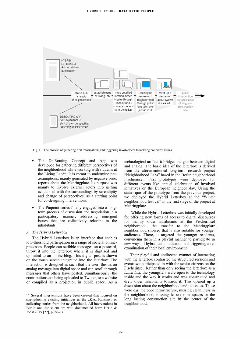
156
Fig. 1. The process of gathering first informations and triggering involvement to tackling collective issues.
The De:Routing Concept and App was
developed for gathering different perspectives of the neighborhood while working with students at the Living Labxiv. It is meant to undermine pre-assumptions, mainly generated by negative press reports about the Mehringplatz. Its purpose was mainly to involve external actors into getting acquainted with the surroundings by serendipity and change of perspectives, as a starting point for co-designing interventions.
The Pinpoint series finally engaged into a long-term process of discussion and negotiation in a participatory manner, addressing emergent issues that are collectively relevant to the inhabitants.
A. The Hybrid Letterbox The Hybrid Letterbox is an interface that enables
low-threshold participation in a range of societal online-processes. People can scribble messages on a postcard, throw it into the letterbox where it is digitized and uploaded to an online blog. This digital post is shown on the touch screen integrated into the letterbox. The interaction is designed as such that the user throws an analog message into digital space and can scroll through messages that others have posted. Simultaneously, the contributions are being uploaded to Twitter, to a website or compiled as a projection in public space. As a
xiv Several interventions have been created that focused on strengthening existing initiatives as the „Kiez Kantine“, or collecting stories from the neighborhood. All interventions in Berlin and Jerusalem are well documented here: Herlo & Joost 2015 [22], p. 36-63
technological artifact it bridges the gap between digital and analog. The basic idea of the letterbox is derived from the aforementioned long-term research project “Neighborhood Labs” based in the Berlin neighborhood Fischerinsel. First prototypes were deployed for different events like annual celebration of involved initiatives or the European neighbor day. Using the status quo of the prototype from the previous project, we deployed the Hybrid Letterbox at the “Winter neighborhood festival” in the first stage of the project at Mehringplatz.
While the Hybrid Letterbox was initially developed for offering new forms of access to digital discourses for mainly older inhabitants at the Fischerinsel neighborhood, the transfer to the Mehringplatz neighborhood showed that is also suitable for younger audiences. There, it targeted the younger residents, convincing them in a playful manner to participate in new ways of hybrid communication and triggering a re-examination of their local environment.
Their playful and undirected manner of interacting with the letterbox contrasted the structured sessions and events we participated in with the senior citizens on the Fischerinsel. Rather than only seeing the letterbox as a black box, the youngsters were open to the technology inside and the way it works and was constructed and drew older inhabitants towards it. This opened up a discussion about the neighborhood and its issues. Those were e.g. the poor infrastructure, missing cleanliness in the neighborhood, missing leisure time spaces or the long lasting construction site in the center of the
HYBRID CITY 2015 | DATA TO THE PEOPLE
neighborhood.
Fig. 1. The Hybrid letterbox and a projection deployed at the
Winterfest Mehringplatz in 2013
B. The De:Routing Appxv De:Routing was first developed as a workshop
concept while designing with students of the Berlin University of the Arts. It is an explorative tool that fosters the experience of the neighborhood and highlights randomly generated, directed walking for local surroundings. It aims at creating a change of perspective by generating unusual routes and by assigning a specific focus to the user, such as “barriers”, “thresholds” or “gatherings”. Participants are asked to answer questions, take photos, record sounds or videos or interact with passers-by, according to the task. Using different media, a map is created where all participants add their geo-tagged content on a shared web platform as a collective map of experiences. The maps serve as starting points for discussion and negotiation.
As a basis for inspiring the design of interventions, we tested and used the tool with both students and varying actors from the neighborhoods in Jerusalem and in Berlin. The superimposed, mapped perceptions helped comparing, discussing and generating concepts for interventions created by students, and researchers. Us an “urban probe”, the De:Routing App leaded also participants of the “Community Now?” conference in order to let them experience the neighborhood we worked with and discussed about in workshops and talks during the conference. The mobile application is open source and can be adapted to different places, as the radium of possible walks, the tasks and perspectives can be easily editable by the workshop leader(s) in the backend.
C. The Pinpoint App Pinpoint describes a series of tools with the goal of
getting a deeper insight in local issues. Since October 2014, three workshops were conducted with diverse participants. In the first workshop, we had a cohort of fifteen inhabitants from different age groups and backgrounds. At first, the participants went outside with the Pinpoint mobile app, which allowed them to photograph and describe positive, negative and alterable
xv De:Routing is based on an analog concept created during a Community Now? workshop by Michelle Christensen and Florian Conradi, derouting.community-infrastructuring. org
places or situations. After the exploration they talked about their experiences and discussed different connotations of and issues in the neighborhood. Concluding the first phase, all experiences and issues were projected publicly in the shop window of our Living Lab. The projection invited all neighbors to add their opinion in an analog or digital way with the goal to identify one unique local topic – meaning that, along with the projection, we offered the possibility to add comments on existing opinions, to support certain issues or to disagree with points of view. All entries were analyzed and clustered, resulting in twelve topics the neighborhood is collectively interested in. Those were e.g. drug facility hotspots, missing higher education possibilities, a missing continuation of the projects and, again, the “never-ending” construction site.
The second meeting was meant to trigger and engage new participants into the process, explain the purpose of Pinpoint to a wider range of inhabitants and find out more about the neighborhood’s handling and appropriation of the Pinpoint series. The main incentives the participants pointed out concerned the experimental, unusual way of offering a platform for discussion. Furthermore, the intuitive interface of the mobile application and working with pictures in a playful manner were perceived very positively, as many engaged actors in the neighborhood decisively avoid traditional evaluation or addressing forms like questionnaires.
Following this, and the overall process of clustering and analyzing the topics, the emerged issues were presented at an official and well advertised meet-up in our Living Lab. The participants ranged from local inhabitants like a social worker with an experience in situ of 30 years, a local artist, a former local writer and sculptor, a current activist and journalist, a member of the local writing group and other residents, but also stakeholders like the neighborhood manager, the head of the neighborhood management, one member of a freshly opened Social Impact Hub and a representative from a local Social Start-Up. After three hours of discussing the process and the twelve topics that evolved from it, no tangible results emerged – but a neutral platform for controversial discussion, where many issues were addressed beyond formal structures, as usually in this composition of differing interests. After reflecting the intense and highly charged meeting and after some one-on-one conversations we filtered out the topic, which was mentioned from the very beginning of our project and always came up in discussions: the long lasting construction site in the center of the neighborhood. Currently a public installation with sound and projection tools is placed at the outside fences of the construction site in order to collect citizen’s voices to accelerate the finalization process of the construction site.
VIII. GENERAL REFLECTION & FINDINGS Trying to build up an evaluation framework is one
big challenge, as the long-term process makes it quite difficult to find out about tangible deliverables for large-scale and open result projects, as the one we are

157
neighborhood.
Fig. 1. The Hybrid letterbox and a projection deployed at the
Winterfest Mehringplatz in 2013
B. The De:Routing Appxv De:Routing was first developed as a workshop
concept while designing with students of the Berlin University of the Arts. It is an explorative tool that fosters the experience of the neighborhood and highlights randomly generated, directed walking for local surroundings. It aims at creating a change of perspective by generating unusual routes and by assigning a specific focus to the user, such as “barriers”, “thresholds” or “gatherings”. Participants are asked to answer questions, take photos, record sounds or videos or interact with passers-by, according to the task. Using different media, a map is created where all participants add their geo-tagged content on a shared web platform as a collective map of experiences. The maps serve as starting points for discussion and negotiation.
As a basis for inspiring the design of interventions, we tested and used the tool with both students and varying actors from the neighborhoods in Jerusalem and in Berlin. The superimposed, mapped perceptions helped comparing, discussing and generating concepts for interventions created by students, and researchers. Us an “urban probe”, the De:Routing App leaded also participants of the “Community Now?” conference in order to let them experience the neighborhood we worked with and discussed about in workshops and talks during the conference. The mobile application is open source and can be adapted to different places, as the radium of possible walks, the tasks and perspectives can be easily editable by the workshop leader(s) in the backend.
C. The Pinpoint App Pinpoint describes a series of tools with the goal of
getting a deeper insight in local issues. Since October 2014, three workshops were conducted with diverse participants. In the first workshop, we had a cohort of fifteen inhabitants from different age groups and backgrounds. At first, the participants went outside with the Pinpoint mobile app, which allowed them to photograph and describe positive, negative and alterable
xv De:Routing is based on an analog concept created during a Community Now? workshop by Michelle Christensen and Florian Conradi, derouting.community-infrastructuring. org
places or situations. After the exploration they talked about their experiences and discussed different connotations of and issues in the neighborhood. Concluding the first phase, all experiences and issues were projected publicly in the shop window of our Living Lab. The projection invited all neighbors to add their opinion in an analog or digital way with the goal to identify one unique local topic – meaning that, along with the projection, we offered the possibility to add comments on existing opinions, to support certain issues or to disagree with points of view. All entries were analyzed and clustered, resulting in twelve topics the neighborhood is collectively interested in. Those were e.g. drug facility hotspots, missing higher education possibilities, a missing continuation of the projects and, again, the “never-ending” construction site.
The second meeting was meant to trigger and engage new participants into the process, explain the purpose of Pinpoint to a wider range of inhabitants and find out more about the neighborhood’s handling and appropriation of the Pinpoint series. The main incentives the participants pointed out concerned the experimental, unusual way of offering a platform for discussion. Furthermore, the intuitive interface of the mobile application and working with pictures in a playful manner were perceived very positively, as many engaged actors in the neighborhood decisively avoid traditional evaluation or addressing forms like questionnaires.
Following this, and the overall process of clustering and analyzing the topics, the emerged issues were presented at an official and well advertised meet-up in our Living Lab. The participants ranged from local inhabitants like a social worker with an experience in situ of 30 years, a local artist, a former local writer and sculptor, a current activist and journalist, a member of the local writing group and other residents, but also stakeholders like the neighborhood manager, the head of the neighborhood management, one member of a freshly opened Social Impact Hub and a representative from a local Social Start-Up. After three hours of discussing the process and the twelve topics that evolved from it, no tangible results emerged – but a neutral platform for controversial discussion, where many issues were addressed beyond formal structures, as usually in this composition of differing interests. After reflecting the intense and highly charged meeting and after some one-on-one conversations we filtered out the topic, which was mentioned from the very beginning of our project and always came up in discussions: the long lasting construction site in the center of the neighborhood. Currently a public installation with sound and projection tools is placed at the outside fences of the construction site in order to collect citizen’s voices to accelerate the finalization process of the construction site.
VIII. GENERAL REFLECTION & FINDINGS Trying to build up an evaluation framework is one
big challenge, as the long-term process makes it quite difficult to find out about tangible deliverables for large-scale and open result projects, as the one we are
4 | Urban Media for Empowering Citizens

158
describing here. In other words, how to evaluate the results, respectively how to measure the ‘social impact’,
Fig. 2. The Pinpoint Process: Neighborhood exploration
accompanied by the Pinpoint mobile application
Fig. 3. The Pinpoint Process: Workshop discussion of individual
explorations and perception of local environment, in the L
Fig. 4. De:Routing App – the interface of the android application
Fig. 5. De:Routing App – the interface of the web application; data mapping in Jerusalem
is one essential question we are still working on. It also turned out during the process that authorship and responsibility prove themselves as core dimensions when co-designing: when to transfer authorship, when and how to take it back or handle responsibility to the community? Through regular self-monitoring and self-reflection, we found a productive way of how to inform our decision-making, how to fix the status quo and, dependent to it, improve the process. So far, we can emphasize that there is no blueprint for handling authorship, but rather reflecting on it and deciding situationally. Nevertheless there are several issues to further be discussed, like communication strategies (how to make the goal and aimed process comprehensible for non-experts), roles (at what point in the process to act like mediator, facilitator, catalyst, decision maker, advocate), and action (when to be passive and observe, when to intervene). The most important factors we experienced as crucial for the process are: transparency – do not promise nothing you can not fulfill; transferability – is it possible to transfer and scale methods and approaches developed at a local level; and resources – time commitment and trust building are at risk to be underestimated, especially at the beginning of such undertakings. We should not let unmentioned that participatory processes are not per se meaningful. They sometimes even boost unequal resources and reinforce hierarchies.
Of course there are (interim) results that can be structured related to the phases of the project. They range from succeeded trust building, to implementing a platform for debate, accomplishing a certain level of inhabitants’ commitment, bundling local initiatives, and creating pleasant interventions and situations of individual encounters – by implementing the Living Lab and working in situ. Thus, all findings make it clear that it is pointless to think of global problems on an operational level, but reflect and address basic issues on an every day life dimension.
IX. PROJECT CONCLUSION Over the first two years of cooperation, both
researchers and students from Israel and Germany experienced the potential of carefully planted and
HYBRID CITY 2015 | DATA TO THE PEOPLE

159
locally based activities and interventions, of small steps towards promising results. Developing tools and methods for complex, sometimes dysfunctional or even conflicting conditions can be challenging even under regulated circumstances. But political tensions in Israel with recent peaks like the Gaza-operation in the summer of 2014 and a related anti-Arab arson attack on the Jewish-Arab Yad Be Yad School inevitably affected the social realities in the context that the group was working in. In Germany, we are currently experiencing xenophobic and Islamophobic protests, movements of unchanneled frustration that are being exploited by right wing groups. But on each side, the waves of solidarity with minorities, generated by a deeply democratic attitude towards our diverse societies, has shown us that political action doesn’t have to be formalized but expresses itself in many meaningful activities for social engagement, inclusion and co-determination. The conflicts thus reaffirm the actuality of the perspectives and intentions of the project. Our focus relies on not only providing tools for collective and transformative practices, but also emphasizing a mindset that considers inclusion, discourse and the ability to deal with each others’ differences in a respectful way. Our aim is to provide frameworks and tools that help situations of individual encounters, sharing of perspectives and productive debates to emerge.
REFERENCES [1] Armstrong, L., Bailey, J., Julier, G., Kimbell, L. (2014): Social
Design Futures. HEI Research and the AHRC. Brighton [2] Bajgier, S., Maragah, Hazem D., Prybutok, V., Saccucci, M.,
and Verzilli, A. (1991): Introducing students to community operations research by using a city neighborhood as a living laboratory. In: Journal, Operations Research archive, Volume 39 Issue 5, Sept.-Oct. 1991, Pages 701 - 709
[3] Bergmann, M.; Herlo, B., Sametinger, F.; Schubert, J.; Unteidig, A. (2013): Community Infrastructuring – Design-werkzeuge zur partizipatorischen Stadtgestaltung. In: Lange, B., Prasenc, G., Saico, H. (ed.): Ortsentwürfe. Urbanität im 21. Jahrhundert. Jovis Verlag, Berlin. p. 62-67
[4] Bergvall-Kareborn, BHMSA, Hoist, M. and Stahlbrost, A. (2009): Concept Design with a Living Lab Approach. In: System Sciences, 2009. HICSS’09. 42nd Hawaii International Conference on, 1–10. IEEE
[5] Bieling, T; Joost, G.; Sametinger, F. (2014): Die soziale Dimension. In: Fuhs et al. (Ed.): Die Geschichte des nachhaltigen Designs; VAS, Bad Homburg, p. 218 – 229
[6] Binder, T., De Michelis, G., Ehn, P., Jacucci, G., & Wagner, I. (2011): Design Things. The MIT Press
[7] Björgvinsson, E., Ehn, P., & Hillgren, P. A., ACM (2010): Participatory design and democratizing innovation. Proceedings of the 11th Biennial Participatory Design Conference, p. 41–50.
[8] Bødker, S., Pelle, E., Sjögren, D., and Sundblad, Y. (2000): Co-Operative Design—perspectives on 20 Years with ‘the Scandinavian IT Design Model.’ In Proceedings of NordiCHI, 2000:22–24. University of Notre Dame
[9] CoreLabs (2007): Living Labs Roadmap 2007-2010. In Open Document. Luleå: Luleå University of Technology, Centrum for Distance Spanning Technology
[10] De Waal, M. (2011). The Ideas and Ideals in Urban Media. In: From Social Butterfly to Engaged Citizen, Gibbs et al., MIT Press
[11] De Waal, M. (2014): The City as Interface. nai 010 publishers, Rotterdam
[12] DiSalvo, C. (2009). Design and the Construction of Publics. Design Issues. MIT Press
[13] Dutilleul, B., Birrer, F.A.J., Mensink, W. (2010): Unpacking European Living Labs: Analysing Innovation’s Social Dimensions. In: Central European Journal of Public Policy
[14] Ehn, P. (2008): Participation in Design Things. School of Arts and Communication. Malmö University, Proceedings of the Tenth Anniversary Conference on Participatory Design
[15] Eriksson, M., Niitamo, V.P., and Kulkki, S. (2005): State-of-the-Art in Utilizing Living Labs Approach to User-Centric ICT Innovation-a European Approach. Lulea: Center for Distance-Spanning Technology. Lulea University, Lulea
[16] Erlhoff, M., Marshall, T. (2007): Design Dictionary, Board of International Research in Design (BIRD)
[17] European Commission (2009): Living Labs for user-driven open innovation (www.eurosportello.eu/sites/default/files/ Living%20Lab%20brochure_jan09_en_0.pdf)
[18] Fuad-Luke, A. (2007): Re-defining the purpose of (sustainable) design: Enter the design enablers, catalysts in co-design. In: J. Chapman and N. Gant (eds) Designers, Visionaries + Other Stories, Earthscan, London, pp18–52
[19] Fuad-Luke, A. (2009): Design Activism: Beautiful Strangeness for a Sustainable World. Earthscan, London
[20] Fuad-Luke, A. et al. (2015): Agents of Alternatives – Re-designing Our Realities. Aalto
[21] Herlo, B., Joost, G. (2015): Design Research and the need for institutional support in German-speaking networks. In: Design Research in Germany, Special Issue, Design Issues 1/2015, Vol 31; Brown, Buchanan et al. (ed.) MIT Press Journals; p. 32-36
[22] Herlo, B., Joost, G. (ed.) (2015): Community Now?. German Society for Design Theory and Research (DGTF), Berlin (http://biancaherlo.de/Com-munityNowBuch.pdf)
[23] Joost, G., Unteidig, A. (2015): Design and Social Change. The changing environment of a discipline in flux. In: Jonas, W. (Ed.): Transformation Design. Birkhäuser, Basel, in print
[24] Kviselius, N. Z., Ozan, H., Edenius, M., and Andersson, P. (2008): The Evolution of Living Labs–Propositions for Improved Design and Further Research. In: Proceedings of the 5th International Conference on Innovation and Management (ICIM 2008), 842–56
[25] Manzini, E., Jégou, F. (2003): Sustainable Everyday, Scenarios of urban life. Edizione Ambiente, Milan
[26] Manzini, E. (2006): Design, Ethics and Sustainability. Guidelines for a transition phase. In: Salmi, E., Anusionwu, L. (2006): Cumulus Working Papers 16/06. Nantes, p. 9-15
[27] Mareis, C. (2010): Entwerfen, Wissen, Produzieren. Designforschung im Anwendungskontext. Transcript, p. 9–32
[28] Pallot, M., Trousse, B., Senach, B., and Scapin, D. and others (2010): Living lab research landscape: From user centred design and user experience towards user co-creation
[29] Papanek, V. (1971): Design for the Real World. Human Ecology and Social Change. New York, Pantheon Books
[30] Pfeffer, F. (2014): To Do: Die neue Rolle der Gestaltung in einer veränderten Welt. Strategien | Werkzeuge | Geschäftsmodelle, Hermann-Schmidt-Verlag, Mainz
[31] Rammert, W. (2010): Die Innovationen der Gesellschaft. Soziale Innovation. VS Verlag für Sozialwissenschaften, 21-51
[32] Rittel, H. W. J., Webber M. M. (1973): Dilemmas in a General Theory of Planning, Elsevier Publishing Company, Amsterdam
[33] Sametinger, F., Lahusen, M., Joost, G. & Brischke, L.-A. (2015): All I need: provoking conflicts at the boundaries ot the private and public sphere in the context of energy sufficiency. In 4th Participatory Innovation Conference 15, p. 288. In print
[34] Sametinger, F., Schubert J. (2013): Design als Infrastruktur in urbanen Nachbarschaften. In: Wer gestaltet die Gestaltung? Praxis, Theorie und Geschichte des partizipatorischen Designs. Claudia Mareis, Matthias Held, Gesche Joost (ed.), transcript. Bielefeld, p. 215-227
4 | Urban Media for Empowering Citizens

160
[35] Sanders, E.B.-N. (2006): Design Serving People, in E. Salmi, L. Anusionwu, Cumulus Working Papers, Univesity of Art and Design, Helsinki
[36] Sanders, E.B.-N. (2013): Perspectives on Participation in Design. in: Wer gestaltet die Gestaltung? Praxis, Theorie und Geschichte des partizipatorischen Designs. Claudia Mareis, Matthias Held, Gesche Joost (ed.), p. 65-78
[37] Schubert, J., Sametinger, F., Unteidig, A., Reiter, L., Sossa, J., Herlo, B., Bergmann, M., Joost, G. (2014): Hybrid Letterbox. Cumulus Conference, Aveiro. In print
[38] Schumacher, A. J. , Feurstein, B. K. (2007): Living Labs — a new multi-stakeholder approach to user integration. In: Enterprise Interoperability II. New Challenges and Approaches. London
[39] Smyth, M., Helgason, I. (2013): Tangible possibilities—envisioning interactions in public space. Digital Creativity, 24(1), p. 75-87.
[40] Unteidig, A., Herlo, B., Reiter, L. (2015): The Hybrid Meeting Point. An urban infrastructure for interacting across boundaries of difference. Hybrid City Conference, Athens. unpublished
[41] Unteidig, A., Sametinger, F., Schubert, J., Joost., G. (2013): Neighborhood Labs. In: Proceedings of the Participatory Innovation Conference, Lahti, Finland
[42] Wenger, E. (1998): Communities of Practice: Learning, Meaning, and Identity. Cambridge: Cambridge University Press
[43] Winhall, J. (2006) RED Paper 02 Transformation Design, Design Council. London
[44] Wood, J. (2007): Design for Micro-Utopias: Making the Unthinkable Possible (Design for Social Responsibility). Ahsgate, Farnham
[45] Zapf, W. (1994): Modernisierung, Wohlfahrtsentwicklung und Transformation. Berlin: Wissenschaftszentrum Berlin für Sozialforschung WZB, Berlin
HYBRID CITY 2015 | DATA TO THE PEOPLE

161
Empowering science parks for disabled persons using Boxes
Lucas H. M. Lazaro, Enlai L. Cheng, Lucas N. Couceiro, Lucia V. L. Filgueiras
Escola Politécnica da Universidade de São Paulo São Paulo, SP, Brazil
{lucas.lazaro, enlai, lucas.couceiro, lfilguei}usp.br
James Ohene-Djan Department of Computing
Goldsmith, University of London London, UK
Abstract. In hybrid cities, both humans and urban environment are empowered by technology. For people with disabilities, technology plays an important role of empowerment as assistive technologies. The thought of disability as the consequence of interaction between an individual and a poorly designed environment fosters the concept of the impaired environment as a different view of accessibility. In this paper, we address how technology in hybrid cities can empower these communication-impaired or physically-impaired environments. We present an application of Boxes, a geolinked technology, in the empowerment of a science park
Keywords: hybrid cities; accessibility; disabilities; empowerment; universal design
I. INTRODUCTION Urban tissue is made of human and physical threads,
woven in complex patterns, sometimes strong, sometimes frayed. Holes in this fabric occurs when interlacing fail or wear out.
Swybgedouw [1] states that cities are socio-physical milieus resultant of processes of socio-environmental metabolic circulation. The author claims “metabolisms produce a series of both enabling and disabling socio-environmental conditions. Indeed, these produced milieus often embody contradictory tendencies”. In addition, he states that “processes of metabolic change are, therefore, never socially or ecologically neutral”.
Given that, we can think of technology as an interfacing tissue that patches holes and enforces the urban tissue, providing a layer of information available for everyone, every time and everywhere. We understand hybrid cities as technology fusing itself with other socio-environmental conditions and empowering both the urban space and citizens. Being a metabolic change, the process of hybridizing a city is not neutral. In this paper, we build on the idea that hybrid cities are empowering environments for people with disabilities.
Empowerment is a concept from social sciences that addresses power relationships in a society, usually applied to the process of minorities assuming their social
role and increasing their influence due to the recognition and exposition of their specific abilities. Deibel [2], talking about qualities in technology acceptance models, defines empowerment as “A person’s ability to freely plan, decide, and act as she deems best”. In enterprise management, empowerment is a tool for change, based on three principles: sharing information with everyone, autonomy and self-management.
Technology usually empowers people. In hybrid cities, however, the environment is also empowered, for technology creates an intelligent context that autonomously decides on performing tasks and sharing information. Together with the more active, participant, empowered individual, the empowered environment is more effective and efficient.
For people with disabilities, technology plays an important role of empowerment as assistive technologies. However, two distinct approaches for disabilities influence assistive technologies design: medical and social approaches. Medical approach to disability considers that assistive technology and rehabilitation can overcome disabilities. In this perspective, disabled persons are outlier citizens who must acquire resources to move toward the “normal” condition. Designers of assistive technology work towards returning some lost ability to users who, by possessing the technical gadget, can interact with the world as it is. In this case, one keeps the environment status quo by empowering the individual.
Instead, the social approach see individual differences as cause of disadvantages in the access to the world. In this approach, society produces barriers to disabled people. Universal design is the way to remove and avoid creating barriers. According to the Human Rights Council of the United Nations [3] “The focus is no longer on what is wrong with the person. Instead, disability is recognized as the consequence of the interaction of the individual with an environment that does not accommodate that individual’s differences and limits or impedes the individual’s participation in society”. Such environments can be called as impaired environments, as opposed to impaired individuals, and
CNPq, Brazilian National Counsel of Scientific and Technological Development, supported Lucas Lazaro with grant no. 226686/2013-2 under Science Without Borders Programme.
4 | Urban Media for Empowering Citizens

162
can be classified as communication-impaired or physically-impaired environments.
In this paper, we use Boxes in a proof-of-concept for addressing both the physical and communication impairment of an educational environment, a park with a permanent science exhibition.
This paper is organized in four sections. Section 2 presents a literature review on user interaction in hybrid cities, in which we identify potential benefits for disabled persons. Section 3 present the Boxes concept and its application in a science park. Section 4 discusses disabled persons´ empowerment using hybrid cities, from the observations derived from section 3.
II. ACCESSIBLE HYBRID CITIES In order to identify potential benefits of hybrid cities
for disabled persons, we work on distinguishing the concepts of smart and hybrid cities; then we present results from a systematic review on hybrid cities in which we look for interaction aspects.
A. Smart or hybrid cities? The use of digital technologies or information
communication technologies (ICT) to empower both the urban space and citizens in this environment is often labelled as smart city. According to Naam and Pardo [4], there is neither a single template or framing smart city nor a one-size-fits-all definition. A study by Forrester Research [5] defines smart city as “The use of Smart Computing technologies to make the critical infrastructure components and services of a city – which include city administration, education, healthcare, public safety, real estate, transportation, and utilities – more intelligent, interconnected and efficient”. Hall [6] defines smart city as a city that monitors and integrate conditions of all of its critical infrastructures, including roads, bridges, tunnels, rail/subways, airports, seaports, communications, water, power, even major buildings, to better optimize its resources, plan its preventive maintenance activities, and monitor security aspects while maximizing services to its citizens.
Exploring perspectives other than city planning and infrastructure, according to Giffiger [7], “a Smart City is a city well performing in a forward-looking way in Economy, People, Governance, Mobility, Environment and Living, built on the ‘smart’ combination of endowments and activities of self-decisive, independent and aware citizens.” Theses six characteristics could be divided in three categories, a technological (Mobility and Environment), a social (People and Living), and governmental (Governance and Economy). This division is similar to the definition given by Naam and Pardo [4], who say that a smart city can be addressed as the intersection of three categories: “technology (infrastructures of hardware and software), people (creativity, diversity, and education), and institution (governance and policy).”
As we are concerned in this paper with the social/people aspect, we share Rios’ [8] vision of a Smart City: a city that “gives inspiration, shares culture, knowledge and life, a city that motivates its inhabitants to create and
flourish in their own lives being a vessel to intelligence but ultimately an incubator of empowered spaces.”
A Hybrid City, as defined by Streitz [9], is a real city with its physical entities and real inhabitants and a parallel virtual city of counterparts of real entities and people. Lange and Waal [10] states that for a long time, the domain of digital media was viewed as virtual, as something separate from physical reality but now these two words are tightly interwoven. Thus, the contemporary city is a hybrid city with physical and digital infrastructures, services and processes at all levels. We consider that the expression hybrid will only make sense while there are still people who have experienced cities before the hybridization process, for new generations understand the hybrid world as natural.
B. Interaction in hybrid applications In order to understand how people interact with the
hybrid city, we have performed a review on past editions of the Hybrid Cities conference, looking for applications in which the user interface is a relevant aspect. Our search has resulted in five papers, which we briefly describe in the following paragraphs.
P.I.G.S [11] is a multiplayer location-based propaganda game, for up to 48 players split into four opposing teams and played with Smartphones. The objective of this game is to give the players the opportunity to explore their city in a different and more adventurous way. In this game, participants use their smartphones equipped with cameras and GPS location as “weapons” to “capture” their opponents by taking a picture and tagging them.
LogIn Design City [12] is a project for the revitalization of public city’s space through the involvement of individuals, collectivities and municipalities, managed by a specific team and structured upon an augmented platform. Using an online web platform, any citizen can act, interact, propose and create events and interventions in public spaces like parks, parking lots, streets and sidewalks, creating a combination of the artificial space created by the new media with the real public space.
The paper by Ivkovic, Piepgras and van Emden [13] discusses possible benefits and shortcomings of introducing gaming, playfulness and smart technologies as instruments to stimulate collaborative urban planning. The application GreenSeeker aims to raise awareness about problems such as the forming of the urban heat islands in the inner cities due to the lack of greenery through interactive presentation of factual data. Users play the game from their smartphones, and can present their solutions to the larger community through established social media channels or a personal network.
The Experimedia Blue project [14] targets a museum. It aims at enhancing the visiting experience before, during and after the actual museum visit. Authors expect to improve user experience within the museum, by offering personalized routing and exhibit descriptions based on the cognitive needs of each visitor. In order to do that, authors manage to collect visitors’ cognitive profile either from data collected in a social media game
HYBRID CITY 2015 | DATA TO THE PEOPLE
163
the user is invited to play prior to the visit or from answers of a small quiz once at the museum and before the main visit starts. After the visit, the user can access their social media account to use museum material and create a personal diary of visit.
Finally, RouteMate [15] was the only application in this review that addressed disabled users and the need for accessibility. It is an application for route learning in urban environments for people with disabilities. The location-based game allows people to interact using their mobile device (with GPS) and provides the user with the options to create a new route, or load and modify an existing route with the help of a parent, caretaker or trainer.
The analysis of these five hybrid cities applications results in the following assertions on interaction in hybrid cities, which we explore later in discussion on accessibility in hybrid cities.
A hybrid city allows extending user experience with the urban space, by adding information that could not be extracted from the space by itself, but instead comes from processing georeferenced data (exhibitions, routes, vegetation).
A hybrid city provides users’ guidance by promoting user experience in a designed way and leading the user in understanding the environment he or she is placed in (museums, routes or points of interest).
A hybrid city provides adaptation of spatial information to users’ interests, capabilities or cognitive styles.
Gamification is often used to stimulate engagement of users to the proposed applications.
Usually applications are placed in spaces where people would be naturally looking for information.
In the next section, we present Boxes as a building block for our accessible park application.
III. BOXES Boxes is a concept created by Ohene-Djan and
Lazaro as part of a Summer Term Project entitled Augmenting Physical Spaces with Digital Objects to Create Smart Environments [16]. They conceived Boxes as virtual containers of digital information, associated to a geo-reference coordinate. The primary intent of Boxes was to explore the concept of geolinks and explore the interaction between the mobile device and server, from the data traffic perspective, using the idea of send and receive box-set identifiers instead of the box content itself.
Because of its simplicity and efficiency, the concept is useful for a number of applications in smart environments. In this section, we present briefly the human interaction aspects of Boxes.
Boxes are based on geolinks. A geolink in a hybrid space is an analogy to a hyperlink in the virtual space. The hyperlink is described by an origin element on a digital resource such as a web page (the web element, like
a text or image that calls to action) and a destination element, which is a URI that details the location of a digital resource such as a web page. The destination element can either be statically declared or computed as the result of a function. The regular behaviour of a hyperlink is triggered by the user action (mostly clicks) on the origin element, which demands a server to retrieve the digital resource denoted by the destination element to be presented to the user. Analogously, geolinks are composed of a origin element, which is a geographical coordinate, and an destination element that is, exactly as in the hyperlink, the address of a digital resource. For geolinks, the behaviour is trigged when the user physically reaching the location that was previously set as geolink origin. The basic behaviour is presenting the content to the user.
The digital resource we call Box has evolved from the first proposed data structure in Lazaro and Ohene-Djan to the present version. A Box is an unstructured data container, using NoSQL systems for storing information tagged with the following metadata.
Where: the Box location, that is, the physical position that is the origin element for the geolink as well as the distance from which the box can be “seen” by the user application
When: time constraints about the Box, regarding when it was created, when it can be accessed and the lifetime of the digital resource;
What: data contained in a Box can be any kind of digital data: audio, video, text or link to other digital resources;
Who: information about creator and authorization for accessing, editing and deleting both the box and its contents.
A user can access a Box using an application deployed in a mobile device equipped with global positioning system (GPS) and internet connection. A user may play two roles, content consumer or content producer.
A content producer set boxes with a three step wizard, defining the essential data as explained above. In the first step, she is able to set a geofence for the box, which, according to Namiot [17], are “user-defined areas defined around a location. For example, in simplest case it is just a radius defines some circular area.” In order to set the geofence, the content producer can either choose its current location or search for a valid location using a map search query. The content producer also sets the range in meters around the selected point. The circular area will be the geofence for that box.
The second step is the content input. Boxes content, in concept, could be any digital content and the decision of what to put in a box is up to its creator. In urban space application, we expect it to be something related with what can be associated, explicitly or not, to a certain position: information about the place, past pictures, videos or audios, links to other digital resources (i.e. webpage, mobile application) that may contain relevant content for the box location.
4 | Urban Media for Empowering Citizens

164
In the last step, the producer sets the box visibility to either public or private access by a defined group of people, using their email addresses. She can also tag the content, in order to have it arranged into categories, and set time constraints like how many times the box can be opened and for how long it will exist.
The application also has a wizard for making easy the definition of a set of Boxes. A content producer can manage the Boxes she creates. By using Boxes, content producers can empower an environment by augmenting physical spaces with digital objects.
On the other hand, content consumers are empowered by the knowledge in Boxes and by the ability to share, manage and actively contribute to this knowledge.
In the role of content consumer, the Boxes user is able to set his preferences on which type of box he might want to come across, by selecting a variety of categories with which boxes are tagged. He can identify how many boxes are around and the distance from the nearest box. Once he steps into a box's geofence he has the right to access, he is notified by a push notification from that box. The user then receives the box, which is kept in a list of received boxes. The consumer can open a selected box and explore its content. Additional actions are checking the reception, making the box favorite and deleting from its inbox.
Figure 1 presents contents available for a consumer user in the application home screen.
Fig. 1 Boxes home screen
Architectural aspects of Boxes are beyond the scope of this paper, however, it is worth informing that in order to minimize data exchange and mobile device battery consumption, Boxes architecture optimize server requests for data by exploring the concept of geofences and the density of boxes near the user.
Considering that one of the research goals is to understand better the relationship between citizens and hybrid cities, Boxes record all relevant events in order to generate activity reports about user experience. An important conversion index is the number of accessed boxes per pushed notifications. Data analysis will give us a good look into the potential of such application and highlight possible improvements and other areas of exploration.
IV. EMPOWERING DISABLED USERS WITH BOXES: AN APPLICATION IN AN ACCESSIBLE PARK
As we could notice from the literature review on interaction with hybrid cities, few applications addressed the access by people with disabilities. Accessibility is enforced by law in several countries, however, we believe that as researchers in a new paradigm for citizenship, it is our duty to think of solutions that are universal from scratch.
In this section, we highlight Boxes features that accounts for its universal access. In Boxes, we distribute accessibility between the environment and the user.
The empowered environment provides universal content, by demanding that all content has equivalent versions from the moment the user loads the content in a box. This means that Boxes contents have alternative and equivalent versions: image descriptions, captioned video and sign language videos.
From the content consumer point of view, users can inform their profile. Based on the user choices, the app changes its operation configuration. When the user opens a box, he will receive the content in formats suitable to his profile.
Boxes empowers people with visual impairment with a tool that is able to augment the physical space with audio information and guidance, promoting accessibility by hybridizing the environment.
For instance, for blind users or those preferring sound output, besides the regular sound operation of the smartphone, information about existing boxes location changes to a compass-like interface, which delivers direction of movement towards nearest box via sound guidance.
Thinking of Boxes as a city empowerment tool, we develop a proof-of-concept (POC) for understanding human-Boxes interaction in a science park. This POC has implemented accessibility using Boxes, but a larger study with users was not concluded by the time of this publication.
Our hypothetical park is a research and educational facility, promoting cultural and educational entertainment activities for students of all ages,
HYBRID CITY 2015 | DATA TO THE PEOPLE

165
especially regarding natural and environmental sciences. Some activities and exhibitions are in open space; others are organized inside buildings. Buildings are surrounded by vegetation and lakes, and trails lead users from one exhibition to another. Exploring the space to find an exhibition is an important factor of motivation.
Even though we have a real park behind this description, it is easy to notice that it fits several similar facilities throughout the world.
Because the park receives regularly the visit of fundamental and high school students, some of which with disabilities, we consider that this is an interesting location for evaluating the use of Boxes for enhancing the disabled student experience. In order to limit the focus of the experiment, we propose the use of Boxes by visual impaired users, both blind and low vision.
Instead of presenting a tactile map for blind students to find their way in the exhibition, we place boxes in places along the trails; also, we placed boxes besides interesting trees and bushes, near outdoor equipments and exhibitions and in buildings entrance. We have placed boxes also close to public facilities like bathrooms, drinking fountains and restaurants, as well as emergency and information stations.
Geofences are programmed in order to progressively disclose boxes, forming paths in the space. If all boxes are disclosed at once, users may lose the motivation to explore the place. Exceptions are the public facilities, which have a different drive.
Content associated to each box varies depending on the designed experience. Boxes along the path are mainly directional, but they allow users to leave messages for other users, as well as retrieving messages left for them. They are analogous to “treasure maps”, pointing to directions where the user path can enter the geofence of a few other boxes.
Boxes placed near vegetation contains information about parts of plants – format of leaves, flowers, size of trunks and invite users to explore the plant by touching it. This is done similarly for touchable artworks and static equipment. In places with historical importance, videos recalling the historical fact are input to the box. Again, people can leave their impressions and instructions for other groups.
Boxes placed near interactive equipment present a brief description of the equipment and the science principles it demonstrates. It allows people to leave their comments on the experience. Maintenance notices and safety warnings are also available as content. Also, it gives directions guiding users to proceed to other exhibitions.
Close to building entrance, where several different exhibitions take place, boxes are more informative than directional, first because trained monitors welcome and lead all students and, second, because indoor location system fails to deliver the desired user experience.
When visitors arrive at the park, they listen about Boxes concept and application. Devices for accessing
boxes are Android tablets with wi-fi access to the web and native accessibility features. Boxes apps can also be downloaded to the personal devices, if desired.
Recalling the assertions we have identified previously in this paper, we can comment on Boxes as an accessible hybrid city application.
Boxes provide users’ guidance for visual impaired users both by providing accessible content and by providing a directional aid, so that the designed navigation can be performed and the content can be consumed.
Boxes provide adaptation of spatial information to users’ interests, capabilities or cognitive styles, presenting information on the suitable format and also by distributing the park information formerly only available from the monitors.
Gamification can be used in Boxes, but useful information is often sufficient to stimulate engagement of users to the application.
Boxes notification approach implies that users can find relevant information even though they are not explicitly looking for it.
V. CONCLUSION The use of technology as an interfacing tissue to the
urban tissue, which is made of human and physical threads, fusing the two layers to empower both citizens and spaces with information that will be available for everyone, every time and everywhere is what makes a hybrid city.
We have used Boxes as geolinked virtual containers of digital information to achieve empowerment for both urban spaces and people.
Next step in this research is to use this POC to understand how people with and without disabilities need and seek for information in a hybrid city, and answer some important questions for hybrid cities:
• Georeferenced information creation and sharing, between people with different abilities;
• Understanding how people in general and persons with disability, in particular, discriminate useful and relevant information in a hybrid envirnoment;
• Identification of outdated and/or irrelevant information in order to destroy it and avoid information overload;
• Diagnosing naturality and intuitiveness in the concept of geolinks;
• Determining the ideal separation of geofences to support visual impaired user autonomous navigation while keeping the behaviour of information foraging.
4 | Urban Media for Empowering Citizens

166
REFERENCES [1] E. Swyngedouw. "Circulations and metabolisms:(hybrid)
natures and (cyborg) cities." Science as Culture 15.2 (2006): 105-121.
[2] K. N. Deibel. Understanding and Supporting the Adoption of Assistive Technologies by Adults with Reading Disabilities. Dissertation for the degree of Doctor of Philosophy, Computer Science & Engineering, University of Washington, 2011. Available in: http://goo.gl/kVHlfi.
[3] United Nation-Human Rights. Monitoring the Convention on the Rights of Persons with Disabilities. Guidance for Human Rights Monitors, Professional training series no. 17. New York and Geneva. (2010).
[4] T. Naam and T. Pardo, “Conceptualizing smart city with dimensions of technology, people, and institutions” The Proceedings of the 12th Annual International Conference on Digital Government Research, Maryland, USA, pp. 282-291, June 2011.
[5] D. Washburn, U. Shindhu, S. Balaouras, R. A. Dines, N. M. Hayes, and L. E. Nelson, “Helping CIOs understand ‘smart city’initiatives”, Forrester Research, Massachusetts, USA, February 2010.
[6] R. E. Hall, “The vision of a smart city”, 2nd International Life Extension Technology Workshop, Paris, France, September 2000.
[7] R. Giffinger, C. Fertner, H. Kramar, R. Kalasek, N. Pichler-Milanonić, and E. Meijers, “Smart cities: Ranking of European medium-sized cities”, Vienna, Austria, October 2007.
[8] P. Rios, “Creating ‘the smart city’”, University of Detroit Mercy, Michigan, USA, 2008.
[9] N. Streitz, “Ambient intelligence landscapes for realizing the cities of the future: Introduction and overview.” Proceedings of the 3rd European Conference on Ambient Intelligence, Salzburg, Austria, November 2009.
[10] M. de Lange and M. de Waal, “Ownership in the Hybrid City”, Amsterdam, Netherlands, February 2012.
[11] E. Roinioti, M. Saridaki, G. Hiotis, and D. Arabatzis, “P.I.G.S. and the city: Playing with guilt and truth in the streets of Athens.”, 2nd International Hybrid City Conference, Athens, Greece, May 2013.
[12] P. Mantzou, X. Bitsikas, E. Mandoulidou, K. Zamzara, E. Giannopoulou, and M. Grafanakis, “LogIn design city.”, 2nd International Hybrid City Conference, Athens, Greece, May 2013.
[13] M. Ivkovic, B. Piepgras, and R. van Emden, “Fun, games and collaborative plans: Benefits and shortcomings of including interactivity and gaming into the collaborative urban planning.”, 2nd International Hybrid City Conference, Athens, Greece, May 2013.
[14] A. Antoniou, G. Lepouras, I. Lykourentzou, and Y. Naudet, “Connecting physical space, human personalities and social networks: The Experimedia Blue Project.”, 2nd International Hybrid City Conference, Athens, Greece, May 2013.
[15] M. Saridaki and E. Roinioti, “RouteMate, a location based route learning system for users with disabilities. A playful methodological experience in different urban European landscapes.”, 2nd International Hybrid City Conference, Athens, Greece, May 2013.
[16] J. Ohene-Djan, L.H.M. Lazaro, M. Otaviano, R. Amaral, W. Loureiro, “Augmenting Physical Spaces with Digital Objects to Create Smart Environments”, unpublished.
[17] D. Namiot and M. Sneps-Sneppe, “Geofence and network proximity”, Internet of Things, Smart Spaces, and Next Generation, 13th International Conference, NEW2AN 2013 and 6th Conference, ruSMART 2013, St. Petersburg, Russia, August 2013.
HYBRID CITY 2015 | DATA TO THE PEOPLE

167
Empowering Citizens and their Input on Civic Issues through Urban Media Dr Ian McArthur
UNSW Art & Design UNSW Australia Sydney, Australia
Dr Martin Tomitsch Faculty of Architecture, Design and Planning
University of Sydney Sydney, Australia
Luke Hespanhol Faculty of Architecture, Design and Planning
University of Sydney Sydney, Australia
Abstract. As smart cities and media architecture attract increasing attention globally, researchers, governments, urban planners, curators, artists and designers are questioning whether they can support urban sustainability and civic innovation through community engagement and social participation. As a widely proliferating form of urban media, large digital screens in particular provide a promising platform for engaging citizens in a dialogue on issues of local relevance. This paper discusses research concerned with techniques and tools for creating awareness and civic discourse about urban issues (e.g. use of public space, public safety, or new developments) and explores how meaningful interaction may be facilitated through the design of participatory urban media that prompt civic discourse and input from citizens. This research ‘in the wild’ aimed to develop and test methods that established a reproducible approach for programing urban screens to respond to a specific physical and socio-cultural environment.
Keywords: Civic participation, community engagement, urban media, urban planning, urban screens, media architecture, participatory design
I. INTRODUCTION Over the last decade we have seen a proliferation of
large digital screens across cities around the world. Placed in spaces such as public squares, railway stations, cultural precincts and shopping malls, these installations are often referred to as urban screens. In Australia the most iconic and successful example in terms of its presence as a tool for engaging citizens and placemaking is the urban screen situated at Federation Square, Melbourne. Many local governments, developers and urban planners in Australia have subsequently attempted to emulate the “Federation Square Model” as it has become known as. Few have proved as successful, but recent developments such as The Concourse at Chatswood in Sydney, and new developments like Barangaroo on Sydney Harbour, and the Gold Coast Cultural Precinct all involve proposals for public spaces featuring large urban media in the form of digital screens.
However, the long-term social, cultural and economic potential of urban screens to vitally augment precincts depends on cities having effective tools to engage all stakeholders with a sense of agency that is grounded in openness, transparency and inclusion [1].
In part the failure to transpose the Federation Square model successfully to other sites is due to a lack of interdisciplinary consultation and collaboration at the planning and implementation phases of the process. A key challenge in creating successful implementations of urban screens and other forms of urban media in public spaces is the critical requirement that they appropriately respond to not only the physical fabric of the built environment but that they are coherent in the socio-cultural context in which they have been placed. In some ways we take the multiplicity of screens in our lives for granted. As Murphie [2] asserts,
“It’s easy to forget what “screens” were only 50 years ago. The “screen” meant cinema or TV. Interaction, at best, meant fighting with one’s brothers or sisters over the knob on the television set that changed channels. Now we have screens of every size, throughout our everyday world, from the small screens in our hands, to the very large screens in our public worlds.” [2].
We have also seen that personal computing devices and increased mobility have led to the collapse of the idea of the neighbourhood in which citizens would form communities around physical locations [3]. This contributes to citizens losing a sense of ownership about the urban environment and leaves them feeling detached from their local community. On the other hand, large digital displays do have the “potential to move beyond ‘ambient television’ to play a role in initiating new collective interactions in public space” [4]. Urban screens therefore could play a part in reconnecting citizens with their local neighbourhood, for instance by encouraging social interaction with other citizens [5] or a dialogue with local governments [6]. Bernstein et al. suggest [7] the networks of humans, artefacts, and the computers that form urban media environments provide a fundamental capacity for accessing collective or ‘civic
4 | Urban Media for Empowering Citizens

168
intelligence’ [8]. McQuire (2011) also notes recent conceptions of urban media suggest a potential for developing “innovative tools for exploring new modes of social interaction and cultural exchange” [4]. However, although this capacity exists as a set of discreet technological components, the question is whether city stakeholders can deploy them in integrated transformative ways useful to the overall wellbeing of citizens.
To further explore this question, researchers from UNSW Australia, University of Sydney and QUT in Brisbane conducted research ‘in the wild’ using the urban screen in Chatswood, Sydney. This paper examines how urban screens may be used to generate synergies between participatory IT, design and data visualisation that add long-term social, cultural and economic value to urban precincts to: (a) encourage collaborative, interdisciplinary approaches to urban planning and development issues relating to urban screens; (b) promote more open, livable, creative and engaging cities; (c) create frameworks enabling participatory citizen engagement to foster thriving and sustainable urban communities; and (d) support innovation in town planning, urban development and land management.
The research has aimed to develop tools and strategies that could be used to help solve some of the programmatic problems associated with mediated urban spaces. Despite our technologies, a reproducible framework for enabling participatory citizen engagement to foster thriving urban communities and ‘smart’ sustainable development remains elusive. Participatory engagement with the Chatswood community determined how to iteratively respond to opportunities and constraints around designing content, spatial layout, interaction design, appropriate technologies, and how to integrate and apply human-computer interaction approaches.
This paper describes and evaluates interdisciplinary research funded by the Halloran Trust (University of Sydney). We begin by providing a background to the research in the field and discuss challenges to facilitating civic interaction and engagement within urban media environments. The aims and research methodology are then described in terms outlining a framework of methods for facilitating participatory polling processes augmented by data visualisation of crowd-sourced content. We follow this by discussing the testing of two different digital interfaces that form the ‘Vote As You Go’ polling platform [9]. The final section of paper evaluates a range of design considerations, limitations of the study, and conclusions highlighting a range of opportunities and challenges.
II. BACKGROUND There are two dominant and closely related
terminologies that describe urban media displays: urban screens and media façades [10][11]. The difference between these concepts is defined by the relationship of the screen itself to the architectural form and the urban site in which it is situated. Urban screens are typically freestanding in open public space or attached to the
façade of a building. The screen and the building are two distinct layers in terms of how they are technically facilitated and the manner in which they are perceived. If urban screens appear as freestanding, independent architectonic elements, they take on the single purpose to communicate media content [12].
Urban screens also provide a high-density information space with which to seek engagement with the public in urban placemaking. Technological advances in LCD and LED / OLED components have supported the proliferation of urban screens of all scales throughout contexts as varied as cafes, retail outlets and outdoor urban streetscapes. Unfortunately however, in many instances the role of urban screens is relegated to that of advertising or simply playing muted television programming [13].
Parallel development in the availability of sensor technologies provides enhanced opportunity to augment urban screens with interaction capacities enabling touch [14] or gesture [15] to be a part of the user experience. This is a more enticing proposition from an interaction design perspective, largely because of the added potential for more participatory forms of implementation and application. Such interactive augmentations to the screen however present a number of new considerations and complex challenges to the designer:
People are often not aware of the interactive capabilities of a display, or might not notice the display at all [14].
New forms of interaction are required, since there is typically no mouse or keyboard available. Touch input, which has become the standard input mechanism on smartphones, is in many cases not practical due to distance between user and display and the form factors of the display [14]. Touch is further not well-accepted in public environments due to health risks associated with touching the surface of the display [117]. This has prompted interaction designers to trial gestural interaction techniques [16] [17].
Interactions at public displays are typically of opportunistic nature [18] and of short periods. If a passer-by does not see an immediate benefit that they can gain from engaging with the display they will quickly decide to move on. This effect may also lead to passers-by appropriating the interactive display for other purposes than what it was intended for, such as engaging in game play [19].
Interactive displays in public spaces may need to cater for multi-user interaction. This further includes the need for essential information such as service departure times or general wayfinding information to remain visible at all times, even when someone is interacting with the display.
The design of the interactive display needs to take into account the physical context. In that regard, the design of an interactive display in a busy city centre at a major transport hub is likely to be
HYBRID CITY 2015 | DATA TO THE PEOPLE

169
vastly different from an interactive display designed for a suburban location.
The research discussed in this paper seeks to explore these considerations and challenges with particular attention to community engagement. The research team aimed to reach a broader cross-section of the public using a large urban screen made available through Sydney-based research partners Willoughby City Council and Urban Screen Productions. The urban screen functioned as a digital platform enabling the researchers to augment it with a range of tools specifically developed for the project in the form of touch screen and full-body gestural interfaces.
III. URBAN MEDIA ENVIRONMENTS Tscherteu and Tomitsch [10] define urban screens as
forms of media artefact existing within the ‘urban media environment’. Urban media environments reflect the influence such artefacts bring to public space and its attendant cultural context. The ubiquity of personal devices such as mobile phones and tablets that may be integrated into the media environment means they too become elements in a confluence of tangible elements in the built environment such as buildings, cars, streetlights, and street furniture. Each possesses affordances encouraging users to engage with them in different ways according to need or purpose. Urban media environments contribute to the growing complexity and importance of place within a matrix of interdependency comprised of humans, diverse artefacts, and the ever-changing temporal interactive relationships they generate. This understanding of public space posits that urban media environments equate to ‘cultural spaces’ where culture is derived from historical understandings about how cities and their denizens in all their complexity have evolved [10].
It is important to note that although these urban media ecologies have significant impact on determining modes of interaction in an urban space they emerge as a result of the socio-cultural histories of place. Department stores or shopping malls are built at a specific location in an evolving response to long traditions of trading in a precinct. The installation of traffic lights is commonly the consequence of accidents that happened in comparable urban situations. Similarly the installation of urban screens at a specific location is often determined by the location’s character, for example using an opportunity where traffic slows down allowing drivers to watch the content of the screen. Urban media environments tend to represent a complex network of artefacts and interactions happening in a specific site in ways that also accommodate the history of the site. This highlights that objects in the built environment do not exist as individual components but are part of a co-evolving web of artefacts and interactions happening on a daily basis in the lives of citizens. These artefacts and interactions perpetually and reactively produce new generations of artefacts and interactions. In that sense, urban media environments can be considered to be ‘cultural spaces’ [10]. ‘Culture’ here refers to the historical (or evolutionary) dimension of urban life that is composed of the inhabitants and their behaviours, buildings, technical developments, as well as
reflections of theoretical and political concepts that form urban life and its development over time. When designing in the context of urban media environments it is more effective therefore to adopt a strategy that reflects a broader cultural perspective rather than focusing on the design of individual artefacts or a set of interactions.
In developing appropriate design strategies for urban media environments Tscherteu and Tomitsch [10] propose the following steps towards implementing a successful long-term strategy for designing urban media environments:
It is necessary to understand public space as an environment that consists of (media) artefacts and social interaction. Interactions can be as simple as crossing a square, taking the dog out, or stopping at a traffic light. They can be of ephemeral and invisible nature, or involve visible artefacts, such as cars, traffic lights, buildings and large displays.
Artefacts and interaction constitute each other. Specific environments invite people to behave in specific ways: A park entices people to walk slower compared to a noisy and busy street. There are different modes of perception when driving a car versus walking down an alley. When additional artefacts, such as large screens, are introduced to an urban environment, it is necessary to understand how they influence the holistic system, for instance by comparing the behaviour of city dwellers before and after a media intervention.
The introduction of new media artefacts into an existing environment often creates a cultural conflict due to the fact that the display and/or content were produced in another environment. Content displayed on urban screens is often targeted at a mode of perception that belongs to a different cultural environment such as watching TV at home. It is necessary to understand the cultural shift between environments by analysing the target space and developing an appropriate form of perception.
The introduction of media interventions in public space requires several design and feedback cycles as well as a long-term perspective. To consider the long-term impact of large-scale displays and other media interventions on urban life also poses a challenge for city governance, planning and administration.
Drawing on these strategies the design, development, and deployment of the digital applications in this research emphasized consideration of the diverse range of people passing through and using the public space around the Chatswood urban screen. The studies were conducted at different times of the day, week and year (e.g. weekdays at lunchtime to reach local office workers, on a Saturday during Chinese New Year). In investigating how digital screens contribute to placemaking as artefacts in a broader media ecology, as well as how they might function as a communication channel for citizens to have a say in placemaking strategies, the studies expand on
4 | Urban Media for Empowering Citizens

170
prior research examining the socio-cultural role of urban media. It should be noted that this is not in itself an entirely novel concept but emerges from the “city hacking” ethos born out of the global movement towards bottom-up activism supported by digital technology. Similarly, the studies described in this paper have also been discussed by the authors in greater length elsewhere [9].
The studies were run in a public space known locally as The Concourse. The area features a large LED urban screen, a plaza with a municipal library, restaurants, and a concert hall. The screen usually broadcasts movies, documentaries and cartoons and is sometimes used in local events and festivals as an information conduit. The space is dominated by a grassed area, often occupied by children playing, groups having picnics and workers from the nearby offices relaxing during their lunch break. Pedestrians normally walk along the pathways around that area, alongside the restaurants, on one side, and the cultural venues (library, gallery, concert hall) on the other. In close proximity are a large railway station, several shopping malls and a pedestrian retail precinct all of which ensures a consistently high level of visitors to the plaza area.
The local community is culturally diverse but the demographic of people in the space varies according to the days of the week and times of day. Mornings on workdays tend to reveal a prevalence of mothers taking their toddlers to watch the cartoons on the screen and play in the grassed area, while around lunchtimes office workers occupy the space and later in the afternoon, students become noticeable in larger numbers. The public is even more mixed on weekends but also less numerous. Gathering data by timing the field studies to be run at different times and days during the week ensured representation from a cross section of the local community.
IV. ‘VOTE AS YOU GO’ POLLING INTERFACES The research team initially considered the potential of
participation and interaction with the ‘Vote As You Go’ polling system against a range of factors including (a) feedback about the interactivity and affordances of the environment; (b) awareness about the interaction by previous participants; (c) playfulness of the interface and; (d) participation as performance (i.e. visibility of individual actions by the surrounding public). Two separate approaches to interfaces were trialed.
The first interface was a web-based survey designed to run on an iPad Air 9.7 inch deployed on a custom stand. The survey used a polar question format posing a series of yes/no questions about community involvement in local events provided by council. These were displayed in sequential but random order. As questions were answered the iPad briefly displayed a visualisation of the results accumulated to date after which the next question was displayed. After all questions were posed a new random sequence of questions began.
A second interface was developed as a full-body voting application designed to run on the urban screen above the plaza (Figure 1, right). A camera, installed
below the screen, enabled the application to stream live footage from within the area. Deploying computer vision, the application can track the presence and movement of passers-by in targeted areas of the space. The urban screen was able to display the live feed. The image on screen was divided into two zones, by applying two colour filters over the live footage, one on the left, representing the “yes” votes and another on the right, corresponding to “no” votes. The visualisation was clearly labeled to ensure the quick orientation for viewers and each question was displayed sequentially at the top of the image. Instructions for how to interact were displayed at the bottom of the screen.
Guided by literature in the field recommending that clearly recognisable mirroring of users onscreen leads to more rapid recognition and communication, as people moved in front of the screen the contours of their bodies were displayed in a contrasting red colour. On screen, as participants moved a rectangular bar displayed vertically beside the section in which they were standing progressively filled up in response; if the viewer stopped moving, the level would fall until empty. Once the bar reached its capacity, a new vote (“yes” or “no”) was registered, after which the bar was once again emptied and another vote could then be cast.
This immersive, full-body approach to polling community opinions enabled very different voting dynamics. The interface permitted multiple votes for the same question and additionally enabled people to vote in groups for “yes” or “no” - or alternatively - simultaneous votes for opposing answers. It might be argued that allowing people to join forces to express a shared opinion, or engage in playful competition to voice their contrary opinions in this way mobilises a more ‘natural’ manifestation of social discussion. To ensure consistency the survey itself adhered identically to the style of survey used in the iPad interface, consisting of yes/no questions displayed sequentially and in random order. However, each question in the full-body interface ran for precisely 1 minute, after which the votes cast to date were aggregated to the total results. An on screen clock progressively indicated the time remaining on each round of a question.
The two interfaces addressed two different and
opposite modes of interaction: the iPad interface, enabled private interactions by restricting participation to one user at a time; the full-body interface accommodated public interactions, and was designed to include multiple participants simultaneously. Although the iPad interface
Fig. 1. The ‘Vote As You Go’ polling interfaces
HYBRID CITY 2015 | DATA TO THE PEOPLE

171
offered a certain level of privacy similar to that experienced with other public interfaces such as automatic teller machines, the larger urban screen interface amplified user opinions to the surrounding public, in doing so manifesting a nascent form of digital social activation.
V. FIELD STUDIES AND SCENARIOS The objective of the field studies was to observe how
the two ‘Vote As You Go’ interfaces would impact the social dynamics of the public space and if they would generate public participation. The deployment-based mode of research integrated into a structured series of interventions at the site allowed the research team to run each interface with varying parameters and then evaluate their impact on participation rates. Based on preliminary observations of the site and pedestrian traffic flow a specific zone of interaction was established in a corner of the plaza directly opposite the urban screen. This had revealed that: (a) the selected location was at the intersection of two walkways and continually exposed to pedestrians; (b) it was the entrance to the plaza for people coming from the shopping precinct and railway station; and (3) it afforded a clear, frontal view of the large screen. In total four different scenarios were tested:
(Scenario 1) iPad interface with unrelated content on the urban screen, e.g. cartoons, documentaries, music videos, etc., part of the regular screen program;
(Scenario 2) iPad interface with the poll results visualisation;
(Scenario 3) same as (2) plus the live video camera feed from the interaction zone, each on a section of the screen;
(Scenario 4) full-body interaction.
Each scenario was deployed on weekdays between 11am and 2pm. This ensured consistency amongst the demographic groups occupying the space. People represented in the space during this timeframe were primarily those shopping or working in the precinct or immediately surrounding area.
The field studies also provided the opportunity to make comparisons between the iPad interface and the full-body interface in terms of visibility/discoverability and levels of feedback response. To leverage the inherently playful aspect of the full-body interface the research team also decided to test an additional scenario (Scenario 5) during the late afternoon on a weekday when large numbers of school children come to the site. This permitted testing of how the more playful interface might appeal to members of the community at different times during the day.
Each of the five scenarios ran for 2 hours during which the behaviour of passers-by around the space was observed and documented. For each study the data gathered included: (a) the number of people who walked near the interaction zone (within a maximum distance of 3m), regardless of becoming aware of it; (b) those who entered the interaction zone, checked the interface but did
not engage with it; and (c) people who actually interacted with it. Over the course of all scenarios in the study 1,501 passers-by and 110 active interactions were recorded. Semi-structured interviews were conducted with 9 participants – 6 for the iPad (4 male, 2 female) and 3 for the full-body interface (2 males, 1 female) – to gauge their experience and intentions while casting votes. Participants were approached for interviews only after finishing their interaction to ensure as much ecological validity as possible.
VI. ANALYSIS The majority of passers-by did not directly approach
the interfaces, a behaviour observed in all scenarios. This is not surprising if the casual and non-disruptive mode of intervention into the regular day-to-day dynamics of the site is taken into account. The intention of the research team was to blend the interfaces into the texture of the urban environment thereby providing a possibility of citizens expressing opinions ‘on the go’ very quickly through self-initiated participation. The self-initiated dimension of potential interactions was a critical factor for the research team. The observational data gathered during the interface testing indicates that certain scenarios were more effective than others in attracting interest amongst potential participants and subsequently prompting them to actually interact.
In the following section we will discuss key aspects of the levels of public awareness exhibited in each of the scenarios, participation rates generated, emerging social interaction, the playfulness factor on community engagement, and questions about the validity of public participation.
A. Awareness and participation rates: Each scenario in the field study was analysed with
regards to the verified awareness rate and well as the participation rate observed. The participation rate is defined as the rate of passers-by who actively engaged in interaction with the interface. The awareness rate is defined as the rate of passers-by who approached the interface but refrained from further interaction combined with the rate of passers-by who actively engaged in interaction with the interface. Readers should note that in the case of the full-body interface awareness and participation rates are more difficult to determine because it was harder to judge whether passers-by within the interaction zone were intentionally or accidentally interacting with the interface, since by merely making movement in the space they would affect it to a certain degree. It was decided in order to establish a more concrete measurement for comparison between the full-body and iPad scenarios that no distinction should be made between the awareness and participation rates for the full-body interface.
In all three scenarios with the iPad interface, people were observed looking at the urban screen as they entered the precinct, with some subsequently approaching the iPad and submitting their vote. The outcomes gathered from each study show that the version producing highest level of participation was the one where the urban screen was partitioned to display both the visualisation of the
4 | Urban Media for Empowering Citizens

172
poll results and the live camera feed of the interaction zone (Scenario 3). This setting yielded a total of 9% of awareness about the interface, with 5% of the passers-by engaging in active participation (a number equivalent to similar settings in the literature), while 4% approached the interface but refrained from further interaction. Interestingly, the similar scenario where the urban screen displayed the poll results but not the live feed (Scenario 2) produced the smallest awareness levels, with only about 1% of active participants and another 1% of passers-by approaching the interface without further interacting. Providing no feedback about the poll on the large screen (by showing unrelated content) was more effective in attracting attention to the interface (5% overall), with 2% active participation rate (Scenario 1).
These results might be explained to some degree by the fact that the iPad stand is an unfamiliar curiosity in public space and therefore inherently sparks the interest of passers-by. 5 of 6 participants interviewed confirmed they stopped because they felt curious enough about the unusual public use of new technology to pause their movement through the plaza. The urban screen however may have been ‘screened out’ with many people seeming not to make any connection between the results displayed on the large screen and the iPad stand as the interface through which the on screen results had been submitted. That disconnect appears to dissipate when the screen is split to accommodate a simultaneous live feed of the iPad stand in the interaction zone and the accompanying polling results. This dual display reveals a more obvious relationship between the images on the screen and the iPad. This simple visual device evidently increases the level of visibility and discoverability of the polling interface, and led to a greater participation rate.
Given the enhanced visibility and more public inclusivity it is not surprising that the full-body interface generated higher levels of awareness. This interface is more immediate in terms of participation as one only needs to see themselves in the video feed to be ‘participating’ (i.e. prompting the interface to respond). Data gathered in interviews suggests that passers-by were drawn to the interface as they became aware of themselves in the video feed displayed on the urban screen. As two respondents indicated, “We were walking along the space when we noticed we were on the screen, so we came back to check it further. We immediately understood how to interact, it was very straightforward” (P8 and P9, a couple interacting together). The critical question here is one of whether awareness and understanding about the interaction translates into meaningful participation.
B. Social interaction and reception by the community: As observed above, in addition to the participation of
individuals, the full-body interface enabled groups to ‘play’ in the space for a few moments collectively watching and responding to the urban screen and to cast a vote simultaneously. Participants who were interviewed described the interface as, “…straightforward, although a bit confusing at start because you cannot immediately understand where the camera is,” (P3, male, interacting with group of friends).
The scenario was also considered “…slightly embarrassing, but at the same time quite fun,” and, “…a much more interesting way to engage the public than, for instance, the distribution of forms or flyers.” (P8 and P9, couple).
The socio-cultural dimension of the precinct and the multicultural demographics of the community may explain to some degree any concerns with public embarrassment in interacting with the full-body interface. One participant observed, “People would likely feel more inclined to play if they saw other people playing first” (P3, male). Such observations were not made in regard to the iPad interface. The relative privacy of this interface allowed a single user interaction and hence less exposure to other participants’ opinions. Collaboration during the voting process itself was also limited with the iPad, the few occurrences that were observed being restricted to social nudging (i.e. a voter being told by an acquaintance watching the process about what their response should be).
Overall, the full-body interface created higher awareness about the polling event. However, the two full-body interaction studies (Scenario 4, Scenario 5) also yielded more inconsistent outcomes when compared to each other. The study conducted in the late afternoon (Scenario 5) resulted in about 30% level of participation, while the study conducted during lunchtime hours (Scenario 4) yielded only about 8%. Given the high number of students around the area during late afternoon it may be that the playfulness and ‘instant fame’ granted by the image on the large urban screen were more appealing to a younger demographic. During the first hour of running the afternoon study the great majority of passers-by noticing and/or engaging in interaction with the interface consisted of children or young teenagers (26 out of 33, or 79% of active participants). There were noticeably less students around during the study run at lunchtime, resulting in much lower participation by that group (7 out of 33, or 21% of active participants).
C. Validity of citizen participation: Critically, with both the interfaces described, it
remains difficult to ascertain from observations alone whether participants were expressing their actual opinion seriously or just playfully experimenting with the interface. However, 8 of the 9 participants interviewed across both interfaces indicated that they approached the interfaces as instruments for democratic participation, and that the votes they were casting reflected their sincere opinions. Yet, some participants also pointed out that the urban screen interface, by implying an impromptu response, might lead to answers not thoroughly reflected upon. This also suggests that the greater privacy afforded by the iPad interface may have the ability to encourage more confident responses.
VII. DESIGN CONSIDERATIONS The four strategies identified and adapted in this
study have been used previously in key related works in the field to address the five challenges for the development of situated public interfaces for community engagement noted earlier. Although they have been
HYBRID CITY 2015 | DATA TO THE PEOPLE

173
reported as effective when used in isolation in related works, the ‘Vote As You Go’ study and evaluation is the first to compare their effectiveness by deploying them in the same location and community over time.
These field studies blended both interfaces into the built environment with the intention of prompting interaction with the local community regardless of their technological literacy or degree of familiarity with mobile devices and social network platforms. Although the interfaces failed to attract the attention of the majority of people in the area, among the participants interviewed, the majority (6 out of 9) said they were attracted by their novelty and by the fact that new technology was being employed in what they perceived to be an unusual circumstance. Promisingly, interviewees welcomed the initiative, indicating that they would like to see more of it and that they believed the broader community would benefit from similar initiatives. The ability to opt in and out and not being coerced to participate was seen as a valuable quality.
Observations drawn from the studies indicate that overall, the strategy of blending interfaces into the built environment does much to ameliorate the challenge of increasing public accessibility to digital forms of community engagement that leverage urban screens. That this mode of using urban media for community engagement is still a novelty promotes awareness about community engagement among citizens using a public space, and to some extent, motivates them to participate. It remains unclear whether the level of curiosity and interest generated in this research would continue to play a significant role in recruiting participants if similar polling interfaces become a regular feature in public urban spaces.
The results reveal that integration of urban screens as components of full-body and tangible interfaces impacted both public awareness and participation. Previous research [15] has deployed public screens for two main forms of real-time feedback: (a) displaying visualisation of interaction results; and (b) displaying mirror images to reflect the identity of participants and increase their sense of agency. The iPad interface as deployed in this research tested (a) in isolation, as well as combined with (b). While the former type of feedback produced the smallest levels of participation observed, the latter produced the highest. This suggests that combining the display of poll results with a live display of the participants themselves on the large urban screen (as in the third iPad scenario, and the full body interface in Scenario 4, Scenario 5) is an effective strategy for promoting participation.
Although the iPad stand proved to not be particularly visible or discoverable in the space, when displayed on the large urban screen beside the poll results a more obvious visual connection was established between the polling interface and the urban screen. This visual connection ensured that passers-by were more likely to become aware of the interface and the possibility of participating in the survey. The video feed of participants displayed at the scale of the urban screen may have contributed in adding an element of playfulness and
public performance to the otherwise conventional and discreet iPad interface. Although playfulness did not appear a decisive factor in itself, the iPad did attract some people even when unrelated content was shown on the screen. The more obviously playful full-body interface demonstrated its efficacy by generating the highest participation rates. Interviewed participants also reported that they perceived the full-body interface as highly engaging. In relation to all the scenarios, all the participants interviewed confirmed that they were quickly able to understand how to interact with the interfaces. This immediacy leverages from public awareness of tacit rules for social interaction in digital contexts.
Regardless of any playful characteristics of the two interfaces, most participants seem to have taken them seriously as instruments for community engagement. Almost all interviewed participants (8 out of 9) confirmed they meant the opinions they expressed. Therefore, the combination of an urban screen with either tangible or full body interaction can be seen as reasonably effective when a balance is achieved between the visibility of public interfaces and the privacy of the engagement process, providing a meaningful level of feedback to participants is achieved.
VIII. LIMITATIONS The insights described must however be tempered by
acknowledging the inherent limitations of these studies. Firstly it is important to recognise that research in the wild is typically difficult to replicate. Similar research processes conducted elsewhere in other locations, different communities, or during times of the day will likely produce different results.
The research team took care to, as far as possible, create a balance between ensuring a consistent sample of the community (e.g. running a majority of the studies at the same time of the day) and taking contextual constraints such as their access to public assets (e.g. the availability of the urban screen, use of the same location in the plaza, avoiding disruption to other local government activities) into account. In order to maximise ecological validity, care was taken after setting up the interfaces to leave the immediate vicinity and observe participant activity from a distance, and only approach them for interviews after they had finished participating and started to walk away. Most people declined to take part in the interviews, a factor that is reflected in the low number of those interviewed when compared to the number of actual participants. Despite this constraint, the interviews do offer some useful qualitative insights into the intentions and reactions of participants when they encounter this form of opportunistic civic engagement, especially in light of the consistency in the feedback gathered. When combined with the metrics produced from observation, the interview data assists in developing a more comprehensive articulation about how the initiative was received by the community.
4 | Urban Media for Empowering Citizens

174
IX. CONCLUSIONS, CHALLENGES AND OPPORTUNITIES
A number of insights may be extrapolated from the results of this study. These suggest that (1) blending community engagement interfaces into the built environment (and consequently promoting opportunistic interaction) makes them more accessible to the general public. However, this in itself is not sufficient to gain the attention of passers-by and encourage them to interact; (2) the playfulness that emerges from live screening of the interactive space may be an effective strategy for attracting the attention of passers-by and converting them into active participants; and (3) while novel interfaces on urban screens increase participation by encouraging group interaction, more discreet privately-oriented tangible user interfaces such as the iPad give participants a longer time to reflect upon their answers.
The research team posit therefore, that deploying a combination of the iPad interface for data entry in concert with live screening of the interactive space on an urban screen raised awareness of the public about the potential for participation and engagement. The outcomes of this study do suggest this combination of techniques and tools can under the right circumstances function to produce an awareness raising hybrid model offering a balance between the private and public dimensions of civic participation.
Despite these small successes more interdisciplinary research in the field is needed to further expand the framework proposed. It is also vitally important to avoid idealising what urban informatics and participatory IT processes are actually capable of providing and what communities might achieve in using them. That said, the potential for innovation in new services, modes of governance, and cultural engagement forms an elusive yet critical focus in the global quest to create the ‘smartest’ cities [20]. True, there remain significant challenges – but also exciting opportunities for designing participatory interfaces that enable community engagement. Large-scale, urban, networked, and immersive screens have the potential to facilitate collaborative and participatory expressions of place and identity. This research highlights the latent yet critical role of the designers of new urban interfaces and the need to understand the local community in order to facilitate civic engagement and city making.
REFERENCES [1] L. Hespanhol & M. Tomitsch, Strategies for Intuitive Interaction
in Public Urban Spaces. Interacting with Computers. doi: 10.1093/iwc/iwu051, 2015.
[2] A. Murphie, 2015, unpublished
[3] M. de Waal, The City as Interface: How New Media Are Changing the City, 2014, nai010 publishers.
[4] S. McQuire, Networked urban screens and participatory public spaces. Telecommunications Journal of Australia, 61(4), 2011.
[5] L. Hespanhol, M. Tomitsch, O. Bown, & M. Young, Using Embodied Audio-Visual Interaction to Promote Social Encounters Around Large Media Façades. In Proceedings of DIS'14, ACM Press, 2014, pp. 945-954.
[6] N. Taylor, J. Marshall, A. Blum-Ross, J. Mills, J. Rogers, P. Egglestone & P. Olivier, Viewpoint: Empowering Communities with Situated Voting Devices. In: Proceedings of CHI'12, ACM Press, 2012.
[7] A. Bernstein, M. Klein, & T.W. Malone, Programming the Global Brain, MIT Center for Collective Intelligence Working Paper No. 2011-04.
[8] D. Schuler, Community networks and the evolution of civic intelligence. AI & society, 25(3), 2010, pp. 291-307.
[9] L. Hespanhol, M. Tomitsch, I. McArthur, J. Fredericks, R. Schroeter & M. Foth. (2015). Vote As You Go: Blending Interfaces For Community Engagement Into The Urban Space. In Proc. of C&T'15, ACM, 2015.
[10] G. Tscherteu & M. Tomitsch, Designing Urban Media Environments as Cultural Spaces. CHI 2011 Workshop on Large Urban Displays in Public Life, May 2011.
[11] M. Haeusler, ‘Media Facades – Quo Vadis?’ in Susa Pop, Gernot Tscherteu, Ursula Stalder, Mirjam Struppek; Urban Media Cultures, avedition, Ludwigsburg, Germany, 2012, pp. 180-185.
[12] S. McQuire, M. Martin, & S. Niederer, Urban Screens Reader. INC Reader #5, Institute of Network Cultures, 2009.
[13] M. Foth, F. Fischer & C. Satchell, From movie screens to moving screens: mapping qualities of new urban interactions. In Geiger, J., Khan, O., & Shepard, M. (Eds.), MediaCity: International Conference, Workshops and Exhibition Proceedings, University at Buffalo, The State University of New York, (2013a), pp. 194-204.
[14] G. Jacucci, A. Morrison, G. T. Richard, J. Peltonen, L. Parisi, & T. Laitinen, Worlds of information: designing for engagement at a public multi-touch display. In Proc. of CHI’10, ACM, 2267-2276, 2010.
[15] C. Ackad, R. Wasinger, R. Gluga, J. Kay & M. Tomitsch, Measuring interactivity at an interactive public information display. In Proc. of OZCHI’13, ACM, 2013, pp. 329-332.
[16] J. Müller, D. Wilmsmann, J. Exeler, M. Buzeck, A. Schmidt, T. Jay, & A. Krüger, Display blindness: The effect of expectations on attention towards digital signage. In Pervasive Computing, Springer Berlin Heidelberg, 2009, pp. 1-8.
[17] X. Jiang, W. Xu, L. Sweeney, Y. Li, R. Gross & D. Yurovsky, New directions in contact free hand recognition. In Image Processing, 2007. ICIP 2007. IEEE International Conference on (Vol. 2, pp. II-389). IEEE.
[18] N. Valkanova, S. Jorda, M. Tomitsch, & A. Vande Moere, Reveal-it!: The Impact of a Social Visualization Projection on Public Awareness and Discourse. In Proceedings of the International Conference on Human Factors in Computing (CHI’13), ACM Press, 2013, pp. 3461-3470.
[19] M. Tomitsch, C. Ackad, O. Dawson, L. Hespanhol & J. Kay, Who cares about the Content? An Analysis of Playful Behaviour at a Public Display. In Proceedings of the International Symposium on Pervasive Displays, ACM, New York, NY, USA, 2014.
[20] L. Yang, I. McArthur, & B. Miller, Expanded urban Media: From discretized social collages to corrugated social brain. In Proc. of ISEA’13, The University of Sydney, Sydney, 2013.
HYBRID CITY 2015 | DATA TO THE PEOPLE

175
Dynamic Street Light Management Towards a citizen centred approach
Nabil Ouerhani, Nuria Pazos, Marco Aeberli, Julien Senn, Stéphane Gobron University of Applied Sciences HES-SO // HE-Arc
Engineering Department, 2000 Neuchâtel, Switzerland [email protected]
Abstract. This paper presents a novel approach towards dynamic street light control, which combines advanced Information and Communication Technologies (ICT) and citizens’ involvement and engagement. Our proposal is based on the Citizens’ involvement which would strongly increases the efficiency and performance of technological solutions in smart city context. We believe that Serious Games have the potential to strengthen people motivation in this context.
Keywords: Smart Cities; Serious Games (SGs), Dynamic street lighting (DLS); Internet of Things, Social behaviour
I. INTRODUCTION On the one hand, street lightening is an essential tool
for urban security of citizens and goods. On the other hand and despite the evolution of low consumption lighting technology like LED, the economy potential is still enormous. Indeed European municipalities are looking for innovative solutions to master the costs of their streetlights, which represent up to 60% of their electricity costs [1]. Dynamic street lighting (DSL), which allows the adjustment of the lighting intensity to the real needs is one possible solution. Research papers on DSL have been published [2,3,4]. The main concepts behind this literature is to rely on a sensor network to measure certain environmental indicators like luminosity, visibility in order estimate the need for lighting intensity. More specific works integrate presence detectors to include the pedestrian and road traffic activities as an additional information to estimate the lighting needs.
As for the control of light intensity, the LED technology has stimulated the development of a wide range of control and dimming possibilities. Nowadays a street lamp can be ordered directly equipped with one of the following dimmers: (1) DALI, (i.e. Digital Addressable Lighting Interface) a protocol that permits an intelligent control of lighting equipment including control gear, control devices and bus power supplies. (2) “0-10V” which is an electronic lighting control signalling system where the control signal is a DC voltage that varies between zero and ten volts. Our project takes advantage of these evolutions.
Serious Games (SGs) are games that use their ludic properties to serve any kind of “serious” aspects in any kind of domain. Our R&D team have recently used them in the health domain resulting in surprisingly good results to strengthen people motivation [11]. The use of SGs to stimulate citizen engagement and participation in the public space has been extensively studied [5, 6]. Known as Serious Urban Games (SUGs), this kind of SGs aims at providing, in most cases, mobile-based games to citizens to facilitate and thus catalyse their effective contribution to the improvement of their urban environment. Reporting of infrastructure defects is an example of contribution with a high potential. Our project is using a SUGs to involve citizens to increase the efficiency of public street lighting.
Here is the structure of the paper: Chapter II presents the technology that underlies the dynamic street light management platform. Chapter III exposes the SG “Sweet City” that allows the collection of citizen’s feedback on street light quality and its alignment with their real needs. Chapter IV shows the integration of the feedback of citizens into the light management platform. Conclusive remarks and future work will be presented in the last chapter.
II. INTERNET OF THINGS ARCHITECTURE FOR DSL
A. System Overview The system of dynamic street light management is
illustrated on Fig. 1. The solution is made of the following parts:
Central platform: analyses the data pushed by the sensors to characterize the context and to determine the needs on illuminating power, i.e. intense/low activity, good/bad visibility, etc.;
Sensors which deliver: o Environmental indicators, e.g. luminosity,
weather forecast; o Activity indicators, e.g. pedestrian, traffic;
Part of this work is funded by the University of Applied Sciences and Arts, Western Switzerland (HES-SO)
4 | Urban Media for Empowering Citizens

Luminaires: receive the command to regulate the illuminating power according to the determined needs.
The different parts will be presented in details below.
B. IoT-based central platform The proposed solution relies on a technological stack
inspired from the Internet of Things paradigm [7]. A set of sensors are deployed in the field to measure street light relevant indicators which are processed and analyzed with the objective to accurately estimate the real need related to light intensity for a given context. Finally, a command is sent to individual or a group of luminaires for dynamically setting the needed light intensity. The
IoT platform Stemys.io (www.stemys.io) built around a set of building blocks for each layer of the IoT technological stack is used to integrate the DSL solution. Fig. 2 shows the different components of the platform, from the sensors/actuators layer to the application layer.
The platform is conceived and built to flexibly and seamlessly integrate new communicating objects with minimal effort. Largely addressing the IoT fragmentation challenge, the platform is implemented around the following modules.
1) Communicating Devices The sensors and actuators are integrated on a single
embedded device able to forward the measured values and to receive the commands.
2) Gateway A ubiquitous processing unit capable of
communicating with the end devices and to push the measured values to the central platform. Further, the gateway is able to pull the commands to the end devices. A new concept of gateway has been introduced which is based on the so-called communication agents. These communication agents allow the seamless integration of communicating devices. On top of the Java VM, the framework Open Services Gateway initiative (OSGi) [8] has been installed. OSGI is about a modular –built up of bundles–and Service Oriented Architecture (SOA) for deploying and executing Java services on top of a resources-constrained embedded system. Further, the basic IoT services proposed by Kura[9] have been integrated into the implemented architecture on top of the OSGi framework. Here are examples of the IoT services provided by Kura:
Device Abstraction: Serial, USB, Bluetooth;. Gateway Basic Services: Watchdog, Embedded DB,
Clock Services; Network Management: Ethernet, WiFi; Connectivity and Delivery: Cloud Service, Data
Service, MQTT (Paho); Field Protocols: ModBUS, CanBUS, ProfiBUS; Operation & Management: Remote configuration,
remote update, log service.
Gateway
Application server
Act
uato
rs (e
x. d
ynam
ic
stre
et li
ghts
)
Sensors gather Context metrics
Data FusionData AnlysisMachine Learning
Commands sentTo actuatorsCommands executed
User Interfaces
Sens
ors
Central DB
Fig. 1: Dynamic street lighting system overview
Fig. 2: Stemys.io detailed architecture
176
HYBRID CITY 2015 | DATA TO THE PEOPLE

177
Thanks to modularity offered by the framework OSGi, three bundles have been developed which make up the pursued communication agent. Each of the three independent bundles of the OSGi-based agent handles one specific task. 1) Recognize and connect to the end device registered by the IoT application. 2) Obtain/send the target data from/to the end device. 3) Publish/subscribe the target data through the MQTT broker to/from the central platform
3) Broker It is message broker capable of forwarding the data between the gateway and the central platform based on the «publish/subscribe» principle. The underlying asynchronous communication mechanism assure a high performance of the data transfer.
4) Central Platform Group of services executed either on the Cloud or on a dedicated server and capable of processing and exploiting the acquired data. The domain specific applications are integrated at this level. Regarding the DSL application, the integration is realized using the built-in rules engine, which is based on DROOLS. As shown on Fig. 3, rules combining various indicators are implemented to control the light intensity.
Fig. 3: Decision tree implemented in DROOLS
C. Sensors The sensors used in our work to quantify the need for
light intensity are of two types: (1) Environmental sensors which allow to measure, ambient luminosity; as well as meteorological visibility which refers to air transparency and c) pluviometry. (2) traffic sensors which permit the estimation of road and pedestrian traffic densities. To estimate these indicators, our choice was oriented towards optical sensor and image processing techniques. These sensors are wirelessly connected to a gateway that communicates the measurements to a central platform presented above.
D. Luminaires Experimentations were drilled using two types of
LED-based luminaires: DALI dimmable luminaire and “0-10V” dimmable.
III. URBAN SERIOUS GAME SweetCity is a mobile-based urban SG that has been
developed to stimulate the participation of people in the management of their cities. In particular, SweetCity facilitates the reporting of public infrastructure anomalies as shown on Fig. 4. The anomalies range from overfilled garbage cans to inappropriate lighting level on streets and degraded roads. For our project we rely on the street lighting anomalies which are: (1) excessive lighting intensity, (2) too low light intensity, and (3) defected luminaire.
By hypothesis, a major aspect of SG concerns the scoring, root of the player involvement. A scoring concept as well as ranking parameterisation have been implemented to integrate a challenge and fun dimensions to the game. The scoring is based on the number of submitted reports and their relevance. The relevance of the reports relies on votes or likes of other gamers and confirmations from the community authorities.
Fig. 4: SweetCity main mobile screen
IV. FUTURE WORK – USING THE SG TO IMPROVE THE DSL EFFICIENCY
Currently the control of the luminaire light intensity is based on rules that combine various indicators like luminosity, visibility and presence detection. These rules have been elaborated by street lighting experts. However, these rules are fixed for all streets and situation and do
4 | Urban Media for Empowering Citizens

note cope with specific needs of local inhabitants. We can imagine that small rural villages have different lighting needs from crowded urban districts. The next step in our research projects is to use urban SGs like SweetCity to capture the feedbacks of citizens and to integrate these feedbacks into the light intensity control rules.
Technically, the integration of the citizen’s feedback will be realized by Machine Learning algorithms [10]. Specifically, the open source data mining software WEKA (http://www.cs.waikato.ac.nz/ml/weka/) will be integrated with DROOLS in order to continuously adjust the indicators hierarchy and the weights of the decision tree presented above (Fig. 3). The J48 algorithm implemented in WEKA will be used for this end. A conceptual view of the future set up is illustrated on Fig. 5. At this stage of the work and given the nature of this paper (i.e. such short paper focusing on prospect work), we expect more detailed results to be published in the short time future.
V. CONCLUSIONS The paper presented a functioning dynamic street
light management system based on an Internet of Things architecture. The current system relies mainly on environmental and traffic indicators to estimate the needs for street light intensity. It then control the luminaires accordingly. We believe that the adoption of such solutions can be facilitated and catalysed through the involvement of citizens. Future work will explore the use of urban SGs to capture the citizen’s feedbacks on lighting quality and integrate them into the existing DSL system.
ACKNOWLEDGEMENT The introduced Serious Game has been developed by
Mr. Johann Chavaillaz, Mr. Etienne Frank and Mr. Grégory Burri, fellow students of the graduate course Games Technology, HES-SO//Arc, Switzerland.
REFERENCES [1] European Commission, Lighting the Cities: Accelerating the
Deployment of Innovative Lighting in European Cities, June 2013.
[2] ROHAIDA HUSIN et al, “Automatic Street Lighting System for Energy Efficiency based on Low Cost Microcontroller”, International Journal of Simulation Systems, Science & Technology, Vol. 13, No. 1, 1473-8031, 2012.
[3] Wen-Tsai Sung * and Jia-Syun Lin, “Design and Implementation of a Smart LED Lighting System Using a Self Adaptive Weighted Data Fusion Algorithm”, Sensors, Vol.13, pp. 16915-16939, 2013.
[4] Deepak Kapgate , “Wireless Streetlight Control System”, International Journal of Computer Applications (0975 – 8887), Volume 41– No.2, March 2012.
[5] Adriana de Souza e Silva, Larissa Hjorth, Playful Urban Spaces - A Historical Approach to Mobile Games, Journal of Simulation and Gaming, Volume 40 Issue 5, pp 602-625, October 2009.
[6] Gabriele Ferri, Patrick Coppock, Serious Urban Games. From play in the city to play for the city, Media & the City Workshop 2012.
[7] Internet of Things Architecture: Final architectural reference model for the IoT v3.0, European project (FP7), 2013.
[8] OSGi Alliance. Available online at http://www.osgi.org. [9] Kura. Available online at https://eclipse.org/kura/ [10] C. M. Bishop, Pattern Recognition and Machine Learning.
Springer. ISBN 0-387-31073-8, 200 [11] S. Gobron et al. “SGs for rehabilitation using head-mounted
display and haptic devices”, AVR 2015, Salento, Lecce, Italy, 31st Aug ~ 3rd Sep., in press, 2015.
Data Layer
NoSQLSQL
Integration Services
Incoming data services
Command Services
Config ServicesREST-API
Secu
rity
Serv
ices
Dashboards 3rd party applicationDROOLS
Figure 5: Integration of citizen's feedbacks
178
HYBRID CITY 2015 | DATA TO THE PEOPLE

179
Transforming a City into a Sociable Smart City
Dimitrios Ringas Department of Informatics
Ionian University Corfu, Greece
Eleni Christopoulou Department of Computer Engineering & Informatics
University of Patras Patras, Greece
Abstract. In this paper we propose a set of interventions that can be exploited in order to transform a city into a sociable smart city. In an era when public authorities worldwide invest in infrastructure and services aiming to convert their cities into smart ones, the human factor is often overlooked. In our view a sociable smart city is an idea of how people can interact with their city in a novel way empowering and engaging people in urban social interactions. Our methodology aims to locate areas of particular interest that can be augmented with urban computing technology in order to function more efficiently or to transform their character. The proposed interventions presented in this paper reflect the outcomes of the second urban computing and modern cities workshop and the results of the outdoor exploration that took place in the city of Corfu.
Keywords: sociable smart city, urban computing, mobile computing, smart cities, social computing, empowering citizens, participatory communities
I. INTRODUCTION The technology that was invented in response to
Weiser’s vision of ubiquitous computing by the turn of the millennium had already matured enough to escape the indoor limits that was initially conceived for and become introduced in the urban environment [1],[2],[3]. Convenient mobile devices became affordable, mobile operating systems matured and networking proliferated as a commercial or public service in the space of modern cities. Public space was constantly augmented with technology that senses civic activity or offers novel gateways to digital services [4],[5],[6]. Soon, the technological progress allowed the focus of research to shift from the technicalities of achieving operation into the wild to looking into the implications of the deployment of technology on people and communities.
The research field of urban computing that soon formed focused on the integration of computing, sensing, and actuation technologies into everyday urban settings and lifestyles [7] and the use of technology in public environments such as cities, parks, forests and suburbs [8], observing not from a mere technological standpoint but studying the interaction between humans and such environments [8], as well as the implications of embedding ubiquitous computing technologies into the modern cities [9]. It is commonly accepted as a
multidisciplinary field that lies in the intersection of three academic areas [10]; social studies, urban planning and computing.
The role of the introduction of computing infrastructure in the field is central in this research domain but not sole. Selecting the urban space as a research setting radically transforms how we approach it. What has been often considered as “in-between space” now re-emerges as a space that contributes to the formulation of our identity, community and self [11]. In [12] is presented a similar view of urban computing as a field that shifts research out of traditional spaces, like work or home, and towards the “third places”, a characterisation that they borrow from the American urban sociologist Ray Oldenburg who used it to refer to inclusively sociable places that he advocates are essential to community and public life [13]. The heterogeneity of real cities is also pointed out, as real cities are not alike but products of historically and culturally situated practices [14]. Aggregating the research in the field, the main research themes naturally cluster around the notions of Place, Community and Infrastructure.
A sharp division within the field of urban computing is highlighted by [15]. Part of it explores the urban scenery as a territory where all sorts of sensors, including people carrying smart devices, collect and emit raw data that, when crunched, reveal patterns, flows and dynamics which can be used in order to optimise global operations or satisfy local needs; examples include Citizen Science project [8] and WikiCity project [4]. Another part suggests a more social and cultural approach that goes beyond the development of orchestrated utility services. In this view, the city space is not neutral, not simply a container of action; rather, space is always and already populated and in effect culturally organised [16]. The introduction of novel technology to it is an intervention that discloses its public and private qualities, thus leading to a better understanding of it [17]. In this context urban computing research introduces interventions into the city fabric that tease the line between familiarity and unfamiliarity in order to study how people’s perception is altered, what social practices may emerge, and even what is the right level or form of intervention.
Our approach falls in the latter category and seeks to address research questions such as what is a public space
4 | Urban Media for Empowering Citizens
180
and how urban computing alters the perception that people have of it, what is our role in the social sphere in this new era, and how does public infrastructure affect the adoption of novel urban computing services. In order to approach these questions we introduce the concept of Sociable Smart City, offer a definition of this vision and engage in attempts to realise it in a variety of contexts.
In the next section of this paper we introduce our definition of Sociable Smart City, then in Section III we introduce our methodology for proposing appropriate realisations of it and in Section IV we demonstrate a number of interventions that were discussed during the second urban computing and modern cities workshop held in Corfu, Greece. We conclude this paper in Section V discussing future directions of this work.
II. DEFINING THE SOCIABLE SMART CITY Sociable: willing to talk and engage in activities with
other people; friendly (Oxford dictionary)
Sociable is a place that is friendly and attracts people to spend time on it. It is a place that encourages communication among people and fosters a convivial mood. It is a place where people can be extrovert and engage in outgoing activities. It is open and welcome, approachable for all.
The sociable space concept [18] relates the physical structure, the functions and the activities in an urban environment. The structure and infrastructure of a city determine connectivity and accessibility; the design of structure makes it possible for functions to be established. The space functions in various forms; it provides communal, public and commercial services, it offers greenery and recreational facilities, it presents historical and aesthetical elements. Functions act as catalysts, attract people, encourage activity and movement and enhance quality of life and culture.
A. Definition of the Sociable Smart City A sociable smart city should offer a wealth of novel
infrastructure and services, however the focus should not be on technology, but on people and community. ICT infrastructure and digital technologies may empower people to participate and engage them to act on collectively shared issues. Such a city assists people to develop a shared sense of belonging and a feeling of ownership and responsibility to improve their city. Digital tools and new media can connect people and their experiences with the city. City infrastructure may enable game activities, learning processes and cultural events.
Our first definition on the concept of the sociable smart city follows:
A sociable smart city is one rich in infrastructure, which combines and exploits both people and artificial intelligence, empowering and engaging people in activities where urban social interactions thrive aiming to advance the quality of life and culture [19].
B. Aspects of the Sociable Smart City Concept Aiming to explore the societal dimension of the smart
city and the various aspects of the “sociable smart city”
concept on 2013 we organised the homonymous workshop [20]. Contributions of this workshop revealed the following diverse routes that researchers approach the concept of the sociable smart city [21]:
Methodologies on city dynamics: Data exploitation can reveal citizens flows in cities as well as highlight interesting areas for both tourists and locals. Local knowledge and people’s experiences from social networks can lead to socially sustainable districts and neighborhoods, assist personalised experiences to tourists exploring places and support local authorities and citizens in adapting their routines.
Infrastructure, tools and applications: The city infrastructure like public displays, wifi network, and embedded sensors is vital in order to turn the urban space into a smart environment. A composition of city infrastructure and appropriate tools and applications that enable interaction, communication, sharing and participation can reform ordinary places in every city into sociable and intelligent public zones.
Social engagement in urban areas: Smart city systems and applications may have a significant social and cultural impact on a city. Hybrid cities are suitable for artistic installations and cultural activities allowing new kinds of social interactions. A sociable smart city can be a perfect playground for learning experiences beyond the classroom as well as for new social forms of play where “strangers” team up together and collaborative activities occur.
Urban social interactions reflect the sociable qualities of a city; rich social interactions strengthen the community. A sociable smart city seeks to promote such interactions aiming to advance the quality of social and cultural life. The introduction of innovative applications in social life has the potential to promote citizen participation, develop a shared sense of belonging, assist decision-making and organise people into collective goals. Aiming to explore how a city can be transformed into a sociable smart city we organised an city exploration as part of the second workshop on urban computing and modern cities.
III. CITY EXPLORATION METHODOLOGY The area that urban computing applies its research is
the physical terrain of modern cities. We thus wished to invite the research community to attempt to apply our definition of sociable smart city into the space that it refers to by engaging in an outdoor exploration and bringing back concrete proposals for interventions that could have an effect on how people use and experience the public space. To achieve this we proposed a three-steps procedure, inspired by Paulos‘ urban probes [11] series of projects.
According to the methodology of our workshop, participants were asked to observe a public space, identify the primary actors that traverse or use it and the propose an appropriate technology-based intervention.
HYBRID CITY 2015 | DATA TO THE PEOPLE

181
On the first step participants were asked to spend an appropriate amount of time on the filed in order to locate areas of particular interest that can be augmented with urban computing technology in order to function more efficiently or to transform their character. A set of functions that each city offers can be selected to focus on, such as transportation, market, social and leisure areas, educational settings, museums, etc. After selecting a particular city function, users were asked to identify the primary actors of the location that offers this function. Primary actors can be frequent users of a space, people who work on it, others who traverse it focusing on it or while attempting to move from a place to another, people idling between occupations. On the last phase, participants were asked to propose an appropriate technology based intervention that when introduced to the space would challenge established habits and routine use of it aiming to advance its sociable qualities. The intervention could be any combination of infrastructure, applications and software or hardware tools required.
IV. PROPOSED INTERVENTIONS During the second urban computing and modern
cities workshop that we organised, we asked participants to focus on a selection of functions that the city of Corfu offers and identify appropriate interventions that could augment or alter them. The selected functions related to transportation, market and leisure. Before the outdoor activity we had located particular areas in the city where these functions occur. Additionally aiming to assist the participants of the workshop, a sample intervention referring to leisure was presented by the organisers as part of an introductory orientation section before the outdoor exploration. This proposed intervention, as well as the ones that the participants contributed are presented below.
A. Outdoors Situated Jukebox The motivation behind this particular intervention is
the identification that there is often a discrepancy between the perceived use of a public space, as its planners have envisioned it, and the actual use that occurs as soon as the public adopts it. We have taken as a case study a public commemoration place in Corfu, Fig.1(a), a monumental structure composed of a number of elements altogether referring to the incorporation of the Seven Islands (Corfu, Paxi, Cefalonia, Ithaki, Lefkada, Zakynthos, Kithira) to the newly founded state of modern Greece in the mid 19th century. The primary function of the monument is the fact that it is a public celebration location on the date of commemoration of the incorporation of the islands with the mainland. Yet this function occurs only annually whereas the monument is used on a daily basis by users, who actually tend to be regulars. As part of the observation phase of the methodology that we follow, we have acknowledged this discrepancy and considered that this is a particularly fit location to introduce an intervention.
The groups of people that use this place tend to vary within the day but they can be clustered in the following sets. In the morning and noon hours the monument is usually either empty or sporadically used by toddlers exercising on its steps. In the afternoon young teenagers
hangout on the steps taking break from cycling or skating, usually discussing and listening to music with the mobile phones. Later in the evening and till late in the night older teens and young adolescents hang out again discussing, listening to music and in several cases performing music in small groups. Thus according to our observations the primary function that occurs by the public on this place is that of social interactions on an informal setting and a common activity that occurs is that of listening, or in some cases performing, of music.
The intervention that we propose directly reflects the most common use of the place and consists of a technical installation that acts as a shared situated jukebox operated via one or more smartphones. In essence it is a shared music playback installation, on which playlists are collaboratively build by a number of users. It leverages from the ubiquity of modern smartphones as an interface to services and the affordability of a number of content streaming services that can deliver music to a wide range of devices.
Introducing such an intervention on a public space brings forward a number of interesting research questions. Given the character of this particular location, where a number of groups simultaneously coexist, what is the right form of this intervention; do we install one that covers the whole location or many, for instance utilising focused speakers, and how does this operate on this space. In extension, given that an auditory intervention cannot simply be ignored as easily as a visual one, for instance as people often ignore public displays, how do we negotiate the needs of multiple actors? Furthermore, how does such an intervention alter the character of the space? Does it promote its sociable character, for instance by bringing together unacquainted individuals with common interests in music, or does it lead to certain groups prevailing over others and driving them away?
B. Social Transportation Hub The motivation behind the social transportation hub
intervention that was proposed after the outdoor exploration is to transform an action that usually occurs in isolation or in small groups to a more social one. We set off observing two transportation hubs, for local and long-distance buses, located around the city centre of Corfu. They both are public space which their users visit usually in a hurry before getting on a bus. Their setting consists of a number of bus stops and shelters where buses idle between routes, a ticket and information office and some kiosks, cafes and small shops that service people on the move. Both hubs are located adjacent to vibrant market areas that benefit from the crowds that traverse them.
We spent time on the field observing the people who use those spaces. Their primary actors are people who visit them on their way to a bus or departing one. There are of course some who idle expecting someone or seeing someone off. The demographics of the travellers, based on our observations, indicate that users are both local and tourists, with the latter in great majority in the summer. Locals are usually youngsters or older people who, by choice or necessity, lean towards public transportation
4 | Urban Media for Empowering Citizens

182
over private means. Tourists are more evenly distributed regarding their ages. The routine use of these spaces includes a visit at the ticket office, possibly after getting some information, some idle time while looking for or waiting for a bus and then departure; the travellers who arrive at the station usually depart immediately, or visit the information office and then depart. A significant proportion of the users look at least once at their mobile phones or spent some time interacting with them while idling.
The proposed intervention, Fig. 1(b), attempts to offer an information system for the travellers and transform their experience into a more social one. It utilises smartphones as the primary interface as well as public situated displays. The information system function exploits smartphones as the interface to offer personalised information and guidance. Leveraging modern Bluetooth beacons technology it proactively welcomes travellers to the transportation hub offering guidance on how to acquire tickets and locate their bus. At the same time it offers a number of social functions that connect travellers and their experiences. A common need of travellers is to find like-minded partners to join activities that can be shared in order to minimise their cost, for instance hiring a boat for a day trip. The social transportation hub intervention can assist its users by utilising public screens on which dynamic billboards are displayed; on such billboards unacquainted users or groups who look for others to join a shared activity can post their ideas and attract peers. The same intervention can offer a set of services that allow users to share their experiences with others. Travellers could be given the chance to share photos, itineraries, cost information and ratings of places they visited and any word of mouth information they found useful; these information could be made available on public displays for others waiting for their bus or scheduling a trip. Some of the functions could only be available on the buses in order to ensure that those who share them actually visited the place.
Introducing such an intervention to a public transportation hub may transform a place that is already populated, even crowded, into a truly sociable one. It is interesting to observe whether it will empower people to participate and act collectively, by sharing information
that others can benefit from. Additionally it is interesting to evaluate to what extend it may connect people with shared interests or shared experiences, or whether this can affect the choices they make when scheduling their time.
C. Apropos memes on public displays The motivation behind the apropos memes on public
displays is to empower people to participate in a public dialogue on current affairs via a playful new medium. The place of application of this intervention is the open air “folk market”, a place where producers and small merchants sell their goods, like groceries and fish, on open-air benches, usually early from dawn till noon. It is a place that is already sociable as customers spend a significant proportion of their time looking for the freshest goods or best prices and merchants do their best to attract them by blaring their goods and prices. It is also a place that current affairs in politics and economics are discussed and criticised. The goal of this intervention is to make this interaction available via a novel medium that may additionally make the folk market more appealing to younger generations who usually prefer large super markets for their convenience and availability throughout the day.
We spent time on the field walking between the benches identifying the primary actors of the location. Clearly the most notable figures are the merchants. On their attempt to sell their goods in few hours they engage in all sorts of techniques to attract customers, ranging from blaring the quality and low prices of their goods to reciting impromptu limericks about the current affairs. Customers are usually less extrovert, though most enjoy the vibrant atmosphere of the place, going through the variety of offerings to locate best quality and prices. It is not uncommon though that they interact with merchants, discussing and exchanging arguments. From a demographics perspective, frequent customers of this market are mostly middle aged or senior people.
The proposed intervention attempts to make this market more appealing to younger ages by introducing a playful interaction exploiting novel technologies and interfaces. The idea is that people on the market, most probably merchants will pose in expressive postures and this will be posted on public displays as an apropos meme commenting on some aspect of the latest news, Fig.1(c). The motivation for those contributing is that they become renown to the market customers and this can turn into a certain “brand awareness” that will be redeemed on their
counters. Apart from the posing merchant a second actor is required for this intervention to function; the person who can quickly capture an expressive posture, transform it into a meme by adding a quote and post it to some online medium for sharing on public displays. This will
Fig. 1. (left-to-right): (a) location of proposed situated jukebox intervention, (b) sketch of the proposed Social Transportation Hub intervention, (c) sketch of the proposed Apropos Memes on Public Displays intervention
HYBRID CITY 2015 | DATA TO THE PEOPLE

183
probably be a young technology fluent customer with a smartphone. The memes will be available for rating on public displays within or around the market and smartphones. Additionally, a challenge can be organised by setting a price for the most popular meme each week. More advanced forms of content editing could also be introduced by allowing memes to be accompanied by distorted audio recording of limericks.
The introduction of such an intervention to the folk market may widen its customer base and enrich the interactions that occur on it, allowing for more playful ones, promoting the sociable character of the place. Naturally, a number of interesting questions emerge; most notably how does the public accept this novelty, interactions and comments that used to be anecdotal will now be perpetuated and publicly presented, does this promote or hinder this informal communication.
V. FUTURE WORK The outcomes of the second urban computing and
modern cities workshop have been fruitful as three interventions appropriate for integration in the city fabric of Corfu have been explored. The city functions that we targeted are leisure, transportation and market. Future work will attempt to realise these interventions and collect user feedback in their effect on how people experience and perceive their cities. In this effort data that used to be latent in modern cities will be offered to its inhabitants for exploitation and reuse, such as the implementation of collaborative applications and services offered via novel interfaces introduced in modern cities.
ACKNOWLEDGEMENT We would like to thank Giannis Kontinis, Felice De
Luca, Marios Magioladitis, Zoe Nivolianitou and Eirini Takoulidou for their active participation at the outdoor exploration of the second international workshop on urban computing and modern cities at Corfu, Greece.
REFERENCES [1] G. Roussos, A.J. Marsh and S. Maglavera, “Enabling pervasive
computing with smart phones”, Pervasive Computing, IEEE, vol. 4, pp. 20-27. IEEE, 2005.
[2] R. Ballagas, J. Borchers, M. Rohs and J.G. Sheridan, “The smart phone: a ubiquitous input device”, Pervasive Computing, IEEE , vol.5, no.1, pp.70,77, IEEE, 2006.
[3] J. Hightower, A. LaMarca and I.E. Smith, “Practical lessons from place lab”, Pervasive Computing, IEEE, vol. 5, pp. 32-39. IEEE, 2006.
[4] F. Calabrese and C. Ratti, “Real time rome”, Networks and Communication Studies - Official Journal of the IGU's Geography of Information Society Commission, vol.20, no.3&4, pp. 247-258, 2006.
[5] V. Gutiérrez, J.A. Galache, L. Sánchez, L. Muñoz, J.M. Hernández-Muñoz, J. Fernandes and M. Presser,
“SmartSantander: Internet of Things Research and Innovation through Citizen Participation”, In Galis, A., Gavras, A. (Eds.) The Future Internet. Future Internet Assembly 2013: Validated Results and New Horizons. LNCS, vol.7858, pp.173-186, Springer Berlin Heidelberg, 2013.
[6] T. Ojala, H. Kukka, T. Lindén, T. Heikkinen, M. Jurmu, S. Hosio and F. Kruger, “UBI-Hotspot 1.0: Large-Scale Long-Term Deployment of Interactive Public Displays in a City Center”, In Proceedings of the Fifth International Conference on Internet and Web Applications and Services (ICIW 2010), pp.285-294, Barcelona, Spain, 2010.
[7] T. Kindberg, M. Chalmers, and E. Paulos, “Guest Editors' Introduction: Urban Computing”, Pervasive Computing, IEEE , vol.6, no.3, pp.18-20. IEEE, 2007.
[8] E. Paulos, R.J. Honicky, and B. Hooker, “Citizen Science: Enabling Participatory Urbanism”, In M. Foth (Ed.), Handbook of Research on Urban Informatics: The Practice and Promise of the Real-Time City, pp. 414-436, IGI Global, 2009.
[9] E. Paulos, K. Anderson, and A. Townsend, “UbiComp in the Urban Frontier”, In UbiComp 2004 Urban Computing Workshop Proceedings, Nottingham, UK., 2004.
[10] M. Foth, (Ed.) “Handbook of Research on Urban Informatics: The Practice and Promise of the Real-Time City”, IGI Global, 2009.
[11] E. Paulos and T. Jenkins, “Urban probes: encountering our emerging urban atmospheres”, In Proceedings of the SIGCHI Conference on Human Factors in Computing Systems (CHI '05). pp.341-350. ACM, 2005.
[12] I. Shklovski and M. Chang, “Urban computing: Navigating space and context”, Computer, IEEE, vol.39, no.9, p.36-37. IEEE, 2006.
[13] R. Oldenburg,”The great good place : cafés, coffee shops, community centers, beauty parlors, general stores, bars, hangouts, and how they get you through the day”, Paragon House, 1989.
[14] A. Williams and P. Dourish, “Imagining the City: The Cultural Dimensions of Urban Computing”, Computer, vol.39, no.9, pp.38-43. IEEE, 2006.
[15] A. Greenfield and M. Shepard, “Urban Computing and Its Discontents”, In Khan, O., Scholz, T., Shepard, M. (Eds.) Architecture and Situated Technologies Pamphlet 1, The Architectural League of New York, 2007.
[16] P. Dourish and G. Bell, “Divining a Digital Future: Mess and Mythology in Ubiquitous Computing”, MIT Press, 2011.
[17] R. Coyne, “The Tuning of Place. Sociable Spaces and Pervasive Digital Media”, MIT Press, 2010.
[18] M. Bäckman and M. Rundqvist, “Sociable Space in a City of Life - the Case of Hanoi”, Master Thesis, Blekinge Tekniska Högskola/Sektionen för Teknokultur, Humaniora och Sam-hällsbyggnad (TKS), 2005.
[19] E. Christopoulou and D. Ringas, “Towards the Sociable Smart City”, Workshop Proc. of the 9th Intelligent Environments. AISE, vol. 17, pp. 673-677. IOS Press, 2013.
[20] E. Christopoulou, D. Ringas and J. Garofalakis, “Introduction to the Proceedings of the Sociable Smart City 2013 Workshop”, Workshop Proc. of the 9th Intelligent Environments. AISE, vol. 17, pp. 615-616. IOS Press, 2013.
[21] E. Christopoulou, D. Ringas and J. Garofalakis, “The Vision of the Sociable Smart City”, In: Distributed, Ambient, and Pervasive Interactions, LNCS, vol. 8530, pp. 545-554, 2014.
4 | Urban Media for Empowering Citizens

DESIGNING THEHYBRIDCITY

The Image of The City in The Information Era Analyzing the effect of digital mobile devices on city imaging process
Negar Ahmadpoormobarakeh Department of Architecture and Built Environment
University of Nottingham Nottingham, NG7 2RD, United Kingdom
Tim Heath
Department of Architecture and Built Environment University of Nottingham
Nottingham, NG7 2RD, United Kingdom [email protected]
Abstract. This paper presents the early stages of a PhD research which attempts to analyze the effect of using digital mobile devices on the process of city imaging in The Information Era. Within this process, some guidelines are suggested in order to facilitate the design of the physical urban environment as well as the design of technologies with location based systems and navigators. Keywords: Digital Mobile Devices, Ubiquitous World, Wayfinding, Imageability, Legibility, Mind Mapping, Spatial Configuration, Physical and Digital Guidelines
I. INTRODUCTION Our society’s modalities of communication and
hence our cities have been significantly influenced and rapidly changed by the emergence of digital revolutions. In fact, as a result of the recent emergence of the fluid, responsive, kinetic, data-driven worlds of ICT and its combination with urban landscape, urban design faces a radical rethink of a number of its principal underpinnings. So, urban designers need to understand the effect of ICTs and digital mobile devices on traditional urban principals (city imaging, way-finding, context, comprehensibility, space, etc.) together with the way people interact with their physical environment in the Information Era to find ways in which they can fruitfully and desirably combine real urbanity and virtual urbanity. Also, in this way, as a necessity for our mediating cities urban designers can learn how to design a discipline that doesn’t really exist yet for the cities; a merger of urban design and urban planning with urban informatics. This would lead to the opportunity for creating networked public space that can value the traditional physical qualities of cities whilst embracing the digital aspects of the developing ubiquitous world.
More than fifty years after the publication of Kevin Lynch‘s seminal The Image of the Cityi, many architects and urban designers still grapple with the criteria he introduced to evaluate “city imaging” and “good city form”. However, the ‘city imaging’ process has been significantly affected by recent progresses and the presence of a hyper-visual contemporary world.
i One of the most important modern contributions to large-scale design theory and it is a detailed study of the way we structure our cities psychologically.
Therefore, it is necessary to rethink the concept of city imaging according to the twenty-first century as Lynch’s theories were formed when digital technology did not impact widely on the world. In this light, this paper discusses attempts to analyze the effects of using digital mobile devices on the process of city imaging; imagability, legibility, way-finding.
II. CASE STUDY This study was undertaken in the city centre of
Nottingham, UK and the methodological procedures consisted of mental maps and space syntax (spatial configuration analyses measuring global and local integration values using UCL Depthmap software). As a result, rich qualitative data was collected from two groups of participants during two workshops. One group of participants used mobile phones to carry out self-guided neighborhood tours and the other group explored the neighborhood without using any digital mobile devices [1]. All participants experienced the site for the first time. Then mental maps were collected, evaluated and scored according to the attributes defined for completeness, complexity and accuracyii. The neighborhood was then analyzed using space syntax in order to predict spatial cognition (Fig.1) and the spatial configuration analyses (space syntax) were compared for both groups. Mental maps revealed that those drawn by people using mobile phones to carry out the self-guided neighborhood tours at some points presented streets and landmarks that had the least integration with whole system. In other words, using mobile devices brought out ‘hidden parts’ of the city in the first level of the cognition process and changed the balance between subjectivity and objectivity in the process of perception ( Table1).
Moreover, evaluation of the mental maps for the two groups based on completeness, complexity and accuracy showed that the mental maps generated by the group using mobile phones, presented more details and they were more complex but in a way less accurate than those of the group that experienced the site unaided by technology. The people who used their smart phones could remember many objectives subjectively and draw them in sketches; however, they could not place them
ii Factors were defined for evaluating the mental maps
185
5 | Designing the Hybrid City

186
accurately and link them correctly. Also, the general orientation and sense of direction were lower amongst this group (Table 2)
The mental maps collected for both groups were scored based on their complexity, and accuracy. Accumulative percentage [2] and General Structure were defined as the attributes of complexity of the maps. Accumulative percentage illuminates the amount of details drawn within the maps (0-100%). General structure shows the general organisation for each map. The score of general structure for each map is ranged from one to five. According to general structure defined for the maps, they are divided into two main categories: sequential and spatial. The maps ranged from sequential to spatial are scored from one to five. Sequential maps which are the simplest type of the maps are (scored one). The maps which are scattered are (scored two), and maps which their components are linked are (scored as three), the pattern incomplete ones are (scored as four), and the maps which their patterns are complete are (scored as five). For the accuracy of the maps, General Orientation and Number of Accurately Placed landmarks are considered as their attributes. General orientation of the maps was scored from one to three: one is considered for the maps which have no orientation, two is for maps with intermediate orientation and three for high orientation maps. The number of accurately placed landmarks was proposed according to the correct location and order for the landmarks.
III. RESULT AND DISCUSSION Although only a quick pilot study, this research has
revealed that tangible legibility is being replaced with intangible legibility through the use of digital mobile devices and location-based services. So, in the Information Era, it appears to matter less if the physical structure of space is not legible and imageable, because digital technology can enhance the physical space and ease wayfinding. However, in using digital devices and services there are some issues to be resolved as people become dependent on those devices. For example, if they
Fig. 1. Integration analysis in Space Syntax( Depth Map)
Table 1: Degree of integration in comparison with the
percentage of appearance of each street in the mental maps
ID Street Name
Integration degree/ Space syntax
appearance in mental maps (%) Non-used phones
Used phones
1 Long Row 1.332 88 78 2 South
Parade 1.2048 83 83
3 Bridle
Smith 0.9768 58 54
4 Old market
square 1.4352 88 88
5 Clumber Street
1.1859 85 86
6 King street 0.7845 62 46 7 Parliament
Street 0.8837 72
80 8 Victoria
Street 1.3204 68 70
9 Hounds
Gate 0.8837 58 65
10 Exchange
Walk 1.4062 78 82
11 Friar Lane 1.1187 58 65 12 Wheeler
gate 0.7672 0 0
13 Peter’s gate 0.757 0 45
14 Gold smith
street 0.5635 0 20
15 Milton
street 1.0323 0 0
16 Glasshouse
street 0.9502 0 0
17 King’s
Edward street
1.1441 0 45
18 Shakespeare street
0.9443 0 20
Table 2: Evaluation of the mental maps complexity accuracy attributes Accumulative
percentage General Structure
General Orientation
Accurately Placed landmarks
Used phones
5.02 2.2 1.6 6.8
Non-used phone
3.08 1.94 2.3 3.2
HYBRID CITY 2015 | DATA TO THE PEOPLE

187
lose their connection to the system, they could have no idea where to go. By using such devices people do not experience the feeling of ‘getting lost’ in the physical space, however, they might get lost in virtual space. Moreover, many components of the physical place are becoming connected for people by ‘digital glue’ rather than by ‘visual glue’. People are becoming better informed about many locations and places, however they are less able to ‘stitch them together’ subjectively as well in their minds.
Moreover, some other findings of this study could be related directly to the design of technologies with personalised spatial profiles and location based systems. Firstly, in this study drawing a map from memory could reflect the act of recreating the selective relationships with the local environment for both groups. This could be seen in the inconsistencies present [3] in the mental maps drawn by participants and the way they tried to resolve these during the workshop. Second, for the both groups, participants alongside the physical coordination of elements of the plan, they emphasised on other factors of importance. For example, the reasoning behind inclusion or exclusion of an area from one’s neighbourhood, personal reasons for citing (or not citing) a ‘landmark’, personal memories associated with features in the landscape. Third, in the case of using digital mobile devices for wayfinding, the reflections on making the mental maps were extended into the immediate present. In better words, using digital mobile devices gives people prepared external images with many details. So while participants were drawing the mental maps, they even marked the points and places where they have not been at, but they just saw them in their phones. Therefore, the participant’s mode of engagement is shifted from that of a subconscious to a conscious reflective agent [4].
If urban designers accept these devices as tools that can enhance the environment, these spatial profile technologies should be designed in sync with their physical space versions. In view of this our findings suggest series of guidelines to cooperate with facilitating the design of the physical urban environment as well as the design of technologies with location based systems and navigators that can assist people to explore the places.
A. The ability to individually tailor the orientation of spatial displays would seem crucial from a design perspective. Designers of navigation application and similar systems should consider the use of north-up versus track up displays backed up by the spatial mapping literature, but accounting for how a good design could ease distortions in spatial knowledge and enable the development of a good internal representation of different environments [3]. It could appear to matter more where the participants of this study who used their mobile phones to have a self-guided tour, could not link the points accurately in their mental maps and also they showed a lower sense of direction.
B. Flexibility is required for users of spatial technologies to personalise their neighbourhood profiles. Designers of technologies that draw on spatial measurement to define behaviours or services will need to explore the resolution, overlap and spatial mappings that are being used to collect spatial profiles [5]. All location based system technologies ought to be capable to be personalised by users. One of the aim of this study here was to gain perceptions of the environment and to leave people fairly free to express what they felt were key aspects to them in describing their environment. So, while we found a set of traditional landmarks that we might expect to see, we were surprised by the number of landmarks provided with very personal meaning to the participant in both groups. It appears that landmarks can be more quirky, individual and personal in fact less obvious — in a neighbourhood environment.
To some extent, landmark selection is used as a social display of individuality — it conveys the personality of the director’s relationship with the neighbourhood to the person being directed. Thus, although a personal landmark may be less easy to immediately identify and share, its eventual identification presents an opportunity to establish a social relationship through a shared understanding of neighbourhood.
C. Designers of spatial services will need to be aware of all types and categories of landmarks in order to make the service authentic. Our data particularly indicates that personal landmarks have a social and communicative role that should not be precluded by enforcing the most legible landmark forms available.
D. Finding the confusing part of the physical space, and enhancing them by a physical installation or digital clue. Finding the confusing part of the physical space as it happened in this study by gathering knowledge on the ways in which people make use of and describe space, could also lead to interventions in real space. As Georg Gartner says‘If you know at what point people are likely to make spatial discussions or are likely to get lost, you could place a kiosk there” [6].
This study raises other significant questions like: to what extent should urban designers alongside of traditional way of designing the places, think of using technologies with personalised spatial profiles or applications to enhance the quality of the physical urban environment?
REFERENCES [1] Schnädelbach, H. Hybrid Spatial Topologies. The Journal of Space
Syntax, 3 (2044-7507). 2012 pp.204-222. [2] Appleyard, D. Lynch, K. Myer, J. The view of the road, The MIT
Press, 1969. [3] C.C. Presson, D.R. Montello, Points of reference in spatial
cognition: stalking the elusive landmark, British Journal of Developmental Psychology, 6. 1988 pp378–381.
5 | Designing the Hybrid City

188
[4] A.K. Dey, G.D. Abowd, Towards a better understanding of context and context-awareness, in: Proc. Workshop on the What, Who, Where, When and How of Context-Awareness, CHI 2000 Conference on Human Factors in Computer Systems, ACM Press, New York, NY, 2000.
[5] N.S.C. Dalton, Synergy, inteligibility and revelation in neighbourhood places. Ph.D. Thesis, Faculty of the Built Environment, University College London, 2011
[6] Gartner, G. Art and Cartography. 2013 Available at: <The University of Nottingham, Web site: http://www.kartografija.hr/tl_files/Hkd/dogadjaji/kARTografija/prezentacije/gg.pdf> [Accessed: December 14, 2014].
HYBRID CITY 2015 | DATA TO THE PEOPLE

189
Lessons from Game Design Understanding Participatory Processes through Game Mechanics
Cristina Ampatzidou Katharina Gugerell
Department of Planning & Environment University of Groningen
Groningen, The Netherlands [email protected]
Jeremiah Diephuis Research Group Playful Interactive Environments
University of Applied Sciences Upper Austria Hagenberg, Austria
Abstract. With the increasing interest of local governments in civic participation, it becomes important to explore the available methods for orchestrating participatory processes and evaluate how different tools address some of the common issues associated with participatory processes. Game design is an expanding field where systems thinking is put to practice by combining simple mechanics into full game experiences. This paper argues that urban planners will be able to improve the coherence and overall experience of participatory processes by thinking of participatory tools in terms of separate game mechanics, which when used in balance, create a compelling player/participant experience. In doing so, some of the challenges faced by existing participatory frameworks can be addressed. The potentials and challenges of approaching the design of participatory processes as a game design process are discussed in the framework of three case studies in the Netherlands, Austria and Belgium.
Keywords: game mechanics; participatory planning; process design
I. INTRODUCTION
The transition from ‘government’ to ‘governance’ has led to the multiplication and diversification of public and private organisations that participate in decision-making, and the fragmentation of governmental bodies. In these new institutional configurations, responsibility is distributed across a wide range of actors. With traditional government and citizens being just two of the actors involved in this new landscape, there is an increasing interest in defining the processes through which diverse actors can negotiate and reach decisions, with participatory processes being formalised and embedded in several national and supranational legislations across the EU.
Civic engagement and citizen participation are broadly defined as the sum of political and social practices, through which individuals influence and attend to public affairs, beyond their direct private environment
[1,2]. These practices are informed by the communication technologies of each time and are conditioned by the spaces within which they take place. As new communication technologies afford increased possibilities for participation leading to a major cultural shift, the role of these technologies has both been framed as democratic, egalitarian, creative and empowering (See [3,4,5,6]) and in terms of generating new forms of exclusions, exploitation of free labor, surveillance and power concentration. (See [7,8,9,10]) What underlies all these observations is that the tools, media and mechanisms used in participatory settings condition the process and the outcome. This is what Muller [11] calls ‘formatted spaces of participation’ a concept that acknowledges that participatory practices are pre-structured both institutionally as well as culturally.
Particularly in the field of urban planning, participation has been associated with the inclusion of those traditionally excluded from the political and economic processes [12] But the domination of these processes by established powerful interest groups [13] has given rise to a ‘radical pragmatism’[14], where the planners acknowledge such systemic constraints but seek to work towards optimizing the implementation and impact of participatory processes. Such an approach can be operationalized within the context of games, where interactions are rule based and goals are predefined, and where the emerging content depends on the actual use of these pre-structured communication spaces. By establishing a connection between game mechanics and participation tools, we expect to be able to understand the design of a participatory process as a game design process, where different mechanics are used consciously at all levels and where multiple mechanics are combined to address each spatial context and stimulate emergent behavior. Since there is no such thing as a one-solution-fits-all in participatory planning, the adaptivity provided by implementing specific mechanics according to the
5 | Designing the Hybrid City

190
changing needs, partial agreements and emerging tasks can provide for the necessary adjustment to the local conditions. Having to think as game designers, the parties orchestrating the participatory process must identify clear goals for the process in advance and select the tools that will most suitably address them. Furthermore, for processes lasting over extended periods of time, it can create diversity and thus contribute to addressing common issues that relate to time restrictions and drop-out rates due to boredom. In this paper, analogies between participatory tools and game mechanics are drawn in order to propose a restructuring of participatory processes following a game design model.
The assumption that applying the principles of game design to the design of participatory processes can make the design of participatory processes more systematic is discussed in the context of three existing participatory processes taking place in three case study areas: the new Reitdiep area in Groningen, the Netherlands, where a community of inhabitants is pushing for an energy transition agenda; the 3rd district (Landstrasse) and 20th district (Brigittenau), in Vienna, Austria, where community development projects focus on increasing resources sharing; and finally, Winterslag in Genk, Belgium with a focus on city wide urban policy.
II. PARTICIPATORY PROCESSES IN THE THREE CASES STUDIES
In all three case studies participatory elements are mainly facilitated in projects pertaining to urban planning, community development and local economy. Local governments in particular use public funding to support intermediary organisations (personnel, infrastructure), which act as proxy for the municipal administration and are an entry point to the formal and informal institutional domain. The direct involvement of political representatives varies to a greater extent as does the political acceptance of the outcomes. In addition to legal restrictions, the political agenda plays an important role for the political agreement and therefore for the continuation and implementation of the participatory project; while delegating idea generation and participation to the neighbourhood level, the political domain stays in control in the final decision making. Therefore, the intermediary organisations (LAG, neighbourhood management) figure not only as the facilitators of the processes but also assuage neighbourhood initiatives and groups if their projects and particular interests do not find political agreement and consequently they are not implemented. This is particularly the case in the Austrian and Dutch cases where proximity to the political agenda is decisive to the advancement of the projects whereas in Genk the political domain pledged to implement the results from the participatory process in policy guidelines.
A. Coordination of Participatory Processes, Methods and Tools
Participatory processes fundamentally illustrate a tension between free exploration of alternatives and result-oriented processes. Organisers strive to keep the processes open enough so that people have the space to deliberate and express diverse opinions, but also structured enough to prevent endless, unproductive discussions and lead to concrete results. The ways this tension is dealt with during the preparation phase is defining the participatory process. In the three case studies, the process design is focusing on heavily conditioning the content with significantly less attention being placed on the process itself. In Austria and Belgium, the neighbourhood management and district service are run by employed professionals (architects, community workers, etc.) that support the participatory process with facilitation, knowledge and institutional capacity, and are very well informed of other processes, initiatives and organisations. In Vienna in particular, participatory processes and projects are rather straight forward and very well planned by the district service or the LAG, which provides an efficient project management but only little room for experimentation. In the Dutch living lab, the neighbourhood initiative is currently managed by two volunteers who are accomplishing the task in their free time, making the process design fairly spontaneous and organic. The methodological setting and the applied methods are chosen by the intermediary organisations or the volunteering leadership, who are also facilitating the single participatory sessions. So as far as the initiative and organisation of the participatory process is concerned, the role of a core group that acts a carrier and main driver of the process is central, as they are mainly responsible for selecting the issues to be addressed, the working methods and the particular mechanisms through which the outcome will be produced. Vaajakallio and Mattelmäki [15] claim that all people are able to contribute to a design process if they are provided with an appropriate setting and tools. Tools used within a participatory process are considered all media and instruments that are used to inform the participants and collect information from them, facilitate deliberation, design and decision making. Tools for collecting information can be surveys and polls, social media monitoring and participatory GIS maps whereas tools to provide information can be project websites and newsletters, audio visual material, even policy documents and reports. Examples of tools that facilitate deliberation, gather feedback and support design are mail circles, online blackboards, reporting apps, design workshops and more, and finally, decision making tools that help consolidate situations, can be voting on project proposals with binding consequences for the process organisers, or co-financing agreements between the local governments and private parties.
HYBRID CITY 2015 | DATA TO THE PEOPLE

191
These tools form the building blocks of the participatory process; they are effectively the mechanics of the participatory process. Gordon et al [16] define two broad categories of tools used in community engagement processes: those that are specifically designed for a particular process, such as custom made games and dedicated online platforms, and generic tools, such as social media, that can be employed within a participatory process. Despite their diversity, in all three cases, the majority of tools used fall in the second category.
The practical tools applied in the studied processes are used to provide information, to consult inhabitants in order to better understand the local conditions and gain access to unsubstituted local knowledge [17, 18, 19], such as insights about the environment, change of perspective and creative solutions tuned to the specific locality in question. Most cases make use of traditional and established methods that the facilitators are comfortable with, mainly different brainstorm techniques, focus groups and workshops, expanded by information meetings. The tools are aligned with the duration of the process that range from several single meetings to processes that are taking several months and sometimes years. There is not a well-argued selection on which tools are used and the tools themselves are poorly designed with little customisation to address specific needs of the participatory process. The sequence of applications also seems random and based on the intuitive judgement of the planner in charge. So despite the considerable diversity of available participatory tools, the processes tend to lack a coherent feel. Furthermore, as they also tend to be very much content oriented, the attention paid to the experience of the participants is often minimal.
III. GAME DESIGN PROCESS:
The rise of smart city technologies and the ensuing debate seem to have provided a significant boost to gamification and other applications of social and digital media for commercial, entertainment and educational purposes. Gamification of society [20] is the tendency to apply gaming principles in every aspect of our lives, with games motivating us to run, organise our housework, map defibrillators in public spaces and self-diagnose sicknesses. However, this proliferation of game-like applications has actually blurred the understanding of what constitutes a game, with many applications marketed as games being interactive simulations or gamified activities [21].
Although the medium of games is extensive and hard to precisely delineate, most definitions describe games as sets of rules that impose limitations to player’s pursuits of set goals. Other common characteristics include the voluntary participation and some kind of ‘magic circle’, a special setting or condition that sets the game outside of reality. (See 22, 23, 24, 25, 26]) Gameplay is defined
by Adams and Dormans [27] as ‘the challenges the game imposes to the player and the actions the game permits the player to perform’ (p.43) and emerges from game mechanics. It is basically the formalistic expression of players’ interaction, when they follow the rules of the game [28].
A. Design Process, Methods and Tools in Game Design
A game design process can be defined as ‘the creation of a system, and the interaction possibilities that a player has with that system’ [29]. The game design process starts with a designer that wants to create an experience through a game for a player [30]. According to Adams en Dormans [31] game design is a process that starts with the designer’s intention and the outlining of the game concept, is followed by the elaboration of this concept into the specifics of the game and the design of the particular elements that constitute the game and closes with fine tuning and bug fixing. In the first phase the general idea, target audience and their role is being decided, leading to what can be called a ‘vision’ for the game. The development of this vision into a full game happens during the elaboration phase, when the story is decided upon, suitable mechanics are selected and the game’s aesthetic vocabulary is shaped. This tends to be a cyclical process of short iterative rounds, starting with the development of prototypes and concluding with evaluations of playtests [32]. The final stage has to do with a decision by the designer’s team to stop adding features to the game and focus on refining the final outcome.
Interconnected networks of game mechanics make up the game as a whole[33] where, content emerges out of the combination of various game mechanics. In their formal analytical model for games, Hunicke et al [34] introduce the Mechanics-Dynamics-Aesthetics triptych to describe the game experience both from the side of the designer (M>D> A) as well as from the side of the player (A> D>M). Mechanics are the various actions, interactions, roles, relationships and control mechanisms that are afforded to the players of a game. They are the building blocks out of which a game is built. Mechanics are perceived by Järvinen [35] as the constraints of the space of possibilities in order to guide the player into a particular behaviour; a prescribed set of causal relations between game elements and their consequences, that demonstrate the set of rules available to the player. They trigger the dynamic system behaviour which then translates to a particular aesthetic experience for the player [36]. Game mechanics can be very simple, such as points, countdowns and game levels or more complex such as Behavioral Momentum (the tendency of players to keep doing what they have been doing) and Blissful Productivity (the idea that working hard playing a game makes you happy) [37]. But it is indeed the entanglement of different mechanics
5 | Designing the Hybrid City

192
within even the simplest games that facilitate the game experience. Emergence is particularly important for game designers because it ensures that rules can be played out differently every time, depending on the player’s behaviour, thus players have a motivation to play the game again and again. However not all games allow content to emerge out of the gameplay. Saleh and Zimmerman [38] talk about ‘horrible games’ that are too simplistic to ever become genuinely complex. Juul [39] makes the distinction between games of emergence and games of progression. Games of emergence are those that have relatively simple rules but much variation. They are games that invite players to create strategies and to replay them, as each gameplay produces different content and outcome. Emergence can be implied in the rules of the game [40, 41] but cannot be inscribed in them. Games of progression, on the other hand, are more suitable for narrative gameplay. They offer the player with a sequence of predefined challenges or tasks that the player has to fulfil in order to advance in the game.
IV. COMPARING GAMES WITH PARTICIPATION
Game Mechanics as well as participatory tools can be very varied and diverse, so their comparison here addresses three different scales. First the more abstract level of the design process is discussed, then the employment and coordination of specific game mechanics and participatory tools, and lastly, how the interaction between these elements can lead to the emergence of content and/or the achievement of results. Both games and applied participatory processes share several common characteristics: they are both rule-based and they are goal oriented. They also take place in a special setting, which can be either physical or virtual, and the outcome emerges from the interaction between players or participants. However, the context of game design and participation is different. Games are usually private initiatives with commercial targets, whereas participatory processes are most frequently initiated by local governments. Another major context-related difference between games and participatory processes lays at their fundamental goal. While the goal of every game is to provide the player with a particular experience, the goal of participatory processes is to lead to a certain output that can be further used in the planning process. Participation processes used to be much more targeted towards the usability of the input for the planner, a principle which dictated the employed tools. However this tendency seems to become softer, as a gradual turn is taking place towards more interactive methods to engage participants into more diversified processes, that embrace a whole range of everyday activities. In these changing conditions, the attention of the design is being oriented towards aspects of engagement and the experience of the player /
participant [42]. Participation and collaboration are becoming affective. More than in planning, this is particularly evident in the applications of consumer participation where brand building is counting on the intrinsic motivation of the participants and the outcome is largely depending on the mediated interactions of participants instead of the mere accumulation of singular inputs [43]. Much like participatory process design, game design is also a second order design problem [44], meaning that the game designer can only indirectly influence the player’s experience, by setting the rules and finetuning the game mechanics [45]. The players’ individual behaviours and the different ways that the rules are being played out lead to an emergent behaviour, which is not always possible to anticipate, and which each time produces different outcomes, thus making the game appealing to be re-played. In much the same way, the behaviour of different actors within a participatory process depends on the interactions with other participants and their individual backgrounds, and despite the use of the same tools, the outcome is different every time a participatory process takes place. Comparing the process design between participation and games, there are several similarities in their basic organisation. They both start by defining the issue at stake and developing a vision, they then go through an intensive development process where concrete proposals are made; in the field of planning that means design proposals, policy documents and participatory projects while in the gaming field that is paper and digital prototypes, and usability tests. They both conclude with polishing the products of this process and their implementation. Undoubtedly the game design process is much more contained, with a clear distinction between the three parts and a clear final product. On the contrary participatory planning can be a much more complex and multi-layered process, where most emphasis seems to be disproportionately distributed towards the elaboration part.
On the level of game mechanics and participatory tools, there is a lack of a widely agreed upon definition of game mechanics [46] and thus there is no conclusive taxonomy [47], as there is none for participatory tools. It is evident that in the three cases, participation tools are employed rather randomly, and in a non-coherent way. If a game design process model was to be applied in participation, one could argue that while the concept and elaboration parts are carried out, much less attention is placed in tuning the different tools. This comes in sharp contrast to the selection of particular game mechanics, which is done very carefully. Choosing and balancing mechanics is an iterative process at the core of the game design practice. The game designer adds, tweaks and removes different mechanics in order to achieve the desired dynamics that will lead to the desired aesthetics for the player. While in isolation game mechanics tend to be rather simple mechanisms,
HYBRID CITY 2015 | DATA TO THE PEOPLE

193
complexity emerges by combining these simple elements with the unpredictable behavior of the players/ participants [48]. Additionally, both game mechanics and participatory tools tend to be media-independent. A game could be played both as an analogue and as a digital game, maintaining the same principal interactions, whereas a survey can take place online or via paper questionnaires. On occasions, games and participatory processes can span several different media, as happens with hybrid or pervasive games and participatory processes that combine physical and virtual tools in the same process. Another point where game mechanics can be compared with participatory tools is their respective visibility. The rules and mechanics are mostly decided at the level of the game design, which is inaccessible to the player. Similarly the rules that will organize each particular participatory process are also often decided on a strategic level, inaccessible to participants. Some mechanics, such as the physics of the game world, remain hidden from the player, who can only begin to understand them by playing, while others are known in advance, such as points or levels. Similarly in a participatory process, some elements are being decided in advance and are taken for granted, like the agenda setting which is usually decided somewhere else, while others are visible, like info boards and informative posters or videos. Both game mechanics and participatory tools are guiding players/participants into particular behaviors by constraining their possibilities of action towards achieving a certain goal. To return to Hunicke et al [49] analysis, the players behaviour is using the available mechanics to create the dynamics which impacts the process of the gameplay. Likewise, participants use the available tools to produce a certain dynamic that influences the total participatory process. In the context of participation, a survey is a mechanic, a person feeling in the survey creates a dynamic and the way the survey results are presented is an aesthetic. Finally on the level of the actual implementation of the output, the distinction between games of emergence and games of progression, introduced by Juul [50] could easily be applied in participatory processes. Highly formalised participatory processes such as those initiated by local governments and intermediary organisations are much like games of progression. The orchestrators of the process decide upon the format, the tools used and the sequence and define what the desired outcome should be. The process is mainly targeted towards communicating the narrative of the political agenda to the participants and explain the reasoning behind the projects. More spontaneous processes such as the one in Reitdiep of open-ended ones as in Genk, appear closer to games of emergence, as they have a more open structure and simpler or negotiable rules, that allow for new ideas and relations to emerge. But contrary to games of emergence that preceded the games of progression and are more popular, such participatory processes seem to be still less widespread due to the increased costs associated with them and time
requirements. While in the history of games, the shift is towards hybrid games that combine both elements of emergence and of progression, in participatory planning it is the second element that still dominates.
V. CONCLUSIONS: MECHANICS FOR PLAYFUL PARTICIPATION.
On a formal level, participatory processes and games seem to share several similarities, both on the design process, where the issues is defined, rules and goals are set and the setting is selected; as well as on the employment of specific mechanics or tools, which in both cases can be media independent and cross-media. But despite the significant similarities, when it comes to the wider context in which games and participation are being employed there are some basic differences.
Most importantly, the participatory planning processes clearly have a social goal and they form part of a much larger and complex planning agenda, whereas games are commercial products with a very contained development process. Additionally, in drawing an analogy between game mechanics and participatory methods, we must also acknowledge the limitations of games, particularly when used in the highly charged political context of planning. Game mechanics are tools of indirect control not only over the player’s actions, but mostly over their experience [51]. Games are ‘formatted spaces of participation’ [52] in that they are technologically, socially and economically pre-structured interfaces through which citizens can perform certain actions. That means that while the experience of participatory processes can become more accessible for the hard-to-reach groups and can help participants articulate their visions and desires, it will always be in the format dictated by the game itself. The tension between the given structure of the participatory process and its constant redefinition by the practice of participation will remain. Moreover, as the political level reaches to stay in control of the planning process, and game development is a lengthy and costly process, the motivation of the commissioning stakeholder should be constantly scrutinized. The role of intermediary organisations, such as the District Service and LAG in Vienna or the Wijkmanagement teams in Belgium, is instrumental in this, as they need to play a facilitating role for the citizens but they are also in constant exchange with the government. In order to maintain their own legitimacy, they have to accept the existing power dynamics between government, interest groups and citizens. However they are responsible for carrying out the full projects, so their role in participatory processes is necessary in order to manage resources, engage other stakeholders and encourage them to take ownership of specific parts of the project [53]. These authors argue that all people involved in communicative planning should focus on the improvement of the participatory process itself and embrace the inherent and thus unresolvable systemic contradictions within and
5 | Designing the Hybrid City

194
around collaborative practices. This can practically be done by renegotiating the existing incentive structures, acknowledging the importance of leader and sponsors in getting the processes started and their abilities to engage others. Very practical things such as meetings summaries, invited experts, proper information and dedicated staff that takes care of these necessities is also mentioned as a significant success factor.
Thus keeping the significance of the political context in mind and acknowledging the systemic constraints imposed on participatory planning processes, should not hinder the lessons that coordinators of such processes can learn from game design. On an operational level, games and participation share many characteristics, and transferring some principles of game design can lead to participatory processes that are more participant-oriented, engaging and yet also more productive in terms of their output.
REFERENCES
[1] E., Gordon, J. Balwin-Philippi, and M., Balestra, “Why We Engage - How theories of human behavior contribute to our understanding of civic engagement in a digital era.” [Online] Available at: https://cyber.law.harvard.edu/publications/2013/why_we_engage. [Accessed: 15 03 2015], 2013.
[2] M. Parés and H., March, Short Guides for Citizen Participation, 3: Guide to Evaluating Participatory Processes, Barcelona: Department of Governance and Institutional Relations, 2013.
[3] C., Leadbeater, We-Think. Mass Innovation, Not Mass Production. London: Profile Books, 2008.
[4] P., Lévy, Collective Intelligence: Mankind's Emerging World in Cyberspace. Cambridge, MA: Perseus Books, 1999.
[5] A. Bruns, Blogs, Wikipedia, Second Life, and Beyond: From Production to Produsage, New York: Peter Land, 2008.
[6] D., Gillmor, We the Media: Grassroots by the People, for the People. Sebastopol: O'Reilly Media, 2006.
[7] M., Castells, “The informational city is a dual city: can it be reversed”, in: High Technology and Low-Income Communities: Prospects for the Positive Use of Advanced Information Technology, D. A. Schön, B. Sanyal & W. J. Mitchell, eds. Cambridge, MA: MIT Press, 1999, pp. 27-42.
[8] T., Terranova, “Free Labor: producing culture for the digital economy”. Social Text, 18(2), 2000, pp. 33-58.
[9] G., Agamben, State of Exception. Chicago: University of Chicago Press, 2005.
[10] S., Sassen, The Global City: New York, London and Tokyo. Princeton: Princeton University Press, 2001.
[11] E., Muller. “Formatted Spaces of Participation: Interactive television and the changing relationship between production and consumption”. in: Digital Material - Tracing New Media in Everyday Life and Technology. M. v. d. Boomen, et al. eds. Amsterdam: Amsterdam University Press, 2009, pp. 49-63.
[12] S. R., Arnstein, “A ladder of citizen participation”. Journal of the American Institute of Planning, vol. 35, 1969, pp. 216-224.
[13] S. S., Fainstein, “New directions in planning theory”. Urban Affairs Review, vol.35(4), 2000, pp. 451-478.
[14] Hoch, C., “Doing Good and being Right - The pragmatic connection in planning theory”. American Planning Association Journal, vol. 4(1), 1984, pp. 335-345.
[15] K. Vaajakallio, and T., Mattelmäki, “Design games in codesign: as a tool, a mindset and a structure”. CoDesign, vol. 10(1), 2014, pp. 63-77.
[16] E., Gordon, J. Balwin-Philippi, and M., Balestra, ibid. [17] A., Van Herzele, “Local knowledge in action: Valuing
nonprofessional reasoning in the planning process”. Journal of Planning Education and Research, vol. 24(2), 2004, pp. 197-212.
[18] D. C., Brabham, “Crowdsourcing the public participation process for planning projects”. Planning Theory, vol. 8(3), 2009, pp. 242-262.
[19] J., Coburn, “Bringing local knowledge into environmental decision making: Improving urban planning for communities at risk”. Journal of Planning Education and Research, vol. 22(4), 2003, pp. 420-433.
[20] K., Kapp,. The Gamification of Learning and Instruction: Game-based Methods and Strategies for Training and Education. San Francisco: Pfeiffer Publisher, 2012
[21] O. Devisch, J. Diephuis, K. Gugerell, M. Berger, M.a Jauschneg, T. Constantinescu, and C. Ampatzidou, “Game Mechanics for Civic Participation in Digitized Cities.” unpublished
[22] J., Huizinga, Homo Ludens: A Study of the Play Element in Culture. Boston: Beacon Press, 1955.
[23] R., Caillois, Man, Play and Games. London: Thames and Hudson, 1962.
[24] D., Parlett, The Oxford History of Board Games. Oxford: Oxford University Press, 1999.
[25] C., Abt, Serious Games. New York: Viking Press, 1969. [26] J., Juul, Half-Real: Video Games between Real Rules and
Fictional Worlds. 1rst paperback edition, Cambridge, MA: MIT Press, 2011.
[27] E. Adams, and J., Dormans, Game Mechanics, Advanced Game Design. Berkeley: New Riders Games, 2012.
[28] K., Salen, and E., Zimmerman, Rules of Play. Game Design Fundamentals. Cambridge, MA: MIT Press, 2004.
[29] M., Sicart, “Defining game mechanics”. The International Journal of Computer Game Research, vol. 8(2), 2008.
[30] J., Schell, The Art of Game Design - A Book of Lenses. Burlington, MA: Morgan Kaufmann Publishers, 2008.
[31] E. Adams, and J., Dormans, ibid. [32] Ibid. [33] D., Cook, “What are Game Mechanics?”, [Online]
Available at: http://www.lostgarden.com/2006/10/what-are-game-mechanics.html [Accessed 11 07 2015], 2006.
[34] R., Hunicke, M. Leblanc, and R., Zubek, MDA: A fromal approach to Game Design and Game Research. sl, AAAI Press, 2004.
[35] A., Järvinen, Games without Frontiers: Theories and Methods for Game Studies and Design. Tampere: Tampere University Press, 2008.
[36] R., Hunicke, M. Leblanc, and R., Zubek, ibid. [37] Bagdeville, “Game Mechanics”. [Online]
Available at: https://badgeville.com/wiki/Game_Mechanics#Achievements [Accessed 25 05 2015], sd.
[38] K., Salen, and E., Zimmerman, ibid. [39] J., Juul, “The Open and the Closed: Games of Emergence and
Games of Progression”, in Computer Games and Digital Cultures Conference Proceedings, Frans Mäyrä ed., Tampere: Tampere University Press, 2002, pp. 323-329.
[40] Y., Vogiazou, Design for Emergence Collaborative Social Play with Online and Location-based Media. Amsterdam: IOS Press, 2007.
[41] J., Juul, 2002, ibid. [42] Y., Vogiazou, ibid.
HYBRID CITY 2015 | DATA TO THE PEOPLE

195
[43] G., Verstraete, “The Politics of Convergence - on the role of the mobile object”. Cultural Studies, vol. 25(4-5), 2011, pp. 534-547.
[44] E., Zimmerman, “Play as Research: The Iterative Design Process”. [Online] Available at: http://www.ericzimmerman.com/texts/Iterative_Design.html [Accessed 13 07 2015]. 2003.
[45] Y., Vogiazou, ibid. [46] M., Sicart, ibid.
[47] J., Schell, ibid. [48] E. Adams, and J., Dormans, ibid. [49] R., Hunicke, M. Leblanc, and R., Zubek, ibid. [50] J., Juul, 2002, ibid. [51] J., Schell, ibid. [52] E., Muller., ibid. [53] E. J. Innes, and D. E., Booher, Planning with Complexity- An
introduction to collaborative rationality for public policy. Londo & New York: Routledge, 2010.
5 | Designing the Hybrid City

196
The urban myths of open data
Christian Ulrik Andersen Aarhus Institute of Advanced Studies (AIAS)
Aarhus University Aarhus, Denmark
Abstract. This article discusses the mythologization of open data and data transparency. It argues that openness largely stands unquestioned, as an idealized, and instrumentalized design mode. Introducing a more diverse understanding of openness and transparency, the article draws lines between architectural planning and studies of software. Further, it discusses the embedded logic of data, and potential ways of challenging this. This implies a focus on ‘expressive data’ rather than ‘open data’ or ‘data transparency’
Keywords: interface criticism; software studies; software cultures; software art; net art; open data; transparency.
I. PANORAMIC AND OTHER URBAN MYTHS The formation of cities is intrinsically connected to
the developments of media technologies. For instance, the 19th century panorama – a building sized 360 degrees painting of cities or historical events – appeared in the midst of a period of heavy urbanization, where the city became increasingly obsolete. The panorama was an architectural construction that created an illusion of (a lost) overview, but its spectacular nature also became part of the city as a designed media-saturated experiences. In 1914 at Potsdamer Platz in Berlin Haus Vaterland offered a western saloon, a Turkish coffee house, and a Rhine terrace with artificial thunder. 1] Also today, the Sony Centre and other buildings contribute to the panoramic spectacle at Potsdamer Platz.
Berlin, and Hausmann’s Paris even more so, with their ‘grand manner’ style (that originates in the 17th century), were examples of an idealised urbanity: a tailored, totalitarian and organized city that was able to control the spreading of diseases as well as public revolts, and which was later idealised by Stalinists, Nazis and fascists alike. [2], [3] At a human scale, the grand manner style involved the framing of impressive (and imposing) perspectives of the cityscape to the individual, but it was also followed by the construction of miniature landscapes that were manageable at an individual level – such as the panorama, but also arcades, and even zoos. Here, the spectator was the centre of attention and the spectacle compensated for the 19th century city that sought to exceed its own limits through grandiosity and growth. The panorama replaced the central perspective of the grand manner style, the city as a piece of art, with horizontal lines that allowed for a human scale perspective of the masses. [4]
The history of the panorama demonstrates how cities are mythical constructions; in this case a mythical construction of overview. It also reminds us that in the construction of such myths, the relation between urbanity and media technologies plays a historical role. This is a helpful insight in developing an understanding of how seemingly new phenomena (such as the networked computer, the smart phone, the hidden data underneath, etc.) interact with our urban environment. Smartness, and not least the myths of the city as a transparent and open source system, is intrinsically related to technological constructions that exercise a form of control. Hence, when we today discuss ‘new media cities’, we must realize that the relation is not just a question of remediating panoramas or other electrical spectacles through media facades, urban screens or smart phones, but also one of governance made visible in and through the work of bureaucrats who plan the cities (including information systems for traffic control, logistics, and other aspects of planning and administration [5]). ‘Data transparency’, and ‘open data’, which is the centre of attention for this article, must be seen in the light of these less visible registers – how opening up the administrative data to the public is a form of governance, hence also a closure, that often stands unchallenged exactly because it is ‘open by nature’; or a mythical construction. Like many other closures in planning and governance, it is met by desires to add human scale.
The central claim of this article is that we construct our cities as myths – or as idealized forms; and that also ‘openness’ and ‘data transparency’ is a myth. Roland Barthes famously described myths as ‘second-order’ signs, or signs with an air of absolute meaning around them. [6] Making these signs readable exposes them as heavily ideological linguistic acts that enable particular policies (the flag may for instance enable the policy of the nation state). Hence, also smartness and openness enable the policies of smartness and openness, and must be read accordingly. This does not mean that the open city, the smart city, or the spectacular city for that matter, do not exist, but merely that they are rhetorical constructs that shape our reality – making it spectacular, smart, open, etc.
I intend to demonstrate this through drawing historical lines between openness in urban design and activism, and in software design and activism.
HYBRID CITY 2015 | DATA TO THE PEOPLE

197
Firstly, the current invigoration of cities as open systems resonate other open projects within governance; and is directly associable to the open source movement, and a software culture that draws distinct lines between different types of openness – expressed in the opposition between the moral/political free/libre software movement and the open source software initiatives, that build on neo liberal notions of open societies.
Secondly, the history of open system design hides an often forgotten historical origin in urban design. This history is helpful in developing an understanding of the role of open data in urban development. Open data initiatives are directly related to open source initiatives, and seemingly highlight a self-fulfilling prophecy of attending both the social and the entrepreneurial registers of the city as an open system.
Finally, this encourages a reflection on the nature of data (open or closed) that supports this prophecy. Datafied realities hold an immanent truth about all aspects of our world, and should not be criticized for being closed, but for their incapability of being ‘free’; meaning having human scale, or being what I label ‘expressive data’, as found in numerous examples from the contemporary software and net art scene.
II. THE CITY AS AN OPEN SYSTEM Openness is central part of urbanism. In claim for ‘the
city as an open system’, Richard Sennett has reinvigorated his (and many other urban theorists, activists and architects) mentor, Jane Jacobs. The link between open systems and Jacobs is logical. Her critique of the urban renewal projects of the fifties and sixties was fierce – both theoretically, and as an urban activist. In her perspective, imagined idealized cities for idealized life forms, such as Le Corbusier’s Ville Radieuse, which formed the basis of urban renewal projects and their brutalism, favoured homogeneity, determination, and predictability, and tried to reflect this in their formal expressions of planning and architecture. Little did the urban planners and architects understand the quirkiness of cities that appears, once it is freed from the closed visions of having to control all elements of the system, through regulation – which in Sennett’s perspective is also reflected in modern city planning’s desire to maintain the social or historical ‘context’ of a urban environments, and regulate anything that “sticks out, offends, or challenges.” [7] For Jacobs as well as Sennett, this includes ad-hoc adaptations and additions to buildings, and a diverse use of public space (having shops, garages, healthcare, etc. in the same neighbourhoods).
Though Jacob’s ideal city is essentially an open city, Sennett also detects “glints of something lurking beneath” the stark contrast Jacobs draws between the homogeneity of closed systems on the one side, and the diversity of open systems on the other. Jacobs is an “anarchist of a peculiar sort,” a much more conservative anarchist. [6] Jacobs believes in the mutation and chance-variation of visual forms. It is the urban cultures that have ‘taken root’ that are agile and able to produce and absorb chance and change: “It is why Naples, Cairo, or New
Yorks lower East Side, though resource poor, still ‘work’ in the sense that people care deeply about them.” [7] The main objective of Sennett’s article is to speculate on how architects can design cities that are open for this process of ‘taking root’, of allowing an experience of time that enables citizens to handle mutations and chance variation, which is also a physical experience of democracy and participation.
Apart from his conception of openness (that differs from current notions of data transparency, which I will later return to) what intrigues me is the potential formal instrumentalization of openness – the vision of a potential design that supports the design of open systems. ‘Instrumentalization’, that also often involves a technical element, is in itself opposed to openness. Jacobs herself, in the final chapter of her book The Death and Life of Great American Cities, points to how developments in science have influenced urban planning. [9] Hence, she establishes a direct link between instrumentalization and the closed form of an idealized city. The prime example of this is of course statistics as a conveyer of urban renewal that builds on a statistical worldview. Statistics offered ways of controlling complexity. In the fifties, cities were mapped according to statistics on child mortality, employment, crime, etc. Based on this, urban planners reorganized (and demolished) the city into uniform office, shopping, and residential areas. In this sense, statistics as an instrument is part of the mythical construction of the ‘renewed ‘city, a form that contains the absolute truth of what a city is. Any instrumentalization implies such logics. What kinds of mythologies does instrumentalized openness imply in a city?
III. SOFTWARE AS AN OPEN SYSTEM Openness is also a myth of political thought, and
intrinsically linked to liberalist oppositions to social and economic engineering. [8] Sennett, however, is well aware that the opposite of the ideal constructs, the “Brittle Cities” as he calls them, is not the free market forces of neo liberalism. Neo-liberalism merely speaks the language of freedom “whilst manipulating closed bureaucratic systems for private gain.” [7] Consequently, he argues for an alternative way, a different social system with a different kind of openness than the private enterprise – through passage territories, incomplete forms and urban narratives.
Hence, judging from Sennett, it seems as if there are two competing formal versions of openness. The one that is open to competition, and the one that is socially open. The first associated with a combination of neo-liberalism/market forces and an irrational desire to control the context; the second with social forces, and a belief in the rooted community’s own ability to handle change. This opposition bears resemblance to discussions within free and open software systems – and perhaps Sennett’s article (from 2006) must even be seen in the light of open system design’s success in the software industries, and its proliferation into other areas.
In a recent study, Nathaniel Tkatcz points to how contemporary ideas of openness, transparency, and
5 | Designing the Hybrid City

198
participation in governance and elsewhere, should be seen in light of the success of open and agile software development. [8] [10] Openness, however, is also one of those terms that are mostly put forward negatively (i.e., ‘not closed’), and thus it often avoids any kind of criticism, and has severe conceptual shortcomings. Openness has an imaginary air, and it lends itself easily to visions of societies to come, Tkatcz argues. For instance, Michael Hardt and Antonio Negri’s use the term “open-source society” – explicitly relating the conception of society to the conception of software – to a coming of a free society (or a democracy of the multitude, in Hardt and Negri’s words).
However, rather than using openness to look forward, Tkacz encourages us to look backward into the history of openness, and the ideas of an open society to gain a more critical understanding of openness. More specifically, he reads Karl Popper’s critique of Plato, which essentially is a critique of anything closed associated with the formalization of ideas. Popper’s work must be seen in light of his exile during the Second World War, and his critique is not only of Plato, but also of communism and fascisms, and their claims to move forward towards a society of perfection – an ideal state for an ideal truth. To quote Tkacz’ summary of Popper: “Openness is necessary because nobody can know for certain what the best course for society might be from the outset, and at the same time it is assumed that openness provides the best possible conditions for producing knowledge and, therefore, making better decisions.” [8] Absolute truths about social class, race etc. (and implicit economic, racial or other determinism) should never be the outset of a politics.
To Tkacz (and others too), Popper’s idealization of openness corresponds well with Friedrich Hayek’s promotion of neo-liberalism in the 1940s. The direction of a society is beyond any individual or group’s knowledge, and only open competition between ideas and practices will provide the agility that ensures liberty and prevents totalitarianism.
Hayek and Popper’s ideas also resonate with a discussion of openness within software culture. Tkacz reminds us that the promotion of openness against proprietary and closed formats follows two competing routes. One being Richard Stallman’s ideas of a GNU GPL (GNU General Public License) as a general software license associated with the Free Software Movement – to which all software that includes work issued under the GNU GPL must inherit the same license. The other being Eric Raymond’s advocacy for an Open Source Initiative that explicitly saw Stallman’s political projects as a hindrance to technical development. This is the difference between ‘free’ and ‘open source’ software.
In Christopher Kelty’s extensive ethnographical work, he highlights how free software cultures’ obsession with openness in technical infrastructures not only is a question of technical efficiency, but also of moral. In Kelty’s terms they represent a recursive publics, where people (much like Sennett’s inhabitants of Naples or New York’s lower east side) care deeply about the system they inhabit. [11]
As an alternative to the free software movement, the Open Software Initiative sees competition through commodification as a more efficient way of developing software that meets the desires of the users. Licences such as the Mozilla Public License is less strict than the GPL, and allows proprietary modules, though still insisting on the open availability of the source code. This way, the MPL permits the open source community to capitalize their work, and this design for business opportunities ideally better supports future progress. To the Open Source Initiative, commodification is the ideal ‘bazaar’ of software development, contrary to the ‘cathedral’ (as Raymond famously entitled his influential text: The Cathedral and The Bazaar [12]). Hence, open source is much more aligned with neo-liberal visions of an open society, envisioned by Popper and Hayek.
Tkacz concludes that it in particular is Raymond’s more neoliberal and market oriented visions of ‘open’ systems that has gained influence outside of software culture, and not Stallman’s notion of ‘free’, which is more socially aware, and less focused on capital and personal gain (‘free’ is also often referred to as ‘libre’ to highlight this difference)
However, Sennett’s perception of a socially rooted openness corresponds better with a ‘free’ openness, and the kinds of recursive publics, Kelty detects in the free software movement. Sennett in other words favours the passage territories, and the structures that open to internal revision according to a social moral and habitation – in favour of the transparency of glass windows, and replacement by competition that he associates with neo-liberal urban development.
How does open data, and data transparency fit into the city as an open system? Like the re-articulation of openness and transparency in governance and elsewhere, open data expresses a second coming of openness, brought about by software culture’s successful invigoration of open access and agile software development. Furthermore, it seemingly automatically appears with no criticism: any open city must have an open data policy. Openness has become an absolute truth, or a myth, that in many ways stand unchallenged. The main question is what kinds of open or free urban space, open data policies support? Is it the glass window or the passage territory that appears, once open data is integrated into an urban design practice?
IV. OPEN DATA FOR OPEN CITIES A specific example of an open data politics is found
in the municipality of Aarhus in Denmark. Aarhus is – like many other mid-sized North European cities – trying to build an identity as a ‘smart city’ that does not tap into mainstream stereotypes of Song Dong in South Korea. ‘Smart Aarhus’ is not the idealized version of smartness in administration, but an idealized version of an open city – a “Scandinavian Third Way” that enforces participation in the struggle to create urban environments that can adapt to changes, and are sustainable socially, economically as well as environmentally. Hence, ‘Smart Aarhus’ associates itself with the collaborative and
HYBRID CITY 2015 | DATA TO THE PEOPLE

199
networked intelligence of people and organizations, and the openness and agility within these networks.
As part of its policy, Smart Aarhus has launched the project ‘Open Data Aarhus’, which provides a number of data sets as a resource for innovation – economic as well as social, educational, cultural, etc. In other words, transparency of the public sector – the data of parking options for trucks, the location of public playgrounds, library services, etc. – is intrinsically linked to strategic decisions for urban development.
As the numerous organizations that identify with ODAA seem to suggest, openness, transparency and participation have become the mantras of not only NGOs and activists but also governance – not only the Danish Cyclists’ Federation, environmentalists, artists and hackers, but also urban planners that seek to promote bicycling (Aarhus Bicycle city), monitor the level of pollution (Open Data on Polluted Soil), support a diverse cultural underground (More Creative/Aarhus European Cultural Capital 2017), or free online access (Smart Aarhus WIFI). In the underbelly of digital culture as well as in governance, openness in the technical infrastructures equals sustainability in all practices of life. Is this state of perpetual and agile openness now a formal ideal for everyone? Are there no conflicts anymore?
As Smart Aarhus and Open Data Aarhus demonstrate, openness in reality often works by pragmatism, and strives for the solutions that are least closed. Conflicts in other words, exist in the dichotomy between open and closed. However, Smart Aarhus generally seems to affirm Tkatcz’ point: the presented initiatives predominantly support the idea of the bazaar, and of open data as a generator of open source innovation. But the ‘cathedrals and the bazaars’ of the open data city are also diverse, and we need a more nuanced perception of their implied openness.
To begin with, we find a reversal of the history that Tkatcz presents. Not only do contemporary pleas for open data and open source software for open cities support the open city; the conception of the open city has also played an important part of the instrumentalization of open system development. The remaining part of this article will present this often forgotten history, and explain how a perspective on the city has affected methods in system development. I will then reflect on the logic of ‘datafication’ and algorithmic realities in relation to this history. Data on a city’s behaviour is envisioned as a working logic that instrumentalizes openness in system design by reflex. Often we see, that open data projects follow the trajectory of open source: openness serves the right to make business out of data, and supports the idea that market competition will lead the way to the best use of data in system development. However, open data – though in opposition to closed/proprietary data – does not challenge the logic of algorithmic realities itself. Finally, I will briefly suggest that Sennett’s idea of openness as a ‘passage territoriy’ may open up for alternative perspectives on data, such as ‘expressive data’.
V. PATTERN LANGUAGES FOR OPEN CITIES Interestingly, Sennett’s plea to formally design an
open, democratic urban space has also been heralded by the architect Christopher Alexander. Alexander has played an important historical role in the development and conception of software openness; more specifically he was the prime inspiration for the development of the wiki (which is not only the origin of Wikipedia, Tkacz’s main object of research, but also an intrinsic part of both interface design and open source projects). [13]
Like Sennett, in favour of Jacob’s like ideas of heterogenic and diverse cities that work in a human scale, Alexander (in the 1970s) developed the idea of a “pattern language”, a collection of people’s patterns of behaviours that would form a basis for designing infrastructures. As an example, Alexander uses the pattern ‘accessible green’ based on the observation that people need open green places to go to; but when they are more than three minutes away, the distance overwhelms the need. Consequently, green spaces must be built “within three minutes’ walk […] of every house and workplace.” This pattern, along with patterns of “dancing in the streets”, or “holy ground” helps fulfil larger patterns such as ‘identifiable neighborhood’. Alexander’s book comprises of 253 patterns in total.
According to Alexander, “towns and buildings will not be able to come alive, unless they are made by all the people in society.” [14] The general idea is that a successful environment depends upon an ability to combine physical and social relationships. The pattern language creates such combinations: it is a lively language, not exclusive to architects, that responds to the needs and desires of the people and thus connects architecture to people. Alexander’s book is a pattern language for towns, buildings and constructions, but this pattern language is only one amongst many. Any society, or even individual, will need a pattern language to combine the physical with the social. However, the problem is that these languages are often not very sophisticated; people are unable to speak. The pattern language, and the book of pattern languages, thus represents the formalization of this linguistic sophistication that affords open systems.
VI. WIKIS AND PATTERN REPOSITORIES FOR OPEN SYSTEMS
Alexander’s ideas have had a tremendous impact on the methods of open software development. In computing, researchers were raising similar critiques of managerial tyrannies of closed system design – in particular in relation to work practices in offices and factories. There was a great need for building systems that reflected the preferred practices and workflows of the users/workers. This is found e.g., in participatory design, and the work of Kristen Nygaard (the father of object oriented computing), who worked closely with workers’ unions in de-alienating computer labour. What Nygaard gained from his co-research with workers was an unexpected insight: programming was not only a way of modelling a labour process, but people in general found a value in describing a program and defining
5 | Designing the Hybrid City

200
objects, classes and methods. Writing programs may lead to deep insight into a social problem and its solutions.
Following on from Nygaard’s developments, Alexander’s ideas where directly applicable in participatory design and open object oriented programming. The programmer Ward Cunningham was particularly influenced by Alexander, and initiated the Portland Pattern Repository. In the nineties, the project integrated the WikiWikiWeb, the world’s first wiki. Using the schemata of Alexander in general ways, “Ward’s wiki” contained patterns that described problems and solutions in graphical user interface design and programming. It became popular because it allowed programmers to share and co-edit their experiences and develop a sophisticated pattern language for the correlation of human use and technical infrastructure.
In participatory and user centered design practices, the Wiki (along with other tools) is an instrumentalized format for openness that ensures the design’s adaptation to the user (be it programmer or end user). The wiki is an intrinsic part of open/agile software development where programing practices are documented, shared and negotiated. To Cunningham and his heirs, the end objective is naturally the design, and not the process. They are interested in formalized standards that corresponds to the user’s reality. Adapting software interfaces to the patterns of the users (based on experience, user research, and other techniques) has been an important part of the development of interfaces, and it has improved not only the usability of the software, but also our experiences of for its domains.
For instance, in their pioneering work with typographers, participatory designers found that hypertext, software text editors and digital print not only builds on and remediates our prior experiences and cultural practices around text, but also renegotiates their reality. [15] In other words, the nature of print and text and the practices around them also change (this has evidently also been affirmed with the World Wide Web). Likewise, our interfaces to the urban – from the personal path-finder app (Google Map, Trip Advisor, Lonely Planet, etc.), to the administrator’s traffic control) – not only reflect our practices, but also change them. This has been intensely documented by Martijn de Waal [16], and the strategies of ‘black boxing’ that exist around these software systems have also been criticized. [17]
VII. FROM PATTERNS TO OPEN DATA Shifting the attention in design practice from the
interaction with people to a processing of the data produced by people marks an important change: it prevents the kinds of negotiations of reality, Nygaard and Alexander envisioned. Pattern languages now appear by computational reflex.
This is for example evident in Smart Aarhus’ use of sensors to control traffic. The company Blip Systems has embedded more than one hundred sensors that gather information from motorists Bluetooth devices (such as in hands-free systems and mobile phones). The system captures anonymous identities (MAC addresses), encrypt them, and time-stamp them. The subsequent analysis of
the data is used for instance to identify traffic congestions, evaluate and calibrate traffic signals and generate other information or warnings to city traffic engineers. The system also features ten dynamic signs along the city’s busiest roads that feature information such as driving times, alternative routes and weather conditions. To many drivers this is probably extremely useful, but it also bypasses the general discussions of traffic (and weather to favor bicycles, public transportation, pedestrians, or private cars).
What the example further demonstrates is how data transparency can be used as a service. In data analytics, the data itself represents a value: the value of user patterns. This is evidently of value to system administrators, but also often to the consumers (who produce the data). The data provided by citizens is used to calculate behavioral patterns that is of value to system administrators, but also offered as a service to the citizens.
Similar strategies of transparency are also featured in the history of the World Wide Web, where log-file analysis (numbers of views in Twitter, tag clouds on a blog, etc.) that was traditionally only accessible to administrators is increasingly presented as a user feature. [18] Though not yet present in our urban environment, these info-features also represent a business model that enables promotions against payment (both Google and trustpilot.com are examples of this).
Tim O’Reilly perhaps best expresses this successful partnership between private business and public openness. In a discussion on “Open data for open land” he writes: “This policy was based on lessons from previous government open data success stories, such as weather data and GPS, which form the basis for countless commercial services that we take for granted today and that deliver enormous value to society.” As an argument he refers to GovLab’s Open Data 500 project [19] as an “impressive list of companies reliant on open government data,” and how he himself has “been encouraging entrepreneurs to invest their time and ingenuity to explore entrepreneurial opportunities based on government data.” [20]
Open data is then not only transparency of numbers and data analytics as a service, but also thrives on the logic that the best services appear via entrepreneurship; and that this entrepreneurship is beneficial for society. Evidently there is some truth in O’Reilly’s claim that open data has lead to numerous startups that offer data analytics as user services, via for instance smart phone apps. In relation to Open Data Aarhus, there is also an explicit aim to harness data. The public service Virk (short for business in Danish) offers not only data sets but also courses to entrepreneurs in how to use data, and a showcase of successful applications (‘App Market’). [21]
VIII. THE LOGIC OF DATA I do not seek to contest this neo-liberal perspective on
open data politics, nor the usability of these apps; but rather to challenge the inner logics of data (open, or not). Data’s claim to truth, an un-ambiguous pattern language, can evidently be questioned. Systems for quantification
HYBRID CITY 2015 | DATA TO THE PEOPLE

201
are faulty in many ways (what does the data set really represent? Does it represent the number of cars, or also cyclists? Does it account for a higher number of devices in some cars rather than others? Or, in the case of the WWW, does the number of views also account for the number of web-crawlers?). As a mythical construction, what is important is however not the falsification of these systems, but how they construct a reality. This reality may be faulty but it is also a construction that actively affects sense making, and the behaviors of people and things.
In cities, data is predominantly seen as an immanent truth about the patterns of the city; and the data analysis provides the basis of a new pattern language. This is an entirely different perception of knowledge than envisioned by for instance Nygaard and Alexander. By turning the world into discrete data, knowledge is not produced about the world anymore – but from the world. According to Antoinette Rouvroy, who is a Doctor of Law at Namur University, it is a kind of knowledge that does not have “any direct contact with the world it is aimed at representing. Rather than its validity, it is of its predictive models, [...] its contribution to the ’fluidification’ of economic and social life (and thus of capitalism), its efficiency in sparing human against time and efforts in the interpretation and evaluation of persons and events of the world that characterize the ’intelligence’ of ’big data’.” [22] Raw data functions as signals that induce reflex responses in computer systems, rather than as signs carrying meanings and requiring interpretation. “Everything goes as if meaning-making was not necessary anymore.” [22]
In other words, the arguments for causalities and the inherent negotiation of these arguments that is present in for instance Alexander and Nygaard’s work is replaced with a system analysis. Hence, the critical approach we may normally assume to our interfaces – how they represent and negotiate reality – is in a crisis. Reality is turned into signals and analytics automatizes the creation of signs. Data and algorithms entail an immanent truth, as Chris Anderson has quoted Peter Norvig (the research manager at Google): “All models are wrong, and increasingly you can succeed without them.” [23] The intrumentalized dream of openness to social behaviors and patterns is benevolent by nature but disarms any negotiation, and even replaces theory and criticism.
What is the openness of data then, other than a glass window into the world of managerial control? What is open access to data sets, other than the right for anyone to apply and harness the logic of data and algorithms?
IX. EXPRESSIVE DATA Any instumentalization of openness inherently imply
closures. The closures of open data seem particularly dangerous in that they are highly operational, but potentially rule out any sense of conflict and negotiation that relates to moral and formal visions of a society. There is an enormous difference between the application of ‘open source’ to ‘open data’ (as envisioned by O’Reilly and others) and potential applications of ‘free’ software to data. What might the latter look like? Again,
visions from architecture may proof helpful, along with artistic experimentation with data politics.
Sennett suggests “porosity of territory, narrative indeterminacy and incomplete form” as three working principles that challenge neo liberal urban design. [7] Openness is not a question of visual transparency, and is not represented by contemporary (i.e., anno 2006) architectural use of glass facades; rather openness should be seen as a ‘passage territory’. He exemplifies this with the medieval wall. Unlike conventional conception, walls can function like ‘membranes’. The medieval wall not only forms the boundaries of a city, but also attracts unregulated development, such as black markets, and more generally “heretics, foreign exiles, and other misfits.” [7] The functions of the wall also highlight how incomplete forms work. Buildings are only complete when situated in a context with other buildings – not as self-referential objects. Hence architecture ought to be engineered fragmental, and leaving subsequent conflicting practices open also creates a narrative of development. This is the kind of ‘Darwinist’ evolution of cities, envisioned by Jacobs, that roots the community; that makes it care, and enables it to deal with mutation and change.
A passage territory of data – that does not simply strive to open data up for harnessing, but also open it up to the kinds of incompleteness, conflicts, negotiations and narratives that roots it in a community – essentially replaces the ‘open’ with the ‘free’. It is a kind of data that does not claim an immanent truth, but is free to mutation and change, and is expressive rather than indicative. We need ‘expressive data’, in order to understand and deal with the myth of ‘open data’ (that is, question it as an unchallenged ideological construct, and self-fulfilling prophecy of an open society).
Expressive data is for instance seen in the strategy of obfuscation, as conveyed by Daniel Howe. [24] Howe sees obfuscation of data as a form of expressive privacy, and uses the examples of browser plugins that evades, distracts, or confuses data gatherers by producing ‘noise’ in the system; that is, over producing data, or producing false/ambiguous data. Such strategies diminish the reliability (and value) of data aggregations by ‘polluting’ the data, and can be used both as a means of political expression, or an actual act of resistance to large-scale surveillance on the Internet. Howe quotes Anna Munster for arguing that in response to data-surveillance we “not simply retreat or withdraw into the issue of privacy”, but rather “become noisy, as noisy as our machines.” [25] One of Howe’s examples of this noisy expressiveness is the project I Like What I See by Steve Klise – a web browser extension that automatically clicks all ‘Like’ links on Facebook. On the project’s Github page, Klise writes: “When you visit Facebook, click the thumbs up in the extension bar and start scrolling and liking. Liking and scrolling. Every instance of the word ‘Like’ will be clicked. Don’t worry, Facebook is a fun place full of all of the stuff you like.” [26]
Howe also quotes the artist Eduoardo Navas, who for a five-year period has posted data from the plug-in TrackMeNot (that obfuscates data by producing pseudo
5 | Designing the Hybrid City

202
searches on the web) onto his blog traceblog. [27] This, he sees as a way of developing an awareness of his own online identity: “According to the developers of the Firefox extension, TrackMeNot keeps track of the actual searches and with time begins to assimilate parallel results that somehow reference indirectly what the user would search for.” A similar strategy is applied by the artist Johannes Osterhoff, who for instance in his project Dear Jeff Besos that generates emails with information from Amazon Whispernet (that tracks reading behaviours on the Amazon Kindle). Every time he reads on his Kindle, his system automatically sends a personal email to Amazon’s CEO with the information that Whispernet is capturing. [28] Also Winnie Soon’s tracking of spam sender addresses and poetry generator, Hello Zombie, is a playful interaction with electronic waste and the ‘un-dead’ nature of data. [29]
Numerous works within contemporary net and software art can be used as examples of how to make data an expression – by obfuscation, reversal, parody, and all imaginable modes of expression. To Howe, Navas, Klise, Osterhoff, Soon and many others, the main concern is not weather the data is open or not, but how they can use it as a mode of free expression that opens up for ambiguities, in an otherwise un-ambigous and mythical datafied and algorithmic reality. Such strategies of expressive data will eventually also be applied in an urban context – and may even be considered a useful way of cultural adaption, and rooting data.
REFERENCES
[1] M. Zerlang,. “Potsdamer Platz: Myten om midten,” K&K, vol. 109, 2010, pp. 45-54.
[2] S. Pold. Ex Libris, Syddansk Universitetsforlag, 2004, pp. 48ff. [3] S. Kostof: The City Shaped – Urban Patterns and Meanings
Through History, London: Thames and Hudson, 1991, pp. 271-272.
[4] M. C. Boyer. The City of Collective Memory – Its Historical Imagery and Architectural Entertainments. Cambridge Massachusetts, London England: MIT Press, 1994, pp. 251-252.
[5] B. Latour, and E. Hermant. Paris ville inisible. Paris: La Découverte, 1998.
[6] R. Barthes. Mythologies. Paris: Editions du Seuil, 1957. [7] R. Sennett. The Open City. Urban Age. Berlin: LSE Cities, 2006.
<http://downloads.lsecities.net/0_downloads/Berlin_Richard_Sennett_2006-The_Open_City.pdf>
[8] N. Tkacz “From open source to open government: A critique of open politics,” Ephemera, vol 12(4), 2012, pp. 386-405.
[9] J. Jacobs, The Death And Life of Great American Cities. New York: Random House and Vintage Books, 1961.
[10] N. Tkacz. Wikipedia and the Politics of Openness. Chicago: University of Chicago Press, 2014.
[11] C. M. Kelty. Two bits: The cultural significance of free software. Durham: Duke University Press, 2008.
[12] E. S. Raymond. The cathedral and the bazaar, 2009. <http://catb.org/~esr/writings/homesteading/]>
[13] C. U. Andersen, and S. Pold. “The Kind of Problem a Software City is,” The 17th International Symposium on Electronic Art, Istanbul, 2011. <https://isea2011.sabanciuniv.edu/paper/kind-problem-software-city>
[14] C. Alexander, et. al., A Pattern Language: Towns – Buildings – Construction. New York: Oxford University Press, 1977.
[15] S. Bødker, P. Ehn, J, Kammersgaard, M. Kyng, and Y. Sundblad, “A Utopian experience,” in G. Bjerknes, P. Ehn, and M. Kyng (eds.), Computers and democracy: A Scandinavian challenge, Aldershot, UK: Avebur, 1987, pp. 251–278.
[16] M. de Waal. The City as Interface: How New Media Are Changing the City. Rotterdam: naiI010 Publishers, 2014.
[17] C. U. Andersen, and S. Pold. “The Scripted Spaces of Urban Ubiquitous Computing: The experience, poetics, and politics of public scripted space,” Fibreculture Journal, vol. 19, 2011, pp. 110-125.
[18] C. Gerlitz, and C. Lury, C. “Social Media and Self-Evaluating Assemblages: On Numbers, Orderings and Values,” Distinktion: Scandinavian Journal of Social Theory, 15:2, 2014, pp.174-188. <http://dx.doi.org/10.1080/1600910X.2014.920267>
[19] The OD500 Global Network, NYU Polytechnic School of Engineering. <http://www.opendata500.com>
[20] T. O’Reilly. “Open data for open lands, ” Radar, O’Reilly Media, Oct. 20, 2014. <http://radar.oreilly.com/2014/10/open-data-for-open-lands.html>
[21] < https://data.virk.dk> [22] A. Rouvroy. “The end(s) of critique : data-behaviourism vs. due-
process,” in M. Hildebrandt, and E. De Vries (eds.), Privacy, Due Process and the Computational Turn. Abingdon: Routledge, 2012, prepublication <https://www.academia.edu/7754445/The_end_s_of_critique_data-behaviourism_vs._due-process>
[23] C. Anderson, “The End of Theory: The Data Deluge Makes the Scientific Method Obsolete” Wired, Aug. 24, 2008. <http://www.wired.com/2008/06/the-end-of-theo/>
[24] D. Howe. “Surveillance Countermeasures: Expressive Privacy via Obfuscation,” in APRJA, A Peer-Reviewed Journal About Datafied Research, vol. 4, iss. 1, 2015. <http://www.aprja.net/?p=2510>
[25] A. M. Munster. “Data undermining: the work of networked art in an age of imperceptibility” in J. A. Green, M. Hankwitz, M. Manusco, E. Navas, and H. Thorington (eds.), Networked: A networked book about networked art. Turbulence.org. Jan. 2009. <http://munster.networkedbook.org/data-undermining-the-work-of-networked-art-in-an-age-of-imperceptibility/>
[26] S. Klise,. I Like What I See. Software/browser extension, 2012-2014. <https://github.com/sklise/i-like-what-i-see>
[27] E. Navas. Traceblog. <http://navasse.net/traceblog/about.html> [28] J. Osterhoff. Dear Jeff Besos. <http://bezos.cc> [29] W. Soon. “Zombification: the living dead in spam” in APRJA, A
Peer-Reviewed Journal About Datafied Research, vol. 4, iss. 1, 2015. <http://www.aprja.net/?p=2471>
HYBRID CITY 2015 | DATA TO THE PEOPLE

203
Understanding Discursive Design and Social Data in Architectural Processes
¹²Kjeld S. Hansen, ¹Tor-Morten Grønli, ¹Synne Skjulstad, ¹Vesma Kontere McQuillan
¹Mobile Technologies Lab (MOTEL)
Westerdals Oslo School of Arts, Communication and Technology
Oslo, Norway [email protected]
²Computational Social Science Lab (CSSL) Department of IT Management Copenhagen Business School
Copenhagen, Denmark
Abstract. This position paper frames our research approach to understand discursive design and social data in architectural processes. The research problem is that single actors’ specific interests often define development of public places, whilst a public sense of ownership often characterizes urban quality. We discuss how social data and the development of artefacts can address this issue by introducing the concepts of discursive design and speculative design in the architectural design process. We contribute to the design research (IS) as well as the discursive design traditions through the disclosure of the development process of Vika Terrace. In framing our study as discursive design, our primary goal was to design for a deeper understanding and awareness of the role of publics in design processes.
Keywords: Social media; mobile computing; big data; social data; architecture; discursive design; speculative design; public place
I. INTRODUCTION In this research project, we investigate how social media and mobile technologies influence design processes in urban settings by focusing on the development of the artefact. We will share our approach, process and initial findings in this short paper. We apply a theoretical framework of social data for understanding how people perceive and appropriate social media artefacts and affordances. We discuss how users of social media utilize artefacts to express affinity and appreciation of urban qualities. We adapt our understanding of social data to the design process through the concept of discursive design. We outline a framework for including discursive design and social data in the design process in order to design for a deeper understanding and awareness of the role of publics in urban settings. We apply our framework in an on-going process of designing a public space in Oslo, Norway, to provide empirical evidence of its usefulness. Finally, we evaluate our approach by addressing the following research question:
How can mobile technology combined with layered social data inform the design process of city places and structures?
II. A DESCRIPTION OF SOCIAL DATA On an abstract level, interactions involving social media and mobile computing are socio-technical interactions since they involve individuals interacting with (a) technologies and (b) other individuals. According to Vatrapu et al. (2009), there are two types of socio-technical interactions:” 1) Interacting with technology per se (for example, using the Facebook app on the user’s smartphone) and 2) interacting with social others using the technology (for example, liking the picture of a friend using the Facebook app on the user’s smartphone)”. Socio-technical interactions are resulting in an electronic trace data, which is termed social data. As shown in Figure 1, social data consist of social graph and social text. The social graph describes actors performing actions with artefacts, while doing activities. The social text describes topics, keywords, pronouns and sentiments. In this short paper, we will focus on the social graph, but will seek to include social text in our framework at a later stage of the process (Mukkamala et al., 2014; Vatrapu, 2009; Vatrapu et al., 2014).
III. SOCIAL MEDIA Facebook is amongst the leading social media networks globally and counts approximately 1.3 billion users. According to the Economist (2014), “Facebook knows more than anyone without security clearances about people’s friendships, their networks of acquaintance and their areas of interest”. Even though users tend to use more than one social media network, most people consider Facebook their social media home. Other popular social media networks, such as Twitter, Instagram, Foursquare and Swarm, integrates easily into the use of Facebook. We therefore acknowledge social
5 | Designing the Hybrid City

204
media networks as a public spheres, which are relevant to consider when discussing public opinions.
IV. SMARTPHONES AND MOBILE INTERFACES Smartphones have penetrated every aspect of modern urban life. Currently, two 2 billion people are using smartphones that have an Internet connection and a touchscreen or similar as an interface (Economist, 2015:9, 18). Mobile interfaces are meeting points of a number of social and cultural dynamics because they enable and mediate informal power structures, restructure everyday practices and transform the
relations between people, appearance, and environment. Hence, we acknowledge that smartphones and mobile interfaces ties into a deeper set of social and cultural processes, which makes them relevant in the production and reproduction of public places and spaces for example on social media (de Souza e Silva, 2012).
Figure 1: Descriptive model of Social Data (Vatrapu et al., 2014)
V. SOCIAL DATA AND URBAN QUALITY Social media and mobile computing has made it possible for users to access and produce information anywhere at any time. de Souza e Silva and Frith (2012) argues that the availability of location-aware technology, such as smartphones with GPS, has sparked a renewed and intense interest in the idea of location. Zimmerman et al. (2014) argues that the popularity of these technologies are forcing us to rethink the traditional conceptualization of location: “Location is often understood in relation to the idea of a place, but there are fundamental differences between a location and a place” (Zimmerman et al., 2012). The definition of a location is its (geo) coordinates in an abstract space; hence, a location is not attributed a sense of meaning and cultural significance. In contrast, the defining factors of a place is a sense of meaning and significance, which is also, what differentiate it from a space. Zimmerman et al argues that the possibility on Facebook and Foursquare to produce a place (literally!) or reproduce a place through a like, a check-in or a photo (on or off location) is adding new relevance to the idea of how we think public places and spaces. (de Souza e Silva and Frith, 2012; Zimmerman et al., 2014)
VI. DISCURSIVE DESIGN AND THE SPECULATIVE
The evolving field of design research is the result of an increasing interest in innovation, creativity, and design (Hevner, 2004; Vaishnavi and Kuechler, 2004). There are many and sometimes contradictory approaches to design
research. Some researchers focus on the development and evaluation of artefacts and seeks to “create things that serves human purposes” (March and Smith, 1995, pp. 253). Other researchers apply design research methodology in problem finding with the aim of designing for critique and for actively shaping or structuring the conditions in which discursive practices may take place (Dunne and Raby 2013, Morrison et.al. 2011). We adopt a socio-cultural view on design, hence we “see design as a situated activity in contexts of expertise and development” (Arnall 2014, Morrison et.al. 2007:2). We find that design research is highly relevant for understanding how innovation in social media and mobile computing relates to urban planning and architectural processes, as the connections between these areas are relatively new, and are outlets calling for experimentation and for further development as a means of stimulating design practices, debate and citizen engagement in urban settings. We adopt the concept of discursive design from the field of product design. The discursive approach to design extends beyond the design of material objects, services, and interactions. The outcome of discursive design is tools for thinking, and potentially for action, which is opposed to systems, infrastructures and artefacts, where the objective is to solve specific problems. Discursive design can afford the raising of awareness, and may provide deeper understandings of issues, which are “substantive and often debatable issues of psychological,
HYBRID CITY 2015 | DATA TO THE PEOPLE
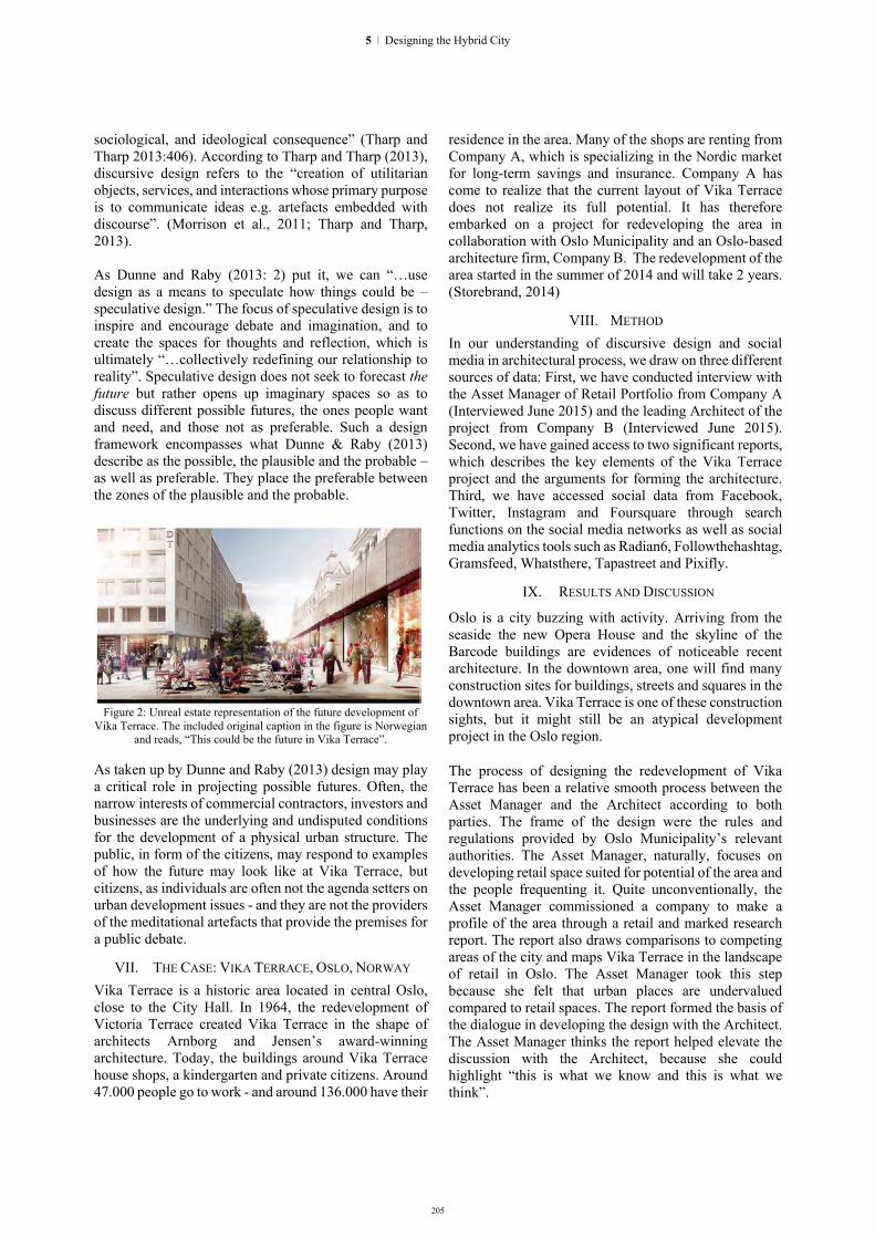
205
sociological, and ideological consequence” (Tharp and Tharp 2013:406). According to Tharp and Tharp (2013), discursive design refers to the “creation of utilitarian objects, services, and interactions whose primary purpose is to communicate ideas e.g. artefacts embedded with discourse”. (Morrison et al., 2011; Tharp and Tharp, 2013). As Dunne and Raby (2013: 2) put it, we can “…use design as a means to speculate how things could be – speculative design.” The focus of speculative design is to inspire and encourage debate and imagination, and to create the spaces for thoughts and reflection, which is ultimately “…collectively redefining our relationship to reality”. Speculative design does not seek to forecast the future but rather opens up imaginary spaces so as to discuss different possible futures, the ones people want and need, and those not as preferable. Such a design framework encompasses what Dunne & Raby (2013) describe as the possible, the plausible and the probable – as well as preferable. They place the preferable between the zones of the plausible and the probable.
Figure 2: Unreal estate representation of the future development of
Vika Terrace. The included original caption in the figure is Norwegian and reads, “This could be the future in Vika Terrace”.
As taken up by Dunne and Raby (2013) design may play a critical role in projecting possible futures. Often, the narrow interests of commercial contractors, investors and businesses are the underlying and undisputed conditions for the development of a physical urban structure. The public, in form of the citizens, may respond to examples of how the future may look like at Vika Terrace, but citizens, as individuals are often not the agenda setters on urban development issues - and they are not the providers of the meditational artefacts that provide the premises for a public debate.
VII. THE CASE: VIKA TERRACE, OSLO, NORWAY Vika Terrace is a historic area located in central Oslo, close to the City Hall. In 1964, the redevelopment of Victoria Terrace created Vika Terrace in the shape of architects Arnborg and Jensen’s award-winning architecture. Today, the buildings around Vika Terrace house shops, a kindergarten and private citizens. Around 47.000 people go to work - and around 136.000 have their
residence in the area. Many of the shops are renting from Company A, which is specializing in the Nordic market for long-term savings and insurance. Company A has come to realize that the current layout of Vika Terrace does not realize its full potential. It has therefore embarked on a project for redeveloping the area in collaboration with Oslo Municipality and an Oslo-based architecture firm, Company B. The redevelopment of the area started in the summer of 2014 and will take 2 years. (Storebrand, 2014)
VIII. METHOD In our understanding of discursive design and social media in architectural process, we draw on three different sources of data: First, we have conducted interview with the Asset Manager of Retail Portfolio from Company A (Interviewed June 2015) and the leading Architect of the project from Company B (Interviewed June 2015). Second, we have gained access to two significant reports, which describes the key elements of the Vika Terrace project and the arguments for forming the architecture. Third, we have accessed social data from Facebook, Twitter, Instagram and Foursquare through search functions on the social media networks as well as social media analytics tools such as Radian6, Followthehashtag, Gramsfeed, Whatsthere, Tapastreet and Pixifly.
IX. RESULTS AND DISCUSSION
Oslo is a city buzzing with activity. Arriving from the seaside the new Opera House and the skyline of the Barcode buildings are evidences of noticeable recent architecture. In the downtown area, one will find many construction sites for buildings, streets and squares in the downtown area. Vika Terrace is one of these construction sights, but it might still be an atypical development project in the Oslo region. The process of designing the redevelopment of Vika Terrace has been a relative smooth process between the Asset Manager and the Architect according to both parties. The frame of the design were the rules and regulations provided by Oslo Municipality’s relevant authorities. The Asset Manager, naturally, focuses on developing retail space suited for potential of the area and the people frequenting it. Quite unconventionally, the Asset Manager commissioned a company to make a profile of the area through a retail and marked research report. The report also draws comparisons to competing areas of the city and maps Vika Terrace in the landscape of retail in Oslo. The Asset Manager took this step because she felt that urban places are undervalued compared to retail spaces. The report formed the basis of the dialogue in developing the design with the Architect. The Asset Manager thinks the report helped elevate the discussion with the Architect, because she could highlight “this is what we know and this is what we think”.
5 | Designing the Hybrid City

206
In our interview in June 2015, the Asset Manager recognises that there is also intangible assets to urban places. In order to discover for herself, she has visited different urban spaces “to experience what a good urban space feels like”. The Architect recognises the intangible aspects as well. In the early stages of their collaboration, the Architect tried to select and include other places with similar qualities as the Asset Manager asked for in their discussions. The Architect would then incorporate images of those places into the visual representations of the future development of Vika Terrace, which she presented to the Asset Manager and other stakeholders. Sometimes the Architect also received an MMS or Social Media message with an image from the Asset Manager. The Architect interpreted this as a form for visual dialogue with the Asset Manager and would try to imagine, what inspiration the Asset Manager would have had, when she took and sent the image. The Asset Manager and the Architect are both explicit about the necessity for encouraging citizens to engage with - and that inviting them to take ownership of Vika Terrace is critical to its success. Apart from the traditional remedies of informing the public through mails, websites, and visual representations, the Asset Manager also collaborated with a group of students. The Asset Manager invited the students to use a vacant retail space on Vika Terrace to develop interventions and temporary spaces through the project VikaLiv (meaning Vika Life). Activities included food trucks, painting the streets and planting flowers. The activities ran through May and June 2015. They announced and documented activities through a Facebook page, a blog and through the social media hashtag #VikaLiv. The intentions of the interventions were to create loyalty and motivation for people to return to the area.
X. FUTURE RESEARCH First, our initial social media research of the VikaLiv project shows that there is not a great reflection of the perceived success of the project on social media. The Facebook pages and Instagram account both show moderate numbers of followers and limit engagement from the public. The #VikaLiv hashtag does show better promises of success with more than 500 contributions on Instagram. We would like to further research how people can interact with public places through social media. Second, the perception - and idea of a place is hard to communicate both for professionals and for laypersons. We would like to research how publics can be included in the design process of public places with the aid of social media and mobile computing. This could perhaps be through including the public at earlier stages of the design process by sharing artefacts such as images, which are intended to develop a shared frame of reference and to inspire the design process. It could also be through analysing the behaviours and sentiments of publics’
social media interacting with places, which are used as inspiration in a design process of another place. Last, we are intrigued about the practices of developing places on social media. We would like to compare the process of producing and reproducing places on social media to a similar process in a physical landscape.
XI. CONTRIBUTIONS AND RESEARCH PERSPECTIVES In this paper, we contribute to the design research (IS) as well as the discursive design traditions through the disclosure of the development process of Vika Terrace. In framing our study as discursive design, our primary goal was to design for a deeper understanding and awareness of the role of publics in design processes. We acknowledge this as an on-going research project and have further data collection planned as follow up projects. We believe the study of architectural design processes, incorporated with understanding from social media channels, is all aspects worthy future pursuits.
XII. REFERENCES [1] Arnall, T., 2014. Making Visible. Arkitektur- og designhøgskolen
i Oslo [2] de Souza e Silva, A. and Frith, J., 2012. Mobile Interfaces in
Public Spaces. Routledge. [3] Dunne A. and Raby, F., 2013. Speculative Everything. MIT Press. [4] Economist, 2014. “Everybody Wants to Rule the World.” The
Economist, November 29, 2014. http://www.economist.com/news/briefing/21635077-online-businesses-can-grow-very-large-very-fastit-what-makes-them-exciting-does-it-also-make.
[5] Economist, 2015. “The Truly Personal Computer.” The Economist, February 28, 2015. http://www.economist.com/news/briefing/21645131-smartphone-defining-technology-age-truly-personal-computer.
[6] Gehl Architects: Bylivsundersøkelse Oslo Sentrum, 2014 [7] March, S. and Smith, G. (1995). "Design and Natural Science
Research on Information Technology." Decision Support Systems 15 (1995): 251 - 266.
[8] Morrison, A, Arnall, T, Knutsen, J, Martinussen, E S, Nordby, K. (2011). “Towards discursive design”. In: Diversity and unity: proceedings of IASDR2011, the 4th World Conference on Design Research. Delft.
[9] Morrison, A. Skjulstad, S. & Sevaldson, B. (2007). 'Waterfront development with Web mediation'. Proceedings of Design Inquiries. 2nd Nordic Design Research Conference. Konstfack, Stockholm, May 27-30 2007.
[10] Lunenfeld, P. (2003) “The Design Cluster”. In Laurel, Brenda Laurel Design Research: Methods and Perspectives. Massachusets MA: The MIT Press. Pp 10-15.
[11] Mukkamala, R.R., A. Hussain, and R. Vatrapu. “Towards a Set Theoretical Approach to Big Data Analytics,” 629–36, 2014. doi:10.1109/BigData.Congress.2014.96.
[12] Storebrand: Vika Oslo: Great herritage. New beginnings., 2014 [13] Tharp, B. M. and Tharp, S. M. (2013). “Discursive Design Basics:
Mode and Audience”. In Proceedings of Nordic Design Research Conference 2013, Copenhagen-Malmo.
[14] TNS Brand & Communication: Utvikling av Vikaterrassen , 2014 (Confidential)
[15] Vaishnavi, V., & Kuechler, W. (2004). Design research in information systems.
[16] Vatrapu, R. K. “Towards a Theory of Socio-Technical Interaction”. In Cress, U., Dimitrova, V., and Specht, M.
HYBRID CITY 2015 | DATA TO THE PEOPLE

207
The Space of Engagement: Participatory design through serious urban gaming – the case
of euREKA digital simulation game
Ir. Milena Ivković, MSc Arch Blok74 Built environment | Urban gaming
Rotterdam, The Netherlands e-mail address: [email protected]
Milica Anđelković, MSc Landscape Arch Ticklebot Games Studio
Pančevo, Serbia e-mail address: [email protected]
Abstract. This paper elaborates on euREKA – serious urban game, a part of the master thesis written by Milica Anđelković and co-mentored by Milena Ivković. The thesis examines the possibilities for application of digital games for motivating citizens to participate in the design of open spaces in the city, with a particular focus on the riverside of the city of Pančevo, Serbia. The paper stresses out the need for rethinking of existing models of participatory urban planning to motivate the citizens to take part in the process.
Keywords: participatory design, serious gaming, engagement, public space
I. INTRODUCTION Ever since mobile technologies and Internet
expanded into everyday life, heated-up discussions started on how “networked” way of living will lead to social isolation and placeless-ness. As an example, in the last few years among a considerably large community of urban planners and designers the term “smart city” has undergone a transformation from everyone’s favourite buzzword to one of the most despised and hated expressions. Similar to smart city, the terms such as gaming, digital games, or playful simulations have also received large portions of critique: they are accused of glorifying wrong values, producing addictions, stimulating disconnection with reality, and inducing of other negative side-effects on almost every level, from social to cultural to economical.
The concerns about our ever-increasing dependence on technology, data, and mobile applications are however, real, and in most cases based on verifiable indicators. But the real question imposed to the designers is how to revert these many doom-scenarios to the society’s advantage through the innovative use of technologies? Also, the authors of the paper were intrigued to research what does use of technology mean for smaller urban areas and cities.
As a part of her master thesis “Application of digital simulation games for the purpose of improving the process of urban design, on the example of the city of Pančevo”, Milica Anđelković developed a smart-phone based, digital simulation game model called “euREKA”. The main goal of euREKA is to create an
interactive instrument that will motivate citizens to participate in the planning and development of the city of Pančevo (Serbia).
II. UNDERSTANDING THE CONTEXT Pančevo is home to 122916 inhabitants as estimated
by the Republic Institute for Statistics in the year of 2012, and is situated about 20 km southeast from the Serbian capital of Belgrade. The town is well-known for it's large industrial complex named “the south zone”, which is a major pollutant of the town’s environment. The river Tamiš, one of the subsidiaries of the Danube, also suffers from the industrial pollution. But still, Tamiš Riverside in the centre of Pančevo is a cultivated green area, and a much-visited public promenade. Traditionally, Pančevo’s inhabitants feel powerless when it comes to improving their environment, since oil refinery and petrochemical industry are the economical lifeline of the community. By engaging more directly with the space of everyday importance (the Tamiš Riverside) the citizens of Pančevo will be able to send a message about the need to preserve and cultivate their immediate environment. Using a game as a tool, the authors aim to provide the citizens with a voice in this process.
Fig. 1. Map of Pančevo, case study area is outlined.
EuREKA’s gameplay focuses on the transformation of the Tamiš River public promenade, and its purpose is to collect citizens’ opinions on how to redesign this vital
5 | Designing the Hybrid City

208
part of the city of Pančevo. In the decade of rising conversations about “bottom-up” urban development, citizen participation has never been so important. In this world wide effort to make urban development as inclusive as it can be, Pančevo is experiencing miscommunication between planning professionals and citizens. It’s inhabitants do not appear to show interest in the public calls from planning experts, which recently resulted in a low citizen participation in the public stages of forming the Draw-up of Development Strategy in the 2014. Less than one percent of the population participated in the survey as a form of involving the citizens. This is a very low percentage compared with US practice (only 16% of the population participated in the planning process which the American Planning Association considered unacceptable). Conducting presentations in local communities and via the mass media means are seen as a measure to improve the participation. This shows that not enough attention was given to the initial informing of the population when drawing up the current strategy, but also that there was no room (assuming there was no funding) for additional commitments to ensure the participation of the population. World experiences have shown that efforts should be made to translate the language of planners so that it can be understood by average citizens, who otherwise have difficulties understanding and getting involved in discussions. Smaller cities may be faced with even bigger obstacles to overcome this problem. With citizens’ voices not being as numerous and loud as those of bigger cities, they often withdraw from important conversations. Pančevo’s residents have initiated discussions regarding city’s ecology in the past, most of which were not fruitful. This goes to show that they are interested in being part of the city management, but the missing link seems to be communication. EuREKA tries to provide the missing piece, and to be the messenger for all stakeholders.
Fig. 2. Tamiš River public promenade - defined spatial framework and it’s micro zones.
Majority of Pančevo’s most valuable open spaces and sites of industrial heritage are situated in the Tamiš
riverside. These spaces are poorly maintained, which lead to decades of degradation. Examining of the planning documents revealed that the riverside is seen as an area of outstanding but untapped potential, a valuable open space not integrated into the rest of the urban fabric. Certain interventions are to be made in order to improve its connectivity in the physical, aesthetic, functional and contextual terms. This is used as a subject area, as a relatively narrow spatial scope suitable for demonstrating the possible future use of games, by using specific examples and suggestions.
The game’s broader goal is to offer a collaborative platform for urban designers and citizens in order to help improve visibility and legitimacy of urban development. But most of all, the model wants to make participation fun and encourage the citizens to think about their environment, through direct, free engagement with the public space.
The paper will further elaborate on the development of the euREKA gameplay (which theoretical modelsi were included in the development, how the gameplay construction evolved) and conclude what are the expected outcomes and possible positive impact of this instrument.
III. BASIC GAME IDEA The game model uses smart phone as basic
interactive interface that supports players’ movement through public space, and focuses their attention on specific, predefined spots.
The Pančevo riverside area serves as a play field, or a “game board” for the game. Its individual ambiences, landmarks and the scenery constitute the main focus points and backdrops of the game. The movement of space users (players) through the environment and change in the angle of observation, is combined with solving a set of digital puzzles. These are the basic “rules of the engagement”.
At certain points along the Tamiš Riverside, users/players discover QR codes, which are embedded in flat surfaces of the promenade. The player initiates euREKA application by scanning QR codes, or by typing the links manually, at the entrance area of the riverside. After launching the application on their mobile phones and after scanning the “discovered” QR code in the real space, players are presented with a puzzle. The puzzle has a form of a quest or a riddle, regarding the space around them. The puzzles placed before players have been developed in such a way that they encourage exploring, and discovering particular spatial features in the “play area”, or the Tamiš promenade. When they find themselves in the “correct”
i Some of the literature used in this segment of the masters thesis: J.Schell, 2008, The Art of Game Design: A Book of Lenses, Carnegie Mellon University G. Ferri, P.Coppock, 2012 Serious Urban Games: From play in the city to play for the city, Universita di Bologna, Italy, Universita di Modena e Reggion Emilia, Italy J.van Uden, 2012 Serious Gaming: Future Horizons, STT, The Hague, The Netherlands
HYBRID CITY 2015 | DATA TO THE PEOPLE

209
position in space, players can see the solutions as an answer to the puzzle, which they then need to type in the application. Application gives players instant feedback on their action, and proceeds by displaying a short, closed-form poll concerning future design of surrounding space. Aside from taking part in survey, players can see statistic data collected by other players’ participation, including all polls in euREKA.
IV. DEVELOPMENT PHASES
A. Initial phase In order to examine the possibilities of applying
games in the urban planning, Anđelković has set the theoretical frames first, by defining concepts "urban design", "public open spaces" and "serious urban games"ii. Eight different serious urban games with strong participatory and urban character from international practices were used for the case study analysis. The results of this analysis were translated into general serious games design guidelines for dealing with citizens’ engagement, participation and public space. Some of these general guidelines are: Urban game should have a clearly defined target audience; it should induce conflicts or confrontation of viewpoints, building of mutual trust and finding common solutions; urban game should encourage exploration and creative use of urban space; urban game should increase the transparency of the planning process; it should use the opportunity of movement through different environments and observation of it from various angles; the digital urban game should be intuitive, without the need for additional tutorials in the game; It should be designed so that it uses advantages of digital technology to the maximum extent; it should be designed so that it contains as less limiting factors inherent in the modern technology as possible.
Parallel to this research, Milica Anđelković also analysed the context of participatory urban practice in the city of Pančevo, as a way of understanding the weak spots in the current practice, and how to overcome them in her game model.
This initial phase resulted in:
Establishing the community profile (the target users’ group), by recognising age structure and computer literacy of citizens, as well as limitations of some users listed by the Republic Institute for Statistics in the year of 2012.
Definition of the direct spatial framework by micro zoning the Tamiš River public promenade and finding the real-space elements which will be incorporated into gameplay.
ii Some of the literature used in this segment of the masters thesis: M. Carmona, T. Health, T. Oc. S. Tiesdell, 2003, Public Places Urban Places - the Dimensions of Urban Design, Burlington, USA J. Long, 2005, Urban Design: A Typology of Procedures and Products, University of South Wale, Sydney, Australia M.A. Ornek, 2013, Exploring the potential uses of computer games in landscape architecture education, Istanbul Technical University, Faculty of Architecture, Department of Landscape Architecture, Istanbul, Turkey
Establishing the immediate set of public space design objectives which will be addressed by the game and the participatory process in general. Through research and analysis of the case study area, it was concluded that Tamiš riverside consists of many micro ambiences, valuable structures of industrial heritage, sports complexes and other open spaces which would be impossible to observe as a whole. Also, these spaces all have a very distinctive “genius loci” that can be felt while one is present in the riverside. This is why it was concluded that participation should take place in the subject area, as a way of inviting citizens to interact, explore, experience and understand these open spaces, and than to think about their redesign. Some of the objectives are: To develop a model of motivating citizens to participate in the planning and development of the city; to draw attention to the redesign of the Tamiš River shoreline; to collect opinions of citizens about the possibilities of redesign of the riverside on the spot - on the bank of the Tamiš River; to attract the younger residents to participate; to ensure that the participation, and the results of participation are public and transparent; to make participation fun; to encourage citizens to think about their environment and to move freely and explore urban open spaces.
Choosing the digital medium and software platform - smart phone /Android - as the most suitable carriers of an urban location-based game
Fig. 3. EuREKA screen shots. Left: gameplay map; right: confirmation screen after solving a puzzle successfully.
B. Pre-design phase Pre-design phase included outlining of the graphic
language and “art directing” of the game’s visuals, coming up with basic storyline and the interactive mechanism of the game, and choosing the technological formula (QR codes) to connect the real and the digital world and structuring of the gameplay.
5 | Designing the Hybrid City

210
C. Game design phase Eureka digital simulation game consists of two
joined parts of the gameplay. First part is a space exploration puzzle game, the second part is a short, closed-form poll about the redesign of a particular part of riverside. In the first part the players choose the puzzles by scanning the QR codes positioned in the space. The answers given in the poll are available to anyone, providing complete transparency.
The riverside area has been positioned as a real-space play field, with its individual ambiences, landmarks and the typical landscape scenery. All these elements are the actual backdrop of the game, and users/players are its “heroes”. The core mechanics of the game are based on the following:
Movement through open space of Tamiš Riverside;
Change in the angle of observation of objects in the real space and their inter-correlation;
Solving puzzles which are “hidden” in the space ( the game-teasers and props, in the form of small-scaled public art interventions marked with QR codes).
V. EXPECTED OUTCOMES Through engaging, challenging and adventure-
inspired gameplay, citizens are motivated to explore the riverside. By playing the game, they take part in urban development of their home city without having to understand the complex language of urban planners. Answers given by the players while taking part in the poll can serve as redesign guidelines. Polls given to euREKA players can be tailored to fit predefined parameters set by urban designers, leaving space for citizens’ imagination while somewhat framing the possibilities. Future development of euREKA could include connections between urban services and citizens, providing the space for commercial use. The core of euREKA remains play and exploration induced participation, but it could also take form of a service used by citizens to report “broken” urban open spaces, inviting the authorities or companies wanting to promote their services to act and “fix” the city.
Taking into consideration current participation practice, it is expected that euREKA would raise curiosity and start conversation on the subject of urban development. The presence of game teasers and props in actual public space should attract players to engage with the game, ensuring higher participation and involvement.
Currently, euREKA is a completed prototype, available online (www.ticklebot.net/eureka). In the next phase, the model will be tested and tailored to the specific needs of citizens, as well as the urban planners. Finally, the game could be adapted to any given location, introducing play and exploration while ensuring public participation.
ACKNOWLEDGEMENT
The thesis was written by Milica Anđelković under the mentorship of Doc. Zoran Đukanović Arch, along with tutoring of Ir. Milena Ivković MSc Arch, and in consultation with Prof. Ph.D. Jasminka Cvejić and Doc. Đorđe Stanojević, with the help of Computer Scientist Stefan Nikolić, BSc., at the Faculty of Forestry, department for Landscape Architecture, University of Belgrade.
REFERENCES 1. R.Burgess, M.Carmona, Th.Kolstee 1994. Contemporary Urban Strategies and Urban design in Developing Countries, Delft, June 1994. 2. M. Carmona, T. Health, T. Oc. S. Tiesdell, 2003, Public Places Urban Places the Dimensions of urban design, Burlington, USA 3. L.D.Yeang, 2000. Urban Design Compendium 1, Homes and Communities Agency 4. M. Carmona, S. Tiesdell , 2007. Urban Design Reader, Oxford. UK 5. R. Cuesta, Cn. Carris, P. Signoretta, 1999, Urban Design Method and Techniques, Oxford UK 6. J. Long, 2005, Urban Design: A Typology of Procedures and Products, University of South Wale, Sydney, Australia 7. M.A. Ornek, 2013, Exploring the potential uses of computer games in landscape architecture edication, Istanbul Technical University, Faculty of Architecture, Department of Landscape Architecture, Istanbul, Turkey 8. J.Schell, 2008, The Art of Game Design: A Book of Lenses, Carnegie Mellon University 9. G. Ferri, P.Coppock, 2012 Serious Urban Games: From play in the city to play for the city, Universita di Bologna, Italy, Universita di Modena e Reggion Emilia, Italy 10. J.van Uden, 2012 Serious Gaming: Future Horizons, STT, The Hague, The Netherlands 11. J. Huizinga, 1955 Homo Ludens: a study of the play-element in culture, Boston, Beacon Press
HYBRID CITY 2015 | DATA TO THE PEOPLE
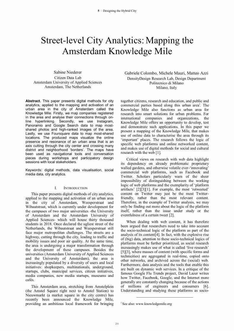
211
Street-level City Analytics: Mapping the Amsterdam Knowledge Mile
Sabine Niederer Citizen Data Lab
Amsterdam University of Applied Sciences Amsterdam, The Netherlands
Gabriele Colombo, Michele Mauri, Matteo Azzi DensityDesign Research Lab, Design Department
Politecnico di Milano Milano, Italy
Abstract. This paper presents digital methods for city analytics, applied to the mapping and activation of an urban area in the city of Amsterdam called the Knowledge Mile. Firstly, we map companies registered in the area and analyse their connections through on-line hyperlinking. Secondly, we use Instagram, Panoramio and Google Search data to map most-shared photos and high-ranked images of the area. Lastly, we use Foursquare data to map most-shared locations. The produced maps visualize the online presence and resonance of an urban area that is an axis cutting through the city center and crossing many district and neighborhood ‘borders’. The maps have been used as navigational tools and conversation pieces during workshops and participatory design sessions with local stakeholders.
Keywords: digital methods, data visualisation, social media data, city analytics.
I. INTRODUCTION This paper presents digital methods of city analytics,
applied to the mapping and activation of an urban area in the city of Amsterdam, Weesperstraat and Wibautstraat, which is currently under development for the campuses of two major universities -the University of Amsterdam and the Amsterdam University of Applied Sciences- which will house thirty thousand students in 2018. Once declared the ugliest street of the Netherlands, the Wibautstraat and Weesperstraat still face major metropolitan challenges. The streets are a highway, cutting through the city, leading to traffic and mobility issues and poor air quality. At the same time, the area is undergoing a major transformation through the development of these campuses. Besides the universities (Amsterdam University of Applied Sciences and the University of Amsterdam), the area is increasingly populated by a diversity of users and local initiatives: shopkeepers, multinationals, underground, startups, clubs, municipal services, citizen initiatives, media companies, new media startups, museums and cafés.
This Amsterdam area, stretching from Amstelplein (the Amstel Square right next to Amstel Station) to Nieuwmarkt (a market square in the city centre) has recently been announced the Knowledge Mile, providing an ambitious local framework for bringing
together citizens, research and education, and public and commercial parties based along this urban areai. The Knowledge Mile also functions as urban area for research into smart solutions for urban problems. For international companies and organizations, the Knowledge Mile offers an opportunity to develop, test and demonstrate such applications. In this paper we present a mapping of the Knowledge Mile, that makes use of online data to characterise the area through its ‘important’ places. The research follows the logic of specific web platforms and online networked content, and makes use of digital methods for social and cultural research with the web [1].
Critical views on research with web data highlight its dependency on already problematic proprietary walled gardens, and otherwise volatile ever-‘innovating’ commercial web platforms, such as Facebook and Twitter. Scholars particularly warn of the sheer impossibility of distinguishing between the working logic of web platforms and the exemplarity of ‘platform artifacts’ [2][3][1]. For example, the most ‘retweeted’ content on Twitter may just be the most Twitter-friendly, rather than the most relevant content. Therefore, in the example of Twitter analysis, we may only be finding out more about the logic of the platform itself, rather than the issue under study or the eventfulness of a certain tweet [2].
When dealing with web content, it has therefore been argued that researchers need to take into account the socio-technical logic of the platform as part of the analysis of its content[4]. In fact, with the explosive rise of (big) data, attention to these socio-technical logics of platforms must be further prioritized, as social research increasingly makes use of what is called ‘live research’ [5][3], where masses of content (with specific forms and technicities) are aggregated in real-time, copied onto other networks, and archived across the (social) web. Furthermore, data analysis and the tools that enable this are built on dynamic web services. In a critique of the famous Google Flu Trends project, David Lazer writes how Twitter, Facebook, Google, and the Internet more generally are constantly changing because of the actions of millions of engineers and consumers [6]. Understanding and studying these platforms as socio-
i See also: www.knowledgemile.org
5 | Designing the Hybrid City

212
technical systems for what they are, is of utmost importance, as they are “increasingly embedded in our societies” [6].
More specifically, one ‘technicity of content’ [4] of importance to our analysis is the way in which platforms organize the geo-location of their content. The mapping presented in this paper consists of three sub-projects, each with different online data sets.ii The overall aim as mentioned before, was to characterise the Knowledge Mile, by identifying its important places (in three ways). The maps then function as a baseline measurement for further annual research as well as a conversation piece used in participatory design sessions with stakeholders of the neighborhood.
Sociologist Tommaso Venturini, when discussing controversy maps, has described social maps as visual interface to complex issues: “To be of any use, social maps have to be less confused and convoluted than collective disputes. They cannot just mirror the complexity of controversies: they have to make such complexity legible” [7]. Similarly, visualization of data layered onto a geographic map of an area, should render legible the complexity of the area, as well as the ways in which the social media platforms it takes its data from deal with geo-location. At the same time, map-based visualizations have been criticized for their oversimplification and reductionist approach to vast and multifarious data, highlighting some information and obfuscating other data for the sake of “creating an image that can be read and judged” [8] or constructing a “top-down narrative” [9]. We would like to stress that in this project and our related research, the practice and objects of mapping are not efforts to ignore the distributed nature of today’s technologies or data, but in fact to gain a better understanding of the many threads that weave these complex patterns of competing technologies as these intertwine form and content. We try to accomplish this here by zooming in on a strictly demarcated geographical location and studying this area across multiple platforms from different viewpoints and by creating not one all-encompassing mother map, but a series of different maps that underline both the complexity of studying places through online content and the entanglement of content with its technicity. These maps then function as a navigational tool, rather than a reductionist narrative, and are presented to local
ii In previous studies we have seen how different social platforms may be used to provide different views on a city. For instance, in a comparative analysis of geo-tagged social media data, we found that Pinterest posts, or ‘pins’, provided a distinct view on ‘boutique’ Amsterdam. The photos we retrieved were mostly taken and tagged on the smaller streets and up and coming areas of Amsterdam, with small bars, art and design venues and original fashion stores. In contrast, the platform Meet-up presented a view on Amsterdam that was more tech-driven as well as athletic (depending on the respective meet-up group), highlighting the parks, sports venues and also the tech-friendly bars in the city of Amsterdam. (See also the project page of the ‘City as Interface’ project of Summer School 2014. URL: https://wiki.digitalmethods.net/Dmi/TheCityAsInterface)
stakeholders in workshops and collaborative design sessions.
II. ANALYZING THE URBAN AREA THROUGH WEB DATA AND THE QUESTION OF GEO-LOCATION
In recent years, several studies have focused on the digitally encoded metadata (such as pictures on Instagram, taken with smartphones, geo-tracks, check-ins) to provide novel views on the city [10][11]. While in this project we mainly used this kind of geographic encoding, we expanded the analysis to web entities not geo-coded with standard formats, identifying methods for their geo-location, which we will discuss later in this paper. As discussed in the introduction, the question here was to retrieve the most important places along the knowledge mile. This was then assessed by looking at the most-networked, the most iconic (visually) and the most acknowledged (or shareable). Retrieving the ‘most important places’ then was operationalized in three ways (which eventually resulted in three maps). Firstly, we defined as most important those places most referred to by other actors in the area. And here we conducted a hyperlink analysis to see which actor was most linked to by other actors in the area. (When we say actors we mean people, organisations, companies, etc.). Secondly, we defined most important places as those most shared and acknowledged by visitors and other local actors, by way of checking in on the Foursquare social app. Thirdly, we defined most important places as those most photographed and shared on Instagram and Panoramio, and those images resonating most in Google Image search results. The base layer for all the three maps is a traditional cartographic representation of the area, created here with Openstreetmap data, showing streets, cycle lanes, buildings, canals and green areas. As the resulting maps were thought to be used in a collaborative session, and watched by multiple people, we decided to design them adopting a 2.5mt long format.
In the data collection process we soon faced a first methodological issue, concerning how to locate web data in a particular geographic space. Previous studies express the need to move “beyond the geotag” when performing geoweb analysis, suggesting, among other techniques, to integrate data from sources not explicitly geographic oriented and to integrate the analysis with official sources data such as census data or news reports [12]. In this study, what has been demarcated as the Knowledge Mile is in fact a diverse area made up of different streets crossing various urban areas. In addition, the data sources identified for the analysis (platforms such as Foursquare or Instagram but also the Chamber of Commerce archive) use very different ways to embed geographical informations into their entities. Therefore different techniques to demarcate the area of interest were needed, based on data sources specificities
HYBRID CITY 2015 | DATA TO THE PEOPLE
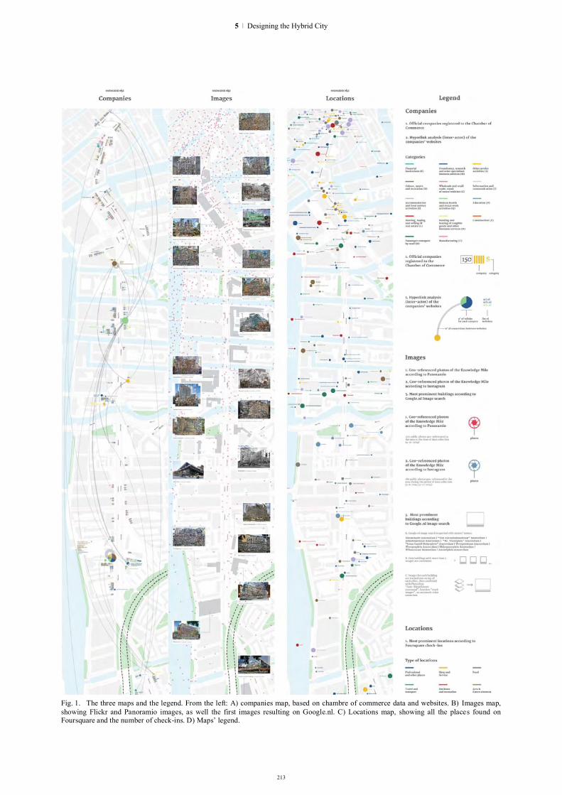
213
Fig. 1. The three maps and the legend. From the left: A) companies map, based on chambre of commerce data and websites. B) Images map, showing Flickr and Panoramio images, as well the first images resulting on Google.nl. C) Locations map, showing all the places found on Foursquare and the number of check-ins. D) Maps’ legend.
5 | Designing the Hybrid City

214
but still allowing the collection of comparable datasets. We therefore combined three methods for geo-locating web entities on the Knowledge Mile. For the first map of the Knowledge Mile, we used the Chamber of Commerce database to retrieve a list of registered companies on the area. Here companies’ data are geo-coded with street names and postal codes. We identified street names on and around the Knowledge Mile and used them to query the database and collect the names and addresses for those companies and organisations registered along the Knowledge Mile. For Instagram, Panoramio and Foursquare we collected data from their application programming interfaces (APIs), using a geo-coordinates ‘bounding box’, which means drawing a rectangle around the Knowledge Mile, considering all geo-coded data within that geographical area and collecting the exact longitude and latitude for each image. Lastly, we queried the same street names on the local image search engine to collect images related to the different streets of the Knowledge Mile, then manually geocoding all buildings found in the search results.
III. MAP #1: HYPERLINK NETWORK ON A GEO-MAP The first map (Fig. 1A) provides an overview of all
the companies in the Knowledge Mile area, allowing both to plot their physical presence onto the map and to analyze their online resonance. It is therefore composed by two layers. In the first layer, all companies listed in the Chamber of Commerce’s Trade Register are depicted as a small square, the colour represents the commercial category as listed in the Trade Register. On the map, near each house number all the companies are listed, divided by category. With this first information layer, the user is able to see how many companies are present in the area, where there are more, if there are particular geographic clusterings of them. The second layer of information is provided by the web data, using the companies’ URLs as listed in the Trade Register. As the data proved incomplete, we manually searched for each listed company on the local version of Google iii, collecting the official websites if available. These were the starting points to be used in the IssueCrawler tool for hyperlink analysis. With the IssueCrawler we could then performed so-called ‘inter-actor analysis’, as the tool in the inter-actor setting “captures the starting points' outlinks and shows inter-linking between the starting points only.iv v
Each website was then geo-coded, according to the company’s addressvi. Using Gephi, a network analysis
iii URL: www.google.nl ivURL: http://www.govcom.org/Issuecrawler_instructions.htm. v For a discussion of the IssueCrawler software, see also Bruns, 2007. vi We then fed the information in the the openstreetmap “Nominatim” database#, translating them in geo-coordinates.
softwarevii, we visualized the network, and with the “geolayout” plug-in we geographically dispersed it: each website has been placed on the geographical map, exactly where its company is physically located. With these operations, it has been possible to geolocate the web, and to perform a hyperlink analysis ‘grounded’ on the geographic level. For addresses with multiple companies registered there, the number of available websites is represented through a pie chart, each wedge representing a commercial category (as listed in the Trade Register).
From the Trade Register data plotted onto the map it is possible to see that commercial activities (i.e. companies) are not uniformly distributed along the Knowledge Mile. There are three main clusters within the area: small commercial activities close to the center (Nieuwmarkt area), a group of cultural and sports-related venues in the middle (Trouw and Volkskrant area), and finally a concentration of financial activities (around the Amstel Station).
The network map shows that interlinking between organisations registered along the Knowledge Mile occurs mostly within sectors, news organizations link to news, although the university does link to museums for instance.
IV. MAP #2: MOST-SHARED & HIGH RANKED IMAGES ON A GEO-MAP
The second map (Fig. 1B) returns an overview of photo sharing activity in the area, showing patterns in the amount of images shared online. Furthermore, it presents an aggregate view of the most depicted buildings, looking at which images are found online. Each photo shared on Instagram and Panoramio is plotted on the map based on its geo-coordinates. Blue glyphs represent Instagram photos while red ones represent photos shared on Panoramio. Users are then able to spot areas with intense photo sharing activity, as well as blank spaces where there are few or none image shared. On top of this quantitative overview a second layer of information is added, using data retrieved from the local search engine. Querying streets’ names returns
vii The used software is an open-source and widely used platform for networks analysis and visualization (see http://gephi.github.io/)
Fig. 2. Detail of the first map.
HYBRID CITY 2015 | DATA TO THE PEOPLE

215
roughly 200 images per query. Images are then downloaded with a web browser plug-inviii and archived locally in a single collection of images. Images are manually tagged and only the ones depicting buildings in proximity of the Knowledge Mile are retained. For this analysis we only consider buildings found in the dataset more than 3 times. Images are then stacked one on top of each other, and visually combined with an ‘image blending’ algorithm that automatically merge images togetherix. The generated composites are then positioned on the map in close proximity of the geographical location of the respective buildings. These algorithmically generated stacks present a merged view of the same building, showing from which angle each building is most commonly perceived and which type of image is more often used to depict it (computer generated renders, historical footage, or professional photos).
With this map it is possible to see that pictures are taken mainly in the city center, and the amount decreases when moving from it. Instagram images are mainly disposed along canals, probably due their photogenicity. Finally, the algorithmically generated images allow to observe the most significative perspectives on buildings, as well as the historical stratification of building imagery. Photos taken from the same viewpoint generate less fragmented composite versions, allowing to distinguish those buildings always observed from their facade (e.g. The Film Academy or Studio HvA, within the University premises) from those who are captured from a wide range of angles and distances (e.g. the Waag building, in the city center).
V. MAP #3: MOST-SHARED LOCATIONS ON A GEO-MAP
The third and last map (Fig. 1C) represents the most shared locations on the platform of Foursquare. We collected all the places in the area listed on Foursquare and their total number of check-ins. Each venue is then visualized with a circle sized according to the number of
viii Mozilla Firefox add-on “DownThemAll! https://addons.mozilla.org/en-US/firefox/addon/downthemall/ ix Adobe Photoshop Auto-Blend Layers command, function “stack images”, no automatic color correction. The tool is meant to combine multiple images of the same scene in order to obtain a better composite version of them. It works masking out over or underexposed areas and it is here repurposed as visual analysis tool.
check-insx. With colours we represented the categories of Foursquare venues, in order to identify possible local clusters (e.g. nightlife zone, offices blocks). The Foursquare data provide a different view on the area. The main nodes of urban transportation (train and metro stations, bus stops) become more visible, as well as supermarkets and bars. Also, as the platform allows to create multiple venues, biggest activities (such as, the HvA university) are split into their parts producing a more detailed view of the one resulting from the Chambre of Commerce data.
These Knowledge Mile maps show the online presence of an urban area under development that is as diverse as one would image from an axis that cuts through the city center and crosses many district and neighborhood ‘borders’. The network map shows that interlinking between organisations registered along the Knowledge Mile occurs mostly within sectors, although the university does link to museums for instance. In the participatory design sessions, people were rather surprised to see how marginal they were on the map (a natural response, if you will, to being confronted with maps about one’s own online presence), or how divided the sectors actually were. The staleness of the Chamber of Commerce data provided a problem, as nobody updates their URLs in the database, which is why we decided to organize fieldwork to collect the current URLs and social media usernames or pages from door to door, so we have a richer data set for further research.
VI. TOWARDS PARTICIPATORY DESIGN: CONCLUSIONS AND FURTHER RESEARCH
The Knowledge Mile maps represent different online data sets of a geographic area, by using different methods of geo-demarcation, data analysis and visualisation. First, by geolocating addresses coming from administrative databases, we showed the density of and the connections between companies registered in the area. Secondly, using natively digital geo-coded
x After a first data analysis, we clustered the amount of check-ins for each venue in six data ranges and we used a non-linear scale to visualize them (from very small to very large). This scale was adopted in order to enable the depiction of smallest elements. Venues with less than 200 check-ins are simply represented with a small dot, without citing the venue’s name.
Fig. 3. Detail of the second map.
Fig. 4. Detail of the third map.
5 | Designing the Hybrid City
216
objects, such as Foursquare checkins and geo-tagged photos, we layered the social media view of the area. Finally, querying names streets in the dominant search engine, we collected the online image of each street. Each layer offered a methodological exercise in rethinking geo-location based on the specificity of each platform and the technicity of its content. What is relevant in such methods is the ability to layer the online activity on top of the map of the actual geo-location. The Knowledge Mile maps show the online presence and resonance of an urban area under development that is as diverse as one would image from an axis that cuts through the city center and crosses many district and neighborhood ‘borders’. The layers on the map each represent different concepts of importance or relevance: connectedness, well-visited or often-depicted and perhaps even visually iconic. By presenting the data that we retrieved online in a visualized form, we enabled local stakeholders (such as inhabitants, organizations, government officials) to assess and evaluate their relevance and resonance in the area, and the relationships with the other stakeholders. The network map shows that interlinking between organisations registered along the Knowledge Mile occurs mostly within sectors, with some exceptions. When presented in participatory design sessions, the participants were rather surprised to see their resonance, be it positively (in the case of the municipality) or negatively, for actors only marginally present on the map (a natural response, if you will, to being confronted with maps about one’s own online presence). Another confronting view was the division between sectors, with barely any interlinking between types of organizations. Participants recognized the staleness of their records in the Chamber of Commerce Trade Register, as nobody updates their URLs in the database after registration. This is why we decided to organize fieldwork to collect the current URLs and social media usernames or pages from door to door, to have an up to date and rich data set for further research. This further result will culminate in the Knowledge Mile Atlas, an atlas offering input for participatory design sessions as well as documentation of the development of this urban area, through its online resonance in web content.
ACKNOWLEDGEMENT The research for these mappings was conducted
during a data sprint in 2014 at the Amsterdam University of Applied Sciences, in a highly motivating setting that formed the basis of the Citizen Data Lab, which was founded later that year with support of the Amsterdam Creative Industries Network (ACIN). ACIN director Matthijs ten Berge conceived of the Knowledge Mile as an area for urban development and research, and we thank him and his colleagues from the Knowledge Mile crew, including Ruurd Priester and Maarten Terpstra, for the fruitful collaboration in presenting the research results to local stakeholders in participatory design sessions. The collaboration with Density Design Lab is crucial to the data collection and visualization of this research. The tools used for the data analysis have been developed by the Digital Methods Initiative at the University of Amsterdam, Dept. of Media Studies.
REFERENCES
[1] Rogers, Richard (2013). Digital Methods. Cambridge, MA: MIT Publishing.
[2] Marres, Noortje (2015). Why Map Issues? On Controversy Analysis as a Digital Method. Science, Technology, & Human Values, online first, DOI: 10.1177/0162243915574602.
[3] Marres, Noortje and Esther Weltevrede (2013). Scraping the Social? Issues in real-time social research. Journal of Cultural Economy (6)3, 313-335.
[4] Niederer, Sabine and José Van Dijck (2010). Wisdom of the crowd or technicity of content? Wikipedia as a sociotechnical system. New Media & Society (12)8, 1368-1387.
[5] Lury, Celia (2012). Going live: towards an amphibious sociology. The Sociological Review 60:S1, 184-197.
[6] Lazer, David, Ryan Kennedy, Gary King, and Alessandro Vespignani (2014). The Parable of Google Flu: Traps in Big Data Analysis. Science 343, 1203-1205.
[7] Venturini, Tommaso (2012). Building on Faults: How to represent controversies with digital methods. Public Understanding of Science 21(7), 796-812
[8] Lovink, Geert. A critique of mapping. Forthcoming. [9] Reichert 2015. [10] Manovich, Lev et al. (2014). Selfiecity. URL:
www.selfiecity.net. [11] CityMurmur. URL: www.Citymurmur.org. [12] Crampton, Jeremy W., et al. "Beyond the geotag: situating ‘big
data’and leveraging the potential of the geoweb." Cartography and geographic information science 40.2 (2013): 130-139.
HYBRID CITY 2015 | DATA TO THE PEOPLE
ENVIRON-MENTAL SENSINGAND HYBRID OBjECTS
218
The hybrid object: augmenting objects and transforming their relationship with humans
Dimitris Charitos1, Maria Kerasia Andrikaki2 Faculty of Communication and Media Studies, National and Kapodistrian University of Athens
Athens, Greece [email protected], [email protected]
Abstract.
With the emergence of the Internet of Things (IoT), computing systems are becoming ubiquitous and pervasive. Gradually, more and more everyday devices incorporate technological features that make them more intelligent. Additionally, material objects are becoming computationally enhanced, as different forms of miniaturized computation may be embedded in them, thus adding new layers of functionality, interactivity and potential for communicating symbolic meaning. This paper discusses the manner in which the relationship between humans and objects is being transformed, as a result of the hybridization of computationally enhanced objects. To achieve that, it investigates this relationship from the perspective of Actor-Network Theory and Activity Theory. It also attempts to analyse the communicative potential of objects which have been augmented by various types of IoT technologies.
Keywords: Internet of Things, Actor-Network Theory, Activity Theory, Machine-to-machine communication.
I. PERVASIVE AND UBIQUITOUS COMPUTING AND THE AUGMENTATION OF MATERIAL OBJECTS
The convergence of embedded and pervasive computing technologies, wireless networking, mobile and wearable computing, sensor networks and intelligent environments has led to the gradual transformation of the internet, from a network of networks to a network that may connect any computer with other computers, as well as with any other human artifacts or physical objects too. This emergent phenomenon has been called “the Internet of Things”
(IoT) and has been described as a universal network of computers, sensors and actuators, connected together via internet protocols [1].
This concept implies that physical objects can now be connected amongst each other and with the internet, can be remotely controlled and/or function as points of access to internet services. Consequently, IoT signifies the expansion of internet onto the physical world, including and connecting things, physical objects of
everyday lifei and artifactsii [2]. This phenomenon can also be seen as the next step of “pervasive and ubiquitous computing” [3].
The emergence of the IoT transforms the process of communication between the human and pervasive & ubiquitous computation as well as with the other digital (or analogue, material) artifacts that participate in this process, by spatialising them and by rendering them implicitiii, persistent and invisible. The complexity and the implications of this condition at a social, political and cultural level are not yet well understood. For this purpose, it is essential that we investigate the ways in which computation extends beyond the limits of what was, until now, perceived as its context. In other words, we need to improve our understanding on how computation expands physically and conceptually out towards the physical world and onto any physical, symbolic, material and immaterial objects and the environments that these constitute.
Therefore, this paper takes into account a series of theoretical approaches which may help us understand the complex context which is being formulated as a result of the deployment of pervasive computing and IoT technologies and the new relations that are being established amongst humans and physical objects. In order to develop a better understanding of the significance that these transformations may have on humans, it is important to discuss the issue of humans interacting with artifacts in general.
Weiser’s vision of “Ubiquitous and Pervasive Computing” anticipates a world in which everyday objects incorporate technological characteristics and communicate with each other and with the internet/cloud. Weiser [3] had also suggested that computers would gradually disappear from their physical manifestation that we are familiar with, in the
i The use of which does not necessarily involve technological mediation. ii These artifacts embody some form of analogue or digital technology, which mediates their use. iii For a further explanation on this phenomenon see [4].
HYBRID CITY 2015 | DATA TO THE PEOPLE

form of a desktop or portable computer. This “disappearance” became possible by virtue of the potential miniaturization of computation and consequently by its incorporation into everyday objects, thus rendering these objects digitally augmented and their connection to networks possible. The concept of “disappearance” is used by Weiser metaphorically, to indicate that actual computers will be so small and incorporated in the physical environment in a way that they will not be visible as they are now. These augmented everyday material objects may then be regarded as “hybrid”, because of their nature of being physical and virtual (digitally mediated) at the same time.
These hybrid objects are usually connected to a network so that they can communicate with each other or with the internet. Gradually, more and more of these objects will maintain an invisible and ubiquitous connection to a network and humans will interact with computationally enhanced environments and not directly with a computing device. In other words, users’ environmental experience will be mediated by distributed and embedded computation, by virtue of its embedment in certain physical elements of the environment and due to the connectedness amongst its components.
II. RELATING HUMANS, OBJECTS AND THINGS The concept of a “thing” is defined by Hodder [5] as
an entity which has the property of presence; it has a configuration which persists in time. The same characteristic also applies to all objects. Hodder, refers to Heidegger [6] and suggests that an object is something that we conceptualize as being “distant from us and set up against us”. Entities and objectsiv become known to human beings only through their being as things that is by virtue of their tendency for bringing other humans and non-humans together into heterogeneous mixes [5]. Things are usually not isolated. Their nature as things resides in their tendency to maintain connections and in their ability to create flows into other forms. It is interesting to point out here that this very property of the “thing”, to gather other things and humans in heterogeneous assemblages, appropriately reflects the constitution, structure and function of the IoT.
III. ACTING AND AGENCY IN THE CONTEXT OF THE IOT
In an effort to understand the complexity, structure and function of the IoT, ultimately aiming at designing for it as well as investigating its impact, a series of theoretical approaches may be employed. Actor-network theory (ANT) [7] is a descriptive theory which takes objects and artifacts into account as “agents”, in a continuous interactive relationship with other humans in actor-networks [8]. Differentiating between human and non-human actors (artifacts or objects or other animate non-humans) is not important in ANT. On the contrary,
iv He implies entities (bounded essences) and objects (which are distant from us and set up against us).
all these actors are equally connected with relational links, as agents in the same overall network [7].
This discussion involves the issue of whether artifacts can actually be considered entities that act (actors) and carry the potential for social action and agency, whether they can have a social kind of impact on other humans, or animate or inanimate objects, in the context of actor-networks [9].
Bennett [10] investigates intelligent and sustainable entanglements and interactions among humans and phenomenally alive and active thingsv. She attempts to point out the potential of “non-human” or “not so human things” for agency. She argues that things do not only have the ability to obstruct the plans and desires of humans but may also act as “quasi agents” or as forces with their own tendencies and trajectories. She agrees with Latour, when she suggests that things can be considered as “acting subjects” (actants). An actant can be an agent of a human or non-human essence, an entity that can do things, display effectiveness, bring about certain consequences as a result of its acting and transform the course of events [10].
Activity Theory (AT)vi on the other hand, is a psychological theory that functions as a descriptive tool for conceptualizing on the relation between consciousness and activity, in the context of everyday life and practice [11]. Being partly in agreement with ANT, AT takes the social world into account as consisting of human beings and artifacts. These artifacts may be physical objects, tools or semiotic systems [11]. Human experience is shaped through the tools and semiotic systems that we use [11]. These things play a significant mediating role and connect us closely and organically with the environment.
AT however, disagrees with ANT, in that it considers humans and things as having a clearly asymmetrical relationship. Humans have consciousness, motives and intentions and they use artifacts which empower them and which could be considered as nodes or agents in a network of humans and things. Artifacts are mediating human thinking and behavior and as such the agency they afford is significantly different from that afforded by humans [11]. In any case, only humans have needs which are largely culturally shaped [8].
In order to discuss the possibility that material things and artifacts may be considered as agents, entities that afford social action, one has to identify the criteria that an entity must fulfill for it to be considered as carrying the ability to act socially. Kaptelinin & Nardi [8] define the essence of humans as subjects and agents of social action as “the ability and the need to act” as well as “the ability to produce an effect”. According to AT, this is also a characteristic of any “thing” that physically and conceptually exists. A more specific criterion for the essence of being an agent is also “the production of
v She uses the term: “vibrant matter”. vi Firstly formulated in the USSR in the beginning of the 20th century by Lev Vygotsky and Alexei Leont'ev.
219
6 | Environmental Sensing and Hybrid Objects

220
effect as a result of intention”. Only humans however, can develop their own intentions, in the basis of their needs and to satisfy these needs, acting upon other human or non-human entities. The need to act entails biological and cultural needs and no other physical, material, thing or artifact can satisfy this criterion.
Based on the principles of AT, Kaptelinin & Nardi [8], suggest a typology for categorizing all existing entities according to a series of properties and dimensions regarding the essence of the human as an agent of social action. This categorization helps us differentiate amongst types of social actors and levels of activity that they may afford. Accordingly, the following entities are identified:
Physical things (physical phenomena, material objects etc. not constructed by humans) are able to produce effects and therefore have a dependent ability to act, which however, does not have the intention of another entity as a starting point.
Culturally determined things which are produced by humans, in other words artifacts, machines, digital and hybrid objects are able to act or to produce effects (conditional agency) and in doing so they may satisfy intentions which are derived from other human entities (delegated agency). These artifacts can therefore be considered as agents but their action is conducted on behalf of another agent.
Humans on the other hand, are considered as agents and this essence is based in their biological and cultural needs, but they can also act for the purpose of fulfilling the intentions of other entities. All entities may also bring about effects which were not in accordance with their intentions, as a result of their actions.
Therefore, artifacts are a special type of agent, that is produced as a result of the cultural needs of humans and can support either conditional agency or delegated agency [8].
When referring to the IoT, it is often implied that the artifacts that IoT consists of, can act willingly and interact as actants. In fact, what really happens is that these artifacts can indeed respond to a human’s action; however this interaction occurs, not because the artifact is capable of thinking but because it is designed (by humans) to simulate human cognitive behavior.
IV. VARIOUS IOT TECHNOLOGIES SUPPORTING DIFFERENT MODES OF M2M COMMUNICATION
Ashton is well known for inventing the term “Internet of Things" to describe a system where the Internet is connected to the physical world via ubiquitous sensors. He suggests that “we need to empower computers with their own means of gathering information, so they can see, hear and smell the world for themselves, in all its random glory. RFID and sensor technology enable computers to observe, identify and
understand the world—without the limitations of human-entered data”[12]. A possible impact of empowering computers in this manner, however, may be a gradual but significant enhancement of machine-to-machine (M2M) interactions in relation to human-to-machine interactions. One has to put forward the question there: do we really “need” to empower computers that much and why?
Connecting physical objects to the internet creates what we call smart or cyber–physical objects. Any small device embedded to any physical object can bridge the gap between the physical and the digital world. These “smart”, hybrid objects are the base of the IoT. Hybrid objects actually are a blend of embedded digital systems connected to the internet which require a physical substance (an artifact) and an electronic device that can collect data (a sensor, a small computer etc.) and communicate (often wirelessly) their output to other objects, humans or the environment. As a result, hybrid objects can be aware of their physical environment, react and interact with humans and/or with other objects.
A series of different types of technologies may be used for supporting such functionality. The specific characteristics and communicative potential of each of these types may determine the manner in which the material object is enhanced as a result of embedding the technological device in it. In all cases though, what once was a material entityvii which is relatively unresponsive to actions conducted by other actors or information communicated to it from other entities of the environment, may now become a hybrid entity, by virtue of its technological augmentation, which receives, processes and consequently communicates information and symbolic meaning to other entities of the environment.
For example, RFID (Radio Frequency Identification) technology supports the identification of any object, on which an RFID tag has been embedded, by an RFID reader. As opposed to bar code technology, RFID does not require the visibility of tags for identification. The RFID reader traces the tag and sends a signal to it. Then the tag sends the characteristics of this tag to the computer and the object is recognized. This technology is useful for tracing objects that are located in a limited distance from the system’s server.
A passive RFID tag can only send the tag’s ID by utilizing the power of the reader’s signal, hence limiting the way in which communication is initiated between the two devices. An active RFID tag [13] is powered by a battery which makes this device able to transmit location and sensor-based data at a bigger distance, thus rendering the object, that it is embedded in, able to initiate M2M communication with other augmented objects or devices.
Near Field Communication (NFC) technologies is a set of protocols enabling M2M communication when
vii A material entity, stable enough in the way that it is perceptually manifested to us, to be called an object.
HYBRID CITY 2015 | DATA TO THE PEOPLE

the criterion of close proximity is met. An NFC tag, embedded on a smart poster or object can communicate information to an NFC enabled mobile device that can read it. Additionally, two NFC enabled devices may establish an adhoc connection when in a peer-to-peer mode.
Another example of a technology enhancing the functionality of material objects is the Quick Response Code (QR). It can be placed or often printed on any flat shaped object (even a magazine page). This code is visible and, when scanned with a smart phone device, can provide access to on-line downloadable content. More specifically, it is used as a “gate” to accessing more information, i.e. from a physical object to a web page, possibly relating to the object it is positioned on. QR Codes are one of the most frequent examples of direct connection and interaction between the physical and the digital world.
Touché is a novel capacitive touch sensing technology, developed by Disney Researchviii that provides rich touch and gesture sensitivity not only to computing devices but also to a variety of analogue and digital objects as well as to the human body and liquids [14]. Augmenting everyday objects and materials with touch sensitivity by using Touché technology does not require expensive hardware. Usually connecting a small wire to the actual physical object or material will suffice. This technology widens significantly the variety of objects that can be augmented, thus allowing computation to be expanded to literally most material entities that we can think of.
Other wireless communication technologies like Bluetooth, WiFi IEEE 802.11 standard etc. may support wireless connectivity amongst mobile devices of diverse functionalities. This way, information may be communicated amongst these devices at a personal (WPAN) or local area (WLAN) level.
V. CONCLUSIONS By utilizing IoT technologies we may create hybrid material entities within which connections between the physical and the digital realm are located. These hybrid objects allow for a variety of M2M communication modes, supporting the activity of complex networks and/or nascent types of assemblages containing material objects, artifacts, analogue and/or digital machinic components. Irrespective of their complexity and not yet well understood nature and structure, these objects and the assemblages they comprise are still culturally determined things which are produced by humans; in other words artifacts, machines, digital and hybrid objects are able to act or to produce effects (conditional agency) and in doing so they may satisfy intentions which are derived from other human entities (delegated agency). These artifacts can therefore be considered as agents but their action is conducted on behalf of another agent. One significant difference
viii http://www.disneyresearch.com/project/touche-touch-and-gesture-sensing-for-the-real-world/
however, if they are compared with simpler forms of human made artifacts, is that they support M2M interactions, the complexity and potential impact of which is not yet well understood and deserves thorough and in depth investigation.
REFERENCES
[1] C. Pfister, Getting Started with the Internet of Things. Sebastopol, CA: O’Reilly Media Inc., 2011.
[2] F. Mattern & C. Floerkemeier, “From the Internet of Computers to the Internet of Things”. Informatik- Spektrum, 33 (2), 2010, pp. 107–121. http://www.vs.inf.ethz.ch/publ/papers/Internet-of-things.pdf
[3] M. Weiser, “The Computer for the 21st Century.” Scientific American Special Issue on Communications, Computers, and Networks, 1991. http://www.ubiq.com/hypertext/weiser/SciAmDraft3.html
[4] C. Rizopoulos and D. Charitos, “Intelligence Technologies as a Means of Enhancing Spatial Experience.” In Communicating Space(s), Proceedings of the 24th Conference on Education in Computer Aided Architectural Design in Europe, V. Bourdakis and D. Charitos (eds.), September 2006, pp. 626-634.
[5] Ι. Hodder, Entangled: An Archaeology of the Relationships between Humans and Things, West Sussex: John Willey and Sons Inc., 2012, pp.7-8.
[6] Heidegger, 1971, in Hodder, ibid. [7] J. Law, “Actor Network Theory and Material Semiotics”. In
The New Blackwell Companion to Social Theory, B.S. Turner, (ed.), Malden, MA: Blackwell Publishing Ltd., 2009.
[8] V. Kaptelinin and B.A. Nardi, Acting with Technology: Activity Theory and Interaction Design, Cambridge MA: MIT Press, 2006.
[9] B. Latour, Reassembling the Social: An Introduction to Actor-Network-Theory, Oxford: Oxford University Press, 2005.
[10] J. Bennett, Vibrant Matter: a political ecology of things, Durham: Duke University Press, 2010.
[11] B. Nardi, Context and Consciousness: Activity Theory and Human-computer Interaction. Cambridge, MA: MIT Press, 1996.
[12] K. Ashton, ‘That 'Internet of Things' Thing: In the real world, things matter more than ideas”, RFID Journal, 2009, http://www.rfidjournal.com/articles/view?4986 (accessed 15 June 2015)
[13] C. Swedberg, “Iotera Develops Active RFID Tag With 4-Mile Read Range”, RFID Journal, 2014.
[14] M. Sato, I. Poupyrev & C. Harrison, “Touché: Enhancing Touch Interaction on Humans, Screens, Liquids, and Everyday Objects”, ACM Conference on Human Factors in Computing Systems (CHI), 2012. http://www.disneyresearch.com/publication/touche-enhancing-touch-interaction-on-humans-screens-liquids-and-everyday-objects/ (accessed in June 2015)
221
6 | Environmental Sensing and Hybrid Objects

222
HexSpace: Technological Layering of Domestic Environments
Stavros Didakis Institute of Digital Arts Technology (i-DAT)
Plymouth University Plymouth, United Kingdom
Abstract. The purpose of this paper is to describe and analyze Hex-Space, a system developed by the author that its main intention is to monitor environmental properties within buildings and domestic environments, allowing participants and inhabitants to engage in alternative ways with the enclosed space and to perceive hidden layers of unseen information that may be important and beneficial. The proposed system consists of an array of sensor devices that have been configured to capture environmental properties (such as air quality, light or sound conditions, radiation, carbon monoxide, to name a few), as well as activity and sentiment information from the inhabitants, and to share data in local and remote systems and networks for further processing. Online services that are connected with the devices make it easy to distribute stored values to any mobile or computer system and allow opportunities for interfacing physically with the captured instances and control further aspects of the media environment. In overall, this work makes an effort to understand through observation and experimentation the system’s implications in inhabitants experience, perception, and lifestyle.
Keywords: IoT, Environmental Monitoring, Cloud, Physical Interface, Interaction
I. INTRODUCTION Examining the urban landscape, it is necessary to
understand the complexity of interlinked information that spans across different systems, spectra, and protocols. Zooming into a city’s micro-scale, independent households with their own rhythms, rules, and conditions produce large amounts of information that can be recorded, analyzed, and used in understanding the complexity in a range of situations. Starting to explore the cell of a biological organism, interesting foresights and ideas emerge that can provide necessary tools in curing a disease from a bottom-up approach. In a similar paradigm, investigating the relationship between homes, data, and people, strategies could be developed in approaching and defining further our hybrid cities.
According to Le Corbusier, a home is simply “a machine for living in” [1], however domestic environments are fundamentally important spaces – for
the majority of individuals – that provide a number of constant parameters to daily needs, such as a sense of security, isolation, personalization, and freedom, but also same time they offer high complexity and multi-layered threads that run simultaneously in different rhythms, timeframes, and intensities. A home is characterized by the way it is being utilized, how, where, and when actions and behaviors take place, or even by the environmental, social, or economic conditions that exist. This allows certain configurations to occur that in overall define the home itself with all that it may include. From the interpretation of Mary Douglas, each household finds its own actions, rituals, and events that become an organized system over time with its individual conditions, regularities, procedures, and idiosyncrasies [2].
In this research, domestic space is considered to be a structural entity with rich information of varying degrees and scales, and is analyzed through sensor interfaces and technologies that provide further exploration of its layered dynamics. Using databases, communication protocols, and visualization techniques, the identified rhythms, timeframes and intensities can be interpreted and used to gain useful insights about the interior space in overall. Moreover, the captured information can be applied to personalize aspects of the environment using projected media elements in spatial peripheries. This extension builds on the speculative approaches of calm computing for suggesting possibilities of interfacing and interacting with the digitized layers of the house.
Main objectives of this work are (a) to explore ways of fitting technological artefacts in the daily household through investigation, practical application and experimentation, (b) to embedded computational units and sensor interfaces within the interior space so that they do not intrude but fuse with the background, and (c) to provide options for personalization and physical interaction that allow closeness and intuitive control concerning the use of data as properties of the space itself. The overall goal is to suggest a computational system that is able to access a number of captured instances of the interior environment and using media to build layers of awareness for the inhabitants so that they can instantly utilize them if needed.
Part of this research is funded by the DeTao Masters Academy (Shanghai, China)
HYBRID CITY 2015 | DATA TO THE PEOPLE

223
II. SUBJECT CONTEXTUALIZATION The intrusion of computational technologies within
the home environment has taken different forms and interpretations over the last decades and various terms have been coined to describe this issue such as ubiquitous computing [3][4], calm computing [5], ambient intelligence [6], everyware [7], smart homes [8] [9], home automation [10], or the connected home [11]. Although a number of different approaches have been applied and tested, the domestication of technology still has not succeeded due to the richness and complexity of the interactions or the difficulty to provide compatibility with the overall household across different systems, protocols, cultures and inhabitants’ lifestyles.
There have been many attempts to resolve this issue as for example Mozer’s Adaptive House [12], Georgia Tech’s Aware Home [13], or Intille’s House-n at MIT [14], nevertheless they have failed to encapsulate the essence of domestication and to establish their proposed technologies as objects of the household that support lifestyles and personalized preferences. Most of the times, the technological complexity of these systems as well as their cost and maintenance, have not allow them to be recognized as permanent and vital assets of the household.
Other recent applications related to the field of the Internet of Things attempt to get away from a unified approach and focus in modular systems that allow different configurations even in real-time, creating environments according to personalized information. For example Google’s Nest, WeMo, SmartThings, Ninja Sphere, or the CubeSensors have all tried to demonstrate useful additions to the home environment that offer a wide range of sensing capabilities such as environmental monitoring, data capturing, cloud storage, access and control through mobile devices, and so on. Although the cost of many of these devices is reasonable and could be easily configured by a novice user, they fail to provide a scenario where all values could be identified, contrasted, and linked to different properties, systems, or protocols. Although there have been many developments to link these devices in an easier manner, as for example the mesh-network proposed by the Thread Group [15], which intends to allow multiple devices talk to each other within a specific network, interfacing and further use captured values of all systems may be cumbersome and inefficient. Moreover, these developments offer a refined final result that is provided to all as is, without giving possibilities for configuring their physical or digital characteristics, shifting the objects into personalized interfaces, or extending their functions into properties of the interior space.
Analyzing this issue from another perspective, the domestic environment can be transformed into a creative playground, where the sensing technologies become part of the domestic experience. For example, in James Auger’s project “Happylife” [16], ubiquitous technologies are able to read in real-time participants’ thermal flows and to react through its interface in an unpredictable way. The environment in this sense extends understanding of the physical space as well as the
interpretation of inhabitants’ selves, allowing it to have a psychotropic reaction. In this instance, the machine is capable of absorbing physiological and emotional features of residents that helps it build psychological profiles based on these events. According to these affective properties the space can exhibit instability and unpredictability; possibly an outcome far more interesting than any pre-programmed logic the designer defines; the system now has human-like idiosyncrasies.
Except that a psychotropic space expresses itself in multiple and peculiar ways, it has to serve, support, and adapt, especially when it is intended for a domestic environment. For this reason, it is vital to establish methods for accurate data acquisition, analysis, categorization, reasoning, representation, synthesis, and spatio-temporal distribution. The psycho-physiological responses of the inhabitants together with the environmental properties of the space can provide substantial material for defining properties of the environment – layered responses through a range of media.
III. METHODOLOGY To establish a notion of domesticity in the digital and
telematic age, it is important to acknowledge the fact that our domestic unwelt penetrates the physical structure and extends into digits, protocols, and frequencies. It is necessary to understand how the physical structure becomes only a basic layer that incorporates the elements that collectively we consider “home”. As Reyner Banham and Francois Dallegret have proposed [17], “a home is not a house”, arguing that the physical structure could be solely eliminated, only to keep the infrastructure that supports our watering needs, electrical devices, antennas, cables, and so on. In a similar sense, the digital lifestyle of our current age makes it impossible to distinguish between the cyber and the virtual, making the boundaries even blurrier concerning the habitats that we perceive as “normal”. Home now includes our social media accounts, the World Wide Web, and the Wi-Fi. Digital information that connects, links, and navigates us to places we feel calm, open, secluded.
Therefore, for the needs of this research it was important to develop a technological approach as a speculative artefact. The interior space has to demonstrate further understanding about detailed conditions that take place within it, and allow inhabitants to experience through its skin properties that define or characterize their lifestyles and well-being. It is important to allow spaces to be personalized with aesthetic decisions of space and time, as the environment has a time-based dimension that unfolds over a period creating narrative contexts as well. Moreover, in this scenario it was important to have a performative (tangible) approach to physically connect with the technologically enhanced environment, and make a networked manifestation between the inorganic, biological, and digital entities.
6 | Environmental Sensing and Hybrid Objects

224
In this development, the system has been designed to support interoperability, having physical and virtual parts that can be removed, added, or replaced in a modular fashion. Moreover, it was important to allow extensions to control and further implement media elements such as video, visuals, and sounds but also to be able to create kinesthetic performances using motors or actuators. Lastly, the system should be able to wirelessly communicate through the local network in order to allow instant connectivity and same time to provide the necessary safety from other networks and devices.
IV. SYSTEM DEVELOPMENT The proposed system consists of a number of
independent parts that same time all work collaboratively to allow concepts to emerge and to investigate in more detail methods of embedding sensors, media, and technologies as agents in the interior and domestic space. First, the system includes a grid of devices that intend to scan the interior space using a large number of sensors so as to enable access of further understanding of the physical environment, allowing awareness and a conscious understanding of concealed substances, particles or frequencies. Moreover, a sentiment log application has been developed to offer users a way to register emotional states, and to allow the creation of a database that registers events that can provide insights in lifestyles, reactions, moods, and contrasted conditions. All data generated from the sensor grid and the log applications are stored on an online database where users can gain access and visualize patterns of information according to needs and desires. The fundamental consideration in this project is to be able to apply these systems and technologies in an interior/domestic space and to monitor reactions, responses, and a range of behaviors that emerge from inhabitants and the system – a symbiotic mutualism.
In more detail, the sensor grid consists of devices with a number of embedded sensors that identify and record digital representations of environmental properties that exist in an enclosed space; properties that affect our mood, health, and performance dramatically: light, sound, temperature, humidity, ozone, liquefied petroleum gas, methane, propane, hydrogen, nitrogen, carbon monoxide, carbon dioxide, dust particles, and radiation. All sensor readings have been calibrated for domestic use and also to provide readable units so that the viewer can easily comprehend. The microcontroller of the device stores internally the digital representations of the captured values and also transmits them in local and remote networks, thus permitting access to a range of digital communications protocols (Open Sound Control, MQTT, and HTTP). Finally, the device includes a LED screen that displays sensor readings, and a piezo-speaker that alerts users if a particular value exceeds predefined limits so that further caution can be taken.
To allow an effective understanding of the interior space concerning the properties each sensor tracks, every device is implemented in a different location around the house, and in combination this grid intends to give an approximation of various scales and dimensions that cannot be perceived with naked human senses, as the
spatial continuous scanning registers and records a large amount of values. The captured data of this process are uploaded on the cloud, where they are stored for immediate or future reference and use, but also they are streamed in the local network in real-time in order to be used for further automations, such as the control of media/digital elements (ambient displays, lights, or sounds).
For the development of the system it was important not only to collect environmental properties of the interior space, but also sentiment information of the participants so that greater awareness of the environment with everything that it includes, can be studied and analyzed. A sentiment log application was created to let users register a number of personal information that fit within a particular timeframe. These properties include: activity, mood, mood intensity, stress and energy levels. The purpose of each personal mobile device is to notify its owner at random instances within a day, and easily allow the logging of these 5 selections. The accumulation of this information offers a way to perceive and experience through time our habits, preferences, behaviors, and introduce further critical reflections.
A crucial consideration for this development was to be able for the user to access the data using visualizations that would allow better understanding of the interior environment rather than confusing numbers and symbols. Following that, an online platform was created to enable access to these results through any Internet-enabled device locally or remotely. So according to this requirement, all data are uploaded onto an online database that communicates with a web interface and a data visualization application. The web interface allows users to setup any number of grid objects or sensors, and
Fig. 1. Sensor Grid (top), Sentiment Log (bottom)
HYBRID CITY 2015 | DATA TO THE PEOPLE

225
directly link the readings to the data visualization process. It is possible to view any selected sensor value or a combination of them within a defined timeframe. Analyzing the graphs, it is easy to compare and contrast dissimilar properties that allow us to understand the environment and ourselves as well.
In order to extract and manipulate the data, software tools were developed to make the selection and configuration of these possibilities as easy and intuitive as possible. Data extracted from the cloud can be used to control media elements that may exist in the interior space –lights, sound systems, kinetic structures, image projections, and so on. This allows inhabitants to diffuse and spatialize information using a middleware (as a mobile phone app) in order to gain access to the configuration of these instances and accurately personalize the distribution of this information within interiors that become shiftable and performative.
V. HEXSPACE INSTALLATION To make an even more clear sense of the
aforementioned systems and technologies, an installation was designed with main intention to provide a speculative approach for domestic environments. HexSpace is a wallpaper that permits tangible reconfiguration in multiple places transforming its hexagon openings into ambient displays of information
extracted from the environment’s properties. In its normal configuration, the wallpaper on its entire surface displays a static physical texture. Fit within the structure, there are 9 hexagon tangible objects that the user can extract from the surface, rotate, and reposition, creating a new response as ambient visualizations are projected on that specific hexagon’s surface. With a new rotation, new data emerge as separate projected visualized
responses. In its entirety, the wallpaper allows 9 different displays at the same time that may be configured by the users according to their preferences. The information is extracted mainly in realtime by the data grid devices, and often from the online database using multiple stored events.
HexSpace proposes a domestic environment that uses digital tools to reflect on conditions of its interior, to react according to sensed interactions, and to allow personalization and a further state of awareness. Tangible interaction becomes a poetic interpretation of reconfigurable architecture, as taking out physical parts of the structure and reposition them enables alternative functions to take place. The installation does not intend to confuse or further inject “noise” to the aesthetic interior, as the wallpaper’s texture may always remain static, causing no discomfort. But on the other hand, if current inhabitants’ lifestyles demand additional awareness or reactive embellishments within the domestic everyday routine, they can activate with a few simple rotations. Observing and interpreting the captured information becomes a vital matter in the context of using ubiquitous computing and the Internet of Things as a substance that may influence or define domestic life for the years to come.
At present the installation is exhibited in the gallery of Roy Ascott’s studio in DeTao (Shanghai, China). The installation is open for visitors but it is used mainly from the staff of the studio. After the period of a month, the information will be collected and analyzed so that it can provide insights concerning the use of media technologies within spaces we occupy.
VI. DISCUSSION A crucial matter of consideration comes to the surface
when we begin to understand that advanced technologies in the interior space may confuse or frustrate therefore making themselves obsolete with no direct or needed function. As in the movie “Playtime” [18], architecture is introduced as highly sophisticated and modern that nevertheless misses all the importance of caring, supporting, and inspiring. Rather it becomes a cold and clean amalgam of specific functions that dominate on personalization – becoming unsuitable for human life. The main goal therefore is to explore these possibilities that emerge through the augmentation and use of digital technologies and to suggest ideas that may extend the apprehension of “personal space”. This applies to the philosophy behind this project that intends to explore the
Fig. 2. Online Visualization
Fig. 4. HexSpace Visualizations
Fig. 3. HexSpace Installation (photo courtesy of the author)
6 | Environmental Sensing and Hybrid Objects

226
ubiquitous systems always with respect to the lifestyles of inhabitants. Personalization of the environment can be accomplished in an extended level, when we allow occupants to insert within the structure and its functions elements that provide direct reflections to their standards and beliefs. Through experimentation and speculative suggestions, new experiences, behaviors, and ideas emerge, allowing us to perceive the possibilities of domesticity through the lenses of technological calibration.
REFERENCES [1] Le Corbusier, Toward an Architecture. London: Frances Lincoln
Ltd., 2008. [2] M. Douglas, “The idea of a home. A kind of space,” Social
Research, vol. 58, pp. 313-319, 1991. [3] M. Weiser, “The computer for the 21st century,” Scientific
American, vol. 265, no. 3, pp. 94-104, 1991. [4] M. Weiser, “Ubiquitous computing,” Computer, vol. 26, no. 10,
pp. 71-72, 1993. [5] M. Weiser and J.S. Brown, “The coming age of calm
technology,” in Beyond Calculation: The Next Fifty Years of Computing, P. Denning and R. Metcalfe, Eds. New York: Springer-Verlag Inc., 1997, pp. 75-85.
[6] E. Aarts, R. Harwig and M. Shuurmans, “Ambient intelligence,” in The Invisible Future, P.J. Denning, Ed. New York: McGraw-Hill, 2002, pp. 235-250.
[7] A. Greenfield, Everyware: The Dawning Age of Ubiquitous Computing, Berkeley, CA: New Rivers Publishing, 2006.
[8] R. Harper, Inside the Smart Home, London: Springer-Verlag, 2003.
[9] C. Marshini, J.Y. Sung and R.E. Grinter, “How smart homes learn: the evolution of the networked home and household,” Ubicomp ‘07 Proceedings of the 9th International Conference on Ubiquitous Computing, 2007, pp. 127-144.
[10] L. Hamill, “Controlling smart devices in the home,” The Information Society, vol. 22, no. 4, 2006, pp. 241-249.
[11] R. Harper, The Connected Home: The Future of Domestic Life, London: Springer-Verlag, 2011.
[12] M.C. Mozer, “Lessons from an adaptive house,” in Smart Environments: Technologies, Protocols, and Applications, D. Cook and R. Das, Eds. Hoboken, NJ: Wiley & Sons, 2005, pp. 273-294.
[13] Georgia Institute of Technology, The Aware Home, http://awaewhome.imtc.gatech.edu, accessed July 12, 2015.
[14] S. Intille, “Designing a home of the future,” IEEE Pervasive Computing vol. 1, no. 2, 2002, pp. 80-86.
[15] Thread Group, www.threadgroup.org, accessed 10 July, 2015. [16] J. Auger, Happylife, http://www.auger-loizeau.com/, accessed
20 April, 2015. [17] R. Banham and F. Dallegret, “A home is not a house,” Art in
America, no. 2, 1965, pp. 109-118. [18] J. Tati, Playtime, Paris: Specta Films, 1967.
HYBRID CITY 2015 | DATA TO THE PEOPLE
227
Sensing the Workspace An Innovative Way to Improve Eco-Awareness at Work
Anna Karagianni, Panagiotis Parthenios School of Architecture
Technical University of Crete Chania - GR
Abstract. During last years, Europe has witnessed remarkable progress in the field of new technologies focused on reducing our carbon footprint. Big retrofit projects, low carbon emission automobiles, combined heat and power systems (CHP) have contributed to promote environment-improving practices at a large scale. In 2005, the EU Ecodesign initiative was developed to address the environmental impacts of the energy use of appliances and devices and to assess the efficiency of the proposed measures. Moreover, the EU has made major efforts in setting the minimum requirements on energy-using and energy-related products placed on the market. According to the 2012 EU Energy Efficiency Report, major energy savings will be realized through simple consumer behaviour shift, such as equipment usage and office lighting in the tertiary sector.
This project intends to create an innovative, multi-level, game-like system to increase eco-awareness and consumer engagement as well as to generate cost-effective, sustainable competitive advantages for energy conservation and increase in renewable energy use. The project’s main scope is to create a smart-sensor network that evolves without human involvement as well as to establish an ‘internet-of-everything’ setting in energy-consumption related activities in the work sector, by adopting energy-efficiency and renewable energy technologies suitable for work applications.
The proposed project will act as a platform for knowledge and exchange of ideas, to provide information, support and guidance to communities and to invent ways to disseminate and share the gained information to working communities that are more or less familiar to the sustainable way of life. This platform is also intended as an open source hub that intends to provide real-time information on the end-user behaviour, analyse and improve it through a peer-to-peer network focused on energy consumption. Sensor and network capabilities will contribute to the shaping of the “sustainable lifestyle” that work hubs are invited to share and promote. The project will project urban living as a “parameterized variation” of dynamic urban factors such as carbon footprint, energy waste, energy consumption, allowing the users of urban space to change these qualities by actively participating in it. Members of the work hub are treated as end-users that will be able to manage their
personal data and take advantage of the IoT network to take back control of their energy consumption levels. A bottom-up approach will be identified to suggest sustainable strategies regarding consumer energy saving in terms of consumption during working hours.
The project suggests dynamic ways to alter this situation: bridge across users, companies and consultants in order to create multiple ways to alter the work habits by approaching different work members according to their education, gender, age and willingness to change their lifestyle. Users will be able to observe the relation between their habits and their energy consumption levels, while new sustainable technologies focusing on the quantification and evaluation of consumer behaviour will be developed.
Keywords: workspace; user-engagement; sustainability; real-time
I. INTRODUCTION Workplaces are often contexts where potential
impacts of individual behavior change are mediated by organizational and group issues. With the presence of user-controlled infrastructure systems such as air-conditioning, lighting and heating, staff is gaining control over decisions related to the working environment. Moreover, the majority of the working staff is not able to recognize the invisible link between disrupting a habit and the overall environmental impact of the specific action. Daily life is characterized by repetition, which associates form in memory with the practiced action and typical performance times [1]. In that respect, changing long-established habits into a sustainable working lifestyle requires a multidisciplinary motivation system.
II. PROJECT BACKGROUND This study is based on the notion that automated
control of buildings, transport and other energy management processes are not sufficient to radically reduce energy consumption levels [2]. On the one hand, new technologies have allowed for the emergence of virtual workspace, which is linked to the urban scale,
6 | Environmental Sensing and Hybrid Objects

228
while traditional workspace relates to the building scale. On the other hand, multi-tasking has allowed for a higher mobility rate nowadays [3]. According to a Typical Work Space Utilization Survey [AECOM, 2013], internal mobility corresponds to a minimum of 20% of a typical working day (Fig.1). As a result, a major behavioural shift in the way users perceive and control space is necessary. A number of solutions have been suggested for the motivation of users to consume less energy through the shift of everyday habits. The usual aim is to model users and their decision-making, intending to promote a household sustainable behaviour. However, there is a major difference between the hours spent at home and the workplace. According to the ATUS (American Time Use Survey), on an average day in 2013, employed persons, ages 25 to 54, spent 8.7 hours in working and related activities, while 2.8 hours in household and other activities. Energy behaviour in the workplace has been analysed by the American Council for an Energy-Efficient Economy, aiming to employ communication tools, such as emails, websites and prompts as well as deploy engagement techniques, such as feedback, rewards and competition mechanisms. In April 2009, a retrofit program was launched at the Empire State Building, aiming to reduce energy use by 38% and lead to annual energy savings values at $4.4 million [4]. The program studied the role of occupant comfort requirements, system design characteristics, changed operating schedules and incentives in building energy use. In Europe, myEcoNavigator was launched in 2013 with the aim to provide independent support by modern means of communication to help consumers find truly sustainable and efficient products.
Fig. 1. Typical Work Utilization
III. PLATFORM IMPLEMENTATION
A. Aims and Objectives The platform aims to provide a real-time feedback
system based on an open-source model of knowledge that is able to track, log and monitor energy-management issues and will engage users into disrupting their everyday habits, aiming to reduce energy consumption.
The idea is based on two layers: user engagement through energy visualization and productivity boost through the understanding and controlling workspace. On the one hand, visualization of the building’s electricity and gas use with kWh, costs and CO2 data
will demonstrate the links between the behavioural aspects of the employees and the overall impact of the company workspace. On the other hand, taking back control of their workspace will enable users to be more efficient and productive. In that framework, the suggested platform will act as a catalyst in minimizing the Sick Building Syndrome (SBS) effects, a worldwide problem of building occupants experiencing acute health and comfort effects that appear to be linked to time spent in a building [5].
Users will be encouraged to take advantage of natural lighting, use less air-conditioning, make sure that all equipment is turned off at the end of the day rather left on standby, telecommute, use the carpool system, use fans in the summer, turn the thermostat down slightly, limit car use, use the recycling facilities accordingly and change a huge pool of everyday habits that later the overall picture of a sustainable workplace.
B. Parameters
Field studies have shown that it is impossible to achieve thermal comfort for 100% of the occupants within a thermal environment, even if their clothing and level of activity are similar [6]. Although there is a large pool of parameters that alter thermal comfort and influence energy consumption, the platform provides data for the following parameters: CO2 emissions, electricity and water consumption, temperature and noise levels, as well as workspace occupancy. It was also necessary to get an overall picture of the user’s thermal comfort. In that respect, there is a ‘user happiness’ option, where the user can show if he feels comfortable in his workspace (Fig.2).
C. Processes The platform is defined through a series of adaptive and event-driven processes. In order to achieve maximum user-engagement, the system goes through the following steps:
Data Collection through Wireless Sensor Network. Each office will be connected to the platform through wi-fi sensors measuring each parameter of every workspace user separately. High-resolution data acquisition and ubiquitous computing are the powerful components to set up the platform.
Data Verification and Analysis. The modeling of the system possesses extended capabilities of synchronizing, mining and parsing acquired data in order to process the stored information.
Energy-to-Cost Conversion. One of the most demanding processes of the system is the cost calculation of the energy saved. How much energy has the user saved by switching off the air condition, or how much has he reduced his
HYBRID CITY 2015 | DATA TO THE PEOPLE

229
CO2 emissions by using the carpool system to go to work?
Data Visualization. Captured data will be available to users through graph APIs that will visualize the relevant information. Analyzed data will be projected on a daily, weekly or monthly basis.
IV. PLATFORM CALIBRATION During the design of the platform, a few problems had to be solved. The first issue pertained to the variability and volatility of the workspace under examination. The above-mentioned methodology is easily applied when workspace is distributed to rooms of one or two persons. The evolution of workspace within the context of mobility, client-focused work and working from home demands a more complex approach to data collection. Organizations reuse and transform the existing stock of workspaces, by creating Open Houses, Co-habited spaces and Co-working hubs. In that case, data will inevitably be captured through the combination of sensors and data loaded manually by the user. Moreover, due to the fact that the platform is a web event-driven mechanism, it was necessary to verify the events during the data analysis phase. Currently, the code goes through further analysis and development to integrate verification tests. For example, noise levels should change during the day in a meeting room, or water consumption should be limited during the weekend. Finally, the internal mobility, as previously mentioned, is a factor that cannot be measured. If a user has more meetings during one week but stays more at the office
another week, the projected energy consumption reduction will be actually less than in reality.
V. FURTHER APPLICATION The platform incorporates the design of an experience that is personalized to each user’s profile, preferences and sustainability behavior. By evolving social and digital intelligence tools, the platform could contribute to the improvement of sustainability performance through tips and advising on how to achieve a higher level. Personalized comments, RSS feeds, user tagging and subjective information can be used further to calibrate the application system and render it more efficient and easier to engage.
REFERENCES [1] W. Wood, M. Guerrero Witt, and L. Tam, “Changing
Circumstances, Disrupting Habits” in Journal of Personality and Social Psychology, Vol.88, No. 6, pp. 918-933, 2005.
[2] M. Batey, R. Bull, R. Decorme, “Living Labs: Successful User Engagement on Energy-efficiency through Participatory Innovation” in IREEN (ICT Roadmap for Energy Efficient Neighbourhoods) Project Report, 2013
[3] A. Laing, “Work and Workplaces in the Digital City”, CURE (The Center for Urban Real Estate), 2013.
[4] http://www.esbnyc.com/sites/default/files/ESBOverviewDeck.pdf , “Empire State Building Case Study”, 2009.
[5] C. Molina, C. Anthony, C. Pickering, O. Valbjorn, M. De Bortoli, “Report No. 4: Sick building Syndrome” in European Concerted Action, Indoor Quality & its Impact on Man”, 1989.
[6] N. Bakker, “Retrofit Wireless Sensor Networks”, MPhil Transfer Report, University of Southampton, 2010.
Fig. 2. User Interface Welcome Screen
6 | Environmental Sensing and Hybrid Objects
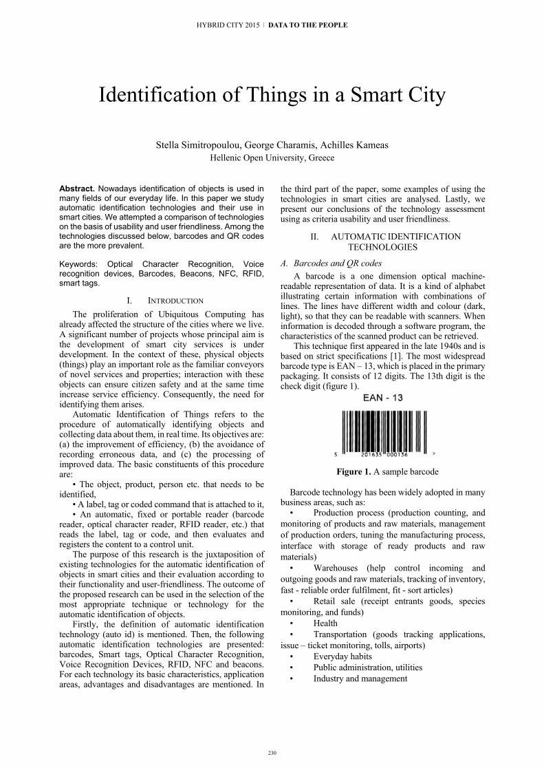
230
Identification of Things in a Smart City
Stella Simitropoulou, George Charamis, Achilles Kameas Hellenic Open University, Greece
Abstract. Nowadays identification of objects is used in many fields of our everyday life. In this paper we study automatic identification technologies and their use in smart cities. We attempted a comparison of technologies on the basis of usability and user friendliness. Among the technologies discussed below, barcodes and QR codes are the more prevalent.
Keywords: Optical Character Recognition, Voice recognition devices, Barcodes, Beacons, NFC, RFID, smart tags.
I. INTRODUCTION The proliferation of Ubiquitous Computing has
already affected the structure of the cities where we live. A significant number of projects whose principal aim is the development of smart city services is under development. In the context of these, physical objects (things) play an important role as the familiar conveyors of novel services and properties; interaction with these objects can ensure citizen safety and at the same time increase service efficiency. Consequently, the need for identifying them arises.
Automatic Identification of Things refers to the procedure of automatically identifying objects and collecting data about them, in real time. Its objectives are: (a) the improvement of efficiency, (b) the avoidance of recording erroneous data, and (c) the processing of improved data. The basic constituents of this procedure are:
• The object, product, person etc. that needs to be identified,
• A label, tag or coded command that is attached to it, • An automatic, fixed or portable reader (barcode
reader, optical character reader, RFID reader, etc.) that reads the label, tag or code, and then evaluates and registers the content to a control unit.
The purpose of this research is the juxtaposition of existing technologies for the automatic identification of objects in smart cities and their evaluation according to their functionality and user-friendliness. The outcome of the proposed research can be used in the selection of the most appropriate technique or technology for the automatic identification of objects.
Firstly, the definition of automatic identification technology (auto id) is mentioned. Then, the following automatic identification technologies are presented: barcodes, Smart tags, Optical Character Recognition, Voice Recognition Devices, RFID, NFC and beacons. For each technology its basic characteristics, application areas, advantages and disadvantages are mentioned. In
the third part of the paper, some examples of using the technologies in smart cities are analysed. Lastly, we present our conclusions of the technology assessment using as criteria usability and user friendliness.
II. AUTOMATIC IDENTIFICATION TECHNOLOGIES
A. Barcodes and QR codes A barcode is a one dimension optical machine-
readable representation of data. It is a kind of alphabet illustrating certain information with combinations of lines. The lines have different width and colour (dark, light), so that they can be readable with scanners. When information is decoded through a software program, the characteristics of the scanned product can be retrieved.
This technique first appeared in the late 1940s and is based on strict specifications [1]. The most widespread barcode type is ΕΑΝ – 13, which is placed in the primary packaging. It consists of 12 digits. The 13th digit is the check digit (figure 1).
Figure 1. A sample barcode
Barcode technology has been widely adopted in many
business areas, such as: • Production process (production counting, and
monitoring of products and raw materials, management of production orders, tuning the manufacturing process, interface with storage of ready products and raw materials)
• Warehouses (help control incoming and outgoing goods and raw materials, tracking of inventory, fast - reliable order fulfilment, fit - sort articles)
• Retail sale (receipt entrants goods, species monitoring, and funds)
• Health • Transportation (goods tracking applications,
issue – ticket monitoring, tolls, airports) • Everyday habits • Public administration, utilities • Industry and management
HYBRID CITY 2015 | DATA TO THE PEOPLE

231
• Tourism applications (QR codes)
As a consequence of globalization and the proliferation of Internet, the information stored in a barcode wasn’t enough. The relevant research resulted in the QR codes, which can be considered as two dimensional barcodes (figure 2). The decoding may be done using a mobile device running a simple application. The encoded text may include web addresses [2].
Figure 2. A sample QR code
Each product, regardless of the place of origin and
destination, can be identified by a unique international code. It is guaranteed that in no way two products can have the same code.
The advantages of using barcode and QR Codes are: • Accuracy in data recovery • Timely information for effective resource
management, inventory, raw materials and other • Limit incorrect entries • Ease of use • Low cost of implementation and use • Labour cost savings due to elimination of time-
consuming manual systems The disadvantages are: • The label must be visible, easily accessible and
readable • Sensitivity in label data changes • Limited volume of coded data • Susceptibility to damage if used in harsh
environments One of the main reasons for the large spread of these
two technologies is their user friendliness. They are found on all products and are an integral part of our daily life. They provide a tool that allows fast, accurate and easy data input in computers, and have replaced the traditional manual typing, which often led to errors and delays. It has been observed that the probability of mistyping is 1 to 300 while the probability of error reading a well printed Barcode is 1 to 3000000. So, in this way, they contribute in achieving smooth handling and product management worldwide [22].
Updating information in the database related to the codes is easy and economical. At the same time, the user doesn’t need any special knowledge; the only thing he has to do is scan the code with the appropriate scanner. Barcodes are characterized by safety, simplicity, international uniqueness, and structure that contains no information. They are the most effective way to secure and indisputably identify products in any form of packaging.
B. Smart Tags Smart tags are an early selection-based search feature
with which a software application can recognize certain words or types of data and convert them into a hyperlink. It allows users to invoke online services from any online source with a few clicks of their mouse. They are also used in office and browser applications. For example, in Microsoft Word, specific types of data (like dates and names) are recognized using smart tags, and this text is automatically converted into a smart tag (figure 3). The text is highlighted with purple dotted line [3].
Figure 3. Smart tag usage in an office application A smart tag consists of two parts: a recogniser and an
action. When the user leads the mouse onto the smart tag, a list of possible actions on the data appears. The object action determines the actions that will appear and controls what happens if any of them is selected.
The advantages of smart tags are: • They save time • They can offer great benefits when combined
with contact lists, diaries, personal preferences, applications • They assist users to:
Auto correction Various ways of pasting E-mail handling Planning a meeting with a person Show map and route instructions to an
address Their disadvantages are: • Potential of spreading viruses • Monitoring of user actions and habits Although this technology is user friendly and easy to
use, it does not have the same impact as barcodes and RFID. Smart tags can be read by handheld scanners. They are primarily used for products that are perishable, i.e. they have a specific end date. They allow the collection of information for replacing goods, if necessary, so that shelves are permanently filled with fresh products and the warehouse is entirely controlled regarding quality [4].
C. Speech recognition Speech recognition (SR) is the translation of spoken
words into text. It helps in executing basic tasks in a hands free way. This technology is used in many applications. It improves continuously and is becoming useful and useable [5].
6 | Environmental Sensing and Hybrid Objects

232
Until now, it has not been widely accepted and the applications don’t use all of its offered features. Apple and Google have added voice recognition technology in their smart phones (i.e. in the personal assistants Siri and Google Now), which can record our voice, translate text and run applications (figure 4).
Figure 4. Speech recognition feature of a personal assistant running in a mobile device
For this technology, the question arises whether it is
indeed safe, because the applications are not configured to a person’s specific voice tone. Anyone can ask the Google Now to make a call or send a text message. It will obey even if it is not your voice that asks for it. Ben Itzak explains that, until now, «free» malware samples exploiting the above have not been found. But developers and device manufacturers should take it into account for their future plans. As it often happens with technology, comfort may come with risks to privacy or safety – and it seems that activation by voice does not differ [6].
SR applies to: • Transportation systems • Health Services and accessibility • Medical documents
• Therapeutic use (benefits for enhancing short-term memory of patients with specific diseases) • Military (helicopters, fighter aircraft) • Telephony • Education and everyday life • Areas such as Aerospace, automatic translation,
robotics, video games Its advantages are: • Gain in time and effort • Spelling • Help for people with disabilities Its disadvantages are: • Difficult implementation due to many
contributing factors, including: pronunciation, voice volume, language, articulation
• Partial safety • More attempts to bridge the performance gap
identification between man and machine are needed. SR is a constantly evolving and improving technology
that still has a high cost. Its usability and friendliness to the user is under discussion mainly because of its disadvantages. Its implementation and then its practical use are relatively difficult due to factors like language, pronunciation and voice intensity. For example, in smart phone Speech Recognition applications, the user usually has to repeat every phrase more than once.
However, the potential to assist disabled people is very important.
D. Optical Character Recognition The Optical Character Recognition (OCR) system is
the engineering or electronic conversion of scanned images into encoded form text characters (figure 5).
Figure 5. OCR using a smart phone
It is a method of digitizing printed text so that it can be
accessed electronically, stored in less space, be accessible from the Web and be used in procedures such as machine translation, data mining or text-to-voice conversion by the computer. During the recognition process, the scanned image is analysed for bright and dark areas in order to identify letters, numbers or characters. When a character is recognized, it is converted to ASCII code [7].
Its advantages are: • Help people with disabilities • Increase efficiency and productivity • Reduced operating costs (archiving, document
storage) • Recover valuable space • Improving the accessibility of documents • Safety / avoiding disaster • Recognizing Documents • Consistency Its disadvantages are: • Relatively high cost • Constant internet connection required • Difficulty in accurate recognition due to many
factors, such as font, colour, etc. The user-friendliness of the technology is constantly
improving, although it is not yet considered as particularly user-friendly. One issue is that sometimes
HYBRID CITY 2015 | DATA TO THE PEOPLE

233
users need to try more than once for a successful OCR result. However, the potential to serve people with disabilities is fairly large.
E. RFID Radio Frequency Identification (RFID) technology is
based on the use of radio waves. It entails the wireless use of electromagnetic fields to transfer data, for the purposes of automatically identifying and tracking special tags attached to objects. RFID tags contain an electronically stored serial number of the object and any other information required (figure 6).
The labels can be automatically detected by fixed or handheld RFID readers, without requiring the scanning of each individual object. The antenna enables the microprocessor to transfer the identification information to the reader, which in turn converts the radio waves "reflected" from the RFID tag into digital information (passive). There exist also RFID tags (active) which receive energy from an embedded battery, can send information to a receiver, and increase range. Neither a physical nor an optical contact of the RFID tags with the receiver is required, which basically accelerates the procedures in applications. This information can then be sent to computers for further use.
RFIDs are used in: • Product Flow Monitoring (clinics, hospitals,
banks) • Ticket systems for entry checks / wireless
transmission of information • Electronic protection products / piracy
prevention • Auto stocks inventory • Calculation, recording temperatures • Collecting data remotely • Robbery prevention Advantages of RFID technology: • A physical or an optical contact with the
reading device is not required; identification is possible from distance • It is not visible • Credibility is not affected by environmental
conditions • Flexibility: RFID tags can be directly
programed even from distance • Continuous update of storage data base is
possible • There is a possibility of storing more data than
with the Barcodes. The amount depends on the supplier and the application. • The RFID Technology offers a high level of
security and data protection thanks to access rights and encryption.
Their disadvantages are: • High cost • Signal distortion problems, because of
interference or bad geometry of the tag
• There are no international communication standards of the readers with the tags.
Figure 6. A sample RFID tag Although RFID tags are technologically superior,
they have not yet managed to replace barcodes. Both of these technologies are user friendly, but barcodes are still in use and they will not become extinct in the immediate future, mainly thanks to their low cost. Additionally, barcodes (especially QR codes) do not require specialized reading devices, as each user can now “read” them using their smart phone. This fact ranks them in a high position concerning user friendliness. We could say that Barcodes and QR Codes have been proven the most user friendly technology up to now.
F. NFC Near Field Communication (NFC) is a short range
wireless technology, operating in the frequency of 13,56 MHz and transferring data at a rate of 424 kbps. NFC has been popular mainly thanks to its usage in smart phones. Its operation is based on the contact or the approach in a short distance, up to five centimeters, of the device containing the NFC chip, with another device containing the appropriate sensor (figure 7) [9].
It is used is fields like payments, tickets, advertising, data exchange, encryption, and access control.
Figure 7. NFC usage
The advantages of this technology are: • Convenience • Suitable for businesses • Wireless eavesdropping is not easy (in contrast
to Wi-Fi, RFID, etc.) and secure usage thanks to short transfer range. • It makes good use of mobile phones as means
of interaction; thus NFC devices are widely used, we always carry them with us, they have a processor, they have access to the internet, they are interactive (keyboard, touch screen), and they have mature hardware.
Its disadvantages are: • It does not allow the applications to calculate
the distance between the broadcaster and the device
6 | Environmental Sensing and Hybrid Objects

234
• There is a danger of losing data because of distance operation of the NFCs [12]
This technology is addressed to users having a technological background. As a result, this technology is not user friendly to people without technological knowledge. It is used in various sectors, but it has not been fully introduced to everyday life, in contrast to barcodes.
G. Beacons It is an indoors position tracking system using small
broadcasting objects (iBeacons), which allow a smart phone or another device to perform actions, when it is close to one of them. It is a low cost technology, which uses Bluetooth connections of low energy consumption, in order to directly transfer messages or orders to smart phones or tablets (figure 8) [10].
Figure 8. Use of beacons This technology is used in many fields like: • Resources observation, mainly in businesses
like restaurants. • Education. For example, it can be used in
games and experiments requiring students to move and track items • Zoological and gardening applications • Automation Its advantages include: • Low cost of realization and maintenance • Low energy consumption • Small size but • It is used only indoors This technology is also addressed to users with
technological background. It is not considered as friendly to the common user, that is why it has not been fully introduced to everyday life, in contrast to barcodes [11].
III. EXAMPLES OF USING AUTOMATED OBJECT RECOGNITION TECHNOLOGIES IN
SMART CITIES
A. Barcodes and QR Codes In Issy, France, a great number of QR codes has been
installed in historic monuments, even in local newspapers. Their purpose is to allow the visitors of the city to have access to various multimedia items, including historic information about the city, by “reading” these QR codes with their mobile phones [20].
In Antwerp, Belgium, QR codes have been installed in central points (shops, public transportation stations
etc.) in order to offer travelers information about the schedules of buses and trains. The initiators of this project highlight that using QR codes has lessened the amount of money spent and improved tracking methods. Moreover, they mention that QR codes have minimum operational costs, require less equipment and are considered as a satisfactory alternative to expensive systems requiring the installation of large screens and experts to maintain them [20].
B. Smart tags Smart tags are used in smart technologies observing
and tracking products and objects. Specifically, BMW and Vauxhall use smart tags to achieve an exact adaptation to their customers’ orders. A read / write smart tag is programmed in accordance with each customer’s order and “travels” with the product during the production process (figure 9) [25].
Credit card companies and members of shopping clubs already track and use their customers’ behavior and habits, so as to send them information, such as special offers, to best satisfy their needs, according to their profile. This is readily accomplished using a mobile phone equipped with GPS, RFID and smart tags [4].
Figure 9. Use of Smart Tags
C. Speech recognition devices LoL@ (local location assistant) is an application,
based on the location multimedia UMTS (Universal Mobile Telecommunications System), aiming at supporting those tourists who have frequent but brief trips and use modern technologies [13].
The MERCURY System provides information about available flights among more than 500 cities of the world. It uses the speech recognition technology so that people can book a flight by phone [14].
D. Optical Character Recognition Smart homes for the elderly and disabled people use
the Optical Character Recognition technology in reading devices, where the printed item is scanned, and afterwards, its image is edited by the OCR device and is converted into an appropriate form, such as voice or Braille (e.g. Optacon II) [26].
HYBRID CITY 2015 | DATA TO THE PEOPLE

235
E. RFID RFID Technology has been used in many pioneering
hospitals. Seoul National University Bundang Hospital uses it in order to improve its patient management system [27]. Texas Health Presbyterian Hospital in Dallas uses this technology to register and observe 7000 objects (figure 10) [28]. Although some research has been conducted on managing patients, assets and health problems, only a few research results are available on using RFID technology in the medical field. For example, according to the research conducted by Nai et al (2008), only 3,6% of the papers about RFID is about the application of this technology to the medical field. In contrast to the above, almost 17,8% of the papers is about the application of RFID to the retail sector [15].
Figure 10. RFID In Ginza, Tokyo, a huge network of active and
passive RFID tags has been created, in order to offer information not only about sights, but also about traffic (figure 11). In this area, a great effort has been made in
Figure 11. Use of RFID order to create a smart city. This effort started in 1989 when more than 1000 sensors and computers were placed in a 333 m2 house (Location - aware Information Services) [17].
The subway system in the South Korean capital uses radio-frequency identification (RFID) and near field communication (NFC) smart technology that allows customers to automatically purchase their tickets with their smartphones [23]. The same holds for the transportation systems of various European cities, among them Brussels and London.
In Santander, around 2.000 RFID tags (and QR codes) have been deployed, offering many points of interest in the city, for example a touristic point of interest, shops and public places such as parks, squares, etc. [30]
F. NFC NFC Technology can offer many opportunities to the
tourist industry, such as mobile payment, navigation, information supply, location base services etc. The first pilot project of a smart city using NFC in Europe was this of Nice in France [18]. Nevertheless, only a small number of papers about applying NFC technology in smart cities is available. Most of the research has been conducted on a theoretical basis. Moreover, it has been observed that the scenarios are examined from the business perspective, and not from the clients’ perspective [18].
The spread of smart phones has led to the development of applications about smart cities, with the assistance of the Android software and the NFC Technology. The Electronic Ticket System for Public Transport is an example of the combination of the above mentioned technologies (figure 12). A popular application is the usage of pre-paid cards using the NFC Technology (Slovenia Urbana card και London Oyster card). In the paper, a system of electronic tickets is proposed, which use the NFC Technology in combination with QR codes, for smartphones running Android software. A considerable problem is the absence of NFC from some smart phones [19].
Barcelona equipped 8,000 city locations with NFC and QR touchpoints in hotels, hostels, tourist offices, tourist attractions etc. For example, when you’re in a pharmacy you can tap the NFC touchpoint and see information about the pharmacy and open pharmacies around if closed but also transport information. The idea is to make the city as digital-friendly as possible for citizens [24].
Figure 12. Use of NFC
G. Beacons A pilot program has been applied for three years in
Los Angeles, where beacons have been placed in the bus stations of the city (figure 13) [29]. The aim of this program is to offer location-based information to the inhabitants of the city. This specific program offers various organizations (e.g. businesses, stores etc.) the opportunity to present their content to their customers, based on their proximity to a point of interest. All the people responsible for the program express their concern
6 | Environmental Sensing and Hybrid Objects
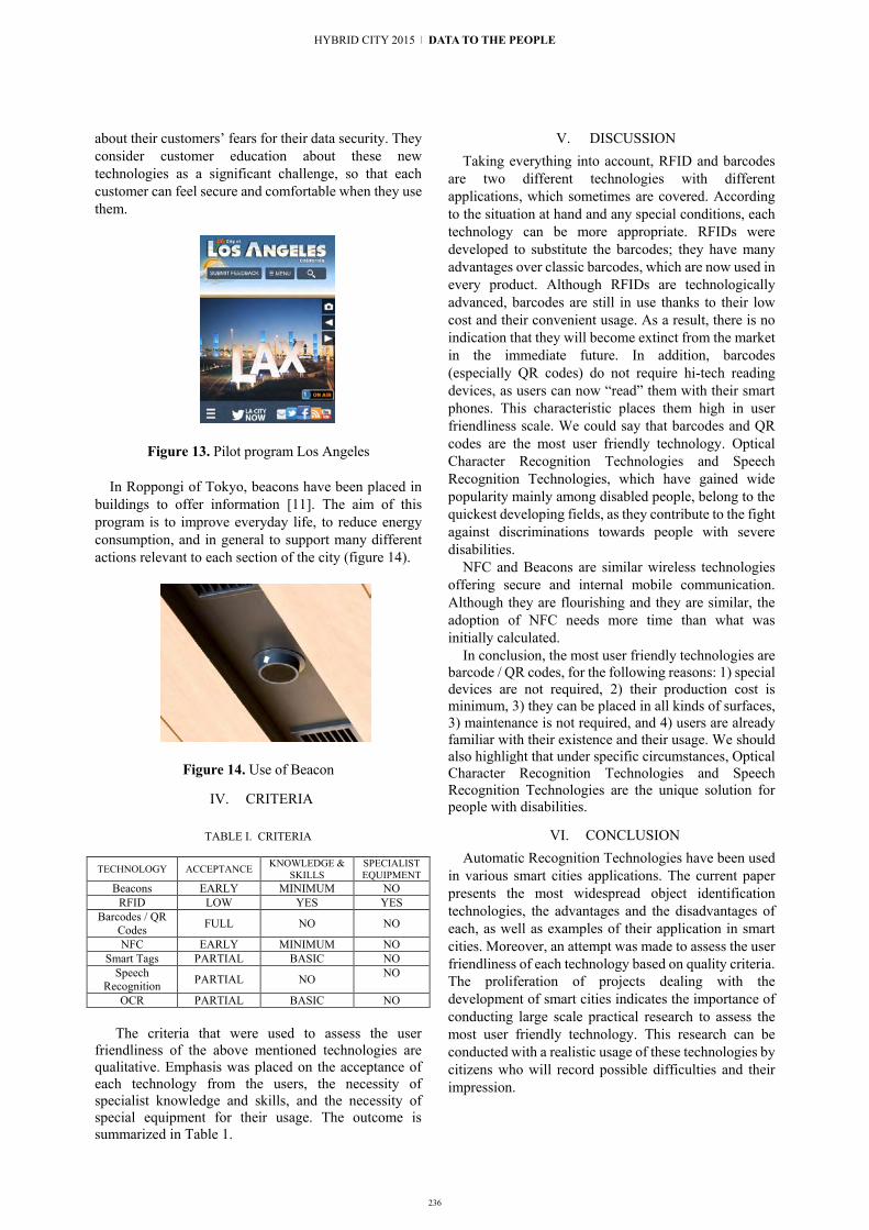
236
about their customers’ fears for their data security. They consider customer education about these new technologies as a significant challenge, so that each customer can feel secure and comfortable when they use them.
Figure 13. Pilot program Los Angeles In Roppongi of Tokyo, beacons have been placed in
buildings to offer information [11]. The aim of this program is to improve everyday life, to reduce energy consumption, and in general to support many different actions relevant to each section of the city (figure 14).
Figure 14. Use of Beacon
IV. CRITERIA
TABLE I. CRITERIA
TECHNOLOGY ACCEPTANCE KNOWLEDGE & SKILLS
SPECIALIST EQUIPMENT
Beacons EARLY MINIMUM NO RFID LOW YES YES
Barcodes / QR Codes FULL NO NO
NFC EARLY MINIMUM NO Smart Tags PARTIAL BASIC NO
Speech Recognition PARTIAL NO NO
OCR PARTIAL BASIC NO
The criteria that were used to assess the user
friendliness of the above mentioned technologies are qualitative. Emphasis was placed on the acceptance of each technology from the users, the necessity of specialist knowledge and skills, and the necessity of special equipment for their usage. The outcome is summarized in Table 1.
V. DISCUSSION Taking everything into account, RFID and barcodes
are two different technologies with different applications, which sometimes are covered. According to the situation at hand and any special conditions, each technology can be more appropriate. RFIDs were developed to substitute the barcodes; they have many advantages over classic barcodes, which are now used in every product. Although RFIDs are technologically advanced, barcodes are still in use thanks to their low cost and their convenient usage. As a result, there is no indication that they will become extinct from the market in the immediate future. In addition, barcodes (especially QR codes) do not require hi-tech reading devices, as users can now “read” them with their smart phones. This characteristic places them high in user friendliness scale. We could say that barcodes and QR codes are the most user friendly technology. Optical Character Recognition Technologies and Speech Recognition Technologies, which have gained wide popularity mainly among disabled people, belong to the quickest developing fields, as they contribute to the fight against discriminations towards people with severe disabilities.
NFC and Beacons are similar wireless technologies offering secure and internal mobile communication. Although they are flourishing and they are similar, the adoption of NFC needs more time than what was initially calculated.
In conclusion, the most user friendly technologies are barcode / QR codes, for the following reasons: 1) special devices are not required, 2) their production cost is minimum, 3) they can be placed in all kinds of surfaces, 3) maintenance is not required, and 4) users are already familiar with their existence and their usage. We should also highlight that under specific circumstances, Optical Character Recognition Technologies and Speech Recognition Technologies are the unique solution for people with disabilities.
VI. CONCLUSION Automatic Recognition Technologies have been used
in various smart cities applications. The current paper presents the most widespread object identification technologies, the advantages and the disadvantages of each, as well as examples of their application in smart cities. Moreover, an attempt was made to assess the user friendliness of each technology based on quality criteria. The proliferation of projects dealing with the development of smart cities indicates the importance of conducting large scale practical research to assess the most user friendly technology. This research can be conducted with a realistic usage of these technologies by citizens who will record possible difficulties and their impression.
HYBRID CITY 2015 | DATA TO THE PEOPLE
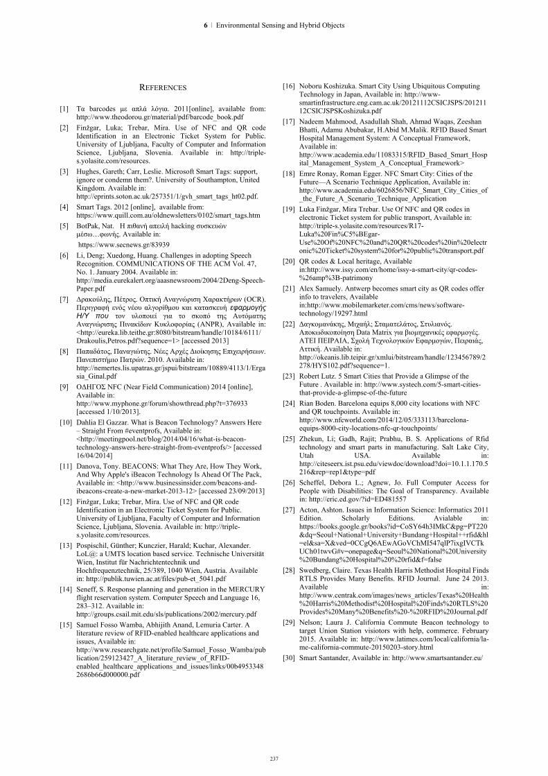
237
REFERENCES [1] Τα barcodes με απλά λόγια. 2011[online], available from:
http://www.theodorou.gr/material/pdf/barcode_book.pdf [2] Finžgar, Luka; Trebar, Mira. Use of NFC and QR code
Identification in an Electronic Ticket System for Public. University of Ljubljana, Faculty of Computer and Information Science, Ljubljana, Slovenia. Available in: http://triple-s.yolasite.com/resources.
[3] Hughes, Gareth; Carr, Leslie. Microsoft Smart Tags: support, ignore or condemn them?. University of Southampton, United Kingdom. Available in: http://eprints.soton.ac.uk/257351/1/gvh_smart_tags_ht02.pdf.
[4] Smart Tags. 2012 [online], available from: https://www.quill.com.au/oldnewsletters/0102/smart_tags.htm
[5] BotPak, Nat. Η πιθανή απειλή hacking συσκευών μέσω…φωνής. Available in: https://www.secnews.gr/83939
[6] Li, Deng; Xuedong, Huang. Challenges in adopting Speech Recognition. COMMUNICATIONS OF THE ACM Vol. 47, No. 1. January 2004. Available in: http://media.eurekalert.org/aaasnewsroom/2004/2Deng-Speech-Paper.pdf
[7] Δρακούλης, Πέτρος. Οπτική Αναγνώριση Χαρακτήρων (OCR). Περιγραφή ενός νέου αλγορίθμου και κατασκευή εφαρμογής Η/Υ που τον υλοποιεί για το σκοπό της Αυτόματης Αναγνώρισης Πινακίδων Κυκλοφορίας (ANPR), Available in: <http://eureka.lib.teithe.gr:8080/bitstream/handle/10184/6111/Drakoulis,Petros.pdf?sequence=1> [accessed 2013]
[8] Παπαδάτος, Παναγιώτης. Νέες Αρχές Διοίκησης Επιχειρήσεων. Πανεπιστήμιο Πατρών. 2010. Available in: http://nemertes.lis.upatras.gr/jspui/bitstream/10889/4113/1/Ergasia_Ginal.pdf
[9] ΟΔΗΓΟΣ NFC (Near Field Communication) 2014 [online], Available in: http://www.myphone.gr/forum/showthread.php?t=376933 [accessed 1/10/2013].
[10] Dahlia El Gazzar. What is Beacon Technology? Answers Here – Straight From #eventprofs, Available in: <http://meetingpool.net/blog/2014/04/16/what-is-beacon-technology-answers-here-straight-from-eventprofs/> [accessed 16/04/2014]
[11] Danova, Tony. BEACONS: What They Are, How They Work, And Why Apple's iBeacon Technology Is Ahead Of The Pack, Available in: <http://www.businessinsider.com/beacons-and-ibeacons-create-a-new-market-2013-12> [accessed 23/09/2013]
[12] Finžgar, Luka; Trebar, Mira. Use of NFC and QR code Identification in an Electronic Ticket System for Public. University of Ljubljana, Faculty of Computer and Information Science, Ljubljana, Slovenia. Available in: http://triple-s.yolasite.com/resources.
[13] Pospischil, Günther; Kunczier, Harald; Kuchar, Alexander. LoL@: a UMTS location based service. Technische Universität Wien, Institut für Nachrichtentechnik und Hochfrequenztechnik, 25/389, 1040 Wien, Austria. Available in: http://publik.tuwien.ac.at/files/pub-et_5041.pdf
[14] Seneff, S. Response planning and generation in the MERCURY flight reservation system. Computer Speech and Language 16, 283–312. Available in: http://groups.csail.mit.edu/sls/publications/2002/mercury.pdf
[15] Samuel Fosso Wamba, Abhijith Anand, Lemuria Carter. A literature review of RFID-enabled healthcare applications and issues, Available in: http://www.researchgate.net/profile/Samuel_Fosso_Wamba/publication/259123427_A_literature_review_of_RFID-enabled_healthcare_applications_and_issues/links/00b49533482686b66d000000.pdf
[16] Noboru Koshizuka. Smart City Using Ubiquitous Computing Technology in Japan, Available in: http://www-smartinfrastructure.eng.cam.ac.uk/20121112CSICJSPS/20121112CSICJSPSKoshizuka.pdf
[17] Nadeem Mahmood, Asadullah Shah, Ahmad Waqas, Zeeshan Bhatti, Adamu Abubakar, H.Abid M.Malik. RFID Based Smart Hospital Management System: A Conceptual Framework, Available in: http://www.academia.edu/11083315/RFID_Based_Smart_Hospital_Management_System_A_Conceptual_Framework>
[18] Emre Ronay, Roman Egger. NFC Smart City: Cities of the Future—A Scenario Technique Application, Available in: http://www.academia.edu/6026856/NFC_Smart_City_Cities_of_the_Future_A_Scenario_Technique_Application
[19] Luka Finžgar, Mira Trebar. Use Of NFC and QR codes in electronic Ticket system for public transport, Available in: http://triple-s.yolasite.com/resources/R17-Luka%20Fin%C5%BEgar-Use%20Of%20NFC%20and%20QR%20codes%20in%20electronic%20Ticket%20system%20for%20public%20transport.pdf
[20] QR codes & Local heritage, Available in:http://www.issy.com/en/home/issy-a-smart-city/qr-codes-%26amp%3B-patrimony
[21] Alex Samuely. Antwerp becomes smart city as QR codes offer info to travelers, Available in:http://www.mobilemarketer.com/cms/news/software-technology/19297.html
[22] Δαγκομανάκης, Μιχαήλ; Σταματελάτος, Στυλιανός. Αποκωδικοποίηση Data Matrix για βιομηχανικές εφαρμογές. ΑΤΕΙ ΠΕΙΡΑΙΑ, Σχολή Τεχνολογικών Εφαρμογών, Πειραιάς, Αττική. Available in: http://okeanis.lib.teipir.gr/xmlui/bitstream/handle/123456789/2278/HYS102.pdf?sequence=1.
[23] Robert Lutz. 5 Smart Cities that Provide a Glimpse of the Future . Available in: http://www.systech.com/5-smart-cities-that-provide-a-glimpse-of-the-future
[24] Rian Boden. Barcelona equips 8,000 city locations with NFC and QR touchpoints. Available in: http://www.nfcworld.com/2014/12/05/333113/barcelona-equips-8000-city-locations-nfc-qr-touchpoints/
[25] Zhekun, Li; Gadh, Rajit; Prabhu, B. S. Applications of Rfid technology and smart parts in manufacturing. Salt Lake City, Utah USA. Available in: http://citeseerx.ist.psu.edu/viewdoc/download?doi=10.1.1.170.5216&rep=rep1&type=pdf
[26] Scheffel, Debora L.; Agnew, Jo. Full Computer Access for People with Disabilities: The Goal of Transparency. Available in: http://eric.ed.gov/?id=ED481557
[27] Acton, Ashton. Issues in Information Science: Informatics 2011 Edition. Scholarly Editions. Avialable in: https://books.google.gr/books?id=CoSY64h3IMkC&pg=PT220&dq=Seoul+National+University+Bundang+Hospital++rfid&hl=el&sa=X&ved=0CCgQ6AEwAGoVChMI547qlP7ixgIVCTkUCh01twvG#v=onepage&q=Seoul%20National%20University%20Bundang%20Hospital%20%20rfid&f=false
[28] Swedberg, Claire. Texas Health Harris Methodist Hospital Finds RTLS Provides Many Benefits. RFID Journal. June 24 2013. Available in: http://www.centrak.com/images/news_articles/Texas%20Health%20Harris%20Methodist%20Hospital%20Finds%20RTLS%20Provides%20Many%20Benefits%20-%20RFID%20Journal.pdf
[29] Nelson; Laura J. California Commute Beacon technology to target Union Station visiotors with help, commerce. February 2015. Available in: http://www.latimes.com/local/california/la-me-california-commute-20150203-story.html
[30] Smart Santander, Available in: http://www.smartsantander.eu/
6 | Environmental Sensing and Hybrid Objects
URBANDATA VISUAL-IzATION ANDMAPPING

Mapito.org Open Geographic Platform for Locative Media Apps
Konstantinos Chorianopoulos, Ionian University Department of Informatics
Corfu, Greece [email protected]
Konstantinos Pardalis, Ionian University Department of Informatics
Corfu, Greece
Abstract. Digital geographical maps have become an important part of many websites and mobile applications. For example, we can embed a map and geo-location tracking into a web page, or into a smartphone application. Nevertheless, the management of user maps and routes is different between the many competing geographic information services. We designed and implemented an open-source and linked-data web service for facilitating the process of a map and route management. The implementation of our open-source web application has been built on-top of existing web services that provide maps. In this way, the Mapito.org service provides an open abstraction layer above the proprietary implementations of commercial companies. Notably, the Mapito platform provides an Application Programming Interface (API), which facilitates the creation and editing of a map and the ability to download the data, or routes without visiting the Web-based user interface. In this paper, we outline the system and provide representative case studies.
Keywords: Geographic Map, API, Open Source, Linked data
I. INTRODUCTION In the last few years, with the rapid growth and
progress of mobile and web technology, digital geographical maps have become an important part of many websites and mobile apps. A digital map is usually a web service that provides maps and routes for users to search and to browse points of interest. Digital maps can be exploited for many and different purposes. For example, we can embed a map and geo-location recording into a web page.
We designed and implemented a platform for facilitating the process of a map creation and embedding in a web page, and for observation, recording and storing of users activity on the map for further processing and analysis. The implementation of our open-source web application is based on existing web services that provide maps, (currently Google Maps and Bing Maps). The main features of this web application are: the easy map creation and embedding in a web page, the ability to add custom controls for basic user interactions with the map, the recording of users activity, the route tracking through a web browser of a smartphone with GPS and HTML5 Geolocation support, the one-click switching between of
map services without affecting the previous settings, and the Application Programming Interface (API), which gives the ability to developers to create, modify or delete a map and the ability to download the data, or routes without visiting the Web-based user interface of our application.
Fig. 1. The Mapito platform enables a locative media App to be switched from Google Maps to Bing Maps with just one click.
The utility of the above features is mainly to facilitate the creation and embedding of a map into a web page. Furthermore, the innovative feature of this application is the recording of the users activity on a map. The usefulness of route tracking using this system is that performs real-time storing of routes in an online database and, accordingly, the collection and analysis of routes can be done very easily.
II. SCENARIOS OF USE The current implementation of the Mapito.org service
supports the following basic scenarios of use: 1) Geographic map embedding in a web page, such as a user web blog, 2) Programming interface for managing geographic information for a big set of data, such as a home rental web site, and 3) geolocation storage and processing for geotracking applications. We have selected to support the above basic scenarios of use, because they are very common in contemporary computer applications for locative web and mobile media. In the rest of this section, we describe the current status of geographic information for locative media apps and we demonstrate how the mapito.org service facilitates the management of geographic information.
239
7 | Urban Data Visualization and Mapping

240
Users and small businesses have widely embedded geographic maps into their web presence (e.g., wordpress, e-commerce, etc), in order to assist other users to locate them. The embedding of geographic maps is based on proprietary geographic information systems. For example, if a user or a business selects to embed a customized map by Google Maps, then the user has to repeat the same process with another map providers (e.g., Bing Maps), in the case that he wants to switch. In short, the current functionality of mainstream digital geographic maps (e.g., Google Maps) is based on user lock-in, the more a user invests effort in a system, the more difficult it is to change to another system.
Fig. 2. Map embedding is very common in many personal and small business web sites and it includes several features, such as markers, as well as custom map navigation controls (e.g., pan, zoom, satellite)
The Mapito.org service provides an open data and open source solution for map embedding on web sites. Instead of using the proprietary code embedding by the many different digital map providers, the user employs the map embedding feature of Mapito, which is rather similar in terms of usability to the mainstream map providers. The main difference is that the user is free to change providers, as soon as he changes his mind with the click of a button.
Fig. 3. Code embedding allows the creation of locative media applications that are independent of the particular cartographic implementations.
Data driven web sites might have many thousands records of geolocations associated with their main data. For example, a home rental website (e.g., Airbnb) associates each available accommodation with a geographic location, in order to assist users in selecting the most convenient for them. In addition to the geographic location of a data base record, there might be a need for additional features, such as highlighting an area on the map around the location, as well as customized controls for map navigation (e.g., pan, zoom). If the web site decides to switch the map service from one operator to another, the developers have to
implement the above geographic information sub-system (locations, highlights, map controls) from scratch, since there is no common API between the competing geographic map systems.
Fig. 4. Home rental web sites (e.g., Airbnb) have several thousands of records associated with geographic information and they use special markings to highlight the neighbourhood.
The Mapito system provides an API that facilitates the programmatic management of big data sets that are associated with geographic information. For example, a web site that provides a list of customized geolocated information (e.g., Airbnb) is enabled to associate its big and precious data-set with the geographic information of the mapito API. In this way, each record in the data-base is associated with a mapito record, which has no dependency with any particular digital map provider. In the unfortunate case that the geographic map provider changes some of the rules of the contract (e.g., cost, privacy, etc), then the Mapito system provides a safety net with easy switching to another provider without any lock-in and without any extra cost in time or money.
Fig. 5. In addition to the graphical user interface, Mapito.org facilitates the customization of map navigation and the definition of markers through an API for big sets of data.
The popularlity of smart phones that include large touchscreens and accurate geolocation has motivated the development and adoption by milions of users of apps that employ geographic maps and route tracking. For example, fitness motivation applications (e.g., Endomondo, Nike Run, Map my Run) employ geotracking storage and processing, in order to visualize the performance of the user and to motivate future improvement. In particular, the storage and processing of route tracking data is a complicated functionality because it requires the storage of billions records of streaming
HYBRID CITY 2015 | DATA TO THE PEOPLE

241
data, as well as the processing of the raw data in order to create meaningful visualizations without sensor noise. Notably, the recognition of the user activity and the filtering of false data points is a common and important functionality, which has to be implemented for each one of these applications separately.
Fig. 6. Contemporary smart phone applications for health and fitness (e.g., Map my Run) include routing tracking functionality in order to visualize performance and to motivate the user to improve
The Mapito.org service provides an API that facilitates the storage and processing of route tracking data. For example, the developer of a new route tracking application (e.g., health monitoring, car pooling) could employ the generic mapito route recording and route processing (e.g., smoothing) features in order to invest more effort into the features that make his application innovative. The Mapito route API provides methods to record a stream of geolocated data, as well as methods for retrieving them. In addition to storage and retrieval of route points, the Mapito system provides a basic algorithm for smoothing the path along a set of route points [2].
Fig. 7. Mapito.org facilitates the storage and processing of route tracking data.
III. SYSTEM DESIGN The development of the mapito.org web application
was based on a series of specifications. The initial specifications were the creation of a web application for the recording of users activity on a map, the facilitating of a map creation, the adding of custom controls and easy embedding in a web page. Then, arose additional features such as adding items on a map to show points and places for users. Furthermore, added an additional feature which is the route tracking. Finally, added the API. The API provides exactly the same functionality just like the graphical user interface of the web application, but with programmatic access to the features. In order to develop the mapito.org web application we employed several internet technologies. In the frontend, we used HTML5, CSS3, JavaScript and some frameworks like Bootstrap for the creation of responsive design, JQuery for rapid development and easy handling of events, and used other smaller libraries to facilitate the development process on the client-side. In the backend, we used the Node.js platform and the NoSQL database MongoDB.
Fig. 8. The System Architecture is modular and allows users to manage their customized maps and routes through a graphical web application or through a programming interface
7 | Urban Data Visualization and Mapping

IV. DISCUSSION AND FURTHER RESEARCH The Mapito platform is a fully functional service and
systemi, as well as a proposal for a new level of geographic information systems. During the past decades, there has been a lot of effort to develop proprietary (e.g., ArcGIS, Google Maps) or open source map systems (e.g., OpenStreetMaps, Mapbox) within a competitive ecosystem. The results has been a fragmented marketplace of systems and data that create user lock-in, as soon as someone has invested some effort in working (e.g., adding data) with one of them. The Mapito platform suggests that there is a significant part of overlapping functionalities between competing map systems and data, which need to become interoperable.
There are many APIs and open data map services, but there are few open source ones and none that allows the migration of application and user data. Data migration is important because without it a developer and its users are locked-in a particular technology. Mapito.org is the first linked-data and open source GIS
system with an API that facilitates the development of Web services and Mobile Apps without user lock-in. Moreover, Mapito.org is creating an abstraction layer above the generic services offered by the major web-based GIS systems, in order to facilitate the migration of the user applications to new services.
A future version of this system should include more features in order to increase the coverage of geographic maps. The current system provides connections to Google Maps and Bing Maps, so another improvement can be the addition of more map services such as OpenStreetMap and HERE Maps. Furthermore, another future approach can be the online analysis of users activity data and the creation of user activity graphs.
In our previous research [1], we raised the issue that contemporary mobile computers (smart phones, tablets, wearables, etc), which are usually employed by pedestrians, provide the exact same cartography that is employed for car navigation. In order to create a visualization of popular pedestrian routes in a usable
cartographic format, we have to collect and analyse as many geographic points as possible. For this purpose, we need an open data service that gathers and analyses actual pedestrian routes as recorded by mobile devices.
In ongoing research, a dynamically crowd-sourced mobile map application is dynamically visualized, where the most frequently used streets will be illustrated and dynamically modified, according to users' feedback. The most popular streets should have larger line widths, whereas the less popular ones should have narrower lines. The dynamics should not only be controlled by frequency, but also by personal preferences and user profiles, depending on several parameters, such as the weather conditions, time of day, possible health problems, etc. In addition, navigation algorithms should generate paths tailored to the user's specific demands and safety. The maps' priority should be focused on safety and enjoyment of pedestrians and they should be addressed to all people, locals and visitors. In addition, the backend system should be extented in order to consider additional means of transport such as biking.
TABLE I. COMPARISON BETWEEN DIFFERENT WEB-BASED GEOGRAPHIC INFORMATION SYSTEMS
ACKNOWLEDGEMENT We are grateful to the students of the Department of
Informatics (Ionian University, Corfu, Greece) for collecting pedestrian route data and to Mouratidis Theofilos for contributing to the implementation of the pedestrian smoothing algorithm.
REFERENCES [1] Chorianopoulos, K. (2014). Community-based pedestrian
mapmaking. Journal of Community Informatics, 10(3). [2] Kasemsuppakorn, P., & Karimi, H. A. (2013). A pedestrian
network construction algorithm based on multiple GPS traces. Transportation research part C: emerging technologies, 26, 285-300
i Mapito service: www.mapito.org Mapito source code: www.github.org/map1t0
Open-Source Open-Data API Data migration
OpenStreet No Yes Yes No
Google Maps No No Yes No
Bing No No Yes No
Here No No Yes No
Mapito.org Yes Yes Yes Yes
242
HYBRID CITY 2015 | DATA TO THE PEOPLE

243
Business Intelligence for Primary Healthcare Management
The case of PEDY Network in Athens Metro Area
Drakopoulos Dimitris MSc PMP DEXTERA Consulting
Maroussi, GREECE [email protected]
Dr Annie Tubadji Department of Economics
University of Bologna Rimini, ITALY
Koutsogianni Amalia Maria MSc DEXTERA Consulting
Maroussi, GREECE [email protected]
Dontas Stelios DEXTERA Consulting
Maroussi, GREECE [email protected]
Abstract. The aim of this study is to present the case of the Business Intelligence System (BIS) developed by DEXTERA Consulting to support decision making on the daily operation of PEDY, the newly established Primary Healthcare Network of Greece, in the metro area of Athens. The objective of the system is twofold: 1) to provide instant and accurate operational data to the healthcare administration and 2) to enhance the value of these data through combination and comparison with open, dimensional datasets, such as time, geospatial segmentation and population agglomeration. The study illustrates how a BIS can offer multidimensional but consistent optics of the truth, allowing the agile counteraction of the administration to multiple changing parameters, such as demand peaks, personnel relocation and population flows.
Keywords: Business Intelligence; Decision Support System; Multidimensional Data Analysis; PEDY; Primary Healthcare; Athens Metro Area;
I. INTRODUCTION Primary Healthcare (PHC) is now more than ever
necessary for the modern societies, in a globalized world. Nowadays the global competition is challenging convergence in the societies and there is a perception that significant parts of the population remain uncovered by crucial healthcare services and treatment. The World Health Organization suggests that health systems need to respond better and faster to the challenges of a changing world and this adaptability can only be achieved through reforms that would reinforce PHC [12]. To this direction the economic crisis in Greece and the consequent lag of resources lead in 2014 to the reform for the foundation of
PEDY, the new nation-wide PHC network. However, given the budgetary limitations, the agility of the newly established network in covering the changing and increasing needs of an ageing population remains to be proved. Main challenge for the decision makers is the shortage of physician’s specialties per locality, while also they need to decide over the operation or not of several small PHC facilities, following seasonal changes of the demand. Optimal resources’ allocation has been recognized as a major aid for decision makers, who should be timely informed for the variances of the demand and ready to react to any transient challenges for the public health [10]. Healthcare organizations are being pressured to provide managers easy access to the data needed for critical decision making. One solution many organizations are turning to is implementing decision-support data warehouses. [9]. Therefore, the PEDY data warehouse and BIS were created.
A data warehouse is a subject-oriented, integrated, time-variant and non-volatile collection of data in support of management's decision making process [7]. “Business Intelligence, or BI” describes the technologies that get datasets stored in a data warehouse and deliver it to users as dashboards, dynamic reports and dynamic data visualizations. According to Glaser and Stone (2008), Business intelligence can enhance healthcare organizations' financial and operational performance and quality of patient care [5].
In this study we present the DW/BI system (BIS) developed by DEXTERA for the Hellenic Ministry of Health, covering the PHC facilities of PEDY in Athens Metro Area, which is aiming to support informed decision making, over a number of fast-changing factors.
7 | Urban Data Visualization and Mapping
Business Intelligence for Primary Healthcare Management
The case of PEDY Network in Athens Metro Area

244
The system is making use of decision support measures and indices of Spatial Accessibility (SA) and Availability. However, what brings it one step further from other works is the live connection with the data sources and the dynamic visualization of important decision support measures with a use of Dashboards. The data warehouse, BIS and its value-adding visualization functionalities are illustrated throughout the next sections of the paper.
II. BACKGROUND AND DATASETS According to the latest reform of PEDY, the
provision of services from PHC facilities is organized under the seven healthcare regional administrations (YPE) of Greece. YPE geographical coverage in general corresponds with the administrative and statistical division of the country, while they are responsible for the provision of PHC, inclusive of preventive care and services to the community. In Athens Metro Area, a network of 85 healthcare centers broken down in 5 types, depending on the services they provide is serving an average of 10.000 incidents per day (see Figure 1).
Daily data collection from 85 healthcare centers includes critical measures, such as the shortage of physicians’ specialties per healthcare facility and incidents served per medical department. These two measures are indicative for the estimation of supply and demand regarding healthcare services in a locality and they could represent a lot more when combined with open data, such as demographic and average income. The BIS is also incorporating oral hygiene preventive care data for primary school students. The study is offering a detailed presentation of: (i) the methodology for development of a BIS for PHC and the critical measures for decision making considered and (ii) the created functionalities and visualizations of the pilot BIS for the management of PEDY’s Network of healthcare centers in Athens Metro Area.
Operational data are coupled with open data and time series available in the data warehouse. These include geographical layers, such as the agglomerations of Attiki, the geographical centers of Municipalities, the
real population of the municipalities and the geographical points of PHC facilities. The necessary time series are continuously fed from their sources with a use of web services.
III. METHODOLOGY Historical data has to be captured and stored to
establish the foundation of organizational memory, which is one of most important capabilities required in the healthcare industry. Organization memory capability of business intelligence facilitated by data warehousing is the first step for a systematic and robust approach to capturing, structuring, and conceptualizing of knowledge assets across a range of healthcare environment [1]. Therefore, data integration is at the core of the system developed. Data integration procedures were developed to bring together and interrelate data from disparate sources. The procedures are adding up to 2.500 records daily and bringing together operational data originated by the healthcare facilities’ users as well as open datasets acquired mainly from the Hellenic statistical authority. The records are stored in repositories at the database and they are organized in thematic data marts. A data mart is a simple sub-set or component of a data warehouse that is focused on a single subject (or functional area), such as the demand at PHC facilities, the physicians’ shortage per facility and the allocation of physicians to community programs.
The stored data require further analysis so they can be meaningful to the decision makers. Usefulness of the information directly depends both on the time of delivery and relevance of the content. For this purpose, a set of visual analyses was developed to deliver interactive insight to complex and multidimensional datasets. The measures and dimensions of those are summarized in the matrix presented in Table I.
Furthermore, an innovative approach to visualize the quantification of accessibility and availability of PHC facilities in urban environment was made. The approach had the form of a pilot, including three (3) indicative municipalities in the east of Athens and the
Figure 1: PHC facilities in Attiki
Figure 2: Physicians per 1000 inhabitants of real population
HYBRID CITY 2015 | DATA TO THE PEOPLE
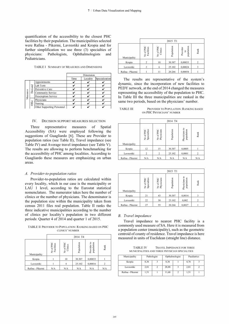
245
quantification of the accessibility to the closest PHC facilities by their population. The municipalities selected were Rafina - Pikermi, Lavreotiki and Kropia and for further simplification we use three (3) specialties of physicians: Pathologists, Ophthalmologists and Pediatricians.
TABLE I SUMMARY OF MEASURES AND DIMENSIONS
IV. DECISION SUPPORT MEASURES SELECTION Three representative measures of Spatial
Accessibility (SA) were employed following the suggestions of Guagliardo [6]. These are Provider to population ratios (see Table II), Travel impedance (see Table IV) and Average travel impedance (see Table V). The results are allowing to perform benchmarking for the accessibility of PHC among localities. According to Guagliardo these measures are emphasizing on urban areas.
A. Provider-to-population ratios Provider-to-population ratios are calculated within
every locality, which in our case is the municipality or LAU 1 level, according to the Eurostat statistical nomenclature. The numerator takes here the number of clinics or the number of physicians. The denominator is the population size within the municipality taken from census 2011 files real population. Table II ranks the three indicative municipalities according to the number of clinics per locality’s population in two different periods: Quarter 4 of 2014 and quarter 1 of 2015.
TABLE II PROVIDER TO POPULATION: RANKING BASED ON PHC
CLINICS’ NUMBER
2014 T4
Municipality
Nr o
f PH
C
Faci
litie
s
Nr o
f PH
C
Clin
ics
Popu
latio
n
Prov
ider
to
popu
latio
n
Ran
k
Kropia 1 10 30.307 0,00033 1
Lavreotiki 1 4 25.102 0,00016 2
Rafina - Pikermi N/A N/A N/A N/A N/A
2015 T1
Municipality
Nr o
f PH
C
Faci
litie
s
Nr o
f PH
C
Clin
ics
Popu
latio
n
Prov
ider
to
po
pula
tion
Ran
k
Kropia 2 10 30.307 0,00033 2
Lavreotiki 2 6 25.102 0,00024 3
Rafina - Pikermi 1 11 20.266 0,00054 1
The results are representative of the system’s dynamic, since the incorporation of new facilities to PEDY network, at the end of 2014 changed the measures representing the accessibility of the population to PHC. In Table III the three municipalities are ranked in the same two periods, based on the physicians’ number. TABLE III PROVIDER TO POPULATION: RANKING BASED
ON PHC PHYSICIANS’ NUMBER
2014 T4
Municipality N
r of P
HC
Sp
ecia
lties
Nr o
f PH
C
Phys
icia
ns
Popu
latio
n
Phys
icia
ns to
po
pula
tion
Ran
k
Kropia 12 15 30.307 0,0005 1
Lavreotiki 2 2 25.102 0,0001 2
Rafina - Pikermi N/A N/A N/A N/A N/A
2015 T1
Municipality
Nr o
f PH
C
Spec
ialti
es
Nr o
f PH
C
Phys
icia
ns
Popu
latio
n
Phys
icia
ns to
po
pula
tion
Ran
k Kropia 21 43 30.307 0,0014 3
Lavreotiki 22 50 25.102 0,002 2
Rafina - Pikermi 27 55 20.266 0,0027 1
B. Travel impedance Travel impedance to nearest PHC facility is a
commonly used measure of SA. Here it is measured from a population center (municipality), such as the geometric centroid of county of residence. Travel impedance is here measured in units of Euclidean (straight line) distance.
TABLE IV TRAVEL IMPEDANCE FOR THREE MUNICIPALITIES AND THREE PHYSICIAN SPECIALTIES
Municipality Pathologist Opthalmologist Paediatrics
Kropia 8,36 3 8,36 1 4,76 3
Lavreotiki 2,81 2 28,88 3 2,81 2
Rafina - Pikermi 1,51 1 11,68 2 1,51 1
7 | Urban Data Visualization and Mapping
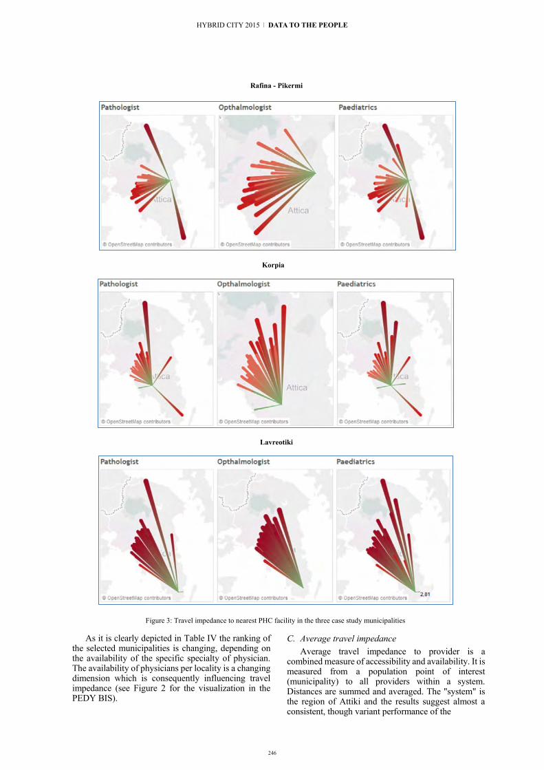
246
Rafina - Pikermi
Korpia
Lavreotiki
Figure 3: Travel impedance to nearest PHC facility in the three case study municipalities
As it is clearly depicted in Table IV the ranking of the selected municipalities is changing, depending on the availability of the specific specialty of physician. The availability of physicians per locality is a changing dimension which is consequently influencing travel impedance (see Figure 2 for the visualization in the PEDY BIS).
C. Average travel impedance Average travel impedance to provider is a
combined measure of accessibility and availability. It is measured from a population point of interest (municipality) to all providers within a system. Distances are summed and averaged. The "system" is the region of Attiki and the results suggest almost a consistent, though variant performance of the
HYBRID CITY 2015 | DATA TO THE PEOPLE
247
measure, depending on physician specialties’ availability.
In summary, the performance of a dynamic analysis on multiple S.A. measures along time certainly presupposes the use of a specialized BIS, otherwise it would require tremendous effort that would render such an endeavor practically impossible.
TABLE V AVERAGE TRAVEL IMPEDANCE FOR THREE MUNICIPALITIES AND THREE PHYSICIAN SPECIALTIES
Municipality Pathologist Opthalmologist Paediatrics
Kropia 17,53 1 16,61 1 17,62 1
Lavreotiki 39,12 3 37,79 3 38,49 3
Rafina - Pikermi 20,07 2 19,08 2 19,41 2
V. DATA VISUALIZATIONS TO FACILITATE DECISION MAKING
For the creation of dynamic data visualizations, we used Tableau Server 8.3. A set of dashboards were developed to represent in the most engaging way the interrelation of S.A. measures with time, shortage of physicians’ specialties per locality and other dimensions. Figure 3 shows examples of travel impedance between localities and healthcare centers in Attiki. The visualization was based on the geographical coordinates of the municipalities centroid and those of the PHC facilities. The common point in every graph is the municipality’s center, while in the other side of the lines exist all available PHC facilities employing at least one physician with specific specialty. The lines become longer, stronger and red when the distance from the starting point increases, while they remain short and green when the distance is smaller. The measure used for the calculation is the Euclidean distance. With the use of filters, it is easy to select for analysis a municipality and then a physician’s specialty. As an example, at the first row of Figure 3, a very small green line near the population centroid of Rafina – Pikermi shows that a Pathologist and a Pediatrician are available at the local Healthcare Center, however this is not the case with the Ophthalmologist.
The information and analysis produced by the dashboards are spread among a range of users through an open source CMS such as Joomla, allowing for multiple and customized interactions. The user’s interactions with the system, among others include filtering across many different dimensions and extraction of data in various raw formats for further analysis and elaboration.
VI. CONCLUSIONS
Spatial Accessibility of Primary Healthcare Facilities is not anymore a static problem to be solved by decision makers once every few years. It is highly dynamic and it depends on several fast changing dimensions, such as the demand for specific services over time, a continuously
moving personnel with different specialties, even it refers to localities of which the population is highly seasonal and significantly changes every few months. All these factors need to be analyzed continuously, either separately or in combination so they can support the delivery of quality PHC services. The use of a Business Intelligence System is offering a practically live integration of continuously produced operational data with open demographic and other datasets, in a consistent and accurate manner. In periods of economic downturn and with limited economic resources, a well established Decision Support System, such as a DW/ BIS is allowing for informed decision making based on well documented multidimensional analysis. This is a decisive first step towards a more agile and efficient mechanism of optimal resources allocation, in a field which is commonly recognized as neuralgic i.e. Primary Healthcare.
In this spirit, the current study presents an up-to-date solution, fully functional and readily replicable, which can ensure efficiency, consistency and comparability in reporting and management between PHC units in Greece as well as elsewhere.
REFERENCES [1] Ashrafi, N., Kelleher, L., & Kuilboer, J-P. (2014). The impact of
business intelligence on healthcare delivery in the USA. Interdisciplinary Journal of Information, Knowledge, and Management, 9, 117-130.
[2] Chabot, Christian "Demystifying Visual Analytics," IEEE Computer Graphics and Applications, vol. 29, no. 2, March/April 2009, pp. 84-87.
[3] Feldstein Paul, "Health Care Economics" Cengage Learning; '007 edition, June 6, 2011, pp. 385-386.
[4] García-Altés, Anna, et al. "Measuring the performance of urban healthcare services: results of an international experience." Journal of epidemiology and community health 61.9, 2007, pp. 791-796.
[5] Glaser, John, and John Stone. "Effective use of business intelligence." Healthcare financial management: journal of the Healthcare Financial Management Association 62.2, 2008, pp. 68-72.
[6] Guagliardo, Mark F. "Spatial accessibility of primary care: concepts, methods and challenges." International journal of health geographics 3.1, 2004, 3
[7] Inmon, W. H. “Building the Data warehouse ” Wiley, Oct 7, 2005
[8] Piai, Silvia. "Big Data and Analytics Trends in the European Healthcare Market: An IDC Health Insights Survey" IDC Health Insights, 2014
[9] Scheese R. Data warehousing as a healthcare business solution. Journal of the Healthcare Financial Management Association. 1998 Feb; 52(2) pp. 56-59. PMID: 10176450
[10] Mettler, Tobias, and Vivian Vimarlund. "Understanding business intelligence in the context of healthcare." Health informatics journal 15.3, 2009: pp. 254-264.
[11] Spil, Ton AM, Robert A. Stegwee, and Christian JA Teitink. "Business intelligence in healthcare organizations." System Sciences, 2002. HICSS. Proceedings of the 35th Annual Hawaii International Conference on. IEEE, 2002
[12] Van Lerberghe, Wim. "The world health report 2008: primary health care: now more than ever. " World Health Organization 2008
7 | Urban Data Visualization and Mapping

248
Exploring Urban Mobility and Accessibility through Transport Data
a study of London Oyster card data and disability
Gareth Simons, Dr. Andrew Hudson Smith, Dr. Martin Zaltz Austwick
Centre for Advanced Spatial Analysis (CASA) University College London (UCL)
London, UK [email protected]
Stylianos Tsaparas School of Architecture
University of Thessaly (UTh) Volos, Greece
Katerina Skroumpelou Computer Networks Laboratory, School of Electrical
and Computer Engineering National Technical University of Athens
Athens, Greece [email protected]
Gianfranco Gliozzo Extreme Citizen Science (ExCiteS) research group
University College London (UCL) and the Zoological Society of London (ZSL)
London, UK [email protected]
Abstract. This paper explores the accessibility of the London Underground network. To do so, we visualize and analyse TfL Oyster Card and Disabled Freedom Pass Oyster card data. We compare census data of people with limited mobility with accessible station usage. We explore travel patterns and network load during a typical week. We propose a new Android app that directs people with limited mobility to accessible stations nearby, to encourage their use. We explore different kinds of visualisation techniques with video and 3d animation. The visualisation approach to the analysis of these data proved very helpful in the attempt to understand the measure upon which public transport in London is used by people with limited mobility. The use of smart ticketing and data recording of the trips provided by TfL enable a thorough research of urban movement patterns, and allow various interpretations of the city. If rhetorics towards a smart city are in place today, proclaiming more and more the need of smart technologies, sensors and a vision of a hybrid, cyber-physical environment, the analysis of the data that this future urban state produces should be treated carefully. If used in the correct way, they will be able to reveal problems of the modern society that had remained in the dark, helping towards a vision of the desired urban well-being for all. This paper can also serve as a portfolio of different takes on spatial data visualisation.
Keywords: London Underground; Oyster Card; data visualisation; accessibility; spatial analysis;
I. INTRODUCTION
A. City and public space The city is its people. It is the people it houses and
the people it bears on its streets and infrastructure. People move within the city and its public spaces, venues of
social interaction and economic exchange, which are the predominant activities that constitute cities. The city must be able to host and accept all of this movement and exchange within and around its public spaces, so that it can offer people the opportunity of being more active and socially engaged. The ever increasing size of cities also means that transportation infrastructure is increasingly essential for the mobility of citizens. It is, therefore, a fundamental role of the city to provide its residents with sufficient and equitable access to its streets, public spaces, and transportation.
B. The issue of Accessibility If public space is not available for all, then it is no
longer truly public. What defines a space as public is its accessibility. Many spaces are difficult to fully navigate, utilise, or feel comfortable in, unless citizens are young, able-bodied, and stereotypically “conventional”. The more a person deviates from this norm, the more inaccessible a space might be or seem. For our project, we chose to focus on people with limited physical mobility, such as wheelchair users. Observing London, we can see, seemingly everywhere, a significant attempt to make spaces, buildings, and public transport, accessible to all. Our goal is to explore to what extent these facilities are used in relation to the general population. It is an attempt to derive how effective the efforts towards improving accessibility have been.
C. Public Transport for people with limited mobility In order to answer some of our questions, we explore
the mobility of Disabled Freedom Pass Oyster card holders. This approach and the ensuing visualizations illustrate a number of perspectives and potential issues
HYBRID CITY 2015 | DATA TO THE PEOPLE

249
concerning the accessibility of the London Underground network. Our emphasis is on visualization as opposed to in-depth technical analysis, and our findings are explorative rather than conclusive. We keep the process open for readers and viewers to arrive at their own conclusions.
We know that our sample is limited, because not all residents of London that have a disability request an Oyster Freedom Pass. We also know that not all Disabled Freedom Pass holders use public transport. As mentioned in the website of London Councils, “There are approximately 1.4 million disabled people in London, though precise figures are unknown” and “There are over 1.3 million Freedom Pass holders (of which 1.16million are older people and 160,000 are disabled). Those who are of the eligible age or meet the criteria for a disabled pass and whose sole or principal residence is in London are entitled to the pass”. In other words, only 8.75% of Londoners with disabilities are Freedom Pass holders. Our work is therefore based on how accessible London’s public transport network is for the people who intend to use it.
D. Data We obtained a 5% sample of Oyster Card trip data for
a week in November 2009. The 5% sample, which translates into 2.5 million trips, is still sufficient for gaining a substantial view of Oyster card usage patterns. The data contains the following information: Day of the week; Subsystem used (bus, underground, tram, overground, dlr, national rail, trips to Heathrow); Start and ending stations (except for bus trips); Entry time and end time of journey; Bus route; And the type of oyster card user (travelcard, pay as you go, staff pass, freedom pass elderly and disabled, bus and tram pass).
II. THE ACTIVE “CITY” BEYOND BARRIERS.
A. Commuters and citizens. The distribution and ratio of disabled to the non-
disabled is geographically visualised to explore the dynamic spatial and temporal patterns that emerge. People are constantly moving from place to place and thereby changing the composition of population in space and time in proximity to stations. We here establish a link between above-ground and below-ground data by linking census data with TFL data.
B. Disability in census 2011 TFL offers two versions of Freedom Passes, one
being for elderly, and the other for the disabled. For our exploratory analysis, we assume an overlap between those that are eligible for the Disabled Freedom Pass, and those that report in the census their “Day-to-day activities limited a lot” or “day-to-day activities limited
1 It influences only the total; number of travellers
since non residence cannot get any freedom pass
a little”. These categorisations require a long-term health problem or disability of duration greater than 12 months. These categories therefore do not directly include elderly people unless they have a specific disability or significant age-related ailment of significant duration. The fact that Freedom Passes granted for old age are easier to obtain than those given to people with a disability, will create a possible misalignment between the two datasets. A further distinction between the two datasets is that the TFL data includes trips made by non-residents1. In general terms, our exploration assumes that:
Assumption 1: (Day-to-day activities limited a lot + Day-to-day activities limited a little) = Eligible for freedom pass.
We investigate at the MSOA2 level the spatial relationship amongst populations with different percentages of people reporting disabilities. Some patterns are visible, where the more central areas that have better transportation access are characterized by a lower degree of population reporting limitations in their day-to-day activities.
C. The construction of the geodata The analysis proceeds to create catchment areas
around all tube stations to explore workflows and gain insight from the merging of the two datasets for investigating opportunities for visualisation. A buffer of 2 Km around stations identifies an approximate area served by all stations (Figure 1).
Fig. 1. Stations (red dots) and buffered area
Then: Assumption 2: Every station has an exclusive
“catchment area” The space around each of the stations is assigned to
each station by using a Voronoi tessellation. The Voronoi and buffer are then linked with census data by using centre points for the Output Areas, which are the
2 Middle layer super output areas (MSOAs)
7 | Urban Data Visualization and Mapping

250
smallest spatial units available in the census. For every catchment area, the census data for the resident population and residents with long-term health problems or disabilities limiting their activities by a-lot or a-little, are summarised. This is used as a starting point for exploring how the resident populations may vary throughout the course of the day based on tube trip data.
The dynamics of these daily population movements is explored using Processing, into which the data and geospatial information are imported and animated. The color-coded areas change during the day, mainly in central London, indicating indeed a change in the dynamic population (Figures 2 and 3).
Fig. 2. Initial status (0am Saturday). Visualizing only census data
Fig. 3. After some hours, the situation changes, but mainly in the central areas (situation after 31 hours, 7am Monday).
III. TRAVEL PATTERNS / REVEALED
A. Exploring the background This Processing application has the purpose of
revealing travel patterns for Disabled Freedom Pass holders (DFPH) and comparing them to non-disabled Oyster card users (NDOCU). When launched, on the left half of the screen, the application shows trips as lines from a station to another throughout each minute of each day of a week. The trips have different coloring, with red
representing DFPH trips and white representing DFPH (Figure 4).
Fig. 4. Screenshot of the app
On the right half of the screen, seven graphs are plotted, representing the days of the week from Sunday to Saturday. The length of the vertical lines of the graph represents the load of the tube at each time step. Again, the white lines represent NDOCU and the red DFPH. As the week progresses, we clearly see that the white lines have notable peaks during the morning and afternoon rush hours, whereas the red lines have no peaks. This is likely because people with limited mobility may have a tendency to avoid use of the Underground if other options are available to them, particularly during peak times, and as indicated in the data, 83.9% of DFPH trips are made on London Transport Buses. Rush hours can be stressful and time-consuming for people with disabilities. J.D Schmockera et. al., 2008, found that people with limited mobility “value their comfort more, due to reduced ability to move easily” and even if they are offered a freedom pass “there appears to be a preference for modes that offer more independent mobility”. They also note that “While rail and underground (tube) services are widely available, most are not readily accessible for wheelchair or electric scooter users.”
Fig. 5. The load of passengers leaving Stratford station, compared to the mean load (the black line)
The app is interactive, and by hovering the mouse over each station, the user can see the name of the station, whether the station is accessible or not, and two line-graphs (Figure 5). One shows the load of the station compared to the mean load of all stations (thus, its
HYBRID CITY 2015 | DATA TO THE PEOPLE

251
popularity) for DFPH and NDOCU. These graphs help us understand how much a station is actually used, also compared to its general load of passengers. Finally, another two options are added, where the user can choose to show all step-free access stations, or all stations ranked according to their total load of passengers (where the radius of each circle represents the percentage).
B. Methodology We needed to add spatial information to the data to
plot it on a map. So, the first step was to remove all rows that did not have a specific geographic reference, which includes all data rows referring to bus trips, since the only information contained in these was the bus route code. The resultant data is approximately 750,000 individual trips. After all bus lines were removed, we combined the new dataset with a dataset containing the locations of station positions. This was done using the MS Access query wizard to assign geographic station locations to each trip, resulting in a dataset containing four extra columns; two for Easting and Northing position of the starting station; and two for Easting and Northing position of each ending station. The next step was to calculate the load of DFPH and NDOCU for each station, and also calculate the means and percentages. To do these calculations we used R (Figure 6).
Fig. 6. Disabled Freedom Pass Holders’ load on tube stations (the radius of each circle represents the percentage)
IV. ACCESSLONDON – AN ANDROID APP
A. Concept Based on initial visualisations, we observed that
many accessible tube stations were not used as much as we had anticipated. We therefore thought that it may be beneficial to create an app pointing the user towards the closest accessible stations along with pertinent information about the station and context. The idea continued to evolve and nearest bus stop information was also added, based on buses’ popularity and also due to the fact that all buses offer disabled access. As found by
Kim and Ulfarsson (2004), “the distance between residence and nearest bus stop influences the mode share” and since walking time to nearest public transport facilities is highly valued (Iseki et al., 2012), given the ease of guidance to the nearest station in the form of a mobile app, may make transportation choices easier. There are many applications available that focus on trip planning. However, this one is different in the sense that it is focused on finding the nearest accessible stations and bus stops for the disabled users. The process is made fast and simple by requiring just two clicks (taps).
Fig. 7. Screenshot, home page of the app
To add to this concept, the user also has live updates from the twitter accounts of @TfLAccess and @FreedomPassLDN, two channels that deal with accessibility of public transport in London, on which users can make queries that are answered on a frequent basis. As an extra, informative feature, the app gives users data on the popularity of each mode of transport.
The app is currently focused on wheelchair users, but an idea for future development is to incorporate different application modes and information types to meet the requirements of different disabled users.
B. Methodology The app uses three static data sets. The one contains
the locations of accessible tube stations. The other contains the locations of bus stops. The third contains information about each mode of transport. This information is the percentage of users that the specific mode carries, and the percentage of DFPH this mode carries. It was a challenge getting the app to work because of idiosyncrasies of the android mode of Processing. It was further challenging connecting to the twitter API, and finding the simplest way of getting the app to automatically load the map application of the phone.
7 | Urban Data Visualization and Mapping

252
V. IDENTIFIED FLYING OBJECTS
A. Background The question behind the third part of our portfolio is:
“Is there an effective way to visualise the relationship between the (underground) spatial movement of people with disabilities and the (above-ground) built environment?”. In this case, the message is the information that our data encapsulates, and which is revealed through an exploration of key points that influence the nature of our visualisation methodologies.
The challenge is therefore twofold: understanding and revealing the nature of the data; and developing visualization methodologies that are the most capable of releasing this information.
To begin with, the nature of our data implies the temporal duration and spatial distance of each trip from its starting to ending points. These points are located within the fabric of the urban environment, but the movement between these points occurs in a void of spatial context. We are therefore seeking a way to visualise this movement in a manner that permits a greater comprehension of temporal duration and spatial distance, and which can therefore be perceived in a more engaging way.
There are many ways to depict the city. The potential variances between what is depicted and what the observer perceives is narrowed in the case of a picture, or even better, a video of the city. The concept thus lends itself to representing the underground movements of people above-ground instead, where the animated patterns of movement contrast with the stationary built environment, while simultaneously making the connection between underground and above-ground locations.
Fig. 8. Kilometers travelled by the two groups of passengers
B. Description At the bottom of the display there is a line with three
attributes: the time, the mean straight-line distance that people with disabled Freedom Pass card-users travel per day, and the mean straight-line distance that other card holders travel per day. The interesting result is that general trips move in a radius of more-or-less eight kilometres whereas disabled Freedom Pass card-users move an average of seven kilometres per day (Figure 8). This observation can lead to several hypotheses, however we will refrain from making overly general or speculative assumptions.
C. Methodology The project Identified Flying Objects was built using
Blender v.2.70, Adobe Premiere video editor and the
Visual effects (VFX) processes (Zwerman, Okun, 2010). VFX are display techniques which combine live-action scenes with generated imagery in order for a realistic environment to be composed (Brinkmann, 2008). The choice of the VFX method for the visualisation of the current project was based on three factors: First of all, as it is referred above, the wish to convey the nature of the data in an engaging and familiar contextual environment. Secondly, the opportunity to explore novel visualisation techniques that are not used widely in scientific analysis. Finally, the choice to use real-life video rather than building a detailed digital 3D model of London allowed for a realistic outcome and efficient workflow.
The VFX process consists of three well-divided sections.
At the beginning of the first section is the video recording, which was performed with an iPhone 5. Blender can only recognize two movement planes for a camera’s path. In no cases can it handle a combination of movement in 3D space and rotation around a point. The next step is to setup the digital camera in the Blender environment. This particular camera recognizes the path in the recorded video by tracking random points across the whole video frames. In this way, the digital camera performs exactly the same motion as the regular camera, thus accurately depicting the digital rendered output. Importantly, the digital camera must be set up with the same technical specifications of the video camera, including factors such as focal length, angle of view, lens distortion, etc (Figure 9).
Fig. 9. Adjusting the factors
The second step is the combination of the video with the information derived from the dataset. The data was imported into blender using code scripted for the blender python “bpy” API. The script consists of the following
steps: Importing all data and creating trip data “objects”,
which are stored in a trip “dictionary”; Creating a default trip object blender material; Setting up a starting point
HYBRID CITY 2015 | DATA TO THE PEOPLE

253
for the blender scene, including a base plane and lighting; Optional (not used for the final rendition) smoke trails; Iterating through the trip-object dictionary to create an object for each trip; Whilst iterating, each trip object is key-framed to invisible, then visible at the time the trip commences, then starting point, then ending point, and then invisible again. Note that because the objects are not instanced and destroyed “on-the-fly” there are some practical limitations to the number of objects that can be imported. The plane and the objects constitute the 3D digital environment of our model which is overlaid with the video of London. Due to the setup in step 1, the start and end points of the flying objects are correlated to the video.
The third part of the VFX process is the modification of the final output in terms of a realistic and illustrated visualisation. This includes lighting and texture settings. A significant role was played by Adobe Premiere in generating the final edit of the video, and was used for visual effects such as blur, adding sound, and for reducing the length of the clip to fit the needs of the presentation.
Fig. 10. The final result
VI. CONCLUSIONS AND THE USE OF UNITY
A. The ins-and-outs of different visualisation software. Each of the visualisation strategies employed so far
reveals a different natural fit for the exploration, visualization, and interaction with data. Unity occupies a unique position because it offers a degree of ‘real-time’ interaction and performance not matched by the other approaches. As a game engine, it is designed from the ground-up for this purpose, thereby offering a unique range of benefits: 1) It offers a modular approach towards “assets” and
“resources”, allowing for the flexible arrangement and combination of data, 3d models, settings, and scripts;
2) It separates ‘real time’ from the frame rate, which means that the frame rate is constantly optimized for a device’s computational performance, without leading to wildly fluctuating time-step changes;
3) It is capable of handling a serious quantity of objects in real-time. Testing with minimal rendering requirements indicated the ability to manipulate well upwards of 3,500 objects depending on computational power and the time scale;
4) It is further capable of offering suffiently high-quality graphics rendered in real-time, therefore distinguishing itself from traditional rendering and animation engines which can be notoriously slow at rendering, albeit with increased realism.
5) Due to these and other reasons, it is inherently well-suited to the creation of dynamic and interactive visualisations that actively respond to user inputs.
B. Data Prep The data preparation for Unity was done in Python
and took three inputs: 1) The tube lines with each of the stations; 2) The stations names with the station coordinates; 3) The data file consisting of all trips.
The script creates a station index, and a station coordinates list, which it then uses to create a weighted adjacency matrix of all stations on the network. The scipy.csgraph package is then used to return a solved shortest path array. Subsequently, the data file is imported and the start and ending location for each trip is then resolved against the shortest path array, with the resulting waypoints for each trip written to a new CSV file.
C. Methodology The Unity implementation consists of various
components: 1) The 3d models for the London landmarks were
found in the Sketchup 3D warehouse. Their materials were removed and they were imported to Unity in FBX format;
2) The outline for Greater London was prepared as a shapefile, which he subsequently exported to FBX via City Engine;
3) An empty game object is assigned with the main “Controller” script that provides a springboard to other scripts and regulates the timescale and object instancing throughout the visualisation. This script allows numerous variables to be set via the inspector panel, including the maximum and minimum time scales, the maximum number of non-disabled trip
7 | Urban Data Visualization and Mapping

254
objects permitted at one time (to allow performance fine-tuning), a dynamic time scaling parameter, and the assignment of object prefabs for the default disabled and non-disabled trip objects. Further options include a movie-mode with preset camera paths and a demo of station selections;
4) One of the challenges in the creation of the visualisation was the need to develop a method for handling time scaling dynamically to reduce computational bottlenecks during rush-hours, and also to speed up the visualisation for the hours between midnight and morning to reduce the duration of periods of low activity. The Controller script is therefore written to dynamically manage the time scale;
5) The controller script relies on the “FileReader” script to load the CSV files. The stations CSV file is used to instance new station symbols at setup time, each of which, in turn, contain a “LondonTransport” script file, with the purpose of spinning the station symbols. It also sets up behavior so that when a station is clicked, the station name is instanced (“stationText” script) above the station, and trips only to and from that station are displayed via the Controller script. The FileReader script also reads the main trip data CSV file, and loads all trips at setup time into a dictionary of trip data objects that include the starting and ending stations, as well as the waypoint path generated by the Python script. The trips data objects are then sorted into a “minute” dictionary that keeps track of which trips are instanced at each point in time. The minute dictionary is in turn used by the Controller script for instancing trip objects.
6) The “Passenger” and “SelectedPassenger” objects and accompanying script files are responsible for governing the appearance and behavior of each trip instance. Since thousands of these scripts can be active at any one point in time, they are kept as simple as possible, effectively containing only information for setting up the trip interpolation based on Bob Berkebile’s free and open source iTween for Unity3. iTween is equipped with easing and spline path parameters, thereby simplify the amount of complexity required for advanced interpolation. The trip instance scripts will further destroy the object once it arrives at the destination.
7) Other script files are responsible for managing the cameras, camera navigation settings, motion paths
3 http://itween.pixelplacement.com
for the movie mode camera, rotation of the London Eye model, and for setting up the GUI.
D. Visual and Interaction Design It was decided to keep the London context minimal
with only selected iconic landmarks included for the purpose of providing orientation, and a day-night lighting cycle to give a sense of time (Figure 11). Disabled Freedom Pass journeys consist of a prefab object with a noticeable bright orange trail and particle emitter, in contrast to other trips which consist of simple prefab objects with a thin white trail renderer and no unnecessarily complex shaders or shadows due to the large quantities of these objects. The trip objects are randomly spaced across four different heights, giving a more accurate depiction of the busyness of a route, as well as a more three-dimensional representation of the flows.
Interactivity is encouraged through the use of keyboard navigation controls for the cameras, as well as a mouse “look around” functionality, switchable cameras, and the ability to take screenshots. When individual stations are clicked, then only trips to or from that station are displayed.
Fig. 11. Screenshots of the app
HYBRID CITY 2015 | DATA TO THE PEOPLE
255
REFERENCES [1] http://www.londoncouncils.gov.uk/londonfacts/defa
ult.htm?category=2
[2] http://www.londoncouncils.gov.uk/services/freedompass/faqs/
[3] geoMap library (http://www.gicentre.net/geomap/) from the giCentre, City University London.
[4] Image with accessible logo from http://www.waag.co.uk/awards.asp
[5] Jan-Dirk Schmöckera, Mohammed A. Quddusb, Robert B. Nolanda, Michael G.H. Bella. “Mode choice of older and disabled people: a case study of shopping trips in London”. Journal of Transport Geography, Volume 16, Issue 4, July 2008, Pages 257–267
[6] Kim, S. and Ulfarsson, G.F. (2004). The Travel Mode Choice of the Elderly: Effects of-Personal, Household, Neighborhood and Trip Characteristics. Paper presented at the 2004 Annual Meeting of the Transportation Research Board, Washington,
[7] DC.Hiroyuki Iseki, Brian D. Taylor, Mark Miller. The Effects of Out-of-Vehicle Time on Travel Behavior: Implications for Transit Transfers, Tool Development to Evaluate the Performance of Intermodal Connectivity (EPIC) to Improve Public Transportation. California Department of Transportation, Division of Research and Innovation, 2012
[8] Ketai Library for Processing Android (https://code.google.com/p/ketai/)
[9] Twitter4j - A java library for the twitter API (http://twitter4j.org/en/index.html)
[10] Brinkmann (2008) The Art and Science of Digital Compositing: Techniques for Visual Effects, Animation and Motion Graphics. 2 edition. Amsterdam ; Boston, Morgan Kaufmann.
[11] Zwerman, S. & Okun, J.A. (2010) The VES Handbook of Visual Effects: Industry Standard VFX Practices and Procedures. 1 edition. Burlington, MA, Focal Press.
[12] http://itween.pixelplacement.com
7 | Urban Data Visualization and Mapping
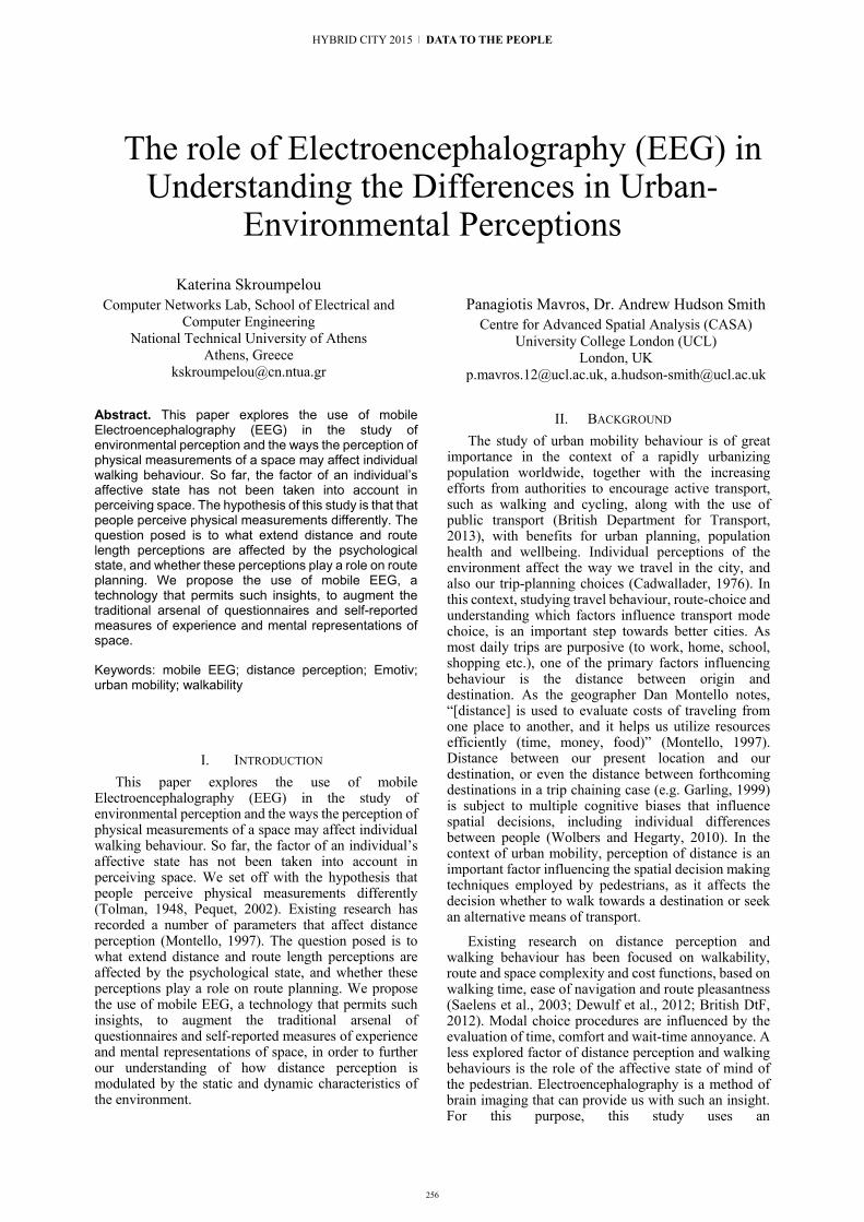
256
The role of Electroencephalography (EEG) in Understanding the Differences in Urban-
Environmental Perceptions
Katerina Skroumpelou Computer Networks Lab, School of Electrical and
Computer Engineering National Technical University of Athens
Athens, Greece [email protected]
Panagiotis Mavros, Dr. Andrew Hudson Smith Centre for Advanced Spatial Analysis (CASA)
University College London (UCL) London, UK
[email protected], [email protected]
Abstract. This paper explores the use of mobile Electroencephalography (EEG) in the study of environmental perception and the ways the perception of physical measurements of a space may affect individual walking behaviour. So far, the factor of an individual’s affective state has not been taken into account in perceiving space. The hypothesis of this study is that that people perceive physical measurements differently. The question posed is to what extend distance and route length perceptions are affected by the psychological state, and whether these perceptions play a role on route planning. We propose the use of mobile EEG, a technology that permits such insights, to augment the traditional arsenal of questionnaires and self-reported measures of experience and mental representations of space.
Keywords: mobile EEG; distance perception; Emotiv; urban mobility; walkability
I. INTRODUCTION This paper explores the use of mobile
Electroencephalography (EEG) in the study of environmental perception and the ways the perception of physical measurements of a space may affect individual walking behaviour. So far, the factor of an individual’s affective state has not been taken into account in perceiving space. We set off with the hypothesis that people perceive physical measurements differently (Tolman, 1948, Pequet, 2002). Existing research has recorded a number of parameters that affect distance perception (Montello, 1997). The question posed is to what extend distance and route length perceptions are affected by the psychological state, and whether these perceptions play a role on route planning. We propose the use of mobile EEG, a technology that permits such insights, to augment the traditional arsenal of questionnaires and self-reported measures of experience and mental representations of space, in order to further our understanding of how distance perception is modulated by the static and dynamic characteristics of the environment.
II. BACKGROUND The study of urban mobility behaviour is of great
importance in the context of a rapidly urbanizing population worldwide, together with the increasing efforts from authorities to encourage active transport, such as walking and cycling, along with the use of public transport (British Department for Transport, 2013), with benefits for urban planning, population health and wellbeing. Individual perceptions of the environment affect the way we travel in the city, and also our trip-planning choices (Cadwallader, 1976). In this context, studying travel behaviour, route-choice and understanding which factors influence transport mode choice, is an important step towards better cities. As most daily trips are purposive (to work, home, school, shopping etc.), one of the primary factors influencing behaviour is the distance between origin and destination. As the geographer Dan Montello notes, “[distance] is used to evaluate costs of traveling from one place to another, and it helps us utilize resources efficiently (time, money, food)” (Montello, 1997). Distance between our present location and our destination, or even the distance between forthcoming destinations in a trip chaining case (e.g. Garling, 1999) is subject to multiple cognitive biases that influence spatial decisions, including individual differences between people (Wolbers and Hegarty, 2010). In the context of urban mobility, perception of distance is an important factor influencing the spatial decision making techniques employed by pedestrians, as it affects the decision whether to walk towards a destination or seek an alternative means of transport.
Existing research on distance perception and walking behaviour has been focused on walkability, route and space complexity and cost functions, based on walking time, ease of navigation and route pleasantness (Saelens et al., 2003; Dewulf et al., 2012; British DtF, 2012). Modal choice procedures are influenced by the evaluation of time, comfort and wait-time annoyance. A less explored factor of distance perception and walking behaviours is the role of the affective state of mind of the pedestrian. Electroencephalography is a method of brain imaging that can provide us with such an insight. For this purpose, this study uses an
HYBRID CITY 2015 | DATA TO THE PEOPLE
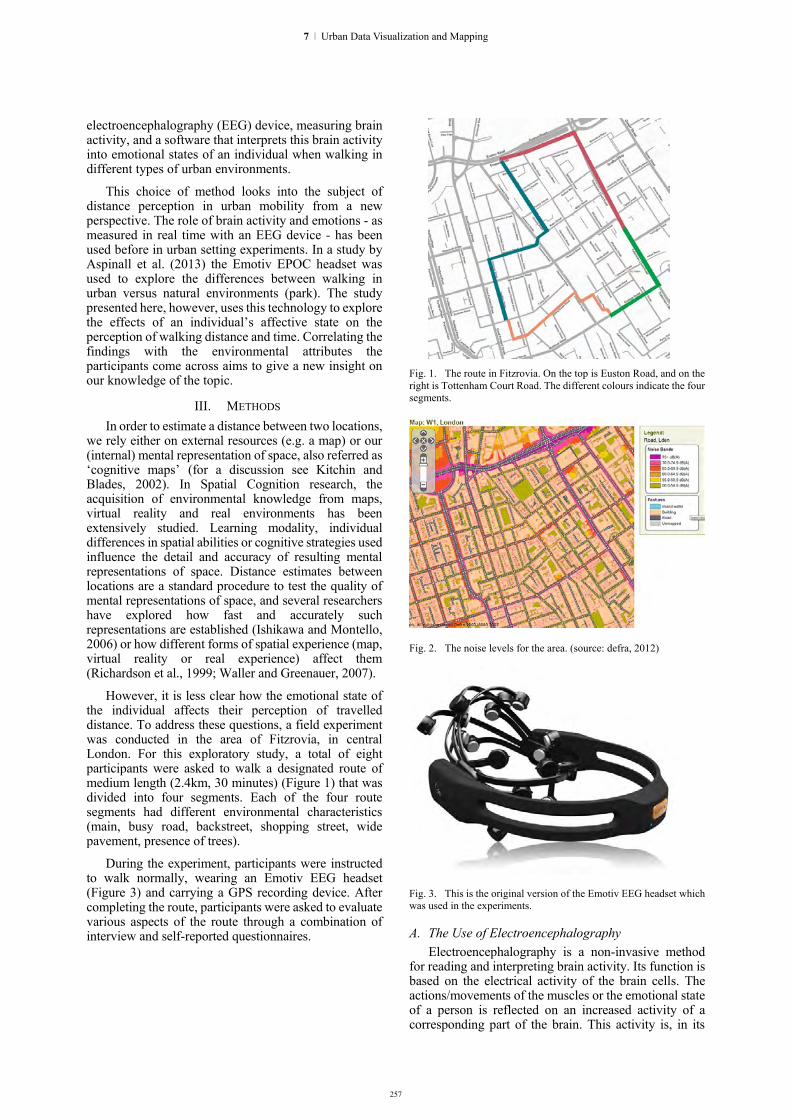
257
electroencephalography (EEG) device, measuring brain activity, and a software that interprets this brain activity into emotional states of an individual when walking in different types of urban environments.
This choice of method looks into the subject of distance perception in urban mobility from a new perspective. The role of brain activity and emotions - as measured in real time with an EEG device - has been used before in urban setting experiments. In a study by Aspinall et al. (2013) the Emotiv EPOC headset was used to explore the differences between walking in urban versus natural environments (park). The study presented here, however, uses this technology to explore the effects of an individual’s affective state on the perception of walking distance and time. Correlating the findings with the environmental attributes the participants come across aims to give a new insight on our knowledge of the topic.
III. METHODS In order to estimate a distance between two locations,
we rely either on external resources (e.g. a map) or our (internal) mental representation of space, also referred as ‘cognitive maps’ (for a discussion see Kitchin and Blades, 2002). In Spatial Cognition research, the acquisition of environmental knowledge from maps, virtual reality and real environments has been extensively studied. Learning modality, individual differences in spatial abilities or cognitive strategies used influence the detail and accuracy of resulting mental representations of space. Distance estimates between locations are a standard procedure to test the quality of mental representations of space, and several researchers have explored how fast and accurately such representations are established (Ishikawa and Montello, 2006) or how different forms of spatial experience (map, virtual reality or real experience) affect them (Richardson et al., 1999; Waller and Greenauer, 2007).
However, it is less clear how the emotional state of the individual affects their perception of travelled distance. To address these questions, a field experiment was conducted in the area of Fitzrovia, in central London. For this exploratory study, a total of eight participants were asked to walk a designated route of medium length (2.4km, 30 minutes) (Figure 1) that was divided into four segments. Each of the four route segments had different environmental characteristics (main, busy road, backstreet, shopping street, wide pavement, presence of trees).
During the experiment, participants were instructed to walk normally, wearing an Emotiv EEG headset (Figure 3) and carrying a GPS recording device. After completing the route, participants were asked to evaluate various aspects of the route through a combination of interview and self-reported questionnaires.
Fig. 1. The route in Fitzrovia. On the top is Euston Road, and on the right is Tottenham Court Road. The different colours indicate the four segments.
Fig. 2. The noise levels for the area. (source: defra, 2012)
Fig. 3. This is the original version of the Emotiv EEG headset which was used in the experiments.
A. The Use of Electroencephalography Electroencephalography is a non-invasive method
for reading and interpreting brain activity. Its function is based on the electrical activity of the brain cells. The actions/movements of the muscles or the emotional state of a person is reflected on an increased activity of a corresponding part of the brain. This activity is, in its
7 | Urban Data Visualization and Mapping

258
turn, reflected on electrical interactions between neurons. When a number of neurons interact (are activated) changes in voltage occur. Electroencephalography uses a number of electrodes placed on standardized sets of locations on to the surface of the skull. These electrodes measure electrical activity picked up from fields that correspond to the combined activity of a number of neurons. The electrodes read better the activity nearest to the point they are placed, thus activity on the cortex is read more accurately, and activity on other parts of the brain is not read at all (Oude, 2007).
For this project, a modified version of the Emotiv EPOC headset (Figure 3) and the Emotiv technology was used. The device has 14 electrodes at the skull locations AF3, F7, F3, FC5, T7, P7, O1, O2, P8, T8, FC6, F4, F8, AF4, having also CMS and DRL locations as references. These locations follow the International 10-20 system for EEG (10/20 System Positioning Manual 2012). Figure 4 highlights the 14 points the Emotiv Headset reads from.
B. Annotation of Events During the Route The hypothesis of this research is that EEG can
capture the effects of static as well as dynamic aspects of the environment on the individual.
However, the brain activity of the individual is influenced by incidental events or situations that occur during the experiment that are not directly relevant to the urban environment. The experimenter, in this case, has to annotate the route with observations of a number of events that occur during the experiment, like the confrontation of an obstacle (another pedestrian for example), or verbal communication.
In order to geo-annotate and timestamp with precision such events, a custom Android application was developed which also enables the experimenter to make these annotations. The app, given the name “Logger” (Figure 5), is collecting data about the phone’s (the experimenters/subject’s) location, speed, GPS recording accuracy, the altitude, the current time in unix epoch time and in human readable format, at a sampling rate of 1Hz. The user can collect behavioural data out of eight “event” options: “Instructions/Talk”, “Pause”, “Obstacle”, “Looks Around”, “Start Walking”, “Hesitates”, “Controlled Crossing”, “Uncontrolled Crossing”. Figure 6 illustrates a map overlaid with the recorded events.
Logger was built in the Android mode of Processing, a java based programming language for creating graphics and visual design. The “Events” as described above, correspond to a number of route elements or walking behaviours that cannot be recorded with the rest of the equipment, but only rely on the observations made by the experimenter. The event names are read into the application via an external text file. This way, the user can change the names without having to edit the code. The app is open-source, available online and is currently being used in more studies, contributing to the toolkit for conducting neuro-behavioural research in natural environments.
Fig. 4. The 10-20 System locations on the skull (the picture is distorted so that all positions are visible)
Fig. 5. The Logger App.
Fig. 6. Events as recorded by the LoggerApp
HYBRID CITY 2015 | DATA TO THE PEOPLE

259
IV. ANALYSIS Analysis of participants’ neural, behavioural and
self-reported data from the routes illustrate the potential of our approach. The software that accompanies the EEG device records this activity and corresponds it to the different ranges. An algorithm is used to calculate the dominant wave or activity. This dominant reading is displayed as an emotion on the screen. The EPOC affectiv suit offers four different mood readings: “Excitement”, “Frustration”, “Meditation” and “Engagement/Boredom”. Based on these, the route segments were ranked from most to least “Frustrating”, “Exciting” and “Boring”. Route segments were also ranked by participants according to 7 characteristics: stressfulness, pleasantness, length, fatigue, scale, light and noise.
Our Analysis was based on the following variables:
Independent Variables Distance Space Syntax Measures Segment Street scale Street type Land Use Junction (yes/ no) Junction Type Location
Dependent Variables Mental States
Excitement Frustration Engagement Meditation
Self-reports Pleasant Noisy Long
For each route, we had a series of continuous EEG data for the route (Figure 7) and a self-reported ranking for the route four segments. In the self-reports, the participants were asked to rank the four route segments according to a number of characteristics (Figure 8). Our intention was to group the experience of the route in these four segments that were each of distinct environmental characteristic. The ranking procedure was conducted as follows. The participants were asked to put the four route segments in an order from the most to least pleasant, stressful, physically tiring, long, dark, noisy. Finally, to put them in order of urban scale measure, as each one of them perceived this term, from larger urban scale to smaller urban scale. When all the rankings were given, a scale from 1 to 4 was used (for the four segments) and transported it to the rankings. So the segment that was ranked, for example, least stressful, takes a ranking of 1, the next more pleasant takes a ranking of two, the next a ranking of 3 and the most pleasant takes a ranking of 4. The same applies to the rest of the characteristics. What these stacked graphs show, is a collective sum of all the rankings for each segment.
This means that the segment that was ranked “most” (pleasant, long, stressful etc) by a lot of participants, has the longest line. This means that the predominant perception of the specific segment is that is was the “most” (pleasant, long, stressful etc), because it received many “most” rankings.
The annotation of the EEG data with the Logger App allowed us to segment the EEG data in these four parts as well, omitting the pauses, the instructions and the talking that took place during the route. For some parts of the analysis, we took the mean of the affective data for each of the route segments, in order to create similar rank-graphs. The data were divided into four parts, each one corresponding to one of the four segments accordingly. The mean value of these fluctuations was calculated for each segment. The new, four, values were then again ranked following the same procedure. The segment that had the smallest value for the mean frustration was ranked with 1, the segment with the largest value for mean frustration was ranked with 4.
Fig. 7. Frustration levels of a participant along the route
Fig. 8. The 8 participants rank the four segments according to how stressful they were.
7 | Urban Data Visualization and Mapping

260
V. RESULTS Distance perception was the main focus of this study.
As expected by the literature, participants could report well when asked to rank the segments from shortest to longest. Interestingly, participants were less accurate between the two of the segments that were of different environmental nature. Each one of them had a characteristic that caused participants to consider them unpleasant and frustrating, the one being busy and noisy, and the other having a complex route with turns.
Fig. 9. The stacked graphs of each characteristic for the first segment. We can see that positive feelings are the lowest here (as recorded by the EEG), the length and stress reports being the highest.
Analysis suggests that the segment that was characterized as tiring, stressful and evoked the least positive feelings (“excitement”) was also perceived as being the longest (Figure 8). There was also a trend between a route being characterized as tiring and long and other environmental attributes such as the lack of light and shops. We tested the Interaction between factors and some results have been observed, indicating a relationship between certain environmental parameters and the presence of negative perceptions and feelings. Comparing self-reported with direct measures of affect, the routes that were reported to be the shortest were the ones with the highest “excitement” levels, meaning the ones where positive feelings were dominant.
Fig. 10. Frustration levels of a participant and all the events along the route.
The Logger App, as we said, allowed us to record the moments were some elements appeared during the route, such as crossings and obstacles. Figure 9 illustrates this spatial diagram overlaid by the events as recorded by Logger.
“Frustration” levels were affected significantly by obstacles on the pathway, and influenced the perception of a route as long, tiring and unpleasant. The complexity of the route also played a significant role in characterizing a route tiring, but had little impact on “frustration” levels.
Fig. 11. Distributions of the means of the recorded frustration values near obstacles and uncontrolled crossings as compared to the mean of all participants’ frustration readings. There are more high frustration readings than the mean of general frustration.
A. Event Analysis In order to explore the effects of subjective
experience and individual incidents, we used a Neuroscience approach named “Event-Related Potential” (ERP) which studies brain activity in response to particular visual, auditory or other stimuli (Picton et al., 2000). In Neuroscience, the ERP method compares the neural signal during two different conditions (e.g. baseline vs stimulus) to determine whether and how a certain brain area is engaged in a particular task. In our research context, we were interested in the effects of a variety of incidental events, such as verbal communication, the confrontation of an obstacle, a busy (or uncontrolled) crossing. By geo-annotating and time-locking these “events” to the EEG data, we can explore how these correspond to different neural activity or emotion state. Two important differences with classic ERP studies and this research is that in a naturalistic experimental paradigm (urban walk) there is a variety of stimuli and, secondly, we have so far compared the emotional state levels (interpreted EEG) and not the raw signal. The frustration of the subjects peaks during an encounter with an obstacle and declines considerably after 30 seconds, close to the initial state before the obstacle. Some peaks of frustration appear also at crossing points, and at points where the environmental situation changes, like in the transitions from a busy street to a quiet street. Figure 12 illustrates a number of graphs with similar observations around uncontrolled crossings and obstacles. Frustration peals around such
HYBRID CITY 2015 | DATA TO THE PEOPLE

261
occurrences. Around controlled crossings we also have high frustration peaks, with most frustration values being high.
Fig. 12. Frustration peaks after the encounter with an obstacle (vertical line) or around an uncontrolled crossing.
Fig. 13. Means of frustration values around obstacles and uncontrolled crossings. Red shows mean of general frustration
Fig. 14. Distributions of the maximum frustration readings around controlled crossings, uncontrolled crossings and obstacles.
The histogram in figure 13 illustrates the distributions of the means of the recorded frustration
values near obstacles and uncontrolled crossings as compared to the mean of all participants’ frustration readings. This reveals that there are more high frustration readings than the mean of general frustration. Figure 14 illustrates the distributions of the maximum frustration readings around controlled crossings, uncontrolled crossings and obstacles. This shows that there are more high frustration readings for uncontrolled crossings and obstacles
VI. CONCLUSIONS The results of this study show that route pleasantness,
route tiredness and route length are not necessarily correlated. A connection between a route being characterized as tiring and as stressful was indeed visible, however length seemed to be less depended on these attributes. Another correlation was apparent, between a route being short and a participant feeling more excited, however a solid conclusion cannot be drawn, due to other variables, such as stressfulness and annoyance. We did see however that people seem to value more the pleasantness of the route and the comfort of walking than the length, and this was apparent in the EEG recordings (high excitement accordingly). On the other hand, high frustration levels were triggered when a participant was asked to memorize a complex path and many directions. Finally, there could be a connection between negative feelings (high frustration readings) and an overestimation of length (long route reports).
VII. DISCUSSION AND FUTURE WORK In order to have accurate results from which strong
conclusions can be drawn about city planning, further work needs to be done, which would include recruiting more participants. The planning of this experiment, nevertheless, can work as an example that will set a new paradigm on how such kind of research (combining EEG with urban studies) can be conducted in the future, exploring how this technology might support innovative architecture and urban planning strategies.
The results of such studies contribute in our better understanding of the role of urban planning. Handy et al., 2002, insist on evidence that “a combination of urban design, land use patterns, and transportation systems that promotes walking and bicycling will help create active, healthier, and more livable communities”. Furthermore, as the American Planning Association eloquently notes, urban planning “improves the welfare of people and their communities by creating more convenient, equitable, healthful, efficient, and attractive places for present and future generations”, also acting as an enabler for the creation of strong communities. On the other hand, we continue to live in cities that urban planning has not met its stated purpose. The reasons are always complex, and design alone will not be enough, without the corresponding education, culture and customs. However, if this one arbitrary parameter of “feeling” and “”perception” is attempted to be measured, a valuable insight can be offered to us, planners, of how people respond to the labeled “attractive” and “convenient” planning. This study produces some valuable results, however it can also serve as a case study of a wider
7 | Urban Data Visualization and Mapping

262
subject, possibly pointing to new methods of evaluating the efficiency of urban design.
An innovative use of mobile EEG was used to investigate walking behaviour, the impact of environmental attributes on individuals’ state of mind and people spatial perceptions. This study suggests that we should not support our planning based solely on physical measurements. This is because each individual perceives a different reality through the experience of the same space, accurately measured with the instrumentation of architects and planners.
If we want to start taking into account a bottom-up strategy of planning, including the reality of street life and leaving apart the ideal of a fully organized and clockwork metropolis, we have to start taking into account the individual and their perception. In an era when smart city visions designed on an unreal corporate basis are starting to become a norm, if we want to keep the evolution of the future city real and going, we need to take a step back and focus on the microscale.
ACKNOWLEDGEMENTS We would like to thank the Future Cities Catapult for
kindly providing the research equipment, as part of the Cities Unlocked collaboration. PM was financed with an academic scholarship by the A.G. Leventis Foundation.
REFERENCES [1] American Planning Association. (2010). What is Planning?.
Available: https://www.planning.org/aboutplanning/whatisplanning.htm. Last accessed March 12th, 2015.
[2] Aspinall, P., Mavros, P., Coyne, R., & Roe, J. (2013). The urban brain: analysing outdoor physical activity with mobile EEG. British Journal of Sports Medicine, 1, 1–7. doi:10.1136/bjsports-2012-091877
[3] British Government, Department for Environment, Food and Rural Affairs, Noise Mapping, 2012, available at http://services.defra.gov.uk/wps/portal/noise)
[4] British Government, Department for Transport, “Understanding and Valuing the Impacts of Transport Investment”, October 2013
[5] British Social Attitudes Survey 2011: Public Attitudes Towards Transport, Department for Transport, Copyright 2012
[6] Dewulf, B., Neutens, T., Van Dyck, D., De Bourdeaudhuij, I., & Van de Weghe, N. (2012). Correspondence between objective and perceived walking times to urban destinations: influence of physical activity, neighbourhood walkability, and socio-demographics. International journal of health geographics, 11, 43.
[7] Garling, T. (1989). THE ROLE OF COGNITIVE MAPS IN SPATIAL DECISIONS. Journal of Environmental Psychology, 9, 269–278.
[8] Handy, S. L., PhD, Marlon G Boarnet, PhD, Reid Ewing, PhD, Richard E Killingsworth, MPH. (2002). How the built environment affects physical activity. American Journal of Preventive Medicine. 23 (2), Pages 64–73.
[9] Ishikawa, T., & Montello, D. R. (2006). Spatial knowledge acquisition from direct experience in the environment: individual differences in the development of metric knowledge and the integration of separately learned places. Cognitive Psychology, 52(2), 93–129. doi:10.1016/j.cogpsych.2005.08.003
[10] Kitchin, R., & Blades, M. (2002). The cognition of geographic space (Vol. 4). IB Tauris.
[11] Meilinger, T., Frankenstein, J., & Bülthoff, H. H. (2013). Learning to navigate: Experience versus maps. Cognition, 129(1), 24–30. doi:10.1016/j.cognition.2013.05.013
[12] Montello, D.R. (1997). The perception and cognition of environmental distance: Direct sources of information. In Spatial Information Theory A Theoretical Basis for GIS. Lecture Notes in Computer Science. Springer Berlin Heidelberg, pp. 297-311.
[13] Picton, T. W., Bentin, S., Berg, P., Donchin, E., Hillyard, S. A., Johnson, R., Miller, G., Ritter, W., Ruchkin, D., Rugg, M. and Taylor, M. J. (2000). Guidelines for using human event-related potentials to study cognition: recording standards and publication criteria. Psychophysiology, 37(02), 127-152.
[14] Richardson, A. E., Montello, D. R., & Hegarty, M. (1999). Spatial knowledge acquisition from maps and from navigation in real and virtual environments. Memory & Cognition, 27(4), 741–50. Retrieved from http://www.ncbi.nlm.nih.gov/pubmed/10479831
[15] Saelens, B.E., Sallis, J.F. & Frank, L.D. (2003). Environmental correlates of walking and cycling: findings from the transportation, urban design, and planning literatures. Annals of behavioral medicine: a publication of the Society of Behavioral Medicine, 25(2), pp.80-91.
[16] Waller, D., & Greenauer, N. (2007). The role of body-based sensory information in the acquisition of enduring spatial representations. Psychological Research, 71(3), 322–32. doi:10.1007/s00426-006-0087-x
HYBRID CITY 2015 | DATA TO THE PEOPLE

AUGMENTED [URBAN] SPATIAL ExPERIENCES

264
"Ghost - Athens": A mobile application about the unknown buildings and street art of Athens
Stavroula Bampatzia, Angela Antoniou, George Lepouras
Department of Informatics and Telecommunications University of Peloponnese
Tripolis, Greece
Violeta Bampatzia Department of Architecture
University of Thessaly
Athena Lountzi Hellenic Telecommunications Organization
Abstract. This paper presents an initial approach towards designing and implementing a mobile application for discovering historic buildings and street art at the city of Athens. This application will be a location based mobile game providing city guides with personalized content to the users. It will be able to adapt to their preferences and redefine their route. It will also give visitors the opportunity to interact with the buildings and share their experiences with their friends through social media.
Keywords: smart cities; mobile applications; user profiling; social media; location-based technology, games
I. INTRODUCTION
It is common that in cities with great cultural heritage, visitors tend to focus their attention on the most famous landmarks (e.g., museums and archaeological sites) and pay less attention towards discovering and learning about the history of contemporary buildings with important cultural heritage. An example of such phenomenon can be observed in the city of Athens, which is a dynamic urban space full of contrasts between old and new spatial configurations of people, buildings and graffiti, which reached Greece in the end of the ’80s [1,2]. Athens is a city not only with famous ancient buildings and ruins, but also with lesser known contemporary buildings and urban landmarks with a rich historical background and architectural value. The objective of this mobile application is to highlight such buildings and urban art landmarks of Athens, using gamification methods, to attract its users to visit them and interact with them. It is common that the majority of mobile city applications have been developed for tourists as mobile guides and less as location-based mobile games. Some exceptional paradigms of location-based mobile games are REXplorer [3], Frequency 1550 [4] and CityExplorer [5], which were influential in designing mobile city applications. However, the above applications did not offer users the chance of sharing their experience through the application in social media. Our aim is to provide urban sociability [6] and to encourage people to rediscover their city with their friends.
II. RELATED WORK Over the last years various city guides have been
developed for different purposes [7]. Many of those directly target the visitors of cities and assist them in their sightseeing tour, incorporating smart techniques to allow visitors to increase the quality of their experience in a time-effective manner [8]. In addition, city guides can provide opportunities for creating personalized experiences. For instance, Curated City allowed visitors to create their own and unique guide by adding their favourite experiences, while they were also exposed to the content of other users [9]. The possibility of content co-creation among city guide users has been also explored in the past. As an example of such approaches, a past work focused on the creation of a 3D guide using image data captured by its users [10]. It seems that city guides can be a good application field for location based recommendation systems that can have multiple applications within the cultural heritage and beyond, like various smart city services [11].
Furthermore, personalization seems to be important for the location based systems, like city guides [12]. There is an increasing need to provide “the right type of information to the right person at the right time and the right location” [13] and many research works focus on personalization and profiling issues for context-specific applications (see [13] for a review and taxonomy of such applications). When it comes to personalization and in particular user profiling, different researchers apply different solutions in order to capture user needs and interests [12]. A common approach is to allow users to provide their feedback while using the application and the application analyses past location /item reviews and suggests new accordingly [14]. It is also common to review what past users have liked and suggest new users with similar profiles the same items [15]. Despite, however, the different approached in user profiling for location based systems, most researchers agree that providing personalized information is important and it should be therefore explored further.
In addition, there are numerous applications for location based mobile games. The vast interest in the
HYBRID CITY 2015 | DATA TO THE PEOPLE

field has produced new knowledge in the form of new use cases as well as in the form on new conceptual and theoretical frameworks, incorporating mainly three characteristics: mobility, sociability and spatiality [16]. The real world becomes a game setting and game reality blends into the everyday reality of users and in order to do that carefully design is needed [17]. Bringing location into game design is not a straightforward process and many aspects of the external environment need to be taken into consideration (see for example [18] in an attempt to “design for coincidence”). Being a relatively new field implies that tools and techniques are developing in order to offer as rich experiences as possible [19]. Different types of cutting edge technology, like augmented reality, are also used [20] in many cases allowing multiuser interaction [21].
Finally, despite the fact that there are: 1. various mobile city guides, many also applying personalization and user profiling techniques and 2. numerous location based mobile games, to the authors’ best knowledge there are no location based games creating user profiles and providing personalized content. The present work is among the first to combine gaming elements with city wide personalized applications.
III. Method As we mentioned before, our application will focus
on personalization. Based on personalized applications for cultural heritage, which retrieve user data from social media such as Youtube, Pinterest, Instagram, Twitter and Facebook [22,23,24,25], we will follow both implicit and explicit methods of personalization [26]. To explore the initial user's profile, we will ask users their age, their available time and their interests (buildings with architectural value, cultural value, historical value, food-service establishments, buildings related to war and street art) using three so called “cold start questions”. During the game, the user's profile will be updated according to the user's actions in relation to the proposed routes. Moreover, we decided to collect more data for the user's cognitive style from Facebook as it is one of the most popular networks in Greece. In the recent years there are successful attempts to elicit personality traits on observations on social media use. For example, [27,28,29] studied personality assessments entirely based on Facebook and Twitter observations (i.e. number of friends, number of posts, number of photos etc.).This will happen if users choose to sign in the application via their Facebook account.
Our approach combines the computing, visualization and sonification capabilities of mobile devices. The application will present a map of the city centre of Athens, where some pins will show up. Each pin will represent a landmark. In the application there will be 5 different routes (see Figure 1). As there is not an official online library for street art in Athens, we tried to record some graffiti of famous street artists and we also collected information from books related to street art and lesser known buildings [30,31] in order to create a database for the routes.
Cognitive style can provide information on a users’ behavior and way on thinking as well as provide indications about personal interests [26]. Therefore it can be used to derive a series of personalization rules fitting a group of user with similar cognitive style [32]. In order to assess individuals’ cognitive styles, a known, valid and reliable tool is MBTI (Myers-Briggs Type Indicator) [33]. The MBTI is based on Jung’s theory of psychological types. Individuals are described using four dimensions: extraversion-introversion (individual’s focus of attention), sensing-intuition (the way an individual gathers information), thinking-feeling (the way an individual makes decisions) and judging-perceiving (the way an individual deals with the external environment). The combination of the four dimensions offers 16 personality types. Thus, we believe that the cognitive style of users will help us to propose the most suitable route to them.
Fig. 1. Potential routes in the application (red line - route with
buildings of architectural value , pink line- route with food-service establishments, yellow line - route with street art, green line- route with buildings of cultural value & blue line - route with building
related to war)
To that end, a short quiz will be presented to the users during their first login to the application to identify her personality type based on the MBTI cognitive tool, unless they decide to log in with Facebook. In the case of Facebook log in, the information on cognitive style will be automatically derived. Additionally, we will develop an algorithm, which will have as parameters the interests of users, their available time, their cognitive style and their age. Using that input the algorithm will propose a predefined route to be followed. For instance, if someone is an extrovert, from 18 to 30 years old, her available time is more than 1 hour and she is interested in pop art or contemporary art, the system will propose to her an appropriate route with a large number of locations containing street art.
However, the user will not be limited to this route but she will be able to modify it in order to visit other recommended places appearing on the map, places near her current location (see Figure 2). At the same time, she will be able to rate the buildings, street art and other landmarks in a 1-5 star-based scaled rating system. According to the user’s ratings, the proposed route will
265
8 | Augmented [Urban] Spatial Experiences

266
be readjusted. In addition, users will have the choice to listen to some stories about the structure of the landmarks, the time that they were built, their architects, the uses of the buildings and some relevant stories about them. The stories of a particular building will become available to the user as soon as geolocation tracking indicates that her actual position is close to it.
Fig. 2. Route modified by the user
In order to enhance the user's experience in the city, we will try to embed gamification elements in the application. In game design, different important characteristics are: the degree of complexity [34,35], the number of players, the themes (i.e. Action, Adventure, Strategy etc. [36] and the interaction mode (1st person, 3rd person, adaptive, etc.). Other important characteristics are the target audience (e.g. schools, families, adults, etc), the game flow, the game aesthetics (look and feel), the game scope, the game play, the mechanics, the interface design and the technology used (e.g. the location could be online, onsite or both, the platform used could be mobile, desktop, virtual reality, etc.).
Based on the above game characteristics, it was decided that the application would be a single player "treasure-key hunting" game. It would go beyond simple game interactions since the user will be asked to locate some keys (parts of building) and scan them in order to unlock more landmarks in the map during the tour. This information will lead the user to carefully observe the structures and not focus her attention solely to the application. This application has adults as its main target group. There are very simple rules that apply to all levels and users should simply follow the on-screen instructions to extend the proposed route. The main objective of the user is to unlock a story, which connects the buildings that they have visited.
Finally, we will use Facebook as a communication medium, through which users will have the opportunity to share their experience with the application in their social network. In detail, they will be able to share their route in the city of Athens, including the buildings and landmarks visited and/or pictures taken via their profile. Each user will be able to create a personal database of
images of buildings, graffiti and other content inside that profile. That content can be private as a personal diary of use or it can be publically shared with other users after it has been approved by the administrator of the system, thus further populating the application. Thus, users will contribute dynamically to the creation of more routes inside the application. Moreover, due to the ephimeral character of the street art, it is important that the application will allow users to provide content and will be updated with the latest graffiti. It will also encourage users to tag their friends in particular locations in order to inform them of places that they would find interesting to visit, as a way to attract more users, therefore increasing the popularity of the application [37,38,39].
IV. Conclusion Our purpose is to design and develop a mobile
application through which visitors and citizens of Athens will observe and explore parts of the city from a new perspective. It is important to notice that we do not only aim to develop yet another application simply for providing sightseeing suggestions for the city of Athens, but also a tool for collecting data about the preferred routes of visitors within the city. Thus this application could be beneficial towards creating new cultural routes in the city of Athens.
REFERENCES
[1] S. Drakopoulou, 'Urban Praxis Athens 2012. An analysis and exploration of locative-media projects made in Athens, based on Lefebvre’s lived experience analysis and rhythmology method.', in Media Cities. International Conference, Workshops and Exhibition, 2013, p. 132.
[2] K. Avramidis and S. Drakopoulou, 'Graffiti crews’ potential pedagogical role', Journal for Critical Education Policy Studies, vol. 10, no. 1, pp. 327-340, 2012.
[3] R. Ballagas, S. Kratz, J. Borchers, E. Yu, S. Walz, C. Fuhr and M. Tann, 'REXplorer: a mobile, pervasive spell-casting game for tourists', in CHI'07 extended abstracts on Human factors in computing systems, 2007, pp. 1929-1934.
[4] S. Akkerman, W. Admiraal and J. Huizenga, 'Storification in History education: A mobile game in and about medieval Amsterdam', Computers & Education, vol. 52, no. 2, pp. 449-459, 2009.
[5] A. Silva and J. Frith, Mobile interfaces in public spaces. New York: Routledge, 2012.
[6] S. Matyas, C. Matyas, C. Schlieder, P. Kiefer, H. Mitarai and M. Kamata, 'Designing location-based mobile games with a purpose: collecting geospatial data with CityExplorer', in The 2008 international conference on advances in computer entertainment technology, 2008, pp. 244-247..
[7] M. Kenteris, D. Gavalas and D. Economou, 'Electronic mobile guides: a survey', Pers Ubiquit Comput, vol. 15, no. 1, pp. 97-111, 2010.
[8] E. Hornecker, S. Swindells and M. Dunlop, 'A mobile guide for serendipitous exploration of cities', in the 13th International Conference on Human Computer Interaction with Mobile Devices and Services, New York, NY, 2011, pp. 557-562.
[9] J. Cranshaw, K. Luther, P. Kelley and N. Sadeh, 'Curated city: capturing individual city guides through social curation', in The SIGCHI Conference on Human Factors in Computing Systems, New York, NY, 2014, pp. 3249-3258.
[10] T. Jehaes, J. Dierckx, P. Quax, W. Lamotte and G. Jans, 'An interactive 3D mobile city guide supporting user driven content creation', in The IASTED International Conference on Internet and Multimedia Systems and Applications (EuroIMSA '08), 2008, pp. 194-201.
HYBRID CITY 2015 | DATA TO THE PEOPLE

[11] R. Seeliger, C. Krauss, A. Wilson, M. Zwicklbauer and S. Arbanowski, 'Towards Personalized Smart City Guide Services in Future Internet Environments', in the 24th International Conference on World Wide Web Companion (WWW '15 Companion), Geneva, Switzerland, 2015, pp. 563-568.
[12] K. Kabassi, 'Personalizing recommendations for tourists', Telematics and Informatics, vol. 27, no. 1, pp. 51-66, 2010.
[13] C. Emmanouilidis, R. Koutsiamanis and A. Tasidou, 'Mobile guides: Taxonomy of architectures, context awareness, technologies and applications', Journal of Network and Computer Applications, vol. 36, no. 1, pp. 103-125, 2013.
[14] Y. Takeuchi and M. Sugimoto, 'A user-adaptive city guide system with an unobtrusive navigation interface', Pers Ubiquit Comput, vol. 13, no. 2, pp. 119-132, 2007.
[15] P. Di Bitonto, M. Laterza, T. Roselli and V. Rossano, 'Multi-criteria retrieval in cultural heritage recommendation systems', in The 14th international conference on Knowledge-based and intelligent information and engineering systems: Part II(KES'10), 2010, pp. 64-73.
[16] A. de Souza e Silva, 'Hybrid Reality and Location-Based Gaming: Redefining Mobility and Game Spaces in Urban Environments', Simulation & Gaming, vol. 40, no. 3, pp. 404-424, 2008.
[17] C. Neustaedter, A. Tang and T. Judge, 'Creating scalable location-based games: lessons from Geocaching', Pers Ubiquit Comput, vol. 17, no. 2, pp. 335-349, 2011.
[18] J. Reid, 'Design for coincidence: incorporating real world artifacts in location based games', in The 3rd international conference on Digital Interactive Media in Entertainment and Arts, New York, NY, 2008, pp. 18-25.
[19] J. Procyk and C. Neustaedter, 'GEMS: the design and evaluation of a location-based storytelling game', in the 17th ACM conference on Computer supported cooperative work & social computing, 2014, pp. 1156-1166.
[20] M. Lochrie, K. Pucihar, A. Gradinar and P. Coulton, 'Designing seamless mobile augmented reality location based game interfaces', in International Conference on Advances in Mobile Computing & Multimedia (MoMM '13), 2013, pp. 412-415.
[21] K. Diamantaki, C. Rizopoulos, D. Charitos and N. Tsianos, 'Theoretical and methodological implications of designing and implementing multiuser location-based games', Pers Ubiquit Comput, vol. 15, no. 1, pp. 37-49, 2010.
[22] M. Feinberg, G. Geisler, E. Whitworth and E. Clark, 'Understanding personal digital collections: an interdisciplinary exploration', in Designing Interactive Systems Conference, 2012, pp. 200-209.
[23] A. Weilenmann, T. Hillman and B. Jungselius, 'Instagram at the museum: communicating the museum experience through social photo sharing', in The SIGCHI Conference on Human Factors in Computing Systems, 2013, pp. 1843-1852.
[24] Y. Lin, X. Bai, Y. Ye and W. Real, 'Constructing narratives using fast feedback', in The 2012 iConference, 2012, pp. 486-487.
[25] A. Talavera, A. Darias, P. Rodríguez and L. Ávila, 'Facebook, heritage and tourism reorientation. The cases of Tenerife and Fuerteventura (Canary Isles, Spain)', International Journal of Web Based Communities, vol. 8, no. 1, p. 24, 2012.
[26] A. Antoniou and G. Lepouras, 'Modeling visitors' profiles', JOCCH, vol. 3, no. 2, pp. 1-19, 2010.
[27] G. Park, H. Schwartz, J. Eichstaedt, M. Kern, M. Kosinski, D. Stillwell, L. Ungar and M. Seligman, 'Automatic personality assessment through social media language.', Journal of Personality and Social Psychology, vol. 108, no. 6, pp. 934-952, 2015.
[28] D. Hughes, M. Rowe, M. Batey and A. Lee, 'A tale of two sites: Twitter vs. Facebook and the personality predictors of social media usage', Computers in Human Behavior, vol. 28, no. 2, pp. 561-569, 2012.
[29] Y. Bachrach, M. Kosinski, T. Graepel, P. Kohli and D. Stillwell, 'Personality and patterns of Facebook usage', in 4th Annual ACM Web Science Conference, 2012, pp. 24-32.
[30] J. Goldstein, Athens street art. Athens [Greece]: Athens News, 2008.
[31] T. Giochalas and T. Kafetzaki, Athens: Tracing the city guided by the history and literature. Athens, Greece: Hestia Publications, 2012. (in greek)
[32] A. Antoniou, I. Lykourentzou, J. Rompa, E. Tobias, G. Lepouras, C. Vassilakis and Y. Naudet, 'User Profiling: Towards a Facebook Game that Reveals Cognitive Style', Games and Learning Alliance, pp. 349-353, 2014.
[33] I. Myers, M. McCaulley and R. Most, Manual, a guide to the development and use of the Myers-Briggs type indicator. Palo Alto, Ca.: Consulting Psychologists Press, 1985.
[34] F. Bellotti, R. Berta, A. De Gloria, A. D'ursi and V. Fiore, 'A serious game model for cultural heritage', JOCCH, vol. 5, no. 4, pp. 1-27, 2012.
[35] M. Prensky, 'Complexity matters', Educational Technology, vol. 45, no. 4, pp. 1-15, 2005.
[36] I. Kekes, 'Playing e-games in the classroom: advantages and prospects', in The 3rd ETPE Conference, 2002.
[37] L. Fosh, S. Benford, S. Reeves and B. Koleva, 'Gifting personal interpretations in galleries', in The SIGCHI Conference on Human Factors in Computing Systems (CHI '14), 2014, pp. 625-634.
[38] L. Ardissono and D. Petrelli, 'Preface', User Modeling and User-Adapted Interaction, vol. 18, no. 5, pp. 383-387, 2008.
[39] L. Ardissono, T. Kuflik and D. Petrelli, 'Personalization in cultural heritage: the road travelled and the one ahead', User Model User-Adap Inter, vol. 22, no. 1-2, pp. 73-99, 2011.
267
8 | Augmented [Urban] Spatial Experiences

The Lure of CyberPark Synergistic Outdoor Interactions between Public Spaces, Users
and Locative Technologies1
Konstantinos Ioannidis School of Architecture
Aristotle University of Thessaloniki Thessaloniki, Greece
Carlos Smaniotto Costa LE3P - Experimental Lab on Communication,
Education and Public Spaces, Universidade Lusófona
Lisbon, Portugal [email protected]
Ina Suklje-Erjavec Urban Planning Institute of the Republic of Slovenia
Ljubljana, Slovenia
Marluci Menezes National Laboratory for Civil Engineering (LNEC)
Lisbon, Portugal [email protected]
Alfonso Bahillo Martínez Universidad de Deusto
Bilbao, Spain [email protected]
Abstract. This paper highlights the emerging concept of the CyberPark - the hybridized relationship between open public places and technologically mediated urban activity patterns. The concept questions whether urban space can keep binding people and their outdoor practices in new meaningful ways, but in fact, what is being asked is whether the relationship between ICT, open public spaces and urban activities can open up creative pathways for a multidisciplinary field. Projecting the transformative shifts not only in the way people choose, move and experience open spaces in cities but also from the impacts of the extensive outdoor use of digital media technologies such as wireless sensor networks, GNSS or cellular networks enabled by mobile devices, into the same coordinate space can transform the oppositional conditions in our understanding of the stroller/machine relationship. This paper introduces a synergistic user-centred methodology for deriving effective strategies for the appropriation and use of wireless urban spaces. To achieve this, it unfolds the first results from the CyberParks Project to help us locate its concept into the possibility of an enhanced form of open urban space that exceeds the “any space”.
1 COST Action TU 1306: CyberParks - Fostering knowledge about the relationship between Information and Communication
Technologies and Public Spaces supported by strategies to improve their use and attractiveness. The Action is financed by COST – European Cooperation in Science and Technology. For more see http://www.cost.eu, http://www.cost.eu/COST_Actions/ tud/Actions/TU1306 and the project’s website at www.cyberparks-project.eu.
Keywords: digital media, public open spaces, hybridised spaces, Cyberpark.
I. INTRODUCTION The emerging reality of new, wireless, forms of urban
spaces challenges the traditional idea for democratic outdoor space-appropriation and social engagement [1]. When considering the expression of the neo-analogue forms of activities that postdigital technologies cultivate based on socio-personal man/object interactions and online storytelling communication and information possibilities (CHESS project, Playful City, Smart City, intelligent urban furniture), this reality is one that readdresses the conception of our outdoor life distinct from its dateless tangible bond with materiality (physical surroundings, spatial features within etc.). While human tasks are in a way even more pervasively regulated by machines, the humanistic content of the interaction often raises them in a more conceptual level. Florian Cramer,
268
HYBRID CITY 2015 | DATA TO THE PEOPLE

269
writing for A Peer Reviewed Journal About Post-Digital Research (APRJA), described them as “neo-analog do-it-yourself” approaches that distant themselves from their “post-digital” predecessors that were simply referring “to a state in which the disruption brought upon by digital information technology has already occurred” [2]. Here, the term “neo-analog” does not refer to a chronological descendant of the post-digital, but to a shift that opens up a new perspective to be emerged, one that expresses itself in complex patterns of user-to-user-to-machine interrelated activities, interlinked variables, and so forth. To some extent, we can trace such interactive tendencies in different neo-analog projects found around the web: generative mindmaps, force-feedback algorithms, digital semantic relations, applications for visual music etc.
Similarly, and during the last years, the wireless dimension of the urban space seems to have received a more dynamic and hybridized form, mostly because it is not any more recognized as a simple spatial unit. Wireless connectivity has transformed it into an (even more) complex system that is part spatial, part immaterial and interactive [3], [1], [4], [5]. In this paper, we approach the CyberParks Project (COST TU1306) as such a complex system to develop a method of understanding how people use media and locative technologies in their attempt to appropriate and make sense out of space’s new intangible properties. In the complex nature of the field, in a parallel way, the interest of ICT remains spatial in terms of improving planning and make it more participatory, since through ICTs people could contribute information to be useful, for example, to improve intervention in public spaces.
The first wave of outdoor cyber-mediated spaces were mostly focused around artistic modalities. Smart urban furniture with embedded media objects (from sounds and images to projections and lighting) were called to attract –maybe temporarily- some public attention and interest. Lately, more practical urban uses and services like mobile charging, wireless sensor network hotspots and urban sensing opportunities for measuring, for example, air pollution were also employed within benches, post-boxes or public lighting in an attempt to make people more engaged in an effective use of -the otherwise- empty open public space. Now, a place-based IT mediated community [6] is emerging from the cross points of our mobile activities and the physio-virtual organization of public space. In this sense, and as of this writing, locomotional participation, agency and interactivity between the user and the digitally displayed or wirelessly transmitted material seem to appear more and more often as elements of an evolved mode of cyberspatial outdoor experience.
This work defines CyberParks as synergistic urban landscapes that operationalize physical and digital syntaxes to foster multipurpose communication opportunities amongst different parts of their systems. It definitely expands Frick’s definition of the supportiveness of public space that concerns the relationship between “people and things” beyond its
ii See more at http://cyberparks-project.eu/app
clearly physical-spatial characteristics [7] to relocate our appreciation of “things” and connect their materiality to a growing digital world. In line with this, the research suggests a rather synergistic human-agent methodology [8] for CyberParks to understand the role of ICT on the basis of the mending mechanisms that space induces to users as a result of the man/environment interaction [9], [10]; traditionally this is termed as cognitive constructs but the way they can shape outdoor hybrid configurations is yet unexplored. In this sense, a synergistic methodology for CyberParks reflects, on one hand, personal decisions, significances given and preferences of the people involved within their premises but, on the other, the reflection presents a significant difference: it is based on the combination of users’ analogue and digital responses to external stimuli to help us comprehend the effects from the use of such hybrid spaces on spatial experience. The method to extract synergies from within such complex landscapes consists of examining the possibility of an underlying cognitive base [11] in the software agent automation proposed during the project (starting from the WAY CyberParksii application and its future development) to determine whether ICT in urban space are supportive of cognitive processes. Synergistic dimensions of the CyberParks are important because the exploration of the cognitive aspects of the employed tools can humanize the strictly algorithmic nature of the method and then response strategies for the formation of local space, ICT, and user ties can be quested. Can media and locative technologies affect an outdoor user’s experience span? Is it possible for applications running in smart phones and tablets contribute to a stronger (or different kind of) social engagement that foster a sense of participation and enhance his/her ability to understand the wireless public realm and online social diversity? If so, how desirable and how prepared are we for this? Finally, how ICT can help us to improve public space by focusing on its participators and sending useful for the planning process information?
II. BACKGROUND The following discussion on the “lure” of the
technologically enhanced public spaces (CyberParks) and the spectacle of their wireless image initiates from interweaving the immateriality of the supported computational environment with the geography of the material urban space and the cognitive skills of its user. The project, embarked on April 2014 [e], has so far explored the relationship between space, people and mobile technologies in three supplementary but distinct ways:
First, through a position informatics framework in which a mobile application has been initially developed to map the position of its user (Fig. 01, 02) and provide information on his/her orientation and moving preferences inside open urban spaces based on its spatial and virtual affordances for ICT interaction (mostly quiet places with free wireless sensor network spots for internet surfing, chatting and instant messaging). This
8 | Augmented [Urban] Spatial Experiences

270
framework offered valuable, but rather limited, information for identifying emerging outdoor lifestyles as dominated by screen action and for exploring further their impacts on space. One problem regarding the limitation of the position informatics approach as a research framework to track visitors’ stationary and moving patterns in areas with multiple convex spaces was that it could not effectively record those spatial imperatives (configurations, architectural facilitators etc.) and syntactic measures (connectivity or integration) [12] contributing to user’s behavioural shift. The same limitation occurred in terms of mapping the wireless and digital facilitatorsiii responsible for the above-mentioned shift. In Lisbon (June 2014), the two case studies of the Parque da Quinta das Conchas and the Jardim da Estrela employed this newly developed locative application accompanied with a traditional survey method (questionnaires, Fig.03) given to the visitors. The focus was to study how moving patterns were subjects to change depending on not only the spatial specification and configuration of each green setting but also on the immaterial conditions and networks established within them. For example, by changing, restricting or replacing nodes of the network where man/machine interaction was supported (in the case of Jardim da Estrela wireless sensor network access wasn’t available, being replaced by GNSS monitoring devices and splitting visitors in six large groups) it became apparent that space appropriation and occupancy could also change respectively based on the location of digital facilitators. A comparison technique between visual data representations (tracks mapped on Google Earth Map) illustrates how free wireless sensor network provision affects not only the routes that users prefer to follow but also the temporal order of the matter and the time spend within each park’s individual clusters (Fig. 04). It was also apparent that when immaterial affordances for digital interaction were
iii Here we identify as wireless and digital facilitators those computational agents of the overlying immaterial network and series of platforms, apps or scripted languages that observe public behavior in urban environments, capture users’
not supported, users were tending to replace the gap of identifying gathering places that could invite and sustain social interaction by the traditional use of spatial landscape features.
The WAY CyberParks application, composed by a mobile platform and a monitoring web service, continued to evolve into a set of options for customizable settings. On one hand, it could track the way people use the space, allowing them to get contextual information and to send suggestions or complains. On the other, the web could monitor the way people use the space in real time allowing to visualize people’s path filtered by gender, age, occupation, or reason for visiting the space. Moreover, users could not only upload their personal profile but also share media material (images, videos etc.) depicting the content of their individual space-related experiences, while using the application in both online and offline environment. By assembling digitised sensory experiences based on the habitual seeing and then filtering them in terms of their relation to space (becoming themselves nodes of the network) in order to interface users, spots and facilitators, a second approach emerged, this of the sensory informatics framework. In Barcelona (November 2014), two case studies – the public spaces of the Fòrum de Les Cultures and Carrer d’Enric Granados- were used to examine how information of real time sensory data transmitted by digital and moving images or narratives and personal comments could be made usable through interface agents that include maps and graphics in order to record an emergent phenomenon: that our contemporary outdoor life being dominated by screen action is not any more built in a linear chain of isolated moments of sense perception but according to a large number of contemplative relations between ours and others individual moments spent in the area as well.
preferences and the relations between them in order to establish connections not only between users themselves but also between spaces, users and machines.
Fig 01. A typical representation of an itinerary with path and points, for each point the coordinates and the time it was reached are recorded. ULHT 2014 (source: Smaniotto et al. 2014)
Fig. 02. The recorded tracks of the six groups within the Jardim da Estrela. ULHT 2014 (source: Smaniotto et al. 2014)
HYBRID CITY 2015 | DATA TO THE PEOPLE

271
In these spaces, users were asked to imprint their personality onto the wireless space of the application and project both mental and physical elements (thoughts, feelings, landmarks, formations etc.) by uploading pictures, videos and personal messages and comments of memorable spots to “compare” their spatial experiences with others (Fig. 05). In this way, the meaning of space previously guided by sole participation seems now to be diverted by the others’ digitised and projected experiences being uploaded and stored on the server as well. The wireless space becomes a mosaic of personalised digital material depicting diverse sensory experiences; and people with mobile devices have the chance to assemble these in their screens and then filter and access them based on their preferences. This phenomenon of our screen-affected appreciation of public places develops affective competencies that are
iv See http://www.watershed.co.uk/playablecity. As defined in the web page of the project, Playable City gives people permission to be playful in public. The ‘Playable City’ is a new term, imagined as a counterpoint to a ‘Smart City’. A Playable City is a city where people, hospitality and openness are key.
fundamental to all these new forms of outdoor communication with others that CyberParks encourage. How stimulating or irritating, for example, an urban furniture, material or building was previously found and recorded by others through their pined images and digital storytelling can induce complex psychospatial dynamics [13] that can affect our emotions, behaviour and perception of object’s future experience. However, if competencies are understood in the context of our interaction with ICT and space, they can enable the formation of procedural synergistic approaches towards user’s spatial experience of the analogue and wireless public space.
Such a challenge to move away from that initial contribution of the WAY platform as a simplistic position and sensory informatics agent towards the more complex approach of a synergistic interface opened the possibility of a third framework better explored during Bristol’s case study (April 2015). There, the Playable Cityiv project that generates social dialogues by cultivating shared experiences through play in the city was introduced to CyberParks researchers. It was found that the interactivity of the Playable City feeds into a technologically mediated response to the neutrality and nonchalance of the outdoor built environment as well as towards a familiarization of the urban landscape design with the new realities dominated by data transference and screen action. In a sense, and if CyberPark’s intention was to be a similar mediated space as described in project’s Memorandum of Understandingv, and its intention was to foster social interaction between users, spaces and machines, then Bristol’s case study formed a clear proposition for the project. That the previously identified computational functions of the occupancy informatics, like the positional ones for example, could better work together (termed as synergy, from the Greek συνεργώ) with human functions like behavioral, cognitive or cultural ones in order, as analyst of narratives in computerized forms Marie Laure Ryan states, new types of interactivity and modes of user involvement to be enabled [14]. Following Murray [15] we can identify two reasons why narrative, as a tool and method, has a promising future in post-digital and neo-analog environments. First, the procedural structuring of many digital platforms and applications create not just a set of displayed information images but combinations of “chapters” unfolding through screen action interesting information stories. Second, while people have increasingly turned their mobile devices into everyday fellow travellers and the accessed data or scripted information into new forms of outdoor companion, the interaction between their activities and open public spaces tend to become rather synergistic. Thus, users of outdoor mobile devices are not only “surfers” but also “authors” who can interact and shape electronic narratives and digital forms of storytelling.
It’s a place where residents and visitors are able to play, and to reconfigure places and stories. v See http://w3.cost.eu/fileadmin/domain_files/TUD/ Action_TU1306/mou/TU1306-e.pdf
Fig 03. The questionnaire “Parks and Tools” as distributed among the Lisbon Meeting Participants. ULHT & LNEC 2014 (source: Smaniotto et al. 2014)
8 | Augmented [Urban] Spatial Experiences

272
In Bristol’s case study, the technical cultivation of this medium of communication [16], [15], [17] has led to some inspiring interactive narrative projects aimed to let users understand, among other, the transformation effect from applying ICT possibilities to the traditional reading and experience of the open public space. In its range of narrative formats, people do not just observe; they are actively engaged and participate in the (re)construction of the wireless outdoor experience by responding and interacting with the immaterial parts of a complex interplay between digital and human “computation”. In Bristol, various kinds of plays in the city provided users with structures for enhancing and shifting their cognitive and critical thinking skills while exploring city’s public spaces. For example, CyberParks’ researchers had the chance to be introduced, among others, with Tom Abba’s work Short Films For You, part of the Circumstancevi project. They somehow learned about the narrative of experience in public space through sound and mobile technology starting with playing an outdoor positional, sensory and rather cinematic in-ear story. Initially, researchers became motivated by the entertainment aspect of the work as introduced to them by its creator, Tom Abba. However, and as the outdoor walk in the city, the moving bodies, the soundscapes and each user’s responses to the storytelling became synergistic and interactive between them, the separation of the analogue from the digital was rendered rather difficult. Moreover, decisions or preferences about the use of Bristol’s public spaces were guided by the synergistic potential effects of the man/space/machine relationships traditionally repressed by the strict algorithmic counting or processes of the GIS-based logic behind tools of monitoring outdoor urban activity [18] – as previously observed in Lisbon or Barcelona case studies. Indicative of this is the extract from Abba’s description of the project:
vi See http://wearecircumstance.com/define/. Circumstance was established in 2010 as a framework for the collaborations of Duncan Speakman, Sarah Anderson and Emilie Grenier. It is currently a limited company registered in
One experience may find you sitting alone in a cafe while observing a stranger, another may find you examining miniature photographs, another guides the fingers of you and a partner in a dance across the pages of the book. Each ‘story’ attempts to maintain a relationship between the sound in your ears, the place you are, and the object in your hands. The book has an MP3 player embedded inside it, headphones attached. Inside the book are different materials for each of the different experiences. A hand-made wooden box holds the book, headphones and a magnifying glass. [a]
Gradually, and as Short Films For You was unfolding a “collection of micro-experiences presented as a book with accompanying soundtracks and physical objects” [a], researchers found themselves motivated by the challenge of participating in a neo-analogue experience. In fact, Tom Abba’s audio book in the hand of the users was transforming images into reality and the individual response into a synergistic outdoor story. The emphasis of a necessary synergy for the story to be unfolded and narrated shifts Bristol’s methodological paradigm from an approach of mapping and storing positional or sensory data elements on a server (digital platforms used to analyze moving patterns) to a collaborative process in which cognitive mapping, search approach or sense of direction can evolve from allowing the digital to rewrite and reconfigure city’s places and spatial characteristics (digital tools used to foster cognitive skills and understanding).
The Playable City’s approach that digitally supported plays in open urban spaces can be described as cognitive prostheses that learn users how to read and interact with ICT and the physical space around them guides the CyberParks module to think forward. We can start imagine the future of the WAY application as advancing synergies instead of unconformities dominated by
the UK, primarily based at the Pervasive Media Studio in Bristol but working between Bristol, London and Brussels.
Fig. 04. This map displays the spatial distribution of visitors of the six routes together. It reveals some common patterns in the use of the space. ULHT 2014 (source: Smaniotto et al. 2014)
HYBRID CITY 2015 | DATA TO THE PEOPLE

273
isolated online navigational experiences that keep the human detached from others and the activities around him/her. The emergence of this synergy is what Jennings et al. [8] termed “human-agent collectives (HACs)” and concerns the increasing interest in the wireless public spaces that “reflect the close partnership and the flexible social interactions between the humans and the computers” [19]. In what follows, this paper attempts to think forward in terms of developing a strategy for such a human-agent synergistic methodology.
III. COGNITIVE-BASED STRATEGIES FOR CYBERPARKS’ PERFORMANCE AGENTS
A. Is human separated from the data captured? The first analysis within the CyberParks project
carried out in Lisbon and later on in Barcelona (June and November 2014) rather than merely illustrating some more high-tech environments, focused to explore the contribution of –the rather ordinary in a sense- computational objects (applications, GIS systems) in transforming traditional open green spaces into more socially cohesive constructs. This integration and reconceptualization of technology-driven spatial configuration illustrated an interesting emergent phenomenon. That while the use of software-agent computational material [4], [20], [5], [21] has now a rather fair history in allowing us to illustrate various aspects of users’ mathematical distribution in urban space, this kind of material provides us only with limited access through the computational turn of the traditional key-stones of the outdoor common space itself. The case studies showed the difficulties and oxymora that exist and emerge when human-centred aspects -like for example our outdoor social interaction, contact with nature, leisure and recreational behaviours, appropriation of public spaces as places for gathering and encounter with others etc.- take a computational turn themselves. In the analysis of how people move or choose to upload
digitalised spatial experiences, agents of the WAY application were so far independent scripts running somehow autonomously in order to register in a database the codified information, being locomotive or sensory. Human activity (mostly move) was captured and processed but the reasons behind this activity and the cognitive constructs it encouraged in people minds were aspects being excluded from the data collected about it. Smaniotto et al. [22] argue that software-agents follow their own logic as well illustrating that algorithms formed from positional or sensory models may have such deficiencies:
With ICT, via the app, the collected data provides important information, but it goes in line with the computer logic and the way it arranges the data. It transforms persons into numbers, and might ignore other facts, that a researcher can capture in the field work, not only in terms of spatial-physical presence, but also spatial-temporal. The symbolic meaning of the human being, in this case of being urban, is difficult to be materialised through the data collected by an app or other digital method. On the other hand, using traditional methods can be led by the view or approach of who analysis it (i.e. in a too personal manner). In the process of data gathering and analysis the observer / researcher / analyst should strive his/her best to be a translator and an interpreter then those data. What is needed in CyberParks is to find out a bridge between the two possibilities. [23]
However, through personalised menus, stored user profiles and implementations with agents that group user’s decisions, preferences and opinions, the CyberParks initiative can receive the personal shift necessary to produce the conditions for the computational turn of something more interesting: the symbolic meaning of “being urban” [22]. In this sense, agents become more dependent of patterns of interaction [24] between humans and data, integrating others’ situated positions (personal opinion, thoughts, effects) in the registered information as well. The <remesh [c] application provides an ideal post-digital example that bridges these two possibilities (human and software agents). The specific chat app allows a group to speak as one, noting in this way the contrast between data being registered individually and interactively. In the last case, user’s opinion is adapted to others’ own particular viewpoints and prior to registration when compared to the former. WAY app can also construct digital networks (positional for example) but it has difficulty integrating those autonomous algorithmic nodes within common frames of references. With <remesh, integrating different personal viewpoints is achieved by grouping and indexing individual digital messages (nodes) in a readily understandable manner for others’ retrieval. “By suggesting your own message and voting on other messages from the group, consensus is quickly reached and the group’s message is sent. While it looks like a simple text message, there can be tens or even hundreds of people on either side of the conversation.” [d] The cognitive possibilities of such a neo-analogue attempt can be inspirational for CyberParks’ methodological
Fig. 05. The WAY CyberParks application, composed by a mobile platform and a monitoring web service, continues to evolve into a set of options for customizable settings (source: http://cyberparks-project.eu/app)
8 | Augmented [Urban] Spatial Experiences

274
development as well, since there is a common thread running through them that highlights a new level of human/human interaction, distinguishing them from post-digital attempts based on human/machine interaction. In this sense, the WAY app can adopt this technology to allow park’s user to carry on an ongoing dialogue with hundreds of others’ found in the same area in a dynamic way. Here, personal narratives intervene both on the micro (individual screen text) and on macro level (integration of others’ texts) with the successful production of one shared view hinging on preferences and final, the voting (man/machine interaction). The social benefits and challenges from groups speaking to other groups or to an individual person in the area with one common voice give us the opportunity to examine the value of narration in structuring a cognitive-based methodology for the future development of the WAY app.
In Bristol’s case study, Playful City’s digital narratives and games instantiated similar peculiar relationships between human agents, cognitive development and media technologies not previously encountered. The user/stroller of the urban space was attributed with an active role in the shaping of how open space is really experienced and comprehended, while synergies between personal and interpersonal selection/choice, acceptance/rejection and approval/disapproval processes where mediating between digital actions and their physio-virtual context.
[Playful City’s digital approach] corresponds to familiar objects, their stories bridge between paper and an adjacent digital layer using, as appropriate; audio, interactivity, location-based pervasive content
vii The first one, Circumstance, was led by Tom Abba and it is elaborated in this paper as forming the basis of our app’s cognitive review. The second one was Miriam Delogu’s The Bearpit. A large public space with a flat paved area, surrounded by embankments, with a high footfall of people passing through, and with great potential for a variety of activities. Such activities include trading, art, performances, informal play and even as a meeting space for community
and reader-generated content. We are concerned with the conjunction between 'fixed' physical books and 'fluid' digital text, the nature of ‘ambient literature’; work that embodies the presence, actions and reactions of its audience; participation becomes an integral part of content; and the manner by which the materiality of experience shapes that content. [b]
The constant shift of the focus of the experience according to user’s preference changes is the central methodological persistence of the work presented to us. An agent collaboration was introduced, one in which neither the locomotional and perceptual processes of the humans were dominant nor the algorithmic language of the software could accurately measure and depict them. Instead, a narrative project emphasized in a rather clear way the cognitive activity of the participants in fitting the reader-generated content of the digital layer into images, schemata or associated memories, and in trying to correspond its individual parts to aspects of the physical surroundings. The cognitive review of Bristol’s case study provides us with an assessment of how people understand space when provided with a non-definite narrative strategy. Such a review is rather useful when serving as a basis for the further development of a technologically mediated space that supports human/human interaction instead of establishing merely human/machine relationships.
The synergistic nature of the Playful City with its reader-generated content defers in some fundamental
aspects from the algorithmic counting or positional ontology of the previous case studies. The case study consisted of threevii participant groupings (with
groups. In this way, the workshop was about exploring the area as both a space for people passing through and dropping by, and also a space for people of all ages to go to. The third group was led by Tine Bech. The workshop attempted to push forward the exploration and understanding of audience interaction. The shift between doing and looking was where Tine Bech’s workshop was positioned. Working with the properties of materials and affordances of technology to create
Fig. 06. Circumstance, with a book and an MP3 device with headphones, offers a new mediated experience of “reading and hearing” while being outdoors. Source: [a]
HYBRID CITY 2015 | DATA TO THE PEOPLE

275
approximately 15 researchers each) that made use of different interactive electronics and location tracking technologies aiming to create user engagement and dialogue. The groups were multidisciplinary in nature, with participants representing a broad spectrum of sciences and arts. In all three workshops, they evaluated what they learned out of their interaction with ICT and Bristol’s public spaces. What follows is a cognitive review of the first workshop, this of Tom Abba’s Circumstance (Fig.06).
B. Case study review: Provisioning complex construction tasks for outdoor users. During this workshop, researchers were engaged with
a collection of mobile micro-experiences as performance agents while they were able to interact and shape the spatial experience of their own outdoor walk in a dynamic, non-conventional way. All 15 researchers completed the Circumstance task under different real-time periods, considering the fact that they were free to choose the speed and intervals of the story told upon their own interpretations and reflections on images, memories and concepts associated with actual or imaginary spaces. The first major difference that researchers identified at the end of the task was that the narrative logic of the digitized tool (the story told via smart telephones and headphones) in terms of shaping and shifting individual responses was bound by cognitive constraints. From the discussion followed, we noted a variety of approaches on how users navigated the “immaterial” spaces of the continuous digital content with the help of a physical book and, as termed by Abba, the intermedium of an “ambient literature” (Fig.07). If compared with the barely physical and bodily necessities of Lisbon and Barcelona’s tasks, this time a human-agent strategy was linked to how people could develop their own understanding of and appreciation for synergistic possibilities. Another significant difference is that in this
audience engagement and dialogue, Tine’s practice presented an aesthetic in which sculpture merges with the digital language of technology to create sculptural interaction. [b]
synergistic approach, the user’s preferences, choices or decisions to follow a specific narrative platform that would guide him/her within the city became in fact the medium-specific features of the ICT implementation highlighting critical aspects of a new hybrid mode of man/machine/space communication. In the cognitive template proposed by Tom Abba’s Circumstance, this dependency from synergies between the user and the mobile micro-experiences as enhancements of his/her cognition
… recognizes the value of the physical, personal experience; [it evolves] processes by which experiences can be embodied by audiences in a ‘safe’ environment. The roles the audience/participants play occasionally challenge expectations and blur the line between author and audience; the maxim of the work is stated as ‘we create cinematic experiences in unexpected environments’ [b]
From the above we can say that a cognitive-based strategy that learns people how and what to decide/choose/prefer while they move in public and wireless spaces should at least leave them free to reconsider their own roles in the action-sensitive environments of the CyberPark as a possible tool to understand the role of the digital information found within (Table 01). However, we think that this is not enough. A crucial requirement for an adequate synergistic framework is that it protects the user from the conventional structuring of CyberPark’s physical experience and from downloading a contiguous pre-determined digital content. It was for this reason the initial insistence of the project that CyberParks are not at all about configuring wireless sensor network spots or about designing green landscapes accessorised with wireless internet access spots. In order to meet these requirements, the framework should facilitate a
Fig. 07. Circumstance takes the issue of mediated experience one-step further. Instead of simply using digital content to furnish spatial experience, the nature of “ambient storytelling” is such that user can become integrated in a cognitive network emerging from the digital source and the individual interpretations of its content. Source: [a]
8 | Augmented [Urban] Spatial Experiences

276
performative public environment integrating strategies that are adaptive not only in both human and software agent interaction but also be responsive to the engagement of participants among themselves, a crucial aspect that contributes to fostering citizen engagement and participation in open public spaces.
IV. CONCLUSIONS ON HUMAN AND SOFTWARE AGENT-BASED STRATEGIES
The CyberParks project attempts to reverse weak aspects emerging from the outdoor use of ICT to the extent that the design of a technologically mediated urban space can motivate people to follow a more active lifestyle leaving the sedentary routine of staying home while promoting physical activity, a higher degree of sociability in our public spaces, etc. To achieve this, it approaches digital tools (the application and the web service) as an interface between the public space and its users.
From the above, the paper evaluated the first results from the ongoing program demonstrating the WAY CyberParks application as an attempt to employ ICT opportunities for human-to-human interaction and with a level of cognitive benefits. The project started by investigating how people combine public open spaces and screen action while exploring some crucial elements to be responded by design, research, and policy making aiming to produce more responsive, stronger, safer and inclusive cities. While open public space is the main object of study, and analysis carried out in Lisbon and Barcelona referred to ICT that enable innovative outdoor social practices, the WAY CyberParks aspires to develop further a useful tool of interface between public space and its users on a level where human interpretation can enable user learning and understanding. To achieve this, different kinds of features will be further tested and evaluated.
Software-based agents focusing on locomotional data capturing have already been used to examine users’ behaviour within technologically enhanced public spaces. At any moment, this kind of behaviour (move and rest) is determined by the surveyor’s own interpretation and cognitive schemata he/she develops while observing spatial characteristics. We identified that this state presents a strong separation between the human and the recorded data, mostly due to the fact that the reason of these interpretative mechanisms are unable to be traced and recorded. When a machine-learning environment was attempted (Barcelona) by the simple personification of user’s preferences and observations and the uploading of significant and meaningful material (images, videos etc.), a human-based agent network revealed that the shared digitised content wasn’t just changing how people move. It shifts the focus of the discussion about what it means to use outdoor ICT possibilities to cultivate learning and understanding through user interaction to a cognitive-based approach that should be further explored.
As we discussed above, the neo-analogue experiences of Bristol’s case study based on performance-agent strategies, proved to reduce significantly the conventionality and intentionality of the digital content found within public spaces. Neo-analogue experiences are meant to be different each time one accesses the digital material. Computational methods, like recording, filtering, grouping or sharing different opinions and preferences, can provide new pathways for generating enhanced modes of outdoor knowledge and human-to-human interaction, contrasted to the conventional post-digital human-to-machine examples (Table 01). Cognitive-based ICT solutions where machines can effectively correlate the diverse human reasoning or parametric relationships emerging during the sharing of digital content, can be proved much more productive and sustainable approaches for CyberParks’ future development.
Table 01. Cognitive value of frameworks of informatics.
HYBRID CITY 2015 | DATA TO THE PEOPLE
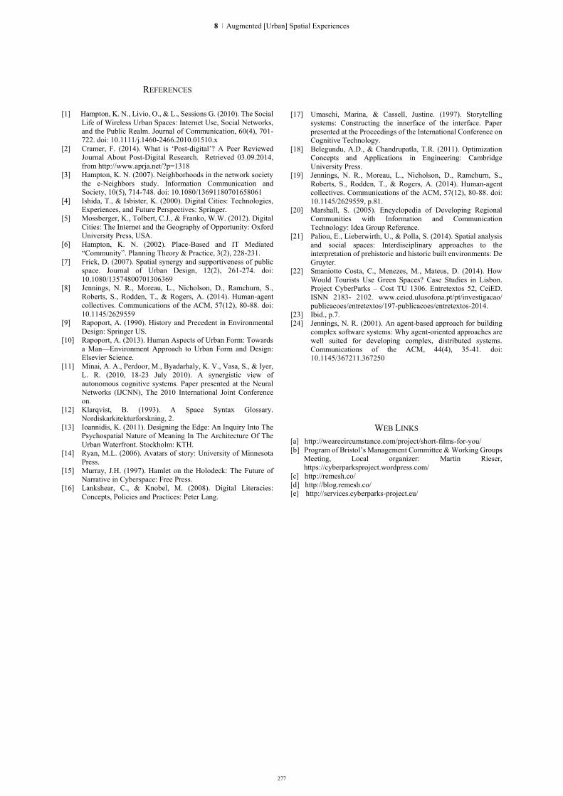
REFERENCES
[1] Hampton, K. N., Livio, O., & L., Sessions G. (2010). The Social Life of Wireless Urban Spaces: Internet Use, Social Networks, and the Public Realm. Journal of Communication, 60(4), 701-722. doi: 10.1111/j.1460-2466.2010.01510.x
[2] Cramer, F. (2014). What is ‘Post-digital’? A Peer Reviewed Journal About Post-Digital Research. Retrieved 03.09.2014, from http://www.aprja.net/?p=1318
[3] Hampton, K. N. (2007). Neighborhoods in the network society the e-Neighbors study. Information Communication and Society, 10(5), 714-748. doi: 10.1080/13691180701658061
[4] Ishida, T., & Isbister, K. (2000). Digital Cities: Technologies, Experiences, and Future Perspectives: Springer.
[5] Mossberger, K., Tolbert, C.J., & Franko, W.W. (2012). Digital Cities: The Internet and the Geography of Opportunity: Oxford University Press, USA.
[6] Hampton, K. N. (2002). Place-Based and IT Mediated “Community”. Planning Theory & Practice, 3(2), 228-231.
[7] Frick, D. (2007). Spatial synergy and supportiveness of public space. Journal of Urban Design, 12(2), 261-274. doi: 10.1080/13574800701306369
[8] Jennings, N. R., Moreau, L., Nicholson, D., Ramchurn, S., Roberts, S., Rodden, T., & Rogers, A. (2014). Human-agent collectives. Communications of the ACM, 57(12), 80-88. doi: 10.1145/2629559
[9] Rapoport, A. (1990). History and Precedent in Environmental Design: Springer US.
[10] Rapoport, A. (2013). Human Aspects of Urban Form: Towards a Man—Environment Approach to Urban Form and Design: Elsevier Science.
[11] Minai, A. A., Perdoor, M., Byadarhaly, K. V., Vasa, S., & Iyer, L. R. (2010, 18-23 July 2010). A synergistic view of autonomous cognitive systems. Paper presented at the Neural Networks (IJCNN), The 2010 International Joint Conference on.
[12] Klarqvist, B. (1993). A Space Syntax Glossary. Nordiskarkitekturforskning, 2.
[13] Ioannidis, K. (2011). Designing the Edge: An Inquiry Into The Psychospatial Nature of Meaning In The Architecture Of The Urban Waterfront. Stockholm: KTH.
[14] Ryan, M.L. (2006). Avatars of story: University of Minnesota Press.
[15] Murray, J.H. (1997). Hamlet on the Holodeck: The Future of Narrative in Cyberspace: Free Press.
[16] Lankshear, C., & Knobel, M. (2008). Digital Literacies: Concepts, Policies and Practices: Peter Lang.
[17] Umaschi, Marina, & Cassell, Justine. (1997). Storytelling
systems: Constructing the innerface of the interface. Paper presented at the Proceedings of the International Conference on Cognitive Technology.
[18] Belegundu, A.D., & Chandrupatla, T.R. (2011). Optimization Concepts and Applications in Engineering: Cambridge University Press.
[19] Jennings, N. R., Moreau, L., Nicholson, D., Ramchurn, S., Roberts, S., Rodden, T., & Rogers, A. (2014). Human-agent collectives. Communications of the ACM, 57(12), 80-88. doi: 10.1145/2629559, p.81.
[20] Marshall, S. (2005). Encyclopedia of Developing Regional Communities with Information and Communication Technology: Idea Group Reference.
[21] Paliou, E., Lieberwirth, U., & Polla, S. (2014). Spatial analysis and social spaces: Interdisciplinary approaches to the interpretation of prehistoric and historic built environments: De Gruyter.
[22] Smaniotto Costa, C., Menezes, M., Mateus, D. (2014). How Would Tourists Use Green Spaces? Case Studies in Lisbon. Project CyberParks – Cost TU 1306. Entretextos 52, CeiED. ISNN 2183- 2102. www.ceied.ulusofona.pt/pt/investigacao/ publicacoes/entretextos/197-publicacoes/entretextos-2014.
[23] Ibid., p.7. [24] Jennings, N. R. (2001). An agent-based approach for building
complex software systems: Why agent-oriented approaches are well suited for developing complex, distributed systems. Communications of the ACM, 44(4), 35-41. doi: 10.1145/367211.367250
WEB LINKS [a] http://wearecircumstance.com/project/short-films-for-you/ [b] Program of Bristol’s Management Committee & Working Groups
Meeting, Local organizer: Martin Rieser, https://cyberparksproject.wordpress.com/
[c] http://remesh.co/ [d] http://blog.remesh.co/ [e] http://services.cyberparks-project.eu/
277
8 | Augmented [Urban] Spatial Experiences

278
The Palimpsest Project postalphabetical augmented museum of participatory storytelling
Polyxeni Mantzou, Assoc. Professor Department of Architecture
Democritus University of Thrace Xanthi, Greece
Angeliki Matami, Georgios Kapraras, Christina Charistou
Department of Architecture Democritus University of Thrace
Xanthi, Greece
Abstract.The paper presents a post-alphabetical approach for the design of new hybrid environments that revitalise urban, public spaces, applying a set of
interactive tools as crowdsourcing archiving, participatory mapping, layering and
story-telling, in a project, called Palimpsest, set as an open-air, artistic, interactive museum on the city’s public space.
The proliferation of digital technologies has altered the relation of individuals and collectivities to the public urban space of the city. W. Mitchell in his last century’s City of Bits, described many of the changes that are happening in the public urban space because of the transfer of its principal activities, which traditionally constituted the raison d' être of the public urban space, in the digital realm of the web. The possibility to do more online has offered a liberating and cherished new way to be in this world, without the traditional restrictions of sintopia. Still, as a counteract, it has stript public urban space of its ability to serve as a receptor of public activities, such as commerce, entertainment, social gathering. As a result, more and more, there are proposals and projects that work upon the combination of the digital and the physical, the creation of new, hybrid conditions, insisting in most cases in the playful or in the artistic scope and in others in a functional approach.
Palimpsest is also a project that aims in the direction of creating an augmented experience of public urban spaces and it focuses on ways to do so in a meaningful and operative way. The continuity of time in the lost and buried past moments of the city is considered as a primary issue that can be restored and reinterpreted by using digital technologies. Hannah Arendt defines public space as the place that connects us to those who have been and to those who are to come, pointing out that without this continuity in time, the public cannot be sustained. Digital technologies can serve as an important tool in order to achieve this, occasionally broken, continuity.
The Palimpsest project is organised in three distinct but yet, interconnected phases. The participation of the public is crucial as the city’s past and the forgotten or erased layers of time and past events are restored by implicating the public in crowdsourcing archiving techniques. The post- alphabetical approach applied is indifferent to verification aspects and is more concerned about the egalitarian, bottom-up, mosaic, representation
of past moments. On a second stage, the information gathered apart from configuring an archive, is used in order to organise layers and filters that associate stories and events to the physical urban space. This narrative mapping can be constantly restructured applying different filters that re-organise the information. On the last stage, the information gathered and linked to the physical space is reinterpreted and processed by artist and embedded in the public urban space in a transparent and interactive way, with the collaboration of architects and software engineers, in order to create an open-air, immaterial, multisensorial, history-based museum.
Keywords:Hybrid; urban narrative; post-alphabetical; participatory mapping; locative media
I. “ARCHIVE” The digital revolution places public urban space and
the city in a crossroad.“Traditional urban patterns cannot coexist with cyberspace”,as W. Mitchell argues[1]; it is imperative to rethink them and embrace the challenges of the new age. Public space is ally what constitutes the community, what we share with others, and what links us to those who have been and to those who are to come. Because digital communities are linked beyond spatial concomitance and respond to a contemporaneity liberated from locational limitations, it is imperative to seek new ways to comprehend and act upon public urban space. On one hand, public urban space is seen as an alternate condition, a physical, material experience with the othernessi, a place to be, corporeally, and thus a refreshing and differentiated background for the digitalized community. On the other hand, there is the possibility to merge digital
i“It is well known that we obtain consciousness of ourselves through the gaze of the otherness, that is, through the image reflected at the mirror, an image that can never correspond to our proper perception of the self.” In P.Mantzou, G. Trovato, Architecture in the digital-machine age. Don’t be my mirror, Mantzou, Polyxeni; Trovato, Graziella,International Conference On Architectural Design &Criticism,Madrid, 12·14 June 2014,pp.3
HYBRID CITY 2015 | DATA TO THE PEOPLE

279
technologies and physical urban space and create new, hybrid, augmented conditions[2].
This second option is, according to A. Picon, inevitable, as “digital media are changing the city and our experience of it”[3]. Digital technologies inserted into urban life provokes new emerging temporalities for the citizens that break the traditional conception of the city space. Urban space becomes fluent and mutable, losing its previous stable corporeality, reforming people’s perception of it. People become curious and interested to experience this unprecedented environment, to explore it, to interact with it, to connect,to finally find their position in this continually transformable reality. The figure of Parisian mesmerisedflaneur of the 19th century could be revived in the contemporary subject. Urban space can be newly mesmerising, spectacular and seductive, if digital technologies are applied in order to augment its capacity to change, to respond, and to offer multisensorial stimuli. Contemporary subjects, accustomed to intense, multisensorial, responsive digital environments, receive gratefully the implementation of these characteristics in the material, physical, public, urban space, where depth and profoundness is also possible.
Meaningfulness becomes a crucial point. If public urban spaces are to be understood as the scenario[4] of digital animation and playfulness, and if hybrid new conditions are to augment the experience of the city’s space, it is imperative to opt for intelligible and coherent ways to do so. It is also imperative to find ways to use these powerful tools not against the material space but in favor of it. The project Palimpsest does so by offering a connection to what has been, the past that is transcribed in the materiality of the urban space, and also by creating a projection to what is to come, the future that the community aspires. The past can be found in the covered and buried layers that remain present but forgotten, the future in the connections that can be instigated by allowing personal, subjective, first-person interpretations to be inscribed in floating, interpretative layers, waiting to be webbed and reconfigured. The project is based upon participatory, crowdsourcing and engagement tools, post-alphabetical archiving, narrative cartography, art installations and embedment of the digital to the physical in order to create a hybrid public urban space with intensity and profoundness.
II. “MAP” The project presented is structured in three distinct
but yet connected phases, each of them based upon a more general theoretical concept, the addressed application of which is essential for the overall post-alphabetic approach. The three concepts are: i) archive, ii) cartography and iii) palimpsest.
The archive origins from the greek word αρχεία arkheia ‘public records’, from αρχήarkhē ‘government’ and origin. The greek word reveals the true nature of the archive concept. In the pre-alphabetic world, where orality rules[5], there is no archive apart from the one that individual and collective memory provides. Elder
people are central because they have the biggest recollection of facts. Archives as memory, are immaterial, subjective, in constant restructuring and mutation, and bear the characteristics of a cerebral process.
The transition from the pre- to the alphabetic inaugurates new ways and types of archiving, organized by those who had knowledge; the keepers of knowledge secure the safe passage of information from generation to generation. Only few could have access to knowledge and have the authority of assessing the information, distilling it, and finally choosing what is to be kept and what is to be forgotten. During the transition from the pre-alphabetic to the alphabetic apart from the establishment, i.e. the masters of memory, who formed the collective memory and thus conscience, and wrote the history, there was still oral transmission, through narratives and popular storytelling. As orality was lost, archives became of extreme importance and their organization reflected on the way societies analyzed and comprehended the world. In the post-alphabetical, digital era, orality and subjectivity regained importance; the archive lost the concept of the arkhē. “In a world of proliferating screenspace and speakers, smart surfaces, video-projected displays, virtual reality, and augmented reality, luminous digital information is ubiquitously overlaid on tangible physical reality”[6]. In the digital public space where the information is not distilled, or assessed the archive is not mastered by the few. Raw material in huge volumes is offered by everyone and everyone can add to it, or consume it.The lack of αρχήconfuses the claimed concept of true or false, hides the facts and leaves only interpretations, created by users and constantly transformed by the receiver. Of course, digital archives are also codified and prioritised by search machines which are the new masters, the ones that associates, prioritises and hierarchises facts.
Mapping is about placing one’s self in the vastness of the indissoluble space. In the pre-alphabetic past, the physical boundaries set by the human body allowed only a subjective kind of mapping, one that supposed an interpretative and imaginative filling of the gaps by the cartographers. Travellers designed their travel routes as a linear connection between their origin and their destination and all the rest was an arbitrary visual interpretation of a river, a forest, a path and sea. In this narrative approach of the map, the personal trajectory had a protagonist role, the space was impregnated by the personal, the subjective, the first-person narration, as the narrator can only tell the story from a specific point of view.
The alphabetic map is the like the one mentioned by Baudrillard in Borges fable “in which the cartographers of the Empire draw up a map so detailed that it ends up covering the territory exactly”[7]; scientific methods and tools are applied in order to gain an objective representation and thus comprehension and possession of physical space.
The post alphabetic map of the digital era takes the technological evolution for granted, satellites and
8 | Augmented [Urban] Spatial Experiences

280
geolocational systems leave nothing unexplored, the earth is tamed, there is no place for the lionsii. Detailed mapping is taken for granted and therefore, interpretation regains importance. With the situationist movement and the psychogeographic approach, maps are understood as a personal, narrative, biased representation of the city. The contemporary cartographer using digital media, is the power holder. He can use GIS data, decide what to include and what to exclude, interpret and present the spatial reality in his/her own way. And, most importantly, everyone can use these tools in order to reflect a subjective, first-person narrative approach of space.
To map a city is not merely an act of representation but also to an act of comprehension, of possession[8].Maps are deeply connected to the physical space; maps represents an intellectual abstraction, a literal convention, while territory is linked to physical experience and the sensorial experience[9]. Participatory mapping, makes use of the collectivity as a powerful tool and invalidates the distinction between cartographer and user.Contemporary graphical representations are used in order to expand the cartographic language and add multiplicity and complexity of the spatial and cultural experience[10]. Maps can reveal divergence, marginality, hidden and forgotten narratives and can be the basis for encounters, collaboration, negotiation or consensus[11].
Contemporary cartography can be a creative procedure of knowledge production and transformation, a constant construction of a network of relations, a bottom up layering of the temporal inflections, a thick web of people‘s narrations spreading itself across the hybrid urban space, connecting historical and cultural conceptions.
The palimpsest metaphor is a powerful one as it links the archive to a spatial expression, a sort of mapping that takes place in time, that is in a vertical rather than in a horizontal development. Pre-alphabetical time is circular, there is no exteriority capable of providing the subject with a distant scope or a surveilling eye in the pre-alphabetic times.
Rituals cycles are the basis of the time which flows in a closed circle in the sacred context of the pre-alphabetical society[12]. Of course the circles are present everywhere in the natural context that prehistoric man lives in. Day and night, seasons, birth and death, position preliterate cultures in all sort of cyclical patterns. Presentness and nowness is thus of extreme importance. Recollection of past moments is evoked by events circularly repeated; and time is defined and comprehended by this recurrence.
ii HIC SVNT LEONES, was the phrase used in old times to denote uncharted and possibly dangerous territory and thus explain the lack of information in maps.
History and the linear conception of time is an alphabetical constructioniii, one that imposes linearity at time perception, in the same way that linearity reigns in all other alphabetical concepts. "By the meaningless sign linked to the meaningless sound we have built the shape and meaning of Western man", points out Marshall McLuhan[13]. Chrono-logical approaches such as time-lines, past-behind and future-ahead are culturally mediated and biased. Different cultures determine notions of what is past or future as ahead or behind in different ways and sometimes future and past are not distinguished between them but only in relation to the presentiv. Linear conception of time leads to schematizations of a panoptic, all-seeing, god-like perception and arrangement of the time continuum, placing the literal, alphabetic subject in a privileged, and all-controlling position.
The post alphabetical world merges the pre- and the alphabetical; time is understood and schematized, not as a circle nor as a line, but rather as a spiral. Presentness and nowness became newly important and, meanwhile, linearity remains operative.
This conception of time, where the reminiscence of the succession is challenged by the eternity of the present, a present which is the centre, an always new centre and therefore a perpetual centre[14], is a conception that translated in technological terms, isolates present time from its here and now, in favour of a cumulative elsewhere[15]. This sense of eternal present but a present without presence, a present of elsewhere can be perfectly visualised in the palimpsest metaphor.The palimpsest, where all is present but all is elsewhere, where linearity is expressed by the depth but circularity is also found in the ability to bring forward any moment in time, can be a model of post-alphabetical time perception.
III. “PALIMPSEST PROJECT” The Palimpsest project is a public urban space
proposal that embeds digital technologies in physical space, providing a playful and yet meaningful experience of a new, hybrid, public urban space, condition. It acts as a mediating agent that encloses a post-alphabetical approach through hybridization processes, in order to enhance individuals’ relation to the cultural heritage embedded in the urban sphere. Sterilised, detached cultural heritage assets are converted into animated, corporeal hybrid experiences which are used in order to associate urban space to its forgotten and erased heritage, underlining the unique city’s palimpsest.“Public spaces are seen as the primary
iii The Judeo-Christian concept of time is considered linear, see T. Cahill,The Gifts of the Jews: How a Tribe of Desert Nomads Changed the Way Everyone Thinks and Feels, Lion Hudson plc,2001
iv“The words yesterday and tomorrow both translate to the same word in Hindi: ("kal"),meaning "the day remote from today.”
HYBRID CITY 2015 | DATA TO THE PEOPLE

281
sites of public culture, windows into the city’s soul”[16] and are the scenery of the Palimpsest project.
Cultural Heritage, the connection to the past, is one of city's most valuable assets, as a mechanism for the human subject to connect to the urban. A new opportunity to reintroducecultural heritage into urban space has come with digital technologies and their immense potential for archiving, processing, circulating and transforming information,in ways that revolutionize our habits and expectations. The digitalization of cultural heritage often inherits the characteristics of the binary code: it becomes flexible, transformable, abstract and immaterial[17]. It is the result of procedures of limitations, i.e. extraction from context and removal from bounding material support, and thus, offers novel possibilities for sharing, preserving and reusing of the converted digitized material. Still, the current state of art presents digital assets as a humble alternative, a mere substitute for the distant -past or lost- real thing.
Palimpsest proposes the creation of an ‘alive’, open-air, city museum constructed into an augmented condition, where digital cultural assets are emplaced, where there is no alternation between digital and physical but combination and hybridization. It proposes an urban intervention, which targets at the promotion of a new inventive system, that combines the analogue with the virtual space through a sequence of overlapping layers configured by urban and mainly transparent, art installations.The intangible layers, occupied by cultural assets from a crowdsourcing archive and connected to the installations’ web, animate cultural heritage upon
the urban space offering multilevel cultural perceptions.
Data relative to urban narratives is collected in a bottom-up, participatory way and structure a crowdsourcing archive; a responsive categorization, following users’ preferences. Material is then processed in a digital, layered web, projected anew upon the urban space as a narrative cartography approach and is finally presented through interactive art installations; a hybrid, artistic implementation of interactive, multisensory, dream-like representations embedded in the city’s public urban space The emerging open-air, augmented, interactive museum associates cultural resources to the specific urban condition in a location-based manner and marshalls digital technologies to engage the human subject in its totality. Participants are invited to become actors instead of spectators or passive receivers, agents who contribute subjective information, active story-tellers, amateur cartographers, protagonists of historical events, heroes of urban legends. People’s participation is crucial and significant from the outset of the project and until its ultimate implementation; data produced by the people, is destined for the people.
Palimpsest is structured in three, discrete but interconnected and interrelated stages. [Fig. 1] Each of them has a distinct mission and a different focus, but all together configure a totality in regard to what is done and to how it is done. Everyone of these three stages completes independent applications that are realized in a specific city of Greece, in the region of Epirus and in particular in Ioannina. Ioannina was chosen as it is a typical middle to small town with significant cultural
Figure 1: Palimpsest's project structural processes
8 | Augmented [Urban] Spatial Experiences
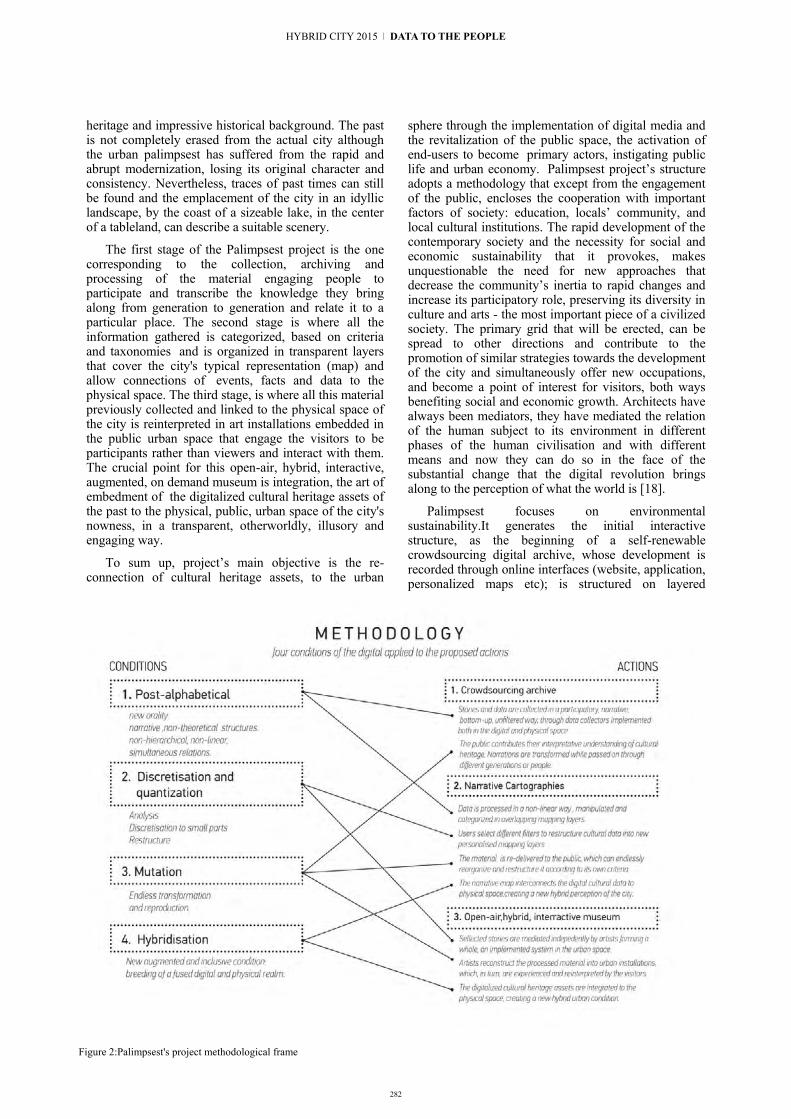
282
heritage and impressive historical background. The past is not completely erased from the actual city although the urban palimpsest has suffered from the rapid and abrupt modernization, losing its original character and consistency. Nevertheless, traces of past times can still be found and the emplacement of the city in an idyllic landscape, by the coast of a sizeable lake, in the center of a tableland, can describe a suitable scenery.
The first stage of the Palimpsest project is the one corresponding to the collection, archiving and processing of the material engaging people to participate and transcribe the knowledge they bring along from generation to generation and relate it to a particular place. The second stage is where all the information gathered is categorized, based on criteria and taxonomies and is organized in transparent layers that cover the city's typical representation (map) and allow connections of events, facts and data to the physical space. The third stage, is where all this material previously collected and linked to the physical space of the city is reinterpreted in art installations embedded in the public urban space that engage the visitors to be participants rather than viewers and interact with them. The crucial point for this open-air, hybrid, interactive, augmented, on demand museum is integration, the art of embedment of the digitalized cultural heritage assets of the past to the physical, public, urban space of the city's nowness, in a transparent, otherworldly, illusory and engaging way.
To sum up, project’s main objective is the re-connection of cultural heritage assets, to the urban
sphere through the implementation of digital media and the revitalization of the public space, the activation of end-users to become primary actors, instigating public life and urban economy. Palimpsest project’s structure adopts a methodology that except from the engagement of the public, encloses the cooperation with important factors of society: education, locals’ community, and local cultural institutions. The rapid development of the contemporary society and the necessity for social and economic sustainability that it provokes, makes unquestionable the need for new approaches that decrease the community’s inertia to rapid changes and increase its participatory role, preserving its diversity in culture and arts - the most important piece of a civilized society. The primary grid that will be erected, can be spread to other directions and contribute to the promotion of similar strategies towards the development of the city and simultaneously offer new occupations, and become a point of interest for visitors, both ways benefiting social and economic growth. Architects have always been mediators, they have mediated the relation of the human subject to its environment in different phases of the human civilisation and with different means and now they can do so in the face of the substantial change that the digital revolution brings along to the perception of what the world is [18].
Palimpsest focuses on environmental sustainability.It generates the initial interactive structure, as the beginning of a self-renewable crowdsourcing digital archive, whose development is recorded through online interfaces (website, application, personalized maps etc); is structured on layered
Figure 2:Palimpsest's project methodological frame
HYBRID CITY 2015 | DATA TO THE PEOPLE

283
mapping and, is animated through interactive installations, an open-air, hybrid, urban museum that offers a continuously transformable experience of the urban space to the people living in it. Preserving time assets, such as history, events, myths and legends and reconnecting them to the public urban space where they were originated, ensures the endurance of the community and the public, which is based, as H.Arendt noted, to the continuity and common ground of sharing past and envisioning future times[19]. [Fig. 1]
IV. “REBOOT” The Palimpsest, The Palimpsest, forms part of a
growing trend and can be considered yet another proposal for application of digital technologies in the public urban space. Its value and merit rests in its focus on meaningfulness and in the way that it aims to find it, by making use of historical and cultural heritage assets, constantly reinterpreting and incessantly rebooting as an opera aperta. On another hand, the involvement of digital media is based in the understanding of certain conditions of the digital and the binary code that constitutes its inner self, conditions taken under consideration, as a conceptual reboot, in the case of the Palimpsest’s proposed actions. Resuming, the adaptation of these conditions configure the prominent characteristics and the ultradeep attributes of Palimpsest: [Fig. 2]
The post-alphabetical approach, is an important factor in the methodology scheme. The post-alphabetical is characterised by its difference from the previous system of reference, i.e. the alphabetic; and its similarity to the pre-alphabetical, as McLuhan has explained[20]. It promotes simultaneity, a new orality, narrative and non-theoretical structures, non-hierarchical, non-linear, non-causal relations. In Palimpsest the post-alphabetical approach is of extreme importance for the collection, assessment and archiving of the cultural heritage material. Instead of using exclusively traditional, accredited and scientific sources, the project proposes a bottom-up, horizontal, non-hierarchical, participatory methodology for collecting, in a first moment, and continuously restructuring, in a second phase, the material, implementing crowdsourcing and open-source methods.
Discretisation is another methodological tool inherited from the digital nature. Discretisation is a comprehension technique, an analytical process that permits the understanding and control of the continuum by discretizing it to small parts and restructuring it, based on a selective process of characteristic points[21]. The combination of analytical and synthetical, of possession and reinterpretation is crucial for the digitalisation process. It is thanks to discretisation that the digital can support different kind of stimuli. The Palimpsest project uses this methodology inasmuch as it involves the dissolution of the continuum of cultural heritage assets in personal, fragmented interventions and narrations, instead of the usual, theoretical, holistic views of cultural cycles, from above and from faraway.
This close, inside, biased and dismantled collection of narrations is archived and then reinterpreted and reconstructed, creating new connections and articulations.
Mutation is a possibility for constant change, supported by the digital and brought to unforeseen dimensions. Mechanical reproduction was radically transformed in the digital context by the addition of mutation[22]. Everything can be multiplied and transformed endlessly and the transformation can occur in a wide range of scale, from the unique and smallest element to the whole. This is an attribute that Palimpsest explores in relation to the cultural heritage inasmuch as cultural assets are considered interpretative and not still, frozen, framed and packaged for delivery. Engaging the human subject to participate actively in all stages and especially deal with cultural heritage assets, triggers a subjective, creative and continually transformable character to project’s context. Different narrations and testimonials, different perspectives and interpretations, different levels of impact among different social groups create reproduction and mutation.
Hybridisation, although not intrinsic to the digital, seems an apparent consequence due to the fact that the digital is taking up a great part of our lives in order to experience it as a separate circumstance, one irrelevant to the body and the physical space[23].The alternation between digital and analog, between immaterial and material corporeality is annoying, or at least, restrictive for both. The combination of both, the incorporation of one to the other, the hybrid condition this would lead to, favors the revitalization of analog, physical space and the centrality of the often forgotten human body[24]. Combinations, overlapping and bonding are needed.
The Palimpsest project, explores how it is possible to contribute to the breeding of a fused digital and physical realm, which creates a new augmented and inclusive condition. Its mission is to exploit the digital code's attributes in order to discretise, collect and archive, bottom-up produced, post-alphabetical cultural assets, which are constantly reinterpreted and mutated as interactive, transparent, multisensorial installations that are related, connected and embedded to the physical, analog, material space and experienced by the actual, bodily drifting of subjects around the city.
[Fig. 3]
8 | Augmented [Urban] Spatial Experiences
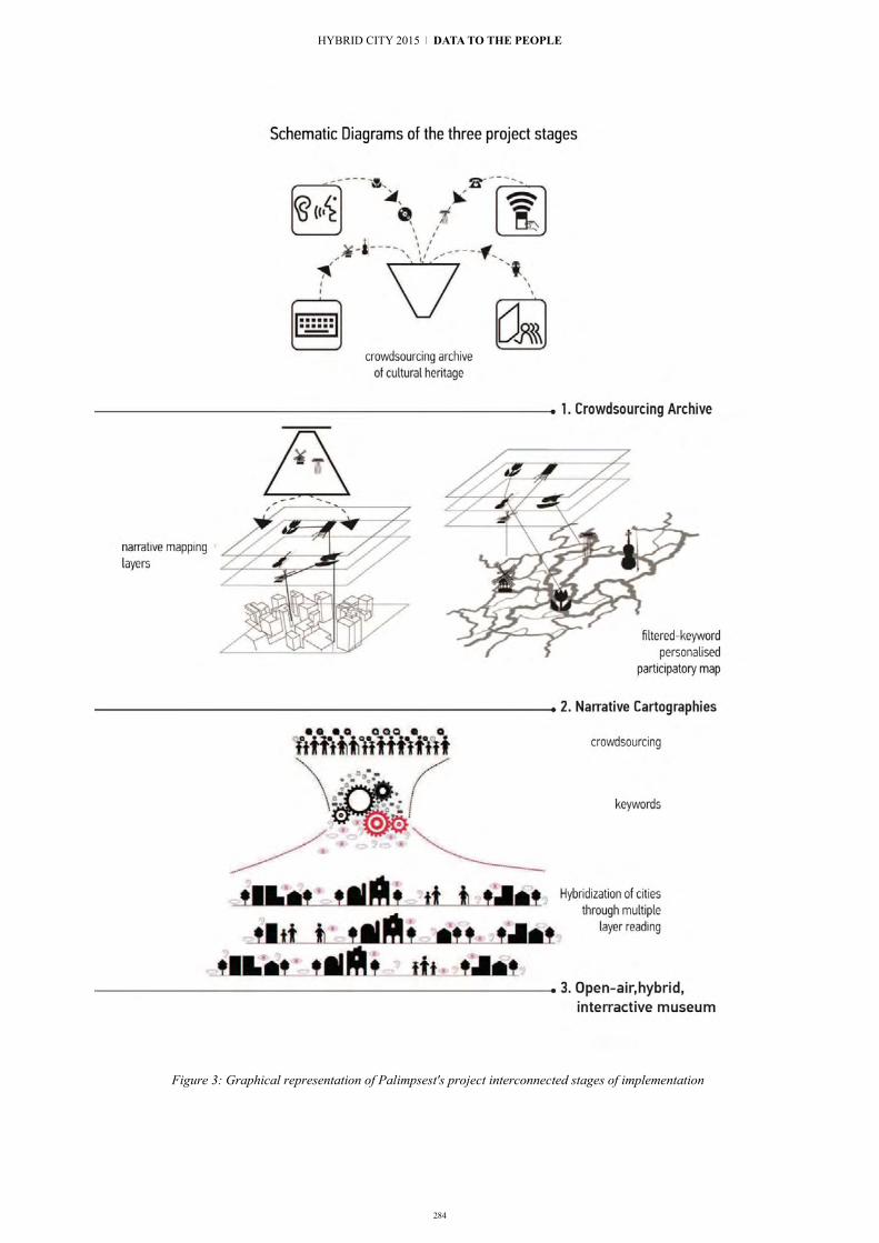
284
Figure 3: Graphical representation of Palimpsest's project interconnected stages of implementation
HYBRID CITY 2015 | DATA TO THE PEOPLE

285
REFERENCES
[1] W. Mitchell, E-topia “Urban life, Jim–but not as we know it”, Cambridge/London,The MIT Press,1999,p.3, and W.Mitchell, City of Bits, The MIT Press, Cambridge,1996
[2] S. Crossan "Digital Networks, Public Spaces." In Digital Public Spaces, edited by D. Hemment, B. Thompson, J. Luis de Vincente and R. Cooper, Manchester: Future Everything, 2013,pp.14-15
[3] A. Picon, Toward a city of events: Digital Media and Urbanity in Turan Neyran (edit.)New Geographies, Puritan Press, USA,2008,p.34
[4] P.Mantzou, X. Bitsikas , E. Mandoulidou : Narration as a design tool of public space in Public space... in quest, Technical Chamber of Greece/Department of Central Macedonia, Thessaloniki, 2011
[5] M. McLuhan, The Gutenberg Galaxy: The making of typographic man, University of Toronto Press, Canada, 1962, p.3
[6] W. Mitchell, E-topia,o.p.,p. 41 [7] J. Baudrillard,Simulacra and Simulation,The MIT
Press,USA,1994,pp.1-2 [8] A. Picon,o.p.,p.34 [9] M. Gausa,The Metapolis dictionary of advanced architecture :
city, technology and society in the information age,Actar, Barcelona, 2003,p.415
[10] Unita di Crisi, “Reflections for a narrative cartography”, http://www.unitadicrisi.org/reflections-for-a-narrative-cartography/
[11] R. Firth, “Critical Cartography”, The Occupied Times of London,April 2015, http://theoccupiedtimes.org/?p=13771
[12] Μ.Eliade,The Sacred and the Profane: The Nature of Religion.
Trans. Willard R. Trask. New York: Harper Torchbooks, 1961 [13] M. McLuhan, The Gutenberg Galaxy, ο.p.,p. 65 [14] P. Virilio,Open Sky, Verso,London,1997,p.136 [15] P. Virilio,o.p.,pp.10-11 [16] R. Marks., Palaces of Desire, SA Architect Nov./Dec., 2000 [17] Π. Μάντζου, Ψηφιακοί χώροι inLimbo στο Μεταλλαγές και
(α)συνέχειες: Πρακτικές, πολιτικές και λόγος για τον αστικό χώρο: πρακτικά επιστημονικού συνεδρίου Αθήνα 4-5 Ιουλίου 2008, εκδ. Αλεξάνδρεια,Αθήνα,2009, σ.42-43
[18] P.Mantzou, G. Trovato, Architecture in the digital-machine age. Don’t be my mirror, Mantzou, Polyxeni; Trovato, Graziella,International Conference On Architectural Design & Criticism,Madrid, 12·14 June 2014
[19] H.Arendt,The human condition,University of Chicago Press, Chicago,1958, p.55
[20] M. McLuhan, The Gutenberg Galaxy, o.p.,pp.57 [21] U. Eco, A Theory of Semiotics, Indiana University Press,
London, 1976, pp.176-7 [22] L. Prestinenza Puglisi, Hyperarchitecture, Spaces in the
electronic Age, Birkhauser, Basel, 1999,pp.51-67 [23] P. Mantzou, E. Mandoulidou, E. Giannopoulou, M. Grafanakis:
Hybridization Processes: The case of the urban game: “Hybrid Hunt: Petrified” in Saglamer, Gulsun, Cebi, Pelin Dursun, Erkok, Fatma, Paker, Nurbin, Aksoy, Meltem, Avci, Ozan, Gumusoglu, Nebole Korucu, Baslo, Meltem (Ed.): EURAU 2014. Istanbul. Composite Cities, Istanbul Technical University, Istanbul, 2014
[24] M. McLuhan, Understanding Media, The extensions of man, The MIT Press, Massachusetts, 2002, pp. 45-53
8 | Augmented [Urban] Spatial Experiences

286
Enriching the city environment with mobile Augmented Reality edutainment applications
for residents and tourists The case of “Roads of Rhodes” game
Dimitrios MARKOUZIS and Georgios FESSAKIS Learning Technology & Educational Engineering Laboratory
University of the Aegean Rhodes, Greece
[email protected], [email protected]
Abstract. Mobile devices wide spreading in the population of all ages along with the availability of mobile augmented reality technology enable new kinds of mobile applications that change the way residents and visitors interact with the city and its environment in general. These unparalleled applications attract focus the interest of Destination Branding Organizations which try to exploit the new mobile communication media in order to promote their tourism product and reach their target groups in a highly competitive market. Among the content-based, participatory and leisure kinds of such mobile applications, this paper focuses on the leisure ones. Leisure applications category includes mobile augmented reality serious games, which appear more difficult to design and develop due to the required collaboration of experts from many different fields e.g. learning design, games design, historians, writers, technology experts and tourism marketing experts. In the paper, existing examples of leisure applications are examined in order to outline their design principles and then the rapid prototyping methodology is utilised for the development of a particular leisure game design which will be used as a test bed for experiments.
Keywords: Augmenting Reality, Rapid Prototyping, Digital Games Based Learning, Edutainment, Destination Branding, Tourism
I. INTRODUCTION Mobile devices with considerable computing power
such as smartphones, tablet pcs and iPads are becoming more and more widespread and accessible [6]. In addition, Mobile Augmented Reality (MAR) technology matures making feasible new kinds of applications that play key role in several fields (e.g. mobile learning, tourism marketing, hybrid cities’ development), exploiting the great potential of awareness of time, position and user state context for digital interaction with the environment [8]. This kind of applications dynamically overlay digital information on the natural environment, enhancing the interaction with urban,
natural or structured space. MAR applications could make living in or visiting the cities more efficient and meaningful while their development and operation offers new employment and business opportunities.
In other words, MAR constitutes a relatively new technology, which uses mobile devices such as smartphones and tablets, to allow users to interact digitally, by sending or receiving digital information relevant to the physical environment. Currently there are two main categories of mobile augmented reality technologies available: A. Location-based augmented reality based on GPS
technology. The applications of this type use GPS technology
which is available on most mobile devices, to deliver information to the users according to their geographical position. The digital information is triggered via GPS and presented to user's screen to augment physical environment with narrative and information related to the location. B. Vision-based augmented reality
Vision-based MAR applications demonstrate digital information to the user after pointing the camera of the mobile device to a specific target, e.g. a physical object or a QR-Code [4]. This function is based on automatic image recognition technology.
MAR applications enable the configuration of hybrid urban environments where interactive digital objects blend with physical space. These applications create new innovative ways to enrich and facilitate the everyday life of people in the cities. The small number of such applications, despite the fact that they are technologically feasible in reasonable cost and effort, raises the need for research to facilitate the innovation development.
The paper does not examine only information or utilitarian MAR applications but focuses also on MAR
HYBRID CITY 2015 | DATA TO THE PEOPLE

287
serious games. Serious games are one of the popular choices for free time activities [3]. MAR technology has great potential in education and entertainment applications [5], [7]. MAR serious games are consistent with the situated learning theory [9] which advocates that learning is more effective through collaborative authentic problem solving, in the natural environment where the constructed knowledge is used.
This new area of applications is significant also for tourism management and destination branding [11]. In this paper, we focus on MAR serious games for residents and visitors in order to explore and map better this new area of applications and interdisciplinary research. More specifically, the paper presents a literature review of mobile applications for destination branding aiming to explore the current role of MAR in the field and to estimate room for improvement. Subsequently, some examples of MAR serious games for tourism are presented and then the modern MAR applications development technology is explored. The development of a MAR Serious Game prototype, designed especially for the city of Rhodes, Greece, is thereafter described along with design principles stemming from the combination of the research review and the analysis of existing examples. The game is aimed to promote the city’s history and cultural environment to students, residents and visitors. The proposed game exploits the cultural heritage of the city to provide digital edutainment experiences to the citizens and visitors. The business model of the game is based on the participation of local businesses, which will be promoted through the game, and the local tourism authorities. The specific model supports a sustainable MAR edutainment application which enhances the city experience and creates new employment opportunities for the development, operation and maintenance of the game. Finally the paper contains conclusion and possible directions for future work.
The paper contributes to the field of design and development of MAR edutainment applications for destinations branding. The authors support the view that MAR serious games, based on the cultural environment of the destinations, could have significant impact on residents and tourism because they promote learning and emotional connection to the cities and to the destinations in general. Furthermore, this kind of applications need the collaboration of learning designers, historians, architects, technology experts and many more, thus making it difficult to be developed by the software development industry alone. This makes necessary the realization of innovative interdisciplinary research in the area of hybrid cities, tourism and learning design, so that the best practices of design and development along with sustainable models for the applications deployment are presented, in a way that marketing, local business and cities’ authorities are interconnected making economic and cultural development possible.
II. MOBILE APPLICATIONS FOR TOURISTS AND RESIDENTS
Information and Communication Technology (ICT) affects significantly the tourism industry in many ways [12]. Especially the internet and the mobile communications have shaped the marketing communication strategies of tourism destinations (i.e. cities, regions or countries) in totally new forms [11], [13]. Destination Marketing Organizations (e.g. the official authorities for the promotion of tourism product) make use, in addition to traditional media (e.g. television, radio, newspapers, magazines), of the World Wide Web (WWW), of online social networking services and of mobile communication technologies to reach their target groups [14], [15], [16]. Mobile digital devices attract the interest of the tourism marketing because of the unique features they have, such as the ubiquitous access to information and the context awareness through the use of GPS and other sensors.
The research about the use of mobile computing devices for the tourism marketing is in its first steps, since modern smartphones appeared fairly recently, in 2007. Several tourism applications have already been developed since then, forming a new complex technological ecosystem for the industry of tourist mobile media which is still in its early steps [17], [18], [11]. It is interesting to know what kind of mobile applications for tourism promotion already exist. Scolari and Fernández-Cavia [11] evaluate and compare 66 mobile applications which are part of the institutional communication strategy for tourism in Spain. In their analysis the main traits (i.e., business model, number of languages, functions, identification, presence of social networks, etc.) of these applications are identified. As far as the business model is concerned, most of the applications (89.5 %) were free and 9% demanded charge for advanced features and extra content. The only paid application charged 1.75 Euro per user. These business models are expected for an innovation in its first steps but they may not be sustainable in the long term, because they cannot cover the cost of application maintenance and content update. The applications could be free or very cheap for the tourist, the visitor or the resident but, jointly to the DMO’s, the tourism businesses of the destination could contribute to the cost for the development and the maintenance, since they are among the beneficiaries of these applications. Most of the applications (76%) were produced or commissioned by public agencies. The possibility to include user generated content to the applications (e.g. photos, stories, descriptions, hotel or restaurant recommendations or reviews) could also reduce their maintenance cost and increase their engagement. Despite its benefits, user generated content inclusion was found quite low among the applications for Spain, since only 23% of the applications included comment sharing and 14% allowed photos uploading. Regarding the use of AR technology in the tourism applications, 30% percent out of the 66 applications examined offered
8 | Augmented [Urban] Spatial Experiences

288
Augmented Reality (AR) functionality. AR functionality is considered among the most important functions including: geo-location services, resources at the destination, agenda, photo gallery and the possibility of sharing comments. AR is considered important because it supports the improvement of environment perception by users’ interaction, while the GPS enables the location based retrieval of information and services.
As far as the classification of the applications is concerned, the common typology [18] of tools for doing or texts for knowing is not considered adequate any more by since it is not clear how to classify many new existing applications (such as augmenting reality or interactive maps with audio guides) [11]. Instead three main categories of applications were proposed, namely: content-based, participatory and leisure ones. Content-based applications are the most usual ones; they emphasize the organized access to information relevant to the destination (apps for knowing more than tools for doing). Participatory applications reinforce the creation of user-generated content. They employ the structure of online communities. Participatory applications promote balance among information for knowing and tools for doing functionalities. Finally, the leisure applications category includes games to learn about or to discover significant aspects of the destination promoted. Leisure applications appear to be hybridization of edutainment software and marketing tools. In [11] these applications are mentioned also as a special case in which AR is used to offer “recreational environment designed for the children of the tourists”. The existing applications in this category are a small minority in comparison to the other two categories. Despite the fact that 30% of the examined applications offered Augmented Reality (AR) functionality, only a few (3) examples were leisure ones. Furthermore, all the applications in the research were addressed to the traditional tourist who visits the destination for leisure and only very few of them were addressing the children of the visitors or the residents.
In our view, leisure applications constitute a special kind of serious game for the promotion of a destination in which the freedom of movement, offered by mobile technology, and the information annotation of the real environment, provided by the augmented reality technology, have obvious advantages.
In this paper we focus on the leisure category applications because of their significance and the advantages of MAR technology in implementing such applications. Leisure applications include adventure games, mystery games, storytelling, quests, interactive storytelling, guided tours, scavenger games and treasure hunts which combine learning with entertainment and produce strong emotional connections of residents and visitors to the natural and cultural environment of a destination. Leisure applications promote also entertainment and informal learning for visitors, tourists and residents, and thus they add value to the destination. The design and development of such applications requires the collaboration of several
disciplines (e.g. learning designers, historians, architects, media experts, technology experts, destination officials, local business champers). The small number of existing applications gives evidence that the development of high quality MAR leisure applications needs interdisciplinary research from learning design, tourism, communication and hybrid city fields in order to find out best practices, design methodologies, evaluation criteria and deployment models. In the next section we get a closer look at some interesting examples of MAR leisure applications.
III. REVIEWING EXISTING MAR LEISURE APPLICATIONS
There are several Augmented Reality applications for tourism. For example, [19] demonstrated an application, “ARCHEGUIDE”, which used augmented reality to digitally reconstruct ancient buildings depending on the user’s perspective. Moreover, Wikitude (http://wikitude.com) is a MAR application which captures images from the surrounding environment (e.g. sights, restaurants, streets, and shops) and displays relevant information, on the screen of the mobile device. Holden argues that many AR applications are occurring in many semi-formal contexts like museums exhibitions and community guides [2]. Finally, [20] advocates to the great potential of AR in visual art, referring to a virtual exhibition in New York’s Museum of Modern Art. Despite their great interest and significance, all these applications are not considered clearly of the leisure kind because they have not a game structure.
In this section, selected examples of MAR leisure applications are presented in order to clarify the concept and understand better the potentials and the complexities of the kind. The applications A, B and C have been validated experimentally and the results have been published. The last application (D) is described as an interesting example which adds value to a place for the visitors through a time travel narration genre. This example could be a model for many tourism destinations with rich history.
A. Mentira “Mentira” (http://www.mentira.org/) [12] is an
example of location-based MARG for Albuquerque city. Mentira combines narration, real facts, visual characters and real people. The purpose of the game is learning Spanish as a foreign language and addresses visitors among others. According to the story, the players must solve a murder in Los Griegos, a Spanish-speaking neighborhood in Albuquerque, in US. According to his/her role, each player receives different information in the game. In order to solve the mystery the players have to interview fictional characters and to collect evidence from real places. Every player creates his own learning path in the story and collaborates with his teammates exchanging evidence to find the murderer. The experimental study of the game revealed that most players increased their interest about Albuquerque while
HYBRID CITY 2015 | DATA TO THE PEOPLE
289
they expressed willingness to participate in creating an extension of the game. The narration genre of the game is mystery. The pedagogical approach is collaborative inquiry. The game was developed using ARIS authoring tool.
B. GUIDE & Augmenting the Visitor Experience The digital tourist guide “GUIDE” for Lancaster at
United Kingdom [1] and the “Augmenting the Visitor Experience (AVE)” which was developed for the area of Keswick of Lake District, Cumbria, U.K. by University of Nottingham, University College London and Leicester University constitute also interesting examples of location based MAR applications for the residents and the tourists [10].
C. Frequency 1550 The “Frequency 1550” [30] is a city mobile game
enabling students to learn about the history of Amsterdam. The players are separated in teams of four or five and randomly assigned to the role of beggar or merchant. The objective is to gain citizenship in the city of Amsterdam by collecting 366 points. The players visit specific locations in Amsterdam. At each location they have to complete some challenges. Moreover, the teams may come in confrontation and the winning team takes points from the losing team. The results revealed that most of the students enjoyed the game and gained higher scores on the knowledge test about medieval Amsterdam in comparison with students who received regular project lessons. The game has mystery and quest narration structure with time travel characteristics, based on historical events in the city of Amsterdam. The game has developed using professional mobile and AR application development tools.
D. Dow Day “Dow Day” (http://arisgames.org/featured/dow-
day/), is a prototype game created using ARIS authoring tool in which the player takes the role of a news reporter and tries to investigate the different perceptions of virtual characters who participated in protests against Dow Chemical Corporation for making napalm for the war in 1967. The application uses a journalistic narration genre.
These applications reveal the significant role that the place plays both in learning and in entertainment activities. The first years of internet wide spreading allowed the users to visit digitally and get information about places that had or hadn't visited before. Now the emerging mobile technologies in combination with effective image recognition algorithms give the opportunity to users to retrieve relevant information about the place they are at the moment. So by pointing the mobile camera on a location, the mobile screen could display appropriate geographical data like address, historical data or even digital characters available for discussion. This offers the potential to contextualize learning, engage the users and create stronger relations between the participants and local society [27]. This
argument is reinforced by the findings of [5] which revealed that the students showed high interest about Los Griegos Neighborhood, the location where the game was played.
Moreover, the existing examples demonstrate the opportunities that MAR offers for enhancing visiting and living in cities. MAR leisure applications offer useful information, learning experiences (formal and informal) and may blend marketing of local enterprises in a sustainable way, which creates economic and cultural development and employability. Many of the examples are based on stories and require serious research for the creation of their content. Many researchers believe that interactive storytelling has the potential to become a premier art form of the 21st century but it is still at an infant stage of development [22]. The authoring of high quality interactive storytelling raises difficulties, since it is a highly complex, creative activity which varies significantly in comparison to traditional text composition [23]. The complexity of MAR Leisure applications explains their small number in comparison to the general AR applications for tourism. Rapid prototyping methodology could facilitate their design and research. Rapid prototyping methodology permits the precise requirements specification for applications using rapid authoring tools instead of full programming development, therefore lowering the cost and making feasible the study of complex software systems development. This methodology will be applied in the present work for the production of an experimental leisure application prototype. In the next section the rapid authoring tools for MAR applications will be briefly analysed.
IV. RAPID AUTHORING TOOLS FOR MAR LEISURE APPLICATIONS PROTOTYPING
The development of AR applications has evolved impressively. The first AR applications development was very hard because it required the mastering of several complicated technologies. Those applications were mostly experimental, proof of the concept demonstrations and their implementation was difficult to manage in terms of cost and development time. The advances of the component technologies and the spreading of mobile computational devices contributed to the evolution of the MAR development and deployment models. In 2008 the first AR browser (wikitude) appears, marking the passage from the isolated applications development to the model of AR authoring for browsers. Soon, several browsers follow (e.g. Aurasma, Layar, Junaio and BuildAR etc) along with the competition of leading companies (Google, Apple, IBM, Microsoft) for the dominance of the browsers popularity. AR browsers facilitate the AR applications development because they provide easy to use API’s to the component technologies. The browsers provide also free access to royalty demanding technologies, making feasible the deployment of more applications. The authoring environments that accompany the browsers permit users with lower
8 | Augmented [Urban] Spatial Experiences

290
technical background to develop quite complex MAR applications while they enable the rapid prototyping of more sophisticated ones [24]. Recently, authoring tools designed especially for the development of MAR serious games became available. For example ARIS (http://arisgames.org/) and TaleBlazer (http://taleblazer.org/) are free authoring tools created by University of Wisconsin-Madison and MIT respectively. Both environments are user friendly, permitting rapid prototyping even by students. The conceptual model of ARIS seems to support more efficiently the Interactive Storytelling development since it provides abstract constructs like “scene”, “dialogs” and “quest”. The authors decided to develop a first prototype (which is described in the next section) using ARIS [25] because of its popularity and facilitation of the IS implementation. In the future extensions of this work, some leisure games will be developed using TaleBlazer in order to have a more thorough comparison among the two platforms.
V. THE “ROADS OF RHODES” GAME PROTOTYPE This section describes our MAR prototype game
specially designed for the promotion of the city of Rhodes. Rhodes Island in the southeast of the Aegean Sea in Greece has long history dating back in 400 B.C. From the ancient city of Rhodes and the Acropolis on Monte Smith Hill, to the world famous medieval city which is cultural heritage of UNESCO and from “Mandraki” harbour with the two deer sculptures adoring its entrance to the famous buildings of Italian period, both the island and the city offer many opportunities for cultural visits.The rich history of Rhodes, the beautiful scenery and beaches are great tourist attractions. Every year thousands of tourists visit the island taking advantage of holiday packages most of the times. Holiday packages often include a tourist guide who is responsible for the whole vacation of the group and manages the visits in all popular sights. On the other way, autonomous tourists who organized their vacations by themselves, consult popular travel guides or travel internet sites. This travel style is highly believed that can be enriched by the rapid evolution of mobile devices like smartphones and tablets and the widespread of internet connections. Nowadays most tourists use their devices to shoot places and moments, to search information or to get orientated using GPS services. Mobile Augmented Reality extends these features and offers new opportunities to tourists.
The “Roads of Rhodes” (Fig. 1) is a game application which introduces the user in the cultural history of the island and it was created using the ARIS authoring tool (Fig. 2).
Fig 1 “Road of Rhodes” game’s welcome screen
Fig 2 ARIS authoring environment with the scenes of the game
The game has only one quest, in terms of ARIS. The goal of the player is to visit all historical points of interest (HPOI) of the game. The HPOI are buildings, museums, beaches and places with cultural interest in general. As soon as a player visits a HPOI, he/she earns some coupons depending of the HPOI. For example, “Mandraki” Harbor offers 10 H-Coupons and Elli beach offers 3 T-Coupons. If the player manages to visit all HPOI, he/she earns 200 T-Coupons. There are two kinds of coupons: the H-Coupons (Historical) and T-Coupons (Tourist). The player can redeem his/her digital H-Coupons to HPOI with entrance fee. In this way he/she can have a discount in entrance fee. The discount is proportional to the number of coupons. Similarly, T-Coupons are redeemed in tourist shops, restaurants and cafes that have agreed to participate in the game.
Fig 3. Mandraki Harbour Plaque
HYBRID CITY 2015 | DATA TO THE PEOPLE

291
The player earns coupons in three ways. Firstly, by visiting HPOI (Fig. 3) or tourist enterprises. Secondly, by chance. The “factory” functionality of ARIS allows the periodically appearance of coupons in specific pseudo-random places. If the player is near the current location he/she collects the coupons. The collected coupons go to player’s inventory. Moreover, the participants have the opportunity to exchange coupons with Non Player Characters (NPCs) which are located in specific places. NPCs also inform players about HPOI. Thirdly, by answering optionally questions of NPCs. Besides the NPCs who have the role to exchange coupons, there are others who have the role of “digital” tourists. These ones ask questions to players about HPOI and if the players answer right, they earn coupons.
In the game there is only one role, the visitor. Several visitors can play the game simultaneously. The visitor interacts with game elements, such as discussing with NPCs, collecting coupons, reading information signs (plaques in terms of ARIS) and answering questions in order to visit all the HPOI and win the game. In the game the players do not compete against each other but they can all be winners. Even if the player won't reach to the end of the game, he/she would have probably collected some coupons that will have been redeemed either in entrance fees or in tourist shops giving to him/her a sense of benefit.
These features of “Roads of Rhodes” play vital role in the development of local market by giving opportunities to small and medium enterprises in terms of capital growth to reach more tourists and promote their goods and services. One of the big concerns of local authorities is how to persuade more visitors to spend more of their free time outside their accommodations and sea cruisers walking in the roads buying gifts and souvenirs. The participating local businesses take a special role in the game through which they can configure their offers details in terms of coupons.
Currently, the Municipality of Rhodes offers information brochures and tourist guides by its website. The “Roads of Rhodes” extends these possibilities by exploiting the new opportunities of mobile devices and augmented reality. The participants do not use their mobile phone or tablet just for reading historical information but for taking photos, answering questions and collecting items. This interactive way of learning is more motivating and engaging than reading a simple text or listening passively a tourist guide. Furthermore, the collection of coupons and their redemption motivates more the users to visit more HPOI. The fact that a player may never finish the game because of lack of time, internet connection or device malfunctions is not discouraging, due to the benefits of coupon redemption. This possibility fosters connection between local market and local history. The main goal of the player is to collect coupons in order to redeem them to local shops. If he/she doesn't redeem them, the coupon loses its worth.
Our approach exploits the advantages of Ubiquitous Learning in order to combine the learning of history of Rhodes with the pleasant free vacation time. According to [26] Ubiquitous Learning offers a) permanency, b) accessibility, c) immediacy, d) interactivity, e) situating of instructional activities and f) adaptability. “Roads of Rhodes”, respectively, is playable anytime and in most of the city places, the information is provided after user request, the users retrieve the information just in time they want it, they interact with the game mechanics like NPCs, coupons and information plaques as well as the game content is digitally superimposed in real objects and finally not all the players get the same information in the same order.
By this perspective, the authors believe that the target group of the game contains not only the visitors who came for vacations but also residents of the city, guests and native or foreign students at the University. Every year, University of the Aegean organizes lifelong learning programs with participant students from all over the world. Many of these students are interested in learning more about the history and the beauties of the island.
Furthermore, “Roads of Rhodes” is possible to be used by local secondary school students with the differentiation of reward of T and H coupons. The local students are not interested in buying souvenirs and can be motivated in others ways, such as outside classroom activities with game characteristics and the use of new technologies such as tablets and mobile phones [28], [29]. Such activities are student centered and in accordance with modern learning theories and thus embraced more broadly by educational community [20]. Hybrid cities should care about school and students who are in their authority, offering them high quality educational services. Well trained teachers in combination with effective learning methods like augmented reality are on this way.
One of the basic limitations of the game is that it is created with ARIS authoring tool. Although ARIS is a user friendly authoring tool with great possibilities, the applications created with it are compatible only with iOS devices. This may exclude from the game many mobile users. Moreover, the limited free WiFi in Rhodes resulted in inclusion of HPOI that have free internet connection near them. Finally, “Roads of Rhodes” is not a collaborative game due to authoring tool limitations, which effects in less engagement and motivation of the players as claimed in [21]. If the game is evaluated positively, the above limitations will be eliminated in the full development of the game using professional development environments.
VI. CONCLUSION AND FUTURE WORK The extended use of powerful mobile computational
devices by the citizens and the visitors of touristic destinations in combination with modern mobile augmented reality technology have as a result the development new kinds of applications that transform
8 | Augmented [Urban] Spatial Experiences

292
the interaction to the city environment. Cities enhanced with ubiquitous digital information applications accessible at any time or anywhere will never be the same from now on. In the paper we reviewed the present state about the destination branding through mobile augmented reality applications focusing especially on leisure ones. This kind of edutainment combines learning, entertainment and marketing industries as well as research fields. Offering learning and entertaining experiences to the residents and the visitors using interactive storytelling and the unparalleled abilities of mobile augmented reality technology makes strong emotional connections to the destinations and adds value to the cities.
Mobile augmented reality applications development became more simple and cost effective recently. Despite this fact, the development of destination branding applications of the leisure kind is still in infant stage. One problem is that the development of such applications constitutes an interdisciplinary problem which requires the collaboration of several experts including learning designers, game developers, historians, architects, writers and tourism experts. More research is needed to reveal best practices and design methodologies. In this direction, the rapid prototyping methodology and the learning design combination is proposed. Combining these approaches, many mobile augmented reality applications of the leisure kind can be developed in a cost effective way in order to facilitate relative research. Quite strong free MAR authoring tools are already available to support this approach. “Roads of Rhodes” is an experimental prototype leisure application which was developed using the rapid prototyping methodology for the case of Rhodes Island, which is a major tourism destination in Greece. The game design proposes a business model according to which the cost of the game development and maintenance is contributed mainly by the Destination Marketing Organizations and the businesses which are promoted through the game. This deployment model is expected to be sustainable for the case of Rhodes City obtaining the required resources to keep the quality of the content high.
The presented work complements to and extends the international research about the Destination Branding applications [11], [15], [16] which emphasize the importance for provision of leisure applications for children and adults, the high quality content, the need for sustainability of the apps and the transmedia character for the communications strategy of tourism destinations.
In the future, this work will be continued with the evaluation of the “Roads of Rhodes” by real users (residents, visitors and tourists). A design methodology will be also defined and professional development programmes will be compiled for learning designers and application developers in order to be experimentally validated. Finally, the business model sustainability will also be validated in practice and may be adapted according to the results. The current version of the
“Roads of Rhodes” constitutes a scavenger game for ages 14+, in the future other genres will also be developed such as mystery, adventure games, or journalistic time travels to fulfill more player preferences. In addition, collaborative versions of the game and connections to social networking services will also be developed.
The development of mobile augmented reality serious games applications based on the cultural environment of the cities promotes the touristic interest of them while it creates new opportunities for economic development and employment of higher education graduates, an issue that is urgent in our days. This work and its future extensions will help to spread this innovation.
REFERENCES [1] K. Cheverst, N. Davies, K. Mitchell, A. Friday, and C. Efstratiou,
“Developing a Context aware Electronic Tourist Guide: Some Issues and Experiences,” Proceedings of CHI2000, pp. 17-24, 2000.
[2] C. Holden, “The Local Games Lab ABQ: Homegrown Augmented Reality,” TechTrends, 58(1), pp. 42-48, 2014.
[3] T. M. Connolly, E. A. Boyle, E. MacArthur, T. Hainey, and J. M. Boyle, “A systematic literature review of empirical evidence on computer games and serious games,” Computers and Education, 59(2), pp. 661-686, 2012.
[4] M. Dunleavy, “Design principles for augmented reality learning,” TechTrends, 58(1), pp. 28- 34, 2014.
[5] C.L. Holden. and J.M. Sykes, “Leveraging mobile games for place-based language learning,” International Journal of Game-Based Learning, pp. 1–18, 2011.
[6] L. Johnson, A. Levine, R. Smith, and S. Stone, The 2010 Horizon Report. Austin, Texas: The New Media Consortium, 2010
[7] E. Klopfer, Augmented learning: research and design of mobile educational games. Cambridge, Mass: MIT Press, 2008.
[8] Ö., Korkmaz, “New Trends on Mobile Learning in The Light of Recent Studies,” Participatory Educational Research, 2(1), 1-10, 2014, Available online at: http://www.partedres.com.
[9] J. Lave, and E. Wenger, Situated learning: Legitimate peripheral participation. Cambridge: Cambridge University Press, 1991.
[10] G. Priestnall, E. Brown, M. Sharples, and G. Polmear, “Augmenting the field experience: a student-led comparison of techniques and technologies,” In: Brown, Elizabeth ed. Education in the wild: contextual and location-based mobile learning in action. A report from the STELLAR Alpine Rendez-Vous workshop series. Nottingham, UK: Learning Sciences Research Institute, University of Nottingham, pp. 43–46, 2010.
[11] C. A. Scolari, and F. C. José, “Mobile Applications and Destination Branding in Spain,” International Journal of Interactive Mobile Technologies (iJIM) 8, no. 2, April 5, 2014: 15. doi:10.3991/ijim.v8i2.3575.
[12] D. Buhalis and R. Law, “Progress in Information Technology and Tourism Management: 20 years on and 10 years after Internet. The state of e-Tourism research”, Tourism Management, 29 (4), pp. 609-623, 2008. http://dx.doi.org/10.1016/j.tourman.2008.01.005
[13] C. Blain, S.E. Levy and J. R. Brent, “Destination branding: Insights and practices from destination management organizations”, Journal of Travel Research, 43, pp. 328-338, 2005. http://dx.doi.org/10.1177/0047287505274646
[14] C. Luna-Nevarez and M. Hyman, M., “Common practices in destination website design”, Journal of Destination Marketing & Management, 1, pp. 94-106, 2012. http://dx.doi.org/10.1016/j.jdmm.2012.08.002
HYBRID CITY 2015 | DATA TO THE PEOPLE

[15] Y. Lim, Y. Chung and P. A. Weaver, “The impact of social media on destination branding: Consumer-generated videos versus destination marketer-generated videos”, Journal of Vacation Marketing, 18 (3), pp. 197-206, 2012. http://dx.doi.org/10.1177/1356766712449366
[16] D. Wang, S. Park, and D. R. Fesenmaier, “The role of Smartphones in mediating the touristic experience”, Journal of Travel Research, 51(4), pp. 371-387, 2012. http://dx.doi.org/10.1177/0047287511426341
[17] J. Fernández-Cavia and M. López, “Communication, destination brands and mobile applications,” Communication & Society, 26(2), pp. 95-113, 2013.
[18] C. A. Scolari, J. M. Aguado and C. Feijóo, “Mobile Media: Towards a Definition and Taxonomy of Contents and Applications,” International Journal of Interactive Mobile Technologies, 6 (2), pp. 29-38, 2012. http://dx.doi.org/10.3991/ijim.v6i2.1880
[19] V. Vlahakis, N. Ioannidis, J. Karigiannis, M. Tsotros, M. Gounaris, L. Almeida, and I. Christou, “ARCHEOGUIDE: First results of an augmented reality, mobile computing system in cultural heritage sites,” Computer Graphics and Applications, IEEE, pp. 52-60, 2002.
[20] D. Munnerley, M. Bacon, A. Wilson, J. Steele, J. Hedberg, and R. Fitzgerald, “Confronting an augmented reality,” Research in Learning Technology, 20, pp. 1–10, 2012. doi:10.3402/rlt.v20i0.19189
[21] J. P. Gee, What video games have to teach us about learning and literacy. Palgrave Macmillan, New York, 2003.
[22] A. Stern, “Embracing the combinatorial explosion: A brief prescription for interactive story R&D,” In: ICIDS 2008, Erfurt, Germany, Nov. 26-29, Springer Verlag, pp. 1-5, 2008.
[23] N. Wardrip-Fruin, and P. Harrigan, “Second person: role-playing and story in games and playable media”. Cambridge, Mass: MIT Press, 2007.
[24] W. R. Foshay, and F. Preese, “Do we need Authoring systems? A commercial perspective,” Technology, Instruction, Cognition & Learning (TICL), 2(3), pp. 249-260, 2005.
[25] J. Martin, S. Dikkers, K. Squire, and D. Gagnon, “Participatory scaling through augmented reality learning through local games,” TechTrends, 58 (1), pp. 35-41, 2014.
[26] J. Na-songkhla, “An Effect of Interactive Media in a Social Awareness Ubiquitous Learning Community,” Presented at International Conference on Lifelong Learning 2011 (ICLLL2011), 2011
[27] J. M. Mathews, Place-based Design: An Instructional Design Theory for Supporting Community based Inquiry and Design Projects. The University of Wisconsin-Madison, 2013
[28] D. M. Bressler and A. M. Bodzin, “A mixed methods assessment of students' flow experiences during a mobile augmented reality science game,” Journal of Computer Assisted Learning 2013, April 2013, DOI: 10.1111/jcal.12008
[29] M. Dunleavy, and R. Mitchell, “Affordances and limitations of immersive participatory augmented reality simulations for teaching and learning,” Journal of Science Education and Technology, 18(1), pp. 7–22, 2009. http://dx.doi.org/10.1007/s10956-008-9119-1.
[30] J. Huizenga, W. Admiraal, S. Akkerman, and G. ten Dam, “Mobile game-based learning in secondary education: engagement, motivation and learning in a mobile city game,” Journal of Computer Assisted Learning, 25(4), pp.332–344, 2009.
293
8 | Augmented [Urban] Spatial Experiences
294
Designing for Mixed Embodied Presence in a Virtual Setting
Chrissa Papasarantou Department of Architecture
University of Thessaly Volos, Greece
Charalampos Rizopoulos Department of Communication and Media Studies
National &KapodistrianUniveristy of Athens Athens, Greece
Abstract. Following up on previous research that pro-vided a working definition of the concept of Mixed Em-bodied Presence, this paper reports the preliminary results of an empirical investigation of a number of its parameters and dimensions. A virtual environment was designed, featuring one out of three different forms and manifestations of agency and communicational intent. A between-groups design was employed; participants filled, among others, the initial version of the “Mixed Embodied Presence” questionnaire, so as to provide insights into the impact of environment-related parame-ters on Mixed Embodied Presence and its constituent dimensions.Among others, the findings indicate that the presence of embodied entities in the environment can transform the perceived nature of the environment, be-stowing on it a degree of physicality, resulting in a hy-brid spatial experience.
Keywords: mixed embodied presence; co-presence; embodied interaction; communication;
I. INTRODUCTION Previous research defined Mixed Embodied Pres-
ence as the coherent sense of embodied presence in an environment that oscillates between physicality and digitality / virtuality. This notion consists of the parame-ters of embodied interaction and co-presence. In order to empirically investigateMixed Embodied Presence andits constituent dimensions, a virtual environment was designed in which three different conditions of co-presence were compared. 32 participants navigated the environment. Before and after the navigation of the en-vironment, the participants filled several questionnaires measuring a variety of constructs such as personality, User Experience, communicator style, and Mixed Em-bodied Presence. This paper presents some preliminary results of this empirical research on how the aforemen-tioned conditions of embodied participation and social presence effect the notion of mixed embodied presence.
II. MIXED EMBODIED PRESENCE The notion of Mixed Embodied Presence is the out-
come of questioning whether or not a mixed interactive space (meaning a space consisting of physical and digi-tal entities), in which the human body is introduced as the link between real and virtual environment, can lead to a mixed experience of presence that is related to bod-ily senses, memory and kinaesthesia. Prior research [12-14] led to the definition of Mixed Embodied Presence as the coherent sense of presence that derives from the progressively embodied engagement and interaction in an environment consisting of physical and digital as-pects. It is a design framework that is related to the pa-rameters of embodied interaction, the nature of interac-tion as well as the mediated or immediate presence of other users in the interactive environment (co-presence). Also, the particular characteristics of Mixed Embodied Presence are congruent with several conceptualizations of User Experience as applied to virtual or hybrid spaces (e.g. [16]).
This paper provides preliminary results of an em-pirical investigation of the parameters that characterize mixed embodied presence and especially with respect to the perception of the environment and/or its elements and the entities it contains as actors and communicators.
III. EXPERIMENTAL DESIGN
A. Environment For the purpose of this research, a three dimensional
virtual environment has been designed. The environ-ment has been deliberately designed to be visually primitive and consists of four serially interconnected rooms that differ slightly in their spatial configuration and segmentation (see Fig. 1). “An exhibition of fine arts” was the presented thematic at this stage of re-search. Each room contained several exhibits in the form of famous paintings.However, the participants were told that,due to a mistake on the part of the cura-tor,the exhibition included some paintings that were part of another exhibition titled “Parodying / provoking fine arts”; consequently, one painting in each room was ac-tually a parody. Their task was to find the painting with the parody elements in each of the four rooms.
Previous research [11, 12] investigated the ways that another embodied social entity (of some degree of intel-
This research has been co-financed by the European Union (European Social Fund – ESF) and Greek national funds through the Operational Program “Education and Lifelong Learning” of the Na-tional Strategic Reference Framework (NSRF) – Research Funding Program: Thales. Investing in knowledge society through the Euro-pean Social Fund
HYBRID CITY 2015 | DATA TO THE PEOPLE

295
Fig. 1. A floorplan of the 3d environment. The triangular shape on the bottom right indicates the user’s initial position and orientation. The three white rectangles on the walls between two adjacent rooms denote openings through which the user may transition from one room to another.
ligence) can be represented based on a literature review of social presence theories and especially on the notion of co-presence, as well as on methods of bodily repre-sentation regarding choreographies and dance perform-ances. The aforementioned analysis led to the proposi-tion of three different conditions of co-presence, leading to an equal number of experimental conditions (see Fig. 2). Two of them examine whether or not the environ-ment itself can (under certain conditions) be perceived as a social entity while the third one investigates the impact that another abstract social entity with some em-bodied characteristics has on users.More specifically:
In the first condition (“Trails”), an artificial en-tity in the form of a set of white and orange-coloured trails, vaguely resembling a somatic presence, inhabits the virtual environment. The entity appears and disappears depending on the user’s proximity to specific parts of the envi-ronment.
In the second condition (“Textures”), some walls partially change texture based on user proximity. The current textures are enriched with horizon-tally scrollinglines that resemble waveforms and act as directional cues.
In the third condition (“Deform”), some walls are partially deformed in response to the user’s movement. Deformation is realized as horizontal ripples on the wall; these ripples act as direc-tional cues in a fashion similar to that of the “Textures” condition.
In all casesthe (re)presented embodied and social metaphor is enriched with an audio pattern that is spati-alized – the sound emanates from the entity, the moving texture, or the deforming wall – and acts as an addi-tional, sound-based directional cue guiding the user towards the paintings that contain parody elements.
B. Equipment The virtual environment was implemented in Unity
3D (version 4.6).It was presented to the user via an Ocu-lus Rift DK1 head-mounted display that provides stereoscopic output at a resolution of 1280×800 pixels for both eyes (effectively 640 horizontal pixels per eye) with a nominal field-of-view of 100° at a refresh rate of 60 Hz, while a Kinect camera was used to record bodily movements and keep track of the user’s position in physical space, which was converted to velocity, i.e. a direction and a speed of movement in the virtual space, in a way similar to P2V (Position-to-Velocity)[9]. Users selected paintings via an ordinary USB mouse.
C. Procedure A between-groups design was implemented. The
experiment was divided in three parts. Firstly, partici-pants filled the NEO-FFI personality questionnaire [2], a demographics questionnaire that also included items on videogame experience familiarity, and a short com-municator style self-assessment questionnaire based on Norton’s [10] Communicator Style Measure. Then, theyfamiliarized themselves with the locomotion and interaction methods employed. Subsequently, they ex-ploredthe 3d environment(in one of the three aforemen-tioned conditions). Apart from general information about the content of the environment, no other guide-lines were provided (orally or otherwise) during the interaction. After finishing the interaction,participants filled a custom User Experience questionnaire whose items are derived from the FunQ [3] and the QUIS (based on [1]) questionnaires while also including some custom items and a UX curve [6], the shortened com-municator style assessment questionnaire (this time as-sessing the environment they had just navigated), as well as a Mixed Embodied Presence questionnaire de-veloped for the purposes of this investigation (see next section)i. Users navigatedthevirtual environment for approximately 15-20 minutes.
D. Mixed Embodied Presence Questionnaire At this early stage of this line of research, the Mixed
Embodied Presence questionnaire consisted of 60 items derived from several presence-related questionnaires, with the addition of a few custom items. Specifically, 16 items come from the Temple Presence Inventory [8], 15 from the Measurement, Effect, Condition, Spatial Pres-ence Questionnaire (MEC-SPQ)[17], 14 from the Sense of Presence Inventory [7], and 10 from the Presence Questionnaire [18-19];sixcustom items that mostly refer to the notions of embodiment and embodied interac-tionwere formulated by the researchers and added to the questionnaire.All questionnaire items that are relevant to the analysis presented in this paper, as well as their origin, may be seen on Tables I and II, which also con-tain means and standard deviations,or frequencies (as appropriate) of participant responses.
iData from the other questionnaires are not included in this paper and will be detailed in subsequent publications.
8 | Augmented [Urban] Spatial Experiences

296
The questionnaire itemswere intended to record as-pects of Mixed Embodied Presence related to spatial presence and perception, social presence, embodiment, and engagement, as well as negative effects (e.g. motion sickness, disorientation, etc.). There were also a number of items that mostly measured effects related to the na-ture of interface and the mechanisms of representation. In particular, 18 items are related to spatiality, 10 to social effects and parameters, 12 to engagement, 10 to embodiment and experience, 6 to negative effects and 4 to aspects related to the nature of interface.
IV. RESULTS For this study, a total of 32 participants (19 female
and 13 male) were recruitedii with an average age of 26.8 years (s = 5.27). The participants were undergradu-ate and postgraduate students at the Department of Communication and Media Studies of the National and Kapodistrian University of Athens. Twelve participants were allocated to the “Trails” condition, eleven to the “Textures” condition, and nine to the “Deformation” condition.
A. Mixed Embodied Presence Questionnaire Statistically significant differences were found with
respect to the following questionnaire itemsiii:
“I had the sensation that parts of the displayed environment (e.g. characters or objects) were re-sponding to me”: Brown-Forsythe F(2,18.550) = 8.721, p = 0.002,ω = 0.57. Post-hoc comparisons (Games-Howell) indicated that there were sig-nificant differences between the “Trails” and the “Textures” conditions (−2.788, p = 0.024, Hedges’s g = −1.01, r = 0.54), as well as the “Trails” and the “Deform” conditions (−3.222, p = 0.012, g = −1.06, r = 0.60). n both cases, the participants of the “Trails” condition did not generally agree to that statement ( Trails = . , Textures = . , Deform = 7.89).
iiThis is the number of valid cases, i.e. the participants who provided data. Four more participants were initially included, bringing the total initial sample size to 36; however, they withdrew very soon without providing data due to motion sickness (see “Limitations”) and could not provide data, resulting in a disparity in the number of participants allocated to each experimental group. iiiDue to space limitations, histograms and results of tests of normal-ity or tests for equality of variances are omitted. Normality (or lack thereof) can be inferred by the statistical test employed. For normally distributed data, parametric tests (e.g. t-test or ANOVA) are used; for non-normally distributed data, their non-parametric equivalents (e.g. the Mann-Whitney orKruskal-Wallis tests, respectively) are used.
“To what extent did you think you could change the elements of the environment?”:H(2) = 8.691, p = 0.010. Pairwise comparisons revealed the difference between “Trails” and “Deform” to be statistically significant (−11.972, p = 0.010, r = −0.64); participants belonging to the “Trails” condition agree less with that statement (mean ranks: Trails = 11.75, Textures = 15.77, Deform = 23.72; MdTrails = 2.5, MdTextures = 5, MdDeform = 6).
“ felt disorientated”: H(2) = 6.684, p = 0.031. No pairwise comparisons were significant; the one that came closer was the one between “Trails” and “Textures” (−9.068, p = 0.056, r = −0.42). Participants in the “Textures” condition agreed more with the aforementioned statement compared to the participants of the other two conditions (mean ranks: Textures = 22.32, Trails = 13.25, Deform = 13.72; MdTrails = 6, MdTextures = 8, MdDeform = 6).
“How proficient in moving and interacting with the virtual environment did you feel at the end of the experience?”:H(2) = 7.291, p = 0.022. Par-ticipants who belong to the “Trails” condition seem to agree more with that statement: 9.625, p = 0.037, r = 0.52 (mean ranks: Trails = 22.12, Textures = 12.50, Deform = 13.89;MdTrails = 8, MdTextures = 6, MdDeform = 7).
“I was able to make a good estimate of the size of the presented space”: H(2) = 7.972, p = 0.015. Participants of the “Trail” condition agree more with this statement compared to participants of the “Textures” condition (10. 8, p = 0.018, r = 0.57) – mean ranks: Trails = 22.25, Textures = 11.68, Deform = 14.72; MdTrails = 8, MdTextures = 5, MdDeform = 6.
“I was able to make a good estimate of how far apart things were from each other”: H(2) = 6.831, p = 0.029. No pairwise comparisons were statistically significant, with the comparison be-tween “Trails” and “Textures” coming close to – but not attaining – significance (9.000, p = 0.058, r = 0.49) – mean ranks: Trails = 22.00, Textures = 13.00, Deform = 13.44; MdTrails = 8, MdTextures = 5, MdDeform = 6.
“Seeing and hearing a person through a medium constitutes an interaction with him or her. How much control over the interaction with the person
Fig. 2. Indicative screenshots from each of the three experimental conditions. Left: Trails; middle: Textures; right: Deformations
HYBRID CITY 2015 | DATA TO THE PEOPLE

297
or people you saw/heard did you feel you had?”: Brown-Forsythe F(2,19.521) = 3.744, p = 0.042, ω = 0.38. A Games-Howell post-hoc test re-vealed no significant differences among condi-tions ( Trails = .08, Textures = .00, Deform = 6.00).
“Even now, I still have a concrete mental image of the spatial environment”: F(2,29) = 3. 0 , p = 0.047, ω = 0.36. Post-hoc tests (Tukey’s HSD) indicated differences between “Trails” and “Tex-tures” that narrowly missed statistical signifi-cance (1.195, p = 0.051, g = 0.84, r = 0.21)iv.
When grouping the three experimental conditions in two categories based on whether they contained embod-ied entities or not (effectively combining “Texture” and “Deform” in one category while retaining “Trails” as a separate category), the following comparisons yielded significant results:
“Seeing and hearing a person through a medium constitutes an interaction with him or her. How much control over the interaction with the person or people you saw/heard did you feel you had?”: t(13.339) = 2.174, p = 0.048,Hedges’s g = 0.85, r = 0.51, 95% CI [0.017, 3.817]. In environments without entities, the participants’ response was more positive ( No = .00, Ent = 4.08).
“I had the sensation that parts of the displayed environment (e.g. characters or objects) were re-sponding to me”: t(13.0 ) = 3.2 0, p = 0.00 ,g = 1.16, r = 0.67, 95% CI [1.013, 4.954]. The par-ticipants of the “no entities” groups responded more positively ( No = . , Ent = 4.67).
“To what extent did you think you could change the elements of the environment?”: U(20,12) = 63.000, p = 0.024, Cliff’s δ = 0.48, r = −0.40. In environments without embodied entities, the par-ticipants’ response was more positive compared to the one that contained such entities (mean ranks: no entities = 19.35, entities = 11.75; MdNo = 6 ,MdEnt = 2.5).
“How quickly did you adjust to the virtual envi-ronment experience?”: U(20,12) = 1. 00, p = 0.020, δ = −0.49, r = −0.41. Those participants who navigated the environment that contained embodied entities evaluated their adaptation as faster compared to those of the other two envi-ronments (mean ranks: no entities = 13.58, enti-ties = 21.38; MdNo = 7, MdEnt = 8.5).
“How proficient in moving and interacting with the virtual environment did you feel at the end of the experience?”: U(20,12) = 2. 00, p = 0.00 , δ = −0.56, r = −0.47. Those participants who navigated the environment that contained em-bodied entities evaluated their subsequent fa-miliarity with the locomotion method as greater
ivHowever, when using the LSD post-hoc test (being generally more permissive than Tukey’s HSD), this comparison was significant (p = 0.020) ( Trails = 8. 0, Textures = . , Deform = 8.22)
compared to those of the other two environments (mean ranks: no entities = 13.13, entities = 22.13; MdNo = 7, MdEnt = 8).
“I was able to make a good estimate of the size of the presented space”: U(20,12) = 1.000, p = 0.005, δ = −0.58, r = −0.48. Participants in the “Trails” condition (that contained embodied enti-ties) agreed to a greater extent with this state-ment compared to participants of the other two conditions (lacking such entities) (mean ranks: no entities = 13.05, entities = 22.25; MdNo = 6, MdEnt = 8).
“I was able to make a good estimate of how far apart things were from each other”: U(20,12) = 54.000, p = 0.008, δ = −0.55, r = −0.46. Partici-pants in the condition that contained embodied entities agreed more with this statement com-pared to participants of the conditions without such entities (mean ranks: no entities = 13.20, entities = 22.00; MdNo = 5.5, MdEnt = 8).
“The objects in the presentation gave me the feeling that I could do things with them”: t(30) = 2.038, p = 0.050,g = 0.69, r = 0.35, 95% CI [−0.00 , 3.23 ]. Participants in the no-entities conditions agreed more with this statement ( No = .9 , Ent = 5.33). However, this difference is marginally non-significant, as the confidence in-terval crosses zero (if only slightly).
Additionally, the following significant results were obtained through the multiple-choice questionsv:
“Where did you think your body was located during the interaction?”: Although in the original 3×3 contingency table no significant associations were found, if the three categories of space (“physical”, “digital”, “both”) are reduced to two (“only digital”, “not only digital”), resulting in a 3×2 contingency table (Table VI), significant as-sociations occur (Fisher’s Exact Test = .12 , p = 0.046, Cramér’s V = 0. ): the vast majority of participants in the “Trails” condition (11 out of 12, i.e. 91.7%) indicated they thought their body was located in a space that was not only digital.
“Which part of the environment and/or its ele-ments communicated with you?”: A Fisher’s Ex-act Test (17.465, p = 0.002, V = 0.52) revealed significant associations in the ×3 contingency table (Table II). This result indicates that the ma-jority of the participants of the “Trails” condition (8 out of 12, i.e. 66.67%) attributed communica-tor status to the embodied entities rather than the environment itself. Testing for significant asso-ciations between whether the experimental con-dition included entities or not and each of the possible replies to this question separately indi-rectly confirms this finding: 16 out of 20 (i.e. 80%) participants who belonged to the experi-mental groups that encountered no embodied en-
vIn the cells of Tables II – VII, an asterisk indicatesan adjusted │z│> 1.96, and therefore significant at least at the 0.05 level.
8 | Augmented [Urban] Spatial Experiences
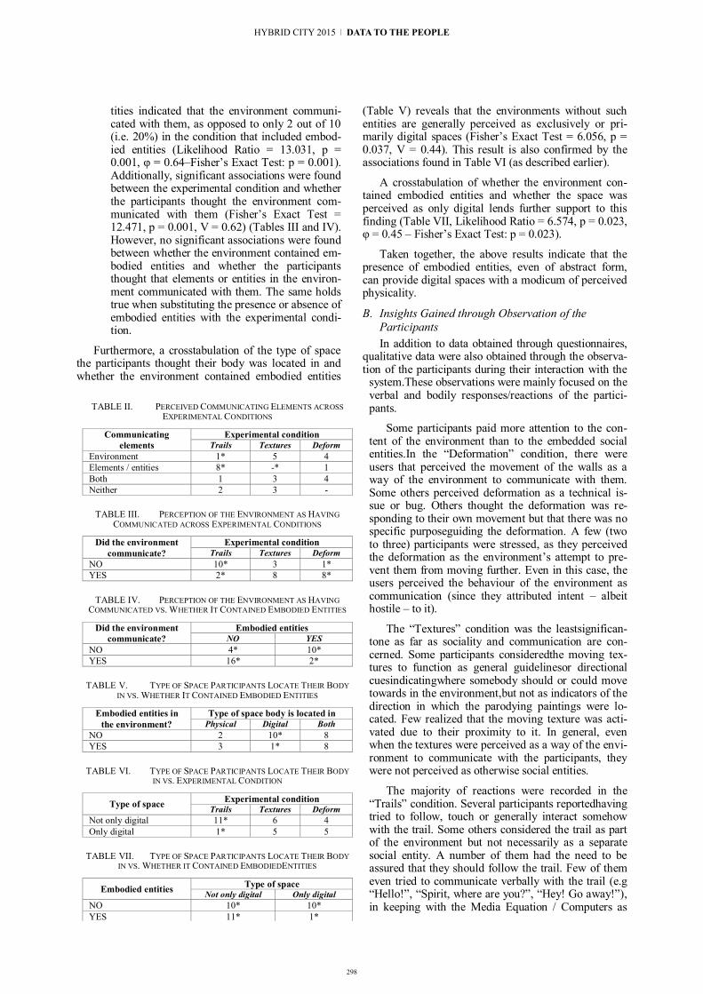
298
tities indicated that the environment communi-cated with them, as opposed to only 2 out of 10 (i.e. 20%) in the condition that included embod-ied entities (Likelihood Ratio = 13.031, p = 0.001, φ = 0.64–Fisher’s Exact Test: p = 0.001). Additionally, significant associations were found between the experimental condition and whether the participants thought the environment com-municated with them (Fisher’s Exact Test = 12.471, p = 0.001, V = 0.62) (Tables III and IV). However, no significant associations were found between whether the environment contained em-bodied entities and whether the participants thought that elements or entities in the environ-ment communicated with them. The same holds true when substituting the presence or absence of embodied entities with the experimental condi-tion.
Furthermore, a crosstabulation of the type of space the participants thought their body was located in and whether the environment contained embodied entities
(Table V) reveals that the environments without such entities are generally perceived as exclusively or pri-marily digital spaces (Fisher’s Exact Test = .0 , p = 0.037, V = 0.44). This result is also confirmed by the associations found in Table VI (as described earlier).
A crosstabulation of whether the environment con-tained embodied entities and whether the space was perceived as only digital lends further support to this finding (Table VII, Likelihood Ratio = 6.574, p = 0.023, φ = 0.45 – Fisher’s Exact Test: p = 0.023).
Taken together, the above results indicate that the presence of embodied entities, even of abstract form, can provide digital spaces with a modicum of perceived physicality.
B. Insights Gained through Observation of the Participants In addition to data obtained through questionnaires,
qualitative data were also obtained through the observa-tion of the participants during their interaction with the
system.These observations were mainly focused on the verbal and bodily responses/reactions of the partici-pants.
Some participants paid more attention to the con-tent of the environment than to the embedded social entities.In the “Deformation” condition, there were users that perceived the movement of the walls as a way of the environment to communicate with them. Some others perceived deformation as a technical is-sue or bug. Others thought the deformation was re-sponding to their own movement but that there was no specific purposeguiding the deformation. A few (two to three) participants were stressed, as they perceived the deformation as the environment’s attempt to pre-vent them from moving further. Even in this case, the users perceived the behaviour of the environment as communication (since they attributed intent – albeit hostile – to it).
The “Textures” condition was the leastsignifican-tone as far as sociality and communication are con-cerned. Some participants consideredthe moving tex-tures to function as general guidelinesor directional cuesindicatingwhere somebody should or could move towards in the environment,but not as indicators of the direction in which the parodying paintings were lo-cated. Few realized that the moving texture was acti-vated due to their proximity to it. In general, even when the textures were perceived as a way of the envi-ronment to communicate with the participants, they were not perceived as otherwise social entities.
The majority of reactions were recorded in the “Trails” condition. Several participants reportedhaving tried to follow, touch or generally interact somehow with the trail. Some others considered the trail as part of the environment but not necessarily as a separate social entity. A number of them had the need to be assured that they should follow the trail. Few of them even tried to communicate verbally with the trail (e.g “Hello!”, “Spirit, where are you?”, “Hey! Go away!”), in keeping with the Media Equation / Computers as
TABLE II. PERCEIVED COMMUNICATING ELEMENTS ACROSS EXPERIMENTAL CONDITIONS
Communicating elements
Experimental condition Trails Textures Deform
Environment 1* 5 4 Elements / entities 8* -* 1 Both 1 3 4 Neither 2 3 -
TABLE III. PERCEPTION OF THE ENVIRONMENT AS HAVING COMMUNICATED ACROSS EXPERIMENTAL CONDITIONS
Did the environment communicate?
Experimental condition Trails Textures Deform
NO 10* 3 1* YES 2* 8 8*
TABLE IV. PERCEPTION OF THE ENVIRONMENT AS HAVING COMMUNICATED VS. WHETHER IT CONTAINED EMBODIED ENTITIES
Did the environment communicate?
Embodied entities NO YES
NO 4* 10* YES 16* 2*
TABLE V. TYPE OF SPACE PARTICIPANTS LOCATE THEIR BODY IN VS. WHETHER IT CONTAINED EMBODIED ENTITIES
Embodied entities in the environment?
Type of space body is located in Physical Digital Both
NO 2 10* 8 YES 3 1* 8
TABLE VI. TYPE OF SPACE PARTICIPANTS LOCATE THEIR BODY IN VS. EXPERIMENTAL CONDITION
Type of space Experimental condition Trails Textures Deform
Not only digital 11* 6 4 Only digital 1* 5 5
TABLE VII. TYPE OF SPACE PARTICIPANTS LOCATE THEIR BODY IN VS. WHETHER IT CONTAINED EMBODIEDENTITIES
Embodied entities Type of space Not only digital Only digital
NO 10* 10* YES 11* 1*
HYBRID CITY 2015 | DATA TO THE PEOPLE
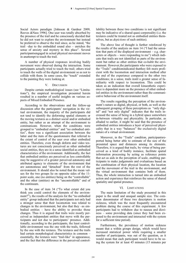
299
Social Actors paradigm [Johnson & Gardner 2009, Reeves &Nass 1996]. One user was totally absorbed by the presence of the trail and he consciously decided that he did not want to explore the environment but instead he preferred to observe the trail since, as he stated, “the trail –due to the embedded sound also – enriches the sense of anxiety and mystery in this place”. Several participantsengaged in actual physical movement moves in anattempt to touch the trail.
A number of physical responses involving bodily movement were observed during the interaction. Some participants actually tried to touch the trail; others tried to touch the walls of the digital environment so as not to collide with them. n some cases, the “touch” extended to the painting they were looking at.
V. DISCUSSION Despite certain methodological issues (see “Limita-
tions”), the empirical investigation presented herein resulted in a number of useful insights on various as-pects of Mixed Embodied Presence.
According to the observations and the follow-up discussion after the participants’ navigation in the vir-tual environment, the majority of the participants did not tend to identify the deforming spatial elements or the moving textures as a distinct social and/or embodied entity, but rather as an attempt of the environment to communicate. However, when the conditions were grouped to “embodied entities” and “no embodied enti-ties”, there was a significant association between the latter and the item of the questionnaire that referred to the extent of control of the user over other embodied entities. Therefore, even though deform and video tex-tures are not consciously perceived as other embodied social entities, they are in a sense identified as embodied characteristics of the environment. Additionally, the fact that embodied entities are perceived as less controllable may be suggestive of a greater perceived autonomy and attributed agency to elements of the environment that are autonomous and “detached” from the rest of the environment. It should also be noted that the mean val-ues for the two groups lie on opposite sides of the 11-point scale, one (no entities) being on the “controllable” and the other (entities) on the “uncontrollable” end of the continuum.
In the case of item 34 (“To what extent did you think you could control the elements of the environ-ment?”), the results of the analysis for the “no embodied entity” group indicated that the participants not only had a stronger sense that their locomotion was related to changes in the environment, but also that they –as em-bodied entities – have the ability to provoke those changes. Thus it is argued that trails were mostly per-ceived as independent entities that move with the par-ticipants and not due to participants’ presence. Addi-tionally, according to the participants, the least control-lable environment was the one with the trails, followed by the one with the textures. The textures and the trails had certain morphological characteristics in common – essentially, the textures were “trail-like” in appearance, and the fact that the difference in the perceived control-
lability between these two conditions is not significant may be indicative of a shared quasi-corporeality (i.e. the textures could be treated not as embodied entities them-selves, but as depictions of such entities).
The above line of thought is further reinforced by the results of the analysis on item 14 (“I had the sensa-tion that parts of the displayed environment – e.g. char-acters or objects – were responding to me”) which indi-cate that trails are not identified as parts of the environ-ment but rather as other entities that co-habit the envi-ronment. However,the participants who were exposed to the “Trails” conditionindicated thatthey felt more profi-cient with the locomotion and interaction method after the end of the experience compared to the other two conditions; in a sense, trails instil a greater sense of fa-miliarity with respect to locomotion. This could be taken as an indication that overall kinaesthetic experi-ence is dependent more on the presence of other embod-ied entities in the environment rather than the communi-cative behaviour of the environment itself.
The results regarding the perception of the environ-ment’s nature as digital, physical, or both, as well as the subsequent grouping of these perceptions as “only digi-tal” and “not only digital” indicates that the trails in-creased the sense of being in a hybrid space somewhere in-between virtuality and physicality. In particular, as alluded to earlier, it might be said that the presence of embodied entities introduces a layer of perceived physi-cality that in a way “balances” the exclusively digital nature of a virtual environment.
Moreover, in the “Trails” condition, participantsre-ported being better able to estimate of the size of the presented space and distances among its elements. Therefore, it is argued that trails, by virtue of being per-ceived as a kind of bodily instance, facilitate spatial information processing by acting as reference points that act as aids in the perception of scale, enabling par-ticipants to make judgements and evaluations based on the combination of their physical location, the location and the movement of the trail in the environment, and the virtual environment that contains both of them. Thus, the whole interaction is turned into an embodied action and experience that reinforces the sense of shared spatiality and spatial presence.
VI. LIMITATIONS The main limitation of the study presented in this
paper is the small and unequal sample size. The com-mon denominator of these two descriptors is motion sickness, which was the most frequently encountered problem during the course of this experiment. A few participants had to withdraw due to nausea and dizzi-ness – some providing data (since they had been ex-posed to the environment and interacted with the system for a sufficient time period).
Furthermore, the prevalence of motion sickness meant that a within groups design, which would have increased statistical power while requiring a smaller number of participants, was out of the question, as it would mean that each participant would have to be us-ing the system for at least 45 minutes (15 minutes per
8 | Augmented [Urban] Spatial Experiences

300
condition), a duration that would have been considered excessive by the majority of the participants. Addition-ally, the environments and their layout would have to be substantially different so that learning effects could have been avoided.
An additional limitation is related to the lack of complexity of the behaviour of the environment or the embodied entities. This lack of complexity led some participants to disregard the environment and/or the entities and proceed to identifying the exhibits in a lin-ear fashion.
VII. CONCLUSIONS AND FUTURE WORK The findings described in this paper point toward a
difference in perception of certain parameters of virtual environments based on whether they are inhabited by embodied entities. The present research corroborates the hypothesis (put forth in earlier publications) thateven abstract forms consisting of basic shapes such as col-oured lines can be regarded as meaningful communica-tors with a clear bodily presence. Furthermore, the pres-ence of such entities reduces the perceived exclusive “digitality” of a virtual space, possibly introducing a notion of “quasi-physicality” that, ultimately, leads to the perception of that space as hybrid. It may be sug-gested that this quasi-physicality is contingent upon the interrelationship between the user’s body and the corpo-real presence of the embodied entities contained in the environment.
The research reported in this paper is only a first step in the process of ascertaining, through empirical research, the interplay among parameters of the envi-ronment (e.g. size, layout, texture, agency etc.), system-related parameters (e.g. representational realism and fidelity, multimodality, degree of immersion etc.), and social aspects (e.g. presence and form of embodied or otherwise autonomous entities in the environment) in the context of Mixed Embodied Presence. Future work will address several of the issues that may arise as a result of the relationships among these factors in an attempt not only to identify the dimensions that are most relevant to the concept of Mixed Embodied Presence, but also their magnitude. Additionally, as described in an earlier section, data pertaining to user- and system-related factors (e.g. personality, videogame experience / familiarity, User Experience, communicator style, etc.) have been obtained and will be reported in future publi-cations.
REFERENCES [1] J.P. Chin, V.A. Diehl, and K.L. Norman. “Development of an
instrument measuring user satisfaction of the human-computer interface”, Proceedings of ACM Conference on Human Factors in Computing Systerms (CH ’88), 15-19 June 1988, Washing-ton D.C., pp. 213-218.
[2] P.T. Costa and R.R. McCrae. “Revised NEO Personality nven-tory (NEO-PI-R) and NEO-PI-R Five-Factor Inventory (NEO-PI-R-FF )”, Professional Manual. Odessa, FL: Psychological Assessment Resources, 1992.
[3] J. Hoonhout. “Inquiring about people’s affective product judgements: How was the experience for you just now?” In:J.H.D.M.Westerink, M.Ouwerkerk, T.J.M.Overbeek, W.F. Pasveer, and B. de Ruyter (eds.), Probing Experience: From
Assessment of User Emotions and Behaviour to Development of Products,Dordrecht, the Netherlands: Springer, 2008, pp. 11-24.
[4] D. Johnson and J. Gardner. “Exploring Mindlessness as an Explanation for the Media Equation: A Study of Stereotyping in Computer Tutorials”. Personal and Ubiquitous Computing, vol. 13, 2009), pp. 151-163.
[5] R.S. Kennedy, N.E. Lane, K.S.Berbaum, and M.G. Lilienthal. “Simulator Sickness Questionnaire: An Enhanced Method for Quantifying Simulator Sickness”, nternational Journal of Avia-tion Psychology, vol. 3 (3), 1993, pp. 203-220.
[6] S. Kujala, V. Roto, K. Väänänen-Vainio-Mattila, K., and A. Sinnelä. “ dentifying hedonic factors in long-term User Experi-ence”, Proceedings of the2011 Conference on Designing Pleas-urable Products and nterfaces (DPP ’11), 22-25 June 2011, Mi-lan, Italy, article no. 17.
[7] J.Lessiter, J. Freeman, E. Keogh, and J. Davidoff. ” A Cross-Media Presence Questionnaire: The ITC-Sense of Presence In-ventory”, Presence: Teleoperators and Virtual Environments, vol. 10 (3), 2001, pp. 282-297.
[8] M. Lombard, T.B. Ditton, and L. Weinstein. “Measuring (tele)presence: The Temple Presence nventory”, Presented at the Twelfth International Workshop on Presence, Los Angeles, California, USA, 2009.
[9] W.E. Marsh, J.W. Kelly, V.J. Dark, and J.H. Oliver. “Cognitive Demands of Semi-Natural Virtual Locomotion”. Presence: Teleoperators and Virtual Environments, vol. 22 (3), 2013, pp. 216-234.
[10] R.W. Norton. Communicator Style. Beverly Hills, CA: Sage, 1983.
[11] C. Papasarantou and E.Gavrilou. “Representational approaches of the notion of co-presence in mixed environments”, in two-day international scientific symposium “Metamorphoses of Corporeality: Art – Body – Technology”, onian Academy, Corfu, 2014, pp. 118-150.
[12] C. Papasarantou, C. Rizopoulos, V. Bourdakis, and D. Charitos. “Analysing mixed embodied presence through the lens of embodiment and social presence”, in proceedings of the international Society for Presence Research 201 “Challenging Presence”, Vienna,1 -19 March, 2014, pp. 73-79.
[13] C.Papasarantou, “Hybrid Spatial Complexes: the notion of mixed embodied presence”, in proceedings of the international Biennial Conference Hybrid City 2013 – Subtle Revolutions, 23-25 May, 2013, pp. 117-124.
[14] C. Papasarantou and V.Bourdakis. “Represent-ing presence”, in V!rus Journal, RE:PRE:SENT, Issue 8, December 2012.
[15] B. Reeves and C.Nass. The Media Equation: How People Treat Computers, Television, and New Media Like Real People and Places. Chicago: University of Chicago Press, 1996.
[16] C. Rizopoulos and D. Charitos. “The Experience of Spatial Interaction: Conceptuaizing the User Experience of Virtual Environments”. n N. Streitz and P. Markopoulos (eds.), Proceedings of the 2nd International Conference on Distributed, Ambient, and Pervasive Interactions (DAPI), Heraklion, Greece, 22-27 June 2014, LNCS 8530, Springer, pp. 380-391.
[17] P. Vorderer, W, Wirth, F.R. Gouveia, F. Biocca, T.Saari, F.Jäncke, S.Böcking, H. Schramm, A.Gysbers, T. Hartmann, C.Klimmt, J.Laarni, N.Ravaja, A.Sacau, T. Baumgartner, and P.Jäncke. “MEC Spatial Presence Questionnaire (MECSPQ): Short Documentation and Instructions for Application. Report to the European Community”, Project Presence: MEC ( ST-2001-37661), 2004, Online. Available from http://www.ijk.hmt-hannover.de/presence
[18] B.G.Witmer, C.J. Jerome, and M.J.& Singer. “The Factor Structure of the Presence Questionnaire”. Presence: Teleopera-tors and Virtual Environments, vol. 14 (5), 2005, pp.298-312.
[19] B.G. Witmer and M. J. Singer. “Measuring Presence in Virtual Environments: A Presence Questionnaire”, Presence, vol. (3), M.I.T. June, 1998, pp. 225-340.
HYBRID CITY 2015 | DATA TO THE PEOPLE
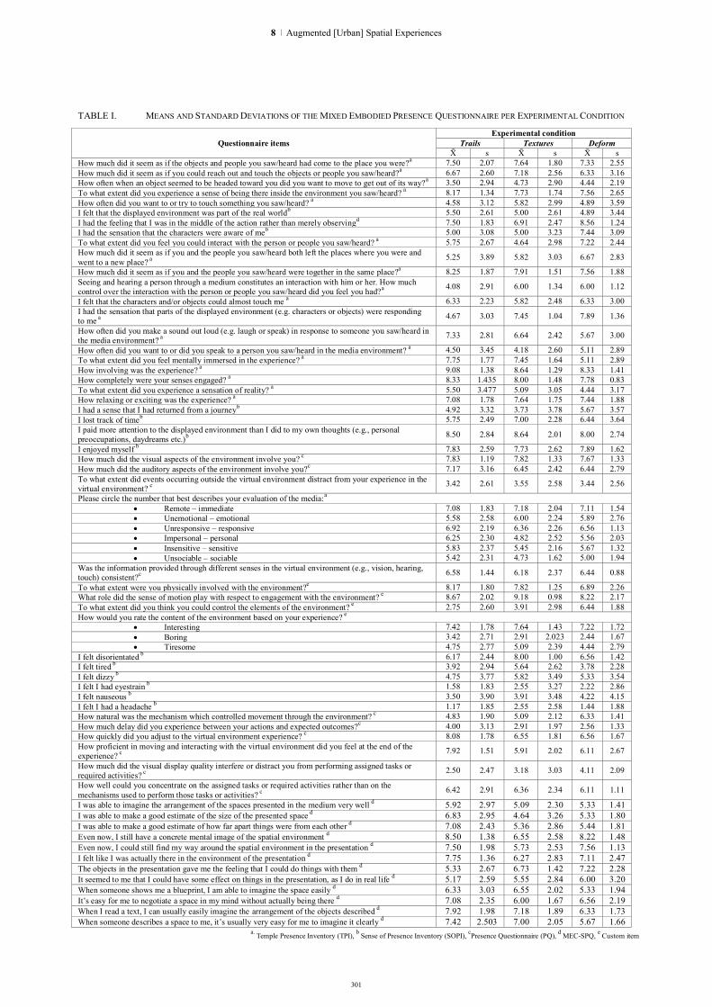
301
TABLE I. MEANS AND STANDARD DEVIATIONS OF THE MIXED EMBODIED PRESENCE QUESTIONNAIRE PER EXPERIMENTAL CONDITION
Questionnaire items Experimental condition
Trails Textures Deform s s s
How much did it seem as if the objects and people you saw/heard had come to the place you were?a 7.50 2.07 7.64 1.80 7.33 2.55 How much did it seem as if you could reach out and touch the objects or people you saw/heard?a 6.67 2.60 7.18 2.56 6.33 3.16 How often when an object seemed to be headed toward you did you want to move to get out of its way?a 3.50 2.94 4.73 2.90 4.44 2.19 To what extent did you experience a sense of being there inside the environment you saw/heard? a 8.17 1.34 7.73 1.74 7.56 2.65 How often did you want to or try to touch something you saw/heard? a 4.58 3.12 5.82 2.99 4.89 3.59 I felt that the displayed environment was part of the real worldb 5.50 2.61 5.00 2.61 4.89 3.44 I had the feeling that I was in the middle of the action rather than merely observingd 7.50 1.83 6.91 2.47 8.56 1.24 I had the sensation that the characters were aware of meb 5.00 3.08 5.00 3.23 7.44 3.09 To what extent did you feel you could interact with the person or people you saw/heard? a 5.75 2.67 4.64 2.98 7.22 2.44 How much did it seem as if you and the people you saw/heard both left the places where you were and went to a new place? a 5.25 3.89 5.82 3.03 6.67 2.83
How much did it seem as if you and the people you saw/heard were together in the same place?a 8.25 1.87 7.91 1.51 7.56 1.88 Seeing and hearing a person through a medium constitutes an interaction with him or her. How much control over the interaction with the person or people you saw/heard did you feel you had?a 4.08 2.91 6.00 1.34 6.00 1.12
I felt that the characters and/or objects could almost touch me a 6.33 2.23 5.82 2.48 6.33 3.00 I had the sensation that parts of the displayed environment (e.g. characters or objects) were responding to me a 4.67 3.03 7.45 1.04 7.89 1.36
How often did you make a sound out loud (e.g. laugh or speak) in response to someone you saw/heard in the media environment? a 7.33 2.81 6.64 2.42 5.67 3.00
How often did you want to or did you speak to a person you saw/heard in the media environment? a 4.50 3.45 4.18 2.60 5.11 2.89 To what extent did you feel mentally immersed in the experience? a 7.75 1.77 7.45 1.64 5.11 2.89 How involving was the experience? a 9.08 1.38 8.64 1.29 8.33 1.41 How completely were your senses engaged? a 8.33 1.435 8.00 1.48 7.78 0.83 To what extent did you experience a sensation of reality? a 5.50 3.477 5.09 3.05 4.44 3.17 How relaxing or exciting was the experience? a 7.08 1.78 7.64 1.75 7.44 1.88 I had a sense that I had returned from a journeyb 4.92 3.32 3.73 3.78 5.67 3.57 I lost track of timeb 5.75 2.49 7.00 2.28 6.44 3.64 I paid more attention to the displayed environment than I did to my own thoughts (e.g., personal preoccupations, daydreams etc.)b 8.50 2.84 8.64 2.01 8.00 2.74
I enjoyed myself b 7.83 2.59 7.73 2.62 7.89 1.62 How much did the visual aspects of the environment involve you? c 7.83 1.19 7.82 1.33 7.67 1.33 How much did the auditory aspects of the environment involve you?c 7.17 3.16 6.45 2.42 6.44 2.79 To what extent did events occurring outside the virtual environment distract from your experience in the virtual environment? c 3.42 2.61 3.55 2.58 3.44 2.56
Please circle the number that best describes your evaluation of the media:a Remote – immediate 7.08 1.83 7.18 2.04 7.11 1.54 Unemotional – emotional 5.58 2.58 6.00 2.24 5.89 2.76 Unresponsive – responsive 6.92 2.19 6.36 2.26 6.56 1.13 Impersonal – personal 6.25 2.30 4.82 2.52 5.56 2.03 Insensitive – sensitive 5.83 2.37 5.45 2.16 5.67 1.32 Unsociable – sociable 5.42 2.31 4.73 1.62 5.00 1.94
Was the information provided through different senses in the virtual environment (e.g., vision, hearing, touch) consistent?c 6.58 1.44 6.18 2.37 6.44 0.88
To what extent were you physically involved with the environment?e 8.17 1.80 7.82 1.25 6.89 2.26 What role did the sense of motion play with respect to engagement with the environment? e 8.67 2.02 9.18 0.98 8.22 2.17 To what extent did you think you could control the elements of the environment? e 2.75 2.60 3.91 2.98 6.44 1.88 How would you rate the content of the environment based on your experience? e
Interesting 7.42 1.78 7.64 1.43 7.22 1.72 Boring 3.42 2.71 2.91 2.023 2.44 1.67 Tiresome 4.75 2.77 5.09 2.39 4.44 2.79
I felt disorientated b 6.17 2.44 8.00 1.00 6.56 1.42 I felt tired b 3.92 2.94 5.64 2.62 3.78 2.28 I felt dizzy b 4.75 3.77 5.82 3.49 5.33 3.54 I felt I had eyestrain b 1.58 1.83 2.55 3.27 2.22 2.86 I felt nauseous b 3.50 3.90 3.91 3.48 4.22 4.15 I felt I had a headache b 1.17 1.85 2.55 2.58 1.44 1.88 How natural was the mechanism which controlled movement through the environment? c 4.83 1.90 5.09 2.12 6.33 1.41 How much delay did you experience between your actions and expected outcomes?c 4.00 3.13 2.91 1.97 2.56 1.33 How quickly did you adjust to the virtual environment experience? c 8.08 1.78 6.55 1.81 6.56 1.67 How proficient in moving and interacting with the virtual environment did you feel at the end of the experience? c 7.92 1.51 5.91 2.02 6.11 2.67
How much did the visual display quality interfere or distract you from performing assigned tasks or required activities? c 2.50 2.47 3.18 3.03 4.11 2.09
How well could you concentrate on the assigned tasks or required activities rather than on the mechanisms used to perform those tasks or activities? c 6.42 2.91 6.36 2.34 6.11 1.11
I was able to imagine the arrangement of the spaces presented in the medium very well d 5.92 2.97 5.09 2.30 5.33 1.41 I was able to make a good estimate of the size of the presented space d 6.83 2.95 4.64 3.26 5.33 1.80 I was able to make a good estimate of how far apart things were from each other d 7.08 2.43 5.36 2.86 5.44 1.81 Even now, I still have a concrete mental image of the spatial environment d 8.50 1.38 6.55 2.58 8.22 1.48 Even now, I could still find my way around the spatial environment in the presentation d 7.50 1.98 5.73 2.53 7.56 1.13 I felt like I was actually there in the environment of the presentation d 7.75 1.36 6.27 2.83 7.11 2.47 The objects in the presentation gave me the feeling that I could do things with them d 5.33 2.67 6.73 1.42 7.22 2.28 It seemed to me that I could have some effect on things in the presentation, as I do in real life d 5.17 2.59 5.55 2.84 6.00 3.20 When someone shows me a blueprint, I am able to imagine the space easily d 6.33 3.03 6.55 2.02 5.33 1.94 t’s easy for me to negotiate a space in my mind without actually being there d 7.08 2.35 6.00 1.67 6.56 2.19 When I read a text, I can usually easily imagine the arrangement of the objects described d 7.92 1.98 7.18 1.89 6.33 1.73 When someone describes a space to me, it’s usually very easy for me to imagine it clearly d 7.42 2.503 7.00 2.05 5.67 1.66
a. Temple Presence Inventory (TPI), b Sense of Presence Inventory (SOPI), cPresence Questionnaire (PQ), d MEC-SPQ, e Custom item
8 | Augmented [Urban] Spatial Experiences

302
Hackable Urban Experiences
Marinela Telo Technical University of Crete, School of
Architectural Engineering. Transformable Intelligent Environments
Laboratory(TUC TIE Lab). Chania, Greece.
Konstantinos-Alketas Oungrinis Technical University of Crete, School of
Architectural Engineering. Transformable Intelligent Environments
Laboratory(TUC TIE Lab). Chania, Greece.
Abstract. The paper presents a concept of an ongoing research project that focuses on re-defining the relationship between people and public space by bridging the physical environment with the digital realm. The project negotiates the parameters of this relation through an Augmented Reality tool that employs the technological features provided by enhanced reality glasses combined with a wearable computer and a wearable gesture-control device. The user has the ability to create virtual manifestations of a personal version of the surrounding urban environment and intervene digitally by painting, writing, posting and even designing within public space. The proposed AR tool provides users with the ability to creatively produce spatial 'tags' and comments upon a building's facade, a street's urban equipment, even within open spaces, helping them to release their imagination, express their own view about public space and shape a new type of spatial experience. Public space transforms into a canvas for personalized expressions of creativity and appropriations of the usual uncanny aspects of a city that can be shared through special apps and social media. The results of this interaction are artistic, architectural and/or social, but they primarily retain the personal view of the users' spatial perception. Aspects that are usually connected with private space are externalized, facilitating familiarity, initiative and fun. The aforementioned digital interventions can either remain personal or shared within a public cloud accessible by other users that forms a second layer of information that is superimposed to normal perception, thus enriching the understanding of the urban reality.
Keywords: Urban digital media; augmented reality; spatial experience; people-space communication.
I. INTRODUCTION
The paper presents a concept of an ongoing research project that focuses on re-defining the relationship between citizens and urban space. The project negotiates the parameters of this relation through a concept of an Augmented Reality tool which provides users with the ability to create virtual manifestations of a personal version of the surrounding urban environment. As the project is in the concept phase this paper presents the influences of this concept as well as the proposed technological features for developing the concept to a prototype.
II. INFLUENCES
The concept of this project stems from different fields of everyday life which include citizens' interventions with built environment, personal technological devices and the growth of social media usage.
A. Interventions in urban built environment The The Urban space, as a social and political space,
is influenced by the activities of citizens. Since the activities of citizens in public space have various manifestations, this project is focused especially in citizens' “interventions” on the built environment. People react and intervene in their urban environments with various ways and techniques (Fig.1). They use graffiti, art, even a simple way in order to express themselves with interventions to walls, traffic signs, trees, ads, and to any other element of modern city [1]. These kind of gestures in urban space interplay with fine art, architecture, performance, installation, activism and urbanism while they turn public spaces into individual experiences [1].
Many of these interventions in public space have a critical or/and satirical character. At MIT a series of pranks and interventions have been described by the term of 'hack'. The word “hack” at MIT usually refers to a clever, benign, and “ethical” prank or practical joke, which is both challenging for the perpetrators and amusing to the MIT community (and sometimes even the rest of the world) [2]. Students come together, usually at night, and prepare their hack. For some of them, hacking is part and parcel of the MIT education. They work productively in teams, to solve engineering problems, and communicate them to the wider world. The process of hacking includes brainstorming, strategy sessions, preparation, test runs, and implementation. The success of a hack is almost proportional to the strength of its finer points. They make large objects appear in inaccessible places, such as rewire lecture hall blackboards, or place a police car or a replica of the Apollo lunar module at the top of the Great Dome (Fig. 1.). In this case, the term 'hack' has nothing to do with computer (or phone) hacking, which in MIT community is named “cracking”. André DeHon discusses how hacking reflects the Institute’s own value system. As he mentions “Hacks provide an opportunity to demonstrate
HYBRID CITY 2015 | DATA TO THE PEOPLE
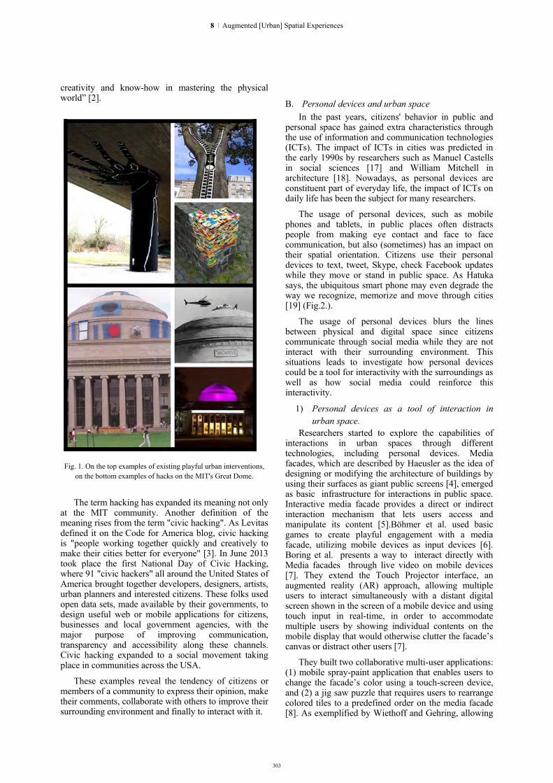
303
creativity and know-how in mastering the physical world” [2].
Fig. 1. On the top examples of existing playful urban interventions,
on the bottom examples of hacks on the MIT's Great Dome.
The term hacking has expanded its meaning not only at the MIT community. Another definition of the meaning rises from the term "civic hacking". As Levitas defined it on the Code for America blog, civic hacking is "people working together quickly and creatively to make their cities better for everyone" [3]. In June 2013 took place the first National Day of Civic Hacking, where 91 "civic hackers" all around the United States of America brought together developers, designers, artists, urban planners and interested citizens. These folks used open data sets, made available by their governments, to design useful web or mobile applications for citizens, businesses and local government agencies, with the major purpose of improving communication, transparency and accessibility along these channels. Civic hacking expanded to a social movement taking place in communities across the USA.
These examples reveal the tendency of citizens or members of a community to express their opinion, make their comments, collaborate with others to improve their surrounding environment and finally to interact with it.
B. Personal devices and urban space In the past years, citizens' behavior in public and
personal space has gained extra characteristics through the use of information and communication technologies (ICTs). The impact of ICTs in cities was predicted in the early 1990s by researchers such as Manuel Castells in social sciences [17] and William Mitchell in architecture [18]. Nowadays, as personal devices are constituent part of everyday life, the impact of ICTs on daily life has been the subject for many researchers.
The usage of personal devices, such as mobile phones and tablets, in public places often distracts people from making eye contact and face to face communication, but also (sometimes) has an impact on their spatial orientation. Citizens use their personal devices to text, tweet, Skype, check Facebook updates while they move or stand in public space. As Hatuka says, the ubiquitous smart phone may even degrade the way we recognize, memorize and move through cities [19] (Fig.2.).
The usage of personal devices blurs the lines between physical and digital space since citizens communicate through social media while they are not interact with their surrounding environment. This situations leads to investigate how personal devices could be a tool for interactivity with the surroundings as well as how social media could reinforce this interactivity.
1) Personal devices as a tool of interaction in urban space.
Researchers started to explore the capabilities of interactions in urban spaces through different technologies, including personal devices. Media facades, which are described by Haeusler as the idea of designing or modifying the architecture of buildings by using their surfaces as giant public screens [4], emerged as basic infrastructure for interactions in public space. Interactive media facade provides a direct or indirect interaction mechanism that lets users access and manipulate its content [5].Böhmer et al. used basic games to create playful engagement with a media facade, utilizing mobile devices as input devices [6]. Boring et al. presents a way to interact directly with Media facades through live video on mobile devices [7]. They extend the Touch Projector interface, an augmented reality (AR) approach, allowing multiple users to interact simultaneously with a distant digital screen shown in the screen of a mobile device and using touch input in real-time, in order to accommodate multiple users by showing individual contents on the mobile display that would otherwise clutter the facade’s canvas or distract other users [7].
They built two collaborative multi-user applications: (1) mobile spray-paint application that enables users to change the facade’s color using a touch-screen device, and (2) a jig saw puzzle that requires users to rearrange colored tiles to a predefined order on the media facade [8]. As exemplified by Wiethoff and Gehring, allowing
8 | Augmented [Urban] Spatial Experiences

304
simultaneous interaction with a shared canvas can lead to frustration among the users [5].
Fig. 2. On the top first mobile phone sidewalks in China, on the bottom, examples of different use of personal devices for interactions.
However, the interactions with media facade are limited to a specific area where the infrastructure is installed. Scheible et al. used MobiSpray art tool for imposing large-scale ephemeral digital artistic projections on the environment [9]. MobiSpray combines a personal mobile phone, a PC and a video projector into a novel art tool for the creation of ubiquitous digital art. As an equipment that can be carried in a rucksack, it allows the creation and projection of ephemeral digital art anytime, anywhere, and on anything [9]. The users of MobiSpray have the freedom to change and personalize their surrounding environment, however, due to the ephemeral projection, the interaction between users can only be accomplished if they are on the same place at the same time.
Another aspect of using personal devices in Urban Environment is the wearable computer system into augmented reality (AR) tool. The AR tool integrates 3D virtual objects into a 3D real environment in real time [10]. As Azuma describes "Augmented reality (AR) is a variation of virtual environments (VE), or virtual reality as it is more commonly called. VE technologies completely immerse a user inside a synthetic environment. While immersed, the user cannot see the real world around him. In contrast, AR allows the user to see the real world with virtual objects superimposed upon or composited with the real world " [10]. Feiner et al. (in 1997) explored at first a way to combine augmented reality and mobile user interfaces, in order to
investigate how these two technologies might together make possible wearable computer systems that can support users in their everyday interactions with the world. They created a prototype which assists users who are interested in Columbia university’s campus, overlaying information about items of interest in their vicinity [11]. In the past years, this field has grown rapidly, and as a result many such devices have been built.
2) Social media and physical environment Social Media, as defined by Kaplan and Haenlein, is
a group of Internet-based applications built on the ideological and technological foundations of Web 2.0, that allow the creation and exchange of User Generated Content [12]. Despite this general definition, there are various types of Social Media that need to be distinguished further. Brian Solis developed in 2008 The Conversation Prism which is a visual map of the social media landscape, an ongoing study in digital ethnography that tracks dominant and promising social networks and organizes them by how they’re used in everyday life[13]. The large family of Social Media includes Social networking sites which are applications that enable users to connect by creating personal information profiles, inviting friends and colleagues to have access to those profiles, and sending e-mails and instant messages between each other [12]. One of the largest social networking sites is Facebook with 1,415 million active user (according to Statista for March 2015 [14]). Facebook users have their personal profile which includes any type of information, and at the same time they have access to a home page, which reveals the news of their contacts, to groups, pages, applications and events.
The activities of users in digital cloud of Facebook have references of physical world. For example, a Facebook user has three possible options about an event: "join", "maybe" and "invite". These choices have actually an impact on the event that will take place in physical world as well as influence the users that will attend this event. Moreover, a Facebook activity that is immediately connected with physical world is the ability to check into a nearby location. This allows the users to add their current location, integrated with Google Maps, to their posts and information. Even though Social Media have references of physical world and affecting the activities that taking place there, continue to inhibit the interaction of users with surroundings.
III. THE "HACKABLE URBAN
EXPERIENCES" PROJECT A. Proposed Methodology
The project proposes a personal device as a tool for a series of interactions and appropriations of public space through digital interventions that lead to a distributed personalized urban experience as well as to create a new Social Networking where these personal interventions are shared and applied from other users, creating a novel way of exchanging more than verbal communications.
HYBRID CITY 2015 | DATA TO THE PEOPLE

305
The project negotiates the parameters of these interventions through an AR tool, an interface that employs the technological features provided by enhanced reality glasses combined with a wearable computer system and a wearable gesture-control device.The users through their personal wearable device have the ability to create virtual manifestations toward a personal version of the surrounding urban environment and intervene digitally by painting, writing, posting, even (re)designing within public space, using user-friendly software as paint, photoshop, google image search, word, even a 3d model software. For example, users can paint on a facade with different colors chosen from the provided color pallet, or they can draw a new image and tag it on a facade. They can write a message that expresses themselves and post it to a specific place that is important for them. They can 'tag' an existed image in open space or they can re-design a building facade according to their preferences (Fig.3.).
Fig. 3. Examples of same possible digital hacks. On the top a color
hack, in the middle an expressive hack and on the bottom a personal note.
The proposed AR tool provides users with the freedom of creating virtual interventions of their preferences anytime, anywhere, and on anything. The ability to creatively produce spatial 'tags' and 'comments' upon a building's facade, a street's urban equipment, even within open spaces, releases users' imagination and expression of their perception of urban environment. Furthermore, this ability shapes a new type of spatial experience. Christopher Alexander mentions " Those of us who are concerned with buildings tend to forget too easily that all the life and soul of a place, all of our experiences there, depend not simply on the physical environment, but on the pattern
of events which we experience there” [15]. The proposed AR tool transforms urban environment into a virtual canvas for personalized expressions of creativity and appropriations of the usual uncanny aspects of a city.
Harrison and Dourish highlight the critical distinction between “space” and “place” and show how it is actually a notion of "place", rather than "space", which frame interactive behaviour [16]. As they commented "We make a house into a home by arranging it to suit our lives, and putting things there which reflect ourselves. People make places in media spaces with just the same ideas of adaptation and appropriation."[16]. With the proposed tool, aspects which are usually connected with our private space as personal interventions and customization, are externalized in public space, in order to make place in public space, facilitating familiarity, fun and interactivity.
The results of these interactions could be either artistic, architectural and/or social, but they primarily retain the personal view of the users' spatial perception, no matter their aesthetic. Every single person, through the experiences of his/her life, has developed a personal point of view and a personal way of understanding his/her surrounding environment.
A recent example of citizens' individual expression into urban environment through digital tools is MobisSpray. Users commented:
-“First I didn’t dare to do it because you have some kind of illegal feeling, but then when you do it, it feels liberating.” -“This is fascinating, now I understand why kids do graffiti.” [9].
However, the users' personal expression is subjective, and as so, it might not be acceptable from other users. The proposed tool avoids this kind of issues through a personal device which allows each user to see his own perspective. On the other hand, if every user had only his own perspective, social issues would rise upon interaction between users. In order to deal with social issues the proposed tool can evolve social networking application, where digital interventions can be shared in a public cloud and be accessible by other users. This Social network provides user the option to live his/her own personalized version of urban experience or explore a city through the “digital eyes” of other users. The potential of a social networking with digital interventions in surrounding environment could form a second layer of understanding urban reality. Information that such a social network can provide, might be crucial for groups of people that involve in urban environment. Such groups are architects, urban designers and sociologists.
B. System components The AR tool is proposed to be comprised of an
augmented reality medium, with the most preferable to be glasses, such as Google’s or Microsoft’s, that features all the computational support from integrated
8 | Augmented [Urban] Spatial Experiences

306
CPU, GPU and HPU, in the case of HoloLens, required for the operation of the app. An additional crucial component is wearable gesture control device that will facilitate the users’ expressionism.
The project proposal to use augmented reality glasses as the main platform is based on the notion that they can provide the user with a unique personal perspective of the surrounding environment. The computational power embedded into AR glasses is already significant and it is growing rapidly nowadays as a result of the possible applications, the projected impact on the market and the competition between the main developers. The vision, location, orientation, processing systems operated allow an increasing ability to manage complex data real time.
The existing developed software provides a series of features to capture information, to process information, to align it to specific sites, to link the position and orientation of a user with a specific viewing angle, to assign virtual content on an actual location/object. Based on these abilities, a new software can be specified that can perform the required tasks for the proposed project(Fig. 4.):
Create and/or edit virtual interventions. This operation includes software that can create and/or edit images, messages, videos and 3d models by using an interface relating for example to programs such as paint and photoshop for images, HWR programs for messages, and Rhino, Maya and 3dsMax for 3d model design, or even better simpler platforms that allow easier handling and produce “lighter” models. This operation is crucial for the proposed application, and it is essentially the main scope of the project as it the main expressive feature that allow people to ‘hack’ their urban surroundings
Tag into place. This operation includes a software that is able to ‘lock’ the designed/processed information into a specific location on the environment. The exact position and the line of view will be also fixed so the ‘intervention’ will be ‘available’ for viewing
Share digital interventions. This operation describes the compatibility with existing social networks in order for a user’s personal view of the city can be shared. This feature allows for wider impact of virtual urban interventions, and also will improve the quality, as more people get involved in an AR civic hacking and techniques and tools will be improved and disseminated.
In the end, taking into consideration the complexity
of data that the proposed tool could handle and especially the fidelity with which the data is depicted, the issue of how the user will be able to control his/her device is raised. As the tool aims to excite and incite the users’ expression and creativity, a gesture control
device is proposed. These type of HCI systems are met also with an increasing development trend as they surpass the disembodied use of a medium, such as the mouse, and recognizes/interprets directly the movements of the human body and its appendices. In this way the interaction with a computer system and the ability to control it is occurring without physical handling of some device but as an immediate expression of the hands. A characteristic example of such a device is presented by Intel in the Real Sense technology. Real Sense is a gesture control system miniaturized enough to be used with mobile systems but provide the abilities of the Kinect sensor, enabling a wide range of gestures to be utilized, enhancing expressionism.
Fig. 4. A diagram of the proposed software.
IV. CONCLUSIONS & FUTURE WORK
This paper presents the concept of an application that provides the user with the ability to create virtual urban interventions, personalize his/her experience in urban environment and share this experience with other users, through the use of AR mediums and specifically glasses. Furthermore, this paper describes the technological components that could support such a tool, as well as it argues that the current social operations is indicative that a tipping point for acceptance of such a tool has come. The goal of this project is the development of the proposed tool, through the development of the constituting parts, and especially the software allowing the expression and creativity of users. The project is in a conceptual stage, at the moment, with the scheduled first developing phase an initial operational prototype of the proposed tool, exhibiting only basic features as to apply only pre-
HYBRID CITY 2015 | DATA TO THE PEOPLE

307
edited images in surrounding environment at university campus of Technical University of Crete, Chania, Greece. The framework, in that stage, is to investigate qualitative elements of the relationship between digital and physical elements and how these two can be superimposed in a way that will be comfortable for the human cognitive mechanisms. The results of this phase will occur form the input provided through questionnaires and experiments, as well as the use of EEG devices, while the users will operate the prototype. When the operability of the app is evaluated, both technically and physiologically, additional capabilities of the expressive tools will be developed. For the hardware, standard tablets will be used at first, and at Microsoft’s HoloLens later, and the Intel Real Sense for the gestural control. For the augmented reality tools, an existing toolkit will be used such as the ARmedia 3D SDK, that can provide the platform to develop the first phases. The aim for the coming year is to complete a case study on a specific area in the old town of Chania, allowing interventions in the context of the expressions that different citizens would perform, projecting their different backgrounds, their sensibilities and their vision of the city, providing a reliable operating proof of concept.
ACKNOWLEDGMENTS
This research project is being developed at the Transformable Intelligent Environments Laboratory (TIE Lab) in the School of Architectural Engineering at the Technical University of Crete, Greece, with the insights and contribution of Research Associate Marianthi Liapi.
REFERENCES [1] Klanten, R. and Huebner, M. (2010), Urban Interventions:
Personal Projects in Public Spaces,Berlin: Gestalten. [2] Peterson, T. F. (2011), Nightwork, A History of Hacks and
Pranks at MIT , updated edition, Cambridge, Massachusetts: The MIT press. Published in association with the MIT Museum.
[3] Levitas, J.(2013), 'Defining Civic Hacking', Code Of America, accessed 15 May 2015, http://www.codeforamerica.org/blog/2013/06/07/defining-civic-hacking/
[4] Haeusler, M.H.(2009), Media Facades: History, Technology,Content. Ludwigsburg: Avedition.
[5] Wiethoff, A., Bauer, T. and Gehring, S. 2014, 'Investigating Multi-User Interactions on Interactive Media Façades', Proceedings of the 2nd Media Architecture Biennale Conference: World Cities,pp. 92-100. Available from: ACM Portal: ACM Digital Library.[10 April 2015].
[6] Böhmer, M., Gehring, S., Löchtefeld, M., Ostkamp, M. andBauer, G. 2011, 'The mighty untouchables: creating playful engagement on media façades', in: Proceedings of the 13th International Conference on Human Computer Interaction with Mobile Devices and Services, pp. 605-610.
[7] Boring, S., Gehring, S., Wiethoff, A., Blöckner, M., Schöning, J. and Butz, A. 2011, 'Multi-user interaction on media façades through live video on mobile devices', in: CHI’11 Proceedings of the SIGCHI Conference on Human Factors in Computing Systems, pp. 2721-2724. Available from: ACM Portal: ACM Digital Library.[10 April 2015].
[8] Wiethoff, A and Gehring, S. 2012, 'Designing interaction with media façades: A case study' in: DIS’12 Proceedings of the Designing Interactive Systems Conference, pp. 308-317. Available from: ACM Portal: ACM Digital Library.[10 April 2015].
[9] Scheible, J and Ojala, T. 2009, 'MobiSpray: mobile phone as virtual spray can for painting BIG anytime anywhere on anything', in: SIGGRAPH ’09 Proceedings of the International Conference on Computer Graphics and Interactive Techniques, pp. 332-341. Available from: ACM Portal: ACM Digital Library.[10 April 2015].
[10] Azuma, R. T. 1997, A Survey of Augmented Reality. Presence: Teleoperators and Virtual Environments 6, 4 , pp. 355 - 385.
[11] Feiner,S., MacIntyre,B., Höllerer,T. and Webster,A. 1997,'A Touring Machine: Prototyping 3D Mobile Augmented Reality Systems for Exploring the Urban Environment', in : Wearable Computers, 1997. Digest of Papers., First International Symposium on, pp. 74 - 81.
[12] Kaplan, A.M., Haenlein, M. 2010, 'Users of the world, unite! The challenges and opportunities of Social Media', in: Business Horizons Volume 53, Issue 1,pp .59–68.
[13] Brian Solis, The Conversation Prism, acceded 17 May 2015, http://www.conversationprism.com//
[14] Statista, The Statistics Portal, accessed 27 May 2015, http://www.statista.com/statistics/272014/global-social-networks-ranked-by-number-of-users/
[15] Christopher, A. 1979, The Timeless Way of Building, New York: Oxford University Press
[16] Harrison, S. and Dourish,P. 1996, Re-Place-ing Space: The Roles of Place in Collaborative Systems, in: CSCW '96 Proceedings of the 1996 ACM conference on Computer supported cooperative work, pp. 67-76. Available from: ACM Portal: ACM Digital Library.[21March 2015].
[17] Castells M. (1996), The Rise of the Network Society. Oxford: Wiley-Blackwell.
[18] Mitchell J.W. (1999), E-topia: Urban Life, Jim – But Not As We Know It. Cambridge, MA: MIT Press.
[19] Badger E. 'How Smart Phones Are Turning Our Public Places Into Private One', From The Atlantic Citylab, accessed 15 July 2015, http://www.citylab.com/tech/2012/05/how-smart-phones-are-turning-our-public-places-private-ones/2017/
8 | Augmented [Urban] Spatial Experiences

AUDIOVISUAL NARRATIVES IN THE CITYSCAPE

Readable City Soundscapes Reading visual noise in the hybrid city
Katerina Antonaki Technological Educational Institute (TEI) of Athens
Faculty of Graphic Arts & Design Athens, Greece
Eleni Glinou Technological Educational Institute (TEI) of Athens
Faculty of Graphic Arts & Design Athens, Greece
Irene Mavrommati Hellenic Open University, School of Applied Arts
Patras, Greece [email protected]
George Birbilis
Zoomicon.com & Hellenic Open University Patras, Greece
Abstract. Our experience of the city is formed through a constant symbiosis with a vast amount of printed and often readable information. Printed images are dominant elements of the public terrain, read consciously or unconsciously. Visual noise is approached here as an additional verbal sound layer of the city. The aural aspects of printed information in urban spaces can be added to the existing soundscape of hybrid cities. An investigation of this audio-echo dimension of hybrid cities is described here.
Keywords: Urban space, printed information, cartography, visual noise, urban soundscapes, hybrid space, OCR
I. INTRODUCTION: THE READABLE IN URBAN SPACE The urban space in which we live, walk, interact and
communicate is characterized by acceleration of information images, as natural consequence of the spatial overabundance as Mark Augé [1] described. This accumulation of printed images has fabricated a new multi-layered urban skin which is as much architectonic as much readable. Every city has its own tune, consisting of variable parameters [3]. Even if one extracts all the aural stimuli, the city still holds a visual echo. Printed images give the city aspects of certain noise, the “loudness”, depending on the colour palette, the text, the repetition and the accumulation. The printed information in public space produces, besides a visual haze, a perceived audible echo as well. Absence of printed images gives a different ‘audible’ quality. Printed images are dominant elements of the public terrain that are read consciously or unconsciously. The soundscape is hereby approached “as a carrier of information or as a factor of disturbance” that “enriches our consciousness being processed and unconsciously filtered in the perceptual process” [3]. As inhabitants of the city, we are exposed to an overwhelming echo landscape that is co-produced
by our interaction with public visual information as well as the urban areas’ soundscape.
Graphic designers are conscious of this echo dimension and intentionally use type and design tools to increase the volume of the communication. Following previous research work “the-walk-in-the-city” [3] we aim to place the research one step further by “translating” the impact of printed material which is in public view, into sound. Giving to the visual the qualities of acoustic content, we reflect on the complexity of our sonic environments.
Urban space is colonized by the visual image, images being well organized or spread, created purposely as well as accidental. The façade of the architectural structure changes dramatically while whole neighbourhoods are covered with a form of wallpaper. Printed information is a dominant element of our everyday life, juxtaposition and superimposition of images, layers of information and materials. It is widely believed -by communication theorists and advertising markets- that this initial impact is of vital importance [5][6]. What is the initial impact of visual images in the case of this visual haze? Can our ‘peripheral’ vision translate all those image-messages? The collage of visual images we face created new patterns of the urban terrain that entail fusion, both spatial and cognitive. “Any striking or unusual aspect of design can function as noise if it fails to reinforce the sender’s intention” [5]. We can refer to this as semantic noise with consequences being almost brutal not only regarding its aesthetical impact but also social concerns about the creation of passive viewers, and implying lack of resistance on their part.
Visual noise of the urban space has an apparent sound dimension, which comes out of the silent, subjective reading of the city walker, and happens mostly in the subconscious (see Fig.1). The literal echo that results from the readings adds to the cityscape an extra sound
309
9 | Audiovisual Narratives in the Cityscape

310
layer while creating zones of meaning. The meaning is composed via the audio coexistence of the readings, by energizing, neutralizing, recharging, and eliminating the value of words, creating other unique narrations. Thus, the urban space, through its visual identity, reveals unexpressed soundscapes.
Fig.1: Photo-shooting (April 2013) at Thivon St., Athens, during visual investigation
and documentation of the cities printed information (Readable Athens).
In Spaces Speak, Are You Listening? [7] the authors introduce the social component of sound in space by enlightening us how social relationships and interactions are influenced according to the sound variables of space. Effectively, the question that arises is: Which is the auditory dimension of special awareness in graphic design?
II. THE READABLE CITIES PROCESS An approach that combined a number of process
steps, which were followed during the various experiments of Readable Cities is outlined in this section. These steps (apart from the two first) were not always followed in a step by step sequence, but rather in a combinatory fashion, in order to serve several different purposes. They are a result of the readable cities concepts described above, being applied in various different areas, including composing type design, artistic expression, soundscape-cartography, soundscape composition, among others.
A. Photographic Documentation The first step followed was the documentation of
public areas, focusing on the printed information (i.e. posters, graffiti) of central areas in cities like Athens (eg. areas or main streets such as Exarxeia. Thivon st.). This documentation was mediated: it was an intentional selection of certain photographs, with an abundance of printed information, (a selection that was done by workshop participants acting as photographers). Documentation was done via digital photographs (digital cameras, mobile phones, etc) in the actual location [8]. An alternative way of documentation, (without the prerequisite of the mediator to be in the actual city location in order to collect this photographic data) could be a mediated selection from internet
resources/photographs, i.e. selection of certain areas from Google Street View, etc.
B. Digitalisation: An OCR (Optical Character Recognition) application was then used that reads photographs that contain written information (mostly from posters) from the city. The results of the OCR readings practically re-compose those posters distilling the textual information. By using the original data of the written information as design elements we develop a process where we approach the city as a setting that designs itself with as little interference as possible. The designer becomes just an inter-mediator in the whole process. This OCR-process (Fig.2) was also used as a method of teaching graphic design students to act as design mediators and produce type designs.
C. Generation of Audio: recorded or generated input Audio input is achieved via documentation with
audio recording, such as personal recordings of our 'silent' day walks in certain roads of the city, where people read loudly the content of the posters while walking. As a result of this process a video and sound piece were presented at Voices/ Fones exhibition [9]. Generating sound from the OCR output (from the photographic documentation) was attempted as another way to create audio, with an ‘automated text to speech’ tool, but this experiment did not prove useful to be further utilised or integrated to the experiments.
D. Create soundscapes using readable-cities audio New soundscapes can be composed by adding these
audio recordings (‘readings’), from the previous step, on the physical city’s soundscape (as an extra sound layer). An extra layer of sound information is thus created, which, until that point, was only existent as a subconscious/internal reading.
E. Cartography and the Readable City Routes in the city have a soundtrack; therefore we
attempted a semantic cartography of the noise created within readable cities. Those ‘visual’ sounds we tried to map and present their impact via software. A case study in commercial roads of the city of Athens was explored, via a desktop application created for this purpose [10].
Using Maps to visualise/make audible the layers of information of Readable cities can offer a lot of potential. It can assist with soundscape applications (with added readable layers of the visual noise) . Or it can provide a semantic representation on maps (i.e. based on colour mapping) of the cities visual noise, that is integrated in the urban terrain.
III. READABLE CITIES EXPERIMENTATION The process steps described in the previous section were used in several design experiments that were based on the concept of Readable Cities. We hereby highlight these experiments:
HYBRID CITY 2015 | DATA TO THE PEOPLE

311
A. Readable Warshaw/Athens experiments Readable Warsaw was a workshop experiment,
during ‘Think In Visual Communication’ Symposium (Warsaw Nov, 2014). Public information was explored by a photo-shoot of participants in areas of Warsaw. Text, inseparable from architectural surfaces, was selectively passed via an OCR, and, via a second exercise, several posters emerged as type design experiments. The Readable Cities Method (namely the first two steps) was utilised here in an educational context to inform and inspire a type design process. The benefit of this method in the educational process was to use step by step a combination of semi-intentional and semi accidental elements in typographic poster design and have students reflect on the urban grunge aesthetic and act as design mediators.
Each workshop participant in Warsaw acted as a reader of the city's 'readable skin'. Collection of data was achieved through the mediation of participants acting as photographers of the readable information of Warsaw (by use of digital camera or mobile phone). Following this method, participants tried to trace types of readable information a walking visitor would come in contact with (sometimes unconsciously) while following a route. The results of the OCR readings were used to compose posters of the town that were then presented as part of an exhibition open to the public. The elements of the OCR reading were products of a second stage formation, a filtration of the reading, presenting an adventure playful syntax. They produced a dynamic new layer of reading the cityscape. From this point of view the OCRS stand “at the edge”, having lost the initial meaning of the words they initiated. Consequently, standing out of rational content images lose their main goal, that of communicating certain information, while they create new forms of interaction. By doing so students can create a consciousness of the fragile links in between art and design forms of communication. A previous similar workshop in Athens has taken place in April 2013, paving the way for a series of Readable Cities Worskhops addressing type design.
Fig.2: A sample image of resulting OCR poster and initial image (Readable Athens).
B. Voices / Fones : Case study An artistic case study based on Readable Athens
concept, was participation at the exhibition Fonés: Dialogies Between Art and Anthropology at CAMP (3/2014) [9]. With a sound document and a Readable Athens video (see also IIc). The sound document was a composition of recordings of 'silent readings' of the printed information in the streets of Athens (posters, brochures, store signs, announcements, commercial material, sale prices, street names, etc.) and the video was the reading of the visual information of multiple streets of Athens, from a “book” that was composed of diverse narrations that came up from the transcripts of our previous recordings of those 'silent readings’ [11]. Both these cases were different examples/ 'translations' of the visual noise that coexists in our urban environment, and which not only acquires aural / sonic attributes but also forms new unexpected narrations.
The aim was to question the notion of 'silent reading' and underline that the visual noise of the urban space co-exist with a semantic haze that do not facilitate communication. The result of this reading adds to the literal soundscape of the town, creating zones of meanings. The urban space, through its visual identity, reveals unexpressed soundscapes full of meaning.
Taking into consideration the ubiquitous presence of images then it is easy to understand that this vast amount of information far exceeds the conventional notions that images are just objects for consumption. Images are the linking points, they could also be considered as points of mediation that allow access to a variety of different experiences [13]. Images are the interfaces that structure the interaction of people with the environments they share [14]. Thus their communicative role into our social, cultural and spatial environment is of big importance.
Taking in account the vast amount of the printed information which exists in the streets of the cities, this public typographic tapestry could also be described as a landmark, which encloses the recent history and the memory of the city. Local stories, habits, social and political reactions of the community all form an “organic” skin which is always in the process of creation. Thus this typographic wallpaper becomes an imprint on the walls, both placed and found, accidentally created. An imprint loaded with narratives, self-created by the cities, which describe the present social, cultural and political scene.
C. Readable Athens, city map soundscape The graphic design research project Readable skin of
the Town / Athens [8], has led to generating initial tests of 'translating' the OCR images of the printed information into sounds. By placing those sound-posters on the map, on the exact position where the initial photographs were taken an echo dimension of the visual noise was attempted through cartography of urban soundcapes.
9 | Audiovisual Narratives in the Cityscape

With this study we investigated the chartography of the echo dimension of printed images in the City of Athens.
The case study focused in commercial roads of the city of Athens. The ‘visual’ sounds that occurred from the Readable City Process, were mapped and via software. A desktop application was created, loading images from a folder and displaying pins on a map (OpenStreetMap), based on the EXIF GPS data in the images [10] (see also IIE). When the mouse moves over the map, it plays crowd-noise sound based on how much text is contained in the (OCR-preprocessed) images of the nearby pins and how far the mouse cursor is from them. When the mouse moves over a pin it displays the associated image. The total city-noise volume and pin size is dependent on the visual noise generated in that area.
By the term “soundtrack” of the city we mean in a first level the composition that occurs from our inner ‘silent readings’ while walking in the city, a soundtrack that maps our personal routes and in a second level the compositions which are formed from the aural dimension of the printed images of the city. In that context each area, street, wall has its own soundtrack, which is formed based on accidental circumstances.
IV. CONCLUSIONS AND FUTURE WORK In this paper we presented a shift from the visual to the
oral or else the visual enhanced with the sound dimension. McLuhan in his sensory analysis of our post-print culture outlined “the sensory shift towards an-eye based culture which has perceptual effects in the organization of thought” [14]. Bringing to conscious non visible aspects of printed information would offer us the opportunity to enhance our perception and uncover hidden meanings and qualities of the print-based skin of the city. By reclaiming our acoustic space, possibly we would be able to make more complex liaisons, create communal experiences and enhance our understanding of the visual printed information.
Readable skins of cities as a method can be further utilised by utilising internet resources -such as images selected from Google Street View- as well as intentionally sampled images photographed in situ. Readable Cities experimentations (via workshops and events) have resulted in mediated type design, done semi-intentionally and semi-automatically. The method was also successful in producing of automated speech narratives, embodied in artistic events, as described above.
Based on these experiments and taking them further, an auditory narrative of automated text, produced with this method, can be added in recorded city soundscapes. Its use is twofold: It can be a further exploration into aesthetic aspects of urban spaces, a readable layer added to the compositions of cities sounscapes. Or, in a more utilitarian way, this method has potential in order to add
visual and street noise together so as to better perceive the total echo of Hybrid Cities, and thus measure the total noise effect of a certain area.
Future work based on the Readable Cities concept, has shown potential in informing visualisation in cartography, and in particular in visualising the clutter and noise aspects of urban areas within maps. One aspect that needs to be considered in the future is the directionality of the visual-scape (as well as audio scape). It is via certain routes that attention is drawn to certain elements in the environment, visual or auditory. Direction of attention towards information has to be taken into account for further research into composite sounsdcapes that include elements from readable cities research and applied into maps as well.
REFERENCES [1] Auge Marc, (1995). Non-places: Introduction to an
Anthropology of Supermodernity. Verso Books, London. [2] Oosterhuis Kas, Schueler Nora, (2008), Fine Tuning the city,
Athens by Sound Catalogue, Εκδόσεις Futura. [3] Kleinen Doris, Kockelkorn Anne, Pagels Gesine, Stabenow
Carsten (Editors), (2008), Tuned City – Between Sound and Space Speculation, Kook Books Pbk.
[4] Katerina Antonaki, The‐walk‐in‐the‐city: a (no)ordinary image: an essay on creative technologies, DIMEA ‘08 Proceedings of the 3rd international conference on Digital Interactive Media in Entertainment and Arts, 2008. http://dl.acm.org/citation.cfm?id=1413670
[5] van Toorn Jan (editor), (1998), Design beyond design. Critical reflection and the practice of visual communication, Maastricht, Jan van Eyck Academie Editions.
[6] Bolter Jay David and Gromala Diane, (2003), Windows and mirrors: interaction design, digital art, and the myth of transparency, Cambridge, Mass: MIT Press.
[7] Blesser Barry and Ruth Salter Linda, (2009). Spaces Speak, Are You Listen-ing? The Mit Press.
[8] The readable skin of the Town / Athens / a graphic design research project by Eleni Glinou and Katerina Antonaki. http://readableathens.tumblr.com/.
[9] Φωνές/Fonés (voices) is a group of visual artists and social scientists exploring the multiple ways in which sounds produced by living bodies are transformed into matter for thought and art making. http://art-anthropology.blogspot.gr/p/news.html
[10] A desktop (WPF) application (Windows), that loads JPG images from a folder and displays pins on a map (OpenStreetMap), based on the EXIF GPS data in the images. Readable Athens https://readableathens.codeplex.com/
[11] http://scicurious.scientopia.org/2013/01/23/silent-reading-isnt-so-silent-at-least-not-to-your-brain/
[12] http://www.ncbi.nlm.nih.gov/pubmed/23223279 [13] Latour Bruno, Peter Weibel (editors), (2002) Iconoclash beyond
the image wars in science, religion and art MIT Press, Cambridge, Mass.
[14] Burnett Ron, (2006), How Images Think, MIT Press, 2005 [15] Laurie Petrou (2006), McLuhan and Concrete Poetry Sound,
Language and Retribalization. Ryerson University. The Canadian Journal of Media Studies, Vol 1, Issue 1: Jan http://cjms.fims.uwo.ca/issues/01-01/petrou.pdf (accessed 22/3/2013)
312
HYBRID CITY 2015 | DATA TO THE PEOPLE

313
Media Walks Culture, Media and Design
Nikos Bubaris Department of Cultural Technology and Communication,
University of the Aegean Mytilene, Greece
Abstract. The paper presents cultural, medial and design issues that emerged during the production of the video walk “Walk Explore Feel”. The point of departure of the paper is that walking is the thread that weaves together all phases of a media walk production. Walking is the initial research method for generating sensory data, which are then used to produce the route and content of the application. In the next phase, walking techniques both inform and are enriched by the audio-visual techniques used in the production and post-production of the video. Finally, walking both conditions and multiplies the uses of the mobile application, inciting locale-aware experiences.
Keywords: walking; video/media walks; mobile storytelling; kinesthetic narrative; experience design
Introduction
Walk Explore Feel is a research project that enquires into the cultural, medial and design issues that initially inform and subsequently emerge during the development of media walks. In this context, the introduction of the term ‘media walk’ refers to mobile media applications in which walking is not just a means for movement but a principal method for eliciting meaningful experiences for designers and users alike. Cultural issues are interwoven into multilayered processes that shape and are actively shaped by actions, perceptions, sensations, emotions and thoughts in particular social and historic situations. The term ‘medial’ refers to the technical operations and the subsequent expressive forms that facilitate cultural and communicative processes. Finally, in the context of this paper, the notion of ‘design’ refers primarily to the critical choices that orchestrate a set of conditions that potentially stimulate noteworthy encounters.
In the Walk Explore Feel project (thereafter WEF),
these issues are applied analytically to the affordances of
i All phases in the production of the video walk were accomplished from September 2014 to January 2015 with the participation of 44 students who attended the ‘Digital Media and the Senses’ course at the
different forms of media walks. The media walk produced to date and discussed in the present paper follows the form of a video walk.i In video walks, user-walkers follow a prescribed itinerary that unfolds through moving images and sounds on their mobile device. The content of the video refers to the location being walked in the city of Mytilene (on the island of Lesvos) and acts, to a certain extent, as an experimental guide to both familiar and unknown parts of the city centre. Video walks may be designed as a distinctive genre of locative media or they may form part of various pervasive multimedia applications. For Janet Cardiff and George Bures Miller, who first introduced the term to describe their project Alter Bahnhof, which was presented at Documenta 13 (2012), a video walk is like a ‘physical cinema’, in which ‘the participants watch things unfold on the small screen but feel the presence of those events deeply because of being situated in the exact location where the footage was shot’ [2].
What follows is an attempt to discuss the affordances
of a video walk in creating meaningful experiences for its participants. The point of departure of this paper is that walking is the thread that binds together all the phases of the production of the video/media walk. The next section outlines the basic features of the walking experience that informed the development of the project, namely the formation of kinesthetic narratives, the body-camera movements and the locale-aware experiences, which are discussed more analytically in the subsequent sections.
I. FEATURES OF THE WALKING EXPERIENCE
During the past year, a growing number of walking projects have been organized in Athens, with the aim of providing location-specific information and experiences beyond the form of a traditional tourist guide. Despite differences in the media used and the thematic issues raised, these projects share a common characteristic: walking is a way to come closer, to be aware and to feel
Department of Cultural Technology and Communication, University of the Aegean, Greece.
9 | Audiovisual Narratives in the Cityscape

314
part of unknown facts and events, which produce a multifarious socio-cultural experience of the past and the present of Athenian life. Walking has been long practised and discussed as an almost existential, embodied way of knowing and being in and with the world in various social, cultural, political, artistic, intellectual and religious contexts [1, 5, 19]. Although some of its aspects are implicitly present throughout the text, the scope of this paper is not to discuss critically the long and rich history of walking. In this section, rather, we present some common features of the walking experience that could be used as main research methods and creative practices during the production of media walks.
Sequences of sensory data. While walking, all the senses are active and collaborate in the way someone moves in space. Sensory data are of primal importance because they constitute fundamental moments of relating. Sensory data do not pre-exist; they are not stabilised discrete units hibernating and awaiting retrieval and mining. Sensory data are formed through the ways we interact with the environment. They are meeting points of the different energies at play between the environment and the walker. Moreover, sensory data are fleeting; they exist only as they reorientate the walker’s perception to something else. Sensory data cannot be experienced as such, but are shaped through their simultaneous and sequential connection with other stimuli and data, for example, a sound reorientates the visual perspective and induces the body to move in a certain manner. Walking as a mode of movement does not connect distributed-in-space data, but produces sensory data that form space as a potentially sensational and meaningful experience. This is because data are semantically both over-determined and under-determined. Data are always already the concentrated products of overlapping mechanisms and processes loaded with potential significations that are about to be decompressed and developed through embodiment and contextualization (for example, the church bell chiming the hour is already a mode of social regulation combining religious institutions and modernist conceptions of clock-time; in an everyday walk, however, it provides a personal embodied sense of place).
Potential equality. Walking is an embodied practice performed in public space. While walking, one comes across people, objects and events that are expected and unexpected, known and unfamiliar, big and small, welcoming and hostile [10, 24]. The walker is engaged with the ongoing heterogeneity, manifoldness and complexity of the world. The mode and degree of engagement may be influenced by notable features of the space (for example, the traffic in town, the steep ground in the countryside) and the scope of walking (strolling, commuting), but they are continually open to uncontrolled interferences. For example, in WEF a small sign of dampness on the wall of a house overshadows semantically the distinctive architecture of the whole
house, as this sign is connected with the experience of the enduring wet weather on the island. Through walking, things that are typically considered minor in size and importance may come into prominence, subverting existing discursive hierarchies and neat classifications. In other words, walking is a serendipitous practice, as it places the walker in the stream of virtuality out of which singular events are actualized. Potential equality is a fundamental precondition of observing ‘the event-ness of the world’ [22].
Space-time stretching. Walking has been loved and hated for the slowness tied to the body’s actual abilities to move. If we detour this ambivalence originating in the ‘modernization vs. romanticism’ debate, we can approach slowness in walking as a way to expand the process beyond its end purpose. Instead of measuring the speed of walking in accordance with external systems of calculation, we can focus on the potentialities of the rhythm of walking and in particular on the intensive instances that are formed by the varying temporal relations between the walker and the environment. Walking allows one to enter the micro-structures of the environment by turning them into large-scale events [cf. 17]. These are moments that are manifested with a prolonged attention to things, which is achieved by connecting sensory data with sensations, thoughts and memories in an unpredictable way. The consequent time stretching (a term originating from audio engineering) redefines the spatial experience of the walker; or, as Gros [5] aptly remarks, the stretching of time deepens the walking space. This approach helps in discussing the sequential features of the walking experience beyond linearity and speediness, since the continuous analogue procession of walking entails the recombination of variably sized parts of the itinerary.
Empowerment through double localization. Walking empowers the sense of presence of the walker, not by enabling the individual to exert control over the environment, but through the intensification of the walker-environment coupling. Drawing on Husserl’s ‘double sensation’, we could argue that when someone walks in one of the old paved alleys of a neighbourhood in Mytilene, she steps on the road while at the same time feeling the unevenness of the surface rising under her feet; or, as one participant said, the narrow alley with the slanted walls made him feel smaller. The concrete sensation of unevenness or narrowness is embodied or, in Husserl’s terms, is localizable in the body. At the same time, the walker is localized in the walking space. A walker is exposed to the cultural, social and material agents of the place and becomes part of it. The production of WEF depended decisively on the extent to which the students became socially visible and were localised in the walking area by spending time walking there over and over again, forming relationships with the residents, becoming regulars in local coffee shops and so on. In the double localization feature of the walking experience, the ‘I’ and the ‘other’ dwell in the same
HYBRID CITY 2015 | DATA TO THE PEOPLE

315
place sometimes to the extent of absolute identification, as in the case when a thought in the walker’s mind is felt as a ‘feature of the landscape that was there all along’[19].
II. MEDIA WALKS In media walks, walking is a bonding practice that
brings together a wide array of media forms in relation to their context of use. In media walks, an extended combination of mobile devices, digital technologies and services (such as smartphones, GPS, social media, QR codes, to name a few) is normally considered as the communicational spine of a media walk experience. Depending on the concept and the performative practices of each project, these contemporary media forms could be complemented with ‘older’ durable or ephemeral, stationary or mobile media found in space (for example, books in a bookstore, statues in a park, billboards in the streets, graffiti on the walls) and site-specific live actions and performances. Furthermore, if we adopt an expansive approach to the definition of the medium as a process that transforms matter and energy into information [14], a wide range of material objects and constructs (such as doors, pavements, etc.) could potentially become media insofar as they encode, archive and process signals and data. In this respect, all media walks are multi-media walks. With respect to mobile storytelling, the distinctive narrative possibilities of each medium contribute to the enrichment of the agents, the plot and the spatiality of a story. In mobile storytelling, the multiple media used, simultaneously or alternating,ii are not only narrative devices outside the storyworld, but may already be part of it.
In media walks, walking could be considered as an intermedia cultural technique that brings together different media forms. Walking enhances the unfolding of multiple stories communicated by different media entangled in the nevertheless unified and extending thread of the storyline. In so doing, walking is not simply a means for movement, but a dynamic condition that allows events to emerge in a contingent way. In this sense, not all locative media applications that incorporate walking are by default media walks. In media walks, the experience of walking is of primary importance: the user walks in order not to complete certain tasks or to arrive at specific geo-located marked points, but to explore the productive relation of the walking body with the media used and the environment.
As an intermedia cultural technique, walking affects and is affected by the technical media. In media walks, the act of walking is partly mediatized, and media operations conform somewhat to the spatio-temporal features of walking. The mediatization of walking concerns: a) the extension of the senses in time and
ii Mobile storytelling is often connected with Henry Jenkins’ theorization of transmedia storytelling [11]. In the context of this paper, multimedia storytelling differs from transmedia storytelling, because in Jenkins’ model each medium is self-contained and its use
space; b) the objectification of body movement and triggered associations (for example, counting steps, capturing the orientation of the body, visualizing or sonifying thoughts); and c) the ‘etherification’ of the walker as an embodied grounded agent (through GPS and telecommunication systems). On the other hand, the media have their own limitations in objectifying elements of the walking experience (for example: to what extent GPS could objectify the contingent space-time stretching of the walking experience?). Walking sets the pace for the media techniques invented (for example, the consonance of camera and body movements) or rediscovered (for example, the use of long shots as a mode of simulating the spatio-temporal experience of walking, discussed below). In other words, there is a profound synergy between walking and the media in forming hybrid media walk experiences; media may enhance the walking experience, while simultaneously their uses and techniques are adapted and modified by the cultural technique of walking.
In WEF, walking is the common factor that unites all the phases of the media walk production. Walking forms the initial research method for defining sensory data related to the route and the content of the application. Thereafter, walking sets the basis for the audio-visual techniques used in the production and post-production of the video. Finally, walking both conditions and multiplies the uses and experiences of the mobile application at work.
Media walks vary greatly in terms of their scope, the media used and the users’ modes of engagement. In this sense, the following sections do not provide a coherent holistic framework for designing media walks, only configurable methods that could potentially be adapted to the particularities of each project.
III. DRAWING STORY-LINES Taking as a starting point Paul Klee’s saying that ‘a
line is a dot that goes out for a walk’, social anthropologist Tim Ingold [9] suggests that drawing a story-line is literally a way of relating occurring events with lived experience. In media walks, the body is the 'dot' that goes out for a walk, developing kinesthetic narratives as confluences of the ever-changing environment with the flowing experiences of the subjects. In kinesthetic narratives, the characteristics of space become the elements of narration that, every time they are related to the walker through double localization, induce different storytellings. Kinesthetic narratives are based on structural improvisation because there is always an underlying logic with the unfolding the route – that each time it is performed different spatial elements with which the walker interacts come to the fore. Kinesthetic narratives are always experienced in
does not presuppose knowledge of the other, whereas in media walks each medium is in a semantic and spatio-temporal complementary relation with the other media in order to form a coherent storyline.
9 | Audiovisual Narratives in the Cityscape

316
the present and are oriented towards future steps, while encompassing the accumulated past steps. Past steps concern retentional structures composed by the distance travelled, the prior experiences and the embodied social-cultural inscriptions of the walker, and the set of design principles. Future steps concern the ways in which the reworking of all these potentially define the experience of the upcoming route.
In the course of the production of WEF, we discerned four kinesthetic narratives: the initial definition of the itinerary, which set the storyline; the space-time stretching of the itinerary, resulting in the plots of the storyline; the audio-visual production of the story/plots, enriched by elements present during the shooting; and the stories developed by the end users, who performed the mediatized walking at various times. Although these narratives differ in terms of scope and the role of walkers in the production of a media walk, they all share the same fundamental practice, namely the production of a series of walking episodes as forms of fluctuating relations that bring the body together with the media and the environment. The narrative elements are spatialized, and the material, social and cultural features of space become narrative techniques that incite sensations, emotions, memories and thoughts. Indicatively, in drawing up the initial itinerary of WEF, the walk starts from the best-known and most visited street of the town, familiarizing the walker with the basic techniques of the media walk (for example, finding the way in relation to the rhythm of the video, comparing the moving images with real-time action in the area). An unexpected turning into a narrow alley with abandoned buildings also marks a turning point in the kinesthetic narrative by inciting senses of embarrassment, closeness, solitude and estrangement, which are further accentuated as the walker heads towards a dead end. However, crossing the gate that marks the end of the alley is a rewarding experience, as the walker enters the peaceful courtyard of a 19th-century church, which is not known even amongst many locals. The steep and tortuous backstreet that follows spatializes the ‘rising action’ of the kinesthetic narrative, which reaches a climax in an old, densely built neighbourhood with some remaining ruined houses next to recently renovated developments. In the long downward route, a calm alley is bisected by a busy street, limited visual views alternate with open perspectives, and non-places cause the gait to accelerate, leading to the epicentre of youth entertainment in the town. The walk ends at the point where it started, eliciting a sense of denouement.
The initial kinesthetic narrative that formed the
storyline of WEF did not aim at the arousal of certain emotions and thoughts that would be concretized in the next phases of the production. Rather in the subsequent phase, the participating students exercised the same walking techniques of potential equality, double localization and space-time stretching in order to propose micro-stories that occasionally extend, subvert and renew prior kinesthetic experience (for example,
extension – the user hears the voice of a resident from his/her earphone who reveals inside information regarding the social microcosm in the old neighbourhood; subversion – the abandoned alley shrinks the embodied space, turning it into an intimate locale that evokes childhood memories; renewal – a small picturesque park that is nevertheless felt as a battlefield of good and evil). Likewise, in the phase of video shooting and field recording, the scenarios that had been handed over were not faithfully executed, since the unplanned facts that were taking place in the walking area were integrated into the video shooting. In other words, kinesthetic narratives are not rigid containers that keep action within certain limits. By repeating spirally the same walking techniques throughout the different phases of the media walk, they are rather directed at things, people and entities in such a way as to unfold various intensities in the ways we interact each time with the changing environment in specific spatio-temporal and socio-cultural contexts.
IV. BODY- CAMERA MOVEMENTS Nowadays, ‘video’ has become a generic term that
describes our close relationship with digital moving images. Digital videos encompass the practices of recording, circulating and reproducing audio-visual information through the use of mobile devices and seamless broadband internet connections. These practices are so pervasive in our everyday life that Sterke [20] speaks of video as a complex ecosystem with which we live together. Video is becoming an intimate form of media for building and expressing relationships with the spaces in which we live.
In the context of video walks, video affords various ways in which body and camera get synchronized to form a mediated walking experience. In WEF, the basic technique of expressing this form of kinesthetic narrative and experience is the first-person long take. In cinematography, the term ‘long take’ refers to a continuous uncut shot that is longer than the usual edited shots. The duration of a long take extends from several minutes to the length of a whole film. In film theory, mobile long take is an apt demonstration of the film’s verisimilitude or, to the contrary, it expresses an intense interaction between the camera and the filmed space [13]. As an aesthetic form, the long take gives prominence to the unity of the filmic space (mise-en-scène) and stretches time by bringing together different tempi of movement in space [23].
In WEF, the extensive use of long takes borrows elements from film theory and aesthetics and at the same time it extends and occasionally subverts them. The reason for the latter is that the video in a media walk is not a self-contained media product that immerses the spectator into its distinct world, but a contextual media experience. Far from being the sole source of cultural information, the use of video aims at inciting interaction amongst the self, the media and the environment. In this sense, the shooting of the video is intertwined with the
HYBRID CITY 2015 | DATA TO THE PEOPLE

317
embodied techniques of walking; it is kinesthetic and multisensory rather than audio-visual.
In WEF, first-person long takes simulate the varying tempo and the changing orientation of walking, providing a sense both of togetherness and identification. While the video acts as a companion and a guide, it also joins in with the bodily movement of the walker. This twofold sense of walking along with someone else and being someone else who walks multiplies the presence of the walker in and with the world. This is achieved because long take in WEF is used as a cool media technique. For Marshall McLuhan [12], cool media provide data of low resolution which motivate the user to participate by filling in the informational gaps. In WEF, long takes intensify coolness by adopting long to medium shots rather than close ups and by avoiding a causal close or a climax, as happens in most cinematic long takes. Coolness is achieved by situating video images within the broader context in which they were shot, thus urging walkers to stretch out the small screen of their mobile devices in search of further location-specific information. These techniques provide a general overview of what is happening or what may happen; they do not immerse users into the screen but urge them to look, listen and move in the walking space, complementing and searching for the actual conditions of the moving images.iii In this sense, WEF differs from the video walks created by Cardiff and Miller; instead of dramatizing screen images by placing them in the location in which they were shot, WEF enhances the perception of the location by placing some of its events inside the screen. With regard to spatial storytelling [15], Cardiff and Miller aim mostly at the creation of enacted narratives by treating space as a stage on which media images occur; WEF, on the other hand, tends towards the creation of emergent narratives by treating space as a field of multiple sequences of sensorial data, as users explore the ongoing relations of media images to their spatial origins.
The video form of WEF could be discussed further in comparison with other digital videos based on camera-body movement, such as action and body cam footage. Like video walks, these video forms provide a visual mode of navigating in space consisting of first-person takes, often shot with means of transportation other than walking. Unlike video walks, the embodied nature of moving images and the conditions of the actual shooting cannot be experienced during playback. Action and body cam footage are mostly made for marking and disseminating the presence of ‘I’ on the move. They act as ‘navigational selfies' [25] that document ‘real’ facts, aimed to be consumed online and in another context than the one in which they were shot. This form of detached
iiiIn WEF, there are also a few edited sections that break the rhythm of the long takes. These ‘intrasequence cuts’ [7] consist of locational images that are not accessible to the walker, which enrich the present time of the walking experience with associations and memories.
viewing tends towards voyeurism and/or surveillance, as in the case of bodycams used in police patrols. Although the length and scope of this paper do not allow further elaboration, it would be interesting for future research to compare the video walk with action and body cam footage in terms of the expressive use of handheld and wearable cameras, as well as the sharing of kinesthetic experience and narrative between producers and consumers.
V. LOCALE-AWARE EXPERIENCES
Location-awareness is a basic process of forming hybrid experiences that blur the boundaries between physical and digital spaces, as described by the term ‘locative media’. The main bulk of works and discussions on the subject is mostly preoccupied with the technical aspect of this process by primarily focusing on the micro-computerization of mobile devices that afford mobile broadband internet access, the data triggered by the user’s location and multimedia applications. Despite the constructive contribution of these works, their prioritization in the discussion of locative media limits to a critical extent and puts out of balance the central concept of ‘hybrid space’, by maintaining the idea that significant interactions take place only between humans and a computational network system. In this way, the importance of other technical and non-technical agents that act outside the mediatized space is often overlooked and downplayed. Media walks and other forms of locative media could contribute to a more balanced approach by shifting the objectives of the design process from the production and use of location-aware systems to the emergence of locale-aware experiences.
Media walks and locative media bring together
multiple modes of interfaces.iv In media walks, people, devices, technologies, materials, animals, objects and physical phenomena (such as the weather) actively come together to form multilayered relations interfaced through senses, data, signs, screens and surfaces. The transitions between the multiple interfaces produce events that configure the contingent spatio-temporal outcomes of these encounters. The connection of a place to events turns a location into a locale. Events do not take place only in particular settings, but also provide a sense of lived space. In locative media, locales give additional meanings to the situated presence of the users by answering their questions of ‘how’, ‘why’ and ‘what’s next’[3].
In WEF, users scan a QR code to activate a video
playing on the screen of their mobile device. The video sets the direction, the pace and the duration of the walk.
iv In the context of this paper, the notion of ‘interface’ concerns mediated forms of active relations between different entities that interact within certain conditions set by the interface itself [8].
9 | Audiovisual Narratives in the Cityscape

318
The users cannot pause or stop the video. Throughout the itinerary there are no other computational signs for interaction. Despite the fact that the audio-visual content of the video always refers to the user’s location, the on-screen spatial narrative is not location aware, as Souza and Frith [21] put it; that is, it is not triggered technologically by the user’s location. In the project, this was an intentional design choice. Rather than advancing the interface-less interactions of ubiquitous technological systems such as the GPS, WEF attempts to urge users to develop a sense of being and becoming in the world by acknowledging the multiple relations that dynamically inform the walking space. Instead of delineating a contained space in which the user can move freely within well-defined boundaries, forgetting that they are part of an extended technological network, the design approach in WEF was centred around the following question: how many kinesthetic narratives could be developed in one single (story)line of a media walk?
Contributing towards this direction, the cool media technique of the long shot, discussed above, played a decisive role. During the walks and the evaluation of the project, we noticed that users, after having become acquainted with the rhythm and style of presenting information in the video, adapted these features to their own interests. Users did not always follow the direction and the pace of the video. Its slowness and coolness favoured the development of space-time stretching techniques performed in the form of short detours, entering courtyards and talking to residents and other users. Moreover, after the completion of the walk, users talked animatedly about their experience, that is, their personal stories about the ways they related to the walking space [cf 6] and those unexpected events not necessarily induced by the mediatized content of the video walk. In other words, the kinesthetic narrative of the video did not simply guide the users, but it was extended and multiplied by their unexpected interactions in the walking area. In this sense, WEF follows one of the main pursuits of experience design: experiences cannot be designed, but can be supported. Moreover, the enhancement of locale-aware experiences in media walks is not only an outcome of augmented reality, but is foremost a process of 'augmented subjectification'. As Hookway [8] remarks, this process concerns the relations of human beings to technology through interfaces that operate ‘as a facing toward an exterior’.
VI. FURTHER RESEARCH The theory and design of media walks could benefit
from further research on the relation between walking, media and the environment, all considered to be distinct communicative entities that develop interconnections and coevolve through mutual interactions. Walking is a basic human movement that promotes mind-body synergy, blurring the boundaries between the self and the environment. In media walks, this experience is
partly objectified by sensory media and is imperceptibly processed by algorithms of ubiquitous computing. These technical systems operate in specific environmental situations, prompting us to (re)consider the multiple connections between geology, the atmosphere and the biosphere with technology and human activity. Drawing on current discussions about media ecologies and the idea of the ‘world-as-medium’ [4, 14, 15, 18], media walks constitute a privileged field for examining how human movement, mobile media and the environment become a medium for the other, that is, how each one carries, extends and transforms the other, forming multiple fields of force and power relations.
REFERENCES
[1] J. Amato, On Foot: A History of Walking, New York and London: New York University Press, 2004.
[2] J. Cardiff and G. B. Miller, Alter Bahnhof Video Walk. Retrieved March 25, 2014 from http://www.cardiffmiller.com/artworks/walks/alterbahnhof_video.html
[3] J. Farman, Mobile Interface Theory: Embodied Space and Locative Media, New York and London: Routledge, 2012.
[4] M. Fuller, Media Ecologies: Materialist Energies in Art and Technoculture, Cambridge MA: The MIT Press, 2005.
[5] F. Gros, A Philosophy of Walking, London, New York: Verso, 2014.
[6] M. Hassenzahl, "User-experience and experience design" in The Encyclopaedia of Human-Computer Interaction, S. Mads and D. Rikke Friis (eds). Aarhus: The Interaction Design Foundation. Retrieved March 25, 2013 from https://www.interaction-design.org/how_to_cite.html?id=100758&objectType=page&referer=http://www.interaction-design.org/encyclopedia/user_experience_and_experience_design.html
[7] B. Henderson, "The long take" in Movies and Methods: an anthology, B. Nichols (ed). Berkeley and Los Angeles: University of California Press, 1976, pp. 314-324.
[8] B. Hookway, Interface, Cambridge MA: The MIT Press, 2014. [9] T. Ingold, Lines. A Brief History, London, New York:
Routledge, 2007. [10] B. Jacks, "Reimagining walking: four practices" in Journal of
Architectural Education, Vol. 57(3), pp. 5-9, 2004. [11] H. Jenkins, Convergence Culture: Where Old and New Media
Collide, New York: New York University Press, 2006. [12] M. McLuhan, Understanding Media: The Extensions of Man,
New York: McGraw-Hill, 1964. [13] D. G. Menard, "Towards a synthesis of cinema - A theory of the
long take moving camera" in Offscreen, Vol.7 (3), 2003. Retrieved August 28, 2014 from http://offscreen.com/view/moving_camera1
[14] A. Murphie, "The world as medium: Whitehead's media philosophy", 2015. Retrieved May 30, 2015 from https://www.academia.edu/12679625/The_World_as_Medium_Whiteheads_Media_Philosophy
[15] J. Parikka, A Geology of Media, Minneapolis, London: University of Minnesota Press, 2015.
[16] J. Ritchie, "The affordances and constraints of mobile locative narratives" in The Mobile Story: Narrative Practices with Locative Technologies, J. Farman (ed). New York and London: Routledge, 2014, pp. 53-67.
[17] C. Roads. Microsound, Cambridge MA, London: The MIT Press. [18] A. Robbert "Geocentric Media Ecology", 2013. Retrieved April
23, 2014 from http://knowledge-ecology.com/2013/10/14/geocentric-media-ecology/
HYBRID CITY 2015 | DATA TO THE PEOPLE

319
[19] R. Solnit, Wanderlust: A History of Walking, Penguin Books, 2000.
[20] A. Sterke, The Inner Life of Video Spheres, Amsterdam: Colophon, 2013.
[21] A. de Souza e Silva and J. Frith, "Re-Narrating the City Through the Presentation of Location" in The Mobile Story: Narrative Practices with Locative Technologies, J. Farman (ed). New York and London: Routledge, 2014, pp. 34-49.
[22] N. Thrift, Non-representational Theory, New York: Routledge, 2008.
[23] K. Thompson and D. Bordwell, "Observations on film art: stretching the shot", 2012. Retrieved September 27, 2014 from http://www.davidbordwell.net/blog/2012/10/07/stretching-the-shot/
[24] E. M. Trell and B. van Hoven, "Making sense of place: exploring creative and (inter)active research methods with young people" in Fennia 188(1), pp. 91-104, 2010.
[25] N. Verhoeff, "Footage: action cam shorts as cartographic captures of time", in Empedocles: European Journal for the Philosophy of Communication, Vol. 5 (1&2), 2015, pp. 103-109.
9 | Audiovisual Narratives in the Cityscape

320
Two Worlds A Hybrid Local-Remote Interactive Sound Installation
Yiannis Colakides NeMe
Limassol, Cyprus
Iannis Zannos Dept. of Audio and Visual Arts
Ionian University Corfu, Greece
Yiannis Christides Dept. of Communication and
Internet Studies Cyprus University of Technology,
Limassol, Cyprus
Abstract. This paper lays out the theoretical rationale and design principles for a hybrid interactive sound installation project that combines a real installation space with virtul remote presence via a web interface. The installation uses sound material from interviews and field recordings in migrant communities. The material is organized according to semantic content criteria and according to psychoacoustic sound features, extracted using the results of recent research on the emotional content of sounds (Drosos 2014, 2015). The preent paper concentrates on the theoretical background. Its aim is to describe howsociopolitical considerations lead to the design of the piece.
Keywords: Interactive sound installation, hybrid environment, migration, psychoacoustics, emotion feature extraction
I. INTRODUCTION "Two Worlds" is a collaborative sound installation project on the topic of Migration and transcultural exchange. It is a project initiated by NeMe, a Cyprus-registered NGO focusing on contemporary theories and their intersection with the arts. It is scheduled for premiere at the NeMe Arts Centre in November 2015. The title of the work refers to multiple polarities involved in migration processes at various levels: The worlds of origin (old home) and destination (new home), the natives vs. the foreigners (migrants), the have and have-nots, the "insider" vs. the "other" in a a group, the dream (or expectation) vs. the reality (or disillusionment). Furthermore, the title refers to the interplay between the material geographical locality of a space and the virtual cyber-space of the Internet. As a consequence, the piece creates a hybrid space where remote participants can interact over a web interface with the visitors of the gallery where the sound-installation is exhibited. Both remote participants and local visitors can interact with the installation and experience its sounds. The work thus combines the experiential worlds of local "physical" (material) presence and virtual presence.
A theoretical point of reference for the work is the book by David Morley and Kevin Robins "Spaces of Identity." (1995). This work deals with the "Restructuring of the Global Media" and its role in the restructuring of cultural, political, national or other identities. In the words of its authors: "restructuring of information and image spaces and the production of a new communications geography, characterised by global networks and an international space of information flows; by an increasing crisis of the national sphere; and by new forms of regional and local activity. Our senses of space and place are all being significantly reconfigured." (Morley and Robins 1995: 1). Furthermore, the project considers - through its sound archive - the reshaping of our world and the imagined identities of those living in the EU but also questions the idea of how a citizen is defined by investigating the changing shifts in local communities.
In a world where migration is at a record high "there is uncertainty as to where to locate the self in relation to the place, taste and traditions of others, then the question of identity appears in its most precarious form" (Nikos Papastergiadis 2006: 51) as "stability is lost in relation to both one's place in the world and one's sense of self as an integrated subject" (Stuart Hall, 1992: 275) and "the threat of cultural difference is no longer a problem of 'other' people [and] it becomes a question of otherness of the people-as-one" (Homi Bhabha, 1994: 150). Writing about the global art scene, Gregory Sholette claims that the majority of the art world exists in a creative equivalent to what astronomer s call dark matter, rendered invisible by the global art system in order to secure and concentrate the resources that are necessary for making the privileged few hyper-visible. This observation applies to societies where the underprivileged are systematically marginalised so as to create a supply of under-classes in order to sustain, not the survival but, the wasteful and excess driven lifestyle of the 1% of our population.
HYBRID CITY 2015 | DATA TO THE PEOPLE

321
According to Paul Virilio "humanity [as] is now defined by migration" (2009). Virilio’s aphorism, is supported by statistical information but is also linked to the debate of globalisation as compared with the now collapsed free-moving world at the beginning of the last century. Migration today is commonly seen from the point of view of the nation-states who rely on the assumption that discrete groups can both culturally reproduce themselves and the structures that 'define' them. Thus, the heterogeneity of everyday lived experience is overseen and terms like 'diaspora' and 'hybridity' are avoided, resulting in a lack of engagement with the experiences of migrants. The European Union authorities forecast the costs of the impact of migration on receiving countries, most of the times excluding the voices of the migrants from the public domain who abandon their sense of belonging to live unpredictable, and often, tragic lives.
The present work has as its goal to give voice metaphorically to under-represented migrants and externalize least indirectly, or through a symbolic call, hidden concerns, anxieties and dreams. Semantic content and emotional charge of speech fragments and field recording samples is not exposed directly and explicitly, but rather hinted at, inviting interpretation according to the subjective experience of the visitors. The interactive nature of the project encourages the public to move away from passive listening and adopt a more active role to the shaping of its content. Ultimately, the listeners add to their own experience as collective editors of the sound environment.
All materials, including the texts and software source code of the project are released under the Creative Commons Attribution Share-Alike license. Furthermore, the project is linked to a seminar on Interactive Digital Art and Open Source Tools organized jointly with the Cyprus University of Technology. This event will serve to encourage contribution of local artists to the project either in the form of audio and text material, or by expanding and modifying the design of the piece itself through tangible interface objects and through additions and modifications to the software infrastructure.
II. CONCEPT This project endeavours to expose one of the divisive barriers which create ghettos in local communities, by reconfiguring the relationships between laws and rights, art and society, real and virtual, code and language, starting with subliminal or indistinctly perceptible auditory experiences. Information carried by sounds by association to their experience in everyday life circumstances is given new significance by uncovering different inherent sound-oriented tacit knowledge (Truax, 1984) hidden in the perceptual qualities of the sounds, aided by aforementioned polarities. Moreover, the new groupings according to shared perceptual qualities creates the ground for the investigation of new relationships and dynamics which are hidden in everyday sound. The installation aims to establish relationships between the perceived locations of the projected virtual sound sources in the real space of the exhibition, as well as in the virtual space of the web-based version and the
positions of the sound samples in the virtual space of the their extracted emotional and perceptual features. The visitors of the installation or the web-space are to rearrange the sounds with their actions, thereby editing the sonic experience of the piece and its underlying semantics.
III. SOUND MATERIAL AND EXPERIMENTAL PSYCHOACOUSTIC ASPECTS
The "Two Worlds" project uses sound material collected through interviews with migrants or persons affected by immigration both for its verbal content and for its subconscious or subliminal emotive effect. It focuses on the details of voice quality, linguistic accent, or other language characteristics and tries to uncover overlooked information which lies in such recordings. Furthermore, the project utilizes everyday sounds recorded in areas where immigrants live or spend time, aiming to bring forth the potential sense of community in the sharing of everyday sound environments, and contrasting the subjectivity of individual listening with the shared experience of sound in a space. Existing polarities and configurations are redefined through the listening experience. Research on extraction of emotional or semantic features from audio signals is still in its infancy. However, recent works provides at least some basic starting points for applying digital audio signal analysis algorithms to classify sound samples emotionally. The two most widely established axes for classification according to current research on emotion and memory are "arousal" and "valence". Drosos (2015), Drosos and Floros (2014) and Drosos et al. (2013) have developed and tested techniques for measuring arousal and valence in non-musical sounds that can be applied to classify the sound samples for the present work. At the time of writing, these techniques are being assessed
IV. LAYOUT, INTERFACE, IMPLEMENTATION The physical layout of the installation, the organisation of the material and its distribution in the space of the installation, and finally the graphical user interface of the browser component of the piece are all based on the idea of contrasting dualities as principle. The installation is distributed in the gallery over two floor levels which communicate via a central staircase. Each of these two levels has four speakers. The sound material is initially distributed between these speakers in clear-cut categories according to two sets of criteria:
1. The semantic content of the spoken utterances contained in the excerpts of recorded interviews
2. According to contrasting sound characteristics extracted by analysing the digital signal of the recordings using criteria such as frequency (in the energy centroid of the frequency spectrum), spectral flatness (clarity or "pronunciation" of pitch characteristics), density and sharpness of event onsets as measured by onset-detection algorithms, and harmonic content of the spectrum, and finally a classification along criteria of “arousal” and “valence” as described above.
9 | Audiovisual Narratives in the Cityscape

322
The visitors are invited to disturb this initial state of polarities and initiate a migration of sounds between the speakers and thus create a different mix in the space of the installation.
Local visitors of the installation space in the arts centre interact with the piece through tactile interfaces, consisting of surfaces connected to the software system via piezoelectric contact microphones or capacitive sensing devices (see Disney Research "Touche": [http://www.disneyresearch.com/project/touche-touch-and-gesture-sensing-for-the-real-world/]).
Remote visitors interact with the piece via a web-based interface in the form of a web page programmed using Javascript and Node.js. Sound of the installation is streamed to the web browser. The web interface contributes an additional dimension to the project in the direction of "data to the people" through the use of an open-source based online geographical information system based on CesiumJs ([http://cesiumjs.org/]), where in addition to the location of origin of the recordings, additional geopolitical information related to the topics narrated in the interviews can be supplied incrementally.
V. CONCLUSION We have presented here the rationale of a work-in-progress for a hybrid interactive sound installation that is based on the emotional and semantic features of sound recordings. The techniques for extraction and classification of perceptual features on which this
installation is based are experimental, and there is no claim or expectation that the intended emotional and semantic content of the sound configurations resulting from the extraction and classification process will be unequivocally recognizable by the visitors of the installation. However, this does not preclude the possibility that the installation as experiment may yield meaningful and recognizable results.
REFERENCES [1] D. Morley and K. Robins, Spaces of Identity : Global Media,
Electronic Landscapes and Cultural Boundaries. London: Routledge, 1995.
[2] N. Papastergiadis, Spatial Aesthetics: Art, Place, and the Everyday. London: Rivers Oram, 2006.
[3] S. Hall, “The Question of Cultural Identity,” in Modernity and its Futures, S. Hall, D. Held and T. McGrew, Eds. Cambridge : Polity Press in association with the Open University, 1992.
[4] H. Bhabha, The Location of Culture. London: Routledge, 1994 [5] P. Virilio, Native Land. Arles: Actes Sud, 2009. [6] B. Truax, Acoustic Communication.Norwood: Ablex 1984. [7] K. Drossos, Εξόρυξη Συναισθηματικής Πληροφορίας από
Ηχητικά Γεγονότα. PhD Thesis, unpublished (2015). [8] K. Drossos and A. Floros, “Investigation of the possibility of
mapping emotional information from audio to visual channel,” in 7th National Conference "Acoustics 2014", Oct 2014.
[9] K. Drossos, R. Kotsakis, G. Kalliris, and A. Floros, “Sound events and emotions: Investigating the relation of rhythmic characteristics and arousal,” in Information, Intelligence, Systems and Applications (IISA), 2013 Fourth International Conference on, July 2013, pp. 1–6.
HYBRID CITY 2015 | DATA TO THE PEOPLE

323
Hello Citizen! Registering the sound of the smart city
Teresa Dillon Universität der Künste, Music Department/Sound Studies,
Technische Universität, Audio Communication Department, Berlin, Germany
www.polarproduce.org
Abstract. The contemporary city is now a Smart City. Broadly defined in relation to a high-functioning technical grid, which is overlaid across the city the aim of the Smart City is to support better city services and improve how we manage and maintain our urban resources and communities. However little public debate has emerged about the roll out of such technical layers, their trade-offs, benefits and limitations. Such public conversations are all the more difficult, when the technical infrastructure is hidden and not easily picked up by our human senses. As as result, informed, inclusive conversations require forms of translation and transposition.
Within this paper contemporary sound art practices are discussed as examples of such translation. These practices are considered as forms of critical sound exploration, which focus on exposing the interrelationships that give rise to particular sounds and their formations in different settings. This approach to sound is further contextualised in relation to critical making discourse and practices namely those within the fields of design, gaming and engineering as well as the ongoing debates relating to interface design and city living. The case is made for how the forms of computing, which underlie the Smart City, Ubiquitous Computing essentially enable computers to become the main operators of the urban space, defining in turn the pathways that a person takes and playing an influencing role in how we experience and live in the city.
Addressing the pervasiveness of Smart City infrastructures, the work of two Berlin-based sound artists Martin Howse and Mario de Vega is presented. Examples of each artists work is discussed along with extracts from interviews with the artists. In highlighting their work the case is made for how their practices are metaphorically “smoking out the machine” by revealing, through sound the infrastructures and technical boundaries of the Smart City. In rendering the boundaries of the Smart City audible such sound art practice invert their “invisibility” and concealment, addressing in turn what the geographer Nigel Thrift's describes as the 'technical unconscious' and hidden paratexts, which write and structure our environments. Thrift defines the technical unconscious (Thrift, 2004, p.
585) as a condition in which our bodies are bent or reshaped to a ‘specific set of addresses’ without the necessary ‘cognitive input’ (Ibid., p. 585).
In defining such practices as critical sound exploration the case is made for how such approaches to sound, enable us to ‘think with our ears’ (Bull and Back, 2003, p.2) by providing opportunities, which augment our critical imaginations and helps us to comprehend the new inputs, which are now influencing our urban lives.
I. INTRODUCTION Since the early 1990s the term ‘Smart City’ has been
used to define how urban development requires information and computing technology to meet our contemporary demands and challenges. This vision is most often portrayed as a seamless, networked layer or high-functioning grid, through which technologies that have been separately developed can be integrated and plugged together to control resources and deliver city services (Batty, 2013; Batty, 2007; Benkler, 2006; Cohen, 2012; Caragliu, Bo & Nijkamp, 2011, Geertman, Ferreira & Robert, 2015; Mitchell, 2003). Over the last decade various companies such as IBM and Cisco have been leading the field, developing the technical backbone, systems and platforms, which are sold to city administrators or built into new urban developments.
As Batty, Axhausen, Fosca, Pozdnoukhov et al., note (2012, p.12)
“Cities however can only be smart if there are intelligence functions that are able to integrate and synthesise this data to some purpose, ways of improving the efficiency, equity, sustainability and quality of life in cities.”
Smartness is thus defined in relation to intelligent, amalgamating functions, which are aimed at enhancing the 'quality of life in cities'. However the question then becomes what we define as 'quality of life' and how can we engage in defining and deciding on such qualities if the infrastructure, which promises to deliver them is hidden.
9 | Audiovisual Narratives in the Cityscape

324
II. THE MATERIALITY OF THE SMART CITY It could be argued that to have meaningful
conversations, it is useful to materialise the topic under discussion so that mutual understandings and differences in opinion are realised. However such conversation about the 'Smart City' are difficult as the design intentions, which lie behind such systems are purposefully created to be invisible and undetected. In that the interface, wires, guts and operating features of the computer are not perceived or registered by the person using them. This approach to computer design relates to a body of work, which spans the fields of Computer Science, Human-Computer Interaction and Interaction Design, the roots of which are within Ubiquitous Computing.
Ubiquitous Computing refers to the methods that are used to make computers available throughout the physical environment but remain invisible to the user. According to Mark Weiser (1991), often credited as the ‘godfather’ of ubiquitous computing:
"The most profound technologies are those that disappear. They weave themselves into the fabric of everyday life until they are indistinguishable from it." (1991, p. 94)
For Weiser ‘the real power of the concept (i.e. ubiquitous computing) emerges from the interaction of all of them’ (1991, p. 22). This approach lies at the heart of the 'Smart City' and the ‘Internet of Things’ (IoT), whereby interconnected devices are embedded into everyday objects and supported by a persistent network, whereby people can ‘jack into the network’ (Ratt & Townsend, 2011).
What is important to emphasis is that the design intention behind Ubiquitous Computing and IoT- is to create a seamless flow of interaction. It is therefore considered “bad design” if the user has to stop and think about what they are doing, as this takes away, disrupts and breaks the overall experience and flow.
When the design takes away the discomfort, it also removes the benefits of choice, control and learning. These trades-off need to be considered particularly when the activities under question relate to our civic rights, privacy and freedoms. Essentially what happens when you design in this such seamless ways is that you take the hassle out of working at the messy, discomfort of the technological borderline. The “normal” sensorial cues which provide the feedback loops, which enable you to remain in control, so you can best judge for yourself, how far you want to go, what you are willing to give up as well as the general learnings about how your environment works are removed or considerable reduced. As Lialina (2012) notes in her essay “Turing Complete User” in rendering the interface invisible the “user” no longer becomes the operator. Galloway (2004) in her paper ‘INTIMATIONS OF EVERYDAY LIFE: Ubiquitous computing and the city’ makes a similar point in relation to implication of such design intentions on our everyday city interaction. As Galloway notes the users invisibility is considered only as a benefit, as making something visible would break
the users attention and experience. As a result users perceptions and thoughts are assumed and ‘taken for granted’ (Galloway, 2004, p. 388).
Such assumptions have critical implications for our civic freedoms and rights. For if the design intention is not to expose the user to the operations and steps, then the user literally becomes absorbed into the technologies embrace without consciously being aware of its effects. This renders the user passive as choices are explicitly taken away. As Galloway (2004) notes the consequences of such computing approaches is that ‘relations of power and control are rendered similarly invisible’ (p.400-01), which in turn sets up ways of behaving which are intentionally hidden from the person using them. Lialina (2012) discusses this power shift as the computer and the network becoming the operator as the machine begins to define how the environment is structured. We then need to ask, how does a computer control things?
Rushkoff (2010) in his book “Programme or Be Programmed 10 Commands for a Digital Age” essentially addresses this question of computer control. He refers to opaque interfaces, whereby you do what the programme requires, without knowing what is actually going on behind the screen. In such cases Rushkoff's main argument is that you are not actually using the computer, it is using you. To gain back the control and avoid such manipulations, Rushkoff makes the case that we need to learn how to code and programme the computer. Over the last decades within educational theory and practice many have been arguing for such technical literacies (for example Scribner & Cole, 1981, Gee, 2003, Williamson, 2013). While almost a decade before Rushkoff's popular book, the importance of understanding how code will define our everyday life was made popular by the American lawyer, Lawrence Lessig (1999). As Lessig noted what defines and controls computers is the instructions written into code that we, or more precisely programmers (code writers), have authored. Code sets the rules and regulates our behaviors, it determines what the “invisible hand wants” (Lessig, 1999) therefore we need to develop laws and ethical approaches, which govern code and protect our values, freedoms and rights. However preceding laws and language learning, we first need to develop a basic level of awareness about the system we are trying to decode and manage.
III. SOUNDING OUT THE MACHINE Across the field of contemporary art, some artists
are working with sound as a means to make audible invisible infrastructures, including those relating to the Smart City. The interest and focus on sound emerged through the authors practice in creating urban interventions and events, as well as work in the fields of art, performance and education. From this practitioner perspective, links were made to peers and colleagues working in the field. This was followed by a period of desk-based research, which drew on online material, including festival programmes and interviews, catalogue and printed publications and sound recordings (CDs, records, online archives). From this a list of
HYBRID CITY 2015 | DATA TO THE PEOPLE
325
artists were selected from which primary interviews were conducted. Second interviews were also carried out, if further clarification was required. Along side this attention was paid to new works and exhibitions. From this body of material the descriptions and understandings of the artists work as outlined in this paper are emerging.
In sum this paper should be viewed as part of an ongoing attempt to put shape to current desk-based and qualitative research, which has been carried out over the last six months. In this respect the work is still at an early stage with further developments, including theoretical and methodological refinements, additional interviews with other artists as well as further documentation of all artists work, currently in progress.
To help ground the work the term critical sound exploration has been coined by the author (Dillon, 2015, forthcoming). This terms refers to artists who work primarily with sound but who also have a specific interest in critically exposing the interrelationships that give rise to particular sound formations and experiences in different settings.
What this means is that a critical sound explorer is interested not only in the sound that arises in a particular place, but also in how that sound arises and the conditions which give rise to its form and nature. For the critical sound explorer the sound-per-se remains the initial and explicit focus of attention. The secondary elements which emerge through the exploration relate to wider socio-cultural, political or economic meanings, which in some cases become as important as the sound, as they are often mutually exclusive and bounded.
From an audience perspective the sound itself remains the primary layer of entry, to the work. Secondary meanings either remain in the background or if necessary are brought to the fore, taking equal position to the sound.
In coining the phrase critical sound exploration, the approach has connections to other contemporary practices. For example, critical design (Dunne, 1999, 2001) has developed as a means to extend how we approach design education and practice. Design traditionally has been considered as a medium through which we solve problems. Dunne and his partner Fiona Raby attempt to look at how design can also be used to critique, accepted norms and structures by proposing alternative functions and fictions. Design in this perspective is not used to affirm the status quo but to poke, open and challenge it. Likewise Mary Flanagan's “Critical Play, Radical Game Design” (2009) charts how some game designers have challenged the norms within the computer game industry by examining how play has influenced the history of creative exploration of the social and the political. Similarly the emphasis on questioning accepted norms is evident in the “Critical Engineering Manifesto” (Oliver, Savičić and Vasiliev, 2011), which focuses on learning to engineer the machine and network. Understanding ones position in relationship to devices, bodies, forces and networks,
including our socio-cultural, economic and political histories is also explicitly stated within the manifesto.
Many other disciplines (art, architecture, geography) have adopted the term critical and its use across these fields is worthy of a separate discussion and therefore outside the scope of this paper. In applying such a linguistic turn to the field of sound the aim is also to provide a wider contemporary context for understanding sound based practices, which may share some similar attitudes to these other fields but which in their realisation are all quite different (in relation to the form the work takes, methods applied and philosophical position).
In making audible the Smart City the following artists (Howse and de Vega) are working with frequencies (wavelengths) at which Ubiquitous Computing devices (broadband and mobile phone networks, embedded sensors and tags, micro computers) as well as visible devices such as radios, antennas, base stations, walkie-talkies, electronic notice boards, tram-lines, hi-speed rail-lines, security and electronic doors, escalators and so forth, emit or radiate energy. For the most they are working with micro and and radio waves ranging from Extremely High Frequency (EHF, 300 Ghz used for high-speed, point-to-point wireless technology, broadband Internet access) too Super Low Frequencies (300-30Hz) and Extremely Low Frequencies (30-3 Hz), which are mainly used for radio communications at sea level but can also be used within amateur and ham radio devices.
In this respect the artists discussed (Howse and de Vega) are working across devices and infrastructures which are both visible and audible to the human eye and ear as well as those which are invisible and make up the Smart City technical-grid.
IV. INTERVIEW APPROACH Semi-structured interviews were held with the artists
in informal spaces including cafes and their homes. As well as in their formal work space (studios). Prior to each interview an email invite was sent, which included an outline of the questions ,which would guide the interview. A set duration for for the interviews was not given but in the email invite an approximate time of one hour was proposed.
Interviews were recorded on iPhone (6.1) using the inbuilt microphone and voice memo software and later uploaded to a laptop from where they were transcribed. For this paper extracts of the interviews were transcribed verbatim with notes including major pauses, coughs, sniffs and non-verbal confirmations from the interviewee and interviewer.
A. Case Example 1: Martin Howse (artist), Maxwell City Workshop (art work) Martin Howse (born 1969) is internationally known
for his work as a programmer, writer, performer and psychographic explorer whose practice crosses the fields of media art, scientific research, engineering, sound and art. Originally from the UK, Howse is now based in Berlin. Since the late 1990s Howse’s work has
9 | Audiovisual Narratives in the Cityscape
326
focused on the relationship between code and matter and the dynamics which emerge between the hardware (the device itself), software (the system and its related code) and environmental inputs (in particular the micro changes that occur as materials interact with each other). For the purpose of this paper, Howse’s project 'Maxwell City Workshop’ with visual artist, engineer and philosopher Erich Berger will be focused upon.
Two interviews were conducted with Howse, in Berlin. The first was conducted in a cafe near the artists studio on 3rd March 2014 (duration 50mins 49 seconds) and focused on a more general overview of the artists work, while the second was carried in his studio on 6th April 2015 (duration 60 minutes) and focused on the ‘Maxwell City Workshop’, 'Active City Circuit' and 'Detektors' projects. For this paper ‘Maxwell City Workshop’ will be discussed. In May 2007 the ‘Maxwell City Workshop’ took place at Atelier Nord, Olso, Norway. During the interview Howse noted how his partnership on this project with Erich Berger forced him to go deeper into electromagnetic experimentation, including the history and science of the field. This was in part due to Erich's more detailed approach, which drew Howse into further explorations around the materiality of the electromagnetic spectrum. The extract below focuses on Howse's decision to work with sound and his interest in materiality.
“..perhaps why I work with sound, is as a way of exploring, like what exactly, I mean how, does one get to know, materiality, materials and the world, like what is this thing, you know. And so it was also somehow like slightly contradictory in using something, which was more or less invisible as in kinda electromagnetic phenomena as a way of looking at materiality. But in someways that kind of, I don't know, like it still kind of made sense to me, coz its a bit like, why not choose the most kind of extreme (laughs) example and work backwards (mmm interviewer), rather then you know. Coz, if you know, how do you say it, when you, come face-to-face with something, which is like, right in front, its hard, its harder in someways, eh, to deal with it, or to get to know it, whereas something that is quite hidden, or mysterious, or as this peculiar relationship is maybe easier to get to know. But it is also at the same time that through the workshop and through building the devices and yeah and my experiences of making the workshop and with Erich and before it is more or less, like we are still using materials to eh, you know it is not some kinda how do you say like etheric (yeah, yeah interviewer) realm like you know you suddenly jump into, you are actually building (mmm, interviewer) physical things and seeing how these things kind (mmm, interviewer) of em how do you say, have a relationship with the body and the space (mmm, interviewer) and that was kinda like the primary, eh, eh (mmm interviewer), how do you say like the primary, eh the primary question of Maxwell City and what I was interested in, like, was exactly, yeah, like, I mean this is why it is called Maxwell City, what does, what do (laughs) these kinda electromagnetic phenomena have to do with the city. They are obviously part of the kinda, infrastructure of the city (mmm interviewer) in that they
are produced by power lines, communication devices, radar (mmm interviewer) and but at the same time they are em, you now, reflecting and been absorbed and all these, by the architecture (mmm, interviewer) of the, so its a way of exposing, eh, the place (mmm, mmm interviewer)... (pause)......I think (yeah, interviewer).....and a way of moving, but that was also that was kinda coming into a strand of work, that you could actually start, to use this whole kind off other city, which was kinda like conceived, like Maxwell City that there is this kinda shadow city, which is purely electromagnetic, which you could experience with these devices and so on (sniff)...mmm..so it was more or less to find new ways to move through the city, dictated by those invisible phenomena, so its not just about saying this here and how is this signal in this point in space, different from this signal in this point of space and making that kind of distinction but also like how could you start too, like, make walks, which could be like, where are the most interesting signals or make walks which are more like kinda where it is most silent...places, or things like this so that you can discover a new city, which can have some relationship with the architecture, which was there (mmm, mmm interviewer) but also because a lot of this infrastructure is obviously, well, yeah, I would say, some of it is visible coz you see tram lines (mmm, mmm interviewer), and eh, mobile phone antenna and base stations but then a lot of it is obviously invisible because you don't know (mmm, mmm interviewer) what is behind the wall, or under the ground, or...(yeah interviewer)” (Interview with Howse: Date: 20150406: Extract 0.51-4.07)
So in this way, through the ‘Maxwell City Workshop’, Howse addresses questions relating to the materiality of invisibility, the behavior of the electromagnetic spectrum and how it enables the maker and listener to perceive a “new city”. Later in the interview Howse also reflected how this period of his work, which included “Maxwell City Workshop’ and other projects such as ‘Detektors’ and ‘Active City Circuit' focused on the detection of the spectrum and what the artist referred to as the “exposure of place”, which Howse considered as as a form of digging or anthropology. He literally digs into the “electromagnetic webs”, which he listens into and which now cover the earth. For Howse this lead to a more critical question relating to the how and why these webs have become so dominant. As Howse notes:
“...yeah, there was definitely this idea of making evident what is kinda hidden, which kinda can extend through, the whole, you know, social domain, in a sense (yeah interviewer). So this kinda exposure idea, not just of exposing electromagnetic phenomena but exposing kinda, infrastructure (mmm, interviewer) or em, just, yeah, just literally saying that there is more than is kinda, obviously, kinda evident...” (Interview with Howse: Date: 20150406: Extract 14.01-14.23)
B. Case Example 2: Mario De Vega (artist), Dolmen (art work) Mario de Vega (born 1979) is an Mexican-city born
experimental sound artist and musician. Since 2008, de
HYBRID CITY 2015 | DATA TO THE PEOPLE

327
Vega has lived and worked in Berlin. His works often focus on the psychoacoustics of sound and the limits of audio perception. For the purposes of this paper a recent work titled 'Dolmen', which was co-commissioned by the Amsterdam based festival, Sonic Acts and the Austrian, Donau Festival in 2015 will be discussed.
The final form of 'Dolmen' which was shown at both festivals was an large antenna which was receiving telecommunication signals from the immediate local space (e.g., mobile, bluetooth, broadband, wifi) as well as a wider range of signals from local train stations, passing police cars, ambulance and so forth. This general “noise” was transposed as sound and incepted with human voices, which were picked up from some of the devices (e.g., police car radios). However for de Vega the piece was somehow a failed project as he explained in an interview (lasting 1hr 34m 46s), which was conducted at his home in Berlin on April 7th 2015. Within the following extract de Vega provides a summary of the original aims of the project and why he considered it, not to be complete.
“...In my understanding the piece failed (ok, interviewer)...because the original project was denied, or was simply not impossible to realize. It was, I mean when you think it a bit forward, so it was probable a, a utopie. So it was not really possible to realise (mmm, interviewer). The project was proposed as to literally install a transfer station in the location (ok interviewer). So in operation, so it means the harmful effects, so for living systems (mmm, interviewer) produced by a transceiver installed in the, the location, will be exponential. So it means, so the proposal, is once it is installed there, nobody can work there...so you could not see the piece (mm, mm, ok, interviewer). So, for it, was a confrontation of course (mmm, interviewer) with legal policies from companies to, to open a discussion in terms of how, I mean what, is the criteria too install a transceiver over a house, or for over a building for example (mm, interviewer)..em.. so we went through it. So the, the Sonic Acts team really wanted to do it, so I mean we spent a year, in negotiation of trying too, too make it happen. So lets say in that sense it was not understood as a media art project, (mmm, interviewer) so it was a political statement (yeah, yeah, interviewer) it was just a dislocation of the context, in terms of just placing something that normally should not be placed there. And to make the long story short, so we could get to Vodaphone in Germany, so we got an appointment, with Vodaphone and we mainly got kicked out from this. Because of course, for me lets say having a chance to get there, so of course I have a recording of everything, was more like a performance (em yeah, interviewer). So because it was clear that they would never agree in doing something like this, so they ne (attempts to start the word), they know (cough interviewer) so that there, there is side effects of this technology. So you can not simply deny the possibility that using microwave radiation in terms of telecommunication infrastructure, it will not produce a side-effects in living systems. But there is a tremendous amount of money involved in this, so it is, this kind of policies are simply (cough interviewer) blurred, so this does not exist at all”.
(Interview with de Vega: Date: 20150417: Extract 1.03-3.37min).
As de Vega explained in the above extract the initial aim was to install a transceiver station inside a building, in the same manner as you would if you were installing it outside. This goal in-and-of-itself as de Vega notes was in the first place already an impossible. This impossibility is what the artist aimed to expose. For in this the issues relating to potential threats to peoples health and safety were exposed. In this way de Vega was forcing the issue of electromagnetic pollution to the fore by “materialising the damage”. This would have lead to the creation of a “dead area” which the audience would not have been able to enter as it would be a “completely hostile” environment, unhealthy and not safe. In this way if the piece had worked in its original form, you would actually not be able to perceive it. So invisibility would have been cloaked by a further layer of invisibility.
Instead de Vega was interested in working the visibility of the antenna as a structure, which installed within a closed space, still could provoke issues relating to the side-effects of such wavelengths. The piece also extended de Vega's ongoing interest in materialising through sound invisible networks and infrastructures. As he noted in the same interview:
“.....for me let’s say what is, what is, is probable, is the first input of all this, is to, to extend, human perception (mmm interviewer), so to materialise something that is here, surrounding us, but for whatever reason we are not able to codify. So this does not mean we are not able to sense. So there is an impact in the, the living systems but we not able to codify this impact, yet” (Interview with de Vega: Date: 20150417: Extract 9.33-min)
V. OUTCOMES The aim of this paper was to provide a brief
introduction to how some contemporary artists working with sound are critically drawing our attention to the invisible networks, which comprise of the Smart City. Defining the Smart City as the high-functioning technical-grid, which utilises forms of Ubiquitous Computing the work of Berlin-based artists Martin Howse and Mario de Vega was presented.
Howse project “Maxwell City Workshop” which was carried out in collaboration with Erich Berger focused on enabling participants to build devices to detect the networks. In comparison de Vega worked directly with the telecommunications industry hardware. Where Howse focused on detecting and almost sniffing out the electromagnetic spectrum through hands on practical demonstrations, whereby participants could make their own devices and then use them to explore the city. In comparsion De Vega installed a fixed base station, which amplified localised and nearby tranmissions.
Methodologically the work of the artists therefore differs. Howse focuses on DIY (Do-It-Yourself) approach, which is honed through workshop formats
9 | Audiovisual Narratives in the Cityscape

328
and collaborative, self-learning with others. While De Vega's approach (as expressed in this piece) is similar to that of an installation artist, whereby the visual impact of the antenna as a sculpture and the failure of the realisation of the piece in its original format, is as important as the final presentation. Despite these methodological differences for both artists the exposure of the electromagnetic spectrum through the materialisation of its presense via sound is crucial to their work.
From the interviews conducted, it was also evident that for both artists the wider sociocultural, economic and political questions which arose through their practice also became part of the rationale for going deeper into this field. Issues relating to the economic incentives which drive the deployment of such devices, their effects on living systems and the ecological ramifications of making such networks were all mentioned. Although these issues may not be presented in the immediate reception of the work, they are subtlety implied or left open for the audience to experience. None-the-less for the artists they become interesting questions, which drove their intentions and for de Vega were explicit aspects, which defined how he arrived at and created 'Dolmen'. This explicit intertwining of sound with particular sociocultural, economic and political issues would be considered as a key characteristic of critical sound exploration.
VI. CONCLUDING THOUGHTS As outlined in the beginning of this paper the goal
was to document how artists working with sound are reflecting and engaging with issues relating to our contemporary techno-civic structures. In literally sniffing, detecting and banging on the technical borders of the Smart City, they render such architectures audible. Such forms of sensing, sensitivity and decoding of the spectrum challenge Thrifts notion that the are completely “unconscious” yet also emphasises his point by highlighting how in saturating our spaces, they are increasingly defining a new set of addresses, which are not overtly registered by our human senses.
As Thrift (2000) notes our urban spaces rely upon the gradual construction of complex ethologies of bodies and objects, which over time act as repositories, which inform how we act. This provides the grounding through which our sociotechnical life emerges. With Ubiquitous Computing this grounding has shifted as the sendings and receiving, which make up our urban life have become disrupted by computer-lead orderings, which now determine what connects, interconnects or disconnects. This as noted by other researchers (Lialina, Galloway), cultural commentators (Ruskhoff) and lawyers (Lessig) creates a shift in power, away from the human-as-operator and towards the intelligent-machine-as-operator. This in turn changes how space is constructed, whereby the arbitrary knowledge of living is increasing systemised. To overcome such rigid, systemisation we can develop laws which govern the code (Lessig, 1999) or we learn to programme the code, so we can become more literate about the machines workings (Ruskhoff, 2010). Other strategies will likely
emerge. What is interesting about the sound art work described here is that it acts as a form of resistance and communication. In banging on these Ubiquitous borders, were return to our animal instincts. We literally sniff and smoke out our new territory and its associated dangers. Sound in this way acts as a form of marking and decoding space within this machine world order. This sonic feedback in turn provides the necessary dissonance, which acts against the seamless and opaque by purposefully exposing it. Sound within such art practices, functions to bring the invisible, technical borders into our conscious awareness. Such acts of sound making are particularly necessary as machine intelligence on this mass scale has trade-offs, which fundamentally reset our freedoms and rights. In literally sounding out the machine by exposing and banging on its borders, we are thinking with our ears (Bull and Black, 2003) and in doing so becoming more aware of the computers presence but in turn demanding that it becomes more aware of us.
REFERENCES [1] Batty, Michael. Cities and Complexity: Understanding Cities
with Cellular Automata, Agent-Based Models, and Fractals. MIT Press, 2007.
[2] Batty, Michael. The New Science of Cities. MIT Press, 2013. [3] Batty, M., K. Axhausen, G. Fosca, A. Pozdnoukhov, A.
Bazzani, M. Wachowicz, G. Ouzounis, and Portugali. “Smart Cities of the Future.” European Physical Journal Special Topics, no. 214 (2012): 418–518.
[4] Benkler, Yochai. The Wealth of Networks: How Social Production Transforms Markets and Freedom. Yale University Press, 2006.
[5] Bull, M., & Back, L. (2003). The auditory culture reader. Oxford, UK: Berg.
[6] Caragliu, Andrea, Chiara Del Bo, and Peter Nijkamp. “Smart Cities in Europe.” Journal of Urban Technology 18, no. 2 (April 1, 2011): 65–82.
[7] Dillon, Teresa, (2015 forthcoming), Andrew King, Andrew, Evangelos Himonides, Evangelos and Ruthmann Alex (Eds). For What It’s Worth
[8] A case for the inclusion of critical sound exploration within education, Music Education Reader, Taylor & Francis
[9] De Vega, Mario (2015), Dolmen, Sonic Acts 2015, http://www.sonicacts.com/2015/installation/mariodevega-dolmen.Last accessed 30/03/2015
[10] Howe, Martin (2007), Maxwell City Workshop, Atlier Nord, Olso, Norway http://1010.co.uk/maxwell_presentation.html#1 and http://1010.co.uk/maxwell_notes.html#1 Last accessed 28/06/2105
[11] Galloway, Anne. “Intimations of Everyday Life: Ubiquitous Computing and the City.” Cultural Studies 18, no. 2–3 (January 1, 2004): 384–408.
[12] Gee, J. P. (2003). What Video Games Have to Teach Us About Learning and Literacy New York: Palgrave/Macmillan
[13] Lialina, Olia. “Turing Complete User,” October 2012. http://contemporary-home-computing.org/turing-complete-user/. Last accessed 05 June 2015.
[14] Lessig, Lawrence. Code and Other Laws of Cyberspace. Basic Books, 1999.
[15] Ratti, Carlo, and Anthony Townsend. “Smarter Cities: The Social Nexus.” Scientific American, September 2011. http://senseable.mit.edu/papers/pdf/2011_Ratti_Townsend_Nexus_SA.pdf. Last accessed 21 Feb 2015.
[16] Rushkoff, Douglas. Program or Be Programmed: Ten Commands for a Digital Age. Berkeley, CA: Soft Skull Press, 2011.
HYBRID CITY 2015 | DATA TO THE PEOPLE

329
[17] Scribner, S. & Cole, M. (1981). The Psychology of Literacy. Cambridge: Harvard University Press.
[18] Thrift, Nigel, (2004), Movementspace: the changing domain of thinking resulting from the development of new kinds of spatial awareness, Economy and Society Volume 33 Number 4 November 2004: 582/604
[19] Weiser, Mark. (1991). “The Computer for the 21st Century.” Scientific American Special Issue on Communications, Computers and Networks, Sept 1, Vol 265, Issue 3, http://web.media.mit.edu/~anjchang/ti01/weiser-sciam91-ubicomp.pdf Last accessed 21/02/2015
[20] Weiser, Mark. (1999) “The Computer for the 21st Century.” SIGMOBILE Mob. Comput. Commun. Rev. 3, no. 3 (July 1999): 3–11.
[21] Weiser, Mark. “Ubiquitous Computing,” 1996. http://www.ubiq.com/hypertext/weiser/UbiHome.html. Last accessed 21/02/2015
[22] Williamson, B. 2013. The Future of the Curriculum: School Knowledge in the Digital Age. MacArthur Foundation Reports on Digital Media & Learning. Cambridge, MA: MIT Press. http://mitpress.mit.edu/books/future-curriculum
9 | Audiovisual Narratives in the Cityscape

330
Locative media soundwalks A rhizomatic approach to urban public space sound art
Dana Papachristou PhD candidate
Paris 8 – Ionian University Paris - Corfu
Abstract. Soundwalking and audiowalking as artistic practices encourage conscious listening and interaction with the sound environment. Often related to the theoretical approach of promenadology (Burckhardt) and flânerie (Baudelaire and Benjamin), soundwalking artworks invite the walker / listener into a wandering within an “aurally augmented” urban public space -whether through a redefinition of the hierarchized sensorium or through technological means of aural augmentation. This artistic practice uses field recordings and soundscape or music composition, and creates new spatio-phonic routes that question the concept of linear urban planning in order to escape from the model of the -prominently visual- panoramic city.
noTours, which will be used in this paper as an example of an interdisciplinary approach on audiowalk composition, uses an open-source platform that combines locative media (gps), music/ sound compositions and performance arts by applying them onto a mapped area. The roles of the artist and the listener often coincide, both in cases where sounds are recorded while crossing the area and in those where the path chosen by the walker / listener determines the artistic result.
Through such artistic practices a citizen-centered approach is being suggested, which gives the walker (both the creator of the soundwalk and the listener) the possibility to use technology as a medium of interaction between public space and its inhabitants. The first and most apparent reason is the open source character of the software in use, which offers the potential to use the editors and the downloadable applications freely, while sharing the code between users is encouraged. Secondly, the inclusion of people’s narratives and stories, stresses the importance of their involvement on the mapping process of an area. Thirdly, the choise of the wandering route is made by the walker rather than the creator of the soundwalk, which puts forth a cultural and social conjuction of spatio-phonic routes and people. Lastly, the walker is encouraged to wander freely in the city and re-establish a connection with the physical and aural environment, as well as to contribute to the soundwalking process. In this approach I will suggest that soundwalks establish rhizomatic maps and lines of sound/audio routes in negotiation with the city, as perceived and
aurally captured by the artist. I will connect such contemporary artistic practices (soundwalks, site-specific sound compositions and geo-located sound interventions in urban public space), with the concept of rhizome, as introduced and explained by Deleuze and Guattari. The principles of a rhizome will be traced within the properties of these artistic practices, demostrating that all aurally augmented parts of the city can potentially integrate into a new millieu despite their heterogeneity; during their synthesis in space-time they form a millieu qualitatively different from each of their signs separately, due to the multiplicity of these individual signs; they do not consist of points or locations but of directions between millieus, and of many dimensions that are shaped by their relationship and movement within a specific frame; the connection of their signs cannot be interrupted, and if they are, the links between them remain the same; they create a new cartography onto an already rhizomatic map of an urban territory; their temporality is circular, random and alternating -as are the routes themselves- rather than linear, and a model of linear growth or dichotomy is not applicable within a complex as such. All the above highlight the relevance of the rhizome concept with the practice of soundwalking as an artistic gesture.
Keywords: rhizome; soundwalk; locative media; site-specific; geo-located; soundscape; public space; promenadology; flânerie.
I. INTRODUCTION In this paper I will attempt to connect contemporary artistic practices of site-specific sound compositions and geo-located sound interventions in urban public space such as sound walks, audio walks and listening walks, with the concept of rhizome, as introduced and explained by Deleuze and Guattari in the introduction of the second book of Capitalism and Schizophrenia, Mille plateaux. I chose this specific piece, instead of references to be found throughout the work of Gilles Deleuze, because it is written together with Felix Guattari and because it contains a detailed analysis of the rhizome concept, its applications and principles. My goal is, firstly, to demonstrate how
HYBRID CITY 2015 | DATA TO THE PEOPLE

331
creating site-specific and interactive artistic works with the use of locative media technology, results to an environment of “augmented aurality” within public space, and, secondly, to describe how an Art Rhizome can branch around walking randomly and listening in/to the city, thus creating an experimentation with a new media of “inscription”, which is being established between new media applications and urban public space.
II. SOUND WALKS, AUDIO WALKS, LISTENING WALKS: SOUNDSCAPE AND WALKING
Sound walks, audio walks and listening walks as artistic practices encourage conscious listening and interaction with the sound environment. There is a distinction, or at least we should try to preserve one, between these three artistic practices: a listening walk is walking while concentrating in hearing the existing sounds of an area. A sound walk is the exploration of a specific area’s soundscape with the use of a score as a guide, usually the score being a map that draws the attention of the listener to unusual sounds or places to stand and listen throughout the route. An audio walk is a walk in which the soundscape of an area is augmented through the use of technology: pre-recorded sounds from the same - or any other - area, narratives, music or soundscape compositions come to the surface during the walkthrough, usually with the use of GPS geo-located mobile applications.
The choise of terms here is not arbitrary: although sound walks were established as an autonomous artistic practice rather recently, the term has been used since the 70s by members of the World Soundscape Project as a practice of browsing the soundscape of an area using a score-map that draws attention to unusual sounds [1]. Murray Schafer specifically distinguishes sound walk from "listening walk" defining the latter as a simple walk with enhanced attention to environmental sounds [2]. The very subtle, as he writes, distinction, brings forth the issue of active listening and hence the "cleansing of the ears", which is a central demand of the author in his earlier works [3]. Moreover, the term "soundscape", also invented by Schafer in order to describe our sound environment, is a central concept in the development of the interdisciplinary field that can be called "sound studies". Morever, the impact of the concept in anthropology becomes immediately evident in the pioneering ethnography of Steven Feld [4], which marks the awareness of anthropologists in sound culture and addresses the soundscape as a cultural system. Feld, apart from being the theoretical proponent of "acoustemology" -an epistemological model that exceeds the primacy of vision in western art and science [5] - is one of the first anthropologists to experiment expressively with sound and open an alternative path of anthropological articulation, which involves a more sensory and cognitive level of cultural understanding. Referring to his own acoustic compositions, which
represent the soundscape of the rainforest as perceived by its residents, Feld refers to the legacy of Murray Shafer for the concept of soundscape as a musical composition, and not as a supposedly authentic "imaging" of reality.
From a different field and view, sound walks, audio walks and listening walks are often related to the theoretical approach of promenadology (Burckhardt) [6] and flânerie (Baudelaire and Benjamin), because -as artworks- they invite the walker/listener into a wandering within an “aurally augmented” public space. Lucius Burckhardt, derived from the field of architectural design and sociology, uses the human body in motion in order to study urban space. In search of a tool to investigate the material and social world that unfold together within the urban environment, Burckhard proposes a broad approach of urban space, promenadology, whose principal methodological tool is walking. The sensory intake of the built environment is being thus enriched by the urban imaginary of wandering and daydreaming; promenadology is a proposal to establish a theoretical framework based on walking, which brings together - socially, culturally, materially, technologically and artistically - frameworks and networks [7].
The flâneurs’ legacy as explorers of the modern city is certainly innate with the imaginary creation of modernism. Walter Benjamin leads a significant theoretical role both by referring to Charles Baudelaire as a wanderer in the city of modernism [8], and by taking over the role of the wanderer in his work on arcades (Passagenwerk) which was unfortunately never completed [9]. The concept of the passive walker in the city is transformed in the 1920s by André Breton [10], who uses walking to experiment with automatic writing and to trigger certain social attitudes in public space. The political stake is crystallized even more clearly in the '50s, with the term "psychogeography", a set of ideas and practices developed within the artistic current of Letterists. Criticizing Urban Geography, the Letterist International (and later the Situationist International) identifies a function of enforcement and monitoring within the city, by exploring the emotional/psychological impact of urban planning and architecture to its inhabitants. GuyDebord’s psychogeographic wandering manual in the late 50s identifies and proposes a liberating dimension of the dérive [11].
III. LOCATIVE MEDIA TECHNOLOGY
Locative media art practices (audio walks) use open-source platforms that combine locative media technology, music/sound compositions, narratives and performance arts by applying them onto a mapped area. These platforms are tools for creating an
9 | Audiovisual Narratives in the Cityscape
332
environment of “augmented aurality” within public space. The user of such applications can attach sounds on the map of an area, and later, when the listener is physically situated at the point of this attachment, he can hear the pre-located sounds, through the operating system/environment of a mobile phone. The application detects the user-listener's location via GPS and plays the geolocated audio files, where they have been pre-located by the user. Locative media technology aims to reverse the process through which only certain cultural expressions become part of the cultural heritage, offering the community a tool to engage in these processes by linking the real space with people’s collective memory. As Rebecca Solnit writes, introducing us to her work on the history of walking, "the most obvious and the most obscure thing in the world", the research on walking offers us the paths and meeting points leading "into religion, philosophy, landscape, urban policy, anatomy, allegory, and heartbreak .... " [12]. The result is a series of collaborative maps and audio walks about and inside the city, the way its residents are experiencing it. Itineraries are, thus, created that evade from the concrete, primarily visual, and panoptically designed urban planning, by suggesting a new cartographic model that could represent various layers of perception and experience of urban space, based on mobility rather than stasis. This model includes time, the subjective glance, the relational and emotional layers of experience, and finally, it is open to a polyphonic narration about space, at the process of its transformation into place through a “walking ethnography”, as Tim Ingold would suggest [13]. Strolling within an aurally augmented city is an open-ended artistic gesture, ready to be re-interpreted and re-toured by each listener. These platforms are a tool for détournement, appropriating the widely spread format of tourist guides into a medium for non-touring and non-guiding, but still impelling the listener into strolling. The notion of “augmented aurality”, as used in the artistic practice of sound walks and audio walks, consists of the intervention on space with audio means. This intervention is an experience of immersion to a hybrid environment between material and potential reality, which employs the multiple levels of the constantly transforming notion of public space: structured and virtual environment, social networks, digital communities [14].
IV. RHIZOME
In relation to the principles of a rhizome, Deleuze and Guattari indicate that: the rhizome is a way to, a means of, the joint between various conditions, the link between the image and the object-world, the carrier of plateaux, always in the middle, not at the beginning not
at the end, it is the essence of any complex relationship between concepts, living organismes, bodies without organs, social conditions, political periods and the essence of each unit of these relationships separately [15]. Each system not based on arborescence, on root or tree-structure "that made us suffer too much" and dichotomy, is potentially rhizomatic. Through this point of view many things can have the properties of the rhizome and be governed by its principles. Similarly, the practice of sound walks, audio walks, and listening walks can be understood as a rhizomatic artistic entity, as a process both concerning the parts that are being composed and how this binding occurs. But what might be the way to detect a rhizome into an artistic practice or interpret artistic works as rhizomes? What relations are being developed between sounds within the environment in which they sound? How a walking sound work functions withinin the space in which it sounds? And which is the rhizomatic part: the artistic result, the relationship of sounds with walking, the relationship between the sounds and the city, or ultimately is it that art might be a rhizomatic process overall?
By juxtaposing the principles of a rhizome with the artistic practices in question, it becomes obvious that there is a correlation and coherence. These principles can be traced within the properties of the artistic practices of sound walks, audio walks and listening walks, demonstrating that: 1. all aurally augmented parts of the city can potentially integrate into a new milieu despite their heterogeneity, 2. during their synthesis in space-time they form a milieu qualitatively different from each of their signs separately, due to the multiplicity of these individual signs, 3. they do not consist of points or locations but of directions between milieus, and of many dimensions that are shaped by their relationship and movement within a specific frame, 4. the connection of their signs cannot be interrupted, and if it is, the links between them remain the same, 5. they create a new cartography onto an already rhizomatic map of an urban territory, 6. their temporality is circular, random and alternating -as are the routes themselves- rather than linear, and 7. a model of linear growth or dichotomy is not applicable within a complex as such.
A rhizome, just as any walking sound work, “can connect any point to any other point, and its traits are not necessarily linked to traits of the same nature” just as “it is reducible neither to the One nor the multiple”. They are both “not composed of units but of dimensions and directions in motion”, “they have neither beginning nor end, but always a middle (milieu) from which they grow and which they overspill”. They both “constitute linear multiplicities having neither subject nor object, which can be laid out on a plane of consistency, and from which the One is always subtracted”. Walking sound works are made only of lines as a rhizome is: “lines of segmentarity and stratification as its dimensions, and the line of flight or deterritorialization as the maximum dimension after
HYBRID CITY 2015 | DATA TO THE PEOPLE

333
which the multiplicity undergoes metamorphosis, changes in nature”. They are both not objects of reproduction: “neither external reproduction (onto the map) as image-tree nor internal reproduction as tree-structure”. They are “short-term memory, or antimemory” and “operate by variation, expansion, conquest, capture, offshoots”. And of course, asignifying rupture applies: both “may be broken, shattered at a given spot, but they will start up again on one of its old lines, or on new lines”.
A last applicable here principle of the rhizome is that it can pertain to a map that must be produced/constructed, a map that is always detachable, connectable, reversible, modifiable, and has multiple entryways and exits. It is the tracings that must be put on the map, not the opposite. In the same way in all three types of walking sound works, the roles of the artist and the listener often coincide, both in cases where sounds are recorded while crossing the area and in those where the path chosen by the walker / listener determines the artistic result. Walking sound works are a summary of the exploration of sound (and research through sound) and soundscape, linking the peripatetical proposal of Ingold and Burckhardt and their approaches to urban space, and could contribute to a theoretical collaboration of soundscape approaches, of urban space studies and of "moving" researches of human experience. The peripatetical dimension of such artistic projects is critical, and is fully compatible with the relatively recent researches of Tim Ingold towards an “ethnography on foot”.
However, the question that seems to me as more appropriate about walking sound works is which is actually the element that establishes this rhizomatic connection: the geo-located compositions, the derive or the city? Geo-located compositions is highlighted in the audio walks, the urban space element is hightlighted in sound walks and listening walks are about a consious listening derive. As these artistic practices occur in public space they point out additional relationships, not only the transmitter-receiver kind but a more general context in which art functions socially. An additional rhizomatic element is emerging, the residents’ possibility of direct involvement, through narratives, stories, and the sound imprint of their sonic identity. Furthermore, through such artistic practices a citizen-centered approach is being suggested, which gives the walker (both the creator of the artwork and the listener) the possibility to use technology as a medium of interaction between public space and its inhabitants.
The first and most apparent reason is the open source character of the software in use, which offers the potential to use the editors and the downloadable applications freely, while sharing the code between users is encouraged. At this point, we could introduce issues relating to digital communications, with emphasis
on the ever expanding market invasion, but also the problematic around the growing individualization produced by the invasion of digital private spaces in the public sphere, which could be seen partly as a technological continuity of the walkman effect [16]. It is clear that more general developments work exactly in the opposite direction of the vision of Murray Schafer, towards the isolation from our sound environment instead of a greater engagement and awareness. Technological developments raise, on one hand, skepticism in relation to ideology and exploitation of information in a time of another crisis of capitalism [17] and, on the other hand, enthusiasm for the new tools and the new forms that are created through a democratization of the medium and the message [18]. In this case we are interested in the user's, or the community of users, ability to develop parallel levels of digital spaces and/or environments in the city, which is an aspect of the spatialisation of the internet [19]. Of course, in the case of sound or audio walks, the community/collective of users/artists who use locative media technology to compose them, does not proceed to the truncation from the public acoustic sphere, but in the production of aggravated acoustic zones, in negotiation and in an unbreakable relationship with their natural environment [20]. Secondly, the inclusion of people’s narratives and stories, stresses the importance of their involvement on the mapping process of an area [21]. In this way the built and the sound environment are intertwined with the emotional landscape that unfolds from the mnemonic narrative, which in my view is reinforced by the physical absence of a speaker. Finally, the choice of the wandering route is made by the walker rather than the creator of the walk, which puts forth a cultural and social conjunction of spatio-phonic routes and people. The walker is encouraged to wander freely in the city and re-establish a connection with the physical and aural environment, as well as to contribute to the artistic process.
V. CONCLUSION To sum up, I will rephrase Deleuze and Guattari and pose a question that seems central to me at this point in history: can these artistic practices carry enough force to shake and uproot the verb "to be"? We talked about communities, collectives, art, public space, democratization of the medium and the information, participative creation, inclusion of communities’ narratives into pubic space interventions. New technology and artistic currents use and encourage collectivity, inclusion, integration, a conjunction of spaces, people and the routes between them. Will that be another one of these cases, where society follows and imitates art in order to overcome its own crisis of values? As I do not know the outcome of human history I will once more quote Deleuze and Guattari, reading a
9 | Audiovisual Narratives in the Cityscape

334
fragment that seems relevant to all above questions, as to walking, listening, and, of course, creating: “Where are you going? Where are you coming from? What are you heading for? These are totally useless questions. Making a clean slate, starting or beginning again from ground zero, seeking a beginning or a foundation—all imply a false conception of voyage and movement (a conception that is methodical, pedagogical, initiatory, symbolic...). But Kleist, Lenz, and Biichner have another way of traveling and moving: proceeding from the middle, through the middle, coming and going rather than starting and finishing”.
REFERENCES
[1] Westercamp, Hildegard (2007 [1974]), Soundwalking, στο Angus Carlyle (επιμ.), Autumn Leaves, Sound and the Environment in Artistic Practice,, Παρίσι Double Entendre.
[2] Schafer, R.Murray (1977), The Soundscape – Our Sonic Environment and the Tuning of the World, Vermont : Destiny Books.
[3] Murray Schafer, R. (1967), Ear Cleaning – Notes for an Experimental Music Course, Clark Cruickshan : Toronto, Canada.
[4] Feld, Steven (1982), Sound and sentiment – Birds, Weeping, Poetics and Song in Kaluli Expression, Φιλαδένφια, University of Pennsylvania Press.
[5] __________ (2004), A Rainforest Acoustemology. στο Bull, M, και Les Back, The Auditory Culture Reader. Νέα Υόρκη : Berg.
[6] Burckhardt, Lucius (1980), Warum ist die Landschaft schön? Die Spaziergangswissenchaft, Kassel : Martin Schmitz, 1980.
[7] Fezer, Jesko και Martin Schmitz (2012), Lucius Burckhardt Writings – Rethinking man-made environments, Springer : Βιέννη / Νέα Υόρκη.
[8] Benjamin, Walter (1994), Σαρλ Μπωντλαίρ, ένας Λυρικός στην Ακμή του Καπιταλισμού, Αλεξάνδρεια, Αθήνα.
[9] Benjamin, Walter (2002), The Arcades Project, Ed. Rolf Tiedemann. Trans. Howard Eiland and Kevin McLaughlin, New York : Belknap Press.
[10] Breton, Le David. Éloge de la marche : Métailié, Paris, 2000. [11] Debord, Guy (1955), Introduction to a Critique of Urban
Geography, στο Les Lèvres Nues #6, (μτφ. στα αγγλικά Ken Knabb).
[12] Solnit, Rebecca (2000), Wanderlust – a history of walking, Penguin, Λονδίνο.
[13] Ingold, Tim (2000) The Perception of the Environment : Essays in Livelihood, Dwelling and Skill, London : Routledge.
[14] Levy, Pierre (1999), Collective Intelligence: Mankind's Emerging World in Cyberspace, Perseus Publishings, Cambridge, MA.
[15] Gilles Deleuze & Felix Guattari, A Thousand Plateaus, University of Minessota press, Minneapolis, 1987.
[16] Thibaud, Jean-Paul (2003), The Sonic Composition of the City, στο Bull, M. & Les Back, The Auditory Culture Reader, Λονδίνο / Νέα Υόρκη : Berg.
[17] Fuchs, Christian (2013), Class and exploitation on the Internet. In Digital labor. The Internet as playground and factory,ed. Trebor Scholz, New York: Routledge.
[18] Levy, Pierre (2001), Cyberculture, trans. Robert Bononno, University of Minnesota Press, Minneapolis, London.
[19] Χαρίτος, Δ. (2007), Τα μέσα επικοινωνίας δι’ εντοπισμού και οι επιδράσεις τους ως προς την κοινωνική αλληλόδραση στο περιβάλλον της σημερινής πόλης, στο Ζητήματα Επικοινωνίας, τχ. 5, Αθήνα: Εκδόσεις Καστανιωτη.
[20] Bull, Michael και Les Back (επιμ.) The Acoustic Culture Reader, Νέα Υόρκη : Berg.
[21] Raban, Johnathan (1974), The Soft City, The Harvill Press, Νεα Υόρκη.
HYBRID CITY 2015 | DATA TO THE PEOPLE

ICTs and Contemporary Art a platform for the urban well-being
Dr. Anastasia Zoi Souliotou Art des Images et Art Contemporain (AI-AC) Laboratory
Paris 8 University Paris, France
Abstract. The objective of the present article is to show how ICTs can inspire or facilitate artistic creation and how art (inspired by ICTs or using ICTs) can contribute to the urban well-being. With the advent of the ICTs the boundaries between the makers and the users have considerably blurred in a way that the latter not only do they possess, but they also shape data. The users, thus, have become active participators and creators, so both technicians and users co-create and share information in virtual environments which can in turn influence the structure of urban physical space. This turn has led to a “Data to the people” tendency which empowers individuals and enables them to take initiatives in sharing information and in engaging with active citizenship. This new role of the user-creator has been already taken by artists who use ICTs in their artworks. All artists presented in this article have access and therefore use the ICTs within their cutting-edge art-and-technology practices which constitute a product of the information age in current post-industrial society. Whether they are telematic artists, Internet or post-Internet artists, GPS artists, GST artists or even artists making public art, their approaches show how the ICTs blaze new trails in contemporary art through a variety of projects and exhibitions using a lot of different media. As far as the telematic artists are concerned, their projects present a remarkable evolution thanks to new advances in data visualization and info-graphics which give them the opportunity to present the (flow of) telecommunications through images and maps by precisely locating and dating the communication processes. These new possibilities, thus, enable the visualization of the telecommunication networks which emerge from these processes, going beyond traditional telecommunication projects which just use telecommunication networks in installations or in collaborative projects without visualizing or mapping them. The Internet has given an unprecedented boost in communications and has notably given rise to Net Art (or Internet Art) which comprises a lot of Internet-based artistic projects presenting a high degree of heterogeneity. Especially the Web 2.0 social network platforms have led to an exponential increase of Internet Art projects. Post-Internet art has subsequently expanded the production of artworks inspired by the Internet by taking on-line data and translating them to material creations. GPS enables artists to draw by taking up physical activities like walking in cities or travelling between cities. GSTs are a considerable
source of inspiration for contemporary artists, since they permit them to have a satisfactory –if not a complete– image of urban places and engage themselves with cyber-flânerie, ceaseless exploration of the urban space and interrogation about privacy and other social issues. As far as public art is concerned, ICTs can be integrated in urban public space or even translate existing public art installations from material to electronic, providing thus the participators with a new kind of experience. The material and the electronic, the physical and the virtual, intermingle forming thus hybrid urban environments and altering the urban physical context. Furthermore ICTs provide us with a clear urbi et orbi image of the world, since a lot of (collaborative) art projects which use ICTs extend not only in the urban, but also in the global scale. Thus, they give a comprehensive image of the 21st century global village which is characterized by the rapid growth of the urban phenomenon and the shift from the city to the metropolis and thereafter to the megapolis. (Perrault, 2011) Another important recent phenomenon, which relates to the ICTs use, is that although a lot of projects are a priori considered as technological or commercial, they also turn out to be artistic and we can particularly find them implanted in physical urban space. ICTs thus instigate an inquiry with regards to the (re)definition of the ‘artistic’ and render urban physical contexts platforms for the fusion of the technological, the commercial and the artistic. All the above approaches reflect different points of view with regards to ICTs and show that art (inspired by ICTs or using ICTs) can contribute to the urban well-being by: addressing current problems of the urban living, such as earthquakes, riots, social inequality; raising questions about privacy and voyeurism; proposing alternative ways for mapping or visualizing information, as well as for establishing communication and collaborations in urban, inter-urban and even global scale; bringing together people living in urban environments. In all the above ways art can give a more comprehensive image of the contemporary urban condition and (re)define the role of ICTs in society and human history by providing new insights into their potential uses.
Keywords: ICTs; contemporary art; telematics; Internet Art; Net Art; Post-Internet Art; Public Art; GSTs; Geospatial Technologies; Google Earth; Google Maps Street View; GPS
335
9 | Audiovisual Narratives in the Cityscape

I. INTRODUCTION The objective of the present article is to show how
ICTs can inspire or facilitate artistic creation and how art (inspired by ICTs or using ICTs) can contribute to the urban well-being. With the advent of the ICTs the boundaries between the makers and the users have considerably blurred in a way that the latter not only do they possess, but they also shape data. The users, thus, have become active participators and creators, so both technicians and users co-create and share information in virtual environments which can in turn influence the structure of urban physical space. This turn has led to a “Data to the people” tendency which empowers individuals and enables them to take initiatives in sharing information and in engaging with active citizenship. This new role of the user-creator has been already taken by artists who use ICTs in their artworks. All artists presented in this article have access and therefore use the ICTs within their cutting-edge art-and-technology practices which constitute a product of the information age in current post-industrial society. Whether they are telematic artists, Internet or post-Internet artists, GPS artists, GST artists or even artists making public art, their approaches show how the ICTs blaze new trails in contemporary art through a variety of projects and exhibitions using a lot of different media.
II. ICTS ARTISTS ICTs have largely prompted artistic creation of
various forms. In this chapter we will present some artists inspired by ICTs or using ICTs in their artworks. The objective of this chapter is to present the broad spectrum of artists and art tendencies using the ICTs rather than to present art inspired by ICTs in an exhaustive way. This variation of art tendencies shows how recent technological advances related to ICTs have promoted the production of cutting-edge projects and how art inspired by ICTs can considerably enhance our perception of the city and of the whole world with regards to communication, information exchange, connections and networks.
A. From Telematic Artists to (Post-) Internet Artists According to Roy Ascott, pioneer artist and
theoretician, telematics are defined as “computer-mediated communications networking involving telephone, cable, and satellite links between geographically dispersed individuals and institutions […] and between the human mind and artificial systems of intelligence and perception”. [1]
As far as the telematic artists are concerned, their projects present a remarkable evolution thanks to new advances in data visualization and info-graphics which give them the opportunity to present the (flow of) telecommunications through images and maps by precisely locating and dating the communication processes (see for example Figure 2). These new possibilities, thus, enable the visualization of the telecommunication networks which emerge from these processes, going beyond traditional telecommunication projects which just use telecommunication networks in
installations or in collaborative projects without visualizing or mapping them (see for example Figure1).
Fig. 1 Fred Forest, THE COMMUNICATING SPACE, multimedia installation/experiment (telephone, minitel,
radio, written press), Electra, Museum of Modern Art of the City of Paris, 1983-1984, source :
http://www.webnetmuseum.org/
Fig. 2 Carlo Ratti, Kristian Kloeckl, Assaf Biderman, Francesco Calabrese, Margaret Ellen Haller, Aaron Koblin, Francisca Rojas, Andrea Vaccari, William
Mitchell, Saskia Sassen, Alexandre Gerber, Chris Rath, Michael Merritt, Jim Rowland, New York Talk
Exchange (NYTE), visualization Globe Encounters, 2008
The Internet has given an unprecedented boost in communications and has notably given rise to Net Art (or Internet Art) which comprises a lot of Internet-based artistic projects presenting a high degree of heterogeneity [2]. Especially the Web 2.0 social network platforms have led to an exponential increase of Internet Art projects, since they are more dynamic networks than Web 1.0 communication networks. [3]
Post-Internet art has subsequently expanded the production of artworks inspired by the Internet by taking on-line data and translating them to material
336
HYBRID CITY 2015 | DATA TO THE PEOPLE

creations. The controversial, but at the same time exciting, term Post-Internet [4] comprises plenty of works that relate to new forms of communication or image appropriation from the Internet. It's not necessarily Internet art per se, but instead it opens to a lot of dimensions, looking at using Internet tools to make painting, sculptures, videos etc. [5]
The Venezuelan artist Yucef Merhi has been making net art projects since late nineties not only by using publicly available internet information, but also by hacking information. He has done projects using Web 1.0 as well as Web 2.0 technologies and his work involves Internet and sometimes post-Internet aesthetics. Maximum Security installation (Figure 3) presents the emails (Web 1.0 technology) obtained by hacking the email account of the former Venezuelan president Hugo Chaves. ChavezCandanga is another project, which presents Chavez’ tweets (Web 2.0 technology).
Fig. 3 Yucef Merhi, Maximum Security, 1998-2004,
Sao Paolo –Valencia Biennial, source: http://www.cibernetic.com/
Fig. 4 Yucef Merhi, ChavezCandanga, 2013, source: http://www.chavezcandanga.net
B. GSTs Artists
GSTs are a considerable source of inspiration for contemporary artists, since they permit them to have a satisfactory –if not a complete– image of urban places and engage themselves with cyber-flânerie, ceaseless exploration of the urban space and interrogation about privacy and other social issues.
Many GSTs projects also highlight the importance of users’ participation and contribution to the map making as well as to information and image sharing. Thus, GSTs have contributed to the rise of the neo-geography concept which clearly indicates this possibility for the users to make maps [6].
For example, the Degree Confluence project by Alex Jarrett is a collaborative project which collects images from users’ visits at latitude and longitude integer degree intersections. The participators arrive at these intersections using GPS and take photos which can then upload at http://confluence.org/.
Fig. 5 Alex Jarrett, the Degree Confluence Project,
since 1996, source: http://confluence.org/
Google Earth artists Esther Polak and Ivar van Bekkum are inspired by Google Earth’s dual quality to be on the one hand a cartographic tool of utmost accuracy and objectivity and on the other hand a platform for subjective stories and fictions. [7]
Their own experience to be recorded by the Street View car in the Highlands of Scotland and then to find themselves photographed in Google Street View gave birth to the <AbstractView> project. Thus, they created 12 stills which depict floating spheres textured with (fragments of) Google Street View panoramas (see Figure 5).
Fig.5 Esther Polak & Ivar van Bekkum, abstract street
view 2, 2010, source: http://www.abstractview.tv/
The author of the present paper has been making
painting portraits of photographed people from Google Maps Street View establishing thus a new relation between the painter and the sitter, since the former turns out to be a cyber-flâneur wandering in virtual Google Street View cities, in order to find interesting models to paint out. In the Figure 6 we can see the portrait of a guardian in London and in Figure 7 we can
337
9 | Audiovisual Narratives in the Cityscape

see a portrait of the painter’s colleague who had been photographed by Google Street View car. We can see how faces in both portraits are blurred. These portraits also raise questions about how and to what extend Google Street View has become a surveillance machine which records public space worldwide and invades privacy by capturing people who remain recognizable despite the blurring of their faces.
Fig. 6 Anastasia Zoi Souliotou, “Guardian”, Google Street View Portraits, snapshot (on the left) and oil
painting (on the right), 2011
Fig. 7 Anastasia Zoi Souliotou, “Ish in Google Maps”, Google Street View Portraits, snapshot (on the left) and
oil painting (on the right), 2011 Clement Valla has created a collection of Google
Earth snapshots showing distorted landscape or cityscape elements such as buildings, roads, bridges. These distortions are due to Google Earth’s texture mapping system, the so-called “The Universal Texture”, which produces a visual mismatch of the aerial photography with the superimposed 3D topography of the Earth. [8]
Fig. 8 Clement Valla, Postcards from Google Earth, Whirlpool, 2013, source: http://www.postcards-from-
google-earth.com/
Fig. 9 Clement Valla, The Universal Texture, inkjet on
canvas, 44 x 92 inches, 2012, source: http://clementvalla.com/
C. ICTs and Public Art As far as public art is concerned, ICTs provide users
with collections of public art projects from all over the world.
For instance, the Google Art Project [9] presents public art:
in Sydney (Scultpture by the Sea – Bondi Collection) and in Cottesloe (Scultpture by the Sea – Cottesloe Collection)
from Street Art Museum in Amsterdam
presented at the Wool Festival in Covilhã
in the frame of the West Kowloon Cultural District project (see Figure 10)
in the frame of allThoseShapes project in Melbourne
in the frame of ‘All City Canvas’ project in Mexico
from Buenos Aires (Buenos Aires graffiti)
in the frame of the Bukruk International Street Art Festival in Thailand
in the frame of City of Philadelphia Mural Arts program in USA
338
HYBRID CITY 2015 | DATA TO THE PEOPLE

and other public art and street art collections. Thus, the Google Art project renders public art from all over the world accessible to all internet users.
Fig. 10 Cheung Shing Pawnshop in the frame of ‘West
Kowloon Culture project’, 2014, source: https://www.google.com/culturalinstitute/collection
ICTs can also be integrated in urban public space or even translate existing public art installations from material to electronic, providing thus the participators with a new kind of experience.
A very good example of translating a public art installation from material to electronic is the famous ‘Before I Die’ installation conceived by Chang. This installation was a huge black board painted on a wall and inviting people to write wishes of things they want to do before they die. Ferreira and others [10] translated ‘Before I Die’ installation into an electronic installation where people could write their wishes by phone or in the computer proving that ICTs can expand possibilities of participation and provide people with new kind of experience with regards to public art installations.
Fig. 11 ‘Before I Die’ and ‘WishBoard’ installations: a) leave a message (chalk vs phone); b) personalize message (chalk vs color and font); c) read messages
(black board vs public electronic screen)
The material and the electronic, the physical and the virtual, intermingle forming thus hybrid urban environments and altering the urban physical context.
Many public art projects which integrate ICTs enable active participation of users and co-creation of public art pieces. Re+Public:Re-Imagining Public Space is a project which was born out of the idea to democratize access and creation to the public urban environment. [11] The project Every Passing Moment by Maria Stukoff makes use of people’s Bluetooth to create flowers. When two people approach, their flowers become bigger, thus this installation encourages interaction between people (see Figure 12).
Fig. 12 Maria Stukoff, Every Passing Moment, digital public art installation, source: http://flavorwire.com/
‘Street Ghosts’ public art project by Paolo Cirio consists of printed posters showing human figures that we can find in Google Maps Street View. These posters are stuck at the precise place where every particular silhouette was captured by Google Street View camera. In Figure 10 for example the printed poster of a guy has been placed on a brick wall in Ebor Street in London, which is the exact place where he was captured in Street View. Thus, the electronic Google Street View snapshot becomes a material poster and a “piece” of virtual London as presented in Google Street View becomes a part of London every day physical experience.
339
9 | Audiovisual Narratives in the Cityscape

Fig. 13 Paolo Cirio, Ebor Street, London, part of ‘Street Ghosts’ project, 2012, source: http://streetghosts.net/
III. ICTS & URBAN WELL-BEING In the ICTs art projects mentioned above the
material and the electronic, the physical and the virtual, intermingle forming thus hybrid urban environments and altering the urban physical context or our perception of the city.
ICTs have also unveiled new potentials especially for public art, since people can interact with ICTs public art projects. Further than the traditional ‘do not touch’ relation between people/observers and the public art, ICTs enable interaction between people/participants and public art as well as between people/participants. In this way the data are given to the people who actively contribute to public art projects and become co-creators in a playful way. Furthermore, implementing ICTs in public space contributes to a better understanding of cutting-edge technology making, thus, ICTs accessible to all. Art-and-ICTs projects intermingle with urban life through public art giving data to the people.
Furthermore ICTs provide us with a clear urbi et orbi image of the world, since a lot of art (collaborative) projects which use ICTs extend not only in the urban, but also in the global scale. GSTs give us the possibility to see the globe from above in alternative heights and also to visit virtually any place of the world. Other ICTs collaborative projects give users the chance to establish distance collaborations and be able to present their project in a worldwide scale. Thus, they give a comprehensive image of the 21st century global village which is characterized by the rapid growth of the urban phenomenon and the shift from the city to the metropolis and thereafter to the megapolis. [12]
Another important recent phenomenon, which relates to the ICTs use, is that although a lot of projects are a priori considered as technological or commercial, they also turn out to be artistic and we can particularly
find them implanted in physical urban space. ICTs thus instigate an inquiry with regards to the (re)definition of the ‘artistic’ and render urban physical contexts platforms for the fusion of the technological, the commercial and the artistic.
All the above approaches reflect different points of view with regards to ICTs and show that art (inspired by ICTs or using ICTs) can contribute to the urban well-being by: addressing current problems of the urban living, such as earthquakes, riots, social inequality; raising questions about privacy and voyeurism; proposing alternative ways for mapping or visualizing information, as well as for establishing communication and collaborations in urban, inter-urban and even global scale; bringing together people living in urban environments. In all the above ways art can give a more comprehensive image of the contemporary urban condition and (re)define the role of ICTs in society and human history by providing new insights into their potential uses.
REFERENCES [1] Ascott, R., Telematic Embrace: Visionary Theories of Art,
Technology, and Consciousness, University of California Press, Berkeley, Los Angeles, London, 2003, p. 232
[2] Greene, Rachel (2004) Internet Art, Thames & Hudson Ltd., London
[3] Katerelos, I., Tsekeris, T., and Tsekeris, Ch. (2013) Reflections on agent-based modeling: Simulating Web networks. In: Advances in Computational Modeling Research: Theory, Developments and Applications, Ch. 6, A. Belya Kora (ed.), Nova Science Publishers, N.Y., pp. 117-126.
[4] De la Chapelle, Benoit Lamy (2015). On “post-internet” art. [on-line], URL: http://www.zerodeux.fr/dossiers/de-lart-post-internet/
[5] Slotover, M., Frieze London Co-Director Matthew Slotover on the Rise of the Art Fair, October 15, 2013, Artspace: INSIDER ACCESS TO THE WORLD’S BEST ART, http://www.artspace.com/magazine/interviews_features/frieze_art_fair_matthew_slotover_interview
[6] Turner, A. 2006. Introduction to Neogeography. Sebastopol, CA: O'Reilly
[7] Polak, E., Van Bekkum, Iv. “Visiting Google Earth”, 2013, http://www.ijvb.dds.nl/wp/wp-content/uploads/2013/03/130123-PolakVanBekkumGoogleEarth_downloadkl.pdf
[8] Valla, C. The Universal Texture, 2012, http://rhizome.org/editorial/2012/jul/31/universal-texture/#notes
[9] https://www.google.com/culturalinstitute/project/art-project [10] Ferreira, Vinicius, Junia Anacleto and Andre Bueno (2014).
Translating Art Installation into ICT: Lessons Learned from an Experience at Workspace, ACM Digital Library
[11] The Heavy Projects & PublicAdCampaign, Re+Public: Re-Imagining Public Space, 2015, http://www.republiclab.com/
[12] D. Perrault, Metropolis?, Institut Français, Paris, 2011.
340
HYBRID CITY 2015 | DATA TO THE PEOPLE

341
Walking-with-Sound: wellbeing, citizen empowerment and agency through mobile sound art
Katerina Talianni The University of Edinburgh, Edinburgh College of Art (ECA)
Reid School of Music, Department of Architecture & Landscape Architecture (ESALA) Edinburgh, United Kingdom
Abstract. The expansion of the materials of art to include sound, noise, silence, music and voice marked a sonic turn and an increased theoretical interest in sound as a phenomenon that invites us to rethink our experience of the world through listening. At the same time, mobile and locative media as systems of technologically mediated communication offer the opportunity to relate physical environments to digital information in order to create hybrid spatial experiences that function as the context for social and cultural activities and emergent artistic practices. The recent proliferation of mobile audio technologies has engendered a variety of walking-with-sound projects that span artistic practices, touristic and educational experiences, games and mobile applications. The soundwalk, as an emergent mobile sound art practice, strongly associated with portable and ubiquitous media devices, incorporates ideas of participation, interactivity and collaboration by exploring sonic environments through movement. Soundwalks offer new possibilities for artists to actively involve their audiences that consist not only of experimental art aficionados, but also of everyday urban dwellers, thus affording a citizen-centred approach.
Keywords: soundwalk, mobile music, wellbeing, participatory art, citizen empowerment
I. WALKING WITH SOUND Mobile sound art offers an exciting research field that
invites public engagement with mobile audio technology, facilitated by media convergence [11, 8]. This trend of participation in art reflects the rise in the social and cultural use of digital technologies. Echoing this trend, soundwalking has evolved from its primary use as methodological tool for the qualitative study of places, to more recent artistic approaches to walking and listening [14]. The soundwalk, a popular mobile sound art practice, explores sonic environments through movement, facilitating a wider range of interactions and forms of collaboration with soundwalk participants. Participants in soundwalks are engaging into co-operative actions that focus on their relationship with the surrounding environment, history, and culture. Soundwalking can be augmented by technologies since people deploy media to extend or modify the sociable aspects of walking [1]; the recent proliferation of mobile
audio technologies has engendered a variety of “walking-with-sound” projects that span artistic practices, touristic and educational experiences, games and mobile applications, provoking interesting dialogues between mobility, urban space and the study of music and sound.
This paper discusses paradigms of soundwalks that invite public engagement and use Information Communication Technologies (ICTs) and mobile media in order to examine the potential of mobile music to encourage creative participation, agency and affect urban wellbeing. These paradigms offer a critical appreciation of the interaction processes that invite participants to engage actively in the process of creation of the artwork. This paper considers the soundwalk as a platform for collaboration, participation and creative engagement with public space through sound and movement and examines the widespread and popular soundwalking practices that foster playful interactions among participants. I understand these artistic interventions that invite citizens to be creative in a sonic way while being mobile in public space as an innovative way of implementing ICTs to create participatory public art. In the case of the soundwalk, this possibility for active participation reflects an alternative hierarchical process for the musical-sonic creation, a bottom-up approach, in contrast to a more artist-guided, top-down approach.
II. BETWEEN ART AND RESEARCH Soundwalking Interactions is a research-creation
project directed by Dr Andra McCartney that questions the dynamics of soundwalks and sonic works that are produced from soundwalks. The soundwalks are designed through the preliminary exploration of a specific urban site, exploring the richness and variety of its sonic environment, taking into account the role and importance of particular sounds and ambiances [13]. Participants are encouraged to conceive of listening as a framework that can be both analytical and playful. Soundwalks are performed on a semi-established path which follows sonically rich areas, with various walking surfaces and resounding architectural and landscape forms, but it may also change to follow interesting real time sonic events. The team’s researchers usually lead the group walks; however participants are encouraged to lead at any time.
9 | Audiovisual Narratives in the Cityscape

342
Post-walk discussions employ an open‐ended format in which participants are invited to speak about their listening experiences; team researchers become involved in the discussion and also attempt to encourage participants to talk about their listening experiences. The soundwalks are recorded and also still images and videos are taken which are later incorporated into the research blog [26]. After listening to the recording of the group discussion, and highlighting parts of the soundwalk that were the focus of commentary, an excerpted version of the soundwalk is edited together and placed on YouTube for online access. This way, the dialog established at the physical site of the soundwalk is extended online, facilitating additional connections between participants and potentially with other people who possess a particular sonic knowledge of the location, or with interested collaborators and stakeholders. Researchers from the Soundwalking Interactions project, in collaboration with York University have designed an interactive installation in which participants affect sounds through their bodily movements. This is achieved with a Max patch, created by Don Sinclair, that collects data from a ‘Myo’ armband controller [27] so that as movements and associated sound files can be mixed. This work is conceived as an extension and amplification of the soundwalking activity.
NoTours is a project by ‘Escoitar’ collective that allows the navigation of a place through augmented acoustic experience. The user/listener of this platform moves around in an environment of “augmented aurality”, connected with the actual space visited and the rizhomatic situation of the territory involved [23]. NoTours project uses mobile devices based on open source code (Android) as well as GPS technologies and 3D audio (binaural and ambisonics). Combining locative media and musical/sonic synthesis on a map, it detects the user’s location via GPS and plays the audio files exactly in the place where they were attached. NoTours platform introduces users into the cultural aspects of sounds and the complexity of the act of listening in a defined place (critical/active listening, ear cleaning, acoustic ecology) and allows them to leave messages, tell their stories, create geo-located concerts or just share their thoughts. The developers propose NoTours workshops and research/artistic groups, such as the ‘Milena Principe’, an interdisciplinary independent European art organization and collective [28] and the ‘Akoo-o’ collective [21] based in Athens, Greece, consisting of musicologists, anthropologists, artists and sociologists, organise various NoTours workshops and soundwalks with interested participants.
During these workshops, at first, the organisers introduce the participants to the theoretical and practical approaches to the aural phenomena and the sonorous identity of a territory, and then they help participants get acquainted with various recording and audio editing techniques. Later, after the participants have been acquainted with the basics of walking theoretic and recording devices they are free to wander around the selected places for sonic exploration and record the sounds that fascinate them, using their mobile devices and recording equipment provided by the workshop
organisers. After the final editing, the recordings are materialized in the composition of soundwalks, created by the participants of the workshop, through participatory and collaborative processes, with the assistance of the workshop’s organisers, using free audio editing software. The creation of the soundwalks is based on GPS localization, by assigning the sounds on the locations using the NoTours platform. The material from the workshops and the derived sound maps are uploaded in the projects’ blogs [24].
Softday, the art-science collaboration between artist Sean Taylor and computer scientist Mikael Fernström, use artistic practices to “explore relations to and understandings of nature, expressed through sonifications and multimedia artworks and performances” [25]. For their ‘Creative Soundwalks’ methodology, Softday select a place for exploration where the participants experience the soundwalk and record their experiences through note taking and sound recording. After the soundwalk the sonic materials are transformed collectively into a sound map that can be later performed as a graphic score. Soundwalkers engaging with acoustic space create their own sonic scenario where each listener is free to interpret and contribute to the sonic environment at any given moment, affording an embodied and collaborative listening experience.
While the traditional soundwalk can be exploratory, scientific, phenomenological, experiential, etc., Softday’s soundwalks explore the potential of applying the creative turn to the outcome of public soundwalks [5]. Their approach is a social one that contextualizes a creative soundwalk practice that involves collaboration with specific communities of interest. Using the collected or experienced field recordings of sounds leads to the design and creation of collaborative and improvisatory sonic art works, as part of a socially engaged sound art practice. Participants in these creative soundwalks are identified as possible stakeholders and potential collaborators, and the selected places for sonic exploration are usually locations relevant to the issues and communities involved.
III. WELLBEING, AGENCY AND EMPOWERMENT The works discussed above afford new modes of
audience engagement with mobile sound and serve as opportunities for the exchange of experiences, playfulness, creativity and social encounters. They can be considered as dynamic processes that enable participants to reclaim public space and thus enhance cultural experience, increase public engagement with research and societal issues, and contribute to urban citizenship and wellbeing. Echoing this trend, in an attempt to reconnect the fields of health and wellbeing with music, DeNora [3] convincingly argues that shared music listening can create a collective consciousness, which in turn can promote a shared experience of asylum and thus of wellbeing. She describes music asylums as (conceptual) spaces wherein one can experience pleasure, be creative and experiment with future possibilities, as well as the set of practices for achieving this place. DeNora analyses the concept of agency - i.e.
HYBRID CITY 2015 | DATA TO THE PEOPLE

343
the ability of an individual to act independently and make free choices - which she considers as the result of the creative interaction with the cultural and social environment, stressing its importance in the maintenance and promotion of wellbeing. Thus, in her concept of asylum, public and private spaces are more fluid and she argues that a bond can develop between seemingly very different people who are sharing in the act of creating asylum. Soundwalking Interactions, Softday’s ‘Creative Soundwalks’ and NoTours projects reveal these intimate connections among participants and their urban environments by highlighting relationships between movements, sounds and spaces. They propose a sonic drifting through a city, understanding the city not only through experience but also through the exchange of experiences, playfulness and creativity, promoting various social encounters [15].
Thus playfulness is another key inherent aspect of soundwalk practices. The stimulation of play acts as a method of achieving engagement and exploration among participants [4] and various art projects that turn the city into a playground are inspired and informed by urban location-based and hybrid reality mobile games [16]. In the case of mobile sound art, spatial environments influence physical experience and encourage or discourage varieties of social interaction, allowing a more dynamic understanding of the environment and a more active role within it. The participants in works of mobile sound art are understood as ‘creative users’ [12] that engage actively in the process of creation and experience of the artwork; by offering new possibilities for artists to actively involve their audiences allowing them to explore new modes of sonic interaction. Thus, participants become active creators of shared soundscapes as they develop and express the acoustic identity of their communities. Again, the city is considered a performative space and this imaginary playful layer makes it an unexpected playful experience [16, 17], providing the means for people to interact with their physical and social surroundings in novel ways. Play is, in other words, a way of negotiating social worlds, a medium of world-making and a creative making of the self [3].
All the above mentioned paradigms address the interdisciplinary research-artistic nature of soundwalking as an artistic intervention for citizen empowerment. The practice of soundwalking, augmented by mobile media technologies, allows artists to deploy media to extend or modify the sociable aspects of walking [1]. Audiences and participants in soundwalking projects promote a creative spatial re-use of urban public spaces achieving personal and collective empowerment, through a more dynamic understanding of the environment; they are nowadays aware of the growing role they play in their cities, to the point that in various occasions they consider themselves to be an emergent group with precise needs and claims. Drawing on Ingold’s walking rhetoric, I understand soundwalkers/participants to be actively engaged both in the act of walking and in the construction of their own identity as walkers [10] who are immersed and present in the context of an acoustically augmented hybrid urban space.
Tim Ingold defines landscape as a “dwelling place […] the forms of which [the landscape] are generated in movement” [9]. Being is always being-in-place and perception exists in and through our being-in-place. In “Ways of Walking: Ethnography and Practice on Foot” [10], walking is understood as a kind of conversation, a profound social activity that is not enacted in situ but paced along. The focus on walking practices enables researchers to learn more about the embodied, multi-sensed way in which people experience things on the move. Walking is understood as an enlightened everyday practice that probes the ways in which pedestrians are appropriating pubic space and invest in it through their daily movements. Walkers actively engage both in the act of walking and in the construction of their own identity as walkers, achieving personal and collective empowerment. Therefore, by providing extra motivation for walking, public places evolve into hybrid places capable of fulfilling leisure expectations as well as more utilitarian needs.
This participatory method is the central idea behind the research/artistic projects discussed above. By creating their own narratives participants are encouraged to explore a creative use of mobile devices and to explore the possibilities of locative media as a narrative tool in the case of NoTours, explore the richness and variety of urban sonic environments in the case of Soundwalking Interactions and create the conditions for spontaneous attentive collaborative opportunities or actions of audience creativity in the case of Softday. This theoretical and practical approach to the aural phenomena and the sonorous identity of the city introduces participants into the cultural aspects of sounds and the complexity of the act of listening in a defined place [19]. Also, these projects act as platforms that invite participants to form groups that can be understood as “urban networks into movement”. These groups are using walking and sound as both research and artistic elements to produce an alternative way of mapping the experience of the city space. Participatory soundwalk projects are giving these citizen networks the opportunity to reclaim city spaces through research/artistic practices through an alternative hierarchical process, a bottom-up approach that allows social expressions to be considered by enabling participation in the process of actualizing the sonic identity of the city.
IV. FUTURE STEPS A research focus on soundwalks will enable
researchers, designers and artists to learn more about the embodied, multi-sensed way in which people experience their surroundings. The exploration of the relationship between mobility and sound in order to understand how people think of public spaces in terms of sonic “thresholds, knots and configurations” [2] contributes to the dialogue on the nature of the technologically mediated urban activity and experience. Research into the ways in which people experience and interact with public space, through mobile sound art calls for an interdisciplinary methodology that will incorporate epistemologies and methodologies from sound and mobility studies, ethnomusicology and human geography in order to produce a sonic methodology informed by
9 | Audiovisual Narratives in the Cityscape

mobility and Information Communication Technologies (ICTs). A useful tool for this research effort is Fieldtrip GB, a mobile mapping and data capture app developed by ‘EDINA’ [22], based at the University of Edinburgh. The primary purpose of the Fieldtrip GB app is to allow users to capture data supporting the collection of images, audio, text and GPS tracks and the creation of maps that can be saved to the users’ device. The study of mobile sound art and soundwalks can contribute to our knowledge of how the power of ICTs can be harnessed for social engagement in urban areas and for the potential for participatory cultural innovation.
The application of urban informatics that deal with people, place and technology with a focus on cities, locative media and mobile technology [6], provides the opportunity to relate physical urban environments with digital information in order to create hybrid spatial experiences [18]. The soundwalk projects discussed in this paper can be understood as platforms that allow people to author their own virtual annotations of the city, enabling a community’s collective memory, allowing ordinary citizens to embed social knowledge in the new wireless landscape of the city. The use of locative media in emergent artistic practices may result in the creation of digital representations of the city that are continuously augmented, thus serving the emerging needs of city dwellers and affording novel ways of public activity [20] situating the performance in public or already otherwise occupied spatialities and at the same time mobilizing it [7]. The familiar space of the city is transformed into a new and unexpected environment. In this sense, hybrid cities may function as the context for artistic installations and cultural activities and allow new kinds of collaborative activities and social interactions. Thus, the design of a successful system that meets the criteria for social, playful interactions among artists, users/participants and the general public is a question both for Human-Computer Interaction (HCI) and digital arts.
REFERENCES [1] R. Coyne, The tuning of place: sociable spaces and pervasive
digital media. The MIT Press, 2010. [2] R. Coyne, Where is that sound? | Reflections on Technology,
Media & Culture on WordPress.com. Available at: http://richardcoyne.com/2010/09/01/sound-and-place/ [Accessed December 8, 2014].
[3] T. DeNora, Music Asylums: Wellbeing through music in everyday life. Farnham, UK: Ashgate Publishing, Ltd, 2013.
[4] E. Edmonds, Transactions. Leonardo, 2007, pp.362–374. [5] M. Fernström & S. Taylor, “The Creative Soundwalk”. 2014,
unpublished. Available at: https://www.academia.edu/12560305/The_Creative_Soundwalk
[6] M. Foth, J.H. Choi & C. Satchell, Urban informatics. In Computer supported cooperative work - CSCW ’11. Hangzhou, China: ACM Press, 2011.
[7] S. Gopinath & J. Stanyek (eds.), The Oxford handbook of mobile music studies. Volume 2. Oxford, UK: Oxford University Press, 2014.
[8] J. Hay & N. Couldry, Rethinking Convergence/Culture. Cultural Studies, 25(4-5), 2011, pp.473–486.
[9] T. Ingold, The perception of the environment: essays on livelihood, dwelling and skill. London, UK: Routledge, 2000.
[10] T. Ingold & J.L.Vergunst (eds.), Ways of walking: Ethnography and practice on foot. Ashgate Publishing, Ltd 2008.
[11] H. Jenkins, Confronting the challenges of participatory culture. Media Education for the 21st Century, Cambridge, MA: MIT Press, 2009.
[12] D. Lander, “Future Physical: The Creative User and the theme of response-ABILITY.” In M. Rieser, ed. The Mobile Audience: Media Art and Mobile Technologies. Amsterdam; New York: Rodopi, 2011, pp. 163–179.
[13] A. McCartney & D. Paquette, “Walking, listening, speaking. The soundwalking interactions project.” In Ambiances in action / Ambiances en acte(s) - International Congress on Ambiances. Montreal, Canada, 2012, pp. 189–194.
[14] A. McCartney & D. Paquette, “Research in Brief. Soundwalking and the Bodily Exploration of Places.” Canadian Journal of Communication, 37(1), 2012, pp.135–145.
[15] R. Silverstone & Z. Sujon, Urban Tapestries: Experimental Ethnography , Technological Identities and Place. 2005.
[16] A. De Souza & L. Hjorth, Playful Urban Spaces. Simulation & Gaming, 40(5), 2009, pp.602–625.
[17] D.M. Sutko, & A. De Souza, Location-aware mobile media and urban sociability. New Media & Society, 13(5), 2011, pp.807–823.
[18] K. Talianni & D. Charitos, Soundwalk: An embodied auditory experience in the urban environment. In Intelligent Environments (Workshops). Athens, Greece, 2013, pp. 684–692.
[19] S. Vermeire & G. Vermeire, Urba(n)Ear, Approaching, Walking and Listening the City With Notours, Augmented Aurality, in the Project Passeio Branco (White walk) in Lisbon. In Invisible Places – sounding cities: Sound, Urbanism and Sense of Place. Viseu, Portugal, 2014.
[20] Δ. Χαρίτος, Τα μέσα επικοινωνίας δι ’ εντοπισμού και οι επιδράσεις τους ως προς την κοινωνική αλληλόδραση στο περιβάλλον της σημερινής πόλης. Ζητηματα Επικοινωνίας, 5, 2007, pp.46–61.
[21] https://akooocollective.wordpress.com [Accessed July 6, 2015]. [22] http://fieldtripgb.blogs.edina.ac.uk/ [Accessed July 6, 2015]. [23] http://www.notours.org [Accessed May 10, 2015]. [24] https://resoundingcities.wordpress.com/ [Accessed May 10,
2015]. [25] http://www.softday.ie [Accessed July 6, 2015]. [26] https://soundwalkinginteractions.wordpress.com/ [Accessed
May 10, 2015]. [27] https://www.thalmic.com/en/myo/ [Accessed July 6, 2015]. [28] http://www.themilena.com/ [Accessed July 6, 2015].
344
HYBRID CITY 2015 | DATA TO THE PEOPLE

PLACEMAKING IN THE HYBRID URBAN CONTExT

Dourgouti Island Hotel Project An “UrbanDig for Neighbourhoods” Case Study
Christos Ananiadis (1st Author) Cultural Management (MSc.)
Panteion University Athens, Greece
Dikaia Chatziefstathiou (2nd Author) School of Human and Life Sciences Canterbury Christ Church University
Canterbury, UK [email protected]
George Sachinis (3rd Author) Artistic Director
Ohi Paizoume Performance Company Athens, Greece
Abstract. Dourgouti Island Hotel Project is an ongoing program of cultural activities created by a theatre company in the historical but “forgotten” neighbourhood of Athens, Greece, called Dourgouti. These activities offer not only cultural products but also new ways of living and experiencing the city. A model of cooperation focusing on strong assets of a place can be a new model for local economy. The results of the project mentioned in this paper show the impact of culture on local society as well as some economic benefits, showing the way to a new economy, organized from the “bottom-up”.
Keywords: arts, culture, neighbourhood, local community, local society, urban.
I. INTRODUCTION Dourgouti Island Hotel Project at Dourgouti
immigrant-housing neighbourhood of Athens is a showcase for the collective cross-field research and management of local cultural capital and for activating a local community network with sustainable features. It is a showcase of UrbanDig for Neighbourhoods, a system created by awarded Ohi Pezoume Performing Arts Company (TEDxAthens 1st prize, 2011).
Ohi Pezoume Performing Arts Company specializes in urban site-specific performances, i.e. performances that are inspired by the past, present and future (aspirations) of urban areas.
The group inspires a cross-field horizontal network of scientists, artists, researchers, students, residents of all ages to research and map a neighbourhood. The backbone of the research method is the voluntary formation of: (a) a series of community events with the double role
of collecting and sharing interesting material about the neighbourhood
(b) a number of cross-field research groups created by residents, scientists, artists, University students.
Apart from the work of the research & mapping groups, other activities include: Outdoor film screening Local festival by the residents and friends inspired
by the neighbourhood [with 55 participating groups] and inspiring the neighbourhood to collect material.
International performance workshops (here and abroad)
Community-led historical walks & explorations Open air community mappings (of history and of
community aspirations) Sensory mapping walks (impressions on their 5
senses of 230 visitors] Young actors performance workshop Photography & archival material exhibition Street performances Collaborations with University courses –
presentation of student research to the community. Outreach presentations of neighbourhood and
research results in conferences, publications and press
II. II. LITERATURE REVIEW
A. Culture UrbanDig for Neighbourhoods puts in action a series
of cultural activities. Geetz [1] includes in his definition of culture everyday human activities that generate “meaning”. For Geertz culture and social structure are sides of the same phenomenon. According Sahlins [2] the cultural characteristics of the environment create a symbolic system that defines the needs and desires of a
346
HYBRID CITY 2015 | DATA TO THE PEOPLE
human being. Therefore it is not the interests that affect choices in economy and production but the “cultural conditions” or “cultural codes” [3].
B. Local Development Ohi Paizoume! Performing Arts Company begins
local research and develops cultural activities with an artistic goal in mind: to gather information for the script of a final theatre play on the neighbourhood streets. However culture and cultural activities can act as a lever for local development. Development here is not meant strictly by economic growth. According to the United Nations Development Program [4] “Human development (…) is about expanding the richness of human life, rather than simply the richness of the economy in which human beings live. It is an approach that is focused on people and their opportunities and choices.” The UrbanDig for Neighbourhoods therefore can potentially lead to local development. According to Florida [5] one of the most popular myths is that “geography is dead”. He suggests that local economy is based on the concentration of real people in real places and that “creative people” such as artists, opinion makers and everyone who develops creative skills are the driving force behind the development.
III. METHODOLOGY
A. Asset mapping This methodology for local development resembles
Asset Mapping [6] a method used officially by local authorities. According to McNight [6] there are two ways for bringing development to the community. One is to focus on needs, deficiencies or shortcomings and the other one on possibilities and available resources. It is the latter that is more effective, yet, not usually implemented.
Mapping the needs of an area defines the attitude of people regarding local development. In many deprived areas residents believe that economic development depends on external help and external organizations, and as a result they turn into service consumers. This in fact reduces the motive for production. Consumers of services spend a lot of their creative capacities in their efforts to survive by cheating the system. According to Fuller [7] residents of an area can easily believe that the “map of needs” is the only reality.
The alternative option is that of a development focused on capacities and resources. Even the poorest neighborhood is a place where individuals and organizations are resources upon which the rebuilding of an area is possible. The key is to track them and to connect them in a way that makes their efficiency sharper. Marginalised people are encouraged to participate in an all-inclusive process towards development. Organizations in the area play a key role and many times in the process they may take up more responsibilities to serve community needs.
We have found Dourgouti to be a rich area in terms of resources. Assets such as the neighbourhood’s history, the active local organizations and active citizens
have been brought to attention and made known through local research and open call for local participation in the project. What is more, through the open cultural activities, a new network has been created, connecting people and organizations in an entirely new way, working consciously or subconsciously for a common goal which is the area’s development. Neither the local organizations nor the municipality but a “third party”, a visitor is necessary, in this case an artistic company, to observe things in a new way, to see possibilities and mobilize local residents.
IV. RESULTS
A. Citizens’ Life Improvement and Wellbeing Authors and Affiliations The project is counting 10 months now, but some
remarks can be made about the impact of the cultural project in the area. The project’s collaboration with the university sector has been remarkable. Local residents have now at their disposal more than 140 academic papers regarding their neighbourhood. Students found an already set network that was used for their research. Interviews from the local Oral History group offered the basis for a common imaginary and identity. Also collaboration of people helped create conditions of coexistence. During the cultural activities people reoccupied public spaces or the “lifeword” [8], usually left unattended, giving a new meaning to human relationships and their environment. At the same time local shops increased profit, they got known to a wider audience that keeps visiting, and artists had a chance to presented their work. Local authorities, showed interest to a “forgotten”, according to residents, neighborhood, by way of cleaning or installing new lights.
B. Active Citizenry Involvement of local residents plays a key role in the
project. As derived from the interviews of the participants, each one has his/her own reason for contributing, and the feeling that he/she belongs to this project in different ways. The collaboration with Professor Martin Phillips from Leicester University allowed locals to talk about the neighborhood’s problems. Now a local committee has been formed, a tool for locals to converse and to address their needs, such as the cleaning of a certain area, to the municipal authorities. Meetings with municipal authorities have already produced some results such as lowering the rent for local shops, given that the municipality of Athens owns these shops. In addition, the local committee works closely with the Oral History Group, also founded by UrbanDig for Neighbourhoods, and both are programming an event on October based on local history.
V. CONCLUDING REMARKS A cultural intervention like Dourgouti Island
Hotel Project through cultural actions brings to surface and creates a network of “creative” people. Residents can participate in different groups, use communication
347
10 | Placemaking in the Hybrid Urban Context

and other tools and with the basis of a common history and identity can work towards a more sustainable development for the neighbourhood.
The collective good, according to narrations of local residents, cannot be expressed by existing authorities. Historical research, participatory initiatives and collective action give new meaning to human relationships and encourage locals to use and reclaim
existing resources. Greece does not have a significant industrial sector. Culture is the symbolic capital that today supports its social and economic condition. In an era of isolation, characterized from a focus on personal interest, culture shows a way of coexistence and reconciliation. These can both elevate the quality of life and create a new economy.
REFERENCES [1] C.Geertz, The interpretation of Cultures: selected essays, New
York, Basic Books, 1973. [2] M. Sahlins, Culture and practical reason, Chicago and London,
The University of Chicago Press, 1976. [3] . Smith, Πολιτισμική θεωρία. Μια εισαγωγή, p.185, Κριτική,
Athens, 2006. [4] United Nations Development Program, Human Development
Reports, Available online: http://hdr.undp.org/en/humandev (Accessed 29/5/2015), p.1.
[5] R. Florida, Cities and the creative class, Routledge, London, 2004.
[6] J. McNight, A Basic Guide to ABCD Community Organizing. Available online: http://www.abcdinstitute.org/docs/A%20Basic%20Guide%20to%20ABCD%20Community%20Organizing-1.pdf. (Accessed 2/5/2015)
[7] T. Fuller, D. Guy, C. Fletch, Asset Mapping, A Handbook, Volunteer Canada. Available online: http://volunteer.ca/content/asset-mapping-handbook (Accessed 2/5/2015).
[8] J. Habermas, The Structural Transformation of the Public Sphere: An Inquiry into a Category of Bourgeois Society, The MIT Press, Cambridge, 1991. .
348
HYBRID CITY 2015 | DATA TO THE PEOPLE

The ‘street’, the ‘body’ and the ‘move’: A hybrid space design for knowledge urban circulation
Anna Chronaki University of Thessaly
Volos, Greece [email protected]
Abstract. The present paper discusses the conceptual design of a hybrid space for knowledge circulation within the urban cityscape in ways that people, knowledge fragments and space reassemble in both virtual and physical entanglements. As such, the potential of spatial metaphors such as the ‘street’, the ‘body’ and the ‘move’ towards creating a space for ‘street mathematics’ -a project that deals with urban interventions through knowledge mobility. Street mathematics embodies digital fragments of knowledge scripts related to mathematical activity as they are situated and embedded in varied sociocultural practices of sciences, arts and crafts. The project re/uses and re/presents those fragments on the urban tapestry of the city aiming to create a liminal space where knowledge of mathematics, mathematical activity and mathematizing tools, artefacts and processes echoed in the works of sciences, arts and crafts can be circulated, negotiated, celebrated, refused, argued for and/or disrupted.
Keywords: knowledge circulation, street mathematics, hybrid space, spatial metaphors, urban interventions, HCI design
I. INTRODUCTION A number of studies at the interdisciplinary boundaries of domains such as cognitive anthropology, sociology of science studies, semiotics, cultural and feminist studies, cultural historical psychology, urban studies and education focus on research endeavours that take us from the terrains of empirical evidence towards theorising knowledge politics and towards designing environments, contexts and systems that explore cultural renewals in knowledge circulation or mobility [32] [36]. In particular, knowledge circulation is conceived here as a matter of appreciating firstly the spatial nature of knowledge as everyday cognition; secondly the importance of a bodymind coupling in knowledge production and sharing at times of crisis, risk and uncertainty; and thirdly the emergent fluidity (but also fragmentation and fragility) of knowledge moving across cultural borders and in-between spaces.
The design process of the project ‘street mathematics’ is rooted in the spatial metaphors of ‘street’, ‘body’ and ‘move’, and is created as a hybrid urban space where digital knowledge fragments and the social can be re/presented, re/located and re/assembled. Such fragments are depicted through audio-visual or text
media and derive from long term ethnographic research (e.g. in situ observing and interviewing), and selections from artworks (e.g. paintings, literature, poetry) or pop culture (e.g. movies, graffiti) in some connection to the cultural life of the city of Volos [37, 38]. Based on this hybrid space tapestry specific urban interventions can be curated, stories concerning our ways of valuing and relating with knowledge, knowing, and so-called knowers or ‘specialists’ (vs non-specialists) can be revisited and multiple mathematical subjectivities can be reconfigured. As such, particular taken for granted truths, values and valorisations concerning mathematical knowledge sharing, identifying and learning can be circulated, presented and, even, disrupted.
The paper is organised around seven sections including this introductory part. The following three sections are organised to discuss the interrelated themes of; ‘Street Mathematics as Everyday Knowledge’, ‘BodyMind: Cognition at Times of Crisis’, and ‘Knowledge Moves out in the Wild’ as they provide the empirical and theoretical grounding for unpacking the metaphoric significances of words such as ‘street’, ‘body’ and ‘move’. The choice of these three words denotes the importance placed on urban learning and human subjectivity as a spatial experience rooted in local opportunities to access, to embody and to think otherwise about knowledge circulation -the information flow as it takes place in urban contexts. The fourth section focuses on discussing the conceptual design methodology of ‘street mathematics’ as a hybrid space for organising urban interventions as embodied performances with knowledge fragments.
The following fifth section of the paper provides an overview of the project ‘street mathematics’ and highlights how knowledge flow in-between spaces can be reimagined and materialised through a multiplicity of narratives where the ‘street’, the ‘body’ and the ‘move’ become the backbone in the realm of activity. Lastly, the paper denotes the potential of the ‘street mathematics’ project towards creating a liminal space where specific performances can trouble and disrupt our relation with certain scripts of mathematical knowledge in everyday contexts. The presence of knowledge in varied genres of mathematical activity and of mathematizing processes in the works of sciences, arts and crafts becomes agentive and can interact with us in unexpected first-person ways.
349
10 | Placemaking in the Hybrid Urban Context

350
II. STREET MATHEMATICS AS EVERYDAY KNOWLEDGE
Back in the 80s and early 90s, a number of ethnographic studies explored the in-situ socio cognitive processes of children, adolescents and adults in the context of their everyday work or leisure practices in mostly deprived urban city neighborhoods or remote indigenous communities [1], [2], [3], [4], [5], [6], [7], [8], [9],[10]. The researchers in those studies identified and reported how specific cultural activities such as buying and selling, playing, navigating, crafting, sewing, constructing or building promoted the development of mathematical ideas in arithmetic, geometry, space, ratio, probability or problem solving that were previously thought to be only acquired through school based instruction. Their observations did justice not only to historical evidence of how commerce, arts and crafts had already flourished in earlier societies where mass education was almost nonexistent, but also to developmental studies which documented very young children’s discoveries of mathematical laws (e.g. the commutative nature of addition, ratio, number properties, spatial properties) before entering formal school. In short, they disrupted predominant views of mathematics hegemony as a static, certain and universal form of knowledge [8].
The term ‘street mathematics’ was first coined by Terezinha Nunez Carraher, David William Carraher and Analucia Dias Schliemann in their 1985 paper ‘Mathematics in the Streets and in Schools’ –an analysis of the everyday use of mathematics by a small group of five working youngsters in commercial transactions in the city of Recife, Brazil [1]. They argued how these young children could perform mentally complex computational strategies to deal with street commerce which, on the one hand, were different from the context-free exercises taught at school and, on the other hand, their performance in these real-life contexts was superior to that on school-type word problems. Amongst the outcomes of their studies was that non-literate children can perform accurate calculations in real life contextual situations without knowing formal algorithms, without being educated in schools and without using paper-and-pencil. And, the immediate response could be asking the pressing question; If not in schooling, where do these children resource?
At about the same time, Rik Pinxten undertakes his ethnographic work with Navajo Indians and their world views on space and geometry [7], [10]. Based on how Navajo people conceive their universe as a dynamic interchange amongst humans, nature, myths, events, changes, and processes as opposed to a static order of objects, he obtained that Navajo geometry has profound semantic and philosophical differences as compared to western notions of geometry. He further argued that Navajo spatial knowledge is embedded in their distinct ways of language use whilst experiencing space. Language, in particular, showed a semantic structure of
interrelated notions which differ from the linear logico-deductive Piagetian model of space. Again, the outcomes of this study denote the need to explore the difference amongst western and Navajo theories of space and propose an approach of schooling in geometric concepts within the Navajo language and culture with full respect for Navajo young children’s ways of spatial thinking.
In recent years, these studies have influenced, albeit partially, curriculum reformation in the USA and internationally, turning the attention of educational material authors and educationists to the importance of children’s multiple strategies in computations, mental operations, real-world word problems, multiple language use, cultural diversity, children’s funds of knowledge and informal ways of learning. Subsequently, such studies played a major part in the expansion of a theoretical and political discussion on what mathematics might be, what knowledge is, and how it is produced, valued and shared. Although, there is still a need to investigate the implications and impact of ‘street mathematics’ research for either performing school mathematics or valorizing mathematical knowledge, the results of such studies have become an important focus of contemporary research. The use of the term 'street mathematics' marks the adoption of this introspective reflection over cognition as ‘everyday knowledge’ and of mathematics as ‘everyday mathematics’. This gesture has encouraged researchers to look closely at how knowledge is determined by the spatiotemporal and cultural contexts where it is rooted and mobilized and has urged educationists to consider mathematics learning in and out of classrooms [11]. Until today ‘street mathematics’ remains the curiosity of diverse disciplinary areas in sociology, anthropology, education and cultural psychology sharing an interest on how cognition develops within social and cultural practices. Some pertinent research and design questions amongst others might be suggested here: What are the social, cultural and political conditions under which ‘street mathematics’ appears and circulates; Are there any routines, rituals or scripts learned by people to cope with street and school knowledge in specific situations; How particular concepts gained by youngsters or adults in their everyday experiences outside school can increase their knowledge growth in formal settings and vice versa; How could we resort and appropriate knowledge brought by street wanderers, vendors, crafts people, constructors, players, artists or even those people regarded as novices, illiterate or of diverse abilities as compared to formal schooling? How could street knowledge become circulated inside or outside school culture? In what ways could we engage children, youth and adults today with such knowledge circulation?
The ongoing impact of this type of research has been not only the forceful debates about the possible implications of such outcomes on school instruction,
HYBRID CITY 2015 | DATA TO THE PEOPLE

351
pedagogy and learning, but the fact that it, consequently, served to seriously trouble taken for granted truths about knowledge, knowledge mobility and knowledge hierarchies. It has provided the empirical evidence to start questioning dominant curricular practices, opening up epistemologies, critiquing the hegemony of academic knowledge and problematizing the school classroom space as the only adequate place where learning occurs.
The ‘street’ as a spatial metaphor for design is favorably utilized in human computer interaction design and especially has been placed at the services of cyberspace navigation tools, web platforms and complex information spaces [12]. What more can we, then, learn from the above theorizing? Taking into account the above, the ‘street’ as metaphor for knowledge circulation signifies the complexity of debates around street mathematics, street knowledge and everyday cognition as discussed above. The notion of ‘street’ denotes knowledge, on the one hand, as situated in local places, whilst, on the other hand, as being found elsewhere in space and time creating a new heterotopia. The ‘where’ of knowledge, as contrasted with its ‘what’ or its ‘how’, becomes emphasized through its connection with ‘streets’ –a connection that urges us to imagine of ‘knowledge’ in material terms as an artefact, tool or commodity that affords us to navigate borders, boundaries and power. At the same time, the vulnerable fragility of knowledge becomes exposed since the ‘street’ as public space is not always safe or protected. As such, ‘street’, ‘street knowledge’ and ‘knowledge met in the street’ surprises us as it works towards a subtle provocation, interrogation and, even, troubling of the fabricated distance amongst knowledge binaries such as formal/informal, academic/everyday, inside/outside, arts/crafts/sciences, primitive/cultural, and so on.
III. BODYMIND: COGNITION AT TIMES OF CRISIS
As has been outlined in a number of related ethnographies, ‘street mathematics’ was inbred and ingenerated within the minds and bodies of children, adolescent and adult street sellers, in Brazilian cityscapes where a great number of people from the nearby rural areas had emigrated for a better life. The survival of those people was depended on their unskilled manual labour, their competences to establish small businesses, their tolerance and ability to deal with a periodical and unsure income and their solidarity in self-organised communities. The debt crisis of the 80s in Latin America made them face complex problems of unstable currency increases due to huge inflation rates that affected commercial transactions in both high and low commerce. Quoting Geoffrey Saxe [13] ‘Brazilian children address mathematical problems when they use currency in their everyday lives in such activities as purchasing a grocery item at a store. Because of the inflated currency, these activities give rise to the need to represent large numerical values and –to a limited extent- arithmetical calculations involving large values. Eventually, some urban children take up ‘street professions’ such as candy selling, and in the context of this practice, mathematical
problems of everyday life increase in complexity. Candy sellers must produce frequent computations involving multiple bills as well as compute and compare pricing ratios’ (p.1424). Children along with adults, despite being unschooled, were encountered into these complex socio political contexts as competent problem solvers without schooling, without using pencil and paper, with no resorting on algorithms and formal tools but through collective, mental, haptic, and oral strategies [1]. In retrospect, one might note how their desire to live a life embodied them with courage for taking risks, staying together and overcoming obstacles. Helen Verran [14] through her ethnographic work with bilingual Yoruba children in mathematics classrooms in Nigeria discusses ‘ontic’ as a way to move beyond a Kantian notion of knowledge as being mainly epistemic. Following A.N. Whitehead, her perspective on ‘ontic’ denotes how agents, always, contribute with embodied participation in collective action. She explains that the ways Yoruba children participate in problem solving is not through quantifying concrete items into abstract number entities as in western logic, but through quantifying matter in relation to their bodies. Their generalizing attempts proceed with bodily gestures and acts of speaking referring to bodily qualities like thingness or volume. Ontics can be seen as a bodymind coupling that does not aspire completeness, certainty or singularity, but, instead, seeks connectivity and accepts vagueness. As such, ontics is a major part of knowing and becomes a politics of rendering our life commitments visible through embodied performance. Today, 30 years later, Greece (and Europe) is under an equally severe economic debt crisis, as was faced by Latin America in the 80s, that affects seriously urban life and challenge modern ways of dealing with knowledge, knowing, knowers and formal learning. The current debt crisis is deeply immersed into a contemporary culture and social life that has been described as cultural flows [15], or networked society [16]. Cultural diversity along with ongoing access to open technologies tend to blur and/or reinforce variously borders and boundaries amongst illiterate and literate, poor and affluent, subalterns and bourgeois, south and west, primitive and privileged. Today, we witness the increased presence and impact of social media and, in consequence, a rapid medicalization of knowledge, as well as, the growing potentials for hybridizing cityscapes due to locative aware technologies. These technologies as Charitos et al explain [17] ‘…whether mobile, wireless or embedded in persistent architectural forms, facilitate the collection and dissemination of data, infusing the physical expression of the city with digital layers of content, thus contributing to the emergence of new hybridized spatial logics and novel forms of social interaction’ (p.xiv). They observe how such systems have paved new revolutionary encounters such as the Arab Spring, the Occupy movement, or the anti-austerity demonstrations in southern Europe which, albeit being ephemeral, are ‘…both embodied and mediated, and influence community dynamics, giving rise to networks around common interests and collectives of affect’ (p.xv).
10 | Placemaking in the Hybrid Urban Context

352
Taking into account the above, it is relevant to ask how the notion of ‘street mathematics’ and bodymind embodied participation in the urban space could be encountered today? How could we visualise, unveil and treat the possible presence of knowledge in the streets? In what ways could we be able to re-imagine knowledge circulation in urban spaces in ways that matter to us all and mainly to those who live at the urban margins? An example of such study has been undertaken by Laurie Rubel and her colleagues [18] where they describe a participatory mapping project with young people in deprived urban neighborhoods in New York City. Youngsters in that project were asked to explore and make visible the mathematical information of lottery in alternative financial institutions like pawnshops or check-cashers. The use of geolocative mobile devices assisted them to capture media, to map information in specific locations so that to reach understandings of how banks charge higher rates and proliferate in low-income areas. In addition, their attempts to critique the ways in which mathematising tools and processes was utilized in social life were facilitated. Inspired by Lefebvre [20] the study poses the crucial question: How can youth claim their ‘right to the city’? In a similar tone the Hybrid City project [17] has called for subtle revolutions, Rubel et al [18] denote the importance of engaging learners to a critical re-connection with their spatial localities. In this way, knowledge ceases to remain an abstract epistemic entity or a ‘matter of fact’ and transforms into an embodied ontic or a ‘matter of concern’–ready to participate actively with us in our living environments and sustain our life worlds [20]. The body metaphor is already utilized by information technology designers in web interfaces for conceiving the screen in relation to how representations and spectators connect in the internet [21] or locative based media in relation to embodied performances, body presence, sensual and sensing experiences or self/other interactions. For the purposes of our research here, the notion of body becomes an important spatial metaphor for considering knowledge mobility. Primarily, a resort to the body metaphor signifies the urge to move beyond body-mind dichotomies where knowledge is solely located in the individual mind and the body is just its container. Secondly, the body signifies the ontic substance of knowledge promoting the importance of embodied performativity. Lastly, the bodymind bond signifies how we best respond to chaos, as well as to inconsistency, uncertainty and vagueness of life itself. At the same time it unveils how crisis affects our relation, access and abilities to deal with knowledge circulations amongst poor and affluent, haves and have-nots, subalterns and bourgeoisie in urban cityscapes. In all, the resort to body encourages us to think embodied interaction not only in relation to our flesh, senses and sensibilities but also in relation to the social space outside the body, but still connected with it, as a matter that matters to our lives and our living environments.
IV. KNOWLEDGE MOVES OUT IN THE WILD Conceiving knowledge as a socially and culturally
rooted phenomenon means that cognitive processes involved in memory, attention, mimesis, decision making, reasoning, arguing and learning assume that mechanisms related to discerning and re-organising information in patterns, rituals, or norms through which a person acts or/and becomes activated are not part of an individual mind but extend out to the social and cultural environment. Edwin Hutchin, based on his cognitive anthropology with US Navy, has coined the term ‘cognition in the wild’ referring to human cognition as an ecology of thinking in its physical and cultural habitat reach in organising resources [22]. His aimed for noting a distinction between the laboratory where cognition is studied in captivity and the everyday complex world, where human cognition resorts and adapts to its natural surroundings. Bruno Latour [23] reviewing Hutchin’s work captures this very essence of cognition as having ‘…nothing to do with minds nor with the individuals but with the propagation of representations through various media, which are coordinated by a very lightly equipped human subject working in a group, inside a culture, with many artefacts and who might have internalised some parts of the process’ (p.4).
For Hutchin [22] the observation of human activity and knowledge ‘in the wild’ makes apparent that cognitive processes are distributed, firstly, across the members of a social group, secondly, between internal and external (material and environmental) structures, and, thirdly, across time so that earlier events can transform the ‘nature of later events. Such a view of knowledge as a flow across actors, groups, networks and space-time arrangements has been also of interest to scientific communities and scholars in the areas of sociology of science studies and actor-network-theory. The birth and growth of scientific facts as knowledge circulation has been explored in the context of laboratory studies [24], [25] or in remote communities where science becomes imported. Particular issues that have grasped research attention include the effects of varied communication or social media, representations, inscriptions and visuals for the kind of things that a scientific community can learn [26] or the implications of re/distributing cognitive activity within social networks, between people and via inscriptions for much of the work of science [27].
However, the vision of science as travelling from the metropolis to the ‘periphery’ has been critiqued as ‘colonial science’ and certain knowledge mobility practices who attempted to cross cultural borders practices were opposed as colonializing acts [28]. Later, the idea of modern science moving towards a racial or cultural mingling has been problematized by post-colonial theorists who wanted to emphasize that knowledge circulation is not just an issue of ‘translating’, ‘interpreting’ or ‘moving’ from the west to the east or to the south. Rather, scientific knowledge remains in a constant shaping and reshaping of ideas and, according to Winterbottom [29], ‘a continual dialectic exchange of information and techniques between Europeans and Asians throughout the colonial period’, but as she
HYBRID CITY 2015 | DATA TO THE PEOPLE

353
explains ‘[…] unequal power relations often meant that this shared knowledge benefited the colonizer more than the colonized’ (p.268).
Scientific knowledge is addressed by Bruno Latour as ‘immutable mobile’ in his work Science in Action. With mobility he refers to the transportation of knowledge in networks of interest whilst with immutability to its capacity of retaining key features whilst moving. Immutable mobiles are effects of costly technoscientific infrastructures (material, discursive, technological) and their study reveals power-control hierarchies in society. Whilst Latour stresses knowledge as immutable mobile, others have pointed to the fact that knowledge/objects transform as they become transported to other cultural contexts or networks of interest. For example, DeLaet and Mol [30] analysed the usage and development of a bush pump in Zimbabwe in this mode and Law and Mol [31] argued about the fluid topology of technoscientific knowledge/objects.
Contemporary issues of an increased ‘liquid’ and ‘consuming’ life where ‘global’ and ‘local’ cultures become blurred, require us to reconfigure subjectivities in the context of a continuous flow of changing social spaces of learning and conceptions of mobility and urbanism [32]. It seems apparent that we, today, need to reconsider how knowledge moves through interaction amongst individuals, cognitive artefacts and networks in a physical and material environment that performs as a computational medium taking into consideration issues of power. Towards this end, the ‘move’ metaphor has a direct implications for the purposes for creating a hybrid urban space for ‘street mathematics’ that does not perpetuate the hegemony of ‘truth’, ‘innocence’ and ‘neutrality’. The notion of ‘move’ has become, today, a source of inspiration for locative based media designers who explore affective movement such as flâneur, dérive or organised choreographies within the cityscape [33], As such, the ‘move’ provides the axiom for creating action in the virtual, physical and hybrid space. It is the ‘move’ that produces ‘action’, and it is the action that enables knowledge circulation. Yet, the opening up of the notions of ‘move’, ‘movement’, ‘moving’, ‘mobility’ and ‘circulation’ makes us sensitized that even the slightest move remains, in principle, social, affective and political.
V. STREET MATHEMATICS: TOWARDS A HYBRID SPACE DESIGN FOR KNOWLEDGE URBAN CIRCULATION Although the term ‘hybrid’ steams from biology, the last three decades has been extensively used, and critiqued, in postcolonial, cultural and feminist studies, as well as, in sociology, history and anthropology of science. In postcolonial studies, Bhabha [34] made an influential argument that the border or boundary region between two domains –two spaces- is a new region of overlap that produces hybridity. This region, often called ‘the third space’, contains an unpredictable and changing combination of attributes of each of the spaces that
contribute towards producing something new –called the hybrid. His area of concern was colonization, in which some native people find themselves caught in between their own traditional culture and the newly imposed culture of the colonizers. This hybrid lives in-between, and despite/because its contradictions, conflicts and power politics, the hybrid is where the polyphony of languages, cultures and identities exists. The notion of hybrid in science studies has been discussed by Bruno Latour and Donna Haraway who argue that science is, ultimately, a factory of hybrids and maintain that a hybrid is the result of any process of association amongst species, methods or ideas. Haraway extends the notion of hybrid to cyborg, a metaphor borrowed from science fiction, in order to break binary distinctions amongst nature and science or humans and non-humans, clearing, thus, the way for diversity and difference [36]. They claim that since our society is composed by humans and non-humans, any attempt of purification by opposing nature to society, natural to artificial, reality to construction or human to non-human and so on will, paradoxically, give rise to more hybrids. According to them, there cannot exist neither a pure ‘scientific phenomenon’ in the laboratory nor a real ‘natural phenomenon’ in the physical context. What is accounted for as ‘real’ or ‘pure’ is a blurred construction amongst scientific and natural phenomena and, as such, everything can be claimed to be a hybrid. In the human computer interface design studies, Lucy Suchman [36] has recently argued in favour for hybridity as a crucial aspect for both users and software professionals so that to maintain and foster the presence of multiple voices in constructing new knowledge and technology products. The construction of a ‘hybrid’ technological space where knowledge becomes re-circulated seems essential for facilitating the co-construction, re-negotiation and re-configuration of concepts, ideas, meanings and alliances [37]. The boundary-crossing or the becoming-hybrid as mutual learning between different standpoints, epistemologies and ontologies gain ground and appeal to theorists, designers and researchers who work in complex fields. As a number of designers in the Hybrid City project exemplify, the advent of mobile technologies, locative media and networks have altered web and physical space experiences into hybrid spatial experiences [17]. Now every single urban experience has the potential of being both material and immaterial, virtual and physical, digital and embodied in a continuous flow of restructuring and reorganising the social space. These concerns become more and more pressing when we consider the new obstacles but also affordances encountered in technology mediated participatory design especially when design work also spans the boundaries between the developed and the developing world, the poor and affluent regions in a city, the subaltern and bourgeoisie psyche in us all.
10 | Placemaking in the Hybrid Urban Context
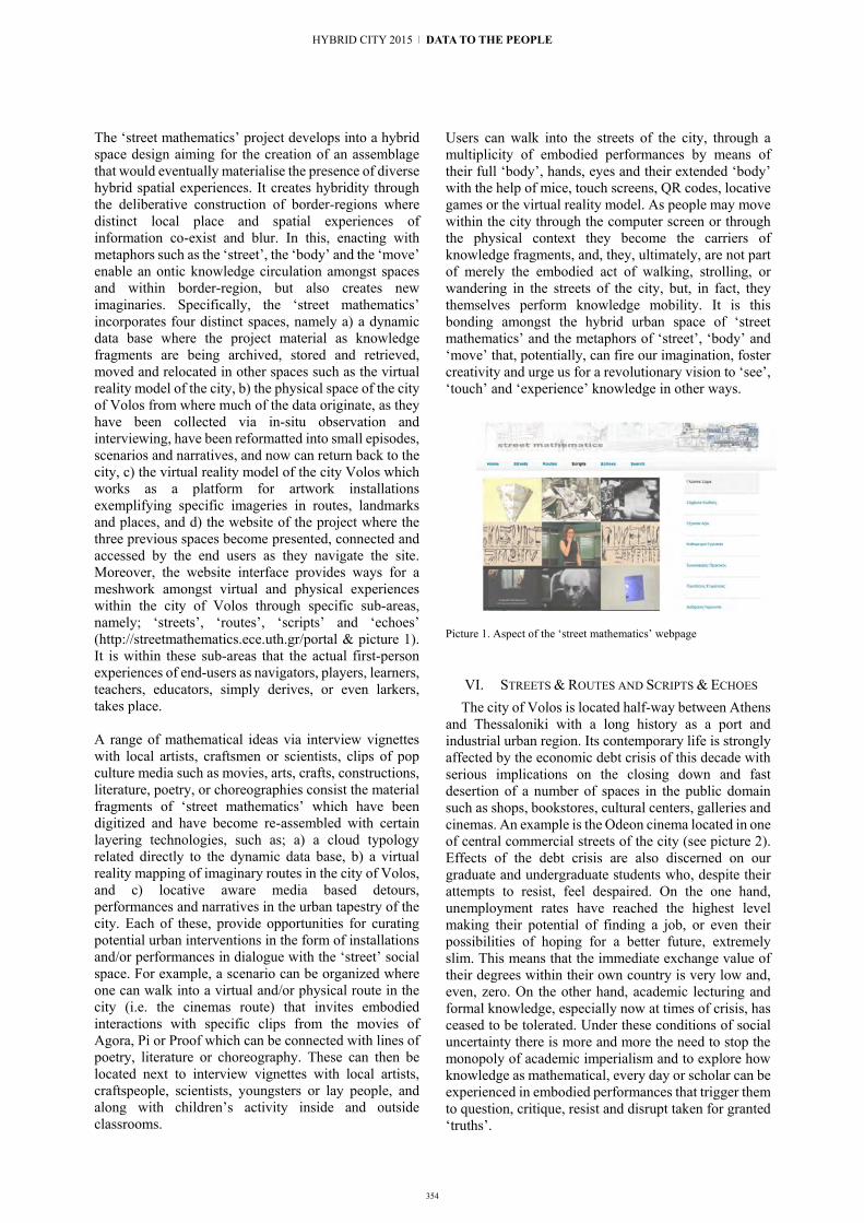
The ‘street mathematics’ project develops into a hybrid space design aiming for the creation of an assemblage that would eventually materialise the presence of diverse hybrid spatial experiences. It creates hybridity through the deliberative construction of border-regions where distinct local place and spatial experiences of information co-exist and blur. In this, enacting with metaphors such as the ‘street’, the ‘body’ and the ‘move’ enable an ontic knowledge circulation amongst spaces and within border-region, but also creates new imaginaries. Specifically, the ‘street mathematics’ incorporates four distinct spaces, namely a) a dynamic data base where the project material as knowledge fragments are being archived, stored and retrieved, moved and relocated in other spaces such as the virtual reality model of the city, b) the physical space of the city of Volos from where much of the data originate, as they have been collected via in-situ observation and interviewing, have been reformatted into small episodes, scenarios and narratives, and now can return back to the city, c) the virtual reality model of the city Volos which works as a platform for artwork installations exemplifying specific imageries in routes, landmarks and places, and d) the website of the project where the three previous spaces become presented, connected and accessed by the end users as they navigate the site. Moreover, the website interface provides ways for a meshwork amongst virtual and physical experiences within the city of Volos through specific sub-areas, namely; ‘streets’, ‘routes’, ‘scripts’ and ‘echoes’ (http://streetmathematics.ece.uth.gr/portal & picture 1). It is within these sub-areas that the actual first-person experiences of end-users as navigators, players, learners, teachers, educators, simply derives, or even larkers, takes place. A range of mathematical ideas via interview vignettes with local artists, craftsmen or scientists, clips of pop culture media such as movies, arts, crafts, constructions, literature, poetry, or choreographies consist the material fragments of ‘street mathematics’ which have been digitized and have become re-assembled with certain layering technologies, such as; a) a cloud typology related directly to the dynamic data base, b) a virtual reality mapping of imaginary routes in the city of Volos, and c) locative aware media based detours, performances and narratives in the urban tapestry of the city. Each of these, provide opportunities for curating potential urban interventions in the form of installations and/or performances in dialogue with the ‘street’ social space. For example, a scenario can be organized where one can walk into a virtual and/or physical route in the city (i.e. the cinemas route) that invites embodied interactions with specific clips from the movies of Agora, Pi or Proof which can be connected with lines of poetry, literature or choreography. These can then be located next to interview vignettes with local artists, craftspeople, scientists, youngsters or lay people, and along with children’s activity inside and outside classrooms.
Users can walk into the streets of the city, through a multiplicity of embodied performances by means of their full ‘body’, hands, eyes and their extended ‘body’ with the help of mice, touch screens, QR codes, locative games or the virtual reality model. As people may move within the city through the computer screen or through the physical context they become the carriers of knowledge fragments, and, they, ultimately, are not part of merely the embodied act of walking, strolling, or wandering in the streets of the city, but, in fact, they themselves perform knowledge mobility. It is this bonding amongst the hybrid urban space of ‘street mathematics’ and the metaphors of ‘street’, ‘body’ and ‘move’ that, potentially, can fire our imagination, foster creativity and urge us for a revolutionary vision to ‘see’, ‘touch’ and ‘experience’ knowledge in other ways.
Picture 1. Aspect of the ‘street mathematics’ webpage
VI. STREETS & ROUTES AND SCRIPTS & ECHOES The city of Volos is located half-way between Athens
and Thessaloniki with a long history as a port and industrial urban region. Its contemporary life is strongly affected by the economic debt crisis of this decade with serious implications on the closing down and fast desertion of a number of spaces in the public domain such as shops, bookstores, cultural centers, galleries and cinemas. An example is the Odeon cinema located in one of central commercial streets of the city (see picture 2). Effects of the debt crisis are also discerned on our graduate and undergraduate students who, despite their attempts to resist, feel despaired. On the one hand, unemployment rates have reached the highest level making their potential of finding a job, or even their possibilities of hoping for a better future, extremely slim. This means that the immediate exchange value of their degrees within their own country is very low and, even, zero. On the other hand, academic lecturing and formal knowledge, especially now at times of crisis, has ceased to be tolerated. Under these conditions of social uncertainty there is more and more the need to stop the monopoly of academic imperialism and to explore how knowledge as mathematical, every day or scholar can be experienced in embodied performances that trigger them to question, critique, resist and disrupt taken for granted ‘truths’.
354
HYBRID CITY 2015 | DATA TO THE PEOPLE

355
Picture 2. The Odeon Cinema in Kartali Street, Volos
Some questions persist: How do we relate with our students in our city and how do we reclaim the energy of everyday life through space and people? How do we deal with academic and everyday knowledge in the chaotic conditions of our worlds and invent ways in which knowledge circulation does not work towards remaking ‘colonial science’, but, instead, paves a subtle disruption of colonial dispositions, binary meanings and poisonous affects? How do we relate with the presence of mathematics and the multiple genres of narrating mathematical activity as we stroll and wander in the cityscape? Could the social space of the city enables us to open up our relations with mathematics? How does the urban environment become challenged and troubled by the presence of mathematics? How do such experiences affect our mathematical subjectivities?
Picture 3. A hybrid of Odeon Cinema in ‘street mathematics’ The ‘street mathematics’ project provides ways towards addressing some of these questions as it becomes more and more utilized by student-teachers, children, adolescents, educationists, designers, urban planners, performers, artists and architects. However, the aim is not really to provide answers here, but, in a more modest way, to try address these question in more local-based, ontic terms. Specifically, the collected materials –as fragile knowledge fragments in the form of inscription accounts or visual images- concern human action in direct relation to a multiplicity of concepts, practices and activities that conventionally is named ‘mathematics’. Reassembling them into the spatiality of streets and routes but also into the discursive configurations of scripts and echoes (see picture 1) can, perhaps, work towards, not so much towards answering a question, but to reformulate it by means of a concrete materialisation and through the available materiality of the space and the people in ways that ‘a question’ becomes explored and expressed as a ‘matter of concern’ for people.
Human interactions with mathematics concerns multiple narrations on how mathematics is being used in different practices (e.g. art, choreographies, constructions, crafts, games, gambling, economy, commerce, history, personal storytelling etc.), but also the relationship that people form with mathematics or through mathematics as part of specific social and cultural practices. These narrations consist parts of interviews with people who aren't necessarily mathematicians or formally educated. They also consist of segments selected from varied sources such as films, literary texts, poems, art, constructions, or events having to do with everyday life, work, and leisure. Their choice is based on the need to address the question of 'what is mathematics for us’. A possible scenario could be a move into the turbulent life of Hypatia, the Alexandrian mathematician, and towards making relations with contemporary women scientists who live and work in the city of Volos. Clips of Hypatia’s life, selected from the film Agora, become present just outside the Odeon Cinema and can be navigated (picture 3). What might be the thoughts, affects and affective experience created by such an associology, using Bruno Latour’s words, for mathematics, science and for our feminist thinking? And what might such an association signify when it takes place just outside of the closed cinema Odeon?
Another potential scenario is related to the experience of working with the ‘absence’ of Giorgio de Chirico and his artworks form the cultural center named after him in Volos. The center is located just next to the University Library building at the parade of Metamorphosis Street. De Chirico’s artwork is full of geometry, yet full of allegories concerning the potential ‘emptiness’ in a gesture of geometrizing the urban space. What might the significance of Giorgio de Chirico artworks today for us? How could we relate to his geometry, but also to the irony and humor embedded in his geometrical space? Can we explore these by moving into critical and imaginative embodied performances in the form of urban (mathematical) interventions [39]?
VII. CONCLUSIONARY REMARKS The significance of three words, the ‘street’, the
‘body’ and the ‘move’ have been discussed here as potential metaphors for a hybrid space design that promotes knowledge circulation in the urban tapestry. Lefebvre [19] invites to open up any fixed container images of a city, a house, or a street and urges us to consider them as ‘a complex of mobilities, a nexus of in and out conduits’ (p.92). Any urban landscape possess the elements of a potentially fluid geography that is being reproduced by ongoing movements or ‘streams of energy which run in and out of it by every imaginable route’ (p. 93). The research undertaken here is geared towards reconfiguring the synergy amongst content and technologies production in the ‘street mathematics’ project [36]. It can be said that the unveiling these three metaphors extent our ways of creating specific urban
10 | Placemaking in the Hybrid Urban Context

356
interventions within the streets of a hybrid city that summon us to rethink our relationship with knowledge and to re-designate its value, power and importance. In this way, the ‘street mathematics’ project provides a hybrid itself –a hybrid that urges our imagination to experiment with urban (mathematical) knowledge. Such interventions can potentially mobilize multiple cultural presentations of mathematical ideas and make them move, drift and wander with/in the streets of the city. However, the act of wandering in a city is not neutral. It is a cartography of spatial embodied relations with/in the metropolis where both the ‘power of the city’ and the ‘city of power’ are being encountered [33] as manifolds of social, racial and gendered inequalities. The urban (mathematical) interventions that the hybrid of ‘street mathematics’ can generate have the potential for exposing inequalities and making subtle disruptions of dominant mathematical subjectivities.
Acknowledgement I would like to express my sincere thanks to a number
of people who collaborated with me in this project, namely; Theodora Papatheochari, Chrysa Papasarantou, Maria Zaharaki, Georgios Giannikis, Irene Lazaridou, Elena Mathioudaki, Magda Koubarelou and Vasilis Bourdakis.
REFERENCES [1] Nunes, T., Carraher, D, & Schliemann, A, “Mathematics in the
streets and in schools”, British Journal of Developmental Psychology, 3, 1986: 21-29.
[2] Lave, J., Cognition in Practice: Mind, mathematics and culture in everyday life. Cambridge: Cambridge University Press, 1988.
[3] Abreu, G. & Carraher, D.W., “The mathematics of Brazilian sugar cane farmers”, In C. Keitel et al (eds). Mathematics Education and Society. Paris: Science and Technology Education Document Series, Unesco, no. 35, 1989.
[4] Saxe,G.B. Culture and Cognitive Development: Studies in mathematical understanding. Hillsdale, NJ: Lawrence Erlbaum, 1991
[5] Millroy, W.L. “An ethnographic study of the mathematical ideas of a group of carpenters’, Journal for Research in Mathematics Education (Monograph No 5). Reston VA: The National Council of Teachers of Mathematics. 1992
[6] Schliemann, A. D. & Acioly, N.M. “Mathematical knowledge developed at work: The construction of practice versus the contribution of schooling”, Cognition and Instruction, 6:3, 1989: 185-221.
[7] Pinxten, R. Anthropology of space: Explorations into the natural philosophy and semantics of the Navajo, University of Pensylvania Press, 1983.
[8] Verran, H. Science and an African Logic, Chicago & London: The University of Chicago Press, 2001.
[9] Nunes, T., Schliemann, A.D, & Carraher, D.W. Mathematics in the Streets and in schools. Cambridge, UK: Cambridge University Press, 1993.
[10] Pinxten, R. “Some remarks on the Navajo geometry and piagetian genetic theory”, Infncia y Apprendizaje, 54: 41-52, 1991
[11] Brenner, M.E. & Moschkovich, J.N. (eds), “Everyday and academic mathematics in the classroom”, Jornal for Research in Mathematics Education, VA: National Council of Teachers of Mathematics, Monograph 1, no11, 2002.
[12] Dieberger, A. & Frank, A.U. “A city metaphor for supporting navigation in complex information spaces”, Journal of Visual Languages and Computing, 9, 1998: 597-622.
[13] Saxe, G.B., “The mathematics of child street vendors’ Child Development, 59, 1989: 1415-1425
[14] Verran, H. “A story about doing the dreaming” Postcolonial Studies, 7:149-164, 2004.
[15] Appadurai, A. Modernity At Large: Cultural Dimensions of Globalization. Minneapolis: Univ of Minnesota Press, 1996.
[16] Castells, M. The Rise of the Network Society, The Information Age: Economy, Society and Culture Vol. I. Oxford, UK: Blackwell, 1996.
[17] Charitos, D. et al. (Eds.) Hybrid City: Conference proceedings. Athens: URIAC, 2013.
[18] Rubel, L. et al. Critical pedagogy of place in mathematics: texts, tool and talk. MES conference. Portland, 2015.
[19] Lefebvre, A. The production of space. Oxford: Blackwell, 1991. [20] Francois, K., “In-Between science and politics”, Foundations of
Science, 16, 2011: 161-171. [21] White, M. The Body and the Screen. The MIT Press, 2006. [22] Hutchins, E. Cognition in the Wild, MIT Press, 1995. [23] Latour, B. “Review of ‘Cognition in the Wild”, Mind, Activity
and Culture, 3:1:54-63, 1995. [24] Latour, B. & Woolgar, S. Laboratory life: the construction of
scientific facts. Princeton: Univ of Princeton Press, 1979/1986. [25] Knorr-Cetina, K. Epistemic cultures: how the sciences make
knowledge. Cambridge, Massachusetts: Harvard University Press, 1999.
[26] Thagard, P. Conceptual Revolutions, Princeton Univ Press, 1992 [27] Latour, B. Science in Action: How to Follow Scientists and
Engineers Through Society, Cambridge: Harvard University Press, 1987.
[28] Young, R.J. Colonial Desire: Hybridity in Theory, Culture and Race. London & New York, 1995.
[29] Wintebottom, A. Hybrid Knowledge. History Workshop Journal, Reviews, 2011: 267-273
[30] DeLaat, M. & Mol, A.M. “The Zimbabwe Bush Pump: Mechanics of a Fluid Technology.” Social Studies of Science, 30, 2: 225–63, 2000.
[31] Law, J. & Mol, A.M., “Situating technoscience: an inquiry into spatialities” Environment and Planning D:Society and Space 19: 609-621, 2001.
[32] Leander, K.M, Philips, N.C & Taylor, K.H. “The Chnging Social Space sof Learning: Mapping New Mobilities”, Review of Research in Education, 34:329-394, March 2010.
[33] Hollevoet, C. “Wandering in the city: Flanerie to Derive and after: The cognitive mapping of urban space” In C. Hollevoet & K. Jones (eds) The Power of the City: The City of Powers. New York: Whitney Museum of American Art, 1992.
[34] Bhabha, H. The location of culture, London: Routledge, 1994. [35] Haraway, D. J., Simians, cyborgs, and women. The reinvention
of nature. New York. Routledge. [36] Suchman, L. “Located accountabilities in technology
production” Scandinavian Journal of Information Systems, 14(2):991-105, 2002.
[37] Chronaki, A, Papasarantou, C, Papatheochari, T, Giannikis, G, Zaharaki, M & Bourdakis, V. “Synthsizing Digital Fragments of Knowledge: The methodology of ‘street mathematics’, ECER conference, Porto, 2014.
[38] Chronaki, A. & Papasarantou, C. “Disrupting Mathematical subjectivity with/in Urban Intervention”, Re-inscribing the City Design Studies of Critical STEAM conceptual Practice, submitted..
HYBRID CITY 2015 | DATA TO THE PEOPLE

Placemaking and place identity in social media Snapshots from Facebook
Mariza Georgalou Department of Linguistics & English Language
Lancaster University Lancaster, UK
Abstract. There is more to place on the social network site of Facebook than its software configurations that allow seamless location sharing and tracking. Users do much more complex linguistic and multimodal work to give meaning to specific places foregrounding them as geographical but also as social, political, cultural, and emotional entities. This paper draws on insights from discourse analysis, sociolinguistics, semiotics, and online ethnography to explore the ways in which two Greek female Facebook participants talk about and represent places in their postings. The analysis shows that, by means of the place, the users communicate something about themselves: they confirm belonging, they communicate respect to other cultures, they use different languages to affiliate with certain places, they make political statements, they disidentify with the stressful aspects of a place in crisis, and they raise awareness about local and national issues.
Keywords: place identity; social media; Facebook; discourse analysis, semiotics; online ethnography
I. FACEBOOK AND MULTIPLY-PLACED IDENTITIES Who we are is entwined with where we are, where we
have been, or where we are going [2]. Web technologies have marked a fundamental shift in the ways we perceive and experience place. In the social media ecosystem of Facebook, the practice of writing and uploading other multimedia material is a self-reflexive process which is not situated in a particular location; it can exist anywhere, allowing the en route construction of a hybrid place identity as mobile, shifting. Consider the case of my research informant, Helen, who experiences a triple spatial reality: She lives and works in Athens; she has stayed for seven years in the UK while she has been serving as a visiting English for Academic Purposes tutor in British universities for two months per year since 2010; her partner is Hungarian and lives in Budapest. While observing her profile, I noticed that in several instances it was difficult for me to decipher in which of the three places (UK, Greece, Hungary) she was located
i The interviews were originally conducted in Greek.
at the time of posting on Facebook. During 2011, the bulk of Helen’s posts were related to the Greek crisis. Hence, one of my very first questions in my interviewi with Helen dealt with her location while posting. She stated that:
i was here most of the time but some posts were made when I was in Hungary and if I wrote some posts in September then I was in England but mainly I was here and I participated in what was happening hm.. even if I’m not in Greece I write posts on issues related to the situation here moreover, on the other hand, when I’m in Greece I write posts that concern the UK for example, when the fees increased in UK universities i was in Greece and I was very worried about this issue, as far as I can remember from my profile or other issues related to UK universities but when the big demonstrations were held and I wrote some [status] updates I was here I also posted some photos I shot them the day after the demonstrations [...] sometimes I write posts that concern Hungary even if I’m not there oh, this identity is too complicated.. a mess!
Helen acknowledges the complication of her place identity by jokingly characterising it ‘a mess’. Having Greeceii as the location of her immediate proximity (here), her place posts revolve around the three countries: Greece, UK and Hungary. Helen feels entitled to comment on her Facebook on issues about the Greek crisis wherever she is, because she still has a legitimate interest in Greece when she is in the UK. Time and again, in these posts, she draws on English language resources as illustrated in Fig. 1. But she also has a special entitlement to speak from experience on these matters: when she is in Greece, she takes part in demonstrations and then uploads relevant material on Facebook, as we will see later on.
With posts like this in Fig. 1, Helen navigates multiple places simultaneously: the one she is physically located in, the one she is thinking of as well as Facebook space itself. Facebook is brought into the places Helen occupies, and, likewise, those places are brought into Facebook. This ability to navigate multiple places at the
ii I interviewed Helen via instant messaging. We were both located in Athens at the time of the interview (29 October 2011).
357
10 | Placemaking in the Hybrid Urban Context

358
same time is in effect ‘the ability to consolidate and locate the spaces and information that we associate with our “digital selves” into something of a hybrid space’ [14]. In these hybrid spaces, the borders between remote and contiguous contexts, be that Greek, English or Hungarian, can no longer be clearly defined [9]. Bringing thus these contexts together in Facebook is not messy (as Helen says) — there are just many theres there [11].
Fig. 1. Using English sources for the Greek crisis.
In this light, the matters that will be addressed in the present paper are the following: How do Facebook users refer to places? Where are these references tied up to places? What do they imply or infer about place identities in these references? The paper is organised as follows. After defining place, I briefly discuss its relation to identity as well as the role of language as a kind of glue that keeps together people and places. Next, I present my data and methods of analysis. The remainder of the paper investigates instances of locating the self textually and visually, geographically and socio-politically in a variety of posts and comments. I close by drawing both specific and general conclusions.
II. PLACE, IDENTITY, AND LANGUAGE Place is not just a position in space; it is the location
plus everything that occupies that location, i.e. tasks, practices, routines, everyday life, seen as an integrated and meaningful phenomenon [29] [32]. Places are classified into three basic types: personal and interpersonal, social, and geographical [41]. Personal and interpersonal places deal with where we are now (in the sense of where our bodies are now) as well as our interlocutors, in other words a space that organises our interaction, perspective and discourse. Social places, on the other hand, locate our activities in everyday life, at home, at work, and during leisure time, and hence are usually defined in terms of what people do in these places – many of which are institutional. Examples in this category comprise outdoor places, residential places, commercial places, commercial service places, community service places, government agencies, educational places, leisure places, and workplaces. Ultimately, the third kind of place, although called geographical, in essence embraces social, political and cultural dimensions. These places can be represented by their scope, range, size or level, and are progressively inclusive, for example: home, street, neighbourhood, city, state, province, country, region, continent, world, and so on.
French philosopher Gabriel Marcel (1889-1973) propounded the idea that individuals are not distinct from their place – they are that place [32]. All of us have a
strong bond with the places where we were born and grew up, where we live, or where we experience particular stirring moments. Humanist geographers see this bond as a starting point from which we can orient ourselves to the world [32]. By the same token, environmental psychologists duly acknowledge that ‘who we are’ is intimately related to ‘where we are’, arguing that identity is not only shaped by place, but we ourselves may also serve as contextual markers for shaping place identities [10] [34]. Reference [31] views place identity as consisting of cognitions about the physical world in which we are located. These cognitions represent an assortment of memories, conceptions, interpretations, ideas, attitudes, values, beliefs, social meanings, preferences and feelings about specific physical settings. Put it plainly, place identity refers to the ways in which we understand ourselves by attributing meanings to places. As such, it should not be understood as a separate part of identity related to place, since all aspects of identity often contain significant references to place or incorporate locations or trajectories as crucial constituents [5] [40].
For sociolinguists and discourse analysts, a place acquires its meanings by the ways it is represented, i.e. written, talked about, and photographed, as well as by the situated interactions that ‘take place’ within it [29] [37]. Language can form and transform our everyday experiences of ‘self-in-place’ [19] [39] so that places are constructed in ways that carry profound implications for who we are, who we can claim to be [10] or where we belong [36]. Through this spectrum, language should not be seen as a mere means to represent or describe external environments. It is also a symbolic resource through which constructions of place can do the rhetorical work of claiming an identity [30].
III. DATA AND METHODS For the purposes of this study, I draw on findings
from a larger discourse-centred online ethnographic project on the construction of identities on Facebook, conducted during 2010-2013 [12]. Discourse-centred online ethnography [1] combines the systematic, longitudinal and repeated observation of online discourse (Facebook profiles here) with direct engagement (face-to-face and/or mediated) with the producers of this online discourse (Facebook profile owners here) and is complementary to the textual analysis of online data. My participants were recruited via convenience sampling (i.e. they were friends of friends). Initially, they were sent a message in which I explained the purposes of my study asking them to fill in an online questionnaire, which helped me to formulate an idea on how they experience the mechanics of social media. Following this, they were invited to have their Facebook profiles painstakingly observed and to participate in a series of semi-structured online interviews via email, instant messaging and/or Facebook messages. My dataset included Facebook profile information, status updates, comments, video and article links, photos my informants have taken themselves or have found elsewhere in the internet, interview excerpts, field notes as well my informants’ comments on drafts of my analysis. My interviewees were asked to sign a consent form in which they were
HYBRID CITY 2015 | DATA TO THE PEOPLE

359
assured that their material would remain confidential and would be used for academic purposes solely. Concerning the use of third-party comments in the study, I either asked for their posters’ permission or asked my subjects to do so on my behalf. Throughout my dataset I have preserved pseudonymity for my informants and anonymity for other Facebook users.
The data I have selected to present and discuss in this paper come from two of my five in total informants, Helen and Carla. Table I offers a rough idea about their demographics.
TABLE I. PARTICIPANTS’ DEMOGRAPHICS
Participants Demographics
Helen
born in 1979; holds a BA in English Language and Literature, an MA in English Language and Literary Studies, and a PhD in Linguistics; works as an Assistant Professor of Linguistics; lives in Athens, Greece, and in UK for 2 months / year.
Carla
born in 1975; holds a BA in Translation and Interpreting; works as a translator of Latin American literature; maintains two Facebook profiles, one personal and one professional; lives in Athens, Greece.
IV. PLACEMAKING ON FACEBOOK I will now turn to examples in which these two users,
other than exploiting Facebook affordances,iii localise their posts by making both direct and indirect references to particular places. The discussion will pivot around the following themes: verbal check-ins, representational locating of self, culinary experiences and placemaking, and socio-political aspects of places.
A. Verbal Check-ins Users specify where they are, where they are heading
towards or where they are departing from, namely where their bodies are, at the moment of writing the status update. With this type of contextual relevance of place, users organise their perspective and orient readers [41]. Fig. 2 offers a brief insight.
Fig. 2. Verbal check-in.
Here there is a reference to a social place, and particularly a commercial service place, a café, and a geographical place, the city of Budapest. Helen, however, is located at the café not only for the typical activity of drinking coffee but also for working. That the formulation of this place is littered with feelings of euphoria and optimism (in a good mood!) is not due to marking but to the fact that she is in her partner’s home
iii A discussion of how the users exploit specific Facebook affordances (e.g. automatic check in, mapping, liking pages) to indicate places falls outside the remit of this paper.
city with him. Two things are observed in this status. First, Helen, beyond just defining where she is, she discloses how she feels while being in the specific place too. Second, Budapest triggers certain emotions in her ongoing activities, marking exams in this case.
Saying where you are going can be done in more inventive ways as shown in Fig. 3. Helen adopts an entextualising process [5] [22], namely she extracts an instance of culture (the song First We Take Manhattan, which includes the lyric ‘First we take Manhattan, then we take Berlin’) and relocates it in her discourse as ‘first we take Budapest’ (where she will meet her partner) and ‘and then we take Berlin’ (where she will head afterwards for a conference presentation) to adjust it to her own situation and give us a flavour of her itinerary.
Fig. 3. Entextualising a song to locate the self.
B. Representational Locating of Self Though text is sufficient to give a location, it is not
the only mode that is used on Facebook. Uploading profile pictures with landscapes and cityscapes in the background has specific resonance for identity claims as well. It serves as a performative exercise of identity and belonging, which documents and validates the subjects’ experience of being at particular places experiencing particular moments [27] [38]. Our own bodies give and give off their meanings because of where they are and what they do ‘in place’ [13] [35]. In this line of reasoning, this type of photographic posing constitutes a kind of placement action which indicates and locates the self [18]. The next examples will illustrate this point.
Carla in her professional profile is pictured surrounded by the sea of Havana, Cuba, in a medium long shot (Fig. 4) while Helen (Fig. 5) appears to enjoy the Hungarian countryside as a biker.
10 | Placemaking in the Hybrid Urban Context
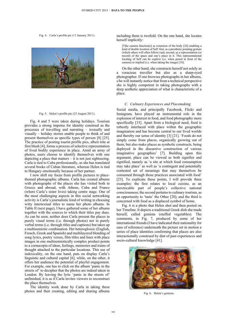
360
Fig. 4. Carla’s profile pic (11 January 2011).
Fig. 5. Helen’s profile pic (23 August 2011).
Fig. 4 and 5 were taken during holidays. Tourism provides a strong impetus for identity construal as the processes of travelling and narrating – textually and visually – holiday stories enable people to think of and present themselves as specific types of person [8] [25]. The practice of posting tourist profile pics, albeit trite at first blush [4], forms a process of selective representation of lived bodily experience in place. Amid an array of photos, users choose to identify themselves with one depicting a place that matters – it is not just sightseeing. Carla is tied to Cuba professionally, as she has translated several books of Cuban literature, whereas Helen is tied to Hungary emotionally because of her partner.
I now shift my focus from profile pictures to place-themed photographic albums. Carla has created albums with photographs of the places she has visited both in Greece and abroad, with Athens, Cuba and France (where Carla’s sister lives) taking centre stage. One of the most challenging aspects in this social networking activity is Carla’s journalistic kind of writing in choosing witty intertextual titles to name her photo albums. In Table II (next page), I have gathered some of her albums together with the sources to which their titles pay dues. As can be seen, neither does Carla present the places in purely visual terms (i.e. through photos) nor in purely verbal terms (i.e. through titles and captions) but takes up a multisemiotic combination. Her heteroglossic (English, French, Greek and Spanish) and multilayered blending of song lyrics, poetry verses, film titles and lines with place images in one multisemiotically complex product points to a cornucopia of ideas, feelings, memories and trains of thought attached to the particular locations. This use of indexicality, on the one hand, puts on display Carla’s linguistic and cultural capital [6], while, on the other, it offers her audience the potential of playful engagement. For example, one has to click on the album ‘panic in the streets of’ to decipher that the photos are indeed taken in London. By leaving the lyric ‘panic in the streets of’ unfinished, it is as if Carla invites viewers to reconstruct the place themselves.
The identity work done by Carla in taking these photos and then creating, editing and sharing albums
including them is twofold. On the one hand, she locates herself implicitly:
[T]he camera function[s] as extension of the body [26] enabling a kind of double location of Self: first, as a prosthetic pointing gesture (which others will often follow) and, second, as a representation (or record) of the space and one’s place in it. This representational locating of Self can be explicit (i.e. when posed in front of the camera) or implied (i.e. when taking the image) [18].
On the other hand, she constructs herself not solely as a voracious traveller but also as a sharp-eyed photographer. If one browses photographs in her albums, s/he will instantly notice that from a technical perspective she is highly competent in taking photographs with a deep aesthetic appreciation of what is characteristic of a place.
C. Culinary Experiences and Placemaking Social media, and principally Facebook, Flickr and Instagram, have played an instrumental role in the explosion of interest in food, and food photography more specifically [33]. Apart from a biological need, food is robustly interlaced with place within the geographic imagination and has become central to our lived worlds and thereby our sense of identity [3] [21]. ‘Foods do not simply come from places, organically growing out of them, but also make places as symbolic constructs, being deployed in the discursive construction of various imaginative geographies’ [7]. Building upon this argument, place can be viewed as both signifier and signified, namely as ‘a site at which food consumption may take place’ as well as ‘a contingent and potentially contested set of meanings that may themselves be consumed through those practices associated with food’ [23]. To explicate these points, I will provide three examples: the first relates to local cuisine, as an inextricable part of people’s collective national consciousness; the second pertains to culinary tourism, as an opportunity to ‘taste’ the Other [28]; and the third is concerned with food as a displaced symbol of home.
Fig. 6 is a photo that Helen shot and then posted on her Timeline. It depicts a traditional Greek dish she made herself, called gemista (stuffed vegetables). The comments, in Fig. 7, produced by some of her international friends (I have indicated their nationality for ease of reference) underneath the picture set in motion a series of place identities confirming that places are also interactionally construed by dint of past experiences and socio-cultural knowledge [41].
Fig. 6. Helen’s gemista.
HYBRID CITY 2015 | DATA TO THE PEOPLE

361
TABLE II. PHOTO ALBUMS AND INTERTEXTUAL REFERENCES
Album thumbnail Places depicted Title of album Intertextual link
Athens (Greece) city sickness II Song title by Tinderstics
-Habana (Cuba) -Barcelona (Spain)
-Corfu (Greece)
looking for a girl in a washing machine?
Song title by The Big Sleep
Paris (France)
à paris (banlieue) tombe la neige_janvier 2013
Tombe la neige à Paris is a song performed by Adamo
Lisbon (Portugal) Lisbon stories Lisbon Story is the title of a
film directed by W. Wenders
London (UK) panic in the streets of Panic in the streets of London
is a song title by The Smiths
Habana (Cuba) Habana Blues Title of a Spanish-Cuban film
directed by B. Zambrano
Monemvasia (Greece)
ο ουρανός είναι εφτά φορές γαλάζιος
(transl.: the sky is seven times light blue)
Verse by Greek poet Yannis Ritsos
Paris (France) We ll always have Paris Line from the film Casablanca
10 | Placemaking in the Hybrid Urban Context

362
Fig. 7. Interaction underneath gemista photo.
What is worth discussing here is the evocation of the inclusive ‘we’ via which the Iranian friend (comments 4 and 6) and the Greek friend (comment 5) speak for the culinary traditions of their countries seeing food standing in a metonymic relationship for their whole nations, the Iranian and the Greek respectively. Helen, on the other hand, deploys a different kind of ‘we’ in comment 7. Taking into account that all of the participants in this thread have been or are still UK residents, this ‘we’ comprises all those who come from different cultural and culinary backgrounds than the UK and find it difficult to prepare their local dishes there because the ingredients differ in taste (comment 7) or good ones are scarce to find (comments 11 and 13), constructing thus the UK as a rather hostile place for gastronomy. In this fashion, Helen disidentifies herself with the UK.
The foregoing example is indicative of what makes Facebook so special as a site for place
4 Hala is a Lancaster area. Single Step is a local wholefood co-op in Lancaster.
identities. The mere uploading of a local food photo and the accompanying comments provide a sense of continuity to Helen’s past (comment 14: I used to buy stuff from Booths ages ago, when I lived in Hala4), present (comment 15: For now, I’m OK with fresh Greek vegetables:-)) and future place selves and actions (comment 11: will do that next time I'm in Lancaster, thanks!; comment 15: Next time I'll try the market/single step and see how that goes).
Having touched upon tourism in the previous section, I will now move on to discuss culinary experiences as a form of tourist practice. Culinary tourism has been described as the intersection between food and travel, and refers to the practice of exploratory eating as a way to encounter, know, and consume other places and cultures, experiencing thus new ways of being [24] [28]. In this light, food functions as a transportable symbol of place, a moveable sign of Otherness [28]. In Fig. 8, included in an album with photos from Katowice and Krakow in Poland, Helen is holding – as if she is serving the viewer – a Zapiekanka, a popular type of Polish street food. Having a photo album under the name of the place and including food pictures of this place, Helen recirculates an imagined geography that differentiates places on the basis of their cuisines [28]. In the caption of the photo, she writes: Zapiekanka..miam!!! (Zapiekanka yummy!!!). But she is not only eating Zapiekanka – she is also eating ‘the differences mobilities make’ [28]. What Helen exhibits here is openness and desire to consume difference as well as competence in the other culture. By posting this photo on Facebook, she almost literally puts on display these qualities of hers.
Fig. 8. Polish Zapiekanka.
Foods should not only be viewed as placed cultural artefacts, but as displaced materials and practices as well, which can inhabit many places [7]. Consider Fig. 9. While being in the UK (one can see the British buildings in the background, emphasising the out-of-placeness), Helen noticed and shot a tin of Greek olives used as plant pot (the tin reads: εκλεκτές ελιές εξαιρετικής ποιότητος – selected olives superior quality). For Helen, the Greekness of the olives, as
HYBRID CITY 2015 | DATA TO THE PEOPLE

363
represented in their packaging, is no longer ordinary and mundane because it is embedded into another, fresh context and therefore stands out, deserving to be captured and shared as a symbol of home. In this example, Helen manifests a dual kind of geographical knowledge [7]: first, knowledge of the origins of the olives; and second, knowledge of the meanings of place, and regional identity, evoked amongst her Facebook audience who will look at this photo (and perhaps smile), especially the Greek members.
Fig. 9. Greek olives tin in the UK.
D. Socio-political Aspects of Places Physical environments are necessarily social environments [17]. Economic, political, and social upheavals such as unemployment, governmental instability, intergroup conflicts, and other sources of frustration can have a corrosive effect upon one’s place identity [31]. The following examples tackle this matter with regard to the Greek crisis.
I. Protesting and documenting Harking back to Helen’s interview in the introduction, she says about the demonstrations in Athens that ‘I was here and I participated in what was happening’. Indeed, she was an active and conscious citizen both physically and digitally. For instance, in heading to Athens Syntagma Square to protest against austerity together with the Greek Indignant Citizens (Aganaktismeni) in June 2011, she wrote on Facebook: ‘off to syntagma’. Such a status update should not be viewed as a mere check-in but as a discursive practice embedded in a broader socio-political and historical context.
The same goes for the uploading of photographs she had taken herself of the places where events related to the protests took place. In Fig. 10, we see Syntagma Square, outside the Greek parliament, while Fig. 11 is shot outside Marfin Bank in Stadiou Street, Athens, where three employees died during the nation-wide strike on 5 May 2010. Fig. 12 is an instance of transgressive semiotics, namely when a sign violates either intentionally or accidentally the conventional semiotics at that place [35]. The photo depicts an empty Athenian store, probably one of the hundreds that have closed down on account of the crisis, with two labels on its window, ΠΩΛΕΙΤΑΙ (for
sale) and ΕΝΟΙΚΙΑΖΕΤΑΙ (to rent), and underneath them a poster that promotes tourism in Greece. At any moment in time these three signs would compose a transgressive semiotic system. Nonetheless, because of the socio-political situation in Greece, this triptych functions on a symbolic level: Greece (the land, its people) is available for sale to or to be rented by its creditors. In Fig. 13, which reads ΜΕΝΟΥΜΕ ΣΥΝΤΑΓΜΑ (We stay at Syntagma), the place, Syntagma Square, is represented as a symbol of resistance placed within the same contextual conditions as in the ‘off to syntagma’ status above.
By recording the place in crisis, Helen simultaneously represents her place in it. Since she is the one taking the images, which are powerful tokens of citizen journalism, and not posing in front of the camera, her representational locating of self is implied [18]. Her identity claim is ‘I’m there, at the heart of the events, protesting and documenting’.
Fig. 10. Syntagma Square (posted on 30 May 2011).
Fig. 11. Stadiou Street (posted on 6 May 2010).
Fig. 12. Empty store in Athens (posted on 23 October 2011).
10 | Placemaking in the Hybrid Urban Context

364
Fig. 13. Flyer in Syntagma Square (posted on 18 October 2012).
II. Responding to ‘unattractive’ places It goes without saying that under the crisis circumstances, places become ‘unattractive’ causing stress to people, who in turn feel displaced, and as a consequence their discourses about these places become deterritorialised too acquiring an irritated style [5] [41]. Here is a simple example:
Fig. 14. Polarising aspects of place identity.
By polarising the unstable political situation in Greece, which distresses Greek people, with the sunshine that typically lifts their spirits, Helen polarises two aspects of her place identity. On the one hand, it is the socio-political place to which she does not feel attached because of its governors. On the other hand, by referring to the two toponyms, the two Athenian neighbourhoods Exarcheia and Monastiraki, she mobilises a kind of intimacy associated with the activities of strolling in pedestrian streets and sitting at outdoor cafés, meaningful only to Athenians.
In the next two examples, without mentioning any place names at all, Helen renounces her identification with Greece:
have stayed too long in this country... (status posted on 25 May 2012 at 20:22 and liked by 2 people)
surrealand (status posted on 16 June 2012 at 12:43)
The frustration-littered update in the first example is unpacked if we take into account that it was posted just after the May 2012 elections in Greece and the failure of political parties to form a new government as none of them had won an absolute majority of parliamentary seats. While in the interview excerpt in the beginning of the paper Helen deployed the spatial adverb ‘here’ to designate Greece, in this status update she displaces and distances herself by selecting the demonstrative ‘this country’ which in this context has a pejorative nuance seen as attitudinal dissociation and depersonalisation from the place. Her estrangement
from Greece is even more accentuated by choosing English as the language of her status.
One day before the new elections, on 16 June 2012, Helen’s status included just one coined word: ‘surrealand’. Her Greek contacts as well as those who keep in touch with the proceedings in Greece can easily deduce that the surrealand is Greece. The coined term bears the connotations of absence of rationality, co-ordination and planning in the country which Helen implicitly condemns.
V. CONCLUDING REMARKS We are the product of the routes we have traversed [15]. In this networked era, Facebook could very well be seen as a versatile inventory of our routes as those are inscribed in check-ins, updates, and photographs. Along these lines, the argument that web and mobile technologies utterly disconnect us from physical spaces is emasculated [14].
What the analysis brought to the fore is that place identity can have several components and overlapping layers, be that geographical, social, political, cultural, emotional. With Facebook, users can bring together these components and layers from virtually anywhere. The findings provide valuable insights into the nature of place identity as unfurled in Facebook. To commence with, place identity is different for different users. For Helen especially, place seems to be at the core of her identity. The following extract is from our interview after my initial observation of her Facebook activity.
Mariza: what has struck me most is your place identity Helen: well, indeed. now you’re saying it… I knew it to a certain degree, but it impresses me that it comes across so strongly to someone else
Not only does it come across so strongly, to borrow Helen’s words, but also we witnessed how references to places in her posts endowed her with a sense of continuity to her identity.
Moreover, users identify with different scales or types of places [20] from micro (e.g. a café) to macro (e.g. Budapest) and from specific (e.g. Syntagma Square) to general (e.g. Hungarian countryside). The analysis also suggested that place identity differs with respect to our role in given places. It is one thing to be a traveller in Cuba (Carla) and another to be a protester in Syntagma (Helen). Another important finding is that place identity is associated with different representations of personal meanings (e.g. marking at a café in Budapest) as well as socio-political meanings (e.g. Greece as surrealand). Furthermore, it is associated with different types of discursive means (e.g. place naming, inclusive we, distancing deixis, metonymy, insinuation, intertextual links, artistic photography, protest photography, food photography).
Place identity on Facebook is found to have two intrinsic values. First, it is fluid, often divorced from where the body is physically located. Strictly speaking, the body is situated together with a portable device and posts on Facebook. As shown, however, Helen is in
HYBRID CITY 2015 | DATA TO THE PEOPLE

365
England but thinks and posts about the demonstrations in Athens.
Second, place identity is an essentially interactive, collaborative task, constructed through processes of negotiation between the profile owner and his/her Facebook audience. Participants work together on place identities, picking up certain aspects and playing with them, as revealed in the stuffed vegetables photo. It is through their comments to posts that different facets of the hybridity of place identity are brought out, functioning as complementary parts of the profile owner’s asserted identity.
As emerged from the data at hand, the users do not just communicate about place, but most importantly they communicate through place, that is to say, by means of the place they communicate ‘something about themselves that goes beyond the descriptive characteristics of a place’ [16]. For instance, they assert or eschew belonging, they communicate openness and respect to other cultures, they use different languages as a mark of affiliation with (or disaffiliation from) certain places, they make political statements, they disidentify with the stressful aspects of a place, and they raise awareness about local and national issues.
REFERENCES [1] J. Androutsopoulos, “Potentials and limitations of discourse-
centered online ethnography”. Language@Internet 5, 8, 2008. [2] R. K. Barnes, “Losing ground: Locational formulations in
argumentation over New Travellers”. Doctoral dissertation. University of Plymouth, UK, 2000.
[3] D. Bell and G. Valentine, Consuming Geographies: We Are Where We Eat. London: Routledge, 1997.
[4] L. Berger, “Snapshots, or: Visual culture’s clichés”. Photographies, 4, 2, 2011, pp. 175-190.
[5] J. Blommaert, Discourse: A Critical Introduction. Cambridge: Cambridge University Press, 2005.
[6] P. Bourdieu, Distinction: A Social Critique of the Judgement of Taste (Richard Nice, trans.). London: Routledge. (Original work published 1979), 1984.
[7] I. Cook and P. Crang, “The world on a plate: Culinary culture and geographical knowledges”. Journal of Material Culture, 1, 2, 1996, pp. 131-153.
[8] L. Desforges, “Travelling the world: Identity and travel biography”. Annals of Tourism Research 27, 4, 2000, pp. 929-945.
[9] A. de Souza e Silva, “From cyber to hybrid: Mobile technologies as interfaces of hybrid spaces”. Space & Culture, 9, 3, 2006, pp. 261-278.
[10] J. Dixon and K. Durrheim, “Displacing place-identity: A discursive approach to locating self and other”. British Journal of Social Psychology, 39, 2000, pp. 27-44.
[11] J. Fernbank, “There is a there there: Notes toward a definition of cyber community”, in Doing Internet Research: Critical Issues and Methods for Examining the Net, S. Jones, Ed. Thousand Oaks, CA: Sage, 1999, pp. 203-220.
[12] M. Georgalou, “Constructions of identity on Facebook: A discourse-centred online ethnographic study of Greek users”. Doctoral dissertation. Lancaster University, UK, 2014.
[13] E. Goffman, The Presentation of Self in Everyday Life. New York: Doubleday, 1956.
[14] E. Gordon and A. de Souza e Silva, Net Locality: Why Location Matters in a Networked World. Boston: Blackwell-Wiley, 2011.
[15] S. Hall, “Cultural identity and diaspora”. In Identity, Community, Culture, Difference, J. Rutherford, Ed. London: Lawrence and Wishart, 1990, pp. 222-237.
[16] L. Humphreys and T. Liao, “Mobile geotagging: Reexamining our interactions with urban space”. Journal of Computer-Mediated Communication, 16, 3, 2011, pp. 407-423.
[17] W. H. lttelson, H. M. Proshansky, L. G. Rivlin and G. H. Winkel, An Introduction to Environmental Psychology. New York: Holt, Rinehart, and Winston, 1974.
[18] A. Jaworski and C. Thurlow, “Gesture and movement in tourist spaces”, in The Routledge Handbook of Multimodal Analysis, C. Jewitt, Ed. London / New York: Routledge, 2009. pp. 253-262.
[19] B. Johnstone, “Language and place”. In The Cambridge Handbook of Sociolinguistics, R. Mesthrie, Ed. New York: Cambridge University Press, 2011, pp. 203-217.
[20] E. Krupat, “A place for place identity”. Identity of Environmental Psychology, 3, 4, 1983, pp. 343-344.
[21] R. Lakoff, “Identity à la carte: You are what you eat”. In Discourse and Identity, A. De Fina, D. Schiffrin and M. Bamberg, Eds. Cambridge: Cambridge University Press, 2006, pp. 147-165.
[22] S. Leppänen, S. Kytölä, H. Jousmäki, S. Peuronen and E. Westinen., “Entextualization and resemiotization as resources for identification in social media”. In The Language of Social Media: Communication and Community on the Internet, P. Seargeant and C. Tagg, Eds. Basingstoke: Palgrave Macmillan, 2014, pp. 112-136.
[23] S. Lockie, “Food, place and identity: Consuming Australia’s ‘Beef Capital’”. Journal of Sociology, 37, 3, 2001, pp. 239-255.
[24] L. M. Long, Ed., Culinary Tourism: Exploring the Other through Food. Lexington: University of Kentucky Press, 2004.
[25] S. McCabe and E. H. Stokoe, “Place and identity in tourist accounts”. Annals of Tourism Research 31, 3, 2004, pp. 601-622.
[26] M. McLuhan, Understanding Media: The Extensions of Man. 2nd edition. Cambridge, Mass: MIT Press, 1974.
[27] A. L. Mendelson and Z. Papacharissi, “Look at us: Collective narcissism in college student Facebook photo galleries”. In The Networked Self: Identity, Community and Culture on Social Network Sites, Z. Papacharissi, Ed. London: Routledge, 2010, pp. 251-273.
[28] J. G. Molz, “Eating difference: The cosmopolitan mobilities of culinary tourism”. Space and Culture, 10, 1, 2007, pp. 77-93.
[29] G. Myers, “Where are you from?: Identifying place in talk”. Journal of Sociolinguistics, 10, 3, 2006, pp. 320-343.
[30] G. Myers, The Discourse of Blogs and Wikis. London: Continuum, 2010.
[31] H. M. Proshansky, A. K. Fabian and R. Kaminoff, “Place-identity: Physical world socialization of the self”. Journal of Environmental Psychology, 3, 1, 1983, pp. 57-83.
[32] E. Relph, Place and Placelessness. London: Pion, 1976. [33] S. Rousseau, Food and Social Media: You Are What You
Tweet. Lanham, MD: AltaMira Press, 2012. [34] T. R. Sarbin, “Place identity as the component of an
addendum”. Journal of Environmental Psychology, 3, 4, 1983, pp. 337-342.
[35] R. Scollon and S. W. Scollon, Discourses in Place: Language in the Material World. London: Routledge, 2003.
[36] S. Taylor, “A place for the future? Residence and continuity in women’s narratives of their lives”. Narrative Inquiry, 13, 1, 2003, pp. 193-215.
[37] C. Thurlow, and A. Jaworski, “Banal globalization? Embodied actions and mediated practices in tourists’ online photo-sharing”, in Digital Discourse: Language in the New Media, C. Thurlow and K. Mroczek, Eds. London and New York: Oxford University Press, 2011, pp. 220-250.
10 | Placemaking in the Hybrid Urban Context

366
[38] C. Thurlow and A. Jaworski, “‘Two hundred ninety-four’: Remediation and multimodal performance in tourist place-making”. Journal of Sociolinguistics, 18, 4, 2014, pp. 459-494.
[39] Y. F. Tuan, “Language and the making of place: A narrative-descriptive approach”. Annals of the Association of American Geographers, 81, 4, 1991, pp. 684-696.
[40] C. L. Twigger-Ross and D. L. Uzzell, “Place and identity processes” Journal of Environmental Psychology, 16, 3, 1996, pp. 205–220.
[41] T. van Dijk, Society and Discourse: How Social Contexts Influence Text and Talk. Cambridge: Cambridge University Press, 2009.
HYBRID CITY 2015 | DATA TO THE PEOPLE

367
Mapping the urban narratives: the works of Larissa Fassler
Zacharias Ouranos postgraduate student
School of Architectural Engineering, Technical University of Crete Chania, Greece
Abstract. The present study aims to investigate the way in which urban landscape is mapped through spatial tactics of documentation resulting from the practices of drifting as a methodological tool of perception. The focus is on the works of Larissa Fassler as she attempts to show how the urban landscape itself is constantly renegotiating its form in terms of socio-political and cultural aspects by recording everyday practices that take place in the city. In addition, references are made to Christian Nold's ''Biomapping project'', emphasizing the impact of Information and Communication Technologies on the mapping process that takes place in the urban grid. Through the correlations above, a new mapping condition is sought, as a quintessential tool in order to comprehend urban phenomena, beyond topographical or static geographic representations, affecting urban design strategies and perceptions.
Keywords: mapping; drifting; networks; psychogeography; urban geography;
I. INTRODUCTION The Canadian-born artist Larissa Fassler
approaches a number of sites in the metropolitan areas of Berlin, Paris and London - recording while drifting - events, networks and behaviors that take place in the urban space. Fassler attempts to map a dense multiplicity of partial and non-measurable effects that space reflects on its users. While moving through the urban fabric, the subject is facing an existing spatial organization of the city, but is also choosing, or even '' condemning certain places to inertia or obscurity ''i or otherwise. Therefore, drifting practices may '' form an unconscious protest against the tempo of the production process ''ii potentially criticizing those generic spatial models which are conceived independently of their socio - cultural contexts. Similarly, the Situationist
i De Certeau Michel, ''The Practice of Everyday Life'', University of California press, Berkeley, 1984, p.99 ii Benjamin Walter, “The Arcades Project ”, Belknap Press, New York, 2002, p. 338
movement, tried to detach design practices from the modernist urban solutions, focusing on drifting as a means of generating new urban concepts as well as Constant's manifesto of 'New Babylon' in the 60's. Based on urban perceptions linked mainly to psychogeography, Fassler's approach focuses on those elements that form an invisible grid in the city, such as events, signs, emotions, footsteps and their paths. In that respect, those paths and pedestrian movements form one of these ''real systems whose existence in fact makes up the city'' iii.
II. DOCUMENTATING SPATIAL PRACTICES
Fassler undermines the rationality of architectural representation and measurement ''through a strategic reworking of unit and data: length and distance is measured in number of footsteps, height as 'me + arm + hand' or 'me + arm + hand + hand'' iv. Her site notes record ''the number of people who cross a bridge, the number of bikes, the weather, where punks sit, where people urinate, where the illegal Vietnamese cigarette seller stashes his wares, when police cars arrived, how much a beer and sausage costs, together with train times, bikes, signs, plaques, regulations, billboards, posters, graffiti and stickers, photos of historic events that took place on the site, newspaper articles, cost projections for redevelopment of the sites, municipal reports, crime reports, and even novels''v. By using seemingly conventional ways of architectural representation, Fassler is tracing network flows of relations and events focusing on the interaction between space and society. This interaction has a major impact on design practices, as along with the emergence of a new era marked by the appearance of digital networks, mapping is characterized by multiple overlapping
iii De Certeau Michel, ''The Practice of Everyday Life'', University of California press, Berkeley, 1984,p.161 iv Furjan Heléne, catalogue essay for ''Walking in Place'', Goldrausch Künstlerinnenprojekt art IT, Berlin, 2009 v Furjan Heléne, ''Dirt'', The MIT Press , Cambridge MA, 2012, p.28
10 | Placemaking in the Hybrid Urban Context

368
Fig. 1. Kotti (revisited), Larissa Fassler, 2014, fine art print 157 x 160 cm, source: http://www.larissafassler.com/
representations of networks documenting those flows and interactions.
At this point, Fassler's approach can be linked to Space Syntax theories and techniques, although they are based on seemingly different contexts. Subjectivity is a common argument in Fassler's work and Space Syntax diagrams, which regard city as a canvas that consists of complex and diverse social, cultural and geographical features. These appear, as common geographical maps '' reclaim mapping for those whose view would be lost in those so-called objective mappings which are really mappings for the majority or those in power ''vi. They both '' take up a viewing position ‘outside’ the subjective, depicting that subjectivity from without rather than within ''vii. In Space Syntax diagrams, the relationship between the morphological structure of urban areas and (mostly pedestrian) movement patterns, has been researched as an underlying structure of the urban grid, measured in steps. Both Fassler and Space Syntax focus on walking practices, while as de Certeau puts it, '' footsteps bear a qualitative character: a style of tactile apprehension and kinesthetic appropriation''viii. The significance of our personal spatial experience through walking in the city, can be considered as a factor of interaction between subject and space, highlighting the psychosocial impact of such a dynamic relationship. Furthermore, Space Syntax theories and techniques, ''show how the connections to adjacent spaces present themselves when approached from one
vi Boyd Davis, Stephen, ''Mapping the unseen: making sense of the subjective image'', in ''Emotional cartography: technologies of the self'' Nold, Christian, ed. Emotional Cartography, London, 2009, p.44 vii Ibid., p.44 viii De Certeau Michel, ''The Practice of Everyday Life'', University of California press, Berkeley, 1984, p.99
particular starting point ''ix . Fassler observes sites from various starting points measuring distances by using her own body, tracing routes in the urban grid through her steps, ''underground pedestrian–ways and train networks, squares, streets and residential complexes they connect to, and the spaces that are a by–product of bureaucratic problem–solving, rather than social or design sensitivity''x. These spaces in Western Europe metropolitan areas, could be defined as Marc Auge's 'non-places' as ''solitude is experienced there as an overburdening or emptying of individuality'' xi. These 'non–places' form ''a succession of autonomous worlds that facilitate flows of people and capital''xii .
Through her work, Fassler critiques those spaces, while ''she is interested in 'the public', rather than 'public space' or even 'public art' 'xiii' and her approach can be linked to Michael Hardt and Antonio Negri’s definition of the “ 'multitude' whose movements ''designate new spaces and its journeys establish new residences ''xiv . De Certeau also identified tactics with the multitude: 'tactics' are the ways of operating of users subjected to regimes of power as ''victories of the 'weak' over the 'strong' ''xv. Fassler’s techniques of documentation and representation are—like the Situationists’ maps before them—a form of tactic: they map a dense multiplicity of fragmentary and incommensurable effects '' xvi .
In this case, Information and Communication Technologies (ICTs) bring out the importance of speed and time, as major factors altering our perception on mapping in terms of graphic representation and also aspects of culture, society and politics. In a similar context, Christian Nold's 'Biomapping project' addresses the creation of 'emotional maps' in urban space through drifting and the aid of interactive media ''which are pervasive, multimodal, physical and social''xvii. Nold refers to his project as a means of ''generating a new type of knowledge combining ‘objective’ biometric data and geographical position, with the ‘subjective story’ as
ix Boyd Davis, Stephen, ''Mapping the unseen: making sense of the subjective image'', in ''Emotional cartography: technologies of the self'' Nold, Christian, ed. Emotional Cartography, London, 2009, p.44 x Furjan Heléne, ''Dirt'', The MIT Press , Cambridge MA, 2012, p.24 xi Augé Marc, ''Non-Places: Introduction to an Antropology of Supermodernity'', Verso, London/New York, 1995, p.88. xii Furjan Heléne, catalogue essay for ''Walking in Place'', Goldrausch Künstlerinnenprojekt art IT, Berlin, 2009 xiii Furjan Heléne, ''Dirt'', The MIT Press , Cambridge, 2012, p. 28 xiv Hardt, Michael and Negri, Antonio, ''Empire'', Harvard University Press, Cambridge MA, 2000, p. 397 xv De Certeau Michel, ''The Practice of Everyday Life'', University of California press, Berkeley, 1984, p.19 xvi Furjan Heléne, ''Dirt'', The MIT Press , Cambridge MA, 2012, p.28 xvii Boyd Davis, Stephen, ''Mapping the unseen: making sense of the subjective image'', in ''Emotional cartography: technologies of the self'' Nold, Christian, ed. Emotional Cartography, London, 2009, p.39
HYBRID CITY 2015 | DATA TO THE PEOPLE

369
Fig. 2. Greenwich Emotion Map,(detail), Christian Nold, 2005-2006, source: Nold, Christian, ''Emotional cartography: technologies of the self'', ed. Emotional Cartography, London, 2009
a new kind of psychogeography ''xviii. All data collected from his project compile maps which could be treated as ''a personal record of an emotional as well as a physical journey''xix . Furthermore, they could ''be aggregated into a composite map which represents the emotional engagement of a group, showing where the community feels stressed or excited, so both personal and group subjectivities are depicted, and both incorporate transient temporal phenomena''xx. Thus, our perception of the city owed to the drifting tactics of spatial documentation, contributes to a new approach to mapping, citing above all the matter of subjectivity ''inherent in the idea that geography depends on where you start ''xxi. Therefore, all these flows and networks mapped, emerging from the urban landscape, should serve as a database for urban design practices. Similarly, as these spatial practices recorded are ''tactical in character'' xxii, opposed to a 'top-down design' system, our approach towards redesigning urban space could be altered, towards a more versatile and collaborative way of thinking. At this point, as Chtcheglov put it '' the architecture of tomorrow will be a means of modifying present conceptions of time and space. It will be both a means of knowledge and a means of action'' xxiii.
xviii Nold, Christian, ''Emotional cartography: technologies of the self'', ed. Emotional Cartography, London, 2009, p.5 xix Boyd Davis, Stephen, ''Mapping the unseen: making sense of the subjective image'', in ''Emotional cartography: technologies of the self'' Nold, Christian, ed. Emotional Cartography, London, 2009, p.47- 48 xx Ibid, p.47- 48 xxi Ibid, p.44 xxii De Certeau Michel, ''The Practice of Everyday Life'', University of California press, Berkeley, 1984, p.99 xxiii Chtcheglov Ivan, ''Formulary for a New Urbanism'' in Situationist International Anthology Revised and Expanded Edition, Bureau of Public Secrets, 2006
III. CONCLUSION As discussed, mapping has to take account the dynamic processes of transformation and interaction implemented between space and its user recorded through drifting and the aid of ICT's, as a kinaesthetic approach in our everyday practices. According to Harley and Woodward, ''maps are graphic representations that facilitate a spatial understanding of things, concepts, conditions, processes, or events in the human world''xxiv. While spatial practices are constantly being redefined by a multitude of social, cultural and economic features and their data are perceived through personal experience, ''maps as both presentational results as aesthetic objects and informative tools, could be used to influence architectural, landscape architectural and urban design moves.''xxv. Drifting, as a methodological tool, along with the advent of technologies sensitive to multimodal inputs, current location and circumstances can become a central theme in our perception of the city. This introduces a new form of subjectivity in which ''subject's location impact on the representation, thus altering our perceptions of geography and subsequently producing unanticipated forms of mapping''xxvi. Therefore, an urban geography is created which consists of many aspects, multiply intelligible and also crucial to the urban design practice and conception process. Furthermore, these mapping approaches generate a condition of comprehension
Fig. 3. Kotti (revisited),detail, Larissa Fassler, 2014, fine art print 157 x 160 cm, source: http://www.larissafassler.com/
xxiv Harley, J. B. and Woodward, David ''The History of Cartography'', The University of Chicago Press, Chicago, 1987, p.16 xxv Amoroso, Nadia, ''The exposed city: mapping the urban invisibles'', Routledge Press, London and New York, 2010, p.11 xxviBoyd Davis, Stephen (2009) Mapping the unseen: making sense of the subjective image. In: Emotional cartography: technologies of the self'' Nold, Christian, ed. Emotional Cartography, London, p.49
10 | Placemaking in the Hybrid Urban Context

370
between the city and its inhabitants, that has to be seriously taken into account when it comes to urban design moves. Exposing all those invisible data and flows that shape our urban environment and recording these interactions is essentially related to our personal spatial experience in the city and beyond. It is an attempt to interpret all these seemingly ephemeral and yet so significant situations within the urban spectacle.
REFERENCES
[1] Amoroso, Nadia, ''The exposed city: mapping the urban invisibles'', Routledge Press, London and New York, 2010
[2] Augé, Marc, ''Non-Places: Introduction to an Antropology of Supermodernity'', Verso, London/New York, 1995
[3] Benjamin Walter, “The Arcades Project ”, Belknap Press, New York, 2002
[4] Boyd Davis, Stephen, ''Mapping the unseen: making sense of the subjective image'', in ''Emotional cartography: technologies of the self'' Nold, Christian, ed. Emotional Cartography, London, 2009
[5] Chtcheglov, Ivan, ''Formulary for a New Urbanism'' in Situationist International Anthology Revised and Expanded Edition, Bureau of Public Secrets, 2006
[6] De Certeau, Michel, ''The Practice of Everyday Life'', University of California press, Berkeley, 1984
[7] Furjan Ηeléne, ''Dirt'', The MIT Press , Cambridge ΜΑ, 2012 [8] Furjan Heléne, catalogue essay for ''Walking in Place'',
Goldrausch Künstlerinnenprojekt art IT, Berlin, 2009 [9] Hardt, Michael and Negri, Antonio, ''Empire'', Harvard
University Press, Cambridge MA, 2000 [10] Harley, J. B. and Woodward, David ''The History of
Cartography'', The University of Chicago Press, Chicago, 1987 [11] Nold, Christian, ''Emotional cartography: technologies of the
self'', ed. Emotional Cartography, London, 2009
HYBRID CITY 2015 | DATA TO THE PEOPLE

371
The Secret School An installation on Migration involving the public through text and media
contributions in a closed network
Ioannis Zannos Dept. of Audio and Visual Arts
Ionian University Corfu, Greece
Loukas Basoukos Dept. of Audio and Visual Arts
Ionian University Corfu, Greece
Evan Light Mobile Media Laboratory
Concordia University Montreal, Canada
Abstract. This paper describes a collaborative art work based that uses a closed wifi-network to create an evolving multimedia piece about immigration, in which visitors can browse texts, photos, sounds and videos and contribute own material. The piece runs on a Raspberry-Pi computer and combines several open-source software technologies: The Pirate Box, as protected internet data exchange system, TiddlyWiki as editable content management system, Node.js as extensible web-server , OpenSoundControl as data exchange protocol and SuperCollider as sound engine and programming language for the interactive logic of the piece. It includes a poem by Raymond Roussel, a short story by Alexandros Papadiamantis, Videos about Immigration in Greece by from a research project of Athens University, excerpts from old recordings of the Turkish flute Ney, Photographs from a trip to south Georgia, and recordings and transcripts from interviews with Georgians whose families have migrated to Greece. Keywords: Closed networks, interactive installations, sound art, immigrations, data to the people
I. INTRODUCTION In the 1990ies one of the first Cyber-communities
served as a kind of Underground Railroad helping refugees from the Balkan wars to escape into the West, an event forming part of what has been called "the first Internet war" (Lovink 1999). Twenty years later, the Internet is being increasingly policed. At the same time, another major issue is pressing upon the social, cultural and economic fabric of the world: that of Migration. While protecting personal information has become a major concern in mainstream technological society, for the majority of Immigrants, confidentiality is not merely a matter of protection of the personal sphere, but of downright vital importance. In this context, this work explores the potential of closed networks as an art medium, as a collaborative platform for communication and expression, and as an informal and modifiable archive repository. Furthermore, it seeks to promote awareness and discussion on both open and clandestine
aspects of Immigration, and to make low-cost DIY internet media widely available for experimentation and expression in an environment free from surveillance. The name "Secret School" (Κρυφό Σχολειό) refers to the stories about clandestine children education in Greek during the Ottoman Occupation period. Written sources from the 16th to the 18th century describe the function of schools that children attended secretly at night in order to be taught the Greek language and culture. This story has left its permanent marks on Greek culture in the works of 19th century artists such as the painter Nikolaos Gyzis and the poet Ioannis Polemis, as well as in a folk song first published by Claude Fauriel in 1825. More recently, it has become subject of heated discussion amongst scholars who doubt its historicity and dismiss it as patriotic myth, and others who find this dismissal baseless and motivated by misguided zeal for political correctness. As title for the present work, the reference to the "Secret School" is anything but a patriotic atavism, on the contrary, it intentionally uses the metaphorical concept of a “secret school” implemented in a stand-alone network to provoke playfully and thereby to raise questions about the role of social media in any context.
The idea for the work was born out of discussions at the artists meetings during the Performigrations workshop in the Mobile Media Lab of Concordia University. The european project "Performigrations", aims to "imbue the territorial map with the dynamism, depth and range of mobility experiences through a series of collaborative artistic interventions" (http://performigrations.eu). Discussions with other artists of the Performigrations project, led to the idea of a "confidential public space". Raspberry Pi had been proposed as low-cost platform for developing applications, because of its low cost and small size. In this context, Evan Light proposed the Pirate Box as software platform to build a low-cost DIY protected network for online chatting and data exchange (http://piratebox.cc). Contributions by other artists, notably Alexis Sidiropoulos who undertook a bus journey from Greece to Georgia in the winter of 2014-
10 | Placemaking in the Hybrid Urban Context

372
2015 to take photographs and record interviews with persons whose family members had migrated to Greece, a platform for collaborative storytelling, and mutated from a mobile protected platform for information exchange to an artpiece that combines heterogeneous material with input from the visitors to create an evolving narrative. In its current form, the piece is an "evolving memory machine" carried in a suitcase. It contains photos, poems, videos, sounds evoking different aspects of migration. Texts and media ceontributed by visitors over wifi become part of the work. The result is a combination of mashup, fragmented documentary on immigration, and interactive poem. It combines literary texts, transcribed interviews, sounds and pictures from recent projects on immigration. Texts entered by the visitors via a chatroom type interface running on any browser become part of the piece, and are presented as parts of a website that includes many texts and fragments in one single narrative with pages arranged in a nested fold-out menu..
II. ARCHITECTURE AND CONTENT At the core of the Secret School is an adapted version of the the "Pirate Box" software, which creates a local WiFi network where visitors of the installation can share information about immigration confidentially and anonymously. Visitors can exchange messages through a chat room and upload texts, various types of documents or media files. The network is local, fully separated from the Internet, and can be transported between different locations in a small suitcase. As such it can collect and share information contributed by the visitors while providing complete safety from snooping. For transportation and display, the computer is placed in an suitcase, and connected to a mouse, a keyboard and a small screen (Figure 1).
Fig. 1. Installation components in the suitcase
The piece is made up of a collage of several open-source technologies, web-based platforms and contents. As computer we used a Raspberry-Pi B version 2 with a 900MHz quad-core ARM Cortex-A7 CPU and 1 GB of RAM, equipped with a USB to WiFi interface. On this computer run the following 3 softare components:
1. A website for presenting texts, and multimedia content, implemented on the TiddlyWiki platform
2. A modified version of the PirateBox software, that presents a chat-room and image gallery with user comments.
3. A SuperCollider application that implements the interconnection between the website and the PirateBox chat room and also plays back selected sound samples in response to actions from the users on the website.
Here follows a description of the above components in more detail:
A. Wiki-Website The website is the main vehicle for presenting content.
Besides an introductory home page with instructions and links, auxiliary pages describing and providing more information on the piece, it contains the following parts:
1. An online version of the text of Raymond Roussel's poem "Nouvelles Impressions d'Afrique", adapted from a port by Dan Visel (http://withhiddennoise.net/roussel/), using built-in features of TiddlyWiki to hide and show interactively verses of the poem which are enclosed in nested parentheses. Roussel's poem recounts a fantatsic story about a group of travelers from Europe that end up in the court of in imaginary african potentate after their ship sinks off the coast of Africa. In this piece, Rouseels poem is incorporated as a means to create a sort of broken mirror in which preconceived roles and images are reversed or distored: the travelers from Europe become captives, and experience the world not as neo-colonial tourists but as involuntary migrants.
2. The full text of a short story by Alexandros entitled "The Destitute Dervish", describing an episode in the life of a ney-playing dervish in Athens at the turn of the 20th century.
3. An autobiographical note by Alexis Sidiropoulos, a Pontos Greek who migrated with his family from Georgia to Greece during the Georgian Civil war of 1992.
4. A description of the trip of Alexis Sidiropoulos to Georgia in the winter of 2014-2015, to collect photographs and record interviews with members of families from southern Georgia, whose family members have migrated to Greece.
5. A selection of photographs made by Alexis Sidiropoulos during his trip to Georgia.
6. A selection of audio recordings of interviews made by Alexis in Georgia, together with translatons of these recordings in english.
HYBRID CITY 2015 | DATA TO THE PEOPLE

373
7. 5 short videos documenting the life of immigrants in from various parts of the world in Greece, made by a research project at the University of Athens.
8. Excerpts from taksimler (Imporovisations) on the ney from historical recordings of old masters.
9. A short video of a Roma boy playing on a broken accordion at the promenade of Thessaloniki harbor in the evening.
B. Chat Page The chat page is a modified version of the chat page of the Pirate Box. In addition to text input and upload of files, it also displays pictures selected by the user on the wiki, plus a prompt for adding a comment to the current picture. Additionally there is an option for going back to the current wiki page or to a page sharing a keyword with the keywords attached to the last displayed picture.
C. Interaction Logic and Audio The interaction with the piece takes place through web-pages on a browser, which can either be seen on the screen attached to the Raspberry Pi computer that runs the piece, or on any smartphone, tablet or other computer that connects to the WiFi network created by the Raspberry Pi/PirateBox. Upon login to the network, the user is transferred to the home-page of the piece (secretschool.html). The home page presents a brief description of the piece, with links to its various parts (texts, videos, photos, chat). Each part of the piece presents a different mode of interaction:
Browsing different parts of the text Triggering sounds connected to keywords
related to segments of the text Browsing pictures in the website, which are
linked to other parts of the website and to sounds and videos through keywords
Triggering pictures to appear in the chat-page of the website, while playing in the associated sounds
Commenting on the pictures in the chat-page, and return to the website through keyword links.
This part is programmed through a collection of functions in JavasScript running as included code in the website, or included in the TiddlyWiki framework.
The correspondences of keywords to text pages, pictures, and sounds is programmed in SuperCollider.
III. IMPLEMENTATION The website is implemented as a TiddlyWiki (http://tiddlywiki.com) running on Node.js. Custom code
was written to enable the site to send information about actions of the user to SuperCollider via OSC, in order to enable customized interaction logic.
The chat-room which is the main interface of the original PirateBox site was implemented for this piece through a Node.js version in order to enable communication to SuperCollider via OpenSoucndControl. The look and contents of the chat-room web page were customized in order to enable the posting and display of pictures in the main page of the chat-room, and to send information to SuperCollider for further processing and relay to the Wiki site.
IV. VERSIONS, PRESENTATIONS, FURTHER DEVELOPMENT
The first incarnation of the piece in the form of a "exhibiion in a suitcase" was exhibited together with other pieces in an event organized for the Performigrations project (http://performigrations.eu) and curated by Kimberly Sawchuck during the Montreal Blue Metropolis literature festival in April 2015. The next version will be shown as a solo installation at Athenx Conservatory in Septmeber 2015, while further exhibitions are planned for Elevsina in November 2015 and April 2016. In the meanwhile, a cooperation with a performance group which includes migrants is in progress, and it is foreseen to integrate also interested persons from the hacker community in Greece for the realization of workshop and performances that will further develop the work in other directions.
ACKNOWLEDGMENTS The implementation of this platform was supported through a research residency at Mobile Media Lab of Concordia University in May of 2015, generously organized by the director of the Lab Kimberly Sawchuck. Kimberly also provided the suitcase for the piece, and arranged the attachment of the computer screen to it. Special thanks are due to Evan Light, co-author of the present paper, for pointing out Pirate Box, for his encouragement and support, and for designing and arranging the hardware placement, and for technical supportg in debugging and showing the first version of the work. Thanks are also due to Ben Spencer for solving organizatorial problems during our stay and work at MML - without his help we would not have managed to finish the project on time.
REFERENCES [1] G. Lovink, “War In The Age of Internet. Some thoughts and
reports. Speing 1999,” in Media Revolution: Electronic Media in the Transformation Process of Eastern and Central Europe (German Title: Ost-West-Internet), ed. S. Kovats. Frankfurt: Camput Verlag, 1999.
10 | Placemaking in the Hybrid Urban Context
ARCHI- TECTURAL PERSPECTIVES ON HYBRID SPACE

D-D_D-P_H-S data-driven de-professionalized hybrid-subjectivities
Christos Chondros PhD Candidate, School of Architecture
NTUA Athens, Greece
Abstract. A “design” theory, rooted upon the appropriation of the anew convergent fields of knowledge and science, on this very production. would have a solid practical foundation and scope, widely engaging, concerning every singular member of its society, rather than closed and delegated disciplines. Within a context, where affects, desires and ideas are directly productive, and control is being exercised on the micro-level of individualized, fragmented and segregated, though interconnected and networked, existences, the specialized congruity of knowledge and science has to be conceived as a social determinant. Thus, inseparable from the social processes, a social force in itself, a kind of active theory-in-practice, re-conceptualized (as an idea) and re-exercised (as an application) simultaneously. Put against more and more recognizable repressive forms, in fact a whole world, "subjectification" finds a necessary element in its reference to social normalizations, and attempts to encapsulate and internalize these norms in the notion of an intensive, objectified, hybrid subjectivity.
Keywords: intersubjectivity; cyborg; process; design
“To say the soul is put to work is to affirm that the social brain or general intellect is not the primary
source of value in the production process. Rather the soul as a web of attachments and tastes, attractions
and inclinations.” [1]
I. INTRODUCTION
There are indications of an important and generic ongoing struggle, that is going on, transversely crossing the design disciplinary imperatives; causing a major disturbance of the limits between subjects- objects- processes, allowing for the creation of reconfigurations of the notions of the political and the exercise of power mechanisms and relations in everyday life, through a creative affective desire for action and joyful contribution of affirmative, enacted users, by their own appropriation of their space, time, labor nexus and life for themselves, through their participation in micro-bio-politically embedded design processes. This paper is deploying research thoughts oriented towards the formulation of a direction for new conditions of spatial production by collective designing entities, self-constituted and self-governed ethical subjective
becomings, responsible for the appropriation of their productive forces and the accumulation of their affective labor and their efforts.
A first set of related research hypotheses is unceasingly dealing with the possible meanings, within a course towards a discharged achievement of such a demand, that the systemic shifts could bear for the multiple sides, oppositional or complementary, in relation to each other, as well as to themselves, partaking in the system. Such elements are as variant as singularities, disciplines and institutions. Furthermore, bearing this diversity in mind, the crucial question dealing with design, is what these shifts, towards collectivity and collaboration, could mean for its disciplinary bearers, which are always forced to set control limits and borders, points that this stance, in favor of ad-hoc, bottom-up openness is put against?
The basic outline of the paper is the reading of the conditions of the transitional conscripts for the abandonment of a closed, linear system of production processes, leading from a subject, thinking on, designing over and producing with matter, and ending with a finite, yet abstracted, in terms of the fundamental value gap between use and cost, object. A transition is insinuated, towards open, circular systems of production, where, finally, subjects are interlinked to processes and those in turn with objects, all of those three regarded as “quasi-” and dynamic carriers of subjective characteristics. Subjectivity functions as a constitutive precondition that forms the “ends” of the productive problems. By exchanging information, on a level of multiple procedural eventualtites (in production/ subjectification), that they are unfolded upon, a new perspective for a discipline of design is being searched out, beyond dominant rationalistic bi-poles and oppressive dualisms.
II. DESIGN WITHIN DEFINITE AND DEFINITIONAL DATA
Striphas notes, “culture is fast becoming […] the positive remainder resulting from specific information processing tasks, especially as they relate to the informatics of crowds. And in this sense, algorithms have significantly taken on what [...] has been one of culture’s chief responsibilities, namely, the task of
375
11 | Architectural Perspectives on Hybrid Space

‘reassembling the social’ […] though, using an array of analytical tools to discover statistical correlations within sprawling corpuses of data, correlations that would appear to unite otherwise disparate and dispersed aggregates of people” [2]. This “algorithmic culture” is the one that disciplines of design and architecture should be confronted to and researched upon.
“Data (and / or reality)”, “data driven forms” and “datascape” are three major examples in architectural and design terminology calling for “a rethinking of the relation between space and architecture”, in terms of “behaviors, undetermined by forms of figures, but dependent on conditions of the game” and “project[s] […] determined by the circularity of reason and the permanent reflection of programs translated by statistics”, along with the mediation of diagrams [3]. Nevertheless, on should point out the eminent dangers in the adaptation of a tale of data, since they inscribe false concreteness to them; a kind of indulgent inheritance to their use causes a confusion of process with product, a misuse of the datascape as a form generating device, since it does not have a formal relationship with architecture, but a conventional one to the content of its products, serving as a gratification of an anxiety for the justification and rationalization of choices [4], managing to avoid criticism.
III. NORMALITY AND RATIONALITY This is, however, a general cultural and
sociopolitical phenomenon. The introduction of numerical evidence, as the undeniable objective factors of truth, for the evaluation and management of abstracted flows of population and matter, in social and empirical sciences, could be attached to the evolution of two domains: statistics and experimental ratification (through repetition and factual observation).
The first observation is running in the veins of the emergence of the notion of biopolitical safety and the adaptation of curves of normality. Biopolitical safety creates, and simultaneously is applied upon, a reality, which is defined by its possibilities and virtualities, thus posing governmental demands founded upon a notion of risk. It is a technology of power that problematizes and delineates the social body upon probabilities of risk and danger, possibilities of abnormality and deviation, subsequently promising to provide protection from those. In contrast to disciplinary motives, biopolitical safety does not create a norm, and try to discipline all bodies according to it. On the contrary, it constructs curves of normality and abnormality, curves of statistical rightness and falsity, so that what is sought after is not the compliance to the norm, but the preservation of an ideal normality of the relational balance between those probabilities in their variant characteristics [5].
The second observation is following a discussion of Terzakis on applied science, as the privileged field having access to the signification of the real. This is
leading to an insistence on the distinction between digital / analog, in order for a re-conceptualization of new production values and the character of labor. The analog goes along with a use value, in complex and diverse, heterogenous relations, irreducible to any general template, describing the human, living labor. On the other hand, the digital goes along with exchange value, subjecting value(s) to a system of formal abstractions, for reasons of control of social reproduction, as appearing in dead labor, money and capital. Estrangement is followed by alienation in the social sphere, insofar as the reversal of real relations is occurring in the anti-strophes between analog and digital procedures and the generative dominance of the general equivalent (the digital). As a result, the conceptualizations of the digital are based on a binary, as interruption and decision, relation, of either/ or, instead of a constant analog flow of more/ less. In numerous fields, where information is put against matter, the former appears to be controlling and manipulating the latter, on all distinct levels, from the Real to the Symbolic and to the Imaginary; (any) linguization, even since its take-off point of formation, serves as means of establishing heteronomy and objectification. This operation is traced in: the dominance of the realm of significations in the linguization of the real; and the law and money, as semblances of ascendant and commanding abstractions, generating social heteronomy.
Within this context, raw data are resembling the treatments of a trapped natural, in the violent accumulations of a modern paramount civilization, creating a will for an identity, as means for the institution of its sovereignty. This situation calls for a radical emancipatory stance, underpinning the reconstitution of the relation among digital and analog, in the passage from a morphostatic, closed structure to a morphogenetic, not meant as describing forms, but as ascribing features and virtual possibilities of becoming (even form, in the end, yet, not form-findind as a scope), open system, coupled by the dissolution of the subject- object distinction and the consolidation of intersubjectivity [6].
IV. FOUCAULT: CONCEPTS AND READINGS The thought of Michel Foucault, unfolding a line
running from the death of the subject and man, as transfiguration of its traditional modern characteristics, its linkage of subjectivity (empowered) to knowledge and power, especially its biopolitical version, to a universally embodied control, infused throughout all macro-and-micro -scales of existence, is leading towards the detection for the emergent terms for the rise of a new figure of emancipated subjectivity, relative to the production of further subjectivities and new institutional organizations.
This section is focusing on a brief outline of some key concepts Michel Foucault has used, along with some appearing in selected readings of his work, which
376
HYBRID CITY 2015 | DATA TO THE PEOPLE

can prove helpful in determining new ones, or even updating those, within the current condition, of explaining the emergent post-fordist biopolitical enterprise of governance repressions, as well as possible revolutionary practices of resistance.
The notion of dispositif acquires a threefold interpretation: a system of relation that are being established among elements of thoroughly heterogenous ensembles of forms, institutions and discourses; the nature of their connection; the formation of the apparatus, bearing a dominant strategic function. In those lines, the concept is linked to that of a genesis as a combination of a functional overdetermination and a strategic elaboration [7].
The dipole of power, as “(capability/ capacity/ potentiality) works through culture and customs, institutions and individuals, [whose] effects are also multiple, not simply negative or positive, but [...] “productive”: they are both positive and negative, unstable valuations that can be reversed through history and a kind of knowledge” that has no clear source, but that of a genealogical analysis; an examination of the historical conditions of possibility, that illuminates, describing the accidents of history, which result in particular consolidations of what counts as truth or knowledge. “[T]his knowledge can only exist with the support of arrangements of power, arrangements that likewise have no clear origin, no person or body who can be said to “have“ it”. In their interrelation then, one should understand and use knowledge as resulting from reflection, an exercise of oneself in the activity of thought and a process of creating preconditions for establishiment of power mechanisms by a political and active subjectivation [8].
By biopower a specific form of penetrative and molecular power is formulated, on “able to access the body because it functions through norms rather than laws, because it is internalized by subjects rather than exercised from above through acts or threats of violence, and because it is dispersed throughout society rather than located in a single individual or governnment body”, moving the focus from the typical notion of disciplinary power, expanding it “on the population (macro-scale) rather than the individual (macro-scale)”. This disctinction should rather by coped with as an expansion. “If at times Foucault describes discipline and biopower as two distinct (although intersecting and overlapping) forms of power, at other times he includes discipline within biopower, or describes discipline as one of the two levels at which biopower works. [...] Discipline may be seen as biopower as it targets the individual body, therefore, while another level of biopower targets the species-body”. Foucault describes these two levels as “the two poles around which the organization of power over life was deployed”, which are unavoidably intertwined [9].
With the concept of subjectivity, as what people make of themselves when they do devote themselves to taking care of themselves, what is achieved is discovering and expressing what one might call relational activities. In other words, they are “activities that form, maintain, or intensify relationships. What makes self-relational activities distinctive and strange is that the terms being related are essentially identical. Self-discovery and self-expression form a relationship of the self to itself. But this implies that the self is in some sense other than itself”. Subjectivity is, hence, above all the relationship of the self to itself and this relationship is “composed of and formed by a variety of possible activities”. There is no proposal for a theory of the subject or the self that would provide ansewers to who and what one truly is; nor a rendering of a kind of human substance or essence. With the notion of subjectivity, Foucault’s work simultaneously carries out two tasks. “a careful description and analysis of a few of the many various forms of subjectivity that Western civilization has produced since the time of the ancient Greek philosophers”; “at the same time, he puts into practice a distinct form of subjectivity”, meant as an activity [10].
Govermentality, in the reading of May, is a matter of the practice of government, concerned with questions such as “how ought goverment to be done?”, “what are its proper roles?”, “whose benefit ought it to seek and how?”. His definition is a gathering of three elements: “an ensemble formed by the institutions, procedures, analyses and reflections” concerning a “complex form of power which has as its target the population, as its principal form of knowledge political economy, and as its essential technical means apparatuses of security”; “a tendency toward the pre-eminence of this type of power”; “the process of the transformation toward this pre-eminence. It requires the substitution of the idea of power for that of institutions, of strategies for that of governmental functions, and of the creation of a field of objects for the assumption of pre-existent objects” [11].
Summing up on the previous ones, Newman introduces the concept of “radical politics is confronted with the problem of analysing, mapping and contesting forms of power that are more deterritorialised […] as part of a more dispersed and differentiated network of power. […] [hence] the possibilities of radical politics today: no longer as laying the ground for a revolutionary event or a single, unified moment of global emancipation, but rather as a series of struggles, movements and communities, whose existence is often fragile, whose practices are experimental, tentative and localised and whose continuity is by no means guaranteed. Nevertheless, they represent moments of potential rupture with the global order of power, and they embody – in their very singularity – the possibility of an alternative. [...] Radical politics must come to terms with the logic of
377
11 | Architectural Perspectives on Hybrid Space

biopolitics and immunization, and find ways of contesting its terms and coordinates”[12].
The final note is focusing on the discussion of man and other, regarded “ [...] as one and the same subject […] subject { subjectus: sub-under; jacere- thrown), [is] the one who owes fealty to a greater power, be that power language, culture, discourse, history. Over the course of time, the word subject has acquired the status of an enantiosome, denoting the sovereignty of the transcendental ego of philosophies of consciousness, whilst retaining the original sense of vassalage, subordination… [...] with the impersonalised text, it is impossible to determine whether what arises is the transcendence of language or the transcendence of its author. [ language / thought ] […] Michel Foucault sets as the goal of contemporary thought “to promote new forms of subjectivity through the refusal of the kind of individuality which has been imposed on us for several centuries, […] promoting a de-alienated subjectivity no longer split between transcendental and empirical essences, between a sovereign cogito on the one hand and an impenetrable unthoughtful on the other.” As a remark, man’s Other must become the Same as himself, subsequently the death of man as ultimately the thinking of man about man. A double process penetrated and obscured by the twin-fold exercise of repressive lack of desire and elusive representation by means of an abstract signification [13].
V. URBAN HYBRIDS AND CYBORGS Current dominant ideological manifestations,
manifested in the framework of post-fordist, immaterial production and cognitive capitalism, lies in the middle between the realm of its subjects and objects and the real, a reality that surrounds and designates identities to those figures. Its “habitat” and surrounding, urban society and metropolitical space have been recently upgraded, as the site of immaterial production, the “social factory”, “a relation of mediation, including the relations of circulation and consumption” [14]. These are insofar, within the currently prevailing paradigm, constituted, by adjectivally consistent philosophic and scientific knowledge schemes, meaning neoliberal and individualistic imageries, in a way that imposes their own will and conscience, thus being able to reproduce the systems and classifications that refer to its ideological and cultural ascendancy. An overcoming of the entrapment within static rectifications of the “Real”, which is persistently hallucinatory, fictitious and fugacious, is, essentially, a calling for a horizontally controlled, fluid and transient, but not temporal, organization of a livable, self-accounted, respectful life. This suggests the possibility of a different way of living, implied by new double view (in terms of knowing and understanding), on the employment of the acting subject, and also from this subject's side, towards the relation of its subjective reality and the collective one, towards historically
assessed and social mechanisms and structures of productive becoming.
According to Bruno Latour, “modernity arises first from the conjoined creation of the entities of “man”, “nonhumanity” (things) and a “crossed-out God”, and then from the masking of the conjoined birth and the separate treatment of the three communities while, underneath, hybrids continue to multiply as an effect of this separate treatment”. What he is pointing out and suggesting, is “the double separation is what we have to reconstruct: the separation between humans and nonhumans on the one hand, and between what happens 'above' and what happens 'below' on the other” [15]. This separation, formed within the ground of production, is leading back to a division and a negotiation, expanded upon the ground of the political.
In the prevalence of non-plan and the possibility of a cybernetic revolution , where “physical planning like anything else, should consist at most of setting up frameworks for decision, within which as much objective information can be fitted”, the fact that control is exercised by the software programmer and not the planner/ architectural programmer, is being coupled with a “postbiological future” of enhanced biopolitics, of human actors as software, not hardware. “[T]he result is not disembodiment, in the sense of complete erasure of materiality. Nor is it reincarnation in humanoid avatar form,. It is a more complex, spatially distributed, fluid, hybrid form of embodiment, enacted with new hardware, […] asymptomatically approaching that networked cyborg state”[16].
In other words, it is a process beyond automata, or automated subjects, towards hybrid forms of cyborg subjective entities, where cells, networks and neurones, organic and inorganic elements blur the borders of technology and bodies/ territories. The cyborg as material and interface, is, thus, beyond digitization and immaterialization, putting an emphasis on technological networks of infrastructure
Where space, a tangible “entity” and relational construct, is regarded as movement and interaction, the notion of “anti-planning” serves as a new significance of chaos, as a form of order, within a model of spatial conception that has moved from the anatomic to the neurological. Additionally, in working with diagrams-abstract machines, without hierarchical, but horizontal structures of differentiations, based on a rhizomatic, and not an arborescent, unfolding of relations, the virtual realm is reintroduced as a space of production and not imitation and representation, carrying with it a political significance, as a field of emerging concepts and tensions [17].
VI. “SCIENTIFIC” DESIGN DATA IN THEORY
A design theory, rooted upon the appropriation of the anew convergent fields of knowledge and science, on this very production would have a solid practical
378
HYBRID CITY 2015 | DATA TO THE PEOPLE
foundation and scope, widely engaging, concerning every singular member of its society, rather than closed and delegated disciplines. Within a context, where affects, desires and ideas are directly productive, and control is being exercised on the micro-level of individualized, fragmented and segregated, though interconnected and networked, existences, the specialized congruity of knowledge and science has to be conceived as a social determinant. Thus, inseparable from the social processes, a social force in itself, a kind of active theory-in-practice, re-conceptualized (as an idea) and re-exercised (as an application) simultaneously. Put against more and more recognizable repressive forms, in fact a whole world, subjectification finds a necessary element in its reference to social normalizations, and attempts to encapsulate and internalize these norms in the notion of an intensive, objectified, hybrid subjectivity.
This subjectivity, at the core of the production and the baygall of the capitalistic mode of production, is governed on a micro-political dimension, on biopolitical terms. Michel Foucault summarizes the theme of his 1978-79 seminar in the term “biopolitics”, […] as “an attempt, starting from the eighteenth century, to rationalize the problems posed to governmental practice by phenomena characteristic of a set of living beings for taming a population: health, hygiene, birthrate, life expectancy, race ... We know the increasing importance of these problems since the nineteenth century, and the political and economic issues they have raised up to the present." [18]. As Bifo states, “[b]iopolitics represents a morphogenetic modeling of the living operated by the habitat with which it is required to interact” [19].
Conscripted data, produced by those sets, abstracted from them and accumulated, their analysis and configuration are becoming one of the prevailing tools of design, not just in terms of creating complexity, but also in terms of attempting to handle its ungraspable conditions. One of the main trends in (digital) design and manufacturing, is drafting data to analyze needs, create behavioral patterns and modulate them according to a constant feedback between usage, effect and re-assessment. The use of data calls for an extended implementation of technological, digital tools acting on two levels: as a method to communicate and share a “specialized” design knowledge and intuition, working on processes of design; as an educational tool, introducing users into design procedures and consequences of design choices and acts, both aiming at the establishment of an open-sourced, data-democracy, built on communal grounds and common goods, ideas and, filtered through a meta-democratization of design principles, methods and processes. The perspective of an open design, collaborative and collective, runs along the lines of a data-driven de-professionalization, allowing for the deployment of temporary, unfixed arrangements of the built environment, as well as the flows of actions and the resurgence of the notion of events, that constitute it.
VII. DATA AS/ AND ABSTRACTION Data, in the way they are being collected and
utilized, could be regarded as eminently decoded flows. Additionally, they act as compact concentrators of a de-terrtitorialized flow, an attribute one should act to retain and conserve, since it provides the ability for future transpositions, the compositional formations of new codifications and vectors of intersubjectivity. “Like events imagined and enunciated against the continuity of time, data are imagined and enunciated against the seamlessness of phenomena. We call them up out of an otherwise undifferentiated blur. If events garner a kind of immanence by dint of their collected enunciation, so data garner immanence in the circumstances of their imagination. Events produce and are produced by a sense of history, while data produce and are produced by the operations of knowledge production more broadly. Every discipline and disciplinary institution has its own norms and standards for the imagination of data, just as every field has its accepted methodologies and its evolved structures of practice” [20].
A set of steps, in the construction of such events, based on data, within the blurred confines of design and architectural disciplines and practices could roughly formulated as follows: recapturing of the administrative handling of information; release from the oppressive power mechanisms of decodification, rationality and techno-informatics; abandonment of the dominant linguistic signifying modeling; social and productive usage within the context of a released, relegated and emancipated desire.
Namely, this desire envelopes the very core and web of a society in its whole, not in a collective form on a regional or local level, yet including the society's mechanisms of reproduction. “A liberated desire does not mean that it flees from the impasse of private individual imagination: it is not going to be adjusted, normalized, disciplined, but grafted, in such a way, that its procedure should not be interrupted by a social body and produce collective decisions” [21]. Both these processes, the codification of an intersubjectivity and of a desiring machine, lying at the center of social production, are conjoining in the creation of war-machines of socio-production, thus problematizing anew the immanent relation of desiring machines to social ones. The role of technology, possibly and that of/ as science, in particular in digitization, the prevalence of the digital realm (understood in the current discussion as the hegemony of the immaterial domain, nevertheless exemplifying a condition that exists in various semiotic systems of non-congruent and non-constant flows, various inconsistent, yet overarching linguistic significations) could be summarized in the following citation:
“Digital technologies open a completely new perspective for labor. First of all they transform the
relation between conceiving and executing, and therefore the relation between the intellectual contents
379
11 | Architectural Perspectives on Hybrid Space

of labor and its manual execution. Manual labor is generally executed by automatically programmed
machinery, while innovative labor, the one that effectively produces value, is mental labor. The
materials to be transformed are simulated by digital sequences. Productive labor (labor producing value) consists in enacting simulations later transferred to
actual matter by computerized machines. The content of labor becomes mental, while at the same time the
limits of productive labor become uncertain. The notion of productivity itself becomes undefined: the relation
between time and quantity of produced value is difficult to determine, since for a cognitive worker every hour is
not the same from the standpoint of produced value. The notion of abstraction and of abstract labor needs
to be redefined. [...]” [22].
VIII. BIG DATA- MICROPOWER RELATIONS The exploitation of data is generating a new
“govermental and businnes rationale”, constructing, in the sense of Michel Foucalt, “a discursive regime: a set of interlocking discourses that justifies and sustains new developments and naturalises and reproduces their use. A discursive regime provides the rationale for adopting new ideas and technologies, and legitimates their development and implementation. The discourses utilised within the regime seek to promote and make their message seem like common sense, to persuade people and institutions to their logic, and to believe and act in relation to this logic” [23].
Then, micropolitics in the possession of data is resting on another transition: from a notion, concerning a logic of simulation and interpretation (executed through representation 1.0) to a logic of taxonomy and representation 2.0 (a constant genesis). These logical incompossibility, on a constant threshold, is the one that shakes and transforms, leading to a multiplicity of becomings, both thought and acted. As such. data, either as samples or/ and as exemplars of properties, are lying on the threshold of the battle between the molar, understood as stable, related to a mass phenomenon, and the molecular, regarded as unstable and random.
Rendering design an-iconic, means that its actual preoccupation becomes culture, in the establishments of regimes of truth, in the interplay of true/ false, not in logical terms, but in terms of exercise and participation within the current discourse, as self-understandable and self-governing practices. This is what a civilization is, and from that point one can move towards a critique of norms of truth-saying. “Politics and economics are not things that exist, nor errors, nor illusions, not ideologies. They are something that does not exist, and is yet inscribed in the real, subjected to a regime of truth that discriminates truth from false”[24]. A data-culture lies beyond democratic consensus and representation. Data, big, raw, objective (or objectively scientific) and open, never exactly anything those terms
imply, yet, molecular, singular, subjective, affective and closed (as private) are representational themselves, as long as they seize being a generalizable abstraction, and become formulated in terms of a profound corporeality, individual and socio-collective, expressing a desire for political action. There, they take the role of molecular forces, rather than that of molar aggregates. As introduced by massive segments and inserted in decofied codes, they are being deterritorialized by lines of flight, as a whole, yet beyond repression and juxtaposition, or partially. Instead of focusing on the intensification of a notion of identity, they are merging in favor of a pre-subjective type of subjectivity (since the subject has always already been a simulation), as partial-objects, with differentiated, but ultimate, attributes, and quasi-causes of production; as fragments constantly cut across by a Body without Organs; as aggregations of flows of productive desire. The surprising and also satisfying thing, is the way this merging, allows for a further hypothesis, of whether the immanent substance of a data-gramatic BwO, is encapsulating, yet re-setting all of the aforementioned concepts of Michel Foucault, re-introducing desire in micro-power relations in an affirmative manner, producing new codes and codifications. Thereby, a matter of ethics; which “becomes the negotiation of moral ambiguities [and] a process of creative overcoming of limited [binary] moral codes” [25], hence delineating Foucault's four axes of self-to-self relation: the ethical substance, the mode of subjection, the ethical work and the telos.
IX. INSTEAD OF A CONCLUSION In these terms, and ultimately stemming from the
tendencies towards design imperatives, this paper is proposing, as a further research objective, an attempt of tracing re-emergent possibilities of Donald Schoen's suggestion for intuitive, practical, interactive, open disciplines, in which “the definition of the situation (and the determination of the direction of public policy) is always both intellectual and political, as views of reality are cognitive constructs (understandings of a certain way) and instruments of political power” [26], auctioning science into a dominant pattern of (collective) practice. In this direction, Michel Foucault's guidelines still insist, addressed to all parts of these practices. Allow for the conclusion of this paper to remind some of the most agonizing ones:
“ Free political action from all unitary and totalizing paranoia. / Develop action, thought, and desires by
proliferation, juxtaposition, and disjunction, and not by subdivision and pyramidal hierarchization. / Withdraw allegiance from the old categories of the Negative (law, limit, castration, lack, lacuna), which Western thought
has so long held sacred as a form of power and an access to reality. Prefer what is positive and multiple, difference over uniformity, flows over unities, mobile
arrangements over systems. Believe that what is productive is not sedentary but nomadic. / Do not think
380
HYBRID CITY 2015 | DATA TO THE PEOPLE

that one has to be sad in order to be militant, even though the thing one is fighting is abominable. It is the connection of desire to reality (and not its retreat into
the forms of representation) that possesses revolutionary force. / Do not use thought to ground a
political practice in Truth; nor political action to discredit, as mere speculation, a line of thought. Use
political practice as an intensifier of thought, and analysis as a multiplier of the forms and domains for
the intervention of political action. / Do not demand of politics that it restore the “rights” of the individual, as
philosophy has defined them. The individual is the product of power. What is needed is to “de-
individualize” by means of multiplication and displacement, diverse combinations. The group must
not be the organic bond uniting hierarchized individuals, but a constant generator of de-
individualization.” And, last but not least, “Do not become enamored
of power”[27].
REFERENCES
[1] Franco “Bifo” Berardi, (2009). the Soul at Work, from
Alienation to Autonomy, Los Angeles: Semiotext(e), pg. 9-10. [2] Ted Striphas, (2015). “Algorithmic Culture”, in European
Journal of Cultural Studies, volume 18, Number 4-5, Aug-Oct 2015, Special Issue: Data Mining Helen Kennedy, Alison Hearn, Mark Andrejevic (eds.), pp. 395-412.
[3] the Metapolis Dictionary of Advanced Architecture (2003), Susanna Cros (coord.), Actar: Barcelona, pp. 149-150.
[4] Reiser + Umemoto, (2006). Atlas of Novel Tectonics, Princeton Architectural Press: New York, pp. 217.
[5] unknown author, “Introduction” in Flesh Machine, corps 1, Michel Foucault, Biopolitical Safety and the Birth of the Police (brochure), pp. 4.
[6] Fotis Terzakis (2012). Anti-epistimologika (in greek), Panopticon: Athens, pp. 26, 67-87.
[7] “the Confession of the Flesh” (conversation), in Michel Foucault, Power/ Knowledge, Selected Interviews and Other Writings 1972-1977, Colin Gordon (ed.), Pantheon Books, New York, 1980.
[8] Ellen K. Feder, (2011). “Power/ Knowledge”, in Michel Foucault, Key Concepts, Dianna Taylor (ed.), Acumen, Durham, pp. 55-68.
[9] Chloe Taylor, (2011). “Biopower”, in Michel Foucault, Key Concepts, Dianna Taylor (ed.), Acumen, Durham, pp. 41-54.
[10] Edward McGushin, (2011). “Foucault’s theory and pracrice of subjectivity”, in Michel Foucault, Key Concepts, Dianna Taylor (ed.), Acumen: Durham, pp. 127-142.
[11] Todd May, (2006). the Philosophy of Foucault, Acumen: Chesham, pp. 156.
[12] Saul Newman, (2010). the Politics of Postanarchism, Edinburgh University Press, Edinburgh, 2010, pp. 170.
[13] Sean Burke, 2010 (1992). the Death and Return of the Author, Edinburgh University Press, Edinburgh, pp. 95-111.
[14] Jason Read, (2003). The Micropolitics of Capital, Marx and the Prehistory of the Present, Albany: State University of New York Press, pp. 122.
[15] Bruno Latour, 1993 (1991). We Have Never Been Modern, Cambridge, Massachusetts: Harvard University Press, pp. 13.
[16] William J. Mitchell, (2003). ME++, the Cyborg Self and the Networked City, MIT Press: Cambridge Massachusetts, pp.166-168.
[17] Matthew Gandy, (2005). “Cyborg urbanization; Complexity and Monstrosity in the Contemprary City”, in International Journal of urban and Regional Research, volume 29.1, March 2005, pp. 26-49.
[18] Michel Foucault, (2008). The Birth of Biopolitics: Lectures at the College de France, 1978-79, Michel Senellart (ed.), New York: Palgrave Macmillan. pp. 317.
[19] Berardi, ibid., pp.179.
[20] Lisa Gitelman, (2013). “Introduction”, in “Raw Data” Is an Oxymoron, Lisa Gitelman (ed.), The MIT Press: Cambridge, Massachusetts, pp. 3.
[21] Nathan Widder, (2012). Political Theory After Deleuze, Continuum: New York, pp. 132, 135, 142-143.
[22] Berardi, ibid., pp.75.
[23] Rob Kitchin (2014). the Data Revolution, Big Data, Open Data, Data Infrastructure and their Consequences, Sage: Los Angeles, pp. 152.
[24] Paul Veyne, 2011 (2008), Foucault, sa pensee, sa personne (Giorgos Karampelas: transl.), Estia: Athens, pp. 175-176.
[25] Gilles Deleuze, Felix Guattari, (2015). For Capitalism and Schizophrenia, Eleutheriaki Koultoura: Athens, pp. 13-15.
[26] Donald Shoen, (1983). the Reflective Practicioner: how professionals think in action, New York: Basic Books, pp. 348.
[27] Michel Foucault, “Preface”, in Gilles Deleuze, Felix Guattari 2000 (1983), Anti-Oedepus, Capitalism and Schizophrenia,
381
11 | Architectural Perspectives on Hybrid Space

Content Architectures and Digital Modernity ‘E-scapes’ into urbanities of data,
Or the information architect as an architect ‘in formation’
Aristotelis Dimitrakopoulos Associate Professor of Architecture & Urban Design
School of Architecture, University of Ioannina Ioannina, Greece
Architect, Aristotheke Eutectonics©
Office of Architecture and Urban Design
Abstract. The discourse on data and the virtual is viewed here as an inescapable next phase of modernity as we knew it; as a succession of theoretical pursuits dating from the Renaissance, if not earlier; as a modernism now dressed in ‘metaphysics’; veiled as an ineffable iteration. Identifying and then emphasizing parallels of theoretical discourse in architecture and in the data noosphere, the text examines the role of information architects as literally a foreseeable re-iteration of an immaterial architecture, agreeing that the prime role of the latter is not physically tectonic, but is principally organizational. Centering current debate on notions of ‘content’ and indirectly to ‘meaning’, the paper questions the notions of information and indexicality as ‘insufficient’ in the quest to establish novel cultural statuses within the virtual. Chimeras for a “city of data” are viewed as ‘dis-urbanizing’ mechanisms when pursued in a lust for the “politically correct” that insists on excluding crucial cultural attributes. Such discontenting and even de-politicizing agendas may be possibly undone – at least partially – through notions of self-organization, as seems already evident within either “social networks,” or within further collective patterns of communication that mainly utilize the mode of automated self-biography: autobiography. Keywords: content architecture, modernity, utopia, data urbanization, index, self-organization, autobiography.
I. INTRODUCTION: PURSUING ‘CONTENT’ The problematic of ‘content’ has always been central
to architectural discourse. A concise overview of architectural history and theory exposes the ceaseless strive for novel conceptual realms, each releasing from sets of constraints imposed by former agendas toward the notion of content. It is in this light that architectural thought progressively moves to yet another theoretical domain, immersing itself into further self-experimentation, formulating associated doctrines and – in some cases even more austerely – new dogmas, ultimately triggering yet another set of logistical implications that exactly springs from the adopted – and supposedly liberating – strategies. Immense new chains of restraint emerge oftentimes through the unforeseen ‘natures’ of each new endeavour, postponing the sought chimeras and imposing new species of limitations and pressures.
II. A BRIEF ACCOUNT OF CONTENT Such reincarnations of ‘content’ we may recognize
in a generalizing yet illustrative chronological transition concerning western culture since the middle ages: the metaphysical and the divine – primarily the religious – served as first and prime thematic entities and as central vehicles of architectural and creative thought; then came the anthropomorphic, or, almost synonymously, the organic – prioritizing the natural; later emerged the mathematical and the geometrical – emphasizing form, rationality, or the Cartesian; while since the early 20th century we may identify various insisting approaches to the technological and even the mechanistic, in pursuits elaborating on diverse notions of science. Such cognitive formulations may be abstracted as individual categories of content. While engendering processions of seeking archetypal ‘meaning,’ they actually showcase a gradual shift in collective interests: from god, to man, to man’s logic, to ‘comprehensive’ science and eventually to its series of by-products. This progression, from the divine to the man-made or later to the machinic and increasingly to the automated, manifests a crisis of principles possibly interpreted as man’s insistence in pronouncing himself as divine and, in safeguarding such a hierarchy, to impose massive systems of control upon his naked realities, upon his uncertainties and fears.
Functionalism and modernism have functioned as the obvious test-beds of such chains of constraint. Modernity per se was initially advertised on grandiosely provocative and liberating mottos. The hidden realities or indirect consequences that emerged from the oftentimes overblown proclamations proved in many instances of an extremely self-contradicting nature, thus announcing a total schism between cause, intention, process and effect. This rupture may be named as the ‘indexical fault’ – as indexing, at least in art criticism and architectural theory, mostly stands for directness between cause and effect, as will be further elaborated later on.
Precisely, logistics may be thought as the very ‘invention’ of modernity, their presence overrunning the supposed accomplishments that may have registered as
382
HYBRID CITY 2015 | DATA TO THE PEOPLE

‘freeing’ or even as ‘clever.’ Indeed the modern world sinks of immense logistics: the entropic by-product of modernization is much grander than its actually usable yet ephemeral effects. It may appear trivial, yet it should draw attention that logic is the root for logistics, a term nowadays synonymous to material implications, to all complexities of implementation and ultimately to the junking of matter, energy and space.
Fig. 1. Aerial view of the Athens industrial port in New Ikonio, a key reference to the spatiality of logistics, a term that encompasses all practical yet non-habitable infrastructural systems and resources, with a priority on transportation and distribution: from highways to railway, intermodal nodes, landfills, power-stations, etc.
III. THE SERVICED THE SERVANT AND THE ‘SERVER’ In this frontier, an elemental case is the distinction
between serviced – or primary – and servant space, as the architectural and spatial iteration of a separation between product and packaging; ultimately between consumable substance and garbage. If architecture has assumed the utilitarian role of some type of packaging, then did architecture turn into nothing more than oversized trash?
Fig. 2. Lloyd’s of London in the City, by Richard Rogers Partnership, 1986. Example of typical plan and relation of serviced to servant space. ‘Non-design’ directed to primary usable space (recognized as gridded blank box), while all design elaboration is consciously directed to the inevitable building services: elevators, restrooms, mechanical spaces, fire-stairwells, ductwork, etc. Hedonism and lust for the inhuman and along, a negligence of space for humans explained here as ‘flexibility.’
i E-scape is understood here as a play of the verb escape with the prefix e- from electronic, generating already a series of neologisms such as
Servant space is the ‘utility zone’ of mechanical support for all building ‘services’ possible. In the context of modernity, servant space has entered a phase of unprecedented lumping, becoming progressively more distinguishable in plan within the various architectural typologies than serviced (or main) space itself – which remains conceptually undealt with, and is represented as blank container in architectural drawings. This defiance of the common intention to design for humans is reversed as a necrophilic mania focusing solely on objects.
As key design feature and as a supposed factual element, servant space was officially acknowledged and treated by Louis Kahn [1], Archigram [2] and numerous followers as a potent spatial component feeding their frontiers of design conceptualization. Yet the very moment logistics were recognized as an architectural subject, this very ‘subject’ was bound to bloat infinitely and ultimately to dissolve into spheres of impossibility. Excessive control emerged in a defence for “lack of control” and that is, flexibility.
“Junkspace” [3] of all kinds, emerged thus as the ultimate project of modernity either willingly within the fields of the so-called “high architecture” or inevitably in modern consumerist culture, as all matter is eventually consumed and scrapped. The issue of one-directional loss of resources is, in itself, an invention of modernity; a counter effect of materialist climax, a direct physical manifestation of the crisis of ephemeral hyper-hedonism; the unnatural. Rephrasing, the notion of time-compressed euphoria re-introduced as consumption involves processes of vacating ‘substance’ from its inherent self-regulating potential through the incision of egotistic appropriation. In that sense, self-organization emerges as an elemental principle resisted in the ‘control states’ of modernity.
IV. AN E-SCAPE FOR THE MODERN At the closing scenes of the ‘physical’ version of
modernization, the emergence of junkspace is treated and accepted as merely a natural fact, as an unavoidable situation that is – for many – supposed to be recovered through digitalization, through the dematerialization of services and goods.
The incursion of a most unthinkable situation, the progressive ‘junking’ of all matter and the subsequent depletion of physical resources, was further exacerbated with parallel societal phenomena of marginalization and segregation that prolonged in unprecedented patterns as intangible counter-effects of uncanny control patterns. Such trajectories eventually professed the ‘failure’ of modernity in the physical dimension, thus the urge for yet another realm of ideological ‘escape’ became pertinent.
Between the failure of logistics and the abhorrence of ingenuity, the overall issue of escape has been recently transplanted as ‘e-scape’i onto the emergent domains of
e-mail, e-banking, e-learning etc. It also denotes the digital land-scape as an electronic scape: e-scape, a novel topological condition.
383
11 | Architectural Perspectives on Hybrid Space
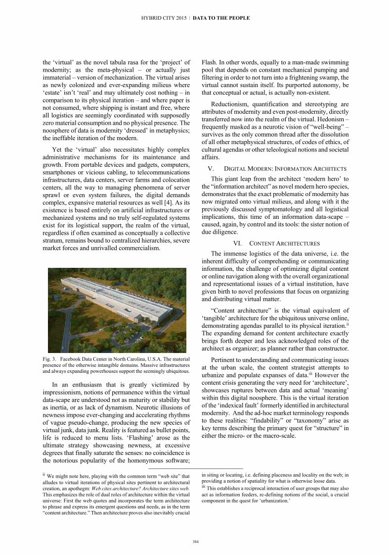
the ‘virtual’ as the novel tabula rasa for the ‘project’ of modernity; as the meta-physical – or actually just immaterial – version of mechanization. The virtual arises as newly colonized and ever-expanding milieus where ‘estate’ isn’t ‘real’ and may ultimately cost nothing – in comparison to its physical iteration – and where paper is not consumed, where shipping is instant and free, where all logistics are seemingly coordinated with supposedly zero material consumption and no physical presence. The noosphere of data is modernity ‘dressed’ in metaphysics; the ineffable iteration of the modern.
Yet the ‘virtual’ also necessitates highly complex administrative mechanisms for its maintenance and growth. From portable devices and gadgets, computers, smartphones or vicious cabling, to telecommunications infrastructures, data centers, server farms and colocation centers, all the way to managing phenomena of server sprawl or even system failures, the digital demands complex, expansive material resources as well [4]. As its existence is based entirely on artificial infrastructures or mechanized systems and no truly self-regulated systems exist for its logistical support, the realm of the virtual, regardless if often examined as conceptually a collective stratum, remains bound to centralized hierarchies, severe market forces and unrivalled commercialism.
Fig. 3. Facebook Data Center in North Carolina, U.S.A. The material presence of the otherwise intangible domains. Massive infrastructures and always expanding powerhouses support the seemingly ubiquitous.
In an enthusiasm that is greatly victimized by impressionism, notions of permanence within the virtual data-scape are understood not as maturity or stability but as inertia, or as lack of dynamism. Neurotic illusions of newness impose ever-changing and accelerating rhythms of vague pseudo-change, producing the new species of virtual junk, data junk. Reality is featured as bullet points, life is reduced to menu lists. ‘Flashing’ arose as the ultimate strategy showcasing newness, at excessive degrees that finally saturate the senses: no coincidence is the notorious popularity of the homonymous software;
ii We might note here, playing with the common term “web site” that alludes to virtual iterations of physical sites pertinent to architectural creation, an apothegm: Web cites architecture? Architecture sites web. This emphasizes the role of dual roles of architecture within the virtual universe: First the web quotes and incorporates the term architecture to phrase and express its emergent questions and needs, as in the term “content architecture.” Then architecture proves also inevitably crucial
Flash. In other words, equally to a man-made swimming pool that depends on constant mechanical pumping and filtering in order to not turn into a frightening swamp, the virtual cannot sustain itself. Its purported autonomy, be that conceptual or actual, is actually non-existent.
Reductionism, quantification and stereotyping are attributes of modernity and even post-modernity, directly transferred now into the realm of the virtual. Hedonism – frequently masked as a neurotic vision of “well-being” – survives as the only common thread after the dissolution of all other metaphysical structures, of codes of ethics, of cultural agendas or other teleological notions and societal affairs.
V. DIGITAL MODERN: INFORMATION ARCHITECTS This giant leap from the architect ‘modern hero’ to
the “information architect” as novel modern hero species, demonstrates that the exact problematic of modernity has now migrated onto virtual milieus, and along with it the previously discussed symptomatology and all logistical implications, this time of an information data-scape –caused, again, by control and its tools: the sister notion of due diligence.
VI. CONTENT ARCHITECTURES The immense logistics of the data universe, i.e. the
inherent difficulty of comprehending or communicating information, the challenge of optimizing digital content or online navigation along with the overall organizational and representational issues of a virtual institution, have given birth to novel professions that focus on organizing and distributing virtual matter.
“Content architecture” is the virtual equivalent of ‘tangible’ architecture for the ubiquitous universe online, demonstrating agendas parallel to its physical iteration.ii The expanding demand for content architecture exactly brings forth deeper and less acknowledged roles of the architect as organizer; as planner rather than constructor.
Pertinent to understanding and communicating issues at the urban scale, the content strategist attempts to urbanize and populate expanses of data.iii However the content crisis generating the very need for ‘architecture’, showcases ruptures between data and actual ‘meaning’ within this digital noosphere. This is the virtual iteration of the ‘indexical fault’ formerly identified in architectural modernity. And the ad-hoc market terminology responds to these realities: “findability” or “taxonomy” arise as key terms describing the primary quest for “structure” in either the micro- or the macro-scale.
in siting or locating, i.e. defining placeness and locality on the web; in providing a notion of spatiality for what is otherwise loose data. iii This establishes a reciprocal interaction of user groups that may also act as information feeders, re-defining notions of the social, a crucial component in the quest for ‘urbanization.’
384
HYBRID CITY 2015 | DATA TO THE PEOPLE

VII. INDEX: HEURISTIC TOOLS DEVISING BETRAYAL Examining the term index etymologically, offers
clues for ‘findability’ also. Latin index, genitive indicis is the forefinger, pointer, sign, or list; a superscription or title, or, for persons, a discoverer, informer, indicator or spy, from the verb indicō, indicare meaning point-out or show. As the Indo-European root deik-iv is traced in the term index, the Hellenic term “ενδείκτης” (endeiktes) appears as most relevant; translated as point in. And surprisingly (or not) the term index alludes to spying and betrayal, where ‘searchers’ need ‘traitors’v hinting at needy information.
Fig. 4. Facebook open compute server racks. The virtual is facilitated and has a locus, while also demanding extreme energy consumption.
Findability is countered by “indexing” processes, practices that indicate. Indexicality can be thus regarded as a response to the quest for findability and emphasizes the significance of the heuristic within the digital noosphere. No wonder that the ‘gates to data’ are controlled by commercial “search engines” and that the giant enterprise and neologism: google, re-iterates what we knew as goggles, that is viewing and protecting devices that dictate or help to see when immersed into uncanny waters; into the wholesome and homogenous ‘liquid’ strata of data.
VIII. TAXONOMY RE-CONSTITUTING AUTONOMY? The absence of context becomes a critical attribute of
the virtual: the erasure of locus, procession or linearity stands as cause for deep misinterpretations of data input. Former notions of ‘collective culture’ are thus overtaken progressively by massive ‘data hysteria’ that arises in a shortage of mechanisms for the editing, digesting and maturing of information. Such questionable conditions emerge perhaps due to the singularity of operational protocols and data exchange conduits, in a lack of holistic communication patterns in always-limited interactivity.
The rise of context-depraved information and the dissolution of societal or other hierarchical structures
iv The roof deik- is familiar through the terms apo-dic-tic, dictate, etc. v The parallel between spying indicating and indexing is analogous to the etymological link between tradition and traitor or even treaty, as tradition, Latin trāditiō means surrendering or handing over, thus
results in schizoid statuses where excessive connective mechanisms and information networks seemingly arise to fill-in cultural voids or replace communal networks yet arrive at a total disability to handle, sort and associate data with ‘real’ relations, revealing once more the deep ruptures of societal and interpersonal structures.
Taxonomy is the antidote: Hellenic “taxis” stands for concord and peace as well as class, while “nomos” is the law and rule(s); the canon, also alluding to Deleuzian notions. The intention seems here clear: control and order through classification. Autonomy, as both independence and self-regulation, is the desired status; the chimera; an elusive condition. The impossibility to link the two terms, taxonomy and autonomy, is animated by often populist approaches defending a ‘collective’ participation in the otherwise entirely pre-set games of ‘ordering’ data.
Fig. 5. Judas indexes or indicates the Messiah. Ravenna, ca. 500 A.D.
IX. DATA AS A NOVEL DATUM? Altogether, convictions that ‘data’ can be the source,
root and basis of strategic thinking, could be questioned by examining the very concept of information as an absolute value grounded on the notion of objectivism; as factual examination of situations or conditions on the basis of rationality and logic – notions obviously deriving from the Enlightenment lineage of thought. Questioning then the concept of data would not be simply equivalent to introducing a hypothetical “theory of relativity” into an equation of Cartesian or Newtonian nature; it is a matter of conceiving a philosophical state of holistic interaction, not of stringent analysis and fragmentation into dissolved components that – through entropy – fail to re-compose a whole. Fault in the very concept of ‘information’ may lie on over-analysis of pure fragments, entailing dangers of creating ‘logical’ chains that build upon smaller rational associations: failure might occur at any stage or link, cancelling thus entire arguments, leaving behind no alternative criteria or further processes of evaluation.
betraying. The simultaneous interpretation of tradition as betrayal is also emphasized by architectural theorist Colin Rowe in his lecture at the Architectural Association on January 18, 1975.
385
11 | Architectural Perspectives on Hybrid Space

This notion of ‘partiality’ may be contrasted to the concept of wholeness conveyed by the Hellenic term “πληρο-φορία” (read: plero + foria, from πλήρης + φέρω roughly: full + carry, root fer-, -pher or for-) thus offering grounds for an etymological comparison with the equivalent English term ‘information’ that carries steeply differing models. The term in-formation derives from the Latin composite “in + fōrmō” (īnfōrmō) that in present infinitive is īnfōrmāre, supine īnfōrmātum and means to form, mould, fashion, shape, delineate, etc. In Greek, the verb pleroforo (πληροφορῶ) may be typically translated as ‘inform’ yet its significance is contrasting, denoting completion or fullness. This announces a discourse on wholeness, closure and completeness, as opposed to ‘information’s insistence on formalities and its ‘lust’ for formalism. If we momentarily considered pleroforia as formation, then in-formation would appear as what in-completeness is to completeness: the prefix in- would function as negative, as undoing formation; as inhibiting its mission; acting even similarly to deformation or dis-formation. Rephrasing, we may think that ‘information’ prioritizes the itemized, the isolated, the indexical, the typical and the conventional that, if and when assured, supposedly safeguards from insecurities or fears by protecting individual monads, be that people or mere data. Such an introverted ‘system’ of fragmented entities is then mediated and serviced solely by third parties, precisely ‘servers’ causing thus no real interaction, only between secured independent units; posing thus no direct challenges to separate monads. Coincidently or not, this exact notion – the server – remains as key technical fact for the virtual domain, as a new kind of non-material ombudsman.
The word pleroforia in contrast disregards partiality and related insecurities; instead aims at a telos; it ignores pressures toward specificity of form; towards formalities, structure and order; pleroforia prioritizes in a sense the veritable, the authentic or holistic. The literary author and poet Odysseus Elytis is known for his severe criticism on contemplating order,vi in characteristically denouncing: “whenever you hear “order,” human meat it smells [5].”
Mere information, even when possibly hinting at ‘proper’ evaluations or choices, fails fundamentally to generate a vibrant continuum of shared ‘energy’ or collective momentum able to support cultural statuses. This exactly causes rupture phenomena, reflected in the growing distrust and loss of bonds, as well as in the emotional detachment between digitally transacting parties – not bodies. At the end these losses are greater than an individualized practical effect or such itemized gains.
X. INDEXICALITY VS. CONTEXTUALITY If ‘acquiring information’ is described as an indexical
process, where itemization and archiving become more
vi The original reads (as two verses): “Όταν ακούς "τάξη" [-] ανθρωπινό κρέας μυρίζει.” While the phrase may register as an extreme poetic expression particularly within a context of academic dialogue for data and the city, it gives a hint for broader contexts
prevalent than a ‘big picture’ or ‘context,’ then a suggested contextual approach can be narrated first through the metaphor of osmosis.
In biology, osmosis describes the natural flow of solvent molecules from an area of low solute concentration, through a semi-permeable membrane, to an area of high solute concentration [6]. The very act of communication can be examined as a network of osmotic relations effortlessly intertwined, where interdependency is more relevant than division or individual examination of isolated components on a basis of pre-determined responses. The acts of operating, relating and succeeding, whatever the objective may be, are not consequences of itemized information collection, are dependent upon ‘contextuality’ or interflow; upon indirect ‘digestive’ processes.
While ‘contextuality’ can be thus seen as opposing ‘indexicality’ in an analogy that reminds of the bipolar of introversion versus extroversion, the situation is reversed for these very terms in art theory as a series of diverse ‘takes’ to ‘indexicality’ emerged over the decades. In her two brief articles that signalled a nascent elaboration on “index” within the Arts, critic Rosalind Krauss [10] – while providing visual reference to artwork primarily by dadaists and surrealists, i.e. specifically Marcel Duchamp and Man Ray – writes:
“By index I mean that type of sign which arises as the physical manifestation of a cause, of which traces, imprints, and clues are examples.”
This precisely reminds of our previous reference to the so-called ‘indexical fault.’ Within contexts of the liberal arts, individual works may register as indexical yet their mission is clearly not to act as links within chain phenomena. Such works are meant as distinct fragments, as isolated ‘moments.’ They demonstrate certain obsessions with often disparate items that may fail to re-compose a whole; that represent information rather than pleroforia. Their approach is often deviant rather than ‘sociable’, and therefore inherently and even intentionally dis-urbanizing rather than cooperative. Yet this stands in opposition to what is anticipated within the virtual domain or within broader social perspectives that may anticipate greater associations of meaning and more profound theoretical inter-connections or lineages. The indexical trace in Art does not necessarily intend to be ‘corrective’ or proper, is only an archival document, a memorandum, an impression lacking further agendas.
The ‘indexical fault’ is here an acceptable and even desired evocation and is re-iterated as indexical ‘items’ directly or spontaneously recorded and represented with no further intention to directly manifesting their cause but primarily physical outcomes; the effect. Yet, transferring into architecture, an inherently more complex pursuit, the
prioritizing order and even attempting to prescribe or streamline the spontaneous and the collective. Original reference (in Greek): Οδυσσέας Ελύτης, «Η Ουγκρική Εξέγερση», Μαρία Νεφέλη Αθήνα, Ίκαρος, 1978.
386
HYBRID CITY 2015 | DATA TO THE PEOPLE

critic Richard Scherr, some decades ago, viewed “index” as a ‘didactic’ paradigm; as an agenda for immediacy or directness yet still inherently of a problematic nature – if not entirely impossible. He writes:
“If a building as index can be interpreted as a physical manifestation of some cause, architecture can be understood as a responsive effect of such a cause.
[…] an alternate mode of establishing associative content can be based in abstraction, or nonrepresentational means in terms of architecture's capacity to perform as “index.”[…] meaning in architecture is defined by its capacity to be contingent, that is, physically dependent on or conditioned by certain factors that inalterably guide the derivation of its form [7].”
Fig. 6. Marcel Duchamp, Machine Optique, 1920. Illustration from R. Krauss article “Notes on Index: Seventies Art in America,” Part 1. The author’s own reference to the indexical in the Arts.
While avoiding here to enter deeply into an often self-contradictory theoretical debate arguing for theory versus architectonic practice [8], provocative attributes of the indexical in architecture do inform the discourse on data within social milieus. Here the ‘architectural indexical’ is for Scherr synonymous to the contextual: it opposes notions of the merely representational, which is perhaps correctly considered as a simplistic approach to a formalism which dictates or prescribes replications of traditionalist or classicist forms that stand aloof to their surroundings.
Simply put, the architecturally indexical does not intend to ‘look like’ something already recognizable, but endeavours to respond and to be informed, shaped and moulded by ‘real-time’ parameters. To explain this, the mission of designing a monument would not be fulfilled by just copying a Georgian or a Victorian tectonic rhythm
vii A parameter to keep in mind is that the indexical in
architecture as a theoretical pursuit may be examined as ‘hiding’ a parallel discourse on the negation of the metaphysical project and
per se, but should be answered by one-of-a-kind open-ended processes as elucidations of contextual parameters, be that specific records, traces and remains of significant notions, symbols, archetypes or references related to the program, place, site, users, participants, or creators. At least the intention remains such. However this directness between cause and effect is simply elusive or distorted by subjective interpretation of external facts; of phenomena.
For R. Scherr, the indexical emerged also as an answer to “modern architecture's purported failure to communicate a specific content relevant to time and place” [9] as recognized by him as well as others of his generation.vii Yet this is already the immanent problem of his own strategy, as well as an eminent challenge for the ‘virtual’: the linkages and contextual associations of content. Apparently his writing almost rephrases former manifestoes for functionalism, precisely Le Corbusier’s outlines for “nouveau” architecture and purism, thus sounding almost homonymous to what he either opposes or overrides: modern architecture. Altogether, the failure of delivering content within context remains in all such pursuits and can be even viewed as engrained within human activity.
XI. DIS-URBANIZING DATA MECHANISMS? Online, it all truly melts into air: customization, i.e. of
interfaces, registers as the sole alternative agenda attempting to undo the boredom of the generic. Yet such a broad approach to individuation through representation may still remain de-personalizing by addressing a list of exterior, shallow, thin parameters; choices meticulously avoiding the more intense and often politically incorrect questions of ‘content.’
It is inescapable that establishing a cultural status pre-supposes reference to the political. In fact, discussing the very notion of data urbanization, it is emphatic that the political is that which relates to the polis; the city. Numbing the notion of the political or bypassing it, one bypasses urbanization as we knew it.
XII. DE-POLITICIZING THE CITY? Obviously, prioritizing the politically correct is a
political statement in itself: politics, ideologies, religions, beliefs, all sensitive yet driving components of cultural identity are strategically denied, excluded or avoided in contemporary communication patterns. Yet the city, the “polis” generates and motivates the political, inevitably. Here though we confront the gradual “de-politicizing” of the city, creating instead branded media-cities – be that physical, online or hybrid – of consumers; of customers, with only latent quasi-ideological attributes: cities of custodians, as loci of serviced versus servant entities, tentatively titled here as Custodia. The urbs that – clinically lost in an absence of other content, meaning or
simultaneously on a rejection of the physical, the present, the visible, summed as the phenomenological. This denial would necessitate a separate analysis of what is outlined as the “metaphysics of presence.”
387387
11 | Architectural Perspectives on Hybrid Space

rationale – barely manages to sustain itself. Dropping from content to discontent, such media-cities suggest the ‘unpolitical polis.’ As medium is the interim, the means towards, what earlier we called as the ‘server,’ then we truly tumble from the media-city to the city of custody.
XIII. AUTO-BIOGRAPHY AS SELF-ORGANIZATION? Two somewhat antithetical terms aforementioned
(see XI), customization and the generic, are elaborated here as key concepts for a tentative urbanization of data.
The notion of the city precludes another condition: human existence; human trace, i.e. human experience. It is human presence that makes ‘place.’ Senses of locus are established by differentiating individual presences; by identifying diverse experiential inputs. It is thus human experience that distinguishes between the local versus a non-local or even global condition.
In the milieus of urbanism, the previous decades emphasized such a bipolar discourse distinguishing between a so-called global and a local, often relying on rigid, supposedly axiomatic definitions of the exercised terms. If now the overall ‘antithesis’ can be simplified as generic (as global) versus special (as local), or even as common versus customized, intention here is to re-iterate the discussion as contrasting the impersonal (as generic) to the personal (as customized). As the impersonal is differentiated from the personalized precisely through the specificity of one’s experiences, addressing the very notion of experience becomes inevitable. Yet we may re-iterate experience as processes ensuing biographic input. As the ‘fabrication’ of such biographical data is led individually – by the experiencing person per se – such processes are inevitably autobiographical.
Fig. 7. Instagram graphic: Instantly/directly ‘writing’ the instance or moment; a timeline. A term connoting autobiography. Insta-gram = instance + gramma or letter (signifying notation broadly).
XIV. COLLECTIVE AUTOBIOGRAPHY The broad appeal of social media is tentatively an
indication of expanding attention to the autobiographic. User profiles may be rethought as recent cases of ongoing interactive autobiography, projected and communicated instantly. Indeed the very term profile is, in itself, direct reference to one’s most characteristic facial depiction; and a “face-book” is thus an archive and a network of interlinked autobiographical records. Art critic Francis R. Hart [11] indeed confirms that “autobiography is self-portraiture”, therefore a selfie is also surely a self-portrait and an autobiographical artifact at once. Rephrasing, the rising interests for an individual yet ultimately collective participation to the voluntary ‘offering’ of one’s own recollections and also re-editions of personal experience,
translates to joining the open-ended communal project of broadcast autobiography. The global vs. local antithesis is thus transcribed into contrasting the autobiographic to the non-autobiographic.
XV. FROM THE GEOGRAPHICAL TO THE EMOTIVE Social media directly link, precisely through data, the
strata of personal experience to the shared realm of the urban, of the mutually accessible and the publicized; of the virtual – if not material – city scale; of the digital – or rather broadly virtual – civitas. This may be considered even as self-explanatory: such media are autobiographical even though renamed as social. The literary genre of autobiography is thus re-thought here at the scale of the collective, rather than merely the otherwise obvious scale of the singular personage.
Fig. 8. Facebook opening web page graphic: A globe urbanized not by cities, but by autobiographical data, self-organized and broadcast. Cities give their place to networks of personal data.
Autobiography becomes the vehicle for an urbanization of data. We may thus recognize the representation of such practiced notions of community as a visualized iteration of collective autobiography. In that way we may acknowledge local identity as a kind of collective identity; as collective ‘biography’ that is then assigned abstractly to place rather than to a group of people; as attached to the notion of community. Thus, narratives of ‘place’ dissolve into their fundamental constituents and that is, the records of participants; or, in other words, autobiographical data.
While autobiographical profiles become almost a ‘social commodity’ or a shared and exchanged good, a source of data and an interactive medium that forms markets and ultimately builds profits, we may be possibly criticized as referring to phenomena of extrovert autobiography as opposed to intimate and profound memoirs, the quest for ‘projected identity’ remains the common and central attribute. Even if one insists on challenging the mainstream iterations of autobiography as highly manicured self-editions; as post-constructed identities simply prepared for the media vitrine or as superficial consumerist profiles, the broad intention of autobiography remains evident: settling an otherwise schizoid universe of loose data and non-identity; acquiring a self-analytic character, even psychoanalytic.
388
HYBRID CITY 2015 | DATA TO THE PEOPLE

This telos aligns with Fredric Jameson’sviii view of schizophrenia as a natural condition of post-modernity, a culture that “replicates and reproduces – reinforces – the logic of consumer capitalism,” [12] a state where disparate signifiers, images and experiential input fail to arrive at a coherent whole. Therefore defence and task of such novel kinds of virtual and immediate autobiography seems, at least at first glance, to precisely be the promotion of a communicative whole; a constant re-edition and forging of wholeness, of communicative closure; a tentative undoing of postmodern schizophrenia. This re-constitution of unity, spanning metaphysical, religious, as much as philosophical and theoretical frontiers, seems to sum up an unceasing quest for completion and closure.
XVI. FROM PLACE TO PEOPLE, VIA DATA Within the context of social media and as an act of
self-organization, autobiography emerges as the driving force; as ‘command’ that triggers networking, patterning and positioning acts. If autobiography is the archiving or compilation of experiences into coherent records, then its tactics trace a personified kind of historiography pursued by the very individual. Such a quest for personal completion becomes surely a collective enterprise, a kind of societal struggle towards the question of individual positioning; of locus or, once more, locality. This novel vision of virtual autobiography as pursued through social media could be understood as a project of re-composing communicative wholeness, as a tentative reversal of evaporated identity, of the lost ‘self,’ of virtual disparity and loss of locality, summed as the schizophrenia of the postmodern. This precisely addresses the discussed antithesis of pleroforia (as completion) versus in-formation (as incompletion).
While we may be witnessing a more homogenously spread species of collective capitalism through the hegemony of centrally-controlled and even censored ‘social’ media, the question pertains: are such alluring notions towards the verve of the autobiographical a form
of resistance towards numbness within a Zeitgeist of collective desolation and distorted autonomy?
REFERENCES [1] S. Sadler, Archigram: Architecture Without Architecture.
Boston: MIT Press, 2005, p. 134. [2] V. Scully Jr., Louis I. Kahn (Makers of Contemporary
Architecture). New York: George Braziller, 1962, pp. 36-37. [3] R. Koolhaas, “Junkspace: the debris of modernization,” in
Project on the City II: The Harvard Guide to Shopping, AMOMA. Koeln: Taschen, 2001, pp. 408-421. Reprinted as: R. Koolhaas, “Junkspace,” in Content, AMOMA. Koeln: Taschen, 2004, pp. 162-171.
[4] See: H. Geng, Data Center Handbook. New York: Wiley, 2014. Also: M. Arregoces, Data Center Fundamentals, Indianapolis: Cisco, 2003.
[5] My translation. O. Elytis, Maria Nefeli. Athens: Icarus, 1978. [6] All etymologies, definitions and Latin translations and are based
on the following books or dictionaries, in combination. The rare French Etymological Dictionary of Latin: A. Ernout and A. Meillet, Dictionnaire Étymologique de la Langue Latine (Histoire des Mots). Paris: Librairie C. Klincksieck. The Latin-Greek dictionary: Efstratios Tsakalotos, Lexicon Graeco-Latinum. Athens: Epikairotita, 1993. D.P. Simpson, Cassell’s Standard Latin Dictionary. Webster’s New World, 1977. The print edition, Oxford English Dictionary (OED), 2nd ed.
[7] R. Scherr, “Architecture as Index: Toward a Theory of Contingency Author,” in Journal of Architectural Education (1984-), Vol. 44, No. 3 (May, 1991), pp. 172-181.
[8] For a representative theoretical as well as project-based approach to index, refer to: P. Eisenman, “Digital Scrambler: From Index to Codex,” in Perspecta 35 (2004), pp. 40-53.
[9] R. Scherr, Ibid., p. 172. [10] R. Krauss, "Notes on Index: Seventies Art in America," Part 2,
October 4 (Fall 1977), p. 59. [11] F.R. Hart, “Notes for an Anatomy of Modern Autobiography,”
in New Literary History, Vol. 1, No. 3 (Spring 1970), pp. 485-511.
[12] F. Jameson, Postmodernism, or, the Cultural Logic of Late Capitalism. Durham, NC: Duke University Press, 1992, p. 125.
viii For Jameson, schizophrenia constitutes a latent psychiatric state that promotes and advocates postmodern interests and – vice versa – a postmodern strategy that projects the schizoid and the psychotic, thus generating illusionary ‘needs’ and thus ensuring a growing clientele fpr consumer culture. Contrasting this, in the infamous book Anti-Oedipus: Capitalism and Schizophrenia by Deleuze and Guattari, schizophrenia is advocated as a prime vehicle for radical opposition against capital and its market forces. However the French philosophers
are themselves already categorized as postmodern theorists, therefore their positions and work may be considered even as integral to postmodern propaganda. All in all the very position of schizophrenia within commercial culture deserves separate elaboration, as here lies a critical moment of interpretation towards the significance of autobiography.
389
11 | Architectural Perspectives on Hybrid Space

390
A Strategy for the Reactivation of Residual Urban Voids
Multidimensional Comparative Analysis and Classification
Anna Laskari School of Architecture
National Technical University of Athens Athens, Greece
Abstract. The perception of physical space involves the conception of multileveled interpretations, evaluations, distinctions and categorizations. Different criteria reveal different associations, corresponding to equally valid understandings of interrelations and categories. It is asserted that the potential of spatial appropriation by different actors, presupposes openness to multiple descriptions and to the possibility of encompassing a variety of different personal readings in a non-hierarchical, distributed fashion. The understanding of such a multitude of interpretations could be supported by the simultaneous incorporation of heterogeneous descriptions in a high-dimensional representational structure.
Following this assumption this paper addresses the possibility of conducting a comparative analysis and classification of spaces, and specifically of unused urban voids, based on the synchronous consideration of sets of multiple spatial descriptions, in terms of quantifiable attributes of the physical structure of spatial configurations. Under the hypothesis of the existence of a reciprocal definition of spatial structure and occupation practices, the aim is to identify distinct generic spatial types in order to subsequently determine a range of suitable generic use types for each that would potentially initialise processes for the re-appropriation of common space.
Keywords: multidimensional spatial representation; quantifiable attributes; dimensionality reduction; classification; generic spatial types; reuse of common space
I. INTRODUCTION Spatial configurations can be perceived through a
variety of descriptions of their physical form and structure. Each description is by definition an interpretative action, formed under the intentional projection of a spectrum of finite attributes, often related to preconceived criteria and practices of habitation. Especially when dealing with public spaces which, being open to multiple users and uses, are by definition subject to constant readings and reinterpretations, multimodal,
high-dimensional descriptions seem to be essential for their representation and understanding.
This paper presents a methodology for describing, comparing and classifying non-typical, undesigned spatial formations, on the basis of multiple expressions of their formal and syntactic characteristics. This investigation supports the formulation of strategies for the reactivation of unused urban voids and the creation of new common spaces, currently being addressed by the research programme titled “Strategies to Network Urban Interventions in the Metropolitan Centre of Athens”. The programme is carried out by the School of Architecture of the National Technical University of Athens in collaboration with the Region of Attica and its scope “involves the definition, evaluation and specification of a multiplex network of actions aiming at improving life and the experience of the townscape in strategically selected areas” [1]. The aim is to offer the Region of Attica a decision making tool in order to shape interventions in the metropolitan centre of Athens.
Within this wider context, the purpose of the proposed multidimensional description and classification is to inform a strategy for activating large sets of residual urban voids, defined as unbuilt spaces without use or with informal and arbitrary use, by suggesting possible distributions of new functions. The proposed functions are indicative and refer mostly to low-cost, immediately applicable and reversible interventions that focus on participatory processes of design, implementation and use, promoting public discourse and the engagement of the local communities. These functions are divided into eight types of activities:
Green spaces (pocket parks, playgrounds, urban farms)
Open-air commerce (farmers’ market, flee market)
Open-air social support structures (exchange market, communal kitchen, mobile medical unit, mobile library)
HYBRID CITY 2015 | DATA TO THE PEOPLE

391
Educative events (workshops for children, seminars for gaining various professional skills, foreign language tutorials, specialized talks)
Recreational events (open-air film projections, musical festivals)
Sports (basic work-out equipment, climbing walls, skate parks, small fields for various team sports)
Units for the management of disposable and reusable materials
Parking spaces
The list of activities is open and their prospective correlation to specific spatial types is indicatory and intended to act as a coarse guideline, since there is no unique or correct association between them. However different uses present variable spatial requirements that can inform the selection criteria. These were specified according to the following aspects:
Spatial layout of activities (linear, around one or multiple centres)
Desired degree of connectivity to the street network
Duration (permanent, ephemeral, periodic)
Range of influence (building block, neighbourhood, city)
Depending on the requirements and scope of each function, the involvement of citizens ranges from decision making, design issues and practical implementation to actual use, maintenance and adaptation to new conditions and needs.
II. CASE STUDY The proposed method is being preliminarily tested in
the area of Patissia, a dense neighbourhood of central Athens Fig. 1. Patissia was selected as a representative example of the prevalent type of urban development of the post-war period, that characterises most modern Greek urban settings.
The examination of the area revealed the presence of a significant number of unused or occasionally and informally used open spaces, combined with an intense lack of common spaces for public use. This situation, expressing two sides of a single bifold problem, could be dealt with as a whole by generating new common spaces through the re-activation of existing unbuilt spaces with the introduction of new functions.
III. DEFINITION OF THE URBAN VOID Although one could distinguish different ‘categories’
of such under-used open spaces in the urban fabric of the area, such as parts of the street network, squares, alleys and empty lots, this paper only examines unbuilt spaces that are confined within the boundaries of the urban blocks. However, this category of voids encompasses highly differentiated spaces, requiring finer typological subdivision.
In order to locate and specify the form of these voids, the urban block is abstractly viewed as a binary configuration of built and open spaces. The elementary component of the analysis, the 'urban void', is defined as the largest possible aggregation of continuous open spaces within one block, as viewed in plan, regardless of proprietary limits and other physical boundaries Fig. 1.
The conditions that formed these spaces through time comprise repetitive processes of local spatial reconfigurations, aggregations and subdivisions. Consequently, they currently appear as mainly undesigned, almost random colligations of residual, heterogeneous spaces that can be defined merely as the negative of built space. Their fragmented and ill-defined identity renders these spaces vague, almost non-describable and intrinsically open to multiple readings.
IV. METHODOLOGY The difficulty to describe these urban voids in explicit
terms doesn’t allow for the designation of unambiguous evaluation criteria for their classification into distinct types. This task requires the definition of a descriptive logic that would act at a procedural level. The multiplicity of space is being perceived through a heterogeneous combination of discontinuous and disparate partial definitions, each of which is viewed as a distinct descriptive dimension. It is therefore attempted
Fig. 1. Location and form of the urban voids in the area of Patissia, central Athens. The urban voids are defined as continuous open spaces within the blocks (right, in red).
11 | Architectural Perspectives on Hybrid Space

392
to describe the physical form and structure of space through these multiple dimensions by gradually identifying, measuring and representing them [2].
A. Identification and measurement of quantifiable attributes The first stage of the analysis consists in the selection,
recording and quantification of spatial attributes that will account for the various descriptive dimensions. It is intended that these attributes be related to the visual perception and spatial experience of the respective spaces, independently from specific morphological, typological and technical characteristics. Such properties are considered to be associated with qualities such as fragmentation, complexity, coexistence of multiple scales, relation between parts, self-similarity, convexity, linearity or centrality, connectivity, symmetry and rhythm.
By combining different methods of shape and spatial analysis, sets of local and global spatial attributes expressing the above qualities are being quantified and measured. The measurements are predominantly derived from plans through non-interpretative, algorithmic measurement methods.
1) Local attributes Local configurational features refer mainly to scalar,
geometric and topologic/syntactic attributes of each individual urban void Fig. 2.
a) Scalar measures Scalar attributes comprise arithmetic measures that
can be directly derived from plans and capture properties referring mainly to issues of size, metric proportions and quantitative expressions of openness to the surrounding streets Fig. 2(left).
b) Geometric measures Geometric attributes related to fragmentation,
multiplicity of scales and self-similarity are considered to be adequately expressed by the fractal dimension [3] of the perimeters' shapes, which is calculated through the graphic method of "Box-Counting” [4] Fig. 2(middle).
c) topologic - syntactic measures The measurement of topologic and syntactic
attributes, such as spatial connectivity and convexity, is based on a method, which quantifies shapes in terms of distribution of connectivity along the perimeter [5] Fig. 2(right), combining a sequential and a synchronous logic of visual experience [6].
2) Global attributes In terms of global measurements, accessibility on a
neighbourhood scale is taken into account, through the measurement of the Weighted Degree of each void, expressing its connectivity in regard with the wider network of open spaces of the area under investigation Fig. 3. The quantification of accessibility is additionally addressed through the calculation of different measures of centrality, such as Betweenness Centrality, Closeness Centrality and Eccentricity of each void.
B. Multidimensional plot Through the selection and quantification of a set of
different types of spatial attributes, each spatial unit is being defined as a multidimensional vector, with each of its dimensions corresponding to one of the features under measurement. By plotting the quantities deriving from the measurements in a high-dimensional feature space, every void is represented as a uniquely defined multidimensional point. The concentration or dispersion of the points corresponds to the degree of relation of the represented spaces along all attributes simultaneously [7].
C. Dimensionality reduction The produced multidimensional representation space
may be mathematically defined but it is not a straightforward task to directly visualise it in an intelligible and legible way. For this purpose, it is attempted to map it onto a space of lower dimensionality, while maintaining the metric and topological relations between the initial multidimensional vectors. In order to cross-validate the results, three different algorithmic methods for mapping and visualising multidimensional data are employed and compared. These are implementations of Principal Component Analysis,
Fig. 2. Measurement of scalar, geometric and topologic/syntactic attributes. Instances of the graphic output of algorithms calculating, from left to right, metric measurements (such as total area and perimeter length, footprint ratio, number of adjacent and contained buildings, number of openings to the surrounding streets, percentage of accessible perimeter length), fractal dimension, global and local connectivity.
HYBRID CITY 2015 | DATA TO THE PEOPLE

393
Kohonen Networks and Particle-Spring Systems simulations Fig. 4.
1) Principal Component Analysis (PCA) The Principal Component Analysis, a statistical
technique of Multivariate Analysis [8], produces a three-dimensional distribution of points that maintains the structure of relations amongst the initial high-dimensional data [9] without however representing specific dimensions of the original space.
2) Kohonen Network From the area of Artificial Intelligence and
specifically of non-supervised Artificial Neural Networks, a Kohonen Network, or Self Organising Map (SOM) is used to map the multidimensional vectors on two dimensions in a self-organising way [10], by gradually adapting the synaptic vectors of the artificial neurons to the input space [11].
3) Particle-Spring System simulation A Particle-Spring System simulation, being an
implementation of Computational Physics Simulations, is not a dimensionality reduction method per se, but it was selected as a tool that enables the dynamic spatial expression of self-organising associations among multiple elements. In the simulation, each space is represented as a Point-Mass Particle [12], connected to all other particles via virtual springs. Under the exertion of the forces of the springs, whose rest length is set as the
Euclidean distance between the feature vectors of the particles at their ends, the system comes to a state of dynamic equilibrium where the relative position of the particles reflects associations among the represented spaces.
D. Typology extraction through clustering All three methods used for dimensionality reduction
result in two or three-dimensional distributions of points where closely related spaces are plotted closer together Fig. 4.
Although this offers a general visualisation of abstract convergences and divergences along all measurements, there is no obvious division into well defined groups that would allow for the classification of the spaces into distinct types.
The first step in this direction consists in connecting all points and generating weighted graphs where each connection is labelled according to its length, and weaker connections are being filtered out Fig. 5(top).
The second step refers to the actual detection of clusters, through the calculation of Modularity of the produced weighted graphs Fig. 5(middle).
Each of the resulting clusters is considered to correspond to a distinct spatial type Fig. 5(bottom).
Fig. 3. Measurement and visualisation of distribution of connectivity on a neighbourhood scale. From left to right: Map of different categories of open spaces: streets (green), passageways (blue) and ‘urban voids’ (red). Weighted graph of open spaces. Calculation of weighted connectivity for the ‘urban voids’. Visualisation of connectivity values on the map.
Fig. 4. Mapping of the multidimensional vectors of all analysed voids on lower-dimensional spaces, using three different methods for dimensionality reduction. From left to right: Principal Component Analysis, Kohonen Network, Particle – Spring System simulation.
11 | Architectural Perspectives on Hybrid Space

394
V. ASSIGNMENT OF GENERIC FUNCTIONAL TYPES The proposed method for classifying non-typical
urban voids is based on the hypothesis that the synchronous view of multiple attributes of a set of spatial representations could lead to the appearance of patterns revealing relations among the respective spaces, in terms of abstract degrees of similarity and difference. The relative position of each spatial unit mapped on reduced dimensionality structures depends on a set of intrinsic relations that cannot be discerned a posteriori and examined as distinct components [13]. In Badiou's words "the class of multiples which are connected to the event will not be determined by any of the properties which can be formulated in the language of the situation" [14].
Consequently, the resulting types are not fixed or unambiguous categories directly related to specific and
describable architectural attributes such as morphological, typological or technical spatial characteristics; neither can they be directly linked to any individual measurement in isolation. Rather, they are considered as indefinite and multiply interpretable groupings according to abstract degrees of similarity.
In this sense, the resulting spatial types are referred to as ‘generic types’ [14], exhibiting multiple identities and openness to multiple interpretations, programmatic specifications and uses.
Following the same logic, the prospective functional types are also ascribed as ‘generic’, since every specification of functional requirements reflects different schemes and dynamically changing patterns of socio-cultural, ideological and economic tendencies that
Fig. 5. Consecutive stages for the exptaction of generic spatial types according to clustering of graphs deriving from different mapping methods. From left to right, results from: Principal Component Analysis, Kohonen Network, Particle – Spring System. From top to bottom: Weighted graphs where the weights of edges depend on the distance between nodes, cluster extrapolation based on Grpah Modularity analysis, visualisation of the resulting generic spatial types on the area map.
HYBRID CITY 2015 | DATA TO THE PEOPLE

395
characterize and identify every singular context within which the design problem is being shaped.
Therefore, the assignment of generic functional types to generic spatial types is not a straight forward process. There is no unique or correct correlation but a wide range of equally fit possible suggestions Fig. 6.
VI. INTRODUCTION OF HIERARCHIES: RANKING OF ATTRIBUTES AND ALLOCATION OF WEIGHTS
For this task, the spatial types need to be interpreted, empirically post-evaluated and lose their generic character and external criteria, not necessarily connected to the physical form of space, need to be taken into account.
Such criteria could, for example, refer to requirements of the prospective function itself, but also to the present functions and architectural typology of surrounding buildings, the existence or not of adjacent empty buildings that could also be reused, the possibility of combination of interconnected voids, environmental properties, demographic characteristics of the specific block, proprietary issues etc.
At the next step, these criteria need to be introduced into the system as user-defined parameters, according to which the initial measurements will be assigned hierarchies. For each parameter, its degree of correlation with each of the measurements needs to be defined, depicting the relevance of the respective spatial attribute to the specific parameter or criterion. Different weights will thus be attributed to the measurements according to the specific intentions of each implementation, allowing for the definition of the involvement and relative importance of each feature for every different description of the design problem. Each formulation of the design problem will be expressed in terms of intentions, explicitly interpreted into the hierarchical ranking of desired spatial attributes, through allocating different
weights to the various features. This will enable the dynamic visualization of the rearrangement of the system of interrelations among the generic spatial types, based on externally applied criteria.
Since there is no definite formulation of the problem and, according to the definition of "wicked problems" by Rittel and Weber [15], "every specification of the problem is a specification of the direction in which a treatment is considered”, this tool could be particularly useful during the early design stages, where all involved actors need to co-specify the requirements and restrictions of the project, by weighting a multitude of heterogeneous priorities and variables. The proposed system could support collaborative decision-making and form the basis for discourse in order to enable the engagement of all parties in the process. This will support an open strategy, where spatial and functional associations will be co-defined and managed by regional authorities, local authorities and communities, whose degree of involvement will be defined according to the specifications of each design problem, in terms of the range of infrastructure requirements, issues of cost, permanence and scope, as well as the groups of population being addressed.
In this context, the methodology for classifying non-typical spatial formations into generic types acts as an open and generalisable platform for setting out a strategy for the reactivation of urban voids with the introduction of a range of community–driven activities. In this sense, it is meant to depict possibilities, support discourse and encourage processes of spatial reappropriation rather than to set out final and definite land use plans.
REFERENCES [1] Parmenidis, G (eds) 2013, Strategies to network urban
interventions in the Metropolitan Centre of Athens, NTUA Press, Athens
Fig. 6. Schematic assignement of generic functions to generic spatial types.
11 | Architectural Perspectives on Hybrid Space
396
[2] Laskari, A, 2014 ‘Multidimensional Comparative Analysis for the Classification of Residual Urban Voids’, in Thompson EM (ed) Education and research in Computer Aided Architectural Design in Europe, eCAADe 2014, Vol.2, pp.283-292
[3] Mandelbrot, BB 1982, The Fractal Geometry of Nature, Freeman [4] Bovill, C 1996, Fractal Geometry in Architecture and Design,
Birkhauser, Boston [5] Psarra, S and Grajewski, T 2000 'shape and shape complexity
using local properties', Third International Space Syntax Symposium, Atlanta
[6] Psarra, S 2003 'Top-down and bottom-up characterizations of shape and space', Fourth International Space Syntax Symposium, London
[7] Laskari, A, Hanna, S and Derix, C 2008 'Urban identity through quantifiable spatial attributes: Coherence and dispersion of local identity through the automated comparative analysis of building block plans', Design Computing and Cognition, Atlanta, pp. 615 – 634
[8] Duda, R, Hart, P and Stork, D 2001, Pattern Classification, Wiley-Interscience Publication, second edition, New York/ Chichester/ Weinheim
[9] Jolliffe, IT 2002, Pricipal Component Analysis, Springer, second edition, Verlag / New York
[10] Kohonen, T 1995, Self-Organizing Maps, Springer, Heidelberg [11] Rojas, R 1996, Neural Networks, Springer-Verlag, Berlin [12] Witkin, Α 1994 ‘Particle System Dynamics’, in Introduction to
Physically-Based Modeling, SIGGRAPH 94 Course Notes [13] Hanna, S 2007, 'Automated representation of style by feature
space archetypes: Distinguishing spatial styles from generative rules', International Journal of Architectural Computing, 5(1), pp. 2-23
[14] Badiou, A 2005, Being and event, Continuum, New York [15] Rittel, HWJ and Webber, MM 1973, 'Dilemmas in a general
theory of planning', Policy Sciences, 4(2), pp. 155-169
HYBRID CITY 2015 | DATA TO THE PEOPLE

397
Urban P.E.T.s. Urban Public Embedded Thresholds
Polyxeni Mantzou Associate Professor,
Department of Architectural Engineering, DUTH Xanthi, Greece,
Katerina Psegiannaki PhD,
School of Architecture, UPM, Madrid, Spain,
Francisco García Triviño Associate Professor,
School of Architecture, ESNE, Madrid, Spain,
Abstract. Urban PETs is a proposal centered in the way architecture as a mediator can find its place in our contemporary world, hugely defined and configured by interfaces. Within this concept PETs are a new kind of hybrid, digitalized, spatial, urban interface. They are, to be exact, urban Public Embedded Thresholds.
Common digital interfaces connect human subjects to the digital code and allow us to interact with the distant and the asynchronous. But they are not habitable; they are surfaces or objects, not surroundings, not spaces that enfold the subjects.
Common architectural interfaces are spaces that enclose subjects and permit them to control, relate and connect to their immediate surroundings, a wall, a door, a window, a roof, a threshold, etc. But their range of connectivity is restricted; they don’t allow distant, far-off nor asynchronous connections.
Urban PETs are hybrids of digital and architectural interfaces, or better still, in-betweens, porous thresholds. PETs are articulations of digital and physical experiences in a new merged condition, where there is no need for alternation, where there is fusion and expansion, where the environment is augmented and interconnected and where the corporeity is reconciled with the virtual.
Urban PETs provide embedment; they host specific, tailor-made software applied in concordance with their physical characteristics. These new thresholds are embedded, in other words they operate like beds for placing specialized software which augments their connectivity and dilate their limits, in the way dreams expand our reach, but, at the same time, without transgressing the physical limitations of the proper bed or denying the accommodated body’s comfort.
Urban PETs are public; embedding digital public space to the physical public space can prove to be beneficent for both. Limits and thresholds between public and private can remain operative but at the same time open source strategies can apply beyond spatiotemporal limitations. The attributes of the digital public space, instantaneity, and ubiquity can, in the case of hybrid public spaces, be combined with em-placement. Physical public space’s borders and
thresholds can be active and can lead to rich, diversified experiences without inhibiting and reducing the connectivity and openness.
Urban PETs are urban; they refer to the city and acknowledge the needs of the contemporary citizen. They shape hybrid urbanities that can offer physical proximity, sense of belonging and community and, simultaneously, allow connections among communities and collectivities, widen the horizons and dilate the restrictions. They aim to revive urban, city spaces and at the same time to transform villagers of the globe to citizens of the world, i.e. cosmopolites.
Urban PETs are a condition for encounter and coexistence but more importantly, an autonomous articulation. They are an independent, porous in-between, which operates as a dilated interface, a connectivity medium, and an enfolding, embracing, habitable condition, i.e. a hybrid, new kind of threshold. Keywords: hybrids, architecture interface, urban, augmented
I. THRESHOLDS Architecture has always been an interface; a
threshold, separating and connecting different systems, providing relation and control, union and separation. Traditionally, it was mainly through this interface that the subject was associated and related to its analogue environment. As our world is becoming more and more digital, the architectural interfaces are becoming less important and even obsolete. In his book, The Lost Dimension, dated back in 1991, Paul Virilio analyzes the evolution of the architectural interface par excellence, that is, the window. He sees in the passing from the door, to the window, a preference for the visual, which is culminated in the third window, i.e. the screen, with a preference for the placeless and the immaterial, where proximity and adjacency become irrelevanti. The subject is related to its digital
i “To this end, consider the history of architectonic elements, such as walls, doors, windows chimneys, the first windows is the door, the door-window necessary for access to and thus conceptualize a house without some meals access. In the first dwellings, the illuminating
11 | Architectural Perspectives on Hybrid Space

398
environment by other means; digital interfaces are seductive and immersive and offer a possibility for connection beyond spatiotemporal limitations. The role of architecture as the principle mediator in the subject’s relation to the world is questioned as the notion of the world is expanded. On the other hand, the digital sphere is one that has no real, actual place for the sensuous body. Spectacular digital experiences lack the profoundness of corporeal, analogue, deep involvement.
The most common digital interfaces nowadays are conditioned by the human-computer interaction, being the computer, a network connected, often portable and tending to disappear, machine, designed to interact with single individualities. In this direction, although we feel every time more connected with each other, when the machine switches off this sense of hyper-connectivity is lost and we find ourselves deprived and isolated, in real space and time. The web 2.0, and the IoT denote a
opening did not exist. There was an entrance and sometimes a chimney of some short. The window as such -the second window- appeared fairly late, in the sites of monastic cults, before becoming popular among the rural homes and only then, and especially, in the palace and the homes of the bourgeoisie. The third window is a recent invention: the television screen, a removable and portable window that opens onto the face day of the speed of light emissions. The television screen is an introverted window, one which no longer opens on the adjoining space but instead faces beyond the perceptible horizon. Thus, if the door-window constitutes an opening- a threshold for the immediate and undifferentiated access of people, things, daylight and direct vision, as well as a form of ground-level ventilation that works with the more elevated ventilation of chimney- then the specialized windows is more selective, because it interrupts the passage of bodies. The specialized window is a puncture, a mediated opening for solar light and nearby perspectives. In this context the TV screen becomes a selector of electronic images, an audiovisual medium for the indirect light of the cathode tube.” [1]
second stage of the world wide web evolution, offering every time more and more new ways of relating, new forms of discourse, new ways of interacting, new kinds of groups, and new ways of sharing, trading, and collaborating [2] that gradually become part of our everyday life. This new reality inspires a spirit of interconnectivity, participation and collaboration [2] provided by new technologies in which most people have access in western societies. Digital interfaces tend to transparency and embedment, in order to relate to physical space and involve the human body; architectural interfaces though, remain indifferent to this change although they could opt for hybridization in order to absorb digital technologies in physical space and thus augment the possibilities of space interaction.
II. EMBEDDED The digital revolution is one that we have been
living in for the last decades and consequently its groundbreaking effects are often greatly assimilated and not always apparent to us but rather taken for granted. Still, there are certain inherent characteristics of the binary code that cause significant consequences in the way it codifies and thus interprets and reconfigures all that is digitalized. Of great importance is its aspect of placelessness, the fact that its nature is abstract and therefore cannot be emplaced or rooted, which results in its great capacity for manipulation, multiplicity and mutation. As a counter-effect this placelessness places serious issues in relation to our bodily nature, which is mostly ignored or even treated as an obstacle, as is the case of those who assume that in the coming decades our mind will be directly linked to the web [3], eliminating all need for interfaces, that is mediators that intervene, being the body one of them.
HYBRID CITY 2015 | DATA TO THE PEOPLE

399
To embed, to lay in a bed, is a geological, originally,
term, in reference to fossils in rock, that is, placed in a bed of surrounding matter.ii Placement and embedment are almost synonyms and the term embedded software, is used to designate software that is placed in artifacts that typically are not understood as computers, i.e. machines and devices that use specialized software to augment their possibility for actions and interactions, as are cars, phones, toys. Software placed in these uncommon hardware receptors is embedded and adapted to the specific needs and to the specific characteristics and also limitations of these beds. Because these beds are not solely destined to bear the software but are also designed to have important analogue and corporeal qualities, this software has to respond to the specific needs and to be designed taking under consideration the overall performance and the produced end-result.
In this line of thought, architecture and architectural interfaces could also be understood as beds for placing embedded software in order to achieve a higher adaptivity, an improved performance, an augmented possibility for interaction and even an enhanced connectivity beyond, but not without, the traditional limitations of place. These beds, with their specialized software, augment their connectivity and dilate their limits, in the way dreams expand our reach, but, at the same time, without transgressing the physical limitations of the proper bed or denying the accommodated body’s comfort.
ii From Online Etymology Dictionary, embed http://www.etymonline.com/index.php?term=embed
III. PUBLIC The main notion of the public space bears within it,
the notion of the private. Architecture has not only mediated for this preeminent dipole, but has also been the principle common denominator that configured and defined where the ending of one becomes the starting point of the other and where one is inserted into the other, shaping encounters that constitute thresholds. These thresholds have typically been analyzed and studied by architects and their deepness or their shallowness, which in cases can get even to superficiality, is a distinctive and an illustrative characteristic of different cultures and societies. To relate public space to private space is to reflect upon the relation of collective to personal, publicity to intimacy, social to individual. This is a relation that constitutes and defines each society and is manifested in its architectural expression.
In the digital age, public space is expanding. It is becoming more and more obvious that public space is not merely perceived by contemporary subjects as the physical space, in many cases defined by architectural elements, but also as the immaterial space of the web [4]. This poses new and unforeseen questions related to the definition of the public and its relation to the private. The web’s development has been up to now driven by the commercial profit it engenders and there are all sort of unsolved issues concerning royalties, privacy and security matters. Unrestricted access, for all, is without doubt a main objective for public digital space, especially as this can create an open resource for knowledge, art, and culture. But also, IP and privacy has
11 | Architectural Perspectives on Hybrid Space

400
to be safeguarded and protected in the anonymity of the unrooted digital public space.
Embedding digital public space to the physical public space can prove to be beneficent for both. Actual and virtual encounters can be combined, merged and therefore enriched; limits and thresholds between public and private can remain operative but at the same time open source strategies can apply beyond spatiotemporal limitations. The instantaneity, the immediacy and the ubiquity of digital public space can, in the case of hybrid public spaces, come without losing all sense of em-placement. [5] At the same time, borders and thresholds can be enacted and can provide diversified and enriching experiences without limiting and reducing the sphere of possibilities allowed.
IV. URBAN According to United Nations, “by the middle of
2009, the number of people living in urban areas (3.42 billion) had surpassed the number living in rural areas (3.41 billion) and since then the world has become more urban than rural.”iii Urban, from city, urbs, is closely linked to civil and civilization. The passing from the tribal phase to the civil stage, that is to the construction of urbs and thus, the urban phase has been of extreme importance for mankind. Nomadic structures led to sedentary ones, when cultivation was made possible and as a result, culture was originated. Urbanity is not only about conglomeration, it is about community, about sharing a common ground and belonging somewhere,
iii Urban and rural areas, 2009. http://www.un.org/en/development/desa/population/publications/urbanization/urban-rural.shtml
forming part of a collectivity. It is through this organizational process that societies achieve an advanced stage of development.
Urban life is changing rapidly due to the proliferation of digital social media, e-commerce, digital entertainment, digital archives, teleworking, distance learning.[6] Almost each and every one of the typologies that used to define the city, have gradually been moving from the physical urban space to an ubiquitous, unrooted and dispersed non-locative medium, leaving urban space unjustified and desolate. On the other hand, the sense of belonging, the community that the physical urban space has engendered cannot be found in its profoundness in the digital realm, where dispersed encounters occur without leaving trace, where memory is an objectified and detached archive.
If urban population is increasing it isn’t because McLuhan’s global village [7] was a false prediction, but rather because, apart from online communities, commerce, work, education, entertainment; there is always an overwhelming desire for physical encounters, for rooted activities, for common ground. Hybrid urbanities can offer physical proximity, sense of belonging and community and at the same time connect communities and collectivities, widen the horizons and dilate the restrictions. Urban processes that combine physical and digital presence can revive urban, city spaces and at the same time can assist villagers of the globe to become citizens of the world, cosmopolites.
V. THE URBAN PETS’ MANIFEST PETs are a new kind of hybrid, digitalized, spatial,
urban interface. They are, to be exact, urban Public Embedded Thresholds. Common digital interfaces
HYBRID CITY 2015 | DATA TO THE PEOPLE

401
connect human subjects to the digital code and allow us to interact with the distant and the asynchronous. But they are not habitable; they are surfaces or objects, not surroundings, not spaces that enfold the subjects. Common architectural interfaces are spaces that enclose subjects or elements that define their emplacement and permit them to connect to their immediate surroundings, a wall, a door, a window, a roof, a threshold, etc. They don’t allow distant, nor asynchronous connections.
PETs are hybrids of digital and architectural interfaces. They are fluid and transformable, they permit all sorts of connections without space or time delimitations and at the same time they allow the subjects to be enfolded in a common ground, a common place that is referred to its immediacy, to its space and time restrictions, to the collectivity and the social coexistence.
PETs are used as a system that can inhabit the public spaces, mostly open, but also enclosed, mostly grounded but also maritime and they can be used in order to host events related to the cultural, the social, the recreational and the political. They can be moved, combined, eliminated and they can be used in a specific relation to preexisting buildings, urban spaces, or landscapes, or as autonomous entities. They can be attached and related to the near and interconnected and expanded to the distant and they aim to host a multiplicity of actions and interactions that aren’t predefined.
PETs are multi-purpose and although they serve as an infrastructure for a disseminated, interconnected museum, they can do so much more. They aim to activate the public space of the town, augment its
repercussion and spread around the city art projects, educational and recreational events, participatory and collective activities, social and political interactions. Their nature is hybrid- they are equally obsessed with the analogue and the digital- they are also systemic, nomadic, expansive, transformable, adjustable, dispersed, multiplied, combined, eliminable.
PETs are autonomous entities in their uniqueness and a part of a whole, of a system that allows different sites of the city to interconnect with this network of physical, accessible and yet amplifying and augmenting structures. The PET network is a unique structure that converts the city and the experience of its urban public spaces in a vivid, collective, participatory, culturally-centered and leisure-oriented, animated, hybrid reality. It is a decentralized, dispersed system that distributes activities and events throughout the city instead of converging it all to a single megastructure. The Helsinki ‘s specific characteristics can benefit from the urban PETs sprawl as they can shelter public acts in semi-open spaces offering shelter from weather impediments. On the other hand, Helsinki can foster the urban PETs and aliment them with its diverse and interesting environment, institutional and participatory activities and the emphasis on art and education matters, as well as to those of social interaction. Helsinki can provide PETs with multiples connections, not just the ones among them, but also with cultural and educational institutions and events, allowing information to flow and proliferate, converting the city to a hybrid, augmented but strenuously physical network of experiences, of situations, where all can participate and get involved. The Helsinki’s urban PETs are loyal to the city’s welfare and at the same time offer a unique
11 | Architectural Perspectives on Hybrid Space

prototype which adjusts hybrid realities to the urban public space.
PETs are autonomous entities and also they are a part of a whole, of a system that allows different sites of the city to interconnect with this network of physical, accessible and yet amplifying and augmenting structures. The PET network is a unique structure that converts the city and the experience of its urban public spaces in a vivid, collective, participatory, culturally-centered and leisure-oriented, animated, hybrid reality. It is a decentralized, dispersed system that distributes activities and events throughout the city instead of converging it all to a single megastructure.
PETs can improve the quality of the urban sprawl as they can activate its use and shelter public acts in semi-open spaces offering shelter from weather impediments. The cities can foster the urban PETs and aliment them with their diverse and interesting environment, institutional and participatory activities and the emphasis on art and education matters, as well as to those of social interaction. PETs can be provided with multiples connections, not just the ones among them, but also with cultural and educational institutions and events, allowing information to flow and proliferate, converting the city to a hybrid, augmented but strenuously physical network of experiences, of situations, where all can participate and get involved. Urban PETs are loyal to the cities’ welfare and at the same time offer a unique prototype, which adjusts hybrid realities to the urban public space.
VI. PET_FOOD (FOR THOUGHT) Urban PETs are equally fed by the digital and the
physical and to be more exact, they are fed by their coexistence. They are bred by hybridization. They inhabit the urban space of the traditional city but they take their PET_walk in a ubiquitous and universal sprawl. They adapt to their masters’ needs, they follow them and move if needed, they are playful, joyful, and sociableiv.
Urban PETs merge digital intensity with physical profoundness in a way that the subject is content in both aspects, as a spectacle-educated person of the digital age and as the corporeal human. They engender collectivity, community and the sense of belonging and at the same time they are characterized by openness, extroversion and unreservedness toward the distant, the unknown, the remote. They are multifaceted, all-embracing and wide-ranging and they adapt to their environment, being very well prepared for change and even mutation.
Urban PETs is an architectural project for the digital age. It is a transcription of the necessity to understand
iv As Sennett and others have emphasized, public sociability is not natural; it needs to be learned, nurtured and practised. In an era in which public space is dominated by spectacular ‘brandscapes’ and pacified by the distributed technology of surveillance, new forms of public interaction facilitating qualities such as collective participation and unpredictable collaboration hold increasing social importance. In this context, the role of artists using new media to construct experimental interfaces in public space can assume strategic value. [8]
public urban space in a different way, under the pressure of the proliferation of digital media and technologies, but still, without dismantling it, but rather by reinforcing it. Architecture is understood in this context, where our environment is irremediably defined by both the physical and the digital, and because our human nature is difficult to please with less, as a common denominator and a merger for the physical and the digital, as a generator of new mediations that intervene and reconcile traditional excisions, providing augmented, responsive, all-engaging new realms. In this sense, Urban PETs provide not only the condition for encounter and coexistence but more importantly, an autonomous articulation, the creation of an independent, porous in-between [9], which operates as a dilated interface, a connectivity medium, and an enfolding, embracing, habitable condition, i.e. a hybrid, new kind of threshold.
REFERENCES [1] Paul Virilio, Improbable Architecture on “Lost Dimension”.
U.S.A.: Semiotext, 1984, p. 79. [2] Michael Wesch, From Knowledgable to Knowledge-able:
Learning in New Media Enviroments. Academic Commons, January 2009 issue: “New Media Techonlogies and the scholarchip of Teaching and Learning” http://www.academiccommons.org/2014/09/09/from-knowledgable-to-knowledge-able-learning-in-new-media-environments
[3] Vishnu S. Pendyala , Simon S.Y. Shim , Christoph Bussler The web that extends beyond the world, Issue No.05 - May (2015 vol.48) pp: 18-25 Published by the IEEE Computer Society https://www.computer.org/csdl/mags/co/2015/05/mco2015050018.html
[4] Drew Hemment, Bill Thompson, José Luis de Vicente, Professor Rachel Cooper. Digital Public Spaces. FutureEverything, 2013.
[5] http://futureeverything.org/ideas/digital-public-spaces/ [6] Paul Virilio, The Overexposed City on “Lost Dimension”.
U.S.A.: Semiotext, 1984, pp.17-18. [7] Mitchell William:e-topia, Urban life Jim, but not as we know it. [8] Marshall McLuhan, The Gutenberg galaxy : the making of
typographic man, [Toronto] : University of Toronto Press, 1962.
[9] Scott Mcquire, The media city, London, UK : Sage, 2008. Pp. 150.
[10] Walter Benjamin: Naples, in Reflections, Essays Aphorisms, Autobiographical Writings pp.163-173. http://www.columbia.edu/itc/architecture/ockman/pdfs/session_8/benjamin.pdf Richard Sennet, Juntos. Rituales, placeres y política de cooperación. Barcelona: Editorial Anagrama, 2012. A.Picon, Toward a city of events: Digital Media and Urbanity in Turan Neyran (edit.)New Geographies, Puritan Press, USA, 2008. Scott Mcquire, The politic of the public space in the media city on Special Issue #4: Urban Screens: Discovering the potential of outdoor screens for urban society, 2006.
All images have been produced for the Next Helsinki competition by Christina Charistou, Angeliki Matami, Polyxeni Mantzou, Katerina Psegiannaki, Francisco García Triviño, 2015.
402
HYBRID CITY 2015 | DATA TO THE PEOPLE

403
Fig.1. “The structure provides sufficient transparency.”
Fig.2. “The three-dimensional urban grid develops in space, while the ground remains free…Ground installations consist of light demountable structures.”
Parallel Structures The Electronic Urbanism of Takis Ch. Zenetos: 1962-1974
Maria D. Papadimitriou Department of Architecture
University of Thessaly, Greece
Abstract. The study entitled “The Electronic Urbanism of Takis Ch. Zenetos: 1962-1974. The Articles in the Weekly Economic Newspaper “Oikonomikos Tahidromos”” began in 2012 as master thesis for the Postgraduate Course of Studies in Architectural Design at the Department of Architecture in University of Thessaly, Greece under the supervision of professor Yorgos Tzirtzilakis.
The study analyses, via the project of “Electronic Urbanism”, the concepts introduced by Post-Fordism and biopolitical labour, the way Takis Ch. Zenetos integrates the new post-industrial era in the city of the future, the influences of technological developments and the immaterial culture of communication on city and architecture. It investigates the role played by a mass magazine like the Greek Weekly Economic Newspaper “Oikonomikos Tahidromos” in the promotion of modern architecture and concepts for the city in the first half of 1970s.The present article presents selected aspects of Electronic Urbanism that indicated the coming culture of information technologies.
Keywords: Common, Multitude, Singularities, Nomad, Peasant, Fiction, Instant, Rhizome, Megastructure, Capsule, Immaterial, Networks, Technology, Tele-Operations, Virtual, Biopolitical Production, Post-Fordism, Altermoderntity, Anti-center, Loss of form, Space of flows, Non-Places,City-Territory, Metamorphoses
I. INTRODUCTION Takis Ch. Zenetos proposes Electronic Urbanism
(City Planning and Electronics) in a period of general reformations and experimentations, from political and social scene to architectural one [1]. It is the period of
the exodus from the regime of factory and the emergence of biopolitical production and immaterial labor. A transition from rigid constructions of Fordism to flexible forms of Post-Fordism is observed. This transition has influenced architecture and city. Immaterial culture has changed the perception and spatial experience. The immaterial of information takes precedence over the material. Flexibility and changeability of media’s networks take precedence over permanence and rigidity of matter. The relationship with time and space is redefined. The automation of production creates new spatiality. New forms of habitation and sociability arise.
T.Ch. Zenetos presents his first study for the City of the Future in 1962 at the Exhibition of the Organization of Modern Housing in Athens. His study was published in magasines “Zygos” 11/1961, “Architektoniki” 42/1963, “Architectural Review” 4/1964, “Architectural Design” 5/1964, “Architecture in Greece” 1/1967 “Themes”, “Technika Chronika” 2/1966, 3-4/1967. A paper on its application to the master plan for Athens was read at the Fifth Panhellenic Architectural Congress in 1966. His last study for an Immaterial Architecture (1973-1974) was published in the “Architecture in Greece” in 1974.
Between the first study of the City of the Future (1962) and the final proposal of the Immaterial Architecture (1973-1974), a transition from the organized forms of modernism to more ‘aerial’ and ‘lightweight’ constructions, is observed; a transition from the pavilion of Mies van der Rohe to space capsules. Continuous transitions from giant to micro-scale, a parallelism between mega-structure and capsule, nomad and peasant, ‘instant’ communication
11 | Architectural Perspectives on Hybrid Space

404
Fig.4. “A spider’s web surrounds the Earth in which the spaces for the dwelling and activities of Man are created.”
Fig.3. “Town of today. The town of the future. The soil remains free”
and physical proximity, private and public, representation and real, are observed in the flexible city planning.
Contrary to radical architectural studios of 1960s that proposed ironic versions of science fiction and not designed solutionsi, T.Ch. Zenetos sets the problems of modernity structures, the system of possible solutions, redefinitions and adjustments of architecture and city and leads to the proposal of the “active presence” of Electronic Urbanism by making his utopian vision for the City of the future “virtual”ii.
II. SPACE WITHOUT BORDERS
DETERRITORIALISATION By addressing the problems of lack of space on
ground level, destruction of the soil and unhealthy residential conditions, T.Ch. Zenetos proposes a suspended city, a flexible and changeable city planning. “The plan of the town of today with roads, gardens houses, shops, schools etc. becomes an elevation.”iii
The City of the Future suspends over historical cities and natural landscape. T.Ch. Zenetos liberates the ground and creates a vertical multi-leveled urban space-structure. The city is deterritorialised in an effort of escape from the traditional rigid urban model and it is redefined under new flexible conditions that automation of production impose.
City expands like a spider’s nest according to the rhythm of population growth and human needs. The nest spreads over the Earth like a rhizome and in the far future it covers its whole surface. T.Ch. Zenetos suggests the “creation of successive ‘earth-surfaces’ in
i Taking for example Superstudio’s visions for twelve ideal cities. Superstudio, “Twelve Cautionary Tales for Christmas (12 Ideal Cities).Premonitions of the mystical rebirth of urbanism”, Architectural Design, No.12/1971, pp.737-742 ii Using the term as defined by Pierre Levy P. Levi [1995], Qu' est-ce que le virtuel?, greek transl. Μ. Κarachalios, Athens: Kritiki, 1999 iii Τ.Ch. Ζenetos, “Town and Dwelling in the Future. Town - Planning in Space. A study. 1962”, Αrchitektoniki, Vol. 42, 1963, pp.48-55
the distant-future”.iv It is a constant city-territoryv that expands on superimposed artificial layers (repetitions of ground) in a form of a series of indivisible spatial experiences.
Nothing is placed outside the boundaries of the City of the Future. City’s boundaries are the constantly expanding limits of information networks [2]. City is formed by linear links between different pluralities. It connects places, non-places, spaces of activities, dwelling units, forests and gaps. Connection, heterogeneity, plurality and non-signified division are the principles of rhizome [3] that Gilles Deleuze & Félix Guattari identify and that are also introduced in the flexible city planning of Takis Ch. Zenetos. The rhizomecity-territory that T.Ch. Zenetos proposes is a field of potentialities and continuous renewal. It territorialise, deterritorialise and reterritorialise [4].
III. TELEPOLIS While describing Electronic Urbanism, T.Ch.
Zenetos reports: “…a system of light three-dimensional supporting structures, containing vertical garden-cities and dense networks of improved telecommunications media (mainly for tertiary industry processing), freeing man from the daily necessity of transporting his body, as an information-carrier, to the actual location of the processing (tele-work, tele-services etc).”vi
iv Τ.Ch. Ζenetos, “City Planning and Electronics”, Architecture in Greece, Vol.3, pp.124 v The term city-territory (in italian città territorio), is initiated by Massimo Cattiari in his book La Città in 2004. According to Cattiari, the city-territory “prevents any form of programming.” It is a space “indefinite, armonic, without boundaries, where events happen, without subjecting in an overall design and that transforms with incredible spead.” M. Cattiari, La Città, Pazzini Stampatore Editore, pp.31 http://www.scribd.com/doc/55721719/Cacciari-Massimo-La-citta-2004 vi Τ.Ch. Ζenetos, “Town Planning and Electronics”, Architecture in Greece, Vol.7, pp.112
HYBRID CITY 2015 | DATA TO THE PEOPLE

405
Fig.5. “Maille équilibre orbitée.(Orbit in balance) Α= Villes-Satellites Β= Continents-Satellites (modular sphere surfaces)”
Fig.6. “A new dimension in everyday life”
The City of the Future is based on tele-transmission of thought and tele-activities. T.Ch. Zenetos suggests a telepolis, an interlinked architecture, a deterritoriasedvii one, an architecture released from the ground. Telepolis offers a liberty for implementation and motion in a space without boundaries and without a center identified a priori. “…The center is materialized at the moment and the place of action”viii, he notice. The expansive use of tele-media results in a gradual spatial release from city center and residential areas. City loses its own territory, tends to be “everywhere or nowhere”ix. City is an immaterial space, a common, a non-signified body that no longer constitutes an organism. It is an over-local dilated space.
IV. PROXIMITY The proximity of matter has no importance in the
new information society. Network diffusion has changed the spatial model of modernity. The “space of flows”x is a new spatial form, typical feature of social relations that prevail and compose information society. It is “the material organization of time-sharing social
vii The term deterritorialisation was initiated by G. Deleuze and F. Guattari in Anti-Oedipus in 1972. John Rajchman analyzing the term in his essay, associate deterritorialisation with the release from site restraints, the release from the obligation of an architecture that is over-determined by the characteristics of the specific space that occupies. He also associate it with the release from a coded perception of history and the burden of tradition. Deterritorialisation refers to the planning over ground, without limits, with no center defined a priori and by breaking the restrictions set by the ground itself. J. Rajchman, Constructions, Cambridge – Massachusetts: MIT Press, 1998 viii Τ.Ch. Ζenetos, Urbanisme électronique, Structures Parallèles, Athenès: Architecture in Greece, 1969, pp.10 ix The phrase is often used by T.Ch. Zenetos to describe the new lifestyle that tele-services initiate. Τ.Ch. Ζenetos, “Town Planning and Electronics”, Architecture in Greece, Vol.8, 1962, pp. 123 x The term “space of flows” was introduced by Manuel Castells in 1989. M. Castells, The Informational City: Economic Restructuring and Urban Development, Wiley-Blackwell, 1992
practices that work through flows”. Flows, according to Manuel Castells, are “purposeful, repetitive, programmable sequences of exchange and interaction between physically disjointed positions.”xi
Spatial experience is released from the physical limitations of materiality. Residents can be tele-transmitted and tele-communicate, in real time, at any distance. Time in telepolis is redefined. Time of interface and absolute time coincide. Leibniz describes time as “a system of relations”. When order changes, time also changes. Time experience through intercommunication technologies and in absolute space
is identical.
“Physical is secondary to systems of computation and communicationxii, Kazys Varnelis and Robert Sumrell comment in Blue Monday. In the study of Electronic Urbanism, interactive screens transfer residents to alternative environments, to multiple topos(=locations). New forms of relationships develop; clustersxiii. Singularities without local proximity share their diversity, their eccentricities. The diversity, protected and promoted in the multitude of Post-Fordism, is enhanced by technologies and the tele-contacts that T.Ch. Zenetos introduces.
V. LIVING IN THE ARCHIVE The condition of instant living, of simultaneously
here and there, of the so-called living in the archive is met in the Electronic Urbanism of Takis Ch.Zenetos. Living in the archive is an apparent routine for technological man. The immaterial archive of
xi As below, pp.147 xii R. Sumrell & K. Varnelis,(AUDC), Blue Monday. Stories of Absurd Realities and Natural Philosophies, Actar, 2007, pp.50 xiii Cluster= a group of things or people that are close together K. Varnelis & A. Friedberg, “Networked Place. Introduction to Networked Publics”: http://networkedpublics.org/book/place
11 | Architectural Perspectives on Hybrid Space

406
Fig.7. “Pneumatic cell as a carrier for (instant) multi-level structures”
information does not refer to the primary, but to representation. Technological man acts and “resides” in virtual worlds within archivexiv. He resides mostly “in mind” than in absolute space. Data archive, that is internet, is an immaterial archive, the “logic of hypomneses”, as Jacques Derrida defines archive in his book Mal d’ Archive.
Communication technologies, by changing the way people interact, have created a form of culture released from material references. Imaginary comes to the fore. Images change into “narrative and spatial formations”xv The dynamic of images influence our perception and experience of space. Architecture and city are no longer material realities but “spaces of vision”, reality representations[5]. The perception of space is limited to vision. The perception through touch disappears and space is perceived visually by its reproduction, its own image. Gilles Deleuze, describing the narrative dynamic of images, refers to “movement-images”, images that affect consciousness and spatial experience and prepare us for new ways of habitation [6].
T.Ch. Zenetos regards city of the future as a network of interlinked nodes and junctions, as a communication network. He introduces to Electronic Urbanism terms as tele-contacts, tele-work, tele-operation, that have not been noticed in former studies. He describes interactive environments, virtual representations, simulations of space and of climate conditions. Representation comes first and often substitutes the real. T.Ch. Zenetos proposes an immaterial architecture, an architecture released from any form or typology, an “inorganic architecture”xvi.
xiv Archive originates from the greek word Arkhe. Arkhe has two definitions, Arkhe as commence and Arkhe as authority. Jacques Derrida defines archive as the “principle of consignation”. “Consignation aims to coordinate a single corpus, in a system or a synchrony in which all the elements articulate the unity of an ideal configuration”. Archive has the power to “gather the “functions of unification, of identification, of classification”. It is “the act of consigning through gathering together signs. J. Derrida, “Archive Fever: A Freudian Impression”, transl. Eric Prenowitz, Diacritics Vol. 25, No. 2 (Summer, 1995), The Johns Hopkins University Press, pp. 9-63 xv Y. Tzirtzilakis, “Mesoarchitektoniki.Sxolia stin ypermesiki dialisi tis architecktonikis”, Αrchitektones, Vol. 52, 2005, pp.60 xvi I refer to Mario Periniola’s thesis for the inorganic character of architecture. I cite a quote: “The fundamental confirmation of the inorganic orientation of architectural experience comes precisely from the works and the poetics of the more innovative architects working since the second half of the sixties. The rejection of functionalism, the critical revision of the fundamentals of architecture…the privileging of a public building topology destined for transit, performances, cultural tourism, the dissolution of housing units, attentions to spaces of transit rather than residences, are similar aspects of a tendency oriented toward the abandonment of any organic character.”
“The structure of the city and the house of tomorrow will have to be ephemeral, and as much as possible, immaterial”, T.Ch. Zenetos describesxvii. The City of the Future is characterised by fluidity and flexibility. It has the ability to assemble and disassemble its systems, structures and relations. The city of the future has to correspond to ephemeral conditions. Dwellings are designed for temporary uses, satisfying simultaneously multiple needs [7].
In the age of speed and information, architecture must be instant. T.Ch. Zenetos often uses the term “instant”, (“tele-transmission of thought instantly”, “instant sleep”, “instant monuments”), so that he describes the new culture of communication technologies [8]. In his study, T.Ch. Zenetos refers to internet as the topos of “information banks-museums”, where “instant monuments” and “environments” created by man will be stored.
He namely comments: “Material monuments-symbols will of course continue to exist, though they will no longer be palaces or temples but huge radio-telescopes, installations for the creation of vacuum cones in the atmosphere and other technological achievements. The ‘carrier’ megastructures of the cities will be monuments in themselves” xviii.
Monuments, with the form of a temple, palace or coliseum are not the objective. Monuments of altermodernity are the human memory, the memory of communication technologies, and the memory of post-fordist multitude. xix
M. Perniola, The Sex Appeal of the Inorganic: Philosophies of Desire in the Modern World, London: Continuum International Publishing Group, 2004, pp.86 xvii Τ.Ch. Ζenetos, “Town Planning and Electronics”, Architecture in Greece, Vol.8, 1962, pp. 124 xviii Τ.Ch. Ζenetos, “Town Planning and Electronics”, Architecture in Greece, Vol.8, 1962, pp. 126 xix Pierro Frassinelli (Superstudio), commenting on the monumentality of architecture in the article “Journey to the End of Architecure”, writes: I did NOT want to find a monumental architecture. ….Instead I always sought a "skinless" architecture, an architecture in which the outside
HYBRID CITY 2015 | DATA TO THE PEOPLE

407
Fig.9. “The all-purpose chair and the ‘communications wall-screen’”
Fig.8. “Detail of elevation.”
VI. HUMAN CHARACTERS
Automation of production and use of tele-operations influence habitar(=dwelling). Two human characters - Nomad and Peasant, that correspond to two forms of dwelling - portable dwelling and “agriculture of proximity” xx-, respectively, coexist in Electronic Urbanism.
VII. NOMAD The concept of nomad comes to the fore under new
communicative terms. Man is no longer a “food-gatherer” but an “information-gatherer”xxi. Wandering, freedom, movement, renewal are the main features of nomadic lifestyle. Nomad has no land, no capital. Nomad is a xenosxxii (by means of Aristotelian concept), a thinker; a man “without a home”. Nomad comes from no specific territory; he has no given place of habitation. He lives “in the mind”.
arises from the inside, straight out of the inner life of the men who live in it.” P. Frassinelli, “Journey to the End of Architecure”, Superstudio. Life without Objects, Peter Lang & William Menking, Italy: SKIRA, 2003, pp.79-83 xx Use the phrase of Y.Tzirtzilakis. Agriculture is no longer a bordered location but a lifestyle. Y. Tzirtzilakis, “The Athenian Peasant. Agriculture as a Post-Metropolitan Cond ition. Positions on Ecological Diffusion and the City-Territory”, ARK. Old Seeds for New Metropolitan Needs, Phoebe Giannisi, Zissis Kotionis (cur.), 12th International Architecture Exhibition- La Biennale di Venezia, Greek Pavilion, Hellenic Ministry of Environment, Energy and Climatic Change, Athens 2010 xxi Τ.Ch. Zenetos often refers to McLuhan’s book Understanding media: The extensions of man in his articles for Electronic Urbanism M. McLuhan, Understanding media: The extensions of man, Taylor & Francis, 2005 xxii xenos=stranger Aristotle, Protrepticus, Β43
Contrary to the nomad of the past, the wandering of the electronic nomad is medium, iconic. Resident of Electronic Urbanism is simultaneously “here and there”. Boundaries of sustainable space are fluid and changeable. Habitation in cyberspace, which T.Ch. Zenetos precedes, is liberated from space and time and corresponds to the immediacy and speed of medium society.
Carrier of the instant dwelling described by T.Ch. Zenetos, is an extension of the body, “an adjustable jointed ‘body-carrier’ that functions as digital medium of mediated communication, a second body – a multi-purposed posture chairxxiii equipped with tele-activities control switch and a combination of optico-acoustical contact accessories”xxiv.
T.Ch. Zenetos creates a cloth mediumxxv, a “machine-costume” as he himself name it, a cloth of thought and action, a cyborgxxvi, as Dοnna Haraway will call years later such a “hybrid of machine and
xxiii Τ.Ch. Zenetos’ multi-purpose chair was awarded an honourable mention in 1967 at the Interdesign 2000 Competition for the best furniture designs of the future. The competition was organized in Germany by the German firm Holzapfel under the auspices of International Council of Societies of Industrial Design. Τ.Ch. Ζenetos, Urbanisme électronique, Structures Parallèles, Architecture in Greece, 1969, pp.10 xxiv Τ.Ch. Ζenetos, “Town Planning and Electronics”, Architecture in Greece, Vol. 8, 1962, pp.122 xxvMarshall McLuhan writes: “Clothing and housing, as extensions of skin and heat-control mechanisms, are media of communication, first of all, in the sense that they shape and rearrange the patterns of human association and community.” M. McLuhan, Understanding media: The extensions of man, Taylor & Francis, 2005, pp. 138 xxvi cyborg=cybernetic organism D. Haraway, “A Cyborg Manifesto: Science, Technology, and Socialist-Feminism in the Late Twentieth Century”, Simians, Cyborgs and Women: The Reinvention of Nature, New York; Routledge, 1991, pp.149-181
11 | Architectural Perspectives on Hybrid Space

408
Fig.10. “Twin cell-envelope, of variable transparency, for two tele-activities assemblies.”
Fig.11. Jeronimus Bosch (1450-1516), The Garden of Earthly Delights (Detail)
organism”. Contrary to previous conceptions, where extensions of man were partial and fragmentary, electronic extension is inclusive and universal because it affects the central nervous system; it is a brain extension.xxvii
The jointed body-carrier is a cyber-inherent system of information control that offers the capacity of simultaneous electronic communication and access anywhere over the whole universe. It offers the ability of free direct interlink and energy that are released from any individual mechanical procedures or actions. “The desired situations will ‘materialize’ instantly by means of thought tele-emission…”,xxviii T.Ch. Zenetos describes.
T.Ch. Zenetos proposes temporary capsules with twin cell-envelope of variable transparency as dwelling units, that “in certain case will be suspended from the ceiling” xxix and will serve multiple conventional activities respectively “sexual activities, rest, ‘instant’ sleep”. He presents in his study of Electronic Urbanism the detail of Hieronymus Bosch painting The Garden of Earthly Delights in which a naked couple is presented in a transparent capsule, so as to give us the sense of the proposed “cells”. The “interactive cells” negate proximity as means of defining space and introduce dualistic thought of computer technology. The internal space of the “cells” can be any place.
The condition “everywhere or nowhere” is expressed as a loss of boundaries between room functions in the internal of dwelling. Graduations between rooms and depth of privacy are cancelled.
xxvii Marshall McLuhan writes: “Now man is beginning to wear his brain outside his skull and his nerves outside his skin; new technology breeds new man.” “The Playboy Interview: Marshall McLuhan”, Playboy Magazine, March 1969 xxviii Τ.Ch. Ζenetos, “Town Planning and Electronics”, Architecture in Greece, Vol. 8, 1962, pp.125 xxix Τ.Ch. Ζenetos, Urbanisme électronique, Structures Parallèles, Athenès: Architecture in Greece, 1969, pp.43
“The conventional bedroom is abolished, to be replaced by a flexible ‘floor’ adjustable to alternative comfortable positions. The ‘floor’, after serving as bed, will again return in horizontal position or assume others contour in relief”, T.Ch. Zenetos describes. xxx Man is released from daily routines and useless travelling in the favor of social activities and mental progress.
The capsules that T.Ch. Zenetos proposes do not include any furniture or appliances for food preparation and cleanup. Neo-nomad’s everyday life requires minimum “material” products and minimum waste. “Cleaning will be done automatically…waste will in turn be fed to closed-circuit recycling systems”. All consumer goods will be “separated in basic component elements”, the ‘carrier’ and the ‘idiostatic substances” and “they could be delivered though pipes in liquid or powder form”.xxxi T.Ch Zenetos is clearly influenced by the operational systems of space crafts and space capsules, both in the formation of the “cell” and the power supply system.
VIII. PEASANT
The second character introduced in Electronic Urbanism is the peasant. Peasant has a unique relation to land and develops a symbiotic relation to nature. Western civilization was based in the absolute control and extended exploitation of nature. This resulted to man being dissociated from nature. While the primitive man had a deep perception of nature, in modern times “landscape” appears, that is a “piece” of nature.xxxii
xxx Τ.Ch. Ζenetos, “Town Planning and Electronics”, Architecture in Greece, Vol. 8, 1962, pp.123 xxxi As below xxxii According to Georg Simmel, nature is “a floating unity of becoming” expressed with the continuity of being in time and space whereas landscape is perceived as a unity but is enclosed in boundaries that do not exist and gives the impression of the totality of nature.
HYBRID CITY 2015 | DATA TO THE PEOPLE

409
Fig.13. “Living in a ‘close to everywhere’-right in the woods-dense-urban structure’”
Fig.12. “The basic space-structure principle.”
The transition to Post-Fordism and consequently to the informatisation of agricultural production renders agriculture biopolitic. Agriculture becomes a mechanism of ideas, experiences, feelings, technologies, “emotional tonalities”xxxiii, using the term of Paolo Virno.
The peasant becomes communicative, participates in the multitude and his role becomes energetic in the new information era. Agriculture can be spread anywhere, can exist anywhere. Agriculture is communication. It is a form of interface, a means of socialization. Agriculture becomes dominant and hegemonic, not only in quantitative terms but in qualitative ones [9].
T.Ch. Zenetos foreseeing this dynamic initiate peasant in the society of the future and land cultivation into urban space. “Technological man needs to be in proximity to virgin nature,” he mentions in the Architectural Design magazine in 1973. xxxiv Land cultivation offers an overabundance of stimuli and mental processes. Technologies allow the integration of countryside into the suspended city. Gardens on the scale of neighborhood that T.Ch. Zenetos proposes function as laboratories for experimentation and learning.
“The ‘suspended city’ aims to fulfill conflicting desires by integrating dwelling into a dense urban environment suspended over a natural landscape while, at the same time, providing its unit with an individual garden, a ‘backyard’ playground … and virgin nature
G. Simmel, “The philosophy of landscape”, Periplanisi sti Neoterikotita (greek transl. G.Sagkriotis-O.Stathatou), Athens: Alexandria, 2004, pp.179 xxxiii The term refers “ to ways of being and feeling so pervasive that they end up being common to the most diverse contexts of experience” P. Virno, A Grammar of the Multitude, greek transl. V.Passas, Athens: Alexandria-Odysseas, 2007, pp.108 xxxiv T. Ch. Zenetos, “Myths of low-density living”, Architectural Design, vol. XLIII, 4/1973, pp.247
within walking distance (impossible in horizontal garden cities).xxxv
IX. IN CONCLUSION Electronic Urbanism is “above all the location of the
abstract tertiary labor which specifies post-industrial age”, Y. Tzirtzilakis describes. xxxvi From the first study for the City of the Future in 1960, T.Ch. Zenetos introduces biopolitical forms of habitation under continuous change, which is the basic principle of production.
Electronic Urbanism forms the “archive” of Post-Fordist era, the emergence of multitude and common, the promotion of plurality and creativity of singularities, the dominance of communication, information and networks, the significance of representation and image in the field of experience, new forms of sociability and habitation, the suspension of architecture and city, the creation of “topos”, where each and every time man “is” and “acts”.
“In his design for the city of the future he tried to bypass reality and produce a blueprint for coming generations”, Orestis B. Doumanis comments in the introduction of a special edition for Takis Ch. Zenetos in 1978.xxxvii The projection of electronic urbanism in the future “accompanies” clear theoretical and scientific thinking based on already emerging contexts of the Post-Fordist model and on problems of structures in Greece, which has been incapable to follow the progresses and precede to new models of development [10]. T.Ch. Zenetos takes for granted that the model of labor and production has already changed. Society and urbanism should follow the developments and not insist on traditional models of construction and planning.
xxxv As below xxxvi Y. Tzirtzilakis, “Takis C. Zenetos and the City of the Fututre”, Metamorphoses of the Modern, Athens: The Greek Experience, Ministry of Culture - the National Gallery and Alexandros Soutzos Museum, 14 May -13 September 1992, pp.297 xxxvii “Takis Ch. Zenetos 1926-1977”, Architecture in Greece, Athens: 1978
11 | Architectural Perspectives on Hybrid Space

410
City has to regain its density and social role. The continuous extension of its boundaries and in extent the augmented road networks for the service of its residents, has resulted in the demolition of city’s unity and density and thus in the absence of scale and orientation. The three-dimensional city that T.Ch. Zenetos proposes functions as a “context” of activities. Human is the center of attention. Human sets the space; it gives metro, rhythm and form.
The utopia of Electronic Urbanism has a “dose” of realism. Contrary to the techno-utopias of 1960s, T.Ch. Zenetos seeks connections with the field of technology and manufacturing [11], from megastuctures to capsules and synthetic elements of living space in order to set his study possible.
REFERENCES [1] K. Frampton, Modern Architecture. A Critical History, greek transl. Th.Androulakis-M.Pagkalou, Athens: Themelio, 1999, pp.250 [2] Y. Tzirtzilakis, “The Athenian Peasant. Agriculture as a Post-Metropolitan Cond ition. Positions on Ecological Diffusion and the City-Territory”, ARK. Old Seeds for New Metropolitan Needs, Phoebe Giannisi, Zissis Kotionis (cur.), 12th International Architecture Exhibition- La Biennale di Venezia, Greek Pavilion, Hellenic Ministry of Environment, Energy and Climatic Change, Athens 2010, pp.181 [3] G. Deleuze & F. Guattari, Thousand Plateaus, transl. Brian Massumi, Minneapolis: University of Minnesota Press, 1987, pp.3-27 [4] G. Deleuze & F. Guattari, Kafka Toward a Minor Literature, greek transl. Κ.Papayiorgis, Athens: Κastaniotis, 1998, pp.21, 104-111 [5] B. Colomina, Privacy and Publicity. Modern Architecture as Mass Media, MIT Press, 1996, pp.318-319 [6] G. Deleuze, Cinema 1: The Movement-image, transl. H. Tomlinson -B. Habberjam, Minneapolis, MN: University of Minnesota, 1986 [7] “I poli ke to spiti tu avrio. Ja tin anoteri diaviosi tu anthropou.” Oikonomikos Tahidromos, 6 January 1974/924, pp.10-12,16 [8] Τ.Ch. Ζenetos, “Town Planning and Electronics”, Architecture in Greece, Vol.8, 1974, pp. 125-134 [9] M. Hardt & A. Negri, Multitude: War and Democracy in the Age of Empire, New York: The Penguin Press, 2004, pp. 115-126 [10] Τ.Ch. Ζenetos, “Problems of Construction in Greece –The City of the Future”, Architecture in Greece, Vol.1, pp.88-92 [11] “Tile-enerjies: I sotiria lisi” Oikonomikos Tahidromos, 2April 1970/832, pp. 7-8
FIGURES CREDITS
Τ.Ch. Ζenetos,“Town and Dwelling in the Future. Town - Planning in Space. A study. 1962”, Αrchitektoniki, Vol. 42, 1963 – Fig.4 Τ.Ch. Ζenetos, “Town Planning and Electronics”, Architecture in Greece, Vol. 8, 1962 –Fig.6,7,8,10,12,13 Τ.Ch. Ζenetos, Urbanism électronique, Structures Paralèles, Athenès: Architecture in Greece, 1969 – Fig. 1,2,3,5,9 Bold letters indicate figures. Captions are written as published on the original articles.
HYBRID CITY 2015 | DATA TO THE PEOPLE
411
The unknown city Rethinking the role of the ‘akalyptos’ in the historic center of Thessaloniki
Dr. Anastasia Papadopoulou Dipl. Arch. AUTh, MLA AUTh, PhD AUTh
40.22.Architects Thessaloniki, Greece
Professor Dr. Ioannis A. Tsalikidis, Director Laboratory of Floriculture & Landscape Architecture
School of Agriculture, Forestry & Natural Environment
Aristotle University of Thessaloniki
Dr. Venetia Tsakalidou Dipl. Arch. AUTh, MArch UCL, PhD AUTh
40.22.Architects Thessaloniki, Greece
Abstract. The continuous building system that is adopted in the major part of Thessaloniki has created a system of hidden and inactive inner courtyards (‘akalyptos’). This research argues that despite its current situation the ‘akalyptos’ may prove to be a valuable urban renewal tool due to its potential resilience and flexibility and to serve as a prime object in the formation of effective sustainable environment in the city. Planning and designing a network of open spaces adjacent with existing properties, especially in the historic centre of Thessaloniki, combined with a series of citizen-centred functions and the qualitative upgrading of everyday life is a challenging project and a subject of systematic interdisciplinary research. Such small or medium scale interventions which aim at the enrichment of the city’s green infrastructure may be more feasible economically and technically and may be easily absorbed by the community.
Keywords: urban regeneration, hybrid urban spaces, placemaking, creative spatial re-use, sustainability
I. INTRODUCTION This paper presents an ongoing research in the field
of sustainable and green development of the city and specifically of Thessaloniki. The research was initiated by 40.22.architects: Papadopoulou + Tsakalidou, a studio based right in the historic centre of Thessaloniki. Their intention was to explore inactive open spaces, which are observed in their direct surroundings, aiming at their potential reclamation, creative re-use and integration with the citizens’ everyday life. The interdisciplinary research team today consists of professor I. Tsalikidis, School of Agriculture, Forestry and Natural Environment of the Aristotle University of Thessaloniki, Dr. A. Papadopoulou, Dr. V. Tsakalidou, E. Disli and P. Petridis.
The city of Thessaloniki is a living organism which has gone through multiple changes in size, form and
functions during its historic evolution. The change in the image of Thessaloniki is manifold, multidimensional and impressive [1]. Rapid post-war development and densification of its historic centre, traffic congestion and lack of open spaces have created severe problems in the urban fabric and consequently in the citizens’ wellbeing.
Public open space is one of important urban environment elements which contribute positively to our quality of life in the city. The term refers to all urban unbuilt spaces provided for leisure, transportation, organized or spontaneous activities and visual exploration, such as streets, sidewalks, piazzas, parks, as well as unbuilt plots, school, church and other courtyards, etc. These open spaces fulfil two different but also complementary roles. They are spaces which allow the presence and function of nature in the built environment, adjusting the city’s microclimate and bringing the public together with natural elements. Secondly, they are social spaces, that is, places of social activity, concentration and transition through the built fabric [2].
In the urban area of Thessaloniki, public open spaces are limited (average of 2,73 square meters per citizen) and appear generally scattered in very small green or open spaces. Only a few, such as the new coastal park, appear as a continuous organized green zone [3].
On the other hand, a significant amount of open spaces, invisible from street and neglected by the citizens, exist in the core of a dominating building system that forms the city fabric. These hidden open spaces (in Greek known as akalyptos, meaning uncovered) are the remaining unbuilt surfaces of the building plots. Most of them are covered with wild vegetation, having no other particular use. According to Jorgensen, landscapes that embody wildscape processes and qualities have the potential to be socially engaging if not socially-generated, expressive of their locality, low in resource inputs and may also constitute one of the ways in which
11 | Architectural Perspectives on Hybrid Space

412
green infrastructure, providing a suite of ecosystem services, may be retrofitted into urban areas [4].
Alexander affirms the need of people to go to green open spaces and adds that when these spaces are close, then people use them. But if the walking time is more than 3 minutes, the distance overwhelms the need. This problem may be solved if hundreds of small parks or parklets are scattered so widely, that every household is within three minutes’ walk of the nearest one [5].
Moreover, defining the city image and its elements, Lynch refers to the term ‘nodes’ and their multiple readings as the strategic spots in a city or the intensive foci or simply concentrations, which gain their importance from being the condensation of some use or physical character or an enclosed square. He mentions that some of these concentration nodes are the focus and epitome of a district, which may be called cores [6].
However, the concern of this research to introduce open green spaces as intensive foci - ‘cores’ in the city fabric, at a minimum distance of every household is combined with the need to investigate and evaluate their connectivity and integration with the city in a continuous unified spatial network and to interpret their impact on its socio-economic characteristics, based on Hillier & Hanson’s Space Syntax theory [7].
Today, the importance of providing a richly vegetated and biodiverse urban environment to sustain quality of life is widely supported [8]. Thus, the fragmented rear bits of the urban fabric concentrate great potential and compose -to a perceptive eye- an important still unknown part of the city, which is waiting for its reclamation.
II. THE ‘AKALYPTOS’ AND ITS CURRENT FORM AND ROLE
The apartment building model was developed during the interwar period and defines today the image of the Greek city [9]. However, the lack of implementation of contemporary urban planning strategies, the increasing development of apartment buildings based on private funds, combined with a motive for direct profit [10], as well as the inadequacy of the legislation frame and building permit procedure, have led inevitably to a specific character of the city image. Thus, the major part of Thessaloniki is characterized by high density, unified height, limited provision for public space and monuments’ surrounding area, random shape of inner courtyards (akalyptos) and insufficiency in providing a viable and unified open space [11].
According to the General Building Regulation (ΓΟΚ 1985 - Ν1577/85) the ‘akalyptos’ space of a plot is the space obligatorily left uncovered, in order to prevent the exceeding of the applicable coverage and building percentage in a specific region. The main features observed today in this uncovered core of all city blocks are: lack of consistence and design, complicated geometry, asymmetry, discontinuity and
FIGURE 1.
Fig. 1. Akalyptos surface 82.240m² (10% of total site area), ©40.22.Architects.
disconnection from the street or urban public space in general, and most important, ambiguous use or no use at all “Fig. 1”.
Article 13 of the same law (ΓΟΚ 1985) refers also to the term ‘Active City Block’ as a potential urban renewal tool, which joins the ‘akalyptos’ spaces and ascribes them to common use. A concise presentation of the existing regulations and an extensive research on the advantages and the disadvantages of such a tool by Kyriazis [12] underpins the weaknesses of the law frame, the lack of urban culture, the lack of political will for bold urban regeneration programs and the consequent fear for the loss of private property as the main failing reasons of the ‘Active City Block’ so far.
III. SIMILAR PROJECTS AND DESIGN EXPERIMENTS IN THE PAST AND PRESENT
The discussion on the ‘akalyptos’ has been coming up frequently in the academic circles during the last fifteen years. Its revaluation has been the subject of thesis projects and postgraduate research of several students of the Greek universities, as well as the theme of certain architectural competitions, organized by the Greek Ministry of Environment, Energy and Climate Change. However, little implementation has been recorded and rarely has the subject been considered thoroughly for the total of such spaces in the city.
In an attempt to increase green spaces in the dense urban fabric and deal with the citizen’s needs, cities known for their high level of architecture and urban planning, like New York City, demonstrate great examples of pocket parks; that is, urban open spaces at the very small scale which act as scaled-down neighbourhood parks, but still often try to meet with a variety of needs. Pocket parks may be created out of vacant lots or otherwise forgotten spaces as a result of community groups, private entities or foundation for the benefit of the local neighbourhood.
Paley Park is one of the most widely known and most successful of all pocket parks. Designed by Zion and Breene Associates and funded by William Paley in 1967, it is primarily a place for sitting and relaxing, for lunch break or coffee, for visual refreshing by the scale of the place, combined with the intense vegetation and water element. The park maintains clear connection with the street and is extremely popular, because of the high density of workers, shoppers and tourists in the area “Fig. 2”.
HYBRID CITY 2015 | DATA TO THE PEOPLE
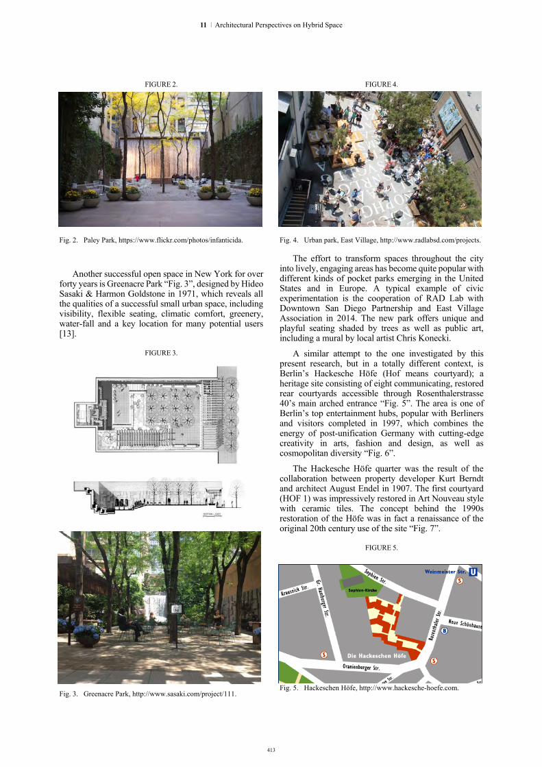
413
FIGURE 2.
Fig. 2. Paley Park, https://www.flickr.com/photos/infanticida.
Another successful open space in New York for over forty years is Greenacre Park “Fig. 3”, designed by Hideo Sasaki & Harmon Goldstone in 1971, which reveals all the qualities of a successful small urban space, including visibility, flexible seating, climatic comfort, greenery, water-fall and a key location for many potential users [13].
FIGURE 3.
Fig. 3. Greenacre Park, http://www.sasaki.com/project/111.
FIGURE 4.
Fig. 4. Urban park, East Village, http://www.radlabsd.com/projects.
The effort to transform spaces throughout the city into lively, engaging areas has become quite popular with different kinds of pocket parks emerging in the United States and in Europe. A typical example of civic experimentation is the cooperation of RAD Lab with Downtown San Diego Partnership and East Village Association in 2014. The new park offers unique and playful seating shaded by trees as well as public art, including a mural by local artist Chris Konecki.
A similar attempt to the one investigated by this present research, but in a totally different context, is Berlin’s Hackesche Höfe (Hof means courtyard); a heritage site consisting of eight communicating, restored rear courtyards accessible through Rosenthalerstrasse 40’s main arched entrance “Fig. 5”. The area is one of Berlin’s top entertainment hubs, popular with Berliners and visitors completed in 1997, which combines the energy of post-unification Germany with cutting-edge creativity in arts, fashion and design, as well as cosmopolitan diversity “Fig. 6”.
The Hackesche Höfe quarter was the result of the collaboration between property developer Kurt Berndt and architect August Endel in 1907. The first courtyard (HOF 1) was impressively restored in Art Nouveau style with ceramic tiles. The concept behind the 1990s restoration of the Höfe was in fact a renaissance of the original 20th century use of the site “Fig. 7”.
FIGURE 5.
Fig. 5. Hackeschen Höfe, http://www.hackesche-hoefe.com.
11 | Architectural Perspectives on Hybrid Space
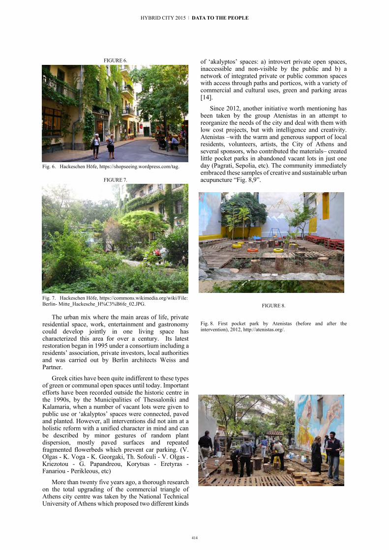
414
FIGURE 6.
Fig. 6. Hackeschen Höfe, https://shopseeing.wordpress.com/tag.
FIGURE 7.
Fig. 7. Hackeschen Höfe, https://commons.wikimedia.org/wiki/File: Berlin- Mitte_Hackesche_H%C3%B6fe_02.JPG.
The urban mix where the main areas of life, private residential space, work, entertainment and gastronomy could develop jointly in one living space has characterized this area for over a century. Its latest restoration began in 1995 under a consortium including a residents’ association, private investors, local authorities and was carried out by Berlin architects Weiss and Partner.
Greek cities have been quite indifferent to these types of green or communal open spaces until today. Important efforts have been recorded outside the historic centre in the 1990s, by the Municipalities of Thessaloniki and Kalamaria, when a number of vacant lots were given to public use or ‘akalyptos’ spaces were connected, paved and planted. However, all interventions did not aim at a holistic reform with a unified character in mind and can be described by minor gestures of random plant dispersion, mostly paved surfaces and repeated fragmented flowerbeds which prevent car parking. (V. Olgas - K. Voga - K. Georgaki, Th. Sofouli - V. Olgas - Kriezotou - G. Papandreou, Korytsas - Eretyras - Fanariou - Perikleous, etc)
More than twenty five years ago, a thorough research on the total upgrading of the commercial triangle of Athens city centre was taken by the National Technical University of Athens which proposed two different kinds
of ‘akalyptos’ spaces: a) introvert private open spaces, inaccessible and non-visible by the public and b) a network of integrated private or public common spaces with access through paths and porticos, with a variety of commercial and cultural uses, green and parking areas [14].
Since 2012, another initiative worth mentioning has been taken by the group Atenistas in an attempt to reorganize the needs of the city and deal with them with low cost projects, but with intelligence and creativity. Atenistas –with the warm and generous support of local residents, volunteers, artists, the City of Athens and several sponsors, who contributed the materials– created little pocket parks in abandoned vacant lots in just one day (Pagrati, Sepolia, etc). The community immediately embraced these samples of creative and sustainable urban acupuncture “Fig. 8,9”.
FIGURE 8.
Fig. 8. First pocket park by Atenistas (before and after the intervention), 2012, http://atenistas.org/.
HYBRID CITY 2015 | DATA TO THE PEOPLE

415
FIGURE 9.
Fig. 9. Third pocket park by Atenistas, 2013, http://atenistas.org/.
IV. MAKING NEW HYBRID PLACES In the study area of the historic centre of
Thessaloniki, the surface of public open spaces reaches merely a 20% in total, which is highly insufficient, compared to other European cities. Moreover, citizens spent almost 80% of their time inside the artificial environment of buildings and vehicles. The ‘akalyptos’ inactive spaces, in direct adjacency to citizens’ homes and workspaces, cover a 10% of the same area. For this reason, it is evident that such open spaces can become major components of a wider network that can upgrade the urban environment, increasing the percentage of urban open spaces by 50%. They can become a part of the green infrastructure network in the city.
At the same time, due to its particular position in the city fabric and its defined closed boundary, an ‘akalyptos’ space may not only act as a scaled down inward green space, but most important it may become a place with a defined set of meanings, functions and associations; It may play a crucial role in the function of the building block, as an incubator for everyday life and social encounter of its residents and the city inhabitants in general. The ‘akalyptos’ may be thus investigated as an informal attractor, which contains uses that attract citizen’s concentration, activity and movement, such as a pleasure garden, an alternative playground, an urban farm “Fig. 10”, an internal route, etc.
FIGURE 10.
Fig. 10. Example of urban farming. http://www.savethegarden.com/ wp-content/uploads/2011/01/phine-in-the-garden.jpg
Moreover, these new green areas can adopt sustainability techniques, such as the collection of rainwater, liquid and solid waste management with the promotion of recycling technologies, preservation of soil and also contribute to the enhancement of the city’s biodiversity.
Through transformation strategies, innovative spatial re-use of pre-existing unused spaces is introduced and a new vitality is generated, suggesting symbolic cores of life and flexible open neighbourhoods. The particularity of the place may be enhanced by the felt contrast with the presence of the city structure around the user [6]. This new type of ‘akalyptos’ presents, in an environment regarded today as the city’s leftovers or
11 | Architectural Perspectives on Hybrid Space

416
FIGURE 11.
Fig. 11. Typical views of the current situation. ©40.22.Architects.
internal wounds “Fig. 11”, a new hybrid landscape, since it combines nature and ecology with recreation and economic viability. Its hybrid character is further enhanced by the involvement of planners, architects, urban designers, landscape architects, artists, developers and the community.
V. METHODOLOGY AND AIM OF THE RESEARCH This research attempts to trace and analyse the total
of such spaces in the site area, propose different scenarios of suitable uses and study a series of prototype models on their restoration and reclamation, in order to successfully re-integrate them with the historic fabric of the city, re-connect them with the rest public spaces and give them
back to its inhabitants. The research will include the thorough study of selected ‘akalyptos’ and the implementation of at least one prototype case which will act as a pilot-study for future interventions.
The approach of this study has begun through primary research (in situ analysis and photographic survey, data gathering through questionnaires and interviews, measurements, etc.) and secondary resources (literature review –publications, proceedings, journals, monographs, building regulations, etc.). In a second phase, several mappings of the site area, including socio-economic, perceptual and ecological criteria will be used in combination to point out the developing capacity of each ‘akalyptos’, as well as the necessary interventions to be made to improve its structure and its integration potential, before proceeding with a proposal in total.
Parallel to the site analysis, an educational programme will take place at selected schools (primary and secondary), which will aim at the sensitization and activation of the citizens, from the very early age. Moreover, graduate and postgraduate students of different disciplines will have the chance to participate in a design workshop, which will enrich the findings of the study.
The research will conclude with the definition of a framework of socio-economic, perceptual and ecological parameters of the ‘akalyptos’; a database which will include the total of principles and specifications for the design of these open spaces, as well as the total of requirements and necessary actions, which will lead to the implementation of similar future interventions.
VI. PLANNING THE NEXT DESIGN AND IMPLEMENTATION STAGES
So far, the analysis of the total site area reveals three groups of ‘akalyptos’ types, according to size (small, medium, large), shape (linear, with a polarizing centre, combination of the previous two) and mode of access (open access from the street, access through semi-open passages, access only through the surrounding buildings) “Fig. 12”. In this phase, a number of diagrammatic backgrounds are being composed, which include further data analysis on representative case-studies.
Parallel to this research, certain actions and initiatives are necessary to be planned to promote social awareness and urban conscience of the citizens through education and marketing techniques (questionnaires, brochures, interactive web platform of communication and informing, interactive workshops with the participations of pupils, teachers, students and tutors, as well as organization of events in situ for a more direct and creative effect).
Consulting the communities affected and searching for their needs can ensure a successful result. When addressing a problem which combines spatial and infrastructure issues in a large city with private properties, apart from finding the people, companies and organizations which will be involved, it is crucial to ensure the municipality’s cooperation, starting from the mayor who has already been informed of this research.
HYBRID CITY 2015 | DATA TO THE PEOPLE

417
This attempt involves a top down (planning) and bottom up (community) coordination. The message should be that the ‘akalyptos’ can acquire a new identity. It is a smart project, because it is cheap, direct, promising and doesn’t burden anyone. It responds to a continuous plea for a more intensified and sustainable use of our city and the enrichment of its green infrastructure and natural legacy, pointing the way towards a multi-sensory architecture which facilitates integration and sparks a sense of belonging among its residents. It is about the upgrading of the urban centre from within, from its very heart, employing ecological, energy sufficient, economic, profitable and aesthetically whole approaches. Its theme and its mode of operation establish a strong bond between the city of Thessaloniki and its people.
FIGURE 12
.
Fig. 12. Akalyptos - Urban wildscapes of Thessaloniki. Images and typology. ©40.22.Architects.
REFERENCES [1] V. Kolonas, B. Thessaloniki 1912-2012: The architecture of a
100-year period. Thessaloniki: University Studio Press, 2012, p.5.
[2] Π. Κοσμάκη, Δ. Λουκόπουλος, “Αστικά κενά-Μικρά πάρκα” in Monumenta, Τεύχος 1: Αστικός Χώρος και Αστικό Πράσινο, 2008.
[3] Strategic Plan of Sustainable Development, Ministry of Macedonia-Thrace, Organization of Urban Planning of Thessaloniki, p. 45.
[4] A. Jorgensen, ‘Introduction’ in Urban Wildscapes, A. Jorgensen, & R. Keenan, Eds. Routledge, London, New York, 2012, pp. 1-14.
[5] Ch. Alexander, S. Ishikawa, M. Silverstein, A pattern language, Oxford University Press, New York, 1977.
[6] K. Lynch, The image of a city, MIT Press, 1960, pp. 46-48, 76, 102-103.
[7] B. Hillier and J. Hanson, The Social Logic of Space, Cambridge University Press, Cambridge, 1984 and B. Hillier, Space is the Machine, Cambridge University Press, Cambridge, 1996.
[8] J. Handley, S. Pauleit, S. Gill, “Landscape, sustainability and the city” in J. Benson, M. Roe, Landscape and Sustainability, Routledge, London, 2007, p. 167.
[9] Α. Παπαγεωργίου - Βενετάς, Αθηνών Αγλάισμα, Ερμής, Athens,
1999, pp. 31-32. [10] Ο. Δουμάνης, “Η ελληνική αρχιτεκτονική 1945 – 1967” in
Όριον, Τιμητικός Τόμος στον καθηγητή Δ.Α. Φατούρο, Σ. Ζαφειρόπουλος, Ed., Τεύχος Α', Επιστημονική Επετηρίδα, Τόμος ΙΕ', Τμήμα Αρχιτεκτόνων Π.Σ. ΑΠΘ, Thessaloniki, 1998, p. 195.
[11] Α. Κωτσιόπουλος, “Θεσσαλονίκη: Τα μικρά και τα μεγάλα”, in Πόλεως Λόγος, Τιμητικός Τόμος στον καθηγητή Α.Φ. Λαγόπουλο, Ε. Δημητριάδης, Γρ. Καυκαλάς, Κ. Τσουκαλά, Eds., Τμήμα Αρχιτεκτόνων Π.Σ. Α.Π.Θ., University Studio Press, Thessaloniki, 2010, pp.169,170.
[12] A. Δ. Κυριαζής, Δυνατότητες αναβάθμισης του ιστού των ελληνικών αστικών κέντρων: ο ρόλος του ενεργού οικοδομικού τετραγώνου, Διδακτορική διατριβή, Τμήμα Αρχιτεκτόνων Α.Π.Θ., 2008.
[13] A. Blake, “Pocket Parks”, http://depts.washington.edu/open2100/pdf/2_OpenSpaceTypes/Open_Space_Types/pocket_parks.pdf
[14] Εθνικό Μετσόβειο Πολυτεχνείο - Σπουδαστήριο Πολεοδο-μικών ερευνών, Εμπορικό Τρίγωνο Κέντρου Αθήνας. Πολεοδομική Έρευνα και Προγραμματισμός Αναβάθμισης. Ερευνητικό Πρόγραμμα 1989-1991 για τον Δήμο Αθηναίων, Έκδοση Τεχνικού Επιμελητηρίου Ελλάδας, Αθήνα, 1996.
11 | Architectural Perspectives on Hybrid Space

418
Fig. 12. Akalyptos - Urban wildscapes of Thessaloniki. Images and typology. ©40.22.Architects.
REFERENCES [1] V. Kolonas, B. Thessaloniki 1912-2012: The architecture of a
100-year period. Thessaloniki: University Studio Press, 2012, p.5.
[2] Π. Κοσμάκη, Δ. Λουκόπουλος, “Αστικά κενά-Μικρά πάρκα” in Monumenta, Τεύχος 1: Αστικός Χώρος και Αστικό Πράσινο, 2008.
[3] Strategic Plan of Sustainable Development, Ministry of Macedonia-Thrace, Organization of Urban Planning of Thessaloniki, p. 45.
[4] A. Jorgensen, ‘Introduction’ in Urban Wildscapes, A. Jorgensen, & R. Keenan, Eds. Routledge, London, New York, 2012, pp. 1-14.
[5] Ch. Alexander, S. Ishikawa, M. Silverstein, A pattern language, Oxford University Press, New York, 1977.
[6] K. Lynch, The image of a city, MIT Press, 1960, pp. 46-48, 76, 102-103.
[7] B. Hillier and J. Hanson, The Social Logic of Space, Cambridge University Press, Cambridge, 1984 and B. Hillier, Space is the Machine, Cambridge University Press, Cambridge, 1996.
[8] J. Handley, S. Pauleit, S. Gill, “Landscape, sustainability and the city” in J. Benson, M. Roe, Landscape and Sustainability, Routledge, London, 2007, p. 167.
[9] Α. Παπαγεωργίου - Βενετάς, Αθηνών Αγλάισμα, Ερμής, Athens,
1999, pp. 31-32. [10] Ο. Δουμάνης, “Η ελληνική αρχιτεκτονική 1945 – 1967” in
Όριον, Τιμητικός Τόμος στον καθηγητή Δ.Α. Φατούρο, Σ. Ζαφειρόπουλος, Ed., Τεύχος Α', Επιστημονική Επετηρίδα, Τόμος ΙΕ', Τμήμα Αρχιτεκτόνων Π.Σ. ΑΠΘ, Thessaloniki, 1998, p. 195.
[11] Α. Κωτσιόπουλος, “Θεσσαλονίκη: Τα μικρά και τα μεγάλα”, in Πόλεως Λόγος, Τιμητικός Τόμος στον καθηγητή Α.Φ. Λαγόπουλο, Ε. Δημητριάδης, Γρ. Καυκαλάς, Κ. Τσουκαλά, Eds., Τμήμα Αρχιτεκτόνων Π.Σ. Α.Π.Θ., University Studio Press, Thessaloniki, 2010, pp.169,170.
[12] A. Δ. Κυριαζής, Δυνατότητες αναβάθμισης του ιστού των ελληνικών αστικών κέντρων: ο ρόλος του ενεργού οικοδομικού τετραγώνου, Διδακτορική διατριβή, Τμήμα Αρχιτεκτόνων Α.Π.Θ., 2008.
[13] A. Blake, “Pocket Parks”, http://depts.washington.edu/open2100/pdf/2_OpenSpaceTypes/Open_Space_Types/pocket_parks.pdf
[14] Εθνικό Μετσόβειο Πολυτεχνείο - Σπουδαστήριο Πολεοδο-μικών ερευνών, Εμπορικό Τρίγωνο Κέντρου Αθήνας. Πολεοδομική Έρευνα και Προγραμματισμός Αναβάθμισης. Ερευνητικό Πρόγραμμα 1989-1991 για τον Δήμο Αθηναίων, Έκδοση Τεχνικού Επιμελητηρίου Ελλάδας, Αθήνα, 1996.
HYBRID CITY 2015 | DATA TO THE PEOPLE
wORKSHOPPRESENTA-TIONS

420
The Hackable City WorkshopMartijn de Waal (Amsterdam University of Applied Sciences, University of Amsterdam)Research team: Martijn de Waal, Michiel de Lange (Utrecht University), Froukje van de Klundert (One Architecture), Matthijs Bouw (One Architecture)www.thehackablecity.nl
The network society that has emerged over the last decades has increasingly taken the shape of a ‘platform society’: Whether it’s finding a Taxi through Uber, a date through Tinder, neighbourhood-dwellers to collec-tively start a solar energy initiative or enthusiasts to turn parking places into parklets, it seems that – as a current tech-commercial claimed: there’s an app for that. Or at least a wiki page, instructable video, online market place, or forum. Following the sometimes overly positivist swing to this rhetoric, the connections these new platforms forge may on the one hand empower citizens to organize them-selves around all kind of issues, organizing local econo-mies in new commons based ways, perhaps contributing to an ‘energetic society.’ Or, as other critics point out, these very same developments may also threaten to subsume all social relations under the commercial ‘city as a service’- market logic of technology companies.
This advent of the ‘platform society’ could mean a shift in the way cities function. After all cities themselves have long been theorized as platforms, or ‘market places’ that in their various public, institutional and private spaces connect supply and demand in numer-ous spheres. As amongst other Manuel Castells has argued cities can be understood as material interfaces that connect individual city dwellers with collective practices, experiences and rhythms. The success of cities as economic and cultural systems has always de-pended on their ‘hackability’, or the ways in which their systematic workings can be (playfully) appropriated by its residents. Successful cities are open platforms whose infrastructure and programme allow their residents to forge all kinds of linkages between them, contributing to both economic and cultural innovation as well as mutual trust between citizens. What happens to these functions now that in our everyday urban lives, we have started to make use of all kinds of digital interfaces to join supply and demand and to match individuals with collectives?
The notion of The Hackable City and its accompany-ing The Hackable City toolkit can be used to analyse these developments and design or organize practices of citymaking from a public interest perspective. A Hack-able City is defined as a city that opens its institutional workings and (digital) infrastructures in such a way that they can be appropriated and improved upon by its citizens, from the perspective of the public interest. A Hackable City approach to citymaking should provide citizens a sense of ownership of their environment and the means to act upon it, creating new forms of public domain. The Hackable City toolkit provides a seven-step pathway for the design of citymaking practices, as well as a number of strategies for citymaking.
In the Hackable City workshop, participants will use this perspective to design a new media probe or pro-totype for a citymaking practice in Athens. A special focus will be applied to the role of data. How is data produced, labeled, shared and operated upon in the hackable city? How can aggregation of urban data give insight into particular issues, or put them on the agen-da? How can it be visualized in such a way that a larger public is engaged with the issue? How can it be offered in such a way that the visualization or the dataset itself becomes ‘actionable’? What conditions need to be met with regard to (open) data sets for them to be of value?
HYBRID CITY 2015 | DATA TO THE PEOPLE

421
12 | Workshop Presentations
Wave Your Open Data Magic Wand. Cybersalon Hackathon.Cybersalon team: Sophia Drakopoulou (Middlesex University), Benjamin Greenaway (www.eetapp.com), James Moulding (OpenSensors.io), Eva Pascoe, Simon SarginsonSponsors/Collaborators: Cybersalon.org OpenSensors.io • Represent.cc www.fastriver.eu/clic2c www.theretailpractice.com • www.smoope.com
Wave Your Open Data Magic Wand. If you could wave a magic wand – what would you do to improve services and systems for citizens of Greece?This workshop invites enthusiasts, creatives, practitioners, artists and techies to work together and create solutions and systems that improve urban life, show Greek culture as well as its flora and fauna in the best possible light and set to create alternative tools and approaches to better everyday life, engage a community, raise social issues and highlight social inequalities.Open Data hold a real potential for creating applications and systems focused on particular localities, problems
and peoples, with greater insight, transparency, account-ability, and broader involvement and engagement than is often found in political institutions and commercial ap-plications. Our hack-a-thon will address questions such as, “What is Open Data?”; “How can Open Data be used to better everyday life?”; “Can it be said that there is an opportunity in Greece right now, to build from bottom up, along new paths and in new directions?” The Cybersalon hackathon will be using Open Data and Open Data sensors from a variety of Open Data APIs based in Greece:
• http://geodata.go; • https://ellak.gr; • https://theodi.org/nodes/odi-athens
The Hackathon will be an opportunity to explore the possibilities of open data and their specific applica-tion within a theme and context of bettering everyday like, well being, raising social issues and bettering a particular locality of peoples. It welcomes any level of technical competency. The hackathon will offer a variety of freeware software tools that can be used to build pro-totypes (working or demos). Participants will be asked to conceptualise and design projects using a set of resources and tools. At the end of the Hackathon the best concepts and working demos will be selected and presented at the Hybrid City Conference 2015.

422
CONTACT: Facilitating information sharing between strangers with DIY networking.Ileana Apostol (NetHood), Katalin Hausel (unMonastery), Panayotis Antoniadis (NetHood)Special guests: Andreas Unteidig (Berlin University of the Arts), James Stevens (http://spc.org), Mathias Jud & Christophe Wachter (http://www.wachter-jud.net/), Michael Smyth (Napier Edinburgh University), Minuette Le (Leuphana University, Centre for Digital Cultures)
An indoors/outdoors workshop which explores citizen engagement in the smart city toward more conviviality and human interactions, shifting the perspective from sensors to senses, from Internet-based locative media to offline DIY networks, from algorithmic matching to genuine serendipity, from powerful mediators to local actors.
CONTACT wishes to explore the advantages of offline networks and smart city concepts for the design of technology that can serve face-to-face meetings and local communities. We will first provide a short intro-duction to certain important concepts that will help us guide the workshop participants through a collabora-tive process of hybrid space design: Do-It-Yourself networking, urban interaction design, field research methodologies, and the role of the stranger. Then we will go out to the streets of Athens to explore the sur-roundings of the conference’s venue, to analyze the spa-tial and social aspects of different places, and to identify locations that are candidates for hybrid urban interven-tions toward our objectives of conviviality and human interactions. After our collective walk, we will gather in a public space to think together about possible applica-tions and possible processes to design them, including software, hardware, surrounding artifacts and perfor-mance. We will focus on ways to take advantage of the special characteristics of DIY networking — ownership, de facto physical proximity, anonymity, and inclusive access — to facilitate contact between strangers, in this specific part of the city. The next day, building on the number and competencies of the participants, we will develop a few prototypes of selected applications and organize an urban intervention in some of the selected locations.
HYBRID CITY 2015 | DATA TO THE PEOPLE

423
Metaxication Inc.The Athens Subsumption Group: Jeff Andreoni, Maria Juliana Byck, Ismini Epitropou, Maria Saridaki, Penny Travlou, Marilia Trogada, Maria Athina Tzioka, Constantinos Venis For this workshop our “laboratory” will be in the neigh-borhood of Metaxourgeio which will be examined through the lens of a “shadow corporation” as a node of international flows of capital and materials which have made this working class district into a hub of global trade.
The laboratory will look at new emerging geographies where public space is transformed to economic zones, places of production, transport hubs and industrial facilities as well as spaces of illegal commercial trans-actions. Participants will explore forgotten/invisible spaces, forming economic heterotopias of production. They will become enmeshed in a temporal network of immateriality by way of a selection of tactile objects that we’ll dissect through a variety of theoretical tools and methodologies.
The shadow corporation is called “Metaxication Inc” to link the workshop activities with the spatial-ity (Metaxourgeio), materiality (silk in Greek i.e. metaxi) and historiography (trade routes) of capital flows.
12 | Workshop Presentations

424
HYBRID CITY 2015 | DATA TO THE PEOPLE
Akoo-o collective: Nikos Bubaris (University of the Aegean), Sofia Grigoriadou (Athens School of Fine Arts), Dana Papachristou (Paris 8/ Ionian University), Giorgos Samantas, Geert Vermeire (http://www.themilena.com/)
Drawing on sound studies, sound arts and walking as social research method and artistic practice, the work-shop presents the theory and practice of creating an au-
diowalk. During the workshop we will lead a field-based expedition of walking, mapping, listening and sound recording in the area around the venue, and we will pro-cess sonic data in the lab in order to develop short sound stories for audio-walk experiences. We will be using noTours, a free software platform developed by escoitar.org. NoTours promotes the artistic practice of sound-walking through the development of audio composition and playback for locative media applications.
noTours: recording-editing-audiowalking


428
HYBRID CITY 2015 | DATA TO THE PEOPLE
9791227896099
ISBN 9789609979122
ISBN 978-960-99791-2-2