PART I : INTRODUCTION
135
PART I : INTRODUCTION
-
Upload
khangminh22 -
Category
Documents
-
view
0 -
download
0
Transcript of PART I : INTRODUCTION

PART I : INTRODUCTION
Final Report, Volume II Introduction Main Report Chapter 1
Nippon Koei Co., Ltd. 1 - 1 The Study on Storm Water Drainage Plan for the Colombo Metropolitan Region
CHAPTER 1 INTRODUCTION
1.1 Background of the Study
As the urbanized area of the Colombo Metropolitan Region (CMR) expands into the coastal lowland, the difficulty of drainage is causing an increase in the frequency of flood inundation. The inundation results in damage to property and deterioration of infrastructures as well as a worsening hygiene environment for residents. Implementation of remedial measures to reduce inundation is important to secure lands for future development in the CMR (population 5.3 million at 2001).
Since the early 1990’s, the Government of Sri Lanka (GOSL) has been implementing the Greater Colombo Flood Control and Environment Improvement Project, being assisted by an Official Development Assistance Loan from the Government of Japan (GOJ). GOSL has also recognized the need for a comprehensive master plan for storm water drainage in the entire CMR and in September 1999 requested GOJ to undertake a study to formulate such a master plan
GOJ agreed to conduct the Study on Storm Water Drainage Plan for the Colombo Metropolitan Region in the Democratic Socialist Republic of Sri Lanka (the Study). The Scope of Work was agreed between the Sri Lanka Land Reclamation and Development Corporation (SLLRDC) of the Ministry of Urban Development, Construction & Public Utilities (presently Ministry of Housing & Plantation Infrastructure) and Japan International Cooperation Agency (JICA) on March 7, 2001.
1.2 Objectives of the Study
The objectives of the Study are:
1) To formulate a master plan for storm water drainage in the Colombo Metropolitan Region,
2) To conduct feasibility study on a priority project to be identified in the master plan, and
3) To carry out technology transfer to counterpart personnel in the course of the Study.
1.3 Study Area
The area for master plan study is shown in the Location Map, and covers part of the Colombo Metropolitan Region. The area is roughly divided into four drainage basins

Final Report, Volume II Introduction Main Report Chapter 1
Nippon Koei Co., Ltd. 1 - 2 The Study on Storm Water Drainage Plan for the Colombo Metropolitan Region
comprising Ja Ela basin, Kalu Oya basin, Greater Colombo basin and Bolgoda basin. The total catchment area is 830 km2 as shown in Figure 2.1.
1.4 Priority Project for Feasibility Study
Based on the master plan study, the storm water drainage project for the sub-catchment of the Bolgoda basin, namely Weras Ganga basin, was selected as a priority project for the feasibility study. The Weras Ganga basin, with a catchment of 55.5 km2 is shown in Figure 2.1.
1.5 Study Schedule and Activity
The Study is scheduled to be carried out for 18 months from September 2001 to February 2003 and the entire study period is staged into two phases as follows:
Phase 1: Master Plan Study
• Preparatory Work in Japan (0.2 months in September 2001) • First Field Work in Sri Lanka (5.8 months from September 2001 to March
2002) • First Home Work in Japan (0.5 months in June 2002)
Phase 2: Feasibility Study on Priority Project
• Second Field Work in Sri Lanka (3.5 months from July to October 2002) • Second Home Work in Japan (1.5 months from October to November 2002) • Third Field Work in Sri Lanka (0.5 months in December 2002) • Third Home Work in Japan (0.5 months in February 2003)
(1) Phase 1
The first field work in Sri Lanka commenced on September 17, 2001. The Inception Report on the Study was agreed by GOSL at the meeting with the Steering Committee established for the Study held on October 10, 2001. The investigation works for the master plan study were carried out till March 9, 2002 in the fields of engineering, environment, social and economy. The results of the first field work were compiled as Progress Report (1).
At the end of the first field work, a workshop on the master plan was held on March 4, 2002 inviting personnel of the relevant organizations aiming at transferring technology and exchanging the opinions on the study results between the Study Team and Sri Lanka participants.
Based on the results of the first field work, the master plan study was carried out in Japan and the master plan study results were compiled in the Interim Report. In this
Final Report, Volume II Introduction Main Report Chapter 1
Nippon Koei Co., Ltd. 1 - 3 The Study on Storm Water Drainage Plan for the Colombo Metropolitan Region
Report, the storm water drainage master plan for the Colombo Metropolitan Region and also the priority project for the feasibility study are proposed.
(2) Phase 2
The second field work commenced on July 1, 2002. The priority project for the feasibility study was affirmed at the Steering Committee meeting held on July 9, 2002 and the storm water drainage project for the Weras Ganga basin was determined as a priority project. Investigation works for the feasibility study were carried out till October 13, 2002 in areas of engineering, environment, social and economy.
The second Progress Report compiled the findings and interim results of the Second Field Work in Sri Lanka carried out for the feasibility study.
At the end of the second field work, a workshop on the feasibility study was held (on March 4, 2002) involving personnel of the relevant organizations and aimed at transferring technology and exchanging the opinions on the study results between the Study Team and Sri Lanka side.
Based on the results of the second field work, the feasibility study was carried out in the second home work in Japan and the result of feasibility study were compiled together with the master plan study result as the Draft Final Report.
The Draft Final Report was presented and discussed at the third field work in Sri Lanka. During this period, a seminar on the Study was held (on December 17, 2002) involving personnel of the relevant organizations and aimed at transferring technology and exchanging the opinions on the study results between the Study Team and Sri Lanka side.
The Final Report was prepared at the third home work in Japan in the light of the discussions at the presentation of the Draft Final Report and the comments issued by the Sri Lanka side afterwards. The Final Report was finalized in March 2002.
1.6 Technology Transfer
Technology transfer is one of the objectives of the Study. The technology transfer was carried out in the form of on-the-job training through joint work by the team member and the counterpart personnel, occasional discussion with other team members and counterpart personnel, workshop and seminar.
Workshops for technology transfer were held twice during the study period as below.
The first workshop was held on March 4, 2002 at Lanka Oberoi Hotel, Colombo in the first field work in Sri Lanka for the master plan study having 40 participants after inviting 78 from relevant central government agencies, relevant local authorities,
Final Report, Volume II Introduction Main Report Chapter 1
Nippon Koei Co., Ltd. 1 - 4 The Study on Storm Water Drainage Plan for the Colombo Metropolitan Region
foreign donors, etc. At the workshop, interim results of the master plan study were presented by the Study Team and discussed among the participants.
The second workshop was held on October 4, 2002 at Colombo Hilton, Colombo in the second field work in Sri Lanka for the feasibility study involving 55 participants from 87 invitations to relevant central government agencies, relevant local authorities, foreign donors, etc. At this workshop, interim results of the feasibility study were presented by the Study Team and discussed among the participants.
The technology transfer seminar was held on December 17, 2002 at Lanka Oberoi Hotel, Colombo in the second field work in Sri Lanka for the feasibility study involving 48 participants from 110 invitations to relevant central government agencies, relevant local authorities, foreign donors, etc. At this workshop, all the results of the Study and topics on storm water drainage in Japan and Sri Lanka were presented by the Study Team and Sri Lanka side and discussed among the participants.
In addition to the workshops, the JICA Team undertook a mini workshop on the master plan study for the counterpart personnel on July 4, 2002 at the meeting room of SLLRDC. The Study Team also held a mini seminar on the MIKE 11 software (for hydrological and hydraulic analyses used in the Study), for about 20 engineering staff of SLLRDC.

PART II : MASTER PLAN
Final Report, Volume II Master Plan Main Report Chapter 2
Nippon Koei Co., Ltd. 2 - 1 The Study on Storm Water Drainage Plan for the Colombo Metropolitan Region
CHAPTER 2 PRESENT CONDITIONS OF THE STUDY AREA
2.1 Natural Conditions
2.1.1 General Topography
The study area extends from Katunayake in the north to Kalutara in the south or
approximately between lat. 6°36´N and lat. 7°10´N and between long. 79°50´E and
long. 80°05´E. It is broadly bounded by Negombo Lagoon and Dandugam Oya to the
north, the proposed route of the Outer Circular Highway to the east, and the Bolgoda
Lake watershed to the south.
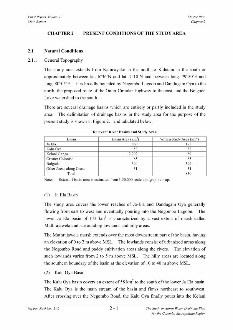
There are several drainage basins which are entirely or partly included in the study
area. The delimitation of drainage basins in the study area for the purpose of the
present study is shown in Figure 2.1 and tabulated below:
Relevant River Basins and Study Area
Basin Basin Area (km2) Within Study Area (km2)Ja Ela 860 173 Kalu Oya 58 58 Kelani Ganga 2,292 89 Greater Colombo 85 85 Bolgoda 394 394 Other Areas along Coast 31 31
Total - 830
Note: Extent of basin area is estimated from 1:50,000 scale topographic map.
(1) Ja Ela Basin
The study area covers the lower reaches of Ja-Ela and Dandugam Oya generally
flowing from east to west and eventually pouring into the Negombo Lagoon. The
lower Ja Ela basin of 173 km2 is characterized by a vast extent of marsh called
Muthrajawela and surrounding lowlands and hilly areas.
The Muthrajawela marsh extends over the most downstream part of the basin, having
an elevation of 0 to 2 m above MSL. The lowlands consist of urbanized areas along
the Negombo Road and paddy cultivation areas along the rivers. The elevation of
such lowlands varies from 2 to 5 m above MSL. The hilly areas are located along
the southern boundary of the basin at the elevation of 10 to 40 m above MSL.
(2) Kalu Oya Basin
The Kalu Oya basin covers an extent of 58 km2 to the south of the lower Ja Ela basin.
The Kalu Oya is the main stream of the basin and flows northeast to southwest.
After crossing over the Negombo Road, the Kalu Oya finally pours into the Kelani

Final Report, Volume II Master Plan Main Report Chapter 2
Nippon Koei Co., Ltd. 2 - 2 The Study on Storm Water Drainage Plan for the Colombo Metropolitan Region
Ganga. The topographic characteristics of the basin are similar to those of the
lower Ja Ela basin. The basin consists of marsh and surrounding lowlands as well
as hilly areas along the basin boundary. The elevation of the basin ranges from 0 to
40 m above MSL.
(3) Kelani Ganga Basin
The study area covers the most downstream basin of the Kelani Ganga extends from
the river mouth to Kaduwela. The basin area within the study area is 89 km2. The
left bank area is protected from the flood of the Kelani Ganga by flood bund (dike)
system along the river with the length of 5 km. The surface elevation of the flood
bund system including the Railway Embankment and Gotatuwa Bund varies from 6
to 8 m above MSL. Meanwhile, the unprotected area along the Kelani Ganga left
bank in Kolonnawa is urbanized partly. The ground elevation of the unprotected
area ranges from 1 to 2 m above MSL.
The right bank is also protected by flood bund but its height remains lower than the
flood bund on the left bank. The surface elevation of the flood bund varies from 3
to 6 m above MSL. The right bank area covers Peliyagoda, Kelaniya and Biyagama.
The ground elevation in the right bank area ranges from 2 to 5 m above MSL.
(4) Greater Colombo Basin
The Greater Colombo basin covers an area of 85 km2 bounded by Nugegoda - High
Level Road to the south, Talangama - Hokandara watershed to the east, Kelani flood
bunds to the north, and elevated urbanized areas of Colombo along the coast to the
west.
The western half of the greater Colombo basin is generally flat with ground
elevations from less than 1 m to 6 m above MSL, with a few elevated and hilly areas
with elevations from about 15 m to 20 m. Within the area, marshy lands of some
350 ha exist at an elevation of less than 1 m above MSL.
The eastern half of the basin is called the Madiwela catchment. The Parliament
Lake is located in the most downstream and has a surface area of 95 ha under the
normal flow condition. Surroundings of the lake are lowlands with an elevation of
less than 1 m above MSL. The catchment rises to the elevations from about 10 m to
35 m above MSL up to the basin boundary.
(5) Bolgoda Basin
The Bolgoda basin has a drainage area of 394 km2, located between the Greater
Colombo basin to the north and the Kalu Ganga basin to the south. In the upper
catchment area, the streams originate from the hills with the highest elevation of 20

Final Report, Volume II Master Plan Main Report Chapter 2
Nippon Koei Co., Ltd. 2 - 3 The Study on Storm Water Drainage Plan for the Colombo Metropolitan Region
m above MSL at the eastern boundary of the basin. The lower catchment area lies
in the lowland widely spreading along the coast with water surfaces and surrounding
marsh lands.
There is a unique water system in the basin comprising the two major lakes with
incoming and outgoing waterways. There exist are two large lakes, North Bolgoda
Lake (normal surface area 760 ha) and South Bolgoda Lake (normal surface area 340
ha). Both lakes are interconnected by Bolgoda Ganga. Almost all of the rivers
pour these two lakes. The Bolgoda Lake North is connected to the sea through
Panadura River, while the Bolgoda Lake South mainly drains to Kalu Ganga.
2.1.2 General Geology
Geologically Sri Lanka is related to India with which it was united as a part of the
ancient southern continent of Gondawanaland. The entire island is underlain by a
complex of metamorphic rocks, which is divided into Vijayan Series, Highland
Series and Southwestern Series. The largest and oldest of these series is the
Highland Series, which is exposed throughout most of the Northern and Central
interior and is believed to be source from which the younger Vijayan Series is
derived. The Vijayan Series is exposed in the south-eastern area of the island.
Many parts of the coastal plain owe their flatness to the presence of extensive flat-
lying sedimentary deposits on a peneplained basement of crystalline rocks on the
Miocene limestone. In the study area north of Colombo, coastal belt flat country
has been formed by sand beaches, lagoonal silt and clay, blown sand, and river
alluvium. The lowest peneplain and the coastal plain extends outwards from the
island and under the sea as a submarine shelf, the Continental Shelf, for a distance of
about 16 miles and at an average depth of 216 feet below the sea level.
The following major soil groups are encountered in different land forms / geological
formations in different physiographic regions of the study area as given below:
Soil Groups in the Study Area
Major Soil Groups Present Geological Formation/ Land Form
Coastal Plain Mantled Plain Recent beach deposits Regosol Old (Pleistocene)beach deposits Latosols Flood plain Alluvial Flat valleys Bog and Half Bog Valleys Low Humic Gley Gently undulating to undulating (2 - 8 % slope) Red Yellow Podzolic Rolling plain (8 - 16 % slope) Red Yellow Podzolic Hilly terrain (16-30% slope) Red Yellow Podzolic Steep terrain (>30% slope) Red Yellow Podzolic
Source: The Geology of Sri Lanka (Ceylon), P. G. Cooray, 1984

Final Report, Volume II Master Plan Main Report Chapter 2
Nippon Koei Co., Ltd. 2 - 4 The Study on Storm Water Drainage Plan for the Colombo Metropolitan Region
The distribution of different soil groups considering the basins and the aspect of the
soil catena within the study area is as follows (e.g. upper aspect is referred to the
upper section of a sloping land (soil) catena):
Soil Groups by Basin
Great Soil Groups Present Basin
Upper Aspect of the Catena Lower Aspect of the Catena Ja-Ela basin Red yellow podzolic soil (dominant
soil group in the basin); Latasols; and Alluvial soils of the levees
Bog and half bog soils; Low humic gley soils; Alluvial soils of the basins and back swamps; and Regosols .
Kalu Oya basin Red yellow podzolic soil (dominant soil group in the basin); and Latosol
Bog and half bog soil; and Low humic gley soils
Greater Colombo basin
Red yellow podzolic soil. (dominant soil group in the basin); and Alluvial soils of the levees
Bog and half bog soils; Low humic gley soils; and Alluvial soils of the basins and the back swamps.
Bolgoda basin Red yellow podzolic soils (dominant soil group in the basin); Latosols; and Alluvial soils of the levees.
Bog and half bog soils; Low humic gley soils; Alluvial soils of the basins and back swamps; and Regasols.
Source: Wetland Site Report & Conservetion Management Plan, Ministry of Environment and Parliamentary Affairs, 1993
2.2 Socio-Economy
2.2.1 Administrative Division
The four basins that are covered in the study area consist of the west part of Colombo
District, the southwest part of Gampaha District, and the northwest part of Kalutara
District. Since the basin boundaries and the administrative boundaries do not
always match, the area coverage of the District Secretariat (DS) Divisions within and
outside the study area need to be estimated separately. The study area is estimated
to cover 89.0% of the Colombo District, 48.8% of the Gampaha District, and 41.9%
of the Kalutara District for a total of 64.2% of CMR. The DS Divisions within the
study area are listed in Table 2.1 and shown in Figure 2.2.
The related local governments, which include municipal councils, urban councils and
Pradeshiya Sabha (MC, UC and PS respectively), and DS Divisions are listed in
Table 2.2.
2.2.2 Population
Total population of the study area in 2001 was estimated to be 3,438,000 which
accounts for 64.4% of the total population of the Western Province (CMR) or 18.1%
of total population of Sri Lanka (19 million), and makes it one of the highly

Final Report, Volume II Master Plan Main Report Chapter 2
Nippon Koei Co., Ltd. 2 - 5 The Study on Storm Water Drainage Plan for the Colombo Metropolitan Region
populated areas in Sri Lanka. Of the three districts in the study area, Colombo
District has the largest population with 57.7% of population share, followed by
Gampaha District with 29.3% and Kalutara District with 12.9% as shown below.
Estimated Population of the Study Area
(Unit: 1,000 persons)
Item Colombo Gampaha Kalutara Study Area Population (2001) 1,985 1,008 445 3,438 Population (1994) 1,933 803 392 3,128 Population (1981) 1,526 656 341 2,523 Population density (2001) persons/ha
51 27 14 32
Area (ha) 39,019 37,278 31,530 107,827 Source: Department of Census and Statistics, Colombo Metropolitan Regional Plan (UDA) Note: Since the area and population are based on the administrative boundary, the total area
mentioned here may not always match with the basin area.
2.2.3 Economic Conditions
Gross Domestic Product (GDP) of Sri Lanka in 2000 was Rs. 857,035 million and
had been expanding throughout the 1990’s with an annual average growth rate of
5.3%. The agriculture sector accounts for 20.5% of GDP in which tea, coconut,
rubber, and paddy are the main agricultural products. Sri Lanka is the largest tea
exporting country in the world with an export volume of 288 million kg in 2000 or
Rs. 12,226 million. The share in the manufacturing sector is 17.4% or Rs. 149,115
million, the textile, chemical (fertilizer, rubber, pharmaceuticals) and agro-processing
(tea and coconut), are main manufacturing activities. Export oriented industries,
apparel and textile industries are contributing to the economic growth of industrial
sector. Wholesale and retail trade sectors are the highest contributor to GDP by
producing 22.1% of GDP (Rs. 189,366 million) and play important roles in the
external trade (Table 2.3).
Because of the limited information, regional economy is measured for the Western
Province or CMR. CMR plays a major role in economic activities in Sri Lanka by
producing 43.3% of GDP or Rs. 179,720 million in 1995. Concentration of
manufacturing activities is particularly high by contributing 72.4% of GDP for the
manufacturing sector (Table 2.4). Assuming that the GRDP share of CMR remains
the same, GRDP for CMR in 2000 is estimated to be Rs. 378,890 million.
2.2.4 Household Income
The household income in the study area is the highest in Sri Lanka. Average
monthly household income in the three districts of Colombo, Gampaha, and Kalutara
of the study area is Rs. 9,230, which is higher than the national average of Rs. 6,476.
The average monthly household income is highest in Colombo District with

Final Report, Volume II Master Plan Main Report Chapter 2
Nippon Koei Co., Ltd. 2 - 6 The Study on Storm Water Drainage Plan for the Colombo Metropolitan Region
Rs.11,107. In the study area, the income from social welfare programs (food
stamps, Janasaviya and Samurdhi) is low, particularly for Colombo District (Rs. 40
per household per month) compared with the national average (Rs. 156 per
household per month). Income from salaries & wages accounts for 48.9% of
income sources, income from non agricultural activities 18.1%, income from
agriculture 3.1%, and Janasaviya & Samurdhi 1.1%.
Since the income is high in the study area, household expenditure is also high. The
average monthly household expenditure is Rs. 10,833 in Colombo District, while the
national average is Rs. 6,305. In the study area, expenditure on non-food items is
large. The national average shows that the expenditure on non-food items is 43.7%
of total expenditure, while Colombo District shows 57.2% is spent on non-food items,
which is attributed to high housing cost. Also more money is allocated to cultural
activities & entertainment, transport, communication and education. Colombo
District provides a variety of urban amenities and social services compared with
other areas of Sri Lanka.
2.2.5 Public Finance
Fiscal operation of the Central Government of Sri Lanka for the year 2000 shows
revenue of Rs. 211,282 million and expenditure of Rs. 335,823 million that resulted
in a fiscal deficit of Rs. 124,541 million. In the past decade, the fiscal revenue did
not cover the current expenditure. Fiscal deficit in 2000 is approximately 10% of
GDP, and cumulative government debt in 2000 reached 97% of GDP and continues
to increase (Table 2.5).
The government fiscal condition has been worsening in past years. The growth rate
of expenditure is higher than that of the revenue. Weakening of financial conditions
in 2000 was mostly resulted from an increase in defense cost, salary of public
officers and increase in world oil price for power generation.
According to the government forecasts, this fiscal condition is expected to continue
for several years because of the amortization of short-term loans, which increases the
expenditure and slows economic growth, which decreases revenue. The fiscal
condition is expected to improve after 2004 when the economy regains and the
payment of the short-term loans is expected to be completed.
2.3 Land Use
2.3.1 Available Data on Land Use
In order to determine the present pattern of land use, as well as to estimate future
patterns of land use, it is a first-step task to collect several kinds of information: the

Final Report, Volume II Master Plan Main Report Chapter 2
Nippon Koei Co., Ltd. 2 - 7 The Study on Storm Water Drainage Plan for the Colombo Metropolitan Region
land use maps, satellite images, aerial photos, and statistics on land-related activities,
such as population density, land prices, and transactional data on lands. In
forecasting the future patterns of land use, additional data, such as locations of future
projects, proposed land use maps, must also be collected. In Sri Lanka, these kinds
of data are archived at various kinds of organizations in a fragmented manner.
During the period of Phase 1 study, the following data were made available for the
use of the study on land use:
Available Data on Land Use in the Study Area
Data Available
Kind of Data Issuing Organization
Land Use Map
Topographic Map, Scale 1:10,000 Topographic Map, Scale 1:50,000 (1989) Topographic Map, Scale 1:100,000 Land Use Map by DS Division (1996) Abandoned Paddy Land Map by DS Division (1996-2000) Land Use Zoning Map by Local Authority (1996-2000)
Survey Department Survey Department Survey Department LUPPD LUPPD UDA
Satellite Image
LANDSAT IKONOS (2001, 2002)
Survey Department UDA
Aerial Photos
1960s Survey Department
Statistics Population Department of Statistics
Note: UDA - Urban Development Authority LUPPD - Land Use Policy Planning Division, Ministry of Land
2.3.2 Present Land Use Pattern Extracted from the Topographic Map
Figure 2.3 shows the spatial extent of present land use for each category by five sub-
watershed basis. Within the 80,716 ha of the study area, paddy land amounts to
14,229 ha (17.6%), built up area 10,851 ha (13.4%), marshy area 2,016 ha (2.5%)
respectively. The share of paddy area is highest in the Ja Ela basin (24.3%).
Meanwhile the Greater Colombo basin indicates the highest share of build up area
(36.9% for the sum of urban and semi-urban area).
Present Land Use Pattern
Basin Area (ha)
Urban Semi- Urban
Paddy Marsh Water Other
(a) Bolgoda 40,116 2.8% 5.7% 17.1% 0.3% 3.4% 70.7%
(b) Greater Colombo 9,072 21.4% 15.5% 8.5% 4.3% 0.1% 50.2%
(c) Ja Ela 17,485 5.1% 2.9% 24.3% 7.1% 0.1% 60.5%
(d) Kalu Oya 6,066 6.6% 12.0% 16.4% 2.5% 0.0% 62.5%
(e) Kelani Ganga 7,977 7.2% 12.6% 16.7% 1.4% 1.8% 60.4%
Total (a) - (e) 80,716 6.1% 7.3% 17.6% 2.5% 1.9% 64.6% Note: Extent of each land use category is extracted from 1:50,000 scale topographic map.
Final Report, Volume II Master Plan Main Report Chapter 2
Nippon Koei Co., Ltd. 2 - 8 The Study on Storm Water Drainage Plan for the Colombo Metropolitan Region
2.3.3 Abandoned Paddy Land
The spatial distribution of the abandoned paddy land could be regarded as indicators
for future urban land use patterns, because it has a high possibility to be converted
into urban use. Thematic maps prepared by the Land Use Policy Planning Division
(LUPPD) were utilized for the purpose of identifying the abandoned paddy lands
around the study area. Results of the field reconnaissance and the IKONOS print
out are also referred to verify the situation.
Figure 2.4 shows the spatial distribution of the abandoned paddy lands. Most of the
abandoned paddy lands were located in the Kesbewa, Kelaniya, and Biyagama DS
Divisions. Several reasons are considered for abandoning cultivation of paddy, such
as flooding, poor drainage, water shortage, labor shortage, and tenurial dispute.
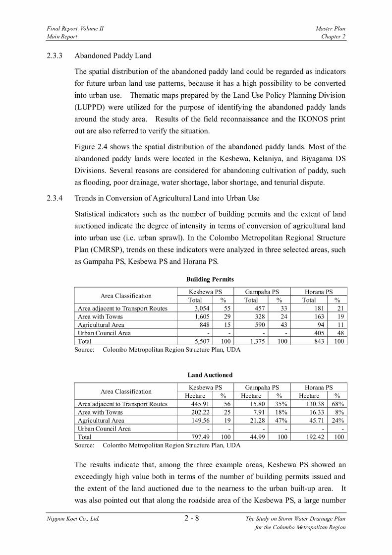
2.3.4 Trends in Conversion of Agricultural Land into Urban Use
Statistical indicators such as the number of building permits and the extent of land
auctioned indicate the degree of intensity in terms of conversion of agricultural land
into urban use (i.e. urban sprawl). In the Colombo Metropolitan Regional Structure
Plan (CMRSP), trends on these indicators were analyzed in three selected areas, such
as Gampaha PS, Kesbewa PS and Horana PS.
Building Permits
Kesbewa PS Gampaha PS Horana PS Area Classification
Total % Total % Total % Area adjacent to Transport Routes 3,054 55 457 33 181 21 Area with Towns 1,605 29 328 24 163 19 Agricultural Area 848 15 590 43 94 11 Urban Council Area - - - - 405 48 Total 5,507 100 1,375 100 843 100
Source: Colombo Metropolitan Region Structure Plan, UDA
Land Auctioned
Kesbewa PS Gampaha PS Horana PS Area Classification
Hectare % Hectare % Hectare % Area adjacent to Transport Routes 445.91 56 15.80 35% 130.38 68% Area with Towns 202.22 25 7.91 18% 16.33 8% Agricultural Area 149.56 19 21.28 47% 45.71 24% Urban Council Area - - - - - - Total 797.49 100 44.99 100 192.42 100
Source: Colombo Metropolitan Region Structure Plan, UDA
The results indicate that, among the three example areas, Kesbewa PS showed an
exceedingly high value both in terms of the number of building permits issued and
the extent of the land auctioned due to the nearness to the urban built-up area. It
was also pointed out that along the roadside area of the Kesbewa PS, a large number
Final Report, Volume II Master Plan Main Report Chapter 2
Nippon Koei Co., Ltd. 2 - 9 The Study on Storm Water Drainage Plan for the Colombo Metropolitan Region
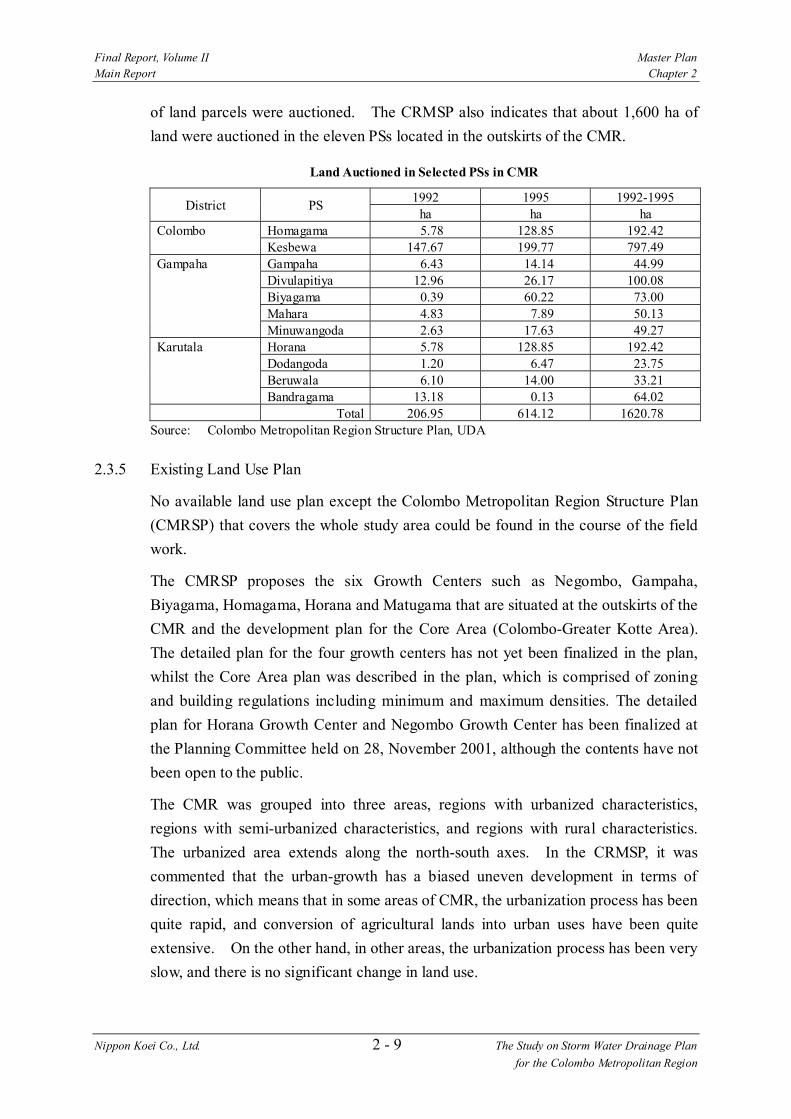
of land parcels were auctioned. The CRMSP also indicates that about 1,600 ha of
land were auctioned in the eleven PSs located in the outskirts of the CMR.
Land Auctioned in Selected PSs in CMR
1992 1995 1992-1995 District PS
ha ha ha Colombo Homagama 5.78 128.85 192.42 Kesbewa 147.67 199.77 797.49 Gampaha Gampaha 6.43 14.14 44.99 Divulapitiya 12.96 26.17 100.08 Biyagama 0.39 60.22 73.00 Mahara 4.83 7.89 50.13 Minuwangoda 2.63 17.63 49.27 Karutala Horana 5.78 128.85 192.42 Dodangoda 1.20 6.47 23.75 Beruwala 6.10 14.00 33.21 Bandragama 13.18 0.13 64.02
Total 206.95 614.12 1620.78 Source: Colombo Metropolitan Region Structure Plan, UDA
2.3.5 Existing Land Use Plan
No available land use plan except the Colombo Metropolitan Region Structure Plan
(CMRSP) that covers the whole study area could be found in the course of the field
work.
The CMRSP proposes the six Growth Centers such as Negombo, Gampaha,
Biyagama, Homagama, Horana and Matugama that are situated at the outskirts of the
CMR and the development plan for the Core Area (Colombo-Greater Kotte Area).
The detailed plan for the four growth centers has not yet been finalized in the plan,
whilst the Core Area plan was described in the plan, which is comprised of zoning
and building regulations including minimum and maximum densities. The detailed
plan for Horana Growth Center and Negombo Growth Center has been finalized at
the Planning Committee held on 28, November 2001, although the contents have not
been open to the public.
The CMR was grouped into three areas, regions with urbanized characteristics,
regions with semi-urbanized characteristics, and regions with rural characteristics.
The urbanized area extends along the north-south axes. In the CRMSP, it was
commented that the urban-growth has a biased uneven development in terms of
direction, which means that in some areas of CMR, the urbanization process has been
quite rapid, and conversion of agricultural lands into urban uses have been quite
extensive. On the other hand, in other areas, the urbanization process has been very
slow, and there is no significant change in land use.

Final Report, Volume II Master Plan Main Report Chapter 2
Nippon Koei Co., Ltd. 2 - 10 The Study on Storm Water Drainage Plan for the Colombo Metropolitan Region
Urban agglomeration, which means towns expanding rapidly beyond their original
administrative boundaries, is also identified in the analysis. The CRMSP
recommended that twenty-eight urban centers be considered as the contiguous area.
The CMRSP advocates the concept of Protected Area Network for paddy land and
wetland. Suitability for existing paddy land and wetland was evaluated based on a
set of criteria. Lands evaluated as suitable for agriculture and wetland were
incorporated into the protected area network. The protected area network envisages
identifying land available for urban expansion and minimizing land speculation
relating to paddy land and wetland.
2.4 Natural and Social Environment
2.4.1 General Environmental Conditions in the Study Area
Environmental features of the study area can be represented by studded marshes with
connecting water systems in the urban area. The study area is located in a
southwestern coastal area and belongs to the wet zone where much of Sri Lanka’s
biodiversity is concentrated. Lowlands, where most of the lands are abandoned
paddy and vacant land, form marshes, especially the upper catchments of the basins.
Among the marshes, protected areas in the study area such as Muthurajawela Marsh
and Bellanwila-Attidiya Marsh are the best birding sites for endemic and migratory
birds in Sri Lanka
In the Ja Ela Basin, the Muthurajawela Marsh (3,068 ha) extending southward from
the Negombo Lagoon (3,164 ha) receives surface water in the basin through the Ja
Ela and Dandungam Oya. The marsh also connects the Old Negombo Canal and
Hamilton Canal flowing to the Kelani Ganga.
In the Kalu Oya Basin, the urbanized area is concentrated in the downstream area of
the basin where road transportation has been developing while the upper catchment
has not yet urbanized, partly extending abandoned paddy. Surface water from the
Kalu Oya flows into the Kelani Ganga through the Old Negombo Canal.
In the Greater Colombo Basin, there are three main marshes: Kolonnawa, Heen and
Kotte Marshes, which are known as the Colombo Flood Detention Areas. The
marshes along with the Parliament Lake constitute the green belt linked by the canals.
Beira Lake has received large volumes of urban pollutant and suffers from high
eutrophication at the urban center.
In the Bolgoda Basin, the Bellanwila-Attidiya Marsh (372 ha) in the upper catchment
of the Weras Ganga receives part of surface water from the surrounding urbanized
area. The Weras Ganga flows down to North Bolgoda Lake, and then to Panadura

Final Report, Volume II Master Plan Main Report Chapter 2
Nippon Koei Co., Ltd. 2 - 11 The Study on Storm Water Drainage Plan for the Colombo Metropolitan Region
River and South Bolgoda Lake. At the west coast of the basin, the Lunawa Lake is
located though it is said no aquatic fauna exist due to pollution.
2.4.2 Environmental Protected Area
An Asian Wetlands Inventory Project was carried out in the 1980s. In the Directory
of Asian Wetlands (Scott, 1989), 41 wetlands of Sri Lanka have been listed. Based on
the inventory, the legally constituted protected areas under the Fauna and Flora
Protection Ordinance (FFPO) were subsequently listed including the following
protected area located within or in the surrounds of the study area. The locations of
environmental protected areas in the study area are shown in Figure 2.5.
1) Sri Jayawardenepura sanctuary: 449 ha of the sanctuary declared in 1985,
where partial protection is enforced, i.e., locally, sustainable extractive uses
are permitted;
2) Bellanwila - Attidiya Marsh: 372 ha of Wildlife Sanctuary declared in 1990
by the Department of Wildlife Conservation;
3) Muthurajawela Marsh and Negombo Lagoon complex: 1,285 ha of
sanctuary declared in 1995/1996.
According to the FFPO, all wild animals are fully protected within the Sanctuary,
while trees, other plants and habitats in general are only protected in the State lands.
As most of the land in the Bellanwila-Attidiya Marsh is privately owned, legal
control over the vegetation, i.e., land exploitation for development, in the majority of
the marsh has not been implementable1.
A list of 35 additional wetlands considered to be of national importance were
prepared locally and includes Beira Lake, Bolgoda Lake, Colombo Breakwaters, and
the Colombo Flood Detention Area.
The Environmental Management Strategy (EMS) for the urbanized area by UDA
(1994) has estimated the total area of marshes in the urbanized area at nearly 4,000
ha, which includes the Muthurajawela Marsh in the Wattala Local Authority area
with an area of 3,068 ha. Over 200 ha of marshy lands have been filled for urban and
industrial infrastructure development. Little data is available on the present
conditions of the marshes, except for Muthurajawela and Bellanwila-Attidiya Marsh.
However, according to the field observation in the Study, the environmental
conditions in the marshes are poor due to solid waste dumping, unauthorized
settlement, unplanned reclamation and inflow of polluted water.
In the Muthurajawela Marsh and Negombo Lagoon complex, the Conservation Zone
includes both the Negombo Lagoon and the northern part of the Muthurajawela
Final Report, Volume II Master Plan Main Report Chapter 2
Nippon Koei Co., Ltd. 2 - 12 The Study on Storm Water Drainage Plan for the Colombo Metropolitan Region
Marsh. The rest of the marsh is left as the Buffer Zone (middle part) and the Mixed
Urban Development Zone (southern part - sand filled for an industrial zone).
The major lakes in the study area are Beira Lake, Parliament Lake, Bolgoda Lake,
Lunawa Lake and Negombo Lagoon. The Beira Lake and Lunawa Lake are seriously
polluted. Negombo Lagoon is still a very valuable eco-resource because of its rich
aquatic life and its vegetation containing mangroves and sea grass. It is an important
breeding ground for the local fisheries and an important economic resource because
of its high fish yield. Lunawa Lake is now devoid of life due to pollution.
2.4.3 Water Pollution
Surface water pollution is the most serious issue among the environmental problems
in the study area. Pollution of urban water bodies by domestic wastewater and
industrial wastewater causes environmental problems as well as health hazards. Most
of the surface waters of the urbanized area in the study area are polluted to some
extent. The serious water pollution problems exist in the canals and lakes in the
western part of the study area, including Colombo MC, Kolonnawa UC, Dehiwela -
Mount Lavinia MC, and Moratuwa UC.
The main causes of surface water pollution are:
1) Discharge of urban drainage water mixed with waste of industrial and
domestic origin to natural streams (This includes runoff from open markets
and garbage dumps);
2) Unauthorized connections of domestic wastewater pipes into drainage
canals;
3) Direct discharge of industrial wastewater into rivers, lakes, canals and
lowlands;
4) Uncontrolled and illegal dumping of waste of industrial and domestic origin
in waterways, embankments and lowlands;
5) Discharge of sewage into canal/surface water bodies mainly by shanty
settlements along canals and around the lowlands such as marshes;
6) Insufficient maintenance and cleaning of watercourses and embankments
resulting in siltation, blockage and aquatic plant growth.
The Colombo Municipal Council (CMC) area is served with a sewerage drainage
system that consists of a raw sewage drainage system draining into the sea via two
sea outfalls and a storm water drainage system discharging into the canals. Since
their construction at the beginning of the century, very few improvements and
extensions have been made despite the considerable development in housing and
1 Wetland Site Report & Conservation Management Plan: Bellanwila- Attidiya Marsh, CEA/Euroconsult, 1993

Final Report, Volume II Master Plan Main Report Chapter 2
Nippon Koei Co., Ltd. 2 - 13 The Study on Storm Water Drainage Plan for the Colombo Metropolitan Region
industry. As a result, both systems are overloaded and in a poor state of repair and
hence, lead to water pollution. Septic tanks and latrines that discharge effluents to
soakage pits serve most of the houses around the lowlands. Overflow of septic tanks
and ingress of sewerage into storm water drains is a common feature, mainly during
heavy rains.
Beira Lake offers example of typical polluted urban water lakes. Eutrophication and
blooming are major water polluting issues in water bodies like Beira Lake due to
wastewater and nutrient rich substances. It is reported that the Lunawa Lake, which
had a healthy aquatic ecosystem in the past, is now devoid of almost all aquatic life
due to pollution.
The groundwater quality in the urbanized area in the study area is likely being
adversely affected by the following factors:
1) Faecal contamination by seepage of domestic wastewater from sanitation
facilities;
2) Chemical contamination by seepage of wastewater from industries and solid
waste dumping sites;
3) Seawater intrusion into groundwater especially due to over-extraction from
wells along the coast.
Regarding coastal water pollution, little data on the quality of the seawater are
available. These waters receive liquid waste from Kelani Ganga, Beira Lake spillover,
Wellawatta and Dehiwala Canals, Lunawa Lake and Bolgoda Lake, two sea outfalls
of the CMC sewerage system at Mutwal and Wellawatta and some minor wastewater
discharges from coastal communities. Colombo Harbor is also a source of coastal
water pollution. In the near coast waters, fishing is of minor importance as most of
the fishing is carried out offshore at the edge of the continental shell.
2.4.4 Poverty and Under-served Settlements
The measurement of the poverty situation in Sri Lanka varies according to the
criteria and indicators used. According to the National Human Development Report
(UNDP 1998), 27 % of the population of Sri Lanka is poor based on the Human
Poverty Index. According to the Department of Census and Statistics (1995/96),
22.9 % of the population is poor, as indicated by the lower consumption poverty line
(Rs. 791 per person per month), while 25.9 % is poor as indicated by the higher
consumption poverty line (Rs. 950 per person per month). (ADB, 20012)
The urban settlements denied of basic urban service and having poor quality or
socially unacceptable housing and living conditions can be referred to as Under-
Final Report, Volume II Master Plan Main Report Chapter 2
Nippon Koei Co., Ltd. 2 - 14 The Study on Storm Water Drainage Plan for the Colombo Metropolitan Region
Served Settlements (USS). The term “USS” is an expression of the physical
condition of the housing and residential health, sanitation and other social conditions
of the settlers, other than just an expression of income level since a large percentage
of occupants in the USS earn reasonable incomes through the informal sector3.
The crucial factor that separates these settlements from other urban settlements is not
the level of income of the occupants but the poor level of infrastructure services in
the settlements. The types of settlements classified as USS in the urban context are
slums, shanty settlements, old low-income flats, relocated housing, old deteriorated
quarters, unplanned permanent dwellings, walkup apartments and suburban housing
estates.
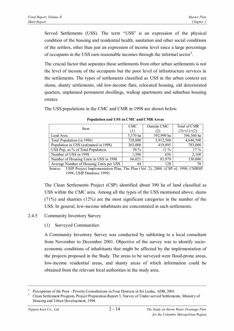
The USS populations in the CMC and CMR in 1998 are shown below.
Population and USS in CMC and CMR Areas
Item CMC (1)
Outside CMC (2)
Total of CMR (3)=(1)+(2)
Land Area 3,370 ha 392,990 ha 396,360 ha Total Population (in 1996) 728,000 3,912,500 4,640,500 Population in USS (estimated in 1998) 363,000 419,895 783,000 USS Pop. as % of Total Population 50 % 11 % 17 % Number of USS in 1998 1,506 656 2,160 Number of Housing Units in USS in 1998 66,021 83,979 150,000 Average Number of Housing Units per USS 44 128 70
Source: USIP Project Implementation Plan, The Plan (Vol. 2), 2000. (CSP of, 1998; CMRSP 1998; USIP Database 1999)
The Clean Settlements Project (CSP) identified about 390 ha of land classified as
USS within the CMC area. Among all the types of the USS mentioned above, slums
(71%) and shanties (12%) are the most significant categories in the number of the
USS. In general, low-income inhabitants are concentrated in such settlements.
2.4.5 Community Inventory Survey
(1) Surveyed Communities
A Community Inventory Survey was conducted by subletting to a local consultant
from November to December 2001. Objective of the survey was to identify socio-
economic conditions of inhabitants that might be affected by the implementation of
the projects proposed in the Study. The areas to be surveyed were flood-prone areas,
low-income residential areas, and shanty areas of which information could be
obtained from the relevant local authorities in the study area.
2 Perceptions of the Poor - Poverty Consultations in Four Districts in Sri Lanka, ADB, 2001 3 Clean Settlement Program, Project Preparation Report 3, Survey of Under-served Settlements, Ministry of
Housing and Urban Development, 1998.

Final Report, Volume II Master Plan Main Report Chapter 2
Nippon Koei Co., Ltd. 2 - 15 The Study on Storm Water Drainage Plan for the Colombo Metropolitan Region
In the survey, Grama Niladhari (GN) division was used as the smallest unit for
collection of data on a community. Based on the survey objective, 217 GN divisions
that have been affected by flood or were low-income were identified for the survey,
which is 17% of the total 1,274 GN divisions in the study area as shown below and in
Figure 2.6. The number of surveyed GN divisions by type of waters nearby is
shown below.
Number of GN Divisions Covered under the Community Inventory Survey
Basin GN Divisions in the Basin
GN Divisions Surveyed
Percentage
Ja Ela 208 26 13% Kalu Oya 178 28 16% Greater Colombo 237 61 26% Bolgoda 651 102 16% Total 1,274 217 17% Source: Community Inventory Survey, JICA Study Team, 2002 (Data from DS offices)
Number of GN Divisions by Type of Waters Nearby
Basin GN Divisions Surveyed
River/Stream Reservoir/Pond Wetland
Ja Ela 26 26 100% 0 0% 2 8% Kalu Oya 28 28 100% 11 39% 5 18% Greater Colombo 61 57 93% 0 0% 36 59% Bolgoda 102 100 98% 4 4% 67 66% Total 217 211 97% 15 7% 110 51% Source: Community Inventory Survey, JICA Study Team, 2002 (Data from GN offices)
Among the GN divisions surveyed in the Community Inventory Survey, GN
divisions which are located in and around the proposed project sites were identified
and some selected surveyed data items are summarized by each proposed plan as
shown below and in Table 2.6.
(2) Communities Concerned with Storm Water Drainage Plan
Total population of the surveyed GN divisions is about one million. That is 27 % of
the total population in the four basins as shown below. This figure indicates that
about one million people are living in the settlements affected by flood and/or under
low-income, and half of them live in the Greater Colombo basin.
In total, 30 % of the households are classified poor4 (62,800 households). Among the
four basins, the number of poor households is larger in the Colombo basin (26,900
households) and Bolgoda basin (22,300 households).
4 In the Community Inventory Survey, information on the poor households was collected based on the GNs’ long-term experience with the following points: a) Only the chief householder is employed and even his/her employment does not generate adequate income for living, b) The house is small in size and the roof is not permanent, and c) Family size is large and many are dependent on the chief householder.
Final Report, Volume II Master Plan Main Report Chapter 2
Nippon Koei Co., Ltd. 2 - 16 The Study on Storm Water Drainage Plan for the Colombo Metropolitan Region
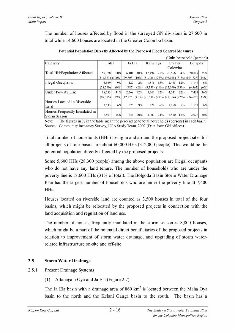
The number of houses affected by flood in the surveyed GN divisions is 27,600 in
total while 14,600 houses are located in the Greater Colombo basin.
Potential Population Directly Affected by the Proposed Flood Control Measures
(Unit: household (person))
Category Total Ja Ela Kalu Oya Greater Colombo
Bolgoda
Total HH/Population Affected 59,978
(311,983)
100%
(100%)
6,101
(29,803)
10%
(10%)
12,494
(81,426)
21%
(26%)
20,566
(96,028)
34%
(31%)
20,817
(104,726)
35%
(34%)
Illegal Occupants 5,569
(28,290)
9%
(9%)
122
(487)
2%
(2%)
1,816
(9,351)
15%
(11%)
2,485
(12,090)
12%
(13%)
1,146
(6,362)
6%
(6%)
Under Poverty Line 18,553
(89,985)
31%
(29%)
2,568
(12,275)
42%
(41%)
4,011
(21,631)
32%
(27%)
4,541
(21,384)
22%
(22%)
7,433
(34,695)
36%
(33%)
Houses Located in Riverside Land 3,533 6% 573 9% 728 6% 1,060 5% 1,172 6%
Houses Frequently Inundated in Storm Season 8,807 15% 1,244 20% 3,007 24% 2,530 12% 2,026 10%
Note: The figures in % in the table mean the percentage to total households (persons) in each basin. Source: Community Inventory Survey, JICA Study Team, 2002 (Data from GN offices)
Total number of households (HHs) living in and around the proposed project sites for
all projects of four basins are about 60,000 HHs (312,000 people). This would be the
potential population directly affected by the proposed projects.
Some 5,600 HHs (28,300 people) among the above population are illegal occupants
who do not have any land tenure. The number of households who are under the
poverty line is 18,600 HHs (31% of total). The Bolgoda Basin Storm Water Drainage
Plan has the largest number of households who are under the poverty line at 7,400
HHs.
Houses located on riverside land are counted as 3,500 houses in total of the four
basins, which might be relocated by the proposed projects in connection with the
land acquisition and regulation of land use.
The number of houses frequently inundated in the storm season is 8,800 houses,
which might be a part of the potential direct beneficiaries of the proposed projects in
relation to improvement of storm water drainage, and upgrading of storm water-
related infrastructure on-site and off-site.
2.5 Storm Water Drainage
2.5.1 Present Drainage Systems
(1) Attanagalu Oya and Ja Ela (Figure 2.7)
The Ja Ela basin with a drainage area of 860 km2 is located between the Maha Oya
basin to the north and the Kelani Ganga basin to the south. The basin has a
Final Report, Volume II Master Plan Main Report Chapter 2
Nippon Koei Co., Ltd. 2 - 17 The Study on Storm Water Drainage Plan for the Colombo Metropolitan Region
complicated waterway system with interconnections and branches in the downstream
reaches.
The Attanagalu Oya originates from the hills with the highest elevation of 300 m
above MSL at the eastern boundary of the basin, located some 40 km away from the
sea. From Gampaha to Ekala, the Attanagalu Oya runs through flat land along the
A33 Road in parallel with the Uruwal Oya, which drains the southern part of the
basin. These two streams interconnect at some locations in this area.
Around Ekala, the two main streams branch in different directions. One stream
goes to the north as the Dandugam Oya. The other is a man-made canal called the
Ja Ela flowing to the west.
The Dandugam Oya turns to the south near the International Airport after joining the
two tributaries, the Mapalam Oya and Kimbulapitiya Oya draining the northern part
of the basin. The river crosses the Negombo Road and runs through the northern
part of the Muthurajawela Marsh, then eventually pours into the Negombo Lagoon.
The Ja Ela flows down a deep-cut section before crossing the Negombo Road and
goes through the Muthurajawela Marsh, then pours into the Negombo Lagoon.
These two streams are also interconnected through the Old Negombo Canal, which
branches from the Dandugam Oya in the north and runs along the seaward side of the
Negombo Road down to the Kelani Ganga to the south.
(2) Kalu Oya (Figure 2.8)
The Kalu Oya basin is a relatively small catchment located between the Ja Ela basin
to the north and the Kelani Ganga basin to the south. Topography of the basin is
flat, as a whole, with a maximum elevation of 40 m above MSL at the northeastern
boundary. The stream originates in the northeastern part of the basin some 15 km
away from the sea. Draining the semi-urbanized areas in the basin, the main stream
flows crossing the Kandy Road and Negombo Road afterwards, then joins the Old
Negombo Canal.
Because of the low lying topography in the basin, marsh lands are formed along the
main stream and tributaries. The marshlands spread widely in Pinammeda, Horape
and Mabole areas located along the reaches between the Kandy Road and Negombo
Road. The ground elevation in these marshlands is less than 1 m above MSL.
The Kalu Oya is the only major drainage for the basin, crossing the Negombo Road
of which the surface elevation is more than 5 m higher than the marshlands. The
drainage of the Kalu Oya is affected by the water level of the Kelani Ganga
connecting through the Old Negombo Canal. This difficulty of drainage is a main

Final Report, Volume II Master Plan Main Report Chapter 2
Nippon Koei Co., Ltd. 2 - 18 The Study on Storm Water Drainage Plan for the Colombo Metropolitan Region
cause of the inundation in the basin.
(3) Hamilton Canal and Old Negombo Canal (Figure 2.9)
The Muthurajawela Mash, a wetland of vast extent, lies along the western coast
between the Negombo Lagoon and Kelani Ganga. The Marsh, with an area of
3,068 ha, is separated from the sea by a sand barrier along the coast. There are two
major canals connecting the Negombo Lagoon with the Kelani Ganga, which were
constructed in colonial time for navigation purposes.
The Hamilton Canal runs along the coast north to south with a length of 15 km.
This canal is well maintained with a road running alongside and is still utilized as a
navigation waterway for fishery boats.
The Old Negombo Canal originally connected the Dandugam Oya with Kelani
Ganga but is separated into two sections by a bund constructed along the southern
bank of Ja Ela. This canal was also constructed for the purpose of navigation or
irrigation for paddy cultivation envisaged in the past but is no longer utilized for such
purposes at present.
(4) Kelani Ganga (Figure 2.10)
The Kelani Ganga drains a basin area of 2,292 km2 originating in the central
highlands of the country with a highest elevation of 1,500 m. The river flows down
the western slopes of the central highlands, collecting water from its tributaries.
The main stream of the river reaches the boundary of the study area around
Biyagama and runs through the flatland, then eventually pours into the Indian Ocean
near Crow Island in the north of Colombo. The length of the river is 145 km from
its origin to estuary. Within the study area, the length of the main stream section
from Biyagama to Crow Island is around 20 km with a gradient of 1/6,000.
(5) Greater Colombo (Figure 2.11)
According to the GCFC&EIP, the Greater Colombo area is defined as the area
covering the local authority areas of Colombo MC, Sri Jayawardenapura Kotte MC,
Kolonnawa MC, Dehiwela - Mount Lavinia MC, and Moratuwa MC. The total area
of the Greater Colombo area is 165 km2.
In view of drainage systems, the Greater Colombo area is composed of a major
drainage basin and other small catchments. The major drainage basin covers an
area of 85 km2 bounded by Nugegoda - High Level Road to the south, Talangama -
Hokandara watershed to the east, Kelani flood bunds to the north, and elevated
urbanized areas of Colombo along the coast to the west. The streams collect runoff
in the upstream catchment and flow into Parliament Lake. After Parliament Lake,

Final Report, Volume II Master Plan Main Report Chapter 2
Nippon Koei Co., Ltd. 2 - 19 The Study on Storm Water Drainage Plan for the Colombo Metropolitan Region
the urbanized areas are drained by the canal system improved by the GCFC&EIP
Phase I. Runoff in the basin is discharged through the North Lock Gate to the
Kelani Ganga and the Mutwal Tunnel to the sea in the north as well as the
Wellawatta and Dehiwala sea outfalls in the south.
There are lowlands with a ground elevation lower than 1 m above MSL. The
majority of lowlands spread around Parliament Lake, Heen Ela, Kolonnawa Ela, and
Kotte Ela and function as storm water retention areas in the major drainage basin.
The total area of these lowlands was estimated at 686 ha in the study stage of the
GCFC&EIP Phase I but would be decreasing due to land filling for development.
The rest of the Greater Colombo area mainly consists of small drainage basins along
the coast or belongs to the Bolgoda basin.
(6) Bolgoda Lake (Figure 2.12)
The Bolgoda basin, located between the Kelani Ganga basin to the north and the
Kalu Ganga basin to the south, has a drainage area of 394 km2. In the upper
catchment area, the streams originate from the hills with a highest elevation of 20 m
above MSL at the eastern boundary of the basin. The lower catchment area lies in
the lowlands widely spreading along the coast with water surfaces and surrounding
marshlands. There is a unique water system in the basin comprising the two major
lakes with incoming and outgoing waterways.
The Weras Ganga is one of the major water waterways continuing from Bolgoda
Lake North. The Weras Ganga collects runoff in the northern part of the basin.
The drainage area of the Weras Ganga is the most developed area of the basin
covering the urban areas of Nugegoda, Dehiwala - Mount Lavinia, Moratuwa,
Maharagama and Kesbewa. Marsh lands spread along the Weras Ganga and
incoming streams, which are partly subject to land fillings for development.
North Bolgoda Lake, with a water surface area of 760 ha at normal water level of
0.07 m above MSL, is located connecting with the southern end of the Weras Ganga.
The lake collects runoff from the Weras Ganga catchment in the north and the Maha
Oya catchment in the east through the Bolgoda Ganga. Incoming runoff to the lake
is finally drained through the Panadura Ganga, which is the largest outfall to the sea.
The Bolgoda Ganga is a waterway interconnecting the North and South Bolgoda
Lakes. The length of the waterway is around 12 km between the two lakes. The
waterway remains almost natural and the areas along the waterway have not been
developed because of the difficulty of access through the wetlands.
South Bolgoda Lake has a water surface area of 340 ha at normal water level of 0.10
m above MSL and still remains natural as a whole. Collecting incoming runoff
Final Report, Volume II Master Plan Main Report Chapter 2
Nippon Koei Co., Ltd. 2 - 20 The Study on Storm Water Drainage Plan for the Colombo Metropolitan Region
mainly from the Bolgoda Ganga, the lake would drain runoff southwards through the
two canals called Kepu Ela and Aluth Ela connecting to the Kalu Ganga but flow
directions of both canals would depend on the water level of the Kalu Ganga. There
is another canal named Talpitiya Ela connecting the lake with the sea but its sea
outfall is closed by sandbar almost throughout the year.
The Maha Oya and Panape Ela are the major streams draining the upper catchment,
almost corresponding to the eastern half of the basin.
The Bolgoda basin can be broadly classified into three regions in the light of the
current development and land use. The northern region, in and around the Weras
Ganga catchment, is covered by the highly urbanized areas of Nugegoda,
Dehiwela-Mount Lavinia, Moratuwa and Kesbewa. The southern region, covering
the southern half of the basin, remains rural as a whole, such as Panadura, Kalutara,
Bandaragama and Horana areas. The northeastern region around Homagama
occupying the upper catchment of the Maha Oya is semi-urbanized with a mixture of
urban centers and rural areas.
2.5.2 Storm Water Drainage Project in the Past
(1) Kelani Ganga Flood Protection Scheme
To protect the downstream basin areas from the critical floods, a series of flood
bunds (dikes) were constructed since 1924 and strengthened thereafter. The flood
bunds along the southern bank of the Kelani Ganga were constructed to prevent the
city of Colombo from flooding. On the other hand, the bund levels along the
northern bank are kept lower than the southern bank. The protection level of the
northern bank is for a 50-year return period flood. In the case of a flood event
exceeding the protection level, flooding would overtop the northern bank but the
southern bank is still offers protection. The city of Colombo located on the
southern bank of the Kelani Ganga is therefore protected against 500-year flood
events.
(2) New Capital City Drainage Project Feasibility Study
This study was carried out in 1981 and is called the ‘Samitar Study’. The objective
of this study was to provide improved storm water drainage for Colombo and its
environs, particularly in the area of the new capital city of Sri Jayawardenapura Kotte,
where the present Parliament Complex is located. The proposals of the study
comprise inflow and outflow regulation for the area of the new capital city. The
planning scale for the proposed improvement was a 200-year return period flood.
The Samitar Study covered the corresponding basin area of the Greater Colombo
basin and established the basic concept for the improvement of storm water drainage

Final Report, Volume II Master Plan Main Report Chapter 2
Nippon Koei Co., Ltd. 2 - 21 The Study on Storm Water Drainage Plan for the Colombo Metropolitan Region
in the basin. Of the proposals of the Samitar Study, the improvement of existing
canal systems were materialized by the succeeding studies and implemented
afterwards as described hereunder.
(3) Greater Colombo Flood Control and Environment Improvement Project Phase I
(GCFC&EIP Phase I, Figure 2.13)
The feasibility study was carried out in 1988 as “The Study of the Canal and
Drainage System in Colombo” under NWSDB. The review and update of the study
and detailed design were afterwards conducted in 1992 as “The Greater Colombo
Canal and Drainage System Rehabilitation Project” under the Sri Lanka Land
Reclamation and Development Corporation (SLLRDC). The project was
implemented from 1992 to 1998 and called the Greater Colombo Flood Control and
Environment Improvement Project Phase I (GCFC&EIP Phase I). The major
drainage canals improved during the Phase I project are 44 km in the total length
including 24 stretches as shown in Table 2.7.
(4) Urban Drainage in Greater Colombo Area
In 1993, SLLRDC conducted a feasibility study for the Greater Colombo area
(Colombo and its environs, consisting of five MCs/UCs), aimed at establishing an
overall storm water drainage improvement plan, including the flood damage survey
in the area.
Based on that feasibility study in 1993, the GCFC&EIP Phase II was taken up for
implementation. This project is to prevent localized flooding in five urgent areas
identified within the Colombo MC. In addition, the Phase II work included the
Review of F/S carried out by SLLRDC in 1993. The Review of F/S covered 19
storm water drainage schemes in the CMC area, five schemes in DMMC and MMC
areas and some other small scale pump drainage schemes in the areas of Kolonnawa
UC and Kotte MC.
Five schemes in DMMC and MMC areas, namely Kawdana, Attidiya,
Mahakuburuowita, Lunawa North and Lunawa South, were reviewed as priority
projects, of which two schemes, Kawdana and Attidiya, were taken up for detailed
design under the Phase II of GCFC&EIP and the construction work is now in
progress under the Phase III of GCFC&EIP.
(5) Greater Colombo Flood Control and Environment Improvement Project Phase
II (GCFC&EIP Phase II, Figure 2.13)
To alleviate the major local floods (inundation) habitually observed in the Colombo
Municipal Council (CMC), GCFC&EIP Phase II was implemented from 1998 to
2001 by SLLRDC. The project includes the following five drainage schemes

Final Report, Volume II Master Plan Main Report Chapter 2
Nippon Koei Co., Ltd. 2 - 22 The Study on Storm Water Drainage Plan for the Colombo Metropolitan Region
located in the highly built-up area inside the CMC and the total coverage area is
around 560 ha.
1) Torrington West Scheme
2) Dematagoda Scheme
3) St. Sebastian-2 Scheme
4) Serpentine Canal Scheme
5) Unity Place Scheme
These schemes were recognized as the most urgent schemes to resolve the
fundamental problems on the storm water drainage system in each drainage area,
which were confirmed through the investigations of the drainage system and
inundation surveys during the Review of F/S. The project includes construction of
trunk drains including underground pipes/culverts under the roads and rehabilitation
of existing open channels. The total length of drainage channels improved in this
project is around 7 km. All these trunk drains were connected to the main canals
improved under the GCFC&EIP Phase I or directly to the sea. The principal
features of each scheme are summarized in Table 2.8.
2.5.3 On-going Drainage Project and Existing Plan
(1) Greater Colombo Flood Control and Environment Improvement Project Phase
III (GCFC&EIP Phase III, Figure 2.13)
A large part of the Dehiwala - Mount Lavinia Municipal Council (DMMC) area is
already urbanized but a satisfactory storm water drainage system has not been
provided. Unlike the CMC area, there is no systematic drainage network in these
areas. In general, storm water drainage in these areas consists of natural streams as
trunk drains partly canalized with masonry or concrete works and smaller open
drains collecting and leading storm water to the trunk drains. It appears that such
drains have been constructed part-by-part without a proper engineering design
processes.
In order to improve the drainage condition in the urban area to the south of CMC
area, the following 5 storm water drainage improvement schemes were proposed by
SLLRDC. These schemes were designed on the basis of a rainstorm event with a 2-
year return period to alleviate the frequent inundation.
1) Mahakunbruowita Scheme
2) Kawdana Scheme
3) Attidiya Scheme
4) Lunawa Lake North Scheme
5) Lunawa Lake South Scheme

Final Report, Volume II Master Plan Main Report Chapter 2
Nippon Koei Co., Ltd. 2 - 23 The Study on Storm Water Drainage Plan for the Colombo Metropolitan Region
Out of the 5 schemes, the Kawdana and Attidiya schemes are being implemented as
the GCFC&EIP Phase III project by SLLRDC. The total coverage area of the two
schemes is 522 ha. A storm water drainage system including trunk drain channels,
secondary drains and roadside ditches is to be constructed for the entire area. The
total length of all the drain channels to be constructed is around 40 km. The
principal features of Phase III Schemes are summarized in Table 2.9.
(2) Lunawa Lake Environment Improvement and Community Development Project
(Figure 2.13)
The project area covers the Lunawa Lake basin with a drainage area of 615 ha
including the two major drainage areas, namely, Lunawa Lake North (353 ha) and
Lunawa Lake South (262 ha) extending over DMMC and MMC areas.
This project is composed of two major components. One is storm water drainage
improvement with resettlement site construction and procurement of O&M
equipment. In this component, two drainage schemes, that is, the Lunawa Lake
North scheme and the Lunawa Lake South scheme are to be implemented. These
schemes were identified and studied together with the two drainage schemes that are
now being implemented under the GCFC&EIP Phase III. The construction work
consists mainly of improvement of existing trunk drains and secondary drains.
Other than the trunk and secondary drains, part of the tertiary drains (roadside drains)
are also to be improved. The total length of drains to be improved under this
project is around 87 km.
The community development component envisages a community’s contribution to
sustain an effective drainage-based flood alleviation program, which aims to
empower the community as a self-help and voluntary organization in both terms of
replicating environmental conservation practices and upgrading their living standard
on a sustainable basis.
Two groups of communities are subject to upgrading under the project, i.e., about
450 families to be relocated in connection with the implementation of drainage
improvement works and accommodated in four resettlement sites, and 441 families
in 11 under-served communities affected by inundation. The principal features of the
project are summarized in Table 2.10.
2.5.4 Flood Damage Survey
(1) General
The flood damage survey was carried out to clarify flooding situations in the study
area. The preliminary information of flooding situations was collected from the local
authorities at first to identify locations of inundation areas. The questionnaire
Final Report, Volume II Master Plan Main Report Chapter 2
Nippon Koei Co., Ltd. 2 - 24 The Study on Storm Water Drainage Plan for the Colombo Metropolitan Region
surveys were conducted thereafter at the locations identified. These works were
done by the local consultant on subcontract basis under supervision of the study team
for the period from November 2001 to February 2002.
The preliminary information of areas prone to habitual inundation were collected
from the 25 local authorities such as Municipal Council (MC), Urban Council (UC),
and Pradeshiya Sabha (PS) relevant to the study area. In addition to the local
authorities, the information was also collected from the other authorities or agencies
such as the Urban Development Authority (UDA), the Irrigation Department, and
Divisional Secretary Offices.
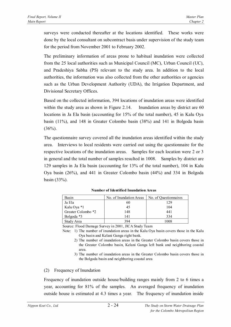
Based on the collected information, 394 locations of inundation areas were identified
within the study area as shown in Figure 2.14. Inundation areas by district are 60
locations in Ja Ela basin (accounting for 15% of the total number), 45 in Kalu Oya
basin (11%), and 148 in Greater Colombo basin (38%) and 141 in Bolgoda basin
(36%).
The questionnaire survey covered all the inundation areas identified within the study
area. Interviews to local residents were carried out using the questionnaire for the
respective locations of the inundation areas. Samples for each location were 2 or 3
in general and the total number of samples resulted in 1008. Samples by district are
129 samples in Ja Ela basin (accounting for 13% of the total number), 104 in Kalu
Oya basin (26%), and 441 in Greater Colombo basin (44%) and 334 in Bolgoda
basin (33%).
Number of Identified Inundation Areas
Basin No. of Inundation Areas No. of Questionnaires Ja Ela 60 129 Kalu Oya *1 45 104 Greater Colombo *2 148 441 Bolgoda *3 141 334 Study Area 394 1008
Source: Flood Damage Survey in 2001, JICA Study Team Note: 1) The number of inundation areas in the Kalu Oya basin covers those in the Kalu
Oya basin and Kelani Ganga right bank. 2) The number of inundation areas in the Greater Colombo basin covers those in
the Greater Colombo basin, Kelani Ganga left bank and neighboring coastal area.
3) The number of inundation areas in the Greater Colombo basin covers those in the Bolgoda basin and neighboring coastal area
(2) Frequency of Inundation
Frequency of inundation outside house/building ranges mainly from 2 to 6 times a
year, accounting for 81% of the samples. An averaged frequency of inundation
outside house is estimated at 4.3 times a year. The frequency of inundation inside

Final Report, Volume II Master Plan Main Report Chapter 2
Nippon Koei Co., Ltd. 2 - 25 The Study on Storm Water Drainage Plan for the Colombo Metropolitan Region
house/building indicates that 72% represent frequency of 3 times a year or less. An
averaged frequency of inundation inside house is estimated at 3.1 times a year.
Frequency of Inundation in the Study Area
Frequency (times/year) and Percentage Inundation 1 or
Less 2 3 4 5 6 7 or
More Outside house/building 11% 19% 20% 13% 11% 18% 8% Inside house/building 35% 22% 15% 7% 6% 10% 5%
Source: Flood Damage Survey in 2001, JICA Study Team
Frequency of Inundation by Basin (times/year)
Inundation Ja Ela Kalu Oya Greater Colombo
Bolgoda Study Area
Outside house/building 2.9 3.3 5.0 4.1 4.3 Inside house/building 1.7 2.6 3.8 2.9 3.1
Source: Flood Damage Survey in 2001, JICA Study Team
Note:
(3) Duration of Inundation
Duration of average inundation varies mainly within 2 days representing 69% of the
samples. Duration within 2 days is also dominant with a rate of 52% in the case of
maximum inundation but the rates for longer duration tend to increase, compared
with average inundation. Duration of inundation indicates different characteristics
by basin. Duration of 7 days or more is dominant in the Ja Ela basin and Kalu Oya
basin and implies the difficulty of natural drainage in marsh and surrounding lowland
in these basins. The majority of duration is 1 day or less in the Greater Colombo
Inundation Outside House/Building Inundation Inside House/Building
Ja Ela Bas in
0%
10%
20%
30%
40%
50%
< 1 2 3 4 5 6 7 >
Frequency (times/year)
Per
cen
tag
e
Kalu Oya Bas in
0%
10%
20%
30%
40%
50%
< 1 2 3 4 5 6 7 >Frequency (times/year)
Per
cen
tag
e
Greater Colombo Bas in
0%
10%
20%
30%
40%
50%
< 1 2 3 4 5 6 7 >Frequency (times /year)
Pe
rcen
tag
e
Bolgoda Basin
0%
10%
20%
30%
40%
50%
< 1 2 3 4 5 6 7 >Frequency (times/year)
Pe
rcen
tag
e
Final Report, Volume II Master Plan Main Report Chapter 2
Nippon Koei Co., Ltd. 2 - 26 The Study on Storm Water Drainage Plan for the Colombo Metropolitan Region
basin and Bolgoda basin, reflecting the characteristics of inundation in urbanized
areas.
Duration of Inundation in the Study Area
Duration (days) and Percentage
Inundation 1 or Less
2 3 4 5 6 7 or More
Average 55% 14% 9% 5% 4% 1% 13% Maximum 38% 14% 7% 5% 5% 2% 28%
Source: Flood Damage Survey in 2001, JICA Study Team
Duration of Inundation by Basin (days)
Inundation Ja Ela Kalu Oya Greater
Colombo Bolgoda
Study Area
Average 5.7 5.1 1.4 2.6 2.7 Maximum 9.3 9.5 3.1 5.2 5.3
Source: Flood Damage Survey in 2001, JICA Study Team
Note: Duration of Average Inundation Duration of Maximum Inundation
2.5.5 Existing Problems on Storm Water Drainage
(1) Cause of Flooding
Based on the natural characteristics of present drainage systems and the results of
flood damage survey, the major causes of flooding in the respective basins are
classified into the followings:
Ja Ela Basin
0%
20%
40%
60%
80%
< 1 2 3 4 5 6 7 >Duration (days )
Per
cen
tag
e
Kalu Oya Bas in
0%
20%
40%
60%
80%
< 1 2 3 4 5 6 7 >Duration (days )
Per
cen
tag
e
Greater Colombo Basin
0%
20%
40%
60%
80%
< 1 2 3 4 5 6 7 >Duration (days )
Pe
rcen
tag
e
Bolgoda Basin
0%
20%
40%
60%
80%
< 1 2 3 4 5 6 7 >Duration (days )
Pe
rcen
tag
e

Final Report, Volume II Master Plan Main Report Chapter 2
Nippon Koei Co., Ltd. 2 - 27 The Study on Storm Water Drainage Plan for the Colombo Metropolitan Region
1) Ja Ela basin
Overflow from main streams such as Attanagalu Oya, Urwal Oya,
Dandugam Oya and Ja Ela
Natural drainage difficulty in lowland surrounding Muthurajawela
Marsh
Lack of storm water drainage system for draining storm water runoff to
the main streams or Muthurajawela Marsh
2) Kalu Oya basin and Kelani Ganga right bank
Natural drainage difficulty from Kalu Oya and Old Negombo Canal to
Kelani Ganga
Lack of storm water drainage system for draining storm water runoff to
the main streams such as Kalu Oya and Old Negombo Canal
Decrease of marsh and surrounding lowland functioning as storm water
retention area due to land filling
3) Greater Colombo Basin and Kelani Ganga left bank
Deterioration and under-capacity of existing urban drainage sytem
Uncontrolled urbanization of unprotected area under the Kelani Ganga
Flood Protection Scheme
4) Bolgoda Basin
Lack of storm water drainage system for draining storm water runoff to
the main streams
Natural drainage difficulty in lowland surrounding the downstream
water system
(2) Estimated Inundation Area and Flood Damage
Based on the results of the inundation analysis and assessment of direct and indirect
damages, the amount of annual damage under the present condition is estimated at Rs.
1,757 million/year for the entire study area.
Estimated Flood Damage in the Study Area
Estimated Extent of Inundation Area by Return Period (ha)
Annual Damage Sub-basin
2-year 5-year 10-year 25-year 50-year (million Rs.) Ja Ela 1,113 1,609 1,938 2,755 3,390 509 Kalu Oya 283 384 449 496 558 329 Greater Colombo 153 288 408 581 774 549 Bolgoda 2,419 2,929 3,278 3,645 3,913 370
Study Area 3,968 5,210 6,073 7,477 8,635 1,757
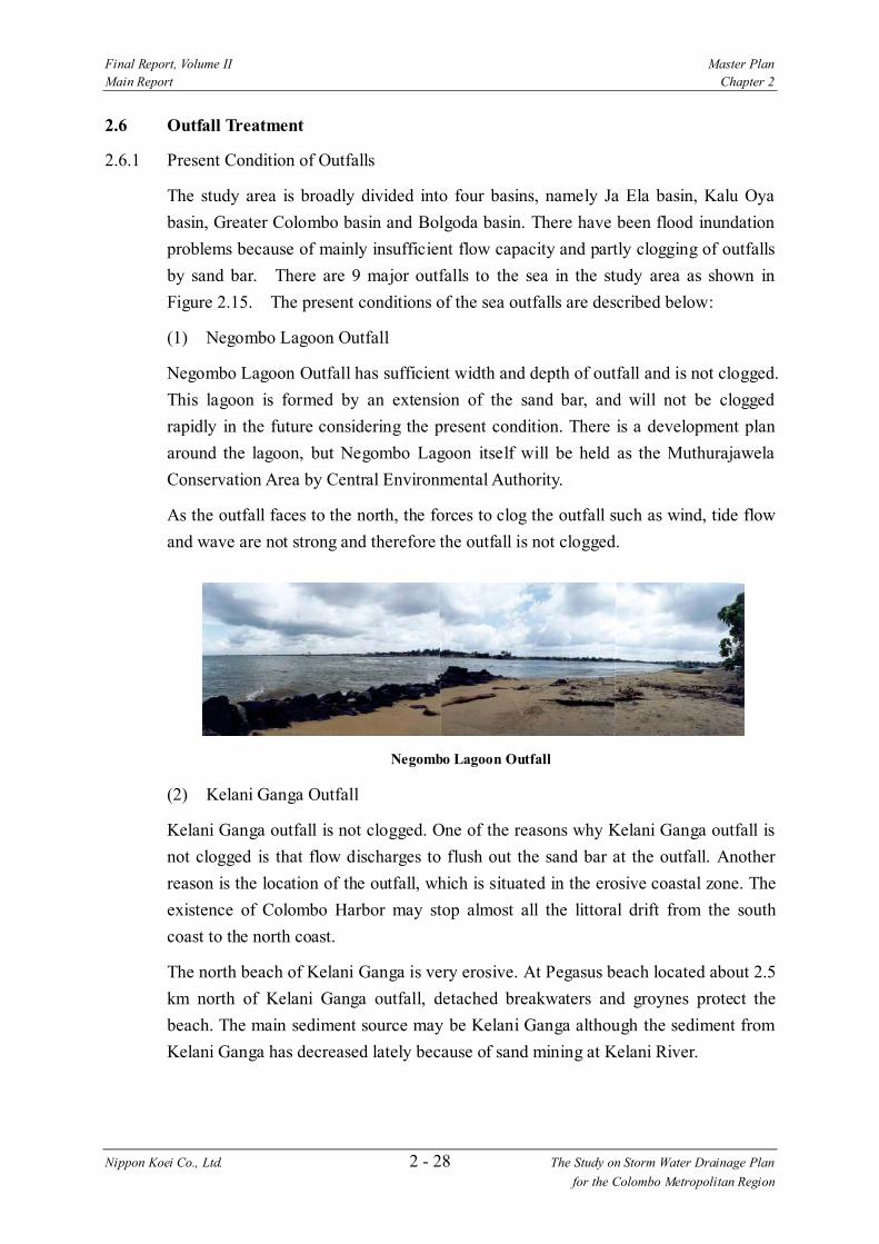
Final Report, Volume II Master Plan Main Report Chapter 2
Nippon Koei Co., Ltd. 2 - 28 The Study on Storm Water Drainage Plan for the Colombo Metropolitan Region
2.6 Outfall Treatment
2.6.1 Present Condition of Outfalls
The study area is broadly divided into four basins, namely Ja Ela basin, Kalu Oya
basin, Greater Colombo basin and Bolgoda basin. There have been flood inundation
problems because of mainly insufficient flow capacity and partly clogging of outfalls
by sand bar. There are 9 major outfalls to the sea in the study area as shown in
Figure 2.15. The present conditions of the sea outfalls are described below:
(1) Negombo Lagoon Outfall
Negombo Lagoon Outfall has sufficient width and depth of outfall and is not clogged.
This lagoon is formed by an extension of the sand bar, and will not be clogged
rapidly in the future considering the present condition. There is a development plan
around the lagoon, but Negombo Lagoon itself will be held as the Muthurajawela
Conservation Area by Central Environmental Authority.
As the outfall faces to the north, the forces to clog the outfall such as wind, tide flow
and wave are not strong and therefore the outfall is not clogged.
Negombo Lagoon Outfall
(2) Kelani Ganga Outfall
Kelani Ganga outfall is not clogged. One of the reasons why Kelani Ganga outfall is
not clogged is that flow discharges to flush out the sand bar at the outfall. Another
reason is the location of the outfall, which is situated in the erosive coastal zone. The
existence of Colombo Harbor may stop almost all the littoral drift from the south
coast to the north coast.
The north beach of Kelani Ganga is very erosive. At Pegasus beach located about 2.5
km north of Kelani Ganga outfall, detached breakwaters and groynes protect the
beach. The main sediment source may be Kelani Ganga although the sediment from
Kelani Ganga has decreased lately because of sand mining at Kelani River.
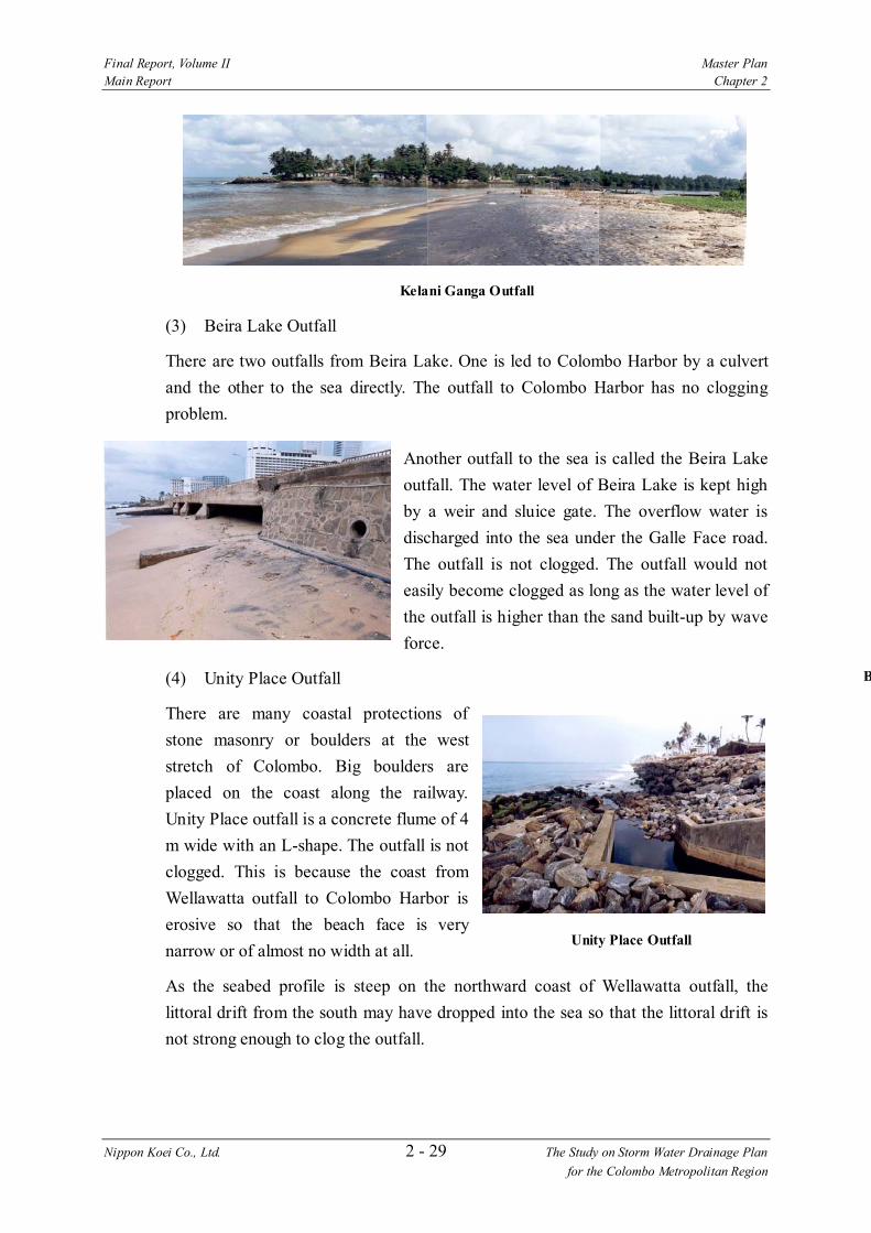
Final Report, Volume II Master Plan Main Report Chapter 2
Nippon Koei Co., Ltd. 2 - 29 The Study on Storm Water Drainage Plan for the Colombo Metropolitan Region
Kelani Ganga Outfall
(3) Beira Lake Outfall
There are two outfalls from Beira Lake. One is led to Colombo Harbor by a culvert
and the other to the sea directly. The outfall to Colombo Harbor has no clogging
problem.
Another outfall to the sea is called the Beira Lake
outfall. The water level of Beira Lake is kept high
by a weir and sluice gate. The overflow water is
discharged into the sea under the Galle Face road.
The outfall is not clogged. The outfall would not
easily become clogged as long as the water level of
the outfall is higher than the sand built-up by wave
force.
(4) Unity Place Outfall
There are many coastal protections of
stone masonry or boulders at the west
stretch of Colombo. Big boulders are
placed on the coast along the railway.
Unity Place outfall is a concrete flume of 4
m wide with an L-shape. The outfall is not
clogged. This is because the coast from
Wellawatta outfall to Colombo Harbor is
erosive so that the beach face is very
narrow or of almost no width at all.
As the seabed profile is steep on the northward coast of Wellawatta outfall, the
littoral drift from the south may have dropped into the sea so that the littoral drift is
not strong enough to clog the outfall.
B
Unity Place Outfall

Final Report, Volume II Master Plan Main Report Chapter 2
Nippon Koei Co., Ltd. 2 - 30 The Study on Storm Water Drainage Plan for the Colombo Metropolitan Region
(5) Wellawatta Outfall
Two groynes about 30 m long and up to depth of about 1.0 m below MSL have been
constructed at Wellawatta outfall. After the construction of Dehiwala outfall, the
groyne at Wellawatta was modified to an L-shape.
Wellawatta Outfall
Though the coast of this area may be erosive according to past studies, the coast
could retain the beaches because of the protection offered by the groynes at
Wellawatta outfall. The coast is protected by boulders north of Wellawatta outfall,
and the sand beach can not be seen. The depth of the outfall is about 0.5 to 1.0 m and
the predominant size of the riverbed material is about 1 mm.
As for the sea conditions south of Wellawatta outfall, the surf zone is seen more than
100 m offshore from the coastline, and
there is a shipwreck. On the other hand,
the surf zone is not seen at the northern
beach in December and waves break at
a point very near shoreline. However,
during the SW monsoon, the waves are
high and a surf zone is seen offshore.
The condition of surf zone is different
between the northern and southern
coasts of Wellawatta outfall.
Before the construction of groyne at
Dehiwala outfall in December 2001, the
outfall at Wellawatta had not been
clogged for a long time.
It is said, generally in Japan, that a
training jetty at the outfall should be
extended so as to cross over the width of the littoral drift and the depth should be
more than 3 m to allow river flow throughout the year. From this, the front depth of
groyne at Wellawatta outfall is much too shallow and might have been clogged
Locations of Wellawatta and Dehiwala Outfalls
Final Report, Volume II Master Plan Main Report Chapter 2
Nippon Koei Co., Ltd. 2 - 31 The Study on Storm Water Drainage Plan for the Colombo Metropolitan Region
sometimes.
After the construction of the groyne at Dehiwala outfall the Wellawatta outfall was
clogged during the dry season. The obvious fact is that the flow quantities of both
Wellawatta Canal and the Dehiwala Canal are not sufficient.
(6) Dehiwala Outfall
In the off-SW monsoon in November, the offshore surf zone is not seen at the
southward coast of the outfall, but is seen at the northward coast in the offshore more
than 100 m from shoreline and the offshore surf continues up to Wellawatta outfall.
Dehiwala outfall has been clogged by the sand bar throughout the year before the
construction of the groyne. This is because the activity of the waves is very active
and also the quantity of river flow is inadequate to flush out the sand bar. The
condition may be similar for the other outfalls in the study area.
The construction of the groyne at Dehiwala outfall was proposed in the study of 1988.
After various studies and discussions the present groyne was constructed and the
sand bar formed at the outfall was breached in early 2002. The groyne extends to a
depth of about 1.0 m below MSL. The groyne size was planned so as to minimize the
coastal impact. The coastal revetment was also constructed to protect the beach north
of the outfall.
Dehiwala Outfall
Probable Littoral Drift around Dehiwala Outfall
Final Report, Volume II Master Plan Main Report Chapter 2
Nippon Koei Co., Ltd. 2 - 32 The Study on Storm Water Drainage Plan for the Colombo Metropolitan Region
(7) Lunawa Lake Outfall
Lunawa Lake outfall is characterized by continuous clogging due to sand bar
formation. The outfall must now be opened regularly by human power. There exists a
sand beach across the outfall.
Because of the small catchment area of 10.26 km2, the ordinary flow through the
outfall is low and the wave action to form sand bar is very active. The outfall is
always exposed to the menace of clogging due to strong wave activity to form a sand
bar and the insufficiency of flow.
When the water level of Lunawa Lake rises to 1.2 m above MSL, the sand bar is
excavated by manpower. After the sand bar is excavated, the lake water level drops to
mean sea level within 24 hours, and a few days later, the outfall is clogged again.
Lunawa Lake Outfall
During the off-SW monsoon, the surf zone is restricted to the shoreline vicinities and
the offshore surf zone is not seen along either the north or south coasts. This means
that a major part of the activity of the littoral drift may be restricted to the shoreline
vicinities. In the SW monsoon, the surf zone near shore is wider than that in the off-
SW monsoon due to high waves.
(8) Panadura Outfall
For small fishing boats, there is an anchorage at the Panadura outfall. The waterway
of Panadura River has not been clogged due to the groyne and is kept open by
dredging.
Panadura outfall was completely covered with sand until the Irrigation Department
constructed a rubble mound structure on the southern side of the outfall in 1982.
Under the harbor construction project this structure was extended and a groyne was
constructed at the harbor entrance of 80 m. The depth at the entrance is around 4 m
below MSL.
Final Report, Volume II Master Plan Main Report Chapter 2
Nippon Koei Co., Ltd. 2 - 33 The Study on Storm Water Drainage Plan for the Colombo Metropolitan Region
Panadura Outfall
Though the northern beach of the Panadura outfall is erosive, there exists a sand
beach. The source of sedimentation may be Panadura River. A large part of the
littoral drift near the shoreline from the south might be trapped at the groyne.
(9) Talpitiya Outfall
The Talpitiya outfall is usually clogged.
Residents living around the outfall stated
that they have not been affected by floods
resulting from clogging since 1994. Also
they stated that people breach the sand
bar by manpower during severe flood.
The clogging of Talpitiya outfall is not
serious.
The littoral drift passes to north across the outfall. South Bolgoda Lake is connected
to the sea through the Kalu Ganga and does not have a clogging problem.
2.6.2 Studies in the Past
Several studies on the sea outfalls around the present study area have been carried
out so far. Those studies are outlined as follows:
(1) Master Plan - Coastal Erosion Management (Volume 4: Southwest Coast), by
Coast Conservation Department and DANIDA/DHI, February 1986
Investigation was carried out for the southwest coast of Sri Lanka from Kelani Ganga
to east of Galle (155 km long) and a medium and long term coast erosion
management master plan was proposed. This master plan presented a coast erosion
tendency map shown in Figure 2.16. As the map was prepared based on the
interview, the study proposed necessity of more detailed investigation. The study
proposed the following actions against erosion.
Talpitiya Outfall
Final Report, Volume II Master Plan Main Report Chapter 2
Nippon Koei Co., Ltd. 2 - 34 The Study on Storm Water Drainage Plan for the Colombo Metropolitan Region
1) Coast around Colombo
Continuation of development of hinterland in the north of Colombo
Construction of railway or road along the coast from Colombo to Mt.
Lavinia
2) Coast around Kalutara
Construction of coast revetment against local erosion
Long term monitoring of sand beach between Moganna Head and
Panadura.
(2) Study of the Canal and Drainage System in Colombo, SLLRDC, by WS Atkins
International in association with GKW Consult and RDC Limited, December
1988,
This study aimed at proposing improvement of the canal and drainage system in
Colombo, but it proposed the following actions on maintenance of the Wellawatta
and Dehiwala outfalls.
1) Temporary excavation of outfalls and study on dimensions of the groins
2) Improvement of existing groins of the Wellawatta outfall
3) Construction of new groins for Dehiwala outfall
(3) Beach Protection Investigation - Pegasus Reef Hotel, Carson Cumberbatch &
Co. Ltd., by LHI, July 1985
The beach protection in front of Pegasus Reef Hotel, 2.5 km north from the Kelani
River, was planned. The protection is beach nourishment of about 145 m between
two groins.
(4) Directional Wave Climate Study, Southwest Coast of Sri Lanka, CCD-GTZ
Coast Conservation Project, May 1994
In the study, wave height, wave period, wave direction, etc. were observed by using
buoy at the point 8 km offshore from Galle for three and half years from February
1989 to August 1992. Based on the data obtained, wave characteristics of the
southwest coast of Sri Lanka were analyzed.
(5) Investigation for Panadura Anchorage, ADB Fisheries Sector Project, Project
Implementation Unit, Ceylon Fishery Harbours Corporation, by LHI, April
1997
In order to prepare the improve plan of the Panadura harbour, coastal field
investigation and numerical model analysis were carried out. The proposal consists
of removal of rock outcrop, dredging and construction of groin.

Final Report, Volume II Master Plan Main Report Chapter 2
Nippon Koei Co., Ltd. 2 - 35 The Study on Storm Water Drainage Plan for the Colombo Metropolitan Region
(6) Hydraulic Studies to Determine Layout and Design Parameters for
Improvement of the Dehiwala Canal Sea Outfall, SLLRDC, by LHI, June 1997
Construction of a groin was proposed on the basis of numerical model analysis for
the outfall of Dehiwala canal. The layout of groin was determined not so as to
completely cut off the littoral drift. This proposal was made on condition that the
protection measures against coast erosion between Dehiwala and Wellawatta are
provided with the groins.
(7) Dehiwala Outfall Study - Coastal Impact Mitigatory Measures, SLLRDC, by
LHI, June 1998
Based on the proposal made in the study in June 1997, the influence by groin to the
coast between Dehiwala and Wellawatta was studied. Construction of a L-shaped
groin at Dehiwala outfall was proposed aiming at trapping the drift and nourishing
the coast.
(8) Improvement of Lunawa Sea Outfall, SLLRDC, by LHI, January 2001
Due to deterioration of water quality of the Lunawa Lake, a permanent measure to
keep the outfall open was needed although the river mouth clogging is being
removed by manual excavation. In order to prepare the improvement plan,
topographic survey and sounding survey were carried out around the outfall. Based
on the data, the following ideas were proposed. SLLRDC has a plan to carry out
the further detail study.
1) Periodical excavation of the outfall by machine
2) Maintenance of the outfall by groin
3) Drainage of lake water by pump
4) Sand bypass by sand pump
2.7 Institution and Legislation
2.7.1 Present Institutional Setting Related to Storm Water Drainage Works
The main agencies related to the storm water drainage works including planning,
approval, implementation and O&M are shown below. The demarcation of their
current responsibility is indicated in Table 2.11.
Final Report, Volume II Master Plan Main Report Chapter 2
Nippon Koei Co., Ltd. 2 - 36 The Study on Storm Water Drainage Plan for the Colombo Metropolitan Region
(1) Executing Agencies
1) Sri Lanka Land Reclamation and Development Corporation (Ministry of
Housing & Plantation Infrastructure)
Colombo District (Low-lying Area) Reclamation and Development Board, the
former Sri Lanka Reclamation and Development Corporation, was established
in 1968 by Act No. 15 of 1968. The objectives of the Board were 1) to reclaim
and develop every reclamation and development area declared by the Minister,
which included lowland, marshy, waste or swampy areas and 2) to have the
custody, management and control of lands comprising such areas.5
General powers of the Board include 1) to acquire, hold or take on lease any
property, or to mortgage, pledge, sell or otherwise dispose of any property, 2) to
undertake the preparation and execution of development schemes in the areas,
3) to cause the construction of roads in the areas, and 4) to cause the
construction of works for the provision of public services in the areas including
surface water drainage, sewerage and disposal of sewage, lighting and water
supply.
The Act was subsequently amended in 1976, which allows the Board to sell
reclaimed lands. Further amendments were done in 1982 allowing acquisition
and vesting of lowlands in any part of the country. The name of the Board
changed to the present one at that time.
The canals and waterways in and around Colombo were handed over from the
Irrigation Department to SLLRDC for maintenance in 1979. Since then,
SLLRDC has been expanding its responsibilities for canal and waterway
maintenance. The present major maintenance activities include Hamilton,
Dutch, St. Sebastian, Dematagoda, Diyamanua Oya, Kirillapone and Dehiwara
Canals and Diyawanna Lake.
SLLRDC has 1,696 staff including 619 casual employees. The permanent staff
consists of 132 executive and managerial staff, 105 supervising staff, 179
clerical staff, 88 secretaries and 573 operators and mechanics. Canal
Development & Maintenance Division has responsibility for maintenance of
canals, having a workshop with 355 staff and relevant heavy equipment and
machinery.
5 Colombo District (Low-lying Areas) Reclamation and Development Board Act No. 15 of 1968

Final Report, Volume II Master Plan Main Report Chapter 2
Nippon Koei Co., Ltd. 2 - 37 The Study on Storm Water Drainage Plan for the Colombo Metropolitan Region
2) Irrigation Department (Ministry of Irrigation and Water Management) and
Provincial Irrigation Department (Western Provincial Council)
IRD is the old organization and no acts exist for its establishment. The relevant
statutes describing responsibilities and powers of IRD are the Irrigation
Ordinance No. 48 of 19686 and the Flood Protection Ordinance No. 4 of 19247.
IRD is responsible to undertake irrigation and drainage works, conservation of
catchments of rivers and major reservoirs and flood protection for the area
declared by IRD.
IRD is, in principal, responsible for inter-provincial irrigation schemes, whilst
the Provincial Irrigation Departments are responsible for provincial irrigation
schemes.
Waterways can be grouped into three categories by objectives, 1) irrigation
schemes, 2) flood protection and drainage schemes and 3) drainage and
salt-water exclusion schemes. IRD is responsible for major irrigation schemes
(over than 1,000 acres) and medium schemes (200 to 1,000 acres), whilst the
Provincial Irrigation Departments or the Agrarian Development Department is
responsible for minor schemes (less than 200 acres). Flood protection and
drainage schemes and drainage and salt-water exclusion schemes can be
handled by either IRD or the Provincial Irrigation Departments, based on the
principal above.
IRD has 5,000 employees and is operating the Irrigation Training Institute at
Galgamowa for all staff of irrigation related organizations including local
authorities, NGOs, private companies and farmers.
(2) Agencies Responsible for Land Use Plan and Regulation
1) Urban Development Authority (Ministry of Urban Public Utilities)
The Urban Development Authority Law No. 41 of 1978 provides for the
establishment of UDA to permit integrated planning and implementation of
economic, social and physical development of urban development areas in the
country, which are specific areas declared by the Ministry.
UDA is vested with strong powers to execute, regulate and control development
plans in urban development areas, which includes 1) to formulate and
implement an urban land use policy, 2) to develop environmental standards and
6 This Ordinance provides for the charging of irrigation rates, constitution of district agricultural committees and construction and maintenance of irrigation works.
7 This Ordinance enables the declaration of any area in Sri Lanka to be a flood area for the protection of such areas subject to damage from floods.

Final Report, Volume II Master Plan Main Report Chapter 2
Nippon Koei Co., Ltd. 2 - 38 The Study on Storm Water Drainage Plan for the Colombo Metropolitan Region
prepare schemes for environmental improvements, 3) to acquire and hold any
movable or immovable property or dispose of same, 4) to formulate and
execute housing schemes, 5) to cause the clearance of slum and shanty areas
and to undertake their redevelopment, 6) to approve, coordinate, regulate,
control or prohibit any development scheme or project, or any development
activity, of any government agency and 7) to regulate any planning projects or
schemes prepared by any government agency8.
In order to perform the responsibilities vested by the Law, UDA had 1,449 staff
as of November 2001, which consisted of 1,327 permanent, 89 contract-based,
8 daily-based and 25 trainee employees. Distribution by professions is 210
planning staff, 62 project staff, 35 administrative staff, 13 legal staff, 58
financial staff, 4 engineers, 14 GIS staff, 112 technical staff and others.
2) Agrarian Development Department (Ministry of Agriculture and Livestock)
ADD was renamed from Agrarian Services Department by the Agrarian
Development Act No. 46 of 2000. Objectives of the Act are to ensure maximum
utilization of agricultural land for agricultural production by introducing clear
restrictions to be imposed on persons using agricultural land for non-
agricultural purposes.
In the definition by ADD, any land can be divided into two types, low land and
high land. The low land is divided into two categories, paddy fields (including
abandoned paddy fields) and marsh. The high land has several categories
including agriculture, urban, forestry, park and so on. The categories covered by
the Department are paddy fields in the low land and agricultural land in the
high land. Marsh is an area of SLLRDC coverage.
There exists a strong demand to develop paddy land, particularly in urban and
urbanizing areas such as Colombo, Gampaha, Karutara, Galle and Kandy.
Development of paddy land by land filling requires the permission of the
Commissioner-General of ADD, for which several steps are needed as
described in Figure 2.17. ADD receives over 1,000 proposals for land filling
of paddy land every year, of which, 100 to 150 proposals are approved.
In case of illegal land filling in paddy and abandoned paddy lands, the Act
empowers ADD to take legal actions such as the removal of earth and imposing
of fines. ADD took such legal actions for 37 cases in 2000. In case of illegal
8 Extracted from Section 8 in Urban Development Authority Law No. 41 of 1978, its amendment No. 4 of 1982, and No. 44 of 1984

Final Report, Volume II Master Plan Main Report Chapter 2
Nippon Koei Co., Ltd. 2 - 39 The Study on Storm Water Drainage Plan for the Colombo Metropolitan Region
land filling in other lands within UDA declared areas, UDA is empowered to
take legal actions. Although local authorities are also empowered to take legal
actions for illegal land filling within their respective administrative boundaries,
they usually ask UDA or ADD to take legal actions in order to avoid
intervention by local politicians.
ADD has 13,000 staff and 25 district offices. There are 9,600 Agrarian
Research and Production Assistants at the village level and 542 Agrarian
Development Committees covering all the country.
(3) Agencies Related to Land Acquisition and Resettlement
1) Ministry of Land
By the Land Acquisition Act, the Ministry of Land has a sole responsibility to
acquire land, which is owned by state, local authority or private
companies/individuals, for public projects approved by the central government.
The Land Registration Department (LRD) is responsible for registration of land
titles. These records are maintained and updated by district offices under the
supervision of LRD. The responsibility of the Land Valuation Department is the
estimation of land prices, based on market price, for compensation, which is
paid to land owners in the case of local authorities or private
companies/individuals. The Land Commissioner’s Department is in charge of
alienation for the State land.
2) Urban Settlement Improvement Program (Ministry of Urban Public
Utilities)
USIP was initially a Project Unit established in 1999 under the Ministry of
Urban Development to execute the World Bank funded Community
Infrastructure Improvement Project in CMR. Two JBIC funded projects have
been added, the Community Development Component of the Kaluganga Project
and the Human Settlement Component of the Lunawa Environment
Improvement & Community Development Project.
USIP aims at facilitating the development of sustainable community based
environmental infrastructure services in the under-served settlements on a
participatory and partnership basis. Therefore, housing development and shanty
relocation are not, in principle, the scope of USIP, although USIP is assigned to
the shanty relocation component in the Lunawa Project. NHDA and UDA are
the organizations responsible for housing development in rural and urban areas,
respectively. The Urban Housing Division of NHDA is officially responsible
for relocation of legal and illegal dwellers for public projects, while USIP may

Final Report, Volume II Master Plan Main Report Chapter 2
Nippon Koei Co., Ltd. 2 - 40 The Study on Storm Water Drainage Plan for the Colombo Metropolitan Region
undertake activities of relocation on a project basis.
USIP is promoting community contracts for basic infrastructure improvement
in the under-served communities. This approach is used for drainage
development, maintenance and solid waste management, for which, the above
on-going projects are budget sources.
USIP has 20 employees at present, which will be increased to 30 when the
Lunawa Project commences.
3) National Housing Development Authority (NHDA), Ministry of Housing
and Plantation Infrastructure
NHDA was established by the National Housing Development Authority Act
No. 17 of 1979. This act empowers the Authority to promote housing
development and to directly engage in the construction of flats, houses and
other living accommodations in urban and rural areas. However, these activities
in the urban areas were handed over to UDA and since then NHDA has been
focusing on housing development for lower income groups in the rural areas
only.
The Urban Housing Division of NHDA used to be under UDA, where the
Division was assigned for shanty relocation in the JBIC funded Greater
Colombo Flood Control and Environment Improvement Project Phase 1. The
Division shifted to NHDA after the recent administrative reform by the new
cabinet.
The current major responsibilities are 1) relocation of legal and illegal dwellers
for public projects, 2) renewal and redevelopment of urban housing, 3) sale of
land after relocation, 4) land acquisition. The Division now has 20 staff.
(4) Regulatory Agency
1) Central Environmental Authority (Ministry of Environment and Natural
Resources)
CEA was established by the National Environmental Act No. 47 of 1980. The
powers, functions and duties of the Authority include to require the submission
of proposals for new projects and changes in existing projects and to require
any local authorities to comply with any recommendations relating to
environmental protection.
As for land use management, CEA is responsible to formulate and recommend
a land use scheme, which includes 1) a scientifically adequate land inventory
and classification system, 2) determination of present land use, 3)

Final Report, Volume II Master Plan Main Report Chapter 2
Nippon Koei Co., Ltd. 2 - 41 The Study on Storm Water Drainage Plan for the Colombo Metropolitan Region
comprehensive and accurate determination of the adaptability of land for
various economic activities, 4) a method for exercising government control
over the use of land and 5) a policy for influencing the location of new areas for
resettlement of persons and the methods for assuring appropriate controls over
land use. Land use plans for areas declared by UDA are finalized by UDA in
consultation with CEA for environmental aspects.
CEA organized an inter-ministerial committee called the Committee on
Environmental Policy and Policy Management (CEPON), an agency to provide
guidelines, approval and monitoring related to environmental preservation.
There are five CEPONs currently working, 1) urban and industries, 2) land, 3)
fishery, 4) energy and 5) biodiversity. CEPONs are operated by a co-chair of
both Secretaries of the Ministry of Environment and the Ministry related to
each CEPON. SLLRDC and UDA are members of CEPON for urban affairs
and industry.
CEA has 630 staff including 300 staff working at local authorities as District
Environmental Officers. Over 250 staff are scientists or engineers and 20 % of
the total staff are highly educated having master, Ph.D., and equivalent
qualifications.
(5) Responsible Organization for Flood Forecasting and Fighting
IRD has a system of 9 water level gauging stations in the Kelani River Basin for
flood forecasting. IRD forecasts by using these data, rainfall records and weather
forecasting by the Meteorological Department. Based on flood forecasts by IRD, the
Meteorological Department gives warnings and evacuation orders by means of
broadcasting through TV and radio.
The responsible agency of flood fighting is Social Service Department in local
authorities guided by the Mayor or the flood authority. Local authorities decide and
inform people of safe shelters such as temples and public buildings and evacuation
routes in advance and Community Leaders guide people in cooperation with Social
Service Department. In case of serious flooding, military forces come to rescue
flood victims.
(6) Local Authorities
The local authorities which lie on the study area are listed in Table 2.12 and the
location is shown in Figure 2.18. The local authorities are categorized into three
depending on the scale, that is, Municipal Council (MC), Urban Council (UC) and
Pradeshiya Sabha (PS). In relation to storm water drainage works, the major
functions of the local authorities are construction and maintenance of drainage

Final Report, Volume II Master Plan Main Report Chapter 2
Nippon Koei Co., Ltd. 2 - 42 The Study on Storm Water Drainage Plan for the Colombo Metropolitan Region
facilities, approval of proposal for building construction and land filing and flood
fighting. One of the most serious problems in local authorities is illegal land filling
and canal encroachment. Local authorities are empowered to file an action against
these illegal activities, however there have been only rare cases due to shortage of
personnel in charge and budget constraint. Local authorities approve proposed
projects of land filling, only if the SLLRDC approves. The general description of
the local authorities is given below.
1) Municipal Councils (MCs)
There are four MCs in the study area, that is, Colombo (CMC), Sri
Jayewardenepura Kotte (KMC), Dehiwara-Mt. Laviniya (DMMC) and
Moratuwa (MMC). MC is headed by Mayor and Municipal Commissioner is
under Mayor. Under the Municipal Commissioner, there are several
Departments in charge of services. Administrative capacities vary among
MCs. CMC has 12,500 staff (9,500 permanent staff), whilst KMC, DMMC
and MMC have 1,000, 2,200 and 700 staff, respectively. In terms of the
population, revenue, expenditure, etc., MC has the largest scale out of the three
categories and all the four MCs in the study area are located in the Greater
Colombo area that has highly developed around the CMC.
2) Urban Councils (UCs)
There are seven UCs in the study area. UC is headed by Chairman and
Secretary is under Chairman. Under the Secretary, there are several
Departments in charge of services such as health, technical and administrative.
Most of the UCs have over 100 staff, but very limited number of university
graduates. Chairman is elected by election. UC is a local government with
large scale next to MC. MC or UC areas may be generally defined as urban
area.
3) Pradeshiya Sabhas (PSs)
There are 28 PSs in the study area. PS is managed by Chairman and Secretary
under the Chairman. Under the Secretary, there are some Sections in charge
of services. The major activities and responsibilities are as same as those of
Urban Council. Since most of PSs are extended in the outskirts of MC or UC
and have a broad area, the government activity is executed based on some sub-
offices. The government scale is small compared to those of MC and UC.
As shown in Figure 2.19, the local authorities are independent organization of the
central government at national level. In terms of the administrative hierarchy, those
are under Provincial Minister of Local Government in Western Provincial Council

Final Report, Volume II Master Plan Main Report Chapter 2
Nippon Koei Co., Ltd. 2 - 43 The Study on Storm Water Drainage Plan for the Colombo Metropolitan Region
which is a central government organization at sub-national level and has
responsibility of coordination of local authorities.
(7) Related Acts, Laws and Ordinances
Acts, laws and ordinances discussed in connection with the present institutional
setting are summarized in Table 2.13. Each of them has been amended several
times and therefore it is observed that there is some overlapping, duplication and
inconsistency among these acts, laws and ordinances, which results in unclear
demarcation of responsibilities among central and local government agencies related
to the storm water drainage.
2.7.2 Present Organization and System for O&M
(1) Related Organizations for O&M of Storm Water Drainage Facilities
In the study area, there are many waterways which function as a storm water
drainage channel, including natural rivers, artificial canals, underground conduits and
road side ditches. At present the organizations which are responsible for O&M of
storm water drainage facilities/rivers in the study area can be categorized into two
groups. One is the SLLRDC as a central government agency which deploy the
nationwide activities and the other is local authorities. The detailed descriptions on
O&M activities of the SLLRDC and local authorities are given below.
1) Sri Lanka Land Reclamation and Development Corporation (SLLRDC)
The SLLRDC is responsible for the regular maintenance of the rivers and
canals which are situated in the declared areas such as the Greater Colombo
basin. The responsibility lies with the Canal Development and Maintenance
Division (CD&M) of SLLRDC. This division operates under a Deputy
General Manager (DGM) and also deals with aspects of developing the canal
network and underground pipe system for storm water drainage purpose, with
projects like a series of the Grater Colombo Flood Control and Environment
Improvement Project (GCFC&EIP) financed by the Government of Japan.
The division is divided into two general areas, of which the O&M side is one.
The O&M part of the division is headed by an Assistant General Manager
(AGM), the most senior member of staff whose time is entirely committed to
canal maintenance. The organization chart of SLLRDC and its CD&M
Division is illustrated in Figures 2.20 and 2.21.
The O&M organization is structured into four Regional Offices, each
responsible for O&M activities in a defined geographical area. Table 2.14 lists
the Regional Offices, together with the coverage areas and the individual

Final Report, Volume II Master Plan Main Report Chapter 2
Nippon Koei Co., Ltd. 2 - 44 The Study on Storm Water Drainage Plan for the Colombo Metropolitan Region
canals.
2) Local Authority
As stipulated in REPORT OF THE COMMISSION OF INQUIRY ON LOCAL
GOVERNMENT REFORMS 1999, drainage is among the important functions
of any local authority and the responsibility of local authorities in this regard is
very high. The organization structures of local authorities are basically same
by MC, UC and PS, however the each structure is different by authority itself
especially due to the government scale. MC and UC have several Council
Departments under Municipal Commissioner or Secretary. The responsibility
of drainage maintenance lies with either the Engineer’s Department or the
Health Department. (Only CMC has 15 Departments and the Drainage Division,
a division under the Engineer’s Department undertakes drainage maintenance.)
On the other hand, the organization of PS is not divided into so many work
areas. It has a few sections under the Secretary and the Health Section
normally undertakes drain cleaning together with road cleaning, garbage
collection and other related works without separate section for drainage
maintenance.
The current O&M system and activities of each responsible organization are
provided in Annex 11 of Supporting Report (1).
2.7.3 Issues and Constraints
(1) Unclear Responsibilities among Government Agencies for Storm Water
Drainage Works
The SLLRDC, the Irrigation Department (IRD), the Provincial Irrigation Department
(PIRD) and local authorities are responsible organizations for developing and
maintaining waterways including rivers, canals and all other channels. Out of these,
waterways, rivers and irrigation canals have been developed and maintained by IRD
or PIRD. It is, however, the current situation that those rivers and canals function
also as an important urban drainage channel with which small drainage channels
from urban/town areas are connected. Especially in the study area, paddy
cultivation tends to be abandoned and the paddy fields are filled to meet the land
demand due to urbanization. It is, therefore, presumed that there are many
irrigation canals that are not maintained by the irrigation related agencies, but
actually function as storm water drainage channels in the study area.
SLLRDC has developed and maintained storm water drainage only in the declared
areas. The responsibility of the local authorities is limited to maintain urban drains
and watercourses. Other than that, there are many small channels and natural
Final Report, Volume II Master Plan Main Report Chapter 2
Nippon Koei Co., Ltd. 2 - 45 The Study on Storm Water Drainage Plan for the Colombo Metropolitan Region
streams for which the responsible organization is not clear.
As mentioned above, it is the current situation that many rivers and canals are kept
from proper maintenance or improvement due to unclear work demarcation among
river work related organizations and this eventually causes flooding problems.
(2) Lack of Authorized Land Use Plan
Based on the State physical plan, Provincial Councils develop provincial physical
plans. Then, referring to provincial physical plans, local authorities develop their
own physical plans. Based on these physical plans, UDA develops physical plans
for areas declared by Gazette for specific urban development areas. Based on these
physical plans, line agencies, such as SLLRDC, NWSDB (National Water Supply
and Drainage Board), NHDA, IRD, RDA (Road Development Authority), CEB
(Ceylon Electricity Board), SLR (Sri Lanka Railway) and CCD (Coast Conservation
Department), develop various plans to achieve their missions.
However, it is the current situation that there is no authorized land use plan.
Therefore, the line agencies tend to develop their development plans to serve their
own interests, and it causes conflicts among development plans. These
development plans, such as land filling for urbanization and road construction, may
cause serious loss of detention capacity in low land areas, which causes storm water
flooding.
(3) Malfunction of the Regulation System for Low Land Development
There exists an official evaluation/approval process for low land development as
shown in Figure 2.17. However, this system can be presumed to not work properly
due to the following reasons.
1) No comprehensive statute relating to land use regulation exists. (Legal
actions by UDA or local authorities, which are empowered to take legal
action to stop, demolish, punish and fine may be restricted because of this.)
2) The Planning Committee in SLLRDC, with participation from UDA and
CEA, is to evaluate all land filling proposals submitted by government
agencies, local authorities, private companies/individuals at the last stage of
the existing evaluation/approval process, however the evaluation system
doesn’t function effectively because of the predominance of UDA in legal
power and because relevant agencies which undertake development works
do not participate in the committee.
3) There is no concrete guideline for evaluating proposals for land filling,
especially from the viewpoint of the affect to the detention function of the
Final Report, Volume II Master Plan Main Report Chapter 2
Nippon Koei Co., Ltd. 2 - 46 The Study on Storm Water Drainage Plan for the Colombo Metropolitan Region
low land.
4) This system might deteriorate due to political pressure and other factors, to
the point that the approved physical and environmental plans and the
scientific drainage analysis could be totally ignored.
(4) Insufficient Resources for Storm Water Drainage Works
SLLRDC and the local authorities are the main organizations that undertake storm
water drainage works. The constraints of the respective organization are described
below.
1) SLLRDC
The SLLRDC has been increasing managerial staff, technical staff and other
employees including laborers, and O&M equipment through undertaking large
scale storm water drainage projects for this 10 years. Therefore, the SLLRDC
has staff together with the knowledge/experience required and O&M equipment
for managing storm water drainage works as an agency for planning,
implementation and O&M at present.
However, the number of staff and equipment may not be sufficient for
undertaking O&M works in the broad area of the Greater Colombo canal
system where rapid siltation, growth of weeds and garbage dumping by canal
side residents are observed, and for undertaking O&M of urban drainage
facilities. And if, in the future, the responsible area is extended, it will be
required to take over drainage channels from other agencies, the actual
undertaking of maintenance works on request/contract basis from local
authorities and providing training for the staff of local authorities which do not
have proper maintenance capacity. This will necessitate further development
of the human resources and an increase in O&M equipment to meet these future
needs.
2) CMC
The responsibility of CMC for storm water drainage works is mainly to clean
and repair underground drainage systems and small drain channels in the built
up area. As far as looking into the responsibility and the staff structure, CMC
is considered to have enough managerial staff. However, the total channel
length to be maintained is quite long (approx. 350 km) and most of the channels
are not well maintained. This implies a shortage of technical and operation
staff together with a shortage of O&M equipment and tools, especially light
equipment such as tractors, water pumps and generators. It seems the budget
allocated for storm water drainage is not enough compared to the total length of

Final Report, Volume II Master Plan Main Report Chapter 2
Nippon Koei Co., Ltd. 2 - 47 The Study on Storm Water Drainage Plan for the Colombo Metropolitan Region
drain channel to be maintained.
3) Other local authorities
The drainage related activities of the other local authorities are to clean and
repair small drain channels including roadside ditches. Most of the local
authorities have no engineers and only a few technical officers manage, with
assistance of supervisor level staff, not only drainage related works, but
maintenance of other infrastructures and public health related works as well.
Typically, equipment owned by most of the local authorities is limited to one
backhoe and several tractors and this equipment is not used exclusively for
storm water drainage maintenance.
An urgent increase of staff and equipment may not be required for the present
work duty and volume for channel maintenance. Considering the annual
revenue scale (generally several tens of million rupees), it is actually difficult
for those local authorities to increase staff and equipment for maintaining a
storm water drainage system. However, as urbanization to the outskirts of the
existing urban area extends, drainage facilities will also increase and proper
maintenance works will be required of the local authorities. Therefore, an
increase in staff and equipment should be considered.
In the major municipal councils in the Greater Colombo area, the improvement
of the storm water drainage systems are now being carried out by SLLRDC or
is about to commence. Those systems are to be transferred to the local
authorities. The strengthening of all levels of staff together with O&M
equipment will be an essential issue to undertake the maintenance works and
for further improvement of drainage systems including planning and
construction by local authorities themselves.
2.8 Foreign Aid
2.8.1 Donors for Sri Lanka
Foreign aid plays an important role in implementing projects in Sri Lanka. More
than 30 DAC nations and multilateral agencies have been contributing their assets to
Sri Lanka with the annual average commitments of Rs. 55.3 billion and Rs. 46.6
billion annual average disbursement for the period 1995 - 2000.

Final Report, Volume II Master Plan Main Report Chapter 2
Nippon Koei Co., Ltd. 2 - 48 The Study on Storm Water Drainage Plan for the Colombo Metropolitan Region
Foreign Aid Commitments and Disbursements 1995 – 2000 (Rs. billion)
Year 1995 1996 1997 1998 1999 2000 Average Commitments 41.9 81.2 56.0 58.8 57.9 35.8 55.3 Disbursements 55.0 48.0 43.4 55.4 36.6 41.0 46.6
Note: US$1 = Rs. 80.0098 Source: Foreign Aid Review Sri Lanka 2000, External Resources Department, Ministry of Finance
and Planning
For the year 2000, annual disbursement of foreign aid by major donors was Rs. 33.2
billion. In terms of disbursement by its source, ADB and IDA are the major owners
among the multilateral agencies with each has a share of 18.7% (Rs. 6.2 billion) and
11.1% (Rs. 3.7 billion), respectively (Table 2.15). Japan and Germany dominate the
bilateral sources with 49.6% (Rs. 16.5 billion) and 6.6% (Rs. 2.2 billion) of
outstanding aid, respectively. Japan is the largest donor among the all agencies by
providing 50% of loan and 71% of grant in 2000.
Economic Infrastructure sector has the largest share in terms of sector allocation with
34.5% (annual average disbursement of Rs. 15.5 billion or US$193.4 million)
followed by Social Infrastructure of 19.8% and Agriculture of 15.8% (Table 2.16).
The high share of infrastructure related foreign aid matches with the priority of the
Government of Sri Lanka, which emphasizes the importance on infrastructure
development particularly power and energy, transport, communication, education and
water supply and sewerage.
2.8.2 Activities of Donors
Each donor has its own emphasis on which sectors or fields to support, which ranges
from economic development to social development, and to infrastructure
development. Basic principles of donors are summarized as shown in Table 2.17.
Based on the principles of each donor, projects are formulated and their programs are
implemented.
2.8.3 Storm Water Drainage Project
A number of donors that support the storm water drainage projects is limited. Japan
is a main donor which provides funds for the storm water drainage projects, which
focus on the Greater Colombo Area, with the total amount of Rs. 15,900 million
(JPY 22,044 million (Rs.100 = JPY 72.3), which is composed of Greater Colombo
Flood Control and Environment Improvement Project Phases I, II, III since 1990.
Some small scale storm water drainage projects are implemented under the urban or
rural development scheme such as Urban Development and Low Income Housing
Project funded by ADB.

Final Report, Volume II Master Plan Main Report Chapter 2
Nippon Koei Co., Ltd. 2 - 49 The Study on Storm Water Drainage Plan for the Colombo Metropolitan Region
One reason for the limited donors for the storm water drainage projects is that
importance of storm water drainage had not widely been recognized in Sri Lanka, so
that other infrastructure projects receive more attention. Only in recent years, the
importance of storm water drainage has been recognized, particularly in the Colombo
Metropolitan Region where a large portion of assets is concentrated, and the rapid
urbanization extends the flood prone area and increases the flood damages.
According to the Department of National Planning, Ministry of Finance and Planning,
storm water drainage system, which is considered as a basic infrastructure, is
important for the development of CMR and needs to be developed in order to reduce
the risk of flood damage.
Other reason is that the priority is given to energy and transport sectors, so that the
Government of Sri Lanka allocates more funds to energy and transport development.
As the energy problem is expected to be improved within a few years, there will be a
possibility for other infrastructure development to receive funds.
2.8.4 Potential Storm Water Project related to the Study
Considering the needs of the Government of Sri Lanka and the policy on foreign aid
by the donor countries, possibility of implementing the storm water drainage projects
is expected to increase. The potential donors will be limited to ADB, World Bank,
Japan, USA, and Germany which have a policy of supporting infrastructure
development. In addition, since most donors have not been supporting storm water
drainage projects actively, the number of independent storm water drainage projects
is expected to remain small. The storm water drainage projects are most likely to be
implemented as a sub-project of other infrastructure development scheme such as
urban and rural development, agricultural development and poverty reduction.

Final Report, Volume II Master Plan Main Report Chapter 3
Nippon Koei Co., Ltd. 3 - 1 The Study on Storm Water Drainage Plan for the Colombo Metropolitan Region
CHAPTER 3 HYDROLOGICAL ANALYSIS
3.1 Objective Drainage Basins
Although the boundary line of the northern part of the study area crosses the middle reaches of the Dandugam Oya and the Ja Ela main streams as shown in Figure 2.1, it is appropriate that the basin upstream of those channels is also included in the objective area in this hydrological analysis. In this hydrological analysis, therefore, the following are set as objective drainage basins.
Objective Drainage Basins for Hydrological Analysis
No. Drainage Basin Catchment Area 1. Ja Ela 860.6 km2 2. Kalu Oya 57.6 km2 3. Greater Colombo 98.5 km2 4. Bolgoda 394.0 km2
Of the above, the study area covers the middle and lower catchment with an area of 173 km2 in the Ja Ela basin. The other catchment areas are located within the study area. The catchment area of Greater Colombo basin above comprises 85.7 km2 of Greater Colombo basin and 12.8 km2 of Malabe basin, which are connected each other by Madiwela East diversion channel.
3.2 Observation Network of Meteorological and Hydrological Records
3.2.1 Rainfall Records
A number of rainfall gauging stations are located in and around the drainage basins relevant to the study area. Of these, it was found that some stations are not operated properly or already closed. The daily rainfall records were therefore collected from the selected stations that are well maintained at present and have a sufficient period of records for the purpose of the study. The daily rainfall records were collected from the following 14 rainfall gauging stations:
Rainfall Gauging Stations
No. Station No. Station 1. Angoda 8. Horana 2. Bandaragama 9. Kalutara 3. Boralesgamuwa 10. Katunayake 4. Dehiwala 11. Pasyala 5. Halgahapitiya 12. Ratmalana 6. Hanwalla 13. Vincit 7. Henarathgoda 14. Colombo

Final Report, Volume II Master Plan Main Report Chapter 3
Nippon Koei Co., Ltd. 3 - 2 The Study on Storm Water Drainage Plan for the Colombo Metropolitan Region
Locations of these stations are shown in Figure 3.1. The majority of these have more than 30 years of recent records with some intermittent. Of the rainfall gauging stations above, pluviographs and short interval data at rainstorm events were also made available for the recording rainfall gauging stations of Katunayake (No.10), Ratmalana (No.12) and Colombo (No.14).
3.2.2 Water Level and Discharge Measurement Records
The number of water level gauging stations is 56 stations in the objective drainage basins as of December 2001 as shown in Figure 3.2. All the gauging stations are of non-recording (staff gauge) and water level is observed once or twice (morning and evening) a day. Discharge measurements are also made a few times per month. Utilizing these observed water level and discharge measurement records, the relationship between water level and discharge (H-Q curves) is estimated for at least 9 stations, i.e., Station Nos. 19, 20, 22, 23, 26, 27, 28, 29 and 31. The existence of H-Q curves of other stations has not been confirmed.
Although the H-Q curves at 9 gauging stations are available, since the discharge measurement is seldom conducted during flood events, the discharges obtained by the H-Q curves are unreliable in high stage water levels.
3.3 Rainfall Analysis
3.3.1 Characteristics of Storm Rainfall
Heavy rainstorms in the study area located in the southwest quarter of the country occur mainly in the Southwest Monsoon period from May to September and occasionally in the two Inter-monsoon periods (Mach-April and October-November) as well. The rainstorms are caused by climatic features in the tropics, i.e., convection, convergence activity of Inter Tropical Convergence Zone (ITCZ), depressions, and cyclonic wind circulations.
Generally, heavy rainstorms brought by convergence, depressions, and cyclonic wind circulations are widespread phenomena while convection brings local thunderstorms with localized heavy rainfall.
The rainfall records at Colombo indicate that the annual maximum daily rainfall amounts to 130 mm in a normal year. It is observed that events of daily rainfall exceeding 250 mm occurred only twice in the last 30 years with 493 mm/day in July 1992 and 284 mm/day in April 1999.
According to the available short interval data at Colombo, most rainstorm events would have a duration of 3 hours or less and would show a distinct peak within a
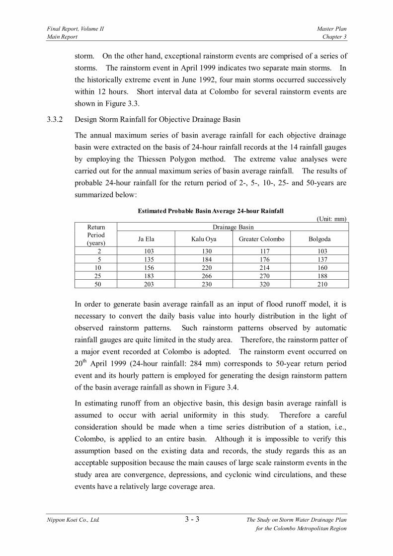
Final Report, Volume II Master Plan Main Report Chapter 3
Nippon Koei Co., Ltd. 3 - 3 The Study on Storm Water Drainage Plan for the Colombo Metropolitan Region
storm. On the other hand, exceptional rainstorm events are comprised of a series of storms. The rainstorm event in April 1999 indicates two separate main storms. In the historically extreme event in June 1992, four main storms occurred successively within 12 hours. Short interval data at Colombo for several rainstorm events are shown in Figure 3.3.
3.3.2 Design Storm Rainfall for Objective Drainage Basin
The annual maximum series of basin average rainfall for each objective drainage basin were extracted on the basis of 24-hour rainfall records at the 14 rainfall gauges by employing the Thiessen Polygon method. The extreme value analyses were carried out for the annual maximum series of basin average rainfall. The results of probable 24-hour rainfall for the return period of 2-, 5-, 10-, 25- and 50-years are summarized below:
Estimated Probable Basin Average 24-hour Rainfall (Unit: mm)
Drainage Basin Return Period (years) Ja Ela Kalu Oya Greater Colombo Bolgoda
2 103 130 117 103 5 135 184 176 137
10 156 220 214 160 25 183 266 270 188 50 203 230 320 210
In order to generate basin average rainfall as an input of flood runoff model, it is necessary to convert the daily basis value into hourly distribution in the light of observed rainstorm patterns. Such rainstorm patterns observed by automatic rainfall gauges are quite limited in the study area. Therefore, the rainstorm patter of a major event recorded at Colombo is adopted. The rainstorm event occurred on 20th April 1999 (24-hour rainfall: 284 mm) corresponds to 50-year return period event and its hourly pattern is employed for generating the design rainstorm pattern of the basin average rainfall as shown in Figure 3.4.
In estimating runoff from an objective basin, this design basin average rainfall is assumed to occur with aerial uniformity in this study. Therefore a careful consideration should be made when a time series distribution of a station, i.e., Colombo, is applied to an entire basin. Although it is impossible to verify this assumption based on the existing data and records, the study regards this as an acceptable supposition because the main causes of large scale rainstorm events in the study area are convergence, depressions, and cyclonic wind circulations, and these events have a relatively large coverage area.
Final Report, Volume II Master Plan Main Report Chapter 3
Nippon Koei Co., Ltd. 3 - 4 The Study on Storm Water Drainage Plan for the Colombo Metropolitan Region
3.4 Flood Runoff and Inundation Analysis
3.4.1 General
The flood runoff and inundation analysis was carried out in order to;
1) Determine the present flood inundation condition, 2) Predict the change in the inundation state due to future land use
development such as urbanization or reclamation of lowlands, and 3) Estimate the effect of proposed structural measures on the flood mitigation.
MIKE11, a one-dimensional (1D) and one-layer flow calculation software package developed by Danish Hydraulic Institute (DHI), comprises a lot of calculation modules such as hydrodynamic (HD), structural operation (SO), rainfall-runoff (RR) and so on. Following are the modules mainly used for this Study:
1) Hydrodynamic Module (HD) for the computation of unsteady flow in channels
2) Structural Operation Module (SO) for the computation of the effect of artificial structures such as weirs, culverts etc.
3) Rainfall Runoff Module (RR) for the computation of runoff from drainage basins
3.4.2 Digital Elevation Model (DEM)
The Digital Elevation Model (DEM) for the study area was assembled from spot levels and contours available on the topographic maps obtained from the Survey Department. Maps of a variety of scales were used and the data were either digitized from paper or sometimes extracted directly from digital data provided by the Survey Department. The results of river cross section surveys and spot level surveys of marshy land boundaries conducted in this Study were also utilized for DEM generation.
These spot levels were converted to DEM using the DEM generation tool of MIKE11 GIS. The DEM grid size is 50 m × 50 m for all basins, and the elevation value of a grid is the distance weighted average of spot level data around it. The DEMs under “Present Land Use Condition” were generated using original spot level data reflecting existing conditions, while those under “Future Land Use Condition” were generated considering reclamation of marshy and paddy areas according to the projection of future (2010) land use condition conducted in the Study.

Final Report, Volume II Master Plan Main Report Chapter 3
Nippon Koei Co., Ltd. 3 - 5 The Study on Storm Water Drainage Plan for the Colombo Metropolitan Region
3.4.3 Channel Network for Hydrodynamic Model
(1) Input Data and Parameters
Main input data for MIKE11 channel network model comprises:
1) Geographical information for the calculation points, i.e., the coordinates (longitude and latitude) of points where discharge (Q) or water level (h) is calculated,
2) Information regarding channel connections, 3) Information regarding structures (weirs, culverts, etc.) such as specifications
or locations, 4) Channel cross section data, and 5) Lateral inflow (to be imported from the basin runoff model).
The channel network model for each objective basin comprises the main streams and major tributaries.
There are two kinds of parameter groups to be considered. One is the parameter group for description of flood phenomenon and the other is for stability of implicit finite difference equations converted from above mentioned two basic equations. A typical parameter for the former group is Manning’s roughness coefficient (n), and for the latter, spatial or temporal steps (∆x or ∆t).
(2) Flood Cells
In order to include the behavior of the flood plain in the hydrodynamic model, “flood cells” are extracted from the generated DEMs and attached to the cross section database of the model. The flood cell is described by the relationship between elevation and inundation area (H-A curve). The flood cells of both present and future land use conditions were extracted from the DEMs of each objective basin.
(3) Boundary Conditions
1) Tidal Levels
According to the Indian and British Tide Tables, tidal variations at Colombo harbor, related to MSL, are given below:
• Lowest Astronomical Tide (L.A.T.) : 0.50 m below MSL • Mean Low Water Springs (M.L.W.S.) : 0.32 m below MSL • Mean Low Water Neaps (M.L.W.N.) : 0.08 m below MSL • Mean Sea Level (M.S.L.) : 0.00 m above MSL • Mean High Water Neaps (M.H.W.N.) : 0.10 m above MSL • Mean High Water Springs (M.H.W.S.) : 0.34 m above MSL • Highest Astronomical Tide (H.A.T.) : 0.50 m above MSL
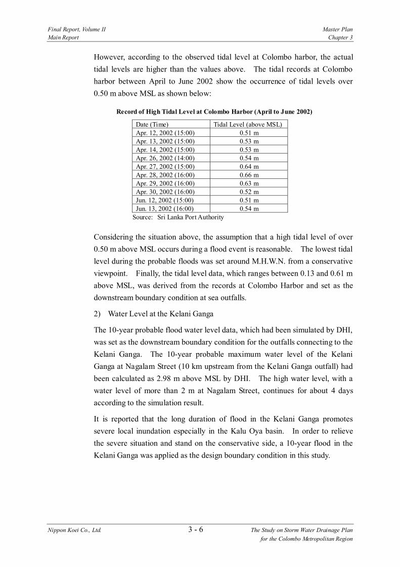
Final Report, Volume II Master Plan Main Report Chapter 3
Nippon Koei Co., Ltd. 3 - 6 The Study on Storm Water Drainage Plan for the Colombo Metropolitan Region
However, according to the observed tidal level at Colombo harbor, the actual tidal levels are higher than the values above. The tidal records at Colombo harbor between April to June 2002 show the occurrence of tidal levels over 0.50 m above MSL as shown below:
Record of High Tidal Level at Colombo Harbor (April to June 2002)
Date (Time) Tidal Level (above MSL) Apr. 12, 2002 (15:00) 0.51 m Apr. 13, 2002 (15:00) 0.53 m Apr. 14, 2002 (15:00) 0.53 m Apr. 26, 2002 (14:00) 0.54 m Apr. 27, 2002 (15:00) 0.64 m Apr. 28, 2002 (16:00) 0.66 m Apr. 29, 2002 (16:00) 0.63 m Apr. 30, 2002 (16:00) 0.52 m Jun. 12, 2002 (15:00) 0.51 m Jun. 13, 2002 (16:00) 0.54 m
Source: Sri Lanka Port Authority
Considering the situation above, the assumption that a high tidal level of over 0.50 m above MSL occurs during a flood event is reasonable. The lowest tidal level during the probable floods was set around M.H.W.N. from a conservative viewpoint. Finally, the tidal level data, which ranges between 0.13 and 0.61 m above MSL, was derived from the records at Colombo Harbor and set as the downstream boundary condition at sea outfalls.
2) Water Level at the Kelani Ganga
The 10-year probable flood water level data, which had been simulated by DHI, was set as the downstream boundary condition for the outfalls connecting to the Kelani Ganga. The 10-year probable maximum water level of the Kelani Ganga at Nagalam Street (10 km upstream from the Kelani Ganga outfall) had been calculated as 2.98 m above MSL by DHI. The high water level, with a water level of more than 2 m at Nagalam Street, continues for about 4 days according to the simulation result.
It is reported that the long duration of flood in the Kelani Ganga promotes severe local inundation especially in the Kalu Oya basin. In order to relieve the severe situation and stand on the conservative side, a 10-year flood in the Kelani Ganga was applied as the design boundary condition in this study.

Final Report, Volume II Master Plan Main Report Chapter 3
Nippon Koei Co., Ltd. 3 - 7 The Study on Storm Water Drainage Plan for the Colombo Metropolitan Region
3.4.4 Basin Runoff Model
(1) Input Data and Parameters
NAM, originally developed by the Technical University of Denmark, is a lumped and conceptual basin runoff model, simulating the overland-, inter-, and base-flow components as a function of the moisture content in four storages, i.e., surface, lower or root zone, ground water, and snow.
There are a lot of parameters to be set in the NAM model, and of them, the following 7 parameters are important for estimating flood runoff from the objective drainage basins. They are constituent elements of the surface and root zone parameter set:
1) Maximum water content in surface storage (Umax) 2) Maximum water content in root zone storage (Lmax) 3) Overland flow runoff coefficient (CQOF) 4) Time constant for interflow (CKIF) 5) Time constant for routing interflow and overland flow (CK12) 6) Root zone threshold value for overland flow (TOF) 7) Root zone threshold value for interflow (TIF)
A function of auto-calibration of the above parameters is available in the MIKE11 RR module. However, since neither water level observations nor discharge measurement records on an hourly basis are available in the study area as mentioned in the section 3.2, those parameters are principally set by an empirical method based on the land surface or land use conditions.
The parameter setting was therefore made introducing the following concepts referring to the past study carried out in 1995 as a part of the “Greater Colombo Flood Control and Environment Improvement Project (Phase I)”, which also utilized MIKE11 and NAM. Land use is classified in four types such as Urbanized, Semi-urbanized, Rural/Paddy and Water/Marsh, considering the hydrological characteristics. A set of NAM parameters is given to a typical basin representing each land use type.
The NAM parameters of sub-catchments are decided as the area-weighted average of above four types of land use condition utilizing GIS information of present and future land use conditions prepared in this Study.
(2) Model Calibration
The validity of hydrological-hydraulic models was examined in the Greater Colombo basin. The reasons why this basin was selected for model calibration are 1) hourly rainfall records are available from an automatic rainfall gauging station in this basin, 2) the basin scale is relatively small and the rainfall pattern of one rainfall station is
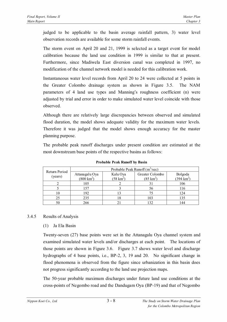
Final Report, Volume II Master Plan Main Report Chapter 3
Nippon Koei Co., Ltd. 3 - 8 The Study on Storm Water Drainage Plan for the Colombo Metropolitan Region
judged to be applicable to the basin average rainfall pattern, 3) water level observation records are available for some storm rainfall events.
The storm event on April 20 and 21, 1999 is selected as a target event for model calibration because the land use condition in 1999 is similar to that at present. Furthermore, since Madiwela East diversion canal was completed in 1997, no modification of the channel network model is needed for this calibration work.
Instantaneous water level records from April 20 to 24 were collected at 5 points in the Greater Colombo drainage system as shown in Figure 3.5. The NAM parameters of 4 land use types and Manning’s roughness coefficient (n) were adjusted by trial and error in order to make simulated water level coincide with those observed.
Although there are relatively large discrepancies between observed and simulated flood duration, the model shows adequate validity for the maximum water levels. Therefore it was judged that the model shows enough accuracy for the master planning purpose.
The probable peak runoff discharges under present condition are estimated at the most downstream base points of the respective basins as follows:
Probable Peak Runoff by Basin
Probable Peak Runoff (m3/sec) Return Period (years) Attanagalu Oya
(800 km2) Kalu Oya (58 km2)
Greater Colombo (85 km2)
Bolgoda (394 km2)
2 105 2 31 106 5 157 3 56 116 10 192 13 75 124 25 235 18 103 135 50 266 21 132 144
3.4.5 Results of Analysis
(1) Ja Ela Basin
Twenty-seven (27) base points were set in the Attanagalu Oya channel system and examined simulated water levels and/or discharges at each point. The locations of those points are shown in Figure 3.6. Figure 3.7 shows water level and discharge hydrographs of 4 base points, i.e., BP-2, 3, 19 and 20. No significant change in flood phenomena is observed from the figure since urbanization in this basin does not progress significantly according to the land use projection maps.
The 50-year probable maximum discharges under future land use conditions at the cross-points of Negombo road and the Dandugam Oya (BP-19) and that of Negombo

Final Report, Volume II Master Plan Main Report Chapter 3
Nippon Koei Co., Ltd. 3 - 9 The Study on Storm Water Drainage Plan for the Colombo Metropolitan Region
road and the Ja Ela (BP-20) were calculated at 197 m3/sec and 70 m3/sec, respectively.
Figure 3.8 shows the simulated flood inundation area for 2-, 10- and 50-year probable floods both under present and future land use conditions. Flood inundation area is summarized by each land use category in Table 3.1. There is no significant change in inundation area for any land use category.
(2) Kalu Oya Basin
Seventeen (17) base points were set in the Kalu Oya basin as presented in Figure 3.9. Water level and discharge hydrographs of the 50-year probable flood at 4 base points, i.e., BP-1, 2, 8 and 13, are illustrated in Figure 3.10. Both water level and discharge increase significantly as a result of basin-wide urbanization and large scaled reclamation. At the downstream base point BP-13, maximum flood water level increases more than 10 cm for every probable flood, and more than 30 cm increase is observed for the 2-year probable flood. Maximum flood discharge also increases more than 40% in each probable flood.
Figure 3.11 shows the simulated flood inundation area for 2-, 10- and 50-year probable floods both under present and future land use conditions. A summary of inundation area by land use category is listed in Table 3.1. Total inundation area is to be reduced due to the land reclamation along the proposed Outer Circular Highway, however that of the urbanized area and semi-urbanized area increases due to the reclamation and urbanization.
(4) Greater Colombo Basin
Twenty-five (25) base points were set in the Greater Colombo basin as seen in Figure 3.12. Water level and discharge hydrographs of the 50-year probable flood for 4 base points, i.e., BP-22, 17, 18 and 19, are illustrated in Figure 3.13. The 50-year probable maximum flood discharge at Welawatta (BP-19) and Dehiwala (BP-20) outfalls are 55 m3/sec and 31 m3/sec, respectively under future land use conditions, while they are 49 m3/sec and 29 m3/sec respectively under present land use conditions. Water level increases 7 to 14 cm. The increase in water level and discharge is caused by urbanization.
Figure 3.14 shows the simulated flood inundation area for 2-, 10- and 50-year probable floods both under present and future land use conditions. Summarized inundation area by land use category is shown in Table 3.1. The inundation area of the built-up area and semi-urbanized area increase significantly.

Final Report, Volume II Master Plan Main Report Chapter 3
Nippon Koei Co., Ltd. 3 - 10 The Study on Storm Water Drainage Plan for the Colombo Metropolitan Region
(4) Bolgoda Basin
Thirty (30) base points were set in the Bolgoda basin as shown in Figure 3.15. Figure 3.16 shows the 50-year probable water level and discharge hydrographs at 4 base points, i.e., BP-9, 19, 20 and 30. Water level and discharge at Weras Ganga outfall (BP-9) increases significantly due to urbanization and land reclamation. There are no significant changes in flood characteristics except for the Weras Ganga basin (northwestern part of Bolgoda basin).
probable floods both under present and future land use conditions. Summarized inundation area by land use category is shown in Table 3.1. Although total inundation area is reduced due to the land reclamation in the Weras Ganga basin, the inundation area of built-up and semi-urbanized areas increases.

Final Report, Volume II Master Plan Main Report Chapter 4
Nippon Koei Co., Ltd. 4 - 1 The Study on Storm Water Drainage Plan for the Colombo Metropolitan Region
CHAPTER 4 FORMULATION OF MASTER PLAN
4.1 Socio-economic Framework
4.1.1 General
For the present study, the CMR Structure Plan (CMRSP) is closely related to the setting of socio-economic conditions such as population, economy, land use, properties, etc. in the future. Basic policy of the CMRSP is to ease the urbanization pressure in the Core Area defined as the existing urban area of Colombo Municipality and surrounding area to Growth Centers outside the Core Area. For setting the macro frame, development policy in the CMRSP and other indicators are used.
4.1.2 Population Framework
Since CMR is a center of economic and social activities, urbanization in the study area is expected to continue and the population is expected to grow. The population framework of the urban area in the CMR is proposed in the CMRSP. The population growth rate is estimated to be 2.4%, which is higher than the CMR average of 1.4%. This rate is even higher than the rate for the study area for the period of 1981-1994 when it was 1.7%. The population of the CMR is expected to reach 6.5 million in 2010 or 1.2 times of the 2001 population of 5.3 million. The percentage of the population living in urban areas is the highest in Colombo District with 94% followed by 64% for Gampaha District and 47% for Kalutara District. Table 4.1 shows the estimated population of core areas and urban centers in the CMR for 2005 and 2010.
The estimate for the population in the study area in 2010 is from the CMRSP and the area coverage of the study area in the CMR mentioned in the section 1.2 Administrative Division. The population of the study area in 2010 is estimated to be 4.18 million composed of 2.43 million for Colombo District, 1.23 million for Gampaha District, 0.52 million for Kalutara District.
Estimated Population of CMR and Study Area in 2010
District
Projected Population
(CMR) (million)
Urban Population
(CMR) (million)
Urban Population
(%)
Rural Population
(CMR) (million)
Rural Population
(%)
Study Area Population (million)
Colombo 2.73 2.57 94 0.16 6 2.43 Gampaha 2.53 1.62 64 0.91 36 1.23 Kalutara 1.24 0.58 47 0.66 53 0.52 Total 6.50 4.77 74 1.73 26 4.18
Source: CMRSP, 1997, Urban Development Authority
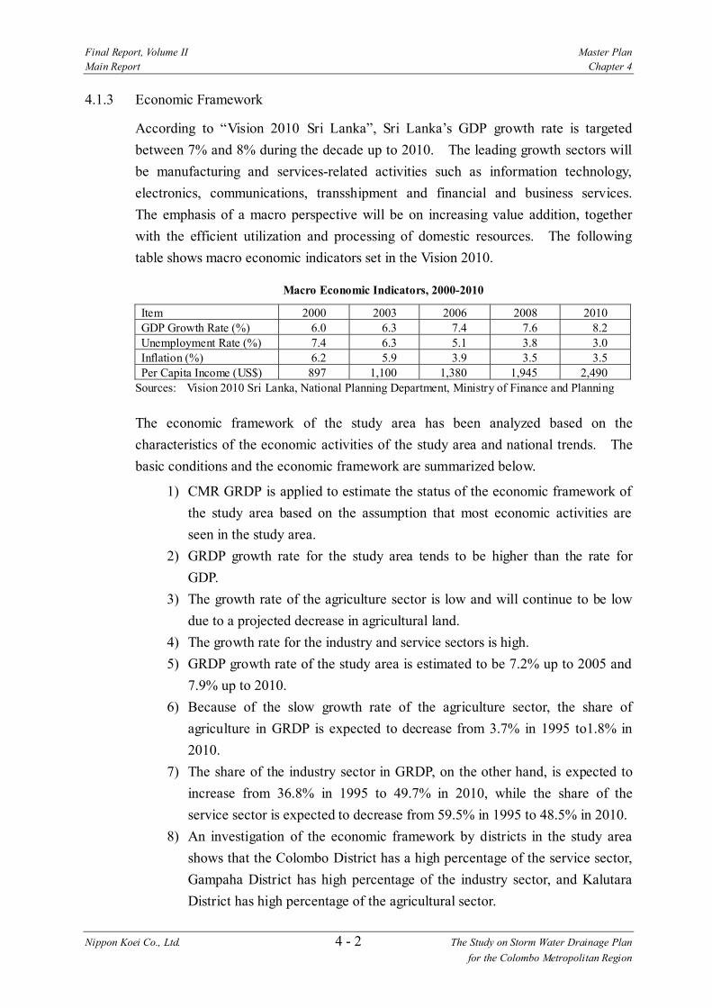
Final Report, Volume II Master Plan Main Report Chapter 4
Nippon Koei Co., Ltd. 4 - 2 The Study on Storm Water Drainage Plan for the Colombo Metropolitan Region
4.1.3 Economic Framework
According to “Vision 2010 Sri Lanka”, Sri Lanka’s GDP growth rate is targeted between 7% and 8% during the decade up to 2010. The leading growth sectors will be manufacturing and services-related activities such as information technology, electronics, communications, transshipment and financial and business services. The emphasis of a macro perspective will be on increasing value addition, together with the efficient utilization and processing of domestic resources. The following table shows macro economic indicators set in the Vision 2010.
Macro Economic Indicators, 2000-2010
Item 2000 2003 2006 2008 2010 GDP Growth Rate (%) 6.0 6.3 7.4 7.6 8.2 Unemployment Rate (%) 7.4 6.3 5.1 3.8 3.0 Inflation (%) 6.2 5.9 3.9 3.5 3.5 Per Capita Income (US$) 897 1,100 1,380 1,945 2,490
Sources: Vision 2010 Sri Lanka, National Planning Department, Ministry of Finance and Planning
The economic framework of the study area has been analyzed based on the characteristics of the economic activities of the study area and national trends. The basic conditions and the economic framework are summarized below.
1) CMR GRDP is applied to estimate the status of the economic framework of the study area based on the assumption that most economic activities are seen in the study area.
2) GRDP growth rate for the study area tends to be higher than the rate for GDP.
3) The growth rate of the agriculture sector is low and will continue to be low due to a projected decrease in agricultural land.
4) The growth rate for the industry and service sectors is high. 5) GRDP growth rate of the study area is estimated to be 7.2% up to 2005 and
7.9% up to 2010. 6) Because of the slow growth rate of the agriculture sector, the share of
agriculture in GRDP is expected to decrease from 3.7% in 1995 to1.8% in 2010.
7) The share of the industry sector in GRDP, on the other hand, is expected to increase from 36.8% in 1995 to 49.7% in 2010, while the share of the service sector is expected to decrease from 59.5% in 1995 to 48.5% in 2010.
8) An investigation of the economic framework by districts in the study area shows that the Colombo District has a high percentage of the service sector, Gampaha District has high percentage of the industry sector, and Kalutara District has high percentage of the agricultural sector.

Final Report, Volume II Master Plan Main Report Chapter 4
Nippon Koei Co., Ltd. 4 - 3 The Study on Storm Water Drainage Plan for the Colombo Metropolitan Region
Economic Framework of the Study Area
Sector Growth Rate (2001-05) (%)
Growth Rate (2006-10) (%)
GRDP (Rs. million)
Sector Share (%)
Agriculture 1.6 1.6 10,765 1.8 Industry 9.9 10.9 305,497 49.7 Service 6.3 7.0 298,621 48.5 CMR GRDP - - 614,883 100.0
Note: Estimated by JICA Study Team
Economic Framework of the Study Area by Districts
(Unit: Upper Rs. million, (Lower %)) District Agriculture Industry Service District GRDP Colombo 1,601
(14.9) 109,262
(35.8) 152,691
(51.4) 263,553
Gampaha 3,945 (36.6)
150,376 (49.2)
95,851 (32.1)
250,173
Kalutara 5,219 (48.5)
45,859 (15.0)
50,080 (16.8)
101,158
Sector GRDP 10,765 (100.0)
305,497 (100.0)
298,621 (100.0)
614,883
Note: Estimated by JICA Study Team
4.1.4 Future Properties
(1) Land Value
In the past 10 years, the rate of increase has varied between high in the early 1990s and low in the late 1990s. The average increase rate for the period of 1990 to 1995 was 5% and that for the period of 1996 to 2001 was 4%. Since high inflation is not expected until 2010, the value in 2010 is estimated based on the past trend. The table below shows the expected land values in 2010.
Average Land Value by Land Use in 2010 (Unit: Rs./m2)
Residential Area Commercial Area District High Low High Low Colombo 19,192 1,556 50,309 16,491 Gampaha 7,568 503 11,475 4,195 Kalutara 3,125 230 11,580 5,307
Note: Estimated by JICA Study Team (2) Residential and Commercial Values
The residential and commercial values are derived from construction cost and the size of the building. The values in 2010 are estimated based on economic growth for which 7.2% is applied. The method of estimating property value is discussed in the section 8.1 Economic Evaluation.

Final Report, Volume II Master Plan Main Report Chapter 4
Nippon Koei Co., Ltd. 4 - 4 The Study on Storm Water Drainage Plan for the Colombo Metropolitan Region
1) Residential value
The residential value for houses and household property is estimated for three house types. The future value is derived by applying a 7.1% growth rate to the present value.
Household Property in 2010
Group Average Value of Houses (Rs.)
Household Property Value (Rs.)
Group 1 57,951 17,387 Group 2 925,731 277,719 Group 3 1,869,574 560,873
Note: Estimated by JICA Study Team Group 1 Temporary: temporary house made of wood or mud in the main Group 2 Permanent (medium): permanent house made of cement (average quality and
medium floor area) Group 3 Permanent (large): permanent house made of cement (better material and large
floor area)
2) Commercial value
The value of commercial property is estimated for shops, offices and factories, which is estimated from the information provided by ICTAD and an insurance company. Future value is derived by using the same method as for household value.
Value for Shops and Offices (Unit: Rs.)
Item 2001 2010 Building 1,421,775 2,658,177 Facility*1 853,065 853,065
Note: *1: 50% of value of building
4.1.5 Alternative Scenarios for Socio-economic Frame
A storm water drainage master plan will be proposed by the Study based on socio-economic conditions projected at some future date, which will also be the basis of evaluating projects to be proposed by the Study. The CMRSP provides the projected socio-economic conditions that will be realized with the proposed development projects to be implemented. Therefore, the study will follow the socio-economic conditions projected by CMRSP in principle.
The CMRSP was prepared in 1996 targeting its realization by the year 2010. At the present time in 2002, it appears that this target year would be too near to complete the numbers of the proposed development projects such as the detail planning and implementation of urban development for one Core Area and six Growth Centers.
As for the storm water drainage master plan to be processed, it will include various projects to attain a certain flood safety level for the four subject basins. One
Final Report, Volume II Master Plan Main Report Chapter 4
Nippon Koei Co., Ltd. 4 - 5 The Study on Storm Water Drainage Plan for the Colombo Metropolitan Region
proposed project would require several years for implementation and also a large investment. Therefore, the year 2010 would also be too near to realize the entire storm water drainage master plan to be proposed in the Study.
The Study will therefore consider the following alternative scenarios to identify a realistic implementation:
1) Basic Scenario: Realization of the future socio-economic conditions projected based on CMRSP by 2010
2) Alternative Scenarios: Delay in realization of the future socio-economic conditions till 2015 or 2020
4.2 Future Land Use Pattern
4.2.1 Future Projects
Future projects are one of the driving forces that determine the future pattern of land use. The projects were investigated by collecting materials and interviewing key informants of the relevant organizations, such as UDA and CEA. The following seven projects are identified in the course of the first fieldwork of the Study:
1) Werisala Warehouse Project; 2) Peliyagoda Project; 3) Mudun Ela Development Project; 4) Wedamulla Project - Stage II; 5) Muthurajawela and Negombo Lagoon Project; 6) Kaduwela- Kolonnawa Development Scheme; and 7) Outer Circular Highway Project
The locations of the projects are concentrated in the northern part of the Colombo area, especially in the Kalu Oya catchment area, where newly constructed roads are supposed to pass through.
4.2.2 UDA Declared Areas
The prospects for the UDA declared area is very useful information for considering future urban sprawl. Table 4.2 shows the list of UDA declared areas at the present. All the Colombo District, some parts of the Gampaha District, and some urban Council areas in Kalutara District have already been declared as UDA areas. The areas for future declaration are listed below:
1) Gampaha District • Seeduwa-Katunayake Urban Council • Wattala Urban Council • Peliyagoda Urban Council

Final Report, Volume II Master Plan Main Report Chapter 4
Nippon Koei Co., Ltd. 4 - 6 The Study on Storm Water Drainage Plan for the Colombo Metropolitan Region
• Veyangoda urban area • Nittamubuwa-Watupitiwela urban area • Kiribathgoda urban area • Biyagama urban area • Ja-Ela Pradeshiya Sabha
2) Kalutara District • Amalgamation of Maradagahamula, Dunagaha and Badalgama urban
areas to the declared area of Divulapitiya • Amalgamation of Mirigama industrial area to the declared area of
Mirigama Pradeshiya Sabha
4.2.3 Driving Forces of Land Use Change
Several driving forces were considered for the change of land use in each category such as built-up areas, paddy land, and marshy areas. Urban sprawl, which means the expansion of built-up areas, could be conditioned by three factors, such as planning factor, population density factor, transportation factor and limiting factor as described hereafter.
(1) Planning Factor
Planning factors determine which areas the planning authority on land use thinks should be developed. In Sri Lanka, UDA is primarily responsible for this matter. Therefore, designation as a UDA development area is one of the indicators for urban sprawl. Core Areas that are planned in the Colombo Metropolitan Regional Structure Plan are also good information sources for considering the future built-up areas. Future project sites are described in the sub-section 4.2.1. The following spatial extents were considered for determining future sprawl areas.
1) The spatial extent of the Core Area which has been described in the Colombo Metropolitan Regional Structure Plan;
2) The spatial extent of the UDA development areas; 3) The areas of future projects which have been mentioned in the sub-section
4.2.2
(2) Population Density Factor
According to the Colombo Metropolitan Regional Structure Plan, the population density of the core area was planned for 100 persons per ha. This figure is equal to the density of population in 1994 in the three DS Divisions of Colombo, Kolonnawa and Nugegoda, which were already built-up areas in 1994. Therefore, population density with 100 persons/ha could be regarded as the criteria for determining the urban built- up area.
Final Report, Volume II Master Plan Main Report Chapter 4
Nippon Koei Co., Ltd. 4 - 7 The Study on Storm Water Drainage Plan for the Colombo Metropolitan Region
(3) Transportation Factor
Transportation is a factor that determines the direction of urban sprawl. In the Colombo Metropolitan Area, there is a railway that extends in the directions of north, south, and northeast. Also, major roads such as Colombo-Negombo Road, Galle Road, Colombo-Kandy Road, Colombo-Horana Road, Low-level road, extend in the directions of north, south, northeast, southeast, and east. Buffers along the transportation route would also be important factors for considering the expansion of the built up area. It is observed in Japan that, within an area 1 km wide along the newly constructed roads and interchanges, there is observed an increase of land value, representing the growth of potential of the land. It takes a decade to fulfil the potential value of land triggered by the construction of infrastructure. It is expected that the same situation will occur in Sri Lanka, although there is no empirical data that supports this phenomenon.
(4) Limiting Factor
A limiting factor for considering urbanization is the area reserved for environmental reasons. From the fieldwork in Sri Lanka, three sanctuary areas, such as the Muthurajawela Sanctuary, the Sri Jayawardenapura Kotte Sanctuary, and the Bellanwila-Attidiya Marsh Sanctuary were identified. These areas are not to be converted into urbanized use.
Abandoned paddy land could be regarded as a source of supply for urbanized land use. By overlaying the map of future project areas and urban sprawl areas onto the abandoned paddy lands, paddy lands that might be converted into the urbanized use were identified. As for the marshy area, only landfilling triggered by the construction of highways, and the Muthurajawela project area were considered.
4.2.4 Future Land Use Pattern
Figure 4.1 shows the spatial distribution of future land use patterns in the study area in the year 2010. According to the results, urbanization will progress rapidly in the areas of the Kalu Oya basin and the Kelani basin.
In this study, land use categories in the study area are broadly classified into a) urban, b) semi-urban, c) rural, d) paddy, and e) marsh. The percentage of built up areas, which is represented by the sum of both categories of urban and semi-urban, is supposed to be increased in Kalu Oya basin and Kelani basin, from the present level of 18.6% and 19.8%, to 62.2 % and 57.5 % respectively. These values exceed the level of the Greater Colombo basin, which is 56.9 %. In terms of change of paddy lands, the percentage occupied is on the decline in areas of the Ja Ela and Kalu Oya basins, and decreases from 24.3% to 23.7%, and from 16.7% to 14.3% respectively.
Final Report, Volume II Master Plan Main Report Chapter 4
Nippon Koei Co., Ltd. 4 - 8 The Study on Storm Water Drainage Plan for the Colombo Metropolitan Region
The percentage of marshy land in the Kalu Oya basin shows a sharp decline from 2.5% to 1.0%, which is triggered by the several projects.
Land Use Distribution by Basin
(Unit: %)
Basin Status Urban Semi- Urban Paddy Marsh Water Rural
Ja-Ela Basin Present 5.1 2.9 24.3 7.1 0.1 60.5 (17,485 ha) Future 8.0 11.8 23.7 7.1 0.1 49.4 Kalu Oya Basin Present 6.6 12.0 16.4 2.5 0.0 62.5 (6,066 ha) Future 16.3 45.9 16.0 1.0 0.0 20.7 Kelani Basin Present 7.2 12.6 16.7 1.4 1.8 60.4 (7,977 ha) Future 16.7 40.8 14.3 1.3 1.8 25.2 Greater Colombo Basin Present 21.4 15.5 8.5 4.3 0.1 50.2 (9,072 ha) Future 33.1 23.8 8.3 4.3 0.1 30.4 Bolgoda Basin Present 2.8 5.7 17.1 0.3 3.4 70.7 (40,116 ha) Future 10.1 16.7 16.2 0.3 3.4 53.4 Total Present 6.1 7.3 17.6 2.5 1.9 64.6 (80,716 ha) Future 13.3 21.0 16.7 2.4 1.9 44.7 Note: Estimated by JICA Study Team
4.3 Planning Scale and Comprehensive Master Plan
4.3.1 Targeted Planning Scale
Planning scale is generally indicated using a rainstorm event return period and also gives a safety level against such a flood caused by said rainstorm in an objective river basin. The planning scale is decided on the basis of ‘degree of importance’ of the river in view of flood control, which is evaluated mainly from the following:
1) Scale of the river 2) Socio-economic importance of the area to be protected against flood 3) Direct and indirect damages anticipated by flooding 4) Historical records of flood disasters
From the above, the planning scale would be different for different rivers. It is therefore necessary to consider a balance of planning scale among different river basins in a country. A Japanese guideline suggests the degree of importance of a river and a corresponding planning scale as follows:

Final Report, Volume II Master Plan Main Report Chapter 4
Nippon Koei Co., Ltd. 4 - 9 The Study on Storm Water Drainage Plan for the Colombo Metropolitan Region
Importance of River and Planning Scale for Flood Control Master Plan
Degree of Importance
Description Planning Scale (Return Period)
A 200 years or More B
Important stretches in large scale rivers 100 – 200 years
C Stretches of large scale rivers other than A or B above Middle scale rivers Rivers in urban areas
50 – 100 years
D 10 – 50 years E
Small scale rivers Tributaries 10 years or Less
Source: Guidelines for River and Sabo Works, Ministry of Land, Infrastructure and Transport, Japan
In a river basin, a balance of planning scale should be maintained between upper and lower reaches as well as between main streams and tributaries in view of consistency in planning scales for the entire basin. When a planning scale is applied for a main stream in lower reaches, an equivalent or lower planning scale is given for that main stream in its upper reaches. Planning scales for tributaries are lower than that for main streams.
Basic Concept of Planning Scale (Example)
For the study area, the Kelani Ganga Flood Protection Scheme indicates an example of planning scale applied for a large river system in Sri Lanka. The basin area of the Kelani Ganga is 2,292 km2 and the flood protection levels by existing bunds in the downstream reaches were evaluated for a 500-year return period on the left bank and for a 50-year return period on the right bank. These flood protection levels would suggest the planning scales for the neighboring basins related to the study area. The degree of importance of the Kelani Ganga may be evaluated as A or B. The others are evaluated as follows based on a relative comparison with the Kelani Ganga:
①
②
③③
④
④
①
②
③
④
Mainstream (Lower Reaches)100-200 Year
Mainstream (Upper Reaches)50-100 Year
Tributary10-50 Year
Urban Drainage5-10 Year
Main Stream (Lower Reaches) 100 - 200 Year
Main Stream (Upper Reaches) 50 - 100 Year
Urban Drainage 5 - 10 Year
Tributary 10 - 50 Year
Final Report, Volume II Master Plan Main Report Chapter 4
Nippon Koei Co., Ltd. 4 - 10 The Study on Storm Water Drainage Plan for the Colombo Metropolitan Region
Degree of Importance of Basins Relevant to the Study Area
Basin Scale of
Basin Area (km2)
Characteristics of Area to be Protected
Suggested Degree of
Importance Kelani Ganga 2,292 Urbanizing areas (right bank)
Highly urbanized and socio-economic center of the country (left bank)
A or B
Ja Ela 860 Limited urbanizing areas in the downstream reaches and mostly rural areas in the middle and upstream reaches
C
Kalu Oya 60
Urbanizing areas in the entire basin C or D
Greater Colombo 86 Highly urbanized areas and socio-economic center of the country
C or D
Bolgoda 467 Limited urbanizing areas in the north and mostly rural areas in the other parts of the basin
C
From the suggested degree of importance above, the planning scale of a 50-year return period, which is the same as recommended by the Colombo Metropolitan Regional Structure Plan (CRMSP), would be reasonable for the basin-wide storm water drainage plan for the basins relevant to the study area.
The flood safety level accomplished by the completion of GCFC&EIP Phase I gives a suggestion to decide a planning scale for the study. The present safety level of the main canals in the Greater Colombo basin was evaluated in the range of a 5-year to 25-year return period. Substantial improvement was accomplished by GCFC&EIP Phase I but further improvement should also be considered in order to cope with economic growth in the basin and the increase of social requirements for flood protection in the future. Provision of a higher planning scale is therefore necessary for the storm water drainage plan.
A large-scale flood event experienced in the past was also taken into consideration for application of planning scale. It is a usual practice to determine a planning scale based on the actual experienced rainstorm event that caused basin-wide damages. The recent major events occurred in 1992 and 1999 in the study area. Of those, the 1992 event was exceptionally large and is regarded to be beyond any measures for protection while the return period of the second largest event in 1999 was evaluated around 40-year. To prevent the same scale flooding, the planning scale of a 40-year return period or more should be applied.
As a conclusion of the points discussed above, a planning scale of a 50-year return period is reasonable as the long-term target for the basin-wide master plan in the study area.
Final Report, Volume II Master Plan Main Report Chapter 4
Nippon Koei Co., Ltd. 4 - 11 The Study on Storm Water Drainage Plan for the Colombo Metropolitan Region
4.3.2 Options of Planning Scale
The study proposes the planning scale of a 50-year return period for the basin-wide master plan for storm water drainage in the study area on the basis of the engineering considerations as described above. However, the planning scale is one of the fundamental subjects to determine a policy of flood management for the future and the final decision will be made by the government in compliance with various administrative issues in the country.
For the decision-making by the government, the study presents several options of planning scale for comparative examination. The following options of planning scale are to be taken into consideration:
1) 50-year Return Period 2) 25-year Return Period 3) 10-year Return Period
The planning scale of a 50-year return period is a basic option proposed by the study. The lower return period is the option for reducing the total investment of structural measures. The possibility of a rainstorm event exceeding the planning scale becomes higher as the lower return period is applied. Floods exceeding the planning scale are beyond control under the storm water drainage measures provided and bring widespread damage by inundation. To alleviate the damages, non-structural measures are required on the premise that widespread inundation occurs in the case of a rainstorm event exceeding the planning scale.
The study indicates storm water drainage measures including structural and non- structural measures for the respective options and an evaluation of their viability.
4.3.3 Basic Concept of Comprehensive Storm Water Drainage Plan
The study envisages formulating a comprehensive storm water drainage plan integrating structural and non-structural measures. A conceptual diagram of the comprehensive storm water drainage plan is illustrated below:

Final Report, Volume II Master Plan Main Report Chapter 4
Nippon Koei Co., Ltd. 4 - 12 The Study on Storm Water Drainage Plan for the Colombo Metropolitan Region
Concept of Comprehensive Storm Water Drainage Plan
In compliance with the present conditions discussed in the previous chapters, the conceivable structural and non-structural measures for the study are identified as follows:
(1) Structural Measures
1) Improvement of main drainage system
Improvement of the main drainage system is a fundamental measure for the basin-wide storm water drainage plan, including improvement of the main streams and drainage channels and construction of diversion facilities. Plans for improvement of the main drainage system are based on analyses on the storm water runoff regime and potential flood damage in an objective basin.
2) Storm water retention areas
Storm water drainage in urbanized areas employing solely river and drainage channel improvement is not only extremely costly but also causes immense effects on natural and social environments. Therefore, it is realistic to incorporate storm water retention areas with the storm water drainage plan.
In the study area, it is expected that existing marsh and lowlands are to be utilized as storm water retention areas. The GCFC&EIP planned that approximately 380 ha of marsh and lowland should be reserved as storm water areas. However, piecemeal reclamation is occurring both legally and illegally
River Management
Measures Co
mpr
ehen
sive
Stor
m W
ater
Dra
inag
e Pla
n
Basin Management
Measures
Other Measures
・River Channel Improvement
・Diversion Channel ・Pumping Station
・Retention Areas ・Regulating Ponds ・Temporary
Retention Facilities
・Permeable Pavement ・Infiltration Gutters ・Piped Infiltration
Drains ・Infiltration Ponds
Stru
ctur
al M
easu
res
Non
-Stru
ctur
al M
easu
res
Runoff Reduction
Flood Plain Management
・Flood Forecasting, Warning and Evacuation System
・Flood Preparedness and ・Flood Hazard Mapping
Storm Water Retention Facilities
Infiltration Facilities
・Land Use Restriction ・Water Proof Buildings

Final Report, Volume II Master Plan Main Report Chapter 4
Nippon Koei Co., Ltd. 4 - 13 The Study on Storm Water Drainage Plan for the Colombo Metropolitan Region
because of the lack of clear enforcing administrative capabilities. There are opinions to reduce storm water retention areas by partially switching from storm water retention to construction of sea outfalls or pumping stations.
The study attempts to secure water retention areas for the future, by clearly defining a required extent (nature reserves and development areas that are designated to be flood plains in case of flooding, etc.) that is in concert with other basin development plans after carefully considering the various demands apparent in this background.
3) Construction of facilities for storm water runoff reduction
The study proposes basic principles for subsequent studies on urban drainage improvement in the light of present and future urbanization by basin. It is pointed out that the urban drainage schemes have been studied and implemented mainly based on the channel improvements likely to be constrained by urbanized condition.
To resolve such constraints, temporary storm water retention facilities need to be introduced to urban systems in highly urbanized areas. The utilization of existing open lands such as playgrounds, parks, school compounds, etc. for temporary storm water retention areas is a conceivable measure for preventing local inundation caused by rapid concentration of storm water runoff to the drainage channels. New land development in the basin should also be subject to this measure to reduce storm water runoff from development areas by provision of storm water retention facilities.
(2) Non-Structural Measures
1) Management of marsh and lowland
There are large expanses of marsh and lowlands in the study area, which have large storm water retention effects. However, due to the reclamation of marsh and lowlands for development housing and industrial estates following the recent rapid expansion of the urbanizing areas, the storm water retention effects of the marshes and lowlands have declined.
It is both technically and financially difficult to replace the storm water retention effects of marshes and lowlands with other structural riparian works. Therefore, it is imperative for storm water drainage that the existing marshes and lowlands should be properly conserved as storm water retention areas. Legal means of restraining the reclamation will be analyzed.

Final Report, Volume II Master Plan Main Report Chapter 4
Nippon Koei Co., Ltd. 4 - 14 The Study on Storm Water Drainage Plan for the Colombo Metropolitan Region
2) Development control and land use regulation
Land use regulation is an important issue to harmonize the storm water drainage and the need for land development in the CMR. A study will be conducted to prepare a future land use plan including urbanization controlling areas, conservation areas, green areas for storm water retention, etc. for the purpose of regulating disordered land development adversely affecting storm water drainage.
3) Disaster preparedness
The study will also focus on disaster preparedness in case that a rainstorm would exceed the design scale of the structural measures. It is also necessary to consider the preparedness before provision of structural measures since it will take a long period to implement structural measures throughout the study area. The following will be the main items of non-structural measures to be studied and proposed through assessment of the present disaster preparedness system in Sri Lanka:
• Clarification of possible inundation areas from an inundation hazard map • Introduction of ‘pilot type’ housing in possible inundation areas • Institutional arrangements for establishment of a flood preparedness
system
(3) Institutional Development Plan
A comprehensive institutional set-up of interrelated organizations will be required for effective performance of integrated flood control including both structural and non- structural measures. A basic concept of such an institutional set-up is recommended through review of present roles and responsibilities of different organizations concerned with project implementation and O&M works relating to flood protection and storm water drainage.
(4) Operation and Maintenance Plan
An operation and maintenance plan for storm water drainage systems in the study area will be prepared based on the study on the present operation and maintenance systems of SLLRDC and local authorities. The plan mainly consists of the following:
1) Strategy for operation and maintenance 2) Organizational set-up with staff arrangement 3) Financial management 4) Equipment plan 5) Staff training plan

Final Report, Volume II Master Plan Main Report Chapter 4
Nippon Koei Co., Ltd. 4 - 15 The Study on Storm Water Drainage Plan for the Colombo Metropolitan Region
(5) Human Resources Development Plan
The storm water drainage projects are being implemented mainly around the city of Colombo but will be evolved to the suburbs. Capacity building for project implementation and operation and maintenance of storm water drainage facilities is a key issue for SLLRDC as well as local authorities. The present main problem on this issue is the insufficiency of human resources managing storm water drainage in local authorities.
As a short-term objective, on-the-job training under the leadership of SLLRDC is regarded as a practical method for improving the capability of local authorities. The study proposes strengthening the leadership of SLLRDC to implement effective training programs for local authorities.
The study also focuses on a comprehensive program to train engineers and technicians in the sector of storm water drainage. Such a program is recommended as a long-term objective.
4.4 Ja Ela Basin
4.4.1 Basic Principle for Planning
In the Ja Ela downstream basin, there are two main streams i.e. Dandugam Oya and Ja Ela. Problems of flooding of the main streams to the downstream urban areas along these rivers are relatively small, suggested by the following characteristics of the basin:
1) Paddy lands extending from Ekala to Gampaha in the middle basin are naturally functioning as flood retention areas, which effect to reduce flood peak runoff to the downstream reaches.
2) The Muthurajawela Marsh is the major flood plain in the downstream end and retards flood runoff in vast wetlands where significant raising of water level is not expected.
3) The urbanized areas are located between the above-mentioned paddy lands and Muthurajawela Marsh. The combined effects of the upstream paddy lands and downstream wetlands contribute to alleviating a high concentration of flood runoff of the rivers.
The future land use projection indicates that the urbanization in the basin will proceed mainly along the Negombo Road and at a few inland locations such as Gampaha and Minuwangoda. In the light of the projection, a significant increase of storm water runoff of the main streams is not expected within the time-scale to the target year 2010.
Final Report, Volume II Master Plan Main Report Chapter 4
Nippon Koei Co., Ltd. 4 - 16 The Study on Storm Water Drainage Plan for the Colombo Metropolitan Region
On the other hand, the Colombo-Katunayake Expressway (CKE) is being constructed in parallel with the Negombo Road. The route of CKE runs along the Muthurajawela Marsh and crosses the two main streams of the basin. The necessary openings for storm water drainage across the CKE have already been studied and should therefore be taken into consideration for the storm water drainage plan.
The storm water drainage plan for the Ja Ela basin is therefore proposed to protect the future urbanized areas along the Negombo Road by means of the following principles:
1) The capacities of the two main streams in the downstream areas should be preserved to secure a required flow capacity for attaining the designated planning scale into the future.
2) The paddy lands in the middle basin presently functioning as a storm water retention area should be conserved to the extent required for the future.
3) The Muthurajawela Marsh should be conserved as a flood plain to maintain the natural flood retarding capacity for the storm water runoff of the main streams.
4.4.2 Basic Flood Runoff
The basic flood runoffs in the Ja Ela basin for probable 10, 25, and 50-year rainstorm events under the future land use conditions are estimated for several base points along the river channel as shown in Figure 4.2. In comparison with the estimated flood runoff with the basin retention effect as shown in Figure 4.3, the peak runoffs of basic floods increase by 41% for a 10-year return period, 69% for a 25-year storm, and 87% for a 50-year storm in the Dandugam Oya at Negombo Road. Figures 4.4 and 4.5 show the comparison of flood hydrographs in the Dandugam Oya at Negombo Road and the Ja Ela at Negombo Road.
Comparison of Flood Discharge with and without Basin Retention Effect in Ja Ela Basin
Location
Return Period (years)
Basic Flood Runoff
(m3/sec)
Flood Runoff with Basin Retention Effect
(m3/sec) 10 205 145 25 295 175
Dandugam Oya at Negombo Road
50 365 195 10 65 50 25 90 60
Ja Ela at Negombo Road
50 110 70 4.4.3 Flow Capacity of Main Stream
The flow capacities of the main streams in the Ja Ela basin were evaluated from the channel cross sections surveyed and estimated probable runoff.

Final Report, Volume II Master Plan Main Report Chapter 4
Nippon Koei Co., Ltd. 4 - 17 The Study on Storm Water Drainage Plan for the Colombo Metropolitan Region
The flow capacity of the Ja Ela is smaller than the probable 2-year flood runoff in most downstream reaches and the flood plain near Ekala. Other than these sections, the flow capacity is larger than the probable 5-year flood runoff except for a few locations.
The flow capacity of the Dandugam Oya is smaller than the probable 2-year flood runoff in the downstream reaches from the flood plain near Kotudoda while the upstream reaches from the flood plain mostly indicate a flow capacity larger than the probable 5-year flood runoff.
Flow Capacity of Mainstream in Ja Ela Basin Ja Ela (Unit: m3/s)
Section Minimum Maximum Average 0-10 km 12 85 38 10-22 km 14 133 55 22-26 km 12 43 24 26-28 km 14 53 26
Dandugam Oya (Unit: m3/s)
Section Minimum Maximum Average 0-12 km 53 227 120 12-23 km 22 245 76 23-34 km 30 337 70 34-40 km 14 223 69
4.4.4 Conceivable Structural Measures
The conceivable structure measures for storm water drainage in the Ja Ela basin are illustrated in Figure 4.6 and listed below:
1) Channel Improvement of Dandugam Oya • Stretch from edge of the Muthurajawela Marsh to junction with the
Mapalam Oya (length 9.9 km) 2) Channel Improvement of Ja Ela
• Stretch from the edge of the Muthurajawela Marsh to the downstream end of the possible storm water retention area around Ekala (length 7.0 km)
3) Diversion Channel from Kotugoda to Seeduwa • A short-cut channel of Dandugam Oya from Kotugoda to Seeduwa
(length of 3.1 km) 4) Storm Water Retention Area
• Defined by ground surface elevation around the proposed locations as follows:
Final Report, Volume II Master Plan Main Report Chapter 4
Nippon Koei Co., Ltd. 4 - 18 The Study on Storm Water Drainage Plan for the Colombo Metropolitan Region
Conceivable Retention Areas
Mainstream
Location Elevation in
Retention Area (above MSL)
Extent of Retention Area
(ha) Mapalam Oya Walanagoda - Unnaruwa Dandugam Oya Madawala - Heenatiyana - Urukalana Below 4m 1,357 Ja Ela Kotugoda - Ekala -Visakawatta Uruwal Oya Tibbotugoda - Ratmalwita Below 7m 101 Attanagalu Oya Medagama - Asgiriya South Below 10m 275 Total 1,733
4.4.5 Comparative Study of Alternative Drainage Plans
(1) Alternative Combinations
The storm water drainage plan for the Ja Ela basin is prepared comprising a combination of the conceivable measures described above, a comparative study is carried out for the following alternative combinations:
Alternative Combinations
Case Channel Improvement of Ja Ela
Channel Improvement of Dandugam Oya
Kotugoda - Seeduwa Diversion Channel
J1 Length = 7.0 km Width = 45m
Length = 9.9 km Width = 65 m (3.5-7.5 km) Width = 55 m (7.5-13.4 km)
-
J2 Length = 7.0 km Width = 50m
Length = 9.9 km Width = 70 m (3.5-7.5 km) Width = 60 m (7.5-13.4 km)
-
J3 Length = 7.0 km Width = 55m
Length = 9.9 km Width = 75 m (3.5-7.5 km) Width = 65 m (7.5-13.4 km)
-
J4 Length = 7.0 km Width = 45m
Length = 9.9 km Width = 65 m (3.5-7.5 km) Width = 55 m (7.5-13.4 km)
Length = 3.1 km Width= 20 m
J5 Length = 7.0 km Width = 60m
Length = 9.9 km Width = 80 m (3.5-7.5 km) Width = 70 m (7.5-13.4 km)
-
J6 Length= 7.0 km Width = 80m
Length = 9.9 km Width = 100 m (3.5-7.5 km) Width = 90 m (7.5-13.4 km)
-
(2) Effect of Retention Area in Lower Basin
The alternative combinations above are based on the conservation of storm water retention areas as described in the sub-section 4.4.4. The effects of the retention areas in the lower basin are analyzed for the four options of the delimitation level such as 4 m above MSL for the base option, and 3 m, 2 m, and 1 m above MSL for the other options of retention area reduction. For these options, it is assumed that the proposed retention areas in the upper basin remain as described in the sub-section 4.4.4 above.

Final Report, Volume II Master Plan Main Report Chapter 4
Nippon Koei Co., Ltd. 4 - 19 The Study on Storm Water Drainage Plan for the Colombo Metropolitan Region
Extent of Retention Area by Delimitation Level
(Unit: ha) Delimitation Level (above MSL) River/Location 4 m 3 m 2 m 1 m
Mapalam Oya /Walanagoda - Unnaruwa Dandugam Oya / Madawala -Heenatiyana - Urukalana Ja Ela / Kotugoda - Elakala -Visakawatta
1,357 948 572 237
Uruwal Oya /Tibbotugoda - Ratmalwita
101 (Delimitation Level 7m)
Attanagalu Oya /Medagama - Asgiriya South
275 (Delimitation Level 10m)
Total 1,733 1,329 953 618
It is assumed that land reclamation would be conducted above the delimitation level with a sufficient height to cope with the inundation level increasing with the reduction of the retention area. The results of the analysis for the effects of retention area are retrieved as shown in Table 4.3, Figure 4.7.
When the water level rises with the reduction of the retention area, the capacity of the drainage facilities downstream should be enlarged to lower the water to the allowable level. The total extent of the lower retention areas required for securing the allowable water levels is derived from the graphs shown in Figure 4.7. Case J2 satisfies the allowable water levels in the lower retention areas, Ja Ela at Negombo Road, and Dandugam Oya at Negombo Road when the total extent of the lower retention areas is reduced from 1,357 ha to 650 ha. The corresponding delimitation level is 2.2 m above MSL in the lower retention area. Case J5, with the larger channel, keeps the allowable water levels on the condition that the lower retention area is reduced to 500 ha corresponding to the delimitation level of 1.8 m above MSL.
Required Extent of Lower Retention Area (50-year Return Period)
Required Retention Area by Allowable Water Level (ha)
Case Ja Ela
1.65 m
Dandugam Oya
1.58 m
Lower Retention Area
3.50 m
Minimum Required Retention Area (ha)
J1 100 700 920 920 J2 --- 640 650 650 J3 --- 560 400 560 J4 100 1,150 200 1,150 J5 --- 500 --- 500 J6 --- 330 --- 330
Note: --- means the water level for the required retention area of 0 ha is still lower than the allowable water level.

Final Report, Volume II Master Plan Main Report Chapter 4
Nippon Koei Co., Ltd. 4 - 20 The Study on Storm Water Drainage Plan for the Colombo Metropolitan Region
(3) Evaluation of Alternative Combinations
The alternatives are evaluated by the economic evaluation. Benefit-cost ratio (B/C) and economic internal rate of return (EIRR) for each alternative are computed from economic cost and annual benefit from flood damage mitigation. In addition to the benefit of flood damage mitigation, land enhancement benefit is taken into account for lands free from inundation by alternative measures.
The land area equivalent to the reduction of the retention area is also regarded as free from inundation and would be available for possible development. This opportunity for development is counted as an incremental benefit combined with the flood damage reduction benefit by structural measures while the cost for land development is also incorporated in with the economic evaluation.
Economic Evaluation for Alternative Combinations (50-year Return Period)
Case Retention
Area (ha)
Project Cost
(million Rs.)
Annual Benefit
(million Rs.)
B/C
EIRR (%)
J1 920+376 2,663 264 1.10 10.9 J2 650+376 2,965 349 1.30 12.6 J3 560+376 3,507 394 1.24 12.1 J4 1,150+376 3,029 191 0.84 8.7 J5 500+376 3,679 440 1.34 12.9 J6 330+376 4,400 645 1.63 15.2
4.4.6 Study on Optional Planning Scales (25-year and 10-year Return Periods)
The alternative combinations are similar to those described in the sub-section 4.4.5 above, but the cross section of the channel is reduced and is sufficient for the probable 25-year and 10-year flood runoff. In these cases, it is assumed that the channel improvement is only composed of the construction of dikes (flood bunds) on both sides of the channel to secure the required channel width. The estimated water level from a rainstorm event for each return period under the present land use condition is adopted as the allowable water level.
Allowable Water Level (25- and 10-year Return Period)
Planning Scale (Return Period)
Ja Ela at Negombo Road
Dandugam Oya at Negombo Road
Lower Retention Area
25-year 1.47 m above MSL 1.43 m above MSL 3.24 m above MSL 10-year 1.24 m above MSL 1.22 m above MSL 2.83 m above MSL
The effect of the retention area is also carried out on the alternatives for the planning scales of 25-year and 10-year return periods. The effect of raising the water level in the retention areas and the required additional measures for reducing the water level are as shown in Table 4.3. The alternative combinations with required retention

Final Report, Volume II Master Plan Main Report Chapter 4
Nippon Koei Co., Ltd. 4 - 21 The Study on Storm Water Drainage Plan for the Colombo Metropolitan Region
areas are evaluated by benefit-cost ratio (B/C) and economic internal rate of return (EIRR).
Economic Evaluation for Alternative Combinations (25- and 10-year Return Period)
a) Planning scale: 25-year return period
Case Retention
Area (ha)
Project Cost
(million Rs.)
Annual Benefit
(million Rs.) B/C EIRR
(%)
J1 1,170+376 2,222 132 0.66 6.5 J2 1,080+376 2,288 188 0.90 9.1 J3 950+376 2,381 266 1.22 11.9 J4 1,357+376 2,462 156 0.88 9.0 J5 930+376 2,471 282 1.25 12.2 J6 780+376 2,830 383 1.47 13.5
b) Planning scale: 10-year return period
Case Retention
Area (ha)
Project Cost
(million Rs.)
Annual Benefit
(million Rs.) B/C EIRR
(%)
J1 1,020+376 2,076 207 1.04 10.4 J2 950+376 2,147 250 1.22 12.0 J3 850+376 2,249 310 1.49 14.2 J4 1,357+376 2,345 137 0.88 9.1 J5 810+376 2,331 335 1.55 14.8 J6 680+376 2,699 420 1.69 15.2
4.4.7 Proposed Storm Water Drainage Plan
The study proposes the planning scale of a 50-year return period for the storm water drainage plan in the Ja Ela basin. The Ja Ela and Dandugam Oya are the main streams in the basin. A certain high planning scale is required for such main streams as mentioned in the section 4.1. In case that the project cost for the planning scale of a 50-year return period becomes a financial burden to the government, a stage-wise implementation is proposed. The planning scale of a 10-year or 25-year return period is to be attained in the first stage and is to be increased in the latter stages.
The results of economic evaluation show that the cases J2, J3, J5, and J6 indicate good economic viability when the land enhancement benefit would be expected. Of those, case J6 with the larger openings than the already proposed openings of the CKE is regarded as a reference. In view of the long-term objective for flood protection, it would be desirable to secure the allowable maximum channel width for each main stream running through the potential urbanization areas. The following case J5 is therefore proposed as the storm water drainage plan for the Ja Ela basin
1) Channel Improvement of Ja Ela (total length 7.0 km) • Width 60 m from 2.0 to 9.0 km

Final Report, Volume II Master Plan Main Report Chapter 4
Nippon Koei Co., Ltd. 4 - 22 The Study on Storm Water Drainage Plan for the Colombo Metropolitan Region
2) Channel Improvement of Dandugam Oya (total length 9.9 km) • Width 80 m from 3.5 to 7.5 km • Width 70 m from 7.5 to 13.4 km
3) Storm Water Retention Area (total 876 ha) • Lower Retention Areas: 500 ha • Upper Retention Areas: 376 ha
The general layout and conceptual designs for the proposed storm water drainage plan are illustrated in Figures 4.8 to 4.15.
4.5 Kalu Oya Basin
4.5.1 Basic Principle for Planning
The Kalu Oya basin faces the difficulty of natural drainage from the lowlands on the right bank of the Kelani Ganga. The higher embankment of the Negombo Road and Railway separates these low-lying lands, which might be a cause of the formation of the marshlands on the upstream side.
The Kalu Oya main stream is the only major drainage for the basin crossed by the Railway and Negombo Road. The drainage of the Kalu Oya is affected by the backwater of the Kelani Ganga. It is reported that the inundation in the lowlands sometimes continues for one week or more once a heavy rainstorm occurs.
The Kalu Oya basin is subject to urbanization expanding from Colombo and is expected to be urbanized rapidly. Further urbanization is projected, not only in the downstream areas along the Negombo Road, but also in the upstream areas along the Kandy Road and the planned route of the Outer Circular Highway. According to future land use projections, urbanization will be expanding throughout the basin.
The route of the Colombo-Katunayake Expressway (CKE) being constructed runs from south to north in the Kalu Oya basin. The necessary openings for storm water drainage across the CKE have already been studied and should therefore be taken into consideration for the storm water drainage plan.
In view of storm water drainage, the Kalu Oya basin requires solutions for the fundamental drainage problems and protection against future increase of storm water runoff due to the urbanization in the basin. For these objectives, a combination of the following measures is conceivable
1) Channel improvement of the Kalu Oya downstream of the existing inland marsh area
2) Diversion of storm water runoff to the Muthurajawela Mash as a storm water retention area
Final Report, Volume II Master Plan Main Report Chapter 4
Nippon Koei Co., Ltd. 4 - 23 The Study on Storm Water Drainage Plan for the Colombo Metropolitan Region
3) Conservation of lowlands as storm water retention areas 4) Reduction of storm water runoff by introduction of storm water retention
facilities in urban areas
4.5.2 Basic Flood Runoff
The basic flood runoffs in the Kalu Oya basin for probable 10, 25 and 50-year rainstorm events under future land use conditions are estimated for several locations along the river channel as shown in Figure 4.16. In comparison with the estimated flood runoff with the basin retention effect as shown in Figure 4.17, the peak runoffs of basic floods increase around five times if the storm water runoff is confined completely within the channels without the retention areas. The significant difference in peak runoff with and without retention effect in the basin suggests the difficulty of drainage to the Kelani Ganga causing stagnation of storm water runoff over the low-lying lands in the Kalu Oya basin. Figure 4.18 shows the comparison of flood hydrographs in the Kalu Oya at Negombo Road.
Comparison of Flood Discharge with and without Basin Retention Effect
Location
Return Period (years)
Basic Flood Runoff
(m3/sec)
Flood Runoff with Basin Retention Effect
(m3/sec) 10 110 20 25 150 30
Kalu Oya at Negombo Road
50 185 35
4.5.3 Flow Capacity of Main Stream
The flow capacity of the Kalu Oya was evaluated from the channel cross sections surveyed and estimated probable runoff. The flow capacity of the Kalu Oya is smaller than the probable 2-year flood as a whole except the most downstream reaches and upstream of the Kandy Road.
Flow Capacity of Kalu Oya (Unit: m3/sec)
Section Minimum Maximum Average 0-6 km 6 28 13 6-13 km 3 22 10 13-15 km 2 27 10
4.5.4 Conceivable Structural Measures
Based on the basic principle of storm water drainage planning, the conceivable structural measures for storm water drainage in the Kalu Oya basin are identified as described hereafter and illustrated in Figure 4.19.

Final Report, Volume II Master Plan Main Report Chapter 4
Nippon Koei Co., Ltd. 4 - 24 The Study on Storm Water Drainage Plan for the Colombo Metropolitan Region
1) Channel Improvement of Kalu Oya • Stretch from inland marsh to confluence of Kelani Ganga (length 5.0
km) 2) Old Negombo Canal Improvement
• Stretch from confluence of Kalu Oya to Muthurajawela Marsh (length 4.5 km)
3) Diversion Channel to Muthurajawela Marsh • A diversion channel across Negombo Road from inland marsh to
Muthurajawela Marsh (length 3.6 km) 4) Wattala Pumping Station
• A pumping station at downstream end of Kalu Oya 5) Storm Water Retention Area
• Retention area delimitated by ground elevation of 2 m above MSL in lower reaches (434 ha)
• Retention area delimitated by ground elevation of 4 m above MSL in upper reaches (89 ha)
4.5.5 Comparative Study of Alternative Drainage Plans
(1) Alternative Combinations
The conceivable alternative components described above are evaluated by a preliminary cost-benefit analysis. Scale alternatives are also taken into consideration for the component projects. The following alternative components are examined:
Alternative Components for Kalu Oya Basin
Case Measures K1 Channel Improvement of Kalu Oya (B= 40 m, L= 5,000 m) K2 Channel Improvement of Kalu Oya (B= 45 m, L= 5,000 m) K3 Channel Improvement of Kalu Oya (B= 50 m, L= 5,000 m) K4 Wattala Pumping Station (Q= 10 m3/sec) K5 Wattala Pumping Station (Q= 20 m3/sec) K6 Wattala Pumping Station (Q= 30 m3/sec) K7 Diversion Channel to Muthurajawela Marsh (B= 30 m, L=1,200+2,400 m) K8 Improvement of Old Negombo Canal to Muthurajawela Marsh (B= 30 m, L= 4,500 m) K9 Improvement of Old Negombo Canal to Muthurajawela Marsh (B= 35 m, L= 4,500 m) K10 Improvement of Old Negombo Canal to Muthurajawela Marsh (B= 40 m, L= 4,500 m)
Note: B: width of channel, L: length of channel, Q: discharge capacity
From the results of the preliminary cost-benefit analysis, alternative components to divert storm water to the Muthurajawela Marsh (cases K7, K8, K9 and K10) indicate good economic viability. Cases K1, K2 and K3 of channel improvement of Kalu Oya give a lower EIRR. Cases K4, K5 and K6 for the Wattala pumping station appear not to be economically viable.

Final Report, Volume II Master Plan Main Report Chapter 4
Nippon Koei Co., Ltd. 4 - 25 The Study on Storm Water Drainage Plan for the Colombo Metropolitan Region
Both options to divert storm water to the Muthurajawela Marsh are therefore incorporated into the alternative components for the storm water drainage plan. On the other hand, the channel improvement of Kalu Oya is an essential measure for storm water drainage in the Kalu Oya basin from the technical point of view. Since this stretch is the only substantial waterway in the Kalu Oya basin to drain storm water runoff to the Kelani Ganga, the channel improvement is a fundamental requirement for storm water drainage in the basin.
Alternative combinations of the component projects are examined based on the condition that an allowable water level should be secured in the Kalu Oya inland marsh area. The estimated water level of 1.67 m above MSL from a 50-year rainstorm event under the present land use condition is adopted as the allowable water level.
Alternative Combinations
Case Measures K11 K1+K8+Retention Area K12 K2+K9+Retention Area K13 K3+K10+ Retention Area K14 K1+K7+K8+ Retention Area K15 K1+K6+K8+Retention Area K16 K1+K7+ Retention Area K17 K1+K9+ Retention Area K18 K1+K10+ Retention Area K19 K3+K7+K10+ Retention Area K20 K3+K6+K7+10+ Retention Area
(2) Effect of Retention Area
The alternative combinations above are based on the conservation of storm water retention areas as described in sub-section 4.5.4. The effects of the retention areas in the lower reaches are analyzed for the four options of the delimitation level. The results of the analysis are as shown in Table 4.4.
Extent of Retention Area by Delimitation Level
(Unit: ha) Delimitation Level (above MSL)
2 m 1.5 m 1.0 m 0.5 m Lower Retention Areas 434 357 250 131
Upper Retention Areas 89 Total 523 446 339 220
The total extent of the lower retention areas required for securing the allowable water levels is derived from the graphs shown in Figure 4.20. Case K13 satisfies the allowable water level in the basin with a retention area of 360 ha corresponding to the
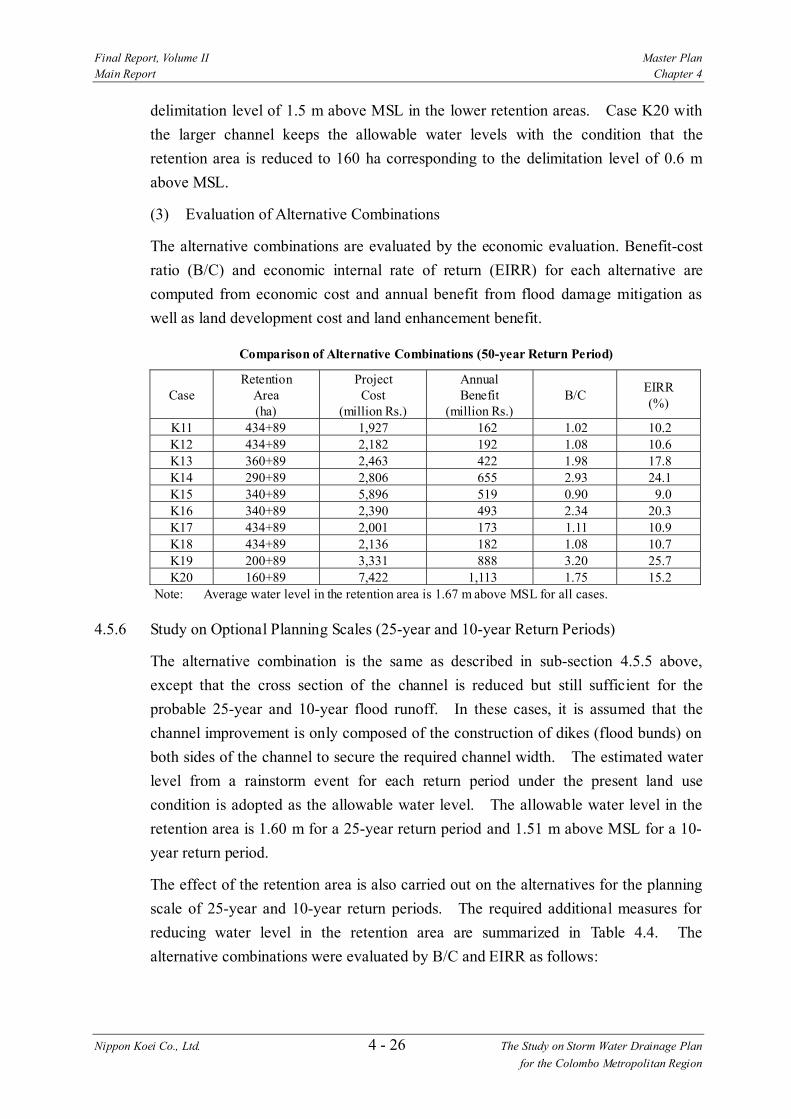
Final Report, Volume II Master Plan Main Report Chapter 4
Nippon Koei Co., Ltd. 4 - 26 The Study on Storm Water Drainage Plan for the Colombo Metropolitan Region
delimitation level of 1.5 m above MSL in the lower retention areas. Case K20 with the larger channel keeps the allowable water levels with the condition that the retention area is reduced to 160 ha corresponding to the delimitation level of 0.6 m above MSL.
(3) Evaluation of Alternative Combinations
The alternative combinations are evaluated by the economic evaluation. Benefit-cost ratio (B/C) and economic internal rate of return (EIRR) for each alternative are computed from economic cost and annual benefit from flood damage mitigation as well as land development cost and land enhancement benefit.
Comparison of Alternative Combinations (50-year Return Period)
Case Retention
Area (ha)
Project Cost
(million Rs.)
Annual Benefit
(million Rs.) B/C EIRR
(%)
K11 434+89 1,927 162 1.02 10.2 K12 434+89 2,182 192 1.08 10.6 K13 360+89 2,463 422 1.98 17.8 K14 290+89 2,806 655 2.93 24.1 K15 340+89 5,896 519 0.90 9.0 K16 340+89 2,390 493 2.34 20.3 K17 434+89 2,001 173 1.11 10.9 K18 434+89 2,136 182 1.08 10.7 K19 200+89 3,331 888 3.20 25.7 K20 160+89 7,422 1,113 1.75 15.2
Note: Average water level in the retention area is 1.67 m above MSL for all cases.
4.5.6 Study on Optional Planning Scales (25-year and 10-year Return Periods)
The alternative combination is the same as described in sub-section 4.5.5 above, except that the cross section of the channel is reduced but still sufficient for the probable 25-year and 10-year flood runoff. In these cases, it is assumed that the channel improvement is only composed of the construction of dikes (flood bunds) on both sides of the channel to secure the required channel width. The estimated water level from a rainstorm event for each return period under the present land use condition is adopted as the allowable water level. The allowable water level in the retention area is 1.60 m for a 25-year return period and 1.51 m above MSL for a 10- year return period.
The effect of the retention area is also carried out on the alternatives for the planning scale of 25-year and 10-year return periods. The required additional measures for reducing water level in the retention area are summarized in Table 4.4. The alternative combinations were evaluated by B/C and EIRR as follows:

Final Report, Volume II Master Plan Main Report Chapter 4
Nippon Koei Co., Ltd. 4 - 27 The Study on Storm Water Drainage Plan for the Colombo Metropolitan Region
Comparison of Alternative Combinations for Reduction of Retention Area
a) Planning Scale: 25-year Return Period
Case Retention
Area (ha)
Project Cost
(million Rs.)
Annual Benefit
(million Rs.) B/C EIRR
(%)
K11 434+89 1,772 148 1.08 10.7 K12 390+89 1,879 298 1.90 16.8 K13 330+89 1,975 489 2.84 23.0 K14 265+89 2,594 690 2.98 24.1 K15 250+89 5,762 797 1.53 14.6 K16 310+89 2,249 551 2.78 22.8 K17 434+89 1,802 161 1.15 11.2 K18 390+89 1,801 302 2.00 17.5 K19 175+89 2,807 987 3.90 29.3
Note: Average water level in retention area is 1.60 m above MSL for all cases. b) Planning Scale: 10-year Return Period
Case Retention
Area (ha)
Project Cost
(million Rs)
Annual Benefit
(million Rs.) B/C EIRR
(%)
K11 434+89 1,751 149 1.25 11.8 K12 320+89 1,810 405 3.41 25.7 K13 250+89 1,899 618 4.66 32.1 K14 215+89 2,533 713 3.84 28.5 K15 150+89 5,671 969 2.66 21.9 K16 290+89 2,219 481 3.04 24.0 K17 325+89 1,704 389 3.50 26.2 K18 275+89 1,699 525 4.59 31.6
Note: Average water level in retention area is 1.51 m above MSL for all cases.
4.5.7 Proposed Storm Water Drainage Plan
Although B/C and EIRR become higher because of the land enhancement benefit as the planning scale is lowered, the study proposes the planning scale of a 50-year return period for the storm water drainage plan in the Kalu Oya basin. As mentioned in the section 4.1, a certain high planning scale is required for the Kalu Oya basin being urbanized and expected as a future development area next to the Greater Colombo basin. In case that the project cost for the planning scale of a 50-year return period becomes a financial burden to the government, a stage-wise implementation is proposed. A planning scale of a 10 or 25-year event is to be attained in the first stage and is to be increased in the latter stages.
The alternative combinations of K14, K16, K18 and K19 include the diversion channel component (K7) and indicate a higher B/C and EIRR than the others without K7. However, the diversion channel requires additional crossings for both Negombo Road and CKE, which would cause rather difficult technical and social problems.

Final Report, Volume II Master Plan Main Report Chapter 4
Nippon Koei Co., Ltd. 4 - 28 The Study on Storm Water Drainage Plan for the Colombo Metropolitan Region
Based on the above considerations, case K13 with the highest B/C and EIRR among the alternative combinations without the diversion channel component is proposed as the storm water drainage plan for the Kalu Oya basin:
1) Channel Improvement of Kalu Oya • Total Length 5.0 km • Width 50 m from 0.0 km to 3.8 km (Trapezoidal Cross Section) • Width 25 m from 3.8 km to 5.0 km (Rectangular Cross Section)
2) Channel Improvement of Old Negombo Canal • Total Length 4.5 km • Width 40 m (Trapezoidal Cross Section)
3) Strom Water Retention Area (449 ha) • Lower Retention Areas: 360 ha • Upper Retention Areas: 89 ha
The general layout and conceptual designs for the proposed storm water drainage plan are illustrated in Figures 4.21 to 4.27.
4.6 Greater Colombo Basin
4.6.1 Basic Principle for Planning
In the Greater Colombo basin, the present safety level of the main canal system was evaluated in the range of a 5-year to 25-year return period. Substantial improvement was accomplished by the GCFC&EIP Phase I but further improvement should also be considered in order to cope with economic growth in the basin and an increase in social requirements for flood protection in the future.
It is projected that the Greater Colombo basin will be urbanized extensively with land development expanding to the suburbs. As a result, it is anticipated that the inundation in the case of heavy rainstorms will be worsening due to the significant increase in storm water runoff to be caused by the extensive urbanization even though the existing storm water retention areas will be conserved properly.
To alleviate the increase of storm water runoff, it is essential to conserve the presently functioning storm water retention areas and preserve other lowlands available for the purpose of storm water retention as much as possible. In addition, the existing storm water drainage system should also be augmented to increase the flood safety level.
For the purpose of the above, a combination of the following measures is proposed as a basin-wide storm water drainage plan:
1) Conservation of existing storm water retention areas and utilization of other lowlands for storm water retention purposes

Final Report, Volume II Master Plan Main Report Chapter 4
Nippon Koei Co., Ltd. 4 - 29 The Study on Storm Water Drainage Plan for the Colombo Metropolitan Region
2) Augmentation of the capacity to drain storm water runoff out of the basin 3) Increase in the flow capacity of existing major drainage canals
4.6.2 Basic Flood Runoff
The basic flood runoffs in the Greater Colombo basin for the probable 10, 25, and 50- year rainstorm events under the future land use conditions are estimated for several base points along the river channel as shown in Figure 4.28. In comparison with the estimated flood runoffs with the basin retention effect as shown in Figure 4.29, the peak runoffs of the basic flood increases by 88 % for a10-year return period, 109 % for a 25-year event, and 114 % for a 50-year event in Krillapone Canal at Open University Bridge. Figure 4.30 shows the comparison of flood hydrographs in Kirillapone Canal at Open University Bridge.
Comparison of Flood Discharge with and without Basin Retention Effect in Greater Colombo Basin
Location Return Period (years)
Basic Flood Runoff
(m3/sec)
Flood Runoff with Basin Retention Effect
(m3/sec) 10 75 40 25 115 55
Kirillapone Canal at Open University Bridge
50 150 70
4.6.3 Flow Capacity of Main Stream
The GCFC&EIP Phase I indicates that the allowable water level of the canal system is 1.85 m above MSL at Parliament Lake and 1.75 m above MSL for the urban part west of Parliament Lake. Under the GCFC&EIP Phase I, the canal bed level was dredged down to 1.0 m below MSL for the entire improved section. The canal bank was improved by raising it to an elevation of 1.8 m to 2.0 m above MSL for the urbanized sections. The canal bank level remains at lower elevations for the other sections located along the low-lying areas, which function as the storm water retention areas. The present flow capacity of the canal system is evaluated as follows:

Final Report, Volume II Master Plan Main Report Chapter 4
Nippon Koei Co., Ltd. 4 - 30 The Study on Storm Water Drainage Plan for the Colombo Metropolitan Region
Flow Capacity of Canal System in Greater Colombo Basin
(Unit: m3/sec) Minimum Maximum Average Canal (m3/sec) (m3/sec) (m3/sec)
Main Drain 9 27 16 St. Sebastian Canal 3 17 8 Dematagoda Ela 5 18 11 Heen Ela 12 44 22 Torrington Canal 7 47 29 Kolonnawa Ela 5 60 30 Kotte Ela 19 48 32 Kirillapone Canal 17 56 31 Wellawatta Canal 12 47 34 Dehiwela Canal 8 35 14
4.6.4 Conceivable Structural Measures
Based on the basic principle of storm water drainage planning, the conceivable structural measures for storm water drainage in the Greater Colombo basin are identified as described hereafter and illustrated in Figure 4.31.
1) Maradana Pumping Station and Improvement of Galle Face Sea Outfall • Connection of St. Sebastian Canal with Beira Lake across Maradana
Road • A pumping station for draining storm water from St. Sebastian Canal to
Beira Lake • Improvement of Beira Lake sea outfall at Galle Face
2) North Lock Pumping Station • A pumping station at North Lock gate
3) Gotatuwa Pumping Station • A pumping station at Gotatuwa flood bund
4) Madiwela South Diversion Canal • A diversion channel across High Level Road from Madiwela catchment
upstream of the Parliament Lake to Weras Ganga (length 8.6 km) 5) Restoration of Existing Mutwal Tunnel
• Restoration of deteriorated existing tunnel connecting Main Drain with sea outfall (dia. 1.8 m, length 550 m)
6) New Mutwal Tunnel • A new tunnel connecting Main Drain with sea outfall (dia. 4.0 m, length
740 m) 7) Widening of Wellawatta and Kirillapone Canals
• Widening of Wellawatta Canal (length 1,900 m) • Widening of Kirillapone Canal (length 1,200 m)

Final Report, Volume II Master Plan Main Report Chapter 4
Nippon Koei Co., Ltd. 4 - 31 The Study on Storm Water Drainage Plan for the Colombo Metropolitan Region
8) Storm Water Retention Area • Delimitated by ground elevation of 2 m above MSL as follows:
Storm Water Retention Area
(Unit: ha) Retention Area Land Area Lower than 2 m above MSL
Kolonnawa Ela 157 Heen Ela 72 Kotte Ela 115 Parliament Lake Surroundings 30 Other Areas 61
Total 435
4.6.5 Comparative Study of Alternative Drainage Plans
(1) Alternative Combinations
The conceivable alternative components described above were evaluated by a preliminary cost-benefit analysis. Scale alternatives are also taken into consideration for the components. The following alternative components were examined:
Alternatives Components
Case Measures G1 Maradana Pumping Station (Q= 5 m3/sec) and Improvement of Galle Face Outfall G2 Maradana Pumping Station (Q= 10 m3/sec) and Improvement of Galle Face Outfall G3 North Lock Pumping Station (Q= 10 m3/sec) G4 North Lock Pumping Station (Q= 15 m3/sec) G5 Gotatuwa Pumping Station (Q= 30 m3/sec) G6 Gotatuwa Pumping Station (Q= 40 m3/sec) G7 Madiwela South Diversion Channel G8 Restoration of Existing Mutwal Tunnel (D=1.8 m) G9 New Mutwal Tunnel (D= 3 m) G10 New Mutwal Tunnel (D= 4 m) G11 Widening of Wellawatta and Kirillapone Canals
To cope with a 50-year rainstorm event under the future land use condition, a storm water drainage plan in the Greater Colombo basin requires a combination of some alternative components.
The analysis discussed here adopts the average water level of 1.75 m above MSL in the retention areas along the Kolonnawa Ela, Heen Ela and Kotte Ela as the allowable water level. This water level represents almost the same condition as the allowable water levels of 1.85 m above MSL at Parliament Lake and 1.75 m above MSL for the urban part west of Parliament Lake in the Greater Colombo basin. Resulting from the hydrological analysis, the following alternative combinations were prepared:

Final Report, Volume II Master Plan Main Report Chapter 4
Nippon Koei Co., Ltd. 4 - 32 The Study on Storm Water Drainage Plan for the Colombo Metropolitan Region
Alternative Combinations Case Measures G12 • G7 Madiwela South Diversion Channel
• G8 Restoration of Existing Mutwal Tunnel (D=1.8 m) • Retention Area
G13 • G7 Madiwela South Diversion Channel • G9 New Mutwal Tunnel (D= 3 m) • Retention Area
G14 • G7 Madiwela South Diversion Channel • G10 New Mutwal Tunnel (D= 4 m) • Retention Area
G15 • G8 Restoration of Existing Mutwal Tunnel (D=1.8 m) • G9 New Mutwal Tunnel (D= 3 m) • Retention Area
G16 • G8 Restoration of Existing Mutwal Tunnel (D=1.8 m) • G10 New Mutwal Tunnel (D= 4 m) • Retention Area
G17 • G7 Madiwela South Diversion Channel • G11 Widening of Wellawatta and Kirillapone Canals • Retention Area
G18 • G7 Madiwela South Diversion Channel • G8 Restoration of Existing Mutwal Tunnel (D=1.8 m) • G9 New Mutwal Tunnel (D= 3 m) • Retention Area
G19 • G7 Madiwela South Diversion Channel • G8 Restoration of Existing Mutwal Tunnel (D=1.8 m) • G10 New Mutwal Tunnel (D= 4 m) • Retention Area
G20 • G7 Madiwela South Diversion Channel • G8 Restoration of Existing Mutwal Tunnel (D=1.8 m) • G11 Widening of Wellawatta and Kirillapone Canals • Retention Area
G21 • G7 Madiwela South Diversion Channel • G9 New Mutwal Tunnel (D= 3 m) • G11 Widening of Wellawatta and Kirillapone Canals • Retention Area
G22 • G7 Madiwela South Diversion Channel • G10 New Mutwal Tunnel (D= 4 m) • G11 Widening of Wellawatta and Kirillapone Canals • Retention Area
(2) Effect of Retention Area
The alternative combinations above are based on the conservation of storm water retention areas as described in sub-section 4.6.4. The effect of the retention areas is analyzed for the following four options of delimitation level.
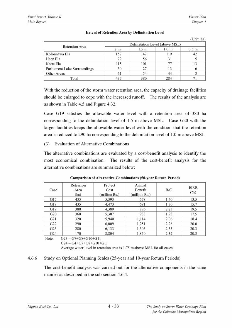
Final Report, Volume II Master Plan Main Report Chapter 4
Nippon Koei Co., Ltd. 4 - 33 The Study on Storm Water Drainage Plan for the Colombo Metropolitan Region
Extent of Retention Area by Delimitation Level
(Unit: ha) Delimitation Level (above MSL) Retention Area 2 m 1.5 m 1.0 m 0.5 m
Kolonnawa Ela 157 142 119 42 Heen Ela 72 56 31 5 Kotte Ela 115 101 77 13 Parliament Lake Surroundings 30 27 13 6 Other Areas 61 54 44 3
Total 435 380 284 71
With the reduction of the storm water retention area, the capacity of drainage facilities should be enlarged to cope with the increased runoff. The results of the analysis are as shown in Table 4.5 and Figure 4.32.
Case G19 satisfies the allowable water level with a retention area of 380 ha corresponding to the delimitation level of 1.5 m above MSL. Case G20 with the larger facilities keeps the allowable water level with the condition that the retention area is reduced to 290 ha corresponding to the delimitation level of 1.0 m above MSL.
(3) Evaluation of Alternative Combinations
The alternative combinations are evaluated by a cost-benefit analysis to identify the most economical combination. The results of the cost-benefit analysis for the alternative combinations are summarized below:
Comparison of Alternative Combinations (50-year Return Period)
Case Retention
Area (ha)
Project Cost
(million Rs.)
Annual Benefit
(million Rs.) B/C EIRR
(%)
G17 435 5,393 678 1.40 13.5 G18 435 4,473 681 1.70 15.7 G19 380 4,389 886 2.23 19.5 G20 360 5,307 933 1.93 17.5 G21 320 5,940 1,114 2.06 18.4 G22 290 6,009 1,251 2.28 20.0 G23 280 6,133 1,303 2.33 20.3 G24 170 8,804 1,850 2.32 20.3
Note: G23 = G7+G8+G10+G11 G24 = G4+G7+G8+G10+G11 Average water level in retention area is 1.75 m above MSL for all cases.
4.6.6 Study on Optional Planning Scales (25-year and 10-year Return Periods)
The cost-benefit analysis was carried out for the alternative components in the same manner as described in the sub-section 4.6.4.

Final Report, Volume II Master Plan Main Report Chapter 4
Nippon Koei Co., Ltd. 4 - 34 The Study on Storm Water Drainage Plan for the Colombo Metropolitan Region
For the planning scale of a 25-year return period, most of the alternative components individually achieve the allowable water level of 1.85 m MSL at Parliament Lake and 1.75 m MSL for the urban part west of Parliament Lake.
The results of the hydrological study indicate that the existing major canal system in the Greater Colombo basin is sufficient for runoff from a probable 10-year rainstorm event under the future land use condition. Hence, the present major canal system in the basin will provide the safety level for a 10-year return period in the future, assuming that the storm water retention area is delimitated at less than 2 m above MSL. But some additional measures would be necessary if the retention areas are reduced
Similarly to the descriptions in the sub-section 4.6.5 above, the effect of retention area is analyzed. The results of the analysis are summarized in Table 4.5. The alternative combinations were evaluated by B/C and EIRR as follows:
Comparison of Alternative Combinations
a) Planning Scale: 25-year Return Period
Case Retention
Area (ha)
Project Cost
(million Rs.)
Annual Benefit
(million Rs.) B/C EIRR
(%)
G7 190 3,327 1,144 3.74 27.8 G10 340 855 452 5.72 38.3 G12 170 3,451 1,247 3.94 29.8 G13 150 4,112 1,373 3.65 28.2 G14 135 4,181 1,461 3.83 29.1 G15 320 908 478 4.83 37.4 G16 310 978 549 6.09 39.8 G19 125 4,305 1,515 3.86 29.3
Note: Average water level in retention area is 1.75 m above MSL for all cases. b) Planning Scale: 10-year Return Period
Case Retention
Area (ha)
Project Cost
(million Rs.)
Annual Benefit
(million Rs.) B/C EIRR
(%)
G8 330 302 103 3.81 28.9 G9 270 785 295 4.22 30.8 G10 240 855 393 5.12 35.1
Note: Average water level in retention area is 1.48 m above MSL for all cases.
4.6.7 Proposed Storm Water Drainage Plan
The study proposes a planning scale of a 50-year return period for the storm water drainage plan in the Greater Colombo basin. In the light of the socio-economic importance of the basin in the country, a high planning scale needs to be provided for the future. If the project cost for the planning scale of a 50-year return period becomes a financial burden to the government, a stage-wise implementation is proposed, i.e., a planning scale of a 25-year event to be attained in the first stage and

Final Report, Volume II Master Plan Main Report Chapter 4
Nippon Koei Co., Ltd. 4 - 35 The Study on Storm Water Drainage Plan for the Colombo Metropolitan Region
the 50-year event in a latter stage. The planning scale for a 10-year return period with a significant decrease of storm water retention area would not be affordable in view of the social requirements for storm water drainage and conservation of appropriate natural environment in the basin even though the benefit of land development is quite large.
For the planning scale of a 50-year return period, the cases G19, G22, G23 and G24 indicate high B/C and EIRR. Case G19, which also comprises the components of G10 and G8, can be completed for the least cost among the three combinations and shows the highest economic viability for the 25-year and 10-year return periods. It is therefore proposed as the storm water drainage plan for the Greater Colombo basin.
1) Restoration of Mutwal Tunnel • Total Length 554 m • Diameter 1.8 m
2) Construction of New Mutwal Tunnel • Total Length 740 m • Diameter 4.0 m
3) Madiwela South Diversion Channel • Total Length 8,800 m • Width 32 m (Trapezoidal Cross Section)
4) Storm Water Retention Areas (380 ha)
The general layout and conceptual designs for the proposed storm water drainage plan are illustrated in Figures 4.33 to 4.42.
4.7 Bolgoda Basin
4.7.1 Storm Water Drainage Plan in Bolgoda Basin
The Bolgoda basin is characterized by the drainage system in the downstream lowlands consisting of the two major lakes and waterways interconnecting each other. These constitute an integrated system functioning as a natural flood plain. According to the future land use projection, extensive urbanization in the basin is not expected within the time-scale to the target year 2010 except the Weras Ganga basin covering the areas of Dehiwela - Mount Lavinia, Moratuwa, Maharagama and Kesbewa in the northern part of the Bolgoda basin.
For the basin-wide flood management in a long-term view, conservation of existing natural drainage systems in the downstream end is an essential need in the basin. Any large-scale structural measures such as channel improvements and runoff diversion facilities will not be affordable within the time scale to the target year 2010 from both technical and environmental viewpoints. On the other hand, the Weras

Final Report, Volume II Master Plan Main Report Chapter 4
Nippon Koei Co., Ltd. 4 - 36 The Study on Storm Water Drainage Plan for the Colombo Metropolitan Region
Ganga basin requires channel improvements to the main stream and major tributaries to cope with runoff to be increased by the projected urbanization. Therefore, the present study mainly focuses on the storm water drainage plan for the Weras Ganga basin.
From the considerations above, the storm water drainage plan in Bolgoda basin is proposed on the basis of the following principles:
1) Conservation of existing water surface areas and surrounding lowlands for storm water retention as well as environmental protection in the entire Bologda basin
2) Channel improvement of the Weras Ganga for draining storm water runoff concentrating from its urbanized catchment
3) Channel improvements to the tributaries of the Weras Ganga for alleviating storm water drainage problems in the respective drainage areas
4.7.2 Study on Storm Water Drainage Plan in Weras Ganga Basin
The Phase I - Master Plan study was carried out, based on the available topographic maps with the scale of 1:50,000 and 1:10,000, for the storm water drainage plans of the respective main streams together with conservation of the retention areas as the primary objectives.
It was identified that the majority of existing problems in the Weras Ganga basin were directly caused by the unsatisfactory conditions of the Weras Ganga main stream as well as the principal drainage channels (major tributaries) or urban drainage channels to drain storm water runoff into the Weras Ganga. It is therefore necessary to conduct a series of in-depth studies on the characteristics of the particular problems on storm water drainage in the entire Weras Ganga basin. Such studies require accurate baseline data including topography, urbanization and drainage system, which are obtainable from the latest maps with a scale of 1:2000 or more detail.
A series of in-depth studies were enabled with the latest 1:2,000 scale topographic maps produced by the Survey Department in 2001, which cover the entire Weras Ganga basin. As a result of the in-depth studies carried out in the early stage of the Phase II - Feasibility Study, the storm water drainage plan for the Weras Ganga basin was formulated. Details of the study on the storm water drainage plan are discussed in Volume IV - Supporting Report (2). The storm water drainage plan for the Weras Ganga basin is outlined in the subsequent sections and is incorporated with the storm water drainage plan for the Bolgoda basin.

Final Report, Volume II Master Plan Main Report Chapter 4
Nippon Koei Co., Ltd. 4 - 37 The Study on Storm Water Drainage Plan for the Colombo Metropolitan Region
4.7.3 Basic Flood Runoff
The basic flood runoffs in the Bolgoda basin for probable 10, 25, and 50-year rainstorm events under the future land use conditions were estimated for several locations along the river channel as shown in Figure 4.43. In comparison with the estimated flood runoff with the basin retention effect as shown in Figure 4.44, the peak runoffs of a basic flood increases by 35% for a 10-year return period, 45% for a 25-year storm, and 55% for a 50-year storm in the Panadura Ganga at the sea outfall if the retention and areas are eliminated. Figure 4.45 shows the comparison of flood hydrographs in Panadura Ganga at the sea outfall.
Comparison of Flood Discharge with and without Basin Retention Effect in Bolgoda Basin
Location Return Period (years)
Basic Flood Runoff
(m3/sec)
Flood Runoff with Basin Retention Effect
(m3/sec) 10 175 130 25 210 145
Panadura Ganga at Sea Outfall
50 240 155
4.7.4 Flow Capacity of Main Stream
The flow capacities of the main streams in the Bolgoda basin were evaluated from the channel cross sections surveyed and estimated probable runoff. The flow capacities of the main streams were evaluated as follows:
Flow Capacity of Mainstream in Bolgoda Basin (Unit: m3/sec)
River/Canal Minimum Maximum Average Bolgoda Canal 30 55 44 Weras Ganga 14 228 98 Panadura Ganga 127 577 267 Bolgoda Ganga 8 38 17 Maha Oya 7 95 36 Panape Ela 6 114 30 Aluth Ela 8 44 22 Kepu Ela 4 135 29
4.7.5 Conceivable Structural Measures
The conceivable structural measures for storm water drainage in the Bolgoda basin are illustrated in Figures 4.46 to 4.48.
1) Channel Improvement of Weras Ganga and Tributaries • Dredging of Weras Ganga • Construction of dike on the right bank of Weras Ganga • Channel improvement of tributaries in sub-basins

Final Report, Volume II Master Plan Main Report Chapter 4
Nippon Koei Co., Ltd. 4 - 38 The Study on Storm Water Drainage Plan for the Colombo Metropolitan Region
2) Storm Water Retention Area • Storm water retention areas in Weras Ganga basin (372 ha) • Conservation of lowland (4,739 ha)
3) Urban Drainage • Urban drainage improvement of highly urbanized area on the right bank
of Weras Ganga (Kandawala and Telawala areas, drainage area 3.3 km2)
4.7.6 Comparative Study on Alternative Drainage Plans
(1) Component Schemes
The conceivable structural measures for the Weras Ganga and tributaries are grouped into the component schemes broadly demarcated by sub-basin as follows:
Component Schemes of Storm Water Drainage Plan
Component Scheme Measures (1) Weras Ganga • Weras Ganga Dredging: length 5,500 m
• Flood Protection Wall on Right Bank: length: 2,300 m • Weras Ganga Swamp Retention Area: 65 ha • Maha Ela Marsh and Lowland Retention Area: 132 ha
(2) Nugegoda-Rattanapitiya Scheme
• Channel Improvement of Nugegoda-Ela: length 1,580 m • Channel Improvement of Delkanda Ela: length 1,760 m • Channel Improvement of Rattanapitiya Ela: length 2,130 m • Retention Areas: total extent 36 ha
(3) Bolgoda Canal Scheme • Channel Improvement of Bolgoda Canal: length 2,400 m • Bellanwila-Attidiya Marsh Retention Area: 108 ha
(4) Boralesgamuwa North Scheme
• Channel Improvement of Depawa Ela: length 3,090 m
(5) Boralesgamuwa South Scheme
• Channel Improvement of Werahera Tributary: length 980 m
(6) Maha Ela Scheme • Channel Improvement of Maha Ela: length 2,700 m • Channel Improvement of Maha Ela Tributary: length 1,760 m
(7) Ratmalana-Moratuwa Scheme
• Urban Drainage Improvement: 11,120 m • Kandawala Retention Pond: 3 ha • Telewala Retention Pond: 10 ha • Channel Improvement of Katubedda Tributary: length 1,250 m • Retention Area: 23 ha
(2) Dredging Width of Weras Ganga
The Weras Ganga Scheme envisages alleviating direct flood damage in the densely urbanized lowland on the right bank as well as improving the principal drainage channels such as Bolgoda Canal and Rattanapitiya Ela connecting to the Weras Ganga by increasing its flow capacity.
For the dredging of the Weras Ganga, alternative dredging widths of 20, 40, and 60 m were examined. Hydraulic analyses were carried out for the respective dredging widths under the storm water drainage plan comprising all the component schemes and retention area described above. The results of water level projections are

Final Report, Volume II Master Plan Main Report Chapter 4
Nippon Koei Co., Ltd. 4 - 39 The Study on Storm Water Drainage Plan for the Colombo Metropolitan Region
summarized below:
Water Level of Weras Ganga by Dredging Width
Water Level (above MSL) Dredging Width Elawella Road Borupana Bridge Confluence of Maha Ela
20 m 1.42 1.01 0.95 40 m 1.41 0.99 0.93 60 m 1.41 0.96 0.88
The alternatives of the storm water drainage plan with different dredging widths are evaluated in the economic evaluation. Benefit-cost ratio (B/C) and economic internal rate of return (EIRR) for each alternative are computed from economic cost and annual benefit from flood damage mitigation as well as land development cost and land enhancement benefit.
Comparison of Alternative Dredging Width
Dredging Width Project Cost (million Rs)
Annual Benefit (million Rs/year) B/C EIRR
20 m 5,128 624 1.50 13.9 40 m 5,317 706 1.60 14.7 60 m 5,657 715 1.52 14.1
(3) Required Extent of Retention Area in Weras Ganga Basin
Of the proposed retention area of 372 ha, a required extent of retention area is analyzed by hydraulic simulation under the following assumptions:
1) The upstream retention areas of 36 ha in the Nugegoda-Rattanapitiya sub-basin should be kept, essentially, for the storm water drainage plan in the sub-basin.
2) The following locations of retention areas would be subject to loss, suggested by present situations of land filling and its influence to the marshes in the vicinity of future urbanized areas: • Marsh areas with small extent surrounded by highly urbanized area, such
as Katubedda Tributary and Thumbowila Tributary, total extent of 31 ha • Bellanwila-Attidiya Marsh, north, east and southeast, 40 ha • Maha Ela Marh and Lowland upstream of Colombo-Piliyandala Road, 26
ha
Influence by loss of retention area is evaluated with a relationship between an extent of retention area and average of water level in the Weras Ganga. When the average water level ‘without’ the project is regarded as an allowable water level, the required extent resulting from the hydraulic simulation analysis is shown by each retention area as follows:
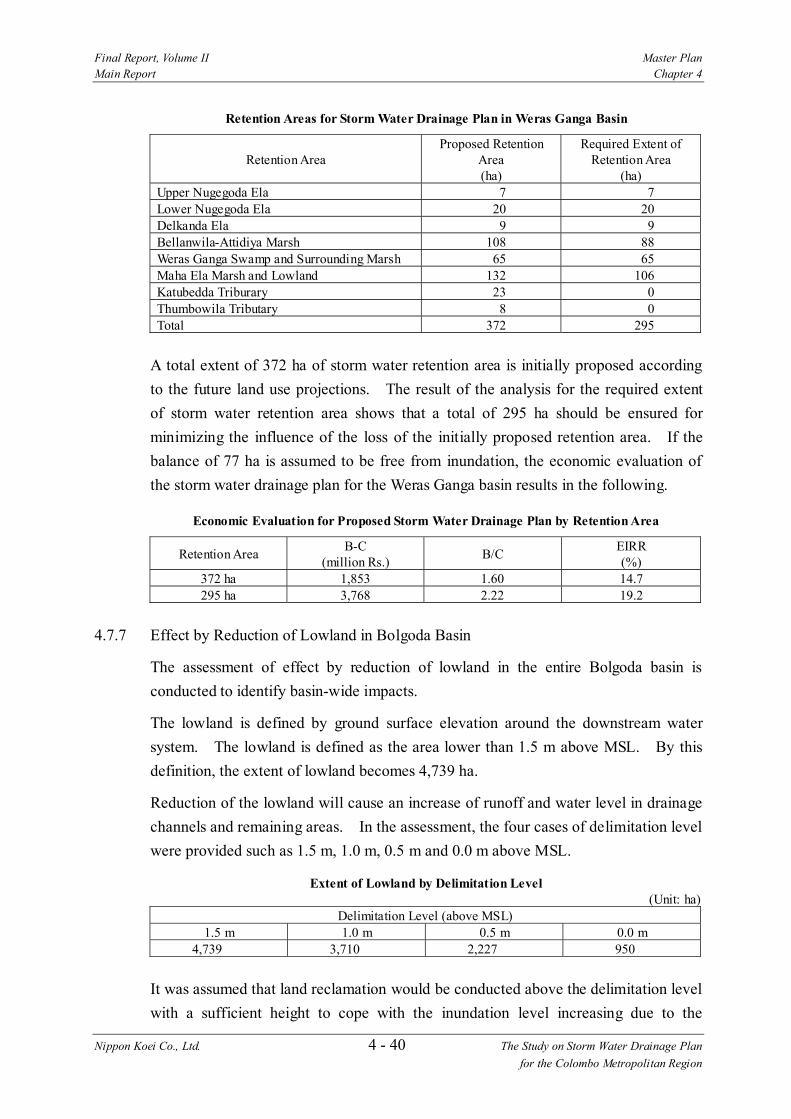
Final Report, Volume II Master Plan Main Report Chapter 4
Nippon Koei Co., Ltd. 4 - 40 The Study on Storm Water Drainage Plan for the Colombo Metropolitan Region
Retention Areas for Storm Water Drainage Plan in Weras Ganga Basin
Retention Area
Proposed Retention Area (ha)
Required Extent of Retention Area
(ha) Upper Nugegoda Ela 7 7 Lower Nugegoda Ela 20 20 Delkanda Ela 9 9 Bellanwila-Attidiya Marsh 108 88 Weras Ganga Swamp and Surrounding Marsh 65 65 Maha Ela Marsh and Lowland 132 106 Katubedda Triburary 23 0 Thumbowila Tributary 8 0 Total 372 295
A total extent of 372 ha of storm water retention area is initially proposed according to the future land use projections. The result of the analysis for the required extent of storm water retention area shows that a total of 295 ha should be ensured for minimizing the influence of the loss of the initially proposed retention area. If the balance of 77 ha is assumed to be free from inundation, the economic evaluation of the storm water drainage plan for the Weras Ganga basin results in the following.
Economic Evaluation for Proposed Storm Water Drainage Plan by Retention Area
Retention Area B-C (million Rs.) B/C EIRR
(%) 372 ha 1,853 1.60 14.7 295 ha 3,768 2.22 19.2
4.7.7 Effect by Reduction of Lowland in Bolgoda Basin
The assessment of effect by reduction of lowland in the entire Bolgoda basin is conducted to identify basin-wide impacts.
The lowland is defined by ground surface elevation around the downstream water system. The lowland is defined as the area lower than 1.5 m above MSL. By this definition, the extent of lowland becomes 4,739 ha.
Reduction of the lowland will cause an increase of runoff and water level in drainage channels and remaining areas. In the assessment, the four cases of delimitation level were provided such as 1.5 m, 1.0 m, 0.5 m and 0.0 m above MSL.
Extent of Lowland by Delimitation Level (Unit: ha)
Delimitation Level (above MSL) 1.5 m 1.0 m 0.5 m 0.0 m
4,739 3,710 2,227 950
It was assumed that land reclamation would be conducted above the delimitation level with a sufficient height to cope with the inundation level increasing due to the

Final Report, Volume II Master Plan Main Report Chapter 4
Nippon Koei Co., Ltd. 4 - 41 The Study on Storm Water Drainage Plan for the Colombo Metropolitan Region
reduction of the lowlands. The results of water level rising at the Weras Ganga, North Bolgoda Lake, and South Bolgoda Lake are shown in Figure 4.49 and summarized below:
Effect by Reduction of Lowland (50-year Return Period)
Water Level (above MSL) Delimitation Level (m)
Extent of Lowland
(ha) Weras Ganga North Bolgoda Lake South Bolgoda Lake
1.5 4,739 1.43 0.69 0.78 1.0 3,710 1.51 0.70 0.79 0.5 2,227 1.73 0.74 0.83 0.0 950 1.89 0.78 0.92
As mentioned above, the ground surface elevation of reclaimed land is assumed to be sufficient to protect against flood water level in the remaining lowlands. On the other hand, the water level rising in the remaining lowlands affects the water level of the incoming channels. Difficulty of drainage would arise in the incoming channels affected by backwater and then flooding occurs in the upper reaches.
4.7.8 Study on Optional Planning Scales (25-year and 10-year Return Periods)
The type of alternative combinations is the same as described in the sub-section 4.7.5 above. The comparative study for different dredging width of the Weras Ganga for each planning scale is summarized below:
Comparison of Alternative Dredging Width
a) 25-year Return Period
Dredging Width Project Cost (million Rs)
Annual Benefit (million Rs.) B/C EIRR
(%) 20 m 4,911 931 2.21 19.0 40 m 5,100 1,012 2.29 19.6 60 m 5,439 1,021 2.16 18.8
b) 10-year Return Period
Dredging Width Project Cost (million Rs)
Annual Benefit (million Rs.) B/C EIRR
(%) 20 m 4,909 878 2.09 18.2 40 m 5,099 955 2.17 18.8 60 m 5,438 963 2.04 18.0
The effect of the retention area is also carried out on the conceivable plans for the planning scale of 25-year and 10-year return periods. The effect of raising the water level in the retention areas is examined in the same manner as described in the sub- section 4.7.6. The required extent of retention area for each planning scale is obtained from the results of simulation analyses tabulated below:

Final Report, Volume II Master Plan Main Report Chapter 4
Nippon Koei Co., Ltd. 4 - 42 The Study on Storm Water Drainage Plan for the Colombo Metropolitan Region
Comparison of Economic Evaluation by Planning Scale
Return Period
Required Retention
Area (ha)
Project Cost
(million Rs)
Annual Benefit
(million Rs.)
B/C
EIRR (%)
50-year 295 5,102 1,022 2.22 19.2 25-year 295 5,100 1,012 2.29 19.6 10-year 295 5,099 955 2.17 18.8
4.7.9 Proposed Storm Water Drainage Plan
The study proposes a planning scale of a 50-year return period for the storm water drainage plan in the Weras Ganga sub-basin. The Weras Ganga is one of the main streams constituting the water system in the Bolgoda Basin. Such a main stream should be improved with a high planning scale as mentioned in the section 4.1. On the other hand, the proposed plan includes the improvement of the tributaries with a planning scale of a 10-year return period.
The reduction of the lowlands would have only a small effect on raising the water level in the lakes because there will be no great change in the land use in the Bolgoda basin to the year 2010 and the storm water runoff from the entire basin will not increase significantly. However, a large reduction of the lowlands is not acceptable without proper offsetting measures for storm water drainage. Conservation of the lowlands needs be undertaken in compliance with future land use for a longer time- scale.
On the other hand, the loss of lowland, including the proposed retention areas in the Weras Ganga basin, would cause water level rising of some 0.5 m in the Weras Ganga. The lowlands in the Weras Ganga basin should be conserved as a part of the storm water drainage plan.
As a conclusion of the considerations above, the following storm water drainage plan is proposed for the Bolgoda basin:
(1) Storm Water Drainage Plan for the Weras Ganga basin:
1) Weras Ganga Scheme
• Weras Ganga Dredging: length 5,500 m • Flood Protection Wall on Right Bank: length: 2,300 m • Weras Ganga Swamp Retention Area: 65 ha • Maha Ela Marsh and Lowland Retention Area: 106 ha
2) Nugegoda-Rattanapitiya Scheme
• Channel Improvement of Nugegoda-Ela: length 1,580 m
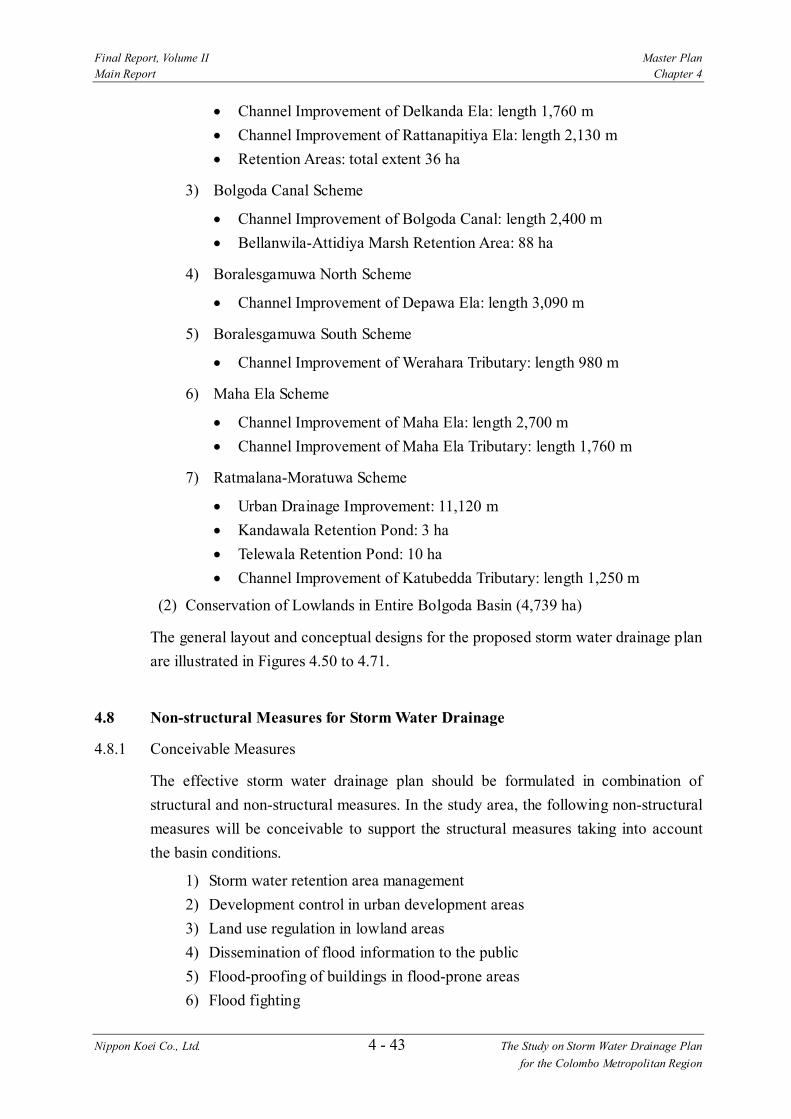
Final Report, Volume II Master Plan Main Report Chapter 4
Nippon Koei Co., Ltd. 4 - 43 The Study on Storm Water Drainage Plan for the Colombo Metropolitan Region
• Channel Improvement of Delkanda Ela: length 1,760 m • Channel Improvement of Rattanapitiya Ela: length 2,130 m • Retention Areas: total extent 36 ha
3) Bolgoda Canal Scheme
• Channel Improvement of Bolgoda Canal: length 2,400 m • Bellanwila-Attidiya Marsh Retention Area: 88 ha
4) Boralesgamuwa North Scheme
• Channel Improvement of Depawa Ela: length 3,090 m
5) Boralesgamuwa South Scheme
• Channel Improvement of Werahara Tributary: length 980 m
6) Maha Ela Scheme
• Channel Improvement of Maha Ela: length 2,700 m • Channel Improvement of Maha Ela Tributary: length 1,760 m
7) Ratmalana-Moratuwa Scheme
• Urban Drainage Improvement: 11,120 m • Kandawala Retention Pond: 3 ha • Telewala Retention Pond: 10 ha • Channel Improvement of Katubedda Tributary: length 1,250 m
(2) Conservation of Lowlands in Entire Bolgoda Basin (4,739 ha)
The general layout and conceptual designs for the proposed storm water drainage plan are illustrated in Figures 4.50 to 4.71.
4.8 Non-structural Measures for Storm Water Drainage
4.8.1 Conceivable Measures
The effective storm water drainage plan should be formulated in combination of structural and non-structural measures. In the study area, the following non-structural measures will be conceivable to support the structural measures taking into account the basin conditions.
1) Storm water retention area management 2) Development control in urban development areas 3) Land use regulation in lowland areas 4) Dissemination of flood information to the public 5) Flood-proofing of buildings in flood-prone areas 6) Flood fighting

Final Report, Volume II Master Plan Main Report Chapter 4
Nippon Koei Co., Ltd. 4 - 44 The Study on Storm Water Drainage Plan for the Colombo Metropolitan Region
They are explained in the subsequent sub-sections.
4.8.2 Storm Water Retention Area Management
This is a sort of floodplain management. As mentioned in the proposed storm water drainage plan, a role of the storm water retention area is very important from the technical and economic viewpoints. If the storm water retention area is not provided, it is quite difficult to confine the storm water in the river channel and also such idea requires a huge cost. Therefore, it is proposed to keep the storm water retention areas. The following retention areas to be conserved are proposed in the Study. They are shown in Figures 4.8, 4.21, 4.33 and 4.50.
Proposed Storm Water Retention Areas in Weras Ganga Basin
Basin Proposed Retention Area Area (ha) Ja Ela Basin Upper 376 Lower 500 Kalu Oya Upper 89 Lower 380 Greater Colombo - 380 Bolgoda - 295 (Weras Ganga Basin) 4,739
In order to properly keep those storm water retention areas, the following measures are required.
(1) Legal Designation of Storm Water Retention Area
The study area is located mostly in the low-lying area as mentioned before. Because of this, it is proposed to keep the storm water retention area properly from the viewpoint of minimization of the storm water drainage project cost. The existing marshes, lowlands and paddy lands are functioning as a storm water retention area. However, illegal filling and uncontrolled development in such lowlands are often observed at many places in the study area. The decrease of retention area results in decrease of storm water retention capacity and increase of flood damage.
The reasons for such activities may be a lack of social understanding for importance of storm water retention effect and also unclearness of the required extents of retention area. It is necessary to clearly demarcate the required storm water retention area and show the retention area on the authorized land use plan and legally designate the retention area as an authorized one.
In addition, the designated retention area should be notified to the government agencies concerned and the public for their understandings to stop and control the illegal filling and uncontrolled development in the designated retention area.

Final Report, Volume II Master Plan Main Report Chapter 4
Nippon Koei Co., Ltd. 4 - 45 The Study on Storm Water Drainage Plan for the Colombo Metropolitan Region
As no authorized detailed land use plan has been prepared yet for the entire study area. It should be prepared as early as possible before implementation of the proposed storm water drainage projects.
It should be noted that the storm water retention areas proposed in the Study are identified by the hydrological and hydraulic analyses based on the topographic maps with scales of 10,000 and 50,000, however those maps have only contour lines of 5-10 m intervals for the lowland and they are insufficient to demarcate the retention area with a satisfactory accuracy. The accurate extents of the proposed retention areas should be reviewed with more detailed topographic data.
(2) Regulation of Land Use in Storm Water Retention Area
The proposed storm water retention areas are extensive open space. There may be demand to utilize the retention area for other purposes such as play ground, park, cultivation, etc. Utilization of the retention areas for the purpose other than storm water retention can be allowed under the condition that the storm water retention effect is not decreased, but it should be properly regulated by the agency concerned such as SLLRDC.
(3) Strict Legal Action for Illegal Activities
As mentioned before, illegal activities such as filling of marshes and lowlands, garbage dumping to canals and lowlands, encroachment of canal area, etc. are observed at many places in the study area. Local authorities and UDA have a power to regulate or stop the illegal activities, but this regulation system has not functioned satisfactorily because of various reasons. The filling of lowlands and garbage dumping to the canal decrease the capacity of storm water drainage system as a whole. It is important to maintain the designed capacities of the storm water drainage facilities to avoid flood damages as much as possible.
The strict legal action against the illegal activities mentioned above should be taken by the local authorities and UDA.
4.8.3 Development Control in Urban Development Areas
Urbanization in the study area causes increase of flood runoff. However, there is a limit to increase the discharge capacity of rivers and drainage canals to cope with increase of the flood runoff. In this context, construction of flood retarding ponds, rainwater storage facilities and seepage facilities are effective measures to reduce the flood runoff. In order to reduce the flood runoff in the urbanized area, all developers including the government agencies in charge of urban development should obligate construction of those facilities in implementation of the development projects.

Final Report, Volume II Master Plan Main Report Chapter 4
Nippon Koei Co., Ltd. 4 - 46 The Study on Storm Water Drainage Plan for the Colombo Metropolitan Region
To ensure the construction of the storm water retention facilities, legislation for mandatory construction is proposed. The main points of the legislation will be as follows referring to the Japanese Guideline on the provision of flood retarding pond.
1) The storm water retarding ponds should be constructed in the large scale development with a development area of more than 10 ha.
2) The peak runoff from the objective development area should not exceed the peak runoff under the conditions before development.
3) SLLRDC should be a responsible agency for evaluation, approval and monitoring of the development plan from storm water drainage aspect, and for providing technical guidance on plan/design of the storm water retention facilities.
4) SLLRDC should be empowered to take a legal action to contravention.
4.8.4 Land Use Regulation in Lowlands
As often seen in the study area, the houses affected by storm water inundation are mostly located in and around the lowlands which are originally flood-prone areas.
To stop recurrence of the same situation, it is proposed to regulate the land use in the lowland areas so as to stop dwelling in the flood-prone lowland.
4.8.5 Dissemination of Flood Information
In the previous sub-section 4.8.2, importance of conservation of the storm water retention areas is stressed. To properly conserve the retention areas, the various information such as related regulations, prohibited activities, boundaries of the retention areas, etc. should be disseminated to the public to get their understandings and awareness for the flood control.
Further, it also will be effective to mitigate the flood damage to disseminate the information on flooding condition of the residential areas and lowlands to the public. The information useful will be flooding area, flood magnitude, flood duration, flood frequency, evacuation route, etc. For this purpose, a flood hazard map is commonly prepared although it needs detailed topographic maps to accurately forecast the inundation area and depth.
Based on the information disseminated, the people are expected to avoid dwelling in the areas with flooding risk such as lowlands and also learning how to cope with flood.
4.8.6 Flood-proofing of Buildings in Flood-prone Areas
In principle, it is better to relocate the houses in the flood-prone areas such as marsh and natural flood retention areas to mitigate the flood damages. However, if it is

Final Report, Volume II Master Plan Main Report Chapter 4
Nippon Koei Co., Ltd. 4 - 47 The Study on Storm Water Drainage Plan for the Colombo Metropolitan Region
inevitable to dwell in the flood-prone areas because of certain circumstances, flood-proofing of the buildings (houses) should be introduced. There are several types of flood-proofing such as raising of foundation ground, piloti type building, wall-fencing around house and waterproof building.
4.8.7 Flood Fighting
If the flood exceeding the design flood scale occurred, flood damage is inevitable. In order to mitigate the flood damages as much as possible, the precautionary measures such as flood fighting, dissemination of information on flooding condition to the public, etc. should be taken.
As mentioned before, the flood fighting system has been established in Sri Lanka. The existing flood fighting system should be fully utilized.
4.8.8 Flood Warning System
Flood forecasting and warning is also one of measures to mitigate the flood damage, but it is not recommended in the study area because of the reasons mentioned below.
According to the field survey in the study area, except the flood prone area of Kelani River, there are no flood prone areas where emergency evacuation and flood fighting activities are strictly required for avoiding any critical damage to human life during heavy rainfall. The inundation depth during heavy rainfall is reported at around 50 to 100 cm in the maximum and almost all inundation do not affect immediately to human life and do not produce any destructive damages to houses and buildings. Mobilization of the flood forecasting and warning system may not be in reality in the study area.
4.9 Outfall Treatment
From the viewpoint of outfall treatment for storm water drainage in the present Study, the followings are recommended for the Wellawatta, Dehiwala and Lunawa Lake outfalls, which are important for storm water drainage in their own basins.
(1) Wellawatta Outfall
At Wellawatta outfall, the outfall had been kept open throughout the year and there was no serious problem of clogging. However, since July 2002, after construction of the groynes for of Dehiwala outfall, clogging of the Wellawatta outfall has been observed. It is thought that the natural discharge is not sufficient to keep the outfall open throughout the year. In November, the sand bar formed during the dry season was flushed out and the Wellawatta outfall is being kept open during rainy season.
Final Report, Volume II Master Plan Main Report Chapter 4
Nippon Koei Co., Ltd. 4 - 48 The Study on Storm Water Drainage Plan for the Colombo Metropolitan Region
From this fact, the clogging of the outfall during the dry season may be automatically removed by the flow during the rainy season. It is recommended to continue monitoring the behavior of the Wellawatta and Dehiwala outfalls.
If the sand bar formulation is excessively large, removal before the rainy season is recommended.
(2) Dehiwala Outfall
The groynes were constructed at Dehiwala Outfall in June 2002. According to Dehiwala Outfall Study - Coastal Impact Mitigatory Measures, SLLRDC, by LHI, June 1998, the sizes of the groynes are minimized to avoid coastal impact as much as possible. As of October 2002, the Dehiwala outfall has been kept open even during dry season because the flow discharge at the outfall after construction of the groynes was increased and made stable although the flow discharge at the Wellawatta outfall was decreased and resulted in clogging of that outfall.
However, the long-term tendency of both outfalls and the coastal impacts by construction of the groynes cannot be clearly recognized as the groynes were just completed in June 2002. Therefore, it is necessary to continue monitoring of the behavior of the outfalls and surrounding coasts.
(3) Lunawa Lake Outfall
At Lunawa Lake outfall, the sand bar formed has been periodically removed by manpower. It will not be so troublesome to continue this method. If it is preferable to adopt natural measures such as a groyne, further study will be necessary, referring to the conceivable plans suggested in the Study of Improvement to the Lunawa Sea Outfall, SLLRDC, by LHI, January 2001.
4.10 Institutional Development Plan
In the sub-section 2.7.3, critical constraints in implementation of storm water drainage projects were identified, including 1) unclear responsibilities among government agencies for storm water drainage works, 2) lack of an authorized land use plan and 3) insufficient resources for storm water drainage works. In this section, an institutional development plan is proposed to eliminate the first two constraints. The third constraint is discussed in the sections 4.11 and 4.12.
4.10.1 Demarcation of Responsibilities for Storm Water Drainage Works among Agencies
As for planning, implementation and O&M for flood control/storm water drainage facilities, the following demarcation of responsibilities is proposed in order to develop a clear institutional arrangement considering the present situation of the related
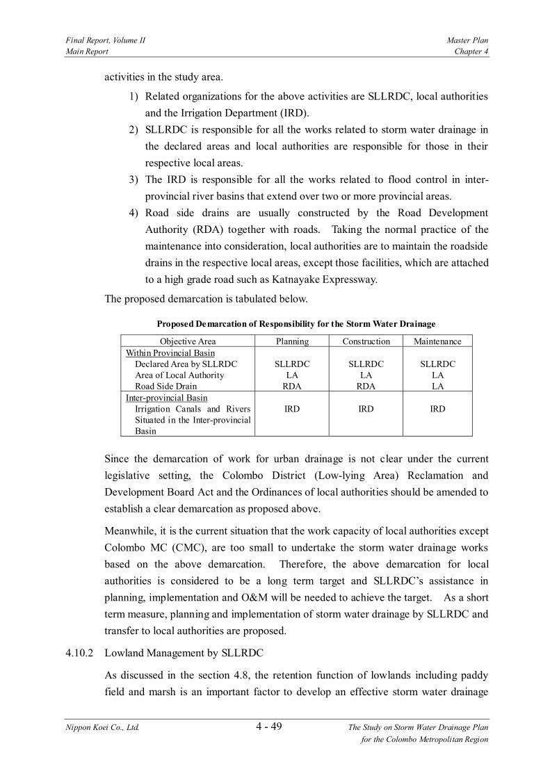
Final Report, Volume II Master Plan Main Report Chapter 4
Nippon Koei Co., Ltd. 4 - 49 The Study on Storm Water Drainage Plan for the Colombo Metropolitan Region
activities in the study area.
1) Related organizations for the above activities are SLLRDC, local authorities and the Irrigation Department (IRD).
2) SLLRDC is responsible for all the works related to storm water drainage in the declared areas and local authorities are responsible for those in their respective local areas.
3) The IRD is responsible for all the works related to flood control in inter- provincial river basins that extend over two or more provincial areas.
4) Road side drains are usually constructed by the Road Development Authority (RDA) together with roads. Taking the normal practice of the maintenance into consideration, local authorities are to maintain the roadside drains in the respective local areas, except those facilities, which are attached to a high grade road such as Katnayake Expressway.
The proposed demarcation is tabulated below.
Proposed Demarcation of Responsibility for the Storm Water Drainage
Objective Area Planning Construction Maintenance Within Provincial Basin
Declared Area by SLLRDC Area of Local Authority Road Side Drain
SLLRDC
LA RDA
SLLRDC
LA RDA
SLLRDC
LA LA
Inter-provincial Basin Irrigation Canals and Rivers Situated in the Inter-provincial Basin
IRD
IRD
IRD
Since the demarcation of work for urban drainage is not clear under the current legislative setting, the Colombo District (Low-lying Area) Reclamation and Development Board Act and the Ordinances of local authorities should be amended to establish a clear demarcation as proposed above.
Meanwhile, it is the current situation that the work capacity of local authorities except Colombo MC (CMC), are too small to undertake the storm water drainage works based on the above demarcation. Therefore, the above demarcation for local authorities is considered to be a long term target and SLLRDC’s assistance in planning, implementation and O&M will be needed to achieve the target. As a short term measure, planning and implementation of storm water drainage by SLLRDC and transfer to local authorities are proposed.
4.10.2 Lowland Management by SLLRDC
As discussed in the section 4.8, the retention function of lowlands including paddy field and marsh is an important factor to develop an effective storm water drainage

Final Report, Volume II Master Plan Main Report Chapter 4
Nippon Koei Co., Ltd. 4 - 50 The Study on Storm Water Drainage Plan for the Colombo Metropolitan Region
system. Proper extent of the lowlands in the study area should be kept from land filling for flood alleviation and natural conservation.
However, in spite of a general recognition of the importance of low land function, it is the current situation that the areas to be preserved are not clearly identified and both legal and illegal fillings are proceeding for various development purposes without proper land use plans.
At present, there exists a process for evaluation, permission and regulation of land development in which UDA, local authorities and SLLRDC are involved (refer to Figure 2.17). However, this process is complicated and does not seem to function properly. Therefore, in order to simplify the process and to materialize an effective lowland use regulation, especially for storm water retention, it is proposed to establish lowland management by SLLRDC. For this purpose, the following actions are proposed.
(1) Empowerment of SLLRDC
It is proposed that SLLRDC become the sole agency for lowland management related to storm water drainage works with the following tasks.
1) Evaluation/approval of land filling proposals in coordination with UDA, CEA, local authorities and line agencies for development works
2) Development of a data base of land filling proposals 3) Monitoring of illegal land filling
In order to implement the above duties and functions, legislative empowerment of SLLRDC is necessary and the following amendment should be made to the Colombo District Low-lying Area Reclamation and Development Board Act:
1) Any land filling projects in low land areas declared under the SLLRDC Act have to be approved by SLLRDC in written form.
2) SLLRDC can take an immediate legal action or issue an injunction order to any person who acts in contravention of the Act in the declared area.
3) No constructions are allowed on any areas declared as canal reservation by SLLRDC. A legal action can be taken by SLLRDC for contravention of the Act.
(2) Formulation of Land Use Plan
Establishment of an authorized land use plan at each level, national, sub-national and local authority should be urged. Authorized land use plans will give clear guidelines for the land use regulation activities including evaluation and approval of land filling proposals, monitoring of illegal land filling and legal action for contravention. The most important objective of the land use plan is to demarcate clearly each land area by

Final Report, Volume II Master Plan Main Report Chapter 4
Nippon Koei Co., Ltd. 4 - 51 The Study on Storm Water Drainage Plan for the Colombo Metropolitan Region
the expected function. In the plans, lowland areas which will contribute to storm water retention should be clearly shown, and further could be divided into some zones by each category as follows:
1) Strictly reserved zone for retention purpose 2) Reserved zone for retention of minor flood but to be used for nature parks
and so on 3) Reserved zone for retention of major flood but to be used for urban parks
and community parks and so on, and some high ground parts of the area to be used for housing schemes
(3) Combined Activities with Local Authorities
Under the existing legislative system, local authorities are empowered to take a legal action to stop, demolish, punish and fine. However, considering the malfunction of this regulation function due to insufficient work resources, political pressure and other local specific constraints, it is proposed to utilize the function of local authorities in combination with SLLRDC’s lowland management. Under this cooperation system SLLRDC and local authorities can organize a network for effective monitoring and regulation of land filling for the broad area including SLLRDC’s declared areas and the areas of local authorities. This combination will be useful for the lowland management from the basin-wide aspect.
(4) Achievement of Social Understanding on Lowland Management
In addition to the actions proposed above, it is important to take actions to achieve social understanding on the lowland management. It will be possible to execute substantially the function and duty on land use regulation through the actions such as the opening of the land use plan to the public, presentation of the importance to preserve lowland areas showing flood inundation hazard maps to the public and public awareness on land use regulation with the mass media. These activities by SLLRDC and local authorities will be necessary for sustainable lowland management.
4.11 Operation and Maintenance Plan
Operation and Maintenance (O&M) is a key issue to establish a sustainable storm water drainage system. At present there are many drainage structures/facilities which are maintained by each responsible organization. In addition, new storm water drainage systems will be proposed through this Study. The O&M activities will depend on the type and scale of the system to be maintained and the organization managing it. Based on the present situation of the O&M activities in the study area
Final Report, Volume II Master Plan Main Report Chapter 4
Nippon Koei Co., Ltd. 4 - 52 The Study on Storm Water Drainage Plan for the Colombo Metropolitan Region
and the drainage systems to be newly proposed, practical O&M systems should be established.
4.11.1 Policy for Operation and Maintenance
O&M plan is prepared for various storm water drainage improvement schemes proposed through the study on the basis of the policy given below.
1) As proposed in the Institutional Development Plan, the responsible organizations for storm water drainage are SLLDC and local authorities including MCs, UCs and PSs.
2) SLLRDC undertakes the O&M of drainage facilities including main and secondary canals/rivers and urban drainage channels in the declared areas.
3) Local authorities have responsibility for the O&M of drainage facilities including main and secondary canals/rivers, urban drainage channels and road side drains in the respective land area.
4) Taking the insufficient O&M capacities of the local authorities except CMC into consideration, SLLRDC shall assist the local authorities in undertaking the O&M works for the drainage facilities for a few years after transfer of those facilities to local authorities. During this period, SLLRDC shall provide local authorities with technical guidance and staff training through joint operation, on-the-job training and lectures.
5) As a long term objective (for example, 10 years), local authorities promote expansion of resources for storm water drainage works including planning, construction and O&M with a view to managing all the works by themselves.
4.11.2 Organization Set-up with Staff Arrangement
(1) SLLRDC
SLLRDC’s management capacity including the organizational set-up and staff for storm water drainage works has been developing especially through undertaking of the large scale storm water drainage projects in the Greater Colombo area. However, considering the future expansion of the coverage area and the work volume, further expansion of the organizational set-up and staff is proposed as below.
1) A new section is proposed within the existing CD&M divisions such as the Urban Drainage Maintenance Section, which undertakes O&M works for storm water drainage systems in built up areas and provision of technical guidance and staff training on O&M of storm water drainage systems to local authorities other than CMC. The proposed organization chart is shown in Figure 4.72.

Final Report, Volume II Master Plan Main Report Chapter 4
Nippon Koei Co., Ltd. 4 - 53 The Study on Storm Water Drainage Plan for the Colombo Metropolitan Region
2) As shown in Figure 4.72, it is proposed to set up the implementation part of the new section in the Kirimandara Mawatha and Colombo North Regional Offices, considering the location of the new urban drainage systems constructed by SLLRDC and that the actual O&M activities for the existing canals are also handled by the regional offices. Furthermore, it will be effective for the same implementation section in Kirimandara Mawatha office to initiate the local authorities into O&M works for storm water drainage system.
3) For the above new section, employment of one managerial staff member (AGM), a few engineers and several engineering assistants, including an O&M trainer, will be necessary for preparation of the work procedure and schedule and arrangement for the implementation. Furthermore, several supervisors who engage in supervision of the work on site, based on the work procedure and schedule, and training of operators for the operation of cleaning machines in the confined space, will be proposed. The proposed staff arrangement is shown below.
Staff Arrangement of the Proposed New Section in CD&M Division
Staff No. of Person AGM(Assistant general Manager) 1 Chief Engineer(CE) 1 Other Engineer 1 Engineering Assistants 3 O&M Supervisor 1 Other staff (utilize existing man power) -
4) As a long term aspect, it is proposed to promote the expansion of the
SLLRDC’s organizational set-up so that SLLRDC can undertake overall works in the flood control/storm water drainage sector including planning, implementation, O&M and regulation/instruction activities on land filling, and further, to provide technical guidance, training and flood information for local authorities. For this purpose, the development of staff capacity at all levels including managers, engineers, technician/operators and other general staff will be necessary.
(2) Local Authority
In order to execute the O&M works of storm water drainage systems on a regular basis, the following organizational set-up and staff expansions are proposed.
1) The organization for the O&M system is basically established and a number of staff and work forces are available, however considering that, at present, the technical and operational staff which engage in the actual O&M works

Final Report, Volume II Master Plan Main Report Chapter 4
Nippon Koei Co., Ltd. 4 - 54 The Study on Storm Water Drainage Plan for the Colombo Metropolitan Region
on site is in short supply, an increase in technical staff, supervisors and machine operators will be required. From the practical aspect, it is proposed at first to arrange the staff for O&M of the major urban drainage channels.
2) In local authorities other than CMC, an exclusive section for storm water drainage works is not currently established because the drainage facilities for which maintenance is required are not highly developed. However, considering the development of storm water drainage systems in the future, it is proposed to establish a section that exclusively undertakes storm water drainage works with the key staff as proposed below.
Staff Arrangement of the Proposed Section in Local Authorities
(Unit: No. of Persons) Staff CMC Other local authorities
Managerial Staff (Engineer) - 1 Technical Officer 1 1 Work Supervisors 2 2 O&M equipment Operators 2 2 Clerical staff - 2
Especially, in the Dehiwela - Mount Lavinia MC and the Moratuwa MC, since the construction of new drainage systems is going on and it is scheduled to be transferred to those local authorities from SLLRDC, establishment of the exclusive section with staff arrangement for handling O&M of storm water drainage will be an urgent issue.
4.11.3 Equipment Plan
(1) SLLRDC
O&M equipment presently owned by SLLRDC is not adequate to handle the O&M works for the entire Greater Colombo Canal system and the responsible area as it will be extended in the future. Therefore, from the long-term aspect, it is proposed to procure some additional heavy equipment such as a dredger for maintenance of major canals in the above areas. Meanwhile, some O&M equipment for storm water drainage has been procured under the GCFC&EIP Phase II. Furthermore, as a short term plan, O&M equipment listed in Table 4.6 is scheduled to be procured under the on-going GCFCEIP-Phase III and the Lunawa Lake Environment Improvement & Community Development Project.
(2) Local Authority
In general, the major O&M work of local authorities is cleaning and minor repair of the existing small drain channels, however local authorities do not have a sufficient
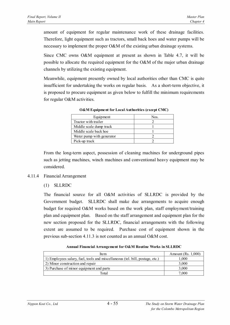
Final Report, Volume II Master Plan Main Report Chapter 4
Nippon Koei Co., Ltd. 4 - 55 The Study on Storm Water Drainage Plan for the Colombo Metropolitan Region
amount of equipment for regular maintenance work of these drainage facilities. Therefore, light equipment such as tractors, small back hoes and water pumps will be necessary to implement the proper O&M of the existing urban drainage systems.
Since CMC owns O&M equipment at present as shown in Table 4.7, it will be possible to allocate the required equipment for the O&M of the major urban drainage channels by utilizing the existing equipment.
Meanwhile, equipment presently owned by local authorities other than CMC is quite insufficient for undertaking the works on regular basis. As a short-term objective, it is proposed to procure equipment as given below to fulfill the minimum requirements for regular O&M activities.
O&M Equipment for Local Authorities (except CMC)
Equipment Nos. Tractor with trailer 2 Middle scale dump track 1 Middle scale back hoe 1 Water pump with generator 2 Pick-up track 2
From the long-term aspect, possession of cleaning machines for underground pipes such as jetting machines, winch machines and conventional heavy equipment may be considered.
4.11.4 Financial Arrangement
(1) SLLRDC
The financial source for all O&M activities of SLLRDC is provided by the Government budget. SLLRDC shall make due arrangements to acquire enough budget for required O&M works based on the work plan, staff employment/training plan and equipment plan. Based on the staff arrangement and equipment plan for the new section proposed for the SLLRDC, financial arrangements with the following extent are assumed to be required. Purchase cost of equipment shown in the previous sub-section 4.11.3 is not counted as an annual O&M cost.
Annual Financial Arrangement for O&M Routine Works in SLLRDC
Item Amount (Rs. 1,000) 1) Employees salary, fuel, tools and miscellaneous (tel. bill, postage, etc.) 1,000 2) Minor construction and repair 3,000 3) Purchase of minor equipment and parts 3,000
Total 7,000
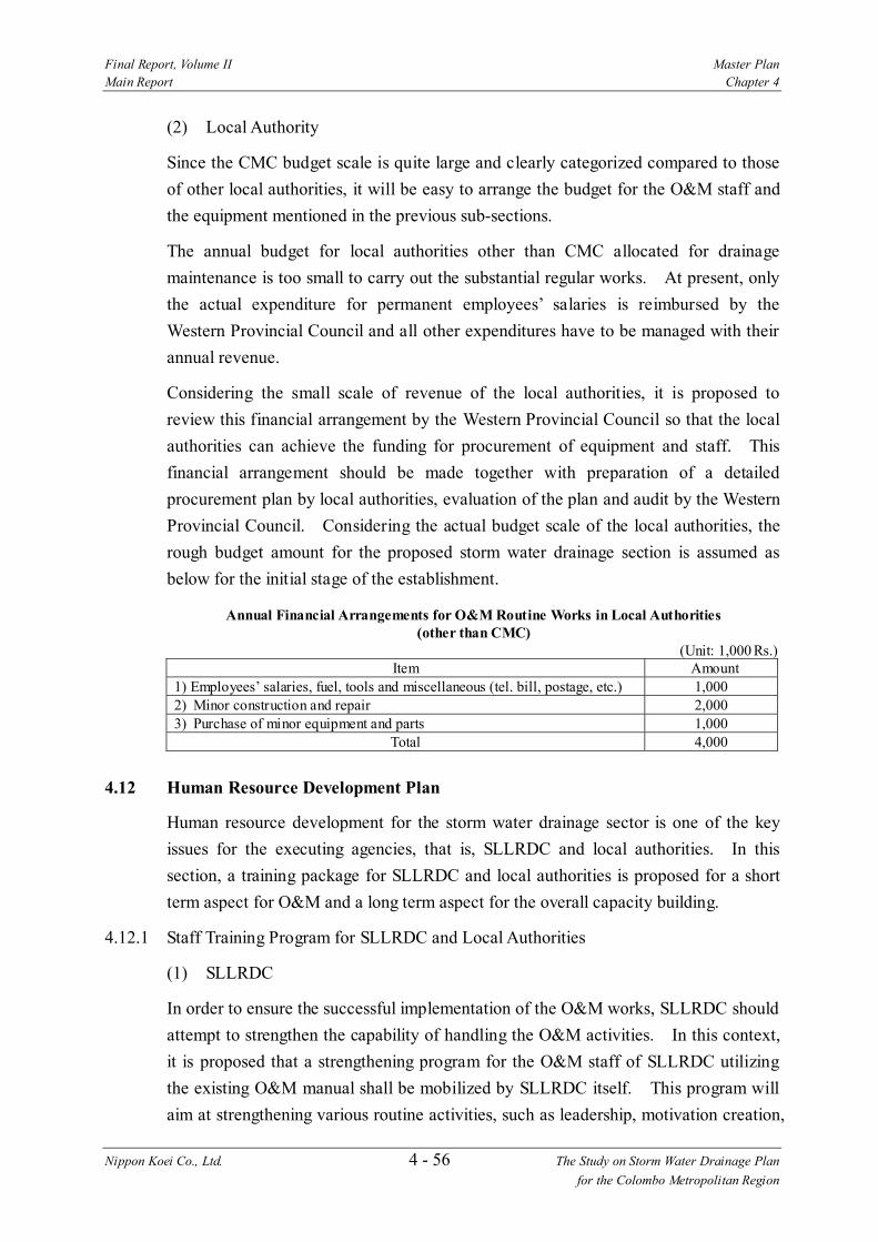
Final Report, Volume II Master Plan Main Report Chapter 4
Nippon Koei Co., Ltd. 4 - 56 The Study on Storm Water Drainage Plan for the Colombo Metropolitan Region
(2) Local Authority
Since the CMC budget scale is quite large and clearly categorized compared to those of other local authorities, it will be easy to arrange the budget for the O&M staff and the equipment mentioned in the previous sub-sections.
The annual budget for local authorities other than CMC allocated for drainage maintenance is too small to carry out the substantial regular works. At present, only the actual expenditure for permanent employees’ salaries is reimbursed by the Western Provincial Council and all other expenditures have to be managed with their annual revenue.
Considering the small scale of revenue of the local authorities, it is proposed to review this financial arrangement by the Western Provincial Council so that the local authorities can achieve the funding for procurement of equipment and staff. This financial arrangement should be made together with preparation of a detailed procurement plan by local authorities, evaluation of the plan and audit by the Western Provincial Council. Considering the actual budget scale of the local authorities, the rough budget amount for the proposed storm water drainage section is assumed as below for the initial stage of the establishment.
Annual Financial Arrangements for O&M Routine Works in Local Authorities (other than CMC)
(Unit: 1,000 Rs.) Item Amount
1) Employees’ salaries, fuel, tools and miscellaneous (tel. bill, postage, etc.) 1,000 2) Minor construction and repair 2,000 3) Purchase of minor equipment and parts 1,000
Total 4,000 4.12 Human Resource Development Plan
Human resource development for the storm water drainage sector is one of the key issues for the executing agencies, that is, SLLRDC and local authorities. In this section, a training package for SLLRDC and local authorities is proposed for a short term aspect for O&M and a long term aspect for the overall capacity building.
4.12.1 Staff Training Program for SLLRDC and Local Authorities
(1) SLLRDC
In order to ensure the successful implementation of the O&M works, SLLRDC should attempt to strengthen the capability of handling the O&M activities. In this context, it is proposed that a strengthening program for the O&M staff of SLLRDC utilizing the existing O&M manual shall be mobilized by SLLRDC itself. This program will aim at strengthening various routine activities, such as leadership, motivation creation,

Final Report, Volume II Master Plan Main Report Chapter 4
Nippon Koei Co., Ltd. 4 - 57 The Study on Storm Water Drainage Plan for the Colombo Metropolitan Region
teamwork, collaborations, responsibility, communication and performance evaluation. Among others, the subjects to be taken up in the program may be as follows:
1) Create awareness of the objectives of the program among all O&M related staff
2) Review the functions and responsibilities of each work section, and revise if some of them are duplicate or obscure
3) Assess staff capability, including qualifications, experience, tasks and duties assigned
4) Assess appropriateness of number of staff assigned to each work section 5) Designated performance targets or goals to be attained by each work section 6) Conduct workshops from time to time to discuss issues arising from the
actual O&M works and to evaluate the functions/duties being achieved by the sections
At the same time, the results of this program should be reflected in the O&M manual for continuous improvement.
(2) Local Authority
The work forces of local authorities have practical knowledge as to maintenance works for existing small drains. In addition, for the purpose of developing additional knowledge of O&M technologies for regular maintenance of storm water drainage systems in urban areas, a series of training programs are required for the engineers and technical officers of local authorities. Especially for the major MCs in the Greater Colombo area, establishment of this training program should be considered soon. As a short term objective, on-the-job training and lectures under the leadership of SLLRDC will be regarded as a practical method for improving the capability of local authorities. On-the-job training by SLLRDC is proposed to execute the following step according to the O&M policy mentioned in the sub-section 4.11.1.
1) During the 1st year after transfer of drainage facilities to the local authority O&M works are undertaken by SLLRDC together with the staff of the local
authority. During this period, staff of the local authority achieve O&M knowledge by joint-operation with SLLRDC staff.
2) During the 2nd year after transfer of drainage facilities to the local authority O&M works are undertaken by the local authority under the supervision of
SLLRDC. Required equipment and machinery are also transferred by SLLRDC.
3) During the 3rd year after transfer of drainage facilities to the local authority O&M works are undertaken by the local authority. SLLRDC staff visits the

Final Report, Volume II Master Plan Main Report Chapter 4
Nippon Koei Co., Ltd. 4 - 58 The Study on Storm Water Drainage Plan for the Colombo Metropolitan Region
work site, at least once a week, for inspection, monitoring and advice.
The lecture programs will include the following:
1) Lectures on the management of O&M works 2) Lectures on health and safety procedures 3) Preparation of O&M manuals (involving Consultants hired by SLLRDC) 4) Lectures on O&M manuals 5) Lectures on procedures of coordination with other institutions and
community organizations
The above program for local authorities should be applied also for local authorities in rural areas according to the progress of development of storm water drainage facilities in the areas.
4.12.2 Overall Training Program for Human Resource Development
From the long term aspect, it will be necessary to establish overall training programs to continuously develop the capability of staff at all levels in the responsible organizations for storm water drainage works. In this section, a framework of the training programs for human resources development is proposed for each target group in SLLRDC and local authorities.
(1) Target Training Participants
1) SLLRDC
SLLRDC will be the sole government agency to be responsible for storm water drainage in the country. As shown in Table 4.8, there are over 1,000 permanent staff working in 13 divisions.
Among these divisions, the Division of Research and Design is the most important section and is in charge of planning, design and approval of storm water drainage projects and land filling proposals on request from UDA or local authorities.
The Division of Canal Development & Maintenance and the Division of Plant & Equipment are also playing important roles for O&M for storm water drainage. A mission of the Department of Reclamation & Planning is partly related to storm water drainage works. The Departments of Human Resource Development & Administration, Finance and Lands & Marketing are supporting sections to make storm water drainage works smooth.
Analyzing the current work performance of SLLRDC, it is proposed that training should cover not only engineering & technical areas but also managerial/administrative and social development areas. In this connection, the

Final Report, Volume II Master Plan Main Report Chapter 4
Nippon Koei Co., Ltd. 4 - 59 The Study on Storm Water Drainage Plan for the Colombo Metropolitan Region
numbers of target training participants in SLLRDC are proposed as shown in Table 4.8.
2) Local Authorities (LAs)
The study area consists of 5 MCs, 12 UCs and 28 PSs. As for storm water drainage works, staff allocation and therefore activities vary among local authorities. CMC has 250 staff including 25 engineers in the Division of Water Supply and Drainage. Although other MCs have a few engineers, they are in charge of all engineering and technical works in the local authorities, which implies no professional staff are available in these MCs. UCs and PSs have no engineers but have a few technical officers. They are in charge of all technical works in the local authorities, which again implies no specialized staff available for storm water drainage works.
Taking this present understaffing in all local authorities except CMC into account, it is proposed to allocate staff specialized in storm water drainage works in each local authority, as shown in Table 4.9. These staff are the target training participants for storm water drainage.
(2) Training Package
The training package is proposed to strengthen capabilities of staff in charge of storm water drainage, as shown in Table 4.10. The training package consists of four categories, i.e., managerial and administrative, technological and technical, social development and O&M.
Managerial and administrative training courses are divided into three groups, i.e., general management and administration, computer literacy and information management. Technological and technical training courses are divided into three groups, i.e., planning, design and drawing and construction management. Social development training courses are divided into four groups, i.e., land management, community development, awareness campaign and relocation of settlement. O&M training courses are divided into two groups, i.e., Operation of O&M equipment and O&M management. Each group has some modules.
Table 4.11 indicates the types of modules, training duration, pre-requisites and candidates for training providers. There are three training types, that is, lecture or conventional classroom training, practical training by using facilities and workshops.
The proposed training providers are briefed below. The details of each training provider are given in Annex 2 of Volume III: Supporting Report (1).
Final Report, Volume II Master Plan Main Report Chapter 4
Nippon Koei Co., Ltd. 4 - 60 The Study on Storm Water Drainage Plan for the Colombo Metropolitan Region
1) SLIDA: Sri Lanka Institute of Development and Administration (Ministry of Public Administration Management and Reforms) A premier public sector training organization for the development of knowledge and managerial skills of senior and middle managers in public administration
2) NIBM: National Institute of Business Management (Ministry of Enterprise Development, Industrial Policy and Investment Promotion) A public organization providing training, consulting and research in the fields of productivity, management and information technology
3) CHPB: Center for Housing Planning & Building (Ministry of Housing and Plantation Infrastructure) A public organization providing training for staff in central government agencies, local authorities, private companies and individuals in broad areas of housing, human settlement, urban infrastructure and urban development. CHPB developed training modules and materials such as community based disaster management, natural disaster mitigation, risk control planning and guidelines for mitigating damages to dwellings in flood-prone areas.
4) SLILG: Sri Lanka Institute of Local Government (Ministry of Home Affairs Provincial Council and Local Government) A public organization providing trainings for trainers in provincial training units in the fields of technical, management and social development
5) PTU/WP: Provincial Training Unit in Western Provincial Council A public organization providing managerial, administrative and technical trainings for officers of LAs in Western Province
In addition, NGOs also can be training providers, particularly in the field of social development. Objectives and contents of each training module are shown in the Attachment in Annex 2 of Volume III: Supporting Report (1).
4.13 Comprehensive Storm Water Drainage Master Plan
The comprehensive storm water drainage master plan consists of structural measures for each basin, non-structural measures, institutional development plan, operation and maintenance plan, and human resources development plan. They are studied in the

Final Report, Volume II Master Plan Main Report Chapter 4
Nippon Koei Co., Ltd. 4 - 61 The Study on Storm Water Drainage Plan for the Colombo Metropolitan Region
previous sections and the following plans are proposed as the comprehensive storm water drainage master plan.
(1) Ja Ela Basin Storm Water Drainage Master Plan (Structural Measures)
1) Ja Ela Channel Improvement (Width = 60 m, Length = 7 km) 2) Dandungam Oya Channel Improvement (Width = 70-80 m, Length = 9.9
km) 3) Storm Water Retention Area (Lower Area=500 ha, Upper Area=376 ha)
(2) Kalu Oya Basin Storm Water Drainage Master Plan (Structural Measures)
1) Kalu Oya Channel Improvement (Width = 25-50 m, Length = 5 km) 2) Old Negombo Canal Improvement (Width = 40 m, L = 4.5 km) 3) Storm Water Retention Area (Lower Area = 360 ha, Upper Area = 89 ha)
(3) Greater Colombo Basin Storm Water Drainage Master Plan (Structural Measures)
1) Madiwela South Diversion Canal (Width = 32 m, Length = 8.8 km) 2) Existing Mutwal Tunnel Restoration (Diameter = 1.8 m, Length = 554 m) 3) New Mutwal Tunnel (Diameter = 4 m, Length = 740 m) 4) Storm Water Retention Area (Kolonnawa Marsh, Kotte Marsh, Heen Ela
Marsh and Parliament Lake Area = 380 ha in total)
(4) Bolgoda Basin Storm Water Drainage Master Plan (Structural Measures)
1) Weras Ganga Storm Water Drainage Plan a) Channel Improvement of Weras Ganga and Tributaries
• Weras Ganga Scheme (Length 5,500 m) • Nugegoda-Rattanapitiya Scheme (Length 5,470 m) • Bolgoda Canal Scheme (Length 2,400 km) • Boralesgamuwa North Scheme (Length 3,090 m) • Boralesgamuwa South Scheme (Length 980 km) • Maha Ela Scheme (Length 4,460 km) • Ratmalana-Moratuwa Scheme (Length 11,120 m)
b) Storm Water Retention Area • Storm water retention areas in Weras Ganga basin (295 ha)
2) Storm Water Retention Area (Low-lying Areas in Lower Bolgoda Basin = 4,739 ha)
(5) Non-structural Measures
1) Storm water retention area management 2) Development control in urban development areas 3) Land use regulation in lowland areas
Final Report, Volume II Master Plan Main Report Chapter 4
Nippon Koei Co., Ltd. 4 - 62 The Study on Storm Water Drainage Plan for the Colombo Metropolitan Region
4) Dissemination of flood information to the public 5) Flood-proofing of buildings in flood-prone areas 6) Flood fighting
(6) Institutional Development Plan
1) Demarcation of responsibilities on storm water drainage sector among related agencies
2) Lowland management by SLLRDC
(7) Operation and Maintenance Plan
1) Demarcation of O&M works among SLLRDC and Local Authorities 2) Organization strengthening of SLLRDC 3) Organization setting-up of Local Authorities
(8) Human Resources Development Plan
1) Training of staff of SLLRDC and Local Authorities for O&M 2) Overall training for human resources
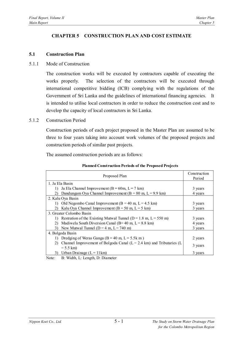
Final Report, Volume II Master Plan Main Report Chapter 5
Nippon Koei Co., Ltd. 5 - 1 The Study on Storm Water Drainage Plan for the Colombo Metropolitan Region
CHAPTER 5 CONSTRUCTION PLAN AND COST ESTIMATE
5.1 Construction Plan
5.1.1 Mode of Construction
The construction works will be executed by contractors capable of executing the works properly. The selection of the contractors will be executed through international competitive bidding (ICB) complying with the regulations of the Government of Sri Lanka and the guidelines of international financing agencies. It is intended to utilise local contractors in order to reduce the construction cost and to develop the capacity of local contractors in Sri Lanka.
5.1.2 Construction Period
Construction periods of each project proposed in the Master Plan are assumed to be three to four years taking into account work volumes of the proposed projects and construction periods of similar past projects.
The assumed construction periods are as follows:
Planned Construction Periods of the Proposed Projects
Proposed Plan Construction Period
1. Ja Ela Basin 1) Ja Ela Channel Improvement (B = 60m, L = 7 km) 3 years 2) Dandungam Oya Channel Improvement (B = 80 m, L = 9.9 km) 4 years
2. Kalu Oya Basin 1) Old Negombo Canal Improvement (B = 40 m, L = 4.5 km) 3 years 2) Kalu Oya Channel Improvement (B = 50 m, L = 5 km) 3 years
3. Greater Colombo Basin 1) Restration of the Existing Mutwal Tunnel (D = 1.8 m, L = 550 m) 3 years 2) Madiwela South Diversion Canal (B= 40 m, L = 8.8 km) 4 years 3) New Mutwal Tunnel (D = 4 m, L = 740 m) 3 years
4. Bolgoda Basin 1) Dredging of Weras Ganga (B = 40 m, L = 5.5k m ) 2 years 2) Channel Improvement of Bolgoda Canal (L = 2.4 km) and Tributaries (L
= 5.5 km) 3 years
3) Urban Drainage (L = 11km) 3 years Note: B: Width, L: Length, D: Diameter

Final Report, Volume II Master Plan Main Report Chapter 5
Nippon Koei Co., Ltd. 5 - 2 The Study on Storm Water Drainage Plan for the Colombo Metropolitan Region
5.2 Cost Estimate
5.2.1 Basic Conditions
(1) Composition of Project Cost
The financial project cost comprises the following cost items.
1) Construction cost 2) Land acquisition and compensation cost 3) Engineering service cost 4) Administration cost 5) Price escalation 6) Physical contingency 7) Tax
(2) Price Level and Foreign Exchange Rate
All costs are estimated at the price level on August 30, 2002.
The exchange rate is set as follows:
US$1.0 = Rs. 96.26 = \118.94
(3) Foreign and Local Currency Portion
All costs are estimated by separating the foreign currency portion (FC) and local currency portion (LC) based on the ratio of the imported and local materials and equipment and also by referring to similar projects such as GCFC&EIP Phase III.
(4) Construction Cost
The construction cost comprises direct construction cost and preparatory work cost. The direct construction cost is estimated on the unit cost basis. The unit costs are estimated based on the current prices of construction resources and the construction plan. The unit construction cost for the urban drainage is based on the data of current similar projects such as GCFC&EIP Phase III.
The preparatory work cost is estimated at 10 % of the direct construction cost.
(5) Land Acquisition and Compensation Cost
1) Land Acquisition
Land acquisition cost is estimated by the required land area and its unit cost. The unit cost of land is estimated based on the data from the Chief Valuer’s Department of the Ministry of Finance.
The applied unit costs are as follows:

Final Report, Volume II Master Plan Main Report Chapter 5
Nippon Koei Co., Ltd. 5 - 3 The Study on Storm Water Drainage Plan for the Colombo Metropolitan Region
Unit Cost of Land
(Unit: Rs./m2) Basin Urban Rural Ja Ela Basin 1,900 20 Kalu Oya Basin 1,900 50
12,000 CMC area * 20,000 200
Greater Colombo Basin Other areas 2,200 200 Weras Ganga Basin 2,200 200 Bolgoda Basin Other areas 600 20
Note: *: Primary commercial area
2) Compensation
Compensation cost includes the cost for compensation for house relocation and properties affected by project implementation. The compensation cost is assumed to be 20% of the land acquisition cost for the master plan study.
(6) Engineering Service Cost
The engineering service cost includes costs for field investigations, basic and detailed design including preparation of pre-qualification documents and tender documents, assistance for pre-qualification and tendering, and construction supervision. The engineering service cost is assumed to be 15% of the construction cost referring to the similar projects.
(7) Administration Cost
The Government’s administration cost for the project implementation is assumed to be 2 % of the total of the construction cost, engineering service cost, and land acquisition and compensation cost. The rate is referred to the “JBIC SAPROF for Lunawa Lake Environment Improvement and Community Development Project, February 2001 (the Lunawa Project)”.
(8) Price Escalation
The following price escalation rates were applied to the SAPROF study for the Lunawa Project.
1) 0.8% per annum for foreign currency (FC) 2) 2.8% per annum for local currency (LC)
The above price escalation rate for local currency was determined based on the following price index data up to the year 1999.
Colombo Consumer’s Price Index (1997-1999)
Year 1997 1998 1999 Colombo Consumer’s Price Index (CCPI) (% change) 9.6 9.4 4.7
Source: Central Bank of Sri Lanka Annual Report - 2001

Final Report, Volume II Master Plan Main Report Chapter 5
Nippon Koei Co., Ltd. 5 - 4 The Study on Storm Water Drainage Plan for the Colombo Metropolitan Region
The future price index is projected by Central Bank of Sri Lanka as follows:
Projected Colombo Consumer’s Price Index (2002-2006)
Year 2002 2003 2004 2005 2006 CCPI (% change) 9.0 6.0 5.5 4.5 3.8
Source: Central Bank of Sri Lanka Annual Report - 2001
According to the above projections, the long-term escalation rate may be presumed to decline to below 3.0 %.
Consequently, the price escalation rates to be applied to the present Study are set at the same rates as those of the SAPROF study for the Lunawa Project.
(9) Physical Contingency
Physical contingency is set as follows referring to the SAPROF study for the Lunawa Project:
1) 10% of the construction cost, land acquisition and compensation cost 2) 5% of the equipment procurement cost, engineering service cost, and
administration cost
(10) Tax
Tax is estimated as follows based on the current tax system of Sri Lanka:
1) 30% for the construction cost 2) 40% for the equipment procurement cost 3) 20% for the engineering service cost
5.2.2 Project Cost
Project costs for the proposed Master Plan are estimated by basin. The total project cost for the Master Plan amounts to Rs. 15.6 billion as tabulated below:
Project Cost of the Proposed Plan
Basin Planning Scale Retention Area (ha)
Project Cost (million Rs.)
Ja Ela Basin 50-year 876 3,679 Kalu Oya Basin 50-year 449 2,463 Greater Colombo Basin 50-year 380 4,389 Bolgoda Basin 50-year 295 5,102 Total 15,633
The features of the storm water drainage plans and project costs for the respective basins are described below:

Final Report, Volume II Master Plan Main Report Chapter 5
Nippon Koei Co., Ltd. 5 - 5 The Study on Storm Water Drainage Plan for the Colombo Metropolitan Region
(1) Ja Ela Basin Storm Water Drainage Master Plan (Structural Measures)
1) Ja Ela Channel Improvement (Width = 60 m, Length = 7 km) 2) Dandungam Oya Channel Improvement (Width = 70-80 m, Length = 9.9
km) 3) Storm Water Retention Area (Lower Area = 500 ha, Upper Area = 376 ha)
Project Cost for Ja Ela Basin Storm Water Drainage Plan
(Unit: million Rs.) Cost Item FC LC Total 1.Construction Cost 1,507 583 2,090 Preparatory Works (10% ) 137 53 190 Construction Cost 1,370 530 1,900 2.Land Acquisition & Compensation Cost 0 223 223 Land Acquisition 0 185 185 Compensation (20% of Land Acquisition Cost) 0 37 37 3.Engineering Service (15% of Construction Cost) 219 94 313 4.Administation Cost (2% of the above) 0 53 53 Total of (1+2+3+4) 1,726 953 2,679 5. Price Escalation 21 41 62 6. Physical Contingency 162 88 250 7. Tax 0 690 690 Project Cost 1,908 1,771 3,679
(2) Kalu Oya Basin Storm Water Drainage Master Plan (Structural Measures)
1) Kalu Oya Channel Improvement (Width = 25-50 m, Length = 5 km) 2) Old Negombo Canal Improvement (Width = 40 m, Length = 4.5 km) 3) Storm Water Retention Area (Lower Area = 360 ha, Upper Area = 89 ha)
Project Cost for Kalu Oya Basin Storm Water Drainage Plan
(Unit: million Rs.) Cost Item FC LC Total 1.Construction Cost 990 311 1,301 Preparatory Works (10% ) 90 28 118 Construction Cost 900 283 1,183 2.Land Acquisition & Compensation Cost 0 288 288 Land Acquisition 0 240 240 Compensation (20% of Land Acquisition Cost) 0 48 48 3.Engineering Service (15% of Construction Cost) 137 59 195 4.Administation Cost (2% of the above) 0 36 36 Total of (1+2+3+4) 1,126 694 1,820 5. Price Escalation 14 30 43 6. Physical Contingency 106 65 170 7. Tax 0 429 429 Project Cost 1,246 1,217 2,463

Final Report, Volume II Master Plan Main Report Chapter 5
Nippon Koei Co., Ltd. 5 - 6 The Study on Storm Water Drainage Plan for the Colombo Metropolitan Region
(3) Greater Colombo Basin Storm Water Drainage Master Plan (Structural Measures)
1) Madiwela South Diversion Canal (Width = 32 m, Length = 8.8 km) 2) Existing Mutwal Tunnel Restoration (Diameter = 1.8 m, Length = 554 m) 3) New Mutwal Tunnel (Diameter = 4 m, Length = 740 m) 4) Storm Water Retention Area (Kolonnawa Marsh, Kotte Marsh, Heen Ela
Marsh and Parliament Lake Area = 380 ha in total)
Project Cost for Greater Colombo Basin Storm Water Drainage Plan
(Unit: million Rs.) Cost Item FC LC Total 1.Construction Cost 1,747 734 2,481 Preparatory Works (10% ) 159 67 226 Construction Cost 1,588 668 2,256 2.Land Acquisition & Compensation Cost 0 280 280 Land Acquisition 0 234 234 Compensation (20% of Land Acquisition Cost) 0 47 47 3.Engineering Service (15% of Construction Cost) 261 112 372 4.Administation Cost (2% of the above) 0 63 63 Total of (1+2+3+4) 2,008 1,189 3,197 5. Price Escalation 24 51 75 6. Physical Contingency 188 110 298 7. Tax 0 819 819 Project Cost 2,219 2,170 4,389
(4) Bolgoda Basin Storm Water Drainage Master Plan (Structural Measures)
1) Weras Ganga Storm Water Drainage Plan a) Channel Improvement of Weras Ganga and Tributaries
• Weras Ganga Scheme (Length 5,500 m) • Nugegoda-Rattanapitiya Scheme (Length 5,470 m) • Bolgoda Canal Scheme (Length 2,400 km) • Boralesgamuwa North Scheme (Length 3,090 m) • Boralesgamuwa South Scheme (Length 980 km) • Maha Ela Scheme (Length 4,460 km) • Ratmalana-Moratuwa Scheme (Length 11,120 m)
b) Storm Water Retention Area • Storm water retention areas in Weras Ganga basin (295 ha)

Final Report, Volume II Master Plan Main Report Chapter 5
Nippon Koei Co., Ltd. 5 - 7 The Study on Storm Water Drainage Plan for the Colombo Metropolitan Region
Project Cost for Bolgoda Basin Storm Water Drainage Plan
(Unit: million Rs.) Cost Item FC LC Total 1.Construction Cost 1,765 762 2,527 Preparatory Works (10% ) 160 69 230 Construction Cost 1,605 693 2,298 2.Land Acquisition & Compensation Cost 0 828 828 Land Acquisition 0 690 690 Compensation (20% of Land Acquisition Cost) 0 138 138 3.Engineering Service (15% of Construction Cost) 265 114 379 4.Administation Cost (2% of the above) 0 75 75 Total of (1+2+3+4) 2,031 1,778 3,809 5. Price Escalation 24 76 101 6. Physical Contingency 190 168 358 7. Tax 0 834 834 Project Cost 2,245 2,857 5,102
5.3 Operation and Maintenance Cost
5.3.1 Maintenance Cost of the Canals
Annual maintenance cost of the canal per kilometer is estimated based on the data in SLLRDC as follows:
Annual Maintenance Cost of Canals
(Unit: million Rs./km) Work Canal of 5-10m wide Canal of 10-30m wide Dredging 0.20 0.60 Surface clearing 0.60 0.60 Canal bank maintenance 0.20 0.20 Total 1.00 1.40
Source: SLLRDC
According to SLLRDC, the annual maintenance cost in 2001 of the Greater Colombo Canal System of GCFC&EIP Phase I, of which the total length is 44 km, was Rs. 66 million. This figure corresponds to about 1% of the construction cost of GCFC&EIP Phase I.
Considering the above, the annual operation and maintenance cost of canals is assumed to be 1 % of the construction cost.
5.3.2 Maintenance Cost of the Other Civil Structures
The annual operation and maintenance costs for the other civil structures are also assumed to be 1% of the construction cost.
5.3.3 Operation and Maintenance (O&M) Cost of the Pumping Stations
Annual O&M cost of pumping stations including personnel expenses, power costs and costs for materials and equipment for O&M works is assumed to be 2.5% of the

Final Report, Volume II Master Plan Main Report Chapter 5
Nippon Koei Co., Ltd. 5 - 8 The Study on Storm Water Drainage Plan for the Colombo Metropolitan Region
electrical and mechanical facility cost of the pumping station referring to the data of similar projects.