
Planning Report - Shorkot 2009 - PART- I: INTRODUCTION
77
Planning Report - Shorkot 1 PUNJAB MUNICIPAL DEVELOPMENT FUND COMPANY PUNJAB MUNICIPAL SERVICES IMPROVEMENT PROJECT (PMSIP) PLANNING REPORT SHORKOT 2009
-
Upload
khangminh22 -
Category
Documents
-
view
0 -
download
0
Transcript of Planning Report - Shorkot 2009 - PART- I: INTRODUCTION

Planning Report - Shorkot 1
PUNJAB MUNICIPAL DEVELOPMENT FUND COMPANY
PUNJAB MUNICIPAL SERVICES IMPROVEMENT PROJECT (PMSIP)
PLANNING REPORT SHORKOT
2009

Planning Report - Shorkot 2
LIST OF CONTENTS
CHAPTER 1 INTRODUCTION ....................................................................................... 6
1.1 BACKGROUND ............................................................................................................................................ 6 1.2 PUNJAB MUNICIPAL SERVICE IMPROVEMENT PROJECT (PIMSIP) ........................................................... 6
1.2.1 Key Features of PMSIP ............................................................................................................................... 6 1.3 PMSIP PLANNING ...................................................................................................................................... 6
1.3.1 Limitations of PMSIP Planning ............................................................................................................. 7 1.4 THE PLANNING PROCESS .......................................................................................................................... 7
1.4.1. Secondary Data Collection ........................................................................................................................ 7 1.4.2. Mapping ..................................................................................................................................................... 8 1.4.3 Field Data Collection.................................................................................................................................. 8 1.4.4 Data Analysis ............................................................................................................................................. 9 1.4.5 The Visioning Workshop ............................................................................................................................ 9 1.4.6 Interim Appraisal by World Bank ............................................................................................................... 9 1.4.7 One Day Planning Refresher Workshop for Year I TMAs .......................................................................... 9
CHAPTER 2: TMA PROFILE ......................................................................................... 11
2.1 DISTRICT PROFILE .............................................................................................................................. 11 2.1.1 History ................................................................................................................................................. 11 2.1.2 Location ............................................................................................................................................... 11 2.1.3 Area / Demography ............................................................................................................................. 11
2.2 TMA/TOWN PROFILE- SHORKOT .......................................................................................................... 11 2.2.1 Location ............................................................................................................................................... 11 2.2.2 Area/Demography ............................................................................................................................... 12
CHAPTER 3 URBAN PLANNING ................................................................................. 14
3.1 SITUATION ANALYSIS - PLANNING SECTION ............................................................................................ 14 3.2 MAPPING BY PMDFC .............................................................................................................................. 14 3.3 BUILDING CONTROL .................................................................................................................................. 15 3.4 EXISTING LAND USE CHARACTERISTICS .................................................................................................. 15
3.4.1 Residential ........................................................................................................................................... 15 3.4.2 Commercial ......................................................................................................................................... 15 3.4.3 Industry ................................................................................................................................................ 16 3.4.4 Parks .................................................................................................................................................... 16 3.4.5 Grave Yards ......................................................................................................................................... 16
3.5 KATCHI ABADIES ............................................................................................................................................. 16 3.6 POPULATION DENSITY .............................................................................................................................. 18 3.7 GROWTH DIRECTIONS .............................................................................................................................. 18
CHAPTER 4 STATUS OF MUNICIPAL INFRASTRUCTURE ....................................... 20
4.1 ROAD NETWORK & STREET LIGHTS ........................................................................................................ 20 4.1.1 Road Condition .................................................................................................................................... 20 4.1.3 Needs ................................................................................................................................................... 22 4.1.4 Street Lights ......................................................................................................................................... 24
4.2 WATER SUPPLY ........................................................................................................................................ 25 4.2.1 Service Area ......................................................................................................................................... 25 4.2.2 Drinking Water Sources ...................................................................................................................... 25 Two tube wells of the following capacity are operating: ½ cusec used for office lawns and ½ cusec for water
sprinkling in the town. None of the tube well is used for supply to the consumers. The consumers have made
their own water supply arrangements through privately installed hand pumps or shallow tube wells/ pumps . 25 4.2.3 Water Distribution Network ................................................................................................................ 25 4.2.4 Water Storage ...................................................................................................................................... 26 4.2.5 Water Demand ..................................................................................................................................... 26 4.2.6 NEEDS ................................................................................................................................................. 26
Planning Report - Shorkot 3
WATER TESTING OF SHALLOW WATER TO DETERMINE IF CONTAMINATION EXISTS IN THE TOWN. IT SHOULD BE
FOLLOW UP BY DETAILED DISCUSSIONS WITH STAKEHOLDERS ABOUT DEVELOPMENT OF TMA WATER SUPPLY
NETWORK. ............................................................................................................................................................... 26 4.3 SEWERAGE SYSTEM .................................................................................................................................. 27
Disposal at Medanwala ..................................................................................................................................... 28 A new disposal at north part of the town is being constructed. Trunk size is 24”, there is one collecting tank
od 18’ dia. Screening chamber 6’ X 13’ has also been constructed. Pump house size is 12’ and boundary was
length is 550’. .................................................................................................................................................... 28 4.3.1 Coverage Area ..................................................................................................................................... 28 4.3.2 Problem Areas ..................................................................................................................................... 29 4.3.3 Needs ................................................................................................................................................... 29
4.4 SOLID WASTE MANAGEMENT .................................................................................................................. 31 4.4.1 Collection System ................................................................................................................................ 31 4.4.2 Service Level ........................................................................................................................................ 32 4.4.3 Land Fill/Dumping Sites ...................................................................................................................... 33 4.4.4 Operation & Maintenance .................................................................................................................. 33 4.4.5 Needs ................................................................................................................................................... 34
4.5 FIRE FIGHTING.......................................................................................................................................... 36 4.5.1 Existing Fire Fighting Arrangements .................................................................................................. 36
4.6 PARKS ...................................................................................................................................................... 36 4.6.1 Existing Parks ...................................................................................................................................... 36 4.6.2 Needs ................................................................................................................................................... 37
4.7 SLAUGHTER HOUSE ................................................................................................................................. 37 4.7.1 Existing Situation ................................................................................................................................. 37 4.7.2 Needs ................................................................................................................................................... 38
CHAPTER 5: WORKSHOP ON VISIONING AND PRIORITIZATION OF DEVELOPMENT SECTORS ......................................................................................... 39
5.1 PRE-WORKSHOP CONSULTATIONS ......................................................................................................... 39 5.2 WORKSHOP PROCEEDINGS ..................................................................................................................... 40
5.2.1 General ................................................................................................................................................ 40 5.2.2 Workshop Participants ...................................................................................................................... 40 5.2.3 The Session ......................................................................................................................................... 40 5.2.4 Group Formation ................................................................................................................................ 40
5.3 OUTCOME OF THE VISIONING WORKSHOP .............................................................................................. 41
42
CHAPTER 6: SITUATION ANALYSIS AND PMDFC INTERVENTIONS ....................... 43
6.1 CAPACITY BUILDING / TRAININGS ............................................................................................................ 43 6.2 COMPLAINT CELL (COMPLAINT TRACKING SYSTEM) .............................................................................. 44 6.3 PERFORMANCE MANAGEMENT SYSTEM .................................................................................................. 45
6.3.1 Performance Management System ...................................................................................................... 45 6.3.2 Data Collection & Analysis ................................................................................................................. 46 6.3.3 Target Setting ...................................................................................................................................... 46
6.4 FINANCIAL MANAGEMENT SYSTEM .......................................................................................................... 46 6.5 TMA WEBSITE ......................................................................................................................................... 47
CHAPTER 7: OUTLINE STRUCTURE PLAN - SHORKOT ............................................ 49
7.1 BRIEF INTRODUCTION ............................................................................................................................... 49 7.2 VISIONING & PRIORITY OF STAKEHOLDERS .............................................................................................. 49 7.3 DEVELOPMENT PLANS .............................................................................................................................. 50 7.4 HISTORIC GROWTH ................................................................................................................................... 51 7.5 GROWTH DIRECTION ................................................................................................................................. 53 7.6 KATCHI ABADIS ........................................................................................................................................ 53 7.7 DENSIFICATION OF BUILT-UP AREAS ........................................................................................................ 53 7.8 LAND REQUIREMENT OF FUTURE URBAN EXPANSION .............................................................................. 56 7.9 PROPOSALS ............................................................................................................................................... 56
7.9.1 Stage I .................................................................................................................................................. 59

Planning Report - Shorkot 4
7.9.2 Stage II ................................................................................................................................................. 59 7.9.3 Stage III ............................................................................................................................................... 59
7.10 ACTION PLANS .......................................................................................................................................... 62 7.10.2 Action Plan for – Water Supply ...................................................................................................... 64 7.10.3 Action Plan for Drainage & Sewerage ........................................................................................... 66 7.10.4 Action Plan for Solid Waste Management ...................................................................................... 69 7.10.5 Action Plan for Parks...................................................................................................................... 69 7.10.5 Action Plan for – Slaughter House ................................................................................................. 70 7.10.6 Action Plan for – Fire Fighting Arrangements ............................................................................... 70
ANNEX -A ROADS ................................................................................................................................................... 71 ANNEX-B WATER SUPPLY....................................................................................................................................... 74 ANNEX-C SEWERAGE .............................................................................................................................................. 76

Planning Report - Shorkot 5
List of Maps
Urban Planning and Infrastructure Maps
1. Land Use Map ……………………………. P - 19 2. Base Map ……………………………. ……P - 21 3. Road Hierarchy Map ……………………..P - 23 4. Street Light Map 5. Water Supply Map 6. Sewerage Map
Structure Plan Maps
7. Historical Growth Map 8. Population Density Map 9. Proposal Map 10. Structure Plan Map 11. Water Supply Action Plan Map 12. Sewerage Action Plan Map 13. Road Action Plan Map 14. Solid Waste Management Action Plan Map

Planning Report - Shorkot 6
CHAPTER 1 INTRODUCTION
1.1 Background Planning is a part of Punjab’s local government system with the planning responsibilities of TMAs, set out in PLGO. Under the devolved system, the newly created office of TO(P) has the following functions ; (i) develop plans; (ii) develop and apply building controls; (iii) manage CCBs; (iv) implement commercialization rules; (v) operate Punjab Housing Development Schemes; (vi) develop site development schemes. In addition, The PLGO identifies the preparation of spatial plans (Article 54 a), development plans (Article 54 c) and budget plans, long term and annual municipal development programs (Article 54 j) as key functions of the TMAs. Unfortunately, in majority of TMAs TO (P) office has not been able to perform as envisioned in the PLGO. Some of the reasons are inadequate staff and lack of up-to-date maps, equipment, management/ regulation/ and enforcement mechanisms. As a result, development works are taking place in a piecemeal manner and lack integrated and coordinated approach.
1.2 Punjab Municipal Service Improvement Project (PIMSIP) Under these circumstances the Government of Punjab launched Punjab Municipal Service Improvement Project (PIMSIP) through Punjab Municipal Development Fund Company (PMDFC) .The project aims at the institutional development of TMAs through improving systems directly related to their functions and through investments in service delivery.
1.2.1 Key Features of PMSIP The project has two distinct components; Municipal Infrastructure Development and Institutional Development (ID): Municipal Infrastructure development: The project funds the infrastructure schemes after the identification of most pressing development issues of the respective town. Institutional Development: To improve the service delivery , a number of interventions are suggested in the projects like providing maps prepared with GIS, Performance Management System, Financial Management System, Action Planning and various trainings to TMA staff.
1.3 PMSIP Planning Under PMSIP planning rapid appraisal of municipal services is undertaken to identify service delivery gaps, analyzed needs and guide the means to overcome such gaps. In addition, stakeholder consultation provides the much needed guidance to the planning exercise. Outcome of this exercise is a municipal service data base, improved mapping and a list of development projects that may be funded by PMSIP.

Planning Report - Shorkot 7
1.3.1 Limitations of PMSIP Planning As every project addresses specific issues, PMSIP has been launched with some limitations as follows:
The PMSIP development grants fund for municipal services only.
PMSIP planning exercise is undertaken at CO Units starting from CO Unit HQ, i.e urban area.
The prioritized list that is developed is restricted to the UCs falling in CO Units. Nonetheless it is assumed that experience gained in the urban areas would be replicated in the entire TMA.
1.4 The Planning Process The Planning process adopted incorporates an overall Strategy for high lighting the development options and the community’s agreed outputs. These out put form the basis of spatial plan. It is a more inclusive approach aiming to ensure best use of land by weighing up competing demands. The plan devised is an ongoing process for the sustainable development. To achieve such development a Spatial plan has been developed. It addresses municipal development issues and infrastructure needs in a systematic way. The plan therefore emphasizes on engagement with the stakeholders and other organizations, the management and ongoing funding programs. This led to identify the community’s preferences for development process. After the identification of the preferred options, a detailed Action plan for each priority sector was developed. Action plans complement the strategy and Spatial plan by setting out short to medium term actions to achieve the desired objectives. The Planning process thus culminates in producing a concise development plan for the town. Following steps were adopted for the planning process:
1.4.1. Secondary Data Collection First, the sources were identified for the previous attempts that were made in Shorkot for planning. It includes , DCR, on line data and PHED services maps. The study of such documents helped to gather background information about the town, infrastructure coverage and growth. It helped to have an understanding about the development patterns evolved over a period of years. The maps from Public health reflected the water supply and sewerage laid out previously. It was also gathered that the whether the projects have completed their designed life. These plans were again used at the analysis stage and compared with the existing data collected later on.

Planning Report - Shorkot 8
1.4.2. Mapping The first requirement before going to the field was to prepare a base map for the town. For this purpose, the mapping exercise was started in parallel to the secondary data collection. The image was procured for the TMA. It was then processed and a vectorized layer was made. The land marks were put on the base map using the secondary sources i.e maps obtained from PHED. The land marks included the important roads, water features, big buildings, factories, graveyards etc. A rigorous brain storming session was conducted in which many apprehensions about the forms were removed. The data collection forms were reviewed and planning team made clarifications to TMA officials about these forms. At this stage the data collection forms were finalized.
1.4.3 Field Data Collection Preliminary meetings Once the data collection forms were finalized the planning team was to initiate the data collection process in the field. First, a meeting was held with the TMA leader ship (Nazim) to discuss the field data collection work plan. At this stage a planning steering committee comprising of TOs, and a working group constituting ATOs and other lower order officials was notified. The duties were assigned and a briefing was given to these officials about their role in data collection. The planning team discussed the general development issues of the town with the Nazim and notes were recorded. Infrastructure Data Collection For infrastructure data collection, the planning team worked very closely with the working group. First the existing service maps available with the TMA were used as a starting point. To update the map the secondary source like information from Public health maps was added. This information was verified by the working group to prepare an updated map for the services. This missing or additional information was provided by second line officials. For instance, for water supply, plumbers and sub engineers provided first hand information about the system. Where necessary, field visits were made to validate the information. Urban Planning A Landuse survey was conducted to update the TMA map. The residential areas, commercial, institutional and open spaces and industrial areas were marked on the base map. The team comprised for the survey was TO (P), urban planner from PMDFC and draftsman from TMA. The Planning office guided about the growth directions of the town and a rudimentary survey was made in this regard. It was observed where the new residences were built

Planning Report - Shorkot 9
and institutions were being developed. These factors determine the future expansion of the town. In addition to it, the land ownership and land values information was recorded.
1.4.4 Data Analysis Once the planning team collected the data, all of the forms were arranged in the office. The data was cleaned and integrated. The PMDFC officials contacted the TMA office again if any gaps were found in the collected data. Such additional information was gathered for each sector. Based on the information collected in the field, descriptive maps for all the municipal sectors like water supply, sewerage, solid waste and land use were developed. The analysis report was produced by the planning team by using these maps. This report was again sent to the engineers for further updation and review and hence a final draft was made.
1.4.5 The Visioning Workshop The planning process stems from the Nazim and other stakeholderss vision of the town which is further translated into the tangible and concrete targets. The salient feature of this step is the visioning and prioritization workshop. Participants of the workshop were the Nazim and Naib Nazim, senior TMA officials, including the TMO, all the TOs and staff members , councilors, local representatives of provincial departments, representatives of NGOs operating in the town, representatives of civic groups such as the trade bodies. A comprehensive presentation was given to all of the stakeholders about the fabric of the municipal infrastructure in the town. They all shared their views about the future development options and investment decisions of their town. Once the vision was agreed upon and the objectives were established, a rigorous session was organized for the selection of the priority sectors. At the end of the workshop the statement of agreed vision, objectives and priorities was summarized in written draft and circulated among all the stake holders.
1.4.6 Interim Appraisal by World Bank Two day Consultative Workshop was held as a schedule arrangement during World Bank Implementation Support Mission. The World Bank mission was to make interim appraisal of the PMSIP activities undertaken inYear-1 TMAs. In addition, it provided a forum for Tehsil Officers Planning (TOPs) , the World Bank and PMDFC to share common approach to improve capacity building efforts for the planning office of the partner TMAs.
1.4.7 One Day Planning Refresher Workshop for Year I TMAs A refresher workshop was conducted to develop a close liaison between PMDFC and TMAs. TO(P)s from partner TMAs attended the workshop. Presentations were designed to give a snapshot of the planning exercise. The main objectives of the workshop were;

Planning Report - Shorkot 10
To review the existing planning process
To initiate the process of up-dation of the planning reports and maps
To share the maps and reports prepared by PMDFC with partner TMAs In addition to it, information was also collected regarding the interventions, their viability and suggested improvements. Recommended Actions and Next Steps
There would be a planning workshop for Year-1 partner TMAs.
Year-1 TMA would again be provided with municipal data and maps.
Mechanism of updation of such municipal data and maps would be formulated by PMDFC.
Stakeholders
Visioning Workshop
Secondary Data
Collection
Orientation Workshop
•PMSIP Orientation
•Data Collection Forms
•Familiarization with PMDFC
•Initial data filling
Field Data
Collection
Data Analysis
Data Filling Workshop
Output
Finalizing the data collection forms
Prioritized infrastructure sectors
•Brain Storming Session
•ATO, Sub- Eng ,PMDFC Planners and Engrs.
•All Infrastructure Sectors
•Landuse, Growth Directions
•Management Analysis
• Procurement of Images
•Vectorization
•Base Map
•DCR, ODP , PHED, Budget Books
MAPPING
OUT LINE SPATIAL PLAN
Output
Output
•Descriptive Maps
•Report
Action Plans for Municipal Services sectors
Output

Planning Report - Shorkot 11
CHAPTER 2: TMA PROFILE
2.1 DISTRICT PROFILE
2.1.1 History
The district takes its name from its headquarters city Jhang. Jhang in local dialect means a clump or grove of trees. Probably, some prominent grove on the site of the present city of Jhang gave its name to the original settlements which grew in size and importance with the passage of time.
2.1.2 Location The district lies between 30-37 to 31-59 north latitudes and 71-37 to 73-13 east latitude.
2.1.3 Area / Demography The total area of the district is 8,809 square kilometers.
Admn. Unit
Area (sq.km.)
Population 1998
Population 1981
1981-98 Avg. annual growth rate (%)
Both sexes
Male Female Sex ratio
Population density/sq. km.
Urban proportion
Avg. HH size
Jhang District
8,809 2,834,545 1,474,099 1,360,446 108.4 321.8 23.4 6.5 1,970,944 2.16
Chiniot Tehsil
2,643 965,124 503,236 461,888 109.0 365.2 26.9 6.4 694,080 1.96
jhang Tehsil
4,153 1,199,166 623,343 575,823 108.30 288.7 25.4 6.4 816,522 2.29
Shorkot Tehsil *
2,013 670,255 347,520 322,735 107.7 333.0 14.8 6.9 460,342 2.23 Ahmadpur Sial Tehsil*
* Data for Tehsil Shorkot & Tehsil Ahmedpur Sial is combined since Ahemedpur Sial was declared
tehsil in 2005 and area was taken from Tehsil Shorkot for its creation. 1998 population census data from Jhang DCR has this combined information.
2.2 TMA/TOWN PROFILE- SHORKOT 2.2.1 Location

Planning Report - Shorkot 12
2.2.2 Area/Demography
The detail of CO Unit is as:
Detail of CO units in Shorkot
CO Units
Population 1998
Population 1981
1981-98 Avg.
annual growth rate (%)
Avg. HH size
Both Sexes
Male Female
Shorkot 102,833 52,359 50,524 55,555 3.69 7.7
Jamke Cheema 20,474 10,308 10,166 14,848 1.91 7.6
Source: District Census Report 1998, Population Census Organization, Statistics Division, Government of Pakistan, Islamabad.
The city population was 102,833 persons as per 1998 Census with a growth rate of 3.69 percent per annum. The population for year 2008 was 147,812 persons, which is expected to grow up to 305,105 persons up to year 2028. Population of Shorkot has been projected over the next 20 years using the following formula:
Pn = Po (1+r/100) n
Where Pn = Population of the desired year, Po = Population of the base year, r = Population Growth Rate, n = Number of years.

Planning Report - Shorkot 13
The growth rate of 3.69 has been taken for the entire period of projection.
Note: The population projection is based on the growth rate identified during the period of 1981-1998.
Population Projection - Shorkot Town
0
10,000
20,000
30,000
40,000
50,000
60,000
1995 2000 2005 2010 2015 2020 2025 2030
Year
Pro
jecte
d P
op
ula
tio
n
Population Forecasts for Shorkot Projected Population for the Year:
2008 2013 2018 2023 2028
147,812 177,172 212,364 254,545 305,105
Incremental Population (2008-2028)
Population 1998
Incremental Population
1998-2008
2008-2013
2013-2018
2018-2023
2023-2028
102,883 44,929 29,360 35,192 42,181 50,560

Planning Report - Shorkot 14
CHAPTER 3 URBAN PLANNING Urban planning under TMA has a crucial role in guiding the present and future growth of the town. The Planning officeis responsible to produce spatial plans and exercise development control for change of land uses in the town. Further it maintains a comprehensive data base and information system on TMA and is responsible to execute and manage development plans for infrastructure projects. For the entire development of the Tehsil it is mandatory to produce different maps like base map, land use map, zoning map, etc. The planning office is responsible to prepare Annual development plans and long term plans. These plans are made under the direction of Tehsil Nazim.
3.1 Situation Analysis - Planning Section TMA Shorkot was no different than other TMAs of Punjab in terms of lacking institutional and individual capacity required to meet post devolution challenges. Initial field appraisal carried out by PMDFC revealed that: The following Table compares the available posts and the filled posts in the office of TO (P). Detail of Posts in the planning office (TMA-Shorkot)
S/No Post Available Posts
Status Additional Charge
1 TO(P) 1 Vacant TO(P)Sambrial
2 Sub-Engineer 1 filled
3 Building Inspector 1 Vacant Draftsman
4 Draftsman 1 Filled
5 Tracer/surveyor 1 Vacant
6 Junior clerk/billing clerk
1 Filled
7 Naib Qasid 1 Filled
Source: Agency record As is evident from the above table, most of the important posts are lying vacant. Without TO(P), and regular sub-engineer and building inspector, building control and other development plans get delayed, causing inconvenience to the general public. All records are manually maintained and no analysis of data is performed.
3.2 Mapping by PMDFC At present, with the completion of planning exercise in Shorkot, a number of maps were prepared and handed over to the TO (P) office. It included land use, density, growth direction, water supply, sewerage, solid waste management, Roads and street light maps.

Planning Report - Shorkot 15
These maps are prepared with the help of GIS. The soft copies will be handed over so that they could develop their own maps. These maps could be prepared in AutoCAD.
3.3 Building control For building control activities residents submit requests with a plan and other requisite documents. Building inspector visits the site and checks if the plan is according to the site. There is a requirement that residents after completion of their buildings get a completion certificate from planning office, but it rarely occurs. There is need of such mechanism that residents have to get the completion certificate. The building control records are manually maintained. Following is the sum of building plans approved in 2006-07 to 2008-09. From the above table it is clear that very high percentage of residential plans have been approved as compared to the commercial plans. Rather, one to two percent of the submitted plans have been approved. This is a matter of fact that the fee for commercial plans is high as compared to the residential plans, therefore, it is not submitted by the applicants, or they are reluctant to pay.
3.4 Existing Land use Characteristics
3.4.1 Residential The land-use pattern in Shorkot is generally undefined. The central part of the town is very congested area. This is because of major commercial activities are concentrated in the centre of the town. There was no planning and the town developed haphazardly. The plot sizes are small with winding street pattern. The industrial activities are mixed up with the commercial activities in the residential areas. A number of new residential areas are being developed in the outer peripheral areas, i.e along Sialkot, Sambrial road in the north and east directions respectively. Some schemes have also started emerging in along Gujranwala road.
3.4.2 Commercial The hub of commercial activities is the Fawara chowk. From this chowk emerge four important roads i.e. Sambrial Road, which is towards north of the town, college road runs towards the Sialkot to the east. The other two roads are Pasrur Road and Nisbat Road towards south east and south direction respectively. This is very congested area. The residential area in this part of the town is old and double storied. The road pattern is irregular and haphazard, with narrow streets which creates further congestion. The slow moving traffic makes the situation even worse.
Sr.# Year Domestic Plans Submitted
Domestic Plans Approved
Commercial Plans Submitted
Commercial Plans Approved
Total Revenue (Rs)
1 2008-09 269 228 28 04 5,082,825
2. 2007-08 343 291 32 09 2,634,255
3. 2006-07 430 365 81 07 2,887,675

Planning Report - Shorkot 16
The other important chowk in Shorkot is the Tehsil Chowk. A number of commercial, institutional and industrial activities are situated here. Girls College is situated on the road connecting Fawara chowk and Tehsil Chowk. There is a rest house adjacent to it. Police station is opposite to the Girls College. TMA office and post office are also located here. The road that runs towards east leads towards Sialkot. Boys College is located in this direction. To the west of Tehsil Chowk, is the highly congested area where industrial/commercial activities are taking place. The presence of cottage industry is the main feature of the town. The commercial/ industrial activities are going on along main strips through out the town. The BRB canal is situated to the south west of the town. The area adjacent to it is densely populated. Nisbat Road runs towards the north and touches the Fawara Chowk. Along this road, Girls primary school, mosques, madrassas like, Dar ul Uloom, Masjid Umer, Imam Bar Gah etc are mainly located. To the south east, most of the land is vacant and some of the land is used for agricultural purposes.
3.4.3 Industry The industries in Shorkot town are scattered all over the town, mixed with other landusessuch as residential, commercial . The major concentration of industries is along Circular road. Most of the Agro Engineering units, Flour and rice mills, steel works are located along this road. Whereas small workshops, furniture shops, cutlery works, auto works, trunk manufacturing are scattered all over the town even in very high density residential area this has resulted in stress, congestion and unhygienic living and working condition.
3.4.4 Parks There is no park in the town. There is one stadium in the town on the crossing of Wazirabad Road and BY pass Road in the north- west direction.
3.4.5 Grave Yards There are four main graveyards in the town. Two of them are to the west and other two are situated in the eastern part of the town. There is one municipal general bus stand towards the south west on Bus Stand road. In the north of the town, circular road runs through the entire town in the shapes of an arc. It is the provincial road, but serves the commercial and industrial activities of the town. The grain market is situated on this road. Two rice mills and one flour mill is located along it.
3.5 Katchi Abadies
There are no katchi abadies in Shorkot.

Planning Report - Shorkot 17
#
#
#
##
#
##
#
#
#
#
#
#
#
Mar
i Min
or
To J
ha
ng
Ba
nk R
oad
To Multa
n
To Patan
To Shorkot Cantt.
Darb
ar R
oad
To Bhangoo
Da
ra P
ur
Ro
ad
Old
Jhang
Road
Ha
ssu
Wali R
oad
Lin
k P
ata
n R
oa
d
Darbar Mai Bap Road
Bhangoo Road
Katch Kota Road
Jamia Usmania Road
Basti Jogianwali Road
Kachi Abadi Road
Disposal Works # 2 Road
Kh
alid
Bin
Wa
lid
Ro
ad
Ol d
Hos
pi t
al R
oad
Tehsil chowk
Ward No. 1
Abbas Pura
Moh. Qasaban
Moh. Usmania
Housing Colony
Moh. Katchkota
Moh. Ameer Abad
Moh. Lallan Peer
Moh. Saraie East
Moh. Saraie West
Mohalla QureshianBasti Jogian Wali
Moh. Basti Arrian
Moh. Hussain Abad
Moh. Umar Bin Khatab
300 0 300 600 Meters
Residential
Landuse
Abandant Fort
Educational Institutes
Graveyard
Hospital
Park
Public Building
Religeous
Tomb
Traffic Terminal
Roads
Commercial
Road Boundary
# Mohallas
Canal
Chowk
N
EW
S
C ho wk
C an al
M oh alla s#
D isp osal W orks
Se wer L in es
Structure Plan
Exist in g R esid en tia l
P rop osed A rea
Prop osed Co mm ercial
P rop osed In st itution al
Legend
C ho wk
C an al
M oh alla s#
L an dm arks#
R oa ds
Legend
Landuse Map- Shorkot
C ho wk
C an al
M oh alla s#
D isp osal W orks
Se wer L in es
R oa ds
Legend
Cho wk
Can al
Moh alla s#
Roa ds
Landuse
Ab and ant Fort
Ed ucation al In st itute s
Gra veyard
Hospita l
Pa rk
Pu blic Build in g
Relig eo us
Tom b
Tra ff ic Te rmina l
Legend

Planning Report - Shorkot 18
3.6 Population Density The average density of Shorkot is 64 persons per acre. Shorkot is a very compact town. Previously, when the town started to develop, it was on an elevated site known as Shorkot Kalan. There was a protective wall around it and surrounded by a protective mot. Ever since, this part along with surrounding area,has now beome the central part of the town. It is very densely populated. Not only the residential uses but the industrial and commercial activities have added to its congestion. The other site that historically developed was Shorkot Kot , exactly one kilometer from Shorkot kalan. It was also an elevated site. The reason for the development at distant sites was because of the fact that with the passage of time the protective moats took the shape of big ponds which restricted the extension of Shorkot Kalan. But with the passage of time, the intervening land was put under residential use as ponds vanished. The area surrounded by the Circular road is densely populated and also the southern part has high population density. The eastern side has a medium density, where we can see various pockets of land within the existing establishments. The outskirts of Shorkot, especially in the north and the east, has a low density. These are newly developed areas and mostly private housing schemes are sprouting up.
3.7 Growth Directions Shorkot is not a planned city. Many important roads that lead to neighboring cities come out of the town. The internal road pattern is haphazard and accommodated randomly developed residential and commercial built up area. Unfortunately, the same pattern of growth is taking place in either direction of the town. Due to the lack of planning, the latest developments are sporadically occurring. Though the development is taking in all the directions, but the major direction of growth is in the east. Some growth has been noticed in north direction also.
But most rapid expansion is taking place towards the north along Sambrial Road and in the east along Sialkot Road. Most of the new houses are being constructed in these directions. As new settlements are being established, other land uses
like commercial area, petrol pumps, primary schools etc have developed accordingly. In the south west a canal is a natural barrier to the growth of the town. However, some of the growth is also taking place on the either side of the water channel. The main built up area is seen along the Gujranwala Road.

Planning Report - Shorkot 19
##
#
#
#
#
#
#
#
#
#
#
#
#
#
#
#
#
#
#
#
#
#
#
#
#
#
#
#
#
#
#
##
#
##
#
#
#
#
#
#
#
Mar
i Min
or
To J
ha
ng
Ba
nk R
oad
To Multa
n
To Patan
To Shorkot Cantt.
Darb
ar R
oad
To Bhangoo
Da
ra P
ur
Ro
ad
Old
Jhang
Road
Ha
ssu
Wali R
oad
Lin
k P
ata
n R
oa
d
Darbar Mai Bap Road
Bhangoo Road
Katch Kota Road
Jamia Usmania Road
Basti Jogianwali Road
Kachi Abadi Road
Disposal Works # 2 Road
Kh
alid
Bin
Wa
lid
Ro
ad
Ol d
Hos
pi t
al R
oad
Tehsil chowk
Ward No. 1
Abbas Pura
Moh. Qasaban
Moh. Usmania
Housing Colony
Moh. Katchkota
Moh. Ameer Abad
Moh. Lallan Peer
Moh. Saraie East
Moh. Saraie West
Mohalla QureshianBasti Jogian Wali
Moh. Basti Arrian
Moh. Hussain Abad
Moh. Umar Bin Khatab
Godown
Graveyard
Graveyard
Graveyard
Graveyard
TMA Office
Chowki Park
Police Post
Post Office
THQ Hospital
NADRA Office
Imam Bar Gah
Jamia Usmaina
Abondant Fort
Old Bus Stand
Children Park
Girls College
Highway Office
Police Station
Building Office
Darbar Mai Baap
Tehsil Katchehry
Girls High School
General Bus Stand
Purani Ghalla Mandi
Disposal Works No.2
Masjid Bat-uz-Zikar
Govt Primary SchoolNational Bank of Pakistan
300 0 300 600 Meters
RoadsRoad Boundary
# Landmarks
# MohallasCanal
Chowk
N
EW
S
C ho wk
C an al
M oh alla s#
C om me rcia l
Landuse
Ab and ant Fort
Ed u
Gra veyard
H ospita l
Pa rk
Pu blic Build in g
R elig eou s
T om b
T ra ff ic Te rminal
R esiden tial
LegendC ho wk
C an al
M oh alla s#
D isp osal W orks
Se wer L in es
Structure Plan
Exist in g R esid en tia l
P rop osed A rea
Prop osed Co mm ercial
P rop osed In st itution al
Legend
Cho wk
Can al
Moh alla s#
Lan dm arks#
Roa ds
Legend
Base Map- Shorkot

Planning Report - Shorkot 20
CHAPTER 4 STATUS OF MUNICIPAL INFRASTRUCTURE
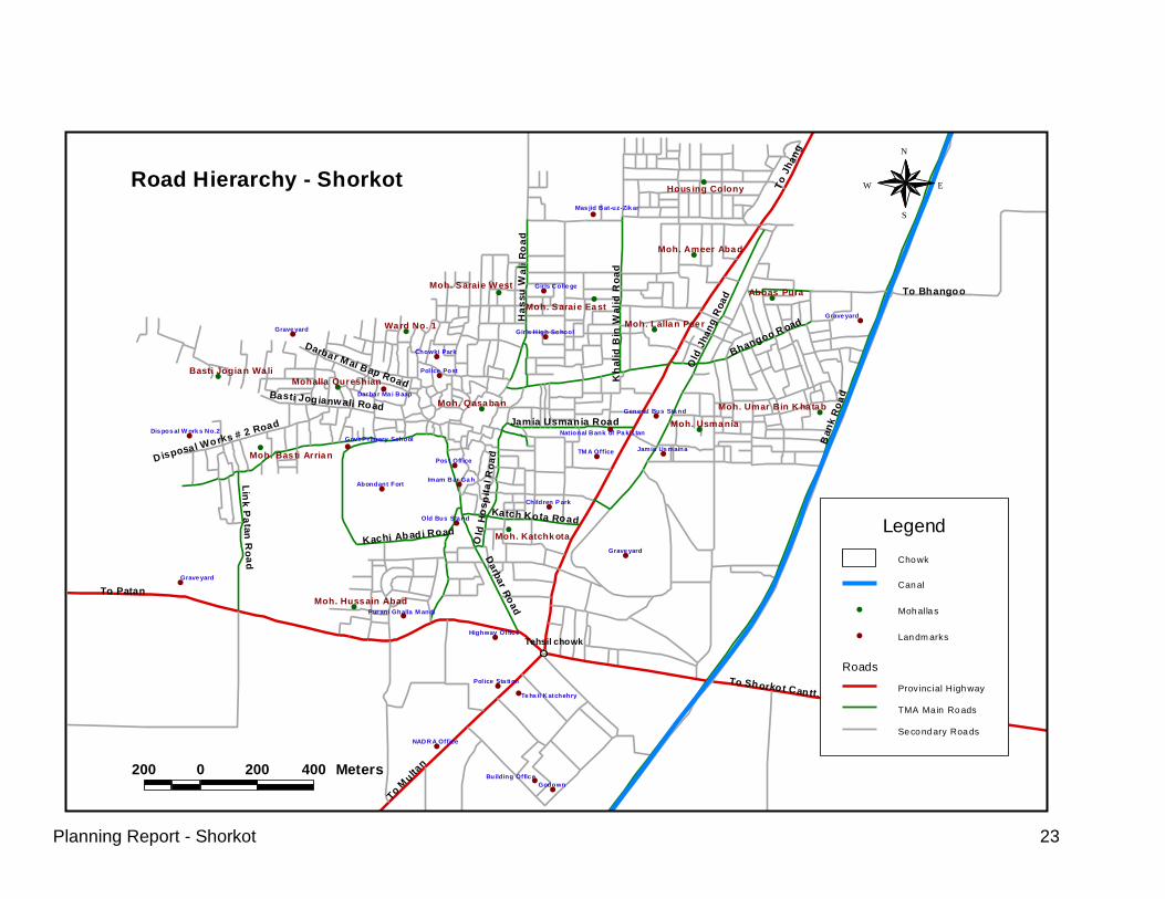
4.1 Road Network & Street Lights Shorkot town is connected to Multan, Jhang, Shorkot Cant by provincial highways.
4.1.1 Road Condition Mostly the link roads in Shorkot are metalled roads and streets are brick soled. Generally, these are narrow with open drains on one or either side. Under PMSIP TMA Shorkot has completed a roads sub-project. The roads in Shorkot were in a state of serious disrepair. After completion of PMSIP road project major roads are now in good condition. Data for existing roads is attached in Annex A.
Following roads were completed by PMSIP road project:
Old Jhang Road with a length of about 4135 ft. starts from Govt. Institute of
Commercial College and acts as a by pass Road by meeting the Main Jhang-Multan Road at the end.
Old Lorry Adda Road starts from Tehsil Chowk and ends at Bargah Hussain. Its length is about 1790 ft.
Shahid Shaheed Road, starts from the end of Main Bazar Road and ends at Sabir Chowk with a length of about 1891 ft.
Bhirr Road which starts near Girls Primary School and ends at Shakir Road. Total length of Bhirr Road is about 2250 ft.
Madrissa Islamia Road meets Jhang-Multan Road and Old Lorry Adda Road at start and end respectively with a length of about 870 ft.
Main Bazar Road starts from Od Lorry Adda Road and ends at Shahid Shaheed Road with a length of about 1406 ft.
Street Lights A comprehensive street lighting system for these Roads was also put in place that meets the required standards of illumination. The Roads which have this system include old Jhang Road, Old Lorry Adda Road and Shahid Sheed Road. In this system 250 watts high pressure sodium vapor luminaries with 30 ft height masts and 100 ft. spacing were placed.
No. Name of Road Controlling Department
1. Shorkot Cant. Road Provincial Highway
2. Multan Road Provincial Highway
3. Jhang Road Provincial Highway
4. Pattan Road District Highway

Planning Report - Shorkot 21
Detail of Main Roads in Shorkot is shown in Annex – A.
Name of Sub-project: Improvement of Roads-Shorkot
Sponsoring Agency: Govt. of Punjab through The World Bank Funding
Executing Agency: TMA Shorkot
Design Consultant M/S NESPAK (Pvt.) Ltd
Supervision Consultant M/S NESPAK (Pvt.) Ltd
Contracting Firm M/S Syed Hussan Mehmood & Co.
Concerned Provincial Department: Local Government & community Development Department
Estimated Cost: Rs. 57.02 Million
Funding Arrangement: PMDFC Grant 85% (48.47 Million)
TMA Share 15% (8.55 Million)
Date of issuance of Completion Certificate
09.05.09
Taking over by TMA from Contractor
06.03.09
Physical Progress at Site 100 %
Financial Progress Rs. 46.85 Million
% age Financial progress 82%
Present status Completed and Handed over to TMA
PMSIP SUB-PROJECT Sub-project Description: Widening and Improvement of five road segments: Old Jhang Road 4135 ft Old Lorry Adda Road 1790 ft. Shahid Shaheed Road 1891 ft Bhirr Road 2250 ft. Madrissa Islamia Road 870 ft. Main Bazar 1406 ft Improvement of existing drains and construction of new storm water drains along the widened and improved roads Salient Features: Road Metalled Width(TST) Old Jhang Road 2x12 = 24 ft Old Lorry Adda Road 2x10 = 20 ft. Shahid Shaheed Road 2x7.5 = 15 ft Bhirr Road 1x16 = 16 ft. Madrissa Islamia Road 1x15 = 15 ft. Main Bazar Full width concrete pavers Following road projects were taken by TMA in last couple of years:
- TST road surfacing from Naseer Chowk to Darbar Mai Baap (Rs 0.5 m) - Resurfacing/widening from Multan Road to Godowns (Rs 0.5 m)

Planning Report - Shorkot 22
- Widening of Dhun Road (Rs 0.7 m). it is under construction.
4.1.3 Needs
Proper functional Bus Stand with regulation to park buses only in specified parking areas.
Area designated for a parking lot
Area for vendor carts
Provision of foot paths in main roads in the town.
Construction of Khalid Bin Waleed Road (Shahid Road to Housing Colony), Construction of Road from Nasar Chowk (Girls College to Hassan Waki Road), Construction of Jamia Usmania Road.
Street light staff should be equipped with ladders and other tools.
Planning Report - Shorkot 23
##
#
#
#
#
#
#
#
#
#
#
#
#
#
#
#
#
#
#
#
#
#
#
#
#
#
#
#
#
#
##
#
#
#
#
#
#
#
#
#
#
To
Jhan
g
Ban
k R
oa
d
To M
ulta
n
To Patan
To Shorkot Cantt.
Darb
ar R
oad
To Bhangoo
Old
Jhan
g R
oad
Ha
ssu
Wa
li R
oa
d
Lin
k P
ata
n R
oa
d
Darbar Mai B ap Road
Bhangoo R oad
Katch Kota Road
Jamia Usmania Road
Basti Jogianwali Road
Kachi Abadi Road
Disposal Works # 2 Road
Kh
ali
d B
in W
ali
d R
oa
d
Ol d
Ho
sp
ita
l R
oa
d
Tehsil chowk
Wa rd No. 1
Abbas Pura
Moh. Qasa ba n
Moh. Usma nia
Hous ing Colony
Moh. Katchk ota
Moh. Ameer Aba d
Moh. Lalla n Pee r
Moh. Saraie Ea st
Moh. Saraie W est
Mohalla Qureshian
Basti Jogia n Wa li
Moh. Bas ti Arria n
Moh. Huss ain Abad
Moh. Umar Bin K ha ta b
Godown
Grave yard
Grave yard
Grave yard
Grave yard
TM A Office
Chowki Park
Pol ice Post
Pos t Office
NADRA Office
Imam Bar Ga h
Jamia Us maina
Abondant Fort
Old Bus Sta nd
Children P ark
Girls Colle ge
Highway Offic e
Pol ice Sta ti on
Building Offic e
Dar ba r Ma i Baap
Te hs il Katchehry
Girls H igh Sc hool
General Bus Sta nd
Pur ani Ghalla M andi
Dis pos al W ork s No.2
Mas jid Bat-uz-Zik ar
Gov t P rimary SchoolNational Bank of Pa kis tan
200 0 200 400 Meters
Roads
Road Boundary
Landmarks
Mohallas
Canal
Chowk
N
EW
S
Road Hierarchy - Shorkot
Cho wk
Can al
Moh alla s#
Lan dm arks#
Roads
Provincial High way
TMA Ma in Ro ads
Se co nd ary Roa ds
Legend

Planning Report - Shorkot 24
4.1.4 Street Lights
Number / Percent of Street Lights not Working During the Month
August 2009
TMA Shorkot
Sr.# Street Name Mohalla U/C Total street lights
No. of street lights not working
during the month
% of street lights not working
during the month
1 Shahid Shaheed Road (Sabir chowk to Naseer chowk)
Mohalla Lallan peer
126 15 0 0%
2 Naseer chowk to Police Choki
Mohalla Sarai (do) 10 1 10%
3 Police Choki to Darbar Mai Bap
Qurashian Wala (do) 10 1 10%
4 Haidri chowk Qurashian Wala (do) 14 0 0%
5 Sardar bazar to rest house
Purana Adda (do) 12 2 17%
6 Bargah hussain to Naseer chowk
Mohalla Sarai (do) 35 0 0%
7 Chowk bazar to sarafa bazar
Mohalla Sarai (do) 22 0 0%
8 Gali Haji Abdul Rasheed Hussain abad (do) 3 1 33%
9 Gali Malik Gazanfar Ali Mohalla Sarai (do) 4 1 25%
10 Gali Sharif tent service Ward No. 4 (do) 4 1 25%
11 Gali Bashir Electric wali Mohalla Katcha Kotha
(do) 4 1 25%
12 Ward no. 6 Mohalla Katcha Kotha
(do) 3 0 0%
13 Purana Jhang Road New City (do) 5 2 40%
14 Bhangoo Road New City (do) 5 1 20%
15 Khalid-Bin-Walid Road Mohalla Lallan peer
(do) 5 1 20%
16 Gali Amjad javaid Mohalla Katcha Kotha
(do) 2 2 100%
17 Gali Bashir WAPDA Mohalla Sarai (do) 1 1 100%
18 Gali Talib Kitab ghar nawa shehr (do) 2 1 50%
19 House Sajad Hussain Mohalla Quraishian Wala
(do) 1 0 0%
Total 157 16 10%
Planning Report - Shorkot 25
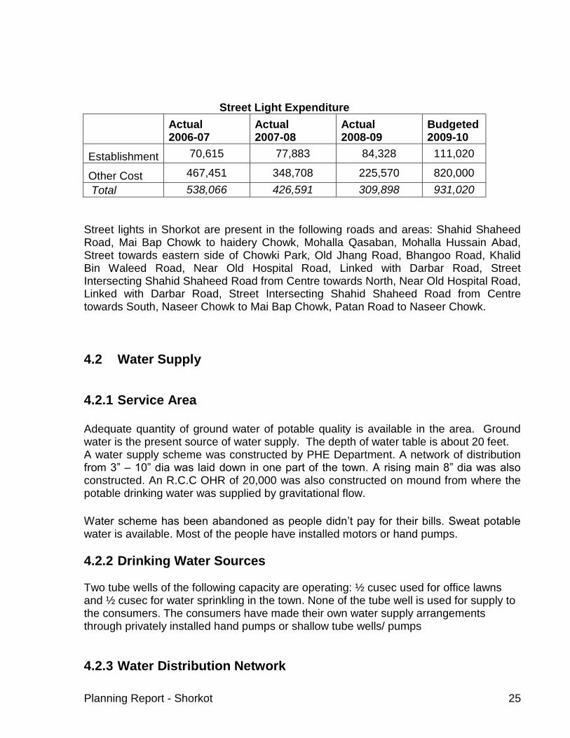
Street Light Expenditure
Actual 2006-07
Actual 2007-08
Actual 2008-09
Budgeted 2009-10
Establishment 70,615 77,883 84,328 111,020
Other Cost 467,451 348,708 225,570 820,000
Total 538,066 426,591 309,898 931,020
Street lights in Shorkot are present in the following roads and areas: Shahid Shaheed Road, Mai Bap Chowk to haidery Chowk, Mohalla Qasaban, Mohalla Hussain Abad, Street towards eastern side of Chowki Park, Old Jhang Road, Bhangoo Road, Khalid Bin Waleed Road, Near Old Hospital Road, Linked with Darbar Road, Street Intersecting Shahid Shaheed Road from Centre towards North, Near Old Hospital Road, Linked with Darbar Road, Street Intersecting Shahid Shaheed Road from Centre towards South, Naseer Chowk to Mai Bap Chowk, Patan Road to Naseer Chowk.
4.2 Water Supply
4.2.1 Service Area Adequate quantity of ground water of potable quality is available in the area. Ground water is the present source of water supply. The depth of water table is about 20 feet. A water supply scheme was constructed by PHE Department. A network of distribution from 3” – 10” dia was laid down in one part of the town. A rising main 8” dia was also constructed. An R.C.C OHR of 20,000 was also constructed on mound from where the potable drinking water was supplied by gravitational flow.
Water scheme has been abandoned as people didn’t pay for their bills. Sweat potable water is available. Most of the people have installed motors or hand pumps.
4.2.2 Drinking Water Sources
Two tube wells of the following capacity are operating: ½ cusec used for office lawns and ½ cusec for water sprinkling in the town. None of the tube well is used for supply to the consumers. The consumers have made their own water supply arrangements through privately installed hand pumps or shallow tube wells/ pumps
4.2.3 Water Distribution Network

Planning Report - Shorkot 26
As water supply scheme was abandoned in the city there are no serviceable wateer supply pipelines.
4.2.4 Water Storage There is one overhead reservoir of capacity 10,000 gallons. It is in dilapidated condition and use has been abandoned.
4.2.5 Water Demand Discussions with Tehsil Nazim, town Union Nazim revealed that it is hard to convince people not to draw water from shallow depths. But, the results from recent tests revealed that in Darbar Mai Bap area the water is contaminated. Union councilors also were of the view that people are starting to realize importance of good public water supply scheme. There is a need to educate citizens about health hazards of drawing contaminated water from shallow depths.
4.2.6 NEEDS
Water testing of shallow water to determine if contamination exists in the town. It should be follow up by detailed discussions with stakeholders about development of TMA water supply network.

Planning Report - Shorkot 27
4.3 Sewerage System
About 80% of the entire area is served with underground sewerage / open drains; Underground sewerage exists in majority of the areas, estimated to be about 80% of total population and open drains serve for about 20% of total population. Open surface drains (tertiary drains), mostly Type-I, Punjab standard type drains collect sludge /surface water from streets. The condition of underground sewer pipes has been reported to be satisfactory. At locations problems towards manhole coverings have been noticed. The open dumping of solid wastes has aggravated the situation. Disposal at Multan Road This network was laid by PHED. It consists of major portion of old town on east side of Darbar Mai Bap, Nawan Shehar, Tehsil courts etc. It covers about 75% of the served area. Size of terminal trunk sewer is 30” dia. There are 2 collecting tanks at disposal station (20‘ dia). New screening chamber has been installed. It is clogged and sewage runs directly into collecting tanks. Pump house is of size 15’ dia. Boundary wall length is 385’ and is in good condition. Forced main is 2363 feet. There is a staff quarter. Three pumping horizontal centrifugal pumps KSB/PECO, 55’ head coupled with 40 BHP electric motor 1450 RPM with electric control panels were provided. Each had I cusec capacity. Presently, pump house is in bad condition with leakage. One of the motor is working. Fire broke out recently and controls were destroyed. Two peter pumps are also installed in one of the collecting tank for emergency. The disposal works for 16 hours daily. In summer it is over loaded due to two ice factories that discharge lot of water in sewerage system. Disposed of sewage is put in a sullage carrier of length 200 feet. Discharge sump is 10’ x 6’.
Exhibit: 2 Disposal at Multan Road

Planning Report - Shorkot 28
Network is shown in Sewerage Map. The network runs from Disposal to Multan road -Tehsil Chowk with 30” trunk sewer, from Tehsil Chowk - Katch Kotha Road crossing of Jhang Road with 27” dia sewer line. From this point to Sabir Chowk along Jhang road with 24” sewer line. From Sabir Chowk along Shahid Shaheed road to Mohalla Kasaban 21” dia sewer. 12”sewer network is expanded to Pathan, Darbar, Katch Kotha, Jamia Usmania, Hassu wali, Bhangoo, Khalid Bin Waleed and Old Jhang roads.
Recently, TMA has constructed sludge carrier with a cost of RS 2 m.
Disposal at west side of Basti Aria
This network was also laid by PHED. It covers 25 % of the served area. Disposal station is constructed on west side of city along path from Badh Rajbana. Three pumping horizontal centrifugal pumps KSB/PECO , 40’ head coupled with 10 BHP electric motor 1460 RPM with electric control panels were provided. Each had I cusec capacity. Size of trunk sewer is 15” dia. Layout of the system is show in sewerage map. There is one collecting tank at disposal station (20‘ dia). There is one screening chamber (4’ x 9’dia.) and is clogged. Pump house is of size 12’ dia. Two sets of pumps were installed. At present, one is in working condition. Boundary wall is 385 feet long and in good condition. The disposal works for 2 hours in the morning and whenever there is load in the evening. Network is shown in Sewerage Map. It covers Disposal road 15” dia sewer up to Nawab Chowk. 12” dia sewer network is expanded to Basti Joganwali Road, area around Haideri Chowk etc. Disposed of sewage is put in a sullage carrier of length 1200 feet. Discharge sump is of size 4’ x 4’. Disposed of sewer is put used for agricultural purposes.
Disposal at Medanwala A new disposal at north part of the town is being constructed. Trunk size is 24”, there is one collecting tank od 18’ dia. Screening chamber 6’ X 13’ has also been constructed. Pump house size is 12’ and boundary was length is 550’.
4.3.1 Coverage Area
About 80 % of the town is covered with sewerage network.

Planning Report - Shorkot 29
4.3.2 Problem Areas Discussions with Union Nazim, Shorkot revealed that Mohallas Usman Ghani and Umer Farooq were having problems with sewerage. In addition, Bhangoo Road, Usmania Road and Street Dr Mukhtar, Ward No. 2 also faces flooding problems.
4.3.3 Needs
Additional sewers in Mohallah Usmania, Amirabad and old Hospital Road are needed.

Planning Report - Shorkot 30
#
#
#
##
#
##
#
#
#
#
#
#
#
Mar
i Min
or
To J
ha
ng
Ba
nk R
oad
To Multa
n
To Patan
To Shorkot Cantt.
Darb
ar R
oad
To Bhangoo
Da
ra P
ur
Ro
ad
Old
Jhang
Road
Ha
ssu
Wali R
oad
Lin
k P
ata
n R
oa
d
Darbar Mai Bap Road
Bhangoo Road
Katch Kota Road
Jamia Usmania Road
Basti Jogianwali Road
Kachi Abadi Road
Disposal Works # 2 Road
Kh
alid
Bin
Wa
lid
Ro
ad
Ol d
Hos
pi t
al R
oad
Tehsil chowk
Ward No. 1
Abbas Pura
Moh. Qasaban
Moh. Usmania
Housing Colony
Moh. Katchkota
Moh. Ameer Abad
Moh. Lallan Peer
Moh. Saraie East
Moh. Saraie West
Mohalla QureshianBasti Jogian Wali
Moh. Basti Arrian
Moh. Hussain Abad
Moh. Umar Bin Khatab
30'
'
12''
24''
21''
15''
27
''
12''
12
'' 12
''
15''
12' '
12
''
12''
12''
12
''
12
''
12''
12''
15''
12
''
12''
12' '24''
12
' '
12''
12''
12''
12' '
12''
12''
12
''
12'' 12
''
12''
12''
12' '
12''
12''
12
' '
12''
12''
12''
12
''
12''
12' '
12
''
300 0 300 600 Meters
RoadsRoad BoundarySewer LinesDisposal Works
# MohallasCanalChowk
N
EW
S
C ho wk
C an al
M oh alla s#
C om me rcia l
Landuse
Ab and ant Fort
Ed u
Gra veyard
H ospita l
Pa rk
Pu blic Build in g
R elig eou s
T om b
T ra ff ic Te rminal
R esiden tial
LegendC ho wk
C an al
M oh alla s#
D isp osal W orks
Se wer L in es
Structure Plan
Exist in g R esid en tia l
P rop osed A rea
Prop osed Co mm ercial
P rop osed In st itution al
Legend
C ho wk
C an al
M oh alla s#
L an dm arks#
R oa ds
Legend
Sewerage Map- Shorkot
Cho wk
Can al
Moh alla s#
Disp osal W orks
Se wer L in es
Roa ds
Legend

Planning Report - Shorkot 31
4.4 Solid Waste Management After sweeping the streets and roads the sanitary workers carry the solid waste in wheel barrows driven manually and collected at certain collection points. Due to shortage of equipment and manpower TMA Shorkot is not capable to serve the entire area of the town. As such some areas have good service delivery level whereas other having lesser attention gets poor service. The existing system comprises of the following:
Collection; through wheel barrows
Transfer through tractor trolleys
Disposal in open fields / along the roads.
4.4.1 Collection System Primary collection is done by sanitary workers in streets and roads. They start work at 5 am and work till 11 am for the first shift. After sweeping the streets and roads the sanitary workers carry the solid waste in wheel barrows driven manually and collect at certain collection points. Presently Shorkot Town has 23 major collection points but this number goes on changing as per need of the sites and town. Sweeping is done manually and no mechanical sweepers are available. The solid waste is being collected at points listed below. There are no permanent masonry collection points or skips in shorkot. All collection points are open heaps. List of such points is as follows: List of Collection Points
ID REMARKS
1 Old Jhang Road, Mohalla Ameer Abad
2 Old Jhang Road, Mohalla Abbas Pura
3 Near Bhangoo Road Graveyard
4 Bhangoo Road Near old Jhang Road
5 Old Jhang Road Near General Bus Stand
6 Tehsil Chowk
7 Near Katchehry
8 Multan Road Near NADRA Office
9 Purani Ghalla mandi
10 Near Post Office
11 Disposal Works # 2 Road Near Mohalla Basti Arrian
12 Darbar Mai Baap Road
13 Near Darbar Mai Baap
14 Chowki Park
15 Girls College

Planning Report - Shorkot 32
16 Girls High School
17 Girls High School
18 Shahid Shaheed Road
19 Near NBP
20 Between Mai Bap Chowk & haidery Chowk
21 Chowki Park
22 Sabir Chowk
23 In Front of Girls High School
Average amount of solid waste collection per day
Percent of Solid Waste Collected per Day
For month of August 09
TMA Shorkot
Sr. # Vehicle No. Capacity (tons) Avg. No. of Trips
per Day During the Month
Avg. Amount of Solid Waste
Collected per Day (tons)
1 Trolley No.1 3.2718 3.7 12.03
Total 12.03
Estimeted total amount of solid waste generated per capita per day (tons) {32718*.4kg)
= 13.09
Avg. amount of solid waste collected per day (tons) = 12.03
Percent of solid waste collected per day = 92%
Source: PMS data, September 2009
Therefore, 92 % of solid waste generated in the town is being collected by the TMA.
4.4.2 Service Level
Due to shortage of equipment and manpower TMA Shorkot is not able to serve the entire area of the town. Some areas have good service delivery level whereas other having lesser attention gets poor service. Much of the area is un-served and heaps of solid waste accumulate in these areas and some of them are removed only when they exceed the toleration level. The service level in the town is stated as under:

Planning Report - Shorkot 33
4.4.3 Land Fill/Dumping Sites
No proper land fill site is available in or outside of this town. The solid waste is dumped in open spaces at Multan road at 4 km and at several informal dumping places and depressions near town such as Bhirr road. Solid waste is also disposed in open plots in order to fill them.
4.4.4 Operation & Maintenance
Sr. No.
Description Nrs Present Status
1 Hand carts 8 Working order
2 Tractor operated trolleys
1 Working order
PDSSP has recently agreed to procure 30 hand carts, six (6) containers for the town. The Establishment
Sr. Job Description Staff
Strength
1 Street Sweeper 32
2 Tractor-Trolly
Workers 5
3 Tractor Driver 2
Total 39
Expenditure
SANITATION
Exhibit: 4 Illegal Disposal Site

Planning Report - Shorkot 34
Actual 2005-06
Actual 2006-07
Actual 2007-08
Budgeted 2008-09
Establishment 1,931,367 2,217,039 2,498,901 3,462,626
POL 319,816 511,232 453,207 700,000
Repair & Replacement
7,338 213,573 50,185 350,000
Total 2,258,521 2,941,844 3,002,293 4,512,626
4.4.5 Needs Area Required for Landfill The town is generating about 13 tons of solid waste / day which is expected to increase to around 20 ton/day by 2019 and 30 ton/day by 2029. The TMA has got a capacity of managing only around 12 ton/day with the existing equipment and manpower. If the management capacity of TMA is not improved, the town will face serious environmental threats with heaps of solid waste emerging up in street, bazaars, open spaces and even in play grounds. There is no proper landfill site to dump ever-increasing solid wastes. Following calculations show that for a period of 10 years Shorkot would need 2.5 acres land for landfill site and 6 acres for 20 years time span. Other assumptions are also mentioned below for these area calculations.

Planning Report - Shorkot 35
TMA:
Population (1998): 27276 1.5
Growth Rate: 2.30 80
Waste Generation: 0.4
1.2 Tons/m3
Per Capita Total WasteCollection
EfficiencyTotal Wt. Total Vol.
kg Tons % Tons m3
m3
m3 Acre Acre
2009 35028 0.400 14.01 80.0 11.21 9 3,409 3,409 0.17 0.19
2010 35833 0.406 14.55 80.4 11.70 10 3,558 6,967 0.34 0.38
2011 36658 0.412 15.11 80.8 12.21 10 3,713 10,680 0.53 0.58
2012 37501 0.418 15.69 81.2 12.74 11 3,874 14,554 0.72 0.79
2013 38363 0.425 16.29 81.6 13.29 11 4,042 18,596 0.92 1.01
2014 39246 0.431 16.91 82.0 13.87 12 4,218 22,814 1.13 1.24
2015 40148 0.437 17.56 82.4 14.47 12 4,401 27,215 1.35 1.48
2016 41072 0.444 18.23 82.8 15.10 13 4,592 31,807 1.57 1.73
2017 42016 0.451 18.93 83.2 15.75 13 4,791 36,599 1.81 1.99
2018 42983 0.457 19.66 83.6 16.43 14 4,999 41,597 2.06 2.26
2019 43971 0.464 20.41 84.0 17.15 14 5,215 46,813 2.31 2.54
2020 44983 0.471 21.19 84.4 17.89 15 5,441 52,254 2.58 2.84
2021 46017 0.478 22.01 84.8 18.66 16 5,676 57,930 2.86 3.15
2022 47076 0.485 22.85 85.2 19.47 16 5,922 63,852 3.16 3.47
2023 48158 0.493 23.73 85.6 20.31 17 6,178 70,030 3.46 3.81
2024 49266 0.500 24.64 86.0 21.19 18 6,445 76,475 3.78 4.16
2025 50399 0.508 25.58 86.4 22.10 18 6,723 83,198 4.11 4.52
2026 51558 0.515 26.56 86.8 23.06 19 7,013 90,211 4.46 4.90
2027 52744 0.523 27.58 87.2 24.05 20 7,316 97,527 4.82 5.30
2028 53957 0.531 28.64 87.6 25.09 21 7,631 105,158 5.20 5.72
2029 55198 0.539 29.74 88.0 26.17 22 7,960 113,117 5.59 6.15
Volume of Solid Waste Generated and Land Requirement for Sanitary Landfill
Year Population
Daily Collection
Yearly
Vol.
Shorkot (City)
Increase
Collection Efficiency
Compacted density of Solid waste in Landfill
Vol. for
LandfillArea for Landfill
Total Area
Required
Including 10%
for
Infrastructure

Planning Report - Shorkot 36
4.5 Fire Fighting
4.5.1 Existing Fire Fighting Arrangements Presently, no fire fighting system exists in Shorkot. Not many fire incidences take place but it is an essential municipal service.
4.6 Parks 4.6.1 Existing Parks
Bahu Park Next to TMA office on Jhang road, a vacant piece of land of 15 acre area that TMA intends into a modern park, that would serve Shorkot town. TMA and PMDFC has taken up this important sub-project and consultants are presently designing the project. According to the PMS, PMDFC data, the average number of people visiting the Park daily is 142. This survey was conducted by TMA staff. This figure would increase manifold if this park is developed. Tehsil Nazim is very keen to develop the park.
Chandni Park This park is located near main Bazar in north-west direction of the town. It has an area of 1 acre. This park would cater for women only. Presently, only jogging paths have been developed. All other amenities that are important for a park are yet to be developed. During Urs Sultan Bahoo & Urs Sakhi Sarwar, the influx of population from the surrounding areas increase enormously, that reflect the provision of more recreational places in the town.
(Bahu Park)
(Chandni Park)

Planning Report - Shorkot 37
4.6.2 Needs Improvement of two above mentioned parks.
4.7 Slaughter House Slaughter house was visited by planning team, PMDFC with sanitary inspector.
4.7.1 Existing Situation Existing slaughter house is located on Shorkot-Cantt Road, at a distance of 1.5 km. Slaughter house is built on TMA property. It is located on a 20 feet TST road. Therefore, even during rainy season there is not much problem in accessing the site. New private housing schemes are springing around it. Slaughter house has an area of 7 marlas. It has no electricity connection. During discussions with the Union Nazim, Shorkot slaughter house was one of the major problems that were put forward. Slaughter house is in shambles and is located on a deserted place. It has no roof, no even floor, no gate or any utilities. There is strong fowl smell and slaughtering is being done in most unhygienic manner. TMA recently started repair with Rs 1.0 m. It is hoped that condition will improve with this expenditure. Water Supply System There is a one hand pump for water supply needs. There are no storage tanks. There are two taps but only one is in working condition.
Structure of Slaughter House

Planning Report - Shorkot 38
Drainage System Effluent disposal is not connected to sewerage system and is discharged into open space behind the slaughter house. Although contaminates are not toxic in natures, but they can introduce bacterial contamination and increase nitrates, phosphates and sulfates concentration in water, leading to health problems. Solid Waste Solid waste is being dumped across the wall from where it is picked up fortnightly by TMA SWM staff. As a result, soil is also being contaminated as solid waste is not removed from there on regular basis.
A veterinary doctor is on honorarium of Rs. 800/- per month which is extremely low. One sanitary worker is attached with the slaughter house. Total budget for Slaughter House in budget estimates 2006-7 are Rs 10,000 for repair & maintenance of slaughter house hand pump. Collection fee animal slaughtering has been auctioned of for Rs 122,000 for year 2006-7.
4.7.2 Needs
Present slaughter house is in worst possible state. No roof, proper floor, electricity, regular water supply and storage, drainage or SWM storage or disposal arrangement. Quality of meat obtained after slaughtering at this unhygienic site could lead to diseases. Stakeholders are demanding re-building of this slaughter house.
With the ongoing repair work condition would improve in the slaughter house.

Planning Report - Shorkot 39
CHAPTER 5: WORKSHOP ON VISIONING AND PRIORITIZATION OF DEVELOPMENT SECTORS
Once the data was analyzed for all the sectors it provided with an understanding of the existing situation. The next step was to develop a vision for the development of the town. This establishes immediate priorities in order to achieve the desired objectives. For this purpose all the stake holders were formally gathered under one umbrella to agree a shared vision about the town. The following methodology was adopted for the prioritization process.
5.1 Pre-Workshop Consultations
PMDFC held meeting with Tehsil Nazim to discuss and finalize the workshop methodology. The purpose was to develop a common understanding and build consensus about the workshop methodology and the proposed projects. The Tehsil Nazim was requested to invite the participants for workshop and make available suitable venue for it. PMDFC briefed how the workshop would proceed, including details about formation of groups, inter-sector prioritization (i.e. roads vs water supply vs sewerage etc.), followed by intra-sector prioritization, e.g. in case of roads sector, individual road projects for the whole town were prioritized.
PMDFC gave briefings about salient features of workshop methodology, its style structure, objectives, the way it would be conducted and material that would be used during the workshop (charts, cards, and presentation through multi-media including visuals/maps). PMDFC also briefed how the workshop would proceed, such as formation of groups, inter-sector prioritization (i.e. roads Vs water supply Vs sewerage etc.), followed by intra-sector prioritization, e.g. in case of roads sector, individual road projects and their priorities. Also discussed in the meetings were the workshop participants. Tehsil Nazim was of the view that apart from the councilors, some local prominent persons should also be invited. This was agreed upon. In second part of the briefing the PMDFC officials and the Tehsil Nazim was briefed about the identified projects that would be presented in workshop for prioritization.

Planning Report - Shorkot 40
5.2 Workshop Proceedings
5.2.1 General The work shop was held on 1st August , 2007, in TMA complex, Shorkot. It commenced at 11 o’clock and was concluded at around 2 p.m.
5.2.2 Workshop Participants The number of participants was 35. The stake holders were mainly the representatives of the Tehsil Council and Union Naib Nazims, from 1 urban UCs of TMA Shorkot. TMA staff, member trade union, journalists, councillors also attended the workshop.
5.2.3 The Session After registration of the participants and recitation from Holly Quran, PMDFC gave a welcome address and briefed the participants about the purpose of the workshop. Mr. Talal Ahmed Khan, Consultant Planning, PMDFC gave background of the project and the role of PMDFC. Maps were displayed in the workshop hall where the participants could easily read about the existing situation and proposed projects. The workshop was formally started with a presentation given by PMDFC on the existing situation of the town and proposed list of sub projects. During the presentation, the participants took a keen interest, and asked a number of questions about the working of, and already projects under taken by PMDFC.
5.2.4 Group Formation The participants were divided into 5 groups at random, but it was ensured that people from same UC may not be included in the same group. Each group comprised of 6 persons. In the first round, inter-sector prioritization was done. Each group was given a list of sectors i.e. roads, water supply, sewerage etc. They were first to label their priority before each sector e.g. if they thought drains was the most important problem of the town they were to assign 1 before drains, etc. The results of the Inter sector prioritization were entered into a ‘priority matrix’. In this matrix, the group-wise sector priorities were entered as assigned by the group members. Based on the frequency of responses, the inter-sector prioritization was finalized. In the second round, group members were asked to prioritize intra-sector projects.

Planning Report - Shorkot 41
The priority-wise projects were then entered in intra-sector priority matrix, and sub-projects finalized on the basis of frequency of responses. The prioritization was then discussed in the plenum where it was finalized. After finalization of projects, the workshop was declared closed by the Tehsil Nazim
5.3 Outcome of the Visioning Workshop Thus a prioritized list of projects was developed for TMA, Shorkot, as shown below:
Prioritized Projects- Shorkot
Sector Priority Schemes
Roads 1 PMSIP Sub-Project
Water Supply 2 Development of Water Supply scheme
Sewerage 3 Improvement of Sewerage Network
Solid Waste Management
4 Improvement of SWM
Parks 5 Improvement of Parks
Street Lights 6 Improvement/Extension of Street Lights
Slaughter House
7 Development of Slaughter House
Fire Fighting 8 Development of Fire Fighting System
The prioritization process calls for the road map for the allocation of resources for the TMA. The sector that needed immediate attention was roads. The roads that were identified were Qabristan Haji Qasim road, Mohallah Usmania to Cantt road, Haidry Chowk to Darbar Mai Baap road and Head Mari Mines to Canal Cantt road. The citizens are severely affected by lack of adequate water supply. Especially in Bhirr, the ground water has contaminated enormously and water supply was highly demanded by the stakeholders. The Planning process adopted minimizes the selection of projects at random or biasness, rather it reflects the ground realities and is demand driven. If the projects are not need based, they are not sustainable for long period of time and become redundant without any benefit to the community or the user. Even if such projects survive, they benefit only a specific group of people. It is therefore important for Infrastructure projects to be need based and both beneficial to and acceptable to the community. To make it

Planning Report - Shorkot 42
mandatory, the involvement of stakeholders was ensured at all stages of planning, including the process of prioritization of the development projects.
Female Councilors Determining the
Priorities
PMDFC assist the participants in
Prioritization
(Workshop Participants Presentation given by PMDFC
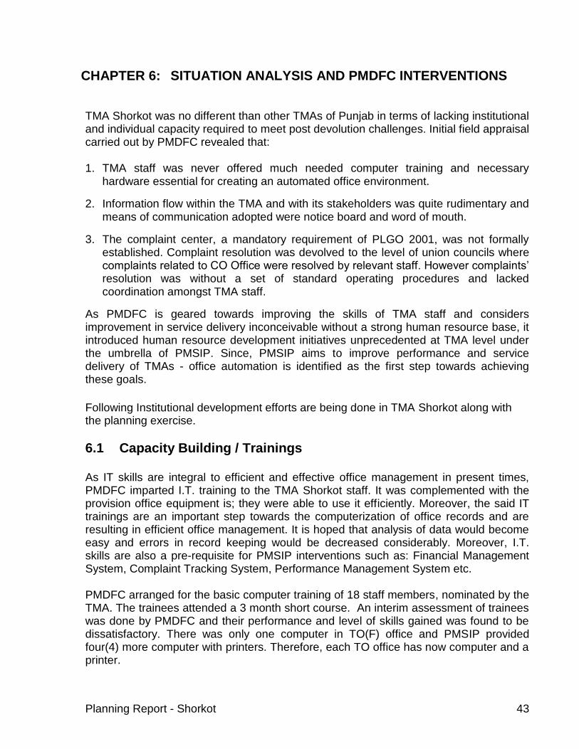
Planning Report - Shorkot 43
CHAPTER 6: SITUATION ANALYSIS AND PMDFC INTERVENTIONS
TMA Shorkot was no different than other TMAs of Punjab in terms of lacking institutional and individual capacity required to meet post devolution challenges. Initial field appraisal carried out by PMDFC revealed that: 1. TMA staff was never offered much needed computer training and necessary
hardware essential for creating an automated office environment.
2. Information flow within the TMA and with its stakeholders was quite rudimentary and means of communication adopted were notice board and word of mouth.
3. The complaint center, a mandatory requirement of PLGO 2001, was not formally established. Complaint resolution was devolved to the level of union councils where complaints related to CO Office were resolved by relevant staff. However complaints’ resolution was without a set of standard operating procedures and lacked coordination amongst TMA staff.
As PMDFC is geared towards improving the skills of TMA staff and considers improvement in service delivery inconceivable without a strong human resource base, it introduced human resource development initiatives unprecedented at TMA level under the umbrella of PMSIP. Since, PMSIP aims to improve performance and service delivery of TMAs - office automation is identified as the first step towards achieving these goals.
Following Institutional development efforts are being done in TMA Shorkot along with the planning exercise.
6.1 Capacity Building / Trainings
As IT skills are integral to efficient and effective office management in present times, PMDFC imparted I.T. training to the TMA Shorkot staff. It was complemented with the provision office equipment is; they were able to use it efficiently. Moreover, the said IT trainings are an important step towards the computerization of office records and are resulting in efficient office management. It is hoped that analysis of data would become easy and errors in record keeping would be decreased considerably. Moreover, I.T. skills are also a pre-requisite for PMSIP interventions such as: Financial Management System, Complaint Tracking System, Performance Management System etc.
PMDFC arranged for the basic computer training of 18 staff members, nominated by the TMA. The trainees attended a 3 month short course. An interim assessment of trainees was done by PMDFC and their performance and level of skills gained was found to be dissatisfactory. There was only one computer in TO(F) office and PMSIP provided four(4) more computer with printers. Therefore, each TO office has now computer and a printer.

Planning Report - Shorkot 44
Staff Trained under PMSIP
Sr. No. PMSIP Intervention
No. of Staff
Trained
Basic Computer Training 13
1. Level Machine 2
2. Complaint tracking system 2
Website
1
Total 18
6.2 Complaint Cell (Complaint Tracking System)
Section 188 of PLGO 2001 lays down for the establishment of a complaint cell at the Tehsil level. It states:
“Every District Government, Tehsil Municipal Administration, Town Municipal Administration and Union Administration shall set up a complaint cell for redress of grievances within the ambit of their responsibilities under this Ordinance.”
The Tehsil Nazim and the TMO were involved in setting up a complaint cell at the TMA office. The complaint cell was established under the supervision of the TMO and Mr Mehmood Hassan Shah, sanitary inspector. The Complaint Tracking system was introduced in TMA Shorkot in two steps: 1) Manual Complaint Tracking System and 2) Computerized Complaint Tracking System. In Manual system a standard design of complaint register was developed by PMDFC and the register was handed over to the TMA. A one day hands-on training was given to the officials in accordance with the standard operating procedures developed by PMDFC for complaint resolution. For computerized system PMDFC developed a in-house software for complaint resolution and handed over to TMSA after requisite training. A computer and a printer was also provided to the TMA with this software. Both systems track type of problem and its resolution details. PMDFC hopes that its ground breaking interventions will go a long way in the human resource development of TMA Shorkot and its staff once equipped with right skills set can be expected to provide timely, cost effective and reliable services to the citizens of Shorkot.

Planning Report - Shorkot 45
6.3 Performance Management System
PMDFC is introducing Performance Management System in Year – II TMAs. Field assessment of the TMA revealed that data existed in rudimentary form regarding performance indicators on municipal services like water supply, solid waste, street lights and sewerage. However, there was lack of data tracking, updation and reporting culture. Mr Mehmood Hassan Shah, sanitary inspector is supervising PMS in Shorkot.
6.3.1 Performance Management System Performance Management System in TMAs is one of the key institutional development components of performance improvement plan (PIP) that PMDFC is implementing in partner TMAs. PMDFC has taken the initiative of implementing PMS in its partner TMAs, under the guidance of Mr. Harry P. Hatry and Ms Rittu Nayyar Stone from Urban Institute Washington and World Bank. In March 05, a team of experts from Urban Institute visited PMDFC and arranged a two days workshop (19 & 21 March 05) at Hotel Avari, Lahore on Performance Management System. The details of workshops / seminars in which TMA Shorkot was invited.
Sr. #
Date Duration Workshop Title Participants
From To
1 10.8.05 10.8.05 One day Workshop on “Performance Management System”
Tehsil Nazim, TMO, All four
TOs
2 29.8.05 30.8.05 Two days
Workshop on “Improving Service Delivery Through Strengthening TMAs”
TMO, All four TOs
3 19.11.05 19.11.05 One day
Orientation seminar for Tehsil Nazims on “Punjab Municipal Services Improvement Project”
Tehsil Nazim, TMO
4 15.12.05 15.12.05 One day Meeting on selection of core performance indicators
Tehsil Nazim, TMO, All four
TOs
5 24.01.06 27.01.06 Four days Workshop on “Improving Performance Management”
Tehsil Nazim, TMO, All four
TOs
6 03.07.06 03.07.06 One day Workshop For Tehsil Nazims on Implementation of PMS
Tehsil Nazim
7 10.7.06 10.7.06 One day
Workshop on Baseline Value Procedures for Service Delivery Indicators
TMO & TO (I&S)
8 18.7.06 18.7.06 One day Workshop on Rating of TMA Roads through Trained Observer
Sub-Engineers
9 19.7.06 19.7.06 One day Workshop on Survey of TMA Parks
Nominated staff

Planning Report - Shorkot 46
6.3.2 Data Collection & Analysis Before initiation of PMS, there was lack of data collection and reporting culture particularly in municipal service delivery. After development of performance indicators and selection of core indicators, data collection formats were developed and shared with the TMAs during the two workshops held in July 05 (3 & 10 July). Trainings were also provided to TMA staff where required for data collection. The last two workshops were arranged to train the nominated TMA staff for road rating and parks survey. TMA Shorkot was then asked to collect and report data on core performance indicators by the end of July 06, which was used as baseline for year 2006-07. It almost takes more than four months to clean the data and get the reports in given reporting formats. The reporting formats were developed as per discussions with relevant TMA officials. Data for the reported period was analyzed and its cleaning was done.
6.3.3 Target Setting After finalization of baseline values during the month of Dec 06, TMA was facilitated to set target values against each performance indicator. Target setting was based on the analysis of present infrastructure, cost of providing services, revenue from services and available resources for any up-gradation/repair/maintenance of municipal services. The targets set by TMA Shorkot involved serious discussions with Tehsil Nazim, TMO and TO (I&S) particularly and other TMA staff.
6.4 Financial Management System
It is envisaged that the computerized financial management system will be able to address the issues faced by the TMAs in managing their finances on more professional grounds. The following list highlights some of the areas where TMAs are facing issues maintaining books of accounts. Highlights of Computerized Financial Management System The following list highlights some of the areas where TMAs will benefit from the computerized financial management system:
Only one point entry of the receipts and payment vouchers and the system will automatically maintain all the subsidiary records.
Minimize the duplicate and redundant data maintenance.
Automation of bank reconciliation with the Cash Book and other registers.
Separate accounting record for special grants, CCB funds etc.
Facilitate in preparation of annual budgets.
Matching cost of services with the related revenue.
Maintenance of contracts, billing and collection records to manage water rate, rent of shops, license fee, auctioned revenues to contracts etc.

Planning Report - Shorkot 47
Generation of various analytical reports related to income and expenditures for various authorities.
Monitoring of CO unit-wise revenues and expenditures
Improvement in budgetary controls by converting annual figures into monthly breakups, which will be comparable with actual monthly accounts.
FMS in TMA Shorkot In TMA Shorkot FMS was installed and basic training was given to the TMA staff. Initial setups were completed and data was entered in Water Consumer database, establishment check register, shop demand and collection register, and classified abstract. Mr. Majid Butt from accounts branch was trained to work on FMS and was also appointed as focal person by TMO.
6.5 TMA Website PMDFC has introduced this intervention under PMSIP for developing a modern interface of TMA with citizens of its area and other stakeholders. With the development of a TMA website, all the relevant information would be a click away. For TMA Shorkot http://www.tmaShorkot.com was chosen as the web address. Muhammad Aslam, computer operator is supervising website maintenance and updation.
TMA Website development process:
1. A standard template for TMA website was developed by PMDFC. 2. Website of each partner TMA is developed afterwards. 3. Domain registration and one time hosting charges paid by PMDFC. 4. All TMA website domains are registered and hosted with BrainNET &
COMSATS (Lahore). 5. Website address of each TMA is modeled as:
www.tma(nameoftma).com e.g. www.tmarenalakhurd.com 6. Data for the website is collected with the assistance of TMA staff. 7. 2 day hands-on training was given to the nominated official of the TMA in the
following areas: a. Managing control panel b. Use of FTP c. Data management d. Use of MS Front page e. Editing pictures in Adobe Photoshop f. Troubleshooting in website management g. Required updations
8. TMA website was launched by the trained TMA official under the guidance of PMDFC Staff.
Required Updations:
Sr. No. Website Links Updation Requirement
1. News and Events Monthly

Planning Report - Shorkot 48
2. Budget Annually
3. Development Projects Annually
4. Procurement Need Basis
5. Other Links Need Basis

Planning Report - Shorkot 49
CHAPTER 7: OUTLINE STRUCTURE PLAN - SHORKOT Shorkot is one of the five tehsils falling in Sialkot District. It is located at a distance of 100 kilometers from Lahore in the southern direction. It is equidistant, i.e 10 km from each of the cities like Gujranwala, Pasrur, Sialkot, Sambrial and Wazirabad. Due to rapid urbanization, the cities in Punjab are growing in a haphazard manner, without any development control. The available infrastructure in these towns is deteriorating as the population pressure is not keeping pace with the available resources for the extension of the infrastructure. These towns face the problems like incompatible land uses, unhealthy environment, and loss of amenity. Hence, an Outline Structure Plan has been devised for Shorkot. This plan identifies the growth potential in an economical and contiguous manner for future development of the town.
7.1 Brief Introduction This plan has been prepared as a part of the planning report of Shorkot. The report indicates that the town is expanding without proper planning and development control. The Outline structure plan, thus prepared for Renala describes the strategy, outline spatial plan, together with Action plans. In essence, the strategy identifies immediate development priorities for various service sectors. The spatial plan provides general information on planned land uses and the structure of development in the town. The Action plans are related to the priority sectors and areas identified in the strategy. Each Action plan consists of a number of proposals.
The plan provides a systematic approach to address the immediate development needs as well as long term development requirements for next 20 years. The plan highlights remedial measures to solve existing problems as well as suggests ways for future systematic growth of the town.
7.2 Visioning & Priority of Stakeholders Focus of PMSIP planning is constant input of various stakeholders in all planning stages. Initial contact was developed with TMA leadership and the relevant staff. Field data collection was done in collaboration with line TMA staff and various segments of the society. This assisted in developing broad vision for existing fabric of the municipal services. Finally, a formal stakeholder workshop attended by elected representatives, NGOs, important citizens etc prioritized municipal services to finalize a vision for the town. This process is hence the amalgamation of technical inputs and the aspiration of the stakeholders’ improved municipal services with an effective O & M framework were deemed a vision to improve life of citizens. Further, general consensus was developed on the priority sectors that needed immediate attention. The order of importance to stakeholders for improving various municipal serves is as follows:

Planning Report - Shorkot 50
A. Roads & Street Lights B. water supply C. sewerage D. Solid waste Management E. Parks F. slaughter house G. Fire fighting As six major roads have been completed under PMSIP, there has been marked improvement in roads and street lights in the town. Now, water supply and sewerage needs attention as per the requirements of the town.
7.3 Development Plans Having established the priorities, the next step of the Plan was to provide broad guidelines to suggest measures to control the future growth of the town. This has been determined after assessing the potentials and constraints in the existing urban set up. The plan is prepared with 20 years perspective from year 2008 to year 2028. This section of the report deals with an outline of proposals regarding;
- Identifying the growth potentials for the town as a whole so that the provision and extension of infrastructure remains economical.
- Identifying gaps in exiting municipal services as well as identifying needs for the incremental population growth.
- Action plans to cater for needs of present and future population in municipal services. Capacity building for O&M of the municipal services is also proposed in these Action Plans.
Development Strategy Shorkot is a small town of Punjab. It is strategically located in the vicinity of Toba Tek Singh in east, Faisilabad in north and Ahmad pur Sial in south west. It is a very congested town. The general trend of growth of Shorkot city is towards south-east direction. This part of the town comprise of Army cantonment area. The main cause of growth of the town is because of the fact that most of the educational institutions and hospitals are situated in this direction. As this part of the town has major institutional activities therefore all new residential developments are being established here. Some of the growth trends were observed towards Multan Road. This development is residential in character. None of the growth trends were found in the northern direction. That is older part of the town and purely residential in character with no institutional and major commercial activity along it, so it does not attract any activity towards it.

Planning Report - Shorkot 51
The following development strategy is recommended for Shorkot; Since the trend of growth is towards south-east, so development should be
encouraged in this direction. Decentralization, by proposing more than one growth centers in either directions. Emphasis is made on filling the adjacent areas first to achieve contiguous
development and to make provision of infrastructure facilities economical. Future residential development to follow neighborhood pattern of growth. Self
contained neighborhoods, provided with all basic public and utility services, be developed at two distinct places.
Improving the existing infrastructure, its maintenance and operation. Provision of municipal infrastructure to the newly suggested growth corridors. Inculcate Operational & Maintenance culture with provision of capacity building for
the same.
7.4 Historic Growth The history of Shorkot dates back to hundreds of years. It was founded during the period of Emperor Shahjahan in 1600AD. It was originally known as Shahjahaanabad. Five Muslim families owning 10,000 acres of land were settled in Shorkot town in that period. The residential areas were developed on elevated ground presently known as Shorkot Kalan. According to a popular account, the name ‘Shorkot” had a special significance with regard to the location and distance from the surrounding settlements. The name Shorkot was derived from “Daskoha” meaning ten Kos as the distance of Shorkot is almost ten kos from the settlements viz, Gujranwala, Pasroor, Sambrial and Sialkot. The name later on, was refined during the British period. Shorkot can distinctly be divided into two parts i.e. Shorkot Kalan and Shorkot Kot. Both these parts developed during different eras. The evolution of growth of Shorkot town can be divided into five distinct stages; Stage – 1 The dark brown color shows the development before the partition. The areas are Shorkot Kalan and Shorkot Kot. Stage – II Yellow color shows the times of war of independence, in 1857and the partition. The British government gave Shorkot the status of Tehsil Headquarters. Various institutional buildings like church and high schools were established during this era. Most of the development took place in Kot Shorkot along the existing College Road. At the time of partition, in 1947, the number of incoming people were much higher as compared to out migrants. The town therefore expanded in terms of area and population at a much higher rate. With the introduction of the industrial sector the city started growing along college road. Stage – III Light green area on map shows the era after 60s,when the most of the development of the town took place. The town expanded in all directions with the construction of new link road known as circular road. Hundreds of industrial units came

Planning Report - Shorkot 52
up in different parts of the town. New residential areas like Sohawa, New Sohawa, Haji pura, Habib Pura were developed. Sambrial road became the spine of commercial activities. Stage- IV The town developed along Pasroor Road, Sialkot Road, Sambrial Road and Lodhey road in the era of 70s and 80s. This is shown by mustard color on the map. Stage –V Dark green color on map shows the most recent developments. The town has started to expand in south west direction i.e along Gujranwala road. A number of new housing schemes have developed in this part.

Planning Report - Shorkot 53
Population Projections
Year 1998 2008 2028 Incremental population for next 20 years
Population 102,883 147,812 305,105 157,293
Growth rate = 3.69 %, It is assumed that city population growth rate would be 3.69 % for the entire plan period.
The population of the Shorkot according to 1998 census was 102,883 persons. The estimated population for 2028 is 305,105 persons, i.e at the end of plan period. The total area occupied by the urban uses or the built up area is 2,300 acres. The incremental population is estimated to be 157,293 for next 20 years time. This has been calculated by using the growth rate 3.69 %.
7.5 Growth Direction Shorkot is not a planned city. The important roads, that pass through the town are Sambrial Road, Sialkot, and Circular Road, are the Provincial highways. Due to lack of adequate development control, a lot of commercial activity started along these roads. Moreover, the industrial activities in addition to the commercial ones have further deteriorated the fabric of the town. Since there was no planning, the internal road pattern is haphazard and discourages the easy mobility of the traffic. Unfortunately, the same haphazard pattern of growth is taking place in either direction of the town. However, the development is taking in all the directions, but there is no control or planning being exercise to make in line with future requirements of the town. Different private housing schemes have been started in the north and east, but they don’t fulfill the requirements of the Planning. Some private schemes are also developing along Gujranwala road in south west of the town. However, the most rapid expansion is taking place towards the north along Sambrial road and in the East along Sialkot Road. Most of the new houses are being constructed in these directions. As new settlements are being established, other land uses like commercial area, petrol pumps, primary schools etc have developed accordingly.
7.6 Katchi Abadis There are no katchi abadies in Shorkot.
7.7 Densification of Built-Up Areas Densification criteria vary from city to city. Each city has its own growth and development potential, based on economic activity, social, cultural and geographically strategic importance. Not all of the incremental population shifts towards the newly developed areas, rather some of the percentage is absorbed in the existing one. This is mainly because of the economic reasons. Its most serious consequences are, the
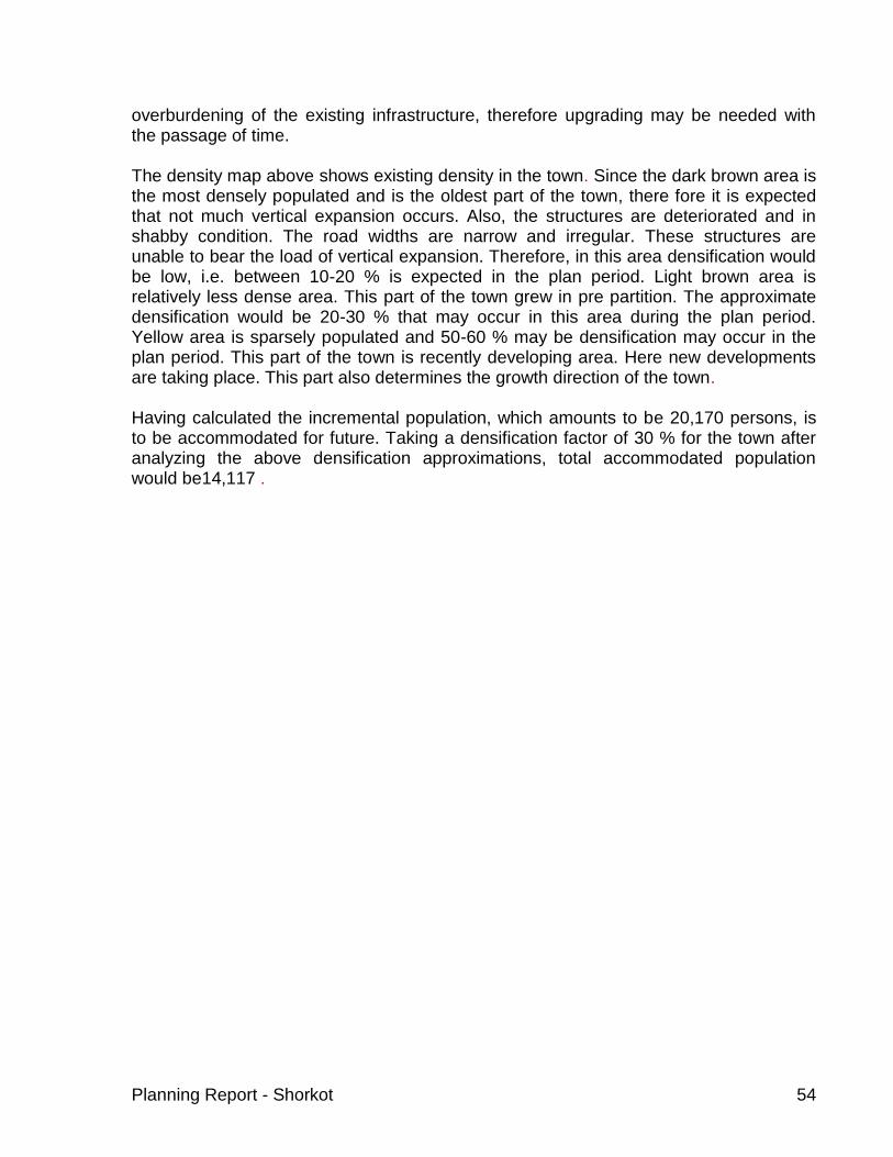
Planning Report - Shorkot 54
overburdening of the existing infrastructure, therefore upgrading may be needed with the passage of time. The density map above shows existing density in the town. Since the dark brown area is the most densely populated and is the oldest part of the town, there fore it is expected that not much vertical expansion occurs. Also, the structures are deteriorated and in shabby condition. The road widths are narrow and irregular. These structures are unable to bear the load of vertical expansion. Therefore, in this area densification would be low, i.e. between 10-20 % is expected in the plan period. Light brown area is relatively less dense area. This part of the town grew in pre partition. The approximate densification would be 20-30 % that may occur in this area during the plan period. Yellow area is sparsely populated and 50-60 % may be densification may occur in the plan period. This part of the town is recently developing area. Here new developments are taking place. This part also determines the growth direction of the town. Having calculated the incremental population, which amounts to be 20,170 persons, is to be accommodated for future. Taking a densification factor of 30 % for the town after analyzing the above densification approximations, total accommodated population would be14,117 .
Planning Report - Shorkot 55
#
#
#
##
#
##
#
#
#
#
#
#
#
Mar
i Min
or
To J
ha
ng
Ba
nk R
oad
To Multa
n
To Patan
To Shorkot Cantt.
Darb
ar R
oad
To Bhangoo
Da
ra P
ur
Ro
ad
Old
Jhang
Road
Ha
ssu
Wali R
oad
Lin
k P
ata
n R
oa
d
Darbar Mai Bap Road
Bhangoo Road
Katch Kota Road
Jamia Usmania Road
Basti Jogianwali Road
Kachi Abadi Road
Disposal Works # 2 Road
Kh
alid
Bin
Wa
lid
Ro
ad
Ol d
Hos
pi t
al R
oad
Tehsil chowk
Ward No. 1
Abbas Pura
Moh. Qasaban
Moh. Usmania
Housing Colony
Moh. Katchkota
Moh. Ameer Abad
Moh. Lallan Peer
Moh. Saraie East
Moh. Saraie West
Mohalla QureshianBasti Jogian Wali
Moh. Basti Arrian
Moh. Hussain Abad
Moh. Umar Bin Khatab
300 0 300 600 Meters
Population Density
High
Medium
Low
Roads
Road Boundary
# Mohallas
Canal
Chowk
N
EW
S
C ho wk
C an al
M oh alla s#
D isp osal W orks
Se wer L in es
Structure Plan
Exist in g R esid en tia l
P rop osed A rea
Prop osed Co mm ercial
P rop osed In st itution al
Legend
C ho wk
C an al
M oh alla s#
L an dm arks#
R oa ds
Legend
Population Density Map- Shorkot
C ho wk
C an al
M oh alla s#
D isp osal W orks
Se wer L in es
R oa ds
LegendC ho wk
C an al
M oh alla s#
R oa ds
Landuse
Ab and ant Fort
Ed ucation al In st itutes
Gra veyard
H ospita l
Pa rk
Pu blic Build in g
R elig eou s
T om b
T ra ff ic Te rminal
Legend
Cho wk
Can al
Moh alla s#
Roa ds
Population Dens ity
Hig h
Med iu m
Low
Legend

Planning Report - Shorkot 56
7.8 Land Requirement of Future Urban Expansion To identify the area required for future growth depends upon two important criteria. First is the location criteria and the second is the allocation criteria of land. The location criteria explain the availability of land in terms of the direction of growth, with respect to physical, socio-economic factors. The allocation is defines the density. In turn the density determines the area requirement. The proposed growth strategy recommends filling up these vacant pockets first, then opening up new areas for development. Present built up area of the town is 892 acres. Taking present population of 35,208 persons, present density is 38 persons/acre. Following table indicates land requirement for residential purposes for the plan period.
Year 2009-2014 2014-2019 2019-2024 2024-2029 Total
Incremental population
4,218 4,725 5,295 5,932
20,170
After taking account densification factor of 30 %
2952 3307 3706 4152 14,117
Residential Land Requirement (Acres)*
77 87 97 109 370
* Residential density of 38 persons/acre are assumed for proposed land use plan As residential area is approximately 70 % of the total land requirement for a small town such as Shorkot, total land requirement would be 370*3/10=111+370 = 481 acres.
7.9 Proposals The strategy suggests improving the connectivity among different parts of the town and filling of the vacant pockets first. In case of Shorkot, the town is haphazardly developed With many vacant areas left that are to be filled in near future. The proposals are designed taking into account the economy , the demand foe services and better prospects for future growth of the town.
First stage

Planning Report - Shorkot 57

Planning Report - Shorkot 58
#
#
#
##
#
##
#
#
#
#
#
#
#
Mar
i Min
or
To J
ha
ng
Ba
nk R
oad
To Multa
n
To Patan
To Shorkot Cantt.
Darb
ar R
oad
To Bhangoo
Da
ra P
ur
Ro
ad
Old
Jhang
Road
Ha
ssu
Wali R
oad
Lin
k P
ata
n R
oa
d
Darbar Mai Bap Road
Bhangoo Road
Katch Kota Road
Jamia Usmania Road
Basti Jogianwali Road
Kachi Abadi Road
Disposal Works # 2 Road
Kh
alid
Bin
Wa
lid
Ro
ad
Ol d
Hos
pi t
al R
oad
Tehsil chowk
Ward No. 1
Abbas Pura
Moh. Qasaban
Moh. Usmania
Housing Colony
Moh. Katchkota
Moh. Ameer Abad
Moh. Lallan Peer
Moh. Saraie East
Moh. Saraie West
Mohalla QureshianBasti Jogian Wali
Moh. Basti Arrian
Moh. Hussain Abad
Moh. Umar Bin Khatab
220
210
1000
300 0 300 600 Meters
Structure Plan
Existing Residential
Proposed Commercial
Proposed Institutional
Stage-1 Development
Stage-2 Development
Residential
Landuse
Abandant Fort
Educational Institutes
Graveyard
Hospital
Park
Public Building
Religeous
Tomb
Traffic Terminal
Roads
Commercial
Road Boundary
Proposed Roads
# Mohallas
Canal
Chowk
N
EW
S
C ho wk
C an al
M oh alla s#
D isp osal W orks
Se wer L in es
Structure Plan
Exist in g R esid en tia l
P rop osed A rea
Prop osed Co mm ercial
P rop osed In st itution al
Legend
C ho wk
C an al
M oh alla s#
L an dm arks#
R oa ds
Legend
Proposed Plan - Shorkot
C ho wk
C an al
M oh alla s#
D isp osal W orks
Se wer L in es
R oa ds
LegendC ho wk
C an al
M oh alla s#
R oa ds
Landuse
Ab and ant Fort
Ed ucation al In st itutes
Gra veyard
H ospita l
Pa rk
Pu blic Build in g
R elig eou s
T om b
T ra ff ic Te rminal
Legend
C ho wk
C an al
M oh alla s#
R oa ds
Population Density
H ig h
M ed iu m
L ow
Legend
Cho wk
Can al
Moh alla s#
Prop osed Ro ads
Com me rcia l
Roa ds
Landuse
Ab and ant Fort
Ed ucation al In st itute s
Gra veyard
Hospita l
Pa rk
Pu blic Build in g
Relig eo us
Tom b
Tra ff ic Te rmina l
Structure Plan
Exist in g R esid en tia l
Prop osed A rea
Prop osed Co mm ercial
Prop osed In st itution al
Legend
Cho wk
Can al
Moh alla s#
Prop osed Ro ads
Com me rcia l
Roa ds
Landuse
Ab and ant Fort
Ed ucation al In st itute s
Gra veyard
Hospita l
Pa rk
Pu blic Build in g
Relig eo us
Tom b
Tra ff ic Te rmina l
Structure Plan
Exist in g R esid en tia l
Prop osed Co mm ercial
Prop osed In st itution al
Sta ge -1 De velopm en t
Sta ge -2 De velopm en t
Legend

Planning Report - Shorkot 59
7.9.1 Stage I Proposal I: Filling the existing areas
In the first stage, the vacant pockets in the town will accommodate the growing population. There are areas in the north, west, south and even in east direction wher lot of vacant land is present. It would be more economical to allow areas to develop in the immediate vicinity to develop first. It would make infrastructure to be provided at the economical cost. The map of the town shows the vacant pockets.
7.9.2 Stage II
In the second stage, when the stage one area will be fully developed, the pressure will shift to peripheral localities. The housing schemes are being planned shall bear the maximum load of the growing population. The most important roads along which such pressure will develop are Sambrial road, Janmkey road , Sialkot road in the upcoming years. The proposal to accommodate population is as follows: Six main roads of the town had been taken up for improvement and extension previously.These roads are Old Jhang road, Lorry Adda road, Shahid Shaheed road, Bhirr road, Madrissa Islamia road and Main Bazar road. The importance of these roads is due to these being the main arteries of the town. These roads bifurcate the entire neighborhoods. The main stream traffic running through the town is borne by these roads. Moreover, the commercial and industrial activities are prevalent along the same
Proposal II: Extension of the roads to outer areas
With the extension of the town, it becomes very important to develop the main arterial roads which will bear the future development. Following links are proposed as: Link A; This is the road to the west of the town, runs north south fron Multan Road. Two more roads perpendicular to this road is A1 and A2. These roads will provide a grid iron pattern of roads for future development. Link B: This is to the east of the town and runs north south. B1 and B2 intersect this road. This part of the town is on the eastern side of Mari Minor.

Planning Report - Shorkot 60
ProposalI II: There is a dire necessity to develop other centres so as to decentralize the population pressure over the town centre. For this reason, in the west, along link A an institutional- commercial zone has been proposed. Since residential development is occurring adjacent to the road, shifting of the institutions here would act as another centre of different activities. This would greatly help to diversify the land use activities, lessen the pressure over existing town area. The map shows the neighborhood plan. With the development of the institutions, it has been proposed to widen the roads and development should take place keeping adequate right of way for the roads.
7.9.3 Stage III
The third stage will allow for the development of a second neighborhood centrei.e along Sialkot road. The residential localities, that were quickly developing in the second stage, shall encircle the new neighborhood enters. The proposal is as follows: Proposal III: The other institutional zone is planned in the western side along link B. This will develop when most of the population will be directed along the eastern belt. This centre would become the centre , reduce travel time for commercial activities. Proposal IV: Link C: After the development of a second neighbourhood centre the population will be attracted more and the urban area will move forward. This link will develop in the third stage. This is parallel to the link B that was planned in the second stage. .

Planning Report - Shorkot 61

Planning Report - Shorkot 62
7.10 Action Plans
7.10.1 Action Plan for Roads Mostly the link roads in Shorkot are metalled roads and streets are brick soled. Generally, these are narrow with open drains on one or either side. Under PMSIP TMA Shorkot has completed a roads sub-project. The roads in Shorkot were in a state of serious disrepair. After completion of PMSIP road project major roads are now in good condition.
Action Plan - 1 Road marking and improvement of foot paths on main roads.
Procurement of road level.
Newly developed Bus Stand would be made operational to decrease load around Kalma Chowk.
Operation & Maintenance training to road staff.
Allocation of sufficient Operation & Maintenance under roads head in the budget.
Improvement of Pasrur Road and Awami Road.
Action Plan - 2
- TST road surfacing from Naseer Chowk to Darbar Mai Baap (Rs 0.5 m) - Resurfacing/widening from Multan Road to Godowns (Rs 0.5 m)
jj Widening of Dhun Road (Rs 0.7 m). it is under construction -
Action Plan – 3
A periphery road is shown on Road Action Plan map as thick red dotted. Thin red dotted roads are also shown in this plan. These roads would provide a guided growth to the town in the peri-urban mentioned in the proposals. Municipal utilities would be developed as per need along these proposed roads. In addition, two bridges to connect these proposed roads are also proposed.

Planning Report - Shorkot 63

Planning Report - Shorkot 64
7.10.2 Action Plan for – Water Supply
Adequate quantity of ground water of potable quality is available in the area. Ground water is the present source of water supply. The depth of water table is about 20 feet. A water supply scheme was constructed by PHE Department. A network of distribution from 3” – 10” dia was laid down in one part of the town. A rising main 8” dia was also constructed. An R.C.C OHR of 20,000 was also constructed on mound from where the potable drinking water was supplied by gravitational flow.
Two tube wells of the following capacity are operating: ½ cusec used for office lawns and ½ cusec for water sprinkling in the town. None of the tube well is used for supply to the consumers. The consumers have made their own water supply arrangements through privately installed hand pumps or shallow tube wells/ pumps Water scheme has been abandoned as people didn’t pay for their bills. Sweat potable water is available. Most of the people have installed motors or hand pumps. Recently, there have been complaints of contamination in underground water. Therefore, there is awareness among stakeholders about TMA water supply.
Action Plan -1
Operation & Maintenance training to water supply staff
Allocation of sufficient Operation & Maintenance budget in the Annual TMA budget.
Action Plan - 2 Following are requirements for additional water for incremental population in the newly developed areas. Main water supply lines would be developed along the main roads developed in the peri-urban areas as shown in the map.

Planning Report - Shorkot 65
#
#
#
##
#
##
#
#
#
#
#
#
#
Mar
i Min
or
To J
ha
ng
Ba
nk R
oad
To Multa
n
To Patan
To Shorkot Cantt.
Darb
ar R
oad
To Bhangoo
Da
ra P
ur
Ro
ad
Old
Jhang
Road
Ha
ssu
Wali R
oad
Lin
k P
ata
n R
oa
d
Darbar Mai Bap Road
Bhangoo Road
Katch Kota Road
Jamia Usmania Road
Basti Jogianwali Road
Kachi Abadi Road
Disposal Works # 2 Road
Kh
alid
Bin
Wa
lid
Ro
ad
Ol d
Hos
pi t
al R
oad
Tehsil chowk
Ward No. 1
Abbas Pura
Moh. Qasaban
Moh. Usmania
Housing Colony
Moh. Katchkota
Moh. Ameer Abad
Moh. Lallan Peer
Moh. Saraie East
Moh. Saraie West
Mohalla QureshianBasti Jogian Wali
Moh. Basti Arrian
Moh. Hussain Abad
Moh. Umar Bin Khatab
300 0 300 600 Meters
Water Supply Action Plans
Action Plan 1
Action Plan 2
Roads
Road Boundary
# Mohallas
Canal
Chowk
N
EW
S
C ho wk
C an al
M oh alla s#
D isp osal W orks
Se wer L in es
Structure Plan
Exist in g R esid en tia l
P rop osed A rea
Prop osed Co mm ercial
P rop osed In st itution al
Legend
C ho wk
C an al
M oh alla s#
L an dm arks#
R oa ds
Legend
Water Supply Action Plan - Shorkot
C ho wk
C an al
M oh alla s#
D isp osal W orks
Se wer L in es
R oa ds
LegendC ho wk
C an al
M oh alla s#
R oa ds
Landuse
Ab and ant Fort
Ed ucation al In st itutes
Gra veyard
H ospita l
Pa rk
Pu blic Build in g
R elig eou s
T om b
T ra ff ic Te rminal
Legend
C ho wk
C an al
M oh alla s#
R oa ds
Population Density
H ig h
M ed iu m
L ow
Legend
Cho wk
Can al
Moh alla s#
Prop osed Ro ads
Com me rcia l
Roa ds
Landuse
Ab and ant Fort
Ed ucation al In st itute s
Gra veyard
Hospita l
Pa rk
Pu blic Build in g
Relig eo us
Tom b
Tra ff ic Te rmina l
Structure Plan
Exist in g R esid en tia l
Prop osed A rea
Prop osed Co mm ercial
Prop osed In st itution al
Legend
Cho wk
Can al
Moh alla s#
Prop osed Ro ads
Com me rcia l
Roa ds
Landuse
Ab and ant Fort
Ed ucation al In st itute s
Gra veyard
Hospita l
Pa rk
Pu blic Build in g
Relig eo us
Tom b
Tra ff ic Te rmina l
Structure Plan
Exist in g R esid en tia l
Prop osed Co mm ercial
Prop osed In st itution al
Sta ge -1 De velopm en t
Sta ge -2 De velopm en t
LegendCho wk
Can al
Moh alla s#
Prop osed Ro ads
Roa ds
Structure Plan
Exist in g R esid en tia l
Prop osed Co mm ercial
Prop osed In st itution al
Sta ge -1 De velopm en t
Sta ge -2 De velopm en t
LegendCho wk
Can al
Moh alla s#
Disp osal W orks
Se wer L in es
Prop osed Dispo sa l Station
Sewer Action Plan
Sta ge -1
Sta ge -2
Roa ds
Structure Plan
Exist in g R esid en tia l
Prop osed Co mm ercial
Prop osed In st itution al
Sta ge -1 De velopm en t
Sta ge -2 De velopm en t
Legend
Cho wk
Can al
Moh alla s#
Roa ds
Water Supply Action Plans
Action P la n 1
Action P la n 2
Legend

Planning Report - Shorkot 66
7.10.3 Action Plan for Drainage & Sewerage
About 80% of the entire area is served with underground sewerage / open drains; Underground sewerage exists in majority of the areas, estimated to be about 80% of total population and open drains serve for about 20% of total population. Open surface drains (tertiary drains), mostly Type-I, Punjab standard type drains collect sludge /surface water from streets. The condition of underground sewer pipes has been reported to be satisfactory. At locations problems towards manhole coverings have been noticed. The open dumping of solid wastes has aggravated the situation.
Action Plan - 1 Up-grading of Existing Sewers and Drains
All existing sewers and drains will be inspected and problematic parts of the networks will be cleaned and repaired so that they are brought back to acceptable working conditions.
Procurement of a generator to cater frequent power failures.
Operation & Maintenance training to sewerage staff.
Allocation of sufficient Operation & Maintenance budget in the Annual TMA budget.
Action Plan - 2
Improvement of Sewerage Network
Improvement of sewerage network in Mohallas Usman Ghani and Umer Farooq.
Replacement of the present disposal station to South of the present location.
Extension of trunk sewer to unserved areas such as : Mohallah Usmania, Amirabad and old Hospital Road
Lateral sewers would be developed in the served areas.
Action Plan – 3
Extension of Sewerage Network to Per-urban Areas Trunk sewers in red thick lines for the peri-urban areas are shown in the Sewerage Action Plan Map. Most of the proposed trunk sewers are proposed along major proposed roads in future development corridors. Construction of Sewage Treatment Plant
Planning Report - Shorkot 67
Waste water is disposed of in open spaces near By-Pass Road without treatment. This disposal practice has serious impact on the environment of the town.
A sewage treatment plant would be developed south of the town below the By Pass Road, which will safeguard public health and will protect agricultural lands from pollution, would be constructed before final disposal of sewage.

Planning Report - Shorkot 68
#
#
#
##
#
##
#
#
#
#
#
#
#
Mar
i Min
or
To J
ha
ng
Ba
nk R
oad
To Multa
n
To Patan
To Shorkot Cantt.
Darb
ar R
oad
To Bhangoo
Da
ra P
ur
Ro
ad
Old
Jhang
Road
Ha
ssu
Wali R
oad
Lin
k P
ata
n R
oa
d
Darbar Mai Bap Road
Bhangoo Road
Katch Kota Road
Jamia Usmania Road
Basti Jogianwali Road
Kachi Abadi Road
Disposal Works # 2 Road
Kh
alid
Bin
Wa
lid
Ro
ad
Ol d
Hos
pi t
al R
oad
Tehsil chowk
Ward No. 1
Abbas Pura
Moh. Qasaban
Moh. Usmania
Housing Colony
Moh. Katchkota
Moh. Ameer Abad
Moh. Lallan Peer
Moh. Saraie East
Moh. Saraie West
Mohalla QureshianBasti Jogian Wali
Moh. Basti Arrian
Moh. Hussain Abad
Moh. Umar Bin Khatab
30'
'
12''
24''
21''
15''
27
''
12''
12
'' 12
''
15''
12' '
12
''
12''
12''
12
''
12
''
12''
12''
15''
12
''
12 ''
12' '24''
12
' '
12''
12''
12''
12' '
12''
12''
12
''
12'' 12
''
12''
12''
12' '
12''
12''
12
' '
12''
12''
12''
12
''
12''
12' '
12
''
300 0 300 600 Meters
Structure Plan
Existing Residential
Proposed Commercial
Proposed Institutional
Proposed Area
Roads
Road Boundary
Sewer Action Plan
Stage-1
Stage-2
Proposed Disposal Station
Sewer Lines
Disposal Works
# Mohallas
Canal
Chowk
N
EW
S
C ho wk
C an al
M oh alla s#
D isp osal W orks
Se wer L in es
Structure Plan
Exist in g R esid en tia l
P rop osed A rea
Prop osed Co mm ercial
P rop osed In st itution al
Legend
C ho wk
C an al
M oh alla s#
L an dm arks#
R oa ds
Legend
Sewerage Action Plan - Shorkot
C ho wk
C an al
M oh alla s#
D isp osal W orks
Se wer L in es
R oa ds
LegendC ho wk
C an al
M oh alla s#
R oa ds
Landuse
Ab and ant Fort
Ed ucation al In st itutes
Gra veyard
H ospita l
Pa rk
Pu blic Build in g
R elig eou s
T om b
T ra ff ic Te rminal
Legend
C ho wk
C an al
M oh alla s#
R oa ds
Population Density
H ig h
M ed iu m
L ow
Legend
Cho wk
Can al
Moh alla s#
Prop osed Ro ads
Com me rcia l
Roa ds
Landuse
Ab and ant Fort
Ed ucation al In st itute s
Gra veyard
Hospita l
Pa rk
Pu blic Build in g
Relig eo us
Tom b
Tra ff ic Te rmina l
Structure Plan
Exist in g R esid en tia l
Prop osed A rea
Prop osed Co mm ercial
Prop osed In st itution al
Legend
Cho wk
Can al
Moh alla s#
Prop osed Ro ads
Com me rcia l
Roa ds
Landuse
Ab and ant Fort
Ed ucation al In st itute s
Gra veyard
Hospita l
Pa rk
Pu blic Build in g
Relig eo us
Tom b
Tra ff ic Te rmina l
Structure Plan
Exist in g R esid en tia l
Prop osed Co mm ercial
Prop osed In st itution al
Sta ge -1 De velopm en t
Sta ge -2 De velopm en t
Legend
Cho wk
Can al
Moh alla s#
Prop osed Ro ads
Roa ds
Structure Plan
Exist in g R esid en tia l
Prop osed Co mm ercial
Prop osed In st itution al
Sta ge -1 De velopm en t
Sta ge -2 De velopm en t
Legend
Cho wk
Can al
Moh alla s#
Disp osal W orks
Se wer L in es
Prop osed Dispo sa l Station
Sewer Action Plan
Sta ge -1
Sta ge -2
Roa ds
Structure Plan
Exist in g R esid en tia l
Prop osed Co mm ercial
Prop osed In st itution al
Sta ge -1 De velopm en t
Sta ge -2 De velopm en t
Legend
Cho wk
Can al
Moh alla s#
Roa ds
Water Supply Action Plans
Action P la n 1
Action P la n 2
Legend
C ho wk
C an al
M oh alla s#
Prop osed Ro ads
R oa ds
Structure Plan
Exist in g R esid en tia l
P rop osed Co mm ercial
P rop osed In st itution al
P rop osed A rea
Legend
Cho wk
Can al
Moh alla s#
Disp osal W orks
Se wer L in es
Prop osed Dispo sa l Station
Sewer Action Plan
Sta ge -1
Sta ge -2
Roa ds
Structure Plan
Exist in g R esid en tia l
Prop osed Co mm ercial
Prop osed In st itution al
Prop osed A rea
Legend

Planning Report - Shorkot 69
7.10.4 Action Plan for Solid Waste Management
Sweeping is done manually and no mechanical sweepers are available. Solid waste generation in Shorkot 13 tons/day and 12 tons/day is being collected by TMA. There is no proper landfill site to dispose off solid waste. It is presently being disposed off along Canal.
Action Plan -1 Improvement of Solid Waste Collection System
Procurement of new wheel barrows in place of non-operational ones.
House-House collection started on pilot basis in few localities.
Operation & Maintenance training to solid waste management staff.
Allocation of sufficient Operation & Maintenance budget in the Annual TMA budget.
Action Plan -2 Development of Disposal Site No landfill site is available in or out side of the town. For landfill site addition manpower and machinery would be required. An area of 2.5 acres is required for landfill site for 10 years (2019) & 6 acres for 20 years (2029). The site for landfill should be away from inhabitants, water bodies, flood areas etc.
7.10.5 Action Plan for Parks
The intervening pocket between Stage I and Stage II proposed development and B is a delta of land. It is bounded by two major roads, the By Pass Road and the Jamkey Road. This site is proposed for the future park of the town. Since Shorkot has no park, the location is suitable as major roads provide maximum accessibility to the visitors. It will facilitate parking and visually and aesthetically more prominent. Moreover, the presence of park at such a site will act as a buffer zone between two is self sustained neighborhoods. The proposed site for the park is accessible and equidistant from the either direction; it may become the centre of the growing Shorkot city

Planning Report - Shorkot 70
7.10.5 Action Plan for – Slaughter House 7.10.6 Action Plan for – Fire Fighting Arrangements
Action Plan – 1
Recruitment of fire fighting persons
Staff training
Action Plan –2
New fire station would be developed comprising of a shed, office and a store and a court yard.
Location for the new fire station could be near the Stadium where TMA has land available.

Planning Report - Shorkot 71
Annex -A Roads
Detail of Roads in Shorkot
S.# Name of
Road
Length Av.
ROW
Av. Metalled
Width Kind of Surface
Existing Condition
Ft Ft Ft
1 Old Jhang Road
5000 44 12 TST
Good -Constructed under PMSIP Project
2 Old Lorri Adda Road
1800 40 12 TST
Good -Constructed under PMSIP Project
3 Bhirr Road 3000 25 16 TST
Good -Constructed under PMSIP Project
4 Shahid Shaheed Road
2225 30 12 TST
Good -Constructed under PMSIP Project
5 Main Bazar 2100 30 10 Concrete Pavers
Good -Constructed under PMSIP Project
6 Madrissa Islamia Road
1100 18 15 TST
Good -Constructed under PMSIP Project
7 Darbar Mai Bap Road
1530 18 13 TST Fair
8 Darbar Road 3300 30 12 TST Fair
9 Primary School Road
2000 18 11 TST Fair
10 Disposal Works Road
1600 18 12 TST Good
11 Hassu Wali Road
2000 20 12 TST Fair
12 Housing Colony Road
1200 25 16 TST Good
13 Housing Colony Road – 1
1800 25 10 TST Bad

Planning Report - Shorkot 72
Housing Colony Road – 2
1300 25 10 TST Bad
14 Old Hospital Road
1980 20 12 TST Fair
15 Usmania Road
1900 20 10 TST Fair
16 Bhangoo Road
2820 22 10 TST Fair
17 PTCL Office Road
350 30 12 TST Fair
18
Ismail Memorial Hospital Road (Dhan Road)
1600 25 12 TST
Fair – Newly constructed one side damaged by Sui Gas Deptt.
19 Shakir Road 1520 20 12 TST
Bad- One side damaged by Sui Gas Deptt.
20 Hospital to Pattan link Road
1900 20 12 TST Fair
21 Multan Link Road
900 25 10 TST Good
22 Officers Colony Road
1200 30 10 TST Fair

Planning Report - Shorkot 73

Planning Report - Shorkot 74
Annex-B Water Supply
Water Supply Data
Sr. #
Tubewell Name /
Location Served Localities
Total Operational
Hours of Tubewell
during the month
Total Hours Water
Supplied to
Households during
the month
Average Hours Water
Supplied to
Households during
the month
1
Tubewell Tankey
No. 1
(Through OHR) Moti Masjid,
Islampura, Nisbat Road, Katchery
Road 119.00 272.00 9.07
2
Tubewell Tankey
No. 2
(Through OHR) Rehman Pura,
College Road, Gulistan Colony,
Jankae Road, Noor Pura 22.00 301.00 10.03
3
Tubewell No. 3
(Sambrial Road)
(Direct Pumping) Sambrial Road,
Gala Talianwala, Mughal Pura,
Mohammad Pura, Gala
Shahidawala 389.00 12.97
4
Tubewell No. 4
(Rest House)
(Direct Pumping) Shad Pura, Gala
Dusanda Singh, Wazirabad Road,
Haqpura 396.00 13.20
5
Tubewell No. 5
(Lorry Adda)
(Direct Pumping) Shah Sharif,
Afshan Road, Gali Janglat Wali,
Rae Wala, Totian Wala 415.00 13.83
6
Tubewell No. 6
(Bhroka Kallan)
Direct Pumping (Wadala Road,
Majid Ummar, Daska Kallan, Awami
Road, Choudhary Wala, Ban Wala 422.00 14.07
7
*Tubewell No. 7
(Civil Chowk)
Direct Pumping (Sohawa,
Habibpura Circle Road) 380.00 12.67
141.00 2575.00 85.83
= 141.00
= 2575.00
= 12.26
Total operational hours of tubewell during the month
Total hours of water supplied to households during the month
Avg. hours of water supplied to households during the month
Total
Source, PMS, PMDFC data, September, 2009 Table 27: Description of components of existing Water Supply System
T/well No.
Location
Designed Discharg
e (Cusec)
Head of
Motor
Bore (motor) (feet)
Motor Type
Motor (BHP)
1 Tube well Tankey no 1
1.5 80 450 Beco 30
2 Tube well Tankey no 2
1.0 80 500 Beco 25
3 Tube well no 3 (Sambrial road)
1.5 80 450 Beco 30
4 Tube well no 4 (rest house)
1.5 80 450 Beco 30
5 Tubewell no 5 (Lari Adda)
1.5 80 450 Beco 40
6 Tubewell no 6 (Broka Kallan)
1.0 80 450 KSB 25
7 Tubewell no 7 (Civil Chowk)
1.0 80 450 KSB 25
Source: PMS data

Planning Report - Shorkot 75
Service Level Fully Served Localities Model Colony, Nisbat Road, Pasrur Road, Shorkot Kalan, Mughal Pura, Haqpura, Circular Road, Islam Pura Un-served Localities Area behind telephone exchange, west of Awami Road, North of Fruit market, Rahman Pura, Sohawa, Haji Pura, Gaga, West of Wadala Road, East of Wazirabad Road, Muhammad Pura

Planning Report - Shorkot 76
Annex-C Sewerage Sewerage Data
ID DIA REMARKS ZONE
1 15
From Gujranwala Road to Circular Road, wazirabad Crossing Stadium Road Zone
2 33 From By Pass(Wazirabad) Road to Mohalla Sohawa Stadium Road Zone
3 24 By Pass Road to Rehman Pura Stadium Road Zone
4 15 By Pass Road to Rehman Pura Stadium Road Zone
5 15 Gujranwala Road to TMA Chowk Stadium Road Zone
6 24 TMA Chowk to Circular Road Stadium Road Zone
7 36 Circular Road Near Haq Pura & Mughal Pura Stadium Road Zone
8 30 Circular Road Near Mughal Pura Stadium Road Zone
9 21 Circular Road Near Haji Pura & Muhammad Pura
Fruit Vegetable Market Zone
10 24 Circular Road Near Haji Pura & Muhammad Pura
Fruit Vegetable Market Zone
11 27
Circular Road(Muhammad Pura) to Sialkot Road upto By Pass Road
Fruit Vegetable Market Zone
12 24 From Jamkay Road Chowk (College Road) to Circular Road
Fruit Vegetable Market Zone
13 15 Jamkay Road Fruit Vegetable Market Zone
14 24 Fawara Chowk (College Road) to Jamkay Road Chowk
Fruit Vegetable Market Zone
15 18 From Circular road to Mughal Pura & Haji Pura Stadium Road Zone
16 15 Sambrial Road Stadium Road Zone
17 21 Pasrur Road Fruit Vegetable Market Zone
18 24 Pasrur Road Fruit Vegetable Market Zone
19 42 Pasrur Road to Disposal Station Fruit Vegetable Market Zone
20 18 TMA Chowk to Police Station (Back Street) Stadium Road Zone
21 15 Police Station (Back Street) Stadium Road Zone
22 36 Wazirabad Road to Stadium Fruit Vegetable Market Zone
23 36 From TMA Chowk to Wazirabad Stadium Road Zone

Planning Report - Shorkot 77
Road upto By Pass
24 27 Circular Road Near Haji Pura Stadium Road Zone
25 27 Circular Road Near Haji Pura Fruit Vegetable Market Zone
26 36 College Road to Pasrur Road Fruit Vegetable Market Zone
27 15 By Pass Road (Ahead Sambrial Road Chowk) Stadium Road Zone
28 24 Sambrial Road (Ahead By Pass Chowk) Stadium Road Zone
29 18 Sambrial Road (Eastern Link Street) Stadium Road Zone
30 27 From Rehman Pura to Sambrial Road Chowk (By Pass Road) Stadium Road Zone
31 21 Pasrur Road towards By Pass Road
Fruit Vegetable Market Zone
32 0 Awami Road Awami Road