HGY/2009/0503 Ward: Noel Park Address - Online Planning ...
215
OFFREPC Officers Report For Sub Committee Planning Committee Item No. REPORT FOR CONSIDERATION AT PLANNING COMMITTEE Reference No: HGY/2009/0503 Ward: Noel Park Address: Land at Haringey Heartlands, between Hornsey Park Road, Mayes Road, Clarendon Road and the Kings Cross / East Coast Mainline Proposal: Outline planning application for demolition of existing structures and redevelopment to provide a residential led, mixed-use development, comprising between 950 to 1,080 residential units (C3); with 460sqm to 700sqm of office uses (B1); 370sqm to 700sqm of retail/financial and professional services uses (A1/A2); 190sqm to 550sqm of restaurant/cafe/drinking establishment uses (A3/A4); 325sqm to 550sqm of community/assembly/leisure uses (D1/D2); new landscaping, public and private open space, and energy centre, two utility compounds, up to 251 car parking spaces, cycle parking, access and other associated infrastructure works. Existing Use: Utilities Land; Derelict Land; Offices Proposed Use: Residential Led Mixed-Use Applicant: National Grid Property Holdings Ltd / London Development Agency Ownership: National Grid Property Holdings Ltd (NGP) and The London Development Agency (LDA) Date received: 20/03/2009 Last amended date: 11/05/2011 Drawing number of plans: P001(REV04) – Red Line – Planning Application Boundary P002(REV05) – Building Layout and Footprint P003(REV06) – Maximum and Minimum Storey Heights P004(REV05) – Ground Floor Uses P005(REV04) – Upper Floor Uses P006(REV05) – Site Access and Movement P007(REV06) – Landscape Strategy
-
Upload
khangminh22 -
Category
Documents
-
view
1 -
download
0
Transcript of HGY/2009/0503 Ward: Noel Park Address - Online Planning ...
OFFREPC Officers Report
For Sub Committee
Planning Committee Item No. REPORT FOR CONSIDERATION AT PLANNING COMMITTEE Reference No: HGY/2009/0503 Ward: Noel Park
Address: Land at Haringey Heartlands, between Hornsey Park Road, Mayes Road, Clarendon Road and the Kings Cross / East Coast Mainline Proposal: Outline planning application for demolition of existing structures and redevelopment to provide a residential led, mixed-use development, comprising between 950 to 1,080 residential units (C3); with 460sqm to 700sqm of office uses (B1); 370sqm to 700sqm of retail/financial and professional services uses (A1/A2); 190sqm to 550sqm of restaurant/cafe/drinking establishment uses (A3/A4); 325sqm to 550sqm of community/assembly/leisure uses (D1/D2); new landscaping, public and private open space, and energy centre, two utility compounds, up to 251 car parking spaces, cycle parking, access and other associated infrastructure works. Existing Use: Utilities Land; Derelict Land; Offices Proposed Use: Residential Led Mixed-Use Applicant: National Grid Property Holdings Ltd / London Development Agency Ownership: National Grid Property Holdings Ltd (NGP) and The London Development Agency (LDA) Date received: 20/03/2009 Last amended date: 11/05/2011 Drawing number of plans: P001(REV04) – Red Line – Planning Application Boundary P002(REV05) – Building Layout and Footprint P003(REV06) – Maximum and Minimum Storey Heights P004(REV05) – Ground Floor Uses P005(REV04) – Upper Floor Uses P006(REV05) – Site Access and Movement P007(REV06) – Landscape Strategy

OFFREPC Officers Report
For Sub Committee
PLANNING DESIGNATIONS: Site Specific Proposal – Haringey Heartlands Area of Change – Haringey Heartlands Framework (AC1) Blue Ribbon Network Defined Employment Area Strategic Employment Location Movement – Improved Access to Haringey Heartlands Town Centre Boundary (North east of the site) Cultural Quarter (North of the Site) Ecological Corridor (Western Boundary) Area of Archaeological Importance (North east of the site) RECOMMENDATION GRANT PERMISSION subject to conditions and subject to section 106 Legal Agreement SUMMARY OF REPORT: The application is for a residential-led, mixed-use development. The outline planning application seeks to fix “Access” only and maximum and minimum parameters have been provided for “Scale” and “Layout”. Therefore details of the following would be determined at the “Reserved Matters” stage: Scale (within parameter plan range); Layout (within parameter plan range); Landscape; and Appearance The development is considered to substantially contribute to the borough’s housing provision including family housing and affordable housing. The development that would contribute to the regeneration of the wider Haringey Heartlands Area which is supported by existing and emerging local and regional planning policies. The applicant has engaged with local stakeholders and has proposed a package of measures to compensate for the impacts of the development. Implementation of these measures would be secured through a section 106 legal agreement. In determining this application, officers have had regard to the Council’s obligations under the Equality Act 2010. On balance it is considered that the scheme is largely consistent with planning policy and that subject to appropriate conditions and s106 contributions it is recommended that the outline application be granted planning permission.
OFFREPC Officers Report
For Sub Committee
TABLE OF CONTENTS 1.0 SITE AND SURROUNDINGS 2.0 PLANNING HISTORY 3.0 PROPOSAL DESCRIPTION 4.0 RELEVANT PLANNING POLICY 5.0 CONSULTATION 6.0 ANALYSIS/ASSESSMENT OF THE APPLICATION
6.1 Basis of Application 6.2 Principle of Residential and Mixed Use Development 6.2 Employment 6.4 Design – Layout, Height, Massing, Density and Dwelling Mix 6.5 Affordable Housing 6.6 Open Space and Landscaping 6.7 Environmental Impact Assessment 6.8 Socio-Economics 6.9 Transport, Access, Parking and Highways 6.10 Noise and Vibration 6.11 Air Quality 6.12 Townscape and Visual Effects 6.13 Archaeology and Built Heritage 6.14 Ground Conditions and Contamination 6.15 Water Resources and Flood Risk 6.16 Ecology 6.17 Daylight, Sunlight and Overshadowing 6.18 Wind 6.19 Waste 6.20 Cumulative Effects 6.21 Sustainability 6.22 Planning obligations and Section 106 Agreement 6.23 Equalities Impact 6.24 Pre-determination
7.0 CONCLUSION 8.0 HUMAN RIGHTS 9.0 RECOMMENDATION 1 10.0 RECOMMENDATION 2 INCLUDING CONDITIONS 11.0 REASONS FOR APPROVAL 12.0 APPENDICES
Appendix 1: Consultation Responses Appendix 2: Summary of GLA reports Appendix 3: Planning Policies Appendix 4: Applicants Response the Issues Raised the DM Forum Appendix 5: Development Management Forum Minutes Appendix 6: Design Panel Minutes Appendix 7: Draft Heads of Terms for s106 Agreement

OFFREPC Officers Report
For Sub Committee
1.0 SITE AND SURROUNDINGS 1.1 The application site forms part of the wider Haringey Heartlands area and is
situated on land between Hornsey Park Road, Mayes Road and the London Kings Cross/East Coast Main Line, Clarendon Road and Coburg Road. The site covers an area of 4.83 ha (11.93 acres) and includes land, buildings and structures owned by NGP and LDA. The site is currently characterised by cleared, derelict land on the southern portion but also includes an occupied single storey call centre office building. The middle of the site contains two large unlisted operational gas holders. A car parking area is located adjacent to the largest gas holder and is used as a car compound by Haringey Council. The northern part of the site included the Olympia Trading Estate which is a 5,830 sq metre industrial building.
1.2 The brownfield site is within close proximity to the western edge of the Wood
Green Town Centre. It forms a strategic regeneration site as outlined in the Haringey Heartlands Development Framework, Haringey Unitary Development Plan and emerging Local Development Framework and The London Plan. The Haringey Heartlands area includes land to the west of the railway line “New River Village” which has already been developed to provide around 630 residential units in seven main blocks of up to seven storeys in height. The Heartlands also includes the land to the north of Station Road in addition to the proposal site itself.
1.3 The surrounding land uses includes a mix of residential, retail, office, industrial and operational land. To the east is Hornsey Park Road characterised by two storey terraced dwellings with gardens backing on to the site. Further east is the Wood Green Shopping Centre which provides a range of high street shops.
1.4 Coburg Road to the northern boundary of the site is characterised by a number of industrial units and the further north the cultural quarter including The Mountview Academy of Theatre Arts and The Chocolate Factory which provides studio space for local artists. Wood Green Common is located to the north of the cultural quarter. To the north-west is a new secondary school for up to 1,100 students and beyond the railway line Alexandra Palace and Park.
1.5 To the south is Clarendon Road which contains a number of light industrial and office uses. Beyond Clarendon Road is Turnpike Lane which consists of retail, food and drink establishments and other associated local shopping centre uses along with residential flats above shops and within purpose built blocks such as the WestPoint Apartments.
1.6 To the west of the railway line is the New River Village with pedestrian access
provided between the two sites by the Penstock footpath adjacent to the water treatment works.
1.7 The site has a Public Transport Accessibility Rating (PTAL) of four and is within close proximity to Turnpike Lane and Wood Green underground stations,

OFFREPC Officers Report
For Sub Committee
Alexandra Palace and Hornsey overland stations, and within walking distance of over a dozen bus routes.

OFFREPC Officers Report
For Sub Committee
2.0 PLANNING HISTORY 2.1 The most recent and relevant planning record relates to an application
submitted in November 2000 for a mixed use scheme on a site extending some 14.6 hectares which included the proposal site. The application was submitted in outline, fixing access and siting. The application was not determined. The description of the application is as follows:
2.2 Planning HGY/2000/1528 Not Determined - “Outline application for planning
permission for the comprehensive redevelopment of land between Hornsey Park Road, Mayes Road and London Kings Cross/East Coast Main Line (Haringey Heartlands) for a mixed use scheme of 173,030sqm (gross) floor space, 1384 residential apartments/flats, 245 live/work units of accommodation, a 100 bed hotel, a public library, a health complex together with office/light industrial units, offices, shopping and restaurant uses”.
2.3 In addition there area number of temporary planning permission which relate to
the call centre at the northern end of the site. These include permission for the erection of three porter cabins for a temporary period. Approved March 2000 (Ref: HGY/2000/0178). A further application was submitted in 2002 for the retention of the cabins for an additional temporary period (until August 2003). (Ref: HGY/2002/0096).
2.4 An application to refurbish the existing buildings on the site to accommodate a
call centre was approved in 2005. Planning HGY/2005/0258 – Granted 17/03/2005 - 95 Western Road - Refurbishment of existing building to accommodate a call centre to Haringey Council.
2.5 In order to facilitate a redevelopment of the site the London Borough of
Haringey applied for planning permission for the construction of a ‘Spine Road’ to gain north/south vehicle access through the site. Planning HGY/2006/2062 – Granted 31/01/2007 - Western Road, N22, Clarendon Road, N8, Gas holder station, Hornsey Park Road Wood Green London - Construction of a new 7.3m wide road with 2m wide footways on either side (known as The Heartlands Spine Road) between the north end of Clarendon Road, N8 and the south end of Western Road, N22. Realignment of existing road at northern end of Western Road by Alexandra School; realignment at junction of Western Road and Mayes Road (eastern corner of Wood Green Common); improvements to Penstock footpath.
2.6 The current planning application (Ref: HGY/2009/0503) was submitted to The
Council on 24th March 2009. Originally the application sought Outline planning permission for a residential led mixed use development comprising between 1100 – 1200 residential units. As a result of negotiations between the planning authority and the applicants/agents during this two year period a number of amendments have been made to the scheme. Full details can be found in the section 6 of this report however the main change includes the reduction in the number of residential units to between 950 to 1080 and changes in the heights of a number of buildings across the scheme.
OFFREPC Officers Report
For Sub Committee
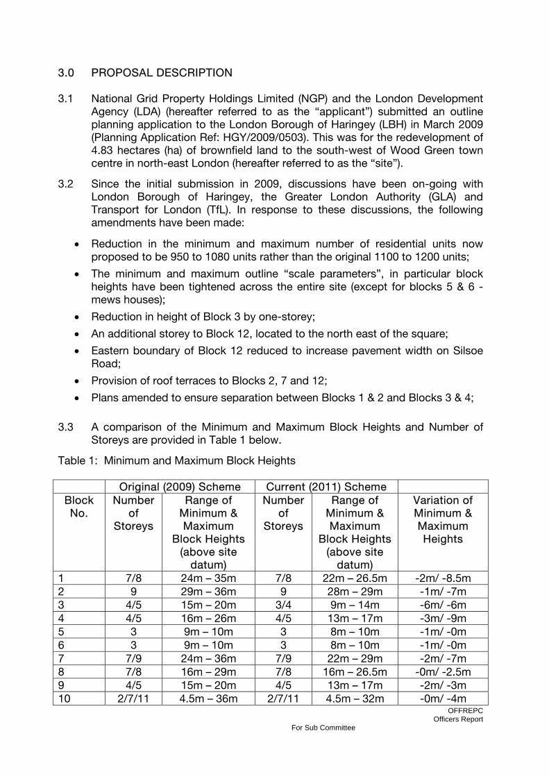
3.0 PROPOSAL DESCRIPTION 3.1 National Grid Property Holdings Limited (NGP) and the London Development
Agency (LDA) (hereafter referred to as the “applicant”) submitted an outline planning application to the London Borough of Haringey (LBH) in March 2009 (Planning Application Ref: HGY/2009/0503). This was for the redevelopment of 4.83 hectares (ha) of brownfield land to the south-west of Wood Green town centre in north-east London (hereafter referred to as the “site”).
3.2 Since the initial submission in 2009, discussions have been on-going with London Borough of Haringey, the Greater London Authority (GLA) and Transport for London (TfL). In response to these discussions, the following amendments have been made:
• Reduction in the minimum and maximum number of residential units now proposed to be 950 to 1080 units rather than the original 1100 to 1200 units;
• The minimum and maximum outline “scale parameters”, in particular block heights have been tightened across the entire site (except for blocks 5 & 6 - mews houses);
• Reduction in height of Block 3 by one-storey;
• An additional storey to Block 12, located to the north east of the square;
• Eastern boundary of Block 12 reduced to increase pavement width on Silsoe Road;
• Provision of roof terraces to Blocks 2, 7 and 12;
• Plans amended to ensure separation between Blocks 1 & 2 and Blocks 3 & 4;
3.3 A comparison of the Minimum and Maximum Block Heights and Number of
Storeys are provided in Table 1 below.
Table 1: Minimum and Maximum Block Heights
Original (2009) Scheme Current (2011) Scheme Block No.
Number of
Storeys
Range of Minimum & Maximum
Block Heights (above site
datum)
Number of
Storeys
Range of Minimum & Maximum
Block Heights (above site
datum)
Variation of Minimum & Maximum Heights
1 7/8 24m – 35m 7/8 22m – 26.5m -2m/ -8.5m 2 9 29m – 36m 9 28m – 29m -1m/ -7m 3 4/5 15m – 20m 3/4 9m – 14m -6m/ -6m 4 4/5 16m – 26m 4/5 13m – 17m -3m/ -9m 5 3 9m – 10m 3 8m – 10m -1m/ -0m 6 3 9m – 10m 3 8m – 10m -1m/ -0m 7 7/9 24m – 36m 7/9 22m – 29m -2m/ -7m 8 7/8 16m – 29m 7/8 16m – 26.5m -0m/ -2.5m 9 4/5 15m – 20m 4/5 13m – 17m -2m/ -3m 10 2/7/11 4.5m – 36m 2/7/11 4.5m – 32m -0m/ -4m

OFFREPC Officers Report
For Sub Committee
11 11 29m – 36m 11 31m – 32m -2m/ -4m 12 5/7 21m – 29m 6/8 20m – 26.5m -1m/ -2.5m 13 8/11 26m – 36m 8/11 25m – 32m -1m/ -4m 3.4 Outline planning consent is now being sought with regard to the amended
outline scale parameters (hereafter referred to as the “current scheme”) and includes: a residential led, mixed-use development, comprising between 950 to 1,080 residential units (C3); with 460sqm to 700sqm of office uses (B1); 370sqm to 700sqm of retail/financial and professional services uses (A1/A2); 190sqm to 550sqm of restaurant/cafe/drinking establishment uses (A3/A4); 325sqm to 550sqm of community/assembly/leisure uses (D1/D2); new landscaping, public and private open space, and energy centre, two utility compounds, up to 251 car parking spaces, cycle parking, access and other associated infrastructure works.
Table 2: Summary of Uses and Minimum & Maximum Floor Spaces
Block 1
3.5 Block 1 would be located on a podium within the south west corner of the site,
west of the Spine Road. Generally the block would take a rectilinear plan-form on a north-south axis. Block 1 would consist of an energy centre, undercroft parking and residential units at ground floor level and residential units at all other levels. Block 1 would be 7 and 8 storeys in height to a maximum of

OFFREPC Officers Report
For Sub Committee
26.5m (excluding allowance for the flue from the proposed energy centre which would project 3m above roof level).
Block 2 3.6 Block 2 would be located on the same podium as Block 1 and be located to
the north of Block 1. The block would take a rectilinear plan-form on a north-south axis. Block 2 would consist of undercroft parking and residential units at ground level and residential units at all levels above. It would be 9 storeys high to a maximum of 29m above site datum.
Block 3 3.7 Block 3 would be located in the south east corner of the site, to the east of the
Spine Road and to the west of the rear gardens of the Hornsey Park Road terraces. The block takes an approximate rectilinear plan-form on a north-south axis. At upper floor levels the block is set back above the east elevation to respond to existing residential properties along Hornsey Park Road. Block 3 would consist of residential units at all levels. The set back eastern elevation would be 3 storeys high to a maximum 11m rising to 4 storeys with a maximum height of 14m.
Block 4 3.8 Block 4 would be located to the north of Block 3 and also take an approximate
rectilinear plan-form on a north-south axis. At upper floor levels the block is set back above the east elevation to respond to existing residential properties along Hornsey Park Road. Block 4 would consist of residential units at all levels. The set back eastern elevation would be 4 storeys up to 14m rising to 5 storeys up to 17m.
Block 5 and 6 3.9 Blocks 5 and 6 would both be located on east-west axis within the east of the
site (between residential properties 105 and 123 Hornsey Park Road). Block 5 would take the form of an inverted “L” shape while Block 6 would take the form of an “L” shape plan form. A utility/plant equipment compound would be located east of block 6 adjacent to Hornsey Park Road. Blocks 5 and 6 consist of residential mews houses which would be 3 storeys at 8-10m in height.
Block 7 3.10 Block 7 would be located on a podium and takes a rectilinear shaped plan-
form. The block would be located north of Blocks 1 and 2. The upper levels of Block 7 would be set back from the western edge of the site to create a stepped “L” shaped block. A utility/plant equipment compound would adjoin the western boundary of block 7. Block 7 would consist of undercroft parking, residential units and B1 uses at ground floor level and residential units at upper levels. The block would be 7 storeys with a maximum height of 23m and 9
OFFREPC Officers Report
For Sub Committee
storeys with a maximum height of 29m. A utility/plant equipment compound would be located to the north west of Block 7.
Block 8 and 9 3.11 Block 8 and 9 would be located on a podium within the north east of the site,
to the east of the spine road. Block 8 takes a “U” shaped plan form and in conjunction with Block 9 (which links the two eastern ends of Block 8) serves to enclose the private space situated on the podium within the centre of Blocks 8 and 9. At upper floor levels, both Block 8 and 9 would be set back long the extent or their eastern elevations. Blocks 8 and 9 would consist of undercroft parking, B1 uses and residential at ground floor level and residential at upper floor levels. Block 8 would be 7 and 8 storeys to a maximum height of 26.5m. Block 9 would be 4 storeys to the eastern elevation to a height up to 14m and 5 storeys to a maximum height of 17m.
Block 10 3.12 Block 10 would be located immediately north of the Spine Road and adjacent
to the existing industrial buildings bordering the northwest site boundary, block 10 would form an approximate triangular plan-form. The block would consist of D class use(s) at ground and first floor level and would be 2 storeys to a maximum height of 6m.
Block 11 3.13 Block 11 would be located along the western boundary of the public square.
The block would take an elongated form along a north-south axis and would adjoin Block 13 at its northern elevation. The block would consist of A1/A2 uses on the ground floor and residential above and would be up to 10 storeys to a height up to 32m.
Block 12 3.14 Block 12 would be located in the north eastern corner of the site, adjacent to
Coburg Road to the north and Silsoe Road to the east. The building would be set back above upper floor levels along its western and southern elevations. Together with Blocks 8, 11 and 13, Block 12 serves to enclose the public space to the north of the site. Block 12 would consist of A class uses on the ground floor with residential units above. The block would be 6 and 8 storeys to a maximum height of 26.5m.
Block 13 3.15 Block 13 would tan an approximate rectilinear form along a north-south axis
and connects to Block 10 at its southern elevation. Block 13 would consist of A use classes on the ground floor and residential above. The block would be 10 storeys (plus allowance for one typical residential storey for a penthouse feature) equally a total of 11 storeys to a maximum height of 32m.
OFFREPC Officers Report
For Sub Committee
Landscaping and Open Space 3.16 A range of public and private open spaces would be provided within the site.
The public spaces would include a civic square known as “Clarendon Square” to the north of the site and a new local park known as “Clarendon Park” to the east of the spine road. Private open spaces would include an Ecological Garden located between Block 9 and the rear gardens of 63 – 155 Hornsey Park Road, Private ground floor Courtyards and Gardens for all blocks except block 12, Rooftop allotments and roof terraces, along with brown and green roofs.
Access and Parking 3.17 The main vehicular access into the site will be via Clarendon Road to the south
and Western Road to the north via the new Spine Road named Mary Neuner Way. Pedestrian and cycle access will also be provided by Coburg Road and from Hornsey Park Road. This eastern access will also provide access emergency vehicle and cars associated with the mews houses.
3.18 The commercial units at the northern end of the site, located around the public
square will be serviced via Silsoe Road and Brook Road. 3.17 A total of 251 parking spaces would be provided for residential use. The
design and layout of the parking areas would be a matter for the detailed design at the reserved matters stage. The proposal will encourage residents of the development to use public and sustainable modes of transport by providing a relatively low number of car park spaces and by incorporating a car club and other measures to reduce private car ownership and travel.
OFFREPC Officers Report
For Sub Committee
4.0 RELEVANT PLANNING POLICY 4.1 The planning application is assessed against relevant National, Regional and
Local planning policy, including relevant:
• National Planning Policy Guidance
• National Planning Policy Statements
• The London Plan 2011 (Published 22 July 2011) Following consultation in 2008, the Mayor decided to create a replacement Plan rather than amend the previous London Plan. Public consultation on the Draft London Plan took place until January 2010 and its Examination in Public closed on 8 December 2010. The panel report was published by the Mayor on 3rd May 2011. The final report was published on 22nd July 2011. The London Plan (July 2011) is now the adopted regional plan.
• Haringey Unitary Development Plan (Adopted 2006)
• Haringey Supplementary Planning Guidance and Documents
• Haringey Local Development Frameworks Core Strategy & Proposals Map
• (Published for Consultation May 2010; Submitted for Examination March 2011)
Haringey’s draft Core Strategy submitted to the Secretary of State in March for Examination in Public (EiP). This Eip commenced on 28th June and concluded on 7th July with the binding Inspector’s report expected in October/November 2011. As a matter of law, some weight should be attached to the Core Strategy policies which have been submitted for EiP however they cannot in themselves override Haringey’s Unitary Development Plan (2006) unless material considerations indicate otherwise.
• Haringey Draft Development Management Policies (Published for Consultation
May 2010)
The consultation draft of the Development Management DPD (DM DPD) was issued in May 2010 following the responses received. The proposed submission draft will be published in summer 2011. The DM DPD is at an earlier stage than the Core Strategy and therefore can only be accorded limited weight at this point in time.
4.2 A full list of relevant planning policy can be found in Appendix 2.

OFFREPC Officers Report
For Sub Committee
5.0 CONSULTATION 5.1 The Council has undertaken wide consultation including Statutory Consultees
and Internal Consultees, Ward Councillors, Residents Groups and Local Residents. A list of Consultees is provided below.
5.1.1 Statutory Consultees
• The Greater London Authority (GLA) • The Mayor of London • Transport for London • Department of Transport • English Heritage • Natural England • Environment Agency • Thames Water • British Waterways • Commission for Architecture & the Built Environment (CABE) • London Waste • Network Rail • Corporation of London • North London Chamber of Commerce • The Metropolitan Police • Government Office for London • London Planning Advisory Committee • Urban Initiatives • Alexandra Palace Manager • Alexandra Park and Palace Statutory Advisory Committee
5.1.2 Internal Consultees
• Building Control • Transportation • Waste Management/Cleansing • Legal • Food and Hygiene • Strategic and Community Housing • Environmental Health – Noise and Pollution • Arboricultural • Parks • Policy • Education – Children and Young People • Property Services • Housing • Economic Regeneration • Design and Conservation
OFFREPC Officers Report
For Sub Committee
5.1.3 External Consultees
• Ward Councillors – Noel Park • Ward Councillors – Hornsey • Ward Councillors – Harringay • Ward Councillors – Alexandra • Ward Councillors – Northumberland Park
• Hornsey CAAC • Alexandra Palace Residents Association • Alexandra Park and Palace CAAC • Parkside Malvern Residents Association • Avenue Gardens Residents Association
5.1.4 Local Residents
Residents of 3400 properties within the surrounding wards were consulted on the original submission in 2009. The same residential properties were again consulted on the submission of the amended scheme in 2011.
5.2 This application was publicised by a press notice and site notices. 5.3 The application was put out to consultation by the London Borough of Haringey
in March 2009 following the validation of the application. This first consultation generated 22 objection letters from resident plus 3 letters of objection from residents associations and 2 letters from businesses on or near the site and 1 letter from the local MP Lynne Featherstone.
5.4 A further round of consultation was undertaken by London Borough of
Haringey in May 2011, following the submission of amendments to the application. This subsequent consultation generated 20 objection letters from residents, 4 objection letters from residents associations and other amenity groups and 3 letters of support from residents. Plus a letter of objection from the Liberal Democrat Group – including Cllr Wilson, Cllr Dennison and Cllr Bloch.
5.5 While the statutory consultation period is 21 days from the receipt of the
consultation letter, the planning service has a policy of accepting comments right up until the Planning Sub-Committee meeting and in view of this the number of letters received is likely to rise further after the officer’s report is finalised but before the planning application is determined. These additional comments will be reported verbally to the planning sub-committee.
5.6 The scheme was presented to the Haringey Design Panel in September 2007
and November 2008. The 2008 Panel was generally pleased with the direction of changes since the previous (2007) panel presentation. The Panel felt that the overall massing of the site was appropriate and was pleased to see the removal of the originally proposed tower. The Panel also agreed with the decision not to retain the gas holders. The relationship to the back gardens of
OFFREPC Officers Report
For Sub Committee
houses off Hornsey Park Road was seen as an improvement over the original submission. The Panel felt that further improvements could be made to connectivity particularly to the Cultural Quarter and underneath the railway. The proposed rooftop allotments were strongly welcomed by the Panel. They felt these would provide good amenity for the residents and soften the visual impact of the Heartlands from Alexandra Palace. The Design Panel Minutes are provided in Appendix 6 of this report.
5.7 A Development Management Forums were held on the 2nd June 2009 at Cypriot
Centre. The meeting was attended by approximately 20 local residents. A second Development Management Meeting, following the submission of amendments, was held on the 25th May 2011 at the Heartlands High School. Approximately 60 residents attended the forum. The minutes are attached as Appendix 5 of this report.
5.8 A summary of all Statutory Consultees and Residents/Stakeholders comments
and objections can be found in Appendix 1. Consultation responses raised the following broad issues:
• Traffic Congestion on nearby Junctions • Insufficient Parking on Site • High density/Overdevelopment • Bulk and Scale excessive – Not in keeping with the area • Excessive Heights – Overlooking and Overshadowing • Blocks Obscure Views to Alexandra Palace • Impact on views and conservation area of Alexandra Palace and Park • Loss of Green Space • Impact on pedestrian walkway under railway line “Penstock Path” • Dust, Noise, Disruption during Construction • Loss of existing Gas Holders • Outline Application not appropriate - Not enough information provided • Population Increase – Impact on Services (GPs, School, Public
Transport etc) • Increase in Crime • Type of Housing provided is too small • Loss of Employment • Over supply of housing • Impact on property prices
5.9 The agents/applicant undertook separate consultation to the council. The
applicant’s have engaged in a consultation process, managed by Indigo Public Affairs, full details of which are provided in the “Statement of Community Involvement” report submitted in support of the application. A summary of the consultation process is also contained within Section 6 of the “Planning Statement”.
OFFREPC Officers Report
For Sub Committee
6.0 ANALYSIS / ASSESSMENT OF THE APPLICATION
The main issues in respect of this application are considered to be:
6.1 Basis of Application 6.2 Principle of Residential and Mixed Use Development 6.2 Employment 6.4 Design–Layout, Height & Massing, Density, Dwelling Mix & Space
Standards 6.5 Affordable Housing 6.6 Open Space and Landscaping 6.7 Environmental Impact Assessment 6.8 Socio-Economics 6.9 Transport, Access, Parking and Highways 6.10 Noise and Vibration 6.11 Air Quality 6.12 Townscape and Visual Effects 6.13 Archaeology and Built Heritage 6.14 Ground Conditions and Contamination 6.15 Water Resources and Flood Risk 6.16 Ecology 6.17 Daylight, Sunlight and Overshadowing 6.18 Wind 6.19 Waste 6.20 Cumulative Effects 6.21 Sustainability 6.22 Planning obligations and Section 106 Agreement 6.23 Equalities Impact 6.24 Pre-determination

OFFREPC Officers Report
For Sub Committee
6.1 BASIS OF APPLICATION 6.1.1 The application is for a residential-led, mixed-use development. The outline
planning application seeks to fix “Access” only and maximum and minimum parameters have been provided for “Scale” and “Layout”. Therefore details of the following would be determined at the Reserved Matters stage:
• Scale (within parameter plan range); • Layout (within parameter plan range); • Landscape; and • Appearance
6.1.2 While the Outline Planning Application seeks to fix “Access” only, through the
parameter plans the application effectively fixes the scale and mass, within tight parameters. The plans submitted include drawing reference P002(REV05) – Building Layout and Footprint and P003(REV06) – Maximum and Minimum Storey Heights). This approach would enable the Council to agree maximum building envelopes and footprints for the proposed development, whilst providing flexibility for the detailed design at the Reserved Matters stage.
6.2 PRINCIPLE OF RESIDENTIAL AND MIXED USE DEVELOPMENT 6.2.1 The application seeks outline planning permission for the demolition of existing
structures and redevelopment to provide a residential led, mixed-use development.
6.2.2 The site is currently characterised by cleared, derelict land on the southern
portion but also includes an occupied single storey call centre office building, two large operational gas holders, a car compound and the Olympia Trading Estate building. A number of consultation letters from residents, residents’ groups and the Victorian Society have raised objection, on heritage grounds, to the proposed demolition of the existing gas holders on the site. However, the gas holders are neither statutorily nor locally listed. With respect to the industrial heritage of the existing gasholders, the Secretary of State advised that the structures did not meet the criteria for listing set out in Planning Policy Guidance 15 (PPG 15) (the adopted national policy at that time). As a consequence the gasholders have been declined for listing by English Heritage. Therefore the removal of these structures, in the interest of securing maximum economic and social benefits from the Clarendon Square site, is deemed to be acceptable in principle.
6.2.3 The London Plan (2011) – Annex 1 identifies Haringey Heartlands/Wood Green
as an “Opportunity and Intensification Area”. This designation covers an area of 50 hectares and seeks to provide an indicative employment capacity of 2000 jobs and a minimum of 1000 new homes. The London Plan highlights that Areas of Intensification have significant potential for increases in residential, employment and other uses through development or redevelopment of available sites and exploitation of potential regeneration through higher densities and more mixed and intensive use.

OFFREPC Officers Report
For Sub Committee
6.2.4 The Haringey Heartlands Development Framework covers the whole of the
Haringey Heartlands Area and includes the area west of the railway line which has already been completed and contains the residential development known as New River Village.
6.2.5 The Haringey Unitary Development Plan (2006) policy AC1 “The
Heartlands/Wood Green” states that development should support the London Plan designation as an “Area of Intensification” to provide new homes and “new employment spaces…especially in the cultural quarter”. The policy also seeks to ensure comprehensive and coordinated development which creates better links with the surrounding area, extends and complements Wood Green Town Centre, creates significant new public spaces and improves existing ones, encourages walking and cycling and ensures that any continuing rail-related operations on the site are not prejudiced.
6.2.6 The scheme has been designed to provide a range of residential units,
commercial, retail suitable for small businesses and restaurant/bar spaces around the public square. In addition, a space with the potential to be used for a community use is also provided to the western side of the main square. The site also enhances both north-south and east-west pedestrian and cycle routes and creates new public open spaces which could be used for a variety of cultural and community activities.
6.2.7 It is considered that subject to full details at the reserved matters stage, the
proposed development has the potential to fulfil the vision for the site set out in the “Haringey Heartlands Development Framework” (Adopted April 2005) which seeks “To create a vibrant, sustainable and attractive new urban quarter where people want to work, live and visit, which acts as the cultural Heart of Haringey and which integrates and benefits the wider community”.
6.2.8 The proposal is considered to deliver the strategic priority set for the area and
therefore deemed to be is acceptable in principle however any development should also comply with other relevant national, regional and local planning policies, where relevant. This last point is covered in the assessment provided in the following sections of this report.
6.3 EMPLOYMENT 6.3.1 Haringey Heartlands and Wood Green have been identified as a major
opportunity area for regeneration with the potential to deliver significant levels of housing and employment in an area that is currently experiencing high levels of deprivation and decline. This area is covered by various planning policies and targets at the regional, sub-regional and local level.
6.3.2 The site currently consists of low density employment space. In total there is
approximately 7000 sqm of employment space on-site consisting of the
OFFREPC Officers Report
For Sub Committee
Olympia Trading Estate, a call centre and a car compound, of which the latter two are temporary uses. Much of the employment space within the Olympia Trading Estate is vacant, with only one tenant, Turnaround Publishing Services, which employs approximately 52 full time staff and 3 part-time staff. There is also a short-term temporary occupier of part. It is stated in the Development Framework “it is envisaged that the majority of the existing industrial estate accommodation on the eastern utilities land will be redeveloped and existing occupiers relocated to suitable premises elsewhere in the borough”. In terms of the relocation of the existing businesses, the Section 106 agreement will require the applicants commitment to take all reasonable steps to ensure that existing businesses in the Olympia Trading Estate are assisted in seeking alternative premises (in the first instance within the borough of Haringey) and that the LDA will meet any costs or payments to which the tenants are legitimately entitled
6.3.3 The London Plan (2008) was the adopted plan when the application was first
submitted and when the amended submission was made in May 2011. Since that time the London Plan (2011) has been formally adopted, as of 22nd July 2011. Therefore while the London Plan 2011 is the adopted regional plan, the policies within the 2008 plan will be discussed for completeness.
6.3.4 Firstly considering the policy context, The London Plan (2008) policy 5B.2 and
5B.3 dealt with Areas for Intensification in North London. Haringey Heartlands/Wood Green was identified in the 2008 plan as a 50 hectare area for intensification, having the potential to deliver a minimum of 1700 homes and an indicative and theoretical employment capacity of up to 1500 jobs within the period 2001 – 2016.
6.3.5 Despite the London Plan specifying a large number of jobs for the area, the
plan maintains a greater emphasis on the provision of residential accommodation, stating the following: “Taking account of other policies, developments will be expected to maximise residential and non-residential densities and contain mixed use...(by seeking) to achieve higher levels of provision wherever possible, especially for housing”.
6.3.6 London Plan (2008) Policy 5.46 specifically deals with the Haringey
Heartlands/Wood Green area and states “The provision of sustainable high-density mixed-use development for housing, leisure, retail, employment and open space should be included in any redevelopment plans”. Again, here the emphasis is placed on mixed-uses.
6.3.7 Similarly, the Sub-Regional Development Framework for North London (2006)
states that development needs to “retain a mix of uses appropriate to an edge town centre location. This will include high density housing, employment and appropriate cultural facilities as well as a mix of other uses”.
6.3.8 The Clarendon Square site forms the southern part of the Eastern Utilities
Lands (EUL) and currently the whole EUL is designated as a “Strategic Employment Location – Regeneration Area” and “Defined Employment Area”

OFFREPC Officers Report
For Sub Committee
(DEA19) within the Haringey Unitary Development Plan (Adopted 2006) and associated Proposals Map. However, within the emerging Development Framework - Core Strategy (submitted for consideration by the Secretary of State in March 2011 and completed EiP in July 2011), only the land north of Coburg Road and Brook Road are designated within the ”Wood Green (northern area) Local Employment Area” as Employment Land. As such, the southern part of the EUL, including the Clarendon Square site, is de-designated from its employment categorisation.
6.3.9 Haringey in the emerging policy plans has altered its stance on the wholesale
redevelopment of the remaining of Haringey Heartlands land. The focus now, is to hold on to existing active employment land and jobs (e.g. the Chocolate Factory). The policy shift in emphasis away from a strict 1500 job target has been taken for specific planning and economic development reasons. It is considered that the regeneration of the Clarendon Square site, which includes the provision of between 950 - 1080 homes, would play an important role in maintaining and improving the vitality and economic health of Wood Green and the wider Haringey Heartlands area.
6.3.10 A number of objections to the Clarendon Square development have been on
the basis that the scheme should deliver more employment rather than residential accommodation however this is not realistic in light of the current economic climate. It is considered that a hard line stance on employment generating uses, at this point in time, could result in de-generation of the area if the site were to remain unoccupied or significantly under utilised and would also jeopardise the viability and deliverability of any development on the Clarendon Square site.
6.3.11 The shift in the employment designation of the site is also reflected in the
London Plan (2011) which has removed the Strategic Industrial Location (SIL) designation of the land. Therefore within the emerging local plans, and also the adopted regional plan, the “Employment Land” designation has been removed from the land that includes the proposal site. Given that the London Plan is now formally adopted and the local plan is at the late stages and due to be adopted later this year, they both form a material planning considerations in the assessment of this application.
6.3.12 The GLA stage one response confirms this stance and the reasoning behind it,
stating “Whilst the site is designated as strategic industrial land in the London Plan (2008), the site’s designations as an Area For Intensification in the London Plan and the Mayor’s support for Haringey Council’s “Haringey Heartlands Development Framework” SPD set the policy context for the site. GLA officers are working with Haringey, Hackney and Enfield and Waltham Forest to produce the Upper Lea Valley Opportunity Area Framework, which looks at de-designating some strategic industrial land and designating new land in its place to allow for the regeneration of some parts of the boroughs. The Haringey Heartlands is one area where the de-designation of strategic industrial land is being considered. As such the principle of a mixed-use development is acceptable”.

OFFREPC Officers Report
For Sub Committee
6.3.13 The comments from the GLA are further supported by the GLA’s “Industrial
Land Release Benchmark Study”, which concludes that there is an over supply of industrial land in North London as a result of the decline in manufacturing.
6.3.14 The applicant has submitted, as part of the amended submission in May 2011,
an “Employment Study” by Hunt Dobson Stringer. The study assesses the proposed Clarendon Square development in terms of its economic and employment contribution to the Haringey Heartlands/Wood Green area.
6.3.15 The Employment Study states that the northern part of the Clarendon Square
proposal provides a mix of employment uses at the ground level around a new public square, which will support and extend the cultural quarter. However, the land to the north of Clarendon Square is identified as a more suitable location for the provision of employment generating uses by reason of higher levels of transport accessibility and the location of a number of potential development sites in and around the existing Chocolate Factory area.
6.3.16 The Clarendon Square proposal includes up to 2,500 sqm of employment floor
space. This will include up to 700 sq m of B1 workspace and will be suitable for small businesses and enterprise and up to 1250 sqm of A1/A2/A3/A4 uses which would provide employment in retail, financial services, café/restaurants and drinking establishments. In total, all of the commercial and community floor space would have the potential to generate between 70 – 135 new jobs as shown in Table 7.3 of the Employment Study. In addition, in London as a whole, approximately 9% of people in employment work from home. On this basis, it is estimated that approximately 180 people could work from home within the development.
6.3.17 Within the wider framework area a number of other schemes and
developments have generated employment. These include a flagship Primark store opened in 2009 within the Wood Green Shopping City and the newly completed Secondary School north of the site.
6.3.18 A number of schemes which are either at the pre-application or application
stages also have the potential to create jobs in the immediate locality. These include the proposed Thameslink maintenance depot immediately west of the site and the potential use of the Hornsey Depot site, west of the New River Village, as a Supermarket.
6.3.19 The Employment Study indicates that taking into account these projects there
is the potential to create up to 1,341 jobs as follows: Primark (circa 700); Heartlands Secondary School (circa 120); The Thameslink Maintenance Depot (circa 126); Hornsey Depot Supermarket (circa 260) and Clarendon Square (circa 135). However taking into consideration the existing jobs on the site a net gain of approximately 1,136 – 1,146 is estimated over the wider area. It is also stated that these figures exclude the employment opportunities provided by other development sites that would come forward in the 50 hectare Area for Intensification up to 2026. Therefore, given these existing and

OFFREPC Officers Report
For Sub Committee
potential/proposed developments it is considered that the Haringey Heartlands/Wood Green area is making progress towards meeting the employment targets set out in the London Plan (2011).
6.3.20 New residential accommodation in this location, rather than a strong emphasis
specifically on employment uses, would not only support local retail and service employment, but also support London's ability to hold on to existing businesses, and over time grow them. The market situation at the moment (2009-16) is about holding onto existing businesses and local vibrancy. For people living in London, the whole of greater London and beyond offer job opportunities across the whole spectrum of skill levels. One barrier to securing jobs within London is the difficulty of finding appropriate and affordable property to rent or buy. Therefore the provision of high quality residential accommodation will assist the ongoing economic recovering of London as a whole. Furthermore, new resident and daytime populations in this location would improve the vitality of the local area, including Wood Green and Hornsey centres, through spending and increased footfall. The additional residential population is estimated to generate additional spending of £15.3 million to £17.4 million per year.
6.3.21 The Employment Study estimates 460 new secondary jobs would be created in
this location. While the provision of employment within Wood Green/Heartlands, both within the immediate past and short term future have predominantly consisted of retail opportunities these jobs are considered to play a vital role in the locality. The retail and low paid jobs sector are important as they provide opportunities for London/Haringey unemployed to get into the job market and receive training and skills that will assist them in sourcing future employment.
6.3.22 During the demolition and construction phases (estimated to be carried out
over a period of 7 – 8 years) a significant amount of employment, albeit temporary, will be created as a direct result of the development. The Section 106 legal agreement contains an obligation on the developer to set up construction training programmes and opportunities for local people.
6.3.23 A number of obligations within the s106 will contribute to supporting
employment in the borough. From the start of site preparation works to completion of the Development the NGP/LDA will be required to use reasonable endeavours to achieve via contractors and sub-contractors a target of 20% of employees being residents having lived in the local area for at least 6 months prior to working in the Development. Apprenticeships are also to be offered to Haringey residents in construction & related skills during the period of construction of the development. In addition, the applicants are to pay £200,000 to the Council towards employment skills training funding and/or funding for Work Placement Co-ordinator.
6.3.24 Overall, it is considered that in light of the recession the move towards large
employment generating uses is not realistic and the emphasis currently is on maintaining economic vitality and supporting existing business and active
OFFREPC Officers Report
For Sub Committee
employment land. In addition, the de-designation of the site as employment land supports the residential-led mixed use development proposed for this site and is in accordance with adopted and emerging planning policies and the aspirations set out within the Heartlands Framework.
6.4 DESIGN – LAYOUT, HEIGHT & MASSING, DENSITY, DWELLING MIX AND
SPACE STANDARDS 6.4.1 The design of the scheme has developed over a number of years in
consultation with various stakeholders. As part of the design development a three-day public exhibition was held in September 2007 and comments from the 150 residents in attendance resulted in a number of amendments to the scheme. The principle changes included the removal of the 20 storey residential tower to the north west of the square, revisions to the buildings backing onto Hornsey Park Road and greater emphasis on landscaping and sustainability.
6.4.2 Since the submission of the outline planning application in March 2009
negotiations have taken place between the applicants’ agents, the local planning authority and relevant stakeholders, including the Greater London Authority (GLA) and Transport for London (TfL) and as a result a formal amendment to the scheme was submitted in May 2011. The key amendments are as follows;
• Reduction in the number of residential unit from the original range of 1100
to1200 units to the current range of 950 to 1080 units; • Amendments to the parameter plans to reflect the appropriate heights
expected for the associated number of storeys in each building; • Reduction in the height of Block 3 by one storey; • The addition of one storey to Bock 12; • Changes to the eastern boundary of Block 12 providing increased
pavement width to Silsoe Road; • Provision of roof terraces to Blocks 2, 7 and 12; • Separation between blocks 1 & 2 and 3 & 4
6.4.3 These amendments are shown on the revised parameter plans (Drawing No’s:
P001(REV04); P002(REV05); P003(REV06); P004(REV05); P005(REV04); P006(REV05); P007(REV06)) which have been submitted as part of the formal amendment to the outline application.
6.4.4 Circular 01/06 (Communities and Local Government) Guidance on Changes to
the Development Control System paragraph 83 states that “Amount (in terms of the number of residential units and floor space for other uses) cannot be reserved within an outline application, although it is common to express a maximum amount of floor space for each use in the planning application and for this to be made the subject of a planning condition”.
OFFREPC Officers Report
For Sub Committee
6.4.5 The Design and Access Statement, section 1.4 provides details of the quantity,
or amount, for each proposed use, summarised in Table 1 below. Parameter plan P004 (REV05) shows the ground floor uses and indicates the location of each proposed use.
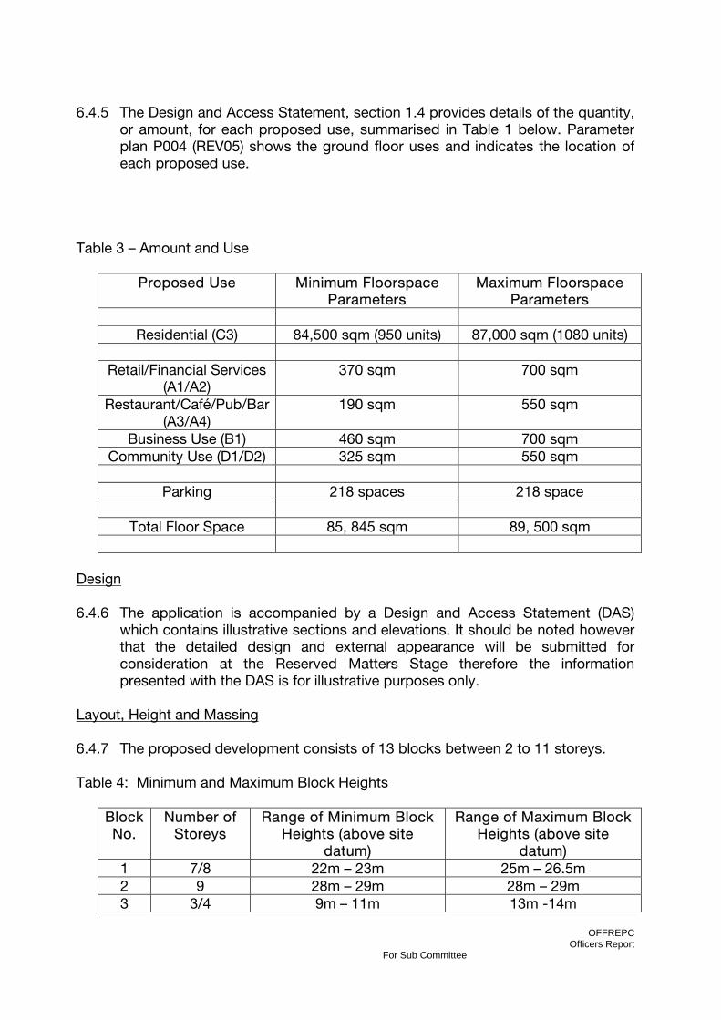
Table 3 – Amount and Use
Proposed Use Minimum Floorspace Parameters
Maximum Floorspace Parameters
Residential (C3) 84,500 sqm (950 units) 87,000 sqm (1080 units)
Retail/Financial Services
(A1/A2) 370 sqm 700 sqm
Restaurant/Café/Pub/Bar (A3/A4)
190 sqm 550 sqm
Business Use (B1) 460 sqm 700 sqm Community Use (D1/D2) 325 sqm 550 sqm
Parking 218 spaces 218 space
Total Floor Space 85, 845 sqm 89, 500 sqm
Design 6.4.6 The application is accompanied by a Design and Access Statement (DAS)
which contains illustrative sections and elevations. It should be noted however that the detailed design and external appearance will be submitted for consideration at the Reserved Matters Stage therefore the information presented with the DAS is for illustrative purposes only.
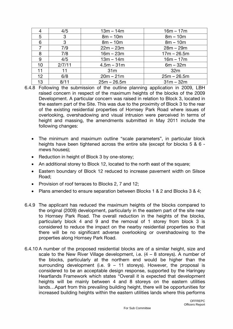
Layout, Height and Massing 6.4.7 The proposed development consists of 13 blocks between 2 to 11 storeys. Table 4: Minimum and Maximum Block Heights
Block No.
Number of Storeys
Range of Minimum Block Heights (above site
datum)
Range of Maximum Block Heights (above site
datum) 1 7/8 22m – 23m 25m – 26.5m 2 9 28m – 29m 28m – 29m 3 3/4 9m – 11m 13m -14m
OFFREPC Officers Report
For Sub Committee
4 4/5 13m – 14m 16m – 17m 5 3 8m – 10m 8m – 10m 6 3 8m – 10m 8m – 10m 7 7/9 22m – 23m 28m – 29m 8 7/8 16m – 23m 17m – 26.5m 9 4/5 13m – 14m 16m – 17m
10 2/7/11 4.5m – 31m 6m – 32m 11 11 31m 32m 12 6/8 20m – 21m 25m – 26.5m 13 8/11 25m – 26.5m 31m – 32m
6.4.8 Following the submission of the outline planning application in 2009, LBH raised concern in respect of the maximum heights of the blocks of the 2009 Development. A particular concern was raised in relation to Block 3, located in the eastern part of the Site. This was due to the proximity of Block 3 to the rear of the existing residential properties of Hornsey Park Road where issues of overlooking, overshadowing and visual intrusion were perceived In terms of height and massing, the amendments submitted in May 2011 include the following changes:
• The minimum and maximum outline “scale parameters”, in particular block heights have been tightened across the entire site (except for blocks 5 & 6 - mews houses);
• Reduction in height of Block 3 by one-storey;
• An additional storey to Block 12, located to the north east of the square;
• Eastern boundary of Block 12 reduced to increase pavement width on Silsoe Road;
• Provision of roof terraces to Blocks 2, 7 and 12;
• Plans amended to ensure separation between Blocks 1 & 2 and Blocks 3 & 4;
6.4.9 The applicant has reduced the maximum heights of the blocks compared to the original (2009) development, particularly in the eastern part of the site near to Hornsey Park Road. The overall reduction in the heights of the blocks, particularly block 4 and 9 and the removal of 1 storey from block 3 is considered to reduce the impact on the nearby residential properties so that there will be no significant adverse overlooking or overshadowing to the properties along Hornsey Park Road.
6.4.10 A number of the proposed residential blocks are of a similar height, size and
scale to the New River Village development, i.e. (4 – 8 storeys). A number of the blocks, particularly at the northern end would be higher than the surrounding development (i.e. 9 – 11 storeys). However, the proposal is considered to be an acceptable design response, supported by the Haringey Heartlands Framework which states “Overall it is expected that development heights will be mainly between 4 and 8 storeys on the eastern utilities lands…Apart from this prevailing building height, there will be opportunities for increased building heights within the eastern utilities lands where this performs
OFFREPC Officers Report
For Sub Committee
an urban design function and does not adversely impact on the amenities of neighbouring occupiers”.
Density 6.4.11 The proposed development seeks to provide a residential density of 640 – 700
habitable rooms per hectare (hrha) at the site. This is in accordance with Haringey Heartlands Development Framework and the density matrix contained within the London Plan and as such is considered to be acceptable.
Dwelling Mix 6.4.12 Although the application is in outline the applicants have been asked to
provide details of how the development could be accommodated within the building envelopes and comply with the relevant standards applying to minimum space standards, dwelling mix and affordable housing. Affordable Housing is discussed greater detail in section XX of this report.
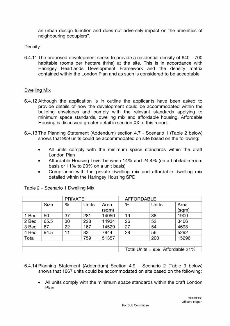
6.4.13 The Planning Statement (Addendum) section 4.7 - Scenario 1 (Table 2 below)
shows that 959 units could be accommodated on site based on the following:
• All units comply with the minimum space standards within the draft London Plan
• Affordable Housing Level between 14% and 24.4% (on a habitable room basis or 11% to 20% on a unit basis)
• Compliance with the private dwelling mix and affordable dwelling mix detailed within the Haringey Housing SPD
Table 2 – Scenario 1 Dwelling Mix PRIVATE AFFORDABLE Size % Units Area
(sqm) % Units Area
(sqm) 1 Bed 50 37 281 14050 19 38 1900 2 Bed 65.5 30 228 14934 26 52 3406 3 Bed 87 22 167 14529 27 54 4698 4 Bed 94.5 11 83 7844 28 56 5292 Total 759 51357 200 15296 Total Units = 959; Affordable 21% 6.4.14 Planning Statement (Addendum) Section 4.9 - Scenario 2 (Table 3 below)
shows that 1067 units could be accommodated on site based on the following:
• All units comply with the minimum space standards within the draft London Plan

OFFREPC Officers Report
For Sub Committee
• Affordable Housing Level between 14% and 24.4% (on a habitable room basis or 11% to 20% on a unit basis)
• Compliance with the affordable dwelling mix detailing within the Haringey Housing SPD
• An indicative private dwelling mix based on demand and viability considerations
Table 3 – Scenario 2 Dwelling Mix PRIVATE AFFORDABLE Size % Units Area
(sqm) % Units Area
(sqm) 1 Bed 50 42 400 20000 19 22 1100 2 Bed 65.5 40 381 24956 26 31 2031 3 Bed 87 16 152 13224 27 32 2784 4 Bed 94.5 2 16 1512 28 33 3119 Total 949 59692 118 9033 Total Units = 1067; Affordable 11% 6.4.15 PPS3 Paragraph 24 states “In planning at site level, Local Planning Authorities
should ensure that the proposed mix of housing on large strategic sites reflects the proportions of households that require market or affordable housing and achieves a mix of households as well as a mix of tenure and price”.
6.4.16 As the application is outline the proposals would not fix the dwelling mix at this
stage but would be determined at the reserved matters stage. The above is simply to show that compliance with the relevant standards is achievable. The revised unit range of 950 to 1080 dwelling units responds to the existing Local and Regional Planning policy standards.
Space Standards 6.4.17 Since the submission of the Outline planning application in 2009 the Mayor of
London has set out his intention to introduce minimum space standards for all new residential dwelling constructed in London. The London Plan 2011 table 3.3 “Minimum space standards for new development” provides details of the standards. Furthermore, The London Housing Design Guide (Interim Edition) (LHDG) states “the objective of this guidance is not only to ‘deliver housing units’ but to provide beautiful and appropriate homes of the highest quality that respond to the complex design challenges posed by this most dynamic of cities”. “The design standards set out in this guide will be applied immediately
OFFREPC Officers Report
For Sub Committee
to LDA supported projects”. Compliance with the LHDG standards will be achieved via a condition of consent and s106 obligation.
6.4.18 In light of these standards the number of dwelling units that could be
accommodated on the site has been reduced, with the range now being for 950 to 1080 residential units (as opposed to the original dwelling range of 1100 to 1200 units). A condition of consent will require all affordable and open market homes in the development to conform to the London Plan (2011) and London Housing Design Guide (Interim Edition – August 2010) floorspace standards and as far as practical with all other standards within the London Housing Design Guide (Interim Edition) (August 2010), particularly in relation to dual aspect units.
6.4.19 The London plan (2011) seeks to ensure that all new housing is built to “The
Lifetime Homes” standards and that 10 per cent of all new housing is wheelchair accessible or easily adaptable for residents who are wheelchair users. Advice on implementing the policy is given by the London Plan SPG ‘Accessible London: achieving an inclusive environment’, which states that “this percentage should be applied to both market and affordable housing, should be evenly distributed throughout the development, and cater for a varying number of occupants.” The GLA Best Practice Guidance ‘Wheelchair Accessible Housing’, 2007, offers guidance for designers on minimum standards for meeting the requirements for wheelchair accessible dwellings. A condition of consent will ensure these provisions are complied with at the reserved matters stage.
6.5 AFFORDABLE HOUSING 6.5.1 PPS3 “Housing” paragraph 29 highlights viability as a material consideration
with regards to affordable housing provision “assessment of the likely economic viability of land for housing within the area, taking account of risks to delivery and drawing on informed assessments of the likely levels of finance available for affordable housing, including public subsidy and the level of developer contribution that can reasonably be secured”.
6.5.2 Similarly, The London Plan (2011), policy 3.12 states that Boroughs should
seek “the maximum reasonable amount of affordable housing…when negotiating on individual private residential and mixed-use schemes”, having regard to their affordable housing targets, the need to encourage rather than restrain residential development and the individual circumstances including development viability”. Targets should be applied flexibly, taking account of individual site costs, the availability of public subsidy and the implications of phased development including provisions for re-appraising the viability of schemes prior to implementation.
6.5.3 Haringey Unitary Development Plan (2006) Policy HSG4 “Affordable Housing”
and AC1 “Areas of Changes” seek to achieve an overall borough target of 50% affordable housing. However, The London Plan (2011) policy 3.12 has removed
OFFREPC Officers Report
For Sub Committee
the 50% affordable housing target and simply seeks to “maximise” affordable housing provision.
6.5.4 Lengthy and complex negotiations have taken place between the applicants
and the Council to determine scheme viability and the achievable level of affordable housing (further details are provided in section 6.23 of this report).
6.5.5 The applicants have engaged with the Council and the Greater London
Authority over the past 18 months to agree an acceptable affordable housing provision. The figures suggested are the range deemed to ensure the development is financially viable and deliverable.
6.5.6 Public sector grant funding cannot be assumed to support the provision of
affordable homes in new developments. This means that the development itself must be taken as the sole source of financial subsidy to enable the inclusion of affordable homes in the scheme.
6.5.7 The introduction of the new ‘affordable rent’ tenure at up to 80% of market
rents means those homes do require less subsidy but there are doubts about the extent to which such homes will meet housing need. More time is needed to allow the implications of this new rented tenure to be worked through. Flexibility has been built into the s106 heads of terms to allow the desired ‘mix’ between ‘social’ and ‘affordable’ rented homes to be specified at a later date by the Council and Registered Provider.
6.5.8 The viability assessment of the scheme has been undertaken and concluded
that the proposal could provide affordable housing at 14% to 24.4% (based on habitable rooms) based on 70%/30% rented/shared ownership tenure split. The reason for the % range is that 14% will be the result if the 70% of rented homes are let at ‘social rent’ levels (around 40% of market levels) while 24.4% will be the result if those 70% of rented homes are let at the new ‘affordable rent’ level.
6.5.9 This percentage range equates to approximately 118 – 208 affordable homes.
The s106 heads of terms require that the development will meet the Council’s policy target regarding the size and mix of affordable homes with 56% being 3 bedrooms or more. The s106 heads of terms would allow the Council to determine its preferred rented tenure mix before the submission of the first reserved matters application.
6.5.10 Therefore, while the percentage range of affordable housing proposed falls
short of the 50% target with the Haringey UDP policy the scheme is still considered to be in line with the intent of wider regional and national planning policy which allow for a more flexible approach.
6.6 OPEN SPACE AND LANDSCAPING 6.6.1 The redevelopment would create a series of public open spaces throughout
the site, including a new public square to the northern end and improved

OFFREPC Officers Report
For Sub Committee
linkages to surrounding neighbourhoods including Wood Green and Hornsey Town Centres.
6.6.2 The application is for outline planning permission and as such the exact private
and public open space requirements would vary depending on the exact dwelling mix provided. The applicants have calculated two open space scenarios based on the two indicative dwelling mix scenarios outlined as provided in section 6.4 above.
Private Amenity Space 6.6.3 Haringey’s Housing SPD (adopted November 2008) defines policy on private
and communal amenity space requirements. Paragraph 8.8 states that “All new residential development, including conversions where appropriate, should provide external amenity space and this should be appropriate to the needs of the likely occupants”. The minimum private garden space for family dwellings is 50m², preferably with back gardens however where a family dwelling cannot be located on the ground floor, either individual private gardens or communal space at a minimum of 25m² per unit should be provided. In addition, non-family units shall be provided with a minimum area of useable communal space of 50 m2 plus 5 m2 per additional unit over five units.
6.6.4 The applicant has counted all 4 bed units as having a requirement of 50sqm,
all 3 bedroom dwellings as having a requirement of 25sqm and all 1 and 2 bedroom flats as having a requirement of 50sqm plus 5sqm for each unit over five units. All housing units with more than two bedrooms are potentially family dwellings. However, since it cannot be determined at this outline stage how many such units will be at ground level, the method used is considered to be an acceptable rule of thumb for determining approximate amenity space provision, that is to count 4 bedroom units as though they were on the ground floor and 3 bedroom units as though at upper floor level. Notwithstanding this, when the detailed housing layouts are produced for reserved matters applications they will be expected to conform to the detailed amenity space requirements of the Housing SPD, based on their location and layout rather than their number of bedrooms.
6.6.5 Therefore, the applicants calculate that under scenario 1 (the maximum
development) the private amenity space requirement would be 15,595sqm and under scenario 2 (minimum development) the requirement would be 11,245sqm.
6.6.6 The applicants consider that the development could potentially provide private
amenity space as follows:
• 1900 sq m to the west of Blocks 1 and 2 • 610 sq m to the west of Block 7 • 1,220 sq m to the west of Block 11 • 2,200 sq m to the east of Block 9 • 2,700sq m to the east of Block 3
OFFREPC Officers Report
For Sub Committee
• 2,680 sq m between Block 8 and 9 • 500 sq m for the Mews House gardens at Blocks 5 and 6 • 400 sq m of allotments/roof terrace space on the roof of Block 7 • 480 sq m of roof terrace space on Block 2 • 582 sq m of roof terrace space on Block 12 • A range of between 1000 sq m and 3000 sq m of balconies
6.6.7 Therefore, the scheme could provide between 14,272 sq m and 16,272 sq m
depending on the number and size of balconies provided within the detailed scheme. As such, the application has demonstrated that the development could meet the private amenity space requirement of between 11,245sq m and 15,595sq m. Although the application is in outline and the precise layout of blocks and amenity space is to be finalised at the reserved matters stage, the parameter plans show the variation to be small enough to accept these as good approximate figures, which could be reasonably be delivered.
Public Park Provision
6.6.8 The scheme proposes a new public square at the northern end of the site, to the west of block 12, which would provide 5,540m2 of public open space. In addition, there is an additional public space proposed, including children’s play area to be provided west of the mews houses covering an area of 2,380m2. This equates to a total of 7920m2 of public open space. The formal could be used for various cultural activities including outdoor events, farmers markets etc.
6.6.9 The applicant has also included a number of incidental spaces in their total
open space calculation such as 750m2 between Blocks 5 and 6, 680m2 between Blocks 2 and 7 and 3640m2 along the eastern and western side of the Spine Road. Including these incidental spaces would bring the total area allocated to public open space to 12,990m2.
6.6.10 By the applicant’s calculation, the Haringey Open Space and Recreation
Standards SPD (based on the indicative dwelling mix scenarios) would require approximately 33,000m2 of public open space to be provided within the development.
6.6.11 As the proposals provide 12,990 sqm of public open space (including
incidental spaces) it is clear that there is a shortfall. However, the standards detailed within the SPD provide detailed formula to calculate financial contributions towards public open space provision. The applicants intend to make a financial contribution towards public open space as part of the s106 agreement, as detailed below and in Appendix 7 of this report.
Children’s play space
6.6.12 Haringey’s Open Space and Recreation Standards Supplementary Planning Document (adopted March 2008) defines policy on public open space and required recreation provision, including children’s play space in developments.

OFFREPC Officers Report
For Sub Committee
The Mayor of London’s Supplementary Planning Document “Providing for Children and Young People's Play and Informal Recreation “ (adopted March 2008) also applies and contains standards on children’s play space that require a similar level of provision to Haringey’s own Open Space and Recreation SPD. It also contains more detailed standards and guidance on the design of different sorts of children’s play space.
6.6.13 The proposal contains four children’s play space sites; one in each of the two
main public spaces, one in the communal amenity space between Blocks 8 and 9 and one in the communal amenity space behind (to the west of) Block 2. Haringey’s SPD accepts that children’s play space “can be integrated within other types of open space provision particularly public park provision and amenity space provision” (paragraph 1.2.3B). Play space integrated with private communal amenity space will need to have access arrangements for children of other blocks or be only required to meet the play space requirements of that block.
6.6.14 The SPD defines three sorts of different categories of children’s play space, in
line with the Mayoral SPD; Doorstep Playable Space, Local Playable Space and Neighbourhood Playable Space (the differences and uses are defined in the SPDs). For all three categories the site is within an area of deficiency by distance and in a ward of deficiency by amount. The threshold above which play space is required for each type is 30, 100 and 150 dwellings, so the proposed development is required to provide play space in all three categories. As stated in the SPD, the space calculated as required in each case is 3m2 per child or 2,293m2 in total. It should therefore be possible to accommodate this area in the proposed 12,990m2 of public space and within the 2,700m2 and 2,680m2 private communal amenity spaces. On this basis, it is considered that an appropriate level of children’s play space could be provided on site within the proposed scheme.
6.6.15 As the application is only for Outline Planning Permission, simply defining the
locations and leaving the detailed design is acceptable. However any reserved matters applications for housing developments in line with this outline permission (if granted) will be required to include the requisite amount of children’s play spaces, including detailed design of those spaces, in order to meet the requirements of Haringey’s Supplementary Planning Documents and any other relevant planning policies.
Natural or Semi-natural Green Space Provision
6.6.16 The proposal designates part of the private communal amenity space behind Block 9 as a “Landscape Buffer” or “Ecological Garden”. Section 4.12 of the applicant’s Design and Access Statement describe this feature. It will have secured and managed access for residents and for education only, and be landscaped to benefit wildlife. There will be a separate buffer space of private amenity spaces for ground floor flats.
Open Space Deficiency and s106 Contributions
OFFREPC Officers Report
For Sub Committee
6.6.17 The Supplementary Planning Document on Open Space and Recreation
contains maps of distance to facilities and data of provision by ward for existing public open space and recreation facilities provision, indicating which areas of the borough are in deficiency of provision. If a proposed development is in a location where the distance to existing public open space provision is too great or is in a ward with insufficient provision, then the development should make a contribution towards providing the open space or recreation facility concerned. This can be provided by the development including relevant facilities, or by the applicants making a Section 106 financial contribution towards the council providing or improving relevant facilities or access to them in the vicinity of the development.
6.6.18 The development site is within an area of open space deficiency as identified in
the Unitary Development Plan. Therefore in addition to the on-site provision of local open space, the applicants will be required, through the s106 legal agreement to pay £500,000 to the Council to fund improvements to off-site local &/or strategic open space likely to be used by residents in the Development, including Alexandra Park, &/or to pedestrian /cyclist routes (which can include the construction of new routes) to that open space.
6.6.19 In the context of strenuous negotiations to achieve a viable scheme that also
meets Haringey’s planning policy objectives, it has been necessary to negotiate a reasonable and fair contribution. The proposal to extend the Penstock Footpath, in particular, would go a long way to meeting the Public Open Space and Recreation shortcomings of the development by providing direct and attractive access to the sports and recreation facilities and ecological assets of Alexandra Park.
6.6.20 An extension to the Penstock Footpath would also be a facility of wider
significance and benefit to the neighbourhood of Wood Green and the Borough as a whole, contributing to the network of leisure paths and cycle routes. It is therefore considered that the combination of onsite provision of open space in addition to the s106 contributions, which could facilitate improved access to Alexandra Palace and Park would be acceptable and a beneficial to the wider locality.
6.7 ENVIRONMENTAL IMPACT ASSESSMENT 6.7.1 The Town and Country Planning (Environmental Impact Assessment) (England
and Wales) Regulations 1999 require (in accordance with EU Directives) that certain development be assessed by the local authority as to whether it is likely to have significant environmental effects. If it is determined that there are likely to be significant environmental effects, the development must undertake an environmental impact assessment (“EIA”).
6.7.2 The EIA procedure requires that the applicant submit a detailed Environmental
Statement (ES) with its planning application which describes all likely significant effects and sets out proposed mitigation measures.

OFFREPC Officers Report
For Sub Committee
6.7.3 An Environmental Impact Assessment (EIA) was undertaken by Waterman
Energy, Environment and Design Ltd on behalf of the applicants. The EIA was undertaken to assess the environmental effects of the development, as proposed when submitted in 2009. The findings of the EIA are reported in the Environmental Statement (ES), which was submitted in support of the outline planning application. An Addendum to the ES has been submitted in light of the amendments to the scheme since the original submission.
6.7.4 The Environmental Statement covers the following issues:
• Socio-Economics • Transport and Access • Noise and Vibration • Air Quality • Townscape and Visual Effects • Archaeology and Built Heritage • Ground Conditions and Contamination • Water Resources and Flood Risk • Ecology • Daylight, Sunlight and Overshadowing • Wind • Waste • Cumulative Effects
6.7.5 A summary of each of these issues will be discussed in the following sections
of this report. 6.8 SOCIO-ECONOMICS 6.8.1 The Socio-economic assessment prepared by Hunt Dobson Stringer assesses
the likely socio-economic effects of the proposed development upon the local economy and social infrastructure.
6.8.2 The first part of the socio-economic assessment relates to issues of
employment which are covered in detail in section 6.3 of this report and therefore will not be covered again in this section.
6.8.3 The second part of the socio-economic assessment relates to the impact of
the development on social infrastructure such as health facilities, education facilities and community facilities and open space.
Health Care 6.8.4 The proposed development is forecast to generate an additional population of
between 1,744 and 2041 residents. This population increase implies a need for approximately one additional GP. There are 11 GP surgeries located within 1km of the site with an average patient list size of 1,685 people per GP. The
OFFREPC Officers Report
For Sub Committee
most frequently used planning assumptions takes an average of 1,800 patients per GP as being generally considered acceptable. This indicates that, in the local area, there is limited capacity at existing surgeries.
6.8.5 The s106 legal agreement will require that prior to the submission of the
Reserved Matters application that includes any or all of Blocks 8,10,11,12 and 13, the Applicant in conjunction with the Council will discuss with the North Central London Primary Care Trust (or successor body) its healthcare facility space requirements. If the PCT (or successor body) confirms a requirement for space, the Applicant shall offer to make available, on 25 year market leasehold terms (with renewal rights) (certified as reasonable by the District Valuer), to the Primary Care Trust (or successor body or a nominated organisation, e.g. the LIFT company) of up to 1,000sqm floorspace GIA – combination of D1/2 & B1 space subject to change of use approval) to be used as a primary healthcare centre (or related activities). The PCT (or successor body) shall have 4 months from the date of the offer within which to notify NGP/LDA that it wishes to take up the offer of a lease. If not, the Owners can withdraw the Offer.
6.8.6 Regardless of whether the PCT enters into a lease of on-site premises,
NGP/LDA agree to pay £500,000 to the Council towards off-site service improvements &/or capacity enhancements in existing or other new healthcare facilities likely to serve residents in the Development.
Education 6.8.7 The increased residential population of the site would result in an increase for
educational services demand. The proposed development would likely result in an additional primary aged population of 91 to 142 children and 42 to 76 secondary school children, giving a total of 134 to 218 places required.
6.8.8 There are 12 secondary schools within the administrative area of the London
Borough Haringey, including the new Heartlands Secondary School to the north of the Site which opened in September 2010. In addition, it is expected that a proportion of children moving into the development (particularly children in the social-rented housing) would already be placed in schools within LBH and may not change schools. As approximately 10% of secondary school age children in London are educated privately, a proportion of pupils would also be expected to receive private education.
6.8.9 The section 106 agreement will require the applicant to pay £5,250,000 to the
Council towards improving existing/new primary &/or secondary schools serving the new residents in the Development. These improvements can include increasing the capacity of school(s), improving premises &/or operational service improvements.
Community Facilities

OFFREPC Officers Report
For Sub Committee
6.8.10 The section 106 agreement will require the applicant to pay £500,000 to the Council towards the improvement &/or provision of off-site community facilities, e.g. library, sports pitches/facilities, swimming pool, etc.
6.9 TRANSPORT, ACCESS, PARKING and HIGHWAYS 6.9.1 The transport impact of the development has been assessed in the context of
the Haringey Unitary Development Plan (2006) policies M2, M3, M5, M9, M10, Appendix 1of UDP and SPG 7c.
Accessibility 6.9.2 The proposed development is located in an area with a public transport
accessibility level which ranges from 2 - 5 across the site, with its northern and southern periphery within reasonable walking distances of Wood Green and Turnpike Lane stations respectively. Its northern end is also some 750 metres walking distance of Alexandra Palace station.
Trip Generation and Modal Split 6.9.3 Haringey Transportation Team has analysed the impact of the trips generated
by the development on the various modes of transport. From the proposed modal split and trip generation tables below the majority of the trips generated by the proposed development would be by sustainable modes of transport. Some 75% of trips are by walking and public transport, 2% and 1% are by pedal and motorcycle respectively, with the remaining 22% travelling by car.
6.9.4 It is the view of Haringey Transportation Team, that with comprehensive travel
plan initiatives, the proposed modal split target can be achieved with additional reduction in the use of cars for journeys to and from the proposed development.
6.9.5 The applicant has proposed diverting bus routes 67 and 230 to the northern
section of the site via Coburg Road to aid in achieving the modal split target. The proposed diversion of the bus service would also mean that the residents/patrons/staff at the northern and southern areas of this development would be within 400 metres walking distance of the bus routes on Station Road/Coburg Road and Turnpike Lane, correspondingly.
6.9.6 Transport for London (TfL) has agreed in principal to the diversion of the two
bus routes and will require a financial contribution to assist in the diversion of the services.
6.9.7 Council officers, TfL and the applicant's consultants, Savill Bird & Axon (SBA)
have looked at the proposed bus route on site and have agreed that in order to achieve the diversion of the bus services some physical realignment of:
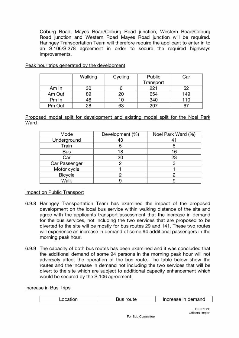
OFFREPC Officers Report
For Sub Committee
Coburg Road, Mayes Road/Coburg Road junction, Western Road/Coburg Road junction and Western Road Mayes Road junction will be required. Haringey Transportation Team will therefore require the applicant to enter in to an S.106/S.278 agreement in order to secure the required highways improvements.
Peak hour trips generated by the development
Walking Cycling Public Transport
Car
Am In 30 6 221 52 Am Out 89 20 654 149 Pm In 46 10 340 110
Pm Out 28 63 207 67 Proposed modal split for development and existing modal split for the Noel Park Ward
Impact on Public Transport 6.9.8 Haringey Transportation Team has examined the impact of the proposed
development on the local bus service within walking distance of the site and agree with the applicants transport assessment that the increase in demand for the bus services, not including the two services that are proposed to be diverted to the site will be mostly for bus routes 29 and 141. These two routes will experience an increase in demand of some 94 additional passengers in the morning peak hour.
6.9.9 The capacity of both bus routes has been examined and it was concluded that
the additional demand of some 94 persons in the morning peak hour will not adversely affect the operation of the bus route. The table below show the routes and the increase in demand not including the two services that will be divert to the site which are subject to additional capacity enhancement which would be secured by the S.106 agreement.
Increase in Bus Trips
Location Bus route Increase in demand
Mode Development (%) Noel Park Ward (%) Underground 43 41
Train 5 5 Bus 18 16 Car 20 23
Car Passenger 2 3 Motor cycle 1 1
Bicycle 2 2 Walk 9 9

OFFREPC Officers Report
For Sub Committee
(08:00-09:00) Turnpike Lane 41, 144 29 Green Lanes 29, 141 94
Westbury Avenue 123,217,231,444 28 Lordship Lane 144,234 18
High Road north of Lordship
121,141, 232,329 42
Bounds Green Road 221 11 Station Road 184, W3 18
6.9.10 Haringey Transportation Team, along with TfL concludes that the increase in
demand on the above route will not have any adverse effect on the existing bus capacity.
6.9.11 The modal split by train only accounts for 5% percent of trips to and from the
development and would only account for some 45 additional trips in the morning peak hour. Therefore the proposed increase in trips will not have any significant effect on the operation of the rail network.
6.9.12 The development proposal will have the greatest impact on the underground
as trips to and from the site account for 40% of the modal split target. Haringey Transportation Team has examined the impact of the development proposal on the underground stations. The information can be seen in the table below.
Existing and Proposed Underground trip at each station
Weekday AM peak 8:00-9:00 Weekday PM peak 17:00-18:00
Passengers Passengers
Station Movements
Existing
Development
Change Existin
g Development
Change
Wood Green Westbound Train
7864 203 2.6% 2511 71 2.8%
Eastbound Train
1128 82 7.2% 3263 108 3.3%
Turnpike Lane Westbound Train
10144 203 2.0% 3035 71 2.3%
Eastbound Train
1726 82 4.8% 4903 108 2.2
6.9.13 The impact on the underground has been reviewed using information from
Transport for London which looks at the relative loading of each station using the numbers of passengers on “on train” through each station. The 452 additional underground passenger trips have been divided equally between both stations, as per the table below. It can be seen that the west bound trains
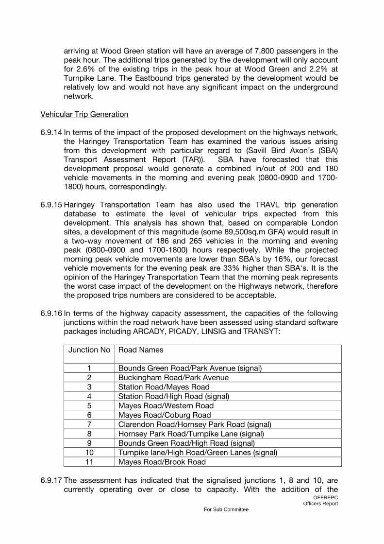
OFFREPC Officers Report
For Sub Committee
arriving at Wood Green station will have an average of 7,800 passengers in the peak hour. The additional trips generated by the development will only account for 2.6% of the existing trips in the peak hour at Wood Green and 2.2% at Turnpike Lane. The Eastbound trips generated by the development would be relatively low and would not have any significant impact on the underground network.
Vehicular Trip Generation 6.9.14 In terms of the impact of the proposed development on the highways network,
the Haringey Transportation Team has examined the various issues arising from this development with particular regard to (Savill Bird Axon’s (SBA) Transport Assessment Report (TAR)). SBA have forecasted that this development proposal would generate a combined in/out of 200 and 180 vehicle movements in the morning and evening peak (0800-0900 and 1700-1800) hours, correspondingly.
6.9.15 Haringey Transportation Team has also used the TRAVL trip generation
database to estimate the level of vehicular trips expected from this development. This analysis has shown that, based on comparable London sites, a development of this magnitude (some 89,500sq.m GFA) would result in a two-way movement of 186 and 265 vehicles in the morning and evening peak (0800-0900 and 1700-1800) hours respectively. While the projected morning peak vehicle movements are lower than SBA's by 16%, our forecast vehicle movements for the evening peak are 33% higher than SBA's. It is the opinion of the Haringey Transportation Team that the morning peak represents the worst case impact of the development on the Highways network, therefore the proposed trips numbers are considered to be acceptable.
6.9.16 In terms of the highway capacity assessment, the capacities of the following
junctions within the road network have been assessed using standard software packages including ARCADY, PICADY, LINSIG and TRANSYT:
Junction No Road Names
1 Bounds Green Road/Park Avenue (signal) 2 Buckingham Road/Park Avenue 3 Station Road/Mayes Road 4 Station Road/High Road (signal) 5 Mayes Road/Western Road 6 Mayes Road/Coburg Road 7 Clarendon Road/Hornsey Park Road (signal) 8 Hornsey Park Road/Turnpike Lane (signal) 9 Bounds Green Road/High Road (signal)
10 Turnpike lane/High Road/Green Lanes (signal) 11 Mayes Road/Brook Road
6.9.17 The assessment has indicated that the signalised junctions 1, 8 and 10, are
currently operating over or close to capacity. With the addition of the

OFFREPC Officers Report
For Sub Committee
development traffic, these junctions will suffer from a slight increase in queuing with the maximum increase at the Turnpike Lane junction of some 3 vehicles in the Saturday peak period Therefore it is concluded that although the development proposal will result in a reduction in the junction operational capacity, the slight resultant increase in queuing resulting from the proposal is not sufficient to recommend a refusal. In addition Haringey Transportation Team will investigate, as part of the S.106 agreement measure to optimise the operation of the junction as part of a linked network and travel plan, measures to reduce the number of trips generated by cars.
Cycle and Pedestrian Access 6.9.17 At its north-western side, this site links with the shared pedestrian/cycle route
'Penstock Footpath' which in turn connects with Cross Lane and ultimately onto Hornsey High Street. However, while the western section of this footpath is newly developed, the eastern section will require an upgrade, including adequate lighting.
6.9.18 There are also two cycle routes on Western Road leading to the Borough
boundary with Enfield via Station Road, Alexandra Palace station and Bounds Green and the second route which runs to the east of the Borough via Wood Green High Road, Downhills Park and Tottenham High Road. In order to ensure that the applicant can achieve the proposed modal split target it will be a requirement the applicant to make a financial contribution towards improving the physical infrastructure of the cycle routes byway of a section 106 agreement.
6.9.19 The applicants transport consultant has proposed improvements to key local
walking routes to assist residents accessing the site. Haringey Transportation Team has reviewed the proposed improvement and agrees that these improvements are crucial in order to achieve the modal split target.
6.9.20 The footway at the northern end of the site on Station Road, which provides a
linkage to the footway bridge over the railway which in turn connects Buckingham Road to Bedford Road, is substandard. This footway would therefore require an upgrade. It will be a requirement that the applicant make a financial contribute by way of a S.106 agreement towards measures to improve the footway at this section of Station Road.
Parking 6.9.21 The proposal site is identified in the Council’s adopted UDP policy HSG11 as
one which suffers from high parking pressures. The site is within the Wood Green Outer CPZ operating from Monday to Saturday between 0800hrs and 1830hrs, which provides adequate on-street car parking control. Therefore is considered that this development proposal fulfils the criteria as per the Council’s adopted UDP policy M9 for a car free development. As this development proposal will be dedicated as a car free development the Council will prohibit the issuing of car parking permits to the future occupiers of the

OFFREPC Officers Report
For Sub Committee
residential element of this development, visitors will still be eligible for parking permits.
6.9.22 The applicant has proposed that 23 per cent (251) of the car parking provision
for the use by the residential part of this development including 60 disabled plus 1 cycle rack per unit, which shall be enclosed within a secure shelter, as detailed on Plan No. 00823-B-24. Haringey Transportation Team has also considered that this restricted car parking provision would not only contain the parking demand of this development on the nearby roads but also form a key element of the Travel Plan initiatives proposed by the applicant.
6.9.23 There is proposed to be 1 cycle space per residential unit equating up to a
maximum of 1080 spaces for this land use. No information is provided on cycle parking for the other proposed land uses. Haringey Transportation Team therefore asks the applicant to provide 50 cycle spaces for the shop/office/community aspects of the development (36, 4 and 10 cycle spaces correspondingly).
Access to the Development 6.9.24 In terms of vehicular access, the existing vehicular access to the site will be
retained but the alignment of the existing Mary Neuner Road will be amended to improve the ease of passing by larger vehicles including buses. The applicant has proposed providing several new vehicular accesses and inset parking on Mary Neuner Road and the existing vehicular access on Hornsey Park Road will be closed. A new access is proposed some 10m further north of the existing access, with the existing crossover reinstated to footways. The proposed new site access will have a barrier installed to prevent vehicles other than the emergency services. The works would have to be delivered by the Council as part of the S.278 agreement.
Road safety 6.9.25 Haringey Transportation Team does not consider that the proposed
development would result in a potential increase in the number of accidents on the highway network. However as part of the proposal and package of highways improvement measure on the Spine Road, it is envisaged that a revised junction arrangement will include safety features that would enhance road safety at this location.
Deliver and Servicing of the development 6.9.26 The applicant has not provided a deliver and servicing plan or a waste
management plan to supplement the transport strategy. Therefore a condition of consent will require the applicant to submit a deliver and servicing plan for the proposed development. In addition the developer will be required to produce a construction environmental management plan including a construction travel plan six months before the developer commences the construction of the development.

OFFREPC Officers Report
For Sub Committee
Travel Plan 6.9.27 The applicant has proposed the following travel plan measures, which
Haringey Transportation Team agree will help in achieving the proposed modal split target which will result in fewer vehicular trips generated by the site and reduce the congestion on the Highways network. These measures will need to be secured via a condition or S.106 agreement
Travel Plan Measures: 1. Appointment of a Travel Plan Coordinator. 2. Provision of Travel Pack 3. Provision of Travel Awareness Initiatives such as Personalised Travel Plan for new household, cycle training, community website, free or discounted cycle equipment and community travel events. 4. Provision of public transport information 5. Liaison on public transport improvements 6. Introduction of a car club (number of spaces and scheme to be agreed as part of the travel plan) 7. Provision of over 1080 cycle stands.
6.9.28 In addition the applicant has proposed providing the following transport
infrastructure enhancement to assist in achieving the modal split target.
1. Provision of improved pedestrian routes 2. Provision of off-street cycles routes along the eastern side of the Spine Road
from Clarendon Road to the public square. 3. Provision of crossing facilities for pedestrians and cyclists along the Spine
Road and Coburg Road. 4. Introduction of two bus services to the site.
6.9.29 Consequently Haringey Transportation Team do not object to this application subject to conditions and s106 agreement.
6.10 NOISE AND VIBRATION 6.10.1 PPG24 “Planning and Noise” sets out the considerations to be taken into
account in determining planning applications for activities which generate noise and recommends appropriate noise exposure levels for different sources of noise. Haringey Unitary Development Plan policy ENV6 “Noise Pollution” states that “the council will ensure that new noise sensitive development is located away from existing or planned sources of noise pollution”. “In cases where separation is not possible, the impact of noisy development on the ambient noise levels should be assessed, for example by an Environmental Assessment. Where new noise-sensitive development is proposed in areas already exposed to high ambient noise levels, the Council may require the submission of an acoustic report to comply with PPG24”.

OFFREPC Officers Report
For Sub Committee
6.10.2 The Environmental Statement, Noise and Vibration assessment was
undertaken by Waterman Environmental in order to assess both the effects of the development in terms of noise and vibration on off-site receptors and noise levels at the development site itself. The assessment considered the effects of noise and vibration during the demolition and construction works as well the effects following completion and operation of the development.
6.10.3 The dominant existing sources of noise at the site are that of road traffic
associated with the surrounding local highway network, in particular Hornsey Park Road adjacent to the east of the site and Mary Neuner Road, which bisects the site. The East Coast Mainline Railway, located adjacent to the western boundary of the site contributes further noise. However noise from this source in intermittent and screened at ground level by a vegetated embankment. There are no significant sources of vibration either within the site or adjacent to the site.
6.10.4 By virtue of these existing noise sources (that is road traffic and the existing rail
traffic) mitigation measures would be need to be considered in design terms of the buildings including the use of double glazing and/or locating bedrooms away from these sources. A condition of consent will require the strategic location of sensitive habitable rooms (i.e. bedrooms) and the use of thermal double glazing units providing a minimum of 35dB LAeq attenuation for during the daytime and 30 dB LAeq in bedrooms at night, in order to achieve internal levels within the good standard as defined by BS8233:1999. However, in order to secure a comfortable internal environment, additional means of ventilation may be necessary, in accordance with BS8233 and Building Regulations.
6.10.5 In terms of the proposed railway operations at Coronation Sidings (Application
Ref: HGY/2011/0612) the Environmental Statement associated with that application predicts that there would not be any noise impacts from the proposed maintenance depot development. It concludes that the rating level would not exceed the background noise level at any of the receptors (including the proposed Clarendon Square development) used in the assessment. A number of conditions of consent will be used to control noise from the Coronation Sidings development, including the requirement that:
1. The design and installation of new items of fixed plant to be such that when
operating the cumulative noise level LAeq Tr arising from the proposed plant, measured or predicted at 1m from the facade of the nearest noise sensitive premises, shall be a rating level of at least 5dB(A) below the background noise level LAF90 Tbg and a noise report produced to demonstrate compliance with the above; and
2. A report is to be submitted to and approved by the Council that
demonstrates that the operational noise from all moving sources on the depot shall not exceed certain levels at specific receptors around the site. The levels in terms of Clarendon Square (western boundary of blocks 1, 2

OFFREPC Officers Report
For Sub Committee
and 7) are as follows: Daytime dBLAeq, 0600-0000 of 56 and Night-time dBLAeq, 0000-0600 of 54.
6.10.6 In respect of the proposed residential elements of the development, the
mitigation measures recommended above and secured via condition of consent are considered to provide an adequate level of protection against noise for the future occupants of the proposed development.
6.10.7 Regarding noise associated with the development following completion and
operation of the scheme, the traffic noise assessment concludes there would be no significant adverse impacts. The ES states that it takes a relatively sizeable percentage changes in traffic volumes (approximately 20% to 25%) to generate an audible change in road traffic noise. The noise changes from traffic generated as a direct result of the proposed development (refer to Appendix 7.1 of this ES Addendum) indicate that there would be an increases of less than 1.0dB for receptors close to the majority of the roads in the vicinity of the site. This constitutes a negligible effect on the noise sensitive receptors.
6.10.8 In relation to plant noise, the assessment shows that provided measures such
as space planning, screening, use of plant rooms and attenuators are undertaken there would be negligible impact.
6.10.9 In relation to noise associated with the use of the main public square,
Clarendon Square, for intermittent performances and activities, these would be tightly controlled through an appropriate licence from the London Borough of Haringey, together with specific mitigation measures and pre-agreements to ensure that potential disturbances to residents would be minimised.
6.10.10In terms of demolition and construction noise and vibration, best practice
measures for the reduction of noise would be implemented through the operation of a Construction Environmental Management Plan (CEMP) secured through a condition of consent. These measures would include the careful selection of modern and quiet plant and machinery, the erection of suitable hoardings around the site, adherence to pre-agreed working hours, and setting of noise level limits. A further condition of consent will also commit the developer to require all on-site contractors to comply with the Considerate Constructors Scheme.
6.11 AIR QUALITY 6.11.1 Planning Policy Statement 23 “Planning and Pollution Control” along with The
London Plan (2011), The Mayor’s Air Quality Strategy: Cleaning London’s Air (2002) and Local Unitary Development Plan (2006) policy ENV 7 “Air Water and Light Pollution”, set the planning policy context for air quality.
6.11.2 The Environmental Statement, Air Quality assessment was prepared by
Waterman Environmental in order to assess the construction and operational impacts of the development on local air quality.
OFFREPC Officers Report
For Sub Committee
6.11.3 Air quality impacts arising from the completed and operational development could arise from vehicle emissions or operational plant and ventilation systems.
6.11.4 The potential effects of vehicular traffic on air quality generated as a result of
the development have been minimised as part of the design, in terms of limiting car parking opportunities (a total of 251 car parking spaces (XX%) are proposed). In addition, a site-wide Travel Plan would be required by condition and implemented in order to promote all non-car modes of travel. It is not considered that the proposed development would have any significant adverse impact on local air quality as a result of vehicle emissions.
6.11.5 With respect to atmospheric emissions from heating plant, the proposed
development would incorporate modern plant and building services facilities with low emissions, in line with tightened legislation and industry standards. The proposed development would incorporate an Energy Centre which would include a communal heating system with a gas Combined Heat and Power (CHP) unit installed as the lead heat source, biomass boilers providing further heating, and gas-fired boilers provided for back up and to meet peak demands. The proposed location of the energy centre is in the basement of the block at the south-west corner of the 2011 Development. The location of the flues from the boiler plant within the energy centre would be located above roof level.
6.11.6 The demolition and construction activities have the potential to affect local air
quality by the generation of dust, emissions from construction plant and emissions from vehicles.
6.11.7 The GLA Best Practice Guidance recommendations include such measures as
the use of site hoardings, construction vehicle wheel washing, dust suppressions measures, and coving of stockpiles to avoid dust blow.
6.11.8 A range of construction mitigation measures would be set out in a
comprehensive Construction Environmental Management Plan (CEMP) (including appropriate mitigation measures to minimise dust and emissions based on the Mayor’s Best Practice Guidance and the those measures listed in section 10.85 of the Environmental Statement, including but not limited to routine dust monitoring, an inventory and timetable of dust generating activities, emission control methods and where appropriate air quality monitoring and close liaison with surrounding sensitive properties). The CEMP will be secured via a condition of consent and the development implemented in accordance with the approved details. Additionally the site contractors will be required to be registered with the Considerate Constructors Scheme.
6.12 TOWNSCAPE AND VISUAL EFFECTS 6.12.1 Planning Policy Statement 1 “Delivering Sustainable Development”, PPS5
“Planning and the Historic Environment” along with The London Plan (2011) and Haringey Local Development Plan (2006) policies on conservation areas and metropolitan open land, set the policy context for townscape and visual effects. In addition, supplementary planning guidance 1a “Design Guidance”, 2
OFFREPC Officers Report
For Sub Committee
“Conservation and Archaeology” and 1c “Strategic Views” also provide relevant advice.
6.12.2 The assessment of the townscape and visual effects was undertaken from a
number of primary viewpoints including the residential properties on the western side of Hornsey Park Road, New River Village apartments and from Alexandra Palace and Park.
6.12.3 Views from the site of the Grade II listed Alexandra Palace viewing terrace
would be fragmented and heavily filtered by intervening vegetation within Alexandra Park, and seen against a wide panoramic backdrop. Whilst both the minimum and maximum parameter developments would be partly masked by trees and would itself screen the Wood Green Shopping City development, the proximity of the development to the edges of Alexandra Park would become a localised focus in the view.
6.12.4 It is important to note that the strategic and protected view from Alexandra
Palace to central London, including St Pauls Cathedral, would not be affected by the development.
6.12.5 The New River Village apartments, located immediately adjacent to the west of
the East Coast mainline railway would experience close oblique views of the western parts of the site. Views from New River Village to the west are significantly screened, at ground level and lower level apartments, by the existing railway embankment. While the proposed buildings would be visible from New River Village, particularly upper floor apartments the impact is not considered to be significantly adverse.
6.12.6 In terms of Hornsey Park Road, the reduction in the overall heights and
particularly the removal of one storey from Block 3 has overcome initial concern regarding overlooking and overshadowing of the gardens of Hornsey Park Road. While the buildings, to the east of the site will be visible from the rear windows and gardens of Hornsey Park Road properties the impact is not considered to be significantly adverse.
6.13 ARCHAEOLOGY AND BUILT HERITAGE 6.13.1 PPS5 “Planning for the Historic Environment” (2010), London Plan (2011)
Policy 7.8 Heritage Assets and Archaeology and Unitary Development Plan policy CSV1 and CSV8, set the policy context for archaeology and build heritage.
6.13.2 The site does not contain any heritage resources designated as of national
importance, such as Scheduled Ancient Monuments (SAMs), Listed Buildings or Parks and Gardens of Special Historic Interest. In addition, there are no locally listed buildings within the site or within the immediate vicinity.
6.13.3 There are number of structures currently on the site, including two gas holders
(built between 1888 and 1894) which comprise Cutler’s patent helical girder

OFFREPC Officers Report
For Sub Committee
frame structure. A number of residents and the Victorian Society have in their letters of correspondence called for the retention of these structures on historic grounds. However, the gas holders are not statutorily or locally listed or protected in any way and English Heritage have declined to list them on a number of occasions as they do not consider them to be of a quality or type worthy of such status. Appropriate recording, to be agreed in consultation with the local planning authority, of the unlisted gas holders and associated structures prior to demolition would ensure that preservation by record would be achieved.
6.13.4 A total of six Conservation Areas surround the site including: Hornsey
Waterworks and Filter Beds, Alexandra Palace and Park, Wood Green Common, Campsbourne Cottage Estate, Hornsey High Street, and Noel Park Conservation Areas.
6.13.5 The proposed development would be screened almost entirely from Noel Park
Conservation area to the east, Wood Green Common Conservation area to the north and Hornsey High Street and Campsbourne Cottage Estate Conservation areas to the west, by existing built form. As a result both the minimum and maximum development parameter plans would have a negligible effect on the built heritage of these areas.
6.13.6 Due to the prominent and elevated location of Alexandra Palace there are
extensive panoramic views possible from the palace and park, especially from the upper viewing terraces. The Palace sits within a corridor of designated views and protected vistas toward the inner city of London and St. Paul’s Cathedral. While the proposed development would be visible from the Alexandra Park and Palace, it would not be located within the London panorama from the terrace of Alexandra Palace towards central London or the statutorily protected vista to St. Pauls. The views to the site would be in the context of the existing operational railway land and surrounding development, including Hornsey Water Treatment Works, Wood Green Shopping City and the New River Village Development. The townscape and visual impact assessment is provided in section 6.12 above.
6.13.7 Since the scheme is in outline, there remains scope for the detailed design of
the development to respond to the sites location adjacent to sites of historic and built heritage importance. This would help to ensure that adverse effects on the setting of the Grade II listed and registered Alexandra Palace and Park and the Hornsey Waterworks and Filter Beds Conservation Areas are minimised. A number of conditions of consent will relate to details of design, materials and finishes to ensure control is retained over the final design outcomes.
6.13.8 There is a potential for the proposed development during construction to
impact on the setting of the built heritage and historic landscape assets within the wider locality. During the construction phase the likely impacts would stem from increased visual impacts from scaffolding, cranes, lorries and equipment.
OFFREPC Officers Report
For Sub Committee
However, any impact in this respect would be temporary and limited to the construction phase only.
6.13.9 In terms of archaeology the Environmental Statement concludes that the site is
considered to have a low potential for archaeological deposits. However, not withstanding the assessment contained within the ES a condition of consent will require the applicant to implement an archaeological watching brief and programme for the recording of built heritage structures, in accordance with a written scheme of investigation which is to be submitted and approved by the Council. This will provide a reasonable opportunity to record the archaeological history of the site.
6.14 GROUNDS CONDITIONS AND CONTAMINATION 6.14.1 Planning Policy Statement 23 “Planning and Pollution Control” along with The
London Plan (2011) policy 5.21 “Contaminated Land” and Local Unitary Development Plan (2006) policy ENV11 “Contaminated Land”, set the planning policy context for the assessment of ground conditions and contaminated land.
6.14.2 A ground contamination assessment has been undertaken in order to establish
the likely potential contamination that exists at the site and the risks posed to humans, flora and fauna and waterways.
6.14.3 The site has been occupied by gas works since the late 1800s. Such land
uses, together with the current light industrial uses and associated car parking are likely to have resulted in ground contamination including coal tar, ammonia, sulphate, acids, fuel oils, asbestos, heavy metals, solvents, lime, hydrogen sulphide and hydrogen cyanide and sodium hydroxide and sulphuric acids.
6.14.4 Celtic Ltd has previously undertaken remediation works at the site in relation to
the construction of the Spine Road known as Mary Neuner Way. An 18m wide corridor containing the spine road has already been remediated to approximately 1m below ground level and up to 7.5m below ground level where structures are evident. The corridor was backfilled with recovered and/or imported clean materials.
6.14.5 The volume of material to be excavated from the site would be approximately
7,500m³. This would be predominantly derived from contaminated Made Ground excavations and also auger poling of foundations. For a development of this scale, such a quantum of excavation and disposal is considered to be small. This is due to the form of development as the proposal does not include basement areas. Consequently, the construction of the undercroft areas accommodating parking and servicing areas (which would commonly be located in basements) contributes significantly to the reduction in the amount of soil to be disposed off-site.
6.14.6 The removal and/or decontamination of soil, in line with relevant legislation, in
addition to a substantial barrier (or capping layer) would isolate the

OFFREPC Officers Report
For Sub Committee
development and future occupants and users of the site from the potential effects of contamination. Once the development is complete the majority of the site would be covered either by hardstanding and/or a capping of new clean soil in landscaped areas.
6.14.7 Demolition and construction works would be subject to a range of mandatory
legislative health and safety controls. Such controls would form part of the Construction Environmental Management Plan for the site, and would also include measures to ensure that contamination risks to underlying soils, groundwater and nearby rivers would be kept to an acceptable level.
6.14.8 The Environment Agency and Haringey Environmental Health Officers have
undertaken an assessment of the ES information relating to contaminated land and propose a number of conditions of consent to ensure the development can be implemented and occupied with adequate regard for the environmental and public safety
6.15 WATER RESOURCES AND FLOOD RISK 6.15.1 PPS25 “Development and Flood Risk” (2010) seeks to ensure that flood risk is
taken into account at all stages of the planning process to avoid inappropriate development in areas at risk of flooding. Where new development is necessary in such areas the policy aims to make it safe without increasing flood risk elsewhere and where possible reducing flood risk overall. London Plan policy 5.12 “Flood Risk Management” seeks to address current and future flooding and minimise the risk of flooding. In addition, Policy 5.14 “Water Quality and Sewage Infrastructure stipulates that development should ensure adequate sewerage infrastructure so not to cause deterioration of water quality in the Blue Ribbon Network
6.15.2 The Environmental Statement makes an assessment of the proposed scheme
on the water environment during both construction and operation, including water quality, water usage and flooding. There are two watercourses within close proximity of the site, the Moselle Brook which is culverted beneath the site and the New River, to the west and south of the site, which is an entirely artificial watercourse.
6.12.3 Environment Agency flood maps indicate the site to be located within Flood
Zone 1. This means that the site has an annual probability of flooding from tidal or fluvial sources of less and 0.1%, indicating that the risk of flooding from rivers and the sea is low.
6.12.4 A Flood Risk Assessment (FRA) was undertaken to determine the potential risk
posed by the development in terms of surface water flooding, ground water flooding and drainage flooding. The FRA also determines an appropriate surface water drainage strategy for the development.

OFFREPC Officers Report
For Sub Committee
6.12.5 Given that the majority of the site currently comprises hardstanding, the incorporation of 1.3ha of soft landscaping would represent a significant increase in the proportion of permeable surface on the site.
6.12.6 Mitigation for water quality and flood risk would be provided though the
provision of a suitable new drainage system, including sustainable urban drainage (SuDS) techniques where appropriate. These include:
• Surface water attenuation comprising a combination of green roofs and
vegetated surface drainage features; • Permeable surfaces; • Rainwater Harvesting; and • Sub-surface storage
A condition of consent will require that a scheme for the provision of Surface Water Drainage works for the site, based on sustainable drainage principles, and an assessment of the hydrological and hydro geological context of the development, be submitted to and approved in writing by the local planning authority.
6.12.7 It is anticipated that an upgrade of the existing foul sewerage network would
be necessary. Enhancement works would be designed in consultation with Thames Water so that the additional sewerage generated by the increased population and users of the development would be adequately accommodated.
6.12.8 During construction there would be a risk to water quality resulting from the
potential spillage or run-off of contaminants, the most significant sources being silt, contaminated silt, hydrocarbons or cement and concrete wash water, into local watercourses. Construction activities will be managed and controlled through the operation of a Construction Environmental Management Plan (CEMP) and conditions and informatives imposed by the Environment Agency.
6.16 ECOLOGY 6.16.1 Planning Policy Statement 9 “Biodiversity and Geological Conservation” along
with the London Plan (2011) and Haringey Unitary Development Plan (2006) policy OS 11 “Biodiversity” set the policy context for the assessment of the development upon ecological and nature conservation resources on, and in proximity to the site.
6.16.2 There are no statutory or non-statutory designation for nature conservation
interest located within the site. The application site is located adjacent to a designated Green Corridor (as identified on the Haringey Unitary Development Plan (2006) – Proposals Map).
OFFREPC Officers Report
For Sub Committee
6.16.3 The results of the Phase 1 Habitat Survey conclude that the site contains the following: buildings and hardstanding, introduced scrub, semi-improved calcareous grassland, tall ruderal vegetation and trees.
6.16.4 The approach of the landscaping scheme is to introduce habitat
enhancements to the site, including a proposed ecological garden to the north east boundary and green and brown roofs. The northern part of the swale within the landscape buffer would be sown with suitable native species. Bat and Bird boxes would be provided throughout the development. Details of the above will form part of the reserved matters submission. A condition of consent will require the preparation and approval of an Ecological Management Plan that would set out a series of measures that would ensure that effects on local wildlife are minimised as far as possible. The mitigation measures will be delivered under the supervision of an Ecological Clerk of Works in line with a Construction Environmental Management Plan to be prepared and approved prior to construction.
6.16.5 Construction works will require the removal of soil for earthworks and
decontamination. These works would impact upon local invertebrate populations. Construction works could also impact upon bat activity in the area. Lighting at night could also potentially affect bat foraging areas. Impact on flora and fauna during construction will be controlled through the Construction Environmental Management Plan (CEMP).
6.16.6 Natural England has been consulted and raised no objection to the application
subject to conditions and informatives which are included in section 10 of this report.
6.16.7 Following the implementation of the proposed mitigation and enhancement
measures it is considered that the overall quality of habitat provided on the site would be improved.
6.17 DAYLIGHT, SUNLIGHT AND OVERSHADOWING 6.17.1 Planning Policy Statement 1 “Delivering Sustainable Development”, The
London Plan (2011) and Haringey Unitary Development Plan policy UD3 “General Principles” set the policy context for the assessment of daylight, sunlight and overshadowing. In addition, supplementary planning guidance 1a “Design Guidance” and SPD Housing also provide relevant advice.
6.17.2 The Environmental Statement, submitted in support of the application,
presents an assessment of the likely significant effects of the amended (2011) development on daylight and sunlight availability at existing properties surrounding the Site, together with the likely effects on daylight and sunlight availability within the proposed residential units of the 2011 Development. In addition, an analysis of overshadowing on the back gardens of neighbouring residential properties and proposed public and private amenity spaces of the 2011 development has been undertaken.

OFFREPC Officers Report
For Sub Committee
6.17.3 Following demolition of the existing buildings and structures on the site, daylight and sunlight levels at the site and the immediate surrounds are likely to temporarily increase. As the construction works progress the levels of daylight and sunlight received would reduce to the levels experienced at the completion of the proposed development.
6.17.4 The majority of the residential properties within Hornsey Park Road would be
unlikely to experience a noticeable change in the level of daylight should the maximum scale of the 2011 Development be completed. As the windows of these residential properties listed in 14.64 of the Updated Environmental Statement Addendum, are compliant with the BRE Guidelines. On this basis, the likely effect of the maximum scale parameters of the 2011 Development on daylight availability the majority of properties along Hornsey Park Road would be negligible.
6.17.5 The assessment does conclude however that three of the properties along
Hornsey Park Road (103, 105 and 123) the BRE Guidelines suggest that the occupants of those rooms may experience a noticeable alteration to one or more of their rooms the when compared to the values of the baseline conditions. The impact on these properties is deemed to be moderately significant for 105 and 123 and minor significant for 103 and therefore is not considered significant in itself to warrant refusal.
6.17.6 In order to ensure a satisfactory standard of accommodation within the
development itself conditions of consent with require the development at the reserved matters stage to comply with the relevant regional and local policy standards, including the London Housing Design Guide (Interim Edition August 2010), particularly in relation to the provision of dual-aspect flats, where appropriate.
6.18 WIND 6.18.1 The wind assessment, prepared by Waterman Energy, Environment and
Design and RWDI Anemons Limited assesses the effects of the development on local wind microclimate and considers the potential effects of wind upon pedestrian comfort and safety.
6.18.2 The results of the assessment showed that, in the absence of mitigation, the
majority of the site would provide wind conditions suitable for the intended pedestrian usage at various times of the year. However, seating areas and a play space situated within the central area of Clarendon Square, roof allotment gardens on Blocks 1 and 2 and building entrances would generate wind conditions which could be considered to cause “uncomfortable” conditions in relation to their intended pedestrian use.
6.18.3 Notwithstanding the above, mitigation such as the use of local landscape
planting and perimeter screen would ameliorate these potential effect such that the entire site would experience appropriate microclimate conditions for

OFFREPC Officers Report
For Sub Committee
the proposed use. These details would be provided and assessed at the reserved matters stage.
6.19 WASTE 6.19.1 National Planning Policy Statement 10 “Sustainable Waste Management”, The
London Plan (2011) and Haringey Unitary Development Plan policy UD7 “Waste Storage” and ENV13 “Sustainable Waste Management” set the policy context for the assessment of waste management.
6.19.2 The proposed development would generate demolition and construction
waste. The volume of soil excavation required for the construction of the development has been estimated at 7,500 cubic metres. Excavated materials would be tested against the Waste Acceptance Criteria (WAC) to determine any hazardous properties. Inert waste (anticipated to be uncontaminated soil) would be reused off-site. Hazardous material (anticipated to be contaminated soil) would be treated or disposed of in accordance with the Landfill Regulations 2002 and Hazardous Waste Regulations 2005 and the Waste Framework Directive 2008 at authorised waste treatment and disposal sites. A condition of consent would include the requirement for a Site Waste Management Plan (SWMP).
6.19.3 The operational waste streams would include mostly residential/domestic
waste, and a small amount of commercial waste associated with the A, B and D uses classes. The assessment estimates that per annum the residential use (C3) would generate 7176 cubic metres of waste, the retail use (A1/A2) would generate 239 – 484 cubic metres, the Café/Restaurant uses (A3/A4) would generate 307 cubic metres, the Community use (D1/D2) would generate 198 – 588 and the Office/Business uses (B1) would generate between 15.6 and 47 cubic metres. Therefore, overall the completed development is anticipated to generate between approximately 7935m³ and 8602m³ per annum.
6.19.4 In terms of residential waste, each apartment or house would include adequate
storage space to allow for separate bins for general waste, recyclables, and organic waste. In addition, the mew houses (blocks 5 and 6) would be provided with compost bins.
6.19.5 In terms of commercial waste, arrangements for the collection and disposal of
commercial waste would be contracted out to a private waste management company or the Council.
6.19.6 A planning condition requiring full details of the arrangements for storage and
collection of refuse, including location, design, screening, operation and the provision of facilities for the storage of recyclable materials would be required at the reserved matters stage.
OFFREPC Officers Report
For Sub Committee
6.20 CUMULATIVE EFFECTS 6.20.1 The Environmental Statement assesses the cumulative effects of the proposed
development in terms of the combined effect with other consented or reasonably foreseeable schemes.
6.20.2 Consideration was given to the following cumulative schemes in the 2009
Environmental Statement:
• The erection of a pre-treatment and bromate removal facility comprising four new buildings at the Hornsey Water Treatment Works;
• The residential development at New River Village; • The extension to the „The Mall Wood Green Shopping City; • The residential development at the Ariella and BT Site; • The redevelopment of the existing Metropolitan Police Authority to retain
its current function; • and • The residential development at 120 to 128 Mayes Road, Wood Green.
6.20.3 In the 2011 Updated Environmental Statement Addendum the proposed Coronation Sidings maintenance depot has also been included in the assessment.
6.20.4 The assessment concludes that there may be some temporary combined
effects during the construction phase, such as townscape and visual effects, vibration and dust. Site specific Environmental Construction Management Plans, required through conditions of consent, would minimise demolition and construction related combined effects as far as practically possible.
6.20.5 The cumulative effects of the proposed development in conjunction with the
other reasonably foreseeable development proposals were generally found to be minimal. The exceptions were found to be in relation to: a slight increase in traffic on the local road network, beneficial job creation and an increased provision of new homes, beneficial and adverse townscape effects depending on the receptor affected and beneficial ecological enhancements. The adverse cumulative effects are deemed to be minor and therefore would not result in the need for any specific mitigation measures.
6.21 SUSTAINABILITY 6.21.1 PPS1 Delivering Sustainable Development confirms sustainable development
as the core principle underpinning planning and sets out the Government’s principles for delivering sustainable development by way of the planning system. PPS1 advises that planning should promote sustainable development and inclusive patterns of development by:
• Making land available for development • Contributing to sustainable economic development

OFFREPC Officers Report
For Sub Committee
• Protecting and enhancing the natural and historic environment • Ensuring high quality development through good and inclusive design • Ensuring that development supports existing communities
6.21.2 The planning application is submitted with an accompanying Sustainability
Statement which sets out to demonstrate how the proposed development will achieve high standards of sustainable design and environmental efficiency and how the proposed design, construction and operation will meet the relevant national, regional and local planning policies.
6.21.3 The scheme has used the One Planet Living framework to develop a
comprehensive sustainability strategy. The aim is of the development to achieve Code for Sustainable homes Level 4 and its key features are:
• Energy – more than 44% CO2 emission reduction though design and
communal energy network with gas CHP and biomass boilers • Water – Potable Water Consumption less than 105 litres/person/day
through water efficient appliances and grey water recycling and rainwater harvesting
• Transport – Reduce private car use through very low parking ratios, car club, electric vehicle charging points and ample cycle parking and storage
• Materials – To be low environmental impact materials • Ecology – Conserve what is on site and create new habitat • Waste - Reduce occupant waste sent to landfill
6.21.4 A number of conditions of consent, detailed in section 10 of this report will ensure compliance with sustainability criteria, including the requirement for a detailed energy strategy for the whole site, demonstration that the residential properties meet Code for Sustainable Homes Code Level 4 and that a minimum standard of “Very Good” under the Building Research Establishment Environmental Assessment Method (BREEAM) is achieved.
6.21.5 In terms of the Blue Ribbon Network, the Environment Agency has objected to
the proposed development on the basis that the scheme does not proposed to de culvert the Moselle Brook. The applicants have provided detailed information, including indicative cross-sections, which demonstrate that opening up the Moselle Brook is not viable. The reasons for not opening the water course include the depth of the stream and the current water quality which both could pose significant health and safety issues to occupiers/users of the development and also the loss of the usable open space within the proposed scheme. As such, the justification for not opening the stream is considered acceptable The applicant’s stance on this issue is also supported by the Greater London Authority who have since the stage 1 report, confirmed that adequate justification for not opening the river has been given. Notwithstanding these comments, the Environment Agency is seeking a number of conditions of consent and informatives, all of which have been included in section 10 of this report.

OFFREPC Officers Report
For Sub Committee
6.22 PLANNING OBLIGATIONS AND SECTION 106 AGREEMENT 6.22.1 The decontamination of the site and specifically the decommissioning of the
two operational gas holders have a significant impact on the viability of the scheme. As such, the Council has adopted a pragmatic approach to the negotiation of the s106 agreement and Head of Terms.
6.22.2 Section 106 agreements, or planning obligations, are legally binding
commitments by the applicant/developer and any others that may have an interest in the land to mitigate the impacts of new development upon existing communities and/or to provide new infrastructure for residents in new developments.
6.22.3 The policy tests that planning obligations must meet in order to be lawful were
recently enshrined in statute by the Community Infrastructure Levy Regulations 2010. The Regulations provide the framework for the transition from the current planning obligation system to the new tariff-style charge – the community infrastructure levy (CIL). Planning obligations must be: 1) necessary to make the development acceptable in planning terms, 2) directly related to the development, and 3) fairly and reasonably related in scale and kind to the development.
6.22.4 Lengthy and complex negotiations have taken place between the applicants
and the Council to determine scheme viability and the achievable level of affordable housing and s106 funding obligations.
6.22.5 81% of the 4.5 hectare site (81%) is owned by National Grid as an operational
gas site. The operational need to provide replacement gas storage capacity is the prime financial constraint in delivering a viable development.
6.22.6 The remaining 19% of the site is the Olympia Trading Estate now part
occupied by two firms (Unit 1 is vacant) on short-term business tenancies from the London Development Agency (LDA). The LDA leases the Estate from Haringey Council as freeholder.
6.22.7 The viability position on this project is complex, made more so due to the
housing market downturn in 2008 significantly reducing residential sales values. The planning application as originally submitted proposed up to 1,200 dwellings plus some office, retail and leisure floorspace. Negotiations on building heights and design led to the submission of a revised scheme in April 2011 proposing the same total floorspace but reducing the number of dwellings.
Minimum Land Release Costs
6.22.8 The key issue determining viability is the minimum land value that the development must achieve for National Grid to release the site from its current operational gas use. These ‘minimum land release costs’ are substantial but
OFFREPC Officers Report
For Sub Committee
have been assessed in detail on behalf of the Council and are considered reasonable (after some reductions were made). They include the demolition of the gasholders, ground remediation, replacement gas storage capacity, scheme preparation costs, provision for landfill tax and industrial existing use value for the National Grid land.
6.22.9 No allowance has been made in calculating these ‘minimum land release
costs’ for either the Council or the London Development Agency to be guaranteed to recoup the existing use value of their respective freehold and leasehold interests. That position will need to be approved by both the Council’s Cabinet and the LDA Board prior to completing the recommended s106 agreement. If approved, this will enable the development to support a higher level of affordable housing/s106 funding than would otherwise be the case. The completion of the s106 agreement on the basis of the heads of terms recommended is dependent on those separate Council Cabinet and LDA Board approvals
6.22.10Taking the minimum land release costs and current market values into
account (and assuming no grant funding in line with current HCA guidelines), the scheme could not viably support the provision of any affordable housing.
6.22.11Recognising that it is likely to be 2-3 years before development could start on
the site, an alternative approach to assessing viability was pursued based on a ‘mid-point’ projection of residential sales values and construction costs. This considered the residential sales values and build costs at the height of the market (2007) and current day (lower) residential sales values and costs. Values and costs were then derived from a ‘mid-point’ position between the two dates.
6.22.12Based on this slightly unconventional approach, and following numerous
iterations, the scheme can support a guaranteed level of affordable housing and cover the scheme’s key direct impacts. The applicants have agreed this approach.
Mitigating the scheme’s impacts via s106 funding obligations
6.22.13The scheme’s impacts focus on:
• schools capacity for the development’s projected child yield; • ensuring public transport accessibility to sustain the reduced level of car
parking in the scheme and achieve mode share targets, together with pedestrian/cyclist route and signalled junction improvements;
• facilitating local public open space improvements (and improving access to
that open space) to offset a deficiency in on-site provision of publicly accessible space compared with the Council’s standards;
• enabling the provision of an on-site healthcare facility by the Primary Care
Trust subject to future demand assessment and trends in alternative
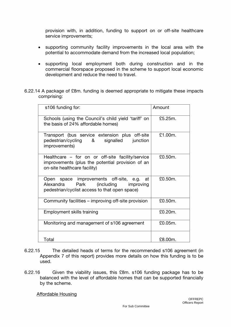
OFFREPC Officers Report
For Sub Committee
provision with, in addition, funding to support on or off-site healthcare service improvements;
• supporting community facility improvements in the local area with the
potential to accommodate demand from the increased local population;
• supporting local employment both during construction and in the commercial floorspace proposed in the scheme to support local economic development and reduce the need to travel.
6.22.14 A package of £8m. funding is deemed appropriate to mitigate these impacts
comprising:
s106 funding for:
Amount
Schools (using the Council’s child yield ‘tariff’ on the basis of 24% affordable homes)
£5.25m.
Transport (bus service extension plus off-site pedestrian/cycling & signalled junction improvements)
£1.00m.
Healthcare – for on or off-site facility/service improvements (plus the potential provision of an on-site healthcare facility)
£0.50m.
Open space improvements off-site, e.g. at Alexandra Park (including improving pedestrian/cyclist access to that open space)
£0.50m.
Community facilities – improving off-site provision
£0.50m.
Employment skills training
£0.20m.
Monitoring and management of s106 agreement
£0.05m.
Total
£8.00m.
6.22.15 The detailed heads of terms for the recommended s106 agreement (in
Appendix 7 of this report) provides more details on how this funding is to be used.
6.22.16 Given the viability issues, this £8m. s106 funding package has to be
balanced with the level of affordable homes that can be supported financially by the scheme.
Affordable Housing

OFFREPC Officers Report
For Sub Committee
6.22.17 The Homes and Communities Agency Framework 2011 makes clear
that ‘s106 schemes’ cannot assume any public sector grant funding to support the provision of affordable homes in new developments. This means that the development itself must be taken as the sole source of financial subsidy to enable the inclusion of affordable homes in the scheme. This significantly reduces the number of affordable homes that can be provided while still maintaining overall scheme viability
. 6.22.18 The introduction of the new ‘affordable rent’ tenure at up to 80% of
market rents means those homes do require less subsidy but there are doubts about the extent to which such homes will meet housing need. More time is needed to allow the implications of this new rented tenure to be worked through. Flexibility has been built into the s106 heads of terms to allow the desired ‘mix’ between ‘social’ and ‘affordable’ rented homes to be specified at a later date by the Council and Registered Provider.
6.22.19 The scheme can support between 14% and 24.4% of affordable homes
(calculated by habitable room) based on 70%/30% rented/shared ownership tenure split.
6.22.20 The reason for the % range is that 14% will be the result if the 70% of
rented homes are let at ‘social rent’ levels (around 40% of market levels) while 24.4% will be the result if those 70% of rented homes are let at the new ‘affordable rent’ level.
6.22.21 The s106 heads of terms allow for the Council to determine its preferred
rented tenure mix before the submission of the first reserved matters application pursuant to the outline planning permission (if the Committee does grant planning consent).
6.22.22 This percentage range equates to approximately 118 – 208 affordable
homes. The s106 heads of terms require that the development will meet the Council’s policy target regarding the size mix of affordable homes with 56% being 3 bedrooms or more.
6.22.23 The detailed heads of terms for the recommended s106 agreement are
provided in Appendix 7 of this report. 6.23 EQUALITIES IMPACT 6.23.1 In determining this planning application the Council is required to have regard
to its obligations under equalities legislation including the obligations under section 71 of the Race Relations Act 1976. An Equalities Impact Assessment is undertaken to evaluate the effects of the proposed scheme on people depending on their ethnicity, gender, age, disability, religion and belief or sexual orientation.

OFFREPC Officers Report
For Sub Committee
6.23.2 This section requires that in carrying out the Council’s functions due regard must be had, firstly to the need to eliminate unlawful discrimination, and secondly to the need to promote equality of opportunity and good relations between persons of different equalities groups. Members must have regard to these obligations in taking a decision on this application.
6.23.3 Some policies, projects, functions, major developments or planning
applications may have a greater impact on equality and diversity than others. The Council has developed a screening tool to help identify whether a full Equalities Impact Assessment (EqIA) should be undertaken. An EqIA screening has been undertaken and found that there are no adverse or unequal impacts identified across each of the equality strand and that a full EqIA is not considered necessary for this particular application.
6.24 PREDETERMINATION 6.24.1 The Council is in a development agreement (see preceding section
‘Development Agreement’) and owns part of the application site. These facts are not planning considerations and Members must not consider the Council as development partner or land owner when reaching their decision.
7.0 CONCLUSION 7.1 The proposal will provide a residential led mixed-use development that would
contribute to the regeneration of the wider Haringey Heartlands Area which is supported by existing and emerging local and regional planning policies.
7.2 The proposal will contribute to the boroughs housing provision for both
affordable and private dwellings units. 7.3 The scheme is also supported by a comprehensive transport strategy which
demonstrates that subject to appropriate conditions, legal obligations and mitigation measures, the development can be accommodated on the highways and transport network.
7.4 The Haringey Heartlands – Clarendon Square site is one of the single largest
development opportunities in Haringey, with substantial implications for the Borough as a whole. This development has the potential to act as a catalyst for the regeneration of the wider Wood Green area. It also offers enormous potential to contribute positively to the Councils regeneration, housing, community and environmental strategies and to the delivery of the London Plan.
7.5 The proposed development would result in the physical regeneration of the site
through comprehensive redevelopment which would represent investment in the area and would lead to further physical, social and economic regeneration in line with Council Planning Policy.

OFFREPC Officers Report
For Sub Committee
7.6 On balance it is considered that the scheme is consistent with planning policy and that subject to appropriate conditions and s106 contributions it is recommended that the outline application be granted planning permission.
8.0 HUMAN RIGHTS 8.1 All applications are considered against a background of the Human Rights Act
1998 and in accordance with Article 22(1) of the Town and Country Planning (General Development Procedure) (England) (Amendment) Order 2003 where there is a requirement to give reasons for the grant of planning permission. Reasons for refusal are always given and are set out on the decision notice. Unless any report specifically indicates otherwise all decision of this Committee will accord with the requirements of the above Act and Order.
9. RECOMMENDATION 1 9.1 That planning permission be granted in accordance with planning application
reference HGY/2009/0503 subject to a pre-condition that the applicant shall first have entered into an agreement or agreements with the London Borough of Haringey (under Section 106 of the Town and Country Planning Act (as amended) 1990) in order to secure the Heads of Terms set out in Appendix 7, covering the following general items:
• Affordable Housing • Education • Healthcare • Community Facilities • Transport • Open Space • Employment and Training
Monitoring 9.2 To ensure that the s106 obligations are honoured in a full and timely manner,
implementation of the s106 obligations will be subject to regular monitoring and target dates will be set where appropriate.
10. RECOMMENDATION 2 GRANT PERMISSION subject to conditions and subject to section 106 Legal Agreement in accordance with the approved plans and documentation as follows: P001(REV04) – Red Line – Planning Application Boundary P002(REV05) – Building Layout and Footprint P003(REV06) – Maximum and Minimum Storey Heights P004(REV05) – Ground Floor Uses P005(REV04) – Upper Floor Uses

OFFREPC Officers Report
For Sub Committee
P006(REV05) – Site Access and Movement P007(REV06) – Landscape Strategy
OFFREPC Officers Report
For Sub Committee
Subject to the following conditions: RESERVED MATTERS
1. The application is granted in OUTLINE, in accordance with the provisions of Regulations 3 & 4 of the Town & Country Planning (General Development Procedure) 1995 and before any development is commenced, the approval of the Local Planning Authority shall be obtained to the following reserved matters, namely: a) Scale (within parameter plan range (Drawing Ref: P003(REV06) – Maximum and Minimum Storey Heights); b) Layout c) Landscape and d) Appearance.
Reason: This condition is imposed by virtue of Section 92 of the Town & Country Planning Act 1990.
TIME LIMIT – RESERVED MATTERS
2. Application must be made to the Local Planning Authority for approval of any matters reserved in this OUTLINE planning permission not later than the expiration of 5 years from the date of this Permission, and the development hereby authorised shall be started not later than whichever is the later of the following dates, failing which the permission shall be of no effect: a. the expiration of 5 years from the date of this permission; or b. the expiration of 2 years from the final date of approval of any of the
reserved matters.
Reason: To comply with the provision of Section 92(2) of the Town and Country Planning Act 1990.
IN ACCORDANCE WITH APPROVED PLANS
3. The development hereby authorised shall be carried out in complete accordance with the plans and specifications (except for the Design and Access Statement which is for illustrative purposed only) submitted to, and approved in writing by the Local Planning Authority.
PHASING PROGRAMME
4. No development shall take place until a programme of phasing for implementation of the whole development has been agreed in writing by the Local Planning Authority. Any amendment to the approved phasing programme must be first agreed in writing by the Local Planning Authority.
Reason: To ensure satisfactory comprehensive development within a reasonable timescale and proper planning of the area.
MATERIALS
OFFREPC Officers Report
For Sub Committee
5. At the reserved matters stage, full details of the external appearance of the development, including samples of all materials to be used for all external facing surfaces and roofing materials for each phase of the development, as set out in an agreed phasing plan, shall be submitted to, and approved in writing by, the Local Planning Authority before any development is commenced on that phase. Samples shall include sample panels in addition to a schedule of the exact product references. All approved materials shall be erected in the form of a samples board and shall be retained on site throughout the works period for the phase concerned. Thereafter only such approved materials and finishes shall be used in carrying out the development.
Reason: To ensure a comprehensive and sustainable development and to achieve good design throughout the development.
MAXIMUM BUILDING HEIGHTS
6. The maximum height of the proposed development, including lift overruns, rooftop plant etc, shall be no greater than indicated on the parameter plan Drawing Number P003(REV06) – Maximum and Minimum Storey Heights.
Reason: In order to ensure the development is carried out in accordance with the approved details and in the interests of amenity.
MAXIMUM DWELLING NUMBERS
7. The outline planning permission hereby approved for a residential-led mixed use development shall not exceed 1080 separate dwelling units, whether flats or houses.
Reason: To ensure a comprehensive and sustainable development in order to control the overall density levels within the development.
ACCESSIBILITY AND LIFETIME HOMES
8. Within the development hereby approved, at least 10% of the dwellings shall be wheelchair accessible or easily adaptable for residents who are wheelchair users. This percentage should be applied to both market and affordable housing, should be evenly distributed throughout the development, and cater for a varying number of occupants. In addition, 100% of the dwellings shall be built to meet Lifetime Homes standards, unless otherwise agreed in writing by the Local Planning Authority. Evidence of compliance with the above shall be submitted to and approved in writing by the Local Planning Authority, prior to the commencement of each phase of the development.
Reason: In order to ensure adequate accessibility for the disabled and mobility impaired throughout their lifetime.

OFFREPC Officers Report
For Sub Committee
HOUSING DESIGN GUIDE STANDARDS 9. The development shall comply with the London Plan (2011) and London
Housing Design Guide – Interim Edition (August 2010) space standards and as far as practical shall meet all other requirements within the London Design Guide – Interim Edition (August 2010), particularly the requirements dual aspect units, contained in section 5.2 of the document.
Reason: In order to ensure a satisfactory standard of accommodation for future
occupiers of the development.
LANDSCAPING – LANDSCAPING SCHEME
10. At the reserved matters stage, full landscaping scheme for the entire site shall be submitted to and approved in writing by the Local Planning Authority a scheme for landscaping, which shall include a) those existing trees to be retained; b) those existing trees to be removed; c) those new trees and shrubs to be planted together with a schedule of species d) roof top gardens/allotments/amenity space e) hard surfacing f) boundary treatment e) street furniture
Reason: To enhance the appearance of the development and in the interest of safeguarding the amenities of residents in the area.
LANDSCAPING – IMPLEMENTATION/MAINTENANCE
11. All landscaping and ecological enhancement works, including planting, seeding or turfing comprised in the approved scheme of landscaping as described in condition “Landscaping – Landscaping Scheme” shall be completed no later than the first planting and seeding seasons following the occupation of the building or the completion of the development in each phase, whichever is the sooner. Any trees or plants which within a period of FIVE years from the completion of that phase of development die, are removed or become seriously damaged or diseased shall be replaced in the next planting season with others of similar size and species. The landscaping scheme, once implemented, is to be maintained and retained thereafter to the satisfaction of the Local Planning Authority. All hard landscaping and means of enclosure shall be completed before the development is occupied.
Reason: To enhance the appearance of the development in the interest of the visual amenities of the area.
LANDSCAPING – PROTECTION OF EXISTING TREES
12. No development shall commence until an Arboricultural method statement, including a tree protection plan, has been prepared in accordance with
OFFREPC Officers Report
For Sub Committee
BS5837:2005 Trees in Relation to Construction”, and approved by the Local Planning Authority. A pre-commencement site meeting must be specified and attended by all interested parties, (Site manager, Consultant Arboriculturalist, Council Arboriculturalist and Contractors) to confirm all the protection measures to be installed for trees. Robust protective fencing / ground protection must be installed prior to commencement of construction activities on site and retained until completion. It must be designed and installed as recommended in the method statement. The protective fencing must be inspected by the Council Arboriculturalist, prior to any works commencing on site and remain in place until works are complete.
Reason: To protect the trees which are to be retained and in the interest of the visual amenities of the area.
JAPANESE KNOTWEED
13. Prior to the commencement of the development, a detailed method statement for the removal or long-term management/eradication of Japanese knotweed on the site shall be submitted to and approved in writing by the local planning authority. The method statement shall include proposed measures to prevent the spread of Japanese knotweed during any operations such as mowing, trimming or soil movement. It shall also contain measures to ensure that any soils brought to the site are free of the seeds / root / stem of any invasive plant covered under the Wildlife and Countryside Act 1981. Development shall proceed in accordance with the approved method statement. Please note that if any of the Japanese knotweed plants are close to water, including watercourses, ditches or standing water, then Environment Agency consent is required if it is to be treated with a herbicide.
Reason: In order to ensure the eradication of Japanese Knotweed which is an invasive plant and the spread of which is prohibited under the Wildlife and Countryside Act 1981.
BOUNDARY TREATMENT
14. Notwithstanding the details contained within the plans hereby approved, full details of boundary treatments, including fencing and gates, to the entire site be submitted to and approved by the Local Planning Authority prior to the commencement of the development.
Reason: In order to safeguard the visual amenity of the area and to ensure adequate means of enclosure for the proposed development.
ECOLOGICAL MANAGEMENT
15. The development hereby approved shall not commence until full details of a site wide Ecology Management Strategy including an Ecological Mitigation and Management Plan which shall provide details of how the proposed measures

OFFREPC Officers Report
For Sub Committee
will be monitored, managed and funded in the future, has been submitted to and approved in writing by the Local Planning Authority.
Reason: In order to ensure that the proposed development maximises the ecological potential of the site
POLLUTION PREVENTION
16. The development hereby approved shall not commence until full details of a site wide Pollution Prevention Strategy has been submitted to and approved in writing by the Local Planning Authority.
Reason: In order to ensure that the proposed development prevents pollution of the environment.
CONTAMINATED LAND – VERIFICATION REPORT
17. The development shall not be occupied or brought into use until verification by a competent person approved under the provisions of Condition “Contaminated Land – Remediation Strategy” that any remediation scheme required and approved under the provisions of the above condition has been implemented fully in accordance with the approved details, shall be submitted to and approved by the Local Planning Authority. Unless otherwise agreed in writing by the Local Planning Authority such verification shall comprise: (a) as built drawings of the implemented scheme; (b) photographs of the remediation works in progress; and (c) certificates demonstrating that imported and/or material left in situ is free from contamination. Thereafter the scheme shall be monitored and maintained in accordance with the scheme approved under Condition “Contaminated Land – Remediation Strategy”.
Reason: To safeguard the health of future residents or occupiers of the site.
USE OF CLEAN UNCONTAMINATED MATERIAL
18. No soils or infill materials shall be imported onto the site until it has been satisfactorily demonstrated that they present no risk to human health and the environment. Documentary evidence to confirm the origin of all imported soils and infill materials, supported by appropriate chemical analysis, test results, shall be submitted to and approved by the Local Planning Authority prior to that import. The import on site of material classified as ‘waste; is only acceptable with the prior written approval of the Local Planning Authority.
Reason: To ensure that no contaminated land is brought on site.
METHOD OF PILING
19. The development hereby approved shall not commence until the method of piling foundations for the development has been submitted to and approved in writing by the Local Planning Authority prior to any development commencing.

OFFREPC Officers Report
For Sub Committee
Piling or any other foundation designs using penetrative methods shall not be permitted except for those parts of the site where it has been demonstrated that there is no resultant unacceptable risk to groundwater. The development shall be carried out in accordance with the approved details.
Reason: To prevent the contamination of the underlying aquifer.
ARCHAEOLOGICAL WATCHING BRIEF
20. No development shall take place within the application site until the applicant has secured the implementation of an archaeological watching brief and a programme for the recording of built heritage structures, including the existing gas holders, in accordance with a written scheme of investigation which has been submitted to and approved in writing by the Local Planning Authority.
Reason: To ensure that archaeological remains on the site shall be adequately investigated and recorded during the course of the development and the findings of such investigation and recording reported
HOARDINGS
21. Prior to the commencement of development full details of a scheme for the provision of hoardings around the site during the construction period including details of design, height, materials and lighting shall be submitted to and approved in writing by the Local Planning Authority prior to the commencement of the works and unless otherwise agreed in writing by the Local Planning Authority. The development shall be carried out only in accordance with the scheme as approved.
Reason: In order to have regard to the visual amenity of the locality an the amenities of local residents, businesses, visitors and construction sites in the area during construction works.
CONSTRUCTION ENVIRONMENTAL MANAGEMENT PLAN
22. The development hereby approved shall not commence until a Construction Environmental Management Plan, including Site Waste Management Plan, Site Management Plan and Construction Logistics Travel Plan, has been submitted to and approved in writing by the Local Planning Authority. The Construction Management Plan shall include but not be limited to the following: a) Public Safety, Amenity and Site Security; b) Operating Hours, Noise and Vibration Controls; c) Air and Dust Management; d) Storm water and Sediment Control and e) Waste and Materials Re-use. The Site Waste Management Plan will demonstrate compliance with an appropriate Demolition Protocol. The development shall be carried out in accordance with the approved details. Additionally the site or Contractor Company must be registered with the Considerate Constructors Scheme. Proof of registration must be sent to the LPA prior to any works being carried out on the site.

OFFREPC Officers Report
For Sub Committee
Reason: In order to have regard to the amenities of local residents, businesses, visitors and construction sites in the area during construction works.
CONSTRUCTION DUST MITIGATION
23. No development shall commence until the appropriate mitigation measures to minimise dust and emissions are incorporated into the site specific Construction Environmental Management Plan based on the Mayor’s Best Practice Guidance (The control of dust and emissions from construction and demolition). This should include an inventory and timetable of dust generating activities, emission control methods and where appropriate air quality monitoring). This must be submitted to and approved in writing by the LPA prior to any works carried out on the site. Additionally the site or Contractor Company must be registered with the Considerate Constructors Scheme. Proof of registration must be sent to the LPA prior to any works being carried out on the site.
Reason: To protect the environment and amenities of the locality.
CONSTRUCTION HOURS
24. Operations in relation to construction for which noise is greater than 50dBLAeq, 1hour at the nearest residential boundary shall be restricted to the hours of 0800 and 1800 on Mondays to Fridays and between 0800 and 1300 on Saturdays and at no time on Sundays or Statutory holidays without the prior written approval of the Local Planning Authority under Section 61 of the Control of Pollution Act 1974.
The following enabling activities shall be permitted to take place within a period one hour before and one hour after normal working hours:
• Arrival and departure of workforce on site; • Deliveries and unloading; • Check and examinations of plant and machinery (including test running) and
the carrying out of essential repairs / maintenance to plant and machinery; • Site inspections and safety checks; and • Site clean-up
Reason: To ensure that the development does not prejudice the enjoyment of neighbouring occupiers of their properties.
CONSTRUCTION – ON-SITE CONTACT 25. At the time of the commencement of works, an on site contact shall be
provided on a 24 hour per day basis for residents to report any disturbances or issues arising from the construction of the site
Reason: To ensure that any disruption to neighbouring residents can be reported immediately.
OFFREPC Officers Report
For Sub Committee
CCTV AND SECURITY LIGHTING
26. At the reserved matters stage, a scheme showing full details of the following shall be submitted to and approved in writing by the Local Planning Authority.
a) CCTV;
b) Security lighting
Reason: In order to ensure that the proposed development achieves the safer places attributes as detailed by Planning Policy Statement 1: Safer Places: The Planning System & Crime Prevention and to prevent crime and create safer, sustainable communities and in order to ensure the location of CCTV protects the privacy of neighbouring residential properties.
EXTERNAL LIGHTING STRATEGY 27. At the reserved matters stage, an external lighting strategy for that phase of
the development shall be submitted to and approved in writing by the Local Planning Authority. The details of the external lighting for each phase shall be in accordance with the approved strategy.
Reason: In order to ensure that the proposed development achieves the safer places attributes as detailed by Planning Policy Statement 1: Safer Places: The Planning System & Crime Prevention and to prevent crime and create safer, sustainable communities
SURFACE WATER DRAINAGE 28. At the reserved matters stage, details of a scheme for the surface water
drainage works including the provision of a Sustainable Urban Drainage System shall be submitted to and approved by the Local Planning Authority (in consultation with Thames Water) prior to the commencement of works within that part of the site. The surface water drainage details shall include that petrol/oil interceptors shall be fitted in all car parking/washing/repair facilities and an Impact Study of existing Sewerage infrastructure.
Reason: In order to ensure the satisfactory surface water drainage of the site.
WATER SUPPLY IMPACT STUDY 29. At the reserved matters stage, a Water Supply Impact Study for that phase of
the development, including full details of anticipated water flow rates, and detailed site plans shall be submitted to, and approved in writing by the Local Planning Authority (in consultation with Thames Water).
Reason: To ensure that the water supply infrastructure has sufficient capacity to cope with the additional demand
OFFREPC Officers Report
For Sub Committee
WASTE STORAGE AND RECYCLING 30. At the reserved matters stage, details of the arrangements for storage and
collection of refuse for each phase of the development, including location, design, screening, operation and the provision of facilities for the storage of recyclable materials shall be submitted to and approved in writing by the Local Planning Authority and the development shall be carried out only in accordance with the details so approved and shall be permanently retained thereafter.
Reason: To ensure good design, to safeguard the amenity of the area and ensure that the development is sustainable and has adequate facilities for the storage of waste and recyclable materials.
BREEAM – DESIGN STAGE ASSESSMENT
31. The development hereby permitted shall be built to a minimum standard of “Very Good” under the Building Research Establishment Environmental Assessment Method (BREEAM). A BREEAM design stage assessment shall be submitted to the Local Planning Authority prior to the commencement of construction. The BREEAM design stage assessment will be carried out by a licensed assessor.
Reason: To ensure that development takes place in an environmentally sensitive way.
BREEAM CERTIFICATE
32. The development hereby permitted shall be built to a minimum standard of “Very Good” under the Building Research Establishment Environmental Assessment Method (BREEAM). Within THREE months of the occupation of the completed development, a copy of the Post Construction Completion Certificate for the relevant building verifying that the “Very Good” BREEAM rating has been achieved shall be submitted to the Local Planning Authority. The Certificate shall be completed by a licensed assessor.
Reason: To ensure that development takes place in an environmentally sensitive way.
TRANSPORTATION – S72 AGREEMENT
33. The developer will we required to dedicate a 3m strip of land by way of a section 72 agreement along Mary Neuner Road to construct the proposed vehicular inset parking as per Drawings No’s 0083-B-23 and 0083-B-24 as submitted by the applicant’s consultant Savell Bird and Axon.
Reason: Ensure safe and efficient vehicle access.
TRANSPORTATION – PARKING PROVISION
OFFREPC Officers Report
For Sub Committee
34. The applicant shall provide 23 per cent (276 car spaces) parking provision for the residential component of the development, including 60 disabled spaces.
Reason: To ensure appropriate levels of car parking within the development.
TRANSPORTATION – PARKING PROVISION – ELECTRIC VEHICLES
35. At the reserved matters stage, details of electric vehicle provision within the parking areas (which shall include a minimum of 20 per cent of all parking spaces and an additional 20 per cent passive provision for electric vehicles in the future) shall be submitted to an approved in writing by the Local Planning Authority.
Reason: In order to ensure adequate provision of electric vehicle infrastructure within the development.
TRANSPORTATION - CYCLE PARKING
36. At the reserved matters stage a detailed plan for cycle parking which shall include a) 1 cycle rack per residential unit; b) 50 cycle spaces for the shop/office/community aspects of the development (36, 4 and 10 cycle spaces correspondingly) and c) secure shelters, shall be submitted to and approved in writing by the local planning authority.
Reason: In order to ensure adequate provision of safe and secure cycle parking.
TRANSPORTATION – TRAVEL PLAN AND CAR CLUB
37. At the reserved matters stage, Travel Plans and welcome pack, in compliance with Transport for London Guidance, shall be submitted to and approved in writing by the local planning authority, at least 3 months in advance of occupation of each phase of the development. The Car Club scheme and number of on site Car Club car parking spaces to be agreed as part of the Travel Plan.
Reason: In order to encourage the use of sustainable modes of transport for journeys to/from the site.
DETAILS OF FLUES
38. Full details of the location and appearance of any flues, including height, design, location and sitting shall be submitted and approved in writing by the Council before work commences.
Reason: To ensure a comprehensive and sustainable development and to achieve good design through the development.
COMMERCIAL PREMISES – ACCESS

OFFREPC Officers Report
For Sub Committee
39. The commercial premises shall be minimum door widths of 900mm and a maximum threshold of 25mm to allow access to people with disabilities and people pushing double buggies.
Reason: In order to ensure that the premises are accessible to all those people who could be expected to use it, in accordance with policy RIM 2.1 “Access for All” of the Haringey Unitary Development Plan (2006).
SHOPFRONTS
40. Detailed plans of the design and external appearance of the shopfronts, including detailed design of the fascias, shall be submitted to and approved in writing by the Local Planning Authority at the reserved matters stage.
Reason: In the interest of visual amenity. SIGNAGE
41. Prior to the commencement of the use, precise details of any signage proposed as part of the development shall be submitted to and approved in writing by the local planning authority.
Reason: to achieve good design throughout the development and to protect the visual amenity of the locality.
HOURS OF OPERATION – A3, A4 and A5 Uses
42. Any restaurant (A3), public house and wine bar (A4) or takeaway (A5) use shall not be operated before 0800 or after 2400 hours on any day of the week.
Reason: In order to ensure that the proposed development does not prejudice the amenities of the future occupiers of the development.
ENVIRONMENT AGENCY – STRUCTURAL SURVEY
43. The development hereby permitted shall not be commenced until such time as a structural survey of the Moselle Brooke culvert to identify the life of the flood defences compared to the life of the development has been submitted to, and approved in writing by, the local planning authority. If the assessment identifies that the life of the culvert is not commensurate with the life of the development, then a scheme of remedial measures shall be submitted to and approved in writing by the Local Planning Authority before development commences. Development shall proceed only in accordance with the approved remedial measures.
OFFREPC Officers Report
For Sub Committee
Reason: To ensure that the flood defences have a life commensurate with the life of the development in order to safeguard the development and area from the risk of flooding.
ENVIRONMENT AGENCY – FLOOD RISK ASSESSMENT 44. The development permitted by this planning permission shall only be carried
out in accordance with the approved Flood Risk Assessment (FRA) Waterman Group (C-37407-10-ES-002 Rev: A05 February 2009) and the following mitigation measures detailed within the FRA:
• Limiting the surface water run-of generated so that it will not exceed a run-off
rate of 17.7ls/ha from the site and not increase the risk of flooding off-site. • Provision of attenuation of surface water on site through the use of SUDS
systems including living roofs, permeable paving and a swale and the use of storage tanks.
• Building and structures on site to be set a minimum of 8m back from the outer culvert wall of the Moselle Brook.
Reason: To prevent flooding by ensuring the satisfactory storage of/disposal of surface water from the site and to ensure the structural integrity of and access to existing flood defences thereby reducing the risk of flooding.
ENVIRONMENT AGENCY – SITE INVESTIGATION AND CONTAMINATED LAND 45. Prior to the commencement of development approved by this planning
permission (or such other date or stage in development as may be agreed in writing by the Local Planning Authority), the following components of a scheme to deal with the risks associated with contamination of the site shall each be submitted to and approved, in writing, by the local planning authority:
1) A preliminary risk assessment which has identified:
• All previous uses • Potential contaminants associated with those uses • A conceptual model of the site indicating sources, pathways and
receptors • Potentially unacceptable risks arising from contamination at the site
2) A site investigation scheme, based on (1) to provided information for a detailed
assessment of the risk to all receptors that may be affected, including those off site.
3) The site investigation results and the detailed risk assessment (2) and, based
on these, an options appraisal and remediation strategy giving full details of the remediation measures required and how they are to be undertaken.
4) A verification plan providing details of the data that will be collected in order to
demonstrate that the works set out in (3) are complete and identifying any requirements for longer-term monitoring of pollutant linkages, maintenance
OFFREPC Officers Report
For Sub Committee
arrangements for contingency action. Any changes to these components require the express consent of the local planning authority. The scheme shall be implemented as approved.
Reason: There are controlled water bodies at, and in the vicinity of the proposed development site, which could be polluted by the known soil and shallow (perched) groundwater contamination which exists at the site. The identified Controlled Water bodies are the Moselle Brook, the New River, the reservoirs to the west and the deeper groundwater system that underlies the site. The deeper groundwater and the New River are used to supply drinking water to the public and therefore must be kept free from pollution. The Moselle Brook which flows through the site in culvert flows into Pymmes Brook to the east. If pollution were to enter the brook it would have a detrimental impact on aquatic life in the brook and also to its aesthetic appeal. As such, site investigation is required to assess the risk that the contamination at the site poses to Controlled Waters. Note: The information provided to the Environment Agency in the report titled 'Environmental Statement' which was prepared by Waterman Energy, Environment & Design and dated February 2009 (Ref EN6847/R/2.1.1/MN) is sufficient to satisfy Part 1 of this condition. Also, part of the site has previously been investigated and remediated to an acceptable standard with regards to any risk posed to Controlled Waters. This area is referred to as the Spine Road and is detailed in Celtic Technologies report titled 'Haringey Heartlands Spine Road Improvement Corridor - Factual Validation Report' dated October 2008 (Ref R1199/08/3325). The above recommended condition is not applicable to this part of the site.
ENVIRONMENT AGENCY – PILING 46. Pilling or any other foundation designs using penetrative methods shall
not be permitted other than with the express written consent of the Local Planning Authority, which may be given for those parts of the site where it has been demonstrated that there is no resultant unacceptable risk to groundwater. The development shall be carried out in accordance with the approved details.
Reason: Piled foundations are proposed to facilitate development at the site. The advancement of such foundations through contaminated material, which is known to be present in the soil and shallow (perched) groundwater at the site, has the potential to mobilise contaminants and result in their release into the deeper groundwater system. The deeper groundwater underlying the site is abstracted a short distance from the site and is used to supply drinking water to the public. Therefore, it is very important that a suitable piling design and methodology is used as to not to pollute the deeper groundwater system below the site.
ENVIRONMENT AGENCY – LANDSCAPE MANAGEMENT PLAN

OFFREPC Officers Report
For Sub Committee
47. Prior to the commencement of development a landscape management plan, including long term design objectives, management responsibilities and maintenance schedules for all landscaped areas (except privately owned domestic gardens), shall be submitted to and approved in writing by the Local Planning Authority. The landscape management plan shall be carried out as approved.
Reason: This condition is necessary to protect the natural features and character of the area and identify opportunities for enhancement of biodiversity in line with national planning policy in PPS9.
ENVIRONMENT AGENCY – PLANTING 48. Planting all landscaped areas (except privately owned domestic gardens but
including green roofs) shall be of locally native plant species only, of UK genetic origin.
Reason: The use of locally native plants in landscaping is essential to benefit local wildlife and to help maintain the region's natural balance of flora. Native insects, birds and other animals cannot survive without the food and shelter that these plants provide. Introduced plants usually offer little to our native wildlife. Local plants are the essence of regional identity and preserve the character of the British landscape. Local plants are adapted to local soils and climate, so have low maintenance requirements. In addition, planting locally native plants helps to prevent the spread of invasive plants in the region.
ENVIRONMENT AGENCY – FOUL AND CONTAMINATED WATER 49. Before the commencement each phase of the development, including
demolition, remediation and construction, a scheme to manage surface, foul and contaminated water on the site will be submitted to, and approved in writing by, the local planning authority. Each scheme shall be implemented as approved the Environment Agency asks to be consulted before approval.
Reason: To prevent the pollution of local surface and ground-waters and protect potable water supplies in the area.
NETWORK RAIL – DEVELOPMENT 50. Prior to the commencement of any works on site, developers must contact
Network Rail to inform them of their intention of commence works. This must be undertaken a minimum of 6 weeks prior to the proposed date of commencement.
Reason: It is useful for Network Rail to inform drivers, maintenance, signallers and any other railway personnel involved in the operation of the railway of development occurring adjacent to the operational railway.
NETWORK RAIL – DEMOLITION

OFFREPC Officers Report
For Sub Committee
51. Any demolition of refurbishment works must not be carried out on the
development site that may endanger the safe operation of the railway, the stability of the adjoining Network Rail structures.
Reason: To ensure that the railway is not damaged during demolition.
NETWORK RAIL – CONSTRUCTION 52. Any scaffold, cranes or other mechanical plant must be constructed and
operated in a “fail safe” manner that in the event of mishandling, collapse or failure, no materials or plant are capable of falling within 3.0m of the nearest rail of the adjacent railway line, or where the railway is electrified, within 3.0m of overhead electrical equipment or supports. To avoid scaffold falling onto operational lines, netting around the scaffold may be required. In view of the close proximity of these proposed works to the railway boundary the developer should contact Network Rail’s Outside Parties Engineer on [email protected] before any works begin.
Any scaffold which is to be constructed within 10 metres of the railway boundary fence must be erected in such a manner that at no time will any poles over-sail the railway and protective netting around such scaffold must be installed.
Where vibro-compaction machinery is to be used in development, details of the use of such machinery and a method statement should be submitted for the approval of the Local Planning Authority acting in consultation with the railway undertaker prior to the commencement of works and the works shall only be carried out in accordance with the approved method statement.
Reason: To ensure railway infrastructure is not damaged during construction.
NETWORK RAIL – SITE LAYOUT 53. Any proposed buildings shall be at least 2 metres from the boundary with the
operational railway, at least 5 metres from overhead power lines, or 3 metres from viaducts.
Reason: This will allow construction and future maintenance to be carried out from the application land, thus avoiding provision and costs of railway look-out protection, supervision and other facilities necessary when working from or on railway land.
NETWORK RAIL – NOISE AND VIBRATION 54. The potential for any noise/vibration impacts caused by the proximity between
the proposed development and any existing railway must be addressed in the context of PPG24 and the local planning authority should use conditions as

OFFREPC Officers Report
For Sub Committee
necessary. Consideration should be given to the need to provide for on-site residential amenity within the development site.
Reason: To mitigate noise and vibration from operational land.
NETWORK RAIL – FENCING 55. This development will create a trespass and vandalism risk on to the railway. In
the interests of promoting public safety, before any part of the development is occupied, a 1.8 metre high trespass resistant fence should be erected. The new fencing provided must be independent of existing Network Rail fencing and a sufficient distance should be allowed between the fences to allow for future maintenance and renewal.
Reason: To prevent trespass.
NETWORK RAIL – DRAINAGE 56. No water or effluent should be discharged from the site or operations on the
site into the railway undertaker’s culverts or drains. Details of the proposed drainage must be submitted to, and approved by the Local Planning Authority, acting in consultation with the railway undertaker, and the works shall be carried out in accordance with the approved details.
Reason: To ensure the operation of the railway.
SECURE BY DESIGN 57. The development hereby authorised shall comply with BS 8220 (1986) Part 1
'Security Of Residential Buildings' and comply with the aims and objectives of the Police requirement of 'Secured By Design' and 'Designing Out Crime' principles. Reason: In order to ensure that the proposed development achieves the required crime prevention elements as detailed by Circular 5/94 'Planning Out Crime'.
SITE PARKING MANAGEMENT PLAN 58. That details of on site parking management plan shall be submitted to and
approved by the local planning authority prior to the commencement of the use of the undercroft car parking area. Such agreed plan to be implemented and permanently maintained in operation to the satisfaction of the Local Planning Authority.

OFFREPC Officers Report
For Sub Committee
Reason: In order to ensure that the proposed development does not prejudice the free flow of traffic or the conditions of general safety along the neighbouring highway.
SATELLITE AERIALS 59. Notwithstanding the provisions of Article 4 (1) and Part 25 of Schedule 2 of the
General Permitted Development Order 1995, at the reserved matters stage, details of a scheme for satellite dish/aerials shall be submitted to and approved by the Local Planning Authority prior to the occupation of the property, and the approved scheme shall be implemented and permanently retained thereafter.
Reason: In order to prevent the proliferation of satellite dishes on the development.
OPEN SPACE MANAGEMENT PLAN 60. That details of a management plan for the management and maintenance of the
public and communal open spaces including roof top gardens, allotments, and children’s play spaces shall be submitted to and approved by the Local Planning Authority prior to the occupation of the residential units such agreed details to be implemented and maintained thereafter to the satisfaction of the Local Planning Authority.
Reason: In order to ensure that a satisfactory standard of amenity space and play facilities is maintained for the future occupiers of the proposed development.
NOISE
61. The design and structure of the development shall be of such a standard that it will protect residents within it from existing external noise so that they are exposed to levels indoors not more than 35 dB LAeq 16hrs daytime and not more than 30 dB LAeq 8 hrs in bedrooms at night.
Reason: In order to ensure that design, structure and acoustic insulation of the development will provide sufficient protection for residents of the development from the intrusion of external noise.
VENTILATION
62. Reserved matters applications must be accompanied by a PPG24 (or any equivalent that may replace it) Noise Assessment and “cooling strategy” in accordance with BS8233 and Building Regulations to demonstrate that the residential units will comply with the criteria set out in condition 61 of this permission. The noise assessment must include a full acoustic report of how the flats will be insulated to reduce and mitigate external and internal noise/vibration break in and meet the requirements of condition 61 and provide details of how the heating and ventilation system will provide adequate natural
OFFREPC Officers Report
For Sub Committee
ventilation and adequate cooling to prevent overheating (no overheating in bedrooms and living rooms where in these rooms there is a need for windows to be kept shut to achieve compliance with the noise levels set in condition 61. No works shall commence until these details have been submitted to and approved by the local planning authority and the development carried out in accordance with those details approved.
Reason: In order to secure a comfortable internal environment for the occupants of the residential properties.
NOISE – PLANT
63. The design and installation of new items of fixed plant shall be such that, when in operation, the cumulative noise level LAeq Tr arising from the proposed plant, measured or predicted at 1m from the facade of any residential premises shall be a rating level of at least 5dB(A) below the background noise level LAF90 Tbg. The measurement and/or prediction of the noise should be carried out in accordance with the methodology contained within BS 4142: 1997. A noise report shall be produced by a competent person(s) to demonstrate compliance with the above criteria, and shall be submitted to and approved by the local planning authority.
Reason: In order to protect the amenity of nearby residential occupiers. TRAVEL PLAN 64 That the applicant shall submit 2 travel plans, one for the residential one for the
commercial use, the details of which shall be agreed in writing by the Local Planning Authority prior to the occupation of the proposed development. Such agreed details shall be implemented and permanently maintained to the satisfaction of the Local Planning Authority.
Reason: In order to ensure sustainable travel and minimise the impact of the proposed development in the adjoining road network.
DETAILS OF CHILDRENS PLAY AREAS 65. No phase of residential development hereby permitted shall commence until a
specification for the Children’s Play Areas, has been submitted to and approved in writing by the Local Planning Authority. The development shall be undertaken in accordance with National Playing Field Association ‘Six Acre Standard’ Best Practise Guidance (2001) and, unless otherwise agreed in writing by the Local Planning Authority, should include the following as a minimum: i. An activity zone of at least 400sqm in area that caters for children of 4-8 years in age ii. At least 5 types of play equipment (i.e. balancing, rocking etc.) iii. Appropriate boundary treatment to provide a continuous and secure boundary iv. A barrier to limit the speed of a child entering or leaving the facility

OFFREPC Officers Report
For Sub Committee
v. At least 10 metres between the edge of the play area and the boundary of the nearest property vi. Planting around the perimeter vii. Adequate adult seating provision viii. Signage ix. Litter bin
Reason: In the interests of health and safety of users of the site and the amenity of local residents.
ENERGY 66. A detailed energy strategy for the whole site shall be submitted with the detailed
application for phase 1. This energy strategy should commit to meeting 2010 Building Regulations through energy efficiency alone. The details shall be approved by the Local Planning Authority and the development carried out in accordance with the approved details.
Reason: In order to ensure an appropriate level of energy efficiency and sustainability is provided by the development.
CODE FOR SUSTAINABLE HOMES 67. Reserved Matters applications in respect of the development shall be
accompanied by an Independent Sustainability Assessment, in accordance with Building Research Establishment guidelines, demonstrating that the residential properties are to achieve a minimum Level 4 rating under the Code for Sustainable Homes.
Reason: In order to ensure an appropriate level of energy efficiency and sustainability is provided by the development.
RESIDENT LIAISON GROUP 68. For the duration of the development the Applicant will establish and maintain a
Liaison Group having the purpose of:
(a) informing local residents and businesses of the design and development proposals; (b) informing local residents and businesses of progress of pre-construction and construction activities; (c) considering methods of working such as hours and site traffic; (d) providing local residents and businesses with an initial contact for information relating to the development and for comments or complaints regarding the development with the view of resolving any concerns that might arise; (e) producing a leaflet prior to commencement of demolition for distribution to local residents and businesses identifying progress of the Development
OFFREPC Officers Report
For Sub Committee
and which shall include an invitation to register an interest in the Liaison Group; (f) providing advanced notice of exceptional works or deliveries; (g) providing telephone contacts for residents advice and concerns. The Liaison Group will meet at least once every month with the first meeting taking place one month prior to Implementation and the meetings shall become bi-monthly after the expiry of a period of four (4) months thereafter or at such longer period as the Liaison Group shall agree.
Reason: In order to ensure satisfactory communication with residents and local stakeholders throughout the construction of the development.
THAMES WATER 69. When it is proposed to connect to a combined public sewer, the site drainage
should be separate and combined at the final manhole nearest the boundary. Connections are not permitted for the removal of Ground Water. Where the developer proposes to discharge to a public sewer, prior approval from Thames Water Developer Services will be required. They can be contacted on 0845 850 2777. Reason - to ensure that the surface water discharge from the site shall not be detrimental to the existing sewerage system.
INFORMATIVES: INFORMATIVE – LONDON FIRE AND EMERGENCY PLANNING AUTHORITY Burning is not the recommended method of disposing of waste materials and you should contact the Local Authority’s Environmental Health Department who will advise on any legislation or by-laws that may be applicable before such methods are employed. However, if burning is to take place, then the following precautions should be taken:
1. All timber and other flammable materials are to be removed from the building and timber buildings are to be demolished, before burning is commenced, to prevent: a) Persons being trapped with burning buildings; and b) Premature collapse of the buildings due to heat damage or to the burning
away of supporting structure.
2. The controlled burning of all materials is to take place at one point. The surrounding area should be clear of all other flammables to prevent fire spread to adjoining properties. The Fire Brigade is to be consulted prior to the commencement should any doubt arise.
3. The contractor is to ensure the burning of flammable materials is under the
direct control of a designated person who shall be provided with suitable
OFFREPC Officers Report
For Sub Committee
emergency fire fighting equipment and instruction on how to call the Brigade, including the location of the nearest exchange telephone.
4. Should the fire get out of control the Fire Brigade is to be called immediately
using the ‘999’ system procedure.
5. No fire is to be left unattended under any circumstances. All fires are to be extinguished completely before the site is vacated at the end of the day or on completion of the contract.
NB. It should be noted that demolition of masonry on top of a fire is not acceptable as a means of extinguishing the fire. 6. Where demolition is to include the ‘hot cutting’ of oil storage tanks or
associated plant, further advice on “process safety” issues should be sought from the Health and Safety Executive (HSE).
NB. Where hot cutting has already commenced and advice on process safety has not already been sought from HSE, then operations should cease until such time as that advice is provided.
INFORMATIVE - ENVIORNMENT AGENCY - WATER RESOURCES ACT 1991 Under the terms of the Water Resources Act 1991, and the Thames Region Land Drainage Byelaws 1981, the prior written consent of the Environment Agency is required for any proposed works or structures, in, under, over or within 8 metres of the top of the bank of the Moselle Brook, designated a 'main river'. Drainage plans should be submitted for each phase of the development showing how discharges will be managed. A schematic drawing showing drainage features including foul and surface drainage runs, interceptors, the location and protective measures employed around areas used for the storage of waste, oils and chemicals will be helpful in approving each scheme. Dewatering has the potential to affect watercourses and groundwater and is subject to control by the Environment Agency under the Water Resources Act 1991 and the Water Act 2003. The applicant should contact the Environment Agency on 08708 506 506 for further information if dewatering is necessary. INFORMATIVE - ENVIRONMENT AGENCY – WATER EFFICIENCY The Thames Region including all London Borough's have been identified as an area of ‘serious’ water stress'. Therefore water conservation and water efficiency measures need to be core themes in any new development. Through committing to Code for Sustainable Homes Level 4 in all residential properties, this will achieve the London Plan Policy 4A.16 of the maximum water use target of 105 litres per person per day for residential development.

OFFREPC Officers Report
For Sub Committee
In terms of commercial development proposals, they will need to demonstrate that the proposal incorporates water conservation measures. We suggest that all such commercial developers design their building sin accordance with the Building Research Establishments Environmental Assessment Method (BREEAM) recommendations'. Water efficiency measures can found on the Envirowise web-site www.envirowise.gov.uk. This is to ensure compliance with communities and Local Government standards for water efficiency in new buildings. INFORMATIVE – PROTECTION OF SPECIES The protection afforded to species under UK and EU legislation is irrespective of the planning system and the applicant should ensure that any activity they undertake on the application site (regardless of the need for planning consent) must comply with appropriate wildlife legislation. Failure to do so may result in fines and potentially, a custodial sentence. INFORMATIVE – REMOVAL OR VARIATION OF CONDITIONS The applicant is advised that Section 73 of the Town and Country Planning Act 1990 (Determination of applications to develop land without compliance with conditions previously attached) requires formal permission to be granted by the Local Planning Authority for the removal or variation of a condition following grant of planning permission. INFORMATIVE – NAMING AND NUMBERING The new development will require naming/numbering. The applicant should contact the Transportation Group at least six weeks before the development is occupied (tel. 020 8489 5573) to arrange for the allocation of a suitable address. INFORMATIVE – WASTE In accordance with Section 34 of the Environmental Protection Act and the Duty of, Care, any waste generated from construction/excavation on site is to be stored in a safe and secure manner in order to prevent its escape or its handling by unauthorised persons. Waste must be removed by a registered carrier and disposed of at an appropriate waste management licensed facility following the waste transfer or consignment note system, whichever is appropriates. INFORMATIVE – PUBLIC EVENTS Any events to be held in the public squares or parks will be subject to applicants for appropriate licences from the local authority. INFORMATIVE – THAMES WASTE – WASTE COMMENTS Surface Water Drainage – With regard to surface water drainage it is the responsibility of a developer to make proper provision for drainage to ground, water courses or a

OFFREPC Officers Report
For Sub Committee
suitable sewer. In respect of surface water it is recommended that the applicant should ensure that storm flows are attenuated or regulated into the receiving public network through on or off site storage. INFORMATIVE – THAMES WASTE – PUBLIC SEWERS AND WATER MAINS There are public sewers crossing this site, and no building works will be permitted within 3 metres of the sewers without Thames Water's approval. Should a building over / diversion application form, or other information relating to Thames Waters assets be required, the applicant should be advised to contact Thames Water Developer Services on 0845 850 2777. There are large water mains adjacent to the proposed development. Thames Water will not allow any building within 3 metres of them and will require 24 hours access for maintenance purposes. INFORMATIVES – THAMES WATER – WATER MAIN DIVERSIONS There is a Thames Water main crossing the development site which may/will need to be diverted at the Developer's cost, or necessitate amendments to the proposed development design so that the aforementioned main can be retained. Unrestricted access must be available at all times for maintenance and repair. Please contact Thames Water Developer Services, Contact Centre on Telephone No: 0845 850 2777 for further information.
OFFREPC Officers Report
For Sub Committee
11.0 REASONS FOR APPROVAL The reasons for the grant of planning permission are as follows:
a) It is considered that the principle of this development for a residential led mixed use development is supported by National, Regional and Local Planning policies which seek to promote regeneration of the Haringey Heartlands area. In reaching the recommendation regard has been give to the relevant planning policies, including the London Plan (2011), Haringey Unitary Development Plan (2006), relevant supplementary planning guidance and documents, representations received and all other materials planning considerations.
b) The proposed access and building footprints and envelopes, as shown in the
parameter plans, are considered to be suitably located in respect of the surroundings, impact on neighbouring properties and environmental site constraints. The Environmental Impact (accompanying Environmental Statements and related Documents and Addendums provided) of the proposed development have been assessed and it is considered there would be no significant adverse impacts or impacts which cannot be adequately mitigated.
c) The Planning Application has been assessed against and is considered to be in
general accordance with the intent of National, Regional and Local Planning Policies requirements including London Borough of Haringey Unitary Development Plan (UDP) 2006. The following UDP policies are of particular relevance: G2 ‘Development and Urban Design’, G3 ‘Housing Supply’, G9 ‘Community Well Being’ AC1 Heartlands/Wood Green, UD2 ‘Sustainable Design and Construction’, UD3 ‘General Principles’, UD4 ‘Quality Design’, UD6 ;Mixed Use Developments’ UD7 Waste Storage, UD8 Planning Obligations, UD9 ‘Locations for Tall Buildings’ HSG1 ‘New Housing Developments’, HSG4 ‘Affordable Housing’, HSG10 ‘Dwelling Mix’, EMP1 ‘Defined Employment Areas – Regeneration Areas’, M2 ‘Public Transport Network’, M3 ‘New Development Location and Accessibility’, M10 ‘Parking for Development’, ENV2 ‘Surface Water Runoff’, ENV4 ‘Enhancing and Protecting the Water Environment’ ENV5 ‘Works Affecting Watercourses’, ENV6 ‘Noise Pollution’, ENV7 Air, Water and Light Pollution’, ENV11 ‘Contaminated Land’, ENV13 ‘Sustainable Waste Management’ OS5 Development Adjacent to Open Spaces, OS2 Metropolitan Open Land, OS7 Historic Parks, Gardens and Landscapes, OS12 Biodiversity, OS12 ‘Allotments’ OS15 ‘Open Space Deficiency and New Developments’ and CW1 ‘New Community/Health Facilities’.

OFFREPC Officers Report
For Sub Committee
APPENDICES: Appendix 1: Consultation Responses Appendix 2: Summary of GLA reports Appendix 3: Planning Policies Appendix 4: Applicants Response the Issues Raised the DM Forum Appendix 5: Development Management Forum Minutes Appendix 6: Design Panel Minutes Appendix 7: Draft Heads of Terms for s106 Agreement

OFFREPC Officers Report
For Sub Committee
APPENDIX 1 Consultation Responses
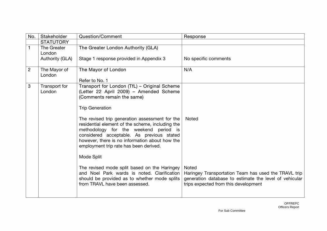
OFFREPC Officers Report
For Sub Committee
No. Stakeholder Question/Comment Response STATUTORY 1 The Greater
London Authority (GLA)
The Greater London Authority (GLA) Stage 1 response provided in Appendix 3
No specific comments
2 The Mayor of London
The Mayor of London Refer to No. 1
N/A
3 Transport for London
Transport for London (TfL) – Original Scheme (Letter 22 April 2009) – Amended Scheme (Comments remain the same) Trip Generation The revised trip generation assessment for the residential element of the scheme, including the methodology for the weekend period is considered acceptable. As previous stated however, there is no information about how the employment trip rate has been derived. Mode Split The revised mode split based on the Haringey and Noel Park wards is noted. Clarification should be provided as to whether mode splits from TRAVL have been assessed.
Noted Noted Haringey Transportation Team has used the TRAVL trip generation database to estimate the level of vehicular trips expected from this development
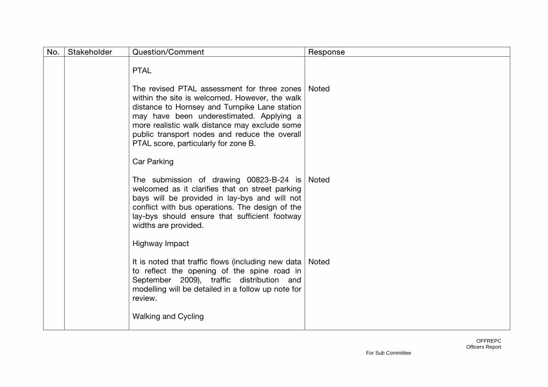
OFFREPC Officers Report
For Sub Committee
No. Stakeholder Question/Comment Response PTAL The revised PTAL assessment for three zones within the site is welcomed. However, the walk distance to Hornsey and Turnpike Lane station may have been underestimated. Applying a more realistic walk distance may exclude some public transport nodes and reduce the overall PTAL score, particularly for zone B. Car Parking The submission of drawing 00823-B-24 is welcomed as it clarifies that on street parking bays will be provided in lay-bys and will not conflict with bus operations. The design of the lay-bys should ensure that sufficient footway widths are provided. Highway Impact It is noted that traffic flows (including new data to reflect the opening of the spine road in September 2009), traffic distribution and modelling will be detailed in a follow up note for review. Walking and Cycling
Noted Noted Noted
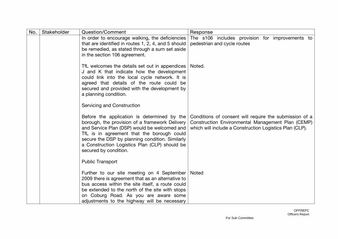
OFFREPC Officers Report
For Sub Committee
No. Stakeholder Question/Comment Response In order to encourage walking, the deficiencies that are identified in routes 1, 2, 4, and 5 should be remedied, as stated through a sum set aside in the section 106 agreement. TfL welcomes the details set out in appendices J and K that indicate how the development could link into the local cycle network. It is agreed that details of the route could be secured and provided with the development by a planning condition. Servicing and Construction Before the application is determined by the borough, the provision of a framework Delivery and Service Plan (DSP) would be welcomed and TfL is in agreement that the borough could secure the DSP by planning condition. Similarly a Construction Logistics Plan (CLP) should be secured by condition. Public Transport Further to our site meeting on 4 September 2009 there is agreement that as an alternative to bus access within the site itself, a route could be extended to the north of the site with stops on Coburg Road. As you are aware some adjustments to the highway will be necessary
The s106 includes provision for improvements to pedestrian and cycle routes Noted. Conditions of consent will require the submission of a Construction Environmental Management Plan (CEMP) which will include a Construction Logistics Plan (CLP). Noted
OFFREPC Officers Report
For Sub Committee
No. Stakeholder Question/Comment Response together with the provision of new infrastructure; stops, standing, bus cage and markings. These should all be provided at the developer’s expense. Furthermore the extension of the route will require an additional bus at a cost of £220,000 per annum for three years which should be secured through the section 106 process. Travel planning It is noted and welcomed that an updated travel plan will be provided prior to determination. Further comments will be provided once this document has been reviewed. The travel plan should be secured by section 106 agreement.
The s106 will require NGP/LDA to pay [£660,000] to the Council (for subsequent payment to Transport for London) to fund bus route extension(s) to serve the Development and/or increased bus service frequency. Three payments of £220,000 shall be made on the same date each year starting from the date of first occupation of the first Block to be occupied of Blocks 7, 8, 9, 10, 11, 12, or 13 in the Development. Noted. The Travel Plan will be secured by a condition of consent and s106 which states “Travel Plan – targets, periodic review of Travel Plan implementation and approval by Council, appointment of Travel Plan Co-ordinator and role”
4 Department of Transport
No comments received N/A
5 English Heritage
English Heritage (6 April 2009) English Heritage confirmed in writing that on the basis of the information provided, they do not consider that it is necessary for this application to be notified to English Heritage under the relevant statutory provisions.
N/A

OFFREPC Officers Report
For Sub Committee
No. Stakeholder Question/Comment Response
6 Natural England
Natural England - Original Scheme (31st March 2009) There are a number of measures proposed within the document which aim to enhance the natural environment. These include the provision of green and brown roofs, rooftop allotments, an Ecological Garden, SuDS and bat and bird boxes. We support these measures recommend that the applicant expands on the proposed Ecological Management Plan by producing and Ecological Mitigation and Management Plan as a mechanism for formalising and delivering these aspirations as a condition to the development. This should include details of how these measures will be monitored, managed and funded in the future. We note that local groups such as school children may be permitted to access the proposed Ecological Garden. If this can be done in a managed way to ensure that the ecological integrity is not damaged we would support this proposal as it would increase access to nature and peoples’ experience of the natural environment. We also recommend that interpretation materials are used within the
Noted A condition of consent included to address these comments Noted This level of detail would be provided at the Detailed
OFFREPC Officers Report
For Sub Committee
No. Stakeholder Question/Comment Response development and the Ecological Garden to increase residents’ awareness of how the natural environment has been incorporated into the development and to encourage people to use the Garden. Natural England - Amended Scheme (12th May 2011) Natural England has no comments to make on this planning proposal. However we would like to stress that the absence of comments or direct involvement on individual plans or proposals is simply an expression of our priorities. It should not be taken as implying a lack of interest or indicating either support for, or objection to, any proposal. However, we would expect the Local Planning Authority to assess and consider the possible impacts resulting from this proposal on the following when determining this application: Local wildlife sites If the proposal site is on or adjacent to local wildlife site, e.g. Site of Nature Conservation Importance (SNCI) or Local Nature Reserve (LNR) the county ecologist and/or local Wildlife Trust should be contacted.
Design/Reserved Matters Stage however comments noted. Comments noted and informatives included to address comments.
OFFREPC Officers Report
For Sub Committee
No. Stakeholder Question/Comment Response Protected species If representations from other parties highlight the possible presence, or the Council is aware of a protected or Biodiversity Action Plan (BAP) species on the site, the Council should request survey information from the applicant before determining the application. Paragraph 98 and 99 of ODPM Circular 06/2005 and Paragraph 16 of Planning Policy Statement 9 provide information on BAP and protected species and their consideration in the planning system. We would draw the Council's attention to our protected species standing advice, which provides guidance on when protected species may be impacted by a proposal. The advice can be found at: http://www.naturalengland.org.uk/ourwork/planningtransportlocalgov/spatialplanning/standingadvice/default.aspx Biodiversity enhancements This application may provide opportunities to incorporate features into the design which are beneficial to wildlife, such as the incorporation of roosting opportunities for bats or the installation of bird nest boxes. The Council should consider securing measures to enhance
A condition of consent will require the submission of an Ecological Management Plan including and Ecological Mitigation and Management Plan as per Natural England’s original comments dated 31st March 2009 which will address these further comments.
OFFREPC Officers Report
For Sub Committee
No. Stakeholder Question/Comment Response the biodiversity of the site from the applicant, if it is minded to grant permission for this application. This is in accordance with Paragraph 14 of PPS9. Additionally, we would draw your attention to Section 40 of the Natural Environment and Rural Communities Act (2006) which states that 'Every public authority must, in exercising its functions, have regard, so far as is consistent with the proper exercise of those functions, to the purpose of conserving biodiversity'. Section 40(3) of the same Act also states that 'conserving biodiversity includes, in relation to a living organism or type of habitat, restoring or enhancing a population or habitat'.
Noted
7 Environment Agency
The Environment Agency – Original Scheme (Letter Dated 16th April 2009) We are pleased to see that our previous discussion with the consultants for the scheme on flood risk has been considered as part of the design of the surface water strategy and that the strategy has been designed to comply with the requirements of National and Regional Policy and our recommendations. We consider this to be an excellent example of the use of sustainable drainage techniques and reduction of run-off rates.
Noted

OFFREPC Officers Report
For Sub Committee
No. Stakeholder Question/Comment Response Therefore, we have no objection to the above application provided a number of conditions are imposed on any planning permission granted. The Environment Agency – Amended Scheme (Letter Dated 22nd August 2011) The proposed development has not embraced the opportunity to deculvert the Moselle Brook that runs through approximately 260 metres of this site. We therefore object to the proposed development because it does not take the opportunity to remove the culvert and restore lost habitat. We recommend that planning permission should be refused. Reason Since the original application was submitted to you and commented on by us in 2009, the Thames River Basin Management Plan (RBMP) and your proposed submission Core Strategy document (May 2010) have been introduced. The RBMP is the framework that we use to achieve the objectives of the Water Framework
Conditions included in section 10.0 of this report The applicant has provided a response to the London Borough and Haringey and the Environment Agency as to why it is not feasible to de-culvert the Moselle Brook. Haringey planners accept this justification as do the Greater London Authority in their Stage 1 response. The conditions suggested by the Environment Agency in their original consultation response have been included in Section 10 of this report.

OFFREPC Officers Report
For Sub Committee
No. Stakeholder Question/Comment Response Directive (WFD). Two of the priorities of the WFD that relate directly to this site are: • to prevent deterioration in the status of aquatic ecosystems, protect them and improve the ecological condition of waters; • to achieve at least good status, or good potential status, for all waters by 2015. Where this is not possible, and subject to the criteria set out in the Directive, aim to achieve good status by 2021 or 2027. The RBMP identifies the Moselle Brook as ‘heavily modified’ and therefore it has to meet ‘good ecological potential’ by 2027. The mitigation measures highlighted for the water body include re-opening existing culverts. This development presents by far the greatest length of deculverting opportunity present on the Moselle Brook currently. The Brook has also been identified in our strategy document ‘Bringing your rivers back to life’ and also the London Rivers Action Plan (LRAP). The LRAP informs the Blue Ribbon Network policies of the London Plan. Policy SP5, of your proposed submission Core Strategy document (May 2010), states that ‘all
OFFREPC Officers Report
For Sub Committee
No. Stakeholder Question/Comment Response development (in Haringey) shall…restore and enhance the Blue Ribbon Network including… (The) Moselle Brook…deculverting wherever feasible, to improve water quality and amenity of these waterways and to help reduce flood risk (in line with LRAP)’. We acknowledge that pre-application discussions, prior to the application being submitted in 2009, agreed that the deculverting of the Moselle Brook was not feasible. However, in light of these policies and plans, the stance on de-culverting must be re-assessed. There is a clear, tangible and significant environmental gain in terms of the character of the area and nature conservation for this development. It would help to reconnect the future residents of the area to the environment, an element which is severely lacking in the area. Moreover, properties in close proximity to water, i.e. waterside development, have been shown to be significantly more attractive and fetch between 10 to 20% more than properties not adjacent to water. Resolution The culvert should be removed thereby restoring the watercourse to an open channel. We are happy to meet with you and the

OFFREPC Officers Report
For Sub Committee
No. Stakeholder Question/Comment Response developer to discuss these points further. We will do everything that we can to help develop a design for a viable scheme for the Moselle Brook at this development site.
8 Thames Water
Thames Water - Original Scheme (8th April 2009 and 14th May 2009) Waste Comments Surface Water Drainage – With regard to surface water drainage it is the responsibility of a developer to make proper provision for drainage to ground, water courses or a suitable sewer. In respect of surface water it is recommended that the applicant should ensure that storm flows are attenuated or regulated into the receiving public network through on or off site storage. When it is proposed to connect to a combined public sewer, the site drainage should be separate and combined at the final manhole
Conditions and Informatives included in section 10 of this report
OFFREPC Officers Report
For Sub Committee
No. Stakeholder Question/Comment Response nearest the boundary. Connections are not permitted for the removal of Ground Water. Where the developer proposes to discharge to a public sewer, prior approval from Thames Water Developer Services will be required. They can be contacted on 0845 850 2777. Reason - to ensure that the surface water discharge from the site shall not be detrimental to the existing sewerage system. There are public sewers crossing this site, and no building works will be permitted within 3 metres of the sewers without Thames Water's approval. Should a building over / diversion application form, or other information relating to Thames Waters assets be required, the applicant should be advised to contact Thames Water Developer Services on 0845 850 2777. Water Comments The existing water supply infrastructure has insufficient capacity to meet the additional demands for the proposed development. Thames Water therefore recommend the following condition be imposed: Development should not be commenced until: Impact studies of the existing water supply infrastructure have been submitted to, and approved in writing by, the local planning authority (in consultation with

OFFREPC Officers Report
For Sub Committee
No. Stakeholder Question/Comment Response Thames Water). The studies should determine the magnitude of any new additional capacity required in the system and a suitable connection point. Reason: To ensure that the water supply infrastructure has sufficient capacity to cope with the/this additional demand. Thames Water recommends the following informative be attached to any planning permission: There are large water mains adjacent to the proposed development. Thames Water will not allow any building within 3 metres of them and will require 24 hours access for maintenance purposes. Thames Water recommends the following informative be attached to any planning permission: There is a Thames Water main crossing the development site which may/will need to be diverted at the Developer's cost, or necessitate amendments to the proposed development design so that the aforementioned main can be retained. Unrestricted access must be available at all times for maintenance and repair. Please contact Thames Water Developer Services, Contact Centre on Telephone No: 0845 850 2777 for further information. Supplementary Comments The site is served by existing sewerage infrastructure that has limited capacity however,

OFFREPC Officers Report
For Sub Committee
No. Stakeholder Question/Comment Response it is possible for the development to be connected to a number of foul sewers. Thames Water request that any form of planning approval be conditioned such that the developers provide a drainage strategy for the site and agree this with Thames Water.
9 British Waterways
British Waterways London (15 April 2009) The proposal does not lie within the consultation zone (150m either side of the centre line) of any waterway, reservoir, canal, feeder channel, watercourse, let off or culvert owned or management by British Waterway. British Waterways therefore has no comments to make. (Please note: Further comments from British Waterways clarified that the Moselle Brook is not owned or managed by British Waterways, and would only be of concern where pollution into it runs into the River Lee Navigation via, Pymmes Brook. British Waterways own and manage the Lee Navigation, but the brooks and other tributaries are managed by the Environment Agency).
N/A
10 Commission for Architecture & the Built Environment
CABE (20th May 2011) We regret to say that we are unable to review this scheme, as we are consulted on more
N/A
OFFREPC Officers Report
For Sub Committee
No. Stakeholder Question/Comment Response (CABE)
projects than we have the resources to deal with.
11 London Waste
No comments received N/A
12 Network Rail
Network Rail – Original Scheme (Letter Dated 8 May 2009) Network Rail is an adjacent landowner, where the western boundary of the application site lies alongside Network Rail operational land. The DfT and Network Rail support the provision of new, high quality, homes for London’s residents and the vision contained within the Haringey Heartlands Development Framework. The Clarendon Square proposals have come forward as part this the broad vision for the area. 1.Planning Policy Designations – The Unitary Development Plan (2006) stipulates that any proposed development within the area must be in accordance with policy AC1, which explicitly states that any proposed development in the Heartlands/Wood Green area “must ensure that any continuing rail-related operations on the site are not prejudices”. In addition the Heartlands Development Framework recognised that parts of the Eastern Utilities Lands may remain in operational use and that “development of non-
Noted Noted
OFFREPC Officers Report
For Sub Committee
No. Stakeholder Question/Comment Response operational land should therefore not conflict with any continued use”.
2.We do not believe that the use outlined by the Clarendon Square proposals conflict with railway operational land per se, but ask the applicant be made aware of the overarching policy requirement to ensure that designated railway land remains protected. The LBH will need to ensure that the Clarendon Road development is designed and planned having regard to the railway operational uses proposed. 3.The applicant highlights the importance of the existing railway embankment & the retention of the mature vegetation on the embankment.
Noted The embankment is to be retained and a clause within the 106 heads of terms for the Coronation Sidings application (HGY/2011/0612) will provide the developer of Clarendon Square the opportunity to manage and maintain the embankment vegetation to the standard they desire. The clause reads as follows: Within 6 months of completion of the landscaping works on the land on the east side of the depot building (plan outlining this part of the site to be attached to the agreement), NR to use reasonable endeavours to offer to grant to National Grid Property or its successor in title (as the main landowner of the proposed Clarendon Square residential development scheme adjoining that land) a management agreement/arrangement of that land on the east side of the depot building for no less than 25 years. The terms of that management agreement/arrangement, including management and maintenance standards, are to be agreed between the

OFFREPC Officers Report
For Sub Committee
No. Stakeholder Question/Comment Response
4.Network Rail propose a number of standard conditions be attached to any consent granted. Network Rail – (Amended Scheme) (25th May 2011) Network Rail confirm that they have no further comments to make on the additional information supplied for the application other than those returned in response to the original application.
parties and National Grid Property but, for the avoidance of doubt, they will not include the requirement for any rental payment to NR and will provide, as necessary, for NR access to and use of that land for operational or safety requirements (as NR may reasonably require). Network Rail to maintain full maintenance responsibility to a standard to be agreed with the Council if National Grid Property decides not to take up the offer of a management agreement. The proposed conditions are contained within Section 10 of this report. Noted
13 London Fire & Emergency Planning Authority (LFEPA)
London Fire & Emergency Planning Authority (LFEPA)– Original Scheme (1 April 2009) The Brigade is satisfied with the proposals for the outline planning application. This Authority has been notified by the Local
Noted
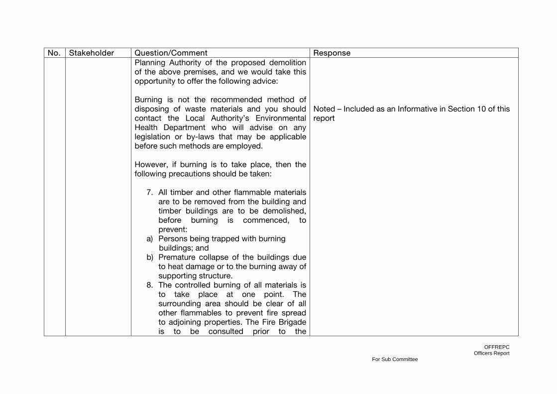
OFFREPC Officers Report
For Sub Committee
No. Stakeholder Question/Comment Response Planning Authority of the proposed demolition of the above premises, and we would take this opportunity to offer the following advice: Burning is not the recommended method of disposing of waste materials and you should contact the Local Authority’s Environmental Health Department who will advise on any legislation or by-laws that may be applicable before such methods are employed. However, if burning is to take place, then the following precautions should be taken:
7. All timber and other flammable materials are to be removed from the building and timber buildings are to be demolished, before burning is commenced, to prevent:
a) Persons being trapped with burning buildings; and
b) Premature collapse of the buildings due to heat damage or to the burning away of supporting structure.
8. The controlled burning of all materials is to take place at one point. The surrounding area should be clear of all other flammables to prevent fire spread to adjoining properties. The Fire Brigade is to be consulted prior to the
Noted – Included as an Informative in Section 10 of this report
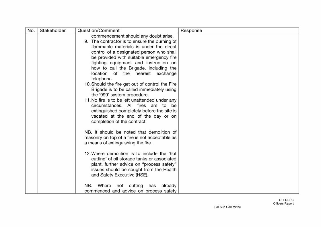
OFFREPC Officers Report
For Sub Committee
No. Stakeholder Question/Comment Response commencement should any doubt arise.
9. The contractor is to ensure the burning of flammable materials is under the direct control of a designated person who shall be provided with suitable emergency fire fighting equipment and instruction on how to call the Brigade, including the location of the nearest exchange telephone.
10. Should the fire get out of control the Fire Brigade is to be called immediately using the ‘999’ system procedure.
11. No fire is to be left unattended under any circumstances. All fires are to be extinguished completely before the site is vacated at the end of the day or on completion of the contract.
NB. It should be noted that demolition of masonry on top of a fire is not acceptable as a means of extinguishing the fire. 12. Where demolition is to include the ‘hot
cutting’ of oil storage tanks or associated plant, further advice on “process safety” issues should be sought from the Health and Safety Executive (HSE).
NB. Where hot cutting has already commenced and advice on process safety

OFFREPC Officers Report
For Sub Committee
No. Stakeholder Question/Comment Response has not already been sought from HSE, then operations should cease until such time as that advice is provided.
14 Corporation of
London
City of London - Original Scheme (23rd April 2009) and Amended Scheme (2nd June 2011) “This proposal will not have a detrimental impact on the City of London and I have no observations on this matter”.
Noted
15 North London Chamber of Commerce
No comments received N/A
16 The Metropolitan Police
Crime Prevention Team – Original Scheme (21 April 2009) No objection to the proposals at this time. We are encouraged that the architects have considered crime prevention issues and community safety in the Design and Access Statement. We consider the main crime issues on such a development to be: 1)Creating defensible space/territoriality and ensuring that there is a buffer between the private space of the homes and semi-private or communal space within the scheme. 2)Controlling access through such features as
Noted
OFFREPC Officers Report
For Sub Committee
No. Stakeholder Question/Comment Response secure communal entrance doors to housing blocks, security gates to any undercroft parking and other measures. 3)Ensuring natural surveillance is promoted throughout the scheme. 4)Good quality white street and estate lighting is a key crime prevention tool that can be achieved at a fraction of the cost of a CCTV system. 5)The Secured by Design scheme provides proven guidance and standards on reducing crime and should be adopted across the whole of the scheme.
17 Government Office for London
No comments received N/A
18 London Planning Advisory Committee
No comments received N/A
19 Urban Initiatives No comments received N/A 20 Alexandra
Palace Manager No comments received N/A
21 Alexandra Park and Palace Statutory Advisory Committee
No comments received N/A
INTERNAL

OFFREPC Officers Report
For Sub Committee
No. Stakeholder Question/Comment Response 1 Haringey
Building Control
Haringey Building Control (20th May 2009) As the proposed development is considered “complex” formal observations should be sought from the fire authority when more detailed site/design drawings are available. The outline application provides insufficient detail for building control purposes. Further consultation required on receipt of the Reserved Matters Planning Application. Formal observations should be sought from the Fire Authority.
The London Fire Authority has been consulted. Refer to No. 13 in the Statutory Consultation list above within this Appendix. Noted. Haringey Building Control and the London Fire Authority will be consulted at the Reserved Matters Stage.
2 Haringey Transportation
Haringey Transportation Team No objection subject to conditions and section 106 agreement. Full comments provided in Section 6.9 of this report.
Conditions included in Section 10 of this Report. Refer to Appendix 7 for draft s106 Heads of Terms relating to Highways and Transportation.
3 Haringey Waste Management
Haringey Waste Management Team Application Noted. Full comments will be provided once plans are submitted at the Reserved Matters Stage.
Noted. Haringey Waste Management Team will be consulted at the Reserved Matters Stage.
4 Haringey Legal
Haringey Legal Haringey Legal are overseeing the legal procedure in relation to the s106 agreement
N/A
OFFREPC Officers Report
For Sub Committee
No. Stakeholder Question/Comment Response 5 Haringey Food
and Hygiene
Haringey Food and Hygiene No comments received as this application is an Outline Planning Application
The department will be re-consulted at the Reserved Matters Stage
6 Haringey Strategic and Community Housing
Haringey Strategic and Community Housing No comments received as this application is an Outline Planning Application
The department will be re-consulted at the Reserved Matters Stage
7 Haringey Environmental Health – Noise and Pollution
Haringey Environmental Health – Noise and Pollution Advised of a number of conditions/s106 obligations
Conditions and s106 obligation included in Section 10 and Appendix 7 of this report, respectively.
8 Haringey Parks and Arboriculture Service
Haringey Parks and Arboriculture Service Standard conditions of consent relating to works to trees
Standard conditions of consent included in Section 10 of this report.
9 Haringey Policy
Haringey Policy No comments received as this application is an Outline Planning Application
The department will be re-consulted at the Reserved Matters Stage
10 Haringey Education – Children and Young People
Haringey Education – Children and Young People No comments received as this application is an Outline Planning Application
The department will be re-consulted at the Reserved Matters Stage
11 Haringey Property Services
Haringey Property Services No comments received as this application is an
The department will be re-consulted at the Reserved
OFFREPC Officers Report
For Sub Committee
No. Stakeholder Question/Comment Response Outline Planning Application Matters Stage
12 Haringey Housing
Haringey Housing No comments received as this application is an Outline Planning Application
The department will be re-consulted at the Reserved Matters Stage
13 Haringey Economic Regeneration
Haringey Economic Regeneration Consulted regarding employment/socio-economic issues
Refer to Sections 6.2 and 6.8 of this report
14 Haringey Design and Conservation
Haringey Design and Conservation Consulted in relation to design, conservation and visual impacts and open space and landscaping
Refer to Sections 6.4, 6.6, 6.12 and 6.13 of this report
EXTERNAL Ward
Councillors MP Lynne Featherstone (Original Scheme) (Letter Dated 14th July 2009) 1.My understanding was that originally the focus of this scheme was on economic development. I have now been told that housing will go ahead first. 2. Jobs – can you confirm there are projected 1500 jobs (700 pro rata) to be created from the scheme? And that there will be job losses and there is a company called Turnaround who will be detrimentally affected by the proposed scheme.
OFFREPC Officers Report
For Sub Committee
No. Stakeholder Question/Comment Response 3.Are the council aware that inadequate information in terms of the planning application in regard to employment impacts minimised the losses on site? 4.Turnaround employ 55 people and have not been considered properly in the plans. 5. Given the economic downturn, what assurances can be given that the project will go ahead as planned, as there will be a blight over getting out in terms of property etc? 6.Should Turnaround have to move they will be entitled to statutory compensation – but this will not cover costs or losses. What efforts is the Council making to work with Turnaround to ensure their future wellbeing? Liberal Democrat Group Councillor Wilson, Councillor Dennison and Councillor Bloch 1.Inappropraite Size of Development 2. Employment loss and lack of job creeation 3. Type of Housing –emphasis on small units 4. Concern that not in accordance with the London plan in terms of - Affordable Housing - Child Play Space
OFFREPC Officers Report
For Sub Committee
No. Stakeholder Question/Comment Response - Moselle Brook - Transport 5. Lack of Detail
Residents Associations and Other Amenity Groups
Alexandra Park and Palace CAAC
Alexandra Palace Residents Association (Original Scheme) (Letter dated 5 May 2009) Demolition of Structures – The CAAC object to the removal of the gas holder structure due to historical significance. Shortcomings in the Outline Proposal – The CAAC’s view is that insufficient consideration has been given to the historical context. Likely Impact on Alexandra Palace and Park Conservation Area – the views from the Park and Palace have already been compromised by the water treatment plant and New River Village. The proposed development would be seen as an “unrelenting cliff face of the linear edge blocks – it would present a continuous built form from the filter beds to the horizon”. We do not object to the bulk per se and might have welcomed one or more higher buildings – it is the sheer bulk of the series of blocks we find so objectionable. Alexandra Park is designated as
OFFREPC Officers Report
For Sub Committee
No. Stakeholder Question/Comment Response a Conservation Area, the character of which is partly determined by the open and uninterrupted vistas. The proposal would seriously degrade the view from the Park and would be detrimental to the character and appearance of the conservation area. Alexandra Palace Residents Association (Amended Scheme) (Letter dated 16 July 2011) The letter raised the same issues as the original letter dated 5th May 2009.
Parkside Malvern Residents Association
Parkside and Malvern Residents Association (PMRA) – Original Scheme (Letter Dated 25th May 2009) The Parkside Malvern Residents Association objects to the application on the following grounds: 1. Insufficient Information 1.1 An assessment of the appropriateness of the proposals cannot be made without consideration of scale, layout, landscaping and
OFFREPC Officers Report
For Sub Committee
No. Stakeholder Question/Comment Response visual impact. 1.2 The application represents a piecemeal approach to development of the eastern Heartlands: the justification for ‘intensification’ is the higher standard of planning and care exercised by architects and planners, to ensure that all aspects of planning are considered and brought into balance: the application site is isolated on all of its boundaries from the areas with which it must connect to justify the intensity of the development proposed. 1.3 Without consideration of scale, layout, landscaping and visual impact, the LPA is not in a position to safeguard the delivery of a development of the requisite high quality. The standard of building design, amenity space and landscaping achieved by the LPA for private development, but regrettably particularly for Housing Association development in the area is poor and not acceptable for the Heartlands: the LPA must accept this and learn from its past failures. 1.4 Since writing its Framework guidance, HBC has not considered the cumulative visual impact of development on Alexandra Palace: the water works scheme in the western Heartlands, the Heartlands School and the proposed new train

OFFREPC Officers Report
For Sub Committee
No. Stakeholder Question/Comment Response depot on Coronation sidings. Intensification must be appropriate: by reference to the above, the density and suggested heights are no longer appropriate. 1.5 Since writing its Framework guidance, HBC has not considered the cumulative impact of traffic arising from other planning permissions such as the Heartlands school and the extension of the Mall (Wood Green Shopping City) and new Debenhams store. 1.6 The new train sheds proposed on the adjacent railway sidings render the site planning assumption and accompanying densities inappropriate. 1.7 The intensity of development proposed relies upon openness beyond the limits of the site. In the case of the railway sidings, Network Rail has written to HBC to make it clear that the developer and the LPA must not rely on the openness of the heavily wooded embankment, yet the application and the council’s Framework justifying intensive development relies precisely on it. 1.8 No visual impact assessment has been carried out from Wightman Road and the long views on this important approach to the site. 1.9 There are no proposals in the application to
OFFREPC Officers Report
For Sub Committee
No. Stakeholder Question/Comment Response guarantee a good mix of family, two and one bedroom and studio flats. To be successful, the development must provide high quality private and key worker housing, into which high quality social housing can be assimilated. The application has the potential to add to and extend the social and environmental problems of Wood Green’s town centre by the addition of more intensive and poorly planned social housing. 2. Loss of Daylight and Overlooking 2.1 The suggested maximum development will have a detrimental effect of the housing in Hornsey Park Road, resulting in loss of daylight, overlooking, noise and activity. All reference to ‘maximum development’ is unacceptable. 2.2 The application must include details of how development facing the back gardens of Hornsey Park Road is to be designed to prevent direct overlooking and to protect the privacy and quiet enjoyment of residents in that road. 3. Traffic in Hornsey Park Road 3.1 The application does not contain proposals to ensure that no traffic from the new development will be introduced directly into Hornsey Park Road.
OFFREPC Officers Report
For Sub Committee
No. Stakeholder Question/Comment Response 4. Development on Hornsey Park Road 4.1 The access to the new housing behind the lime trees in Hornsey Park Road does not, as promised provide a traffic-free way through from Hornsey Park Road towards Alexandra Palace. The Hornsey Park area is an area dominated by traffic without good, safe access to local open space (as confirmed by the HBC Development Plan). The route through from Hornsey Park Road must be made attractive and traffic free to overcome this acknowledged shortcoming, to help sustain the existing community. 5. Construction Traffic 5.1 The application does not contain proposals to ensure that no construction traffic can use Hornsey Park Road: width and weight restrictions must be introduced at each end of Hornsey Park Road, to ensure construction heavy good vehicles use the spine road and in no circumstances can use Hornsey Park Road, with its kerb-side parking, narrow lanes, housing in close proximity to traffic, lack of safe crossing points, low visual quality and susceptibility to vibration and noise.

OFFREPC Officers Report
For Sub Committee
No. Stakeholder Question/Comment Response 5.2 The reference in supporting documentation to the use of Wightman Road is unacceptable: the road has many of the problems endemic in Hornsey Park Road and is subject to weight restrictions for heavy goods vehicles. 5.3 The application does not contain any viable or deliverable proposals for construction work to make use of the railway. 6. Moselle Brook 6.1 No attempt has been made to open the Moselle Brook: the river is not polluted downstream, so it should not be polluted through the site. From the level of the river and its outfall from the site, it is apparent that historically, the site was not flat. Recontouring the site would enable the river to be de culverted as well as creating a valuable ecological corridor and habitats for flora and forna [sic] associated with water and wetland. The reduced contour would also help assimilate the proposed buildings better into the site, by perhaps half a storey, with obvious visual benefits. 7. Travel and Parking 7.1 By virtue of the application site’s isolation
OFFREPC Officers Report
For Sub Committee
No. Stakeholder Question/Comment Response on all of its boundaries from the areas with which it must connect, travel assumptions for pedestrian and cyclists are flawed: there is no safe way through for either group via the north and south approaches: the approach via Hornsey Park Road is blighted by the appalling traffic levels in that road and the Penstock path is an area with a high level of crime concern. Buses through the development will need to have the frequency of a shuttle service to overcome such structural weakness, something the developers are unlikely to be able to deliver. 7.2 The application relies upon the new road junction (i.e. that between the spine road (Clarenden Road) [sic] and Hornsey Park Road) that falls short of the standards required to support the proposed development, in practical terms and in the terms required by CABE for new roads and by HBC’s own standards. The approach has no safe provision for cyclists and provides a pedestrian route to transport and local services that creates both the opportunity for crime and the fear of crime. 7.3 The application does not include proposals for the development to have its own Controlled Parking Zone to ensure that parking generated by the Heartlands does not spill over into the Hornsey Park Road area CPZ, thereby causing

OFFREPC Officers Report
For Sub Committee
No. Stakeholder Question/Comment Response more traffic in Hornsey Park and competition for already limited parking. 8. Healthcare and Sustainable Communities 8.1 The application does not include proposals for the proper provision for health services required to support the suggested level of intensification: the area is already poorly served. The LPA’s failure to ensure the delivery of health care provision in the west Heartlands must not be repeated. The proposed level of intensification must create a viable community sustained by proper, convenient health provision. 9. Incomplete Consultation 9.1 Consultation is not, as stated thorough: no consultation appears to have been made with St Mary’s School (less than half a mile away) or the parish church for Hornsey High Street and this area of N8 (St Mary’s with St George). 9.2 Half of the Mayor for London’s response to the application is missing: his comments are likely to be highly significant in the wider consultation and consideration process. 10. Sustainability 10.1 The Mayor’s hierarchy in the London Plan prioritises the delivery of district heating
OFFREPC Officers Report
For Sub Committee
No. Stakeholder Question/Comment Response schemes in particular those based on combined heat and power, and trigeneration. Connection into existing networks, and the ability to improve the performance existing stock and the delivery of strategic infrastructure to facilitate this are apriority of the London Development Agency through the Decentralised Energy Deployment Team at the LDA. While a district heating scheme is proposed using biomass as a heat source and some CHP (Combined Heat and Power) generating low carbon heat and electricity, there is a lack of strategic thinking to energy planning across the proposed heartland development area. If as we are informed there will be a pressure reduction station on the site when the current gasometers are decommissioned, this represents an opportunity for low carbon electricity generation as part of the scheme. 10.2 Combined Heat and Power networks rely on a good balance of daytime and evening loads to be economically viable, connecting in to the new school remaining industrial units and existing shopping centre would provide an opportunity to minimise both the new scheme and existing stock’s carbon emissions, and improve the commercial feasibility of such a scheme being delivered.
OFFREPC Officers Report
For Sub Committee
No. Stakeholder Question/Comment Response 10.3 No attempt has been made look at the feasibility of these connections or a more strategic approach to decentralised energy. This is surprising given that the LDA is co applicant for this scheme. Notwithstanding the above, members of the Association raised the following concerns at the meeting with the Applicant’s agent and ward councillors on 29th April 2009: i. The external space must be high quality, with private as well as public garden space (not just concrete). Mature trees must be planted. ii. Proper cycle ways and dedicated footpaths must be provided, with high quality landscaping around. iii. The entrances to the development from Clarendon Road and Western Road are through unattractive, twilight-ish commercial areas, and must be improved to be attractive and feel safe. iv. The development must be built to the highest standards, to design out crime and the fear of crime. v. The lime trees in Hornsey Park Road must be protected and their growth managed. vi. The spine road must be designed to take some traffic from Hornsey Park Road as promised, with the buildings facing it and the spaces around designed minimise the environmental effects of traffic. vii. The spine road must not be obstructed by
OFFREPC Officers Report
For Sub Committee
No. Stakeholder Question/Comment Response on street parking. viii. Section 106 funds to improve Horsey [sic] Park road and mitigate the negative impacts from additional traffic and degradation of amenity from the scheme ix. The new Heartlands School must be opened by September 2010 and Alexandra Primary School improved to be attractive to new residents and children. Is this feasible? x. The idea of some shops, restaurants and possibly a pub was thought to be a good one as long as they were good quality, to support the new community and do not a [sic] repeat of the poor quality offer around the area. Parkside and Malvern Residents Association (PMRA) – (Amended Scheme) (Letter dated 22nd August 2011 resubmission of 2009 raising the same issues as above).
Avenue Gardens Residents Association
Avenue Gardens Residents Association (AGRA) – Original Scheme (Letter Dated 14th April 2009) Objects to the application for the following reasons: The Application 1. AGRA notes that the application is an
outline application, with all matters
OFFREPC Officers Report
For Sub Committee
No. Stakeholder Question/Comment Response reserved other than the means of access (Environmental Statement para. 1.15, 5.3 Design Statement page8). The applicant states that the purpose of this outline application is to fix “access” only. Notwithstanding the additional outline materials provided (seven so-called “Parameter Plans” or drawings), the applicant states that they wish to leave issues of Scale, Layout, Landscaping and Appearance to be fixed at subsequent determinations.
2. The applicant claims that the materials
provided conforms to Circular 01/06 (Environmental Statement para. 1.15) and GDPO (Environmental Statement para 1.21) and is thus adequate for a determination on “Access”.
3. AGRA objects that the material provided is
not sufficient for the LPA to determine the appropriateness of this scheme without consideration of such issues as Scale, Layout, Landscaping and Appearance. AGRA objects that the application presented in this form is an attempt to “salami slice” the Planning Authority into giving its imprimatur on the entirety of the scheme including contentious issues of

OFFREPC Officers Report
For Sub Committee
No. Stakeholder Question/Comment Response scale, layout, landscaping and appearance.
4. AGRA expects that any Decision Notice
issued in respect of this application will duly not the limits of the decision (that is, determining “Access” only). AGRA expects that any Decision Notice will note that a positive determination does not endorse or otherwise prejudice proper consideration (including refusal) of issues of scale, layout, landscaping, appearance at a later date, irrespective of any such material being provided in the current application.
Transport/Access – Bus Routes 5. The applicant proposes (Transport
Assessment para 5.23, 5.28, Supporting Planning Statement para 14.3, 14.6 Environmental Statement par 5.28) a new bus route through the site connection Turnpike Lane and Wood Green Stations, and requiring modifications to the Spine Road. The new bus route is indicated by the applicant to be of importance in ensuring that the aim of limiting car use is met.
6. AGRA objects that the application does

OFFREPC Officers Report
For Sub Committee
No. Stakeholder Question/Comment Response not make clear whether the bus route is a diversion of an existing bus route, or a new bus route (eg shuttle bus) or whether a site for a bus turnaround or bus stand will be required. It is not acceptable that an application purporting to be seeking outline permission to fix “Access” for a scheme of this size should not have resolved this issue.
7. AGRA objects that the applicant has not
provided infrastructure on the site to support the new bus route, including space for a bus turnaround or bus-stand on the site. If the applicant does not provide these facilities, some other will have to.
8. AGRA objects that the applicant has not
taken an opportunity to design in a sensible and appropriate bus infrastructure to support the scheme. This constitutes piecemeal development, where the costs and impacts of making the scheme workable will fall to others, such as nearby residents. The scheme is thus against policy and should be rejected.
Transport/Access – Construction Traffic
OFFREPC Officers Report
For Sub Committee
No. Stakeholder Question/Comment Response 9. The Environmental Statement (page 7,
para 6.58, 8.55-8.58) suggests that all demolition and construction traffic will travel be designated routes. Park Avenue and Wightman Road are specifically mentioned as road through residential areas that are unsuitable for this traffic. It is not clear how contractors’ compliance with the use of designated routes will be monitored, or what sanctions will be applied in the event of a breach.
10. AGRA objects that the application provides
no credible monitoring or enforcement plans for the use of designated routes during construction.
11. The LPA must insist on rigorous measures
to ensure compliance with designated routes as a condition of any positive determination of this application. Measures might include very large and visible notices on construction vehicles inviting the public and traffic wardens to call-in on any unauthorised movements, and financial penalties.
Transport/Access – Completed Development Traffic
OFFREPC Officers Report
For Sub Committee
No. Stakeholder Question/Comment Response 12. The applicant (Environmental Statement
para 8.109, 8.110, and Transport Assessment para 5.24, 5.25 and Appendix F) proposes that traffic generated by the development will be limited by preventing commuter car journeys. The applicant suggests that this will follow by limiting car parking on the site, and promoting non-car use to future residents by a “Travel Pack” and the appointment of a “Travel Coordinator”.
13. AGRA objects that the traffic generated
and the parking impacts in neighbouring areas have been underestimated by the applicant. The strategies proposed to limit car use by 2,000 or more residents (Environmental Statement para 7.76) of the scheme are simply not credible. The applicant has not provided any case studies or supporting data where such tactics have been proved to work. This scheme is simply too large for such hand-waving arguments to be allowed to stand.
Transport/Access – Traffic Impacts 14. The applicant has estimated the impact of
increased car journeys in Station Road and Park Avenue as an increase of 2% and 3%
OFFREPC Officers Report
For Sub Committee
No. Stakeholder Question/Comment Response in the number of trips in each of the AM and PM peak hours (Environmental Statement para 8.81, 8.82, tables 8.8 sand 8.9). The peak hour effect is the only impact considered.
15. The applicant further claims that there has
been no growth in peak hour traffic between 2004 and 2008 (Environmental Statement para 8.22, Transport Assessment para 7.41) and ascribes this to the fact that local junctions are at capacity/overload, including the Park Avenue/Bounds Green Road junction (Environmental Statement para 8.87).
16. AGRA points out that the traffic survey
(Transport Assessment para 2.17-2.20) have not been corrected for seasonal or other effects: school holidays, long running Thames Water mains water works in the area (Park Avenue, Station Road) and the effects of the gathering recession in 2008. Traffic counts are therefore underestimates.
17. AGRA points out that the traffic analysis
cumulative impact study does not include the effects of the proposed new school (Transport Assessment 7.38, 7.39) in
OFFREPC Officers Report
For Sub Committee
No. Stakeholder Question/Comment Response contradiction to the opposite assertion in the Environmental Assessment para 19.7, 19.8. 19.29 and 19.30). The traffic impacts for the new school were notoriously underestimated and will have an impact during the school run periods.
18. AGRA objects that the traffic impact
analysis has ignored the off peak hour effects. The reality is that the rush hour now lasts longer in Park Avenue and Station Road. The impact study has not taken into account the effects of longer periods of increased traffic in the local residential streets. Focussing only peak hour effects ignores the background impact of traffic on residents.
Transport/Access – Parking 19. The applicant envisages providing
underground parking – 218 spaces in undercroft car parks (Environmental Assessment para 8.102).
20. AGRA objects that the underground car
parks are not necessarily compatible with Public Safety issues or with efforts to “design our crime”.

OFFREPC Officers Report
For Sub Committee
No. Stakeholder Question/Comment Response Employment 21. The Environmental Statement (para 1.9)
points out that adopted LBH planning policies (London Plan, UDP 2006, Heartlands Development Framework 2005) envisages the Heartlands Development creating 1,500 (new) jobs.
22. The scheme proposed to covers a
substantial proportion of the Heartlands land area (approaching 50%) and a much larger portion of the “not at all developed” Heartlands land area. The number of long term jobs generated by this scheme is around 130 – 140 jobs (Environmental Statement para 1.9, 7.87 and supporting statement para 11.33, 11.34).
23. The current employment on the site is
around 150 – 170 jobs (Supporting Planning Statement para 11.30, Environmental Statement Introduction page 7) which will be lost. The applicant states that the scheme involves a net reduction in employment levels (Supporting Planning Statement para 11.36).
24. In spite of adopted Planning Policy, the
OFFREPC Officers Report
For Sub Committee
No. Stakeholder Question/Comment Response scheme therefore anticipated destroying 20 jobs. The scheme does not create anything like the pro-rata new job creation (700+ jobs) based on land uses that are required by policy.
25. AGRA objects that the proposed scheme
is too biased towards residential uses, and that the employment uses and employment targets have not been given proper consideration by the applicant. The scheme is thus against policy and should be rejected.
26. AGRA objects that the scheme represents
‘piecemeal development’. The developer has “cherry-picked” the most profitable parts of the Heartlands objectives, leaving the less attractive aims and objectives of the Heartlands Development Framework to be left to others or to be left unmet and unrealised. The scheme is thus against adopted policy and should be rejected.
Townscape and Visual Impacts – Impact on Alexandra Palace and Park 27. The applicant characterises Townscape
Impact on Alexandra Palace and Park as of Moderate to High Adverse Significance
OFFREPC Officers Report
For Sub Committee
No. Stakeholder Question/Comment Response (Environmental Assessment para 11.108, 11.109 and Environmental Assessment Summary page 10).
28. The applicant characterises the Visual
Impact on Alexandra Palace and Park as of Long Term of High Adverse Significance (Environmental Assessment para 11.125-11.128).
29. The applicant has provided
photomontages #11, #12 and #13 showing before and after visual impacts (Environmental Assessment figures 11.5 and 11.6). The impact on Alexandra Palace and Park will be huge, dwarfing even Shopping City.
30. AGRA objects that the impact on
Alexandra Palace and Park Metropolitan Open Land and its open character is gross and unacceptable. This level of impact is against policy. The scheme is thus against adopted policy and should be rejected.
Daylight, Sunlight and Overshadowing 31. The applicant identifies that residents of 65
– 105 Hornsey Park Road will experience moderate adverse significant impact on

OFFREPC Officers Report
For Sub Committee
No. Stakeholder Question/Comment Response daylight (Environmental Assessment Summary page 14, Environmental Assessment para 16.91, 16.130, 16.135).
32. Residents of 77 – 105 will also experience
adverse impact from overshadowing of their gardens (Environmental Assessment para 16.138, 16.139). The range of building heights proposed in no way respects the existing residential properties in Hornsey Park Road, in direct contradiction to the assertions of the developer (Environmental Assessment para 5.14).
33. AGRA objects that the applicant has
downplayed the impacts of overshadowing and overlooking on the residents of Hornsey Park Road. AGRA does not accept that developers should carry over the impact of an earlier development (overlooking and overshadowing from the gasholder, erected in a time of weaker protections) to continue to oppress the residents of Hornsey Park Road.
Health Care 34. The applicant proposes to fund an
additional GP in the area (Environmental Assessment Summary page 7, Environmental Assessment para 7.76,

OFFREPC Officers Report
For Sub Committee
No. Stakeholder Question/Comment Response 7.77) for a forecast increase in population of 2000. This figure is bases upon the average patient list size in the local area of 1,852 patients per GP (0.56 GP’s per 1000 people).
35. AGRA points out the local area is
notoriously under-provided in GP services, an issue of long standing in the community.
36. In fact, the average GP ration per 1000
population in England is 0.64 (Hansard – Written Answers 16 November 2004 Column 1381W). On this basis, the appropriate provision should be 1.3 GPs for a scheme of this size – that is, the developer is proposing to underfund health care provision in the scheme by 30%.
37. Further, the NHS provides 1.8 practising
doctors per 1000 people across all services (‘The NHS plan: a plan for investment a plan for reform’, Command Paper 010481829, Department of Health, 1 March 2007). On this basis, the developer should be providing funding for an additional 3.6 doctors across all local NHS services, not just primary health care.

OFFREPC Officers Report
For Sub Committee
No. Stakeholder Question/Comment Response 38. AGRA objects that the applicant has not
provided an appropriate level of support to mitigate the impact of the scheme on local health care services.
Play Space 39. The applicant proposes to supply 10m² of
play space for between 142 and 257 children, that is between 1420m² and 2,570m² of space (Environmental Assessment para 5.40 – 5.56). The application regrettably conflates the public realm with “play space”.
40. Private space, controlled by a single
family, outdoors and at ground floor level must be provided for families and their children. It is not clear where the family accommodation is to be located in the scheme or what the real disposition of “play space” will be.
41. AGRA objects that the issue of play space
and the location of family accommodation is not made clear in the application. The developer conflates the public realm amenity with play space provision into a single headline figure so that the adequacy or not of the play space provision is
OFFREPC Officers Report
For Sub Committee
No. Stakeholder Question/Comment Response impossible to determine.
Friends of Alexandra Palace and Park
Friends of Alexandra Palace and Park (Amended Scheme) (Letter not dated) We object to the plans for the construction of the buildings alongside the railway on the grounds that they would significantly damage the open aspects to the east of the Park. The blocks (numbers 1,2,7 and 10) as currently designed present an almost unbroken wall, some 20 metres above the top of the railway embankment. One of the amenities of Alexandra Park is the large swathe of grassland in the lower levels of the Park which has relatively open views to the east. These open views were impacted by the construction of the Thames Water treatment buildings. The construction of the ¿wall¿ of flats would remove all distant views from the lower parts of the Park. Open space is vital in cities for the public¿s health and well-being. The openness of a park is as much a function of the distance one can see beyond its boundaries, as of the area of the park itself. The proposed buildings

OFFREPC Officers Report
For Sub Committee
No. Stakeholder Question/Comment Response enclose the Park to an unnecessary extent. We recognise the need for additional housing in Haringey, but fail to see why architects cannot develop a scheme for the Heartlands which presents a profile of varying heights, with significant sight lines between the buildings, which has markedly less adverse impact on the views from Alexandra Park.
The Victorian Society
The Victorian Society (Amended Scheme) (Letter Dated 5th July 2011) We were informed of this application by local residents concerned about the demolition of this important gasholder. We now write to convey our strong objection to the demolition of the smaller gasholder on the site, known as Hornsey Number 1.
Local Residents First consultation (March 2009) 3400 residents consulted. This Generated 22 individual objection letters from
• Traffic Congestion on nearby Junctions • Insufficient Parking on Site • High density/Overdevelopment • Bulk and Scale excessive – Not in keeping with the area • Excessive Heights – Overlooking and Overshadowing • Blocks Obscure Views to Alexandra Palace

OFFREPC Officers Report
For Sub Committee
No. Stakeholder Question/Comment Response residents and 2 letters from businesses on or near the site. A further round of consultation was undertaken by London Borough of Haringey in May 2011, following the submission of amendments. This generated 20 objection letters from residents and 3 letters of support from residents.
• Impact on views and conservation area of Alexandra Palace and Park • Loss of Green Space • Impact on pedestrian walkway under railway line “Penstock Path” • Dust, Noise, Disruption during Construction • Loss of existing Gas Holders • Outline Application not appropriate - Not enough information provided • Population Increase – Impact on Services (GPs, School, Public
Transport etc) • Increase in Crime • Type of Housing provided is too small • Loss of Employment • Over supply of housing • Impact on property prices

OFFREPC Officers Report
For Sub Committee
APPENDIX 2 Summary of GLA reports
OFFREPC Officers Report
For Sub Committee
OFFREPC Officers Report
For Sub Committee
OFFREPC Officers Report
For Sub Committee

OFFREPC Officers Report
For Sub Committee

OFFREPC Officers Report
For Sub Committee
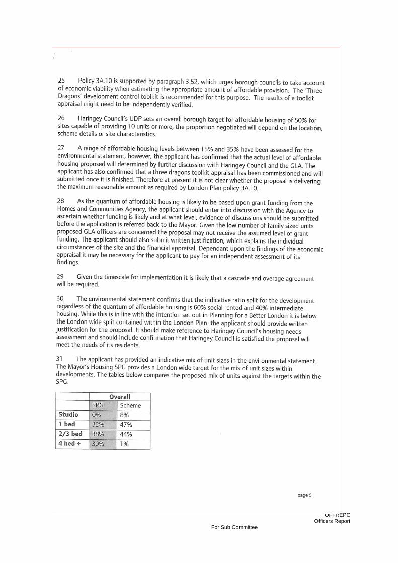
OFFREPC Officers Report
For Sub Committee
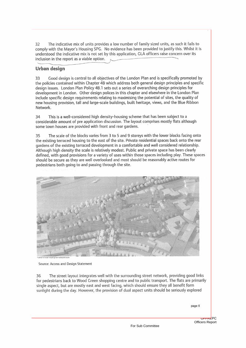
OFFREPC Officers Report
For Sub Committee

OFFREPC Officers Report
For Sub Committee
OFFREPC Officers Report
For Sub Committee

OFFREPC Officers Report
For Sub Committee

OFFREPC Officers Report
For Sub Committee
OFFREPC Officers Report
For Sub Committee
OFFREPC Officers Report
For Sub Committee

OFFREPC Officers Report
For Sub Committee
OFFREPC Officers Report
For Sub Committee

OFFREPC Officers Report
For Sub Committee
Appendix 3 Planning Policies

OFFREPC Officers Report
For Sub Committee
The planning application is assessed against relevant National, Regional and Local planning policy including:
• National Planning Policy Guidance • National Planning Policy Statements • The London Plan (2011) • Haringey Unitary Development Plan (Adopted 2006) • Haringey Supplementary Planning Guidance and Documents
• Haringey Local Development Framework (LDF) Core Strategy
Haringey’s draft Core Strategy has been submitted to the Secretary of State for Examination in Public (EiP). This Eip commenced on 28th June and concluded on 7th July with the binding Inspector’s report expected in October/November 2011. As a matter of law, some weight should be attached to the Core Strategy policies which have been submitted for EiP however they cannot in themselves override Haringey’s Unitary Development Plan (2006) unless material considerations indicate otherwise.
• Haringey Development Management DPD The consultation draft of the Development Management DPD (DM DPD) was issued in May 2010 following the responses received. The proposed submission draft will be published in summer 2011. The DM DPD is at an earlier stage than the Core Strategy and therefore can only be accorded limited weight at this time.
National Planning Policy
Draft Planning Policy Statement: Planning for a Natural and Healthy Environment Planning Policy Statement 1: Delivering Sustainable Development (2005) Planning Policy Statement: Planning & Climate Change (Supplement to PPS 1) Planning Policy Statement 3: Housing (November 2006 and April 2007) Planning Policy Statement 4: Planning for Sustainable Economic Growth Planning Policy Statement 5: Planning for the Historic Environment Planning Policy Statement 9: Biodiversity and Geological Conservation Planning Policy Guidance 13: Transport Planning Policy Guidance 17: Planning for Open Space, Sport and Recreation Planning Policy Statement 22: Renewable Energy Planning Policy Statement 23: Planning and Pollution Control Planning Policy Guidance 24: Planning and Noise Planning Policy Statement 25: Development and Flood Risk (2010)
Regional Planning Policies
• The London Plan (Adopted July 2011) Policy 2.14 Areas for Regeneration Policy 3.3 Increasing housing supply Policy 3.4 Optimising housing potential Policy 3.5 Quality and design of housing developments

OFFREPC Officers Report
For Sub Committee
Policy 3.6 Children and young people’s play and informal recreation facilities Policy 3.7 Large residential developments Policy 3.8 Housing choice Policy 3.10 Mixed and balanced communities Policy 3.12 Affordable housing targets Policy 3.13 Negotiating affordable housing residential & mixed use schemes Policy 3.14 Affordability housing thresholds Policy 4.7 Retail and town centre development Policy 4.8 Supporting a successful and diverse retail sector Policy 4.9 Small Shops Policy 5.2 Minimising carbon dioxide emissions Policy 5.3 Sustainable design and construction Policy 5.5 Decentralised energy networks Policy 5.7 Renewable Energy Policy 5.10 Urban Greening Policy 5.11 Green roofs and development site environs Policy 5.12 Flood Risk Management Policy 5.13 Sustainable Drainage Policy 5.14 Water Quality and Wastewater Infrastructure Policy 5.15 Water Use and Supplies Policy 5.18 Construction Excavation and Demolition Waste Policy 5.21 Contaminated Land Policy 6.1 Integrating transport & development Policy 6.3 Assessing transport capacity Policy 6.13 Parking Policy 7.2 Creating an inclusive environment Policy 7.3 Secured by design Policy 7.4 Local character Policy 7.5 Public realm Policy 7.8 Heritage Assets and Archaeology
The Mayors Other Strategies The Mayor’s Air Quality Strategy: Clearing the Air (2010) The Mayor’s Biodiversity Strategy: Connecting with London’s Nature (2002) The Mayor’s Cultural Strategy: Realising the Potential of a World Class City (2004) The Mayor’s Economic Development Strategy Success through Diversity (2001) The Mayor’s Ambient Noise Strategy (2004) The Mayor’s Energy Strategy (Feb 2004) The Mayor’s Transport Strategy (2004) The Mayor’s Municipal Waste Management Strategy (2003) The Mayor’s Energy Strategy (2004) The Mayor’s Planning for Equality and Diversity in Meeting the Spatial Needs of London’s Diverse Communities SPG The Mayor’s Draft Industrial Capacity SPG (2003) The Mayor’s Land for Transport Functions SPG (March 2007) The Mayor’s Sustainable Design and Construction SPG (2006) The Mayor’s Providing for Children and Young People’s Play and Informal Recreation SPG (March 2008)
OFFREPC Officers Report
For Sub Committee
The Mayor’s Housing SPG (November 2005) The Mayor’s Industrial Capacity SPG The Mayor’s Accessible London: Achieving an Inclusive Environment SPG The Mayor’s Wheelchair Accessible Housing Best Practice Guide (BPG) The Mayor and London Councils’ Best Practice Guide on the Control of Dust and Emissions during Construction The Mayor’s London Housing Design Guide (August 2010)
North London Sub-Regional Development Framework (SRDF) (May 2006)
Local Planning Policies
• Haringey Unitary Development Plan (Adopted July 2006; Saved July 2009)
G1 Environment G2 Development and Urban Design G3 Housing Supply G4 Employment G6 Strategic Transport Links G9 Community Well Being G10 Conservation G12 Priority Areas AC1 Heartlands/Wood Green UD2 Sustainable Design and Construction UD3 General Principles UD4 Quality Design UD6 Mixed Use Developments UD7 Waste Storage UD8 Planning Obligations UD9 Locations for Tall Buildings ENV1 Flood Protection: Protection of Floodplain, Urban Washlands ENV2 Surface Water Runoff ENV4 Enhancing and Protecting the Water Environment ENV5 Works Affecting Water Courses ENV6 Noise Pollution ENV7 Air, Water and Light Pollution ENV8 Facilities for Alternative Refuelling Infrastructure ENV11 Contaminated Land ENV13 Sustainable Waste Management HSG1 New Housing Developments HSG2 Change of Use to Residential HSG3 Protecting Existing Housing HSG4 Affordable Housing HSG10 Dwelling Mix EMP1 Defined Employment Areas – Regeneration Areas EMP4 Non Employment Generating Uses EMP5 Promoting Employment Uses TRC1 Development in Town and Local Shopping Centres TRC5 A3 Restaurants/Cafes, A4 Drinking Est., A5 Hot Food Takeaways
OFFREPC Officers Report
For Sub Committee
M2 Public Transport Network M3 New Development Location and Accessibility M5 Protection, Improvement and Creation of Pedestrian and Cycle Routes M8 Access Roads M10 Parking for Development OS4 Alexandra Palace and Park OS6 Ecological Valuable Sites and Their Corridors OS7 Historic Parks, Gardens and Landscapes OS10 Other Open Space OS11 Biodiversity OS12 Allotments OS15 Open Space Deficiency and New Developments CW1 New Community/Health Facilities
• Haringey Supplementary Planning Guidance (October 2006)
SPG1a Design Guidance (Adopted 2006) SPG2 Conservation and Archaeology (Draft 2006) SPG4 Access for All (Mobility Standards) (Draft 2006) SPG5 Safety By Design (Draft 2006) SPG7a Vehicle and Pedestrian Movements (Draft 2006) SPG7b Travel Plans (Draft 2006) SPG7c Transport Assessment (Draft 2006) SPG8a Waste and Recycling (Adopted 2006) SPG8b Materials (Draft 2006) SPG8c Environmental Performance (Draft 2006) SPG8d Biodiversity, Landscaping & Trees (Draft 2006) SPG8e Light Pollution (Draft 2006) SPG8f Land Contamination (Draft 2006) SPG9 Sustainability Statement Guidance Notes and Checklist (Draft 2006) SPG10a Negotiation, Mgt & Monitoring of Planning Obligations (Adopted 2006) SPG10c Educational Needs Generated by new Housing (Draft 2006) SPG10d Planning Obligations and Open Space (Draft 2006) SPG10e Improvements to Public Transport Infrastructure & Services (Draft 2006) SPD Housing
Haringey Heartlands Development Framework (Adopted April 2005) Planning Obligation Code of Practice No 1: Employment & Training (Adopted
2006) Planning Obligation Code of Practice No 2: Health (Adopted 2006) • Local Development Framework Core Strategy and Proposals Map (Published for Consultation May 2010; Submitted for Examination March 2011. EiP Completion July 2011)
SP1 Managing Growth SP2 Housing SP4 Working towards a Low Carbon Haringey

OFFREPC Officers Report
For Sub Committee
SP5 Water Management and Flooding SP6 Waste and Recycling SP7 Transport SP8 Employment SP9 Improve Skills/Training, Support/Access to Jobs/Community Cohesion SP10 Town Centres SP11 Design SP12 Conservation SP13 Open Space and Biodiversity SP14 Health and Well-Being SP15 Culture and Leisure SP16 Community Infrastructure
• Draft Development Management Policies (Published - Consultation May 2010)
DMP1 New Housing Developments DMP2 Protecting and enhancing existing housing DMP3 Preventing the loss of affordable housing DMP4 Housing Conversions DMP5 Homeless people, vulnerable people and hostels DMP6 Sheltered housing and care homes for older people DMP7 Homes of Different Sizes DMP8 Basements and Lightwells DMP9 New Development Location and Accessibility DMP10 Access Roads DMP11 Car-Free Residential Developments DMP12 Protection of Front Gardens and Private Off Street Parking DPM13 Sustainable Design and Construction DMP14 Flood Risk, Water Courses and Water Management DMP15 Environmental Protection DMP16 Development Within and Outside of Town and Local Shopping Centres DMP17 Protection of Shops in Designated Shopping Areas DMP18 A3 Restaurants & Cafes, A4 Drinking Est. & A5 Hot Food Takeaways DMP19 Employment Land & Premises DMP20 General Principles DMP21 Quality Design DMP22 Waste Storage DMP23 Commercial Design: Advertisements, Shopfronts, Signs and Security DMP25 Haringey’s Heritage DMP26 Alexandra Palace DMP27 Significant Local Open Land (SLOL) & Devt Adjacent to Open Spaces DMP28 Ecologically Valuable Sites their Corridors and Tree protection DMP29 Lee Valley Regional Park DMP30 Open Space Deficiency and New Developments DMP31 Social Clubs DPM32 Pre-school and Educational Needs Generated by New Housing
Draft Sustainable Design and Construction SPD (October 2010) Draft Wood Green Town Centre SPD

OFFREPC Officers Report
For Sub Committee
Other Local Documents;
Haringey Sustainable Community Strategy 2007 – 2016

OFFREPC Officers Report
For Sub Committee
Appendix 4
Applicants Response the Issues Raised the DM Forum

OFFREPC Officers Report
For Sub Committee

OFFREPC Officers Report
For Sub Committee
OFFREPC Officers Report
For Sub Committee
OFFREPC Officers Report
For Sub Committee

OFFREPC Officers Report
For Sub Committee
Appendix 5 Development Management Forum Minutes
OFFREPC Officers Report
For Sub Committee
PLANNING, POLICY & DEVELOPMENT DEVELOPMENT CONTROL DIVISION
MINUTES Meeting : Development Control Forum – Land at Haringey Heartlands, between
Hornsey Park Road, Mayes Road, Clarendon Road and the Kings Cross / East Coast Mainline London ‐ HGY/2009/0503
Date : 25th May 2011 Place : Heartlands High School, Station Road, Wood Green, N22 7ST Present : Paul Smith ( Chair), Applicants agents, Cllr Gibson
Approx 60 local residents
Minutes by : Tay Makoon Distribution :
1.
Paul Smith opened the meeting by welcoming everyone and introducedofficers, members and the agents for the applicant. He explained the purposeof the meeting that it was not a decision making meeting, the house keepingrules, he explained the agenda and that the meeting will be minuted and attached to the officers report for the Planning Committee. Myra Barnes on behalf of the applicant National Grid and The LondonDevelopment Agency ‐ provided a brief introduction Agents have undertaken lots discussion with council GLA and local stakeholders As a result of that has many comments – tried to accommodate as many of those within the revised scheme Main Changes:
‐ Overall reduction in the number of dwellings – prev 1100 – 1200 now 050 – 1080 – reason – looked at space stds of dwellings – to ensure space standards are good
‐ Overall reduction in height of whole scheme of about 5 – 11m in height. To ensure maximum height of the development is restricted
‐ Reduction in height of block 3 by a further 1 storey – b/c comment overlooking of adjoining gardens
Action
OFFREPC Officers Report
For Sub Committee
2. 3.
‐ Block 12 – additional storey – to rebalance floor space within the scheme result of reduction block 3
‐ Block 12 – modified footprint to create wider pavement for pedestriansalong Silsoe Road
‐ New Roof Terrace – blocks 2, 7 and 12 – improve the amount of amenity space for residents
‐ Blocks 1 and 2 – prev param plans 1 large block. Now 2 separate blocks
for good design reasons
Presentation of the scheme
Stuart Blower presented the scheme using a slide show with parameter plans, photomontages and there was a 3D model of the scheme on display forviewing.
Stuart Blower (Make Architects) ‐ Outline application – Defining a framework in which a future
development would get built
‐ What you see here are the maximum parameters
‐ Define all the key design moves and principles that would get developedon at the Reserved Matters stage – detailed application
Site – Stuart gives brief description of the site and surroundings ‐ Brief Description of the proposed scheme
Question from the floor
Q1. Is the 3D model the maximum, the minimum or an average?
SB – Close to the maximum.
Q2. The proposal mentions an Energy Centre and two utility compounds. Couldyou say a little bit more about those please?
MB – The energy centre is for sustainable energy. It is a combined heat and power plant. It will be incorporated into the residential building.
The two compounds are pressure reduction stations which are part of the gasinfrastructure. When you demolish the two gas holders and remove all theother equipment, you end up needing to have two small compounds.
Q3. How do you envisage Hornsey Park Road becoming a safe place? Concern
OFFREPC Officers Report
For Sub Committee
about more traffic along an existing very busy road.
MB – The scheme does not provide 100% parking provision. About ¼ carparking space per dwelling. So only 25% living in the new development will beable to have a parking space. They will not be allowed to get on street parkingspaces within the existing CPZ.
Also, contributing to improving bus services. There would be bus services which would be diverted to go from the north along Coburg Road and back outin a sort of a loop. Idea is to start from a sustainable situation where you areminimising cars within the scheme.
There will also be a car club incorporated.
In terms of access from Hornsey Park Road it will only be for pedestrian andcyclists and for the limited number of houses accessed directly from that point.The rest of the cars will only access via the Spine Road.
Q4. Colin Kerr? ‐ Avenue Gardens Residents Association
In the context of pre‐application discussions with the Authority and theHeartlands Master Plan, can you tell us what the net result is in respect ofemployment on the site and how that fits in with the master plan as a whole?
MB – It is an area of intensification and mixed use development area, ratherthan primarily an employment area now. The number of jobs to be created arebetween 70 and 135 jobs.
What is the net?
MB – The existing users are about 58 and the idea is that the LDA owner of theexisting Olympia Trading Estate. The occupiers are currently on short termleases and the LDA have been in discussions with them for some time now andwill be trying to assist them to be relocated within the area.
You are aware of the Authorities master plan for the area which requires I think a net increase of jobs of is it close to 1000 for the master plan area? So far themaster plan has delivered, I think, no net increase in jobs. So I’m interested toknow how this land is proposed to be development for the long term, in respect of employment opportunities.
MB – It is a mixed use development. There is a change in the policy as wellwhich Paul or Marc may wish to expand on.
MD – There is no change to policy. Myra is wrong – this is not primarily a residential scheme, its part and parcel of a mixed use regeneration area whichcovers the whole of the Haringey Heartlands area. We have had a look at the

OFFREPC Officers Report
For Sub Committee
creation of jobs across the whole of the Heartlands designated area, includingWood Green, and what we are seeing is the increase in jobs of around about 600‐800 jobs have been created, since we have put in place the 2006 plan. Weare heading towards accepting that that is the level of job increase that couldbe created in this area and on balance we need also a significant amount and an appropriate amount of housing in the area. So we are heading toward apolicy tension, which you might call a policy conflict, where the application isfor more housing than jobs. And one of the things that we are interested in isyour views and your comments, and those along with the level of employmentthat has been generated in the regeneration area including the town centre,we will put that to planning committee to see if they will find that acceptableor not. In terms of our research to see if we can grow that number of jobs inthis location, we don’t believe it has been possible to do that. We think that inorder to get more jobs we are going to need to see more residentialdevelopment, and as a result of that we will see the sustaining of the town centre, as a result of the footfall, and growth in jobs in and around the towncentre. As far as the existing employment on site, it would be an absoluterequirement from the local authority that they were successfully relocates, aswe have done in principle with the Spurs scheme.
Should the scheme be approved, the location of that business and jobs wouldstill remain, quite possibly within the borough, but we would not let those jobsand that business to be lost. That is the current local authority position.
Colin Kerr –
Statement from the floor
The point is that the development value of the land should not be aconsideration with respect to the planning decision. The local authority has apolicy in place for the Heartlands area, not the whole of the extended Wood Green area which you referred, of something like in one policy document of1200 jobs. It has become a resident scheme. I’m not surprised by that becauseyou could possibly tell me that you cannot economically develop the site for particular employment or hold on to it for now. My interest is for the long termstability of the borough and the land we have in the borough. If it all goes tohousing, most people work outside the borough, we are trying to becomesustainable. I think having an energy hub in the heart of the centre is nothingbut a sordid sob. How can you bring all these people in and then say we havemore jobs if all you are offering is some more retail in a high road whichdoesn’t serve the people who are living here very well at all. There is a big planning issue here. We are losing all our land to high density housing becauseof an economic turn at the moment.
Q4. You said you are going to make a contribution to a bus route. Is that afinancial contribution? How long? Is that a promise? Could you please clarify?

OFFREPC Officers Report
For Sub Committee
MB – We have had discussions with Transport for London (TfL) about potentialbus route extensions, diverting some of the existing services and how best wecould improve services in the area. As a result of that, TfL have requested a certain sum of money which would sustain the improved bus routes. That sumwould be incorporated into the s106 agreement, the timing of actual paymentshas been agreed as yet, but it is a certainty. It would be phased over the time of the development. The bus companies generally ask for pump priming, so youpay more upfront and then as the buses have more people using them then ittails of as they becomes more viable.
Q5. On this bus route, when the Heartlands Scheme 2000 came forward they were proposing a very nasty development, 300ft bus station, right next toavenue gardens by the Alexandra Palace Station. We don’t want that rubbish inour area. With your discussions with TfL you should be thinking about wherethese busses are going to be housed and the principle should be where theroute is that’s where the station is, not in an existing residential area.
MB – As part of the discussions with TfL on of the aspects is whether there is aneed for any bus stabling facilities and they are saying is that they don’t need any in the area. What they are looking at is extending existing bus routes.There has never been any discussion about the need for a bus station in thearea at all.
Resident – Wants this in writing from TfL
Q6. From the development forum two years ago there were two lastingimpressions: 1. Loss of jobs and the loss of high quality jobs. This plan wouldremove the viable businesses in Coburg Road, including a publishing companyservice, which provide high quality jobs qualitatively different from service jobs in retail. The other impression was residents saying that they actually preferredto look at the gas holders as they were and they didn’t like the thought ofthese monolithic blocks, and I can’t see there has been any accommodation of that view at all. Communities increasing concerns about clone towns and blanddevelopments and lack of character in city centres and localities and yet hereyou are going ahead with a plan that seems to be in parody as being bland – a series of monolithic blocks, almost like cliffs in their unregulated array theimpact of this would make this development indistinguishable from anydevelopment in Warsaw or Basildon. What we need is something that is morecharacteristic of Wood Green. Find more imagination and reuse at least one of the gas holders within the development and have a reference to the importanthistorical and industrial part of this area.
MB – The model, the drawings are all talking about parameters. Therefore weare looking at a building envelope rather than a detailed design. There will bedetailed designs that will come forward over the years and you will all haveample opportunity to have a discussion about the architectural treatment of
OFFREPC Officers Report
For Sub Committee
the buildings at that stage.
Q7. Want to ascertain the volume of residents in relation to similar areas.You’ve stated roughly how many units there would be but how many wouldthat be in equation to another area of a similar dimension.
MB – I think probably it is a similar density to New River Village. Paul may be able to confirm that or otherwise.
PS – Yes I would say they are probably similar
Res – I don’t know New River Village
MB – New River Village is the development on the other side of the railway
Res – I’m talking about in the local area, not the other end. What we can equate to here directly.
MB – NRV is just off Turnpike Lane
Res – That is a new development. We don’t really know the capacity there
PS ‐ In relation to an existing area then? So comparing the densities say of NoelPark with this.
Res – Yes for example the traditional Victorian houses we have within the area.
PS – It’s going to be higher. These densities are higher than what you would callthe traditional densities of the past. That is normal for new development whichtakes place at a much higher density than was traditionally the case, and thegovernment thinks that’s fine.
Res – Will that mean a substantial increase in noise levels in the area?
PS – I wouldn’t think so but MB may wish to comment
MB – there will be more people in the area, but the noise from where?
Res – Noise from music, noise from traffic, general noise increasing.
MB – Any specific causes of noise will have conditions imposed upon them tolimit it. Conditions are generally imposed on planning application which say you can’t increase the noise levels more than X above existing backgroundlevels.
Q8. Information is difficult to come by after a consultation like this. Would it bepossible to have a longer period of time for this model and information to be
OFFREPC Officers Report
For Sub Committee
available to people.
PS – Most of this information on the website. The information is availableelectronically. The LPA would be quite happy to host the model at our offices inTottenham or locally for a longer period of time.
MB – The model needs to be in a safe secure environment to ensure it is notdamaged.
PS – We will try and make necessary arrangements for the model andinformation to be made available locally. But we don’t have an answer tonight.
Simon Fedida
1. Plans accessible from web – the design statement in 70 different files. Complaint to Mr Dorfman ‐ Unacceptable.
2. Last time the master plan was asking for access – and all the rest was reserved matters. Has that changed?
MB – Yes.
FD – So we give you a blank cheque.
MB – No because the parameter plans set the envelope for the buildings. But we are not seeking detailed approval. So if you like, it’s adetailed outline.
FD – So what you’re saying is it’s basically building heights
MB – You have is the access and approved the building envelope.
3. Issue of the bus route and bus stabling. What are TfL’s plans if theysupport it, where will the buses be stabled? Are they new additionalbuses or are they pure diversions of existing routes.
MB. As far as I am aware, in existing locations, I don’t know where those are. There is no proposal for additional stabling. They arediversions of existing routes and what they will then probably do is addnew buses if they need to accommodate the extra time taken.
4. Hornsey Park Road and Impact on Daylight and Overlooking. One of problems of last scheme. Numbers 77 – 205 Hornsey Park Road your daylight study at the time said there would an adverse impact on theirdaylight. I haven’t been able to download the current daylightstatement. You’ve reduced the height of those buildings behind the gardens Hornsey Park Road. So what now is the impact on those
OFFREPC Officers Report
For Sub Committee
houses? What does your new daylight study say?
MB – Clearly it has improved. But I can’t remember what the actualcategory was. But we can let you know. It has significantly improved.
SB – We have also tightened up the maximum parameter as well. So itsnot just the storey we have restricted it much more in terms offlexibility.
SF – What is the actual height?
SB – I can’t remember off the top of my head. But it’s all defined on the plans. Each of the blocks has dropped a storey. Therefore a minimum of3.5m but I know for a fact that because the maximum parameters havebeen tightened its more than that and probably find its more like 5 or6m which in the scale of these buildings I would suggest is a significantimprovement in terms of daylight and sunlight.
5. You are expecting several hundred children in the scheme. Confusionbetween private play space for children and public play space forchildren. If you have a family you want accommodation that offers youprivate play space for your children, at least in part. How is the playspace distributed? How much is there per expected child? What is theproportion between private and public play space.
SB – The parameter plans define the positions of play space. At thisstage we are just defining the location. It is not a drawing of how it willlook or the size of it. On all the larger units on the ground floor there ispotential for private space. Potential because it is an outline application. In addition, there are communal play space.
Resident who live on Hornsey Park Road
1. Concerned about traffic and parking problems. I know you areproviding 25% parking spaces concerned how that will persuadedpeople not to have cars. Are there similar schemes which have beenbuilt with only 25% car parking? People persistently use cars anyway.
MB – There are plenty of other schemes where there are very low levels ofcar parking, it is generally where there is good public transport accessibility. This site has good public transport and hence we are also looking atimproving the bus services as well as improving pedestrian and cycleroutes. In one of previous answers I said they will not be allowed to park onthe adjoining street because they will not be given car parking permits.People who live in the development will only be able to have a car if theyactually have a car parking space within the development. Otherwise they
OFFREPC Officers Report
For Sub Committee
can use the car club or public transport.
Resident
1. The public transport access looks quite good but when you actuallycommute into central London using the Tube or the train it is absolutelychocka. So I don’t see how you can you can get more peoplecommuting into London that way.
2. Also, part of the London Plan says existing vistas must not be damaged and that will damage the vista from Alexandra Palace which is anhistoric vista. It looks like a concrete slab and that contravenes theterms of the London Plan.
3. How has the overall height been determined? The gasometers are not solid structures most of the times they are empty. They don’t count atall as a height.
SB – The height of the proposal are significantly lower than the existingheights of the gasometers. The gasometers are further away butproposed buildings are definitely lower than the existing structures.
MB – In relation to the views from Alexandra Palace, we have looked atthat and it is one of the reasons why we have tried to reduce the overallsize of the blocks. And it will be important how they are articulated at the time of the detailed planning applications. At the moment whenyou do a photomontage because you are only looking at blocks it lookslike a slab but it won’t look like that. It will depend on the treatmentand materials. New River Village looks quite prominent because it is all white. It is a different view but it will always be different because it is aredevelopment of the site rather than looking at two very large gasholders.
MB – In relation to public transport we have discussions with TfL and have looked at the capacity on the tubes as well. The TransportConsultant reviewed it with them and they said there was adequatecapacity. We are also funding increase capacity on the buses.
Resident
1. Noise from the flats and noise from the railway to the flats. They are facing west. We would like to have some sunshine during theafternoon and the evening. And you can’t open the doors andwindows because you cannot speak together.
MB – Noise will be dealt within in terms of the design of the flats. New River Village is located next to the railway as well.
PS – We had a forum about the Depot recently so that’s where that
OFFREPC Officers Report
For Sub Committee
question comes from. But we are really talking about this schemetonight. And I think the point is that, rather like this building, it can be built to attenuate noise and people can still live in it satisfactorily as aresult of that. We are aiming that the accommodation is acceptable tolive in despite the railway and that’s quite normal there are lots ofproperties built along railways.
Resident
1. Everyone seems to be talking from the Hornsey Park Road side,however there are people who live near Mayes road and Coburg Road.The number of people walking from those flats will affect everyonewalking from the underground and Jack Barnett Way. No one has mentioned policing and cleaning.
MB – In terms of pedestrian routes one of the things we are looking atis whether or not they need to be improved and looking at fundingwithin the s106, a sum of money in the s106 which would deal with upgrading some of the pedestrian routes within the area.
Resident
1. Car parking is an issue. There are other schemes which were supposedto be car free but the residents were issued parking permits by thecouncil when they weren’t supposed to. To build something on this scale without adequate parking facilities is naïve and it’s not going towork in the long run.
MB – in relation to the CPZ the clause would be contained within thelegal agreement and therefore would be enforceable.
Resident
1. How many people would live in this development, do you estimate?
MB – About 1900
2. Access to tubes and public transport it seems that the exit onto HornseyPark Road followed by a walkway onto Malvern Road is the most likelyroute to the high street and Turnpike Lane. We will conceivably end up with over 1000 people walking up and down our streets.
MB – There are different options. Not everyone is going to go to onestation or to one bus stop. They will be dispersing either to Turnpike Laneor Wood Green Stations and the buses.
OFFREPC Officers Report
For Sub Committee
Resident
1. Can you tell us about the programme you anticipate from now on in –Planning applications, construction?
MB – Probably go to committee around July and then a period of time toconclude the legal agreement. So planning permission by the end of the year, assuming it gets approved by the committee. Then there would beout 18 months worth of work for decommissioning and remediation andgoing to the market. So it probably wouldn’t start at the earliest for 2 – 3 years. It is likely to be built in phases. Start in the south and movenorthward. Blocks 1 and 3 may possibly the first phase but depends on theactual developer.
Resident
1. This is an outline planning application. A number of the points raisedthis evening are clearly points which should be resolved before this is submitted even for outline. An outline application must address, surely,all the points of the council’s policy as to demonstrate how the proposalcan achieve the planning policy of the council. I will give a couple ofexamples. The first one is children’s play space. There is adoptedplanning policy on children’s play space. It is not an optional extra it is adefinite requirement. That has been reinforced by some planningdecision recently given by the council which rejected schemes because the capacity for children’s play space was inadequate. Now from theearlier answer, I’m afraid it was not an answer at all. That’s pointnumber 1.
Point number 2. I’m surprised by the number of times therepresentatives of the applicants have had to say “I don’t know” and not be sure to points which are really fundamental with respect to theapplication itself. For example density, I would have thought that thatshould have just reeled off the top of your head. I know that thecouncils density standards are now 750 habitable rooms. Is that whatyou’re going to in this application? You should be able to tell people.
The outline application. If the council grants outline permission, I wanteverybody to know for everything. It is only the detail which can then be manipulated. Therefore before this goes before the council all thedetailed policies which lie under the headline policy of getting morehouses built need to be demonstrated to be possible within the outline,the plan and the configuration which you are putting forward.
I was surprised to discover that there were no drawings actuallysubmitted other than the drawing which now gives the revised heightsfor the building blocks. A lot more work should be done before you
OFFREPC Officers Report
For Sub Committee
actually bring this to the council and you should certainly demonstratehow the council’s policies are going to be met, in all respects, not justsimply telling us how many houses are going to be built.
MB – We have indicated in the planning application how we have metpolicy. In relation to your specific question on children’s play area, wedo comply with policy. We have demonstrated we comply with policy.In terms of overall open space there are areas spelt out of the differenttypes of open space.
Res – When are we going to get answers to our specific questions? Ithas to be before it goes to committee.
PS – If the questions are not able to be answered tonight, then I suggestyou have an email dialogue where you raise the questions. If we can’tget the answers tonight we have to have a different strategy. If you have a point you want to make then email and no doubt the agent willbe able to give specific answers at that point.
Res – It’s not good enough. The question about what’s the daylightimpact. The question about play space. Your colleagues should be taking notes of this.
MB – They are taking a note. If you give us your names afterwards thenwe can provide you with a detailed response.
Resident – Has anyone thought about the present day police force, fireservice, hospitals, traffic wardens, postal service, rubbish collection,GP’s, Dentists, anything else?
MB ‐ There is a proposal within the scheme there would be space whichwould be offered to the PCT or any of its successors or to the Councilthey will have the opportunity to take that space for health careservices. There will be a sum of money within the s106 which would gotowards improving health care which would deal with aspects such asemergency services.
Resident
I feel this meeting has been called prematurely and the applicant is not ready for a meeting of this sort. When you’ve had time to reflect on theconcerns that we have and you can come to a meeting like this withanswers. It shouldn’t be a precursor to a planning application. You needto put everything back a bit, take some time to reflect on what we’vesaid and come back and have a proper development control forum. Iguess the forum is organised by the Council so you’ve used the council’s

OFFREPC Officers Report
For Sub Committee
time unwisely and you need to apologise to them and rearrange this.
I am incredibly disappointed with this application. Looking at the visualsit looks dated. It turns its back on the best bits of Wood Green, whichare just now emerging, which is a quirkiness, references to its past, anumber of differences not references to the major development of theshopping city 30 years ago and mega planning which has been tried inWood Green and failed. Thinking of the quirkiness and the thingspeople do enjoy about it – whether it’s Wood Green common, the variety types of houses, little bits or railway, the arches, the memory ofthe Moselle Brook. Nobody has actually seen it but we know it’s there.And it was policy to open it up. And given the council is activelyinvolved in trying to open it up in Lordship Park I can’t see why up stream it can’t be opened up. I’ve seen developments where levelshave been used to create contours. It would fit very nicely in this greencorridor whether it be open or closed. The gas works, I feel passionatelyabout. It’s visible from Alexandra Park, a high point in Wightman road. It is part of the history of Hornsey and of Wood Green. It is a unique gasholder that is worth preserving. Looking at your plans there is a perfectspace for it. A gas holder could be turned into some sort of employment area, design space, performance space or leisure, all sorts of things. Thebest places around the world, the best cities around the world arecoming up with clever things like that. The best you seem to be able todo is think the same way the developers for Wood Green shopping city thought 30 years ago which is you know better, clear it away, startagain. Your development you’ve suggested you’re not in control overwhether it is completed or not, Wood Green shopping city wasthankfully never finished and I doubt this one will ever be finished. Itshows no respect for the area. To see blocks 5 and 6 pushing againstthe small amount of open space that the road has, plus parking, access,some sort of gas governor and an electricity substation still in there. It’s cheap and it’s mean and it’s really poor master planning.
Resident
The gas container, question addressed to the lead architect. Couldn’tyou think of anything to do with that beautiful Victorian structure?
MB – There are certain practical problems with gas holders. The majority of gas holders around the world that have been refurbished forother uses are totally different structures, for example in Vienna thereis a lovely brick structure which has been converted. You need to beable to remediate the tank which is underground and to do that youneed to dismantle the framework. It’s a question then whether you canre‐erect the framework. Generally that is usually done where a gasholder is considered to be unique, and of great importance and is listed e.g. in the case of Kings Cross. In this case, English Heritage have

OFFREPC Officers Report
For Sub Committee
indicated on three occasions that it is not worthy of retention.
SB – There are many great examples where that has been done. But ishas not been part of my brief. We have looked at it and discussed it on numerous occasions. But it is a difficult thing to do. Firstly for all thereasons given by Myra and secondly if you look at the Master plan itwould drastically change the relationship with the Spine Road. It is avery difficult thing to incorporate within this scheme.
Resident
The conversion of a gas holder into prestige accommodation has been done inDublin was exactly the same principle as the one here.
MB – If I can add, it is very much smaller, different structure I believeand they have had a lot of problems in actually being able to dispose ofthe flats.
The Councils new Local Development Framework writes in it the needto conserve views and specifically mentions the views from Alexandrapalace. Not the strategic views to St Paul’s which is a separate consideration. The LDF also talks about the importance of conservingviews within, to and from conservation areas. At the moment when youlook from Alexandra Park into this south east corner you have themassive development at New River Village, the ghastly water treatment plant plonked on the filter beds which should never have been there,the threat of the new train shed which would be right along the top ofthis embankment and now we have the prospect of this line of buildingsright along that line. Are you assuming that the council will continue toview this south east corner of a conservation area as eye sore land andthat you will simply get permission to put in this massive block on thesky line?
MB – We are not assuming anything. We have been working with the council for 4 or 5 years on this scheme. We have modified it toaccommodate a lot of views and we believe that we now meet policy interms of all the necessary criteria and standards. We also believe it is adesign led scheme and will produce a quality development.
Resident
Question about the timing. You said this would possibly go tocommittee in July. It think that’s very concerning. That’s about sixweeks. I don’t think you’ve answered the questions to be ready for that. Also a major application in holiday time. It shouldn’t be in summerholidays when people are away.

OFFREPC Officers Report
For Sub Committee
4.
PS – It would be early July and the summer holidays really begin in thelater part of July. If it didn’t go to July it would go to September.
Paul Smith ended the meeting by thanking everyone for attending and contributing to the meeting. The minutes will be attached to the officer’s report and further representation can be made at the Planning Committee.
It will go to a planning committee in due course. Could be July could be later.PS reminded everyone to give your contact details to the applicants so theycould address the questions which were not answered.
End of meeting
OFFREPC Officers Report
For Sub Committee
PLANNING, POLICY & DEVELOPMENT
DEVELOPMENT CONTROL DIVISION
MINUTES
Meeting : Development Control Forum – Land at Haringey Heartlands, between Hornsey Park Road, Mayes Road, Clarendon Road and the Kings Cross/East Coast Mainline – HGY/2009/0503
Date : 2nd June 2009 Place : Cypriot Centre Present : Mark Dorfman (Chair), Cllr Beecham, Cllr Hare, approx 20 local resident
and Architect Stuart Blower from Make Minutes by : Tay Makoon

OFFREPC Officers Report
For Sub Committee
1.
2.
Marc Dorfman opened the meeting by welcoming everyone and introduced officers, members and architect Stuart Blower. He explained the purpose of the meeting that it was not a decision making meeting, the house keeping rules, he explained the agenda and that the meeting will be minuted and attached to the officers report for the Planning Committee.
Presentation by Architect – Stuart Blower
Stuart Blower presented the scheme using a slide show with parameter plans, elevation plans, photomontage, there were a number of illustration boards of the scheme on display for viewing.
Proposal
Outline planning application for demolition of existing structures and redevelopment to provide a residential led mixed‐use development, comprising between 1,100 to 1,200 residential units (C3); with 460sqm to 700sqm of office uses (B1); 370sqm to 700sqm of retail/financial and professional services uses (A1/A2); 190sqm to 550sqm to 550 sqm of restaurant/café/drinking establishment uses (A3/A4); 325sqm to 550sqm of community/assembly/leisure uses (D1/D2); new landscaping, public and private open space, and energy centre, two utility compounds, up to 251 car parking spaces, cycle parking, access and other associated infrastructure works.
Main Issues
Principle of the Uses
Size, Scale and Density
Sustainable Development and Construction
Impact on adjoining properties
Car parking
Landscaping

OFFREPC Officers Report
For Sub Committee
Question from the floor
Q1: Jane Goodser – Haringey Resident and work for a business affected by this proposal.
Outline planning application, we don’t yet know how many dwellings, a lot of this is taken on trust, how much could this change, I’m very concerned that a development of this scale should occur and no one knows of the eventual population, what kind of resources are required, it’s all very vague, there’s a real worry that this application could be dealt on the basis that yes we are happy and it could change radically, as it is an outline application it will not be dealt with diligently. Some detail matters which is very important would not be looked at as it would if it were a full application. Huge dangers, funding – how many people are going to live there? How many doctors? What resources you need? These are not being looked at.
Ans: Stuart Blower responded: Yes, it is an outline application as I am the architect I can speak about the design as well as other aspects of the scheme. The application does go into a lot of detail in terms of setting out its parameters and the parameter essentially sets out the maximums for number of dwellings. There is ongoing discussions with the Council as to what the mix is and the numbers and types of houses 3 bed, 2 bed, 1 bed flat and that is the level of detail we are discussing with the Council.
Statement from Marc Dorfman – Local Authority’s point of view
It is perfectly legal to put in an outline application, or full application. If applicants choose to do that then the level of control and conditions that Local Authority will put on an outline application would be more significant than on a full application as they have all the details in front of them.
What is the advantage of putting in an outline application to a detail application? There is a particular advantage at the economic downturn – hardly any big housing schemes are being put in anywhere in London at the moment. So the process for building homes for our children is slowing down very significantly. It costs more to get this off the ground; it is more difficult to get loans and finance in order to make this happen. The way to do it is in stages. There is a cost for the applicants. The Council will put many
OFFREPC Officers Report
For Sub Committee
conditions to safeguard before they can start building.
Statement from the floor: This has been trailed as producing 1500 jobs the press release, there seem to be conflation between the Haringey UDP aspirations for the whole area, Cultural Quarter/Clarendon area which I understand involves project/Clarendon area and maybe delivered sometime later such as the Chocolate Factory. I am very concerned 1500 jobs being battered around, there will be a net employment loss as a result of this application.
Q2: I remember having a meeting with Shifa Mustafa about the overall Haringey Plan there were 2 sides to the Heartlands 1) Riverside and 2) Gasworks site. With housing being dealt with by the Riverside and Jobs would be focus on the Gasworks site. It is surprising to discover that the Gasworks site has no job at all but a net job loss as well.
Has the developer read Haringey’s planning documents, because on the face of it, it seems they have not met the published policy for the site?
Statement from the floor:
Everyone knows you can make money building on a site, but the reason for planning policy to identify/and use and not take out inappropriately. If you take other uses and put it in housing, it will never come back; we can always make industrial land housing but never make housing land industrial.
Q3: 1: Is this land truly surplus to Haringey – the public interest of Haringey for long term sold to housing developments?
Q3:2: The layout of the site and architecture for planning meetings – I can say a lot of flattering things about the proposal it has a lot of common sense in it, with respect to the overall planning the impact of it on the people who are already here would be great, for example in Hornsey Rd, they will suffer a major reduction in their amenity space. I can see a lot of
OFFREPC Officers Report
For Sub Committee
intelligence at ground floor level however there is a huge problem with the bulk and size an issue there against Haringey’s policies impact on dwellings, distances. With respect to the heights, the new boulevard is very good, but we need to recognise the fact, the new boulevard at Clarendon Road end is narrower than Hornsey Park Road. Hornsey Park Road is a two storey Road; it doesn’t feel like a wide road, eight storeys/nine storey blocks across the street from a five storey block will feel not pleasant.
Q4: Why is this meeting so far away from the application site?
Statement from the floor
The outline application determines everything apart from the external wall. You are asking for a scoping which does not relate to the height of the buildings you are proposing, you ask for the maximum height and you show on all your drawings the minimum height. I think this is not fair. Tell us what the maximum height you are going for is?
Ans: Marc Dorfman responded with the following
We can look at having another meeting closer to the site
This development is residential lead
No decision has been made yet and we are yet to have detailed negotiation and in doing that we will take into account all the relevant policies to protect employment.
We are looking for the creation of jobs in the whole of the regeneration area on both sides of the railway line, as we move to detail negotiation on the application after public consultation, and move to a recommendation to Committee, we will take into account Council policy and the generation of specific jobs in the area. Over the next 10/15 years we need to balance how the economy is changing with population growth and decide where we are going to put housing. We are protecting industrial sites that have good access, good egress to arterial routes and train routes in the upper Lee Valley.
The change in the economy is driving the need for different kind of jobs, overall decline in manufacturing and overall increase in
OFFREPC Officers Report
For Sub Committee
financial business services.
We will look at issues of relocation if we think the application merits that.
We will look at distance between homes, their back gardens, and the communal gardens that are being proposed in this scheme, the height of the residential units and compare it to what was there in the past and the height of the Gasholders.
We will take into account the outlook that people have from their properties and consider whether or not the planting that is being proposed and promised would soften the impact to make it acceptable.
We will take into consideration your concerns and objections, we might go and visit similar sites elsewhere in London.
Q5: The problem is the planning policies ‐ if you do not get it right in this part of London with the kind of communities we have and then we get it wrong you can’t reverse it. If you go to River Village, it is developed there is nothing on that site with employment. How are you going to get your planning policies achieved? 1700 jobs on the site. Our concerns are bulk, size and massing.
What we would like to see is an integrated planning policy that means we don’t just have housing.
Statement Resident from Redstone Road
I am very concerned about a tall structure overlooking my kitchen window. 10 Years ago when this idea was being created – they were talking about 1100 live/work units, at that time there were no issue with the secondary school on the Heartland site; we will now have a secondary school in 5 years catering for 1200 children. Wood Green area will be gridlock with traffic. I am concerned about overdevelopment, overlooking, intensity, density and morning and afternoon school run.
Q6: Silvester King resident from Burghley Road
The area is too crowded; can you balance it out with more trees, to give us

OFFREPC Officers Report
For Sub Committee
more oxygen, as you increase the population in Wood Green, would you increase the policing?
Would you have a fence to make the place secure around these areas?
Ans: Marc Dorfman said we will take into account overdevelopment, open space, community safety and community facilities to cope.
Ans: Stuart Blower – Architect said it is a site that has been identified as an area for intensification. The numbers of dwellings we are providing has been considered by the Council in line with their policies, there are serious constraints and we are trying to do a layout that best respond to the needs and requirements of the site. The layout is designed to get activity onto the street. It is within the UDP and within the densities agreed with the Council. We have worked very hard to balance that across the site. The buildings have been designed to show the distinction between public and private spaces. In my view this is the right scheme and layout for this site. The massing does respond to the layout and the layout is governed by the Spine Road, the Eastern Edge is set back as far as we can . We are not right up against the boundary of the gardens. If we don’t incorporate the Gasholder site then nothing will be built there. We have to demolish the gasholders in order to build on the land.
Q6: Colin Marr
Can you please explain how you have responded to the local context?
Ans: Stuart Blower said what is the local character, it involves the layout, trying to find a layout mapping buildings of different height, entrances, opens up to the Spine road, not creating dead ends, dark unsecure spaces, this development does relate to the local context.
Statement from Colin Marr: I agree there is no justification for retaining the Gasholders, however there is a compelling case for the outer casing of the smaller Gasholder to be retained and incorporated into this scheme. This could have been a significant reference to the culture and history of

OFFREPC Officers Report
For Sub Committee
this site and would relates to the context of the area.
Q7: Have you really considered what impact the series of 9 blocks will have on the area, when seen from the Conservation Area, this is not in the context of this area as you have said.
Ans: Marc Dorfman said we will put this in front of our Committee members.
Q 8: Elevation treatment to show what it would be like.
Ans: Elevation plans were shown and explained.
Marc Dorfman said the applicants have not submitted the details of materials as yet this will be dealt with under reserved matters should we grant planning permission. Is your concern that we should not be granting planning permission without those details?
Ans: Yes you should not be granting permission without knowing the finer details.
Q9: Is this the only application for this site or are you expecting more application?
Ans: This is the only application we have received at the moment.
Q10: Local resident central to Wood Green
I have heard a number of times that reference has been made that to the development have been designed around the constraints of the Spine Road; the Spine Road has only been there for about a year. The Spine Road was put there to facilitate the development that is coming up now, so if the landowners thought about 2/3 years a go that this wouldn’t be a good place for the Spine Road and it would have constraints for this development coming up now, the Spine Road was put in as per your

OFFREPC Officers Report
For Sub Committee
request, they should have raised the issue back then. I fail to see how you can now say that the Spine Road is a constraint to what it is you now want to do.
Ans: Stuart Blower: I can say in my view as an architect the location of the Spine Road is in the right location and we have designed that accordingly, we did challenge it at that time but have accepted it and designed around it. It is the approved route and the best route for the site.
Q11 Simon Fedida
The Council has been dining out on the stuff around the Heartlands framework for quite a few years now. It seems to me Heartland West the NRV has been cherry picked for residential development, we now have the southern part of the site has been cherry picked for residential development. When and how are you going to create one and half thousand new jobs, which are what the policy says in the northern bit, which is already an industrial estate with busy business. The application does represent peace meal development. All the policies, discussions have come to nothing.
Ans: Marc Dorfman said I can’t see that we have enough detail and information about the quality of the small retail offer in this outline application. We are down on the housing trajectory this year and if planning permission is granted near what is being projected here we will have a good year. All the predictions say that very little homes will be built in 09/10 and 10/11 from the flow of planning applications coming in to the Local Authority. At the moment we are not on track to meet the 6800 by 2016.
Q12: Simon Fedida
The impact on Alexandra Palace Park. The photomontage are very deceitful they do not represent a true picture, they are massive the size of the big gasometer. Hornsey Park Rd in your analysis says certain houses will suffer loss of daylight. The density calculation taking the number of people and site area is not the way Haringey policy says you should calculate density. What are the density numbers that we are going to
OFFREPC Officers Report
For Sub Committee
face?
Ans: Stuart Blower said he is unable to answer the question on density and can respond in due course. I and the team have studied the numbers and the team are assessing it .
Q13: Statement from Simon Fedida
I had a meeting with you Stuart Blower and your colleague and the both of you said you would not put in an outline application without the details of finishing materials.
Ans: Stuart Blower said that all the materials that can be used are in the design and access statement.
Q14: Simon Fedida
1) The website is clogged up with stuff which makes it difficult to find the necessary document, can you sort this problem out.
2) Health care – the healthcare providers in the area are oversubscribed, so what are you going to do with healthcare. The s106 should address the healthcare.
Ans: Stuart Blower said he did not have all the answers but will check this and come back.
Statement from Ulla Liethman in Burghley Road
I think the Spine Road is making life bad in the Heartlands, this is misplaced and should have been placed next to the railway line. We would have had a nice environment to build in. Think about it before a child is killed.
Q15: This development is too big , ugly and not friendly, you can build houses 4/5 storey not 9 Storey, that might appeal to some people. Can you make them user friendly, sports centre, market stalls.

OFFREPC Officers Report
For Sub Committee
Q16: Sue Graig from Turn Around Publishers
Local employer for 14 years, employing 60 peoples some trainee graduate. We use all local amenities, why have we never been consulted on this application as a business.
Statement We employ all types of skills for our business, your figures do not stack up, and you will be losing valuable jobs in the borough.
The research on local business is very poor and needs to be done again
Ans: Marc Dorfman said we would take this away and make sure this will not happen.
Q17: What percentage of the dwellings will be key worker? I am concerned that you will not be able to fill these flats and it will be left to ruin
Ans: Stuart Blower said he did not have the information and will come back with it.
Q18: There is a very mature tree on the site, has it got a Tree Preservation Order?
Ans: Stuart Blower said 2 out of 6 trees has Tree Preservation Order as to which trees I am not sure, I will check and come back.
Q19: How are the buildings materials going to be brought into the site? The railway can be used to do that as this area cannot cope with any more traffic, especially articulated lorries using residential roads. This needs to be sorted out via the railway.
Good architecture is not enough, once you build it and if it is wrong you will have to put up with it for 100 years. We do not need to rush into this. What we should be considering is this the right scheme for this part
OFFREPC Officers Report
For Sub Committee
of the borough.
Q20: Cllr Bob Hare: How wide will the square be? Have you any special proposals for the flats facing West? What are your thoughts about the views from Alexandra palace in terms of balconies, hanging plants, greenery along the walls.
Ans: We have thought about that and at this stage of the project, it is not feasible to cloak them in green there are a lot of maintenance issues. There are opportunities in the scheme to introduce greenery on the building. The size of the square is 50/60 metres across. With regard to the moselle we have spoken to the environment agency and we have done all sorts on tests to see if we could open that up, however the to Environment Agency and Landscape architect and it was deemed unfeasible, within the site as there are safety issues. The moselle is significantly lower than the current ground level, it is about 2/3metres difference, and making this safe is quite difficult and is deemed unfeasible. We would like to see measures in place to deal passively with solar gains.
Statement: I am very disappointed with the amount of money spent on the Spine Road, it has a designer pothole in the middle of Coberg Road.
Marc Dorfman ended the meeting by thanking everyone for attending and contributing to the meeting. The minutes will be attached to the officer’s report and further representation can be made at the Planning Committee.
End of meeting

OFFREPC Officers Report
For Sub Committee
Appendix 6 Design Panel Report
OFFREPC Officers Report
For Sub Committee
HARINGEY DESIGN PANEL 27 November 2008 Chair Sule Nisancioglu Haringey Council, Head of Planning Policy
and Design Panel Gordon Forbes (Architect) Highgate Society Leo Hammond (Urban designer) Alan Baxter Associates Michael Hammerson Highgate Society Peter Sanders RIBA Levitt Bernstein Apologies Oktay Karel, Sam Appleby, Stephen Hall, Ruth Blum Presenters Chris Hampson Hampson Williams, Architecture John Stock Acorn Property Group Stuart Blower Make Architects Dominic Howe Make Architects Robin Buckley London Development Agency Observers Ismail Mohammed Haringey Council, Group Manager Strategic
Sites Anne Stevenson Haringey Council, Design Officer Summary of meeting Following introductions and an overview of Panel procedures, Chris Hampson presented proposals for the former Hornsey Hospital site on Park Lane. The panel posed a number of questions to him and John Stock to clarify points of the development. Stuart Blower then presented the outline planning proposal for Haringey Heartlands with input from Robin Buckley. Following a question period, the presenters departed and the Panel held a closed discussion. Comments on proposals for the Former Hornsey Hospital site The Panel felt that the overall bulk and mass of the proposals were an appropriate response to the site and that the development could provide a positive contribution to
OFFREPC Officers Report
For Sub Committee
the area. There were specific points the Panel felt would need careful consideration for the development to meet its full potential and deliver a high quality development. Style Panel members agreed that the detailing of the buildings was difficult to resolve given their eclectic surroundings. They felt a pastiche of the former nurses’ accommodation should be resisted and that a contemporary finish to the buildings should be sought. They suggested materials be responsive to the contexts they front, for example using wood panelling opposite the leisure centre and open land, and brick or dark covered concrete for the street and clinic side. There was discussion over the potential of creating different styles for the two building segments, though it was strongly felt this would only be appropriate if the same level of quality could be delivered for both the social and private blocks. The Panel felt particular attention should be paid to the entrance way off Park Road to ensure the development had a strong presence and positively addressed the street. Building arrangements There was considerable concern over the large proportion of north facing, single aspect units. This was not seen as an acceptable design outcome in terms of environmental sustainability, sunlight accessibility and the thermal comfort of residents. It was also felt that the minimal number of cores created poor internal environments with long, narrow corridors throughout the building. The Panel felt the ‘knuckle’ posed a particular challenge as it could not work effectively as a link if circulation between the social and private units was to be kept separate. The Panel encouraged the architects to continue developing this concept and felt the idea of an atrium had some merit. The Panel also felt it was important for both blocks to have equal access to the underground parking. Sustainability The Panel was pleased that a ground source heat pump and solar thermal panels had been incorporated into the design. It was noted that attention should be paid to ensure solar panels do not reflect into the adjoining open parkland. They also encouraged all energy efficiency measures possible to be taken, including insulation and design to maximise solar gain. Comments on the proposal for Haringey Heartlands – Clarendon Square The Panel was pleased with the direction of changes since the previous panel presentation, however expressed concern over some aspects of the proposal. There was a general sentiment that the presentation had focused too strongly on architectural rather than urban design features, and that the fundamental rationale for the site layout hadn’t been clearly presented. Massing

OFFREPC Officers Report
For Sub Committee
The Panel felt that the overall massing of the site was appropriate and was pleased to see the removal of the originally proposed tower. The Panel also agreed with the decision not to retain the gas holders. The relationship to the back gardens of houses off Hornsey Park Road was seen as an improvement over the original submission. Connectivity The Panel felt that the current arrangement failed to connect successfully to the adjacent cultural quarter. They were disappointed that views were obscured and that only one access point across Coburg Road was provided. It was felt to be a short sighted approach that would decrease the potential for these two areas to interact and compliment one another. The Panel felt there was a need for better views and connections to the cultural quarter. The need to improve connections to Hornsey was also expressed by the Panel. It was felt that improvements to the footpath under the railway should be considered in relation to this proposal. The Panel commented that the courtyard space within the oyster building could potentially provide visual amenity to other residents by having views in from Clarendon Square. Spine Road The Spine Road was seen by the Panel as one of the most sensitive aspects of the development. Although the Panel felt the buildings successfully framed the street, they were not convinced that the envisioned character of the Spine Road was realistic. Though shown as a green, leafy lane, the Panel felt it was important to recognise that the Spine Road would have buses and potentially heavy vehicle traffic from Hornsey Park Road. There were concerns that the quality of the adjacent triangle play park would be compromised by this traffic. It was also noted that the illustrations showed trees that were at least 30 years old. The Panel stressed that the trees alone could not be depended on to deliver the character of the street in the early years of the development. There was some discussion over incorporating on-street car parking to provide animation to the Spine Road, though it was agreed that if included, considerable attention would have to be given to ensure it did not dominate the streetscape. Sun and daylight Although there will be single aspect units in the development, the Panel was pleased that none of these were north facing. They recommended lowering the southern area of the oyster building as much as possible to allow maximum light into the courtyard. Allotments The proposed rooftop allotments were strongly welcomed by the Panel. They felt these would provide good amenity for the residents and soften the visual impact of the Heartlands from Alexandra Palace. Land Contamination & Archaeology
OFFREPC Officers Report
For Sub Committee
The Panel queried whether a land contamination or archaeological survey of the site had been conducted and stressed the importance of having these reports completed prior to commencement of development.
OFFREPC Officers Report
For Sub Committee

OFFREPC Officers Report
For Sub Committee

OFFREPC Officers Report
For Sub Committee

OFFREPC Officers Report
For Sub Committee

OFFREPC Officers Report
For Sub Committee
Appendix 7 Draft Heads of Terms for s106 Agreement
OFFREPC Officers Report
For Sub Committee
CLARENDON SQUARE, HARINGEY HEARTLANDS Draft Heads of Terms for a S106 Agreement The Parties:
National Grid Property Ltd (NGP) – freeholder of land hatched brown and edged red on the attached Ownership Plan A
London Development Agency (LDA) – long leaseholder of land hatched blue and edged red on the attached Ownership Plan A
Haringey Council (Council) – local planning authority and freeholder of land hatched blue and edged red on the attached Ownership Plan A
The Site: Land bounded by Hornsey Park Road, Mayes Road, Coburg Road,
Brook Road, Western Road and Railway lines (Coronation Sidings), N22 (the ‘Site’) - edged red on the attached Site Plan B
Legal Effect: s106 Town & Country Planning Act 1990 (as amended)
1. Planning Permission: 1.1 This agreement is conditional upon the grant of outline planning permission for
“Clarendon Square” (the Development) (reference HGY/2009/0503) and its Implementation (to be defined as carrying out a material operation (import S56(4) TCPA excluding site preparation works such as works of demolition, remediation, surveys, site clearance, works of archaeological or ground investigation, the erection of fencing or hoardings, the provision of security measures or lighting, the erection of temporary buildings or structures associated with the development, the laying removal or diversion of services, the provision of construction compounds or piling works).
1.2 The Clarendon Square development comprises:
• Up to 87,000sqm (GEA) residential floorspace (950-1,080 dwellings) (Density 640-700hrha.):
• 460-700sqm. B1 • 370-700sqm. A1/A2 • 190-550sqm. A3/A4 • 325-550sqm. Community/assembly uses (D1/D2) • Up to 251 car parking spaces • Energy centre • Utility compounds • Landscaping, public and private open space • Demolition of gasholders/existing buildings/structures
2. Recitals
2.1 The Council is the local planning authority for the area.

OFFREPC Officers Report
For Sub Committee
2.2 NGP is the freeholder of land hatched brown and edged red on the attached Ownership Plan A
2.3 LDA is the long leaseholder of land hatched blue and edged red on the
attached Ownership Plan A. 2.4 The Council is freeholder of land hatched blue and edged red on the attached
Ownership Plan. 2.5 NGP, LDA and the Council shall collectively be known as the “Owners” and
liability will run with their respective land interests. [Note: Subject to Council Legal advice on the implications of this for the Council] Successor developers to their respective interests will be bound as successors in title and the owners will be released save for antecedent breaches. (NOTE: Liability will rest with owners individually – the Council will not be liable for any breaches by NGP or LDA).
3. Heads of Terms: 3.1 The provisions set out below form the Heads of Terms of the proposed legal
agreement under s106 of the Town and Country Planning Act 1990 relating to the Development.
3.2 The terms of this Agreement relate to the Development up until practical
completion of the Development. 4. Housing
4.1 The consented total of dwellings covers the range of 950 – 1,080 units. The
final number will depend on the tenure mix of the affordable homes deemed appropriate prior to the first reserved matters planning application and also on the private dwelling mix and other issues. Affordable housing range & selection of affordable housing Registered Provider
4.2 The proportion of affordable homes in the Development (calculated as a
percentage of total habitable rooms) will be within the range of 14% - 24.4% across the Development.
4.3 Whatever the final number of affordable homes in the Development, 70% of the habitable rooms in those dwellings shall be available for renting (defined as including both ‘social’ and ‘affordable’ rent) and 30% for shared ownership (unless otherwise agreed between the parties). Prior to selection of the affordable housing Registered Provider, the Council will inform NGP/LDA of its preferred affordable housing rented tenure mix. Delivering that preferred mix will be used by NGP/LDA as a key selection criterion in choosing the Registered Provider. In the event that the Council does not confirm its preferred rented tenure mix within 6 weeks of having been requested to do so in writing by NGP/LDA , the mix of the habitable rooms in rented dwellings
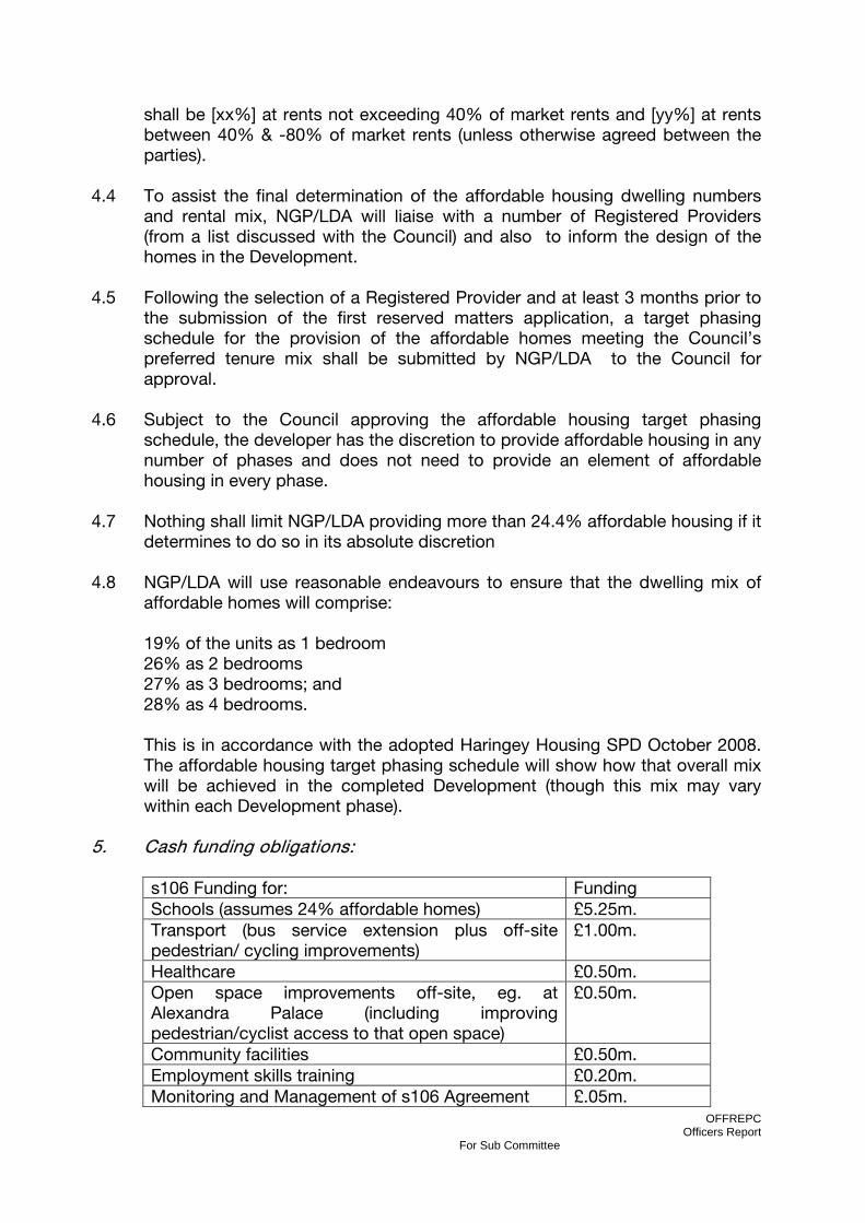
OFFREPC Officers Report
For Sub Committee
shall be [xx%] at rents not exceeding 40% of market rents and [yy%] at rents between 40% & -80% of market rents (unless otherwise agreed between the parties).
4.4 To assist the final determination of the affordable housing dwelling numbers and rental mix, NGP/LDA will liaise with a number of Registered Providers (from a list discussed with the Council) and also to inform the design of the homes in the Development.
4.5 Following the selection of a Registered Provider and at least 3 months prior to the submission of the first reserved matters application, a target phasing schedule for the provision of the affordable homes meeting the Council’s preferred tenure mix shall be submitted by NGP/LDA to the Council for approval.
4.6 Subject to the Council approving the affordable housing target phasing schedule, the developer has the discretion to provide affordable housing in any number of phases and does not need to provide an element of affordable housing in every phase.
4.7 Nothing shall limit NGP/LDA providing more than 24.4% affordable housing if it determines to do so in its absolute discretion
4.8 NGP/LDA will use reasonable endeavours to ensure that the dwelling mix of affordable homes will comprise:
19% of the units as 1 bedroom 26% as 2 bedrooms 27% as 3 bedrooms; and 28% as 4 bedrooms. This is in accordance with the adopted Haringey Housing SPD October 2008. The affordable housing target phasing schedule will show how that overall mix will be achieved in the completed Development (though this mix may vary within each Development phase).
5. Cash funding obligations: s106 Funding for: Funding Schools (assumes 24% affordable homes) £5.25m. Transport (bus service extension plus off-site pedestrian/ cycling improvements)
£1.00m.
Healthcare £0.50m. Open space improvements off-site, eg. at Alexandra Palace (including improving pedestrian/cyclist access to that open space)
£0.50m.
Community facilities £0.50m. Employment skills training £0.20m. Monitoring and Management of s106 Agreement £.05m.

OFFREPC Officers Report
For Sub Committee
Total £8.00m. Education Contribution
6.9 NGP/LDA to pay £5,250,000 to the Council towards improving existing/new primary &/or secondary schools serving the new residents in the Development. These improvements can include increasing the capacity of school(s), improving premises &/or operational service improvements.
6.10 Payments shall be made on a tariff per unit basis and will be paid for each Block on commencement of construction of that Block in the Development. On commencement of construction of the final Block in the Development, that Block will make whatever balancing payment is required to ensure that the cumulative sum of £5.25m. has been paid.
Healthcare Provision/Contribution
6.11 Prior to the submission of the Reserved Matters application that includes any or all of Blocks 8,10,11,12 and 13, NGP/LDA (with the Council) will discuss with the North Central London Primary Care Trust (or successor body) its healthcare facility space requirements. If the PCT (or successor body) confirms a requirement for space, NGP/LDA undertakes to offer to make available on 25 year market leasehold terms (with renewal rights) (certified as reasonable by the District Valuer) to the Primary Care Trust (or successor body or a nominated organisation, e.g. the LIFT company) of up to 1,000sqm. floorspace GIA – combination of D1/2 & B1 space subject to change of use approval) to be used as a primary healthcare centre (or related activities). The space to be constructed to a ‘shell and core’ specification to be agreed with the Primary Care Trust (or successor body) and let on open market terms. The offer of space to the PCT shall be made prior to the occupation of Blocks 8,10,11,12 and/or 13 and the space offered shall be made available to the PCT for occupation in accordance with a timetable agreed with the PCT
6.12 The PCT (or successor body) shall have 4 months from the date of the offer
within which to notify NGP/LDA that it wishes to take up the offer of a lease. If not, the Owners can withdraw the Offer.
6.13 Regardless of whether the PCT enters into a lease of on-site premises,
NGP/LDA agree to pay £500,000 to the Council towards off-site service improvements &/or capacity enhancements in existing or other new healthcare facilities likely to serve residents in the Development.
6.14 Payments shall be made on a tariff per unit basis and will be paid for each Block on commencement of construction of that Block in the Development. On commencement of construction of the final Block in the Development, that Block will make whatever balancing payment is required to ensure that the cumulative sum of £500,000 has been paid.

OFFREPC Officers Report
For Sub Committee
6.15 The Council undertakes to make that funding available to the PCT or successor body for healthcare facility/service improvements in the general area of the Development.
Community Facilities Contribution 6.16 NGP/LDA to pay £500,000 to the Council towards the improvement &/or
provision of off-site community facilities, e.g. library, sports pitches/facilities, swimming pool, etc.
6.17 Payments shall be made on a tariff per unit basis and will be paid for each Block on first occupation of that Block in the Development. On occupation of the final Block in the Development, that Block will make whatever balancing payment is required to ensure that the cumulative sum of £500,000 has been paid.
Transport Contribution
6.18 NGP/LDA to pay [£660,000] to the Council (for subsequent payment to Transport for London) to fund bus route extension(s) to serve the Development and/or increased bus service frequency. Three payments of £220,000 shall be made on the same date each year starting from the date of first occupation of the first Block to be occupied of Blocks 7, 8, 9, 10, 11, 12, or 13 in the Development.
6.19 NGP/LDA to pay £340,000 to the Council to undertake improvements to any bus stops required in connection with the bus route extension to serve the Development, investigating and implementing measures to optimise traffic signal timings at junctions likely to experience increased traffic flows as a result of the Development and/or improvements to pedestrian/ cycle routes to nearby Stations, Wood Green Town Centre and/or schools to support the modal split assumptions in the Transport Assessment.
6.20 The first payment of £170,000 shall be made prior to the occupation of the
second Block in the development. A second payment of £170,000 shall be made prior to the occupation of the fourth Block of the Development.
6.21 NGP/LDA to ensure establishment of a Car Club (including electric vehicles) to
serve the Development prior to the occupation of any residential units on the site. Details of the Club (initial size, phased expansion during development, minimum operational period, eligibility for membership, etc.) to be submitted to the Council for approval prior to the start of development.. NGP/LDA to ensure provision of electric vehicle charging points
6.22 NGP/LDA agree to ensure that all residents are informed that the Council will
consider them ineligible to apply for CPZ permits in surrounding streets. 6.23 Travel Plan – targets, periodic review of Travel Plan implementation and
approval by Council, appointment of Travel Plan Co-ordinator and role.
OFFREPC Officers Report
For Sub Committee
6.24 Works to existing adopted public highway – If requested to do so by the
developer, the Council will undertake the necessary processes to promote the Traffic Regulation Order (TRO) or Road Closure Order procedures in order for works (to be undertaken by the Council) to existing adopted public highway within the boundary of the development to commence at NGP/LDA cost e.g. realignment of part of the spine road, construction of on-street parking bays, planting of street trees, etc.
6.25 Prior to commencement of the Development, NGP/LDA to enter into a
separate agreement under the Highways Act 1980 with the Council as local highway authority to cover all the Council’s costs (the actual cost of works, fees and statutory procedures) incurred by the Council undertaking required works to the existing public highway (including the realignment of the spine road through the Development, construction of vehicular and pedestrian accesses to the Site, construction of on-street parking bays and planting of street trees) .
Open Space Contribution 6.26 The Development is within an area of open space deficiency as identified in the
UDP. In addition to the on-site provision of local open space by NGP/LDA, NGP/LDA to pay £500,000 to the Council to fund improvements to off-site local &/or strategic open space likely to be used by residents in the Development, including Alexandra Park, &/or to pedestrian /cyclist routes (which can include the construction of new routes) to that open space.
6.27 Payments shall be made on a tariff per unit basis and will be paid for each Block on first occupation of that Block in the Development. On occupation of the final Block in the Development, that Block will make whatever balancing payment is required to ensure that the cumulative sum of £500,000 has been paid.
Employment & Training Contribution
6.28 From the start of site preparation works to completion of the Development, NGP/LDA will use reasonable endeavours to achieve via contractors and sub-contractors a target of 20% of employees being residents having lived in the local area for at least 6 months prior to working in the Development. For the purposes of this paragraph, the local area is defined as the north London Boroughs of Haringey, Barnet, Enfield, Camden, Islington, Hackney & Waltham Forest).
6.29 NGP/LDA will use reasonable endeavours to achieve via contractors and sub-
contractors a target of [no] apprenticeships to be offered to Haringey residents in construction & related skills during the period of construction of the Development (and will liaise with the College of Haringey Enfield and North-East London in securing the offer of those apprenticeship places).

OFFREPC Officers Report
For Sub Committee
6.30 Relocation of existing businesses – LDA commits to take all reasonable steps to ensure that existing businesses in the Olympia Trading Estate are assisted in seeking alternative premises (in the first instance within the borough of Haringey) and that the LDA will meet any costs or payments to which the tenants are legitimately entitled.
6.31 NGP/LDA to pay £200,000 to the Council towards employment skills training funding and/or funding for Work Placement Co-ordinator.
6.32 A payment of £50,000 to be made at the commencement of construction of
the Development, with a further £50,000 payment to be made 12 months later. Two payments of £50,000 each will then be made on commencement of construction of the second and third phases of the Development respectively (assuming there will be at least 3 phases – if less, then the full balancing sum will need to be paid either at the start of construction of the second . phase or 2 years after the first payment. .
6. Maintenance of Open Space & Public Realm 6.1. NGP/LDA agree to the maintenance at their cost of on-site public and
communal private space (open space and public realm), including ecological areas for the lifetime of the Development.
7. Index Linking of Funding Contributions 7.1 All funding to be subject to index linking from a year after the date of this
Agreement , using the All Items Retail Prices Index together with interest payments calculated at [………] for any late payments.
8 Monitoring and Management Fee 8.1 NGP/LDA to pay £50,000 to the Council on the commencement of
construction of the Development towards the cost of monitoring the obligations in this Agreement.
9. Legal & Other Professional Fees 9.1 NGP/LDA to pay the Council’s reasonable legal costs and fees in the
negotiation, drafting and completion of this Agreement – payable on the date of this Agreement.