Palestine's virtual borders 2.0: From a non-place to a user-generated space
22
This is the English version of the article originally published in French. For references, please cite: Anat Ben-David, “La Palestine et ses frontières virtuelles 2.0: Du « non-lieu » à l’espace généré par les utilisateurs”, Réseaux 1/2010 (No 159), p. 151-179 1 Palestine's Virtual Borders 2.0: From a Non-Place to a User-Generated Space Anat Ben-David Abstract In 2003 the Palestinian state received official recognition on the Web before it was established on the ground. The delegation of the .ps Country code Top level domain (CcTld) to the Palestinian Authority and its inclusion in the UN list of recognized countries and territories created an official Web-space in which a Palestinian state operated side-by-side with other sovereign states. Yet with the rise of Web 2.0 applications, the official representation of the Palestinian state partially disappeared. This study focuses on the shift in the spatial representation of the Palestinian state on the Web, from an officially acknowledged national Web space, followed by its partial disappearance in Web 2.0 spaces, to its reconstruction as a user-generated space. It examines Palestine’s virtual borders on various Web 2.0 mapping platforms, along with the listing (and non-listing) of Palestine as a country in the registration procedure of popular Web 2.0 applications. It shows that on most mapping platforms the Palestinian Territory is underrepresented, and that the country's official representation on the UN list of recognized countries and territories is often omitted or modified on social media sites’ registration forms. After analyzing the geo-politics of social media's drop-down country lists, this study argues that Web 2.0 spaces are unofficial Web-spaces, in which official representations of countries are not determined by diplomacy or approved by international institutions, but rather by interaction between commercial platforms and their users. Faced with the partial disappearance of their homeland, Palestinian users both in the Palestinian Territory and in the Diaspora thus become placeless participants of Web 2.0 spaces. They attempt to reclaim the virtual representation of their home country as a sovereign Palestinian state by protesting, uploading, tagging and generating content on Web 2.0 platforms. On platforms such as Facebook, Blogger and Google Maps, user activism and user-generated content has led to a spatial transformation from the country's non-listing and non-placement, to its official inclusion. Finally, this article makes a contribution to the theorization of political Web spaces by arguing that the Palestinian case complicates current views on relationships between the Web and the ground. Unlike the common perception that the virtual is grounded in the real, the over- representation of a Palestinian state in official Web spaces, in parallel with its underrepresentation in unofficial Web spaces, and users' treatment of virtual spaces as real spaces, indicate that these realms actually tend to merge, at least in the case of contested Web terrains and unsettled struggles for self-determination.
Transcript of Palestine's virtual borders 2.0: From a non-place to a user-generated space
This is the English version of the article originally published in French. For references, please cite: Anat Ben-David, “La Palestine et ses frontières virtuelles 2.0: Du « non-lieu » à l’espace généré par les utilisateurs”, Réseaux 1/2010 (No 159), p. 151-179
1
Palestine's Virtual Borders 2.0:
From a Non-Place to a User-Generated Space
Anat Ben-David
Abstract
In 2003 the Palestinian state received official recognition on the Web before it was established on the ground. The delegation of the .ps Country code Top level domain (CcTld) to the Palestinian Authority and its inclusion in the UN list of recognized countries and territories created an official Web-space in which a Palestinian state operated side-by-side with other sovereign states. Yet with the rise of Web 2.0 applications, the official representation of the Palestinian state partially disappeared. This study focuses on the shift in the spatial representation of the Palestinian state on the Web, from an officially acknowledged national Web space, followed by its partial disappearance in Web 2.0 spaces, to its reconstruction as a user-generated space. It examines Palestine’s virtual borders on various Web 2.0 mapping platforms, along with the listing (and non-listing) of Palestine as a country in the registration procedure of popular Web 2.0 applications. It shows that on most mapping platforms the Palestinian Territory is underrepresented, and that the country's official representation on the UN list of recognized countries and territories is often omitted or modified on social media sites’ registration forms. After analyzing the geo-politics of social media's drop-down country lists, this study argues that Web 2.0 spaces are unofficial Web-spaces, in which official representations of countries are not determined by diplomacy or approved by international institutions, but rather by interaction between commercial platforms and their users. Faced with the partial disappearance of their homeland, Palestinian users both in the Palestinian Territory and in the Diaspora thus become placeless participants of Web 2.0 spaces. They attempt to reclaim the virtual representation of their home country as a sovereign Palestinian state by protesting, uploading, tagging and generating content on Web 2.0 platforms. On platforms such as Facebook, Blogger and Google Maps, user activism and user-generated content has led to a spatial transformation from the country's non-listing and non-placement, to its official inclusion. Finally, this article makes a contribution to the theorization of political Web spaces by arguing that the Palestinian case complicates current views on relationships between the Web and the ground. Unlike the common perception that the virtual is grounded in the real, the over-representation of a Palestinian state in official Web spaces, in parallel with its underrepresentation in unofficial Web spaces, and users' treatment of virtual spaces as real spaces, indicate that these realms actually tend to merge, at least in the case of contested Web terrains and unsettled struggles for self-determination.
This is the English version of the article originally published in French. For references, please cite: Anat Ben-David, “La Palestine et ses frontières virtuelles 2.0: Du « non-lieu » à l’espace généré par les utilisateurs”, Réseaux 1/2010 (No 159), p. 151-179
2
Introduction
Palestinian campaigning on the Web was at its peak during the first half of the 2000s, from the outburst of the Second Intifada in 2000, until the Israeli disengagement from the Gaza Strip in 20051. These political campaigns advocated intensively for the Palestinian right to self-determination in the Palestinian Territory2 and protested against the Israeli occupation, military operations against Palestinian civilians and the construction of the Separation Wall, which was seen by Palestinians as a unilateral and unjust act of border-stating on the part of the occupying power3. As with political campaigns elsewhere on the Web during that time, most campaigns were led by international and local non-governmental organizations (NGOs)4 and sought to achieve resonance in mainstream international and local media, a high rank in search engine results, and a dense network of hyperlinked Websites advocating for the Palestinian cause5.
The year 2005 saw changes in both Palestinian politics and Web dynamics. Although unrelated, the outcome of both processes was the decentralization of Palestinian advocacy on the Web. On a political level, events driven by the internal crisis between Fatah and Hamas – Hamas’ victory in the Palestinian Legislative Elections in 2006 and consequent takeover of the Gaza Strip in 2007 – sabotaged all attempts to reach Palestinian internal unity. At the same time, Web dynamics underwent major changes that affected the ways in which content was distributed, ranked and linked, and the way in which people were connected on the Web. The rise of Web 2.0 applications – blogging platforms, social networking software and content-sharing applications – allowed users to connect, upload and modify content in ways that were previously the preserve of webmasters, but at the same time created “walled gardens” of content available only to registered users6. Web campaigning thus became a laborious task which had to be re-enacted time and again in each of the various closed Web spaces. For example, a picture of a child taken in a Palestinian refugee camp, uploaded to Flickr and tagged with the camp’s name, would appear on Flickr’s search results but nowhere else
1 The demarcation of the period of the Second Intifada, or “Al Aqsa Intifada”, is debatable. Among the suggested
2 The question of naming the Palestinian Territory is also contested. The various official and unofficial names have political connotations and are often used exclusively by certain actors to make a political stand. As noted below, the UN refers to “Occupied Palestinian Territory”, Palestinian sources use “Palestine”, and the US administration refers to “West Bank and Gaza”. Since the variety of names and their connotations will be at the heart of this study, the term “Palestinian Territory” is used by the author in order to avoid political attachments to any of the official and unofficial names presented in this study. 3 Miryiam Aouragh. “Everyday Resistance on the Internet: the Palestinian Context.” Journal of Arab & Muslim Media Research 1.2 (2008): 109-130. 4 Craig Warkentin. Reshaping World Politics: NGOs, the Internet, and Global Civil Society. Rowman & Littlefield Pub Inc, 2001. 5 Richard Rogers and Anat Ben-David, “Coming to Terms: A Conflict Analysis of the Usage, in Official and Unofficial Sources, of 'Security Fence,' 'Apartheid Wall,' and other Terms for the Structure between Israel and the Palestinian Territories,” Media, Conflict & War, 2, 3, 2010. 6 Richard Rogers. “Post-Demographic Machines,” in: Annet Dekker and Annette Wolfsberger (eds.), Walled Garden. Amsterdam: Virtueel Platform, 2009, 29-39.

This is the English version of the article originally published in French. For references, please cite: Anat Ben-David, “La Palestine et ses frontières virtuelles 2.0: Du « non-lieu » à l’espace généré par les utilisateurs”, Réseaux 1/2010 (No 159), p. 151-179
3
on the Web; users who had registered accounts on Facebook would have access to groups supporting the village Nihlin, which hosted weekly joint Palestinian-Israeli protests against the construction of the Separation Wall, but non-Facebook users would not; and access to the scarce information coming from Gaza during the media blackout in operation Cast Led in early 2009 was only available to Twitter users. Such changes in Web dynamics and Palestinian politics had a multi-layered effect on Palestinian campaigning on the Web: the fragmented Palestinian polity could no longer campaign univocally and jointly for the Palestinian cause, as the technologies previously used for such campaigning had become decentralized, and the prominent campaign actors, previously identified as international, non-governmental and grassroots organizations, had become individual users.
Despite the weakening effect of Web decentralization on Palestinian Web advocacy, another development in the spatial arrangement of the Web contributed to the creation of a unique Palestinian Web space. In what he terms “the grounding of cyberspace”, Richard Rogers describes this development as a shift from the perception of the Web as a “space-less space”, in which real geographical locations had no meaning, to the constant and gradual “revenge of geography”, as evidenced by the localization of both Web content and devices, which eventually led to the grounding of the virtual in the real7. The gradual localization of search engine results and the circulation of local content, together with the rise of platforms dedicated to providing localized geographical data, created a new nationally determined spatial organization of the Web8. The Palestinian case is no exception to this trend. For example, in August 2009 Google launched its localized Palestinian search engine platform, Google.ps, thereby granting Palestinians the option of receiving localized search results from the Palestinian Territory. Until then, Palestinian users had to visit Google.jo, Google.eg or Google.co.il for local searches in Arabic9.
The official representation of the Palestinian state on the Web however still complicates the grounding of the virtual in the real. In 2000 the Palestinian state was granted official status on the Web with the delegation of the .ps national Country code Top Level Domain (CcTld)10, before it was established on the ground. Although the creation of an official Palestinian Web space virtualized the establishment of the Palestinian state, it stemmed directly from the Palestinian geo-political needs on the ground. In its current state, the Palestinian Territory is divided: the Gaza Strip and the West Bank are isolated
7 Richard Rogers. “The Politics of Web Space”. [Unpublished MS], 2008. http://www.govcom.org/publications/full_list/rogers_politics_web_space_2008_pre.pdf (accessed 29 September 2009). 8 Esther Weltevrede. “Thinking Nationally with the Web: A Medium-Specific Approach to the National Turn in Web Archiving”. MA thesis, University of Amsterdam, 2009.
9 http://google.ps (accessed September 29, 2009).
10 The Internet Assigned Numbers Authority (IANA). IANA Report on Request for Delegation of the .ps Top-Level Domain. 22 March, 2000. http://www.iana.org/reports/2000/ps-report-22mar00.html (accessed September 29, 2009).

This is the English version of the article originally published in French. For references, please cite: Anat Ben-David, “La Palestine et ses frontières virtuelles 2.0: Du « non-lieu » à l’espace généré par les utilisateurs”, Réseaux 1/2010 (No 159), p. 151-179
4
from each other, and movement restrictions make it impossible for Palestinians from different cities to physically meet.
Palestinians are therefore currently reliant on Information and Communication Technologies (ICTs) to maintain normal daily activity: ICTs are used by schools to keep education programs running, by hospitals and universities to maintain contact with the outside world, and by individuals who wish to maintain social contact, to inform, debate, and engage in political activity11. Since 2007, political exchange between the Gaza Strip and the West bank has been totally reliant on ICTs, as Israel forbids Hamas ministers from Gaza to travel to the West Bank. Parliamentary sessions and voting are held simultaneously in Ramallah and Gaza, connected through video conferencing12, and other ministerial and political deliberations between Ramallah and Gaza are always mediated via telephone, the Internet, or satellite.
Since considerable parts of Palestinian reality are currently connected through ICTs (and thus not physically), many view ICTs, and especially the Web, as the place where a Palestinian state currently exists: a space that is not bound by boundaries, checkpoints, access routes or airways. An official representation of Palestine on the Web was thus seen by Palestinian officials as affording great and unprecedented potential for creating a “promised cyberland”, an idealized and imagined cyberspace to be used as a model for the anticipated state on the ground13.
The complex relationships between the virtual and the real are evident in the long process that preceded the delegation of the .ps CcTld. The Palestinian National Authority had started inquiring about the possibility of obtaining the .ps CcTld in 1997. The request was refused by the ICANN, since at the time Palestine was not included on the UN list of recognized countries and territories – a requirement for the delegation of a national CcTld. As an interim solution, an international top level domain, Palestine.int, was delegated to the Palestinian Government Computer Center in 1998 and was mainly used by Palestinian governmental sources. A year later, the country was included on the UN list of recognized countries and territories under the name “Palestinian Territories, Occupied”. In 2000 the country name and the .ps country code were included on the international standard list “Codes for the representation of names of countries and their subdivisions” (ISO 3166-1)14 (see Table 1). ICANN accordingly delegated the .ps CcTld 11Makram Khoury-Machool. “Palestinian Youth and Political Activism: the Emerging Internet Culture and New Modes of Resistance.” Policy Futures in Education 5, no. 1 (2007): 17–36. .
12 Al Ayyam, “Through ‘Video Conferencing’, The New Palestinian Government Sworn in Before the President”, March 30, 2006, (in Arabic), http://www.al-ayyam.ps/znews/site/template/Doc_View.aspx?did=35395&Date=3/30/2006 (accessed September 29, 2009). For an English translation see http://www.jmcc.org/new/06/mar/hamasgov2.htm (accessed September 29, 2009). 13 Anat Ben-David. “The Promised Cyberland. Does the Palestinian State Already Exist on the Web?” Paper presented at the Amsterdam New Media Summer Talks, University of Amsterdam, 11 August 2008. See also Govcom.org, "Mapping the Palestinian Web-Space Sept-Nov 2007". http://www.govcom.org/pisp_maps1.html (accessed September 29, 2009). 14 International Organization for Standardization (ISO). Maintenance for ISO 3166 Country Codes. English Country Codes and Code Elements. http://www.iso.org/iso/english_country_names_and_code_elements (accessed September 29, 2009).

This is the English version of the article originally published in French. For references, please cite: Anat Ben-David, “La Palestine et ses frontières virtuelles 2.0: Du « non-lieu » à l’espace généré par les utilisateurs”, Réseaux 1/2010 (No 159), p. 151-179
5
to the Palestinian Authority. For the first time, a country received official representation on the Web before it was established on the ground.
The creation of the official Palestinian Web thus reflects the complex relationships between the Web and the ground, which involve both grounding and virtualization of new kinds. The undetermined status of the Palestinian state on the ground is virtualized in a sovereign space on the Web, and Palestinian national aspirations are projected onto it. At the same time, the status of the Palestinian Web space is grounded in international diplomacy, not in the country’s de-facto status on the ground (a point to which I will return).
The .ps domain is thus an official and internationally acknowledged Web space, subject to international standards and regulation, and maintained by Palestinian governmental bodies. This, however, contrasts with the representation of the Palestinian Territory in unofficial Web spaces comprised of “wall garden” Web 2.0 applications. These unofficial spaces are subject to the platforms’ terms of use rather than to international and national regulations; their form is determined by the platforms’ administrators rather than international standards, and their content is determined by individual users.
Therefore, despite the official legitimization granted to the Palestinian state on the Web, through the delegation of the .ps CcTld and the ISO 3166-1 list, the representation of a Palestinian virtual state partially disappears in many social networking software and on Web-based mapping platforms, thereby returning the status of the virtual cyberland into a non-virtual, grounded place. In these Web-spaces, Palestinian users and their sympathizers become placeless participants by default. For each platform available on the Web, they struggle to make Palestine’s borders visible and to legitimize the listing of its official name on country lists by generating content, modifying data, uploading geo-coded information onto maps, and signing online petitions.
This study thus focuses on the shift in the spatial representation of the Palestinian state on the Web, from an officially acknowledged national Web-space, followed by its partial disappearance in unofficial and decentralized "wall garden" Web 2.0-spaces, to its reconstruction as a user-generated space. Whilst the official and unofficial are seen to coexist on the Web15, the study shows that in the Palestinian case, official and unofficial representations actually form separate Web spaces. It examines Palestine’s virtual borders on the various online mapping platforms and the listing (and non-listing) of Palestine as a country in the registration procedure of popular Web 2.0 applications, to show the tension between the country's non-placement in ready-made and commercially-determined applications, and its reclaiming by user-generated content.
This study also suggests that this tension could be read as a spatial shift from the depiction of Palestine as a “non-place”, to borrow Marc Augé’s term for transient, transparent and a-historical places16, to a “lived space”, which is Henri Lefebvre’s
15 Richard Rogers. Information Politics on the Web. The MIT Press, 2004. 16 Marc Augé. Non-places: Introduction to an Anthropology of Supermodernity. Verso, 1995.

This is the English version of the article originally published in French. For references, please cite: Anat Ben-David, “La Palestine et ses frontières virtuelles 2.0: Du « non-lieu » à l’espace généré par les utilisateurs”, Réseaux 1/2010 (No 159), p. 151-179
6
concept of the social and material construction of spaces17. Finally, this study revisits debates surrounding the relationships between the virtual and the real, and links them to the tension between the official and unofficial on the Web. It claims that the Palestinian case challenges understandings of the grounding of the virtual. The argument put forward here is that the virtualization and projection of an idealized Palestinian state on the Web, coupled with its grounding in international diplomacy and regulation in official Web spaces, as well as users’ attempt to change Palestine’s status to an official “Web country” in unofficial Web spaces, indicate that in the Palestinian case, at least, the two realms are actually merging.
Soft boundaries and self-determination
Border-stating and -mapping are considered to be a practice of power enacted by sovereign (or colonial) states in order to delineate the territory, people and objects under their rule18. As James Scott put it, the purpose of such mapping is to provide a simplified and legible grasp of the ruled19.
Throughout the twentieth century, the Palestinian Territory and its residents were subject to constant reading and mapping by various external powers (Ottoman, British, Jordanian and Israeli). The Israeli authorities use various surveillance technologies to manage the Palestinian population through mapping, monitoring and registration practices which, according to Elia Zureik, determine the boundaries of the Palestinian nation from without20. Another example of an external mapping practice, designed to benefit a future and viable Palestinian state, was proposed by the US research and development organization RAND. This organization suggested an arc-shaped restructuring of Palestinian villages and cities and the construction of underground tunnels to physically connect the West Bank and Gaza and enable Palestinian sovereignty on a continuous terrain21. Such mapping not only offers a geographical re-arrangement to solve a political problem, but also proposes a new aesthetics for how this solution could be achieved. Instead of redrawing borders and lines, new shapes and forms are suggested.
RAND's geographical re-arrangement of the Palestinian Territory could be seen as an attempt to avoid the question of the state's future fixed borders, which has been one of the thorniest issues at the heart of the Palestinian-Israeli conflict. Although Israel does not recognize the June 4, 1967 boundary (“the Green Line”) as its official border, this boundary was an administrative and de-facto boundary between Israel and Palestinian civilians at first, and then between Israel and the Palestinian National Authority, after the
17 Henri Lefebvre. The Production of Space. Wiley-Blackwell, 1992. 18 Benedict R.O. Anderson. Imagined Communities: Reflections on the Origin and Spread of Nationalism. London and New York: Verso, 1991. See Also Patrick Carroll. Science, Culture, and Modern State Formation. Berkeley and Los Angeles, California: University of California Press, 2006. 19 James. C. Scott. Seeing Like a State: How Certain Schemes to Improve the Human Condition have Failed. Yale University Press, 1998. 20 Elia Zureik. “Constructing Palestine through surveillance practices.” British Journal of
Middle Eastern Studies 28, no. 2 (2001): 205–227. 21 RAND. The Arc. A Formal Structure for a Palestinian State. 2005. http://www.rand.org/palestine/ (accessed 29 September 2009).
This is the English version of the article originally published in French. For references, please cite: Anat Ben-David, “La Palestine et ses frontières virtuelles 2.0: Du « non-lieu » à l’espace généré par les utilisateurs”, Réseaux 1/2010 (No 159), p. 151-179
7
signing of the Oslo interim peace accords in 199322. The Oslo Accords avoided the question of final Palestinian borders, a topic both sides agreed to discuss during the implementation phase which, as of 2009, never took place. Israel's boundaries with the West Bank and Gaza are therefore still described as "soft borders", or as "a boundary in flux", subject to constant change23. The route of the Separation Wall, for example, supposedly runs through the Green Line boundary, yet annexes parts of the West Bank around Jewish settlements and East Jerusalem to ensure Israeli sovereignty and security for its residents in these areas24. While Israel's unilateral disengagement from the Gaza Strip in 2005 changed its border with Gaza, the state retained control on its airspace and territorial waters, population registry, imports and exports, and movement between the Gaza Strip and the West Bank25.
Contrary to external mapping of the Palestinian Territory, Palestinian claims to their territory are evident in self-mapping practices26. When it comes to the right to self-determination in a specific territory, the point of view from which mapping commences is relevant to the power relations between the map-maker and the mapped. The tension between how the map is viewed from the outside and how it is seen from within, and the controversy around the fixed borders which would replace the current soft boundaries between Israelis and Palestinians, should an agreement be reached, is also evident in Web 2.0 spaces. There, the disputed borders are constantly shifting, depending on the platforms that make them available on virtual maps, and on the information included on those maps by users. As I show further on, similar to the controversy around offline political maps, in Web 2.0 spaces the right to Palestinian self-determination is manifest in self-mapping practices and user-generated maps of the Palestinian Territory, which face direct competition with mapping and tagging practices generated by (pro-)Israeli users and other interest groups.
Palestinian borders 2.0
The Web now offers many mapping platforms equipped with technology to modify, add and tag geo-coded information onto virtual maps27. However the decentralization of the mapping authority from the platform to the users remains limited. Users can upload data, tag and add information to maps, but can change neither the maps themselves nor the algorithms hidden in their back-end. The mapping technology underpinning each platform remains a commercially-protected "black box", not in its usual sense of settled
22 Government of the State of Israel, and Palestinian Liberation Organisation (PLO).“Declaration of Principles On Interim Self-Government Arrangements.” September 13, 1993. 23 David Newman and Clive Schofield. Boundaries in Flux. The 'Green Line' Boundary Between Israel and the West Bank - Past, Present and Future. International Boundaries Research Unit, 1995. 24 David Makovsky. “How to Build a Fence.” Foreign Affairs 83 no.2 (2004): 50-64. 25 B'Tselem. Israel's Control of the Airspace and the Territorial Waters of the Gaza Strip. http://www.btselem.org/english/Gaza_Strip/Control_on_Air_space_and_territorial_waters.asp (accessed 29 September 2009). 26 Rochelle Davis. “Mapping the Past, Re-creating the Homeland: Memories of Village Places in pre-1948 Palestine.” In Nakba: Palestine. 1948, ed. Ahmad H. Sa’di, and Lila Abu-Lughod, (NY: Columbia University Press, 2007), 53–76. 27 Matthew A. Zook and Mark Graham. “Mapping DigiPlace: Geocoded Internet Data and the Representation of Place.” Environment and Planning B: Planning and Design 34 no.3 (2007): 466-482.
This is the English version of the article originally published in French. For references, please cite: Anat Ben-David, “La Palestine et ses frontières virtuelles 2.0: Du « non-lieu » à l’espace généré par les utilisateurs”, Réseaux 1/2010 (No 159), p. 151-179
8
contents and dynamics that require no further mention28, but as a process which has a known input (a searched place), a known output (its location on a digital map), and an unknown mechanism which determines which areas will be depicted and how they should be named or searched for, especially around disputed areas. Users, then, can only respond by generating content showing different results, or by protesting. For example, in 2005 the Indian Government protested against Google Earth's depiction of the part of Kashmir, which it claims as its own, as belonging to Pakistan29. Users also reported that Google Maps accessed from China depicted a different border between China and India, than the same map accessed from India30.
As with other disputed areas around the world, the placement (or not) of the Palestinian Territory on various mapping platforms has revived and publicly opened the decades-long dispute over Israel’s borders with its Palestinian neighbors – a dispute that until now was debated around offline, often military classified maps31.
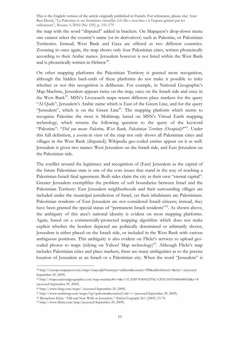
Our examination of Palestinian borders online started in August 2008 with a single observation: a search for “Palestine” on Google Maps was directed to Palestine, Texas, USA32. While searches for more specific areas and city names such as “West Bank”, “Gaza” and “Ramallah” led to their correct areas on the map, these were gray, blank, and did not contain any geo-coded data or information usually available for other place markers. Moreover, geo-coded Wikipedia entries and photos with exact longitude-latitude coordinates of places within the Palestinian Territory, which can be uploaded as an additional layer to Google Maps, did not appear in Google Map's depiction of the West Bank and Gaza, while entries for Israeli cities and places did (see Figure 1). Thus, in August 2008 the Palestinian Territory on Google Maps was defined by its “blank” data or, so to speak, as a “non-place”.
28 Langdon Winner. “Upon Opening the Black Box and Finding it Empty: Social Constructivism and Philosophy of Technology”. Science, Technology, & Human Values 18 (1993): 362-378. 29 Times of India, “India Protests Google Kashmir Map”, November 20, 2005. 30 Sky Full of Clouds blog, “Google Maps on India and China”. August 9, 2009. http://skyfullofclouds.wordpress.com/2009/08/09/google-maps-on-india-and-china/ (accessed August 12, 2009). 31 Note that Israelis often complain that for decades, Israel's name was erased from these offline maps. 32 A similar search for Bethlehem was redirected to Bethlehem, Pennsylvania. However, the redirection perhaps has more to do with the platform's American-centrism, as evidenced by the default US map on the opening page of Google Maps. http://maps.google.com/maps?f=q&source=s_q&hl=en&geocode=&q=Palestine&sll=37.0625,-95.677068&sspn=27.976484,79.013672&ie=UTF8&ll=31.777796,-95.646973&spn=0.117035,0.308647&z=12&iwloc=A (accessed September 29, 2009).

This is the English version of the article originally published in French. For references, please cite: Anat Ben-David, “La Palestine et ses frontières virtuelles 2.0: Du « non-lieu » à l’espace généré par les utilisateurs”, Réseaux 1/2010 (No 159), p. 151-179
9
Figure 1. The Palestinian Territory as blank areas on Google Maps. Screenshot taken from http://maps.google.com, 13 August 2008
Coined by Marc Augé, the term non-place refers to transient and transparent urban places devoid of history and identity, such as hotels, ATM machines, airports and supermarkets33. Although the Web itself has already been claimed to be such a non-place34, I would like to suggest that the representation of the Palestinian state is a non-place within geographically-determined Web spaces, a transparent place defined by its constantly shifting entry and exit points.
Palestinian users and their sympathizers are thus left with a placeless representation of their homeland and the territory of their national aspirations. As one blogger commented35:
“Denying the whole Palestinian nation the right to be on the map can only be a gross error if one believes Google's slogan of "Do no Evil", but given Google's influence and presence on the Internet, this error can lead to the public believing that Palestine and its population of over 4 million does not exist, and that they have no right to existence.”
Further examination reveals that the Palestinian Territory is underrepresented on most mapping platforms available on the Web. In Yahoo! maps, for example, the place marker is named “Occupied Palestinian Territories”, and terms such as “West Bank” and “Gaza City” lead to their pinpoint location on the map36. It was not however possible to query for “Jerusalem” within the West Bank, and the city is located on the Israeli side of the Green Line. To avoiding having to define Palestine as a country, Expedia goes so far as to define it as a “Region in Asia”37. Zooming in on this area, the West Bank appears on
33 Marc Augé. Idem. 34 Jay David Bolter and Richard Grusin. Remediation: Understanding New Media. 1st ed. The MIT Press, 2000. 35 Kawther Salam. “Did Google Push Palestine into the Sea?”, The Kawther Salam Blog, June 6, 2007, http://www.kawther.info/K20070606B.html (accessed September 29, 2009). 36 http://maps.yahoo.com (accessed September 29, 2009). 37http://www.expedia.com/pub/agent.dll?qscr=mrdr&fmap=1&lats1=31.413122577872088&lons1=35.05315236771991&alts1=1162®n1=2&plce1=Palestine+%28region%29%2C+Asia& (accessed September 29, 2009).
This is the English version of the article originally published in French. For references, please cite: Anat Ben-David, “La Palestine et ses frontières virtuelles 2.0: Du « non-lieu » à l’espace généré par les utilisateurs”, Réseaux 1/2010 (No 159), p. 151-179
10
the map with the word “disputed” added in brackets. On Mapquest’s drop-down menu one cannot select the country’s name (or its derivatives) such as Palestine, or Palestinian Territories. Instead, West Bank and Gaza are offered as two different countries. Zooming in once again, the map shows only four Palestinian cities, written phonetically according to their Arabic names. Jerusalem however is not listed within the West Bank and is phonetically written in Hebrew38.
On other mapping platforms the Palestinian Territory is granted more recognition, although the hidden back-ends of these platforms do not make it possible to infer whether or not this recognition is deliberate. For example, in National Geographic’s Map-Machine, Jerusalem appears twice on the map, once on the Israeli side and once in the West Bank39. MSN’s Livesearch maps return different place markers for the query “Al Quds”, Jerusalem’s Arabic name which is East of the Green Line, and for the query “Jerusalem”, which is on the Green Line40. The mapping platform which seems to recognize Palestine the most is Multimap, based on MSN’s Virtual Earth mapping technology, which returns the following question to the query of the keyword “Palestine”: “Did you mean: Palestine, West Bank, Palestinian Territory (Occupied)?”41. Under this full definition, a zoom-in view of the map not only shows all Palestinian cities and villages in the West Bank (disputed); Wikipedia geo-coded entries appear on it as well. Jerusalem is given two names: West Jerusalem on the Israeli side, and East Jerusalem on the Palestinian side.
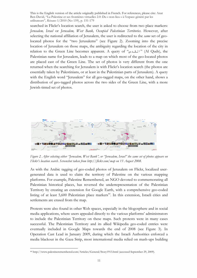
The conflict around the legitimacy and recognition of (East) Jerusalem as the capital of the future Palestinian state is one of the core issues that stand in the way of reaching a Palestinian-Israeli final agreement. Both sides claim the city as their own “eternal capital”. Greater Jerusalem exemplifies the problem of soft boundaries between Israel and the Palestinian Territory: East Jerusalem neighborhoods and their surrounding villages are included under the municipal jurisdiction of Israel, yet their inhabitants are Palestinians. Palestinian residents of East Jerusalem are not considered Israeli citizens; instead, they have been granted the special status of “permanent Israeli residents”42. As shown above, the ambiguity of this area’s national identity is evident on most mapping platforms. Again, based on a commercially-protected mapping algorithm which does not make explicit whether the borders depicted are politically determined or arbitrarily shown, Jerusalem is either placed on the Israeli side, or included in the West Bank with various ambiguous positions. This ambiguity is also evident on Flickr’s services to upload geo-coded photos to maps (relying on Yahoo! Map technology)43. Although Flickr’s map includes Palestinian cities and place markers, there are many ambiguities as to the precise location of Jerusalem as an Israeli or a Palestinian city. When the word “Jerusalem” is
38 http://europe.mapquest.com/maps/map.adp?formtype=address&country=PS&addtohistory=&city= (accessed September 29, 2009). 39 http://maps.nationalgeographic.com/map-machine#s=r&c=31.255074185421936,%2035.54351806640626&z=8 (accessed September 29, 2009). 40 http://www.bing.com/maps/ (accessed September 29, 2009). 41 http://www.multimap.com/maps/?qs=palestine&countryCode=+ (accessed September 29, 2009). 42 Menachem Klein. “Old and New Walls in Jerusalem.” Political Geography 24.1 (2005): 53-76. 43 http://www.flickr.com/map/(accessed September 29, 2009).
This is the English version of the article originally published in French. For references, please cite: Anat Ben-David, “La Palestine et ses frontières virtuelles 2.0: Du « non-lieu » à l’espace généré par les utilisateurs”, Réseaux 1/2010 (No 159), p. 151-179
11
searched in Flickr’s location search, the user is asked to choose from two place markers: Jerusalem, Israel or Jerusalem, West Bank, Occupied Palestinian Territories. However, after selecting the national affiliation of Jerusalem, the user is redirected to the same set of geo-located photos for the “two Jerusalems” (see Figure 2). Zooming into the precise location of Jerusalem on those maps, the ambiguity regarding the location of the city in relation to the Green Line becomes apparent. A query of “االقدسس” (Al Quds), the Palestinian name for Jerusalem, leads to a map on which most of the geo-located photos are placed east of the Green Line. The set of photos is very different from the one returned when the searching for Jerusalem is with Flickr’s location search (the photos are essentially taken by Palestinians, or at least in the Palestinian parts of Jerusalem). A query with the English word “Jerusalem” for all geo-tagged maps, on the other hand, shows a distribution of geo-tagged photos across the two sides of the Green Line, with a more Jewish-tinted set of photos.
Figure 2. After selecting either “Jerusalem, West Bank”, or “Jerusalem, Israel” the same set of photos appears on Flickr’s location search. Screenshot taken from http://flickr.com/map on 13 August 2008.
As with the Arabic tagging of geo-coded photos of Jerusalem on Flickr, localized user-generated data is used to claim the territory of Palestine on the various mapping platforms. For example, Palestine Remembered, an NGO devoted to commemorating all Palestinian historical places, has reversed the underrepresentation of the Palestinian Territory by creating an extension for Google Earth, with a comprehensive geo-coded listing of at least 5,600 Palestinian place markers44. In this extension, Israeli cities and settlements are erased from the map.
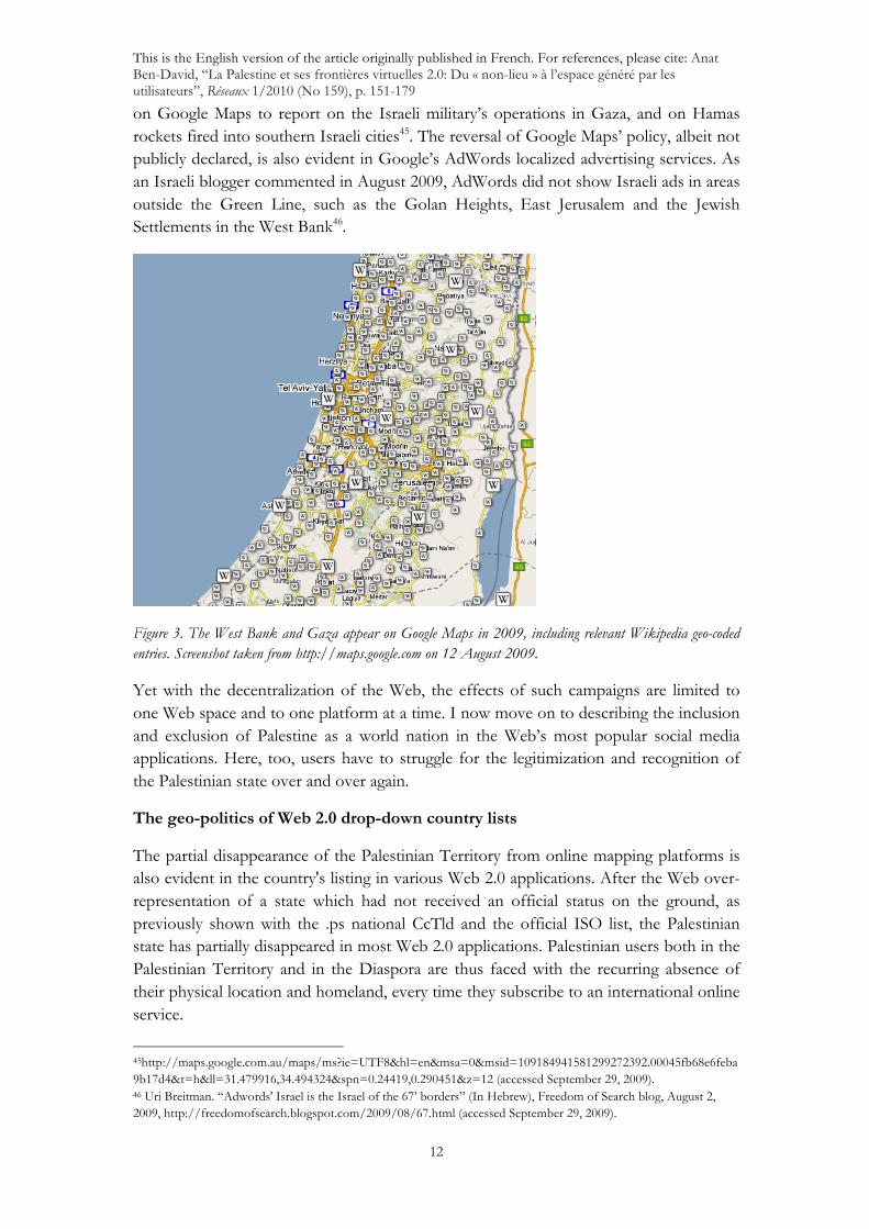
Protests were also found in other Web spaces, especially in the blogosphere and in social media applications, where users appealed directly to the various platforms’ administrators to include the Palestinian Territory on these maps. Such protests were in many cases successful. The Palestinian Territory and its allied Wikipedia geo-coded entries were eventually included in Google Maps towards the end of 2008 (see Figure 3). In Operation Cast Lead in January 2009, during which the Israeli Authorities enforced a media blackout in the Gaza Strip, most international media relied on mash-ups building
44 http://www.palestineremembered.com/Articles/General/Story1913.html (accessed September 29, 2009).
This is the English version of the article originally published in French. For references, please cite: Anat Ben-David, “La Palestine et ses frontières virtuelles 2.0: Du « non-lieu » à l’espace généré par les utilisateurs”, Réseaux 1/2010 (No 159), p. 151-179
12
on Google Maps to report on the Israeli military’s operations in Gaza, and on Hamas rockets fired into southern Israeli cities45. The reversal of Google Maps’ policy, albeit not publicly declared, is also evident in Google’s AdWords localized advertising services. As an Israeli blogger commented in August 2009, AdWords did not show Israeli ads in areas outside the Green Line, such as the Golan Heights, East Jerusalem and the Jewish Settlements in the West Bank46.
Figure 3. The West Bank and Gaza appear on Google Maps in 2009, including relevant Wikipedia geo-coded entries. Screenshot taken from http://maps.google.com on 12 August 2009.
Yet with the decentralization of the Web, the effects of such campaigns are limited to one Web space and to one platform at a time. I now move on to describing the inclusion and exclusion of Palestine as a world nation in the Web’s most popular social media applications. Here, too, users have to struggle for the legitimization and recognition of the Palestinian state over and over again.
The geo-politics of Web 2.0 drop-down country lists
The partial disappearance of the Palestinian Territory from online mapping platforms is also evident in the country's listing in various Web 2.0 applications. After the Web over-representation of a state which had not received an official status on the ground, as previously shown with the .ps national CcTld and the official ISO list, the Palestinian state has partially disappeared in most Web 2.0 applications. Palestinian users both in the Palestinian Territory and in the Diaspora are thus faced with the recurring absence of their physical location and homeland, every time they subscribe to an international online service.
45http://maps.google.com.au/maps/ms?ie=UTF8&hl=en&msa=0&msid=109184941581299272392.00045fb68e6feba9b17d4&t=h&ll=31.479916,34.494324&spn=0.24419,0.290451&z=12 (accessed September 29, 2009). 46 Uri Breitman. “Adwords' Israel is the Israel of the 67’ borders” (In Hebrew), Freedom of Search blog, August 2, 2009, http://freedomofsearch.blogspot.com/2009/08/67.html (accessed September 29, 2009).
This is the English version of the article originally published in French. For references, please cite: Anat Ben-David, “La Palestine et ses frontières virtuelles 2.0: Du « non-lieu » à l’espace généré par les utilisateurs”, Réseaux 1/2010 (No 159), p. 151-179
13
As part of the process of signing up for most Web 2.0 applications, users are often required to fill in their country name. In many applications, however, some countries are not listed, turning users from these countries into placeless participants. Whilst the ISO-3611 country list follows the United Nations' nomenclature for as many as 240 recognized countries and territories, none of the popular social media applications use the ISO list as it stands. Table 2 shows the ISO country names, compared to eight popular Web 2.0 applications, as of August 200847. Except for the movie resource site IMDB, which seems to use the ISO list, all applications show various changes to the list, either by delisting some countries, or by changing their names. For example, the ISO list refers to "Korea, Republic of" and "Korea, Democratic Republic of", but most applications name them as South and North Korea, respectively. Timor-L'este is often translated into East Timor and in many lists Serbia and Montenegro appear as one country, instead of their listing as separate countries in the ISO list.
The standard list is however not the only official list available on the Web. Other official lists, offered for example by the European Union48 or the US administration, can also serve as a model for Web 2.0 drop-down country lists. The US CIA World Factbook country list, for example, proposes a different nomenclature to that of the UN, in order to reflect US foreign policy49 (see Table 3). The CIA list refers to Burma (and not to Myanmar), and has separate entries for West Bank and Gaza (and not the Palestinian Territories, Occupied). It also includes Kosovo (the ISO list does not), since the USA is one of the 62 countries that have already recognized Kosovo’s independence, whilst a UN resolution on this matter is still pending. The nomenclature of country lists, then, reflects official international policies. But does that translate into Web 2.0 spaces?
Since there is no one identical country list among the Web 2.0 applications examined, and since none of the lists are identical to the international diplomatic lists proposed either by the UN, the US or the EU, one can assume that these applications do not presume to operate in official Web spaces. Yet the variety of edits and delisting of certain countries from these lists indicate that even in an unofficial, socially-oriented Web space, political choices are made. Users have accused the professional networking site LinkedIn, for example, of following US sanction policies, as their country list does not include Iran, Sudan or North Korea. Syria was deleted from the list for a while, and then relisted50. The country list offered by Flickr, on the other hand, shows extended political sensitivity as it adds the options "Disputed Territory" and "United Nations Neutral Zones", to the selection of countries.
47 Web 2.0 Innovations. “2008's Most Popular Web 2.0 Sites”. http://www.web2innovations.com/most-popular-web-2.0-sites.php (accessed September 29, 2009). 48 European Commission. “European Union in the World”, http://ec.europa.eu/world/where/index_en.htm (accessed September 29, 2009). 49 CIA, the World Factbook. “US Government Profiles of Countries and Territories Around the World”, https://www.cia.gov/library/publications/the-world-factbook/geos/wq.html (accessed September 29, 2009). 50 Jillian York. "Linked In Alienates Syrian Users. Why Now?" The Huffington Post, April 20, 2009, http://www.huffingtonpost.com/jillian-york/linkedin-alienates-syrian_b_188629.html (accessed September 29, 2009).

This is the English version of the article originally published in French. For references, please cite: Anat Ben-David, “La Palestine et ses frontières virtuelles 2.0: Du « non-lieu » à l’espace généré par les utilisateurs”, Réseaux 1/2010 (No 159), p. 151-179
14
Whilst the Web is known for hosting both official and unofficial sources in a single space51, the analysis of drop-down country lists shows that the official does not penetrate Web 2.0 social media spaces. Web 2.0 spaces are instead unofficial and flexible political sandboxes in which countries are easily added and removed, based on the interaction between the applications, their administrators, and their users. Such is the case with the official representation of the Palestinian state on the Web. The status granted to the Palestinian state by the UN and by ICANN in one Web space, loses its status in social media spaces.
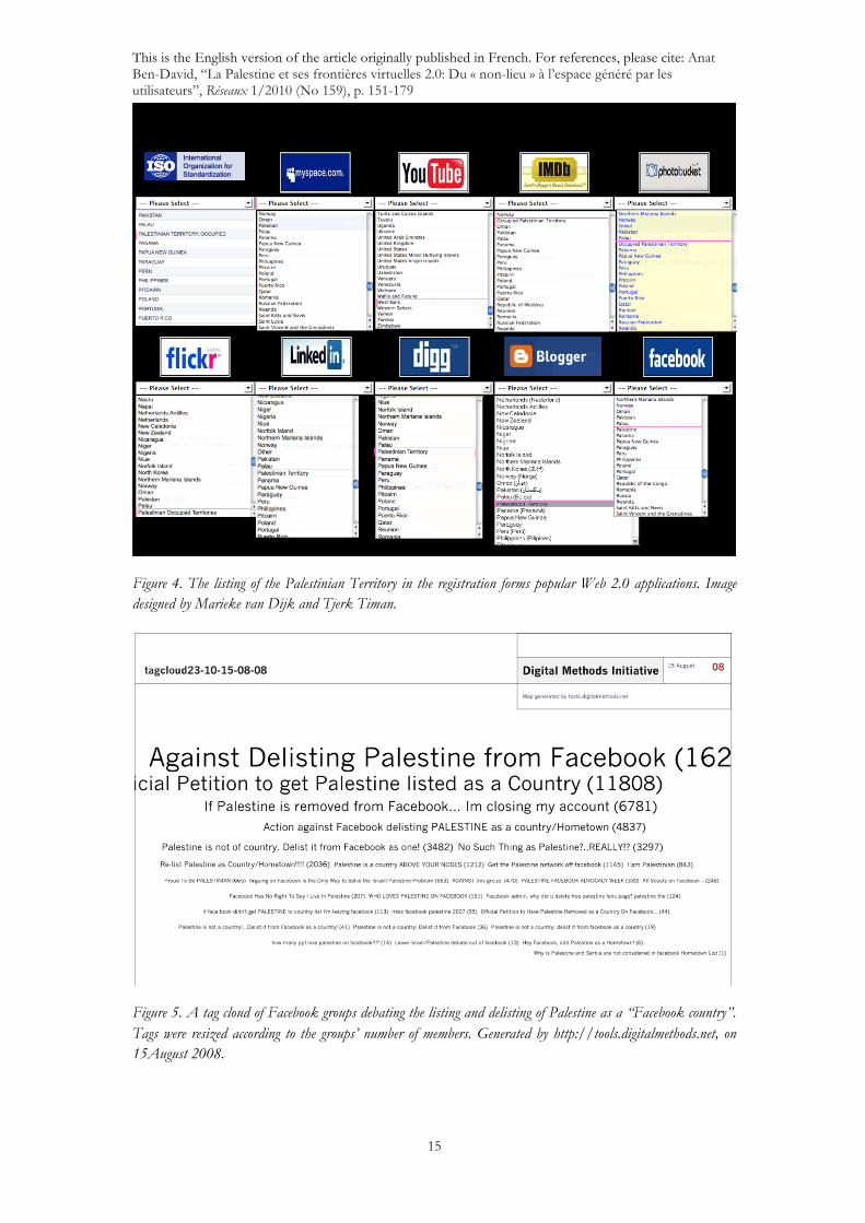
In most of the drop-down country lists examined the Palestinian Territory is often not listed as a country, a location, or a region (see Figure 4). The ISO 3166-1 standard name “Palestinian Territories, Occupied” rarely appears in these forms and the word "Occupied" is often removed.
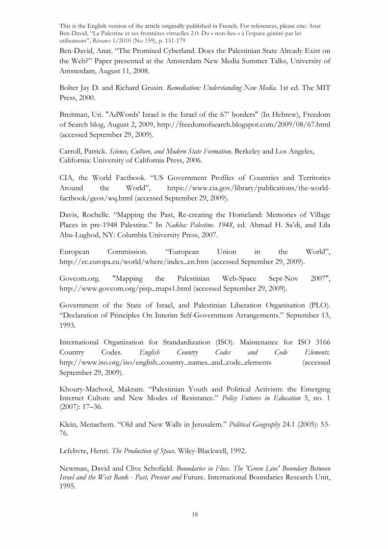
On some platforms such as MySpace, the Palestinian Territory is simply not listed52. Others use different variations: separate entries for West Bank and Gaza (as with the CIA list), “Occupied Palestinian Territories”, “Palestinian Occupied Territories” or “Palestinian Territory”. Users respond to the underrepresentation of their homeland and put pressure on platforms to list Palestine as a country by forming groups, signing petitions and warning that they will stop using those platforms if Palestine is not added as a country. For example, Blogger, Google’s blogging platform, eventually accepted these requests and "Palestinian Territory" was added to the list53. After long debates, and recurrent listing and delisting, Facebook is currently the only platform that lists "Palestine" under its sovereign country name. The history of the fight over country code listings may be read from Facebook group activities, which showed a raging battle over the claiming of Palestine as a “real” Facebook place54. The delisting of Palestine as a country from Facebook led to a flurry of Facebook groups petitioning and demanding the Facebook administrators to re-list Palestine. Other groups demanded that it remain delisted, as it is not (and to them should not) be a country. The tag cloud in Figure 5 is a sample of the heated debates that have been taking place on Facebook over the listing of Palestine as a country. The tag cloud is made up of a sample of groups on the issue and the size of the clouds represents the number of members in each group. Groups such as “Against Delisting Palestine from Facebook“ and “Official Petition to get Palestine Listed as a Country“ gathered more than 16,000 and 11,000 members respectively.
51 Richard Rogers. Information Politics on the Web. Idem. 52 MySpace also does not list a variety of dependent island-countries such as French Polynesia and Isle of Man. The non-listing of the Palestinian Territories together with these islands can be read as recognition of Palestine as a dependent, rather than sovereign, territory. 53 For the bloggers’ protest, please see: http://www.pledgebank.com/palestineblogs. For Google’s response please see http://buzz.blogger.com/2006/03/updated-places-in-profiles.html (accessed September 29, 2009). 54 See, for example, the following group: Re-List Palestine as a country/hometown. http://is-is.facebook.com/group.php?gid=9171691133 and http://is-is.facebook.com/posted.php?id=2324912280&start=60&hash=2cdd049c56786512cc4ffca521510422 (accessed September 29, 2009).
This is the English version of the article originally published in French. For references, please cite: Anat Ben-David, “La Palestine et ses frontières virtuelles 2.0: Du « non-lieu » à l’espace généré par les utilisateurs”, Réseaux 1/2010 (No 159), p. 151-179
15
Figure 4. The listing of the Palestinian Territory in the registration forms popular Web 2.0 applications. Image designed by Marieke van Dijk and Tjerk Timan.
Figure 5. A tag cloud of Facebook groups debating the listing and delisting of Palestine as a “Facebook country”. Tags were resized according to the groups’ number of members. Generated by http://tools.digitalmethods.net, on 15August 2008.

This is the English version of the article originally published in French. For references, please cite: Anat Ben-David, “La Palestine et ses frontières virtuelles 2.0: Du « non-lieu » à l’espace généré par les utilisateurs”, Réseaux 1/2010 (No 159), p. 151-179
16
In a way, the struggle for the legitimization of the Palestinian state is translated into its symbolical representation as a “Facebook country”, where users from both sides of the conflict identify the inclusion or exclusion of the country in a social media platform as a legitimization of this country’s right to existence on the ground. The debate is thus projected from unofficial to official Web space, and from virtual to real, to the extent of identification of the two realms.
The virtual and the real indeed take part in the same political process. As with technologies on the ground that form soft boundaries between Palestinians and Israelis (such as fences, separate roads and checkpoints), platform-based impediments prevent Palestinian and Israeli Facebook users from changing the representation of the conflict on the ground. Even after the inclusion of Palestine as a home country, one cannot join the Palestine network and the Israel network at the same time.
Conclusions: The revenge of geography in Palestinian user-generated spaces
On the Web, Palestinian boundaries are constantly shifting. This is driven not so much by political macro-actors, as by an interaction between commercially-determined and globally-oriented Web-spaces, and their constant modification and protest by (pro) Palestinian users. In Web 2.0 applications, the transition from non-inclusion to an official representation of the Palestinian state characterizes a new spatial arrangement in which people, objects and technologies produce political spaces on the Web. This transition could be read as a shift from the spatial arrangement of Palestine as a “non-place”, as described earlier with the disappearance of the Palestinian Territory from Google Maps in 2008, to the inclusion of “Palestine” as Facebook country as a user-generated “lived space”, to borrow Henri Lefebvre’s concept of socially and materially produced spaces55. From the delegation of the .ps domain, to the inclusion in Google Maps and enlisting of the country’s name in Blogger and Facebook, this interaction between users and technologies leads to the (re)claiming of Webs paces as Palestinian spaces, one platform at a time.
The Palestinian case thus complicates the concept of the grounding of the virtual in the real. The official representation of a virtual Palestinian state in the national .ps CcTld and its inclusion in the ISO country list could be read as a virtual realization of a political aspiration, which is not materialized on the ground. Moreover, whilst an allocation of any national Web-space is part and parcel of the gradual localization of the Web, the delegation of the .ps domain to the Palestinian Authority is grounded more in international diplomacy than in the situation on the ground. The complex relationship between the virtual and the real is also evident in Web 2.0 applications, which show partial disappearance of the Palestinian state, since the country does not appear in many of the maps or in the drop-down country lists. On the one hand, Web 2.0 applications construct non-diplomatic, geographical and social media spaces in which the representation of the Palestinian state is grounded in its current non-state status. This
55 Henri Lefebvre, Idem.

This is the English version of the article originally published in French. For references, please cite: Anat Ben-David, “La Palestine et ses frontières virtuelles 2.0: Du « non-lieu » à l’espace généré par les utilisateurs”, Réseaux 1/2010 (No 159), p. 151-179
17
grounding is being virtualized again by user-generated content, which turns these spaces into politically claimed national spaces. The treatment of a virtual representation of a Palestinian state as an indication to its right to existence on the ground – as evidenced in the heated debates around the depiction (and non-depiction) and listing (and non-listing) of Palestine as a state in most Web 2.0 applications – shows that as long as the dispute around the question of Palestine is not settled, the virtual and the real will continue to merge.
The Palestinian case also complicates views of ‘side-by-sideness’ of official and unofficial sources on the Web. National Web representations which are given official international recognition do not seem to have effect in social-media spaces. These spaces are constructed primarily through bottom-up processes, where the interaction between the internal politics of Web 2.0 applications and the users’ responses to them is responsible for their shaping as political spaces.
Acknowledgements
This study describes findings from the govcom.org Jubilee workshop project, hosted by Prof. Richard Rogers in August 2008 at the University of Amsterdam. Project contributors are Erik Borra, Bram Nijhof, Ganaele Langlois, Astrid Mager, Michael Stevenson and Esther Weltevrede. Images designed by Marieke van Dijk and Tjerk Timan. An earlier version of this article was presented at the “Middle East and the Web” conference, the Hebrew University of Jerusalem, March 19, 2009. The author wishes to thank Dana Diminescu, Richard Rogers, Uri Weinheber and the anonymous reviewers for their valuable comments.
Bibliography
Al Ayyam, “Through ‘Video Conferencing’, The New Palestinian Government Sworn in Before the President”, March 30, 2006, (in Arabic), http://www.al-ayyam.ps/znews/site/template/Doc_View.aspx?did=35395&Date=3/30/2006 (accessed September 29, 2009).
Anderson, Benedict R.O. Imagined Communities: Reflections on the Origin and Spread of Nationalism. London and New York: Verso, 1991. Aouragh, Miriyam. “Everyday resistance on the internet: the Palestinian context.” Journal of Arab & Muslim Media Research 1, no. 2 (2008): 109-130. Augé, Marc. Non-places: Introduction to an Anthropology of Supermodernity. Verso, 1995.
B'Tselem. Israel's Control of the Airspace and the Territorial Waters of the Gaza Strip. http://www.btselem.org/english/Gaza_Strip/Control_on_Air_space_and_territorial_waters.asp (accessed 29 September, 2009),
This is the English version of the article originally published in French. For references, please cite: Anat Ben-David, “La Palestine et ses frontières virtuelles 2.0: Du « non-lieu » à l’espace généré par les utilisateurs”, Réseaux 1/2010 (No 159), p. 151-179
18
Ben-David, Anat. “The Promised Cyberland. Does the Palestinian State Already Exist on the Web?” Paper presented at the Amsterdam New Media Summer Talks, University of Amsterdam, August 11, 2008.
Bolter Jay D. and Richard Grusin. Remediation: Understanding New Media. 1st ed. The MIT Press, 2000.
Breitman, Uri. "AdWords' Israel is the Israel of the 67’ borders" (In Hebrew), Freedom of Search blog, August 2, 2009, http://freedomofsearch.blogspot.com/2009/08/67.html (accessed September 29, 2009).
Carroll, Patrick. Science, Culture, and Modern State Formation. Berkeley and Los Angeles, California: University of California Press, 2006.
CIA, the World Factbook. “US Government Profiles of Countries and Territories Around the World”, https://www.cia.gov/library/publications/the-world-factbook/geos/wq.html (accessed September 29, 2009).
Davis, Rochelle. “Mapping the Past, Re-creating the Homeland: Memories of Village Places in pre-1948 Palestine.” In Nakba: Palestine. 1948, ed. Ahmad H. Sa’di, and Lila Abu-Lughod, NY: Columbia University Press, 2007.
European Commission. “European Union in the World”, http://ec.europa.eu/world/where/index_en.htm (accessed September 29, 2009).
Govcom.org. "Mapping the Palestinian Web-Space Sept-Nov 2007", http://www.govcom.org/pisp_maps1.html (accessed September 29, 2009).
Government of the State of Israel, and Palestinian Liberation Organisation (PLO). “Declaration of Principles On Interim Self-Government Arrangements.” September 13, 1993.
International Organization for Standardization (ISO). Maintenance for ISO 3166 Country Codes. English Country Codes and Code Elements. http://www.iso.org/iso/english_country_names_and_code_elements (accessed September 29, 2009).
Khoury-Machool, Makram. “Palestinian Youth and Political Activism: the Emerging Internet Culture and New Modes of Resistance.” Policy Futures in Education 5, no. 1 (2007): 17–36.
Klein, Menachem. “Old and New Walls in Jerusalem.” Political Geography 24.1 (2005): 53-76. Lefebvre, Henri. The Production of Space. Wiley-Blackwell, 1992. Newman, David and Clive Schofield. Boundaries in Flux. The 'Green Line' Boundary Between Israel and the West Bank - Past, Present and Future. International Boundaries Research Unit, 1995.
This is the English version of the article originally published in French. For references, please cite: Anat Ben-David, “La Palestine et ses frontières virtuelles 2.0: Du « non-lieu » à l’espace généré par les utilisateurs”, Réseaux 1/2010 (No 159), p. 151-179
19
Makovsky, David. “How to Build a Fence..” Foreign Affairs 83 no.2 (2004): 50-64.
RAND. The Arc. A Formal Structure for a Palestinian State. 2005. http://www.rand.org/palestine/ (accessed 29 September 2009).
Rogers, Richard. Information Politics on the Web. The MIT Press, 2004.
Rogers Richard. “Post-Demographic Machines,” in: Annet Dekker and Annette Wolfsberger (eds.), Walled Garden. Amsterdam: Virtueel Platform, 2009, 29-39.
Rogers, Richard. “The Politics of Web Space”. [Unpublished MS], 2008. http://www.govcom.org/publications/full_list/rogers_politics_web_space_2008_pre.pdf (accessed 29 September 2009).
Rogers Richard and Anat Ben-David, “Coming to Terms: A Conflict Analysis of the Usage, in Official and Unofficial Sources, of 'Security Fence,' 'Apartheid Wall,' and other Terms for the Structure between Israel and the Palestinian Territories,” Media, Conflict & War, 2, 3, 2010.
Scott, James. C. Seeing Like a State: How Certain Schemes to Improve the Human Condition have Failed. Yale University Press, 1998.
The Internet Assigned Numbers Authority (IANA). IANA Report on Request for Delegation of the .ps Top-Level Domain. 22 March, 2000. http://www.iana.org/reports/2000/ps-report-22mar00.html (accessed September 29, 2009).
Times of India, “India Protests Google Kashmir Map”, November 20, 2005
Salam, Kawther. “Did Google Push Palestine into the Sea?”, The Kawther Salam Blog, June 6, 2007, http://www.kawther.info/K20070606B.html (accessed September 29, 2009).
Sky Full of Clouds blog, “Google Maps on India and China”. August 9, 2009. http://skyfullofclouds.wordpress.com/2009/08/09/google-maps-on-india-and-china/ (accessed August 12, 2009).
Warkentin, Craig. Reshaping World Politics: NGOs, the Internet, and Global Civil Society. Rowman & Littlefield Pub Inc, 2001.
Web 2.0 Innovations. “2008's Most Popular Web 2.0 Sites”. http://www.web2innovations.com/most-popular-web-2.0-sites.php (accessed September 29, 2009). Weltevrede, Esther. “Thinking Nationally with the Web: A Medium-Specific Approach to the National Turn in Web Archiving”. MA thesis, University of Amsterdam, 2009.
Winner, Langdon. "Upon Opening the Black Box and Finding it Empty: Social Constructivism and Philosophy of Technology". Science, Technology, & Human Values 18 (1993): 362-378.
This is the English version of the article originally published in French. For references, please cite: Anat Ben-David, “La Palestine et ses frontières virtuelles 2.0: Du « non-lieu » à l’espace généré par les utilisateurs”, Réseaux 1/2010 (No 159), p. 151-179
20
York, Jillian. "Linked In Alienates Syrian Users. Why Now?" The Huffington Post, April 20, 2009, http://www.huffingtonpost.com/jillian-york/linkedin-alienates-syrian_b_188629.html (accessed September 29, 2009).
Zook, Matthew A. and Mark Graham. “Mapping DigiPlace: Geocoded Internet Data and the Representation of Place.” Environment and Planning B: Planning and Design 34 no.3 (2007): 466-482. Zureik, Elia. “Constructing Palestine through surveillance practices.” British Journal of Middle Eastern Studies 28, no. 2 (2001): 205–227.
Index
Table 1. ISO 3166-1 English Country Names and Code Elements
Afghanistan Åland Islands Albania Algeria American Samoa Andorra Angola Anguilla Antarctica Antigua And Barbuda Argentina Armenia Aruba Australia Austria Azerbaijan Bahamas Bahrain Bangladesh Barbados Belarus Belgium Belize Benin Bermuda Bhutan Bolivia, Plurinational State Of Bosnia And Herzegovina Botswana Bouvet Island Brazil British Indian Ocean Territory Brunei Darussalam Bulgaria Burkina Faso Burundi Cambodia Cameroon Canada Cape Verde Cayman Islands Central African Republic Chad Chile China Christmas Island Cocos (Keeling) Islands Colombia Comoros Congo Congo, The Democratic Republic Of The Cook Islands Costa Rica Côte D'ivoire Croatia Cuba Cyprus Czech Republic Denmark Djibouti Dominica Dominican Republic Ecuador
Egypt El Salvador Equatorial Guinea Eritrea Estonia Ethiopia Falkland Islands (Malvinas) Faroe Islands Fiji Finland France French Guiana French Polynesia French Southern Territories Gabon Gambia Georgia Germany Ghana Gibraltar Greece Greenland Grenada Guadeloupe Guam Guatemala Guernsey Guinea Guinea-Bissau Guyana Haiti Heard Island And Mcdonald Islands Holy See (Vatican City State) Honduras Hong Kong Hungary Iceland India Indonesia Iran, Islamic Republic Of Iraq Ireland Isle Of Man Israel Italy Jamaica Japan Jersey Jordan Kazakhstan Kenya Kiribati Korea, Democratic People's Republic Of Korea, Republic Of Kuwait Kyrgyzstan Lao People's Democratic Republic Latvia Lebanon Lesotho Liberia
Libyan Arab Jamahiriya Liechtenstein Lithuania Luxembourg Macao Macedonia, The Former Yugoslav Republic Of Madagascar Malawi Malaysia Maldives Mali Malta Marshall Islands Martinique Mauritania Mauritius Mayotte Mexico Micronesia, Federated States Of Moldova, Republic Of Monaco Mongolia Montenegro Montserrat Morocco Mozambique Myanmar Namibia Nauru Nepal Netherlands Netherlands Antilles New Caledonia New Zealand Nicaragua Niger Nigeria Niue Norfolk Island Northern Mariana Islands Norway Oman Pakistan Palau Palestinian Territory, Occupied Panama Papua New Guinea Paraguay Peru Philippines Pitcairn Poland Portugal Puerto Rico Qatar Réunion Romania Russian Federation Rwanda Saint Barthélemy Saint Helena Saint Kitts And Nevis Saint Lucia
Saint Martin Saint Pierre And Miquelon Saint Vincent And The Grenadines Samoa San Marino Sao Tome And Principe Saudi Arabia Senegal Serbia Seychelles Sierra Leone Singapore Slovakia Slovenia Solomon Islands Somalia South Africa South Georgia And The South Sandwich Islands Spain Sri Lanka Sudan Suriname Svalbard And Jan Mayen Swaziland Sweden Switzerland Syrian Arab Republic Taiwan, Province Of China Tajikistan Tanzania, United Republic Of Thailand Timor-Leste Togo Tokelau Tonga Trinidad And Tobago Tunisia Turkey Turkmenistan Turks And Caicos Islands Tuvalu Uganda Ukraine United Arab Emirates United Kingdom United States United States Minor Outlying Islands Uruguay Uzbekistan Vanuatu Vatican City State Venezuela, Bolivarian Republic Of Viet Nam Virgin Islands, British Virgin Islands, U.S. Wallis And Futuna Western Sahara Yemen Zambia Zimbabwe

This is the English version of the article originally published in French. For references, please cite: Anat Ben-David, “La Palestine et ses frontières virtuelles 2.0: Du « non-lieu » à l’espace généré par les utilisateurs”, Réseaux 1/2010 (No 159), p. 151-179
21
Table 2. ISO 3166-1 and popular Web 2.0 drop-down country lists compared
Facebook Digg Photobucket Flickr MySpace
Missing ISO countries Åland Islands American Samoa Antarctica Antigua And Barbuda Bahamas Bouvet Island British Indian Ocean Territory Cocos (Keeling) Islands Guernsey Heard Island And Mcdonald Islands Jersey Nauru Réunion Saint Barthélemy Saint Pierre And Miquelon South Georgia And The South Sandwich Islands Timor-Leste United States Minor Outlying Islands Edits to ISO country names Bolivia Brunei Falkland Islands The Gambia United States Iran North Korea South Korea Laos Libya Macau Macedonia Moldova Palestine Paraguai Russia Netherlands Antilles Syria Taiwan Tanzania Venezuela Vietnam US Virgin Islands British Virgin Islands
Missing ISO countries Åland Islands American Samoa British Indian Ocean Territory French Southern Territories Guam Heard Island And Mcdonald Islands Isle Of Man Marshall Islands Micronesia, Federated States Of Northern Mariana Islands Palau Saint Kitts And Nevis Saint Martin United States Minor Outlying Islands Wallis And Futuna Edits to ISO country names Bolivia Congo Congo Falkland Islands Iran Kazakstan North Korea South Korea Lao Macau Macedonia Moldova Palestinian Territory Tanzania Venezuela Serbia and Montenegro St. Lucia St. Pierre And Miquelon St. Vincent/Grenadines South Georgia Taiwan Tanzania East Timor Venezuela Vietnam Great Britain
Missing ISO countries Saint Barthélemy Saint Martin Serbia Edits to ISO country names land Islands Bolivia French Polynesia and Tahiti Korea, Democratic People's Republic of (North) Korea, Republic of (South) Laos Macau Macedonia Serbia and Montenegro Myanmar (Burma) Occupied Palestinian Territory Riunion Taiwan Tanzania Venezuela Vietnam St. Helena
Missing ISO countries Guernsey Isle Of Man Jersey Saint Barthélemy Saint Martin Edits to ISO country names Bolivia Brunei Ivory Coast Croatia Falkland Islands French Guyana Iran North Korea South Korea Laos Libya Macau Macedonia Moldova Serbia and Montenegro Palestinian Occupied Territories Pitcairn Islands Russia Saint Helena and Dependencies Serbia and Montenegro Syria Taiwan Tanzania East Timor Venezuela Vietnam British Virgin Islands US Virgin Islands Countries added to ISO list Disputed Territory Iraq-Saudi Arabia Neutral Zone Spratly Islands United Nations Neutral Zone
Missing ISO countries Åland Islands French Polynesia French Southern Territories Guadeloupe Guernsey Isle Of Man Jersey Martinique Mayotte New Caledonia Palestinian Territory, Occupied Réunion Saint Barthélemy Saint Martin Saint Pierre And Miquelon Saint Vincent And The Grenadines Sao Tome And Principe Wallis And Futuna Edits to ISO country names Bolivia Zaire Croatia (Hrvatska) Guyana Iran (Islamic Republic of) Laos Macau Macedonia, Republic of Micronesia, Federated States of Moldova, Republic of St. Helena Slovakia (Slovak Republic) Svalbard and Jan Mayen Islands Taiwan Tanzania, United Republic of East Timor Venezuela Virgin Islands (British) Virgin Islands (U.S.) Countries added to ISO list Former Yugoslavia DoDDs Schools
Blogger IMDB LinkedIn Missing ISO Countries Saint Barthélemy Saint Martin Edits to ISO country names Bolivia Bosnia and Herzegovina Brunei (Brunei Darussalam) Cocos Islands Falkland Islands Iran North Korea South Korea Laos Libya Macedonia Micronesia Moldova Palestinian Territories Russia Syria Taiwan Tanzania Venezuela Countries added to ISO list Serbia and Montenegro
No Missing ISO Countries Edits to ISO country names Bolivia Falkland Islands South Georgia Taiwan Venezuela
Missing ISO Countries Cuba Guernsey Iran, Islamic Republic Of Isle Of Man Jersey Slovakia Syrian Arab Republic Taiwan, Province Of China Edits to ISO country names Bolivia Central African Republic Democratic Republic of the Congo Cote D'Ivoire (Ivory Coast) East Timor Korea (North) Korea Laos Libya Macedonia Moldova Serbia and Montenegro Sultanate of Oman Palestinian Territory S.Georgia And S. Sandwich Islands Slovak Republic Syria Taiwan Caribbean Nations Countries added to ISO list France, Metropolitan Other Yugoslavia

This is the English version of the article originally published in French. For references, please cite: Anat Ben-David, “La Palestine et ses frontières virtuelles 2.0: Du « non-lieu » à l’espace généré par les utilisateurs”, Réseaux 1/2010 (No 159), p. 151-179
22
Table 3. The CIA World Factbook and the European Union's country lists compared to ISO-3166-1, showing different nomenclatures
CIA World Factbook (US) Euopean Union Missing ISO Countries Åland Islands Guadeloupe Martinique Réunion Different country names than ISO list Bahamas, The Bolivia Brunei Congo, Democratic Republic of the Congo, Republic of the Falkland Islands (Islas Malvinas) Gaza Strip Guyana French Southern and Antarctic Lands Gambia, The Iran Korea, North Korea, South Laos Libya Macau Macedonia Moldova Burma West Bank Pitcairn Islands Russia Saint Barthelemy Jan Mayen Syria Taiwan Tanzania Venezuela Vietnam British Virgin Islands Virgin Islands Countries added to the list Spratly Islands Kosovo European Union
No Missing ISO Countries Different country names than ISO list Bolivia Congo (Brazzaville) Congo (Kinshasa) Ivory Coast Hong Kong SAR Iran Korea (North) Korea (South) Kyrgyz Republic Laos Libya Macao SAR Micronesia (Fed. State) Moldova Myanmar (Burma) Occupied Palestinian Territory Russia Syria Saint-Vincent Taiwan Tanzania United States of America Vatican City Venezuela Vietnam East Timor Countries added to the list Kosovo under UN Resolution