Countryside Visits - Scottish Borders Council
35
www.scotborders.gov.uk/parks – www.fwlp.co.uk 1 £2.00 Countryside Visits Easy Access to the Countryside Short, easy walks for everyone in the Scottish Borders. Including places to visit with some access for wheelchair users.
-
Upload
khangminh22 -
Category
Documents
-
view
2 -
download
0
Transcript of Countryside Visits - Scottish Borders Council

www.scotborders.gov.uk/parks – www.fwlp.co.uk 1 £2.00
Countryside VisitsEasy Access to the CountrysideShort, easy walks for everyone in the Scottish Borders. Including places to visit with some access for wheelchair users.
Q Easy Access Paths in the Scottish Borders
www.scotborders.gov.uk/walking 32
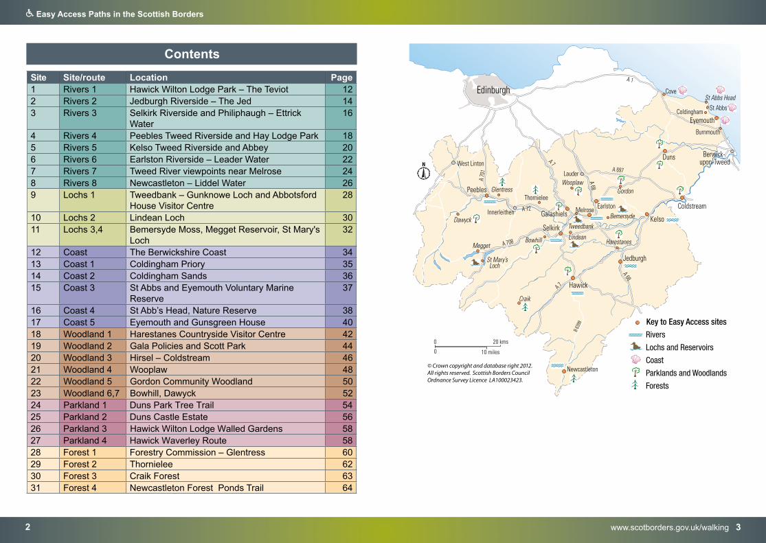
Contents
Site Site/route Location Page1 Rivers 1 Hawick Wilton Lodge Park – The Teviot 122 Rivers 2 Jedburgh Riverside – The Jed 143 Rivers 3 Selkirk Riverside and Philiphaugh – Ettrick
Water16
4 Rivers 4 Peebles Tweed Riverside and Hay Lodge Park 185 Rivers 5 Kelso Tweed Riverside and Abbey 206 Rivers 6 Earlston Riverside – Leader Water 227 Rivers 7 Tweed River viewpoints near Melrose 248 Rivers 8 Newcastleton – Liddel Water 269 Lochs 1 Tweedbank – Gunknowe Loch and Abbotsford
House Visitor Centre 28
10 Lochs 2 Lindean Loch 3011 Lochs 3,4 Bemersyde Moss, Megget Reservoir, St Mary's
Loch32
12 Coast The Berwickshire Coast 3413 Coast 1 Coldingham Priory 3514 Coast 2 Coldingham Sands 3615 Coast 3 St Abbs and Eyemouth Voluntary Marine
Reserve37
16 Coast 4 St Abb’s Head, Nature Reserve 3817 Coast 5 Eyemouth and Gunsgreen House 4018 Woodland 1 Harestanes Countryside Visitor Centre 4219 Woodland 2 Gala Policies and Scott Park 4420 Woodland 3 Hirsel – Coldstream 4621 Woodland 4 Wooplaw 4822 Woodland 5 Gordon Community Woodland 5023 Woodland 6,7 Bowhill, Dawyck 5224 Parkland 1 Duns Park Tree Trail 5425 Parkland 2 Duns Castle Estate 5626 Parkland 3 Hawick Wilton Lodge Walled Gardens 5827 Parkland 4 Hawick Waverley Route 5828 Forest 1 Forestry Commission – Glentress 6029 Forest 2 Thornielee 6230 Forest 3 Craik Forest 6331 Forest 4 Newcastleton Forest Ponds Trail 64
Q Easy Access Paths in the Scottish Borders
www.scotborders.gov.uk/WalkIt 54
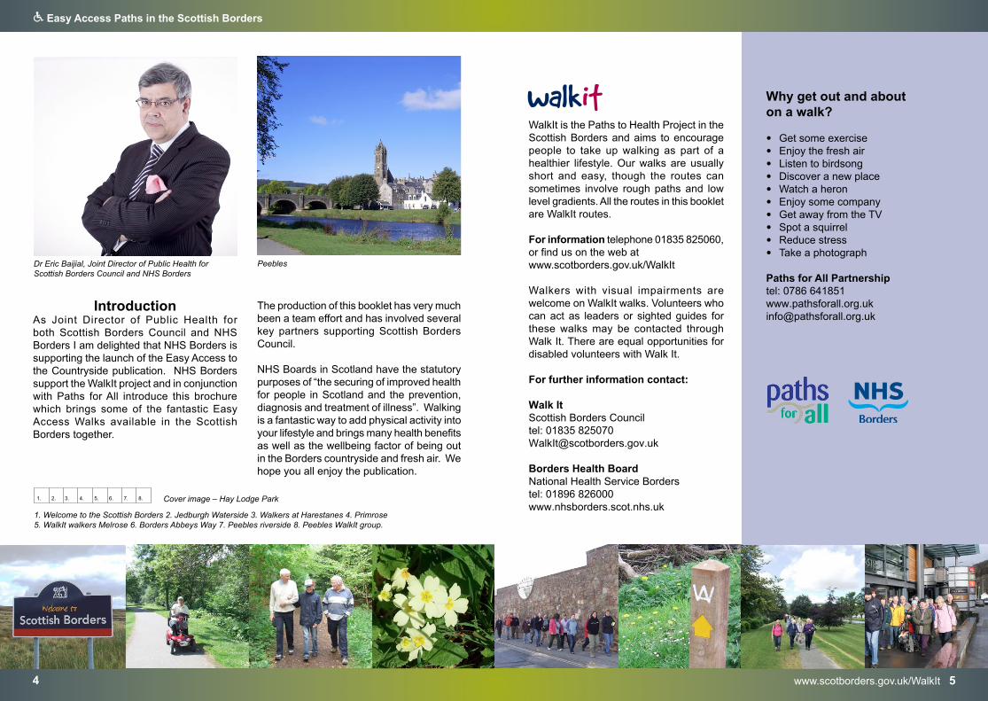
Peebles
IntroductionAs Joint Director of Public Health for both Scottish Borders Council and NHS Borders I am delighted that NHS Borders is supporting the launch of the Easy Access to the Countryside publication. NHS Borders support the WalkIt project and in conjunction with Paths for All introduce this brochure which brings some of the fantastic Easy Access Walks available in the Scottish Borders together.
WalkIt is the Paths to Health Project in the Scottish Borders and aims to encourage people to take up walking as part of a healthier lifestyle. Our walks are usually short and easy, though the routes can sometimes involve rough paths and low level gradients. All the routes in this booklet are WalkIt routes.
For information telephone 01835 825060, or find us on the web at www.scotborders.gov.uk/WalkIt
Walkers with visual impairments are welcome on WalkIt walks. Volunteers who can act as leaders or sighted guides for these walks may be contacted through Walk It. There are equal opportunities for disabled volunteers with Walk It.
For further information contact:
Walk ItScottish Borders Council tel: 01835 [email protected]
Borders Health BoardNational Health Service Borderstel: 01896 826000www.nhsborders.scot.nhs.uk
1. Welcome to the Scottish Borders 2. Jedburgh Waterside 3. Walkers at Harestanes 4. Primrose5. WalkIt walkers Melrose 6. Borders Abbeys Way 7. Peebles riverside 8. Peebles WalkIt group.
1. 2. 3. 4. 5. 6. 7. 8.
Why get out and about on a walk?
• Get some exercise• Enjoy the fresh air• Listen to birdsong• Discover a new place• Watch a heron• Enjoy some company• Get away from the TV• Spot a squirrel• Reduce stress• Take a photograph
Paths for All Partnership tel: 0786 [email protected]
Cover image – Hay Lodge Park
Dr Eric Baijial, Joint Director of Public Health for Scottish Borders Council and NHS Borders
The production of this booklet has very much been a team effort and has involved several key partners supporting Scottish Borders Council.
NHS Boards in Scotland have the statutory purposes of “the securing of improved health for people in Scotland and the prevention, diagnosis and treatment of illness”. Walking is a fantastic way to add physical activity into your lifestyle and brings many health benefits as well as the wellbeing factor of being out in the Borders countryside and fresh air. We hope you all enjoy the publication.
Q Easy Access Paths in the Scottish Borders
www.onlineborders.org.uk/community/bdfc 76 Scottish Borders Countryside with Easy Access website
1. Comma Butterfly 2. picnic tables 3. Jedburgh Abbey and riverside path 4. Selkirk riverside 5. Leaderfoot6 Lindean Loch 7. Common Blue butterfly 8. Starfish.
1. 2. 3. 4. 5. 6. 7. 8.
Countryside with Easy Access
This booklet aims to provide information on some good places to visit and enjoy wildlife in the countryside of the Scottish Borders. It describes places to visit with some access paths which are wide, fairly level and hard surfaced. Some paths may be suitable for people with limited mobility, some wheelchair users and people pushing a child in a buggy. It is hoped that this will be of assistance to wheelchair users and others with limited mobility to plan a visit to the countryside.
For many of the sites there is a contact telephone number of a manager or countryside ranger who could give further details. The list of sites is not comprehensive and is meant as a guideline only. The accessibility of a location in the countryside for wheelchair users is liable to change with the weather and to be dependent on the physical ability of the wheelchair user, the assistance they have available and the type of wheelchair.
Scottish Borders Council Countryside Ranger Service wishes to thank the many people of varying abilities who helped to produce this guide. In particular some groups worked hard to assist in the updating of this information.
A group from the Ability Centre surveyed a number of the sites mentioned in this guide during the years between 2002 and 2008, the Katharine Elliot Centre’s Hawick and Jedburgh groups in 2009 and 2010, and the Borders Disability Forum in 2010, 2011 and 2012.
Some of the photographs taken on these visits have been used in this publication. The Ability Centre’s Outdoor Visit Diary included this quote:
“We have enjoyed the visits. I didn’t realise there were so many places to visit on our doorstep.”
The Borders Disability Forum and WalkIt Group continue to update this information with outdoor visits to countryside locations planned for future years.
Scottish Borders Council Countryside Ranger Service produced this information. The rangers can give further information on general countryside access in the Scottish Borders area. They would welcome comments on the usefulness of this information, and any suggestions.
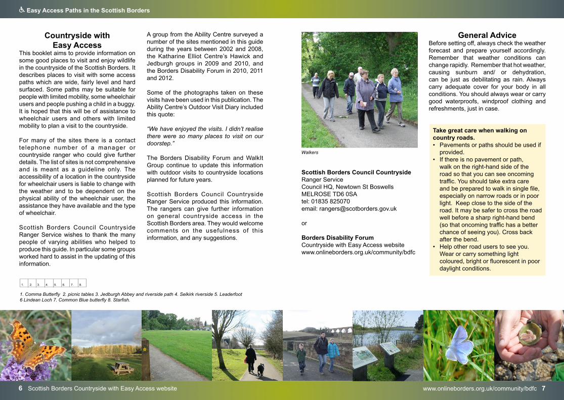
General AdviceBefore setting off, always check the weather forecast and prepare yourself accordingly. Remember that weather conditions can change rapidly. Remember that hot weather, causing sunburn and/ or dehydration, can be just as debilitating as rain. Always carry adequate cover for your body in all conditions. You should always wear or carry good waterproofs, windproof clothing and refreshments, just in case.
Take great care when walking on country roads. • Pavements or paths should be used if
provided.• If there is no pavement or path,
walk on the right-hand side of theroad so that you can see oncomingtraffic. You should take extra careand be prepared to walk in single file,especially on narrow roads or in poorlight. Keep close to the side of theroad. It may be safer to cross the roadwell before a sharp right-hand bend(so that oncoming traffic has a betterchance of seeing you). Cross backafter the bend.
• Help other road users to see you.Wear or carry something lightcoloured, bright or fluorescent in poordaylight conditions.
Walkers
Scottish Borders Council Countryside Ranger Service Council HQ, Newtown St Boswells MELROSE TD6 0SAtel: 01835 825070 email: [email protected]
or
Borders Disability Forum Countryside with Easy Access website www.onlineborders.org.uk/community/bdfc
Q Easy Access Paths in the Scottish Borders
www.outdooraccess-scotland.scot 98 Outdoor Access website
Livestock and WildlifeDogs can be a particular concern for farmers during lambing time (March – May) and when cows are calving (Spring & Autumn).
Dogs therefore should not be taken into fields where there are young livestock. This includes all young livestock such as lambs, calves and foals. In more open countryside where lambs are present, keep your dog on a short lead.
Disturbance at this time can separate young livestock from their mothers leaving them cold, hungry and exposed to predators.
Dogs should not be taken into fields of cattle when they have calves, as the cows see a dog as a threat and may attack it. Go into a neighbouring field or onto adjacent land.
During the bird breeding season (April – June) keep your dog under close control or on a short lead in ground nesting areas.
Without a dog, if you walk quietly through livestock areas, keeping a safe distance from stock and watching them carefully, you should experience little or no difficulty. Please leave gates as you find them and ensure that if you have to open a gate, you
Health Warning!Infections from animals can cause serious human illness. Stay safe from diseases when out in the countryside by:a. Washing hands with soap & water
(or use wet wipes) after visitingthe toilet, after activities, touchinganimals and before handling,cooking and eating food
b. Taking care to avoid spreadinganimal faeces on footwear
c. Avoiding camping or having a picnicon land which has recently beenused for grazing animals
d. Not drinking untreated water fromrivers, streams and lochs
e. Avoiding tick bites; cover legs whenwalking through long vegetation
Contact the Public Health Department for more information 01896 825 560
Access in Scotland The Land Reform (Scotland) Act 2003 and the Scottish Outdoor Access Code came into effect in February 2005. The LRSA establishes a statutory right of responsible access to land and inland waters for outdoor recreation, crossing land, and some educational and commercial purposes. The Scottish Outdoor Access Code gives detailed guidance on your responsibilities when exercising access rights and if you are managing land and water. The Act sets out where and when access rights apply. The Code defines how access rights should be exercised responsibly.
Know the Code before you go... Enjoy Scotland’s outdoors -
responsibly!
Enjoy Scotland’s outdoors! Everyone has the right to be on most land and inland water for recreation, education and for going from place to place providing they act responsibly. These access rights and responsibilities are explained in the Scottish Outdoor Access Code. The key things are:
When you’re in the outdoors:• take personal responsibility for your
own actions and act safely;• respect people’s privacy and peace of
mind;• help land managers and others to work
safely and effectively;• care for your environment and take your
litter home;• keep your dog under proper control;• take extra care if you’re organising an
event or running a business.
When you’re managing the outdoors:• respect access rights;• act reasonably when asking people to
avoid land management operations;• work with your local authority and other
bodies to help integrate access andland management;
• respect rights of way and customaryaccess;
Find out more by visiting www.outdooraccess-scotland.scotor telephoning your local Nature Scotland office
close it securely behind you. Thank you for your cooperation, which will help to ensure that these walks are available for those who follow in your footsteps in future years.
1. Chaffinch 2. Rabbit 3. Cattle 4. Farmer and Eildon Hills 5. Tractor 6. Ewes and lambs
1. 2. 3. 4. 5. 6.
Comma Butterfly
Q Easy Access Paths in the Scottish Borders
www.liveborders.org.uk 1110 Scottish Borders Council – tel: 0300 100 1800 RADAR toilet information
1. Disabled Parking 2. Easy Access path 3. Herring gull4. Fingerpost at Scott Park Galashiels5. Southern Upland Way waypost 6. Hay Lodge park7. Waverly path near Teviotdale Leisure Centre.
1. 2. 3. 4. 5. 6. 7. 8.
Route Facility
Café area with vending machines
Toilets and Disabled Toilets
Swimming Pool
Waverley Path Hawick Teviotdale Leisure Centre Yes Yes Yes
Selkirk Riverside Selkirk Leisure Centre Yes Yes Yes
Gala Policies and Scott Park Galashiels
Galashiels Swimming Pool Yes Yes Yes
Peebles Riverside Gytes Leisure Centre Yes No
Peebles Riverside Peebles Swimming Pool Yes Yes Yes
Eyemouth Seafront Eyemouth Leisure Centre Yes Yes Yes
Jedburgh Riverside - Laidlaw Memorial Pool Jedburgh - Jedburgh Leisure Facilities Trusttel: 01835 863430 | www.laidlawmemorialpool.org.uk
Route Facility
Café area with vending machines
Toilets and Disabled Toilets
Swimming Pool
Jedburgh Riverside Laidlaw Memorial Pool Jedburgh
Yes Yes Yes
Swimming PoolsA number of the routes listed in this booklet are adjacent to swimming pools. Many have accessible toilets and café areas with vending machines. Whether or not you intend to go for a swim, these venues are open to the public to visit during opening hours. As such they can be a useful stopping place as part of your countryside visit. Below are listed the swimming pools near the routes listed. Other pools are located at Kelso and Duns.
Live Borderstel: 01896 661166 | www.liveborders.co.uk
Core PathsMany of the paths in this booklet are core paths. Core paths provide the basic framework of legally recognised, promoted and signposted paths. These link to the wider path network of other formal and informal paths and to the wider countryside. Details of local core paths at www.scotborders.gov.uk/corepaths
ToiletsRADAR wheelchair access toilets are available in most Borders towns. Where there are other wheelchair access toilets, these are shown on the maps for the routes.
Further information www.scotborders.gov.uk
ParkingMost locations listed have free parking and some wheelchair access parking provided. Details on maps and for each route description.
Waymarking and MapsThe majority of the routes are waymarked, however an appropriate map could be used in conjunction with this booklet for further interest. Local leaflets may also be available from some locations and further information is often available from a website.
The Paths around Towns booklets and Town Trail leaflets also provide information on further walk possibilities; visit www.scotborders.gov.uk/walking Ordnance Survey maps in the 1:25 000 Explorer range provide detailed information.
Admission ChargesA few locations with particular countryside interest have been included that have a small admission charge or parking charge. Details may change and are correct at time of going to press.
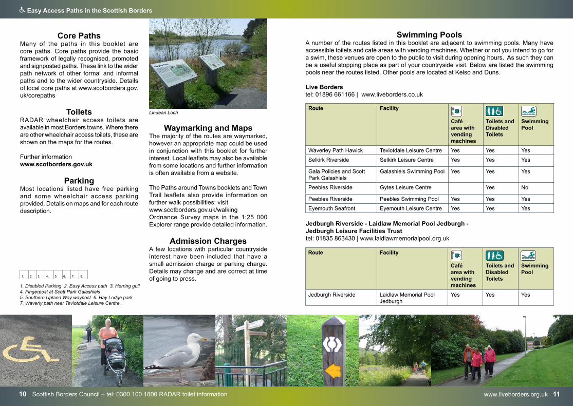
Lindean Loch
www.scotborders.gov.uk/parks 1312 Scottish Borders Council – tel: 0300 100 1800
Q Easy Access Paths in the Scottish Borders
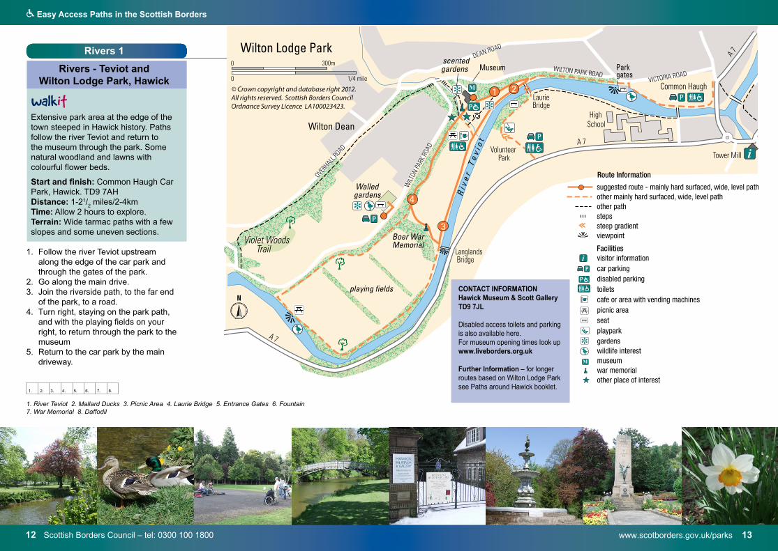
1. River Teviot 2. Mallard Ducks 3. Picnic Area 4. Laurie Bridge 5. Entrance Gates 6. Fountain7. War Memorial 8. Daffodil
1. 2. 3. 4. 5. 6. 7. 8.
Rivers 1
Rivers - Teviot and Wilton Lodge Park, Hawick
Extensive park area at the edge of the town steeped in Hawick history. Paths follow the river Teviot and return to the museum through the park. Some natural woodland and lawns with colourful flower beds.
Start and finish: Common Haugh Car Park, Hawick. TD9 7AHDistance: 1-21/
2 miles/2-4km
Time: Allow 2 hours to explore. Terrain: Wide tarmac paths with a few slopes and some uneven sections.
1. Follow the river Teviot upstreamalong the edge of the car park andthrough the gates of the park.
2. Go along the main drive.3. Join the riverside path, to the far end
of the park, to a road. 4. Turn right, staying on the park path,
and with the playing fields on yourright, to return through the park to themuseum
5. Return to the car park by the maindriveway.
P
M
+ P
P
i
P
+
N
Route Information
i visitor informationcar parkingdisabled parkingtoiletscafe or area with vending machinespicnic areaseatplayparkgardenswildlife interestmuseumwar memorialother place of interest
suggested route - mainly hard surfaced, wide, level pathother mainly hard surfaced, wide, level path other pathstepssteep gradientviewpoint
Facilities
+
P
P
M
CONTACT INFORMATION Hawick Museum & Scott Gallery TD9 7JL
Disabled access toilets and parking is also available here. For museum opening times look up www.liveborders.org.uk
Further Information – for longer routes based on Wilton Lodge Park see Paths around Hawick booklet.
14 Scottish Borders Council – tel: 0300 100 1800
Q Easy Access Paths in the Scottish Borders
www.scotborders.gov.uk/bordersabbeysway 15
1.
2.
3.
4.
5.
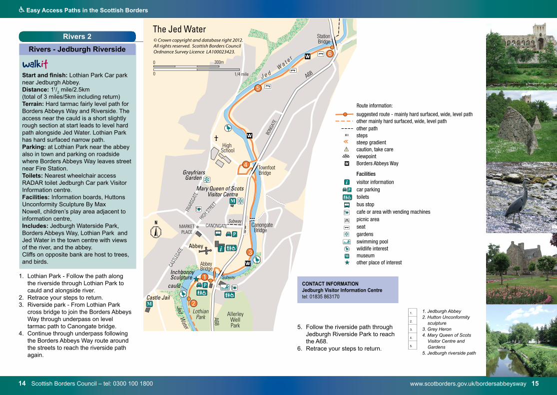
Rivers 2
Rivers - Jedburgh Riverside
Start and finish: Lothian Park Car park near Jedburgh Abbey.Distance: 11/
2 mile/2.5km
(total of 3 miles/5km including return) Terrain: Hard tarmac fairly level path for Borders Abbeys Way and Riverside. The access near the cauld is a short slightly rough section at start leads to level hard path alongside Jed Water. Lothian Park has hard surfaced narrow path.Parking: at Lothian Park near the abbey also in town and parking on roadside where Borders Abbeys Way leaves street near Fire Station.Toilets: Nearest wheelchair access RADAR toilet Jedburgh Car park Visitor Information centre. Facilities: Information boards, Huttons Unconformity Sculpture By Max Nowell, children’s play area adjacent to information centre, Includes: Jedburgh Waterside Park, Borders Abbeys Way, Lothian Park and Jed Water in the town centre with views of the river, and the abbey. Cliffs on opposite bank are host to trees, and birds.
1. Lothian Park - Follow the path alongthe riverside through Lothian Park tocauld and alongside river.
2. Retrace your steps to return.3. Riverside park - From Lothian Park
cross bridge to join the Borders AbbeysWay through underpass on leveltarmac path to Canongate bridge.
4. Continue through underpass followingthe Borders Abbeys Way route aroundthe streets to reach the riverside pathagain.
5. Follow the riverside path throughJedburgh Riverside Park to reachthe A68.
6. Retrace your steps to return.
wA
i visitor informationcar parkingtoiletsbus stopcafe or area with vending machinespicnic areaseatgardensswimming poolwildlife interestmuseumother place of interest
suggested route - mainly hard surfaced, wide, level pathother mainly hard surfaced, wide, level path other pathstepssteep gradientcaution, take careviewpointBorders Abbeys Way
Facilities
P
M
CONTACT INFORMATIONJedburgh Visitor Information Centre tel: 01835 863170
1. Jedburgh Abbey2. Hutton Unconformity
sculpture3. Grey Heron 4. Mary Queen of Scots
Visitor Centre and Gardens
5. Jedburgh riverside path
16 Paths around Selkirk – www.scotborders.gov.uk/walking
Q Easy Access Paths in the Scottish Borders
www.bslt.org.uk 17
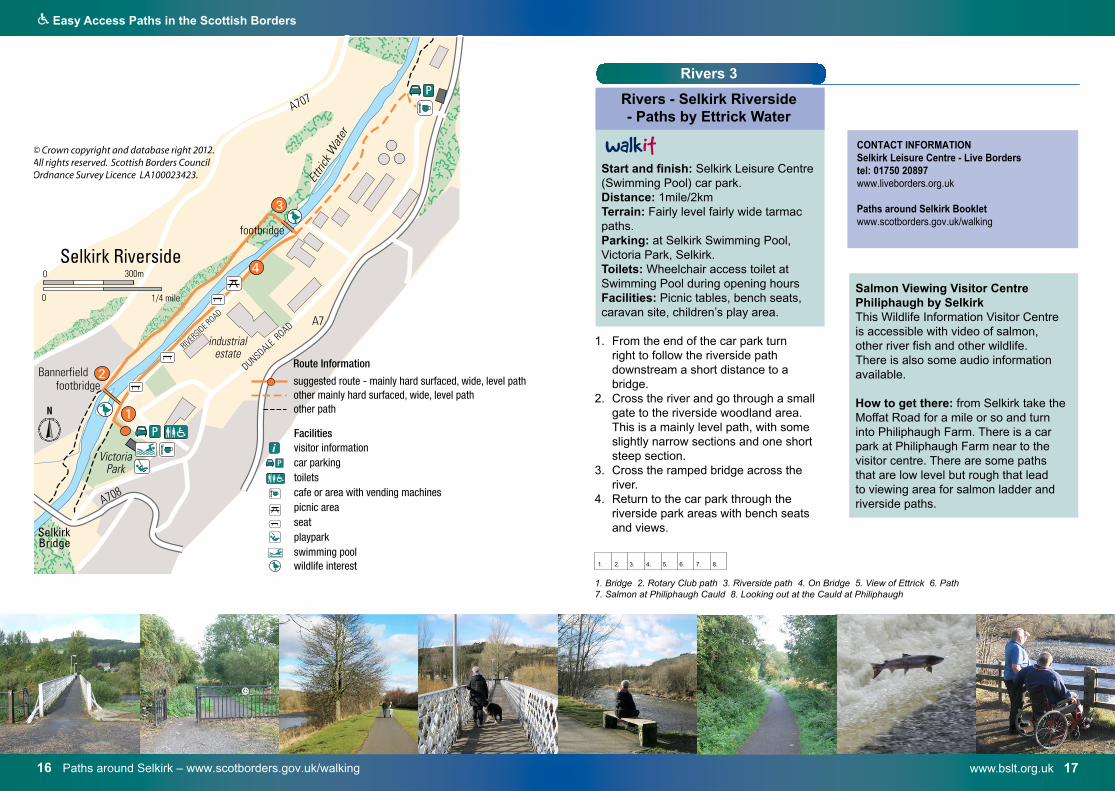
Rivers 3
Rivers - Selkirk Riverside - Paths by Ettrick Water
Start and finish: Selkirk Leisure Centre (Swimming Pool) car park. Distance: 1mile/2km Terrain: Fairly level fairly wide tarmac paths.Parking: at Selkirk Swimming Pool, Victoria Park, Selkirk. Toilets: Wheelchair access toilet at Swimming Pool during opening hoursFacilities: Picnic tables, bench seats, caravan site, children’s play area.
1. From the end of the car park turnright to follow the riverside pathdownstream a short distance to abridge.
2. Cross the river and go through a smallgate to the riverside woodland area.This is a mainly level path, with someslightly narrow sections and one shortsteep section.
3. Cross the ramped bridge across theriver.
4. Return to the car park through theriverside park areas with bench seatsand views.
Route Information
i visitor informationcar parkingtoiletscafe or area with vending machinespicnic areaseatplayparkswimming poolwildlife interest
suggested route - mainly hard surfaced, wide, level pathother mainly hard surfaced, wide, level path other path
Facilities
P
1. Bridge 2. Rotary Club path 3. Riverside path 4. On Bridge 5. View of Ettrick 6. Path 7. Salmon at Philiphaugh Cauld 8. Looking out at the Cauld at Philiphaugh
1. 2. 3. 4. 5. 6. 7. 8.
CONTACT INFORMATIONSelkirk Leisure Centre - Live Borderstel: 01750 20897www.liveborders.org.uk
Paths around Selkirk Booklet www.scotborders.gov.uk/walking
Salmon Viewing Visitor Centre Philiphaugh by Selkirk This Wildlife Information Visitor Centre is accessible with video of salmon, other river fish and other wildlife. There is also some audio information available.
How to get there: from Selkirk take the Moffat Road for a mile or so and turn into Philiphaugh Farm. There is a car park at Philiphaugh Farm near to the visitor centre. There are some paths that are low level but rough that lead to viewing area for salmon ladder and riverside paths.
www.scotborders.gov.uk/parks 1918 Hay Lodge Park Scottish Borders Council – tel 0300 100 1800
Q Easy Access Paths in the Scottish Borders
A 72
B 7062
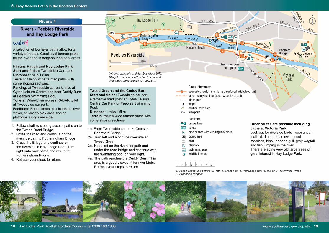
A 72Rivers 4
Rivers - Peebles Riverside and Hay Lodge Park
A selection of low level paths allow for a variety of routes. Good level tarmac paths by the river and in neighbouring park areas.
Ninians Haugh and Hay Lodge Park Start and finish: Tweedside Car park Distance: 1mile/1.5km Terrain: Mainly wide tarmac paths with some sloping sections.Parking: at Tweedside car park, also at Gytes Leisure Centre and near Cuddy Burn at Peebles Swimming Pool. Toilets: Wheelchair access RADAR toilet at Tweedside car park. Facilities: Bench seats, picnic tables, river views, children’s play area, fishing platforms along river side.
1. Follow shallow sloping access paths on tothe Tweed Road Bridge.
2. Cross the road and continue on theriverside path to Fotheringham Bridge.
3. Cross the Bridge and continue onthe riverside in Hay Lodge Park. Turnright onto park paths and return toFotheringham Bridge.
4. Retrace your steps to return.
car parkingtoiletscafe or area with vending machinespicnic areaseatplayparkswimming poolwildlife interest
suggested route - mainly hard surfaced, wide, level pathother mainly hard surfaced, wide, level path other pathstepscaution, take careviewpoint
FacilitiesP
Route InformationTweed Green and the Cuddy Burn Start and finish: Tweedside car park – alternative start point at Gytes Leisure Centre Car Park or Peebles Swimming Pool. Distance: 1mile/1.5km Terrain: mainly wide tarmac paths with some sloping sections.
1a. From Tweedside car park. Cross the Priorsford Bridge.
2a. Turn left and along the riverside at Tweed Green.
3a. Keep left on the riverside path and under the road bridge and continue with the swimming pool on your right.
4a. The path reaches the Cuddy Burn. This area is a good viewpoint for river birds. Retrace your steps to return.
1. Tweed Bridge 2. Peebles 3. Path 4. Cranes-bill 5. Hay Lodge park 6. Tweed 7. Autumn by Tweed8. Tweedside car park
1. 2. 3. 4. 5. 6. 7. 8.
Other routes are possible including paths at Victoria Park.Look out for riverside birds - goosander, mallard, dipper, mute swan, coot, moorhen, black-headed gull, grey wagtail and fish jumping in the river. There are some very old large trees of great interest in Hay Lodge Park.
www.historic-scotland.gov.uk 2120 Kelso Abbey - Local Historic Scotland staff at Dryburgh 01835 822381
Q Easy Access Paths in the Scottish Borders
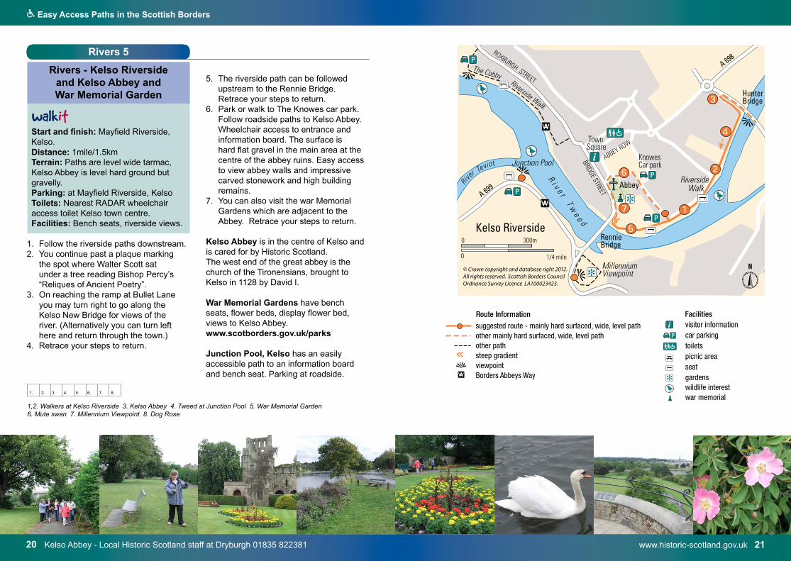
Rivers 5
Rivers - Kelso Riverside and Kelso Abbey and War Memorial Garden
Start and finish: Mayfield Riverside, Kelso. Distance: 1mile/1.5km Terrain: Paths are level wide tarmac, Kelso Abbey is level hard ground but gravelly. Parking: at Mayfield Riverside, KelsoToilets: Nearest RADAR wheelchair access toilet Kelso town centre.Facilities: Bench seats, riverside views.
1. Follow the riverside paths downstream. 2. You continue past a plaque marking
the spot where Walter Scott sat under a tree reading Bishop Percy’s “Reliques of Ancient Poetry”.
3. On reaching the ramp at Bullet Lane you may turn right to go along the Kelso New Bridge for views of the river. (Alternatively you can turn left here and return through the town.)
4. Retrace your steps to return.
5. The riverside path can be followed upstream to the Rennie Bridge.
Retrace your steps to return. 6. Park or walk to The Knowes car park. Follow roadside paths to Kelso Abbey.
Wheelchair access to entrance and information board. The surface is hard flat gravel in the main area at the centre of the abbey ruins. Easy access to view abbey walls and impressive carved stonework and high building remains.
7. You can also visit the war Memorial Gardens which are adjacent to the Abbey. Retrace your steps to return.
Kelso Abbey is in the centre of Kelso and is cared for by Historic Scotland.The west end of the great abbey is the church of the Tironensians, brought to Kelso in 1128 by David I.
War Memorial Gardens have bench seats, flower beds, display flower bed, views to Kelso Abbey.www.scotborders.gov.uk/parks
Junction Pool, Kelso has an easily accessible path to an information board and bench seat. Parking at roadside. wA
i visitor informationcar parkingtoiletspicnic areaseatgardenswildlife interestwar memorial
suggested route - mainly hard surfaced, wide, level pathother mainly hard surfaced, wide, level path other pathsteep gradientviewpointBorders Abbeys Way
Facilities
+
P
Route Information
1,2. Walkers at Kelso Riverside 3. Kelso Abbey 4. Tweed at Junction Pool 5. War Memorial Garden 6. Mute swan 7. Millennium Viewpoint 8. Dog Rose
wA
i visitor informationcar parkingtoiletspicnic areaseatgardenswildlife interestwar memorial
suggested route - mainly hard surfaced, wide, level pathother mainly hard surfaced, wide, level path other pathsteep gradientviewpointBorders Abbeys Way
Facilities
+
P
Route Information
1. 2. 3. 4. 5. 6. 7. 8.
www.earlstonpathsgroup.co.uk 2322 Earlston Paths Group
Q Easy Access Paths in the Scottish Borders
River 6
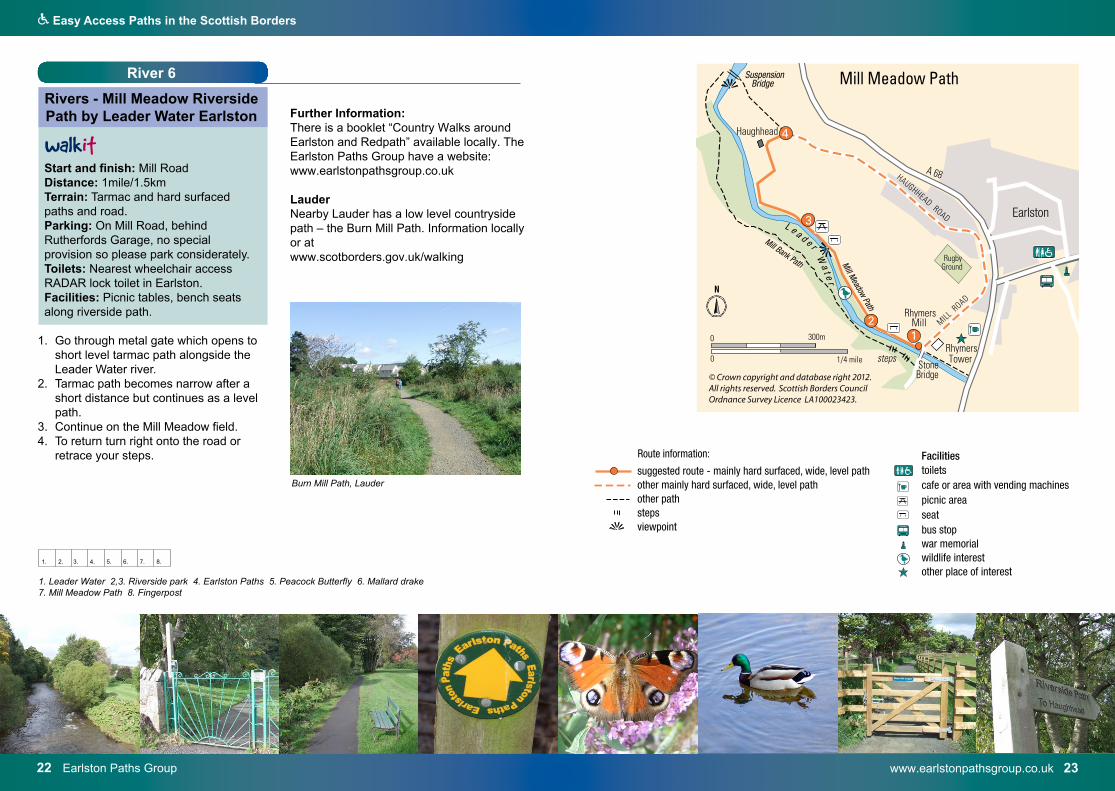
Rivers - Mill Meadow Riverside Path by Leader Water Earlston
Start and finish: Mill Road Distance: 1mile/1.5km Terrain: Tarmac and hard surfaced paths and road.Parking: On Mill Road, behind Rutherfords Garage, no special provision so please park considerately.Toilets: Nearest wheelchair access RADAR lock toilet in Earlston.Facilities: Picnic tables, bench seats along riverside path.
1. Go through metal gate which opens toshort level tarmac path alongside theLeader Water river.
2. Tarmac path becomes narrow after ashort distance but continues as a levelpath.
3. Continue on the Mill Meadow field.4. To return turn right onto the road or
retrace your steps.
toiletscafe or area with vending machinespicnic areaseatbus stopwar memorialwildlife interestother place of interest
suggested route - mainly hard surfaced, wide, level pathother mainly hard surfaced, wide, level path other pathstepsviewpoint
Facilities
+
Further Information: There is a booklet “Country Walks around Earlston and Redpath” available locally. The Earlston Paths Group have a website: www.earlstonpathsgroup.co.uk
Lauder Nearby Lauder has a low level countryside path – the Burn Mill Path. Information locally or at www.scotborders.gov.uk/walking
1. Leader Water 2,3. Riverside park 4. Earlston Paths 5. Peacock Butterfly 6. Mallard drake7. Mill Meadow Path 8. Fingerpost
1. 2. 3. 4. 5. 6. 7. 8.
Burn Mill Path, Laudertoiletscafe or area with vending machinespicnic areaseatbus stopwar memorialwildlife interestother place of interest
suggested route - mainly hard surfaced, wide, level pathother mainly hard surfaced, wide, level path other pathstepsviewpoint
Facilities
+
www.tweedforum.com 2524 Tweed Forum Past Project – Tweed Rivers Heritage
Q Easy Access Paths in the Scottish Borders
River 7
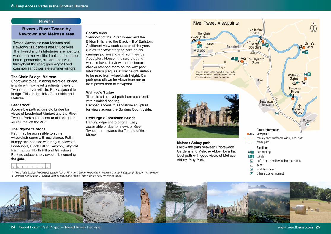
Rivers - River Tweed by Newtown and Melrose area
Tweed viewpoints near Melrose and Newtown St Boswells and St Boswells. The Tweed and its tributaries are host to a wealth of river wildlife. Look out for dipper, heron, goosander, mallard and swan throughout the year; grey wagtail and common sandpiper are summer visitors.
The Chain Bridge, Melrose Short walk to cauld along riverside, bridge is wide with low level gradients, views of Tweed and river wildlife. Park adjacent to bridge. This bridge links Gattonside and Melrose.
Leaderfoot Accessible path across old bridge for views of Leaderfoot Viaduct and the River Tweed. Parking adjacent to old bridge and sculptures, off the A68.
The Rhymer’s Stone Path may be accessible to some wheelchair users with assistance. Path bumpy and cobbled with ridges. Views to Leaderfoot, Black Hill of Earlston, Kittyfield Farm, Eildon North Hill and Galashiels. Parking adjacent to viewpoint by opening the gate.
Scott's ViewViewpoint of the River Tweed and the Eildon Hills, also the Black Hill of Earlston. A different view each season of the year. Sir Walter Scott stopped here on his carriage journeys to and from nearby Abbotsford House. It is said that this was his favourite view and his horse always stopped there on the way past. Information plaques at low height suitable to be read from wheelchair height. Car park area allows for views from car or from paved area at viewpoint.
Wallace’s Statue There is a flat level path from a car park with disabled parking.Ramped access to sandstone sculpture for views across the Borders Countryside.
Dryburgh Suspension BridgeParking adjacent to bridge. Easy accessible bridge for views of River Tweed and towards the Temple of the Muses.
A 6091A 68
car parkingtoiletscafe or area with vending machinesseatwildlife interestother place of interest
FacilitiesP
Route Informationviewpointmainly hard surfaced, wide, level pathother path
1. The Chain Bridge, Melrose 2. Leaderfoot 3. Rhymers Stone viewpoint 4. Wallace Statue 5. Dryburgh Suspension Bridge6. Melrose Abbey path 7. Scotts View of the Eildon Hills 8. Straw Bales near Rhymers Stone
1. 2. 3. 4. 5. 6. 7. 8.
Melrose Abbey path Follow the path between Priorswood Gardens and Melrose Abbey for a flat level path with good views of Melrose Abbey. Play Park.
Q Easy Access Paths in the Scottish Borders
www.visitnewcastleton.com 2726 Newcastleton Village
1. 2. 3. 4. 5. 6. 7. 8.
1. Newcastleton sign 2. War Memorial 3. Grey Heron 4. Riverside path 5. Picnic table and daffodils6. Holm Bridge 7. Creeping Thistle 8. Liddlel Water path near Holm Bridge
River 8
Rivers - Newcastleton Village, Holm Bridge and the
Liddel Water
A riverside walk on roads and hard paths
Start and finish: Douglas Square, Newcastleton.Distance: 1mile/1.5km Terrain: Hard tarmac paths, pavements and some sections on quiet road.Parking: Douglas Square.Toilets: Langholm Street.
1. From the information board in thesquare go down Whitchester Street toMid Liddel Street by the river.
2. Turn right to go along the road.3. Continue on the riverside path for
views of river wildlife and Holm bridge.4. Retrace your steps to the end of the
riverside path.5. Turn left along Walter Street.6. At South Hermitage Street turn left
to reach the Newcastleton HeritageCentre. Alternatively turn right to returnto Douglas Square.
For more information: please see the Paths around Newcastleton booklet at www.scotborders.gov.uk/walking Information on Newcastlleton area and Liddesdale Heritage Centrewww.visitnewcastleton.com and www.thereivertrail.com
i visitor informationcar parkingtoiletspicnic areaseatwildlife interestHeritage centre
suggested route - mainly hard surfaced, wide, level pathother mainly hard surfaced, wide, level path other pathviewpoint
Facilities
P
Route Information
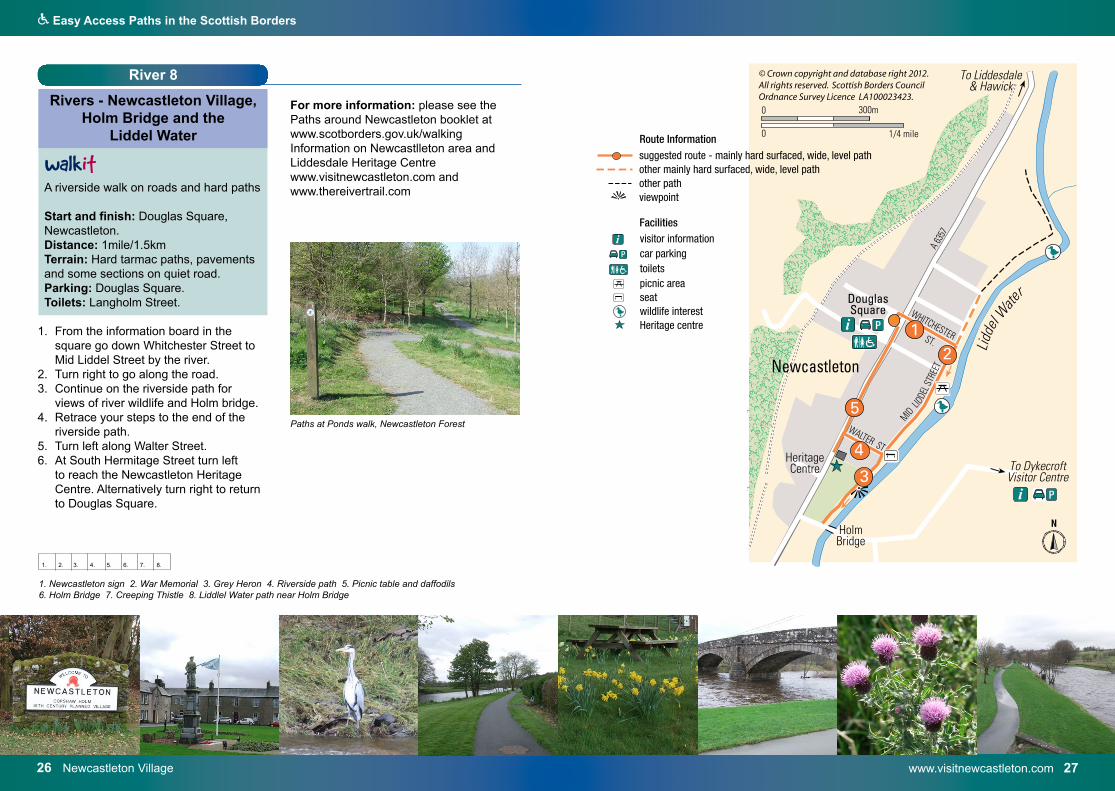
Paths at Ponds walk, Newcastleton Forest
Q Easy Access Paths in the Scottish Borders
28 Tweedbank Park – Scottish Borders Council – tel: 0300 100 1800 www.scotborders.gov.uk/parks 29
Lochs 1
Lochs and Reservoirs - Gunknowe Loch in Tweedbank and link to Abbotsford House
and Visitor Centre
Hard path all the way around the pond. Level tarmac paths in park area around park. A wide variety of wildfowl. The nature trail was created by Tweedbank Primary School. Start and finish: Gunknowe Loch car park, Tweedbank or Abbotsford House Visitor Centre car park. Distance: 1.5km/1 mile Terrain: Flat hard surfaced tarmac paths.Parking: Car park by loch. Ramp access is on left of car park if facing pond. Wide tarmac ramp to pondside.Toilets: Nearest Wheelchair access RADAR lock toilets - Galashiels, Melrose.Facilities: Bench seats, café, information boards.
1a. From Abbotsford follow the paths to reach the pond and walk around the pond with the pond on your left.
1. From the Gunknowe Loch car park turn left to go down the gentle slope to the pond.
2. Turn right and walk around the side of the pond.
3. After an open area with bench seats by the pond, turn right, walk past the play area and take the second left.
4. Go straight on (The full nature trail turns left here).
5. Follow the tarmac path with the large grass area on your right. You join the trail again at the end of the grass area.
6. Turn left towards the pond. 7. Walk around the pond to the right, and
back to the start of your walk. Turning left here would bring you back to the play park.
8. A path link can form a longer route on tarmac paths from point 6 turn right then when you meet the Borders Abbeys Way stay on the tarmac path to the left and turn left to follow the path beside the A6091and return to your start point.
Further information: please see the Paths around Galashiels booklet at www.scotborders.gov.uk/walking
i visitor informationcar parkingtoiletsbus stopcafe or area with vending machinespicnic areaseatplayparkgardenswildlife interest
suggested route - mainly hard surfaced, wide, level pathother mainly hard surfaced, wide, level path other pathstepscaution, take careviewpointBorders Abbeys Way
Facilities
P
Route Information
wA
1. Tweedbank Family Nature Trail 2. WalkIt walks at Gunknowe Loch 3. Tweedbank Park 4. Tufted Duck.
1. 2. 3. 4.
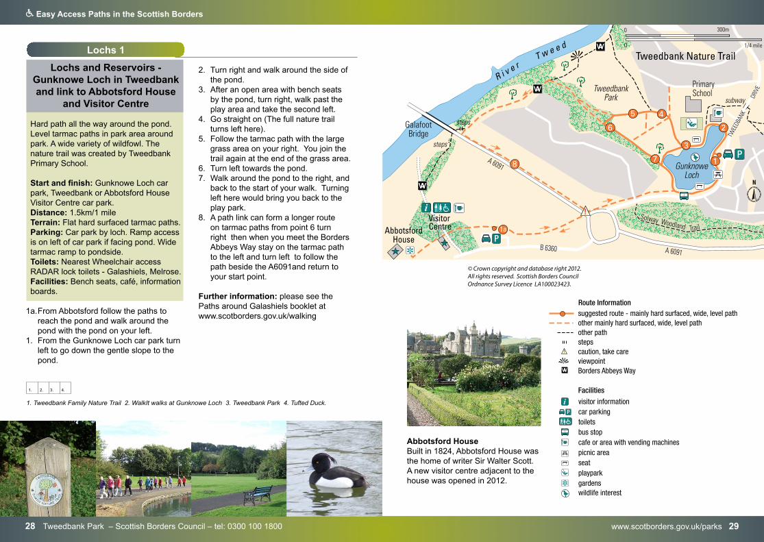
Abbotsford House Built in 1824, Abbotsford House was the home of writer Sir Walter Scott. A new visitor centre adjacent to the house was opened in 2012.
Q Easy Access Paths in the Scottish Borders
www.scotborders.gov.uk/biodiversity 3130 Lindean – Scottish Borders Council – tel: 0300 100 1800
Lochs 2
Lochs and Reservoirs - Lindean Loch, near Selkirk
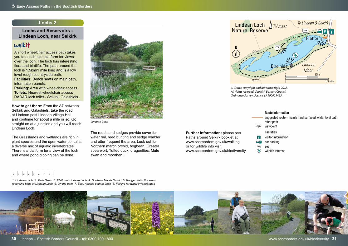
A short wheelchair access path takes you to a loch-side platform for views over the loch. The loch has interesting flora and birdlife. The path around the loch is 1.5km/1 mile long and is a low level rough countryside path. Facilities: Bench seats on main path, information panels. Parking: Area with wheelchair access. Toilets: Nearest wheelchair access RADAR lock toilet - Selkirk, Galashiels.
How to get there: From the A7 between Selkirk and Galashiels, take the road at Lindean past Lindean Village Hall and continue for about a mile or so. Go straight on at a junction and you will reach Lindean Loch.
The Grasslands and wetlands are rich in plant species and the open water contains a diverse mix of aquatic invertebrates. There is a platform for a view of the loch and where pond dipping can be done.
i visitor informationcar parkingseatwildlife interest
suggested route - mainly hard surfaced, wide, level pathother pathviewpoint
Facilities
P
Route Information
The reeds and sedges provide cover for water rail, reed bunting and sedge warbler and otter frequent the area. Look out for Northern march orchid, bogbean, Greater spearwort, Tufted duck, dragonflies, Mute swan and moorhen.
1. 2. 3. 4. 5. 6. 7. 8.
1. Lindean Loch 2. Mute Swan 3. Platform, Lindean Loch 4. Northern Marsh Orchid 5. Ranger Keith Robeson recording birds at Lindean Loch 6. On the path 7. Easy Access path to Loch 8. Fishing for water invertebrates
Lindean Loch
Further information: please see Paths around Selkirk booklet at www.scotborders.gov.uk/walking or for wildlife info visit www.scotborders.gov.uk/biodiversity
Q Easy Access Paths in the Scottish Borders
www.ettrickandyarrow.org.uk 3332 Scottish Wildlife Trust – tel: 0131 312 7765 – www.swt.org.uk
viewpointcar parkingtoiletscafe or area with vending machinespicnic areaseatwildlife interestJames Hogg Ettrick Shepherd monument
Facilities
P
viewpointcar parkingtoiletscafe or area with vending machinespicnic areaseatwildlife interestJames Hogg Ettrick Shepherd monument
Facilities
P
Lochs 3
Lochs and Reservoirs - Bemersyde Moss
Bemersyde Moss near St Boswells is a large marsh area with birds. Geese roost here in winter. You can birdwatch from an easy access bird-hide, the ramp is on your left from where you park. There is information on birds inside the hide. Toilets: Nearest RADAR lock wheelchair access toilet is in Melrose.
How to get there: from Scotts View go south into Bemersyde village and turn left. Go straight on at the first junction with the Moss visible below the road. Turn left past Whitrighill. Park on road verge adjacent to the nature reserve.
Further information: Scottish Wildlife TrustTel: 0131 312 7765www.swt.org.uk
Lochs 4&5
Lochs and Reservoirs - St Marys Loch and Megget Reservoir
St Marys LochLochs with views of surrounding hillsides. St Marys Loch is the largest loch in the Scottish Borders. It was formed during the last ice age by glaciers. Loch of the Lowes is at the South end of the loch. There is a café, views and picnic area at this area.Toilets: RADAR wheelchair access toilets adjacent to the Glen Café, Loch of the Lowes. Ramp is fairly steep.
1. 2. 3. 4. 5. 6. 7.
1. Bemersyde Moss 2. At the Bird-watching Hide 3. Cuckoo Flower 4. Black-headed Gull 5. Oxcleuch Haugh 6. St Mary`s Loch 7. Megget Reservoir 8. Foxglove
Megget Reservoir Megget Reservoir is nearby. It is possible to drive a car up to the reservoir where there is a car parking area.
The road between Megget and Talla is not suitable for coaches. There are information boards, which are on a grass area, with a kerb, adjacent to the car park. Information on the water supply and local wildlife. Views across the reservoir.

34 www.scotborders.gov.uk/walking
Q Easy Access Paths in the Scottish Borders
www.canmore.org.uk – www.coldingham.info 35
1. Cove Harbour 2. Sculpture 3. Burnmouth harbour 4. Lobster Creel 5. Luckenbooth at Coldingham Car park 6,7, Coldingham Priory 8. Common Blue butterfly
1. 2. 3. 4. 5. 6. 7. 8.
Coastal
Coastal - The Berwickshire Coast
Check out the Paths around Eyemouth booklet and the Berwickshire Coastal Path at www.scotborders.gov.uk/walking
Some locations on the coast have some easy access. Sea views, villages, harbours, historic locations, and wildlife may be seen in this area.
Coastal 1
Coastal - Coldingham Priory
Start finish and ParkingColdingham Village Car parkDistance: 200mTerrain: level, hard surfaced pathsToilets: Disabled Access Toilets at Car park
Locations include:Cove Harbour - Parking area allows for coastal views.
Burnmouth - Park at Lower Burnmouth to watch birds at the rocky shore. Picnic tables.
Further information: please see the Paths around Eyemouth booklet and the Berwickshire Coastal Path at www.scotborders.gov.uk/walking
Coldingham PrioryThe atmospheric ruins of Coldingham Priory represent nearly 1000 years of unbroken worship. A church was founded here in 1098 by King Edgar I of Scotland, possibly on the site of an earlier Anglo-Saxon monastery. Edgar's church grew into a priory, and its community lived in Coldingham for 400 years. The Priory was largely destroyed by Oliver Cromwell in the 17th century.
Further information: www.rcahms.gov.ukwww.coldingham.info
i visitor informationcar parkingdisabled parkingtoiletscafe or area with vending machinesseatwildlife interestmaritime museum
Facilities
P
P
M
coastal sitesviewpoint
36 Scottish Borders Council – tel: 0300 100 1800 – www.scotborders.gov.uk
Q Easy Access Paths in the Scottish Borders
www.marine.reserve.co.uk 37
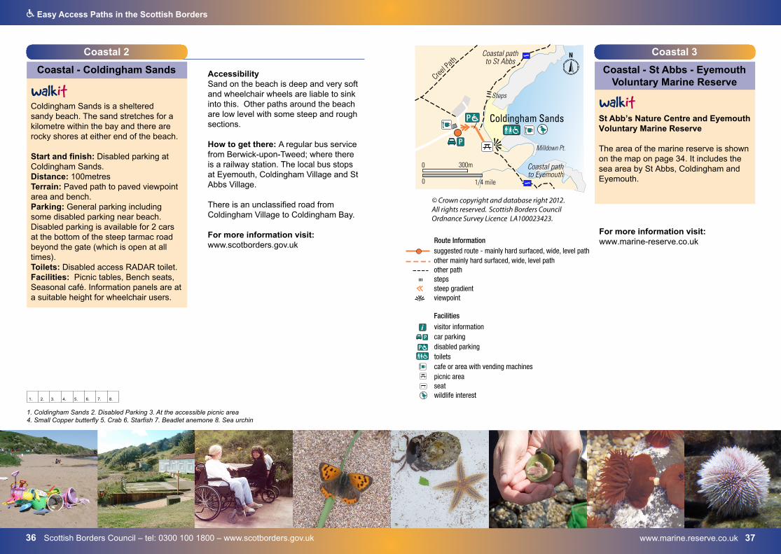
Coastal 2
Coastal - Coldingham Sands
Coldingham Sands is a sheltered sandy beach. The sand stretches for a kilometre within the bay and there are rocky shores at either end of the beach.
Start and finish: Disabled parking at Coldingham Sands. Distance: 100metresTerrain: Paved path to paved viewpoint area and bench. Parking: General parking including some disabled parking near beach. Disabled parking is available for 2 cars at the bottom of the steep tarmac road beyond the gate (which is open at all times).Toilets: Disabled access RADAR toilet.Facilities: Picnic tables, Bench seats, Seasonal café. Information panels are at a suitable height for wheelchair users.
AccessibilitySand on the beach is deep and very soft and wheelchair wheels are liable to sink into this. Other paths around the beach are low level with some steep and rough sections.
How to get there: A regular bus service from Berwick-upon-Tweed; where there is a railway station. The local bus stops at Eyemouth, Coldingham Village and St Abbs Village.
There is an unclassified road from Coldingham Village to Coldingham Bay.
For more information visit:www.scotborders.gov.uk
1. Coldingham Sands 2. Disabled Parking 3. At the accessible picnic area 4. Small Copper butterfly 5. Crab 6. Starfish 7. Beadlet anemone 8. Sea urchin
1. 2. 3. 4. 5. 6. 7. 8.
visitor informationcar parkingdisabled parkingtoiletscafe or area with vending machinespicnic areaseatwildlife interest
suggested route - mainly hard surfaced, wide, level path
other pathstepssteep gradientviewpoint
Facilities
P
P
Route Information
i
other mainly hard surfaced, wide, level path
Coastal 3
Coastal - St Abbs - Eyemouth Voluntary Marine Reserve
St Abb’s Nature Centre and Eyemouth Voluntary Marine Reserve
The area of the marine reserve is shown on the map on page 34. It includes the sea area by St Abbs, Coldingham and Eyemouth.
For more information visit: www.marine-reserve.co.uk
www.stabbs.org – www.stabbsvisitorcentre.co.uk 3938 www.nts.org.uk
Q Easy Access Paths in the Scottish Borders
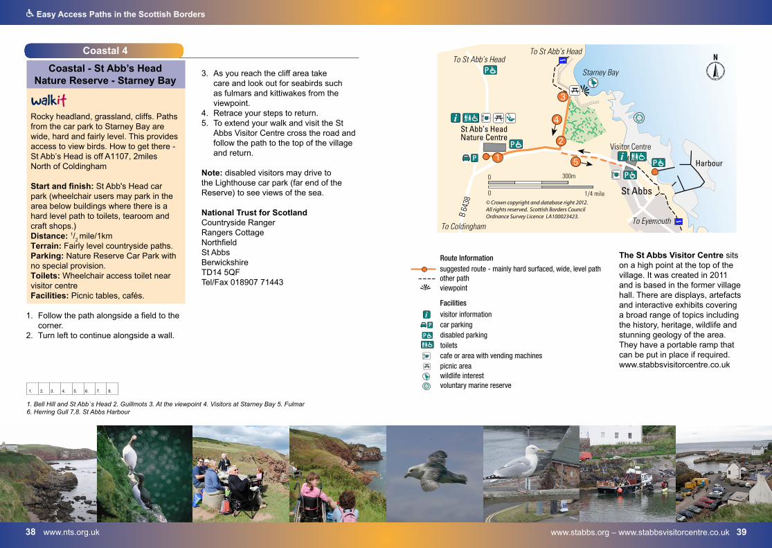
The St Abbs Visitor Centre sits on a high point at the top of the village. It was created in 2011 and is based in the former village hall. There are displays, artefacts and interactive exhibits covering a broad range of topics including the history, heritage, wildlife and stunning geology of the area. They have a portable ramp that can be put in place if required. www.stabbsvisitorcentre.co.uk
i visitor informationcar parkingdisabled parkingtoiletscafe or area with vending machinespicnic areawildlife interestvoluntary marine reserve
suggested route - mainly hard surfaced, wide, level pathother pathviewpoint
Facilities
P
P
Route Information
Coastal 4
Coastal - St Abb’s Head Nature Reserve - Starney Bay
Rocky headland, grassland, cliffs. Paths from the car park to Starney Bay are wide, hard and fairly level. This provides access to view birds. How to get there - St Abb’s Head is off A1107, 2miles North of Coldingham
Start and finish: St Abb's Head car park (wheelchair users may park in the area below buildings where there is a hard level path to toilets, tearoom and craft shops.) Distance: 1/
2 mile/1km
Terrain: Fairly level countryside paths. Parking: Nature Reserve Car Park with no special provision. Toilets: Wheelchair access toilet near visitor centreFacilities: Picnic tables, cafés.
1. Follow the path alongside a field to thecorner.
2. Turn left to continue alongside a wall.
3. As you reach the cliff area takecare and look out for seabirds suchas fulmars and kittiwakes from theviewpoint.
4. Retrace your steps to return.5. To extend your walk and visit the St
Abbs Visitor Centre cross the road andfollow the path to the top of the villageand return.
Note: disabled visitors may drive to the Lighthouse car park (far end of the Reserve) to see views of the sea.
National Trust for ScotlandCountryside RangerRangers CottageNorthfieldSt AbbsBerwickshireTD14 5QFTel/Fax 018907 71443
1. Bell Hill and St Abb`s Head 2. Guillmots 3. At the viewpoint 4. Visitors at Starney Bay 5. Fulmar 6. Herring Gull 7,8. St Abbs Harbour
1. 2. 3. 4. 5. 6. 7. 8.
Gunsgreen House – www.gunsgreenhouse.org 4140 Scottish Borders Council – tel: 0300 100 1800
Q Easy Access Paths in the Scottish Borders
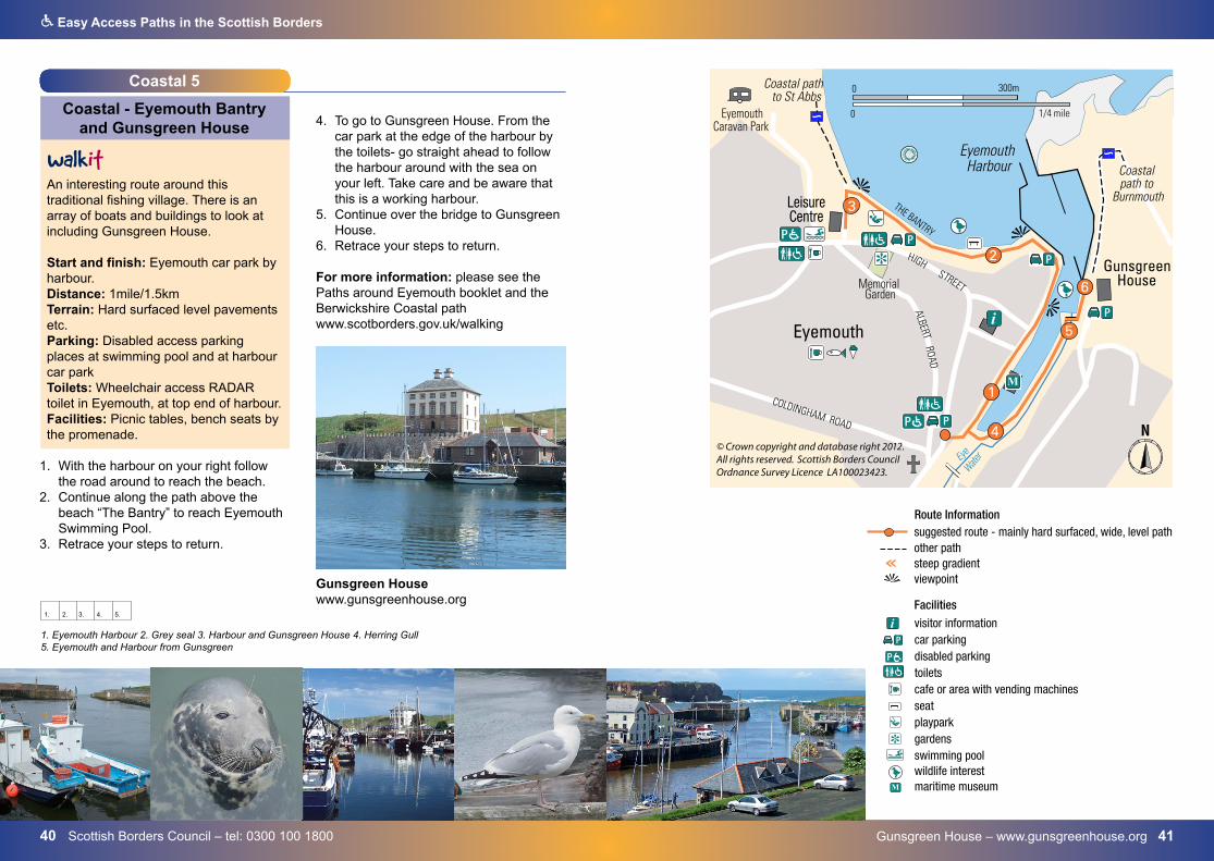
4. To go to Gunsgreen House. From thecar park at the edge of the harbour bythe toilets- go straight ahead to followthe harbour around with the sea onyour left. Take care and be aware thatthis is a working harbour.
5. Continue over the bridge to GunsgreenHouse.
6. Retrace your steps to return.
For more information: please see the Paths around Eyemouth booklet and the Berwickshire Coastal path www.scotborders.gov.uk/walking
i visitor informationcar parkingdisabled parkingtoiletscafe or area with vending machinesseatplayparkgardensswimming poolwildlife interestmaritime museum
suggested route - mainly hard surfaced, wide, level pathother pathsteep gradientviewpoint
Facilities
P
P
M
Route Information
1. Eyemouth Harbour 2. Grey seal 3. Harbour and Gunsgreen House 4. Herring Gull 5. Eyemouth and Harbour from Gunsgreen
1. 2. 3. 4. 5.
Coastal 5
Coastal - Eyemouth Bantry and Gunsgreen House
An interesting route around this traditional fishing village. There is an array of boats and buildings to look at including Gunsgreen House.
Start and finish: Eyemouth car park by harbour.Distance: 1mile/1.5km Terrain: Hard surfaced level pavements etc.Parking: Disabled access parking places at swimming pool and at harbour car park Toilets: Wheelchair access RADAR toilet in Eyemouth, at top end of harbour.Facilities: Picnic tables, bench seats by the promenade.
1. With the harbour on your right followthe road around to reach the beach.
2. Continue along the path above thebeach “The Bantry” to reach EyemouthSwimming Pool.
3. Retrace your steps to return.
Gunsgreen House www.gunsgreenhouse.org
4342 Paths around Jedburgh www.scotborders.gov.uk/walking
Q Easy Access Paths in the Scottish Borders
Woodland 1
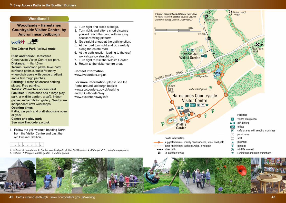
Woodlands - Harestanes Countryside Visitor Centre, by
Ancrum near Jedburgh
The Cricket Park (yellow) route
Start and finish: Harestanes Countryside Visitor Centre car park. Distance: 1mile/1.5km Terrain: Woodland paths, level hard surfaced paths suitable for many wheelchair users with gentle gradient and a few rough patches. Parking: 4 disabled access parking places. Free parking.Toilets: Wheelchair access toilet Facilities: Harestanes has a large play park, a wildlife garden, a café, indoor games and exhibition gallery. Nearby are independent craft workshops. Opening times: Paths, car park and craft shops are open all year. Centre and play park See www.liveborders.org.uk
1. Follow the yellow route heading Northfrom the Visitor Centre and past theold Cricket Pavillion.
2. Turn right and cross a bridge.3. Turn right, and after a short distance
you will reach the pond with an easyaccess viewing platform.
4. Go straight ahead at the path junction.5. At the road turn right and go carefully
along the estate road.6. At the path junction leading to the craft
workshops go straight on.7. Turn right to visit the Wildlife Garden8. Return to the visitor centre area.
Contact Information www.liveborders.org.uk
For more information: please see the Paths around Jedburgh booklet www.scotborders.gov.uk/walkingand St Cuthberts Waywww.stcuthbertsway.info
i visitor informationcar parkingtoiletscafe or area with vending machinespicnic areaseatplayparkgardenswildlife interestExhibitions and craft workshops
suggested route - mainly hard surfaced, wide, level pathother mainly hard surfaced, wide, level path other pathSt. Cuthbert’s Way
Facilities
P
Route Information
1. Walkers at Harestanes 2. On the woodland path 3. The Old Beeches 4. At the pond 5. Harestanes play area6. Walkers 7. Poppy in wildlife garden 8. Indoor games
1. 2. 3. 4. 5. 6. 7. 8.
www.scotborders.gov.uk/parks 4544 Scottish Borders Council – tel: 0300 100 1800
Q Easy Access Paths in the Scottish Borders
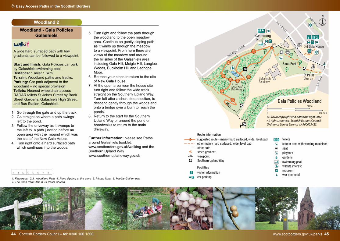
Woodland 2
Woodland - Gala Policies Galashiels
A wide hard surfaced path with low gradients can be followed to a viewpoint.
Start and finish: Gala Policies car park by Galashiels swimming pool.Distance: 1 mile/ 1.6km Terrain: Woodland paths and tracks.Parking: Car park adjacent to the woodland – no special provisionToilets: Nearest wheelchair access RADAR toilets St Johns Street by Bank Street Gardens, Galashiels High Street, and Bus Station, Galashiels.
1. Go through the gate and up the track.2. Go straight on where a path swings
left to the pond.3. Follow the driveway as it sweeps to
the left to a path junction before anopen area with the mound which wasthe site of the New Gala House.
4. Turn right onto a hard surfaced pathwhich continues into the woods.
5. Turn right and follow the path throughthe woodland to the open meadowarea. Continue on gently sloping pathas it winds up through the meadowto a viewpoint. From here there areviews of the meadow and aroundthe hillsides of the Galashiels areaincluding Gala Hill, Meigle Hill, LangleeWoods, Buckholm Hill and LadhopeMoor.
6. Retrace your steps to return to the siteof New Gala House.
7. At the open area near the house siteturn right and follow the wide trackstraight on the Southern Upland Way.Turn left after a short steep section, todescend gently through the woods andonto a bridge over a burn to reach theponds.
8. Return to the start by the SouthernUpland Way or around the pond onboardwalks to return to the maindriveway.
Further information: please see Paths around Galashiels booklet. www.scotborders.gov.uk/walking and the Southern Upland Way www.southernuplandway.gov.uk
i visitor informationcar parkingtoiletscafe or area with vending machinesseatplayparkgardensswimming poolwildlife interestmuseumwar memorial
suggested route - mainly hard surfaced, wide, level pathother mainly hard surfaced, wide, level path other pathsteep gradientviewpointSouthern Upland Way
Facilities
P
M
Route Information
+
1. Fingerpost 2,3. Woodland Path 4. Pond dipping at the pond 5. Inkcap fungi 6. Marble Gall on oak 7. The Scott Park Oak 8. St Pauls Church
1. 2. 3. 4. 5. 6. 7. 8.
i visitor informationcar parkingtoiletscafe or area with vending machinesseatplayparkgardensswimming poolwildlife interestmuseumwar memorial
suggested route - mainly hard surfaced, wide, level pathother mainly hard surfaced, wide, level path other pathsteep gradientviewpointSouthern Upland Way
Facilities
P
M
Route Information
+
The Hirsel www.dandaestates.co.uk 4746 Paths around Coldstream www.scotborders.gov.uk/walking
Q Easy Access Paths in the Scottish Borders
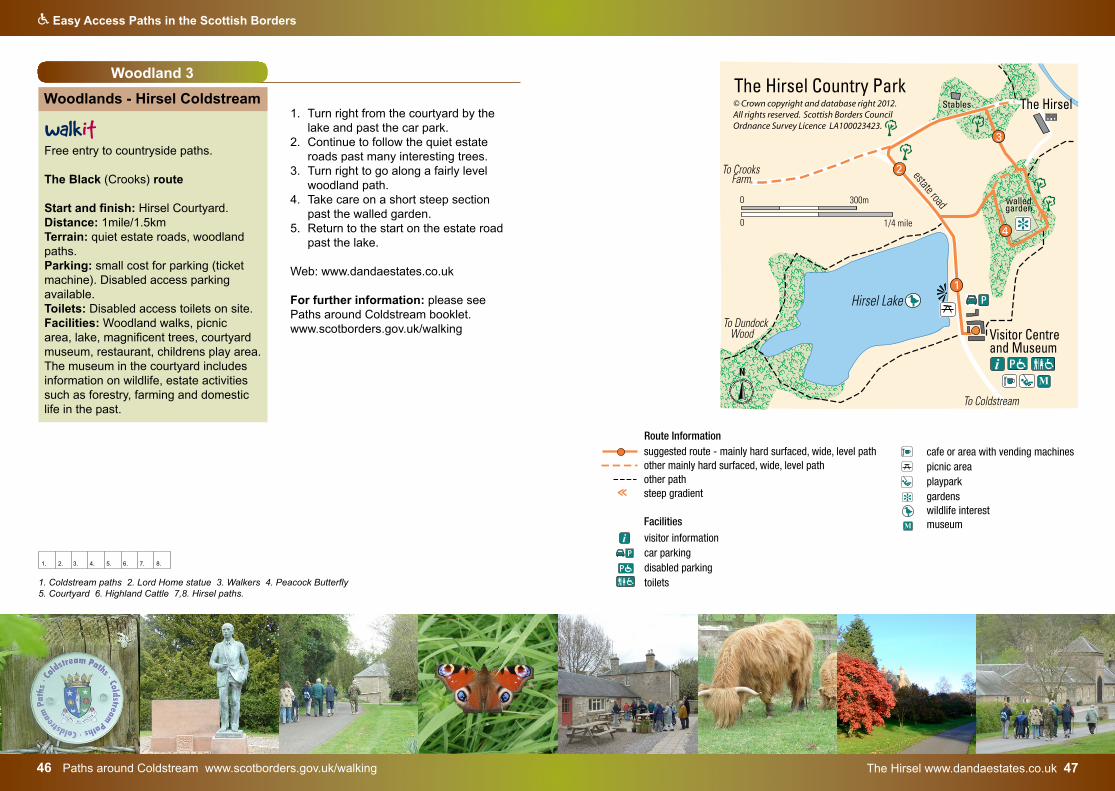
Woodland 3
Woodlands - Hirsel Coldstream
Free entry to countryside paths.
The Black (Crooks) route
Start and finish: Hirsel Courtyard.Distance: 1mile/1.5km Terrain: quiet estate roads, woodland paths.Parking: small cost for parking (ticket machine). Disabled access parking available.Toilets: Disabled access toilets on site.Facilities: Woodland walks, picnic area, lake, magnificent trees, courtyard museum, restaurant, childrens play area. The museum in the courtyard includes information on wildlife, estate activities such as forestry, farming and domestic life in the past.
1. Turn right from the courtyard by the lake and past the car park.
2. Continue to follow the quiet estate roads past many interesting trees.
3. Turn right to go along a fairly level woodland path.
4. Take care on a short steep section past the walled garden.
5. Return to the start on the estate road past the lake.
Web: www.dandaestates.co.uk
For further information: please see Paths around Coldstream booklet. www.scotborders.gov.uk/walking
i
i visitor informationcar parkingdisabled parkingtoiletscafe or area with vending machinespicnic areaplayparkgardenswildlife interestmuseum
suggested route - mainly hard surfaced, wide, level pathother mainly hard surfaced, wide, level path other pathsteep gradient
Facilities
P
P
M
Route Information
1. Coldstream paths 2. Lord Home statue 3. Walkers 4. Peacock Butterfly 5. Courtyard 6. Highland Cattle 7,8. Hirsel paths.
1. 2. 3. 4. 5. 6. 7. 8.
i visitor informationcar parkingdisabled parkingtoiletscafe or area with vending machinespicnic areaplayparkgardenswildlife interestmuseum
suggested route - mainly hard surfaced, wide, level pathother mainly hard surfaced, wide, level path other pathsteep gradient
Facilities
P
P
M
Route Information
www.bordersforesttrust.org 4948 Borders Forest Trust
Q Easy Access Paths in the Scottish Borders
car parkingpicnic areaseatwildlife interestwoodland sculpture
suggested route - mainly hard surfaced, wide, level pathother mainly hard surfaced, wide, level path other path
FacilitiesP
Route Information
Woodland 4
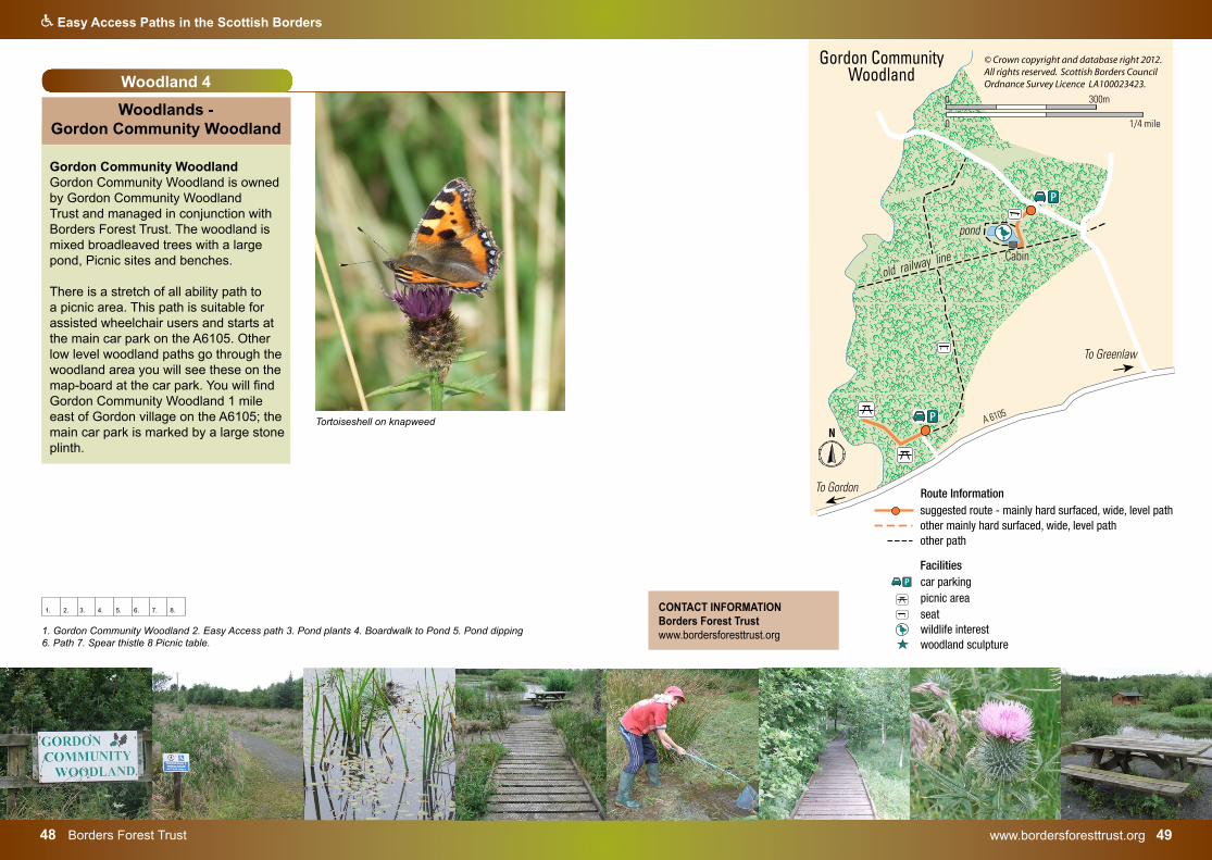
Woodlands - Gordon Community Woodland
Gordon Community Woodland Gordon Community Woodland is owned by Gordon Community Woodland Trust and managed in conjunction with Borders Forest Trust. The woodland is mixed broadleaved trees with a large pond, Picnic sites and benches.
There is a stretch of all ability path to a picnic area. This path is suitable for assisted wheelchair users and starts at the main car park on the A6105. Other low level woodland paths go through the woodland area you will see these on the map-board at the car park. You will find Gordon Community Woodland 1 mile east of Gordon village on the A6105; the main car park is marked by a large stone plinth.
1. Gordon Community Woodland 2. Easy Access path 3. Pond plants 4. Boardwalk to Pond 5. Pond dipping 6. Path 7. Spear thistle 8 Picnic table.
1. 2. 3. 4. 5. 6. 7. 8. CONTACT INFORMATION Borders Forest Trust www.bordersforesttrust.org
Tortoiseshell on knapweed
Dawyck Botanic Garden – www.rbge.org 5150 Borders Forest Trust – www.bordersforestrust.org
Q Easy Access Paths in the Scottish Borders
Woodland 5
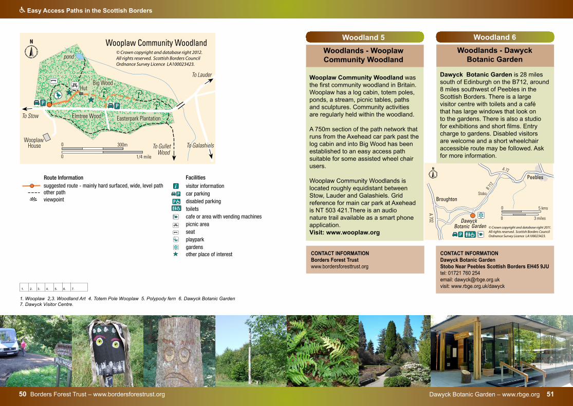
Woodlands - Wooplaw Community Woodland
Wooplaw Community Woodland was the first community woodland in Britain. Wooplaw has a log cabin, totem poles, ponds, a stream, picnic tables, paths and sculptures. Community activities are regularly held within the woodland.
A 750m section of the path network that runs from the Axehead car park past the log cabin and into Big Wood has been established to an easy access path suitable for some assisted wheel chair users.
Wooplaw Community Woodlands is located roughly equidistant between Stow, Lauder and Galashiels. Grid reference for main car park at Axehead is NT 503 421.There is an audio nature trail available as a smart phone application. Visit: www.wooplaw.org
1. Wooplaw 2,3. Woodland Art 4. Totem Pole Wooplaw 5. Polypody fern 6. Dawyck Botanic Garden 7. Dawyck Visitor Centre.
1. 2. 3. 4. 5. 6. 7.
CONTACT INFORMATION Borders Forest Trust www.bordersforesttrust.org
i visitor informationcar parkingdisabled parkingtoiletscafe or area with vending machinespicnic areaseatplayparkgardensother place of interest
suggested route - mainly hard surfaced, wide, level pathother pathviewpoint
Facilities
P
P
Route Information
Woodland 6
Woodlands - Dawyck Botanic Garden
Dawyck Botanic Garden is 28 miles south of Edinburgh on the B712, around 8 miles southwest of Peebles in the Scottish Borders. There is a large visitor centre with toilets and a café that has large windows that look on to the gardens. There is also a studio for exhibitions and short films. Entry charge to gardens. Disabled visitors are welcome and a short wheelchair accessible route may be followed. Ask for more information.
CONTACT INFORMATION Dawyck Botanic GardenStobo Near Peebles Scottish Borders EH45 9JU tel: 01721 760 254email: [email protected]: www.rbge.org.uk/dawyck
i visitor informationcar parkingdisabled parkingtoiletscafe or area with vending machinespicnic areaseatplayparkgardensother place of interest
suggested route - mainly hard surfaced, wide, level pathother pathviewpoint
Facilities
P
P
Route Information
Bowhill – www.bowhillhouse.co.uk 5352 Bowhill – 01750 22204
Q Easy Access Paths in the Scottish Borders
i visitor informationcar parkingdisabled parkingtoiletscafe or area with vending machinespicnic areaseatplayparkgardensother place of interest
suggested route - mainly hard surfaced, wide, level pathother pathviewpoint
Facilities
P
P
Route Information
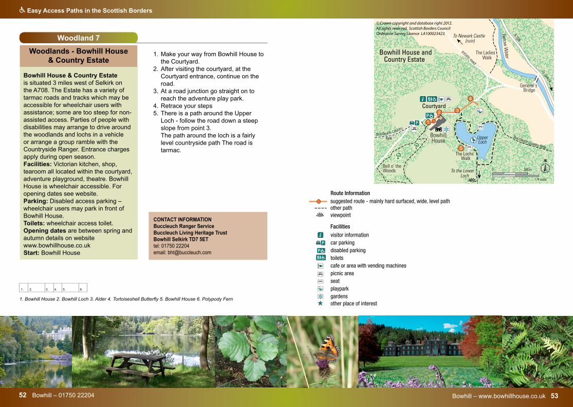
1. Bowhill House 2. Bowhill Loch 3. Alder 4. Tortoiseshell Butterfly 5. Bowhill House 6. Polypody Fern
CONTACT INFORMATION Buccleuch Ranger ServiceBuccleuch Living Heritage Trust Bowhill Selkirk TD7 5ETtel: 01750 22204 email: [email protected]
Woodland 7
Woodlands - Bowhill House & Country Estate
Bowhill House & Country Estate is situated 3 miles west of Selkirk on the A708. The Estate has a variety of tarmac roads and tracks which may be accessible for wheelchair users with assistance; some are too steep for non-assisted access. Parties of people with disabilities may arrange to drive around the woodlands and lochs in a vehicle or arrange a group ramble with the Countryside Ranger. Entrance charges apply during open season.Facilities: Victorian kitchen, shop, tearoom all located within the courtyard, adventure playground, theatre. Bowhill House is wheelchair accessible. For opening dates see website. Parking: Disabled access parking – wheelchair users may park in front of Bowhill House. Toilets: wheelchair access toilet. Opening dates are between spring and autumn details on website www.bowhillhouse.co.uk Start: Bowhill House
1. Make your way from Bowhill House tothe Courtyard.
2. After visiting the courtyard, at theCourtyard entrance, continue on theroad.
3. At a road junction go straight on toreach the adventure play park.
4. Retrace your steps5. There is a path around the Upper
Loch - follow the road down a steepslope from point 3.The path around the loch is a fairlylevel countryside path The road istarmac.
1. 2. 3. 4. 5. 6.
www.scotborders.gov.uk/parks 5554 Scottish Borders Council – tel: 0300 100 1800
Q Easy Access Paths in the Scottish Borders
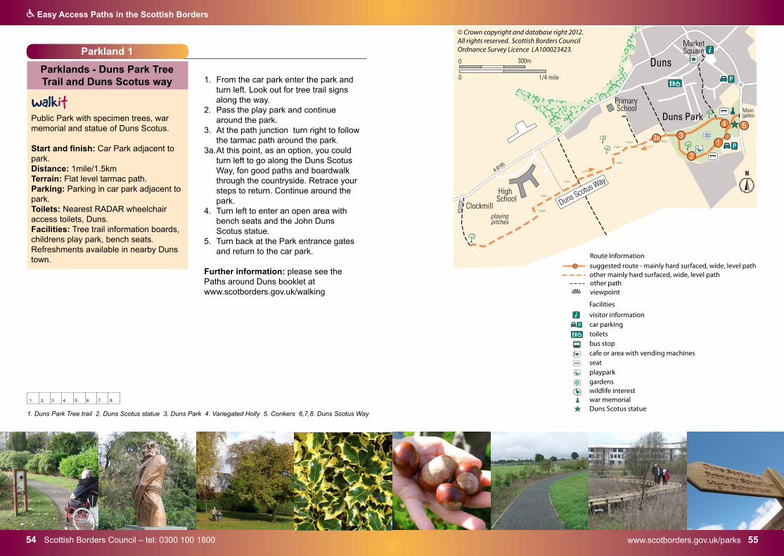
Parkland 1
Parklands - Duns Park Tree Trail and Duns Scotus way
Public Park with specimen trees, war memorial and statue of Duns Scotus.
Start and finish: Car Park adjacent to park. Distance: 1mile/1.5km Terrain: Flat level tarmac path.Parking: Parking in car park adjacent to park. Toilets: Nearest RADAR wheelchair access toilets, Duns. Facilities: Tree trail information boards, childrens play park, bench seats. Refreshments available in nearby Duns town.
1. From the car park enter the park andturn left. Look out for tree trail signsalong the way.
2. Pass the play park and continuearound the park.
3. At the path junction turn right to followthe tarmac path around the park.
3a. At this point, as an option, you could turn left to go along the Duns Scotus Way, fon good paths and boardwalk through the countryside. Retrace your steps to return. Continue around the park.
4. Turn left to enter an open area withbench seats and the John DunsScotus statue.
5. Turn back at the Park entrance gatesand return to the car park.
Further information: please see the Paths around Duns booklet at www.scotborders.gov.uk/walking
i visitor informationcar parkingtoiletsbus stopcafe or area with vending machinesseatplayparkgardenswildlife interestwar memorialDuns Scotus statue
suggested route - mainly hard surfaced, wide, level pathother mainly hard surfaced, wide, level path
Facilities
+
P
Route Information
other pathviewpoint
1. Duns Park Tree trail 2. Duns Scotus statue 3. Duns Park 4. Variegated Holly 5. Conkers 6,7,8. Duns Scotus Way
1. 2. 3. 4. 5. 6. 7. 8.
5756 Paths around Duns booklet at www.scotborders.gov.uk/walking
Q Easy Access Paths in the Scottish Borders
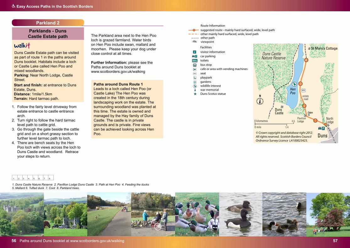
Parkland 2
Parklands - Duns Castle Estate path
Duns Castle Estate path can be visited as part of route 1 in the paths around Duns booklet. Habitats include a loch or Castle Lake called Hen Poo and mixed woodlands.Parking: Near North Lodge, Castle Street.
Start and finish: at entrance to Duns Estate, Duns. Distance: 1mile/1.5km Terrain: Hard tarmac path.
1. Follow the fairly level driveway fromestate entrance to castle entrancearch.
2. Turn right to follow the hard tarmaclevel path to cattle grid.
3. Go through the gate beside the cattlegrid and on a short grassy section tofurther level tarmac path to loch.
4. There are bench seats by the HenPoo loch with views across the loch toDuns Castle and woodland. Retraceyour steps to return.
The Parkland area next to the Hen Poo loch is grazed farmland. Water birds on Hen Poo include swan, mallard and moorhen. Please keep your dog under close control at all times.
Further Information: please see the Paths around Duns booklet at www.scotborders.gov.uk/walking
i visitor informationcar parkingtoiletsbus stopcafe or area with vending machinesseatplayparkgardenswildlife interestwar memorialDuns Scotus statue
suggested route - mainly hard surfaced, wide, level pathother mainly hard surfaced, wide, level path
Facilities
+
P
Route Information
other pathviewpoint
1. Duns Castle Nature Reserve 2. Pavillion Lodge Duns Castle 3. Path at Hen Poo 4. Feeding the ducks 5. Mallard 6. Tufted duck 7. Coot 8. Parkland trees.
1. 2. 3. 4. 5. 6. 7. 8.
Paths around Duns Route 1Leads to a loch called Hen Poo (or Castle Lake) The Hen Poo was created in the 18th century during landscaping work on the estate. The surrounding woodland was planted at this time. The estate is owned and managed by the Hay family of Duns Castle. The castle is in private grounds and is private. Fine views can be achieved looking across Hen Poo.
Teviotdale Leisure Centre – www.liveborders.org.uk 5958 www.scotborders.gov.uk/parks
Q Easy Access Paths in the Scottish Borders
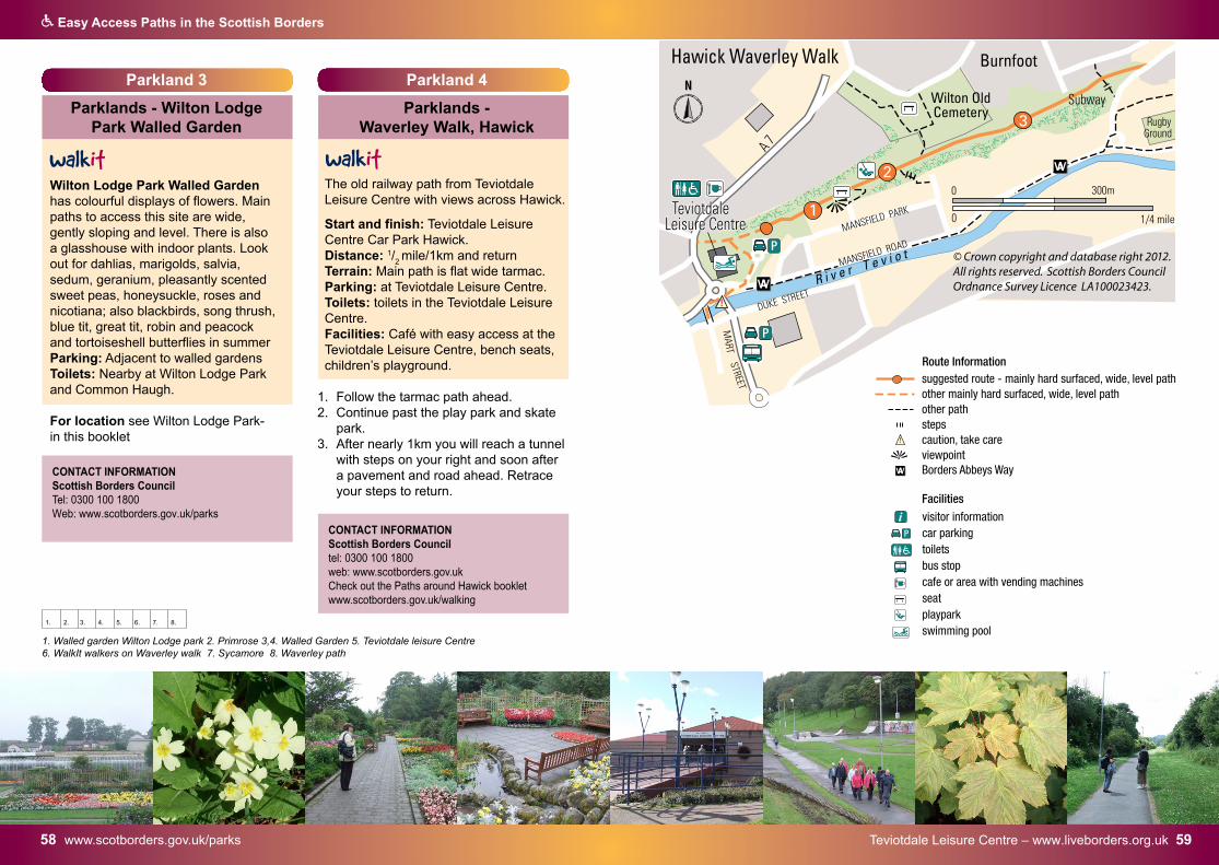
Parkland 4
Parklands - Waverley Walk, Hawick
The old railway path from Teviotdale Leisure Centre with views across Hawick.
Start and finish: Teviotdale Leisure Centre Car Park Hawick.Distance: 1/
2 mile/1km and return
Terrain: Main path is flat wide tarmac.Parking: at Teviotdale Leisure Centre.Toilets: toilets in the Teviotdale Leisure Centre.Facilities: Café with easy access at the Teviotdale Leisure Centre, bench seats, children’s playground.
1. Follow the tarmac path ahead.2. Continue past the play park and skate
park.3. After nearly 1km you will reach a tunnel
with steps on your right and soon aftera pavement and road ahead. Retraceyour steps to return.
1. Walled garden Wilton Lodge park 2. Primrose 3,4. Walled Garden 5. Teviotdale leisure Centre 6. WalkIt walkers on Waverley walk 7. Sycamore 8. Waverley path
1. 2. 3. 4. 5. 6. 7. 8.
Parkland 3
Parklands - Wilton Lodge Park Walled Garden
Wilton Lodge Park Walled Garden has colourful displays of flowers. Main paths to access this site are wide, gently sloping and level. There is also a glasshouse with indoor plants. Look out for dahlias, marigolds, salvia, sedum, geranium, pleasantly scented sweet peas, honeysuckle, roses and nicotiana; also blackbirds, song thrush, blue tit, great tit, robin and peacock and tortoiseshell butterflies in summer Parking: Adjacent to walled gardens Toilets: Nearby at Wilton Lodge Park and Common Haugh.
For location see Wilton Lodge Park-in this booklet
wA
i visitor informationcar parkingtoiletsbus stopcafe or area with vending machinesseatplayparkswimming pool
suggested route - mainly hard surfaced, wide, level pathother mainly hard surfaced, wide, level path other pathstepscaution, take careviewpoint
Facilities
P
Route Information
Borders Abbeys WayCONTACT INFORMATION Scottish Borders Council Tel: 0300 100 1800Web: www.scotborders.gov.uk/parks
CONTACT INFORMATION Scottish Borders Council tel: 0300 100 1800web: www.scotborders.gov.ukCheck out the Paths around Hawick booklet www.scotborders.gov.uk/walking
Dumfries and Borders Forest District 6160 Dumfries and Borders Forest District
Q Easy Access Paths in the Scottish Borders
Forest 1
Forestry and Land Scotland Glentress Forest
There is public access to all Forestry and Land Scotland managed forests across the Scottish Borders. A selection of trails are included here which are designed for those with limited mobility, wheelchair users and families with buggies.Visit: www.forestryandlandscotland.gov.scot Forest and Land Scotland Sites in the Tweed Valley
Glentress Forest near Peebles: The Ponds Trail is an easy access stroll around the upper ponds at Glentress with plenty of seating and lots of wildlife spotting opportunities en route. Also there is a brass rubbings nature trail.
Start and finish: Falla Brae (Red Squirrel) Car Park.Distance: 1/2 mile/0.6 km Terrain: Woodland paths. Parking: Disabled access parking at the Falla Brae (Red Squirrel) car park, parking charges apply. Toilets: Wheelchair access toilet at car park.
1. Leave the Car park entrance andfollow the road to the left for a shortdistance.
2. Follow the path around the pond.There is one steep section near thefar end of the top pond. There areaccessible picnic tables along thepath.
The Tweed Valley Wild Watch Osprey Viewing Centres at Glentress Peel and Kailzie Gardens are both accessible to all users. They include live remote osprey viewing facilities. Both sites also have café/restaurant and wildlife interpretation. Parking charges apply.
www.tweedvalleyospreys.com
P
visitor informationcar parkingdisabled parkingtoiletscafepicnic areaseatwildlife interest
suggested route - mainly hard surfaced, wide, level pathother pathviewpoint
Facilities
P
Route Information
i
1,2. Ponds trail 3. Glentress Peel 4. Picnic tables at Glentress 5. logs 6. Forest trees 7. Glentress Peel 8. Osprey
CONTACT INFORMATION Forestry and Land Scotland Recreation TeamDumfries and Borders Forest District Tel: 0300 067 6900www.forestryandland.gov.scot
1. 2. 3. 4. 5. 6. 7. 8.
Dumfries and Borders Forest District 6362 Dumfries and Borders Forest District
Q Easy Access Paths in the Scottish Borders
Forest 2
Forestry and Land Scotland Thornielee Meadows trail
Thornielee Forest near Clovenfords is 5 miles west of Galashiels on the A72 between Clovenfords and Walkerburn. The Meadow trailDistance: 1/2 mile/1km This is an easy access trail, offering lovely views over the River Tweed and is a hotspot for butterflies during the summer months. Facilities: Picnic area, Muckle Moothed Meg sculpture by Rob Taylor.Parking: is available adjacent to the sculpture - no special provision.Toilets: nearest wheelchair access
visitor informationcar parkingpicnic area‘Muckle Mouth Meg’ sculpture
suggested route - mainly hard surfaced, wide, level pathother pathviewpoint
Facilities
P
Route Information
i
Forest 3
Forestry and Land Scotland Burnside Trail Craik Forest
Easy Access Path
Craik Forest near Hawick is located approximately 7 miles south of Hawick. Take the Roberton road from the A7 and enjoy the scenic drive through farmland and forestry.
The Burnside Trail follows the Borthwick Water from the lower car park.
Start and finish: Large car park area with picnic tables near stream and ponds.Distance: 1/4 mile/0.4km Terrain: Flat level hard and wide forest paths.
Facilities: Forest walk, picnic area, stream, ponds, information.Parking: Large car park with ample parking adjacent to picnic area and path.Toilets: Easy access toilets in forest.
1. Take the path beside the burn.2. At a path junction go right through the
forest trees.3. Continue back to the car park and
picnic area.
toiletscar parkingpicnic area
suggested route - mainly hard surfaced, wide, level pathother pathviewpoint
Facilities
P
Route Information
CONTACT INFORMATION Forestry and Land Scotland Recreation Team Dumfries and Borders Forest DistrictTel: 0300 067 6900www.forestryandland.gov.scot
CONTACT INFORMATION Forestry and Land ScotlandRecreation Team Dumfries and Borders Forest District tel: 0300 067 6900www.forestryandland.gov.scot
Dumfries and Borders Forest District 6564 Dumfries and Borders Forest District
Q Easy Access Paths in the Scottish Borders
Forest 4
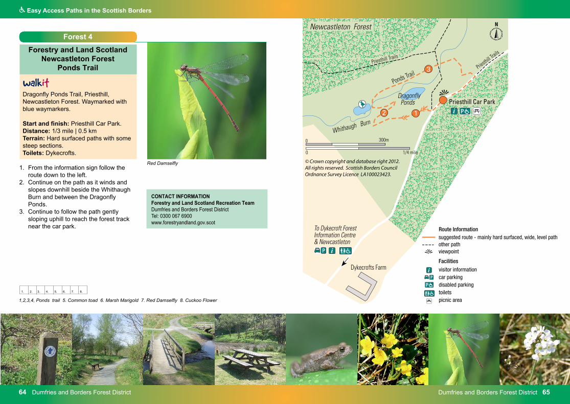
Forestry and Land Scotland Newcastleton Forest
Ponds Trail
Dragonfly Ponds Trail, Priesthill, Newcastleton Forest. Waymarked with blue waymarkers.
Start and finish: Priesthill Car Park. Distance: 1/3 mile | 0.5 km Terrain: Hard surfaced paths with some steep sections. Toilets: Dykecrofts.
1. From the information sign follow theroute down to the left.
2. Continue on the path as it winds andslopes downhill beside the WhithaughBurn and between the DragonflyPonds.
3. Continue to follow the path gentlysloping uphill to reach the forest tracknear the car park.
P
visitor informationcar parkingdisabled parkingtoiletspicnic area
suggested route - mainly hard surfaced, wide, level pathother pathviewpoint
Facilities
P
Route Information
i
1,2,3,4, Ponds trail 5. Common toad 6. Marsh Marigold 7. Red Damselfly 8. Cuckoo Flower
1. 2. 3. 4. 5. 6. 7. 8.
CONTACT INFORMATION Forestry and Land Scotland Recreation Team Dumfries and Borders Forest District Tel: 0300 067 6900www.forestryandland.gov.scot
Red Damselfly
Q Easy Access Paths in the Scottish Borders
www.scotborders.gov.uk/parks 6766 Scottish Borders Council – tel: 0300 100 1800
Contact Information
Access & Countryside TeamScottish Borders CouncilRegulatory ServicesCouncil HeadquartersNewtown St BoswellsMELROSETD6 0SA Tel: 01896 825070email: [email protected]
Scottish Borders Council information on sites and activities:www.scotborders.gov.ukwww.scotborders.gov.uk/walkingwww.scotborders.gov.uk/countrywalks www.scotborders.gov.uk/biodiversitywww.scotborders.gov.uk/parksWalkIt Paths to Health Project in the Scottish Borderswww.scotborders.gov.uk/Walk ItWalk [email protected]
Contact Information for general easy access:The Borders Disability Forum Countryside with easy access website includes information on more than 40 locations in the Scottish Borders. It is updated after site visits by disabled path users. The locations listed all have countryside interest and either free of charge or minimal parking charge.http://onlineborders.org.uk/community/bdf http://onlineborders.org.uk/community/bdfc
Traveline Scotland (for public transport information)Tel: 0871 200 2233 www.travelinescotland.com
Toilets - National Key SchemeThere are RADAR and wheelchair access public toilets in a number of Scottish Borders villages and towns: Selkirk, St Mary’s Loch, Peebles, Innerleithen, Broughton, Newtown St Boswells, St Boswells, Melrose, Lauder, Kelso, Town Yetholm, Jedburgh, Hawick, Greenlaw, Newcastleon, Galashiels, Eyemouth, Earlston, Duns, Coldstream, Cocksburnpath, and Chirnside.
Local information from:Scottish Borders Council Newtown St Boswells Tel: 0300 100 1800 Look up toilets at www.scotborders.gov.uk RADAR Scheme details from:Disability Rights UK0203 687 0790RADAR key available [email protected]
Visitor Information Centre - Jedburgh Gives information on countryside locationsLocal accommodation and accessible accommodation. Holds a RADAR key for visitors
The following information is available from Visitor Information Centres: Practical Information for Visitors with Disabilities to ScotlandPublished by the Scottish Tourist Board Scottish Borders Tourist Board Fact Files Places of interest - information for Disabled VisitorsAccessible Accommodation
Building design Technical advice regarding access for disabled visitors may be obtained through reference to “The Disabled Access Design Guide”produced by Scottish Borders Council (Building Control) Tel: 0300 100 1800
Tourism and accommodation:www.visitscotland.com look up Scottish Borders [email protected]
Forestry organisations:Forestry and Land Scotland RecreationTeamDumfries and Borders Forest District Tel: 0300 067 6900www.forestryandland.gov.scot
Borders Forest Trustwww.bordersforesttrust.org
Natural Heritage information:Nature ScotlandOutdoor Access CodeLothian & Borders Area Office Tel: 01896 756652www.outdooraccess-scotland.scot Riverswww.tweedforum.com
Built Heritage information:There are Town Trails in most Borders towns. Parts of most trails will be on level pavements however they may not be easy access. The trails take about 2 hours to complete and are an excellent way to discover the towns. It provides an added dimension of local history and flavour of the town’s development through time.
Full Town Trail guides are available from Visit Scotland or online atwww.scotborders.gov.uk/walking
Abbeys - Jedburgh, Melrose, Kelso, Dryburgh historic locations. www.historic-scotland.gov.uk
Scottish Borders Heritage www.scottishbordersheritage.co.ukwww.scotborders.gov.uk/archaeologywww.canmore.org.uk
AcknowledgementsSome of the routes, waymarking and information in this booklet was provided and developed in cooperation with the land managers, owners and farmers whose land they cross. Their co-operation is gratefully acknowledged. Funding for signage etc on some routes came from the European Union whose assistance is also acknowledged.
Every effort has been made to ensure that the information and advice contained in this booklet is correct at the date of publication. However, it is always for you to assess whether completing a route is within your capability, using your common sense and your knowledge of your own state of health and fitness, competence and experience. No liability is accepted by the authors or publishers for any loss, injury or damage, arising out of, or in any way connected with, any person or persons undertaking or attempting to undertake any of the routes described in this booklet, howsoever caused.
www.scotborders.gov.uk/parks – www.fwlp.co.uk 68
All text, photographs and maps in this publication are copyright. Photographs by Erica Niven, Susan Kevan, Keith Robeson, Laura Aitken, Andy Murray, Lisa Cole, Graeme Stewart,
Diane Bennet, Sandra Towers, Forestry Commission and Scottish Borders Council. Maps designed and drawn by David Langworth. Adapted maps are reproduced by permission of Ordnance Survey
on behalf of HMSO ©Crown copyright and database right 2013. All rights reserved. Scottish Borders Council Ordnance Survey Licence LA100023423
Designed by Scottish Borders Council Graphic Design Section. Printed 2005, Revised reprinted in the Scottish Borders 2013.Revision for web 2021.
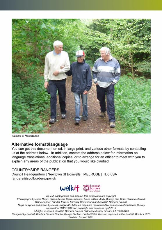
Walking at Harestanes
Alternative format/language You can get this document on cd, in large print, and various other formats by contacting us at the address below. In addition, contact the address below for information on language translations, additional copies, or to arrange for an officer to meet with you to explain any areas of the publication that you would like clarified.
COUNTRYSIDE RANGERS Council Headquarters | Newtown St Boswells | MELROSE | TD6 0SA [email protected]