2016 - Scottish Borders Council
375
2016 VOL2SETTLEMENTS SCOTTISH BORDERS COUNCIL LOCAL DEVELOPMENT PLAN
-
Upload
khangminh22 -
Category
Documents
-
view
2 -
download
0
Transcript of 2016 - Scottish Borders Council

2016
VOL2
SETT
LEM
ENTS
SCOTTISH BORDERS COUNCIL LOCAL DEVELOPMENT PLAN

188 | LOCAL DEVELOPMENT PLAN | SCOTTISH BORDERS COUNCIL
CONTENTSLOCAL DEVELOPMENT PLAN
VOLUME 1 – POLICIES
FOREWORD 3
1. INTRODUCTION 5
2. MEETING THE CHALLENGES FOR THE SCOTTISH BORDERS 9
3. VISION, AIMS AND SPATIAL STRATEGY 15 4. LOCAL DEVELOPMENT PLAN POLICIES 21 POLICY CONTENT 21 POLICIES 23 PLACE MAKING AND DESIGN (PMD) 23 ECONOMIC DEVELOPMENT (ED) 33 HOUSING DEVELOPMENT (HD) 67 ENVIRONMENTAL PROMOTION AND PROTECTION (EP) 78 INFRASTRUCTURE AND STANDARDS (IS) 114
APPENDIX 1: SETTLEMENT APPRAISAL METHODOLOGY 143 APPENDIX 2: MEETING THE HOUSING LAND REQUIREMENT 147 APPENDIX 3: SUPPLEMENTARY GUIDANCE AND STANDARDS 159 APPENDIX 4: PUBLICITY AND CONSULTATION 167 APPENDIX 5: COUNCIL OWNED SITES 181
VOLUME 2 – SETTLEMENTS
5. POLICY MAPS & SETTLEMENT PROFILES WITH MAPS 189

5. POLICY MAPS & SETTLEMENT PROFILES WITH MAPS
INTRODUCTION | CHALLENGES | VISION, AIMS AND SPATIAL STRATEGYPOLICIES | APPENDICES | SETTLEMENTS
LOCAL DEVELOPMENT PLAN | SCOTTISH BORDERS COUNCIL | 189
SCOTTISH BORDERS COUNCIL LOCAL DEVELOPMENT PLAN 2016

190 | LOCAL DEVELOPMENT PLAN | SCOTTISH BORDERS COUNCIL
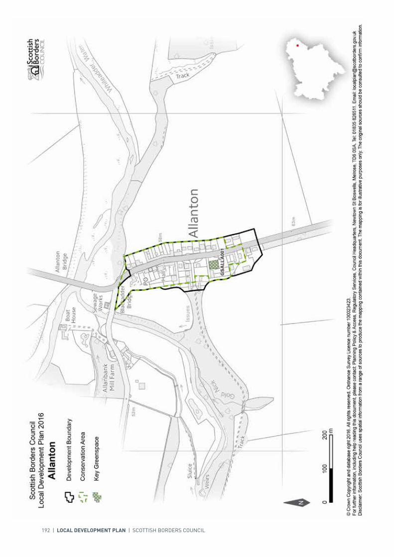
SETTLEMENT PROFILE ALLANTON
This profile should be read in conjunction with the relevant settlement map.
DESCRIPTION
Allanton is located just over 7 miles from Duns and just under 10 miles from Berwick-upon-Tweed. The population of Allanton in the 2001 Census was 86. The village is located within the Eastern Strategic Development Area (SDA) as defined by the SESplan.
PLACE MAKING CONSIDERATIONSAllanton is located above the riverbanks of the Blackadder Water and Whiteadder Water which meet just north of the village. The character of Allanton is largely defined by the fact that it developed as an estate village of Blackadder House; splay fronted lodges display the old entrance and the village has developed around them in a linear fashion along the road.
The Conservation Area has distinctive characteristics and their retention is important when considering alterations. The uniformity resulting from use of local whin and sandstone for buildings and boundary walls, and natural slate for roofs is important. There are 17 Listed properties within Allanton, with a number of significant buildings.
There is no land proposed for development within Allanton in the period of this Local Development Plan. However the village is located within the Eastern SDA and development could potentially take place in the future. Development to the north and west would be constrained by flood risk and the River Tweed Special Area of Conservation. Other considerations would be the belt of ancient woodland; the surrounding prime agricultural land; and the lack of services in the village.
INFRASTRUCTURE CONSIDERATIONSAffordable Housing will require to be provided in association with proposed housing sites under the provisions of Policy HD1 and the Supplementary Guidance/ Supplementary Planning Guidance on Affordable Housing.
A contribution towards Berwickshire High School will be sought to supplement Scottish Borders Council’s investment in the new school which opened in 2009-2010 under the 3 High Schools project.
With regards to Waste Water Treatment Works, Allanton has limited capacity. Contributions may be required where upgrades are necessary. In respect of the local water network, developers may be required to contribute towards upgrading to enable development.

INTRODUCTION | CHALLENGES | VISION, AIMS AND SPATIAL STRATEGYPOLICIES | APPENDICES | SETTLEMENTS
LOCAL DEVELOPMENT PLAN | SCOTTISH BORDERS COUNCIL | 191
Further information is available from the Supplementary Guidance/ Supplementary Planning Guidance on Developer Contributions.
DEVELOPMENT AND SAFEGUARDING PROPOSALS
KEY GREENSPACE
SITE REFERENCE SITE NAME SITE SIZE (HA)
GSALLA001 Allanton Play Area 0.1
192 | LOCAL DEVELOPMENT PLAN | SCOTTISH BORDERS COUNCIL

INTRODUCTION | CHALLENGES | VISION, AIMS AND SPATIAL STRATEGYPOLICIES | APPENDICES | SETTLEMENTS
LOCAL DEVELOPMENT PLAN | SCOTTISH BORDERS COUNCIL | 193
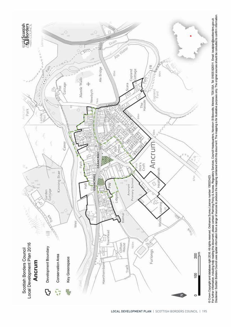
SETTLEMENT PROFILE ANCRUM
This profile should be read in conjunction with the relevant settlement map.
DESCRIPTIONAncrum is situated 4 miles to the north west of Jedburgh. The population of Ancrum is 392 (2001 Census). It is located within the Central Borders Strategic Development Area as defined in the SESplan.
PLACE MAKING CONSIDERATIONSAncrum is contained by a bend of the Ale Water - part of the River Tweed Special Area of Conservation and a wildlife site of international importance - from which its name is derived. The Teviot Valleys Special Landscape Area surrounds the boundaries of the village. The historic core of Ancrum is characterised by its triangular centre set around a raised tree-lined village green. This part of the village is designated as a Conservation Area, and includes a group of caves on the south bank of the river. These may have been used as early as the middle of the 16th century.
The properties surrounding the historic green are mainly one and a half or two storeys in height. Of particular note are the 16th century Market Cross (a Scheduled Monument), the War Memorial, the Cross Keys Public Bar and the Parish Church. Most properties are constructed of traditional materials - predominantly sandstone, whinstone and harling walls, and slate roofs. Architectural detailing includes continuous cills at upper floors, sash and case windows, and stone cills, jambs and lintels around window and door openings. New development or alterations should respect the individual buildings and Conservation Area and designs should take account of traditional features.
Development outside the Conservation Area is mainly of semi detached rendered houses, with the most recent expansion taking place at Myrescroft on the southern edge of the village.
The village green is identified as a key green space along with ground adjacent to the Church.
The preferred areas for future expansion beyond the period of this Local Development Plan will be to the south west of Ancrum. Development to the north, north-west and east of the settlement will be resisted. The suggested area is indicative only, and will require further detailed assessment during the next Local Development Plan review.
194 | LOCAL DEVELOPMENT PLAN | SCOTTISH BORDERS COUNCIL
INFRASTRUCTURE CONSIDERATIONSAffordable Housing will require to be provided as part of any new housing development under the provision of Policy HD1 and the Supplementary Guidance/ Supplementary Planning Guidance on Affordable Housing.
There is no requirement for contribution towards education provision.
With regards to Waste Water Treatment Works, Ancrum has limited capacity. Contributions may be required where upgrades are necessary. In respect of the local water network, developers may be required to contribute towards upgrading to enable development.
Further information is available from Supplementary Guidance/ Supplementary Planning Guidance on Developer Contributions and Planning/Development Briefs where applicable.
DEVELOPMENT AND SAFEGUARDING PROPOSALS
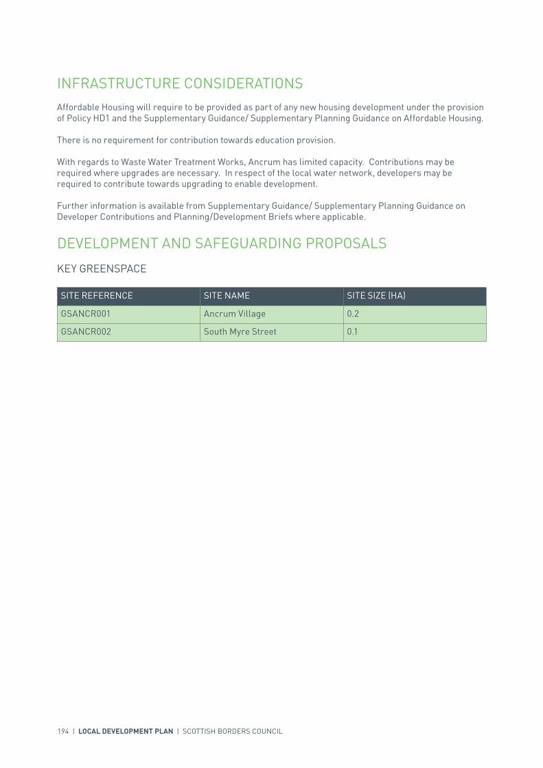
KEY GREENSPACE
SITE REFERENCE SITE NAME SITE SIZE (HA)
GSANCR001 Ancrum Village 0.2
GSANCR002 South Myre Street 0.1
LOCAL DEVELOPMENT PLAN | SCOTTISH BORDERS COUNCIL | 195

196 | LOCAL DEVELOPMENT PLAN | SCOTTISH BORDERS COUNCIL
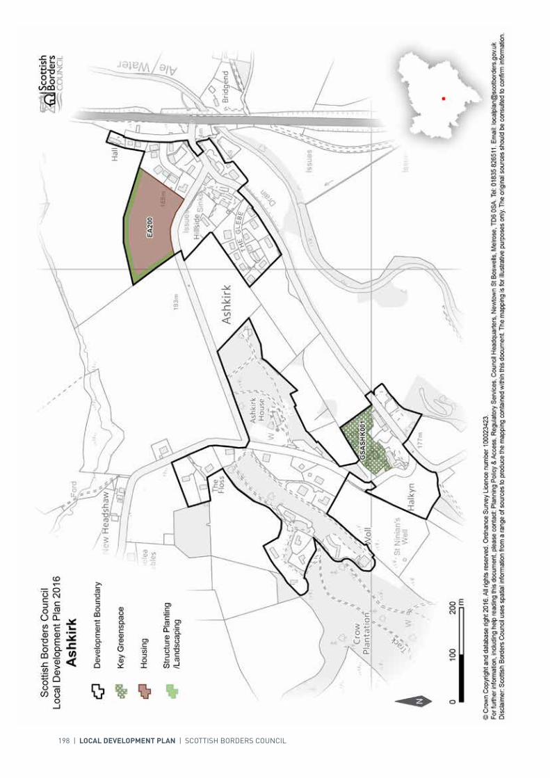
SETTLEMENT PROFILE ASHKIRK
This profile should be read in conjunction with the relevant settlement map.
DESCRIPTIONAshkirk is located 5 miles south of Selkirk, just off the A7 trunk road. The population is 107 (2001 Census). The village is located within the Central Borders Strategic Development Area as defined in the SESplan.
PLACE MAKING CONSIDERATIONSAshkirk comprises two clusters of buildings separated by open farmland; one beside the A7 and the other around the church, including the mansion houses of the Woll and Ashkirk House. Separation between the two parts of the settlement is important to maintain their distinct identities. The Ale Water, which lies to the south of the settlement, is part of the River Tweed Special Area of Conservation, a wildlife site of international importance. The character of Ashkirk is established by its setting in the wooded upland fringe valley of the Ale Water.
There is one area, at the Church, identified as key greenspace.
There are some opportunities for small scale infill development within the settlement boundary. Development at risk of flooding from the Ale Water will be resisted. The Plan does not identify any areas for future expansion beyond the period of this Local Development Plan.
INFRASTRUCTURE CONSIDERATIONSAffordable Housing will require to be provided under the provisions of Policy HD1 and the Supplementary Guidance/ Supplementary Planning Guidance on Affordable Housing.
There is no requirement for contribution towards education provision.
The settlement falls within an area identified for a contribution to the Borders Railway Project (see Policy IS3).
With regards to Waste Water Treatment Works, Ashkirk has limited capacity. Contributions may be required where upgrades are necessary. In respect of the local water network, developers may be required to contribute towards upgrading to enable development.
INTRODUCTION | CHALLENGES | VISION, AIMS AND SPATIAL STRATEGYPOLICIES | APPENDICES | SETTLEMENTS
LOCAL DEVELOPMENT PLAN | SCOTTISH BORDERS COUNCIL | 197
Further information is available from Supplementary Guidance/Supplementary Planning Guidance on Developer Contributions and Planning/Development Briefs where applicable.
DEVELOPMENT AND SAFEGUARDING PROPOSALS
HOUSING
SITE REFERENCE SITE NAME SITE SIZE (HA) SITE CAPACITY
EA200 Cransfield 2.0 12
Site Requirements
• Vehicular access from the minor road to the south of the site with the requirement for visibility improvements
• Pedestrian link to be provided from site to village• Structural landscaping along the northern and western perimeter• Retain hedge along road frontage where possible and enhance landscape through planting of small
trees• The design and layout of the new buildings should also take advantage of the southerly aspect of the
site to make best use of the microclimate to reduce energy usage.
SITE REFERENCE SITE NAME SITE SIZE (HA)
GSASHK001 Ashkirk Church 0.7
KEY GREENSPACE
198 | LOCAL DEVELOPMENT PLAN | SCOTTISH BORDERS COUNCIL

INTRODUCTION | CHALLENGES | VISION, AIMS AND SPATIAL STRATEGYPOLICIES | APPENDICES | SETTLEMENTS
LOCAL DEVELOPMENT PLAN | SCOTTISH BORDERS COUNCIL | 199
SETTLEMENT PROFILE AYTON
This profile should be read in conjunction with the relevant settlement map.
DESCRIPTIONAyton is located 2.5 miles south-west of Eyemouth and just less than 8 miles from Berwick-upon-Tweed. The population of Ayton according to the 2001 Census was 557. It is located within the Eastern Strategic Development Area (SDA) as defined by the SESplan.
PLACE MAKING CONSIDERATIONSThe setting of Ayton is characterised by its position within the lower Eye Water coastal valley, with the river running to the south west of the settlement. In addition the designed landscape of Ayton Castle is a significant influence on the urban fabric. The Castle is not directly evident from the town however the planting associated with the designed landscape can be seen on its eastern edge. Ayton has developed westward, away from the grounds of the Castle, along the High Street, and modern housing development has been built off this road and also along Beanburn.
The Ayton Conservation Area is made-up of historic properties on the High Street, Beanburn, Tower Road and part of The Crofts. A range of different building types can be found including detached villa style properties and properties built in rows. Any alterations or new development within the Conservation Area should seek to respect individual buildings and the wider character. There are 20 Listed Buildings within the Conservation Area.
Ayton Castle Garden and Designed Landscape will be protected from development, which constrains building to the east. The remaining land surrounding Ayton is prime agricultural land.
Ayton has two housing sites which have been allocated in previous Local Plans and are not yet fully developed. As a result there is no further land in Ayton allocated for development in this Local Development Plan (LDP). However, Ayton is located within the Eastern SDA and there is potential for development beyond the period of this LDP. If this was to occur the preferred location would be to the north-west of the settlement but there would be the need for further investigation of infrastructure to assess feasibility.
INFRASTRUCTURE CONSIDERATIONSAffordable Housing will require to be provided in association with proposed housing sites under the provisions of Policy HD1 and the Supplementary Guidance/ Supplementary Planning Guidance on Affordable Housing.

200 | LOCAL DEVELOPMENT PLAN | SCOTTISH BORDERS COUNCIL
A contribution towards Eyemouth High School will be sought to supplement Scottish Borders Council’s investment in the new school which opened in 2009-2010 under the 3 High Schools project.
With regards to Waste Water Treatment Works and Water Treatment Works, Ayton currently has sufficient capacity.
Further information is available from Supplementary Guidance/Supplementary Planning Guidance on Developer Contributions and Planning Briefs where applicable.
DEVELOPMENT AND SAFEGUARDING PROPOSALS
HOUSING
SITE REFERENCE SITE NAME SITE SIZE (HA) INDICATIVE SITE CAPACITY
AAYTO003 Lawfield 1.3 20
Site Requirements
• Vehicular access from housing allocation AY1A to the south west• Provide a pedestrian/cycle link to Lawfield Drive/Primary School• Leave the possibility for future road links to land to the north west• Structure planting/landscaping should be provided to the north and south west, to reinforce the
settlement boundary and safeguard the amenity of adjacent houses• The long term maintenance of landscaped areas must be addressed• Archaeological evaluation and mitigation required as the site is in an archaeologically sensitive area• Evaluation and mitigation of moderate biodiversity interest, including hedgerows, breeding birds and
grassland, required. The existing hedgerows should be conserved and extended• Site design should utilise the south facing aspect for energy efficiency• A flood risk assessment is required to inform the site layout, design and mitigation.
AY1A Beanburn 1.5 24
Site Requirements
• Vehicular access to be taken from B6955, extending existing access• Provide a pedestrian/cycle link to the Primary School• Evaluation and mitigation of moderate biodiversity interest, including hedgerows, breeding birds and
grassland, required. The existing hedgerows should be conserved and extended, particularly at thesouth western boundary
• Site design should utilise the south facing aspect for energy efficiency• Respect the residential amenity of properties already on the site.
SITE REFERENCE SITE NAME SITE SIZE (HA)
GSAYTO001 Ayton Playing Field 0.1
KEY GREENSPACE

LOCAL DEVELOPMENT PLAN | SCOTTISH BORDERS COUNCIL | 201

00mm
200200100100
N
Scottish Borders CouncilLocal Development Plan 2016as modified by Supplementary
Guidance on Housing 2017Ayton
© Crown Copyright and database right 2017. All rights reserved. Ordnance Survey Licence number 100023423.For further information, including help reading this document, please contact: Planning Policy & Access, Regulatory Services, Council Headquarters, Newtown St Boswells, Melrose, TD6 0SA. Tel: 0300 100 1800. Email: [email protected]: Scottish Borders Council uses spatial information from a range of sources to produce the mapping contained within this document. The mapping is for illustrative purposes only. The original sources should be consulted to confirm information.
Development Boundary
Housing
Key Greenspace
Structure Planting/Landscaping
Conservation Area
AY1AAY1A
AAYTO003AAYTO003
GSAYTO001GSAYTO001
AAYTO004AAYTO004
202 | LOCAL DEVELOPMENT PLAN | SCOTTISH BORDERS COUNCIL
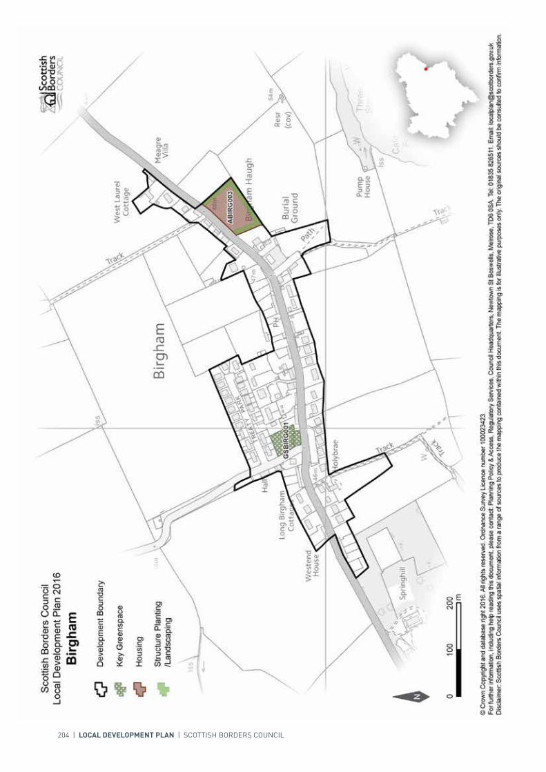
SETTLEMENT PROFILE BIRGHAM
This profile should be read in conjunction with the relevant settlement map.
DESCRIPTIONBirgham is located 4 miles from Coldstream and just over 5 miles from Kelso. The population of Birgham according to the 2001 Census is 139. It is located outwith the Strategic Development Areas (SDA) as defined in the SESplan.
PLACE MAKING CONSIDERATIONSBirgham is situated within the lowlands associated with the River Tweed which flows to the south of the settlement. The village follows a largely linear form along the A698 however there has been modern housing built off this road at Treaty Park. The surrounds of Birgham are relatively flat and marked by arable and pastoral fields, to the south there is a slope down to the River Tweed.
A small housing site is allocated at the east of Birgham (ABIRG003), following the linear form of the settlement along the A698. The site will contribute towards the Council’s housing land requirement.
INFRASTRUCTURE CONSIDERATIONSAffordable Housing will require to be provided in association with proposed housing sites under the provisions of Policy HD1 and the Supplementary Guidance/ Supplementary Planning Guidance on Affordable Housing.
A contribution towards Berwickshire High School will be sought to supplement Scottish Borders Council’s investment in the new school which opened in 2009-2010 under the 3 High Schools project.
With regards to Waste Water Treatment Works, Birgham has limited capacity. Contributions may be required where upgrades are necessary. In respect of the local water network, developers may be required to contribute towards upgrading to enable development.
Further information is available from Supplementary Guidance/Supplementary Planning Guidance on Developer Contributions and Planning Briefs where applicable.

INTRODUCTION | CHALLENGES | VISION, AIMS AND SPATIAL STRATEGYPOLICIES | APPENDICES | SETTLEMENTS
LOCAL DEVELOPMENT PLAN | SCOTTISH BORDERS COUNCIL | 203
DEVELOPMENT AND SAFEGUARDING PROPOSALS
HOUSING
SITE REFERENCE SITE NAME SITE SIZE (HA) INDICATIVE SITE CAPACITY
ABIRG003 Land at East Birgham 0.8 6
Site Requirements
• Vehicular access should be taken from the A698 in line with advice from the Council’s Roads Planning team
• Properties should be developed in a linear form facing the road• Advantage should be taken of the southerly aspect and views from the site• Structure planting on the southern, western and eastern boundary to provide a settlement edge• Other boundary treatments should use vernacular materials.
SITE REFERENCE SITE NAME SITE SIZE (HA)
GSBIRG001 Birgham Playing Field 0.3
KEY GREENSPACE
204 | LOCAL DEVELOPMENT PLAN | SCOTTISH BORDERS COUNCIL
INTRODUCTION | CHALLENGES | VISION, AIMS AND SPATIAL STRATEGYPOLICIES | APPENDICES | SETTLEMENTS
LOCAL DEVELOPMENT PLAN | SCOTTISH BORDERS COUNCIL | 205
SETTLEMENT PROFILE BLYTH BRIDGE
This profile should be read in conjunction with the relevant settlement map.
DESCRIPTIONBlyth Bridge is located outwith the Western Strategic Development Area, as part of the Development Strategy in the Strategic Development Plan. The village sits within the Northern Housing Market Area. The settlement is located 10 miles from Peebles and 9 miles from West Linton on the A701 principal road. The population of the settlement was 107 at the time of the 2001 Census.
PLACE MAKING CONSIDERATIONSThe village has expanded significantly over the past twenty years or so with the majority of properties in the village being built within that period. The original village was based around the Kirk and the mill next to the river crossing and to the north at Blyth Farm. New development has filled in between these two areas. The most attractive feature of the village is the area around the Old Mill.
The village lies at the bridging point of the Tarth Water and is south west facing. The village is open to views particularly when approaching from the south west. The village lies on the lower slopes of the Drochill Hill range to the east and in the valley that this creates with the lower lying hill ranges on the east and north around Blyth Moor. To the south lies the Lochurd Hills beyond Kirkurd.
The Plan does not allocate any sites at Blyth Bridge. It is considered that the village is not suited to large scale development. The area of open space to the east of the A701 provides an important setting to the village and will be protected from development.
The play park has been identified as a Key Greenspace within the Plan and will receive protection under Policy EP11 Protection of Greenspace.
INFRASTRUCTURE CONSIDERATIONSAffordable Housing will require to be provided in association with proposed housing sites under the provisions of Policy HD1 and the Supplementary Guidance/Supplementary Planning Guidance on Affordable Housing.
Peebles High School is forecast by the Director of Education and Lifelong Learning to face capacity issues from 2016 onwards. Developer Contribution towards school provision within the catchment will be requested, commensurate with the size and type of the development and in accordance with Developer Contribution Policy.

206 | LOCAL DEVELOPMENT PLAN | SCOTTISH BORDERS COUNCIL
SITE REFERENCE SITE NAME SITE SIZE (HA)
GSBLYT001 Play Area 0.1
With regards to Waste Water Treatment Works, Blyth Bridge has limited capacity. Contributions may be required where upgrades are necessary. In respect of the local water network, developers may be required to contribute towards upgrading to enable development.
Further information is available from Supplementary Guidance/Supplementary Planning Guidance on Developer Contributions.
DEVELOPMENT AND SAFEGUARDING PROPOSALS
KEY GREENSPACE

LOCAL DEVELOPMENT PLAN | SCOTTISH BORDERS COUNCIL | 207

208 | LOCAL DEVELOPMENT PLAN | SCOTTISH BORDERS COUNCIL
SETTLEMENT PROFILE BONCHESTER BRIDGE
This profile should be read in conjunction with the relevant settlement map.
DESCRIPTIONBonchester Bridge is situated 7 miles south east of Hawick on the A6088 where it crosses the Rule Water. The population of the village is 135 (2001 Census). It is located outwith any Strategic Development Area as defined in the SESplan.
PLACE MAKING CONSIDERATIONSThe Teviot Valleys Special Landscape Area is located to the north and east of the village.
The settlement developed around the bridge crossing of the Rule Water, close to its confluence with Hob’s Burn - a minor tributary from the west. It is here that the older, mainly stone buildings are found. The main expansion in recent years has taken place at the southern end of the village at Forest Road. The settlement contains a public house and a primary school which is located approximately 500m south of the village. Rule Water is part of the River Tweed Special Area of Conservation, a wildlife site of international importance.
Future expansion of the village will be considered during the process of the next Local Development Plan.
INFRASTRUCTURE CONSIDERATIONSAffordable Housing will require to be provided under the provisions of Policy HD1 and the Supplementary Guidance/ Supplementary Planning Guidance on Affordable Housing.
There is no requirement for contribution towards education provision.
With regards to Waste Water Treatment Works, Bonchester Bridge has limited capacity. Contributions may be required where upgrades are necessary. In respect of the local water network, developers may be required to contribute towards upgrading to enable development.
Further information is available from Supplementary Guidance/ Supplementary Planning Guidance on Developer Contributions and Planning/Development Briefs where applicable.

INTRODUCTION | CHALLENGES | VISION, AIMS AND SPATIAL STRATEGYPOLICIES | APPENDICES | SETTLEMENTS
LOCAL DEVELOPMENT PLAN | SCOTTISH BORDERS COUNCIL | 209
DEVELOPMENT AND SAFEGUARDING PROPOSALS
HOUSING
SITE REFERENCE SITE NAME SITE SIZE (HA) INDICATIVE SITE CAPACITY
ABONC003 Site opposite Memorial Hall
1.2 8
Site Requirements
• Exclude steep slopes to west from developable area and plant with trees to create woodland landscape
• No development shall take place on the functional flood plain (small area in north west corner of site) or above existing culverts
• A flood risk assessment is required to inform the site layout, design and mitigation.

210 | LOCAL DEVELOPMENT PLAN | SCOTTISH BORDERS COUNCIL
INTRODUCTION | CHALLENGES | VISION, AIMS AND SPATIAL STRATEGYPOLICIES | APPENDICES | SETTLEMENTS
LOCAL DEVELOPMENT PLAN | SCOTTISH BORDERS COUNCIL | 211
SETTLEMENT PROFILE BOWDEN
This profile should be read in conjunction with the relevant settlement map.
DESCRIPTIONBowden is located 2 miles from Newtown St Boswells and just over 4 miles from Melrose. The population of Bowden according to the 2001 census is 223. The village is located within the Central Borders Strategic Development Area as defined in the SESplan.
PLACE MAKING CONSIDERATIONSThe character of Bowden stems much from its physical context - a village set around its Green. The main focus of the Conservation Area is the distinct layout centred on the aforesaid Green, single to two-storey properties, near continuous rows and high quality materials and architectural detailing. The Conservation Area of Bowden includes almost all the village, Bowden Kirk, the Mill and the Manse.
Bowden is also located in a sensitive landscape setting and is included in the Eildon and Leaderfoot National Scenic Area.
The village green is identified as a key greenspace.
Given the sensitivity of the character and setting of Bowden, there is very little scope for additional development. There are no allocated land use proposals included for Bowden in the Local Development Plan.
INFRASTRUCTURE CONSIDERATIONSAffordable Housing will require to be provided in association with proposed housing sites under the provisions of Policy HD1 and the Supplementary Guidance/ Supplementary Planning Guidance on Affordable Housing.
A contribution towards Earlston High School will be sought to supplement Scottish Borders Council’s investment in the new school which opened in 2009-2010 under the 3 High Schools project.
Bowden falls within an area identified for a contribution to the Borders Railway (See Policy IS3).
In accordance with the Council’s Local Transport Strategy, a Central Borders Traffic Model has been developed which will help direct funding to areas of the road network that may become congested

212 | LOCAL DEVELOPMENT PLAN | SCOTTISH BORDERS COUNCIL
in the future. Developer contributions will be sought from developments within the Central Borders in accordance with the Supplementary Planning Guidance on Developer Contributions.
With regards to Waste Water Treatment Works, Bowden is served by the Newtown St Boswells works which has limited capacity. Contributions may be required where upgrades are necessary. In respect of the local water network, developers may be required to contribute towards upgrading to enable development.
Further information is available from Supplementary Guidance/Supplementary Planning Guidance on Developer Contributions and Planning/Development Briefs where applicable.
DEVELOPMENT AND SAFEGUARDING PROPOSALS
KEY GREENSPACE
SITE REFERENCE SITE NAME SITE SIZE (HA)
GSBOWD001 The Green 0.1

LOCAL DEVELOPMENT PLAN | SCOTTISH BORDERS COUNCIL | 213

214 | LOCAL DEVELOPMENT PLAN | SCOTTISH BORDERS COUNCIL
SETTLEMENT PROFILE BROUGHTON
This profile should be read in conjunction with the relevant settlement map.
DESCRIPTIONBroughton is located outwith the Western Strategic Development Area, as part of the Development Strategy in the Strategic Development Plan. The village sits within the Northern Housing Market Area. The 2001 Census population was 306.
PLACE MAKING CONSIDERATIONSBroughton lies on the wide valley floor at the point where the Biggar Water and the Broughton Burn converge before issuing to the Tweed. The valley is framed by Trahenna Hill to the north east, Goseland Hill to the west and Whitslade Hill to the south. The north part of the village lies on lower lying slopes of Langlawhill. The village sits within the Upper Tweed National Scenic Area. The Borders Landscape Assessment describes the area as an “Upland Valley with Pastoral Floor” characterised by flat valley bottom pastures, strongly enclosed by steep valley side merging with heather and forest covered uplands.
The village lies on the A701 principal road and this provides the village with a direct route north to Edinburgh and south to Moffat. There are two separate parts to Broughton. The older part is known as ‘The Village’, constitutes a double line of cottages, mostly in local stone, on either side of the Moffat to Edinburgh road. The more recent part of Broughton lies to the south of the original village where the Broughton Burn joins the Biggar Water, heading towards Calzeat. Within ‘The Village’ where the properties are built tight to the back of the footpath and adjoin each other the settlement feels enclosed; whilst to the south of the settlement the properties tend to be set back from the footpath and are generally detached or semi-detached. It is also the south of the settlement that particularly benefits of the views of the surrounding landscape.
The plan provides two housing allocations; both are located to the north east of the village. They are Dreva Road and Springwell Brae. Additionally, there is planning permission in principle for a housing development on the western side of Dreva Road opposite the two housing allocations and the existing housing at Springwell Brae. The site extends up to the development boundary to the south of Elmsfield. The plan also safeguards an established business and industrial site – Former Station Yard.

INTRODUCTION | CHALLENGES | VISION, AIMS AND SPATIAL STRATEGYPOLICIES | APPENDICES | SETTLEMENTS
LOCAL DEVELOPMENT PLAN | SCOTTISH BORDERS COUNCIL | 215
The preferred areas for future expansion beyond this Local Development Plan will be the area to the West of the A701 at Corstane adjoining the Biggar Road. The area for future growth indicated in this profile will require detailed assessment during the next Local Development Plan Review.
The playing fields to the north of the primary school provide an important recreational area for the community and will be protected.
INFRASTRUCTURE CONSIDERATIONSAffordable Housing will require to be provided in association with proposed housing sites under the provisions of Policy HD1 and the Supplementary Guidance/Supplementary Planning Guidance on Affordable Housing.
Peebles High School is forecast by the Director of Education and Lifelong Learning to face capacity issues from 2016 onwards. Developer Contribution towards school provision within the catchment will be requested, commensurate with the size and type of the development and in accordance with Developer Contribution Policy.
With regards to Waste Water Treatment Works, Broughton has limited capacity. Contributions may be required where upgrades are necessary. In respect of the local water network, developers may be required to contribute towards upgrading to enable development.
Further information is available from Supplementary Guidance/Supplementary Planning Guidance on Developer Contributions and Planning/Development Briefs where applicable.
DEVELOPMENT AND SAFEGUARDING PROPOSALS
HOUSING
SITE REFERENCE SITE NAME SITE SIZE (HA) INDICATIVE SITE CAPACITY
TB200 Dreva Road 2.4 10
Site Requirements
• Enhancement of existing landscaping in addition to buffer areas along new and existing landscaping will be required. The long term maintenance of landscaped areas must be addressed
• Mitigation measures are required to prevent any impact on the River Tweed Special Areas of Conservation via the Broughton Burn
• Consideration should be given to the design of the overall site to take account of the National Scenic Area
• Vehicular access will be via the Dreva Road, upgrades will be required• Consider the potential for any culvert removal and channel restoration.
TB10B Springwell Brae 0.6 10
Site Requirements
• Enhancement of existing landscaping in addition to buffer areas along new and existing landscaping will be required. The long term maintenance of landscaped areas must be addressed
• Consideration should be given to the design of the overall site to take account of the National Scenic Area
• Vehicular access to be achieved from Springwell Brae. Upgrades along the Dreva Road will also be required.

216 | LOCAL DEVELOPMENT PLAN | SCOTTISH BORDERS COUNCIL
BUSINESS AND INDUSTRIAL SAFEGUARDING
KEY GREENSPACE
SITE REFERENCE SITE NAME SITE SIZE (HA)
GSBROU001 School Playing Fields 2.2
SITE REFERENCE SITE NAME SITE SIZE (HA) INDICATIVE SITE CAPACITY
zEL43 Former Station Yard 1.8 N/A
Site Requirements
• This is a local safeguarded business and industrial site as defined in Policy ED1• Existing landscape features to be retained• The established pathways onsite to remain free from any built structure so to ensure access for
pedestrians, horse riders or cyclists.

LOCAL DEVELOPMENT PLAN | SCOTTISH BORDERS COUNCIL | 217

218 | LOCAL DEVELOPMENT PLAN | SCOTTISH BORDERS COUNCIL
SETTLEMENT PROFILE BURNMOUTH
This profile should be read in conjunction with the relevant settlement map.
DESCRIPTIONBurnmouth is located 3 miles south-east of Eyemouth and just under 6 miles from Berwick-upon-Tweed. The population of Burnmouth according to the 2001 Census was 220. It is located within the Eastern Strategic Development Area (SDA) as defined in the SESplan.
PLACE MAKING CONSIDERATIONSBurnmouth is made up of a series of dispersed coastal settlements located on the rugged North Sea cliffs, with Partanhall, Lower Burnmouth, Cowdrait and Ross, all at sea level, and Upper Burnmouth, by the A1 and the east coast railway line. The settlement is originally based on the historic harbour set at the foot of a dramatic incline and the listed converted railway station house located within the upper level. Other significant Listed Buildings include the post-war Council housing at the shore.
The coastline on which Burnmouth sits is part of the Berwickshire and North Northumberland Coast Special Area of Conservation and is also designated as part of the Berwickshire Coast Special Landscape Area. Any development in Burnmouth, particularly at the shore line, will need to take cognisance of the Local Development Plan (LDP) policies associated with these designations.
Burnmouth has a housing allocation that remains undeveloped and as a result there will be no further development proposed in this LDP. However the settlement is located within the Eastern SDA and further development is possible in the long-term. Potential development to the north, at Burnmouth Hill, and to the south east will be resisted because it would have a negative impact on the character and setting of the village and also on the road network. Proposed development to the north east of East Flemington would also be resisted as this would be contrary to the existing settlement pattern. Further considerations that are relevant are the lack of services within the village and the prime agricultural land on the settlement surrounds.
INFRASTRUCTURE CONSIDERATIONS
Affordable Housing will require to be provided under the provisions of Policy HD1 and the Supplementary Guidance/Supplementary Planning Guidance on Affordable Housing.
A contribution towards Eyemouth High School will be sought to supplement Scottish Borders Council’s investment in the new school which opened in 2009-2010 under the 3 High Schools project.

INTRODUCTION | CHALLENGES | VISION, AIMS AND SPATIAL STRATEGYPOLICIES | APPENDICES | SETTLEMENTS
LOCAL DEVELOPMENT PLAN | SCOTTISH BORDERS COUNCIL | 219
SITE REFERENCE SITE NAME SITE SIZE (HA)
GSBURN001 Burnmouth Hill 0.2
With regards to Waste Water Treatment Works and Water Treatment Works, Burnmouth currently has sufficient capacity.
Further information is available from Supplementary Guidance/Supplementary Planning Guidance on Developer Contributions and Planning/Development Briefs where applicable.
DEVELOPMENT AND SAFEGUARDING PROPOSALS
HOUSING
KEY GREENSPACE
SITE REFERENCE SITE NAME SITE SIZE (HA) INDICATIVE SITE CAPACITY
ABURN003 Lyall Terrace II 0.9 10
Site Requirements
• Refer to approved Planning Brief.

220 | LOCAL DEVELOPMENT PLAN | SCOTTISH BORDERS COUNCIL

INTRODUCTION | CHALLENGES | VISION, AIMS AND SPATIAL STRATEGYPOLICIES | APPENDICES | SETTLEMENTS
LOCAL DEVELOPMENT PLAN | SCOTTISH BORDERS COUNCIL | 221
SETTLEMENT PROFILE CARDRONA
This profile should be read in conjunction with the relevant settlement map.
DESCRIPTIONCardrona is located within the Western Strategic Development Area, within the Development Strategy in the Strategic Development Plan. The settlement also sits within the Northern Housing Market Area. Cardrona is unique in the Scottish Borders in that it was a master planned new village. The 2001 Census population for Cardrona was 229, though at this time there were only 98 dwellings in the village.
PLACE MAKING CONSIDERATIONSThe village lies within the River Tweed valley and straddles both sides of the river. The village lies to the southern side of the valley and benefits from a high degree of visual enclosure from the A72. The valley is formed by the Lee Pen, Kirk Law and Lee Burn Head along the northern side of the river and Wallace Hill to the south.
Cardrona is a new village and is based around the two farms at Cardrona Mains and Horsbrugh Castle on the south and north side of the River Tweed. The village was developed as part of a tourism project comprising a hotel, golf course and village.
The village has been developed around a central village green, and is well connected with a footpath network that links the settlement through to the countryside. A landscape framework plan was developed as part of the master plan for the settlement, to take advantage of the existing plantations of coniferous woodland planted along the northern boundary of the site and that which had self seeded along the route of the former railway line. Additional planting has been put in along the golf course that surrounds the village and also along the southern boundary to the B7062.
The Plan provides two mixed use allocations to the north west of the village. These sites are identified for a mix of uses including commercial and employment.
In view of the recent development of the village, as well as the constraints and sensitivity of the setting of Cardrona, it has not been possible to identify an area for longer term expansion.
The Village Green is an important amenity area within the centre of the village and will therefore be protected from development.
Located outside the settlement, and set within the Tweed Valley Forest Park is Glentress. The Glentress Forest is a hub for many activities that attracts locals and visitors alike. During the lifetime of the Local Development Plan, the Council will support the development of a Masterplan as Supplementary Guidance in partnership with the Forestry Commission.
222 | LOCAL DEVELOPMENT PLAN | SCOTTISH BORDERS COUNCIL
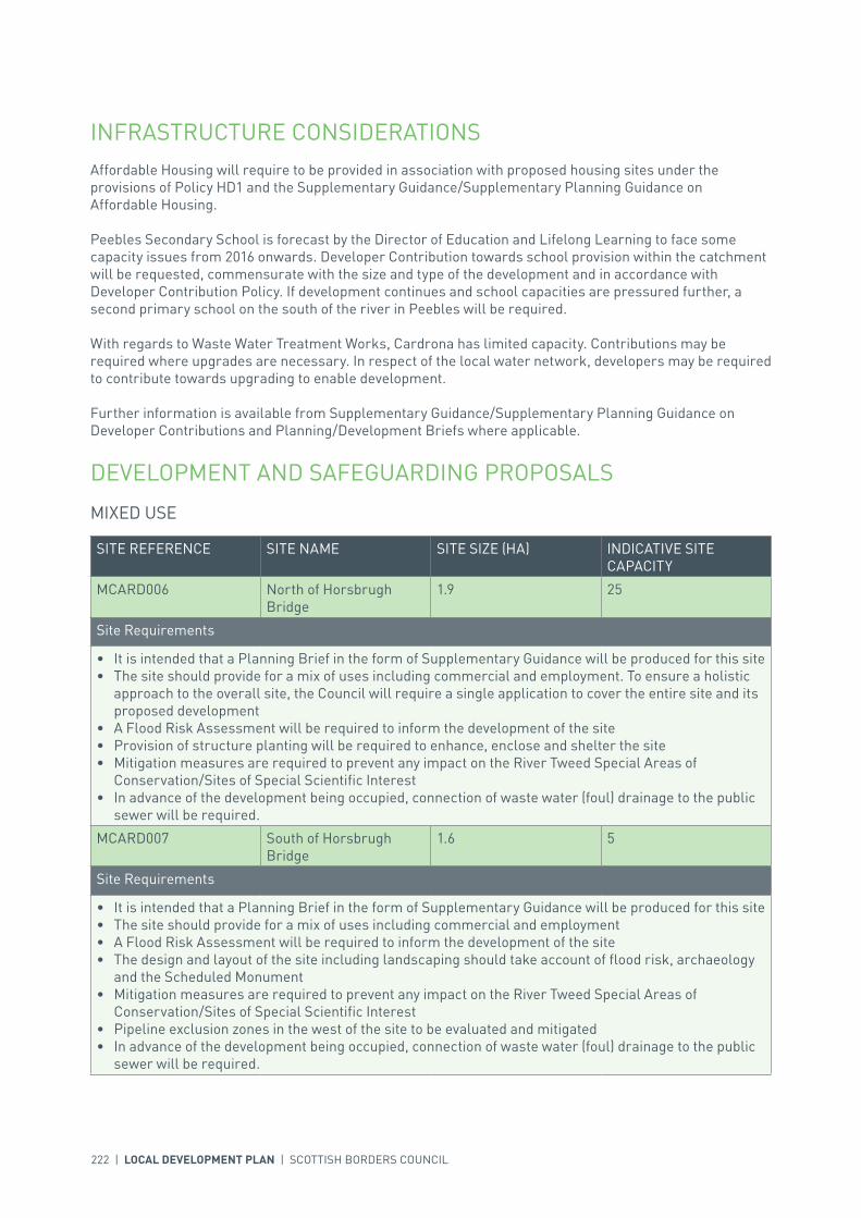
INFRASTRUCTURE CONSIDERATIONSAffordable Housing will require to be provided in association with proposed housing sites under the provisions of Policy HD1 and the Supplementary Guidance/Supplementary Planning Guidance on Affordable Housing.
Peebles Secondary School is forecast by the Director of Education and Lifelong Learning to face some capacity issues from 2016 onwards. Developer Contribution towards school provision within the catchment will be requested, commensurate with the size and type of the development and in accordance with Developer Contribution Policy. If development continues and school capacities are pressured further, a second primary school on the south of the river in Peebles will be required.
With regards to Waste Water Treatment Works, Cardrona has limited capacity. Contributions may be required where upgrades are necessary. In respect of the local water network, developers may be required to contribute towards upgrading to enable development.
Further information is available from Supplementary Guidance/Supplementary Planning Guidance on Developer Contributions and Planning/Development Briefs where applicable.
DEVELOPMENT AND SAFEGUARDING PROPOSALS
MIXED USE
SITE REFERENCE SITE NAME SITE SIZE (HA) INDICATIVE SITE CAPACITY
MCARD006 North of Horsbrugh Bridge
1.9 25
Site Requirements
• It is intended that a Planning Brief in the form of Supplementary Guidance will be produced for this site • The site should provide for a mix of uses including commercial and employment. To ensure a holistic
approach to the overall site, the Council will require a single application to cover the entire site and its proposed development
• A Flood Risk Assessment will be required to inform the development of the site• Provision of structure planting will be required to enhance, enclose and shelter the site• Mitigation measures are required to prevent any impact on the River Tweed Special Areas of
Conservation/Sites of Special Scientific Interest• In advance of the development being occupied, connection of waste water (foul) drainage to the public
sewer will be required.
MCARD007 South of Horsbrugh Bridge
1.6 5
Site Requirements
• It is intended that a Planning Brief in the form of Supplementary Guidance will be produced for this site• The site should provide for a mix of uses including commercial and employment• A Flood Risk Assessment will be required to inform the development of the site• The design and layout of the site including landscaping should take account of flood risk, archaeology
and the Scheduled Monument• Mitigation measures are required to prevent any impact on the River Tweed Special Areas of
Conservation/Sites of Special Scientific Interest• Pipeline exclusion zones in the west of the site to be evaluated and mitigated• In advance of the development being occupied, connection of waste water (foul) drainage to the public
sewer will be required.

INTRODUCTION | CHALLENGES | VISION, AIMS AND SPATIAL STRATEGYPOLICIES | APPENDICES | SETTLEMENTS
LOCAL DEVELOPMENT PLAN | SCOTTISH BORDERS COUNCIL | 223
SITE REFERENCE SITE NAME SITE SIZE (HA)
GSCARD001 The Green 0.8
KEY GREENSPACE

224 | LOCAL DEVELOPMENT PLAN | SCOTTISH BORDERS COUNCIL

INTRODUCTION | CHALLENGES | VISION, AIMS AND SPATIAL STRATEGYPOLICIES | APPENDICES | SETTLEMENTS
LOCAL DEVELOPMENT PLAN | SCOTTISH BORDERS COUNCIL | 225
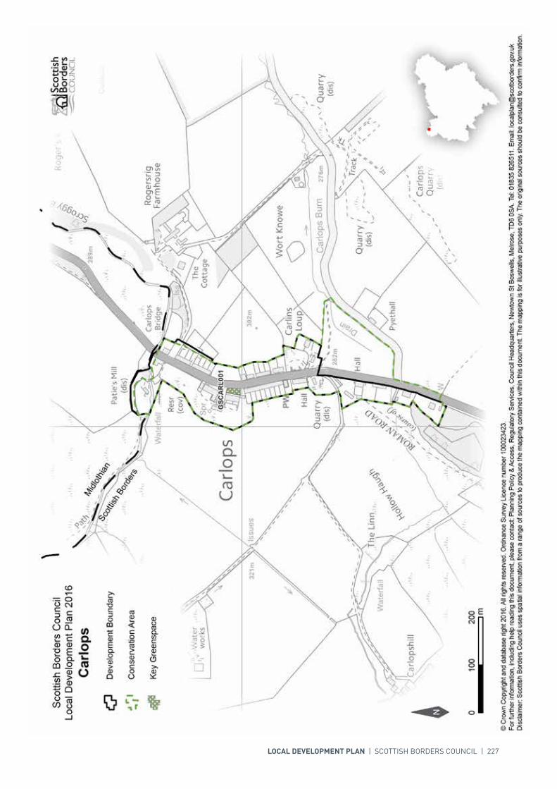
SETTLEMENT PROFILE CARLOPS
This profile should be read in conjunction with the relevant settlement map.
DESCRIPTIONCarlops is located to the far north-west of the Scottish Borders, close to the administrative boundary with Midlothian Council. Carlops lies to the east of the Pentland Hills on the North Esk. The village is located outwith the Western Strategic Development Area as part of the Development Strategy in the Strategic Development Plan and sits within the Northern Housing Market Area. The 2001 Census population was 92.
PLACE MAKING CONSIDERATIONSThe settlement Carlops was founded in 1784, when Robert Brown the Laird of Newhall established a cotton weaving industry laying out rows of weavers’ cottages on either side of the main Edinburgh-Biggar Road. A significant feature of the Village is the remains of the former quarry, in other locations it would be seen as unsightly but here it is attractive in an unusual way.
Carlops is a linear village that possesses a distinct identity and virtually the entire village sits within the Conservation Area. The openness of the field to the front of Carlops Mains contrasts with the height of the former quarry and gives a sense of enclosure. The most important part of the Conservation Area is the rows of original cottages that have been little altered and are single storey with porches. Elsewhere in the settlement some properties rise to two storeys such as the Allan Ramsey Hotel and Carlops Mains. While the majority of properties front onto the A702, most of the cottages have some form of garden ground to the front. Beige sandstone, slate and harling are frequently used throughout. The majority of the cottages have simple vertical boarded doors. Details such as dry stone boundary walls, skews, stepped quoins, rybats and margins are features that are notable within Carlops and should be preserved.
The Plan does not propose any development proposals. The village is subject to a high degree of protection, due to the high concentration of Listed properties and the extensive Conservation Area.
The greenspace to the front of Ramsay Cottages provides an attractive amenity space for the village and will therefore be protected.

226 | LOCAL DEVELOPMENT PLAN | SCOTTISH BORDERS COUNCIL
INFRASTRUCTURE CONSIDERATIONSAffordable Housing will require to be provided in association with proposed housing sites under the provisions of Policy HD1 and the Supplementary Guidance/Supplementary Planning Guidance on Affordable Housing.
Peebles Secondary School is forecast by the Director of Education and Lifelong Learning to face some capacity issues from 2016 onwards. Developer Contribution towards school provision within the catchment will be requested, commensurate with the size and type of the development and in accordance with Developer Contribution Policy.
A contribution at the new school rate towards West Linton Primary School will be sought to supplement Scottish Borders Council’s investment in the new school.
With regards to Waste Water Treatment Works Carlops has limited capacity. Contributions may be required where upgrades are necessary. In respect of the local water network, developers may be required to contribute towards upgrading to enable development.
Further information is available from Supplementary Guidance/Supplementary Planning Guidance on Developer Contributions.
DEVELOPMENT AND SAFEGUARDING PROPOSALS
KEY GREENSPACE
SITE REFERENCE SITE NAME SITE SIZE (HA)
GSCARL001 Carlops Verge 0.03
LOCAL DEVELOPMENT PLAN | SCOTTISH BORDERS COUNCIL | 227
228 | LOCAL DEVELOPMENT PLAN | SCOTTISH BORDERS COUNCIL
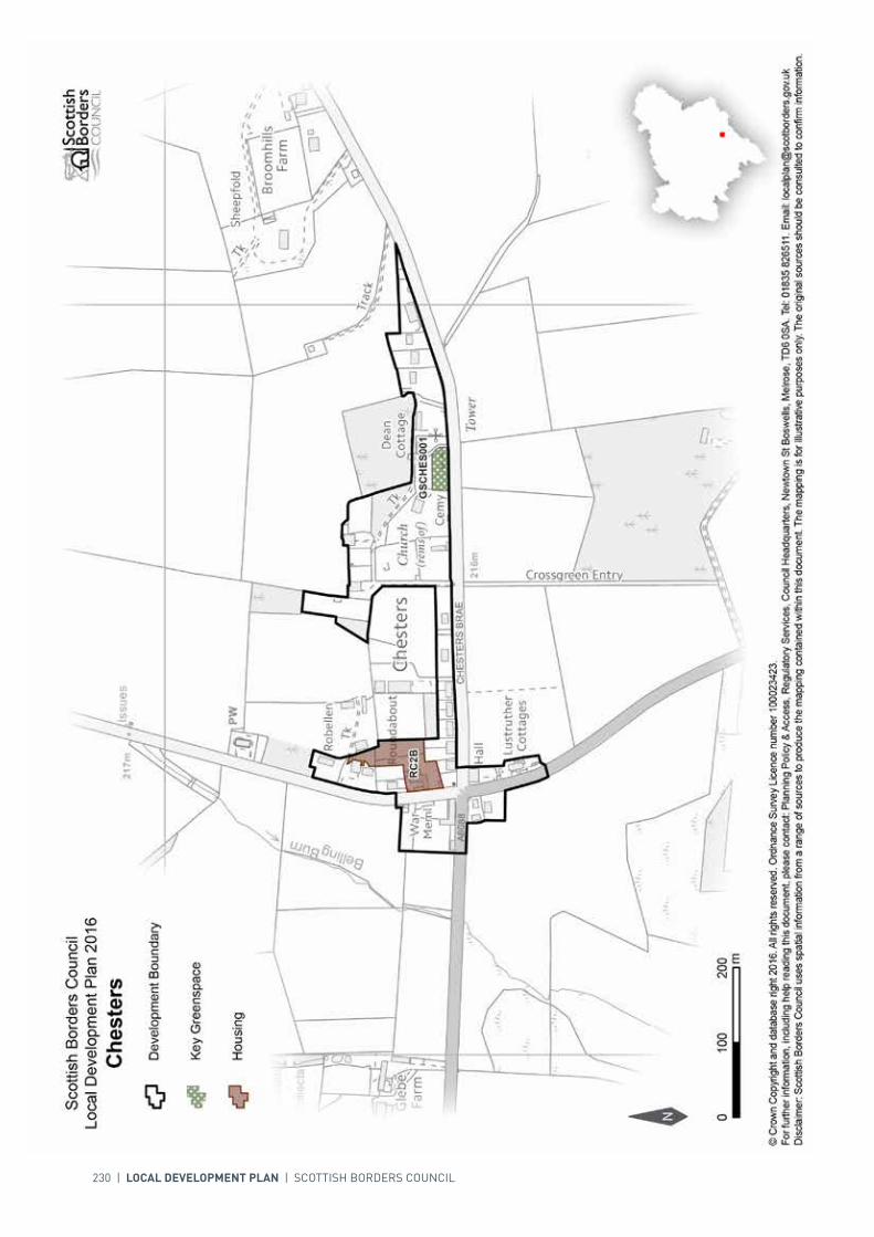
SETTLEMENT PROFILE CHESTERS
This profile should be read in conjunction with the relevant settlement map.
DESCRIPTIONChesters is situated on the A6088 Hawick to Carter Bar road, approximately 10 miles south east of Hawick and 8 miles south of Jedburgh. It is outside the Central Borders Strategic Development Area as defined in the SESplan. Chesters has a population of 49 (2001 Census).
PLACE MAKING CONSIDERATIONSThe village is centred at the crossroads where the A6088 road is met by minor roads from Camptown and Jedburgh. A war memorial is located at the crossroads. The village has developed in a linear form, mainly eastwards along Chesters Brae (the Camptown road). The existing trees and hedges around the village add to its rural character. The area around the ruined churchyard, site of the former tower and former school is particularly attractive.
The village has a southerly aspect and sits in an agricultural upland landscape with impressive views of the Cheviot Hills to the south. The land slopes to the south towards Jed Water. The Teviot Valleys Special Landscape Area is located to the north of the settlement.
The cemetery is identified as a key greenspace.
The absence of local services, the topography of the settlement and its location outside the Strategic Development Area means that it does not lend itself to significant levels of development. Development beyond the Local Development Plan period should be kept to a minimum.
INFRASTRUCTURE CONSIDERATIONSAffordable Housing will require to be provided under the provisions of Policy HD1 and the Supplementary Guidance/ Supplementary Planning Guidance on Affordable Housing.
There is no requirement for contribution towards education provision.
In respect of both the Waste Water Treatment Works (which serve only part of the village) and the local water network, Chesters has limited capacity. Contributions may be required where upgrades are necessary to enable development.

INTRODUCTION | CHALLENGES | VISION, AIMS AND SPATIAL STRATEGYPOLICIES | APPENDICES | SETTLEMENTS
LOCAL DEVELOPMENT PLAN | SCOTTISH BORDERS COUNCIL | 229
Further information is available from Supplementary Guidance/Supplementary Planning Guidance on Developer Contributions and Planning/Development Briefs where applicable.
DEVELOPMENT AND SAFEGUARDING PROPOSALS
HOUSING
SITE REFERENCE SITE NAME SITE SIZE (HA) INDICATIVE SITE CAPACITY
RC2B Roundabout Farm 0.5 5
Site Requirements
• Vehicular access from the minor road to the west of the site• A pedestrian access to the bus stop at the crossroads may be required. This will be dependant upon
the location of the vehicular access• The design, layout, materials and finishes should reflect the high quality of existing buildings,
particularly along the road frontage• Archaeological investigation of the site in order to assess the survival, extent and significance of any
buried archaeological remains. Further investigation or changes to development proposals may be required based on the results
• Existing trees should be retained where possible.
SITE REFERENCE SITE NAME SITE SIZE (HA)
GSCHES001 Cemetery 0.2
KEY GREENSPACE
230 | LOCAL DEVELOPMENT PLAN | SCOTTISH BORDERS COUNCIL

INTRODUCTION | CHALLENGES | VISION, AIMS AND SPATIAL STRATEGYPOLICIES | APPENDICES | SETTLEMENTS
LOCAL DEVELOPMENT PLAN | SCOTTISH BORDERS COUNCIL | 231
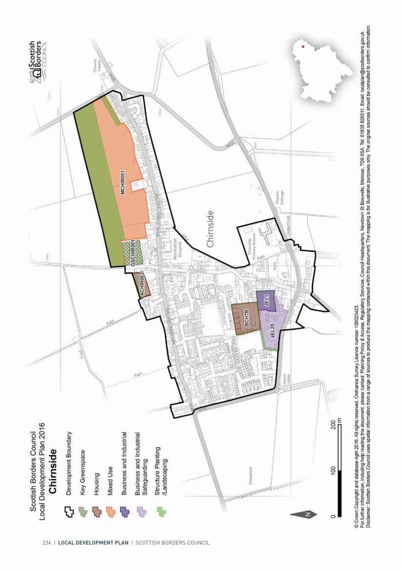
SETTLEMENT PROFILE CHIRNSIDE
This profile should be read in conjunction with the relevant settlement map.
DESCRIPTIONChirnside is located in Berwickshire, 6 miles to the east of Duns. The population of Chirnside according to the 2001 Census was 1204. The settlement is located within the Eastern Strategic Development Area (SDA) as identified in the SESplan.
PLACE MAKING CONSIDERATIONSChirnside overlooks the Merse to the south; the Parish church is located to the south and the Kirkgate heads northward up-slope, with the buildings tight to the road. The Main Street then runs east to west at the upper side of the settlement. Modern development of the settlement has resulted in the south-west part filling out with housing now bounding the A6105.
Chirnside currently has a significant amount of allocated housing land (BCH7B, ACHIR003 and MCHIR001) which is not yet developed and as a result further allocations for this Local Development Plan period are not required. The mixed use (MCHIR001) site provides the opportunity for new housing and a retail site close to the centre of the village which would support and enhance the current services available. Large scale housing development has recently taken place in the south-west of the settlement.
As Chirnside is located within the Eastern SDA there is the potential for further development in the long-term, any such development will not be considered south of the A6105. Another consideration is that the surrounds of the settlement are designated as prime agricultural land.
INFRASTRUCTURE CONSIDERATIONSAffordable Housing will require to be provided in association with proposed housing sites under the provisions of Policy HD1 and the Supplementary Guidance/Supplementary Planning Guidance on Affordable Housing.
A contribution towards Berwickshire High School will be sought to supplement Scottish Borders Council’s investment in the new school which opened in 2009-2010 under the 3 High Schools project.
With regards to Waste Water Treatment Works, Chirnside has limited capacity. Contributions may be required where upgrades are necessary. In respect of the local water network, developers may be required to contribute towards upgrading to enable development.

232 | LOCAL DEVELOPMENT PLAN | SCOTTISH BORDERS COUNCIL
Further information is available from Supplementary Guidance/Supplementary Planning Guidance on Developer Contributions and Planning Briefs where applicable.
DEVELOPMENT AND SAFEGUARDING PROPOSALS
HOUSING
SITE REFERENCE SITE NAME SITE SIZE (HA) INDICATIVE SITE CAPACITY
BCH7B Erskine Road 1.4 25
Site Requirements
• Take cognisance of the existing planning permission on the site• Take cognisance of the existing infrastructure built (access road)• Ensure the integrity of the Right of Way located to the west of the site• Take advantage of the southerly aspect• Respect the amenity of neighbouring properties• Provide satisfactory planting along the western, southern and eastern boundaries.
ACHIR003 Crosshill 0.5 8
Site Requirements
• Main vehicular access to the site from Dominies Loan to the east. Improvements to the junction of Main Street/ Dominies Loan and upgrades to the loan are required
• Evaluation and mitigation of the potential archaeological interest of medieval structures is required• Structural planting/ landscaping is required in the north and west of the site to screen the site, create
a new settlement boundary and protect the amenity of adjacent residential areas• The long term maintenance of landscaped areas must be addressed• Evaluate and mitigate flood risk from overland flow• Adjacent footpath should be protected.
BUSINESS AND INDUSTRIAL
SITE REFERENCE SITE NAME SITE SIZE (HA) INDICATIVE SITE CAPACITY
zEL1 Southfield 0.7 N/A
Site Requirements
• This is a district business and industrial site as defined in Policy ED1• Ensure pedestrian access to the Kirkgate is maintained• Satisfactory planting to be carried out on northern, southern and eastern boundaries where required
to safeguard residential amenity• Long term maintenance of landscaped areas must be addressed• Ensure vehicular access to A6105 is maintained.

INTRODUCTION | CHALLENGES | VISION, AIMS AND SPATIAL STRATEGYPOLICIES | APPENDICES | SETTLEMENTS
LOCAL DEVELOPMENT PLAN | SCOTTISH BORDERS COUNCIL | 233
BUSINESS AND INDUSTRIAL SAFEGUARDING
SITE REFERENCE SITE NAME SITE SIZE (HA) INDICATIVE SITE CAPACITY
zEL25 Berwick Road 1.7 N/A
Site Requirements
• This is a district safeguarded business and industrial site as defined in Policy ED1• Ensure pedestrian and cycle access to Main Street and protect adjacent paths• Satisfactory planting to be carried out on western and northern boundaries where required to
safeguard residential amenity, and on southern boundary to screen development from the road• Long term maintenance of landscaped areas must be addressed• Ensure vehicular access to A6105 is maintained.
MIXED USE
SITE REFERENCE SITE NAME SITE SIZE (HA) INDICATIVE SITE CAPACITY
MCHIR001 Comrades Park East 13.2 60
Site Requirements
• It is intended that a Planning Brief in the form of Supplementary Guidance will be produced for this site• A mixed use site that incorporates 3 hectares for housing and 3 hectares for a retail opportunity close
to the village centre• Provide pedestrian and cycle access to Main Street & protect adjacent paths • Create the main vehicular access from the road to the east and consider a minor access to the west.• Consider the potential for direct vehicular links to the Main Street and associated off street parking for
Main Street properties• A substantial new woodland boundary to create a new natural development boundary and contain the
site. It should have a footpath running through it that allows access to Comrades Park football ground• The long term maintenance of landscaped areas must be addressed• Design and layout should be sympathetic to the local character and take advantage of southern aspect
for energy efficiency & solar gain.
SITE REFERENCE SITE NAME SITE SIZE (HA)
GSCHIR001 Comrades Park Football Ground 0.8
KEY GREENSPACE
234 | LOCAL DEVELOPMENT PLAN | SCOTTISH BORDERS COUNCIL
INTRODUCTION | CHALLENGES | VISION, AIMS AND SPATIAL STRATEGYPOLICIES | APPENDICES | SETTLEMENTS
LOCAL DEVELOPMENT PLAN | SCOTTISH BORDERS COUNCIL | 235
SETTLEMENT PROFILE CLINTMAINS
This profile should be read in conjunction with the relevant settlement map.
DESCRIPTIONClintmains is located approximately 2 miles from St Boswells and 9 miles west of Kelso. It is located within the Central Strategic Development Area, as set out in the Development Strategy in the Strategic Development Plan.
PLACE MAKING CONSIDERATIONSThe Conservation Area of Clintmains covers the majority of the village. Its name stems from “the farm by the lake”. The village was originally built for the workers of Mertoun Estate – the property of the Duke of Sutherland.
A well-preserved village, Clintmains’ original estate layout is still intact with the Green providing a significant contribution to the amenity of the village. Properties range from single to two storeys in height. Building materials that are found within the Conservation Area are sandstone, harl and slate. Whinstone can also be found in parts. It is notable that within Clintmains, properties that have been harled tend to have sandstone margins around their openings, while those that are finished with stonework are complete with sandstone quoins and rybats. These details along with other architectural details such as sash and case windows (of various patterns), transom lights or integral door lights, all contribute significantly to the character and appearance of the Conservation Area.

236 | LOCAL DEVELOPMENT PLAN | SCOTTISH BORDERS COUNCIL
INTRODUCTION | CHALLENGES | VISION, AIMS AND SPATIAL STRATEGYPOLICIES | APPENDICES | SETTLEMENTS
LOCAL DEVELOPMENT PLAN | SCOTTISH BORDERS COUNCIL | 237
SETTLEMENT PROFILE CLOVENFORDS
This profile should be read in conjunction with the relevant settlement map.
DESCRIPTIONClovenfords is located almost 3 miles west of Galashiels. The population according to the 2001 Census is 421. Clovenfords is located within the Central Borders Strategic Development Area as defined in the SESplan.
PLACE MAKING CONSIDERATIONSThe settlement sits on undulating grasslands and is surrounded by rolling hills. The original settlement was clustered around the Clovenfords Hotel beside a bridging point over the Caddon Water.
The settlement is on the strategic public transport network. It has regular bus services between Edinburgh, Galashiels and Melrose. The settlement is within ten minutes drive time of the railway station at Tweedbank.
A Special Area of Conservation follows the Caddon Water through the western parts of the village; this requires special consideration in terms of development. The area around the Caddon Water is also under risk of flooding.
There is one area, at Meigle Row, identified as a key greenspace.
The Plan provides housing allocations to the south of the village at Caddonhaugh and further west at Clovenfords West, as well as at Meigle.
Once the allocated sites are fully developed the preferred areas for future expansion beyond the period of this Local Development Plan will be the area to the north east of the settlement and also to the south of the existing housing allocation at Meigle. The areas suggested for future growth are indicative only and will require further detailed assessment during the next review of the Local Development Plan.
INFRASTRUCTURE CONSIDERATIONSAffordable Housing will require to be provided in association with proposed housing sites under the provisions of Policy HD1 and the Supplementary Guidance/ Supplementary Planning Guidance on Affordable Housing.

238 | LOCAL DEVELOPMENT PLAN | SCOTTISH BORDERS COUNCIL
A contribution towards Clovenfords Primary School will be sought to supplement Scottish Borders Council’s investment in the new school.
Clovenfords falls within an area identified for a contribution to the Borders Railway (See Policy IS3).
In respect of the Waste Water Treatment Works and Water Treatment Works, Clovenfords currently has sufficient capacity.
In accordance with the Council’s Local Transport Strategy, a Central Borders Traffic Model has been developed which will help direct funding to areas of the road network that may become congested in the future. Developer contributions will be sought from developments within the Central Borders in accordance with the Supplementary Planning Guidance on Developer Contributions.
Further information is available from Supplementary Guidance/ Supplementary Planning Guidance on Developer Contributions and Planning/Development Briefs where applicable.
DEVELOPMENT AND SAFEGUARDING PROPOSALS
HOUSING
SITE REFERENCE SITE NAME SITE SIZE (HA) INDICATIVE SITE CAPACITY
EC2 Caddonhaugh 0.9 6
Site Requirements
• The site is located within a flood risk area. A Flood Risk Assessment will be required• Mitigation measures are required to prevent any impact upon the River Tweed Special Area of
Conservation• Vehicular and pedestrian access from Caddonhaugh to the north• Site investigation and risk assessment of potential contamination• Existing trees to be retained and protected• The design and layout of the new buildings should exploit the southerly aspect of the site to make best
use of the microclimate and reduce energy usage• Safeguard amenity of existing neighbouring residential properties• Ecological survey of the site.
EC6 Clovenfords West 4.9 60
Site Requirements
• Refer to approved Planning Brief.
EC13B Meigle 3.4 60
Site Requirements
• Refer to approved Planning Brief.
SITE REFERENCE SITE NAME SITE SIZE (HA)
GSCLOV001 Clovenfords Green 0.7
KEY GREENSPACE

INTRODUCTION | CHALLENGES | VISION, AIMS AND SPATIAL STRATEGYPOLICIES | APPENDICES | SETTLEMENTS
LOCAL DEVELOPMENT PLAN | SCOTTISH BORDERS COUNCIL | 239
240 | LOCAL DEVELOPMENT PLAN | SCOTTISH BORDERS COUNCIL
SETTLEMENT PROFILE COCKBURNSPATH
This profile should be read in conjunction with the relevant settlement map.
DESCRIPTIONCockburnspath is located just over 13 miles from Duns. The population of Cockburnspath according to the 2001 Census was 412. It is located outwith the Strategic Development Areas (SDA) as identified in the SESplan.
PLACE MAKING CONSIDERATIONSCockburnspath overlooks the North Sea, and the Berwickshire Coast Special Landscape Area. The settlement has grown outward to the south-west from the market square and old ‘Mercat’ cross. The village has developed on a south-west facing slope and as a result development off Hoprig Road, which winds through the village, is on different levels. In the last 20 years the settlement has expanded northward with a modern housing development at Toll View/Lady Hall.
The Conservation Area covers the historic core of the settlement and there are many distinctive townscape characteristics that provide a sense of place. Properties range from single storey outbuildings that line the east side of the Kirkyard, to storey and a half, and two storeys around The Square. The use of building materials, such as sandstone, harling, pantiles and slate, and architectural details such as transom lights, sash and case windows, and bay windows all add to the character. Any new development must aim to positively contribute to the Conservation Area. There are seven Listed Buildings within the Conservation Area of which three are category ‘A’.
Cockburnspath has two existing housing allocations which have not yet been developed and as a result there is no land further allocated in this Local Development Plan (LDP).
Once the allocated sites are developed the preferred area for expansion would be between the development boundary and Pathhead House to the north. Development into the open fields to the west and over the road to the east should be avoided to maintain the settlement form. This land is also designated as prime agricultural land. Expansion to the south would be impractical due to the operational mineral workings and the topography. In addition the restrictive road network within the village would adversely affect the potential for further development land in the immediate surrounds.
INTRODUCTION | CHALLENGES | VISION, AIMS AND SPATIAL STRATEGYPOLICIES | APPENDICES | SETTLEMENTS
LOCAL DEVELOPMENT PLAN | SCOTTISH BORDERS COUNCIL | 241
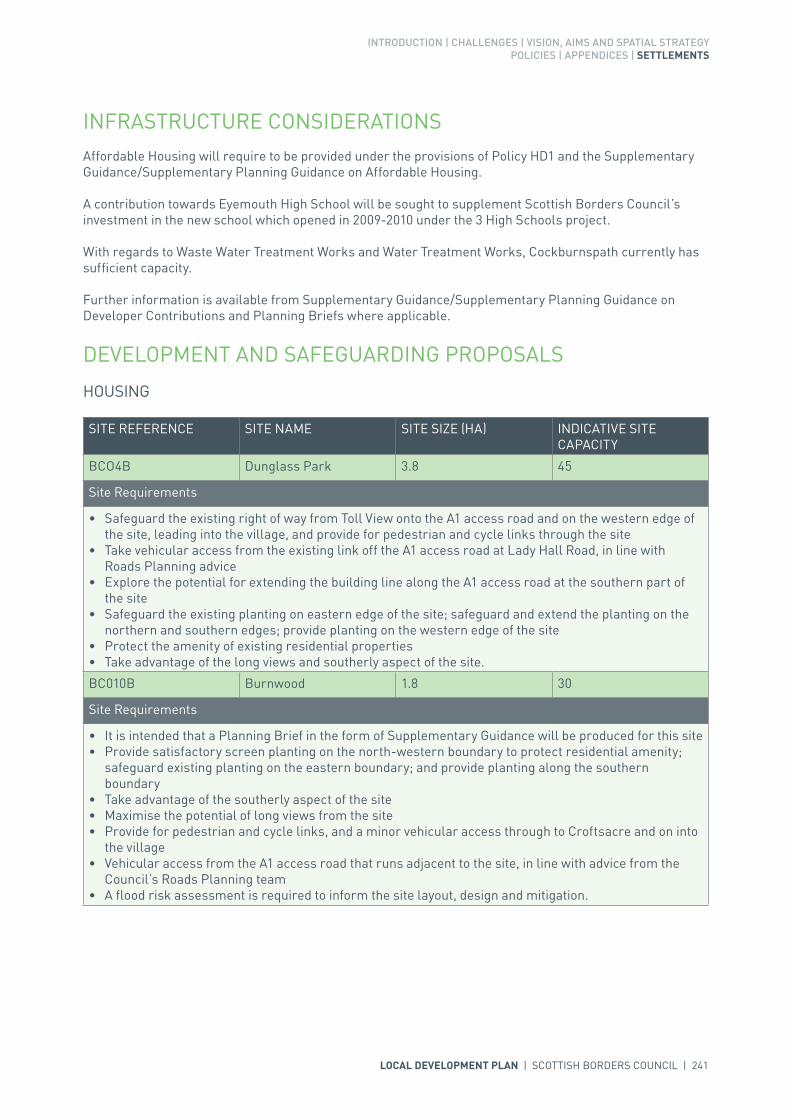
INFRASTRUCTURE CONSIDERATIONSAffordable Housing will require to be provided under the provisions of Policy HD1 and the Supplementary Guidance/Supplementary Planning Guidance on Affordable Housing.
A contribution towards Eyemouth High School will be sought to supplement Scottish Borders Council’s investment in the new school which opened in 2009-2010 under the 3 High Schools project.
With regards to Waste Water Treatment Works and Water Treatment Works, Cockburnspath currently has sufficient capacity.
Further information is available from Supplementary Guidance/Supplementary Planning Guidance on Developer Contributions and Planning Briefs where applicable.
DEVELOPMENT AND SAFEGUARDING PROPOSALS
HOUSING
SITE REFERENCE SITE NAME SITE SIZE (HA) INDICATIVE SITE CAPACITY
BCO4B Dunglass Park 3.8 45
Site Requirements
• Safeguard the existing right of way from Toll View onto the A1 access road and on the western edge of the site, leading into the village, and provide for pedestrian and cycle links through the site
• Take vehicular access from the existing link off the A1 access road at Lady Hall Road, in line with Roads Planning advice
• Explore the potential for extending the building line along the A1 access road at the southern part of the site
• Safeguard the existing planting on eastern edge of the site; safeguard and extend the planting on the northern and southern edges; provide planting on the western edge of the site
• Protect the amenity of existing residential properties• Take advantage of the long views and southerly aspect of the site.
BC010B Burnwood 1.8 30
Site Requirements
• It is intended that a Planning Brief in the form of Supplementary Guidance will be produced for this site• Provide satisfactory screen planting on the north-western boundary to protect residential amenity;
safeguard existing planting on the eastern boundary; and provide planting along the southern boundary
• Take advantage of the southerly aspect of the site• Maximise the potential of long views from the site• Provide for pedestrian and cycle links, and a minor vehicular access through to Croftsacre and on into
the village• Vehicular access from the A1 access road that runs adjacent to the site, in line with advice from the
Council’s Roads Planning team• A flood risk assessment is required to inform the site layout, design and mitigation.

242 | LOCAL DEVELOPMENT PLAN | SCOTTISH BORDERS COUNCIL
KEY GREENSPACE
SITE REFERENCE SITE NAME SITE SIZE (HA)
GSCOPA001 Church Hall 0.1
GSCOPA002 Cross 0.2
GSCOPA003 Allotments 0.1
GSCOPA004 Football Ground 0.8

LOCAL DEVELOPMENT PLAN | SCOTTISH BORDERS COUNCIL | 243

244 | LOCAL DEVELOPMENT PLAN | SCOTTISH BORDERS COUNCIL
SETTLEMENT PROFILE COLDINGHAM
This profile should be read in conjunction with the relevant settlement map.
DESCRIPTIONColdingham is located 3 miles north-west of Eyemouth. The population of Coldingham according to the 2001 Census was 607. It is located within the Eastern Strategic Development Area (SDA) as identified by the SESplan Proposed Plan.
PLACE MAKING CONSIDERATIONSColdingham sits within an attractive rolling landscape with narrow and deeply incised stream valleys. The settlement is also closely associated with the Berwickshire coastline, which is designated as a Special Landscape Area. The Priory forms a significant element of the settlement and development has progressed along narrow winding streets largely contained by the burns that run east to west.
The rise and fall and twists and turns of the narrow streets and lanes are an important characteristic of the Conservation Area. Properties range from single, one and a half, and two storeys in height. Many of the properties are built hard to the footpath but on the whole they tend to follow the streetscape. The use of building materials are important; sandstone, harling, pantiles and slate all help to form the character. Architectural details such as transom lights, sash and case windows, margins and rybats also add to the sense of place. Any new development must aim to positively contribute to the existing character of the Conservation Area. There are 26 Listed Buildings within the Conservation Area including two of category ‘A’. The Priory is also a Scheduled Monument.
Coldingham has two existing housing allocations which are yet to be developed, as a result there is no further land allocated for housing in this Local Development Plan (LDP) period. However the village is located within the Eastern SDA and there may be potential for further development land beyond the LDP period to meet future housing targets. The preferred area for future expansion is the area to the west of Coldingham, on the north side of School Road, although this would be subject to improvements in the road system in the town, which is severely constrained. The road network would constrain development to the south of the town and development in other directions would be resisted due to the adverse impact on the character and setting of the village.
Land is available for a new cemetery; however this is subject to access constraints. There may be requirement for an alternative site to be brought forward if these issues cannot be overcome.

INTRODUCTION | CHALLENGES | VISION, AIMS AND SPATIAL STRATEGYPOLICIES | APPENDICES | SETTLEMENTS
LOCAL DEVELOPMENT PLAN | SCOTTISH BORDERS COUNCIL | 245
INFRASTRUCTURE CONSIDERATIONSAffordable Housing will require to be provided under the provisions of Policy HD1 and the Supplementary Guidance/Supplementary Planning Guidance on Affordable Housing.
A contribution towards Eyemouth High School will be sought to supplement Scottish Borders Council’s investment in the new school which opened in 2009-2010 under the 3 High Schools project.
With regards to Waste Water Treatment Works and Water Treatment Works, Coldingham currently has sufficient capacity.
Further information is available from Supplementary Guidance/Supplementary Planning Guidance on Developer Contributions and Planning Briefs where applicable.
DEVELOPMENT AND SAFEGUARDING PROPOSALS
HOUSING
KEY GREENSPACE
SITE REFERENCE SITE NAME SITE SIZE (HA) INDICATIVE SITE CAPACITY
BCL2B Bogangreen 3.3 36
Site Requirements
• Refer to approved Planning Brief, which shall be updated to consider the need for flood risk assessment and the investigation of whether culverted watercourses are present within the site.
BCL12B The Firs 0.7 10
Site Requirements
• Consider an active frontage at the northern edge, onto the A1107• Ensure vehicular access off the A1107 and take cognisance of existing junctions and 30mph speed
limits• Ensure intermittent planting along the southern and western edge of the site to provide a defined
settlement boundary• Protect existing planting along northern and eastern edge where appropriate• Take advantage of long views from the site• Maximise solar gain from the southerly aspect.
SITE REFERENCE SITE NAME SITE SIZE (HA)
GSCOLH001 Priors Walk Rec 1.2
SITE REFERENCE SITE NAME SITE SIZE (HA)
FCOLH002 Cocket Hat 0.7
Site Requirements
• Discussion with the Council’s Roads Planning team to achieve acceptable access and parking.
CEMETERY

246 | LOCAL DEVELOPMENT PLAN | SCOTTISH BORDERS COUNCIL
INTRODUCTION | CHALLENGES | VISION, AIMS AND SPATIAL STRATEGYPOLICIES | APPENDICES | SETTLEMENTS
LOCAL DEVELOPMENT PLAN | SCOTTISH BORDERS COUNCIL | 247
SETTLEMENT PROFILE COLDSTREAM
This profile should be read in conjunction with the relevant settlement map.
DESCRIPTIONColdstream is located 10 miles to the south of Duns. The population of Coldstream according to the 2001 Census was 1846. The town is located outwith the Strategic Development Areas (SDA) as identified by the SESplan.
PLACE MAKING CONSIDERATIONSSited at the border on the banks of the River Tweed; the town is an important ‘gateway’ into the Borders. Coldstream has developed northward through housing estates and an industrial estate, and the fringes are identified for further housing and business and industrial development.
The Conservation Area includes much of the historic core; various parts contribute to its character including the River Tweed and the Market Square. The High Street changes in level along its length. Shops are centred along the High Street and not the Market Square as would be seen in most other market towns. Two to three storey buildings predominate, and building materials vary including, sandstone, harling, slate, and brick chimneys. Architectural elements like rybats, margins, quoins, skews, and transom lights are notable. Any development must aim to respect the Conservation Area and take account of these important features. There are 97 Listed Buildings within the Conservation Area.
Coldstream has a number of housing, redevelopment, and business and industrial land allocations which are yet to be developed and as a result there are no further allocations within this Local Development Plan (LDP). Given the town’s size there is demand for development and two longer term housing areas to the north east of the settlement are identified (SCOLD001 and SCOLD002), these will require further assessment and a masterplan.
Development to the west of Coldstream is not appropriate because of the Hirsel Garden and Designed Landscape; to the south the Tweed floodplain and mature woodland provide an effective barrier; and to the east the Tweed itself provides a settlement edge.
The River Tweed is designated as a Special Area of Conservation and any development proposals which could affect the designated site would have to adhere to the requirements of LDP policy EP1.

248 | LOCAL DEVELOPMENT PLAN | SCOTTISH BORDERS COUNCIL
INFRASTRUCTURE CONSIDERATIONSAffordable Housing will require to be provided under the provisions of Policy HD1 and the Supplementary Guidance/Supplementary Planning Guidance on Affordable Housing.
A contribution towards Berwickshire High School will be sought to supplement Scottish Borders Council’s investment in the new school which opened in 2009-2010 under the 3 High Schools project.
This settlement is identified within the Council’s Flood Contingency Plan as being at risk of flooding. Any development proposals should therefore be subject to early consultation with the Council’s Flood and Coastal Management Officer, and SEPA, having regard to the Indicative River and Coastal Flood Map (Scotland). A flood risk assessment may be required and may influence the scale and layout of any development at a particular location.
With regards to Waste Water Treatment Works and Water Treatment Works, Coldstream currently has sufficient capacity.
Further information is available from Supplementary Guidance/Supplementary Planning Guidance on Developer Contributions and Planning Briefs where applicable.
DEVELOPMENT AND SAFEGUARDING PROPOSALS
HOUSING
SITE REFERENCE SITE NAME SITE SIZE (HA) INDICATIVE SITE CAPACITY
BCS3A Guards Road 0.3 7
Site Requirements
• Maintain grass verge facing onto Guards Road, with planting on western side, and hedge planting along northern edge
• Take vehicular and pedestrian access from Douglas Court• Ensure amenity of neighbouring residential properties is protected• Provide for a central courtyard to ensure overlooking of parking area.
BCS5B West Paddock 4.5 60
Site Requirements
• Refer to approved Planning Brief.
ACOLD004 South of West Paddock 1.5 20
Site Requirements
• Vehicular access from allocated housing site BCS5B to the north• Creation of structural planting/landscaping along eastern boundary to protect amenity of houses to
the south east• Structural planting/landscaping along the southern boundary of the site to screen development from
the Hirsel Garden & Designed Landscape and improve the boundary of the settlement• Plant the field south of the site as woodland to screen new and existing residential development
from the Hirsel Garden & Designed Landscape, enhance the setting of the settlement and create a recreational amenity
• The long term maintenance of landscaped areas must be addressed• High quality design paying tribute to the local character of Coldstream• Preference to form pedestrian link into woodland walk on adjoining land to west which links into core
path 46• There are crop mark records in adjoining fields so it is likely that archaeological investigation would be
required ahead of development.

INTRODUCTION | CHALLENGES | VISION, AIMS AND SPATIAL STRATEGYPOLICIES | APPENDICES | SETTLEMENTS
LOCAL DEVELOPMENT PLAN | SCOTTISH BORDERS COUNCIL | 249
POTENTIAL LONGER TERM HOUSING (subject to review)
SITE REFERENCE SITE NAME SITE SIZE (HA) INDICATIVE SITE CAPACITY
SCOLD001 Hillview North 1 12.6 TBC
Site Requirements
• Vehicular access from Duns Road, Hill View, the A6112, via site BCOLD001 and a minor link from Priory Bank. Improvements to the A6112/Coldstream Mains Farm road junction
• Path/cycle linkages to the existing network within Coldstream, particularly linking new open spaces• New structure planting/ landscaping, including woodland, to improve the setting of the areas, screen
and shelter development. Establish single trees in association with field boundaries and access routes• Conserve the existing tree belt to the south of the site and reinforce it with new planting• Provide open space to serve the site and wider settlement. Locate open space along the eastern
boundary of the site to provide a buffer between this area and the employment allocation BCOLD001 • Archaeological investigation of the site• Investigate need for diversion of water main in eastern part of site SCOLD002• The long term maintenance of landscaped areas must be addressed• The incorporation of employment allocation BCOLD001 into the Masterplan.
SCOLD002 Hillview North 2 3.8 TBC
Site Requirements
• Please see the site requirements for SCOLD001 above.
BUSINESS AND INDUSTRIAL LAND
SITE REFERENCE SITE NAME SITE SIZE (HA) INDICATIVE SITE CAPACITY
BCOLD001 Lennel Mount North 7.2 N/A
Site Requirements
• This is a district business and industrial site as defined in Policy ED1• A site incorporating land for both long and short term class 4, 5 and 6 employment use• Vehicular access from the A6112 and Hill View. Improvements to the A6112/ Coldstream Mains Farm
road junction• A sense of arrival should be created at the entrance from the A6112• Enhancement to existing woodland south of the site which provides amenity space and will act as a
buffer between the existing residential areas and employment uses• Enhance existing footpaths. Create new footpath linkages through the site and links to the potential
longer term housing area to the west• Establishment of structural planting/ landscaping, including woodland, to create a setting for
employment uses, shelter the site and create a new settlement boundary. This will also provide a buffer between the site and surrounding uses, including the potential longer term housing to the west
• Focus general employment uses in the centre of the site and office, business and lighter employment uses along the edges, which are in closer proximity to existing and potential longer term housing areas
• Design the site to relate to the potential longer term housing area to the west• The long term maintenance of landscaped areas must be addressed.
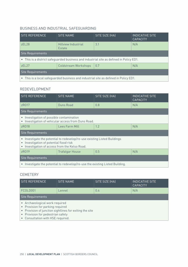
250 | LOCAL DEVELOPMENT PLAN | SCOTTISH BORDERS COUNCIL
BUSINESS AND INDUSTRIAL SAFEGUARDING
SITE REFERENCE SITE NAME SITE SIZE (HA) INDICATIVE SITE CAPACITY
zEL28 Hillview Industrial Estate
3.1 N/A
Site Requirements
• This is a district safeguarded business and industrial site as defined in Policy ED1.
zEL27 Coldstream Workshops 0.7 N/A
Site Requirements
• This is a local safeguarded business and industrial site as defined in Policy ED1.
REDEVELOPMENT
SITE REFERENCE SITE NAME SITE SIZE (HA) INDICATIVE SITE CAPACITY
zRO17 Duns Road 0.8 N/A
Site Requirements
• Investigation of possible contamination• Investigation of vehicular access from Duns Road.
zRO18 Lees Farm Mill 1.2 N/A
Site Requirements
• Investigate the potential to redevelop/re-use existing Listed Buildings• Investigation of potential flood risk• Investigation of access from the Kelso Road.
zRO19 Trafalgar House 0.5 N/A
Site Requirements
• Investigate the potential to redevelop/re-use the existing Listed Building.
CEMETERY
SITE REFERENCE SITE NAME SITE SIZE (HA) INDICATIVE SITE CAPACITY
FCOLD001 Lennel 0.4 N/A
Site Requirements
• Archaeological work required• Provision for parking required• Provision of junction sightlines for exiting the site• Provision for pedestrian safety• Consultation with HSE required.

INTRODUCTION | CHALLENGES | VISION, AIMS AND SPATIAL STRATEGYPOLICIES | APPENDICES | SETTLEMENTS
LOCAL DEVELOPMENT PLAN | SCOTTISH BORDERS COUNCIL | 251
KEY GREENSPACE
SITE REFERENCE SITE NAME SITE SIZE (HA)
GSCOLD001 Home Park 3.1
GSCOLD002 Coldstream Primary School 2.4
GSCOLD003 Tennis Courts 0.3
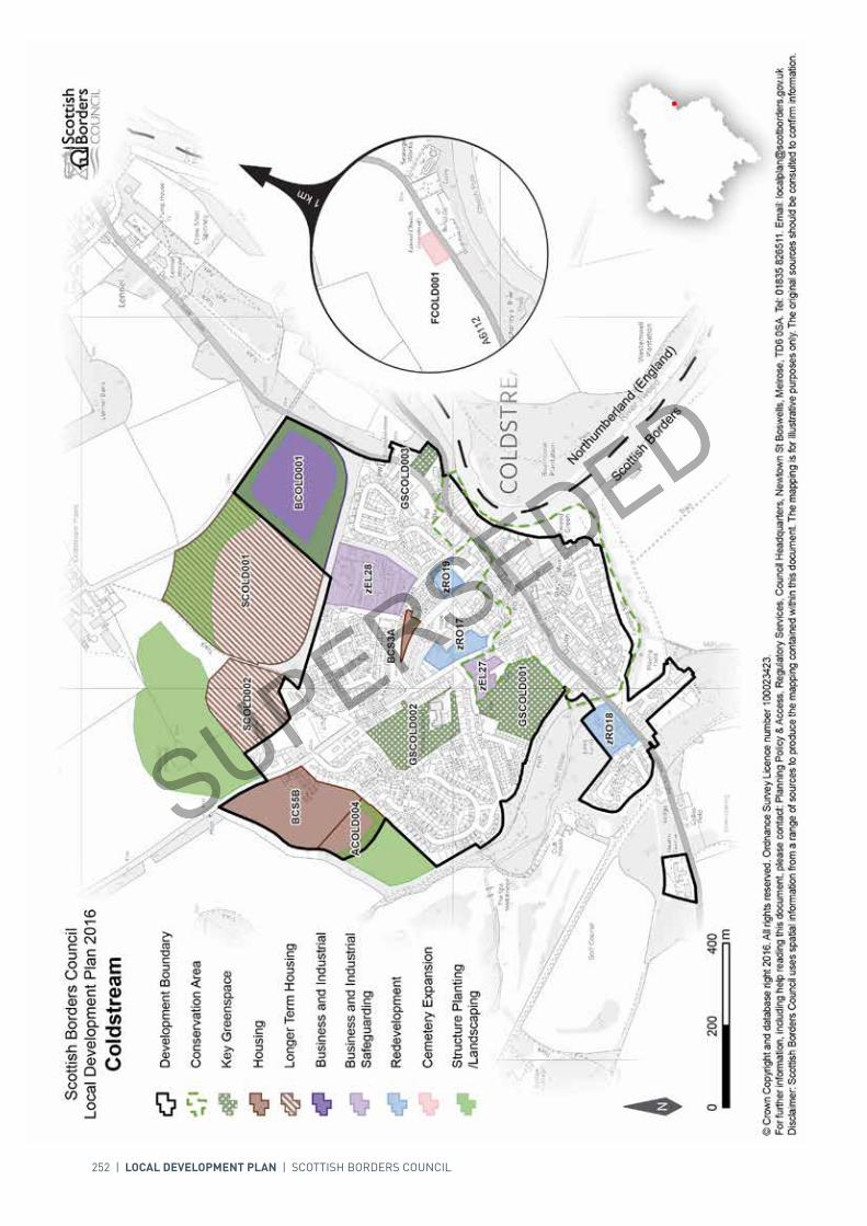
252 | LOCAL DEVELOPMENT PLAN | SCOTTISH BORDERS COUNCIL

00mm
400400200200
N
Scottish Borders CouncilLocal Development Plan 2016as modified by Supplementary
Guidance on Housing 2017Coldstream
© Crown Copyright and database right 2017. All rights reserved. Ordnance Survey Licence number 100023423.For further information, including help reading this document, please contact: Planning Policy & Access, Regulatory Services, Council Headquarters, Newtown St Boswells, Melrose, TD6 0SA. Tel: 0300 100 1800. Email: [email protected]: Scottish Borders Council uses spatial information from a range of sources to produce the mapping contained within this document. The mapping is for illustrative purposes only. The original sources should be consulted to confirm information.
Redevelopment
Development Boundary
Business and Industrial
Housing
Longer Term Housing
Business and IndustrialSafeguarding
Key Greenspace
Structure Planting/Landscaping
Conservation Area
Scottish Borders
Northumberland (England)
1 km
Cemetery Expansion
GSCOLD001GSCOLD001
GSCOLD002GSCOLD002GSCOLD003GSCOLD003
SCOLD001SCOLD001
BCOLD001BCOLD001BCS5BBCS5B
zEL28zEL28
SCOLD002SCOLD002
zRO18zRO18
zEL27zEL27
ACOLD004ACOLD004
zRO17zRO17zRO19zRO19
BCS3ABCS3A
FCOLD001FCOLD001
A6112A6112
ACOLD011ACOLD011

INTRODUCTION | CHALLENGES | VISION, AIMS AND SPATIAL STRATEGYPOLICIES | APPENDICES | SETTLEMENTS
LOCAL DEVELOPMENT PLAN | SCOTTISH BORDERS COUNCIL | 253
SETTLEMENT PROFILE CRAILING
This profile should be read in conjunction with the relevant settlement map.
DESCRIPTIONCrailing is located 7 miles to the south of Kelso within the Central Strategic Development Area, within the Development Strategy in the Strategic Development Plan. The 2001 Census population of Crailing was 36.
PLACE MAKING CONSIDERATIONSCrailing is situated on the A698 Jedburgh to Kelso Road, to the east of the Oxnam Water in the Teviot valley. The valley location of the settlement provides shelter with higher ground on both sides of the Teviot valley, although the settlement is relatively open to the north-east. The topography around Crailing is undulating with steeper ground to the south east; to the north the settlement enjoys open views out over the Teviot valley.
Crailing has developed at a crossing point of the Oxnam Water adjacent to the Parklands of Crailing House. Although originally focused on the river and bridge it is now dominated by the A698.
The Plan provides a short term housing allocation to the east of the settlement at Crailing Toll.
INFRASTRUCTURE CONSIDERATIONSAffordable Housing will require to be provided in association with proposed housing sites under the provisions of Policy HD1 and the Supplementary Guidance/Supplementary Planning Guidance on Affordable Housing.
With regards to waste water, Crailing is served by a septic tank which currently has sufficient capacity.
Further information is available from Supplementary Guidance/Supplementary Planning Guidance on Developer Contributions and Planning/Development Briefs where applicable.
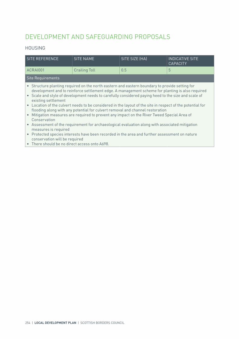
254 | LOCAL DEVELOPMENT PLAN | SCOTTISH BORDERS COUNCIL
DEVELOPMENT AND SAFEGUARDING PROPOSALS
HOUSING
SITE REFERENCE SITE NAME SITE SIZE (HA) INDICATIVE SITE CAPACITY
ACRAI001 Crailing Toll 0.5 5
Site Requirements
• Structure planting required on the north eastern and eastern boundary to provide setting for development and to reinforce settlement edge. A management scheme for planting is also required
• Scale and style of development needs to carefully considered paying heed to the size and scale of existing settlement
• Location of the culvert needs to be considered in the layout of the site in respect of the potential for flooding along with any potential for culvert removal and channel restoration
• Mitigation measures are required to prevent any impact on the River Tweed Special Area of Conservation
• Assessment of the requirement for archaeological evaluation along with associated mitigation measures is required
• Protected species interests have been recorded in the area and further assessment on nature conservation will be required
• There should be no direct access onto A698.

LOCAL DEVELOPMENT PLAN | SCOTTISH BORDERS COUNCIL | 255

256 | LOCAL DEVELOPMENT PLAN | SCOTTISH BORDERS COUNCIL
SETTLEMENT PROFILE DARNICK
This profile should be read in conjunction with the relevant settlement map.
DESCRIPTIONDarnick is located less than one mile west of Melrose. The population according to the 2001 Census is 397. The village is located within the Central Borders Strategic Development Area as defined in the SESplan.
PLACE MAKING CONSIDERATIONSThe Darnick Conservation Area incorporates the historic core of the settlement and the Conservation Village is organic in nature. Its buildings are arranged in informal groups providing constantly changing views to the Eildon Hills.
A strong impact has been formed by a number of buildings within the Conservation Area fronting directly onto the main street, as well as the use of traditional building materials and high standard of architectural detail.
The village is located within a sensitive landscape setting and is included in the Eildon and Leaderfoot National Scenic Area.
The distinct character and setting of Darnick is recognised. As indicated in Figure EP6a, Policy EP6 (Countryside Around Towns) seeks to protect the areas between Darnick and Melrose, and Darnick and Tweedbank from development in the longer term primarily to avoid coalescence of the settlements, thereby retaining individual character.
There is one area, Darnick Community Woodland, identified as a key greenspace.
The Plan provides housing allocations on the western and southern edges of the village.
With regard to Darnick’s proximity to the railway station it is anticipated that the settlement will be the subject of increasing development pressure. Any sites for future expansion will require further detailed assessment during the next Local Development Plan review.
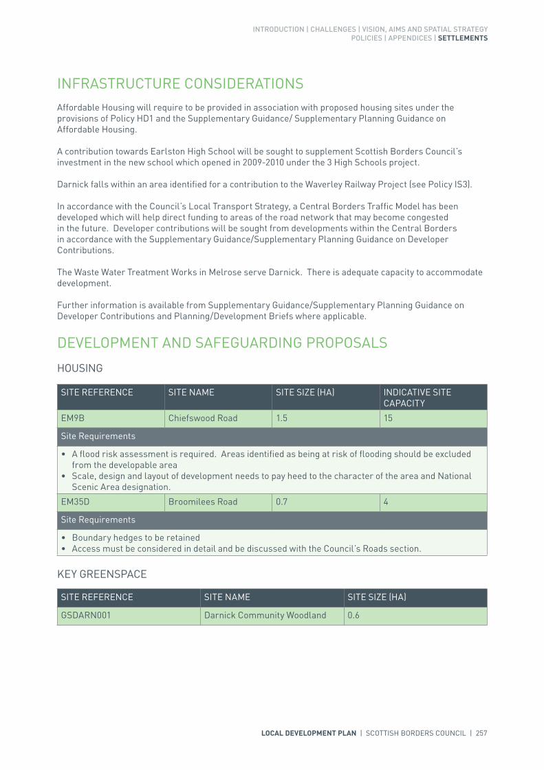
INTRODUCTION | CHALLENGES | VISION, AIMS AND SPATIAL STRATEGYPOLICIES | APPENDICES | SETTLEMENTS
LOCAL DEVELOPMENT PLAN | SCOTTISH BORDERS COUNCIL | 257
INFRASTRUCTURE CONSIDERATIONSAffordable Housing will require to be provided in association with proposed housing sites under the provisions of Policy HD1 and the Supplementary Guidance/ Supplementary Planning Guidance on Affordable Housing.
A contribution towards Earlston High School will be sought to supplement Scottish Borders Council’s investment in the new school which opened in 2009-2010 under the 3 High Schools project.
Darnick falls within an area identified for a contribution to the Waverley Railway Project (see Policy IS3).
In accordance with the Council’s Local Transport Strategy, a Central Borders Traffic Model has been developed which will help direct funding to areas of the road network that may become congested in the future. Developer contributions will be sought from developments within the Central Borders in accordance with the Supplementary Guidance/Supplementary Planning Guidance on Developer Contributions.
The Waste Water Treatment Works in Melrose serve Darnick. There is adequate capacity to accommodate development.
Further information is available from Supplementary Guidance/Supplementary Planning Guidance on Developer Contributions and Planning/Development Briefs where applicable.
DEVELOPMENT AND SAFEGUARDING PROPOSALS
HOUSING
KEY GREENSPACE
SITE REFERENCE SITE NAME SITE SIZE (HA)
GSDARN001 Darnick Community Woodland 0.6
SITE REFERENCE SITE NAME SITE SIZE (HA) INDICATIVE SITE CAPACITY
EM9B Chiefswood Road 1.5 15
Site Requirements
• A flood risk assessment is required. Areas identified as being at risk of flooding should be excluded from the developable area
• Scale, design and layout of development needs to pay heed to the character of the area and National Scenic Area designation.
EM35D Broomilees Road 0.7 4
Site Requirements
• Boundary hedges to be retained• Access must be considered in detail and be discussed with the Council’s Roads section.

258 | LOCAL DEVELOPMENT PLAN | SCOTTISH BORDERS COUNCIL

INTRODUCTION | CHALLENGES | VISION, AIMS AND SPATIAL STRATEGYPOLICIES | APPENDICES | SETTLEMENTS
LOCAL DEVELOPMENT PLAN | SCOTTISH BORDERS COUNCIL | 259
SETTLEMENT PROFILE DENHOLM
This profile should be read in conjunction with the relevant settlement map.
DESCRIPTIONDenholm is situated on the south bank of the River Teviot, mid-way between Hawick and Jedburgh on the A698 road. The population is 608 (2001 Census) and the village lies within the Central Borders Strategic Development Area as defined in the SESplan.
PLACE MAKING CONSIDERATIONSThe character of Denholm is established by its layout of largely two storey sandstone buildings around a large central green. The village is set within the landscape of the lowland valley of the Lower Teviot. The River Teviot, to the north, is part of the River Tweed Special Area of Conservation, a wildlife site of international importance. Denholm Dean, the wooded valley of the Dean Burn, forms a natural edge to the west of the village. The village is surrounded by the Teviot Valleys Special Landscape Area.
Denholm Conservation Area includes the central Green area, together with a smaller Green at Kirkside, part of Cannongate and the former Denholm Mill that is now in residential use. The village is distinctive in that it represents a planned village based on the decanting of stocking weaving work from Hawick. The properties around the Green are mainly two storey on a simple rectangular plan, gable ends and eaves to the roadside. Most buildings are constructed in continuous rows but there are a few examples of detached cottages.
Traditional building materials prevail throughout the Conservation Area, architectural detailing includes sash and case windows, and stone cills, jambs and lintels around window and door openings. It is all of these elements that give Denholm its distinct appearance that should be conserved. Any proposed alterations to individual buildings or any new development should seek to respect the individual buildings and the wider Conservation Area. There are six listed properties within the Conservation Area of which the Westgate Hall is a Category ‘A’.
A number of shops and two pubs/hotels are located in the village centre. The new Denholm Primary School is situated on the western edge of the village.
The Village Green is identified as a key greenspace.
Recent development has taken place on the eastern side of Denholm, at Croftfield, which adjoins the allocated housing sites at Denholm Hall Farm, to the north side of Jedburgh Road.

260 | LOCAL DEVELOPMENT PLAN | SCOTTISH BORDERS COUNCIL
The preferred area for future expansion beyond the period of this Local Development Plan will be the south-eastern edge of the village. Expansion will be dependant upon suitable access and landscaping. Development to the north-west of the settlement will be resisted where it will have a significant effect on the River Tweed international Special Area of Conservation site. Development to the west of the settlement will also be resisted as it would cross the natural boundary of the Denholm Dean. The suggested area is indicative only, and will require further detailed assessment during the next Local Development Plan review.
INFRASTRUCTURE CONSIDERATIONSAffordable Housing will require to be provided under the provisions of Policy HD1 and the Supplementary Guidance/ Supplementary Planning Guidance on Affordable Housing.
There is no requirement for contribution towards education provision.
With regards to Waste Water Treatment Works, Denholm has limited capacity. Contributions may be required where upgrades are necessary. In respect of the local water network, developers may be required to contribute towards upgrading to enable development.
Further information is available from Supplementary Guidance/Supplementary Planning Guidance on Developer Contributions and Planning/Development Briefs where applicable.
DEVELOPMENT AND SAFEGUARDING PROPOSALS
HOUSING
CEMETERY
SITE REFERENCE SITE NAME SITE SIZE (HA) INDICATIVE SITE CAPACITY
RD4B Denholm Hall Farm 0.9 10
ADENH001 Denholm Hall Farm East 2.1 40
Site Requirements
• Refer to approved Planning Brief.
KEY GREENSPACE
SITE REFERENCE SITE NAME SITE SIZE (HA)
FDENH001 Bedrule 0.1
• Discussion with the Council’s Roads Planning team to achieve acceptable access• Suitable boundary treatment is required• Existing boundary features should be retained• Archaeological work required.
SITE REFERENCE SITE NAME SITE SIZE (HA)
GSDENH001 Denholm Green 1.2
LOCAL DEVELOPMENT PLAN | SCOTTISH BORDERS COUNCIL | 261

262 | LOCAL DEVELOPMENT PLAN | SCOTTISH BORDERS COUNCIL
SETTLEMENT PROFILE DOLPHINTON
This profile should be read in conjunction with the relevant settlement map.
DESCRIPTIONDolphinton is located in the western part of the Northern Housing Market Area and is one of the few settlements that crosses the administration boundary with South Lanarkshire. The Scottish Borders part of the settlement straddles the A702 trunk road and is located 4 miles south west of West Linton. The settlement is located outwith the Strategic Development Areas as defined in the Strategic Development Plan.
PLACE MAKING CONSIDERATIONSThe character of Dolphinton (within the Scottish Borders Council area) has been established particularly by its layout and setting – it is set between Kippit Hill and Sandy Hill and consists of two parts separated by the A702 trunk road. The Garvald Burn runs to the south west of the village. Dolphinton was once served by two railways – the Caledonian Railway and the North British Railway. The dismantled railway runs through the settlement.
The plan provides a housing allocation for a small scale residential development which will bring a brownfield site back into use. The allocation is on the eastern edge of that part of the village on the west side of the A702.
INFRASTRUCTURE CONSIDERATIONSAffordable Housing will require to be provided in association with proposed housing sites under the provisions of Policy HD1 and the Supplementary Guidance/Supplementary Planning Guidance on Affordable Housing.
Peebles Secondary School is forecast by the Director of Education and Lifelong Learning to face some capacity issues from 2016 onwards. Developer Contribution towards school provision within the catchment will be requested, commensurate with the size and type of the development and in accordance with Developer Contribution Policy.
A contribution at the new school rate towards West Linton Primary School will be sought to supplement Scottish Borders Council’s investment in the new school.
With regards to Waste Water Treatment Works Dolphinton has limited capacity. Contributions may be required where upgrades are necessary. In respect of the local water network, developers may be required to contribute towards upgrading to enable development.

INTRODUCTION | CHALLENGES | VISION, AIMS AND SPATIAL STRATEGYPOLICIES | APPENDICES | SETTLEMENTS
LOCAL DEVELOPMENT PLAN | SCOTTISH BORDERS COUNCIL | 263
Further information is available from Supplementary Guidance/Supplementary Planning Guidance on Developer Contributions.
DEVELOPMENT AND SAFEGUARDING PROPOSALS
HOUSING
SITE REFERENCE SITE NAME SITE SIZE (HA) INDICATIVE SITE CAPACITY
ADOLP003 South of Sandy Hill 0.4 5
Site Requirements
• Existing landscaping on site to be retained. Landscape enhancement to the south and south east boundaries of the site adjacent to the A702 will be required. Buffer areas for new and existing landscaping will be required. The long term maintenance of landscaped areas must be addressed
• The site coincides with the former site of Dolphinton station. Further assessment of archaeology will be required and mitigation put in place
• Vehicular access to be achieved off the minor road to the south west of the site and the development to be designed so that there is no adverse effect on the safety of the nearby junction between the minor road and the A702
• Provision of amenity access to the countryside for pedestrians and cyclists• Potential contamination on site to be investigated and mitigated.
264 | LOCAL DEVELOPMENT PLAN | SCOTTISH BORDERS COUNCIL

INTRODUCTION | CHALLENGES | VISION, AIMS AND SPATIAL STRATEGYPOLICIES | APPENDICES | SETTLEMENTS
LOCAL DEVELOPMENT PLAN | SCOTTISH BORDERS COUNCIL | 265
SETTLEMENT PROFILE DRYBURGH
This profile should be read in conjunction with the relevant settlement map.
DESCRIPTIONDryburgh is located on the northern bank of the River Tweed approximately 4 miles from St Boswells and 7 miles from Melrose. Dryburgh is focused around the medieval Abbey and is located within the Central Strategic Development Area, as set out in the Development Strategy in the Strategic Development Plan.
PLACE MAKING CONSIDERATIONSThe Conservation Area of Dryburgh is located in the crook of the River Tweed beneath the Eildon Hills.
The Dryburgh Conservation Area is unique in the Borders in that it is a rural area that has many different types of buildings. These buildings range significantly from the modest agricultural buildings at Dryburgh Mains to the grandeur of the Dryburgh Abbey Hotel and the Abbey. The relationship of the buildings and the spaces between them contribute significantly to both the character and appearance of the Conservation Area. While the properties themselves range from single storey to two and a half storeys in height for residential buildings, the hotel rises to a significant three and a half storeys. Building materials include slate, harl and sandstone in varying colours. Details such as boundary walls with coping, crowsteps, stepped quoins, rybats and margins are features notable in Dryburgh and should be preserved.
DEVELOPMENT AND SAFEGUARDING PROPOSALS
BUSINESS AND INDUSTRIAL
Site BNEWT001 (Tweed Horizons Expansion) extends into the Dryburgh Conservation Area; refer to Newtown St Boswells Settlement Profile and Map.
266 | LOCAL DEVELOPMENT PLAN | SCOTTISH BORDERS COUNCIL

INTRODUCTION | CHALLENGES | VISION, AIMS AND SPATIAL STRATEGYPOLICIES | APPENDICES | SETTLEMENTS
LOCAL DEVELOPMENT PLAN | SCOTTISH BORDERS COUNCIL | 267
SETTLEMENT PROFILE DUNS
This profile should be read in conjunction with the relevant settlement map.
DESCRIPTIONDuns is one of the principal towns within the Eastern Strategic Development Area (SDA) as identified by the SESplan. According to the 2001 Census the population was 2,626.
PLACE MAKING CONSIDERATIONSDuns sits with the Castle and Duns Law to the north whilst the southern edge of the settlement sits on the Merse lowland. A mire runs east to west and there is an area of wetland to the south of the existing Primary School. The settlement radiates from the medieval church, Market Square and Cross with older buildings evident between the entrance to the Castle grounds and the Parish Church. The main shops are located around the Squares that mark the centre of the town and there are also buildings representing the administrative role of the town within Berwickshire. Latterly modern housing has been built away from the town centre, whilst to the south an industrial area has developed at Cheeklaw.
The Conservation Area in Duns contains distinctive characteristics that can only be found in the town. The majority of the properties are focused around the squares in the town centre and along Newtown Street. A variety of building styles are present adding to the uniqueness of the place and on the whole they follow the streetscape. The use of building materials such as sandstone, harling, slate, and architectural details such as transom lights, sash and case windows, and crow steps, contribute to the sense of place. Any development must aim to positively contribute to the character of the Conservation Area. There are 118 Listed Buildings within the Conservation Area of which the Mercat Cross is Category ‘A’.
The LDP puts forward a network of town centres and Duns is recognised within this as an important district centre. A Core Activity Area has been defined, running along part of the north side of Market Square, then from the bank round to the corner with Murray Street. The Core Activity Area represents the core area for public activity in Duns and also represents an important historic part of the town.
A site, South of Earlsmeadow Phase 1 (ADUNS023), has been allocated to help meet identified strategic housing need. A redevelopment site is also allocated at the former chicken hatchery at Clockmill (RDUNS003). Duns has a number of other housing allocations that have not yet been developed and the combination of the allocations is considered sufficient for the period of the Local Development Plan (LDP).

268 | LOCAL DEVELOPMENT PLAN | SCOTTISH BORDERS COUNCIL
Once the allocations are developed land for potential longer-term mixed use development is identified at South of Earlsmeadow (SDUNS001). This area is indicative only and would require further investigation and a Masterplan to ensure a coherent and holistic approach.
Development in other directions around Duns is constrained for a number of reasons. Duns Castle Designed Landscape provides an effective boundary to the northern edge of the town due to the steep slope. The Borders Landscape Capacity Study identifies a number of further constraints: to the south and south east the distance from the town centre and the open rural character of the landscape; to the east the rolling nature of the farmland and it’s role in providing a containing edge to the settlement; and to the west the risk of coalescence and the foreground to views of Duns Castle policies. The housing site at Langton Edge is located to the west of Duns and once it has been developed, further expansion will be resisted in this area to prevent ribbon development at greater distances from the town centre. The surrounds of the settlement are designated as prime agricultural land.
In terms of business and industrial land, the allocations at Cheeklaw and Peelrig Farm will provide for demand in the LDP period however there is the potential for further expansion along the dismantled railway line in the future.
It is envisaged that the primary school, which lacks capacity, will move to the former high school building. The key greenspace land to the north and west of the former high school will be used to cater for rugby pitches which will relocate from other parts of Duns.
INFRASTRUCTURE CONSIDERATIONSAffordable Housing will require to be provided under the provisions of Policy HD1 and the Supplementary Guidance/Supplementary Planning Guidance on Affordable Housing.
Funds have been identified to relocate the Primary School to the old Berwickshire High School. This will be a major refurbishment project. Developer contributions will be sought in the Duns Primary School catchment to assist in the provision of additional capacity. A contribution towards Berwickshire High School will be sought to supplement Scottish Borders Council’s investment in the new school which opened in 2009-2010 under the 3 High Schools project.
There are current and predicted longer-term pressures on health services accommodation. Accommodation may require upgrade or development.
With regards to Waste Water Treatment Works and Water Treatment Works, Duns currently has sufficient capacity. In respect of the local water network, developers may be required to contribute towards upgrading to enable development.
Further information is available from Supplementary Guidance/Supplementary Planning Guidance on Developer Contributions and Planning Briefs where applicable.
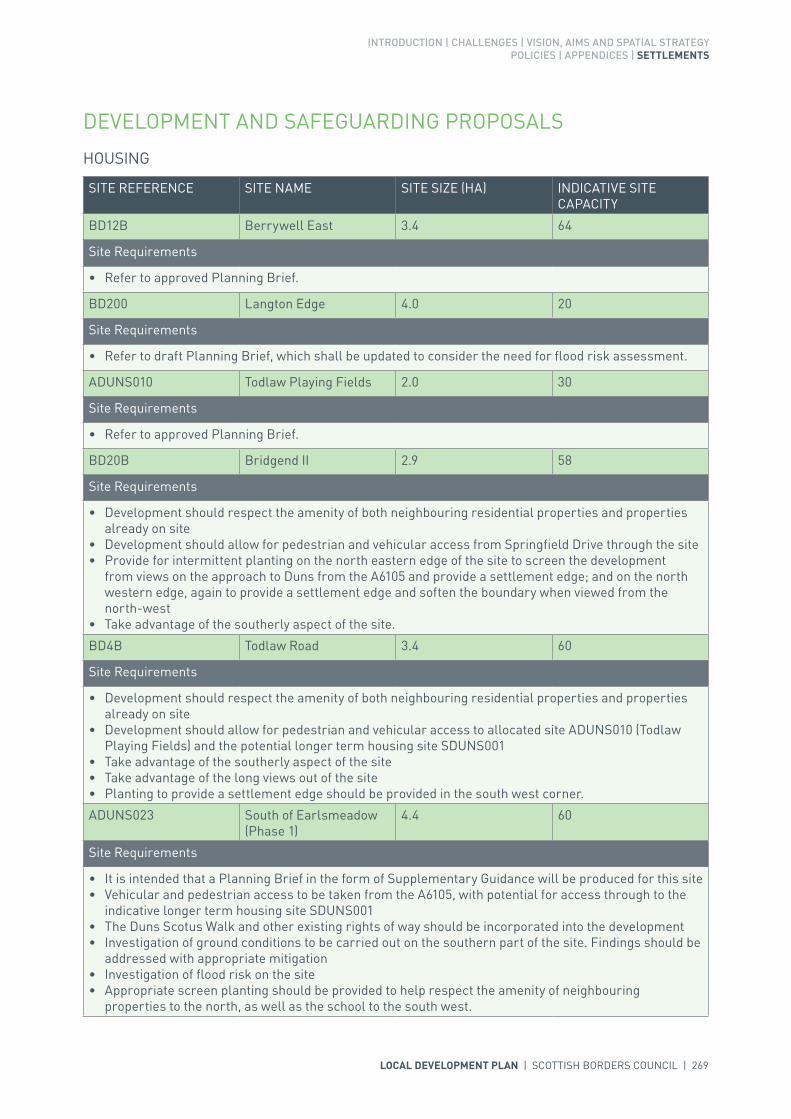
INTRODUCTION | CHALLENGES | VISION, AIMS AND SPATIAL STRATEGYPOLICIES | APPENDICES | SETTLEMENTS
LOCAL DEVELOPMENT PLAN | SCOTTISH BORDERS COUNCIL | 269
DEVELOPMENT AND SAFEGUARDING PROPOSALS
HOUSING
SITE REFERENCE SITE NAME SITE SIZE (HA) INDICATIVE SITE CAPACITY
BD12B Berrywell East 3.4 64
Site Requirements
• Refer to approved Planning Brief.
BD200 Langton Edge 4.0 20
Site Requirements
• Refer to draft Planning Brief, which shall be updated to consider the need for flood risk assessment.
ADUNS010 Todlaw Playing Fields 2.0 30
Site Requirements
• Refer to approved Planning Brief.
BD20B Bridgend II 2.9 58
Site Requirements
• Development should respect the amenity of both neighbouring residential properties and properties already on site
• Development should allow for pedestrian and vehicular access from Springfield Drive through the site• Provide for intermittent planting on the north eastern edge of the site to screen the development
from views on the approach to Duns from the A6105 and provide a settlement edge; and on the north western edge, again to provide a settlement edge and soften the boundary when viewed from the north-west
• Take advantage of the southerly aspect of the site.
BD4B Todlaw Road 3.4 60
Site Requirements
• Development should respect the amenity of both neighbouring residential properties and properties already on site
• Development should allow for pedestrian and vehicular access to allocated site ADUNS010 (Todlaw Playing Fields) and the potential longer term housing site SDUNS001
• Take advantage of the southerly aspect of the site• Take advantage of the long views out of the site• Planting to provide a settlement edge should be provided in the south west corner.
ADUNS023 South of Earlsmeadow (Phase 1)
4.4 60
Site Requirements
• It is intended that a Planning Brief in the form of Supplementary Guidance will be produced for this site• Vehicular and pedestrian access to be taken from the A6105, with potential for access through to the
indicative longer term housing site SDUNS001• The Duns Scotus Walk and other existing rights of way should be incorporated into the development• Investigation of ground conditions to be carried out on the southern part of the site. Findings should be
addressed with appropriate mitigation• Investigation of flood risk on the site• Appropriate screen planting should be provided to help respect the amenity of neighbouring
properties to the north, as well as the school to the south west.

270 | LOCAL DEVELOPMENT PLAN | SCOTTISH BORDERS COUNCIL
POTENTIAL LONGER TERM HOUSING (SUBJECT TO REVIEW)
SITE REFERENCE SITE NAME SITE SIZE (HA) INDICATIVE SITE CAPACITY
SDUNS001 South of Earlsmeadow 16.1 TBC
Site Requirements
• Cognisance of the Duns Scotus Way • Provision for an events area to facilitate tourism events• Investigation of ground conditions. The wetland area close to the park will need to be treated with care
to create an attractive wetland feature• Investigation of the flood risk on the site• The creation of a scattered woodland edge to define the site. This should still allow for solar gain, for
energy efficiency, within the site• The long term maintenance of landscaped areas must be addressed• Potential to enhance the road system around Duns• Assessment of developer contributions for the Primary School and High School.
BUSINESS AND INDUSTRIAL
BUSINESS AND INDUSTRIAL SAFEGUARDING
SITE REFERENCE SITE NAME SITE SIZE (HA) INDICATIVE SITE CAPACITY
zEL8 Peelrig Farm 3.9 N/A
Site Requirements
• This is a district business and industrial site as defined in Policy ED1• Ensure appropriate vehicular access is achieved through adjacent site, zEL26, whilst considering the
existing Right of Way • Ensure screen planting to define the southern edge of the site; and protect existing planting on the
eastern edge, without precluding the potential for future eastward expansion• Buildings should take advantage of southerly aspect where appropriate.• A flood risk assessment and consideration of whether there are culverted watercourses within or
adjacent to the site are required to inform the site layout, design and mitigation.
SITE REFERENCE SITE NAME SITE SIZE (HA) INDICATIVE SITE CAPACITY
zEL26 Cheeklaw 19.3 N/A
Site Requirements
• This is a district safeguarded business and industrial site as defined in Policy ED1.

INTRODUCTION | CHALLENGES | VISION, AIMS AND SPATIAL STRATEGYPOLICIES | APPENDICES | SETTLEMENTS
LOCAL DEVELOPMENT PLAN | SCOTTISH BORDERS COUNCIL | 271
REDEVELOPMENT
SITE REFERENCE SITE NAME SITE SIZE (HA) INDICATIVE SITE CAPACITY
zRO15 Former Berwickshire High School
2.5 N/A
Site Requirements
• Refer to approved Planning Brief.
RDUNS002 Duns Primary School 2.9 45
Site Requirements
• Refer to approved Planning Brief.
RDUNS003 Disused Chicken Hatchery, Clockmill
1.1 20
Site Requirements
• Investigate potential flood risk• Take cognisance of the existing planning permission on part of the site• Existing planting on southern and western boundaries should be retained where appropriate, to
shelter the site and provide a settlement edge• Assessment of historic heritage of Cammo House• Establish appropriate pedestrian and vehicular access in line with advice from the Council’s Roads
Planning team.
KEY GREENSPACE
SITE REFERENCE SITE NAME SITE SIZE (HA)
GSDUNS001 Duns Park 4.5
GSDUNS002 Former Berwickshire High School- Rear
3.1
GSDUNS003 Former Berwickshire High School- Front
0.6

272 | LOCAL DEVELOPMENT PLAN | SCOTTISH BORDERS COUNCIL

LOCAL DEVELOPMENT PLAN | SCOTTISH BORDERS COUNCIL | 273
274 | LOCAL DEVELOPMENT PLAN | SCOTTISH BORDERS COUNCIL
SETTLEMENT PROFILE EARLSTON
This profile should be read in conjunction with the relevant settlement map.
DESCRIPTIONEarlston is located along the A68 trunk road, approximately 7 miles south of Lauder.The population of Earlston according to the 2001 Census is 1,703. The settlement is located within the Central Housing Market Area and the Central Borders Strategic Development Area as defined in the Strategic Development Plan.
PLACE MAKING CONSIDERATIONSEarlston is set in the upland fringe valley of the Lower Leader. It is sited to the east of the Leader Water and north of the Turfford Burn and there is a flood risk associated with both of these watercourses. Its triangular green, its High Street and its church are all focal points. The Leader Water, to the south west, is part of the River Tweed Special Area of Conservation, a wildlife site of international importance. The community has expressed desire for land to the north of the existing cemetery is retained for expansion in the future. There are also aspirations for land at the Glebe to be used for open space and to retain existing recreational open space.
The Plan provides four housing sites, one business and industrial site and three business and industrial safeguarded sites as well as two redevelopment opportunities.
Within Earlston, three key greenspaces, including the Rugby Ground have been identified for protection due to the recreational opportunities these offer to the community. The Plan also allocates a site for cemetery expansion within the town.
Once the allocated sites are full developed the preferred area for future expansion beyond the period of this Plan will be the area to the east of the settlement at Georgefield east (SEARL006). This longer term mixed use site will be subject to further assessment and review as part of the next Local Development Plan review, and will require a Masterplan to ensure a coherent and holistic approach.
INFRASTRUCTURE CONSIDERATIONSAffordable Housing will require to be provided in association with proposed housing sites under the provisions of Policy HD1 and the Supplementary Guidance/Supplementary Planning Guidance on Affordable Housing.

INTRODUCTION | CHALLENGES | VISION, AIMS AND SPATIAL STRATEGYPOLICIES | APPENDICES | SETTLEMENTS
LOCAL DEVELOPMENT PLAN | SCOTTISH BORDERS COUNCIL | 275
A contribution towards Earlston High School will be sought to supplement Scottish Borders Council’s investment in the new school which opened in 2009-2010 under the 3 High Schools project.
The Director of Education and Lifelong Learning advises that there is a requirement to rationalise and refurbish the former secondary school for primary use. The Council has already made investment to expand the capacity to accommodate future development. Contributions will be sought to recoup this investment.
Scottish Borders Council maintains a Flooding Contingency Plan as part of its Emergency Planning Responsibilities. Within this plan reference is made to this settlement as being at risk of flooding. Any development proposals within this settlement should be subject to consultation with the Council’s flood prevention officer, and SEPA, having regard to the SEPA second generation flood risk maps, as part of the planning process. It is therefore recommended that early discussions take place to consider flood risk and the requirement for a flood risk assessment. It should be acknowledged that the flood risk assessment may influence the scale and layout of any development at that particular location.
There are current and predicted longer-term pressures on health services accommodation in Earlston. The accommodation may require upgrade or development.
Earlston falls within an area identified for a contribution to the Waverley Railway Project (see Policy IS3).
In accordance with the Council’s Local Transport Strategy, a Central Borders Traffic Model has been developed which will help direct funding to areas of the road network that may become congested in the future. Developer contributions will be sought from developments within the Central Borders in accordance with the Supplementary Guidance/Supplementary Planning Guidance on Developer Contributions.
With regards to Waste Water Treatment Works, Earlston has limited capacity. Contributions may be required where upgrades are necessary. In respect of the local water network, developers may be required to contribute towards upgrading to enable development.
Further information is available from Supplementary Guidance/Supplementary Planning Guidance on Developer Contributions and Planning/Development Briefs where applicable.
DEVELOPMENT AND SAFEGUARDING PROPOSALS
HOUSING
SITE REFERENCE SITE NAME SITE SIZE (HA) INDICATIVE SITE CAPACITY
EEA12B Earlston Glebe 2.5 25
Site Requirements
• Suitable vehicular access to the site would require discussion with the Council’s Roads Planning Team• A flood risk assessment is required to inform the design of the site along with possible mitigation and
resilience measures• The footpath along the former railway line is to be retained• Archaeological features on-site should be evaluated and mitigation measures carried out where
necessary• The development should have a key frontage onto the High Street. The building frontages should define
the key entrance to the site, creating a definite sense of place• Existing trees and hedgerows on the site are to be retained and enhanced wherever possible.

276 | LOCAL DEVELOPMENT PLAN | SCOTTISH BORDERS COUNCIL
AEARL002 Surplus land at Earlston High School
4.3 60
Site Requirements
• Refer to approved Planning Brief• Vehicular access to the site and the primary school from the north east and provide for access to any
future development to the south• A flood risk assessment will be required due to potential flood risk to the south east of the site• Potential contamination from the former gas works on the site to be investigated and mitigated• Conservation and enhancement considerations to be given to the Turfford Burn which is part of the
River Tweed Special Area of Conservation. Mitigation of any potential impacts on biodiversity• Retention of pedestrian/cycle link in the north west of the site to South Croft Park and in the north east
of the site between the primary school and the playing field• Creation of a countryside footpath along the Turfford Burn• Creation of woodland buffer along western boundary of site to separate residential uses from the
existing industrial uses to the west. A management scheme for planting is also required• Creation of an area of amenity open space in the eastern part of the site• Archaeological features on-site should be evaluated and mitigation measures carried out where
necessary. This includes the former gasworks site and stone tool finds listed on the sites and monuments record.
AEARL010 East Turfford 4.6 40
Site Requirements
• It is intended that a Planning Brief in the form of Supplementary Guidance will be produced for this site• A coherent Masterplan covering the whole area of Georgefield, including this site, AEARL011 and
longer term SEARL006• Vehicular access from the new road to the new high school and potential for a secondary access direct
onto the A6105 further to the east• A flood risk assessment will be required due to possible flooding in the southern part of the site. The
flood risk area should be landscaped as wetland with tree planting and recreational open space. This should serve as a central focal point between AEARL010 and AEARL011
• Conserve and enhance the nature conservation interest of the Turfford Burn to the south of the site which is part of the River Tweed Special Area of Conservation and on the open space in the south of the site. Mitigation of any impact on biodiversity
• Management of the existing tree belt to the north which screens the site from the A6105• Creation of a woodland buffer along the western boundary to contain it and screen it from the access
road to the school. A management scheme for planting is also required• Retention of footpaths through the east of the site.
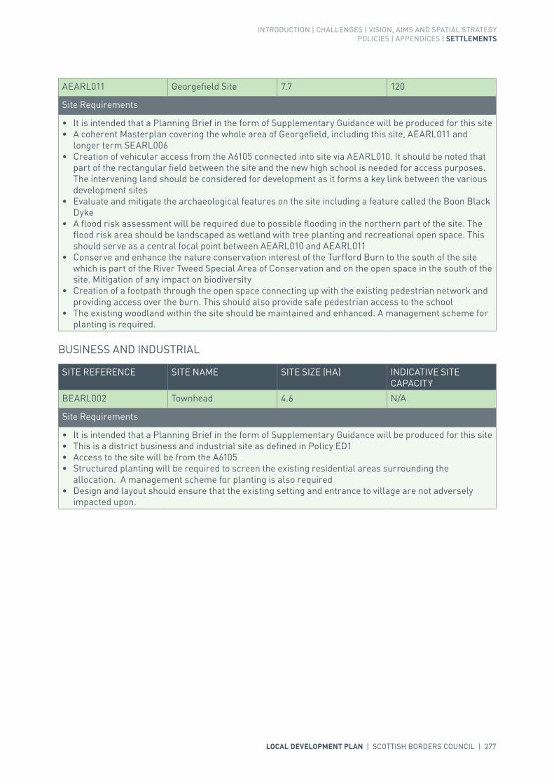
INTRODUCTION | CHALLENGES | VISION, AIMS AND SPATIAL STRATEGYPOLICIES | APPENDICES | SETTLEMENTS
LOCAL DEVELOPMENT PLAN | SCOTTISH BORDERS COUNCIL | 277
AEARL011 Georgefield Site 7.7 120
Site Requirements
• It is intended that a Planning Brief in the form of Supplementary Guidance will be produced for this site• A coherent Masterplan covering the whole area of Georgefield, including this site, AEARL011 and
longer term SEARL006• Creation of vehicular access from the A6105 connected into site via AEARL010. It should be noted that
part of the rectangular field between the site and the new high school is needed for access purposes. The intervening land should be considered for development as it forms a key link between the various development sites
• Evaluate and mitigate the archaeological features on the site including a feature called the Boon Black Dyke
• A flood risk assessment will be required due to possible flooding in the northern part of the site. The flood risk area should be landscaped as wetland with tree planting and recreational open space. This should serve as a central focal point between AEARL010 and AEARL011
• Conserve and enhance the nature conservation interest of the Turfford Burn to the south of the site which is part of the River Tweed Special Area of Conservation and on the open space in the south of the site. Mitigation of any impact on biodiversity
• Creation of a footpath through the open space connecting up with the existing pedestrian network and providing access over the burn. This should also provide safe pedestrian access to the school
• The existing woodland within the site should be maintained and enhanced. A management scheme for planting is required.
BUSINESS AND INDUSTRIAL
SITE REFERENCE SITE NAME SITE SIZE (HA) INDICATIVE SITE CAPACITY
BEARL002 Townhead 4.6 N/A
Site Requirements
• It is intended that a Planning Brief in the form of Supplementary Guidance will be produced for this site• This is a district business and industrial site as defined in Policy ED1• Access to the site will be from the A6105• Structured planting will be required to screen the existing residential areas surrounding the
allocation. A management scheme for planting is also required• Design and layout should ensure that the existing setting and entrance to village are not adversely
impacted upon.

278 | LOCAL DEVELOPMENT PLAN | SCOTTISH BORDERS COUNCIL
BUSINESS AND INDUSTRIAL SAFEGUARDING
SITE REFERENCE SITE NAME SITE SIZE (HA) INDICATIVE SITE CAPACITY
zEL55 Turfford Park 1.1 N/A
Site Requirements
• This is a district safeguarded business and industrial site as defined in Policy ED1• In the event of further proposed development or redevelopment, a flood risk assessment is required.
zEL56 Station Road 2.4 N/A
Site Requirements
• This is a district safeguarded business and industrial site as defined in Policy ED1.
zEL57 Mill Road 1.4 N/A
Site Requirements
• This is a district safeguarded business and industrial site as defined in Policy ED1• In the event of further proposed development or redevelopment, a flood risk assessment is required.
POTENTIAL LONGER TERM MIXED USE (SUBJECT TO REVIEW)
SITE REFERENCE SITE NAME SITE SIZE (HA) INDICATIVE SITE CAPACITY
SEARL006 Georgefield East 59.9 TBC
Site Requirements
• Vehicular access from the A6015. A transportation assessment will be required• The longer term mixed use area is appropriate for housing, employment, community uses and open
space• The natural heritage interest of the Turfford Burn, part of the River Tweed Special Area of
Conservation, should be conserved and enhanced• Flood risk assessment will be required for the areas at flood risk along the Turfford Burn• The layout and design of development should create a visually contained settlement expansion with its
own identity• New wetland areas for Sustainable Urban Drainage System (SUDS) should be created, including the
north east, north west and centre of Georgefield East• Retention and management of existing woodland, including woodland along burns and shelter belts• Woodland structure planting to provide a setting and shelter for potential development, create a
settlement edge, provide a wooded edge to watercourses and add variety to existing woodland. Planting should screen development from the roads to the north. A management scheme for planting is also required
• The archaeological sites on the sites and monuments record should be investigated and appropriate mitigation measures carried out. A crop mark in the south east should be excluded from development
• The provision of a pathway link from the longer term mixed use area to the new Earlston High School to the west and adjacent countryside paths.

INTRODUCTION | CHALLENGES | VISION, AIMS AND SPATIAL STRATEGYPOLICIES | APPENDICES | SETTLEMENTS
LOCAL DEVELOPMENT PLAN | SCOTTISH BORDERS COUNCIL | 279
KEY GREENSPACE
SITE REFERENCE SITE NAME SITE SIZE (HA)
GSEARL001 Acorn Drive Fields 1.0
GSEARL002 High Street 0.1
GSEARL003 Rugby Ground 1.5
REDEVELOPMENT
SITE REFERENCE SITE NAME SITE SIZE (HA) INDICATIVE SITE CAPACITY
zRO12 Brownlie Yard 1.5 N/A
Site Requirements
• Access to be taken directly from existing access off Church Street• Potential contamination on the site, to be investigated and mitigated• A flood risk assessment may be required to inform the design along with possible mitigation and
resilience measures• Design and layout to be in character with existing on-site development.
REARL001 Halcombe Fields 0.9 N/A
Site Requirements
• A flood risk assessment is required to inform the design along with possible mitigation and resilience measures
• Various uses would be appropriate for development on this site• Suitable access to the site would be determined by the proposed use and would require discussion
with the Council’s Roads Planning Team• Mitigation measures would be required to ensure no significant impacts on the River Tweed Special
Area of Conservation• Some archaeological investigation and mitigation may be necessary before or during redevelopment• Pedestrian access should be maintained through this site to the fields beyond and promote informal
access to the High School• Mitigation measures to be considered regarding the overhead power lines through part of the site.
CEMETERY
SITE REFERENCE SITE NAME SITE SIZE (HA)
FEARL001 Earlston Cemetery Expansion 0.4
Site Requirements
• Integrate existing Right of Way in development• Archaeological work required• Mitigation measures to minimise parking in surrounding residential areas.

280 | LOCAL DEVELOPMENT PLAN | SCOTTISH BORDERS COUNCIL

LOCAL DEVELOPMENT PLAN | SCOTTISH BORDERS COUNCIL | 281

282 | LOCAL DEVELOPMENT PLAN | SCOTTISH BORDERS COUNCIL
SETTLEMENT PROFILE ECCLES
This profile should be read in conjunction with the relevant settlement map.
DESCRIPTIONEccles is located 10 miles south west of Duns and 6 miles north east of Kelso. According to the 2001 Census the population of Eccles was 69. The village is located outwith the Strategic Development Areas (SDA) as put forward in the SESplan.
PLACE MAKING CONSIDERATIONSEccles lies on the Tweed lowlands and is surrounded by fields reflecting the prime agricultural land found in the area. The Parish Church has had a major role in placing the settlement on the map; however there has been little outward growth.
Eccles does not have a Conservation Area designation however there are 5 Listed Buildings within the settlement boundary.
It is considered that the two housing sites previously allocated in the Local Plan fulfil development need for the period of this Local Development Plan and likely beyond.
The south west corner of the Churchyard contains the remains of the St Mary’s Convent which is a Scheduled Monument, and there may be further archaeological interest in the surrounds of the site. Development which might affect the site would need to adhere to the requirements of Local Development Plan policy EP8.
INFRASTRUCTURE CONSIDERATIONSAffordable Housing will require to be provided under the provisions of HD1 and the Supplementary Guidance/Supplementary Planning Guidance on Affordable Housing.
A contribution towards Berwickshire High School will be sought to supplement Scottish Borders Council’s investment in the new school which opened in 2009-2010 under the 3 High Schools project.
With regards to Waste Water Treatment Works, Eccles has limited capacity. Contributions may be required where upgrades are necessary. In respect of the local water network, developers may be required to contribute towards upgrading to enable development. There is limited environmental capacity available because discharge is to a low dilution watercourse.
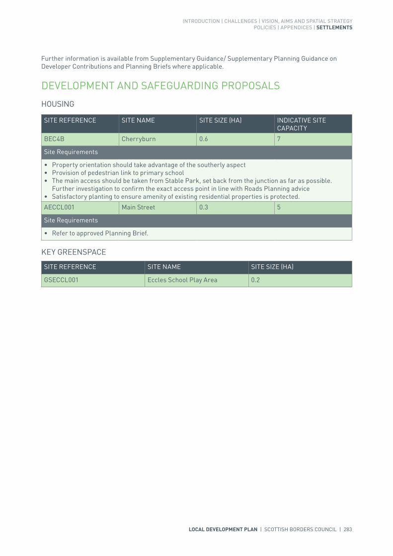
INTRODUCTION | CHALLENGES | VISION, AIMS AND SPATIAL STRATEGYPOLICIES | APPENDICES | SETTLEMENTS
LOCAL DEVELOPMENT PLAN | SCOTTISH BORDERS COUNCIL | 283
Further information is available from Supplementary Guidance/ Supplementary Planning Guidance on Developer Contributions and Planning Briefs where applicable.
DEVELOPMENT AND SAFEGUARDING PROPOSALS
HOUSING
KEY GREENSPACE
SITE REFERENCE SITE NAME SITE SIZE (HA)
GSECCL001 Eccles School Play Area 0.2
SITE REFERENCE SITE NAME SITE SIZE (HA) INDICATIVE SITE CAPACITY
BEC4B Cherryburn 0.6 7
Site Requirements
• Property orientation should take advantage of the southerly aspect• Provision of pedestrian link to primary school• The main access should be taken from Stable Park, set back from the junction as far as possible.
Further investigation to confirm the exact access point in line with Roads Planning advice• Satisfactory planting to ensure amenity of existing residential properties is protected.
AECCL001 Main Street 0.3 5
Site Requirements
• Refer to approved Planning Brief.
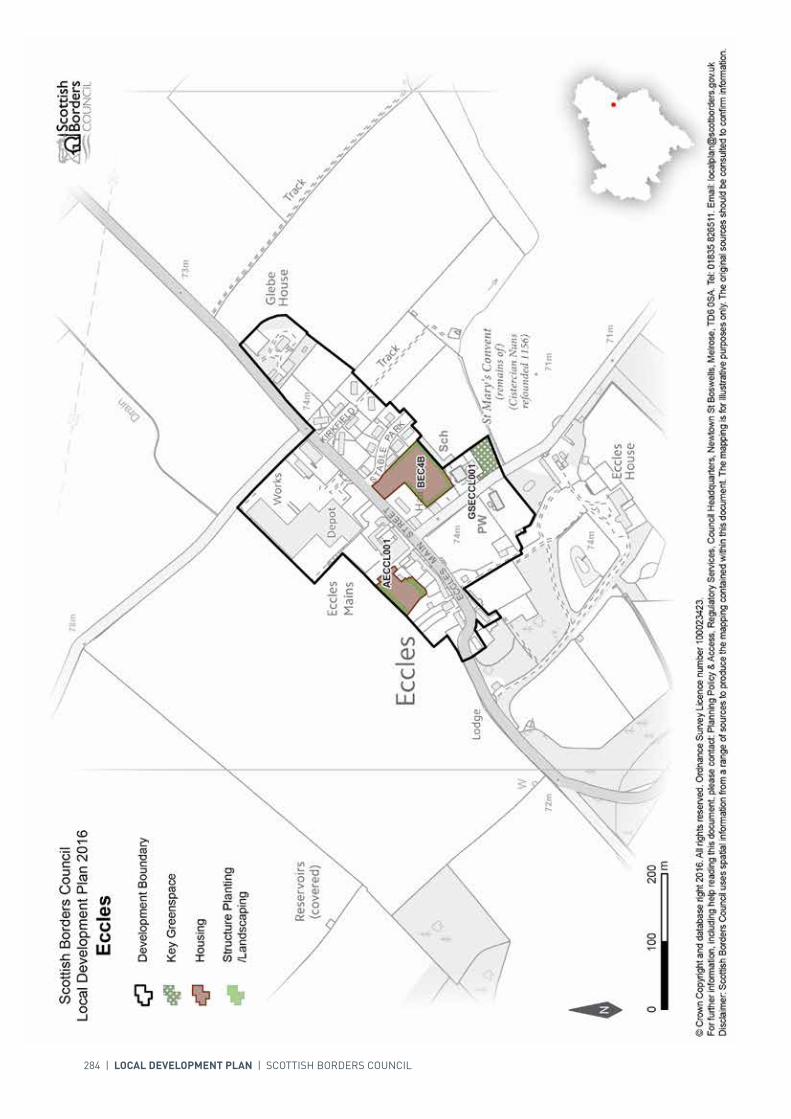
284 | LOCAL DEVELOPMENT PLAN | SCOTTISH BORDERS COUNCIL
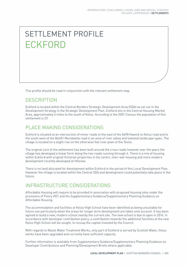
INTRODUCTION | CHALLENGES | VISION, AIMS AND SPATIAL STRATEGYPOLICIES | APPENDICES | SETTLEMENTS
LOCAL DEVELOPMENT PLAN | SCOTTISH BORDERS COUNCIL | 285
SETTLEMENT PROFILE ECKFORD
This profile should be read in conjunction with the relevant settlement map.
DESCRIPTIONEckford is located within the Central Borders Strategic Development Area (SDA) as set out in the Development Strategy in the Strategic Development Plan. Eckford sits in the Central Housing Market Area, approximately 6 miles to the south of Kelso. According to the 2001 Census the population of this settlement is 29.
PLACE MAKING CONSIDERATIONSEckford is situated at an intersection of minor roads to the east of the A698 Hawick to Kelso road and to the south west of the B6401 Morebattle road in an area of river valley and lowland landscape types. The village is located on a slight rise on the otherwise flat river plain of the Teviot.
The original core of the settlement has been built around the cross roads however over the years the village has developed a linear form along the two roads running through it. There is a mix of housing within Eckford with original Victorian properties in the centre, inter-war housing and more modern development recently developed at Hillview.
There is no land allocated for development within Eckford in the period of this Local Development Plan. However the village is located within the Central SDA and development could potentially take place in the future.
INFRASTRUCTURE CONSIDERATIONSAffordable Housing will require to be provided in association with proposed housing sites under the provisions of Policy HD1 and the Supplementary Guidance/Supplementary Planning Guidance on Affordable Housing.
The accommodation and facilities at Kelso High School have been identified as being unsuitable for future use particularly when the areas for longer term development are taken onto account. It has been agreed to build a new, modern school nearby the current site. The new school is due to open in 2016. In accordance with developer contribution policy, a contribution towards the additional facilities at the new Kelso High School will be sought, to recoup the capital invested by the Council.
With regards to Waste Water Treatment Works, only part of Eckford is served by Scottish Water, these works have been upgraded and currently have sufficient capacity.
Further information is available from Supplementary Guidance/Supplementary Planning Guidance on Developer Contributions and Planning/Development Briefs where applicable.
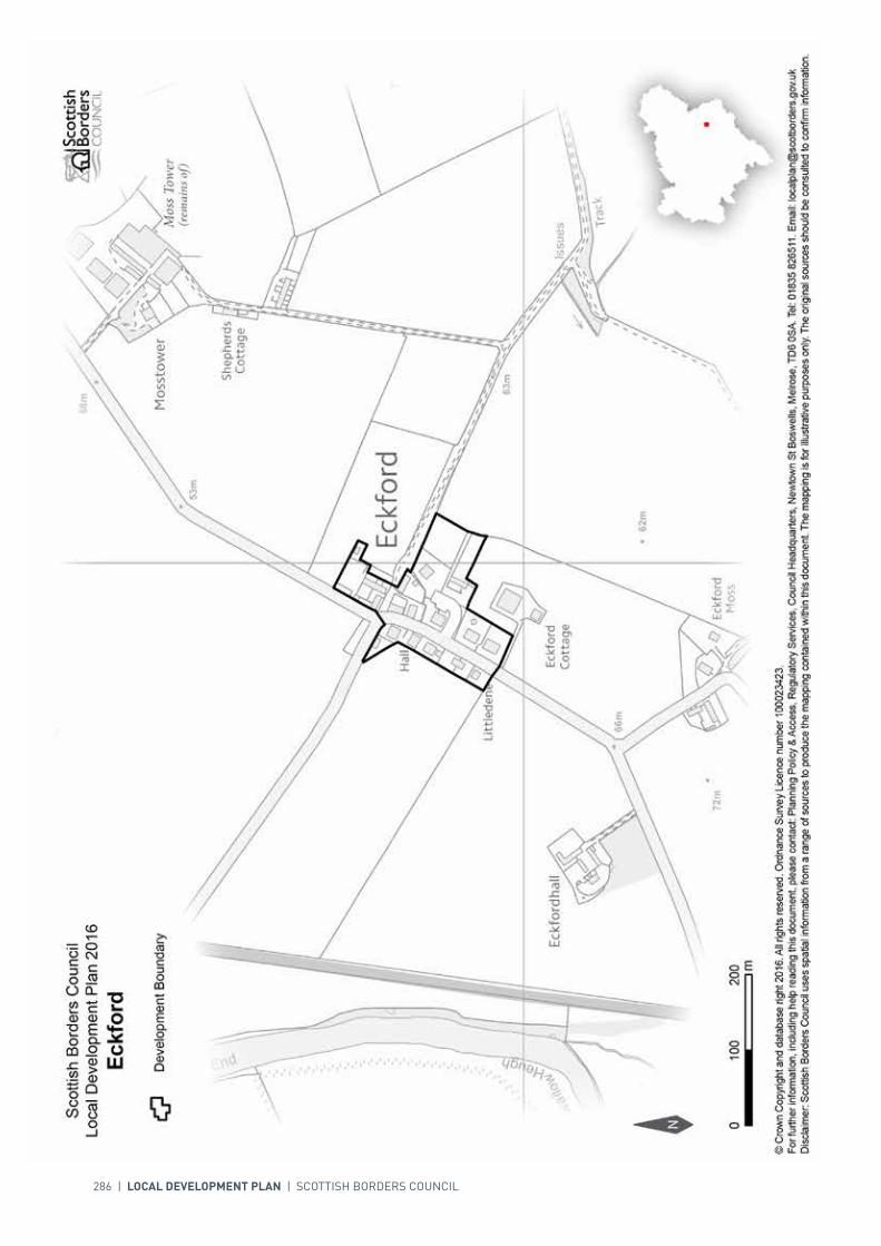
286 | LOCAL DEVELOPMENT PLAN | SCOTTISH BORDERS COUNCIL
INTRODUCTION | CHALLENGES | VISION, AIMS AND SPATIAL STRATEGYPOLICIES | APPENDICES | SETTLEMENTS
LOCAL DEVELOPMENT PLAN | SCOTTISH BORDERS COUNCIL | 287
SETTLEMENT PROFILE EDDLESTON
This profile should be read in conjunction with the relevant settlement map.
DESCRIPTIONEddleston is located outwith the Strategic Development Areas as defined in the Strategic Development Plan. The settlement is also located within the Northern Housing Market Area. The 2001 Census population was 335.
PLACE MAKING CONSIDERATIONSThe character of Eddleston is established particularly by its setting as it lies within the Lammermuir and Moorfoot Hills Landscape. Eddleston has a dramatic environment that is significantly enhanced by the woodlands and grassland that surrounds it. Eddleston benefits from many views both within and outwith the settlement.
The Eddleston Conservation Area includes the entire historic village and has two distinct focal points – Station Road and the area around the Horseshoe Inn. The village was founded about 1785 as a single street of whinstone cottages and is terminated by Station House to the north. Properties range from two to two and a half, detached and single storey cottages built in rows.
Eddleston village is set where the Eddleston Water meets the Longcote Burn and the Dean Burn. It is a result of these waterways that Eddleston has the three bridges crossing them – the two within the Conservation Area being humped back. All buildings relate to the landline and tend to rise and fall with the topography while the properties along Station Road front directly onto the street. Along Station Road small single storey cottage style properties are the norm, though some properties rise to two storeys elsewhere. Prominent buildings consist of the Parish Church on the hill and the Horseshoe Inn with its uniquely ‘horseshoe’ shaped windows reflecting its previous use as a smithy. Features that are evident throughout the Conservation Area and which form the character of the place are the use of building materials like whin and sandstone (predominately beige coloured though a few examples of red), harling and exposed rafter feet. Architectural details such as gabled porch entrances, bay windows, margins or stepped rybats and sash and case windows can be frequently seen. It is all of these elements that give Eddleston its distinct appearance that should be conserved.
The Plan provides two housing allocations one to the east of the village adjacent to the school, and the second to the north of Bellfield in the north of the village. The Local Development Plan does not identify any areas for longer term development.

288 | LOCAL DEVELOPMENT PLAN | SCOTTISH BORDERS COUNCIL
The Plan identifies two greenspace areas for protection within Eddleston, the Elibank Park and the Bellfield Crescent play area. These spaces provide the village community with important recreation opportunities.
INFRASTRUCTURE CONSIDERATIONSAffordable Housing will require to be provided in association with proposed housing sites under the provisions of Policy HD1 and the Supplementary Guidance/Supplementary Planning Guidance on Affordable Housing.
Peebles Secondary School is forecast by the Director of Education and Lifelong Learning to face some capacity issues from 2016 onwards. Developer Contribution towards school provision within the catchment will be requested, commensurate with the size and type of the development and in accordance with Developer Contribution Policy.
This settlement is identified within the Council’s Flood Contingency Plan as being at risk of flooding. Any development proposals should therefore be subject to early consultation with the Council’s Flood and Coastal Management Officer, and SEPA, having regard to the Indicative River and Coastal Flood Map (Scotland). A flood risk assessment may be required and may influence the scale and layout of any development at a particular location.
With regards to Waste Water Treatment Works Eddleston has limited capacity. Contributions may be required where upgrades are necessary. In respect of the local water network, developers may be required to contribute towards upgrading to enable development.
Further information is available from Supplementary Guidance/Supplementary Planning Guidance on Developer Contributions and Planning/Development Briefs where applicable.
DEVELOPMENT AND SAFEGUARDING PROPOSALS
HOUSING
SITE REFERENCE SITE NAME SITE SIZE (HA) INDICATIVE SITE CAPACITY
TE6B Burnside 1.9 30
Site Requirements
• Refer to approved Planning Brief and, additionally, consider the potential for culvert removal and channel restoration
• Consideration is to be given to phasing of development of site.
AEDDL002 North of Bellfield 4.1 35
Site Requirements
• It is intended that a Planning Brief in the form of Supplementary Guidance will be produced for this site• A vehicular link via Bellfield Crescent to the south and from the A703 further north will be required• Provision of structure planting along the northern edge of the site with an area of open space to the
east of the site along with buffer areas alongside new and existing landscaping will be required• Provision of amenity access within the development for pedestrians and cyclists• Assessment and mitigation of flood risk from overland flow will be required• Mitigation measures are required to prevent any impact on the River Tweed Special Areas of
Conservation• Water resilient construction measures should be employed in the development of the site.

INTRODUCTION | CHALLENGES | VISION, AIMS AND SPATIAL STRATEGYPOLICIES | APPENDICES | SETTLEMENTS
LOCAL DEVELOPMENT PLAN | SCOTTISH BORDERS COUNCIL | 289
KEY GREENSPACE
SITE REFERENCE SITE NAME SITE SIZE (HA)
GSEDDL001 Bellfield Crescent Play Area 0.1
GSEDDL002 Elibank Park 1.4

290 | LOCAL DEVELOPMENT PLAN | SCOTTISH BORDERS COUNCIL

INTRODUCTION | CHALLENGES | VISION, AIMS AND SPATIAL STRATEGYPOLICIES | APPENDICES | SETTLEMENTS
LOCAL DEVELOPMENT PLAN | SCOTTISH BORDERS COUNCIL | 291
SETTLEMENT PROFILE EDNAM
This profile should be read in conjunction with the relevant settlement map.
DESCRIPTIONEdnam is located in the Central Borders Housing Market Area, almost 3 miles north of Kelso. The settlement is located within the Central Strategic Development Area, within the Development Strategy in the Strategic Development Plan. The population of Ednam according to the 2001 Census is 140.
PLACE MAKING CONSIDERATIONSEdnam is located along the B6461 and lies north of the Eden Water. The most recent development within the village has been a small scale housing development at the north eastern end of the village at Eden Park.
The Plan provides one housing allocation to the west of the village at West Mill. To the east of this allocation, a site has been allocated to accommodate an expansion of the existing cemetery. The Plan also identifies the Playing Fields at Ednam Primary School as a key greenspace for protection. The longer term areas for future expansion beyond this Local Development Plan period will be to the north and to the east. The areas for longer term development are indicative only and will require further detailed assessment.
INFRASTRUCTURE CONSIDERATIONSAffordable Housing will require to be provided in association with proposed housing sites under the provisions of Policy HD1 and the Supplementary Guidance/Supplementary Planning Guidance on Affordable Housing.
The accommodation and facilities at Kelso High School have been identified as being unsuitable for future use particularly when the areas for longer term development are taken onto account. It has been agreed to build a new, modern school nearby the current site. The new school is due to open in 2016. In accordance with developer contribution policy, a contribution towards the additional facilities at the new Kelso High School will be sought, to recoup the capital invested by the Council.
With regards to Waste Water Treatment Works, Ednam uses the pump station at Kelso which has limited capacity. Contributions may be required where upgrades are necessary. In respect of the local water network, developers may be required to contribute towards upgrading to enable development.

292 | LOCAL DEVELOPMENT PLAN | SCOTTISH BORDERS COUNCIL
Further information is available from Supplementary Guidance/Supplementary Planning Guidance on Developer Contributions and Planning/Development Briefs where applicable.
DEVELOPMENT AND SAFEGUARDING PROPOSALS
HOUSING
KEY GREENSPACE
SITE REFERENCE SITE NAME SITE SIZE (HA)
GSEDNA001 Playing Field 0.8
SITE REFERENCE SITE NAME SITE SIZE (HA) INDICATIVE SITE CAPACITY
AEDNA002 West Mill 1.3 12
Site Requirements
• Site is to be accessed via Poppleburn Park• Structure planting required on the western and northern boundary to resist further development to
the west and to reinforce settlement edge and reduce visual impact• New appropriate boundary treatment would be required between this site and the allocated cemetery
expansion.
CEMETERY
SITE REFERENCE SITE NAME SITE SIZE (HA)
FEDNA001 Ednam Cemetery Expansion 0.05
Site Requirements
• Suitable boundary treatment to the west is required• Archaeological assessment required.

LOCAL DEVELOPMENT PLAN | SCOTTISH BORDERS COUNCIL | 293
294 | LOCAL DEVELOPMENT PLAN | SCOTTISH BORDERS COUNCIL
SETTLEMENT PROFILE EILDON
This profile should be read in conjunction with the relevant settlement map.
DESCRIPTIONEildon is located to the north of Newtown St Boswells. The population is 53 according to the 2001 Census. The village is included in the Central Borders Strategic Development Area as identified in the SESplan.
PLACE MAKING CONSIDERATIONSThe character of Eildon is established by an irregular cluster of cottages and houses. There is no Conservation Area in Eildon. The quality of the countryside around Eildon is recognised by its designation as a National Scenic Area.
The Plan puts forward a previously allocated site at West Eildon for housing. The main opportunities and constraints for the site are set out in an approved Planning Brief.
Due to the sensitive landscape setting of the village, further development will be resisted. Development to the south should be resisted to prevent the coalescence of Eildon with Newtown St Boswells. Development to the west of Eildon should be resisted because the road forms a clear boundary and beyond that there are open fields that form the foothills of the Eildon Hills.
INFRASTRUCTURE CONSIDERATIONSAffordable Housing will require to be provided in association with proposed housing sites under the provisions of Policy HD1 and the Supplementary Guidance/ Supplementary Planning Guidance on Affordable Housing.
A contribution towards Earlston High School will be sought to supplement Scottish Borders Council’s investment in the new school which opened in 2009-2010 under the 3 High Schools project.
The settlement falls within an area identified for a contribution to the Borders Railway (See Policy IS3).
In accordance with the Council’s Local Transport Strategy, a Central Borders Traffic Model has been developed which will help direct funding to areas of the road network that may become congested in the future. Developer contributions will be sought from developments within the Central Borders in accordance with the Supplementary Guidance/ Supplementary Planning Guidance on Developer Contributions.

INTRODUCTION | CHALLENGES | VISION, AIMS AND SPATIAL STRATEGYPOLICIES | APPENDICES | SETTLEMENTS
LOCAL DEVELOPMENT PLAN | SCOTTISH BORDERS COUNCIL | 295
With regards to Waste Water Treatment Works, Eildon has limited capacity. Contributions may be required where upgrades are necessary. In respect of the local water network, developers may be required to contribute towards upgrading to enable development. There is limited capacity for new private sewage treatment systems due to small watercourses in the vicinity. Contact should be made with SEPA.
Further information is available from Supplementary Guidance/Supplementary Planning Guidance on Developer Contributions and Planning/Development Briefs where applicable.
DEVELOPMENT AND SAFEGUARDING PROPOSALS
HOUSING
SITE REFERENCE SITE NAME SITE SIZE (HA) INDICATIVE SITE CAPACITY
AEILD002 West Eildon 0.8 5
Site Requirements
• Refer to approved Planning Brief.

296 | LOCAL DEVELOPMENT PLAN | SCOTTISH BORDERS COUNCIL
INTRODUCTION | CHALLENGES | VISION, AIMS AND SPATIAL STRATEGYPOLICIES | APPENDICES | SETTLEMENTS
LOCAL DEVELOPMENT PLAN | SCOTTISH BORDERS COUNCIL | 297
SETTLEMENT PROFILE ETTRICK (HOPEHOUSE)
This profile should be read in conjunction with the relevant settlement map.
DESCRIPTIONThe building group known as Hopehouse is situated in the upland valley of the Ettrick Water, approximately 17 miles south west of Selkirk, on the B709 minor road. The settlement is outside the Central Borders Strategic Development Area as defined in the SESplan.
PLACE MAKING CONSIDERATIONSThere are a number of building groups located within the Ettrick valley along the B709, including Ettrick, Hopehouse, Tushielaw and Crosslee. Although the local school and pub have closed recently, the presence of a church and village hall within the area make the aforesaid building groups suitable for small housing allocations. Maintaining a viable population to support the retention of local facilities in this remote area is desirable.
The largest cluster of buildings in this settlement group is at Hopehouse, which straddles Hopehouse Burn, a tributary of the Ettrick Water. Hopehouse consists of a prominent steading called Wardlaw that is to the north of the B709, together with a number of small cottages and detached houses. A small caravan park occupies land between the building group and Ettrick Water to the south-east.
The settlement has a southerly aspect and sits in an attractive upland landscape with impressive views of the surrounding high hills.
The development proposals at Hopehouse envisage the construction of around 15 new dwellings.
INFRASTRUCTURE CONSIDERATIONSAffordable Housing will require to be provided under the provisions of Policy H1 and the Supplementary Guidance/ Supplementary Planning Guidance on Affordable Housing. The scale and type of provision will be guided by any Housing Needs Assessments already undertaken.
There is no requirement for contribution towards education provision.
There is no Scottish Water water supply in the area. There is a septic tank at Ettrick but not at Hopehouse. The septic tank at Ettrick is not large enough to support additional properties. Appropriate provision of private sewage treatment systems would be required for any new development in this location, to be agreed and licensed by SEPA.

298 | LOCAL DEVELOPMENT PLAN | SCOTTISH BORDERS COUNCIL
Further information is available from Supplementary Guidance/Supplementary Planning Guidance on Developer Contributions and Planning/Development Briefs where applicable.
DEVELOPMENT AND SAFEGUARDING PROPOSALS
HOUSING
SITE REFERENCE SITE NAME SITE SIZE (HA) INDICATIVE SITE CAPACITY
AETTR002 Hopehouse East 0.5 5
AETTR003 Hopehouse West 2.0 5
AETTR004 Hopehouse North East 0.4 5
Site Requirements
• Refer to approved Planning Brief.

LOCAL DEVELOPMENT PLAN | SCOTTISH BORDERS COUNCIL | 299

300 | LOCAL DEVELOPMENT PLAN | SCOTTISH BORDERS COUNCIL
SETTLEMENT PROFILE ETTRICKBRIDGE
This profile should be read in conjunction with the relevant settlement map.
DESCRIPTIONEttrickbridge is situated in the upland valley of the Ettrick Water approximately 8 miles south west of Selkirk, on the B7009 minor road. The population is 96 (2001 Census). The village is outside the Central Borders Strategic Development Area as defined in the SESplan.
PLACE MAKING CONSIDERATIONSThe character of Ettrickbridge is established by its main street from the church to the hall and its rural setting. Local facilities include a public house and primary school.
The Ettrick Water, immediately to the south, is part of the River Tweed Special Area of Conservation, a wildlife site of international importance.
There is one area, Kirkhope Sports Club, identified as a key greenspace. The existing cemetery is located to the north of the village; this would be extended to the west, where an archaeological investigation would be required.
Development to the south of the settlement will be resisted when it exacerbates flood risk or impacts on the international nature conservation value of the Ettrick Water. Small scale expansion of the village over the last decade has taken place off Woodend Road on the north-eastern edge of the village.
The preferred area for future expansion beyond the period of this Local Development Plan will be to the north of the settlement, but is dependent upon improved road access. This will require further detailed assessment during the next Local Development Plan review.
INFRASTRUCTURE CONSIDERATIONSAffordable Housing will require to be provided under the provisions of Policy HD1 and the Supplementary Guidance/ Supplementary Planning Guidance on Affordable Housing.
There is no requirement for contribution towards education provision.
Ettrickbridge falls within an area identified for a contribution to the Borders Railway (See Policy IS3).

INTRODUCTION | CHALLENGES | VISION, AIMS AND SPATIAL STRATEGYPOLICIES | APPENDICES | SETTLEMENTS
LOCAL DEVELOPMENT PLAN | SCOTTISH BORDERS COUNCIL | 301
With regards to Waste Water Treatment Works, Ettrickbridge has limited capacity. Contributions may be required where upgrades are necessary. In respect of the local water network, developers may be required to contribute towards upgrading to enable development.
Further information is available from Supplementary Guidance/Supplementary Planning Guidance on Developer Contributions and Planning/Development Briefs where applicable.
DEVELOPMENT AND SAFEGUARDING PROPOSALS
CEMETERY
SITE REFERENCE SITE NAME SITE SIZE (HA)
GSETTB001 Ettrickbridge/Kirkhope Sports Club
0.7
SITE REFERENCE SITE NAME SITE SIZE (HA)
FETTR001 Ettrickbridge 0.1
Site Requirements
• Discussion with the Council’s Roads Planning team to achieve acceptable access• Existing boundary treatment to the south to be protected and retained.
KEY GREENSPACE

302 | LOCAL DEVELOPMENT PLAN | SCOTTISH BORDERS COUNCIL
INTRODUCTION | CHALLENGES | VISION, AIMS AND SPATIAL STRATEGYPOLICIES | APPENDICES | SETTLEMENTS
LOCAL DEVELOPMENT PLAN | SCOTTISH BORDERS COUNCIL | 303
SETTLEMENT PROFILE EYEMOUTH
This profile should be read in conjunction with the relevant settlement map.
DESCRIPTIONEyemouth is located 13 miles north-east of Duns. The population of Eyemouth according to the 2001 Census was 3479. The town is located within the Eastern Strategic Development Area (SDA) as identified by the SESplan.
PLACE MAKING CONSIDERATIONSEyemouth has considerable scenic attraction with its coastal location and dramatic headlands. The harbour lies at the mouth of the Eye Water which separates the town from the area of Gunsgreen. With Gunsgreen House as a backdrop, the harbour is a picturesque quarter of the traditional fishing town.
The town has grown outward from the harbour and the mouth of the Eye Water and also away from the High Street and Church Street. Modern housing has spread over to the Gunsgreen side of the harbour but is mainly located on the western side of the town. Development such as the Acredale and Eyemouth Industrial Estates can be linked to the harbour and the proximity of the A1. There is also development that can be linked to the coastal location such as the caravan holiday park to the north-west and Eyemouth Golf Course to the south-east.
Eyemouth town centre runs along the High Street into Church Street and spreads into the pedestrianised wynds and squares off Chapel Street and George Street. Eyemouth attracts a number of tourists and there is a strong retail presence, with independent retailers still trading. The LDP puts forward a network of town centres and Eyemouth is recognised within this as an important district centre. A Core Activity Area has been defined which covers a block of the High Street to the corner with Chapel Street and part of the block opposite to the corner with Renton Terrace. The Core Activity Area represents the core area for public activity in Eyemouth.
Eyemouth Harbour is the second largest inshore fishing port in Scotland. There has been significant regeneration funding to enhance harbour operations as well as to support further economic development in the town. A new high school has been built as a part of the 3 Schools project and the former high-school building is now a redevelopment opportunity. There are further redevelopment opportunities identified at the Whale Hotel, and former gas holder station, and a regeneration opportunity between Church Street, Manse Road and Harbour Road.
The Conservation Area of Eyemouth includes the town centre, harbour and a series of old fortifications dotted along the coastline. A number of important features contribute to the character of the
304 | LOCAL DEVELOPMENT PLAN | SCOTTISH BORDERS COUNCIL
Conservation Area. The Town’s harbour is essential to the character of the place and it is inextricably linked to the traditional layout of Harbour Road. The coast brings an additional element to the townscape quality along coastal walk and Marine Parade. The Burgh Chambers, Gunsgreen House, and Paxton Terrace and Armitage Street, are all good examples of traditional architecture. There are a range of property types evident, from single storey to three and a half storeys. Development must aim to contribute to the existing character of the Conservation Area and of individual buildings. Within the Conservation Area there are 64 Listed Buildings including two of Category ‘A’.
Eyemouth has a number of previously allocated sites that are not yet developed which are considered sufficient to meet development needs for the LDP period and beyond.
The Berwickshire and North Northumberland Coast Special Area of Conservation is located around the coast of Eyemouth and any proposal which could impact upon this designation will have to meet the requirements of Policy EP1. There are also two SSSI sites, Berwickshire Coast Intertidal and Burnmouth coast which are protected by Policy EP2.
The Berwickshire Coast Special Landscape Area (SLA) bounds the Eyemouth coastline and inland areas adjacent to the settlement. Any proposal for development that may affect the SLA will need to take cognisance of the requirements of Policy EP5.
The roads either side of the Harbour area are at risk of coastal and fluvial flooding.
The Netherbyres Designed Landscape is located south of the settlement boundary and development is constrained here to protect the status and historic character of the area, as well as the contribution to the fine setting of the town along its western edge. The Borders Landscape Capacity Study identifies constraints to development at the surrounds of the town, to the south east by the elevation and exposure on the open slopes and by the role that the ridges make in containing and providing a robust edge to the settlement; to the south-west by the steep gradients and high visibility of the landform; and to the west by the exposure and visual impact of development, which would breach the ridges and skyline. Areas to the south and west of the A1107 are therefore likely to be protected from development.
The land surrounding the limits of Eyemouth is prime agricultural land.
INFRASTRUCTURE CONSIDERATIONSAffordable Housing will require to be provided under the provisions of Policy HD1 and the Supplementary Guidance/Supplementary Planning Guidance on Affordable Housing.
A contribution towards Eyemouth High School will be sought to supplement Scottish Borders Council’s investment in the new school which opened in 2009-2010 under the 3 High Schools project.
There are current and predicted longer-term pressures on health services accommodation. Accommodation may require upgrade or development.
With regards to Waste Water Treatment Works and Water Treatment Works, Eyemouth currently has sufficient capacity.
Further information is available from Supplementary Guidance/Supplementary Planning Guidance on Developer Contributions and Planning / Development Briefs where applicable.

INTRODUCTION | CHALLENGES | VISION, AIMS AND SPATIAL STRATEGYPOLICIES | APPENDICES | SETTLEMENTS
LOCAL DEVELOPMENT PLAN | SCOTTISH BORDERS COUNCIL | 305
DEVELOPMENT AND SAFEGUARDING PROPOSALS
HOUSING
SITE REFERENCE SITE NAME SITE SIZE (HA) INDICATIVE SITE CAPACITY
BEY1 Barefoots 1.3 20
Site Requirements
• Development must not adversely impact the Berwickshire and North Northumberland Coast SAC• Development should not cause adverse impacts on the Berwickshire Coast SLA• Development should not be of a scale as to adversely affect the amenity of existing neighbouring
residential properties• Satisfactory planting will be required to screen the south eastern side, and at the north west side to
provide a settlement edge, although it should not prejudice the sea view• The existing hedge at the south western edge should be protected• Development should seek to maximise the benefits of the southerly aspect• Where appropriate development should take advantage of the long sea views• Vehicular access could be taken from the existing housing on Barefoots Road and/or at the north west
corner of the site (at the corner of Hinkar Way/Pocklaw Slap), in line with Roads Planning advice.
BEY2B Acredale Farm Cottages 9.5 244
Site Requirements
• Refer to approved Planning Brief.
BEY15B Gunsgreenhill 3.3 66
Site Requirements
• Refer to approved Planning Brief.
AEYEM006 Gunsgreenhill Site C 4.7 12
Site Requirements
• Refer to approved Planning Brief, which shall be updated to consider the need for flood risk assessment.
AEYEM007 Gunsgreenhill Site B 7.9 120
Site Requirements
• Refer to approved Planning Brief, which shall be updated to consider the need for flood risk assessment.

306 | LOCAL DEVELOPMENT PLAN | SCOTTISH BORDERS COUNCIL
BUSINESS AND INDUSTRIAL SAFEGUARDING
SITE REFERENCE SITE NAME SITE SIZE (HA) INDICATIVE SITE CAPACITY
zEL47 Acredale Industrial Estate
8.5 N/A
Site Requirements
• This is a district safeguarded business and industrial site as defined in Policy ED1.
zEL63 Eyemouth Industrial Estate
3.5 N/A
Site Requirements
• This is a district safeguarded business and industrial site as defined in Policy ED1.
MIXED USE
SITE REFERENCE SITE NAME SITE SIZE (HA) INDICATIVE SITE CAPACITY
MEYEM001 Gunsgreen Mixed Use 6.1 N/A
Site Requirements
• Refer to approved Planning Brief.
BUSINESS AND INDUSTRIAL
SITE REFERENCE SITE NAME SITE SIZE (HA) INDICATIVE SITE CAPACITY
zEL6 Hawk’s Ness 2.4 N/A
Site Requirements
• This is a strategic business and industrial site as defined in Policy ED1• Take cognisance of the existing infrastructure that is laid out on the site• Avoid adverse effects on the Berwickshire Coast SLA• Provide for the long term maintenance of landscaping, including structure planting to the north and
south of development• Ensure the integrity of the two rights of way are maintained• Take cognisance of the approved Gunsgreenhill, Eyemouth – Planning Guidance.
BEYEM001 Gunsgreenhill 6.3 N/A
Site Requirements
• This is a strategic business and industrial site as defined in Policy ED1• Refer to approved Planning Brief.

INTRODUCTION | CHALLENGES | VISION, AIMS AND SPATIAL STRATEGYPOLICIES | APPENDICES | SETTLEMENTS
LOCAL DEVELOPMENT PLAN | SCOTTISH BORDERS COUNCIL | 307
REDEVELOPMENT
SITE REFERENCE SITE NAME SITE SIZE (HA) INDICATIVE SITE CAPACITY
REYEM002 Former Eyemouth High School
7.7 90
Site Requirements
• Refer to approved Planning Brief.
REYEM003 Gasholder Station 0.1 N/A
Site Requirements
• Possible contamination will need to be investigated• Roads Planning team would need to be consulted on access• Cognisance of the adjacent Conservation Area.
REYEM005 Whale Hotel 0.1 N/A
Site Requirements
• Consideration of potential coastal flood risk• Efforts should be made to ensure that the C listed building is reused• Demolition will only be considered if there are overriding environmental, economic, social or practical
reasons• It must be satisfactorily demonstrated that every effort has been made to continue the present use or
to find a suitable new use.
CEMETERY
SITE REFERENCE SITE NAME SITE SIZE (HA)
FEYEM002 Eyemouth Cemetery Expansion 0.3
Site Requirements
• Refer to approved Planning Brief.
SITE REFERENCE SITE NAME SITE SIZE (HA)
GSEYEM001 Eyemouth High School 0.9
GSEYEM002 River Walk 1.0
GSEYEM003 Eyemouth Cemetery 0.2
GSEYEM004 Gunsgreen Planting 3.0
GSEYEM005 Eyemouth Recreation Ground 0.8
KEY GREENSPACE

308 | LOCAL DEVELOPMENT PLAN | SCOTTISH BORDERS COUNCIL

LOCAL DEVELOPMENT PLAN | SCOTTISH BORDERS COUNCIL | 309
310 | LOCAL DEVELOPMENT PLAN | SCOTTISH BORDERS COUNCIL
SETTLEMENT PROFILE FOULDEN
This profile should be read in conjunction with the relevant settlement map.
DESCRIPTIONFoulden is located 10 miles east of Duns. The population of Foulden according to the 2001 Census was 106. It is located within the Eastern Strategic Development Area (SDA) as defined by the SESplan.
PLACE MAKING CONSIDERATIONSFoulden has a stunning setting, lying in an area of sloping arable lowland where the Tweed Valley meets the Northumberland Plain. Foulden is in two parts with the western part, and the row of cottages and war memorial, separate to the church and the housing development that has spread east off the A6105. The Ha-Ha to the west was created to maximise the views and no housing has been built there.
The Conservation Area of Foulden includes the single linear built form of the original settlement. Properties tend to be single storey or a storey and a half and mostly front onto the raised pavement. Traditional building materials such as- slate, terracotta tiles, sand and whin stone, and architectural detailing such as- gable brick dormers, skews and quoins prevail. The collective contribution of the built form helps create the character of the Conservation Area. Any development must aim to respect the character of the wider area and the individual buildings. There are 13 Listed Buildings within the Conservation Area of which the Old Tithe Barn is Category ‘A’ and is also a Scheduled Monument.
There is potential for 2 infill units on land to the west of the playing fields. The preferred area for any long-term development is the area south of Kerrigan Way dependent on providing suitable road access; consideration of the woodland to the east; and investigation of flood risk. Development to the north and south of the settlement will be resisted, particularly at the Conservation Area. The surrounds of Foulden are prime agricultural land.
INFRASTRUCTURE CONSIDERATIONSAffordable Housing will require to be provided under the provisions of Policy HD1 and the Supplementary Guidance/Supplementary Planning Guidance on Affordable Housing.
A contribution towards Eyemouth High School will be sought to supplement Scottish Borders Council’s investment in the new school which opened in 2009-2010 under the 3 High Schools project.

INTRODUCTION | CHALLENGES | VISION, AIMS AND SPATIAL STRATEGYPOLICIES | APPENDICES | SETTLEMENTS
LOCAL DEVELOPMENT PLAN | SCOTTISH BORDERS COUNCIL | 311
With regards to Waste Water Treatment Works, Foulden has limited capacity. Contributions may be required where upgrades are necessary. In respect of the local water network, developers may be required to contribute towards upgrading to enable development.
Further information is available from Supplementary Guidance/Supplementary Planning Guidance on Developer Contributions and Planning/Development Briefs where applicable.
DEVELOPMENT AND SAFEGUARDING PROPOSALS
KEY GREENSPACE
SITE REFERENCE SITE NAME SITE SIZE (HA)
GSFOUL001 War Memorial and Green 0.5
GSFOUL002 Recreation and Play Area 2.1

312 | LOCAL DEVELOPMENT PLAN | SCOTTISH BORDERS COUNCIL

INTRODUCTION | CHALLENGES | VISION, AIMS AND SPATIAL STRATEGYPOLICIES | APPENDICES | SETTLEMENTS
LOCAL DEVELOPMENT PLAN | SCOTTISH BORDERS COUNCIL | 313
SETTLEMENT PROFILE FOUNTAINHALL
This profile should be read in conjunction with the relevant settlement map.
DESCRIPTIONFountainhall is located in the Northern Housing Market Area. The settlement is outwith the Strategic Development Areas as defined in the Strategic Development Plan. The settlement sits to the west of the A7, and is adjacent to the proposed Waverley Railway reinstatement route. The 2001 Census population was 101.
PLACE MAKING CONSIDERATIONSFountainhall is of primarily a residential character and has been developed in a linear form running north-west to south-east. Set within the Pastoral Upland Valley of the Gala Water, Fountainhall has many significant views both within and outwith the settlement. The majority of the properties with the exception of those recently built, are constructed of traditional materials such as stone and slate which provides Fountainhall with considerable character.
The Plan provides one housing allocation to the south west of the village. The Local Development Plan does not identify any areas for longer term development.
The Plan identifies the playing field to the south west of the settlement for protection as an important recreational facility for the community.
INFRASTRUCTURE CONSIDERATIONSAffordable Housing will require to be provided in association with proposed housing sites under the provisions of Policy HD1 and the Supplementary Guidance/Supplementary Planning Guidance on Affordable Housing.
In relation to education provision there is currently no requirement for development contributions.
Fountainhall falls within an area identified for a contribution to the Waverley Railway Project (see Policy IS3).
Road improvement works associated with the Waverley Railway Project are planned at Falahill, to the south of Heriot Station, and to the north of Fountainhall.

314 | LOCAL DEVELOPMENT PLAN | SCOTTISH BORDERS COUNCIL
With regards to Waste Water Treatment Works Fountainhall has limited capacity. Contributions may be required where upgrades are necessary. In respect of the local water network, developers may be required to contribute towards upgrading to enable development.
Further information is available from Supplementary Guidance/Supplementary Planning Guidance on Developer Contributions and Planning/Development Briefs where applicable.
DEVELOPMENT AND SAFEGUARDING PROPOSALS
HOUSING
SITE REFERENCE SITE NAME SITE SIZE (HA) INDICATIVE SITE CAPACITY
AFOUN005 South Fountainhall 1.1 6
Site Requirements
• Refer to approved Planning Brief.
SITE REFERENCE SITE NAME SITE SIZE (HA)
GSFOUN001 Playing Field 0.3
KEY GREENSPACE

LOCAL DEVELOPMENT PLAN | SCOTTISH BORDERS COUNCIL | 315

316 | LOCAL DEVELOPMENT PLAN | SCOTTISH BORDERS COUNCIL
SETTLEMENT PROFILE GALASHIELS
This profile should be read in conjunction with the relevant settlement map.
DESCRIPTIONGalashiels is located in the Central Borders Strategic Development Area as identified in the SESplan. The population was, at Census 2001, 12,367 making it the second largest settlement in population terms in the Borders, after Hawick.
PLACE MAKING CONSIDERATIONSGalashiels is in the heart of the Borders and is home to a number of public agencies as well as part of Heriot-Watt University. The recently completed inner relief road, the railway station and the transport interchange will provide further opportunities to develop the town and particularly to realise the redevelopment of redundant buildings and create new jobs. There has been significant growth and change in recent years and the town has been successful in attracting both housing developers and major retailers. There are a number of redevelopment opportunities as well as edge of settlement housing developments. However the topography of the town together with road capacity constraints poses significant challenges for future growth.
The character of Galashiels is mainly established by its town centre and its setting in the steep sided river valley of the Gala Water. The town centre is on the valley floor and is characterised by narrow streets, dating from the nineteenth century, punctuated by public buildings such as the Council Offices and nineteenth century churches.
The River Tweed, to the east, and the Gala Water are part of the River Tweed Special Area of Conservation, a wildlife site of international importance.
The Galashiels Conservation Area takes in Bank Street, High Street, Overhaugh Street, Bridge Street and Channel Street along with a number of linking streets. The majority of the main streets run along the valley bed, northwest to southeast. The most important visual focal points are the Bank Street Gardens and around the Cornmill Square.
Galashiels is the main shopping centre in the Scottish Borders, aided by recent retail developments. The impact of these upon the town centre must continue to be monitored. The Core Activity Area (previously known as Prime Retail Frontage) has been reduced in order to promote opportunities for complementary uses within the town centre.
INTRODUCTION | CHALLENGES | VISION, AIMS AND SPATIAL STRATEGYPOLICIES | APPENDICES | SETTLEMENTS
LOCAL DEVELOPMENT PLAN | SCOTTISH BORDERS COUNCIL | 317
The arrival of the new railway station at Ladhope Vale and Transport Interchange at Stirling Street should increase vibrancy and footfall in the town centre and the Inner Relief Road scheme will ease traffic congestion and flow.
The Plan takes forward redevelopment sites within Galashiels.
There are currently significant issues with primary schools in Galashiels. A review of the catchment is underway with a view to some significant redevelopment of the school portfolio. The identification of a site for pupils with social, emotional and behavioural needs may also be required.
The Galashiels Flood Protection scheme is being delivered to protect the town from flooding from the Gala Water. Works are being undertaken at the Wilderhaugh /Plumtree area of the town to protect the town centre to a level of 1 in 75 return period (based on 2011 data). More significant works are being undertaken at Netherdale adjacent to the watercourse to project the area to a level of 1 in 200 plus climate change (based on 2011 data). This work will significantly improve the overall protection of the town allowing future development opportunities.
The Plan identifies land at Hollybush Valley, to the south west of the settlement, for potential longer term mixed use development. This area will be subject to further assessment and review as part of the next Local Development Plan review, and will require a Masterplan to ensure a coherent and holistic approach.
The area at Easter Langlee Mains is currently not appropriate for longer term development, but can be reconsidered in future Local Development Plan reviews depending on the development of waste disposal and recycling related facilities in the surrounding area. Easter Langlee is identified as a key waste management site for the whole of the Scottish Borders, with the existing landfill and waste management operations. The Council is taking forward the delivery of a waste treatment plant for the region to divert the majority of collected domestic and commercial waste away from landfill. This will result in significantly less waste being disposed of in the existing Easter Langlee Landfill site, subsequently elongating the possible lifespan of the landfill site. This development will also create renewable energy from waste derived fuel, with the possibility of a district heating scheme to provide heat to neighbouring households and businesses.
Development to the east of the Development Boundary from Boleside Road to Melrose Road will be resisted, where it has a significant effect on the River Tweed international nature conservation site. Development on the hills and woodlands north of the Development Boundary from Ladhope Crescent to Broom Drive will be resisted if it will impact on the setting of the town.
There are 10 areas, including Bank Street Gardens, Gala Park, Victoria Park and sports fields and allotments, identified as key greenspaces.
INFRASTRUCTURE CONSIDERATIONSAffordable Housing will require to be provided under the provisions of Policy HD1 and the Supplementary Guidance/ Supplementary Planning Guidance on Affordable Housing.
The Director of Education and Lifelong Learning is in the process of undertaking a review of the Galashiels schools catchment with a view to some significant redevelopment of the school portfolio in the area. Contributions are sought towards the costs of extending or improving schools, or where deemed necessary to provide new schools, in order to ensure that over-capacity issues are managed and no reduction in standards occur.
This settlement is identified within the Council’s Flood Contingency Plan as being at risk of flooding. Any development proposals should therefore be subject to early consultation with the Council’s Flood and Coastal Management Officer, and SEPA, having regard to the Indicative River and Coastal Flood Map (Scotland). A flood risk assessment may be required and may influence the scale and layout of any development at a particular location.

318 | LOCAL DEVELOPMENT PLAN | SCOTTISH BORDERS COUNCIL
There is current pressure on the Primary Healthcare accommodation at Roxburgh Street, Galashiels. The reprovisioning process for this is currently underway.
Galashiels falls within an area identified for a contribution to the Borders Railway (See Policy IS3).
In accordance with the Council’s Local Transport Strategy, a Central Borders Traffic Model has been developed which will help direct funding to areas of the road network that may become congested in the future. Developer contributions will be sought from developments within the Central Borders in accordance with the Supplementary Guidance/ Supplementary Planning Guidance on Developer Contributions.
With regards to Waste Water Treatment Works, Galashiels has limited capacity. Contributions may be required where upgrades are necessary. In respect of the local water network, developers may be required to contribute towards upgrading to enable development.
Further information is available from Supplementary Guidance/ Supplementary Planning Guidance on Developer Contributions and Planning/Development Briefs where applicable.
DEVELOPMENT AND SAFEGUARDING PROPOSALS
HOUSING
SITE REFERENCE SITE NAME SITE SIZE (HA) INDICATIVE SITE CAPACITY
EGL13B Crotchetknowe 12.7 75
Site Requirements
• Refer to approved Planning Brief.
EGL16B South Crotchetknowe 1.4 14
Site Requirements
• Vehicular access from B6374 (Melrose Road) to the north• Existing trees to be retained where possible. Construction works and development to be a minimum
of 15 metres from the base of mature trees.• Existing boundary wall feature to be retained where possible• Amenity of neighbouring residential properties must be safeguarded• Pedestrian link to be provided to Glenfield Road East• It is intended that a Planning Brief in the form of Supplementary Guidance will be produced for this
site.
EGL17B Buckholm Corner 4.4 60
Site Requirements
• Refer to approved Planning Brief.• Consider the potential for culvert removal and channel restoration.
EGL19B Mossilee 3.9 120
Site Requirements
• Vehicular and pedestrian linkage with development to the east at Riddle Dumble Park / Meigle View• Layout and design should minimise visual impact from the open countryside• Existing trees on northern and western boundaries of site to be retained and protected• Archaeological interests require to be investigated and mitigation measures may thereafter be
required. It is likely a watching brief will be required during development.• Consider the potential for culvert removal and channel restoration.

INTRODUCTION | CHALLENGES | VISION, AIMS AND SPATIAL STRATEGYPOLICIES | APPENDICES | SETTLEMENTS
LOCAL DEVELOPMENT PLAN | SCOTTISH BORDERS COUNCIL | 319
EGL20B Grange 0.9 13
Site Requirements
• Existing trees protected by Tree Preservation Order must be retained• Preferred vehicular access off Craigpark Gardens• Amenity of existing neighbouring residential properties must be safeguarded.
EGL32B Ryehaugh 2.6 10
Site Requirements
• Existing trees/vegetation to be retained where required. A Tree Preservation Order covers the site • Mitigation measures are required to prevent any impact on the River Tweed SAC/SSSI• Archaeological interests require to be investigated and mitigation measures may thereafter be
required• Access onto A7 to be within vicinity of existing access with relevant upgrades• Development of site must provide access to EGL200.
EGL41 Buckholm North 8.7 180
Site Requirements
• Refer to approved Planning Brief.• Consider the potential for culvert removal and channel restoration.
EGL42 Forest Hill 2.5 50
Site Requirements
• Refer to approved Planning Brief.
EGL43 Balmoral Avenue 0.5 10
Site Requirements
• Landscape buffer to the north, south and west to minimise visual impact from the open countryside• Access from Balmoral Avenue to east• Existing trees to east are protected by a Tree Preservation Order. This must be given due
consideration in provision of access.
EGL200 North Ryehaugh 1.7 20
Site Requirements
• Access to be provided through adjoining site to south (EGL32B). Access immediately from the A7 will not be appropriate
• Appropriate structure planting to be provided• Mitigation measures are required to prevent any impact on the River Tweed SAC/SSSI• Existing trees/vegetation to be retained where required. A Tree Preservation Order covers the site.
AGALA017 Coopersknowe Phase 4 2.1 50
Site Requirements
• New vehicular access road from the north• Retention of the mature tree on the eastern boundary of the site• Provision of a SUDS feature• Landscape planting in an open space to the south west and in the SUDS area• Long term maintenance of landscaped areas to be addressed.

320 | LOCAL DEVELOPMENT PLAN | SCOTTISH BORDERS COUNCIL
AGALA024 Easter Langlee Expansion Area
25.2 450
Site Requirements
• Refer to approved Planning Brief and Masterplan for the site as well as the existing planning permission.
BUSINESS AND INDUSTRIAL
SITE REFERENCE SITE NAME SITE SIZE (HA) INDICATIVE SITE CAPACITY
BGALA002 Galafoot 2.6 N/A
Site Requirements
• This is a district business and industrial site as defined in Policy ED1.• Vehicular access onto the site from the road to the east• Development should conserve and enhance the natural heritage interest of the Gala Water, to the
north, part of the Tweed Special Area of Conservation• Potential contamination from the former gas works should be investigated and mitigated• Any implications in respect of the consultation zone associated with the Dewarton/Selkirk major
accident hazard pipeline must be assessed• A flood risk assessment is required for the site• The tree belt to the west of the site should be retained and managed as it screens the site from the
playing fields. Where possible trees should be planted and maintained along the north of the site to screen it from the minor road and pathway.
BUSINESS AND INDUSTRIAL SAFEGUARDING
SITE REFERENCE SITE NAME SITE SIZE (HA) INDICATIVE SITE CAPACITY
zEL38 Easter Langlee Industrial Estate
2.0 N/A
Site Requirements
• This is a district safeguarded business and industrial site as defined in Policy ED1.
zEL40 Netherdale Industrial Estate
6.7 N/A
Site Requirements
• This is a district safeguarded business and industrial site as defined in Policy ED1• Refer to approved Planning Brief.• In the event of further proposed development or redevelopment, a flood risk assessment is required.
zEL41 Huddersfield Street Mill 3.4 N/A
Site Requirements
• This is a district safeguarded business and industrial site as defined in Policy ED1.• In the event of further proposed development or redevelopment, a flood risk assessment is required.
INTRODUCTION | CHALLENGES | VISION, AIMS AND SPATIAL STRATEGYPOLICIES | APPENDICES | SETTLEMENTS
LOCAL DEVELOPMENT PLAN | SCOTTISH BORDERS COUNCIL | 321
MIXED USE
SITE REFERENCE SITE NAME SITE SIZE (HA) INDICATIVE SITE CAPACITY
MGALA002 South of Coopersknowe 1.2 N/A
Site Requirements
• New vehicular access road from the housing site to the north or the employment land to the west• The south eastern part of the site will be required for a new roundabout at the junction of Melrose
Road and the Langshaw road.• Retention of mature trees and replacement planting along the Melrose Road and western boundary• Potential contaminated land from agricultural activity should be investigated and mitigated• Long term maintenance of landscaped areas to be addressed.
MGALA003 Winston Road 0.7 N/A
Site Requirements
• Vehicular access to the site from Winston Road• Creation of good quality building elevations along the Winston Road and Melrose Road elevations• Screen the site from the adjacent electricity substation and abattoir to the south with tree/hedge
planting• Long term maintenance landscaped areas to be addressed.
zEL42 Wheatlands Road 5.6 N/A
Site Requirements
• This is a district safeguarded business and industrial site as defined in Policy ED1• In the event of further proposed development or redevelopment, a flood risk assessment is required.
BGALA003 Langhaugh Business and Industrial Safeguarding
0.9 N/A
Site Requirements
• This is a district business and industrial safeguarded site as defined in Policy ED1• In the event of further proposed development or redevelopment, a flood risk assessment is required.
322 | LOCAL DEVELOPMENT PLAN | SCOTTISH BORDERS COUNCIL
POTENTIAL LONGER TERM MIXED USE (SUBJECT TO REVIEW)
SITE REFERENCE SITE NAME SITE SIZE (HA) INDICATIVE SITE CAPACITY
SGALA005 and SGALA016
Hollybush Valley 73.5 N/A
Site Requirements
The Hollybush areas will be subject to further assessment and will require a Masterplan to ensure a coherent and holistic approach to allow their future consideration. The site would form part of a new district for the settlement as it is separated from it by the Gala Hill woodland. High quality design is required to create its own identity. The following requirements will need to be met within the Masterplan:
• Identified as preferred longer term development area subject to a transport appraisal and major roads issues to be addressed including: new road through the Policies on Balmoral Avenue side; subsidiary access through Balmoral Avenue; upgrade of Hollybush Road through Gala Hill; upgrade of Hollybush Road on southern side of Gala Hill; and upgrade of Yair Junction onto A7
• Residential, employment and community uses would be appropriate in this area• A flood risk assessment may be required because a small area in the east of the Hollybush site is in a
flood risk area• Conservation and management of existing woodland adjacent to and in the area. These include the
Gala Policies, Gala Hill, Stannis Plantation and copses in the west of the Hollybush area. Conserve hedges and field trees. Create single trees in the south and west of Hollybush to enhance these areas
• New woodland structure planting to the west of Mossilee West and to the south, west and east of Hollybush to contain the area. Open space on the steeper slopes in the north of Hollybush
• Conserve existing wetland areas in the south west of Hollybush and create Sustainable Urban Drainage System (SUDS) there and in the north
• Archaeological Sites and Monuments Record sites should be evaluated and mitigated. These include the Picts Work Ditch/Catrail on the west of Hollybush; a well to the west of Hollybush and an old road running east to west. These should be excluded from development
• Retain the Southern Upland Way pathway through Hollybush and create new circular countryside paths around the site
• Long term maintenance of landscaped areas to be addressed• Ecological survey to be undertaken and appropriate mitigation measures recommended• An open space and outdoor recreational strategy for the area.
REDEVELOPMENT
SITE REFERENCE SITE NAME SITE SIZE (HA) INDICATIVE SITE CAPACITY
zRO4 Plumtreehall Brae 1.8 N/A
Site Requirements
• Improvements to access to the A7 required• Flood risk assessment may be required.

INTRODUCTION | CHALLENGES | VISION, AIMS AND SPATIAL STRATEGYPOLICIES | APPENDICES | SETTLEMENTS
LOCAL DEVELOPMENT PLAN | SCOTTISH BORDERS COUNCIL | 323
zRO6 Roxburgh Street 1.4 N/A
Site Requirements
• A flood risk assessment is required and design and layout of the site should mitigate flood risk on the site
• Archaeological interests require to be investigated and mitigation measures may thereafter be required
• The Category B Listed former Glasite Chapel and Botany Mill and Category C Listed Morrison and Murray Engineering Works and their setting must be protected and retained. Any extensions, alterations, new building and associated landscaping should be designed sympathetically to this setting
• The layout and design of the site should be sympathetic to and integrate well with the character of the Conservation Area, which covers the northern section of the site.
zRO24 Heriot-Watt Halls of Residence
3.2 N/A
Site Requirements
• Majority of site redeveloped for student accommodation, although remainder of site remains suitable for redevelopment
• Existing access off Tweed Road to serve remainder of site• Existing trees within site to be retained where possible• Amenity of existing residential properties to be safeguarded.
zRO202 Melrose Road 2.1 N/A
Site Requirements
• Refer to approved Planning Brief.
RGALA001 St Aidans Church 0.2 N/A
Site Requirements
• The redevelopment of the site should retain the Category B Listed St Aidans Church and the Category B Listed St Aidans Hall if possible. Any new buildings should conserve and enhance the character of these Listed buildings and views from the proposed Galashiels Conservation Area at Bank Street.
• Flood risk assessment may be required.
RGALA002 Vacant buildings at Kirk Brae
0.1 N/A
Site Requirements
• Assessment of any impact on nature conservation will be required• The character and setting of the C Listed Buildings which occupy the site must be protected and
retained. Any extension, alterations, new building and associated landscaping should be designed sympathetically to this character and setting
• Parking requirements must be met within the site• It is expected that the buildings will be put back into residential use.
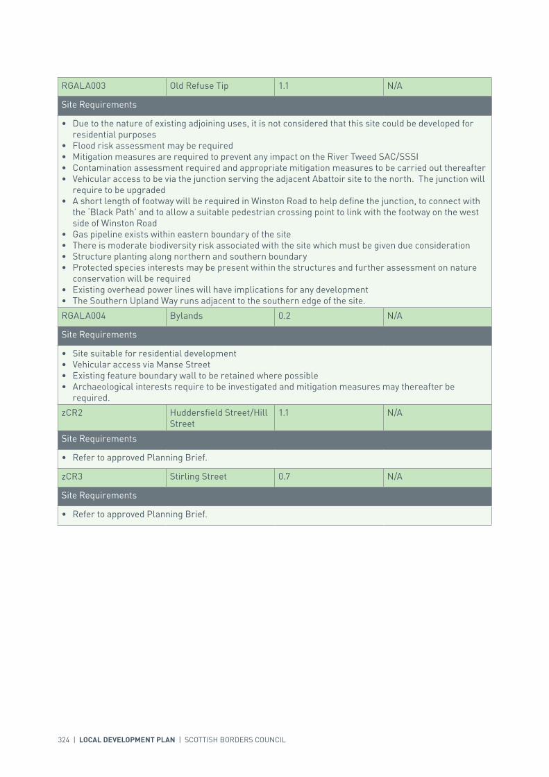
324 | LOCAL DEVELOPMENT PLAN | SCOTTISH BORDERS COUNCIL
RGALA003 Old Refuse Tip 1.1 N/A
Site Requirements
• Due to the nature of existing adjoining uses, it is not considered that this site could be developed for residential purposes
• Flood risk assessment may be required• Mitigation measures are required to prevent any impact on the River Tweed SAC/SSSI• Contamination assessment required and appropriate mitigation measures to be carried out thereafter• Vehicular access to be via the junction serving the adjacent Abattoir site to the north. The junction will
require to be upgraded• A short length of footway will be required in Winston Road to help define the junction, to connect with
the ‘Black Path’ and to allow a suitable pedestrian crossing point to link with the footway on the west side of Winston Road
• Gas pipeline exists within eastern boundary of the site• There is moderate biodiversity risk associated with the site which must be given due consideration• Structure planting along northern and southern boundary• Protected species interests may be present within the structures and further assessment on nature
conservation will be required• Existing overhead power lines will have implications for any development• The Southern Upland Way runs adjacent to the southern edge of the site.
RGALA004 Bylands 0.2 N/A
Site Requirements
• Site suitable for residential development• Vehicular access via Manse Street• Existing feature boundary wall to be retained where possible• Archaeological interests require to be investigated and mitigation measures may thereafter be
required.
zCR2 Huddersfield Street/Hill Street
1.1 N/A
Site Requirements
• Refer to approved Planning Brief.
zCR3 Stirling Street 0.7 N/A
Site Requirements
• Refer to approved Planning Brief.

INTRODUCTION | CHALLENGES | VISION, AIMS AND SPATIAL STRATEGYPOLICIES | APPENDICES | SETTLEMENTS
LOCAL DEVELOPMENT PLAN | SCOTTISH BORDERS COUNCIL | 325
TRANSPORTATION
SITE REFERENCE SITE NAME SITE SIZE (HA) INDICATIVE SITE CAPACITY
zTI1 Galashiels Transport Interchange
0.7 N/A
Site Requirements
• Refer to approved Planning Brief.
zRS2 Galashiels Railway Station
0.2 N/A
Site Requirements
• Parking provision at site of existing bus station• Vehicular drop off point to be provided within site.
EDUCATION
SITE REFERENCE SITE NAME SITE SIZE (HA) INDICATIVE SITE CAPACITY
zED2 Heriot Watt University - Netherdale Campus
2.7 N/A
Site Requirements
• This is an education safeguarded site as defined in Policy IS17.• In the event of further proposed development or redevelopment, a flood risk assessment is required.
SITE REFERENCE SITE NAME SITE SIZE (HA)
GSGALA001 Wood St. Allotment 0.3
GSGALA002 Manse Road Cricket Ground 2.8
GSGALA003 Manse Road Park 2.6
GSGALA004 Mossillee Allotment 0.6
GSGALA005 Public Park 2.7
GSGALA006 Tweed Road 6.6
GSGALA007 Galashiels RFC 3.3
GSGALA008 Bank Street Gardens 0.4
GSGALA009 Gala Policies 13.4
GSGALA010 Scott Park 3.8
KEY GREENSPACE

326 | LOCAL DEVELOPMENT PLAN | SCOTTISH BORDERS COUNCIL
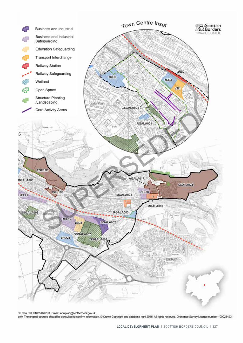
LOCAL DEVELOPMENT PLAN | SCOTTISH BORDERS COUNCIL | 327

For further information, including help reading this document, please contact: Planning Policy & Access, Regulatory Services, Council Headquarters, Newtown St Boswells, Melrose, TD6 0SA. Tel: 0300 100 1800. Email: [email protected]: Scottish Borders Council uses spatial information from a range of sources to produce the mapping contained within this document. The mapping is for illustrative purposes only. The original sources should be consulted to confirm information. © Crown Copyright and database right 2017. All rights reserved. Ordnance Survey Licence number 100023423.
N
00mm
400400200200
Redevelopment
Development Boundary
Housing
Longer Term Mixed Use
Town Centre Boundary
Mixed Use
Key Greenspace
Conservation AreaEducation Safeguarding
Transport Interchange
Railway Station
Business and IndustrialSafeguarding
Railway Safeguarding
Open Space
Structure Planting/Landscaping
Core Activity Areas
Wetland
Business and Industrial
GSGALA009
GSGALA006
GSGALA007
GSGALA002
GSGALA005
GSGALA003
GSGALA004
GSGALA001
SGALA016
SGALA005
AGALA024
EGL13B
EGL41
zEL40
zEL42
zEL41
EGL17B
zED2
zRO24
EGL19B
EGL42
zEL38
EGL32B
zRO4
zRO202
BGALA002
EGL200
zCR2AGALA017
EGL16B
MGALA002
EGL20B
RGALA003
BGALA003
EGL43
MGALA003
RGALA004
GSGALA009
GSGALA006
GSGALA010
GSGALA007
GSGALA002
GSGALA005
GSGALA003
GSGALA004
GSGALA001
SGALA016
SGALA005
AGALA024
EGL13B
EGL41
zEL40
zEL42
zEL41
EGL17B
zED2
zRO24
EGL19B
EGL42
zEL38
EGL32B
zRO4
zRO202
BGALA002
EGL200
zCR2AGALA017
EGL16B
MGALA002
EGL20B
RGALA003
BGALA003
EGL43
MGALA003
RGALA004
Town Centre Inset
zRO6zCR3
zTI1
GSGALA008
zRO6
zTI1
zCR3
zRS2
RGALA001
AGALA037AGALA037 AGALA036AGALA036
Scottish Borders Council Local Development Plan 2016as modified by Supplementary
Galashiels Guidance on Housing 2017
GSGALA008
AGALA032
RGALA002RGALA002

328 | LOCAL DEVELOPMENT PLAN | SCOTTISH BORDERS COUNCIL
SETTLEMENT PROFILE GATTONSIDE
This profile should be read in conjunction with the relevant settlement map.
DESCRIPTIONGattonside lies within the Central Borders Strategic Development Area as defined in the SESplan. The settlement is located 2 miles from Melrose and under 4 miles from Galashiels. The population was 381 at Census 2001.
PLACE MAKING CONSIDERATIONSGattonside benefits from an attractive setting in the Tweed Valley. It is viewed from many points across the valley; particularly prominent are the fields and land to the north side of the main road. The tree lined avenue around the southern edge of the village and down towards the footbridge to Melrose adds much to its setting as do the open fields between the village and the Tweed.
The Conservation Area of Gattonside takes in much of the settlement. Narrow winding streets and paths all contribute to the distinctive spatial identity of Gattonside. Properties tend to be one and a half to two storeys in height but there are also a few single storey properties within the Conservation Area.
Traditional building materials prevail within the Conservation Area and architectural details contribute to the sense of place. It is recommended that any alterations or new development within the Conservation Area should contribute to the retention of its character.
The quality of the countryside around Gattonside is recognised by its inclusion in Eildon and Leaderfoot National Scenic Area.
The Plan includes a large site for residential development at St. Aidans and a smaller residential site east of Montgomerie Terrace. Further development sites will not be promoted during the plan period as the sensitive character and setting of Gattonside must be protected from overdevelopment.
The settlement boundary has been amended to include land to the north east of the settlement. This may allow the opportunity for some form of residential development, although any such development must have no adverse impact on boundary trees protected by Preservation Orders.
There are two areas of key greenspace identified in the village, at The Triangle and the School Wynd.

INTRODUCTION | CHALLENGES | VISION, AIMS AND SPATIAL STRATEGYPOLICIES | APPENDICES | SETTLEMENTS
LOCAL DEVELOPMENT PLAN | SCOTTISH BORDERS COUNCIL | 329
INFRASTRUCTURE CONSIDERATIONSAffordable Housing will require to be provided under the provisions of Policy HD1 and the Supplementary Guidance/ Supplementary Planning Guidance on Affordable Housing.
A contribution towards Earlston High School will be sought to supplement Scottish Borders Council’s investment in the new school which opened in 2009-2010 under the 3 High Schools project.
Gattonside falls within an area identified for a contribution to the Waverley Railway Project (See Policy IS3).
In accordance with the Council’s Local Transport Strategy, a Central Borders Traffic Model has been developed which will help direct funding to areas of the road network that may become congested in the future. Developer contributions will be sought from developments within the Central Borders in accordance with the Supplementary Guidance/ Supplementary Planning Guidance on Developer Contributions.
The Waste Water Treatment Works in Melrose serve Gattonside. There is adequate capacity to accommodate development.
Further information is available from Supplementary Guidance/Supplementary Planning Guidance on Developer Contributions and Planning/Development Briefs where applicable.
DEVELOPMENT AND SAFEGUARDING PROPOSALS
HOUSING
SITE REFERENCE SITE NAME SITE SIZE (HA) INDICATIVE SITE CAPACITY
AGATT007 St Aidans 3.8 40
Site Requirements
• Careful consideration will be required to establish the point of access from the B6360 (Main Street)• Pedestrian / cycle link to be provided to Baker’s Road• The B listed Gattonside House and its setting must be retained. Any new building and associated
landscaping should be designed sympathetically to this setting• Site was formerly a designed landscape associated with Gattonside House and this would need to be
explored prior to development. The mature trees within the site and on the surrounding boundary must be protected wherever possible
• Archaeology interests have been recorded within the site and archaeological assessment including archaeological evaluation along with associated mitigation measures is required
• The layout and design of the site should be sympathetic to the setting of the National Scenic Area and integrate well within the character of the existing Conservation Area in terms of proportion and materials
• Open space must be provided to allow breathing space within the site and provide recreational facilities
• Protected species interests have been recorded in the area and further assessment on nature conservation will be required
• Mitigation measures are required to prevent any impact on the River Tweed Special Area of Conservation and ensure the protection and enhancement of habitats.
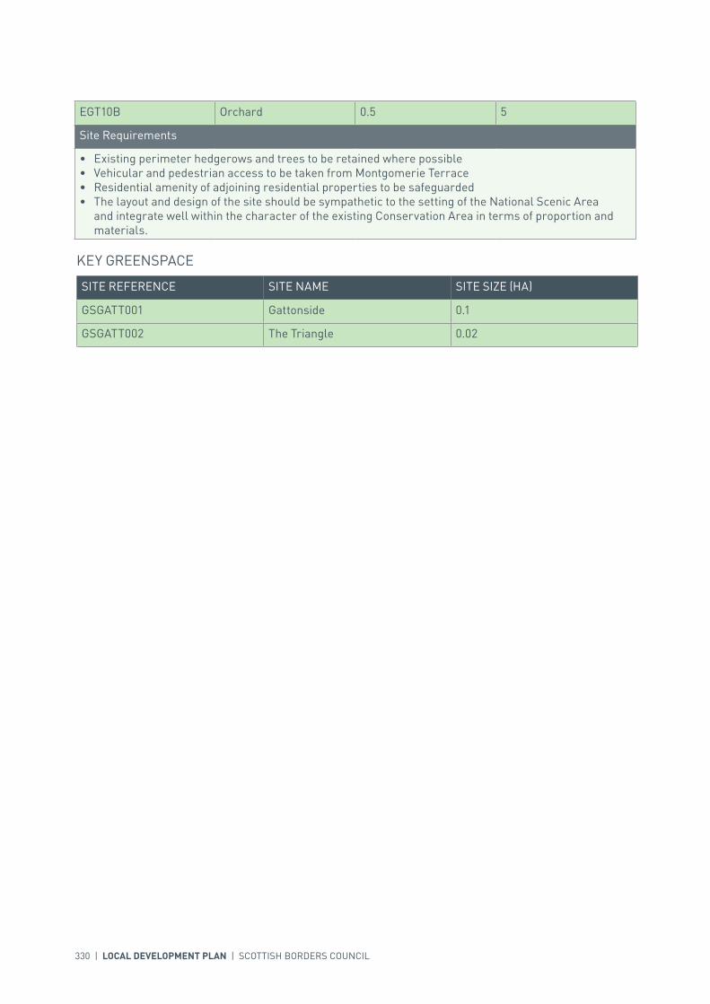
330 | LOCAL DEVELOPMENT PLAN | SCOTTISH BORDERS COUNCIL
SITE REFERENCE SITE NAME SITE SIZE (HA)
GSGATT001 Gattonside 0.1
GSGATT002 The Triangle 0.02
KEY GREENSPACE
EGT10B Orchard 0.5 5
Site Requirements
• Existing perimeter hedgerows and trees to be retained where possible• Vehicular and pedestrian access to be taken from Montgomerie Terrace• Residential amenity of adjoining residential properties to be safeguarded• The layout and design of the site should be sympathetic to the setting of the National Scenic Area
and integrate well within the character of the existing Conservation Area in terms of proportion and materials.
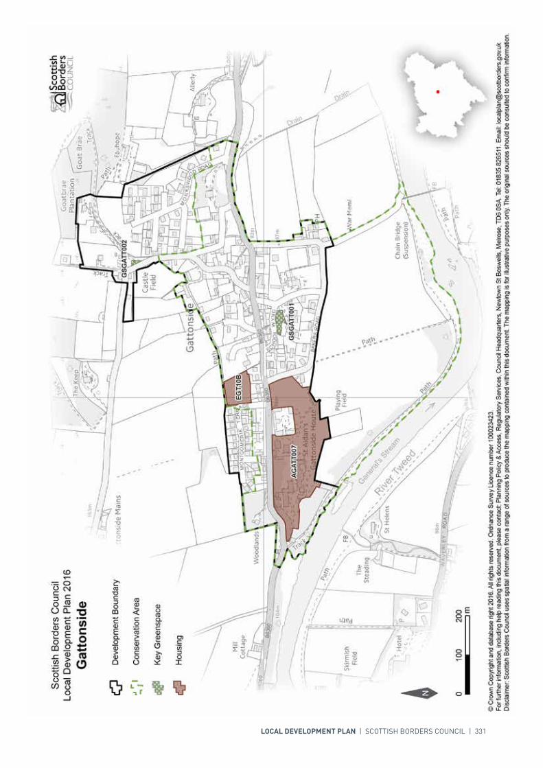
LOCAL DEVELOPMENT PLAN | SCOTTISH BORDERS COUNCIL | 331

332 | LOCAL DEVELOPMENT PLAN | SCOTTISH BORDERS COUNCIL
SETTLEMENT PROFILE GAVINTON
This profile should be read in conjunction with the relevant settlement map.
DESCRIPTIONGavinton is located just over 2 miles from Duns and 17 miles from Berwick upon Tweed. The population of the village according to the 2001 Census was 201. Gavinton is located within the Eastern Strategic Development Area (SDA) as identified by the SESplan.
PLACE MAKING CONSIDERATIONSGavinton is an estate village intentionally set out around its Green in the 18th Century. Sited on a relatively flat area of land, the village benefits from attractive views, particularly of the surrounding gently rolling land, with large arable and pasture fields.
The Conservation Area is laid out in two short terrace rows and is centred on the rectangular green, surrounded by single and two-storey properties. Building materials that prevail are sandstone, harling and slate. The architectural details include sash and case windows, transom lights, and rybats. These elements of the built fabric help form the character of the Conservation Area. Any new development or alterations must therefore also aim to respect the individual buildings, the wider layout of the Conservation Area, and take account of the features listed. There are a total of 29 Listed Buildings within the Conservation Area.
The previously allocated housing site, which is not yet developed, is adequate to meet the identified housing need in the Local Development Plan period. The preferred area for longer-term development will be the area to the north of the settlement. The area to the south of the settlement should be protected from further development. The surrounds of Gavinton are designated as prime agricultural land.
INFRASTRUCTURE CONSIDERATIONSAffordable Housing will require to be provided under provisions of Policy HD1 and the Supplementary Guidance/Supplementary Planning Guidance on Affordable Housing.
Funds have been identified to relocate the current Duns Primary School to the old Berwickshire High School. This will be a major refurbishment project. Developer contributions will be sought in the Duns PS catchment to assist in the provision of additional capacity. A contribution towards Berwickshire High School will be sought to supplement Scottish Borders Council’s investment in the new school which opened in 2009-2010 under the 3 High Schools project.

INTRODUCTION | CHALLENGES | VISION, AIMS AND SPATIAL STRATEGYPOLICIES | APPENDICES | SETTLEMENTS
LOCAL DEVELOPMENT PLAN | SCOTTISH BORDERS COUNCIL | 333
With regards to Waste Water Treatment Works, Gavinton has limited capacity. Contributions may be required where upgrades are necessary. In respect of the local water network, developers may be required to contribute towards upgrading to enable development.
Further information is available from Supplementary Guidance/Supplementary Planning Guidance on Developer Contributions and Planning/Development Briefs where applicable.
DEVELOPMENT AND SAFEGUARDING PROPOSALS
HOUSING
SITE REFERENCE SITE NAME SITE SIZE (HA) INDICATIVE SITE CAPACITY
BGA1 West Gavinton 3.2 45
Site Requirements
• Refer to approved Planning Brief.
SITE REFERENCE SITE NAME SITE SIZE (HA)
GSGAVI001 Village Green 0.2
KEY GREENSPACE

334 | LOCAL DEVELOPMENT PLAN | SCOTTISH BORDERS COUNCIL

INTRODUCTION | CHALLENGES | VISION, AIMS AND SPATIAL STRATEGYPOLICIES | APPENDICES | SETTLEMENTS
LOCAL DEVELOPMENT PLAN | SCOTTISH BORDERS COUNCIL | 335
SETTLEMENT PROFILE GORDON
This profile should be read in conjunction with the relevant settlement map.
DESCRIPTIONGordon is located approximately 12 miles south-west of Duns. The population of the village according to the 2001 Census was 415. Gordon is located outwith the Eastern Strategic Development Area (SDA) as defined in the SESplan.
PLACE MAKING CONSIDERATIONSGordon is a 19th century village that was formed along the Main Street and the Station Road that crosses it. Sited on a relatively flat area of land, Gordon benefits from attractive views within and out of the settlement. The surrounding landscape is gently sloping with large arable and pasture fields.
Gordon has three Listed Buildings, including both of the churches.
It is considered that development needs in the village for the period of the Local Development Plan will be met by the allocated site BGO9D. The preferred area for future expansion will be to the east of Gordon, north of Eden Road, dependent upon increasing waste water and drainage capacity. Development to the north of the settlement will be resisted.
INFRASTRUCTURE CONSIDERATIONSAffordable Housing will require to be provided under provisions of Policy HD1 and the Supplementary Guidance/Supplementary Planning Guidance on Affordable Housing.
A contribution towards Earlston High School will be sought to supplement Scottish Borders Council’s investment in the new school which opened in 2009-2010 under the 3 High Schools project.
With regards to Waste Water Treatment Works Gordon has limited capacity. Contributions may be required where upgrades are necessary. In respect of the local water network, developers may be required to contribute towards upgrading to enable development.
Further information is available from Supplementary Guidance/Supplementary Planning Guidance on Developer Contributions and Planning/Development Briefs where applicable.
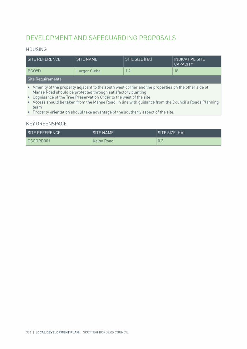
336 | LOCAL DEVELOPMENT PLAN | SCOTTISH BORDERS COUNCIL
DEVELOPMENT AND SAFEGUARDING PROPOSALS
HOUSING
SITE REFERENCE SITE NAME SITE SIZE (HA) INDICATIVE SITE CAPACITY
BGO9D Larger Glebe 1.2 18
Site Requirements
• Amenity of the property adjacent to the south west corner and the properties on the other side of Manse Road should be protected through satisfactory planting
• Cognisance of the Tree Preservation Order to the west of the site• Access should be taken from the Manse Road, in line with guidance from the Council’s Roads Planning
team• Property orientation should take advantage of the southerly aspect of the site.
SITE REFERENCE SITE NAME SITE SIZE (HA)
GSGORD001 Kelso Road 0.3
KEY GREENSPACE

LOCAL DEVELOPMENT PLAN | SCOTTISH BORDERS COUNCIL | 337
338 | LOCAL DEVELOPMENT PLAN | SCOTTISH BORDERS COUNCIL
SETTLEMENT PROFILE GRANTSHOUSE
This profile should be read in conjunction with the relevant settlement map.
DESCRIPTIONGrantshouse is located 11 miles west of Eyemouth. The population of the village according to the 2001 Census was 97. Grantshouse is located outwith any of the Strategic Development Areas (SDA) identified in the SESplan.
PLACE MAKING CONSIDERATIONSThe settlement pattern of Grantshouse reflects the valley landform, and was mainly developed in a linear form with a small group of buildings along one side of the A1. Predominately of a residential character, the settlement benefits from the many attractive open fields that give it a countryside setting.
There are two Listed Buildings within Grantshouse.
Grantshouse is located outwith the SDA and as a result there is no requirement for land to be allocated for development in the Local Development Plan period. The preferred area for longer-term development is the north side of Mansefield. Expansion in this direction will be dependent upon identified housing need. Development of the open space to the north of Grantshouse will be resisted. Development to the south of Grantshouse will also be resisted as this would severely compromise pedestrian safety, due to the proximity of the A1, and part of the land is subject to flood risk. The land to the north of Grantshouse is prime agricultural land.
INFRASTRUCTURE CONSIDERATIONSAffordable Housing will require to be provided under provisions of Policy HD1 and the Supplementary Guidance/Supplementary Planning Guidance on Affordable Housing.
A contribution towards Eyemouth High School will be sought to supplement Scottish Borders Council’s investment in the new school which opened in 2009-2010 under the 3 High Schools project.
With regards to Waste Water Treatment Works Grantshouse has limited capacity. Contributions may be required where upgrades are necessary. In respect of the local water network, developers may be required to contribute towards upgrading to enable development. There is limited environmental capacity as there is relatively low dilution available in the receiving watercourse.
Further information is available from Supplementary Guidance/Supplementary Planning Guidance on Developer Contributions and Planning/Development Briefs where applicable.
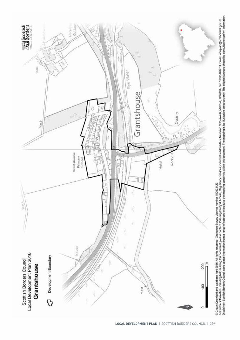
LOCAL DEVELOPMENT PLAN | SCOTTISH BORDERS COUNCIL | 339
340 | LOCAL DEVELOPMENT PLAN | SCOTTISH BORDERS COUNCIL
SETTLEMENT PROFILE GREENLAW
This profile should be read in conjunction with the relevant settlement map.
DESCRIPTIONGreenlaw is located 7 miles south-west of Duns and 9 miles north of Kelso. The population of Greenlaw according to the 2001 Census was 586. The settlement is located outwith any of the Strategic Development Areas (SDA) as identified in the SESplan.
PLACE MAKING CONSIDERATIONSGreenlaw is located in the hills at the edge of the Lammermuirs with the Blackadder Water running through the town. The settlement originally developed along the High Street but there has been subsequent development up slope on the Duns road, marked by post-war Council housing, businesses, and a caravan park. There has also been further residential development to the south west, along Wester Row, and to the east, along Marchmont Road.
The Conservation Area of Greenlaw consists of the majority of the High Street, and contains 5 A-Listed Buildings, which contribute to the character of the town. Properties are generally built in short rows and there is a range of storey level and style. Building materials such as- sandstone, slate and pantiles; and architectural details such as- transom lights, sash and case windows, and pilasters, also contribute significantly to the character. Any new development must aim to positively contribute to this character. There is a Scheduled Monument, the Mercat Cross, beside the old Parish Church.
Greenlaw has sites previously allocated which are yet to be developed and are therefore carried forward into the Local Development Plan (LDP). Two Mixed Use development sites are included (MGREE001 and MGREE003) and it is intended that these sites support suitable complimentary developments.
The area at Halliburton Road (SGREE003) is the preferred area for potential longer term development. The area will be subject to further assessment, and will require a future Masterplan to ensure a coherent and holistic approach.
Land to the south of the settlement boundary, particularly surrounding Greenlaw Mill Farm, is subject to flood risk and also has the River Tweed Special Area of Conservation and SSSI. As a result development should be avoided in this location.

INTRODUCTION | CHALLENGES | VISION, AIMS AND SPATIAL STRATEGYPOLICIES | APPENDICES | SETTLEMENTS
LOCAL DEVELOPMENT PLAN | SCOTTISH BORDERS COUNCIL | 341
INFRASTRUCTURE CONSIDERATIONSAffordable Housing will require to be provided under the provisions of Policy HD1 and the Supplementary Guidance/Supplementary Planning Guidance on Affordable Housing.
A contribution towards Berwickshire High School will be sought to supplement Scottish Borders Council’s investment in the new school which opened in 2009-2010 under the 3 High Schools project.
This settlement is identified within the Council’s Flood Contingency Plan as being at risk of flooding. Any development proposals should therefore be subject to early consultation with the Council’s Flood and Coastal Management Officer, and SEPA, having regard to the Indicative River and Coastal Flood Map (Scotland). A flood risk assessment may be required and may influence the scale and layout of any development at a particular location.
There are some pressures identified on health services accommodation which may require further upgrade.
With regards to Waste Water Treatment Works, Greenlaw has limited capacity. Contributions may be required where upgrades are necessary. In respect of the local water network, developers may be required to contribute towards upgrading to enable development.
Further information is available from Supplementary Guidance/Supplementary Planning Guidance on Developer Contributions and Planning/Development Briefs where applicable.
DEVELOPMENT AND SAFEGUARDING PROPOSALS
HOUSING
SITE REFERENCE SITE NAME SITE SIZE (HA) INDICATIVE SITE CAPACITY
BG200 Marchmont Road 1.0 25
Site Requirements
• Refer to approved Planning Brief.
AGREE004 North of Edinburgh Road 0.6 15
Site Requirements
• Main vehicular access route will be from Edinburgh Road• Provide for future vehicular links to the longer term development area to the north• Affordable housing provision on site• Provide footway link to the centre of Greenlaw• Existing landscape features to be conserved.
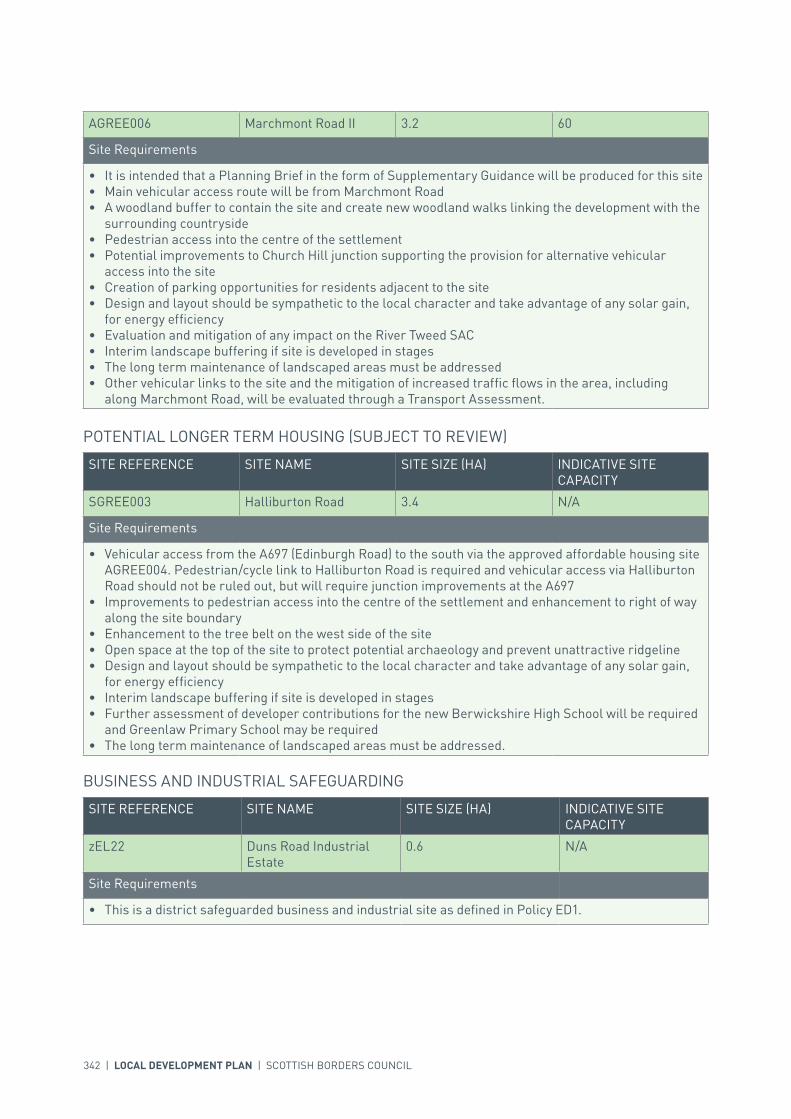
342 | LOCAL DEVELOPMENT PLAN | SCOTTISH BORDERS COUNCIL
AGREE006 Marchmont Road II 3.2 60
Site Requirements
• It is intended that a Planning Brief in the form of Supplementary Guidance will be produced for this site• Main vehicular access route will be from Marchmont Road• A woodland buffer to contain the site and create new woodland walks linking the development with the
surrounding countryside• Pedestrian access into the centre of the settlement• Potential improvements to Church Hill junction supporting the provision for alternative vehicular
access into the site• Creation of parking opportunities for residents adjacent to the site• Design and layout should be sympathetic to the local character and take advantage of any solar gain,
for energy efficiency• Evaluation and mitigation of any impact on the River Tweed SAC• Interim landscape buffering if site is developed in stages• The long term maintenance of landscaped areas must be addressed• Other vehicular links to the site and the mitigation of increased traffic flows in the area, including
along Marchmont Road, will be evaluated through a Transport Assessment.
SITE REFERENCE SITE NAME SITE SIZE (HA) INDICATIVE SITE CAPACITY
SGREE003 Halliburton Road 3.4 N/A
Site Requirements
• Vehicular access from the A697 (Edinburgh Road) to the south via the approved affordable housing site AGREE004. Pedestrian/cycle link to Halliburton Road is required and vehicular access via Halliburton Road should not be ruled out, but will require junction improvements at the A697
• Improvements to pedestrian access into the centre of the settlement and enhancement to right of way along the site boundary
• Enhancement to the tree belt on the west side of the site• Open space at the top of the site to protect potential archaeology and prevent unattractive ridgeline• Design and layout should be sympathetic to the local character and take advantage of any solar gain,
for energy efficiency• Interim landscape buffering if site is developed in stages• Further assessment of developer contributions for the new Berwickshire High School will be required
and Greenlaw Primary School may be required• The long term maintenance of landscaped areas must be addressed.
POTENTIAL LONGER TERM HOUSING (SUBJECT TO REVIEW)
SITE REFERENCE SITE NAME SITE SIZE (HA) INDICATIVE SITE CAPACITY
zEL22 Duns Road Industrial Estate
0.6 N/A
Site Requirements
• This is a district safeguarded business and industrial site as defined in Policy ED1.
BUSINESS AND INDUSTRIAL SAFEGUARDING
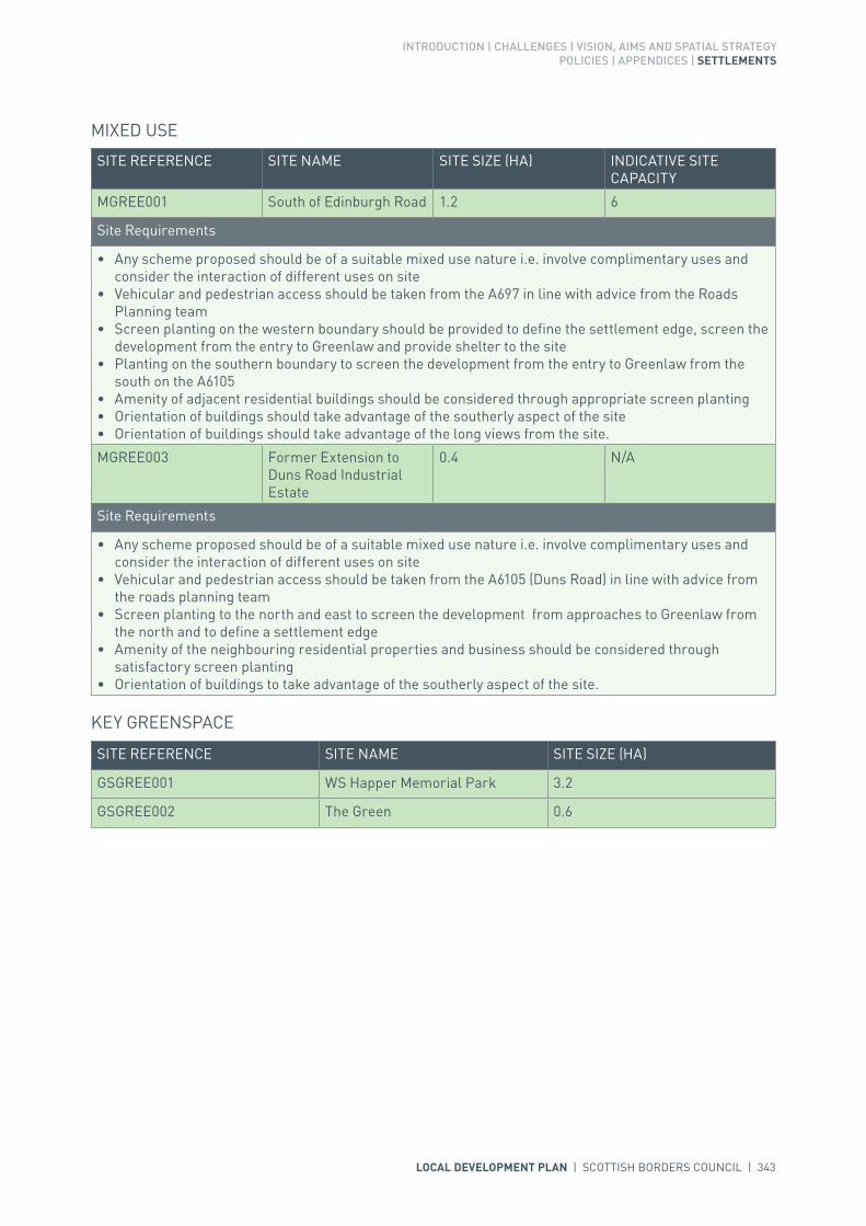
INTRODUCTION | CHALLENGES | VISION, AIMS AND SPATIAL STRATEGYPOLICIES | APPENDICES | SETTLEMENTS
LOCAL DEVELOPMENT PLAN | SCOTTISH BORDERS COUNCIL | 343
SITE REFERENCE SITE NAME SITE SIZE (HA)
GSGREE001 WS Happer Memorial Park 3.2
GSGREE002 The Green 0.6
KEY GREENSPACE
SITE REFERENCE SITE NAME SITE SIZE (HA) INDICATIVE SITE CAPACITY
MGREE001 South of Edinburgh Road 1.2 6
Site Requirements
• Any scheme proposed should be of a suitable mixed use nature i.e. involve complimentary uses and consider the interaction of different uses on site
• Vehicular and pedestrian access should be taken from the A697 in line with advice from the Roads Planning team
• Screen planting on the western boundary should be provided to define the settlement edge, screen the development from the entry to Greenlaw and provide shelter to the site
• Planting on the southern boundary to screen the development from the entry to Greenlaw from the south on the A6105
• Amenity of adjacent residential buildings should be considered through appropriate screen planting• Orientation of buildings should take advantage of the southerly aspect of the site• Orientation of buildings should take advantage of the long views from the site.
MGREE003 Former Extension to Duns Road Industrial Estate
0.4 N/A
Site Requirements
• Any scheme proposed should be of a suitable mixed use nature i.e. involve complimentary uses and consider the interaction of different uses on site
• Vehicular and pedestrian access should be taken from the A6105 (Duns Road) in line with advice from the roads planning team
• Screen planting to the north and east to screen the development from approaches to Greenlaw from the north and to define a settlement edge
• Amenity of the neighbouring residential properties and business should be considered through satisfactory screen planting
• Orientation of buildings to take advantage of the southerly aspect of the site.
MIXED USE

344 | LOCAL DEVELOPMENT PLAN | SCOTTISH BORDERS COUNCIL

INTRODUCTION | CHALLENGES | VISION, AIMS AND SPATIAL STRATEGYPOLICIES | APPENDICES | SETTLEMENTS
LOCAL DEVELOPMENT PLAN | SCOTTISH BORDERS COUNCIL | 345
SETTLEMENT PROFILE HAWICK
This profile should be read in conjunction with the relevant settlement map.
DESCRIPTIONHawick is situated in the valley of the River Teviot and is the most southerly town in the Central Borders Strategic Development Area as defined in the SESplan. The population is 14,800 (2001 Census), making it the largest in the Borders by population. The A7 Carlisle to Edinburgh trunk road runs through the town.
PLACE MAKING CONSIDERATIONSHawick is centred on the River Teviot around its confluence with the Slitrig Water. Both these rivers are part of the River Tweed Special Area of Conservation, a wildlife site of international importance. The rivers are important focal points, especially when viewed from the bridges, including the James Thomson footbridge, and public open spaces, including Wilton Lodge Park. The Teviot Valleys Special Landscape Area is located to the east of the settlement.
Hawick‘s history can be traced back to the 12th century, and the town grew significantly with the arrival of the industrial revolution, in particular the expansion of the knitwear and textile industries and the introduction of the railway.
The town centre is a Conservation Area which includes all the High Street and the historic core around Drumlanrig Square to the south. Properties along the High Street date mainly from the Victorian era and include a range of architectural styles dominated by the impressive Scots baronial Town Hall. The Conservation Area has retained many of its distinctive characteristics, with the High Street having a strong urban feel. There is still evidence of the medieval pattern of burgage plots or ‘rigs’ here. A number of textile mills are still in existence, including the Category ‘A’ listed Tower Mill – one of three ‘A’ Listed Buildings in the Conservation Area. There are also 90 more Listed Buildings of lesser designation.
In the Hawick Conservation Area there is a variety of building types, styles and periods, reflecting the history, diversity and development of the town. Buildings are chiefly of stone with slate roofs and contain a range of interesting architectural details. All these elements contribute to the distinctiveness of the Conservation Area and should be respected when development or alterations are proposed.
Hawick has experienced significant economic decline largely as a result of the contraction of the local textile industry. With its rural location, commuting to other work areas is more challenging, limiting alternative employment opportunities. The town remains in need of regeneration and the Council’s Economic Development team is working in partnership with the community to maximise the town’s potential and create new jobs.
346 | LOCAL DEVELOPMENT PLAN | SCOTTISH BORDERS COUNCIL
Recent projects around the Heart of Hawick complex comprising Tower Mill, the Textile Towerhouse (formerly Drumlanrig’s Tower) and the Heritage Hub at the south end of the High Street as well as the redevelopment of the Commercial Road and the regeneration of key properties of historical/conservation significance on the High Street area have helped to regenerate the town. The further development of the Galalaw area to the north of Hawick provides a key opportunity for mixed use development.
Ten redevelopment sites are identified within the settlement, to encourage the re-use of previously developed land. These are mainly former mill sites, but also include the former Cottage Hospital – a Category B Listed Building in need of a new use.
Hawick is an important centre within the Central Borders Strategic Development Area and has a wide range of housing and business/industrial opportunities to enable growth to take place, including the strategic business and industrial site at Galalaw on the northern edge of the town. An additional area of land has been allocated for housing at Burnfoot, adjacent to Galalaw. In recent years, new retail units have been developed on the north side of the River Teviot on Commercial Road, so the town centre boundary has been extended accordingly. The Core Activity Area is focused in recognition of the long term reduction in traditional town centre retailing and the need to diversify uses in the centre to maintain prosperity.
Development to the south of the settlement will be resisted if it will exacerbate road congestion in the Loan.
There are a total of fifteen key greenspaces identified in the town, including the Volunteer Park, Wilton Lodge Park and various allotment sites.
INFRASTRUCTURE CONSIDERATIONSAffordable Housing will require to be provided under the provisions of Policy HD1 and the Supplementary Guidance/ Supplementary Planning Guidance on Affordable Housing.
There is no requirement for contribution towards education provision.
This settlement is identified within the Council’s Flood Contingency Plan as being at risk of flooding. Any development proposals should therefore be subject to early consultation with the Council’s Flood and Coastal Management Officer, and SEPA, having regard to the Indicative River and Coastal Flood Map (Scotland). A flood risk assessment may be required and may influence the scale and layout of any development at a particular location. The Council is currently progressing a Flood Protection Scheme to alleviate the risk of flooding in Hawick. A preferred scheme has been approved and is now progressing to the design stages.
There is current pressure on the Primary Healthcare Team’s accommodation in Hawick which may require further upgrade.
The Council has long term aspirations to see the southward extension of the Borders Railway to Hawick and Carlisle in accordance with SESplan policy. The indicative line of the railway, which is largely co-incident with the disused railway line, is therefore protected from development.
In respect of the Waste Water Treatment Works and Water Treatment Works, Hawick currently has sufficient capacity.
Further information is available from Supplementary Guidance/Supplementary Planning Guidance on Developer Contributions and Planning/Development Briefs where applicable.
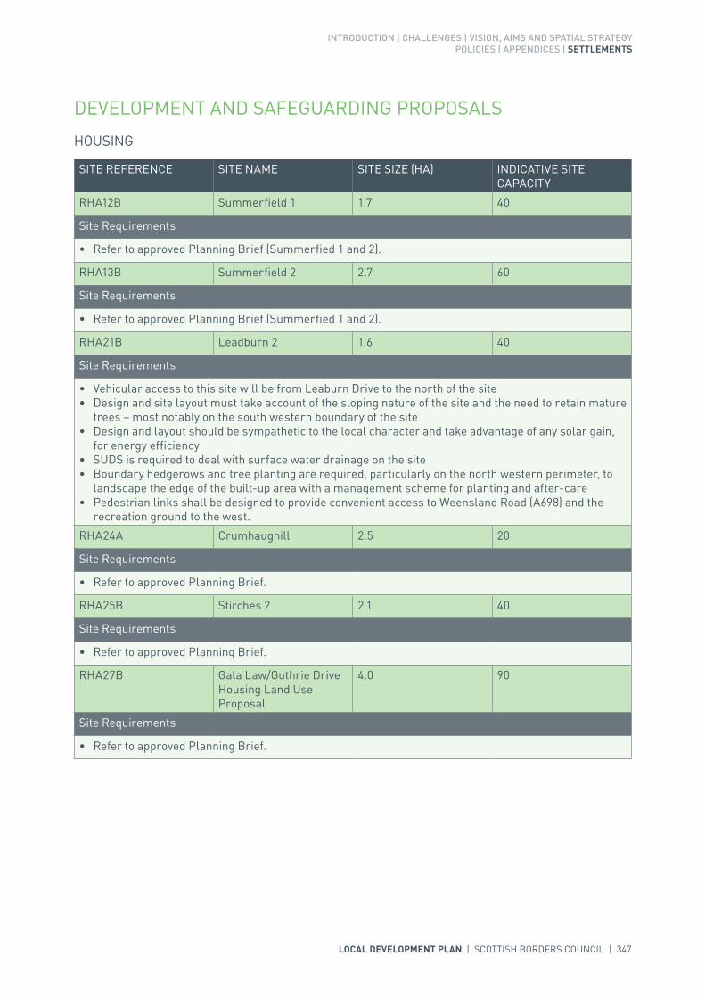
INTRODUCTION | CHALLENGES | VISION, AIMS AND SPATIAL STRATEGYPOLICIES | APPENDICES | SETTLEMENTS
LOCAL DEVELOPMENT PLAN | SCOTTISH BORDERS COUNCIL | 347
DEVELOPMENT AND SAFEGUARDING PROPOSALS
HOUSING
SITE REFERENCE SITE NAME SITE SIZE (HA) INDICATIVE SITE CAPACITY
RHA12B Summerfield 1 1.7 40
Site Requirements
• Refer to approved Planning Brief (Summerfied 1 and 2).
RHA13B Summerfield 2 2.7 60
Site Requirements
• Refer to approved Planning Brief (Summerfied 1 and 2).
RHA21B Leadburn 2 1.6 40
Site Requirements
• Vehicular access to this site will be from Leaburn Drive to the north of the site• Design and site layout must take account of the sloping nature of the site and the need to retain mature
trees – most notably on the south western boundary of the site• Design and layout should be sympathetic to the local character and take advantage of any solar gain,
for energy efficiency• SUDS is required to deal with surface water drainage on the site• Boundary hedgerows and tree planting are required, particularly on the north western perimeter, to
landscape the edge of the built-up area with a management scheme for planting and after-care• Pedestrian links shall be designed to provide convenient access to Weensland Road (A698) and the
recreation ground to the west.
RHA24A Crumhaughill 2.5 20
Site Requirements
• Refer to approved Planning Brief.
RHA25B Stirches 2 2.1 40
Site Requirements
• Refer to approved Planning Brief.
RHA27B Gala Law/Guthrie Drive Housing Land Use Proposal
4.0 90
Site Requirements
• Refer to approved Planning Brief.

348 | LOCAL DEVELOPMENT PLAN | SCOTTISH BORDERS COUNCIL
AHAWI006 Guthrie Drive 6.9 100
Site Requirements
• It is intended that a Planning Brief in the form of Supplementary Planning Guidance will be produced for this site
• Relation to St Andrews convent needs to be considered and taken into account in development proposals
• The woodland policies to the north west of the site need to be retained and managed• Trees along Guthrie Road need to be retained or improved (as amended for visibility and access
purposes)• Undergrounding of existing overhead transmission lines to be considered.• Access to be via Guthrie Drive• Protected species interests have been recorded in the area and further assessment on nature
conservation will be required• Landscaping is required to reduce visual impact from the west• Archaeology interests have been recorded in the surrounding area and archaeological assessment
including archaeological evaluation along with associated mitigation measures is required
AHAWI013 Gala Law 5.5 100
Site Requirements
• Refer to approved Planning Brief.
SITE REFERENCE SITE NAME SITE SIZE (HA) INDICATIVE SITE CAPACITY
SHAWI003 Burnfoot (Phase 1) 5.0 100
Site Requirements
• Design and site layout must take cognisance of the sloping nature of the site • Development to take cognisance of the possibility of a culverted water course within the site, the need
for a sustainable drainage system and the wetland area to the south west. A flood risk assessment may be required.
• Hedgerows are required on the eastern and western parts of the site to reduce visual impact. A management scheme for planting is also required
• Care must taken to provide boundary treatment to the north to separate housing land and business and industrial land
• Vehicular access to this site is achievable from the B6359• Pedestrian linkage will be required to the bus laybys on the A7 at the Galalaw roundabout and a
footway is required on the northwest side of the B6359• The road layout will need to integrate fully with the allocated business and industrial site to the north
(BHAWI001). A masterplan should address this• Archaeology interests have been recorded in the surrounding area and archaeological assessment
including archaeological evaluation along with associated mitigation measures is required• The design and site layout should aim to enhance the biodiversity value of the site through the creation
or restoration of habitats and wildlife corridors.
POTENTIAL LONGER TERM HOUSING LAND (SUBJECT TO REVIEW)
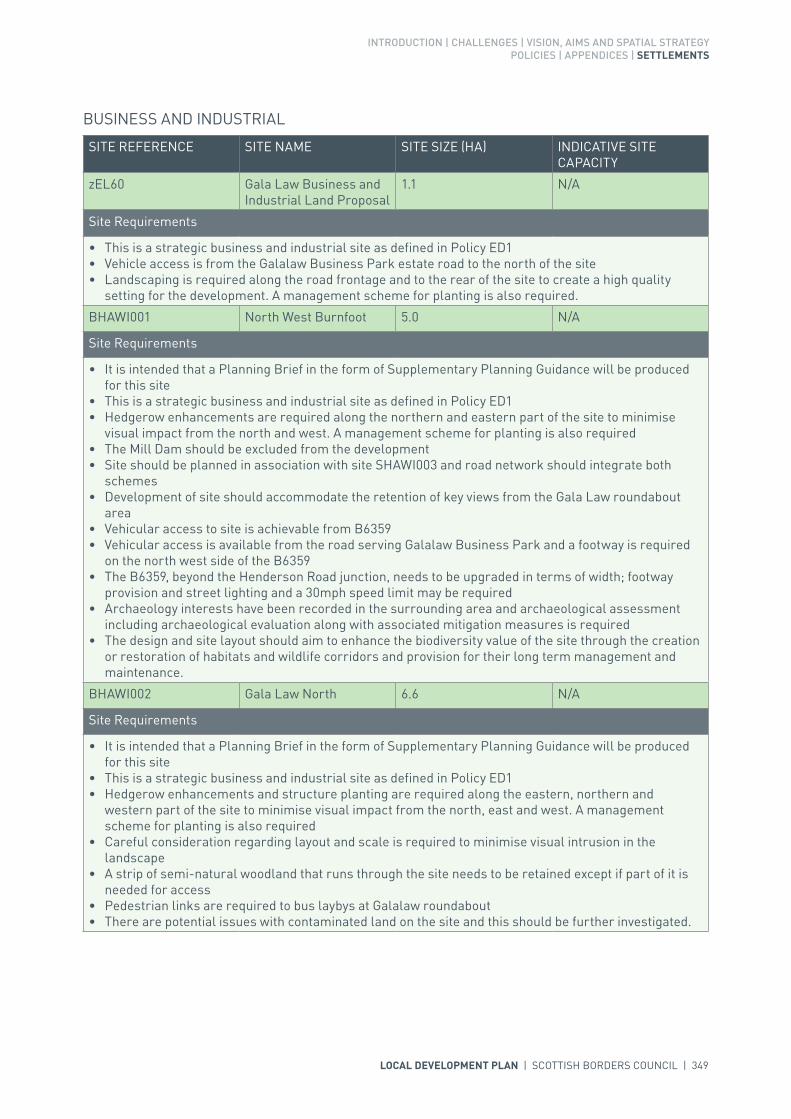
INTRODUCTION | CHALLENGES | VISION, AIMS AND SPATIAL STRATEGYPOLICIES | APPENDICES | SETTLEMENTS
LOCAL DEVELOPMENT PLAN | SCOTTISH BORDERS COUNCIL | 349
SITE REFERENCE SITE NAME SITE SIZE (HA) INDICATIVE SITE CAPACITY
zEL60 Gala Law Business and Industrial Land Proposal
1.1 N/A
Site Requirements
• This is a strategic business and industrial site as defined in Policy ED1• Vehicle access is from the Galalaw Business Park estate road to the north of the site• Landscaping is required along the road frontage and to the rear of the site to create a high quality
setting for the development. A management scheme for planting is also required.
BHAWI001 North West Burnfoot 5.0 N/A
Site Requirements
• It is intended that a Planning Brief in the form of Supplementary Planning Guidance will be produced for this site
• This is a strategic business and industrial site as defined in Policy ED1• Hedgerow enhancements are required along the northern and eastern part of the site to minimise
visual impact from the north and west. A management scheme for planting is also required• The Mill Dam should be excluded from the development• Site should be planned in association with site SHAWI003 and road network should integrate both
schemes• Development of site should accommodate the retention of key views from the Gala Law roundabout
area• Vehicular access to site is achievable from B6359• Vehicular access is available from the road serving Galalaw Business Park and a footway is required
on the north west side of the B6359• The B6359, beyond the Henderson Road junction, needs to be upgraded in terms of width; footway
provision and street lighting and a 30mph speed limit may be required• Archaeology interests have been recorded in the surrounding area and archaeological assessment
including archaeological evaluation along with associated mitigation measures is required• The design and site layout should aim to enhance the biodiversity value of the site through the creation
or restoration of habitats and wildlife corridors and provision for their long term management and maintenance.
BHAWI002 Gala Law North 6.6 N/A
Site Requirements
• It is intended that a Planning Brief in the form of Supplementary Planning Guidance will be produced for this site
• This is a strategic business and industrial site as defined in Policy ED1• Hedgerow enhancements and structure planting are required along the eastern, northern and
western part of the site to minimise visual impact from the north, east and west. A management scheme for planting is also required
• Careful consideration regarding layout and scale is required to minimise visual intrusion in the landscape
• A strip of semi-natural woodland that runs through the site needs to be retained except if part of it is needed for access
• Pedestrian links are required to bus laybys at Galalaw roundabout• There are potential issues with contaminated land on the site and this should be further investigated.
BUSINESS AND INDUSTRIAL

350 | LOCAL DEVELOPMENT PLAN | SCOTTISH BORDERS COUNCIL
SITE REFERENCE SITE NAME SITE SIZE (HA) INDICATIVE SITE CAPACITY
zEL48 Gala Law (Safeguarded Site)
1.0 N/A
Site Requirements
• This is a strategic safeguarded business and industrial site as defined in Policy ED1.
zEL49 Burnfoot 17.2 N/A
Site Requirements
• This is a district safeguarded business and industrial site as defined in Policy ED1.
zEL62 Weensland 2.8 N/A
Site Requirements
• This is a district safeguarded business and industrial site as defined in Policy ED1• A flood risk assessment is required for proposed development within this area.
zEL50 Mansfield Road 5.6 N/A
Site Requirements
• This is a district safeguarded business and industrial site as defined in Policy ED1• A flood risk assessment is required for proposed development within this area.
zEL51 Loch Park Road 2.2 N/A
Site Requirements
• This is a local safeguarded business and industrial site as defined in Policy ED1.
zEL52 Liddesdale Road 1.5 N/A
Site Requirements
• This is a district safeguarded business and industrial site as defined in Policy ED1.
BUSINESS AND INDUSTRIAL SAFEGUARDING
SITE REFERENCE SITE NAME SITE SIZE (HA) INDICATIVE SITE CAPACITY
MHAWI001 Gala Law 29.2 N/A
Site Requirements
• The design and site layout should aim to retain areas of significant biodiversity value• A landscape and ecological strategy should be prepared to restore and create habitats and wildlife
corridors and to create a high quality landscape setting for the development. The developer should provide for the long term management and maintenance of these areas
• The layout of roads and paths, shall be designed to maximise ease of movement for pedestrians and cyclists within and into the site and to ensure convenient access to bus services.
MIXED USE

INTRODUCTION | CHALLENGES | VISION, AIMS AND SPATIAL STRATEGYPOLICIES | APPENDICES | SETTLEMENTS
LOCAL DEVELOPMENT PLAN | SCOTTISH BORDERS COUNCIL | 351
SITE REFERENCE SITE NAME SITE SIZE (HA) INDICATIVE SITE CAPACITY
zRO8 Commercial Road 3.9 N/A
Site Requirements
• Refer to approved Planning Brief.
RHAWI001 Slitrig Crescent 1.6 70
Site Requirements
• A flood risk assessment is required and design and layout of the site should mitigate flood risk on the site
• Redevelopment of the site should take advantage of the location close to the town centre• Design and layout should give proper respect to the listed buildings, archaeological records and the
location in the Conservation Area in Hawick • Any development is required to take into account the intimate setting of the area around Slitrig
Crescent and Slitrig Bank area• Parking is required to be included within the layout of the development • Mitigation measures are required to prevent any impact on the River Tweed SAC/SSSI • Contamination assessment required due to the relation to the former Waverley railway and
appropriate mitigation measures to be carried out thereafter• Land in direct proximity to the railway is required to be safeguarded to comply with Structure Plan
policy• In the short term, the site would benefit from improved open space in the south eastern corner that
would also create a link to the core path along the former railway line.
RHAWI009 Knitwear Factory 0.2 6
Site Requirements
• A flood risk assessment is required and design and layout of the site should mitigate flood risk on the site
• Mitigation measures are required to prevent any impact on the River Tweed SAC• Protected species interests have been recorded in the area and further assessment on nature
conservation will be required.
RHAWI010 Cottage Hospital 0.7 N/A
Site Requirements
• The B Listed former Cottage Hospital and its setting must be retained. Any extension, alterations, new building and associated landscaping should be designed sympathetically to this setting
• Access is likely to be from Buccleugh Road (A7), via the shared entrance with Borders College• There are trees within the site which are protected by Tree Preservation Orders as well as other
mature trees which must be retained and protected. BS5837 site appraisal for tree cover required• SUDS is required to deal with surface water drainage on the site• Site investigation of any potential contamination and appropriate mitigation measures to be carried out
thereafter• Due to the regional historic interest of the building, a Historic Building Survey to be undertaken• Assessment of any impact on nature conservation will be required.
REDEVELOPMENT
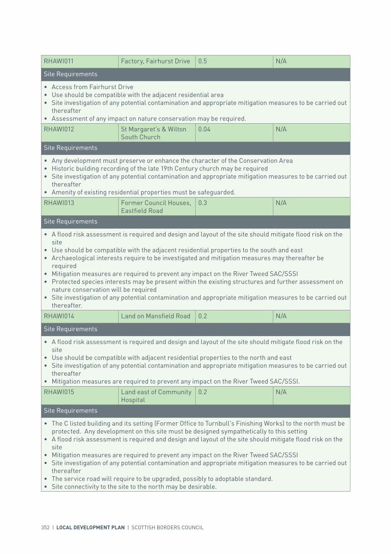
352 | LOCAL DEVELOPMENT PLAN | SCOTTISH BORDERS COUNCIL
RHAWI011 Factory, Fairhurst Drive 0.5 N/A
Site Requirements
• Access from Fairhurst Drive• Use should be compatible with the adjacent residential area• Site investigation of any potential contamination and appropriate mitigation measures to be carried out
thereafter• Assessment of any impact on nature conservation may be required.
RHAWI012 St Margaret’s & Wilton South Church
0.04 N/A
Site Requirements
• Any development must preserve or enhance the character of the Conservation Area• Historic building recording of the late 19th Century church may be required• Site investigation of any potential contamination and appropriate mitigation measures to be carried out
thereafter• Amenity of existing residential properties must be safeguarded.
RHAWI013 Former Council Houses, Eastfield Road
0.3 N/A
Site Requirements
• A flood risk assessment is required and design and layout of the site should mitigate flood risk on the site
• Use should be compatible with the adjacent residential properties to the south and east• Archaeological interests require to be investigated and mitigation measures may thereafter be
required• Mitigation measures are required to prevent any impact on the River Tweed SAC/SSSI• Protected species interests may be present within the existing structures and further assessment on
nature conservation will be required• Site investigation of any potential contamination and appropriate mitigation measures to be carried out
thereafter.
RHAWI014 Land on Mansfield Road 0.2 N/A
Site Requirements
• A flood risk assessment is required and design and layout of the site should mitigate flood risk on the site
• Use should be compatible with adjacent residential properties to the north and east• Site investigation of any potential contamination and appropriate mitigation measures to be carried out
thereafter• Mitigation measures are required to prevent any impact on the River Tweed SAC/SSSI.
RHAWI015 Land east of Community Hospital
0.2 N/A
Site Requirements
• The C listed building and its setting (Former Office to Turnbull’s Finishing Works) to the north must be protected. Any development on this site must be designed sympathetically to this setting
• A flood risk assessment is required and design and layout of the site should mitigate flood risk on the site
• Mitigation measures are required to prevent any impact on the River Tweed SAC/SSSI• Site investigation of any potential contamination and appropriate mitigation measures to be carried out
thereafter• The service road will require to be upgraded, possibly to adoptable standard.• Site connectivity to the site to the north may be desirable.

INTRODUCTION | CHALLENGES | VISION, AIMS AND SPATIAL STRATEGYPOLICIES | APPENDICES | SETTLEMENTS
LOCAL DEVELOPMENT PLAN | SCOTTISH BORDERS COUNCIL | 353
SITE REFERENCE SITE NAME SITE SIZE (HA)
GSHAWI001 Twirlees Terrace Allotments 0.3
GSHAWI002 Bard Road Allotment 1.1
GSHAWI003 Fisher Avenue Allotment 1.7
GSHAWI004 Dean Road Allotments 0.6
GSHAWI005 Hawick & Wilton CC 2.2
GSHAWI006 Volunteer Park 2.8
GSHAWI007 Volunteer Park ATP 2.6
GSHAWI008 Allotments at Guthrie Drive 0.7
GSHAWI009 Moat Site 1.1
GSHAWI010 Mansfield & Albert Park 3.6
GSHAWI011 Park in Burnfoot 2.8
GSHAWI012 Wilton Lodge Park 33.3
GSHAWI013 Little Haugh 0.6
GSHAWI014 The Village Allotments 0.1
GSHAWI015 Weensland Allotments 0.3
KEY GREENSPACE
RHAWI016 Former N Peal Factory, Carnarvon Street
0.3 N/A
Site Requirements
• The design and layout of development proposals should ensure that there is no adverse impact on adjoining land uses
• The C listed building which occupies the site and its setting (Former Office to Turnbull’s Finishing Works) must be retained. Any development on this site must be designed sympathetically to this setting
• Use should be compatible with adjacent residential properties to the north and east• Mitigation measures are required to prevent any impact on the River Tweed SAC/SSSI• Site investigation of any potential contamination and appropriate mitigation measures to be carried out
thereafter• Demolition or alteration would require a Historic Building Survey to be undertaken and possibly
further mitigation of impacts• Protected species interests may be present within the structures and further assessment on nature
conservation will be required• Vehicular access off Carnarvon Street, provided the use is not intense and does not involve any undue
use by HGV traffic. Connectivity with the road to the south may be desirable although the creation of a rat-run would be objectionable.

354 | LOCAL DEVELOPMENT PLAN | SCOTTISH BORDERS COUNCIL
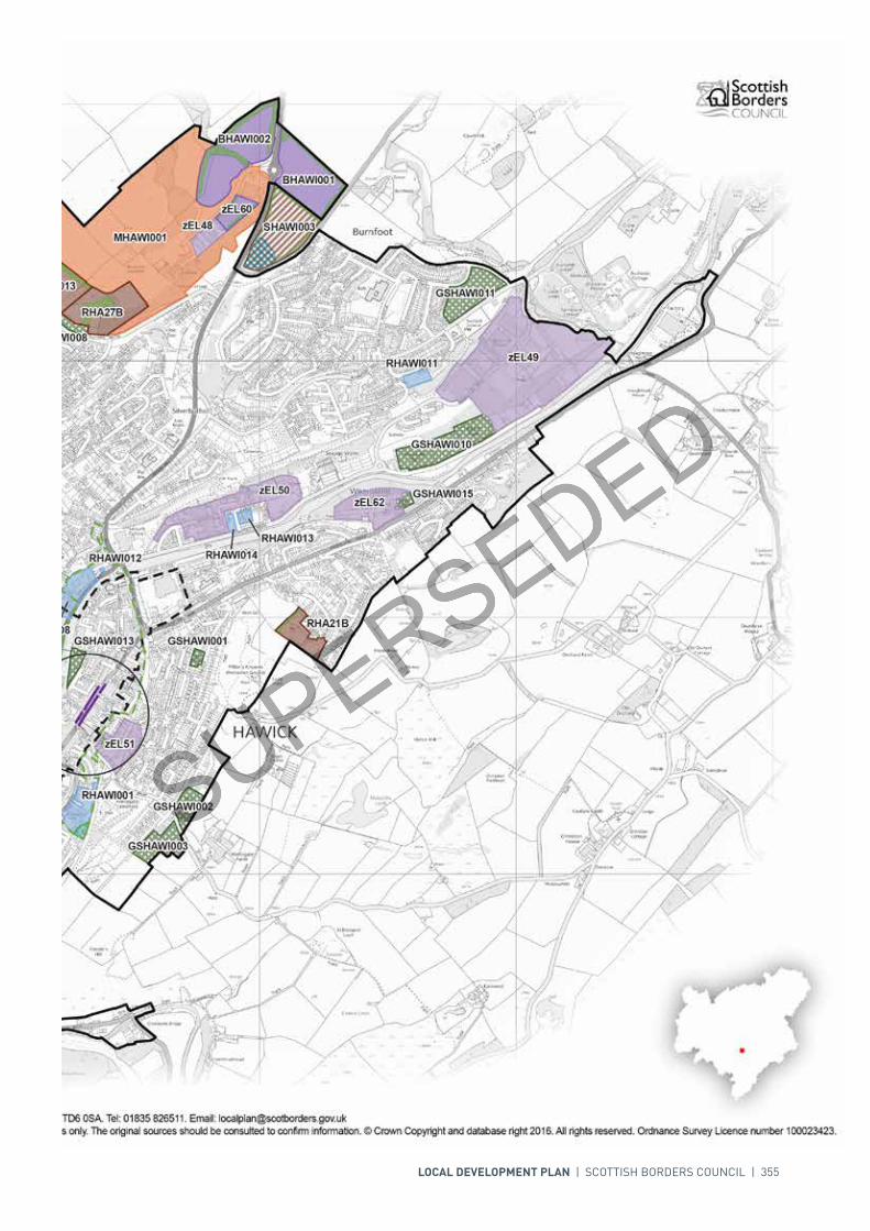
LOCAL DEVELOPMENT PLAN | SCOTTISH BORDERS COUNCIL | 355

Redevelopment
Development Boundary
Housing
Business and IndustrialSafeguarding
Town Centre Boundary
Mixed Use
Key Greenspace
Open Space
Structure Planting/Landscaping
Conservation Area
Core Activity Areas
Business and Industrial
Longer Term Housing
Wetland
GSHAWI012GSHAWI012
GSHAWI010GSHAWI010
GSHAWI006GSHAWI006
GSHAWI007GSHAWI007
GSHAWI011GSHAWI011
GSHAWI005GSHAWI005
GSHAWI003GSHAWI003GSHAWI009GSHAWI009
GSHAWI002GSHAWI002
GSHAWI008GSHAWI008
GSHAWI013GSHAWI013
GSHAWI004GSHAWI004
GSHAWI015GSHAWI015
GSHAWI001GSHAWI001
GSHAWI014GSHAWI014
MHAWI001MHAWI001
zEL49zEL49
zRO8zRO8
zEL50zEL50
BHAWI002BHAWI002
AHAWI013AHAWI013
RHA27BRHA27B
BHAWI001BHAWI001
zEL62zEL62
RHA13BRHA13B
zEL51zEL51
AHAWI006AHAWI006
RHA24ARHA24A
RHA25BRHA25B
zEL52zEL52
RHA12BRHA12B
RHA21BRHA21B
zEL60zEL60zEL48zEL48
RHAWI001RHAWI001RHAWI010RHAWI010
RHAWI011RHAWI011
RHAWI016RHAWI016
RHAWI013RHAWI013
RHAWI009RHAWI009
RHAWI014RHAWI014
RHAWI015RHAWI015
SHAWI003SHAWI003
zEL51zEL51
GSHAWI013GSHAWI013
zRO8zRO8
For further information, including help reading this document, please contact: Planning Policy & Access, Regulatory Services, Council Headquarters, Newtown St Boswells, Melrose, TD6 0SA. Tel: 0300 100 1800. Email: [email protected]: Scottish Borders Council uses spatial information from a range of sources to produce the mapping contained within this document. The mapping is for illustrative purposes only. The original sources should be consulted to confirm information. © Crown Copyright and database right 2017. All rights reserved. Ordnance Survey Licence number 100023423.
N
00mm
400400200200
Scottish Borders CouncilLocal Development Plan 2016as modified by Supplementary
Guidance on Housing 2017Hawick
Town Centre Inset
AHAWI025AHAWI025
AHAWI026AHAWI026
RHAWI012AWI012RHAWI012RHAWI012

356 | LOCAL DEVELOPMENT PLAN | SCOTTISH BORDERS COUNCIL
SETTLEMENT PROFILE HEITON
This profile should be read in conjunction with the relevant settlement map.
DESCRIPTIONHeiton is located 2.5 miles to the south of Kelso. The settlement is located within the Central Borders Strategic Development Area as defined in the Strategic Development Plan. According to the 2001 Census the population of Heiton is 133.
PLACE MAKING CONSIDERATIONSHeiton is a linear settlement formed along the A698, the main road from Kelso to Hawick. There is a wide mix of house types within Heiton, including traditional terraced housing to the north of the village and larger detached units with some back-land development in the southern part.
The Plan identifies two housing sites within Heiton along the eastern side of the Main Street at both the north and south of the village. The Plan also identifies one greenspace for protection at Heiton Recreational Park.
INFRASTRUCTURE CONSIDERATIONSAffordable Housing will require to be provided in association with proposed housing sites under the provisions of Policy HD1 and the Supplementary Guidance/Supplementary Planning Guidance on Affordable Housing.
The accommodation and facilities at Kelso High School have been identified as being unsuitable for future use particularly when the areas for longer term development are taken onto account. It has been agreed to build a new, modern school nearby the current site. The new school is due to open in 2016. In accordance with developer contribution policy, a contribution towards the additional facilities at the new Kelso High School will be sought, to recoup the capital invested by the Council.
With regards to Waste Water Treatment Works, Heiton has limited capacity. Contributions may be required where upgrades are necessary. In respect of the local water network, developers may be required to contribute towards upgrading to enable development.
Further information is available from Supplementary Guidance/Supplementary Planning Guidance on Developer Contributions and Planning/Development Briefs where applicable.

INTRODUCTION | CHALLENGES | VISION, AIMS AND SPATIAL STRATEGYPOLICIES | APPENDICES | SETTLEMENTS
LOCAL DEVELOPMENT PLAN | SCOTTISH BORDERS COUNCIL | 357
DEVELOPMENT AND SAFEGUARDING PROPOSALS
HOUSING
SITE REFERENCE SITE NAME SITE SIZE (HA) INDICATIVE SITE CAPACITY
RHE2B Heiton Mains 0.9 15
Site Requirements
• The main vehicular access to the site will primarily be directly from the A698 with respect for the urban form of the village
• Structure planting required to the eastern boundary to reinforce the settlement edge and contain the site
• The design and layout of the site should be in character with the existing linear form of the village.
RHE3B Ladyrig 1.1 20
Site Requirements
• The main vehicular access to the site should be from the A698 with respect for the urban form of the village
• Structure planting required to the southern and eastern boundaries to reinforce the settlement edge and contain the site
• The design and layout of the site should be in character with the existing linear form of the village.
SITE REFERENCE SITE NAME SITE SIZE (HA)
GSHEIT001 Heiton Recreational Park 0.4
KEY GREENSPACE
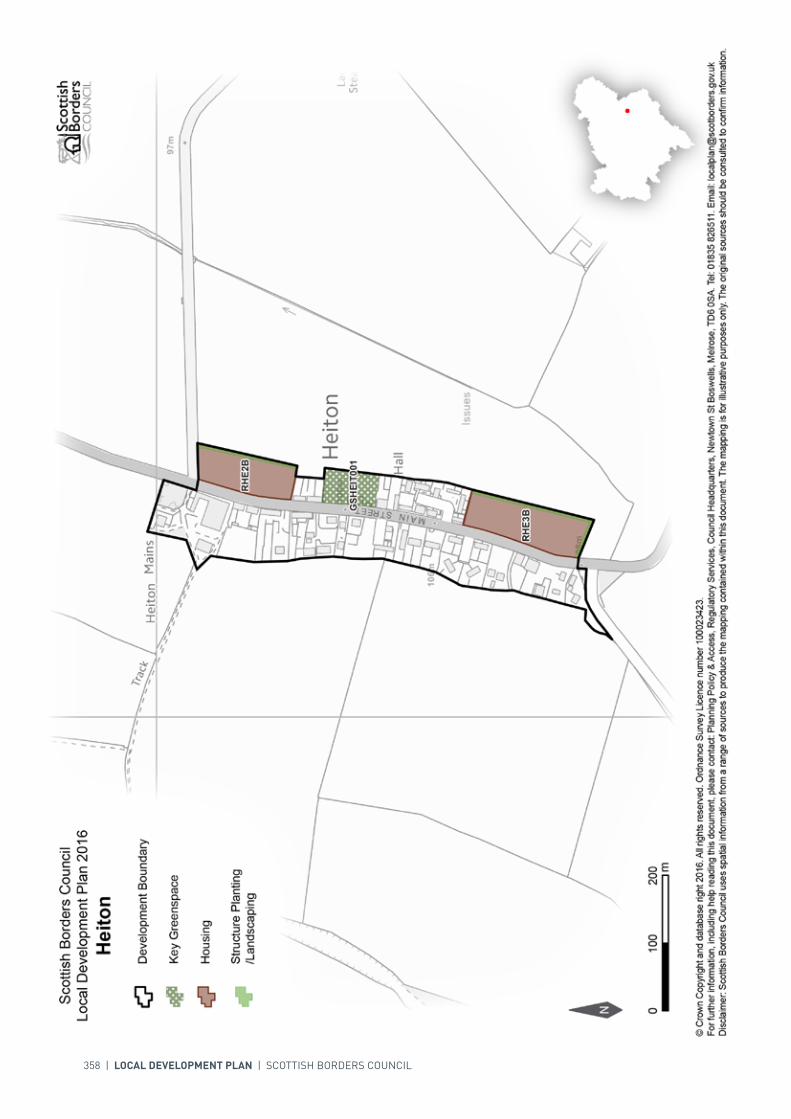
358 | LOCAL DEVELOPMENT PLAN | SCOTTISH BORDERS COUNCIL

INTRODUCTION | CHALLENGES | VISION, AIMS AND SPATIAL STRATEGYPOLICIES | APPENDICES | SETTLEMENTS
LOCAL DEVELOPMENT PLAN | SCOTTISH BORDERS COUNCIL | 359
SETTLEMENT PROFILE HERIOT STATION
This profile should be read in conjunction with the relevant settlement map.
DESCRIPTIONHeriot Station is in the Northern Housing Market Area, outwith any of the Strategic Development Areas as defined in the Strategic Development Plan. Heriot Station is located in the valley of the Gala Water, five miles north of Fountainhall and to the west of the A7. It is associated with a series of small building groups in the lower end of the valley of the Heriot Water.
PLACE MAKING CONSIDERATIONSThe settlement is set within the pastoral upland valley of the Gala Water. Services such as the school and church are located further up the valley of the Heriot Water to the west.
The character of Heriot Station is established by single sided development along the B709 facing south down the valley of the Gala Water, with a cluster of residential areas to the rear. Properties are generally single to a storey and a half in height; those that front onto the B709 are generally of traditional character, detached and constructed of traditional materials such as harl and slate. A few semi detached properties however, do exist within the settlement.
The Plan does not provide any housing allocations or areas for longer term development in Heriot Station. However, the Plan identifies the play area as an area of greenspace to be protected.
INFRASTRUCTURE CONSIDERATIONSAffordable Housing will require to be provided in association with proposed housing sites under the provisions of Policy HD1 and the Supplementary Guidance/Supplementary Planning Guidance on Affordable Housing.
In relation to education provision there is currently no requirement for development contributions.
Heriot Station falls within an area identified for a contribution to the Waverley Railway Project (see Policy IS3).
Road improvement works associated with the Waverley Railway Project are planned at Falahill, to the south of Heriot Station, and to the north of Fountainhall.

360 | LOCAL DEVELOPMENT PLAN | SCOTTISH BORDERS COUNCIL
SITE REFERENCE SITE NAME SITE SIZE (HA)
GSHERI001 Play Area 0.3
KEY GREENSPACE
With regards to waste water, Heriot Station is largely served by private drainage.
Further information is available from Supplementary Guidance/Supplementary Planning Guidance on Developer Contributions.
DEVELOPMENT AND SAFEGUARDING PROPOSALS

LOCAL DEVELOPMENT PLAN | SCOTTISH BORDERS COUNCIL | 361

362 | LOCAL DEVELOPMENT PLAN | SCOTTISH BORDERS COUNCIL
SETTLEMENT PROFILE HUTTON
This profile should be read in conjunction with the relevant settlement map.
DESCRIPTIONHutton is located in Berwickshire, 10 miles to the east of Duns. The population of the settlement according to the 2001 Census was 89. Hutton is located within the Eastern Strategic Development Area (SDA) as identified by the SESplan.
PLACEMAKING CONSIDERATIONSHutton is located on the lowlands associated with the River Tweed, the settlement is therefore flat and surrounded by arable fields, which are designated as prime agricultural land.
The village is within the Eastern SDA as identified by the SESplan and as a result land could be identified to meet housing demand. In this Local Development Plan period the existing allocated site, which remains undeveloped, is considered adequate to meet housing demand.
INFRASTRUCTURE CONSIDERATIONSAffordable Housing will require to be provided under provisions of Policy H1 and the Supplementary Guidance/Supplementary Planning Guidance on Affordable Housing.
A contribution towards Berwickshire High School will be sought to supplement Scottish Borders Council’s investment in the new school which opened in 2009-2010 under the 3 High Schools project.
With regards to Waste Water Treatment Work, Hutton has limited capacity. Contributions may be required where upgrades are necessary. In respect of the local water network, developers may be required to contribute towards upgrading to enable development.
Further information is available from Supplementary Guidance/Supplementary Planning Guidance on Developer Contributions and Planning Briefs where applicable.

INTRODUCTION | CHALLENGES | VISION, AIMS AND SPATIAL STRATEGYPOLICIES | APPENDICES | SETTLEMENTS
LOCAL DEVELOPMENT PLAN | SCOTTISH BORDERS COUNCIL | 363
DEVELOPMENT AND SAFEGUARDING PROPOSALS
HOUSING
SITE REFERENCE SITE NAME SITE SIZE (HA) INDICATIVE SITE CAPACITY
BHU2B Rosebank 1.1 11
Site Requirements
• Provide structure planting at southern edge to provide enclosure to the site and to define a settlement boundary
• Retain existing hedge planting on the western edge to define a settlement boundary• Provide satisfactory planting to safeguard the amenity of neighbouring properties, particularly at
north-east and south-east corners• Property orientation should take advantage of the southerly aspect and long views• Work will be required to establish a vehicular access from Royal Terrace or Knowepark, this should be
done in line with advice from the Council’s Roads Planning Team • Pedestrian links through the site to Royal Terrace and to Knowes Close and the play park should be
provided• Investigation of possible archaeological links to the north west of the site.
SITE REFERENCE SITE NAME SITE SIZE (HA)
GSHUTT001 Recreation and Play Area 0.1
KEY GREENSPACE
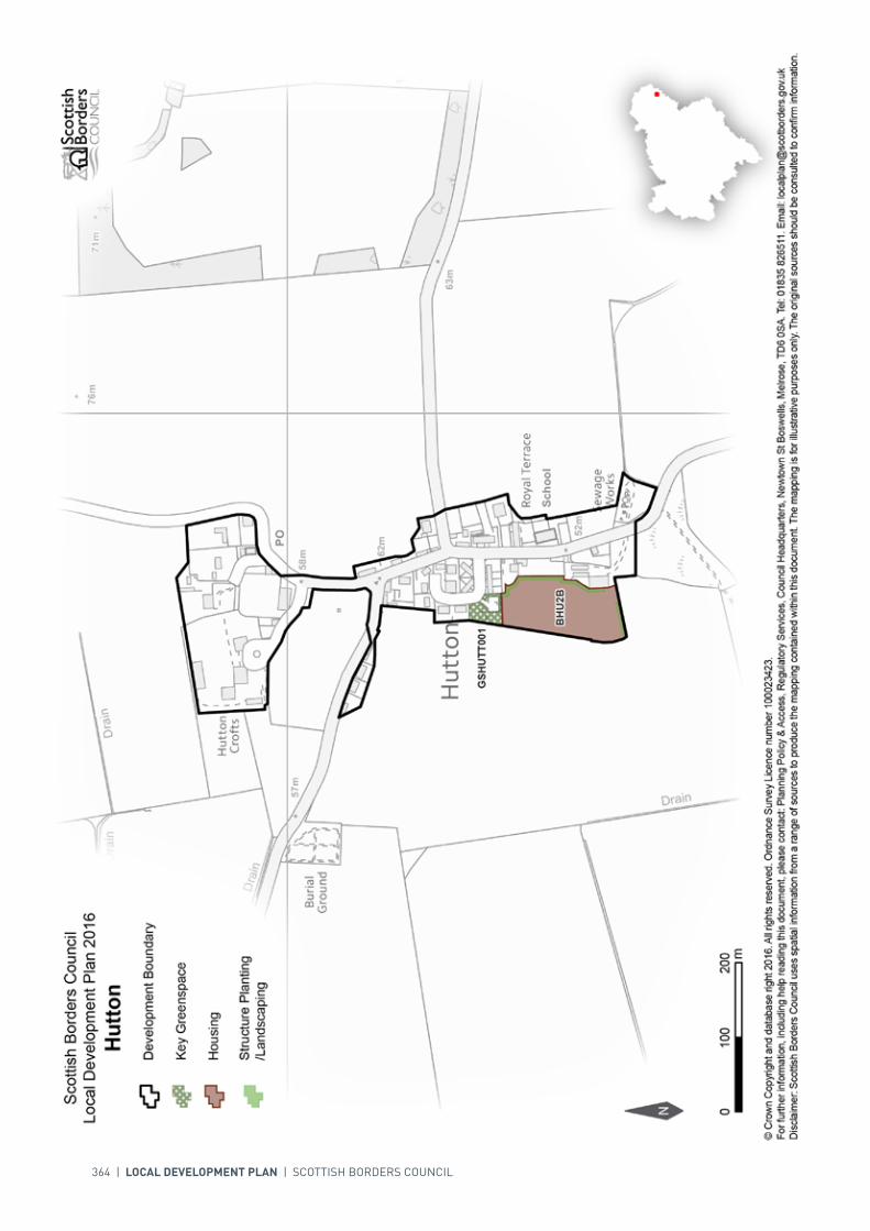
364 | LOCAL DEVELOPMENT PLAN | SCOTTISH BORDERS COUNCIL
INTRODUCTION | CHALLENGES | VISION, AIMS AND SPATIAL STRATEGYPOLICIES | APPENDICES | SETTLEMENTS
LOCAL DEVELOPMENT PLAN | SCOTTISH BORDERS COUNCIL | 365
SETTLEMENT PROFILE INNERLEITHEN
This profile should be read in conjunction with the relevant settlement map.
DESCRIPTIONInnerleithen is located in the Western Development Area as defined in the Strategic Development Plan. The town is located in the Northern Housing Market Area. Innerleithen is located almost 7 miles east of Peebles. The 2001 Census population was 2619.
PLACE MAKING CONSIDERATIONSInnerleithen sits on a significant bend in the River Tweed at a point where the valley floor opens out into wide haughland, and the majority of the built up area of the town lies on this haughland. The entrances into the town are generally quite pleasing and there is a good integration with the adjoining landscape to the north due to the mature landscape framework. The River Tweed and the flood plain dominate the southern side of the village.
The town developed in the late 18th century on the development of the textile industry and the publication in the early 19th century of Sir Walter Scott’s St Ronan’s Wells, which extolled the restorative qualities of the spring waters. At this time the High Street was developed but it was not until the end of that century that the major expansion of the settlement occurred extending behind the High Street to the south and to the south east beyond the Leithen Water. Another major expansion also occurred after the 2nd World War with a major public housing scheme in the east towards the former Pirn House. Recently new residential development within the settlement has taken place to the north in the vicinity of Kirklands and it is in this area where future development is expected to take place.
The character of Innerleithen owes much to the Leithen Water that runs through the town to the Tweed. A lade to the west of the river supplied several woollen mills (one of them was the first in the Borders, established in 1788), a sawmill and Smail’s Printing Works (now run by the National Trust for Scotland). Innerleithen was an ideal location for the woollen industry. Its fast flowing river offered waterpower to the mills and wool was produced in the surrounding pastoral countryside. The development of the woollen industry did not begin as a gradual process, but on a large scale with the building of Brodie’s Mill.
The Conservation Area of Innerleithen includes much of the High Street, Leithen Road, and part of Traquair Road, Waverley Road, Horsbrugh Street, and Pirn Road. The majority of properties within the Conservation Area are 19th century and residential and follow a fairly general pattern. Architecturally they are quite plain as individual units but rely for their interest and integrity on their proportioning, detailing and uniformity as a group of buildings. Snecked whin stone, sandstone, harling, stone quoins,
366 | LOCAL DEVELOPMENT PLAN | SCOTTISH BORDERS COUNCIL
and slate are the main building materials. Most properties have timber sash and case windows and solid timber doors, and dormers. They are characteristically of a small scale either single, one and a half or two storeys in height.
The main central area focuses on the High Street, with a diverse range of services and facilities to serve the local community including a bank and a post office. The town benefits from a supermarket which is situated just outwith the town centre along the Peebles Road. The town centre itself is considered to be one of the healthier town centres within the Scottish Borders with generally a low vacancy rate.
The Plan identifies two greenspace areas for protection within Innerleithen, the Innerleithen Recreation Ground and the outdoor space at St Ronan’s Primary School. These spaces provide the village community with important recreation opportunities.
The Plan provides three housing allocations, two of which are located to the north of the settlement off Leithen Road, and the third is off the Peebles Road. One redevelopment site is identified, the Gap site on the High Street. Furthermore, two Business and Industrial sites are also identified off Traquair Road, of which site zEL200 (Traquair Road) is safeguarded. In addition to these sites a key potential regeneration opportunity exists to the north of the town centre at the Caerlee Mill site.
Once the allocated sites are fully developed the preferred area for future expansion beyond the period of this Local Development Plan will be the area at Kirklands/Willowbank (SINNE001).
The Kirklands/Willowbank longer term housing area will be subject to further assessment and review as part of the next Local Development Plan Review, and will require a Masterplan to ensure a coherent and holistic approach.
In relation to the Medical Centre, there are pressures on accommodation which may require further upgrade.
INFRASTRUCTURE CONSIDERATIONSAffordable Housing will require to be provided in association with proposed housing sites under the provisions of Policy HD1 and the Supplementary Guidance/Supplementary Planning Guidance on Affordable Housing.
Peebles Secondary School is forecast by the Director of Education and Lifelong Learning to face some capacity issues from 2016 onwards. Developer Contribution towards school provision within the catchment will be requested, commensurate with the size and type of the development and in accordance with Developer Contribution Policy.
This settlement is identified within the Council’s Flood Contingency Plan as being at risk of flooding. Any development proposals should therefore be subject to early consultation with the Council’s Flood and Coastal Management Officer, and SEPA, having regard to the Indicative River and Coastal Flood Map (Scotland). A flood risk assessment may be required and may influence the scale and layout of any development at a particular location.
With regards to Waste Water Treatment Works and Water Treatment Works, Innerleithen currently has sufficient capacity.
Further information is available from Supplementary Guidance/Supplementary Planning Guidance on Developer Contributions and Planning/Development Briefs where applicable.

INTRODUCTION | CHALLENGES | VISION, AIMS AND SPATIAL STRATEGYPOLICIES | APPENDICES | SETTLEMENTS
LOCAL DEVELOPMENT PLAN | SCOTTISH BORDERS COUNCIL | 367
DEVELOPMENT AND SAFEGUARDING PROPOSALS
HOUSING
SITE REFERENCE SITE NAME SITE SIZE (HA) INDICATIVE SITE CAPACITY
TI200 Kirklands/Willowbank 5.2 55
Site Requirements
• Refer to approved Planning Brief.
TI3B Peebles Road 0.2 5
Site Requirements
• A vehicular link with Tweed View will be required along with a pedestrian link to the health centre as well as through to the supermarket
• Retention of the stone boundary wall along the Peebles Road• New landscape planting is required to provide enclosure and setting for housing development.
Buffer areas alongside new and existing landscaping will be required. The long term maintenance of landscaped areas must be addressed
• Further assessment on archaeology will also be required and mitigation put in place.
AINNE004 Kirklands/Willowbank II 7.8 150
Site Requirements
• It is intended that a Planning Brief in the form of Supplementary Guidance will be produced for this site• The vehicular access will be via the allocated housing site TI200 and although this entails only one
point of access from the existing road network, the possibility of a second junction with the B709 (Leithen Road) further south should not be completely ruled out. Improvements are required to the B709 towards the A72 – High Street in terms of carriageway width, footway provision/width and parking provision. Access routes through to site for long term development should be established
• New woodland structure planting is required to provide a setting and shelter for housing development, as well as to reinforce the settlement edge. The use of mixed broadleaved woodland including forest trees such as oak, ash, Scots pine and beech along with the establishment of a shrub layer will be required. These areas are also useful for informal recreation and should be made accessible through appropriate access routes to the neighbourhood and countryside more generally. Buffer areas alongside new and existing landscaping will be required. The long term maintenance of landscaped areas must be addressed
• Existing stone walls to be maintained and possibly incorporated into access routes• Provision of amenity access within the development for pedestrians and cyclists will be required. An
adoptable pedestrian link through to Well’s Brae is strongly desirable• Mitigation measures are required to prevent any impact on the River Tweed Special Areas of
Conservation (Leithen Water)• Further assessment on nature conservation interest along with archaeology will also be required and
mitigation put in place• A flood risk assessment is required to inform the site layout, design and mitigation.
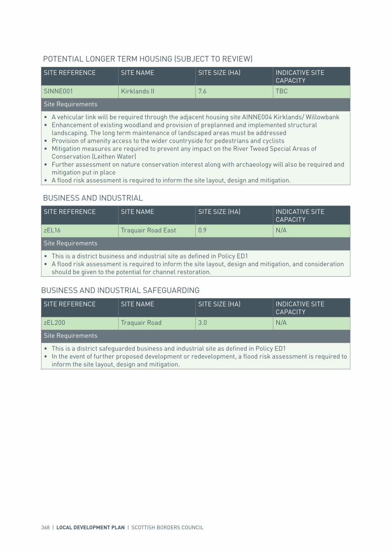
368 | LOCAL DEVELOPMENT PLAN | SCOTTISH BORDERS COUNCIL
SITE REFERENCE SITE NAME SITE SIZE (HA) INDICATIVE SITE CAPACITY
SINNE001 Kirklands II 7.6 TBC
Site Requirements
• A vehicular link will be required through the adjacent housing site AINNE004 Kirklands/ Willowbank• Enhancement of existing woodland and provision of preplanned and implemented structural
landscaping. The long term maintenance of landscaped areas must be addressed• Provision of amenity access to the wider countryside for pedestrians and cyclists• Mitigation measures are required to prevent any impact on the River Tweed Special Areas of
Conservation (Leithen Water)• Further assessment on nature conservation interest along with archaeology will also be required and
mitigation put in place• A flood risk assessment is required to inform the site layout, design and mitigation.
POTENTIAL LONGER TERM HOUSING (SUBJECT TO REVIEW)
SITE REFERENCE SITE NAME SITE SIZE (HA) INDICATIVE SITE CAPACITY
zEL16 Traquair Road East 0.9 N/A
Site Requirements
• This is a district business and industrial site as defined in Policy ED1• A flood risk assessment is required to inform the site layout, design and mitigation, and consideration
should be given to the potential for channel restoration.
BUSINESS AND INDUSTRIAL
SITE REFERENCE SITE NAME SITE SIZE (HA) INDICATIVE SITE CAPACITY
zEL200 Traquair Road 3.0 N/A
Site Requirements
• This is a district safeguarded business and industrial site as defined in Policy ED1• In the event of further proposed development or redevelopment, a flood risk assessment is required to
inform the site layout, design and mitigation.
BUSINESS AND INDUSTRIAL SAFEGUARDING
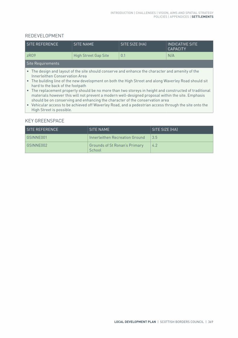
INTRODUCTION | CHALLENGES | VISION, AIMS AND SPATIAL STRATEGYPOLICIES | APPENDICES | SETTLEMENTS
LOCAL DEVELOPMENT PLAN | SCOTTISH BORDERS COUNCIL | 369
SITE REFERENCE SITE NAME SITE SIZE (HA) INDICATIVE SITE CAPACITY
zRO9 High Street Gap Site 0.1 N/A
Site Requirements
• The design and layout of the site should conserve and enhance the character and amenity of the Innerleithen Conservation Area
• The building line of the new development on both the High Street and along Waverley Road should sit hard to the back of the footpath
• The replacement property should be no more than two storeys in height and constructed of traditional materials however this will not prevent a modern well-designed proposal within the site. Emphasis should be on conserving and enhancing the character of the conservation area
• Vehicular access to be achieved off Waverley Road, and a pedestrian access through the site onto the High Street is possible.
REDEVELOPMENT
SITE REFERENCE SITE NAME SITE SIZE (HA)
GSINNE001 Innerleithen Recreation Ground 3.5
GSINNE002 Grounds of St Ronan’s Primary School
4.2
KEY GREENSPACE

370 | LOCAL DEVELOPMENT PLAN | SCOTTISH BORDERS COUNCIL

LOCAL DEVELOPMENT PLAN | SCOTTISH BORDERS COUNCIL | 371
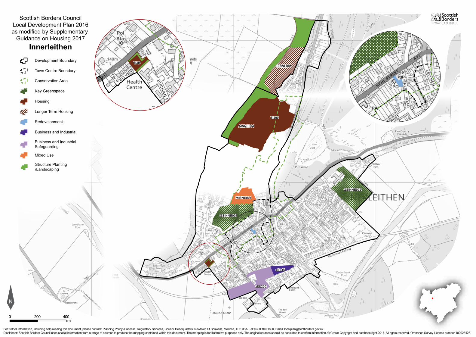
For further information, including help reading this document, please contact: Planning Policy & Access, Regulatory Services, Council Headquarters, Newtown St Boswells, Melrose, TD6 0SA. Tel: 0300 100 1800. Email: [email protected]: Scottish Borders Council uses spatial information from a range of sources to produce the mapping contained within this document. The mapping is for illustrative purposes only. The original sources should be consulted to confirm information. © Crown Copyright and database right 2017. All rights reserved. Ordnance Survey Licence number 100023423.
N
Scottish Borders CouncilLocal Development Plan 2016as modified by Supplementary
Guidance on Housing 2017Innerleithen
00mm
400400200200
Redevelopment
Development Boundary
Housing
Longer Term Housing
Business and IndustrialSafeguarding
Town Centre Boundary
Key Greenspace
Structure Planting/Landscaping
Conservation Area
Business and Industrial
GSINNE002GSINNE002
GSINNE001GSINNE001
TI200TI200
AINNE004AINNE004
SINNE001SINNE001
zEL200zEL200
zEL16zEL16
TI3BTI3B
zRO9zRO9
Mixed Use
MINNE001MINNE001

372 | LOCAL DEVELOPMENT PLAN | SCOTTISH BORDERS COUNCIL
SETTLEMENT PROFILE JEDBURGH
This profile should be read in conjunction with the relevant settlement map.
DESCRIPTIONJedburgh is located in the Central Borders Strategic Development Area as defined in the Strategic Development Plan and is within the Central Housing Market Area. According to the 2001 Census the population of this settlement was 4,136.
PLACE MAKING CONSIDERATIONSThe historic settlement of Jedburgh was built either side of the Jed Water which runs on a north - south axis, and is framed by Lanton Hill (280 metres) and Black Law (338 metres) to the west and south west and by lower more undulating hills to the east. The High Street is characterised by a mix of commercial, residential and social facilities.
The Conservation Area of Jedburgh includes much of the historic core of the town including the Abbey and the Castle Gaol. Similar to Edinburgh Old Town in its layout, Jedburgh has a long street that rises terminating with the castle at the highest point. The High Street is characterised by a mix of commercial, residential and social facilities, the central area is focused around where the Mercat Cross once sat with roads leading off in various directions.
Properties within the Conservation Area are built in rows with some detached properties particularly along Friarsgate. Ranging from two to three and a half storeys in height, properties vary in styles. Although the elements highlighted above are important and contribute greatly to the character of Jedburgh they do not do so in isolation. Building materials and architectural details are also just as important. Sandstone, some whinstone, harling, and slate all help to form the character. Architectural details such as sash and case windows (though there are some unfortunate uPVC replacements), rybats, margins, detailed door heads above some entrances and in some instances pilasters all add to the sense of place. Any new development must therefore aim to contribute to the existing character of the Conservation Area.
The views within the valley floor are more limited by the topography and vegetation of the settlement. Nevertheless, the views from the south to the Abbey are particularly important and require protection. From the higher parts of Jedburgh there are more extensive views over the town to the east and west.
Development land in Jedburgh is severely restricted by the topography and road network. Once the allocated sites have been developed, without serious investment in the road network, there is no identifiable preferred area of expansion for Jedburgh. Future areas of expansion will be looked at in
INTRODUCTION | CHALLENGES | VISION, AIMS AND SPATIAL STRATEGYPOLICIES | APPENDICES | SETTLEMENTS
LOCAL DEVELOPMENT PLAN | SCOTTISH BORDERS COUNCIL | 373
more detail in subsequent plans. Serious considerations must be made regarding the road network and where best to locate future development which impacts least on the character and setting of Jedburgh. Under the present circumstances, any development outwith the allocated sites proposed during this local development plan period will be resisted. There may be potential in the long term future for development to the north if the road network issues can be resolved. However, further development on Sharplaw Road other than those allocated will be resisted due to the severe road network restrictions.
The Plan provides eight housing allocations within Jedburgh, business and industrial land at Wildcat Wood and six safeguarded sites for business and industrial use. Two redevelopment opportunities have been identified and a site has also been allocated to the south of the settlement for a cemetery expansion.
Several greenspaces within Jedburgh are protected due to there value within the community these include Jedforest Bandstand, Allerley Well Park and Howden Park.
INFRASTRUCTURE CONSIDERATIONSAffordable Housing will require to be provided under the provisions of Policy HD1 and the Supplementary Guidance/Supplementary Planning Guidance on Affordable Housing.
There is no requirement for contribution towards education provision.
This settlement is identified within the Council’s Flood Contingency Plan as being at risk of flooding. Any development proposals should therefore be subject to early consultation with the Council’s Flood and Coastal Management Officer, and SEPA, having regard to the Indicative River and Coastal Flood Map (Scotland). A flood risk assessment may be required and may influence the scale and layout of any development at a particular location.
Contributions may be required to upgrade and improve the existing constrained and congested road network.
With regards to Waste Water Treatment Works and Water Treatment Works, Jedburgh currently has sufficient capacity.
Further information is available from Supplementary Guidance/Supplementary Planning Guidance on Developer Contributions and Planning/Development Briefs where applicable.
DEVELOPMENT AND SAFEGUARDING PROPOSALS
HOUSING
SITE REFERENCE SITE NAME SITE SIZE (HA) INDICATIVE SITE CAPACITY
RJ7B Annefield 2.0 40
Site Requirements
• Refer to approved Planning Brief.
RJ30B Howden Drive 4.2 80
Site Requirements
• Refer to approved Planning Brief.

374 | LOCAL DEVELOPMENT PLAN | SCOTTISH BORDERS COUNCIL
RJ2B Lochend 3.1 43
Site Requirements
• Refer to approved Planning Brief.
RJ14B Oxnam Road 8.3 67
Site Requirements
• Access to be taken directly from existing access off Oakieknowe Road• Site to include village green and play area as shown in the approved Planning Brief for Lochend and
Annefield• Design and layout to be in character with existing on-site development.
RJ27D Wildcat Cleuch 1.7 6
Site Requirements
• Site is to be accessed off Wildcat Cleuch not Lanton Road• Structural planting required on the northern boundary to provide a definitive settlement edge. A
management scheme for planting is also required• Existing hedgerows and trees to be retained where possible• Consider the potential for culvert removal and channel restoration.
AJEDB005 Wildcat Gate South 2.1 20
Site Requirements
• Refer to approved Planning Brief.
AJEDB010 Queen Mary Building 0.3 25
Site Requirements
• Refer to approved Planning Brief.
AJEDB012 Howden Drive South 0.2 5
Site Requirements
• Structural planting required on the southern boundary to reinforce settlement edge and protect existing woodland. A management scheme for planting is also required
• Scale of the development must be in keeping with surrounding residential properties• Mitigation measures are required to prevent any impact on the River Tweed Special Area of
Conservation• Mitigation measures should be carried out to address drainage into the nearby burn.
SITE REFERENCE SITE NAME SITE SIZE (HA) INDICATIVE SITE CAPACITY
BJEDB001 Wildcat Wood and extension
7.6 N/A
Site Requirements
• This is a district business and industrial site as defined in Policy ED1• Existing woodland should be excluded from the developable area.
BUSINESS AND INDUSTRIAL
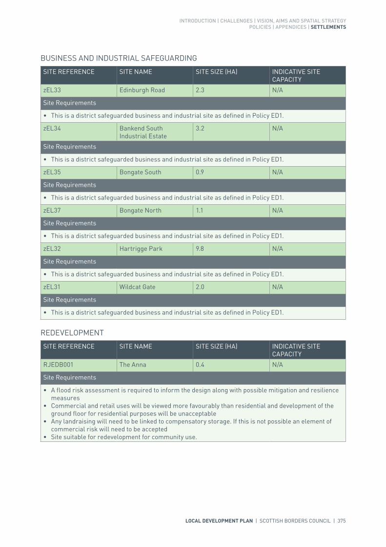
INTRODUCTION | CHALLENGES | VISION, AIMS AND SPATIAL STRATEGYPOLICIES | APPENDICES | SETTLEMENTS
LOCAL DEVELOPMENT PLAN | SCOTTISH BORDERS COUNCIL | 375
SITE REFERENCE SITE NAME SITE SIZE (HA) INDICATIVE SITE CAPACITY
zEL33 Edinburgh Road 2.3 N/A
Site Requirements
• This is a district safeguarded business and industrial site as defined in Policy ED1.
zEL34 Bankend South Industrial Estate
3.2 N/A
Site Requirements
• This is a district safeguarded business and industrial site as defined in Policy ED1.
zEL35 Bongate South 0.9 N/A
Site Requirements
• This is a district safeguarded business and industrial site as defined in Policy ED1.
zEL37 Bongate North 1.1 N/A
Site Requirements
• This is a district safeguarded business and industrial site as defined in Policy ED1.
zEL32 Hartrigge Park 9.8 N/A
Site Requirements
• This is a district safeguarded business and industrial site as defined in Policy ED1.
zEL31 Wildcat Gate 2.0 N/A
Site Requirements
• This is a district safeguarded business and industrial site as defined in Policy ED1.
BUSINESS AND INDUSTRIAL SAFEGUARDING
SITE REFERENCE SITE NAME SITE SIZE (HA) INDICATIVE SITE CAPACITY
RJEDB001 The Anna 0.4 N/A
Site Requirements
• A flood risk assessment is required to inform the design along with possible mitigation and resilience measures
• Commercial and retail uses will be viewed more favourably than residential and development of the ground floor for residential purposes will be unacceptable
• Any landraising will need to be linked to compensatory storage. If this is not possible an element of commercial risk will need to be accepted
• Site suitable for redevelopment for community use.
REDEVELOPMENT

376 | LOCAL DEVELOPMENT PLAN | SCOTTISH BORDERS COUNCIL
RJEDB002 Riverside Mill 0.2 N/A
Site Requirements
• A flood risk assessment is required to inform development of the site along with possible mitigation and resilience measures
• Suitable access to the site would be determined by the proposed use and would require discussion with the Council’s Roads Planning Team
• Depending on the type of use developed on the site, screening may be required along the northern boundary to protect the residential amenity of the properties at Malestroit Court
• Mitigation measures would be required to ensure no significant impacts on the River Tweed Special Area of Conservation
• Excavations in this area may require archaeological monitoring.
SITE REFERENCE SITE NAME SITE SIZE (HA)
FJEDB001 Jedburgh Cemetery Expansion 1.1
Site Requirements
• Archaeological work may be required.
CEMETERY
SITE REFERENCE SITE NAME SITE SIZE (HA)
GSJEDB001 Allerley Well Park 4.6
GSJEDB002 Jed Forest RFC 1.4
GSJEDB003 Jed Legion Club 3.0
GSJEDB004 Howden Park 2.2
GSJEDB005 Stone Hill 1.4
GSJEDB006 Jedforest Bandstand 0.7
GSJEDB007 A68/Jedwater 2.0
GSJEDB008 Jedburgh Water 1.3
KEY GREENSPACE

INTRODUCTION | CHALLENGES | VISION, AIMS AND SPATIAL STRATEGYPOLICIES | APPENDICES | SETTLEMENTS
LOCAL DEVELOPMENT PLAN | SCOTTISH BORDERS COUNCIL | 377

378 | LOCAL DEVELOPMENT PLAN | SCOTTISH BORDERS COUNCIL
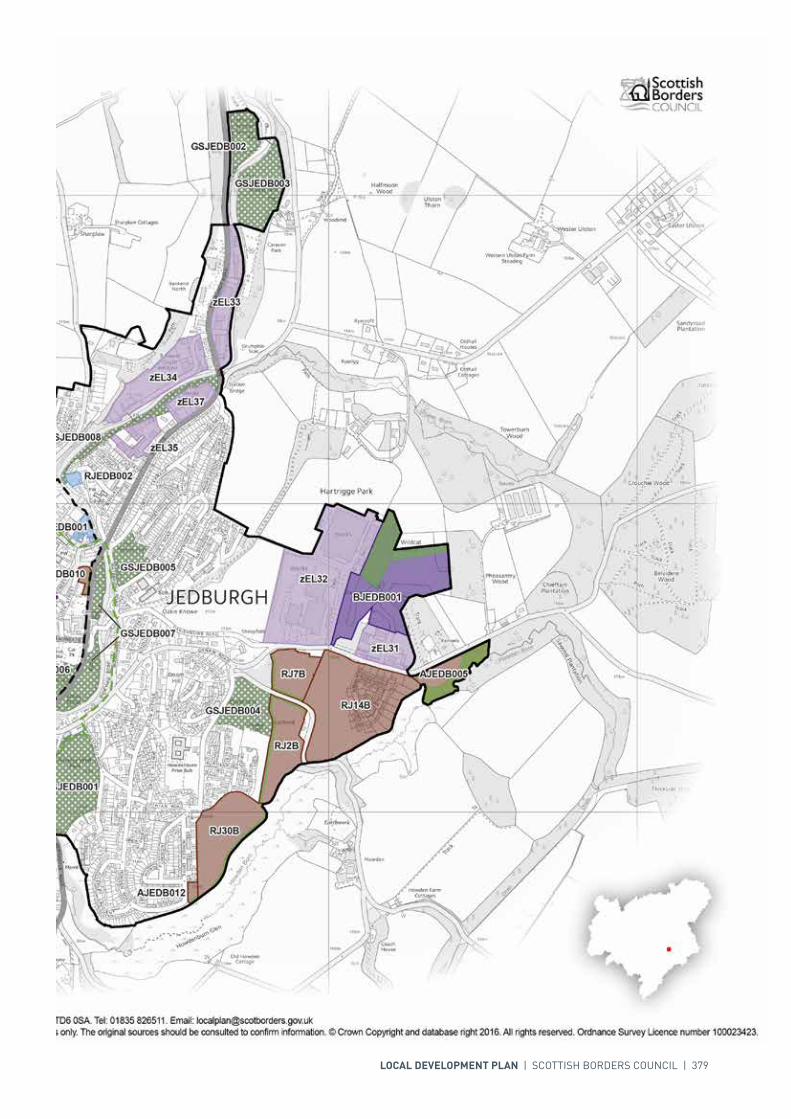
LOCAL DEVELOPMENT PLAN | SCOTTISH BORDERS COUNCIL | 379

380 | LOCAL DEVELOPMENT PLAN | SCOTTISH BORDERS COUNCIL
SETTLEMENT PROFILE KELSO
This profile should be read in conjunction with the relevant settlement map.
DESCRIPTIONKelso is located within the Central Borders Housing Market Area, at the eastern section of the Central Strategic Development Area, within the Development Strategy in the Strategic Development Plan. The 2001 Census population of Kelso was 5,116.
PLACE MAKING CONSIDERATIONSThe character of Kelso is established from its setting along an attractive meander in the River Tweed. It takes considerable benefit of its open riverside with many walkways alongside. Within the centre, the Square forms a significant part of the character of the Market Town. Within the town centre a one-way Traffic Management Scheme has been established to provide safer and more accessible routes for pedestrians and less vehicular congestion whilst aiming to retain, and indeed enhance, the character of the historic main square and surrounding street surfaces.
Residents and visitors of Kelso enjoy many scenic views that look out and into the settlement. From the south the historic Kelso Abbey can be seen. The River Tweed separates the town in a north-south divide and therefore allows for many attractive views, the most attractive being from the west on the A699 route past Floors Castle. The views from other approaches to the town are less dramatic and are shortened by the topography and landscape features that exist in the area.
The town lies within the Tweed Lowlands Regional Landscape Area and the River Tweed is designated as a Site of Special Scientific Interest and Special Area of Conservation reflecting its importance to the biodiversity of the Borders. The Floors Castle estate which lies to the west of the town is listed within the Inventory of Gardens and Designed Landscapes.
The Conservation Area of Kelso includes the historic core of the town, including the ruins of the 12th century Abbey, the 18th century Market Square and the Kelso Bridge, as well as the surrounding 19th century buildings and the main approaches into the town. Built in 1800, Kelso Bridge was the first bridge in the world to have elliptical arches. It was built to replace its predecessor that had been previously swept away in a flood.
The Kelso Conservation Area retains many of the distinctive townscape characteristics that can only be found in this Roxburghshire market town. Main streets within the Town run in a radial pattern and centre on the Market Square. This Square is the largest formal square in Scotland and is still complete with setts. Around the Market Square, buildings are made-up of a rich assortment of commercial
INTRODUCTION | CHALLENGES | VISION, AIMS AND SPATIAL STRATEGYPOLICIES | APPENDICES | SETTLEMENTS
LOCAL DEVELOPMENT PLAN | SCOTTISH BORDERS COUNCIL | 381
properties while a large part of Roxburgh Street is residential. A variety of different building styles and types are present throughout the Conservation Area and these all add to the uniqueness of the place. Both Shedden Park and the Abbey provide a significant contribution not only to the amenity of the Town but also to its attractiveness. Many of the properties are built hard to the footpath but on the whole they tend to follow the streetscape. While all of the features highlighted above are important and contribute greatly to the character of Kelso they do not do so in isolation. The use of building materials and architectural details are just as important. Sandstone, render and slate all help to form the character. Architectural details such as the traditional shop fronts, the classical proportions and details like the frieze, cornices and other highly ornamental carved stonework, sash and case windows, panel doors, and brick chimney stacks all add greatly to the Conservation Area. Any new development must therefore aim to contribute to the existing character of the Conservation Area.
Kelso is a key town within the Central Strategic Development Area. The Plan provides eight housing allocations, including two additional sites at Nethershot and Hendersyde, allocated to meet the housing land requirements identified within the Strategic Development Plan. The Plan also provides two business and industrial sites; two safeguarded business and industrial sites, as well as two redevelopment opportunities at the Former Kelso High School site and the Former Foundry on Station Road. The Plan also provides a site for a new High School to the north-west of Kelso.
There is growing pressure on the existing High School within the town and the site has limited potential for expansion, therefore there was a need to identify a new site. Funding has been made available from the Scottish Government for the school to be relocated. The Council has identified a preferred site for a new High School at Nethershot, Angraflat Road; this site has been through extensive consultation and is well supported.
Once relocated, the former High School site will be available for redevelopment. The site is suitable for a variety of uses although the retention of some of the existing buildings may be required, including the category ‘B’ Listed Main School building.
Kelso is also an important employment hub; sites at Wooden Linn and the Extension to Pinnaclehill Industrial Estate are allocated within the Plan for strategic business and industrial land which allows for the development of Class 4, 5 & 6 uses. An allocated site at Pinnaclehill Industrial Estate has been safeguarded for strategic business and industrial land, a further site at Spylaw Road/ Station Road has also been safeguarded for local business and industrial land uses under policy ED1.
Within Kelso, several greenspaces have been identified for protection within the Plan due to their high amenity value; these include Shedden Park, Kelso Rugby Club and Mayfield Riverside Walk.
The areas of Longer Term Development on the settlement map are indicative only and will require further detailed assessment and review as part of the next Local Development Plan Review. The preferred areas are, in line with the Plan, the area to the north west of Kelso (SKELS004) and there is also potential for further longer term development in the area to the north east of Kelso at Hendersyde North Lodge (SKELS005). Development to the East of Broomlands and West of Wallacenick will be resisted.
INFRASTRUCTURE CONSIDERATIONSAffordable Housing will require to be provided under the provisions of Policy HD1 and the Supplementary Guidance/Supplementary Planning Guidance on Affordable Housing.
Broomlands Primary School is currently operating over capacity and there are growing space pressures within the current site. Options for expanding the site are under review and if agreed would require investment for this to occur. Edenside Primary School is currently operating within capacity; this may be under review dependent on longer term development. The Director of Education & Lifelong Learning has proposed that development in this catchment area is released on a phased basis in line with their capacity to provide pupil places.

382 | LOCAL DEVELOPMENT PLAN | SCOTTISH BORDERS COUNCIL
The accommodation and facilities at Kelso High School have been identified as being unsuitable for future use particularly when the areas for longer term development are taken onto account. It has been agreed to build a new, modern school nearby the current site. The new school is due to open in 2016. In accordance with developer contribution policy, a contribution towards the additional facilities at the new Kelso High School will be sought, to recoup the capital invested by the Council.
There are some pressures on health services accommodation in Kelso. The accommodation may require further upgrade or development.
With regards to Waste Water Treatment Works, Kelso has limited capacity. Contributions may be required where upgrades are necessary. In respect of the local water network, developers may be required to contribute towards upgrading to enable development. Whilst there is limited treatment capacity at Kelso Waste Water Treatment Works, there may also be limited hydraulic capacity. Subsequent upgrading works may be required.
Further information is available from Supplementary Guidance/Supplementary Planning Guidance on Developer Contributions and Planning/Development Briefs where applicable.
DEVELOPMENT AND SAFEGUARDING PROPOSALS
HOUSING
SITE REFERENCE SITE NAME SITE SIZE (HA) INDICATIVE SITE CAPACITY
RKE1B Broomlands East 10.0 80
Site Requirements
• Refer to approved Planning Brief.
AKELS009 Broomlands North 6.0 80
Site Requirements
• Refer to approved Planning Brief.
RKE15F Wallacenick 2 5.5 150
Site Requirements
• Refer to approved Planning Brief.
AKELS008 Wallacenick 3 5.1 150
Site Requirements
• Refer to approved Planning Brief.
RKE12B Rosebank 2 1.4 20
Site Requirements
• Vehicular access to the site should be discussed with the Council’s Roads Planning Team• Pedestrian link to the town centre would be required• Structure planting required to the western site boundary to provide setting for the development and
screen the development from Hunter’s Bridge. A management scheme for planting is also required• The existing hedges and trees within the site should be conserved and enhanced wherever possible• A flood risk assessment will be required to inform the development of the site• Mitigation measures to be considered regarding the overhead power lines through part of the site and
electricity sub station to the west.
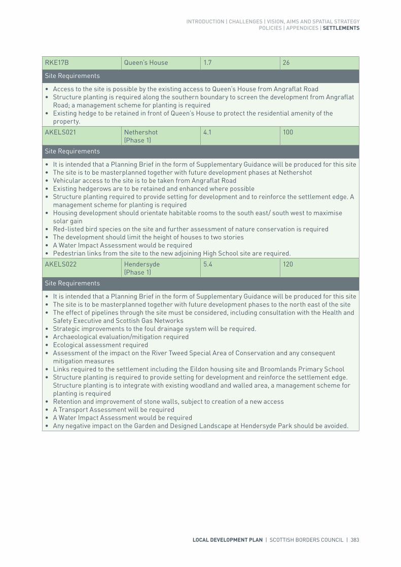
INTRODUCTION | CHALLENGES | VISION, AIMS AND SPATIAL STRATEGYPOLICIES | APPENDICES | SETTLEMENTS
LOCAL DEVELOPMENT PLAN | SCOTTISH BORDERS COUNCIL | 383
RKE17B Queen’s House 1.7 26
Site Requirements
• Access to the site is possible by the existing access to Queen’s House from Angraflat Road• Structure planting is required along the southern boundary to screen the development from Angraflat
Road; a management scheme for planting is required• Existing hedge to be retained in front of Queen’s House to protect the residential amenity of the
property.
AKELS021 Nethershot (Phase 1)
4.1 100
Site Requirements
• It is intended that a Planning Brief in the form of Supplementary Guidance will be produced for this site• The site is to be masterplanned together with future development phases at Nethershot • Vehicular access to the site is to be taken from Angraflat Road• Existing hedgerows are to be retained and enhanced where possible• Structure planting required to provide setting for development and to reinforce the settlement edge. A
management scheme for planting is required• Housing development should orientate habitable rooms to the south east/ south west to maximise
solar gain• Red-listed bird species on the site and further assessment of nature conservation is required• The development should limit the height of houses to two stories• A Water Impact Assessment would be required• Pedestrian links from the site to the new adjoining High School site are required.
AKELS022 Hendersyde (Phase 1)
5.4 120
Site Requirements
• It is intended that a Planning Brief in the form of Supplementary Guidance will be produced for this site• The site is to be masterplanned together with future development phases to the north east of the site• The effect of pipelines through the site must be considered, including consultation with the Health and
Safety Executive and Scottish Gas Networks• Strategic improvements to the foul drainage system will be required.• Archaeological evaluation/mitigation required• Ecological assessment required• Assessment of the impact on the River Tweed Special Area of Conservation and any consequent
mitigation measures• Links required to the settlement including the Eildon housing site and Broomlands Primary School• Structure planting is required to provide setting for development and reinforce the settlement edge.
Structure planting is to integrate with existing woodland and walled area, a management scheme for planting is required
• Retention and improvement of stone walls, subject to creation of a new access• A Transport Assessment will be required• A Water Impact Assessment would be required• Any negative impact on the Garden and Designed Landscape at Hendersyde Park should be avoided.
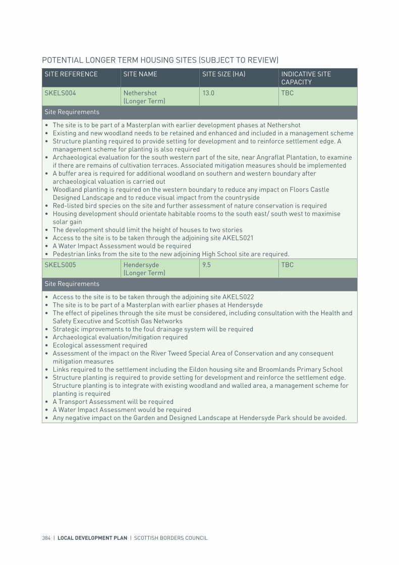
384 | LOCAL DEVELOPMENT PLAN | SCOTTISH BORDERS COUNCIL
SITE REFERENCE SITE NAME SITE SIZE (HA) INDICATIVE SITE CAPACITY
SKELS004 Nethershot (Longer Term)
13.0 TBC
Site Requirements
• The site is to be part of a Masterplan with earlier development phases at Nethershot• Existing and new woodland needs to be retained and enhanced and included in a management scheme• Structure planting required to provide setting for development and to reinforce settlement edge. A
management scheme for planting is also required• Archaeological evaluation for the south western part of the site, near Angraflat Plantation, to examine
if there are remains of cultivation terraces. Associated mitigation measures should be implemented• A buffer area is required for additional woodland on southern and western boundary after
archaeological valuation is carried out• Woodland planting is required on the western boundary to reduce any impact on Floors Castle
Designed Landscape and to reduce visual impact from the countryside• Red-listed bird species on the site and further assessment of nature conservation is required• Housing development should orientate habitable rooms to the south east/ south west to maximise
solar gain• The development should limit the height of houses to two stories• Access to the site is to be taken through the adjoining site AKELS021• A Water Impact Assessment would be required• Pedestrian links from the site to the new adjoining High School site are required.
SKELS005 Hendersyde (Longer Term)
9.5 TBC
Site Requirements
• Access to the site is to be taken through the adjoining site AKELS022• The site is to be part of a Masterplan with earlier phases at Hendersyde• The effect of pipelines through the site must be considered, including consultation with the Health and
Safety Executive and Scottish Gas Networks• Strategic improvements to the foul drainage system will be required• Archaeological evaluation/mitigation required• Ecological assessment required• Assessment of the impact on the River Tweed Special Area of Conservation and any consequent
mitigation measures• Links required to the settlement including the Eildon housing site and Broomlands Primary School• Structure planting is required to provide setting for development and reinforce the settlement edge.
Structure planting is to integrate with existing woodland and walled area, a management scheme for planting is required
• A Transport Assessment will be required• A Water Impact Assessment would be required• Any negative impact on the Garden and Designed Landscape at Hendersyde Park should be avoided.
POTENTIAL LONGER TERM HOUSING SITES (SUBJECT TO REVIEW)

INTRODUCTION | CHALLENGES | VISION, AIMS AND SPATIAL STRATEGYPOLICIES | APPENDICES | SETTLEMENTS
LOCAL DEVELOPMENT PLAN | SCOTTISH BORDERS COUNCIL | 385
SITE REFERENCE SITE NAME SITE SIZE (HA) INDICATIVE SITE CAPACITY
zEL206 Extension to Pinnaclehill Industrial Estate
5.9 N/A
Site Requirements
• This is a strategic business and industrial site as defined in Policy ED1• Access to be taken directly from internal road within Industrial Estate• Consider the potential for culvert removal and channel restoration• Appropriate structure planting/landscaping is required to create a setting for employment uses,
shelter the site and create a defined settlement boundary.
BKELS003 Wooden Linn 3.2 N/A
Site Requirements
• This is a strategic business and industrial site as defined in Policy ED1• Sustainable Urban Drainage System is required for the development along with consideration of the
potential for culvert removal and channel restoration• Flood risk assessment required to inform site layout and mitigation• Existing hedges and woodlands to the east should be reinforced and included in a management
scheme• Pedestrian link is required to the existing employment development• Road links available from the existing industrial estate.
BUSINESS AND INDUSTRIAL
SITE REFERENCE SITE NAME SITE SIZE (HA) INDICATIVE SITE CAPACITY
BKELS005 Pinnaclehill Industrial Estate
14.8 N/A
Site Requirements
• This is a strategic safeguarded business and industrial site as defined in Policy ED1.
zEL205 Spylaw Road/ Station Road
8.5 N/A
Site Requirements
• This is a local safeguarded business and industrial site as defined in Policy ED1.
BUSINESS AND INDUSTRIAL SAFEGUARDING
SITE REFERENCE SITE NAME SITE SIZE (HA) INDICATIVE SITE CAPACITY
RKELS001 Former Foundry 0.6 12
Site Requirements
• Access to the site is to be taken from Station Road• Existing trees to the north of the site are to be retained• Potential contamination on the site to be investigated and mitigated• Development needs to consider nearby listed buildings in terms of layout and design• Archaeological evaluation and mitigation may be required.
REDEVELOPMENT
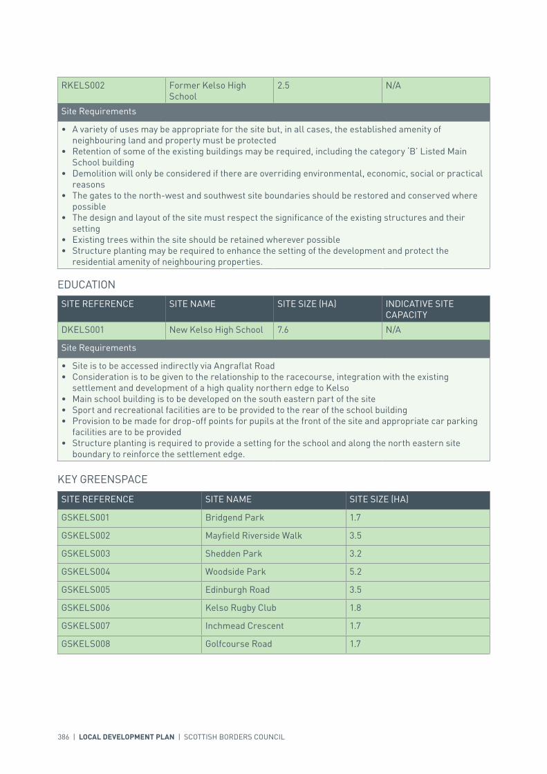
386 | LOCAL DEVELOPMENT PLAN | SCOTTISH BORDERS COUNCIL
SITE REFERENCE SITE NAME SITE SIZE (HA)
GSKELS001 Bridgend Park 1.7
GSKELS002 Mayfield Riverside Walk 3.5
GSKELS003 Shedden Park 3.2
GSKELS004 Woodside Park 5.2
GSKELS005 Edinburgh Road 3.5
GSKELS006 Kelso Rugby Club 1.8
GSKELS007 Inchmead Crescent 1.7
GSKELS008 Golfcourse Road 1.7
KEY GREENSPACE
RKELS002 Former Kelso High School
2.5 N/A
Site Requirements
• A variety of uses may be appropriate for the site but, in all cases, the established amenity of neighbouring land and property must be protected
• Retention of some of the existing buildings may be required, including the category ‘B’ Listed Main School building
• Demolition will only be considered if there are overriding environmental, economic, social or practical reasons
• The gates to the north-west and southwest site boundaries should be restored and conserved where possible
• The design and layout of the site must respect the significance of the existing structures and their setting
• Existing trees within the site should be retained wherever possible• Structure planting may be required to enhance the setting of the development and protect the
residential amenity of neighbouring properties.
SITE REFERENCE SITE NAME SITE SIZE (HA) INDICATIVE SITE CAPACITY
DKELS001 New Kelso High School 7.6 N/A
Site Requirements
• Site is to be accessed indirectly via Angraflat Road• Consideration is to be given to the relationship to the racecourse, integration with the existing
settlement and development of a high quality northern edge to Kelso• Main school building is to be developed on the south eastern part of the site• Sport and recreational facilities are to be provided to the rear of the school building• Provision to be made for drop-off points for pupils at the front of the site and appropriate car parking
facilities are to be provided• Structure planting is required to provide a setting for the school and along the north eastern site
boundary to reinforce the settlement edge.
EDUCATION

INTRODUCTION | CHALLENGES | VISION, AIMS AND SPATIAL STRATEGYPOLICIES | APPENDICES | SETTLEMENTS
LOCAL DEVELOPMENT PLAN | SCOTTISH BORDERS COUNCIL | 387
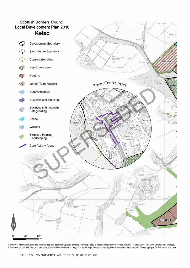
388 | LOCAL DEVELOPMENT PLAN | SCOTTISH BORDERS COUNCIL
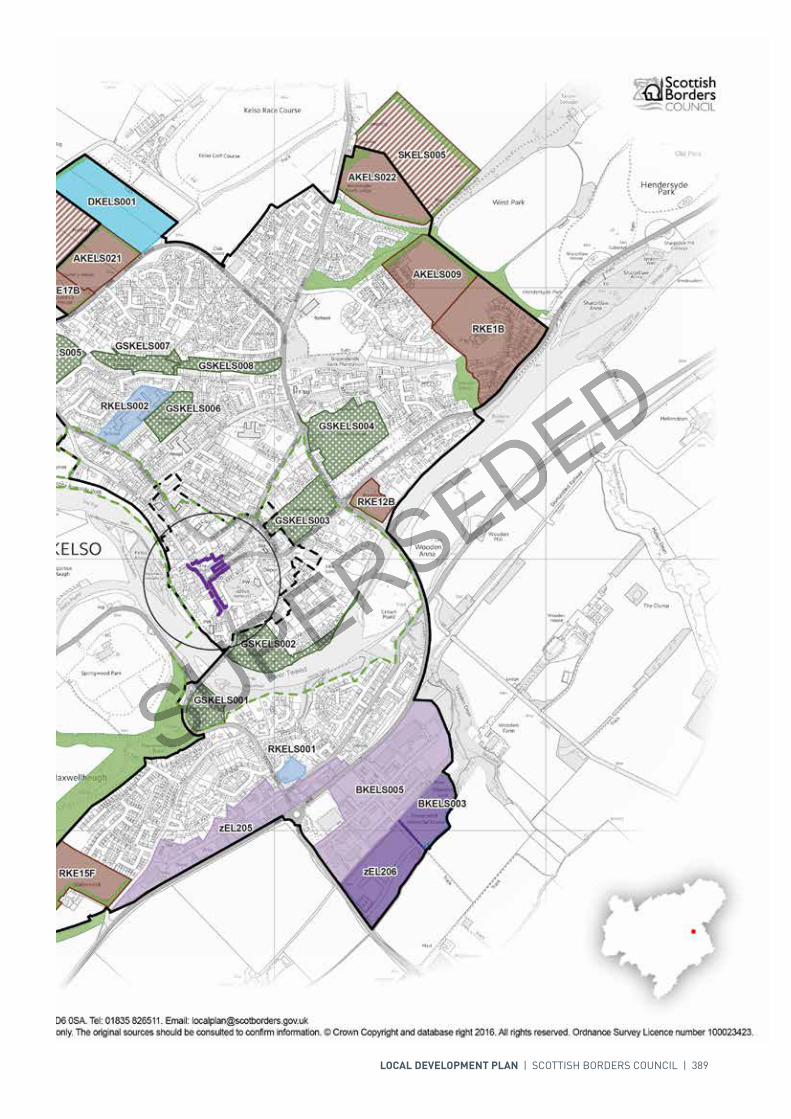
LOCAL DEVELOPMENT PLAN | SCOTTISH BORDERS COUNCIL | 389

For further information, including help reading this document, please contact: Planning Policy & Access, Regulatory Services, Council Headquarters, Newtown St Boswells, Melrose, TD6 0SA. Tel: 0300 100 1800. Email: [email protected]: Scottish Borders Council uses spatial information from a range of sources to produce the mapping contained within this document. The mapping is for illustrative purposes only. The original sources should be consulted to confirm information. © Crown Copyright and database right 2017. All rights reserved. Ordnance Survey Licence number 100023423.
N
Scottish Borders CouncilLocal Development Plan 2016as modified by Supplementary
Guidance on Housing 2017Kelso
00mm
400400200200
Redevelopment
Development Boundary
Housing
Longer Term Housing
Business and IndustrialSafeguarding
Town Centre Boundary
Key Greenspace
Structure Planting/Landscaping
Conservation Area
Core Activity Areas
Wetland
Business and Industrial
School
Town Centre Inset
GSKELS004GSKELS004
GSKELS005GSKELS005
GSKELS002GSKELS002
GSKELS003GSKELS003
GSKELS006GSKELS006
GSKELS008GSKELS008
GSKELS001GSKELS001
GSKELS007GSKELS007
BKELS005BKELS005
RKE1BRKE1B
SKELS004SKELS004
zEL205zEL205
SKELS005SKELS005
zEL206zEL206
DKELS001DKELS001
RKE15FRKE15F
AKELS009AKELS009
AKELS022AKELS022
AKELS008AKELS008
AKELS021AKELS021
BKELS003BKELS003
RKELS002RKELS002
RKE17BRKE17B
RKE12BRKE12B
RKELS001RKELS001
AKELS026AKELS026
AKELS025AKELS025

390 | LOCAL DEVELOPMENT PLAN | SCOTTISH BORDERS COUNCIL
SETTLEMENT PROFILE LANTON
This profile should be read in conjunction with the relevant settlement map.
DESCRIPTIONLanton is located 2 miles north west of Jedburgh, just off the A698 Hawick to Kelso road. The population of Lanton is 100 (2001 Census). It is located within the Central Borders Strategic Development Area as defined in the SESplan.
PLACE MAKING CONSIDERATIONSLanton is situated on the northern slopes of the Lanton Hill and is surrounded by the Teviot Valleys Special Landscape Area. The village was originally formed in two main groupings, the first around Lanton Tower, the former Inn and smithy to the South West; and the second around the former school and Lanton Farm in the north-east. The remainder of the village comprises detached houses and bungalows set in well landscaped gardens, including several mature trees that contribute significantly to the landscape quality of the settlement.
The most recent development has been small scale infill at the north eastern end of the village. The absence of local services and public transport means that significant levels of development should not be encouraged. Development beyond the plan period should be kept to a minimum and be limited to small scale infill. Development which would negatively impact on the character and setting of the village will be resisted.
There is one area, Lanton Community Garden, identified as key greenspace.
INFRASTRUCTURE CONSIDERATIONSAffordable Housing will require to be provided under the provisions of Policy HD1 and the Supplementary Guidance/Supplementary Planning Guidance on Affordable Housing.
There is no requirement for contribution towards education provision.
With regards to Waste Water Treatment Works, Lanton has limited capacity. Contributions may be required where upgrades are necessary. In respect of the local water network, developers may be required to contribute towards upgrading to enable development.
Further information is available from Supplementary Guidance/Supplementary Planning Guidance on Developer Contributions and Planning/Development Briefs where applicable.

INTRODUCTION | CHALLENGES | VISION, AIMS AND SPATIAL STRATEGYPOLICIES | APPENDICES | SETTLEMENTS
LOCAL DEVELOPMENT PLAN | SCOTTISH BORDERS COUNCIL | 391
DEVELOPMENT AND SAFEGUARDING PROPOSALS
KEY GREENSPACE
SITE REFERENCE SITE NAME SITE SIZE (HA)
GSLANT001 Lanton Community Garden 0.04

392 | LOCAL DEVELOPMENT PLAN | SCOTTISH BORDERS COUNCIL

INTRODUCTION | CHALLENGES | VISION, AIMS AND SPATIAL STRATEGYPOLICIES | APPENDICES | SETTLEMENTS
LOCAL DEVELOPMENT PLAN | SCOTTISH BORDERS COUNCIL | 393
SETTLEMENT PROFILE LAUDER
This profile should be read in conjunction with the relevant settlement map.
DESCRIPTIONLauder is located in the Northern Housing Market Area on the A68(T), outwith any of the Strategic Development Areas as defined in the Strategic Development Plan. The population of Lauder according to the 2001 Census is 1112.
PLACE MAKING CONSIDERATIONSThe settlement is located in the upland valley of the Upper Leader. The Leader Water to the east, is part of the River Tweed Special Area of Conservation, a wildlife site of international importance. The character of Lauder is established by its wide High Street and countryside setting. The focal points of the town are the town hall and parish church. Thirlestane Castle and its Garden and Designed Landscape to the east are important tourist attractions and contribute to the setting of the settlement.
Lauder Conservation Area includes all of the central part of the settlement and is one of the best preserved examples of an historic burgh in Scotland. Despite the expansion of the town in the 19th and 20th centuries, Lauder has retained its historic street pattern of a main street with back lanes to the east and west and this defines the extent of the Conservation Area. Only limited development within the historic core has taken place and this has respected the original character. The majority of traditional buildings are two storey though there are many single, storey and a half, and two and a half stories. Buildings line both sides of the High Street, including a number of gable end houses. Historic building materials range from whin and sand stone, harling, slate and brick chimneys. The high boundary walls, in particular those along Castle Wynd, are an important feature within Lauder and the Conservation Area and these should be retained.
The Town Hall is the major visual focal point within the town and dominates the town centre by both its physical height and isolated position at the end of the Market Place. It is also mainly along the Market Place where a diverse range of services and facilities to serve the local community can be found including a bank and a post office. The town also benefits from a supermarket which is situated near the northern edge of the settlement along the Edinburgh Road. The town itself is considered to be one of the healthier towns within the Scottish Borders with generally a low vacancy rate.
The Plan provides two housing allocations one at Wyndhead and a further at West Allanbank; Redevelopment opportunities are also identified at the Former Lauder Primary School site and at the Burnmill site. Furthermore the Plan identifies two business and industrial sites to the north of the settlement. The Plan also identifies the Old Castleriggs Recreational Ground for protection; this space provides the village community with important recreation opportunities.

394 | LOCAL DEVELOPMENT PLAN | SCOTTISH BORDERS COUNCIL
It is recognised that Lauder has been subject to significant development in recent years. The Local Development Plan does not identify any areas for longer term development in Lauder. There may be limited opportunities for expansion to the west beyond the period of this Local Development Plan.
Development to the east of the settlement in the Thirlestane Castle Garden and Designed Landscape will be resisted if it would adversely affect it.
INFRASTRUCTURE CONSIDERATIONSAffordable Housing will require to be provided in association with proposed housing sites under the provisions of Policy HD1 and the Supplementary Guidance/Supplementary Planning Guidance on Affordable Housing.
The current development at Wyndhead and proposals at Allanbank have been factored into new Primary and Secondary School capacities. The Director of Education and Lifelong Learning advises that it would not be possible to accommodate further large scale development and that contributions will be sought from every development.
A contribution towards Earlston High School will be sought to supplement Scottish Borders Council’s investment in the new school which opened in 2009-2010 under the 3 High Schools Project.
Lauder falls within an area identified for a contribution to the Waverley Railway Project (see Policy IS3).
With regards to Waste Water Treatment Works Lauder has limited capacity. Contributions may be required where upgrades are necessary. In respect of the local water network, developers may be required to contribute towards upgrading to enable development.
Further information is available from Supplementary Guidance/Supplementary Planning Guidance on Developer Contributions and Planning/Development Briefs where applicable.
DEVELOPMENT AND SAFEGUARDING PROPOSALS
HOUSING
SITE REFERENCE SITE NAME SITE SIZE (HA) INDICATIVE SITE CAPACITY
ELA12B Wyndhead II 1.2 30
Site Requirements
• Main vehicular access to be achieved via Thirlestane Drive with a potential vehicular and pedestrian minor access link onto Factors Park. The extension of the footway would need to be carried out with pedestrian linkages through to Millburn Park
• Provision of amenity access within the development for pedestrians and cyclists will be required. Links to the Core Paths to be created and amenity maintained and enhanced
• Landscape enhancement particularly along the western, north-eastern and south-eastern boundaries will be required and their long term maintenance to be addressed
• Mitigation measures are required to prevent any impact on the River Tweed Special Areas of Conservation (Lauder Burn)
• Further assessment on nature conservation interest along with archaeology will also be required and mitigation put in place.

INTRODUCTION | CHALLENGES | VISION, AIMS AND SPATIAL STRATEGYPOLICIES | APPENDICES | SETTLEMENTS
LOCAL DEVELOPMENT PLAN | SCOTTISH BORDERS COUNCIL | 395
ALAUD001 West Allanbank 8.7 100
Site Requirements
• It is intended that a Planning Brief in the form of Supplementary Guidance will be produced for this site• One or two access points possible from B6362 Stow Road and a minor road link into the housing
development to the east. The extension of the footway/ cycleway on the south east side of Stow Road would need to be carried out
• Evaluation and mitigation of moderate biodiversity interest. Enhancement of existing tree planting along the north of the site, retention of parkland trees
• Establishment of woodland structure planting on the southern and western parts of the site. Retention/ replacement of the wall to the north where possible as this contains the site
• Long term maintenance of landscaped areas to be addressed• Protect existing paths and creation of new footpath linkages along the north and western edge of the
site, linking into existing countryside access routes• Careful consideration to be given to site layout to ensure there is no adverse affect on the setting of the
category ‘C’ Listed Allanbank House, stables cottage and stables area• Hazard pipeline exclusion zones in the west of the site to be evaluated and mitigated• Flood risk from a watercourse on the west end of the site should be evaluated and mitigated• The development layout and design should take into account the potential risk of nuisance from the
adjacent poultry unit.
SITE REFERENCE SITE NAME SITE SIZE (HA) INDICATIVE SITE CAPACITY
BLAUD002 North Lauder Industrial Estate
2.0 N/A
Site Requirements
• This is a district business and industrial site as defined in Policy ED1• Refer to approved Planning Brief.
BUSINESS AND INDUSTRIAL
SITE REFERENCE SITE NAME SITE SIZE (HA) INDICATIVE SITE CAPACITY
zEL61 Lauder Industrial Estate 3.6 N/A
Site Requirements
• This is a district safeguarded business and industrial site as defined in Policy ED1.
BUSINESS AND INDUSTRIAL SAFEGUARDING
SITE REFERENCE SITE NAME SITE SIZE (HA) INDICATIVE SITE CAPACITY
RLAUD001 Former Lauder Primary School
0.3 5
Site Requirements
• Vehicular access to the site from Crofts Road• Design should respect the character, scale and layout of the settlement and utilise the southern
aspect for energy efficiency• Evaluation and mitigation of archaeological interest in the north of the site• Evaluation and mitigation of potential contamination from former uses• Existing buildings should be evaluated for moderate biodiversity, including bats and breeding birds,
and appropriate conservation carried out.
REDEVELOPMENT
396 | LOCAL DEVELOPMENT PLAN | SCOTTISH BORDERS COUNCIL
RLAUD002 Burnmill 0.8 5
Site Requirements
• Vehicular access to the site from Mill Wynd, the junctions into the site and with Thirlestane Drive should be assessed further
• Provide for future road links to land to the west• A flood risk assessment of the northern part of the site which is in a flood risk area• Evaluation and mitigation of potentially contaminated land from the former gasworks and mill• Conserve and enhance the nature conservation interest of the adjacent Lauder Burn to the north,
which is part of the River Tweed Special Area of Conservation• Evaluation and mitigation of major biodiversity interest from the River Tweed Special Area of
Conservation, and habitats and species on and adjacent to the site• Evaluation and mitigation of archaeological interest• Site design should respect its position at an arrival point to the settlement• Include landscaping to enhance the character of the glen and burn corridor• Long term maintenance of landscaped areas to be addressed• Protection of the route of the Right of Way/ Core Paths.
SITE REFERENCE SITE NAME SITE SIZE (HA)
GSLAUD001 Old Castleriggs Recreation Ground
1.8
KEY GREENSPACE
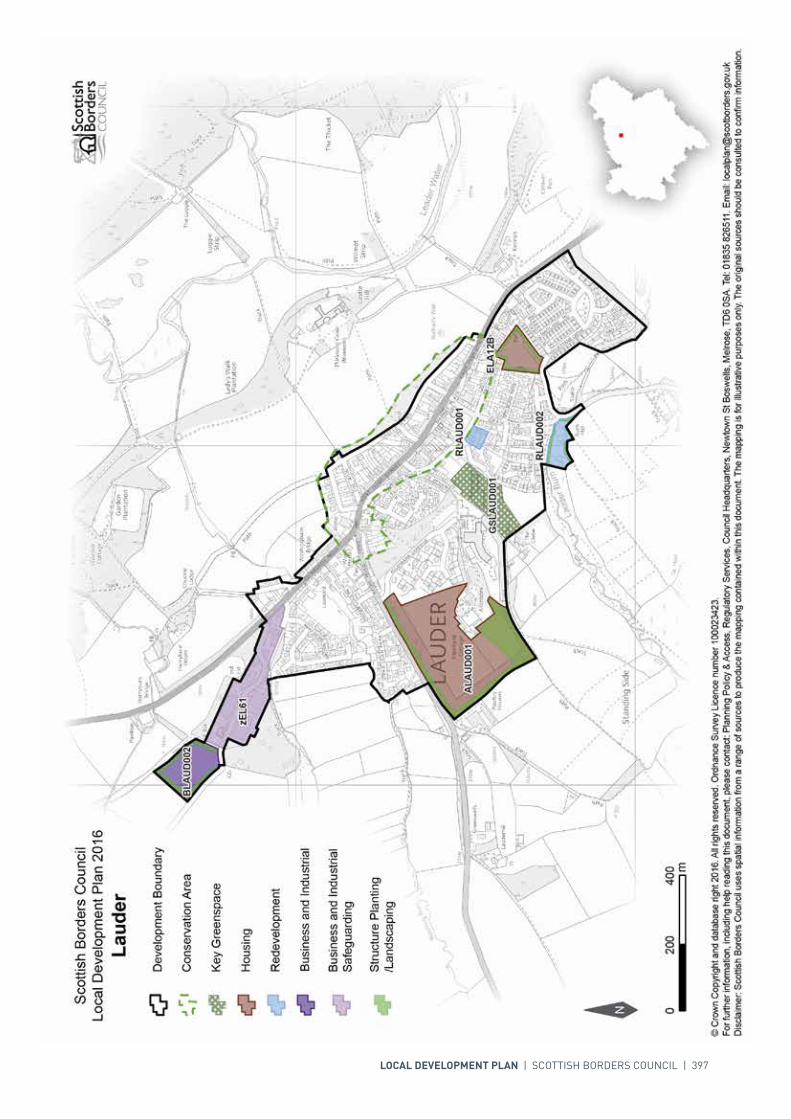
LOCAL DEVELOPMENT PLAN | SCOTTISH BORDERS COUNCIL | 397
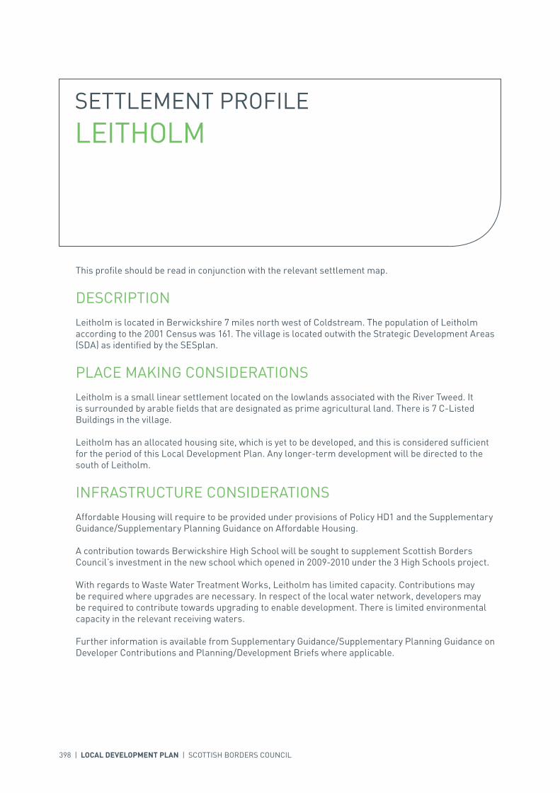
398 | LOCAL DEVELOPMENT PLAN | SCOTTISH BORDERS COUNCIL
SETTLEMENT PROFILE LEITHOLM
This profile should be read in conjunction with the relevant settlement map.
DESCRIPTIONLeitholm is located in Berwickshire 7 miles north west of Coldstream. The population of Leitholm according to the 2001 Census was 161. The village is located outwith the Strategic Development Areas (SDA) as identified by the SESplan.
PLACE MAKING CONSIDERATIONSLeitholm is a small linear settlement located on the lowlands associated with the River Tweed. It is surrounded by arable fields that are designated as prime agricultural land. There is 7 C-Listed Buildings in the village.
Leitholm has an allocated housing site, which is yet to be developed, and this is considered sufficient for the period of this Local Development Plan. Any longer-term development will be directed to the south of Leitholm.
INFRASTRUCTURE CONSIDERATIONSAffordable Housing will require to be provided under provisions of Policy HD1 and the Supplementary Guidance/Supplementary Planning Guidance on Affordable Housing.
A contribution towards Berwickshire High School will be sought to supplement Scottish Borders Council’s investment in the new school which opened in 2009-2010 under the 3 High Schools project.
With regards to Waste Water Treatment Works, Leitholm has limited capacity. Contributions may be required where upgrades are necessary. In respect of the local water network, developers may be required to contribute towards upgrading to enable development. There is limited environmental capacity in the relevant receiving waters.
Further information is available from Supplementary Guidance/Supplementary Planning Guidance on Developer Contributions and Planning/Development Briefs where applicable.

INTRODUCTION | CHALLENGES | VISION, AIMS AND SPATIAL STRATEGYPOLICIES | APPENDICES | SETTLEMENTS
LOCAL DEVELOPMENT PLAN | SCOTTISH BORDERS COUNCIL | 399
DEVELOPMENT AND SAFEGUARDING PROPOSALS
HOUSING
SITE REFERENCE SITE NAME SITE SIZE (HA) INDICATIVE SITE CAPACITY
BLE2B Main Street 1.4 25
Site Requirements
• It is intended that a Planning Brief in the form of Supplementary Guidance will be produced for this site• Provide appropriate structure planting along the south eastern boundary to provide enclosure to the
site and on the northern boundary to protect the existing residential amenity• Ensure vehicular and pedestrian access off the B6461• Maintain potential for further vehicular access to the south east of the site• Ensure pedestrian/cycle links through the development to the Right of Way • Take advantage of the southerly aspect in terms of property orientation and long views.
SITE REFERENCE SITE NAME SITE SIZE (HA)
GSLEIT001 Playground 0.1
KEY GREENSPACE
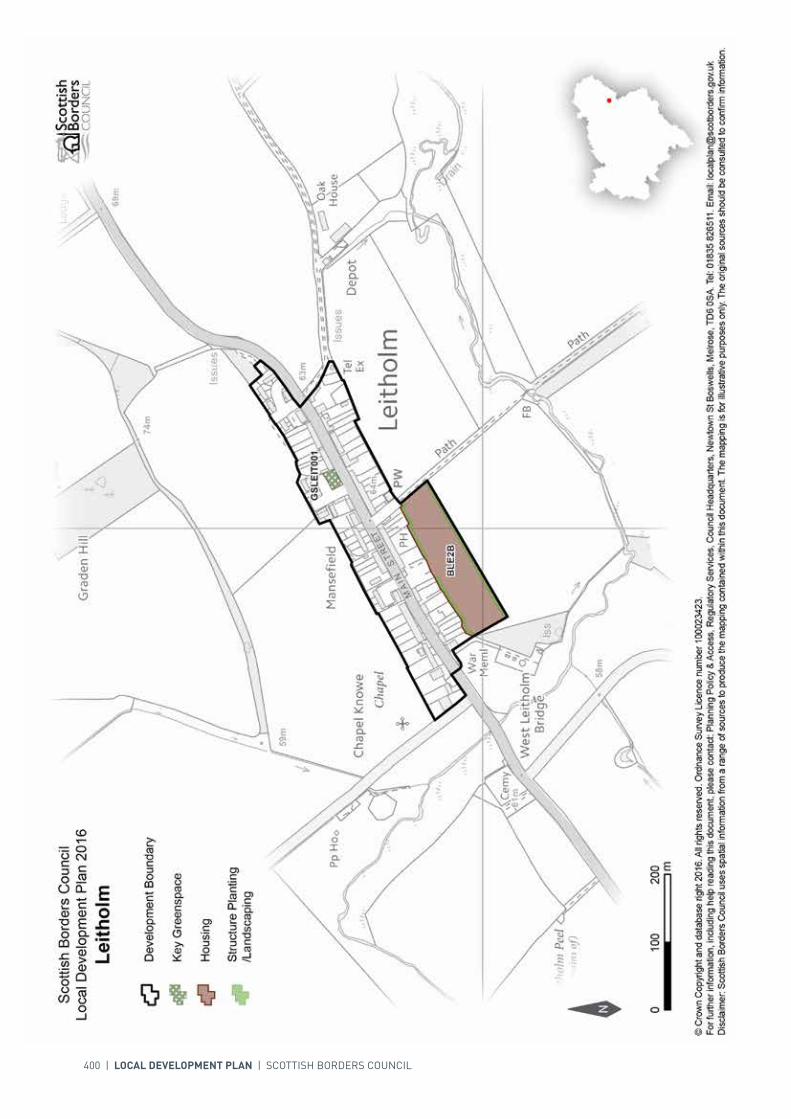
400 | LOCAL DEVELOPMENT PLAN | SCOTTISH BORDERS COUNCIL
INTRODUCTION | CHALLENGES | VISION, AIMS AND SPATIAL STRATEGYPOLICIES | APPENDICES | SETTLEMENTS
LOCAL DEVELOPMENT PLAN | SCOTTISH BORDERS COUNCIL | 401
SETTLEMENT PROFILE LILLIESLEAF
This profile should be read in conjunction with the relevant settlement map.
DESCRIPTIONLilliesleaf is situated 7 miles south east of Selkirk. The population of the village is 246 (2001 Census). It is located within the Central Borders Strategic Development Area as defined in the SESplan.
PLACE MAKING CONSIDERATIONSThe village sits on a low ridge within the wooded upland fringe valley of the Ale Water with the rolling farmland of the Minto Hills to the south. The Ale Water, to the north, is part of the River Tweed Special Area of Conservation, a wildlife site of international importance.
Lilliesleaf is characterised by its linear layout either side of the Main Street (B6359). The isolated village church is a distinctive feature, set amongst fields to the east. The buildings along Main Street are mainly stone or rendered, one and half or two storey. Local facilities include a primary school, church, coffee shop and two public houses.
The most recent development in Lilliesleaf is taking place at St Dunstan at the western end of the village. Further expansion is planned at this end of the village through the allocated site West of St Dunstan and in the centre of the village adjacent to Muselie Drive.
One area of key greenspace is identified on the Main Street.
Beyond the plan period, development will be limited to small scale expansion and infill. Development to the north of the settlement will be resisted if it impacts on the landscape setting of the settlement or has a significant effect on the natural heritage interest of the Ale Water. Future expansion is indicative only and will require further detailed assessment during the next Local Development Plan Review.
INFRASTRUCTURE CONSIDERATIONSAffordable Housing will require to be provided under the provisions of Policy HD1 and the Supplementary Guidance/ Supplementary Planning Guidance on Affordable Housing.
There is no requirement for contribution towards education provision.
The settlement falls within an area identified for a contribution to the Borders Railway Project (See Policy IS3).

402 | LOCAL DEVELOPMENT PLAN | SCOTTISH BORDERS COUNCIL
In accordance with the Council’s Local Transport Strategy, a Central Borders Traffic Model has been developed which will help direct funding to areas of the road network that may become congested in the future. Developer contributions will be sought from developments within the Central Borders in accordance with the Supplementary Guidance/ Supplementary Planning Guidance on Developer Contributions.
In respect of the Waste Water Treatment Works, Lilliesleaf currently has sufficient capacity.
Further information is available from Supplementary Guidance/Supplementary Planning Guidance on Developer Contributions and Planning/Development Briefs where applicable.
DEVELOPMENT AND SAFEGUARDING PROPOSALS
HOUSING
SITE REFERENCE SITE NAME SITE SIZE (HA) INDICATIVE SITE CAPACITY
EL16B Muselie Drive 0.7 7
Site Requirements
• Vehicular/pedestrian access be taken from the B6359 Main Street• The possibility of a vehicular/pedestrian link to/from Muselie Drive must be investigated• An appropriate landscape buffer should be provided to enhance the northern settlement boundary and
to contain the site. The existing hedges, trees and shrubs within and around the site shall be retained and incorporated into the landscaping design for the site. A management scheme for planting is also required
• The design and layout of the new buildings should exploit the southerly aspect of the site to make best use of the microclimate and reduce energy usage
• Archaeological investigation of the site in order to assess the survival, extent and significance of any buried archaeological remains. Further investigation or changes to development proposals may be required based on the results
• Safeguard amenity of existing neighbouring residential properties• Existing path link from the village linking to the Ale Water located along north eastern boundary of site
to be maintained. A pedestrian link to be provided through the site linking with the path access.
ELI2B St Dunstan 0.4 8
Site Requirements
• Pedestrian footway to be provided from the site into the village• An appropriate landscape buffer should be provided to enhance the northern settlement boundary and
to contain the site. The existing hedges, trees and shrubs within and around the site shall be retained and incorporated into the landscaping design for the site. A management scheme for planting is also required
• The design and layout of the new buildings should exploit the southerly aspect of the site to make best use of the microclimate and reduce energy usage
• Safeguard amenity of existing neighbouring residential properties.
ALILL003 West of St Dunstan 1.5 15
Site Requirements
• Refer to approved Planning Brief.

INTRODUCTION | CHALLENGES | VISION, AIMS AND SPATIAL STRATEGYPOLICIES | APPENDICES | SETTLEMENTS
LOCAL DEVELOPMENT PLAN | SCOTTISH BORDERS COUNCIL | 403
SITE REFERENCE SITE NAME SITE SIZE (HA)
GSLILL001 Main Street 0.03
KEY GREENSPACE

404 | LOCAL DEVELOPMENT PLAN | SCOTTISH BORDERS COUNCIL
INTRODUCTION | CHALLENGES | VISION, AIMS AND SPATIAL STRATEGYPOLICIES | APPENDICES | SETTLEMENTS
LOCAL DEVELOPMENT PLAN | SCOTTISH BORDERS COUNCIL | 405
SETTLEMENT PROFILE LONGFORMACUS
This profile should be read in conjunction with the relevant settlement map.
DESCRIPTIONLongformacus is located in Berwickshire, 7 miles to the north-west of Duns. The population according to the 2001 Census was 66. The village is not located within any of the Strategic Development Areas (SDA) identified by the SESplan.
PLACE MAKING CONSIDERATIONSLongformacus is a small village located on upland fringe moorland in the shadow of the Lammermuir Hills. The Dye Water runs through the village with the majority of the properties on the northern side, generally located on Duns or Gifford Road, or just off. There are examples of traditional row housing, with a variety of elevations and architectural features evident. The land to the south-east is identified as prime agricultural land.
There are 13 C-listed buildings and 1 B-listed building in the village.
No development is put forward for Longformacus in this Local Development Plan (LDP) period.
The Dye Water is identified as being at risk of flooding and is also designated as part of the River Tweed Special Area of Conservation. Any development proposed would need to be in line with the relevant LDP policy. The trees to the north-east of the village are protected by a Tree Preservation Order.
INFRASTRUCTURE CONSIDERATIONSAffordable Housing will require to be provided under provisions of Policy HD1 and the Supplementary Guidance/Supplementary Planning Guidance on Affordable Housing.
A contribution towards Berwickshire High School will be sought to supplement Scottish Borders Council’s investment in the new school which opened in 2009-2010 under the 3 High Schools project.
With regards to the Septic tank, Longformacus has limited capacity. Contributions may be required where upgrades are necessary. In respect of the local water network, developers may be required to contribute towards upgrading to enable development.
Further information is available from Supplementary Guidance/Supplementary Planning Guidance on Developer Contributions and Planning Briefs where applicable.

406 | LOCAL DEVELOPMENT PLAN | SCOTTISH BORDERS COUNCIL
SITE REFERENCE SITE NAME SITE SIZE (HA)
GSLONG001 Recreation Ground 1.1
KEY GREENSPACE
DEVELOPMENT AND SAFEGUARDING PROPOSALS

LOCAL DEVELOPMENT PLAN | SCOTTISH BORDERS COUNCIL | 407

408 | LOCAL DEVELOPMENT PLAN | SCOTTISH BORDERS COUNCIL
SETTLEMENT PROFILE MAXTON
This profile should be read in conjunction with the relevant settlement map.
DESCRIPTIONMaxton is located in the Central Borders Housing Market Area, 9 miles west of Kelso. The settlement is located within the Central Strategic Development Area, as set out in the Development Strategy in the Strategic Development Plan. The population of Maxton according to the 2001 Census is 60.
PLACE MAKING CONSIDERATIONSThe character of Maxton is established by its predominantly linear layout and the focal point of the church, to the north west. The settlement is set within the lowland valley of the Lower Tweed. The River Tweed, to the north, is part of the River Tweed Special Area of Conservation (SAC), a wildlife site of international importance.
The preferred areas for future expansion beyond the period of this Local Development Plan will be to the east. Development to the north and north west of the settlement will be resisted where it has a significant effect on the River Tweed International Wildlife site or impacts on the setting of the church.
The Plan allocates two housing sites within Maxton, one at Meadowbank and another at the extreme east of the settlement. There are no areas for longer term expansion identified in Maxton.
The Village Green is an important amenity area within the centre of the village and will therefore be protected from development.
INFRASTRUCTURE CONSIDERATIONSAffordable Housing will require to be provided in association with proposed housing sites under the provisions of Policy HD1 and the Supplementary Guidance/Supplementary Planning Guidance on Affordable Housing.
A contribution towards Earlston High School will be sought to supplement Scottish Borders Council’s investment in the new school which opened in 2009-2010 under the 3 High Schools project.
Maxton falls within an area identified for a contribution to the Waverley Railway Project (see Policy IS3).
INTRODUCTION | CHALLENGES | VISION, AIMS AND SPATIAL STRATEGYPOLICIES | APPENDICES | SETTLEMENTS
LOCAL DEVELOPMENT PLAN | SCOTTISH BORDERS COUNCIL | 409
With regards to waste water, Maxton is served by a septic tank which currently has limited capacity. Developer contributions may be required where upgrades are necessary. In respect of the local water network, developers may be required to contribute towards upgrading to enable development.
Further information is available from Supplementary Guidance/Supplementary Planning Guidance on Developer Contributions and Planning/Development Briefs where applicable.
DEVELOPMENT AND SAFEGUARDING PROPOSALS
HOUSING
SITE REFERENCE SITE NAME SITE SIZE (HA) INDICATIVE SITE CAPACITY
AMAXT001 East Maxton 0.6 10
Site Requirements
• It is intended that a Planning Brief in the form of Supplementary Guidance will be produced for this site• Scale and style of development needs to be carefully considered paying heed to the existing settlement• Structure planting required on the southern and eastern boundary to provide setting for development
and to reinforce settlement edge. A management scheme for planting is also required• Archaeology interests have been recorded in the surrounding area and archaeological assessment
including archaeological evaluation along with associated mitigation measures is required• Mitigation measures are required to prevent any impact on the River Tweed Special Area of
Conservation• Access to be via the C67 side road. The junction of C67 with the A699 will have to shift in a north
eastern direction to improve visibility and the gradient• Part of C67 carriageway requires widening and provision of a footway.
AMAXT002 Meadowbank 0.5 5
Site Requirements
• Scale and style of development needs to be carefully considered paying heed to the existing settlement• Structure planting required on the southern boundary to provide setting for development and to
reinforce settlement edge and minimise visual impact. A management scheme for planting is also required
• Planting on the eastern boundary is needed to prevent conflict of uses• Archaeology interests have been recorded in the surrounding area and archaeological assessment
including archaeological evaluation along with associated mitigation measures is required• Mitigation measures are required to prevent any impact on the River Tweed SAC• Access via A699.
SITE REFERENCE SITE NAME SITE SIZE (HA)
GSMAXT001 Village Green 0.2
KEY GREENSPACE
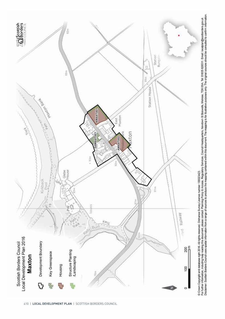
410 | LOCAL DEVELOPMENT PLAN | SCOTTISH BORDERS COUNCIL

INTRODUCTION | CHALLENGES | VISION, AIMS AND SPATIAL STRATEGYPOLICIES | APPENDICES | SETTLEMENTS
LOCAL DEVELOPMENT PLAN | SCOTTISH BORDERS COUNCIL | 411
SETTLEMENT PROFILE MELROSE
This profile should be read in conjunction with the relevant settlement map.
DESCRIPTIONMelrose is located just over 4 miles east of Galashiels and is included in the Central Borders Strategic Development Area as identified in SESplan. According to the 2001 Census the population of Melrose is 1,671.
PLACE MAKING CONSIDERATIONSMelrose is of key importance as a tourist centre and is located in an area of scenic beauty. The town is located within the Eildon and Leaderfoot National Scenic Area.
The Conservation Area of Melrose incorporates the historic core of the settlement, including the world-renowned Melrose Abbey and retains many of the historic features that provide the town with its distinctive identity. Melrose is an unplanned settlement with an organic nature, though many of the properties around the Abbey have been set out in an ordered fashion. The centre of Melrose is closely packed and intimate, while the periphery appears more sprawling and open.
Whilst individual elements of the built fabric may not appear significant, collectively their contribution to the Conservation Area is considerable. Any new development or alterations should seek to respect individual buildings and the wider Conservation Area by taking account of these important features.
Melrose has an attractive and vibrant town centre with impressive built heritage centred around Market Square. The recent town centre one-way system and associated townscape works have successfully contributed towards the appearance of the town, traffic movements and parking provision. The town centre is identified as a Core Activity Area.
There are five areas, south of the Abbey and around Gibson Park and the Greenyards, identified as key greenspaces.
The Plan does not promote any further development sites within Melrose as there has been significant recent development at Dingleton Hospital and owing to the sensitivity of the location, it has not been possible to define preferred areas for future expansion beyond the period of this Local Development Plan.
The distinct character and setting of Melrose is recognised. The areas between Melrose, Darnick, Newstead and Gattonside are protected from development under policy EP6 Countryside Around Towns, primarily to avoid coalescence of the settlements, thereby retaining individual character. The
412 | LOCAL DEVELOPMENT PLAN | SCOTTISH BORDERS COUNCIL
Croft housing site has been proposed in the Plan because it is judged to be a contained site that can fit into the landscape, it is recognised that this is a sensitive boundary, important to the setting of the town. No further development in this area is anticipated.
INFRASTRUCTURE CONSIDERATIONSAffordable Housing will require to be provided under the provisions of Policy HD1 and the Supplementary Guidance/ Supplementary Planning Guidance on Affordable Housing.
A contribution towards Earlston High School will be sought to supplement Scottish Borders Council’s investment in the new school which opened in 2009-2010 under the 3 High Schools project.
In Melrose the advice from NHS Borders is that there are existing and predicted long term pressures on health service accommodation. The current premises may require upgrade or development.
Melrose falls within an area identified for a contribution to the Borders Railway (See Policy IS3).
In accordance with the Council’s Local Transport Strategy, a Central Borders Traffic Model has been developed which will help direct funding to areas of the road network that may become congested in the future. Developer contributions will be sought from developments within the Central Borders in accordance with the Supplementary Guidance/Supplementary Planning Guidance on Developer Contributions.
There are capacity issues on the roads in and around Melrose particularly on Dingleton Road and Chiefswood Road. Studies are underway to identify options for improvement. The proposed housing development at the Croft will provide the opportunity for developer contributions to the upgrading of sections of Dingleton Road including road widening either side of the new access to provide a two lane road and on-street parking in the form of an elongated lay-by adjacent to the public footway.
With regards to Waste Water Treatment Works and Water Treatment Works, Melrose currently has sufficient capacity.
Further information is available from Supplementary Guidance/Supplementary Planning Guidance on Developer Contributions and Planning/Development Briefs where applicable.
DEVELOPMENT AND SAFEGUARDING PROPOSALS
HOUSING
SITE REFERENCE SITE NAME SITE SIZE (HA) INDICATIVE SITE CAPACITY
EM32B Dingleton Hospital 23.6 230
Site Requirements
• Consideration must be given to the landscape form of the site• Vehicular access from Dingleton Road with the possibility of a link to the wider development in the
Dingleton area via Chiefswood Road• Disposal of surface water to comply with SUDS• Existing trees, many of which are protected by a Tree Preservation Order, should be retained and
protected• Footpath links to wider area to be provided• Archaeological evaluation will be required along with associated mitigation• Due consideration to be given to Abbotsford Designed Garden located to the north and west of the site
and the location of the site within a Special Landscape Area.

INTRODUCTION | CHALLENGES | VISION, AIMS AND SPATIAL STRATEGYPOLICIES | APPENDICES | SETTLEMENTS
LOCAL DEVELOPMENT PLAN | SCOTTISH BORDERS COUNCIL | 413
SITE REFERENCE SITE NAME SITE SIZE (HA)
GSMELR001 Gibson Park 2.1
GSMELR002 Melrose RFC 1.8
GSMELR003 High Street, Weirhill 2.7
GSMELR004 Abbey Street 1.1
GSMELR005 Melrose Bowling Club 0.2
KEY GREENSPACE
EM4B The Croft 2.4 25
Site Requirements
• Refer to approved Planning Brief.• Consider the potential for culvert removal and channel restoration.
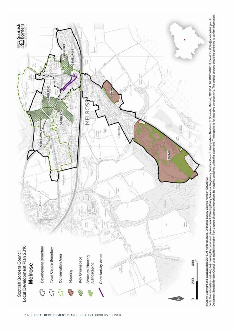
414 | LOCAL DEVELOPMENT PLAN | SCOTTISH BORDERS COUNCIL
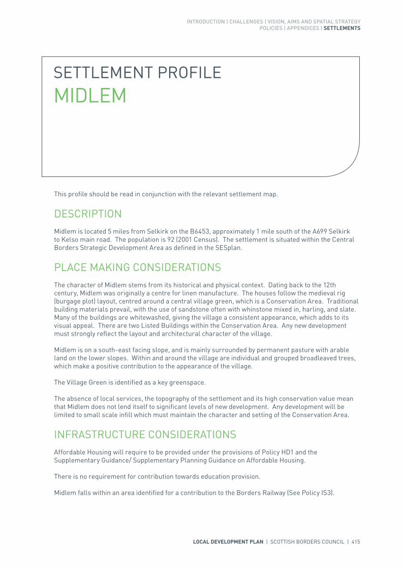
INTRODUCTION | CHALLENGES | VISION, AIMS AND SPATIAL STRATEGYPOLICIES | APPENDICES | SETTLEMENTS
LOCAL DEVELOPMENT PLAN | SCOTTISH BORDERS COUNCIL | 415
SETTLEMENT PROFILE MIDLEM
This profile should be read in conjunction with the relevant settlement map.
DESCRIPTIONMidlem is located 5 miles from Selkirk on the B6453, approximately 1 mile south of the A699 Selkirk to Kelso main road. The population is 92 (2001 Census). The settlement is situated within the Central Borders Strategic Development Area as defined in the SESplan.
PLACE MAKING CONSIDERATIONSThe character of Midlem stems from its historical and physical context. Dating back to the 12th century, Midlem was originally a centre for linen manufacture. The houses follow the medieval rig (burgage plot) layout, centred around a central village green, which is a Conservation Area. Traditional building materials prevail, with the use of sandstone often with whinstone mixed in, harling, and slate. Many of the buildings are whitewashed, giving the village a consistent appearance, which adds to its visual appeal. There are two Listed Buildings within the Conservation Area. Any new development must strongly reflect the layout and architectural character of the village.
Midlem is on a south-east facing slope, and is mainly surrounded by permanent pasture with arable land on the lower slopes. Within and around the village are individual and grouped broadleaved trees, which make a positive contribution to the appearance of the village.
The Village Green is identified as a key greenspace.
The absence of local services, the topography of the settlement and its high conservation value mean that Midlem does not lend itself to significant levels of new development. Any development will be limited to small scale infill which must maintain the character and setting of the Conservation Area.
INFRASTRUCTURE CONSIDERATIONSAffordable Housing will require to be provided under the provisions of Policy HD1 and the Supplementary Guidance/ Supplementary Planning Guidance on Affordable Housing.
There is no requirement for contribution towards education provision.
Midlem falls within an area identified for a contribution to the Borders Railway (See Policy IS3).
416 | LOCAL DEVELOPMENT PLAN | SCOTTISH BORDERS COUNCIL
In accordance with the Council’s Local Transport Strategy, a Central Borders Traffic Model has been developed which will help direct funding to areas of the road network that may become congested in the future. Developer contributions will be sought from developments within the Central Borders in accordance with the Supplementary Guidance/ Supplementary Planning Guidance on Developer Contributions.
With regards to Waste Water Treatment Works, Midlem has limited capacity. Contributions may be required where upgrades are necessary. In respect of the local water network, developers may be required to contribute towards upgrading to enable development.
Further information is available from Supplementary Guidance/Supplementary Planning Guidance on Developer Contributions and Planning/Development Briefs where applicable.
DEVELOPMENT AND SAFEGUARDING PROPOSALS
KEY GREENSPACE
SITE REFERENCE SITE NAME SITE SIZE (HA)
GSMIDL001 Midlem Village Green 0.8

LOCAL DEVELOPMENT PLAN | SCOTTISH BORDERS COUNCIL | 417

418 | LOCAL DEVELOPMENT PLAN | SCOTTISH BORDERS COUNCIL
SETTLEMENT PROFILE MINTO
This profile should be read in conjunction with the relevant settlement map.
DESCRIPTIONMinto is situated on the north bank of the River Teviot, off the A698 which runs east to west connecting the towns of Hawick and Jedburgh, about 1 mile north of Denholm. The population is 58 (2001 Census) and the village lies within the Central Borders Strategic Development Area as defined in the SESplan.
PLACE MAKING CONSIDERATIONSThe village occupies an elevated ridge overlooking the River Teviot and commands good views along the river corridor and along the Dean Burn. To the south is Ruberslaw hill which, at 424m, is the most dominant feature in the landscape. The village lies just to the south of the Minto Hills and is surrounded by the Teviot Valleys Special Landscape Area.
Minto Conservation Area covers the entire historic part of the village, which was laid out by the Earl of Minto. The village developed in a linear form with rows of cottages, a church and a school along the west side of the street. Land to the east is occupied by Minto golf course giving the village a formal landscaped setting with large numbers of mature trees lining the roadside.
Traditional building materials prevail (slate, sandstone and harling) together with a range of architectural details, which contribute to the character of the Conservation Area. There are two Listed Buildings within the Conservation Area.
The absence of local services, the topography of the settlement and its high conservation value mean that Minto does not lend itself to significant levels of new development. Any development will be limited to small scale infill which must maintain the character and setting of the Conservation Area.
INFRASTRUCTURE CONSIDERATIONSAffordable Housing will require to be provided under the provision of Policy HD1 and the Supplementary Guidance/ Supplementary Planning Guidance on Affordable Housing.
There is no requirement for contribution towards education provision.

INTRODUCTION | CHALLENGES | VISION, AIMS AND SPATIAL STRATEGYPOLICIES | APPENDICES | SETTLEMENTS
LOCAL DEVELOPMENT PLAN | SCOTTISH BORDERS COUNCIL | 419
With regards to Waste Water Treatment Works, Minto has limited capacity. Contributions may be required where upgrades are necessary. In respect of the local water network, developers may be required to contribute towards upgrading to enable development.
Further information is available from Supplementary Guidance/Supplementary Planning Guidance on Developer Contributions and Planning/Development Briefs where applicable.
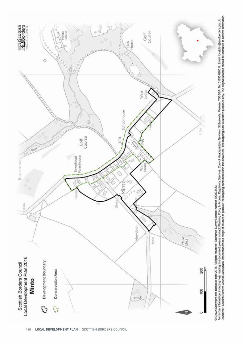
420 | LOCAL DEVELOPMENT PLAN | SCOTTISH BORDERS COUNCIL

INTRODUCTION | CHALLENGES | VISION, AIMS AND SPATIAL STRATEGYPOLICIES | APPENDICES | SETTLEMENTS
LOCAL DEVELOPMENT PLAN | SCOTTISH BORDERS COUNCIL | 421
SETTLEMENT PROFILE MOREBATTLE
This profile should be read in conjunction with the relevant settlement map.
DESCRIPTIONMorebattle is located in the Central Borders Housing Market Area, almost 8 miles from Kelso. The settlement is located outwith any of the Strategic Development Area identified within the Development Strategy in the Strategic Development Plan. The population of Morebattle according to the 2001 Census is 266.
PLACE MAKING CONSIDERATIONSThe characterful and historic settlement of Morebattle appears to have grown out from the Parish Church, with the Main Street and Teapot Street being the oldest parts. Distinct in its layout the village was originally formed with a wide street and pavement with mature trees lined either side.
Morebattle is an attractive picturesque settlement, which has many significant features that contribute greatly to the character of the Conservation Area. The Conservation Area boundary extends to cover much of the village including the Main Street, Teapot Street, Mansfield Road and part of the road leading to Heughhead.
Primarily a residential settlement other significant properties include the Parish Church and the Junior School. Morebattle benefits from many views within and out of the settlement. The surrounding landscape is gently rolling with large arable and occasional pasture fields.
The Plan provides two housing allocations; both are located to the west of the village at Renwick Gardens and West Renwick Gardens. The Plan also provides an employment land allocation to the east of Croft Industrial Park and safeguards an established employment site at Croft Industrial Park.
Once the allocated sites are fully developed the preferred area for future expansion beyond the period of this Plan will be the area to the south west of the settlement. The area to the east of Mansfield Avenue and south of the Main Street should be protected from development.
The areas suggested for future growth in this profile are indicative only; they will require further detailed assessment during the next Local Development Plan Review.
The playing field to the north of the Primary School provides an important recreational area for the community and will be protected.

422 | LOCAL DEVELOPMENT PLAN | SCOTTISH BORDERS COUNCIL
INFRASTRUCTURE CONSIDERATIONSAffordable Housing will require to be provided in association with proposed housing sites under the provisions of Policy HD1 and the Supplementary Guidance/Supplementary Planning Guidance on Affordable Housing.
The accommodation and facilities at Kelso High School have been identified as being unsuitable for future use particularly when the areas for longer term development are taken onto account. It has been agreed to build a new, modern school nearby the current site. The new school is due to open in 2016. In accordance with developer contribution policy, a contribution towards the additional facilities at the new Kelso High School will be sought, to recoup the capital invested by the Council.
With regards to Waste Water Treatment Works, Morebattle has limited capacity. Contributions may be required where upgrades are necessary. In respect of the local water network, developers may be required to contribute towards upgrading to enable development. Further information is available from Supplementary Guidance/Supplementary Planning Guidance on Developer Contributions and Planning/Development Briefs where applicable.
DEVELOPMENT AND SAFEGUARDING PROPOSALS
HOUSING
SITE REFERENCE SITE NAME SITE SIZE (HA) INDICATIVE SITE CAPACITY
RMO6B Renwick Gardens 0.4 9
Site Requirements
• Refer to approved Planning Brief.
AMORE001 West Renwick Gardens 1.3 20
Site Requirements
• Refer to approved Planning Brief.
SITE REFERENCE SITE NAME SITE SIZE (HA) INDICATIVE SITE CAPACITY
BMORE001 Extension to Croft Industrial Park
0.6 N/A
Site Requirements
• This is a district business and industrial site as defined in Policy ED1• Structure planting required on the northern and eastern boundaries to provide setting for
development. A management scheme for planting is also required• Existing hedgerow to the west should be retained• Retain separation between employment sites and settlement by not developing in the slope towards
the Primary School• Access is possible from/to the existing employment land site to the west and direct access is possible
from/to the B6401• Mitigation measures are required to prevent any impact on the River Tweed Special Area of
Conservation.
BUSINESS AND INDUSTRIAL

INTRODUCTION | CHALLENGES | VISION, AIMS AND SPATIAL STRATEGYPOLICIES | APPENDICES | SETTLEMENTS
LOCAL DEVELOPMENT PLAN | SCOTTISH BORDERS COUNCIL | 423
SITE REFERENCE SITE NAME SITE SIZE (HA)
GSMORE001 Morebattle School 0.4
KEY GREENSPACE
SITE REFERENCE SITE NAME SITE SIZE (HA) INDICATIVE SITE CAPACITY
BMORE002 Croft Industrial Park 0.6 N/A
Site Requirements
• This is a district safeguarded business and industrial site as defined in Policy ED1.
BUSINESS AND INDUSTRIAL SAFEGUARDING

424 | LOCAL DEVELOPMENT PLAN | SCOTTISH BORDERS COUNCIL
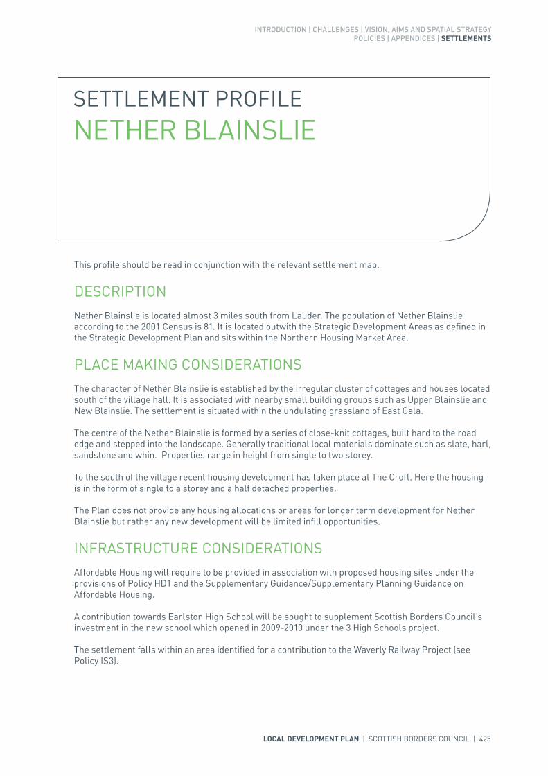
INTRODUCTION | CHALLENGES | VISION, AIMS AND SPATIAL STRATEGYPOLICIES | APPENDICES | SETTLEMENTS
LOCAL DEVELOPMENT PLAN | SCOTTISH BORDERS COUNCIL | 425
SETTLEMENT PROFILE NETHER BLAINSLIE
This profile should be read in conjunction with the relevant settlement map.
DESCRIPTIONNether Blainslie is located almost 3 miles south from Lauder. The population of Nether Blainslie according to the 2001 Census is 81. It is located outwith the Strategic Development Areas as defined in the Strategic Development Plan and sits within the Northern Housing Market Area.
PLACE MAKING CONSIDERATIONSThe character of Nether Blainslie is established by the irregular cluster of cottages and houses located south of the village hall. It is associated with nearby small building groups such as Upper Blainslie and New Blainslie. The settlement is situated within the undulating grassland of East Gala.
The centre of the Nether Blainslie is formed by a series of close-knit cottages, built hard to the road edge and stepped into the landscape. Generally traditional local materials dominate such as slate, harl, sandstone and whin. Properties range in height from single to two storey.
To the south of the village recent housing development has taken place at The Croft. Here the housing is in the form of single to a storey and a half detached properties.
The Plan does not provide any housing allocations or areas for longer term development for Nether Blainslie but rather any new development will be limited infill opportunities.
INFRASTRUCTURE CONSIDERATIONSAffordable Housing will require to be provided in association with proposed housing sites under the provisions of Policy HD1 and the Supplementary Guidance/Supplementary Planning Guidance on Affordable Housing.
A contribution towards Earlston High School will be sought to supplement Scottish Borders Council’s investment in the new school which opened in 2009-2010 under the 3 High Schools project.
The settlement falls within an area identified for a contribution to the Waverly Railway Project (see Policy IS3).

426 | LOCAL DEVELOPMENT PLAN | SCOTTISH BORDERS COUNCIL
With regards to waste water, Nether Blainslie is served by a septic tank which currently has limited capacity. Contributions may be required where upgrades are necessary. In respect of the local water network, developers may be required to contribute towards upgrading to enable development.
Further information is available from Supplementary Guidance/Supplementary Planning Guidance on Developer Contributions.
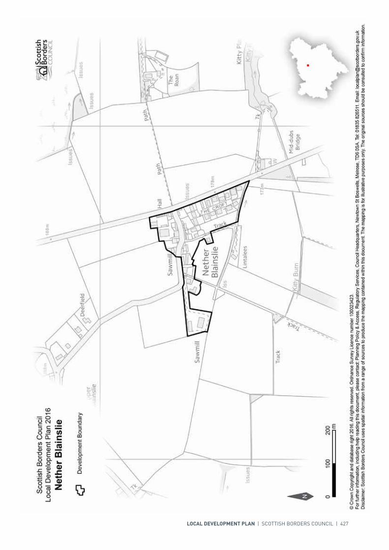
INTRODUCTION | CHALLENGES | VISION, AIMS AND SPATIAL STRATEGYPOLICIES | APPENDICES | SETTLEMENTS
LOCAL DEVELOPMENT PLAN | SCOTTISH BORDERS COUNCIL | 427

428 | LOCAL DEVELOPMENT PLAN | SCOTTISH BORDERS COUNCIL
SETTLEMENT PROFILE NEWCASTLETON
This profile should be read in conjunction with the relevant settlement map.
DESCRIPTIONNewcastleton is located in the upland valley of Liddesdale, on the north bank of the Liddel Water river. It is situated on the B6357, mid-way between Carlisle and Jedburgh, and lies about 21 miles due south of Hawick. The population is 784 (2001 Census). Newcastleton is outside the Central Borders Strategic Development Area as defined in the SESplan.
PLACE MAKING CONSIDERATIONSNewcastleton is relatively distant from the other settlements in the Scottish Borders and has links with England, particularly Carlisle. Its relative remoteness means that the community is concerned about its relationship to the wider regional land use and development strategies and this is a factor which must be carefully considered in its future planning.
The Council wishes to see the extension of the Borders Railway southwards from Galashiels to Carlisle. The indicative line is protected in the Local Development Plan and follows the line of the disused railway along the western edge of Newcastleton. Safeguarding of the route needs to be taken into account when development is proposed in the vicinity.
The unique character of Newcastleton is established by its formal street layout with a central square and two secondary squares. It is considered to be the best example of a late 18th century planned village in the Borders and the majority of the settlement is designated as a Conservation Area. Newcastleton has a distinct grid iron layout and displays distinct building styles and architectural details. The designs for any new development should seek to respect the character of individual buildings and the wider Conservation Area.
As the main settlement in the southern Borders it has a short term housing allocation as well as a mixed use allocation to meet local development needs. Landscaping is indicated and would need to be incorporated into any development of the sites.
Three areas of key greenspace are identified in Newcastleton at Union Street, Douglas Square and the Polysport Playing Field.
The preferred area for future expansion beyond the period of this Local Development Plan will be to the south of the settlement. Expansion in this direction will be dependant upon flood risk assessment.

INTRODUCTION | CHALLENGES | VISION, AIMS AND SPATIAL STRATEGYPOLICIES | APPENDICES | SETTLEMENTS
LOCAL DEVELOPMENT PLAN | SCOTTISH BORDERS COUNCIL | 429
Development to the north of the settlement will be resisted where there is an adverse effect on the Liddel Water. The suggested area is indicative only, and will require further detailed assessment during the next Local Development Plan Review.
INFRASTRUCTURE CONSIDERATIONSAffordable Housing will require to be provided under the provisions of Policy HD1 and the Supplementary Guidance/Supplementary Planning Guidance on Affordable Housing.
There is no requirement for contribution towards education provision.
This settlement is identified within the Council’s Flood Contingency Plan as being at risk of flooding. Any development proposals should therefore be subject to early consultation with the Council’s Flood and Coastal Management Officer, and SEPA, having regard to the Indicative River and Coastal Flood Map (Scotland). A flood risk assessment may be required and may influence the scale and layout of any development at a particular location.
With regards to Waste Water Treatment Works and Water Treatment Works, Newcastleton currently has sufficient capacity.
Further information is available from Supplementary Guidance/Supplementary Planning Guidance on Developer Contributions and Planning/Development Briefs where applicable.
DEVELOPMENT SAFEGUARDING PROPOSALS
HOUSING
SITE REFERENCE SITE NAME SITE SIZE (HA) INDICATIVE SITE CAPACITY
RNE2B South of Holmhead 0.3 5
Site Requirements
• Vehicular access via Moss Road• Layout and design to consider the adjacent conservation area and the location on the edge of the
village in order to retain the character of the settlement• Links to existing paths are required. A Right of Way runs to the north-east of the site linking the
caravan site to the west with North Hermitage Street and needs to be considered at development stage
• Existing trees to the north, south and west of the site to be retained and protected where possible. A tree protection plan will be required
• Flood risk assessment will be required.

430 | LOCAL DEVELOPMENT PLAN | SCOTTISH BORDERS COUNCIL
SITE REFERENCE SITE NAME SITE SIZE (HA)
GSNEWC001 Playing Field / Polysport 1.3
GSNEWC002 Union Street Playing Field 0.9
GSNEWC003 Douglas Square 0.1
KEY GREENSPACE
SITE REFERENCE SITE NAME SITE SIZE (HA) INDICATIVE SITE CAPACITY
zEL44 Moss Road 0.5 N/A
Site Requirements
• This is a district safeguarded business and industrial site as defined in Policy ED1.
BUSINESS AND INDUSTRIAL SAFEGUARDING
SITE REFERENCE SITE NAME SITE SIZE (HA) INDICATIVE SITE CAPACITY
MNEWC001 Caravan site 1.1 20
Site Requirements
• It is intended that a Planning Brief in the form of Supplementary Guidance will be produced for this site• No development should take place on the line of the proposed extension to the Borders railway. This
is expected to follow the former track bed of the disused railway, which runs through the whole length of the north western edge of the site. The land safeguarded for the railway should be landscaped and a management scheme for planting is also required
• Links to existing paths are required. A Right of Way runs through the site and needs to be considered at development stage
• Newcastleton ponds are located within the site and should preferably be used as features within the site
• Consideration is required in terms of layout and design to consider the conservation area in the village and the location on the edge of the settlement to retain the character of the settlement
• Protected species interests have been recorded in the area and further assessment on nature conservation will be required
• Access via Moss Road• Appropriate SUDS are required• Flood risk assessment is recommended to inform site design and mitigation.
MIXED USE

INTRODUCTION | CHALLENGES | VISION, AIMS AND SPATIAL STRATEGYPOLICIES | APPENDICES | SETTLEMENTS
LOCAL DEVELOPMENT PLAN | SCOTTISH BORDERS COUNCIL | 431

432 | LOCAL DEVELOPMENT PLAN | SCOTTISH BORDERS COUNCIL
SETTLEMENT PROFILE NEWSTEAD
This profile should be read in conjunction with the relevant settlement map.
DESCRIPTIONNewstead lies two miles east of Melrose and is included in the Central Borders Strategic Development Area as defined in the SESplan. The population of Newstead is 256 (2001 Census).
PLACE MAKING CONSIDERATIONSNewstead is located within the Eildon and Leaderfoot National Scenic Area.
The original village has developed fundamentally in a linear form along either side of the Main Street. Properties range from single to two storeys in height. Most of the village centre properties are in groups of two with a number of detached properties. Some of the older properties have been built hard to the Main Street with no footpaths.
The Newstead Conservation Area incorporates almost all of the settlement. Lying on land steeply rising from the south banks of the River Tweed, the village of Newstead is reportedly the oldest village in Scotland. It is recommended that any alterations or new development within the Conservation Area should have regard to traditional building material and detailing to contribute to the retention of the settlements character.
The distinct character and setting of Newstead is recognised. Policy EP6 (Countryside Around Towns) seeks to protect the area between Newstead and Melrose from development in the longer term, primarily to avoid coalescence of the settlements, thereby retaining individual character.
There is one area, south of the Orchard, identified as a key green space.
The settlement of Newstead experiences pressure for further development but due to its sensitive location it has not been possible to identify any land for development. Given the proximity of Newstead to the proposed railway station at Tweedbank, it is likely to experience even greater pressure in the future. Therefore it is important that the areas of open space within the settlement and the area surrounding the Trimontium Fort should be protected from future development. The fields to the east of the Development Boundary should also be protected from future development, these are considered to form part of the character of the village.

INTRODUCTION | CHALLENGES | VISION, AIMS AND SPATIAL STRATEGYPOLICIES | APPENDICES | SETTLEMENTS
LOCAL DEVELOPMENT PLAN | SCOTTISH BORDERS COUNCIL | 433
INFRASTRUCTURE CONSIDERATIONSAffordable Housing will require to be provided in association with proposed housing sites under the provisions of Policy HD1 and the Supplementary Guidance/ Supplementary Planning Guidance on Affordable Housing.
A contribution towards Earlston High School will be sought to supplement Scottish Borders Council’s investment in the new school which opened in 2009-2010 under the 3 High Schools project.
Newstead falls within an area identified for a contribution to the Borders Railway (See Policy IS3).
In accordance with the Council’s Local Transport Strategy, a Central Borders Traffic Model has been developed which will help direct funding to areas of the road network that may become congested in the future. Developer contributions will be sought from developments within the Central Borders in accordance with the Supplementary Guidance/ Supplementary Planning Guidance on Developer Contributions.
The Waste Water Treatment Works in Melrose serve Newstead. There is adequate capacity to accommodate development.
Further information is available from Supplementary Guidance/Supplementary Planning Guidance on Developer Contributions and Planning/Development Briefs where applicable.
DEVELOPMENT AND SAFEGUARDING PROPOSALS
KEY GREENSPACE
SITE REFERENCE SITE NAME SITE SIZE (HA)
GSNEWS001 Community Playing Field 1.0

434 | LOCAL DEVELOPMENT PLAN | SCOTTISH BORDERS COUNCIL

N
Scottish Borders CouncilLocal Development Plan 2016as modified by Supplementary
Guidance on Housing 2017Newstead
© Crown Copyright and database right 2017. All rights reserved. Ordnance Survey Licence number 100023423.For further information, including help reading this document, please contact: Planning Policy & Access, Regulatory Services, Council Headquarters, Newtown St Boswells, Melrose, TD6 0SA. Tel: 0300 100 1800. Email: [email protected]: Scottish Borders Council uses spatial information from a range of sources to produce the mapping contained within this document. The mapping is for illustrative purposes only. The original sources should be consulted to confirm information.
00mm
200200100100
Development Boundary
Key Greenspace
GSNEWS001GSNEWS001
Conservation Area
ANEWS005ANEWS005
Housing

INTRODUCTION | CHALLENGES | VISION, AIMS AND SPATIAL STRATEGYPOLICIES | APPENDICES | SETTLEMENTS
LOCAL DEVELOPMENT PLAN | SCOTTISH BORDERS COUNCIL | 435
SETTLEMENT PROFILE NEWTOWN ST BOSWELLS
This profile should be read in conjunction with the relevant settlement map.
DESCRIPTIONNewtown St Boswells is located in the Central Borders Strategic Development Area as defined in the SESplan. At the 2001 Census the population in the village was 1,153.
PLACE MAKING CONSIDERATIONSNewtown St Boswells is dominated by views of the Eildon Hills and the Black Hill. The village centre is clustered around the B6398 at Old Station Court and Tweedside Road. Other features of interest include the Auction Mart with its octagonal ring building, the former school and the nineteenth century terraces.
The semi natural/plantation wood along the Bowden Burn is included in Scotland’s Semi-Natural Woodland Inventory (SSNWI). The River Tweed lies to the east, but tributaries – Sprouston Burn and Newtown Burn (further west known as Bowden Burn) – flow through Newtown St. Boswells itself and east of the main built up area, they both have SSSI status. The area to the north of the settlement, from Sprouston Burn to the junction of Earlston Road and the A68, is part of a National Scenic Area and is highly visible from the A68 trunk road and the attractive settlement of Eildon.
Newtown St Boswells is located within the heart of the Borders and is the Council’s administrative centre. It has excellent road connections, is convenient for the Borders Railway and has good quality developable land in its vicinity. The planned expansion of the village is allocated as site ANEWT005 in the Plan.
It is expected that, aside from any future expansion, there will be a growth in pressure to develop within Newtown St Boswells. In addition to the expansion area, two housing sites are allocated. A large site is allocated along Melrose Road, heading towards the A68 away from the village. A smaller site is allocated to the north-west of the existing village, located between the school area and the planned expansion.
The allocated redevelopment sites provide mixed use opportunities which will encourage regeneration of the village centre. There is community support to redevelop and regenerate Newtown St Boswells and it is hoped that these aspirations can be met through the redevelopment sites and the future expansion. The Council has developed a Development Framework to support and provide guidance for the redevelopment of the village centre.

436 | LOCAL DEVELOPMENT PLAN | SCOTTISH BORDERS COUNCIL
Areas to north and east of the A68 are considered to be unsuitable for residential expansion. If planned expansion does not take place, the preferred area for the longer term development of Newtown St Boswells is to the west. This would allow a more sensitive edge to be created to Newtown St Boswells. Although this land is within the Special Landscape Area, and further investigations must be carried out, the impact of development at this location would be significantly lower than to the north or east of the settlement.
Where possible, the relocation to more suitable sites of various existing uses in the village that generate heavy goods vehicles and other commercial vehicle movements will be supported, in the interests of road safety, local amenity, and regeneration.
The separation between the two communities of Newtown St Boswells and Eildon must be retained and further development along Earlston Road and Melrose Road will be resisted.
There are two areas, near the primary school, identified as key greenspaces.
INFRASTRUCTURE CONSIDERATIONSAffordable Housing will require to be provided under the provisions of Policy HD1 and the Supplementary Guidance/ Supplementary Planning Guidance on Affordable Housing.
The existing primary school does not have the capacity to accommodate pupils from all allocated sites. Contributions will be sought for expansion of existing facilities or development of new education facilities in the catchment area based on the best long term solution for the settlement as a whole when all sites have been taken into consideration. A contribution towards Earlston High School will be sought to supplement Scottish Borders Council’s investment in the new school which opened in 2009-2010 under the 3 High Schools project.
There are current and predicted longer term pressures on the health service’s accommodation in Newtown St Boswells. The current premises require upgrade or development.
Newtown St Boswells falls within an area identified for a contribution to the Borders Railway (See Policy IS3).
In accordance with the Council’s Local Transport Strategy, a Central Borders Traffic Model has been developed which will help direct funding to areas of the road network that may become congested in the future. Developer contributions will be sought from developments within the Central Borders in accordance with the Supplementary Guidance/Supplementary Planning Guidance on Developer Contributions.
With regards to Waste Water Treatment Works, Newtown St Boswells has limited capacity. Contributions may be required where upgrades are necessary. In respect of the local water network, developers may be required to contribute towards upgrading to enable development.
Further information is available from Supplementary Guidance/Supplementary Planning Guidance on Developer Contributions and Planning/Development Briefs where applicable.

INTRODUCTION | CHALLENGES | VISION, AIMS AND SPATIAL STRATEGYPOLICIES | APPENDICES | SETTLEMENTS
LOCAL DEVELOPMENT PLAN | SCOTTISH BORDERS COUNCIL | 437
DEVELOPMENT AND SAFEGUARDING PROPOSALS
HOUSING
SITE REFERENCE SITE NAME SITE SIZE (HA) INDICATIVE SITE CAPACITY
ENT4B Melrose Road 4.4 68
Site Requirements
• The layout and design of the site should be sympathetic to the local character and to the setting of the Eildon and Leaderfoot National Scenic Area and should take advantage of any solar gain, for energy efficiency
• Requirement for pedestrian link, with a footbridge over Sprouston Burn, to the south of the site providing a connection to Sprouston Road
• Appropriate landscape scheme with maintenance programme• Archaeology interests have been recorded in the surrounding area, archaeological assessment
including archaeological evaluation along with any associated mitigation measures is required• Existing trees and hedgerows to be retained and protected where possible.
ENT15B Sergeants Park II 2.0 30
Site Requirements
• Refer to approved Planning Brief.
ANEWT005 Newtown Expansion Area
58.0 900
Site Requirements
• Outline of development will be determined in master planning exercise that will be undertaken in consultation with local communities and be submitted as supporting document to a planning application. Master plan should include consideration of the following (the list is not exhaustive):
• Access from A68 (including considering new roundabout) and road/transport network within the settlement
• Provision of cycle paths and footpaths• Full integration with existing street network in the village• Provision of areas for SUDS, public park, greenspace, open space and play equipment• Sustainable approach to construction and use of renewable energy for running of buildings• Provision of school and nursery to serve the local catchment area• Scale and design of the development needs to consider the sensitive landscape and settings• Use of landscaping and buffers to create strong boundary of the settlement• Management scheme for any planting is required• Incorporate outcome from community consultations in development and regeneration of the village
centre• Provision of sports facilities• Design of development needs to conserve and enhance the landscape value of the National Scenic
Area• Flood risk assessment is recommended to inform site layout.

438 | LOCAL DEVELOPMENT PLAN | SCOTTISH BORDERS COUNCIL
BUSINESS AND INDUSTRIAL
SITE REFERENCE SITE NAME SITE SIZE (HA) INDICATIVE SITE CAPACITY
BNEWT001 Tweed Horizons Expansion
13.9 N/A
Site Requirements
• It is intended that a Planning Brief in the form of Supplementary Planning Guidance will be produced for this site
• This is a strategic high amenity business and industrial site as defined in Policy ED1• Development of high amenity employment site (Class 4 of the Use Class Order)• Woodland and hedges are required to screen from the A68 and to minimise visual impact from
surrounding areas• Hedges and tree line required to reinforce and improve existing hedgerow along the southern part of
the site to screen the site• A woodland buffer is required to screen the existing farm from the development if the farm continues
to be used for agricultural use. Details at planning application stage needs to consider overshadowing of the farm
• Management scheme for any planting is required• Development of the site should include a new access from the A68 and may require to be supported by
a new roundabout on the A68 in conjunction with the Newtown expansion to the west of the A68• Careful consideration is required relating to design, location and scale due to the proximity to
Dryburgh Conservation Area, Dryburgh Abbey, Tweed Horizons and its landscaped setting• Woodland screening to be maintained and enhanced to minimise impact on Dryburgh Abbey and the
area to the east• Flood risk assessment recommended to inform site layout. The assessment should include
consideration of the potential for culvert removal and channel restoration• Provide a master plan to identify and respond to the landscape sensitivities of the site and the wider
National Scenic Area• It should be noted that this site extends into the Dryburgh Conservation Area, refer to Dryburgh
Settlement Map.
BUSINESS AND INDUSTRIAL SAFEGUARDING
SITE REFERENCE SITE NAME SITE SIZE (HA) INDICATIVE SITE CAPACITY
zEL36 Waverley Place 0.3 N/A
Site Requirements
• This is a district safeguarded business and industrial site as defined in Policy ED1.
MIXED USE
SITE REFERENCE SITE NAME SITE SIZE (HA) INDICATIVE SITE CAPACITY
MNEWT001 Auction Mart 9.6 220
Site Requirements
• Refer to approved Planning Brief.

INTRODUCTION | CHALLENGES | VISION, AIMS AND SPATIAL STRATEGYPOLICIES | APPENDICES | SETTLEMENTS
LOCAL DEVELOPMENT PLAN | SCOTTISH BORDERS COUNCIL | 439
SITE REFERENCE SITE NAME SITE SIZE (HA)
GSNEWT001 Sergeants Park 0.1
GSNEWT002 King George V Playing Field 1.9
KEY GREENSPACE
REDEVELOPMENT
SITE REFERENCE SITE NAME SITE SIZE (HA) INDICATIVE SITE CAPACITY
zRO23 Mills 0.6 N/A
Site Requirements
• Refer to approved Development Framework.
zRO21 Depot 1.2 N/A
Site Requirements
• Contamination assessment would be required and appropriate mitigation measures thereafter.

440 | LOCAL DEVELOPMENT PLAN | SCOTTISH BORDERS COUNCIL

INTRODUCTION | CHALLENGES | VISION, AIMS AND SPATIAL STRATEGYPOLICIES | APPENDICES | SETTLEMENTS
LOCAL DEVELOPMENT PLAN | SCOTTISH BORDERS COUNCIL | 441
SETTLEMENT PROFILE NISBET
This profile should be read in conjunction with the relevant settlement map.
DESCRIPTIONNisbet is located in the Central Borders Housing Market Area, 5 miles north east of Jedburgh. The settlement is located within the Central Strategic Development Area, as set out in the Development Strategy in the Strategic Development Plan. According to the 2001 Census the population of Nisbet is 37.
PLACE MAKING CONSIDERATIONSThe estate village of Nisbet lies south-east of the Peniel Heugh which dominates the views from the south and also provides a dramatic backdrop for the village. While Nisbet was built for the workers of its two farms, it was arranged around two informal spaces – the Mill Pond and the burial ground to the west.
The settlement is situated within the Tweed Lowlands Regional Landscape Area within the River Valley Landscape that is described as ‘Lowland Valley with Farmland’. Nisbet benefits from a number of established tree belts particularly around East Nisbet House and within small clusters in the village. It is these mature trees that provide a high degree of enclosure for the village and greatly enhances its character.
The Conservation Area of Nisbet includes almost all the village. As an estate village, Nisbet has remained virtually unaltered since it was developed in the 19th century. The Village was built for the workers of two farms – West Nisbet and East Nisbet. There are only two properties within the village that are independent of each of the farms and therefore are considered to be part of Nisbet and not East or West Nisbet – these properties are the School House and the Smiddy House.
The Plan does not identify any allocations within Nisbet, there has been recent development within the settlement at West Nisbet Farm.
The Play Area within Nisbet is an important amenity area within the centre of the village and will therefore be protected from development.
Further detailed assessment will be required during the next Local Development Plan Review to assess for any areas for further expansion.
442 | LOCAL DEVELOPMENT PLAN | SCOTTISH BORDERS COUNCIL
INFRASTRUCTURE CONSIDERATIONSAffordable Housing will require to be provided in association with proposed housing sites under the provisions of Policy HD1 and the Supplementary Guidance/Supplementary Planning Guidance on Affordable Housing.
There is no requirement for contribution towards education provision.
With regards to Waste Water Treatment Works, only part of Nisbet is served by Scottish Water and these works currently have limited capacity. Contributions may be required where upgrades are necessary. In respect of the local water network, developers may be required to contribute towards upgrading to enable development.
Appropriate provision of private sewage treatment systems would be required for any new development within Nisbet, to be agreed and licensed by the Scottish Environmental Protection Agency.
Further information is available from Supplementary Guidance/Supplementary Planning Guidance on Developer Contributions and Planning/Development Briefs where applicable.
DEVELOPMENT AND SAFEGUARDING PROPOSALS
KEY GREENSPACE
SITE REFERENCE SITE NAME SITE SIZE (HA)
GSNISB001 Nisbet Play Area 0.03
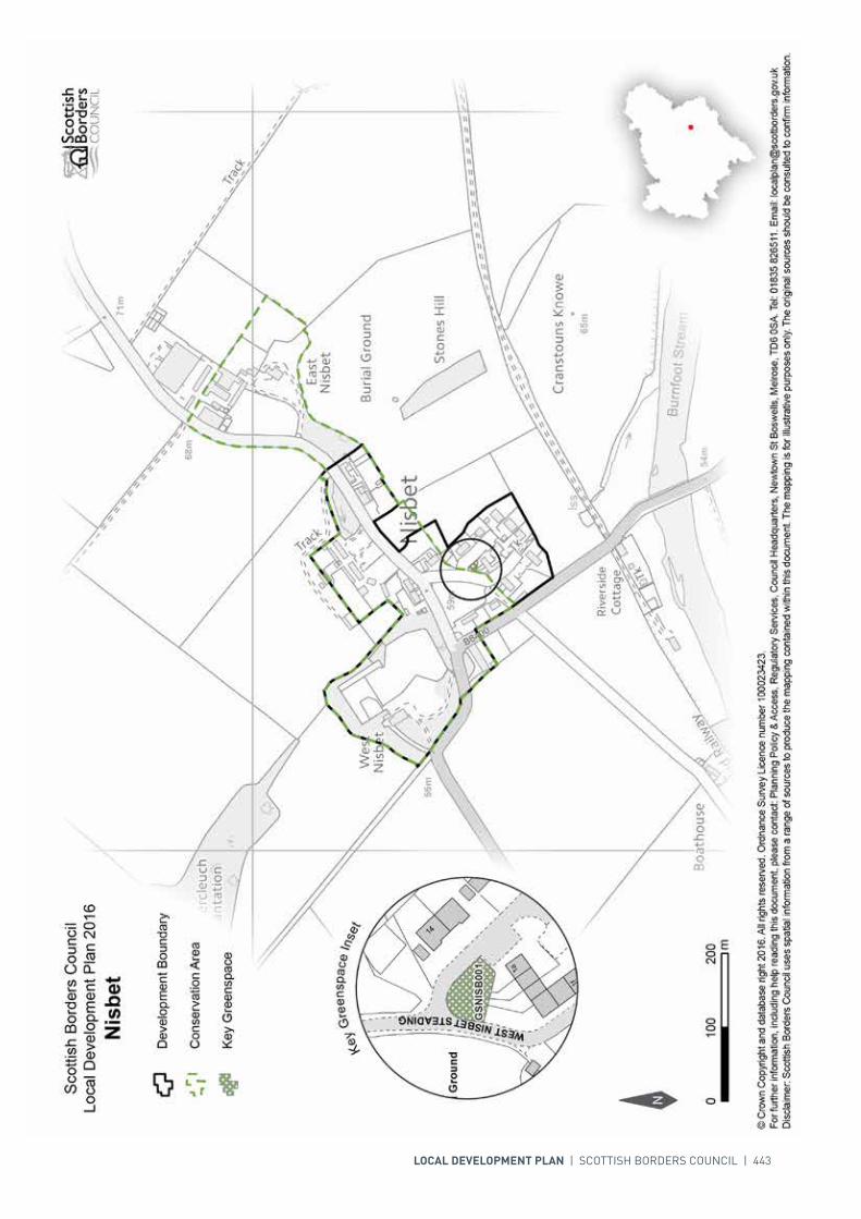
INTRODUCTION | CHALLENGES | VISION, AIMS AND SPATIAL STRATEGYPOLICIES | APPENDICES | SETTLEMENTS
LOCAL DEVELOPMENT PLAN | SCOTTISH BORDERS COUNCIL | 443
444 | LOCAL DEVELOPMENT PLAN | SCOTTISH BORDERS COUNCIL
SETTLEMENT PROFILE OXTON
This profile should be read in conjunction with the relevant settlement map.
DESCRIPTIONOxton is located almost 5 miles north of Lauder just off the A68(T). The population of Oxton according to the 2001 Census is 270. It is located within the Northern Housing Market Area, and outwith the Strategic Development Areas as defined in the Strategic Development Plan.
PLACE MAKING CONSIDERATIONSThe character of Oxton is established by its clustered form and countryside setting. It is situated in the upland valley of the Upper Leader. The Leader Water to the east is part of the River Tweed Special Area of Conservation, a wildlife site of international importance.
The centre of the village of Oxton is focused on the crossroads where The Loan, Station Road, Main Street, and the unclassified road that leads to the A68 all meet. Along Station Road on the north side, a stone wall separates the village from the fields to the fore of Justice Hall, which in themselves form an attractive outlook for the village. The village sits above the A68 with pleasant views outward to the surrounding countryside and especially towards Addinston Hill.
Traditional properties within the village tend mainly to be terraced, built to the back of the footpath and step into the landscape. Two storey properties dominate on Station Road whilst on The Loan and the Main Street a mixture of single to two storeys exist. Sandstone, whin, harl and slate are the main building materials that feature within the centre of the village.
The Plan provides one housing allocation to the north east of the village off Station Road. The Plan also identifies the Heriot Field Play Park for protection as greenspace.
Development to the north and east of the settlement will be resisted where it would have significant effect on the international nature conservation value of the Leader Water or impact on the countryside setting of the settlement as viewed from the A68 trunk road.
INFRASTRUCTURE CONSIDERATIONSAffordable Housing will require to be provided in association with proposed housing sites under the provisions of Policy HD1 and the Supplementary Guidance/Supplementary Planning Guidance on Affordable Housing.

INTRODUCTION | CHALLENGES | VISION, AIMS AND SPATIAL STRATEGYPOLICIES | APPENDICES | SETTLEMENTS
LOCAL DEVELOPMENT PLAN | SCOTTISH BORDERS COUNCIL | 445
A contribution towards Earlston High School will be sought to supplement Scottish Borders Council’s investment in the new school which opened in 2009-2010 under the 3 High Schools project.
Oxton falls within an area identified for a contribution to the Waverley Railway Project (see Policy IS3).
With regards to Waste Water Treatment Works, Oxton currently has sufficient capacity. In respect of the local water network, developers may be required to contribute towards upgrading to enable development.
Further information is available from Supplementary Guidance/Supplementary Planning Guidance on Developer Contributions and Planning/Development Briefs where applicable.
DEVELOPMENT AND SAFEGUARDING PROPOSALS
HOUSING
SITE REFERENCE SITE NAME SITE SIZE (HA)
GSOXTO001 Heriot Field Play Park 0.2
KEY GREENSPACE
SITE REFERENCE SITE NAME SITE SIZE (HA) INDICATIVE SITE CAPACITY
AOXTO001 Station Yard 0.5 10
Site Requirements
• Vehicular access from the road to the south (Station Road) including improved pedestrian linkage• Create structure planting/ landscaping on the boundaries of the site to contain it, screen development
from the A68 and frame development. The mature trees on site to be retained. The long term maintenance of the landscaped areas needs to be addressed
• Evaluation and mitigation of moderate biodiversity interest, including potential impact on the Leader Water, Tweed Special Area of Conservation
• Consider the need for a topographic survey to determine site levels and following this a flood risk assessment and appropriate mitigation may be required, because of the culvert under the site and, additionally, consider the potential for culvert removal and channel restoration.

446 | LOCAL DEVELOPMENT PLAN | SCOTTISH BORDERS COUNCIL
INTRODUCTION | CHALLENGES | VISION, AIMS AND SPATIAL STRATEGYPOLICIES | APPENDICES | SETTLEMENTS
LOCAL DEVELOPMENT PLAN | SCOTTISH BORDERS COUNCIL | 447
SETTLEMENT PROFILE PAXTON
This profile should be read in conjunction with the relevant settlement map.
DESCRIPTIONPaxton is located 11 miles to the east of Duns. The population of the village according to the 2001 Census was 195. It is located on the boundary of the Eastern Strategic Development Area (SDA) as defined by the SESplan.
PLACE MAKING CONSIDERATIONSPaxton is located on the Merse in the lowlands associated with the River Tweed. The village is surrounded by arable fields which are designated as prime agricultural land. Paxton is predominantly residential and has expanded with the development of detached properties.
There are 4 Listed Buildings in Paxton; 3 C-Listed and the B-Listed Old School House.
Paxton is located on the boundary of the Eastern SDA but it is considered that for the Local Development Plan period the identified housing need can be met elsewhere. Recent housing development at The Orchard meets the village’s needs.
INFRASTRUCTURE CONSIDERATIONS Affordable Housing will require to be provided under the provisions of Policy HD1 and the Supplementary Guidance/Supplementary Planning Guidance on Affordable Housing.
A contribution towards Berwickshire High School will be sought to supplement Scottish Borders Council’s investment in the new school which opened in 2009-2010 under the 3 High Schools project.
With regards to Waste Water Treatment Works, Paxton has limited capacity. Contributions may be required where upgrades are necessary. In respect of the local water network, developers may be required to contribute towards upgrading to enable development.
Further information is available from Supplementary Guidance/Supplementary Planning Guidance on Developer Contributions and Planning Briefs where applicable.

448 | LOCAL DEVELOPMENT PLAN | SCOTTISH BORDERS COUNCIL
DEVELOPMENT AND SAFEGUARDING PROPOSALS
KEY GREENSPACE
SITE REFERENCE SITE NAME SITE SIZE (HA)
GSPAXT001 Play Area 0.2
GSPAXT002 Amenity Space 0.1

INTRODUCTION | CHALLENGES | VISION, AIMS AND SPATIAL STRATEGYPOLICIES | APPENDICES | SETTLEMENTS
LOCAL DEVELOPMENT PLAN | SCOTTISH BORDERS COUNCIL | 449
450 | LOCAL DEVELOPMENT PLAN | SCOTTISH BORDERS COUNCIL
SETTLEMENT PROFILE PEEBLES
This profile should be read in conjunction with the relevant settlement map.
DESCRIPTIONPeebles is located almost 19 miles west of Galashiels and sits in the Northern Housing Market Area. The population of Peebles according to the 2001 Census is 8159. The settlement is located within the Western Strategic Development Area as defined in the Strategic Development Plan.
PLACE MAKING CONSIDERATIONSPeebles benefits from a dramatic setting at the convergence of the River Tweed and the Eddleston Water. The settlement is framed between high hills on all sides and has extensive views both into and out of the settlement. The settlement and its hinterland are of high amenity value with mature woodland and spacious parkland. There are attractive views of the town on particularly the south, eastern and western approaches and views out to the south to the adjoining hill ranges beyond Cademuir. The town has a strong landscape framework as already highlighted above; the northern portion of the town nestles into the slopes of Venlaw Hill and onto the flatter land to the west of the Eddleston Water towards Jedderfield. The southern portion of Peebles over the Tweed lies within the flatter haughland of the river valley and on the lower slopes of the Cademuir Hill.
The Conservation Area covers a large part of Peebles, including the entire town centre. The town centre takes in parts of both the Old Town and the New Town including the High Street with its rich assortment of commercial properties and churches. The Old Town is, as its name suggests the oldest part of Peebles and includes St Andrews Church Tower and cemetery. Many of the properties in the Biggiesknowe area and in the north side are one and two storey cottages of a vernacular design. In the south side of the Old Town properties tend to be tenements and commercial premises, with an urban character.
The three churches within the New Town dominate the skyline at both ends of the town centre. The Old Parish Church with its crown steeple sits high, on the site of the castle, at the west end. The tall steeple of the Leckie Memorial Church and the lesser steeple of the Eastgate Church terminate the east end of the centre. The Leckie Memorial Church also dominates the Tweed Green. Within the New Town the rig pattern is still evident. Behind the facades of both sides of the High Street and the west part of Eastgate the narrow passages have been built-up and lead to internal courts that serve a large number of small premises. Of particular interest is Parliament Square, at the west end of the south side of the High Street, which is said to have been a site of a meeting of the Scottish Parliament in 1346.

INTRODUCTION | CHALLENGES | VISION, AIMS AND SPATIAL STRATEGYPOLICIES | APPENDICES | SETTLEMENTS
LOCAL DEVELOPMENT PLAN | SCOTTISH BORDERS COUNCIL | 451
Within Peebles there are also a considerable number of residential properties on either side of the River Tweed. The older housing to the north consists mainly of terraces, semi-detached and villa style properties that were built in the 19th century. Along the south side of the Tweed, to the east and to the south, 19th century villas and mansion style properties are found; outwith those areas are more modern developments with the most recent area for the towns development taking place at Whitehaugh off the B7062. It is evident that within Peebles there is a wide range of building types, styles and periods. These all reflect the history, diversity and development of the town.
Throughout Peebles and particularly along the water courses of the River Tweed and Eddleston Water there are substantial areas of green open space. Tweed Green and Ninian’s Haugh are the most significant areas but there are others.
The main central area of the town focuses on the Eastgate, High Street and Old Town with a diverse range of services and facilities including hotels, bars, shops, restaurants and cafés to serve the local community, tourists and surrounding settlements. The town centre itself is considered to be one of the healthier and vibrant town centres within the Scottish Borders with generally a low retail vacancy rate.
Located outside the town, and set within the Tweed Valley Forest Park is Glentress. The Glentress Forest is a hub for many activities that attracts locals and visitors alike. During the lifetime of the Local Development Plan, the Council will support the development of a Masterplan as Supplementary Guidance in partnership with the Forestry Commission.
The Plan provides seven housing allocations, two safeguarded business and industrial sites, one proposed business and industrial site located at South Parks, as well as one mixed use site at Rosetta Road and three redevelopment sites located at Dovecot Road, George Street and Tweedbridge Court.
The Plan also identifies a number of greenspaces within the settlement; these spaces provide the Peebles community with many important recreation opportunities.
Once the allocated sites are fully developed the preferred area for future expansion beyond the period of this Local Development Plan will be to the south east of Peebles.
The sites identified for longer term development will be subject to further assessment and review as part of the next Local Development Plan Review, and will require a Masterplan to ensure a coherent and holistic approach.
INFRASTRUCTURE CONSIDERATIONSAffordable Housing will require to be provided in association with proposed housing sites under the provisions of Policy HD1 and the Supplementary Guidance/Supplementary Planning Guidance on Affordable Housing.
Peebles Secondary School is forecast by the Director of Education and Lifelong Learning to face some capacity issues from 2016 onwards. Developer Contribution towards school provision within the catchment will be requested, commensurate with the size and type of the development and in accordance with Developer Contribution Policy. If development continues and school capacities are pressured further, a second primary school on the south of the river in Peebles will be required.
This settlement is identified within the Council’s Flood Contingency Plan as being at risk of flooding. Any development proposals should therefore be subject to early consultation with the Council’s Flood and Coastal Management Officer, and SEPA, having regard to the Indicative River and Coastal Flood Map (Scotland). A flood risk assessment may be required and may influence the scale and layout of any development at a particular location.
452 | LOCAL DEVELOPMENT PLAN | SCOTTISH BORDERS COUNCIL
The possible requirement for a second vehicular bridge over the River Tweed was subject to investigation by external transport consultants in the period leading up to the publication of the Finalised Local Plan 2005. The results of the study inform that the housing developments to the south side of the River Tweed proposed in the Finalised Local Plan can be accommodated by the existing Tweed Bridge within the expected lifespan of the Plan, but that this would be at the cost of increased congestion on the North Side of the River at peak commuter times, and that these developments would take the existing bridge close to capacity. Therefore it is now considered that the time has been reached when development sites in Peebles need to contribute towards the tackling of congestion and the potential provision of a second crossing.
Developers are recommended to contact Scottish Water or the Council with regards to the latest position in relation to Waste Water Treatment Works and Water Treatment Works. Contributions may be required where upgrades are necessary.
Further information is available from Supplementary Guidance/Supplementary Planning Guidance on Developer Contributions and Planning/Development Briefs where applicable.
DEVELOPMENT AND SAFEGUARDING PROPOSALS
HOUSING
SITE REFERENCE SITE NAME SITE SIZE (HA) INDICATIVE SITE CAPACITY
TP7B Whitehaugh 9.9 106
Site Requirements
• Construction of the site for housing has commenced• The main vehicular access to be achieved off the B7062 Kingsmeadows Road with a vehicular access
linking with the adjacent Whitehaugh Park via the roundabout to the south of the site• Pedestrian and cycle links to be incorporated into the development• Structure planting and additional landscape enhancement will be required. The long term
maintenance of landscaped areas must be addressed.
TP200 Violet Bank Field 2.4 40
Site Requirements
• Structure planting and additional landscape enhancement including riparian planting (outwith the site) will be required to assist in sheltering and containment of the site. Existing trees onsite to be retained. The long term maintenance of landscaped areas must be addressed
• Provision of amenity access within and through the development for pedestrians and cyclists. In addition provision of a link to the adjacent Violet Bank playing field to the south of the site will be required and potential for improved access to the Eddleston Water
• Further assessment on nature conservation interest may be required and mitigation put in place• A flood risk assessment will be required to inform the development of the site. No development to take
place within the functional floodplain.
APEEB026 Dunwhinny Lodge 0.5 14
Site Requirements
• Consideration of retention or partial retention and conversion of the main building on site• Enhancement of existing landscaping on site with beech hedge to be retained. The long term
maintenance of landscaped areas must be addressed• The site currently has vehicular access to Kingsmuir Drive and to Glen Road. Both have their own
difficulties, but of the two the access route via Kingsmuir Drive is superior. Therefore vehicular access to the site must be restricted via Glen Road
• Further assessment on nature conservation interest may also be required and mitigation put in place• Provision of amenity access within and through the development for pedestrians and cyclists.

INTRODUCTION | CHALLENGES | VISION, AIMS AND SPATIAL STRATEGYPOLICIES | APPENDICES | SETTLEMENTS
LOCAL DEVELOPMENT PLAN | SCOTTISH BORDERS COUNCIL | 453
APEEB031 George Place 0.3 36
Site Requirements
• The main vehicular access to the site will be via George Place with a vehicular connection through to the site to the south – RPEEB002
• Parking provision should be accommodated onsite• Provision of Sustainable Urban Drainage feature onsite• A flood risk assessment will be required to inform the development of the site• Landscape enhancement to the east of the site between the proposed buildings and the Eddleston
Water. Buffer areas for new and existing landscaping will be required. The long term maintenance of landscaped areas must be addressed
• Mitigation measures are required to prevent any impact on the River Tweed Special Areas of Conservation via the Eddleston Water
• Potential contamination on site to be investigated and mitigated• Provision of amenity access within the development for pedestrians and cyclists. Links to the footpath
network to be created and amenity maintained and enhanced.
APEEB021 Housing south of South Park
2.4 50
Site Requirements
• It is intended that a Planning Brief in the form of Supplementary Guidance will be produced for this site• A flood risk assessment is required to inform the site layout, design and potential mitigation• A watercourse buffer strip will be required• No built development should take place on the functional flood plain or over existing culverts• The channel up-stream from grill will be required to be kept clear and maintained, and free from
build-up of silt. Machine access to this overflow and channel must be maintained to allow for future cleaning and maintenance
• Provision of structure planting will be required• Evaluation and associated mitigation of archaeology and impact on River Tweed will be required• In advance of the development being occupied, connection of waste water (foul) drainage to the public
sewer will be required.
APEEB041 Violet Bank II 1.2 25
Site Requirements
• It is intended that a Planning Brief in the form of Supplementary Guidance will be produced for this site• A flood risk Assessment will be required to inform the development of the site• Improved vehicular linkage may be required over the Eddleston Water between Rosetta Road and the
A703 to allow for increased connectivity within the northern part of the Peebles• Provision of structure planting and areas of open space both on and off site will be required. Riparian
planting outwith the site will also be required• Mitigation measures are required to prevent any impact on the River Tweed Special Areas of
Conservation• In advance of the development being occupied, connection of waste water (foul) drainage to the public
sewer will be required• Investigation of the potential for culvert removal and resultant channel restoration.
APEEB044 Rosetta Road 5.7 100
Site Requirements
• Development of the site shall proceed in accordance with the requirements agreed by the council in regard to its consideration of planning application 13/00444/PPP. Should that development not be implemented, a Planning Brief in the form of Supplementary Guidance will require to be produced for this site.
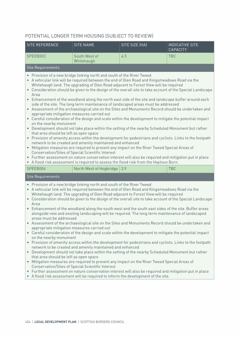
454 | LOCAL DEVELOPMENT PLAN | SCOTTISH BORDERS COUNCIL
POTENTIAL LONGER TERM HOUSING (SUBJECT TO REVIEW)
SITE REFERENCE SITE NAME SITE SIZE (HA) INDICATIVE SITE CAPACITY
SPEEB003 South West of Whitehaugh
4.5 TBC
Site Requirements
• Provision of a new bridge linking north and south of the River Tweed• A vehicular link will be required between the end of Glen Road and Kingsmeadows Road via the
Whitehaugh land. The upgrading of Glen Road adjacent to Forest View will be required• Consideration should be given to the design of the overall site to take account of the Special Landscape
Area• Enhancement of the woodland along the north east side of the site and landscape buffer around each
side of the site. The long term maintenance of landscaped areas must be addressed• Assessment of the archaeological site on the Sites and Monuments Record should be undertaken and
appropriate mitigation measures carried out• Careful consideration of the design and scale within the development to mitigate the potential impact
on the nearby monument• Development should not take place within the setting of the nearby Scheduled Monument but rather
that area should be left as open space• Provision of amenity access within the development for pedestrians and cyclists. Links to the footpath
network to be created and amenity maintained and enhanced• Mitigation measures are required to prevent any impact on the River Tweed Special Areas of
Conservation/Sites of Special Scientific Interest• Further assessment on nature conservation interest will also be required and mitigation put in place• A flood risk assessment is required to assess the flood risk from the Haytoun Burn.
SPEEB004 North West of Hogbridge 2.9 TBC
Site Requirements
• Provision of a new bridge linking north and south of the River Tweed• A vehicular link will be required between the end of Glen Road and Kingsmeadows Road via the
Whitehaugh land. The upgrading of Glen Road adjacent to Forest View will be required• Consideration should be given to the design of the overall site to take account of the Special Landscape
Area• Enhancement of the woodland along the south west and the south east sides of the site. Buffer areas
alongside new and existing landscaping will be required. The long term maintenance of landscaped areas must be addressed
• Assessment of the archaeological site on the Sites and Monuments Record should be undertaken and appropriate mitigation measures carried out
• Careful consideration of the design and scale within the development to mitigate the potential impact on the nearby monument
• Provision of amenity access within the development for pedestrians and cyclists. Links to the footpath network to be created and amenity maintained and enhanced
• Development should not take place within the setting of the nearby Scheduled Monument but rather that area should be left as open space
• Mitigation measures are required to prevent any impact on the River Tweed Special Areas of Conservation/Sites of Special Scientific Interest
• Further assessment on nature conservation interest will also be required and mitigation put in place• A flood risk assessment will be required to inform the development of the site.
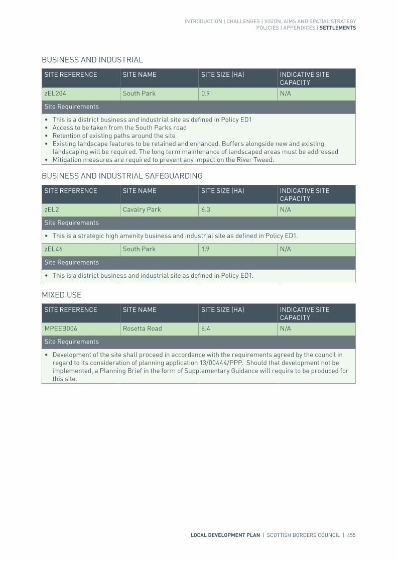
INTRODUCTION | CHALLENGES | VISION, AIMS AND SPATIAL STRATEGYPOLICIES | APPENDICES | SETTLEMENTS
LOCAL DEVELOPMENT PLAN | SCOTTISH BORDERS COUNCIL | 455
BUSINESS AND INDUSTRIAL
SITE REFERENCE SITE NAME SITE SIZE (HA) INDICATIVE SITE CAPACITY
zEL204 South Park 0.9 N/A
Site Requirements
• This is a district business and industrial site as defined in Policy ED1• Access to be taken from the South Parks road• Retention of existing paths around the site• Existing landscape features to be retained and enhanced. Buffers alongside new and existing
landscaping will be required. The long term maintenance of landscaped areas must be addressed• Mitigation measures are required to prevent any impact on the River Tweed.
BUSINESS AND INDUSTRIAL SAFEGUARDING
SITE REFERENCE SITE NAME SITE SIZE (HA) INDICATIVE SITE CAPACITY
zEL2 Cavalry Park 6.3 N/A
Site Requirements
• This is a strategic high amenity business and industrial site as defined in Policy ED1.
zEL46 South Park 1.9 N/A
Site Requirements
• This is a district business and industrial site as defined in Policy ED1.
MIXED USE
SITE REFERENCE SITE NAME SITE SIZE (HA) INDICATIVE SITE CAPACITY
MPEEB006 Rosetta Road 6.4 N/A
Site Requirements
• Development of the site shall proceed in accordance with the requirements agreed by the council in regard to its consideration of planning application 13/00444/PPP. Should that development not be implemented, a Planning Brief in the form of Supplementary Guidance will require to be produced for this site.

456 | LOCAL DEVELOPMENT PLAN | SCOTTISH BORDERS COUNCIL
POTENTIAL LONGER TERM MIXED USE (SUBJECT TO REVIEW)
SITE REFERENCE SITE NAME SITE SIZE (HA) INDICATIVE SITE CAPACITY
SPEEB005 Peebles East (South of the River)
32.3 TBC
Site Requirements
• Provision of land for housing, employment, potential new school site and recreation ground. The site should also allow for the potential for tourism facilities
• There is currently a shortfall of good quality business and industrial land in Peebles. This is a mixed use site and employment land could come forward early to meet this shortfall
• Provision of a new bridge linking north and south of the River Tweed• A vehicular link and pedestrian links will be required to the adjacent allocated site – TP7B. The
upgrading of B7062 Kingsmeadows Road will be required• Enhancement of existing woodland and provision of additional landscaping. The long term
maintenance of landscaped and open space areas must be addressed• Consideration should be given to the design of the overall site to take account of the Special Landscape
Area• Provision of amenity access in the development for pedestrians and cyclists. Links to the footpath
network to be created and amenity maintained and enhanced• Mitigation measures are required to prevent any impact on the River Tweed Special Areas of
Conservation/Sites of Special Scientific Interest• A watercourse buffer strip of six metres will be required• Further assessment on nature conservation will be required• As this site is at high risk of flooding, a flood risk assessment is required to inform site layout, design
and mitigation• No built development should take place on the functional flood plain. The flood risk area in the
northern half of the site (north of the B7062) should be safeguarded as open space, for structure planting and landscaping purposes only
• In advance of the development being occupied, connection of waste water (foul) drainage to the public sewer will be required.
REDEVELOPMENT
SITE REFERENCE SITE NAME SITE SIZE (HA) INDICATIVE SITE CAPACITY
RPEEB001 Dovecot Road 0.4 TBC
Site Requirements
• Design and layout should conserve and enhance the character and amenity of the Peebles Conservation Area
• Vehicular access will be from Dovecot Road• Street frontage to Dovecot Road• Provision of landscaping on site will be required. Buffers alongside new and existing landscaping will
be required. The long term maintenance of landscaped areas must be addressed• A flood risk assessment will be required to inform the development of the site• Mitigation measures are required to prevent any impact on the River Tweed Special Areas of
Conservation via the Eddleston Water• Potential contamination on site to be investigated and mitigated• Provision of amenity access within the development for pedestrians and cyclists. Links to the footpath
network to be created and amenity maintained and enhanced• Further assessment on nature conservation interest will also be required and mitigation put in place.

INTRODUCTION | CHALLENGES | VISION, AIMS AND SPATIAL STRATEGYPOLICIES | APPENDICES | SETTLEMENTS
LOCAL DEVELOPMENT PLAN | SCOTTISH BORDERS COUNCIL | 457
RPEEB002 George Street 0.1 TBC
Site Requirements
• Landscape enhancement to the east of the site between the proposed buildings and the Eddleston Water. Buffer areas for new and existing landscaping will be required. The long term maintenance of landscaped areas must be addressed
• Potential contamination on site to be investigated and mitigated• The main vehicular access to the site should be via George Street with a vehicular connection through
to the site to the north – APEEB031• Parking provision should be accommodated onsite• Provision of Sustainable Urban Drainage feature on site• Mitigation measures are required to prevent any impact on the River Tweed Special Areas of
Conservation via the Eddleston Water• Further assessment on nature conservation interest will also be required and mitigation put in place• A flood risk assessment will be required to inform the development of the site• Provision of amenity access within the development for pedestrians and cyclists. Links to the footpath
network to be created and amenity maintained and enhanced.
RPEEB003 Tweedbridge Court 0.5 50
Site Requirements
• Residential redevelopment will be required• Landscape enhancement to the north of the site between the proposed buildings and the River Tweed
and retention of the existing landscaping on site. Buffer areas for new and existing landscaping will be required. The long term maintenance of landscaped areas must be addressed
• The main vehicular access to the site will be via Dukehaugh• Parking provision should be accommodated onsite• Mitigation measures are required to prevent any impact on the River Tweed Special Areas of
Conservation/Sites of Special Scientific Interest• Further assessment on nature conservation interest will also be required and mitigation put in place• Provision of amenity access within the development for pedestrians and cyclists. Links to the footpath
network to be created and amenity maintained and enhanced• A flood risk assessment will be required to inform the development of the site.
SITE REFERENCE SITE NAME SITE SIZE (HA)
GSPEEB001 Whitestone Park 6.2
GSPEEB002 Tweed Green (North) 1.6
GSPEEB003 Tweed Green (South) 1.6
GSPEEB004 Hay Lodge Park 10.6
GSPEEB005 Area adjacent to River Tweed 4.5
GSPEEB006 Victoria Park 6.7
GSPEEB007 Eddleston Water 2.7
GSPEEB008 Rosetta Road Allotments 0.5
GSPEEB009 Walker’s Haugh 0.8
GSPEEB010 Area around Gytes Leisure Centre 2.5
GSPEEB011 Jubilee Park Field 2.3
GSPEEB012 Burgh Hall Allotments 0.1
GSPEEB013 Violet Bank Playing Field 2.5
GSPEEB014 High School Playing Fields 6.3
KEY GREENSPACE

458 | LOCAL DEVELOPMENT PLAN | SCOTTISH BORDERS COUNCIL

LOCAL DEVELOPMENT PLAN | SCOTTISH BORDERS COUNCIL | 459

For further information, including help reading this document, please contact: Planning Policy & Access, Regulatory Services, Council Headquarters, Newtown St Boswells, Melrose, TD6 0SA. Tel: 0300 100 1800. Email: [email protected]: Scottish Borders Council uses spatial information from a range of sources to produce the mapping contained within this document. The mapping is for illustrative purposes only. The original sources should be consulted to confirm information. © Crown Copyright and database right 2017. All rights reserved. Ordnance Survey Licence number 100023423.
N
Scottish Borders CouncilLocal Development Plan 2016as modified by Supplementary
Guidance on Housing 2017Peebles
00mm
400400200200
Redevelopment
Development Boundary
Housing
Mixed Use
Longer Term Mixed Use
Longer Term Housing
Business and IndustrialSafeguarding
Town Centre Boundary
Key Greenspace
Open Space
Structure Planting/Landscaping
Conservation Area
Business and Industrial
Core Activity Areas
Town Centre Inset
MPEEB006 MPEEB006
APEEB044
APEEB044
GSPEEB013 GSPEEB013
GSPEEB014 GSPEEB014
GSPEEB004
GSPEEB006
GSPEEB001
GSPEEB005
GSPEEB010
GSPEEB011
GSPEEB007
GSPEEB003
GSPEEB002
GSPEEB009
GSPEEB007
GSPEEB012
SPEEB005
TP7B
zEL2
zEL46
APEEB021
TP200
SPEEB004
zEL204
APEEB041
RPEEB003
APEEB026
RPEEB001
APEEB031
RPEEB002
SPEEB003
GSPEEB004
GSPEEB006
GSPEEB001
GSPEEB005
GSPEEB010
GSPEEB011
GSPEEB007
GSPEEB003
GSPEEB002
GSPEEB009
GSPEEB007
GSPEEB012
SPEEB005
TP7B
zEL2
zEL46
APEEB021
TP200
SPEEB004
zEL204
APEEB041
RPEEB003
APEEB026
RPEEB001
APEEB031
RPEEB002
SPEEB003
MPEEB007MPEEB007GSPEEB008GSPEEB008
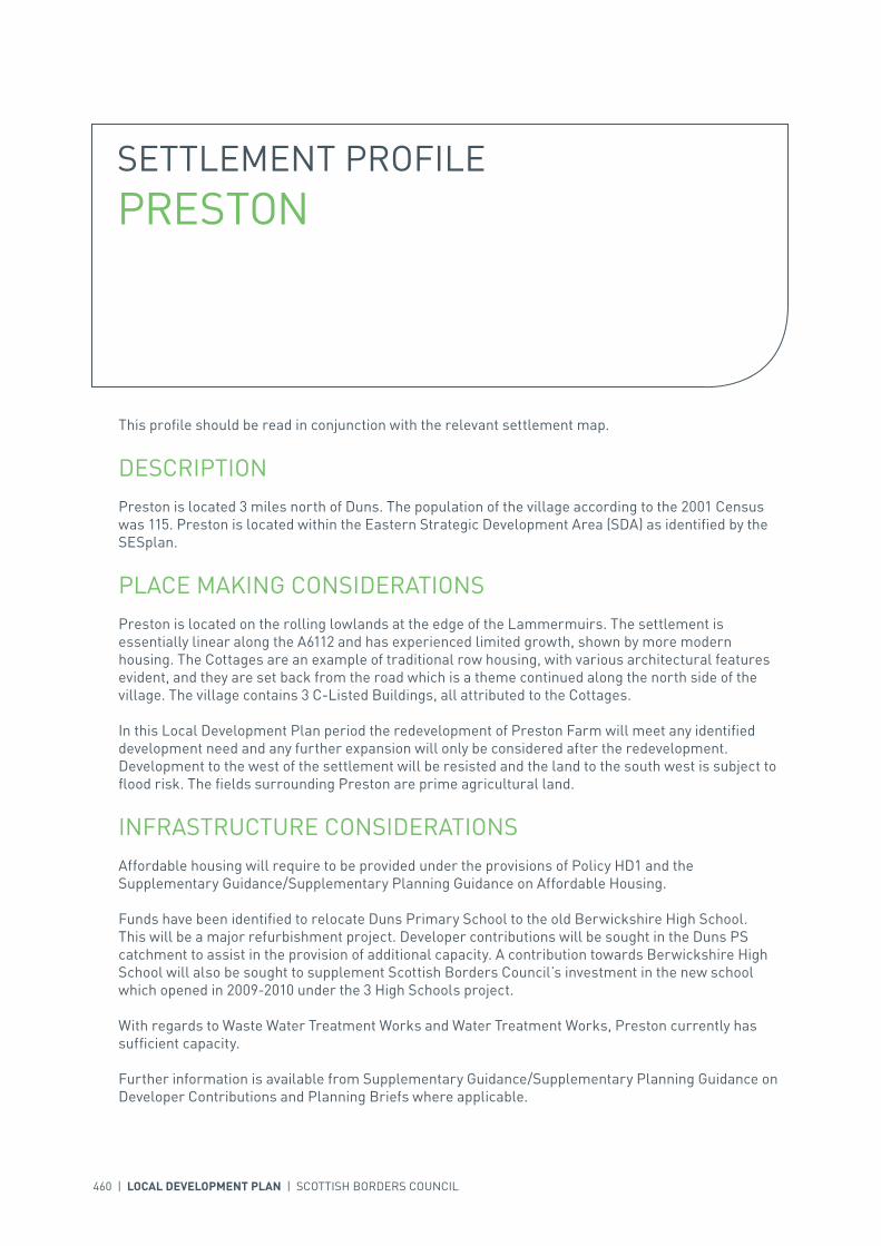
460 | LOCAL DEVELOPMENT PLAN | SCOTTISH BORDERS COUNCIL
SETTLEMENT PROFILE PRESTON
This profile should be read in conjunction with the relevant settlement map.
DESCRIPTIONPreston is located 3 miles north of Duns. The population of the village according to the 2001 Census was 115. Preston is located within the Eastern Strategic Development Area (SDA) as identified by the SESplan.
PLACE MAKING CONSIDERATIONSPreston is located on the rolling lowlands at the edge of the Lammermuirs. The settlement is essentially linear along the A6112 and has experienced limited growth, shown by more modern housing. The Cottages are an example of traditional row housing, with various architectural features evident, and they are set back from the road which is a theme continued along the north side of the village. The village contains 3 C-Listed Buildings, all attributed to the Cottages.
In this Local Development Plan period the redevelopment of Preston Farm will meet any identified development need and any further expansion will only be considered after the redevelopment. Development to the west of the settlement will be resisted and the land to the south west is subject to flood risk. The fields surrounding Preston are prime agricultural land.
INFRASTRUCTURE CONSIDERATIONSAffordable housing will require to be provided under the provisions of Policy HD1 and the Supplementary Guidance/Supplementary Planning Guidance on Affordable Housing.
Funds have been identified to relocate Duns Primary School to the old Berwickshire High School. This will be a major refurbishment project. Developer contributions will be sought in the Duns PS catchment to assist in the provision of additional capacity. A contribution towards Berwickshire High School will also be sought to supplement Scottish Borders Council’s investment in the new school which opened in 2009-2010 under the 3 High Schools project.
With regards to Waste Water Treatment Works and Water Treatment Works, Preston currently has sufficient capacity.
Further information is available from Supplementary Guidance/Supplementary Planning Guidance on Developer Contributions and Planning Briefs where applicable.
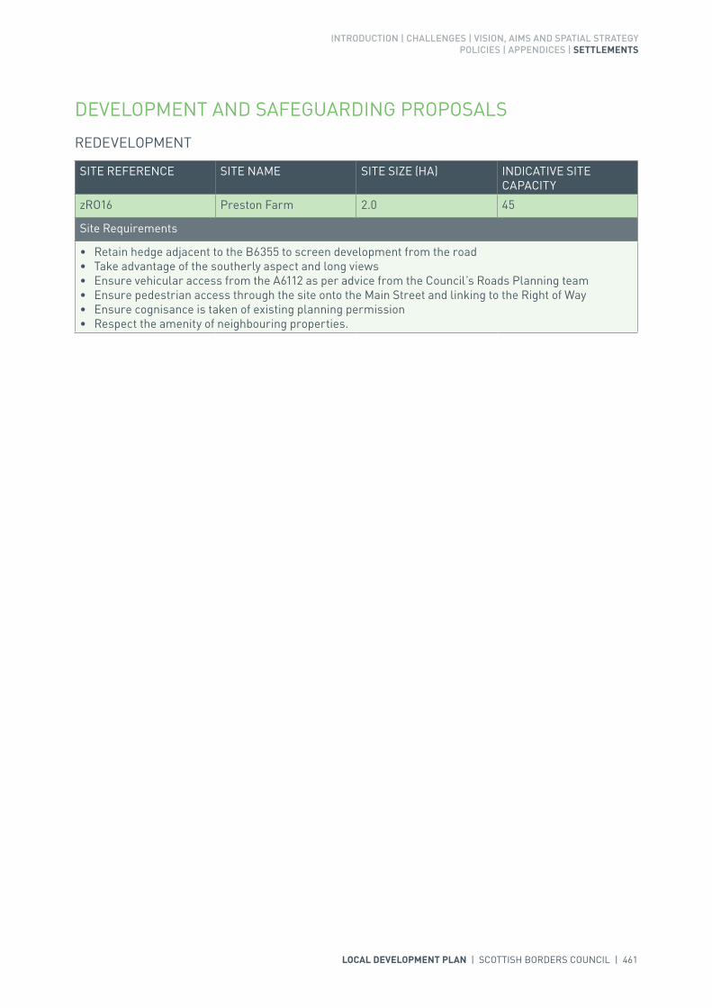
INTRODUCTION | CHALLENGES | VISION, AIMS AND SPATIAL STRATEGYPOLICIES | APPENDICES | SETTLEMENTS
LOCAL DEVELOPMENT PLAN | SCOTTISH BORDERS COUNCIL | 461
DEVELOPMENT AND SAFEGUARDING PROPOSALS
REDEVELOPMENT
SITE REFERENCE SITE NAME SITE SIZE (HA) INDICATIVE SITE CAPACITY
zRO16 Preston Farm 2.0 45
Site Requirements
• Retain hedge adjacent to the B6355 to screen development from the road • Take advantage of the southerly aspect and long views• Ensure vehicular access from the A6112 as per advice from the Council’s Roads Planning team• Ensure pedestrian access through the site onto the Main Street and linking to the Right of Way• Ensure cognisance is taken of existing planning permission• Respect the amenity of neighbouring properties.
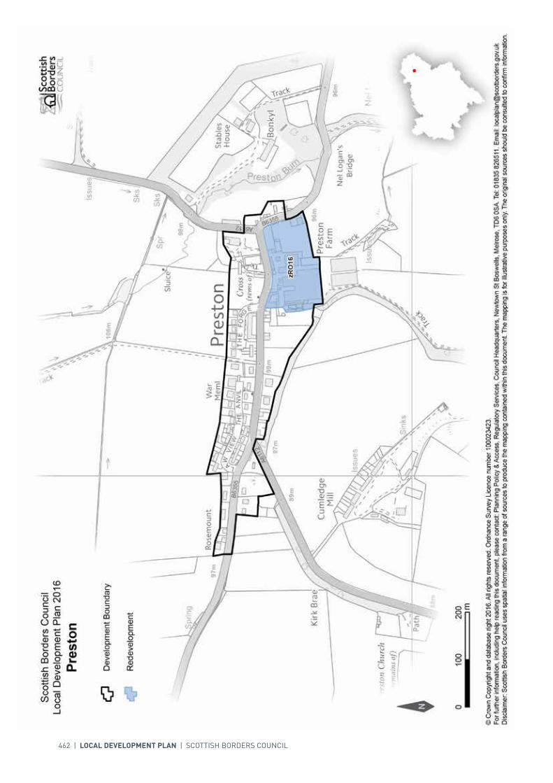
462 | LOCAL DEVELOPMENT PLAN | SCOTTISH BORDERS COUNCIL

INTRODUCTION | CHALLENGES | VISION, AIMS AND SPATIAL STRATEGYPOLICIES | APPENDICES | SETTLEMENTS
LOCAL DEVELOPMENT PLAN | SCOTTISH BORDERS COUNCIL | 463
SETTLEMENT PROFILE REDPATH
This profile should be read in conjunction with the relevant settlement map.
DESCRIPTIONRedpath is located within the Central Strategic Development Area as defined in the Strategic Development Plan and lies within the Central Borders Housing Market Area. The population of Redpath according to the 2001 Census is 56. The settlement is located just over 2 miles from Earlston and 7 miles from Galashiels.
PLACE MAKING CONSIDERATIONSThe character of Redpath is established by its linear layout and its countryside setting. It is located on the edge of lowland hills around Black Hill, the pastoral upland fringe valley of the Lower Leader and the upland fringe valley with settlements of the River Tweed. The quality of this countryside is recognised by its inclusion within a National Scenic Area. Other distinct features are an ancient oak tree near the village hall, and the rows of cottages. The Leader Water, to the west, is part of the River Tweed Special Area of Conservation, a wildlife site of international importance.
The Conservation Area of Redpath incorporates most of the village and part of its surroundings. Redpath developed in a linear form between two farms, one located at the east and the other at the west of the village. Many of the small cottages within the centre of Redpath were once the homes of weavers where looms were spun.
The Redpath Conservation Area has a distinct appearance and setting, it is located on the south facing slopes above a wooded dean connected to the Leader Water. A track running along part of the village allows access to the rear of some of the properties. The layout of Redpath is one of the most important features of the Conservation Area; it is recommended that new development should respect this characteristic. Another distinct feature is the rows of cottages on either side of the road that lead into the centre of the village. Traditional building materials prevail, whin and sand stone, harl and slate are all to be found within the Redpath Conservation Area. Architectural details such as sash and case windows and margins feature greatly. Stone boundary walls also appear of which some are dry. While these collective details form the character of the Redpath Conservation Area they should all be protected and any alterations or new build should seek to respect the individual buildings and the wider Conservation Area.
The Plan does not identify any allocations within Redpath. Given the sensitivity of the character and setting of Redpath it has not been able to identify an area for longer term expansion at this stage. Further detailed assessment will be required during the next Local Development Plan Review to assess for any areas for further expansion.

464 | LOCAL DEVELOPMENT PLAN | SCOTTISH BORDERS COUNCIL
INFRASTRUCTURE CONSIDERATIONSAffordable Housing will require to be provided under the provision of Policy HD1 and the Supplementary Guidance/ Supplementary Planning Guidance on Affordable Housing.
A contribution towards Earlston High School will be sought to supplement Scottish Borders Council’s investment in the new school which opened in 2009-2010 under the 3 High Schools project.
The settlement falls within an area identified for a contribution to the Waverley Railway Project (see Policy IS3).
In accordance with the Council’s Local Transport Strategy, a Central Borders Traffic Model has been developed which will help direct funding to areas of the road network that may become congested in the future. Developer contributions will be sought from developments within the Central Borders in accordance with the Supplementary Guidance/Supplementary Planning Guidance on Developer Contributions.
With regards to Water Treatment Works, Redpath currently has sufficient capacity. However, there is no waste water infrastructure within the settlement at present.
Further information is available from Supplementary Guidance/Supplementary Planning Guidance on Developer Contributions.
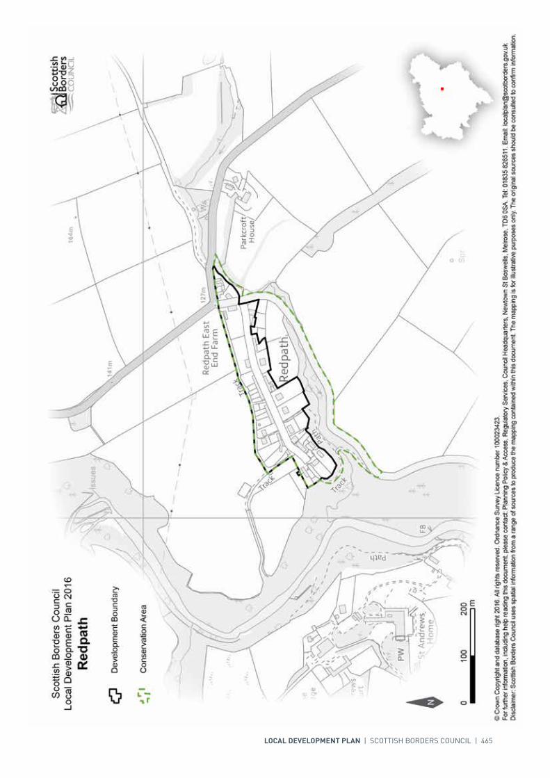
LOCAL DEVELOPMENT PLAN | SCOTTISH BORDERS COUNCIL | 465
466 | LOCAL DEVELOPMENT PLAN | SCOTTISH BORDERS COUNCIL
SETTLEMENT PROFILE RESTON
This profile should be read in conjunction with the relevant settlement map.
DESCRIPTIONReston is located 6 miles west of Eyemouth. The population of the village according to the 2001 Census was 335. Reston is located within the Eastern Strategic Development Area (SDA) as identified by the SESplan.
PLACE MAKING CONSIDERATIONSReston sits in the rolling lowland landscape associated with the Eye Water which flows to the north of the settlement. The settlement follows a linear form running east to west and the surrounds are made up of arable and pasture fields. Reston was formerly a stop on the East Coast Main Line and the western end of the village is split by the tracks. The settlement is mainly residential in character with more modern housing towards the eastern and western ends and traditional row housing, of various elevations, fronting on to the Main Street.
Reston does not have a Conservation Area but contains 8 Listed Buildings.
Reston is well placed to contribute land towards housing targets. The Consolidated Local Plan identified two housing allocations and a redevelopment allocation. The Local Development Plan (LDP) continues to identify the two housing allocations but the redevelopment allocation is changed to a mixed use allocation; it should be noted that there is an existing permission for housing on this site as well as an approved Development Brief (Reston Auction Mart). These allocations are sufficient to meet identified demand.
There is likely to be longer-term demand for housing in Reston, particularly if a railway station is reinstated. As a result two areas are identified, SREST001 and SREST002. The Development Brief for Reston Auction Mart gives guidance on these sites, as well as the land safeguarded for a railway station (zRS3).
As longer-term development is proposed to the south of Reston, development in other directions will be resisted. The north of the settlement is also constrained by flood risk, while the fields over the railway are designated as prime agricultural land.

INTRODUCTION | CHALLENGES | VISION, AIMS AND SPATIAL STRATEGYPOLICIES | APPENDICES | SETTLEMENTS
LOCAL DEVELOPMENT PLAN | SCOTTISH BORDERS COUNCIL | 467
INFRASTRUCTURE CONSIDERATIONSAffordable Housing will require to be provided under the provisions of Policy HD1 and the Supplementary Guidance/Supplementary Planning Guidance on Affordable Housing.
The Director of Education and Lifelong Learning has advised that there are severe capacity issues in Reston. The existing school is constrained and is not suitable to be extended therefore a suitable replacement site will need to be found. There are potential opportunities related to the sites allocated for housing, mixed use and the indicative longer term housing areas. A contribution towards Eyemouth High School will be sought to supplement Scottish Borders Council’s investment in the new school which opened in 2009-2010 under the 3 High Schools project.
With regards to Waste Water Treatment Works, Reston has limited capacity. Contributions may be required where upgrades are necessary. In respect of the local water network, developers may be required to contribute towards upgrading to enable development.
Further information is available from Supplementary Guidance/Supplementary Planning Guidance on Developer Contributions and Planning Briefs where applicable.
DEVELOPMENT AND SAFEGUARDING PROPOSALS
HOUSING
SITE REFERENCE SITE NAME SITE SIZE (HA) INDICATIVE SITE CAPACITY
BR5 West Reston 1.0 20
Site Requirements
• Planting on the south-eastern boundary to provide enclosure to the site and define a settlement edge, and on the south west edge to protect amenity of neighbouring property
• Retain the hedge planting on the north west edge where appropriate• Vehicular access off the B6438 in line with advice from the Council’s Roads Planning team• Pedestrian access from the B6438• Investigation of possible archaeological links on the south east boundary of the site.
BR6 Rear of Primary School 1.6 16
Site Requirements
• Planting on the western boundary to help provide a settlement edge and enclosure to the site• Retain hedges on northern and southern edges where appropriate• Cognisance of the amenity of the existing residential property on the site• Provision for vehicular access from the B6438 in agreement with the advice of the Council’s Roads
Planning team • Pedestrian access through the site from the B6438 and on to the unclassified road to the north• Take advantage of the southerly aspect and views from the site• A flood risk assessment is required to inform the site layout, design and mitigation.

468 | LOCAL DEVELOPMENT PLAN | SCOTTISH BORDERS COUNCIL
POTENTIAL LONGER TERM HOUSING (SUBJECT TO REVIEW)
SITE REFERENCE SITE NAME SITE SIZE (HA) INDICATIVE SITE CAPACITY
SREST001 Reston Long Term 1 3.9 N/A
Site Requirements
• Refer to approved Planning Brief (Reston Auction Mart), which shall be updated to consider the need for flood risk assessment.
SREST002 Reston Long Term 2 2.1 N/A
Site Requirements
• Refer to approved Planning Brief (Reston Auction Mart), which shall be updated to consider the need for flood risk assessment.
MIXED USE
SITE REFERENCE SITE NAME SITE SIZE (HA) INDICATIVE SITE CAPACITY
MREST001 Auction Mart 4.0 100
Site Requirements
• Refer to approved Planning Brief (Reston Auction Mart).
TRANSPORTATION
SITE REFERENCE SITE NAME SITE SIZE (HA) INDICATIVE SITE CAPACITY
zRS3 Reston Station 1.1 N/A
Site Requirements
• Refer to approved Planning Brief (Reston Auction Mart).
SITE REFERENCE SITE NAME SITE SIZE (HA)
GSREST001 Sports Field 0.6
GSREST002 Play Area 0.1
KEY GREENSPACE
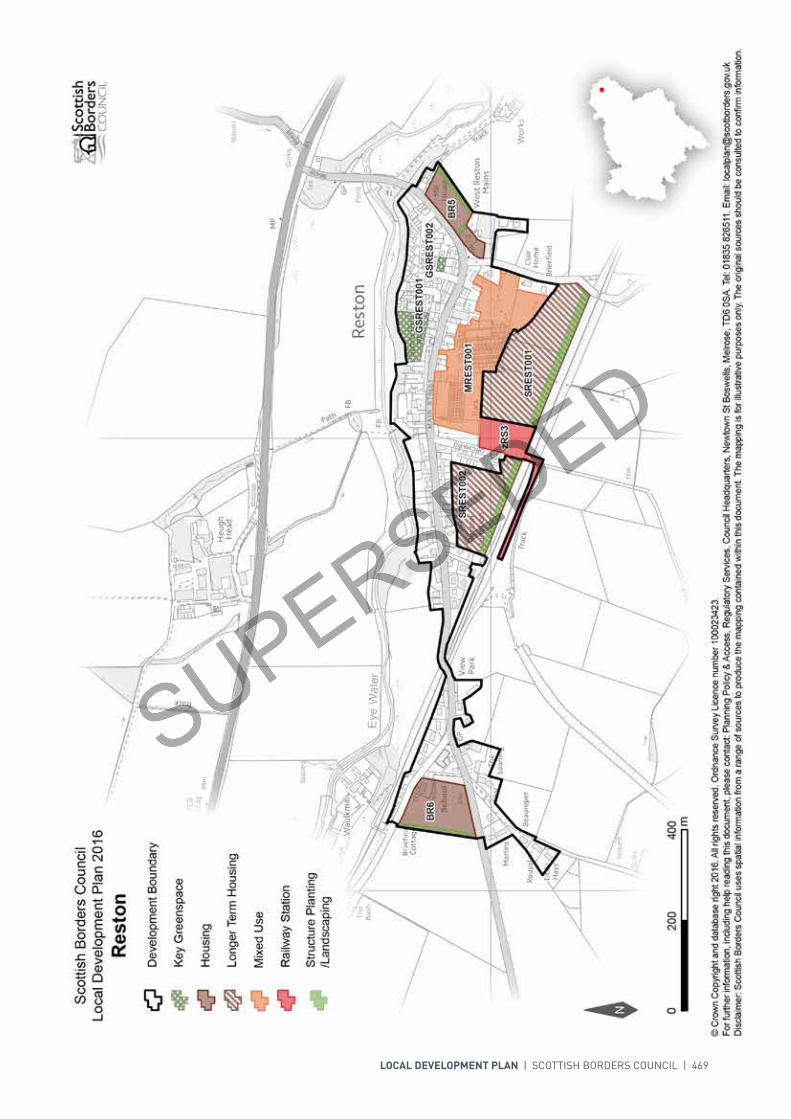
LOCAL DEVELOPMENT PLAN | SCOTTISH BORDERS COUNCIL | 469

N
Scottish Borders CouncilLocal Development Plan 2016as modified by Supplementary
Guidance on Housing 2017Reston
© Crown Copyright and database right 2017. All rights reserved. Ordnance Survey Licence number 100023423.For further information, including help reading this document, please contact: Planning Policy & Access, Regulatory Services, Council Headquarters, Newtown St Boswells, Melrose, TD6 0SA. Tel: 0300 100 1800. Email: [email protected]: Scottish Borders Council uses spatial information from a range of sources to produce the mapping contained within this document. The mapping is for illustrative purposes only. The original sources should be consulted to confirm information.
00mm
400400200200
Development Boundary
Housing
Longer Term Housing
Railway Station
Key Greenspace
Structure Planting/Landscaping
GSREST001GSREST001GSREST002GSREST002BR6BR6
MREST001MREST001
SREST001SREST001
BR5BR5
zRS3zRS3
AREST004AREST004
Mixed Use

470 | LOCAL DEVELOPMENT PLAN | SCOTTISH BORDERS COUNCIL
SETTLEMENT PROFILE ROBERTON
This profile should be read in conjunction with the relevant settlement map.
DESCRIPTIONRoberton is located 5 miles to the west of Hawick. It is a small settlement consisting of a scattered group of buildings either side of the B711. This minor road connects Hawick with remote rural settlements in the Ettrick valley about 11 miles further west. It is located within the Central Borders Strategic Development Area as defined in the SESplan.
PLACE MAKING CONSIDERATIONSThe settlement is set above the Borthwick Water, a tributary of the River Teviot. It lies at the confluence of Borthwick Water with Glen Burn that runs off Watch Knowe – the hill to the north. It is clearly visible in the landscape from Easter Park Hill with mature trees and ancient woodland providing shelter and an attractive setting.
Roberton is made up of a number of detached houses focused around the B711 that runs through the village and a minor road that follows Roberton Cleuch. A church and village hall serves the wider community and provides a central focus in the area. There is no longer a school in the village.
Recent expansion has taken place at the east end of the settlement, where four detached houses have been erected within the last five years. Further small scale expansion is planned on the west side of the settlement, close to the church and village hall. Landscaping is indicated and would need to be incorporated into any development of the site.
The Development Boundary is intended to indicate the extent to which the settlement should be allowed to expand during the Local Development Plan period and aims to focus development to specific sites in the short term.
INFRASTRUCTURE CONSIDERATIONSAffordable Housing will require to be provided under the provisions of Policy HD1 and the Supplementary Guidance/ Supplementary Planning Guidance on Affordable Housing.
There is no requirement for contribution towards education provision.

INTRODUCTION | CHALLENGES | VISION, AIMS AND SPATIAL STRATEGYPOLICIES | APPENDICES | SETTLEMENTS
LOCAL DEVELOPMENT PLAN | SCOTTISH BORDERS COUNCIL | 471
There is no Waste Water Treatment Works in Roberton at present; it is currently served by a private system. Appropriate provision of private sewage treatment systems would be required for any new development in this location, to be agreed and licensed by SEPA.
Further information is available from Supplementary Guidance/Supplementary Planning Guidance on Developer Contributions and Planning/Development Briefs where applicable.
DEVELOPMENT AND SAFEGUARDING PROPOSALS
HOUSING
SITE REFERENCE SITE NAME SITE SIZE (HA) INDICATIVE SITE CAPACITY
AROBE001 Roberton West 0.9 5
Site Requirements
• The site is only acceptable for a small development• Tree and hedge planting is required on the northern, western and eastern boundary to reduce visual
impact from the countryside and to maintain the wooded character of the settlement. A management scheme for planting is required
• Scale and design of development needs to have regard to the character of the existing settlement• Mitigation measures should be carried out to address drainage into the nearby burn• Mitigation measures are required to prevent any impact on the River Tweed Special Area of
Conservation.
AROBE003 Site adjacent to Kirk'oer 0.8 5
Site Requirements
• The site is only acceptable for a small development• Tree and hedge planting is required on the northern, eastern and western boundary to reduce visual
impact from the countryside and protect the adjacent ancient woodland. A management scheme for planting is required
• Scale and design of development needs to have regard to the character of the existing settlement• Archaeology interests have been recorded in the surrounding area and archaeological assessment
including archaeological evaluation along with associated mitigation measures is required• Mitigation measures should be carried out to address drainage into the nearby burn• Consider the potential for culvert removal and channel restoration• Mitigation measures are required to prevent any impact on the River Tweed River Tweed Special Area
of Conservation.
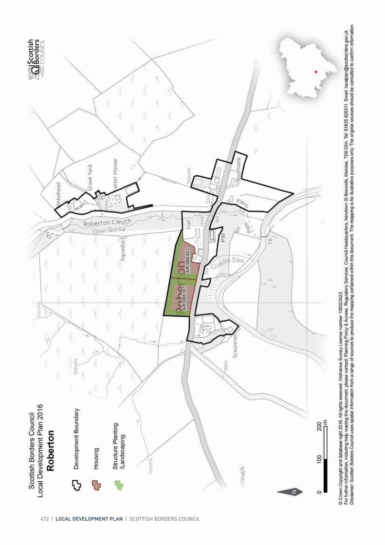
472 | LOCAL DEVELOPMENT PLAN | SCOTTISH BORDERS COUNCIL

INTRODUCTION | CHALLENGES | VISION, AIMS AND SPATIAL STRATEGYPOLICIES | APPENDICES | SETTLEMENTS
LOCAL DEVELOPMENT PLAN | SCOTTISH BORDERS COUNCIL | 473
SETTLEMENT PROFILE ROMANNOBRIDGE
This profile should be read in conjunction with the relevant settlement map.
DESCRIPTIONRomannobridge is located 10 miles north west from Peebles. The population of Romannobridge according to the 2001 Census is 175. It is located outwith the Strategic Development Areas as defined in the Strategic Development Plan.
PLACE MAKING CONSIDERATIONSThe village is subdivided into two distinct parts. The southern portion of Romannobridge contains the original village focussed around the Romanno Inn and the crossing point of the Lyne Water. This attractive compact group of buildings was later extended to the south west along the western side of the Edinburgh to Moffat road either side of the primary school.
The northern portion of the settlement developed in more recent years between Woodlands House, the cemetery, and Romanno House Farm. Development has been along either side of the A701 and more recently the cul-de-sac development at Halmyre Loan.
The Lyne Water which flows alongside and through part of the settlement is designated a Special Area of Conservation. The southern and original part of the settlement also contains a number of listed buildings which include the Old Bridge over the Lyne Water.
The Plan does not propose any allocated land use proposals nor does it identify any areas for longer term development or protection in Romannobridge.
INFRASTRUCTURE CONSIDERATIONSAffordable Housing will require to be provided in association with proposed housing sites under the provisions of Policy HD1 and the Supplementary Guidance/Supplementary Planning Guidance on Affordable Housing.
Peebles Secondary School is forecast by the Director of Education and Lifelong Learning to face some capacity issues from 2016 onwards. Developer Contribution towards school provision within the catchment will be requested, commensurate with the size and type of the development and in accordance with Developer Contribution Policy.

474 | LOCAL DEVELOPMENT PLAN | SCOTTISH BORDERS COUNCIL
With regards to Waste Water Treatment Works, Romannobridge has limited capacity. Contributions may be required where upgrades are necessary. In respect of the local water network, developers may be required to contribute towards upgrading to enable development.
Further information is available from Supplementary Guidance/Supplementary Planning Guidance on Developer Contributions.
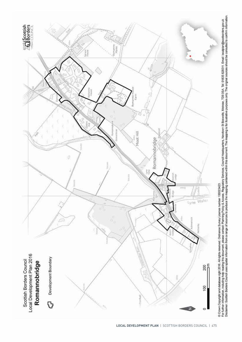
LOCAL DEVELOPMENT PLAN | SCOTTISH BORDERS COUNCIL | 475
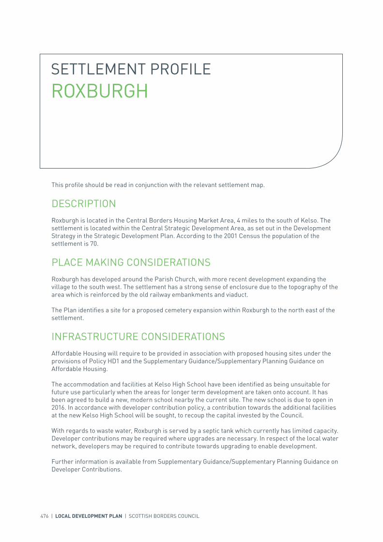
476 | LOCAL DEVELOPMENT PLAN | SCOTTISH BORDERS COUNCIL
SETTLEMENT PROFILE ROXBURGH
This profile should be read in conjunction with the relevant settlement map.
DESCRIPTIONRoxburgh is located in the Central Borders Housing Market Area, 4 miles to the south of Kelso. The settlement is located within the Central Strategic Development Area, as set out in the Development Strategy in the Strategic Development Plan. According to the 2001 Census the population of the settlement is 70.
PLACE MAKING CONSIDERATIONSRoxburgh has developed around the Parish Church, with more recent development expanding the village to the south west. The settlement has a strong sense of enclosure due to the topography of the area which is reinforced by the old railway embankments and viaduct.
The Plan identifies a site for a proposed cemetery expansion within Roxburgh to the north east of the settlement.
INFRASTRUCTURE CONSIDERATIONSAffordable Housing will require to be provided in association with proposed housing sites under the provisions of Policy HD1 and the Supplementary Guidance/Supplementary Planning Guidance on Affordable Housing.
The accommodation and facilities at Kelso High School have been identified as being unsuitable for future use particularly when the areas for longer term development are taken onto account. It has been agreed to build a new, modern school nearby the current site. The new school is due to open in 2016. In accordance with developer contribution policy, a contribution towards the additional facilities at the new Kelso High School will be sought, to recoup the capital invested by the Council.
With regards to waste water, Roxburgh is served by a septic tank which currently has limited capacity. Developer contributions may be required where upgrades are necessary. In respect of the local water network, developers may be required to contribute towards upgrading to enable development.
Further information is available from Supplementary Guidance/Supplementary Planning Guidance on Developer Contributions.

INTRODUCTION | CHALLENGES | VISION, AIMS AND SPATIAL STRATEGYPOLICIES | APPENDICES | SETTLEMENTS
LOCAL DEVELOPMENT PLAN | SCOTTISH BORDERS COUNCIL | 477
DEVELOPMENT AND SAFEGUARDING PROPOSALS
CEMETERY
SITE REFERENCE SITE NAME SITE SIZE (HA)
FROXB001 Roxburgh Cemetery Expansion 0.06
Site Requirements
• Use of previous buildings on site needs to be ascertained before work commences.
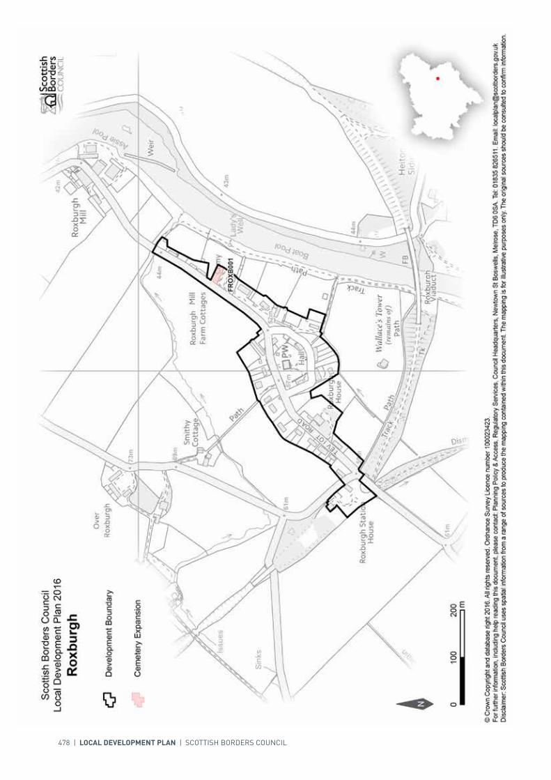
478 | LOCAL DEVELOPMENT PLAN | SCOTTISH BORDERS COUNCIL

INTRODUCTION | CHALLENGES | VISION, AIMS AND SPATIAL STRATEGYPOLICIES | APPENDICES | SETTLEMENTS
LOCAL DEVELOPMENT PLAN | SCOTTISH BORDERS COUNCIL | 479
SETTLEMENT PROFILE SELKIRK
This profile should be read in conjunction with the relevant settlement map.
DESCRIPTIONSelkirk is located 6 miles south west of Galashiels and is included in the Central Borders Strategic Development Area as defined in the SESplan. The 2001 Census population was 5,839.
PLACE MAKING CONSIDERATIONSThe character of Selkirk is mainly established by its historic hilltop town centre and its countryside setting. The town is located in the valley of the Ettrick Water and on the rolling hills to the east of the river. The surrounding countryside is part of the designated Eildon and Leaderfoot Special Landscape Area. The Riverside area of the town, adjacent to the Ettrick Water, contains a number of Victorian mill buildings of architectural and historical interest. The Ettrick Water, which passes through the town, is part of the River Tweed Special Area of Conservation, a wildlife site of international importance. The Haining Garden and Designed Landscape lies to the south of the development boundary.
The Conservation Area of Selkirk includes the historic core of the town, including the ruins of the 18th century church where for centuries a church stood, the Market Place and Halliwell’s Museum, as well as the many plaques, monuments and statues around the town. Selkirk was until the 19th Century only a small settlement when it then expanded extensively due to the introduction of the woollen mills.
A variety of different building styles and types are present throughout the Conservation Area and these all add to the uniqueness of the place. Both the statues and the monuments as well as the larger detailed properties, such as Sheriff Court, all provide a significant contribution not only to the amenity of the Town but also to its attractiveness. Many of the properties are built hard to the footpath but on the whole they all tend to follow the streetscape. The use of building materials and architectural details are important to form the character. Any new development must therefore aim to contribute to the existing character of the Conservation Area.
The town is an identified area for regeneration and the Riverside area, which is a priority for employment related development, has already seen the redevelopment of redundant buildings. There are significant constraints to growth including flood risk, particularly in the riverside area and road capacity with the centre of the town posing particular difficulties for traffic movement and parking.
The Council is currently progressing a Flood Protection Scheme for the town and the first phase of the works, which would drastically reduce the risk of flooding in the Riverside area, is planned for 2015/16.
480 | LOCAL DEVELOPMENT PLAN | SCOTTISH BORDERS COUNCIL
The Plan includes previously allocated sites and a number of redevelopment sites within Selkirk. In the Riverside area a more flexible policy may allow for mixed use development in the southern part while the northern part is regarded as a district employment site. The Plan also includes the reintroduction of the Core Activity Area (previously known as Prime Retail Frontage) protection in central Selkirk.
The line of the Selkirk bypass is protected by Policy IS4 – Transport Development and Infrastructure. This would provide the opportunity to improve the town centre environment, enhance road linkages within the Central Borders and speed up journey times from Hawick northwards. Whilst the bypass is safeguarded, there is currently no Scottish Government commitment and further studies would be required to identify the exact line and establish community and environmental impacts. If the bypass is built in the future, there are areas adjacent to it which could be identified for potential longer term development. An area to the north of the bypass line could be a potential business park in the longer term. Areas at the southern end of the bypass could also be further investigated for potential longer term mixed use development. These areas will be subject to further assessment as part of the next Local Development Plan review and will require a Masterplan to ensure a coherent and holistic approach. Until this is progressed, the uncertainty is a significant constraint to the planning of long term development in Selkirk.
Land to the west of Philiphaugh Farm, currently outwith the development boundary, is also considered to have potential for Longer Term Mixed Use. Part of this land has been identified as an opportunity for development in the Development and Landscape Capacity Study. Whilst it is acknowledged that there are flooding issues in this area, alleviation measures are proposed to mitigate this through the Flood Protection Scheme. It is envisaged that the Scheme would release some of this land for development. Refinement of this Longer Term area can be addressed in the future once, after completion, these mitigation works are fully assessed. The area will be subject to further assessment as part of the next Local Development Plan review and will also require a Masterplan to ensure a coherent and holistic approach.
There are ten areas, including Victoria Park, Pringle Park, sports fields and more informal spaces, identified as key greenspaces.
INFRASTRUCTURE CONSIDERATIONSAffordable Housing will require to be provided under the provisions of Policy HD1 and the Supplementary Guidance/Supplementary Planning Guidance on Affordable Housing.
The Director of Education and Lifelong Learning has advised that there will be a significant capacity issue at Philiphaugh Community School, once the future site at Linglie Road has been developed. He advised that Knowepark Primary School has inadequate playing field provision, the site is constrained and there is no opportunity to expand capacity on the current site. He also advised that in school catchments where there are significant capacity issues Developer Contributions towards school provision will be sought commensurate with the size and type of development, in accordance with Policy IS2 Developer Contributions.
A Flood Protection Scheme is being taken forward for Selkirk under the Flood Risk Management (Scotland) Act 2009 and is at the Detailed Design Stage. The construction of the first phase of the work is planned for 2015/16. Developer contributions will require to be provided for any residential/commercial development within the existing extent of the flood area. The settlement is currently identified within the Council’s Flood Contingency Plan as being at risk of flooding. Any development proposals should therefore be subject to early consultation with the Council’s Flood and Coastal Management Officer, and SEPA, having regard to the Indicative River and Coastal Flood Map (Scotland). A flood risk assessment may be required and may influence the scale and layout of any development at a particular location. It should be noted that the requirement for a Flood Risk Assessment will change when the Flood Protection Scheme has been fully implemented.

INTRODUCTION | CHALLENGES | VISION, AIMS AND SPATIAL STRATEGYPOLICIES | APPENDICES | SETTLEMENTS
LOCAL DEVELOPMENT PLAN | SCOTTISH BORDERS COUNCIL | 481
There is current and predicted longer term pressure on the health service’s accommodation in Selkirk. The accommodation may require to be upgraded or developed.
Selkirk falls within an area identified for a contribution to the Borders Railway (See Policy IS3).
In accordance with the Council’s Local Transport Strategy, a Central Borders Traffic Model has been developed which will help direct funding to areas of the road network that may become congested in the future. Developer contributions will be sought from developments within the Central Borders in accordance with the Supplementary Guidance/Supplementary Planning Guidance on Developer Contributions.
The difficult corner at Yarrow Terrace/Ettrick Road may require upgrading. The Selkirk bypass would be likely to require developer contributions.
With regards to Waste Water Treatment Works and Water Treatment Works, Selkirk currently has sufficient capacity.
Further information is available from Supplementary Guidance/Supplementary Planning Guidance on Developer Contributions and Planning/Development Briefs where applicable.
DEVELOPMENT AND SAFEGUARDING PROPOSALS
HOUSING
SITE REFERENCE SITE NAME SITE SIZE (HA) INDICATIVE SITE CAPACITY
ESE2 Kerr’s Land 1.0 24
Site Requirements
• The design and layout of the development should recognise the sensitivity of the Special Landscape Area and the need to provide an access that meets the standards of Transport Scotland in respect of the A7, a trunk road
• Evaluation and mitigation of potential archaeological interest• Existing boundary wall to be retained where possible• Existing boundary trees and hedgerows to be retained and protected where possible.
ESE10B Linglie Road 2.3 30
Site Requirements
• Development is to be restricted to the area, about 0.75ha, at the west end of the site that is outwith the functional flood plain and not at risk from a 1 in 200 year event
• Remainder of the site is to be used for prevention of flood risk and a holistic consideration of site landscape
• Consider the potential for culvert removal and channel restoration• Archaeological interests require to be investigated and mitigation measures may thereafter be
required• Amenity of neighbouring residential properties must be safeguarded• Existing trees to be retained and protected• Robust belt of woodland planting along the south and east boundaries in order to provide containment• Vehicular access to be from Linglie Road and integration with the street network to the south west to
be addressed.
482 | LOCAL DEVELOPMENT PLAN | SCOTTISH BORDERS COUNCIL
ASELK006 Philiphaugh Steading 1.6 32
Site Requirements
• Vehicular access should be taken from the A708 and a vehicular link to site ASELK021 to the north to be provided. Pedestrian/cycle links should be improved between this site and Selkirk
• Retain existing trees to the south of the site to screen it from the A708• The natural heritage interest of Long Philip Burn and the Ettrick Water will require mitigation
measures to prevent any impact on the River Tweed Special Area of Conservation• A management scheme for planting is required• The design and layout of the development should recognise the sensitivity of the Special Landscape
Area• As this site is at high risk from flooding a flood risk assessment is required to inform site layout,
design and mitigation. In this respect, potential developers should be aware of the provisions of the Selkirk Flood Protection Scheme
• No built development should take place on the functional flood plain; this area should be safeguarded as open space.
ASELK021 Philiphaugh North 1.2 20
Site Requirements
• New vehicular and pedestrian/cycle access to the site from site ASELK006 to the south• Creation of woodland structural planting along the northern boundary of the site to contain it. A
management scheme for planting is required• The natural heritage interest of Long Philip Burn and the Ettrick Water will require mitigation
measures to prevent any impact on the River Tweed Special Area of Conservation• The design and layout of the development should recognise the sensitivity of the Special Landscape
Area• Consider the potential for culvert removal and channel restoration.
BUSINESS AND INDUSTRIAL
SITE REFERENCE SITE NAME SITE SIZE (HA) INDICATIVE SITE CAPACITY
zEL11 Riverside 2 0.6 N/A
Site Requirements
• This is a district business and industrial site as defined in Policy ED1• Although it is likely that the approved flood protection scheme will reduce the risk posed by the Ettrick
Water, a flood risk assessment is required.
zEL15 Riverside 6 0.8 N/A
Site Requirements
• This is a district business and industrial site as defined in Policy ED1• Although it is likely that the approved flood protection scheme will reduce the risk posed by the Ettrick
Water, a flood risk assessment is required• Archaeological interests require to be investigated and mitigation measures may thereafter be
required• The A Listed Ettrick Mill and its setting must be retained. Any extension, alterations, new building and
associated landscaping should be designed sympathetically to this setting.
BSELK002 Riverside 5 0.5 N/A
Site Requirements
• This is a district business and industrial site as defined in Policy ED1• Although it is likely that the approved flood protection scheme will reduce the risk posed by the Ettrick
Water, a flood risk assessment is required.

INTRODUCTION | CHALLENGES | VISION, AIMS AND SPATIAL STRATEGYPOLICIES | APPENDICES | SETTLEMENTS
LOCAL DEVELOPMENT PLAN | SCOTTISH BORDERS COUNCIL | 483
BSELK003 Riverside 8 6.7 N/A
Site Requirements
• It is intended that a Planning Brief in the form of Supplementary Guidance will be produced for this site• This is a local safeguarded business and industrial site as defined in Policy ED1• Due to the location of this site adjacent to a mixed use area, it is considered that this site would be
appropriate for mixed use development• Although it is likely that the approved flood protection scheme will reduce the risk posed by the Ettrick
Water, a flood risk assessment is required• Development must have attractive frontage to Ettrick Water• Archaeological interests require to be investigated and mitigation measures may thereafter be
required.
BUSINESS AND INDUSTRIAL SAFEGUARDING
SITE REFERENCE SITE NAME SITE SIZE (HA) INDICATIVE SITE CAPACITY
BSELK001 Riverside 7 21.2 N/A
Site Requirements
• This is a district safeguarded business and industrial site as defined in Policy ED1• Although it is likely that the approved flood protection scheme will reduce the risk posed by the Ettrick
Water, a flood risk assessment is required for proposed development within this area.
REDEVELOPMENT
SITE REFERENCE SITE NAME SITE SIZE (HA) INDICATIVE SITE CAPACITY
RSELK001 Forest Mill 0.5 30
Site Requirements
• Vehicular access to the site from the road to the west and the B7014 to the east• The redevelopment of the site should conserve and enhance the character of the category B Listed
Forest Mill complex of single and multi-storey mill buildings and their setting. This includes machinery in the former wheel house and yarn store
• The industrial archaeology of the site should be investigated and mitigated where possible• The site falls within a flood risk area so a flood risk assessment will be required.• A mix of residential, class 4 business and community uses could be appropriate on this site.
RSELK002 St Marys Church 0.1 21
Site Requirements
• The site has been granted consent for a mix of flats and offices• The design of the site should conserve and enhance the character of the Conservation Area and in
particular respect the category B Listed Selkirk Sheriff Court building to the north.
RSELK003 Land at Kilncroft/Mill Street
0.1 N/A
Site Requirements
• Amenity of existing residential properties must be safeguarded.

484 | LOCAL DEVELOPMENT PLAN | SCOTTISH BORDERS COUNCIL
RSELK004 Souter Court 0.1 N/A
Site Requirements
• Amenity of existing residential properties must be safeguarded• Layout and design should conserve and enhance the character of the conservation area.
SITE REFERENCE SITE NAME SITE SIZE (HA)
GSSELK001 Selkirk Football Club 5.3
GSSELK002 Selkirk Cricket Club 2.1
GSSELK003 Selkirk Rugby FC 2.9
GSSELK004 Recreation Ground/Allotments 1.3
GSSELK005 Bannerfield Drive Open Space 1.2
GSSELK006 The Pringle Park/Scott Crescent Recreation Ground
5.1
GSSELK007 Selkirk Bowling Club 0.2
GSSELK008 South Port Recreation Area 0.8
GSSELK009 Heatherlie Park 0.1
GSSELK010 Victoria Park Camping & Caravan Site
3.7
KEY GREENSPACE

INTRODUCTION | CHALLENGES | VISION, AIMS AND SPATIAL STRATEGYPOLICIES | APPENDICES | SETTLEMENTS
LOCAL DEVELOPMENT PLAN | SCOTTISH BORDERS COUNCIL | 485
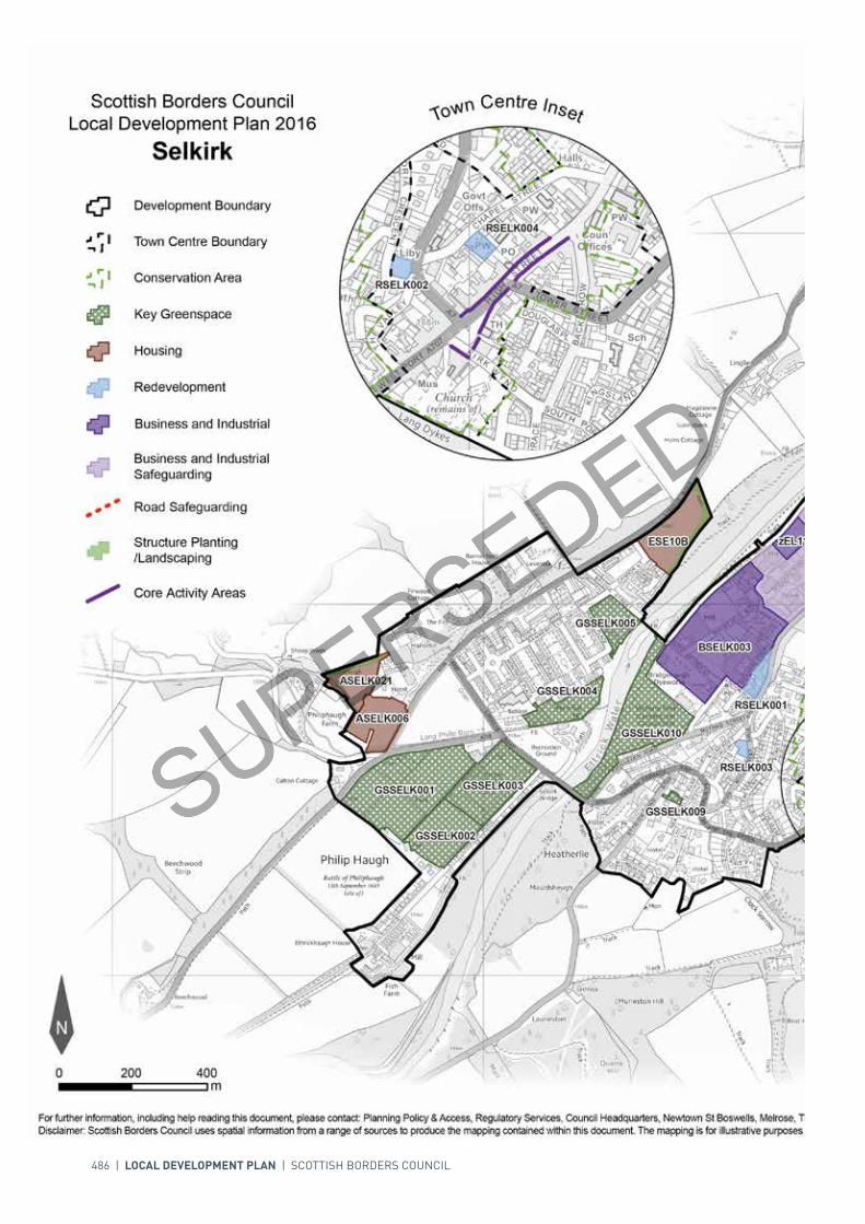
486 | LOCAL DEVELOPMENT PLAN | SCOTTISH BORDERS COUNCIL

LOCAL DEVELOPMENT PLAN | SCOTTISH BORDERS COUNCIL | 487

For further information, including help reading this document, please contact: Planning Policy & Access, Regulatory Services, Council Headquarters, Newtown St Boswells, Melrose, TD6 0SA. Tel: 0300 100 1800. Email: [email protected]: Scottish Borders Council uses spatial information from a range of sources to produce the mapping contained within this document. The mapping is for illustrative purposes only. The original sources should be consulted to confirm information. © Crown Copyright and database right 2017. All rights reserved. Ordnance Survey Licence number 100023423.
N
Scottish Borders CouncilLocal Development Plan 2016as modified by Supplementary
Guidance on Housing 2017Selkirk
00mm
400400200200
Redevelopment
Development Boundary
Housing
Business and IndustrialSafeguarding
Town Centre Boundary
Key Greenspace
Structure Planting/Landscaping
Core Activity Areas
Business and Industrial
GSSELK001GSSELK001
GSSELK006GSSELK006
GSSELK010GSSELK010
GSSELK003GSSELK003
GSSELK002GSSELK002
GSSELK004GSSELK004
GSSELK005GSSELK005
GSSELK008GSSELK008
GSSELK007GSSELK007
GSSELK009GSSELK009
BSELK001BSELK001
BSELK003BSELK003
ESE10BESE10B
ESE2ESE2
ASELK006ASELK006
zEL15zEL15
ASELK021ASELK021
zEL11zEL11
BSELK002BSELK002
RSELK001RSELK001
RSELK003RSELK003
Conservation Area
Town Centre Inset
RSELK004RSELK004
RSELK002RSELK002
Road Safeguarding
MSELK002MSELK002
ASELK033ASELK033
Mixed Use
488 | LOCAL DEVELOPMENT PLAN | SCOTTISH BORDERS COUNCIL
SETTLEMENT PROFILE SKIRLING
This profile should be read in conjunction with the relevant settlement map.
DESCRIPTIONSkirling is located on the A72 Peebles to Biggar road to the western edge of the Borders. The population of Skirling according to the 2001 Census is 127. The settlement is located outwith the Strategic Development Areas as defined in the Strategic Development Plan.
PLACE MAKING CONSIDERATIONSThe village sits at around 220m above sea level, elevated from the flood plain of the Biggar Water in a narrow upland valley below Gallow Law. This valley contains a tributary to the Spittal Burn which meets the Candy Burn at Skirling Mill to the west of the village. The predominant surrounding land use is agriculture.
The village of Skirling is linear in shape and originally comprised five small farms on the valley floor next to Skirling Burn. Other buildings include farm workers cottages, two churches, a village hall and a school as well as a few other small activities such as a blacksmith and a small general store.
Skirling has a distinct identity and benefits from Conservation Area status which extends beyond the Development Boundary. The importance of the water source to the development of the village can be seen in the pattern of building back from the road and above the level of the burn. This is reflected in both the northern and southern parts of the village. One of the most important properties of the Conservation Area is Skirling House, built by Lord Carmichael and designed in 1905 by Ramsay Traquair. Constructed around an existing farmhouse this property has a pleasant appearance, with weather-boarded upper floor along with some attractive wrought iron work by Thomas Hadden of Edinburgh. The Arts & Crafts movement is evident throughout Skirling House – beautiful ornate wrought ironwork and decorative carvings.
Within the settlement, properties tend to range from single to two storeys in height. Traditional building materials prevail with ochre and red coloured sandstone, harl and slate. The houses also have a number of architectural details - sash and case windows, skews, rybats, margins and quoins.
The Plan does not provide any housing allocations within the settlement nor does it identify any areas for longer term development in Skirling. The Plan does however, identify three areas of greenspace for protection.

INTRODUCTION | CHALLENGES | VISION, AIMS AND SPATIAL STRATEGYPOLICIES | APPENDICES | SETTLEMENTS
LOCAL DEVELOPMENT PLAN | SCOTTISH BORDERS COUNCIL | 489
KEY GREENSPACE
SITE REFERENCE SITE NAME SITE SIZE (HA)
GSSKIR001 Skirling Green 0.4
GSSKIR002 Skirling Verges 0.2
GSSKIR003 Skirling Verges 0.1
INFRASTRUCTURE CONSIDERATIONSAffordable Housing will require to be provided in association with proposed housing sites under the provisions of Policy HD1 and the Supplementary Guidance/Supplementary Planning Guidance on Affordable Housing.
Peebles Secondary School is forecast by the Director of Education and Lifelong Learning to face some capacity issues from 2016 onwards. Developer Contribution towards school provision within the catchment will be requested, commensurate with the size and type of the development and in accordance with Developer Contribution Policy.
With regards to Waste Water Treatment Works Skirling has limited capacity. Contributions may be required where upgrades are necessary. In respect of the local water network, developers may be required to contribute towards upgrading to enable development.
Further information is available from Supplementary Guidance/Supplementary Planning Guidance on Developer Contributions.
DEVELOPMENT AND SAFEGUARDING PROPOSALS

490 | LOCAL DEVELOPMENT PLAN | SCOTTISH BORDERS COUNCIL

INTRODUCTION | CHALLENGES | VISION, AIMS AND SPATIAL STRATEGYPOLICIES | APPENDICES | SETTLEMENTS
LOCAL DEVELOPMENT PLAN | SCOTTISH BORDERS COUNCIL | 491
SETTLEMENT PROFILE SMAILHOLM
This profile should be read in conjunction with the relevant settlement map.
DESCRIPTIONSmailholm is located within the Central Borders Strategic Development Area as set out in the Development Strategy in the Strategic Development Plan. The settlement is located just over 6 miles from Kelso and almost 12 miles from Galashiels. The population of Smailholm is 67 based on the 2001 Census.
PLACE MAKING CONSIDERATIONSThe character of Smailholm has been established particularly by its layout and setting - a small hill-top settlement that originally consisted of three detached parts: East Third, West Third and Overtown. Little remains of Overtown today, while the East Third and West Third are now the main foci. The village centre (East Third) is compact and attractive and is largely devoid of traffic allowing for a very quiet rural quality with little activity on the street.
Smailholm Conservation Area has a distinct identity. The importance of the category ‘B’ listed Church and graveyard to the layout of Smailholm is evident through its central positioning of it within the village. Properties tend to range from single to two storeys in height with chimneys mainly being situated at the gable-ends. Traditional building materials prevail, whinstone mixed with ochre coloured sandstone, harl, slate, and in some instances pantiles are all to be found within the Conservation Area. Architectural details such as sash and case windows, skews, rybats, margins and quoins also feature greatly. Stone boundary walls appear often and contribute significantly to the character of the place.
Given the sensitivity of the character and setting of Smailholm it has not been possible to identify an area for longer term expansion at this stage. The division of the village in to two separate parts is a relatively distinctive feature and therefore it would be undesirable to allow infill development to fill the gap between these two parts, this area should therefore be protected from development. Another area that should also be protected from development is the area to the south of East Third.
Within Smailholm, the Plan identifies two greenspaces, the Play Area and the Memorial Green which are to be protected due to their community value.

492 | LOCAL DEVELOPMENT PLAN | SCOTTISH BORDERS COUNCIL
INFRASTRUCTURE CONSIDERATIONSAffordable Housing will require to be provided in association with proposed housing sites under the provisions of Policy HD1 and the Supplementary Guidance/Supplementary Planning Guidance on Affordable Housing.
The accommodation and facilities at Kelso High School have been identified as being unsuitable for future use particularly when the areas for longer term development are taken onto account. It has been agreed to build a new, modern school nearby the current site. The new school is due to open in 2016. In accordance with developer contribution policy, a contribution towards the additional facilities at the new Kelso High School will be sought, to recoup the capital invested by the Council.
With regards to Waste Water Treatment Works, Smailholm has limited capacity. Contributions may be required where upgrades are necessary. In respect of the local water network, developers may be required to contribute towards upgrading to enable development.
Further information is available from Supplementary Guidance/Supplementary Planning Guidance on Developer Contributions.
DEVELOPMENT AND SAFEGUARDING PROPOSALS
KEY GREENSPACE
SITE REFERENCE SITE NAME SITE SIZE (HA)
GSSMAI001 Play Area 0.04
GSSMAI002 Memorial Green 0.1

LOCAL DEVELOPMENT PLAN | SCOTTISH BORDERS COUNCIL | 493

494 | LOCAL DEVELOPMENT PLAN | SCOTTISH BORDERS COUNCIL
SETTLEMENT PROFILE SPROUSTON
This profile should be read in conjunction with the relevant settlement map.
DESCRIPTIONSprouston is located in the Central Borders Housing Market Area, approximately 4 miles east of Kelso. The settlement is located within the Central Strategic Development Area, within the Development Strategy in the Strategic Development Plan. The population of Sprouston according to the 2001 Census is 100.
PLACE MAKING CONSIDERATIONSSprouston is situated within the lowlands associated with the River Tweed, which flows to the north of the settlement. There are fields surrounding Sprouston, which benefit from being Prime Agricultural Land.
The B6350 runs through Sprouston and the settlement has developed from the crossroads in the centre with recent development along Dean Road. Within the settlement there is a Primary School, Church and Village Hall.
The Plan allocates two housing sites within Sprouston at Church Field and Teasel Bank. A site has also been identified for a future cemetery expansion adjacent to Sprouston Church.
Sprouston Village Green is an important amenity area within the centre of the village and will therefore be protected from development.
It is envisaged that future demand for housing in Sprouston will be met through current allocations and there is no requirement beyond the period of this plan for future expansion. Development to the West of Sprouston, aside from any potential Primary School expansion or cark park for the Village Hall, will be resisted.
INFRASTRUCTURE CONSIDERATIONSAffordable Housing will require to be provided under the provisions of Policy HD1 and the Supplementary Guidance/Supplementary Planning Guidance on Affordable Housing.
Sprouston Primary School may have capacity issues depending on future development. The accommodation and facilities at Kelso High School have been identified as being unsuitable for future use particularly when the areas for longer term development are taken onto account. It has been

INTRODUCTION | CHALLENGES | VISION, AIMS AND SPATIAL STRATEGYPOLICIES | APPENDICES | SETTLEMENTS
LOCAL DEVELOPMENT PLAN | SCOTTISH BORDERS COUNCIL | 495
agreed to build a new, modern school nearby the current site. The new school is due to open in 2016. In accordance with developer contribution policy, a contribution towards the additional facilities at the new Kelso High School will be sought, to recoup the capital invested by the Council.
With regards to Waste Water Treatment Works and Water Treatment Works, Sprouston currently has sufficient capacity.
Further information is available from Supplementary Guidance/Supplementary Planning Guidance on Developer Contributions and Planning/Development Briefs where applicable.
DEVELOPMENT AND SAFEGUARDING PROPOSALS
HOUSING
SITE REFERENCE SITE NAME SITE SIZE (HA) INDICATIVE SITE CAPACITY
RSP2B Church Field 1.5 18
Site Requirements
• Vehicular access could be taken from the B6350 and/or the minor road to the south of the site• A vehicular access must be retained from the site through to the field to the west of the development• The existing hedges and trees within the site should be retained and enhanced wherever possible• Structure planting is required to the eastern boundary to reinforce the settlement edge. A
management scheme for planting is also required• Archaeology interests have been recorded in the surrounding area and archaeological assessment
including archaeological evaluation along with associated mitigation measures is required.
RSP3B Teasel Bank 1.7 18
Site Requirements
• Vehicular access should be taken from the minor Sprouston to Hadden road• The existing hedges and trees within the site should be retained and enhanced wherever possible• Structure planting required to the western site boundary to provide setting for the development and
provide screening from the road. Screening may also be required along the northern boundary to protect the residential amenity of the properties along Dean Road dependent on the proposed site layout. A management scheme for planting will be required
• Pedestrian links to the Primary School and village centre are required• Archaeology interests have been recorded in the surrounding area and archaeological assessment
including archaeological evaluation along with associated mitigation measures is required.
CEMETERY
SITE REFERENCE SITE NAME SITE SIZE (HA) INDICATIVE SITE CAPACITY
FSPRO001 Sprouston Cemetery Expansion
0.1 N/A
Site Requirements
• Archaeological work required• Improvements required to achieve acceptable visibility at the junction between B6350 and the minor
road adjacent to the site• Potential flood risk from culverted watercourse located to the north of the site. Flood risk
assessment and any identified mitigation measures required.

496 | LOCAL DEVELOPMENT PLAN | SCOTTISH BORDERS COUNCIL
SITE REFERENCE SITE NAME SITE SIZE (HA)
GSSPRO001 Village Green 0.7
KEY GREENSPACE

LOCAL DEVELOPMENT PLAN | SCOTTISH BORDERS COUNCIL | 497

498 | LOCAL DEVELOPMENT PLAN | SCOTTISH BORDERS COUNCIL
SETTLEMENT PROFILE ST ABBS
This profile should be read in conjunction with the relevant settlement map.
DESCRIPTIONSt Abbs is located 5 miles north-west of Eyemouth. The population of the village according to the 2001 Census was 185. St Abbs is located within the Eastern Strategic Development Area (SDA) as identified by the SESplan.
PLACE MAKING CONSIDERATIONSSt Abbs gains its character primarily from being a coastal fishing village perched on the north-east coast of the Borders. It benefits from views over the harbour and the wider North Sea. Further inland, the settlement’s surroundings are dominated by arable and pastoral fields. The settlement and hinterland are of particular high amenity value with mature woodland to the north-west around Northfield House.
The Conservation Area covers the majority of the village and Northfield House. The harbour and the coastal location are important features as they are essential to the character of the place. Properties range from single, storey and a half, and two storeys in height; built hard to the footpath and following the streetscape. Building materials such as sandstone, pantiles and slate, and architectural details like transom lights, sash and case windows, and margins, add to the sense of place. Any alterations or new development must therefore aim to contribute to the existing character of the Conservation Area. There are 7 Listed Buildings within St Abbs.
In this Local Development Plan (LDP) period any identified housing need can be met elsewhere. Any expansion of the village would have a significant impact on the capacity of the existing road network in Coldingham. In addition, St Abbs is located adjacent to the Berwickshire and North Northumberland Coast Special Area of Conservation, St Abbs Head to Fast Castle Special Protection Area and the Berwickshire Coast SSSI. The coastline and inland surrounds of St Abbs are also designated as a Special Landscape Area (Berwickshire Coast). Any proposed development would need to adhere to the relevant policy requirements associated with these designations.
INFRASTRUCTURE CONSIDERATIONS Affordable Housing will require to be provided under the provisions of Policy HD1 and the Supplementary Guidance/Supplementary Planning Guidance on Affordable Housing.

INTRODUCTION | CHALLENGES | VISION, AIMS AND SPATIAL STRATEGYPOLICIES | APPENDICES | SETTLEMENTS
LOCAL DEVELOPMENT PLAN | SCOTTISH BORDERS COUNCIL | 499
SITE REFERENCE SITE NAME SITE SIZE (HA)
GSSTAB001 Briery 0.1
GSSTAB002 Play Area Briery Dean 0.1
A contribution towards Eyemouth High School will be sought to supplement Scottish Borders Council’s investment in the new school which opened in 2009-2010 under the 3 High Schools project.
With regards to Waste Water Treatment Works and Water Treatment Works, St Abbs currently has sufficient capacity.
Further information is available from Supplementary Guidance/Supplementary Planning Guidance on Developer Contributions and Planning Briefs where applicable.
DEVELOPMENT AND SAFEGUARDING PROPOSALS
KEY GREENSPACE

500 | LOCAL DEVELOPMENT PLAN | SCOTTISH BORDERS COUNCIL
INTRODUCTION | CHALLENGES | VISION, AIMS AND SPATIAL STRATEGYPOLICIES | APPENDICES | SETTLEMENTS
LOCAL DEVELOPMENT PLAN | SCOTTISH BORDERS COUNCIL | 501
SETTLEMENT PROFILE ST BOSWELLS
This profile should be read in conjunction with the relevant settlement map.
DESCRIPTIONSt Boswells is located within the Central Strategic Development Area as defined in the Strategic Development Plan and lies within the Central Borders Housing Market Area. The population of St Boswells according to the 2001 Census is 1,115. The settlement is located 8 miles from Galashiels and 10 miles from Kelso.
PLACE MAKING CONSIDERATIONSSt Boswells is an attractive village with much of its character gained from the large green. The Green and the cricket ground provide an interesting and attractive entrance to the village against the backdrop of the Eildon Hills.
The St Boswells Conservation Area has a distinct layout and is centred on the large green with its tree-lined approach into the centre of the village. There is a wide range of property within the Conservation Area: mainly two or two and a half storeys in height, but including terraces, semi detached or detached. Three large detached properties sited on the ridge of land on the north boundary have good views both into the village and over the River Tweed. Detached properties tend to be sited back from the road and those built in rows are mainly built hard to the street with few exceptions.
As the layout of St Boswells is one of the most important features of the Conservation Area, it is recommended that new development should respect this characteristic. Building materials that prevail throughout the Conservation Area are red and cream sandstone, harling, slate as well as whinstone, though mainly in the construction of boundary walls. Architectural details include sash and case windows, dormers (a few of which have corbelled details), fanlights, transom lights, margins and rybats. While these individual elements of the built fabric may not appear significant, their collective contribution to the Conservation Area is considerable. Any new development or alterations should therefore aim to respect the individual building and the wider Conservation Area and take account of these important features.
An issue which is of particular concern within St Boswells is that of transport. As a result of increased through-traffic, resident’s on-street parking and shop traffic including deliveries, the Main Street through the settlement and its junction onto the A68 can become very congested particularly at peak times. As a result of this, parking within the settlement can also appear a problem. These are issues that will require continued assessment.

502 | LOCAL DEVELOPMENT PLAN | SCOTTISH BORDERS COUNCIL
St Boswells and the surrounding area is covered by the Countryside Around Town policy. The policy seeks to protect the settlement from coalescence and thereby retaining the individual identity of St Boswells as well as protecting and enhancing the local area.
Although the Charlesfield Industrial Estate is located outwith the Development Boundary of the settlement, it plays an important role in the settlement and is seen as a strategic employment site within the Borders. The Plan allocates a Business and Industrial site, which provides an extension to the east of the existing Industrial Estate at Charlesfield, which is safeguarded within the Plan.
The Plan also identifies four key greenspaces within St Boswells which provide recreational opportunities for the community and therefore are to be protected.
Given the sensitivity of the character and setting of St Boswells it has not been able to identify an area for longer term expansion at this stage. Further detailed assessment will be required during the next Local Plan Review to assess for any areas for further expansion.
INFRASTRUCTURE CONSIDERATIONSAffordable Housing will require to be provided under the provision of Policy HD1 and the Supplementary Guidance/ Supplementary Planning Guidance on Affordable Housing.
The Director of Education and Lifelong Learning states that any further release of land at St Boswells for housing may require expansion to the existing school facilities. A contribution towards Earlston High School will be sought to supplement Scottish Borders Council’s investment in the new school which opened in 2009-2010 under the 3 High Schools project.
St Boswells falls within an area identified for a contribution to the Waverley Railway Project (see Policy IS3).
In accordance with the Council’s Local Transport Strategy, a Central Borders Traffic Model has been developed which will help direct funding to areas of the road network that may become congested in the future. Developer contributions will be sought from developments within the Central Borders in accordance with the Supplementary Guidance/Supplementary Planning Guidance on Developer Contributions.
With regards to Waste Water Treatment Works, St Boswells has limited capacity. Contributions may be required where upgrades are necessary. In respect of the local water network, developers may be required to contribute towards upgrading to enable development.
Further information is available from Supplementary Guidance/Supplementary Planning Guidance on Developer Contributions and Planning/Development Briefs where applicable.
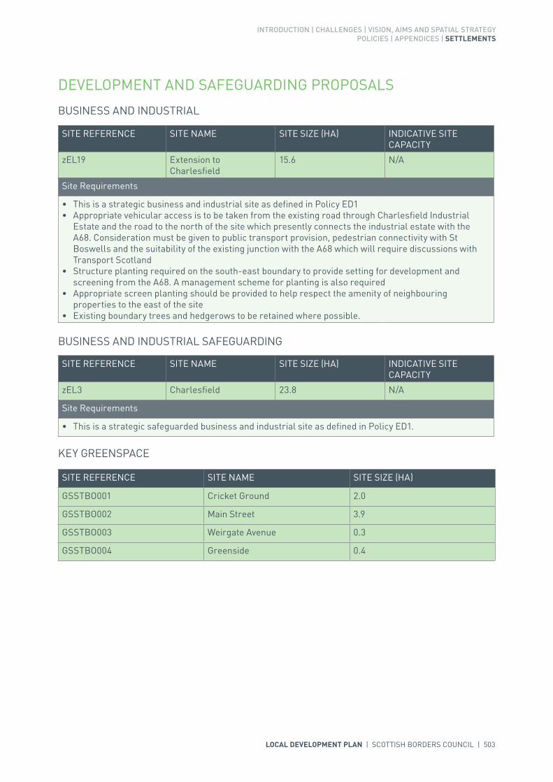
INTRODUCTION | CHALLENGES | VISION, AIMS AND SPATIAL STRATEGYPOLICIES | APPENDICES | SETTLEMENTS
LOCAL DEVELOPMENT PLAN | SCOTTISH BORDERS COUNCIL | 503
SITE REFERENCE SITE NAME SITE SIZE (HA) INDICATIVE SITE CAPACITY
zEL19 Extension to Charlesfield
15.6 N/A
Site Requirements
• This is a strategic business and industrial site as defined in Policy ED1• Appropriate vehicular access is to be taken from the existing road through Charlesfield Industrial
Estate and the road to the north of the site which presently connects the industrial estate with the A68. Consideration must be given to public transport provision, pedestrian connectivity with St Boswells and the suitability of the existing junction with the A68 which will require discussions with Transport Scotland
• Structure planting required on the south-east boundary to provide setting for development and screening from the A68. A management scheme for planting is also required
• Appropriate screen planting should be provided to help respect the amenity of neighbouring properties to the east of the site
• Existing boundary trees and hedgerows to be retained where possible.
DEVELOPMENT AND SAFEGUARDING PROPOSALS
BUSINESS AND INDUSTRIAL
BUSINESS AND INDUSTRIAL SAFEGUARDING
SITE REFERENCE SITE NAME SITE SIZE (HA) INDICATIVE SITE CAPACITY
zEL3 Charlesfield 23.8 N/A
Site Requirements
• This is a strategic safeguarded business and industrial site as defined in Policy ED1.
SITE REFERENCE SITE NAME SITE SIZE (HA)
GSSTBO001 Cricket Ground 2.0
GSSTBO002 Main Street 3.9
GSSTBO003 Weirgate Avenue 0.3
GSSTBO004 Greenside 0.4
KEY GREENSPACE

504 | LOCAL DEVELOPMENT PLAN | SCOTTISH BORDERS COUNCIL

INTRODUCTION | CHALLENGES | VISION, AIMS AND SPATIAL STRATEGYPOLICIES | APPENDICES | SETTLEMENTS
LOCAL DEVELOPMENT PLAN | SCOTTISH BORDERS COUNCIL | 505
SETTLEMENT PROFILE STICHILL
This profile should be read in conjunction with the relevant settlement map.
DESCRIPTIONStichill is partially located within the Central Borders Strategic Development Area as defined in the Development Strategy in the Strategic Development Plan and is located in the Central Housing Market Area, 3 miles to the north of Kelso. According to the 2001 Census the population of the settlement was 126.
PLACE MAKING CONSIDERATIONSStichill is situated in an elevated position with views to the south over Eden Water and the Tweed Valley towards the Cheviot Hills. Development within the settlement is focused along Ednam Road and the B6364, Kelso to Greenlaw Road, which runs through the village.
There has been recent development within Stichill at Ednam Road and there is no land proposed for development within Stichill in the period of this Local Development Plan. However the village is located within the Central Strategic Development Area and development could potentially take place in the future.
The Plan identifies one greenspace for protection within Stichill at the Village Hall Play Area.
INFRASTRUCTURE CONSIDERATIONSAffordable Housing will require to be provided in association with proposed housing sites under the provisions of Policy HD1 and the Supplementary Guidance/Supplementary Planning Guidance on Affordable Housing.
The accommodation and facilities at Kelso High School have been identified as being unsuitable for future use particularly when the areas for longer term development are taken onto account. It has been agreed to build a new, modern school nearby the current site. The new school is due to open in 2016. In accordance with developer contribution policy, a contribution towards the additional facilities at the new Kelso High School will be sought, to recoup the capital invested by the Council.
With regards to Waste Water Treatment Works, Stichill has limited capacity. Contributions may be required where upgrades are necessary. In respect of the local water network, developers may be required to contribute towards upgrading to enable development.

506 | LOCAL DEVELOPMENT PLAN | SCOTTISH BORDERS COUNCIL
Further information is available from Supplementary Guidance/Supplementary Planning Guidance on Developer Contributions.
DEVELOPMENT AND SAFEGUARDING PROPOSALS
KEY GREENSPACE
SITE REFERENCE SITE NAME SITE SIZE (HA)
GSSTIC001 Village Hall Play Area 0.04

LOCAL DEVELOPMENT PLAN | SCOTTISH BORDERS COUNCIL | 507
508 | LOCAL DEVELOPMENT PLAN | SCOTTISH BORDERS COUNCIL
SETTLEMENT PROFILE STOW
This profile should be read in conjunction with the relevant settlement map.
DESCRIPTIONStow is located almost 8 miles north from Galashiels on the A7. The population of Stow according to the 2001 Census is 596. It is located outwith the Strategic Development Areas as defined in the Strategic Development Plan and sits in the Northern Housing Market Area.
PLACE MAKING CONSIDERATIONSThe village is located in the pastoral upland valley of the Gala Water. Its character is influenced by the nearby divided moorland of the Moorfoot Plateau and the plateau grassland of the Lauder Common. It sits along the river valley of the Gala Water and is framed between Stagehall Hill to the west and Torsonce Hill, Sell Moor and Craigend Hill in the east. The Gala Water, which meanders along the valley floor within the settlement, has a large area of flood plain to both eastern and western banks. This flood plain is a dominant feature of the village. The village itself lies predominately on the eastern side of the river.
The Conservation Area for Stow takes in much of the centre of the original settlement and includes the Subscription Bridge and the Church of St Mary of Wedale. The settlement is centred round the remains of the Old Parish Church and the remains of the Bishop of St Andrew’s manor house that is also known as the ‘palace’; and in addition to those properties also retains many of the historic properties that are only found in such a distinctive place.
The settlement of Stow is built-up of a range of different styles and types of properties. These range from the small, single storey cottage type, modern detached two storey to the grand baronial Town Hall. At the centre of Stow is the Pennywhiggam Burn which flows through the settlement (east/west) and is bounded by ash trees and provides a green space. Traditional building materials within the settlement vary from whin and sandstone, slate and harl; and architectural elements like rybats, margins and transom lights are also notable throughout Stow.
The plan provides one housing allocation to the north of the village along Craigend Road, and another to the south at Stagehall II. A mixed use site is also provided within the centre of the village on the former Royal Hotel site. The plan also provides a new site for a railway station.
In addition, the Plan identifies the Stow Playing Field as a key greenspace as it provides the Stow community with many important recreation opportunities.
Once the allocated sites are fully developed the preferred area for future expansion beyond the period of this Local Development Plan will be an area north east of Stow at Craigend and two areas at Lugate,

INTRODUCTION | CHALLENGES | VISION, AIMS AND SPATIAL STRATEGYPOLICIES | APPENDICES | SETTLEMENTS
LOCAL DEVELOPMENT PLAN | SCOTTISH BORDERS COUNCIL | 509
south west of Stow. These sites are considered to have potential for longer term mixed use development. The Craigend site was identified as an opportunity for development and the Lugate sites were identified as an opportunity for a new settlement in the Development and Landscape Capacity Study. The proposed Railway Station will provide good accessibility by public transport to these potential longer term development areas. The Craigend site would require a new or improved access to the A7 and the Lugate sites would require a new access onto the A7. Moreover longer term employment land to meet general business needs would be beneficial in these areas. These areas will be subject to further assessment as part of the next Local Development Plan Review and will require a Masterplan to ensure a coherent and holistic approach.
During the lifetime of the Local Development Plan should a further site for a car park associated with the railway station be required; the Council will support a new car park associated with the railway station at an appropriate location outwith the Development Boundary.
INFRASTRUCTURE CONSIDERATIONSAffordable Housing will require to be provided in association with proposed housing sites under the provisions of Policy HD1 and the Supplementary Guidance/Supplementary Planning Guidance on Affordable Housing.
In relation to education provision there is currently no requirement for development contributions.
This settlement is identified within the Council’s Flood Contingency Plan as being at risk of flooding. Any development proposals should therefore be subject to early consultation with the Council’s Flood and Coastal Management Officer, and SEPA, having regard to the Indicative River and Coastal Flood Map (Scotland). A flood risk assessment may be required and may influence the scale and layout of any development at a particular location.
Stow falls within an area identified for a contribution to the Waverley Railway Project (see Policy IS3).
With regards to Waste Water Treatment Works, Stow has limited capacity. Contributions may be required where upgrades are necessary. In respect of the local water network, developers may be required to contribute towards upgrading to enable development.
Further information is available from Supplementary Guidance/Supplementary Planning Guidance on Developer Contributions and Planning/Development Briefs where applicable.
DEVELOPMENT AND SAFEGUARDING PROPOSALS
HOUSING
SITE REFERENCE SITE NAME SITE SIZE (HA) INDICATIVE SITE CAPACITY
ASTOW022 Craigend Road 1.0 10
Site Requirements
• Vehicular access from Craigend Road. Traffic issues to be assessed and mitigated include pinch points in the road, on street parking, carriageway width and footway provision
• Assessment and mitigation of flood risk from overland flow• Assessment and mitigation of moderate biodiversity interest, including the nearby Gala Water, part of
the Tweed Special Area of Conservation. The burn east of the site drains into this• Structural planting/ landscaping, including trees, in the north of the site to contain it and create a new
settlement boundary. Structural planting/ landscaping on the edges of the site to frame development• Long term maintenance of landscaped areas needs to be addressed• Utilise the south facing aspect of the site for energy efficiency• The route of the core path on Craigend Road should be retained.

510 | LOCAL DEVELOPMENT PLAN | SCOTTISH BORDERS COUNCIL
MIXED USE
SITE REFERENCE SITE NAME SITE SIZE (HA) INDICATIVE SITE CAPACITY
MSTOW001 Royal Hotel 0.2 11
Site Requirements
• Refer to approved planning brief and, additionally, a flood risk assessment will be required.
SITE REFERENCE SITE NAME SITE SIZE (HA)
GSSTOW001 Playing Field 2.5
KEY GREENSPACE
TRANSPORTATION
SITE REFERENCE SITE NAME SITE SIZE (HA) INDICATIVE SITE CAPACITY
TSTOW001 North of Edinburgh Rd (Railway Station)
0.8 N/A
Site Requirements
• Vehicular access to the site will be taken from the Station Road and will also serve the primary school• The site will include a car park.
ASTOW027 Stagehall II 1.2 12
Site Requirements
• Existing landscaping on site to be retained and enhanced. The introduction of structure planting along the south and south eastern edges of the site will be required to provide a defensible settlement edge. Buffer areas for new and existing landscaping will be required. The long term maintenance of landscaped areas must be addressed
• Careful consideration should be given to the design of the overall site to take account of its position in the landscape and views into the site from the A7
• Surface water run off from the surrounding area will be required to be considered during the design stage and mitigation put in place
• Consideration to be given to the need for a flood risk assessment• The stone boundary wall on site to be retained and incorporated into the overall design for the site• Vehicular access to be taken from the adjacent housing development – Wedale View. Alterations
and traffic calming measures along Wedale View and to its junction with Station Road will also be required. Parking arrangements will be required to be accommodated on site
• Provision of amenity access in the development for pedestrians and cyclists. Links to the footpath network to be created and amenity maintained and enhanced.

LOCAL DEVELOPMENT PLAN | SCOTTISH BORDERS COUNCIL | 511

512 | LOCAL DEVELOPMENT PLAN | SCOTTISH BORDERS COUNCIL
SETTLEMENT PROFILE SWINTON
This profile should be read in conjunction with the relevant settlement map.
DESCRIPTIONSwinton is located 6 miles from Duns and 12 miles from Berwick upon Tweed. The population according to the 2001 Census was 224. Swinton is located outwith the Strategic Development Areas (SDA) identified by the SESplan.
PLACE MAKING CONSIDERATIONSSwinton is located on the lowlands associated with the River Tweed contained within rolling arable and pasture fields. The settlement was re-designed in the 18th Century and laid out with a village green and Market Cross. There has been limited expansion east and west but the layout remains largely intact. Swinton is primarily residential, although some services are located at the eastern end.
The Conservation Area comprises most of the planned estate village centring on the village green. There is a distinct layout placed along a single terrace row with only a few detached properties. The majority of properties are constructed of traditional materials such as sandstone and slate, or they are harled. Architectural detailing such as, timber bargeboards, continuous cills at upper floors, sash and case windows, and transom lights appear frequently. These built fabric elements help form the character of the Conservation Area. Any new development or alterations must aim to respect the importance of the layout and built fabric features. There are 31 Listed Buildings within Swinton.
The site assessment process in preparation of the Local Development Plan (LDP) identified the possibility of an additional allocation to the south-east of Swinton which would bring forward further housing and the possibility of community benefit. As a result a mixed use allocation (MSWIN002) is included in the LDP for which land must be included for community benefit in any development proposal.
The Consolidated Local Plan stated that the preferred area for expansion of the settlement would be to the south-east. There is now an allocation in this area which will cater for the development need of Swinton in the LDP period and likely beyond. The area to the north-west of the settlement is subject to a Tree Preservation Order. The surrounds of Swinton are designated as prime agricultural land.

INTRODUCTION | CHALLENGES | VISION, AIMS AND SPATIAL STRATEGYPOLICIES | APPENDICES | SETTLEMENTS
LOCAL DEVELOPMENT PLAN | SCOTTISH BORDERS COUNCIL | 513
INFRASTRUCTURE CONSIDERATIONSAffordable Housing will require to be provided under the provisions of Policy HD1 and the Supplementary Guidance/Supplementary Planning Guidance on Affordable Housing.
A contribution towards Berwickshire High School will be sought to supplement Scottish Borders Council’s investment in the new school which opened in 2009-2010 under the 3 High Schools project.
There is sufficient capacity at the Waste Water Treatment Works. However a drainage impact assessment will be required on the network. There is limited environmental capacity in the receiving waters.
Further information is available from Supplementary Guidance/Supplementary Planning Guidance on Developer Contributions and Planning Briefs where applicable.
DEVELOPMENT AND SAFEGUARDING PROPOSALS
HOUSING
SITE REFERENCE SITE NAME SITE SIZE (HA) INDICATIVE SITE CAPACITY
BSW2B Well Field 1.4 25
Site Requirements
• Property orientation should take advantage of the southerly aspect and potential of long views from the site
• Vehicular and pedestrian access should be taken from Main Street (the A6112) in line with advice from the Roads Planning team
• Vehicular and pedestrian access should link through the site to the mixed use allocation to the south• The amenity of neighbouring properties should be respected• Planting at the edges of the site should be retained where appropriate.
BUSINESS AND INDUSTRIAL SAFEGUARDING
SITE REFERENCE SITE NAME SITE SIZE (HA) INDICATIVE SITE CAPACITY
zEL45 Coldstream Road 1.2 N/A
Site Requirements
• This is a local safeguarded business and industrial site as defined in Policy ED1.

514 | LOCAL DEVELOPMENT PLAN | SCOTTISH BORDERS COUNCIL
MIXED USE
SITE REFERENCE SITE NAME SITE SIZE (HA) INDICATIVE SITE CAPACITY
MSWIN002 Land Adjacent to Swinton Primary School
3.0 25
Site Requirements
• Any proposal must present complimentary uses reflecting the mixed use nature of the allocation, this should include consideration of the provision of community facilities, including playing fields
• Ensure vehicular and pedestrian access from the A6112 (Coldstream Road) in line with advice from the Council’s Roads Planning team
• Ensure vehicular and pedestrian access through the site from the A6112 (Main Street) and the allocated housing site to the north
• Provide structure planting on the southern and western boundaries to screen the site from the entry to Swinton from the south; to provide a settlement boundary; and to provide enclosure to the site
• Orientate buildings to take advantage of the southerly aspect and views out of the site.
SITE REFERENCE SITE NAME SITE SIZE (HA)
GSSWIN001 Village Green 0.6
KEY GREENSPACE

LOCAL DEVELOPMENT PLAN | SCOTTISH BORDERS COUNCIL | 515

516 | LOCAL DEVELOPMENT PLAN | SCOTTISH BORDERS COUNCIL
SETTLEMENT PROFILE TRAQUAIR
This profile should be read in conjunction with the relevant settlement map.
DESCRIPTIONTraquair is located two miles south of Innerleithen. The population of Traquair according to the 2001 Census is 51. The settlement is located partly outwith the Western Strategic Development Area as defined in the Strategic Development Plan and is also located within the Northern Housing Market Area.
PLACE MAKING CONSIDERATIONSThe village lies on the lower and western slopes of Plora Rig and Damhead. It faces west and is situated within the Quair Water valley floor, which opens out to the north towards Innerleithen. The views out of the village are generally of lower undulating hills with the exception of to the north towards Lee Pen and Kirnie Law.
Traquair has a small scale rural appearance, the area is characterised by groupings of modest traditionally constructed houses separated by agricultural fields and commercial woodland planting on the higher ground.
Traquair is situated in close proximity to the Quair Water and Fingland Burn both of which are designated Special Areas of Conservation.
The Plan does not propose to allocate any sites at Traquair. It is considered that the village is not suited to large scale development.
INFRASTRUCTURE CONSIDERATIONSAffordable Housing will require to be provided in association with proposed housing sites under the provisions of Policy HD1 and the Supplementary Guidance/Supplementary Planning Guidance on Affordable Housing.
Peebles Secondary School is forecast by the Director of Education and Lifelong Learning to face some capacity issues from 2016 onwards. Developer Contribution towards school provision within the catchment will be requested, commensurate with the size and type of the development and in accordance with Developer Contribution Policy.

INTRODUCTION | CHALLENGES | VISION, AIMS AND SPATIAL STRATEGYPOLICIES | APPENDICES | SETTLEMENTS
LOCAL DEVELOPMENT PLAN | SCOTTISH BORDERS COUNCIL | 517
With regards to waste water, Traquair is served by a septic tank which currently has limited capacity. Contributions may be required where upgrades are necessary. In respect of the local water network, developers may be required to contribute towards upgrading to enable development.
Further information is available from Supplementary Guidance/Supplementary Planning Guidance on Developer Contributions.

518 | LOCAL DEVELOPMENT PLAN | SCOTTISH BORDERS COUNCIL

INTRODUCTION | CHALLENGES | VISION, AIMS AND SPATIAL STRATEGYPOLICIES | APPENDICES | SETTLEMENTS
LOCAL DEVELOPMENT PLAN | SCOTTISH BORDERS COUNCIL | 519
SETTLEMENT PROFILE TWEEDBANK
This profile should be read in conjunction with the relevant settlement map.
DESCRIPTIONTweedbank, located less than one mile east of Galashiels, has a population of 1,716 according to the 2001 Census. It is located within the Central Borders Strategic Development Area as defined in the SESplan.
PLACE MAKING CONSIDERATIONSThe character of Tweedbank is established by its layout and countryside setting. Its layout is made up of clusters of development along Tweedbank Drive. It is situated in the upland fringe valley with settlements opposite the confluence of the River Tweed and the Gala Water.
To the east of the settlement boundary is the Eildon and Leaderfoot National Scenic Area. The River Tweed Special Area of Conservation, a wildlife site of international importance, is north of the settlement. South of the settlement is the Tweed, Ettrick and Yarrow Confluences Special Landscape Area. Other landscape features in Tweedbank include tree belts which screen it from the A609 trunk road and Tweedbank Park with its Gun Knowe Loch.
Tweedbank was planned as a new village in the 1970s and has become a successful and thriving new community with a recent large residential development opposite Gun Knowe Loch.
Policy EP6 (Countryside Around Towns) seeks to protect the area between Darnick and Tweedbank from development in the longer term, primarily to avoid coalescence of the settlements, thereby retaining individual character.
The railway terminal for the Borders Railway is planned for Tweedbank and the village is therefore seen as an appropriate location for growth. The area around Tweedbank is protected under policy EP6 Countryside Around Towns.
Tweedbank Industrial Estate is one of the most successful in the Borders. The Plan takes forward the restructuring of the existing industrial estate and a mixed use site to the east of the railway terminal. Tweedbank Industrial Estate and Tweedside Park have many advantages and attractive development features. They are well located in terms of roads and footway access and are ideally placed to capitalise on the arrival of the Borders Railway, with the terminal being located within close proximity. The sites have a good internal roads layout, are serviced and benefit from a mature landscaping and screening scheme. The industrial estate is, however, suffering from an ageing and increasingly

520 | LOCAL DEVELOPMENT PLAN | SCOTTISH BORDERS COUNCIL
substandard building stock and the size and layout of both the buildings and external yard areas are not consistent with modern development requirements. There are therefore significant opportunities in Tweedbank to create a high quality business and industrial estate which capitalises on the railway terminal and provides a supply of industrial and business land for the central Borders within the period of this Local Development Plan.
There are two areas, at Tweedbank Park and the playing fields, identified as key greenspaces.
INFRASTRUCTURE CONSIDERATIONSAffordable Housing will require to be provided in association with proposed housing sites under the provisions of Policy HD1 and the Supplementary Guidance/ Supplementary Planning Guidance on Affordable Housing.
There is no requirement for contribution towards education provision.
The settlement falls within an area identified for a contribution to the Borders Railway (See Policy IS3).
In accordance with the Council’s Local Transport Strategy, a Central Borders Traffic Model has been developed which will help direct funding to areas of the road network that may become congested in the future. Developer contributions will be sought from developments within the Central Borders in accordance with the Supplementary Guidance/Supplementary Planning Guidance on Developer Contributions.
With regards to Waste Water Treatment Works and Water Treatment Works, Tweedbank currently has sufficient capacity.
Further information is available from Supplementary Guidance/Supplementary Planning Guidance on Developer Contributions and Planning/Development Briefs where applicable.
DEVELOPMENT AND SAFEGUARDING PROPOSALS
BUSINESS AND INDUSTRIAL SAFEGUARDING
SITE REFERENCE SITE NAME SITE SIZE (HA) INDICATIVE SITE CAPACITY
zEL59 North of Tweedbank Drive
6.3 N/A
Site Requirements
• This is a strategic high amenity safeguarded business and industrial site as defined in Policy ED1.
zEL39 Tweedbank Industrial Estate
10.8 N/A
Site Requirements
• It is intended that a Planning Brief in the form of Supplementary Guidance will be produced for this site
• This is a strategic safeguarded business and industrial site as defined in Policy ED1. It is expected that it will become a Strategic High Amenity Site through the period of the Local Development Plan, whereby the restructuring of the existing Industrial Estate is necessary in order to promote the area as a high amenity estate through a more efficient use of land and buildings
• Development on land immediately adjacent to the A6091 would require to be of high quality and design and would be restricted to Class 4 use. Careful consideration would require to be given to landscaping, particularly along the southern edge of the site, in order to ensure an attractive edge to the business and industrial site.

INTRODUCTION | CHALLENGES | VISION, AIMS AND SPATIAL STRATEGYPOLICIES | APPENDICES | SETTLEMENTS
LOCAL DEVELOPMENT PLAN | SCOTTISH BORDERS COUNCIL | 521
MIXED USE
SITE REFERENCE SITE NAME SITE SIZE (HA) INDICATIVE SITE CAPACITY
MTWEE001 Site east of railway terminal
1.0 N/A
Site Requirements
• Access via existing Tweedside Park to the east and from zRS1 to the west• Substantial planting required on mutual western boundary with railway station.• New site to be formed for mixed use purposes along with the restructuring of the existing
landholdings within Tweedbank Industrial Estate• It is expected that the site would be developed for commercial mixed use. Housing would not be
appropriate on this site, given it’s proximity to the Railway Station (zRS1) and the business and industrial land to the east (zEL59).
SITE REFERENCE SITE NAME SITE SIZE (HA)
GSTWEE001 Tweedbank Sports Centre 5.6
GSTWEE002 Gun Knowe Park 11.4
KEY GREENSPACE
TRANSPORTATION
SITE REFERENCE SITE NAME SITE SIZE (HA) INDICATIVE SITE CAPACITY
zRS1 Tweedbank (Railway Station)
2.7 N/A
Site Requirements
• Vehicular and pedestrian access from Tweedbank Drive • Vehicular and pedestrian link to mixed use site to the east (MTWEE001) to be provided• The site will include car and cycle parking.
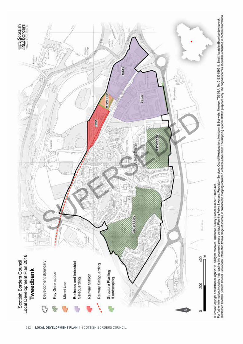
522 | LOCAL DEVELOPMENT PLAN | SCOTTISH BORDERS COUNCIL
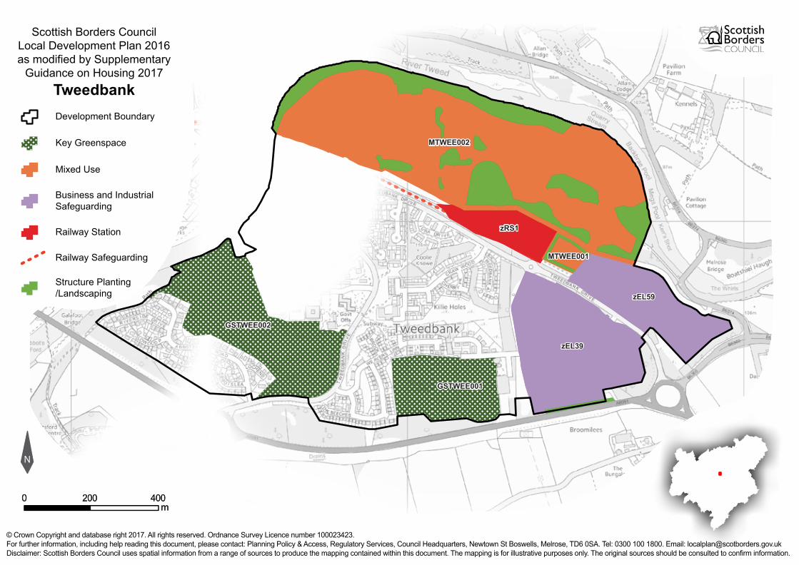
N
Scottish Borders CouncilLocal Development Plan 2016as modified by Supplementary
Guidance on Housing 2017Tweedbank
© Crown Copyright and database right 2017. All rights reserved. Ordnance Survey Licence number 100023423.For further information, including help reading this document, please contact: Planning Policy & Access, Regulatory Services, Council Headquarters, Newtown St Boswells, Melrose, TD6 0SA. Tel: 0300 100 1800. Email: [email protected]: Scottish Borders Council uses spatial information from a range of sources to produce the mapping contained within this document. The mapping is for illustrative purposes only. The original sources should be consulted to confirm information.
00mm
400400200200
Development Boundary
Railway Station
Business and IndustrialSafeguarding
Mixed Use
Key Greenspace
Structure Planting/Landscaping
GSTWEE001GSTWEE001
GSTWEE002GSTWEE002
zEL39zEL39
zEL59zEL59
zRS1zRS1
MTWEE001MTWEE001Railway Safeguarding
MTWEE002MTWEE002

INTRODUCTION | CHALLENGES | VISION, AIMS AND SPATIAL STRATEGYPOLICIES | APPENDICES | SETTLEMENTS
LOCAL DEVELOPMENT PLAN | SCOTTISH BORDERS COUNCIL | 523
SETTLEMENT PROFILE WALKERBURN
This profile should be read in conjunction with the relevant settlement map.
DESCRIPTIONWalkerburn is located almost two miles east of Innerleithen. The population of Walkerburn according to the 2001 Census is 676. It is located within the Western Strategic Development Area as defined in the Strategic Development Plan.
PLACE MAKING CONSIDERATIONSThe village sits with a steep side river valley on the lower south facing slopes of Cairn Hill and Kirna Law. The land falls towards the River Tweed and then rises again steeply to the south towards Elibank Law and Plora Rig. The village of Walkerburn grew up around the Ballantyne’s Mill, built in 1854, however prior to that the only trace of habitation in this area was Caberston farmhouse and steading.
The village lies within the Central Southern Uplands Regional Landscape Area and is described as Upland Valley with Woodland. There are significant habitat networks in and around the Walker Burn, the forestry plantations on adjoining hillsides and the Tweed and open haughland. The River Tweed runs along the southern edge of the village and the land along this edge is susceptible to flooding. There is also the Walker Burn, which may give rise to localised flooding. The River Tweed to the south of the village is a Special Site of Scientific Interest (SSSI) and Special Area of Conservation (SAC).
Focused within the centre of the settlement there is a high concentration of listed buildings including the attractive Caberston Steading. With a basic linear form, the village runs along the route of the A72 and much of the established settlement takes the form of a range of split level houses and cottages along the roadside. To the west of the village is a group of later semi detached stone built cottages which would have been built as the village prospered at Caberston Avenue whilst to the east of the village on the north side of the main road are large houses built for the Mill owner which sit within well established mature garden grounds. The later development has generally been to the east of the village at Tweedholm, which runs parallel to the main road.
The Plan provides two housing allocations to the north of the settlement at Caberston Farm. A redevelopment opportunity is also allocated in the centre of the village taking in part of the Caberston Farm and Old Mill Site. Three areas of greenspace are also identified for protection.
The Local Development Plan does not identify any further areas for long term development in Walkerburn.
524 | LOCAL DEVELOPMENT PLAN | SCOTTISH BORDERS COUNCIL
INFRASTRUCTURE CONSIDERATIONSAffordable Housing will require to be provided in association with proposed housing sites under the provisions of Policy HD1 and the Supplementary Guidance/Supplementary Planning Guidance on Affordable Housing.
Peebles Secondary School is forecast by the Director of Education and Lifelong Learning to face some capacity issues from 2016 onwards. Developer Contribution towards school provision within the catchment will be requested, commensurate with the size and type of the development and in accordance with Developer Contribution Policy.
This settlement is identified within the Council’s Flood Contingency Plan as being at risk of flooding. Any development proposals should therefore be subject to early consultation with the Council’s Flood and Coastal Management Officer, and SEPA, having regard to the Indicative River and Coastal Flood Map (Scotland). A flood risk assessment may be required and may influence the scale and layout of any development at a particular location.
With regards to Waste Water Treatment Works and Water Treatment Works, Walkerburn currently has sufficient capacity.
Further information is available from Supplementary Guidance/Supplementary Planning Guidance on Developer Contributions and Planning/Development Briefs where applicable.
DEVELOPMENT AND SAFEGUARDING PROPOSALS
HOUSING
SITE REFERENCE SITE NAME SITE SIZE (HA) INDICATIVE SITE CAPACITY
TW200 Caberston Farm Land 1.6 30
Site Requirements
• It is intended that a Planning Brief in the form of Supplementary Guidance will be produced for this site• Access to this site would be via the allocated site zR200• Provision of amenity access within the development for pedestrians and cyclists will be required.
Links to the Core Paths to be created and amenity maintained and enhanced. The Right of Way BT98 runs adjacent to the site, amenity side of access would be lost unless there were landscape mitigation measures in place
• The long term maintenance of landscaped areas must be addressed• Existing stone walls to be maintained and incorporated into access routes where possible• Mitigation measures are required to prevent any impact on the River Tweed Special Areas of
Conservation/Sites of Special Scientific Interest• Archaeological evaluation will be required along with associated mitigation• A flood risk assessment will be required to inform the development of the site.
INTRODUCTION | CHALLENGES | VISION, AIMS AND SPATIAL STRATEGYPOLICIES | APPENDICES | SETTLEMENTS
LOCAL DEVELOPMENT PLAN | SCOTTISH BORDERS COUNCIL | 525
AWALK005 Caberston Farm Land II 3.3 100
Site Requirements
• It is intended that a Planning Brief in the form of Supplementary Guidance will be produced for this site• Access to this site would be via the allocated sites zR200 and then TW200• New woodland structure planting is required providing a setting and shelter for housing development as
well as reinforcing the settlement edge. The use of mixed broadleaved woodland including forest trees such as oak, ash, Scots pine and beech along with the establishment of a shrub layer will be required. These areas are also useful for informal recreation and should be made accessible through appropriate access routes. Buffer areas alongside new and existing landscaping will be required
• Provision of amenity access within the development for pedestrians and cyclists will be required. Links to the Core Paths to be created and amenity maintained and enhanced. The Right of Way BT98 runs adjacent to the site, amenity side of access would be lost unless there were landscape mitigation measures in place
• The long term maintenance of landscaped areas must be addressed• Existing stone walls to be maintained and incorporated into access routes where possible• Mitigation measures are required to prevent any impact on the River Tweed Special Areas of
Conservation/Sites of Special Scientific Interest• Development should not take place within the setting of the Scheduled Monument. Archaeological
evaluation will be required along with associated mitigation• A flood risk assessment will be required to inform the development of the site.
SITE REFERENCE SITE NAME SITE SIZE (HA) INDICATIVE SITE CAPACITY
zR200 Caberston Farm/Old Mill Site
1.9 TBC
Site Requirements
• It is intended that a Planning Brief in the form of Supplementary Guidance will be produced for this site• Retention and conversion of the historic buildings on the site (including the two storey dwelling house to
the south of the steading) however, this does not preclude an element of good quality modern build also taking place within the site
• Existing stone walls to be maintained and incorporated into access routes where possible• A flood risk assessment will be required to inform the development of the site• A watercourse buffer strip will be required• Further assessment on nature conservation and archaeological interest may also be required and
mitigation put in place• Enhancement of existing landscaping on site and the long term maintenance of landscaped areas must
be addressed• The main vehicular access to the site will be via the A72. The site will also be required to allow for
vehicular and pedestrian access through to the adjacent housing sites – TW200 and AWALK005. Parking provision will be required to be accommodated onsite
• Provision of amenity access within and through the development for pedestrians and cyclists. Links to the Core Paths to be created and amenity maintained and enhanced. The Right of Way BT98 runs adjacent to the site, amenity side of access would be lost unless there were landscape mitigation measures in place.
REDEVELOPMENT
SITE REFERENCE SITE NAME SITE SIZE (HA)
GSWALK001 Walkerburn RFC 0.9
GSWALK002 Village Green 0.1
GSWALK003 Alexandra Park 2.5
KEY GREENSPACE

526 | LOCAL DEVELOPMENT PLAN | SCOTTISH BORDERS COUNCIL

INTRODUCTION | CHALLENGES | VISION, AIMS AND SPATIAL STRATEGYPOLICIES | APPENDICES | SETTLEMENTS
LOCAL DEVELOPMENT PLAN | SCOTTISH BORDERS COUNCIL | 527
SETTLEMENT PROFILE WEST LINTON
This profile should be read in conjunction with the relevant settlement map.
DESCRIPTIONWest Linton is located almost 14 miles north west of Peebles. The population of West Linton according to the 2001 Census is 1559. It is located outwith the Strategic Development Areas as defined in the Strategic Development Plan.
PLACE MAKING CONSIDERATIONSThe character of West Linton is established particularly by its setting as it lies at the foot of the Pentland Hills Special Landscape Area where it clusters around the valley and gorge of the Lyne Water. The Lyne Water designated a Special Area of Conservation runs through the settlement. The Lyne Dale Ancient Woodland also sits within the settlement to the northwest off Medwyn Road. The settlement benefits particularly from long views to the south across the level fields.
The original settlement of which much of it is a Conservation Area includes a considerable part of the historic settlement and the tree-lined approach along Station Road. The narrow winding streets and paths that run through the village provide a distinctive spatial identity. Raemartin Square especially forms a break out space along the narrow Main Street. Both the Upper and the Lower Green offer a significant amount of green space along the Lyne Water of which glimpses can be seen from the Main Street.
Properties tend to be one and a half, to two storeys in height. Some gable-fronted properties can be found such as the bank on the Main Street. Larger detached and semi-detached properties can also be found to the periphery of the settlement. While traditional building materials prevail within the Conservation Area such as sandstone, harling, slate and even lime-wash (though now painted over) so too do many of the architectural details – sash and case windows, timber doors, margins and rybats, and transom lights. Other details that are also common are exposed rafter feet, stone boundary walls and corner protectors.
The village of West Linton benefits from a diverse range of services and facilities to serve the local community including a bank, chemist and a post office. The settlement also benefits from a supermarket which is situated within the centre of the settlement along the Main Street. West Linton is considered to be one of the healthier settlements within the Scottish Borders with generally a low vacancy rate.
The Plan provides three housing allocations; these are Robinsland, Robinsland Steading and School Brae. A Business and Industrial Land site is also identified at Deanfoot Road.

528 | LOCAL DEVELOPMENT PLAN | SCOTTISH BORDERS COUNCIL
The Plan also identifies a number of greenspaces within the settlement including the Lower Green and the Upper Green; these spaces provide the West Linton community with many important recreation opportunities.
INFRASTRUCTURE CONSIDERATIONSAffordable Housing will require to be provided in association with proposed housing sites under the provisions of Policy HD1 and the Supplementary Guidance/Supplementary Planning Guidance on Affordable Housing.
Peebles Secondary School is forecast by the Director of Education and Lifelong Learning to face some capacity issues from 2016 onwards. Developer Contribution towards school provision within the catchment will be requested, commensurate with the size and type of the development and in accordance with Developer Contribution Policy.
A contribution at the new school rate towards West Linton Primary School will be sought to supplement Scottish Borders Council’s investment in the new school.
NHS Borders have stated that there are predicted pressures on health services accommodation which may require upgrade or development longer-term.
With regards to Waste Water Treatment Works West Linton has limited capacity. Contributions may be required where upgrades are necessary. In respect of the local water network, developers may be required to contribute towards upgrading to enable development.
Housing site TWL8B will require vehicular access through school site zSS9, from Robinsland Drive and probably also from Deanfoot Road. A Development Contribution towards road access will be required.
Further information is available from Supplementary Guidance/Supplementary Planning Guidance on Developer Contributions and Planning/Development Briefs where applicable.
DEVELOPMENT AND SAFEGUARDING PROPOSALS
HOUSING
SITE REFERENCE SITE NAME SITE SIZE (HA) INDICATIVE SITE CAPACITY
TWL8B Robinsland 2.3 46
Site Requirements
• Refer to approved Planning Brief.
TWL15B School Brae 0.4 10
Site Requirements
• Consideration of retention or partial retention and conversion of the building on site• The boundary walls of the site to be retained and incorporated into the development in order to reflect
the former school use on the site• Vehicular access to be achieved off School Brae and parking for the development to be provided onsite• Provision of amenity access within and through the development for pedestrians and cyclists• Landscape enhancement to be provided onsite to assist in softening the edges of the development and
integrate it into its surroundings• Further assessment on nature conservation interest may also be required and mitigation put in place.

INTRODUCTION | CHALLENGES | VISION, AIMS AND SPATIAL STRATEGYPOLICIES | APPENDICES | SETTLEMENTS
LOCAL DEVELOPMENT PLAN | SCOTTISH BORDERS COUNCIL | 529
SITE REFERENCE SITE NAME SITE SIZE (HA)
GSWEST001 Upper Green 0.8
GSWEST002 Lower Green 2.8
GSWEST003 Bogsbank Road 1.0
GSWEST004 Station Road 0.1
GSWEST005 War Memorial 0.1
KEY GREENSPACE
AWEST009 Robinsland Steading 2.2 40
Site Requirements
• A vehicular link will be required via the upgraded Robinsland Track• Woodland planting will be required along the east and south east part of the site with buffer areas
alongside new and existing landscaping• The long term maintenance of landscaped areas must be addressed• Mitigation measures are required to prevent any impact on the River Tweed Special Areas of
Conservation (Lyne Water)• Further assessment on nature conservation interest will also be required and mitigation put in place• Provision of amenity access within the development for pedestrians and cyclists. Existing stone walls
to be maintained and incorporated into access routes• The retention and conversion of traditional stone buildings on site will be required in order to retain a
traditional historic edge to the settlement.
SITE REFERENCE SITE NAME SITE SIZE (HA) INDICATIVE SITE CAPACITY
zEL18 Deanfoot Road 0.7 N/A
Site Requirements
• This is a district business and industrial site as defined in Policy ED1• Vehicular access to be achieved off Deanfoot Road and parking for the development to be provided
onsite• Provision of amenity access within and through the development for pedestrians and cyclists• Creation of woodland buffer along boundaries of site. Long term maintenance of landscaped areas to
be addressed.
BUSINESS AND INDUSTRIAL

530 | LOCAL DEVELOPMENT PLAN | SCOTTISH BORDERS COUNCIL

INTRODUCTION | CHALLENGES | VISION, AIMS AND SPATIAL STRATEGYPOLICIES | APPENDICES | SETTLEMENTS
LOCAL DEVELOPMENT PLAN | SCOTTISH BORDERS COUNCIL | 531
SETTLEMENT PROFILE WESTRUTHER
This profile should be read in conjunction with the relevant settlement map.
DESCRIPTIONWestruther is located in Berwickshire, 11 miles to the west of Duns. According to the 2001 Census the population was 60. The village is located outwith the 3 Strategic Development Areas (SDA) as identified by the SESplan.
PLACE MAKING CONSIDERATIONSWestruther is a small village located in the shadow of the Lammermuir Hills, set within rolling arable and pastoral fields. Westruther is primarily residential and there is older row housing to modern detached housing evident. There are two B-listed buildings in Westruther.
In this Local Development Plan (LDP) period proposed development is better sited elsewhere. Westruther has experienced recent housing development and some plots remain at both Kirkpark and East of Kirkpark.
Once the allocated sites are fully developed the preferred area for future expansion beyond the period of this LDP is to the north of the settlement at Edgar Road.
INFRASTRUCTURE CONSIDERATIONSAffordable Housing will require to be provided under the provisions of Policy H1 and the Supplementary Guidance/Supplementary Planning Guidance on Affordable Housing.
The Director of Education and Lifelong Learning has advised that there are severe capacity issues at Westruther Primary School. A contribution towards Earlston High School will be sought to supplement Scottish Borders Council’s investment in the new school which opened in 2009-2010 under the 3 High Schools project.
With regards to Waste Water Treatment Works and Water Treatment Works, Westruther currently has sufficient capacity.
Further information is available from Supplementary Guidance/Supplementary Planning Guidance on Developer Contributions and Planning Briefs where applicable.
532 | LOCAL DEVELOPMENT PLAN | SCOTTISH BORDERS COUNCIL
DEVELOPMENT AND SAFEGUARDING PROPOSALS
HOUSING
SITE REFERENCE SITE NAME SITE SIZE (HA)
GSWESR001 Westruther Play Area 0.04
KEY GREENSPACE
SITE REFERENCE SITE NAME SITE SIZE (HA) INDICATIVE SITE CAPACITY
AWESR005 East of Kirkpark 0.6 5
Site Requirements
• Vehicular and pedestrian access from the B6456• Pedestrian/cycle access required from the village through the Kirkpark development• Retention of trees on western boundary of site• Ecological survey of woodland and appropriate mitigation• Further assessment of the creation of a village green/open space• Contributions for Earlston High School and Westruther Primary School• Additional boundary screen planting on south-western edge.

LOCAL DEVELOPMENT PLAN | SCOTTISH BORDERS COUNCIL | 533
534 | LOCAL DEVELOPMENT PLAN | SCOTTISH BORDERS COUNCIL
SETTLEMENT PROFILE WHITSOME
This profile should be read in conjunction with the relevant settlement map.
DESCRIPTIONWhitsome is located 7 miles south-east of Duns. The population of the village according to the 2001 Census was 51. Whitsome is located outwith the Strategic Development Areas (SDA) identified in the SESplan.
PLACE MAKING CONSIDERATIONSWhitsome is a settlement of linear form that follows an east to west direction and commands significant views over the Merse and the Cheviots to the South. A variety of property type is evident in the village, from traditional row cottages to more modern detached houses. An allocation is safeguarded for business and industrial land to the east. There is 5 C-Listed Buildings in the settlement.
Whitsome is located outwith the SDA and no further land is allocated in the village in this Local Development Plan (LDP). Beyond the LDP period further development to the west of the village is restricted due to the poor road access. The surrounds of the settlement are designated as prime agricultural land.
INFRASTRUCTURE CONSIDERATIONSAffordable Housing will require to be provided under the provisions of Policy H1 and the Supplementary Guidance/Supplementary Planning Guidance on Affordable Housing.
A contribution towards Berwickshire High School will be sought to supplement Scottish Borders Council’s investment in the new school which opened in 2009-2010 under the 3 High Schools project.
With regards to Waste Water Treatment Works and Water Treatment Works, Whitsome currently has sufficient capacity. There is limited environmental capacity in the receiving waters.
Further information is available from Supplementary Guidance/Supplementary Planning Guidance on Developer Contributions and Planning Briefs where applicable.

INTRODUCTION | CHALLENGES | VISION, AIMS AND SPATIAL STRATEGYPOLICIES | APPENDICES | SETTLEMENTS
LOCAL DEVELOPMENT PLAN | SCOTTISH BORDERS COUNCIL | 535
DEVELOPMENT AND SAFEGUARDING PROPOSALS
BUSINESS AND INDUSTRIAL SAFEGUARDING
SITE REFERENCE SITE NAME SITE SIZE (HA)
GSWHIT001 Play Area 0.1
KEY GREENSPACE
SITE REFERENCE SITE NAME SITE SIZE (HA) INDICATIVE SITE CAPACITY
zEL24 Waste Transfer Station 0.9 N/A
Site Requirements
• The site is safeguarded as a district business and industrial land site under Policy ED1 Protection of Business and Industrial Land.
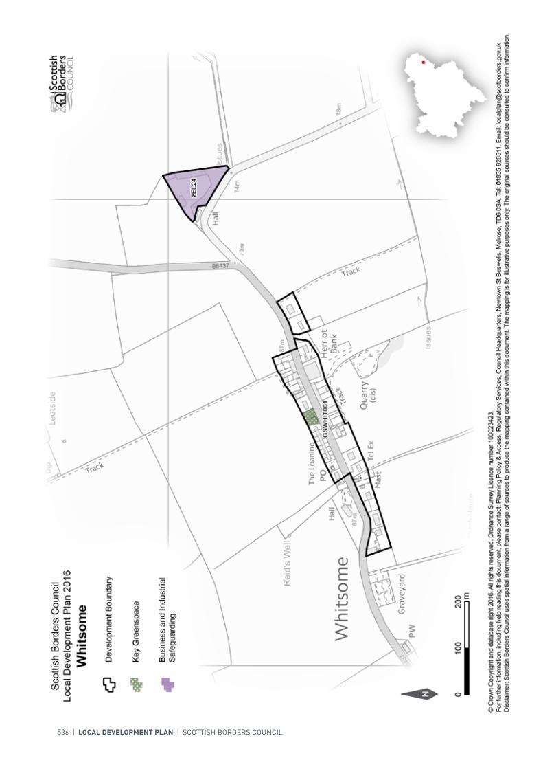
536 | LOCAL DEVELOPMENT PLAN | SCOTTISH BORDERS COUNCIL
INTRODUCTION | CHALLENGES | VISION, AIMS AND SPATIAL STRATEGYPOLICIES | APPENDICES | SETTLEMENTS
LOCAL DEVELOPMENT PLAN | SCOTTISH BORDERS COUNCIL | 537
SETTLEMENT PROFILE YARROWFORD
This profile should be read in conjunction with the relevant settlement map.
DESCRIPTIONYarrowford is located just west of the Central Strategic Development Area as identified in the SESplan. The 2001 Census population was 77.
PLACE MAKING CONSIDERATIONSThe settlement is situated in the upland valley of the Yarrow and is bound to the west by the Hangingshaw Garden and Designed Landscape. The Yarrow Water is part of the River Tweed Special Area of Conservation, a wildlife site of international importance. The Tweed, Ettrick and Yarrow Confluences Special Landscape Area surrounds the boundaries of the settlement.
The character of Yarrowford is established by its countryside setting and two clusters of development, one to the south of Broadmeadows House and the other at Minchmoor Road.
The development boundary has been amended to include an area of land to the south east of the village.
No additional areas for future growth have been identified in this Local Development Plan given difficulties of access and flooding.
Development adjacent to the Gruntly Burn or Yarrow Water will be resisted where there is a flood risk. Development to the west will be resisted where it would adversely affect the Hangingshaw Garden and Designed Landscape. Development to the east will be resisted where it will have a significant adverse impact on the Tweed, Ettrick and Yarrow Confluences Special Landscape Area.
There is one area, to the north of Minchmoor Road, identified as a key greenspace.
INFRASTRUCTURE CONSIDERATIONSAffordable Housing will require to be provided in association with proposed housing sites under the provisions of Policy HD1 and the Supplementary Guidance/ Supplementary Planning Guidance on Affordable Housing.
There is no requirement for contribution towards education provision.

538 | LOCAL DEVELOPMENT PLAN | SCOTTISH BORDERS COUNCIL
The settlement falls within an area identified for a contribution to the Borders Railway Project (See Policy IS3).
With regards to Water and Waste Water Treatment Works, Yarrowford has limited capacity. Contributions may be required where upgrades are necessary.
Further information is available from Supplementary Guidance/Supplementary Planning Guidance on Developer Contributions and Planning/Development Briefs where applicable.
DEVELOPMENT AND SAFEGUARDING PROPOSALS
HOUSING
SITE REFERENCE SITE NAME SITE SIZE (HA)
GSYARR001 Minchmoor Road 0.1
KEY GREENSPACE
SITE REFERENCE SITE NAME SITE SIZE (HA) INDICATIVE SITE CAPACITY
EY5B Minchmoor Road East 0.2 5
Site Requirements
• The site is located within 1:200 flood risk area. A Flood Risk Assessment will be required• Structure planting/hedges required on the northern, eastern and southern boundaries. Existing
planting on western boundary to be retained where possible• Improvements required to road and junction onto the A708• Mitigation measures are required to prevent any impact on the River Tweed Special Area of
Conservation/ Sites of Special Scientific Interest.

INTRODUCTION | CHALLENGES | VISION, AIMS AND SPATIAL STRATEGYPOLICIES | APPENDICES | SETTLEMENTS
LOCAL DEVELOPMENT PLAN | SCOTTISH BORDERS COUNCIL | 539
540 | LOCAL DEVELOPMENT PLAN | SCOTTISH BORDERS COUNCIL
SETTLEMENT PROFILE YETHOLM
This profile should be read in conjunction with the relevant settlement map.
DESCRIPTIONAlthough a single settlement, Yetholm is made up of two distinct parts – Town Yetholm and Kirk Yetholm. Yetholm is located outwith the Strategic Development Areas as defined in the Strategic Development Plan and sits within the Central Housing Market Area. The population of Town Yetholm is 469 whilst the population of Kirk Yetholm is 137 based on the 2001 Census.
PLACE MAKING CONSIDERATIONSThe settlement of Yetholm has a defined and special character not only because it is made up of two distinct parts but also because of its setting. The Haugh and the course of the Bowmont Water that separates Town Yetholm from Kirk Yetholm play a great role in connecting the two parts together. The Conservation Area of Yetholm has many special characteristics that are not found in many other locations even outwith the Borders. The most important features of the Yetholm Conservation Area are its historic layout with both Town Yetholm and Kirk Yetholm with their own green, along with its attractive rural setting. Properties are mainly two storeys in height though one and a half storey properties do exist in Kirk Yetholm. As the layout of Yetholm is one of the most important features of the Conservation Area, it is recommended that new development should respect this characteristic. Buildings of feature include the Parish Church, Blunty’s Mill, and the Old Border Inn all in Kirk Yetholm; and in Town Yetholm the War Memorial and the Wauchope Monument and the listed “Thatched Cottage” on the High Street.
Yetholm benefits from many views within and out of the settlement. The surrounding landscape is gently rolling and around the settlement itself there are few tree belts of significant size. The most important of the tree belts frame the eastern and western edges of the Haugh Land.
The Plan provides two housing allocations; both are located to the east of Town Yetholm at Deanfield Court and Morebattle Road.
There are no areas for longer term expansion in Yetholm. Development within the Haugh between Town and Kirk Yetholm will be resisted.
The key greenspaces within Yetholm provide an important recreational area for the community and will be protected.

INTRODUCTION | CHALLENGES | VISION, AIMS AND SPATIAL STRATEGYPOLICIES | APPENDICES | SETTLEMENTS
LOCAL DEVELOPMENT PLAN | SCOTTISH BORDERS COUNCIL | 541
INFRASTRUCTURE CONSIDERATIONSAffordable Housing will require to be provided under the provisions of Policy HD1 and the Supplementary Guidance/Supplementary Planning Guidance on Affordable Housing.
The accommodation and facilities at Kelso High School have been identified as being unsuitable for future use particularly when the areas for longer term development are taken onto account. It has been agreed to build a new, modern school nearby the current site. The new school is due to open in 2016. In accordance with developer contribution policy, a contribution towards the additional facilities at the new Kelso High School will be sought, to recoup the capital invested by the Council.
With regards to Waste Water Treatment Works, Yetholm has limited capacity. Contributions may be required where upgrades are necessary. In respect of the local water network, developers may be required to contribute towards upgrading to enable development.
Further information is available from Supplementary Guidance/Supplementary Planning Guidance on Developer Contributions and Planning/Development Briefs where applicable.
DEVELOPMENT AND SAFEGUARDING PROPOSALS
HOUSING
SITE REFERENCE SITE NAME SITE SIZE (HA) INDICATIVE SITE CAPACITY
RY1B Deanfield Court 0.6 7
Site Requirements
• Vehicular access is to be taken from Deanfield Court, although this should be discussed with the Council’s Roads Planning Team
• Existing trees are to be retained along the northern site boundary to protect the residential amenity of Yetholm Hall
• Screening may be required along part of the southern and western site boundary to screen the site from existing commercial uses along Deanfield Court. A management scheme for planting is also required
• A pedestrian linkage to the village centre would be required• Existing stone wall along the eastern boundary to be retained if possible to maintain a defined
settlement edge• Archaeology interests have been recorded in the surrounding area and archaeological assessment
including archaeological evaluation along with associated mitigation measures is required.
RY4B Morebattle Road 1.2 18
Site Requirements
• Vehicular access is to be taken from Woodbank Road• Structure planting is required to the southern and western site boundaries to provide setting for
the development and to reinforce the settlement edge. A management scheme for planting is also required
• The existing hedges and trees within the site should be conserved and enhanced wherever possible• Pedestrian linkages to the village centre required via Woodbank Road or Cheviot Road.

542 | LOCAL DEVELOPMENT PLAN | SCOTTISH BORDERS COUNCIL
SITE REFERENCE SITE NAME SITE SIZE (HA)
GSYETH001 Town Yetholm Recreational Ground
2.5
GSYETH002 Kirk Yetholm Greens 0.5
GSYETH003 Kirk Yetholm Allotments 0.1
GSYETH004 Town Yetholm Allotments 0.6
GSYETH005 Town Yetholm Greens 0.3
KEY GREENSPACE
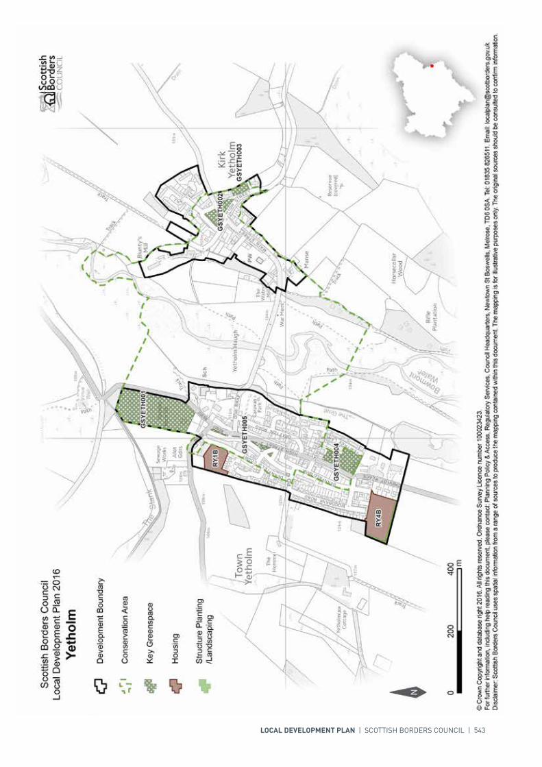
INTRODUCTION | CHALLENGES | VISION, AIMS AND SPATIAL STRATEGYPOLICIES | APPENDICES | SETTLEMENTS
LOCAL DEVELOPMENT PLAN | SCOTTISH BORDERS COUNCIL | 543

POLICY MAPS
INTRODUCTION | CHALLENGES | VISION, AIMS AND SPATIAL STRATEGYPOLICIES | APPENDICES | SETTLEMENTS
SCOTTISH BORDERS COUNCIL LOCAL DEVELOPMENT PLAN 2016