Palaeoecological record of natural changes and human impact in a small river valley in Central...
17
Palaeoecological record of natural changes and human impact in a small river valley in Central Poland Dominik Pawlowski a, * , Krystyna Milecka b , Piotr Kittel c , Michal Woszczyk b , Waldemar Spychalski d a Adam Mickiewicz University, Institute of Geology, Faculty of Geographical and Geological Sciences, Department of Palaeontology and Stratigraphy, Mak ow Polnych 16, 61-606 Pozna n, Poland b Adam Mickiewicz University, Institute of Geoecology and Geoinformation, Faculty of Geographical and Geological Sciences, Dzie ˛ gielowa 20, 61-680 Pozna n, Poland c University of Lodz, Department of Geomorphology and Palaeogeography, Faculty of Geographical Science, Narutowicza 88, 90-139 L od z, Poland d Pozna n University of Life Sciences, Department of Soil Science and Soil Protection, Szydlowska 50, 60-656 Pozna n, Poland article info Article history: Available online xxx Keywords: Palaeoclimate Fluvial activity Human impact/Geoarchaeology Pollen Cladocera Geochemistry abstract The developmental history of a mire located in the Grabia River valley, central Poland, spanning the last 9000 years, was investigated using high-resolution records of pollen, Cladocera, and geochemistry from a 14 C-dated core. The study demonstrates the value of Cladocera, palynological, and geochemical methods in research into human impact and natural fluvial activity, particularly for those elements that are difficult to find through sedimentological methods. Our research shows the importance of long-term reconstructions in establishing palaeohydroclimatic conditions and determining the human impact on the mire. We propose that water-level fluctuations were important in modifying biota assemblages. Periods with higher water-levels are synchronous with climatic changes, but in the Subatlantic, they also correspond to phases of human activity in the valley. The probable phases of increased fluvial activity of the Grabia River coincide in general with periods of wet climate, deforestation, and soil erosion. The main phases that show increases in the water level in the lower part of Grabia River valley are estimated at ca. 5800e5500 BC, 4500e4300 BC, 4200e3800 BC, and 400 AD. The water-level changes of 1300 AD, 1500 AD, and 1650 AD, as well as those of the last century, were most strongly influenced by a combination of natural and anthropogenic factors. Anthropogenic events were particularly significant during the Middle Ages and in the last century. © 2014 Elsevier Ltd and INQUA. All rights reserved. 1. Introduction The use of the varying roles of climate and human activity in reconstructing past hydrological changes in river dynamics has been documented (Starkel et al., 1996, 2006; Dambeck and Thiemeyer, 2002; Kalicki, 2006; Macaire et al., 2006; Macklin et al., 2006; Dotterweich, 2008; Notebaert and Verstraeten, 2010). Since the Neolithic, anthropopressure on the environment has been increasing (Kalicki, 2006; Hoffmann et al., 2008). Therefore, the impact of the climate and of humans can be very difficult to distinguish, as they have both acted at the same time (Zolitschka et al., 2003; Thorndycraft and Benito, 2006; Kittel, 2014). Floodplain deposits, and especially fills of oxbow lakes and valley mires, seem to be suitable sites for studying climate change versus human impact, both on the local scale and in the wider context (Kalicki, 2006). Valley mires are sensitive to changes in humidity, including drainage (Tobolski, 2003), and so analyses of their sediments (especially palaeochannel filling deposits) are very useful in reconstructing and dating humidity changes (Rotnicki, 1991; Pawlowski, 2012). How- ever, the response of river systems to both climate change and landscape alteration by humans is more dynamic than in the case of lacustrine and peat-bog systems (Kalicki et al., 2008). Fens in river valleys also allow us to reconstruct ongoing processes in the region (H ajkov a et al., 2012a,b). High water tables create favorable condi- tions for the accumulation of organic sediments in groundwater-fed wetlands. Remarkably, relatively long-lasting water-level changes can be revealed through palaeoecological analysis (Lamentowicz et al., 2013). Valley mires in small river valleys, such as the Grabia River valley, seem to be appropriate for such studies. Small rivers are just as sensitive to changes in humidity as large rivers, but lack the * Corresponding author. E-mail addresses: [email protected] (D. Pawlowski), [email protected] (K. Milecka), [email protected] (P. Kittel), [email protected] (M. Woszczyk). Contents lists available at ScienceDirect Quaternary International journal homepage: www.elsevier.com/locate/quaint http://dx.doi.org/10.1016/j.quaint.2014.06.033 1040-6182/© 2014 Elsevier Ltd and INQUA. All rights reserved. Quaternary International xxx (2014) 1e17 Please cite this article in press as: Pawlowski, D., et al., Palaeoecological record of natural changes and human impact in a small river valley in Central Poland, Quaternary International (2014), http://dx.doi.org/10.1016/j.quaint.2014.06.033
Transcript of Palaeoecological record of natural changes and human impact in a small river valley in Central...

lable at ScienceDirect
Quaternary International xxx (2014) 1e17
Contents lists avai
Quaternary International
journal homepage: www.elsevier .com/locate/quaint
Palaeoecological record of natural changes and human impactin a small river valley in Central Poland
Dominik Pawłowski a, *, Krystyna Milecka b, Piotr Kittel c, Michał Woszczyk b,Waldemar Spychalski d
a Adam Mickiewicz University, Institute of Geology, Faculty of Geographical and Geological Sciences, Department of Palaeontology and Stratigraphy, Mak�owPolnych 16, 61-606 Pozna�n, Polandb Adam Mickiewicz University, Institute of Geoecology and Geoinformation, Faculty of Geographical and Geological Sciences, Dziegielowa 20, 61-680Pozna�n, Polandc University of Lodz, Department of Geomorphology and Palaeogeography, Faculty of Geographical Science, Narutowicza 88, 90-139 Ł�od�z, Polandd Pozna�n University of Life Sciences, Department of Soil Science and Soil Protection, Szydłowska 50, 60-656 Pozna�n, Poland
a r t i c l e i n f o
Article history:Available online xxx
Keywords:PalaeoclimateFluvial activityHuman impact/GeoarchaeologyPollenCladoceraGeochemistry
* Corresponding author.E-mail addresses: [email protected] (D. Paw
(K. Milecka), [email protected] (P. Kittel), woszczyk@amu
http://dx.doi.org/10.1016/j.quaint.2014.06.0331040-6182/© 2014 Elsevier Ltd and INQUA. All rights
Please cite this article in press as: PawłowskCentral Poland, Quaternary International (2
a b s t r a c t
The developmental history of a mire located in the Grabia River valley, central Poland, spanning the last9000 years, was investigated using high-resolution records of pollen, Cladocera, and geochemistry from a14C-dated core. The study demonstrates the value of Cladocera, palynological, and geochemical methodsin research into human impact and natural fluvial activity, particularly for those elements that aredifficult to find through sedimentological methods. Our research shows the importance of long-termreconstructions in establishing palaeohydroclimatic conditions and determining the human impact onthe mire. We propose that water-level fluctuations were important in modifying biota assemblages.Periods with higher water-levels are synchronous with climatic changes, but in the Subatlantic, they alsocorrespond to phases of human activity in the valley. The probable phases of increased fluvial activity ofthe Grabia River coincide in general with periods of wet climate, deforestation, and soil erosion. The mainphases that show increases in the water level in the lower part of Grabia River valley are estimated at ca.5800e5500 BC, 4500e4300 BC, 4200e3800 BC, and 400 AD. The water-level changes of 1300 AD, 1500AD, and 1650 AD, as well as those of the last century, were most strongly influenced by a combination ofnatural and anthropogenic factors. Anthropogenic events were particularly significant during the MiddleAges and in the last century.
© 2014 Elsevier Ltd and INQUA. All rights reserved.
1. Introduction
The use of the varying roles of climate and human activity inreconstructing past hydrological changes in river dynamics has beendocumented (Starkel et al., 1996, 2006; Dambeck and Thiemeyer,2002; Kalicki, 2006; Macaire et al., 2006; Macklin et al., 2006;Dotterweich, 2008; Notebaert and Verstraeten, 2010). Since theNeolithic, anthropopressure on the environment has been increasing(Kalicki, 2006; Hoffmann et al., 2008). Therefore, the impact of theclimate and of humans can be very difficult to distinguish, as theyhave both acted at the same time (Zolitschka et al., 2003;Thorndycraft and Benito, 2006; Kittel, 2014). Floodplain deposits,and especially fills of oxbow lakes and valley mires, seem to be
łowski), [email protected] (M. Woszczyk).
reserved.
i, D., et al., Palaeoecological r014), http://dx.doi.org/10.101
suitable sites for studying climate change versus human impact, bothon the local scale and in the wider context (Kalicki, 2006). Valleymires are sensitive to changes in humidity, including drainage(Tobolski, 2003), and so analyses of their sediments (especiallypalaeochannel filling deposits) are very useful in reconstructing anddating humidity changes (Rotnicki, 1991; Pawłowski, 2012). How-ever, the response of river systems to both climate change andlandscape alteration by humans is more dynamic than in the case oflacustrine and peat-bog systems (Kalicki et al., 2008). Fens in rivervalleys also allow us to reconstruct ongoing processes in the region(H�ajkov�a et al., 2012a,b). High water tables create favorable condi-tions for the accumulation of organic sediments in groundwater-fedwetlands. Remarkably, relatively long-lasting water-level changescan be revealed through palaeoecological analysis (Lamentowiczet al., 2013). Valley mires in small river valleys, such as the GrabiaRiver valley, seem to be appropriate for such studies. Small rivers arejust as sensitive to changes in humidity as large rivers, but lack the
ecord of natural changes and human impact in a small river valley in6/j.quaint.2014.06.033

Fig. 1. Location of �Swierczyna Mire in Europe (A), and in Poland (B), digital elevation model of the study area (based on LiDAR data) with archeological records (C), and geologicalcross-sections (AeA') of the studied mire (D). Lidar data used in this study are protected by copyright under Polish law (Dz. U. 2010, no 193, pos. 1287).
D. Pawłowski et al. / Quaternary International xxx (2014) 1e172
effects of the headwater section, which often have different hydro-logical characteristics.
The multidisciplinary studies presented here employ palae-obiological, geochemical, archaeological, and radiometric data toinvestigate the interrelationships between climatic changes andhuman impact in reconstructing the Holocene landscape of themouth part of the Grabia River valley. The objectives of this studywere (i) to recognize the changes in humidity over the last 9000years in a small river valley, (ii) to recognize the role of humanimpact on the evolution of the environment in a small valley, and(iii) to estimate the usefulness of palaeoecological research intovalley mires for environmental archaeology.
2. Regional setting
�Swierczyna Mire is located in the central part of the Polish low-lands, in the Ł�od�z region (Fig. 1A and B) near to the town of Łask,
Please cite this article in press as: Pawłowski, D., et al., Palaeoecological rCentral Poland, Quaternary International (2014), http://dx.doi.org/10.101
between the villages of Wola We _zykowa and Zamo�s�c (Fig. 1C). Themire is located on the outer part of the valley floor and occupies anabandoned palaeochannel (Fig. 1C and D). It lies in the mouth of theGrabia River and covers an area about of 0.085 km2. Presently, it iscovered with an alder swamp. The Grabia River is a natural, mostlyunregulated river, inflowing to the Widawka, a tributary of the Oder(Odra). The study site is situatedwithin anarea thatwas coveredby iceduring theWartanianStadial of theOdranianGlaciation (Marks, 2011).
Glacial and glaciofluvial deposits are present in an area sur-rounding the valley. Fluvial sediments (Late Glacial and Holocenealluvium) fill themain part of the valley. General descriptions of thegeological and geomorphological setting of the Grabia valley havebeen presented by Bali�nski and Gawlik (1986), Krzemi�nski andBezkowska (1987)and Turkowska (2006).
Funnel Beaker Culture (FBC) settlements from the MiddleNeolithic are present in themiddle part of the Grabia River valley andin the Widawka River valley, close to the mouth of the Grabia River
ecord of natural changes and human impact in a small river valley in6/j.quaint.2014.06.033

Fig.
2.Pe
rcen
tage
polle
ndiag
ram
from
� Swierczy
naMire.
D. Pawłowski et al. / Quaternary International xxx (2014) 1e17 3
Please cite this article in press as: Pawłowski, D., et al., Palaeoecological record of natural changes and human impact in a small river valley inCentral Poland, Quaternary International (2014), http://dx.doi.org/10.1016/j.quaint.2014.06.033

Fig. 3. Percentage Cladocera diagram and total number of Cladocera specimens and species from �Swierczyna Mire.
D. Pawłowski et al. / Quaternary International xxx (2014) 1e174
(Pelisiak,1985,1991e1992a, 2003, 2004). In the vicinity of themouthof the Grabia, there are records of artefacts belonging to the TrzciniecCulture (TC) (Gardawski, 1959; Gasior, 1975; Pelisiak, 1991e1992b)and to the Lusatian Culture (LC) of the Bronze Age (Kaszewski, 1975).A LC cemetery has been excavated at Podule (Dylik, 1931;Mikłaszewska-Balcer and Mi�skiewicz, 1968), about 3 km north ofthe mire (Fig. 1B). Pomeranian Culture sites from the Early Iron Ageare also very numerous in the area in question (Jadczykowa, 1990).
The Warta River played a very important role in settlement andcommunication during the Roman Period (Kaszewska, 1975;Urbaniak, 2004). The main complex of mediaeval settlements waslocated in the lower part of the Widawka River valley and in themiddle part of the Warta River valley (Sikora, 2007, 2009). Theoldest historical sources record a few villages in the neighborhoodsof �Swierczyna Mire in the fourteenth century AD, such as Grabno(1340 AD), Podule, Wola We _zykowa (Wola Grabicka), and Kozuby(1386 AD). Grabica was documented for the first time in 1400 AD(Zajaczkowski and Zajaczkowski, 1966). Historical sources recordevidence of the founding of a settlement in the area as late as thefourteenth century AD.
3. Material and methods
3.1. Fieldwork
The study site (51�28.0240 N, 018�59.8950E) is situated in thedeepest palaeochannel running along the edge of the high terrace
Please cite this article in press as: Pawłowski, D., et al., Palaeoecological rCentral Poland, Quaternary International (2014), http://dx.doi.org/10.101
of the valley (Fig. 1C and D). The sediment core used in the ana-lyses was taken using a manual Instorf corer. The depositionalsuccession consists of fluvial sands, gyttja, and various types ofpeat (Fig. 1D). The lowermost sediments in the palaeochannel aresands. Above, at a depth of 330e168 cm, gyttja with sand in-tercalations was recorded. Peat occurs from 168 cm upwards. Anorganic succession of 90 cm thick from this site was chosen fordetailed analysis (Fig. 1D). The lowermost part of this succession,90e52 cm depth, included well decomposed peat with a smallnumber of remains of herbaceous plants (sedges and reeds) andtrees (Fig. 6). Above, from 52 to 23 cm in depth, a mediumdecomposed sedge peat occurred. The top of section containsSphagnum-sedge peat with remains of alder and birch. In thelaboratory, the core was sliced into one-centimeter intervals forfurther studies.
For reconstruction of the �Swierczyna Mire development, humanimpact, and relative palaeohydrological parameters (such asgroundwater table, river flood magnitudes, and flood frequencies)we used pollen, Cladocera, and geochemical analyses. For conve-nience, the term “water table” is used in the context of ground-water, and “water level” is related to the level of river, flood andwater bodies in the mire.
3.2. Palaeobiological data
For pollen analysis, sediment samples of 1 cm3 were taken.These were prepared for microscopic analysis following standard
ecord of natural changes and human impact in a small river valley in6/j.quaint.2014.06.033

Fig. 4. Geochemical data from �Swierczyna Mire.
D. Pawłowski et al. / Quaternary International xxx (2014) 1e17 5
methods (Berglund and Ralska-Jasiewiczowa, 1986), includingtreatment with cool HF for the removal of mineral componentsand acetolysis for three minutes. The samples were placed in pureglycerine and stained with safranin prior to microscopic analysis.At least 500 terrestrial pollen grains were analyzed for eachsample, with the exception of two samples (16 and 92 cm) inwhich the pollen concentration was too low. Pollen percentageswere calculated based on the sum of trees and shrubs (AP) and ofherbs (NAP, except aquatic and wetland plants), but only speciesimportant for the interpretation are presented here. To define theanthropogenic phases, we used the presence of synanthropicplants, such as pasture, cultivated taxa, and others indicators ofhuman activity.
For the Cladocera analysis, 1 cm3 of fresh sediment sample wastaken and processed according to the standard procedure (Frey,1986). The samples were treated with hot 10% KOH. The materialwas then deflocculated using a magnetic stirrer and sieved througha 50 mmmesh. Slides were prepared from 0.1ml of each sample andexamined under a microscope (at 100� magnification). The tax-onomy of cladoceran remains in this paper follows that presentedby Szeroczy�nska and Sarmaja-Korjonen (2007). The ecologicalpreferences of cladoceran taxa were determined on the basis ofBjerring et al. (2009). The presence of aquatic invertebrates likeCladocera in valley mires is generally associated with changes inhydrology (such as floods and droughts), pH, and the trophy ofwatersdincluding those induced by human impact (Szeroczy�nska,2002). The composition of Cladocera species adjusts very quickly tonewand variable habitats. In fens that are seasonally inundated, theexistence of these aquatic invertebrates is strongly related to thehydroperiod, and cladocerans therefore reflect water-level fluctu-ations. The occurrence of pelagic species is connected with a sig-nificant increase in the water level of valley mires. In turn, thesediment-associated taxa and the species with broad ecologicaltolerance have better adaptations to advective environments. Someof these taxa, such as Bosmina longirostris and Chydorus sphaericus
Please cite this article in press as: Pawłowski, D., et al., Palaeoecological rCentral Poland, Quaternary International (2014), http://dx.doi.org/10.101
(sensu lato), occur in small ponds, may be dominant in the littoralzone, and can also occur in rivers as with potamoplankton (Hudec,1989; Nevalainen, 2011). Therefore the co-occurrence of pelagicspecies and sediment-associated taxa can be regarded as an indi-rect indicator of flood episodes. The initial interpretive possibilitiesfor palaeoecological studies of Cladocera in flood records have beenrecently demonstrated (Pawłowski et al., 2012), and have mostlybeen tested for young sediments from the last two hundred yearsassociated with human activity (Galbarczyk-Gasiorowska et al.,2009).
The high degree of peat decomposition has led to a poor recordof plant macrofossils. The only fossils in the peat deposits were afew remains of trees, such as alder; other plant remains occur onlyvery occasionally (Dr. G. Kowalewski (Adam Mickiewicz Univer-sity), personal communication). For this reason, we did not use thismethod in the study.
3.3. Geochemical data
Prior to geochemical analysis, the samples were lyophilizedand pulverized in a Pulverizette 2 agate mortar (Fritsch). Theorganic matter content was determined by loss on ignition at550 �C for 2 h. Terrigenous (SiO2ter) and biogenic (SiO2biog) silicawere analyzed by digestion of the organic-matter-free samples inaqua regia (12 h at room temperature and 2 h at 200 �C on ahotplate). The residue left after the acid treatment was assumedto represent the total SiO2 (SiO2tot). SiO2ter and SiO2biog wereseparated by extraction of SiO2biog with 0.5 N NaOH in a waterbath at 100 �C for 2 h. The SiO2biog content was calculated asSiO2biog [%] ¼ SiO2tot � SiO2ter. The total carbon (TC), total sulphur(TS), and total nitrogen (TN) contents were determined using aVario Max elemental analyzer (“Elementar Analysensysteme”).Each sample was analyzed in duplicate. The total organic carbon(TOC) was determined using the same device following removalof carbonates with 1 N HCl. Total inorganic carbon (TIC) was
ecord of natural changes and human impact in a small river valley in6/j.quaint.2014.06.033

Table 1Results of radiocarbon dating from �Swierczyna Mire.
Samplename
Depth(cm)
14C age (BP) Calibrated age(95.40% probability)BC/AD
Dated material
Poz-57015 13 114.6 ± 0.36pMC
1691 AD (12.7%) 1708 AD1717 AD (11.3%) 1730 AD1811 AD (68.4%) 1887 AD1912 AD (3.0%) 1920 AD
Stems of moss(Sphagnum)
Poz-52512 23 190 ± 30 1648 AD (21.7%) 1694AD1726 AD (52.7%) 1813 AD1918 AD (21.0%) …
Stems of moss(Sphagnum)
Poz-57016 29 380 ± 60 1438 AD (95.4%) 1641 AD Stems of moss(Sphagnum)0.3 mgC
Poz-57017 35 1610 ± 30 392 AD (95.4%) 538 AD Seeds of pinePoz-54916 49 5050 ± 40 3959 (92.9%) 3761 BC
3740 (1.0%) 3731 BC3725 (1.5%) 3715 BC
Piece of pinebark
Poz-57018 73 6690 ± 80 5722 BC (95.4%) 5487 BC Piece of pinebark 0.4 mgC
Poz-52513 92 8060 ± 90 7303 BC (6.1%) 7216 BC7200 BC (89.3%) 6692 BC
TOC res: wood,0.1 mgC
Poz-57401 88e90a 108.63 ± 0.34pMC
1694AD (14.6%) 1710AD1716AD (14.0%) 1729AD1811AD (58.5%) 1892AD1908AD (8.3%) 1918 AD
TOC res: plant(Carex flava,Batrachium),0.1 mgC
a Date from the second core, from the mire marginal zone, below the colluvialdeposits (88e90 cm below ground surface); for location, see Fig. 1D; pMC: percentmodern carbon.
D. Pawłowski et al. / Quaternary International xxx (2014) 1e176
calculated by subtraction of TOC from TC. The concentrations ofthe elements (Na, K, Ca, Al, Mg, Mn, Fe, Zn, and Cu) weremeasured using a SpectrAA 220 spectrometer (Varian). The ele-ments were extracted from the solid samples using aqua regia, asdescribed earlier. Sulfadiazine and SQC001S (Metals in sewagesludge) reference materials were used to control the quality ofmeasurements.
The content of Al, K, and SiO2ter can be regarded as indicators ofthe intensity of physical weathering and erosion. The first two ofthese are usually associated with fine sedimentary particles (siltand clay) and therefore tend to behave differently than SiO2ter,which is held within quartz sand grains. Consequently, theincreased contents of Al and K in the peat infilling the river valleycould have been produced by a distant aeolian or fluvial transportand deposition during floods in the marginal zone of the valleyfloor. SiO2ter would be delivered from the valley slopes by erosionevents of a local character.
The molar TOC/N ratio in peat is widely used to interpret theorigin and decomposition of organic matter (Comont et al., 2006).In peat, the TOC/N ratio is negatively correlated with the degree ofhumification (Broder et al., 2012) and consequently, the lower theTOC/N, the higher the decomposition of the peat. The TOC/N valuesin bulk peat normally vary across a wide range (20e90), but values>50 are thought to be inherited from the parent material (Comontet al., 2006). Additionally, the Fe/Mn ratio is used as a parameter theredox conditions of peat (Boyle, 2001). In this study, we attemptedto use TOC/N and Fe/Mn as indicators of the changes in the watertable in the mire. This interpretation is based on the link betweenthe elevation of the water table and the redox conditions in thepeat. Theoretically, the higher the water table, the lower the redoxpotential within the peat, and thus the lower the humificationdegree of the former.
Anthropopressure is indicated by the heavy-metal content (i.e.Zn and Cu) (Boyle, 2001). It is advised, however, to normalize theraw metal contents using Zr, Ti, or Al, mainly bound to alumino-silicates and clay minerals, carrying the heavy metals. Thenormalization thus liberates the interpretation of heavy metalsfrom the changes in lithology of the sediments. For this reason, wehave used the Zn/Al and Cu/Al ratios in our interpretation.
3.4. Archaeological data
Because of the lack of archaeological excavations undertakenin the vicinity of the study area, the occurrence and age ofarchaeological sites found in the surroundings of �Swierczyna Mirewere assigned on the basis of the Polish National ArcheologicalRecord Sites (PNARS/Archeologiczne Zdjecie Polski in Polish;Fig. 1C) and literature studies. The Polish National ArcheologicalRecord Sites (PNARS) is a national survey designed to record allarchaeological sites in Poland using chiefly the surface surveymethod (Mazurowski, 1980; Prinke, 1992; Barford et al., 2000).The unpublished results of the survey are accessible as a databasein the archive of the Voivodeship Monument Protection Office.Unfortunately, not all the sites that are approachable with surfacesurvey methods in the �Swierczyna Mire area have been recordedin PNARS (Dr. P. Papiernik (Museum of Archaeology and Ethnog-raphy in Ł�od�z), personal communication). Only one archaeolog-ical site in the area has been published so far: the cemetery of LCpeople in Podule (Dylik, 1931; Mikłaszewska-Balcer andMi�skiewicz, 1968).
3.5. Radiocarbon dates
Radiocarbon dating was carried out at the Pozna�n RadiocarbonLaboratory (Poland), using accelerator mass spectrometry (AMS).
Please cite this article in press as: Pawłowski, D., et al., Palaeoecological rCentral Poland, Quaternary International (2014), http://dx.doi.org/10.101
Seven dates were obtained from the main core sediment, and onefrom the core from the marginal zone of the mire (Fig. 1D). Thematerial selected for radiocarbon dating was composed exclusivelyof macroscopic plant remains (i.e., moss stems (Sphagnum), nuts ofsedges, wood). Rootlets and other contamination were avoided.Dates are given in calibration years BC (Table 1). Conventionalradiocarbon dates were calibrated using OxCal 4.2.2 (BronkRamsey, 2009) and the IntCal13 calibration curve (Reimer et al.,2013). The results of the constructed ageedepth model, based onall 7 radiocarbon dates from themain core and spread over the timeperiod since 7000 cal BC (Figs. 5 and 6), are presented here. Themodel was constructed using the P_Sequence procedure fromOxCal 4.2 program; the value of the k parameter was 0.1; interpo-lation with the Akima spline algorithm (Akima, 1970) was used toassign a date to each centimeter of depth.
The detailed diagrams of each proxy are presented in separatefigures for pollen (Fig. 2), Cladocera (Fig. 3), and chemical compo-nents (Fig. 4). The results were plotted stratigraphically in a per-centage diagram using POLPAL and TILIA software (Grimm, 1992;Walanus and Nalepka, 1999). Cluster analysis was applied todistinguish palaeoecological and geochemical zones. The calcula-tions were performed using MSVP software, version 3.1 (Kovach,2007).
4. Results
4.1. Pollen analysis
The pollen diagram exhibits (Fig. 2), a succession of five localpollen assemblage zones (LPAZ, Table 2), and reveals local plantcommunities growing in the river valley in a wet habitat. Alnus is adominant species, covering the area for the last 8500 years,accompanied by ferns (monolete fern spores) and sedges (Carextype, Cyperaceae). Pinus and deciduous forests (Quercus, Tilia,
ecord of natural changes and human impact in a small river valley in6/j.quaint.2014.06.033

D. Pawłowski et al. / Quaternary International xxx (2014) 1e17 7
Ulmus, Fraxinus, Corylus) growing outside of the valley representregional vegetation at a greater distance from the site. The youngerpart of the diagram, ca. 1750e2000 AD, shows deforestation. Thelight-demanding Betula and Poaceae were dominant in open plantcommunities. In each sample, only a few corroded pollen grainswere noted.
Fig. 5. The ageedepth model (radiocarbon dates).
Table 2Detailed descriptions of local pollen assemblages zones (LPAZ) from the �SwierczynaMire deposits.
Zone Depth(cm)
Age(ca. BC/AD yrs)
Description
LPAZ5 0e10 After ca. 1950AD
Lack of pollen of deciduous trees, a highamount of Alnus pollen, small increases inPinus and Betula content, and a stable curveof Poaceae below 10% are observed.
LPAZ4 10e22.5 1750e1950 AD Decline in deciduous trees and Alnus isobserved. The Betula curve increases. ThePoaceae curve also increases, and itsculmination exceeds 20% of the calculationsum.
LPAZ3 22.5e49 3800 BCe1750AD
Decline in mesophilous trees such as Tilia,Ulmus, and Fraxinus, while Corylus expandsand Quercus remains stable. A lowculmination of Carpinus (up to 5%) is found.The curves of Pinus and Betula are low. Thecontent of NAP increases. Alnus stillfrequently occurs.
LPAZ2 49e85 6500e3800 BC A dominance of deciduous, mixed forestswith Quercus, Ulmus, Tilia, and Corylus isobserved. The river valley is covered by carr.The proportion of open plant communitiesis very low.
LPAZ1 85e92 7000e6500 BC The spread of Corylus, Tilia, Ulmus, andQuercus in the regional vegetation, as wellas Alnus in the local plant communities isobserved. There are also decreases in Pinusand Poaceae.
Indicators of human activity are barely represented prior to4000 BC. Only a few pollen grains of Artemisia, Plantago lanceolata,and Rumex acetosa were found. These suggest the sporadic pres-ence of humans in the lower part of Grabia River valley. The pres-sure on the natural ecosystems was negligible. The pollen grains ofSecale found below 80 cm depth cannot come either from cultiva-tion (beingmuch too early) or from cultivated fields of other cereals(as there are no pollen grains of other cereals and there is noarchaeological evidence for settlement). They are probably theresult of contamination or of erroneous identification of largePoaceae grains.
The presence of some more pasture and cultivated plants allowsus to define three further phases of human activity (PHA; Fig. 6).
Phase 1 (PHA1; 49e39 cm; ca. 3800e800 (?) BC)
Pollen grains of the Artemisia, Urtica, and R. acetosa/acetosellatype indicate periodical penetration of the area surrounding thesite. Grains of Secale probably originated from wheat weeds. Thisphase involved a long interval of prehistory between the MiddleNeolithic and, probably, the Late Bronze Age.
Phase 2 (PHA2; depth 35e27 cm; ca. 400 BCe1500 AD)
Humanpresence is indicated by ruderal plants, such as Artemisiaand Urtica. However, this is the phase where weeds appearedfrequently, including Centaurea cyanus, Papaver rhoeas, Scleranthus
Please cite this article in press as: Pawłowski, D., et al., Palaeoecological rCentral Poland, Quaternary International (2014), http://dx.doi.org/10.101
perennis, and Spergularia, all of which appeared in cultivated fieldsof cereals, as indicated by the pollen of Secale and cereal undiff. Thisphase covers the long period from the Pre-Roman Period to the endof the Middle Ages.
Phase 3 (PHA3; depth 23.5e0 cm; ca. 1750e2000 AD)
All human activity indicators are present: ruderals (Artemisia,Urtica, Chenopodiaceae, Plantago maior), pasture plants (Rumex sp.,P. lanceolata), and cultivated plants and weeds (C. cyanus, Spergula,Spergularia, Secale, Triticum type, cereals). Pollen grains of rye arethe most abundant on the diagram, with a curve exceeding 5% ofthe calculated sum. This phase is correlated with the late ModernPeriod as far as the present.
4.2. Cladocera analysis
The middle and late Holocene sediments contain 13 Cladoceraspecies (Fig. 3) belonging to 3 familiesdBosminidae, Daphnidae,and Chydoridae. Six cladoceran assemblage zones (CAZ 1e6) havebeen distinguished and are presented in Table 3. No Cladocera re-mains occur (Fig. 3) at depth intervals of 90e83, 81e76, 69e62,57e54, and 10e6 cm.
ecord of natural changes and human impact in a small river valley in6/j.quaint.2014.06.033

Table 3Detailed descriptions of cladoceran assemblages zones (CAZ) from the �Swierczyna Mire deposits.
Zone Depth (cm) Age (ca. BC/AD yrs) Description
CAZ6 0e6 After ca. 1950 AD The cladoceran fauna is represented by only sporadic fossils (Bosmina (Eubosmina) coregoni, Acroperus harpae,and Chydorus sphaericus). The frequency and diversity of cladoceran fauna are very low.
CAZ5 10e21 1950e1780 AD A rapid decrease in both the frequency and diversity of Cladocera (not exceeding 200 specimens and 4 speciesper cm3 of deposit) and a lack of pelagic forms are observed. The oligotrophic taxa Alonella excisa and Alonaguttata var. tuberculata dominate. At the end, only fossils of Chydorus sphaericus are noted.
CAZ4 21e54 1780ADe4200 BC Fluctuations in both the frequency and diversity of Cladocera are observed. 3 subzones are determined.
CAZ4c 21e36 1780e200(?) AD fromthe Roman period tolate modern period
An increase in littoral species, especially at the end (with more than 2000 specimens and 10 species per cm3 ofdeposit) is noted. Macrophyte-associated taxa dominate, but sediment-associated taxa and pelagic forms arestill present. Fossils of Disparalona rostrata and Pleuroxus trigonellus appear for the first time.
CAZ4b 36e49 200(?) ADe3800 BCprehistory from theMiddle Neolithic,probably as far as theRoman Period
Sporadic occurrence of pelagic forms, especially from the Bosminidae family (Bosmina (Eubosmina) coregoni andBosmina longirostris). Fossils of Alonella nana, Alona guttata, and Pleuroxus uncinatus appear simultaneously.
CAZ4a 49e54 3800 BCe4200 BC theMiddle Neolithic
The lack of pelagic forms and the dominance of macrophyte and macrophyte/sediment-associated species arenoted. Alonella excisa appears for the first time.
CAZ3 57e62 4400e4800 BC The first occurrence of the pelagic taxa Bosmina longirostris is observed. The macrophyte/sediment-associatedAlona affinis, Alona guttata var.tuberculata, and Alona rectangula occurs for the first time. The frequency anddiversity of cladoceran fauna exceeds 7 taxa and 500 specimens/cm3.
CAZ2 69e76 5300e5800 BC Chydorus sphaericus has the most frequent occurrence. The sediment-associated taxa Pleuroxus uncinatus andthe macrophyte-associated Simocephalus sp. are also noted.
CAZ1 81e83 6200e6400 BC One macrophyte/sediment-associated species, Chydorus sphaericus appears.
D. Pawłowski et al. / Quaternary International xxx (2014) 1e178
4.3. Geochemical data
The geochemical diagram (Fig. 4) is divided into seven zones,G1eG7, and is described in Table 4.
Table 4Detailed descriptions of geochemical zones (G) from the �Swierczyna Mire deposits.
Zone Depth(cm)
Age (ca.BC/AD yrs)
Description
G7 0e10 After ca.1950 AD
An increase in the SiO2ter up to 27% and aconcomitant drop in TOC; high but decreasingupward values of S and very low contents of Kand Al; high contents of Cu and Zn; relativelylow Fe/Mn and TOC/N ratios (100e150 and 26e27, respectively).
G6 10e23 1950e1750AD
Low contents of SiO2biog (2.6%e1.4%); upwarddecrease in TOC and the increase in S; variablecontents of K and Al and TOC/N and Fe/Mn; theenrichment in K and Al in the topmost part ofthe zone; high values of Cu/Al and Zn/Al.
G5 23e35 1750e400AD
Relatively high level of SiO2ter; K and Al increasewhile Fe/Mn and TOC/N slightly decreasetowards the top of the zone.
G4 35e49 400ADe3800BC
Relatively high and decreasing contents ofSiO2ter; upward increase in Al and K; high TOC/N of 35e38; upward decline in Fe/Mn from 212to 120.
G3 49e66 3800e5000BC
Slight but systematic increase in SiO2ter up to ca.7%; low increasing upwards contents of Al andK; SiO2biog completely absent; upwardincreasing values of TOC/N; Fe/Mn declining inthe bottom section (from 270 to 79) and varyingin the upper part.
G2 66e74 5000e5700BC
Al and K content and Fe/Mn sharply decreaseupwards; TOC increases to 52%; a maximumcontent of TN of 2.3e2.5%; low values of theTOC/N (24e26); SiO2ter is depleted.
G1 74e90 5700e6900BC
Relatively high values of SiO2biog (up to 5%); astrong enrichment in Al and K content; SiO2ter isvery low (0.5e5%); high TOC is high (45e49%);TOC/N values are rather low (23e29) anddisplay a steady decline; high Fe/Mn ratio of270e300.
Please cite this article in press as: Pawłowski, D., et al., Palaeoecological rCentral Poland, Quaternary International (2014), http://dx.doi.org/10.101
4.4. Archaeology
Despite the controversies stemming from the PNARS (Duliniczand Kobyli�nski, 1990; Pisarek-Małyszek, 2005), only four archaeo-logical sites have been registered to date within 1.0 km of the mire(Fig. 1C). Three of these have been dated to prehistory and one tothe Middle Ages. It is necessary to emphasize that potsherds,though not numerous, have been registered at every site. Thisdocuments a very gentle human impact on themire's direct vicinityin the past. Within 2.0 km of the mire, 26 archaeological sites with32 archaeological facts have been recorded: 14 of these are dated toprehistory, 6 to the Early Middle Ages, and 12 to the Late MiddleAges and the Modern Period. The oldest relics of the FBC from theMiddle Neolithic (with only two potsherd fragments) have beenregistered at a site 2 km north of the mire. Very infrequent traces ofBronze Age settlement have been recorded at three sites. The firstdistinctive occupation phase in the area closest to the mire issubstantiated by the occurrence of two sites with rich evidence ofhuman settlement in the Pre-Roman and Roman Periods. Increasesin the quantity and density of archaeological sites in the south-western part of the studied area are clear. A concentration of sitessurrounds the mouth of the Grabia River. The areas of theWidawkaRiver valley and of the Warta River valley located to the west havemany archaeological sites.
Archaeological records of occupation in the Mesolithic(Niesiołowska-�Sreniowska and Cyrek, 1975; Cyrek, 1990;Niesiołowska-�Sreniowska and Płaza, 2011; Sobkowiak-Tabaka,2011), and also in the Early Neolithic (Wiklak, 1975; Pelisiak,1991e1992a), are very rare in Central Poland. FBC settlementsfrom the Middle Neolithic are represented at numerous sites(Wiklak, 1975), as well in the Widawka River valley, close to themouth of Grabia River (Pelisiak, 1991e1992a, 2003) and in themiddle part of the Grabia River valley (Pelisiak, 1985, 1991, 2003,2004). The middle part of the Warta River (located about 10 kmwest of the mire) seems to have been one of the main areas ofprehistoric occupation in Central Poland since the Middle Neolithic(Kaszewska, 1975; Kaszewski, 1975; Wiklak, 1975; Łaszczewska,1975). In the area very close to the mouth of the Grabia River, a
ecord of natural changes and human impact in a small river valley in6/j.quaint.2014.06.033
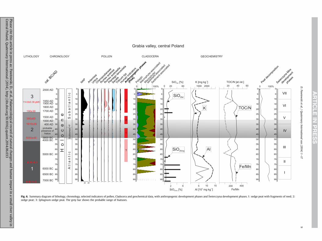
Fig. 6. Summary diagram of lithology, chronology, selected indicators of pollen, Cladocera and geochemical data, with anthropogenic development phases and �Swierczyna development phases. 1: sedge peat with fragments of reed; 2:sedge peat; 3: Sphagnum-sedge peat. The grey bar shows the probable range of hiatuses.
D.Paw
łowski
etal./
Quaternary
Internationalxxx
(2014)1e17
9
Pleasecite
thisarticle
inpress
as:Paw
łowski,D
.,etal.,Palaeoecologicalrecord
ofnaturalchangesand
human
impact
inasm
allrivervalley
inCentralPoland,Q
uaternaryInternational(2014),http://dx.doi.org/10.1016/j.quaint.2014.06.033

D. Pawłowski et al. / Quaternary International xxx (2014) 1e1710
concentration of sites belonging to the TC (Gardawski, 1959; Gasior,1975; Pelisiak, 1991e1992a) and to the LC (Kaszewski, 1975) hasbeen recorded. A cemetery of people of the LC has been excavatedin Podule (Mikłaszewska-Balcer and Mi�skiewicz, 1968), about 3 kmnorth of the mire. A concentration of Middle Age settlement siteshas been recorded in the lower part of the Grabia River valley, thelower part of the Widawka River valley, and the neighboringmiddle part of the Warta River valley (Chmielowska, 1975; Sikora,2007, 2009). The regional capital of the castellany developed inthe Middle Ages at Sieradz (Fig. 1B) in the Warta River valley, andthe �Swierczyna area was in the possession of the Widawa nobilityfrom the fourteenth to the eighteenth centuries AD.
The natural condition of the �Swierczyna Mire area was verysuitable for human occupation in prehistory and in the MiddleAges, above all because of the well-developed river valley and thehigh environmental geodiversity of the area (Kittel, 2012a). The lowfrequency of archaeological records close to the mire might beexplained by the presence of the exceptionally convenient areas ofthe Widawka River valley, and especially of the Warta River valley.The Warta River valley played an important role as a communica-tions route throughout the whole of prehistory (Janiak, 2004;Rzepecki, 2004) and during the Roman Period as part of the“Amber Route” (Kaszewska, 1975; Urbaniak, 2004). Also significantis the lack of early Medieval settlements in the �Swierczyna area,opposite to the lower part of Widawka River valley, and above all inthe mid-Warta River valley. On the other hand, future explorationof the terrain may reveal new sites.
4.5. Radiocarbon data
The results of the radiocarbon dating analysis of the sections(Table 1) point to dates from the end of the Atlantic to the Sub-atlantic. The model age is not linear, suggesting a variable sedi-mentation rate along the core (Fig. 5). We suspect the existence ofhiatuses between 49 and 35 cm (3400 years; mean sedimentationrate 0.04 mm/year) and between 35 and 29 cm, where the meansedimentation rate is 0.048 mm per year (Fig. 6).
5. Discussion
5.1. The evolution of �Swierczyna Mire
Between ca. 7000 and 5800 BC (Phase I, 90e76 cm depth; Fig. 6)the mire experienced unstable humid conditions. These unfavor-able conditions provide evidence for a high (though variable) de-gree of peat decomposition, as shown by the decreased TOC/N ratio.However, no signs of redeposition, and the lack of distinct, visibleborders classifiable as hiatuses (except for a few corroded pollengrains) indicates that therewas no interruption of peat sedentation.On the other hand, the sharp decline in the number of grains offerns (Filicales monolete; Fig. 2) and the occasional appearance ofone species of Cladocera, Ch. sphaericus, that possesses broadecological tolerance (Figs. 3 and 6), suggests a temporary increasein the water table in the mire, or perhaps a short-term increase inthe effective moisture. Moreover, the increased content of K and Al(Figs. 4 and 6) associated with clay minerals seems to record thedeposition of fine particles throughout the mire, as a result of theincreased frequency of floods. This enhanced flood frequency cor-relates with the higher values of mean annual discharges in themiddle Polish lowlands (through the Prosna River) during theAtlantic (Rotnicki, 1991). Moreover, the enrichment of peat inmineral matter can point to the more minerogenic character of themire. Broder et al. (2012) postulate that the deposition of mineralmatter within peat may stimulate its decomposition, on account ofthe greater availability of nutrients that can be used by microbes
Please cite this article in press as: Pawłowski, D., et al., Palaeoecological rCentral Poland, Quaternary International (2014), http://dx.doi.org/10.101
decomposing organic matter. The higher frequency of floods mayaccount for the higher content of SiO2biog (Figs. 4 and 6), indicatingthe presence of diatoms (Engstrom and Wright, 1984). The greaterbiomass of diatoms in flooded basins, as reported byWiklund et al.(2010), is explained by the greater availability of dissolved silicaduring floods, which is necessary for the secretion of diatom frus-tules (Dean, 1993). On the other hand, biogenic silica might origi-nate from plant phytoliths (L�opez-Buendía et al., 2007), but thesmall number of phytolith-producing Cyperaceae and Poaceae(Fig. 2) do not confirm this thesis. An alternative explanation for thehigh levels of detrital sedimentary components might be the de-livery of airborne mineral particles. Shotyk et al. (2002) havepostulated that this process increased in intensity during cold anddry climatic phases, when there was a reduced vegetation cover.However, even during a climatic optimum, accumulation of dustparticles originating from long-range transport does occur (Shotyket al., 2002)despecially in areas rich in dunes (Fig. 1D).
In the sediments of Phase I, the low TOC/N ratio, indicatinghigher peat decomposition, conflicts with the high Fe/Mn value,reflecting anoxic conditions in the mire (Fig. 4). The discrepancyarises because the enhanced decomposition of peat is more likely tooccur under more oxidizing conditions. We propose that thediscrepancy was due to the colonization of the Grabia River valleyby alder shrub thickets. This is indicated by the increase in theabundance of Alnus pollen (Fig. 2), from 10% to 60%, ca. 7000e6000BC. The spread of alder was presumably the effect of an increase ineffective moisture in the region in the mid-Holocene (Hu et al.,2001), and it had both ecological and geochemical consequences.Alder is known for its ability to fix larger amounts of nitrogen,which results in lower TOC/N values in the soil (Hu et al., 2001;Selmants et al., 2005). Alder also favors the acidification of soilsvia nitrification (Mitchell and Ruess, 2009), which can, in turn, leadto an increase in the Fe/Mn ratio owing to the enhanced solubilityand mobility of Mn under low pH conditions. Alternatively, thediscrepancy between the low TOC/N and the high Fe/Mn values,might be explained by two features indicating consecutive, ratherthan contemporaneous, conditions: first, more oxidizing conditionsprovided a high degree of peat decomposition, and led to the lowTOC/N value. Subsequently, anoxic conditions developed due toburial and/or higher groundwater tables, which caused preferentialremoval of Mn, and consequently, postdepositional increases in theFe/Mn ratio.
Between ca. 5800e5200 BC (Phase II, 76e68 cm depth) unstablehumid conditions continued in the mire. On the basis of thegeochemical data, it can be concluded that the environmentalconditions in the mire were very similar to those in Phase I, exceptfor the much reduced mineral input (especially in the upper part ofthe zone). The decreasing content of K and Al (Figs. 4 and 6) seem tobe connected with the reduced intensity of floods and/or with thereduced deposition of airborne particles. Nevertheless, for most ofthe zone, the groundwater table was rather high, as confirmed bythe presence of some macrophyte/sediment-associated andsediment-associated cladocerans (Fig. 6). Simocephalus sp., whichinhabits vegetation in the littoral zones of lakes, was abundant(Fig. 3). This zooplankton can also be found in temporary ponds.Additionally, chydoridsdthe richest cladoceran group in�Swierczyna Miredare particularly adapted to harsh environmentalconditions and can exploit permanent and temporary water bodies,as well as peat pools (Coronel et al., 2007); these invertebratesquickly colonize newly constructed aquatic habitats (Wissingeret al., 2001). Most of the species found in �Swierczyna Mire arelittoral, macrophyte/sediment-associated, and sediment-associatedtaxa, such as Alona affinis, Ch. sphaericus, Pleuroxus sp., which arecommon in European lakes (Bjerring et al., 2009). Some of thesetaxa are commonly found in small ponds (Korhola, 1999; Korponai
ecord of natural changes and human impact in a small river valley in6/j.quaint.2014.06.033

D. Pawłowski et al. / Quaternary International xxx (2014) 1e17 11
et al., 2010), and are sometimes observed to be seasonal (Serranoand Toja, 1995); they are characterized by a broad ecologicaltolerance (Fryer, 1968). Thus, following Nevalainen et al. (2011), wepropose that it was the water depth that had the greatest influenceon Cladocera assemblages in the examined mire. The length of thewet period is considered a powerful driving force, because this is afundamental condition that influences all other features (Serranoand Fahd, 2005). A similar signal is given by seasonal drying,which may temporarily eliminate Cladocera from a basin, as re-ported by Gladden and Smock (1990). Moreover, the increase in thegroundwater table in the mire is corroborated by a number ofgrains of Filicales monolete, as well as by the presence of grains ofSparganium emersum (Fig. 2), which grows at the edges of ponds,lakes, and rivers.
The decomposition of the peat peaked at the end of Phase II, asevidenced by relatively low TOC/N ratios. Moreover, there was alsoa significant drop in the Fe/Mn ratio, indicating a rapid increase inredox conditions in the mire, favorable to the humification of peat.The oxygenation may have been caused by drier conditions (Broderet al., 2012).
Prior to ca. 3800 BC, the changes in the mire seem to have beencontrolled by natural forces. There are no certain indicators ofMesolithic or Early Neolithic human occupation in the vicinity ofthe miredthe presence of single grains of Secale might be due torecent contamination of peat or with incorrect identification oflarge Poaceae grains, as explained above. In turn, the presence ofHumulus/Cannabis may be connected with the presence of riverineplant communities in the river valley as a natural part of their as-semblages. Cultivation of Cannabis in Central Europe took place aslate as in the Roman Period (D€orfler, 1990), so the presence ofCannabis pollen grains is unlikely. However, single pollen humanindicators, such as of R. acetosa and P. lanceolata, may be considereda record of slight penetration by humans into the area during theEarly Neolithic (Fig. 6).
From ca. 5200e3800 BC (Phase III, 68e49 cm depth), we note aconstant increase in the groundwater table in themire; the presenceof the remains of Sphagnum (Fig. 2) shows the initiation of a suc-cession of wet habitats. The temporary presence of stagnant water isalso confirmed by grains of Typha latifolia, a species that typicallygrows in flooded areas. Another confirming factor is the re-emergence and development of cladocerans, especially of pelagicspecies and those associated with sediments (Figs. 3 and 6). Theincreasing SiO2ter content consistently points to increased erosion inthe basin. The simultaneously decrease in Al and K content (Fig. 6)indicates diminished flood activity. The complete lack of SiO2biogmight indicate the disappearance of diatoms (Fig. 4). The sharp in-crease in the TOC/N ratiodin particular from a depth of 63 cm(accompanied by an increase in the Fe/Mn ratio; Figs. 4 and 6)dindicates a lower rate of humification of the peat, and thus reflects anincrease in the groundwater table in the mire. The humid conditionsin the Grabia River valley were mainly controlled by groundwaterdrainage from the valley side. However, fluvial activity is also apossible factor, especially ca. 4800e4700 BC and 4500e4300 BC, asindicated by the temporary presence of Cladocera and by changes inthe content of some geochemical elements (Fig. 6).
The presence of a few grains of Artemisia and Rumex suggestsperiodic, though weak and short-lived, penetration of the valley bypeople of the Early Neolithic culture (Fig. 6). Archaeological recordsof the occupation of Central Poland in the Early Neolithic are veryrare (Wiklak, 1975; Pelisiak, 1991e1992a), although artefacts of theLinear Pottery Cultures have been found at the Osjak�ow site(Niesiołowska,1971), located about 25 km southwest of �SwierczynaMire (Fig. 1B). A peak in the Zn/Al ratio occurs in mire deposits ofthe same time (at 64 cm depth; ca. 5000 BC), but we suppose thatthis peak in pre-industrial times probably illustrates enrichment of
Please cite this article in press as: Pawłowski, D., et al., Palaeoecological rCentral Poland, Quaternary International (2014), http://dx.doi.org/10.101
Zn as a consequence of the biological accumulation of Zn in the soil(cf. Hong et al., 1996; Shotyk et al., 2002). This process has beenclearly documented for the Holocene optimum (Beauford et al.,1977).
Phase IV (49e35 cm depth, ca. 3800 BCe400 AD) of the�Swierczyna core corresponds to the Subboreal and the Subatlantic,as suggested by radiocarbon dating and pollen records (Fig. 2). Thephase extends from the Middle Neolithic to the Late Roman Period.It covers the early phase of some intensive anthropogenic activityin the study area (PHA1; Fig. 6). Artemisia and Chenopodiaceaereflect temporary human occupation of the valley. Rumex and P.lanceolata indicate seasonal grazing of animals. This is confirmed bythe increasing number of Pteridium aquilinum pollen grains, whichmight suggest burning of the forest floor (and the presence ofgrazing animals in the surrounding woods) (Makohonienko, 2000;Pelisiak et al., 2006). The pollen grains of Secale probably came fromcultivated fields of other cereals, most likely Triticum (Okuniewska-Nowaczyk et al., 2004)dthe pollen of which is however absent,being underrepresented as a self-pollinated plant. This phaseprobably contains hiatuses, possible indicators of which include alow sedimentation rate, an increase in the degree of peat decom-position (at 45 cm depth; Fig. 6), an increase in the presence ofgrains of Secale, and the sudden appearance of cladocerans (espe-cially pelagic forms). The average rate of accumulation of peat atthese depths is only 0.04 mm per year. The slowdown of the peataccumulation may have been caused by (1) the incision of the riverchannel and a lowering of the groundwater table, which could alsohave led to the destruction of pollen in the peat (Dobrza�nska andKalicki, 2003); (2) the variable level of groundwater drained fromthe valley side, which influences the drying of the bog; or (3) acombination of both factors. Although these data actually do notcontradict the pollen data, there are no clear indicators of a hiatus.However, the irregular culmination of herbaceous plants, thepresence of few corroded pollen grains, and the emergence of adiscontinuous Secale curve all suggest the presence of a hiatus asthe result of periodically drier conditions. Additionally, the rela-tively higher concentration of charcoal in this interval may indicatemultiple hiatusesdthough no clear traces of disturbance werefound in the core.
The decrease in Filicales monolete, the visible growing curve ofSphagnum (Fig. 2), and the sudden appearance of pelagic Cladocera(Fig. 6) indicate a raise of the water level in the mire and of thehumidity of the habitat, following a dry period. This is alsoconfirmed by the presence of pollen grains from plants growing inflooded areas (Fig. 2). Despite the fact that autogenic forces canresult from internal bog dynamics (Hendon et al., 2001) and fromchanges in the structure of the peat as a feedback effect fromchanges in the plant community and decay rates (Charman, 2007),we presume that the changes in the humidity of �Swierczyna Mirealso correspond to supraregional changes.
The intensity of the erosion in the basin decreased over time, asis indicated by the SiO2ter levels (Figs. 4 and 6). Erosion seems to bepartly correlatable with low river palaeodischarges (and low pre-cipitation) in the middle of Poland during the early Subboreal(Rotnicki, 1991). On the other hand, the increasing values of Al andK (Fig. 6) in the middle Subboreal point to an increased supply ofriverborne material, which is consistent with the increased palae-odischarges (and increased precipitation) of mid-Polish riversdemonstrated by Rotnicki for the Prosna valley (1991). The rela-tively high TOC/N ratio (Fig. 6) suggests that the process of peatdecomposition was hamperedda fact that may be connected withmore humid conditions in the mire.
It is possible that the lower part of this phase (dated to ca. 3500BCdi.e., prior to the hiatus) corresponds to the Middle Neolithic,and most probably to the settlement of the FBC people. Sites of this
ecord of natural changes and human impact in a small river valley in6/j.quaint.2014.06.033

D. Pawłowski et al. / Quaternary International xxx (2014) 1e1712
culture have been identified in the Grabia River valley (Pelisiak,2004), and one site has been registered in the mire's immediatevicinity (Fig. 1C). The pollen record of the Neolithic human settle-ment in �Swierczyna Mire is unclear. The discontinuous curve ofSecale (Figs. 2 and 6) is somewhat in conflict with the radiocarbondates. The cultivation of rye began ca. 2000 BC, but the radiocarbondate from this part of the section is 3800 BC. In this case, as thequantity of rye pollen is very low, we interpret its presence as acontaminant of the wheat crop of that time. Triticum pollenwas notfound, as autogamous wheat sheds much less pollen thananemophilous rye. A second possible explanation is the hiatus inthis part of the section. At this stage of the research, both expla-nations seem acceptable. In addition, the amount of charcoal(Fig. 2) can neither be an indicator of any periods of human activity,nor can it confirm them. This makes it difficult to determine theexact chronology of the history of human activity at that time.
The final period of the phase is connected with the (late) RomanPeriod and with the very beginning of the Migration Period. Nodistinct anthropogenic evidence has been recognized in the profileat the depth of 39e36 cm, which correlates to the Early Iron Ageand the Roman Period. Two archaeological sites of the PrzeworskCulture, dated as Pre-Roman and Roman, respectively, have beenrecorded in the near vicinity of the mire. The younger part of thePHA1 could, however, be associated with the recorded settlementof people of the LC in the Bronze Age (Fig. 1C). In Poland, the in-crease in the role of rye in agriculture began in the Early Iron Age(Lity�nska-Zajac and Wasylikowa, 2005).
Phase V (depth 35e23 cm), ca. 400e1750 AD (from the RomanPeriod to the Modern Period) is characterized by a rise of thegroundwater table in the mire. The development of Sphagnumcommunities was partly halted by a temporary increase in nutri-ents that resulted from changes in the water supply when thehumidity increased and floods and precipitation became moreintense. This last observation is confirmed by the presence ofpelagic and littoral cladocerans (Fig. 3), such as B. longirostris, A.affinis, Alona rectangula, Ch. sphaericus, and Pleuroxus uncinatusdallof which prefer shallower, more fertile waterdas well as by thepresence of the fossils of water plants and algae such as Pediastrum.On the other hand, the plants characteristic of wet conditions arepoorly represented in the pollen record. Also, the increase inSiO2biog (Figs. 4 and 6) at this time might be related to the supply ofbiogenic phosphorus to the mire (Dean, 1993). These particularchanges could be related to human activity (PHA 2; Fig. 6), such ascatchment deforestation that leads to increased runoff. At thattime, the increased percentage of NAP (herbaceous plants; Fig. 2)first appears in the study area. Episodic high proportions of Mel-ampyrum can generally be associated with the appearance of hu-man impact on habitats and plant communities. At that time, therewere also Sinapis type, Trifolium, Hypericum, and grass-esdsuggesting the use of meadows by humans. On the other hand,the emergence of more frequent Calluna and grasses suggests drierconditions. The growing of Secale is visible from ca. 400 AD (depthof 35 cm), but its low frequency rather suggests long-distancetransport. Cultivation of cereals in the close vicinity of the mire isvisible as late as 1700 AD (<25 cm deep; Figs. 2 and 6). A decrease inevidence for human impact can be recognized at depths of 34, 30and 27e23.5 cm. The first of these may be correlated with theregress of settlements in the Migration Period; the second, with theEarly Middle Ages; and the third with the economic crisis of theseventeenth century AD. At a depth of 33e31 cm, the developmentof the Polish state in the tenth to twelfth centuries AD is recorded.The most important settlement complexes of the Early MiddleAges in Central Poland developed in the Warta River valley,close to the Widawka River mouth and in the Sieradz area (Sikora,2009).
Please cite this article in press as: Pawłowski, D., et al., Palaeoecological rCentral Poland, Quaternary International (2014), http://dx.doi.org/10.101
The next phase of the mire's development (Phase VI, depth23e10 cm) is associated with human activity in the late ModernPeriod, as is confirmed by AMS dating (ca. 1750e1950 AD) and bythe increase in human indicators in the palynological record(anthropogenic phase PHA3; Fig. 6). During this phase, typicalsynanthropic plants occur, indicating the presence of human-sdalthough not in the direct vicinity of the �Swierczyna site. Thisgroup includes Artemisia, Urtica, and Chenopodiaceae. Indicators ofpasturing include sorrel and plantain. These are the most abundantin the diagram, which suggests grazing in the river valley. Crops andweeds include rye, wheat, cornflower, and Spergula (Figs. 2 and 6).The low degree of peat decomposition, inferred from both the highTOC/N ratio and macroscopic observations, suggests an increase inthe groundwater table. This is confirmed by the presence of waterand telmatic plants, such as Sphagnum, T. latifolia, and Equisetum, aswell as of the algae Pediastrum (Fig. 2). Periodically, small waterbodies appeared, which were colonized by several Cladocer-admostly macrophyte-associated and macrophyte/sediment-associated taxa that tolerate a low pH. Also a decrease in Alnus(Fig. 2) or its felling could be responsible for reduced evapotrans-piration, and consequently for the rise of the groundwater table aswell as for the development of an aquatic fauna. Similar situationshave been described for a floodplain in the southwestern ParisBasin (Macaire et al., 2006). On the other hand, the appreciablevertical variability of the properties of the peat reflects the insta-bility of the environmental conditions in the mire. The increase in Kand heavy metals corresponds to an increase in SiO2ter (Fig. 6). Thisshows the coincidence of human activity and the physical erosionof catchment and the occurrence of floods. This is partly confirmedby the dating (108.63 ± 0.34 pMC) of the upper parts of the peat,which were covered by colluvial sediments from the valley slope(Fig. 1D; Table 1). The deforestation resulted in increasing slopeprocesses and frequency of floods. The synchronicity of the changesin SiO2ter and heavy metals (Fig. 4) indicates that the enhancederosion in the basin of the mire may have been induced by humans.
The occurrence of S in freshwater peatlands is usually associatedwith sulfides of epigenetic origin (L�opez-Buendía et al., 2007).Epigenetic pyrite is produced by microbes during the humificationof peat (L�opez-Buendía et al., 2007). There is thus an overallagreement between the increase in S content (Fig. 4) and thedecrease in the TOC/N ratio. The increased content of S could belinked to environmental pollution, but it has also been shown that Sis very mobile in peat and that the pollution record can be obscured(Novak et al., 2005).
It is most interesting that the terrigenous sediment influx at theend of this phase does not correspond to more occurrences ofsediment-associated Cladocera, but rather to the occurrence of Ch.sphaericus. However, this species can also be an indicator of thesupply of fine-grained alluvial sediments to the mire. An explana-tion might be the low pH during this phase, which restricted theliving conditions for Cladocera.
Finally, phase VII of the development of the mire (10e0 cmdepth) is associated with contemporary human activity (after ca.1950 AD, anthropogenic phase PHA3), as confirmed by the increasein SiO2ter, the enrichment in heavy metals (Zn/Al and Cu/Al ratios),and the drop in the TOC/N index and Fe/Mn ratio (Fig. 4). Theformer two parameters indicate intense erosion induced byhumans. As a rule, this erosion is triggered by extensive defores-tation. On the other hand, the decrease in TOC/N and Fe/Mnpoint toa lowering of the water table and the enhanced humification ofpeat. Despite the fact that the groundwater table dropped, small,temporary water bodies could continue to exist in the mire, whichexplains the presence of some cladocerans and water plants (Figs. 2and 3). We believe that the very thin upper layer of peat accumu-lated at the end of the twentieth and the beginning of the twenty-
ecord of natural changes and human impact in a small river valley in6/j.quaint.2014.06.033

D. Pawłowski et al. / Quaternary International xxx (2014) 1e17 13
first century. It is possible that the presence of thesewater bodies atthis time resulted from human activitydsuch as peripheral forestrydrainage effects, hydrological management, and the restoration ofthe area's natural reserve status in 2000.
5.2. Climate or human impact?
�Swierczyna Mire is located on a floodplain on the valley floor,and so most rises in the water table are likely to be associated withriver activity, including floods (Kalicki et al., 2008). In the Preboreal,most mires partly lost their supply of fluvial water, as the mireswere positioned above the contemporary channels occupied bystreams. This is well known from Central Poland, for example bythe studies of Turkowska (1988), Kozarski (1991), Kalicki (2006)andForysiak (2012). However, the small denivelation of terraces in thispart of the Grabia River valley (Fig. 1C) suggests that floods couldeasily spread from the channel to the valley floor, and affect thegroundwater table in the valley. Floods were therefore recorded asperiods of waterlogging in themire. Signals of the river's impact arethe increase in the amount of mineral matter in the peat (SiO2ter),the presence of detrial components (such as K and Al), and,consequently, the increase in Fe/Mn and TOC/N ratios. Theappearance (even if only short-lived) of aquatic invertebrates inwater bodies on the floodplain might be related to the increase inthe groundwater table in the valley, as a result of humid conditionsand/or flood episodes. Records of flooding may manifest as theshort-lived appearance of pelagic forms and as relative increases in
Fig. 7. Correlation between main phases of increased fluvial activity, the higher rate of peatet al., 2013), with radiocarbon dating from �Swierczyna Mire.
Please cite this article in press as: Pawłowski, D., et al., Palaeoecological rCentral Poland, Quaternary International (2014), http://dx.doi.org/10.101
the number of littoral Cladocera species (especially of sediment-associated taxa and species with broad ecological tolerance). Thissituation has been recorded in �Swierczyna Mire (Figs. 3 and 6).
In turn, human-induced processes mostly manifest as concomi-tant increases in the pollen values of synanthropic plants (indicatingan intensification of agricultural activity) and also as an increase inmineralmatter in the peat. It is therefore necessary to exclude factorsassociated with climate conditions or human impact; if this is notdone, the reconstruction of environmental conditions might bedubious and not entirely reliable. Both natural and anthropogenicfactors can operate synchronously (Kittel, 2014). The interaction be-tweenbiotic factors (such as pollen andCladocera) and abiotic factors(e.g., geochemical components) seems to be a composite indicator offloods, climate influence, or human impact on the environment.
The biogenic deposits that have accumulated in �SwierczynaMire probably contain hiatuses associated with the periodic func-tioning of drier and wetter conditions. However, they do enable ageneral reconstruction of the local landscape, together with itsregional backgrounddwhich is associated almost entirely withnatural environmental changes (mainly climatic changes). Theoccurrence of Cladocera, and especially of pelagic taxa, over thepast 9000 years at the �Swierczyna site points to a number of in-creases in the water level. These signals were very significant inperiods such as those ca. 6500e6200 BC, 5800e5300 BC,4800e4700 BC, 4500e4300 BC, 4200e3800 BC, 400 AD,1300e1500 AD, 1650 AD, and during the last hundred years (Figs. 6and 7). Two significant increases in the water level in the mire
growth, and higher water level in lakes in Poland (based on Starkel et al., 2006; Starkel
ecord of natural changes and human impact in a small river valley in6/j.quaint.2014.06.033

D. Pawłowski et al. / Quaternary International xxx (2014) 1e1714
occurred between 3800 cal BC and 400 AD, but the presence ofhiatuses in this part of the section prevents their precise dating.Some of these periods (ca. 5800e5500 BC, 4800e4700 BC,4500e4300 BC, 4000e3800 BC, and 400 AD) are correlatable withincreases in the Fe/Mn and TOC/N ratios, the K and Al levels, and theamount of SiO2ter.. This must be ascribed to climate conditions andmust also be associated with higher values of river outflow(Rotnicki,1991). In turn, changes in 1300 AD,1500 AD,1650 AD, andthe last century are not reflected unambiguously in the geochem-ical data, because both natural and anthropogenic factors operatedsynchronously. The recorded periods of higher water levels in�Swierczyna Mire are in good agreement (Fig. 7) with the results ofstudies of the fluvial, lake, and peatland history in Poland andCentral Europe. It seems that most of these changes can be groupedinto certain periods, regardless of the size of an area or a river. Thephases of increased fluvial activity in the Grabia River valley in theHolocene are mostly dependent on climatic conditions, becausethey occurred during the same periods as in other Polish and Eu-ropean river valleys. However, the revival of river activities isrelated not only to cool and wet climate conditions, but also to theexistence of a variety of extreme events (such as colluvium andmore frequent rain periods) concentrated in short periods (Starkel,2002; Kalicki, 2006; Starkel et al., 2013). This was recorded at the�Swierczyna site, especially in the Neolithic and the Late MiddleAges. At these times, overbank deposits increased in many Euro-pean river valleys, and floods occurred (Kalis et al., 2003; Kalicki,2006; Hoffmann et al., 2008; Kaiser et al., 2012; Starkel et al., 2013).
The phase of higher waters levels at ca. 6500e6200 BC corre-lates with the warmer, drier phase mentioned by Starkel et al.(2013) within AT2 (8400e7700 BP). Simultaneously, the wetphase in the development of peat bogs is estimated at 7500e7300conv. BP (ca. 6400e6200 BC; _Zurek and Pazdur, 1999; _Zurek et al.,2002), and the decrease in the water level in the profile of the_Zabieniec peat bog in Central Poland (Fig. 1B) to the period6760e6070 BC (Forysiak et al., 2010). In the Harz Mountains, anincrease in precipitation probably occurred between 8200 and7500 cal BP (Voigt et al., 2008). It is therefore quite well possiblethat the phase described for �Swierczyna Mire also corresponds to adistinct rise in fluvial activity at about 8400 cal BP (Starkel et al.,2013). Also, the second phase, ca. 5800e5300 BC, might corre-spond to a minor rise in fluvial activity around 7700 cal BP (Starkelet al., 2013). The next recognized phase in the mire, ca. 4500e4300BC, is located at the transition between AT3 and AT4 (Fig. 7). TheAT4 phase is characterized by a rise in peat growth and in land-slides, as well as by an increase in lake-water levels (Starkel et al.,2013). The phase of higher water levels at the �Swierczyna site, ca.4200e3800 BC, is located within AT4 (6400e5600 BP). An increasein the fluvial activity of mid-European rivers in the 5500e4800conv. BP (ca. 4350e3550 BC) period has been recorded by Kalicki(1996, 2006). Magny (2004) reconstructs episode 10 of highermid-European lake-water levels to 6350e5900 BP (ca. 5450e4750BC). Simultaneously, a dry phase in the development of peat bogshas been identified at 5700e5100 conv. BP (ca. 4500e3850 BC)( _Zurek and Pazdur, 1999; _Zurek et al., 2002). SA1 (ca. 2850e1500BP) is recognized as a time of higher fluvial activity and high lakelevels, with cooler (later turning to warmer) climatic conditions(Starkel et al., 2013). In the final section of SA1, a phase of higherwater levels occurred in the mire, ca. 400 AD (Fig. 7). In the_Zabieniec peat bog, high water levels are recorded at ca. 400e500AD (Lamentowicz et al., 2009). Evidence of the rapid accretion ofoverbank deposits, dated to the Roman Period, from the Moszc-zenica River valley (Kami�nski, 1993; Kami�nski and Moszczy�nski,1996), the Ner River valley (Turkowska, 1988), and the Kras�owkaRiver valley (Marosik, 2002) have also been recognized (Fig. 1B). Ahumid phase occurred between 1700 and 1500 BP in the Harz
Please cite this article in press as: Pawłowski, D., et al., Palaeoecological rCentral Poland, Quaternary International (2014), http://dx.doi.org/10.101
Mountains (Voigt et al., 2008). A distinct increase in precipitation inthe Migration Period is recorded by Büntgen et al. (2011). Büntgenet al. (2010, 2011) have reconstructed an increase in precipitation inthe thirteenth, fourteenth, and eighteenth centuries AD. Addi-tionally, the succession in the _Zabieniec peatland shows thebeginning of a wet shift at ca. 1350 AD and of deforestationbeginning 1250 AD. The highest water level occurred between 1500and 1800 AD, and was either connected with deforestation orassociated with the Little Ice Age (Lamentowicz et al., 2009). It isquite well possible that the phases of higher water level in�Swierczyna Mire recorded at 1500 AD and 1650 AD correspond tothese regional climatic changes. However, some of these high-water phases might be attributable to human activity, and maybe of local anthropogenic origin. For example, the construction of amill in Grabno (in the mouth part of the Grabia River; Fig. 1C)probably resulted in an increase in the water level in this part of theriver valley. The mill is marked on maps from the nineteenth andtwentieth centuries AD. The natural conditions of this lower part ofthe Grabia River valleydsuch as the narrowing of the wide valleynear Grabno village and the small denivelation of the terra-cesdcould affect the increase in the water level on the valley floor.
Finally, the possibility exists that the waterlogged conditions inthemirewere caused by groundwater discharge at the foot of valleyside. Groundwater-controlled waterlogging of the valley can affectthe occurrence of cladocerans. However, neither the presence ofpelagic cladocerans (connected with a significant rise of the waterlevel) and of sediment-associated taxa, nor the increase (alsorelative) in geochemical components, can be explained only by theinfluence of groundwater. The influence of groundwater and theoccurrence of flood episodes probably was facilitated the signifi-cant increase in the water level of the mire, resulting from supra-regional changes.
The record of environmental changes in the deposits of theGrabia River valley bears the distinct footprint of human impactfrom the Middle Neolithic (Pelisiak, 2004). Based on the pollensuccession, it seems that this phase was warm, relatively dry, andfavorable for the development of settlements in the valley. Changesin the groundwater table and flood activity were significant forhuman settlement (Zolitschka et al., 2003; Hildebrandt-Radke,2013). The sites of the FBC people have been excavated in themid-Grabia River basin (Ldza�n site, Fig. 1B) and dated as ca. 3500BC. The FBC settlers occupied the area for ca. 150 years (Pelisiak,2003, 2004). This was probably also the case in the lower sectionof the Grabia River valley; however, the presence of hiatuses doesnot permit this conclusion. On the other hand, our palaeoecologicalstudies indicate occasional penetrations into this part of the valleyby humans during the Neolithic, probably even during the EarlyNeolithic. In lowland areas of the temperate zone, and especially inriver valleys, where there is good access to water resources, specificsettlement preferences and significant changes in these prefer-ences are difficult to interpret, and their role changes over time(Jasiewicz and Hildebrandt-Radke, 2009).
The clearly defined phase of human activity, supported byarchaeological evidence, in the vicinity of the �Swierczyna siteprobably began in the Bronze Age or during the Roman Period.Palaeobotanical indicators document the very extensive presenceof grazing animals, though without a clear orientation in terms ofcultivation or farming. The second distinct period, which can beassociated with the cultivation of cereals and grazing animals, isrecorded from the Late Middle Ages to the present day. Theintensification of erosion in the immediate vicinity of the mirebegan ca. 3800 BC. The changes since ca. 1750 AD coincide withagricultural activities in the Grabia River valley, suggesting wide-spread human impact on soil erosion and slope processes, recordedby deposition of colluvium. Furthermore, the frequency of slope
ecord of natural changes and human impact in a small river valley in6/j.quaint.2014.06.033

D. Pawłowski et al. / Quaternary International xxx (2014) 1e17 15
processes has increased over the last 50 yearsda period of knownhigh human impact. The high Cu/Al and Zn/Al ratios from this timealso point to increased anthropogenic pollution. The intensificationof erosion in the immediate vicinity of �Swierczyna Mir-edassociated with increasing population density and defor-estationdhas been significant in the late Modern Period (Olejnik,1984). This is confirmed by the radiocarbon date of colluvial sedi-ments overlying the mire, as well as by the increase in SiO2ter., K,and heavy-metal content, accompanied by the increased incidenceof floods. Therefore, these changes were probably also related toclimatedit is possible that climate fluctuations played a leadingrole, but that anthropogenic factors are also responsible for thegeneral increase in the intensity of certain phenomena, such asdeforestation and the erosion of the slopes (Kittel, 2014). Thistendency of the last 250e300 years has also been observed in othervalleys of the region, such as at the Kolonia Bechcice site(Stachowicz-Rybka et al., 2011) and the Lutomiersk-Kozi�owki site(Kittel, 2012b), both of which are located in the Ner River valley(Fig. 1B).
6. Conclusions
This research concerns the palaeohydroclimatic conditions ofthe Grabia River valley, and human impact on it, over the last 9 ka.Human impact was insignificant in the close vicinity of the�Swierczyna Mire under study. This can be partly explained by theexistence of human settlements in the center of the Grabia Rivervalley and in the larger neighboring river valleys. The resultingincrease in water level in peat pools and in the valley accelerated inthe lower part of the valley. The phases showing a rise in the waterlevel are correlatable with climatic and palaeohydrologicalchanges, mainly in prehistory, and probably also with humanimpact in historical times. Geochemical data allow, through com-parison with palaeobiological data, to distinguish humid phaseswithin the fens associated with increases in the groundwater table,direct fluvial activity (floods), and alluvial deposition. Based on theoccurrence of Cladocera in �Swierczyna Mire, the phases of water-level rise must have been significant particularly ca. 6500e6200BC, 5800e5300 BC, 4800e4700 BC, 4500e4300 BC, 4200e3800 BC,400 AD,1300e1500 AD, and 1650 AD, as well as in the last hundredyears (Figs. 6 and 7). It is likely that two significant phases of water-level rise in the mire occurred between 3800 BC and 400 AD, buthiatuses in the investigated core make it difficult to establish theirage precisely. However, only the ca. 5800e5500 BC, 4500e4300 BC,4200e3800 BC, and 400 AD intervals correspond strictly to thehumid phases documented by recorded flood events in Poland.Until 400 AD, fluvial activity events were mainly related with wetclimatic phases. Since the Middle Ages, the growing population canbe considered an important factor in environmental changes. Theincreasing human impact since the nineteenth century AD suggestsa stronger coupling with slope processes. Fens seem to be verypromising for environmental archaeological studies, because sedi-ments in river valleys can record both minor climate fluctuationsand individual events. Despite the fact that numerous studies,including GIS techniques, have been applied to geoarchaeology, thepalaeobiological and geochemical methods would seem to be mosthelpful in understanding settlement processes, especially in areaswith sparse archaeological archives.
Acknowledgements
We are grateful to the anonymous reviewers for their criticaland helpful comments. The study was supported by a grant fromthe National Science Centre (NCN), Poland, No. 2011/01/B/ST10/04905. We express our gratitude to the Regional Directorates for
Please cite this article in press as: Pawłowski, D., et al., Palaeoecological rCentral Poland, Quaternary International (2014), http://dx.doi.org/10.101
Environmental Protection in Ł�od�z and Sieradz for their permissionto carry out our investigations. The authors thank the Office of theGeodesist General of Poland for the possibility of using and pub-lishing Lidar data in this study. These materials are protected bycopyright under Polish law (Dz. U. 2010, no 193, pos. 1287). Specialthanks are due to Professor Tom van Loon for help with Englishediting of the text and Dr. Grzegorz Kowalewski of the Faculty ofGeographical and Geological Sciences, Pozna�n, for his help with theplant macrofossil and peat decomposition analyses.
References
Akima, H., 1970. A new method of interpolation and smooth curve fitting based onlocal procedures. Journal of the Association for Computing Machinery 17 (4),589e602.
Bali�nski, W., Gawlik, H., 1986. Obja�snienia do Szczeg�ołowej mapy geologicznejPolski w skali 1:50000: arkusz Zel�ow. Polski Instytut Geologiczny, Warszawa,p. 54.
Barford, P.M., Brzezi�nski, W., Kobyli�nski, Z., 2000. The past and future of the polisharchaeological record project. In: Bintliff, J., Kuna, M., Venclov�a, N. (Eds.), TheFuture of Surface Artefact Survey in Europe. Sheffield Academic Press, Sheffield,pp. 73e92.
Beauford, W., Barber, J., Barringer, A.R., 1977. Release of particles containing metalsfrom vegetation into the atmosphere. Science 195, 571e573.
Berglund, B.E., Ralska-Jasiewiczowa, M., 1986. Pollen analysis. In: Berglund, B.E.(Ed.), Handbook of Holocene Paleoecology and Paleohydrology. Willey andSons, Chichester, pp. 455e483.
Bjerring, R., Becares, E., Declerck, S., Gross, E.M., Hansson, L.-A., Kairesalo, T.,Nyk€anen, M., Halkiewicz, A., Kornij�ow, R., Conde-Porcuna, J.M., Seferlis, M.,Noges, T., Moss, B., Amsinck, S.L., Vad Odgaard, B., Jeppesen, E., 2009. SubfossilCladocera in relation to contemporary environmental variables in 54 Pan-European lakes. Freshwater Biology 54, 2401e2417.
Boyle, J.F., 2001. Inorganic geochemical methods in palaeolimnology. In: Last, W.M.,Smol, J.P. (Eds.), Tracking Environmental Change Using Lake Sediments, Physicaland Geochemical Methods, vol. 2. Kluwer Acad. Publishers, Dordrecht,pp. 83e141.
Broder, T., Blodau, C., Biester, H., Knorr, K.H., 2012. Peat decomposition records inthree pristine ombrotrophic bogs in southern Patagonia. Biogeosciences 9,1479e1491.
Bronk Ramsey, C., 2009. Bayesian analysis of radiocarbon dates. Radiocarbon 51 (1),337e360.
Büntgen, U., Trouet, V., Frank, D., Leuschner, H.H., Friedrichs, D., Luterbacher, J.,Esper, J., 2010. Tree-ring indicators of German summer drought over the lastmillennium. Quaternary Science Reviews 29 (7e8), 1005e1016.
Büntgen, U., Tegel, W., Nicolussi, K., McCormick, M., Frank, D., Trouet, V., Kaplan, J.,Herzig, F., Heussner, U., Wanner, H., Luterbacher, J., Esper, J., 2011. 2500 years ofEuropean climate variability and human susceptibility. Science 331, 578e582.
Charman, D.J., 2007. Summer water deficit variability controls on peat-land water-table changes: implications for Holocene palaeoclimate reconstructions. TheHolocene 17 (2), 217e227.
Chmielowska, A., 1975. Osadnictwo w Polsce �srodkowej w okresie od połowy X dopołowy XIII w. In: Prace i Materiały Muzeum Archeologicznego i Etnogra-ficznego w Łodzi, Seria Archeologiczna, vol. 22, pp. 331e371.
Comont, L., Laggoun-D�efarge, F., Disnar, J.R., 2006. Evolution of organic matter in-dicators in response to major environmental changes: the case of a formerlycut-over peat bog (Le Russey, Jura Mountains, France). Organic Geochemistry37, 1736e1751.
Coronel, J.S., Declerck, S., Brendonck, L., 2007. High-altitude peatland temporarypools in Bolivia house a high cladoceran diversity. Wetlands 27 (4), 1166e1174.
Cyrek, K., 1990. Paleolit i mezolit na obszarze wojew�odztwa sieradzkiego, vol. 7.Sieradzki Rocznik Muzealny, pp. 5e33.
Dambeck, R., Thiemeyer, H., 2002. Fluvial history of the northern Upper Rhine River(southwestern Germany) during the Lateglacial and Holocene times. Quater-nary International 93e94, 53e63.
Dean, W.E., 1993. Physical properties, mineralogy, and geochemistry of Holocenevarved sediments from Elk Lake, Minnesota. Geological Society of AmericaBulletin 276, 135e157.
Dobrza�nska, H., Kalicki, T., 2003. Człowiek i �srodowisko w dolinie Wisły koło Kra-kowa w okresie od I do VII w. n.e. Archeologia Polski 48 (1e2), 25e55.
D€orfler, W., 1990. Die Geschichte des Hanfanbaus in Mitteleuropa aufgrund paly-nologischer Untersuchungen und von Grossrestnachweisen. PraehistorischeZeitschrift 65 (2), 218e244.
Dotterweich, M., 2008. The history of soil erosion and fluvial deposits in smallcatchments of central Europe: deciphering the long-term interaction betweenhumans and the environment. Geomorphology 101 (1e2), 192e208.
Dulinicz, M., Kobyli�nski, Z., 1990. Archeologiczne mapy osadnicze i ich przydatno�s�cdo komputerowej analizy przestrzennej. Archeologia Polski 35, 241e266.
Dylik, J., 1931. Z Otchłani Wiek�ow. Przeglad ostatnich odkry�c i wykopalisk doko-nanych z ramienia Pa�nstw, vol. 6(1). Muzeum Archeologiczne w Warszawie,pp. 5e7.
ecord of natural changes and human impact in a small river valley in6/j.quaint.2014.06.033
D. Pawłowski et al. / Quaternary International xxx (2014) 1e1716
Engstrom, D.R., Wright Jr., H.E., 1984. Chemical stratigraphy of lake sediments as arecord of environmental change. In: Haworth, E.Y., Lund, J.W.G. (Eds.), LakeSediments and Environmental History. Leicester Univ. Press, Leicester, pp. 11e67.
Forysiak, J., 2012. Zapis zmian �srodowiska przyrodniczego p�o�znego Vistulianu iHolocenu w osadach torfowisk regionu ł�odzkiego. Acta Geographica Lodziensia99, 1e164.
Forysiak, J., Bor�owka, R., Kittel, P., Kloss, M., Lamentowicz, M., Pawłowski, D.,Pł�ociennik, M., Twardy, J., _Zurek, S., 2010. Holoce�nski rozw�oj torfowiska_Zabieniec i jego znaczenie dla paleoekologii i paleogeografii. In: Twardy, J.,_Zurek, S., Forysiak, J. (Eds.), Torfowisko _Zabieniec: warunki naturalne, rozw�oj izapis zmian paleoekologicznych w jego osadach. Bogucki Wydawnictwo Nau-kowe, Pozna�n, pp. 203e214.
Frey, D.G., 1986. Cladocera analysis. In: Berglund, B.E. (Ed.), Handbook of HolocenePaleoecology and Paleohydrology. Wiley and Sons, Chichester, pp. 667e692.
Fryer, G., 1968. Evolution and adaptive radiation in the Chydoridae (Crustacea:Cladocera): a study in comparative functional morphology and ecology. Philo-sophical Transactions of the Royal Society of London Series B Biological Sciences254, 221e386.
Galbarczyk-Gasiorowska, L., Gasiorowski, M., Szeroczy�nska, K., 2009. Reconstruc-tion of human influence during the last two centuries on two small oxbow lakesnear Warsaw (Poland). Hydrobiologia 631, 173e183.
Gardawski, A., 1959. Plemiona kultury trzcinieckiej w Polsce. Materiały Staro _zytne5, 7e189.
Gladden, J.E., Smock, L.A., 1990. Macroinvertebrate distribution and production onthe floodplains of two lowland headwater streams. Freshwater Biology 24,533e545.
Grimm, E.C., 1992. TILIA/TILIA Graph. Version 1.2. Illinois State Museum, Springfield,Illinois.
Gasior, I., 1975. Kultura trzciniecka na obszarze Polski �Srodkowej. In: Prace iMateriały Muzeum Archeologicznego i Etnograficznego w Łodzi, Seria Arche-ologiczna, vol. 22, pp. 101e121.
H�ajkov�a, P., Hors�ak, M., H�ajek, M., Lacina, A., Buchtov�a, H., Pel�ankov�a, B., 2012a. Originand contrasting succession pathways of the Western Carpathian calcareous fensrevealed by plant and mollusc macrofossils. Boreas 41, 690e706.
H�ajkov�a, P., Grootjans, A., Lamentowicz, M., Rybní�ckov�a, E., Madaras, M.,Opravilov�a, V., Michaelis, D., H�ajek, M., Joosten, H., Wolejko, L., 2012b. How aSphagnum fuscum-dominated bog changed into a calcareous fen: the uniqueHolocene history of a Slovak spring-fed mire. Journal of Quaternary Science 27,233e243.
Hendon, D., Charman, D.J., Kent, M., 2001. Palaeohydrological records derived fromtestate amoebae analysis from peatlands in northern England: within-sitevariability, between-site comparability and palaeoclimatic implications. TheHolocene 11, 127e148.
Hildebrandt-Radke, I., 2013. Pradziejowa i wczesnohistoryczna antropopresja i jejzapis w �srodowisku geograficznym na przykładzie �srodkowej Obry (Wielko-polska). Bogucki Wydawnictwo Naukowe, Pozna�n, 166pp.
Hoffmann, T., Lang, A., Dikau, R., 2008. Holocene river activity: analysing 14C-datedfluvial and colluvial sediments from Germany. Quaternary Science Reviews 27,2031e2040.
Hong, S., Candelone, J.-P., Turetta, C., Boutron, C., 1996. Changes in natural lead,copper, zinc, and cadmium concentrations in Central Greenland ice from 8250to 149100 years ago: their association with climatic changes and resultantvariations of dominant source contributions. Earth Planetary Science Letters143, 233e244.
Hu, F.S., Finney, B.P., Brubaker, B., Anderson, P.M., 2001. Effects of Holocene Alnusexpansion on aquatic productivity, nitrogen cycling, and soil development inSouthwestern Alaska. Ecosystems 4, 358e368.
Hudec, I., 1989. Occurrence and biology of family Bosminidae (Crustacea, Cladocera)in Slovakia. Biol�ogia 44, 995e1006.
Jadczykowa, I., 1990. Kultura pomorska na terenie wojew�odztwa sieradzkiego, vol.7. Sieradzki Rocznik Muzealny, pp. 35e67.
Janiak, R., 2004. Z bada�n nad p�o�zna epoka brazu i okresem halsztackim Polski�srodkowej. Acta Geographica Lodziensia 88, 17e26.
Jasiewicz, J., Hildebrandt-Radke, I., 2009. Using multivariate statistics and fuzzylogic system to analyse settlement preferences in lowland areas of thetemperate zone: an example from the Polish Lowlands. Journal of Archaeo-logical Science 36, 2096e2107.
Kaiser, K., Lorenz, S., Germer, S., Juschus, O., Küster, M., Libra, J., Bens, O., Hüttl, R.F.,2012. Late Quaternary evolution of rivers, lakes and peatlands in northeastGermany reflecting past climatic and human impact: an overview. QuaternaryScience Journal 61 (2), 103e132.
Kalicki, T., 1996. Climatic or anthropogenic alluviation in Central European valleysduring the Holocene. In: Branson, J., Brown, A.G., Gregory, K.J. (Eds.), GlobalContinental Changes: the Context of Palaeohydrology. The Geological Society,London, pp. 205e215. Geological Society Special Publication 115.
Kalicki, T., 2006. Zapis zmian klimatu oraz działalno�sci człowieka i ich rola w hol-oce�nskiej ewolucji dolin �srodkowoeuropejskich. Prace Geograficzne 204, 1e347.
Kalicki, T., Sauchyk, S., Calderoni, G., Simakova, G., 2008. Climatic versus humanimpact on the Holocene sedimentation in river valleys of different order: ex-amples from the upper Dnieper basin, Belarus. Quaternary International 189,91e105.
Kalis, A.J., Merkt, J., Wunderlich, J., 2003. Environmental changes during the Ho-locene climatic optimum in central Europe e human impact and natural causes.Quaternary Science Reviews 22, 33e79.
Please cite this article in press as: Pawłowski, D., et al., Palaeoecological rCentral Poland, Quaternary International (2014), http://dx.doi.org/10.101
Kami�nski, J., 1993. P�o�znoplejstoce�nska i holoce�nska transformacja doliny Moszc-zenicy jako rezultat zmian �srodowiska naturalnego oraz działalno�sci człowieka.Acta Geographica Lodziensia 64, 1e104.
Kami�nski, J., Moszczy�nski, J., 1996. Wpływ osadnictwa kultury przeworskiej nakształtowanie doliny Moszczenicy w okolicy Woli Branickiej. Acta GeographicaLodziensia 71, 56e66.
Kaszewska, E., 1975. Kultura przeworska w Polsce �Srodkowej. In: Prace i MateriałyMuzeum Archeologicznego i Etnograficznego w Łodzi, Seria Archeologiczna,vol. 22, pp. 194e252.
Kaszewski, Z., 1975. Kultura łu _zycka w Polsce �srodkowej. In: Prace i MateriałyMuzeum Archeologicznego i Etnograficznego w Łodzi, Seria Archeologiczna,vol. 22, pp. 23e166.
Kittel, P., 2012a. Wpływ geor�o _znorodno�sci zlewni Neru (Polska �srodkowa) nalokalizacje osadnictwa pradziejowego. Landform Analysis 19, 33e50.
Kittel, P., 2012b. Slope and river inorganic deposits as an indicator of stronganthropressure in the light of research in the Ner River catchment (centralPoland). Archaeologia Polona 50, 73e88.
Kittel, P., 2014. Slope deposits as an indicator of anthropopressure in the light ofresearch in Central Poland. Quaternary International 324, 34e55.
Korhola, A., 1999. Distribution patterns of Cladocera in subarctic Fennoscandianlakes and their potential in environmental reconstruction. Ecography 22,357e373.
Korponai, J., Braun, M., Buczko, K., Gyulai, I., Forro, L., Nedli, J., Papp, I., 2010.Transition from shallow lake to a wetland: a multi-proxy case study in Zalav�ariPond, Lake Balaton, Hungary. Hydrobiologia 641, 225e244.
Kovach, W.L., 2007. MVSP-A Multivariate Statistical Package for Windows, ver. 3.1.Kovach Computing Services, Pentraeth, Wales, UK.
Kozarski, S., 1991. Warta: case study of lowland river. In: Starkel, L., Gregory, K.J.,Thornes, J.B. (Eds.), Temperate Palaeohydrology. Wiley and Sons, Chichester,pp. 189e215.
Krzemi�nski, T., Bezkowska, G., 1987. Obja�snienia do Szczeg�ołowej mapy geo-logicznej Polski w skali 1:50000: arkusz Widawa. Polski Instytut Geologiczny,Warszawa, p. 119.
Lamentowicz, M., Balwierz, Z., Forysiak, J., Pł�ociennik, M., Kittel, P., Kloss, M.,Twardy, J., _Zurek, S., Pawlyta, J., 2009. Multiproxy study of anthropogenic andclimatic changes in the last two millennia from a small mire in central Poland.Hydrobiologia 631, 213e230.
Lamentowicz, M., Gałka, M., Milecka, K., Tobolski, K., Lamentowicz, Ł., Fiałkiewicz-Kozieł, B., Blaauw, M., 2013. A 1300 years multi-proxy, high-resolution recordfrom a rich fen in northern Poland: reconstructing hydrology, land-use andclimate change. Journal of Quaternary Science 28, 582e594.
Lity�nska-Zajac, M., Wasylikowa, K., 2005. Przewodnik do bada�n arche-obotanicznych. Sorus, Pozna�n.
L�opez-Buendía, A.M., Whateley, M.K.G., Bastida, J., Urquiola, M.M., 2007. Origins ofmineral matter in peat marsh and peat bog deposits, Spain. InternationalJournal of Coal Geology 71, 246e262.
Łaszczewska, T., 1975. Polska �Srodkowa w okresie wedr�owek lud�ow i w poczatkachwczesnego �sredniowiecza. In: Prace i Materiały Muzeum Archeologicznego iEtnograficznego w Łodzi, Seria Archeologiczna, vol. 22, pp. 295e392.
Macaire, J.J., Bernard, J., Di-Giovanni, C., Hinschberger, F., Limondin-Lozouet, N.,Visset, L., 2006. Quantification and regulation of organic and mineral sedi-mentation in a late-Holocene floodplain as a result of climatic andhuman impacts (Taligny marsh, Parisian Basin, France). The Holocene 16,647e660.
Macklin, M.G., Benito, G., Gregory, K.J., Johnstone, E., Lewin, J., Michczy�nska, D.J.,Soja, R., Starkel, L., Thorndycraft, V.R., 2006. Past hydrological events reflectedin the Holocene fluvial record of Europe. Catena 66, 145e154.
Magny, M., 2004. Holocene climate variability as reflected by mid-European lake-level fluctuations and its probable impact on prehistoric human settlements.Quaternary International 113, 65e79.
Makohonienko, M., 2000. Przyrodnicza historia Gniezna. Bydgoszcz-Pozna�n.Marks, L., 2011. Chapter 23, Quaternary Glaciations in Poland. In: Ehlers, J., Gibbard, P.L.,
Hughes, P.D. (Eds.), Developments in Quaternary Sciences, vol. 15, pp. 299e303.Marosik, P., 2002. Ukształtowanie terenu i warunki geologiczne na stanowisku
archeologicznym nr 11 w Grabku oraz na obszarze przyległym w dnie dolinyKras�owki. In: Grygiel, R. (Ed.), Badania archeologiczne na terenie odkrywki“Szczerc�ow” Kopalni Wegla Brunatnego “Bełchat�ow” S.A, Fund. Bad. Archeolog.im. K. Ja _zd _zewskiego, t. II. Fundacja UAM, Ł�od�z, pp. 9e23.
Mazurowski, R., 1980. Metodyka archeologicznych bada�n powierzchniowych.Pa�nstwowe Wydawnictwo Naukowe, Warszawa-Pozna�n.
Mikłaszewska-Balcer, R., Mi�skiewicz, J., 1968. Cmentarzysko kultury łu _zyckiej zmiejscowo�sci Podule, pow. Łask, stanowisko 1. Wiadomo�sci Archeologiczne 33,3e113.
Mitchell, J.C., Ruess, R.W., 2009. N2 fixing alder (Alnus viridis spp. fruticosa) effectson soil properties across a secondary successional chronosequence in interiorAlaska. Biogeochemistry 95, 215e229.
Nevalainen, L., 2011. Intra-lake heterogeneity of sedimentary cladoceran (Crustacea)assemblages forced by local hydrology. Hydrobiologia 676 (1), 9e22.
Nevalainen, L., Sarmaja-Korjonen, K., Luoto, T.P., 2011. Sedimentary Cladocera asindicators of past water-level changes in shallow northern lakes. QuaternaryResearch 75, 430e437.
Niesiołowska, E., 1971. Sprawozdanie z dotychczasowych bada�n na stanowisku 3 wOsjakowie, pow. In: Wielu�n, Prace i Materiały Muzeum Archeologicznego iEtnograficznego w Łodzi, Seria Archeologiczna, vol. 18, pp. 77e91.
ecord of natural changes and human impact in a small river valley in6/j.quaint.2014.06.033

D. Pawłowski et al. / Quaternary International xxx (2014) 1e17 17
Niesiołowska-�Sreniowska, E., Cyrek, K., 1975. Mezolit w Polsce �srodkowej. In: Pracei Materiały Muzeum Archeologicznego i Etnograficznego w Łodzi, SeriaArcheologiczna, vol. 22, pp. 27e65.
Niesiołowska-�Sreniowska, E., Płaza, D.K., 2011. Obozowiska ze starszej i �srodkowejepoki kamienia na stanowisku 1 w Aleksandrowie Ł�odzkim. In: Niesiołowska-�Sreniowska, E., Płaza, D.K., Marosik, P., Balwierz, Z. (Eds.), Obozowiska zestarszej i �srodkowej epoki kamienia na stanowisku 1 w AleksandrowieŁ�odzkim w kontek�scie analizy �srodowiska naturalnego, Ł�od�z, pp. 65e142.
Notebaert, B., Verstraeten, G., 2010. Sensitivity of West and Central European riversystems to environmental changes during the Holocene: a review. Earth-Sci-ence Reviews 103, 163e182.
Novak, M., Adamova, M., Wieder, R.K., Bottrell, S.H., 2005. Sulfur mobility in peat.Applied Geochemistry 20, 673e681.
Okuniewska-Nowaczyk, I., Milecka, K., Makohonienko, M., Harmata, K., Madeja, J.,Nalepka, D., 2004. Secale cereale L.dRye. In: Ralska-Jasiewiczowa, M.,Latałowa, M., Wasylikowa, K., Tobolski, K., Madeyska, T., Wright Jr., H.E.,Turner, Ch (Eds.), Late Glacial and Holocene History of Vegetation in PolandBased on Isopollen Maps. W. Szafer Institute of Botany, Polish Academy ofSciences, Krak�ow, pp. 347e353.
Olejnik, T., 1984. Rozw�oj demograficzny miast woj. sieradzkiego w latach1870e1980. Sieradzki Rocznik Muzealny 1, 7e22.
Pawłowski, D., 2012. Younger Dryas Cladocera assemblages from two valley mires incentral Poland and their potential significance for climate reconstructions.Geologos 18, 237e249.
Pawłowski, D., Kloss, M., Obremska, M., Szymanowski, M., _Zurek, S., 2012. Evolutionof small valley mire in central Poland as a result of hydroclimatic oscillations.Geochronometria 39, 133e148.
Pelisiak, A., 1985. Sprawozdanie z bada�n wykopaliskowych przeprowadzonych naosadzie kultury puchar�ow lejkowatych na stan. 1 w Dobroniu, woj. sieradzkie,w latach 1982e1983. Sprawozdania Archeologiczne 37, 9e29.
Pelisiak, A., 1991. Kultura puchar�ow lejkowatych w dorzeczu Grabi: terytoriumeksploatowane przez osade. Archeologia Polski 36, 73e92.
Pelisiak, A., 1991e1992a. Neolit na terenie wojew�odztwa sieradzkiego, vol. 8. Sier-adzki Rocznik Muzealny, pp. 5e23.
Pelisiak, A., 1991e1992b. Poczatki epoki brazu na terenie wojew�odztwa sier-adzkiego, vol. 8. Sieradzki Rocznik Muzealny, pp. 25e34.
Pelisiak, A., 2003. Osadnictwo. Gospodarka. Społecze�nstwo. Studia nad kulturapuchar�ow lejkowatych na Ni _zu polskim. Wydawnictwo Uniwersytetu Rzes-zowskiego, Rzesz�ow.
Pelisiak, A., 2004. Osadnictwo kultury puchar�ow lejkowatych w dorzeczu Grabi(Polska �srodkowa). Uwarunkowania �srodowiskowe. In: Abłamowicz, D.,�Snieszko, Z. (Eds.), Zmiany �srodowiska geograficznego w dobie gospodarkirolno-hodowlanej, Studia z obszaru Polski, Katowice, pp. 171e183.
Pelisiak, A., Rybicka, M., Ralska-Jasiewiczowa, M., 2006. From the Mesolithic toModern Times. Settlement Organization and Economy Recorded in AnnuallyLaminated Sediments of the Go�scia _z Lake (Central Poland), Rzesz�ow.
Pisarek-Małyszek, K., 2005. Okolice Wołynia i Bezwoli w �swietle ArcheologicznegoZdjecia Polski (Woły�n and Bezwola area in Polish Archaeological Record). In:Radzy�nski Rocznik Humanistyczny, vol. 3, pp. 9e18.
Prinke, A., 1992. Polish national record of archaeological sites. A computerization.In: Larsen, C.V. (Ed.), Sites and Monuments. National Archaeological Records.National Museum of Denmark, Copenhagen, pp. 89e94.
Reimer, P.J., Bard, E., Bayliss, A., Beck, J.W., Blackwell, P.G., Bronk Ramsey, C.,Grootes, P.M., Guilderson, T.P., Haflidason, H., Hajdas, I., Hatt�e, C., Heaton, T.J.,Hoffmann, D.L., Hogg, A.G., Hughen, K.A., Kaiser, F., Kromer, B., Manning, S.W.,Niu, M., Reimer, R.W., Richards, D.A., Scott, E.M., Southon, J.R., Staff, R.A.,Turney, C.S.M., van der Plich, J., 2013. IntCal13 and Marine13 radiocarbon agecalibration curves 0e50,000 Years cal BP. Radiocarbon 55, 1869e1887.
Rotnicki, K., 1991. Retrodiction of paleodischarges of meandering and sinusalluvial rivers and paleoclimatic implications. In: Starkel, L., Gregory, K.J.,Thornes, J.B. (Eds.), Temperate Paleohydrology. Wiley and Sons, Chichester,pp. 431e470.
Rzepecki, S., 2004. Z bada�n nad neolitem Polski �srodkowej. Acta GeographicaLodziensia 88, 41e48.
Selmants, P.C., Hart, S.C., Boyle, S.I., Stark, J.M., 2005. Red alder (Alnus rubra) alterscommunity-level soil microbial function in conifer forests of the PacificNorthwest, USA. Soil Biology and Biochemistry 37, 1860e1868.
Serrano, L., Fahd, K., 2005. Zooplankton communities across a hydroperiod gradientof temporary ponds in the Do~nana National Park (SW Spain). Wetlands 25,101e111.
Serrano, L., Toja, J., 1995. Interannual variability in the zooplankton community of ashallow temporary pond. In: International Association of Theoretical andApplied Limnology, vol. 26, pp. 1575e1582.
Please cite this article in press as: Pawłowski, D., et al., Palaeoecological rCentral Poland, Quaternary International (2014), http://dx.doi.org/10.101
Shotyk, W., Krachler, M., Martinem-Cortinas, A., Cheburkin, A.K., Emons, H., 2002.A peat bog record of natural, preanthropogenic enrichments of trace elementsin atmospheric aerosols since 12370 14C yr BP, and their variation with Holo-cene climate change. Earth and Planetary Science Lettters 199, 21e37.
Sikora, J., 2007. Polska Centralna we wczesnym �sredniowieczu w �swietle bada�narcheologicznych i osadniczych. Slavia Antiqua 48, 121e159.
Sikora, J., 2009. Ziemie Centralnej Polski we wczesnym �sredniowieczu. Studiumarcheologiczno-osadnicze, vol. 7. Monografie Instytutu Archeologii Uni-wersytetu Ł�odzkiego, p. 238.
Sobkowiak-Tabaka, I., 2011. Społeczno�sci p�o�znego paleolitu w dorzeczu Odry,Pozna�n.
Stachowicz-Rybka, R., Obremska, M., Kittel, P., Pawłowski, D., Cywa, K., Forysiak, J.,2011. Zapis zmian paleo�srodowiskowych w kontek�scie archeologicznym wosadach wypełnienia paleokoryta w dolinie Neru na stanowisku KoloniaBechcice (woj. Ł�odzkie, Polska �Srodkowa). In: V Polska Konferencja Paleo-botaniki Czwartorzedu. Człowiek i jego wpływ na �srodowisko przyrodnicze wprzeszło�sci i czasach historycznych. Pa�nstwowy Instytut Geologiczny, Pa�nstw-owy Instytut Badawczy, Warszawa, pp. 73e74.
Starkel, L., 2002. Change in the frequency of extreme events as the indicator ofclimatic change in the Holocene (in fluvial systems). Quaternary International91, 25e32.
Starkel, L., Kalicki, T., Krapiec, M., Soja, R., Gebica, P., Czy _zowska, E., 1996. Hydro-logical changes of valley floor in the upper Vistula basin during Late Vistulianand Holocene. In: Starkel, L., Kalicki, T. (Eds.), Evolution of the Vistula RiverValley during the Last 15 000 Years, Part VI, Geographical Studies, pp. 7e128.Special Issue 9.
Starkel, L., Soja, R., Michczy�nska, D.J., 2006. Past hydrological events reflected in theHolocene history of Polish rivers. Catena 66, 24e33.
Starkel, L., Michczy�nska, D.J., Krapiec, M., Margielewski, W., Nalepka, D., Pazdur, A.,2013. Progress in the Holocene chrono-climatostratigraphy of Polish territory.Geochronometria 40 (1), 1e21.
Szeroczy�nska, K., 2002. Human impact on lakes recorded in the remains of Cla-docera (Crustacea) (Crustacea). Quaternary International 95e96, 165e174.
Szeroczy�nska, K., Sarmaja-Korjonen, K., 2007. Atlas of Subfossil Cladocera fromCentral and Northern Europe. Friends of Lower Vistula Society, �Swiecie.
Thorndycraft, V.R., Benito, G., 2006. Late Holocene fluvial chronology of Spain: therole of climate variability and human impact. Catena 66, 34e41.
Tobolski, K., 2003. Torfowiska na przykładzie Ziemi �Swieckiej. TowarzystwoPrzyjaci�oł Dolnej Wisły, �Swiecie.
Turkowska, K., 1988. Rozw�oj dolin rzecznych na Wy _zynie Ł�odzkiej w p�o�znymczwartorzedzie. Acta Geographica Lodziensia 57, 1e157.
Turkowska, K., 2006. Geomorfologia regionu ł�odzkiego. Wydawnictwo Uni-wersytetu Ł�odzkiego, Ł�od�z.
Urbaniak, A., 2004. Z bada�n nad okresami przedrzymskim, rzymskim i wedr�oweklud�ow w Polsce �srodkowej. Acta Geographica Lodziensia 88, 119e126.
Voigt, R., Grüger, E., Baier, J., Meischner, D., 2008. Seasonal variability of Holoceneclimate: a palaeolimnological study on varved sediments in Lake Jues (HarzMountains, Germany). Journal of Paleolimnology 40, 1021e1052.
Walanus, A., Nalepka, D., 1999. Polpal program for counting pollen grains, diagramplotting and numerical analysis. Acta Palaeobotanica Supplementum 2,659e661.
Wiklak, H., 1975. Neolit w Polsce �Srodkowej. In: Prace i Materiały MuzeumArcheologicznego i Etnograficznego w Łodzi. Seria Archeologiczna, vol. 22,pp. 67e100.
Wiklund, J.A., Bozinovski, N., Hall, R.I., Wolfe, B.B., 2010. Epiphytic diatoms as floodindicators. Journal of Paleolimnology 44, 25e42.
Wissinger, S.A., Ingmire, S.G., Bogo, J.L., 2001. Plant and invertebrate communities asindicators of success for wetlands restored for wildlife. In: Rader, R.B.,Batzer, D.P., Wissinger, S.A. (Eds.), Bioassessment and Management of NorthAmerican Freshwater Wetlands. John Wiley and Sons, New York, pp. 207e236.
Zajaczkowski, S., Zajaczkowski, S.M., 1966. Materiały do słownika geograficzno-historycznego dawnych ziem łeczyckiej i sieradzkiej do 1400 roku, Ł�od�z.
Zolitschka, B., Behre, K.E., Schneider, J., 2003. Human and climatic impact on theenvironment as derived from colluvial, fluvial and lacustrine archives-examplesfrom Bronze Age to the Migration period, Germany. Quaternary Science Re-views 22, 81e100.
_Zurek, S., Pazdur, A., 1999. Zapis zmian paleohydrologicznych w rozwoju torfowiskPolski. In: Pazdur, A., Bluszcz, A., Stankowski, W., Starkel, L. (Eds.), Geo-chronologia g�ornego czwartorzedu w �swietle datowania radioweglowego iluminescencyjnego. Wind, Wrocław, pp. 215e227.
_Zurek, S., Michczy�nska, D., Pazdur, A., 2002. Time record of palaeohydrologicchanges in the development of mires during the Late Glacial and Holocene,North Podlasie Lowland and Holy Cross Mts. Geochronometria 21, 109e118.
ecord of natural changes and human impact in a small river valley in6/j.quaint.2014.06.033