
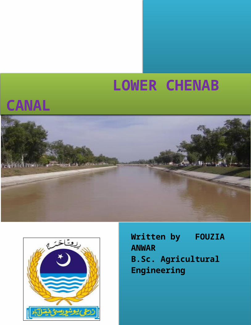
Pakistan irrigation system report on LOWER CHENAB CANAL
29
Written by FOUZIA ANWAR B.Sc. Agricultural Engineering LOWER CHENAB CANAL
Transcript of Pakistan irrigation system report on LOWER CHENAB CANAL
Written by FOUZIA ANWARB.Sc. Agricultural Engineering
LOWER CHENAB CANAL
Table of Contents1: Introduction 32- Khanki headworks 42.1 improvements in Khanki headworks 62.2: SILENT FEATURE OF KHANKI HEADWORKS 62.3 Flood in khanki 73: LOWER CHENAB CANAL(LCC) 93.1: classification of LCC 93.2: SALIENT FEATURES of LCC 113.3: Branch canals of LCC 123.3.1 Lower Chenab Canal (East) 123.3.1a LCC(E) Features 123.3.1b Population of LCC 143.3.1c LCC(E) area 143.3.1d FO of LCC (E) 163.3.2 Lower Chenab Canal (West) 163.3.2a Area Water Board 163.4 Discharge from LCC 183.4.1 Capacity and Discharge 183.5 silting in LCC 203.5.1 Silt removal 20
1

3.5.2 E.S Lindley’s depth bed width relationship (1991)20
3.6 Lining of LCC 213.6.1 Clay puddle lining 213.7 Conclusion 21
1: Introduction Khanki headworks issituated on river Chenab in Gujranwala districtof Punjab province of Pakistan. khanki headworksused for irrigation and flood control. LowerChenab Canal(LCC) is originates from khankiheadworks. Khanki headworks provide water toLCC.
2

Fig 1.1: layoutof the Chenab river basin
2- Khanki headworks KhankiHeadworks is a headworks situated on the RiverChenab. It was constructed in 1889 and is
3
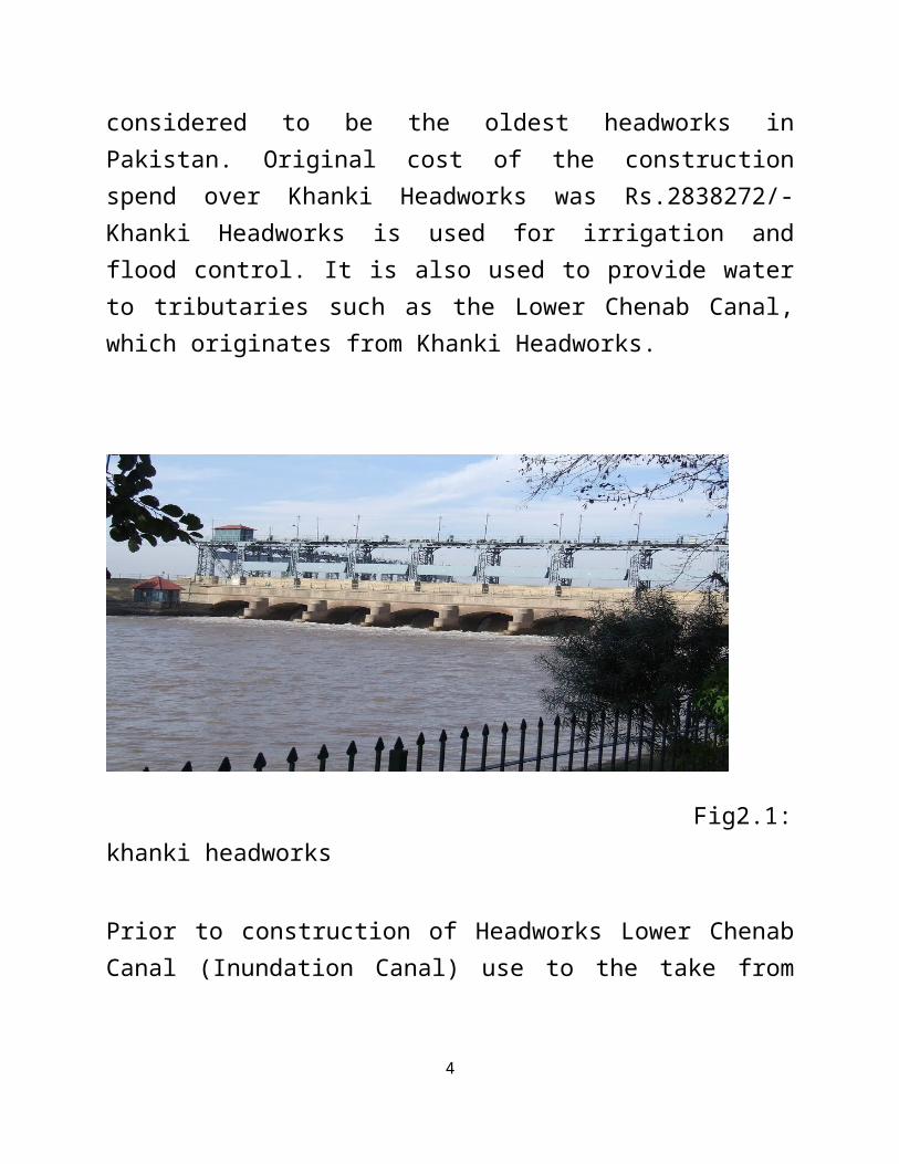
considered to be the oldest headworks inPakistan. Original cost of the constructionspend over Khanki Headworks was Rs.2838272/-Khanki Headworks is used for irrigation andflood control. It is also used to provide waterto tributaries such as the Lower Chenab Canal,which originates from Khanki Headworks.
Fig2.1:khanki headworks Prior to construction of Headworks Lower ChenabCanal (Inundation Canal) use to the take from
4

Ghari Gola about 6 KM Downstream of KhankiHeadworks.
Khanki controls water distribution over 3million acres (12,000 km²) of Agricultural landsby one main distributary, the Lower ChenabCanal, and 59 minor distributaries. Table2.1:Length of guide bank and marginalbund on khanki
Length of upstreamguidebank(ft)
Length of marginalbund (miles)
Left side Right side Left side Right side2700 4500 4.2 6.73
KhankiHeadworks is the oldest major IrrigationDiversion Structure in Pakistan. Khanki Divisionis responsible for maintenance of Headworks &L.C.C. RD 0+000 - 140+000 under administrativecontrol of Chief Engineer, Irrigation ZoneFaisalabad and Superintending Engineer LowerChenab Canal (East) Circle Faisalabad.
5

2.1 improvements in Khanki headworks Replacementof 121 years old Khanki Headworks with a newbarrage is planned to increase agriculturalproduction by 10%.Primary beneficiaries of theproject will be 568000 farming families in theLower Chenab Canal (LCC) command area who willbe ensured of reliable irrigation supplies. Theconstruction of new barrage will save the canalnetwork of 2925 channels (4680 kilometers),which will irrigate more than 3.301 millionacres of the above eight districts. To replacethe existing 120 years old Headworks with newbarrage will enhance flood passage capacity from800000 to 1100000 cusecs.
2.2: SILENT FEATURE OF KHANKI HEADWORKS 1. Length of Main Canal.
28.00 Miles
2. Length of Distys. 102.77 Miles
3. Length of Minors.117.42 Miles
6

4. Length of Sub Minors. 11.75 Miles
5. Escape channel. 4.00 Miles
TOTAL: - 264.26
6. No. of Channels 46
7. No. of Outlets. 638
8. Cultureable Command Area240319 Acres.
9. Water Allowance10.00/4.43/5.15
10. Intensity 33%/50%
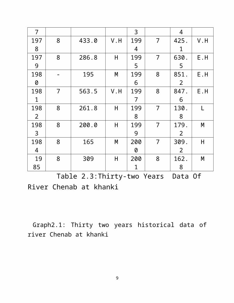
2.3 Flood in khanki
Table2.2: FLOOD LIMITS (IN THOUSANDS CUSECS)
7
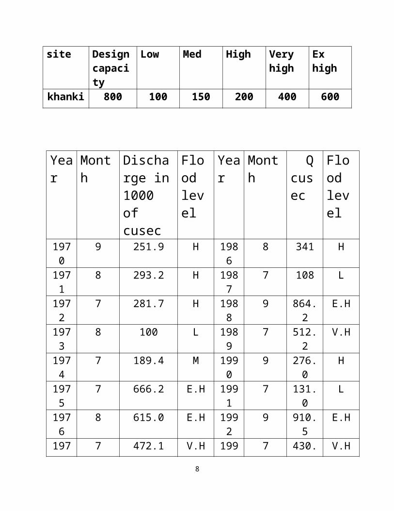
site Designcapacity
Low Med High Veryhigh
Exhigh
khanki 800 100 150 200 400 600
Year
Month
Discharge in1000 of cusec
Flood level
Year
Month
Qcusec
Flood level
1970
9 251.9 H 1986
8 341 H
1971
8 293.2 H 1987
7 108 L
1972
7 281.7 H 1988
9 864.2
E.H
1973
8 100 L 1989
7 512.2
V.H
1974
7 189.4 M 1990
9 276.0
H
1975
7 666.2 E.H 1991
7 131.0
L
1976
8 615.0 E.H 1992
9 910.5
E.H
197 7 472.1 V.H 199 7 430. V.H
8
7 3 41978
8 433.0 V.H 1994
7 425.1
V.H
1979
8 286.8 H 1995
7 630.5
E.H
1980
- 195 M 1996
8 851.2
E.H
1981
7 563.5 V.H 1997
8 847.6
E.H
1982
8 261.8 H 1998
7 130.8
L
1983
8 200.0 H 1999
7 179.2
M
1984
8 165 M 2000
7 309.2
H
1985
8 309 H 2001
8 162.8
M
Table 2.3:Thirty-two Years Data Of River Chenab at khanki
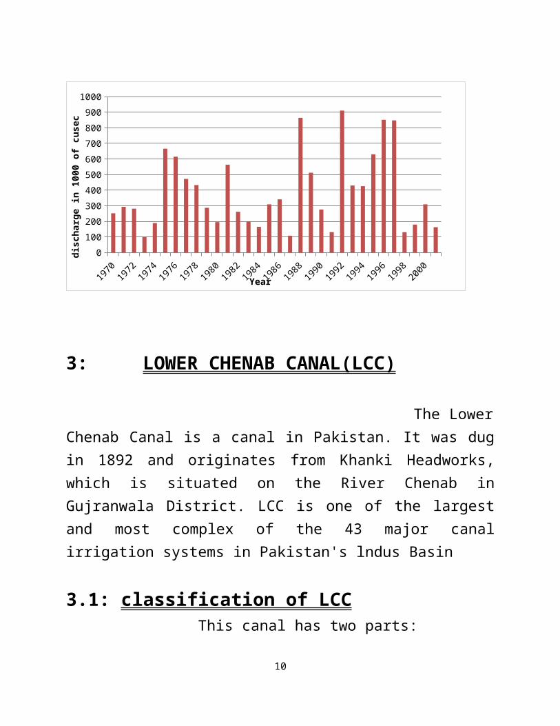
Graph2.1: Thirty two years historical data ofriver Chenab at khanki
9
1970
1972
1974
1976
1978
1980
1982
1984
1986
1988
1990
1992
1994
1996
1998
2000
01002003004005006007008009001000
Year
disc
harg
e in 1
000
of c
usec
3: LOWER CHENAB CANAL(LCC)
The LowerChenab Canal is a canal in Pakistan. It was dugin 1892 and originates from Khanki Headworks,which is situated on the River Chenab inGujranwala District. LCC is one of the largestand most complex of the 43 major canalirrigation systems in Pakistan's lndus Basin
3.1: classification of LCC This canal has two parts:
10
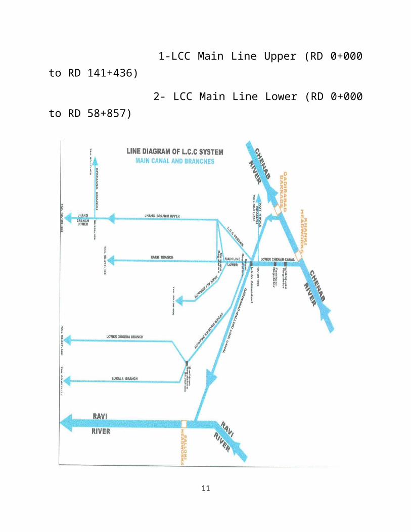
1-LCC Main Line Upper (RD 0+000to RD 141+436)
2- LCC Main Line Lower (RD 0+000to RD 58+857)
11

Fig3.1: linediagram of LCC
3.2: SALIENT FEATURES of LCC
Main Canal / Branches = 454Miles
Minors = 2399 Miles
Escape Channels = 38 Miles
Outlets = 6709 Nos.
Q.B. Link Canal = 103Miles
Drainage System = 1474 Miles
Flood Embankments = 85.40 Miles
12
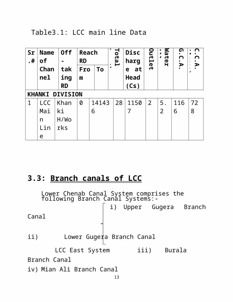
Table3.1: LCC main line Data
Sr.#
NameofChannel
Off-takingRD
ReachRD
TotalLength
Discharge atHead(Cs)
Outlet(Nos)
WaterAllowance
G.C.A.(Acres)
C.C.A.(Acres)Fro
mTo
KHANKI DIVISION1 LCC
MainLine
KhankiH/Works
0 141436
28 11507
2 5.2
1166
728
3.3: Branch canals of LCC Lower Chenab Canal System comprises the following Branch Canal Systems:-
i) Upper Gugera BranchCanal ii) Lower Gugera Branch Canal
LCC East System iii) BuralaBranch Canaliv) Mian Ali Branch Canal
13
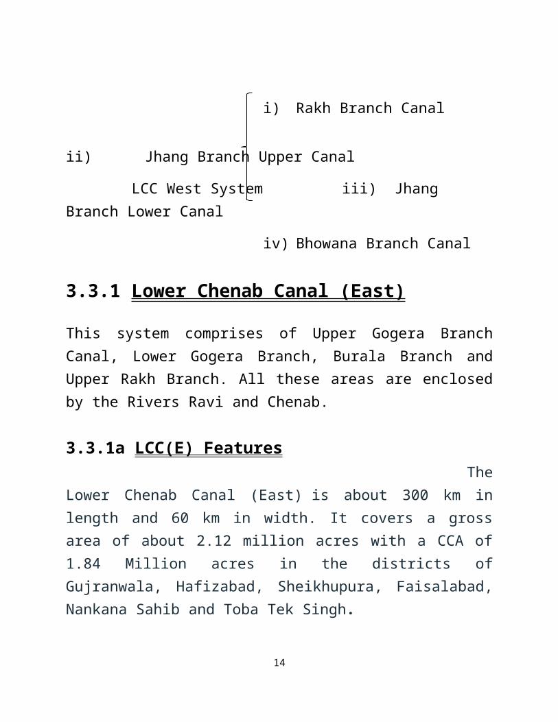
i) Rakh Branch Canal ii) Jhang Branch Upper Canal
LCC West System iii) JhangBranch Lower Canal
iv) Bhowana Branch Canal
3.3.1 Lower Chenab Canal (East)
This system comprises of Upper Gogera BranchCanal, Lower Gogera Branch, Burala Branch andUpper Rakh Branch. All these areas are enclosedby the Rivers Ravi and Chenab.
3.3.1a LCC(E) Features TheLower Chenab Canal (East) is about 300 km inlength and 60 km in width. It covers a grossarea of about 2.12 million acres with a CCA of1.84 Million acres in the districts ofGujranwala, Hafizabad, Sheikhupura, Faisalabad,Nankana Sahib and Toba Tek Singh.
14
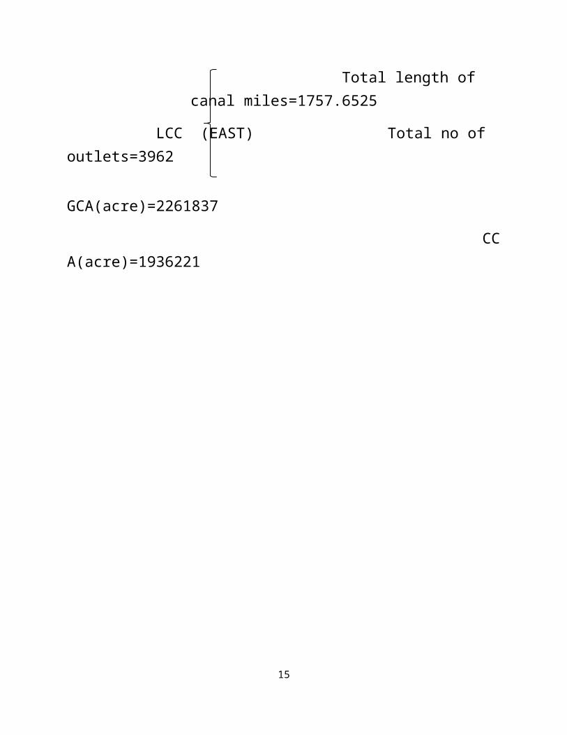
Total length ofcanal miles=1757.6525
LCC (EAST) Total no of outlets=3962 GCA(acre)=2261837
CCA(acre)=1936221
15
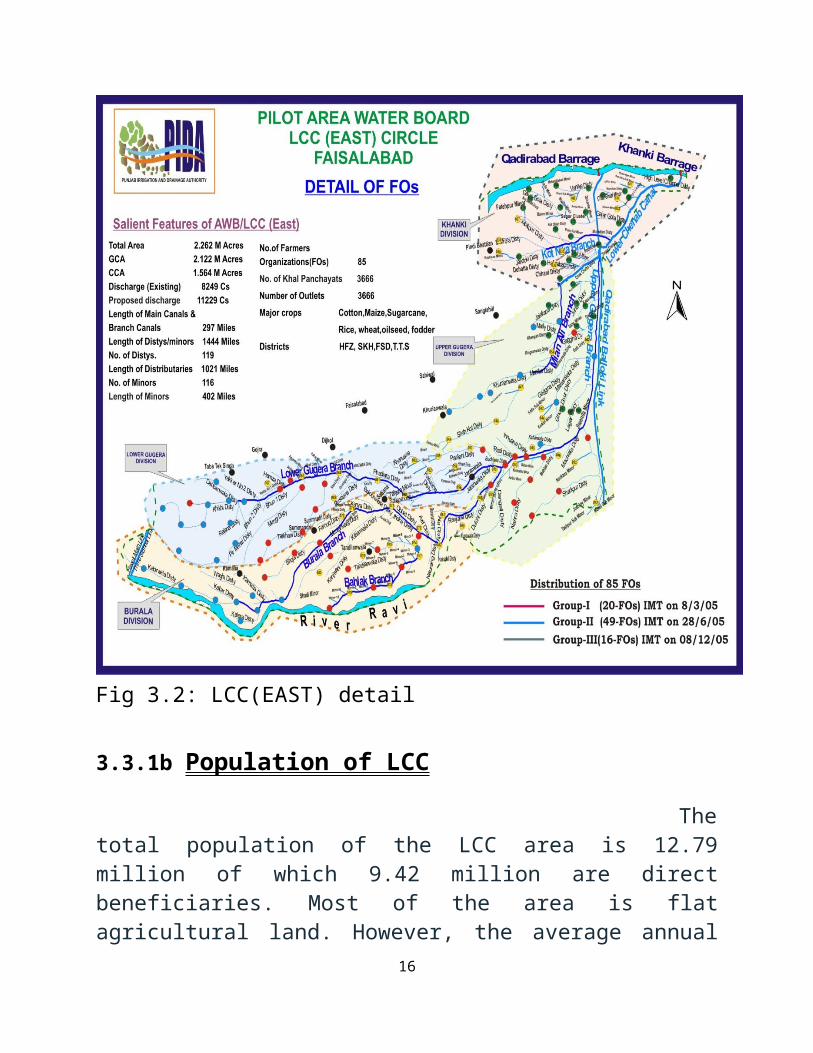
Fig 3.2: LCC(EAST) detail
3.3.1b Population of LCC
Thetotal population of the LCC area is 12.79million of which 9.42 million are directbeneficiaries. Most of the area is flatagricultural land. However, the average annual
16
rainfall is estimated as 315 mm, which isinsufficient for the water requirement of thecrops grown.
Table 3.2:Lower Chenab Canal East Circle Faisalabad
Sr.#
Name of Division
Lengthof
canal(miles
)
Discharge ofchannelcusec
GCAAcres
CCAAcres
Annualirrigated areaacre
NO. ofOutlets
1 UpperGugera 435 1,653
701133 576233 763,612 1050
2 LowerGugera 429 1,834 621524 521064 696,677 989
3 Burala 408 1,542 588220 510638 704,723 947
Total 1,271 4,029 1,910,877 1,607,935 2,165,012 4219
1 acre = 0.4047 hectare; 1 mile = 1.61 km; 1 cusec =28.32 I/s.
3.3.1c LCC(E) area LCC (E) areais defined as mixed cropping zone. Rice, wheat,sugarcane, oilseeds and fodders are the maincrops of the area while cotton and maize are notcommonly cultivated in the LCC (E).Differentkinds of orchards cover every minute percentageof the area. Total cultivated command area ofLCC (E) is 1,839,300 acres.
17

Table3.3: DISTRICT WISE LENGTH OF CHANNELS LCC( EAST)Faisalabad
DistrictGujranwala
Length ofMainCanal
sLength of Branch
Canals
Length ofdisty
Length ofMinor
Escape
Khanki Division 22-00 0-00
32-4911 22-2958
4-0000
District wisetotal 22.00 0.00 32.98 22.59 4.00District HafizabadKhanki Division
6-1436 0-00
67-1546 99-0184 0.00
Upper GugeraDivision 0-000 15-000
25-1264 7_4462 0.00
District wisetotal 6.29 15.00 92.56 106.92 0.00District SheikhupuraUpper GugeraDivision 0-000 44-00
127-1400 52-2200 0.00
District wisetotal 0.00 44.00
127.28 52.44 0.00
District Nankana Sahib
16-2000 77-4000 38-3000 0.00
16.4 77.80 38.6 0.00District FaisalabadUpper GugeraDivision 0.00 0-000
77-1006 31-1231
17-3500
18

Lower Gugera 0-000 63-0000145-1077 33-1102
1-0500
Burala 0-000 82-000200-1088 82-3578
2.-2700
District wisetotal 0-000 145
422.63 147.18
21.34.
District T.TSingh
Lower Gugera 0-000 14-2566131-4500 71-1026 0.00
Burala 0-000 15-075588-
47-92 26-46690-
2050District wisetotal 0-000 29.66
220.86 98.14 0.41
Grand Total 28.29 250.06
974.11 465.87
25.75
(Dimensionsin miles)
3.3.1d FO of LCC (E) Under thereforms program, PIDA has framed 85 FarmerOrganizations in Lower Chenab Canal (East)Circle by establishing the Area Water Board.
Table3.4: LCC (East) Data LOWER CHENAB CANAL EAST CIRCLE FAISALABADDATA OF CNANNELS 2012-2013Sr.#
Name of Division
Canal Total Length of Canal(Miles)
Tatal No. of Outlets
GCA (Acres)
CCA (Acres)
Remarks
1 2 3 4 5 6 7 8
19
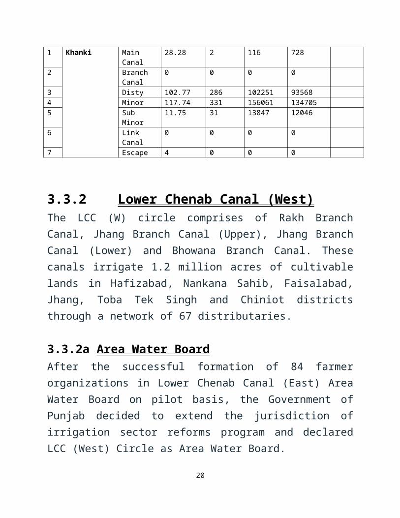
1 Khanki Main Canal
28.28 2 116 728
2 Branch Canal
0 0 0 0
3 Disty 102.77 286 102251 935684 Minor 117.74 331 156061 1347055 Sub
Minor11.75 31 13847 12046
6 Link Canal
0 0 0 0
7 Escape 4 0 0 0
3.3.2 Lower Chenab Canal (West)The LCC (W) circle comprises of Rakh BranchCanal, Jhang Branch Canal (Upper), Jhang BranchCanal (Lower) and Bhowana Branch Canal. Thesecanals irrigate 1.2 million acres of cultivablelands in Hafizabad, Nankana Sahib, Faisalabad,Jhang, Toba Tek Singh and Chiniot districtsthrough a network of 67 distributaries.
3.3.2a Area Water BoardAfter the successful formation of 84 farmerorganizations in Lower Chenab Canal (East) AreaWater Board on pilot basis, the Government ofPunjab decided to extend the jurisdiction ofirrigation sector reforms program and declaredLCC (West) Circle as Area Water Board.
20

Fig3.3:LCC(WEST) map
Theland of LCC (W) Area Water Board is very famousall over the world for the production of rice,cotton, sugarcane, maize, wheat, oil seed andfodder. The Area Water Board of LCC (W) Circle was made
21

operational in 2009 for a period of three yearswhere PIDA established 64 farmer organizations.
3.4 Discharge from LCC LCC supplying irrigation water to 3.031 millionacres of culturable command area (CCA) through anetwork of branches, distributaries and minors.
i) Existing =12243 Cusecs ii) Revised = 15528
Cusecs
3.4.1 Capacity and Discharge The designed capacity of weir is 8.00 Lac cusecand designed discharge of off taking canal is8143 cusec which used by SuperintendingEngineer, LCC East Circle, Faisalabad. Therevised discharge for LCC works out 11500 Cusecand L-Section of LCC is approved and will beimplemented after construction of Barrage. New Khanki Barrage will reliably divert 11653
22
cusecs of irrigation supplies to the downstreamLCC irrigating 1.2 million hectors.
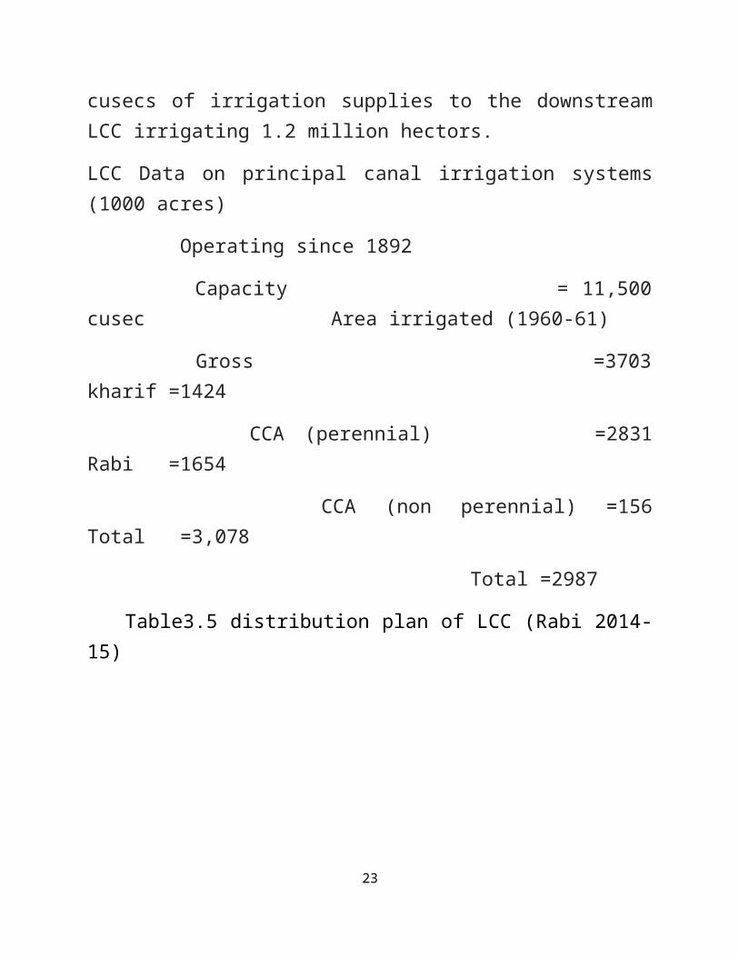
LCC Data on principal canal irrigation systems(1000 acres)
Operating since 1892
Capacity = 11,500cusec Area irrigated (1960-61)
Gross =3703kharif =1424
CCA (perennial) =2831Rabi =1654
CCA (non perennial) =156Total =3,078
Total =2987
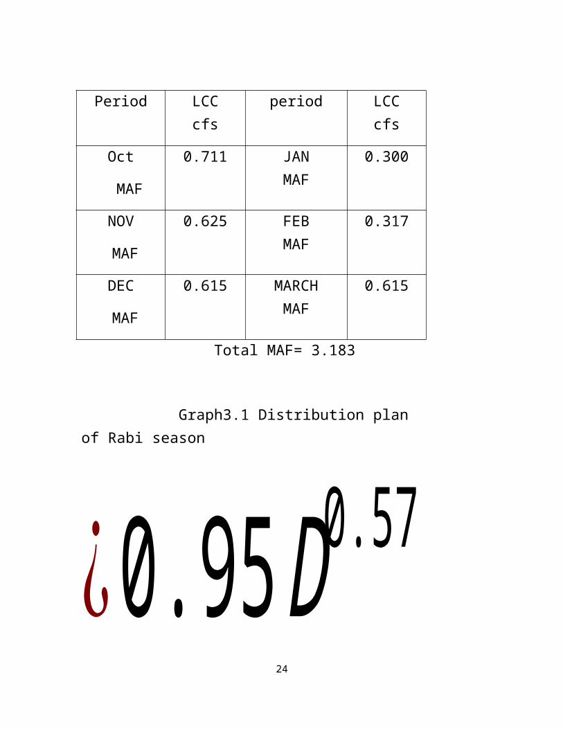
Table3.5 distribution plan of LCC (Rabi 2014-15)
23
24
Period LCCcfs
period LCCcfs
Oct
MAF
0.711 JANMAF
0.300
NOV
MAF
0.625 FEBMAF
0.317
DEC
MAF
0.615 MARCHMAF
0.615
Total MAF= 3.183
Graph3.1 Distribution plan of Rabi season
¿0.95D0.57
3.5 silting in LCC Silting oflower Chenab canal after its opening in 1887 hadbeen a serious problem so that it was found to1900 Kennedy faced with silt entry into canal atRuper had suggested several Counter measure toreduce silt entry. One of the methods was tocreate a curved flow to feed the canal throughflow of low sediment content this very methodwas tried at Khanki which had to be providedwith undersluices in the middle and on rightside of the weir. The idea of silt excluder wasalso adopted on this weir.
3.5.1 Silt removal Kennedy’s silttheory is important in this respect and thenLindley’s makes modification and improvements inKennedy’s theory.
3.5.2 E.S Lindley’s depth bed width relationship (1991) Lindleyperformed experiment on the Lower Chenab Canal
25

and developed the following relationshipsbetween the Velocity , bed width and depth.
V ¿0.95D0.57
V ¿0.59B0.355
B ¿3.80D1.61
Where, V=non-Silting , non-scouringvelocity
B=bed width D=bed depth
3.6 Lining of LCC Lining reduces seepage losses. Reducing percolation and watersaved for irrigation
Chances of weed growthdecreases
No danger of erosion Salts will not be absorbed
3.6.1 Clay puddle lining A layerof clay about 1ft thick covered by 1ft silt orsoil will serve as an excellent cut off forseepage.it was use on selected reaches of Lower
26
Chenab Canal(LCC) and seepage was reduces by80%.
3.7 Conclusion The abovediscussion on LCC shows that by increasing waterlevel in khanki headworks the water level in LCCalso rise.The distribution plan of LCC during RABI(2014-15) shows that during Jan and Feb less amount ofwater is available in LCC. By lining of LCCsilting can b minimizes and maximum Agriculturalarea can be irrigated.
ReferencesPunjab irrigation and drainage Authority (PIDA),Irrigation department Pakistan.
27

Agricultural Statistics of Pakistan. 1991-92. Ministryof Food, Agriculture and Cooperatives, Food andAgriculture Division, Economic Wing, Government ofPakistan, Islamabad.
Asad Serwar Quereshi, Mushtaq A. Gill, Asrar Serwar.(2010). Sustaianable Groundwater Management inPakistan: Challenges and Opportunities. Irrigation andDrainage .
Water resources of Pakistan by Dr. Nazir ahmed
28


![[Trophic ecology and reproductive aspects of Trichomycterus areolatus (Pisces, Trichomycteridae) in irrigation canal environments]](https://static.fdokumen.com/doc/165x107/6331c794b6829c19b80ba6ae/trophic-ecology-and-reproductive-aspects-of-trichomycterus-areolatus-pisces-trichomycteridae.jpg)