Pak Nai Field Trip - Teacher's Manual
20
Pak Nai Field Trip Pak Nai Field Trip Teacher’s Manual Teacher’s Manual Pak Nai Field Trip Pak Nai Field Trip Teacher’s Manual Teacher’s Manual Target audience Related subject Themes Suggested field trip duration Suggested student to teacher ratio About this manual Key Words Students from secondary 1 to 3 Geography “Ridge to Reef” concept Mudflat ecology Suggested field trip duraon: three hours with travelling me (can be adjusted according to teaching content and weather condions) 30 to 2 The field trip manual is designed for secondary 1 to 3 geography students to help facilitate the exploraon of Hong Kong’s mudflat ecology and to understand the “Ridge to Reef” concept and UN sustainable development goals. The teacher’s manual includes: field trip route; suggested teaching objecves; idenficaon charts of commonly found organisms; and student worksheets. “Ridge to Reef”, mudflat, sustainable development goals, SDGs, Pak Nai Funded by Organised by Project Brief Building on IUCN’s (The Internaonal Union for Conservaon of Nature) global conservaon iniave, The Nature Conservancy (TNC) launched the Jockey Club “Ridge to Reef” Environmental Educaon Programme, with support from The Hong Kong Jockey Club Charies Trust. The holisc program aims to enhance the environmental literacy of Hong Kong’s youth. Using TNC’s Learn-Act-Lead model, we are working with Hong Kong’s students, teachers and schools.
-
Upload
khangminh22 -
Category
Documents
-
view
0 -
download
0
Transcript of Pak Nai Field Trip - Teacher's Manual

Pak Nai Field Trip Pak Nai Field Trip Teacher’s ManualTeacher’s ManualPak Nai Field TripPak Nai Field Trip Teacher’s ManualTeacher’s Manual
Target audience
Related subject
Themes
Suggested field trip duration
Suggested student to teacher ratio
About this manual
Key Words
Students from secondary 1 to 3
Geography
“Ridge to Reef” concept Mudflat ecology
Suggested field trip duration: three hours with travelling time (can be adjusted according to teaching content and weather conditions)
30 to 2
The field trip manual is designed for secondary 1 to 3 geography students to help facilitate the exploration of Hong Kong’s mudflat ecology and to understand the “Ridge to Reef” concept and UN sustainable development goals. The teacher’s manual includes: field trip route; suggested teaching objectives; identification charts of commonly found organisms; and student worksheets.
“Ridge to Reef”, mudflat, sustainable development goals, SDGs, Pak Nai
Funded by Organised by
Project Brief Building on IUCN’s (The International Union for Conservation of Nature) global conservation initiative, The Nature Conservancy (TNC) launched the Jockey Club “Ridge to Reef” Environmental Education Programme, with support from The Hong Kong Jockey Club Charities Trust. The holistic program aims to enhance the environmental literacy of Hong Kong’s youth. Using TNC’s Learn-Act-Lead model, we are working with Hong Kong’s students, teachers and schools.

Cities and metropolitan areas are the sources of economic growth, and they are accountable for about 70 percent of global carbon emissions. Rapid urbanization also leads to various environmental problems, such as pollution, sanitation, sewage and wastes, freshwater supply and land-use problems. Therefore, development is closely related to the environment. To protect the Earth’s environment and reduce negative impact, urban development must comply with the principles of sustainable development.
Related targets:
11.4 Protect the world’s cultural and natural heritage
11.6 Reduce the environmental impact of cities
SDG
The consumption and production of natural resources promote economic growth but causes problems such as pollution and over-exploitation. In order to protect and reduce the impact on the environment, we must consume and produce responsibly.
By understanding the relationship between Pak Nai, oyster reefs and the fishing community, students can learn how to sustainably manage and use natural resources effectively and adopt a sustainable lifestyle to coexist harmoniously with nature.
Related targets:
12.2 Sustainable management and efficient use of natural resources
12.8 Promote sustainable lifestyles in harmony with nature
12.B Sustainable tourism that creates jobs and promotes local culture and products
Sustainable Cities and CommunitiesMake cities and human settlements inclusive, safe, resilient and sustainable.
Responsible Consumption and ProductionEnsure sustainable consumption and production patterns.
Sustainable Development Goals (SDG)
The Sustainable Development Goals (SDGs) are the blueprint designated by the United Nations, setting up 17 goals and 169 targets. The agenda intended to lead the world’s various governments, organisations, and bodies to achieve these goals and bring a more sustainable future for all. The SDGs were adopted by all 193 United Nations Member States and implemented in 2016, and are intended to be achieved by the year 2030.
Through the field trip in Pak Nai, teachers can guide students to think about some of the SDGs and related targets, and discuss their relations with Hong Kong and our daily life.
2
SDG

The ocean occupies 70 percent of the Earth’s surface, provides food and energy to humans and plays an important role in elemental cycling , oxygen supply and climate control. To protect marine resources, we have to reduce pollution and overfishing.
Through the field trip to Pak Nai, students can understand mudflat and mangrove biodiversity and the resources they provide, as well as the importance of protecting marine environments.
Related targets:
14.1 Prevent and significantly reduce marine pollution, especially from land-based activities
14.2 Coastal ecosystem protection and management
14.5 Conserve coastal areas
Life Below WaterConserve and sustainably use the oceans, seas and marine resources.
Terrestrial ecosystems are as important to human survival as the ocean, providing oxygen, pollinating crops and providing resources such as food. Human activities have transformed the terrestrial ecosystems and threatened many terrestrial life forms. As a result, human livelihoods, economy, health and quality of life are also affected.
Through the field trip, students can understand the concept of “Ridge to Reef” and the close relationship between the land and the sea. Students can also learn how changing land use affects the surrounding land and ocean environment.
Related targets:
15.1
15.2
15.5
15.8
Life on LandSustainably manage forests, halt and reverse land degradation, halt biodiversity loss.
Ensure the conservation, restoration and sustainable use of terrestrial and inland freshwater ecosystems and their services, in particular forests, wetlands, mountains and dryland
Sustainable management of forests, halt deforestation, restore degraded forests and increase afforestation and reforestation
Reduce the degradation of natural habitats, halt the loss of biodiversity and protect and prevent the extinction of threatened species
Prevent the introduction and reduce the impact of invasive alien species on ecosystems
3
Sustainable Development Goals (SDG)
SDG
SDG

Preparation
Drinking water
From the Yuen Long MTR station, it is about a 10-minute walk to the Tai Fung Street green minibus station. Take the number 33 minibus to Pak Nai Ap Tsai Hang.
Green minibus:
Record forms and stationery
Materials and tools:
Binoculars
First aid kitTray, forceps and magnifying glasses for observing organisms
Mudflat organism field guide and ID charts
Outdoor gear:
Light-colored, breathable, long-sleeved clothing
Sports shoes, water boots
Hat
Jacket
4
Transportation
As the road is narrow and rough, a 28-seat coach is the largest recommended size.
Coaches can park at “App Store Cafe & Barbecue”, but reservations must be made in advance. (Contact information - address: 283A, Nim Wan Road, opening from 2:00 – 7:00 p.m., Monday to Sunday, phone: 9804 3042)
Coach:
A green taxi from Tin Shui Wai MTR station to Pak Nai costs about $80 and takes about 15 minutes.
Green Taxi:
Rain gear

Participants should wear light-coloured, long-sleeved clothing and a hat to protect from sunburn and heatstroke. Bring plenty of drinking water. Wear protective shoes, such as sport shoes or water boots. Open-toed slippers or sandals are not suitable.
As students may come into contact with seawater during the field trip, teachers can recommend using ocean-friendly sunscreen and physical barriers for mosquitos. Avoid using chemical sunscreens to prevent contamination of the seawater.
Teachers should pay close attention to the tide level on-site to ensure that students have sufficient time to leave the intertidal mudflat area before the tide goes up.
Respect wildlife. Do not shout or yell in the field, or touch, interfere or harm organisms during observation. Beware of stepping on animals while walking.
Do not take any animal, plant or anything that belongs in the field. Only trash should be taken away from the natural environment.
Teachers should explain the field trip arrangement, schedule, suggested gear and safety recommendations to the students.
Teachers should check the tide level and weather conditions on the Hong Kong Observatory website. The ideal tide level for field work is below one meter.
Before the trip:
If the Hong Kong Observatory issues the following signals two hours before the trip starts, teachers should consider cancelling the field trip:
Strong Wing Signal, Typhoon Warning Signal No. 3 or above
Any Rainstorm Warning
Regional Thunderstorm Warning
Very Hot Weather Warning
How to check tidal information:
1. Visit Hong Kong Observatory Website (https://www.hko.gov.hk/) or download the HKO app
2. Choose “Geophysics > Tide > Predicted Tide” from the sidebar
3. Choose the forecast date according to the day of the survey
4. Check whether the tide at the proposed time is lower than one meter
Weather:
Tide levels suitable for field trip
Time not suitable for field trip (nights)
5
Reminders and Safety Recommendations:
During the trip:
6
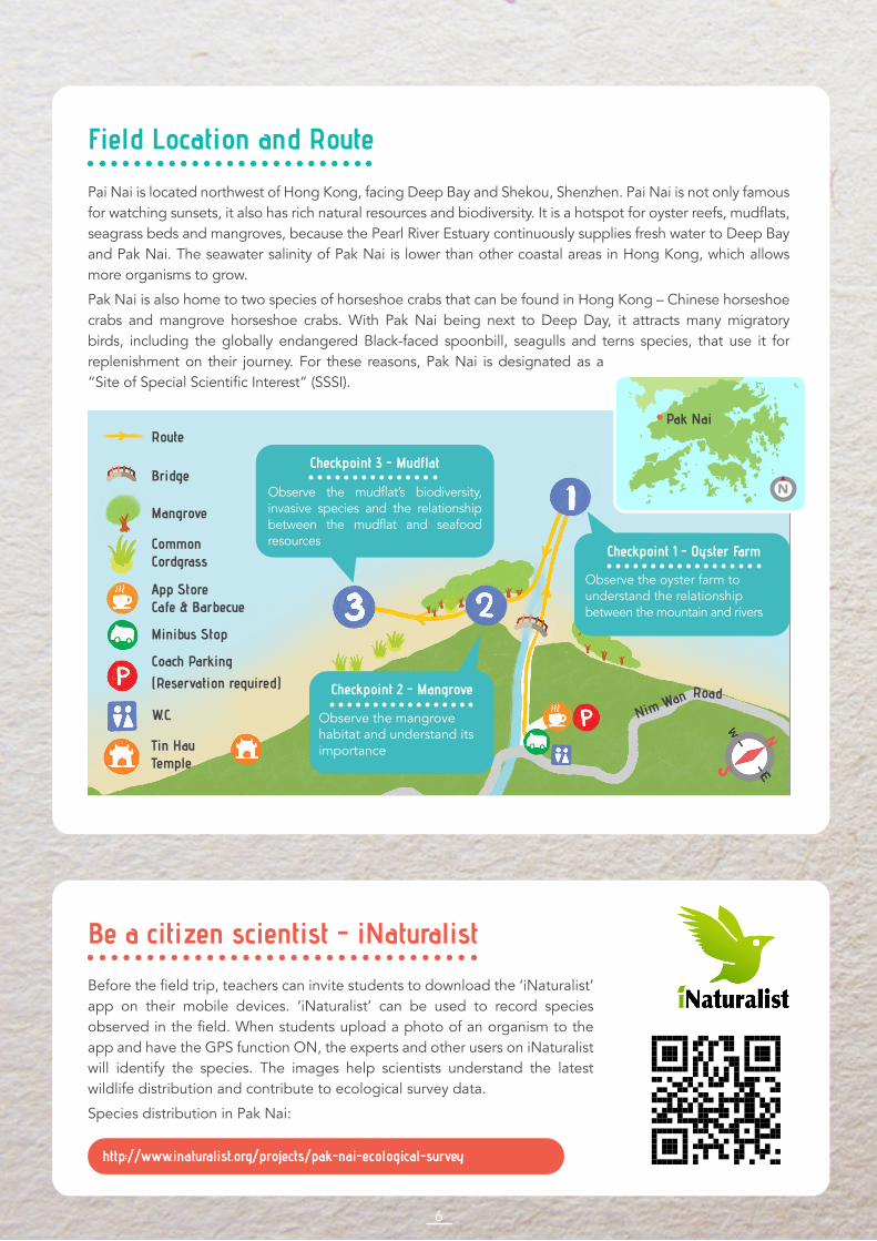
Field Location and Route
Pai Nai is located northwest of Hong Kong, facing Deep Bay and Shekou, Shenzhen. Pai Nai is not only famous for watching sunsets, it also has rich natural resources and biodiversity. It is a hotspot for oyster reefs, mudflats, seagrass beds and mangroves, because the Pearl River Estuary continuously supplies fresh water to Deep Bay and Pak Nai. The seawater salinity of Pak Nai is lower than other coastal areas in Hong Kong, which allows more organisms to grow.
Pak Nai is also home to two species of horseshoe crabs that can be found in Hong Kong – Chinese horseshoe crabs and mangrove horseshoe crabs. With Pak Nai being next to Deep Day, it attracts many migratory birds, including the globally endangered Black-faced spoonbill, seagulls and terns species, that use it for replenishment on their journey. For these reasons, Pak Nai is designated as a “Site of Special Scientific Interest” (SSSI).
Be a citizen scientist - iNaturalist
Before the field trip, teachers can invite students to download the ‘iNaturalist’ app on their mobile devices. ‘iNaturalist’ can be used to record species observed in the field. When students upload a photo of an organism to the app and have the GPS function ON, the experts and other users on iNaturalist will identify the species. The images help scientists understand the latest wildlife distribution and contribute to ecological survey data.
Species distribution in Pak Nai:
http://www.inaturalist.org/projects/pak-nai-ecological-survey
Common Cordgrass
App Store Cafe & Barbecue
Minibus Stop
Coach Parking(Reservation required)
W.C.
Tin Hau Temple
Route
Mangrove
Checkpoint 3 - Mudflat
Observe the mudflat’s biodiversity, invasive species and the relationship between the mudflat and seafood resources
Checkpoint 2 - Mangrove
Observe the mangrove habitat and understand its importance
Checkpoint 1 - Oyster Farm
Observe the oyster farm to understand the relationship between the mountain and rivers
Bridge
Nim Wan
Pak Nai
Road
N

7
Location: Oyster Farm
Duration: 40 minutes
Teaching content:
Through rivers and streams, everything that happens on land (e.g., sewage and litter) will have an impact downstream, including intertidal habitats and eventually, the sea. The ocean and intertidal wetlands are ecosystems with rich biodiversity, so healthy and clean rivers and streams are crucial to maintaining healthy estuaries, coastal areas, wetlands, coral reefs and oyster reefs. Therefore, the International Union for Conservation of Nature (IUCN) has proposed the “Ridge to Reef” (R2R) conservation initiative to link the river basins from land to coast, to better manage water resources and ecosystems. This initiative also applies to Hong Kong, because it is a coastal city, and proper management of coastal areas’ ecosystems and estuaries can support people’s livelihoods and increase income from fisheries and tourism.
In some Asian and Latin American cities, improved watershed management has benefited the coral reef system and improved people’s quality of life and well-being.
“Ridge to Reef” Concept
The Hong Kong Jockey Club Ridge to Reef (R2R) Environmental Education Programme Educational Animation
International Coral Reef Initiative Case Studies: From Ridge to Reef https://www.env.go.jp/nature/biodic/coralreefs/pamph/C-community_EN.pdf
Extended Reading Materials
Episode 1
https://www.youtube.com/watch?v=bYD2DlinVpw
Episode 2
https://www.youtube.com/watch?v=XZocxB-J-YU
Checkpoint 1 - Oyster FarmField Trip Run Down

Teaching content:
The Hong Kong oyster industry has over 700 years of history, and the oyster culture methodology was developed during the early Song Dynasty.
The traditional methods of oyster cultivation (bottom cultivation) and oyster sauce production have been designated as part of Hong Kong’s Intangible Cultural Heritage. “Bottom cultivation” means oyster farmers lay out bare substrate on the mudflat, allowing for oyster larvae in the water column to settle naturally. Oysters usually will reach marketable size and are ready to harvest after three to four years.
Traditional oyster cultivation encourages sustainable harvesting practices, because oysters are only harvested well beyond maturity. Oysters reach reproductive maturity at about one year old but are harvested around three-to-four years old, leaving plenty of time to reproduce. This helps sustain natural wild oyster populations, including native oyster species in Hong Kong.
The brackish conditions of Deep Bay make its waters ideal for growing oysters. Deep Bay has been is an important oyster cultivation zone in Hong Kong for at least 250 years. Today, oyster farming in Deep Bay is a sunsetting industry, with only about 80 active oyster farmers left. Many have worked with their families since childhood, and most of them are now over sixty years old.
Man-made oyster farms are not the same as naturally occurring oyster reefs, which have much denser oyster populations and are not as spread out. The artificial oyster clumps in the abandoned Pak Nai farm are still full of live oysters that can provide habitats to many other living creatures. Try to count the number of different species you find at the oyster farm.
History of oyster farming in Hong Kong::
1. Improving fishery catchesOyster reefs can provide habitat for juvenile fish and their prey, which can benefit both commercial and recreational fisheries.
2. Coastal protectionOyster reefs can buffer strong waves and reduce erosion, which makes the coast more stable and supports the growth of seagrass beds.
Since oyster reefs are alive, they can grow taller when the sea level rises and can rebuild after a typhoon.
3. Improving water qualityA Hong Kong oyster can filter 30L of water per hour.
Oysters are filter feeders, mainly feeding on plankton that can improve the clarity of the water, allow sunlight to penetrate deeper and benefit aquatic plant growth.
Oyster reefs can reduce eutrophication in the coastal environment by filtering excessive pollutants, especially nitrogen compounds.
Three major benefits of oyster reefs:
8
Checkpoint 1 - Oyster FarmField Trip Run Down

© Joe Cheung/TNC
9
Abandoned oyster farm (Pak Nai, Hong Kong)
© Qing Liu/TNC
Natural intertidal oyster reef (Jiangsu Province, China)
Teaching content:
Checkpoint 1 - Oyster FarmField Trip Run Down

1010
Suggested Activity 1: Explain the nearby attractions
Objective: To help students understand the interconnectedness of people and nature.
Activity content:
1. Have the students stand by the river near the mudflat, then look at the mountains. Using the environment around you to introduce the R2R concept to students, explain that activities happening on the mountain, such as hill fires and sewage discharge, will affect the mudflat ecosystem beneath their feet through the river, and eventually affect the ocean. Therefore, if we want to protect the ocean, we also need to protect the environment in the mountains.
2. Make use of the environment in front of you. Encourage the students to think of examples related to R2R and discuss the interconnectedness of protecting the mountains and the sea.
3. Teachers can explain that the river connects the mountains to the oyster reefs, and then point out the high-polluting industries near Pak Nai on the map, such as the West New Territories Landfill and the Black Point Power Plant.
4. Teachers can tell students that the West New Territories Landfill previously had a pollution leakage accident, and sewage infiltrated the rivers in Pak Nai and heavily impacted the water quality, microorganisms and fish.
5. Students can discuss how the oyster industry in Lau Fau Shan will be affected if the river is polluted, and they can consider the relationships between the river, mangrove forests and oyster reefs.
Suggested Activity 2: Observe the biodiversity in the oyster farm
Objective: To learn about the biodiversity in oyster farms and the importance of its ecological services.
Activity content:
1. Divide the students into groups and ask them to observe and record the animals found inside and outside the oyster farm (please refer to P.14 for the ID chart) and compare the results.
2. Emphasize the ecological services of oyster farms.
Teaching content:
Biodiversity means the number and variety of different life forms.
It is generally categorized into ecosystem diversity, species diversity and genetic diversity (differences between individuals).
Having a wide variety of life, or maintaining biodiversity, is key for organisms to be able to adapt to changes and maintain the stability of the ecosystem. If high biodiversity is maintained, when a few species decline or disappear from an ecosystem, or when sudden environmental changes occur, the impacts can be reduced and allow organisms to play different ecological roles and functions.
High biodiversity provides many advantages, called “ecosystem services”, including the production of food, medicine, clothing and construction materials.
Biodiversity:
Checkpoint 1 - Oyster FarmField Trip Run Down

11
Location: Mangrove forest
Duration: 30 minutes
Teaching content:
Mangrove forests are a unique intertidal habitat, usually found in the high tide areas in tropical and subtropical estuaries, mainly distributed on hidden coasts. As this habitat is often affected by both freshwater from the river and saltwater from the ocean, the salinity, oxygen content and soil moisture fluctuate often. Organisms living in this habitat have evolved to overcome this constantly changing environment.
There are around 60 mangrove forests in Hong Kong, covering over 500 hectares found in Sai Kung, Deep Bay, Lantau Island and other locations.
Mangroves can be divided into two types: true mangroves and mangrove associates:
True mangroves:Located in the intertidal zone, they have evolved at least one physiological or morphological adaptation to survive in this harsh environment.
There are eight native true mangrove species in Hong Kong: Acrostichum aureum, Aegiceras corniculatum, Avicennia marina, Bruguiera gymnorrhiza, Excoecaria agallocha, Heritieria littoralis, Lumnitzera racemosa, and Kandelia obovate.
Mangrove associates:Grow closer to the land side of the mudflat and are seldom flooded by tides.
Common examples include: Talipariti tiliaceum and Clerodendrum inerme.
(*Please refer to the Pak Nai Common Organism Field Guide on P.14 for plant photos.)
Mangrove:
1. The temperature is generally high and is exposed to sunlight
2. Unstable and loose substrate
3. Salinity in the substrate fluctuates
4. Interchanging oxygenated and anoxic state in the substrate
5. Sometimes saturated by the tide and sometimes surrounded by dry air
Environmental characteristics:
1. Act as natural barrier to absorb the impact of waves, prevent soil erosion
2. Fallen leaves provide food sources for marine life
3. Complex root systems provide a suitable nursery ground for marine life
4. Filter harmful substances in the water
5. Carbon sequestration and alleviate the effects of climate change
Importance of mangroves:
Suggested Activity 1: Observe the biodiversity in the mangroves
Objective: To explore the mangrove ecosystem and its importance.
Activity content:
1. Divide the students into groups and ask them to observe the animals found inside the mangrove forest and their distribution (please refer to Pak Nai Field Guide).
2. Emphasize the ecological services of mangroves.
Checkpoint 2 - MangroveField Trip Run Down

1212
Location: Mudflat
Duration: 30 minutes
Teaching content:
The intertidal mudflat is one type of wetland habitat that connects the ocean and land. Most mudflats are located along the coasts, away from intense waves, and the mudflat is formed by the natural deposition of fine silt and clay. As the mudflats are located in the intertidal zone, it is exposed to the air and the sun during low tide and immersed in the sea during high tide. Therefore, organisms living in the mudflats have evolved to adapt to this extreme changing environment, similar to those organisms living in mangrove forests.
The mud is rich in organic matter with an abundance of algae growing on its surface. The sediment is fine, and the oxygen content is generally low, creating an anoxic environment that is favorable for the growth of Sulphur bacteria. These algae, bacteria and other organic matter are the food source of invertebrates such as oysters, shellfish, conchs and crabs. Fish and birds, in turn, feed on these invertebrates. Therefore, the mudflat can support rich biodiversity and a large number of organisms and be an important replenishment station for migratory birds.
There are many mudflats in Hong Kong, located in areas such as Mai Po, Deep Bay, Pak Nai, Luk Keng and Tsim Bei Tsui. In the past, mudflats were thought to have no economic value with an unpleasant environment, resulting in many mudflats being reclaimed and converted into agricultural land, shrimp pond, fishpond or for development. Today, mudflats still face threats of being excavated, used for artificial seawalls and converted for other purposes, in addition to suffering from water pollution and overharvesting.
Intertidal Mudflat:
1. Connects the sea and ocean
2. Waves with less energy
3. Affected by the tide, sometimes exposed to the air or sometimes immersed in seawater
4. Sediment is small and can hold a large amount of organic matter
Environmental characteristics:
1. Support rich biodiversity
Commonly found animals: mudskippers, fiddler crabs, egrets, horseshoe crabs, oysters, razor clams
Commonly found plants: seagrass, i.e., Beccari’s seagrass
2. Rich in food resources, an important replenishment stop for migratory birds
3. Suitable nursery and feeding ground for marine life, such as fish and crabs
4. Nursery ground for two local horseshoe crab species – Chinese horseshoe crabs and mangrove horseshoe crabs
Ecological value and its importance:
Checkpoint 3 - MudflatField Trip Run Down

Suggested Activity 1: Mix-and-Match seafood found on the mudflat
Objective: To understand that the mudflat is the nursery ground of many marine organisms, including many seafoods that are commonly in Hong Kong. The mudflat is not as distant as it seems as it actually has a direct relationship with our daily life.
Activity content:
1. Teachers can ask the students to observe the organisms found on the mudflat and ask them where they can find these animals in daily life.
2. Teachers can list a few kinds of seafood found in the wet market, such as fish, shrimp, crab, razor clams, and then ask the students to search for their juveniles on the mudflat. (The teacher can also prepare some photos to help the students recognize the seafoods.)
3. Students will understand that the mudflat is a nursery ground for many marine organisms.
Suggested Activity 2: The effect of common cordgrass
Objective: To understand and view the impact of invasive common cordgrass through comparing the differences between the mudflat and cordgrass habitats.
Activity content:
1. Lead the students to an area with common cordgrass and a mudflat without common cordgrass. Record the differences between two sites, including the properties of the soil (soil moisture, temperature, fineness of the sediment), environmental characteristics, abundance of species, etc.
2. Ask the students to think of the mudflat as an organism and how their life could be affected if the mudflat was turned into grassland.
Teaching content:
This invasive species can be found along the mudflat. It is fast-growing, has a high tolerance to salt and flooding, and with roots firmly anchored in the soil, it is able to withstand strong wind and waves. These characteristics cause it to over-occupy mudflats and mangroves and quickly turn them into grassland, leaving organisms to lose their habitat. In some cases, their growth has caused the wide-spread death of shellfish, crabs, algae, fish and other animals. Cordgrass spread will also block waterbirds and other animals from foraging.
In 2000, common cordgrass was listed as one of the World’s Worst Invasive Alien Species by IUCN.
Invasive Plant: Common cordgrass (Spartina anglica)
13
Checkpoint 3 - MudflatField Trip Run Down

141414
Objective: To solidify the knowledge of mudflat ecology and R2R concept after the field trip through group discussion and reporting.
Duration: 30 minutes
Activity content:
After the field trip, the teacher can split the students into small groups to discuss and report to the class, and then the teacher can summarize the findings and debrief. Suggested time for discussion is five minutes and reporting is two minutes per group.
Discussion questions Teaching objectives
Name the most interesting organisms found today, explain with one of the characteristics of that organism
Point out the importance of biodiversity
Describe something that happens on land or on the mountain that will affect the marine environment
Emphasize that the environments of the mountain and the ocean are closely connected to each other; things that happen on land will affect the sea
Put personal practices into consideration as our choices will also affect the environment
List the threats faced by mangroves and mudflats and discuss how to protect them
Point out that each person has the responsibility to protect the environment, starting from their own choices/actions, and they can take initiative to reflect their opinions to the government
Suggested activity 1
Photo credit © Nicole Kit unless otherwise noted.
Activity DebriefingField Trip Run Down

Mantis shrimp Pistol shrimp
Fiddler crab Metopograpsus sp.
Pyrhila sp. Sentinel crab
15
Commonly found invertebrates in Pak Nai (A)
Chinese horseshoe crab Mangrove horseshoe crab
1 2
3 4
5 6
7 8
Photo credit © Nicole Kit unless otherwise noted.

Hong Kong oysters Rock oysters
Barnacles
Razor clam
Snail
Sea slug
1616
9 10
11 12
13 14
Photo credit © Nicole Kit unless otherwise noted.
Commonly found invertebrates in Pak Nai (B)
Mussel
15

Collared crow
© Nelson Wan
Little egret
© Joe Cheung/TNC
Common kingfisher
© Nelson Wan
Chinese pond heron
Common sandpiper
Black kite
17
© Nelson Wan
© Nelson Wan
Commonly found vertebrates in Pak Nai
Blue mudhopper Shuttles hoppfish
1 2
3 4
5
7 8
Photo credit © Nicole Kit unless otherwise noted.
6

Kandelia obovata Avicennia marina
Acanthus ilicifoliusAcanthus ilicifolius Beccari’s seagrass
Bidens pilosa Common cordgrass
1818
Sonneratia caseolaris Sonneratia apetal
Commonly found plants in Pak Nai
1 2
3 4
5
7 8
6
Photo credit © Nicole Kit unless otherwise noted.
Introduced sp. Invasive sp.
Invasive sp.Invasive sp.

Funded by Organised by
Pak Nai Field Trip Worksheet
Name: Class: Date:( )
Shenzhen
Deep Bay
Lau Fau Shan
Pak Nai
1. Geographical information of Pak Nai
Pak Nai is located at the side of Hong Kong with its back to the mountain
and facing the sea. Its back is facing . It is located near
the border, opposite .
2(A). Oyster Reefs
Please list out three benefits oyster reefs can bring to the environment:
1.
2.
3.
2(B). Mangroves
Please list out three environmental characteristics of mangroves:
1.
2.
3.
N
Google Earth. Image © 2020 Maxar Technologies and TerraMetrics.

(B) Why should we protect mudflats and mangrove habitats?
2(C). Mudflat
How do mudflat animals adapt to the environment? Please list out two examples.
1.
2.
Please draw two marine organisms that you found on the mudflat and write down their names:
Please list out two negative impacts of common cordgrass that affects the animals living in mudflats and mangroves:
1.
2.
3. Protect Pak Nai
(A). What is the “Ridge to Reef” concept? Please explain with a specific example.
2(D). Common Cordgrass