Overview on the Hydrocarbon Potential of the East Mediterranean Deep Offshore, Perpectives for Greek...
25
East Mediterranean petroleum potential Page 1 Overview on the Hydrocarbon potential of the East Mediterranean Deep Offshore: Perpectives for Greek exploration. A.Bruneton, E.Conofagos, M.Patsoulis, Forewords The cost of energy and the pressure for oil reserves renewal, push very strongly all countries to revisit their own hydrocarbon potential. This work should be highly beneficial in Greece for several reasons: -The presence of several working petroleum systems has been already established both in Western and Eastern Greece: presence of numerous live oil shows in Zakyntos island, in Epeirus mountains , gas shows in Katakolon area , presence of Prinos oil field in Egean sea, discovery of a small oil field in pre-Neogene reservoirs in Katakolon offshore. The presence of several large structures, some of them showing reefal carateristics, has been already established in the deep Ionan offshore basin close from Paxos and Corfu Islands (Fig.1a ). As available seismic is here very scarce, new acquisition works must be done or encouraged (Speculative surveys). -The development of new tectonic concepts showing huge potential of mobile zones and foredeep basins suggests that the potential of deep pre-Neogene sequences has not been investigated definitively. Repeated sections, duplex type traps are frequently very productive targets for exploration (Colombia, Canada). -The extensive utilization of the new techniques for deep and ultra deep offshore exploration (drilling beyond 3000m of water, 3D seismics, reservoir caracterization) opens the door for exploration of new promising areas particularly in East Mediterranean offshore: deep Offshore of the Herodotus basins. This basin has a great potential with probable large stratigraphique traps and a working petroleum system ascertained by direct hydrocarbons indications on seismic data. -The discovery of oil and gas reserves in neighbouring countries (Israel, Egypt) strengthens the probability for discovery of similar pools in the Greek Offshore.Recent huge discoveries in the Deep Offshore of Israel was done in a geological environment that probably extends into the Greek Cyprus offshore. This paper based on published data, will make a short review of the hydrocarbon potential of the East Mediterraneen Offshore areas more particularly areas connected with the Greek offshore domain. 1. Introduction The present day structure of the East Mediterranean offshore domain is the result of the convergence between the African/Arabic plates and the Egean/Anatolian/Eurasian plates initiated during the late Cretaceous. The main components of this structural domain are represented in Fig.1b and Fig.2 and correspond: In the South to a stable foreland (African/Arabic plate) which comprises: - A plateform domain including the South Levantine offshore basin in the East, the Nile delta resting above the Egyptian plateform in the south and the Eratosthenes Seamount in the North -A deep oceanic realm corresponding to the Herodotus basin to the West. In the north the orogenic Alpine thrusts domain composed of several basins: -The North Levantine basin, the Kyrenia- Misis basins, the Iskanderun basin, the Cilicia- Adana basin, the Antalya basin and the Rhode basin -These basins are separated by tectonic ridges, the core of which is usely composed of ophiolitic material emplaced during the main NS Cretaceous compressive tectonic phase. The southern frontal ridges correspond to the tectonic boundaries between the African and Eurasian colliding plates. This limit corresponds from East to West to the Cyprus arc, the Florence ridge in the Middle and to the Mediterranean ridge in the West. This tectonic limit was the result of the north south Collision of the two plates with associated subduction during the Upper Cretaceous.It was rejuvenated several times during the Tertiary but it evolved as a dominantly transpressional system during the Pliocene. This evolution is due to the clockwise rotation of the convergence axis between the two plates, evolving from a NS direction during the Cretaceous to a NE- SW direction during the Upper Tertiary. The presence of huge faults inside or at the boundaries of the plates determines microplates with complex relative motions: Figs 2 and Fig3 . The main faults are known as the Dead Sea transform fault, the south Anatolian fault, the North Anatolian Fault, and in the South the Misfaq Bardawil fault and the left lateral Qattara Eratosthenes fault which possibly connects with the East part of the Cyprus arc. The triangular sector delimited between this fault and the Dead See transform fault, plus the Eratosthenes sea mounts, corresponds roughly to the carbonate plateform with thick to intermediate continental crust
-
Upload
independent -
Category
Documents
-
view
2 -
download
0
Transcript of Overview on the Hydrocarbon Potential of the East Mediterranean Deep Offshore, Perpectives for Greek...
East Mediterranean petroleum potential Page 1
Overview on the Hydrocarbon potential of the East Mediterranean Deep Offshore:
Perpectives for Greek exploration. A.Bruneton, E.Conofagos, M.Patsoulis,
Forewords The cost of energy and the pressure for oil reserves renewal, push very strongly all countries to revisit their own hydrocarbon potential. This work should be highly beneficial in Greece for several reasons: -The presence of several working petroleum systems has been already established both in Western and Eastern Greece: presence of numerous live oil shows in Zakyntos island, in Epeirus mountains , gas shows in Katakolon area , presence of Prinos oil field in Egean sea, discovery of a small oil field in pre-Neogene reservoirs in Katakolon offshore. The presence of several large structures, some of them showing reefal carateristics, has been already established in the deep Ionan offshore basin close from Paxos and Corfu Islands (Fig.1a). As available seismic is here very scarce, new acquisition works must be done or encouraged (Speculative surveys). -The development of new tectonic concepts showing huge potential of mobile zones and foredeep basins suggests that the potential of deep pre-Neogene sequences has not been investigated definitively. Repeated sections, duplex type traps are frequently very productive targets for exploration (Colombia, Canada). -The extensive utilization of the new techniques for deep and ultra deep offshore exploration (drilling beyond 3000m of water, 3D seismics, reservoir caracterization) opens the door for exploration of new promising areas particularly in East Mediterranean offshore: deep Offshore of the Herodotus basins. This basin has a great potential with probable large stratigraphique traps and a working petroleum system ascertained by direct hydrocarbons indications on seismic data. -The discovery of oil and gas reserves in neighbouring countries (Israel, Egypt) strengthens the probability for discovery of similar pools in the Greek Offshore.Recent huge discoveries in the Deep Offshore of Israel was done in a geological environment that probably extends into the Greek Cyprus offshore. This paper based on published data, will make a short review of the hydrocarbon potential of the East Mediterraneen Offshore areas more particularly areas connected with the Greek offshore domain.
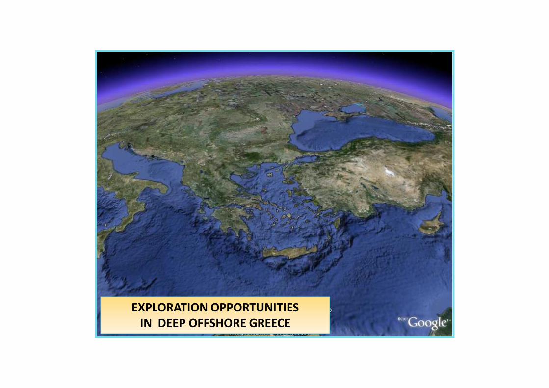
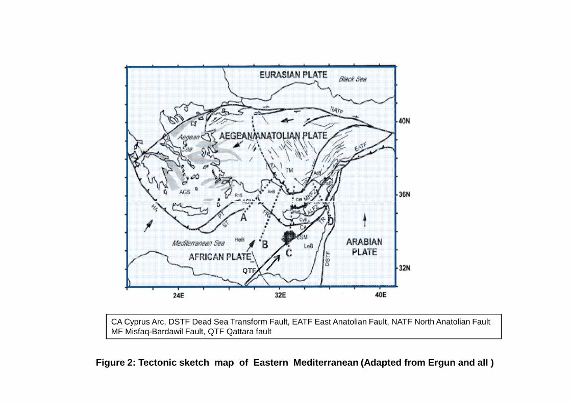
1. Introduction The present day structure of the East
Mediterranean offshore domain is the result of the convergence between the African/Arabic plates and the Egean/Anatolian/Eurasian plates initiated during the late Cretaceous. The main components of this structural domain are represented in Fig.1b and Fig.2 and correspond: In the South to a stable foreland (African/Arabic plate) which comprises:
- A plateform domain including the South Levantine offshore basin in the East, the Nile delta resting above the Egyptian plateform in the south and the Eratosthenes Seamount in the North
-A deep oceanic realm corresponding to the Herodotus basin to the West. In the north the orogenic Alpine thrusts domain composed of several basins: -The North Levantine basin, the Kyrenia-Misis basins, the Iskanderun basin, the Cilicia-Adana basin, the Antalya basin and the Rhode basin -These basins are separated by tectonic ridges, the core of which is usely composed of ophiolitic material emplaced during the main NS Cretaceous compressive tectonic phase. The southern frontal ridges correspond to the tectonic
boundaries between the African and Eurasian colliding plates. This limit corresponds from East to West to the Cyprus arc, the Florence ridge in the Middle and to the Mediterranean ridge in the West. This tectonic limit was the result of the north south Collision of the two plates with associated subduction during the Upper Cretaceous.It was rejuvenated several times during the Tertiary but it evolved as a dominantly transpressional system during the Pliocene. This evolution is due to the clockwise rotation of the convergence axis between the two plates, evolving from a NS direction during the Cretaceous to a NE- SW direction during the Upper Tertiary. The presence of huge faults inside or at the boundaries of the plates determines microplates with complex relative motions: Figs 2 and Fig3. The main faults are known as the Dead Sea transform fault, the south Anatolian fault, the North Anatolian Fault, and in the South the Misfaq Bardawil fault and the left lateral Qattara Eratosthenes fault which possibly connects with the East part of the Cyprus arc. The triangular sector delimited between this fault and the Dead See transform fault, plus the Eratosthenes sea mounts, corresponds roughly to the carbonate plateform with thick to intermediate continental crust
East Mediterranean petroleum potential Page 2
whereas, west of the fault, the Herodotus basin correspond to probable Jurassic oceanic crust. All these faults have undergone complex stress regimes where compression alternated with lateral shear and produced numerous complex structures in the Levantine plateform (en Echelon fold, horst structures, flower structures. etc). The last extensional phases during Plio-Pleistocene have induced a general huge subsidence in the area resulting in the deposition of thick Plio-Pleistocene sediments and large sedimentary collapses towards the center of the basins which probably contributed to mask the last compressional tectonic events. The strong subsidence is still active as it can be seen from bathymetric data and very deep trenches are found reflecting few of the last tectonic events (Strabo trench, spliny trench, Rhodes basin, Herodotus basin).
2. Petroleum Potential The East Mediterranean area has shown
many discoveries located mainly in Egyptian Offshore, Israel and Lebanon Offshore (Fig 4 and Fig5). Both oil and gas were discovered and the objectives are found at several stratigraphic levels. The petroleum potential of each area is determined by its geological situation inside the structural and tectonic pattern presented in paragraph1. The diversity of geological situations creates many types of plays and objectives. We can evaluate the hydrocarbon occurrence looking in each geological environment and inside each environment describe possible plays and prospects. The objective of this short review is to evaluate the consequences and therefore the perspectives for exploration of the Greek areas.
2.1. Nile delta petroleum system:
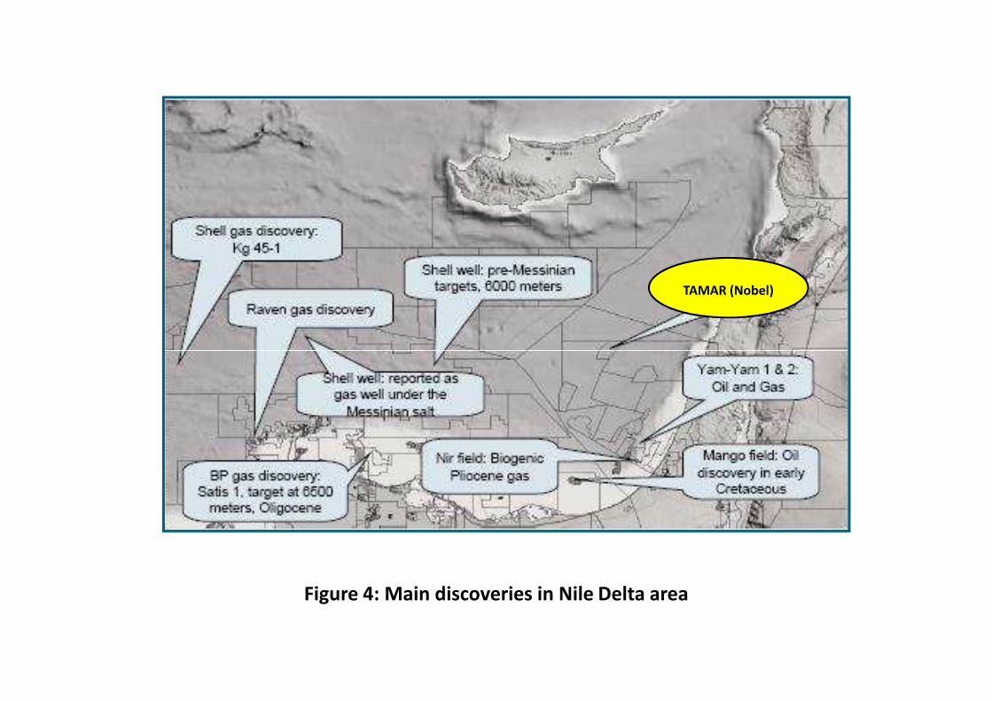
The Nile Delta corresponds to a very thick clastic wedge of prograding sediments dated Paleogene to Actual. The sedimentary thickness may exceed 4000/5000m. The Miocene and Pliocene sands reservoirs have produced a large amount of gas: 3.8 billions boe reported in 2000 and more than 62 TCF of proven reserves (in Niazi, Dahli, Cancun 2004). A few oil fields have been also discovered in the Lower Cretaceous (Mango/TOTAL). The petroleum system of the Nile deep sea fan lying in deep and ultra deep water seems very promising. Shell Company has just made a gas discovery in its deep NEMED block and reported a lot of DHI in the Pliocene interval. The deepest part of the delta corresponds to a large deep sea fan characterized by two main factors
-Turbidic systems composed of large erosional canyons cutting through the continental platform, passing to a set of channel/ levees in the continental slope and ending as huge turbidites
lobes in deep bathyal basins surrounding the delta. Two main channelling systems have been identified: Rosetta canyon in the western part of the delta which conducts huge amount of sediments in the deep Herodotus basin and the Damietta canyon which drives sediments to the North.Levantine basin. Other channels systems originating from the Levantine coast have been identified. They drive turbiditic sediments in the abyssal plain located East and South of Eratosthens seamount.
-Salt driven tectonic: at the bottom of the present slope and in the deep offshore basins, a thick layer of Messinian evaporites was deposited. The thick pile of Plio/Pleistocene sediments induces a strong loading over the evaporites and produces thin skin extensional detachment above the salt in the upper slope resulting in strong compressional effects in the deep frontal basins. This salt driven tectonic leads to the development of large gravity faults underlined by salt walls along the slope (rotated fault block belt (Figs 3) whereas huge folding and thick sediments stacking affect the Plio-Pleistocene sediments in the abyssal plain. This folding and detachment propagates as far as the South border of Eratosthenes seamount and affects also the Levantine basin. These two factors provide excellent opportunities for good reservoir occurence, hydrocarbons generation and trapping far away from the delta itself (Herodotus basin, Eratosthenes zone etc). They are responsible for most of the Hydrocarbon prospectivity in the area. Three plays can be found in the delta itself and around the delta:
-Piocene turbidites systems: slope fans, channel/levees, basin fan/turbidites lobes, complex reservoir trapping induced by salt tectonic (onlap pinch out on salt domes, intersected channels, starved sediments in ponded basins.
-Upper Miocene with canyons infills, rotated fault blocks and upper shallow marine facies.
-Pre-salt section with Miocene channels and turbidites or shallow reefal targets installed on paleo-horsts. The source rocks possibilities are: Pliocene shales for biogenic gas in the shallow delta, Pliocene sapropels in deep delta, Oligo-miocene shales(Gas and condensate), upper Cretaceous black shales and probably deeper sources in the Mesozoic plateform.
2.2. Herodotus basin potential
The boundaries of the Herodotus basin are the Egyptian shelf and Nile delta in the South, The Qattara Eratosthenes fault to the East, the Mediterraneen Ridge to the West and the Florence ridge to the North. The water depth ranges from 1,000 to more than 3000m. Therefore most of the area corresponds to deep or ultra deep exploration. The published seismic data are very scarce and old
East Mediterranean petroleum potential Page 3
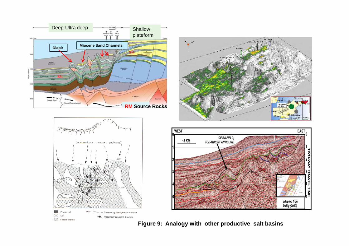
(scientific surveys). They do not usely show below the thick Messinian evaporites. Sections presented by IFP displayed in Fig 6 show a thick Pliocene and thick Messinian evaporites. The first cross-section shows a large structure below the Miocene. Scientific surveys using Large Beam Sonar (Swath survey) show in the recent sediments a large system of channels coming from the upper Nile delta and feeding deep large fans and turbidites lobes in the Herodotus basin (Fig 7 and Fig 8). More recent seismic shot in Egyptian waters by Veritas with results analyzed in Niazi and Dahli show the presence of large turbitic features channels and lobes of more than 10 km large found both in Miocene and Pliocene sections which could reveal giant fields. If it is very clear that the Plio-Pleistocene section is fed by the Nile delta, it is highly probable that the same situation occurs in Miocene just below the evaporites section because this period was a marine lowstand and at that time the delta reached more northern area. A section presented in Petex 2008(PGS survey) displayed in fig.9 shows very strong DHI which demonstrates that Pliocene reservoirs above salt dome structures are charged by hydrocarbons. The probability to discover gas at this depth is higher than oil but the modelling study presented in the Shell publication concerning their deep Nemed block allows to think that in the same stratigraphic and great water depth both oil and gas could be present. Many analogs of hydrocarbon generation and trapping in such deep and evaporitic basin can be presented: Mexico Gulf, Mauritania, Equatorial Guinea, Brazil (Fig.10 to Fig14). These preliminary investigations demonstrate that Herodotus basin has a high potential. The central and the Northern parts of the basin are located in Greek waters (Fig 15) and it is highly probable that these zones have been fed by the Nile sediments. The potential of the Northern part of the basin resting at the front of the Florence Ridge remains more hypothetical because it is located far from the source.
2.3 Levantine basin
The South Levantine basin corresponds to the offshore basin in front of Eastern Egypt, Israel, Lebanon and southern Turkey. The Levantine platform corresponds mainly to carbonate platform during the Mesozoique and clastics deposits during the Tertiary. A typical seismic section (CGG data) is presented in Fig. 16. Structural data presented in the Shell paper show a dominant direction of faulting coming from Nile delta towards the NE part of the Cyprus Arch (Tartus ridge): the Qattara–Erastothenes fault intersected by a sub-set of NW-SE and EW faults. The area between the Qattara fault and the Levantine basin corresponds to the Levantine
plateform with probable continental crust. The area along the Qattara fault appears as a system of staircase faults which allows the progressive slip of the Sinai microplate towards the NE with a left lateral displacement. The Qattara fault could be also an hingeline feature between the Eastern plateform and the Herodotus basin . In this case pinch out of the plateform and reefal features could be observed. Also due to the lateral movement of the fault, en echelon folding, flowers structures could be found. All these features could be found East of Eratosthenes. Petroleum systems: The Levantine basin shows also a thick layer of Messinian evaporites and the salt tectonic already discussed for Nile delta will be present in the Levantine domain.. Several discoveries have been reported in the Offshore of Israel (Fig.4): Yam1/2 discovered light oil in the middle Jurassic, and gas in the lower Cretaceous, Mary B gas field (British Gas) produces 600Mcf/day. The Gaza Marine field has 1,4 Tcf of proven reserved. A recent discovery, Tamar field has been made on the concession operated by Nobel Energy Company. The field is reported to be a giant with 5 Tcf reserves and with up to 150 Mcf possible production per day (C.Glover-June2009). The gas is said to come from Neogene sands deposited in turbiditic environment. These turbidites are inferred to be deposited by channels systems having a NW-SE direction. This trend could reach Cyprus blocks offshore in the South Eastern part. Finally the interest of the Levantine basin is to present various types of traps from different age (Jurassic to Tertiary). The hydrocarbons could be related to different petroleum systems which could be present in the Eastern part of the offshore Cyprus.
2.4 Eratosthenes Seamount,
Eratosthenes basin.
The Eratosthenes seamount is thought to be a detached slab of the African/Levantine plateform. The lower geological section of figure 17 has been studied by the Ocean Drilling Program (Leg 160 in A.H.F. Robertson 1998). The upper cross-section is taken from Beicip-Franlab presentation (2008 promotional round). These sections show that Eratosthenes seamount is composed of thin Plio-Pleistocene shallow water Miocene carbonates Upper cretaceous pelagic carbonates and Lower Cretaceous shallow water limestones. All seismic data reveal an intensive network of faults. The Northern flank is affected by reverse folding, traducing the proximity of the Cyprus tectonic wedge. The Eastern flank shows the pinching out of the tertiary section of the Levantine basin. The west flank seems faulted. The Herodotus basin appears
East Mediterranean petroleum potential Page 4
structurally deeper than the Levantine platform providing an image of shelf edge. The southern flank seems also affected by reverse faulting. This could be related with the compression induced in the Nile delta on the evaporites. Petroleum systems: Nothing is known about the petroleum system in Eratosthens area but serious possibilities probably exist: -On the flanks of Eratosthenes various types of pinch out could be found: The western flank can be sourced by the deep Herodotus basin. The Northern flank could be sourced by the the basin subducted below Cyprus arc. The Eastern flank and the Southern flank could be fed by turbiditic systems coming from Nile delta or Levantine Coast. -Many oil or gas indications (DHI) are visible on the PGS seismic (Fig.18 and fig 19) -The seamount itself could be consider as a structure but sourcing and sealing is unknown. -Structures around Eratosthenes: Large structures below the evaporites are displayed on the PGS seismic (Fig.17). The termination of the Levantine plateform on the Eastern flank could reveal structures such as crest of tilted blocks, or reefal built up at the top of the Jurassic/Cretaceous plateforme.
2.5 Cyprus Arc and foredeep basin
The structures constituting the Cyprus front arc such as the Hecateus ridge, the Latakia ridge do not seem very attractive because the substratum corresponds to the cretaceous ophiolites and also no petroleum system is known. Nevertheless many structures in the foredeep or on the Levantine plateforme at the front of the tectonic arc are present (Fig.20). We can imagine that sourcing could come from the foredeep basin.
3. Conclusions Many authors think now that the deep waters lying around the Nile delta like Herodotus basin or Eratosthenes basin, have a very great potential and compare it to the productive Gulf of Mexico. There is probably a part of over rating but it must be
stressed that the geological factors favourable to large discoveries are fulfilled. As most of the objectives are lying below water depths ranging between 2000m and 3000m or more, the exploration of these ultra deep waters areas will be very expansive but the technology (Drilling and seismic) allow to explore now most of these areas. The fast review of the published geological data and petroleum results in these East Mediterraneen basins allow to think that many opportunities exist in the Greek waters located in this Eastern domain. A rating of these priority areas can be drawn as follows (see Figure 15): -Herodotus basin in the NW of Nile Delta, zone 1. The interest of the area is justified by the existence of a working petroleum system in the Nile area (Nemed block Shell) reinforced by the presence of DHI on the seismic data (Veritas survey).The evaluation of this area must be done urgently. Given the high strategic interest of the zone it should be easy to find a way to shoot a non exclusive survey. The only drawback of the area is the water depths. -Herodotus basin west of Cyprus, zone 2: this area has the same high interest than zone 1 and the water depth are comparable. But here seismic is already available. -Cyprus offshore south East of Eratosthenes: this area corresponds to zone 3. A huge discovery Tamar has been done by Nobel Energy recently in the Levantine basin farther South East. Zone 3 presents a high interest because it is possibly located on the same turbidic trend sourced from the East Levantine basin. The water depth is less than in the two previous areas (1500 to 2000m) -Folds in the North Levantine basin. It corresponds to zone 4. Petroleum system here is not really proven but in offshore Israel several discoveries of oil and gas were done in the lower Cretaceous. -Foldings and pinch out in the foredeep basin of North Erastothenes (Zone 5). There is no proven petroleum system. Therefore this is a pure exploration problem.
References A.Abdel Aal,A. El Barkooky, M.Gerrit, H Meyer and A ll Shell Egypt : The tectonic evolution of the Eastern Mediterranean basin-Leading Edge October 2000 Ben Avraham, Z., Tibor, G., Limanov, A.F., Leybov, M.B.,Ivanov, M.K., Tokarev, M.Yu., Woodside, J.M., 1995. Structure and tectonics of the eastern Cyprean Arc. Mar. Pet. Geol.12, 263– 271. Biju-Duval, B., Letouzey, J., Montadert, L., 1978. Structure and evolution of the Mediterranean basins. In: Hsu¨ , K., Montadert,L., et al., (Eds.), Initial Reports of the
Deep Sea Drilling Project42: Part I. U.S. Government Printing Office, Washington,pp. 951– 984. Calon, T., Aksu, A.E., Hall, J., 2005 . The Neogene evolution of the outer Latakia basin and its extension into the eastern Mesaoria Basin (Cyprus), Eastern Mediterranean Mesaoria Basin (Cyprus), Eastern Mediterranean 94 T.J. Calon et al. / Marine Geology 221 (2005) 61–94. Mar. Geol.221, 49–73. doi:10.1016/j.margeo.2005.03.013.

East Mediterranean petroleum potential Page 5
Cleintuar, M.R., Knox, G.J., Ealey, P.J., 1977. The geology of Cyprus and its place in the Eastern Mediterranean framework.Geol. Mijnb. 56, 66–82. Eaton, S. Robertson, A.H.F. 1993. The Miocene Pakhna formation,southern Cyprus and its relationship to the Neogene tectonic evolution of the eastern Mediterranean. Sediment. Geol. 86,273– 296. Follows, E.J. Robertson, A.H.F. 1990. Sedimentology andstructural setting of reefal limestones in Cyprus. In: J. Malpas,E.M. Moores, A. Panayiotou, C. Xenophontos (Eds.), Ophiolites,Oceanic Crustal Analogues. Proceedings of the SymposiumbTroodos 1987Q. Geological Survey Department,Ministry of Agriculture and Natural Resources, Nicosia,Cyprus, pp. 207–215. 733 pp. Gass, I.G., 1960. The geology and mineral resources of the Dhali area. Memoir, vol. 4. Geological Survey Department, Cyprus.Gass, I.G., MacLeod, C.J., Murton, B.J., Panayiotou, A., Simonian,K.O., Xenophontos, C ., 1994. The geology of the SouthTroodos Transform Fault Zone. Memoir, vol. 9. GeologicalSurvey Department, Cyprus.Geological Survey Department of Cyprus, 1979. Geological Map ofCyprus. Department of Lands and Surveys, Nicosia, Cyprus. Hall, J., Aksu, A.E., Calon, T.J., 2005 . Varying tectonic control on basin development at an active microplate margin: the LatakiaBasin, Eastern Mediterranean. Mar. Geol. 221, 15–8.doi:10.1016/j.margeo.2004.05.034. Hardy, S., Poblet, J., 1994 . Geometric and numerical model of progressive limb rotation in detachment folds. Geology 22,371– 374 Hsu ¨ , K.J., Montadert, L., Bernoulli, D., Cita, M.B., Erickson, A.,Garrison, R.E., Kidd, R.B., Melieres, F., Muller, C. Wright, R. 1978 . History of the Mediterranean salinity crisis. In: Hsu¨ , K.,Montadert, L., et al., (Eds.) , Initial Reports of the Deep Sea Drilling Project XLII: Part I. U.S. Government Printing Office,Washington, pp. 1053– 1078. Ivanov, M.K., Limonov, M.K., Woodside, J.M., 1992 . Geologicaland geophysical investigations in the Mediterranean and BlackSeas. Initial Results of the Training through Research Q Cruise of RV Gelendzhik in the Eastern Mediterranean and the BlackSea (June–July 1991). UNESCO Reports in Marine Science,vol. 56. 208 pp. Jamison, W.R., 1987 . Geometric analysis of fold development in overthrust terranes. J. Struct. Geol. 9, 207– 219. Karig, D.E., Kozlu, H., 1990 . Late Paleogene–Neogene evolution ofthe triple junction region near Mara8, south-central Turkey.J. Geol. Soc. Lond. 147, 1023– 1034. Kempler, D., Ben Avraham, Z., 1987 . The tectonic evolution of the Cyprean Arc. Ann. Tecton. 1, 58–71. Kozlu, H., 1987. Structural development and stratigraphy of the Misis–Andirin region. Proceedings of the 7th
PetroleumCongress of Turkey, Turkish Association of Petroleum Geologists,pp. 104– 116. McCallum, J.E., Robertson, A.H.F., 1990. Pulsed uplift of theTroodos Massif - evidence from the Plio-Pleistocene MesaoriaBasin. In: J. Malpas, E.M. Moores, A. Panayiotou, C.Xenophontos (Eds.), Ophiolites, Oceanic Crustal Analogues. Proceedings of the Symposium b Troodos 1987Q. Geological survey Department, Ministry of Agriculture and Natural Resources, Nicosia, Cyprus, pp. 217–229. 733 pp. Moore, T.A., 1960 . The geology and mineral resources of the Astromeritis–Kormakiti area. Memoir, vol. 6. Geological Survey Department, Cyprus. Mulder, C.J., 1973 . Tectonic framework and distribution of Miocene evaporites in the Mediterranean. In: Drooger, C.W.(Ed.), Messinian Events in the Mediterranean. Konink lijke Nederlandse Akademic von Weterschappen. North-Holland Publishing Company, Amsterdam, pp. 44–59. Robertson, A.H.F., 1998. Mesozoic–Tertiary tectonic evolution of the easternmost Mediterranean area: integration of marine and land evidence. In: Robertson, A.H.F, Emeis, K.C., Richter, C.,Camerlenghi, A. (Eds.), Proceeding of the Ocean DrillingProgram, Scientific Results, vol. 160, pp. 723– 782. Robertson, A.H.F., Hudson, J.D., 1974 . Pelagic sediments in the Cretaceous and Tertiary history of the Troodos Massif, Cyprus. In: Hsu¨ , K.J., Jenkyns, H.C. (Eds.), Pelagic Sediments: On Landand Under the Sea, Special Publication, International Association of Sedimentologists, vol. 1, pp. 403–436. Robertson, A.H.F., Woodcock, N.H., 1986 . The role of Kyrenia Range lineament, Cyprus, in the geological evolution of the eastern Mediterranean area. R. Soc. Lond. Philos. Trans., SeriesA 317, 141–177. Robertson, A.H.F., Eaton, S., Follows, E.J., McCall um, J.E., 1991.The role of local tectonics versus global sea-level change in the Neogene evolution of the Cyprus active margin. Spec. Publ. Int.Assoc. Sedimentol. 12, 331– 369. Robertson, A.H.F., Eaton, S., Follows, E.J., Payne, A.S., 1995.Depositional processes and basin analysis of Messinian evaporates in Cyprus. Terra Nova 7, 233– 253. Ryan, W.B.F. 1969. The floor of the Mediterranean Sea. PhD thesis, Columbia University, New York. 236 pp. Uffenorde, H., Lund, J.J., Georgi, K.H., 1990 Biostratigraphy of the Neogene in the Iskenderun Basin. Turkish Association of Petroleum Geologists Proceedings of the 8th Petroleum Congress of Turkey, pp. 363– 370. Weiler, Y., 1969. The Miocene Kythrea flysch basin in Cyprus. .Geol. 5,13– 229. YVlmaz, Y., GurpVnar, O., Yig˘itbaY, E., 1988 . Tectonic evolution of the Miocene basins at the Amanos Mountains and the MaraYregion. Bull. Turk. Assoc. Pet. Geol. 1/1, 52– 72.
EXPLORATION OPPORTUNITIES
IN DEEP OFFSHORE GREECE
Rhodos Basin Antalya Basin
Ionian Basin
Kefallina fault
3000 2000 1000 500 mFigure 1: Bathymetry and main structural features
Hellenic Arc
Nile Delta
Florence Ridge
Cyprus
Cyprus Arc
Eratosthenes
Rhodos Basin Antalya Basin
Levantine Basin
Kefallina fault
CA Cyprus Arc, DSTF Dead Sea Transform Fault, EATF East Anatolian Fault, NATF North Anatolian FaultMF Misfaq-Bardawil Fault, QTF Qattara fault
Figure 2: Tectonic sketch map of Eastern Mediterranean (Adapted from Ergun and all )
QTF
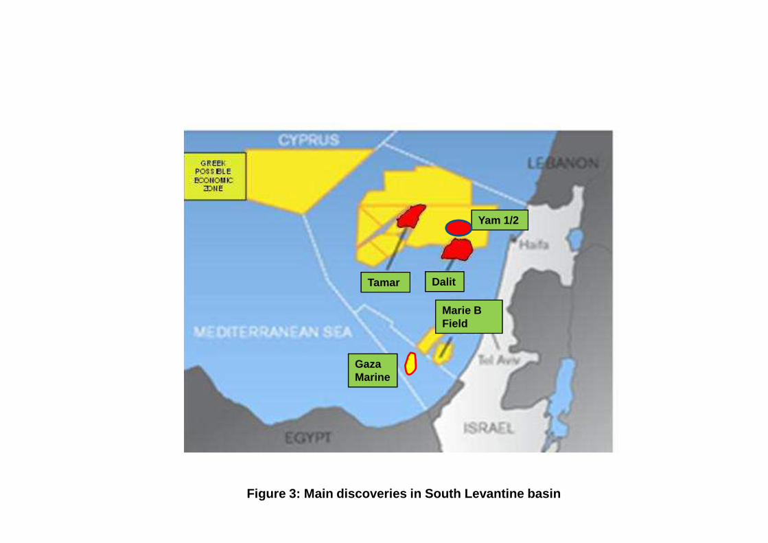
Yam 1/2
Gaza Marine
Tamar
Marie BField
Dalit
Figure 3: Main discoveries in South Levantine basin
TAMAR (Nobel)
Figure 4: Main discoveries in Nile Delta area
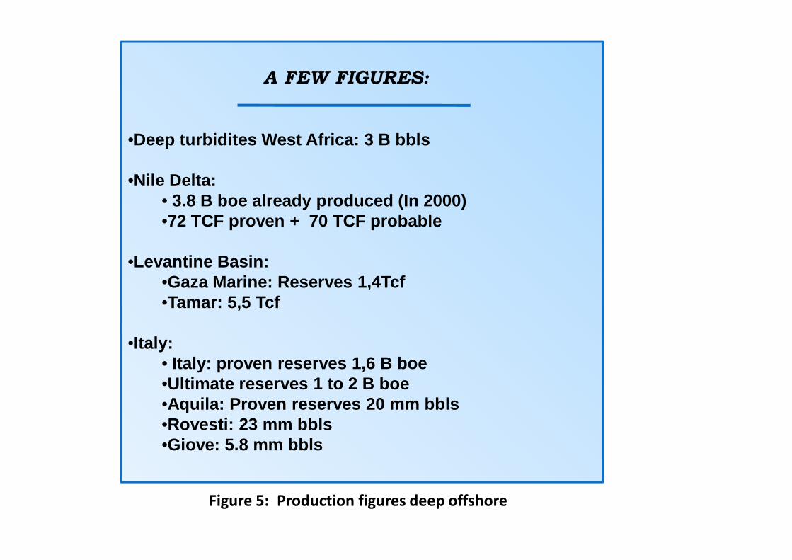
A FEW FIGURES:
•Deep turbidites West Africa: 3 B bbls
•Nile Delta:• 3.8 B boe already produced (In 2000)•72 TCF proven + 70 TCF probable
•Levantine Basin:•Gaza Marine: Reserves 1,4Tcf•Gaza Marine: Reserves 1,4Tcf•Tamar: 5,5 Tcf
•Italy:• Italy: proven reserves 1,6 B boe•Ultimate reserves 1 to 2 B boe•Aquila: Proven reserves 20 mm bbls•Rovesti: 23 mm bbls•Giove: 5.8 mm bbls
Figure 5: Production figures deep offshore

Fig 6a: Pliocene turbiditic systemdeposition (From Shell Egypt) 2
1
Fig 6b : Messinian canyons and Plio-Pleistocene turbiditic system
1
2
Miocene canyons

Figure 7: DHI in Herodotus basin (Petex 2008)
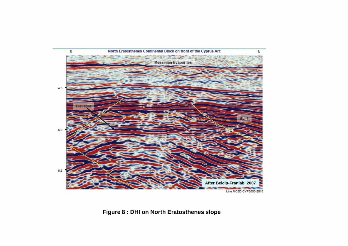
Figure 8 : DHI on North Eratosthenes slope
After Beicip-Franlab 2007
Miocene Sand ChannelsDiapir
Deep-Ultra deep Shallow plateform
RM Source Rocks
Figure 9: Analogy with other productive salt basins

Figure 10: Areas of interest in East Mediterranean Greek zone
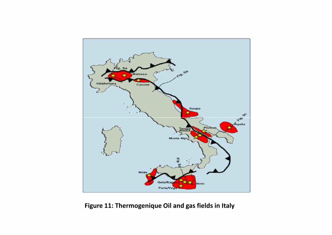
Figure 11: Thermogenique Oil and gas fields in Italy
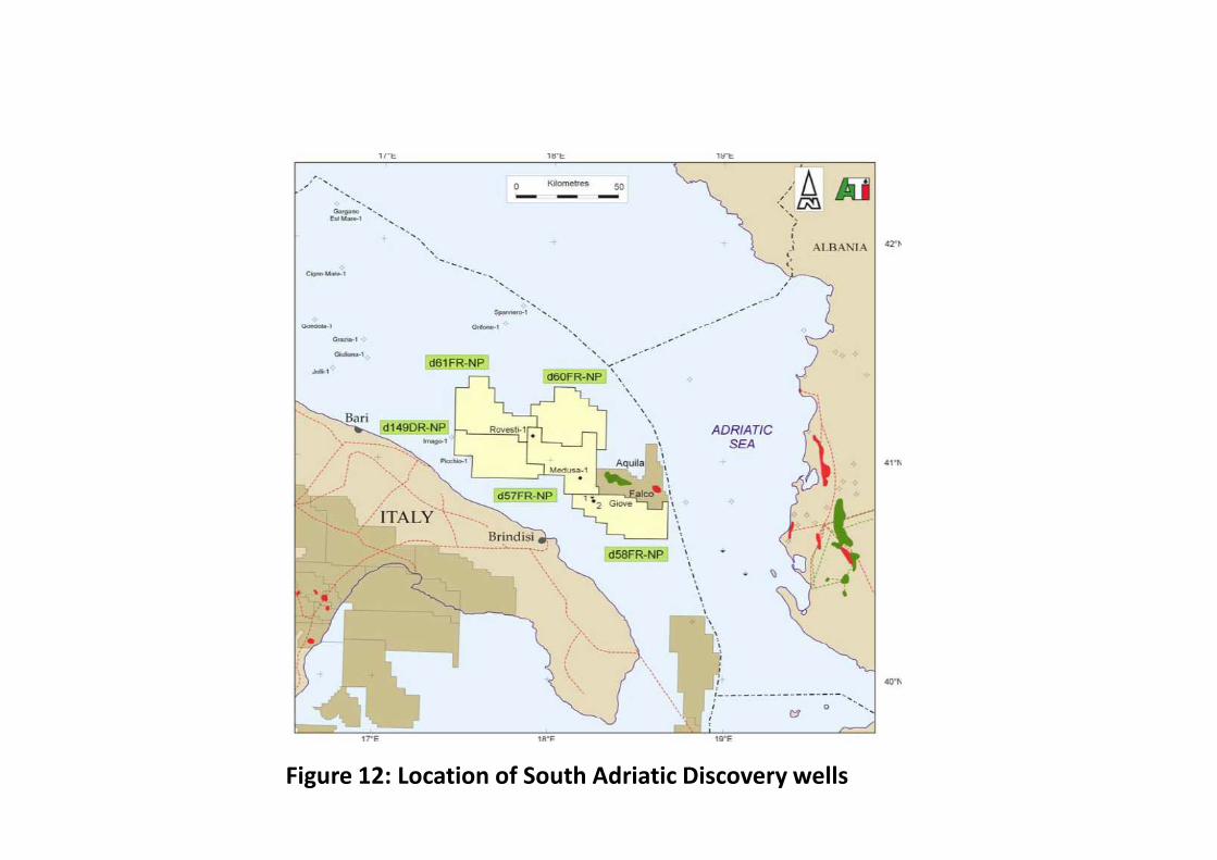
Figure 12: Location of South Adriatic Discovery wells

Aquila, Falco
Ionian
Ionian
2
1
3
Ionian
Apulian
ApulianIonian
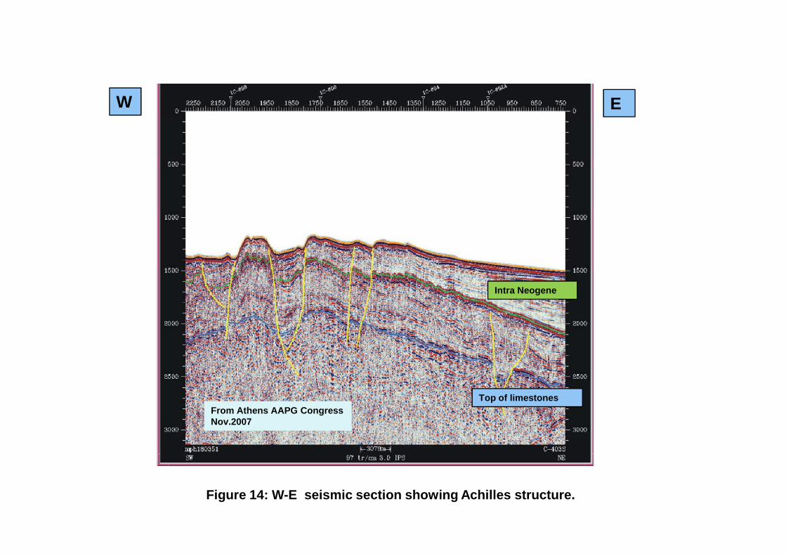
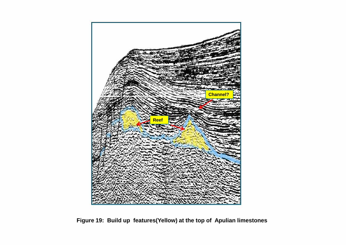
1, 2, 3 Ionian Prospects1 Achilles2 Pyrros3 Build up/Channels
Italian Fields (Aquila, Falco)
Contact Apulian-IonianZones
Figure 13: Location of Ionian prospects
W E
Figure 14: W-E seismic section showing Achilles structure.
Top of limestones
Intra Neogene
From Athens AAPG CongressNov.2007
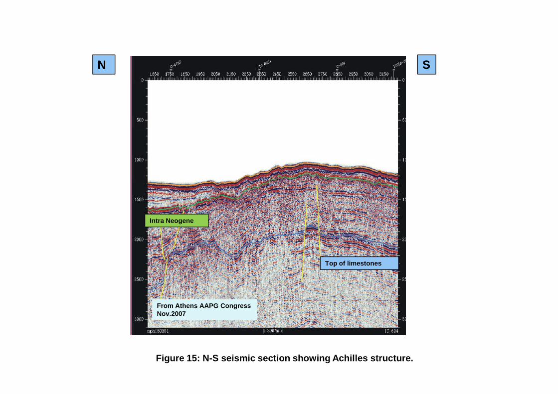
N S
Figure 15: N-S seismic section showing Achilles structure.
Intra Neogene
Top of limestones
From Athens AAPG CongressNov.2007
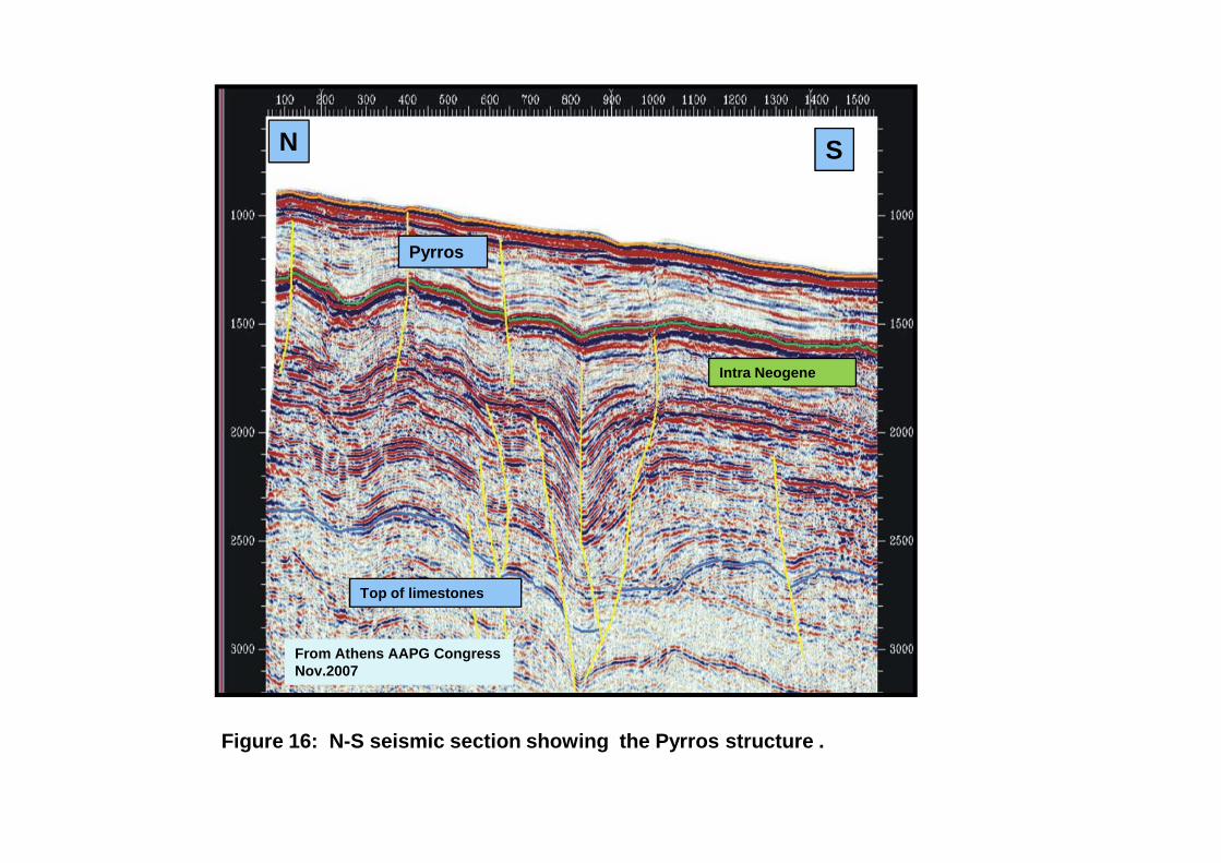
Pyrros
N S
Intra Neogene
Figure 16: N-S seismic section showing the Pyrros structure .
Top of limestones
From Athens AAPG CongressNov.2007
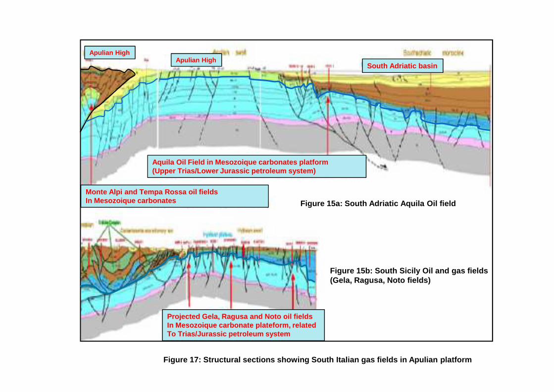
Aquila Oil Field in Mesozoique carbonates platform(Upper Trias/Lower Jurassic petroleum system)
Monte Alpi and Tempa Rossa oil fields
Apulian HighApulian High
South Adriatic basin
Figure 17: Structural sections showing South Italian gas fields in Apulian platform
Figure 15a: South Adriatic Aquila Oil field
Figure 15b: South Sicily Oil and gas fields(Gela, Ragusa, Noto fields)
In Mesozoique carbonates
Projected Gela, Ragusa and Noto oil fieldsIn Mesozoique carbonate plateform, related To Trias/Jurassic petroleum system
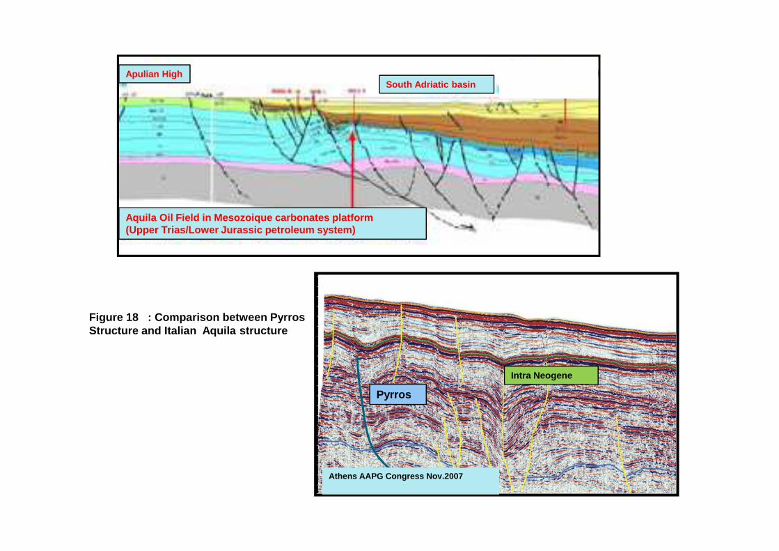
South Adriatic basinApulian High
Aquila Oil Field in Mesozoique carbonates platform(Upper Trias/Lower Jurassic petroleum system)
Figure 18 : Comparison between PyrrosStructure and Italian Aquila structure
Pyrros
Intra Neogene
Athens AAPG Congress Nov.2007
Reef
Channel?
Figure 19: Build up features(Yellow) at the top of Apulian limestones