Crustal architecture and tectono-magmatic history of the western offshore of India: Implications on...
10
Crustal architecture and tectono-magmatic history of the western offshore of India: Implications on deepwater sub-basalt hydrocarbon exploration Rajesh Kalra a , G. Srinivasa Rao b , Roberto Fainstein a , M. Radhakrishna b,n , Rabi Bastia c , S. Chandrashekar d a Schlumberger – Western Geco, India b Department of Earth Sciences, Indian Institute of Technology Bombay, Powai, Mumbai 400076, India c Oil Max Energy India Pvt. Ltd., Mumbai, India d Oil and Natural Gas Corporation, Priyadarshini, Mumbai, India article info Article history: Received 21 October 2013 Accepted 2 July 2014 Available online 10 July 2014 Keywords: western offshore of India potential field modeling ocean–continent transition sub basalt imaging Mesozoic petroleum system abstract The western continental margin of India (WCMI) has evolved as a result of two-stage rifting and breakup events, the first one between India and Madagascar during the mid Cretaceous, and the second event between India and Seychelles during the late Cretaceous. Detailed seismic studies by earlier workers in the offshore margin confirm that it is a poly-rift margin with significant volcanic emplacements, and on the basis of these datasets; the western margin was classified as volcanic. In the present study, constrained potential field modeling of four profiles across the western offshore region revealed that the eastern basin comprising of Laxmi and Laccadive basins as well as the adjoining Laxmi and the Laccadive ridges are underlain by the extended continental crust and has been punctured by several magmatic intrusions. The models further suggest that the continent–ocean boundary (COB) lies to the west of Laccadive and Laxmi ridges, and also in the southern part of Laccadive basin. In this paper, we presented high-resolution seismic images at the margin that have revealed the presence of deeper sedimentary strata below the K/T flood-basalts and provided detailed interpretation of few sections belonging to a 3D seismic block in the deepwater Kerala–Konkan offshore. The sections reveal numerous features such as the sag basin, fractures, faults and folding below the basaltic top. Further, significant sedimentary wedges terminating against the volcanic highs are inferred to be the Mesozoic sub-basalt plays. The interpreted crustal transects, the inferred combination of tectono-magmatic processes and the probable occurrence of sub-basalt sediments at the margin are analyzed and encapsulated to provide a basis for assessing deepwater petroleum prospectivity of the entire western margin offshore. & 2014 Elsevier B.V. All rights reserved. 1. Introduction Geologically, the west coast of India is different from the east coast in that it is devoid of major onshore sedimentary basins, and is characterized by the wide spread Deccan Volcanic Province (DVP) in the north. Absence of major rivers and due to less sediment discharge into the offshore, at least since the Cretaceous, the western offshore is devoid of extensive major sediment depocenters (barring the Indus basin) that are present in the eastern offshore. It is known from the investigations that the west coast of India and the adjoining offshore areas (known as the WCMI) contain several structural features that were inherited from the rifting and breakup of India, Madagascar and Seychelles since the mid Cretaceous (Norton and Sclater, 1979; Naini and Talwani, 1982; Biswas, 1987). The WCMI consist four sedimentary basins such as Kutch, Saurashtra, Mumbai, and Kerala-Konkan basins (Fig. 1) separated by the transverse basement arches (Biswas and Singh, 1988; Singh and Lal, 1993). The WCMI has evolved in two stages; first one associated with the India and Madagascar breakup at 88 Ma, and the second with the separa- tion of Seychelles from India at 65 Ma (Norton and Sclater, 1979; Storey et al., 1995). The second breakup event is also believed to be associated with the eruption of large volume of traps that have an association with the Reunion mantle plume activity at the same period (Courtillot et al., 1986; Minshull et al., 2008). Several basement ridges in the offshore such as the Laccadive ridge, Laxmi Contents lists available at ScienceDirect journal homepage: www.elsevier.com/locate/petrol Journal of Petroleum Science and Engineering http://dx.doi.org/10.1016/j.petrol.2014.07.002 0920-4105/& 2014 Elsevier B.V. All rights reserved. n Corresponding author. Fax: þ91 22 25767253. E-mail address: [email protected] (M. Radhakrishna). Journal of Petroleum Science and Engineering 122 (2014) 149–158
-
Upload
ismdhanbad -
Category
Documents
-
view
0 -
download
0
Transcript of Crustal architecture and tectono-magmatic history of the western offshore of India: Implications on...

Crustal architecture and tectono-magmatic history of the westernoffshore of India: Implications on deepwater sub-basalthydrocarbon exploration
Rajesh Kalra a, G. Srinivasa Rao b, Roberto Fainstein a, M. Radhakrishna b,n,Rabi Bastia c, S. Chandrashekar d
a Schlumberger – Western Geco, Indiab Department of Earth Sciences, Indian Institute of Technology Bombay, Powai, Mumbai 400076, Indiac Oil Max Energy India Pvt. Ltd., Mumbai, Indiad Oil and Natural Gas Corporation, Priyadarshini, Mumbai, India
a r t i c l e i n f o
Article history:Received 21 October 2013Accepted 2 July 2014Available online 10 July 2014
Keywords:western offshore of Indiapotential field modelingocean–continent transitionsub basalt imagingMesozoic petroleum system
a b s t r a c t
The western continental margin of India (WCMI) has evolved as a result of two-stage rifting and breakupevents, the first one between India and Madagascar during the mid Cretaceous, and the second eventbetween India and Seychelles during the late Cretaceous. Detailed seismic studies by earlier workers inthe offshore margin confirm that it is a poly-rift margin with significant volcanic emplacements, and onthe basis of these datasets; the western margin was classified as volcanic. In the present study,constrained potential field modeling of four profiles across the western offshore region revealed that theeastern basin comprising of Laxmi and Laccadive basins as well as the adjoining Laxmi and the Laccadiveridges are underlain by the extended continental crust and has been punctured by several magmaticintrusions. The models further suggest that the continent–ocean boundary (COB) lies to the west ofLaccadive and Laxmi ridges, and also in the southern part of Laccadive basin. In this paper, we presentedhigh-resolution seismic images at the margin that have revealed the presence of deeper sedimentarystrata below the K/T flood-basalts and provided detailed interpretation of few sections belonging to a 3Dseismic block in the deepwater Kerala–Konkan offshore. The sections reveal numerous features such asthe sag basin, fractures, faults and folding below the basaltic top. Further, significant sedimentarywedges terminating against the volcanic highs are inferred to be the Mesozoic sub-basalt plays. Theinterpreted crustal transects, the inferred combination of tectono-magmatic processes and the probableoccurrence of sub-basalt sediments at the margin are analyzed and encapsulated to provide a basis forassessing deepwater petroleum prospectivity of the entire western margin offshore.
& 2014 Elsevier B.V. All rights reserved.
1. Introduction
Geologically, the west coast of India is different from the eastcoast in that it is devoid of major onshore sedimentary basins, andis characterized by the wide spread Deccan Volcanic Province(DVP) in the north. Absence of major rivers and due to lesssediment discharge into the offshore, at least since the Cretaceous,the western offshore is devoid of extensive major sedimentdepocenters (barring the Indus basin) that are present in theeastern offshore. It is known from the investigations that the westcoast of India and the adjoining offshore areas (known as the
WCMI) contain several structural features that were inheritedfrom the rifting and breakup of India, Madagascar and Seychellessince the mid Cretaceous (Norton and Sclater, 1979; Naini andTalwani, 1982; Biswas, 1987). The WCMI consist four sedimentarybasins such as Kutch, Saurashtra, Mumbai, and Kerala-Konkanbasins (Fig. 1) separated by the transverse basement arches(Biswas and Singh, 1988; Singh and Lal, 1993). The WCMI hasevolved in two stages; first one associated with the India andMadagascar breakup at �88 Ma, and the second with the separa-tion of Seychelles from India at �65 Ma (Norton and Sclater, 1979;Storey et al., 1995). The second breakup event is also believed to beassociated with the eruption of large volume of traps that have anassociation with the Reunion mantle plume activity at the sameperiod (Courtillot et al., 1986; Minshull et al., 2008). Severalbasement ridges in the offshore such as the Laccadive ridge, Laxmi
Contents lists available at ScienceDirect
journal homepage: www.elsevier.com/locate/petrol
Journal of Petroleum Science and Engineering
http://dx.doi.org/10.1016/j.petrol.2014.07.0020920-4105/& 2014 Elsevier B.V. All rights reserved.
n Corresponding author. Fax: þ91 22 25767253.E-mail address: [email protected] (M. Radhakrishna).
Journal of Petroleum Science and Engineering 122 (2014) 149–158

ridge, Pratap ridge etc. and other horst–graben structural elementsare known to have evolved during the rifting and seafloorspreading. The dominant structural trends along the West Coastare; the Dharwar trend NW–SE to NNW–SSE Dharwar trend, theNE–SW Aravalli trend, and the ENE–WSW to E–W Satpura trend,and according to Biswas (1982) these have a bearing on the riftingand breakup process. Biswas (1987) further suggested that thePrecambrian structural grain of the west coast might have partlycontrolled some of the offshore structural features and manyonshore structural features extend into the deep offshore part ofthe WCMI (Bhattacharya and Subrahmanyam, 1986; Kolla andCoumes, 1990). Detailed seismic data and large number of wellsdrilled in the western offshore have defined the basin architectureand revealed that significant part of the DVP is concealed belowsediments in the Mumbai offshore (Mathur and Nair, 1993).Further, studies also revealed that the Deccan volcanics form thefloor for the Tertiary sediments throughout the western offshore(Singh and Lal, 1993; Singh et al., 2007). This vast cover of the trapsall along the margin is believed to be masking the older sediments(Mesozoics) lying below. While, the presence of Mesozoic sedi-ments below the traps has been confirmed in the Kutch–Saurashtrabasin north of Mumbai offshore in many drilled wells; in southernpart, their presence has not yet been confirmed due to the fact thatmany wells drilled in the Kerala–Konkan offshore did not penetrate
through the traps and available seismic data was not good enoughto map the sub-basalt structures, if any. In the present study, weexamine the crustal architecture below the western offshore basinsthrough constrained potential field modeling and present high-resolution seismic images of the sub-basalt sediments/structures inthe Kerala–Konkan offshore with a view to evaluate the sub-basalthydrocarbon potential of the western offshore.
2. Tectonic fabric and evolution of the margin
The dominant basement fabric of the western offshore isNNW–SSE (see Fig. 1) as revealed by series of linear rifts, horstsand grabens that have developed at the margin. Major tectonicelements along the WCMI are, shelfal horst–graben complexconsisting of Kori–Comorin depression, Kori–Comorin ridge,Laxmi–Laccadive depression, Laxmi–Laccadive ridge and Arabianabyssal plain (Biswas and Singh, 1988). The NE–SW orientedbasement arches trending from the coast to shelf/deepwater areas(Fig. 1) such as the Saurashtra Arch, Vengurla Arch and theTellicherry Arch have played a role in the segmentation of themargin into different sub-basins. The sedimentary basins along themargin can be grouped into two categories: (1) Mesozoic marginalrift basins and (2) Tertiary offshore rift basins, where Mesozoic
D V P
C C R
S G T
20n21n
22n23n
24n.1n24n.3n
Kutch Rift
WESTERN BASIN
EASTERN BASIN
25n
26n
27n28n
Bombay Offshore
SuratDepression
Kori-Comorin Ridge
62 66 70 74 780
5
10
15
20
25
LB
30 40 50 60 70 80 90-40
-30
-20
-10
0
10
20
30
Fig. 1. Regional topography map (left panel) of the northwest Indian Ocean depicting various morphological and tectonic features. The red square marks the outline of thestudy area (right panel), the Western continental margin of India (WCMI) and the adjoining Arabian Sea. Major tectonic elements are shown on this map. Magnetic anomalyidentifications shown in western basin and Laxmi basin (L1–L4) are adopted from Chaubey et al. (1998) and Bhattacharya et al. (1994) respectively. Dotted line indicates thetrack of the Reunion plume. SWIR, Southwest Indian ridge; SEIR, Southeast Indian ridge; CIR, Central Indian ridge; CLR, Chagos–Laccadive ridge; DFZ, Davie fracture zone; RS,Red sea; AR, Aden ridge; SR, Sheba ridge; DVP, Deccan Volcanic Province; CCR, Central Cratonic region. (For interpretation of the references to color in this figure legend, thereader is referred to the web version of this article.)
R. Kalra et al. / Journal of Petroleum Science and Engineering 122 (2014) 149–158150

prospects are believed to be existing below thick basaltic traps(Biswas, 1987; Bastia and Radhakrishna, 2012). While the marginis characterized by a wide shelf (4300 km) with 7–8 km of thickIndus fan sediments in the north, south of Vengurla Arch, the shelfis narrow (o100 km) with 3–4 km of sediments in isolated smalldepressions (Zutshi et al., 1995). The Kerala–Konkan basin is amajor frontier basin and lies along the southwest offshore of India.The basin is bounded by Vengurla Arch in the north and continuestowards the southern tip of India south of Cape Comorin (Fig. 1).Both Kerala and Konkan basins are separated by another NE–SWtrending basement arch called the Tellicherry Arch (Singh and Lal,1993). Despite nearly 17 wells drilled in this basin, structuralunderstanding of the basin is known mostly from the seismic,gravity and magnetic data. Many drilled wells in this basin haveencountered basaltic traps with the oldest sediments of Santonianage (Singh and Lal, 1993; Dirghangi et al., 2000).
Several regional mega tectonic events that occurred in thegeological past have significantly affected the western offshorebasins and their imprints can be realized from the present-daystructural configuration of the offshore basins. These are (1) therifting of Madagascar and Seychelles from India, (2) the shift ofdrainage system from west to east in the Peninsular India whichcaused reduction of sediment supply to the west coast, (3) uplift,extension and subsidence caused by the Reunion mantle plumeand the associated flood basalt activity, (4) the northward drift ofIndia, and (5) the collision of India with the Eurasia and uplift ofHimalayas. Courtillot et al. (1986) suggested a causal link betweenthe Reunion plume and the breakup of India and Seychelles whichis associated wide spread volcanism. Coming to the earlier riftevent between India and Madagascar, considerable ambiguityexists on the position of Madagascar during the eastern Gondwanatimes though many workers agree that Madagascar was sand-wiched between the West Coast of India and the Africa. However,the Precambrian trends, lithologies and age provinces betweenMadagascar and India are well correlatable (Agarwal et al., 1992)and their fit could be traced to the Proterozoic times. Yatheeshet al. (2006) presented a detailed synthesis of all availablereconstructions between India and Madagascar (e.g., Norton andSclater, 1979; Morgan, 1981; Besse and Courtillot, 1988; Mülleret al., 1993) and suggested a close fit reconstruction by accom-modating various micro-continents or continental slivers thatexisted during the pre-drift scenario in the gaps.
3. Geophysical datasets and analysis
In the present study, we used different regional geophysicaldatasets that were compiled from various sources for furtheranalysis/insight. High-resolution 10 �10 satellite derived free-airgravity and bathymetry data available from the Danish globalgravity and bathymetry database (Andersen and Knudsen, 2008)was used in the present study for the regional data analysis. Thissatellite derived gravity database is useful for regional investiga-tions because free-air gravity anomalies contain information downto very short wavelengths (o20 km). The regional magnetic gridis from the global 20 �20 resolution Earth Magnetic Anomaly Grid(EMAG2), a worldwide magnetic anomaly database which is acompilation of satellite, aeromagnetic and marine magnetic data(Maus et al., 2009). Apart from these global data sets, several ship-borne gravity and magnetic profiles are available from the NGDCmarine geophysical track line database. From this database, weselected few profiles lying perpendicular to the margin for thepurpose of modeling. All published seismic reflection data in thewestern offshore area (Chaubey et al., 2002; Krishna et al., 2006;Kenneth et al., 2008; Ajay et al., 2010; Corfield et al., 2010; Calvèset al., 2011) was compiled and the profiles closer the gravity and
magnetic profiles are projected to constrain the models. Further,we also used many sonobuoy seismic refraction data points (Nainiand Talwani, 1982) available in the western offshore area for theconversion of seismic velocities to densities.
3.1. Gravity and magnetic anomaly maps
The satellite derived free air gravity anomaly map of the westernoffshore (Fig. 2A) correlates well with various morphological features.The typical bi-polar gravity anomaly pattern observed in all theglobal passive margin segments i.e., positive gravity along the shelfregion and a negative gravity anomaly trend associated with shelfand slope areas of the margin is clearly depicted in the westernoffshore also. Detailed analysis of the gravity field in this region wasearlier attempted (viz., Radhakrishna et al., 2002; Sheena et al.,2007). The free-air anomaly map reveals that the anomalies ingeneral are negative throughout the eastern Arabian Sea, except incertain areas of the shelf. The gravity field seems to be disturbed(positive anomalies) as response to the presence of several basementridges and isolated bathymetric features (Radhakrishna et al., 2002)in the central part of the margin. A NW–SE trending gravity low of��40 mgal appears to correlate well with the Laxmi ridge, and inthe Laxmi basin which is located between the Laxmi ridge and thewest coast shelf area, the free-air anomalies are characterized by abroad regional gravity high. A prominent NNW gravity low at thecenter in this basin is correlated with the crest of the Panikkar ridge(Krishna et al., 2006). On the other hand, the Laccadive ridge, incontrast is associated with a distinct positive gravity field. In theLaccadive basin lying between the Laccadive ridge and Sri Lanka, aprominent N–S gravity trend along 751E joins the west coast at 101N.This feature was earlier noticed by Arts et al. (2003) and isinterpreted as the trace of the Vishnu/Chagos fracture zone.
It is knownwell that the free-air gravity anomalies at the passivemargin is an integrated sum of the contribution from shallow (waterand sediment) and deep (crust and mantle) effects; the relativeamplitude, geometry of the water–sediment, sediment–crust, andthe crust–mantle interfaces define the free-air gravity anomalyacross the margin. However, the margin subsequent to rifting or atthe time of breakup can encounter substantial modification to crustdue to volcanism. The isostaic residual anomalies eliminate thegravity contribution of water layer and regional anti-root effect andare thus useful to understand the crustal density heterogeneities aswell as shallow uncompensated basement features across themargin (Rabinowitz and LaBrecque, 1977). The isostatic anomalycomputation is made in two steps: in the first step, the completeBouguer anomaly is computed. The Bouguer slab correction involvesreplacing the water layer with an average crustal density of 2.67 g/cm3 and applying this correction to the free-air gravity anomalieswould give rise to the Bouguer anomaly. Along with the usualBouguer correction, the terrain correction is also required in theareas of large topographic undulations. The combined Bouguer andterrain corrections on to the free-air anomaly map gives rise to thecomplete Bouguer anomaly map (Fig. 2B). In the second step, theregional anti-root thickness is computed by assuming Airy isostaticcompensation and for a depth of compensation considered here as30 km. The gravity effect of regional anti-root has been computedusing the density contrast of 0.63 g/cm3 considering the 2.67 g/cm3
crust and 3.3 g/cm3 for the upper mantle. This anomaly is called theisostatic regional field which is essentially due to the anti-root effectin the oceanic areas. The subtraction of this anti-root effect from thecomplete Bouguer anomaly map gives rise to the isostatic residualanomalies and such a map generated for the present study region isshown in Fig. 2C According to Rabinowitz and LaBrecque (1977), theisostatic residual anomalies provide valuable insights in identifyingthe crustal transition zones or the ocean–continent boundary (OCB)as these anomalies are sensitive to shallow uncompensated features.
R. Kalra et al. / Journal of Petroleum Science and Engineering 122 (2014) 149–158 151
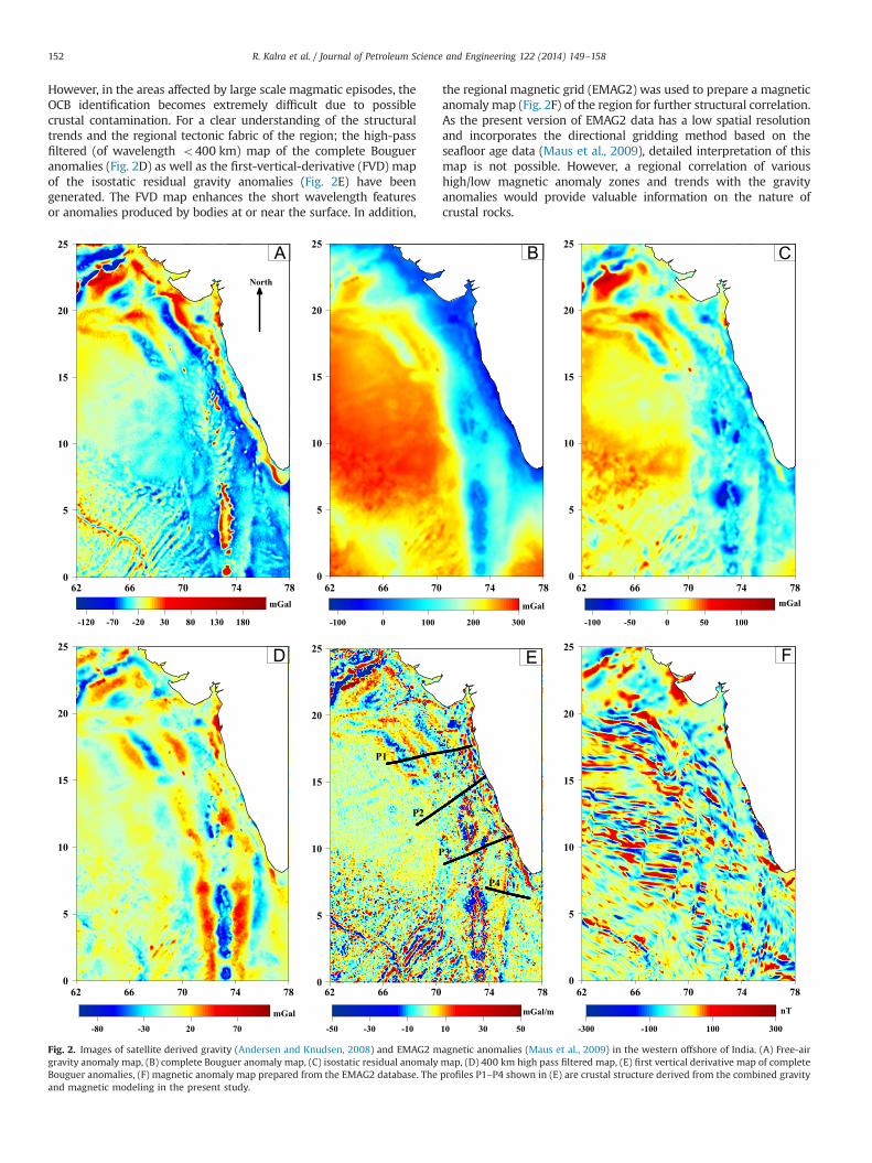
However, in the areas affected by large scale magmatic episodes, theOCB identification becomes extremely difficult due to possiblecrustal contamination. For a clear understanding of the structuraltrends and the regional tectonic fabric of the region; the high-passfiltered (of wavelength o400 km) map of the complete Bougueranomalies (Fig. 2D) as well as the first-vertical-derivative (FVD) mapof the isostatic residual gravity anomalies (Fig. 2E) have beengenerated. The FVD map enhances the short wavelength featuresor anomalies produced by bodies at or near the surface. In addition,
the regional magnetic grid (EMAG2) was used to prepare a magneticanomaly map (Fig. 2F) of the region for further structural correlation.As the present version of EMAG2 data has a low spatial resolutionand incorporates the directional gridding method based on theseafloor age data (Maus et al., 2009), detailed interpretation of thismap is not possible. However, a regional correlation of varioushigh/low magnetic anomaly zones and trends with the gravityanomalies would provide valuable information on the nature ofcrustal rocks.
62 66 70 74 780
5
10
15
20
25
-100 -50 0 50 100
mGal mGal
mGal/m
62 66 70 74 780
5
10
15
20
25
-80 -30 20 70
mGal
62 66 70 74 780
5
10
15
20
25
-50 -30 -10 10 30 50
P1
P2
P4
P3
62 66 70 74 780
5
10
15
20
25
-300 -100 100 300
nT
62 66 70 74 780
5
10
15
20
25
-100 0 100 200 300
62 66 70 74 780
5
10
15
20
25
-120 -70 -20 30 80 130 180
mGal
North
Fig. 2. Images of satellite derived gravity (Andersen and Knudsen, 2008) and EMAG2 magnetic anomalies (Maus et al., 2009) in the western offshore of India. (A) Free-airgravity anomaly map, (B) complete Bouguer anomaly map, (C) isostatic residual anomaly map, (D) 400 km high pass filtered map, (E) first vertical derivative map of completeBouguer anomalies, (F) magnetic anomaly map prepared from the EMAG2 database. The profiles P1–P4 shown in (E) are crustal structure derived from the combined gravityand magnetic modeling in the present study.
R. Kalra et al. / Journal of Petroleum Science and Engineering 122 (2014) 149–158152

3.2. Seismic reflection and refraction data
The multi-channel seismic reflection profiles (MCS) acquiredacross the western offshore by many earlier workers (Chaubey
et al., 2002; Krishna et al., 2006; Kenneth et al., 2008; Ajay et al.,2010; Corfield et al., 2010; Calvès et al., 2011; Nathaniel et al.,2011) were helpful to understand the rift architecture and sedi-mentation history of the margin. However, due to the presence of
TW
T(s
ec)
62 66 70 74 787
11
15
19
23
57V63V
L13L08
L1271V
L05L07 L09
L11
L06L10
76C
64V
73V
L02
69V
61V
L01
52V 66C70V
74V
66V
74C
62V
a
b
c
d
L022.182.593.13.7
5.6
6.6
8.0
1.892.293.5
6.9
8.0
L01
6.2
1.813.04
62V
3.55.3
6.4
63V2.052.353.0
5.46.4
02
4
6
8
10
12
14
TW
T(s
ec)
7.2
6.7
5.4
4.82.27
L11
4.65.4
6.47.3
2.052.353.053.48
0
2
4
6
8
10
1214
2.232.502.772.995.1
6.9
8.1
66V
5.1
6.7
8.2
64V L05
0
2
4
6
8
10
12
7.2
6.1
5.4
2.31.74
L13
6.3
5.6
4.42.12
L08
7.2
1.79
3.0
5.3
6.6
8.1
74V
7.0
6.7
5.41.75
71V69V 66C 70V2.082.202.82
5.6
6.8
8.5
1.752.59
3.0
5.8
6.6
1.822.293.173.55.7
6.6
8.3
0
2
4
6
8
10
12
14
Fig. 3. Map of the western offshore (left panel) showing location of sonobuoy and refraction stations (after Naini and Talwani (1982)) compiled for the present study. On theright panels, transects of seismic refraction points (a–d) show the higher velocities in the lower crust, and shallow Moho depths in the western basin.
Fig. 4. (A) Two interpreted multi-channel seismic reflection profiles (1 and 2 after Kenneth et al. (2008)) map the sedimentary sequences below the basalt layer (K–Tboundary). Location of these profiles and a 3D DISCover seismic survey area (square) are shown in the inset map in left. (B) Representative seismic sections from the 3Dseismic area (after Fainstein et al. (2012)) showing the structuration and layered pattern below the traps. Interpretation of these sections in the present study reveals severalfeatures such as sag basin, faults, anticline structures below the basaltic top. (For interpretation of the references to color in this figure, the reader is referred to the webversion of this article.)
R. Kalra et al. / Journal of Petroleum Science and Engineering 122 (2014) 149–158 153

extensive volcanism in the western offshore, clear interpretationof these sections became difficult and ambiguous. However, betterunderstanding of several first-order structural features such as theLaxmi ridge, Prathap ridge, Panikkar ridge and the Laccadive ridgewas possible from these data. It is very well known that theLaccadive and Laxmi ridges divide the Arabian basin into theWestern and Eastern basins (Naini and Talwani, 1982). The offshore ischaracterized by the presence of thicker sediments (�4–5 km) belowthe western and shelf margin basins, and very thin cover of sediments(�1–2 km) in the Laxmi basin and over the Laxmi and Laccadiveridges (Chaubey et al., 2002; Krishna et al., 2006). In general, theseismic velocity of the sediments ranges from 1.7 to 4.9 km/s for thelayers above the acoustic basement. Further, the Laxmi ridge andLaxmi basin is underlain by the �1–2 km thick layer of velocitiesranges from 4.0 to 4.9 km/s indicative of the basal sediments (Fig. 3).The Moho interface in the western offshore was mapped at several
locations with velocities of 7.9–8.3 km/s. The Moho is mapped at adepth of 21 km below Laxmi ridge; 16 km below Gop rift; 12 km inthe Western basin, and around 17 km in the Eastern basin region(Fig. 3). Absence of velocities of �6.7 km/s (oceanic layer 3) below theLaxmi basin, Laxmi and Laccadive ridges could indicate the continentalcrustal rocks; however, the higher velocities of 7.0–7.4 km/s within thelower crust in these areas was inferred as the initial oceanic crust byTalwani and Reif (1998) alternatively as rifted continental crust withmagmatic intrusions by Krishna et al. (2006).
3.2.1. Sub-basalt imagingFor the exploration of vast deepwater western offshore region,
important key factor is the assessment of its petroleum systems inMesozoic strata that are believed to be buried under the lateCretaceous flood basalts. Challenges for the seismic imaging ofsub-basalt features offshore the southwest coast of India are ideally
Fig. 4. (continued)
R. Kalra et al. / Journal of Petroleum Science and Engineering 122 (2014) 149–158154
focused in the Kerala–Konkan basin (Fainstein et al., 2009). Fewlong offset seismic reflection data in this basin (after Kenneth et al.(2008)) have revealed structural features and presence of layeredgeometry below the trap top (Fig. 4A). Recently, modern seismicdata for this basin originates from a 3D (DISCover) survey (areashown in the inset Fig. 4A) that has been processed with state-of-art migration algorithms for improved imaging resolution andcoherence of sub-basalt structures (Fainstein et al., 2012). Theprocessed data clearly displays sub-basalt structuration below theK/T boundary (see Fig. 4B) within a major regional anticline withfour-way dip closure. A geological interpretation of these structuresis provided in Section 5.
4. Modeling of potential field data
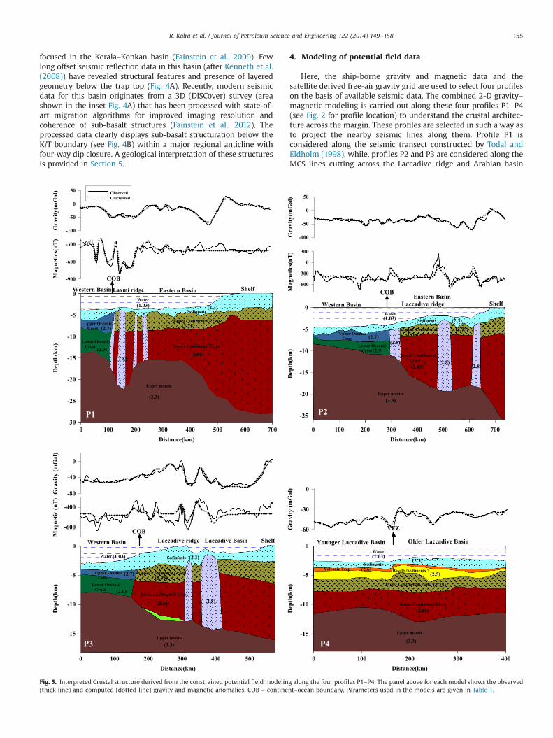
Here, the ship-borne gravity and magnetic data and thesatellite derived free-air gravity grid are used to select four profileson the basis of available seismic data. The combined 2-D gravity–magnetic modeling is carried out along these four profiles P1–P4(see Fig. 2 for profile location) to understand the crustal architec-ture across the margin. These profiles are selected in such a way asto project the nearby seismic lines along them. Profile P1 isconsidered along the seismic transect constructed by Todal andEldholm (1998), while, profiles P2 and P3 are considered along theMCS lines cutting across the Laccadive ridge and Arabian basin
-60
-30
0
Gra
vity
(mG
al)
0 100 200 300 400Distance(km)
-15
-10
-5
0
Dep
th(k
m)
Upper mantle
SedimentsBasalts/Sediments ?
Water
Upper Continental Crust
Lower Continental Crust
Volcanic Trap
Younger Laccadive Basin Older Laccadive Basin
VFZ
P40 100 200 300 400 500
Distance(km)
-15
-10
-5
0
Dep
th(k
m)
Upper Oceanic Crust
Upper mantle
Sediments
Lower Oceanic Crust
Water
Upper Continental Crust
Lower Continental Crust
-80
-40
0
Gra
vity
(mG
al)
-600
-400
Mag
netic
(nT)
Western Basin Laccadive ridge Laccadive Basin Shelf
P3
COB
ObservedCalculated
0 100 200 300 400 500 600 700Distance(km)
-30
-25
-20
-15
-10
-5
0
Dep
th(k
m)
-100
-50
0
50
Gra
vity
(mG
al)
-900
-600
-300
Mag
netic
s(nT
)
Upper Oceanic Crust
Upper mantle
Sediments
Lower Oceanic Crust
Water
Upper Continental Crust
Lower Continental Crust
Western Basin Laxmi ridge
COBShelfEastern Basin
P1
0 100 200 300 400 500 600 700Distance(km)
-25
-20
-15
-10
-5
0
Dep
th(k
m)
-600
-300
0
300
Mag
netic
s(nT
)
-100
-50
0
50
Gra
vity
(mG
al)
Upper Oceanic Crust
Upper mantle
Sediments
Lower Oceanic Crust
Water
Upper Continental Crust
Lower Continental Crust
Western BasinEastern Basin
Laccadive ridge Shelf
COB
P2
(1.03)
(1.03) (1.03)
(1.03) (2.3)
(2.3)
(2.3) (2.3)(2.6)
(2.5)
(2.75)
(2.85)
(3.3)(3.3)
(2.8)(2.85)
(2.75)(2.7)
(2.9)
(2.7)
(2.9)
(3.3)
(2.85)
(2.75)
(2.8)
(2.8)
(2.8)(2.8)(2.85)
(2.75)
(2.9)
(2.7)
(3.3)
Fig. 5. Interpreted Crustal structure derived from the constrained potential field modeling along the four profiles P1–P4. The panel above for each model shows the observed(thick line) and computed (dotted line) gravity and magnetic anomalies. COB – continent–ocean boundary. Parameters used in the models are given in Table 1.
R. Kalra et al. / Journal of Petroleum Science and Engineering 122 (2014) 149–158 155
compiled from Chaubey et al. (2002) and Ajay et al. (2010)respectively. The MCS line (profile 2 in Fig. 4A, after Kenneth etal., 2008) is projected along profile P4. The gravity data along theseprofiles is extracted from the free-air anomaly grid (Fig. 2A), whilemagnetic anomaly data is projected along profiles P1–P3 consid-ered from the NGDC marine geophysical track line database. Thegravity and magnetic modeling is carried out using the GM-SYSsoftware that is primarily based on the method/algorithms ofTalwani et al. (1959) and Talwani and Heirtzler (1964). The densityvalues of sediments (2.3 g/cm3) and crust required for gravitymodeling are obtained using published sonobouy refraction velo-cities (Naini and Talwani, 1982) and the densities obtained usingthe velocity–density conversion from the curve of Nafe and Drake(1963). Densities of 1.03 and 3.3 g/cm3 are assumed for seawaterand upper mantle respectively. For the interpretation of magneticanomalies, appropriate parameters for the remnant magnetizationare considered based on the paleo positions of India during theCretaceous and Paleocene times for both oceanic crustal rocks aswell as modeled intrusive rocks. Details of the modeled parametervalues are given in Table 1. Several iterations were performed afterassigning appropriate density, susceptibility and magnetizationvalues for the sediments/crustal rocks and for varied crustalconfiguration, till the best fit between the observed and computedanomalies has been achieved. While modeling, greater emphasiswas given for fitting the gravity anomalies to less than 5 mgal ofRMS error in all profiles. In the case of magnetic anomalies, wemainly focused on understanding the presence of intrusive rocks.The modeled crustal structure along the four profiles is presentedin Fig. 5.
5. Interpretation
The above analysis and modeling of geophysical data in thedeepwater areas of the western offshore has provided significantnew insights on the regional crustal architecture of the WCMI as awhole, and revealed the presence of probable structuration belowtraps in the Kerala–Konkan offshore. These are briefly describedbelow.
5.1. Crustal architecture
The interpreted crustal models (shown in Fig. 5) indicate thatthe Laxmi basin, Laxmi and Laccadive ridges are underlain by theextended continental crust and with magmatic intrusions. Thecrust below the Laxmi ridge is 4–5 km thicker than the adjacentLaxmi basin, while, crustal thickness below the Laccadive ridgeand Laccadive basin varies from 12 to 14 km in the north to 8 to9 km in the south. The crustal models, qualitative analysis of
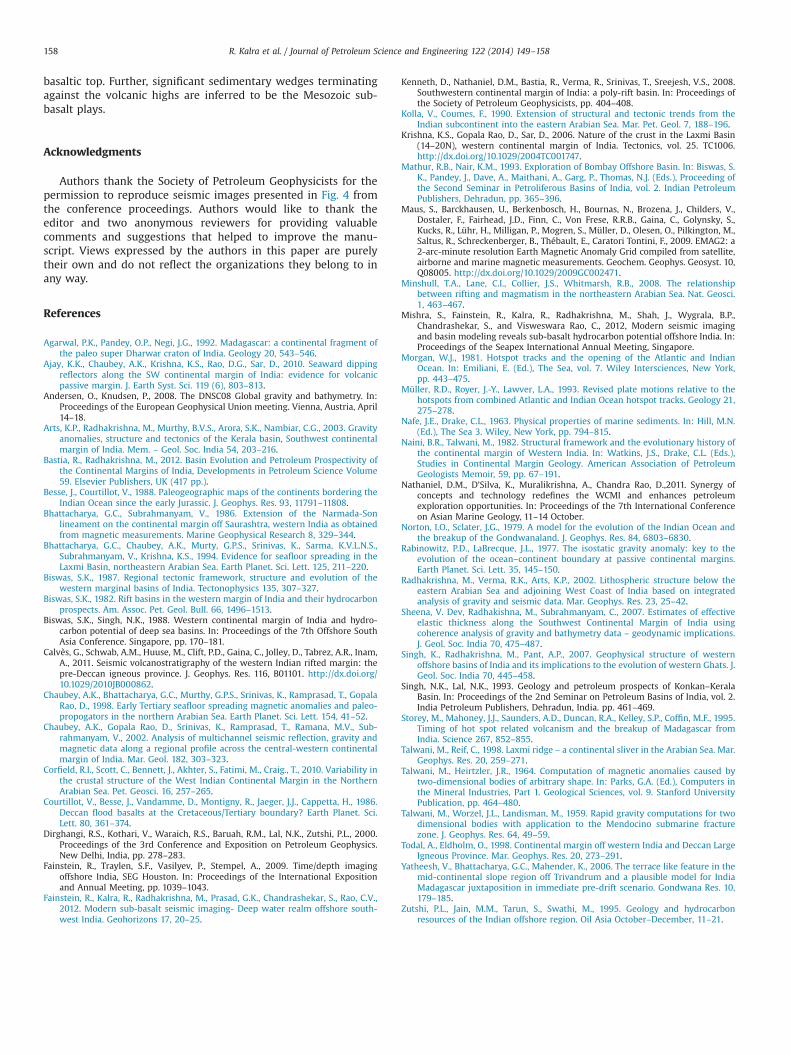
gravity and magnetic anomaly maps (in Fig. 2) along with thepublished seismic interpretations have been further used todemarcate the continent–ocean boundary (COB) and variousdistinct crustal domains in this region (Fig. 6). The identificationof COB is based on the outer limit of SDRs and abrupt transition ofgravity and magnetic anomaly signatures (see Fig. 2) across thewestern flank of Laxmi and Laccadive ridges. Further, gravity andmagnetic anomalies in the transitional domain shows two con-trasting signatures: one with isolated gravity highs/lows as well asmagnetic lows over the seamounts as correlated from MCS imagesindicating the transitional intrusive crustal domain, the other,associated with subdued gravity and magnetic signatures suggest-ing the extended crustal domain. Further north, the structuralcharacteristics associated with the Saurashtra High, Murray ridgeand the Girnar fracture zone trend could be very well noticed fromthe potential field data as proposed by Calvès et al. (2011). In theeastern basin, the boundary between the transitional intrudedcrust and the extended continental crust is demarcated by a sharpgravity variation and complex magnetic signature. Similarly, thegravity and magnetic anomalies in the oceanic domain fallingwithin the western Arabian basin shows two different spreadingregimes. The nature of crust and the identification of COB are stillnot clear below the Laccadive basin in the south. In view of the factthat the Vishnu fracture zone may have been a transpressional(Singh and Lal, 1993; Nathaniel et al., 2011) structural feature
62 66 70 74 780
5
10
15
20
25
Murrayridge Saurashtra
high
Oceanic regime 1
Oceanic regime 2
Lac
cadi
veri
dge
Old
erL
acca
dive
basi
n
You
nge r
Lac
c adi
veba
sin
ExtendedContinental crust
Transitional Intrudedcrust
G R F Z
SF
Z
BF
Z
VF
Z
Laxmi ridgeOC
B
OC
B
OC
B
O C B ??
OC
B??
??
OC
B
Fig. 6. Inferred crustal architecture, COB and different spreading regimes in thewestern offshore based on the interpreted crustal transects, the anomaly pattern,distinctness of magnetic anomaly grain, published fracture zone trends and seismicinterpretations. The arrows represent the direction of SDR's identified from theseismic data by earlier investigators (Ajay et al., 2010; Corfield et al., 2010;Nathaniel et al., 2011). GRFZ – Girnar fracture zone, BFZ – Brahma fracture zone,SFZ – Shiva fracture zone, VFZ – Vishnu fracture zone.
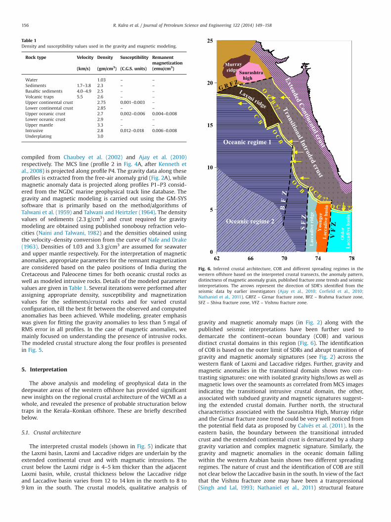
Table 1Density and susceptibility values used in the gravity and magnetic modeling.
Rock type Velocity Density Susceptibility Remanentmagnetization
(km/s) (gm/cm3) (C.G.S. units) (emu/cm3)
Water 1.03 – –
Sediments 1.7–3.8 2.3 – –
Basaltic sediments 4.0–4.9 2.5 – –
Volcanic traps 5.5 2.6 – –
Upper continental crust 2.75 0.001–0.003 –
Lower continental crust 2.85 – –
Upper oceanic crust 2.7 0.002–0.006 0.004–0.008Lower oceanic crust 2.9 – –
Upper mantle 3.3 – –
Intrusive 2.8 0.012–0.018 0.006–0.008Underplating 3.0
R. Kalra et al. / Journal of Petroleum Science and Engineering 122 (2014) 149–158156

(profile 2 in Fig. 4A), we tend to believe that southern part of theLaccadive basin is underlain by the oceanic crust that had evolvedunder different spreading regimes. However, more data would berequired to further enlighten this aspect.
5.2. Identification of structural features (probable) below the basalt
Interpretation has been carried out on few profiles from 3DDISCover dataset of a block in the Kerala–Konkan basin (see Fig. 4Afor the location) to demonstrate the capability of seismic data toimage sub-basalt structural features and also its capability indelineating basaltic layers. For this purpose, two successive cross-line, one inline and one SW–NE profiles have been considered(Fig. 4B) and the structural mapping is performed at all significanthorizon marker levels. The sections revealed deepwater images ofthe Mesozoic structuration under thick basalts that can be inter-pretable and where correlations from line to line could be made soas to produce plausible structure model for the sub-basalt in thisblock area.
In Fig. 4B, the first two successive crosslines are displayed nextto each other and the main structural features are marked andlabeled. It is divided into several segments. The horizon markedwith green color represents the top of basalt trap i.e. K/T boundary.Above the basalt top, the complete column comprise of Tertiarysediments, mostly clastics with a probable alternating sequencesof unconsolidated clay and sands except for the blue marker thatappears to be a carbonate accretion. Below the basalt top i.e. inbetween green and black markers; numerous features such as thesag basin, fractures, faults and folding could be seen. The K/Tboundary layer is clearly seen as major change in frequencycontent. Deeper bright amplitudes may be related to the magmaticevent. There are significant sedimentary wedges terminatingagainst the buttress (volcanic highs) and these are essentiallyinferred to be Mesozoic sub-basalt plays. The bases of wedges,probably, are the events of diabase intrusives or extrusives thatmay have happened prior to or after the K/T extrusives. Also, theprominent ridge rift shoulders on both sides of the buttress can benoted. Possible rifted margin (zone at the bottom) marked in pinkcolor is highlighted and this could be at the base of Mesozoic.Further, in the inline section, clear imaging of Mesozoic strataunder basalt is observed. A sizable anticline structure is delineatedunder an erosion unconformity represented by the Cretaceous/Tertiary boundary. Numerous faults compartmentalize sedimen-tary strata. High-amplitude anomalies on Mesozoic may representearlier lava flowage (Reunion?) event. The Tertiary cover is uni-form and the high amplitude reflections within Tertiaries could becarbonate platforms, wherein, it is evident that the subsidencemay be recent. Further, the Tertiary sequences are seen to bedetached from the older ones. As can be seen, the interpretedhorizons appear as continuous high amplitude records. Furtherbelow, the section displays volcanic ridge dome and the adjacentmarginal Mesozoic basin.
5.3. Implications on deepwater exploration
The Kerala–Konkan basin is known to have undergone severalstages of development tied up with the tectonic evolution of thewest coast of India. The hydrocarbon potential of sub-basalt areasin the basin can be well understood or explored only when theimprovement in seismic imaging is realised through technology.Despite advancements in other geophysical methods (namely MT,gravity and magnetic), seismic remains as the best approach as ondate to take the sub-basalt exploration to the level of expectations.It is relevant to understand whether integration of modern seismicimaging, multi-measurements and basin simulation models wouldprovide us adequate information for uncovering the potential
reservoir systems in deepwater sub-basalt environment. Innova-tive, alternative approaches are needed to make the invisiblevisible! In fact these questions have been there and wereaddressed through several stages of development that underwentin the Kerala–Konkan basin. As such recognition of the morphol-ogy of Tertiary and Mesozoic sediments and crystalline basementfeatures are critical (Fainstein et al., 2012) to our understanding ofsub-basalt plays. As both continental and the oceanic crustalrealms are relevant in the deepwater exploration, correct place-ment of the COB is of paramount importance. The present studyprovides few important constraints on this aspect through theintegration of all geophysical data.
The interpretation on few key lines along with other geophysicaldata suggest that the source rock is underlain by reservoir qualitysandstone of continental origin wherein the hydrocarbons can alsobe expelled downwards to be trapped. A recent simulation efforttaking into consideration of several petroleum migration scenarios(Mishra et al., 2012) suggested the possibility of the existence ofsizable volumes of gaseous hydrocarbons that could be trappedagainst the structural highs. According to them, the limited hydro-carbon occurrence in the sediments above the basalts in Kerala–Konkan offshore may be due to the effect of dispersion of previousgas migration through leaky faults in periods of higher tectonicactivity. Main challenge therefore is to focus into the propermapping and understanding of the Mesozoic plays.
In this area, the origin of large regional anticlines and theassociated source and reservoir facies are one of the concerns andthe question remains whether these resulted from several epi-sodes of volcanic activity or formed due to tectonic inversion? Theinterpreted sections reveal that between the K/T boundary and theregional anticline tops, there are, in many instances, stratigraphicwedge terminations that point out to the possibility of structuralinversion. Therefore, we infer a strong possibility of distinctseparate episode of Mesozoic petroleum system below the basalticflows. The structural interpretation presented and discussed herealong both the crossline and inline sections is based on what couldbe interpreted on the stacks data but obviously more geologicaland geophysical information and studies on seismic data would berequired for better understanding of the overall structure. Theactual subsurface nature and existence of these probable struc-tures can be confirmed only by exploratory drilling.
6. Conclusions
As a part of overall discussion for this exercise, we have beenable to bring together several geophysical observations in thewestern offshore of India which confirms that it is a poly-riftmargin with significant volcanic emplacements. On the basis of itstectono-magmatic history and evolution; the western margin ofIndia in totality can be classified as a volcanic margin. It is verywell known that all along the margin volcanic rocks underlie thebase of Tertiary sedimentary cover (characterized by widespreadextrusive volcanism with intermittent intrusive volcanics). Adetailed analysis of gravity and magnetic data constrained bymulti-channel seismic information across this margin revealedthat the continent–ocean boundary (COB) lies to the west ofLaccadive and Laxmi ridges, and also in the southern part ofLaccadive basin. The models further show that the eastern basin isunderlain by extended continental crust that was punctured byseveral magmatic intrusions. We also presented high-resolutionseismic images at the margin that have revealed the presence ofdeeper sedimentary strata below the K/T flood-basalts. Detailedinterpretation of few sections belonging to 3D seismic block in thedeepwater Kerala–Konkan offshore revealed numerous featuressuch as the sag basin, fractures, faults and folding below the
R. Kalra et al. / Journal of Petroleum Science and Engineering 122 (2014) 149–158 157
basaltic top. Further, significant sedimentary wedges terminatingagainst the volcanic highs are inferred to be the Mesozoic sub-basalt plays.
Acknowledgments
Authors thank the Society of Petroleum Geophysicists for thepermission to reproduce seismic images presented in Fig. 4 fromthe conference proceedings. Authors would like to thank theeditor and two anonymous reviewers for providing valuablecomments and suggestions that helped to improve the manu-script. Views expressed by the authors in this paper are purelytheir own and do not reflect the organizations they belong to inany way.
References
Agarwal, P.K., Pandey, O.P., Negi, J.G., 1992. Madagascar: a continental fragment ofthe paleo super Dharwar craton of India. Geology 20, 543–546.
Ajay, K.K., Chaubey, A.K., Krishna, K.S., Rao, D.G., Sar, D., 2010. Seaward dippingreflectors along the SW continental margin of India: evidence for volcanicpassive margin. J. Earth Syst. Sci. 119 (6), 803–813.
Andersen, O., Knudsen, P., 2008. The DNSC08 Global gravity and bathymetry. In:Proceedings of the European Geophysical Union meeting. Vienna, Austria, April14–18.
Arts, K.P., Radhakrishna, M., Murthy, B.V.S., Arora, S.K., Nambiar, C.G., 2003. Gravityanomalies, structure and tectonics of the Kerala basin, Southwest continentalmargin of India. Mem. – Geol. Soc. India 54, 203–216.
Bastia, R., Radhakrishna, M., 2012. Basin Evolution and Petroleum Prospectivity ofthe Continental Margins of India, Developments in Petroleum Science Volume59. Elsevier Publishers, UK (417 pp.).
Besse, J., Courtillot, V., 1988. Paleogeographic maps of the continents bordering theIndian Ocean since the early Jurassic. J. Geophys. Res. 93, 11791–11808.
Bhattacharya, G.C., Subrahmanyam, V., 1986. Extension of the Narmada-Sonlineament on the continental margin off Saurashtra, western India as obtainedfrom magnetic measurements. Marine Geophysical Research 8, 329–344.
Bhattacharya, G.C., Chaubey, A.K., Murty, G.P.S., Srinivas, K., Sarma, K.V.L.N.S.,Subrahmanyam, V., Krishna, K.S., 1994. Evidence for seafloor spreading in theLaxmi Basin, northeastern Arabian Sea. Earth Planet. Sci. Lett. 125, 211–220.
Biswas, S.K., 1987. Regional tectonic framework, structure and evolution of thewestern marginal basins of India. Tectonophysics 135, 307–327.
Biswas, S.K., 1982. Rift basins in the western margin of India and their hydrocarbonprospects. Am. Assoc. Pet. Geol. Bull. 66, 1496–1513.
Biswas, S.K., Singh, N.K., 1988. Western continental margin of India and hydro-carbon potential of deep sea basins. In: Proceedings of the 7th Offshore SouthAsia Conference. Singapore, pp. 170–181.
Calvès, G., Schwab, A.M., Huuse, M., Clift, P.D., Gaina, C., Jolley, D., Tabrez, A.R., Inam,A., 2011. Seismic volcanostratigraphy of the western Indian rifted margin: thepre-Deccan igneous province. J. Geophys. Res. 116, B01101. http://dx.doi.org/10.1029/2010JB000862.
Chaubey, A.K., Bhattacharya, G.C., Murthy, G.P.S., Srinivas, K., Ramprasad, T., GopalaRao, D., 1998. Early Tertiary seafloor spreading magnetic anomalies and paleo-propogators in the northern Arabian Sea. Earth Planet. Sci. Lett. 154, 41–52.
Chaubey, A.K., Gopala Rao, D., Srinivas, K., Ramprasad, T., Ramana, M.V., Sub-rahmanyam, V., 2002. Analysis of multichannel seismic reflection, gravity andmagnetic data along a regional profile across the central-western continentalmargin of India. Mar. Geol. 182, 303–323.
Corfield, R.I., Scott, C., Bennett, J., Akhter, S., Fatimi, M., Craig., T., 2010. Variability inthe crustal structure of the West Indian Continental Margin in the NorthernArabian Sea. Pet. Geosci. 16, 257–265.
Courtillot, V., Besse, J., Vandamme, D., Montigny, R., Jaeger, J.J., Cappetta, H., 1986.Deccan flood basalts at the Cretaceous/Tertiary boundary? Earth Planet. Sci.Lett. 80, 361–374.
Dirghangi, R.S., Kothari, V., Waraich, R.S., Baruah, R.M., Lal, N.K., Zutshi, P.L., 2000.Proceedings of the 3rd Conference and Exposition on Petroleum Geophysics.New Delhi, India, pp. 278–283.
Fainstein, R., Traylen, S.F., Vasilyev, P., Stempel, A., 2009. Time/depth imagingoffshore India, SEG Houston. In: Proceedings of the International Expositionand Annual Meeting, pp. 1039–1043.
Fainstein, R., Kalra, R., Radhakrishna, M., Prasad, G.K., Chandrashekar, S., Rao, C.V.,2012. Modern sub-basalt seismic imaging- Deep water realm offshore south-west India. Geohorizons 17, 20–25.
Kenneth, D., Nathaniel, D.M., Bastia, R., Verma, R., Srinivas, T., Sreejesh, V.S., 2008.Southwestern continental margin of India: a poly-rift basin. In: Proceedings ofthe Society of Petroleum Geophysicists, pp. 404–408.
Kolla, V., Coumes, F., 1990. Extension of structural and tectonic trends from theIndian subcontinent into the eastern Arabian Sea. Mar. Pet. Geol. 7, 188–196.
Krishna, K.S., Gopala Rao, D., Sar, D., 2006. Nature of the crust in the Laxmi Basin(14–20N), western continental margin of India. Tectonics, vol. 25. TC1006.http://dx.doi.org/10.1029/2004TC001747.
Mathur, R.B., Nair, K.M., 1993. Exploration of Bombay Offshore Basin. In: Biswas, S.K., Pandey, J., Dave, A., Maithani, A., Garg, P., Thomas, N.J. (Eds.), Proceeding ofthe Second Seminar in Petroliferous Basins of India, vol. 2. Indian PetroleumPublishers, Dehradun, pp. 365–396.
Maus, S., Barckhausen, U., Berkenbosch, H., Bournas, N., Brozena, J., Childers, V.,Dostaler, F., Fairhead, J.D., Finn, C., Von Frese, R.R.B., Gaina, C., Golynsky, S.,Kucks, R., Lühr, H., Milligan, P., Mogren, S., Müller, D., Olesen, O., Pilkington, M.,Saltus, R., Schreckenberger, B., Thébault, E., Caratori Tontini, F., 2009. EMAG2: a2-arc-minute resolution Earth Magnetic Anomaly Grid compiled from satellite,airborne and marine magnetic measurements. Geochem. Geophys. Geosyst. 10,Q08005. http://dx.doi.org/10.1029/2009GC002471.
Minshull, T.A., Lane, C.I., Collier, J.S., Whitmarsh, R.B., 2008. The relationshipbetween rifting and magmatism in the northeastern Arabian Sea. Nat. Geosci.1, 463–467.
Mishra, S., Fainstein, R., Kalra, R., Radhakrishna, M., Shah, J., Wygrala, B.P.,Chandrashekar, S., and Visweswara Rao, C., 2012, Modern seismic imagingand basin modeling reveals sub-basalt hydrocarbon potential offshore India. In:Proceedings of the Seapex International Annual Meeting, Singapore.
Morgan, W.J., 1981. Hotspot tracks and the opening of the Atlantic and IndianOcean. In: Emiliani, E. (Ed.), The Sea, vol. 7. Wiley Intersciences, New York,pp. 443–475.
Müller, R.D., Royer, J.-Y., Lawver, L.A., 1993. Revised plate motions relative to thehotspots from combined Atlantic and Indian Ocean hotspot tracks. Geology 21,275–278.
Nafe, J.E., Drake, C.L., 1963. Physical properties of marine sediments. In: Hill, M.N.(Ed.), The Sea 3. Wiley, New York, pp. 794–815.
Naini, B.R., Talwani, M., 1982. Structural framework and the evolutionary history ofthe continental margin of Western India. In: Watkins, J.S., Drake, C.L. (Eds.),Studies in Continental Margin Geology. American Association of PetroleumGeologists Memoir, 59, pp. 67–191.
Nathaniel, D.M., D’Silva, K., Muralikrishna, A., Chandra Rao, D.,2011. Synergy ofconcepts and technology redefines the WCMI and enhances petroleumexploration opportunities. In: Proceedings of the 7th International Conferenceon Asian Marine Geology, 11–14 October.
Norton, I.O., Sclater, J.G., 1979. A model for the evolution of the Indian Ocean andthe breakup of the Gondwanaland. J. Geophys. Res. 84, 6803–6830.
Rabinowitz, P.D., LaBrecque, J.L., 1977. The isostatic gravity anomaly: key to theevolution of the ocean–continent boundary at passive continental margins.Earth Planet. Sci. Lett. 35, 145–150.
Radhakrishna, M., Verma, R.K., Arts, K.P., 2002. Lithospheric structure below theeastern Arabian Sea and adjoining West Coast of India based on integratedanalysis of gravity and seismic data. Mar. Geophys. Res. 23, 25–42.
Sheena, V. Dev, Radhakishna, M., Subrahmanyam, C., 2007. Estimates of effectiveelastic thickness along the Southwest Continental Margin of India usingcoherence analysis of gravity and bathymetry data – geodynamic implications.J. Geol. Soc. India 70, 475–487.
Singh, K., Radhakrishna, M., Pant, A.P., 2007. Geophysical structure of westernoffshore basins of India and its implications to the evolution of western Ghats. J.Geol. Soc. India 70, 445–458.
Singh, N.K., Lal, N.K., 1993. Geology and petroleum prospects of Konkan–KeralaBasin. In: Proceedings of the 2nd Seminar on Petroleum Basins of India, vol. 2.India Petroleum Publishers, Dehradun, India. pp. 461–469.
Storey, M., Mahoney, J.J., Saunders, A.D., Duncan, R.A., Kelley, S.P., Coffin, M.F., 1995.Timing of hot spot related volcanism and the breakup of Madagascar fromIndia. Science 267, 852–855.
Talwani, M., Reif, C., 1998. Laxmi ridge – a continental sliver in the Arabian Sea. Mar.Geophys. Res. 20, 259–271.
Talwani, M., Heirtzler, J.R., 1964. Computation of magnetic anomalies caused bytwo-dimensional bodies of arbitrary shape. In: Parks, G.A. (Ed.), Computers inthe Mineral Industries, Part 1. Geological Sciences, vol. 9. Stanford UniversityPublication, pp. 464–480.
Talwani, M., Worzel, J.L., Landisman, M., 1959. Rapid gravity computations for twodimensional bodies with application to the Mendocino submarine fracturezone. J. Geophys. Res. 64, 49–59.
Todal, A., Eldholm, O., 1998. Continental margin off western India and Deccan LargeIgneous Province. Mar. Geophys. Res. 20, 273–291.
Yatheesh, V., Bhattacharya, G.C., Mahender, K., 2006. The terrace like feature in themid-continental slope region off Trivandrum and a plausible model for IndiaMadagascar juxtaposition in immediate pre-drift scenario. Gondwana Res. 10,179–185.
Zutshi, P.L., Jain, M.M., Tarun, S., Swathi, M., 1995. Geology and hydrocarbonresources of the Indian offshore region. Oil Asia October–December, 11–21.
R. Kalra et al. / Journal of Petroleum Science and Engineering 122 (2014) 149–158158