ORIGINAL RESEARCH PAPER Geomorphic setting and geohazard-related features along the Ionian Calabrian...
11
ORIGINAL RESEARCH PAPER Geomorphic setting and geohazard-related features along the Ionian Calabrian margin between Capo Spartivento and Capo Rizzuto (Italy) Danilo Morelli • Angela Cuppari • Ester Colizza • Francesco Fanucci Received: 10 April 2010 / Accepted: 31 March 2011 Ó Springer Science+Business Media B.V. 2011 Abstract The aim of this work is to describe the morpho- dynamic processes of coastal and submarine areas based on morpho-bathymetric data and sub-bottom acoustic profiles from the Calabrian Ionian margin (from Capo Spartivento to Capo Rizzuto). We describe some of the most significant geo-hazard features and show some examples of their complex interactions and related potential risk. The rela- tionship between these geo-hazard features and the active tectonics and some severe historical earthquakes and tsu- namis is also discussed. The studied area is characterized by several well developed canyon systems. The retrogres- sive erosion of the canyon heads affects the continental shelf and interacts with the coastal morpho-sedimentary processes, evidencing the intense geomorphic activity of this sector of Ionian margin. The widespread evidence of mass wasting processes and slope instability, together with the historical seismicity, makes this area also an ideal case study for investigating on the possible relationship between earthquakes and landslide-triggered tsunamis and assessing the potential risk. Keywords Marine geo-hazard Á Submarine landslide Á Submarine canyon Á Active tectonics Á Marine morphology Á Marine cartography Á Ionian Calabrian margin Introduction During the last decade most research programs in marine geology focused on the analysis of seafloor features and shallow sediments packages, aiming at defining seafloor instability and sediment mass wasting processes that may represent hazard for coastal areas and infrastructures. In this view, a number of national and international research projects have involved the Italian continental margins (COSTA Project, Canals et al. 2004; MALISAR Project, Migeon et al. 2007, MAGIC Project, Chiocci and Ridente, this volume), where the interests for geo-hazard investi- gation and risk analysis are rooted in the well-known high concentrations of historical and recent natural disasters (Italian Catalogue of Tsunami, Tinti et al. 2004; Lorito et al. 2008). These events are often connected to the intense seismicity (e.g. Ligurian, Calabrian and Sicilian margins) which may influence both the long- and short-term mor- phodynamic evolution. Moreover, such catastrophic events may be amplified by human activity (e.g. the 1977 Gioia Tauro harbour landslide, Colantoni et al. 1992; the 1979 Nizza harbour landslides, Cochonat et al. 1993). The geographical distribution and frequency of geo- hazard features indicative of intense erosion and sediment failure along the Italian margins, such as canyons and widespread submarine landslides, have been better con- strained with the recent increase of Multibeam swath bathymetry acquisition combined with high resolution seismic data. Detailed 3D reconstructions of surficial and deep-seated morpho-structural settings have improved the identification of marine geo-hazard features, allowing a better compre- hension of geomorphic processes resulting in the rapid morpho-dynamic evolution of continental margins. This rapid geomorphic shaping of the seafloor is often related to D. Morelli (&) Á A. Cuppari Á E. Colizza Á F. Fanucci Department of Geosciences, University of Trieste, Via Weiss 2, 34128 Trieste, Italy e-mail: [email protected] A. Cuppari e-mail: [email protected] E. Colizza e-mail: [email protected] F. Fanucci e-mail: [email protected] 123 Mar Geophys Res DOI 10.1007/s11001-011-9130-4
-
Upload
triestearchitettura -
Category
Documents
-
view
1 -
download
0
Transcript of ORIGINAL RESEARCH PAPER Geomorphic setting and geohazard-related features along the Ionian Calabrian...

ORIGINAL RESEARCH PAPER
Geomorphic setting and geohazard-related featuresalong the Ionian Calabrian margin between Capo Spartiventoand Capo Rizzuto (Italy)
Danilo Morelli • Angela Cuppari • Ester Colizza •
Francesco Fanucci
Received: 10 April 2010 / Accepted: 31 March 2011
� Springer Science+Business Media B.V. 2011
Abstract The aim of this work is to describe the morpho-
dynamic processes of coastal and submarine areas based on
morpho-bathymetric data and sub-bottom acoustic profiles
from the Calabrian Ionian margin (from Capo Spartivento
to Capo Rizzuto). We describe some of the most significant
geo-hazard features and show some examples of their
complex interactions and related potential risk. The rela-
tionship between these geo-hazard features and the active
tectonics and some severe historical earthquakes and tsu-
namis is also discussed. The studied area is characterized
by several well developed canyon systems. The retrogres-
sive erosion of the canyon heads affects the continental
shelf and interacts with the coastal morpho-sedimentary
processes, evidencing the intense geomorphic activity of
this sector of Ionian margin. The widespread evidence of
mass wasting processes and slope instability, together with
the historical seismicity, makes this area also an ideal case
study for investigating on the possible relationship between
earthquakes and landslide-triggered tsunamis and assessing
the potential risk.
Keywords Marine geo-hazard � Submarine landslide �Submarine canyon � Active tectonics �Marine morphology �Marine cartography � Ionian Calabrian margin
Introduction
During the last decade most research programs in marine
geology focused on the analysis of seafloor features and
shallow sediments packages, aiming at defining seafloor
instability and sediment mass wasting processes that may
represent hazard for coastal areas and infrastructures. In
this view, a number of national and international research
projects have involved the Italian continental margins
(COSTA Project, Canals et al. 2004; MALISAR Project,
Migeon et al. 2007, MAGIC Project, Chiocci and Ridente,
this volume), where the interests for geo-hazard investi-
gation and risk analysis are rooted in the well-known high
concentrations of historical and recent natural disasters
(Italian Catalogue of Tsunami, Tinti et al. 2004; Lorito
et al. 2008). These events are often connected to the intense
seismicity (e.g. Ligurian, Calabrian and Sicilian margins)
which may influence both the long- and short-term mor-
phodynamic evolution. Moreover, such catastrophic events
may be amplified by human activity (e.g. the 1977 Gioia
Tauro harbour landslide, Colantoni et al. 1992; the 1979
Nizza harbour landslides, Cochonat et al. 1993).
The geographical distribution and frequency of geo-
hazard features indicative of intense erosion and sediment
failure along the Italian margins, such as canyons and
widespread submarine landslides, have been better con-
strained with the recent increase of Multibeam swath
bathymetry acquisition combined with high resolution
seismic data.
Detailed 3D reconstructions of surficial and deep-seated
morpho-structural settings have improved the identification
of marine geo-hazard features, allowing a better compre-
hension of geomorphic processes resulting in the rapid
morpho-dynamic evolution of continental margins. This
rapid geomorphic shaping of the seafloor is often related to
D. Morelli (&) � A. Cuppari � E. Colizza � F. Fanucci
Department of Geosciences, University of Trieste,
Via Weiss 2, 34128 Trieste, Italy
e-mail: [email protected]
A. Cuppari
e-mail: [email protected]
E. Colizza
e-mail: [email protected]
F. Fanucci
e-mail: [email protected]
123
Mar Geophys Res
DOI 10.1007/s11001-011-9130-4

sediment erosion and mass wasting; where these processes
cluster and focus, they may lead to the development of
canyon systems deeply and diffusely incising the shelf and
slope region.
Mass wasting processes are often the effect of multiple
factors which can variably interplay, making sediment
instability one of the most difficult geo-hazard to be eval-
uated. In many cases the difficulty of predicting geo-hazard
related to the complex processes like sediment failure
depends also on the scarce availability of spatial and
temporal information relative to their occurrence. How-
ever, the likelihood of geo-hazards and their possible
effects can be inferred from specific geomorphic features
(e.g. horseshoe scar, migrating bedforms, accumulation or
dispersion of giant blocks) as well as from the stratigraphic
record (e.g. debris deposits, hummocky deposits), properly
evaluated within the context of known recent and historical
events (e.g. earthquakes, inundations, and tsunamis).
The Ionian Calabrian margin is one of the most inter-
esting areas for applying the above investigative criteria in
order to define the main geomorphic features, their rela-
tionship with stratigraphy and seismotectonic setting and,
finally, the resulting geo-hazard potential. The Ionian
Calabrian margin has been the object of the MESC-05
research Project (Morphology and Evolution of the Sub-
marine Canyons in the Ionian Margin of Calabria- Uni-
versity of Trieste, Italy). In the framework of the MESC-05
project, a survey has been performed on board of the R/V
OGS EXPLORA (summer 2005) during which Multi-beam
and CHIRP data were acquired, covering the Ionian shelf
area and slope up to 1,600 m depth from Capo Spartivento
to Capo Rizzuto (Figs. 1, 2).
The collected high resolution swath bathymetry data
allowed us to define in detail the main morphological
features of the area, confirming the prevalence of the ero-
sional and mass wasting processes, particularly along
canyon systems in the slope and within the shelf area. The
deeply incised canyon headscarps and channels suggest
that erosion and sediment mass wasting may have been
accompanied by landslides. These features have been
evaluated in terms of geo-hazard potential in the frame-
work of the MaGIC project (Marine Geohazard along the
Italian Coasts).
The regional seismotectonic setting (Fig. 1) is domi-
nated by the Calabrian arc subduction zone, and is
responsible for large historical earthquakes and tsunamis
events, as well as for the high uplift rates of 0.8–0.9 mm/
year during the Plio-Quaternary (Ghisetti 1979; Canu and
Trincardi 1989; Westaway 1990; Dai Pra et al. 1993;
Bordoni and Valensise 1998; Ferranti et al. 2007). Locally,
regional uplift was accompanied by extensional and strike-
slip tectonics, by which formed ridges and basins also
within the offshore, including the study area (e.g. Sparti-
vento and Catanzaro basins; Ambrosetti et al. 1987; Del
Ben et al. 2008). This process is one of the main causes for
the intense erosion and mass wasting processes in the study
area, where the margin is characterized by a very narrow
continental shelf and steep slope, frequently incised by
canyon systems that backstep landward very close to the
modern coast and affect coastal sediment dispersal (Fig. 2;
Cuppari et al. 2007; Morelli 2008; Colizza et al. 2008).
In particular, sediment is intercepted by canyon heads-
carps and channels and is directly conveyed into the slope,
determining, on one hand, coastal erosion and shoreline
Fig. 1 Structural setting and active tectonics of the Calabrian Arc
and surronding area (Ferranti et al. 2007, modified). In a solid blackline: Front of the contractional orogen in the Apennines and Sicily;
dotted black lines: Depth (km) of the Ionian slab; gray patchesbounded by thick dashed lines: Moho Depth (km) in the Tyrrhenian
Sea; thin, solid gray lines: Uplift and subsidence rates (mm/year) in
the Late Pleistocene. In b structural setting (Del Ben et al. 2008,
modified) seismicity and active tectonics of the Calabrian Arc and of
the Ionian margin. The double-arrowed line shows extension
direction (Monaco and Tortorici 2000). Focal mechanisms of
moderate to large earthquakes (M [ 4) are shown (Ferranti et al.
2007 and references therein)
Mar Geophys Res
123

retreat, and promoting on the other hand sediment mass
wasting (debris and turbidity flows). The regional geomor-
phic setting is characterized by areas of different concen-
trations and intensity of these processes, coinciding with
different seismo-tectonic activity within three distinct areas:
the Squillace Gulf, the Siderno-Bovalino Gulf and the Stilo
rise area.
Geological setting
The study area is located in the Ionian Sea margin of
southern Calabria, whose Neogene geological evolution is
connected to the growth and SE migration of the Calabrian
Arc orogen and accretionary prism (Fig. 1). The prominent
arc-shaped orocline connecting the NW–SE trending
southern Apennines with the WSW striking Maghrebian
trusts belt, is rimmed by the Tyrrhenian and Ionian basins
characterized by thinned continental and oceanic crust.
According to several Authors, these physiographic and
geological units are the result of the Neogene north-wes-
terly subduction and easterly roll-back of the Adriatic–
Ionian slab (Malinverno and Ryan 1986; Doglioni et al.
1994; Gueguen et al. 1998; Faccenna et al. 2001; Ferranti
et al. 2009 and references therein).
Since the Late Oligocene to Early Pleistocene the process
has led to the development of a complex contractional belt
(Casero et al. 1992; Patacca and Scandone 2001) including a
stack of basement nappe and the Meso-Cenozoic sedimen-
tary cover. The accretionary prism, during its SE migration,
has involved the Oligocene–Quaternary terrigenous suc-
cession deposited in migrating foreland and piggyback
basins (Monaco et al. 1996; Patacca et al. 1990; Van Dijk
et al. 2000).
Since the Late Miocene, the structural evolution and
sedimentary succession of the Ionian area are comparable
to the typical development and migration of thin-skinned
thrust front fore-arc basins, with alternation of compres-
sional and extensional process, often accompanied by
strike-slip deformation. The Quaternary extensional phase
affecting the Calabrian Arc and the Ionian margin is tes-
tified by regional NE–SW normal fault systems and E–W
to NW–SE strike-slip fault systems segmenting the Cala-
brian Arc; these fault systems extend through the Ionian
shelf and slope (Figs. 1, 2; Sibari, Squillace Bovalino and
Spartivento faults in Del Ben et al. 2008; Van Dijk et al.
2000; Cuppari et al. 2004; Tansi et al. 2007).
During the Middle and Upper Pleistocene, the Calabrian
coast underwent significant tectonic uplift (Fig. 1; West-
away 1990; Bordoni and Valensise 1998; Ferranti et al.
2007). The regional uplift determined topographic steep-
ness, in turn enhancing erosion and large volume sediment
discharge by which mass movements and geomorphic
shaping of the margin significantly accelerated.
The surficial effects of these processes include topo-
graphic steepness with seismogenic normal and strike-slip
Fig. 2 3D view of the surveyed Ionian Calabrian Margin showing the
main morphological features of the three sectors of Bovalino-
Sidenno, Squillace Gulf and Stilo Rise. The relationship between
the main erosional-gravitational features and the active tectonics of
the Cabrian Arc is shown. The red lines indicate the main faults (by
Ambrosetti et al. 1987; Cuppari et al. 2004; Del Ben et al. 2008,
modified). The red circles and blue dots show the seismicity (by
Italian Seismicity Catalogue, 1981–2002—CSI 1.1, Castello et al.
2007, modified)
Mar Geophys Res
123

faulting, high persistence of erosion, large volume of sed-
iment discharge and related mass movements. These are
the major factors responsible for the rapidly evolving
morpho-dynamic features and geo-hazard elements detec-
ted in the surveyed area.
Methods
Multibeam bathymetry and Chirp sonar seismic data were
acquired in the frame of MESC-05 Project, over an area of
approximately 6,000 km2, including the continental shelf
and slope between Capo Spartivento and Capo Rizzuto
(Fig. 2) to a depth of 1,500 m. In addition, multi-channel
seismic sections acquired for hydrocarbon exploration have
been used for investigating the deep-seated tectono-sedi-
mentary structures. Multi-beam data have been collected
using Reson 8110 and 8150 devices and then processed
with PDS2000; the DTM spatial resolution obtained was of
50 m (Fig. 2). When possible, the interpretation and map-
ping of geo-hazard features on the multi-beam dataset has
been supported by high-resolution (Benthos Chirp II)
seismic data. The most proximal reach of canyon heads,
which is very close to the coast, could not be covered by
multi-beam data; this coastal area, however, has been
mapped using side-scan sonar data (Italian Department of
the Environment and of the Territory Management.
–SI.DI.MAR). Earthquake and tsunami events reported in
historical catalogues (Tinti et al. 2004) have been also
considered in order to better evaluate the geo-hazard
Fig. 3 Detailed 3D view of the
Bovalino-Siderno area which
shows the morphodynamic
characters of the canyons and of
the slope area (above). Side-
scan sonar records show the
proximity of the Bovalino
Canyon head to the shoreline
and to the urban areas (below)
Mar Geophys Res
123
potential of the geomorphic features investigated in the
study area.
Results
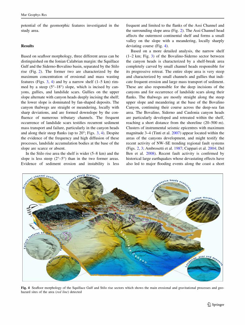
Based on seafloor morphology, three different areas can be
distinguished on the Ionian Calabrian margin: the Squillace
Gulf and the Siderno-Bovalino basin, separated by the Stilo
rise (Fig. 2). The former two are characterized by the
maximum concentration of erosional and mass wasting
features (Figs. 3, 4) and by a narrow shelf (1–5 km) rim-
med by a steep (5�–18�) slope, which is incised by can-
yons, gullies, and landslide scars. Gullies on the upper
slope alternate with canyon heads deeply incising the shelf;
the lower slope is dominated by fan-shaped deposits. The
canyon thalwegs are straight or meandering, locally with
sharp deviations, and are formed downslope by the con-
fluence of numerous tributary channels. The frequent
occurrence of landslide scars testifies recurrent sediment
mass transport and failure, particularly in the canyon heads
and along their steep flanks (up to 20�; Figs. 3, 4). Despite
the evidence of the frequency and high diffusion of these
processes, landslide accumulation bodies at the base of the
slope are scarce or absent.
In the Stilo rise area the shelf is wider (5–8 km) and the
slope is less steep (2�–5�) than in the two former areas.
Evidence of sediment erosion and instability is less
frequent and limited to the flanks of the Assi Channel and
the surrounding slope area (Fig. 2). The Assi Channel head
affects the outermost continental shelf and forms a small
valley on the slope with a meandering, locally sharply
deviating course (Fig. 4).
Based on a more detailed analysis, the narrow shelf
(1–2 km; Fig. 3) of the Bovalino-Siderno sector between
the canyon heads is characterized by a shelf-break area
completely carved by small channel heads responsible for
its progressive retreat. The entire slope area is very steep
and characterized by small channels and gullies that indi-
cate frequent erosion and large mass transport of sediment.
These are also responsible for the deep incisions of the
canyons and for occurrence of landslide scars along their
flanks. The thalwegs are mostly straight along the steep
upper slope and meandering at the base of the Bovalino
Canyon, continuing their course across the deep-sea fan
area. The Bovalino, Siderno and Caulonia canyon heads
are particularly developed and retreated within the shelf,
reaching a short distance from the shoreline (20–500 m).
Clusters of instrumental seismic epicentres with maximum
magnitude 3–4 (Tinti et al. 2007) appear located within the
areas of the canyons development, and might testify the
recent activity of NW–SE trending regional fault systems
(Figs. 2, 3; Ambrosetti et al. 1987; Cuppari et al. 2004; Del
Ben et al. 2008). Recent fault activity is confirmed by
historical large earthquakes whose devastating effects have
also led to major flooding events along the coast a short
Fig. 4 Seafloor morphology of the Squillace Gulf and Stilo rise sectors which shows the main erosional and gravitational processes and geo-
hazard sites of the area (red line) detected
Mar Geophys Res
123

distance from the canyon heads (e.g. 1784 Roccella event
and 1907 Bovalino event; Tinti et al. 2007).
In the Gulf of Squillace, one of the most significant geo-
hazard features is represented by the upper portion of the
Botricello Canyon (Fig. 4). The canyon head of the main
channel is close to the coast, while the secondary channel
head is intersecting a forward shelf edge sector. The wes-
tern flank of this canyon is affected by retrogressive
gravitational-erosive processes testified by well evident
landslide scars that are progressively reducing the slope
area which delimits the canyon from the Serre Channel.
The rapidly evolving mass-wasting processes are supported
by multi-channel seismic profiles which show deep-seated
landslide slip planes and their correspondence with a deep
compressive structure (Fig. 5). This finding is consistent
with the regional tectonic evolution, which is characterized
by the presence of a blind Plio-Quaternary and still active
arc-shape compressive front (Fig. 2; Ambrosetti et al.
1987; Del Ben et al. 2008).
The historical data of this area show a tsunami event on
8th March 1832 which struck the coastal area from Ca-
tanzaro Lido to Steccato village with maximum flooding at
Magliacane village for about 900 m, corresponding to the
canyon head. The tsunami wave of 20 m height 2 km
offshore was triggered by an earthquake with epicentre on
land, about 20 km from the coast (Tinti et al. 2007).
The Serre Channel presents a fan-shaped head charac-
terized by minor channel with shell-shaped erosion scars
which flow in the Catanzaro Canyon (Fig. 4). Chirp and
multi-channel seismic profiles suggest a channel head
development linked to surficial and deep-seated mass
movement which may be favoured by the presence of gas
charged sediments (Fig. 5). In the area where the gravita-
tional processes are concentrated, a deep compressive
structure, as described for the Botricello Canyon, is present
(Fig. 5) and its recent activity is confirmed by a cluster of
instrumental seismic epicentres with maximum magnitude
3.4 (Tinti et al. 2007). Moreover the fault planes have
likely controlled the upward migration of gas into the
younger sedimentary covers (Fig. 5).
The Sellia Canyon head is located at depth of 40 m at
a distance of 1 km from the shoreline (Fig. 6). The con-
cave-shaped axial profile and the meandering morphology
of the thalweg suggest a smaller persistence of the ero-
sional and mass wasting processes than on the other
canyons of this area. However, at the confluence with the
Squillace Canyon, the canyon thalweg is more straight
and carved with very steep flanks (Fig. 4). In this sector
the Chirp profiles show evidence of incipient destabili-
zation of significant thickness of sedimentary cover. The
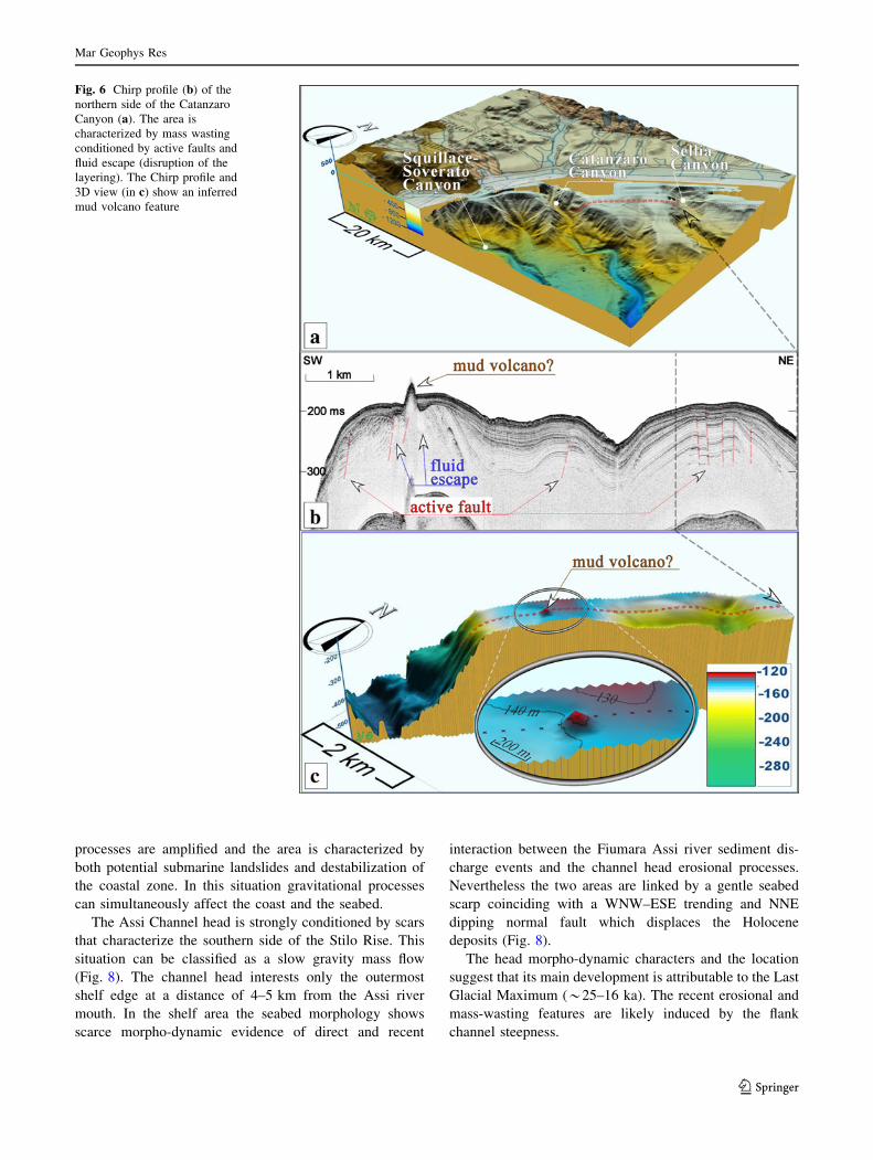
Catanzaro Canyon head is subject to evident retrogressive
erosion (Fig. 6). The canyon is narrow, straight, directly
connected to the mouth of the Corace River, and drains
coastal deposits and flood supply (Fig. 7). Its northern
flank is marked by many landslide scars and an incipient
secondary channel. In this area, where small earthquake
epicentres cluster, high resolution seismic profiles show
how slope instability may be related to active faults and
gas leakage (Fig. 6).
Near the coast, the fan-shaped canyon head is at a dis-
tance of 50 m from the shoreline along a frontal area of
about 3.5 km. The coastal area affected by the head canyon
is strongly urbanized, with the presence of the Catanzaro
Lido tourist harbour (Fig. 7).
The head of Copanello and Soverato Canyons can be
described as a single zone of landslide and erosional geo-
hazard (Fig. 4). The head of the canyons reaches the
shoreline near Soverato at a distance of 100–200 m, where
coastal indentations are conditioned by a master fault
outcropping on land. In this area the morpho-dynamic
Fig. 5 3D view of the Serre Channel b and its surficial (Chirp profile;
in a) and deep seated structural setting (multichannel seismic section;
in c)
Mar Geophys Res
123
processes are amplified and the area is characterized by
both potential submarine landslides and destabilization of
the coastal zone. In this situation gravitational processes
can simultaneously affect the coast and the seabed.
The Assi Channel head is strongly conditioned by scars
that characterize the southern side of the Stilo Rise. This
situation can be classified as a slow gravity mass flow
(Fig. 8). The channel head interests only the outermost
shelf edge at a distance of 4–5 km from the Assi river
mouth. In the shelf area the seabed morphology shows
scarce morpho-dynamic evidence of direct and recent
interaction between the Fiumara Assi river sediment dis-
charge events and the channel head erosional processes.
Nevertheless the two areas are linked by a gentle seabed
scarp coinciding with a WNW–ESE trending and NNE
dipping normal fault which displaces the Holocene
deposits (Fig. 8).
The head morpho-dynamic characters and the location
suggest that its main development is attributable to the Last
Glacial Maximum (*25–16 ka). The recent erosional and
mass-wasting features are likely induced by the flank
channel steepness.
Fig. 6 Chirp profile (b) of the
northern side of the Catanzaro
Canyon (a). The area is
characterized by mass wasting
conditioned by active faults and
fluid escape (disruption of the
layering). The Chirp profile and
3D view (in c) show an inferred
mud volcano feature
Mar Geophys Res
123

Discussion
The different morphological character of the three sectors
described above reflect, to some extent, the effect of the
regional uplift and active tectonics on the morphodynamic
evolution of the Ionian Sea margin of Calabria. Distribu-
tion of mass wasting and erosional features, as well as the
main canyon heads, coincide with fault systems and tec-
tonic lineaments dissecting the Calabrian Arc (Fig. 2), and
are located near the coastal infrastructures.
In terms of potential geo-hazard, these coastal areas are
exposed to retrogressive erosion of the canyon headscarps
yielding sediment mass-wasting and failure, both on the
shelf edge, where sediment loading is significant, and on
the steep slope and canyon flanks; slope failure is also
associated with gas-charged sediment and shallow faults
dissecting Pleistocene and Holocene deposits.
The absence of significant landslide accumulations at
the base of the slopes suggests that the sediment failure
mainly occurred as small-scale processes in form of fre-
quent and diffused debris flows (grain/mud flows) evolving
downslope into turbidity flows, rather than as large-scale
landslides (debris avalanches). Nevertheless, it is also
possible that larger landslide deposits may have been
reworked and/or transported at greater distance (McAdoo
et al. 2000; De Blasio et al. 2006).
An example of very large slope failure is recorded in the
area between the two canyons of Bovalino and Siderno,
where the widespread retrogressive erosional and gravita-
tional processes have reduced the shelf to a narrow sub-
littoral zone (Fig. 3). Relative to such events, it is still a
matter of debate whether seismicity may have contributed
to slope instability and whether instability progressed
Fig. 7 Side-scan sonar records of the head of Catanzaro Canyon
which show its proximity to the coastal area and to the tourist harbour
Fig. 8 3D view of the head of Assi Channel which affects the shelf edge. In the shelf area Chirp profiles show the presence of active faults that
displace the base of the Holocene section
Mar Geophys Res
123
through frequent and small events or less frequent but
larger submarine landslides.
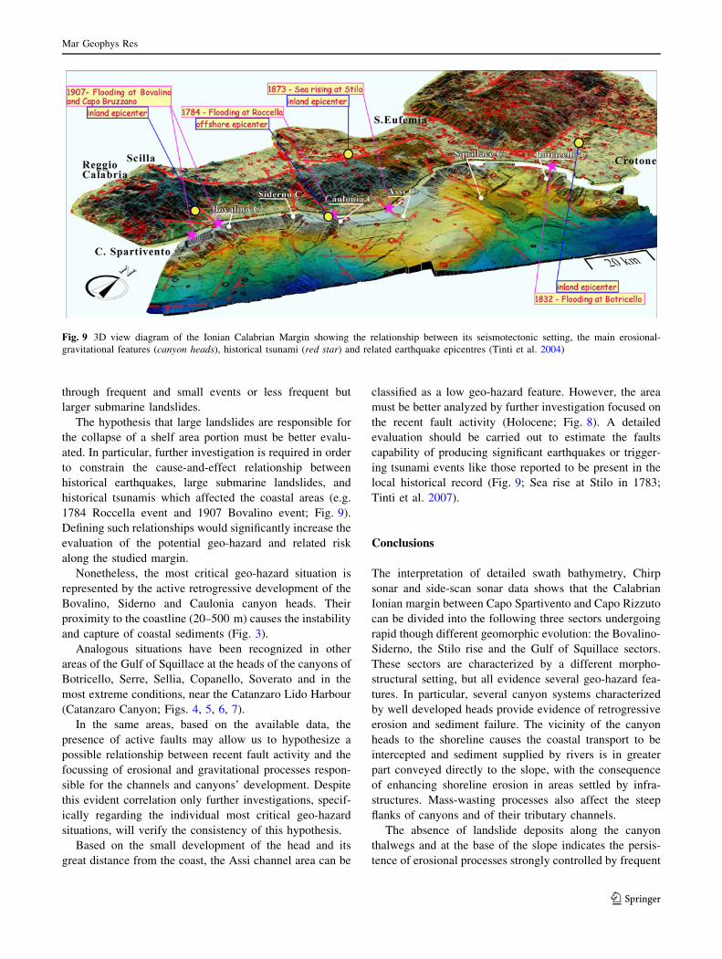
The hypothesis that large landslides are responsible for
the collapse of a shelf area portion must be better evalu-
ated. In particular, further investigation is required in order
to constrain the cause-and-effect relationship between
historical earthquakes, large submarine landslides, and
historical tsunamis which affected the coastal areas (e.g.
1784 Roccella event and 1907 Bovalino event; Fig. 9).
Defining such relationships would significantly increase the
evaluation of the potential geo-hazard and related risk
along the studied margin.
Nonetheless, the most critical geo-hazard situation is
represented by the active retrogressive development of the
Bovalino, Siderno and Caulonia canyon heads. Their
proximity to the coastline (20–500 m) causes the instability
and capture of coastal sediments (Fig. 3).
Analogous situations have been recognized in other
areas of the Gulf of Squillace at the heads of the canyons of
Botricello, Serre, Sellia, Copanello, Soverato and in the
most extreme conditions, near the Catanzaro Lido Harbour
(Catanzaro Canyon; Figs. 4, 5, 6, 7).
In the same areas, based on the available data, the
presence of active faults may allow us to hypothesize a
possible relationship between recent fault activity and the
focussing of erosional and gravitational processes respon-
sible for the channels and canyons’ development. Despite
this evident correlation only further investigations, specif-
ically regarding the individual most critical geo-hazard
situations, will verify the consistency of this hypothesis.
Based on the small development of the head and its
great distance from the coast, the Assi channel area can be
classified as a low geo-hazard feature. However, the area
must be better analyzed by further investigation focused on
the recent fault activity (Holocene; Fig. 8). A detailed
evaluation should be carried out to estimate the faults
capability of producing significant earthquakes or trigger-
ing tsunami events like those reported to be present in the
local historical record (Fig. 9; Sea rise at Stilo in 1783;
Tinti et al. 2007).
Conclusions
The interpretation of detailed swath bathymetry, Chirp
sonar and side-scan sonar data shows that the Calabrian
Ionian margin between Capo Spartivento and Capo Rizzuto
can be divided into the following three sectors undergoing
rapid though different geomorphic evolution: the Bovalino-
Siderno, the Stilo rise and the Gulf of Squillace sectors.
These sectors are characterized by a different morpho-
structural setting, but all evidence several geo-hazard fea-
tures. In particular, several canyon systems characterized
by well developed heads provide evidence of retrogressive
erosion and sediment failure. The vicinity of the canyon
heads to the shoreline causes the coastal transport to be
intercepted and sediment supplied by rivers is in greater
part conveyed directly to the slope, with the consequence
of enhancing shoreline erosion in areas settled by infra-
structures. Mass-wasting processes also affect the steep
flanks of canyons and of their tributary channels.
The absence of landslide deposits along the canyon
thalwegs and at the base of the slope indicates the persis-
tence of erosional processes strongly controlled by frequent
Fig. 9 3D view diagram of the Ionian Calabrian Margin showing the relationship between its seismotectonic setting, the main erosional-
gravitational features (canyon heads), historical tsunami (red star) and related earthquake epicentres (Tinti et al. 2004)
Mar Geophys Res
123

turbidity flows, or dynamic processes as disintegrative
mass failure associated with large submarine landslides.
The focusing and development of these processes could be
mostly conditioned by the margin structural setting and
influenced by the activity of the offshore extent of fault
systems known on land. The offshore extent of these sys-
tems frequently coincides with the main canyon heads and
small channels (Assi Channel) on the margin.
In many cases, mass-wasting processes may be favoured
by the presence of gas charged sediment, along the flanks
of canyons, as evidenced by seismic data.
An interesting aspect put in evidence by the correlation
between the known historical tsunami events and the
described marine geo-hazard features, is the reduced dis-
tance of the latter from the coastal zones that were dam-
aged (Fig. 9). This distance in many cases turns out to be
less than the distance of the related earthquake epicentre.
Based on this evidence one can surmise that the tsunamis
have been generated by large submarine landslides trig-
gered by repeated earthquake loading. This hypothesis is
only partially supported by the frequency of landslide scars
and widespread mass movements described, and requires
further investigation aimed at defining the volume and
velocity of the failed deposit, as well as their age in order to
verify the consistency with the occurrence of known his-
torical earthquakes. A similar, more complete analysis
would allow to better address geo-hazard evaluation and
risk assessment relative to earthquake triggering of land-
slides and landslide-generated tsunamis in the studied area.
Acknowledgments This work was supported by University of
Trieste (Department of GeoSciences; Resp. F. Fanucci and E. Coli-
zza). We are grateful to the support of Project MaGIC (Marine
Geohazard along the Italian Coasts; Resp. F.L. Chiocci) funded by the
Italian Civil Protection Department and coordinated by the Institute of
Environmental Geology and Geoengineering of the Italian National
Research Council (IGAG-CNR). The marine geophysical data were
acquired in the framework of the MESC-05 project (Morphology and
Evolution of the Submarine Canyons in the Ionian Margin of Cala-
bria; Resp. E. Colizza), on board of the R/V OGS-EXPLORA and
supported by the Department for the Development of Marine Tech-
nology and Research of the Osservatorio Geofisico Sperimentale
(Trieste; Resp. R. Ramella). The Side-Scan Sonar data were collected
by the Italian Department of the Environment and of the Territory
Management. (SI.DI.MAR). L. Ferranti (University of Naples—
FedericoII) is thanked for his helpful suggestions. We are also
grateful to D. Ridente (IGAG-CNR) and of an anonymous reviewer
for their careful review and to F.L. Chiocci for editorial guidance.
References
Ambrosetti P, Bartolini C, Bosi C, Carraro F, Ciaranfi N, Panizza M,
Papani G, Vezzani L, Zanferrari A (1987) Neotectonic map of
Italy (Scale 1:500.000). C.N.R., P. F. Geodinamica
Bordoni P, Valensise G (1998) Deformation of the 125 ka marine
terrace in Italy; tectonic implications. In: Stewart I, Vita-Finzi C
(eds) Late quaternary coastal tectonics. Geol Soc Spec Publ
Lond 146:71–110
Canals M, Lastras G, Urgeles R, Casamor JL, Mienert J, Cattaneo A,
De Batist M, Haflidason H, Imbo Y, Laberg JS (2004) Slope
failure dynamics and impacts from seafloor and shallow sub-
seafloor geophysical data: case studies from the COSTA project.
Mar Geol 213(1–4):9–72
Canu M, Trincardi F (1989) Controllo eustatico e tettonico sui sistemi
deposizionali nel bacino di Paola (Plio-Quaternario), margine
tirreno orientale. Giornale di Geologia 3(51/2):41–61
Casero P, Roure R, Endignoux L, Moretti I, Muller C, Sage L, Vially
R (1992) Neogene geodynamic evolution of Southern Apen-
nines. Mem Soc Geol Ital 41:109–120
Castello B, Olivieri M, Selvaggi G (2007) Local and duration
magnitude determination for the Italian earthquake catalogue
(1981–2002). Bull Seismolog Soc Am 97(1B):128–139
Cochonat P, Bourillet JF, Savoye B, Dodd L (1993) Geotechnical
characteristics and instability of submarine slope sediments, the
Nice slope (NW Mediterranean Sea). Mar Georesour Geotechnol
11:131–151
Colantoni P, Gennesseaux M, Vanney JR, Ulzega A, Melegari G,
Trombetta A (1992) Processi dinamici del canyon sottomarino di
Gioia Tauro (Mare Tirreno). Gionale di Geologia 3(54/
2):199–213
Colizza E, Cuppari A, Fanucci F, Morelli D, Fonda G, Melis R,
Accettella D, Wardell N (2008) Morfostrutture e processi
sedimentari nei fondali dell’area compresa fra Punta Stilo e
Capo Rizzuto (Calabria Ionica), zona a potenziale rischio
geoambientale. In: Oggiano G et al. (eds) Rend online Society
Geological Italian. Proceedings of 84th congress SGI, 15–17th
Sept 2008, Sassari vol 3, pp 248–249
Cuppari A, Colizza E, Fanucci F, Morelli D (2004) Morphology and
evolution of the Siderno and Bovalino Canyons: there relation-
ship with the tectonics of the Calabrian Arc (Calabrian Ionian
Margin). Quaternaria Nova VIII:29–44
Cuppari A, Fanucci F, Morelli D, Colizza E, Lenaz D, Accettella D,
Wardell N (2007) Morphostructural features and sedimentary
processes of the Ionian Calabrian inner margin.). In: Consiglio di
Presidenza della FIST (eds) Epitome 02.864, Geoitalia 2007,
12–14th Sept 2007, Rimini
Dai Pra G, Miyauchi T, Anselmi B, Galletti M, Paganin G (1993) Eta
dei depositi a Strombus Bubonius di Vibo Valentia Marina
(Italia Meridionale). II Quaternario 6(1):139–144
De Blasio FV, Elverhøi A, Engvik LE, Issler D, Gauer P, Harbitz C
(2006) Understanding the high mobility of subaqueous debris
flows. Norvegian J Geol 86/3:275–284
Del Ben A, Barnaba C, Toboga A (2008) Strike-slip systems as the
main tectonic features in the Plio-Quaternary kinematics of the
Calabrian Arc. Mar Geophys Res 29:1–12. doi:10.1007/s11001-
007-9041-6
Doglioni C, Mongelli F, Pieri P (1994) The Puglia uplift (SE Italy)-an
anomaly in the foreland of the Apenninic subduction due to
buckling of a thick continental lithosphere. Tectonics
13(5):1309–1321
Faccenna C, Becker TW, Lucente FP, Jolivet L, Rossetti F (2001)
History of subduction and back-arc extension in the central
Mediterranean. Geophys J Int 145:809–820
Ferranti L, Monaco C, Antonioli F, Maschio L, Kershaw S, Verrubbi
V (2007) The contribution of regional uplift and coseismic slip
to the vertical crustal motion in the Messina Straits, southern
Italy: evidence from raised Late Holocene shorelines. J Geophys
Res 112:B06401. doi:10.1029/2006JB004473
Ferranti L, Santore E, Mazzella ME, Monaco C, Morelli D (2009)
Active transpression in the northern Calabria Apennines, south-
ern Italy. Tecthonophysics 476:226–251
Mar Geophys Res
123

Ghisetti F (1979) Relazioni tra strutture e fasi trascorrenti e distensive
lungo i sistemi Messina-Fiumefreddo, Tindari-Letojanni e Alia-
Malvagna (Sicilia nord-orientale): uno studio microtettonico.
Geol Rom 18:23–58
Gueguen E, Doglioni C, Fernandez M (1998) On the post-25 Ma
geodynamic evolution of the western Mediterranean. Tectono-
physics 298:259–269
Lorito S, Tiberti MM, Basili R, Piatanesi A, Valensise G (2008)
Earthquake-generated tsunamis in the Mediterranean sea: sce-
narios of potential threats to southern Italy. J Geophys Res
113:B01301. doi: 10.1029/2007jb004943
Malinverno A, Ryan WBF (1986) Extension in the Tyrrhenian sea
and shortening in the Appennines as result of arc migration
driven by sinking of the lithosphere. Tectonics 5:227–245
McAdoo BG, Pratson LF, Orange DL (2000) Submarine landslide
geomorphology, US continental slope. Mar Geol 169:103–136
Migeon S, Cattaneo A, De Lepinay BM, Corradi N, Larroque C, the
Malisar team (2007) Quaternary and recent submarine landslides
on the Ligurian margin (North-Western Mediterranean): distri-
bution and triggering mechanisms. Malisar project—3rd inter-
national symposium
Monaco C, Tortorici L (2000) Active faulting in the Calabrian arc and
eastern Sicily. J Geodyn 29:407–424. doi:10.1016/S0264-3707(99)
00052-6
Monaco C, Tortorici L, Nicolich R, Cernobori L, Costa M (1996)
From collisional to rifted basins: an example from the southern
Calabrian arc (Italy). Tectonophysics 266:233–249
Morelli D (2008) La Cartografia marina: ricerche ed applicazioni
orientate ai rischi geologico-ambientali in aree campione.
Unpublished PhD thesis, University of Trieste, Italy, p 118
Patacca E, Scandone P (2001) Late thrust propagation and sedimen-
tary response in the thrust belt-foredeep system of the southern
Apennines (Pliocene–Pleistocene). In: Vai GB, Martini IP (eds)
Anatomy of an orogen: the Apennines and adjacent Mediterra-
nean basins. Kluwer Academic Publishers, London, pp 401–440
Patacca E, Sartori R, Scandone P (1990) Tyrrhenian basin and
Appenninic arcs: kinematic relations since late Tortonian times:
Memorie della Societa Geologica Italiana 45:425–451
Tansi C, Muto F, Critelli S, Iovine G (2007) Neogene–quaternary
strike-slip tectonics in the central Calabrian Arc (southern Italy).
J Geodyn 43:393–414
Tinti S, Maramai A, Graziani L (2004) The new catalogue of Italian
tsunamis. Nat Hazards 33(3):439–465
Tinti S, Maramai A, Graziani L (2007) The Italian Tsunami Catalogue
(ITC), Version 2. http://www.ingv.it/servizi-e-risorse/BD/catalogo-
tsunami/catalogo-degli tsunami-italiani
Van Dijk JP, Bello M, Brancaleoni GP, Cantarella G, Costa V, Frixa
A, Golfetto F, Merlini S, Riva M, Torricelli S, Toscano C, Zerilli
A (2000) A regional structural model for the northern sector of
the Calabrian Arc (southern Italy). Tectonophysics 324:267–320
Westaway R (1990) Present-day kinematics of the plate boundary
zone between Africa and Europe from the Azores to the Aegean.
Earth Planet Sci Lett 96:393–406
Mar Geophys Res
123