Origin of Different Types of Isolated Hills, Examples from Iraq
28
Journal of Earth Sciences and Geotechnical Engineering, vol. 5, no.2, 2015, 1-28 ISSN: 1792-9040 (print), 1792-9660 (online) Scienpress Ltd, 2015 Origin of Different Types of Isolated Hills, Examples from Iraq Varoujan K. Sissakian 1 , Nadhir Al-Ansari 2 and Sven Knutsson 3 Abstract Al-JaziraIraqi is located almost in the central part of the Middle East with diverse topography and different exposed sedimentary rocks covering an area of about 443 000 Km2. These diverse topography, lithology and tectonic activities have contributed in development of many types of natural isolated hills of different sizes and shapes; however, anthropogenic (artificial) hills of different shapes and sizes are developed too in different parts of the country. The main reason for development of the isolated hills is the differential weathering and erosion acting on the flat lying beds in the Western and Southern Deserts, as well in the Jazira Plain, which is located in the central western part of the country, besides some diagenetic processes. Anthropogenic hills are located in the Mesopotamia Plain witnessing different civilizations and in the northern central part; witnessing the Assyrian civilization and many others. The natural isolated hills are formed in forms of buttes, mesas and small plateaus, called "Tal, Tel, Marqab, Gara, whereas the anthropogenic hills have mainly flat lying pyramid shape with circular base; of different sizes, called either "Zaqoora" or "Ishan". Keywords: Buttes, mesas, plateaus, anthropogenic forms, differential weathering, physiography, Iraq 1 Introduction Wadi Iraqi is located almost in the central part of the Middle East with diverse topography and different exposed sedimentary rocks covering an area of about 443 000 Km2 (Figure 1). Among these, the carbonates rocks dominate over the others; however, about 1% of the total coverage area is covered by igneous and metamorphic rocks; in the extreme northeastern part of the country. The central and southeastern parts are covered by Quaternary sediments of the Mesopotamia Plain with almost flat topography that descends towards the south east, being dissected by the Tigris and Euphrates rivers and their distributaries. The northern, northeastern and northwestern parts form hilly and 1 Consultant Geologist. 2&3 Lulea University of Technology, Sweden.
Transcript of Origin of Different Types of Isolated Hills, Examples from Iraq

Journal of Earth Sciences and Geotechnical Engineering, vol. 5, no.2, 2015, 1-28 ISSN: 1792-9040 (print), 1792-9660 (online) Scienpress Ltd, 2015
Origin of Different Types of Isolated Hills, Examples from
Iraq
Varoujan K. Sissakian1, Nadhir Al-Ansari2 and Sven Knutsson3
Abstract Al-JaziraIraqi is located almost in the central part of the Middle East with diverse topography and different exposed sedimentary rocks covering an area of about 443 000 Km2. These diverse topography, lithology and tectonic activities have contributed in development of many types of natural isolated hills of different sizes and shapes; however, anthropogenic (artificial) hills of different shapes and sizes are developed too in different parts of the country. The main reason for development of the isolated hills is the differential weathering and erosion acting on the flat lying beds in the Western and Southern Deserts, as well in the Jazira Plain, which is located in the central western part of the country, besides some diagenetic processes. Anthropogenic hills are located in the Mesopotamia Plain witnessing different civilizations and in the northern central part; witnessing the Assyrian civilization and many others. The natural isolated hills are formed in forms of buttes, mesas and small plateaus, called "Tal, Tel, Marqab, Gara, whereas the anthropogenic hills have mainly flat lying pyramid shape with circular base; of different sizes, called either "Zaqoora" or "Ishan". Keywords: Buttes, mesas, plateaus, anthropogenic forms, differential weathering, physiography, Iraq
1 Introduction Wadi Iraqi is located almost in the central part of the Middle East with diverse topography and different exposed sedimentary rocks covering an area of about 443 000 Km2 (Figure 1). Among these, the carbonates rocks dominate over the others; however, about 1% of the total coverage area is covered by igneous and metamorphic rocks; in the extreme northeastern part of the country. The central and southeastern parts are covered by Quaternary sediments of the Mesopotamia Plain with almost flat topography that descends towards the south east, being dissected by the Tigris and Euphrates rivers and their distributaries. The northern, northeastern and northwestern parts form hilly and
1Consultant Geologist. 2&3Lulea University of Technology, Sweden.

2 Varoujan K. Sissakian et al.
rugged mountainous areas that ascend in topography towards north and northeast. The physiographic provinces of Iraq [1] (Figure 2) has played a big role in the development of different types of isolated hills, both naturally and artificially formed. The artificial hills are located in the Mesopotamia and Low Mountainous Provinces; in descending order. However, both types occur in other provinces, but are very rare. The Mesopotamia Plain forms about 34 % of the total area [2], it is covered mainly by flood plain sediments of the Tigris and Euphrates Rivers and their distributaries. The natural isolated hills are located in the Western Desert, Jazira, Southern Desert and Low Amplitude Mountainous Provinces; in descending order. The Southern and Western Deserts cover almost 30% of the total coverage area; west and south of the Euphrates River, the area is almost flat; rising in topography west and south wards, being dissected by numerous valleys. The involved area is not affected by tectonic forces; therefore, the beds are lying horizontally. In this research, both the type of hills will be described. In addition, causes of their formation and origin will be discussed.
Figure 1: Google Earth image showing the location of Iraq in the Middle East The aim of this study is to shade light on the developed isolated hills in Iraq, both naturally and artificially, how and why they are formed; usually in flat and/ or undulatory plains. Moreover, to join the geological and archaeological evidences and how during the past history those artificial hills were built, selecting suitable geological landforms. No previous specialized work was carried out concerning the isolated hills, apart from archeological studies, which were carried out to discover some of the hills; however, their listing is beyond of the scope of this study. Moreover, almost all of the mentioned natural hills were reported in geological reports that deal with the regional geological mapping executed by Iraq Geological Survey during 1971 – 2012. It is worth to mention that the senior author had visited all those natural hills and part of the artificial hills.
Origin of Different Types of Isolated Hills, Examples from Iraq 3
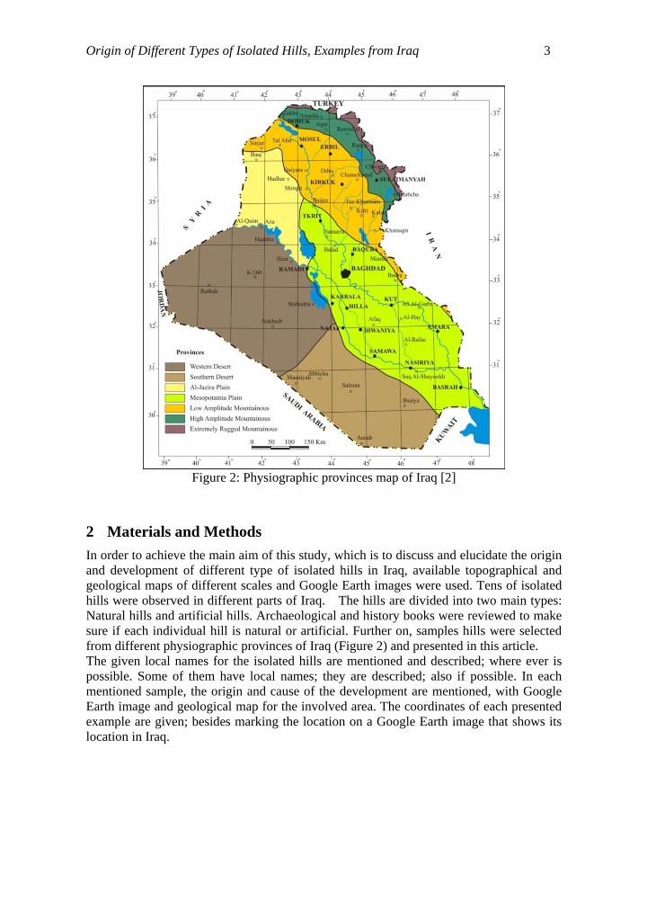
Figure 2: Physiographic provinces map of Iraq [2]
2 Materials and Methods In order to achieve the main aim of this study, which is to discuss and elucidate the origin and development of different type of isolated hills in Iraq, available topographical and geological maps of different scales and Google Earth images were used. Tens of isolated hills were observed in different parts of Iraq. The hills are divided into two main types: Natural hills and artificial hills. Archaeological and history books were reviewed to make sure if each individual hill is natural or artificial. Further on, samples hills were selected from different physiographic provinces of Iraq (Figure 2) and presented in this article. The given local names for the isolated hills are mentioned and described; where ever is possible. Some of them have local names; they are described; also if possible. In each mentioned sample, the origin and cause of the development are mentioned, with Google Earth image and geological map for the involved area. The coordinates of each presented example are given; besides marking the location on a Google Earth image that shows its location in Iraq.

4 Varoujan K. Sissakian et al.
3 Isolated Hills As mentioned before, the isolated hills are divided according to their origin into two main types:
3.1 Natural Hills These are well developed in the Western Desert, Jazira and Southern Desert Provinces, and less abundant in the Low Amplitude Mountainous Province (Figure 2). Samples from the developed hills in each physiographic province are mentioned hereinafter. 3.1.1. Western Desert Province
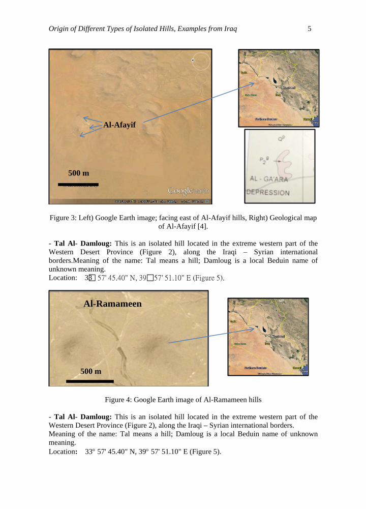
This province occupies the western part of Iraq (Figure 2); it is characterized by flat lying beds; mainly of carbonates with less abundant clastic rocks [3]. The area is either flat or hummocky, in both cases are dissected by dense net of valleys; some of them are more than 100 Km in length; with canyon shapes. Isolated hills of different shapes and sizes are well developed in the area. Another geomorphic feature is the presence of long cliffs, mainly erosional; however; rarely represent fault escarpments. Hereinafter are some selected samples of different types, shapes and sizes of the developed isolated hills. - Al-Afayif: These are three isolated hills located in the Ga'ara Depression located in the western part of the Western Desert Province (Figure 2). Meaning of the name: The virgins. Location: The highest hill has the following coordinates: 33° 41' 06.73" N, 40° 30' 09.17" E (Figure 3). Description: Three isolated hills, their height from the surrounding flat plain is about 25 m; the highest one is at elevation of 489 m (a.s.l) the other two are around 485 m. The three hills are developed within the Ga'ara Formation [2], which consists of alternation of hard sandstone and soft claystone [3]. The main reason for the development of the hills is the differential weathering and erosion. - Al-Ramameen: These are two isolated hills located in the northern part of the Western Desert Province (Figure 2). Meaning of the name: Most probably two grenades. Location: The highest hill has the following coordinates: 33 41' 06.73" N, 40 30' 09.17" E (Figure 4). Description: Two isolated hills, their height from the surrounding flat plain is about 25 m; the highest one is at elevation of 489 m (a.s.l) the other one is around 485 m. The two hills are developed within the Euphrates Formation [2], which consists of limestone, dolostone and marl [3]. The main reason for the development of the hills is the differential weathering and erosion; besides the development of calcrete on the top of the hills, the calcrete is broken into large blocks that cover the majority of the hills' slopes that hindered the exposed rocks. The thickness of the calcrete is about 3 m.
Origin of Different Types of Isolated Hills, Examples from Iraq 5
Figure 3: Left) Google Earth image; facing east of Al-Afayif hills, Right) Geological map
of Al-Afayif [4]. - Tal Al- Damloug: This is an isolated hill located in the extreme western part of the Western Desert Province (Figure 2), along the Iraqi – Syrian international borders.Meaning of the name: Tal means a hill; Damloug is a local Beduin name of unknown meaning. Location: 33 57' 45.40" N, 39 57' 51.10" E (Figure 5).
Figure 4: Google Earth image of Al-Ramameen hills - Tal Al- Damloug: This is an isolated hill located in the extreme western part of the Western Desert Province (Figure 2), along the Iraqi – Syrian international borders. Meaning of the name: Tal means a hill; Damloug is a local Beduin name of unknown meaning. Location: 33° 57' 45.40" N, 39° 57' 51.10" E (Figure 5).
500 m
Al-Afayif
Al-Ramameen
500 m

6 Varoujan K. Sissakian et al.
Description: The hill is 583.6 m (a.s.l.) in height; whereas, the surrounding plain is at height of about 570 m.The hill is developed within the Ratga Formation [2], which consists of limestone and dolostone [3 and 5]. The main reason for the development of the hill is the differential weathering and erosion; besides the presence of silicified limestone on the top of the hill, which has kept the hill from the weathering and erosion of the surrounding rocks. The thickness of the silicified limestone range from (3 – 5) m.Geomorphologically, the hill forms a bute of step form due to the presence of fairly hard limestone beds in the succession.
Figure 5: Left) Google Earth image of Tal Al-Damloug, south of Wadi Swab, Right) Geological map of Tal Al-Damloug [4]
- Rdhuma Al-Safra: This is an isolated hill located in the extreme western part of the Western Desert Province (Figure 2), west of the western rim of Ga'ara Depression. Meaning of the name: Rdhuma means stone, safra means yellow. The name means the yellow stone. Location: 33° 39' 36.72" N, 40° 02' 15.89" E (Figure 6) Description: The hill is 583.9 m (a.s.l.) in height; whereas, the surrounding plain is at height of about 578 m. The hill is developed within the Akashat Formation [2 and 4], which consists of limestone, yellow calystone and dolostone [3 and 4]. The main reason for the development of the hill is the differential weathering and erosion. Geomorphologically, the hill forms a small bute of step form due to the presence of soft claystone beds in the succession (Figure 6).
Tal Al-Damloug
500 m

Origin of Different Types of Isolated Hills, Examples from Iraq 7
Figure 6: Rdhuma Al-Safra (Photo from the front cover of 6)
- Garat Al-Shutab: It is a large isolated plateau located in the extreme northwestern part of the Southern Desert Province; almost in the borders with the Western Desert Province (Figure 2). Meaning of the name: Gara means large elevated area; the letter "t" is added because in Arabic language some of the words are female; so the letter "t" is added, it is the single of "Goor", Shutab is an Arabic male name; it can be seen from far areas from east and south directions. Location: 32° 39' 01.15" N, 42° 59' 22.12" E (Figure 12). Description: Large isolated plateau of mesa shape with irregular form with a flat top that is 281.5 m (a.s.l.); whereas, the surrounding plain is at height of about 255 m.The plateau is developed within the Zahra Formation, which consists of red claystone alternated with limestone, in cyclic nature, whereas in the plain the Nfayil Formation (Middle Miocene) is exposed [2 and 7]. The maximum width of the plateau is 0.5 Km, whereas the length is about 1.65 Km. The main reason for the development of the hill is the the presence of silicified limestone bed capping the succession that has decreased the influence of the weathering and erosion on the succession.Geomorphologically, the hills form wide mesa with gentle slopes, which are partly covered by the fallen blocks of the silicified limestone.
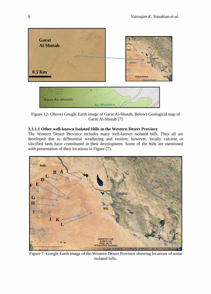
8 Varoujan K. Sissakian et al.
Figure 12: Ubove) Google Earth image of Garat Al-Shutab, Below) Geological map of
Garat Al-Shutab [7]
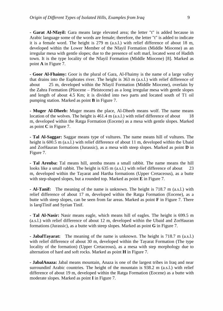
3.1.1.1 Other well-known Isolated Hills in the Western Desert Province The Western Desert Province includes many well-known isolated hills. They all are developed due to differential weathering and erosion; however, locally calcrete or silicified beds have contributed in their development. Some of the hills are mentioned with presentation of their locations in Figure (7).
Figure 7: Google Earth image of the Western Desert Province showing locations of some
isolated hills.
Garat Al-Shutab
0.5 Km
I J
C
G H
F D
A B
E
K L
Origin of Different Types of Isolated Hills, Examples from Iraq 9
- Garat Al-Nfayil: Gara means large elevated area; the letter "t" is added because in Arabic language some of the words are female; therefore, the letter "t" is added to indicate it is a female word. The height is 279 m (a.s.l.) with relief difference of about 18 m, developed within the Lower Member of the Nfayil Formation (Middle Miocene) as an irregular mesa with gentle slopes; due to the presence of soft marl, located west of Hadith town. It is the type locality of the Nfayil Formation (Middle Miocene) [8]. Marked as point A in Figure 7. - Goor Al-Fhaimy: Goor is the plural of Gara, Al-Fhaimy is the name of a large valley that drains into the Euphrates river. The height is 363 m (a.s.l.) with relief difference of about 25 m, developed within the Nfayil Formation (Middle Miocene), overlain by the Zahra Formation (Pliocene – Pleistocene) as a long irregular mesa with gentle slopes and length of about 4.5 Km; it is divided into two parts and located south of T1 oil pumping station. Marked as point B in Figure 7. - Muger Al-Dheeb: Muger means the place, Al-Dheeb means wolf. The name means location of the wolves. The height is 461.4 m (a.s.l.) with relief difference of about 18 m, developed within the Ratga Formation (Eocene) as a mesa with gentle slopes. Marked as point C in Figure 7. - Tal Al-Saggar: Saggar means type of vultures. The name means hill of vultures. The height is 600.5 m (a.s.l.) with relief difference of about 11 m, developed within the Ubaid and ZorHauran formations (Jurassic), as a mesa with steep slopes. Marked as point D in Figure 7. - Tal Arenba: Tal means hill, arenba means a small rabbit. The name means the hill looks like a small rabbit. The height is 635 m (a.s.l.) with relief difference of about 23 m, developed within the Tayarat and Hartha formations (Upper Cretaceous), as a butte with step-shaped slopes, but a rounded top. Marked as point E in Figure 7. - Al-Tanif: The meaning of the name is unknown. The height is 718.7 m (a.s.l.) with relief difference of about 17 m, developed within the Ratga Formation (Eocene), as a butte with steep slopes, can be seen from far areas. Marked as point F in Figure 7. There is IarqiTinif and Syrian Tinif. - Tal Al-Nasir: Nasir means eagle, which means hill of eagles. The height is 699.5 m (a.s.l.) with relief difference of about 12 m, developed within the Ubaid and ZorHauran formations (Jurassic), as a butte with steep slopes. Marked as point G in Figure 7. - JabalTayarat: The meaning of the name is unknown. The height is 718.7 m (a.s.l.) with relief difference of about 30 m, developed within the Tayarat Formation (The type locality of the formation) (Upper Cretaceous), as a mesa with step morphology due to alternation of hard and soft rocks. Marked as point H in Figure 7. - JabalAnaza: Jabal means mountain, Anaza is one of the largest tribes in Iraq and near surroundinf Arabic countries. The height of the mountain is 938.2 m (a.s.l.) with relief difference of about 19 m, developed within the Ratga Formation (Eocene) as a butte with moderate slopes. Marked as point I in Figure 7.

10 Varoujan K. Sissakian et al.
- Al-Nihaydain: Al-Naydain means two breasts. The height is 884.2 m (a.s.l.) with relief difference of about 13 m, developed within the Ratga Formation (Eocene) as a small butte with moderate slopes, can be seen from far distance. Marked as point J in Figure 7. - Al-Amghar: Amghar is a character of wolves, possibly means wolves live in the area. The height is 427.5 m (a.s.l.) with relief difference of about 23 m, developed within the Um Er Radhuma Formation (Paleocene) as a cone shaped butte with step like slopes; due to the presence of hard and soft rocks, can be seen from far distance. Marked as point K in Figure 7. - Tlailat Al-Zureq: Tlailat means small hills, Al-Zureq means blue. The height is 319.9 m (a.s.l.) with relief difference of about 12 m, developed within the Zahra Formation (Plocene - Pleistocene) as a small butte with moderate slopes, can be seen from moderate distance. Marked as point L in Figure 7. 3.1.2. Southern Desert Province
This province occupies the southern part of Iraq (Figure 2); it is characterized by flat lying beds; mainly of carbonates and marl with rare clastic rocks [3]. The area is either flat or hummocky, in both cases are dissected by dense net of karst valleys and depressions; some of depressions have diameters of about 35 Km; with various depths. Isolated hills of different shapes and sizes are very rarely developed in the area; as compared with the Western Desert Province. This is attributed to the exposed formations; mainly Um ErRadumma (Paleocene), Dammam (Eocene), Euphrates (Lower Miocene), and Nfayil (Middle Miocene) formations, which cover the whole area with flat lying beds. Hereinafter are some selected samples of different types, shapes and sizes of the developed isolated hills. - Goor Al-Sahin: These are isolated hills located in the central part of the western margin of the Southern Desert Province (Figure 2), south of Al-Najaf City Meaning of the name: Goor is a local name for elevated areas; the single is Gara, Sahan means saucer shaped depression; it is a geographic location. The name means hills of Sahan area. Location: 31° 01' 26.72" N, 42° 58' 55.24" E (Figure 8) Description: The hills are 324.2 m (a.s.l.) in height; whereas, the surrounding plain is at height of about 318 m.The hills are developed within the Upper Member of the Um Er Radhuma (Paleocene) and Lower Member of Dammam (Lower Eocene) formations [2], both formations consist of limestone, marl and dolostone [2 and 9]. The main reason for the development of the hill is the differential weathering and erosion, beside the presence of silicified limestone bed capping the succession that has decreased the influence of the weathering and erosion on the succession.Geomorphologically, the hills forms a wide mesa of plateau shape of step form due to the presence of soft marl beds in the succession (Figure 8).

Origin of Different Types of Isolated Hills, Examples from Iraq 11
Figure 8: Left) Google Earth image of Goor Al-Sahin, south of Najaf city, Right)
Geological map of Goor Al-Sahin [9] - Jabal Al-Baydhatain: These are two isolated hills located in the southern part of the of the Southern Desert Province (Figure 2), along the Iraqi – Saudi Arabian international borders. Meaning of the name: Al-Baydhatain means two eggs, since the two hills has egg shape, they can be seen from few kilometres from the north, west and east. Location: 30° 31' 57.67" N, 43° 04' 31.54" E and 30° 31' 21.29" N, 43° 04' 18.70" E (Figure 9). Description: The hills are 348 m and 328 m (a.s.l.) in height; whereas, the surrounding plain is at height of about 312 m.The hills are developed within the Zahra Formation [2 and 10], which consist of red claystone alternated with limestone, in cyclic nature [2 and 10]. The main reason for the development of the hills is the differential weathering and erosion, beside the presence of silicified limestone bed capping the succession that has decreased the influence of the weathering and erosion on the succession.Geomorphologically, the hills form two butes with steep slopes, which are partly covered by the fallen blocks of the silicified limestone. - Tlool Al-Mnaither: These are many isolated hills located in the central part of the Southern Desert Province (Figure 2), near wadi Al-Khir. Meaning of the name: Tlool means hills, Mnaither means scenes, and since they are located alongside a branch of wadi Al-Khir; therefore, they can be seen from far area. Location: 31° 46' 41.50" N, 43° 10' 15.50" E (Figure 10). Description: The highest point in the hills is 280 m (a.s.l.); whereas, the surrounding plain is at elevation of about 260 m (a.s.l.). The hills are developed within the Zahra Formation [2 and 9]; the formation consists of red claystone alternated with limestone, in cyclic nature, whereas in the plain the Dammam Formation (Eocene) is exposed [2 and 9]. The main reason for the development of the hill is the the presence of silicified limestone bed capping the succession that has decreased the influence of the weathering and erosion on the succession, they are coated by desert varnish (Figure 10).Geomorphologically, the
Goor Al-Sahin
1600 m
12 Varoujan K. Sissakian et al.
hills form wide mesa with gentle slopes, which are partly covered by the fallen blocks of the silicified limestone.
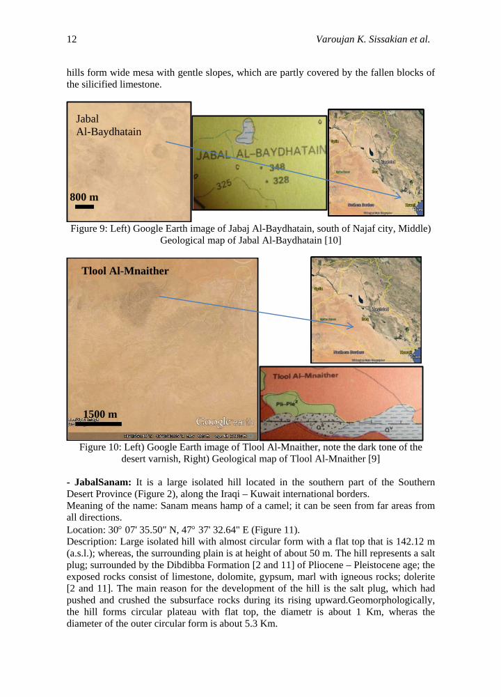
Figure 9: Left) Google Earth image of Jabaj Al-Baydhatain, south of Najaf city, Middle)
Geological map of Jabal Al-Baydhatain [10]
Figure 10: Left) Google Earth image of Tlool Al-Mnaither, note the dark tone of the
desert varnish, Right) Geological map of Tlool Al-Mnaither [9]
- JabalSanam: It is a large isolated hill located in the southern part of the Southern Desert Province (Figure 2), along the Iraqi – Kuwait international borders. Meaning of the name: Sanam means hamp of a camel; it can be seen from far areas from all directions. Location: 30° 07' 35.50" N, 47° 37' 32.64" E (Figure 11). Description: Large isolated hill with almost circular form with a flat top that is 142.12 m (a.s.l.); whereas, the surrounding plain is at height of about 50 m. The hill represents a salt plug; surrounded by the Dibdibba Formation [2 and 11] of Pliocene – Pleistocene age; the exposed rocks consist of limestone, dolomite, gypsum, marl with igneous rocks; dolerite [2 and 11]. The main reason for the development of the hill is the salt plug, which had pushed and crushed the subsurface rocks during its rising upward.Geomorphologically, the hill forms circular plateau with flat top, the diametr is about 1 Km, wheras the diameter of the outer circular form is about 5.3 Km.
Tlool Al-Mnaither
1500 m
Jabal Al-Baydhatain
800 m

Origin of Different Types of Isolated Hills, Examples from Iraq 13
Figure 11: Left) Google Earth image of Jabal Sanam, note the circular form of the plug and near surroundings, Right) Geological map of Jabal Sanam [11]
3.1.3 Al-Jazira Province
This province occupies the central western part of Iraq (Figure 2); it is characterized by flat lying beds; including cyclic deposits of marl, limestone and gypsum (Fatha Formation, Middle Miocene) and cyclic deposits of clastics (Injana Formation, Upper Miocene) [2 and 3]. The area is either flat or hummocky, in both cases are dissected by dense net of valleys and karst depressions; some of depressions form salt marshes [12, 13 and 14]. Isolated hills of different shapes and sizes are rarely developed in the area; mainly in form of mesa. This is attributed to the exposed formations, especially Fatha, which includes hard and soft rocks [3, 12, 13, and 14]. Hereinafter are some selected samples of different types, shapes and sizes of the developed isolated hills. - Marqab Al-Jighayfy: It is a large isolated plateau located in the central part of Al-Jazira Province; north of the Euphrates River (Figure 2). Meaning of the name: Marqab means observatory area; Jighayfi is the name of tribe living in that vicinity; the name means the observatory area of Jaghaify tribe; it can be seen from west, east and south directions. Location: 34° 25' 05.77" N, 42° 34' 20.07" E (Figure 12). Description: Large isolated plateau of mesa shape with irregular form with a flat top that is 257.6 m (a.s.l.); whereas, the surrounding plain is at height of about 250 m.The plateau is developed within the Fatha Formation, which consists of marl, limestone and gypsum, in cyclic nature, [2, 3, 13, 14 and 15]. The maximum width of the plateau is 270 m, whereas the length is about 390 m. The main reason for the development of the mesa is that it is present in a water divide area, besides that some of the cycles of the Fatha Formation includes; locally thick limestone and gypsum beds; more than the usual beds; due to the shape of the depositional basin. Therefore, the rocks of such a cycle will resist weathering and erosion; consequently an elevated area will remain.Geomorphologically, the hill forms wide mesa with gentle slopes, which are partly covered by the fallen blocks of the limestone and gypsum.
JabalSanam
IRAQ
KUWAIT 1 Km

14 Varoujan K. Sissakian et al.
Figure 12: Google Earth image of Marqab Al-Jighayfy
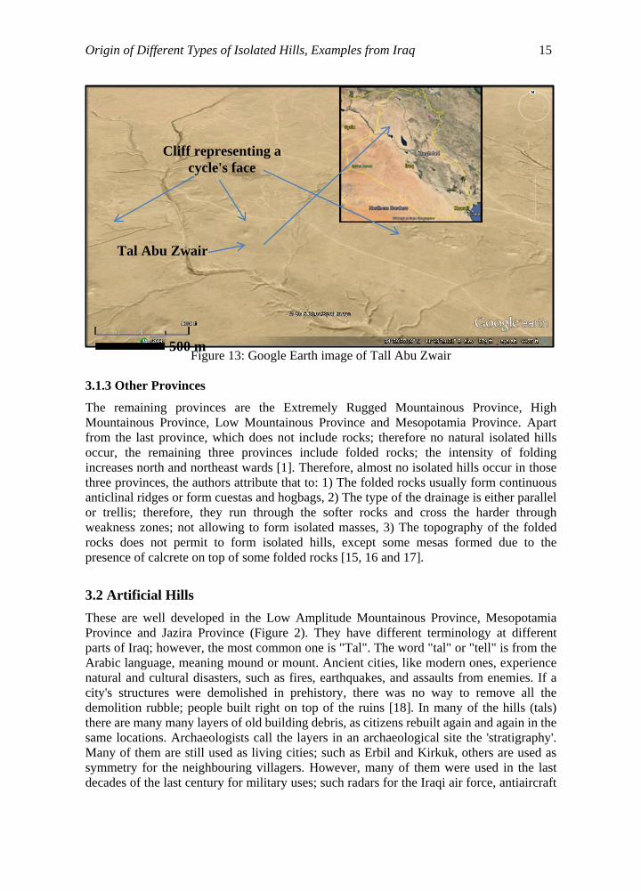
- Tal Abu Zwair: It is an isolated hill located in the central part of Al-Jazira Province (Figure 2); within almost a flat plain. Meaning of the name: Abu in slang Iraqi language means a character of something. Zuwair is a small Zor, which means a cave in which wild animals leave; therefore, the name means a place where wild animals, like wolf, hyena, fox live. Location: 34° 39' 34.27" N, 41° 49' 15.67" E (Figure 13). Description: Small isolated hill of conical shape; its height is about about 7 m, with elevation of 276 m (a.s.l.), whereas the surrounding plain is at elevation of 240 m (a.s.l.). The hill is developed within the Fatha Formation, which consists of marl, limestone and gypsum, in cyclic nature, [2, 3, 12, 13 and 14]. The width of the top is about 20 m, whereas the diameter of the base is about 85 m. The main reason for the development of the hill is the differential weathering and erosion that separated the hill from the cliff of the cycle, since the face of each cycle forms a continuous cliff (Figure 13), besides that some of the cycles of the Fatha Formation includes; locally thick limestone and gypsum beds; more than the usual beds; due to the shape of the depositional basin. Therefore, the rocks of such a cycle will resist weathering and erosion; consequently an elevated area will remain.Geomorphologically, the hill forms conical butte with step form slope, due to the presence of hard and soft rocks.
Marqab Al-Jighayfy
100 m
Origin of Different Types of Isolated Hills, Examples from Iraq 15
Figure 13: Google Earth image of Tall Abu Zwair
3.1.3 Other Provinces
The remaining provinces are the Extremely Rugged Mountainous Province, High Mountainous Province, Low Mountainous Province and Mesopotamia Province. Apart from the last province, which does not include rocks; therefore no natural isolated hills occur, the remaining three provinces include folded rocks; the intensity of folding increases north and northeast wards [1]. Therefore, almost no isolated hills occur in those three provinces, the authors attribute that to: 1) The folded rocks usually form continuous anticlinal ridges or form cuestas and hogbags, 2) The type of the drainage is either parallel or trellis; therefore, they run through the softer rocks and cross the harder through weakness zones; not allowing to form isolated masses, 3) The topography of the folded rocks does not permit to form isolated hills, except some mesas formed due to the presence of calcrete on top of some folded rocks [15, 16 and 17].
3.2 Artificial Hills These are well developed in the Low Amplitude Mountainous Province, Mesopotamia Province and Jazira Province (Figure 2). They have different terminology at different parts of Iraq; however, the most common one is "Tal". The word "tal" or "tell" is from the Arabic language, meaning mound or mount. Ancient cities, like modern ones, experience natural and cultural disasters, such as fires, earthquakes, and assaults from enemies. If a city's structures were demolished in prehistory, there was no way to remove all the demolition rubble; people built right on top of the ruins [18]. In many of the hills (tals) there are many many layers of old building debris, as citizens rebuilt again and again in the same locations. Archaeologists call the layers in an archaeological site the 'stratigraphy'. Many of them are still used as living cities; such as Erbil and Kirkuk, others are used as symmetry for the neighbouring villagers. However, many of them were used in the last decades of the last century for military uses; such radars for the Iraqi air force, antiaircraft
Cliff representing a cycle's face
Tal Abu Zwair
500 m

16 Varoujan K. Sissakian et al.
artillery, watching towers…etc. Assorted samples from the developed hills "Tals" in each physiographic province are mentioned hereinafter. 3.2.1 Low Amplitude Mountainous Province
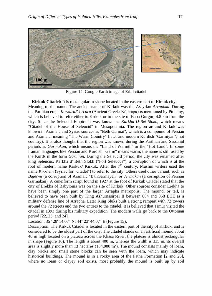
This province occupies an oblong shape in the northern central part of Iraq; extending from southeast to northwest (Figure 2); it is characterized by flat gently to moderately dipping beds; mainly of carbonates and clastics with less abundant evaporitic rocks [3]. The area is either flat (syncline) or hummocky and low relief (anticlines); however, some exceptions occur too, like Sinjar and Qara Chough mountains. In both cases; they are dissected by net of valleys that differ according to the structure and type of the exposed rocks. The flat areas are usually covered by soil of different types, mainly of loom type (Sissakian and Fouad, 2012). Artificial isolated hills of different shapes and sizes are developed in the area. Hereinafter are some selected samples of different types, shapes and sizes of the developed natural isolated hills. – Erbil Citadel: It is almost circular in shape located in the centre of Erbil city, which is located in extreme western part of Erbil – Kirkuk Plain. Meaning of the name: Because Erbil is very ancient city; therefore, the meaning of the name is given in detail. The name Erbil was mentioned in Sumerian holy writings of third millennium BC as Urbilum, Urbelum or Urbillum, which appears to originate from Arbilum in the language of the Hurrians who inhabited the area. Later, the Akkadians and Assyrians by a folk etymology rendered the name as Arba'ūilū to mean four gods. The city became a centre for the worship of the Assyro – Babylonian goddess Ishtar. In classical times the city became known as Arbela. In Old Persian the city was called Arbairā.Today, the modern Kurdish name of the city, Hewlêr, appears to be a corruption of the name Arbel by a series of metatheses of consonants. It is the oldest continuously inhabited settlement in the world, which has been settled since 6,000 BC and because of its imposing height, yellow-ochre color, and the solid perimeter wall, the town is perhaps one of the most dramatic visual experiences in the Middle East [19, 20, and 21]. Location: 36° 11' 29.21" N, 44° 00' 34.45" E (Figure 14). Description: Erbil is the largest artificial isolated hill in Iraq. The overall form of Erbil citadel is circular but more elliptical to be precise. It rises about 30 m above the ground level of the lower city. Its long diameter is about 430 m and its short diameter is about 340 m. Its overall area is slightly more than 10 hectares (102,000 m2). The mound consists mainly of loam, clay bricks and small stone blocks can be seen with the loam, which may indicate historical buildings. The mound is in a plain covered by loam or clayey soil, which is used to build up the mound. It is surrounded by a steep earthen mound in all directions, which made it very difficult for any attacker to scale it. The houses that are built on the perimeter are contiguous and form a solid wall very similar to fortified citadels of medieval times.
Origin of Different Types of Isolated Hills, Examples from Iraq 17
Figure 14: Google Earth image of Erbil citadel
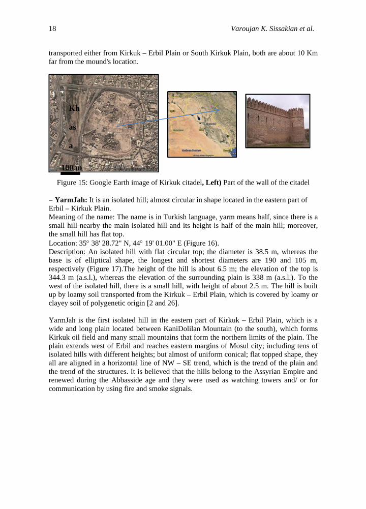
– Kirkuk Citadel: It is rectangular in shape located in the eastern part of Kirkuk city. Meaning of the name: The ancient name of Kirkuk was the Assyrian Arraphka. During the Parthian era, a Korkura/Corcura (Ancient Greek: Κόρκυρα) is mentioned by Ptolemy, which is believed to refer either to Kirkuk or to the site of Baba Gurgur; 4.8 km from the city. Since the Seleucid Empire it was known as Karkha D-Bet Slokh, which means "Citadel of the House of Seleucid" in Mesopotamia. The region around Kirkuk was known in Aramaic and Syriac sources as "Beth Garmai", which is a compound of Persian and Aramaic, meaning "The Warm Country" (later and modern Kurdish "Garmiyan"; hot country). It is also thought that the region was known during the Parthian and Sassanid periods as Garmakan, which means the "Land of Warmth" or the "Hot Land". In some Iranian languages like Persian and Kurdish "Garm" means warm; the name is still used by the Kurds in the form Garmian. During the Seleucid period, the city was renamed after king Seleucus, Karkha d' Beth Slokh ("Fort Seleucus"), a corruption of which is at the root of modern name Karkuk/ Kirkuk. After the 7th century, Muslim writers used the name Kirkheni (Syriac for "citadel") to refer to the city. Others used other variant, such as Bajermi (a corruption of Aramaic "B'thGarmayeh" or Jermakan (a corruption of Persian Garmakan). A cuneiform script found in 1927 at the foot of Kirkuk Citadel stated that the city of Erekha of Babylonia was on the site of Kirkuk. Other sources consider Erekha to have been simply one part of the larger Arrapha metropolis. The mound, or tell, is believed to have been built by King Ashurnasirpal II between 884 and 858 BCE as a military defense line of Arrapha. Later King Sluks built a strong rampart with 72 towers around the 72 streets and the two entries to the citadel. It is believed that Timur visited the citadel in 1393 during his military expedition. The modern walls go back to the Ottoman period [22, 23, and 24]. Location: 35° 28' 14.07" N, 44° 23' 44.07" E (Figure 15). Description: The Kirkuk Citadel is located in the eastern part of the city of Kirkuk, and is considered to be the oldest part of the city. The citadel stands on an artificial mound about 40 m high located on a plateau across the Khasa River, the plateau is almost rectangular in shape (Figure 16). The length is about 400 m, whereas the width is 335 m, its overall area is slightly more than 13 hectares (134,000 m2). The mound consists mainly of loam, clay bricks and small stone blocks can be seen with the loam, which may indicate historical buildings. The mound is in a rocky area of the Fatha Formation [2 and 26], where no loam or clayey soil exists, most probably the mound is built up by soil
100 m
18 Varoujan K. Sissakian et al.
transported either from Kirkuk – Erbil Plain or South Kirkuk Plain, both are about 10 Km far from the mound's location.
Figure 15: Google Earth image of Kirkuk citadel, Left) Part of the wall of the citadel
– YarmJah: It is an isolated hill; almost circular in shape located in the eastern part of Erbil – Kirkuk Plain. Meaning of the name: The name is in Turkish language, yarm means half, since there is a small hill nearby the main isolated hill and its height is half of the main hill; moreover, the small hill has flat top. Location: 35° 38' 28.72" N, 44° 19' 01.00" E (Figure 16). Description: An isolated hill with flat circular top; the diameter is 38.5 m, whereas the base is of elliptical shape, the longest and shortest diameters are 190 and 105 m, respectively (Figure 17).The height of the hill is about 6.5 m; the elevation of the top is 344.3 m (a.s.l.), whereas the elevation of the surrounding plain is 338 m (a.s.l.). To the west of the isolated hill, there is a small hill, with height of about 2.5 m. The hill is built up by loamy soil transported from the Kirkuk – Erbil Plain, which is covered by loamy or clayey soil of polygenetic origin [2 and 26]. YarmJah is the first isolated hill in the eastern part of Kirkuk – Erbil Plain, which is a wide and long plain located between KaniDolilan Mountain (to the south), which forms Kirkuk oil field and many small mountains that form the northern limits of the plain. The plain extends west of Erbil and reaches eastern margins of Mosul city; including tens of isolated hills with different heights; but almost of uniform conical; flat topped shape, they all are aligned in a horizontal line of NW – SE trend, which is the trend of the plain and the trend of the structures. It is believed that the hills belong to the Assyrian Empire and renewed during the Abbasside age and they were used as watching towers and/ or for communication by using fire and smoke signals.
Kh
as
a
100 m

Origin of Different Types of Isolated Hills, Examples from Iraq 19
Figure 16: Google Earth image of YarmJah hill, Left) Details of the hill (image facing
NW)
– QooshTappa: It is an isolated hill; almost circular in shape located in the central part of Erbil – Kirkuk Plain, west of Erbil city. Meaning of the name: The name is in Turkish language, qoosh means bird, tappa means flat topped elevated area. During the last century, hundreds of storks were immigrating to the northern and central parts of Iraq; coming from Europe, they were building their nests on elevated areas, like minarets of mosques, church towers, high tension towers…etc. Among the elevated areas is the QooshTappa, most probably during the 19th century when Iraq was under the rule of Ottoman Empire. Location: 36° 00' 25.92" N, 44° 02' 00.90" E (Figure 17). Description: An isolated hill of conical shape; with flat circular top; the diameter is 89.5 m, whereas the diameter of the base is 392 m (Figure 17).The height of the hill is about 6 m; the elevation of the top is 393 m (a.s.l.), whereas the elevation of the surrounding plain is 397 m (a.s.l.). The hill is built up by loamy soil transported from the Kirkuk – Erbil Plain, which is covered by loamy or clayey soil of polygenetic origin [2 and 27]. It is believed that the hill belongs to the Assyrian Empire and renewed during the Abbasside age and was used as a watching tower.
YarmJah
40 m
20 Varoujan K. Sissakian et al.
Figure 17: Google Earth image of QooshTappa hill, Left) Details of the hill
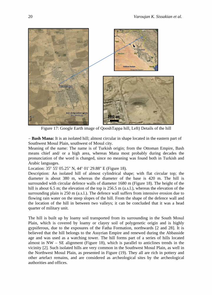
– Bash Mana: It is an isolated hill; almost circular in shape located in the eastern part of Southwest Mosul Plain, southwest of Mosul city. Meaning of the name: The name is of Turkish origin; from the Ottoman Empire, Bash means chief and/ or a high area, whereas Mana most probably during decades the pronunciation of the word is changed, since no meaning was found both in Turkish and Arabic languages. Location: 35° 55' 05.25" N, 44° 01' 29.88" E (Figure 18). Description: An isolated hill of almost cylindrical shape; with flat circular top; the diameter is about 380 m, whereas the diameter of the base is 420 m. The hill is surrounded with circular defence walls of diameter 1680 m (Figure 18). The height of the hill is about 6.5 m; the elevation of the top is 256.5 m (a.s.l.), whereas the elevation of the surrounding plain is 250 m (a.s.l.). The defence wall suffers from intensive erosion due to flowing rain water on the steep slopes of the hill. From the shape of the defence wall and the location of the hill in between two valleys; it can be concluded that it was a head quarter of military unit. The hill is built up by loamy soil transported from its surrounding in the South Mosul Plain, which is covered by loamy or clayey soil of polygenetic origin and is highly gypsiferous, due to the exposures of the Fatha Formation, northwards [2 and 28]. It is believed that the hill belongs to the Assyrian Empire and renewed during the Abbasside age and was used as a watching tower. The hill forms part of a series of hills located almost in NW – SE alignment (Figure 18), which is parallel to anticlines trends in the vicinity [2]. Such isolated hills are very common in the Southwest Mosul Plain, as well in the Northwest Mosul Plain, as presented in Figure (19). They all are rich in pottery and other artefact remains, and are considered as archeological sites by the archeological authorities and offices.
100 m
Origin of Different Types of Isolated Hills, Examples from Iraq 21
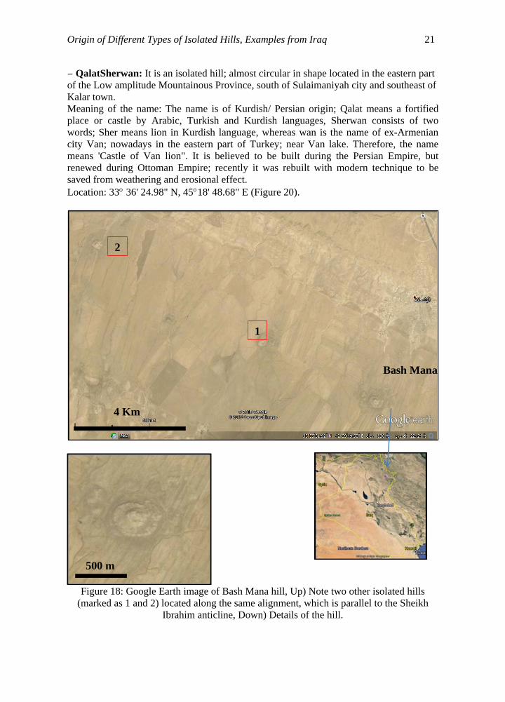
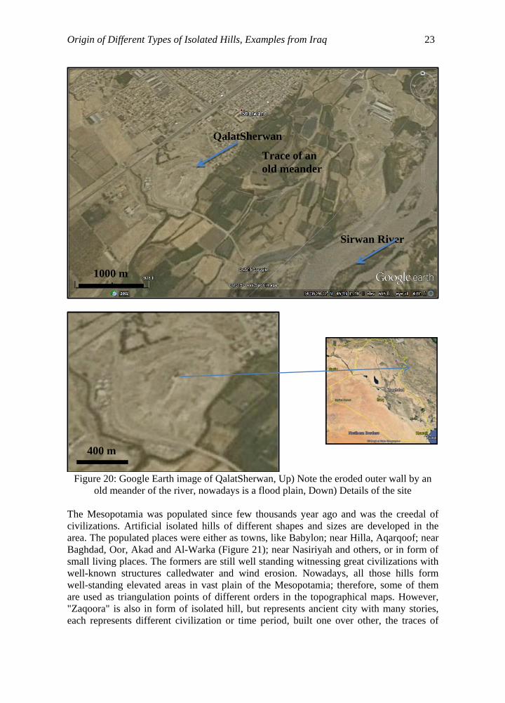
– QalatSherwan: It is an isolated hill; almost circular in shape located in the eastern part of the Low amplitude Mountainous Province, south of Sulaimaniyah city and southeast of Kalar town. Meaning of the name: The name is of Kurdish/ Persian origin; Qalat means a fortified place or castle by Arabic, Turkish and Kurdish languages, Sherwan consists of two words; Sher means lion in Kurdish language, whereas wan is the name of ex-Armenian city Van; nowadays in the eastern part of Turkey; near Van lake. Therefore, the name means 'Castle of Van lion". It is believed to be built during the Persian Empire, but renewed during Ottoman Empire; recently it was rebuilt with modern technique to be saved from weathering and erosional effect. Location: 33° 36' 24.98" N, 45°18' 48.68" E (Figure 20).
Figure 18: Google Earth image of Bash Mana hill, Up) Note two other isolated hills
(marked as 1 and 2) located along the same alignment, which is parallel to the Sheikh Ibrahim anticline, Down) Details of the hill.
Bash Mana
4 Km
500 m
2
1

22 Varoujan K. Sissakian et al.
Description: The castle is built over an isolated hill of conical shape; with flat circular top; the upper diameter is about 100 m, whereas the lower one is about 120 m, the elevation of the hill is 216.9 m (a.s.l.), whereas the base is at elevation of 197.5 m (a.s.l.), which means the hill is about 20 m. The hill is surrounded by two defence walls (Figure 20); the outer one has length and width of 1000 m and 800 m, respectively, whereas the inner one has length and width of 600 m and 400 m, respectively (Figure 20). It is clear that the outer wall was eroded by the Sirwan River and partly collapsed; therefore, the inner defence wall was constructed (Figure 20). The used soil in building the hill is from the neighbouring areas; westwards, where thin soil covers the wide plain, which is rich in sand and gravels led down by tens of streams and valleys that drain the elevated areas represented by many anticlines [ 29 and 30].
Figure 19: Geological Map of Mosul Quadrangle [27], note the distribution of the
artificial isolated hills (encircled in red) in the Northwest Mosul Plain
3.2.2 Mesopotamia Province
This province occupies the central and southern parts of Iraq; extending from southeast to northwest (Figure 2); it is characterized by flat topography representing the Mesopotamian flood plain [2]; totally covered by Quaternary sediments that consists of silt, sand and clay [3], locally sand dunes are developed, as well shallow depressions, which are flooded by rain water; seasonally and may form sabkhas.
O O
O
O O
O
O O
O
Origin of Different Types of Isolated Hills, Examples from Iraq 23
Figure 20: Google Earth image of QalatSherwan, Up) Note the eroded outer wall by an
old meander of the river, nowadays is a flood plain, Down) Details of the site
The Mesopotamia was populated since few thousands year ago and was the creedal of civilizations. Artificial isolated hills of different shapes and sizes are developed in the area. The populated places were either as towns, like Babylon; near Hilla, Aqarqoof; near Baghdad, Oor, Akad and Al-Warka (Figure 21); near Nasiriyah and others, or in form of small living places. The formers are still well standing witnessing great civilizations with well-known structures calledwater and wind erosion. Nowadays, all those hills form well-standing elevated areas in vast plain of the Mesopotamia; therefore, some of them are used as triangulation points of different orders in the topographical maps. However, "Zaqoora" is also in form of isolated hill, but represents ancient city with many stories, each represents different civilization or time period, built one over other, the traces of
1000 m
Sirwan River
QalatSherwan
400 m
Trace of an old meander

24 Varoujan K. Sissakian et al.
stories can be seen clearly; all built by clay bricks; sun burnt, locally some traces date palm leaves can be seen too, like in ZaqooratAqerqoof, west of Baghded. 'Zaqoora", whereas the latters are presented by small artificial isolated hills; called locally "Ishan" (Figure 22).
Figure 21: Part of the Geological Map of Sooq Al-Shiyookh Quadrangle [31]; scale
1:250000, note the location of Tel Al-Warka used as a triangulation point with height of 34.6 m, whereas the surrounding plain is at elevation of (6 – 8) m (a.s.l.)
Figure 22: Parts of geological maps; scale 1:250 000, Left)Sooq Al-Shiyookh
Quadrangle [31], Right) Al-Nasiriyah Quadrangle. Note the distribution of isolated hills (Ishan) encircled by red
Almost all parts of the Mesopotamia Plain are rich in isolated artificial hills, which are now not more than (3 – 6) m high; having conical shape with a lot of pottery, clay bricks and other artefact remains. The slopes are smoothed due toto water and wind erosion. Nowadays, all those hills form well-standing elevated areas in vast plain of the Mesopotamia; therefore, some of them are used as triangulation points of different orders in the topographical maps. However, "Zaqoora" is also in form of isolated hill, but
O O
O
O O O
O
O
O
O
Origin of Different Types of Isolated Hills, Examples from Iraq 25
represents ancient city with many stories, each represents different civilization or time period, built one over other, the traces of stories can be seen clearly; all built by clay bricks; sun burnt, locally some traces date palm leaves can be seen too, like in ZaqooratAqerqoof, west of Baghded.
4 Discussion The diversity in the topography, type of the exposed rocks, and/ or presence of Quaternary sediments, and structural regime in Iraq, has developed different types of natural isolated hills of different shapes, sizes and types. Hundreds of such hills can be seen in different physiographic provinces, among them the Western Desert, Southern Desert, Jazira Plain and the Low Amplitude Mountainous Provinces. Almost all of them has local names, indicating certain meaning; usually by local slang language. The main reason for development of the natural isolated hills in those provinces is the rocks are almost horizontal; apart from the Low Mountainous Province where the rocks are folded, with contribution of the weathering and erosion process and different diagenetic processes. In the folded strata; like in other provinces, usually form strike or anticlinal ridges, which are commonly dissected by valleys running parallel to the dip direction forming trellis drainage pattern; therefore very rarely isolated hills can be formed there. Moreover, in the provinces, which include folded rocks, the sheet erosion is hardly effective; just the reverse case in horizontally lying beds; therefore, the sheet erosion is very active in carving of the rocks and keeping some isolated hills of different shapes and sizes; due to the mentioned reasons in this article. Artificial isolated hills are also well distributed in different provinces, such as the Low Mountainous and Mesopotamia Provinces, witnessing the great civilizations that existed during B.C., over different parts of Iraq. The built isolated hills were located in flat areas; almost where the surroundings can be seen for far distances, this is one of the reasons why they were not built in areas, which include folded beds forming mountainous areas, where the visibility distance is very low; due to hummocky and/ or mountainous landscapes that prevent the visibility. Besides building of the hills by rock blocks is harder than building by soil dumping; as it is the case in areas covered by soil. Moreover, thousands of artificial isolated hills were constructed during the last two decades of the last century by the Iraqi Army in restricted areas, such surrounding locations of strategic projects, army camps and stores, presidential locations…etc. They were used as bases for anti-aircraft artillery, radar sites, watching towers, and air force manual early warning stations. They were built by dumping local soil; usually (4 – 10) m high, depending on the nature of its usage. However, locally large isolated hills were built and used as residential palaces (Figure 23).

26 Varoujan K. Sissakian et al.
Figure 23: Google Earth images of three presediential sites constructed on top of
three isolated artificial hills in the Mesopotamia Plain, with heights of 24 m, 27 m, and 20 m, resepctively
5 Conclusions Study of isolated hills in Iraq indicated that two main types of hills exits. They are either natural or artificial. Natural isolated hills of different shapes, size and origin are well developed in different parts of Iraq, especially the Western Desert, Southern Desert and Jazira Provinces. They are isolated hills having different terminology in different places of Iraq, the most common one is "Tal", also called Tel, Gara (plural is Goor), Marqab. The main reason for the development of the isolated hill is the differential weathering and erosion; wind and water; however, some diagenetic processes, such as silicification, calcretion and presence of abnormal thick beds within the sequence has played big role in the development of the hills. These isolated hills are in mesa and butte forms, the formers are usually large and irregular, whereas the latters are of conical shape, in both cases the slopes has usually step form; due to the presence of hard and soft rocks.
Artificial hills are also well distributed in the Low Mountainous and Mesopotamia Provinces, in both cases they are usually built by dumping soil to the required height. In the Low Mountainous Province, the artificial isolated hills either represent habituated cities, such as Erbil and Kirkuk, or represent watching towers; for military uses. In the Mesopotamia Province, they either indicate prehistoric civilizations; called "Zaqoora", or small living locations, called as 'Ishan".
100 m
100 m
100 m
Origin of Different Types of Isolated Hills, Examples from Iraq 27
References [1] Sissakian, V.K. and Fouad, S.F., 2012. Geological Map of Iraq, scale 1: 1000000, 4th
edition. Iraq Geological Survey publications, Baghdad, Iraq. [2] Sissakian, V.K. and Al-Khalidi, Z.B., 2014. The Chronological Map of Iraq with age
– lithology relation of the exposed geological formations. Iraq Geological Survey Library report no. 3508.
[3] Sissakian, V.K. and Saeed, Z.B., 2012. Lithological Map of Iraq, Compiled using GIS Techniques. Iraqi Bulletin of Geology and Mining, Vol. 8, No.3, p. 1 – 13.
[4] Hassan, K.M., 1993. Geological Map of Al-Rutba Quadrangle, scale 1: 250000. Iraq Geological Survey publications, Baghdad, Iraq.
[5] Al-Bassam, K.S. and Karim, S.A., 1997. The Akashat Formation: A new name for the Paleocene Lithostratigraphic Unit in the Western Desert of Iraq. Iraqi Geological Journal, Vol. 30, No.1, p. 22 – 35.
[6] Jassim, S.Z. and Goff, J., 2006. Geology of Iraq. Dolin, Prague and Moravian Museum, Brno.
[7] Mahdi, A.I., 1994. Geological Map of Al-Shithata Quadrangle, scale 1: 250000.Iraq Geological Survey publications, Baghdad, Iraq.
[8] Sissakian, V.K., Mahdi, A.I., Amin, R.M. and Salman, B.M., 1997. The Nfayil Formation: A new lithostratigraphic unit in the Western Desert of Iraq. Iraqi Geological Journal, Vol. 30, No.1, p. 61 – 65.
[9] Sissakian, V.K., 1994. Geological Map of Al-Bireet Quadrangle, scale 1: 250000.Iraq Geological Survey publications, Baghdad, Iraq.
[10] Barwary, A.M. and Slewa, N.A., 1996. Geological Map of Al-Ma'aniyah Quadrangle, scale 1: 250000.Iraq Geological Survey publications, Baghdad, Iraq.
[11] Deikran, D.B., 1995. Geological Map of Al-Rukhaymiyah and Kuwait Quadrangles, scale 1: 250000.Iraq Geological Survey publications, Baghdad, Iraq.
[12] Zuwaid, Q.A., 1992. Geological Map of Al-Qayara Quadrangle, scale 1: 250000.Iraq Geological Survey publications, Baghdad, Iraq.
[13] Sissakian, V.K. and Qanber, S.H., 1995. Geological Map of Albu Kamal Quadrangle, scale 1: 250000.Iraq Geological Survey publications, Baghdad, Iraq.
[14] Sissakian, V.K. and Qanber, S.H., 1996. Geological Map of Haditha Quadrangle, scale 1: 250000.Iraq Geological Survey publications, Baghdad, Iraq.
[15] Sissakian, V.K. and Fouad, S.F., The origin of Amadiya Plateau, Dohuk Governorate, North Iraq.Iraqi Bulletin of Geology and Mining, Vol. 7, No.1, p. 93 – 98.
[16] Sissakian, V.K., 2012. Calcrete in SartaqBammu area Iraqi Bulletin of Geology and Mining, Vol. 8, No.1, p. 93 – 98.
[17] Sissakian, V.K., Al-Musawi, H.A., Al-Ansari, N. and Knutsson, S. 2015.Old alluvial fan relics in north and northeast Iraq (in press).
[18] Hirst, K.K., 2012. What is a 'Tell".Internet data.Archaeology.about.com. [19] Hamblin, W. J., 2006. Warfare in the Ancient Near East to 1600 BC. Routledge.p.
111.ISBN0-415-25589-9. [20] Khan, G., 1999. A grammar of neo-Aramaic: the dialect of the Jews of Arbel, Part 1,
Volume 47. BRILL.p. 2.ISBN978-90-04-11510-1. [21] Gershevitc, J., 1985. The Cambridge History of Iran, Volume 2. Cambridge
University Press, 964 pages, s p. 37. [22] Balfour, E., 1976. EncyclopaediaAsiatica, p. 214, Cosmo Publications.

28 Varoujan K. Sissakian et al.
[23] Harrak., A., 2005. The Acts of Mar Mari the Apostle By Amir Harrak. p. 27. [24] Comay, T., 1978. The World's Greatest Story: The Epic of the Jewish People in
Biblical Times, p. 384. [25] Talabany, N., 1999. Iraq’s Policy of Ethnic Cleansing: Onslaught to change
national/demographic characteristics of the Kirkuk Region. [26] Sissakian, V.K. and Foaud, S.F., 2014. Geological Map of Kirkuk Quadrangle, scale
1: 250000, 2nd edition. Iraq Geological Survey Publication, Baghdad, Iraq. [27] Sissakian, V.K. and Foaud, S.F., 2014. Geological Map of Erbil and Mahabad
Quadrangles, scale 1: 250000, 2nd edition. Iraq Geological Survey Publication, Baghdad, Iraq.
[28] Sissakian, V.K., 1995 Geological Map of Mosul Quadrangle, scale 1: 250000. Iraq Geological Survey Publication, Baghdad, Iraq.
[29] Youkhanna, R.Y. and Hradecky, P., 1978. Report on regional geological mapping of Khanaqin – Maidan Area. Iraq Geological Survey Library report No. 903.
[30] Sissakian, V.K., 1978. Report on regional geological mapping of TuzKhrmatu – Kifri – Kalar Area. Iraq Geological Survey Library report No. 902.
[31] Deikran, D.B., 1995. Geological Map of Sooq Al-Shiyookh Quadrangle, scale 1: 250000.Iraq Geological Survey publications, Baghdad, Iraq.
[32] Deikran, D.B., 1995. Geological Map of Al-Nasiriyah Quadrangle, scale 1: 250000.Iraq Geological Survey publications, Baghdad, Iraq.