Order in Council 911/1923 - BC Laws
92
/ 4, 75- 'Lb ) ‘ 4,0• 4* ` -' yi 911 . C Approved and ordered this (0 day of < , A.D. 19)-- ' Litattnant-Governor. At the Executive Council Chamber, Victoria, PRESENT: The Honourable Mn O. fiver Mn PHttu1Io Mn !lec'een Mn Single Mn :!e neon Mn Futh , =q.1 end Mr. Mn To His Honour The Lieutenant-Governor in Council: The undersigned has the honour to report: in the Chair. i• 12_ THAT by memorandum of agreement bearing date the 24th day of September 1912 made between J. A. J. McKenna, Special Commissioner appointed by the Dominion Government to investi- gate the condition of Indian affairs in British Columbia, and the Honourable Sir Richard McBride as Premier of the Province of British Columbia, an agreement was arrived at subject to the approval of the Governments of the Dominion and of the Province, for the purpose of settling all differences between the said Governments respecting Indiah lands and Indian af- fairs generally in the Province of British Columbia, and for the final adjustment of all matters relating thereto, by the c appointment of a commissioner for the purposes set out in the agreement. THAT by Dominion Order in Council of the 27th November 1912, and Provincial Order in Council of the 31st day of Deoem- ber 1912, the said agreement was approved, subject to the fur- ther provision that notlftwithstanding anything in the said agre- ement contained, the Acts and proceedings of the Commission shall be subject to the approval of the two Governments and that the Governments agree to consider favourably the reports whether final or interim, of the Commission, with a view to give effect as far as reasonably may be to the Acts, proceed- ings and recommendations of the Commission and to take all such steps and proceedings as may be reasonably necessary with the object of carrying into execution the settlement provided for by the Agreement in accordance with its true intent and purpose. THAT a Royal Commission on Indian Affairs for the Prov- ince of British Columbia was duly appointed for. the purpose of oarrying out the said Agreement. THAT the said Commission has since reported as to lands reserved and to be reserved for Indians in the Province of British Columbia, and otherwise for the settling of all differ- ences between the said Governments respecting Indian lands and Indian Affairs generally in the said Province. THAT by Chapter 32 of the Statutes of British Columbia 1919, entitled "Indian Affairs Settlement Act" the Lieutenant Governor in Council was empowered to do, execute and fulfilV
-
Upload
khangminh22 -
Category
Documents
-
view
0 -
download
0
Transcript of Order in Council 911/1923 - BC Laws
/4, 75- 'Lb )
‘4,0•4* -' yi
911 . C
Approved and ordered this (0 day of < , A.D. 19)--
' Litattnant-Governor.
At the Executive Council Chamber, Victoria,
PRESENT: The Honourable
Mn O. fiver Mn PHttu1Io Mn !lec'een Mn Single Mn :!e neon Mn Futh ,=q.1 end Mr. Mn
To His Honour The Lieutenant-Governor in Council:
The undersigned has the honour to report:
in the Chair.
i• 12_
THAT by memorandum of agreement bearing date the 24th day of September 1912 made between J. A. J. McKenna, Special Commissioner appointed by the Dominion Government to investi-gate the condition of Indian affairs in British Columbia, and the Honourable Sir Richard McBride as Premier of the Province of British Columbia, an agreement was arrived at subject to the approval of the Governments of the Dominion and of the Province, for the purpose of settling all differences between the said Governments respecting Indiah lands and Indian af-fairs generally in the Province of British Columbia, and for the final adjustment of all matters relating thereto, by the
c appointment of a commissioner for the purposes set out in the
agreement.
THAT by Dominion Order in Council of the 27th November 1912, and Provincial Order in Council of the 31st day of Deoem-ber 1912, the said agreement was approved, subject to the fur-ther provision that notlftwithstanding anything in the said agre-ement contained, the Acts and proceedings of the Commission shall be subject to the approval of the two Governments and that the Governments agree to consider favourably the reports whether final or interim, of the Commission, with a view to give effect as far as reasonably may be to the Acts, proceed-ings and recommendations of the Commission and to take all such steps and proceedings as may be reasonably necessary with the object of carrying into execution the settlement provided for by the Agreement in accordance with its true intent and purpose.
THAT a Royal Commission on Indian Affairs for the Prov-ince of British Columbia was duly appointed for. the purpose of oarrying out the said Agreement.
THAT the said Commission has since reported as to lands reserved and to be reserved for Indians in the Province of British Columbia, and otherwise for the settling of all differ-ences between the said Governments respecting Indian lands and Indian Affairs generally in the said Province.
THAT by Chapter 32 of the Statutes of British Columbia 1919, entitled "Indian Affairs Settlement Act" the Lieutenant Governor in Council was empowered to do, execute and fulfilV
•
(ORDER IN COUNCIL No. . I
every act, deed, matter, or thing necessary for the carrying out of the said Agreement between the Governments of the Do-minion and the Province, according to its true intent, and
' i
for giving effect to the report of the Commission, either in whole or in part, and for the full and final adjustment and settlement of all differences between the said Goverr,nonts respecting Indian lands and Indian Affairs in the Province.
THAT for the purpose of adjusting, readjusting, or con-firming the reductions, cut-offs, and additions, in respect of Indian reserves proposed in the said report of the Commis-sion, the Lieutenant-Governor in Council was also empowered to carry on such further negotiations and enter into such further agreements, whether with the Dominion Government or with the Indians, as might be found necessary for a full and final ad-justment of the differences between the said Governments.
THAT representatives of the two Governments were subse-quently appointed for the purpose of adjusting, readjusting, confirming and generally reviewing the report and recommenda-tion of the Royal Commission.
THAT the said representatives have reported in respect to their adjustment, readjustment and review of the said re-port:
AND TO RECOMIMND:
THAT the Report of the Royal Commission of Indian Af-fairs as made under date of the 30th day of June 1916, with the amendments thereto as made by the representatives of the two Governments, via: Mr. W. E. Ditchburn, representing the Dominion Government and Major J. W. Clark, representing the Province, in so far as it covers the adjustments, readjust-ments or confirmation of the Reductions, Cut-offs and addi-tions in respect of Indian Reserves proposed in the said re-port of the Royal Commission, as set out in the annexed schedules, be approved and confirmed as constituting full and final adjustment and settlement of all differences in res-pect thereto between the Governments of the Dominion and the Province, in fulfilment of the said Agreement of the 24th day of September 1912, and also of Section 13 of the Terms of Union, except in respect to the provision for lands for Indi-ans resident in that portion of British Columbia covered by Treaty No. 8, which forms the subject of Interim Report Do. 91 of the Royal Commission: The settlement of which will be allowed to remain in abeyance until some more suitable time, but which shall not prevent the Government of the Province from dealing with vacant Crown lands under the provisions of the land laws of the Province from time to time in force and effect. Provided that all new reserves and the lines neces-sary to define the cut-offs and the new boundaries of the reserves affected thereby be surveyed by duly qualified Brit-ish Columbia Land Surveyors under the direction of, and at the expense of the Dominion Government. The appointment of such surveyors shall be subject to the approval of the Sur-veyor-General for the Province. The work to be carried out under the provisions of the Land Act and general instructions
Approved this day of
r er2A4, 0-eLL.A7
A.D. 1923.
[ORDER IN COUNCIL No.
for British Columbia surveyors and the field notes and plane shall be subject to the approval of the Surveyor-General for the Province, a copy of same to be depos-ited in the Department of Lands. All surveys to be com-
.pleted not later than the 31st day of December 1926, subject to an extension of time if found necessary.
Provided also that upon completion and due ac-ceptance of such surveys, conveyance be made by the Province to the Dominion in accordance with Section 7 of the said Agreement of the 24th day of September,1912.
Dated this A.D.1923.
Minister of Lands.
Presiding Member of the Executive Council
-A-e-e.:c•
c15 1.7.1 q '14 ,
--trtka:),.....4j • q
- .14.4-. 9- 1 6
•
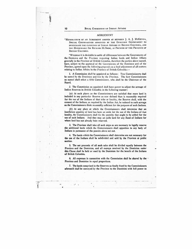
10 ROYAL COMMISSION ON INDIAN AFFAIRS
AGR EEM E N
"MrsuniANDost OF AN AGREEMENT ARRIVED AT BETWEEN J. A. J. MCKENNA,. SPECIAL COMMISSIONER APPOINTED BY THE DOMINION GOVERNMENT TO
INVESTIGATE rim CoNDITIoN or INDIAN AFFAIRS IN BRITISH CoLUMIIIA, AND
TIII: HONOURABLE SIR RICHARD MCBRIDE, AS PREMIER OF THE PROVINCE OF
BRITISH COLUMBIA.
"WHEREAS it is desirable to settle all differences between the Governments of the Dominion and the Province respecting Indian lands and Indian Affairs generally in the Province of British Columbia, therefore the parties above named, have, subject to the approval of the Governments of the Dominion and of the Province, agreed upon the following proposals as a final adjustment of all matters relating to Indian Affairs in the Province of British Columbia :—
1. A Commission shall be appointed as follows: Two Commissioners shall be Milled by the Dominion and two by the Province. The four Commissioners so named shall select a fifth Commissioner, who shall be the Chairman of the Board.
2. The Commission so appointed ,hall have power to adjust the acreage of Indian Reserves in British Columbia in the following manner:
(a) At such places as the Commissioners are satisfied that more land is included in any particular Reserve as now defined than is reasonably required for the use of the Indians of that tribe or locality, the Reserve shall, with the consent of the Indians, as required by the Indian Act, be reduced to such acreage as the Commissioners think reasonably sufficient for the purposes of such Indians.
(b) At any place at which the Commissioners shall determine that an insufficient quantity of land has been Set aside for the use of the Indians of that locality, the Commissioners shall fix the quantity that ought to be added for the use of such Indians. And they may set aside land for any Band of Indians for whom land has not already been reserved.
3. The Province shall take all such steps as are necessary to legally reserve the additional lands which the Commissioners shall apportion to any body of Indians in pursuance of the powers above set out.
4. The lands which the Commissioners shall determine are not necessary for the use of the Indians shall be subdivided and sold by the Province at public auction.
5. The net proceeds of all such sales shall be divided equally between the Province and the Dominion, and all moneys received by the Dominion under this Clause shall be held or used by the Dominion for the benefit of the Indians of British Columbia.
6. All expenses in connection with the Commission shall be shared by the Province and Dominion in equal proportions.
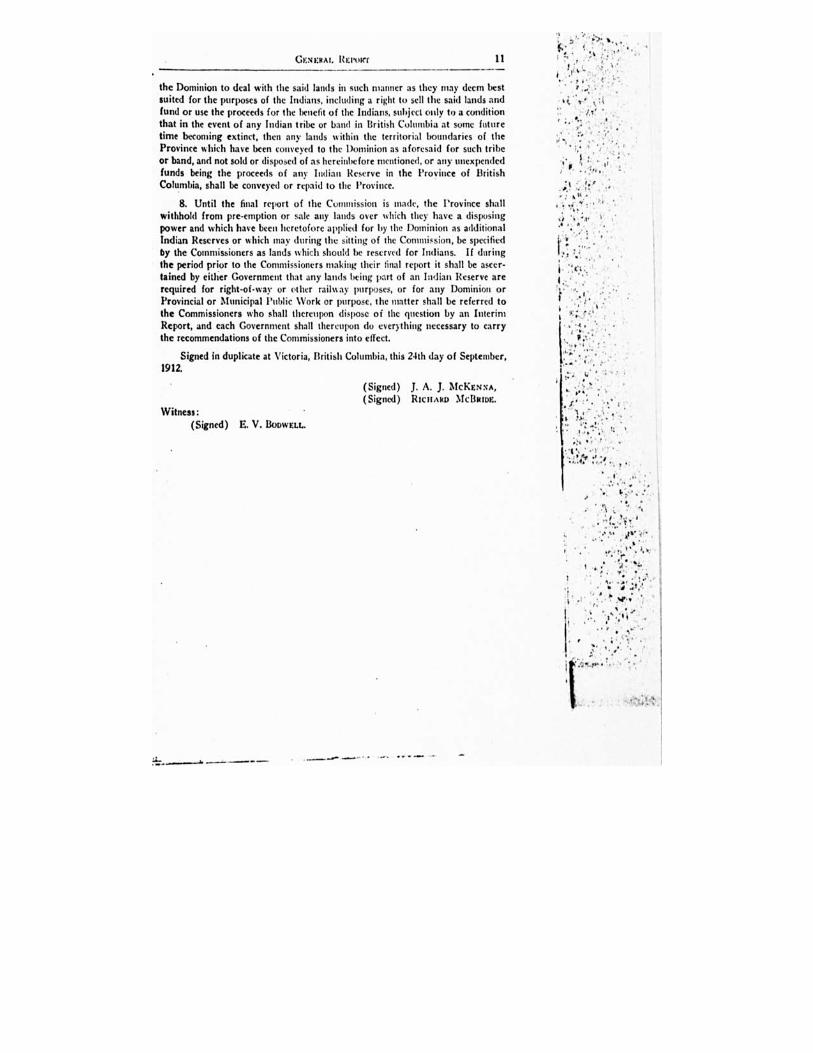
7. The lands comprised in the Reserves as finally fixed by the Commissioners aforesaid shall be conveyed by the Province to the Dominion with full power to
GENERAL. REPoier
11
the Dominion to deal with the said lands in such manner as they may deem best suited for the purposes of the Indians, including a right to sell the said lands and fund or use the proceeds for the benefit of the Indians, subject only to a condition that in the event of any Indian tribe or band in British Columbia at some future time becoming extinct, then any lands within the territorial boundaries of the Province which have been conveyed to the Dominion as aforesaid for such tribe or band, and not sold or disposed of as hereinbefore mentioned, or any unexpended funds being the proceeds of any Indian Reserve in the Province of British Columbia, shall be conveyed or repaid to the Province.
8. Until the final report of the Commission is made, the Province shall withhold from pre-emption or sale any lands over which they have a disposing power and which have been heretofore applied for by the Dominion as additional Indian Reserves or which may during the sitting of the Commission, be specified by the Commissioners as lands which should be reserved for Indians. If during the period prior to the Commissioners making their final report it shall be ascer-tained by either Government that any lands being part of an Indian Reserve are required for right-of-way or other railway purposes, or for any Dominion or Provincial or Municipal Public Work or purpose, the matter shall be referred to the Commissioners who shall thereupon dispose of the question by an Interim Report, and each Government shall thereupon do everything necessary to carry the recommendations of the Commissioners into effect.
Signed in duplicate at Victoria, British Columbia, this 24th day of September,
1912. •
(Signed) J. A. J. McKENNA, (Signed) RICHARD MeBum.
Witness:
(Signed) E. V. BoowELL.
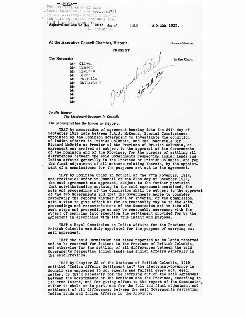
m..44.2kLmm The co-; of tLis ;Ordei.-in-Council borrowed911
.attorney- 7 ' ' and
s'AP(Prol4 t 26th day of July , A.D. 296:c 1923. .i- other,)c.
At the Executive Council Chamber, Victoria, Lieutenant.Governor.
PRESENT:
The Honourable in the Chair. Mc Oliver Mr. :Janson Mr. 71a.cLean Mr. Sloan Mr. ?attullo Mr. Sutherland MI% MI% Mr. Mr% Mr.
To His Honour The Lieutenant-Governor in Council:
The undersigned has the honour to report:
THAT by memorandum of agreement bearing date the 24th day of September 1912 made between J.A.J. McKenna, Special Commissioner appointed by the Dominion Government to investigate the condition of Indian affairs in British Columbia, and the Honourable Sir Richard McBride as Premier of the Province of British Columbia, en agreement was arrived at subject to the approval of the Governments of the Dominion and of the Province, for the purpose of settling all differences between the said Governments respecting Indian lands and Indian affairs generally in the Province of British Columbia, and for the final adjustment of all matters relating thereto, by the appoint-ment of a commissioner for the purposes set out in the agreement.
THAT by Dominion Order in Council of the 27th November, 1912, and Provincial Order in Council of the 31st day of December 1912, the said agreement was approved, subject to the further provision that notwithstanding anything in the said agreement contained, the Acts and proceedings of the Commission shall be subject to the approval of the two Governments and that the Governments agree to consider favourably the reports whether final or interim, of the Commission, with a view to give effect as far as reasonably may be to the Acts, proceedings and recommendations of the Commission and to take all such steps and proceedings as may be reasonably necessary with the object of carrying into execution the settlement provided for by the Agreement in accordance with its true intent and purpose.
THAT a Royal Commission on Indian Affairs for the Province of British Columbia was duly appointed for the purpose of carrying out said Agreement.
THAT the said Commission has since reported as to lands reserved and to be reserved for Indions in the Province of British Columbia, and otherwise for the settling of all differences between the said Governments respecting Indian lands and Indian Affairs generally in the said Province.
THAT by Chapter 32 of the Statutes of British Columbia, 1919 entitled "Indian Affairs Settlement Act" the Lieutenant-Governor in Council was empowered to do, execute and fulfill every act, deed, matter, or thing necessary for the carrying out of the said Agreement between the Governments of the Dominion and the Province, according to its true intent, and for giving effect to the report of the Commission, either in whole or in part, and for the full and final adjustment and settlement of all differences between the said Governments respecting Indian lands and Indian Affairs in the Province.
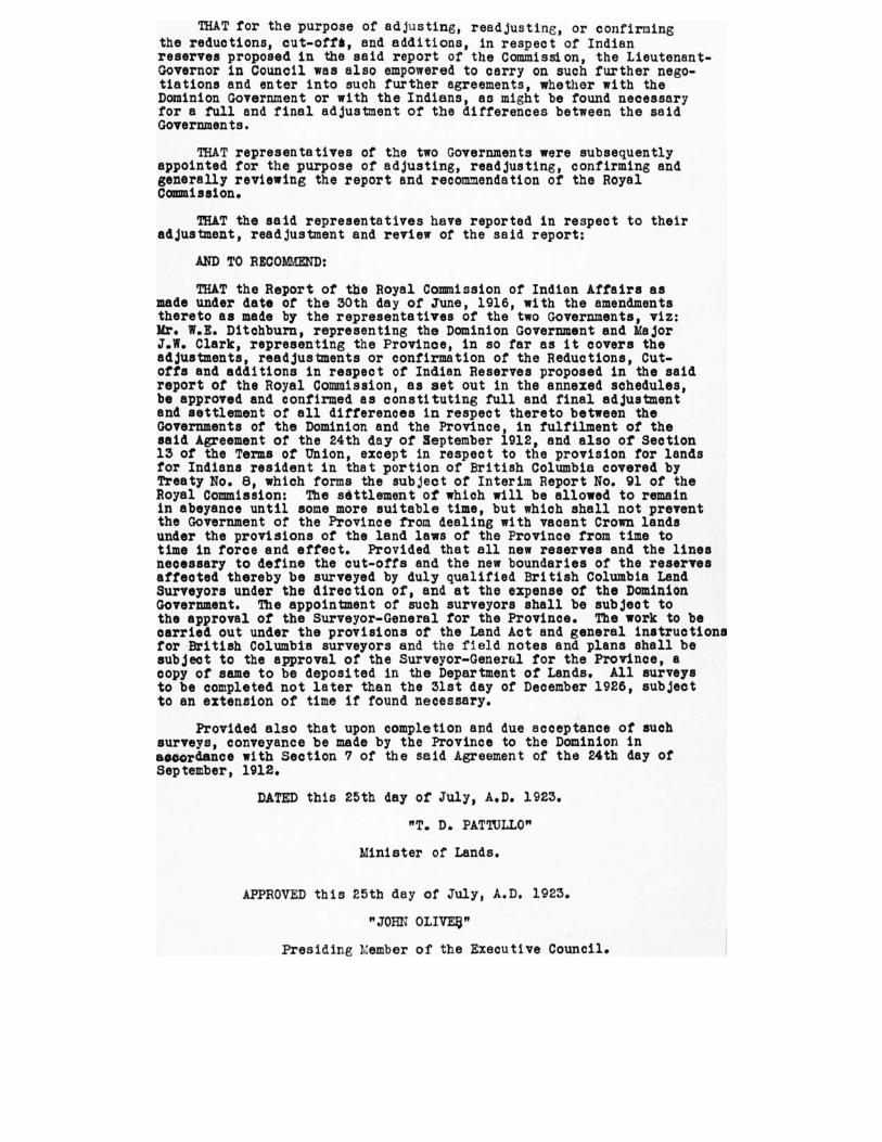
THAT for the purpose of adjusting, readjusting, or confirming the reductions, cut-offils, and additions, in respect of Indian reserves proposed in the said report of the Commission, the Lieutenant-Governor in Council was also empowered to carry on such further nego-tiations and enter into such further agreements, whether with the Dominion Government or with the Indians, as might be found necessary for a full and final adjustment of the differences between the said Governments.
THAT representatives of the two Governments were subsequently appointed for the purpose of adjusting, readjusting, confirming and generally reviewing the report and recommendation of the Royal Commission.
THAT the said representatives have reported in respect to their adjustment, readjustment and review of the said report:
AND TO RECOMMEND:
THAT the Report of the Royal Commission of Indian Affairs as made under date of the 30th day of June, 1916, with the amendments thereto as made by the representatives of the two Governments, viz: Mr. W.E. Ditchburn, representing the Dominion Government and Major J.W. Clark, representing the Province, in so far as it covers the adjustments, readjustments or confirmation of the Reductions, Cut-offs and additions in respect of Indian Reserves proposed in the said report of the Royal Commission, as set out in the annexed schedules, be approved and confirmed as constituting full and final adjustment and settlement of all differences in respect thereto between the Governments of the Dominion and the Province, in fulfilment of the said Agreement of the 24th day of September 1912, and also of Section 13 of the Terms of Union, except in respect to the provision for lands for Indians resident in that portion of British Columbia covered by Treaty No. 8, which forms the subject of Interim Report No. 91 of the Royal Commission: The settlement of which will be allowed to remain in abeyance until some more suitable time, but which shall not prevent the Government of the Province from dealing with vacant Crown lands under the provisions of the land laws of the Province from time to time in force and effect. Provided that all new reserves and the lines necessary to define the cut-offs and the new boundaries of the reserves affected thereby be surveyed by duly qualified British Columbia Land Surveyors under the direction of, and at the expense of the Dominion Government. The appointment of such surveyors shall be subject to the approval of the Surveyor-General for the Province. The work to be carried out under the provisions of the Land Act and general instructions for British Columbia surveyors and the field notes and plans shall be subject to the approval of the Surveyor-General for the Province, a copy of same to be deposited in the Department of Lands. All surveys to be completed not later than the 31st day of December 1926, subject to an extension of time if found necessary.
Provided also that upon completion and due acceptance of such surveys, conveyance be made by the Province to the Dominion in accordance with Section 7 of the said Agreement of the 24th day of September, 1912.
DATED this 25th day of July, A.D. 1923.
"T. D. PATTULLO"
Minister of Lands.
APPROVED this 25th day of July, A.D. 1923.
"JOHN OLIVES"
Presiding namber of the Executive Council.
CONFIRMATS OF RESERVES B NE AGENCY
TRIBE OR BAND RESERVE NUMMI DESCRIPTION ACREAGE DATE OF CONFIRMATION
idH aossf wc oilfgoewt oTrBi Band
1M or i c e t own
H melton Metric lit 35 miles S. E. of li mel ton on the
Bulkley River. 1333.0o
'''-
March asst, 1916
Do Coryatsaqu• 3 Hmelton District, N. of No. t. •
the trail to Il.celton, about a miles 330.49 6_, March alit, 19t6
Do Oschawwinna 3 Haselton District south of No.
the F Lake trail, about s miles 16o.00 ,_._ March alit, 1916
ff:fmtroltetuToir,!obee,
Band
Clotalairquot 4
V
Fo3rtfolla:e131. Do it onf tohoe.oriEhoty 6;0%1 on
the bBabineoe ob off River,
.
s911.00 l.---
March slat, 1916
Do No-cut. 3 ve .
Fo F DM c on the left bank of the Babine River,
a des N. of the udson'• Bay Post on Babine Lake. 197.00
C.----- March asst, 1916
poafrBabinelt Trgeo,d Babine 6
Ve
Fo ■
Foil jaorirofDogietltrii,co autdtpoen,00uVocyt o joytieobileimLake and N. of 69900
I--
Much met, 1916
Do Timber Reserve 7
1,
fto Dicric on the Western shore of Babine Lake,
west of the udson'e Bay Co.'s claim.
`v.
9a.00
e---
March mat, 1916
Do Casdeded aye I Fort F Diem on the E bore of Babine Lake, 1 ile south of e Hudson's Bay Co.'. claim.
107.00 March 31113, 1916
Do 'Teak 9 Fort Diatri , on the Western shore of Babine Lake, •b t 16 miles S. of the Hudson's Bay Co.'. Post.
1530.00
.4:-
March'stst, 1916
Do Ne-tow-gr ce
11
to
'ef/
Fo racer Dietri on a Eastern shore of Babine Lake, • 166t 16 miles S. of th dson'e Bay Co.'s Poet.
ae6.00
1.--
March Mt, 1916
7FlosAwillgtoTo Tribe, N e-do-a t• ii se` ,
Fort met Di on the Eastern shore of Babine Lake, •bout as miles f Hudson'. Bay Co.'s Poet.
977.00 March met, 19t6
foftgoilAebTXobeo,
Band
Timber R is
For aser Distric on the Western shore of Babine Lake, • 34 nu h of the Hudson's Bay Co.'. Post.
336.00 March egth, tge6
Hagwilget Tribe Redeem 13 Fort F •31. District, o Weal of and adjoining
Nedo• Reserve No. 346.00 March amh, 19:6
Do Chanoodandidalch 14
Port Fr North re 0
75toinb000utLate mile East of No. 333.00
4,--
March a9th, 1916
Do Tarlinlay is
V C------
Port I,/ 4eiostro. t, b o SLoteat of and adjoining No. to, e6a.00 March 39th, 19 ■ 15
Do Babine 115" Fort Frmer a ol ct, fli 7, North of and adjoining No. 7, 703.0o
G---
March amh, 19,6
Do Teitak 3A ✓ .kl° tric e
, 1;7 g ;8 liblkiglivoei't: Bulkley
A River. 306.00 March 3151. 1916
Haselton Tribe, ()gunman Band
Harelton a
Hanle. e t, t the foris of the Skeena and Bulkley
River • .704.00* March 39th, 1916
Do Kecio-gun-ye Two de Creek, 0,3 miles from with H y River.
N
131
360.00
Z.
Much 39th, :916
Do Taitsk 3 H aicelotonbt Mile
.ono he lying to the
or,041, tohfe ftenct !Loy(
River.
137.00 L -
March slat, tmel
,"\C
Do Anlaw 4
ti Harelton District, on the I t bank I the Skeen. River, north
of and adjoining No. 1. 31300 , April 3rd, 1916
Elegem@ Kimmel
V
Hmelton District, on Babine River, about 4 mile, from its confluence with the Skeen.
3435.00 e„.., April 3rd, 1916
Kispaim Kiepaiox 1 Harelton District, about eight miles above Harelton, and at the confluence of the Kispaiox •nd Skeen& River.
5870.013 /----""
April 3rd, 106
Do Sik-e-dalsh (Dien Vowel!)
a Haselton District, on the right bank of the Skeen• River, •bout 354 mile. above Hmelton.
i a66.vo April pd, mt.
Do Agwedin 3 Hmelton District, on the Kimaiox River, about three miles from its mouth.
7150.00 April 3rd, 1916
Kitseguecla Kitseguecla ,
V
Haselton District, on the Skeen. River, about 11 miles below Hmelton.
a417 3.o. —less allowed right-o, 1-:. 37 Go o ,To...P.foRoy4.
or 433, 3363.63
April 4th, 1916
Do New Kit.eguecla a Haselton District, on the Skeena River, about seven miles below Meehan.
1033.00 l‘cososyelo. — lowed dpr i Ehyt -.
33.60 acres, more Of Ir., 100640 t%
April 4th, 3936
Do Timber R 3 Harelton District, on the left bank of the Skeen•, about her miles below Hmelton.
317.00 April 5th, :916
Kitmlas Kitselas Hmelton District, at Kitselm Canyon, on the Skeena River. 1103.00 ;.-f-lweaosr alilloriedpriihyt:
.31.1.3...m.roe,s;.srore
April 4th, 1916

CONFIRMATIONS OF RESERVES BABINE AGENCY
TRIBE OR BAND RESERVE Ngngell DESCRIPTION 1 ACREAGE DATE OF CONFIRMATION
Do Chimilimash a Macelton District, on Skeena River, 4 miles above the Canyon.
, 2,14.00, , _
—f.!o :Ty' 'Go. 7. 'Pr. i thy!,
146 acre., more or less, 20344-
df,"
April 4th, Iota
Do Do aA Ilaxelton District, on Skeena River, adjoining R No. 1. 337.00 ei2.---'
April 4th, 2916
Do lkshenigwolk , 3 If are! ton District, on Slew. River, ■ a miles above the Canyon.
7,.00 Li—.
April 4th, egt6
Do Kshish ' 4 ettas.00 lil•sellon District, on Skeena River, 3 mile. below the Canyon. I s allowed r"'ght-
6395 acres, more or less, stio3 acres, more or less
of-w* .y G. T. P. Ry.,
April 4th, agt6
Do K•hish 4A Hardtop District, on Skeet's River, adjoining Reserve No. 4. tr, s711.00 April 4th, 106
Do Zairnoets Y 5 Ilarelton District, on Skeen. River, 4 mile• below the Canyon. 170.00 ... April sth, 5936
Do Kulspai .-- 6
V
fl•zelton District, on Sheens River, 9 miles below the Canyon. t7.0o ,,
April 3th, 1916
Do Ketoneda \t" 7 HajaenItyclonn. District, on Skeena River, 17 miles above the solos ,4--
April sth, 1916
Kitwangar Kitwangar 1
V'
Ifitzelton District, on the bank• of the Skeena at the mouth of Kitwangar River. —less 32I9o5W0e0d r ight-
of-way G. T. P. Ry.
r9Ite'ss,.3caT;7om. °"
April 4th, :916
Do Timber Reserve a Ilarelton District, on left Wilk of the Skeet. River, about a mile above Reserve No. t.
203.00
4.. April sth, 1916
-
Do Kwa-ts•-lis 4
I
Moulton District, on the banks of the Skeena, about as miles below Kitwangar.
ras.00 April sth. 29.8
Do Tum-bah jr,
/ miles Haselton District, on the left bank of the Skeena, about 2'4,
below Kitwangar. 147.00
l.--
April sth, 19:6
Do Kits-ka-haws 6
Y' Hatelton District, on the right bank of the Skeen., about 3
miles below Kitwangar. SS,. I
4-
April sth, 5916
Do Koonwats F i
liarelton District, on Skeena River, about 8 miles above Lorne Creek.
1115.00 more or less April sth, 1916
Do Chig-in-kaht 8 Harelton District, on the right bank of the Skeena, about I!, mile• below Lorne Creek 72.92
l-- April 5th, 590
Kuldoe Kuldoe -' I i
Harelton District, on the Skeen• River, about seventy miles above Harelton.
446.. April 4th, 2916
( e eucar
el
It
REDUCTIONS AND CUT-OFFS OF RESERVES
BABINE AGENCY
TRIBE OR BAND RESERVE NUMBER DESCRIPTION ACREAGE REDUCTION OR CUT-OFF OATS OP REDUCTION Oil CUT-DPP
Kitwangar Squin-lix-stot 3 Haselton District, on the right bank of the Skeena, about to mile, be- low Kltwangar.
.9-59 Cut-off April 5th, .915
.•
NEW RESERVES BABINE AGENCY
Art! C.iiCr'it■C 1103014
1' TRIBE OR BAND RESERVE 1411111111in 1 DESCRIPTION ACREAGE DATE OF MINUTE OF DECISION
II Kitwantool Kitwancool ;
On Kitwangar River approximately 13 miles from its mouth, son.mencins, at the N. E. corner of Lot No. 3365, Cassiar Land District; thence S. 206.04 chains; thence K. So chains; thence N. lob.os c.o.; thence W. Go chains, to the place of commencement. • i , ( r I ,I 1 /,, -
• ).1.j.- •'•i ■ .I, , r ILA
110.52, more or leas, subject to survey.
• .,) , r •.
May 3oth, tarn ,,,
4 d ( % r 1. 0 h . lo./
IA Do e a S. E. 4 Lot 345o and Lot sateA, Cassia: Land District. 269.00.1110ft or less. Map 30th, 1216 e....../...-
IB Do ,v13_____
s
1.44-43Yev.-Gariar Land--iiiewitet.
•• ... "..! " e 11" i.',0 • '.., ,.....n- l'•'.1 ,•1 ,.fat 3611.00, 113040-4014114.
•.., 0 il/o4 May 30111, 12111. I.• 1 • ^ -
A 1-' (s'
so Andimaul On right bank of the Skeena River, zit miles S. W. of Harelton, on G. T. P. R.
1o113.00, more or less, subject to
May sorb, 3936
L..—
.9 Kist:Won Quan.skum.ksin- mich.mich
‘ ;I/ OnLarnilhtDitnikc t.ofas thi,e,,SIstLetnct pRiavner,ef inAgodt00,2,321i. C8irseseianr.
B. C. L. S.
Loii,i j,ecnttorte. Osfurvl leas, May soth, 19r6 i____
21 Do Gun-a.chal 3
s . '
On left bank of the Skeena River, opposite Lot 1032, C.siar Land District. as per sketch plan of Ashdown H. Green, B.C.L.S.
5 oo, more or less, subject to survey.
May sorb, :9.6
o6 DoDO Sidi. 6 On left bank of the Skeen River, extending from Caribou or Sinallch Creek southward to and including Sidi. Fishery, a. per sketch plan of Ashdown H. Green, B.C.L.S.
120.00, more or less, subject to survey, under special In. structions of the Surveyor-General of British Columbia.
May Sorb, 39.6
I-
39 Do Kis.an•usko On right bank of Sheep River, in South 4 Lot 1390, C•scar Land Di rrr ict, a. per sketch plan of Ashdown H. Green, B.C.L.S.
10.00, more or 14113, subject to survey.
May soth. 1316
.---
33 Do Gulmak B V
On right bank of Skeena River, in North yi Lot 2394P,
Cassiar Land District, as per sketch plan of Ashdown H. Green, B.C.L.S.
33.00, more or less, subject to survey.
May 30th, 3936
37 Do And•k 9 .
V
On right bank of Skeena River, opposite Simile), Creek, in North % Lot 2595, C.i.f. L•nd District, as per sketch plan of Ashdown If. Green, B.C.L.S.
10.00, more or less, st.bject to survey.
May both, 193 6
t..-- --
40 Do Waulp 3"0
I
On rirt.bank of Skeena River, below. Se.ai.esh Creek, in. S. E. 4 Lot 3001, CO113121. Land Die rict, as per 3114 Ch plan of shdown II. Green, B.0 L.S.
Poo, tiro. or less, subject to survey.
May both, pig
e--_
p Hagwilget Tribe sy
I
Between Moricetown Reserve No I and Coryatsaqua Reserve No. a, bounded on the N. by Coryatsaqua Reserve No. a; on the W. by Lot 146a, Cassia, Land Di trier ; on the S. by Moricetown Reserve No 1; and on the E. by an un- numbered lot. (Provisional Reserve).
16o.00, more or less. subject to survey.
May both, rug
e----
34 riajivec.iligoewt Moricetown Band
18
V7
W. of Coryatesque R No. a and described as follow.: Commencing at the N. W. corner of Lot pre, Cassiar Land District; thence W. one mile; thence B. one mile: thence E. one mile; thence N. one nude to the place of commence. meet.
64o.00, more or less, subject to survey.
May both, :9•6
..---
70 Do Bulkley River If Bounded on the N. by Lots 333 and 103S, Cassiar Land District, on the W. by Coryateaqua Reserve No. 3 and Government R ; on the S. by Moricetown R No. t; and on the E. by the Bulkley River.
600.00, more or lens, subject to survey.
May 30th, 1916
C
7 4 liloar tillavitn.Tti aben,d Babine Lake . iso -
V
On N. shore of Sabine Lake, Lot 1366, Cassiar Land District. 640.00, more or less, May pith, 39.6
Z.-
76 Do Babine River as
V
OnbeSnsgbinuengliv.e,4d.uortos,iroaot.elcy..6,im.rileisantii gisRtreiscetr.ve No. 6, 33.00, more or less. May 30th, .916 4....—
.A6E:g
76 ,
Do Do Ke.A
32
7
VGreen,
On Rabin. River, opposite Reserve No. 31, being ungasetted
Lot 16or, C.C. and District. .
„.• k..,, ., r ,__ v , •..,ge p,., .., ,
On N. end of Angier Lake, as per sketch plan of Ashdown H. B.C.L.S.
3e.00, more or less.
',,.., .ii r e
anon, more or less, subject to eurvey.
May pith, r9.11/1
e */ z...
May both, 3936 So Do Augier Lake
113 Do Pinkut Lake 33 On P ■ nkut Lake, as per sketch plan of Ashdown H. Green, B.C.L.S.
tone, more or less, subject to surrey.
May both, 1916
BS Do Tahlo Lake 14 „.•
/te
ar
y
.
On Tahlo or Salmon Lake on Trail from Port Babine to Manson Creek, as per sketch plan of Ashdown H. Green, B.C.L.S.
sao.00, more or le., subject to surrey.
May sunk, 3901 Z.....---
84 Do
At the confluence w.th the B•bine River of a Creek flowing S. out of Fulton Lake, being ungpetterl Lot 1333, R. g, Coast Land District.
rsg.00, more or lees. May loth, spa
( -
Ili Do 36 ‘,..
7-37
A ,..,- At's A
T
On the E. shore of Babine Lake, 13 miles N. of Reserve No ag, as per sketch plan of Ashdown H. Green, B.C.L.S.
N. frl. V. Lot 326, Cass'ar Land District.
4 h ...JAY i.., ja 1. )1e. iv 4 c.. -: e h, a Y. ).a .
, " ....1 ,` t. .1. ,,, t „ ,ants, e ,,,,,....t,e,„ ./........, ..,,...eic ../ .4 -3 . W. ^A 7 ste4, le :.,- 4.1740
dr'.„57 t....4..t.44, 4.tist et /0 .4.1tit fr, le - i..... •
tt, , niP r .;14... 4....t: yes , I .1,.. , . . a. E 4, „A.m ,..1" .7 ,,,,,,,,,,,,..,,_,P."
flop, more or less, subject to survey.
86.cp, more or less.
A . ,..
May 'Ph, 3916 -
May 30th, :9,6 4.' -
A '4' C.- --
1...."'""
p H•pvilget
41 t t.( c tds
CONFIRMATIONS OF RESERVES BELLA COOLA AGENCY
TRIBE OR BAND ' RF.SERVE NUMBER DESCRIPTION ACREAGE DATE OF CONFIRMATION
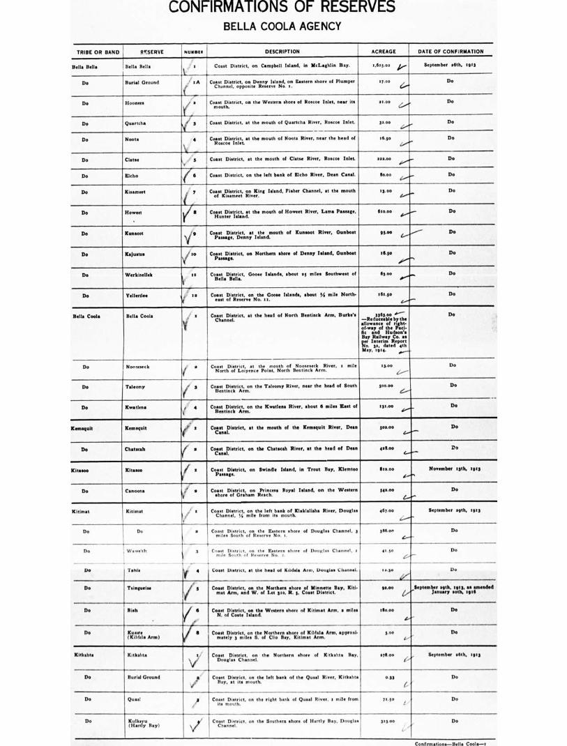
Bella Bella , Bella Sells a Coast District, on Campbell Island, in McLaghlin Ray. 1,623.00 k,.. September agth, 1913
Do Burial Ground .' IA Ea Coast District, on Denny Island, on stern shore of Plumper Channel, opposite Restart No. s.
17.00 Do
Do Hoonees Coast District, on the Western shore of Roscoe Inlet, near its mouth.
moo Do
Do Quartch• 1 3 Coast District, at the mouth of Quartcha River, Rom). Inlet. ga.00 Do
Do Noots a District, the mouth of Noota River, near the head of Cog.ctlistIrne s6.3o Do
Do Clots. Coast District, at the mouth of Clatm River, Roscoe Inlet 132.00 Do
Do Elcho 6 Coast District, on the left bank of Bleb° River, Dean Canal. boo Do
Do Kisameet y Coast District, on King Island, Fisher Channel, at the mouth of !Unmet; River.
13 . oo Do
Do Howeet
ff
r Hunter Coast District, at the mouth of Howeet River, Lama P
Island. Ilsono Do
Do Kunsan Coast District, at the mouth of Kunsoot River, Gunboat Passage, Denny Island.
95.03 Do
Do Kajustus
\e
I to Coast District, on Northern shore of Denny Island. Gunboat tip Do
Do Werkinellek 1a Coast District, Goose Islands, about ss miles Southwest of Bella Bella.
113.00 Do
Do Yallerthes 1 Coast .eas
t 1:Ifis;treiscet6oenNthei ::loose Islands, about yi mile North- 191.30 Do
Bella Cools Bella Cools a Coast District, at the head of North Bentinck Ann, Burke's Channel.
336400 —Red cla Lc se • bolls 61 thht.
of.wey of the "mi- lk and Hudson's Bay Railway Co. as
Interim jeftc.sdadl
May, We.
Do
Do Nooseseck • Coast District, at the mouth of Noosemek River, : mile North of Loiyenc. Point, North BentinckBentinckArm.
s$.ao Do
Do Taleomy S Coast District, the Taleomy River, mar the head of South pone Do
Do Xwatlen. s 4 i
Coast District, on the 'Emden. River, about 6 miles East of Bentinck Ann.
131.00 Do
iltamiquit Kemsoult Coast District, at the mouth of the Xemsquit River, Dean Canal.
sos.00 Do
Do Chatmah ( s Co&stnalMstrict, on the Chatscah River, at the head of Dean allloo Do
Kitasoo Ritmo Coast District, on Swindle Island, in Trout Bey, Klemtoo Passage.
Ses.00 November 13th, 1913
Do Carioca. ;'' a
V
Coast District, on Princess Royal Wend, on the Western shore of Graham Reach.
Woo Do
Kitimat Kitimat Coast District, on the left bank of KlakIalisha River, Douglas Channel, I,I mils from Its mouth.
461.0o September snth, lots
Do Do a CommL.DisoturItcht,or Reserve No.
o .. shore of Douglas Channel, 3 3gton Do
Do
Do
Wmeelth 3
Tone 4
Coast District, 021 the Eastern shore of Douglas Channel, t mile Routh of Reserve No 2.
41.30
aa.go
4
Do
Do Coast In . at the had of Etidala Arm, Douala. Channel.
Do Tlinguaise Coast District, on the Northern shore of Minoan. Day, SM. neat Arm, and W. of Lot 350, R. s, Coast District.
woo September seat, 1113, se amended January Mb. tote
Do ftieh Coast District, on the Western shore of Kitimat Ann, a miles N. of Costs Island.
asp° Do
Do Kumm (Elide]. Arm)
Coast District, on the Northern shore of Kilda. Ann, approzi. mately 3 milt,' S. of Clio Boy, Kitimat Arm.
3.00 Do
K itkohta Kakahta Coast District, on the Northern shore of Kltbahts lay, Douglas Channel.
130.00 September oath, tots
Do Burial Ground / v40'
Coast District, on the left barb of the Quaid River, Kitbahta Bay, at its 'mouth. e '
0.43
t- Do
Do Quasi j Coirst. sttDirhict, on the right bank of Quasi River, a mite front 71.5o Do
Do IfCgratr: Bay)
ye Coast District. on the Southern shore of Hartly Bay, Douglas 313.00 Do
Conlirmationo—Itella Coota—.1
CONFIRMATIONS OF RESERVES BELLA COOLA AGENCY
TRIBE OR BAND RESERVE
11111451R
DESCRIPTION
ACREAGE I DATE OF CONFIRMATION
Kitlathla or Kitkatla
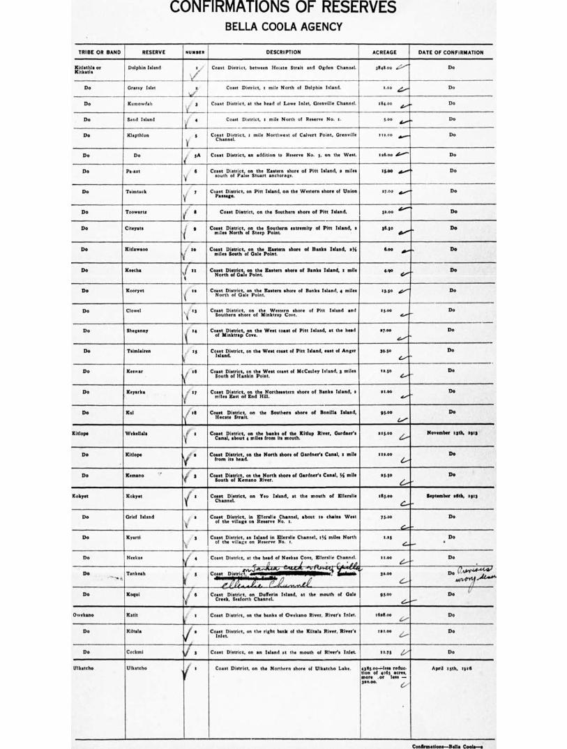
Dolphin Wend r •
V
Coast District, between Ifetate Strait and Ogden Channel. 3844 au Do
Do Do Gramy Islet s.
V
Coast District, a mile North of Dolphin Island. vici
Do Xumowdah 3 V
Coast District, st the head of Lowe Inlet, Grenville Channel. slle.00 Do
Do Sand Island . ? 4 Coen District, a mile North of Reserve No. a. 5.00 Do
Do Klapthlon 5
Y
Coast District, a mile Northwest of Calvert Point, Grenville Channel.
111.00 Do
Do Do
Ps-sat
i
SA
6
Y
Coast District, an addition to R No. 3, on the West.
Count District, on the Eastern shore of Pitt Island, s miles south of False Stuart anchorage.
',Soo deititV'
s 5.so
Do
Do Do
Do Tsimtacit y Coast District, on Pitt island, on the Western shore of Union Passage.
07.00 Do
Do Toowarts ' S Coast District, on the Southern shore of Pitt island. 52.00 Do
Do Citeyste / 9 ComasLaD otraig,c,linstteheep Southern extremity of Pitt island, s 36.5o Do
Do Kitlawaoo / go
V miles Coast District, on the Keeton shore of Banks island, sI5
South of Gale Point. Do
Do Reecho ‘f it
I
Co7sisotr,Diosrljatiaoi;ot„,h . Eastern shore of Banks Island, : mile arto Do
Do Kooryet . as Coast District, on the Eastern shore of Banks Island, 4 miles North of Gale Point.
13.30 Do
Do Clowel , ts Coast District, on the Western shore of Pitt Wend end Southern shore of Minktrep Cove.
13.00 Do
Do Sheganny 3. 14
i of Come District, on the West coast of Pitt Island, at the head
Minktrap Cave. 57.00 Do
Do Tsimlairen is Comet District, on the West coast of Pitt Island, east of Anger island.
3113. Do
Do Keswar :6
`i CortoXiostfriicit,;floknnthiloi,Writ Coast of McCauley Island, 3 miles 11.5o Do
Do Keyark• 1 or ConnteaDkatraitctoi oiA‘ttp Aitliortheastern shore of Banks Island, a 111.00 .r./.-
Go
Do Kul .' ill
1
Coast District,
on the Southern shore of Bonilla Island, Hecate Strait (.../
Do
Kitlope Weknllals s Coast District, on the banks of the Kitlup River, Gardner's Canal, about 4 miles front Its mouth.
ass.00 Z../
November Isth, Iva
Do Kitlope s
( Coast District, on the North chore of Gardner's Canal, s mile
from its head. woo
L. Do
Do Keenan° ,. 3 f
Coast District, on the North shore of Gardner's Canal, % mile South of Kernano River.
eS.30
G-- Do
Kokyet Kokyet y) 1 Coast District, on Yeu Island, at the mouth of Etienne 1133.00 September 66th, Ills
Do Grief Island s Coast District, In Enerslie Channel, about ris chains West of the village on Reserve No. 1.
73.00 Do
Do Kyarti S Coast District, as Island in Ellaville Channel, t14 miles North of the village on Reserve No. s.
s.ss
L_,
Do a
Do Necks.
!Ns
Coast District. at the head of Weeks. Cove, Entrant Channel. moo Do
Do CA6444-4441 rit+0, Do 'rankest: 5
gye,,,S4rt-t—kae'lldC--.v Coast District, asmillilamINISENEEMIE ss.00
e . , --,....A ei Do Koqui I 6
'11
Coast District, on Dufferin Island, at the mouth of Gals Creek, Seaforth Chanrel.
95.00 Do t"
Ovalkano Rath t
ll
Coast District, on the hanks of Owekano River, River's Inlet. 5616.o0 Do
Do Kiltala ti s CornsitoDistrict, on the right bank of the Kiltata River, River's oct.00 2.,....„ Do
Do Cockmi 13 Coast District, on •n island at the mouth of River's Inlet 51.55 Do Do
Ulkatcho Untstcho r Coast District, on the Northern shore of Ulkatcho Lake. 4305 oo--lees redo- hot of ends acres, more or less — woo.
April t3th, lose
Cesfraatioss—lells Cools—s

REDUCTIONS AND CUT-OFFS OF RESERVES
BELLA COOLA AGENCY
TRIBE OR BAND RESERVE DESCRIPTION ACREAGE REDUCTION OR CUT-OFF DATE 01, REDUCTION OR CUT•OFF
NUMBER
Kam 10.00 Kitimat Cut-off ". S oth January, 'gib
••••-d irrr •■•
Ulltatcho Ulltatcho / 5 Coast District, on the Northern shore of Ulkatcho Lake.
ttth April, 1956 /76700 Reduced by the cutting off of Four Thousand and S i (4065.0.) met., the residue of the R being the S. E. corner portion thereof. Three Hundred and Twenty alo.00t •cres, being confirmed is
such Ulliattho Reserve No. I.
NEW RESERVES BELLA COOLA AGENCY
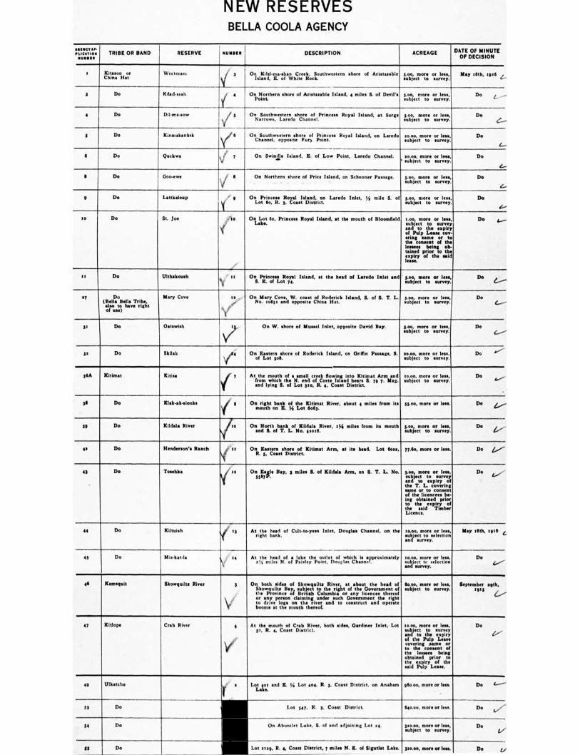
1141111CT AP. PTION TRIBE OR BAND LICA RESERVE NUMMI DESCRIPTION ACREAGE DATE OF MINUTE
OF DECISION
s Kinn° or China Hat
Ws ccccc n: On Kdel.me-shan Creek, Southw shore of Aristamble Island, K of White Roth.
goo, more or less, subject to survey.
E.001:1019N., a z ..
3 Do Kdademli 4 On Northern shore of Art isle Island, a miles S. of Devil's Point.
3.00 more or less, subject to survey.
Do L —
4 Do Dil-ma.sow i 5 On Southwestern shore of Princes. Royal Island, at Surge Narrows, Laredo Channel.
goo, more or less, subject to survey.
Do e.---
5 Do Kinmakanksk 6 On Southwestern shore of Pr' Royal Island, on Laredo Channel, opposite Purl Point.
sem, more or less. subject to survey.
Do
I Do Quelmes i 7 t4 On Swindle Island. S. of Low Point, Laredo Channel. es moo mom or less
t subject to survey Do
I Do Goo-ewe V $
On Northern shore of Price Island, on Schooner P cc . goo more or less subject to survey
Do
e Do Lattkaloup ' g On Princes. Royal Island, on Laredo Inlet, 34 mile S. of Lot 0o, R. 3, Coast District.
seo more or less subject to survey
Do
t6e.
to Do St. jolt ..le
1r'
On Lot Ils, Princess Royal Island, at the mouth of Bloomfield Lake.
Loci more or less, subject to survey and to the expiry of Pulp Luse coy erng same or to the consent al the lessees being ob- tained prior to the expiry of the sold loan
Do A....
it Do Ulthakoush On Princess Royal Island, at the head of Laredo Inlet and S. K. of Lot 74.
goo more Cl less, subject to survey.
Do e.--- 17 Do
(Bella Bella Tribe, also to have right of use)
Mary Cove a On Mary Cove, W. coast of Roderick Island, S. of 8. T. L. No. mem and opposite China Hat.
goo, more or less. subject to urea?.
Do (....e--
31 Do Oamwish v On W. shore of Mussel Inlet, opposite David Bay. goo, more or leek subject to survey.
De (...--"-
gs Do Mak On Eastern shore of Roderick Island, on Griffin Passage, S. of Lot 308.
sem, more or less, subject to survey.
Do '''"---
36A Kitimat Kitisa At the mouth of a small creek flowing into Kitimat Arm and from which the N. end of Come Island been S. 75 7. Map and lying S. of Lot po, R. 4, Coast District.
moo, more or less, subject to survey.
Do ‘../
311 Do Klak-aLsiouks On right bask of the Kitimat River, about 4 miles from Its mouth on K. Ye Lot beg.
33.o°, more or less. De 4,..—
30 Do Kildala Rivet On North bank of 'Male River, leb milss from Its mouth and IL of T. L. No. pest
boo more or lees, subject to survey.
De 1-,-
es Do Henderson's Ranch On Eastern shore of Kitimat Arm, at Its head. Lot Goss, R. 3, Coast District.
77.60, more or leas. Do L..--
43 Do Toaehka Onsitsple Bay, 2 miles S. of Kildala Arm, on R. T. L. No. 34.mor:o or less,
and to expiry of the T. L. covering same Of to COOINOt Of the licence's be-ing obtained prior to the "levity of the said Timber Licence.
Do L....,
44 Do 'Mullett At the head of Cult-to-yees Inlet, Douglas Channel. on the right bank.
m.o., more or less, subject to selection en d survey.
May tith, sp6 L
43 Do Mielt•tts At the head of a lake the outlet of which is approximately 1 ,4 miles N. of Paisley Point, Douglas Channel.
moo, more or lea.. subject te selection and surrey.
Do 4,'
46 Kamsquit Skov/quilt, River On both sides of Skowoullts River, at about the head of Skowquilts Bay, subject to the right of the Government of the Province of British Columbia or any licence. thereof or any person claiming under such Government the right to drive logs on the river and to construct and op booms at the mouth thereof.
Soso, more or less, subject to survey.
September sgth, 1913
1-e'''
47 Kitlope Crab River At the mouth of Crab River, both sides, Gardiner Inlet. Lot 5o, R. c Coast District.
10.00, more or less, subject to survey and to the expiry of the Pulp Lean covering same or to the consent of the lessees being obtained prior to the expiry of the said Pulp Lease.
Do
(e."--
411 Ulkatcho Lot eot and Z. 34 Lot me R. 3. Coast District, on Anaham Lake.
Sem, more or less. Do 1-----
33 Do Wil Sill
1 tall
Lot 347. R. s. COOS( District. 640.00, more or lens. Do (V-
34 Do On Abuntlet Lake. S. of and adjoining Lot se mom, more or less, subject to survey.
Do ej
SS Do Lot sup, R. e, Coast District, 7 miles N. Z. of Iligutlat Lake pen, move er legs De L/
NEW RESERVES BELLA COOLA AGENCY
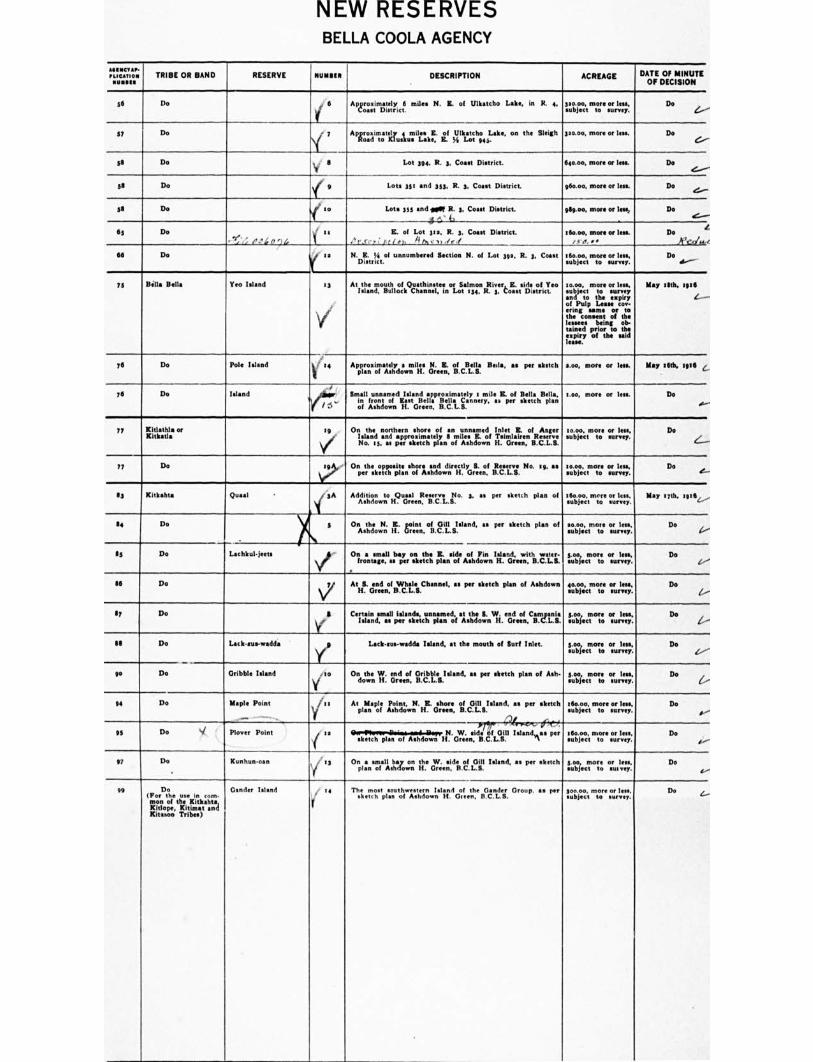
AMINCVAli-MICAtIOM TRIBE OR BAND RESERVE BUNSEN DESCRIPTION ACREAGE DATE OF MINUTE
OF DECISION
56 Do 4, 6 Ap&roasx:mi...t.elric:l miles N. R. of Ulkatcho Lake, in R. 4, 3.2Ajoeoc,,mtoore sourrIveesys: Do 4.-- -
57 Do • 7 ApLroaadintloateau.m.iltsakell. 11.4 5Lillkia.:,11,74sLake, on the Sleigh sso.00. more or less. Do C..--
53 Do ,. II Lot 394, R. 3. CoastDistrict. 640.00, more Of loss. Do
53 Do
( 9 Lots 351 and 757. R. 3. Coast District. 960.00, more or lees. Do
e...---
56 Do Lots 355 and golf R. 3, Coast District.
4._;„.A.L__
969.00, more or less, Do e----
65 Do
, I/ ,,,4o ,,4
as
1
IL of Lot pa, R. 3, Coast Diarist.
',..r,-,,,,e,, li t,. vi ,,, ,
r6o.00, more or less. ,,,,, ••
1.6uob. jooec,,mtoore sourrlyeeeys,
Do 1,_,',..,,
Do se..--
66 Do y a N.Httrykof unnumbered Section N. of Lot 392, R. 3, Coast
75 Bella Bella Yen Island 13 At the mouth of Qu•thinstee or Salmon River L K. side of Yeo Island, Bullock Channel, in Lot 134, R. 3. toast District.
s000, more or less subject to and to the e•piry of Pulp Lease coo. Ming an. or to the consent of the lessees being ob- tained prior to the expiry of the said lease.
May 59th, 1916
/
76 Do Pole Island ' 34 Approximatelypiao .tdos.m. V. (I.1,:e.C... citc Bela Bella, all per sketch 1.00, more or less. May :6th, :926
76 Do Island 10/ 77. Small al I unna m; d Island approximately a mi I 41of Bella1 Bells, nfrontE e.c,n.ry..%.rsketchpta,
of Ashdown If. Green, S.
s. oo, more or less. s. ...--
Do
77 Kitlathla or 59 Kitlestla
i \l'No.
On the northern shore of an unnamed Inlet E. of Anger Island and approximately 9 miles E. of Taimlairen Reserve
15, as per sketch plan of Ashdown II. Green, B.C.L.S.
so.00, more or less, subject to survey.
Do
-
77 Do 19› Onpeteheskoe tactrpileanshonsahnddowdnireteitlyGrt.enof H.Rc.L.s. No. s9, its 10.00. more or less, subject to survey.
Do C.
83 Kitkahta Ousel . 3A
1
5
-
Addition to H. reenft. eis3ercveao. 3, as per sketch plan of
on per sketch plan of On the E. point of Gill S.
istob joec tintrore or Ica,
Lotojoictmotroe or less, subject
May 17th. 1916
Do C.,'
94 Do 1 15 Do Lachkul-jeets
1 Oiroantsamgea,ilasblyer o:ieetth4t plan side
Ashdown IH.'"dlieewnli. ''.1:;-. LZecTorte. or Do
/ '
96 Do 1 \;,/ AtHS.anecleno.113Wchfes.Channel, as per sketch plan of Ashdown 90.00, more or less, Do
17 Do 3
yInland,
Certain small islands, unnamed, at the S. W. end of Campani• as per sketch plan of Ashdown II. Green, B.C.L.S.
3.00„ more or less, subject to survey.
Do / --
13 Do Lack-mm-wadda 2
Y subject Lack•zus-wadda Island, at the mouth of Surf Inlet. 5.00, more or less,
to survey. Do
to Do Gribble Island . so
V down On the W. end of Gribble Island, as per sketch plan of Ash•
H. Green, B.C.L.S. 5.00, more or less, *object to surrey.
Do
94 Do Maple Point vj se
_.....
At plaMna Maple F.:soti.lt.,,,,,N. HR. . teoerne. oft. cGill. 8.Island. •s per sketch
1 . J*74'''
. subject
joeoc,, mtoore sourrlyeesys,
Let. subject
Fero. survey.
Do a ---
Do t.- 6.-
95 Do Plover Point ''
'I sketch plan
N. Ashdown 114.G
Wriene.idieitfL111 Island as per
97 Do Kunhun-oan v' :3 OnplaansinofallltrowCinn the ,r;f ensi,cleFi.ce NI Island, al per sketch Soo, subject
more or ilea., Do P.--
99 Do Gentler Island 4 (Por the use in com- mon of the Kitkahta, Kitlope. Kitimat and Xitasoo Tribes)
Thizohstpisaonu tohisztierowInsITind Go, le Gr een, s
Citnideir. Group, • • per Ecti,. subject m
soore sOurrlyeetyll: Do 4...-
CONFIRMATIONS OF RESERVES COWICHAN AGENCY
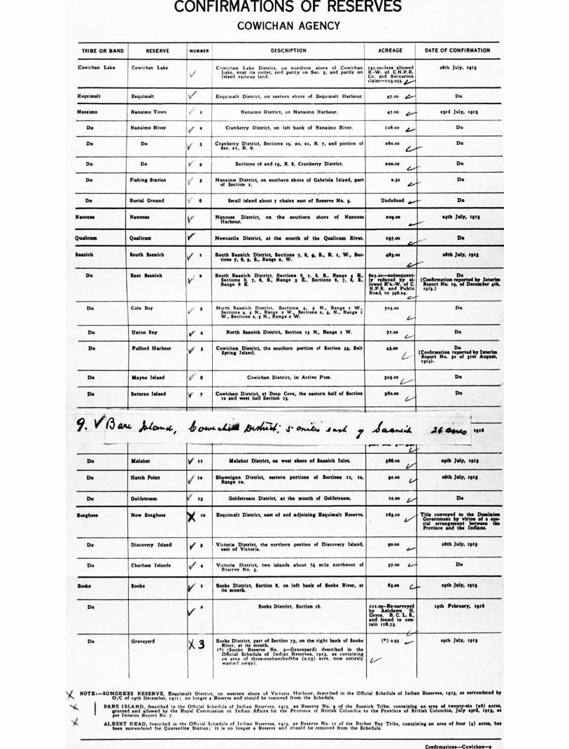
TRIBE OR BAND RESERVE 1 NUOInto DESCRIPTION ACREAGE DATE OF CONFIRMATION
Cowichan Lake Cowichan Labe I Cowichan Lake District, on northern shore of CowIchan 1 tso.00-less allowed
Lake, near ate outlet, and partly on Sec. 5, and partly on R.-W. of C.N.P.R. Island railway land. Co. and Swinarton
: claim-103.035. 4,........
alth July, tuts
Eequirnalt ZoquImMt W Esquimalt District, on ea•tern shore of Esquirn•It Harbour 47.00 ‘...."' Do
Habana° Massimo Town . : Nanaimo District, on N•naimo Harbour. 47.00 e....... .3rd July, sots
Do Nanainto River Vt .
Cranberry District, on left bank of Nanairno River. I.S.O. 4..„ Do
Do Do ,, 3 V Sec.
Cranberry District, Section• 1g, no, at, R. 7, and portion of 31, R. 6.
16coo Do Z...,"---
Do Do It" 4 Section• Cl and tg, R. 9, Cranberry District. g00.00e.../-
Do
Do Fishing Station ir 5 Na Joirecotilliat.riet, on southern shore of Gabriela Island, part use Do d..---
Do Burial Ground 6 Small island about 7 chains east of Reserve No. S. Undefined „........- Do
Noncom, Nanoose Nanoose District, on the southern shore of Nanoose Harbour.
109.00 aeth July, ag13
er..../
Qualicum Qualicum Iff Newcastle District, at the mouth of the Qualicum River. 197.00 Do 4.---
Saanich South Saanlrk v t Sotuitot.S7aanelcgh. iMst;tial,geSencti‘vis 7, 8, 9, S., R. :, W., Sec- 453.0* ellth July, tgag
e...---"
De Sold Resold' . • r
South S••nich District, Elections 6, 7. 1, S., Range 4 IL, Sections 6 7, I, S., Range 5 E., Sections 0, 7, t, S., Rang• 6 E.
6.75.00—gubsequent. Do ly reduced by al. (Confirmation reported by Interim lowed R'o•W. of C. Report No. sp. of December 4th, N.P.R. and Public rail) Road, to 596.24.
C/'
Do Cola Bay • 3 i
North Saanich District, Section• 4, 5 N., Runge r W., ttrtIccetit.,..5.Ni II:onranagelltkvIlectIona a, 3, N., Range a
703.0o Do
L.-"
Do Union Say 1 4 North Saanich District. Sutton 13 N., Range I W. vino Do 6.--
De Folioed Harbour ve j Cowichan District, the southern portion of Section 53, Salt Spring Island.
43.0e Do
'VII= aP:r"1:yt. 7Z Vn reported by Interim
ugul 81114).
Do Mayne Island el 6 Cowlchan District, In Active Pan. 3o3.00 e.---"-
Do
De Saturn& Island ‘e 7 corp.'s:" District, at Deep ,C3ove, the eastern half of Section 360.00 I Do G-
9, ik4...4,tY „......4As haz 4- 7 AicLAt..4.k
.10 4134,40 1916
Do Malahut 36 Nialahut District, on west Acre of Saanich Inlet. 3116.00 sgth July, fgt.
Da Hatch Point v/ is Shrmangiten... District, eastern portion. of Sections ta, II, groo Le'
26th July, .013
Do Goldstrearn t3 Goldstream District, at the mouth of Coldstream. 12.00 z........, Do
Songhees New Songhees • Eequintalt District, east of and adjoining Irequimalt Reserve. 163.0o . L./
Title conveyed to the Dominion Government by virtue of s op'. cial arrangement between the Provinc• and the Indians.
Do Discovery Island ✓ 3 Vic toria District,D,. .tcrthicrti,..the northern portion of Discovery Island, 90.00 1---
21th July, sots
4-
Do Chatham Islands lraDgtrict, two Islands about 4 mile northwest of Ff Victoria District, o s 5700 4,-4 Do
Soaks looks Book. Metric<,
Section 8, on left bank of Book. River, at Its mouth.
63.coo 6....._ agth July, trig
Do I n Soobe District, Section t6. tor .og-Re.eurveyed le, ..nAshdown ii
L. , . 11. :
and found to con- tain ‘18.75.
17'
lath February, ante
Do Graveyard A 3 Bo;illyeerDisstori: Lan tic:f. Section 73. en the right bank of Soots
(*) (books Reserve No. 3-0 yard) described in the Official Schedule of Indian Reserves, 1913, as containing an area of three-onehundredth• (o.o3) acre, now entirely washed sway).
(*) on
/...,,,•-•
sgth July. 1013
NOTE.—SONGHEES RUMOR, Esqultnalt District, on western shore of Victoria Harbour, described In the Official Schedule of Indian Reserves, 0/C of tgth December, sett ; no longer a Reserve and should be removed from the Schedule.
HARE I SI AND, described in the Official Schedule of Indian Reserves, agt3, as Reserve No.g of the &ankh Tribe, containing an area of granted and allowed by the Royal Commission on Indian Affairs for the Province of B ' Is Columbia to the Province of British Colurnb per Interim Report No. 7.
ALBERT HEAD, described in the Official Schedule of bull. R , rut3, u R No. It of the Becher Bay Tribe, containing an area been surrendered for Quarantine Station; It Is no longer a Reserve and should be removed from the Schedule.
as surrendered by
iia7ttir;.:„S,"■gtario
of four (4) acres, has
Coullrmatioaa—Cowichan—e
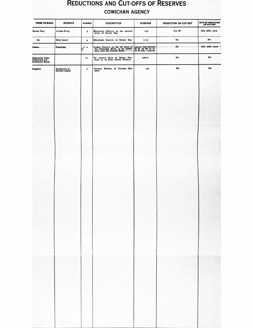
REDUCTIONS AND CUT-OFFS OF RESERVES
COWICHAN AGENCY
TRIBE OR BAND RESERVE NUMBER I DESCRIPTION ACREAGE REDUCTION OR CUT-OFF OAT( OF REDUCTION OR CUT-OFF
Becher Ray Omits Point 3 Metrhosin District, on th• western shore of Becher Ray.
2.$0 Cot off July .5th. 1913
Do Wolf Island • M•tchosin District, in Herber Hay. a soo Do Do
Cameos Pisatledg• / * Cr:7401341:11tt. arth., at irol k—`41.
OA. WS, k rho Twiltains Tier.,
Do NIT 0444, olist - l
R. --trm•urti. -.1.-84e-6es---seyisse.
Ellremm:i"rir• aihridb., Sic Iranneen Binds
ra On western shore of Oyster liar. .36.00 bout, at its head, Oyster District.
Do Do
Songhers Dead/1.11's or H•lkett Island
a Victoria District, in Victoria Hari .3i3 Dour.
Do Do
i
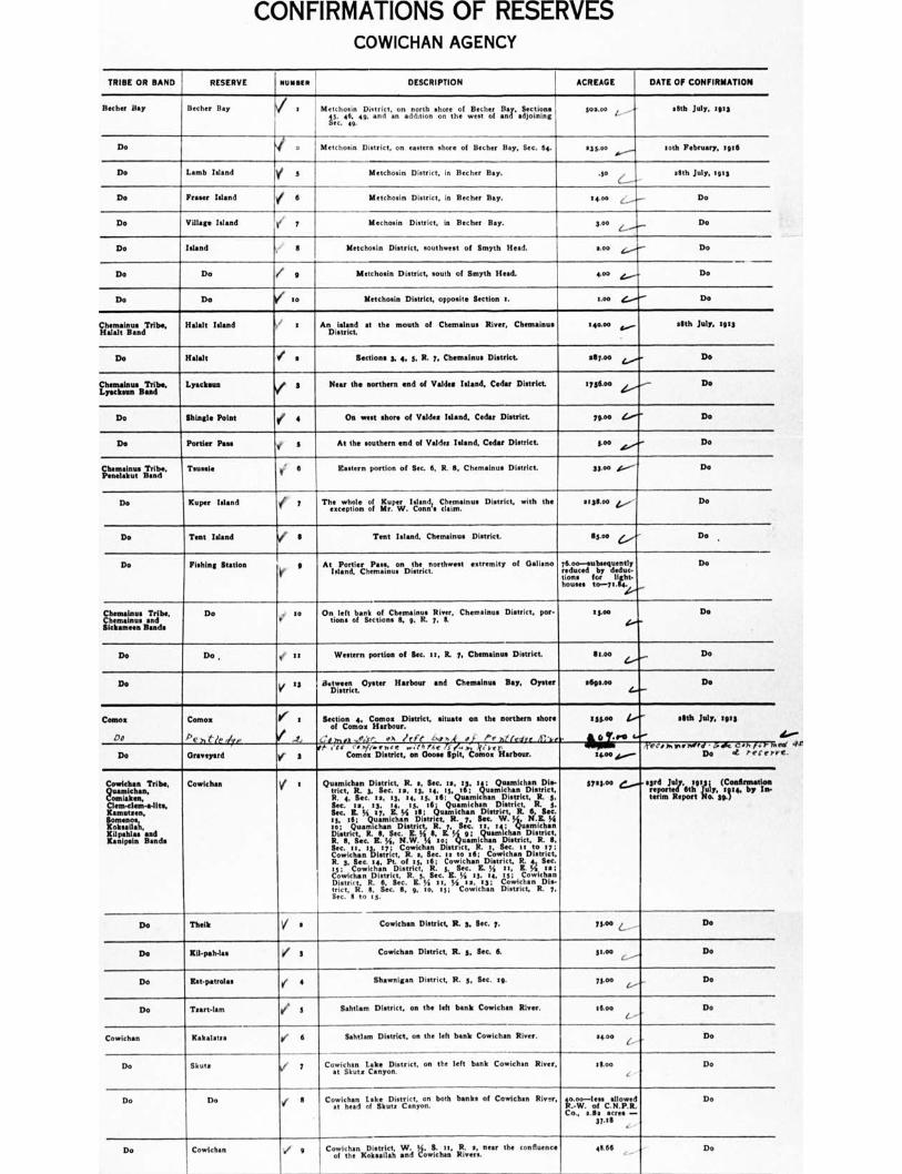
CONFIRMATIONS OF RESERVES COWICHAN AGENCY
TRIBE OR BAND RESERVE NUNSIn DESCRIPTION ACREAGE DATE OF CONFIRMATION
Becher Bay Becher Bay V a Metchosin Diattict.onaio.ohn shoonretho.f Ze.ctheorf .13.ait artLiiggs
Isc.c. 464, 49, and sos.00 i sfith July, 1913
Do i 2 Metchosin District, on eattern chore of Becher Bay, Sec. 64. 535.0o.s.----
roth February, :gib
Do Lamb Island Y 5 Metchosin District. in Becher Bay. .50 CI--
.6th July, tots
Do F Island e 6 Metchosin District, in Becher Bay. 14.00 c_.....— Do
Do Village Island Mechoein District, in Becher Bay. 3.00 /.... -/—
Do
Do Island 8 Metchosin District, southwest of Smyth Head. too Do
Do Do I/ Metchosin District, south of Smyth Head. 4.00 Do
Do Do so Metchosin District, opposite Section r. too Do
Chemainus Tribe, Halals Band
Beloit Island x An island at the mouth of Chemainus River, Chemainus District.
t4ono ,....... 11th July, 1913
Do Halalt ✓ a Sections S. 4. S. B. 7, Chemainus District 2117.00 Do
Chentabsue Tribe. Lyachsan Band
Lyatkette 3 Near the northern end of Voider Island, Cedar District. t ygtoo Do
Do Shingle Point ✓ 4 On west shore of Veldts Island. Cedar District 7900 Do
Do Pottier Pau 1 5 At the southern end of Valdes Island, Cedar District toe Do
Chemainus Tribe, Penelahut Band
Tenni. :. 6
Eastern portion of Sec. 6, R. 11, Chemainus District 33.00 ef....."-- Do
Do Kuper Island Y 7 The whole of Kuper Island, Chemainus District, with the exception of Mr. W. Corm's caim.
51311.00 4,-- Do
Do Tent Island I Tent Island. Chemainus District. Stott Do .
Do Fishing Station 9 At Pottier Pass. on the northwest extremity of Dalian° Island, Chemainus District.
76.00—subsequently reduced by deduc- tions ftor „Bet.
Do
Chemainos Tribe, Chemainus and Mehemet' Bands
Do . 10 r
On left bank of Chemainus River. Chemainus District, pot- lions of Sections it p. R. 7, S.
15.00 Do
Do Do , 44' it Western portion of get it, R. 7, Chemainus District. $1.00 Do
Do V " a 1)7:47c t. Oyster
Harbour and Chemainus Bay, Oyster stlgs.00 Do
Como:
Do Como:
Pe ,,t1r ,/rp
4f x
I .4,
Section 4. Comes District, situate on the northern shore of Comm Harbour.
-., ,,,, ,o,:ye Oh lrfc 04;,4 of Pr 71 ledrc if:',.'
ISS.00
Nafi
elltb July. tuts
Do Oranyard VE ' ""f ;.g 'te
,
)
.
t 'H Como: Goose ipltotcs Harbour.
ttoo ,.......- yet, ivrWred • L Ic CO. for),
Do 4 Peter.
Cowichan Tribe, 2ustraLhan..
Clem-clam-eats, Kantutsen.
LITZ'. Kilpahlas and Kanipsin Bands
Cowichan I i Qt raimdchrt. 3Dislercieta.R. 123,. Sec. zs. It: tA: OrtinIchif)n District
R. 4, Sec. 13, 13, :4, ts. ;61: 5,QivaMielituainmpisat.;ict,mR. cs, Sec. Is, ts, 14, 13, 16; Quamichan District, E. S. Sec. E. % 37, IL 34 ill; Quamichan District, R.
N.E.11 Sec.
is, it; Quamichan Dietrict, R. 7, Sec. W. 54, N. 34 to; Quamichan District R. y, Sec. it 14; Quamichan District R. R. It Sec. R. VIAL K 5. 9; Quarnichan DistrictDistrict
8, See. E. 64 uamlchan District. R. S.
toc;rilnitisltlict,C1r. lachcc.91trgt,0612. ,04ecti;an"Dtisottlit;,
R. 3, Sec. 04, Pt. of is, 16; Cowichan District, R. 4 Sec. IS: Cowichan District, R. 5, Sec. E. SS It, 8. SS Is; Cowichan District, R. S. Sec. E. 54 13. 14. rs; Cowichan District, R. 6, Sec. IL 54 11, 34 as, as; Cowichan Dis- trict, R. il, Sec. II, 9, 1o, 13; Cowichan District, R. 7, Sec. 6 to as.
371600 4gcri,jt:t faintly, (FglailVtia terim Report No. n.) 4.
Do Tbeik V n Cowichan District, R. 3, Sec. 7. 7300 L Do
Do Kil-palvias V 8 Cowichan District, R. 3, Sec. 6. stoo ___ Do
Do Ist;patrolas e 4 Shawnigan District, R. 3, Sec. ag. 7300 Do
Do Teart-lam 1 5 Sahtlam District, on the left bank Cowichan Elver. 16.00
L Do
Cowichan Kabala's.: le 6 Sahtlam District, on the left bank Cowichan River. 1400 Do
Do Shute ht 7 Cowichan Lake District, on the left bank Cowichan River, at Shute Canyon.
!too Do
Do Do e I Cowic han hesd o
llik AtIlisttacnty.onn both banks of Cowichan River, fzirlo,rloetsc allowed
Co., s.8s scree - 37.19
Do
Do Cowichan / g Cooviticuksen xDoilisstirilicit iyiti t;.,1{iht.t., iri.,..,,, near the confluence 46.66 Do
4.•••• rd dal C.
'I
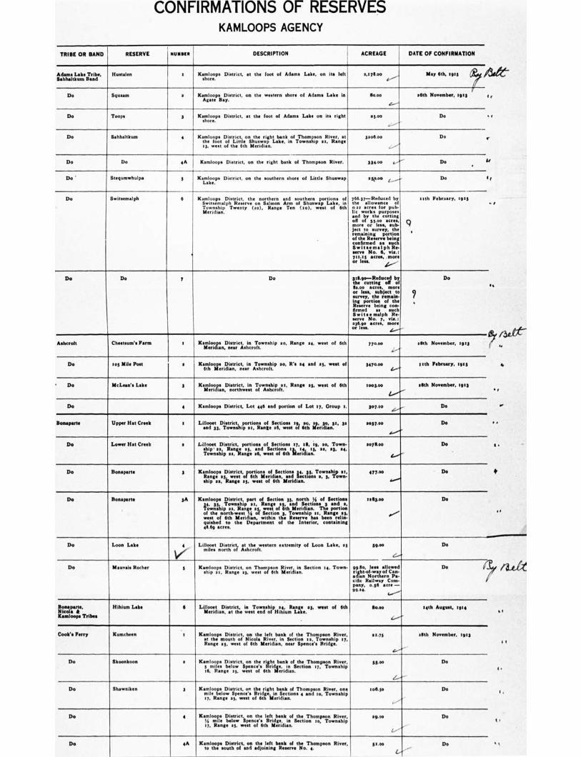
CONFIRMATIONS OF RESERVES KAMLOOPS AGENCY
TRIBE OR BAND RESERVE niillgen DESCRIPTION ACREAGE DATE OF CONFIRMATION
Adams Lake Tribe, SolsIsaltkum Band
Hustalen , Kamloops District, at the toot of Adams Lake, on its left a,tyll.00 May 6th, tg45 /3S
Do Squasm s Kamloops District, on the western shore of Adams Lake in boo
.f.----
16th November, tots 4 ,,
Do Toops Kamloops District, at the foot of Adams Lake on its right shore. +3.00
..:.---
Do • t
Do Sahhaltkum Kamloops District, ThomonSiver,at filtol • tli.stu.w. Llb.inTown.rp..Fang
I a, west of the 6th Meridian.
3so6.00 Do r
Do Do 4A Kamloops District, on the right bank of Thompson River. 334.00 a/ Do •
U
Do' Stegumwhulpa 5 Kamloops District, on the southern shore of Little Shuman a ko. Go „..........- Do 4 4
Do Switsemalph 6
•
Kamloops District, the northern and southern portions of Switsemalph Reserve on Salmon Arm of Shiners', Lake, in Township Twenty (so), Range Ten (to), west of 6th Met idian.
766.37—Reduced by pith February, tors the allowance of 0 as acres for pub. tic work• purposes and by the cutting oft more
I .,5 5 iono... a csruett q
jut to survey, the remaining portion ' of the Reserve being confirmed as such Swits•malph Re. serve No. 6, viz.: 711.13 acres, . more Of less. 1----
.. t
Do Do 7 Do 3111.9o—Roduced by Do the tutting od of
acres, more or Ins, subject to 7 survey, the remain. leg portion of the . Reserve being con- firmed as much Switsemalph Re. serve No. y, via.: astgo acres. more or less. .5....-4-
es
Ashcroft Cheetsum's Farm I Kail.11.2.sp.Dpisetarriclsti‘e...:1'hownship ao, Range 84, west of 6th 770.00 60th November, tors ‘.....-+
Do in Mlle Post s IslithssgerlictInts,iseteeirn
Township P 1°. R'"4
and sy. west of 747640 Itth February, :us 1...-••••
• Do McLean's Lake 3 Kaptrzeipctipsokuit..i.n. oTfowiatirous.s, Range •, most of 6th loofioo lath November, zips •
Do 4 Kamloops District, Lot 446 and portion of Lot 17, Group L 307.00 Do
Bosaperte Upper Hat Crook t Lialipajoepts.D4.trict.I. ipport..lonL.I.Satiownese. 19 a mr,3dt...30, 31 1.37.... D.
do•'..
•
Do Lower Hat Creek s Lilloott District, portions of Sections ty, 1111, te, so, Town-
Skip . 10 Rana
Rer,YtansA deZdweasstst oi7nilthllerWill., 11,
15. 14.
soyltoo Do
(..../
it
Do Bonaparte 3 KaizIpooilk.:7istorisc.t,proprIon portions of 14.,..v.;,.T.o.wes.sh.lt 0t,
ship es, Mange es, west of 6th lluidian.
477.00 Do
ao,
1
Do Bonaparte 3A Kamloops District, part of Section 33, north .N of Sections
'itwilitipT"nst, ;Psi: es 'is limaensgteolittnegriSdela"nionsTlit poanglon of the north-west It of Section 3. Township *It, Range 53
west of 6th Meri ian, within the Reserve has boon rolls quished to the Department of the Interior, containing 46.69 acres.
0,53.. Do
Do Loon Lake 4 Lillooet District, at the western extremity of Loon Late, as miles north of Ashcroft.
39.00 Do
e.....0
Do Mauves Bother 3 Section 14, Town- Kamloops Dziasptrgiect,t1s,swThonrorsosti, I:iv:rail:.
gp.11::,..loz: !Jordan. Do
.ifin Northern Pa- cific Railwey Com. pany, o.56 acre — 99.14.
4...-"".
Booeyerte. Nkola A Kamloops Tribes
Hihium Labe 6 Lillooet District, in Township IL Range es, west of 6th
Meridian, at the west end of Hum Lake. . So.00 04th August. 1914
(..../
Cook's Ferry Kunicheen t Kamloops District, on the left bank of the Thompson River, at the mouth of Nicola River, in Section Os, Township 07, Range 83, most of 6th Meridian, near Spence's Bridge.
13.73 16th November, 49:3
Do Skoonkoon s Kamloops District, on the right bank of the Thompson River, 6 Miles below Spence's Bridge, in Section 17, Township IS, Range ay, west of 6th Meridian.
55.so De
,(....-e"
Do Shawniken 3 Kamloops District, on the right bank of Thompson River, one milt below Spence's Bridge, in Sections 4 and to, Township tt, Range at, west of 6th Meridian.
106.3* De
Do 4 Kamloops District, on the left bank of the Thompson River,
17, Rang* es, west of 6th Meridian. 74 mile below Spence'. Bridge, is Section to, Township
so.. Do
/..--'
De 4A Kamloops District, on the left bank of the Thompson River, to the south of and adjoining Reserve No. 4.
51.50 Do •
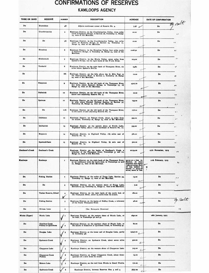
CONFIRMATIONS OF RESERVES KAMLOOPS AGENCY
TRIBE OR RAND RESERVE NUMMI I DESCRIPTION ACREAGE DATE OF CONFIRMATION
...e---
'
Do Shawniken GB Adjoins north-east corner of Reserve No. 4. 7.56 ioo".. De
Do Chuchhriawhin 8 Kamloops District, in the ChucihriachinValey three mie north of Spence'. in Section 36, s7,Rooze s5. west
so.00 De I I
Do Do 5A Kamloops District, in the Chuchhriaschin Valley, two. miles north of o.ls, B jee,:coo'iii olthriliee;idiin...flection 28, Township 17,
30.00 Do e r
Do Nicoelton 6 Kamloops District, in the Nicoelton Valley, four miles north of Spence's Bridge, In Township :8, Range as, west of 6th Meridian.
•ooll.so Do la
Do Kloklowuck 7
Kamloops l ** :: 3 i I .in hhe : ico a Y aleTi
miles Isom om penc r on the righ t banolte Taiivr.
stgoe Do I •
Do Toinkahtl II KanntiLoos pasboDviestiipect,nto:.thBerirlIcht bank of Thompson River, sin :silo Do yr
Do a A Ka 71 ovo District, the hils:bove the Pon the
.ari,oE.d.iniecion7.ewi.hp,stus
34, west of 6th Meridian.
.0.0 Do 07
Do Illem8moos g Kamloops District, on the left bank of the Thompson Rimy,
lmisas Sence'egridge, in Townships :7, il,
Range west offthisriia.
4307.70 Do we.
Do Pokheitsk to Kamloops District, on the left bank of the Thompson River, above and adjoining Reserve No. g.
cone Do hi
De Spats= 1, Kamloops District, on the left bank of the Thompoon River,
twm.ditipabzveRaKnigmebalail wiRe.i!waoty6tilhtaitilo.nrid in Section Ss. S93.00 Do
S /
Do Do :RA Ketomltohor nofr/gtroifct;n:yinalljtoeinlienf: renskrno: the 'Thompson River, 176,00 Do 4 .
Do Chilthnua to Kamloops District Pokiest Creek, about smiaro: tsmgth4owisipanie.3wenoithtrkiia 395.06 Do I" "
•
De Quiltanton t3 Kamloops District, on the eastern shore of Divide Lake, Highland Valley, about s mile northeast of Reserve No. et
SS5.00 Do I,
De Inquocto 34 Kaitnlooys District, in Highland Valley, :34 miles east of i 36o.00 Do I ,
De Squetankilhats to Kamloops District, in Highland Valley, M mile east of Reserve No. 14.
siutoo De / /
Dsednian's Creek Deadman's Creek Kamloops District, on the banks of Desdman's Creek, a tributary of owf estItieofT6httingiundisn.River, Townships 14 and as,
soutoo eyth November, lots i 1
Kamloops Kamloops e Kamloopsi0Dmileuternicct,; cztothitihreignhotniriMii.1 IT eTThomsrop.n .R. River
el, Range ay, west of 6th Meridian.
Arclk).:0 7jeegt re-
hundred and eighty (00.00) agree, more or less, subject to
acres, more m—on 1:1 V."
„.„..- —
e,
nth February, tots le
Do Fishing Station a KaTmolv.00rtipDI:7tritnagte thue. oweuttett of 6th
6Tifarierli..daika:: Section 34. 'see
C-----
Do I f
Do Do g Kirhrp1sz141 onthewtern spoe;H InrLee. ecton..7i.shpe7rngeiw.notefdl. to Do •1
Do Timber Reserve, Gilead 4.,
V'
Kamloops District on sttar:141t.tienskiroofmtItte..noor2h.fork of Mow Do
Do Fishing Station I KajitohoepstioDrigr District, on the banks of Healey Creek, a tribute/7 46.00 Do 63 ilie
i
Do Hihium Lake 6 (See Bonaparte Reserves) 1 f
Nicola (Upper) Nicola Lake
/
Kamloops District, on the eastern shore of Nicola Lake, at its head, in Townships 96 and 97.
ellip.00 seth January, toti
Do Hamilton Creek Fishery or Quilchen* j a
Kamloops District, on the southern shore of Nicola Lake, at the mouth of Hamilton or Quilchena Creek, in Township 97.
60.00 Do
Do Douglas Lake 1 3 Kamloops S4rige:: at the lower end of Douglas Lake, pertly no Do
Do Spahomin Creek ii 4 Kamloops District,Dmiosatrj,ct on Spahomin Crook, about seven miles mattio
4.....-
Do
Do Chapperon Lake . 3 Kamloops District. on the western shore of Chipper°. Lake. 70S.00 De
Do F,Iiistperyron Creek / II ICaruloopa DoIsstrin,cti,leoproUmprte.r.C.shuare. ron Crook, about threw 11600 Do
Do Salmon Lake I Kamloops District on the trail from Nicola to Grand Prairie. so
I111.00 c
Do
Do Spahomin Creek V s
Kamloops District, between Reserves Not 5 and 4. gSgy.rm De
CONFIRMATIONS OF RESERVES KAMLOOPS AGENCY
TRIBE OR BAND
RESERVE NUN". DESCRIPTION
ACREAGE
DATE OF CONFIRMATION
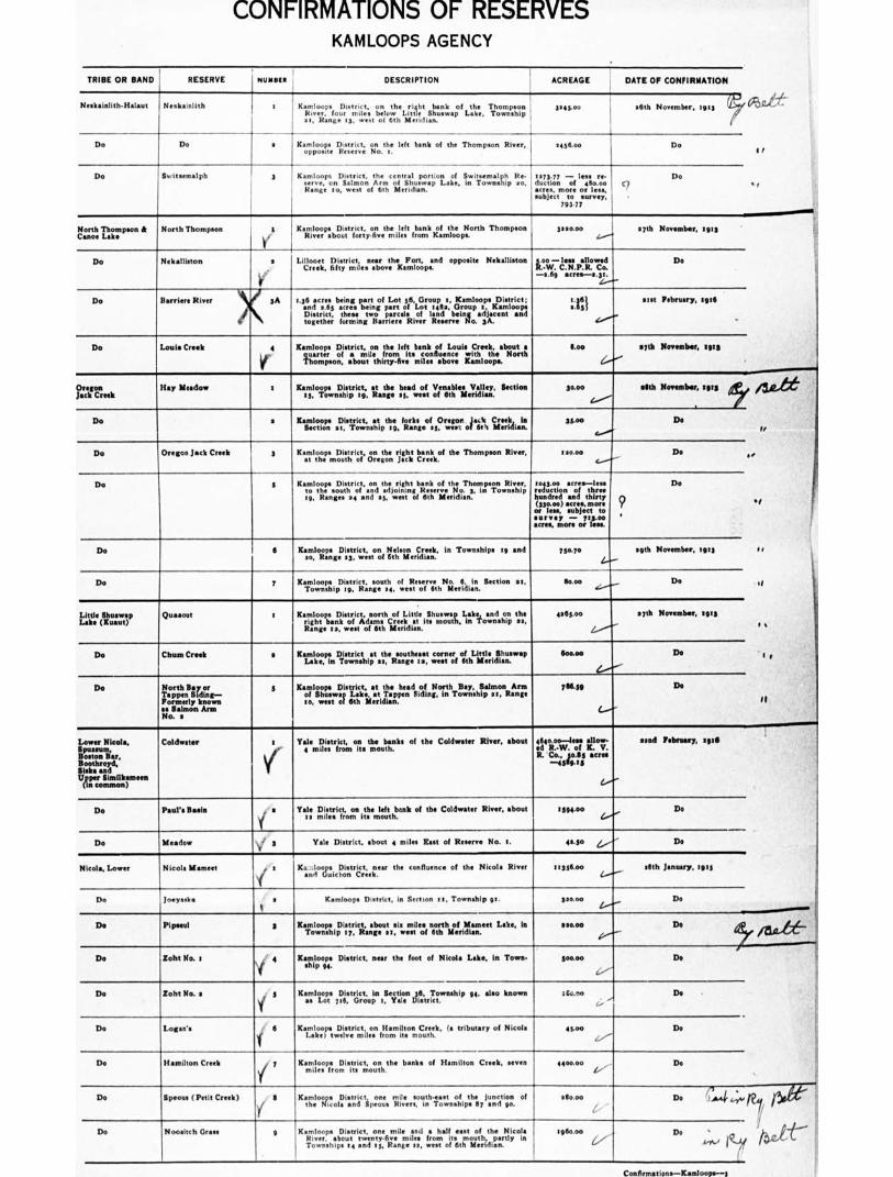
Nesk•inlith-Halaut i Neiikalniith a Kamloops the right bank
n k of the Thompson
3,43.0,
uver.fourniierelowL,. SI_•w•p Lake, Townshi p •
at, Range 13. west of 6th Meridian.
—4-
agth November, rots 0Vi 1:.'
(7
Do Do s Kaomplp000spts. District, Reserve
left bank of the Thompson River, .436.00 , Do I /
Do Switsemalph 3 Kasmerlvoeo,psonDeatIrmicotn 'k r%
centralui:1"pioia:et, inwi'll'oewmn3laVilip Rea.
Range zo, west of 6th Meridian. :417CrOl I —
less '
• cres, more or less, subject tosurvey, •
79177
c z Do
• I
North Thompson & Canoe Lake
North Thompson t
Mi
Kamloops District, on the left bank of the North Thompson River about forty-five miles from Kamloops.
L i&oecieeit., Districtf ty m il ..n taabrovteheK.Fmoaperd opposite Nekalllston
3220.00 27th November, tilts c....--+
Loo —less Mli.pal:lowceod Do
—2.69 acres-2.31. (......-.."
li Do Nekalliston
Do Barrier* River 1.36 acre. being part of Lot 36, Group t, Kamloops District; and a 65 acre• being part of Lot 1412, Group z , Kamloops District, these two ztrcelsof land be i nl adjacent nt and ,oge,e;io,.na.,r,r.Rice, 2..,ve0.3,
2 tat February, surf 2651
,r../.
tt
Do
I
Louis Creek 4 Kamloope District, on the left bank of Louis Creek, about a
Fhttrpe o'nf, :b about 1 Ihifr`t7sveit.m2:fl.ugonycee Litrnhiothpe.. North
too 227th November, 1923
?LTC': es k Hay Meadow t Kamloops District, at the head of Venable. Valley, Section
13, Township tg, Range s3. west of 6th Meridian. soon allth November, 1913
Do a Kamloops e c t in 22 1,District, io .,,sahti
Township the 9. forks eel. 50. rwircr
of .0‘,
CMeridian I i 33.00 Do
1I
Do Oregon Jack Creek 3 Kamloops Diairict, on the right bank of the Thompson Mem, at the mouth of Oregon Jack Creek.
120.100 Do
Do 5 KatmolctrsoDuititriocpaonnd the jorilentobwk of the Thom
tri, Ranges 04 and as, west of 6th Meridian.
rteogiottisonacrrit three
hundred and thirty (330.00) •crea, more or less, subject to survey — 773.00 acres, more or less.
Do
7 • I
Do 6 Kamloops District, on Nelson Creek, in Townships tg and
ao, Range s3, west of 6th Meridian 75n7o loth November, tem c r
Do 7 Kamloops District, south of R No. 6, in Section as, Township tg, Range 34. west of 6th Meridian.
g000 Do of
Little Shuswap Lake (Kuaut)
Quaaout z Kanlgape)i s ri c north o f Little Sh uswat Lake and on the rgt.,kofkdamsC,eatisnout.intonmip.,.
Range z a, west of 6th Meridian.
065.00 27th November, zg13
r a
Do Chum Creek a Kamloops District at the southeast corner of Little Shuswap Lake, in Township 23, Range 12, west of 6th Meridian.
too.00 Do t 4 P
Do North Bay or Tappers Siding— Formerly known as Salmon Arm No. .
3 Kamloops District, at the heed of North Bay, Salmon Arm itl, Ss.heusstwej Lake, at Siding, in Township 21, Range
766.59 Do
11
Lower Nicola, Spusmm, Boston Bar, Boothroyd, Sisk• and llgecroSmimmoilnkreen
Coldwater 1 Yale District, on the banks of the Coldwater River, about 4 miles from its mouth.
464o.00—less allow- ed R.-W. of K. V. R. Co., 30.85 acres
—4539.1 5
aand February, lett
Do heloefibank of the Coldwater River, about riction t. n,th Yale District, from
it is miles
1394.00 Do
Do Meadow •,V f g Yale District, about 4 miles East of Reserve No. 1. 41.30 6....- Do
Nicola, Lower Nicola Mameet :
1(
Ka...irogicitantrgel.lear the confluence of the Nicola River 1,336.00 .8th January, 1913
Do lomask• s Kamloops District, in Section es, Township or. 320.120 Do
De Pipeful s Kamloops District. about six miles north of Mameet Lake, In Township 17, Range 21, west of 6th Meridian.
520.00 Do /UAL-
Do Zoht Nat 4, 4 Ksalpoor District, neat the foot of Nicola Lake, in Town. goo.00 Do
Do Zokt No. a 3 Kamloops District, in Section 36, Township 94. also known as Lot 716, Group t, Yale District.
460.00 Do
Do Logan'. , 6 KaroDlnrctonlamIltonErt, la tributary of Nicola atrtwelye.ilsirmsm r
43.0. i.,--
De
Do Hamilton Creek Kamloops f,ilesfroDmisittrsic:Aolaulththe banks of Hamilton Creek, seven 4400.00 , i.,'
Do
Do Speous (Petit Creek) Kaom.low:011).ir.rIctip.00n.e. 111.1eu.solntivrotnap.theti, Ju.n.cdtigoon of eScoo Do
Do Nooaltch Grass 9 Kamloops District, one mile and a half east of the Nicola River. about twenty-five miles from its mouth, partly in Townehipe ee and es, Range se, wear of 6th Meridian.
te ll000 v
Do ..
Conlirmatione—Ksoloope--;
CONFIRMATIONS OF RESERVES KAMLOOPS AGENCY
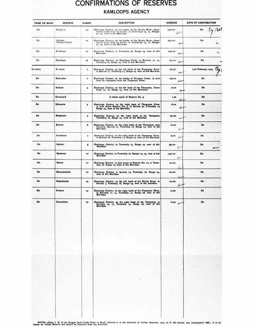
TRIBE OR BAND
RESERVE
OWa16Sa
DESCRIPTION
ACREAGE
DATE OF CONFIRMATION
Do Noorsitch to KmIloop• District, on the banks of the Nicola River. shout twenty ends, from its mouth. in Townships te, 13, Ranges sa, 33, west of 6th Meridian.
0310.00
Do U./ lif.1
I,'" I i
Do Shackan is (Potato Diable)
Kamloops District, on the banks of the Nicola River. about twelve miles from its mouth, its Townships 13, 16, Ranges at ea, west of 6th Meridian.
6470.00 Do
4...""o I,
Do Soldatquo is ' Kairfelroogn.District, in Township VS, Range a3, west of 6th 1440.00 Do i C.,.--•
Do Pepsilqua • :3 Kamloops District, on Papsdqua Creek. in Sections u, 13, Township 16. Range 43, west of 6th Meridian.
73o.00 1..........., Do I I
Necomen N. omen 1 Kamloops ,ionDistrict, i7,,wonns:ihpe 13, Range al. twhees,TolTtasoliteATae.r., t51.5o nth February, rats
4.---
Do Kykinalko a Kamloops District, on the banks of Nicomen Creek, % mile from its confluence with the Thompson River.
13o.00 Do
Do Sodium 3 Kamloops District, on the left bank of the Thompson, Town- ships :5, 16, Range 15, west of 6th Meridian.
tom Do
Do Graveyard 6 chains south of R No. 3. 1.50 Do
Do Skhpowte 4 Kamlomoses bl:le sotwricliesoenmth:4orig,htinbasnettiooln Tphongswonnsepiviers:
Range 25, west of 6th Meridian.
16.00 Do
Do Klahkowit 5 KaimolwoongipDilit,rilczt,;nto.n .;.hewerf right bank ofeorfi d ahne. Thompson, 1 07.00 Do
Do Sleetsis 6 Kamloops District, on the right bank of the Thompson, near Drynock, Section ty, Township 16, Range as, west of 6th Meridian.
$4.00 Do
C.--
Do Shoskhost y Kamloops in ietioDn District, on right Range a3.
.osf. wthees,TchiciT, gailertitviaenr, rpm, Do
Do Skeikut g Kagelm.n.Dietrict, in Township as, Range se, west of 6th 390.00 Do
Do Squianny so opeDistrict, in Township t6, R eeeee 14, as, west of 6th Kalo Meridian.
13,0.00 Do
Do Enhalt is Kamloops District, ti mile south of Rewires No. so, in Town- ship 16, Range a3, west of 6th Meridian.
eau.. Do
Do Skaynaneldist as Kamloops District, in Section 25, Township 16, Range ea, west of 6th Meridian.
400.00 Do
l
Do Neykikoulth 13 Kamloops District on the left bank of the Nicola River, in Section 7, Township t6, Range 23, west of 6th meridian.
ess.00 Do
Do Putkwa to Kamloops District, on the right bank of the Thompson River, in Section. Is, 14, Township 15, Range 36, west of 6th
Meridian.
to.50 Do
Do Sluouchten :5
Kamloops District, on the right bank of the Thompson, in
Sections 13, ts, Township ty, Range .6, west of 6th Meridian.
imso Du
NOTE:—Nepa I. R. of the Oregon Jack Creek Tribe or Band, referred to in the Schedule of Indian Reserves, 1913, at P. 611 thereof, was relinquished allS6; It is mo longer an Indian Reserve and should be removed from the Schedule.
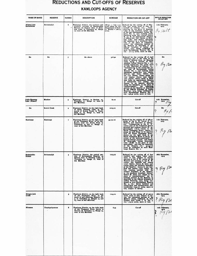
REDUCTIONS AND CUT-OFFS OF RESERVES
KAMLOOPS AGENCY
TRIBE OR BAND RESERVE let.1111111 DESCRIPTION ACREAGE REDUCTION OR CUT-OFF PATO Or 11110intION ON CUT 0/1
Adams Lake Sahh•Itkurn
Swittemalph 6
•
Kamloops District. the northern and southern portions of Switsemalph R on Salmon Arm of Shoe- mon Ulm In Township so, Range to, west of 6th Meridian.
766.17 — lem a re acre. taken by the Department of Pub- lir Works — 7611.11 *MN.
Reduced by the tutilne off of filly. five (30 , more or less,. dm embed as follow., Mot "Com- menctne on the shore of Elltuswep 7.313• et the northern corner post of the said Switwmalph Indian Re- serve No. 6, and running south therefrom sissy (6o)chaine;. thence N. 33, E. an approximate distance of twenty•five (ss) <halm to Shia- way Lae, and thence, following the lakeshore in a northerly direc- tion, to the place of commence- ment" the remaining ponion of the R as described In the Official Schedule of Indian Re- serves, soy Wing confirmed •• such Ilwitsemalph Reserve No. 6. vie.: Imes acres, more or lam
1111111 February, We
g
/JO ilf A lr 4, .• •
Olg. , ,
De Do 7 As above 311.90 Reduced by the cutting off of land adjoining and to the west of the town of Salmon Arm, oe Shumesp Lake, being a portion of Sint- einnalph Indian Reserve No. y. con-taining eghty-two (Sa) acres. more or less, described se follows, vie.:
Commencing at the north-eest cor- ner post of Switsemalph Indian R No. 7, and running !south therefrom twenty-five (es) chains, fifty-Ms (16) links; Owner/ west ten (to) chains; thence south ten (to) chains; thence west twenty (so) chains; thence north to Shun- way Lake, an •pproximate distance of twenty-two (se) chains; snd thence, in an easterly direction along the lakeshore, to the place of commencement," the remaining portion of the Reserve me described In the Official Schedule of Indian Res eeeee , tits, being confirmed a such Switsentalph Reserve No. y. via.: .36.90 acres, more or less.
Do
I? (3..,
Little Slummy Loh (Kneen)
Meadow s Kamloom • District, in Section 53, Township 33, Range ts, west of 6th Meridian.
6o.oe Cut-off myth November. 7 cps
•
Do Scotch Creek 4 Kamloops District, on the right bank of Oreat Shuhrap Lake, at the mouth of Scotch Creek, in Town. ships se, 13, Range 1 1, west of 6th Meridian.
stos.00 Cut-off Do
9 ri,/
Kamloops Kamloops e Kamloops District, on the right bank of the Thompson River, at its con. novice with the North Fork in Townships so and se, Range ey, west of 6th Meridian.
33.131.00 Reduced by the cutting off of sliouo wee, at the S. W. corner of the Reserve and described as follows, vie.: "Commencing at the N. W corner post of the Industrial School grounds and running thence W. lip- proximately .16.0o chains to the North Thompson River; thence S. along the awl River to its junction with the South Thompson River; thence up the right bank of the South Thompson River to the S. W. corner of the before-mentioned In- dustrial School ground;
end thence
N. forty-eight chain. sits eight hole (0.61) to the place off com- mencement; and that the remainder of the Reserve, via.: 30431.00 acres be confirmed m such Kam- loops R No. I.
nth February, ens
c)
Neskainlith- Habitue
Switsemalph 3 Kamloops District, the central pore non of Switsemalph Reserve, on Salmon Ann of Shuswap Lake, in Township 30, Range lo, west of 6th Meridian.
1971.77 Reduced by the cutting off of four hundred and eight (do) acres. more or less, subject to survey, starting at the S. . corner of the Reserve and running to the N. W. corner, one hundred and twenty (to) chains; thence IL forty Sso) chains along the northern boun ary of the Reserve; thence S. one hun- dred and twenty (too) chains, the line running parallel with the western boundary of the Referee, to the southern boundary thereof; thence W. forty (40) chains to the place of commencement " the re- maining portion of the Reserve, se described in the Official Schedule of Indian R , a913, being con- firmed as such Switsemalph Reecho No. 3, via.: Seven hundred and ninety-three and seventy. One- hundredths (793.77) acres, more or less, subject to survey.
math November, 1913
9 fay PP'
. /
Oregon Jack Creek
s Kamloops Distri.t, on the right bank of the Thompson River, to the south of and adjoining Reserve No. 3, in Township tg, Ranges se and 03, west of 6th Meridian.
1043.00 Reduced by the cutting off of 330.00 acres, more or less, subject to sus- thy, the remaining portion of the R being confirmed se such Oregon Jack Creek I. R. No. 3, via.: 713.00 acres, more or less
.6th November, 1913
, / V ...77
,.,1C
( Niconsen Unpukpulquatum 6 Kamloops District, on the right bank
of the Thompson River, partly in Section 111, Township Is, Range 83, wen of 6th Meridian.
6.33 Cut-off tath February,
1" I ,f t_ y /3,t.

NEW RESERVES KAMLOOPS AGENCY
or IP111100 /MIN OR NAND RER/RVE MYOSIN DESCRIPTION ACREAGE DATE Of MINUTE 01' DECISION
I anti North no ..e 7 a I to"
PowItter Crab
..
i
/I
.
A i n Imi t or pont' of land ilestribed as follows, •im 1 Commenting at s point north of boulder Crook, North Thompson River, the N. IL corner of the Canadian Northern Railway Company'. Timber Lot No Is, and running then. N. eighty (6o) chain.: thence W. eighty (So) chain.; thence S. eighty (So) chain.; and then. I. eighty (b) theme, to the piace of commencement," containing an ern of nil hundred anti forty (140.00) more or lees, eubJect to survey.
.
Ste oo .4th February, spa
so ria Mower° Oboe NW Ilan4
14
vei
A In or parcel of land deectlbod as follows, via: "Casnmencing at the S. W. corner of I. R No. s (Shoter or Zobt R ), being Lot No. 716 am .hewn onpfan; thence wort to the eastern boundary of Lot 3366• thence, follOwing the eastern and northern nd ' Lot No. 33662twohe eastern boundary of . No. lolls; thence north to thiliV corner of P. o. sass: thence to the S. E. corner a . R. No. I thence north to the N. E. corner of P. R. Thy '37 t enc. east to • point directly north of the north* miler of mid I. R. No. s: thence emith to the N. FE met of the said I. R. No. 5; and thence vent and s to the place of commencement, containin•n are• nine hundred (boa) acre.. more or leak sub get to deduction therefrom of those portion. of Lots Nos. a, on, and 674 (containing in ape aggregate of such I ions of the said lots an arta of 63 es, more or les ailing within the above described limits, toin• Mg....an area of eight hundred end thirty•esven (13 ) idea more or loss, sublets to survey.
,•••••• IP, I • i a. ..7 ,,, ,_ /Y W' co . 4 , .,/ If 4.14 (...../es,<J• .. olts., . ; Ft e', ,..4%,•:1 err.,,., V ,•4 ,..:-. .1..,,, e ..:.•e......., • (6••••• d'./.../.;...., ..,,,, ...r 4.4,, N' /Y. V. iv est...e, ,..‘ 4,, - 2/6 . . fi..,e, E, leell......
. . .4,0,,./ hi, p: /of *sr ri.4..i •Y .•'• f,( 41' I-, V. 1- ,, .•?.,41 , //.., re r,•,..,..—_,
, ( • ey, of,. , , , . , , ,, , ac.,,,, /.. 7
1 , ,... 44 „or, ,, r 11.1.,
ANA&
.../ i o
Do
•
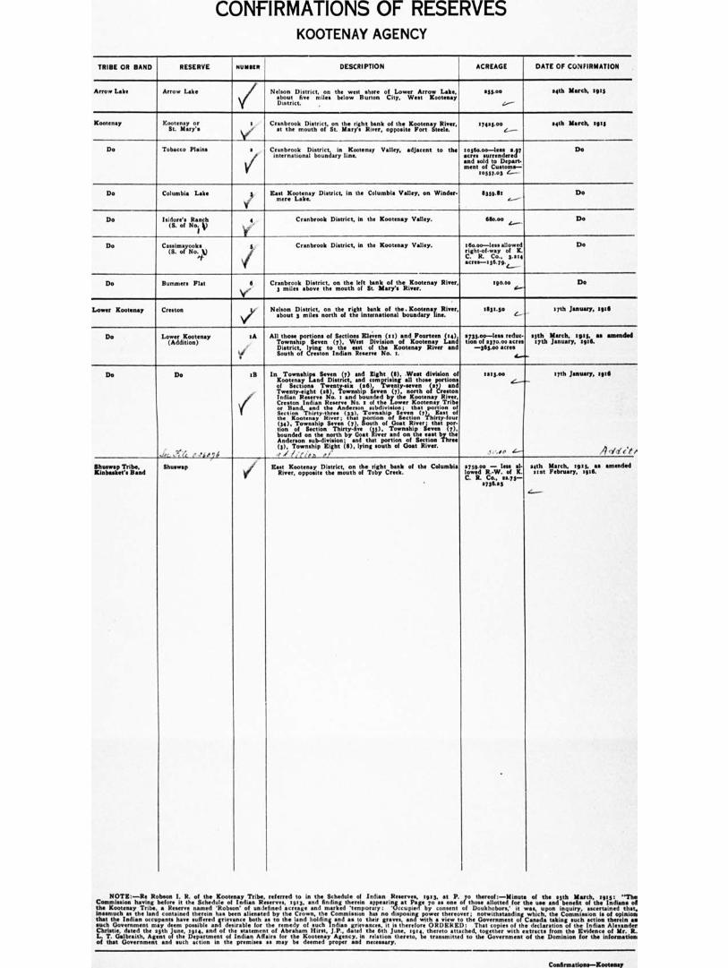
CONFIRMATIONS OF RESERVES KOOTENAY AGENCY
TRIBE OR BAND . RESERVE 036110 DESCRIPTION ACREAGE DATE OF CONFIRMATION
Arrow Lake Arrow Lake
Nelson District, on the west shoreof Lower Arrow Lake,
about five miles below Burton City, Went Kootenay District.
255.00
.....--
14th March, 2915
Kootenay
— --
Kootenay Cranbrook District, on the right bank of the Kootenay River, at the mouth of St. Mary's River, opposite Fort Steele.
5745300 C —
tech March, 5915
Do Tobacco Plains I 17,
Cranbrook Di tract, line Valley, adjacent to the
international boundary to56o.00—lese •.97 Do acre. surrendered and sold to Depart-ment of Custom.--
10557•03 c_-
Do Columbia Lake Kant Kootenay District, in the Columbia Valley, on Winder- mere Lake.
11359.67 Do 4.--
Do loidore's Ranch (S. of No. V
4 Cranbrook District. In the Kootenay Valley. 610.00 Do 4...—
Do Cassimayooks (S. of No. t)
4 S Cranbrook District, in the Kootenay Valley. ellio.00—less allowed Do
right-of-way of K. C. R. Co.. 3.214 mres--156.79.4_
Do Bummers Flat 6 Cranbrook District, on the left bank of the Kootenay River, 3 miles above the mouth of St. Mary's River.
190.00 Do I.—
Lower Kootenay Creston g, Nelson District, on the right bank of the. Kootenay River, about 3 miles north of the international boundary line.
1131.50 January, 5916 , 17th J
Do Lower Kootenay (Addition)
.A
'S
All those portions of Sections Eleven (11) and Fourteen (14), Township Seven (7), West Division of Kootenay Land District, lying to the east of the Kootenay River and South of Creston Indian Reserve No. I.
2735.00—lens reduc- .5th March. 1915, •O •MtfIffell tion of 0370.00 acres 17th January, 7916.
—345410 acres
Do Do 1B In Townships Seven (7) and Eight DO, West division of Kootenay Land District, and comprising all those portion. of Sections Twenty-six (26), Twenty-seven (27) and Twenty-eight (26), Township Seven (7), north of Creston Indian R No. t and bounded by the Kootenay River, Creston Indian R No. I of she Lower Kootenay Tribe or Band, end the Anderson subdivision; that portion of Section Thirty-three (33). Township Seven 17,1 East of the Kootenay Nicer ; that portion of Section Thirty.four (ee), Township Seven (7), South of Goat River; that por- tion of Section Thirty-five (35), Township Seven (7), bounded on the north by Goat River and on the east by the Anderson sub-division; and that portion of Section Three (3). Township Eight (6), lying south of Goat River.
1215.mi 17th January, :916 (_---__
itr" Tarirind Shuswap East Kootenay District, on the right bank of the Columbia River, opposite the mouth of Toby Creek.
2759.00 — less al- 24th March, 1915, an amended lowed R.-W. of K. 213f February, 1916. C. R. Co., m.75--
2736.23
NOTE:—Re Robson I. R. of the Kootenay Tribe, referred to in the Schedule of Indian R , 1953, at P. 7o thereof:—Minnie of the 25th March, 1915: '"The Commission having before it the Schedule of Indian Reserves, 19r3, end finding therein appearing at Page 7o as one of' those allotted for the use and benefit of the Indiana of the Kootenay Tribe, a Reserve named 'Robson' of on lefined metes< and marked 'temporary : 'Occupied by consent of Doukhobors,' wm, upon inquiry. aseertrned that. inasmuch as the land contained therein has been alienated by the Crown, the Commission has no disposing power thereover; notwithstanding which, the Commission is of opinion that the Indian occupants have suffered grievance both as to the land holding and as to their graves, and with a •iew to the Government of Canada taking such action therein as such Government may deem possible and desirable for the remedy of such Indian grievances, in therefore ORDERED: That copies of the declaration of the Indian Alexander Chrintie, dated the 25th June, 1914, and of the statement of Abr•hun Hirst, J.P., dated the 6th June, 1914, thereto attached, together with entracte from the Evidence of Mr. R. L. T. Galbr•ith, Agent of the Department of Indian Affair. for the Kootenay Agency, in relation thereto, be transmitted to the Government of the Dominion for the information of that Government soil such action in the premise• as may be deemed proper and necessary.
Confirmations—Kootenay
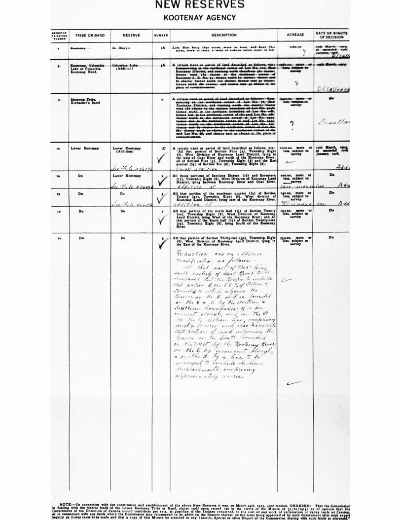
NEW RESERVES KOOTENAY AGENCY
•
ea,ceno• 1 TRIBE OR BAND RESERVE N1111111111 DESCRIPTION ACREAGE Ss t
'...:* II it",...e;OS
. Rememmy
Lt..
at. Meeti• SA 1,,,s Mee ace 41lee see., nista •Oe ...MP ess4 Mow My. mow.
......, www .. sew., • ...al we ........ wwww. www• .... ion • ntm vim... vmse sw tesseeteie es. el.*, • eget
' ' • As/A
9 SA. pi, eAllebit II,,teney Pant
( Atililion I A dewswwwo A .....4. 44..... ...... sel lama toesesaset we wow mem do.
-low oflog000lbo opooAlhoodo.....
Lee inew no., 4......•wwww.a se. Me. ••••■••••• mimes we
.
', 4110•• _OA
' Kinstemy 11wieme, esod mamma mean noweassem $6 memos, i mom. Men. ma, OM abeam we OA esonseeesie moms 44,
i leeawwey 1. IL I,.... lise tesedia MIA ip, -Um.* *AMA AAA*, Awe*, tweak Ile •ne00111, IhenOe owolo see Atte* Age n
then. week ill. onsmst aM Alessee teat ots *Yens ea At pie. 01 64.41MINIMeeeNebe
p iiemem leak.. ; Kiebeakee• Band
.
e
A states. egtOotee- AMA.- -40 111A wermisowwwin
enlients
f 1 .
smosso• m - U. -111.61141.0114--60M10 we -1,ww-also.--yeir-flossi Kawisuas Lasausaa.- AA itisaastss emote the-ebeselsee-Ommit weal ago etsesee-.6.-ste-teteesse- thews. amen to M.• .ramYa.a- bousuloses-roll-ims. 111.-MS, 1140044 AM are MoomeisaMomms MobiwomiLlos-afew-olla 0144.11•-•01111.10-4H4110-.00eie.011#-Ole••■•••46--4.11.-.641.-vippi.
Memo Mmes.
-. L.- Bo. Menne som-1*--ohno•-oo-41 Mt e mid-Leo-Mm41,-owel-olmatmemowe a_placo.of Aelleasessemeal.
to I Lower Kootenay Lower Kootenay IC (Addition)
V
,sd i `- ( ,,IL2, 4
Lower Kootenay a ,
4 .. v
'1 r t., 47 ...L474
A certain tract or parcel of land described as follows. via, ''All that portion of Section POW (4). Townshp fight
te) ' w We 2 t"Cit of Division
i°River o •Kootenay
nri n O „h LoIntlIe DXsotorrenay!ygor
all of Section Fins (t). Township Eight (II? and the lest quarter (Ye) of Section Six (S), Township light (0).
‘•:.,,,,)" . ,4 ' ,,,h
I 'save, Mt we rp±.....= n . lees. IMArseet III IA
=rem jeaserery. tprel
. ,
I -. .1 -. ,
to Do All those portions of Sections SI•teen 01) and Seventeen
sii.),;,.1',77;Inhgi° twhet..( 61k*/..e.l.t.13, Division osf .1°°001:1R1-aivtnr4
1.1/1,'L.,..n i' '
too.. more or
Less. s7rsbrei7"o
.f....• , •.. ,
Do
s..v.' _-) my
Do
-
Is Do Do 8
Vi yid' t r G e " .4:4 _
All that portion of the southeast quarter Oa I of Section
Twenty (co), Township Eight (I), West division of Koonay Land District. lying east of the Kootenay River. te
• .
230.00. more or less, subject to "-- survey
• . ..
to DO Do 4 ...
Y'
All that _portion of the north half (%) of Section Twenty (so), Township Kignt (8). West Division of Kootenay Land District, lying Weal of the Kootenay River; and all that portion of the South half (Si) of Section Twenty-nine
kit), Township Eight (6), lying South of the Kootenay River.
188.00. more or Itee, subject to
survey
Do
to Do Do 8 .
. V
All that portion of Section Thirty-two
of the Kootenay River.
(gal, Township Eight (8), West Division of Kootenay Land District, lying to the East
(t du c t is )ti oh., •0 s, ,, ,...;/,,,,,,,
/)'s Iseq,, 0.4 4 g‘ii ..in ittl7te46/...• -
1 ,', ewe. r - .4,, 1 - ../ '91... 6 - 4%, , wt • et, • ( l. r ..., 4 44 i .424.4. 1.--..t.'• t fi• 6l
' " - ^ ,'4,.." ,1 4,/ 74,. ,f1,ill.c. 4 i;,e('''4"
(awl • A,Pfis« ei ,4c J76- 1,V 1 6 "" ' ...1-, , , .., 46 6, , . 'I; „ AI .1 0 1 te ...1, Z."
. /y 4; 1 • ) IK, ..pi,' rA e 1,. ........., At /4....1.-.41, n. ' to E o V. !x .4(4. Ai( JiTio , w-
.4-611-41...,. /:.I. ,,,,41,:er...• li ., * ' ,. • ,,,,,(_41.,,, ,,, A ,,,,,t ,..... 'et SA/
.. / e A:. '4. .. Gass.. 4 ;‘,c ,,..,..A Ise,' .y
•" '
' Ile- l'e o e )I. o • a ...17 ,1614, 4.4 ; ,, 4,', 4
, 4. ,:( 5,.1 4 e s,, 0 7,,,,... el "tin.. 1,•.., ....r/ , . ,
"" 1 ,.e. el, ' /Z. lieu. I't '.-Itt• 1, ,e, ,..4
rte . 4 ' 4. t ........, t ...11,,,, sis ./,
* t` , • • ti‘
..., f 1 ,-,ye,1 7:7 •, r- (<7,..-It ta;,44.....„. '"' 1., Iri. e ........4.17 , • .., 414,..;..
1 , II 1.., , /.? 1 et < a., ....{ A '.. Si. i ■ or ui.. x .
388.0o, more or
less, subject to le survey
Do
NOTE:—In connection with the constitution and establishment of the above New N Willi, on March .4th, easy, upon motion, ORDERED: This the Commission in dealing with the Ian& of the Lower Kootenay Tribe or Rand, plates itself upon record (as in the terms of the Minute of 3r/to/tare) as of opinion that the Government of the Dominion of Canada should contribute pro rata, as guardian of the Indians concerned, to the cost of any work of reclamation of valley lands at Creston, or in connection with any lands which the Commission may recommend to be added to the Reserve th , on the same being approved of by such Government •fter such expert inquiry as it may muse to be made and that a copy of this Minute be tinselled to any Interim. Special or other Report of the Commission dealing with such lands as aformand."
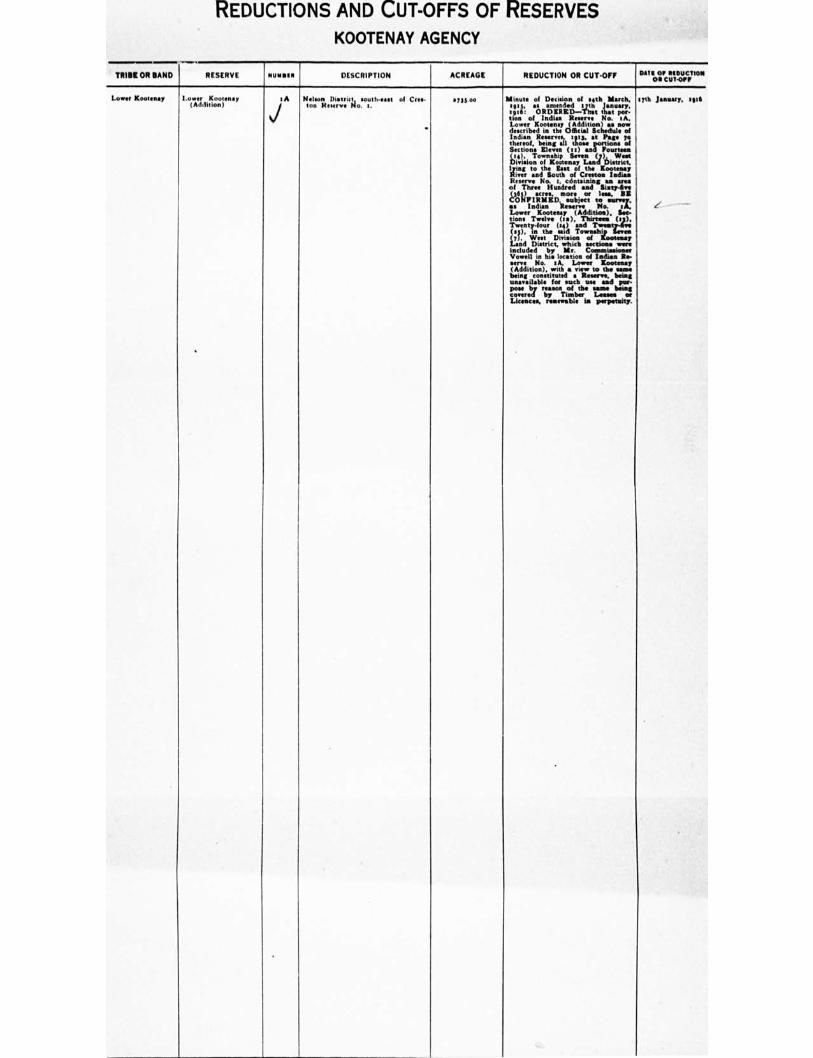
REDUCTIONS AND CUT-OFFS OF RESERVES
KOOTENAY AGENCY
TRIBE OR BAND RESERVE 1 I NU11•lIl DESCRIPTION ACREAGE REDUCTION OR CUT•OFF our OI RIRUCTION OR CUTOPR
Lower Kootenay I own Kooten•y (Addition)
iA
%./
Nelson Ili.trit. ,t sooth•east of CM. toe lecierve No. I.
•
MS.. Minute of Ossetian of silk March, eggs, as intended 17th January, sg:6: ORDERED—Tlent that you Con of Indian Reserve No. tA. Lower K. ..... (Addition) an now deecribed in the Official Schedule of Indian Reserves, Intp. at Pans ye thereof, being all thoes portions of Sections Elena (te) end Fourteen (ti). Township Seven (7), Ween Division of Kootenay Land District.
lityn:r taondhBororiCtresh.toalt= Resent No. t, contemns( as area of Three Hundred and Sisty-live
PINPIRUID,wsoulljec7 21Ww.1.51; se Indian Reserve lino eft, Lower Kootenay (Addition), Sow Cone Twelve (is), Thineee tat.); Twenty-four (1() and Twee (1g), in the eatd Toltrashz...1
tat, Wont Danes. of
Land District• which sections were included by Mr. Comaiseioner Vowel in his location of Indian Re. serve No. ,A, Lower /Comma, (Addition), with a view to the ma e being constituted a Reaeres being unavailable for such use and pee- p.* by ream. of the nine Meng Covered by Timber Lenses se Licences. renewable is Perneetniel.
syth January, sill
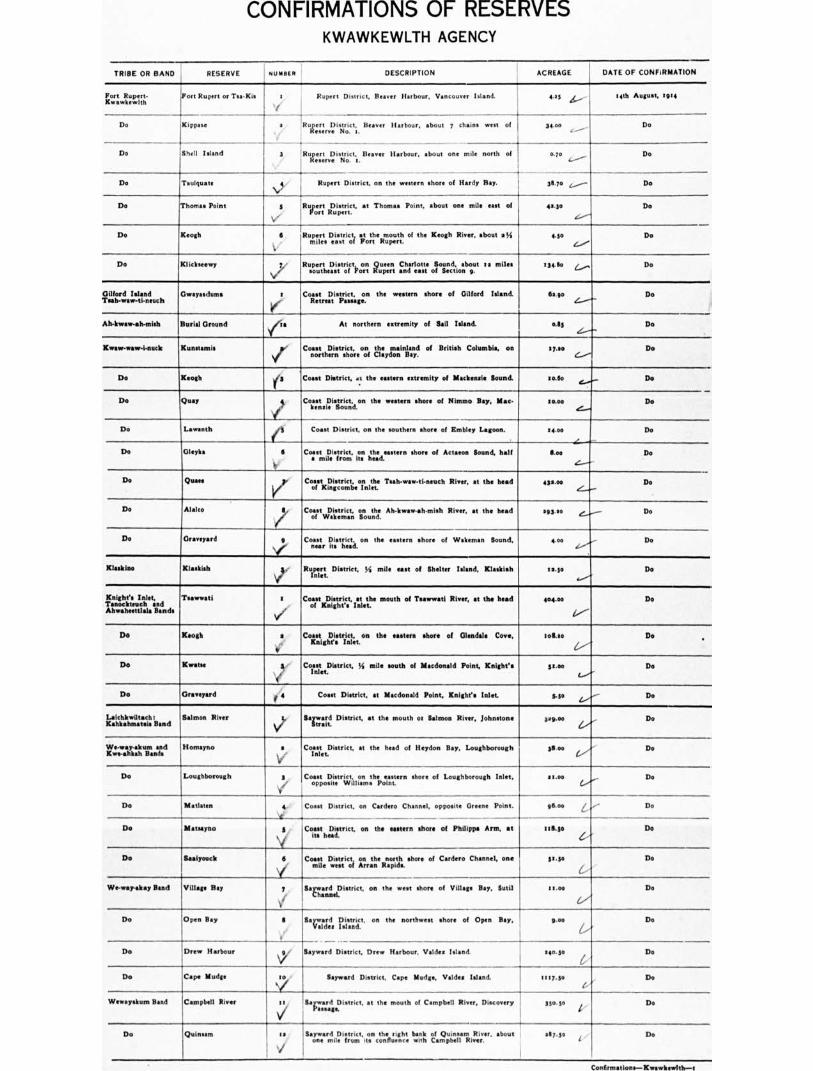
CONFIRMATIONS OF RESERVES KWAWKEWLTH AGENCY
TRIBE OR BAND
RESERVE
NUMBER
DESCRIPTION
ACREAGE
DATE OF CONFIRMATION
Fort Rupert-KwawkewIth
Fort Rupert or Tsa•Kis I Rupert Distr is t, Beaver Harbour. Vancouver Island. • t5 4.,,,..... 1 telh August, 5 9.4
Do Do Kippase a Iluitiesretr,I:is iroicti. Beaver Harbour, about 7 chains west of 34.00 „,........,_
Do Shell Island 3 RuLegnD.isgoict...B Harbour, about one mile north of aio 3.-----
Do
Do Teulquate
Ni."/
Rupert District, on the western shore of Hardy Bay. 31.70 z........- Do
Do Thomas Point at Thomas Point, about one mile met of Ryer: Rupert.
4..30
4..---'
Do
Do Keogh S Rupert District Dei.s.tlic.ti vortItteumuop.1 of the Keogh River, about a% 4.10 (...../
Do
Do Klideeewy y
\i/
Ruzeurt,h,D.,ilittroiri,00,7 5fuupt.er, and asst ofilend.ioanbogut 5 • miles t 34. 110 (...„.., Do
Gifford Island Tsah-waw-ti-neuch
Gwayasdums t Coast District, on the western shore of Gilford Island. Retreat P .
64.90 (----v-'
Do
Ab.kwaw-ah-mish Burial Ground At northern extremity of Sail Island. 0.13 .C...---'
Do
Kwaw-waw-i.nuck Kunstami• o'
V
Coast District, on the mainland of British Columbia, on northern shore of Claydon Bay. e-...,"-
17.10 Do
Do Keogh tig Coast District, ,,,t the eastern eatremity of Mackensie Sound. 50.60 Do
Do Quay $
4‘
Co:eent.ilpsiiroiucnt,d.on the western shore of Nimmo Bay, Mac- 10.00 Do
Do Lavranth en Coast District, on the southern shore of Embley Lagoon. t 1.0o
-.L.-
Do
Do Gleyka 6 Coast District, on the eastern shore of Actaeon Sound, half a mile from its head.
too Do
Do Quasi
II/1
r. Coast District, on the Tsah-waw-ti-neuch River, et the head of Kingcombe Inlet,
431.00 Do
Do Alalco ley
p
Y
Coast District, the Ah-kwawoh.mish River, at the head 193.20 Do
Do Graveyard Coast District, on the eastern shore of Wakeman Sound, near ite head.
4.00 d.. ..."
Do
Klaskioo Klaalsials ;, Rupert District, !.mile east of Shelter Island, Klaskish 311.10 Do
Knight's Inlet, Tenor kteuch and Ahwaheettlala Bands
Tsawwati I Coast District, at the mouth of Tsawwati River, at the head of Knight's Inlet.
404.00 Do
Do Keogh s Coast District, on the eastern shore of Glendale Cove, Knight's Inlet.
505.10 Do •
Do Klemm 3 Coast District, Si mile south of Macdonald Point, Knight's Inlet.
stoo Do
Do G d f 4 Coast District, at Macdonald Point. Knight's Inlet. 540 Do
Leichkwiltach: Kahlt•hm•teis Band
Salmon River y,, flar,•.r.d District, at the mouth at Salmon River, Johnstone 44 9.00 Do
We-way.akum and Kwe-ahkah Bands
Homayno s Coast District, at the heed of Heydon Bay, Loughborough Inlet.
35.00 Do
Do Loughborough g Coast District, on the eastern shore of Loughborough Inlet, opposite Williams Point.
meet Do
Do II o dates a Coast District, on Cudeto Channel, opposite 0 Point.
-4.--
Illos L Do
Do bletsayno 3
\i
Coast District, on the eastern shoot of Philippa Arm, at its head
tfitta Do
Do Saaiyouck 5
Vmile
7
Coast District. on the north shore of Cardero Channel, one west of Arran Rapids.
SamanrcfneiDistrict, on the west shore of Village Bay, kW
3E0
11.00
Do
Do We-wry-stay Band Village Bay
Do Open Bay S Bac= 11):1eatnIt, on the northwest shore of Open Bay, p.00 D.
Do Drew Harbour \,to, Upward District, Drew Harbour, Valdes Island. 0411.5* Do
Do Cape Mudge Nty Sayward District, Cape Mudge, Valdes Island. 1157.ge De
Wewayskom Band Campbell River ‘t,i Sarard:istrict, at the mouth of Campbell River, Discovery 330.50 De
Do Quinsam :i ,
V
v Sameard District, on the right bank of Quinsam River, about one mile from its confluence with Campbell River.
a57.30 De
Centirmallems—IKwawkewitlm-11
CONFIRMATIONS OF RESERVES KWAWKEWLTH AGENCY
TRIMS OR NAND RESERVE
NUMMI*
DESCRIPTION
ACREAGE
DATE OF CONFIRMATION
MakteMtkpe Etitekin 3 Coast District, on the eastern shore of Havanna/1 Channel, east of the northern end of Hull Island, also there small islands.
31.50 Do
-I-
sg.00 Do Do Esectkiltuta or Port Harvey
-I-
s Coast District, on the eastern shore of Port Harvey, Cracroft Island, opposite the southern end of Mist Island.
Do Haylahte ii Rufterratti District, at the mouth of Adams River, Johnstone 47.0 Do
Do Part Neville or Harkhom
4 'Coast District, on the northern shore of Port Neville, at its t head.
36.7o Do
Illakkuuku Kequeeta a Coast District, on the northern shore of Seymour Inlet, so miles from its mouth.
174.00 Do
De Graveyard a ./
V Reserve Coast District, 3 rocks In Nugent Sound, M mile south of
No. 1. 0.16 Do
Do Pakaa
Coast District, on the northern shore of Blunders Harboor, Queen Charlotte Sound. Includes Byrnes Island.
95.30 f :l7l it August, as amended
Do Mahpahkum 4 .•
', '
Coast District at the northern 00000 mit, of Deserters Island, Queen Charlotte Sound. Includes three small Islands.
tg.00 5th August, 1914
Do Tss-ack g /
V Charlotte Coast District, one of the Storm Oroup of Islands, Quests
Sound. 114.00 1/.1t7th Arzn,214, as asoutdod
De leagoombehlsh
•
Coast District, tseeternstre oStorr Laeme rrinettile;ofmilteip. Includes
one Wand.
4.5o Do
Do Burial Oround 7
V'
Coast District, an island in the centre of Nahkwockto Rapids, Seymour Inlet.
aol Do
Do Do S Coast District, on the northern shore of Seymour Inlet, el mile north of Nahlswockto Rapids.
0.46 Do
Do litwetahltis Coast District, at the head of Nenahlnsal Lagoon, Seymour Inlet.
tone et.....- Do
Do Owh-wiwtoo-a-wan ea .,
e"..
Coast District, at the mouth of Frederick Sound, Seymour Inlet, on its southern shore.
u.so Do
Do Pincers tt Coast District, at the head of Wigwam Bay, Seymour Inlet. 8.6o Do
Do Wawevat'l Is River, Cogyt.Douisrtricntioo. n.bteh.et r.i4htmliresnkfroomf V. mouth.
163.00 Do
Do Teal-kwlu 33 ..
Ve
Coawsotrd%istgccut,ndon the northern shore of Village Bay, Mere' 111.10 Do
Do Nokwi-iss 34 Coast District, on the eastern shore of Alison Sound, near its mouth.
sg.to Do
Do Rekowkwin tg Coast District, on the northern shore of Alison Sound, 3 miles north of Relent No. 34.
31.30 Do
Do Women VI •
‘4!
Coast District, at the bead of Alison Sound. ge.So De
Do Pel-loothl-kal tyr Coast District, at the bud of Belies Inlet. 4.05 Do
Nahwittl Hope Island 3 Rupert District, Queen Charlotte Sound. 11352.00-1•11 refine. Litrireoorf 317414 rut
Har- leg on Bull XI: bour, as per sketch
tia.114ST.1717 August 17th, las 5. 1514.14 scree, more
or lees.
stet February, sue
Do Munch Rupert District, Sea Otter Cove, Vancouver Island. Soo 14th August, 1514
Do Ouchton V, y Rupert District, at Cape Scott, V Island 111.00 Do
Do PilabwIttl Vj, sy!
Rupert District, at Cape Camera Vancouver Island. scot) ,
14th August, tits, u weeded 9th Juno *W.
Do Olen•glarouch ) Ruclartn.DeLstrict, at southern end of Balaklave Island, Goleta, 1 4-00 141h August, 11 94
Nienkeesh Alert Bay V
Rupert District, Alert Bay, Cormorant Island. 46.35 Do
Do Burial Oround Rupert District, Alert Bay, 30 chains south of Reserve No. I. :.$7 Do
Do Chest-la-tee 3, Rulte,re,District, at the mouth of Nimbeesh River, Broughton 3os.87 Do
Do Ar.ce.stree 4 Rinr.t.lpolcittli on the bank of the Nimkeesh River, .14 41.30 Do
Do 0.1savr.l. 5 , ,/
Rupert District, on the right bank of the Nimkeesh River, 1t mile from the outlet of Karrnutsen Lake.
541$ De
Quatslno Quattishe ‘t#7 Rupuelt,..Distrift, near Turn Point,at lthe, southern end. of
I ?sland"WatrwroowssjItle17. Sound;
• " includes Quattishe
stews De
ConfirmatIons—RwswkowItle—s

CONFIRMATIONS OF RESERVES KWAWKEWLTH AGENCY
TRIBE OR BAND RESERVE nu MOE e DESCRIPTION ACREAGE DATE OF CONFIRMATION
Do 1 Toh•quo-eugh 3
V
3
Rulooeurnt dDistrict, two small inlets in the west arm of Quatsino
i
1 1.10 Do
Do Pa-cat'l-tin-ne
Vmiles
: Rupert District, on the west arm of Quatsino Sound. two from its head,
goo l.--"'
Do
Do Kultah , 4
V
RucliDnoistgeat,,,roawts. James Point, on the shore of 41.00 Do
Do Cayilth
Coyne'
q'
Ruarnt dDistrict. at the head of the southeast arm of Quatsino
Ruo.ert District. on the western shore of the southeast arm of twain., Sound. west of the northern ern extremity of
Long
gland.
55.50 Do
goo Do Do
Do Teets 7
I(
Rupert District, on the western shore of the southe•st arm of Qu•tsino Sound, one mile southwest of Dog Island. Includes four small islets.
ii.50 Do
Do Mah•te..nicht if'6 Rupert District, in ICoskeemo Bay, Quatsino Sound. Woo Do
Do Clain ii g
i
I _..... r Island.
Rupert District, on the, eastern shore, of Koprino Harbour, .1111(10 Sound. Include. seven inland.; False Island, urnt Island; Cone Island: Observatory Island; Wedge
73.00 Do
Do Fishery (to RueniD.istrslocutx tihneclonger.th;or.n,nt;f.r:dos1 Koprino Harbour, 111.00 Do
Do 0-yes-kumis 1 1t
I
Ruzr,,erli,,Doistcut,,,,con the eastern shore of Forward Inlet. 1131.00 Do
Do Quatleyo ( is Ruysoerrwt .RistIrntti. on the southern shore of Browning Creek, too Do 4/
Do Grass Point /53 Ruzelgiosntri3c.t, foart.trlaysawluiinnt, within Orr=1:rtluliu:X=.
to Do
Do Vienna y/ to Ruopeprotrtroinstroneocrttiotnhesonorthern shore of Winter Harbour, 5o.00 Do
Do Orsveyard 1/ ss Rupee DiMictkinmont.enrd.Harbour, ten chain. south of zoo Do
Do A h.we-cha-ol-to e 16 Rupert District,
at the head of Winter Harbour, on its southern shore.
74 00 Do
Quawshelah Wyclese t Coast District, on the .outhern shore of Smith's Sound, shout ao miles from its mouth, and on the left bank of the Ssmmo River: also includes Rye Islands.
57t.00 Do
-..--
Do Nekite Coast District,
on the right bank of the Nekite River, at the head of Smith's Sound.
165.00 Do
1.----
Turner Wand Karlukwees , I
f Beware Coast District, on the southern shore of Turner Island,
Passage. 26.75 Do
C.- -
Village Inland or Mahmalilliki.11ah
Mahmalillikullah a Coast District, on the western store of Village Island, Elliott Passage also includes three islands.
434.05 Do
(
Do Mettop is Coast District. at the head of Viner Sound. IS.73 Do
Jam_
11.16 Do
/ .
Do Ahta /3 CoirotndDiLtt.inck at the mouth of Ahta River, at the head of
Do Xakweiten 0 Coast District, at the mouth of Kakweken River, at the head of Thompson Sound.
too°
'
Do
Do Dead Point 3 Coast Diarist, at Dead Point, Harbledown Island. $7.00 4.....r- Do
REDUCTIONS AND CUT-OFFS OF RESERVES
KWAWKEWLTH AGENCY
TRIBE OR BAND RESERVE NUBBIN DESCRIPTION ACREAGE REDUCTION OR CUTOFF Dail on REDUCTION On CUT-Oer
Klaekino Telaise s Rupert Diet riot, a I; miles north of Klee:lino Inlet, te mile northeast of al•y Day Island.
48,00 Cut-off
Cut oR
14th August, toes
Do
3111t Febrility, eve
Do Tao...macho a Rupert District, 54 mile east of Anchorage Island, KlaellIno Inlet.
ado.
Plahwitti Hops Island 1 Rupert District, Queen e e n C h a r I otte a. ggss.00 Reduced by the cutting off of thirty. seven and eighty-elie.one hundredth• 07.gal •cres, more
or less, sub-
ject to survey, on Bull Harbour, as per sketch plan of Ashdown H. Clr“n, D.C.L.S., dated August 17th, tots, filed with the Government of Canada and the Government of Brit• ish Columbia, the rem•ining portion of the R as described in the Official Schedule of Indian Reserves, sots, being confirmed as such Hope Island R No. s, via.: Right thousand fine hundred end four- teen and fourteen-one hundredths (eiStatis) sores, more or less.
NEW RESERVES KWAWKEWLTH AGENCY
1.11111GTS, 'LIGATION
NUMMI. TRIBE OR BAND RESERVE /1111111111
t DESCRIPTION ACREAGE DATE OF MINUTE
OF DECISION
to 2uo.aitti.no. Tarainbed, Maquarneecht Island s 7 IA aqu•sneecht Island, subject to survey and to any rights
under the "Mineral Act" which may have been acquired orlon to constitution of said Island as a Reserve.
tom s 5th February, ro t
30 Nahseitti W.Items
Nathlegalis
6 3
On the eastern shore of Nigei Island, Rupert Land District, N.
‘(°5').
nee of S. T. L. No. 9.67. and running W. therefrom twenty (so) chains; thence north to the se•coast, •nd thence following the seashore in • southeasterly direction to the
tra,c,en.olBsenn.Lrnrcserbeiencti atos•
vurrytkyetarnhd pLananoyf Ar,..1;:lt.owurindtel;
follows, via
vlia.r:boCI'llinCitie al
the "Mineral Act" which may have been acquired prior to constitution of the same as a Reserve.
Inddeiasncriblieldanads.
adjacent nNt fiEve.
stoo Do
as Quasershelah small islands of the group, as per sketch plan of Ashdown H. Green, B.C.L.S., subiect to survey and to any rinhts under the "Mineral Act' which may have been ac quired prior to constitution of the same as • Reserve.
318.00 Do
as Do Toles. 4
ve/e
At the junction of the outlet of Long Lake and Wyclees Lagoon, on the left bank of the river draining Long Lake into Wyclees Lagoon and containing an Indian settlement, as per sketch plan of Ashdown 11. Green, B.C.L.S., subject to survey and to any rights under the "Mineral Act" which may have been acquired prior to constitution of the same as a Reserve.
20.00
..
Do
AO Do Halowis S On the left bank of Smokehouse Creek, about thirty-five (35) chains from the head of the N.E. arm of Long Lake, com- mencing at a spruce tree marked "Indian Reserve," and running E. therefrom five ( 5 ) chains ; thence N. ten (so) chains; thence W. to Smokehouse Creek, and thence, following the left bank of said creek, to the place of corn- mencemene, as per sketch plan of Ashdown II. Green, B.C.L.S., subject to survey and to any rights under the "Mineral Act' which may have been acquired prior to constitution of the same as a Reserve.
9.00
,......--"--
Do
17 Do Tseetsum-Sawlasilah 6 On the north shore of N•yeash Inlet, Smith Sound, approxi. Irately three ( 3 ) miles N. of Point Adelaide, commencing at • spruce tree marked "Indim Reserve" •t the mouth of a small creek, near T. L. No. 6n rat and running N. there. from six (6) chain. ; thence E. seven ( 7 ) chains; thence S. to Naysash Inlet, and thence along the shore of the said Inlet, in • westerly direction, to the place of corn.
cement, as• per sketch plan of Ashdown H. Green,
B.C.L.S.'
mbject to survey and to any rights under the "Mineral Act" which may have been acquired prior to constitution of the same a. a Reserve.
4.50
C'./
Do
29 Do Ann Island Any Island, subject to survey and to any rights under the Mineral Act" which may have been acquired prior to con. stitution of the same as a Reserve.
15.00
G..
Do
44.
../...
Nahkworkto Kuthlo
/7i
Head of Frederick Sound, as per sketch plan of Ashdown H. Green, B.C.L.S., subject to survey and to any rights under the "Mineral Act" which may have been acquired prior to constitution of the same as a Reserve.
... ,,,, q ,(, ,j , ._:if ion ?:' 1.. ' r C";;;Zrarn / t''", l,i' 'n ,,5,01,,r 3;,, 0
Do
- ---> N;* 84.,-
DI,C'1))e, WC' I)
59 Kwawkewlth Malcolm Island 8 '1.-7 " •g", f 0 ; n 'Ice .vir • , )4%4,, , NI",...•n■
Legal Subdivision. 1, I, 7, 8, 9, to, 15 and 16, Section 15 ,
and Legal Subdivisions 4, 5, ca, and s 3, Section 16, Mai.
colm Island, subject to any rights under the "Mineral Act" which may have been acquired prior to constitution of the same as • Reserve.
.ef. *9%44,, 4110.00
...rerebidest Do
.
1,
66 Village Island Compton Island Vi• rn'Ibrnt• no(P4 7 .stb•5 .. Pit 5 •• , • ,I• or
Compton Island, in its entirety, •is per sketch plan of Ash- down H. Green, B.C.L.S., subject to survey and to any rights under the "Mineral Act" which may have been acquired prior to Constitution of the same as a Reserve.
.1, • • , rye..
,....
csalssforsort Do
76 Nimkeesh Ksui-la-das 6
V
)Cmi-la-das Island, the southwesterly Island of the Plumper Group, as per sketch plan of Ashdown II. Green, B.C.L.S, subject to survey and to any right. under the "Mineral Act ' which may have been acquired prior to constitution of the same as a Reserve.
70.00 Do
77 Do Kuldeledurna 7
V
Kuldeledums Island, the most northerly of the Kuldekduma or Peers. Group, as per sketch plan of Ashdown 11. Green, B.C.L.S..
subject to survey and to any rights under the "Mineral Act' which may have been acquired prior to constitution of the same as • Reserve.
60.00 Do
86
(/'
Turner Island or Klawatsis
Agtakumna.la ✓ s
V 3
i 1"/
' .4 A
The Klaw•tsis or Tlawatsis Group of island., described as follow,. via.: Anlakum-na.la, an island containing seven. tenths (.10) of an acre. mote or less. situate appro•imittely two (3) chains E. of the eastern shore of Harbledown Island, from which the Indian Village of Karlukwees bears N. 23 E.; Coffin Island, containing an area of fifteen 05 ) acres:, more or less, situate in Beware Passa ge, S. ol the Indian Village of Karlukwees; and an islet or rock con. taining one-half (.5o) acre, more or lea., between Coffin Island aforesaid and the Indian village of Karlukwees, as p.r sketch plan of Ashdown H. Green, B.C.L.S., mbject to survey and to any rights under the "Mineral Act" which may have been acquired prior to constitution of the same as • Reserve.
" r, s ..- ,I-,air a ims I i '141 "-- P ir "---
16 3o ,„,
i /0.no
Do
a dlift ,e, 1,
99 Mahteelthpe Pawal• 5
V/
At the head of Call Creek, Knight's Inlet, immediately N. of Lot No 264, commencing at the S. W. corner of the said Lot No. 064 and running therefrom E. five chains sixty- lour links (5.64 ) to the N. E. corner of the said Lot No. 164 ; thence N. four ( 4 ) chains; thence W. to the •ea. shore, and thence following the seashore in a southeasterly direction to the place of commencement, as per sketch plan of Ashdown H. Green, B.C.L.S., subject to survey and to any erigting rights under Hand-logger.' Licence and to any right. under the "Mineral Act" which may have been acquired prior to constitution of the same as a reserve.
875 Do
so9 Do Hawse 6
It
Land covered by Timber Sale X85 (allegedly now logged off), subject to the right of the licence. of the Province TO remove the timber therefrom, and subject also to survey and to any rights under the "Mineral Act" which may have been acquired prior to constitution of the same as • Reserve.
135.00 Do
its Knights Inlet Tribe, Tmockteuch and Ahwehetllala Bands
Sim Creek •,;,, Lot 49, subject to survey and to any rights under the "Mineral Act" which may have been acquired prior to constitution of the same as • Reserve.
115.004T:re or March 3oth, 19:6
NEW RESERVES KWAWKEWLTH AGENCY
••3111CY 3, • LICATIO.
nullito TRIBE OR BAND RESERVE NUMMI! DESCRIPTION ACREAGE DATE OF MINUTE
OF DECISION
.4. Gilford Island Tribe, Taahwave-ti-neuch Bend
Chart" Creek a
(
On the left bank of Charles Creek, Kingcombe Inlet, at its mouth, commencing at the S. E. corner of Lot 374, R. I; thence K 7 chains to the N. W. corner of R ; thence E. 3 chains; thence S. so chains; thence W. 4.12 chains to the seashore, and following the shoreline and creek In a northerly and easterly direction to the aforementioned N. W. corner, as per sketch plan of Ashdown H. Green, B.C.L.S.
3.33, more or less, subject to
survey
March both, 1416
.43 Do Bat-l-ki 3
, /
I may
On the eastern shore of Belle Isle Sound, Kingcombe Inlet, immediately N. of T. L. No. 3ot6o, commencing at a hem- lock tree marked "Indian Reserve," and running therefrom E. ten (to) chains; thence S. ten (to) chains; thence W. to the seashore and thence along the shore, in a northerly direction, to the place of commencement, a• per sketch plan of Ashdown H. Green, B.C.L.S., subject to survey and to any rights under the "Mineral Act," which
have been acquired prior to constitution of the same as a Reserve.
On the nonhern shore of Simoon Sound, Tribune Channel, and N. 5o W., mast., from H•nn•nth Point, commencing at • cedar tree nwrked "Indian Reserve" and running therefrom N. ten (to) chains; thence E. ten (to) chains)
thence S. to the seashore •nd thence along the seashore, in s westerly direction, to the place of commencement,al. per sketch plan of Ashdown If Green, B.C.L.S., subject to survey and to any rights under the Mineral Act" which may have been acquired prior to constitution of the same as a Reserve.
moo
v
6.00
eSth February, 1956
Do 145 Do Kaw•gee 4
i
146 Do Kukwapa 5 Ply Island, of the Benjamin Group, as per sketch plan of Ashdown If. Green, B.C.L.S., subject to survey and to any rights under the "Mineral Act' which may have been
V acquired prior to constitution of the tame as a Reserve.
So.°. !
Do
155 Als-kwaw•ah-tlaf Band
Ryidagwis s On the western shore of Wakeman Sound, Kingcombe Inlet, commencing at a cedar tree marked "Indian R and running W. therefrom ten (to) ch•Ine; thence S. ten leo) chains; thence IL to the seashore and thence, follow- ing the seashore in • northerly direction, to the place of commencement, as per sketch plan of Ashdown If. Green. B.C.L.S., subject to survey and to any rights under the "Mineral Act' which may have been acquired prior to constitution of the same iss • Reserve.
10.30
„,_
Do
t6:
/ (',
/twaw-wow-ineuch Band
Pe-
M•gwekstala to On the eastern hore of Burley Bay and to the N. of and adjoining Lot No. 441, commencing on the shore of Burley Bay at the N. W. corner of the said Lot No. 467 and running E. therefrom ten (so) chains; thence N. ten (to) chains; thence W. to the seashore; and thence, in • fr.
sketch plan of Ashdown H. Green, B.C.L.S., subject to \ir
southerly direction, to the place of commencement, a• per
survey and to any rights under the "Mineral Act" which may have been acquired prior to constitution of the same
\e' as a R
' t e-r Si- i or 4'0 - A?? » .. tf ':',./.) r
to. oo C
1, , ,,
Do
,/ 1/• .//oh
!MI Do Kunstarni•
sa At the northern entrance to Claydon Bay, Grappler Sound, and adjoining the old Kunstsmis Indian Reserve No. 2, commencing at N.W. corner of Kunstamis I. N. No a •nd running N. therefrom to the southern boundary of Lot
voe'
No 796, Range 1, Coast District; thence E. to the sea- shore; thence, following the seashore in • southerly and westerly direction, to the S. E. corner of the said Kun- BI•111i11 Indian Reserve No. a; and thence, following the eastern and northern boundaries of the said Kunnamis Indian Reserve No. a, to the place of commencement, as per sketch plan of Ashdown H. Green. B.C.L.S., subject to survey and to any rights under the "Mineral Act" which may have been acquired prior to constitution of the same as • Reserve.
Into* Do
171 Do Kadis is Dickson memiklmem Island in its entirety, subject to survey and to any rights under the "Mineral Act" which may have been acquired prior to constitution of the same as a R
Boma Do
t76 Do Dove Island 13 Dove Island, In Its entirety, at the head of Drury Inlet, W. of Charlotte Point, subject to survey and to any rights under the "Mineral Act' which may have been acquired prior to constitution of the same an • Reserve.
20.00 Do
sly Village ,I.slna.nadu TBrai,1,ed, Dab lulls At the extreme end of Islet Point. subject to survey and to any rights under the "Mineral Act" which may have been acquired prior to constitution of the same as a R
voo Do
Hew - Do. 5- To the 04,W. 4f-Loe-Mm-fice-meetew-elm- 49,ef-Kev4.1s-Beyrose•-- - Do • •
a6 ever . .
• and to any e . Ms untie, /M--,Masoasl-Acs" which- may has bee. pewee to - 43.3.1.34643•3 oil- sha. aanan—na 43- A....
egt Do Umdsgitis 9 All that portion of Sail Island, W. of Health Bay and S. E. of Reserve No 7, not already included in Burial Ground R . No. sA of the Gilford Island Tribe, Ah-kw•w-ah• nii•h Band, ales the small Island adjacent thereto, as per sketch plan of Ashdown H. Green, B.C.L.S., subject to
V
survey and to any rights under the "Mineral Act" which may have been acquired prior to constitution of the same as • Reserve.
an. no, more or less, subject to
survey
25th February, 5916, as amended both
March, 5926
5 94 Do Kyienla On Tribune Channel, epproarnately one (t) mile IL of Tr•fford Point, Gilford Island, and W. of Kumlah Island, commencing et a cedar tree marked "Indian Reserve" and running W. therefrom four (4) chains: thence S. five (5) chains to the seashore; and thence following the sewhore, in an easterly and northerly direction, to the place of commencement, as per sketch plan of Ashdown II. Green, B.C.L.S., subject to survey end to any rights under the "Mineral Act' which may have been acquired prior to cnnsLtulion of the same as a R .
e.66 myth February, rott3
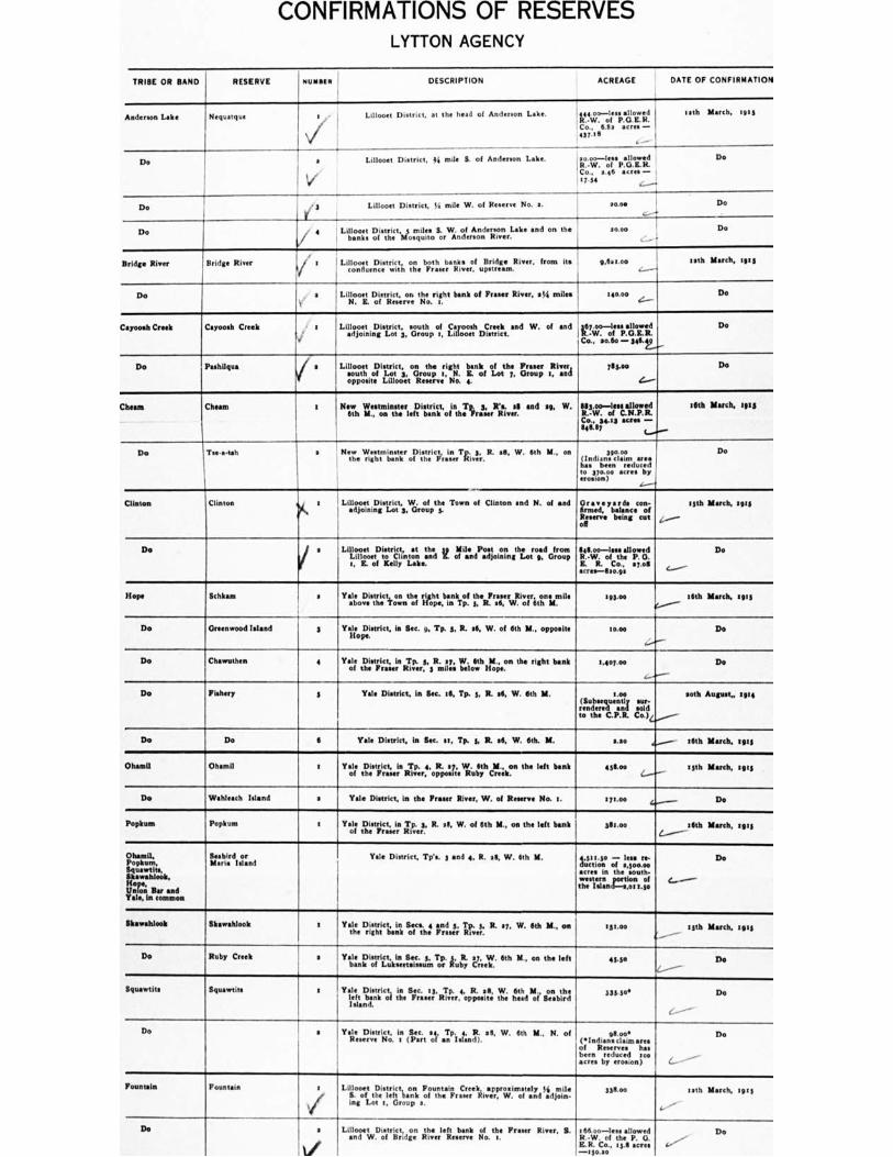
CONFIRMATIONS OF RESERVES LYTTON AGENCY
NUMBER DESCRIPTION
ACREAGE
DATE OF CONFIRMATION
Anderson Lake Nequatgue t Lillooet District, at the head of Anderson Lake.
I
114Vr. otf";2%.°E11. Co., 6.82 acre.— ' 437.. 8
lees 20.00—le allowed R.-W. of P.G.E.R. Co., 346 acres — .7,54 c...---.
13 th March. tuts
Do
I Lillooet District, 44 mile S. of Anderson Lake. a Lin. Do
Do '3 Lillooet District, 74 mile W. of R No. a. 50.00 I 4.---+
Do
Do ' 4 Lillooet District. 5 miles S. W. of Andermn Lake and on the b•nks of the Mosquito or Anderson River.
20.00 Do
Bridge River Bridge River Lillooet District, on both banks of Bridge River, from its confluence with the Frame River, upstream.
, 9,6.1.o0 lath March, 1915
Do a Lillooet District, on the right bank of F River, at4 miles . N. E. of Reserve No. t.
woo c..-.- Do
Cayooah Creek Cayoosh Creek I 1 Lillooet District, s2ut h of Cayoosh Creek and W. of and
a:oiningot3.roopr. District.
t. 67foTle •iond f .kof ;.a t.
CO, 3.60 — 316. 2..„
' Do
Do Pashilgua Lillooet District, on right bank o f River soug oiLt3, &oupt ta .,_ot, Ero. p,ard
opposite Lillooet R No. 4.
715.00
e...--
Do
Cheam Chown a New Westminster klit:iestomnin.teriefD.istarnict, bank ofintheT'Fra3:erwiLre're.
and a9, W. 11.34°.—or trill.7.1Ed Co., 3413 sm. -646.67
36th March, 1.1i
Do Tse-a-tah s 'New Vii,eor'asntie.r of the
In Tu... R. sill, W. 6th M., on 330.0o (Inditn• claim area has been reduced to 37o.00 acres by erosion)
Do
Clinton Clinton a Lillooet District, W. of the Town of Clinton and N. of and adjoining Lot 3, Group 5.
Oran c yards con- firmed, balance of Reserve being cut off
.,...--
55th March, zeta
Do
Lity:toeDitsotr Clinton
i, st 1)::,,, so Mile andPaorjoionritngthzotro9a.d Group
s, E. of Kelly Lake.
fle.kfvio—. olfestehaellriwzid.
E. R. Co., 37.12111 acres-8 Mos
Do
Hope Schkam a Yaalleo,Deisttir,tecti..kownnthoef rkileohpt b.nnkTopf t3h.eRF. at. W. of
Be 393.04 16th March, 26:3
Do Greenwood Island 3 Yale District, in Sec. si, Tp. 5, R. 26, W. of 6th M., opposite (lope.
moo
,....--
Do
Do Chewuthen 4 Yale District, in Ty. 5, R. 37, W. 6th M., on the right bank of the P River, 3 miles below Hope.
1,407.00
(..--.--
Do
Do Fishery g Yale District, in Sec. 16, Tp. t, R. at, W. 6th M. 11.00 sur- (Subsequently an t IT sold rendered
n
to the C.P.R. Co.)L......,..--
aoth August,. 0114
Do Do 6 Yale District, in Sec. at. Tp. 5, R. 36, W. 6th. M. LSO .......---- 36th March, 5915
Ohamll Ohamil t Yaol;s ,D,eistpct, in RTil3;,..4,,,Rp....:74WR...:yth Creek.
n the left hank 456.00 4.-----" 15th March, sass
Do Wahleach Island a Yale District, in the Fraser River, W. of Reserve No. s. Imo* 4......— Do
Popkum Popkum 1 Yale 1::)1,istri ctk in Rfp.e s. R. 23, W. of 6th M., on the left bank 3111.00 4.-----
16th March. I9t5
Ohernil, Popkum, Sguawtite, Skawahlook, Hope, Union Bar and Yale, In common
Seab, rd or Maria Island
Yale District, TVs 3 and 4, R. 38, W. 6th M. toWinr of flessoso.n000- acres in the south- ms tlezannrratiootnI.soof [_
Do
Skawahlook Skaw•hlook z ' Yale DrIgst,r,tict anink Soefest.h: and 3. TR!;,.., R. 37, W. 6th nt., on .5... syth March, 15115
Do Ruby Creek a Yakiaemlitiostirie,,,ki.n,,Smeic,...5in Tp. ,y, R. 7r,..117./.. 6th M., on the left 4340 Do
Squewtits iquantits
—'
1 Yale District, in Sec. t3, Tp. 4, R. 28, W. 6th M., on the
fat bank of the F River, opposite the head of Seabird Island.
333.300 Do
Do a YaReeseDrivsetria. icn (SFeaci, al, aTnpi J;nEti I.
28, W. 6th M., N. of 911.00l. (s Indians claim area of Reserves has been reduced too acres by erosion)
Do
Fountain Fountain a Lili.000eft (DisierWi,acinnk Fountaino .e..C.terrekiiivsep.p.VmoallealL Idimoiinle.
ing Lot t, Group a.
338.00 lath March, 19:3
Do a Lillooet District, on the left bank of the Fraser River, 5 and W. of Bridge River Reserve No. s.
266.00—less allowed R.-W. of the P. G. E.R. Co, 131 acres —swats
Do
RESERVE
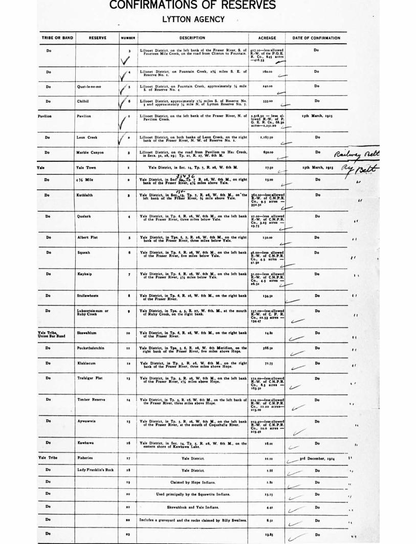
f
C l
CONFIRMATIONS OF RESERVES LYTTON AGENCY
TRIBE OR BAND RESERVE mural, DESCRIPTION ACREAGE DATE OF CONFIRMATION
Do 3 Li poouert,,,Dni District, , Corn.. Lhe. .1 eftthebarn.kaoffrot.he ClintonF raser tRoivilL.S,..ionl. /3 Ji4,:io. --ofl ex, allowed
R. Co., 645 acres --4,1.35
.0."'"'
Do
Do 6 Lillooet District, on Fountain Creek, s3/4 miles B. IL of R No. a.
a6o.00 L....J.-
Do
Do Quat-lene•mo j Lillooet District, on Fountain Creek, approximately !. mile S. of Reserve No. 4.
Woo Do
Do Chills') , 6 Lillooet District, approximately orlest of R No. 533.00 r n! .ppro....ey,nl oiytto; l Do
Pavilion Pavilion i t
/
Lillooet Dietrict, on the left bank of the Fraser River, N. of Pavilion Creek.
3,5 ■ 1550 - less al. lowed R.-W. of P. G. E. R. Co., 611.3o acres-2,35o.ao ,.......,_
15th March, ton
Do Leon Creek PJ
Lillooet District, on both banks of Leon Creek, on the right bank of the F River, N. W. of Reserve No. t.
e.t6y.so Do
Do Marble Canyon 3 Lillooet District, on the road from Pavillon to Ha. Creek, in Secs. a 3a, . eg: Tp. et, R. sy, W. 6th M.
650.00 L'
,
I Do ie...4
Yale Yale Town t Yale District, in Sec. at, Tp. 7, R. 26, W. 6th At 1 7.10 13th March, :913 :2..<
/ Do .---
Do 4 ../4 Mile a Yale District, in Sec'5v1913 67 R. a6, W. 6th PA on right
bank of the Fraser River, 6 3,6 miles above Yale." I 15.00
i..,
Do Kuthlalth 3
/I Y-• Yale
et Dbiasn'iit ' tc:f itnhell7,4:!; TRT;e7r: R.
mile aboveYale. the
VA.°7-. on.11.7.711 Do
Co., g.5 acres - 31a.30
Do Qualarlt 4 Yale District. In Tp. 6, R. ea, W. 6th M., on the left bank of the F River, three mile. below Yale.
aroo-less allowed Do R.-W. of C.N.P.R.
Co., 3.05 acres - a3.75
L.-....""
Do Albert Flat 1 I
Yale District, ritche ilPraTse'rL R6i.ee7r, ittreaecz.6Cloil"Yosie.the right
a5o.00 Do
Do Squeals (I Ytiol District, inRT4r.6.fiR miles below
athw 1.ileon the left bank ilto‘c.ii-feu calla/IV Do
Co., 4.5 acres - 11.5o
1......"--
Do Kaykaip p Yale ,I41,ic.t.,,,inRT4.,..6,5,R...t.VLio6wth Yale.
on the left bank C.-W. allowed Do
Co.. 4.5 acres - ease _..../
Do Stullawheets S Yale District, in Tp. 6, R. 36, W. 6th M., on the right bank of the F River.
.34.50 Do
Do Lukseetsis-sum or Ruby Creek
4 Yale ITitoittyriceienk.Top.s. the 5
,,igt.t 2b7a,ni:N. 6th, II., at the mouth ;rig-. olfeeLallirltd. Do
Co., 33.53 acres - 134.47 L.-------
Yale Tribe, Union Bar Band
Skawahlum 3e
Yale Dietrict in Tp. 6, R. 26, W. 6th M., on the right bank of the F . River.
.410 Do
Do Puckatholetchin 11 Yale righD, District, of Jr 0 5, 6, III i year!,
hoe n.,6%.M.eir,oidvi.anhoopne. the 566.5o Do
Do Klaklacum la YaiLenipiosAire, Fi,n Tp.RL,12.024,, 1,.,,,Viieelltahbolliv ,Hoonpethe right 7145 Do
Do Trafalgar Flat 83 Yale Zistir,i,jc.tinRTcp r,,,,,j1:. n.,261,e.W..biolyth. M.. on the left bank elije.iz-. of acres
Do
Co., 6.5 acres - ,63.30 .Z..----'
Do Timber Reserve 14 Yale District, in Tp. L. R. a6, W. 6th U. on the left bank of the F River, three miles above Hope.
324.3o-lessellowed Do R.-W. of C.N.P.R.
Co.. 11.3o acres- 213.00 L
Do Aywastrwis 85 Yale District, in Tp. 5, R. a6, W. 6th M., on the left brink of the P River, at the mouth of Coquebelle River.
039.40-lees allowed Do R.•W. of C.N.P.R.
Co.. to.° acres - e10.60
Do Kawk•wa NI Yale District, in Sec. 14. Tp. 3, R. 26, W. 6th It, on the eastern shore of K•wkaw• Lake.
oo 36.00 Do
Yale Tribe Fisheries ty Yale Di ttt ict. tom 3rd December, :ale 1 i.------
Do Lady Franklin's Rock o6 Yale District. 6.66 Do
Do e, Claimed by Hope Indians. 7.k Do ,
Do 20 Used principally by the Squewtits Indians. 65.35 Do Li
Do •
at Skawahlook and Yale Indians. 4.40 Do
__. Do se Includes a graveyard and the rock, claimed by Silly Swansea. Bo Do .
De Da ails- - Do
it
a r
6 ?

CONFIRMATIONS OF RESERVES LYTTON AGENCY
TRIBE OR BAND RESERVE NUMMI" DESCRIPTION ACREAGE DATE OF CONFIRMATION
Do 21 A bur.1 ground for Indians. 0.10 ,.........., Do
Do 15 0.71 ..........-- Do
Boothroyd Tribe, Chamon Band
Teawewmuck r Yamleoastorctiino:;iettelelt, 317.an.k ileosf .tte.v.F Yale. River, at the 1/...virloeilec allowed
Co., 13.75 Ur eil- 33.73 ..........--
15th March, lots
Do Tsintahhtl a Yale District, on the right bank of the F River, 33 miles C.-W. of
allowed
27.00 e.-----
Cn., so.° acres -
Do
Do liPerurn 3 Tsilte District, the mr15.11.1 baabrok.ofytales F River, opposite 374.50
e....."-"- Do
a
Do Kahmoose 4 Yale District, on the left bank of the Fraser River 34 mile. above Yale, in Sec. 4. Tp. ts. It. et, W. 6th N.
60.00
es■"'"..-
Do
Do Sho-ook 5 Yale District, between the 33 and 36 Mile Posts, on the road from Yale, in Tp. 13. R. 06, W. 6th M.
41 3.00 (..............Geh March, z916
Do Boothroyd IA Secs. 9 and to, Tp. Is, R. PI, W. 6th M. 103.33 23rd December, 1914 e......----
Do Do Sp Baas: iscan4. sithrik.ts, R. $6, and MKS. 33 and 34, Tp. tz, 6a . eon of sser.00raltlics,
Ph 3211112.17. 1911
more or lean - 4......■• 390.08
Do Inkehtuph 6 Yallreo.DifVeCt,inonTpthenlefitt. bank of the :if MK RhIff , 31 MUM It !it37;111.111W 19th March, tots
Co., 47.00 acre. - d........., 407.00
Do Boothroyd 6A Secs et and 16, Tp. zit, R. .6, W. 6th M. 140.04 3td December, rug 4---- Do Do 6B Sec. so, Tp. se, R. e6, W. 6th U. ea.3e Do
CI
Itombroyd Tribe Chukcheetszi 7 Yale District, on the right bank of the Fraser River, oppc.site inkahtsaph Reserve.
44.30 :ph March, tots I 4-.---
Do Stalyshanny 8 Yalmeilellisatai raLtbe left bank of the Fruit River, 4254 V..1.7-1.eisc allowed Do
ill,a.i. 11.7 acres - e.„/
Do Boothroyd PA Sec. 6 Tp. es, R. 06, and Sec. 31, Tp. HI, R. se, W. of 6th M. 145.0-leas allowed pd December. 1914
R.-W. of C.N.P.R. Co., 5.os saes - 4....../ 1 40.00
Do Stlahament 9 Yale District, to the west of the Fraser River, opposite Resens No. I.
40.011 13th March. 1903
......./--.
Do Dulerin to VaIlfe prip.strIct en ins ; 0".:r°111. of the Fraser River, In Sec. wirioels cakorkl Do
Co., 7.73 acres - 1.75 4....."--.
Baton Bar Tockkwimehum 1 YamleouWatorlict,Anotertsohen !get 6.114 the of :rue' ,11:17,' rapt. te,
R. .6, W. 6th U. VIZ: 401. C r. '1:1.1
Do
Co., to.s5 acres - 16.73 C.......".....
Do Kopchitchin a Yale District, on the right bank of Fraser River at North Bend, a miles above Boston Bar, Tp, to, R. 46, W. 6th Y.
339.0o Do I
4.--- Do Austin's Flat 3 Yale District, .con the tfit bank of tlis.,F1m4.t iltp.ive;: near Hell's
rtheid." miles "
ie.1.7 oir.c.11.7.1t Do
Co.. 1.0 acre-0.13 I
C........
De Bucktum , 4 Vale District, on the left bank of the Fraser River, at Butcher's Flat, Sec. 14, Tp. to, R. 26, W. 6th IL, sin miles above Boston Bar.
64.0o--less allowed Do R.-W, of C.N.P.R. i Co., 6.3 sues - e,../ 17.30
- v. ..._ _.•___- /Mr
IrW-j. of C.N.P.Ri... Amer wee...mmeo-wz
cent Vd Drr..41.121 4.41...0
$ r i 44 IL d" 4 93.71
Do kascy s Va,Le.l7isotfritiounoth&ereith. tttgzek moIletshebpirot,serBR.ttveo: aitidr.lekt
Sec. to, Tp. to, R. $6. W. 6th Y.
1100 15th March, 291 5
$0,'"----
Do Paul's 6 YamleileDairorvicetlieoLtteawrigihnt stocnkto,ofTilheso,F;tnusr6. 7k...4 oils. 1.73 Do
....--
Do Shrypttahooks 7 Yale District, on the right bank of the Fraser lino, two miles below Boston Bar, in Sec. 14, Tp. to, R. 26, W. 6th Y.
67.00 Do
Manske Bar Nekliptum r Yale District, near the left bank of the Fraser River, 46 1'4
miles •hove Yale, on the banks of Nekliptum Creek. in Tp. 53, R. e6, W. 6th M.
30.00 15th March, qty
Do to Yale District, in Seca se, and sg, Tp. es, R. .7, W. 6th IL, between Reserves Nos. I and a.
17o.93 3rd December, nog
L....."---r-
Do Kauko Bar a Yale District, on the left bank of the Fraser River, 47 310il18 above Yale, in Tp. th R. 17, W. 6th Y.
113.00-1101113110wed 13311 March, 191 3 R.-W. of C.N.P.R. Co., 53.73 litres- 94•3
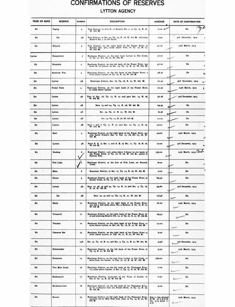
CONFIRMATIONS OF RESERVES LYTTON AGENCY
TRIBE OR BAND RESERVE RUNNER DESCRIPTION ACREAGE
. DATE OF CONFIRMATION
Do Pegleg 3 1 Yale District. !,1 mile E. of E No. a, in Tp. 13, R. at, W. 6th M.
too Do
Do Do 3A Vale District. in Sec. 30. Tp. 13, R. 26. W. 6th II., adjoining Reserve No. I on the South.
19.90 3rd December, wit 1
Do Whyeek 4 Yale D t, on the right bank of the Fraser River, at Kanak• Bar. 44 , i miles above Vale. in Tp. 13, R. 27. W. 6th M.
361 .00 lath March. iges
Lytton Nananahout x Kamloops District, on the trail from Lytton to Hat Creek, in Tp. 17, Ws. 26, 27, W. 6th M.
7/o.00 Do 1
Do Nuuautin I . Kam loops District,o L Lytton,
oono :nheslgecit 112371+poll ttshe R.
Fraser r 4:iv4r1;. two 417.00 Do I
Do Spintlum Flat 3 Kamloops District, on the left bank of the F River. 7 miles above Lytton, in Tp. 16, R. 27, W. 6th IL
735.30 Do 4
Do Lytton A Kamloops District, Sec. .6, Tp. 16, R. 17, W. 6th. M. 101.30 3rd December. 1914 4 r
Do Nickel Palm 4 Kainto lomoires. DagtvreictLy itnonthe right bank of the F River, Ithoo 13th March, toss 3'
Do Lytton 4A Part of Sec. 115, Tp. 17, R. 47 and part Soc. ts. R. .6, W. Gth M.
361.M 3rd December, 1914
Do Lytton 45 Seca. 18 and as. Tp. 17, R. elk W. 6th M. 133.33 Do
Do Lytton 4C Sec. 19, Tp. ty R. .7. W. 6th M. 60.36 Do
Do Lytton 4D Sec. 43, Tp. 17, It. se, W. 6th Y. 150.00 Do
Do Lytton 445 Secs. 7 and 11. Tp. 17. R. ay, and Sec. cc, Tp. t7, R. ell, W. 6th M.
',coo Do .4
Do Sub 3 Karrntooci oDwin tlitieJ.igihnt Innik ••.:f7.thAkFrks:r41.3,. ci,.4..
6th Y.
314.00 13th March, sing
If
De Lytton 3A Ports N. Z. 44 Sec.., and S. IL 74 Soc. st, Tp. 111, R. .9, W. lith M.
314.40 3rd December, 1914 1.1
Do Make' 6
v- Kamloo_ps District. :44i_milessbelow Lillooet on the banks of zwiFTrielltiiver, to Tp. t . R. sg, W. Gth MI., partly in
:353.00 13th March, .,., 11,4
De Fish Lake 7 Kamloops District. at the foot of Fish Lake, on Stuouck Sao° Do 4'
Do • Make S Kamloops District. in Sac. 17, Tp. it R. 16. W. 6th IL I0.00 Do I
Do Stryen g Kamloops District, on the right bank of the F River, at Stryen Creek, In Tp. is, N. s7, W. 6th M.
11.0.3. Do i
Do Lytton gA Slit .147. 41, 6th
rd 34. Tp. 53, R. al and Sec. 4. Tp. 16, MFG 3rd December, 1914
De Do GB Sere. se, e3 and 14, Tp. ts, R. 07, W. 6th IL 57645 Do C..../
Do Minh so Kamloops District,aDttracitaeo: ateveritt ,baiLkHor,f..thme 17ree.iir, :lag:
V.I. 6th M.
alls.e. 73th March, s 0: g
t.--/
Do Yawaucht 11 Kaonfilcoodasaf:iislicitlaoo ,th.: aht.01:ageTopf. Ile. Fraser River, Y. slaso Do
4.....-------
Do Tctukan I s Kamloops pieboDviestLigiez it.hemr.ig. h.te.11apk. of the BL W- !irk : s :ono Do
De Cameron Bar :3 Kamloops District, on the right bank of the Fraser River 83 mile. above Lytton, in Tps. .6. :7, R. 07. W. 6th Y.
17.eo Do
Do .3A Sec. 3s, Tp. ill, R. a7, and Sec. 3, Tp. 17, R. s7, W. 6th. IL 4495 c- 3rd December, tato
—
De Ralhalatden 14 Kamloops Diotrict, on the left bank of the Fraser River, in Tp. as, R. a7, W. 6th 11.
11430 13th March, tgts
l-----
De Bootahnie 13 Kamloops,,,ile 0Dmiegiectieromn.trir intrippLfrog, Lytton to H44 Creek to 9114000 Do
Do Two Mile Creek 16 Kamloops District, on the left bank of the Thompson River, 119 miles above Lytton, in Sec. 7, Tp. 13, R..6, W. 6th Y.
11.00 Do
Do Klahkamich :7 XasmeclooleTpDis:Lick. .oath-nut ti%riagh al,. the Town of Lytton. in 11.5o _ Do
Do Klickkumcheen 88 Kamloops District, on the left bank of the Thompson River. at its confluence with the Fraser River, in Tp. 13. R. 86, W. 6th M.
47.00 Do
Do Noreen tg Kamloops Dietrict• on the right bank of the Thompson River, opposite the 61 Mile Post from Yale, in Tp. 17. R. s6, W. 6th Y.
1140 — less allowed R.-W. of C.N.P.R. Co., 7.t3 acres - 3.76
13th March, sing
--
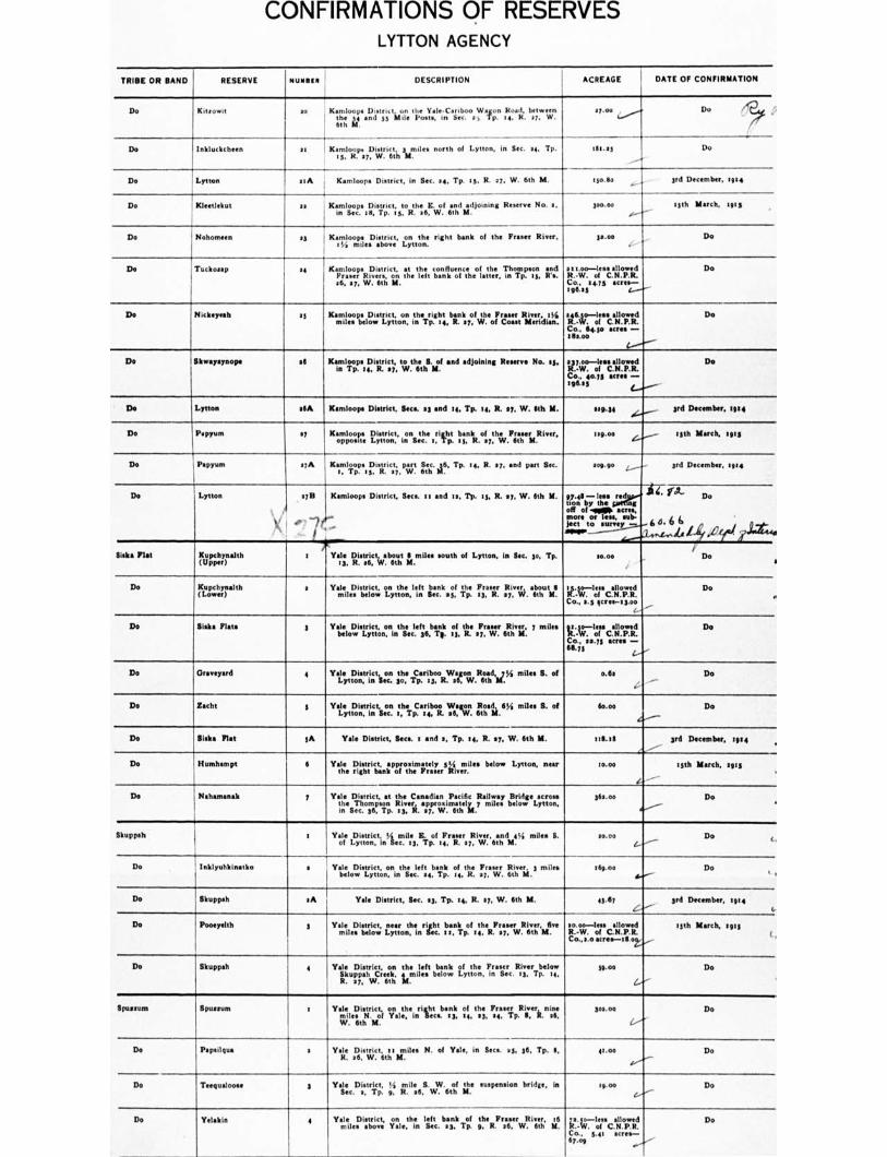
CONFIRMATIONS OF RESERVES LYTTON AGENCY
TRIBE OR BAND RESERVE NUMMI! DESCRIPTION ACREAGE DATE OF CONFIRMATION
Do Rd..* ao Kamloops District un the Yale-Cariboo Wagon Road, between 161:: tie and 53 Mile Ponta, In Sec. at Tp. is, K. a7. W.
17.00 , Do
Do • Inkluckchimn it Katms loitpanD r;ric6tt,h 3mmden north of Lytton, in Sec. se, Tp. 014.05 Do
Do Lytton etA Kamloops District, in Sec. 24, Tp. es. R. 27, W. 6th U. :pane 3rd December. 1914
Do Kleetlekut se i Kamloops District, to the C. of and adjoining Reserve No. 2. in Sec. la, Tp. as, R. 26, W. 6th M.
300.00 13th March. 1p3
De Nohomeen 23 Kamloopsmef above Lytton.
loyuonthne right bank of the Fraser River. I ga.so Do
De Tuckossp 24 Kamloops District. at the confluence of the Thompson and P River.. on the left bank of the latter, in Tp. is. it's. 06. si, W. 6th M.
sr lao-lese allowed R.-W. of C.N.P.R. Co., 24.73 acre.- 196.55
Do
De ?Nehemiah s3 KrigiLotaDisthoofte: itsheRrp.igl:Lbir kilo! ,klmellaca:erut Itillgvelkdiejst. 54.6.-47-iorgclicrie Co., imp acres - taco*
De
De likweraynope .6 Kaim. i;o9p. s,D.Isi;ricipt,,, t;,.th:ithS.4II end adjoining Reserve No. oh 211.7.47-;Ifeeakortitd.
Co., golf acres -totes
Do
De Lytton NIA Kamloops District, Seca. 23 end 04. Tp. 04, R. 117. W. 6th Y. sI6.34 3rd December. films
Do Parma 27 Kaomppoloo.ftee lilyietttroinct., inonsetcha 5.righp2 1:rikolmth,:v.figirru.Rlyer. mg.00 lath March, tips
Do Peppers ayA /faietkiiopp. oe District, part Sec. 6., Tp. se, R. •7„ and part Sec. 509.90 3rd December. :914
Do Lytton
2711 Kamloops District, Secs. sr and III, Tp. Is. R. •5, W. Ith Y.
,--)r
$ ' -
97.46- Imo red tion
of by the g
off .9.116. acre.. more og lose, nib-Pet to survey - APP
44. fa- Do
6 4. 6 6 li 14 X941 lit"
Sidra net Kupchynalth (Upper)
a Yale District, about 6 miles south of Lytton, In Sec. 3o, Tp. 13, R. aiS, W. 6th M.
10.00 i
Do i
Do Kupchynalth (Lower)
a YeeDisct; ar:pecf bank of the 1 River about
njles a.iyen:i:Lci esrp.13,R..7., mtloc itrlisgone ! P.R.
Co., 1.3 4cres-23.00 L
Do
'
Do Cells Flats 3 Yail,:loDwistryilnrinthilecl.ef3t6.bv9k. eo3f. the ay, W. 6th
7 miles v...trloarceamd.
Co., 22.73 acres -6/.73
Do
Do Oreveyard 4 Taller tDoins.triincticcn. ;oh.e Tp. µ.
A. .aigo;,.Rirtand,m7.54, miles S. of o.11. Do
Do Becht 5 YailayuDeinatriinctieocn. :heTpC. ar;4ibo3. tagg Road 65G miles B. of 6moo Do
Do Sisk. Plat 3A Yale District. Secs. z and a, Tp. re, R. sy, W. 6th M. rill.sl pd December. 2604 . ,.....-
Do Hurnhampt 6 Yale fillegicbtin:pgottmrely 30i miles below Lytton, near to.00 13th March, cps ■
De Nahamanak y Yale District, at the Canadian Pacific Railwey Brirlgo across InhesTechor3n6pIrtp. River aini.m6stLelle miles below Lytton,
361.00 Do .
Dapple t Tool; pyitstterniatinleTilueLICi.pol .Trazr,:liz4r,6N,2dm4% miles S. •
so.00 Do (..,
Do Inklyuhkinatko s Yale District, on the left bank of the Fraser River, 3 miles below Lytton, In Sec. 04, Tp. se, R. 27, W. 6th U.
26o.00 Do i
Do Dropph 2A Yale District, See. 13. Tp. ta R. 27, W. 6th M. 0.67 G
3rd December, late
Do ffeeepith 3 Yamleil.D.itterlia LTgont.heinriLhet. bzal....po. f 0 t4h. eR.Freizerw.Riztr,mll.ve zavrtifsec.1.7.11
Co., ,.o acres-s 6.o
t3th March, tots
(
Do Skuppah 4 Yale District, on the left bank of the F River below fRaurgah R,Fre6etl; ',miles below Lytton. in Sec. la Tp. 04,
19.00 Do
Spursum Spussum t Yale l D. iiiitiricoti oln.i.th. einrithet,Lbar312 c,f4. th.e3, gsr4aserrp.RZeritnix
■V. e 6th .61.
301.00 Do
Do Papeilqua 2 Yale District, tt mile. N. of Yale, in Secs. as, 36, Tp. I. R. 26, W. 6th M.
41.00 Do
Do Teequaloose 3 Yale Mulct, % mile S. W. of the suapension bridge, in See. a, Tp. R. R. 26, W. 6th M.
ig.00 Do
Do Yelakin 4 YaeDill, on the left bank of the F River. tt mii..a l iale.in I.c.13.Tp.).R..6.W.oti i ..‘rofc s.oles Ia r
Co., 5.41 am.- 67.09 ..-
Do
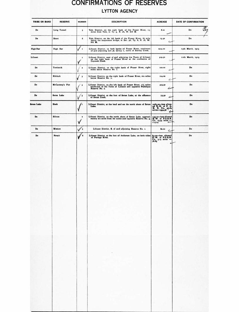
CONFIRMATIONS OF RESERVES LYTTON AGENCY
TRIBE OR BAND I RESERVE RUNIC' DESCRIPTION ACREAGE DATE OF CONFIRMATION
Do Long Tunnel 3 Yale District, on the right bank of the F River, 13
miles from Yale, in Tp. 9. R. a6, W. 6th M. too
„,....--
Do
Do Skeet 6 YatLeioDwisgiect;urpenthsieonleftarilardagnek in Sea the FraserF3r6aserrp.Rv.eri. 1,;■,..m.lie.
6th IL
13.30 c.--/-
Do
High Bar High Bar e Lillooet District, on both banks of F River, northwest
of and adjoining Lot 36, Group a, north of Barney Creek. effae.o.
J- 53th March, let 3
Lillooet a
Lillooet District, west of and adjoining the Town of Lillooet
e.y.thoethrerhstekbank of F River at the confluence of 919.30 lath March, taps
Do Towinock t ' a Lillooet District, on the right bank of F River, eight miles below Reserve No t.
320.00 4/-
Do
Do Kilchult if 3 Lillooet District,rtiettern,ict; ;none right bank of From River, sin miles 101.00
c.---
Do ,---".
Do McCartney'. Flat /..' 4
V
Lillooet District, on the left bank of F River, 5 tai miles south-east of the Town of Lillooet and opposite Pashilqu• Reserve No. a.
123.50
L./..
Do
Do Seton Lake . 3
V of Lillooet District, at the foot of Seton Lake, at the effluence
Seton Creek. 7540 c...."--+
Do
Seton Lake Slosh a Lililalest District, at the head and on the north shore of Seton ear no—lea, Iallow-
E. R. Co., 90.64 acre•-199e.16 '4.....
Do
De Silicon s
V
Lillooet Dstricotherrthshore of Seton Lake, ,rn 1i: mey..emLsfronooutle,andoppostee..;v:Ao4t„. f3,c•,--l;•:Innd o ;.i
Co., a3.513 acres — t un s .._„.
Do
Do Mission / I Lillooet District, S. of and adjoining Reserve No. a. 60.00 Do
Do Necait
w 6 Lillooet District, at the foot of Anderson Lake, on both sides
of Portage River. 114.00—less allowed R.-W. of P.O.E.R. Co., 3.es acres - 76.63
Do
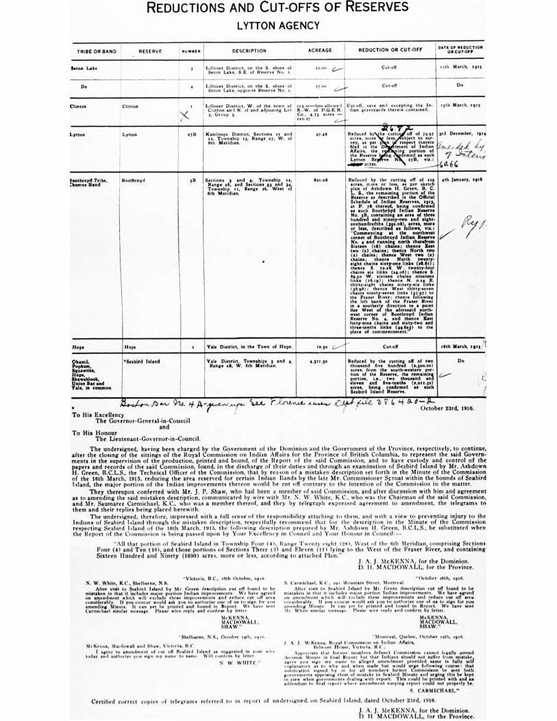
REDUCTIONS AND CUT-OFFS OF RESERVES
LYTTON AGENCY
TRIBE OR BAND RESERVE tunics DESCRIPTION ACREAGE REDUCTION OR CUT-OFF DATE Or DEDUCTION
ON CUT-OFF
Salon Lake 3 Lilloom District, t, on the S. shore of " "" ‘......--1 Scion Lake, S.E. of N No. 1.
Cut-off I
1
Cut-off
1.ith March, 1515
Do Do 4 Laloocine t Lake, District, cpt;ocr, et the ,S,... vs
eh iii,irc.e. o I 37.00
L...■
Clinton Clinton t
"‹.
Lillooet District. W. of the town of rts.oc—less allowed Clinton •nd N. of and adjoining Lot R.-W. of P.G,E.R. 3, Group 5. Co.. 4.73 acres .—
720.17
Cut-off, save and excepting the In- than graveyards therein contained.
15th March, tuts
Lytton Lytton 37/1 Kamloops District, Sections 11 and 9/.46 13, Township 15, Range 37, W. of 6th Meridian.
to Reduced b the cutti off of 79.97 acres, more lest, object to sur• vey, as per p respect thereto filed in the D tment of Indian Affairs, the in{ portion of the Reserve u firmed as such the Lytton Re vs 1713, vie.:
____ -- -- "----
3rd December. me ,
J(„, ic/
, ,
47 444-
4 4 6 6
loothroyd Tribe, :homes Band
Boothroyd 5B Sections 3 and 4, Township 13, Range 36, and Sections 33 and 34. Township at, Range M. West of 6th Meridian.
•
Setoff Reduced by the cutting off of asp acres, more or less, as per sketch plan of Ashdown H. Green, B. C. L. S., the remaining portion of the Reserve as described In the Official Schedule of Indian Reserves, 2913, at P. 7s thereof, being confirmed a. such Boothrbyd Indian Reserve No. 513, containing an area of three hundred and ninety-two and eight-onehundredthe (391.011), *fres, more Or Ins
, described as follows, :
"Commencing at the northwest corner of Boothroyd Indian Reserve No. 4 and running north therefrom %mem (16) chains; thence gut two (a ) . chains; thence North two (a) chains; thence West two (91 chains; thence North twenty- eight chains sixty-one links (211.6i); thence S. 7e26 W. twenty-four chains six links (se.o6) ; thence S. 89.5o W. •ixtrtn chains ni links (16.19); thence N. ose E thirty-eight chains ninety-sis links (3496); thence Wert thirty-seven chains ninety.seven link.(37.91) to the Fraser River; thence following the left bank of the F River in • southerly direction to a point due West of the aforesaid north- west corner of Boothroyd Indian R No. 4, and thence Zest forty-nine chains and sixty-two and three-tenths links (45.511) to the place of commencement.'
6th January, 1916
V
Hope Hope t Yale District, in the Town of Hope. ao.5o ,...... Cut-off 16th March, eels '(
Ohemil, Popham. kuswtits. Hope, Skawahlook, Union Bar and Yale, in common
"Seabird Island
I
Yale District, Townships 3 and 4. Range 39, W. 5th Meridian.
4.5tt•5o Reduced by the cutting off of two thousand five hundred (s.soo.00) acres, from the lout Ume Insr- tion of the Reserve, the remaining portion, i.e., two thousand and eleven and five-tenths (emit .5o) acre., being confirmed as such Seabird Island Reserve.
Do
4.„....--- f....
•
914. 4 A To His Excellency
The Governor-General-in-Council and
To His Honour The Lieutenant-Governor-in-Council.
%AA.. e3i6'4 0— October 23rd, 1916.
The undersigned, having been charged by the Government of the Dominion and the Government of the Province, respectively, to continue, after the closing of the sittings of the Royal Commission on Indian Affairs for the Province of British Columbia, to represent the said Govern-ments in the supervision of the production, printed and bound, of the Report of the said Commission, and to have custody and control of the papers and records of the said Commission, found, in the discharge of their duties and through an examination of Seabird Island by Mr. Ashdown H. Green, B.C.L.S., the Technical Officer of the Commission, that by reason of a mistaken description set forth in the Minute of the Commission of the 16th March, 1915. reducing the area reserved for certain Indian Bands by the late Mr. Commissioner Sproat within the bounds of Seabird Island, the major portion of the Indian improvements thereon would be cut off contrary to the intention of the Commission in the matter.
They thereupon conferred with Mr. J. P. Shaw, who had been a member of said Commission, and after discussion with him and agreement as to amending the said mistaken description, communicated by wire with Mr. N. W. %%line, K.C., who was the Chairman of the said Commission, and Mr. Saumarez Carmichael. K.C., who was a member thereof, and they by telegraph expressed agreement to amendment, the telegrams to them and their replies being placed herewith.
The undersigned, therefore, impressed with a full sense of the responsibility attaching to them, and with a view to preventing injury to the Indians of Seabird Island through the mistaken description, respectfully recommend that for the description in the Minute of the Commission respecting Seabird Island of the 16th March. 1013, the billowing desciiption prepared by Mr. Ashdown II. Green, It. C. I.. S., he substituted when the Report of the Commission is being passed upon by Your Excellency in Council and VI itsr Honour in Council:—
"All that portion of Seabird Island in Township Pour (41, Range Twilit) eight c261, West of the nth Meridian, comprising Sections
Four (al and Ten (50), and those portions of Sections Three CM and Eleven (111 lying to the West of the F River, and containing Sixteen Hundred and Ninety (1690) acres, more or less, according to attached Plan.”
J. A. J. 31c KENNA, for the Dominion. D. II. MACDOWALL, for the Province.
"October 16th, 1016. "Victoria. B.C., 10th October, loth. N. W. While, K.C., Shelburne, N.S.
After visit to Seabird I eland by Mr. Green description cut off found to be mistaken in that it includes major portion Indian improvement.. We have agreed on amendment which will exclude three improvements and reduce cut off area considerably. II you concur would ask you to attlhorirt one of us to sign for you amending Minute. It can yet be printed and bound In Report. We have sent Carmichael similar Please wire reply and confirm by letter.
Mc K ENNA NI AC DOW ALI.. SHAW."
-Shelburne, N.S., October 19th, Ivo
McKenna, Macdowall soil Shear, 1ictur is, 11 .0 I agree to amendment mil rut till Seabird Island a only "Ira in your alint
today and authorise putt sign my name to same. Will contain by letter.
N W
Certified correct copies of telegrams referred to in report
S. Carmichmel, K C., rot Mountain Street. Montreal. After visit to Seabird Island by Mr. Green description cut off found to be
mistaken in that 11 111c11.1.1r11 11111)Or portion Indian improvements. We have agreed on amendment %hub will exclude these improvements and reduce cut off area ettomder•bly, II you c.o.,' would milt you 111 authorise one of us 10 sign for you amending Minute. It ran yet be printed and bound in Report. We have sent Mr White similar n . Please wire reply and confirm by letter.
McKF,NNA, MACDOWALL, SHAW."
"Montreal, Quebec, October loth, rein 1 A. J. McKenna, Royal Commission on Indian Affair',
Belmont flown., Victoria. . Appreciate that former members defunct Conouiseion cannot legally amend
de, mion Minute in final Report hut that Indians should not suffer from mistake, rupee you sign my name to alleged amendment provided tame is fully self E4planattrty as 10 w by and when made but would wire following course: that mintiest'. signed by or foe all member burner Commisison be sent both government. apprising them of mistake in Seabird Minute sod urging this Ice kept in view whengovernmente dealing with report. This could be printed with and so addendum final report where amendment varying report could not properly he.
S. CARMICHAEL."
of undersigned, oil Seabird Island. dated October 23rd, told.
D A. J. MeKENNA, for the Dominion. . II. MACDOWALL, for the Province.
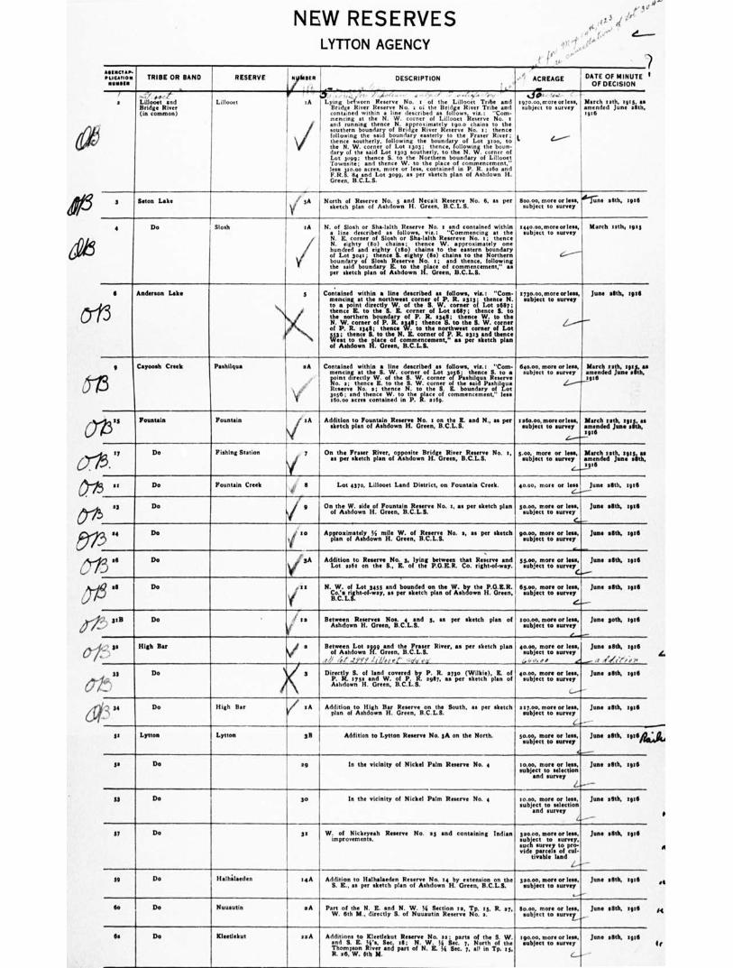
NEW RESERVES
3
LYTTON AGENCY r e ,(1°
ammo- eucerietes TRIBE OR BAND RESERVE ' N WI DESCRIPTION ACREAGE DATE OF MINUTE 1 • OF DECISION
1
...
- ...4
a LiBoost and Lillooet , IA Lying between R No. I of the Lillooet Trrbe and spro.00,more cries., March lath, tom as Bridge River Bridge River Reserve No. t 01 the Bridge River Tribe and subject to survey amended June 56th, (In common) contained within • line described an follows via.: "Com- 1916 mending at the N. W. corner of Lillooct Reserve No. s
v/ and running thence N. •pproximetely tgoo chains to the southern boundary of Bridge River Reserve No. I; thence following the said boundary easterly to the F River; I thence southerly, following the boundary of Lot 3100, to • the N. W. corner of Lot 1303; thence, following the boun- dary of the said Lot 1303 southerly, to the N. W.corner of Lot peg; thence S. to the Northern boundary of Lillooet Townsite; and thence W. to the place of commencement," less 32o.d0 acres, more or less, contained in P. R. :26o and F.R.S. Liand Lot 3099, as per sketch plan of Ashdown H. Green, B.C.L.S.
, '0•-•
3 Baton Lake . If 3A North of Reserve No. 3 and Necalt Reserve No. 6, as per Soo.00, more or less, unit ellth, ape I' sketch plan of Ashdown H. Green, B.C.L.S. subject to survey
v/ 4 Do Slosh to N. of Slosh or Sha-faith Reserve No. 3 and contained within tac000,mortorless, March tstis. Ibis • line described us follows, via.: "Commencing at the subject to survey N. E. corner of Slosh or Sha-lalth R eeeee ve No. a; thence N. eighty (110) chains: thence W. approximately one hundred and eighty (111o) chains to the eastern boundary
the said boundary R. to the place of commencement," as 4.---- of Lot goy; thence 5. eighty (Bo) chains to the Northern boundary of Slosh Reserve No. t; and thence, following
per sketch plan of Ashdown H. Green, B.C.L.S.
Ii thence B. to the IL E. corner of Lot 9617; thence IL to
6 Anderson Lake 5 Contained within • line described u follows, vie: "Com- mo.00,more mins, June gbh, egsll
mending at the northwest corner of P. R. sys; thence N. subject to survey to a point directly W. of the S. W. corner of Lot 2637; the northern boundary of P. R. sun; thence W. to the
N. W. corner of P. R. 5j41; thence B. to the B. W. corner 2.----"--.— of P. R. sun; thence W. to the northwest corner of Lot 333; thence S. to the N. R. corner of P. R. sits and thence West to the place of commencement," as per sketch plan of Ashdown H. Green, B.C.L.S.
3 .,, point directly W. of the S. W. corner of Psehilasm Reserve
11 Carmel' Creek Pashilqua *A Contained within • line described as follow., vie.: "Com- 60.00, more or lees, March reth, sus. as ncing at the 5. W. corner of Lot 3036_; thence S. to • subject to survey amended fume elltk. me No. a; thence E. to the S. W. corner of the aid Peshilqus Reserve No. e; thence N. to the S. E. boundary of Lot .Z.....-"--1116
I 3056; end thence W. to the place of commencement," less 160.00 acres contained in P. R. stag.
1336 Fountain Fountain IA Addition to Fountain Reserve No. e on the E. and N., to per Batio.00,moreorlesa, March soh, 'Its. as sketch plan of Ashdown H. Green, B.C.L.S. subject to survey amended Jane skh, B:11 L..---
5 '' Do Fishing Station On the Fraser River, opposite Bridge River Reserve No. e, 5.00, more or less, March Beth, ssis, as
i as per sketch plan of Ashdown H. Green, B.C.L.S. subject to survey amended June 'Stk. : iii
3 is Do Fountain Creek 4, 6 Lot 4370, Lillooet Land District, on Fountain Creek. 45.00. more or lessJune aSth, tull 6.4.......
03 Do 5
i g On the W. side of Fountain Reserve No. t. as per sketch plan so.00, more or leas, June slIth, istli of Ashdown H. Green, B.C.L.S. subject to survey C-
'
54
Do I to Apprariorrialegd 55 mile W. of ;Tint No. s, as per sketch gtotoj,ezoLie sorun,leesys, June AIM, toe 0-,,,,....
0 MI Do ',A Addition to Reserve No. 8, lying between that Aintree and 5s.eo, more or lets, Jane Milk tut/ J Lot WI on the B., Z. of the P.O.R.R. Co. right-of-way. subject to survey
6 all Do .011 N. W. of Lot 3435 and bounded on the W. by the P.O.KR. 6500, more or less. June Stith, Bull
Co.". right-of.way, as per sketch plan of Ashdown H. Green, subject to survey B.C.L.S.
,./
SIB Do ,/ la Between Reserves Noe. 4 and 5, as per sketch plan of soo.00. mote or leas, June sloth, ieill
o e
Ashdown H. Green, B.C.L.S. subject to survey .---
i•-', le High Bat i a Between Lot 1696 and the Frater River, as per sketch plan 40.00, more or less, Jane .6th, esti of Ashdown H. Green, B.C.L.S. milieu to survey ,, .1 b .;,/ ..'Y/,' i IL', e r Z' ..g'a ca __..., „. " e -- , (4!(,,,, 1, 4, u Do 3 Directly S. of land covered by P. R. also (Wilkie), IL of 40.00, 0$301 or le$S, June allth, WO F7
Ashdown H. Green, B.C.L.B.
P. R. sly and W. of P. R. egli7, as per sketch plan of subject to survey ..----••"
if 34 Do High Bar els Addition to High Bar Reserve on the South, in per It a17.00, more or lees. Jane sStk, sue plan of Ashdown H. Green, B.C.L.S. subject to survey ...
ss Lytton Lytton 3B Addition to Lytton Reserve No. sA con the North. so.00, more or lea, Jose aStb, sass
6s Do set In the vicinity of Nickel Palm Reserve No. 4 to.00, more or lees. June elStB, led
subject to survey 4-
subject to selection end survey 2.---
14 Do so In the vicinity of Nickel Palm Reserve No. 4 tome, more or lees, June 5th, stitil subject to selection and survey (...----
17 Do se W. of Nickeyeah Reserve No. es and containing Indian *ewe°, more or Ink June ell* IWO improvements. subject to survey, sock Survey to pro- vide parcels of cul- tivable land Z-.' -
19 Do Halhalaeden 14A Addition to Halhaleeden Reserve No. 54 by on on the geo.ocs, more or lees, June seth, WO
B. E. as per sketch plan of Ashdown H. Green, B.C.L.S. subject to survey .......--
Ile Do Nuusutin *A Part of the N. K. and N. W. H Section Be, Tp. ts, R. 17, Ilmoo, more or less, June ,nth, este W. 6th M., directly B. of Nuuautin Reserve No. a. subject to surver„
64 Do Kleedeltut as A Additions to Kleetlekut Reserve No. se parts of the B. W. tgo.00. more or lege. June sIBIll, lite and B. K. Ws, Sec. 511; N. W. 34 Inc.S 7, North of the subject to survey Thompson River and part of N. R. id See. 7, alt in Tp. si. R. 86, W. Ilth M. L..
et
F4
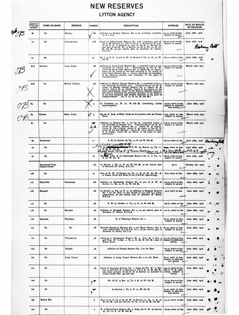
• tf
NEW RESERVES LYTTON AGENCY
“IIIIC/111, PLICATION TRIBE OR BAND RESERVE NUMBER DESCRIPTION ACREAGE DATE OF MINUTE
OF DECISION
64 Do Nesikep . 6A Addition to Nesikep Reserve No. 6 by extension northerly
24 of a mile. pools, more or less, subject to survey
4,-
June .8th, :916
74 Do lnkfuckcheen I- atft North of Inkluckcheen R No. stA, comprising part of the S. W. Section 2 5; pure of the S. !•', of Section .0, part of the S. E. It Section ay, part of the N. ,ti Section 23
in p. s s, R. 3r, and ;art of the N. W. ti Section 24, an T W. 6th N., as per sketch plan of Ashdown H. Green,
! . 9.C.L.S.
380.0o, more len, subject to survey
G....-.
June 28th, .916
4"
71 Do j 30 W. 1,.; of S. IL % and S. W. I/4 Section II, Tp. IL R. 27. W. 6th M.
160.00, more or less June 25th, 126
/......"" as
SeA Pavilion Leon Creek aA
Addition to Leon Creek R No. a contained within a line described as follows, vie.: "Lornmencing at the S. W. corner of Leon Creek Reserve No. 3; thence W. to chains; thence N. so chains to the most northerly S. W. corner of Leon Creek Reserve No. a; thence, following the boundary of the Reserve easterly and southerly, to the place of commencement"
440.0o, morose leas, March 115th, 103 subject to survey
........---
gaB 0
Do Marble Canyon
4■1
I 3A I
X
., •
t'
Addition to Marble Canyon R No. s contained within a line described as follows, vie, "Commencing at the N. E. corner of M•rble Canyon Reserve No. 3: thence N. to chains; thence W. go chains; thence S. 30 chains, to the most northeasterly corner of the Reserve (Marble Canyon) and thence, following the northern boundary of the Reserve, in the most southerly and easterly direction, to the place of commencement." (In T. al, R. 27, W. 6th M.)
In Township at, R. 27, W. 6th Y. (containing Indian improvements).
76o.00, more or less, Much 13th, 1915 subject to survey
C../....--
100.00, more or lees. June 28th, tate subject to selection ,
and survey„.....--.
13 Do
... 89
5 Clinton Kelly Creek On the N. bank of Kelly Creek at Its junction with the Fraser
River. 5.00, more or lose, March 27th, tilts subject to survey
67 Do 4g,
iii_A I
Addition to Reserve No. a, on the N., contained within a line described as follows, via.: "Commencin g at the N. W. corner of Clinton Reserve No. a; thence N. so chains; thence E. 166.4 chains; thence 5. yo chains to the N. E. corner of the said Reserve; thence kgf. tate chains; thence S. so chain.; thence W. 4o chains, to the place of com- mencement."
Woo, more or less. I March syth, 19:3 subject to survey I
Sp Boothroyd 21 S. E. 55 Section al, Tp. II, R. 36, W. 6th M
.3 4I,A" S.' i-i'l•MIEMINIMMI1111.`6f S. W. yi, Section 23, Tp. II,
R. 3 , . 6th M. .,_ ...,
i /1..c..4. 77c!aff C . frlcsukA. IF.....•416, • ,,,,, ) .f
.60.00, more or less
ma. more or less
31 6 -4/-....-,„kh 1.#...A 4, ,., ..4.0, illosoo, more or less, subject to survey
June .8th, 1916 I
June ellth, title
d. /v.A.
June seth, 1916
90 Do es li.- .
9t Do s3 On Labe, S. of Inkalitsaph Reserve No. 6, in Tp. ta,
R. 26, W. 6th M.
Roomthoro.V.T.rdibe, 5C Inon.tihorinow3; 1.1,.. e4.1i.. 4.1%. 11th M., as per 'ketch plan Wag 1 j•nuary 4th, 1g15
138 Do i4 Part of N. W. v4 Section 23. Tp. tt, R. se, W. 6th M., Z. of Fraser River and West of the C.N.P.R. right-of-way.
too, 110040 or lass
4....._
June .6th, 126
to7 Sieks Flat Humhampt 6A Addition to flumhempt Reserve No. 6, part of S. W. Si Section 11, Tp. 14, R. 27, W. 6th M.
sso.00, more orison, subject to survey
June .8th, 106
,
to8 Skuppah 03
In Section 24, T is. R. 37, an addition to Skuppah R No. a on the East, in two parcels of 24.2 and 23.4 acres, gsric.tvely, us per sketch plan of Ashdown H. Green,
49.6. more or less
,„.....4-
June .8th, :06
'II Do 3A N. W. 14 Section tt Tp. is, R. sy, W. 6th M. istoo, more or lea 4.--.--
June allth, 1916
118 Do Skoppah ailt
Addition to Skuppah Reserve No. 4, as per sketch plan of
Ashdown H. Green, B.C.L.S. tea.00, more or less
6-- June .5th, 1 316
1.8 Sputum Papilqua eA B. of Pap•ilqua Reserve No. e. 150.00, more or less, subject to survey
June .5th, titie
119 Do Do sll Between Papsilqua Reserve No. • and Skutt Reser,. No. 6 (less right-of-way of C.N.P.R. Co.), as per sketch plan of Ashdown H. Green, B.C.L.S.
Sci.oci, more or lass, subject to surrey
C_...
June sal% 106
120 Do Teegualoose 3A Addition to Teequalooet Reserve No. 3; Frac. K. li Sec. a and Frac. W. yi Sec. t, Tp. 9, R. .6, W. 6th M., west of F River.
3otoo, more or less, subject to additions)
survey "___
June elIth, :916
123 Do Yelakin 4A Addition to Yelskin Reserve No. 4 on the East. 260.00, more Of less, subject to survey
June elth, ifite _
t.4 Do Long Tunnel 3A Addition to Long Tunnel R No. 5 on the West. 80.00, more or lees, subject to selection
and survey e,
June alth, 1916
- -
rat Do to South of Spiusurn Reserve No. t, being the Prl. W. Si See. non .3 and Fri. E. ti Section .4 Tp. II, R. se, W. 6th M., less those portions of the S. E. Ye Section t included in timber berths Nos. 39 8 sod 46o.
434.00, more or less, less C. P. R. right. of-way, subject to
survey , s, June 26th,' t•te
tell Do Frt. N. E. ti Sec. 13, Tp. 8. R. 26. W. 6th M. t20.00, more or less, subject to survey
,
June 28th, tete
leg Do In Section 7, Tp. 8, R. es, W. 6th M. 40.00, more or less, subject to selection
and survey
June .8th, tete
10 Boston Bar I Part of the N. t/ of the N. W. si Section 23, Tp. to. R. .6, W. 6th M.. and part Section 26, Tp. to, R. 26, W. 6th M. szgoo, more or less
,
June 3110, 1918
-
tee Do 9 K. of Kopchitchin Reserve No. s, being the N. W. 54 Section 35, Tp. to, R. It W. 6th It
160.00, more or less .
June 111th, zull
---
C
cam- - •
0% 41
is
k •
Sr 44
444 •4
•
A
•• •
• w
4. • „
• 4. • 0 •
•
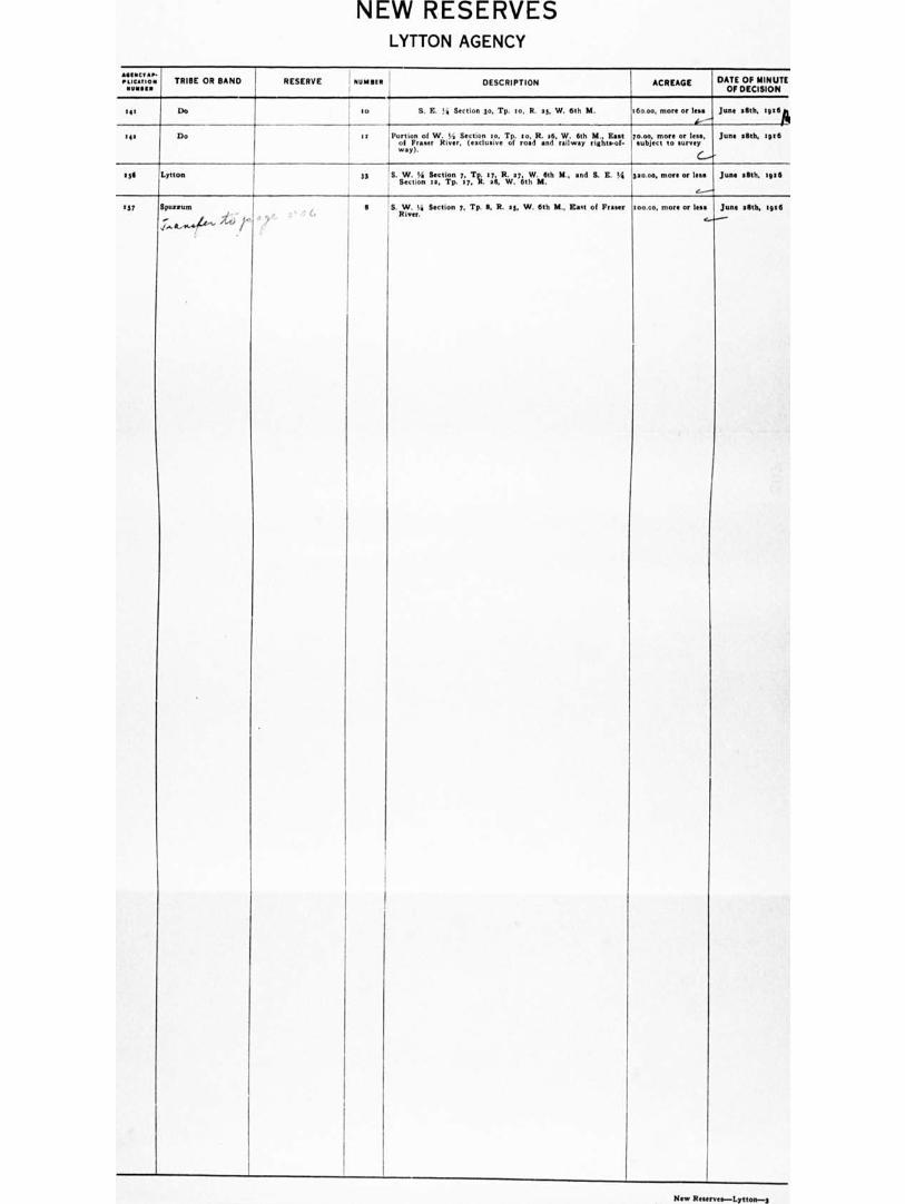
NEW RESERVES LYTTON AGENCY
•
pascals TRIBE OR BAND RESERVE NUNN, DESCRIPTION
4
ACREAGE DATE OF MINUTE OF DECISION
tit 10
S. E. ia Section do, Tp. to, R. at, W. 6th M.
Portion of W. 5/3 Section to, Tp. to, R. at), W. 6th M., East
of Fraser River, (exclusive of road and railway right.of• way).
a6o.00, more or less
14.----
yo.00, more or less, subject to survey
C./
June aSth, tptflpi
June oak tote .41 Do , I t
133 Lytton 33 S. Sectio
n Section 7, 3;7%. tze. R,..vayitii,As.m6th 111., and S. E. Vi woo, more or Ina JOAO MIL 3956
137 Spustum
./44.11..4•4416"- r
II S. W. Si Section y, Tp. S. R. ty. W. 6th M., East of F River.
t0000, more or less June silth, 416
New Reserves—Lynes-3
CONFIRMATIONS OF RESERVES NAAS AGENCY
TRIBE OR BAND RESERVE Minnie DESCRIPTION ACREAGE DATE OF CONFIRMATION
Kitauskaylum Kiteumkaylum _ i e
`,/ Skeen, District on the right bank of S k River, at
the mouth of Kitsuinkayium River. 0199.0o e....„. 10th February, 1916
Do Fishery .' a Skeen& District on the right bank of the Kitsumkaylum River, 5 miles from its mouth.
Os... 4.-----
Do
Do Timagerd , • 3
\ Minor. aill,twrictkito.numtkh.esur.1 ht bank of S River, 6 77.00
e- Do
Labels, Killutsal 1
I
Skeen. District, on the left bank of Labels* River, near its confluence with the Skeena.
196.00 a --
Do
Do Do Iii Sheen. District, to the 'northeast of and adjoining Room No. e.
5.00 C.--•
Do
Nue River Aiyansh a Skeen. District, on the banks of the Naas River. about 49 miles from its mouth.
30711.00 .....-
Do
Do Kitiadaman r ta Skeen& District, an extension of Reserve No. 7, on Its western boundary.
640.00 Do
Do Tsimmanwoncllet a Skeena District, on the banks of the Nue River, half a mile above the Grease Trail.
$0.60 G.
Do
Do Beaks a Minna District, an island at the confluence of the Beaks River with the Naas.
40.50 f.----
Do
Do Shumarl i 4 SktegtenathDouticoti on the right bask of the Nees Rivet, at 1711.06 -6...-- Do
Do Fishery a
i the Ikons Di•trict. on an Wand la the Naas River opposite
southwestern corner of RUM, No. 4. 1 7.50
e..... -"" De
Do Aortal 6 Skeen. District, on the left bank of Ness River, to the west of Ramo No. 5 .
76.50 e.. - ' Do
Do Iltwilluchsilt 7
4i
Skeen. District on the banks of the Naas River at the Lava beds. '
495.00 C..---
De
Do Aadegutay III Skew Dilltrdi,chtizspthe left bank of the Naas, So miles 051.60 _. Do
Do Do it as 3 ............................................ beak of the Naas, Mune- elli.ino (..----'
Do
Do Llecnhvlillutsap or f • Slrgent clli•tiri ldc:i. :Letilo bolls of the Naas River at the 3955.0o 4--- Do
Do Do yea Skiza,.District, to the wont of and adjoining Reserve 11.0. 6.-- Do
Rue River and Xincolith 7t to each i.e.,op-
grchili.ad to44 to Lothkaltsop)
Stony Point or Fishery Bay
t' to Shona District, on the tight bank of the Naas River at Stony Point.
347.50
Z.--..-'
t7th February, 1906
Naas River and Minion*
Black Point to Skeen. District, on the right bank of the Naas River, at Black Point,
40.59 17-
tads February, tog
Do Lachtesk I is Sheen. District on the left bank of the Nu e, twelve miles from it. mouth.
ago.00 Do
Do Red Cliff ; II Skeen. District. 1/istriciti. en the right bank of the Noe River, nine 711.$e 1..."-
Do
Do Kincolith re Skeena District, on the right bank of the Naas River, at its mouth.
:tattoo
I/ Do
Do Monolith to
!
Moon District, an antiunion of Reserve No. se, on the west.
Otto 4 , Do
Do Manama: 13 Ilk:iennes Diesstrincotroonof thiporlicimt bunk of /Mono: River, 4.40
e"
Do
Do Talahast IS Skeena District, on the bank, of the Kinsman River, two end • half miles from its mouth.
Tito `7
Do
Do Oorgie 17
Skeins District, on the eastern shore of Portland Canal,
near Blue Point. /I.00 Do
Do Scamakounst sg Simone District, on the eastern shore of Portland Canal, et its head, at the mouth of Best River.
96.90 Do
De Itionelit to Sheens Inlet.
in Salmon Cove. on the western shore of Observatory
4150 t
Do '
Do Stooks at Skeane District, on Dawkin's Point, on the eastern shore of Observatory Inlet
57.00 1... '
, Do
Do Stage* se Skeena District, on the bore of Observatory Inlet, four miles north of Reserve No. et.
47.30 4,,, Do
De inlaid 63 Sligbna DiLltrryictlidoeitn Perry Bay, on the eastern shore of eyteo 4,,- De
Coniloodomp—Maa•—•
CONFIRMATIONS OF RESERVES NAAS AGENCY
TRIBE OR BAND RESERVE NUMBER DESCRIPTION ACREAGE DATE OF CONFIRMATION
Do Tackuan 'se 1311(sebrisawoDo:ostrryictiolz the western choreoFft Hatdims aAsrm, 30040
•4 Do
Do Kshwan ay Skeena District, at the head of Hastings Arm, Observatory Inlet, on the right bank of Kshwan River.
133.50 ‘
Do
Do Sco ben yr at Skte:onajdisotqcatif ownilotshenolgteorfnNsohog go:Observatoryf Inlet, 76.30
e.--
Do
Do Zauleap t as Skeena District, on the banks of the Naas, about half a mile below Reserve No. 7.
5711.00 Do
Do Do ' age Skeena District to the north of and adjoining Reserve No. sq. 6.00
G
Do
Do Dachlabah t . go Skeen. District, on the right bank of the Naas, one mile west of Reserve No. U.
131.00 Do
WITATrie. Simpson Band Po"Simpson Skeen. District. in Port Simpson. on the Teimpeean
Peninsula. 37.o Do
Teimpsean: N. y1
helaa
v Umpteen a
V
Skeena District, on the Teimpsean Peninsula. 44.173—less reduc• ton of 10,468.00 acres-33,70L 4._
soth March, 19111
Teimpsean Tribe Metlakatla Band
Wilnultancaud , 3 Skeena Doottirii,c.t;.ionofthAse=.shore of Kaien Island. eight 6.0o lath February, :916
Do Shoowahtlans 4 Skeena District, on the western shore of the Tsimpeean Peninsula. east of Metlakstla.
13. no—less reduc- tion of 16.111 acres, more or less, sub- ject to surver-5.111
..'
211th February, 1916
Do Cloyah Deena District, on the western shore of the Tsimpsean Peninsula, at the mouth of the Cloyah River.
77.00 10th February, 09:6
Tsimpsean Tribe, Port Simpson and Metlakatla Bands
(in common)
/Gwen g Reverie District,
on the right bank of the Skeane River, at the mouth of the Kivu River.
e--
43.47 Do
Do Kilcutseen / 9
Skeena District, on the left bank of the Skeena River,
about six miles east of Port Essington. 1600 Do
Do Khtanda so Skeen. District, on the left bank of the Steen. River, about 7 mile. east of Port IE.sington, at the mouth of Khtshda River.
70o Do
Do Scutteap i'n
Skeena District, on the left bank of the Skeena River, at the head of tidal water.
9.00 g Do
7:i:it:fp:jet:lid TYmt°"*" , le Skeena District, on Compton Island, at the mouth of Works
Canal. 7300
G.
Do
Do Ensheshese 13 Skeena District, on the left bank of the Enshesheas River, Works Canal.
43.00 Do
Do Wilskultammel 1, 14 Skuonoaal Daistmrito ofnrotoihe J.aestFobraa of the north fork of Works too
4-
Do
Do Toon ,l13 Skeen.ooDoisot:trioortit, t,:ife,pult sbrokoote Toon River, at the head 110.00 Do
Do Lachmach 4,5 :6 Skeena District, on the right bank of Lachmach River, at the head of the south fork of Works Canal.
17.00 Do
Do Spate!. ay Deena District, on the eastern shore of Somerville Island, in Steamer Passage, opposite Khutseymateen Inlet.
moo
(--- Do
Do Hindi Island 16 Skeen. District, aH miles north of Port Simpson. 113.03 Do
Do Finlayson Island sg
/
Skeena District, one mile west of Port Simpson. 1569.0o–less reduc- Lion of eleven bun- dred and seventy- nine
("?) acres,
more Or.a,.s (tot to sunny —
410.00
56th February, 1916
Do Burnt Cliff Island I an Sheens District, in Pearl Harbour, 4 miles south of Port Simpson.
67.0o 16th February, tete
le.trx Tribe T"well I"" Sterna District, tH miles west of Iletlakatla. 351.00 Do
Tsimpsean Tribe, Port Simpson and Metlakatla Sande
(In common)
Dashken a1 Skeen District, on the northeast shore of Smith's Island, on the North P ge. . Sheen. River.
7.10 Do
Do Kshsoom 403 Skoenenlo14,sitorA:. ir the nciri:.h.woeostRlohoorre of De Horsey Island, 3.30 Do
Do Meanlaw ae
Lakelm es .
V Sterna Skeena District, at Mowitch Point, on the right bank of the
River.
SkoelmoDfirsoto,rictLookno.t.heLorlet bank of Lakelse River, about
649
*too
Do
17th February, 19:11 Do
NOTE:—KULLAN I. R. No. d, referred to in the Official Schedule of Indian Reserves. tgt3. at P 9e thereof, was placed by the Alaska Boundary Award within United States territory. It is not now a Reserve for British Columbia Indians and should therefore be removed from the Schedule.
WITZIMAGON I. R. No. lig, referred to in the Official Schedule of Indian Reserves, tem at P. 91 thereof, was surrendered and sold under 0. C. 14th January. tett. It is not now • Reserve for British Columbia Indians and should therefore be removed from the Schedule.
PORT ESSINGTON RESERVE, of the Kitselas, Kitsumkaylum and other Indians. referred to at P. 90 of the Schedule of Indian Reserves. 'pm Is not • Reserve within the disposing power of the Commission. having been conditionally granted in .got by the late Robert Cunningham and • revereionary Interest Wins retained for his Estate.
REDUCTIONS AND CUT-OFFS OF RESERVES
NAAS AGENCY
TRIBE OR BAND RESERVE NUMMI DESCRIPTION ACREAGE REDUCTION OR CUTOFF OAT I OF REDUCTION OR CUTOFF
Naas River and Kincolith
G, vault 54 Skeen. District, on the western AIM of Observatory Inlet.
7011.30—less allowed R.-W. of Provin- cial Public Road, 7.70 arr., 211 per Interim Report No. 114—soo.3o
Cut-off
G.
16th February, 1916
Teimpstan : Trimrsean N. 5.• Port Simpson S. 5. Metlakatla
s
f
Sheens District, on the Tsimpeean Peninsula.
44. 1 75.00 Reduced by the cutting off of Ten Thousand Four Hundred and Sisty- eight (10.461.00) •Cres, more Or less, subject to mrvey, w per sketch plan of Ashdown H. Green, H.C.L.S., the remaining portion being confirmed as such Minima° Reserve No. a, YiB. • 35,70100 acres.
with Much, :gig
Shoowahtlane If';t7.7.7.114Z.
I
4 Shona District, on the western shore of the Tsimpsean Peninsula, K. of Illetlakatla.
Moo Reduced by the cutting off of s6.6s awe., more or less, subject to ow- vey, as per sketch plan of Ashdown H. Green, li.C.L.S.,---s .1 6, the re- mcning portion of the R e be- ins confirmed as mob Shoo...theme Reserve, No. it, via.: nig arr., more or less.
.6th February, l9r6
Teimpwan Tribe, Port Simpson and lietlaketla Bands, n common
Wilhelm's',
.
II Skeena District, on the right bank of S e River, at I
99.07 Cut-off lath February, soca
Do Point Veitch 7 Skeena District, on the left bank of the Skeen• River, a miles W. of Port Essington.
t6.00 Do Do
Poi: rim7E,Tnrillrin d
.
Finlayson Island j
Skeen. District, t mile W. of Port Simpson.
tsag.00 Reduced by the cutting off of "moo acres, more or UK subject to survey, as per sketch plan of Ashdown H. Green, B.C.L.S.,— —atom, the remaining portion of the Reserve being confirmed as such Finlayson Island Reserve No. to,... Ws.: 41o.00 acres, more Or less. •
nIth February, ?mil
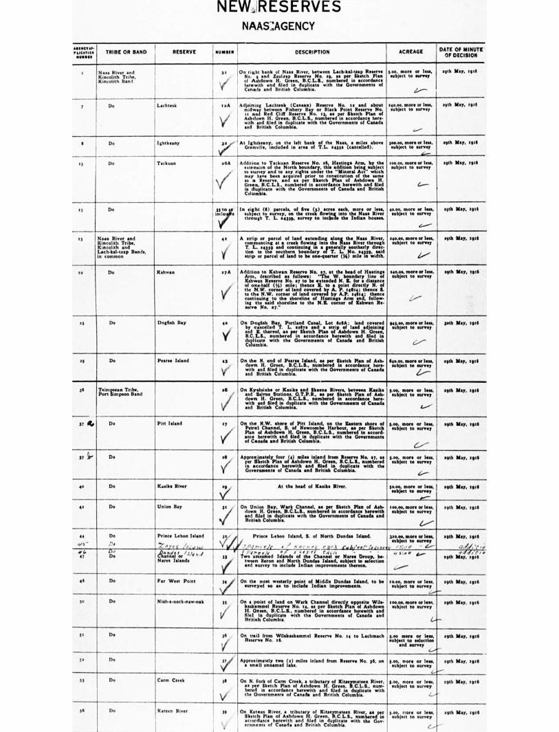
NEW RESERVES NAAS :AGENCY
114111C11.• ..oration TRIBE OR BAND RESERVE I NORM DESCRIPTION ACREAGE . DATE OF MINUTE
OF DECISION
. Naas River and Kincolith Tribe. Kincolith Band \i„
On slight bank of Naas River, between Lech-ltal•uap Reserve No. g and Zsulrap R No. sg, es per Sketch Plan
1 of Ashdown H. Green, B.C.L.S., 1111111O0f1111 is accordance 1 herewith •nd filed in duplicate with the Governments of
Canada and British Columbia.
3.00, more or less, agth May, iota subject to rummy
Z.,---
1 Do Lachtesk ■ a A 1
V 1
1
Adjong Lachtesk (Canaan) Reserve No. all and about midway between Fishery Bay or Black Point R No. cc and Red Cliff Reserve No. 13, as per Sketch Plan of
Ashdown H. Green, B.C.L.S., numbered in accordance here- 1 with end filed in duplicate with the Governments of Canada
and Braley Columbia.
aeo.00, more or lese, subject to survey
.......-
agth May, meta
I Do Ightkeany ;ee- I1 Atollttlitifesnaundetrinlefat.tanolef fiflthe.43499.1as,c s mild )cbove
1
te4:,,fnntrr!z
4....-
.9th If", 1911
I, Do Tackuan a6A i Addition to Tackuan Reserve No. al, Hastings Arm, by the ' extension of the North boundary, this addition being subject
to survey and to any.rights under the "Mineral Act" which may have been acquired prior to constitution of the mme as • Reserve, and as per Sketch Plan of Ashdown H. Green, B.C.L.S., numbered in accordance herewith and filed in duplicate with the Governments of Canada and British Columbia.
tocoo, more or len, subject to survey
C...--
agth May, :916
is Do i
33:0 inclu •
In sight fli) parcels, of five (d) acres each, more or IOW subject to sunny, on the creek flowing into the Naas River through T. I.. .4319, survey to include the Indian houses.
40.00, more Of less, subject to survey
(----.."
agth Rey, tell
Is Naa. River and Kincolith Tribe, Kincolith and Lech-kat-map Bands, in common
er A strip or parcel of land extending •Tong the Naas River, commencing at a creek flowing into the Naas River through T. L.. 54332 and continuing in • generally motherly dirge. tion to the southern boundary of T. L. No. sant said strip or parcel of land to be one-quarter (14) mile in width.
340.00, more or lam agth May, lots subject to survey
41,'-''
as I Do Kshwan syA
V
.
Addition to Kshwan Reserve No. ay, at the head of Hastings Arm, described an follows: "The W. boundary line of Kshwan Reserve No. ay to be extended N. E. for a distance of one-half (IA) mile; thence E. to • point directly N. of the N.W. corner of land covered by A. P. 1464; thence S. to the N.W. corner of land covered by A.P. 24414; thence continuing to the shoreltn• of Hastings Arm and, follow- ing the said shoreline to the N.& corner of Kshwan Re- serve No. sy."
340.00, more or less. 1 agth May, tote subject to coney
33 Do Dogfish Bay es ,
y$
On Dogfish Bay, Portland Canal, Lot 6311A; land covered by cancelled T. I.. oafs and a strip of land adjoining and E. thereof, as per Sketch Plan of Ashdown H Green, B.C.L.II., numbered in accordance herewith and filed in duplicate with the Governments of Canada and British Columbia.
943.00, more or leas, 1 Loth May. toil subject to survey
I
c -
ag Do P Island 43
Ya
On the N. end of P Island, as per Sketch Plan of Ash. down H. Green. B.C L.S., numbered In accordance here. with and filed in duplicate with the Governments of Canada and British Columbia.
640.00, more or less, i path May, e9t6 subject to survey 1
Z./.
36 To•irnmeapsn Simeon Band
16
/
On Kyalisiahs or Kasiks and Skeane Rivers, between Kandes and Salvos Stations, O.T.P.R., me per Sketch Plan of Ash. down H. Green, B.C.L.S., numbered in accordance here- with and filed in duplicate with the Governments of Canada and British Columbia.
d.00, more or less, agth May, min subject to survey
1.---;
37 flo Do Pitt Island ty
v/
On the N.W. shore of Pitt Island, on the Eastern shore of 3.00, more or less, agth May, :gra
Petrel Channel, S. of Newcombe Harbour, as per Sketch subject to survey Plan of Ashdown H. Green, B.C.L.S., numbered in sccord-
ante herewith and filed in duplicate with the Governments of Canada and British Columbia.
6.----
37 Do IS ,
Approximately four (4) miles inland from Reserve No. ay, as 3.00, more or less, .9th May, spa
per Sketch Plan of Ashdown H. Green, B.C.L.S., numbered subject to survey in accordance herewith and filed in duplicate with the Governments of Canada and British Columbia.
4.----
ito Do Kest!' River ___v_s9
Union Bay 3t
At the head of Knelt. River.
On Union Bay, Wark Channel, as per Sketch Plan of Ash. down H. Green, B.C.L.S., numbered in accordance herewith and filed in duplicate with the Governments of Canada and British Columbia.
1 o.m more Of less, Ssubfecmt to never
d."--
too.00, more or less, subject to survey
6,'''
SO May, Nue
soh Nay, sei6 41 Do
44
4,6
Do
Pe
Prince Leboo Island 3n
,..74 c .1., , 4 too
&eel Sot S/"" I 33 Hares Islands
Prince Leboo Island, S. of North Dundee Island.
. ' .1 '' `- r2r • AO . , 04 03 , 1 .nediret'' titteavas. •,:- j "4 4, rt Cderi
ism nenked Islands of the Channel or Norse Droop, ba tenon Baron and North Dundee Island, subject to selection and survey to include Indian improvements thereon.
pane, more or less, subject to survey
, ,; ' c' . e- -- e .• • ,...... ' I. —
..../.-
qt! Nay, ugh'
adk,:<,■ 0.1414 1.4,
sittb 1110, :9111 47 4,4
Do
41 Do Per West Point ss On the most westerly point of Middle Dundee Inland, to be surveyed no ss to include Indian Improvements.
10.00, more or less, eobject to survey
.........-
sgth Slay, sots
30 Do N isha-nock•naw-nak 39
/ On a point of land on Wark Channel directly opposite Wile-
kaskammel Reserve No. le, as per Sketch Plan of Ashdown H. Green. B.C.L.S., numbered in accordance herewith and filed in duplicate with the Government. of Canada and British Columbia
s0000. more or leek subject to survey
V-
agth May, :9:6
31 Do 36 ,
17
On trail from Wilskaskammel Reserve No. t4 to Lschmach Reserve No. It
5.00 more or less, subject to selection
and survey ......---•
.9th May, soli
5. Do :i.el Approximately two (a) miles Inland from Reserve No. 36, on • small unnamed lake.
e.00, more or less, subject to survey
..
agth May, tgt6
---
SS Do Carm Creek 3$
.
V the
On N. fort of Carm Creek, a tributary of Kitselmateen River, as per Sketch Plan of Ashdown H. Green, B.C.L.S., num- bend in accordance herewith and filed in duplicate with
Governments of Canada and British Columbis.
5.00, more or less, subject to survey
...--•
agth May, tots
36 Do Kateen River 39
,
On Kateen River, • tributary of Kitseymateen River, as per Sketch Plan of Ashdown H. Green. B.C.L.S., nunsbered In accordance herewith and filed in duplicate with the Gov- eminent. of Canada and Britith Columbia.
gve. more or loss, subject to survey
(,...-
agth Nay, :WI
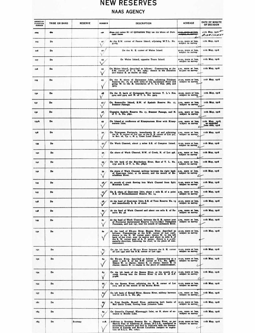
NEW RESERVES NAAS AGENCY
ELICAT10116,-
TRIBE OR BAND RESERVE I
1 n noun DESCRIPTION ACREAGE DATE OF MINUTE OF DECISION
-um die -ow rid1=2,1111•411•,....1= .1-- .21th May, igt6
otf,./...V.411 //.0 fre.o/ Bay;- on - Port. T4.4 ,...t. N-.- of-Guthman cm the Mort of
Ifs Do . el At the S.W. corner of Pears* Island, adjoining W.T.L. No. 31115 5.
:coo, more or lees, *object to survey
..,.
nth May, egull
■ all Do 4a On the N. E. corner of Wales Island. 116klile
subject to sourr ler
nth May, 1916
117 Do \413/..• On Wales Island, opposite Truro Islind. go...otogrtio foe sane, nth May, e5t6
oil Do oil 44 On Wale• Island, described as follows: Commencing at the
Y
S.W. corner of T. L. No. 7684; thence to the shoreline and thence EC as chews on map.
goo, more or less, I maject to survey •
Ittlk Map, MG
tag Do 4$
y/'
On the N. shore of Quinarn•ss Inlet, adjoining Talshaat R No. 16, on both sides of the Quinamm• River and going W. to the E. boundaries of T. L.'s Nos. 5685 aid 3903.
moo, more or lees, subject to survey
tttIt MIN ME
130 Do ali
V 59o4 On the N. bank of Quinarnam River between T. L.'s Nos,
and 5924 and N. of T. L. No. 5901 moo, more or less, 'object to s
nth May, 2916
to Do 47 On Somerville Island, S.W. of Spike!. Reserve No. 17, Steamer Passage.
g.00, more or less, subject to survey
ttth May, 3916
ils Do 48
Vl
Opposite ipakels Reserve No. 17, Steamer Pentane, and N. of T. L. No. 51193.
goo, more or lees, subject to survey
nth May, zeta
I34A Do 40 On Inland at confluence of Milometer'', River with Rimy- mitten Inlet.
4.00. more or leas, subject to survey
Seth May, :9:0 as amended
June ellth, 1916
316 Do ge OntheTetir verornPeernoirfisidos, siredi•tely N. of and adjoining Lot , at the S. E. corner of Lot 517,
in Sec. et. Tp. 1, R. 5, Come Lend District.
goo, more or less, subject to survey
nth May, mid
139 j Do gs On Wark Channel, •bout 3 miles S.E. of Compton Island. to mi. more or less, 1 subject to mrvey
mth May, egt6
140 Do Ss On shore of Wark Channel, N.W. of Creek, N. of Lot get
more sourlesse, 1 nth May, 1916 giuoot; subject to
,
LI--
g.00, more or lees, . nth May, sgt6 subject to survey I
44--
141 Do ga /
On left bank of the Enscheshese River, East of T. L. No. s7g1 and S. of T. L. No. 38695.
:42 Do is 0. shore of Wark Channel, midway between the right bank of Quatdoon Inlet, at its mouth, and the mouth of In. whisks., River.
s.00, more or less, , subject to survey
e....--
nth May. sg:0
144 Do \74'. At mouth of creek flowing into Wark Channel from Split Mountain Lake.
15.00 more or less, subject to survey
k'''-.
goo, more or less, subject to survey
44,"
itch May, rgt15
nth May, :916 143 Do sy Os S. shore of Quart-coon Inlet, about e mile E. of • point N.I. of Wilakmkammel R No. 14.
146 Do ill At the heed of Quart-toon Inlet, B.E. of Toon R No. es sod immediately S. E. of creek.
---/
so.00, more or less, subject to survey
' Soo, more or lees, ' subject to survey
4--- 15.00, more or less,
subject to survey
.00414'
_
nib May, 39.6
nth May, 29,6
rub May, zeta
eel Do So e
1
At the head el Welt Channel and about one mile B. of Re- serve lie. 56.
149 Do 111 y■
Al the head of Work Channel, between the S. E. corner post of Provincial Government Reserve (15/m/ellge) Tsinmsean Peninsula, and Lot 197, near the mouth of Lachmach River.
to Do M At the head of Kh-ye• River, Skeena River, described as follows: Commencing at the S.W. corner of Lot toot; thence to the N. W. corner poet; thence W. to the left bank of the river, near its source and about 54 mile S. of the S. W. corner poet of A. P. moss; thence i.i •...nth- easterly direction, following the river, to the place of com-mencement.
3o.00, more or less, nth May, meg subject to survey
A.-.
1SI Do tto
V of On dm left bank of Kh.ye• River between the S. IL corner
Lot 1990 and the N.I. COMET of Lot 1391. moo, more or lets, nth May, ,9111
1 subject to surety
t3* Do Do 64 , Os Kh-yea River, described a. follows: Commencing at a point I mile S. of the N.W. corner of T.L. No. 306115; thence W. to chains; thence S. 10 chains; thence Z. to chains; thence N. to chains to the place of commencement
:coo, more or lees, nth May, seen subject to survey
(...-r"
114 Do 111 On the left bank of the Simms River, at the mouth at •
creek flowing Into the Steens River 44 mile Z. of A.P. 5.966.
10.00, more or less, ttth M.', zeta subject to survey
.. t_ ..
155 Do
• 66, /
On the Skeen• River, adjoining the N. E. corner of Lot !moo, more or 1001, nth May, 1916
2374 and at the mouth of the Scotia River. subject to survey
--«— •-■
137 Do 67 On left bank of Metall Rime, Skeens River, midway between S.00, more or IOW nth May, 3916 Lot 67 and A. L. No. 301. subject to survey s,
tat Do 6:7
nib My. sole AtReFdir&I,Rhapdree,a.EctsotwelilngRifrvorner, itrnrslocinngutath banks of so...z.:ittotros survey,
164 1 44 Do On Grenville Channel, Klewnuggit Inlet, on N. shore of en• trance to Brodie Lake.
goo, more or less. 551h Kay. we subject to survey
‘,/-
165 De Scutt's', telt
'
Addition to !lemmata Reserve No. II, Skeen' RIVET as per I Sketch Plan of Ashdown H. Gran, B.C.L.S., numbered
in
accordance herewith and tiled In duplicate with the Govern-ments of Canada and British Columbia (subject to expire- lion of H.L.L. No. 1467). _____
30.00. most Of tee. MR NM HO subject to sunray
...../
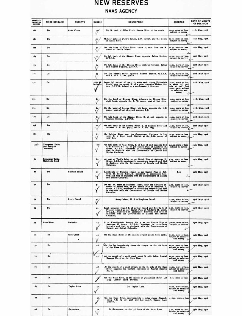
NEW RESERVES NAAS AGENCY
411.14C ■ ••• soc•tion TRIBE OR BAND RESERVE Nuags. DESCRIPTION ACREAGE DATE OF MINUTE
""'" -• ---•-•—•
:66 Do Alder Creek to
" 1
On N. bank cal Alder Creek, Slteen• River, at its mouth. io.oe, more or less, subject to survey
-.0
13th May, 3916
167 Do idwey between Devil's Island, S.W. , and the mouth M iplwey Redo River. '
moo, more or less, subject to survey
nth M•y, 1916
364 Do 731 . On left bank of Rinks River. about al mile from the N. \ / corner of Devil's Isl•nd.
to.00, more or less, subject to survey
nth May, 1916
tag Do y
On left bank of the Steen. River, opposite Salvos Station, 000 to
more or less, subject survey
nth M•y, 3916
aye De ..
ye \i,
On left bank of the Sheen. River. midway between Salvu• and Hubert Stations, G.T.P.R.
moo, more or less, subject to survey
nth May, 3916
173 Do 75 Onantill. SolfmernaLRI4voer,7471333site Ilubert Station, G.T.P.R tos.uotogr more sourrvleesys, nth kl•y, 3936
t7. Do rd.° . Seven i(, ( 7) rarC‘11.11 mouth
uttehn 6. of •. c r tos nttlIC h, along Huber t
la ds0,111
lion, G.T.P.R., inland in a soutUasterdirectioun. r '
1.0.00, more orOr ICI:
ciels sevof ten ro) sores each, subject
to selection and survey
nth May, 3916
t75 Do •
53,
i
On the bend of Estes.. River, tributary to Sheens River,
right bank, opposite the S. W. corner post of Lot 5639. moo, more or less, subject to survey
13th May, 1916
...-
174 Do 66 On the bend of Extew• River, left bank, opposite the N.H. corner poet of Lot 5634 and running &E.
moo, more or Ilse, eubject to survey
nth May, 39111
176 Do 55 On left bank of the Skeen. River, E. of and opposite to Shames Station, O.T.P.R.
30.00, more or less, subject to survey
nth May, :916
176 On S6 •
v
On left bank of the Skeens River. K. of Shames River and between T. L. No. 3094S and P. R. No. 3693.
40.00, more or less, subject to survey 4
13th M•y, spa
:St Do 67 /
On Lakelm River, near the Government Hatchery, in Lot 5967, R. 5, Coast Land District, at the S.W. corner of said Lot.
Ioao0i more or less, subject to survey
nth May, tete
590 Tnimpsean Tribe (All Bands in common)
SS /
\.
On left bank of Naas River, R. of Lot ill and opposite Red Cliff R No. 15, •• per Sketch Plan of Ashdown H. Green, B.C L.S., numbered in accordance herewith and filed in duplicate with the Governments of Canada and British Columbia.
040.00. more or less. subject to survey
eath May, 3916
So TineTl'aPra:Ina Tribe, 119
\if
At head of Tuck's Inlet, as per Sketch Plan of Ashdown H. Green, B.C.L.S., numbered in accordance herewith and filed in duplicate with the Governments of C•n•cla and British Columbia.
5.00, more or less, subject to survey
.9th May, 3916
ft Do Rushton Island yo
\'‘'
Lachhoieta or Rushton Island, as per Sketch Plan of Ash- down H. Green, B.C.L.S., numbered in accordance here- with and filed in duplicate with the Governments of Canada and British Columbia.
Soo
&-
sgth May, 1916
79 Do gt
\(
On the W. coast of Stephens Island, near the northern en- trance to Skiakl Bay, as per Sketch Plan of Ashdown H. Green, B.C.L.S., numbered in accordance herewith and filed in duplicate with the Governments C•nad• and British ts Columbia.
s.00, more or less, subject to survey
c...--.---
egth May, 19 et
72 Do Avery Island gs
\i"
Avery Island. N. E. of Stephens Island. 15.0o, more or less, subject to survey
err
19th M•y, 1916
73 Do 6g Small unnamed Island K. of Arthur Wand and directly S. of Prescott Island, as per Sketch Pun of Ashdown H. Green, B.C.L.S., numbered in •ccordance herewith and filed in duplicet• with the Governments of Canada and British Columbia.
3.00, more or les., subject to survey
39th May, 39311
75 Na.. River Gwinsha e4 S. of Kitwilluch•ilt R No .7, as per Sketch Plan of Ashdown H. Green, B.C.L.S., numbered in accordance herewith •nd filed in duplicate with the Governments of Canada and British Columbia.
soo on, more or less, subject to survey
oath May, 1916
79 Da Oieh Creek
s
45
,,, i
On the Naas River, at the mouth of Gish Creek, both Woks moo more or less. subject to selection
and survey z
39th May. Iota
79 Do 46
r
On the Rst immediately Move the canyon on the left bank of the Nese River.
10.00, more or less, subject to eelectmn
and survey ,
gib May, 1916 y
.."
79 DJ se
V ey At the mouth of s smell creek about !ii mile below Amatal R No. 6, on the Tim River.
t000, more or less, subject to selection
and survey
sgth May, 3936
79 Do 411 At the mouth of a small stream on the N. side of the Naas River, opposite the western extremity of Amami Reserve No 6.
10.00, more or less, subject to selection
and survey
e9th May, tgt4
..-,-
So Do 7 On the Nas• River, at the mouth of Quinamuck River, Lot 5153, C•Bilill, Land District.
7.00, more or less 39th May, 3916
115 Do Taylor Lake so
1(
On Taylor Lake moo, more or less. subject to selection
and survey
39th Noy, 1936
al Do st. / '
On the Naas River, approximately g mil" above Aiyansh,
being N.H. La Lot soge and Lot so9612, Cuellar Land District.
ettoo, more or less 39th May, 1116
34.6 Do Owimmau. ss .. .
v
At Owimmeim on the left bank of the Naes River.
an d survey
5.00, more or feu, subject to selection
,9th May, 3916 '
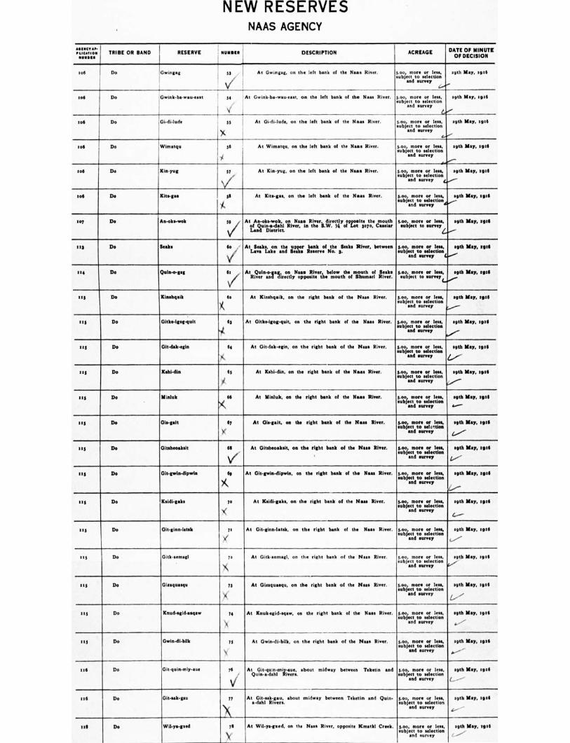
NEW RESERVES NAAS AGENCY
Vit.:Act■ aol.t; TRIBE OR BAND RESERVE stills ' DESCRIPTION ACREAGE DATE OF MINUTE OF DECISION tot Do 'Gwing•g S3 ,
V and At Owingeg, on the left bank of the Naas River. 5.0o, more or less, subject to selection survey
29th Kay, sot
mg Do Gwink.ba.wau.esst ' 54 , At Gwink.ba-wau.east, on the left bank of the Naas River. 1 i
5.00, more or less, sub ject to selection and survey mith May, teal
tog t Do ,Gi.di.lude 55 1 At Oi-di-lude, on the left bank of the Naas River. 5.00, more or less, sub ject to selection and survey 39th May, Bete
tot Do Wimatqu 56 le
At Wimatqu, on the left bank of the Naas River. 5.00 more or less, sub ject to selection and survey 39th May, :ha
to. Do Kin.yug 57 At Kin-yug, on the left bank of the Naaa River. 5.00 more or less, sub ject to selection and survey 29th May, :gill
mg Do Kits-pa 35 -is
At Kits-per, on the left bank of the Naas Roar. tle:fecTotroe s:fecitrot and survey 29th May, 19"
so? Do An-oks-wok 5v AtotAxouiltat.weil t7;i Nueu.Rtteri.vvre. csrlpait:07tZe cutout:it:1 Lan District
To; j.netrrte. or lees, setk May, Intli
113 Do Soaks ", . Attk'nI a bank the River, between Lan Lake the upper . Loo more subject o decti and
Barmy 39th May,
""
174 Do Qule-mgag 6: V
z AtLuin44a ton Nr tlir blow th month of trIu a:r.a rectlyposietleeoutiOfbtaarv. or : lees, subject to " eh May, " "
111/ Do Kinehosik 6s At Kinehgaik, on the right bank of the Naas River. 5.00, more or lees, sub ject to selection and survey seth May, 19111
HS Do Githe-igoipquit If 'Ilt.
At Oltkipigog-quit, on the right bank of the Naas River goo more or Ins, subject to selection and survey sgth May, ire
III Do Oltdak-egin 64 1.,
At Oit-dak-egin, on the right bank of the Naas River. too, more or lees, subject to selection and survey seth May, toll
4.......--
at] Do Kehl-din 65 At Kahi-din, on the right bank of the Naas River. 5.00 more or less, sub ject to selection and survey Beth May, 1916
mg Do Mhiluk 66 ')(\
At Mialuk, on the right bank of the Naas River. too more or lees, subject to selection and survey soth May, m:6 4.----
113 De Ole-galt ly
X'
At Cliwgait, on the right bank of the Naas River. Loo moreVela, sad survey
nee May, Bed Z.,°.--
us Do Oltehmaksit 65 Vi
At Gitehmaksit, on the right bank of the Naas River. g.00, more or lees, subject to selection and survey 9th May, toil
1/- us De Ditgwirdipwia 65 At Git-gwin-dionia, on the right bank of the Noss River. too, more of lees,
subject to *election and survey meth May, 59:11
4:./. 515 Do Ksidtgaks 70
1( At 33sidi-gake, on the right bank of the Neu River. Lobocecetroe.o,riclat
and survey :nth May, :916 4.---
ti5 Do Git-ginn-latsk is llti
At Clit-gins-latak, on the right bank of the Naas River. 5.033, more or lees, subject to selection and survey age May, 3914
(........,
It s Do Gitkaernagl 73 \i's
At Gitk.semagi, on the right bank of the Neu River. 5.00, more or less, sub ject to selection and survey 39th May, 1941 ,....,,
11111 Do Oiraquaequ 73 X
At Giraqualmu, on the right bash of the Naas River. 5.00 more or lest subject to selection and survey setb May. 911
e.-,
115 Do Rauttegidasaaw 74 \
At Rnuk.egid-saaw, on the right bank of the Naas River. too more or less, sub ject to selection and survey
39th May, tell ..-'
its Do Owin-dtbilk 73 N
At Owin-di-bilk, on the right bank of the Naas River. too, more or lose, subject to selection sod survey
:gth May, seta 6.---- -
tag Do Clit.quiremly-aue 76 AtQutilnit-amdrfh-imiliwuurei. shout midway between Teketin and Loboj,ecmiroes:recltr.sl:; and survey
setb May, tell L. ---
Ire Do Clitaak-gau 77
Witya-gved 76 A--
N'
At Oit-eak-gau, about midway between Teketin and Quin- a-dahl Rivers.
At Wil-ye-geed, on the Ness River, opposite Kmat121 Creek.
5.00 more or less, subject to selection and survey
5.0o. more or less, sub ject to selection and eurvey
39th May, tell
29th May, Iva ----
1 till Do
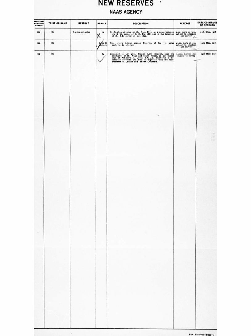
I RESERVE
PLICATIO. TRIBE OR BAND
Erg I Do
1112
tea Do
An uks-e ynisg
NEW RESERVES ' NAAS AGENCY
DESCRIPTION ACREAGE
At An-uks-gwi-ynisg, on the the S. W. corner of P. R.
Na.. No.
River at • point between] :667 and in the directio
S-oo more or les., subject to selectsoO
of the S.E. corner of Lot tagt. and survey
iv Chnive Ni
enaech.aetvograt!. trei,nts.d.station of five (s) acre. 45.00, more or leek' a9th May, tote subject to selectioal
and survey
Containedin Lot 4010, C•s•i•r L•nd Di•trice, near the teo.00, more Of less
confluence of the Naas and Stak• Rivers, as per Sketch subject to survey v Plan of A•down H. um
wi tbed i •c
condone herh it ewh and
G filed in
B duplicate h
re the
n Gov
ernment• of Canada and British Columbia.
a9th May, seta
Do
DATE OF MINUTE OF DECISION
sgth May, igie
New R a—Naa•--g
t-1
CONFIRMATIONS OF RESERVES NEW WESTMINSTER AGENCY
TRIBE OR BAND RESERVE NU mate DESCRIPTION , ACREAGE DATE OF CONFIRMATION
Chilliwack Tribe, Skwash Band
Schelowat 1
New Westminster Dietrict, in Spa. a and 3, R. op, W. 6th M., on the right bank of Hope Slough.
013.00 e/....
April toth, 1916
Do Sk wshla a New the
VfeefirmbiannlerolDiAtorp.ict, e0.7gg: 3. R. 3u, W. 6th M., on 09.00 4••••........-
Aped lath, 1916
Do Skwali j
New Westminster 07111okpte iiloTo ;ft 3ent the left olhStflord'
Slough.
agitoo April soth, 1916
Do Skwah 1 Ne;.. Wonestlinsi teefr, District. coti, Ir. Hope Slough
L gal? and 3, its mouth.
6th 313.00 Do
e....-e---- I
Chilliwack Tribe, Skwsy Band
Skway 3 N71., WoenstgiensrtiegrhtD:InrVt'ofinCIfirlaiWaacfrli:er Rat 311 's Wmouth. 6 h
53too Do
(......"----
Chilliwack Tribe, Kwaw-kwaw-a-pilt
Kwaw-kwew-a-pilt 6
Band 4....-----
New rwessweinii,nwsat::..Gplieittrit,..Tgt s3, E.C.M., on the left bank '33.00 Do
Chilliwack Tribe, Silviaa Bead
Squi..a.als 7 New Westminster District, in Tp. s3, E.C.M., on the right bank of Chilliwack River.
sog.00 Do
‘......"--..- r
Do Do I New Westminster District, in Tp. N. R.C.M., on the left bank of Chilliwack River, at its mouth.
115.00 Do I.
Chilliwack Tribe, Ahtsslits Band
Aitchelitch g New Westminster District, in Tp. ss, R.C.1111., on the left bank of Chilliwack Rivet.
53.00 Do t
Chilliwack Tribe, @Welton Band
likul.kayn zo New Westminster District, In Tp. 26. Z.C.M., on the right bank of Chilliwack River.
e 170.00 Do
IA
Do Do :1 New Westminster District. in Tp. 16, R.C.M., on the left bank of Chilliwack River.
sone Do z.---- '
Chilliwack Tribe, Va•bnes-a-kwi-oou Band
Ye•kwu.a•kwi-oose la New Westminster District, in Tp. 26, E.C.61., on the right bank of the Chilliwack River.
41.00 Do
4....-"" t •
Chilliwack Tribe, Chilliwack, S rs aid Ynkeronkwirsose Bands
Taeschten Is New Westminster District, in Tps. as and ell, R.C.11.. on the banks of the Chilliwack and Luca-cuc Rivers.
697.00 Do
c..----"-- t '
Chilliweelt Tribe, Soowahlis Band
Soowahlie le New Westminster District, in Tps. en, III, aj and s6, E. C.M.
1140.00 April moth, awl r:...----
re
Chilliwack Indians in common
Grass Reserve as New Westminster District. northwest ye Section is, Tp. 26. 160.00 Do
/ I
Chilliwack Tribe, limb. Skwahla, Rwasnineaw-e-pilt, hulaltkiiikwaasnd
in common
Skumalasph 16 New Westminster District, in Tp. se, on the right bank of the Fraser River.
1137.40 Do
4 --- ,
Chilliwack Tribe, Ahtsalits Band
17 New Westminster District, in Tp. s3, Sec. 17, R.C.M. 55.00 April moth, sgill V/
t
/
Coquitlam Tribe Coquitlam a New Westminster District, in Tp. 3II. W.C.M., on the right bank of Coquitlsm River.
6.5o April 11th, Hue
4..-.."--
Do • New Westminster District, in Tp. I. W.C.M., on the left bank of COqUitInfl River.
201.10 Do Qr.--
Douglas Tribe Samehquam :
Y4
New Westminster District, at the se Mile Post on the Douglas Portage.
049.00 April 7th, sed6 6.--- De Sachteen New Westminster District, near the es Mile Post on the
. Poosrtuge. (Two graves moo yards north of the .Doujiire P 3 15.0o Do
c...,---
DO Do / sA To the south of and adjoining Reserve No. a. 30.00 Dov.
De Swesteen / 3 New Westminster District, near the at Mile Post on the Douglas Portage,
'too Do
i......---
Do Skookumchuck IV 4 Nevou;liaess trpon4aterge. District, at the to Mile Post on the 526.00
C. -
Do
Do Sklahhesten ( 5 Ne1■70.1egyee.sta;oilgtaegre. District, et the re Mile Poet on the Do
71700 4 .
Do Do y/ 5A An addition to Reserve No. 5 115.06 Do
Do Lelachen ,, 6 F
New Westminster District. on the right bank of the LIDOOOt 12111111% shout 5 miles from its mouth.
37.10 Do
Do Graveyard I
V' 7 New Wlistitticinesiter4 Dmi■iterict:ilo.osailaiechir,Lght bank of the 0.73 Do
Do Douglas / I NeawidWa:sminsmteornopisotpc,t4. iheos ItiefFtdivel Harrison Lake, zoso.00 Do
De Morteon New Westminster District, et the .7 Mile Poet en the Douglas Portage.
te5.1:* Do
CONFIRMATIONS OF RESERVES NEW WESTMINSTER AGENCY
TRIBE OR BAND RESERVE NUNOIll DESCRIPTION ACREAGE DATE OF CONFIRMATION
Do Franke to ' New Westminster District, at the it Mile Post on the I Douglee Portage.
,moo
i.../'-"' Do
Do P v3 r hea.Vjaitinnater District, near the to Mile Post on the 3o.00 4......../ Do
Harrison River Scowlito 1
New Westminster District. in Tp. 3, R. 30, W. 6th M.,
at the mouth of Harrison River. 616.00 Do , faate---
Do Burial Ground a New Westminster Di ' , in Tp. 3, R. 30, W. 6th la, on the right bank of Harrison River at its mouth.
24.00 Do / I
Do Squawkum Creek 3 NI Wstn:r District, ...... I.%1, on right /k:1:4Z.,ve...... ....... 392.00 L.,-----
Do 5,
Do Chehalis 4 Metz. Wriegiri:isntekr District, aririsoinn Ttfii.v.4;. R. 30, W. 6th M., on 633.00 Do • •
Do Do 3 New Westminster District, In Tp. 4,_ R. 29-30, W. 6th Id., on the right bank of the Harrison River. 1414.cto Do • • e••••-""----
Do Do 3A New Westminster District, In Tp. 4, R. 3o, W. 6th St, on the right bank of Harrison River between Reserves 4 and 5.
tstoo Do 4.••••••""---- L /
Do II New Westminster District, in Tp. 4, R. 34, on left bank of Harrison River. 61.00 4..2.730f soth, 1.16
I. f
Homalco Tribe Hornets* .,s v f V
Coast District, on right bank of Homalco River, at the
head of Bute Inlet. 7 sago Do
Do i e Cox:. Itiszictit.onmoleuftth. bank of Homely:, River, about a 9.5o Do
Do Potato Point ( 3 Coast District, at head of But. Inlet. Do
0.40
Do Orlord Bay ( 4 Coast District, on shore of But. Inlet. 111 71.02 Do
Do Muabkin f 5 Coast District, on eastern shore of Valdes Island. !e.g. Do I Do Aupe Coast District, on shore of Bute Inlet. 14.0o Do
Kuno Tribe Saul. a New Westrni District, in B. 1o, Tp. 9, Zest of Coast Meridian, on right bank of 10 River. 1 olio. May set, sou (e41 V 641—.
Do a New Westmi District, in S. tr. Tp. 9, R.C.M., on left bank of Fraser River. 370. 14 Do
Do Barnston Island 3 Wow. Vrfgegmti,..k of .. ..the c LIL.053, FS; at, To. LC. M., 'Slue Do
Do Pitt Lake 4 New Westminster District, In Secs. 3 and 4, TP. 3. • 7th M., at the outlet of Pitt Lake. 34000 Do t •
Do Graveyard 5 New Westminster District, the N.W. corner of Lot 279, 0. s. Leo v Do ti
lashes's' Tribe Klaboose a Coast District. at the head of Toba Inlet. 1,11104o April 50th, 2011
Do Burial Ground Coast District, on western shore of Toba Inlet, about • mile W. of Reserve Na, s. 073 Do
Do Salmon Bay V3 Coast District, at the head of Salmon Bay, Toba Inlet. 174.00 Do
De Rabin 4 11( New Westminster District, on eastern shore of Waddington Channel, near Dean Point, Redonda Island. 700 Do
Do Deep Valley Coast District, on eastern shore of Ramsey Arm. 6140 Do
Do . Quequa ( 6 New Westminster Dlissltanricds, on eastern shore of Lewis 4.00 Do
De Tork i 7 Sariwiaal District, on we shore of Squirrel Cove, Cones {Oleo Do
Do Squirrel Cove 1
Sarzati District, 011 northern shore of Squirrel Cove, Cones 39.0o Do
Do Alvah= ' g New Westminster District, at the head of Forbes Bay. Hominy Channel. Peas Do
Do Tstpo-ooee 1(.1 to Hayward District, at the head of Hoskyn Inlet, Valdes 11..00 April ink. tine
Langley Tribe Whonock t New Westminster District, In Toe. r e, 15. E.C.31., on the right bank of P River. 91.00 April stns. spill 11-141
2 Do Neivc,W4e.,stomninsrfegrht Dbiasntrkict,:: of the N.W.tam it..sr.c. s. Tp. 15, • roo Do I i
Do 3 Ne1.5. Tten.insotenr l lertitcnti Loulor:h:ellaavned River O. ii,,,,T1.:Litg: 11.00 Do ' r
Do 4 New Westminster District, in Sec. s, Tp. e 3. E.C.M., on left bank of the Stave River. 0390.0 April lath, Agra r
CONFIRMATIONS OF RESERVES NEW WESTMINSTER AGENCY
TRIBE OR BAND RESERVE tit/ MSS a DESCRIPTION ACREAGE DATE OF CONFIRMATION
Do i 3 New Westminster District, in Tps. I ■ and is, Z.C.II., on right bank of Fraser River.
360.30 A'''.
April a Ith. Iv6
Do McMillan's Island 6 New Westminster District, in Tps. is and tan, E.C.M., in P River, near Langley.
i---
647.00 .I../....
Do
Do 7 1 New Westminster District, part of Sec. at, Blk. 3 N., Range a W.
40n0 Do e...2"'
Do 3 New Westminster District. poet of Lot a, 0. 2, on left bank of the F River. opposite New Westminster.
OS e--.4"- Do
Matsqui Tnbe Sahhacum 2 New Westminster District, Oft of Sec. 34, Tp. 36, B.C.Y. Mlle 1_ – Do
Do Matsqui Main a New Westminster District, part of He. 7, Tp. 17, S.C.M. 3.543 Do
Do Three Islands 3 New Westmi District, in Fraser River, N. of Reserve No. a.
Sollso Do ,--.."
Do Weenie' 4 New Westminster District, part of Bee. A, Tp. 13. ECM. Sous Do
Mosques= New Westminster District, part of Lots a and s. G. a, on left bank of Fraser River, opposite New Westminster.
Leg Do .4••••"
r Do Musqueans a New Westminster District, on the right bank of the north
arm of the Prose, River at its mouth. 4:11.82 Do L.,
Do Sea Island A New Westminster District, Lots II and g, lea Island, on the left bank of the north arm of the Fraser River at its mouth,
So.'s ,..■ Do
• c 0.7C rl lewd Wet? y.th,f, II Coast Tribes Poplar island
V.,PeC ni I. ■ ,,/,'N .1. A •7. I et ,..11•• •V • •T , s J., • New Westminster District', 'en' Sartrtrnrcit tea& r Arver,
opposite New Westminster.
, 9, .74,...– 17.10 e...„.,--,
,..,,,,,, ,,,jf,',A rrc 0 bs yo,
April leek 1 gel A be a,
Pemberton Tribe Pemberton / 1.1114ozci District, at the upper end of the Lower Pemberton 411.30 ,,...--
April nth, tit, NO
De
Lillooet District, on the Upper Pemberton Meadows, be-
tauten the Lillooet and flquarnieh Rivers. res.rio Do
Do Nouuch f Lillooet District, on the Lower Pemberton Meadows, be- tween the N. and S. branches of the Lillooet River.
609•10 Do
Do Lokla 4 /
V
Lillooet District, _on the Birkenhead Rim, about 7 miles from R sew N . t.
16.3o —Less allowed R.. W. of P.O. RR. Co.. 3.00 acres-13.te
Do
Do Graveyard s Lnlooet District, near the 2g Mile Hest. at the foot of Pemberton Labe, on Mr. Joseph Smith's pre-emption claim. L.---
Lee Do
Do LUlosset District, on left bank of the Lilloost River, N. of ItHerVe No. 3.
4,orto.se Do 4,..,..... •
De Lillooet District, on left hank of the Lillooet River, N. of Reserve No. 3.
iso.00 Do (---.
Do •
1111.W.d& II Lillooet District, L. 99, O. t, L.'S, 0. v. 1113.a ‘......1.- Do
Semialunoo Tribe lir A New Westminster D trl htcs. sti,Inj i,....T.pi.s; LC..1d., on Semlahmoo Bay, on thcst.
Me•to ,........... IMF loth. ASIA
Sisheit Tribe TlawCOalt i 1 Nit:LiZerstnisdster District, in Trail Bay, t54 miles N. of 47•17 6_,_ April 13th, rote
Do Sasholt a New Westminster District, between Trail Bay and Porpoise Bay, Jerrie Inlet.
11.7..0 Do C---•-•
Do Sway-call' 1 3 Ner.,,WassItzleirter District, on western shore of Porpoise Bay, II.S$ Do C..--
Do Oalthkrins V 4 New Vlsoltgtuster District, on western shore of Porpoise Bay, Sto Do
Do Klaalth s
V'
New Westminster District, on eastern shore of Porpoise Bay, Jervis Inlet.
7•44 L—■
Do
De Itlayekwins I Now tergiuster District, on eastern shore of Narrows Ann, IntS
l-
Do
Ds D• Do 1 7 New Westminster DIStrict, os w shore of Narrows Ann. 711.00 I ...'
Do
Do Do S New Westminster District, at the head of Narrows Ann, Jervis Inlet.
eg4.so Do '.r"
De ChicInrst 9 .••
New Westminster District. on the right bank of the Timasys River, about three miles shove Reserve No. S.
Leo l
Do
Do Tcholcholalltbtesum to New Westminster District, S. of Boulder island, Sesheit Inlet, Jervis Inlet.
t3 to Do
Do Hunatchis n Neer Westminster District, at the bead of Queen's Reach, Jervis [mkt
sfu.so .. Do
fat
vner.' a. ol
c.t-.11,0s
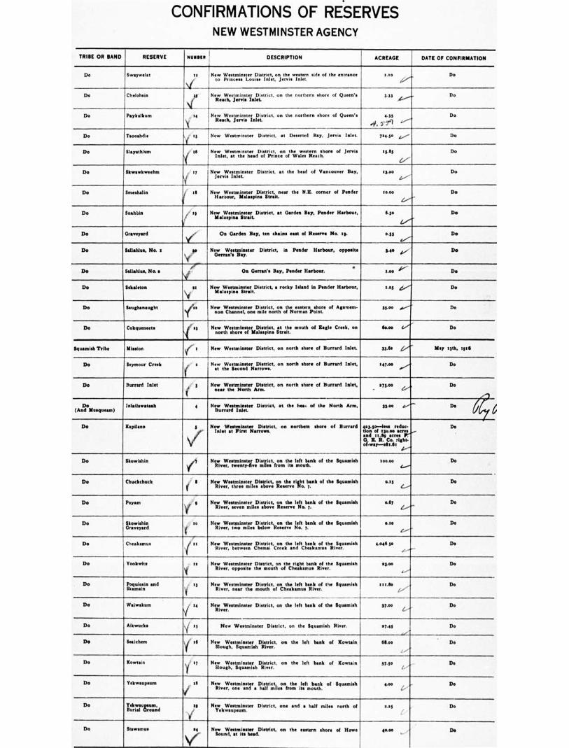
CONFIRMATIONS OF RESERVES NEW WESTMINSTER AGENCY
TRIBE OR SAND RESERVE elltillett 1 DESCRIPTION ACREAGE DATE OF CONFIRMATION
Do Swaywelot
Chelohsin
to
Nif
New District, western on the eeeee n side of the entrance
to Princess Louise Inlet, Jervis Inlet. New Westminster District, on the northern shore of Queen's
Reach, Jerrie Inlet
1.10
345
On
Do Do
Do Paykulbum . 14 New Westminster District, on the northern shore of Queen's Reach, Jervis Inlet.
4.33 4, 0'19
Do
Do Tsooandio i to New Westminster District, at D d Bay, Janis Inlet. 7$4.30 L.,/ Do Do Slayathlum II New Westminster western er Dietrict, on the weern shore of Jervis Inlet, at the head of Prince of Wales Reach. sg.11y
4/ Do
Do Skwawkweehm . 17 New Westmi D at the head of Vancouver Bay, Jervis Inlet sk.00 Z.,--
Do
Do Smeshalia as New Westminster District, near the N.B. corner of Pander Harbour. Malaspina Strait.
moo Do
Do itralebin ' is New Westminster District, at Garden Bay, Pander Harbour, 6.so Do
Do 0 d Os Garden Bay, ten chains east of Reserve No, Ie. 0.33 Do
Do Sallahlus. Nat op
41/
New Westminster District, in Ponder Harbour, opposite Getran'o Bay.
SO k.." Do
Do Sallahlus. No.• Oa Otrran's Bay, Ponder Harbour. • Leo 1/ Do
Do Sekaleton si New Westminster District, a rocky Island In Pander Harbour, Malaspina Strait.
Lao Do
Do {aughanaught stePss NevesonWctitaixtiLDmisiltrelentznegt otth ;40itimastae.rnp,totos of Ailment- SS... Do
Do Cokquenests s New Westminster District, at the mouth of Eagle Creek, on north shore of Malaspina Strait.
lkom Do
Bquamish Tribe Mission e. I New Westminster District, on north shore of Burford Inlet. 33.65 May 13th, totli
Do Seymour Creek ( ' s New Westminster District, on north shore of Barrett! Inlet, at the Second Narrows.
147.00 Do
Do Burrard Inlet New Westminster District, on north shore of Bunked Inlet, near the North Arm.
on.coo Do
Do (And Mesquesm)
Inlailawatash • New Westminster D' at the hes, of the North Arm, Burrard Inlet.
311.00 Do
Do Repliers, 3 New Westminster District, on northern shore of Burford Inlet at First Narrows.
403.4e—less mdse. Son of :soft s and mile acres G. Z R. Co. flight. of•way—alt.fir
Do
Do Skowisbin /3 New Westroineter District, on the left bank of the Squamish River, twenty-eve miles from its mouth.
soo.00 Do
Do Chuckchuck New Westminster on the right bank of the Squamsh i ivrthrero..shry;.e4o.y. lss De
Do Poyam 3 New Westminster District, on the left bank of the Squaraish River, seven miles above Reserve Na i. Ally Do
Do Skowishin Graveyard
so New Westminster District on the left bank of the Squamish River, two miles below Reserve No. 7. am Do
Do Chealtamus /I t : NezvWerfsbuelwinesetern ehttraicit.cor.n.:heinljItc Ihlitmet.th;titiru. Amish 4,046 30
.e. Do
Do Yookwits s
I New District Sguanish i iver,0, L motiotci.i.slier. as.. Do
De littrnin and • 'I
1 New Westminster District, on the left bank of the Squamish
River, sear the mouth of Cheskamus River. t t t.So
1," Do
Do Waiwakum J 14
Y New Westminster District, on the left beak of the Squaniish
River. 37.00 De
Do Aikwucks \I is
New Westminster District, on the {gnomish River. 17.43 ,.., Do Do Seeichem \i' a NitilouWestminsterh,sshDlitsityruict, on the left bask of ICowtain 611.oa De
Do Kowtain Y. II
I New Westminster District. on the left bank of Kowtain Slough, Sguamish River. 37,30 . Do
Do Yekwaupeum v il New Westminster tiltiri.ctilesonly the il:fi tmobzb of Squamish 440 De
Do ti.akrZal I:Lund
sel
/
New Westminster District, one and a half miles north of Yekwoupsum.
041 Do
Do Mammon 04 ‘oer
New Weatmiaster District. on the eastern shore of Howe Sound, et its head.
40.00 De
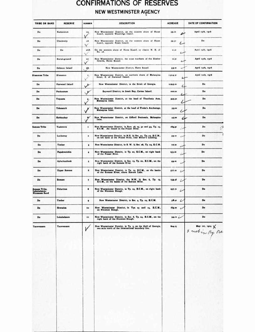
CONFIRMATIONS OF RESERVES NEW WESTMINSTER AGENCY
TRIBE OR BAND RESERVE nun. DESCRIPTION ACREAGE , DATE OF CONFIRMATION
Do Kaikalahun ,
as V
all
• 6A 10n
\ • I
! New Westminster District, on the western shore of Howe ' i Sound, opposite Wookidge Island.
33.00 April 13th, 1916
Do Chetliwelp
New Westminster District, on the western shore of Howe
Sound, opposite Keats inland.
the ...tern shore of Howe Sound, el chains N. E. of No. 36.
34.50
co.so
Do
Do Do April teth. 416
Do Burial.ground op '
V' New Westminster District. the most northern of the Shelter
Islands, Howe Sound. 0.3• April 13th, Erg
Do I Defencesland .,.. . New Westminster District, Howe Sound. 3340 April spiv,, sole
Slisenmon Tribe /Mammon 0 New Westminster District on northern shore of Malaspina 'Strait, IL of Harwood Island.
,04•Se April lath, toll
Do Harwood island NII).-
New Westminster District, is the Strait of Georgia. e.093o0 Do
Do Paukeanum ,./-
Nor !Inward District, in Smelt Bay, Cartes Island. soon Do
Do Toques 4 .
V/
New Westminster District. at the head of Theedosia Arm, Malaspina inlet
393.10 Do
Do Tokenatch New Westminster District, at the head of Preke's Anchorage, Malaspina Inlet.
33.00 Do
Do Rahltaykay Le ,
New Westminster District, on Gifford Peninsula, Malaspina Inlet,
413.0e Do
Sumass Tribe Yaalstrick t New Westminster District, in Sacs. al, ea, sa and 33, Tp. s3, E.C.M. An Wand in the F River.
11131.10 Do (1
Do Lackawey a New Westminster District, In N.E. Ye Sec. so, Tp. es, KCAL ,on left bank of the Fraser River, near Miller's Landing.
39.00 39.00 Do
De Timber 3 New Westminster District, is S. W. 54 Wm IS, Tp. a3, R.C.M. soon Do
Do Papekwatchia 4 NOW Westminster District, In Tp. so, E.C.11., on right bank of the Fraser River.
113.00 Do
Do Aplechoollook s New Westminster District. in Sec. se, Tp. so, Z.C.M., on the right bank of the Sumas. River.
4940 De
Do Upper Samna 6 New Westminster DIBtflet, In Tp. sy Z.C.M., on the banks of the Suntan River, above lumen Lan.
376.so Do
Do Sumas 7 New ratmasintrierblestrrft.the
thil.NZ.ILSec. S. Tp. so 11314 Do
Sumer Tribe, tokababons. Nintann Rand
Holachtea II Now Westminster District, is Tp. et. ISC.111., on right bank of the Nicornen Slough.
09740 Do
Do Timber 9 New Westminster District. is Mc. 4, Tp. so R.C.M. 3840 Do
Do Skweahm so New Westminster District, in Too si and 14, Z.C.M., on Nimmons Slough.
113.00 Do
Do Lekahabrams so New Westminster District, in Sec. 6, Tp. so LC.11., on the right bank of the Nicomen Slough.
94.50 i..../V Do
Teavrerneen Temenmen New Westminster District, In Tp. 3, on the Dull of Georgia, one mile north of the International boundary line.
foo.si May sit. 5914 g
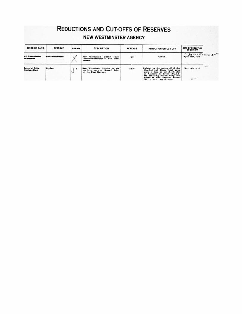
REDUCTIONS AND CUT-OFFS OF RESERVES
NEW WESTMINSTER AGENCY
TRIBE OR BAND RESERVE NURSER DESCRIPTION ACREAGE REDUCTION OR CUT-OFF DATE OF REDUCTION 0111CUTOIF
/411—COSI1441.41•1 ws-wwwwwie
N11.--W•641164604et--EINA.04....-tiat. bit.ele•-117—Tiet-414,--01—WW.--W48. IIIITItler .
tat/. CuS-al_ April trth, [06
Squomish Tribe, X•pdano Band
Kollin° R New Westminster District, on the northern shore of Burr•rd Inlet, at the First Narrows.
133, 90 I Reduced by the cutting oft of One 1 Hundred end Thirty (15o) •cre•,
l more Ins,
Ha.. 'reerens,kell.hC.er: 1 the remaining portion being con. ,
Armed as such IC•pileno Reserve
! No. 5, nit : 193.50 Sleet
May osth. lamp

NEW RESERVES NEW WESTMINSTER AGENCY
■•01CIA, DATE OF MINUTE • LICATION TRIBE OR BAND RESERVE NUMBER DESCRIPTION ACREAGE 111.181. OF DECISION
a Romero Aupe . .Adjoining Aupe Reserve No. 6 and subtracted from P. R. .9.7. August HIM :gig No. s651 (William Thompson). Aver., ., • ,. ,'',2L, '..' • ' ,' !, " ... 4' ,. , ; , r • 7 • 4'r,iet r (
s Do sA Adjoining Reserve No. a on the North-east. g000, June sith. 19111
Nlr feet to survey 4-- more or less, sub-
3 Do ,uN shkin
I'
5A Adjoining Ilimhkin R No. 5 on the West. moo, more or less, sub-
ject to eurvey Do
C....
4 Do Bartlett Island ., y Bartlett island, near Aupe Reserve No. 6. too, Do
Y more or Ie., sub- ject to survey a..
so Do Bear Bay g On Bear Bey. W. side of Bute Inlet. 10.00, Do more or Ie., sub- and survey ject to selection G.-
IS Sumas Graveyard as . 5.00, De 64,
AA....1fAaeAsv Itgssit ..% ., r. c,,, /A., r ".- .. ‘. IN ,n> } r L . / , , to.vil,,rom•cctehTtr:cei; I' 0 ' , i . L. )• .'./ Ai.V rt.' f ' or ,,r _,,,,. ,.,f ',Iv t' A i n , i 1 ,, /a/'t/O;
more or :ear, sub- ject to selection •nr1 wry., with road 4.----
toutnTchiubeck Band 014.GwlaWerstk,ankiseterant Creek, adjoining apd II IL el 0 %) r. /‘ ri itr ,—.14',.. W,-4-,-.1,e ,r,' r 11, . ' 4/1 ?1 A 33 Glazier Creek Do ir°insteneitehLoptlatti"ccl Gross e. more r i0e0., aub- If. Green, B.C.L.S. ject to survey
34 Do Skookumchuck /4,1 Adeitiininetk,o.onkulillecsheru‘cek Ipile,„servp.e No. 4, and connecting same OS 5.00. Mt
Y ject to survey L.•"*". more or lees, sub-
34 Do Skl•hhesten Adpj3V:imwSlthpternst,nensterRerrvia No. 5 and contained in Lot Do more or less, sub- , jeer to survey
37 Pemberton Graveyard g On W. side of Lillooet Lake, between Pemberton .d Ten. 3.00, Do
V Lake. more or less, sub- ject to selection and survey
44 Seehelt es A strip of land appro. Mime I y seven (7) chain. in width sac.. Do between Lots 156a and 3615, New Westminster L. D., . more or less, •ub- Yper sketch plan of Ashdown If. Green, B.C.L.S. ject to survey
5a Do Boulder Island 55 Boulder Island, approximately one mile S. of Skookumchuck 15.00, Do more or lest sub ject to survey
34 Do e6 Deducted from P. R. No ear, at Skookumchuck, as per sketch 0.73, Do plan of Ashdown H. Green, B.C.L.S. more or less, eub- .- ject to survey
37 Do Sway-welat teA Graveyard, a mall island at the mouth of Princess Louise Do ■er
Inlet. near Sway.welat Reserve No. so. more sirless
6s Do Sekaleton ye 1 A Three c(egn)t i:pmaLki.sil.atnodns ;.1,,trhve. Splaordao,n or Sekaleton Group, Do
A-77-
yo Do Do
sy ,. At.gpk:to,le,.uirichcirkanYdfacrroovweredSipofTl..v).Noi.fri, New West' p,oraeoo:ro,less
V ____,;47, tt . 3 7 6 z...
79 Do Klayekwim 1 6A New Westminster L. D., Narrows Arm "Lot No. 5x64 as* Woo. Do
!-----
\t/ wersomilmlIMMIgnimwengli■ of Klayeliveim R No. 6. more or less, sub-
e. sika ject to survey
So Do lag New Westminster L. D., on Porpoise Bay; S. W. % Lot Do No. 5651. more le. c

CONFIRMATIONS OF RESERVES OKANAGAN AGENCY
TRIBE OR BAND
RESERVE
It MINI
DESCRIPTION
Spallunicheen
-
Salmon River : j_Kainsolwonopth•ipDastrict, on the right bank of Salmon River, in 3853.00 t7th November, 5933
Do Raderby a Kamloops District, on both banks of the Spallumcheen River, in Townships 35, 37 and 39.
3633.00 - Reduced tor the aacIlroews aricoe,
Pudic Road R.•W. and by the cutting off of 1680.00 acres, more or less, sub- ject to , the remaining portion of the Reserve as described in Offi- clot Schedule of Indian R ;gm being CO0- firmed as such En- derby R No. a, via: 3941.35 aerie, more or less.
Do
C?
'
Do Graveyard In Mr. Fortune's Reid, south of the apellumcheen River, In Township 38.
0.75 Do
Okanagan Ok if s Osoyoos District, at the head of Okanagan Lake. 53339.00-less el- lowed R.-W. of C. N. P. R. Co., 315.39 • Cre13-3$31111.71
list November, 1913
0-11 0 Ate d re-Otine ‘..,,) Q.4
Do Otter Lake y a Osoyoos District, on the shore of Otter Lake, in Section 33, Township 7.
6g.00 17th November, i917
Do 3
(
Osoyoos District, the southwest quarter Section :3, Town- ship 7.
!Soso° tith November, zge3, (with Or- commendation, embodied in In- terim Report No. 16, that same be conveyed to Isaac Harris).
Do Priest's Valley I 6 Oaoyom District, at the head of the south arm of Ok Lake, in Section 3o, Township g.
$Boo 37th November, 1913
Do Duck Lake
M(5:_(0 , ) Cl rev 4'
i 7
(
Osoyoos District, on the northern shore of Duck Lake, in Township. to and 23.
I .4 e ,'et 'f ' .n ,,, )' ' . 1... I - r ( 6 .9 6 ,,
437.0o
me" 6.."
Do
C01,11'1.171.27V Oh TrCarge myterr rwt. _ ..
sitlt November, 1.13, Ili 11.0111a4 sgth Febromy, mitli.
n 7
'
Do Telnetikepturn • / g
,
Osoyoos District, on the western shore of Ok Lake, In Township 25.
11436.00-lem "due- lion of r764.00 scree, Mere Or leek subject to survey-
579.00
Do Do 1/
to on the western shore of Okanagan Lake Osoyoos District,
st 3', miles north of R No. 9. ' '
Soo.00 tut November, rots
Pontictoo Penticton Osoyoos and Similkameen Districts, at the foot of Okanagan Lake, partly in Township 88.
•
47829.0o- less re- duetion by the cut- tins off of fourteen thousand and sixty ( 54060.00 ) acres, more or less, sub- ject to survey,there being deducted from such cut-off acs an area of fire hundred and maty- four and filty-eve one-hundredths (5354.311 acres, granted and allowed the Department of
i- sAgicultotunre of C.perT-
mental Farm pur- poses under In. terien Reports Nos. 35, 35A and s3B; also allowed R.-W. of K.V.R., t.33•CreS - 33767.77 sores. more or less.
Do
....------
Do Nicola Prairie 3 Lot 3317, Group s. Osoyoos Division of Yale District. 310.00 16th February, 3916
Osoy000 Osoyoos a Similkameen District, at the head of Osoyoos Lake, portion. of Townships elll, 49, yo end St•
pogi.00 - less R.- W. of Provincial Public Road, 1143 acres. allowed be Interim Report No VI, of 37th April, 1916-33,o85.38.
Go'
tut November, 39:3
thonamen, Lower
..,,,
e g lihnilkameen District, on the left bank of the Similkameen River.
1011.00
4.."." 23nd November, 19:3
Do / 3 Similkameen District, on both banks of the Similkameen River, adjoining Reserve No. a on the south.
',soya 1.---"-
Do
Do Marries:a Farm /
Similkameen District, on the right bank of the Similkameen River, opposite Reserves Nor a and 3. nine miles north of international boundary line.
tIllse.00
i.""-
Do
Do Jos Nahumpchon I Similkameen District, on both banks of the Similkameen River, to the south of and adjoining Reserve No. 3.
1078.0o Do
Do Blind Creek ( II Similkameen District, part of Sections It and la. Town- ship sa.
400.00 Do
Do litemeoskuankin 41
Alexis (90
Sirittarmetnonnrsotficet.,,donadtjt irnirtobeanmkt.12,1n.thoen.Siirritilk.anmic.e4
line.
31loo.00 Do
Do Similkameen District, on the left bank of the Similkameen
River, five miles above Keremeos. 450.00 Do
Do Ashnola /so Similkameen District, on the right bank of the Ihnilltamem River, at its confluence with the Ashnola River.
4:11.00 ,„......---
Do
•
I I
lva vlsde/ lp. dVin P3 .4.4.$ 13
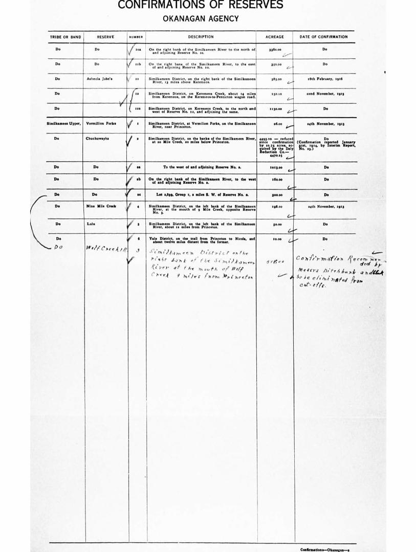
CONFIRMATIONS OF RESERVES OKANAGAN AGENCY
TRIBE OR BAND RESERVE h U PI II F R DESCRIPTION ACREAGE DATE OF CONFIRMATION
Do Do roa
/ rob
1.--
On the right bank of the Similkameen River to the north of, and adjoining Reserve No. so.
3360.00
1....'"--
Do
Do Do On tahned raiCtotintigneReosferte Ntmistkameen River, to the east 350.00 ,....--.
Do
Do Aehnola John's . a, Similkameen District, on the right bank of the Similkameen River, 13 miles above Kerenteos.
505.00 (.,"
MY Irebrualty. toil
Do
V
as Similkameen District, on Kamer). Creek, about re miles from Kererneos, on the Kerenteoe-to.Penticton wagon road.
130.00 sand November, sots
t......
Do lea
Similkameen District. on Keremeos Creek, to the north and
west of R No. I a, and adjoining the same. 3 ISOM) Do
//-
Similkameen Upper,
1
Vermillion Forks V
1 ' SiTtiilvItearmeneenarD1,1rtirnicct toant . Vermilion Forks, on the Similkameen 56.00 s4th November, too ..I.,--
Do Chuchuwayha a 1 Similkameen District, on the bank. of the Similkameen River, at ao Mile Creek, ao mile, below Princeton.
44g3.00 — reduced Do
tlyn cL.7cson.firmm.sti.o: (Cio.ntfi. rma,t4ion b yr. Interim
o e d ;sun Report,
Lir= tleo. Doty to. 231
4470.33 „_.....„
Do I Do f ns To the west of and adjoining Reserve No. e. tot3.00 Do
Do Do / eb On tahnedriLliotpnnik Roefsemthe, Similkameen River, to the went zfloom Do
Do Do C a Lot 3.899. Group 1, s miles S. W. of Reserve No. s. 300.00 Do
Do Nine Mile Creek 4 8 i 'R li I./helm:4r" trh3ei"mri2thonofthge Yfitle
bvirkeekof opposite
Similkameen ilits•emseerevne
No. 3.
sgS.00 14th November, roes
L----
Do Lulu ii, s SiVltanenpietrictonthe left bank of the Similkameen iveraboul ,am.iesfron ItcIt.r so.00 Do
C'r
ro.00 4,4,-, Do
C 6 hi/ .Y, In 4.6." A 1 e 1 /e c d
Messrs 411‘.44.,,i, ---- h ,%," le/ • ' e, I eh 1 h 4,74 vd Ir.,
C tW-- a /(c.
Do
.... D0
: 6
kr 'If c's4rf 4 /7'
Yale DietrIct, on the trail from Princeton to Nicole, end about twelve miles distant from the former.
( C7711)-fr1 r, e c h 4 7 161. re. c t .A /AV
Ttf 41' 44 -h k e ,c' (4t 3.1..hit.)kow,••r ,ft . Per et 1 Ay 771 opt A 0, $'e/A' 0 7. v r-1 9 has friehl irri hreeoh
Coalksatloas—Okaaassa—s
orb dee!
41 77 "art
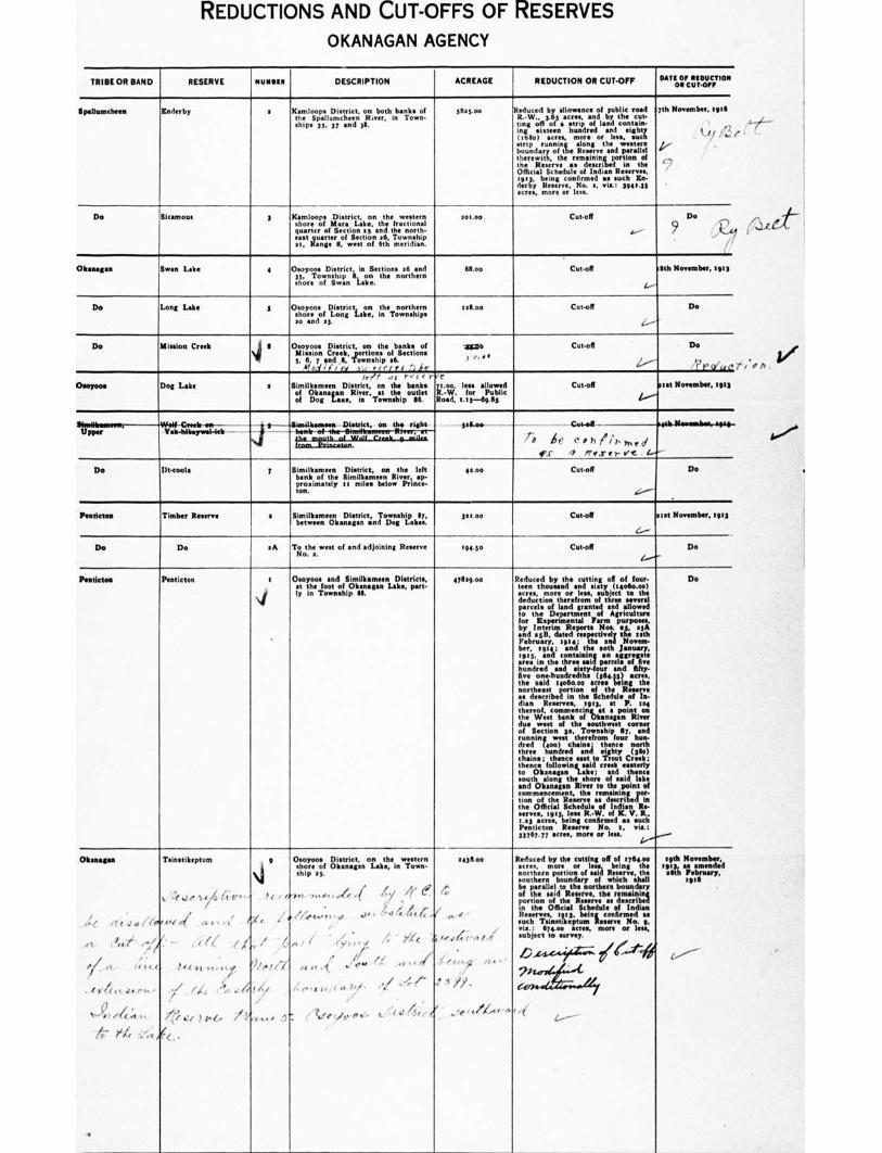
REDUCTIONS AND CUT-OFFS OF RESERVES
OKANAGAN AGENCY
TRIBE OR BAND RESERVE NUMMI DESCRIPTION ACREAGE REDUCTION OR CUTOFF Date OF REDUCTION
OR CUT.Orli
Spallumcheen Enderby a Kamloops District, on both banks of the Spallumcheen River, in Town. ships 35, 37 and 38.
36.3.00 Reduced by allowance of public road R.-W.. 3.65 acres, and by the cut• ring off of a strip of land contain- ing sixteen hundred and eighty (168o) Acres, more or less, such strip running •long the western boundary of the Reserve and parallel therewith, the remaining portion of the Reserve as described in the Official Schedule of Indian Reserves, '5113, being confirmed as •arch En. derby Reserve, No a, vis.: 594,35 •cres, more or less.
7th November, .216
■ , , (3,
e,... ."
Do Sicamous 3 Kamloops District, on the western shore of Mara Lake, the fractional quarter of Section ay and the north. east quarter of Section 26, Township sr, Range II, west of 5th meridian.
aoroo Cut-off Do
(--)
71
Okanagan Swan Lake 4 Osoyoos District, in Sections 26 and 33, Township 6 on the northern shore of Swan Lake.
(Moo Cut-off
1---
I6th November, tots
Do Long Lake 5 Osogoom District, on the northern shore of Long Lake, in Townships SO and 23.
c38.00 Cut-off Do
Do Mission Creek 6 Osoyoos District, on the banks of Mission Creek,
Township of Sections
5, 6, 7 and II, Township .13. Med ; c in/ •vel ca '; A.
IS;170
.1 r. 0 .
Cut-off
, „-,
Do
'fr?PC/Itt.,
Osoyoos Dog Lake a
h.! r' ,,, r •• c f 1), f
Similkameen District, on the banks of Okanagan River, at the outlet of Dog Lane, in Township 86.
moo, less allowed R.-W. for Public Road, s.15-69.83
Cut-off slat NetsontiMf,, 095$
SinviReerneettc-- --Well Upper
Creek ass-- -9--illiesilleasesisen District, on the right lie..k ef-the-fliverifirwmeerr-R1
ft.12=ofW Ate Creek ix Wit&
-geg.o•---
iscoo
i— - -Csw-oll Nonessame,t+111-
To be c ,, h /l 1.A, , . d I'S 4 /TV,Irer set •
CoVoll Do
Yak-hlkeyveal-fink
Do Ilt-coole 7 Similkameen District, on the left bank of the Similkameen River, ap- proximately it miles below Prince- ton.
Penticton Timber R a Similkameen District, Township 117, between Okanagan and Dog Lakes.
511.00 Cutol
(---- set Noirmalter, mg
Do Do 2A To the west of and adjoining Reserve No. a.
1114.50 Cut-of Do
Penticton Penticton e Osoyoos and Similkameen District., at the foot of Okanagan Lake, part- ly in Township 88.
47889.00 Reduced by the cutting off of four- teen thousand and silty (14050.00) acres, more or less, subject to the deduction therefrom of three several parcels of land granted and allowed to the Department of Agriculture for Enperimental Farm purpose., by Interim Reports Nos. as, 23A and 138, dated respectively the lath February, rote; the and Novem- ber, tote; and the nosh January, eyes, and containing an ag to area in the three said parcels of five hundred and sinty-four and fifty- five one-hundredths (56440 acres, the said 3406o.00 acres being the northeast portion of the R as described in the Schedule of In- dian Reserves, 19x3, It P. 1.4 thereof, commencing at a point on the West bank of Okanagan River due west of the southwest corner of Section 32, Township Sy, and running west therefrom four hon. tired (too) chains- thence north three hundred and eighty (38o) chains; thence east to Trout Creek; thence following_ said creek easterly to Okanagan Lake: and thence south along the shore of said lake and Okanagan River to the point of commencement, the remaining por- tion of the Reserve as described in the Official Schedule of Indian Re- serves, 19t3, less R.-W. of K. V. R., 1.23 acres, being confirmed MI such Pentic ton Reserve No. 1, vie : 33767.77 acres, more or less.
Do
Okanagan Teinstikeptum
1. ,:e ..1.,, AO I': fr. , -
• „ /,rt.• el f J ,2 / (OW tee ei. a at c- i' "'it
2414- ,
e - •
71.-ez- 01.-1 It-c Yu,. , ...1. 1"
.
,d1i 1 d so do r..- , 7" ._ (I, .''', , 4
"ji?"4-d. '' 47;, .,.., , P-G, 7!",
k Piss -. -. . ,/.. c ..
i 9 Osoyoos District, on the western
ship as. NI
shore of Okanagan Lake, in Town-
. 1 /r e ft r tt-nn -,..c., ole ' • ',, .
oO r C -/ / 4-1/74,640•21, 0. 42e e , 4 t
. • ( . 7 / - i/G 'O'r
' / ,-A' a ,.af q 1 m ! 17/ el sr .-"(. e O.'
.1 1,1' ' felt ir r 01‘,/- It/ l',4-t-
• y •
, , , , . !lie r/effr-ittl- 4A 1tNfr /
943too
4
,,, .
,4.,-,,,, 1 4' - •
' ,,,,,,,te a. , ,./
,e 1 # -
,
... '4, , .14a 0.
Reduced by the cutting off of 1164.0o scree, more or less, being the northern portion of mild R , the southern boundary of which shall be parallel to the northern boundary of the said Reserve, the remaining Portion of the Reserve as described in the Official Schedule of Indian Reserves, eyes, being confirmed ae such Tainahkeptum Reserve No. 9, via.: 674.00 acres, mots or less, subject to survey.
7 I
"( L-
!nth November, 5953, se amended
38th February, 5956
• 41/ I I••A.
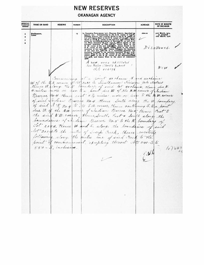
NEW RESERVES OKANAGAN AGENCY
*GMT 411, P LICA/104
6
7
SimIlkanteen, Lower
TRIBE OR BAND RESERVE ACREAGE DATE OF MINUTE OF DECISION
3"t smacehn.c1:1". 16th March, 1916
NUNSIN '
DESCRIPTION
13 I In Township Forty-seven (47), Osoyooe District, demand • owe, via.: Commencing at the S. K. corner of
1 Os s District. and running North to the N. IL er of Lot sir, ence FAIR to the S. B. corner of Lot , thence North to th - E. corner of the said Lot 3 ence East. •tkri..iehse, ntoor.tted.„ undates1914Sectio a, s3 and 14 to
S. ence South to the northern boundary of s :9Ss thence West to the N. W. corner of the said all; thence South to the N. E. corner of Lot e 11 the Weet to the eastern
of the said Lot • tslo.untheerl vedireco thetoNthewnorctohrenren, boofun4ary .d t 23 lil!
boundary of Lot 3460 • , thence fo ing the boundary a OS In a norther westerly and
thence h to the S. W. corner of the 1>eal'orementilnek Lot and thence West en the place of commence-
flesh
)1)0 $5 t, ,/• ✓
h vs, areq - 571I See Md/or c, '14P.PC •If e froP,
4 o 7
■
New
01,11 evett ie
•"/ !NY} al, LA
14/ -
"'WU. I I
'144.14/v-C. 44).11 'Ve.t.e
,..4244:te(
a; ,e .
at, A2 „:„e I/ e ebt,
4t4,11.07.40.44 (1/ je-
L 7te VC 44,
4/11—..2 tf J -444 of
s-/e .144 t ((014
01.44.1f ,',7 e‘7/11.,41,te
d'a 'A ,r, /.14
ye - -3/ 1/o t+ ,.e
• - - - • %Z.-- — rs•-tor,' • 'ff:v-itlftf-tv •Zre /, -;1` /0‘ le t- — 4; s1- ye e•
t
6-
ti
/0/.4.4.4 ,-11'11,1 ,4(1c, W V, 71/4 *14 (*.Ili-Lei, •
e 1+4:644' All 6",e' el I 1 C'e.' Sh. &Pt-m.41i
lie • .31 . iletc-c,c tiefr-re f 7-x
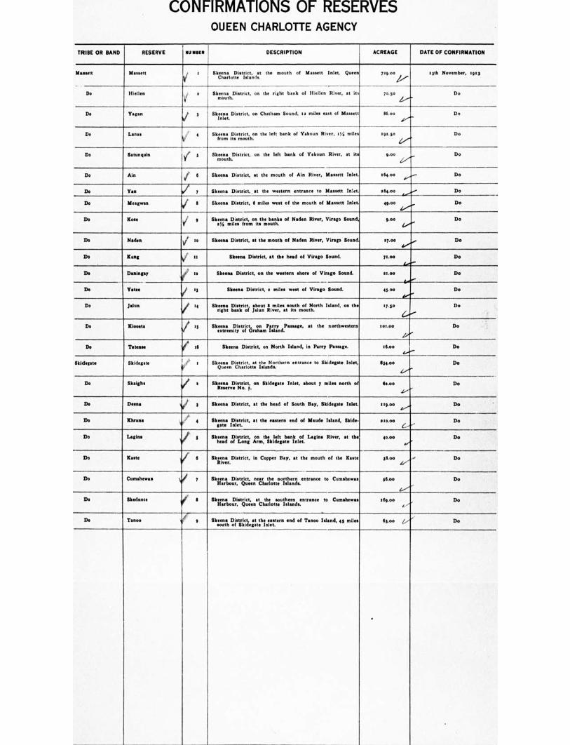
CONFIRMATIONS OF RESERVES OUEEN CHARLOTTE AGENCY
TRIBE OR SAND RESERVE IHINBIll DESCRIPTION ACREAGE DATE OF CONFIRMATION
Maasett M o Simms District. at the mouth of Monett Inlet, Queen Charlotte Islands.
700,00 4„, igth November, :9:3
Do Hielien s i
Skeen. District, on the right bank of Hiellen River, at its mouth.
lose Do
Do Vegan 3 I/ larera District, on Chatham Sound, to miles east of Massett n.t 116.00 Do
Do Lanes 4 SkIreonma its mouth.the left bank of Yakoun River, 054 mile. 190.50 Do
Do Satunquin V. 5 Skeena District, on the left bank of Yakoun River, at its goo Do
Do Ale ✓
Skeena District, at the mouth of AM River, Massett Inlet. 064.00 Do
Do Tan y Skeen. District, at the western entrance to Massett Inlet. 064.00 Do
Do Illeagwan II Skeen. District, 6 miles west of the mouth of Massett Inlet. 49.o° Do
Do Lost g V
User Jilliesstrificotfnort.thme obustnhbe of Haden River, Virago Sound, 9.00 Do
Do Radon 0o Skeena District, at the mouth of Nodes River, Virago Sound. syoe Do
1)0 Lang it Skeena District, at the head of Virago Sound. 7too Do
Do Daningay Skeins District, on the western shore of Virago Bound. stoo Do
Do Yates eg Skeen. District, a Intel west of Virago Sound. 43.00 Do
Do Johan 04 Skeena District, shout I miles south of North Island, on the right bank of jalun River, at its mouth.
07.30 Do
On Kloeste :5 Mama District, on Parry Passage, at the northw n extremity of Graham Island.
ooe.00 Do
Do Tatenee 16 Skeen. District, on North Island, in Parry Passage. :6.00 Do
Skid Skidoo:* f' 1 Skeena District. at the Northern entrance to Skidegate Inlet, Queen Charlotte Islands.
11134.00 Do
Do SI:sighs a Skeen:: District, on Skidegate Inlet, about 7 miles north of Reserve No. 7.
fltoo Do
De Deena Skeena District, at the head of South Boy, Skidegate Inlet. tsg.oe Do
Do Lhrana 4 Skeena District, at the eastern end of Maude Island, Skids. gate Inlet.
210.00 Do
Do Latins Skeen. District, on the left bank of Lagina River, at the head of Long Arm, Skidegate Inlet.
40.00 Do
De Lade Skeen: District, in Copper Bay, at the mouth of the Rasta River.
gtoo Do
Do Cumshewas Skeen. District, near the northern entrance to Cumshewas Harbour, Queen Charlotte Islands.
stoo Do
Do Skedanee Skeen. District, at the southern entrance to Cumshewas Harbour, Queen Charlotte Islands.
:Ogee Do
Do Tanoo III Skeane District at the eastern end of Tenon Island, 43 miles south of Skidegate Inlet.
Ftot Do
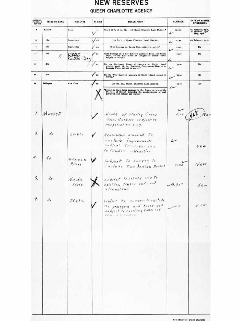
NEW RESERVES QUEEN CHARLOTTE AGENCY
',Ligation TRIBE OR SAND RESERVE NUMMI ' DESCRIPTION ACREAGE DATE OF MINUTE OF DECISION
I Masson Busk 17 The S. E. ta of Lot No. 1111, Queen Charlotte Lend District.• r55.00 nt Fei . V' a g:2 e
4.-- May, ifitG.
SO Do Bawuchten V e • Lot No. em, Queen Charlotte Land District. 1740 ph February, tpll.
It Do i .9
Estrin Bay It '' With frontage on Soria Bay. subject to surveys ag.oe Do
.1/ SI AN) Do It De ob int pi an , With frontage on • bay between Andrews Point and Cohoe
Point, on the East Coast of Langan or North Island, subject to survey.•
ei v/ as On the Northwest Coast of Langer. or North Island, directly south of the Dominion Government Reserve at I. Point, subject to survey.•
go.00 Do
!...."--
II Do /DO On the West Coast of Langara or North Island, subject to survey.°
•scoe Do
14
3.
-41
,.
SIddeetate
/14 C2S-S C if
do
.6
New Clew
0 IN liTi
44.-i N. ,, ; ),
R( .1/r)-
Yd dm.
ifive)-
ri . a A),
so Lot No. try. Queen Charlotte Land District. 17.70 Do
i . / el l
1, 1 e w
,1/ e w
•
Y e w.
.4/. e vi.
III
4)1(petroleum
•Sectt: there Ming eey41 tothegrcaninriht ofthegvincof ttholon 1.theanstrtio:of.a
and natural gas therein.
/1/1,fitA oie Stapler Creek
/*de 7, H .-7 rb our CV hjeoe- to
pe.r),etva) 7:4. ..2.17y
/ft a so liable ct ?now Tie rfl
1 he ?Ude 1 171/3T/PF7VUT/t1
su bie e I - Tn ,cdrver ,, , , ro rimbe r a h'e7,4i-o..th
So Aie, t To ,.r u r v.e r to
e: n elk de rwo Ihcleab Mouses
S t / Aiee..e. 70 SOYVer 4)10, To
,, 41 ext .& - tehct. PAther 4 " j —
a ?lc -7100.011C.
soilecr t, survey t 4.;bel.de
"Ae emverrrg, 4711 Au "re vb./
So affect to ex I' rting. timber 4I cr,i) a it ehro,-1..),
4.----
Z..,----
1,/'e A
e..----
4.---- .a .1 - 0
P.-----2. 7 ..1 —
-o a.
New Resenes—Queen Charlotte
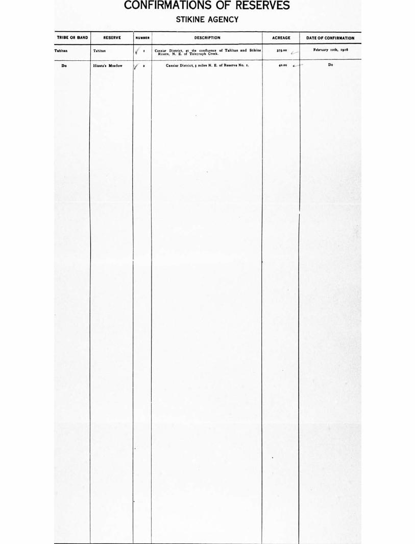
CONFIRMATIONS OF RESERVES STIKINE AGENCY
TRIBE OR BAND RESERVE NUMBER DESCRIPTION ACREAGE DATE OF CONFIRMATION
TahItan Tahitian s Calatsvia.r..District, of T
t.hi:, rc.opnhfl confluence of Tattle. and Stikine 375.00 February I a t h, lig t6
Do Hiatt... Meadow a Cassia, District, 3 mile. N. B. of Reserve No. 1. 40.00 , Do
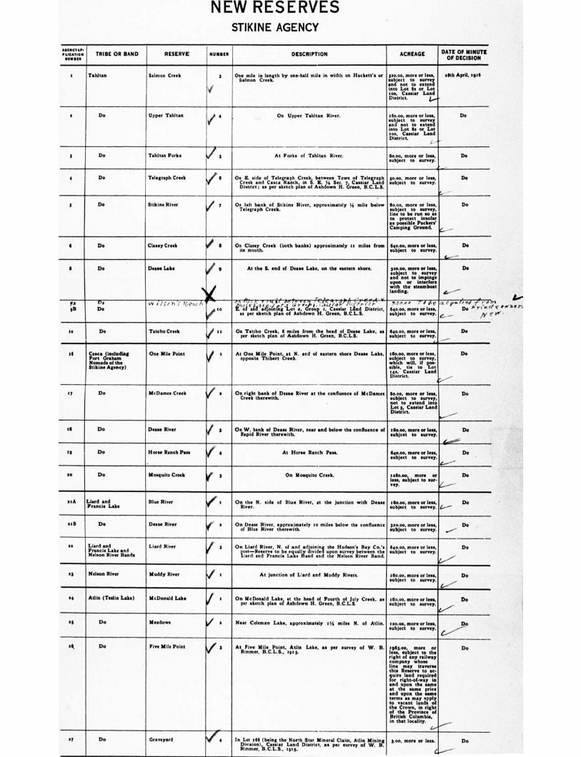
NEW RESERVES STIKINE AGENCY
21114C211, PO0121011
01112•111 TRIBE OR BAND RESERVE NUMM DESCRIPTION ACREAGE DATE OF MINUTE
OF DECISION
1 Tahltan Salmon Creek 3 One Tillin length by one-hall mile in width on Ilackett's or Salmon Creek.
30.00. mote or less, subject to survey and not to extend into Lot Ss or Lot too, Costar Land District. 1.---'
26th April, sere
• Do Upper Tahltan 6 On Upper Tahltan River. 16o.0o. more or less, subject to survey and not to extend into Lot ea or Lot
C.. eosrie• ror LandDistrict 6Boo, 0.0 0. Iens.
Do
3 Tahltan Forks 3 At Forks of Tahltan River. subject to survey.
Do
4 Do Telegraph Creek J 6 On E. side of Telegraph Creek, between Town of Telegraph Creek and Cases Ranch, in S. E. !) Sec 7, C Land District ; as per sketch plan of Ashdown H. Green, B C.L.S.
30.0o more or les., subject to survey.
Do
3 Do Stikine River / 7 On left bank of Stikine River, approximately I s mile below Telegraph Creek.
60.00, more or less, subject to survey, line to be run so as to protect insofar Ise possible Packer.' Camping Ground.
Do
c.._
6 Do Classy Creek / 8 On Classy Creek (both banks) approximately sr miles from its mouth.
640.00, more or less. Do subject to survey.
L..-
3 Do Deese Lake i g
At the S. end of Deane Lake, on the eastern shore. 320.00, more or less, subject to survey
and not to impinge upon or interfere with the steamboat landing.
Do
4--- --
.0 ef./red 7,+ -01 , ,
e.....___ D. . PI 1..'
/Y '
f4 9 33
Ps
Do v /..) s',4 h -5" Y(',--hic r
V so
Tcsie,r07‘e--e., 4 u ,-, 04,7 ,t--- T I li 11 ? Art. rc 1 tif lest- ,,c ,,,-1 ,t
i.'O'i 'ela ?aVidnrni;i..M';,...Grroiun 's Casmiar Lind District,
as per sketch plan of Ashdown H. s, B.C.L.S.
T . !.A. ,. -'-‘1 dct. 640.00, more or leas, subject n'to survey.
so Do Tatcho Creek 1 at On Tatcho Creek. It miles from the head of Des. Lake, as per sketch plan of Ashdown H. Green, B.C.L.S.
640.00, more or less, Do subject to survey.
16 Caeca (including Port Graham Nomads of the Stikine Agency)
One Mile Point / : At One Mile Point, at N. end of eastern shore Deane Lake, opposite Thibert Creek.
160.00. more or less, Do !subject to survey, which will, if pos- • ible, tie to Lot yet. C•s•iar Land District.
4,
17 Do MeDarne• Creek V a On right bank of Deese River at the confluence of McDames Creek therewith.
tot., more or less, Do subject to survey, not to extend into Lot 3, C•a•iar Land District.
III Do Deese River j
3 On W. bank of Deane River, near and below the confluence of Rapid River therewith.
160.00, more or less, Do eubjcet to survey.
4/- --
640.00, more or less, Do subject to survey.
e—
If Do Horse Ranch Pass I 4 At Horse Ranch Pass.
so Do Mosquito Creek e 5
On Mosquito Creek. raeo.00, more or Do less, subject to sur- rey. 4-
s I A litrndciesnduke Blue River / : On the N. side of Blue River, at the junction with Deese River.
16o.00, more or less, Do subject to purvey. Z...---
a 5 II Do Deane River ler s Onof Dizee. 34i,vve.rr, taareowsitately so miles below the confluence subject
oomtoore soarn,leesys: Do
22 Lind and Francis Lake and
River Bands
Liard River i 3 On Liard River, N. of •nd adjoining the Hudson's Bay Co.'s si7 Re 7e reto be lally vtde 1 upon svey between the T.,.n;rondsaendant,Nxon,iverind
subject bjec t t o surrey.
64o oo, more or less, Do
a3 Nelson Nelson River Muddy River 1 ' At junction of Liard and Muddy Rivers. r6o.00, more or less, Do
subject to surrey.
a4 Atlin (Teslin Lake) McDonald Lake / sketch
On McDon•ld L•ke, at the head of Fourth of July Creek. as per plan of Ashdown H. Green, B.C.L.S.
160.00, more or lean, Do subject to survey.
13 Do Meadows / 1 Near Coleman Lake, approximately sir, miles N. of Atlin. 120.00, more or less, Do subject to survey.
sk Do Five Mile Point Vf 3 At Five Mile Point, Atlin Lake, as per survey of W. B. Rurimer, B.C.L.S., 1913.
:963.00, more or Do less, subject to the right of any railway company whose line may traverse this Reserve to so. quire land required for right-of-way in and upon the same at the same price and upon the same terms as may •pply to •aunt lands of the Crown, in right of the Province of British Columbia, in that locality.
4.--""----
If Do G d In Lot 261 (being the North Star Mineral Claim, Arlin Mining Divinion), Cassia, Land District, •• per survey of W. B. Rimmer, B.C.L.S., tots.
3.00, more or less. Do
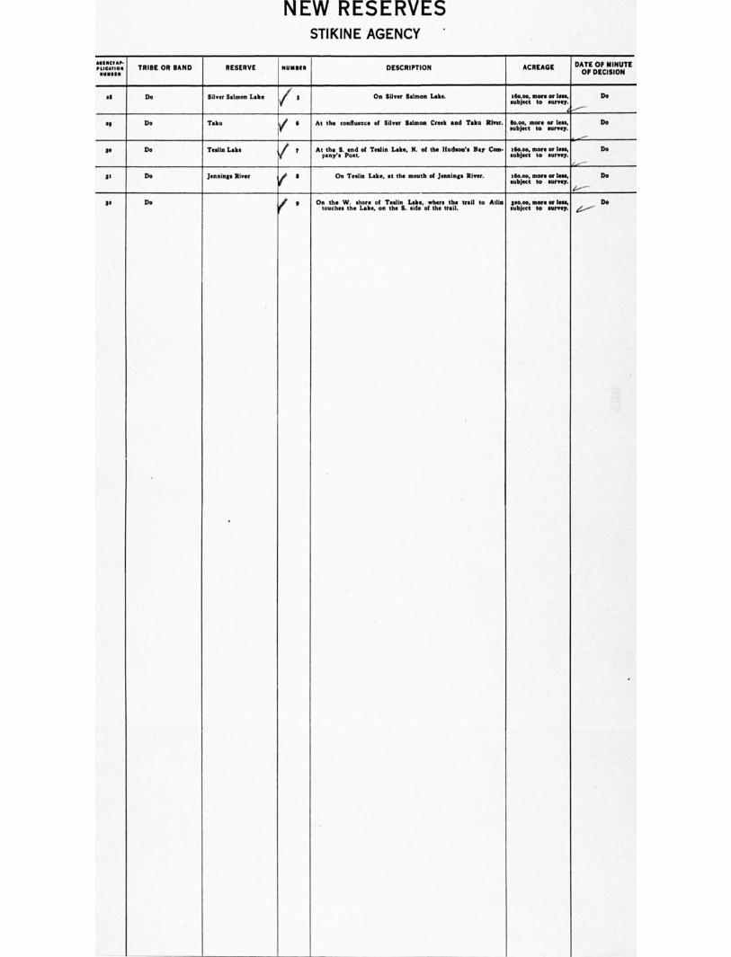
NEW RESERVES STIKINE AGENCY
&stn., I' LICAtIO• sums
TRIBE OR BAND RESERVE NUMBER I DESCRIPTION ACREAGE DATE OF MINUTE OF DECISION
stl Do Silver Salmon Lake i On Silver Salmon Lake. I 6o.00, more or lelean,bjert to survey. .object
Do
se Do Taku /
Tealin Lake ii.
6
7
At the confluence of Silver Salmon Creek and Tako River.
Atp.thney..S. Peon.d. of Tealin Lake, N. of the Hudson's Hay Com-
.11uoicre,,tinotroe lean
subject mtoore .ourrl.e.sys,
.i..■
Do Do
Do Se Do
3g Do en Jnie'. River V
S On Teslin Lake, at the mouth of Jennings River. 16o.00, more or less, subject to survey.
1--
Do
3, Do q On the W. shore of Teslin Lake, where the trail to Min touches the Lake, on the S. side of the trail.
p000, more or Ins, .object to survey. ‘,..:, -
Do
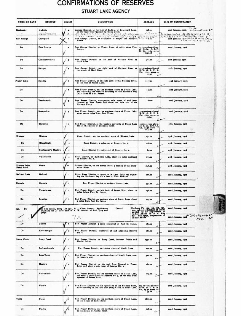
CONFIRMATIONS OF RESERVES STUART LAKE AGENCY
TRIBE OR BAND RESERVE NUMMI DESCRIPTION ACREAGE DATE OF CONFIRMATION
&backwater theiiiele.
KY.,//0.1 ),„ ■(
Cariboo Diutriet, et the foot of Eu-la-te en Graveyard Wm, on the teat+ -from-Quawrol- togterr-Gmeb.
' 1.,0 ,,i e ,'.,r , ' j.e, i J,1 .P/ . tallow
• d ' 2,0 0 ."' -...- r.
seat January, 1906 ,,,,, i ,.,.
/r.n ,a. Ir.. i ijr 11c! C l'a
Fort George Graveyard "h," .• . 1,1 / r , /ea.- 'A.. 0, ,as
Fort George District, at confluence of Fru/Aria' Vic Rivera.
. l kr ■ • • ' ,,'", r" " i.03. '
()if', A.,- ,, , , , ,,,,It fill aline January, 3916 .""" h
.. • el,' ',' .,,,
Do Fort George a Fort GeorgeDistrict, on F River, tfl miles above Port atroinTil. es;allos;
R. Co., 13.74 acre. -3395.36
and January, 1916
Do Cleabaoneecheck 3 /
Fort George District, on left bank of Nechaco River, at 304.00 aa
nat January, 1916
Do Salaquo • . 1
Port George District, on right bank of Nechaco River, at the mouth of Mud River.
115.00-less allowed
Co., 17.93 acres - 97.07 ,
R.-W. G. T. P. R. 16th January, t916
Fraser Lake Nautley ye' I Foartt tFnreasfenro,Doirrvic t, onLtatleft bank of the Nechaco River, itty.00 and January, 1916
i..---
Do a Fort Fraser District, on the northern shore of F Lake. acnod.aadaiaolinA tertwptern boundary of the Hudson's Bay
.49.0o sand January, 1936
Do Vensimhuck i 3 ,
Fort F District, one-quarter mile north of trail front attaels,:ea01 raraPyort Fraser and about one mile cut of the
16octo aand January, 1916
--..--
Do Seaspunkut / 4 FoarttnsuF, saaanDimatirliacatf aonnnIrnastoti,trhaeaarna. shore of F Lake, 112.3iko-. iiLesti..allir ;td. aand January, 1910
Co., t6.yy acres ■- 908.23
Do Stellaquo 5 FoarntriFat the
District, or theellawquso"Rnivaear.'"mi" of F
Lake eaVii7.7.4(3.4.1:.72'. 16th January, :936
Co., 29.32 acre. - .047.66
Kluskus Kluskus 1 Coast District, on the northern shore of )(tusk. Lake. t,o5t.00 35th January, zeta
Do Kloyadingli Yr s Coast District, 5 mile. east of Reserve No. 1. 546.00 35th January, 1916
Do Sundayman's Meadow Coast District, 6% mile. east of Reserve No. 1. 6o. no 4 25th January, 29:11
Do Voir:14.161a ,,. 4 Coast District, on Euchinico Lake, about to mile. northeast of Reserve No. T.
173.04. 25th January, 1.916 t''
Kluskus Tribe, Naito Band
Nano ao
1
Cariboo District, on the Narco River, a branch of the Black- water River.
1,146.00 ayth January, 1916
McLeod Lake McLeod i I Peiancge ttiveitainstnr.iactaaayt rotlaetlaonfd McLeod Lake Laakie.anagd adjoin- 3116.00 33nd January, 1916
Necoslie Nemalie Fort F District, at outlet of Stuart Lake. 734.00 4,......"" aand January, 1956
Do T Tat-sel-awas a Port Framer District, on left bank of Stuart River, about to miles below Fort St. J•mm.
ss6.00 sand January, 1916 z....---'
Do Sowchea 3 Fort P District, on southern shore of Stuart Lake, about 9 miles from Fort St. Jame.. 13.00l'''
sand January, 1916
e nee red. ,4
Je~ '•r hafes.../ 1• ■ ••i'h,r.
131. Do 1 enIesqgre,beirLot CaatDistrict App1catiol nrii n4llyaan ::eaeaap orneofo!s4714a,d General Evidence Pp. lot 505, 3o6, mt. rga, 396. 297; Schedule of Lands applied for by Department of Indian Affairs, on R. C. Fd• 6o1; Pile 39858, Department of Indian Affairs.
Sand January, 1926
i'e ) et. e b seltd January, n46
new. --_
Do Chesda i 6 Port F District, 3 miles southwest of Port St. James. 360.0o a-
_
sand January, :916
Do Kwot-ket.quo ti y
Y No. Port F Dietrict, southwest of and adjoining Reserve
6. t6o.00
r,.. sand January, 1956
--
Stony Creek Stony Creek ( :
Sacka-ni-te-cla
Fownaria, 1 1,p:strict on Stony Creek, between Tachie and 637000
V'
sand January, 1938
Do /
a Port F District, on eastern shore of Noolki Lake, 200.00 aand January, zeta
Do Lake-Town S Fort F District, on northern shore of Noolki Lake, near its western end.
340.00 4.---**---
and January. t936
Do Meadow 4 FeLtaaaF and alLianTcat,moina wthaest tornafaraormaa tune. %net to Fraser 16o.00 r...-/--
aand January, 1916
Do Clus.ta-lath r 5 /
Fort F District, on the southern shore of Tachie Lake, and about 3 miles north of Reserve No. 3. on the trail from Dunne! to Fraser Lake.
to3.00 L-----
sand January, 1936
Do Noonla 6 Fort F District, on the right bark of the Nechaco River, at the crossing of the trail from Stony Creek to Stuart Lake.
tz5.00-less allowed R.-W. G. T. P. R. Co., I a.32 acres -
99.6S
18th January, 1916
Tache Tache ‘ i
Port F District, on the northern shore of Stuart Lake, at the mouth of niche River.
1655.00 ua aced January, .9:6
Do Pinchie A a
Y
Foarit JaramsenrutDiantfrii,ti,naonlatriaanaorthern shore of Stuart Lake, yalloo aand January, 1916

CONFIRMATIONS OF RESERVES STUART LAKE AGENCY
TRIBE OR BAND RESERVE RUNUP DESCRIPTION ACREAGE DATE OF CONFIRMATION
Do Nan-cut i 3 FoiritiaaFrr.aaseard Donistgcat.poorntaSgtaugotmLasktea,aalt t toheR:rauathLcalaVi.ko 371.020 /„---•
rand January, 2916
Do U.caus-ley ; 4
(
Fort Fraser District, at the outlet of Petit or Cunningham Lake. about 4 miles from Reserve No. 3.
443.00 sand January, 1316
Do Car-soon-at a3
Y Fort F District, on the northern shore of Stuart Lake.
about hall way between Reserves Noe 1 and 3. ts4.00
c nand January, 23111
Trembleur Lake Gelangle i e FoitaaaF at
thaDmisatraioct; of m
ti tdienaniztahaearn shore of Trembleur INS.00 rand January, :316
Do So-yan-do-star a Fort Fraser District, on the northern shore of Trembleur Lake, about 4 miles east of R No. 1.
43.01 rand January, sat6
Do Tees-lee 3 Fort F District, on the left bank of the Tithe River, about half a mile from the outlet of Trembleur Lake.
a33.00 rand January, sold
Do Ste-van / 4 Fort Fraser District, on the left bank of Tache River, about two and a half miles from Trembleur Lake.
42.09
C.
send January, sate
Do Grand Rapid. , 3
'(
Fort Fraser District, on the Tache River, about seven mile. from Trembleur Lake.
384.00 sand January, tate
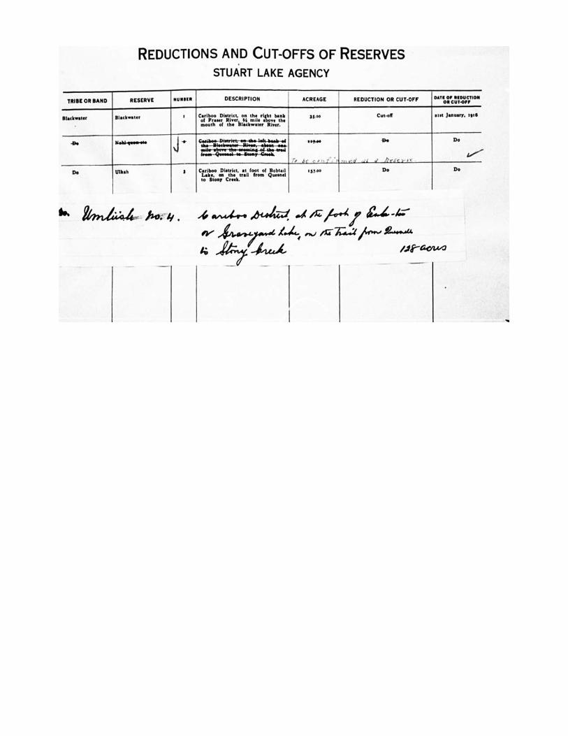
REDUCTIONS AND CUT-OFFS OF RESERVES
STUART LAKE AGENCY
TRIBE OR BAND RESERVE NUMBER DESCRIPTION ACREAGE REDUCTION OR CUT-OFF DATE OE REDUCTION On CUT-OPE
Blackwater Slackwater t Cariboo Dietrtet, on the right bank of F River, % mile above the mouth of the Slackw•ter River.
15.00 Cut -off alit January. 1916
-De blnlel-neein-Me Casiboo-Diseriet,em-eMa lete-baniref the—litimberimee—IReoes. -tabout -Awe-vni5tr-nbow-the-easeeinfi-oE the■-eeati
-N-Seen" -Gook
"144 Bo Do
.... LI'
Do Ulkah 3 Cariboo DIetrict, at loot of Bobtail Lake. on the trail from Queenel to Stony Creek.
1$7.00 Do Do
*** k 4;4 ho• y . w-a-4-• 1)-(44-d, /54.-4/ 44, e>.I /145.4:1
4LCZA, /0-acitAr3
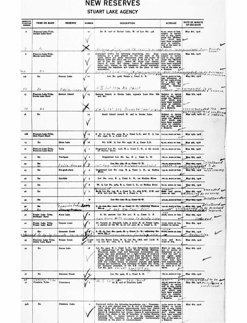
4114iseall
d e
rii•nv w e/.
NEW RESERVES STUART LAKE AGENCY
p. •LICATION TRIBE OR BAND RESERVE NUMMI DESCRIPTION .
1 ACREAGE DATE OF MINUTE
OF DECISION
6 Francois Lake Tribe, 10 Decker Lake Band
•
On N. end of Decker Lake, W. of Lot No. 556.
, . ' • • , r A ,,,.. . r . • r • l' r ' ', , • • •',1
■ • Contained within the following boundaries, vie.: Com- ,
mencing at a post glowed on the left bank of the , creek, about 300 yardsI downstream from the outlet of i Maxim Lake and about one (a) mile 6. of the B. K. cor• !under ner of Lot No. op ; thence W. thirty (30) chains; ,' thence S. sixty (6o) chains; thence Z. approsim•tely forty (40) chains, to the lakeshore; thanes northerly. following the lakeshore and creek, to the place of com- I mincemeat, „ I• ,. • , - ,,, v- ,,,,
toot, more or less, subject to meow and to any rights under the "Mineral Act" which may have been acquired prior to constitu• tion of the name as . • Reserve.
/ .f, •• 0 •••■ i• f
soo.00, more or less, subject to coney and to any rights
the any
Act" which may have been acquired prior to coestita-
tion of the same as a Reserve. ‘...."'""
, iv r' , r- e. d h.
soo.o. more or less, less allowance of 66 feet right-of-way for a public rood through Lot No. n: to Dunces
, , o ' ' ' . '
May Oh, 1,16
g-'
), 1-- 4 4./ r4' 7-,
May 8th, spa
-r, Yr•fe •fr 1 --e, d ..e net' A • r, i./.),+.4
May 8th, tete
,:.---.---
' r'; ''', I ''',-' /94'_,L
II
,v //
Francois Lake Tribe, Mairim Lake Band
I
' •.•
..
os6
/•7
Do
Po
Duncan Lake
:leit i. h i,
JJJ
Y
•,e.
u .4. .. r , i s -,.. o. 04... Lot No. Hod, Range 5, Coast L. D.
1/ ii r. ,''' • 7 7 74: A' e. ,.. e ,.., /
15
/1,
Francois Lake Tribe, (Inch* Lake Band
1)d
Intern Island
•
r a5 Lastern Island, in Uncha Lake, opposite Lots Noe. MI6 Subject to survey and 111:. and to any rights
under the "Mineral Act" which may have bean acgeind prior to coastine Non of the same as a Reserve.
6.. W. Yy I s I" .P, 2 e 1 r) et e I Y. 00 /.1t,i)i.gt A.(' • / ,- )
' 5 May 8th, :9:6
.....- L--
tee )* ),,,,,,e),.."
di Do 4 Small lobed teemed W. ad in Ueda Lake. Subject to gamey and to any rights under the "Iliseral Act" which may have been acquired price to constitu- tion of the same as • Reserve.
"6 0 .)- c h.ii ecd c) May 13th, 1906 es
all Penton Lake Tribe, Skis Tyee's Band
I
IL fel. 51 Lot No. 2435. R. 4, Coast L.D., and N. Y Lot soon, more or less. No. 0436, R. 4, Coast L.D.
May lath. :936
19 Do Blaine Lake a6 Pd. S.W. 51 Lot No. 2456, R. 4. Coast L.D. 83.oe, mere or less. if.--
May gth, t9a6
so Francois Lake Tribe. Francois Lake Band
Tatla ii a
Ungasetted Lot No. log R. 5, Coast L. D., at the mouth 080.04, more or less. I of Nadine River.
May 8th, sod
as Do Tannins •
V a Ungasetted Lot No. 614. R. 1, Coast L. D. allo.00, mon or ins. t......1igay Illtb, agog
N Ow nd 1-7 I'll)( a'fordse
Kle.gook-chew
/ .2 4
(
1•224-,-N0.-0819-11-47-eNIN-L-D., '-ot- -14./? pnq_r_ V , ',), lc e- ..:), .; e 5 - LA' l'
tamm-resesecasiiess.
:55.00, mon or lees. ?""' ''' i'`-s141/1L.", d :
Mtp-adr-61521L-i •
May me, sad a SI Do Unifaretted Lot No. 1059, R 5, Coast L. D., oar Nadine
sll Do °dobbin f
6
Lot No. :may, R. 5, Coast I.. D., on Nadine River. tlia.oe, more or lest
W. M Lot No. 5363, R. 5, Coast L. D.. on Wadies River. Smog more or less. AV'''.
May Ilth, spa
May Ilth, tete of Do
di Do 7
4L-e•• ■••er 0, 4 .0.4 I,'" 111-99 Lot No. 74i), R. 4, Coast I.. D.; dm B.W., N.W. and and asacto,,
N.R. Ws Lot No. 744, R. 4, Coast L. D. more or les° (,..
cr _May Sth, sgt•
G ?wit. air .
i--/-
SA '0' 12"-Nor-Tdr-/L-4.--Cosse-le-e. 322"4-1822N-soNoo,4-416T-9236-210113" 4 41.--
sao.m, neoreortem,r....day 6th,jr4
t mr/r to 2 az / 2,1' ;-,`Z., 7.°)% ,.., r .ir.t o De
T!
-De
b •
/e./ lope OA..Cm , '''" • -e 11--.-3.14-mw-,..wer-lih-4,- Cold4-1.-Etailltrrr SlIvern
, .21 #, J 2 4;12. ,_' ,,i1 - il,. ) ,'•
0 Feuer Labe Tribe, Strange° Band
Biota Lake
I
5,011,. hl. ,po:nciono Lot N.io.,,gar:s., J.R.,4,,, bCo6s,,aat L. jp._zte... 3:d e
met more or less.
6.---
10.00, more or les., subject to survey.
0.--
May Stb, 1911
,CroSvi May 8th, sod 42 Fraser Lake Tribe,
Fraser Lake Band Canyon Lake iy On Canyon or Ormond' Lake, o miles N. of Fraser Lake,
• portion of the W. 34 of Lot 3sos, R. 5, Coast L. D.
TV
' 4fri frit/ 6 ' .., Si ...y 21•
Orman& Creak
,,,,,/: 2.1 ly -,_
11,--- -Ilm-persL-Bc-t--Cierret-fm-07-edepleiwg-11.- /5 •,,, •
-4mers,..mottew_lamo
lir 4..•"" May 8th, e9:11
7?ebuct A A
. '' 1- ." .: LS -• r_r- LA....LL2Lp k et` e_
43 Francois Lake Tribe, Burns Lake Band
i-
Poison Creek ay and 7
(ay) On Burns Lake, N. Y Lot No. rail, and (rya) N. 5.4 Lot No lent R. t Coast L D.
ro.ms and llo.00, more or less.
Yore or less, sub- jets to survey of deduction. as pro-
any Jrriaotaits and to
the "mineral Act" which may have been acquired prior to constitution of the same as • Re- MVO. 1----
L.- May 18th, Iota
May 8th, yid
d°
44 Do Burns Lake :I
V,'
Lot No. 3402, R. 5, Coast L. D. less deductions therefrom of rights-of-way of the Grand Trunk Nellie Railway, Provincial public road and Dominion Government tele- {(661 feet fora
allowance apnil ;4 ififfroaadriel-aft.hw:FGrociferTrUnil:
Mile Railway Company's Burns Lake Station to Burns Lake, provided the said right-of-way shall not interfere with any Indian house, or obstruct ingress and nem thereto and therefrom, also allowance of eighty OW) acres, for Townsite purposes, In the S.R. corner of the said Lot No. $40s. c.."X C e' pr- ,,ye.,,e e , f f je,.,
f.. I). . te
47 Do Sheraton Creek Lot No. 5405, R. 3, Coast 1 D. .. alo.00. more or less. May a 6th, zed 4.----
JO' MI
C 4 eT7x/v r)-, h. Chmlatta Tribe Unampaorta
.r , , • 4 , Afte, 5 1 t,'. , '.-., , i ' At Z. cod of t 'wenn. Lake.
/4 0.10 e- 1.----4" ).- r C a in hi t soli 364.es, more or less, May 8th, zed /4., subject to survey and ts any rights c 0 under the
any
Act" which may have been acquired prior to constihm don of the same as a Reserve.
1.-/"--
55A Do Chedatta Lake
e-
a Conta,ned within the following boundaries, vie.: Commons-
1
ing at a post planted near the Z. end of Cheelatta Lake, north shore, and diatom approximately forty (40) chains then the N. Z. corner of Indian Reserve Location No. a
a;
thence E. tweet •6q 451 chains; thence S. approximately fifteen 05) choles to the N. boundary of Indian Reserve Location No. e; thence westerly to the lakeshore and following the lakeshore in a g ally northwesterly direction to the place of commencement
nom, more or less, May 8th, 1.16 subject to survey and to eery rights under the 'Mineral Act" which may have been acquired prior to ite- dm of the same as • Reserve.
I.
SOO°
„ tiv..eg
c /•41•CAtt(fre
akerriel- ve.
""rfl ore/il sat
1•""), /.(4,1".we of
,yetv exervt.Littp.
Inefteleee *6 Gere.r.
1:cd/%',
e pcAarre reterve.
eat. 5,..ww""
n.
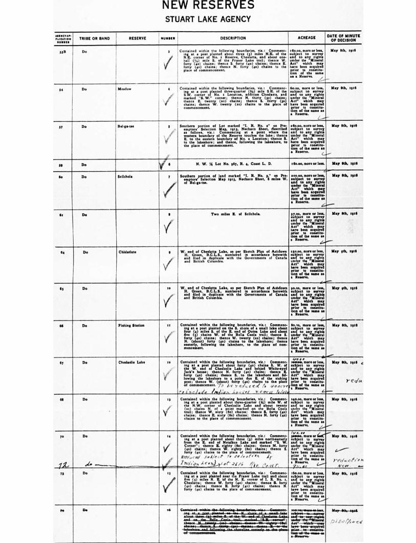
NEW RESERVES STUART LAKE AGENCY
AIIIINCT••• /LIGATION I TRIBE OR BAND NUMMI i
, OMR RESERVE N DESCRIPTION ACREAGE DATE OF MINUTE
OF DECISION
50 Do
I
2
/
Contained within the followng boundaries, via.: Comment-
'1'4'1"c:in:rot planted t, o . Itosuetr.tehr, e_ (3) stilts Nit. of the
eheslattas,lisnd about one- half ( 1,i) mile S. of the P Lake trail; thence W. forty (40) chain.; thence S. forty (40) chains; thence Z. forty (40) chains; thence N. forty (40) chains to the place of commencement
e 6o.00, more or Ins, subject to annoy and to any rights under the
any
Act" which may have been acquired prior to constitu- don of the same as a Reserve.
.---
May ath. 19:6
-
S4 Do Meadow 4
Contained within the following boundaries, nit : Comment- planted three-q (Ye) mile S.R. of the in{ at
coarrfeor" of No. a Location, addition Cheslatta, and marked "S. W." corner; thence N. thirty (0) chains• thence IL twenty (2o) chains; thence S. thirty (34 chain.; thence W. twenty (so) chains to the place of commencement
So-w, more or lees, subject to survey and to any rights under the "Mineral Act" which may have been acquired prior to constitu- tion of the same as a Reserve.
May Mb. will
37 Do I
Bel-Sac tee 2 Southern portion of Lot marked "I. R. No. a" on Pre- emptors' Selection Map, tot 3, Nechaco Sheet, described as follows, via.: Commencing at a point where the western boundary of the Reserve touches the lake ; thence E. to the eastern boundary of No. a Location; thence S. to the lakeshore ; and thence, following the lakeshore, to the place of commencement.
260.00, more or leek subject to survey and to any rights under the
any
Act" which may have been acquired prior to constitu- tion of the buns as a Reserve.
May kb, wig
--
sg Do I N. W. ye Lot No. sty, R. 4, Coast L. D. t Pape, more or less. May Rh, tea 6
So Do Scilchola 7
/
Southern portion of land marked "I. R. No. 3," on Pre- ernptors' Selection Map 19:3, Nechaco Sheet. 6 rides W. of Bel-ga-are.
a oo.00, more or less, May 6th, mill subject to survey and to any rights under the
any
Act" which may have been acquired prior to constitu- tion of the same as a Reserve.
2..—..-----
de Do I
1
Two miles R. of Scilchola. 37.00, more or less, May kb, 1916 subject to survey and to any rights under the 'Mineral Act" which may have been acquired prior to constitu- tion of the same an a Reserve.
64 Do Chidatlate g
i
W. end of Chealatta Lake, as per Sketch Plan of Ashdown Ii. Green, B.C.L.S., numbered in accordance herewith • nd filed in duplicate with the Governments of Canada and British Columbia.
250.00. more or less, subject to survey and to any rights under the
any
Act" which may have been acquired prior to constitu- tion of the same as a Reserve.
----,.....--
90.00, more or less, subject to survey and to any rights under the "Mineral Act" which may have been acquired prior to constitu- tion of the mute as a R .
May 9th, red
Is Do to
7
W. end of Cheeletta Lake, as per Sketch Plan of Ashdown H. Green, B.C.L.S., numbered in accordance herewith and filed in duplicate with the Governments of Canada and British Columbia.
May 9th, wag
IA Do Fishing station on
(
Contained within the following boundaries, via.: Comment- lto,o, more or less, May Ith, sate mg at a post planted on the S. shore of s small lake about subject to survey four (4) miles S. of the IL end of Goma Lake end about and to any rights One (3) chains W. of the Bells Cool. trail; thence S. under the
any
forty (40) chains; thence W. twenty (ao) chains; thence Act" which may N. (about) forty (40) chains to the lakeshore; thence have been acquired easterly, following the 1•Iteshore, to the place of cm, prior to constitu- inmost:nem. Non of the saute as
a Reserve.
By Do Chesiaalle Lake as
.
Contained within the following boundaries, vie.: Commenc- mg at • post planted about forty (40) chains S. W. of the W. end of Cheslaslie Lake and behind White-eyed Jack' house; thence N. forty (40) chains; thence K. o
s frty (4o) ch•ins; thence B. to the lakeshore sad fol. lowing the lakeshore to a point due R. of the staking port; thence W. (about) forty (4.) chains to the place of commencement. it A ,, y e•,/,, , t. ,,( ,..; •7n , ,,,, "eon
'r, ( ,i .• it rit 41• A A , ief >, **(rc.c.f it2a.14,
ivto • • Mal*, more or less, May 1th, stit • subject to survey and to any rights under the "Mineral Act" which may have been acquired prior to constitu- Y- C. (lir
of the same as a Reserve. L.--
sactort, more or less, May gas, mg subject to survey and to sny rights under the
any
Act" which may have been acquire prior to constitu- tion of the same ss I Reserve. ....„......-
65 Do es
/
Contained within the following boundaries, vie.: Comment- irag at a post planted about three-quarter (43) mile W. of the N.W. corner of Cheslaslie Lake and about twenty (an) chains N. of a point marked on the Belli. Coola trail ; thence W. •iiity (60) chains; thence 8. (any itri) chains; thence E. Bitty (6o) chains; thence N. forty no) chains to the place of commencement.
ID
iL
Do
..........
se
V
r
Contained within the following boundaries, vie.: Comment- ing at a post planted about three (3) miles northeasterly front the I. end of Netalkus Lake and marked "It W. Corner" ; thence Z. eighty , (So) chains; thence N. forty (40) chain.; thence W. eighty (So) chains; thence S. forty (40) chains to the place of commencement.
leeti,,,,v, J.,,,C,-, e• /. J! /r et' , 0,1 „i r
irk1/4,, .Lr,), foe' .7iA; Ai', .;,,,Irt-
14,0, •• ima May Sth, s916
,....„./--
7.-pd„ ,..,r'ir /,
New • ..-..
May 9th, nig
isome, more or subject to survey and to any rights under the "Mineral Act' which may have been acquired prior to constitu. hors of the UM. as a Regent / -. a 4.----4
!Woo, more or less, subject to surrey and to any rights under the "Mineral Act" which may have been acquired prior to constitu- tion of the same a. a Reserve. (......./
IS Do •
is
Contained within the followingboundaries, via.: Commenc- leg at a post planted near t e Fraser Lake trail and about Ave (3) miles N. Z. bf the N. Z. corner of 1. R. No. t. Chitlins: thence W. forty (45) chains; thence S. forty leo) chains,. thence Z. forty (4.) chains; thence N forty (4o) chains to the place of commencement,
PP Do ad wereen-wwwwee-less. MapJ*-apst
/...," i j-„, 44 . e e 30.6
e.krui K. somas, .andAb"4-4.trit ,,-.-47:"..27W:1 117161, ; me"- -
"I hare- bevi.r7,-; the.. elm.*
prim- so-wwweres-Hew-w9-1be-oree-se • -aeeerwn.
rowrinernowneob
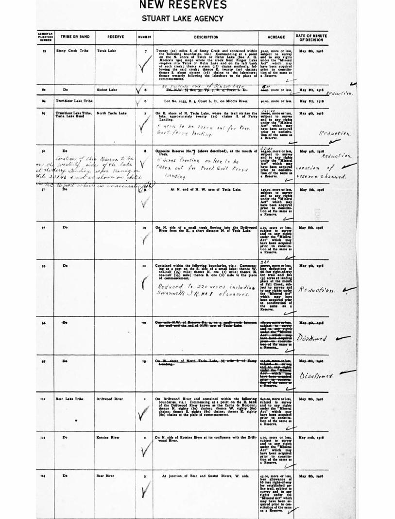
NEW RESERVES STUART LAKE AGENCY
AIIINCV •P. • ‘,CA11011
1101111• TRIBE OR BAND RESERVE 01111111111 DESCRIPTION ACREAGE DATE OF MINUTE
OF DECISION
79 Stony Creek Tribe Tatuk Lake / Twenty (to) miles S of Stony Creek and contained within the following boundaries, vie.: Commencing at • point on the N. shore of Tatuk or Hehn Lake (See A. G. Morin'. soar map) where the creek from Finger Lake empties into Tatuk or Hehn Lake and on the left bank of such creek; thence eixteen 06) chains northerly, fol. lowing the said creek ; thence S. twisty (so) chains;
S. about sixteen OS) chains to the lakeshon; thence westerly following the lakeshore to the plan of ........t.
prior to come es
p.00, more or Ins, subject to survey and to any rights under the "Miners! Act" which may have been acquired
lion of the same es • R .
..!
May 6th, tote
I
12 Do linkut Lake
A75,..r.zi c:4 ,v' -'/,, . ,:t4„iteur.. dr/F amime, more or less. May 6th, and
Li Transbleur Lake Tribe Id Lot No. soot, It. 5, Coast L. D., on Middle River. 40.00, more or less. May 6th, 3 9.6
SO Trembleur Lake Tribe, North Tacla Lake Tula Lake Bud
.
On E. shore of N. Tacla Lake, where the teed strikes the lake, approximately twenty (so) chains A of Perry Landing.
/ 0 At y4,( rr. ,gt re,- Pp', Ct- a v r. /e ) r A,„ A.,.
7-
,.,, ,,, spneo, more or less, May 9th, gate subject to survey and to any rights under the "Mineral Act" which may have been acquired prior to constitu- non of the same as /ern • Resent.
4..■
66
?it / H..,
C-41 - /40,
Wile, - 2 at
Do
,,,se wrient, • 0°' (4 401.14.4. 4' -44. / •
,,,,...e. 4.4.1 t:'./., 4.,_ ,. r4 (.4. 1 if ekl+, r4.;, x. -se, itn...cs —7... kw-
/ ;,I i 0 ..-fri .,, .t'' 414 ..42.6.4".• ....-' ..44t
II Opposite R No.7 (above described), at the mouth of
.• ..., ,..,),..".,.. t p•utin q. Oh 4.4 c 10 46
V t giv•A our ,Ar p,., „,l a „./ A.-e ,-, ' l'
L.---7 her ' 4 i hip.
-;:•...r., ...aim, more or less, May gob, eint1 subject to survey
,! ,- and to any right. under the "Mineral Act" which may have been acquired „,,. if ,'„, j., prior to constitu- tion of the same as • Reserve. 3'eSt' 3-a, C C A,
L-- '-".,' -it d
fl 74, ,....,zt'' re-4. 4.44, < •,..et .e..-e tes.ta eh)
At N. end of N. W. arm of Tecla Lake. 140.00, more or less, May 6th, sgsli subject to survey and to any rights under the
any ,
Act" which may have been acquired prior to constitu- tion of the same as • Reserve.
L.....---.1
93 Do to On N. side of • email creek flowing into the Driftwood
River from the E., a short distance N. of Teel. Lake. 4.00, more or less, May 6th, end subject to survey and to any rights under the "Mineral Act" which may have been acquired prior to constitu- tion of the same es • Reserve.
Lam"
93 Do az Contained within the following boundaries, vie.: Commenc- ing at • post on the S. side of a small lake; thence W. one-half 4) mile; thence N. one (t) mile; thence E. one-half 54)) mile; thence S. one (a) mile to the place
ir of commencement.
. , /Ve cji,, ce ,-/ te Jgo gere.1 ene/A, 0'0,4 swq),,,c)/1. i le A'll eAo,sere.r.
. 2 • 2 a game mon or less. May 6th, ape less deductions of 66 feet right-of-way for trail and Sc. (3) acre. at landing place at the mouth of Pall Creek, sub- jest to survey and pp , ,i to any rights under / 1 r cru cc-1'o the "Mineral Act" which may have been acquired prior to constitution of the same as a Reserve.
166
ffivvvervvmrtrrIM Mar 014-1/1.11
r....,_. .....____.,.._ 2)‘;4„„,,„, „......._____ ten-of-the-mosm-as a3teeow...
(..---"
the-vemi.-esvirlea-mid-e6-61.W..-weas 46--Twts/o-Iminr.
rt • . , Mop -6tit, lege.
te ' sue s
i.)/..ilffaiv I , priee---Preorestim. use-of-thp-isease,m e-Resterein.
e--- 102 Beer Lake Tribe Driftwood Min/
•
s On Driftwood River and contained within the following boundaries, via.: Commencing at a point on the K. bank of the Driftwood River known se the Cache de Bonjour; thence N. eighty (So) chains; thence W. eighty (6o) chains; thence S. eighty (to) chains; thence E. eighty (So) chains to the place of commencement.
64o.00, more or less, May 6th, egad subject to survey and to any rights under the "Mineral Act" which may have been acquired prior to constitu- lion of the same as a R
6-----"--
soy Do Koteine River a On N. side of /Conine River at its confluence with the Drift- wood River.
Loo, more or leu, May nth, Intl subject to survey and to any rights under the "Mineral Act" which may have been acquired prior to constitu- tion of the same as a Reserve
e..,--''''
lee Do Bear River a At junction of Beer and Sustut Rivers, W. side. es.00, more or less, May Sib, 1 555 less allowance of 66 feet right-olkny for established po-lice trail, subject to survey and to any
libts under the Mend Act" which
may have been ac-quired prior to con- stitution of the same - as a Reserve. vo"
ats••••""
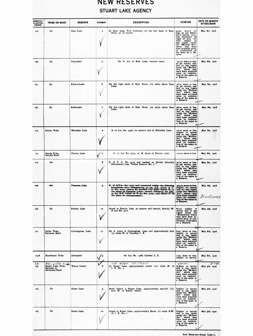
NLW Kt.StKVL5 STUART LAKE AGENCY
astactsr- ! • I.,CATIOIN 1 TRIBE OR BAND RESERVE NUMIIIII DESCRIPTION cum. I
ACREAGE . DATE OF MINUTE OF DECISION
ios Do lie., Like 2 At Year Lake, Frrt Connelly. on the left bank of Hear
River. at its mouth
1 j.
I
34.0o, more Or less, as per Swam- nell's survey, tot:, less allowance of right • of •way for tr trail, subject to any rights under the "Mineral Act" which may have been acquired prior to constitution of the same aa • Re- NM.
May 80. 106
ton Do Tiup-meet 3 On N. and of Bear Lake, w shore. tscoe, more or less. as per survey, sub- ject to any rights under the
any
Act' which may have been acquired prior to constitu- tion of the Saint as • R
May Ilth. .936
to, Do Klew.a-duska S On the right bank of Bear River. aii miles below Bear Lake.
26.00, mote or less, a. per survey, sub- ject to any rights under the "Mineral Act" which may have been actotred prior to constitu- tine of the same Is • R . ,_..1.....,___
May 5th, :936
tog Do Kallie-seks 7 On the right bank of Bear River. 3% miles below Bear Lake.
gtoo, more or len, May Sth, :936 as per survey, sub- Jett to any rights under the "Mineral Act" which may have been acquired prior to constitu- tion of the earns aa a R . 4.+-.."----
Isis Taisho Tribe Whitefish Lake 6 5. of Lot No. 4936• on astern end of Whitefish Lake. r
moo, more or less, May Ith. 8936 subject to survey and to any rights under the "Mineral Act" which may have been acquired prior to constitu- , nonof the um• as; • Reserve.
..,.....---
ass Tatche Tribe, Pinchle Band
Pinchie Lake S. ti Lot No. 001. on N. shore of Pinchie -ake. -1—
1 on.00, more or less. ' May 6th, sorra
wii■
40.00, more or less,' May Ilth, WS as per survey, sub-'! jeer to any rights under the "Mineral Act" which may have been acquired prior to constitu- , riots of the urn*
se as4.....„
• Reserve,
114 Do 6 S. of T. L. No. 4273 and marked on British Columbia Government map "Indian Reserve No 7."
• Ie. ' im.,......a,
Ate' —.41 1ts. may Sib, 1,11
A ...i.,,/?, 0 ed
'''''.."-
May 9th, HO
. . .
'to-. _ .ttrairlI7earser-of-,—W-1441.--asse.4..-euuLalwew tix-Ww•-ol-commaaramear-- biwo-bews-seausiesil
paios—w—oweseitu. 11111111-4-tht-Inlitiff-at '-u R.-. a
LP
So.00 subject to and to any rights under the "Mineral Act" which may have been ac-quired prior to con-stitution of the some a• a Reserve.
336 Do Mackie Lake to
v ay
Island in Pinchie Lake. at eastern end thereof, directly W. of Lot No. 3010.
Ilia Tech* Tribe, Yocum* Band
Cunningham Lake t 1
V
On S. shore of Cunningham Lake and approximately four
(4) miles W. of Ursouley I. R. Boo, more or less, subject to survey and to any right. under the "Mineral Act" which may have been acquired prior to constitu. lion of the urns as a Reserve.
(0.-----
May 6th, tele
au/. Blackw•ter Tribe Graveyard On Lot No. :NW Cariboo L. D. s.00, more or ten, subject to survey.
Le-----
May 6th, spill
/.0 133
Nc' . n 7/e r,ii(1, Stuart Lake Tribe, B Island Necoalle or Necaueley Band
/
A de -92.14, /el -. t'.4.res: In Stuart Labs, appsoxissately twelve (eel miles W. of
I. R. No. t. und er the "Mineral
‘4,,,,,,, Subject to survey and to any right.
Act" which may have been acquired prior to constitu- tion of the same as a Reserve. 4/".-
1. f RV
May 9th. :916
_
134 Do Stuart Lake 9
V/
Small Island n Stuart Labe, approximately one-half (54)
mile W of Heaver Island. Subject to survey and to any right. under the "Mineral Act" which may have been acquired prior to constitu. non of the tame ae a Reserve.
-
May 9th, togs
,..- "r.
US Do Stuart Lake to Island in Stuart Lake. approximately Seven fy) miles N.W. of I. R No 1
Subject to survey and to any rights under the "Mineral
May rith. 1916
have been acquired prior to constitu-tion of the same as a Reserve.
New Renews—Stuart Lalte—,
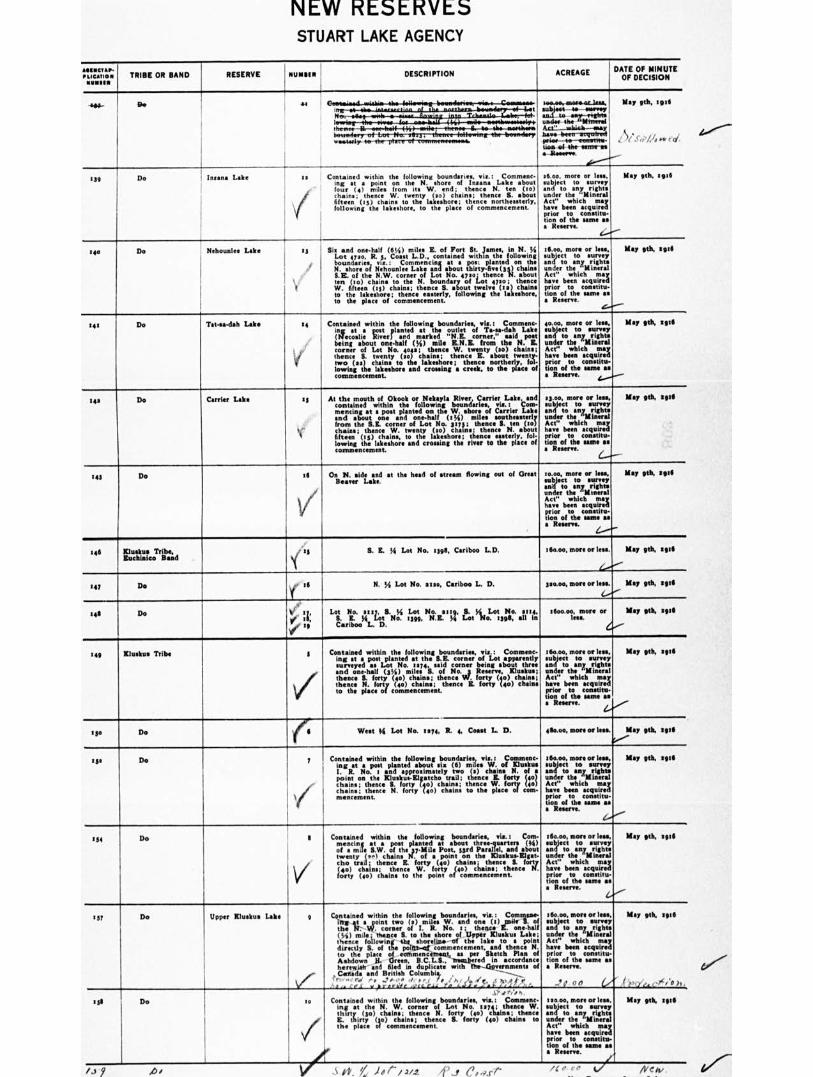
*ex, /4 er. 00
NEW RESERVES STUART LAKE AGENCY
'LOCATION NUMMI
AITINC121, TRIBE OR BAND RESERVE MINIM
I DESCRIPTION ACREAGE
DATE OF MINUTE
OF DECISION
suwavatora-ac-lass, LtriAt 4. seamy
under- th:= Actlt..-taltlatt--tasy
May 9th, 1926 Be 41
'13eimareri nvole ,
'
leifb*--441-2•011/r1TrO- P/Se? /A •w ed tie. a the •INTrIrVII
W11111,144". 012111TrOter/r0124.
e-lite......
ta Do 1 Insane Lake as I
1
Contained within the following boundaries, via.: Comment- log at a point on the N. shore of Insane Lake about four (4) miles from its W. end; thence N. ten (to) chains; thence W. twenty (so) chain.; thence S. about fifteen (to) chains to the lakeshore; thence north rly, following the lakeshore, to the place of commencement
saw more or less. May 6th, tit. subject to survey end to any rights under the "Mineral Act" which may have ban acquired prior to constitu- tion of the BUMP 1le a Reserve.
tilt Do Nehounlee Lake es Sit and one-half (61/4) mil. E. of Fort St. lames, in N. ;4 Lot 4720, R. 3, Coast L.D., contained within the following boundaries, vie.: Commencing at • pos. planted on the N. shore of Nehounlee Lake and about thirty-five (33) chains S.E. of the N.W. corner of Lot No. eta; thence N. about ten (to) chains to the N. boundary of Lot 4720; thence W. fifteen 05) chains; thence S. about twelve (Iz) chains to the lakeshore; thence easterly, following the lakeshore, to the place of commencement.
Ifitio, more or less, May oh, sal subject to survey and to any rights under the
any
Act" which may have been acquired prior to constitu- lion of the ume as a R
2 41 Do Tatwa-dah Lake 24
lorf ,
Contained within the following boundaries, vit.: Commen. in at a poetplanted at the outlet of Ta-sa.deh Lake (Metallic River) and marked "N.E. corner," said post being about one-half ((4) mile E.N.E. from the N. E. corner of Lot No. 4o4a; thence W. twenty (so) chains; thence S. twenty (to) chains; thence E. about twenty- two (sal chains to the lakeshore; thence northerly, fol- lowing the Iskeshore and crossing a creek, to the place of commencement.
40.0o, more or lees, May eh, tag subject to survey and to any rights under the
any
Act" which may have been acquired prior to constitu- tion of the earne as a Reserve.
2 42 Do Carrier Lake 45
It
At the mouth of Okook or Nekayla River, Carrier Lake, and contained within the following boundaries, viz.: Corn- mencing at a post planted on the W. shore of Carrier Lake and about one and one-half 01/4) miles southeasterly from the S.E. corner of Lot No. 3275; thence S. ten (to) chain.; thence W. twenty (2o) chains; thence N. about fifteen (t3) chains, to the lakeahore; thence easterly, fol. lowing the lakeahore and crossing the river to the place of commencement.
13.00, more or less, May ash, sae subject to survey and to any rights under the
any
Act" which may have been acquired prior to constitu- tion of the same as a R
143 Do 16
V/
On N. side and at the head of stream flowing out of Great Beaver Lake.
to.00, more or lea., May 9th, ea. subject to and to any right under the
any
Act" which may have been acquired prior to constitu- tion of the since a. a Reserve.
146 Kluskus Tribe, Euchinico Band
S. S. E. (4 Lot No. 2398, Cariboo L.D. 1611.00, more or less. May gth, call
247 Do ,fie ill N. 1,4 Lot No. 2120, Cariboo L. D. 310.00, more or Ina. May gth, sag
146 Do ,
I T
Lot No. 2117, S. fi Lot No. alt., S. ),i_ Lot No. at.,
S. E. Bi Lot No. 2399, N.E. )4 Lot No. 1393 all In Cariboo L. D.
2600.w, more or May gth, 0924 less.
49
249 Kluskus Tribe 3
.
/
141
Contained within the following bound via.: Comment- ing at a post planted at the S.E. corner of Lot apparently surveyed as Lot No. :am said corner being about three and one.hall (31/4) mile. S. of No. Reserve, Klueltus; thence S. forty (40) chains; thence . forty (40) chains; thence N. forty (40) chains; thence E. forty (40) chains to the place of commencement.
West M Lot No. es., R. 4, Coast L. D.
t6o.00, more or less, subject to survey and to any rights under the
any
Act" which may have been acquired prior to constitu- tion of the same as a R .
ello.00, more or less.
May 9th, spa
May gth, 394
1,-*--
250 Do
am Do 7
%
,le"
Contained within the following boundaries, viz.: Coalmen. ing at a post planted about sit (6) miles W. of Endue I. R. No. 1 and •pproximately two (2) chain. N. of a point on the Eluskus.Elg•tcho trail; thence E. forty (4o) mch.anin..; etnhtence S. forty (40) chains; thence W. forty (40) chains; thence N. forty (4o) chains to the place of corn•
,.
160.00, more or leek .object to survey and to any rights under the
any
Act" which may have been acquired prior to constitu- tion of the same as • Reserve.
4.-."--
May 9th, sal
151 Do 9
\i/
Contained within the following boundaries, viz. : Com- mencing at a post planted at about three-quarters (4.1 of • mile S.W. of the 37.Mile Poat, 33rd Parallel, and about twenty (•^1 chain. N. of a point on the Elualeus-Eigat- cho trail; thence E. forty (40) chains thence S. forty (40) chains; thence W. forty (40) chains; thence N. forty (40) chains to the point of commencement.
160.00, more or less, subject to survey and to any right. under the ."Minerel Act" which may have been acquired prior to constitu- tion of the same as • Reserve.
4-,'''
Map gth, 106
t37 Do Upper Kluskus Lake g
Ve
Ostiained within the following boundaries, via: Commas. a a point two It) mile. W. and one 0) pie 3. of
the 4:-.w. corner of I. R. No. 1; than E. one-half (M) mile; thence S. to the shore of Upper Kluskus Lae; thence following the Morelli. of the lake to a point directly S. of the poigh-of commencement, and thence N. to the place of eoltunencermat, as per Sketch Plan of Ashdown K. Green, B.C.L.S., matared in accordance herewith and filed in duplicate with aliments of
„Collide and British Columbi,. . tree,,: rd , .,,,,,.. ,i. ,,i- r • ,/ •■ r ,A. • ', .5;?;,6/ C
All •■ COS . pr•rhIlo ate CAA LA ./..." • • ..,..I. X _,I.Ill
igto.cw, more or lam, subject to survey and to any right. under the "Mineral Att" which may have been acquired prior to connitu- tion of the same as a Reserve.
-,' 0. 00 0 4,
May 9th, ate
. ,
4 'e,c/,. elc,4».
sell Do to
/
.s ,,,,,.. h.
Contained within the following boundaries, via.: Coalmine- ing at the N. W. corner of Lot No. es.; thence W. thirty (30) chains; thence N. forty (40) chains; thence E. thirty (30) chains; thence S. forty (40) chains to the place of commencement.
tun.ae, more or less. subject to survey end to any rights under the "Mineral Act" which may have ban acquired prior to constito- don of the same as a Reserve.
/
May Mk tote
/.5 A / 0. )0r/242. 'f J Cease
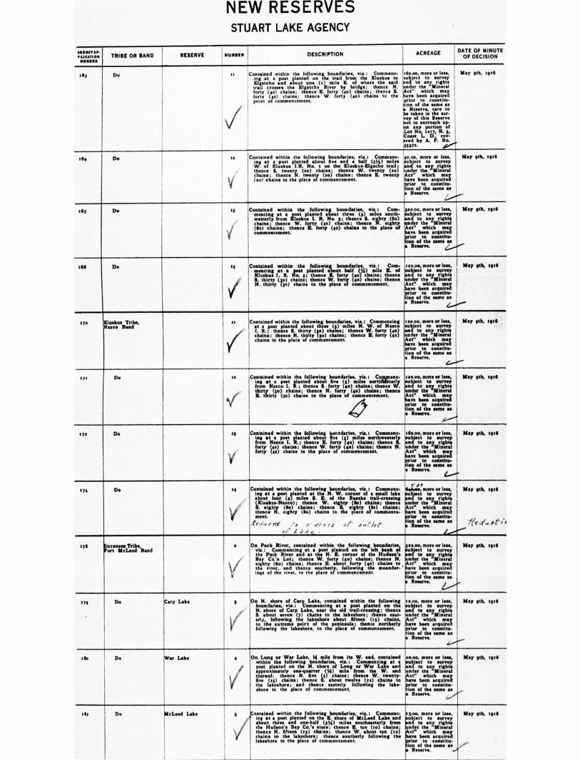
NEW RESERVES STUART LAKE AGENCY
MIIIICT•P. PLICATION
1 I 1
TRIBE OR BAND RESERVE MUNSON DESCRIPTION ', ACREAGE DATE OF MINUTE OF DECISION
It, Do ti Contained within the following boundaries, vie: Comment- !I igo.00. more or less,
ing at a post planted on the trail from the /Dusk. to .subject to survey Elgatcho and about one ( r) mile E. of where the said pod to any rights trail crosses the Elgatcho River by bridge; thence N. hinder the "Mineral forty (4o) chains; thence E. forty (40) chains; thence S. Act" which may forty (4o) chains; thence W forty (401 chains to the have been acquired point of commencement. :prior to constitu-
tion of the um* as a Reser., tare to be taken in the mar- vey fthis Reserve not to encroach up- on any portion of Lot No. tely, R. 3, I Coast L. D. cow- ered by A. P. No. )33S7s. eew'...t.
May gth, 19111
164 Do is Contained within the following boundaries, via.: Comment- I ing at a post planted about five and a half (I%) miles W. of Klu•Itus I.R. No. 1 on the Kluskus-Elgacho trail; thence S. twenty (so) chains; thence W. twenty (so) chains; thence N. twenty (ao) chains; thence E. twenty
1 (so) chains to the place of commencement. 'prior
4o.00, more or less, eubject to sunny and to any rights hinder the "Mineral Act" which may have been acquired
to constitu- tion of the same as
Reserve. /...•°.".-
May gth, spa
Ids Do r3
f
Contained within the following boundaries, vie.: Corn- mencing at • post planted about three (3) miles south- westerly from Kluskue I. R. No. 5; thence S. eighty (So) chain•; thence W. forty (40) chains; thence N. eighty (So) chains; thence E. forty (40) chains to the place of commencement.
po.00, more or lens, object to survey nd to any rights nder the
any
Act" which may ve been acquired for to constitu- n of the same as Reserve. Z.......'.
Map nth, tntS
t66 Do 14
1
l Contained within the following boundaries, vie.: Coat- mencing at • post planted about half 04) mile IL of Kluskus I. R. No. 3; thence K. forty (to) chains; then. S. thirty (3o) chains; thence W. forty (45) chains; thence N. thirty (3o) chains to the place of commencement.
120.00, more or less, subject to survey
d Minder othes"Mrinigehral e Act" which may hare been acquired prior to COBStinl■ lion of the same as a R 4../m
Map plit, qt[
r yo Xluskus Tribe, Nuco Road
at
7.
Contained within the following boundaries, via.: Commencing at a post planted about three () miles N. W. of Nano I. R.; thence S. thirty (go) chain.; thence W. forty (40) chains; thence N. thirty (go) chains; thence IL forty (40) chains to the plan of commencement.
ta000, more or leek Map la* spa subject to surrey and to any rights under the "Minna Act" which may have bun acquired prior to contrite- tion of the same as a Reserve.
4.----
171 Do
sa .Contained within the following boundaries, via.: Comnenc- ' ing at a post planted about five (5) miles north'Wterly
from Nasco I. R.; thence S. forty (40) chains; thence W. thirty, ($0) chains; thence N. forty (40) chains; thence R. thirty (go) chains to the place of commencement.
IVC ,
i
1 ao.00, more or less, I May ph, son subject to survey , and to any rights under the "Mineral Act" which may have been acquired prior to constitu- tion of the same ae • Resent. y/,.
eye Do el
)6
f ! 1 Contained within the following bound via,: Comment- 1160.00, store or less, ' May gth, tug
ing et a post planted about fine (3) miles northwesterly Isubject to many i from Next° I. R.; thence E. forty (40) chains; thence S. and to any rights forty (40) chains; thence W. forty (4o) chain.; thence N. tinder the
any
forty (40) chains to the place of commencement. Act" which may have 'been acquired prior to conetitu- tion of the same ite • Reserve.
tr.'.
5 74 Do se
V
Contained within the following boundaries, els. : Comment- ing at a post planted at the N. W. corner of a small lake about four (4) miles S. K. of the Bunko trail-crossing
VI uzitInhits- Ns(ssc.o)) ; chains;
tre;..eig)lity eighty
c 331.7 ; chains ; tiele •
thence J.- eighty (So) 'cholas to the piece of commence: ment, ,e,.. ,.■ e MI i, I ..er).ei at ...'let
41' A a 4' r •
. .)- ds 3 4,neeo, more or lees, ttliject to survey nd to any rights Titer the ic"til Mineral
havr been acquired prior to conetitu. mon of the same as • Reserve.
May 5th, spg
iCc./', 43 i , 4
1 yll liocrctanl'ribe, McLeod Band
s
vf
On Pack River, contained within the following boundarice, .5ao.00, more or less, vie.: Commencing at a post planted on the left bank of eubject to survey the Pack River and at the N. R. corner of the Hudson's end to any rights Bay Co.'s Lot ; thence W. forty (4o) chains; thence N. under the "Mineral eighty (to) chain.; thence R. about forty (401 chains to,Act" which may the r i rrr, , and thence souther)y. following the meander- •' have been acquired illiS of the riven, to the place of C0111171.1"111.t. prior to constitu-
tion of the rune as In Reserve. , 2.-
May stk. Igtil
3 /9 De Carp Lake s
yOr
On N. shore of Carp Lake, contained within the following boundaries, vie.: Commencingat a post planted on the N. shore of Carp Lake, near the old trail-crowing; thence 3. about seven (7) chains to the lakeshore; thence east- *fly, following the lakeshore about fifteen (r5) chains, to the extreme polrt of the peninsula; thence northerly following the lakeehore, to the place of commencement,
'moo, more or less, tab est to survey
d to any rights nder the "Mineral et" which may no bun acquired lea to conetitu-
Ion of the same as Reserve
e./.--..
May ph, spa
t to Do War Lobo 4
,e
V
On Long or War Lake, f4 mile from its W. end, reatahmd within the following boundaries, vie.: Commencing at a poet planted on the N. shore of Long or War Lake and •pproximately one-quarter (14) mile from the W. end thereof; thence N. five (5) chains. thence W. twenty- five (al) chains; thence S. about twelve (es) chains to the hauliers; and thence easterly following the Iske- shore to the place of commencement.
se.om more or leas, bject to survey
n4 to any rights Under the ,"Mintral Act ' which may have been acquired prior to mastitis- lion of the same as a Resent.
.......-
May eth, seta
-
I la Do McLeod Lake s ontained within the following boundaries, via.: ,Commenc. int at a post planted on ths IL shore of McLeod Lake and about three and one-half WO miles southeasterly from the Hudson's Bay Co.'s Mire; thence IL ten (to) chains; thence N. fifteen OP chain.; thence W. shout tea (to) chains to the lakeshon; thence southerly following the lakeshore to the place of commencement.
esoo, more or less, ubject to survey nd to any rights nder the "Mineral
Act" which may ye been acquired for to constitu-
ion of the mime as
fi le ....
May 9th, full
.-
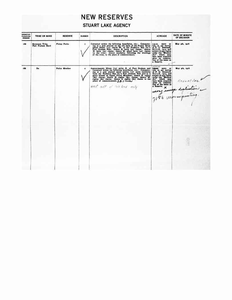
NEW RESERVES STUART LAKE AGENCY
P. PLICATION TRIBE OR BAND RESERVE NUMMI DESCRIPTION ACREAGE DATE OF MINUTE
OF DECISION
ell Siccanees Tribe, , Finlay Yorks Port Pr•h•m Band
Contained within the following boundaries, •i•.: Comment- !eat% more or May 9th. sot6 ing at a post ,I.anted on the left bank of the Finlay River less a. per surve
so •bout fifteen es) amine W. of the Hudson'. Bay Co.'s of P. C. Serannell, Fort Graham ost; thence I. forty (to) chain.; thence B.C.L.S.. rate, anti N. forty (40) chains; thence W. about lout) (40) chains subject to any rights to the ricer, thence southerly, following the winding. under the "Mineral of the river, to the place of commencement. Act" which may
have been acquired prior to constitu-tion of the same as • R
dS Do ' Police Meadow a Approximately fifteen (ti) miles N. of Port Graham and , contained within thefollowing boundaries, viz.; Comment-
/
ing at • post planted about twelve (ta) miles northerly from the Hudson's Bay Co.'. Fort Graham Post and at •
V/
place known as Upper Police Meadows; thence R. eig OW s;
h Wty
chain.; thence N. eighty (Sol chain thence . eighty (do) chains; thence S. eighty (So) chains to the plac• of commencement,' a c■ 0......e.1.,,
West A,?// .,
sasses more or May nth, sgta less, as per survey of P. C. Swanned% B.C.L.S., tate, and subject to any rights under ths "Mineral Act" which may have been acquired plot to tomtit*. than of the game as • Reserve.
'4:76
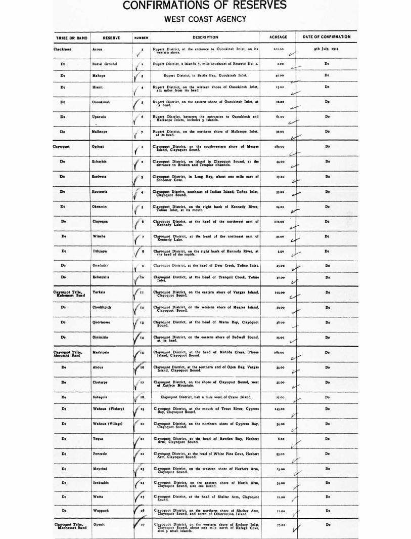
CONFIRMATIONS OF RESERVES WEST COAST AGENCY
TRIBE OR BAND
RESERVE NUMBER
DESCRIPTION
ACREAGE
DATE OF CONFIRMATION
Choc151mat Acct. ' a Rupert District, it the entrance to Ououkinah Inlet, on its r !, w n shore.
400.00 0th July, 4 91 4
Do Burial Ground i . s
3
, 4 /
.--i----.
Rupert District, s islands % mile southeast of Reserve No. 5. coo ‘......----
Do
Do Mahouts I I(
Meek ,
Rupert District, in Battle Bay, Ououkinsh Inlet.
Ru.p4rtaisstrIrcot,morts thhieee;ivestern shore of Ououkinsh Inlet,
40.00
13.00
Mv..."'"
Do
Do Do
Do Ououkinsh ri 5 (
Rupert District, rl/strict, on the eastern shore of Ououkinsh Inlet, at moo Do
De Upsomis !,' 6 Rupistiictbetween ,: entrances to OuoukInsh and gaopeni;.. includes islands. 61.00
4..."--
Do
Do Milksops ,.. 7 Ruireirtts hDeaielrict, on the northern shore of Milksops Inlet, 30.00 Do
Clayoquot Opitut 4 Clayoquot District, on the southwestern shore of Meares Island, Clayoquot Sound.
e$o.00 Do
Do &habil, fef a Cleargunoct. tDoisitfricotienonenislalied.p11,CcIgnoLulost. Bound, at the 44.00 i...."--
Do
Do Reollesta S Clverzt.Dsotvreict, in Long Boy, about 004 mile east of sy.00
1..."" Do
De Kootowle i 4 ClgruoLlt) imiceqa. southeast of Indian Island, Torino Inlet, 31.00 ...„.• Do
Do Okeamin (.• 3 Clvoofirtilitralett,itoonmoth.right bank of Kennedy River, 44.00 Do
Do Clayoqua
(
Cli Kennedy
IlIaell.ct. at the head of the northwest arm of 110.00
4.4.'" Do
Do Winch. fe I Clayoquot District, at the head of the northeast arm of 40.0o e.-"
Do
Do !Blips,. Nit 6 Clayoquot District, on right bank of Kennedy River, at a.so /7.
„ Do
Do Onadsilth 4
V
Clayoquot District, at the head of Deer Creek, Tof.° Inlet. On o .. iv Do
Do lalmuklis yjko Clirmuot District, at the head of Tranquil Creek, Tofino 40.0o Do
Clai=t.Trittid Yarksis ( is Clactizt,ougat.Tiroruicnta. on the eastern shore of Vargas Island, 103.00
C,....... Do
Do Cloolthplch il is Clayoquot District on the western shore of Meares Island, 30.00 4.".-
Do
Do Quortsowe i :3 ClTicRordot District, at the head of Warm Bay, Cleyoquot 36.0o ✓ Do
Do Oininthis 14 Cligolitustleastrict, on the eastern shore of Bidwell Sound, 13.00 Do
C16704004 TOMO, Abousaht Band
Markto.i. (13 head of Matilda Creek, Flores Clayoquot .1.c IDistrict,.y o o i1.t. Sound
sticoo Do
Do Ahous ..-,. to.. Clayoquot District, at the southern end of Open Bay, V
Island, Clayoquot Sound. 34.00 Do
Do Chetarpo CI:rot:v.?. District, the shore of Clayoquot Bound, west 33.00 1,-..-
Do
Do Butaquis '4' la ild
Clayoquot District, half a mile west of Crane Island. siao Do
Do Wohous (Fishery) t9 Clitlyaoyqu&yEl4s.voitctiouant dthe mouth of Trout River, Cypress 443.00 Do
Do Wakous (Village) if so Clecrilougo.t.13iaincl, on the northern shore of Cypress Bey, 34.00 Do
Do Timm vies Clazotro&Dr.iist.roictt, soatuntte head of Bawden Bay, Herbert Iva Do
Do (..
Pentad. as Clayoquot District, at the head of White Pine Cove, Herbert Arm, Clayoquot Bound.
93.00
13.00
4"-
Do
Do Do Mopehal 1,, 03 CItyi4ougot.opirrouicnta. on the western shore of Herbert Arm,
Do Seektukis tie,
Watts yel5
Clayoquot District. :in. tohen. eastern shore of North Arm,
Cilyooutrrt District, at the head of Shelter Arm, Clayoquot
34.60
zs.00
Y
/a
Do
Do Do
Do Wappook ra4 ClaiotgqoutopiLtruin. oanndthneortgrtohiercnnisthruoreetiooj Island.
Arm, moo 4,7,,- Do
C1;1= Tribei°P"It 0::
tlsld Clayoquot District or s western shore of Sydney Inlet, a.oguo,Lond.a,onon.mi.noroft.iugov.
also 9 small islands.
Moo / Do
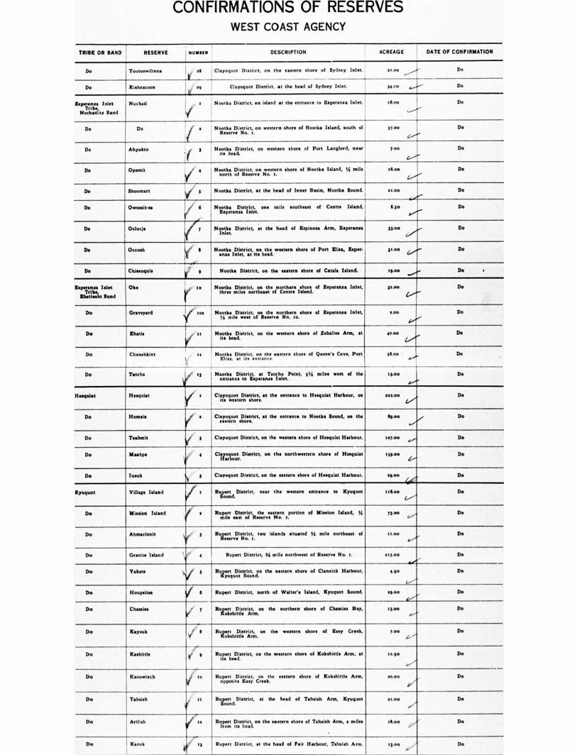
CONFIRMATIONS OF RESERVES WEST COAST AGENCY
TRIBE OR BAND I RESERVE NOMMEN DESCRIPTION ACREAGE DATE OF CONFIRMATION
Do Tootoowiltena 20 Clayoquot District, on the eastern shore of Sydney Inlet. st.on
L
as ,...-
........7 Do
Do Kishnacous s9 Clayoquot District, at the head of Sydney Inlet. 34.00 g
✓;
Do
laperansa Inlet Tel
Nut!satins Bond
Nuchad 1 . 5 Nootka District, an island at the entrance to lit•persne• Inlet. Moo
15
Do
Do Do R i
37.0o iit• s Nootka District, on western shore of Nootka Island. south of :
I
Do
Do Ahpukto i. J., 3 . NT.tk4teadDIstrict, on western shoe* of Port Langford, near ! 7.00
I
Do
Do OpentIt / ♦0 Nootka VeLicste.r.o.n 17.e.st0e.rn shore of Nootka Island, 44 mile :too Do
Do Shoomart .1 3 Nootka District, at the head of Inner Basin, Nootka Sound. moo Do
n/...
Do Ovrossit•sa ei 0
Y i
Nootka District, one mile southeast of Centre Island, Rowans* Inlet.
11.3o Do
Do Oclucis 7 Nootka District, at the head of Espinosa Ann, Esperansa Inlet.
Stion 4....",..- Do
Do °tooth ' II f
Noodle District, on the unworn sham of Port Lisa, Koper- anon Inlet, at its head.
33.00 Do 6.r.- Do
Do Chiseuquis r' ' Nootka District, on the casters shore of Catals Island. eg.oe ......... Do •
Isperansa Inlet
Iliatin Band
Olee r Nootka District, on the northern shore of Eamon,. Inlet, three miles northeast of Centre Island.
35.0o Do
4.---•
Do 0 Ica Nootka District, on the northern shore of Eisperansa Inlet, 46 mile west of Resew* No, so.
coo Do
De thane Nootka District, on the we shore of Zeballos Arm, at its head. '
40.0o 6....... De
Do Chenakkint as
t
• 13
Nootka District, on the *astern shore of Queen'. Cove, Port Eliza, at its entrance.
76.00 ' at,'
Do
Do Taisho ♦ Nooenttlera...D.Isttritp.v...T:t115.11.t.Point. 3% miles west of the 13.00
•s•••"..
Do
Hsettlat linguist s Clayoquot District, at the entrance to Hesqulat Harbour, on Its western shore.
see.00 4.2 Do
Do Homais ( s Cl.araumot stsiteriet. at the entrance to Nootka Sound, on the go.00 Do
Do Teahmlt yr 3 Clayoquot District, on the western shore of Hesqulat Harbour. sol.o. Do
Do Mashing 0, i 4 Clagar.outr. District, on the northwestern shore of Hesquist II 59.00 4,^
Do
De lusuk 41 3 Clayoquot District, on the host of Hesquiat Harbour. woo Do
Kyuquot Village Island frr Ruiromd.District, near the western entrance to Kynquot :Moo
1.•••A Do
Do Mission Inland s Ru:Ilrt. east of
N.. a portion of Mission Inland, 44 Moo ,.........• Do
Do Ahmesianit ii 3 Rugsr:T.D.is,tiric!ct;. two Islands situated 54 mile northeast of 'too ....""
Do
Do Drank* Island 4 Rupert [florist, 44 mile northwest of Reuses No. 5. 113.00 Do
Do Takata i 3 Rurytt..D.itensiecitan the eastern shore of Clennick Harbour, 440 Do
Do Houpsitee V 6 Rupert District, north of Walter's Island, Kyuquot Sound. SO.00 Do
De Channels el 7 Rugir:aLs.triAr.oa the northern short of Chemins Bay, ILO. ....4
Do
Do Kayouk i., II RuzltshilLstrIcrtm. on the w shore of Easy Creek, Two 4-
Do
Do Kashitne 9 Rupert District, on the western shore of Kobshlttle Arm. at 5 5.30
4.•''''
Do
Do Kaoowinch shore of Kokshittle Arm, RuoppepertmtDeisLiscyt, Creek.
10.00 ii‘i•
1'
Do
Do Tahalsh ' it Rua.d.District, se the head of Tahsish Arm, Kyuquot sena Do
Do Artlish Rafr:fiti District on the eastern shore of Taheish Arm, s miles at.cm Do
De Kaouk F
t Rupert District, at the heed of Fair Harbour, Taheith Arm. 53.0o r Do
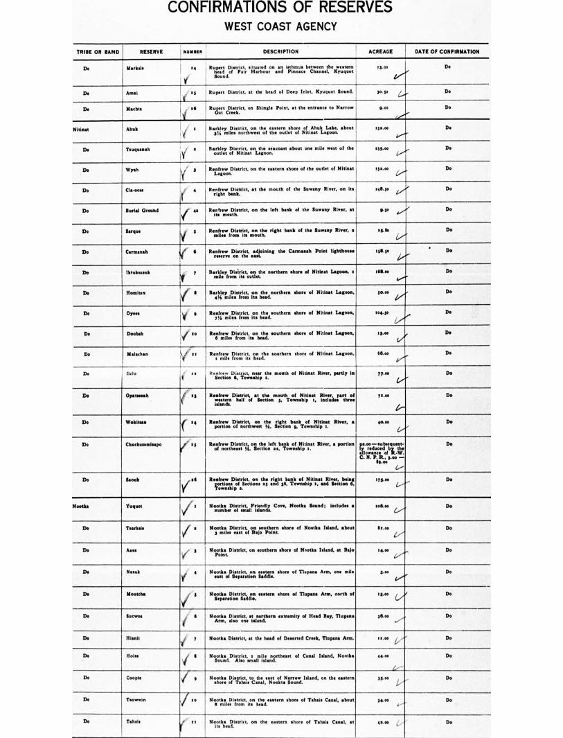
CONFIRMATIONS OF RESERVES WEST COAST AGENCY
TRIBE OR BAND RESERVE I NUM9111 DESCRIPTION ACREAGE DATE OF CONFIRMATION
Do Markel. .4 Rupert District, situated on an isthmus between the western head of Pair Harbour and Pinnace Channel, Kyuquot Bound.
13.00
i'
Do
Do Amai sg Rupert District, at the head of Deep Inlet, Kyuquot Sound. ga ge 1.....,. Do
Do Mschte ill I Rud,t,rtt CT:Is:Ve t, on Shingle Point, at the entrance to Narrow g.00 Do
Nitinat Ahuk a j BasII.eLiitlesistnroicrtt,hwonestthoef ettlseteoruntl:Itsoort 4fitinAahtultL.Lagets. about tis.os Do
Do Touquenah , e Barkley District, on the seacoast about one mile west of the
I y outlet of Nitinat Lagoon.
slgve Do "
Do Wysh
Y , Renfrew District, on the
Lagoon. hors of the outlet of Nitinat 131.00 Do
Do Clgoose r 4 Renfrew District, at the mouth of the Suwany River, on Its right bank.
141.10 4 7 Do
Do Burial Oroubd Renfrew District, on the left bank of the Barony River, at its mouth.
LP ,.., Do
Do to rque i g Renfrew District, on the right bank of the Buwany River. a miles from its mouth.
119.92 Do
Do Carmasah ler 6 Renfrew Distrtig, eatining the Carmanah Point lighthouse tillgo ' Do
Do Ilstubeasak 7 Barkley District, on the northern shore of Nitinst Lagoon, a mile from its outlet.
16111.oe De
t.v"..
Do Homitan Barkley District, on the northern shore of ?Minot Lagoon. 4% miles from its head.
ie.°. 4,... .. Do
Do Oyees 1 y 9 RegewmilDesiegolent; its head.
iLhaotsouthern shore of Nitinat Lagoon, :ogre Do
Do 1
Deobah li so Reiridez.Difsrtormieth;inh:sht southern shore of Nitinat Lagoon, zg.oe yr Do
Do Malachan
—1-
V no
3 s
Renfrew District, Riosmtrici% on e southern shore of Nitinat Lagoon, 06.00 Do
De Delo Reliefeliwo.Distfgt,,,nn4 the mouth of Nitinat River, partly in ?goo Do
le'''
Do Opatmeah 49 (
Renfrew District, at the mouth of Minot River, part of western half of Section g, Township s, includes three islands.
7 t.oe Do
Do Wokitsaa t{ RortrItri/ Dolstnreirt60.11, the right ii Section g, bask ofIlitpint River, a 40•011 Do
r...,' Do Ckuchammleepo ' a s Raonffrneworgasts;ickotiEttonlef.taba41,k ofoltlpitIrt River, a portion ils.ared—ucsuctrebquer Do
odorants of It:We. C. N. P. L. goo —
Sr..° 4.---
Do Moak ill Renfrew Dirtriet,const.he and g6, rrik. ollsIfirsn.atuillivie.rztitealat
coortwinoxipOILBeC Sections 3 Township s.
MA. Do (/'-
Rooth& Yuquot 3 Nr.otta DiosIrsiemt,alrelnnt Cove, Nootka Sound; includes • sego. 1..''''
Do
Do Tsar:Isis s Noos tmktiesDiesatsritcto,f oisoso. southern shore of Nootka Island, about St .1)*
L7
Do
De Asses .. 3 Nopootlenat.District, on southern shore of Nootka Island, at Baja tgoo ,..„...„..„ Do
Do Result ..„ 4 Bootle District, on eastern shore of Dupes. Arm, one mile east of Separation Saddle.
goo Do i...........
Do Moods
1,1
Nootka District, on eastern shore of Tinniest' Arm, north of Separation Saddle.
:gm (../ Do
Do {nitroa Booties District, st northern extremity of Head Bay, Tlupana Arm, also one island.
36.eo ...„. Do ...,
D. }Bend i 7 ?tootles District, st the head of Deserted Creek, Tlupana Arm. moo 4... ...." Do
Do Noise i II Nzuk:d.Disztoict, taillniil.linnotrtheast of Canal Island, Banks 44.00 De
Do Coopte i g Booths District, to the east of Narrow Island, on the eastern shone of Tahsie Canal, Nookta Sound.
33.oe , Do I.,'
Do / i o ore of Tahiti Canal, about 74 osottlieD. iirtori.ct, itosn the ore !gm Do a -
Ds Tahab
I?‘
Booths District, on the eastern shore of Tahsis Canal, et Its head.
4.46 Do
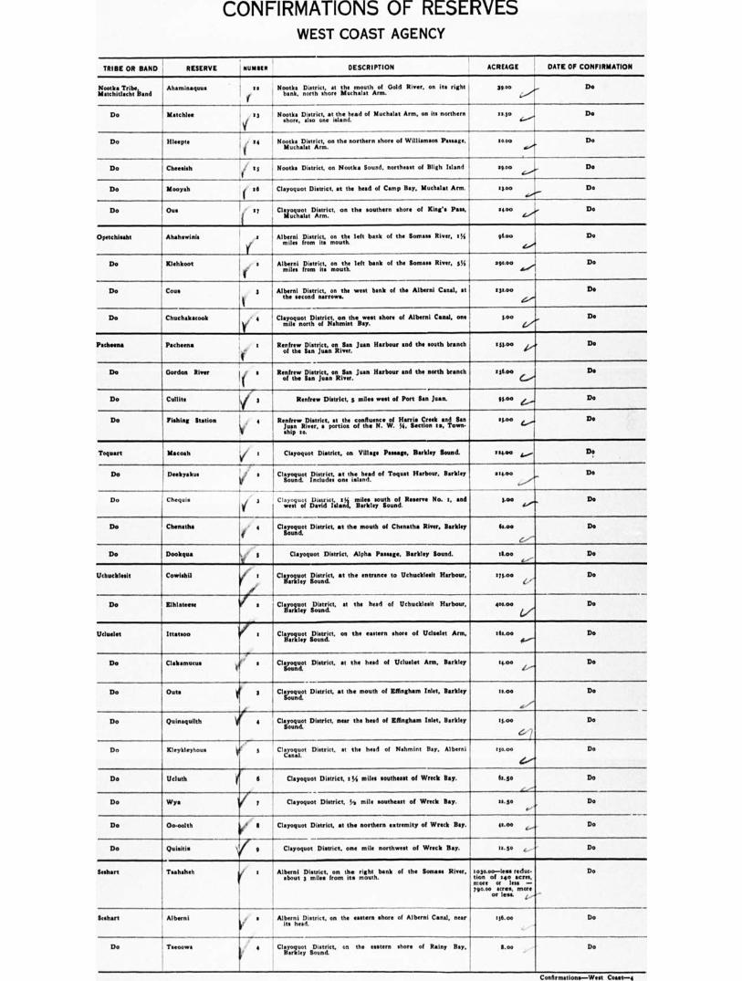
CONFIRMATIONS OF RESERVES WEST COAST AGENCY
TRIBE OR BAND
RESERVE I NUNIIR
DESCRIPTION
ACREAGE
DATE OF CONFIRMATION
Nootka Tribe, blatchitlacht Band
Ahansinaqaus to Nootka District, at the mouth of Gold River, on its right 39 00 bank, north shore Muchalat Arm.
l'' -
Do
Do Maul:los :3 Nootka District, at the head of Muchalat Arm, on its northern 1540
Vf shore, also one island. 444.'''
Do
Do Illoopta 14 I Nootka District, on the northern shore of Williamson Passage, Muchalat Arm.
saw a■
•
Do
Do Cheesieh 3' Is Roots. District, on Nootka Sound. northeast of With Island 1000L I..
Do
Do Mooyah oil Clayoquot District, st the head of Camp Bay, Modest Ann. 1500 et/
Do
Do Due s7 Cltrooy.olt.1))*rt.rict, on the southern shore of King's Pan, Issas 4(0/, Do
Opetchisaht Ahahswinis a
ymile. ;
a
Alberni District, on Somas left bank of the Som• River, 133 from its mouth.
Alberni District, on the left bank of the Boman River, s%
miles from its mouth,
96.00 Do
soca° ..., Do dieor
Do Itlohkoot
Do Coon 3 Alberni District, on the west bank of the Alberni Canal, at the second narrows.
930.50 Do
ii
Do Chuchekacook Clayoquot District, on the west shore of Alberni Canal, one mile north of Nahmint Bey.
3.00 Do
Pacheco* Pachcena Renfrew District, on San Juan Harbour and the south branch t 33.0o 4.,..., Do of the San Juan River.
Do Gordon River I/ a
■ I
Reonffrtehwe Lientrijcot;..onRillva.nr. Juan Harbour and the north branch 0 Apo c...... j Do
Do Cullite Renfrew District, s miles west of Port San Juan. 91.00 e„...... Do
Do Fishing Station 4 It
Renfrew District, et the confluence of Harris Creek and San Juan River, a portion of the N. W. la, Section to, Town- ship so.
.3.00 .1 Do 4....
Toquart M•coeh
P
1 Clayoquot District, on Village Passage, Berkley Sound. 14041 ,...„.. Do
Do
Do
Deekrakus a V Clayoquot District, at the head of Toquat Harbour, Barkley Sound. Includes one island.
sleet° Do
Chequi• 3 Clayoquot David Island,
sralAnd,e0y uLhonoti Reserve No. t. and taw 4.•,„„ Do
Do Chenatha 4 Clayoquot District, at the mouth of Chenatha River, Barkley 63.00 Do
Do Dookqua ti. 5 Clayoquot District, Alpha Passage, Barkley Sound. arm 4
Do
Uchucklesit Cowlahil 1 t Civ.moy, kioiustnr,iic. t, at the entrance to Uchucklent Harbour, t33.00 Do
Do Iffiklatease 1111( s cizol,,,..; sUoi::,r1ct, at the herd of Uchucklesit Harbour, 400.0o Do
Wooled Mafia* I : Clzox.oyt s13.1::,r,:c t, on the eastern shore of Ucluelet Arm, 303.00 4‘...-
Do
Do Clakennous s Clayoquot District, at the head of Ucluelet Arm, Barkley Sound.
tseso /,--•
Do
Do Outs ■ 3 el
Clayoquot District, at the mouth of Effingham Inlet, Barkley 11.00
, ...-
Do
Do Women* Clayoquot District, near the head of Effingham Inlet, Barkley Sound,
ts.00
er
Do
Do Kleykleiyhoue s CIt.yoxot District, at the heed of Nahmint Bay. Alberni tio.00 Do
ve
Do Ucluth f I Wya ifie y
Clayoquot District, 13.4 miles southeast of Wreck Bay. 63.3o Do
z...--'
Do Clayoquot District, ./s mile southeast of Wreck Bay. *Lips Do
Do 0o-oolth Clayoquot District, at the northern extremity of Wreck Bay. WSW fi... Do
Do Quisitis i 9
Clayoquot District, one mile northwest of Wreck Bay. 90.50 ,......., De
&short
04
Taahaho: s Alberni District, on the right bank of the Somas River, about 3 mile• from its mouth.
io3o.00—less reduc• Bon of 140 acre., more or less 790.00 11CleS, more
or len.
Do
Do
&short Alberni •
Do Tsroowa 4
Alibte.olroiffi tetnet, on the eastern shore of Alberni Canal, near I 36. 00
Clayoquot District, co the eastern shore of Rainy Bay,
Barkley Sound. Lao Do
Coaarmtiona—West Coast-4
CONFIRMATIONS 01- KtStKVLS WEST COAST AGENCY
TRIBE OR BAND RESERVE NUMBER
DESCRIPTION
ACREAGE I DATE OF CONFIRMATION
Do Ahmitsa 3 Barkley District, on the southern shore of Seddon Island, . kloo its Rainy Bay.
Do
Do Clebo 6 BagalrekykyDzi,soturnick on the shore of Nettle Island, ! es.00
dr./).
Do
Do Keith Island ‘I '
Barkley District, in Barkley Bound. moo
91..-
Do
D. gigolo N . 8 Clayoquot District, 134 miles east of LysII Point, Barkley Sound.
013.00
C./T.
Do
Do on the Onmak shore of Village Island, 9 Barkley Sound.
3o.00
L
Do
Numukamla tor 1 BaIrnlecile.ydesDoient.ricits,lano3du Numukamis Bay, Barkley Bound. goon .00crlsex raecdrunc:
more or less — Iloo.00.raLr.eLs, RITA..,
tillth August. 1914
Do Nuchaquis ( s BageuleztDistrict, on eastern shore of Copper Island, Barkley 3s.00 1.,''
Do
Do Docinuppl• if 3 Barkley District, at the head of Foote* Nook, Barkley Bound. 81.00 Do
Do Sachs. ( 4 BallotItagd.1.)plosgliocl of Sectionluhetiohneside.olroGraggpers. Creek, Barkley zg.so Do
Do Illathaoril v/ 9 Barkley District, on the northwest shore of Hell:, Island. 7.00 Do
Do Kirby Point 1( S Barkley District, on the northwest shore of Diana Island. Moo Do
Do .,
HUMOUR Point / Barkley Mello, the southern portion of Diana Island. Ikkoo
c1''''
Do
Do Malmo Island irers
Barkley District, Barkley Bound. 3o.0o Do
Do Iteeshaa i' 9 Baerl4eLilDeisstnriocrtimaatst:f sigtpteritoielTrance to Barkley Bound, 330.00 Do
!.../
Do Kkhha i'
Barkley District, :34 miles east of Cape Bask. moo Li....' - r-
Do
Do Clutus Barkley District, at western entrance to Pacheens Hay. tt ar los.00 (/ Do
Do Ansel* ' :: Barkley District, at the head of Pachena Bay, the eastern ha I of Section 5, Township 1.
axial e...„."" Do
Do Mask :3 Baortlesyntirisdtriasnal eastern entrance to Pachena Bay, east 1113.0o Do
Confirmations—Weet Coast-3
NOTE:—ilvachis I. R. Mo. s, of the Boahart Tribe or Band, surrendered and sold to Canadian Northern Pacific Rail.my Company, October, ■ 913.
REDUCTIONS AND CUT-OFFS OF RESERVES
WEST COAST AGENCY
TRIBE OR BAND RESERVE NUMMI DESCRIPTION ACREAGE REDUCTION OR CUT•OFF DATE OI REDUCTION ON CUTAII
Seshart Tashaheb 3 Alberni District. on the right bank of the Somas. River, about 3 mile• from its mouth.
i 030.0o Reduced by the cutting off of ten hundred and forty (so) acre*, (subject to survey), this being the northern portion of thv Reserve. the remaining portion of the Re- serve •• described in the Official Schedule of Indian Reserves, rem being confirmed as ouch Tsahaheh R No 1, ma, seven hundred • nd ninety 179o.00) acres, more or Ina.
,,th July, rasa, rte amended May leth, tele.
Ohin Numukuals 1 Barkley District, on Numukarni• Ray, Barkley Sound; includes an
cloo.00
island.
Reduced by the cutting off of six hundred (600) acres (subject to •urvey) from the extern portion of the R , the reimining por- tion of the Reserve. as described in the Official Schedule of Indian Reserves, 1913, being confirmed as such Numuk•rnis Reserve Mn. a,
eleven hundred (Imo) ItereR, i more or less.
e eth August, 1PM as mended May lath, rota.

NEW RESERVES WEST COAST AGENCY
••1122221.. • LICATION TRIBE OR BAND RESERVE NUMMI' DESCRIPTION ACREAGE DATE OF MINUTE
OF DECISION
9 Clayoquot Indian Island so
I"
All that portion of Indian Island not covered by the Sutton lumber Lease, of
Canada
sbj e c t at no d s uor fray, tt,
the
a s p rpoe vr i na,k: t cohl plani , i soh( Ashdown H. Green, B.C.L.S., numbered in •ccordanc•
Dominion
T b
herewith and filed in duplicate with the Governments of the
Columbia.
94.P 7th February, ■ gig
53 ICCI:lieTrrtt Tribe,
V aaaaa Island 35 -
Y As per sketch plan of Ashdown H. Green, B.C.LS., num-
bored in accordance herewith and filed in duplicate with the Governments of the Dominion of Canada and of the Province of British Columbia (subject to survey).
22.00
—
Do
ry s
Clayoquot i't i Band cti . '
Bartlett Island p
Bartlett Island, Clayoquot Sound (subject to survey), as per sketch plan of Ashdown H. Green, B.C.L.S., numbered in accordance herewith and filed in duplicate with the Gov- ements of the Dominion of Canada and of the Province ofrn
British Columbia.
539.0o
1
I
.
Do
.9 Clayoquot Tribe, Ahousaht Band '
Kut.co-us Point 33 Lot No. ■ 35o, Clayoquot Land District, subject to due com- pen”tion being made by the Government of the Dominion of Canada to Frank C. Perrotta on account of improve- ments made by him thereon under and by virtue of P. R. No. says. upon relinquishment by him of all right, title and interest in the said Lot No. 156o, Clayoquot Land District.
also loth February, 1916 , as amended and covered by Interim Report No. 53. toth February, 1915.
20 Clayoquot Tribe Tilaird
Hisnit Fishery lip , ,
.--'sei
A. per sketch plan of Ashdown H. Green, B.C.L.S., numbered in accordance herewith and filed in duplicate with the Governments of the Dominion of Canada and of the Pro- vince of B h Columbia (subject to eurvey).
7.53 7th February, .916
P Esp Inlet Tribe, Nuchatlits and Hhatisaht Bands
t4
•
As per sketch plan of Ashdown H. Green, B.C.L.S., num- bereft in accordance herewith and filed in duplicate with the Governments of the Dominion of Canada and of the Province of British Columbia (subject to survey).
Coo
....-
Do
11 Iv:, rsain:te ilinnledt Tribe, Graveyard sob A. per sketch plan of Ashdown H. Green, BC. L. S., num- hued in accordance herewith and filed in duplicate with the Governments of the Dominion of Canada and of the Province of British Columbia (subject to survey).
7.73
L.
Do
79 &paean. Inlet Tribe, Nuchatlits and Ehatiuht Bands
13 .
\il
A• per sketch plan of Ashdown H. Green, B.C.L.S., num- bored in accordance herewith and filed In duplicate with the Governments of the Dominion of Canada and of the Province of British Columbia (subject to survey).
9.73 Do
79 Do t6
I
As per sketch plan of Ashdown H. Green, B.C.L.S., num- bared in accordance herewith and filed in duplicate with the Governments of the Dominion of Canada and of the Province of British Columbia (subject to survey).
20.20 Do
40 Do ay
• • •
l
On the Bast hore of Zebelloe Arm, as per sketch plan of Ashdown H. Green. B.C.L.S., numbered in •ccortlance herewith and filed in duplicate with the Governments of the Dominion of Canada and of the Province of British Columbia (subject to survey).
15•70 Do
43 Esperansa Inlet Tribe, Ehatisaht Band
Tatchu a3a Addition as per sketch plan of Ashdown H. Green, B.C.L.S., numbered in accordance herewith and filed in duplicate with the Governments of the Dominion of Canada and of the Province of British Columbia (subject to survey).
7 le.00
Z-''''
Do
93 Xyuquot Grassy Wends y
4e'r
Grassy Island, se per sketch plan of Ashdown H. Green, B.C.L.S., numbered in accordance herewith and filed in duplicate with the Government. of the Dominion of Canada and of the Province of B h Columbia (subject to survey).
Leo Do
49 Checkleset Quin-e-en 17
V
As per sketch plan of Ashdown H. Green, B.C.L.S., num- lotted in accordance herewith and filed in duplicate with the Governments of the Dominion of Canada and of the Province of British Columbia (subject to survey).
5.1I0 Do
49 Do
,
i X•Ehatisaht
Ch aaaaa lis Island
Band of ILsperinsa Inlet Tribe, to have equal rights Wein.
p
I
Checkaklie Island, as per sketch plan of Ashdown H. Green, B.C.L.S., numbered in accordance herewith and filed In duplicate with the Governments of the Dominion of Canada and of the Province of British Columbia.
33.00 Do

CONFIRMATIONS OF RESERVES WILLIAMS LAKE AGENCY
TRIBE OR BAND
RESERVE
DESCRIPTION
ACREAGE DATE OF CONFIRMATION
Alexandria Ale•andria Cariboo District, on the left bank of the Fraser River,at the :7g Mile Post, on the Cariboo wagon road. near Alex. andria Town.
34g 76—less reduc. non of e6o.00 acres, more or km sub- ject to survey —
219.76
allth February, ratio
Do I Hay Ranch e . Cariboo District, 3t,i miles east of Alexandria. flo.oet sath February. seta
Do V 3 Cairnigbozori4s,tsritroounp tpeanrithotppboasnikte oili..prrays.erNtive.r, adjoin. 0334.00 Do
Alkali Lake Alkali Lake
ie
/ 1 Lillooet IZirsetaqc.t,..esatstoforpand adjoining Lot 6, Group 3. on 396.50 Do
Do / s Lillooet District, 3 mile. northeast of R No. I. 600.00 Do
Do ✓ 3 Lillooet District, t49 mike east of Reserve No. s. Ono* Do
Do V 4 Lillooet District, 44 mile south of litter,' No. 3. sto.00 a....--
Do
Do
. ID
Allston 1 IN AlY .t Lid r 4
Lillooet District, I% miles southwest of Reserve No. 4.
1-1,/,'I a r i b14('• 01,-/p , ,.. ji, , , A: /IT - .[t . ',., , ',i.e.)
, il.ie.el
7.**
Do le 4, r e.,, ./1. 31,fd_
Do Do
re.
PAltery / Lide■reV'Dist.C1.1. the' north sheUti' 'obt■C' ' la Noche, in Section so, Township 39.
Do Ora X yA OnofLirlkNoct 22,. G.rnodupont one and one-half the right
Alkali Lake Creek.
0.01 Do
Do Little Spring. S Lillooet District, three-quarters of a mile northeast of Rosen* No. 3.
485.00 Do
De andantino 9 III
Unmet District, three-quarter. of • mile northeast of R No. S.
1400-00 Z...--
Do
Do Loon Like is • Lillooet District, one mile end three-eighths east of Reserve No. 9.
loo.00 Do
Do Sampson's Meadow V is Lillooet District. one-quarter of a mile welt of Lot 323, and half a mile southeast of R No. is.
loose Do
Do V is District, southeast t, three-quarters of • mile southea of LilReserve
looir t D4o 4 goo.00
(..../.
Do
I Do 6. .3 I Ligtoom. t„District, two miles and one-eighth east of R 1400.00 Do
Do Roper's Meadow if s Lillooet District, one mile south of Reserve No. S. Sono Do
Amhara Anaharn's Flat t
Cariboo District, on the tell bank of the Chilcoten River,
a, riy14 nilesfromiu.outan,atut..,.;
miles northwest of Hanceville.
palyo -
Do
Do Anaham's Meadow V a Cariboo District, shout One miles north of the Indian Village on R No. 1.
637oo L- Do
Aleals Creek j Redstone Flat s Cariboo District, Chilean° River, W. of Alexia Creek. liflo.00 c.....” Do
Cullen Lake Canim Lake •
Lillooet District, on Bridge Creek, one mile west of C•nim Lake.
4400.00 slek Febrrhry juntL164•011 amended
Do • I,l 2 Lillooet District, on Bridge Creek, @bout half way between Reserve No. s and the too Mile Post on the Cariboo wagon road.
slow oath February, rata
Canoe Creek Cane* Creek s Lillooet District, on Canoe Creek, in the northwest quarter• section of Section se, Township so.
93.00 L.-, Do
Do
Lillooet District, on Canoe Creek, one mile and one-hall
from Reserve No. :, and adjoining Sections 3-to, Town- ship so.
446000 Do
Do Ve i Lillooet District, on the left bank of the F River, North of and adjoining Townships 4-ro.
693r.00 , sod May, solo
Do Spilmouse / 4 Lillooet District' . on Canoe Creek, about two miles above Reserve No. a
400.00 sfth February, :94
Do Fish Lake / 9 Lillooet District, at the foot of Fish Lake, one and one-half miles northeast of Reserve No. 4.
tos.00 4:-
Do
Do Toby Lake Ii, • III
Lillooet District, on the road from Canoe Creek to the 37
Mile Post on the Cariboo Road and six miles southeast
of Lot set, Group t.
320.00 Do
Do Graveyard
41111
7 A graveyard on the left bank of Canoe Creek, one-half (t,) mile from its mouth, in Section 1, Township 4; a grave- yard situate in Section 17, Township to; a graveyard on the right bank of Canoe Creek, situate in Section 11, Township to: • graveyard seven chains north of Canoe Creek. •ituate in Section 15. Township to.
. ---
Do
Deg Creek Dog Creek Lillooet Dintriet, on Dog Creek, about three miles from its confluenc• with F River.
3•I.30 L. Do Do
Do v/ a Liqiiiioegt. ..Deleatsrticoti Reserve
DoalloCreeek, three miles and three- 340.00 : Do
Do 3 V
LillonestitieL.oinviDita .reek, three-quarter. of • Milt WOO ( .-, Do
CONFIRMATIONS OF RESERVES WILLIAMS LAKE AGENCY
TRIBE OR BAND
RESERVE
bower C
DESCRIPTION
ACREAGE DATE OF CONFIRMATION
Do I
a 4 Lillooet District , on the left bank of the Fraser River, above ! 434.00 .....-- Y D., Creek. I
sIth February, Iva
Masulab Valley Odes Lake / I Li1,1,73 ety.Distrifi, on Chilco Lake, at the outlet of Netnaiah a00.00
I </"..-
36th February, 1916
Do Gerdes 1,i
, a LII14orie; D.r.icitiomin reero..ravia.hNVosIlrey, about four and one.half llo.00
4....-'" Do
Do Lisbery a
illooet District, in Nernaiah Valley, at the foot of Conner 543.0o Lake.
i.'''"
Do
De Meadow 1 ye Litokeet District, in Nemalah Valley, at the head of Conn*. 04.00
.e""--
Do
Quieted Quarrel I 2 Cariboo 31:Lreic:,owor,n ,t.IfleQlueLtub,fink of Fraser River, one mile lii6i.to.lc7ile:7 Viz:
V ii. R. Co. under In. tcrirn Report No.
0349.1. e./t
1 1
110. 17.119 acres —
Do
Do Fishery yr a Cariboo on the right bank of Pr River, opposite 46.5o the western end rn of Reserve No. I. •
Do
Do 'Dragon Lake 3 Cariboo i District, at Town t
o the foot • small lake about a mile moo c....-■
28th February, 1916
DO er
Rich Bar Vr 4 Cag3dooneltarilsytri:ctiloonintghepleesf.tmtan,143..oft.F River, south of 10.5.i.fvm--1,316 allowed
ii. Co. under In- terim Report No. 41, 9.75 acres —
fis.ao i'
36th February, 1914
heals Crook Mods Creek / z Caorib;31o, DvAt.rsicet,o;onsotte left bankof Fraser River, southeast :od9o5.to.ovv.leusne daelriolw...
1 t4e1r.il 4:13tertitt.
Co., 26.13 Scree -
1 3063.77 6.../1 I
Do
D. i Deep Creek 1 a Cariboo n District, east of the 168 Mile Poo on the Cariboo 4tr000
L...---4' Do
Maw !Stone i 3 !Cariboo District, on the south bank of Chilcoten River about
1 , i 354 miles west of Hanceville. . 3913.00
C..../
3 2 0 00
Do
Do Do Meadow /1If a Cariboo District, about It mile. fiutbefit of Reserve No t
Teem "reeeey V 6 Ir
Cariboo District. on Itiokle Creek, one mile west of Lot 66, 5780.03 Oroup t, in sub-district of Chilcoten. Z.--
Do
Do Meadow k a Cariboo District, t.hout 6vemiIee northwest of the I d' an 56o.00 win.,onl;..;eN;i0.
. L.-- Do
Do Cariboo District, about two miles above the mouth of Riskie foss Creek, on the right bank of F River. I Gii--"'
Do
IfidUsse Lake Wallows Lake I a
Cariboo District, net of the head or eastern end of William• : 4069.63 Lake.
Do
De Cariboo District, one and three-eighth. miles north of Reserve tao.00 No I.
4-- Do
De Meadow 3 Cariboo District, two miles northeast of Reserve No. 5. 5110.004 .,''
Do
!Se Maher? 4 Cariboo District, on the left bank of P River, at the confluence of San Jose Creek.
F•00 Do
Do M 3 Cariboo District, on the left bank of F River at the confluence of Chimney Creek.
36.00
e,""--- Do
Do Do pfil Cariboo District, at the foot of Williams L•ke, one-quarter
of a mile from the effluence of San Jose River. 6.so
../...! Do
Do °ravened X 7 Cariboo tproDp.iartiryiroti mr. tii.enaci5hyst bank of Chimney Creek, on 0.14 G.."'
Do
Do x 4 Cariboo aDni:Jitrol.ctiheonla,t,hdeorwoanedd ficlomm,Wiginecn4.1.:k• to Soda 0.13 4......., Do
Do Do y g Cariboo District, on a trail from Williams Lake to Soda Creek, fifty links south of the southern boundary of Mr.
IPinchbeck'. land, Lot 6.
Do X •• Cariboo District, seventy-five links south of Reserve No. 9.
otll ,....„.4
o.to..... (-%
Do
Do Do
Do
—
Do A is ■
i
Cariboo District, fifteen chain. south of the southern boundary of Mr. Pinchbeck's land, Lot 6.
o.t7 4......., Do
Do i Do ig is Cariboo Creek, on n
io,rrthponf ot,t,vsatilafam Williams Lake to 0.06 Do
Do Do X s Cariboo District, north of the road from Williams Lake to Soda Creek, on Mr. Pinchbsck'e land.
0.90
Do Do y. la
7;— 5
Cariboo Difirict, near the outlet of Williams Lake, on Mr. Pinchbeck's land.
o.3o Do
Do Carpenter Mountain Cariboo nor th Na t3 the 136 Mile Poet on Cariboo wagon :64.76 , Do
TRIBE OR BAND RESERVE NUNN, DESCRIPTION ACREAGE REDUCTION OR CUT-OFF DATE OF REDUCTION OR CO1'43/I
Cariboo Riser
on left bank of F ee the Nceet,./X the .79 Mile Post,
wagon road, near Alexandria.
Reduced by the cutting off of entee acre., more or less, subject to sur-rey, as per Sketch Plan of Ash-down H. Careen, B.C.L.S., from the eastern portion of the Reserve, the remaining portion of the R.04170 being confirmed as such Alexandria R No. a, viz.: 84.76 acres, more or 1•••
Alexandria Aleaandria math February, tot6
Lakes** Dieeriet--ew—le teener of Fraser Rms. About aa weikre VA of AHreft Leh*
ClrhofF
T i'
Do
, r
•
REDUCTIONS AND CUT-OFFS OF RESERVES WILLIAMS LAKE AGENCY
Reductions and Cut-offs—Williams Lake
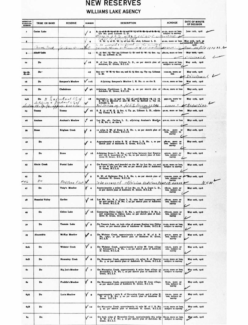
NEW RESERVES WILLIAMS LAKE AGENCY
(.
Yuman*P
TRIBE OR BAND I
RESERVE Nyman DESCRIPTION i
ACREAGE DATE OF MINUTE OF DECISION
t Caen Lake 40.0o, more or less, subject to survey
• ,./' i',,i -
lung nth. sal , t No: 4000,
Liik;.E-N114;11tIF7SEW-W-W-94,014,11,44
a/,' ,,,,, - u .5' L ', 4 i• /„_/ o ' , " ' , ' , N _./,'
I .0, ...' n , ....- y , r - ■ y i'reli`
1 4 N. W. Si of N. W. Y. of Lot No. sine, Linnet L. D.
• /. ,.....,,,,,, ir •• 1,;..-..." ,.. ,47 ., ....! ,,. .1 n A / . i V r / . if JP,- '
eo.00, more or less May oath. left as amended June seth,
:ail , ,--3 .os • •
_
e..- —Aiken-Lin se eemee, more er nee Mw111914-111111-
,-----1,3 . / '../ /if o/ C 1,.
f.4 14 -L-2/7-ind• II- W.-tfr La. sm.
to Do ,6 N. Hin.eryeee,..LgIritsL D., as per sketch plan of 40.00 more ior nays,
e..--••••""
May moth, ate
= Dr sp Ilem irr;-/r1D-I$-11secenersed-8.--$4-ia te, VP 136, i30101101 30/000, wen-we
Ie.-
130.00, more or less
May seth, ten
r/i.0 11),,or •
Map soth, lag
L0' to Do lampeon's Meadow il i t A Adjoining Sampson's Meadow I. R. No. t t on the R.
se Do Cludolicum eA Adionilnisote Cltdotrceuemn. Iii.c.J. 9, es per sketch plan of ann. more or less May son, sal
ra'''''' seA Do A %4 ,, 7, .c ,-j ,„.. I ,c /.. iit is
/ I • x. A ,,,,r,e,,. / L, /,:f , / w / /
...r/...r.u/7 I v ,..4-- tn* 1 1." . .1).. 4 ../IN, t 6 .01 6.,, e. 5,
/ i
Senn. 4.r 1 I ma, tvand re, Ted 911.1andfrt:Sten$ 0 08 09,
tillootti. iron' " and
33' FA.
4 I 3 i°A 3. 331 SI' ,1-3../ _Cr '.,-,',A /ii f 1 7 LL X •J-, ,• ' r. _ . • /AN ) >/,,,:.4.i ,
geemooi.more -eir
,... .., 0. 0 0 ''. a .-IfY
May slth, nal
dile t/' s I)
se Toney Toney / sA B. L J4 of N. L I4 Sac. 4, Tp. so, Mont L D., adjoin. in Toney I. R. No. t.
emoo, more or lea
N."...
May nth, tall
at Anshan Ansham's Meadow Is'' sA
I.
Lot No. 410 , Cariboo L. D., adjoining Anaham's Meadow I. R. No. 0, on the I.
400.0e, more or less
Zee'.
May moth, 3016
39 Items Brigham Creek V 3
nAmsar L ff.. of stesioallti. No. o, Ms per sketch plan of illio.os, subject
toe!
survey (..,--
May 11011„ tete
0 De V 4 A Perelgw:fillf Of 11101. W. ',1,41°."ILL:."°. '. " pea •10.00, more or
surrey ‘.....--
May moth, ""
a De Stone to Adjoining Stone I. R. No. ■ and lying between that Reserve ido. es per sketch plan of Ash. Asoid shks6mb.oeunn clyz. ii.f.
B.C.L.S.
400.00, more or lesa,sturry t to 4.........
survey
May loth, tote
eg Alen. Creek Puntel Lake a On Punta Lake, and bounded on the W. by Lot No. tei and en
2reget: tiClt. Lot se"
as per sketch plan of A Mown eg.oe, more or lees, May son, tall
subject to survey
1.••'"
41 De
*".$(6, Pe Reg< Ve A e / 4, (-
a N. W. of Redstone Flat I. R. No. t, as per sketch plan of Ashdown H. Green, B.C.L.S.
-ti ir sv ',vet- e I JO. ( ./,/ea- 0-els/ehe k
0040.00., more or dim lay meth, tote less, *abject to
survey tilt luaoi It.'
temeo, mon or May seth, tote lees, subject to
surrey 64.,,,••• 47 Do Teby's Meadow y 4 Approximately a miles L of Lot No. as, R. ',Can L D.,
as per sketch plan of Ashdown H. Gress, B.C.Lle
46 Remsleh Valley Gerdes V
sA bra No. UL I. Coast L. .D., aloe land _ tInssid
H. Greer,rB.C.L.833. No. s, as
" sketch plan
of Ashdown
sillsaos..more or May soth, ten Nett to
mangy C■'''
411 Do Chaco Lake V sA Coeseeting Chilco Lake 1. R, No. t, and Garden I. R. No. a, end extending to Chile* Lake, as per sketch plan of Ash. down H. Green, B.C.L.S.
186000, more or May meth, tall less, subject to
sunny 1.----
Is Do Tann Labe rr
g .0tLF4seumnasia pI;erkseieetnehboptihansT.fesAosfhltro esmHflosing i,ntifcav ,.....:4.70:::„147, May oath, 3616
l../'"
g Alesandsla McKay Meadow V 4 On Webster Creek, approximately a miles N. W. of A. P. 1,10d1.11,1141, a per sketch plan of Ashdown H. Green,
goo.00, mon or May soth, tin less, subject to
survey A/
l.A De Webster Creek V g On Webster Creek, approximately I miles W. from village on Alexandria I. R. No. t, a per sketch plan of Ashdown H. Green, B.C.L.S.
memo. more or May soth, tote sees, subject to
aunty
NB Do Neeausley Creek 1, 11 On Nu I y Creek, sppr m tely 1I4 mil s IL of Reserve No. d*, AsIo*per 'sketch •plaAn*'of *Ashdowit H. Green, B.C.LL
loin more or less, abject to survey map
Seth, 1".
'
Ilt Do Big Jee's Meadow i 7 On Neeausley Creek, approximately 11 miles from village on Alexandria I. R. No. s, es per sketch plan of Ashdown H. Green, B.C.L.S.
40.00, more or le n, • Mop 110111. tall subject to survey 4.„,•••
Gs Do Freddie's Meadow e 8 On Necaueley Creek, approaimetely 6 miles W. from village, as per sketch plan of Ashdown H. Green, B.C.L.S.
$0.00, more or May nth. :en lees, subject to
111.11-036
flgA Do Lorin Meadow Avoiscralteli 1 4e.s,ile3R. ...of per sketch C
prleagnk.oltdAldmoLles le: H.
Gnat, B.C.111. 01wen,":uTercet two """'".""
surrey
11311 Do to
On NentuslreysketchCrilt,
plan of mile W. of I. R. _No.
9. as I. Ian I A lid H. Green, B.C.L.S. May oath, oat
1.0.00, subject survey (/
Wble 1 WY e....,,,„,
64 Do i t On both sides of gecusleCrekeprcaimveamilgs N. W.
;o3a"rsietctplanlmi.
Green, B.C.L.S.
aoe,more orles,,soth, tee sbi.tosu,ey
/.2151 - 1.."
W.
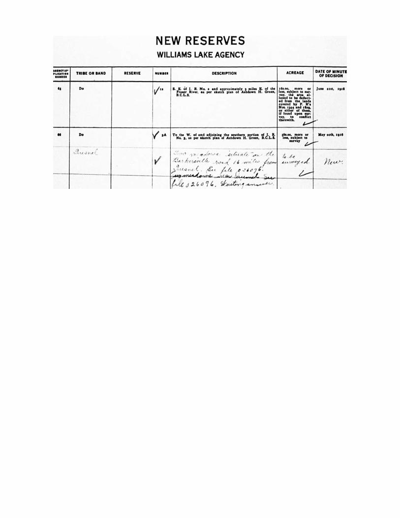
NEW RESERVES WILLIAMS LAKE AGENCY
*HNC, •■• 'Locum. TRIBE OR BAND RESERVE 111.111111111
1 DESCRIPTION ACREAGE DATE OF MINUTE
OF DECISION
H Do a S. H. Of I. R. No. a and approximately 3 mile. E. of the F River, ee per sketch plan of Ashdown H. Green, B.C.L S.
1150.00, more or few .object to ear- vey, the area al- lowed to be deduct- ed from the land. covered by P. R's Noe 1344 and tem or either of them, if found upon sur- vey, to conflict therewith.
June au:, 1916
IIII Do V 3A
10/
Tonothes.W... of ra antr,l.acrItjoptinngofthzziouwthnerriti. parrteieonn, citd..a:
-. . 1 , p ir e/e-r..avt _4( 4( at 4 —,0-as • (411
41"et 2 ht. teteLf 414.• . ,,,... ,t:. / ‘ ,..44,' ft.."
,..,,..ec. (,L, itaz 0,9dp7i. 7441,..021,44.„.„.,_...6.446,..144.4.:4_44.40. _,_
M of .7.6 a 7 4 . 0,"...r...r,y......i........-4,,-,•
lea., .abject more
to survey 4.0.0...-
May soh, 19111
4 le .te.e1.0-0.....e. PI...-.
2/---*