OR IGIN A L REPO R T - Simcoe County
38
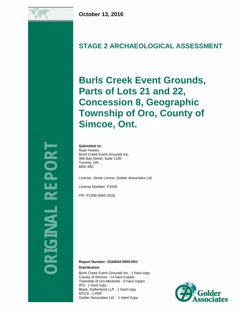
October 13, 2016 STAGE 2 ARCHAEOLOGICAL ASSESSMENT Burls Creek Event Grounds, Parts of Lots 21 and 22, Concession 8, Geographic Township of Oro, County of Simcoe, Ont. ORIGINAL REPORT Report Number: 1534044-5000-R01 Distribution: Burls Creek Event Grounds Inc - 1 hard copy County of Simcoe - 14 hard Copies Township of Oro-Medonte - 6 hard copies IPS - 1 hard copy Black, Sutherland LLP - 1 hard copy MTCS - 1 PDF Golder Associates Ltd. - 1 Hard Copy Submitted to: Ryan Howes Burls Creek Event Grounds Inc. 366 Bay Street, Suite 1100 Toronto, ON M5H 4B2 License: Jamie Lemon, Golder Associates Ltd. License Number: P1056 PIF: P1056-0065-2016
-
Upload
khangminh22 -
Category
Documents
-
view
1 -
download
0
Transcript of OR IGIN A L REPO R T - Simcoe County
October 13, 2016
STAGE 2 ARCHAEOLOGICAL ASSESSMENT
Burls Creek Event Grounds, Parts of Lots 21 and 22, Concession 8, Geographic Township of Oro, County of Simcoe, Ont.
ORIG
INAL
REP
ORT
Report Number: 1534044-5000-R01
Distribution: Burls Creek Event Grounds Inc - 1 hard copy County of Simcoe - 14 hard Copies Township of Oro-Medonte - 6 hard copies IPS - 1 hard copy Black, Sutherland LLP - 1 hard copy MTCS - 1 PDF Golder Associates Ltd. - 1 Hard Copy
Submitted to: Ryan Howes Burls Creek Event Grounds Inc. 366 Bay Street, Suite 1100 Toronto, ON M5H 4B2
License: Jamie Lemon, Golder Associates Ltd.
License Number: P1056
PIF: P1056-0065-2016
BURLS CREEK EVENT GROUNDS - STAGE 2 ARCHAEOLOGICAL ASSESSMENT
Executive Summary
The Executive Summary highlights key points from the report only; for complete information and findings, as well as the limitations, the reader should examine the complete report.
A Stage 2 archaeological assessment was conducted on behalf of Burls Creek Event Grounds Inc. by Golder Associates Ltd. (Golder), for a property in Simcoe County, Ontario (Burls Creek Event Grounds) (Map 1). The Stage 2 assessment was conducted at the request of Burls Creek Event Grounds Inc. on the property grounds on part of Lots 21 and 22, Concession 8, Geographic Township of Oro, Simcoe County, Ontario. The Stage 2 assessment was conducted in conjunction with a Planning Act application.
The larger Burls Creek Event Grounds property, consisting of a mixture of agricultural and recreational lands, was previously subject to a Stage 1 archaeological assessment (Golder 2016); the property had historically been used for agriculture, with significant areas used for recreation in the previous decades, including the site of the former Barrie Speedway. Large portions of the property were recommended for Stage 2 pedestrian or test pit surveys prior to ground disturbance activities. The Stage 2 assessment documented herein relates to areas where security towers will be installed (three areas), and areas adjacent to the former Barrie Speedway that were recommended for judgemental test pit survey (Map 4, see Section 1.3.2).
The objectives of the Stage 2 archaeological assessment were to provide an overview of archaeological resources on the property and to determine whether any of the resources might be artifacts and archaeological sites with cultural heritage value or interest and to provide specific direction for the protection, management and/or recovery of these resources. Areas recommended for Stage 2 assessment were surveyed through systematic pedestrian and test pit survey at five metre intervals, as per Sections 2.1.1 and 2.1.2 of the Standards and Guidelines for Consultant Archaeologists (MTCS 2011).
With reference to the Stage 2 archaeological assessment, the following recommendations are made:
1) As no artifacts or cultural features were identified during the Stage 2 survey of the security tower locations or the area adjacent to the former Barrie Speedway (Map 5), no further archaeological assessment is recommended for these areas;
2) It is recommended the Stage 1 archaeological assessment results map (Golder 2016:Map 4) be provided and reviewed with all Burls Creek and subcontracted work crews prior to any further work being undertaken on the property;
3) It is recommended the letter in Appendix A be provided to all Burls Creek and subcontracted work crews prior to any further work being undertaken on the property; and
4) It is recommended a licensed archaeologist be contact if any of the previous Stage 1 report recommendations are unclear.
The MTCS is asked to review the results and recommendations presented herein, to accept this report into the Provincial Register of Archaeological Reports.
October 13, 2016 Report No. 1534044-5000-R01 i
BURLS CREEK EVENT GROUNDS - STAGE 2 ARCHAEOLOGICAL ASSESSMENT
Project Personnel
Project Director Hugh Daechsel, M.A. (P051), Principal, Senior Archaeologist
Project Manager Jamie Lemon, M.A. (P1056), Project Archaeologist
Licensed Archaeologist Jamie Lemon, M.A. (P1056), Project Archaeologist
Licensed Field Supervisor Christopher W. Lemon, B.Sc. (R289), Project Archaeologist
Field Technicians Shawn Bayes, B.A (R356), Tatiana Istomina, Ph.D. (R288), Alex Vasylenko, M.A. (R287), Aaron Andringa
Report Production Christopher W. Lemon, B.Sc. (R289), Jamie Lemon, M.A. (P1056)
GIS/Mapping Jeff Todd, GIS Analyst
Senior Review Hugh Daechsel, M.A. (P051), Principal, Senior Archaeologist
Acknowledgments
Proponent Ryan Howes, Tammi Taylor, Mike McKenna, Burls Creek Event Grounds Inc.
Greg Barker, IPS
Ministry of Tourism, Culture and Sport Robert von Bitter
October 13, 2016 Report No. 1534044-5000-R01 ii
BURLS CREEK EVENT GROUNDS - STAGE 2 ARCHAEOLOGICAL ASSESSMENT
Table of Contents
1.0 PROJECT CONTEXT ....................................................................................................................................................... 1
1.1 Development Context .......................................................................................................................................... 1
1.1.1 Stage 2 Archaeological Assessment Objectives ............................................................................................ 1
1.2 Historical Context ................................................................................................................................................. 2
1.2.1 Post-Contact Aboriginal Occupation of Southern Ontario .............................................................................. 2
1.2.2 Euro-Canadian Settlement ............................................................................................................................. 2
1.2.2.1 Simcoe County, Township of Oro ............................................................................................................... 2
1.2.2.2 Lots 21 and 22, Concession 8 .................................................................................................................... 3
1.3 Archaeological Context ........................................................................................................................................ 3
1.3.1 The Natural Environment ............................................................................................................................... 3
1.3.2 Previously Identified Archaeological Sites and Surveys ................................................................................. 3
2.0 FIELD METHODS ............................................................................................................................................................. 6
2.1 Existing Conditions and Land Use ....................................................................................................................... 6
2.2 Stage 2 Field Work Methodology ......................................................................................................................... 6
3.0 RECORD OF FINDS ......................................................................................................................................................... 9
4.0 ANALYSIS AND CONCLUSIONS .................................................................................................................................. 10
5.0 RECOMMENDATIONS ................................................................................................................................................... 11
6.0 ADVICE ON COMPLIANCE WITH LEGISLATION ........................................................................................................ 12
7.0 BIBLIOGRAPHY AND SOURCES ................................................................................................................................. 13
8.0 IMAGES .......................................................................................................................................................................... 15
9.0 MAPS .............................................................................................................................................................................. 21
10.0 IMPORTANT INFORMATION AND LIMITATIONS FOR THIS REPORT ....................................................................... 27
TABLES Table 1: Registered Archaeological Sites within 1km of Study Area .......................................................................................... 4
Table 2: Inventory of Documentary Record ................................................................................................................................ 9
October 13, 2016 Report No. 1534044-5000-R01 iii
BURLS CREEK EVENT GROUNDS - STAGE 2 ARCHAEOLOGICAL ASSESSMENT
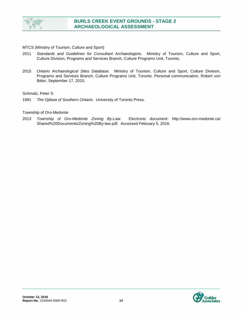
IMAGES Image 1: Test Pitting at TL1, note grass colour along road edge from installation of conduits, facing northwest. .................... 15
Image 2: Open test pit at TL1, north as indicated. .................................................................................................................... 15
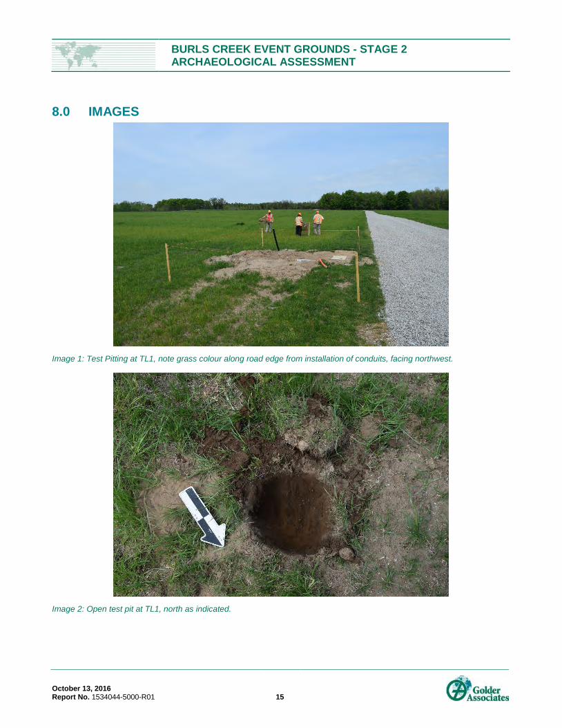
Image 3: Field conditions at TL2, facing northwest. ................................................................................................................. 16
Image 4: Open test pit at TL2, north is up and to the right (as indicated by trowel tip). ............................................................ 16
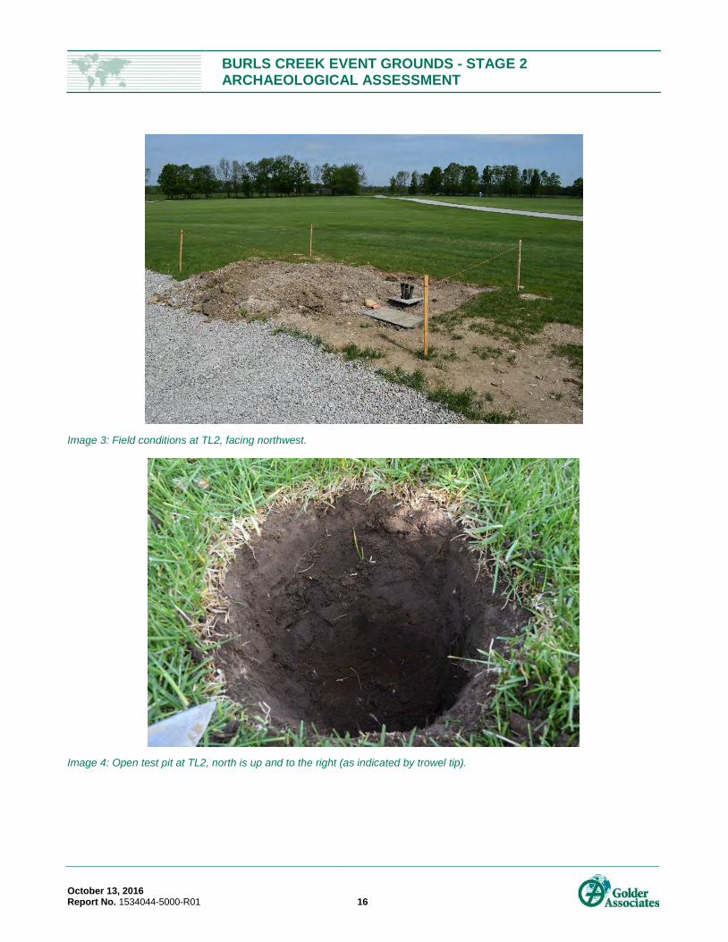
Image 5: Field conditions at TL3, note grass colour variation along edge of road indicating buried conduits, facing southwest. ............................................................................................................................................................... 17
Image 6: Soil profile at Tower Location 3, note the knife edge between the imported topsoil and the native topsoil, facing west. ............................................................................................................................................................. 17
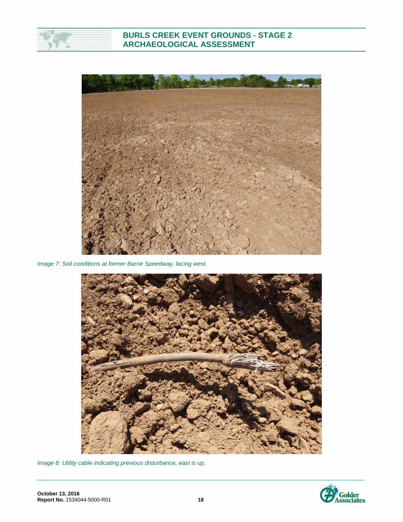
Image 7: Soil conditions at former Barrie Speedway, facing west. ........................................................................................... 18
Image 8: Utility cable indicating previous disturbance, east is up. ............................................................................................ 18
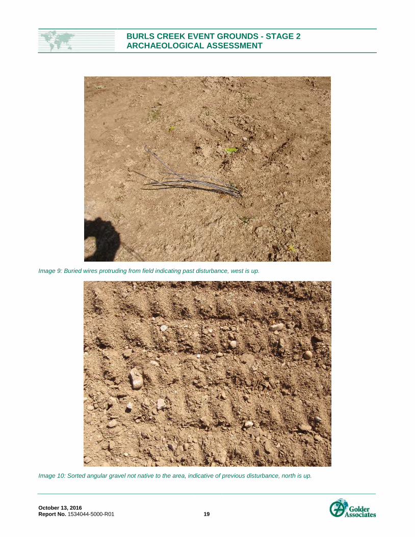
Image 9: Buried wires protruding from field indicating past disturbance, west is up. ................................................................ 19
Image 10: Sorted angular gravel not native to the area, indicative of previous disturbance, north is up. ................................. 19
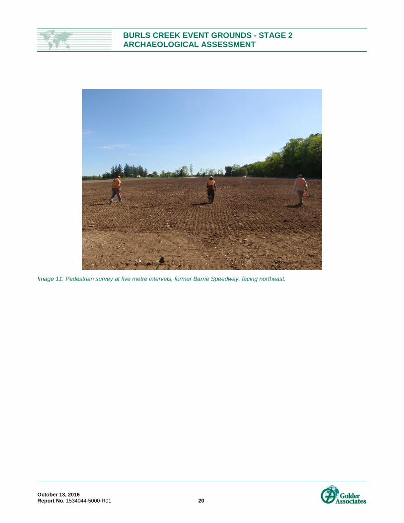
Image 11: Pedestrian survey at five metre intervals, former Barrie Speedway, facing northeast. ............................................ 20
MAPS
Map 1: Study Area…………………………………………………………………………………………………………………………22
Map 2: Portion of 1881 Map of Township of Oro………………………………………………………………………………………23
Map 3: Aerial Imagery………………………………………………………………………………………………………………...…..24
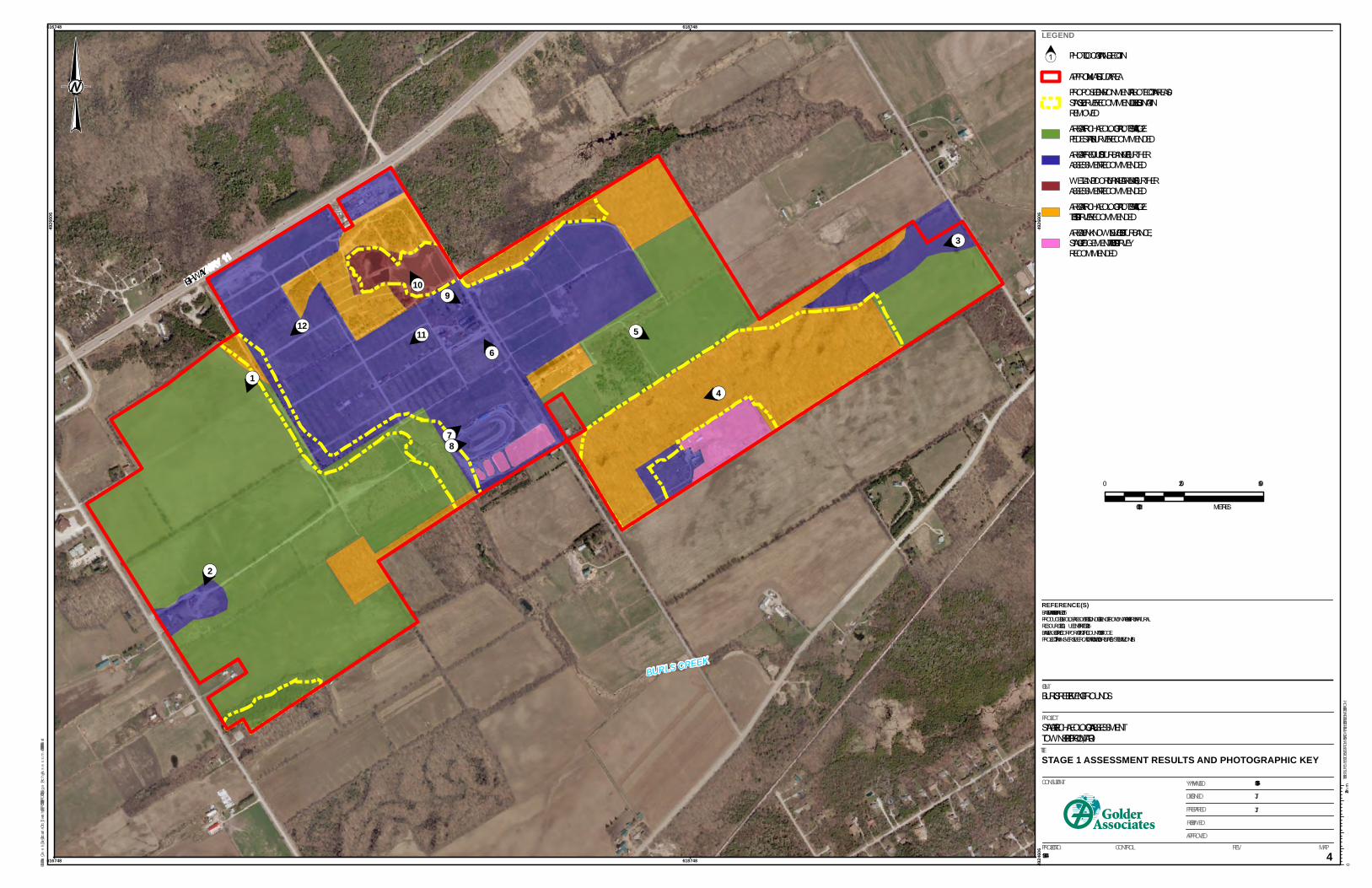
Map 4: Stage 1 Assessment Results ……………………………………………………………………….…..………………………25
Map 5: Stage 2 Assessment Results and Photographic Key..…………………………………………….…..…………….………26
APPENDICES APPENDIX A Letter to Provide to Onsite Work Crews
October 13, 2016 Report No. 1534044-5000-R01 iv
BURLS CREEK EVENT GROUNDS - STAGE 2 ARCHAEOLOGICAL ASSESSMENT
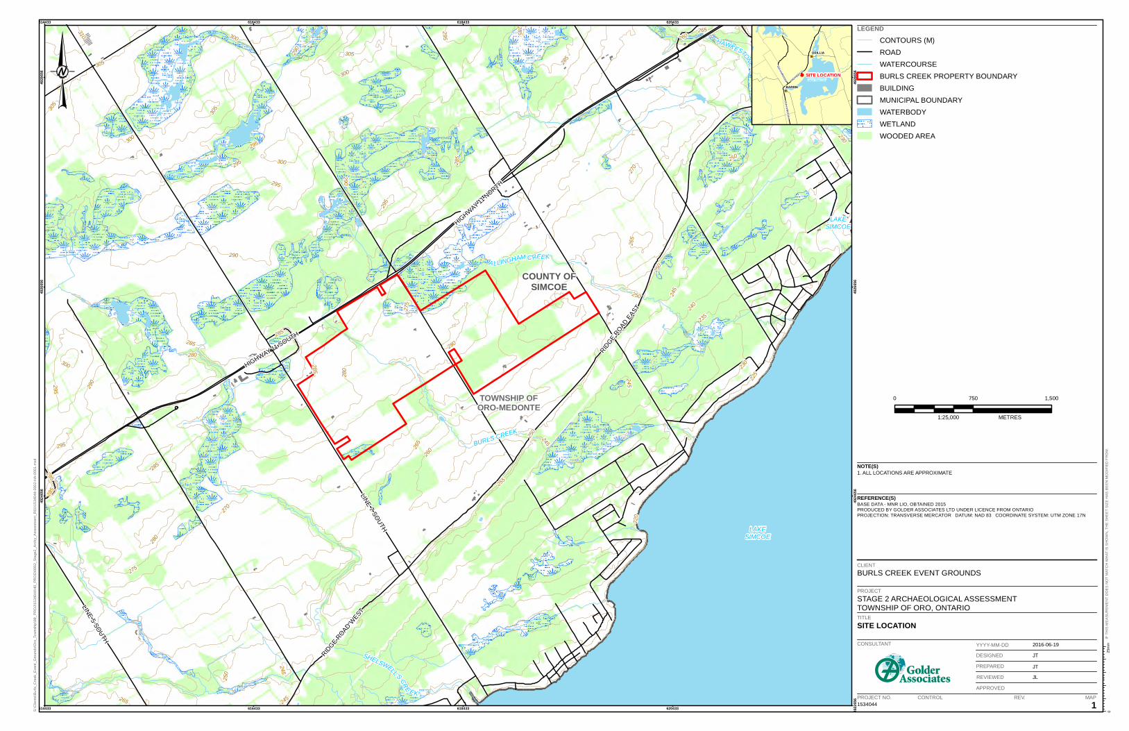
1.0 PROJECT CONTEXT 1.1 Development Context A Stage 2 archaeological assessment was conducted on behalf of Burls Creek Event Grounds Inc. by Golder Associates Ltd. (Golder), for a property in Simcoe County, Ontario (Burls Creek Event Grounds) (Map 1). The Stage 2 assessment was conducted at the request of Burls Creek Event Grounds Inc. on the property grounds on part of Lots 21 and 22, Concession 8, Geographic Township of Oro, Simcoe County, Ontario. The Stage 2 assessment was conducted in conjunction with a Planning Act application.
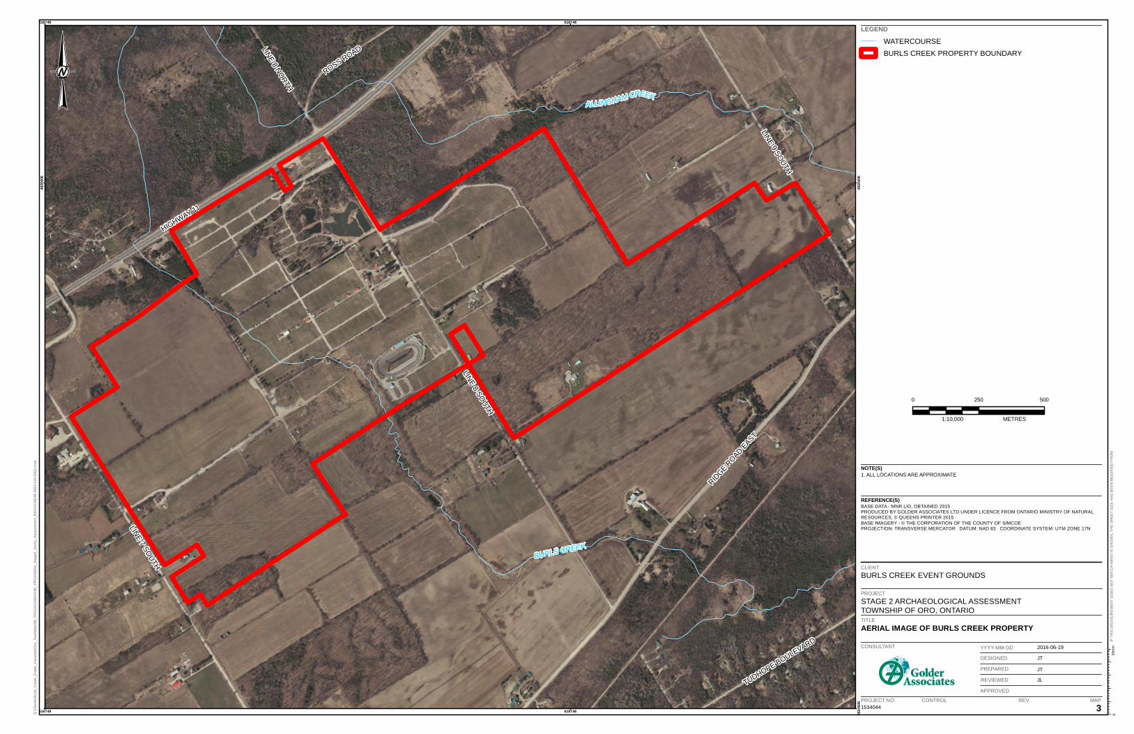
The larger Burls Creek Event Grounds property was previously subject to a Stage 1 archaeological assessment (Golder 2016); larger portions of the property were recommended for Stage 2 pedestrian or test pit surveys prior to ground disturbance activities. The Stage 2 assessment documented herein relates to areas where security towers will be installed (three areas), and areas adjacent to the former Barrie Speedway that were recommended for judgemental test pit survey (Map 4, see Section 1.3.2). Approximately 1.8 hectares was subject to Stage 2 survey.
1.1.1 Stage 2 Archaeological Assessment Objectives The objectives of the Stage 2 Property Assessment were to provide an overview of archaeological resources within the project area and to determine whether any of the resources might be artifacts and/or archaeological sites with cultural heritage value or interest. In compliance with the Standards and Guidelines for Consultant Archaeologists (MTCS 2011), the Stage 2 property assessment:
Documents the presence or absence archaeological resources with cultural heritage value or interest in the study area;
Determines whether the study area requires further Archaeological Assessment; and/or
Recommends no further Archaeological Assessment in the study area.
To meet these objectives Golder archaeologists conducted:
Pedestrian and test pit survey at five metre intervals within the study area, as per Sections 2.1.1 and 2.1.2 of the MTCS’ Standards and Guidelines for Consultant Archaeologists (MTCS 2011).
Permission to enter the property was given by Ms. Tammi Taylor of Burls Creek Event Grounds Inc. The Stage 2 archaeological assessment was conducted under Project Information Form (PIF) P1056-0065-2016 issued to Mrs. Jamie Lemon of Golder Associates.
October 13, 2016 Report No. 1534044-5000-R01 1
BURLS CREEK EVENT GROUNDS - STAGE 2 ARCHAEOLOGICAL ASSESSMENT
1.2 Historical Context 1.2.1 Post-Contact Aboriginal Occupation of Southern Ontario The post-contact Aboriginal occupation of southern Ontario was heavily influenced by the dispersal of various Iroquoian-speaking peoples by the New York State Iroquois and the subsequent arrival of Algonkian-speaking groups from northern Ontario at the end of the 17th century and beginning of the 18th century (Schmalz 1991).
Following the introduction of Europeans to North America, the nature of First Nations settlement size, population distribution, and material culture shifted as settlers began to colonize the land. Despite this shift in First Nations life ways, “written accounts of material life and livelihood, the correlation of historically recorded villages to their archaeological manifestations, and the similarities of those sites to more ancient sites have revealed an antiquity to documented cultural expressions that confirms a deep historical continuity to Iroquoian systems of ideology and thought” (Ferris 2009:114). As a result, First Nation peoples of southern Ontario have left behind archaeologically significant resources throughout southern Ontario which show continuity with past peoples, even if this connection has not been recorded in historical Euro-Canadian documentation.
The study area is situated within the Geographic Township of Oro, Simcoe County, Ontario. The study area is within lands that were part of Treaty Number 16, made between the Chippewas and the Crown on November 18, 1815. Treaty Number 16 includes the Townships of Oro and Medante and parts of Vespra, Flos, Tony and Tay; the treaty lands included much of the land between the northwest edge of Lake Simcoe and Georgian Bay (Morris 1943).
The Stage 2 assessment described herein was discussed with representatives of the Huron-Wendat Nation in May 2016 (Personal communication, Maxime Picard). At this time the Huron-Wendat Nation elected not to send an archaeological field liaison representative for this Stage 2, due to the timing and length of field work. A summary of the field work was provided to the Huron-Wendat Nation; a PDF copy of the final Stage 2 archaeological assessment report will also be provided.
1.2.2 Euro-Canadian Settlement 1.2.2.1 Simcoe County, Township of Oro The land that would become Simcoe County was within the Nassau District (later Home District) when it was created in 1788 by Lord Dorchester. Governor Simcoe made a journey to Penetanguishene in 1793, recognizing the potential of the harbour. The original Simcoe County was created in 1821, was transformed into the Simcoe District in 1843 and the current Simcoe County was established in 1850. Official European settlement began in the Simcoe County region in 1818.
Oro Township was one of the earliest areas of African-American settlement in Ontario, and the only one created through government planning. The settlement was intended for Black Loyalist refugees after the War of 1812. Between 1819 and 1831 African-American settlement was concentrated along the west side of Concession 11, with a maximum population of 100. The population steadily declined through the latter half of the 19th century, as families left the on account of the harsh climate.
October 13, 2016 Report No. 1534044-5000-R01 2
BURLS CREEK EVENT GROUNDS - STAGE 2 ARCHAEOLOGICAL ASSESSMENT
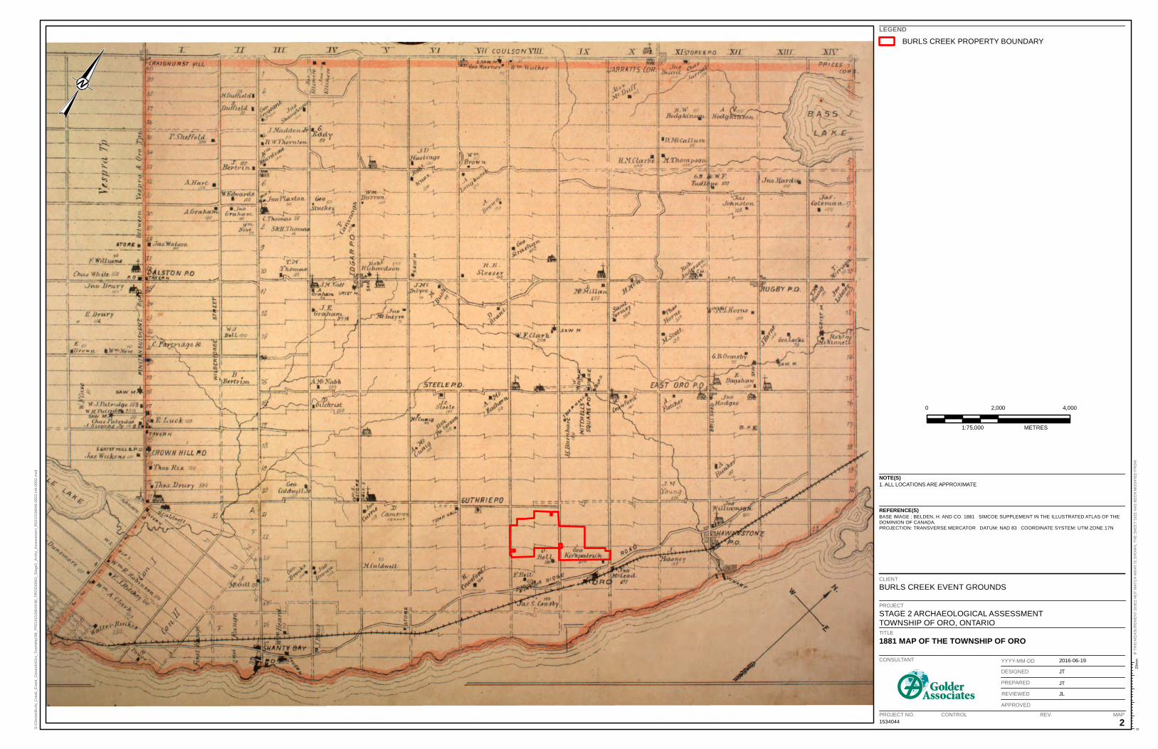
1.2.2.2 Lots 21 and 22, Concession 8 The study area is located on part of Lots 21 and 22, Concession 8, Geographic Township of Oro. The 1881 Map of the Township of Oro (Map 2) Lot 21 and 22 (Concession 8) do no list an occupants, though that can be misleading as only subscribers to this series of atlases had their names included on the mapping.
The study area is located in close proximity to the Ridge Road, an early transportation route between Barrie and Orillia that reportedly followed an Aboriginal trail across the north shore of Lake Simcoe. Additionally, the study area is located in close proximity to the 19th century communities of Oro and Hawkestone.
1.3 Archaeological Context 1.3.1 The Natural Environment The study area is situated within the “Simcoe Uplands” physiographic region:
The Simcoe uplands comprise a series of broad, rolling, till plains separated by steep-sided, flat-floored valleys. They are encircled by numerous shorelines, indicating that they were islands in Lake Algonquin…The till in these uplands differs from the till found east of Lake Simcoe; it consists mainly of Pre-cambrian rock rather than limestone. Its texture is a gritty loam, becoming more sandy toward the north, and it is also boulder. Some heavier, more calcareous till occurs near Lake Simcoe and near Midland. Several drumlins appear near Orillia.
Chapman and Putnam 1984:182-183
The soils of the study area consist predominately of Vasey sandy loam with good natural drainage; small pockets of Sargent gravelly sandy loam with good drainage and Alliston sandy loam with imperfect natural drainage (Hoffman et al. 1962). These types of soils would have been acceptable for pre-contact Aboriginal agricultural practices. The closest potable water source would have been remnants of a small creek tributary of the Oro Creeks South sub-watershed (of the larger Lake Simcoe watershed) that bisects the study area (Map 1). The Ridge Road, which follows the glacial ridge shoreline of Lake Algonquin, runs approximately 500 metres south of the study area. The modern Lake Simcoe shoreline is approximately two kilometres south of the study area. The topography of the area is flat to gently rolling.
1.3.2 Previously Identified Archaeological Sites and Surveys Previous archaeological assessments and research surveys have demonstrated the lands that later became Simcoe County were utilized by pre-contact Aboriginal peoples. A search of the OASD and within Golder’s corporate library indicated there are two archaeological sites within one kilometre of the study area (MTCS 2015). These two sites, both pre-contact Aboriginal, were reported on by Andrew Hunter in the 1903 Annual Archaeological Report of Ontario. The text of the 1903 report states Oro 64 was located on the west half of Lot 23, Concession 9 and Oro 65 was located on east half of Lot 24, Concession 8. Although limited descriptions were provided, Oro 64 was described as yielded artifacts such as pipes, pipe fragments, pottery fragments, and evidence of ash and coal six inches below the ground surface. A cache of stone axes was also identified, near a barn. Oro 65 was described as being located beside the “Ridge Road” (Highway 20), at the top of the Algonquin
October 13, 2016 Report No. 1534044-5000-R01 3
BURLS CREEK EVENT GROUNDS - STAGE 2 ARCHAEOLOGICAL ASSESSMENT
cliff shoreline. The site was evidently identified by Richard Bell and yielded the “usual relics”, as well as a human skull that was recovered while Mr. Bell was digging a cellar for his house (Hunter 1903).
The mapping within the 1903 report suggests both sites are located south of the study area, though the scale of the mapping makes it difficult to tell if the sites are in close proximity (within 300 metres) or further afield. It would appear Oro 64 was located in very close proximity to the southern boundary of the study area. The placement of the Bell Homestead (F. Bell) on Lot 24 of the 1881 Map of the Township of Oro gives an indication of the likely location of Oro 65. A listing of the two sites is provided in Table 1.
Table 1: Registered Archaeological Sites within 1km of Study Area Borden # Site Name Site Type Cultural Affiliation
N/A Hunter’s Oro 64 Unknown Woodland Period - Huron N/A Hunter’s Oro 65 Unknown Woodland Period - Huron
In addition to the sites reported on in the 1903 Annual Archaeological Report of Ontario a previous Stage 1 archaeological assessment was undertaken adjacent to the current study area. A Stage 1 assessment of Highway 11, from Highway 400 to the Severn River, was undertaken in 2008, with a Stage 1 completed of the Highway 11 ROW north of the study area (P059-059-2008, AMAA 2009). The Stage 1 report identified areas of previous disturbance in the ROW ditches immediately north of the study area, save for a small area east of Highway 11 and 7th Line North, where narrow ditching led to a recommendation for Stage 2 test pit survey (AMAA 2009).
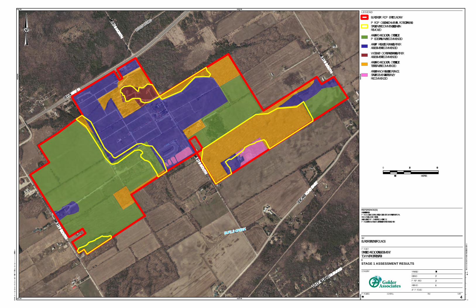
The Stage 1 archaeological assessment of the Burls Creek Event Grounds found that portions of the study area retain archaeological potential for the recovery of pre- and post-contact Aboriginal archaeological resources, as well as historical Euro-Canadian resources. With regards to the Burls Creek Event Grounds study area the following recommendations were made (Golder 2016:17):
1) Areas of previous disturbance and wetland/poorly drained areas exhibit low potential for the recovery of archaeological remains. No further assessment is recommended for these areas;
2) Areas of archaeological potential associated with areas of manicured lawns around buildings and bush lots exhibit archaeological potential for the recovery of archaeological remains. In the event that these areas are to be impacted a Stage 2 test pit survey at an interval of five metres is recommended for these areas prior to ground disturbance activities. Test pits should be approximately 30 centimetres in diameter and excavated to subsoil. If artifacts be recovered their location should be recorded with a GPS unit and test pit intervals reduced to 2.5 metres within 5 metres of the positive test pit, as well as a one-metre test unit if necessary;
3) Areas of archaeological potential associated with areas of grass fields exhibit archaeological potential for the recovery of archaeological remains. In the event that these areas are to be impacted a Stage 2 pedestrian survey at an interval of five metres is recommended for these areas prior to ground disturbance activities. All areas recommended for pedestrian survey will need to be ploughed and weathered by rainfall ahead of the survey. Given the grass conditions of the fields, it is recommended the area be ploughed, then disked twice to break up the soil. The pedestrian survey will involve a visual inspection of the property
October 13, 2016 Report No. 1534044-5000-R01 4
BURLS CREEK EVENT GROUNDS - STAGE 2 ARCHAEOLOGICAL ASSESSMENT
by having archaeologists walk the area at five metre transects. Should artifacts be identified survey intervals will be reduced to one metre within a radius of 20 metres around the initial findspot;
4) Several small areas along the southern edge of the study area are most likely disturbed, but this could not be confirmed during the property inspection. Stage 2 judgemental test pit survey is recommended in these areas to confirm disturbance, prior to ground disturbance activities (Map 4). The judgmental test pit survey interval should be decided based on professional judgment of the field conditions at the time of the Stage 2 survey; if disturbance cannot be confirmed by judgemental test pitting, the survey interval should be reduced until disturbance is either confirmed, or a test pit survey at a five metre interval is completed;
5) Environmental Protection Areas have been delineated on Map 4 as described in the Zoning By-Law Amendment documents included in this report (Appendix B and C). Parts of the EPAs are identified as retaining archaeological potential (Map 4) and will require Stage 2 archaeological assessment (following the strategies described in recommendations 2 and 3) prior to any soil disturbance of those areas; and
6) Small gravel roads that criss-cross the study area are considered to be previously disturbed and no further assessment is recommended. These roads are not shown in Map 4 as previously disturbed, due to the scale of the map and the assumption that pedestrian survey at an interval of five metres should capture these roads within the five metre interval.
October 13, 2016 Report No. 1534044-5000-R01 5
BURLS CREEK EVENT GROUNDS - STAGE 2 ARCHAEOLOGICAL ASSESSMENT
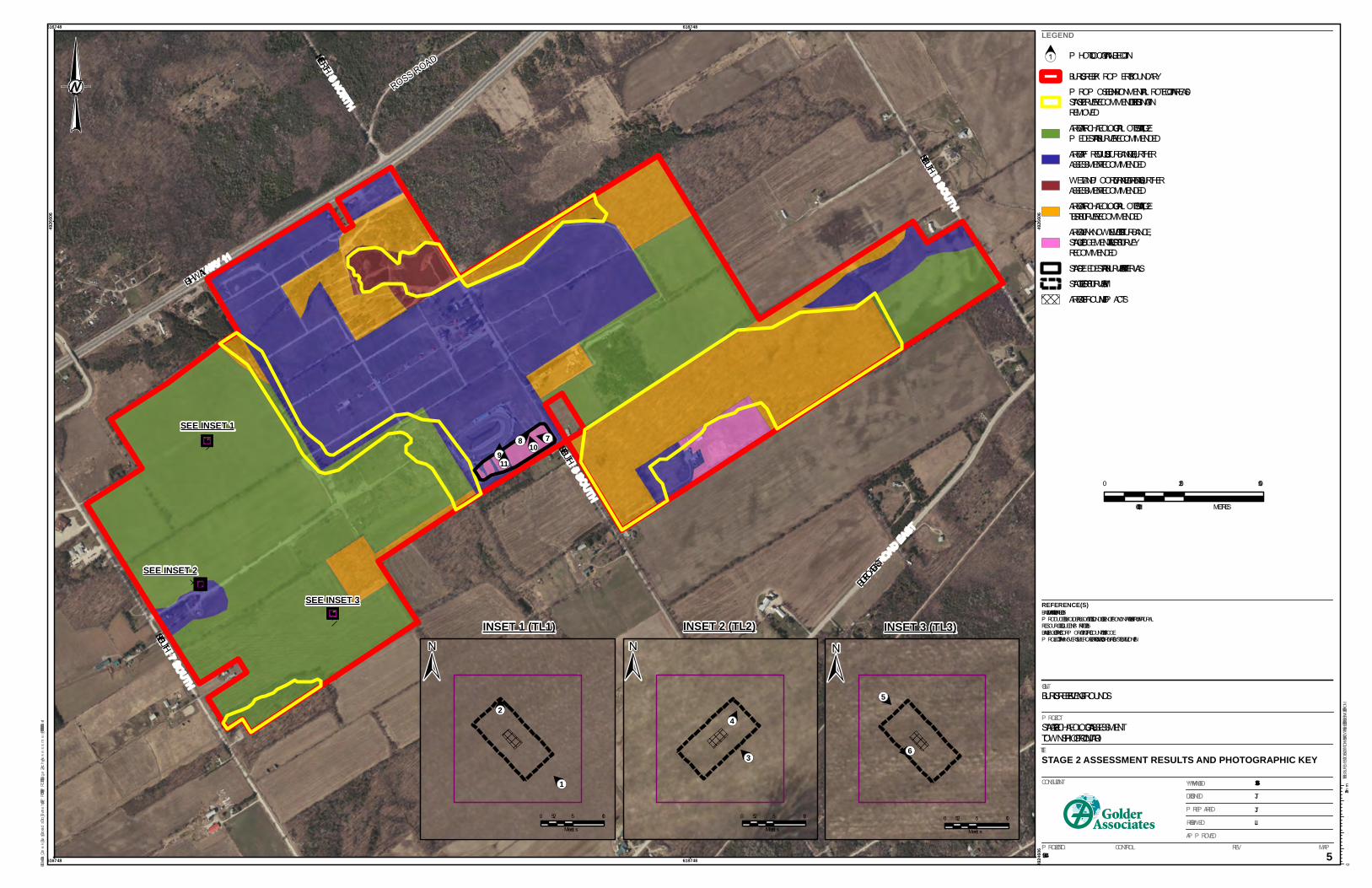
2.0 FIELD METHODS 2.1 Existing Conditions and Land Use The study area currently consists of grass areas adjacent to previously disturbed gravel roads (security towers) and an area adjacent to the former Barrie Speedway. The area adjacent to the former Barrie Speedway was found to have been altered since the Stage 1 property inspection was completed in September 2015; the area appeared to have been graded, and then ploughed. These conditions permitted the Stage 2 in this area to be conducted by pedestrian survey. Further details on these areas are provided below.
The Stage 2 archaeological assessment took place on May 25, 2016 and June 3, 2016 under archaeological consulting licence P1056, issued to Mrs. Jamie Lemon of Golder. Christopher Lemon (R289) of Golder was designated to oversee the day to day Stage 2 field operations. The weather during the Stage 2 property inspection each day was sunny and warm. Lighting conditions during the test pit survey and pedestrian survey were excellent, and at no time were field conditions found to be detrimental to the completion of the Stage 2.
2.2 Stage 2 Field Work Methodology The Stage 2 assessment documented herein relates to areas where security towers will be installed (three areas), and areas adjacent to the former Barrie Speedway that were recommended for judgemental test pit survey. Each security tower location was situated on a grass area, immediately adjacent to a previously disturbed gravel access road. The area of impact for these towers is approximately four feet by four feet (1.2 metres by 1.2 metres). The towers will be supported by a plastic base that can be removed when the tower is no longer needed. Given the small area of impact and location adjacent to an area of previous disturbance, it was the licensee’s professional opinion the security tower locations fell under Section 2.1.2 Standard 1f of the Standards and Guidelines for Consultant Archaeologists (MTCS 2011). A modified test pit strategy over a 2.5 metre by 2.5 metres area was planned for survey at these locations.
Prior to the Stage 2 field work commencing Golder was notified by Burls Creek on May 11, 2016 that work crews had commenced the excavation for tower installation on at least one of the locations. Burls Creek stated when they learned of this they immediately asked the work crews to stop until the Stage 2 archaeological assessment was completed.
Upon arrival at the study area the archaeological field crew was taken to the location of each of the three proposed security tower locations by a representative of Burls Creek. When the field crew arrived at each of the tower locations it was apparent that installation of subsurface infrastructure had commenced at all three locations. Upon assessing the condition of each location a modified test pit assessment was conducted at five metre intervals surrounding each site of ground disturbance. The test interval was expanded from the initially proposed two and a half metre intervals to standard five metre intervals as the impact had already occurred and no further impact was going to occur; this interval also allowed Golder to assess around the edges of impact, providing the best chance of observing any artifacts or sites that may have been impacted. Based on the disturbance footprint a five metre by ten metre area was subject to test pit assessment on the un-impacted lands surrounding each tower location. Additionally, the exposed excavation holes were visually inspected for evidence of cultural remains, and test pits excavated adjacent to the areas of impact.
October 13, 2016 Report No. 1534044-5000-R01 6

BURLS CREEK EVENT GROUNDS - STAGE 2 ARCHAEOLOGICAL ASSESSMENT
Tower Location 1 (TL1) is located on the northwest portion of the property (Map 5; inset 1). There was evidence that underground cables had been installed adjacent to the gravel access road (Image 1); Burls Creek has indicated these cables were installed in November and December 2015. Given the presence of these cables, a one metre buffer was maintained along this infrastructure path to ensure there was no impact during test pit excavation. All test pits excavated around TL1 were a minimum of 30 centimetres in diameter and were excavated into subsoil; subsoil was encountered between 15 and 20 centimetres below ground level (Image 2). Test pit excavation continued until five centimeters of subsoil had been excavated and screened. The topsoil surrounding TL1 was comprised of compact light orange-brown sandy silt and the subsoil was comprised of light grey silty clay. All of the soils in this area appeared to represent native soils and did not exhibit indications of non-native material having been brought to the site to augment the native soils. No artifacts or cultural features were identified at TL1.
Tower Location 2 (TL2) is located on the western side of the study area between TL1 and TL3 (Map 5; inset 2). TL 2 (Image 3) is situated on elevated ground adjacent to a large gravel area used as an entrance to the property during events. The soils surrounding TL2 exhibit signs of previous disturbance. The soil profile around TL2 contains a layer of black organic loam; it is possible that this organic soil represents an artificial application of non-native topsoil to increase the agricultural potential of the area (Image 4). All of the test pits were a minimum of 30 centimetres in diameter and were excavated into subsoil where possible; subsoil was encountered between 15 and 20 centimetres below ground level and all soils were screened for cultural artifacts using 6mm hardware cloth. Below the organic layer highly compact soils containing gravel were encountered, indicative of previous disturbance. Excavation ceased when this level was encountered as it was obvious the assessment was occurring in an area of previous disturbance. TL2 is adjacent to an area identified as previously disturbed in the Stage 1 assessment report (Golder 2016). All of the test pits excavated around TL2 exhibited the conditions described above. No artifacts or cultural features were identified at TL2.
Tower Location 3 (TL3) is located in the southwest portion of the property and had been subjected to the least ground disturbance related to the installation of the tower bases of the three locations (Map 5; inset 3) (Image 5). As less infrastructure had been installed it was possible to obtain a clear view of the stratigraphy of the area (Image 6). The soil surrounding TL3 was comprised of a thin layer of non-native organic soil (approximately 10 cm) sitting atop the native sandy silt topsoil layer, which resided above a more compact silt clay subsoil. As with TL2 the dark organic soils encountered at ground level likely represents an artificial application of non-native topsoil to increase the agricultural potential of the area. All of the test pits were a minimum of 30 centimetres in diameter and were excavated into subsoil; the original topsoil ranged in depth from 34 to 39 centimetres. This resulted in some test pits being over 50 centimetres in depth. All soils were screened for cultural artifacts using 6mm hardware cloth. No artifacts or cultural features were identified at TL3.
The second part of the Stage 2 survey included assessment of areas adjacent to the former Barrie Speedway. This speedway was identified as previously disturbed in the Stage 1 report (Golder 2016) and has since the Stage 1 property inspection in September 2015 been removed and the area subjected to grading. At the time of the Stage 1 several small areas south of the speedway were identified as likely disturbed, but recommended for judgmental test pit survey to fully assess the potential of the area and ensure that all area of archaeological potential were mitigated prior to development.
When the field crew arrived on site on May 25, 2016 it was apparent that earthworks had occurred in this area since the Stage 1 property inspection, likely related to the demolition and grading of the adjacent speedway
October 13, 2016 Report No. 1534044-5000-R01 7
BURLS CREEK EVENT GROUNDS - STAGE 2 ARCHAEOLOGICAL ASSESSMENT
area. The conditions encountered on May 25 led to Golder requesting the area be ploughed and subject to pedestrian survey. The area was ploughed, weathered by heavy rainfall and subject to pedestrian survey on June 6, 2016. At the time of Stage 2 pedestrian survey the field was well-disked and weathered with 95% surface visibility. The field was assessed using standard pedestrian survey methods at five metre intervals. The pedestrian survey of the area revealed heavily disturbed soils indicated by large patches of subsoil inclusion into the plough zone (Image 7), buried infrastructure protruding from the ground surface (Images 8 and 9) as well as many occurrences of graded limestone gravel (Image 10), which would have been used as parking surfaces and access roads prior to regrading. Overall the Stage 2 pedestrian survey of the area adjacent to the former Barrie Speedway lands did not result in the recovery of any cultural remains.
October 13, 2016 Report No. 1534044-5000-R01 8
BURLS CREEK EVENT GROUNDS - STAGE 2 ARCHAEOLOGICAL ASSESSMENT
3.0 RECORD OF FINDS The Stage 2 archaeological assessment was conducted employing the methods described in Section 2.0, above. An inventory of the documentary record generated during the archaeological assessment is provided in Table 2.
Table 2: Inventory of Documentary Record
Document Type Current Location of Document Additional Comments Quantity
Field Notes Golder office in Whitby
Stored digitally in electronic project folder, and in original field note book 7 pages
Hand Drawn Maps Golder office in Whitby In hard copy and electronic project folders 1
Maps Provided by Client
Golder office in Whitby Stored digitally in electronic project folder 4
Digital Photographs Golder office in Whitby
All photos stored digitally in electronic project folder
168 photos in .jpeg format
No archaeological resources were recovered from the Stage 2 survey of the study area illustrated in Map 4 of this report.
October 13, 2016 Report No. 1534044-5000-R01 9
BURLS CREEK EVENT GROUNDS - STAGE 2 ARCHAEOLOGICAL ASSESSMENT
4.0 ANALYSIS AND CONCLUSIONS No artifacts or cultural features were identified during the Stage 2 survey.
At the three security tower locations excavation impacts related to the tower bases had already occurred prior to the Stage 2 field work. Areas of impact ranged from approximately 1 metre by 1 metre (TL3) to 1 metre by 2 metres (TL1 and TL2). An area of 10 metres by 5 metres was subject to test pit survey at a five metre interval. Additionally, the exposed excavation holes were visually inspected for evidence of cultural remains, and test pits excavated adjacent to the areas of impact. Given this, although the areas were impacted prior to the Stage 2 field work, it is unlikely a site was impacted in this area, as the visual inspection and test pit survey conducted likely would have yielded some evidence of a site, if one had been present.
The lands adjacent to the former Barrie Speedway were recommended for Stage 2 judgmental test pit survey, however the conditions encountered in this area on the first day of Stage 2 field work led to the area being ploughed and subject to pedestrian survey. This pedestrian survey likely provided greater exposure of potential artifacts to be identified, more than judgmental test pit survey would. Given this, although the area was impacted after the Stage 1 property inspection, it is unlikely a site was impacted in this area, as the pedestrian survey conducted likely would have yielded some evidence of a site, if one was present.
Section 5.0 presents recommendations related to the Stage 2 survey, as well as recommendations for preventing ground impacts on this property in the future, prior to recommended archaeological assessments being completed.
October 13, 2016 Report No. 1534044-5000-R01 10
BURLS CREEK EVENT GROUNDS - STAGE 2 ARCHAEOLOGICAL ASSESSMENT
5.0 RECOMMENDATIONS With reference to the recent ground impacts in these areas and the Stage 2 survey, the following recommendations are made:
1) No artifacts or cultural features were identified during the Stage 2 survey of the security tower locations or the area adjacent to the former Barrie Speedway (Map 5). No further archaeological assessment is recommended for these areas;
2) It is recommended the Stage 1 archaeological assessment results map (Golder 2016:Map 4) be provided and reviewed with all Burls Creek and subcontracted work crews prior to any further work being completed on the balance of the property;
3) It is recommended the letter in Appendix A be provided to all Burls Creek and subcontracted work crews prior to any further work being completed on the property; and
4) It is recommended a licensed archaeologist be contact if any of the previous Stage 1 report recommendations are unclear.
The MTCS is asked to review the results and recommendations presented herein, to accept this report into the Provincial Register of Archaeological Reports.
October 13, 2016 Report No. 1534044-5000-R01 11
BURLS CREEK EVENT GROUNDS - STAGE 2 ARCHAEOLOGICAL ASSESSMENT
6.0 ADVICE ON COMPLIANCE WITH LEGISLATION This report is submitted to the Ontario Minister of Tourism, Culture and Sport as a condition of licensing in accordance with Part VI of the Ontario Heritage Act, R.S.O. 1990, c O.18. The report is reviewed to ensure that it complies with the standards and guidelines that are issued by the Minister, and that the archaeological fieldwork and report recommendations ensure the conservation, protection and preservation of the cultural heritage of Ontario. When all matters relating to archaeological sites within the project area of a development proposal have been addressed to the satisfaction of the Ministry of Tourism, Culture and Sport, a letter will be issued by the ministry stating that there are no further concerns with regard to alterations to archaeological sites by the proposed development.
It is an offence under Sections 48 and 69 of the Ontario Heritage Act for any party other than a licensed archaeologist to make any alteration to a known archaeological site or to remove any artifact or other physical evidence of past human use or activity from the site, until such time as a licensed archaeologist has completed fieldwork on the site, submitted a report to the Minister stating that the site has no further cultural heritage value or interest, and the report has been filed in the Ontario Public Register of Archaeology Reports referred to in Section 65.1 of the Ontario Heritage Act.
Should previously undocumented archaeological resources be discovered, they may be a new archaeological site and therefore subject to Section 48 (1) of the Ontario Heritage Act. The proponent or person discovering the archaeological resources must cease alteration of the site immediately and engage a licensed consultant archaeologist to carry out archaeological fieldwork, in compliance with Section 48(1) of the Ontario Heritage Act.
The Funeral, Burial and Cremation Services Act, 2002, S.O. 2002, c.33, requires that any person discovering or having knowledge of a burial site shall immediately notify the police or coroner. It is recommended that the Registrar of Cemeteries at the Ministry of Consumer Services is also immediately notified.
Archaeological sites recommended for further archaeological fieldwork or protection remains subject to Section 48 (1) of the Ontario Heritage Act and may not be altered, or have artifacts removed from them, except by a person holding an archaeological licence.
October 13, 2016 Report No. 1534044-5000-R01 12
BURLS CREEK EVENT GROUNDS - STAGE 2 ARCHAEOLOGICAL ASSESSMENT
7.0 BIBLIOGRAPHY AND SOURCES AMAA (A.M. Archaeological Associates) 2009 Stage 1 Archaeological Assessment for Highway 11, From Barrie at Highway 400 to the Severn River,
Central Region (W.O. 07-20013), Simcoe County. Report on file with the MTCS, Toronto. Belden, H. and Co. 1881 Simcoe Supplement in the Illustrated Atlas of the Dominion of Canada. Chapman, Lyman John and Donald F. Putnam 1984 The Physiography of Southern Ontario. 3rd edition. Ontario Geological Survey Special Volume 2.
Ontario Ministry of Natural Resources, Toronto. Ferris, Neal 2009 The Archaeology of Native-Lived Colonialism: Challenging History in the Great Lakes. University of
Arizona Press, Tucson. Golder (Golder Associates Ltd.) 2016 Stage 1 Archaeological Assessment, Burls Creek Event Grounds, Part of Lots 21-22, Concession 8, Part
of Lots 22-23, Concession 9, Geographic Township of Oro, County of Simcoe, Ontario. Report on file with MTCS, Toronto.
Hoffman, D.W., Wicklund, R.E., and N.R. Richards 1962 The Soil Survey of Simcoe County. Report No. 29 of the Ontario Soil Survey. Canadian Department of
Agriculture and the Ontario Agricultural College. Hunter, Andrew F. 1903 Notes on Huron Sites in the Township of Oro. Annual Archaeological Report of Ontario. Printed by L.K.
Cameron. 1909 A History of Simcoe County. The County Council: Barrie. Morris, J.L. 1943 Indians of Ontario. 1964 reprint. Department of Lands and Forests, Government of Ontario.
October 13, 2016 Report No. 1534044-5000-R01 13
BURLS CREEK EVENT GROUNDS - STAGE 2 ARCHAEOLOGICAL ASSESSMENT
MTCS (Ministry of Tourism, Culture and Sport) 2011 Standards and Guidelines for Consultant Archaeologists. Ministry of Tourism, Culture and Sport,
Culture Division, Programs and Services Branch, Culture Programs Unit, Toronto. 2015 Ontario Archaeological Sites Database. Ministry of Tourism, Culture and Sport, Culture Division,
Programs and Services Branch, Culture Programs Unit, Toronto. Personal communication, Robert von Bitter, September 17, 2015.
Schmalz, Peter S. 1991 The Ojibwa of Southern Ontario. University of Toronto Press. Township of Oro-Medonte 2013 Township of Oro-Medonte Zoning By-Law. Electronic document: http://www.oro-medonte.ca/
Shared%20Documents/Zoning%20By-law.pdf. Accessed February 5, 2016.
October 13, 2016 Report No. 1534044-5000-R01 14
BURLS CREEK EVENT GROUNDS - STAGE 2 ARCHAEOLOGICAL ASSESSMENT
8.0 IMAGES
Image 1: Test Pitting at TL1, note grass colour along road edge from installation of conduits, facing northwest.
Image 2: Open test pit at TL1, north as indicated.
October 13, 2016 Report No. 1534044-5000-R01 15
BURLS CREEK EVENT GROUNDS - STAGE 2 ARCHAEOLOGICAL ASSESSMENT
Image 3: Field conditions at TL2, facing northwest.
Image 4: Open test pit at TL2, north is up and to the right (as indicated by trowel tip).
October 13, 2016 Report No. 1534044-5000-R01 16
BURLS CREEK EVENT GROUNDS - STAGE 2 ARCHAEOLOGICAL ASSESSMENT
Image 5: Field conditions at TL3, note grass colour variation along edge of road indicating buried conduits, facing southwest.
Image 6: Soil profile at Tower Location 3, note the knife edge between the imported topsoil and the native topsoil, facing west.
October 13, 2016 Report No. 1534044-5000-R01 17
BURLS CREEK EVENT GROUNDS - STAGE 2 ARCHAEOLOGICAL ASSESSMENT
Image 7: Soil conditions at former Barrie Speedway, facing west.
Image 8: Utility cable indicating previous disturbance, east is up.
October 13, 2016 Report No. 1534044-5000-R01 18
BURLS CREEK EVENT GROUNDS - STAGE 2 ARCHAEOLOGICAL ASSESSMENT
Image 9: Buried wires protruding from field indicating past disturbance, west is up.
Image 10: Sorted angular gravel not native to the area, indicative of previous disturbance, north is up.
October 13, 2016 Report No. 1534044-5000-R01 19
BURLS CREEK EVENT GROUNDS - STAGE 2 ARCHAEOLOGICAL ASSESSMENT
Image 11: Pedestrian survey at five metre intervals, former Barrie Speedway, facing northeast.
October 13, 2016 Report No. 1534044-5000-R01 20
BURLS CREEK EVENT GROUNDS - STAGE 2 ARCHAEOLOGICAL ASSESSMENT
9.0 MAPS All maps will following on succeeding pages.
October 13, 2016 Report No. 1534044-5000-R01 21
!
!
!
!
!
!
!
!
!
!
!
!
!
!
!
!
!
!
!
!
!
!
!
!
!
!
!
!
!
!
!
!
!
!
!
!
!
!
!
!
!
!
!
!
!
!
!
!
!
!
!
!
!
!
!
!
!
!
!
!
!
!
!
!
!
!
!
!
!
!
!
!
!
!
!
!
!
!
!
!
!
!
!
!
!
!
!
!
!
!
!
!
!
!
!
!
!
!
!
!
!
!
!
!
!
!
!
!
!
!
!
!
!
!
!
!
!
!
!
!
!
!
!
!
!
!
!
!
!
!
!
!
!
!
!
!
!
!
!
!
!
!
!
!
!
!
!
!
!
!
!
!
!
!
!
!
!
!
!
!
!
!
!
!
!
!
!
!
!
!
!
!
!
!
!
!
!
!
!
BURLS CREEK
SHELSWELL'S CRE EK
HAWKESTONE CREEK
ALLINGHAM C REEK
LAKESIMCOE
LAKESIMCOE
225
230
235
240
245
250
295
280
230
295
290
245
295
285
285
270
265
285
290
250
220
310
305
280
275
290
300
295
305
300
265
250
250
300
295
305
300
250
255
265
260
285
280
285
290
295
270
285
295
285
285
260
245
255
280
300
295
245
245
275
265
305
LINE 11 SOUTH
RIDGE R
OAD WEST
HIGHWAY 11
NORTH
RIDGE R
OAD EAST
HIGHWAY 11 SOUTH
LINE 7 SOUTH
LINE 5 SOUTH
TOWNSHIP OFORO-MEDONTE
COUNTY OFSIMCOE
614433
614433
616433
616433
618433
618433
620433
620433 4922
656
4924
656
4924
656
4926
656
4926
656
4928
656
4928
656
S:\C
lient
s\Bu
rls_C
reek
_Eve
nt_G
roun
ds\O
ro_T
owns
hip\
99_P
RO
J\15
3404
4\40
_PR
OD
\000
2_S
tage
2_A
rchy
_Ass
essm
ent_
R01
\153
4044
-000
2-H
A-0
001.
mxd
IF T
HIS
ME
ASU
RE
ME
NT
DO
ES
NO
T M
ATC
H W
HAT
IS S
HO
WN
, TH
E SH
EE
T S
IZE
HAS
BE
EN
MO
DIF
IED
FR
OM
:25
mm
0
0 750 1,500
1:25,000 METRES
CLIENT
BURLS CREEK EVENT GROUNDS
NOTE(S)
REFERENCE(S)
1. ALL LOCATIONS ARE APPROXIMATE
BASE DATA - MNR LIO, OBTAINED 2015PRODUCED BY GOLDER ASSOCIATES LTD UNDER LICENCE FROM ONTARIOPROJECTION: TRANSVERSE MERCATOR DATUM: NAD 83 COORDINATE SYSTEM: UTM ZONE 17N
PROJECT
STAGE 2 ARCHAEOLOGICAL ASSESSMENTTOWNSHIP OF ORO, ONTARIOTITLE
SITE LOCATION
1534044 1
2016-06-19
JT
JT
JL
CONSULTANT
PROJECT NO. CONTROL REV. MAP
YYYY-MM-DD
DESIGNED
PREPARED
REVIEWED
APPROVED
LEGENDCONTOURS (M)ROADWATERCOURSEBURLS CREEK PROPERTY BOUNDARYBUILDINGMUNICIPAL BOUNDARYWATERBODYWETLANDWOODED AREA
!
"J
"J
LAKE SIMCOE
HIG
HW
AY 4
00
HIGHWAY 11
HIG
HWAY
400
ORILLIA
BARRIE
SITE LOCATION
S:\C
lient
s\Bu
rls_C
reek
_Eve
nt_G
roun
ds\O
ro_T
owns
hip\
99_P
RO
J\15
3404
4\40
_PR
OD
\000
2_S
tage
2_A
rchy
_Ass
essm
ent_
R01
\153
4044
-000
2-H
A-0
002.
mxd
IF T
HIS
ME
ASU
RE
ME
NT
DO
ES
NO
T M
ATC
H W
HAT
IS S
HO
WN
, TH
E SH
EE
T S
IZE
HAS
BE
EN
MO
DIF
IED
FR
OM
:25
mm
0
0 2,000 4,000
1:75,000 METRES
CLIENT
BURLS CREEK EVENT GROUNDS
NOTE(S)
REFERENCE(S)
1. ALL LOCATIONS ARE APPROXIMATE
BASE IMAGE ; BELDEN, H. AND CO. 1881 SIMCOE SUPPLEMENT IN THE ILLUSTRATED ATLAS OF THEDOMINION OF CANADA.PROJECTION: TRANSVERSE MERCATOR DATUM: NAD 83 COORDINATE SYSTEM: UTM ZONE 17N
PROJECT
STAGE 2 ARCHAEOLOGICAL ASSESSMENTTOWNSHIP OF ORO, ONTARIOTITLE
1881 MAP OF THE TOWNSHIP OF ORO
1534044 2
2016-06-19
JT
JT
JL
CONSULTANT
PROJECT NO. CONTROL REV. MAP
YYYY-MM-DD
DESIGNED
PREPARED
REVIEWED
APPROVED
LEGENDBURLS CREEK PROPERTY BOUNDARY
BURLS CREEK
HIGHWAY 11
ALLINGHAM CREEK
LINE 8 NORTH
ROSS ROAD
RIDGE R
OAD EAST
TUDHOPE BOULEVARD
LINE 9 SOUTH
LINE 7 SOUTH
LINE 8 SOUTH
616748
616748
618748
618748 4924
606
4926
606
4926
606
S:\C
lient
s\Bu
rls_C
reek
_Eve
nt_G
roun
ds\O
ro_T
owns
hip\
99_P
RO
J\15
3404
4\40
_PR
OD
\000
2_S
tage
2_A
rchy
_Ass
essm
ent_
R01
\153
4044
-000
2-H
A-0
003.
mxd
IF T
HIS
ME
ASU
RE
ME
NT
DO
ES
NO
T M
ATC
H W
HAT
IS S
HO
WN
, TH
E SH
EE
T S
IZE
HAS
BE
EN
MO
DIF
IED
FR
OM
:25
mm
0
0 250 500
1:10,000 METRES
CLIENT
BURLS CREEK EVENT GROUNDS
NOTE(S)
REFERENCE(S)
1. ALL LOCATIONS ARE APPROXIMATE
BASE DATA - MNR LIO, OBTAINED 2015PRODUCED BY GOLDER ASSOCIATES LTD UNDER LICENCE FROM ONTARIO MINISTRY OF NATURALRESOURCES, © QUEENS PRINTER 2015BASE IMAGERY - © THE CORPORATION OF THE COUNTY OF SIMCOEPROJECTION: TRANSVERSE MERCATOR DATUM: NAD 83 COORDINATE SYSTEM: UTM ZONE 17N
PROJECT
STAGE 2 ARCHAEOLOGICAL ASSESSMENTTOWNSHIP OF ORO, ONTARIOTITLE
AERIAL IMAGE OF BURLS CREEK PROPERTY
1534044 3
2016-06-19
JT
JT
JL
CONSULTANT
PROJECT NO. CONTROL REV. MAP
YYYY-MM-DD
DESIGNED
PREPARED
REVIEWED
APPROVED
LEGENDWATERCOURSEBURLS CREEK PROPERTY BOUNDARY
HIGHWAY 11
BURLS CREEK
LINE 8 NORTH
ROSSRO
AD
RIDGE ROAD EAST
TUDHOPE BO
ULEVARD
LINE 9 SOUTH
LINE 7 SOUTH
LINE 8 SOUTH
616748
616748
618748
618748 4924
606
4926
606
4926
606
S:\Clients\Burls_Creek_Event_Grounds\Oro_Township\99_PROJ\1534044\40_PROD\0002_Stage2_Archy_Assessment_R01\1534044-0002-HA-0004.mxd
IF THIS MEASUREMENT DOES NOT MATCH WHAT IS SHOWN, THE SHEET SIZE HAS BEEN MODIFIED FROM:
25mm
0
0 250 500
1:10,000 METRES
CLIENTBURLS CREEK EVENT GROUNDS
REFERENCE(S)BASE DATA - MNR LIO, OBTAINED 2015P RODUCED BY GOLDER ASSOCIATES LTD UNDER LICENCE FROM ONTARIO MINISTRY OF NATURALRESOURCES, © QUEENS P RINTER 2015BASE IMAGERY - © THE CORP ORATION OF THE COUNTY OF SIMCOEP ROJECTION: TRANSVERSE MERCATOR DATUM: NAD 83 COORDINATE SYSTEM: UTM ZONE 17N
P ROJECTSTAGE 2 ARCHAEOLOGICAL ASSESSMENTTOWNSHIP OF ORO, ONTARIOTITLESTAGE 1 ASSESSMENT RESULTS
1534044 4
2016-06-19JTJT JL
CONSULTANT
P ROJECT NO. CONTROL REV. MAP
YYYY-MM-DDDESIGNEDP REP AREDREVIEWEDAP P ROVED
LEGENDBURLS CREEK P ROP ERTY BOUNDARYP ROP OSED ENVIRONMENTAL P ROTECTION AREAS –STAGE 2 SURVEY RECOMMENDED IF DESIGNATIONREMOVEDAREA OF ARCHAEOLOGICAL P OTENTIAL, STAGE 2P EDESTRIAN SURVEY RECOMMENDEDAREA OF P REVIOUS DISTURBANCE, NO FURTHERASSESSMENT RECOMMENDEDWETLAND/P OORLY DRAINED AREAS, NO FURTHERASSESSMENT RECOMMENDEDAREA OF ARCHAEOLOGICAL P OTENTIAL, STAGE 2TEST P IT SURVEY RECOMMENDEDAREA OF UNKNOWN LEVEL OF DISTURBANCE,STAGE 2 JUDGEMENTAL TEST P IT SURVEYRECOMMENDED
# !(
#!( #!(#
!(#!(
HIGHWAY 11
BURLS CREEK
LINE 8 NORTH
ROSSRO
AD
RIDGE ROAD EAST
TUDHOPE BO
ULEVARD
LINE 9 SOUTH
LINE 7 SOUTH
LINE 8 SOUTH
78 10911
616748
616748
618748
618748 4924
606
4926
606
4926
606
S:\Clients\Burls_Creek_Event_Grounds\Oro_Township\99_PROJ\1534044\40_PROD\0002_Stage2_Archy_Assessment_R01\1534044-0002-HA-0005.mxd
IF THIS MEASUREMENT DOES NOT MATCH WHAT IS SHOWN, THE SHEET SIZE HAS BEEN MODIFIED FROM:
25mm
0
0 250 500
1:10,000 METRES
CLIENTBURLS CREEK EVENT GROUNDS
REFERENCE(S)BASE DATA - MNR LIO, OBTAINED 2015P RODUCED BY GOLDER ASSOCIATES LTD UNDER LICENCE FROM ONTARIO MINISTRY OF NATURALRESOURCES, © QUEENS P RINTER 2015BASE IMAGERY - © THE CORP ORATION OF THE COUNTY OF SIMCOEP ROJECTION: TRANSVERSE MERCATOR DATUM: NAD 83 COORDINATE SYSTEM: UTM ZONE 17N
P ROJECTSTAGE 2 ARCHAEOLOGICAL ASSESSMENTTOWNSHIP OF ORO, ONTARIOTITLESTAGE 2 ASSESSMENT RESULTS AND PHOTOGRAPHIC KEY
1534044 5
2016-06-19JTJT JL
CONSULTANT
P ROJECT NO. CONTROL REV. MAP
YYYY-MM-DDDESIGNEDP REP AREDREVIEWEDAP P ROVED
LEGEND#!(1 P HOTO LOCATION AND DIRECTION
BURLS CREEK P ROP ERTY BOUNDARYP ROP OSED ENVIRONMENTAL P ROTECTION AREAS –STAGE 2 SURVEY RECOMMENDED IF DESIGNATIONREMOVEDAREA OF ARCHAEOLOGICAL P OTENTIAL, STAGE 2P EDESTRIAN SURVEY RECOMMENDEDAREA OF P REVIOUS DISTURBANCE, NO FURTHERASSESSMENT RECOMMENDEDWETLAND/P OORLY DRAINED AREAS, NO FURTHERASSESSMENT RECOMMENDEDAREA OF ARCHAEOLOGICAL P OTENTIAL, STAGE 2TEST P IT SURVEY RECOMMENDEDAREA OF UNKNOWN LEVEL OF DISTURBANCE,STAGE 2 JUDGEMENTAL TEST P IT SURVEYRECOMMENDEDSTAGE 2 P EDESTRIAN SURVEY AT 5M INTERVALSSTAGE 2 TEST P IT SURVEY AT 5MAREA OF GROUND IMP ACTS
#!(
#!(2
1
±
0 5 102.5
Me tre s
#!(
# !(6
5
#!(
#!(4
3
±
0 5 102.5
Me tre s
SEE INSET 1
SEE INSET 3
SEE INSET 2
INSET 1 (TL1) INSET 3 (TL3)INSET 2 (TL2)
±
0 5 102.5
Me tre s
BURLS CREEK EVENT GROUNDS - STAGE 2 ARCHAEOLOGICAL ASSESSMENT
10.0 IMPORTANT INFORMATION AND LIMITATIONS FOR THIS REPORT Golder has prepared this report in a manner consistent with that level of care and skill ordinarily exercised by members of the archaeological profession currently practicing under similar conditions in the jurisdiction in which the services are provided, subject to the time limits and physical constraints applicable to this report. No other warranty, expressed or implied is made.
This report has been prepared for the specific site, design objective, developments and purpose described to Golder by Burls Creek Event Grounds Inc. (the Client). The factual data, interpretations and recommendations pertain to a specific project as described in this report and are not applicable to any other project or site location.
The information, recommendations and opinions expressed in this report are for the sole benefit of the Client. No other party may use or rely on this report or any portion thereof without Golder’s express written consent. If the report was prepared to be included for a specific permit application process, then upon the reasonable request of the Client, Golder may authorize in writing the use of this report by the regulatory agency as an Approved User for the specific and identified purpose of the applicable permit review process. Any other use of this report by others is prohibited and is without responsibility to Golder. The report, all plans, data, drawings and other documents as well as electronic media prepared by Golder are considered its professional work product and shall remain the copyright property of Golder, who authorizes only the Client and Approved Users to make copies of the report, but only in such quantities as are reasonably necessary for the use of the report by those parties. The Client and Approved Users may not give, lend, sell or otherwise make available the report or any portion thereof to any other party without the express written permission of Golder. The Client acknowledges that electronic media is susceptible to unauthorized modification, deterioration and incompatibility and therefore the Client cannot rely upon the electronic media versions of Golder’s report or other work products.
Unless otherwise stated, the suggestions, recommendations and opinions given in this report are intended only for the guidance of the Client in the design of the specific project.
Special risks occur whenever archaeological investigations are applied to identify subsurface conditions and even a comprehensive investigation, sampling and testing program may fail to detect all or certain archaeological resources. The sampling strategies incorporated in this study comply with those identified in the Ministry of Tourism, Culture and Sport’s 2011 Standards and Guidelines for Consultant Archaeologists.
October 13, 2016 Report No. 1534044-5000-R01 27
BURLS CREEK EVENT GROUNDS - STAGE 2 ARCHAEOLOGICAL ASSESSMENT
Report Signature Page
GOLDER ASSOCIATES LTD.
Jamie Lemon, M.A. Hugh Daechsel, M.A. Project Archaeologist Principal, Senior Archaeologist
CWL/JLL/lb
Golder, Golder Associates and the GA globe design are trademarks of Golder Associates Corporation.
\\golder.gds\gal\whitby\active\2015\3 proj\1534044 st 1 burl's crk_oro-medonte_burl's creek event grounds\03 reporting\stage 2\r01\final\p1056-0065-2016_13oct2016_re.docx
October 13, 2016 Report No. 1534044-5000-R01
BURLS CREEK EVENT GROUNDS - STAGE 2 ARCHAEOLOGICAL ASSESSMENT
APPENDIX A Letter to Provide to Onsite Work Crews
October 13, 2016 Report No. 1534044-5000-R01
Dear Mr. Howes
Golder Associates Ltd. (Golder) requests the enclosed letter and map attachment be provided to all Burls Creek Event Grounds and Subcontractor work crews, who in the future will be working on the Burls Creek Events Grounds.
Golder completed a Stage 1 archaeological assessment of the property (report dated March 2, 2016). Large portions of the property were recommended for further Stage 2 archaeological assessment ahead of ground disturbance activities. Prior to commencement of future ground disturbance on the property, Golder recommends all work crews be provided with, and review, the Stage 1 assessment results map, and confirm with a Burls Creek Events Grounds representative that the required archaeological assessments have been completed. A copy of this map is provided for your convenience.
It is an offence under Sections 48 and 69 of the Ontario Heritage Act for any party other than a licensed archaeologist to make any alteration to a known archaeological site or to remove any artifact or other physical evidence of past human use or activity from the site, until such time as a licensed archaeologist has completed fieldwork on the site, submitted a report to the Minister stating that the site has no further cultural heritage value or interest, and the report has been filed in the Ontario Public Register of Archaeology Reports referred to in Section 65.1 of the Ontario Heritage Act.
Should previously undocumented archaeological resources be discovered, they may be a new archaeological site and therefore subject to Section 48 (1) of the Ontario Heritage Act. The proponent or person discovering the archaeological resources must cease alteration of the site immediately and engage a licensed consultant archaeologist to carry out archaeological fieldwork, in compliance with Section 48(1) of the Ontario Heritage Act.
The Funeral, Burial and Cremation Services Act, 2002, S.O. 2002, c.33, requires that any person discovering or having knowledge of a burial site shall immediately notify the police or coroner. It is recommended that the Registrar of Cemeteries at the Ministry of Consumer Services is also immediately notified.
October 13, 2016 Project No. 1534044
Ryan Howes Burls Creek Event Grounds Inc. 366 Bay St. Suite 1100 Toronto, ON M5H 4B2
DIRECTIONS FOR ALL ON SITE WORK CREWS
Golder Associates Ltd.
100, Scotia Court, Whitby, Ontario, Canada L1N 8Y6 Tel: +1 (905) 723 2727 Fax: +1 (905) 723 2182 www.golder.com
Golder Associates: Operations in Africa, Asia, Australasia, Europe, North America and South America
Golder, Golder Associates and the GA globe design are trademarks of Golder Associates Corporation.

Ryan Howes 1534044 Burls Creek Event Grounds Inc. October 13, 2016
Archaeological sites recommended for further archaeological fieldwork or protection remains subject to Section 48 (1) of the Ontario Heritage Act and may not be altered, or have artifacts removed from them, except by a person holding an archaeological licence.
Sincerely,
GOLDER ASSOCIATES LTD.
Jamie Lemon, M.A. Hugh Daechsel, M.A. Project Archaeologist Principal, Senior Archaeologist JLL/lb Attachments: Stage 1 Assessment Results Map
\\golder.gds\gal\whitby\active\2015\3 proj\1534044 st 1 burl's crk_oro-medonte_burl's creek event grounds\03 reporting\stage 2\r01\final\appendix a - letter.docx
2/2
#!(
#!(
# !(
# !(#!(
#!(
#!( #!(#!(#!(
#!( #!(
HIGHWAY 11
BURLS CREEK
1
2
3
4
56
78
910
1211
616748
616748
618748
618748 4924
606
4926
606
4926
606
S:\Clients\Burls_Creek_Event_Grounds\Oro_Township\99_PROJ\1534044\40_PROD\0001_Stage1_Archy_Assessment\1534044-0001-HA-0004.mxd
IF THIS MEASUREMENT DOES NOT MATCH WHAT IS SHOWN, THE SHEET SIZE HAS BEEN MODIFIED FROM:
25mm
0
0 250 500
1:10,000 METRES
CLIENTBURLS CREEK EVENT GROUNDS
REFERENCE(S)BASE DATA - MNR LIO, OBTAINED 2015PRODUCED BY GOLDER ASSOCIATES LTD UNDER LICENCE FROM ONTARIO MINISTRY OF NATURALRESOURCES, © Q UEENS PRINTER 2015BASE IMAGERY - © THE CORPORATION OF THE COUNTY OF SIMCOEPROJECTION: TRANSVERSE MERCATOR DATUM: NAD 83 COORDINATE SYSTEM: UTM ZONE 17N
PROJECTSTAGE 1 ARCHAEOLOGICAL ASSESSMENTTOWNSHIP OF ORO, ONTARIOTITLESTAGE 1 ASSESSMENT RESULTS AND PHOTOGRAPHIC KEY
1534044 4
2015-10-01JTJT
CONSULTANT
PROJECT NO. CONTROL REV. MAP
YYYY-MM-DDDESIGNEDPREPAREDREVIEWEDAPPROVED
LEGEND#!(1 PHOTO LOCATION AND DIRECTION
APPROXIMATE STUDY AREAPROPOSED ENVIRONMENTAL PROTECTION AREAS –STAGE 2 SURVEY RECOMMENDED IF DESIGNATIONREMOVEDAREA OF ARCHAEOLOGICAL POTENTIAL, STAGE 2PEDESTRIAN SURVEY RECOMMENDEDAREA OF PREVIOUS DISTURBANCE, NO FURTHERASSESSMENT RECOMMENDEDWETLAND/POORLY DRAINED AREAS, NO FURTHERASSESSMENT RECOMMENDEDAREA OF ARCHAEOLOGICAL POTENTIAL, STAGE 2TEST PIT SURVEY RECOMMENDEDAREA OF UNKNOWN LEVEL OF DISTURBANCE,STAGE 2 JUDGEMENTAL TEST PIT SURVEYRECOMMENDED
Golder Associates Ltd. 100, Scotia Court Whitby, Ontario, L1N 8Y6 Canada T: +1 (905) 723 2727