
Onset Monsun Musim Panas Asia di Semenanjung Indochina
30
Oleh : Made Dwi Jendra P. (22411313) ONSET MONSUN PANAS ASIA (ASM) di SEMENANJUNG INDOCHINA Merujuk pada paper yang berjudul : Onset of The Summer Monsoon Over The Indochina Peninsula : Climatology and Interannual Variation Yongshemg Zhang, Tim Li, Bin Wang, Guoxiong Wu Oleh : Made Dwi Jendra P. (22411313) MATA KULIAH METEOROLOGI MONSUN FAKULTAS TEKNIK IL1MU KEBUMIAN INSTITUT TEKNOLOGI BANDUNG
Transcript of Onset Monsun Musim Panas Asia di Semenanjung Indochina
Oleh : Made Dwi Jendra P. (22411313)
ONSET MONSUN PANAS ASIA (ASM)
di SEMENANJUNG INDOCHINA
Merujuk pada paper yang berjudul :
Onset of The Summer Monsoon Over The Indochina Peninsula
: Climatology and Interannual Variation
Yongshemg Zhang, Tim Li, Bin Wang, Guoxiong Wu
Oleh : Made Dwi Jendra P. (22411313)
MATA KULIAH
METEOROLOGI MONSUN
FAKULTAS TEKNIK IL1MU KEBUMIAN
INSTITUT TEKNOLOGI BANDUNG
OUTLINE
1.INTRODUCTION
2.DATASETS
3.DEFINITION OF THE MONSOON ONSET
4.THE CHANGE OF GENERAL CIRCULATION
6/7/2014 Meteorologi Monsun FITB-ITB
4.THE CHANGE OF GENERAL CIRCULATION
ASSOCIATED WITH THE MONSOON ONSET
5.THE INTERANNUAL VARIABILITY OF THE
MONSOON ONSET OVER INDOCHINA
6.CONCLUSIONS

INTRODUCTION
6/7/2014 Meteorologi Monsun FITB-ITB
INTRODUCTION
6/7/2014 Meteorologi Monsun FITB-ITB
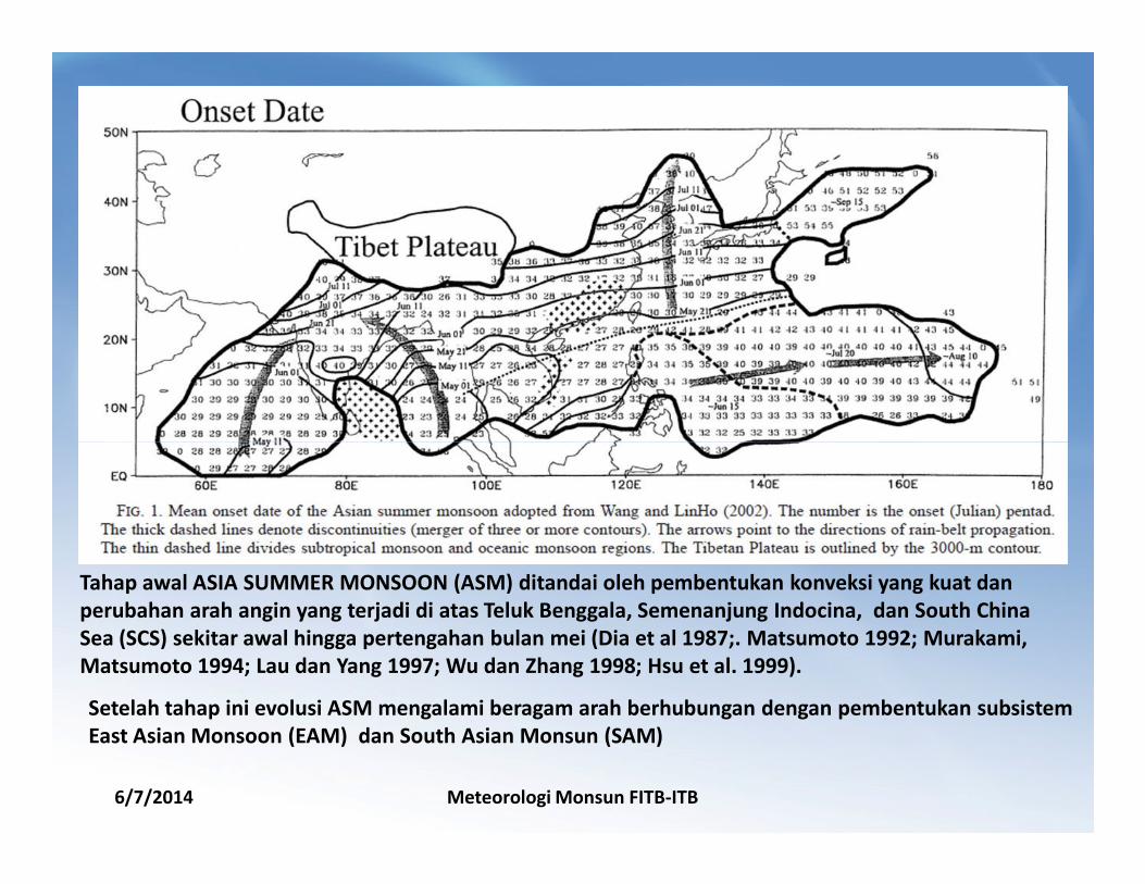
Tahap awal ASIA SUMMER MONSOON (ASM) ditandai oleh pembentukan konveksi yang kuat dan
perubahan arah angin yang terjadi di atas Teluk Benggala, Semenanjung Indocina, dan South China
Sea (SCS) sekitar awal hingga pertengahan bulan mei (Dia et al 1987;. Matsumoto 1992; Murakami,
Matsumoto 1994; Lau dan Yang 1997; Wu dan Zhang 1998; Hsu et al. 1999).
Setelah tahap ini evolusi ASM mengalami beragam arah berhubungan dengan pembentukan subsistem
East Asian Monsoon (EAM) dan South Asian Monsun (SAM)
Tiga cabang arah angin dari sumber yang
berbeda yang mempengaruhi cuaca di
SEMENANJUNG INDOCHINA.
1. The Subtropical westerly from the
Northern Indian subcontinent to the
Indochina Peninsula.
2. The Southeasterly associated with the
subtropical ridge over the western
Pacific
6/7/2014 Meteorologi Monsun FITB-ITB
3. The Westerly over the equatorial
eastern indian ocean, which stretches
northeastward in early May as the
Southwesterly flows.
DATASETS
6/7/2014 Meteorologi Monsun FITB-ITB
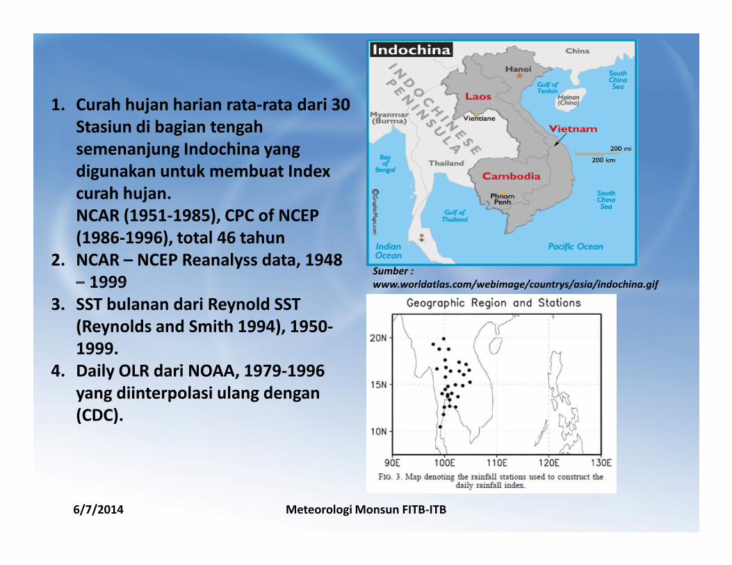
Sumber :
www.worldatlas.com/webimage/countrys/asia/indochina.gif
1. Curah hujan harian rata-rata dari 30
Stasiun di bagian tengah
semenanjung Indochina yang
digunakan untuk membuat Index
curah hujan.
NCAR (1951-1985), CPC of NCEP
(1986-1996), total 46 tahun
2. NCAR – NCEP Reanalyss data, 1948
– 1999
6/7/2014 Meteorologi Monsun FITB-ITB
www.worldatlas.com/webimage/countrys/asia/indochina.gif– 1999
3. SST bulanan dari Reynold SST
(Reynolds and Smith 1994), 1950-
1999.
4. Daily OLR dari NOAA, 1979-1996
yang diinterpolasi ulang dengan
(CDC).

DEFINITION
6/7/2014 Meteorologi Monsun FITB-ITB

Figure 4 displays the 5-day running mean
climatology
of the rainfall index for 46 years. The wet
season over Indochina is identified from early
May to mid-October while the dry season is
from November to late April. The transition
from a dry to a wet season is characterized
by a sudden increase of the daily rainfall from
2 to 6 mm/day sometime from late April to
mid-May.
6/7/2014 Meteorologi Monsun FITB-ITB
Based on the strength and persistence of the rainfall
over Indochina, the onset date for each individual year
is defined as the day on which the 5-day running mean
rainfall index satisfies the following conditions:
1) The amount of the daily rainfall index exceeds 5
mm/day and persists continuously for 5 days;
2) Within the consecutive 20 days, the number of the
days with rainfall greater than 5 mm/day exceeds 10
days.
6/7/2014 Meteorologi Monsun FITB-ITB
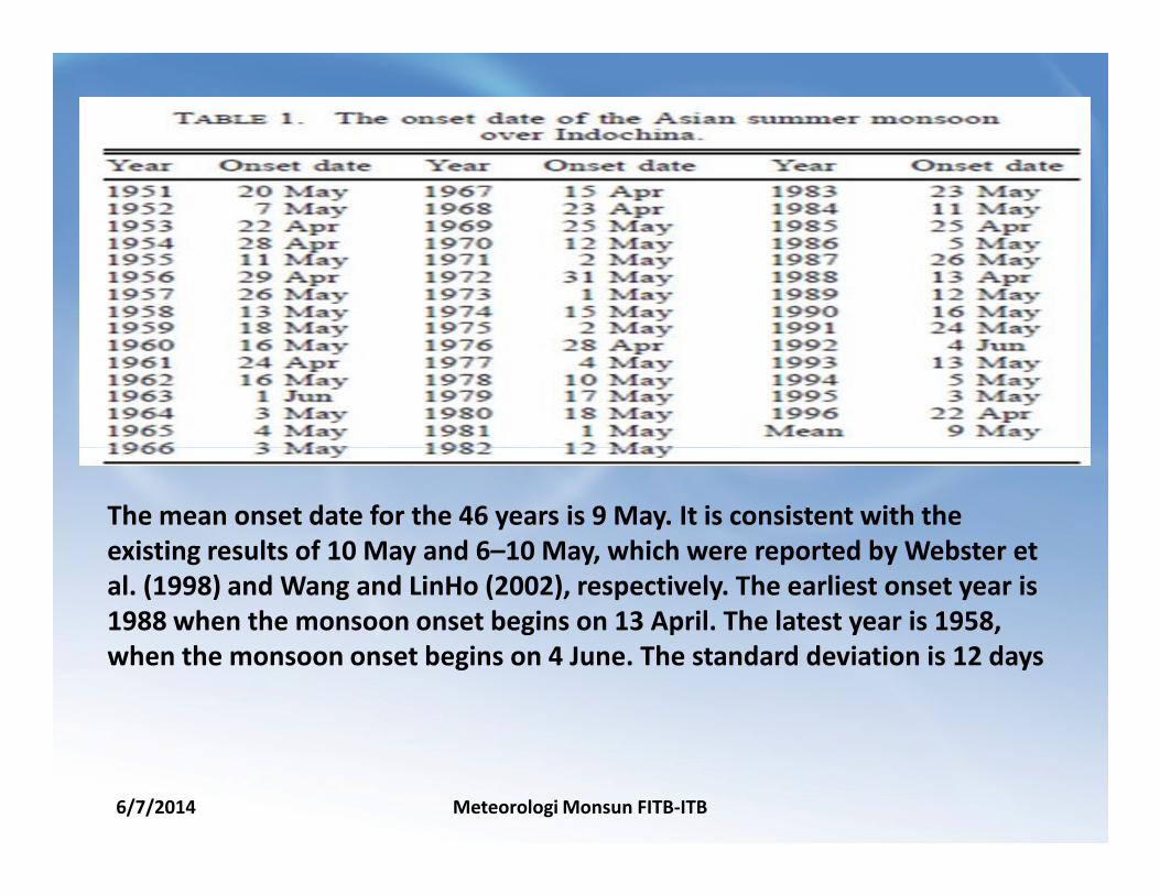
The mean onset date for the 46 years is 9 May. It is consistent with the
existing results of 10 May and 6–10 May, which were reported by Webster et
al. (1998) and Wang and LinHo (2002), respectively. The earliest onset year is
1988 when the monsoon onset begins on 13 April. The latest year is 1958,
when the monsoon onset begins on 4 June. The standard deviation is 12 days

6/7/2014 Meteorologi Monsun FITB-ITB
THE CHANGE OF GENERAL CIRCULATION
ASSOCIATED WITH THE MONSOON ONSET

Berdasarkan data OLR :
H-2 dan H-1 konsentrasi OLR Minimum berada
disekitar diatas Sumatera dan Pasifik bagian
barat. Pada saat ini kondisi di teluk benggala
dan Laut Cina Selatan OLR maksimum.
Pada har “H” OLR minimum konsentrasi
semakin meluas hingga teluk benggala
Pada H+2, konsentrasi OLR semakin meluas
6/7/2014 Meteorologi Monsun FITB-ITB
Pada H+2, konsentrasi OLR semakin meluas
yang menandakan konveksi didaerah tersebut
semakin meluas.
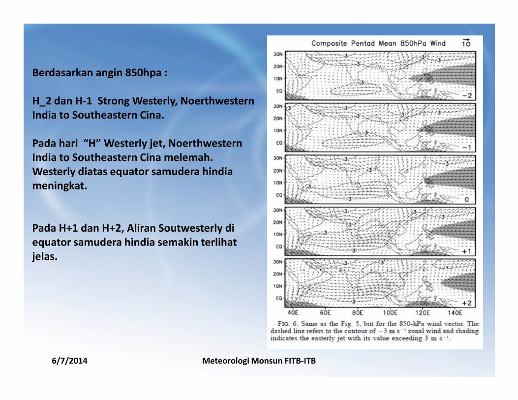
Berdasarkan angin 850hpa :
H_2 dan H-1 Strong Westerly, Noerthwestern
India to Southeastern Cina.
Pada hari “H” Westerly jet, Noerthwestern
India to Southeastern Cina melemah.
Westerly diatas equator samudera hindia
meningkat.
6/7/2014 Meteorologi Monsun FITB-ITB
Pada H+1 dan H+2, Aliran Soutwesterly di
equator samudera hindia semakin terlihat
jelas.
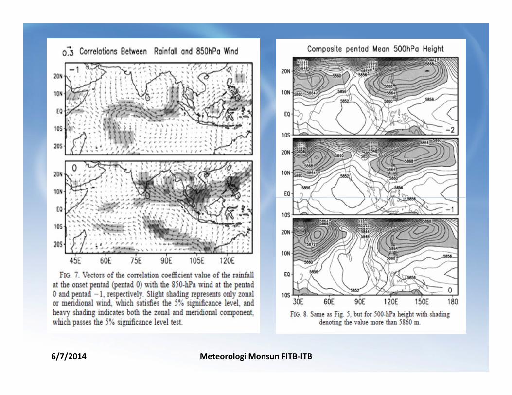
6/7/2014 Meteorologi Monsun FITB-ITB
6/7/2014 Meteorologi Monsun FITB-ITB
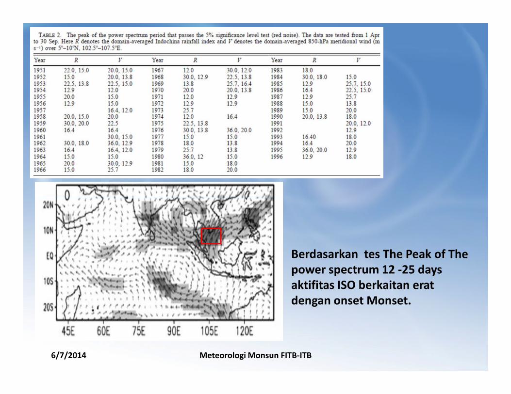
Berdasarkan tes The Peak of The
power spectrum 12 -25 days
aktifitas ISO berkaitan erat
dengan onset Monset.
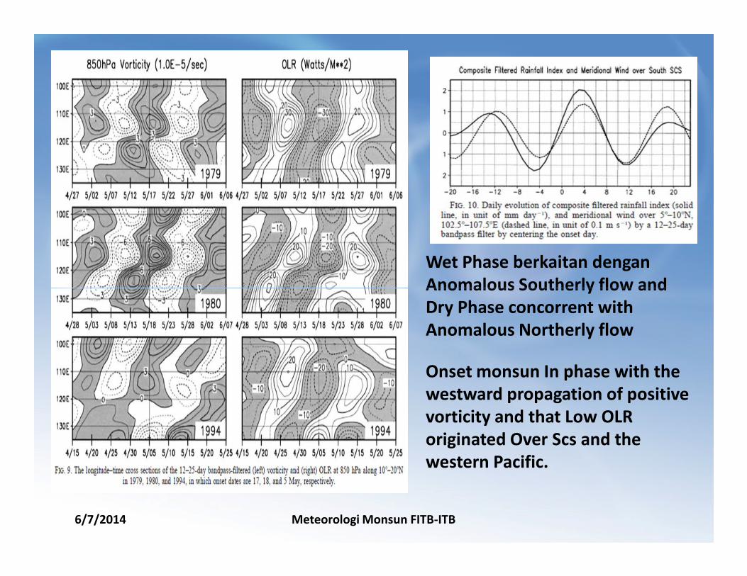
Wet Phase berkaitan dengan
Anomalous Southerly flow and
6/7/2014 Meteorologi Monsun FITB-ITB
Onset monsun In phase with the
westward propagation of positive
vorticity and that Low OLR
originated Over Scs and the
western Pacific.
Anomalous Southerly flow and
Dry Phase concorrent with
Anomalous Northerly flow
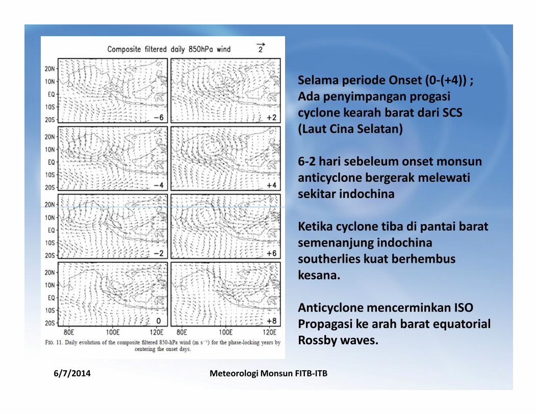
Selama periode Onset (0-(+4)) ;
Ada penyimpangan progasi
cyclone kearah barat dari SCS
(Laut Cina Selatan)
6-2 hari sebeleum onset monsun
anticyclone bergerak melewati
sekitar indochina
6/7/2014 Meteorologi Monsun FITB-ITB
Ketika cyclone tiba di pantai barat
semenanjung indochina
southerlies kuat berhembus
kesana.
Anticyclone mencerminkan ISO
Propagasi ke arah barat equatorial
Rossby waves.
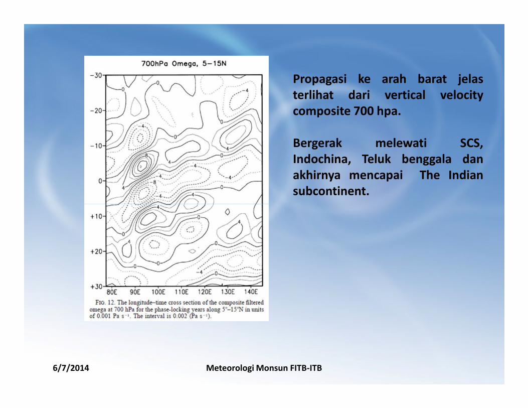
Propagasi ke arah barat jelas
terlihat dari vertical velocity
composite 700 hpa.
Bergerak melewati SCS,
Indochina, Teluk benggala dan
akhirnya mencapai The Indian
subcontinent.
6/7/2014 Meteorologi Monsun FITB-ITB

THE INTERANNUAL VARIABILITY OF
6/7/2014 Meteorologi Monsun FITB-ITB
THE INTERANNUAL VARIABILITY OF
THE MONSOON ONSET OVER INDOCHINA
1
2
6/7/2014 Meteorologi Monsun FITB-ITB
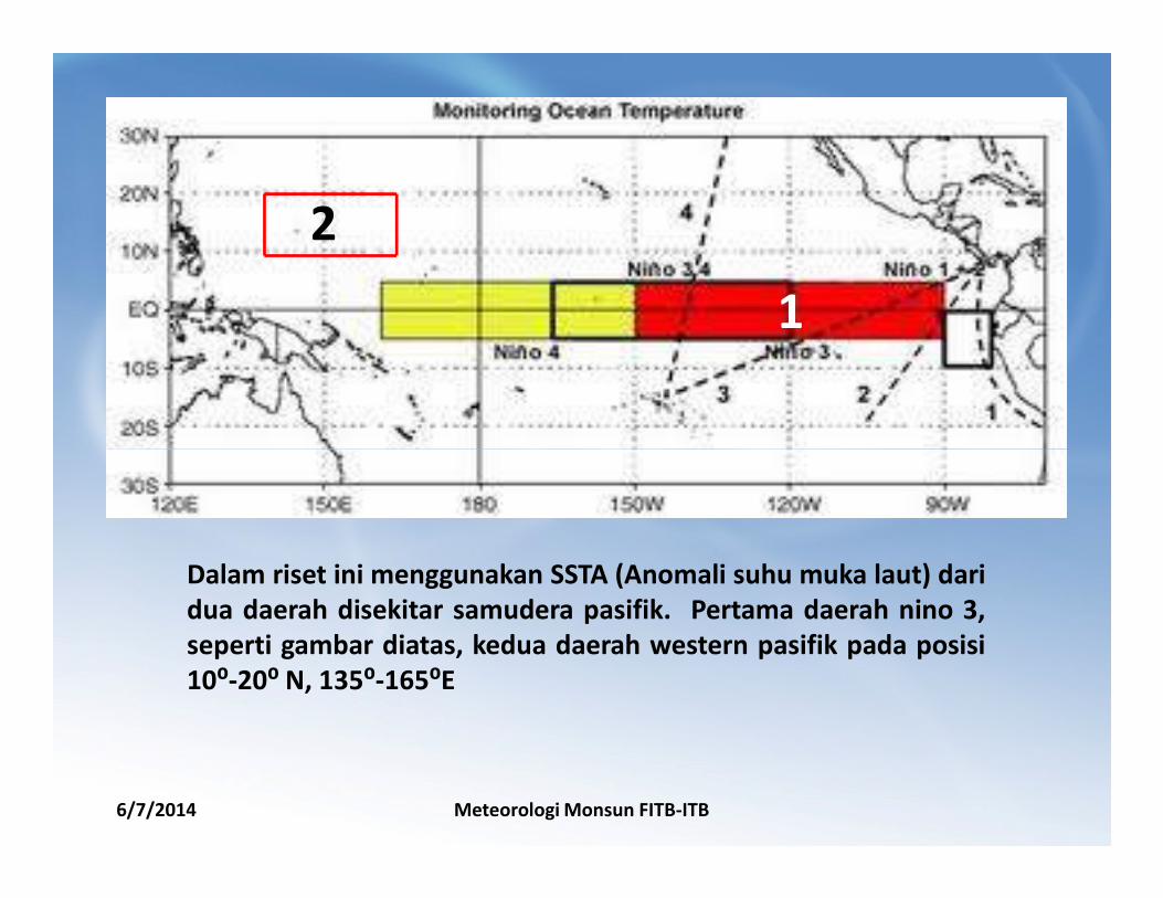
Dalam riset ini menggunakan SSTA (Anomali suhu muka laut) dari
dua daerah disekitar samudera pasifik. Pertama daerah nino 3,
seperti gambar diatas, kedua daerah western pasifik pada posisi
10⁰-20⁰ N, 135⁰-165⁰E
6/7/2014 Meteorologi Monsun FITB-ITB
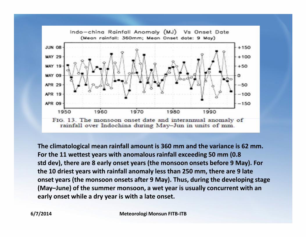
The climatological mean rainfall amount is 360 mm and the variance is 62 mm.
For the 11 wettest years with anomalous rainfall exceeding 50 mm (0.8
std dev), there are 8 early onset years (the monsoon onsets before 9 May). For
the 10 driest years with rainfall anomaly less than 250 mm, there are 9 late
onset years (the monsoon onsets after 9 May). Thus, during the developing stage
(May–June) of the summer monsoon, a wet year is usually concurrent with an
early onset while a dry year is with a late onset.
6/7/2014 Meteorologi Monsun FITB-ITB
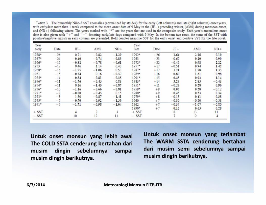
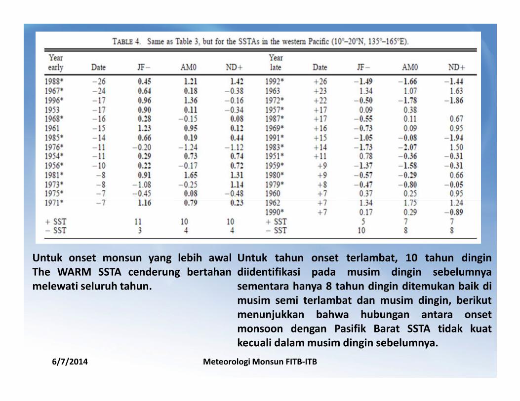
Untuk onset monsun yang lebih awal
The COLD SSTA cenderung bertahan dari
musim dingin sebelumnya sampai
musim dingin berikutnya.
Untuk onset monsun yang terlambat
The WARM SSTA cenderung bertahan
dari musim semi sebelumnya sampai
musim dingin berikutnya.
6/7/2014 Meteorologi Monsun FITB-ITB
Untuk onset monsun yang lebih awal
The WARM SSTA cenderung bertahan
melewati seluruh tahun.
Untuk tahun onset terlambat, 10 tahun dingin
diidentifikasi pada musim dingin sebelumnya
sementara hanya 8 tahun dingin ditemukan baik di
musim semi terlambat dan musim dingin, berikut
menunjukkan bahwa hubungan antara onset
monsoon dengan Pasifik Barat SSTA tidak kuat
kecuali dalam musim dingin sebelumnya.
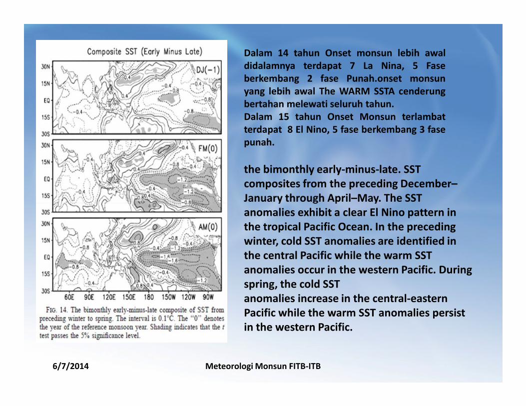
Dalam 14 tahun Onset monsun lebih awal
didalamnya terdapat 7 La Nina, 5 Fase
berkembang 2 fase Punah.onset monsun
yang lebih awal The WARM SSTA cenderung
bertahan melewati seluruh tahun.
Dalam 15 tahun Onset Monsun terlambat
terdapat 8 El Nino, 5 fase berkembang 3 fase
punah.
the bimonthly early-minus-late. SST
composites from the preceding December–
January through April–May. The SST
6/7/2014 Meteorologi Monsun FITB-ITB
January through April–May. The SST
anomalies exhibit a clear El Nino pattern in
the tropical Pacific Ocean. In the preceding
winter, cold SST anomalies are identified in
the central Pacific while the warm SST
anomalies occur in the western Pacific. During
spring, the cold SST
anomalies increase in the central-eastern
Pacific while the warm SST anomalies persist
in the western Pacific.
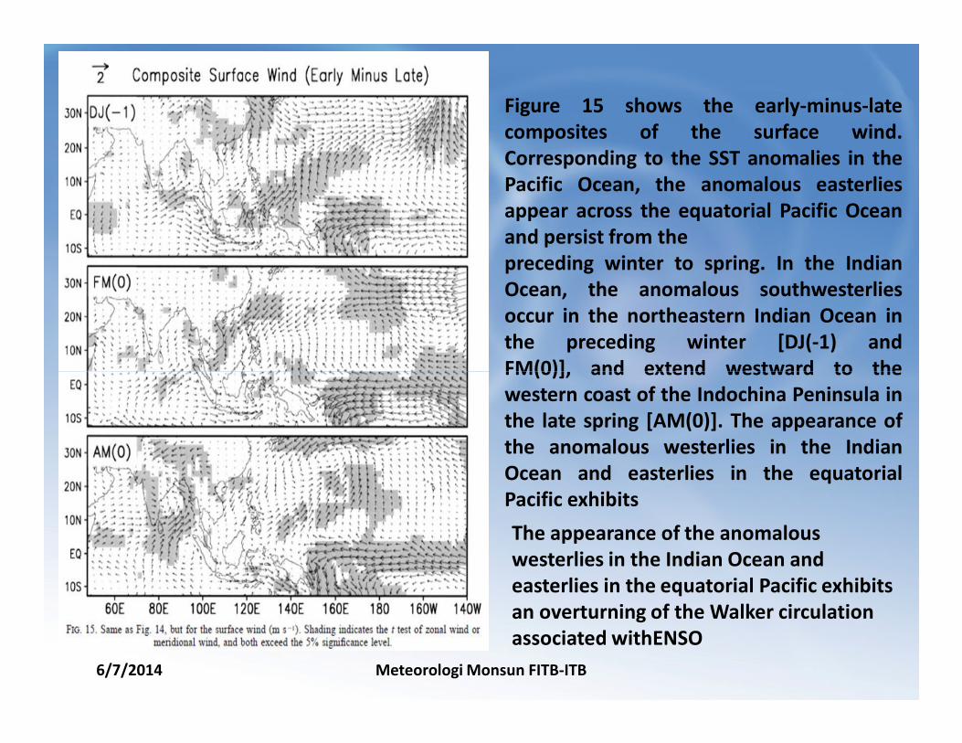
Figure 15 shows the early-minus-late
composites of the surface wind.
Corresponding to the SST anomalies in the
Pacific Ocean, the anomalous easterlies
appear across the equatorial Pacific Ocean
and persist from the
preceding winter to spring. In the Indian
Ocean, the anomalous southwesterlies
occur in the northeastern Indian Ocean in
the preceding winter [DJ(-1) and
FM(0)], and extend westward to the
6/7/2014 Meteorologi Monsun FITB-ITB
FM(0)], and extend westward to the
western coast of the Indochina Peninsula in
the late spring [AM(0)]. The appearance of
the anomalous westerlies in the Indian
Ocean and easterlies in the equatorial
Pacific exhibits
The appearance of the anomalous
westerlies in the Indian Ocean and
easterlies in the equatorial Pacific exhibits
an overturning of the Walker circulation
associated withENSO
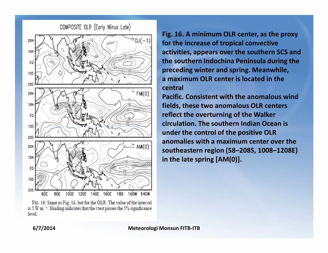
Fig. 16. A minimum OLR center, as the proxy
for the increase of tropical convective
activities, appears over the southern SCS and
the southern Indochina Peninsula during the
preceding winter and spring. Meanwhile,
a maximum OLR center is located in the
central
Pacific. Consistent with the anomalous wind
fields, these two anomalous OLR centers
reflect the overturning of the Walker
circulation. The southern Indian Ocean is
6/7/2014 Meteorologi Monsun FITB-ITB
circulation. The southern Indian Ocean is
under the control of the positive OLR
anomalies with a maximum center over the
southeastern region (58–208S, 1008–1208E)
in the late spring [AM(0)].
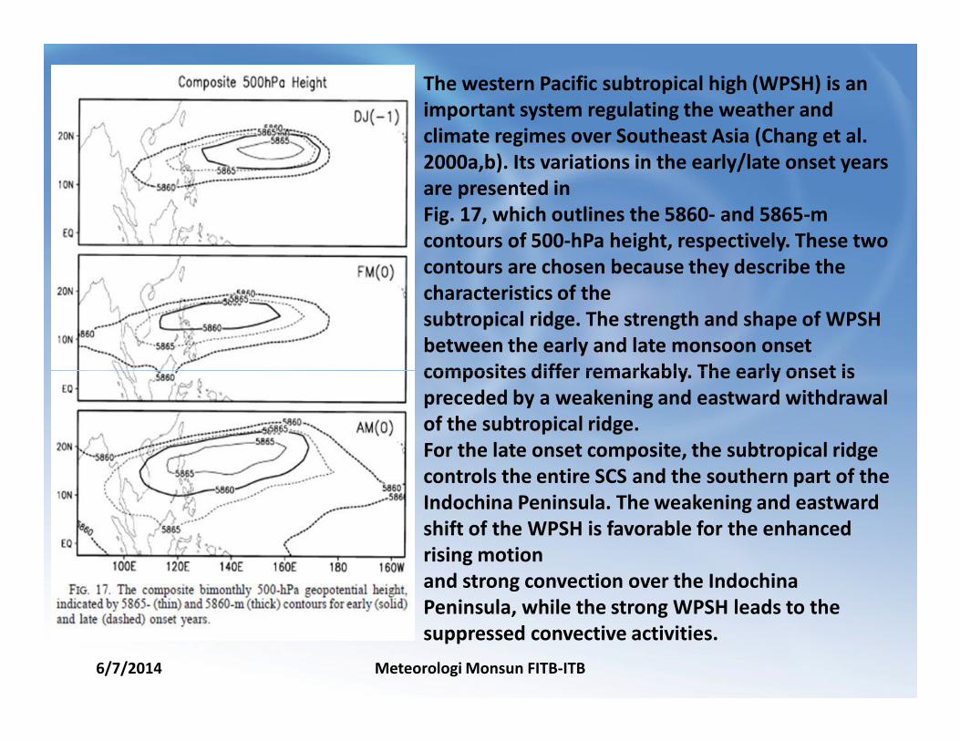
The western Pacific subtropical high (WPSH) is an
important system regulating the weather and
climate regimes over Southeast Asia (Chang et al.
2000a,b). Its variations in the early/late onset years
are presented in
Fig. 17, which outlines the 5860- and 5865-m
contours of 500-hPa height, respectively. These two
contours are chosen because they describe the
characteristics of the
subtropical ridge. The strength and shape of WPSH
between the early and late monsoon onset
composites differ remarkably. The early onset is
6/7/2014 Meteorologi Monsun FITB-ITB
composites differ remarkably. The early onset is
preceded by a weakening and eastward withdrawal
of the subtropical ridge.
For the late onset composite, the subtropical ridge
controls the entire SCS and the southern part of the
Indochina Peninsula. The weakening and eastward
shift of the WPSH is favorable for the enhanced
rising motion
and strong convection over the Indochina
Peninsula, while the strong WPSH leads to the
suppressed convective activities.

CONCLUSIONS
6/7/2014 Meteorologi Monsun FITB-ITB
CONCLUSIONS
1. Berdasarkan Data Klimatologi onset Monsoon di Semenanjung Indochina
tanggal 9 Mei. Onset monset setiap tahunnya sangat bervariasi antara
Pertengah April hingga awal Juni. Onset monsun ditandai dengan meluasnya
konveksi diatas daerah Sumatera hingga menuju utara, pergerakan angin tropis
baratdaya menuju Pantai Barat wilayah Indochina dan intensifikasi INDIA-
BURMA trough di ketinggian 500-hpa.
2. Osilasi intraseasonal (ISO) dengan skala waktu dominan 12 – 25 hari, sangat
berkaitan erat dengan waktu dari Onset Monsoon . Hal ini berasal dari
SCS (Laut Cina Selatan) dan Pasifik barat kemudian menyebar ke arah barat
menuju Semenanjung Indocina.
6/7/2014 Meteorologi Monsun FITB-ITB
menuju Semenanjung Indocina.
3. Ada kaitan yang erat antara awal atau terlambatnya onset monsun dengan
kondisi anomali SST (dingin/hangat) di Perairan Barat Pasifik dan Perairan
Timur tengah Pasifik selama musim semi di Belahan Bumi Utara
4. Berdasarkan Komposit SST Early minus Late, onset monsun lebih awal akibat
pemanasan convektif yang kuat di selatan indochina dan selatan SCS
mendahului musim dingin dan musim semi. Hal ini sangat berkaitan dengan
perubahan sirkulasi Walker dan Sirkulasi Hadley secara lokal.

6/7/2014 Meteorologi Monsun FITB-ITB