OMVG ENERGY PROJECT COUNTRIES: GAMBIA, GUINEA ...
40
1 PROJECT : OMVG ENERGY PROJECT COUNTRIES: GAMBIA, GUINEA, GUINEA-BISSAU, SENEGAL SUMMARY FULL RESETTLEMENT PLAN (FRP) Project Team Project Team Mr. A. B. DIALLO, Chief Energy Engineer, ONEC.1 Mr. P. DJAIGBE, Principal Financial Analyst, ONEC.1/SNFO Mr. K. HASSAMAL, Economist, ONEC.1 Ms. S. MAHIEU, Socio-Economist, ONEC.1 Mrs. S.MAIGA, Procurement Officer, ORPF.1/SNFO Mr. O. OUATTARA, Financial Management Expert, ORPF.2/SNFO Mr. A. AYASI SALAWOU, Legal Consultant, GECL.1 Mr. M. L. KINANE, Principal Environmentalist, ONEC.3 Mr. S. BAIOD, Environmentalist, ONEC.3 Mr. H. P. SANON, Socio-Economist, ONEC.3 Sector Manager: Mr. A. RUGUMBA, Director, ONEC Regional Director: Mr. J. K. LITSE, Acting Director, ORWA Division Manager: Mr. A. ZAKOU, Division Manager, ONEC.1 AFRICAN DEVELOPMENT BANK GROUP
-
Upload
khangminh22 -
Category
Documents
-
view
1 -
download
0
Transcript of OMVG ENERGY PROJECT COUNTRIES: GAMBIA, GUINEA ...

1
PROJECT : OMVG ENERGY PROJECT
COUNTRIES: GAMBIA, GUINEA, GUINEA-BISSAU, SENEGAL
SUMMARY FULL RESETTLEMENT PLAN (FRP)
Project Team
Project Team Mr. A. B. DIALLO, Chief Energy Engineer, ONEC.1
Mr. P. DJAIGBE, Principal Financial Analyst, ONEC.1/SNFO
Mr. K. HASSAMAL, Economist, ONEC.1
Ms. S. MAHIEU, Socio-Economist, ONEC.1
Mrs. S.MAIGA, Procurement Officer, ORPF.1/SNFO
Mr. O. OUATTARA, Financial Management Expert,
ORPF.2/SNFO
Mr. A. AYASI SALAWOU, Legal Consultant, GECL.1
Mr. M. L. KINANE, Principal Environmentalist, ONEC.3
Mr. S. BAIOD, Environmentalist, ONEC.3
Mr. H. P. SANON, Socio-Economist, ONEC.3
Sector Manager: Mr. A. RUGUMBA, Director, ONEC
Regional Director: Mr. J. K. LITSE, Acting Director, ORWA
Division Manager: Mr. A. ZAKOU, Division Manager, ONEC.1
AFRICAN DEVELOPMENT
BANK GROUP

2
SUMMARY FULL RESETTLEMENT PLAN (FRP)
Project Name: OMVG ENERGY PROJECT Project No.: PZ1-FAO-018
Countries: GAMBIA, GUINEA, GUINEA-BISSAU, SENEGAL
Department : ONEC Division: ONEC1
INTRODUCTION
The Gambia River Basin Development Organization Energy Project (OMVG Energy Project)
involves the following four countries: Gambia, Guinea, Guinea-Bissau and Senegal. This sub-
regional organization is the executing agency for integrated development programmes in the
region, and focuses particularly on the rational management of the joint resources of Rivers
Gambia, Kayanga-Géba and Koliba-Corubal, whose basins have power-generating potential.
At the request of the authorities of the above-mentioned four countries, the African
Development Bank will support the implementation of the OMVG Energy Project under co-
financing arrangements with AFD, the World Bank, EIB, IsDB, KFW and the States concerned.
From the environmental and social perspective, the project is classified in Category 1, taking
into consideration the nature of the works to be undertaken, the size and scope of the project,
as well as its potential direct and indirect impacts.
The implementation of the OMVG Energy Project entails the expropriation, in the public
interest, of buildings, farmland, crops, trees and non-residential buildings. It will also result in
loss of income-generating activities.
Therefore, in accordance with the African Development Bank's policy on involuntary
displacement, the Governments of Gambia, Guinea, Guinea-Bissau and Senegal have
developed a Full Resettlement Plan (FRP) for the compensation and resettlement of project-
affected persons (PAPs). Its objectives are to: (i) minimize involuntary displacement as much
as possible; (ii) avoid the destruction of property where possible; and (iii) compensate affected
persons for the loss of residential plots, farmland, buildings and equipment, as well as the loss
of income.
The four countries have decided to entrust the project implementation to OMVG, their joint
executing agency, and also to adopt common provisions enabling them to present the project's
resettlement plan as a single document, while highlighting the specificities of each country.
OMVG will be responsible for the implementation.

3
I. DESCRIPTION OF THE PROJECT AND ITS IMPACT AREA
I.1 Project Description
The overall goal of the OMVG Energy Project is to contribute to the socio-economic
development of the member countries of the organization by increasing the populations' access
to electricity. It aims to enable energy trade and improve the quality of electricity supply in
OMVG member countries by providing renewable and clean energy at a competitive cost. The
main outcomes of the project include: increased access to electricity, expansion of the power
trade system, and creation of a regional electricity market. The use of water resources will also
significantly reduce the consumption of fossil fuels and, by the same token, reduce greenhouse
gas emissions.
The project components are as follows:
Components Description
Electricity Production Construction of the Sambangalou Hydroelectric Plant (128 MW, 402 GWh/year) in
Senegal on River Gambia.
Electricity
Interconnection
Construction of: (i) a 1 677 km-long loop and a 225 kV power transmission line
interconnecting the four countries; (ii) fifteen (15) sub-stations for injecting power into
national grids; and (iii) a dispatching centre for the management of power flows.
Institutional Support Project management assistance, capacity building
Project Management Operation of the Project Management Unit (PMU), works control and supervision,
management of environmental and social impacts, and project audit.
The pre-construction and construction activities of the Sambangalou hydroelectric plant are
expected to last four years, with the filling and commissioning scheduled for 2017 and end-
2018 respectively.
I.2 Project Impact Area
SAMBANGALOU HYDROELECTRIC DEVELOPMENT
The Sambangalou hydroelectric plant is located on River Gambia in Senegal, a few kilometres
north of the border with Guinea and 18 km south of Kédougou. Access on the left bank is from
Kédougou, upstream from Bandafassi and Yamoussa, that is, a total distance of 31 km.
The dam's reservoir will have an area of 181 km² and a volume is 3.8 billion m3, of which nearly
half is useful, and the scheme will straddle Senegal (20%) and Guinea (80%). Sambangalou
village, from which the site derives its name, is in the immediate vicinity of the latter.
In Guinea, the area affected by the plant is exclusively concentrated in Mali Prefecture, which
has a population of 211 130 inhabitants, of whom 172 321 are rural residents. The Sub-
Prefectures of Balaki (7 426 inhabitants), Salambandé (12 000 inhabitants), Lébékéré and Mali
Urban Commune are the administrative units in whose jurisdictions are located the villages and
sectors covered by the studies on the Sambangalou hydroelectric plant.
In Senegal, the reservoir and the area where the structures are located fall within Fongolombi
and Bandafassi Sub-Prefectures, in Kedougou Department. The population of the Department
is estimated at 78 806 people, of whom 21 86 reside in Bandafassi Sub-Prefecture and 13 450
in Fongolombi District.

4
The structures, service facilities, worksite installations facilities and access to the site are all
located in Senegal, through which supplies and equipment will be routed. A 7 metre-wide and
24 km-long earth road will be constructed from Kédougou, on the right bank of the river, largely
covering the Kedougou-Bara local road. The proposed road will include a crossing on the
Gambia at Kédougou in the form of a floating bridge about 175 m long. This bridge, like the
access road, will be open to normal traffic. The road will link the contractor's temporary site
accommodation and that of OMVG, the power plant and crest of the dam. The access road to
the Sambangalou sub-station will be built on the left bank, thus facilitating access to Tépéré
Diantou.
The impact area is dominated by the forest environment, especially the wetlands bordering the
River Gambia up to its mouth.
The description of the human environment is based on the administrative units affected by the
project. Thus, from the Sambangalou reservoir to the sea, the administrative units affected by
the Sambangalou hydroelectric plant are:
Country Major Territorial Units
Right Bank Left Bank
Guinea Labé Region
Mali Prefecture
Senegal Kédougou and Tambacounda Regions
Tambacounda, Kédougou and
Kolda Regions
Vélingara Department (very little)
Gambia
Upper River Division
Upper River Division (Basse Santa Su)
Central River Division North (Janjanbureh)
North Bank Division (Kerewan)
Upper River Division (Basse Santa Su)
Central River Division South (Janjanbureh)
Lower River Division (Mansakonko)
Western Division (Brikama)
Source: COTECO, 2004
Map showing the location of Sambangalou and the interconnection

5
INTERCONNETION LINE
The 1 677 km-long interconnection line crosses the four OMVG countries: Guinea, Senegal,
Gambia and Guinea-Bissau. The interconnection will supply the four member countries with
power generated by Sambangalou and Kaleta facilities and other power plants in the
OMVG/ECOWAS zones.
The population of the interconnection study area is estimated at 3 347 303 inhabitants, shared
between Guinea (1 850 078 inhab.), Senegal (989 187 inhab.), Gambia (308 906 inhab.) and
Guinea-Bissau (199 132 inhab.). Most of the project-affected persons live in rural areas on
agricultural, livestock and handicraft production.
In Senegal
The projected transmission line in Senegal will cross Tambacounda, Kaolack and Kolda
Regions. Specifically, in each of these regions, it will cross the departments, urban communes,
districts and rural communities (CR) presented in the table below:
REGION DEPARTMENT DISTRICT RURAL
COMMUNITY/COMMUNE
TAMBACOUNDA
Kédougou
Bandafassi
Bandafassi
Tomboronkoto
Tambacounda
Koumpentoum
Bamba Ndiayene
Koumpentoum
Maleme Niani
Koussanar Koussanar
Sinthiou Malene
Maka Coulibatang
Ndoga Babacar
Missirah
Dialakoto
Missirah
Netteboulou
KAOLACK
Kaffrine
Birkilane
Birkilane
Mabo
Ndiognick
Maka Yop (Koungheul)
Ida Mouride
Maka Yop
Saly Escale
Maleme
Kahi
Maleme Hoddar
Nganda Kathiotte
Nioro du Rip
Médina Sabakh
Kayemor
Médina Sabakh
Ngayene
KOLDA
Sédhiou
Bounkiling Diaroumé
Ndiamacouta
Diende Sakar
Tanaff
Karantaba
Simbandi-Brassou
Tanaff
Source: Administrative map of Senegal
It should be noted that in all the regions, only a tiny part of the territory will be affected by the
project. The identified districts and rural communities allow for better tracking of the power
transmission corridor in each region.

6
In Guinea
The transmission line crosses two major natural regions from north to south, known as Lower
Guinea and Middle Guinea. These major regions include various administrative regions and
prefectures partially affected by the transmission line. For the purposes of this analysis, the
prefectures taken into consideration are those with a relatively large part of the territory affected
by the project. The administrative regions and prefectures considered are shown in the table
below:
AREA REGION PREFECTURE
MIDDLE GUINEA (MOYENNE GUINÉE)
Labé Mali
Labé
Mamou
Pita
Mamou
Dalaba
LOWER GUINEA (BASSE GUINÉE)
Kindia Kindia
Dubréka
Boké
Bofa
Fria
Boké
Source: Administrative Map of Guinea.
In Guinea Bissau
The power transmission line will pass through three provinces in Guinea-Bissau, namely the
Northern, Eastern and Southern Provinces. In the provinces, the project will affect Oio, Bafatá
and Tombali Regions respectively. More specifically, in each of these regions, the transmission
line will cross the sectors shown in the table below. The transmission line will end at the point
of entry into the Bissau Autonomous Sector (BAS).
PROVINCE REGION SECTOR
NORTH Oio
Farim
Bissora
Mansaba
Mansoa
Nhacra
EAST Bafatá
Bambadinca
Xitole
SOUTH Tombali Quebo
BISSAU Bissau Bissau Source: Administrative Map of Guinea-Bissau.
In Gambia
The power transmission line will pass through three divisions in Gambia, namely the Western,
Lower River and North Shore Divisions. These divisions correspond to the local government
regions of Brikama, Mansakonko and Kerewan respectively. Within these divisions, the line
will cross the 11 districts identified in the table below:
7
DIVISION DISTRICT
WESTERN
Kombo Central
Kombo East
Kombo South
Foni Brefet
Foni Bintang-Karenai
Foni Kansala
Foni Bondali
Foni Jarrol
LOWER RIVER
Kiang Central
Kiang East
Kiang West
Jarra West
NORTH BANK Upper Baddibu
Source: Administrative Map of Gambia.
II. POTENTIAL IMPACTS
SAMBANGALOU HYDROELECTRIC PLANT
During the construction phase, the major negative impacts on the human environment concern
the displacement of the communities of the reservoir area, implications for the health of these
communities and the workers, loss of farmland and lack of means of crossing the river in the
dry season.
For the Guinean portion of the reservoir, which will cover an area of 149 km², a population of
about 1,130 people will be moved from 8 villages of Mali Prefecture (Labé Region). Regarding
the Senegalese portion spanning an area of 32 km², a population of about 200 people will need
to be moved from 3 villages in Fongolembi and Bandafassi Departments (Kédougou Region).
As for the construction of the 24 km-long access road in Kédougou on the right bank of the
river and a floating bridge on the Gambia in Kédougou, it will entail the displacement of about
106 people.
Impacts concerning the displacement of communities are as follows:
- Loss of productive land (farmland and pasture);
- Potential loss of income for displaced persons;
- Loss of public goods, cultural and religious heritage;
- Potential loss of social identity and social dislocation;
- Disruption of the activities of the displaced men and women and host communities;
- Lack of natural resources in the vicinity of host sites;
- Exclusion of vulnerable persons from the project benefits;
- Potential increase in the workload of women and children; and
- Potential psycho-social trauma (loss of sense of belonging and/or feeling of insecurity).
The following risks were identified:

8
- Potential losses for women relating to the compensation criteria and/or mechanisms if the
right of use is not taken into account in the compensation process and if the access of
women and heirs to land is limited;
- The main risks faced are: the possible inability of local authorities and institutions to
manage resettlement and development activities;
- Risk of food shortage and increased malnutrition; and
- Potential insecurity during the displacement and resettlement process.
During the operational phase, the negative impacts of the Sambangalou project will relate to
health, especially in terms of water-borne diseases, as well as to accidents and drowning,
decreased fishing yields downstream of the dam and loss of natural resources used by the
communities.
Moreover, the adoption of environmental and social management measures and the
development of the communities created by the dam construction should result in a number of
positive impacts: improvement in the living conditions of the displaced population;
improvement in the accessibility of the project area; creation of job opportunities and
improvement in incomes; development of fishing; creation of farmland; improvement in
infrastructure and creation of new services.
INTERCONNECTION LINE
Regarding the interconnection line, at the current stage, the final route has not been determined
precisely. The area reserved for the installation of the line avoids the most sensitive sites, and
will be helpful in determining a final route entailing very little or no physical displacement.
For now, no survey has yet been conducted to identify and record losses. However, loss
assessment was established from analysis of satellite images produced on scale of 1:700 000,
making it possible to identify the major classes of land use. The corridor of the interconnection
line mainly runs through agricultural areas where there are no buildings or large trees.
In order to reduce the negative impacts to the strict minimum, the following measures are
envisaged: (i) In the savannah or very thinly wooded zone, the right-of-way of the 225-kV
single-circuit and double-circuit lines is 40 m wide; (ii) In the wooded zone, after pylon
distribution, if required, the width of the right-of-way will be adjusted to minimize the felling
of trees, while providing a safety clearance that meets the installation and maintenance
requirements (revised from 40 m to 30 m and even 20 m); (iii) For each of the 15 sub-stations,
an area of 250 m x 300 m was provided within which the sub-station will be built. This area
constitutes a right-of-way reserved exclusively for the electrical equipment of the sub-station,
complemented by a buffer zone.
On this basis and at this stage, the identified residual impacts are as follows:
- On the biophysical environment, the only identified impacts, requiring environmental
monitoring, is the deforestation in classified forests. The planned compensation measure
is the implementation of reforestation within these highly classified forests. For other
elements of the natural environment, those affected by the project are not particularly
sensitive to the passage of a power line and those that could be have been avoided
(national parks, for example) or are protected by appropriate measures (wetlands);

9
- On the human environment, the impacts mainly concern the farming areas whose surface
area under the line is estimated at around 2 000 ha. During the construction phase, the
damage to the soil will lead to partial or total crop losses for some households. During the
operational phase, the permanent loss of farmland will be limited to areas under pylons or
occupied by sub-stations, and those destroyed by the construction of permanent access
roads.
The exact identification of the various types of losses will be conducted concurrently with the
implementation studies of the selected companies, according to the following stages: (i) issue
of decrees relating to declaration of public interest (DUP) - May 2015; (ii) implementation
study – as from June 2015; (iii) evaluation of assets based on field surveys – as from June 2015;
and (iv) indemnification and compensation – as from July 2015.
III. ORGANIZATIONAL RESPONSIBILITY
The organizational responsibility for implementation of environmental and social measures of
the power project involves four categories of players: the contracting authority; the contractor;
and the operators and administration of the States responsible for environmental and social
safeguards. The table below shows the composition of the agencies involved in the
implementation of the resettlement plan (RP) and the environmental and social management
plan (ESMP).
Agency Internal Organization Role
Gambia River Basin
Development
Organization
(OMVG)
- Executive Secretariat responsible for supervising
the power project and ensuring overall socio-
environmental coordination
- Department of Studies, Planning and
Infrastructure
- Department of Agriculture
- Administrative and Financial Department
- Project owner
- Supervision of PMU through
monitoring of its performance
contract
- Approval of RP and ESMP
programmes and budgets
Project Management
Unit (PMU)
- An Environmental Unit
- A Technical Management Unit
- An Administrative and Financial Management
Unit
- Based in Dakar
- Day-to-day monitoring of
implementation of RP and ESMP
measures
- Coordination, planning and
proper implementation of project
components
- Monitoring-evaluation and
control of activities
- Administrative, financial and
accounting management
- Support to OMVG for launching
of competitive bidding and
contract awards
- Secretariat of the Project
Monitoring Advisory Committee
(CCS).

10
Monitoring Advisory
Committee (CCS)
- Actors involved in the project: NGOs, experts,
ministries, public agencies, technical and
financial partners, etc.
- Actors.
- Participatory and consultative role
- Coordination, focus and monitoring of
project activities
Technical Assistance
for Project Owner
(ATMO)
- International recruitment
- Based in Dakar
- Contribution to establishment of PMU and
building of its monitoring-evaluation
capacity.
National Monitoring
Committees (CNS)
- Chaired by the Head of the National OMVG Unit
- Ministry in charge of Energy
- Ministry for the Interior
- Ministry in charge of Local Government
- Ministry in charge of Finance
- Ministry in charge of the Environment
- Ministry in charge of Agriculture
- Ministry in charge of Lands
- National Electricity Corporation
- Project Team (permanent staff): a team leader, an
officer in charge of relations with government
services/communication, an accountant, a
Secretariat
- Monitoring and supervision of field
activities
- Administrative facilitation
- Monitoring and implementation of
environmental and social aspects
Local Coordination
and Monitoring
Committees (CLCS)
- Permanent staff: a facilitator, a communication
officer, a secretariat, and an assistant accountant
- Other participants, according to the problems:
representatives of project-affected persons,
representatives of local authorities,
representatives of government services,
development projects, private institutions and
NGOs, and Territorial Administration
- Relationship between the project and the
local population
- Management of disputes and complaints
- Monitoring of implementation of
development measures
- Monitoring the population’s acceptance of
the measures implemented: compensation,
indemnification, resettlement, consultation,
information, advocacy, and dispute
management
Engineering
Consultant (IC)
- Technical engineers
- Officer in charge of environmental and social
issues
- Offer in charge of hygiene and safety
- Field inspectors
- Control, supervision and monitoring of the
construction of the interconnection and
Sambangalou structures
- OMVG representation in dealings with
contractors
Operators - Private institutions and NGOs
- Entrepreneurs
- Consulting Firms
- Local population (farmer cooperatives,
associations, etc.)
- Implementation of measures to mitigate
negative impacts, as well as enhancement
measures
State Services - Services responsible for environmental and
social monitoring of projects
- Other services depending on the issues at stake
- Monitoring of proper implementation of the
ESMP and RP

11
IV. COMMUNITY PATICIPATION / PUBLIC CONSULTATION
SAMBAGALOU HYDROELECTRIC PLANT
The people were consulted as part of feasibility studies in 2002 and throughout the conduct of
environmental and social assessment from November 2005 to February 2006 and during the
update of the environmental documentation in August 2014. These consultations were
complemented by those held between December 2014 and February 2015, which included the
residents of host villages. There has been little change in the people’s expectations and concerns
over this period:
The expectations of the local population are: access to electricity; employment opportunities at
the site; opening of roads and improvement of the area’s accessibility; construction of local
schools offering complete primary cycle to enable children to study with ease; construction and
equipment of health posts for easy access to health care; construction of boreholes for drinking
water; poverty reduction; development of fishing; and development of new activities.
The concerns of the local population are: loss of farmland; loss of homes; displacement and
resettlement of people; loss of socio-economic infrastructure; fears about the compensation and
resettlement process, especially among people who had anticipated their displacement, and
consequences of the delayed start-up of the project; fear of not having enough clean water once
resettled; fear of not being adequately compensated and not being able to maintain the same
standard of living; and impacts on the natural environment.
The consultations also helped to identify the population’s preferred options regarding
compensation and indemnification.
They were also helpful in clarifying the choice of resettlement sites. The main options discussed
focused on the following points: (i) Compensation conditions; (ii) Building type; (iii) Spatial
organization of villages; (iv) Resettlement sites; and (v) Compensation for sacred sites.
The project-affected persons (PAPs) consulted agreed that the loss of land (residential plots and
farmland) incurred due to the filling of the reservoir should be compensated for, preferably in
kind; however, the possibility of receiving compensation in cash will be considered if the
situation so warrants (e.g. total change of activity or place of living).
From the results of the technical studies for the final selection, host sites will finally be selected
after consultation with representatives of the affected communities. These are the sites that will
be presented to PAPs to enable them to select their resettlement site.

12
During the construction phase, the following arrangements will be made to inform people:
ACTIVITIES PROJECTED
PERIOD
SCOPE
Establishment of information points within Local Coordination and
Monitoring Committees (CLCS)
July 2015 Local
Circulation of copies of the environmental and social documentation
within the CLCS
July 2015 National / regional / local
Update of the environmental and social (E&S) documentation based
on individual public surveys of PAPs
July 2015 International / national /
regional / local
Announcement in the national press and local audio-visual media
concerning the start of the compensation process and population
displacement
August 2015 National / regional / local
Local radio/TV broadcasts on the start of works and the procedure for
getting access to the jobs created by the site
September 2015 National / regional / local
Nationwide dissemination and online posting of monitoring reports of
the E&S expert panel in charge of monitoring the construction of the
dam and power transmission line
2015, 2016, 2017, 2018 International / national /
regional / local
Periodic consultation of the population, on an informed basis,
regarding the implementation of E&S measures of the Resettlement
Action Plan (RAP) and ESMP
2015, 2016, 2017, 2018 Regional / local
Consultations will continue once the population is displaced to ensure that resettlement is
carried out under satisfactory conditions and that the support measures actually help to improve
living conditions. The monitoring arrangements are as follows: conduct of socio-economic
surveys, and communication activities targeting the population. These activities will be
complemented by the establishment of a mechanism for managing complaints and monitoring
indicators related to the socio-economic situation of the area.
INTERCONNECTION LINE
At the completion of the feasibility and ESIA study, institutional consultations were conducted
by COTECO Firm.
Under the partial land investigations conducted in 2014 for sub-stations, consultations were
held with PAPs in the presence of local authorities. The challenges of the project, its impacts
and the principles adopted in respect of compensation and indemnification were presented to
the local population. Overall, they welcomed the project, but had a major concern regarding the
terms of payment of compensations.
Provisions similar to those relating to the Sambangalou scheme will also be adopted for the
study on the construction of the interconnection line.
It should be noted that the World Bank, which is co-financing only the interconnection line,
published the environmental and social document on its website in 2014.
(http://www.worldbank.org/projects/P146830?lang=en).
13
V. INTEGRATION WITH HOST COMMUNITIES
SAMBAGALOU HYDROELECTRIC PLANT
To facilitate full integration with host communities, the following measures will be taken: (i)
Consultation with host villages; (ii) Compensation of host villages; (iii) Implementation of a
development programme.
Consultation with host villages is underway. There have been several informal discussions
between the displaced and villages hosts. To validate the agreements between villages, the
discussions will be formalized under the supervision of the local authority and will be contained
in a document signed by the three parties. The main concern centred on conflict prevention. In
that regard, an agreement would be formally established between the villages containing at least
the following information: demarcation of the areas provided to the displaced population, terms
of use of space and any pooled infrastructure, and measures for compensating the host
population.
The compensation of host villages for public goods was assessed with the aim of pooling
infrastructure with these villages. Precise identification of the needs of host communities is also
underway and will eventually help to adjust the proposed compensation for public goods.
Depending on the distances and type of relationships that the villages will forge, infrastructure
could be pooled or otherwise.
Development measures are an essential component of integration with host communities.
Significant differences may appear in terms of the quality of the habitat. However, it is
important to ensure that socio-economic development is uniform throughout the area hosting
the displaced villages.
The measures could be considered as a development project with various components aimed at:
- supporting development planning (one measure);
- ensuring economic development based on sustainable management of natural resources (10
measures); and
- ensuring socio-cultural development (2 measures).
As regards the Sambangalou project, the key development measures are as follows:
- Local development planning: the measures proposed by the Sambangalou project must
comply with the Local Development Plan (PDL), or be integrated with the PDL after
validation by Rural Communities (CR) and Rural Development Committees (CRD). Since
the Sambangalou project will profoundly change the local context, it is advisable to have
the PDL assessed accordingly so that local authorities may have up-to-date planning
documents;
- Agro-sylvo-pastoral development: The purpose of this measure is to encourage the practice
of sedentary agriculture instead of shifting cultivation by improving subsistence farming
through crop diversification and promotion of fruit-tree planting and agroforestry on the
deep soils of hillsides;
- Improvement of family agriculture: The aim of this measure is to improve rain-fed crop
yields and thus increase production on areas equivalent to those currently cultivated;

14
- Perennial crops and plantations: This development programme is designed to restore, as
much as possible, production and income derived from fruit growing, forest
plantations/nurseries and forest-product gathering;
- Action research in agriculture: The goal of this development programme is to gradually
build sustainable production systems for key activities in the project area: rain-fed cropping
on hillsides and forest exploitation. At the end of the support provided to the resettled
communities, they will have adopted and mastered such techniques as the practice of short-
term fallowing and agroforestry;
- Improvement of family livestock production: The programme seeks to increase incomes
through small livestock rearing (small ruminants and poultry), which may thus compensate
for the loss of income related to other activities also practised by women; and
- Generation of farm-related incomes: The objective of this programme is to capitalize on the
new market opportunities and help maintain and increase family incomes by expanding and
improving post-harvest activities, at both family and group levels.
- Improvement of fishing as a secondary activity: This programme aims to develop fisheries
resources created by the future reservoir. It will include support for the purchase of nets and
plank canoes - a measure desired by fishermen met on the site - training of village neophytes
and establishment of rules governing fishing activities on the lake;
- Development of handicraft and support for reconversion: This programme aims to support
craftsmen in the study area who use antiquated techniques and risk being superseded by the
better equipped and better trained immigrant craftsmen, in a context where the inflow of
development support, immigration and construction programmes will lead to increased
demand for services and products;
- Maintaining social harmony: The development activities envisaged under the resettlement
plan (RP) require the building of producers' capacities in terms of organization into
groupings, reading, writing and numeracy for adults, through a functional literacy
programme;
- Human capacity building: The aim of this programme is to maintain, as much as possible,
intra-family, intra-community and inter-community harmony during the displacement
despite immigrant influences;
- Strengthening of rural services: This programme aims to support input supply, marketing
and microfinance;
- Land security: The formal security of land tenure rights, as well as those of land use, is a
prerequisite for ensuring sustainable management of natural resources throughout the sub-
region.

15
VI. SOCIO-ECONOMIC STUDIES ON AFFECTED PERSONS
SAMBAGALOU HYDROELECTRIC PLANT
The population density in the area around the proposed dam is low. The 10 villages that need
to be moved have a total population of 1 436 people, including 733 women, grouped in 180
households. The 10 villages subject to displacement and resettlement are:
Sambangalou/Niambara; Néoudou; Diaré; Parabanta, Moussouly Koto, Missira, Tiéwiré,
Souléré, Tembouguidaré, and Doundounk Saara. The distribution of households per village is
presented in the table below.
Population and Households
Co
un
tr
y Department/
Prefecture
District/ Sub-
Prefecture
Villages and Hamlets Number of
Households Population Name
Sen
ega
l Kédougou
Fongolembi Sambangalou /
Niambara 22 141
Bandafassi Néoudou
24 193
Gu
inea
Mali
Balaki
Diaré 11 98
Parabanta 10 72
Moussouly Koto 7 27
Lébékéré Missira 24 234
Mali-Centre
Tiéwiré 46 348
Souléré 13 100
Tembouguidaré 12 99
Doundou Saara 11 124
Total 180 1 436
Generally, the population is increasing. In some villages, however, the number of households
has declined, especially in Sambangalou and Niambara where part of the population anticipated
the resettlement and moved to other villages.
The population of the displaced villages is young, with youths under 20 accounting for 60% of
the total. The Peulhs make up the main ethnic group; the villages are generally mono-ethnic.
Among the displaced villages, Missira stands out with a population essentially composed of the
Mandingo, Sarakholé and Djakhanké ethnic groups.
The level of education is low and the illiteracy rate stands at 90% for men and 98% among
women. The main causes of morbidity are malaria and acute respiratory infections.
The household head is usually a man and one in two households is polygamous.
There are no indigenous or minority populations in the dam's impact area; however, several
households are considered vulnerable.
Households considered vulnerable were identified on the basis of the following criteria: Female
heads of household; heads of households aged over 60; people with disabilities; and people with
chronic illnesses. Based on these criteria, 55 vulnerable households were identified,
representing 31% of the total number of households. The table below shows the number of
households per village, distinguishing three levels of vulnerability depending on the cumulative
criteria:
16
VILLAGES Female heads of
household
Heads of
household aged
over 60 years
old
Persons with
disabilities
Persons chronic
illness
TOTAL
TOTAL 21 24 10 0 55
To control the project impacts on the vulnerable population, the following measures will be
implemented: (i) specific provisions adopted during the consultations identified vulnerable
households and will be monitored specifically by dedicated staff; (ii) material assistance
(provision of a vehicle) to move displaced persons who cannot afford to move on their own;
(iii) a one-time food assistance during the resettlement period; (iv) a one-time cash assistance
during this period to allow mainly for the hiring of labour to perform some physical work; and
(v) facilitate access to medical care.
In the 10 villages to be displaced, there are a total of 506 residential houses, 345 toilets /
showers, 218 kitchens, 101 animal pens, 113 chicken coops, 150 barns and other fixed
structures such as warehouses, latrines, tombs, wells, entrance enclosures and ovens. In most
cases, the houses are built of mud-bricks, banco (a mixture of mud and straw) and straw. The
other buildings are also constructed with traditional materials.
The average cultivated area per household is 4.47 ha. Lowland farming accounts for 12% of
cultivated areas, and was identified in 5 of the 10 villages.
The area of farmland available to the resettled villagers was also estimated based on the
population census survey. The needs in terms of fallow land in the study area were estimated at
three times the area used for slash-and-burn farming.
Surface areas of village farmland in the reservoir area
Village / Hamlet
Farmland (ha)
Slash-and-burn
Farming
Lowland
Farming TOTAL
TOTAL 707.6 96.6 804.2
Source: Population census for the reservoir area, MSA / Oréade-Brèche, August 2014.
The main crops grown in the area are, in order of importance, groundnuts, maize, fonio, millet
and rice.
Regarding farmland situated on the layout of the access road, it is estimated that about 2.5 ha
of farmland and its crops will be lost, requiring compensation. This preliminary assessment will
be validated during the update of the land ownership statement. The affected farmland extends
from National Road 7 (RN 7) to the planned bridge on the river, with few farmland areas located
just south of this bridge.
The total number of identified trees is about 5 000.
Public infrastructure is limited in the villages listed. In the whole area, there are only four
schools, one health hut, nine water points, seven mosques, and 10 cemeteries
(exhumation/burial). The communication lines are poorly developed, and the villages are not
easily accessible.
The main activity in the area of the future reservoir is agriculture. Overall, land is available and
the area is vast and sparsely populated. Most of the land is managed on a community basis,
17
according to customary law. Stockbreeding is a form of savings on-the-hoof. In addition, it
serves a function and the animals are also used for animal traction and their dung as manure in
tapades. Forest product gathering is relatively widespread and more particularly concerns néré
(monkey bread), shea and non-food products. The other activities (fishing, hunting, trade and
handicraft) are less developed.
Very wide income disparities are observable depending on the households and activities
considered. The average annual household income is estimated at CFAF 872 257, which
corresponds to an average per capita income of CFAF 109 336. The highest annual income per
household is about CFAF 19 million and the lowest is equal to CFAF 7 500.
LINE INTERCONNECTION
From an initial analysis of satellite images, a rough assessment was made of farmland and
pastures that will be affected, requiring replacement with other land or monetary compensation.
It was estimated that about 30% of the transmission line will cross farmlands. Given that the
total length of agricultural or pastoral land crossed by the line is estimated at 510 km and that
the right-of-way is 40 metres wide, the total agricultural land taken up by the right-of-way
stands at 2 040 ha. To this should be added the areas taken up by the construction of access
roads which, like those lost to the transmission line, will be calculated as the work progresses.
Regarding the sub-stations, land investigations were conducted in 2008 and updated in August
2014. The investigations identified the affected agricultural plots and houses, and made an
initial assessment of compensation. Of all the affected persons identified, only one had a land
title (Bissau sub-station).
Structures were also identified within the right-of-way of a number of sub-stations, but these
were only individual property, residential houses for the most part.
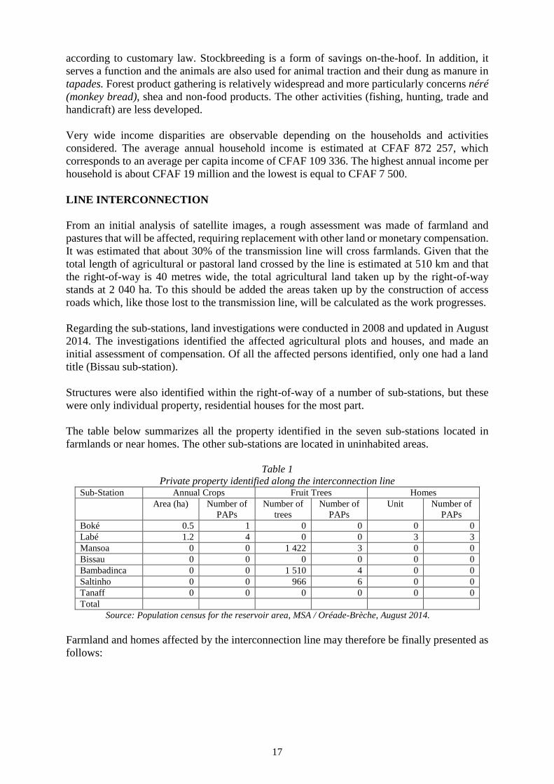
The table below summarizes all the property identified in the seven sub-stations located in
farmlands or near homes. The other sub-stations are located in uninhabited areas.
Table 1
Private property identified along the interconnection line Sub-Station Annual Crops Fruit Trees Homes
Area (ha) Number of
PAPs
Number of
trees
Number of
PAPs
Unit Number of
PAPs
Boké 0.5 1 0 0 0 0
Labé 1.2 4 0 0 3 3
Mansoa 0 0 1 422 3 0 0
Bissau 0 0 0 0 0 0
Bambadinca 0 0 1 510 4 0 0
Saltinho 0 0 966 6 0 0
Tanaff 0 0 0 0 0 0
Total
Source: Population census for the reservoir area, MSA / Oréade-Brèche, August 2014.
Farmland and homes affected by the interconnection line may therefore be finally presented as
follows:

18
Under the line
o 6.52 hectares of farmland and grazing land lost permanently under the pylons;
o 2 040 ha of farmland and grazing land within the right-of-way of lines and between
the pylons. These areas might possibly be subject to loss of agricultural
income if construction works clash with cropping calendars;
o Fruit trees.
- Under the sub-stations
o 1.7 ha of cultivated farmland lost permanently under the sub-stations;
o 3 households with homes that will be identified during implementation studies;
o Plantations of fruit trees, particularly cashew trees.
As regards land for compensation, the permanent loss of 8.22 ha of farmland and grazing land
may therefore be envisaged, requiring compensation in kind.
Land loss due to the construction of access roads is also to be expected. However, at this stage
of the project, nothing is known about the location, number or length of the access roads. On
the other hand, as regards compensation for land ownership, it is very likely that those using
land affected by access roads have no official title deeds. Therefore, no monetary compensation
is envisaged for the replacement of land affected by access roads. However, the lost land will
be replaced by other pieces of land, probably State-owned land requiring no expropriation and
for which no costs would be incurred.

19
VII. LEGAL FRAMEWORK, INCLUDING DISPUTE RESOLUTION AND
APPEAL MECHANISMS
The legal framework consists of key environmental and social legal provisions enacted by the
Governments of Guinea, Senegal, Gambia and Guinea-Bissau. It also comprises applicable
international conventions to which the three countries have acceded.
IN GAMBIA: State Land Regulations define the rules governing the allocation of State
lands for agricultural purposes, and provisions relating to the demarcation and management of
forest areas, “green belts” and “buffer zones”. The right to property is protected by Section 22
of Chapter 4 on the Protection of Fundamental Rights and Freedoms of the Constitution of the
Second Republic of Gambia, which was adopted on 8 August 1996, entered into force in
January 1997, and whose last amendment dates from 2001. When this right is violated under
the conditions provided by the legislation in force, the Land Acquisition and Compensation Act
(1990) and the State Lands Act (1990) constitute the legal framework for population
resettlement.
IN GUINEA: The Code on Private and State-owned Land determines the rules of land
acquisition by private persons and determines State-owned land and land belonging to other
public entities. It also specifies the terms and conditions for human rights protection,
particularly by organizing the process for land registration and the registration of rights in rem.
The new Federal Code on Private and State-owned Land provides that, besides the State, other
natural and legal persons may hold property rights on land and the buildings erected thereon.
The Code on Private and State-owned Land provides precisely for the case of restriction of
property ownership rights. Thus, restrictions on property ownership rights will stem from: (i)
expropriation for public purposes; and (ii) establishment of public easements. The system of
expropriation in the public interest is also defined by the Code on Private and State-owned
Land. The provisions are relatively conventional. Expropriation is subject to fair compensation
paid in advance by mutual agreement and, failing this, by court decision. The expropriation
procedure occurs in three phases: (i) administrative: investigation; declaration of public utility;
deed of transferability; notification; identification of tenants and property rights holders; etc.);
(ii) amicable; and (iii) possibly judicial. The timeframe for the conduct of the expropriation is
always indicated and may not exceed three years.
IN GUINEA-BISSAU: The resettlement framework in Guinea-Bissau is provided by
Lei da Terra No. 5/98 (Law No. 5/98 of 23 April 1998). This law defines the legal framework
for expropriation and compensation in Guinea-Bissau. It enshrines customary rights to land-use
with a number of innovations. Under this law, the State may expropriate for reason of public
welfare. Expropriation is carried out under the conditions provided by the Lei da Terra, and
compensation is based on the market value principle with no allowance for depreciation. This
law provides also for the establishment of land commissions to ensure implementation of this
law and coordination between the various levels of intervention in land-use.
Guinea-Bissau's land law is in line with international standards in almost every respect. The
major difference between national legislation and international standards is the legal obligation
of economic rehabilitation. Thus, even though the legal framework for expropriation and
rehabilitation is based on Guinea-Bissau's legislation, the higher of the two standards will apply
in the event of discrepancies, since the higher standard automatically meets the requirements of
the other standard.

20
IN SENEGAL: Senegal’s Constitution of 7 January 2001 (Article 15) guarantees the
right to property ownership. In this country, land tenure regulation is based on Law No. 64-46
of 17 June 1964 organizing the management of the landed property sector. Land is divided into
three categories: (i) national land, which consists of land that is not classified in the public
domain, not registered or whose ownership has not been recorded with the Deeds Registration
Office; (ii) State land, which comprises public and private lands, refers the State's rights in and
ownership of movable and immovable property; (iii) private land refers to land registered in the
name of private individuals.
Regulations on expropriation in the public interest are based on Law No. 76.67 of 2 July 1976
and Implementation Decree No. 77.563 of 3 July 1997. Law No. 76-67 defines the expropriation
procedure by which the State may, in the public interest and subject to fair and prior
compensation, as well as in accordance with the Constitution of 7 January 2001, constrain any
person to surrender ownership of privately owned moveable or immoveable property. This law
constitutes the legal basis of displacement and compensation procedures. The usual procedure
for expropriation in the public interest comprises: (i) an administrative phase (investigation,
declaration of public interest, transferability statement and conciliation) which may, failing an
amicable agreement, lead to: (ii) a judicial phase during which the transfer of ownership is
decided by the judicial authority concurrently with the compensation amount. Despite the
absence of a displacement and compensation policy framework, it must be acknowledged that
in Senegal there are mechanisms for the resettlement of communities, particularly in terms of
restructuring and land regularization.
AFRICAN DEVELOPMENT BANK (AfDB) POLICIES ON INVOLUNTARY
DISPLACEMENT OF PEOPLE: Operational safeguard 2 - involuntary resettlement concerns
AfDB-financed projects that cause involuntary resettlement of people. It results in: (i)
Relocation or loss of shelter by people residing in the project-impact area; (ii) Loss of assets
(including loss of structures and assets of cultural, spiritual, and other social importance) or
restriction of access to assets, including national parks and protected areas or natural resources;
and (iii) Loss of income sources or means of livelihood as a result of the project, whether or not
the people affected are required to move. The specific objectives of this Operational Safeguard
are to:
- Avoid involuntary resettlement where feasible, or minimize resettlement
impacts where involuntary resettlement is deemed unavoidable after all
alternative project designs have been explored;
- Ensure that displaced persons are meaningfully consulted and given
opportunities to participate in the planning and implementation of resettlement
programmes;
- Ensure that displaced persons receive significant resettlement assistance under
the project, so that their standards of living, income-earning capacity, production
levels and overall means of livelihood are improved beyond pre-project levels;
- Provide explicit guidance to borrowers on the conditions that need to be fulfilled
regarding involuntary resettlement issues in Bank operations to mitigate the
negative impacts of displacement and resettlement, actively facilitate social
development and establish a sustainable economy and society; and
- Guard against poorly prepared and implemented resettlement plans by setting up
a mechanism for monitoring the performance of involuntary resettlement
programmes in Bank operations and remedying problems as they arise.

21
CONSISTENCY BETWEEN THE LEGAL FRAMEWORK OF THE FOUR
COUNTRIES AND AfDB PROCEDURES: The main points on which AfDB policies require
going beyond the national regulations of the four countries concerned are:
- Priority of compensation in kind over cash compensation, especially for land
where the “land-for-land” option should be preferred where feasible;
- Compensation for full replacement value, where cash compensation is to be
applied (fruit trees and houses);
- Support for the restoration of income and livelihoods (farming, fishing,
stockbreeding, forest product gathering, handicraft);
- Compensation for commercial and handicraft activities;
- Participation of affected persons in the entire resettlement process; and
- Monitoring and evaluation, including support measures (training, technical
support, subsidized loans, etc.).
MANAGEMENT OF COMPLAINTS AND DISPUTES: In practice, complaints and
conflicts that arise during the implementation of a resettlement and compensation programme
may be the following: errors in property identification and assessment; disagreement over land
boundaries either between the affected persons and the expropriation agency or between two
neighbours; conflict over property ownership (two or more affected persons claiming
ownership of the same property); disagreement on the assessment of a plot of land or other
property; inheritance, divorce and other family issues, resulting in conflicts between heirs or
members of the same family, over the ownership or partial ownership of a given property;
disagreement on resettlement measures, for example, the type of proposed housing or the
characteristics of the resettlement plot.
In addressing complaints, preference could be given to the following extra-judicial channels:
(i) additional explanations (e.g. explain in detail how the project calculated the complainant's
compensation and show that the same rules apply to all); (ii) arbitration, involving elders or
persons respected in the community, while being from outside community.
Each affected person, while obviously maintaining the option of seeking redress before the
courts of his/her country, could appeal to this mechanism, which will comprise two main steps:
(i) registration of the complaint or dispute by the project manager; and (ii) amicable settlement
with the help of mediators independent from the project.
The project will use National Monitoring Committees (CNS), as well as Local Coordination
and Monitoring Committees (CLCS) also responsible for conflict management and mediation
in population displacement.

22
After a complaint has been registered, the complainant(s) will be summoned to appear before
the Mediation Committee, which will attempt to propose a solution acceptable to both parties.
If necessary, additional meetings will be organized and the Committee may appoint one of its
members to continue the arbitration in a less formal setting than the monthly meetings. If no
agreement is reached, the parties may resort to the courts. To facilitate access by PAPs to the
legal process, the expropriation judge will sit in the chief-town of the Department or Prefecture
where the complainant resides. The PMU will assist vulnerable PAPs in order to facilitate their
access to legal services on a prop bono basis with the help of NGOs. Furthermore, the settlement
of a dispute cannot delay the displacement of a community as that would unduly slow the
project implementation process. It is therefore envisaged that if a dispute goes to court and the
latter cannot hand down its decision prior to the displacement date, the affected person who
appealed his/her case will be compensated according to the decision of the expropriations judge,
but that an adjustment will be made after the displacement if the court so decides.
VIII. INSTITUTIONAL FRAMEWOK
The institutional framework for implementation of the resettlement plan consists of OMVG,
the Delegated Project Manager, and the Government service responsible for environmental and
social monitoring.
The current OMVG team is enough to meet the needs of the activities of the study phase.
Significant capacity building initiatives have been scheduled to provide OMVG with the staff
and material resources required for implementation of the project. These capacity building
initiatives are as follows:
- Establishment of a Project Management Unit (PMU): The PMU environmental
team, in addition to the technical assistant responsible for the environmental unit,
will include four country counterparts (an environmentalist, two resettlement
experts and a monitoring and evaluation expert);
- Establishment of a National Monitoring Committee (CNS) in each member
country. The CNS will include the key Ministries involved in project
implementation in the country and national electricity companies. They will
have a dedicated project team reporting directly to the head of the national unit;
- Establishment of Local Coordination and Monitoring Committees (LCMC) at
local level. They will consist of the following staff: a facilitator and a part-time
secretary, a communication officer and a full-time administrative/accounting
officer.
Although the OMVG Council of Ministers decided to entrust the management to the Project
Management Unit (PMU) located within this four-nation regional body, OMVG will work
closely with the competent services of these four countries:
IN GAMBIA: Gambia's institutional mechanism on expropriation is managed
by the Ministry of Local Government and Lands. This body is supported by the
Ministry of Natural Resources and the Environment, the Ministry of Agriculture
and Local Government (Divisional Headquarters; District Headquarters, and
Village Committees). Depending on the needs, other entities may be mobilized.

23
IN GUINEA: Guinea's institutional mechanism on expropriation is under the
responsibility of the Ministry of Urban Development and Housing. It is
supported by the Ministry of Environment, Water and Forests, the Ministry of
Agriculture and Livestock, and the Local Government (Rural Development
Communities - CRD). Other structures may be mobilized as required.
IN GUINEA-BISSAU: Guinea Bissau's institutional arrangements on
expropriation fall under the responsibility of the Ministry of Social Equipment.
This Ministry is supported by the Ministry for the Interior, the Ministry of
Environment, the Ministry of Agriculture, Forestry and Livestock, and the
Ministry of Natural Resources and Energy (MNRE). Other State or non-State
actors may be mobilized as required.
SENEGAL: Senegal’s institutional arrangements on expropriation fall under the
Ministry of the Economy and Finance (MEF) responsible for Land Management
and Enforcement of procedures for expropriation in the public interest (ECUP)
and the terms and conditions for compensation under Law No. 76-67 of 2 July
1976. The Ministry is supported by the Ministry of the Environment and Nature
Protection, the Ministry of Mines and Energy, and the Ministry of Territorial
Development and Town Planning. Other entities may be mobilized as required.
All these stakeholders will need to be strengthen through training and logistical support.
IX. ELIGIBILITY
Persons affected by the Sambangalou plant and the interconnection line may be individuals,
households or communities. Furthermore, among the affected persons, there are people
considered vulnerable who need to be given special attention.
Given that the legislations of Guinea, Senegal, Gambia and Guinea-Bissau recognize formal
ownership (with title deed) and customary ownership, any affected person who owns land
(legally or customarily) is considered eligible for compensation.
The resettlement arrangements laid down by AfDB Operational Safeguard 2 (OS2) are taken
into account by the project.
The deadline for compensation eligibility for the Sambangalou plant is at the end of the period
of census of affected persons and their property in the study area conducted in August 2014 by
the consultant. Beyond that date, the occupancy and/or use of land or resource affected by the
project may no longer be subject to compensation. This date has been clearly indicated to the
local population who, through traditional authorities, may help check opportunistic
installations. After the census, the people were told that new investments would not be taken
into account, but that they should, however, continue their activities until displacement.
Regarding the interconnection, the eligibility deadline will be at completion of the
implementation study leading to the identification and census of affected persons on the route
finally adopted, that is to say, June 2015.

24
X. ASSESSMENT AND COMPENSATION FOR LOSSES
SAMBAGALOU HYDROELECTRIC PLANT
COMPENSATION PRINCIPLES AND PROCESS
PAPs will be compensated in cash, in kind and/or in the form of assistance as shown in the table
below. The payment of compensation will be managed by OMVG, which will harmonize the
approach for the four member countries. Indeed, during the conduct of the environmental and
social assessment, the member countries decided to standardize the procedure at regional level.
This decision was formalized in a correspondence that the Ministers of the member countries
addressed to OMVG.
The following table summarizes the proposed arrangements:
Impact Eligibility Right to Compensation or Resettlement
Compensation for property and investment (land, structures and buildings)
Loss of titled land Be the holder of a valid and
registered property title deed
Resettlement on a similar plot, that is to say, having the same
dimensions and operating potential and reimbursement of expenses
related to the establishment of the land title deed. Or
Compensation in cash for the plot at full replacement value, where
material constraints do not allow for compensation in kind.
Loss of arable and
cultivated untitled
land
Be the recognized occupant of
arable and cultivated land
(recognized by customary chiefs,
notables and neighbours).
Customary “owners” are considered
to be occupying land in good faith,
and are eligible for the measures
described in the section opposite.
No monetary compensation for the plot.
Recognized occupants of arable and cultivated land are eligible for
resettlement. They will be offered a resettlement option, comprising:
• Replacement of the buildings found on such land, if applicable
(see below);
• Replacement of agricultural plots by equivalent land with
agricultural potential located within an acceptable distance
from the residence of the person concerned.
Developments carried out on land are eligible for compensation at
full replacement value (for example, clearing, irrigation canals, wells,
dykes, tillage of soil, etc.), or replacement on a resettlement plot.
Loss of
uncultivated land
- Village communities
- Stockbreeders
- Compensation at community level, see section on “Natural
Resources and Bushes”
- Support to find new pastures and new transhumance corridors,
support for the intensification of stockbreeding.
Loss of building Case 1: Resident owner recognized
as owner by neighbours.
Compensation for the building at full replacement value (market
value if it is possible to reach a settlement for such a building, plus
relocation allowances). OR
Resettlement in a building of equivalent or superior characteristics,
and surface, plus relocation allowances.
Case 2: Non-resident owner
recognized as owner by neighbours.
Compensation for the building at full replacement value (market
value if it is possible to reach a settlement for such a building).
Case 3: Tenant, recognized as tenant
by neighbours.
Compensation for moving cost, including: (i) expenses incurred for
renting a similar house (three-month rent deposit); and (ii) moving
allowances.

25
Compensation for Loss of Income Sources
Loss of crops Be recognized by neighbours and
local authorities as having farmed
the crops
Perennial crops: Compensation at full replacement value of the crops
in question (taking into consideration the value of the plants, the work
required to re-cultivate the crops, and the loss of income during the
period necessary to re-cultivate the crops at market value).
Annual crops: If the crops are destroyed before they can be harvested,
compensation will be paid for the equivalent of a rice crop or the
corresponding current value.
Trees that do not generate income, except through the sale of
firewood: compensation will be granted by providing seedlings and
paying for the planting work.
Loss of business or
handicraft activity
Be recognized by neighbours and
the authorities as the operator of the
activity
Compensation for loss of income incurred for a six-month period for
handicraft, and three months for trading (periods deemed necessary
to re-establish the activity on another site), plus support for
adaptation to new sites.
Change in working
conditions
Mainly the case with fishermen and
gatherers and, to a lesser extent,
stockbreeders
Structural support (training, credit) during the training period and
repayment of credit contracted for these professionals to adapt to
their new environment, plus compensation for loss of income over a
six-month period (the period considered necessary for their
adaptation).
Employment
disruption
Be an employee of a business
affected by the relocation.
Temporary indemnities for the transition period corresponding to the
moving and reconstruction period.
Natural resources
and bushes lost
Anyone recognized as deriving
income directly from the lost
resource
Funding of replacement projects for lost natural resources most
commonly used by the affected persons (medicinal plants and roots,
etc.).
Displacement Indemnities
Relocation Be resident and eligible for
resettlement.
Support for the cost of moving, preferably in kind (provision of a
vehicle to transport personal belongings).
Other Forms of Assistance
Increased
vulnerability
Vulnerable persons Assistance Fund established at CFAF 150 000 per vulnerable person
(guaranteed minimum agricultural wage over a period of five
months); the Fund will be used for micro-project development to help
these people to maintain, if not improve, their living conditions
ASSESSMENT AND COMPENSATION FOR GOODS AND INCOME
a) Collective Goods
Public goods for replacement will be fully rebuilt respecting existing dimensions and national
sector-based policies. Existing social infrastructure will also be rehabilitated. The cost of
replacing all existing collective goods in the localities to be displaced is estimated at CFAF 958
647 000 (EUR 1 463 583).
b) Loss of land
Loss of land (residential and agricultural land) incurred due to the impoundment of the reservoir
will be compensated for, preferably in kind. PAPs consulted expressed their support for this
approach, although the opportunity to receive compensation in cash will be considered if the
situation so warrants (e.g. total change of activity or place of residence). There is no provision
for financial compensation for title deeds held by PAPs nor for compensation for land on host
sites because: (i) no title deed was recorded in the area; (ii) the host sites will most likely be
located on State land, available at no cost. If it becomes necessary to expropriate PAPs with
title deeds, the funds will be derived from the contingency funds of the project to offset the cost
of establishing the title deeds. Funds are also provided for the development of host sites.

26
c) Land Preparation Costs in Rural Areas
Farmland offered in compensation has never been cultivated before. In fact, according to the
analysis of satellite imagery and the land-use map, land located in peripheral areas that has been
identified as potentially available land for compensation has never been developed.
Accordingly, owners who will receive the said land in compensation will first make them
suitable for cultivation. It is estimated that clearing, grubbing and levelling the land will require
about 20 days of work per hectare received, representing CFAF 28 800 per ha at the minimum
agricultural wage rate (CFAF 1 440 / hour). Moreover, the agricultural potential will be
evaluated when selecting resettlement sites.
At the dam site, the plan is to give in compensation 804 hectares of farmland and pasture land
located in peripheral areas. Assuming that all this land will be prepared for farming or grazing,
the total land preparation cost will amount to CFAF 23 155 200.
d) Loss and Replacement of Compounds, Buildings and Private Equipment
Built structures owned by individuals concern fences around compounds/tapades, and buildings
and equipment found in inhabited compounds/tapades or which are on property outside these
compounds/tapades that will also be flooded.
Although animal fences and enclosures identified in the 10 displaced villages consist primarily
of wood or straw, the proposal is to offer PAPs the choice of replacement material. The
calculation of the compensation budget was based on the price of iron wire mesh fences, which
is the highest, so that this type of fence may be built around all compounds if the demand is
widespread.
The replacement cost of all fences around compounds/tapades identified stands at CFAF 222
420 000.
Residential huts, mainly built of banco, (a mixture of mud and straw) will be replaced by houses
made of durable materials (cement blocks, metal sheets and concrete floor). Compensation for
buildings will be based on their actual dimensions, established during the census update.
Moreover, all kitchens will be compensated for in durable building materials, while
warehouses, entrance enclosures and barns will be compensated in banco.
Furthermore, in addition to compensating for identified buildings and fixed equipment, the plan
is to provide an improved oven to each identified household and build an improved latrine and
cemented bathroom in each compound/tapade, and even for those that are not currently
equipped with such facilities.
The total cost of replacing fixed buildings and equipment owned by the identified households
stands at CFAF 2 424 935 000.
e) Loss and Compensation for Trees
There is no organized plantation in the reservoir area. Fruit trees are generally isolated in
compounds/tapades, village areas, fields or in natural formations, with little or no maintenance.
As for trees used for gathering purposes, they are found throughout the area.
27
With regard to compensation, any fruit or “gathering” tree lost will be replaced with a young
plant. As for lost production, fruit trees will be treated differently from “gathering” trees.
Indeed, only the lost fruit trees will be compensated for since it is estimated that the natural
resources surrounding reception areas will be able to provide the lost forest products upon
resettlement.
Thus, initially, compensation for lost products is established by estimating the average market
value of the production of a fruit tree based on the average production in the study area.
Secondly, this value is applied over the period of time required for a new plant to become
productive.
Overall, compensation for loss of trees is estimated at CFAF 106 497 000.
f) Loss of Income by Farmer Owners
Temporary reduction in the income of land-owning farmers may result from the loss of market-
garden or rain-fed crops following impoundment of the reservoir and from lower agricultural
yields for the first year of harvest on the new land.
Compensation will be provided by crop type, depending on the average yield per crop and
average prices in the reservoir area.
The total expected compensation for the loss of rain-fed and market garden crop production for
a year in the reservoir area stands at CFAF 242 511 889.
Furthermore, the construction of the access road will lead to the loss of a total of 2.5 ha of land.
The future land ownership report will help identify in detail the affected areas, existing crops
and the owners and affected farmers. For budget requirements, an average amount of CFAF
301 000 per hectare (CFAF 242 511 889 for 804 ha) is earmarked for such compensation.
The total expected compensation for loss of agricultural land due to the construction of the
access road will stand at CFAF 663 600.
Overall, the compensation for crop losses stands at CFAF 243 175 479.
g) Loss of Income by Persons Employed in Non-Agricultural Sectors:
Several types of incomes are considered under compensation for loss of income:
- Agricultural income that is likely to be lost for an entire year: Compensation is
calculated on the basis of the average production recorded in the survey,
irrespective of whether it is the main or secondary activity of the PAP;
- Income derived from an activity practised as main activity (excluding
agriculture), which may be disrupted for a relatively long period due to changes
made to the living milieu or environment: (i) For fishing, potential degradation
of the aquatic environment; and (ii) for gathering and hunting, distance from
operating environments;

28
- A lumpsum corresponding to one year of the average income calculated in the
study area and adjusted for PAPs whose main activity is either fishing, hunting
or gathering. This amount will be redistributed gradually every month as
follows: CFAF 700 000 for fishing, CFAF 500 000 for forest product gathering,
and CFAF 225 000 for hunting;
- Income from activity practised as main activity that will only be temporarily
affected by displacement: stockbreeding, handicraft and trade. For stockbreeding
and handicraft, the compensation proposed is calculated on the basis of average
earnings observed over the area and corresponds to six months of income. For
traders, the huge disparity between PAPs does not make it possible to propose
an average compensation; the compensation paid will therefore correspond to
three months' income based on the income declared by each trader.
- Income from secondary activities: A lumpsum is proposed for such activities,
regardless of the type of secondary activity considered. The household in
question will receive an amount equivalent to CFAF 190 000 for each secondary
activity practised (average annual income of secondary activities in the study
area, excluding agriculture-related income).
The total amount to be earmarked for compensation for loss of income, excluding agriculture,
stands at CFAF 41 695 000.
INTERCONNECTION LINE
For reasons of consistency and harmonization in the expropriation process and to address issues
of equity and equality between persons affected by the same project, the OMVG Council of
Ministers decided that the same scale would be used in the four countries to determine the value
of losses. An administrative document was issued to that effect.
The precise assessment of losses and compensation will be made based on a comprehensive
census of PAPs. This census will include a population census, a land ownership survey, and a
socio-economic survey. This initiative will eventually provide a picture of the situation of
affected persons. The data collected will help to estimate with accuracy the expected losses of
PAPs. Pending the census, a certain estimate of losses was conducted through analysis of aerial
photographs of the transmission line. It should be noted that no construction is located in the
optimized corridor.
a) Land loss: Given the very sparse population of the study area and the limited
size of the plots taken up by the pylons, it is quite likely that lost land will be
compensated for in kind.
b) Cost of land preparation in rural areas: It is possible that farmland offered as
compensation may have never been cultivated previously. Thus, recipients of
land compensation will first need to make it suitable for cultivation. It is
estimated that clearing, grubbing and levelling of the land will require about 20
days of work per hectare received, representing CFAF 28 800/ ha at the
minimum agricultural wage rate (CFAF 1 440/day).

29
c) Loss of income by land-owning farmers: The construction works will probably
result in loss of crops in the corridor of the interconnection line. In the months
preceding the works, it is likely that construction will not respect cropping
schedules and that could cause a loss of income when crops are lost. Since this
type of loss is difficult to predict, it was decided, for budgetary purposes, that
the entire surface within the right-of-way could be subject to a loss of income.
d) Loss of income by non-landowning farmers within the right-of-way of the
transmission line: To ensure that farmland not cultivated by the owner(s) remains
accessible to farmers after expropriation, landowner(s) will be encouraged to
sign a formal agreement with farmers prior to the expropriation designed to
guarantee the famers' right of use under the same conditions. Despite this
recommendation, some non-landowning farmers may lose access to part or all
of the land they used to cultivate, following the expropriation. In this case, the
project will help tenants find farmland.
e) Loss of income by farmers within the right-of-way of sub-stations: Land
permanently lost as a result of the construction of sub-stations will be subject to
compensation in kind, but related crop losses will probably be subject to cash
compensation.
f) Compensation for houses: Buildings will be compensated for according to their
actual dimensions that will be established during the census update.
g) Compensation for loss of fruit trees: The calculation of the cost of compensation
for fruit trees and forest trees is based on the average value of trees set at CFAF
35 000.
SPECIAL SOCIAL MEASURES
Support Fund for Vulnerable Persons
To assist the vulnerable people identified in the census, who are generally highly impacted by
changes and do not have the financial resources to adapt, it is recommended that an Assistance
Fund be set up for them, to be managed by Local Coordination and Monitoring Committees
(CLCS). This Fund would be an ultimate source of help for vulnerable people who find
themselves in a precarious situation as a result of the implementation of the Energy Project.
The funding level of the Assistance Fund was set at CFAF 150 000 per household considered
vulnerable. Thus, the available amount would be sufficient to meet the basic needs of a
household for a few months. Since 55 PAPs were identified as vulnerable, based on the census
results, the Assistance Fund for vulnerable people amounts to CFAF 8 250 000.
Compensation for increased sailing risks
Sailing conditions upstream of the dam will change following the creation of the reservoir,
becoming more difficult mainly in the lake part of the reservoir. It will be risky to sail or fish
with small canoes. To avoid accidents and enable affected persons to continue to travel and fish
with their small canoes, it is recommended that compensation be provided for the addition to
freeboards on these canoes. This compensation is intended for all canoe owners, regardless of
whether or not they are displaced, or whether or not they practise fishing. It totals CFAF 900
000 (EUR 1 374) for all identified canoes needing to be modified.

30
Cost of moving project-affected households
Moving expenses will be borne by the project. The cost of moving each household is estimated
at CFAF 30 000. Thus, with 180 households to be moved, the required budget amounts to CFAF
5 400 000.
Maintaining social cohesion
The objective of this programme is to maintain, as much as possible, intra-family, intra-
community and inter-community cohesion so as to cope with influences from the immigrant
population.
During the initial consultation, the need to maintain cohesion within village communities and
between communities was clearly expressed. This demand implies that current traditional
authorities will not be challenged during the movement and the RP implementation.
The aim of the strategy for maintaining such cohesion is to: (i) reduce the risk of conflicts
between the indigenous and non-indigenous populations; (ii) reduce risks of cultural shock
between the lifestyles of immigrants and the local people as that could be detrimental to
traditional authorities; and (iii) after project completion, facilitate the return to lifestyles and
living conditions that are improved, but in better harmony with the socio-cultural context of the
area.
It also aims to maintain solidarity systems within families and communities, as well as between
communities, considering that these systems enable them to support people and groups that are
disadvantaged or facing exceptional constraints.
This strategy does not preclude the initiation of targeted economic development activities to
improve the status of women and young people in the society or the introduction of certain
necessary changes (land security, for example).
Resettlement is designed to help maintain this cohesion, for example, by resettling displaced
populations in the same region or maintaining diversity among communities, where it exists.
However, it seems necessary to ensure that the implementation of the RP and ESMP does not
affect that cohesion (or that it affects it positively) and that the measures implemented are
corrected if they adversely affect it.
This approach is an ongoing assessment of the effects of the RP and ESMP, the risks and
impacts of the project on families, village communities and social groups (Fulani/Soussou,
farmers/stockbreeders, farmers/non-farmers, indigenous people/ immigrants, etc.).
Potential actions to be taken under this programme are:
Definition of the specifications of the operator's mandate from the socio-
economic surveys and consultations with the people. Definition, if necessary, of
the self-assessment methods of the process and socio-cultural changes.
Regular monitoring intended to identify and assess the socio-cultural or
marginalization risks faced by families and groups.
Recommendation of possible corrections to the implementation of the ESMP and
RP programmes. The corrections will be made using the regular budget.
In agreement with the host community and in line with the RP and ESMP,
targeted support to groups or families in difficulty by offering counselling,
getting into contact with social institutions, and implementing micro-economic
measures with special monitoring or targeting of regular ESMP and RP
measures. Financial grants are not advisable.
31
XI. IDENTIFICATION OF POSSIBLE RESETTLEMENT SITES, CHOICE OF
SITE(S), SITE PREPARATION AND RESETTLEMENT
HOST SITE ALLOTMENT: The area deemed necessary for the construction of a village is
estimated on the basis of 1 500 m² per person or, for an average household, 10 650 m² (1 065
ha), including the built-on area, compound/tapade, outbuildings and public space. This area
allows for possible extensions. Farmland and areas reserved for community infrastructure
should be added to this estimate. In this regard, it was estimated that a total area of 804 ha will
be needed as farmland, to which should be added areas required for fallowing and replacement
of community infrastructure, estimated at 7.61 ha. A total area of around 2 418 hectares will
therefore be required for the development of host sites.
IDENTIFICATION AND SELECTION HOST SITES: Host areas were selected in a manner
that maintains filial ties and ensures a safety margin in respect of the limits of the future
reservoir (more than 210 m above the reservoir water level). The host areas were selected taking
into account their proximity to existing villages and the fact that they are preferably
uninhabited. Each resettlement area is located in a place identified on the land-use map as
having potentially productive soils. During the consultation update, the people made alternative
proposals to the initial ones. This information was collected and will be used during the third
stage, which consists in verifying development possibilities on the ground. Several biophysical
and technical aspects need to be analyzed to confirm the selection of a specific resettlement
site. Other aspects considered in the choice of sites within the identified zones are: availability
of drinking water, land-use potential of nearby areas, agricultural potential of soils of the
resettlement area, distance from the most erosion-prone segments of the shoreline, and the
developments required to protect the shoreline, availability of firewood and other valuable
natural resources, presence of fragile wildlife habitats and measures to protect them, and
accessibility and safety of the population. Line projects such as those of a power transmission
line have specific characteristics.
Regarding the interconnection line, unlike projects such as dam development that occupy large
swathes of land, their right-of-way is a narrow corridor. When expropriation is required, it is
usually a strip within a property and not the entire property. Losses incurred by occupants of
such lands are usually minor. When the physical displacement of a house or property is
required, relocation is almost always within the very plot of the affected household. It is rarely
necessary to develop a host site for those affected by a line project. If host sites are required,
their identification and selection should be based on an iterative process entailing the active
involvement of the affected population.
RESETTLEMENT MEASURES: Local Coordination and Monitoring Committees (CLCS)
will be responsible for preparing, with outside experts if necessary, a development plan for each
site, as well as defining the zones reserved for residential, commercial and other purposes.
Depending on the size of the site, one or more habitable zones will be proposed for the future
development of the site. Public infrastructure will be proposed on the basis of the compensation
provided for public goods. Host site servicing includes the following:
- full replacement of all existing public goods property;
- sufficient number of classes to enable all children of school age to attend school;
- provision of health infrastructure for villages (displaced villages and
surrounding villages), going over and above national standards, if necessary;

32
- drinking water infrastructure to meet all immediate needs on the basis of 20 litres
per inhabitant and designed to meet future expansion needs;
- individual sanitation infrastructure in all private and public compounds;
- access roads; and
- where the resettlement sites are very close to host villages, common
infrastructure may be provided.
Measures have also been proposed to minimize disruptions experienced by affected persons
during and following involuntary displacement.
XII. HOUSING, INFRASTRUCTURE AND SOCIAL SERVICES
HOUSING
As part of the resettlement process, the houses lost by displaced persons will be compensated
for with new houses as follows: residential houses and toilets will be replaced by new ones built
by the project. Other buildings (barns, enclosures and huts) will be compensated for financially.
The displaced population will be consulted during the resettlement process so as to define the
characteristics of the reconstructed buildings: desired materials, building type and spatial
distribution. Based on the consultations held so far (Sambangalou and Néoudou villages), the
principles adopted at this stage are as follows:
- Use of cement and iron sheets as building materials for residential houses;
- A single residential house per household, with a room for each woman and a
room for the man;
- The Chief and the Imam will, in addition, have a separate building in their
compound;
- Two common residential buildings for older children who have not yet founded
a household, one for each sex; and
- Maintenance of a similar neighbourhood.
SOCIAL INFRASTRUCTURE AND SERVICES: The social infrastructure and
services to be provided under the project were determined taking account the infrastructure that
existed prior to the displacement, the size of the villages, and the distance between resettlement
sites. Groups were thus formed on the basis of pooled infrastructure.

33
XIII. ENVIRONMENTAL SAFEGUARDS
The development of host sites, displacement and resettlement activities will create pressure on
the environment, which could adversely affect some of its components. The main impact of the
RP implementation on the environment relate to construction and transport activities. Key
among these impacts are soil compaction due to extensive movement of heavy vehicles, loss of
natural vegetation and consequently of wildlife habitat, increased risk of soil and water
contamination, and production of large quantities dry debris (e.g. from demolition of houses).
Mitigating these impacts requires that contractors responsible for construction, displacement
and/or demolition be compelled to use appropriate working techniques as defined in the
mitigation measures proposed in the ESMP. The mitigation measures that should be included
in RP implementation contracts involving field work and/or displacements are detailed in the
ESMP.
XIV. IMPLEMENTATION SCHEDULE
SAMBANGALOU HYDROELECTRIC PLANT
The implementation schedules presented below are consistent with the implementation timeline
of the Energy Project and that of the ESMP. They comprise the indemnification and
compensation schedule, and the schedule for the implementation of resettlement and
development measures. They span a 10-year period, with five relating to the pre-impoundment
period and five to the post-impoundment period
Due to the constraints of the implementation timetable, the relocation of PAPs on the reservoir’s
right-of-way has been programmed to take place after works start-up. Indeed, there is no PAP
on the right-of-way or within the vicinity of the reservoir’s construction site. Consequently, the
compensation and resettlement process is planned to take place just before the reservoir
impoundment date. The resettlement process is therefore expected to be completed not more
than six months prior to impoundment. On the other hand, the 106 PAPs located within the
right-of-way of the access road and bridge to the worksite will be compensated and resettled
prior to works start-up.

34
Compensations will paid according to the following timetable:
The resettlement of PAPs will be conducted as indicated below:
35
INTERCONNECTION LINE
The interconnection line construction programme envisages the finalization of all the
interconnection networks in 2016. The construction is scheduled to start from May/June 2015
and the works are estimated to last 18 months.
Regarding the RP implementation timeline, the census of PAPs will be based on the programme
for the conduct of implementation studies. The final route will be determined only during the
validation, by the Consulting Engineer, of these studies which will help to determine the precise
positioning of the line’s 40-metre right-of-way within the two km-wide corridor adopted at the
preliminary design phase. Arrangements will be made at this stage to minimize the impact on
private and public goods. Therefore, the assessment of losses will not be finalized until after
optimization of the route. The stages of the resettlement process have been scheduled as
follows:
- Mobilization of the financial contribution of States: March 2015;
- Mobilization of stakeholders identified during census and compensation of PAPs
(operator, NGO, Consulting Engineer): May 2015;
- Start of implementation studies: June 2015;
- Start of population census: June 2015; and
- Start of payment of indemnification and compensation: July 2015.
Monitoring will cover the two-year construction period and continue for at least three years
after the commissioning of the line.
XV. COSTS AND BUDGET
SAMBANGALOU HYDROELECTRIC DEVELOPMENT
The overall budget for implementation of the Resettlement Plan amounts to EUR 12 359 868
over a 10-year period. This amount includes indemnification and compensation of EUR 7 118
351, and costs associated with resettlement and development measures amounting to EUR 5
241 517. However, a reserve of EUR 790 047 has been included in the budget to hedge affected
persons' compensation against inflation. The 5% contingency fund applies only to non-
compensation RP expenses. The tables below present the budget for the indemnification and
compensation, as well as for resettlement and development measures.

36
Cost of Indemnification and Compensation Measures
(EUR) Breakdown by State
INDEMNIFICATION AND
COMPENSATION MEASURES
Gambia Guinea Guinea-B. Senegal
Land inventory and uses 29 349
Studies, supervision 1 936 348 387 271 929
Demarcation of areas to be expropriated 8 823 1 588 1 765 1 235 4 235
Surveys, investigation, and feedback 18 591 3 346 3 718 2 603 8 924
Census update (property and assets 4 726
Studies, supervision 1 530 275 306 214 735
Surveys, investigation, and feedback 3 196 575 639 447 1 534
Settlement of indemnities
Compensation for agricultural activities 406 019
Land preparation 35 300 6 354 7 060 4 942 16 944
Compensation for loss of agricultural
income (landowners) 370 719
66 729 74 144 51 901 177 945
Compensation for non-agricultural
activities 235 522
Compensation for loss of fishing income 10 854 1 954 2 171 1 520 5 210
Replacement of trees and products 162 354 29 224 32 471 22 730 77 930
Compensation for loss of access to natural
resources 8 232
1 482 1 646 1 153 3 951
Compensation for loss of income
(excluding agriculture and fishing) 52 709
9 488 10 542 7 379 25 300
Compensation for risks of navigating on
the reservoir 1 372
247 274 192 659
Compensation for vulnerable persons 12 577
Emergency relief fund for vulnerable
persons 12 577
2 264 2 515 1 761 6 037
Intervention costs (for indemnities) 27 008 27 008 4 861 5 402 3 781 12 964
Village planning
Services 67 521 67 521 12 154 13 504 9 453 32 410
Reconstruction of houses and fences 4 058 374
Replacement of buildings and equipment
in compounds 3 696 790
665 422 739 358 517 551 1 774 459
Replacement of fences of compounds/
tapades 339 077
61 034 67 815 47 471 162 757
Physical contingencies 22 507 4 051 4 501 3 151 10 803
Education infrastructure and services 223 108
Services 6 302 1 134 1 260 882 3 025
Construction 194 930 35 087 38 986 27 290 93 566
Equipment and supplies 10 623 1 912 2 125 1 487 5 099
Operating costs 6 752 1 215 1 350 945 3 241
Provision for maintenance 4 501 810 900 630 2 161
Health infrastructure and services 121 107
Services 3 421 616 684 479 1 642
Construction, equipment 109 313 19 676 21 863 15 304 52 470
Operating costs 8 373 1 507 1 675 1 172 4 019
Socio-cultural infrastructure and
services 353 214
Construction and equipment 347 272 62 509 69 454 48 618 166 690
Support for sport and cultural activities 5 942 1 070 1 188 832 2 852

37
DWS and sanitation infrastructures and
services 142 247
Technical studies and support 6 302 1 134 1 260 882 3 025
Construction of 7 boreholes and one public
latrine (as compensation) 132 794
23 903 26 559 18 591 63 741
Provision for maintenance 3 151 567 630 441 1 512
Road infrastructure 572 575
Technical studies and support 13 504 2 431 2 701 1 891 6 482
Construction of rural roads 549 618 98 931 109 924 76 947 263 817
Provision for maintenance 9 453 1 702 1 891 1 323 4 537
River-crossing infrastructure 54 804
Construction and equipment 45 802 8 244 9 160 6 412 21 985
Operation and maintenance 9 003 1 620 1 801 1 260 4 321
Transfer of persons and property 8 232
Expenses for moving affected households
and their property 8 232
1 482 1 646 1 153 3 951
Provision for inflation on compensation
Average inflation of 2.4% per year (for
compensation) 790 047 790 047
142 208 158 009 110 607 379 222
5% Contingencies (excl. compensation) 11 922 11 922 2 146 2 384 1 669 5 723
TOTAL – INDEMNIFICATION AND
COMPENSATION MEASURES 7 118 351 7 118 351
1 281 303 1 423 670 996 569 3 416 809
Cost of Resettlement and Development Measures
(EUR) Breakdown by State
RESETTLEMENT AND
DEVELOPMENT MEASURES
Gambia Guinea Guinea- B. Senegal
Planning and local development 564 107
Engineering and consultancy (land use
and development plans)
55 849 10 053 11 170 7 819 26 807
Strengthening of CR and Rur. Dev. Com
Investment 160 652 28 917 32 130 22 491 77 113
Operating costs 347 607 62 569 69 521 48 665 166 851
Agro-sylvo-pastoral development 1 738 033
Studies and assessment 231 738 41 713 46 348 32 443 111 234
Development 1 158 688 208 564 231 738 162 216 556 170
Reforestation 347 607 62 569 69 521 48 665 166 851
Improvement of family agriculture 677 833
Studies 11 587 2 086 2 317 1 622 5 562
Appropriations and developments 49 244 8 864 9 849 6 894 23 637
Training 110 075 19 814 22 015 15 411 52 836
Operator contract 506 926 91 247 101 385 70 970 243 325
Perennial crops and plantations 89 798
Appropriations and developments 17 380 3 128 3 476 2 433 8 343
Training, support 5 793 1 043 1 159 811 2 781
Village fire management committees 66 625 11 992 13 325 9 327 31 980
Action research 291 352
Studies, reports 28 388 5 110 5 678 3 974 13 626
Field performance 61 642 11 096 12 328 8 630 29 588
Investments 130 352 23 463 26 070 18 249 62 569
Training and demonstrations 33 457 6 022 6 691 4 684 16 059
Operator’s management expenses 37 513 6 752 7 503 5 252 18 006

38
Improvement of family livestock
production 46 348
Studies and technical support 11 587 2 086 2 317 1 622 5 562
Appropriations and developments 34 761 6 257 6 952 4 866 16 685
Generation of agriculture-related
incomes 88 640
Studies and technical support 31 285 5 631 6 257 4 380 15 017
Appropriations and developments 57 355 10 324 11 471 8 030 27 530
Improvement of fishing as a side
activity 100 516
Studies and technical support 17 960 3 233 3 592 2 514 8 621
Endowments and developments 16 511 2 972 3 302 2 312 7 925
Surveys and et scientific performance 66 045 11 888 13 209 9 246 31 702
Development of craftsmen,
reconversion 142 866
Technical studies and support 19 292 3 473 3 858 2 701 9 260
Training 72 302 13 014 14 460 10 122 34 705
Staffing 51 272 9 229 10 254 7 178 24 611
Human capacity building 48 086 48 086 8 655 9 617 6 732 23 081
Strengthening of rural services 172 529
Input supply 33 138 5 965 6 628 4 639 15 906
Marketing 7 531 1 356 1 506 1 054 3 615
Micro-finance 131 859 23 735 26 372 18 460 63 292
Maintenance of social harmony 188 866
Studies and support 128 035 23 046 25 607 17 925 61 457
Special intervention fund 60 831 10 950 12 166 8 516 29 199
Land security 220 151
Studies 23 174 4 171 4 635 3 244 11 123
Implementation 196 977 35 456 39 395 27 577 94 549
Operators of resettlement measures 622 795
Services 370 780 66 740 74 156 51 909 177 975
Investment 89 798 16 164 17 960 12 572 43 103
Operating costs 162 216 29 199 32 443 22 710 77 864
5% Contingencies 249 597 249 597 44 927 49 919 34 944 119 807
TOTAL – RESETTLEMENT AND
DEVELOPMENT MEASURES 5 241 517 5 241 517 943 473 1 048 303 733 812 2 515 928
INTERCONNECTION LINE
The budget was prepared on the basis of: (i) Compensation for annual and perennial crops: The
consultant used updated rates; (ii) Specific actions for displaced persons and their host areas:
cost of actions directly affecting the impacted persons; (iii) Project management: The costs are
estimated on the basis of the prices usually charged. Compensation and indemnification for
persons affected by the construction of sub-stations and the interconnection line are separate.
The budget for this interconnection component is merely a rough estimate, since the route of
the interconnection line is not specified, which causes uncertainties concerning property losses
and the number of project-affected persons (PAPs). Nevertheless, with the available field data,
the budget for this component is estimated at CFAF 1 487 105 956, rounded up to CFAF
1,488,000,000 or EUR 2 267 000. The financing is entirely borne by OMVG Member States.
The price details are shown in the table below, expressed in rounded values.

39
No. ITEM CFAF EUR
A INDIVIDUAL INDEMNITIES AND COMPENSATION FOR ITEMS IN CONNECTION WITH
THE INTERCONNECTION LINE
A1 Compensation for fruit trees 90 000 000 136 000
A2 Compensation corresponding to a year's food crop production 552 000 000 841 000
A3 Crop replanting expenses 300 000 455
Sub-Total for the Line 642 300 000 977 455
B INDIVIDUAL INDEMNITIES AND COMPENSATION FOR ITEMS
B1 Compensation for fruit trees 140 215 000 214 000
B2 Compensation corresponding to a year's food crop production 2 730 000 4 160
B3 Houses 12 000 000 19 000
B4 Title deeds 100 000 000 152 000
Sub-Total for Items 257 945 000 388 660
TOTAL INDEMNISATION AND COMPENSATION 900 000 000 1 371 000
F PROJECT OWNER
F1 Assistance to vulnerable persons and conflict management mechanism
(NGOs, travel expenses, complaint centres, etc.)
20 000 000 30 490
F2 Cost of Project Management Unit for 3 years 200 000 000 (50
million times 4) 304 898
F3 Facilitation of administration staff, elected officials and the chiefdom 60 000 000 (15
million times 4) 91 469
F4 Monitoring of work sites, legal advice 20 000 000 30 490
F5 Monitoring and evaluation 40 000 000 60 980
Sub-Total Management 340 000 000 518 327
TOTAL (from A to F) 1 240 000 000 1 889 000
MISCELLANEOUS AND CONTINGENCIES 20% 247 851 000 378 000
GRAND TOTAL 1 488 000 000 2 267 000
XVI. MONITORING AND EVALUATION
Monitoring and evaluation arrangements seek to ensure, first, that the proposed actions are
implemented as planned and within the established timeframe and, secondly, that the expected
results are achieved. When weaknesses or difficulties are observed, monitoring and evaluation
help to trigger appropriate corrective action.
The proposed monitoring and evaluation (M&E) measures are consistent with the general M&E
framework defined in the Sambangalou ESMP. The ESMP will define, in particular, monitoring
measures specifically concerning construction activities. It is also under the ESMP that the
resources required for the M&E mission will be determined. Specific measures are proposed in
this RP, key among which are the following:
- Monitoring of population demographics;
- Monitoring of the development of host sites and their intake capacity;
- Monitoring of the implementation of compensation or indemnification
measures;
40
- Monitoring of developments in the living conditions of PAPs;
- Monitoring of specific compensation for women;
- Monitoring of the provision of technical and material support to local authorities;
- Monitoring of the trend of activities and income level;
- Monitoring of the intake capacity of resettlement sites; and
- Monitoring of compensation and indemnification for loss of infrastructure and
social services.
XVII. REFERENCES AND CONTACTS
References
- ESIA report of the OMVG Power Project
- Report of the Environmental and Social Management Plan
- Report of the Comprehensive Resettlement Plan
Contacts
- For further information, please contact:
- Mr. Kurt LONSWAY, Environment and Climate Change Division,
- Mr. A. Bassirou DIALLO, Energy Division 1, ([email protected])
- Mr. Modeste KINANE, Environment and Climate Change Division,
- Mr. Salim BAIOD, Environment and Climate Change Division,
- Mr. P. Hassan SANON, Environment and Climate Change Division,