REDD+ Politics in the Media: A case study from Papua New Guinea
Upload
khangminh22Category
view
0download
0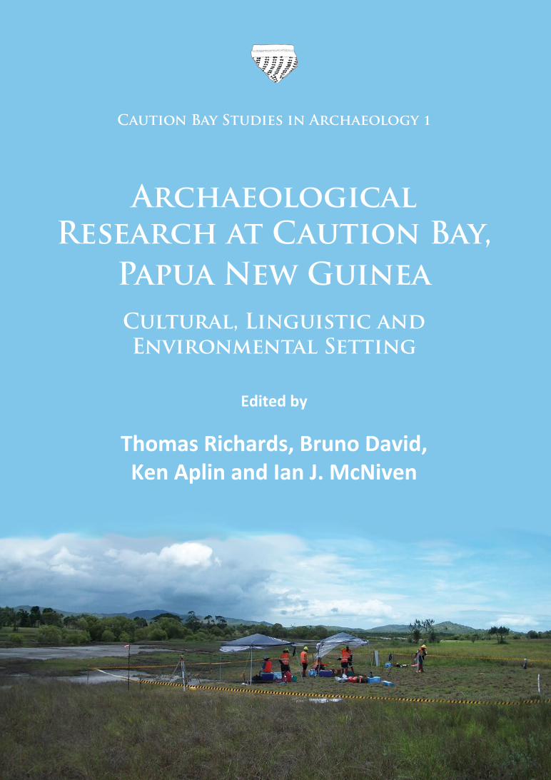
Archaeopress Archaeology www.archaeopress.com
In 2008, intensive archaeological surveys began at Caution Bay, located 20km to the northwest of Port Moresby, Papua New Guinea. The excavation of 122 stratified sites in 2009-2010 followed, and detailed analysis of the well-preserved and abundant faunal, ceramic and lithic finds has continued ever since. The Caution Bay Archaeology Project is providing new and exciting contributions to the western Pacific past. It has radically expanded the known geographic distribution of the Lapita Cultural Complex to include, for the first time, the southern coast of Papua New Guinea; it has established the relationship of Lapita to later cultural expressions in this area; it has pinpointed the time of arrival of domesticated animals along the southern coast of Papua New Guinea and, by inference, on the larger island of New Guinea; it has provided new insights into the impact of resident populations on local terrestrial and marine environments over a 5000 year time period; and perhaps of greatest significance, it has provided a unique opportunity to document, using multiple strands of archaeological evidence, interactions between resident and colonizing populations at a time of cultural transformation c. 2900 years ago.
The first volume of the Caution Bay monograph series introduces the goals of the Caution Bay project, the nature and scope of the investigations and the cultural and natural setting of the study area. To this end, a series of chapters are included on the ethnographic and linguistic setting, the natural environment, archaeological surveys of the study area and investigative and analytical methods. These background chapters will be repeatedly referred to in all the other monographs, as foundational reference materials for the broader study.
Subsequent volumes of Caution Bay Studies in Archaeology will each detail the results of excavations at a number of sites while addressing specific research themes, including Lapita colonization, ceramic transformations, long distance ceramic trade, spatial and temporal faunal resource use patterns, technological transformations, cross-cultural interactions and other themes.
Dr Thomas Richards is Adjunct Senior Research Fellow at the Monash Indigenous Centre, Monash University, Melbourne. His archaeological investigations in Canada, Australia and Papua New Guinea typically integrate cultural heritage management, community archaeology and research-oriented approaches; they have appeared in over 60 publications and 90 consulting reports. He has been a director of the Caution Bay Archaeology Project since 2009, and co-directs archaeological research at Hood Bay, southeast of Port Moresby. In conjunction with the Gunditj Mirring native title holders, he is currently investigating the historical emergence of transegalitarian cultural landscapes in the Holocene archaeological record of southwestern Victoria, Australia. A long-term collaborative project with the Tk’emlups te Secwepemc First Nations people involves research on the emergence of sedentary villages on the Interior Plateau of British Columbia, Canada.
Associate Professor Bruno David is an archaeologist who specialises in the north Australian-western Pacific region. He has published numerous books and hundreds of articles in professional journals and popular magazines. His recent books include Cave Art (Thames & Hudson), Hiri: Archaeology of Long-Distance Maritime Trade along the South Coast of Papua New Guinea (with Robert Skelly, University of Hawai’i Press), and the World Archaeological Congress’s Handbook of Landscape Archaeology (edited with Julian Thomas, Left Coast Press). He is regularly engaged by Indigenous groups to undertake partnership research on matters of history of particular significance to their own communities. He is based at the Monash Indigenous Centre, Monash University, Australia.
Dr Ken Aplin studied archaeology, anthropology and geomorphology before moving to palaeontology and mammalogy at post-graduate level. A professional career as a museum curator and later as a Research Scientist with CSIRO gave opportunities for fieldwork in almost every country between India and Australia, and produced a uniquely broad appreciation of the region’s fauna, ecology and traditional human lifestyles. Since 2011, Aplin has operated a private consultancy working mainly in the resource development sector in Southeast Asia and Papua New Guinea. He is currently a Visiting Fellow in the Department of Archaeology and Natural History in the College of Asia and the Pacific, the Australian National University, in addition to holding Research Associate positions in Mammalogy at the Australian Museum, the American Museum of Natural History and the Smithsonian Institution’s United States National Museum. Throughout his career, he has contributed as a faunal specialist to archaeological studies in Australia and Melanesia.
Ian J. McNiven is Professor of Indigenous Archaeology at the Monash Indigenous Centre, Monash University, Melbourne. He specialises in the archaeology of Australasian Indigenous societies, with major research interests in coastal societies of southern Papua New Guinea, Torres Strait, and the Queensland coast. Other research interests include the archaeology of the volcanic plains of western Victoria and the colonial history of Indigenous archaeology. His major theoretical research interest is understanding the long-term development of specialised maritime societies with a focus on the archaeology of seascapes and ritual and spiritual relationships with the sea. He is an elected Fellow of the Society of Antiquaries London and the Australian Academy of the Humanities. In addition to over 140 refereed journal papers and book chapters, and 80 cultural heritage consultancy reports, his co-authored and edited books include Goemulgaw Lagal: Cultural and Natural Histories of the Island of Mabuyag, Torres Strait (2015), The Social Archaeology of Australian Indigenous Societies (2006), Appropriated Pasts: Indigenous Peoples and the Colonial Culture of Archaeology (2005), Torres Strait: Archaeology and Material Culture (2004), Australian Coastal Archaeology (1999), and Constructions of Colonialism: Perspectives on Eliza Fraser’s Shipwreck (1998). A
rc
haeo
press
Caution Bay Studies in Archaeology 1
Richards, David, Aplin and McN
iven (editors) Archaeological Research at Caution Bay
Archaeological Research at Caution Bay,
Papua New GuineaCultural, Linguistic and Environmental Setting
Edited by
Thomas Richards, Bruno David, Ken Aplin and Ian J. McNiven
Richards cover.indd 1 12/12/2016 13:42:33

Archaeopress Publishing LtdGordon House
276 Banbury RoadOxford OX2 7ED
www.archaeopress.com
Caution Bay Studies in Archaeology 1
ISBN 978 1 78491 504 9ISBN 978 1 78491 505 6 (e-Pdf)
© Archaeopress, Monash University and authors 2016
Cover: Tanamu 2 excavations in progress, 27 November 2009. The site is located 110 metres inland of the mangrove-fringed coastline, on the western margin of Caution Bay’s alluvial plain as it extends into
the littoral zone. Occupation at the site peaked around 2500 cal BP (photograph by Ian J. McNiven).
All rights reserved. No part of this book may be reproduced, in any form or by any means, electronic, mechanical, photocopying or otherwise,
without the prior written permission of the copyright owners.
Printed in England by Oxuniprint, OxfordThis book is available direct from Archaeopress or from our website www.archaeopress.com

i
Contents
Contents ......................................................................................................................................................................... iList of Figures ................................................................................................................................................................ vEditors’ and Authors’ Affiliations and Contacts ........................................................................................................ viiiAcknowledgements ..................................................................................................................................................... ix
Chapter 1. Introduction to the Caution Bay Archaeology Project ...........................................................................................1Thomas Richards, Bruno David, Ken Aplin, Ian J. McNiven and Matthew LeavesleyIntroduction .............................................................................................................................................................1Research Goals and Themes ....................................................................................................................................3
Lapita Colonization .............................................................................................................................................3Ceramic Transformations ...................................................................................................................................4Long Distance Ceramic Trade .............................................................................................................................4Historicizing the Ethnographic Koita and Motu..................................................................................................4Spatial and Temporal Faunal Resource Utilization Patterns ...............................................................................5Caution Bay Landscape Use ...............................................................................................................................5Raw Material Sources ........................................................................................................................................6Technological Transformations ..........................................................................................................................6
Scope and Organization of the Caution Bay Monographs .......................................................................................6Organization of the Present Volume ........................................................................................................................7
Chapter 2. Archaeology in Port Moresby and the Southern Lowlands of Papua New Guinea: Intellectual and Historical Contexts for Caution Bay ........................................................................................................................................9Bruno David, Thomas Richards, Robert Skelly, Ian J. McNiven and Matthew Leavesley Introduction .............................................................................................................................................................9Port Moresby Region .............................................................................................................................................11
Graeme Pretty ..................................................................................................................................................11Susan Bulmer ...................................................................................................................................................11Jim Allen ...........................................................................................................................................................13Pamela Swadling ..............................................................................................................................................16
Yule Island-Hall Sound ...........................................................................................................................................19Ron Vanderwal .................................................................................................................................................19
Gulf of Papua Region .............................................................................................................................................21Jim Rhoads, David Frankel and Bruno David ...................................................................................................21Bruno David and Robert Skelly ........................................................................................................................22
Amazon Bay-Mailu .................................................................................................................................................23Geoff Irwin .......................................................................................................................................................23
Summary and Conclusions .....................................................................................................................................24
Chapter 3. The Motu-Koita: A Cultural and Social History .....................................................................................................27Michael GoddardIntroduction ...........................................................................................................................................................27A Provisional Prehistory .........................................................................................................................................27Social Organization ................................................................................................................................................29Lifeworld ................................................................................................................................................................31Effects of European Contact and the Colonial Period ............................................................................................32Independence and Afterwards ..............................................................................................................................34

ii
Chapter 4. Motu-Koita Contact in the Caution Bay Area of Central and Southeast Mainland Papua New Guinea: Some Linguistic Observations ...............................................................................................................................39Tom DuttonIntroduction ...........................................................................................................................................................39The Linguistic Scene at First Contact......................................................................................................................39
Motu................................................................................................................................................................. 39Koita ................................................................................................................................................................. 42
Motu-Koita Contact: The Linguistic Evidence ........................................................................................................43The British New Guinea Annual Report for 1889-90 Vocabulary ......................................................................43The 1994 Study .................................................................................................................................................45
Historical Implications of the Linguistic Evidence ..................................................................................................46Three Comparative Cases .................................................................................................................................47
Maisin ......................................................................................................................................................... 47Ouma and Related Remnant Languages .....................................................................................................48Lau’una ....................................................................................................................................................... 50
Motu-Koita Contact in the Caution Bay Area .........................................................................................................50Conclusion .............................................................................................................................................................51
Chapter 5. Koita and Motu Landscapes and Seascapes of Caution Bay ................................................................................53Linus S. digim’Rina, Thomas Richards, Bruno David, Matthew Leavesley, Michael Goddard, Tom Dutton, Robert Skelly, Brad Duncan, Laura Naidi and Julia HagoriaIntroduction ...........................................................................................................................................................53Preliminary Place-Name Study .............................................................................................................................53Detailed Mapping of Caution Bay Place-Names: The Focused Study ....................................................................56
Methods ...........................................................................................................................................................58Recorded Places ...............................................................................................................................................58
Named Places in the Study Area ................................................................................................................58Named Places Near the Study Area ...........................................................................................................61
Conclusions ............................................................................................................................................................63
Chapter 6. Historicizing Motu Ceramics and the Hiri Trade ...................................................................................................65Bruno David, Thomas Richards, Michael Goddard, Tom Dutton, Matthew Leavesley, Ian J. McNiven and Herman Mandui Introduction ...........................................................................................................................................................65The Hiri Trade .........................................................................................................................................................66Origin of the Hiri ....................................................................................................................................................67The Ceramic Industry .............................................................................................................................................70Conclusion .............................................................................................................................................................73
Chapter 7. The Natural Setting of Caution Bay: Climate, Landforms, Biota, and Environmental Zones ..............................75Ken Aplin, Cassandra Rowe, Helene Peck, Brit Asmussen, Sean Ulm, Patrick Faulkner and Thomas RichardsIntroduction ...........................................................................................................................................................75
Location and General Topography ...................................................................................................................75Sources of Information .....................................................................................................................................77Terminology of Environmental Zones and Habitats ..........................................................................................83
Climate ...................................................................................................................................................................83Environmental Zones and their Resources ............................................................................................................85
The Littoral Plains Zone ....................................................................................................................................85Littoral Plains Zone Landforms ................................................................................................................... 85Littoral Plains Zone Soils ............................................................................................................................. 86Littoral Plains Zone Plant Communities ......................................................................................................87Littoral Plains Zone Animal Resources ........................................................................................................89
The Hinterland Zone .........................................................................................................................................90

iii
Hinterland Zone Landforms ........................................................................................................................ 91Hinterland Zone Soils .................................................................................................................................. 93Hinterland Zone Animal Resources ..........................................................................................................100
The Inshore Marine Zone ...............................................................................................................................103Inshore Marine Zone Substrates and Habitats .........................................................................................103Inshore Marine Zone Animal Resources ...................................................................................................104
The Offshore Marine Zone..............................................................................................................................105Offshore Marine Zone Substrates and Habitats .......................................................................................105Offshore Marine Zone Animal Resources .................................................................................................105
Environmental History .........................................................................................................................................105Regional Scale Influences and Events .............................................................................................................105Local Influences and Events in Southern New Guinea ....................................................................................107
Historical and Contemporary Land Use ...............................................................................................................108Terrestrial Environments ................................................................................................................................108
Gardening ................................................................................................................................................. 109Cash Cropping ........................................................................................................................................... 109Hunting ..................................................................................................................................................... 110Other Terrestrial Resources ...................................................................................................................... 110
Marine Environment ......................................................................................................................................110Concluding Comments .........................................................................................................................................111
Chapter 8. Archaeological Surveys at Caution Bay ..............................................................................................................113Bruno David, Thomas Richards, Robert Skelly, Siobhán Walker, Matthew Leavesley, Jeremy Ash and Herman ManduiIntroduction .........................................................................................................................................................113Archaeological Surveys ........................................................................................................................................113
Core Study Area Survey ..................................................................................................................................116Core Study Area Survey Strategy, Methods and Intensity ........................................................................117Core Study Area Survey Results ................................................................................................................117
Peripheral Survey ...........................................................................................................................................132Peripheral Survey Strategy, Methods and Intensity..................................................................................132Peripheral Survey Results ......................................................................................................................... 132
Vaihua River Survey ........................................................................................................................................136Papa Lea Lea Road Survey ..............................................................................................................................138
Papa Lea Lea Road Survey Strategy, Methods and Intensity ....................................................................138Papa Lea Lea Road Survey Results ............................................................................................................139
Other Sites ......................................................................................................................................................140Conclusions ..........................................................................................................................................................143
Chapter 9. The Caution Bay Project Field and Laboratory Methods ...................................................................................145Bruno David, Thomas Richards, Ian J. McNiven, Jerome Mialanes, Ken Aplin, Fiona Petchey, Helene Peck, Brit Asmussen, Sean Ulm, Katherine Szabó, Holly Jones-Amin, Patrick Faulkner, Claire Perrette, Cassandra Rowe, Matthew Leavesley and Bryce Barker Introduction .........................................................................................................................................................145Project Personnel and Research Structure ..........................................................................................................145Field Methods ......................................................................................................................................................146Analytical Methods ..............................................................................................................................................154
Pottery Analysis .............................................................................................................................................156Pottery Conservation ......................................................................................................................................157
Treatment ................................................................................................................................................. 157Final Comments on Pottery Conservation ................................................................................................160
Stone Artefact Analysis ..................................................................................................................................160Raw Materials ........................................................................................................................................... 161Technological Variables ............................................................................................................................ 161Colours and Heat Alteration ..................................................................................................................... 163
Non-Molluscan Faunal Remains .....................................................................................................................163

iv
Bone from Vertebrate Animals .................................................................................................................164Eggshell ..................................................................................................................................................... 166Invertebrate Exoskeleton .......................................................................................................................... 166Reporting .................................................................................................................................................. 166
Molluscan Remains ........................................................................................................................................167Taxonomic Identification of Molluscan Remains ......................................................................................167Modes of Quantification ........................................................................................................................... 167
Worked Shell Analysis .....................................................................................................................................169Determination of the Worked Shell Sample .............................................................................................169Protocols for the Identification of Worked Shell ......................................................................................169Analytical Procedures ............................................................................................................................... 170Context of Interpretation.......................................................................................................................... 170
AMS Radiocarbon Dating and Chronological Model-Building ........................................................................171Caution Bay Marine Reservoir Corrections ...............................................................................................171Chronological Model-Building ..................................................................................................................173
Other Analyses .....................................................................................................................................................174Concluding Comments .........................................................................................................................................175
Appendix A. Comparison of Motu and Koita Vocabulary in the British New Guinea Annual Report for 1889-1890 (MacGregor 1890) with that in Dutton (1966) and Dutton (1975) ....................................................................177
Appendix B. Other Apparent Borrowings in Motu and Koita in Dutton (1975) not Included in Appendix A ........................179
Appendix C. Established Borrowings in Koita with Comparative Evidence from Motu, Sinagoro and Keapara ...................181
Appendix D. Caution Bay Project Field Staff, 2009-2010 ........................................................................................................183
References................................................................................................................................................................. 185

v
Figure 1.1. Location of the Caution Bay study area and sites excavated prior to 2009 (black dots) in the broader Port Moresby region. ............................................................................................................................................................... 1
Figure 1.2. Sites (black dots) excavated at Caution Bay, 2009-2010, with Papua New Guinea National Museum and Art Gallery registration codes. ................................................................................................................................................ 2
Figure 2.1. Locations of previous archaeological research areas involving excavation along the southern PNG lowlands, and Mask Cave in Torres Strait. ........................................................................................................................................ 9
Figure 2.2. Cultural and ceramic sequences for southern lowland PNG. ........................................................................................ 13Figure 2.3. Summary of some characteristics of decorative styles of Port Moresby bowls (from Bulmer 1978: table 5.5). ...........14Figure 2.4. Representative decorated sherds from Nebira 4 (ACL) (a-d = Style G, e-g = Style H) (after Allen 1972: 106, figure 2). 15Figure 2.5. Shell-impressed bowl sherds with ‘herringbone’ patterns from the ‘early levels’ of Motupore (AAK). ........................17Figure 2.6. Representative sherds from the Yule Island ‘Type Collection’, PNG National Museum and Art Gallery:
a = Type T, b = Type T, c = Type M, d = Type K, e = Type R, f = Type T (Photo: Robert Skelly). .........................................19Figure 2.7. Representative decorated sherds from Oposisi: a = Type A, b = Type A, c = Type B, C, D, E, d = Type B, C, D , E,
e = Type B, C, D, E, f = Type A, g = Type B, C, D, E, h = Type G, i = Type G, j = Type K, k = Type B, C, D, E, l = Type B, C, D, E, m = Type B, C, D, E, n = Type K, o = Type F, p = Type S, q = Type W, r = Type W, s = Type T, t = Type T, u = Type W (after Vanderwal 1973: figures VI-6-10). ......................................................................................................... 20
Figure 2.8. Representative sherds from Amazon Bay-Mailu excavations (a-d = Early period, e-g = Mayri period, h = Mayri-Mailu transitional) (after Irwin 1985: 248-251, plates 1-3). ............................................................................................23
Figure 4.1. Languages of Port Moresby region and central and southeast PNG: (a) Languages of central and southeast Papua New Guinea; (b) Port Moresby region languages and villages. ...........................................................................40
Figure 4.2. Central Papuan AN languages (after Ross 1994). .......................................................................................................... 41Figure 4.3. The Koiarian family tree................................................................................................................................................. 42Figure 5.1. Motu and Koita landscape place-names at Caution Bay (excluding creek and river names). .......................................54Figure 5.2. Motu and Koita landscape place-names in the Caution Bay study area (including creek and river names). ................55Figure 5.3. Motu and Koita place-names on the Caution Bay seascape, including Edai Siabo First Lagatoi story places. ..............56Figure 5.4. Motu and Koita places at Caution Bay: a. Location of First Lagatoi Landing/Stone Anchor site (red rectangle),
west of Boera village, February 2008 (Photo: Brad Duncan); b. Anchor stone at First Lagatoi Landing/Stone Anchor site, during low tide, west of Boera village, February 2008 (scale in 20 cm increments) (Photo: Brad Duncan); c. Cultural material scatter at Konekaru, March 2009 (Photo: Robert Skelly); d. Outrigger canoes on beach, Papa village, January 2008 (Photo: Brad Duncan). e. Partly buried possible anchor stone at archaeological site ABIV, Square C, Bogi locality, February 2010 (Photo: Simon Coxe); f. Julia Hagoria holding a stadia rod in front of a pool on lower Ruisasi Creek where seiri, kwaru and fire-fish are caught, March 2010 (Photo: Robert Skelly). .................................................................................................................................................... 57
Figure 5.5. Konekaru locality, showing open ocean beach bounded by mangrove forest to north and south, and backed by mudflats to the east (Google Earth Pro imagery dated 16 May 2010). .....................................................................59
Figure 5.6. Caution Bay Motu and Koita places: a. Southern edge of Davage beach, looking north, March 2010 (Photo: Robert Skelly); b. Hill directly south of former village of Davage, where women would watch for returning lakatoi rounding Lagava Island at the northern end of Caution Bay, March 2010. Present Boera village in left foreground (Photo: Robert Skelly); c. Stilt house, south side of Lea Lea village, January 2008. Note canoe platform at front (Photo: Brad Duncan); d. Smoke from grass fires set by hunting party from Boera village, October 2009. Archaeological site ABBK Square B excavation in foreground (Photo: Ian McNiven). ............................62
Figure 6.1. ‘Loading the lakatoi, Port Moresby’, 1885 (Lindt 1887, 12, plate V) (photograph by J. W. Lindt). .................................65Figure 6.2. Heirloom ceramic pot (uro) in the Gulf Province village of Epemeavo in August 2007, previously obtained
through hiri trade (photograph: Bruno David). ............................................................................................................... 70Figure 6.3. Traditional categories of Motu pottery (after Bulmer 1971:63, 1978:58; Groves 1960:14). ......................................... 71Figure 6.4. Motu ceramic pot types from Hanuabada, 1879-1882: a = uro, b = hodu, c = oburo, d= kaiwa, e = itulu (ituru),
f = nao (nau) (after Finsch 1914: plate XVII). ................................................................................................................... 72Figure 6.5. Motu pottery manufacture, Hanuabada. Archive image description: ‘clay dug from nearby hillside, made,
sundried and burnt; “glaze” from pulp of mangrove applied when hot’, 1921 (photograph by Frank Hurley). Courtesy Australian Museum Archives – AMS320/V4422. .............................................................................................73
Figure 7.1. Distribution and extent of offshore barrier reef and the fringing reef at Caution Bay (Sources: Google Earth Pro; PNG 1:100,000 Port Moresby Topographic Map). ................................................................................................... 76
Figure 7.2. Marine and terrestrial habitats of the Caution Bay study area (Source information includes: PNG 1:100,000 Port Moresby Topographic Map; Google Earth Pro; Woxvold 2008: figures 5 and 9). ....................................................77
Figure 7.3. Molluscan taxa from excavated archaeological sites in the Caution Bay study area, with a summary of their likely occurrence across the various marine to freshwater habitats. Habitat information has been predominantly drawn from Poutiers’ comprehensive chapters on bivalves and gastropods of the Western Central Pacific found in the FAO Species Identification Guide prepared by Carpenter and Niem (1998). Additional supplementary resources were referred to when we encountered species in the archaeological assemblages that were not present in this guide. These include Baron and Clavier (1992), Bellchambers et al. (2011), Coleman (2003), Houbrick (1987), Lamprell and Healy (1998), Malaquias and Reid (2008), Poiner and Catterall (1988) and Tebano and Paulay (2000). The online World Register of Marine Species was also consulted in each instance (WoRMS Editorial Board 2014). ...........................................................................................78
List of Figures

vi
Figure 7.4. Averaged monthly trends for important climate parameters, based on measurements taken over the past 40 years at Jackson Airport, Port Moresby (based on data from BoM 2015a). ...................................................................83
Figure 8.1. Location of Caution Bay Study Area surveys................................................................................................................114Figure 8.2. Caution Bay survey areas. ............................................................................................................................................115Figure 8.3. Caution Bay surveys in progress: a. Site survey across open grassland in the vicinity of site AAPH, located
in the south of the Core Survey Area, 24 February 2009 (Photo: Robert Skelly); b. UXO encountered during survey at Caution Bay, February 2009 (Photo: Jeremy Ash); c. Survey of patchy grassland in the northwest of the Core Survey Area, 6 May 2008 (Photo: Matthew Leavesley); d. Survey and recording of site ABAV, located in savannah in the southeast of the Core Survey Area, 6 November 2008 (Photo: Robert Skelly). ..............................116
Figure 8.4. Caution Bay Core Study Area Survey (red outline) sites (red dots). ...........................................................................117Figure 8.5. Core Study Area Survey site descriptions. ...................................................................................................................118Figure 8.6. Caution Bay survey landscapes and site recording in progress: a. Survey team determining extent and
recording site AAUY, in the northeast part of the Core Survey Area, 20 March 2009 (Photo: Jeremy Ash); b. Survey of edge of intertidal salt flat, Vaihua River Survey Area, 10 April 2009 (Photo: Jeremy Ash); c. Mangrove forest, Vaihua River Survey Area, 2 April 2009 (Photo: Jeremy Ash); d. Recording site ABIL eroding from bank on edge of salt flat, Vaihua River Survey Area, 10 April 2009 (Photo: Robert Skelly). ..................................................131
Figure 8.7. Core Study Area Survey site surface artefact density (maximum number of items/m2) by site size (m2). ..................132Figure 8.8. Caution Bay Peripheral Survey area (blue outline) sites (blue dots), plus other recorded sites (orange dots),
with Papua New Guinea National Museum and Art Gallery registration codes. ..........................................................133Figure 8.9. Peripheral Survey site descriptions. ............................................................................................................................134Figure 8.10. Peripheral Survey site surface artefact density (maximum number of items/m2) by site size (m2). ..........................136Figure 8.11. Caution Bay Vaihua River Survey area (yellow outline) sites (yellow dots) with Papua New Guinea National
Museum and Art Gallery registration codes. ................................................................................................................137Figure 8.12. Vaihua River Survey site descriptions. .......................................................................................................................137Figure 8.13. Vaihua River Survey site surface artefact density (maximum number of items/m2) by site size (m2). ......................139Figure 8.14. Caution Bay Papa Lea Lea Road Survey sites (black dots) with Papua New Guinea National Museum and Art
Gallery registration codes. ...........................................................................................................................................140Figure 8.15. Papa Lea Lea Road Survey site descriptions. .............................................................................................................141Figure 8.16. Papa Lea Lea Road Survey site surface artefact density (maximum number of items/m2) by site size (m2). ............142Figure 8.17. Descriptions of other sites recorded at Caution Bay. ................................................................................................142Figure 9.1. Pot sherds on the surface (red rectangles) and embedded in the ground (blue rectangle), site AAJB, west-
central core study area, 12 February 2009 (Photo: Jeremy Ash). .................................................................................146Figure 9.2. Sites excavated in the Caution Bay study area, with numbers of excavation squares and stepping out squares.
(PNG NMAG = Papua New Guinea National Museum and Art Gallery). .......................................................................147Figure 9.3. Excavations in progress at Caution Bay: (a) View from site ABIW east to excavations at site Tanamu 3 (ABHD)
(left and centre) and AAJM (far right, in mid-distance), in the west of the study area, with the Dirora Gotera Range in the background, 7 December 2009 (Photo: Nic Dolby); (b) View of excavations at site Nese 1 (AAWA) on the northern slope of Moiapu Hill, in the east of the study area, 10 November 2009 (Photo: Ceri Shipton). ........150
Figure 9.4. Excavation at site Edubu 1 (ABAO), 26 September 2009 (Photos: Thomas Richards): a. Excavation in progress at (left to right) Squares A, B and C; b. Square B, strung out with offset metal survey arrows, prior to commencement of excavation; c. Start of excavation in Square B; d. Excavation of Square C; e. Elevation reading being taken with automatic level; f. Excavated soil being transferred to plastic bag for transport to field laboratory for wet sieving. ............................................................................................................................................151
Figure 9.5. Stepping out operations at Caution Bay: a. Phase 1 of stepping out completed at site Bogi 1 (ABEN) with excavation Squares C and D protected by a wooden cover in the centre of the stepping out area, 5 January 2010 (Photo: Ian McNiven). Note the star picket and plywood shoring around the periphery of the stepping out pit, as well as other protective and safety measures being installed prior to the next stage of excavation; b. Hand excavation of stepping out squares in progress around excavation Squares D and E (with plywood on bottom in centre of photo) at site (ABIV), 9 March 2010 (Photo: Ben Shaw). ..............................................................152
Figure 9.6. Wet sieving and sorting operations in the Caution Bay field laboratory, September 2009 – May 2010 (Photos: Cassandra Rowe): a. Wet sieving team at work; b. Close-up of wet sieving through 2.1mm mesh sieve; c. Wet sieve residue on trays drying on shelves prior to sorting; d. Sorted sieve residue on trays; e. Sorting team at work on sieve residue. .................................................................................................................................................153
Figure 9.7. Excavated sediment temporarily stored inside container prior to wet sieving, Caution Bay field laboratory, 19 March 2010 (Photo: Cassandra Rowe). ........................................................................................................................154
Figure 9.8. Excavated sediment temporarily stored outside container prior to wet sieving, Caution Bay field laboratory, 19 March 2010 (Photo: Cassandra Rowe). ...................................................................................................................155
Figure 9.9. Key terms used for ceramics. ......................................................................................................................................157Figure 9.10. Excavated pottery conservation: (a) Site Ruisasi 1 (ABKO) pottery conjoining in progress showing 3M
Micropore™ tape labels on sherds, conjoined sherds (green rectangle), a conjoin map (red rectangle) and structural fills on a partially reconstructed pot (blue rectangles) (Photo: Holly Jones-Amin); (b) Shoulder-carinated Lapita pot with a collar and globular base from site Bogi 1 (ABEN), Square F, XU14, reconstructed from 23 conjoining sherds, which has undergone mechanical reduction of carbonates, desalination and infilling using Paraloid (Photo: Steven Morton). ...........................................................................................................158
Figure 9.11. Stone artefact analysis variables. ..............................................................................................................................162Figure 9.12. Colours (Munsell Color 2011) recorded on flaked stone artefacts from Caution Bay. ...............................................164Figure 9.13. Valve determination in chiton (Class Polyplacophora) used for MNE and MNI calculations (after Dell 1951: 9). .....168Figure 9.14. Specific landmarks identified for MNE and MNI calculations of bivalves (after Carpenter and Niem 1998:
124, 192, 198). ..............................................................................................................................................................168

vii
Figure 9.15. Specific landmarks identified for MNE and MNI calculations of gastropods (after Carpenter and Niem 1998: 364, 370, 394, 486 and Harris et al. 2015: 170). ...........................................................................................................169
Figure 9.16. Cut Conus sp. body with fragment surfaces heavily eroded through acid dissolution (at x30 magnification). From site ABHD, Square C, XU 13b (Photo: Katherine Szabó). ......................................................................................169
Figure 9.17. Freshwater mussel (Alathyria jacksoni) nacre delaminating and crumbling due to organic loss and microbiological taphonomic action which has produced numerous tiny holes. SEM micrograph at x1100 magnification (Micrograph: Erica Weston). ...................................................................................................................170
Figure 9.18. Recommended species-specific ∆R for Caution Bay marine shells (adapted from Petchey et al. 2012, 2013). ........172Figure 9.19. Example from site Ataga 1 (AAVM) of an OxCal multi-plot showing the 68.2% and 95.4% probability age
ranges as outlined in the text. .......................................................................................................................................173Figure 9.20. OxCal model schematic showing the overlapping phase model for site Nese 1 (AAWA). .........................................174

viii
Editors’ and Authors’ Affiliations and Contacts
Dr Ken Aplin. (1) Division of Mammals, National Museum of Natural History, Smithsonian Institution, Washington D.C., 20013-7012, U.S.A. [email protected] (2) Department of Archaeology and Natural History, College of Asia and The Pacific, Australian National University, Canberra, A.C.T., 0200, Australia. [email protected]
Dr Jeremy Ash. Monash Indigenous Centre, Monash University, Clayton, Victoria 3800, Australia. [email protected]
Dr Brit Asmussen. (1) Cultural Environments Program, Queensland Museum, PO Box 3300, South Brisbane, QLD 4101, Australia. [email protected] (2) School of Social Sciences, The University of Queensland, Brisbane, QLD 4072, Australia.
Professor Bryce Barker. School of Arts and Communication, University of Southern Queensland, Toowoomba, Queensland 4350, Australia. [email protected]
Dr Bruno David. Monash Indigenous Centre, Monash University, Clayton, Victoria 3800, Australia. [email protected]
Dr Linus digm’Rina. Department of Anthropology, University of Papua New Guinea, PO Box 320, University Post Office, National Capital District, Papua New Guinea. [email protected]
Dr Brad Duncan. School of Humanities, University of New England, Baulkham Hills, New South Wales, 2153, Australia. [email protected]
Dr Tom Dutton. 530 Yass River Road, Yass, New South Wales 2582, Australia. [email protected] Dr Patrick Faulkner. Department of Archaeology, University of Sydney, New South Wales 2006, Australia. patrick.
[email protected] Michael Goddard. Department of Anthropology, Macquarie University, Sydney, New South Wales 2109, Australia.
[email protected] Ms Julia Hagoria. PO Box 7534, Boroko, National Capital District, Papua New Guinea. [email protected] Ms Holly Jones-Amin. Monash Indigenous Centre, Monash University, Clayton, Victoria 3800, Australia. hjjon2@
student.monash.eduDr Matthew Leavesley. (1) Department of Anthropology, University of Papua New Guinea, PO Box 320, University
Post Office, National Capital District, Papua New Guinea. [email protected] (2) College of Arts, Society and Education, James Cook University, PO Box 6811, Cairns, Queensland 4870, Australia. [email protected]
Mr Herman Mandui. Papua New Guinea National Museum and Art Gallery, Port Moresby, Papua New Guinea. (deceased)
Professor Ian J. McNiven. Monash Indigenous Centre, Monash University, Clayton, Victoria 3800, Australia. [email protected]
Dr Jerome Mialanes. Monash Indigenous Centre, Monash University, Clayton, Victoria 3800, Australia. [email protected]
Ms Laura Naidi. PO Box 304, Alotau, Milne Bay Province, Papua New Guinea. [email protected] Ms Helene Peck. College of Arts, Society and Education, James Cook University, PO Box 6811, Cairns, Queensland
4870, Australia. [email protected] Claire Perrette. Centre for Archaeological Science, School of Earth and Environmental Sciences, University of
Wollongong, Wollongong, New South Wales 2522, Australia. [email protected] Dr Fiona Petchey. Radiocarbon Dating Laboratory, University of Waikato, Hamilton 3240, New Zealand. fpetchey@
waikato.ac.nz Dr Thomas Richards (Corresponding Editor). Monash Indigenous Centre, Monash University, Clayton, Victoria 3800,
Australia. [email protected] Dr Cassandra Rowe. Monash Indigenous Centre, Monash University, Clayton, Victoria 3800, Australia. rowe.
[email protected] Dr Robert Skelly. Monash Indigenous Centre, Monash University, Clayton, Victoria 3800, Australia. robert.skelly@
monash.edu Dr Katherine Szabó. Centre for Archaeological Science, School of Earth and Environmental Sciences, University of
Wollongong, Northfields Ave., Wollongong, New South Wales 2522, Australia. [email protected] Dr Sean Ulm. College of Arts, Society and Education, James Cook University, PO Box 6811, Cairns, Queensland
4870, Australia. [email protected] Siobhán Walker. Community Relations, Rio Tinto Alcan, Weipa, Queensland 4874, Australia. siobhanski@gmail.
com

ix
Acknowledgements
We gratefully dedicate this research to the people of Caution Bay, the villagers from Boera, Kido, Lea Lea, Papa and Porebada, who generously supported this project for its duration. We especially thank all who participated in the surveys, excavations, recording of place names and laboratory work at Caution Bay from 2008 to 2010.
Assistance and support from the University of Papua New Guinea and the Papua New Guinea National Museum and Art Gallery were essential for the successful completion of field operations at Caution Bay.
We thank all of the archaeological and anthropological personnel listed in Appendix D, who worked on the 2009-2010 field investigations at Caution Bay, and the survey team members of 2008-2009: Nick Araho (PNG National Museum and Art Gallery), John Dop (PNG National Museum and Art Gallery), Brad Duncan (Monash University), Alexandra Gartrell (Monash University), Alois Kuaso (PNG National Museum and Art Gallery), and John Muke (Social Research Institute, Port Moresby).
Tom Dutton is indebted to Andrew Pawley, Malcolm Ross and Andrew Taylor for comments on earlier drafts of Chapter 4, and to all three and Alan Jones for providing data on Proto Oceanic and particularly Proto Central Papuan languages. Tom Dutton is also grateful to Kidu Taylor, a native speaker of the eastern dialect of Motu, for comments on Motu forms and usages.
We thank Jim Allen for making the sherds in Figure 2.5 available to us for drawing, and Cathy Carigiet for drawing them.
We thank the Australian Research Council for Discovery grants, QEII and DORA Fellowships DP0877782 and DP130102514 to Bruno David.
The authors are indebted to the many local people named in Chapter 5 who provided information on named places, and also extend thanks to Andrew Taylor and Kidu Taylor who clarified and confirmed Motuan seascape terms for us.
Monash University has provided unceasing support for the fieldwork, administration, lab work, analyses, and reporting associated with the Caution Bay Archaeology Project. We especially thank our management and support team at Monash University in 2009-2010: Phillippa Sutherland, Cathy Alex, Melanie Thiedeman, Dimitria Semertjis, Judith Harvey, Heather Fletcher, Kerry Cake, and Jean Newey. We are also grateful for the painstaking work of the many lab assistants who processed the huge quantity of excavated material from Caution Bay at Monash University from 2009 through 2013, and the several lab supervisors who oversaw this work: Nick Hogg, Simon Coxe, Laura Bates, Kirstie Lewis, Peter Ross, Jerome Mialanes, and Cassandra Rowe. We thank Kara Rasmanis, Monash University, for drafting most of the figures in this volume. The Monash Indigenous Centre, especially Professor Lynette Russell, Executive Officer Vanessa Fleming-Baillie and Administrative Assistant Beverly Thomson, have been generous with support during the production of this monograph.
Lastly yet foremostly, this project owes a big debt of gratitude to the late Herman Mandui, Curator of Archaeology, PNG National Museum and Art Gallery, who was responsible for cultural heritage management for all of PNG. His tragic, premature death in October 2014 means that he will sadly not be able to see this finished product. Herman was a champion of this project from the outset, supporting the scale of the field and laboratory work as proposed by Monash University, and, most importantly, in mediating between the demands of development and scientific research to achieve the best outcome for his nation.

x

1
Introduction
In 2008 we began intensive archaeological surveys at Caution Bay, located 20km to the northwest of Port Moresby, Papua New Guinea (Figure 1.1). We followed this with the excavation of 122 stratified sites in 2009-2010, and detailed analysis of the well preserved and abundant faunal, ceramic and lithic finds has been continuing ever since.
The Caution Bay Archaeology Project is providing new and exciting contributions to western Pacific prehistory. It has radically expanded the known geographic distribution of the Lapita Cultural Complex to include, for the first time, the southern coast of Papua New Guinea; it has established the relationship of Lapita to later cultural expressions in this area; it has pinpointed the time of arrival of domesticated animals along the southern coast of Papua New Guinea and, by inference,
on the larger island of New Guinea; it has provided new insights into the impact of resident populations on local terrestrial and marine environments over a 5000 year time period; and perhaps of greatest significance, it has provided a unique opportunity to document, using multiple strands of archaeological evidence, interactions between resident and colonizing populations at a time of cultural transformation c. 2900 years ago.
Over seven hundred indigenous archaeological sites were identified in survey areas comprising coastal and inland landscapes drained by the Vaihua River and Ruisasi Creek (see Chapter 8). The archaeological excavation of 122 stratified sites within the core study area, measuring 3.1km east-west by 2.8km north-south, comprises the largest excavation program ever undertaken in the western Pacific (Figure 1.2). Detailed analyses by experts of the finds from the excavations is fully supported by a dating program consisting of more than 1300 AMS
Chapter 1. Introduction to the Caution Bay Archaeology Project
Thomas Richards, Bruno David, Ken Aplin, Ian J. McNiven and Matthew Leavesley
Port Moresby
WaiganiSwamp
Mt Lawes
N
L aloki R iver
Vaihua R.
Goldie
River
Brown River
Vanapa River
Caution Bay
100
Kilometres
Papua New
Guinea
N
Papa Salt Pan
Ava Garau
Nebira 1,2,4Eriama
Taurama Motupore
Fig. 1.2
Figure 1.1. Location of the Caution Bay study area and sites excavated prior to 2009 (black dots) in the broader Port Moresby region.

2
Archaeological Research at Caution Bay, Papua New Guinea
radiocarbon dates, a number unprecedented for any single archaeology project in the southern hemisphere.
The Caution Bay Archaeology Project was only possible on such an unprecedented scale because it formed part of cultural heritage impact studies in advance of construction of a liquefied natural gas plant near Port Moresby. The client, along with the main proponent, maintained control of the cultural heritage management aspects of the development from the outset, with our responsibility largely focused on research-oriented salvage excavations.
Intensive pedestrian field surveys were undertaken across the entire study area in late 2008 and early 2009, following burning of the grass to provide a high degree of ground visibility. Site survey and the subsequent salvage excavations were supervised by staff of Monash University; the main salvage excavations took place in a narrow window of time from September 2009 through to March 2010, and were immediately followed by large-
scale infrastructure construction activities. Following the main salvage period, a small team of archaeologists was permitted to return to excavate a single human burial in April 2010. Wet sieving of excavated sediments and the preliminary sorting of finds in the field laboratory continued until June 2010.
The salvage excavation program relied extensively on the collaboration and participation of University of Papua New Guinea staff and students. Local community representatives of Boera, Papa, Lea Lea and Porebada villages also made substantial contributions, especially to the fieldwork. These village representatives, employed by the developers, worked with professionally trained Monash University personnel on all aspects of the fieldwork, both at the sites and in the field laboratory.
Following completion of the salvage work and reporting to the clients in mid-2011, Phase 2 research set in with the excavated materials, now housed at Monash University, becoming available for more detailed analyses and
Vaih u a River
0 1
ki lometres
N
GrasslandMangroveSaltflat Savannah
ABERABJX AAVM
ABJY ABKAABKC
ABEQABKF
ABKIABEP
ABEOABKL
ABEN
AAVD
ABHAABIV
ABITARM
ABHFAALW
AAOI
AANBAALU
AAPH
AAQC
AANX
AALGAALR
ABCO
ABCMAAUJ
ABCKABCL
ABCN
ABISABIU
AAPNABBS
ABBQABBK
ABAOABAN AAUJ
ABAM
AAUY AAUGAAUQAAIJ
AAVAAAVC
AAIT
AATVAAIC
ABCEAASI
AAIZ
AAWA
AAIGAAJB
AAKD
AAJXAAJVAAKQ
AAKX
AAMC
AANV AANRAAZD
AATPAATB
AATAAAYLAANO
AANM
AAYJ
AAHP
AAYBAAHR
AAYM
AAKLAAKM
AAHO
ABKH
AAIB
AAHN
AAJU
ABHD
AAIJ
ABKOABKN
AAYD
AATF
ABIWABHC
AAJK
AAHMAAJQ
AAJN
AAJJ
AAJHAAJI
AAKZ AASG
AAVZ
AASN
AAVYAASQAAHV
AASA
AAVX
AASFAASE AASP
AASLAAHS
AAXK AAXLAAHX
AANO
AAJM
ABES
ABKK
Figure 1.2. Sites (black dots) excavated at Caution Bay, 2009-2010, with Papua New Guinea National Museum and Art Gallery registration codes.

3
Thomas Richards et al.: Introduction to the Caution Bay Archaeology Project
publication. Analyses have been in progress ever since, working towards publication in this monograph series.
From the onset, the guiding assumption of the excavation program was that the majority of archaeological sites in the Caution Bay study area were going to be destroyed or made inaccessible to further study during construction activities. Consequently, one objective of the salvage program was to obtain a meaningful sample of cultural material from this landscape before it was permanently altered. The chosen strategy was to excavate as many sites as possible where surface exposures identified during the project surveys indicated the presence of potentially stratified deposits (see Chapter 9). We explicitly chose to undertake a large number of small excavations within the available time, rather than limit ourselves to a handful of large excavations, so as to sample subsurface deposits in a range of environmental settings and covering a range of potential time frames. By this means we hoped to obtain a diverse sample of the material residues of human activities in the study area, through time and across the landscape. This decision was made in part because we had no idea what lay beneath the surface prior to the excavations – extensive excavations at just a few sites could have led to the sampling of one period of time only, at the expense of other cultural phases elsewhere across the landscape – and partly to historicize landscape engagements across the entire region through time.
Strict adherence to highly controlled excavation methods and broad landscape sampling has resulted in abundant, high integrity excavation data. The excavated sites typically contain an abundance of molluscan remains, a variable quantity of non-molluscan faunal remains including both marine and terrestrial animals, lithics and ceramics, with occasional personal decorative items and other valuables, usually of shell, but also of sea urchin and of stone. A subset of sites produced unusually rich concentrations of particularly informative materials such as obsidian and ceramics. Features such as infilled postholes, hearths and earth ovens are rare and only two sites have human burials, although isolated human remains are fairly common. Typically, detailed laboratory investigations were undertaken by specialists on the faunal remains, ceramics and lithics from each site, but additional specialist analyses were frequently warranted on special classes of finds including shell artefacts, sediments, pollen, obsidian, pottery fabrics, human skeletal remains, human and animal aDNA, and other materials.
Excavations were undertaken in three main landforms: coastal sand dune, riverine lowland sub-coastal plains with clayey and clayey loam sediments, and low rocky and clayey loam slopes and hilltops of the highland foothills. Sites located on the coastal sand dune tend to have deeper stratified cultural deposits with more occupation phases than the off-dune clay and clayey
loam sites, which tend to be shallower and usually only contain one major occupation phase, although there are some exceptions to this general pattern. The combination of well-dated deeply stratified multi-occupation deposits at a few locations and many single occupation components from throughout the study area allow us to construct a highly detailed culture-historical sequence, and thence, to investigate in considerable detail many research themes, as detailed below.
Research Goals and Themes
Originally, our research goals focused on building a well-dated cultural sequence for Caution Bay, with emphasis on a detailed ceramic sequence, plus attention on the emergence of the historic hiri trade (discussed below and at length in Chapter 6), the timing of the introduction of domesticates including the pig, dog and chicken, and the understanding of land-use patterns through time. At the time of writing we have unambiguous evidence of human occupation dating back to more than 5000 cal BP with cultural horizons covering every century from 4300 cal BP to at least 1500 cal BP. As for the more recent period of the past 1500 years, we have not yet begun to study those sites in any detail, but radiocarbon dates already, and possibly entirely, fill this gap. There are yet many sites that are still undergoing analysis and dating, and it is likely that the start of the Caution Bay cultural sequence will be extended further back into the past, while at the other end of the chronological spectrum, the possibly less well represented last 1500 years (or less) of the sequence will likely be fleshed out with more analysis and dating. These results have more than doubled the age of the previously earliest dated archaeological evidence, and have provided the first record of pre-ceramic coastal adaptations, for the broader Port Moresby region. As a historical foundation for understanding the long-term development of the ethnographic cultural landscape, the results from Caution Bay are probably without parallel in the wider Pacific region.
Without doubt the single most startling outcome of the excavations at Caution Bay was the discovery of a Lapita colony dating to c. 2900-2600 cal BP, and our research goals have diversified accordingly; they now include nine major themes, as introduced below. Naturally, these themes are not mutually exclusive but, rather, form an integrated whole with numerous overlapping and inter-digitating elements.
Lapita Colonization
The combination of abundant finely-excavated ceramics and other materials, and precise chronological control from numerous sites, allows us to accurately document the time of arrival of Lapita colonists at Caution Bay. Since we also have pre-ceramic occupation sites in a common locality dating from c. 5000 years ago up to

4
Archaeological Research at Caution Bay, Papua New Guinea
the arrival of Lapita peoples, we are presented with an opportunity unique in the Pacific to characterize the nature of initial interactions between incoming Lapita and pre-existing groups at this critical social and cultural juncture, as well as their subsequent relationships.
Also important to consider are the ties the colonists maintained with other parts of the Lapita world, or at least with their place of origin, after arriving at Caution Bay. We will examine this issue through assessment of the Caution Bay archaeological record against the wider corpus of regional studies.
Ceramic Transformations
The emphasis of the Caution Bay ceramic analysis is to produce a local sequence using only the Caution Bay data, rather than attempting to revise problematic existing ceramic sequences or horizons from other parts of the south coast of PNG (see Chapter 2). Pottery is one of the most commonly occurring cultural materials in our excavated sites, ranging from a few nearly whole vessels (e.g., David et al. 2013) to sizable sherds, to tiny comminuted sherds. Although the bulk of the pottery consists of tiny fragments that were recovered in our 2.1mm mesh sieves, there are substantial samples of potsherds in the 3 - 10cm size range in many of the excavated sites. The condition of the pottery is variable, but good enough to identify surface decoration style in every assemblage analysed thus far. In several sites, conjoining of sherds has taken place, greatly facilitating recording of full decoration patterns and identification of vessel shapes.
With the abundant ceramics from numerous stratified sites – we estimate that there are many hundreds of thousands of sherds in the excavated assemblages, although most are very small – we are able to construct a detailed ceramic sequence starting at c. 2900 cal BP with the appearance of Lapita pottery, and continuing largely uninterrupted to the ethnographic period. Key decorative traditions and transformations in stylistic conventions are being identified and finely dated (e.g., David et al. 2012). We have, for example, several stratified sites dating from the Lapita to post-Lapita periods on the coast and inland at Caution Bay, with good samples of well-dated, decorated ceramics, allowing this key transformation to be examined in detail (in the second monograph of this series). We also have well-dated excavated ceramic assemblages from throughout the study area pertaining to each subsequent ceramic transformation or phase up to ethnographic times, which will allow these to also be characterized as the analysis progresses.
Long Distance Ceramic Trade
Of widespread interest is understanding the emergence of the ethnographically documented Motu hiri trade,
a large scale, long-distance maritime enterprise that involved the transport of locally manufactured clay pots westward in fleets of lagatoi sailing ships to be exchanged for sago starch with trading partners hundreds of kilometres distant in the swamplands of the Gulf of Papua (see Chapter 6, this volume). Genealogical reckoning using oral histories suggests a maximum 300-400 years antiquity for this trade. The Caution Bay area features prominently in the ethnographic and oral historic accounts of the hiri trade, including origin myths and first lagatoi stories, so it is an excellent location from which to investigate the emergence of the hiri trade using archaeological data (see Chapters 3, 5 and 6). The abundant, well-dated Caution Bay ceramic assemblages will also enable us to identify indicators of long distance ceramic trade in the region from the Lapita period onwards, including shared ceramic decorative conventions with pottery found elsewhere (e.g., Skelly et al. 2014), evidence for the mass production of pottery, or standardization of pot forms akin to hiri trade wares.
Historicizing the Ethnographic Koita and Motu
The study area is located in an area occupied today by two originally linguistically unrelated and culturally distinct groups: the Motu, Austronesian language speakers who mostly occupied coastal villages, had a maritime resource focus, and specialized in the manufacture of pottery that they traded far and wide, especially via the hiri; and the Koita, non-Austronesian language speakers who mainly occupied inland villages, hunted wallabies and tended gardens, manufactured no pottery until the arrival of Austronesian-speaking peoples, and who participated in the hiri through the Motu. The present day and historical relationships between these two ethnographic groups are examined ethnographically and linguistically in Chapters 3 and 4 respectively. We have to consider that we can now archaeologically document the arrival of pottery-making Lapita colonists c. 2900 cal BP in a Caution Bay cultural landscape where existing populations did not make pottery. This leads us to ask the following questions: are the maritime-focused, Austronesian language speaking, long-distance travelling, pottery specialist Lapita founding population(s) the direct ancestors of the maritime-focused, Austronesian language speaking, pottery making and long-distance trading, ethnographic Motu of Caution Bay? And are the Koita direct descendants of the existing aceramic Caution Bay populations at the time of arrival of the Lapita people? Or rather is the picture more complex, involving intermarriages and multiple kinds of cross-cultural exchanges and influences, with two, initially distinctive populations literally coming together and perhaps even largely merging at Caution Bay over a period covering nearly three millennia? If so, what is the basis for a more or less distinctive Koita versus Motu cultural identity that we see today? This latter question is one that both the archaeology and social anthropology

5
Thomas Richards et al.: Introduction to the Caution Bay Archaeology Project
can contribute to significantly, and in doing so cross-fertilize our separate disciplinary skills and approaches.
Spatial and Temporal Faunal Resource Utilization Patterns
Faunal assemblages of marine and terrestrial origin are preserved in virtually every excavated site and throughout the stratigraphic profiles, and in many cases the preservation of bone and shell is good to excellent. To date, only a very few sites have been reported in a preliminary fashion (e.g., McNiven et al. 2011, 2012a); however, studies are underway on both the molluscan and non-molluscan faunal remains from numerous coastal and inland sites. The results will allow for progressively more detailed analyses across numerous assemblages, both synchronously across the landscape and through time. In sheer quantity but also in the quality and diversity of remains, the faunal assemblages are without parallel in a New Guinean context. Critically, animals represented in the deposits are derived from every one of the locally represented environments including the off-shore and near-shore marine, the strandline, mangrove and inter-tidal mudflat habitats of the littoral zone, the woodland, grassland and scrub of the inland plains and hills, and the freshwater aquatic habitats and fringing bands of riparian forest of the inland streams.
How these habitats were exploited through time will reveal previously unavailable information about the extractive strategies of both the pre-Lapita residents of Caution Bay and of the earliest Lapita colonists, and of the subsequent pattern of exploitation, over-use and adaptive shifts that occurred across space and through time. The impacts of this utilization on the local environment can also be assayed from the faunal remains, including evidence for depletion and extinction of local populations. Comparison of these results with the findings of pollen analyses within the study area (Rowe et al. 2013) will lead to a detailed narrative of regional resource use and its impacts over the past 5000 years. It is anticipated that this record will yield numerous insights into the sustainability or otherwise of traditional resource extraction practices, and that these insights will be of great practical value for the ongoing management of both marine and terrestrial resources in south central New Guinea where many people continue to follow customary practices, often using similar methods as their forebears to obtain the same resources at Caution Bay.
Wallaby hunting is a topic of some interest in the Port Moresby area (e.g., Allen 1977a). This was a notable activity across the region in ethnographic times, and the potential role of fire to modify and maintain landscapes in favour of wallaby-preferred grassland savannah is a topic of great interest. The Caution Bay deposits contain remains of at least three wallaby species and, at times, these were clearly the focus of hunting activity. By
documenting the variable presence and composition of wallaby remains through time and across space, and comparing this pattern to the wider faunal and palynological records, we hope to establish the nature of the relationship(s) between wallaby hunting and landscape firing and modification, and also that between the intensity of wallaby hunting and the status of trade activities.
In a recent paper, O’Connor et al. (2011) reviewed the evidence for the introduction of the pig (Sus scrofa) into mainland New Guinea (not including evidence from Caution Bay, which were not available at the time). They argued convincingly that the evidence for the mid-Holocene presence of pig is unreliable, being derived from mixed middle and late Holocene deposits, and that the oldest directly dated pig bone in all of New Guinea is from Kria Cave in West Papua, dating to 1876-1638 cal BP. We will be addressing the appearance of pigs in the archaeological record at Caution Bay through a combination of careful assessment of the chronostratigraphic context of each occurrence and by direct AMS dating of key specimens. Analysis of ancient DNA of pig remains is being undertaken where DNA is preserved, to determine genetic relationships with existing regional pig populations and with other archaeologically recovered genetic profiles for pigs (Larson et al. 2007), and thus we seek to gain further insights regarding the routes of introduction of the pig into New Guinea.
Similarly, we will be addressing the appearance of the domesticated dog in the archaeological record of Caution Bay. Ethnographically and continuing today in many areas, dogs are of central importance in diverse aspects of New Guinean life, including hunting, security and various ceremonial contexts. Their introduction is anticipated to have had a marked impact on lifestyles throughout the region (Koler-Matznick et al. 2007).
Caution Bay Landscape Use
This theme involves consideration of the chrono-spatial distribution of occupation deposits across the study area, both synchronically and diachronically. Aspects of relevance include coastal vs. inland land use, the distribution of hamlets, villages, other occupation sites, burials and specialized activity areas, in comparison with the distribution of food resources and habitats and arable land. Spatial comparisons should facilitate the understanding of relationships between ceramic (Lapita and descendent) and non-ceramic (pre-Lapita and descendent) populations through time (see Historicizing the Ethnographic Motu and Koita above).
The environmental history of the study area is also directly pertinent to documenting and understanding human landscape use through time, as well as

6
Archaeological Research at Caution Bay, Papua New Guinea
understanding human impacts on the landscape. There is a likely recursive human-natural environment effect from the time of extensive land-clearance relating to gardens upstream of the study area and increased erosion and fluvial sediment deposition in the study area, or increased human burning activities and the creation, expansion or maintenance of the grassland savannah characteristic of the present day study area. These effects would have influenced wild food resource availability, the amount of land suitable for gardening, and the location of suitable long-term occupation locations (i.e., villages). We have started to address this issue through the study of coastal pollen cores (e.g., Rowe et al. 2013) and we are continuing with ongoing analyses of sediments and pollen from inland archaeological sites across the study area, and with the detailed studies of faunal assemblages that document the conversion of lowland rainforests to savannah woodlands and grasslands.
Detailed studies of the molluscan and marine vertebrate faunal remains also promise significant insights into the impact of fishing and other extractive activities on the coastal and off-shore environments of Caution Bay. From work already undertaken, it is clear that our studies will document major changes in this milieu, including local depletions and even extinctions of particular resources, and that we will document a series of corresponding shifts in the extractive focus of local human populations.
Raw Material Sources
Identifying the sources of raw materials present in the excavated sites will potentially illuminate both internal and external relationships within the Caution Bay study area and between Caution Bay and external localities. For example, chert is a widely available surface resource at Caution Bay and is also the most common raw material in every flaked lithic assemblage studied thus far. One study underway is using X-ray fluorescence technology to characterize chert sources to investigate patterns of chert usage over time and throughout the study area; the results may help to identify social boundaries as well as patterns of interaction and land use within the study area. In addition, we are interested in comparing the raw material sources of stone axes/adzes from the pre-Lapita, Lapita and subsequent periods at Caution Bay, not only to look at continuities or changes, but also to potentially gain insight into engagement between Lapita peoples and local inland populations for raw materials sourced to the mainland of PNG, or the establishment of offshore trading patterns for materials from island sources. Obsidian, as well as metamorphic and volcanic stone for adze and axe making are presently the subjects of sourcing studies.
Also in progress is the fabric analysis of ceramics from certain excavated sites to shed light on the origin and movement of pottery, potentially allowing further
insights into internal and external social relationships at Caution Bay.
Technological Transformations
Non-ceramic artefacts from excavated sites at Caution Bay include flaked lithics, ground lithics, drilled lithics, and worked shell, bone and sea urchin. Detailed analysis of the technology of manufacture, maintenance and repair, is being undertaken for all of these materials, with emphasis on identifying transformations through time, but also variability across the study area, and external relationships, including stylistic aspects and raw material selection.
Other than pottery, flaked lithics are the most common worked items by far, being present at nearly all of the excavated sites. Flaked stone was clearly in use on a daily basis. Detailed lithic analyses for each excavated site is providing a profile through time and across space of raw material selection, lithic reduction, and tool use, and will thus provide crucial data for evaluating wider patterns of landscape use. Comparisons of technology and raw material use-profiles from pre-Lapita and initial Lapita should be particularly informative, as should the comparisons of lithic assemblages at the ceramic transformations of Lapita to post-Lapita, etc., through to the ethnographic period.
Scope and Organization of the Caution Bay Monographs
While some of the preliminary results, especially in relation to the initial discovery of stratified archaeological deposits establishing the presence of Lapita people on mainland PNG, have been published elsewhere (e.g., McNiven et al. 2011, 2012b; David et al. 2011), from the onset we have worked towards the production of monographs as detailed accounts of our investigations, including analytical methods and primary results, and meta-analyses of trends and processes. This series of monographs reporting the Caution Bay investigations will not only detail the analytical results on a site-by-site basis for numerous sites but will also contain an emergent consideration of each of the research questions in progressive depth. To avoid potential repetition and redundancy, we have carefully structured the monograph series to present the mass of new information in an efficient, informative and interesting way.
The present volume is both an introduction, and a necessary accompaniment, to the succeeding volumes that will consist of a series of detailed reports on the investigations at a number of sites. The write-up of each site is focused on a site report chapter, detailing the investigations and the chronostratigraphy of that particular site, followed by results of specialist studies either in separate chapters if there is much material or otherwise incorporated into the site report chapter. Each

7
Thomas Richards et al.: Introduction to the Caution Bay Archaeology Project
volume will conclude with a chapter or chapters that discuss relevant research goals and themes in light of the contribution of each site, or group of sites in the volume.
Each monograph will focus on both a research theme and one or more of the following sites or groups of sites: (1) a key, well and/or deeply stratified site, rich in cultural content, that is important for establishing a cultural sequence with that monograph’s major theme in mind; (2) contemporaneous sites, to highlight ceramic stylistic conventions and/or transformations, or variable use of the landscape across the study area; or (3) groups of geographically proximate sites that document land use of a portion of the study area. For example, the second Caution Bay monograph has an emphasis on the deeply stratified Lapita age Tanamu 1 (ABHA) site, but also includes four other important sites of late Lapita to
immediate post-Lapita age (c. 2700-2400 cal BP) from across the study area, with a thematic focus on Lapita to post-Lapita transformations.
Organization of the Present Volume
The first volume of the Caution Bay monographs is designed to introduce the goals of the Caution Bay project, the nature and scope of the investigations and the cultural and natural setting of the study area. To this end a series of chapters are included on the ethnographic and linguistic setting, the present and past natural environment, archaeological surveys of the study area and investigative and analytical methods. These background chapters will be repeatedly referred to in all the other monographs, as foundational reference materials for the broader study.

8

9
Introduction
Until the Caution Bay project, limited archaeological research in the Port Moresby region and, more broadly, along the entire southern lowlands of Papua New Guinea (PNG) had been almost exclusively restricted to sites of the past 2000 years, representing that period after the arrival of ceramicists (Figure 2.1; Chapter 1: Figure 1.1). This limited window of time covered by the archaeological evidence had critical impacts for how we have since come to understand the long-term history of the entire region, and thus for how the Caution Bay finds themselves came to be slotted-in to a predetermined cultural pattern incorporating hypothesized ceramic transactions along vast distances of coastline. Here we revisit this archaeological setting, as it sets the scene for how our understanding of the long-term history of the southern lowlands needs to be rethought in light of the Caution Bay results, and, on the other hand, for how some of these new results confirm other pre-existing patterns.
Given a paucity of known pre-ceramic sites across much of the southern PNG lowlands, debate on Port
Moresby’s archaeology has focused on the wide variety of ceramic decorative styles revealed by surface surveys and excavations. Ceramics have been favoured by archaeologists not only because of their plasticity of manufacture – i.e., for their ability to reveal information on cultural practice including both historical traditions (conservativeness of practice) and artistic creativity (change) – but more particularly because the Port Moresby region was, ethnographically, a great centre of mass manufacture of pottery towards long-distance hiri maritime exchanges (see Chapter 6). Since the late 1960s and early 1970s, when professional archaeological investigations were initiated in Port Moresby and elsewhere in southern PNG (e.g., Allen 1972; Bulmer 1971, 1978; Irwin 1985; Vanderwal 1973, 1976, 1978), research has targeted ceramic sequences both within the pottery-producing (see Allen 1977a, 1977b, 1978, 1984; Allen and Rye 1982; Bulmer 1982) and pottery-receiving (see Frankel et al. 1994; Rhoads 1980, 1994) ends of the hiri system. Despite this considerable archaeological effort – particularly concentrated in the 1970s – and significant findings, few excavations and ceramic sequences had been reliably radiocarbon-dated or systematically published, making it difficult to
Chapter 2. Archaeology in Port Moresby and the Southern Lowlands
of Papua New Guinea: Intellectual and Historical Contexts for Caution Bay
Bruno David, Thomas Richards, Robert Skelly, Ian J. McNiven and Matthew Leavesley
Figure 2.1. Locations of previous archaeological research areas involving excavation along the southern PNG lowlands, and Mask Cave in Torres Strait.
N
kilometres
0 200
Gulf of Papua
Collingwood BayYule Island-Hall Sound
Port Moresby
Australia
Milne Bay
The Massim
Amazon Bay
Wari
L ou i s i ade A r ch i pe l ago
Mask Cave
Vailala River
Kikori River

10
Archaeological Research at Caution Bay, Papua New Guinea
characterize, adequately model, or trace the evolution of ceramic sequences within and between the Port Moresby and Gulf of Papua regions. There are, of course, perfectly apt historical reasons for this situation (e.g., absence of AMS radiocarbon dating and advanced preparation chemistry of charcoal or shell samples; poorly understood species-specific ΔR values for individual locations), but the fact remains that until recently ceramic chronologies have been compromised by limited chronological data that were often problematic.
Initially, researchers who tried to investigate the origins and history of the hiri generally concluded that the hiri system itself (as known from ethnography) began only a few hundred years ago (but see Rhoads 1982), with viewpoints ranging from around 800 to 300 years ago depending on the region of concern, the specific archaeological site, and the kind of evidence used (e.g., oral traditions, archaeological ceramics, archaeological evidence for settlement intensification and population increase, linguistic modelling). For example, Bulmer (1982: 117) concluded, largely from archaeological evidence in the Port Moresby region, that ‘it is not necessary to search beyond the immediate Port Moresby area or further back in time than the past three to four hundred years to find the origins of the hiri’. For Allen (1977b: 408), the hiri probably developed ‘since the ancestors of the Motu arrived on that [Western Motu] coast some 800 years ago’. Working in recipient villages near Kerema to the west of Port Moresby, Frankel et al. (1994: 47) concluded that the ceramics ‘reflect … 500 years of continuous trade between the Motu and villages in the Papuan Gulf leading to the ethnographically observed hiri’.
There has, however, also been widespread recognition that the hiri is only one of a number of post-Lapita long-distance Melanesian maritime trade systems operating during the late 1800s around mainland PNG’s coastline and offshore islands (e.g., see Irwin 1985 for discussion of Mailu trade to the east of Port Moresby; Harding 1967 for Vitiaz Straits; Uberoi 1962 for the Kula system of the Massim), and whose ceramic ancestry somehow emerges from more ancient, Lapita cultural practices beginning in the Bismarck Archipelago off the northeast PNG mainland around 3300-3400 years ago. Along the southern PNG lowlands, however, the earliest ceramics prior to Caution Bay came from Nebira 4, Loloata, Oposisi, Eriava and Emo, all dated somewhat short of 2000 years ago (Allen 1972; Bulmer 1978; David et al. 2010; Rhoads 1980; Sullivan and Sassoon 1987; Vanderwal 1973; see also Macintyre and Allen 1990).
The past 2000 years of southern PNG’s history was recently modelled in an influential paper by Summerhayes and Allen (2007) that divided the broader region’s entire then-known ceramic history into three broad phases:
1. An early phase of widespread ceramic decorative styles and shapes beginning with the arrival of ceramicists c. 2000 years ago, termed Early Papuan Pottery (EPP).
2. A period of ceramic transformation uncertainly dated from c.1200 to 800 years ago and previously coined the ceramic ‘hiccup’ by Irwin (1991; see also the ‘Papuan hiccup’ of Rhoads 1982: 146). This phase was a period of ceramic transformation that in some regions may have involved a lull in long-distance maritime trade and an abandonment of settlements, such as suggested by a hiatus in the cultural sequence of Yule Island/Hall Sound between c. 1200 and 700 cal BP, and, as more recently determined, of the mid-Kikori River further to the west between 950-500 cal BP (David 2008; Vanderwal 1973; see also Irwin 1991; Rhoads 1982).
3. A recent phase of highly specialized, regionalized ceramics beginning c. 800 years ago that represents the identifiable roots of ethnographic cultural practices including the hiri.
Antecedents of the ethnographic hiri trade were set in new focus a few years ago by the findings of red-slipped ceramics in northern Australian waters (Torres Strait). At Ormi and Mask Cave, Carter et al. (2004) and McNiven et al. (2006) have found stratified ceramic sherds on islands that have no ethnographically known pottery making (or using) traditions. The significance of these findings is highlighted by McNiven et al.’s (2006) claims for the presence of ceramic sherds dated to 2400-2600 cal BP from Mask Cave on the islet of Pulu, which they suggest may relate to the onset of southern PNG influences from the east into Torres Strait around 2600 cal BP (see also Barham 2000).
A major reason for preferring an eastern rather than western source for these Torres Strait ceramics is the known presence of ethnographic hiri trade ceramics in the Gulf of Papua region to the east. Ceramics have not yet been found archaeologically in neighbouring western regions, although there research has been very limited. Nevertheless, a western origin for Torres Strait’s ceramic tradition(s) cannot be entirely dismissed, especially given that red-slipped ceramics have also been a feature of trade networks and archaeological sites further to the west (e.g., Aru Islands, Bomberai Peninsula of western New Guinea). Sourcing of the Pulu sand tempers by Dickinson (in McNiven et al. 2006) failed to specifically locate the manufacturing centre(s), but were tentatively identified to western Torres Strait sandy-clay sources. The Mask Cave results pre-dated any confirmed ceramics along the PNG southern coast prior to the Caution Bay research, thereby throwing into question what we thought we knew of southern PNG’s ceramic history. This incongruity between the apparently earlier Torres Strait and later southern PNG ceramics led some

11
Bruno David et al.: Archaeology in Port Moresby and the Southern Lowlands of Papua New Guinea
archaeologists to think that ceramicists had arrived in southern PNG somewhat earlier than the hitherto argued 2000 years ago, perhaps going back to Lapita itself (McNiven et al. 2006; see also David et al. 2004).
The temporal pattern in settlement and ceramics from the Gulf of Papua region in the west is of considerable significance for understanding the broader region’s social history via exchanges with ceramic production centres in the Port Moresby area in the east (for ceramic sourcing studies see Bickler 1997; Worthing 1980). The occupational trends in the Gulf region indicate that settlement systems were never stable for very long, and we follow David’s (2008) suggestion that the history of the southern lowlands is best understood as a sequence of pulses in occupation and long-distance maritime (ceramic) trade rather than as singular long-term trends. Because of the workings of the hiri system, cultural sequences in one part of southern coastal PNG are closely linked to those of other parts, even if many hundreds of kilometres apart (as recognized by previous researchers). In light of these findings, it is likely that ethnographically documented oral traditions about population movements, village and clan origins for this broader region relate to the latest (i.e., past c. 500 years), rather than earlier, phases of occupation or use. This ethnography also highlights that to understand land use across the southern lowlands, more than environmental conditions and environmental histories need to be understood, requiring a focus on the specifics of social interactions that, in this case, have come to guide settlement processes. Understanding the cultural history of places requires consideration of past social relationships. What the above results highlight is the significance of ceramic producing centres for understanding the history not just of those locations for themselves, but for understanding the history of the entire southern coastal region of PNG, as an inter-connected social network.
Many of the sites discussed below possess their own language names (obtained from oral traditions or named after the general areas from which they are found) (e.g., Nebira), a name or number given by the discovering archaeologist as part of their own survey referencing system (e.g., Nebira 2), and/or a unique three or four letter reference code (e.g., ACJ), being the official designation on the PNG National Museum and Art Gallery site register (by convention, site lettering is organized by PNG Province; all registered cultural heritage sites from the Central Province and the National Capital District begin with the letter A). For example, the cultural heritage site known from oral traditions as Nebira has been sub-divided by archaeologists into a series of distinctive, archaeologically separate exposures each of which has been given a separate researcher reference number (e.g., Nebira 2, Nebira 4 etc.), and each of which has been given an official PNG National Museum and Art Gallery site code (Nebira 2 = ACJ; Nebira 4 = ACL).
The results of previous archaeological research are presented below by locality and researcher name, with emphasis on the Port Moresby region.
Port Moresby Region
Graeme Pretty
In 1967, Graeme Pretty undertook reconnaissance archaeological surveys in the vicinity of Boera village, in search of a ‘kitchen midden’ that Maurice Leask (1943) had previously reported. Pretty undertook preliminary surveys on and around Stanley Hill, recording three sites (which he termed Sites A, B and C), but without finding the sought-after site. He notes that ‘both the Summit and slopes were thickly strewn with potsherds, shell and other Melanesian habitation residue’ (Pretty 1967: 34). During these investigations, Pretty visited Boera village and the nearby beach, recording in the process the important cultural heritage site of Edai Siabo’s first lagatoi anchor (Pretty 1967: 35) (which he identifies as the anchor of the sailing ship by which Edai Siabo founded Boera; see Chapter 6, this volume for details of a legendary story of Edai Siabo and his first lagatoi). The anchor was partly covered with sand at the time of Pretty’s visit.
Susan Bulmer
Susan Bulmer’s 1978 doctoral thesis Prehistoric Culture Change in the Port Moresby Region is the largest single study ever undertaken on the archaeology of the Port Moresby area. Bulmer’s work on the history and dynamics of ceramic production and settlement location was based on the analysis of pottery sherds collected from 67 archaeological sites within an area covering 800km2, and the excavation of Nebira 2 (ACJ) and Eriama 1 (ACV), two ancient village sites, and Taurama (AJA), a rock shelter. Her investigations focused on the region from Bootless Inlet in the east to Galley Reach in the west, from the coast northward to the Laloki River. Within this area the Koita and Motu have long lived in a ‘complementary relationship in an overlapping territory’ (Bulmer 1978: 2) involving trade and cohabitation in close social relations.
At Nebira 2 (ACJ), more than 55,000 pottery sherds were excavated, along with the skeletal remains of at least 45 individuals (Bulmer 1978: 135). Taurama (AJA) is a beachside ‘foundation village of the western Motu’ and is said to have been settled from Motupore around 14 generations before 1978 (corresponding well with the timing of abandonment at Motupore as evidenced by archaeological investigations) (Bulmer 1978: 258, after Oram 1969: 429; see also Golson 1968: 69). Taurama contains a rich assortment of shells, stone and shell artefacts (including imported obsidian flakes), beads, vertebrate faunal remains, almost 25,000 pottery sherds, and evidence of past structures (e.g., postholes). At
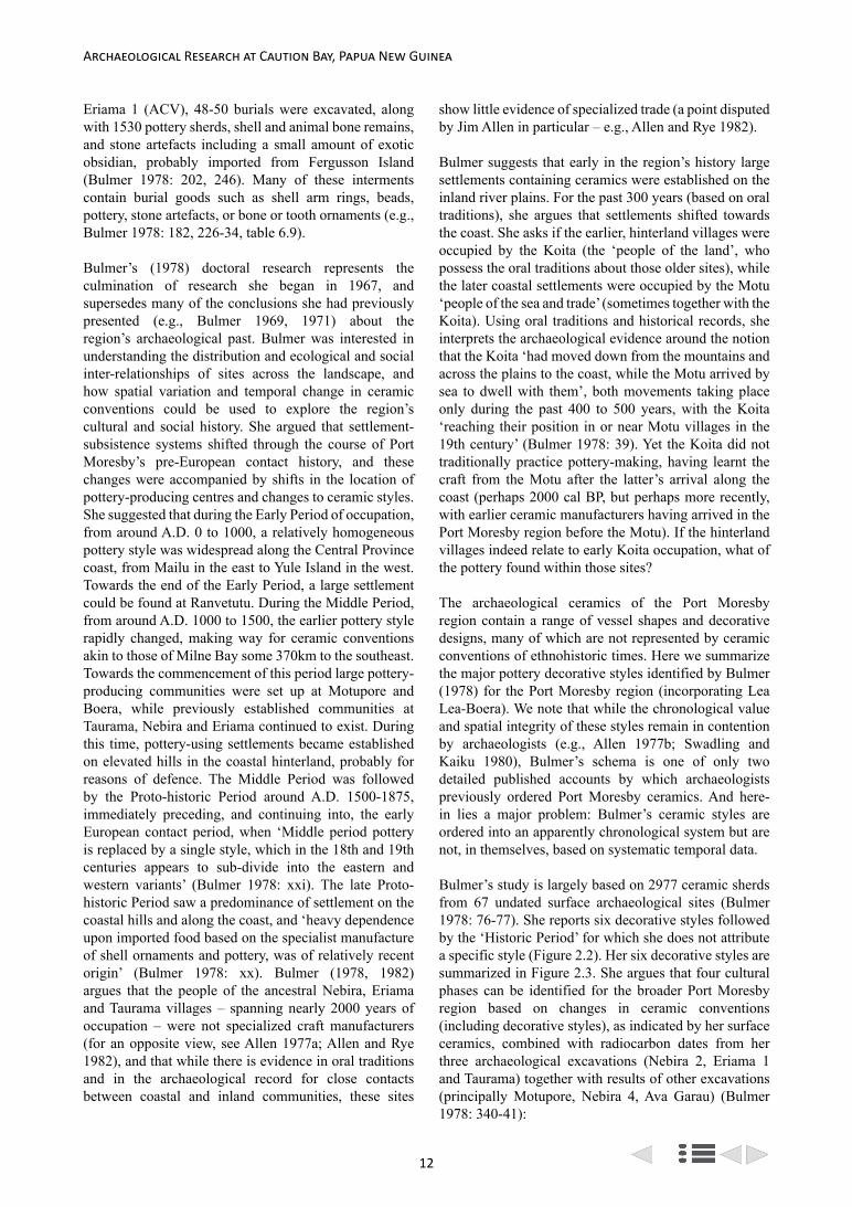
12
Archaeological Research at Caution Bay, Papua New Guinea
Eriama 1 (ACV), 48-50 burials were excavated, along with 1530 pottery sherds, shell and animal bone remains, and stone artefacts including a small amount of exotic obsidian, probably imported from Fergusson Island (Bulmer 1978: 202, 246). Many of these interments contain burial goods such as shell arm rings, beads, pottery, stone artefacts, or bone or tooth ornaments (e.g., Bulmer 1978: 182, 226-34, table 6.9).
Bulmer’s (1978) doctoral research represents the culmination of research she began in 1967, and supersedes many of the conclusions she had previously presented (e.g., Bulmer 1969, 1971) about the region’s archaeological past. Bulmer was interested in understanding the distribution and ecological and social inter-relationships of sites across the landscape, and how spatial variation and temporal change in ceramic conventions could be used to explore the region’s cultural and social history. She argued that settlement-subsistence systems shifted through the course of Port Moresby’s pre-European contact history, and these changes were accompanied by shifts in the location of pottery-producing centres and changes to ceramic styles. She suggested that during the Early Period of occupation, from around A.D. 0 to 1000, a relatively homogeneous pottery style was widespread along the Central Province coast, from Mailu in the east to Yule Island in the west. Towards the end of the Early Period, a large settlement could be found at Ranvetutu. During the Middle Period, from around A.D. 1000 to 1500, the earlier pottery style rapidly changed, making way for ceramic conventions akin to those of Milne Bay some 370km to the southeast. Towards the commencement of this period large pottery-producing communities were set up at Motupore and Boera, while previously established communities at Taurama, Nebira and Eriama continued to exist. During this time, pottery-using settlements became established on elevated hills in the coastal hinterland, probably for reasons of defence. The Middle Period was followed by the Proto-historic Period around A.D. 1500-1875, immediately preceding, and continuing into, the early European contact period, when ‘Middle period pottery is replaced by a single style, which in the 18th and 19th centuries appears to sub-divide into the eastern and western variants’ (Bulmer 1978: xxi). The late Proto-historic Period saw a predominance of settlement on the coastal hills and along the coast, and ‘heavy dependence upon imported food based on the specialist manufacture of shell ornaments and pottery, was of relatively recent origin’ (Bulmer 1978: xx). Bulmer (1978, 1982) argues that the people of the ancestral Nebira, Eriama and Taurama villages – spanning nearly 2000 years of occupation – were not specialized craft manufacturers (for an opposite view, see Allen 1977a; Allen and Rye 1982), and that while there is evidence in oral traditions and in the archaeological record for close contacts between coastal and inland communities, these sites
show little evidence of specialized trade (a point disputed by Jim Allen in particular – e.g., Allen and Rye 1982).
Bulmer suggests that early in the region’s history large settlements containing ceramics were established on the inland river plains. For the past 300 years (based on oral traditions), she argues that settlements shifted towards the coast. She asks if the earlier, hinterland villages were occupied by the Koita (the ‘people of the land’, who possess the oral traditions about those older sites), while the later coastal settlements were occupied by the Motu ‘people of the sea and trade’ (sometimes together with the Koita). Using oral traditions and historical records, she interprets the archaeological evidence around the notion that the Koita ‘had moved down from the mountains and across the plains to the coast, while the Motu arrived by sea to dwell with them’, both movements taking place only during the past 400 to 500 years, with the Koita ‘reaching their position in or near Motu villages in the 19th century’ (Bulmer 1978: 39). Yet the Koita did not traditionally practice pottery-making, having learnt the craft from the Motu after the latter’s arrival along the coast (perhaps 2000 cal BP, but perhaps more recently, with earlier ceramic manufacturers having arrived in the Port Moresby region before the Motu). If the hinterland villages indeed relate to early Koita occupation, what of the pottery found within those sites?
The archaeological ceramics of the Port Moresby region contain a range of vessel shapes and decorative designs, many of which are not represented by ceramic conventions of ethnohistoric times. Here we summarize the major pottery decorative styles identified by Bulmer (1978) for the Port Moresby region (incorporating Lea Lea-Boera). We note that while the chronological value and spatial integrity of these styles remain in contention by archaeologists (e.g., Allen 1977b; Swadling and Kaiku 1980), Bulmer’s schema is one of only two detailed published accounts by which archaeologists previously ordered Port Moresby ceramics. And here-in lies a major problem: Bulmer’s ceramic styles are ordered into an apparently chronological system but are not, in themselves, based on systematic temporal data.
Bulmer’s study is largely based on 2977 ceramic sherds from 67 undated surface archaeological sites (Bulmer 1978: 76-77). She reports six decorative styles followed by the ‘Historic Period’ for which she does not attribute a specific style (Figure 2.2). Her six decorative styles are summarized in Figure 2.3. She argues that four cultural phases can be identified for the broader Port Moresby region based on changes in ceramic conventions (including decorative styles), as indicated by her surface ceramics, combined with radiocarbon dates from her three archaeological excavations (Nebira 2, Eriama 1 and Taurama) together with results of other excavations (principally Motupore, Nebira 4, Ava Garau) (Bulmer 1978: 340-41):

13
Bruno David et al.: Archaeology in Port Moresby and the Southern Lowlands of Papua New Guinea
1. Early Period with Style I pottery: around A.D. 0-1000.
2. Middle Period with Styles II, III and IV pottery: around A.D. 1000-1500.
3. Proto-historic Period with Styles V and VI pottery: around A.D. 1500-1875.
4. Historic Period: after around A.D. 1875.
Jim Allen
Jim Allen’s work in the Port Moresby region involved both field research and the theoretical modelling of culture change in this ceramic manufacturing and ethnographically renowned long-distance maritime trading centre. Allen (e.g., 1984: 415-16) noted that the Motu, like other southern PNG lowlands Austronesian-speaking groups, did not settle rich agricultural landscapes but rather coastal regions fronted by resource-rich offshore reefs. He further pointed out that these were (and continue to be) specialized maritime peoples who also gardened, hunted and gathered, but it is the sea that
formed the focus of subsistence and settlement practices. Nevertheless the seasonally drought-prone Port Moresby region, and the paucity of agricultural products directly available to the maritime specialist Motu, meant that alternative means of obtaining food resources had to be developed to ensure long-term survival. The answer came in the form of craft specialization (ceramics and shell valuables used for bride price and the like) and the intensification of long-distance maritime trade (Allen 1982: 202) in time leading to the hiri. However, Allen (1977c: 399), also noted that ‘…the environmental stress hypothesis remains nothing more than an explanation for the developed system as first recorded by Europeans, and not necessarily an explanation of why it developed in the first place’. Allen (1977c: 406) further noted that ‘despite the economic imperatives it is impossible to separate the hiri as a subsistence expedition from the hiri as a social institution, for in the hiri … socio-political and economic objectives were closely intertwined’. Nevertheless, regardless as to whether the hiri emerged as a subsistence strategy or not, ceramics and shell
CulturalHiatus
Shell-impressed
Linear-incised
LapitaSh
ell-i
mpr
esse
d
Red-slipped/painted
and Linear-incised
Hiatus
Pulse
cimare
C ylraE
et ai demr et nI
Proto Historic
Pr
e-C
eram
ic fr
om
4000
yea
rs a
go
Recent Ceramic
Ceramic
EarlyCeramic
Pulse
esahp ylrae l
ate
phas
e
LateCeramic
200
400
600
800
1000
1200
1400
1600
1800
2000
2200
2400
2600
2800
3000
Years
- - - - - Kikori River - - - - - Yule Island-Hall Sound
- - - - Port Moresby Region - - - - Amazon Bay-Mailu
Red-Slip
Middle
Motu
Early
from
u bukuK ca
. P
B 0004
Oposisi
Wairo
Kairuku
Ravao
ecneuqeS elyt
S cimare
C
Col
onis
atio
n(E
PW)
Dee
peni
ng
Reg
iona
l Is
olat
ion
Pottery Style Trans-
formation
Inte
ract
ion
Spec
ialis
atio
n an
d Ex
chan
ge
Urourina
Late
I
VI V
IV
III II
- - - - - Gulf of Papua Region - - - - -
Bulmer1978,1982
Bulmer1971
Swadling1980
Vanderwal1973
Rhoads andMackenzie 1991
David2008
Irwin1991
Skelly2014
Vailala River
Middle
Irwin1978
Early
Mayri
MailuGash-incised
Un-decorated
(years cal BP)
(years ago) (years ago) (years ago) (years ago)(years BP)
(years cal BP)
(years BP)
(years cal BP)
Figure 2.2. Cultural and ceramic sequences for southern lowland PNG.

14
Archaeological Research at Caution Bay, Papua New Guinea
valuables have high archaeological visibility enabling the history of such trade and social relations to be investigated.
Jim Allen undertook archaeological excavations at two ancient village sites in the Port Moresby region, Nebira 4 (ACL) and Motupore (AAK). Both sites contain rich cultural deposits, including flaked stone artefacts (among which are obsidian pieces imported from Fergusson Island, and drill points), pottery sherds, numerous animal bones (mainly pig, wallaby, fish and shell), shell artefacts (including beads and fragments of arm bands) and varied pieces of ochre and ground-stone artefacts from Nebira 4; and 40 burials, numerous stone drill bits, hundreds of shell disc beads, large volumes of shell and vertebrate faunal remains (particularly marine and wallaby), structural evidence in the form of pits and post holes, and very large quantities of ceramic sherds from
more extensive archaeological excavations at Motupore (e.g., Allen 1977a: 443, 444). One of these Motupore burials (a secondary burial with a dog’s teeth necklace) dated to around 400 cal BP is interpreted as Koita, due to its similarity to Koita and Koiari burials of ethnographic times. The implication is that by that time Koita-Motu relations were already close enough for a Koita burial to be included in a predominantly Motu village, as practiced also during ethnographic times (Allen 1977a: 445).
Nebira 4 is believed to date from around 2000 cal BP to sometime before the colonial period. The similarity in age of the earliest cultural levels at each of these sites, along with Oposisi in the western Central Province where 2000 year old ceramics were also found, led Allen (1972: 121) to conclude: ‘… we appear to be dealing with a widespread maritime migration into the central coast about 2,000 years ago. These people established
Style Common techniques Vessel forms Characteristic rim or lip form
Probable associated pot
decoration
I Red Slip
Slipping
Burnishing
Incising
Combing, grooving
Simple restricted bowl
Simple unrestricted bowl
Composite restricted bowl
Composite unrestricted bowl
Thickened, round
Thickened, square
Round
Round
Slipping
Burnishing
Incising
Painting
II Eriama Incised/Applique (formerly Massim)
Heavy line incising, perforation
Appliqué
Grooving
IIa Composite bowl
IIb Simple unrestricted bowl
IIc simple restricted bowl
Square, round
Thickened, square
Thickened, round
?
III Eriama Incised/Punctate (formerly Massim)
Fine line incising,
punctationSimple restricted bowl Thin, round ?
IV Taurama Shell/Comb (formerly Boera/Taurama)
Shell and comb impressing, combing Composite bowl Square
Shell and comb impressing, painting
V Taurama Incised/Punctate (formerly Motu) Heavy line incising Simple bowl Thickened round or
square Incising
VI WaiganiIncising, finger impressing, shell impressing
Simple bowl Thickened round or square ?
Figure 2.3. Summary of some characteristics of decorative styles of Port Moresby bowls (from Bulmer 1978: table 5.5).

15
Bruno David et al.: Archaeology in Port Moresby and the Southern Lowlands of Papua New Guinea
themselves widely and maintained good communications for at least a thousand years.’
The Nebira 4 faunal assemblage indicates a marine-oriented economy during the earliest cultural layers, becoming gradually less so through time (Allen 1972: 116). This change may be due to increasing dependence on inland gardens, as Allen (1972: 122) suggests, or to subsequent sedimentation of the coastal plains. The ceramic sequence indicates an early red slip (and sometimes burnished) tradition followed by a sequence of ceramic conventions including continuity of red slipping (Allen 1972: 99). Allen (1972: 105-109) identified nine decorative styles (Styles A-I), many, but not all, of which represent sequential changes in ceramic conventions (Figure 2.4).
The Nebira 4 ceramic sequence can be arranged into three successive phases (Allen 1972: 108, 109):
Horizon 1. Levels 1-8. Globular pots with heavily rolled horizontal rims; bowl forms shallow and open, often with a thickened lip; decorative style A the most distinctive marker, with a large percentage of painted pottery. [Corresponds with Styles IA and IB of Oposisi].
Horizon 2. Levels 9-15. Globular forms a mixture of horizontal and angled rims with the latter more popular; deeper bowls with straight sides; styles D and E the most common decorative styles with some temporal value, together with styles F and G. [Corresponds with Style IIA of Oposisi].
Horizon 3. Levels 16-19. Globular forms with angled rims; bowl forms most commonly restricted, and found in association with decorative styles F and G. Styles
H and I are the best indicators of this early horizon. [Corresponds with Styles IIB and IIC of Oposisi].
The age ranges of these phases remains unclear due to dating uncertainties and insufficient radiocarbon determinations to resolve such questions (Allen 1972: 121). Nevertheless, Nebira 4 clearly demonstrates some 2000 years of ceramic evolution.
Motupore in Bootless Inlet to the southeast of Nebira was established around A.D. 1200, and appears to have been abandoned around A.D. 1700 (Allen 1977a: 443). Motupore is only referred to once in the recorded oral traditions of the greater Port Moresby area, yet as determined archaeologically it was once a major site of ancestral Motu character (Allen 1977a: 442, 446). Allen (1984: 420) wrote that Motu (and to a lesser degree Koita) pottery ‘underwrote the emergent maritime trading systems’. Allen (1977a) has suggested that socio-economic interactions between the Koita and Motu, and with trading partners further to the west in the Gulf Province, have intensified through time. Such intensifications are observable archaeologically in a simplification (decreased decoration) and standardization of Motu ceramics with the mass production of trade goods, along with an increased population evident in a concomitant proliferation of occupation sites. Among the Western Motu, amicable relations with the Koita led to the establishment of seaside villages, but further to the east less amicable relations between the Eastern Motu and the Koiari led to the construction of Motu villages over the sea for purposes of defence (Allen 1977a: 451). Allen notes that pottery-producing Motu settlements were located in low-rainfall parts of PNG subject to periodic droughts, encouraging the development of specialized pottery manufacture for which food products (in particular sago) could be traded in surplus quantities (Allen 1984). Nevertheless, the manufacture of (principally hiri) trade ceramics did not simply meet the dietary needs of the Motu villages, but also enabled high risk, status-enhancing long-distance maritime voyages and the acquisition of surplus products (sago) by which internal exchange relations could develop with Koita and other nearby groups. The development of specialized ceramic-for-food trade relations with long-distance trade partners (in the Gulf region) as well as with neighbouring groups (such as the Koita and Koiari, the latter bringing shell lime and highlands stone axes to the Motu) created social developmental momentum that gave rise to the complex Motu and Koita societies of ethnographic times.
Following Bulmer (1971), Allen (1977a: 439-442) initially divided Port Moresby’s archaeological sequences into three broad periods, which he referred to as the Early Ceramic Horizon (A.D. 0-1000), followed by a ‘middle period’ onto a ‘final period’. He suggested that during the initial ceramic phase,
a b
c d
e f g
0 4cm
Figure 2.4. Representative decorated sherds from Nebira 4 (ACL) (a-d = Style G, e-g = Style H) (after Allen 1972: 106,
figure 2).

16
Archaeological Research at Caution Bay, Papua New Guinea
Austronesian speakers came from the east and settled in an interconnected network of villages along the southern PNG coast, maintaining between themselves good inter-community communications and thereby a commonality of ceramic conventions. However, ‘The demise of this Early Ceramic Horizon is sudden all along the coast’ (Allen 1977a: 448). The subsequent phase of the ‘middle period’ saw ‘the possible removal of the people from the valley floor site of Nebira 4 to the adjacent hilltop site of Nebira 2 and the occupation of the offshore island site of Daugo near Port Moresby’ (Allen 1977a: 439-440). Allen here suggests that around A.D. 1000 the (presumably Austronesian-speaking) people of the Early Ceramic Horizon came under pressure from inland (ancestral Koita) groups as the latter began to move towards the coast, necessitating the establishment of settlements in more defensive positions (hilltops and offshore islands). Following Bulmer (1971), around A.D. 1000-1400 two new ceramic traditions then appeared in the Port Moresby area: intrusive (i.e., foreign) ‘Massim’ wares from the Milne Bay area, most evident from archaeological sites in the Boera area; and ‘Boera/Taurama’ wares that appeared to represent ancestral Motu ceramics. The pottery of the ‘final period’ corresponds to the ethnographically recorded Motu ceramics. Allen (1977a: 446) suggested that as Motupore was occupied continuously from around A.D. 1200 to 1700, and as Motupore’s most ancient ceramic decorative styles could be shown to evolve uninterrupted into decorative conventions that are akin to Motu ethnographic examples, its inhabitants were likely ancestral to present-day Motuans. ‘For this reason a certain adjustment needs to be made to Sue Bulmer’s proposed culture sequence’ (Allen 1977a: 446), which posited a sequence of interrupted ceramic styles representing external influences or replacements. Hence, as the ceramic conventions of Bulmer’s ‘Boera/Taurama’ Middle Phase were found at Motupore, where they could be shown to be ancestral to, and evolving into, historic Motu incised/impressed wares, Allen (1977a: 446) suggested that the later two stages of Bulmer’s sequence should be coalesced into one, reducing the entire Port Moresby sequence into two phases: an early phase spanning around A.D. 0-1000; and a later phase beginning ‘somewhere before A.D. 1200 and continuing to present’ (Allen 1977a: 446). Allen concludes that the long-debated
… hiatus between the two is therefore reduced, and it is into this hiatus the Massim industry described by Bulmer must be fitted. The status of the people represented by this pottery still requires elaboration … On the present evidence it may well be that there was no hiatus at all, and that the Massim component infiltrated during the brief period of disequilibrium following the disappearance of the earlier inhabitants and during the establishment of ancestral Motuan
groups (Allen 1977a: 446; see also Swadling 1976).
Motupore has a ceramic industry that can be followed uninterrupted from around A.D. 1200 into ancestral Motu ceramics (Figure 2.5). This phase is interpreted by Allen (1977a: 446) as indicating that the Motu ‘impinged upon the existing central Papuan coastal population from outside the research area some 800 years ago’. That is, around A.D. 1200 a new wave of Austronesian speakers came from the east to the Port Moresby area with new ceramic decorative conventions, establishing a base at Motupore. These were the ancestors of the ethnographic Motu. Through time, as the Motu established and consolidated their villages along the coast, the Motu proliferated on the coast and the Koita both inland and on the coast as the two groups entered into symbiotic social and economic relations (Allen 1977a: 449). Allen (1984: 423) later argued that craft specialization was ‘vitally important’ to the Western Motu (and Koita) trade economy, and that they were ‘the only notable producers of pottery along some 400km of the south Papuan coast’. Of note is the highly standardized ceramics that emerged during this recent, monopolizing phase, which Allen (1984: 423) associated with increasing commercialization of production. Following Groves (1960), Allen (1984) noted that the heightened levels of trade generated by establishing trade partnerships led to increased (and surplus) food returns into the Motu villages, which in turn fed increasing trade relations with neighbouring groups who brought hinterland food products (garden produce, wallaby meat) for imported surplus sago and ceramics, positively feeding back to higher populations that enabled the system to grow. By the later stages of the recent phase, this demographic growth had led to further increasing demands on food resources that led the ceramic-manufacturing women to work ‘at break-neck speed’ to produce the very large quantities of pots necessary for exchange expectations, in particular in the form of the long-distance hiri expeditions; ‘insufficient care in making the pots’ led to substandard pots that often broke in the making, and a lack of time for elaboration of designs led to the ‘simplification of shapes and decoration’ evident in recent phase ceramics (Allen 1984: 423).
Pamela Swadling
Swadling (1977a: 38) states that by 1977, about 400 archaeological sites were known from the coastal lowlands of the Central Province by the PNG National Museum and Art Gallery; the oldest of these (e.g., Nebira 4, Eriama 1; subsequently, Loloata Island) dated to around 2000 cal BP, indicating the rarity and great difficulty of finding older cultural materials, despite well-documented archaeological deposits tens of thousands of years old in the highlands. She further noted that at the time of early European contact,

17
Bruno David et al.: Archaeology in Port Moresby and the Southern Lowlands of Papua New Guinea
… the largest villages were those of the Motu; but from Pari westwards, all Motu villages also had Koita residents … The Koita however had other settlements located on the coastal lowlands inland from the coast, or on hills overlooking the sea (Swadling 1977a: 37).
Swadling and Kaiku (1980) excavated two sites in the broader Caution Bay landscape: in the north at Papa they excavated a ‘fireplace in the clay surface of an eroded village site in the Papa salt pans’ (Swadling and Kaiku 1980: 86), dated to 1280±170 BP; and in the south they excavated a large archaeological village site at Ava Garau located on a coastal ridge to the northwest of Boera, dated to 1220±95 BP. The Papa site contained red slipped ceramic sherds typical of the earliest phase of human occupation in the Port Moresby region (e.g., Style I of Bulmer 1978; at Nebira 4, Horizon 3 of Allen 1972).
At Ava Garau, which Swadling identified as an ancestral Boera site,
… pottery was found which shows that both old and new pottery ideas were used by people living there 1,200 years ago. … The influence of new potting ideas, especially in bowl decoration and rim shapes, from the D’Entrecasteaux, Amphlett
and Goonenough Islands cannot be denied. (Swadling 1977a: 39)
Swadling (1977a: 42) concluded that while the ancient ceramic assemblages of the broader Port Moresby region showed close formal and decorative affinities with those of the D’Entrecasteaux, Amphlett and Goonenough Islands as well as Milne Bay, Motuan history could not be reduced to recent or foreign arrivals ‘to the shores of Port Moresby’ (as Allen similarly concluded for the past 800 years, see above). Rather, oral traditions ‘do not tell of a far away homeland, but of old village sites along the Central Province coastline. Some of these old villages are said to be very old, whereas others have been recently settled’ (Swadling 1977a: 42).
Swadling (1980) divided the Port Moresby region ceramics into three phases: Early Period (a.k.a. Bulmer’s ‘Red Slip’, c. 2000-1200 cal BP), Middle Period (a.k.a. Bulmer’s ‘Boera-Taurama-Motupore’, c. 1200-300 cal BP) and Late Period (a.k.a. Bulmer’s ‘traditional Motu’ of the past 300 years) (Figure 2.2). She argued that major stylistic changes in ceramic designs took place between the late Early Period and the Middle Period (broadly but imprecisely corresponding to the ‘Papuan hiccup’ of Rhoads [1982: 146], ‘hiccup’ of Irwin [1991]; ‘ceramic hiccup’ of Summerhayes and Allen [2007]; and ‘hiatus’ of Allen et al. [1997]). Her study of the sources and
ba c
0 5
cm
d e
Figure 2.5. Shell-impressed bowl sherds with ‘herringbone’ patterns from the ‘early levels’ of Motupore (AAK).

18
Archaeological Research at Caution Bay, Papua New Guinea
antiquity of a small sample of the ceramic vessels found in Central Province and Gulf Province archaeological sites (including sherds from Daugo Island site AAQ, the Papa Salt Pan site [AWL], and Ava Garau [AMH] near Boera) indicates that
… early Middle Period sites do not seem to extend as far west as those of the late Early Period. Does this reflect some settlement changes in the Gulf or the impact of the changing situation in the Central Province, as the early Middle Period marks a rather abrupt, but not total, stylistic change in the Port Moresby region (Swadling 1980: 108-9).
She continues (Swadling 1980: 115):
… the people living at the late Early Period sites in the Port Moresby region were using a number of different clay sources. Why the people living at Ranvetutu were using pots made from Boera clay, rather than clay from near their own village, is not known. … The intricate decoration and complex shapes of the pots made during the late Early Period indicates that considerable time and effort was spent on pot making. These people were certainly not involved in the quick, mass production of pots which occurred in the Port Moresby region at the time of contact.
Swadling clearly suggests major cultural change across the Port Moresby region between the late stages of the earliest ceramic phase and the classic Motuan ceramic tradition that we are familiar with from ethnography, changes akin to those argued by Allen concerning the period between 1200 and 800 cal BP in particular. Furthermore, farther to the west in the Gulf region sites receiving Port Moresby region ceramics, ‘the bulk of the late Early Period potsherds … come from sources in the LeaLea-Boki area. None come from Boera’ Swadling (1980: 119).
Swadling (1980: 119-21) thus further noted:
The same pattern with most coming from LeaLea-Boki and none from Boera continues in the early Middle Period potsherds from Tei Hill … This finding suggests that the same clay sources continued to be used during the rather abrupt, but not total, ceramic stylistic change which occurred between the late Early Period ceramics in the Port Moresby region. No settlement sites with early Middle Period ware are known from the LeaLea area, but it would not be unrealistic to envisage the continued use of this clay source by descendants of people who may have moved to reside in the Boera village complex from the LeaLea area. … Perhaps the biggest surprise of all, is the lack of late Early Period and Middle Period sherds made
from Boera clay in the Gulf sites. … This seems contrary to the widely acknowledged Motuan legend which claims that the hiri was started by Edai Siabo from the Boera area. … The results to hand would indicate that it was the people formerly resident in the LeaLea area, who may have been responsible for producing, using their former clay sources, most of the early Middle Period ware which reached the Gulf.
While the people using the Boki clay source in the LeaLea area were the main suppliers to the Gulf of both Early Period and early Middle Period ware, the coming of the Middle Period seems to mark a total decline in the movement of Central Province pots to the Gulf. The author is not aware of any middle Middle Period [ware] … having been collected in the Gulf. In other words, it would seem that soon after the founding of the huge village complex at Boera, that potsherds dating to that period no longer appear in the Gulf.
A likely explanation is that the oral traditions (including the legendary Edai Siabo story) relate largely, if not entirely, to the most recent phase or pulse (dating to the past 500 years), of cultural activity in the Gulf of Papua and Port Moresby regions.
A related question that has dogged the archaeology of the southern PNG lowlands concerns whether or not a hiatus in human occupation and long-distance maritime trade occurred around 1000 cal BP. Swadling (1976: 1) poses this question for the Port Moresby region, pointing out that ‘The excavations and surveys of Bulmer, Allen and Vanderwal along the central south Papuan coast all suggested that there was a chronological break about 1,000 years ago’. A paucity of radiocarbon dates on individual pieces of charcoal (thereby avoiding the potential mixing of charcoal pieces of varied ages) notwithstanding, Swadling (1976: 2-3) suggested that the Ava Garau radiocarbon determination near Boera ‘removes the likelihood of a hiatus in the Port Moresby sequence’, and instead ‘suggests continuity into what has been called the Boera-Taurama-Motupore tradition’, as the Boera-Taurama-Motupore tradition is interpreted as a local development of earlier (imported) ceramic manufacturing conventions of the Port Moresby region (in line with Allen’s [1977a] interpretations). Like Allen (1977a), Swadling (1976: 4) suggested that the Boera-Taurama wares were ancestral to recent Motu ceramics as documented ethnographically. Nevertheless, the question of a hiatus in regional occupation and long-distance ceramic trade between 950-500 cal BP remains for the Kikori River area of the Gulf region. Disruptions in settlement systems, trade relations, and ceramic production in the pottery-producing Port Moresby region villages is key to understanding the lull in ceramics and

19
Bruno David et al.: Archaeology in Port Moresby and the Southern Lowlands of Papua New Guinea
paucity of known archaeological villages between the occupational pulses in the Gulf region.
Yule Island-Hall Sound
Ron Vanderwal
From mid-1969 to 1970, Ron Vanderwal undertook his PhD research in the Yule Island-Hall Sound area, located on the brink of the Gulf of Papua (Vanderwal 1973). He identified 13 sites and excavated five, Urourina, Sirirou, Abe and Kukuba Cave, and most notably Oposisi on Yule Island. Vanderwal excavated 30m2 at Oposisi, a deeply stratified site with a rich ceramic assemblage, from which six charcoal radiocarbon determinations were obtained (and which greatly influenced other archaeologists working along the entire south coast of PNG). There were a number of dating inversions, but Vanderwal concluded that a date of 1890±305 BP (ANU-425) from the ‘bottom level (14)’ in Zone IIC, approximated the commencement of occupation at the site, with the uppermost undisturbed cultural deposits dating approximately 600-800 years later. He well-recognised, however, that the ‘mid-periods of Oposisi are not well dated’ (Vanderwal 1973: 50).
Vanderwal (1973: 99-108) identified 18 ceramic Types at Oposisi, primarily from vessel form, but surface decoration also contributed to his typological determinations (Figures 2.6, 2.7). However, surface
decoration was used only to corroborate and refine determinations based on vessel form. As a consequence, some decorations are attributed to a number of different ceramic Types, whereas others are limited to just one Type. Largely on the basis of Types A-C shell-impressed sherds (e.g., Figure 2.6a-g, 2.6k-m), restricted to the basal Zone IIC at Oposisi, Vanderwal concluded that:
The evidence from both Yule Island and Port Moresby [the Bulmer and Allen excavations] suggests that what I have called the Oposisi ceramics are the earliest in the region. Accompanying the pottery in the research area is an entire range of cultural items, many of which are limited, on the available evidence, to the phase in question. … the Oposisi people might have been supported by a parent community, with certain items like obsidian and even adzes traded in from a source to the east, and they might have been traders themselves, bringing pottery to an area that had previously not known it. … Nevertheless the archaeological evidence shows the case to be not one of trait intrusions … but one of site unit intrusion where cultural identity has been maintained and actual migration involved. (Vanderwal 1973: 233).
Further, he states, ‘there can be little room for doubt that the Oposisi culture is another transformation of the Pacific Lapita’ (Vanderwal 1973: 234). Vanderwal later
0 4cm
a b c
de f
Figure 2.6. Representative sherds from the Yule Island ‘Type Collection’, PNG National Museum and Art Gallery: a = Type T, b = Type T, c = Type M, d = Type K, e = Type R, f = Type T (Photo: Robert Skelly).

20
Archaeological Research at Caution Bay, Papua New Guinea
modified his interpretation to suggest that ‘the Oposisi assemblage, as represented in Zone IIC, was transported to this part of Papua through exchange media probably mostly after initial settlement’ (Vanderwal 1978: 424), rather than representing colonising traders who settled at Yule Island. But during those initial, influential
formative years of south coast archaeology, Vanderwal argued that Oposisi held evidence for the arrival of a new people introducing pottery for the first time to the southern shores of PNG, and given the age of Zone IIC, dating to around 2000 cal BP.
Figure 2.7. Representative decorated sherds from Oposisi: a = Type A, b = Type A, c = Type B, C, D, E, d = Type B, C, D , E, e = Type B, C, D, E, f = Type A, g = Type B, C, D, E, h = Type G, i = Type G, j = Type K, k = Type B, C, D, E, l = Type B, C, D, E, m = Type B, C, D, E, n = Type K, o = Type F, p = Type S, q = Type W, r = Type W, s = Type T, t = Type T, u = Type W (after Vanderwal 1973: figures
VI-6-10).

21
Bruno David et al.: Archaeology in Port Moresby and the Southern Lowlands of Papua New Guinea
For his study area, using data from all of his excavated sites, Vanderwal (1973: 195-198) defined four cultural phases:
• Preceramic phase (c. 4000 BP): represented by stone artefacts from Kukuba Cave.
• Initial Ceramic phase (c. 2000 BP): pottery was introduced by intrusive horticulturists who maintained external contacts possibly with founding groups.
• Developmental phase (<2000 BP to probably <1000 BP): represents a time of ‘greater control and knowledge’ of mainland resources (Vanderwal 1973: 197).
• Intrusive Ceramic phase (>700 BP): represented only by ceramic traits evident at the Urourina site.
The same data and periods were also divided into six chronologically sequential technological complexes spanning the period c. 4000-700 BP (Vanderwal 1973: 167-74). The first of these was a pre-ceramic phase; specific ceramic Types formed the basis of differentiation for the subsequent five ceramic complexes (Figure 2.2):
• Kukuba complex (c. 4000-2000 BP). Consists of stone artefacts in pre-ceramic levels at Kukuba Cave (the only pre-ceramic assemblage known from the southern coast of PNG prior to the Caution Bay research).
• Oposisi complex (c. 2000 BP). Ceramic Types A, B and C (Figures 2.7a and 2.7b) from basal levels of Oposisi. These earliest ceramics signalled the first arrival of ceramics across the region.
• Ravao complex (c. <2000-1200 BP). Ceramic Types H and J. Contains fewer bone and shell artefacts than the Oposisi complex.
• Wairo complex (c. 1100-1200 BP). Ceramic Type S (Figure 2.7p), plus ceramic forms found in the later part of the preceding Ravao complex, and the subsequent Kairuku complex.
• Kairuku complex (c. 1000-900 years ago). Ceramic Types T and W (Figures 2.6a, 2.6b, 2.6f, 2.7t and 2.7u).
• Urourina complex (c. 700 BP). Includes sherds with a distinctive type of shell-impressed decoration and ‘multi-pronged’ impressed decoration found at Urourina.
More recently Allen and colleagues excavated a column sample on the edge of the original excavation pit at Oposisi, the results of which generally confirmed and slightly extended the age of basal deposits at c. 2000 cal BP, and refined the overlying ceramic chronology. Obsidian from the period c. 2000-1500 cal BP was sourced to Fergusson Island in the Massim off the eastern tip of New Guinea, demonstrating strong links with the east for this early phase (Allen et al. 2011).
Gulf of Papua Region
Jim Rhoads, David Frankel and Bruno David
The Gulf of Papua represents the recipient end of the hiri trade. Archaeological excavations began there during the 1970s, first with Rhoads (1980) in the mid-Kikori River and at the site of Popo at Orokolo Bay (Rhoads 1994), then by Frankel and Vanderwal at Kinomere on Urama at the mouth of the Purari River and at a number of sites near Kerema (Frankel and Vanderwal 1982, 1985; Frankel et al. 1994). Between 2006 and 2009, Bruno David, Ian McNiven, Bryce Barker and Lara Lamb excavated a number of sites from the mouth of the Kikori River inland to Baina at the foothills of the Highlands. Frankel et al. (1994: 46) have pointed out for the coast that:
No sites in the Gulf have been securely dated between 700 and 500/400 years ago. This is probably a product of the limited amount of research and the difficulty of locating sites without pottery, but may well reflect [a] decline in long-distance trade, at least in pottery (Frankel et al. 1994: 46).
Most researchers (e.g., Allen 1977a; Swadling 1976) have suggested that the hiri as known from ethnography immediately post-dates the ‘ceramic hiccup’ phase of transformation in pottery styles (in Central Province pottery-producing communities) or apparent ceramic absence (in Gulf Province pottery recipient communities), and is probably only 500 to 300 years old (Rhoads and Mackenzie’s [1991] ‘Recent Ceramic’ phase). This most recent ceramic phase in recipient Gulf Province sites is usually taken to indicate some 500-300 years of continuous trade, an increasing standardisation of trade goods (including increasing specialisation and centralisation of ceramic production within the ceramic producing areas), population increases and the establishment of large settlements in the Gulf region (e.g., Allen 1977a, 1977b; Frankel et al. 1994: 45-47). More recently and consistent with these views, David (2008) has demonstrated major shifts in ceramic trade into the western sections of the Gulf region beginning 500 cal BP, attributed to the onset of the hiri continuing uninterrupted into ethnographic times. This most recent pulse in occupation, ceramics and radiocarbon dates in the Gulf region, dated to 500-0 cal BP, corresponds well with Rhoads and Mackenzie’s (1991) Recent Ceramic and Proto-historic phases (Figure 2.2). This period of time contains the greatest number of ceramic sherds, traceable to the onset of the ethnographically documented hiri system (again in agreement with Rhoads and Mackenzie’s earlier interpretations). Precisely how the newly excavated ceramics from this most recent period formally, decoratively, economically and occupationally relate to the earlier ceramic phases – in particular how

22
Archaeological Research at Caution Bay, Papua New Guinea
they relate to an earlier pulse of high archaeological representation 1450-950 cal BP also associated with large quantities of imported ceramic sherds (David 2008) – remains a matter of debate.
While the major pulses in occupation in the mid-Kikori River area suggest the existence of active exchange relations 1450-950 and again 500-0 cal BP separated by a hiatus in the arrival of ceramics during the intervening period, they also indicate a loosening of village stability presumably in concert with a breakdown in long-distance trade relations between 950-500 cal BP, a period so-far characterized by an absence of (imported) ceramics. It is significant to note that this period in the mid-Kikori River area lies largely within the ‘ceramic hiccup’ phase of the Central Province – a period of transformation of pottery styles in the ceramic production end of the hiri system. The paucity of radiocarbon dates and the apparent absence of ceramics between 950 and 500 cal BP in the Kikori River area may thus reflect contemporaneous and/or shortly earlier disturbances in ceramic producing sites and cultural sequences further to the east. If the precise dating of cultural sequences in the Port Moresby region sites is correct (which is not certain), the rejuvenation of ceramic-sago exchange in the Gulf region around 500 cal BP appears to post-date the start of intensified pottery production and the most recent ceramic phase (immediately following the ‘ceramic hiccup’) in the Port Moresby region by perhaps 200 years (possibly involving Koita-Motu displacements there; Allen 1977a; Bulmer 1978). During this most recent period, the establishment of a new phase of trade partnerships and stable settlement locations were associated with new forms of regionalized ceramics, indicating a break-down of the earlier and more widespread ceramic conventions. Critical to understanding the onset of this new phase is, therefore, the period known as the ‘ceramic hiccup’, a perceived gap between the earlier and later phases of ceramic production and long-distance maritime trade. In such ways the archaeology of the Gulf of Papua has profound significance for understanding the socio-cultural history of the ceramic-producing villages in the Port Moresby region, and vice versa.
Bruno David and Robert Skelly
On 20 August 2007 the Post-Courier (PNG’s major daily newspaper) announced that two wrecked lakatoi (hiri trading vessel) hulls had been discovered near Epemeavo and Kea Kea villages east of the Vailala River in the mid-region of the Gulf of Papua. One week later archaeologists Bruno David and Nick Araho (PNG National Museum and Art Gallery) arrived to investigate the finds (see David et al. 2008 for details). Following community discussions and completion of initial investigations of the hulls site, clan leaders representing Epemeavo and Kea Kea villages led the archaeological team to Keveoki (OKE and OKG) and Meiharo swamps
(OKF) where large amounts of buried ceramics had recently been exposed through gardening activity (see David et al. 2009; Moffat et al. 2011; Skelly et al. 2010). Comparing ceramic conventions of the Keveoki assemblage with those known from the ethnographic hiri trade, David et al. (2009: 18) described a ‘predominance of everted carinated dishes and everted indirect pots at Keveoki 1 [OKE surface collection] … consistent with the predominance of Motu uro, nau and perhaps hodu’. David et al. (2009: 18) concluded that,
Keveoki 1 [OKE] belongs chronologically to the early part of the late ceramic phase in the Gulf Province (see David 2008 for discussion), the one immediately following the so-called ‘Ceramic Hiccup’ on the southern Papuan coast (see Summerhayes and Allen 2007), and located at the beginning of the ceramic sequence that then continues uninterrupted to the period of the ethnographic hiri.
Based on promising results from investigations at Keveoki and Meiharo, for his doctoral research Robert Skelly investigated other cultural sites from the same region of what is locally known as the Kouri lowlands. Skelly excavated 10 archaeological sites in 2010, shortly after the Caution Bay fieldwork and the discovery of Lapita sites there, but his research is relevant to the interpretation of the Caution Bay finds and therefore to discussions presented in forthcoming Caution Bay volumes. Noteworthy is a detailed ceramic sequence that starts with a small Late Lapita ceramic assemblage with dentate-stamped body and lip decorations from the Hopo site (OJS) dated to c. 2600 cal BP (Skelly et al. 2014) (Figure 2.2). This is followed by several post-Lapita ceramic phases with shell-impressed body decorations dating to an uncertain time within the period 2300-1550 cal BP, followed by a phase of red-slipped/painted and linear incised decorations dating to c. 1550-1175 cal BP. This is then followed by a period of some 500 years (c. 1175-675 cal BP) when no cultural evidence is apparent, a period that corresponds well with the ceramic ‘hiccup’ previously identified by Rhoads (1982), Irwin (1991) and Summerhayes and Allen (2007) for various parts of the southern lowlands (see above). Ceramics then reappeared c. 675 cal BP in the Kouri lowlands, continuing unabated into the ethnographic period (Skelly 2014). Ceramics in that most recent, post-‘hiccup’ phase were initially decorated with linear arrangements of individually-impressed shell valve lip impressions on the bodies of pots, with deeply-incised lip decorations leaving distinctive crenulated vessel profiles also being characteristic of the period. After c. 540 cal BP these decorations declined in complexity, and after c. 300 cal BP body decoration consisted of gash-incisions or punctations along vessel contours and shallowly incised lips. Body and lip decoration ceased entirely by c. 150
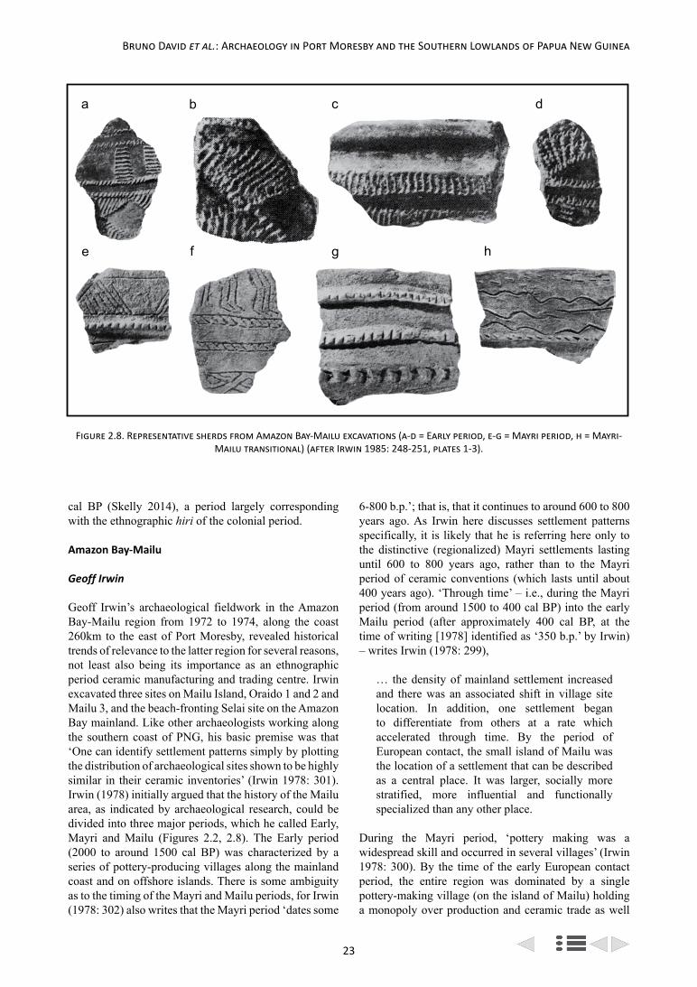
23
Bruno David et al.: Archaeology in Port Moresby and the Southern Lowlands of Papua New Guinea
cal BP (Skelly 2014), a period largely corresponding with the ethnographic hiri of the colonial period.
Amazon Bay-Mailu
Geoff Irwin
Geoff Irwin’s archaeological fieldwork in the Amazon Bay-Mailu region from 1972 to 1974, along the coast 260km to the east of Port Moresby, revealed historical trends of relevance to the latter region for several reasons, not least also being its importance as an ethnographic period ceramic manufacturing and trading centre. Irwin excavated three sites on Mailu Island, Oraido 1 and 2 and Mailu 3, and the beach-fronting Selai site on the Amazon Bay mainland. Like other archaeologists working along the southern coast of PNG, his basic premise was that ‘One can identify settlement patterns simply by plotting the distribution of archaeological sites shown to be highly similar in their ceramic inventories’ (Irwin 1978: 301). Irwin (1978) initially argued that the history of the Mailu area, as indicated by archaeological research, could be divided into three major periods, which he called Early, Mayri and Mailu (Figures 2.2, 2.8). The Early period (2000 to around 1500 cal BP) was characterized by a series of pottery-producing villages along the mainland coast and on offshore islands. There is some ambiguity as to the timing of the Mayri and Mailu periods, for Irwin (1978: 302) also writes that the Mayri period ‘dates some
6-800 b.p.’; that is, that it continues to around 600 to 800 years ago. As Irwin here discusses settlement patterns specifically, it is likely that he is referring here only to the distinctive (regionalized) Mayri settlements lasting until 600 to 800 years ago, rather than to the Mayri period of ceramic conventions (which lasts until about 400 years ago). ‘Through time’ – i.e., during the Mayri period (from around 1500 to 400 cal BP) into the early Mailu period (after approximately 400 cal BP, at the time of writing [1978] identified as ‘350 b.p.’ by Irwin) – writes Irwin (1978: 299),
… the density of mainland settlement increased and there was an associated shift in village site location. In addition, one settlement began to differentiate from others at a rate which accelerated through time. By the period of European contact, the small island of Mailu was the location of a settlement that can be described as a central place. It was larger, socially more stratified, more influential and functionally specialized than any other place.
During the Mayri period, ‘pottery making was a widespread skill and occurred in several villages’ (Irwin 1978: 300). By the time of the early European contact period, the entire region was dominated by a single pottery-making village (on the island of Mailu) holding a monopoly over production and ceramic trade as well
a b c d
e f g h
Figure 2.8. Representative sherds from Amazon Bay-Mailu excavations (a-d = Early period, e-g = Mayri period, h = Mayri-Mailu transitional) (after Irwin 1985: 248-251, plates 1-3).

24
Archaeological Research at Caution Bay, Papua New Guinea
as use of large ocean-going canoes, despite the fact that by that time there were many more villages than previously along the coast, and that these villages were more closely but less regularly spaced than during earlier periods (being on average 7km, 6km and 3km apart during the Early, Mayri and Mailu periods respectively) (Irwin 1978: 304, 305). Along with this increasing centralization and specialization of ceramic production and trade, and increasing populations and village density, also came a move from coastal village locations to hilltops for purposes of defence, a further indication that social relations were significantly different between the latest (ethnographic) phase and earlier times (Irwin 1985: 11). Because of insufficient radiocarbon dating, Irwin (1978: 315) concludes that ‘The major change in pattern occurred between early in the Mayri Period and 1890’ – a period covering from around 1500 to 150 cal BP.
Irwin later compared his earlier material to sites of similar age to the west, noting that the lower levels of Oraido 1 revealed sherds with shell-impressed decoration apparently comparable to Type A from Zone IIC at Oposisi on Yule Island and Style H from Horizon 3 from Nebira 4 near Port Moresby, with a radiocarbon date of 1900±70 BP (ANU-1229) from Oraido 1 suggesting near-contemporaneity of the three pottery assemblages (Irwin 1985: 67). Shell-impressed sherds similar to those from Oraido 1 were also found at Selai on the mainland, where radiocarbon dates of 1790±70 BP (ANU-1316) and 1770±70 BP (ANU-1317) were obtained.
Irwin (1991: 503) coined the term ‘Early Papuan Ware’ (EPW) for the earliest pottery phase from Amazon Bay-Mailu, which although locally made, he suggested was part of a sequence of styles also found along much of the south coast of PNG. EPW remained current as a progression of styles in Amazon Bay-Mailu c. 2000-1200 years ago (Irwin 1991: 504-505). Between c. 1600-1000 years ago, however, there was divergence in local ceramic traditions from similar, contemporaneous ceramic traditions elsewhere along the south coast of PNG, with the EPW pottery tradition ending abruptly in all locations c. 1200 BP (Irwin 1991: 507). Irwin (1991: 504) characterized this later period (c. 1600-1000 years ago) of stylistic divergence as signalling a lessening of communication along the approximately 400km of coastline between Amazon Bay and Yule Island.
Based primarily on results from Amazon Bay-Mailu, but also referencing investigations further to the west, Irwin (1991) presented a four-phase cultural sequence for the south coast of PNG (Figure 2.2):
• Colonisation (2000-1600 years ago). Settlements using EPW pottery appear along the south coast of PNG.
• Deepening Regional Isolation (1600-1000 years ago). Coastal groups fragment, creating a series of local ceramic traditions, with ceramics in Amazon Bay-Mailu diverging from those of the Port Moresby region and Yule Island-Hall Sound.
• Pottery Style Transformation (1200-800 years ago). Earlier ceramic traditions are ‘abruptly replaced’ by new traditions broadly similar in style to each other, but not as uniform as during the Colonisation period.
• Interaction, Specialisation and Exchange (800-200 years ago). Areas along the south coast of PNG become locally integrated while coastal communication and exchange relationships fluctuate in their spatial extents.
Summary and Conclusions
Prior to the Caution Bay research, only eight sites had been professionally archaeologically excavated and reported from Port Moresby northwestward to Papa; none of these dated prior to 2000 cal BP and no preceramic sites had been investigated. There was a focus on ceramic sequences, investigating archaeological evidence for the hiri, and speculating on the introduction and spread of, and nature of connections between, the earliest known ceramic horizons along the southern lowlands of PNG.
The Caution Bay excavation results, with their >1000 AMS radiocarbon dates and numerous rich cultural sequences, are now forcing us to rethink the known history of the Port Moresby region built from a handful of sites and few more radiocarbon dates. These new results contain virtually continuous dated occupation evidence from c. 4500 cal BP to the ethnographic period. The discovery of a Lapita colony beginning c. 2900 cal BP at Caution Bay, and the record of ceramic transformations from numerous well-dated excavated components, have instantly rendered obsolete the old models regarding the introduction and spread of what was thought to be the earliest ceramic horizon attributed to post-Lapita Austronesian-speakers, the EPP dated to c. 2000 cal BP. And yet the question remains as to how to make sense of various cultural patterns, such as those established during the pioneering years of research, in light of this significantly extended cultural chronology.
The more recent discovery of another locality containing Late Lapita ceramics on the southern lowlands of PNG, some 250km (by sea) to the west of Caution Bay in the Gulf of Papua region, strongly indicates long-distance Late Lapita westward expansions by c. 2600 cal BP, representing a further challenge to the previous orthodoxy involving the post-Lapita EPP (Skelly 2014; Skelly et al. 2014). Such questions of pre-EPP exploration and colonization by Lapita ceramicists, and how they come to connect with the EPP, remain to be elucidated.

25
Bruno David et al.: Archaeology in Port Moresby and the Southern Lowlands of Papua New Guinea
While the new Caution Bay database represents a manifold increase in both the number of excavated sites and in the number of available radiocarbon dates for the broader Port Moresby region, pioneering research since the 1960s has also revealed critical patterns leading to enduring models of south coast cultural dynamics. The Caution Bay research represents a quantum increase in excavation data, more finely excavated and significantly
more well dated, and spanning greater than twice the time-depth of much of the earlier work. We will therefore be primarily constructing ceramic and cultural sequences specific to Caution Bay based on this new dataset, rather than patching up and expanding the existing chronological models, although much reference will be made to the results of the earlier work.

26

27
Introduction
Archaeological investigations of the southeast coast of Papua New Guinea (PNG) burgeoned between the late 1960s and early 1980s, creating a climate of debate about the origins and settlement history of local populations (see for example Allen 1972; Bulmer 1971, 1982; Golson 1968; Lampert 1968; Swadling 1977a, 1981). The new wave of research which informs the current volume contributes importantly to the issues that were debated then, and holds the potential to clarify our knowledge of the prehistory of the region. This chapter introduces the traditional inhabitants of the area that includes the national capital, Port Moresby, and Caution Bay, the site of important discoveries in the most recent archaeological investigations (see for example David et al. 2011, 2012). Drawing on archival material and my own cultural anthropological fieldwork I revisit the known prehistory of the local groups, who are nowadays collectively referred to as the Motu-Koita. I describe something of their traditional social organization and their lifeworld as it was when Europeans arrived in the region in the 1870s. I then discuss the effects of introduced Christianity and colonial administration, and the ongoing changes since PNG gained independence in 1975. Growing problems such as land loss and a perception that their cultural identity is in jeopardy have shaped the political and social strategies of the traditional inhabitants of the area in recent decades. The current archaeological research is important not only for its contribution to academic knowledge but also for its potential to inform the Motu-Koita themselves as the past becomes a subject of contestation.
A Provisional Prehistory
Nineteenth-century missionaries and explorers found the coastal area to the east and west of Port Moresby harbour to be inhabited by two peoples known as the Motu and the Koita. These are nowadays mostly spoken of collectively as the Motu-Koita, or Motu-Koitabu. The compound term obviates a complex history of relations both hostile and amicable within and between the two groups, which had once been ethnolinguistically distinct. Simple generalizations are inadequate in representing the cultural and linguistic variations among them. For example it has become conventional to describe the Austronesian-language-speaking Motu historically as
marine-oriented, preferring to build houses on or near the shoreline, with Motu women specializing in the making of clay pots that the men traded by sea voyages along the coast. In contrast the non-Austronesian-language-speaking Koita are commonly described as gardeners and hunters inhabiting the coastal plains, thought to have split in the distant past from hinterland people known as Koiari. But this dichotomous description ignores complications such as the actual absence of pottery production in some Motu villages, hostilities between Motu groups, communalectic differences between villages, oral histories tracing a variety of migration patterns for both the Motu and the Koita, and the situation of some Koita villages on the coastline.
Just after the turn of the twentieth century the anthropologist C. G. Seligmann attempted an ethnology specifically of the Koita, but substantively his study could not avoid collapsing them together with the Motu, differentiating for the most part only some language terms for the same concepts and activities (Seligmann 1910). Several decades later, in 1950, a study of local blood groups could find no difference between the two (Groves 1958). The pre-colonial alliance of the Motu and Koita had fused their sociality and ontology to a degree where early European descriptions could not distinguish between them in these regards. Yet lingering questions about their pre-colonial migration patterns, their interaction with neighbouring and more distant people through trade and warfare and their integration are grounds for caution in the representation both of their traditional customs and of the culture in which those customs might be contextualized.
In some respects the prehistory of the Koita appears more straightforward than that of the Motu. Koita was an autonym that can be translated as ‘human’. Koitabu, to which Koita have now largely capitulated, was the name used for them (and also referring to a prolific local shrub) by the Motu. Their language was related to that of the Koiari and the implication of linguistic evidence (Dutton 1969), oral tradition (Oram 1981), and archaeological investigation (Swadling 1981) is that at some stage in the distant past they moved, or were driven by the Koiari, from the foothills of the Owen Stanley Ranges towards the coast. They lived in small shifting hamlets, and at first contact by Europeans were found to occupy a territory from (for the reader’s convenience
Chapter 3. The Motu-Koita:
A Cultural and Social History
Michael Goddard

28
Archaeological Research at Caution Bay, Papua New Guinea
I will give placenames employed by Europeans) Galley Reach to Bootless Inlet bounded inland by Brown River and Laloki River. At that time their villages were located both inland and on the coast, though they had no particular fishing specialization.
The Motu on the other hand presented researchers with a confusing variety of migration stories and a number of distinctions among themselves. An important review of the migration stories was published by Nigel Oram in 1981, drawing attention to the distinction made by the majority of Motu between three villages (Boera, Tatana and Vabukori) and the rest, based on different migration routes and communalects (1981: 210-216). He also emphasized the split between the ‘Western Motu’ and the ‘Eastern Motu’ (who were formerly called the Lakwaharu) (1981: 216-219). Murray Groves stated in his 1956 PhD thesis (which was not published until 2011) that Boera, Tatana, Vabukori, and the Eastern Motu were regarded by other Motu as not being ‘true’ Motu (Groves 2011: 12). Further, the Western and Eastern Motu were formerly enemies, and the hostilities between them had been responsible for Western Motu moving from Motu Hanua (nowadays called Motupore), an island at the entrance to Bootless Inlet, to Taurama on the mainland, where a massacre subsequently took place at the hands of the Eastern Motu (Oram 1969, 1981: 210-11). Boera village also engaged in warfare with other Motu villages (Seligmann 1910: 126). Boera villagers recounted a migration from beyond Cape Possession in the west, via Yule Island (Chatterton 1968; Oram 1981: 216). They gave their traditional name as Apau (roughly ‘we dive’, derived from ‘plunged’), referring to the act of jumping into the water to swim from Yule Island to Davage on the mainland. From Davage they moved to the present village site at Boera. Manumanu village, further west, was said to have been founded by migrants from Porebada to the east. Tatana village, on a small island in Fairfax Harbour at Port Moresby, was said to have been founded by people from Nara, to the west (Oram 1981: 215).
The word motu can be translated as ‘island’. The majority of Western Motu villages (with the exception given in the previous paragraph) traced their migrations back to the time they inhabited Motu Hanua (Oram 1981). Hanua is popularly translated as ‘village’, but like cognates in other Austronesian languages, such as vanua and fanua, referred more precisely to lived space (see for example Rodman 1987: 35), or perhaps we could say socialized land. Motu Hanua was the eastern extent of the territory also inhabited by the Koita. Beyond that point the Lakwaharu (Eastern Motu) lived at the shore of Koiari-dominated territory, and thus unlike the Western Motu their relations with the Koiari were not mediated by the Koita. The Lakwaharu were said to have come from the east (Oram 1981: 216), to form the ancestral village at Tubusereia, on the eastern side of Bootless
Inlet. Some migrants were also said to have come from Koiari groups inland, losing their former language after settling in the Motu village (Oram 1981: 216). From Tubusereia segments moved eastward, establishing villages at Barakau, Gaire and Gabagaba. Frequently under attack from inland groups and from the Western Motu, the Eastern Motu villages occasionally moved offshore to become marine enclaves (see for example King 1909: 183; Lindt 1887: 57).
The migration stories of both the Motu and the Koita are further complicated by their frequently changing toponymy (see for example Dutton 1969; Oram 1981). Place names changed over time, a single place could have several names, and inaccurate translations by Europeans added to the confusion. Sometimes shifting groups carried the same village name to several successive locations, as in the case of the Koita village Kila Kila (Orrell 1977). The original encounter between the Motu and Koita, and the terms of their alliance, are the subject of innumerable oral histories (see for example Oram 1981) and no conclusive account exists. Questions remain about whether the Motu, being marine-oriented migrants, had no land in the first instance and gained access only by the permission of the Koita. This interpretation is popular among the Koita, and was suggested in an early (and frequently cited) account by the missionary James Chalmers (Chalmers 1895: 14). An early colonial settler, Robert Hunter, who married into Motu-Koita society and acquired land from them in the late nineteenth century, insisted to the anthropologist Bronislaw Malinowski in 1914 that the Motu did not own land, and had to pay the Koita in food or armshells for its use (Malinowski n.d.: 77).
The prehistory given above, informed by oral history, linguistic evidence and sporadic archaeology which was conducted before the 1980s, has a temporal horizon determined by those sources and should be interpreted as provisional only. The oral histories involved genealogies to which colonial researchers applied a rule-of-thumb reckoning of twenty-five years per generation, and suggested an arrival time for the Motu of less than 500 years ago. The archaeological findings (largely of potsherds) were far more complicated and led to questions about the relationship between earlier pottery makers (whose presence was traced by late-colonial archaeologists to about 2000 years ago) and the people called the Motu (see for example Bulmer 1971, 1982; Golson 1968; Swadling 1977a, 1981). Swadling, for example, argued that the earlier people were the Motu, and had inhabited not only the coastline but also the Laloki river valley, withdrawing from the inland area under pressure of Koiari population growth in the area and the movement of the Koita (Swadling 1981: 249). Bulmer was less sure of cultural continuities between the earlier and later groups (Bulmer 1977). The Caution Bay research informing the present volume is thus of great

29
Michael Goddard: The Motu-Koita
importance, for in addition to having already established a much earlier Lapita arrival date, it has the potential to clarify the relationship between earlier and later populations in the area.
After the coastal villages of the pre-colonial Motu became consolidated, a number of Koita groups became allied with the settlements known as Poreporena (a village cluster that Europeans referred to as Hanuabada), Tanobada, Tatana, Vabukori and Pari close to where Port Moresby would develop and friendly relations were maintained between the two peoples, though the Motu regarded the Koita as prone to sorcery (Oram 1981). Further west the Motu villages of Porebada, Boera and Lea Lea also had Koita sections (Oram 1981). Manumanu, the furthest Motu village to the west, had no Koita sections (Groves 2011). However, Motu did not form sections in Koita villages. At the time of first European contact the Motu and Koita were sharing the same cosmo-ontology and principles of social organization. There was a decline in usage of the Koiari-derived, non-Austronesian, Koita language from the late nineteenth century, due to several influences. One was the increasing intermarriage of Koita with Motu, which was happening when Europeans first arrived and which mostly resulted in the Koita partners moving into Motu villages (rather than the other way around) and adopting Motu language at the expense of their own. Also, missionaries quickly began translating the Bible and related literature into Motu, rather than Koita, reinforcing the use of Motu among the rapidly missionized local villagers. Thirdly, during the first part of the twentieth century the development of ‘Police Motu’ (nowadays often called ‘Hiri Motu’), a simplified version of Motu (see Dutton 1985), as a lingua franca also contributed to a decline in the use of Koita outside exclusively Koita villages. In Pari village, where I have conducted fieldwork, there are nowadays no Koita speakers, even though there are three so-called ‘clans’ (see below) of distinct Koita origins. A Koita grammar sketch and vocabulary by Dutton (1975) shows a significant absorption of Motu terms into Koita. In contrast there has been little borrowing from Koita by the Motu.
The Motu had trading relationships with people in the Papuan Gulf region to the distant west, whom they visited to exchange pots made by Motu women for sago, along with other items such as shell decorations and boar tusks (Barton 1910). They were also friendly with the Vula’a, who are commonly called ‘Hula’, about 110km to the east, beyond the Eastern Motu. The Vula’a were mortal enemies of the Koita, but when Vula’a fishermen travelled to the waters and reefs offshore from the Motu territory, the Motu mediated relations between the antagonistic groups (Lindt 1887: 113, 120; Oram 1968, 1981). When Motu sailors were away on their westward trade voyages, the Vula’a provided fish for the sailors’ waiting kinspeople. In reciprocation, when the Motu
traders returned they passed on sago to the Vula’a (Oram 1982).
Social Organization
The earliest anthropological descriptions of the Motu and Koita relied heavily on observations about material culture and the responses of only one or two native interlocutors. The first, by Turner in 1878, was superficial and contained some misinformation and inaccurate speculation. The next, by Seligmann (1910), was pre-functionalist and influenced by evolutionism. Seligmann generalized that the Koita, Motu and nearby groups were all patrilineal, because he could see little trace of ‘mother right’ (1910: 16). However, he was careful not to refer to the descent groups called iduhu, to which the Motu and Koita applied a patrilineal idiom, as ‘clans’ (1910: 49). Seligmann did not record a Koita language term for descent groups, which suggests that Koita in the immediate vicinity of Port Moresby had already capitulated to the Motu term. Iduhu is the word nowadays used by both groups. Some decades after Seligmann’s description Groves attempted to distinguish between two types of groups called iduhu. One type consisted of large name-carrying groups of which sections occurred in different villages, suggesting a shared ancestral origin. The other type consisted of smaller fragmentary units found within each village. He proposed calling only the former ‘clans’ and calling the latter ‘village sections’ (1963: 16). Regardless of the caution of anthropologists the latter type is nowadays popularly translated as ‘clan’ by the Motu and Koita themselves. Certainly, these village sections are far too flexible in practice to be comfortably categorized according to a conventional definition of ‘clan’ such as Fox’s ‘descent groups whose members claim to be descended – on one principle or another – from a common ancestor’ (1976: 90). Membership of an iduhu can be gained, for example, through residence and social commitment (Belshaw 1957: 13-20; Seligmann 1910: 50-80). Further, while interlocutors in my own fieldwork in Pari village identified themselves primarily with a single iduhu, they would sometimes identify with other iduhu (by recounting variable personal genealogies) in relation to historical stories or land-right claims.
Despite the flexible nature of iduhu, early researchers found that each had a male leader, whose position appeared to be inherited. These men were often addressed as lohia (man of renown), although a more precise term is iduhu kwarana (from kwara, meaning ‘head’). An idiom of agnatic primogeniture was and is used by Motu-Koita to explain succession to the position, although exceptions are not uncommon (see Goddard 2011a). Turner wrongly called iduhu heads ‘chiefs’ in his 1878 description, while finding that they had no apparent political authority of the kind conventionally associated with chiefdoms. In fact the iduhu kwarana was never a ‘chief’ but was a
30
Archaeological Research at Caution Bay, Papua New Guinea
personification of the idiom through which an iduhu expresses its political and historical identity (Goddard 2001). Traditionally he incarnated the ancestry of the iduhu. Not only did he represent the ancestors to the living iduhu, but through ceremonial rituals (most now discontinued) he represented the living iduhu to the ancestors and to other groups.
Groves noted a lack of identification by iduhu members with iduhu bearing the same name in villages other than their own. This reinforced his distinction between the ‘two types’ of iduhu (i.e., supra-village ‘clans’ and ‘village sections’). On the basis of discussions of genealogy in the village of Pari, the investigation of genealogical information in colonial land department records and the available body of oral histories I have come to different conclusions from those of Groves. In pre-colonial times there were frequent migrations and descent group fragmentations. Villages or hamlets moved for example in response to warfare, the search for subsistence resources, and intra-village issues such as fraternal conflicts. Descent group fragments often carried their name in these moves, albeit with the addition of qualifying terms (for example Kahanamona Idaro, Kahanamona Elevara, Kahanamona Lea Lea all derive from an original iduhu called Kahanamona). While colonial rule resulted in the decrease in movement of Motu and Koita villages, there were continued group migrations, iduhu segmentations, intervillage marriages and incorporations of non-Motu-Koita persons into local groups. Thus while village identity is discursively accentuated by the Motu and Koita, there is a multitude of links between villages. My own findings have been that historical iduhu links between latter-day villages may be downplayed to avoid friction over longstanding land rights issues. For example in Pari I was initially told, in response to a direct question, that there was no connection between a particular iduhu in the village and an iduhu with the same name in the Hanuabada village complex. Some time later in a discussion over a land issue talk turned to an unresolved conflict several generations earlier between claimants from both villages on the basis of their descent from a common iduhu ancestor. Failure to resolve the conflict had led to a decision to ‘forget’ the connection between the two iduhu in the interests of peace.
As noted above, Seligmann’s pre-functionalist perspective included an assumption that ‘primitive’ societies were simply either matrilineal or patrilineal, and finding little evidence of matrilineality he decided that the Motu and Koita were patrilineal. Groves belonged to the functionalist era, when conventional Anglophone kinship theory, guided by bio-jural notions of descent, had not yet been challenged by Lévi-Strauss’s structuralism (Lévi-Strauss 1969) and the serious consideration of alliance theory. Groves agreed with Seligmann’s ‘patrilineal’ findings, and the investigation
of iduhu as quasi-descent groups (Groves 1963) was fundamental in his approach to Motu and Koita sociality. The application of a conventional patrilineal model meant these anthropologists struggled to accommodate aspects of social organization which did not fit well with ‘patrilineal descent’. Had Groves – and Cyril Belshaw, who conducted research in the Hanuabada village complex in the 1950s (Belshaw 1957) – belonged to the next generation of anthropologists they might possibly have considered applying the cognatic descent principle, given the high degree of flexibility in the Motu and Koita systems.
Keesing said of cognatic systems that the ‘on paper’ potential for individuals to make extremely broad claims of multiple group membership was limited in practice by a number of mechanisms including parental residence and systems of primary and secondary rights, and frequently a bias affording stronger rights or status to patrilineal descendants of a group’s founding ancestor (Keesing 1975: 92; see also Holy 1996: 115-121). This certainly applies to the Motu and Koita, as shown in Groves’s own work (Groves 1963, 2011). Further, the kin classification terminology of both groups emphasizes generational difference and displays bilateral symmetry (see Belshaw 1957: 18, 270; Groves 1958: 131; Seligmann 1910: 66-7). It is essentially a Hawaiian terminology, which kinship theorists came to associate with cognatic descent systems (Fox 1976: 246-249; Keesing 1975: 104). Moreover the bilateral exogamous unit of the Motu and Koita does not necessarily coincide with the boundary of the iduhu, as Seligmann noticed (1910: 82), and can extend considerably beyond the bounds of a small iduhu. The structure of the exogamous unit fits the anthropological typification of cognatic systems (see Keesing 1975: 96) in that it is a matter of ‘degrees’ of relatedness. However, where Seligmann attempted to rationalize the boundary of the unit by stating that it extended to ‘third cousins’ (1910: 82), in Pari village I found a looser interpretation. When there was uncertainty about eligibility among potential marriage partners, elderly people were consulted. Grandparents and their siblings would give advice according to their own understanding of the relatedness of individuals up to their own grandparent generations, and thus assess an appropriate distance between descendants. This manifests in a less rigorous, and occasionally negotiable, circle of prohibited marriage partners compared to Seligmann’s application of European bio-jural ‘degrees’.
My purpose in questioning the attribution of ‘patrilineal’ descent to the Motu and Koita is not to argue instead that they were, or are, ‘cognatic’. Rather, I suggest that Motu and Koita social organization was traditionally more mutable than earlier anthropological models allowed. As we have seen, the Motu and Koita were originally two distinct groups, with different languages, subsistence activities and, quite possibly, different ideas

31
Michael Goddard: The Motu-Koita
of kinship. Not only did they adapt to each other’s sociality, integrating or perhaps abandoning different characteristics to eventually display the similarities encountered by Europeans in the late nineteenth century, but they were doubtless influenced by their joint and separate encounters and relationships with nearby groups and distant trading partners before European contact. Many of the anomalies generated by the rigidity of pre-functionalist and functionalist models can be avoided if we acknowledge the dynamism and chronic adaptability of Motu and Koita kinship and social organization. In a context of periodic migration and shifting habitation, there was a need for recurrent negotiation and strategizing both within and between groups. This is better appreciated by a perspective emphasizing flexibility, rather than fixed principles of descent and social organization.
Lifeworld
Traditionally, the Motu and Koita interpretation of their lifeworld was mythopoeic (see Goddard 2011b: 287-288), in that beyond common-sense explanations of everyday experience there were extra-ordinary potencies, attested to in mythic narratives. Motu and Koita mythopoeia was an intellectual activity comparable to that in ancient, pre-philosophical, Greece. As Hatab (1990: 20) says of the Greeks, myth was not a ‘detached account’, but a spoken correlate of an acted rite, or a thing done: it was a lived reality. My discussion in this section confines itself to the Motu case, since my research has been in the self-identified ‘Motu’ village of Pari where Koita language is not spoken and only Motu tradition is invoked by interlocutors, despite the presence of Koita iduhu. To illustrate mythopoeic consciousness I shall use an example from Pari, which is near Taurama hill. Traditionally, when Motu canoes travelling coastal waters entered the area overlooked by Taurama hill their crews fell silent, and if they were carrying food they tossed pieces onto the water. The immediate reason for this behaviour was a fear that the canoe would be made to overturn by a serpent who lived in a fissure in the rock of Taurama hill. The serpent was called Buasi, and was an incarnation of the founding ancestor of Tubumaga iduhu which, with others residing on Taurama hill, was massacred by the Lakwaharu many generations ago (see Goddard 2011b: 288-289; Oram 1981: 211). In this example the past and present are conflated, the ancestor is immanent and potent, and passing canoeists depend on his benevolence while negotiating a stretch of water that a foreigner might perceive as relatively unhazardous.
As my example shows, for the Motu the immanence of ancestors meant that the temporal past was not conceived historically, in relationship to the present, but was experienced as part of a lived present. Moreover, the relationship between members of a mortal community and ancestors could be enhanced by siahu, which can be glossed in English as ‘heat’. Heat was an important
constitutive concept in traditional Motu cosmology. Ancestors could be ritually approximated through the creation of conditions of heat, dryness and lightness. One way of achieving this was by intensifying a fire at an irutahuna, a potent central space in, for example, a house, which facilitated enhanced communication between a living assemblage and the phalanx of their ancestors. Men or women could also increase their siahu by chewing ginger in combination with other foods recognized as generating lightness and dryness. Such dietary régimes were instrumental in achieving a state of potency known as helaga, in which the participant became partially separated from communal mortality and closer to the existential status of ancestors. Becoming helaga enabled people to embrace their ancestors’ power to a degree. This last achievement is reflected in the English glosses of siahu in translation, which include ‘power’ and ‘authority’ as well as ‘heat’ (see also Goddard 2007, 2010: 23-24).
Siahu, in the sense of authority, was also a legitimating force when telling a sivarai (story), insofar as genealogical connections to specific ancestors legitimated narratives of the past, which might include, for example, stories of the movement of ancestors from place to place establishing or abandoning villages or gardens, fighting battles, killing or being killed and buried. The narratives were important in relation to land and its usage, because the presence of ancestors at a given place was regarded as entitling similar usage by contemporary groups or individuals. As mythopoeia, these narratives were not articulated as truth claims, nor were they subject to proof in any European legal or philosophical sense. They ‘belonged’ to the people who told them by virtue of their genealogy, and thereby the veracity of their content was not challenged by other individuals or groups (see also Goddard 2007, 2008, 2013). Sivarai of the past exemplify how in the Motu lifeworld (as well as that of the Koita and many other Melanesian peoples) the environment was constituted by places which were given meaning for the living by the activities of ancestors.
Mythopoeia was integral to a cosmomorphic view in which most of a person’s encounters with human and non-human entities could be modified through ritual action and incantation (as can be inferred from my brief reference to siahu). In everyday activities ritual action involving incantations and the use of a variety of objects such as plants, stones and bones was common (see for example Seligmann 1910). Incantations were used for instance in gardens simply to encourage cultivants to grow (and this is still done by elderly women), or in the bush to attract hunted animals or ward off malevolent spirits. Knowledge of incantatory ritual varied among individuals, depending on factors such as inherited knowledge or apprenticeship to specialists, and the Motu term mea tauna (‘man of incantations’) could be applied, without necessarily implying evil intent, to people who

32
Archaeological Research at Caution Bay, Papua New Guinea
had greater powers than others to affect or control the course of events. Some people had the ability to persuade or force bush spirits to aid them in their own malevolent, even deadly, endeavours. These individuals were often referred to as vada tauna. Vada was a term applied loosely to bush spirits in Koiari territory, with an implication that the Koiari themselves were bush spirits (Lawes 1879: 374; O’Malley 1912: 99; cf. Seligmann 1910: 187). The Motu believed that Koita had the knowledge to employ vada, and also to negate their power if asked (Lawes 1879: 374). Vada as malevolent activity was labelled ‘sorcery’ by Europeans who became preoccupied for decades with trying to disabuse Melanesians of their belief in it (see for example Murray 1925: 67; Papuan Villager 1931: 82).
The traditional trading expeditions known as hiri, in which Motuans sailed west to the Gulf of Papua to trade Motu-made pots for sago (see for example Barton 1910; Dutton 1982a), provide a further example of the mythopoesis of the traditional lifeworld. The tortuous voyages were made in vessels called lagatoi – multi-hulled craft with crab-claw lateen sails – crewed by more than twenty men each (Groves 1972; Oram 1982). The lagatoi left heavily loaded with pots and returned equally heavily loaded with sago. Preparations for the voyages were lengthy and involved strict régimes of self-discipline for the sailors. The voyages themselves were conducted in a similar climate of taboo, invoking the assistance of ancestors for a safe journey. The hiri had a mythical origin for the Motu and a large body of accounts of this were collected by researchers during the colonial period (see for example Barton 1910: 97-100; K. Moi 1979; O’Malley 1912; Oram 1991). The substance of the myth was that initially the Motu were unaware of the availability of sago from places far to the west. Then one day a man named Edai Siabo, of Boera village, was taken underwater head-first by a spirit while he was fishing. The spirit held Edai Siabo in its grip long enough to give him ritual knowledge and instructions on how to construct a lagatoi to transport pots westward to a people who would give him sago in return. Despite disbelief among his fellow villagers, he built a lagatoi, persuaded some men to accompany him and returned several months later with sago for his village. A large stone embedded in the sand at Davage beach, close to Boera, is said to be the anchor of the lagatoi with which Edai Siabo inaugurated the hiri trade (Oram 1968: 82).
The mythology of the hiri’s provenance has become a casualty of historical research since the early twentieth century. The temporal beginnings of the carriage of pottery to the Gulf region have been a matter of debate for some decades, and new data is now emerging which may throw more light not only on the antiquity of the trading methods and patterns but also on their continuities and discontinuities (for example David 2008; David et al. 2010, 2011, 2012). A scholarly interrogation of the Edai
Siabo persona was conducted in 1982 by Nigel Oram who, on the basis of genealogical evidence, thought there was a reasonable possibility that Edai had really existed, possibly nine generations previously (Oram 1982: 5). However, he later changed his mind, stating ‘it is inconceivable that one person could have founded the hiri’ (Oram 1991: 530) and concluded that the Edai Siabo story was a repository for an amalgam of accounts of the origins of nets, trading canoes, and other aspects of an economic order based on the sea, fishing and trade (Oram 1991: 533). The original creation of the lagatoi by the spirit-inspired labour of Edai Siabo was also challenged by the findings of the anthropologist A. C. Haddon (1975[1937]), who investigated canoe types along the south New Guinea coastline. An inference from his survey was that influential models for various types of craft moved in prehistorical times from the eastward Mailu toward the Motu and neighbouring peoples. He believed the lagatoi was an inferior copy of an orou, a double-hulled vessel with a lateen sail found at Mailu, to the east (1975[1937]: 230, 238). Like many other oral-historical accounts, with the passing of time, and particularly since Papua New Guinea’s independence (1975), the Edai Siabo story has shifted from being integral to Motu mythopoeia to being a popular, and even politicized, ‘legend’ (see Goddard 2011b).
Effects of European Contact and the Colonial Period
The first Europeans who arrived in late 1872 were representatives of the London Missionary Society (LMS). They brought Polynesian ‘teachers’ from already Christianised societies elsewhere in Oceania to the south coast, installing them in contacted villages during the next few years (Crocombe 1982; Sinclair 1982). While the Motu and Koita in general were not hostile to the early missionaries and were keen to acquire the goods and services they brought, they were not immediately amenable to the Christian message (see for example King 1909: 70-72). Singing especially attracted them however, and they enjoyed and quickly learnt hymns (see King 1909: 65, 84, 194, 269; cf. Van Heekeren 2011). Missionary persistence was reinforced by the early translation of Bible readings and hymns into Motu, and in 1881 the first Motuans were baptised (Crocombe 1982: 71).
The LMS moved to ban a range of traditional dances which they considered licentious and a stimulus to other undesirable heathen customs (Groves 1954). As Groves noted, the missionaries’ project was not an unqualified success as there was resistance from Motu factions and from some colonial officers who saw nothing wrong with the dancing, and occasional revivals of traditional dancing continued through the first half of the twentieth century (1954: 85-86). Groves also noted the effect of the decline of dancing on feasting and other activities to which dances were connected

33
Michael Goddard: The Motu-Koita
(1954: 80-82). These disappearing traditional practices were replaced by Church-related activities. Church buildings were established in central areas in villages, and Church organization was integrated into the social structure of the community, using iduhu as a basic unit of Church governance. With the decline of older prestige-building activities men found new ways to achieve high social status by becoming Church deacons and preachers (Groves 1954; Oram 1976: 58). As in other LMS-affected societies along the south coast, the moral ideation of Christianity was partly reinforced through villager-run ‘deacon’s courts’ (Oram n.d.a: 6). These indicated the degree to which Church affairs had been integrated into the social structure of the village: when offenders were penalized by exclusion from Church activities, it amounted to a simultaneous exclusion from village activities (Oram n.d.a: 11).
Some missionaries disapproved of the preparatory rituals associated with the hiri voyages (Chatterton 1980: 33) and while their opposition seemed to fade it may have had an effect on specific practices. By 1881 Christian ritual was being incorporated into the voyages (King 1909: 184) and Christian terminology (‘holy’, ‘sacred’, ‘prayer’, etc.) was already being translated employing Motu words whose use had until then reflected non-Christian ontology. Some conceptual effects of this can be inferred from the phraseology used by old Motuan men in the 1970s when recalling hiri practice of the 1920s and 1930s (Gwilliam 1982: 41-63). The hiri finally died out in the 1950s, by which time it had been largely made redundant by the development of the cash economy, the availability of foodstuff from town stores, and the increasing commitment of the Motu to waged employment.
In the 1880s missionaries and colonial government representatives began to acquire plots of land from local villagers in return for ‘barter items’ such as hatchets, cloth and tobacco, whose value was reckoned in monetary terms by the Europeans (Fort 1886: 16–19). It is doubtful whether the villagers interpreted this as a purchase in the sense intended by the Europeans, who calculated in one case (by estimating the cost of the tomahawks, handkerchiefs and tobacco handed over) that they were paying £2 5s an acre (Fort 1886: 18). The early colonial government in British New Guinea was careful to acknowledge what it understood to be customary indigenous land title. In a little more than a year after the arrival in 1885 of the first Special Commissioner appointed to the new Protectorate, the Administration acquired 552 acres for the development of a township (Oram 1970: 10) that would become Port Moresby. According to the Assistant Deputy Commissioner this involved twenty-seven transactions on as many days, involving negotiations with, and payment of, 1,258 different vendors (Fort 1886: 18). Exhaustive and careful as this process may have appeared, it proved less than
conclusive for the Motu and Koita in later years, when land claimants were likely to argue that the colonial officers had paid the wrong people (see for example PNGLR 1973). Land acquired as ‘waste and vacant’ (after enquiries among local groups about the status of the land in question) included the apparently uninhabited and unclaimed Daugo Island (MacGregor 1890: 15; cf. Goddard 2013), and stony sections of Paga hill and Touaguba hill in Port Moresby which the Motu and Koita famously told the Administration were useless (Oram 1976: 24). Land arrangements came to include rental agreements and more substantial payments, and the colonizers acquired enough land by these means, with the agreement of the Motu and Koita, for the purposes of the growing town until after the Second World War (Oram 1970: 13).
The LMS provided schooling and technical training facilities enabling many Motu and Koita to attain literacy and trade qualifications leading to professional careers which were not yet available to most other societies in the colony (Oram 1976: 52-57). At the outbreak of the Second World War Port Moresby was becoming a substantial town dominated by Australians from which most Melanesians were excluded with the exception of the Motu and Koita and nearby groups whose long-term links with the Motu and Koita gave them a degree of license to frequent the spreading urban area. The adaptability of the Motu and Koita to the material and ideational influences of Europeans gave the impression to some observers that they had been successfully ‘acculturated’ (see for example Rosenstiel 1953) at a time when many New Guinean societies had not yet seen white people. Along with proximate coastal peoples like the Vula’a they seemed poised to take on élite status among fellow Melanesians in the future of the colony (Oram 1971).
Port Moresby grew rapidly after the war however (Oram 1970: 14–16, 1976: 84–103) and by the mid twentieth century the Motu and Koita had become alarmed by the growth of permanent infrastructure and buildings. Land purchases by the Administration were continuing, though the traditional inhabitants were becoming less co-operative in this process (see for example Haynes 1990: 79–82). Old colonial regulations preventing the movement of people around the country were relaxed in the late 1940s and migrants started to move into the growing town of Port Moresby, adding to the complexities of landholding. In effect the Motu and Koita in the immediate eastern vicinity of the harbour had become trapped and immobilized by the city’s growth. When they had small village populations and a large territory in which to move, Motu and Koita villages, as communities, were fairly mobile. The spread of the city however reduced the option of movement increasingly in the second half of the twentieth century. While the Motu-Koita had been financially recompensed to some

34
Archaeological Research at Caution Bay, Papua New Guinea
degree for purchased land, and were still recognized as the ‘owners’ of a considerable proportion of the land on which the city stands, this did not compensate for the distress they suffered at being overrun by newcomers. Migrants at first took low-status labouring jobs such as grass-cutting or domestic service to Europeans but quickly became more entrepreneurial. The traditional inhabitants of the area felt increasingly aggrieved as these immigrants, who they regarded as foreigners far less educated and qualified than themselves, moved into better employment in their territory.
With a growing sense of social and political marginalization, the Motu and Koita took advantage of the establishment in 1963 of a Lands Title Commission to make claims to customary ownership of several portions of land lost to the growing town since the 1880s (see Goddard 2007, 2010; Oram 1970). The results were mixed, and the claimants were sometimes set against each other as ambiguities surrounding identities of original vendors emerged in documents and oral histories (see for example PNGLR 1973). Motu villages further to the west, including Lea Lea, Boera, and Manumanu in the Caution Bay area were less affected by land loss but were also now competing with migrants from distant places for wage employment. Some attempted to develop village co-operative groups to further their economic interests. Boera village, for example, began a self-help organization known as the Boera Association in 1969 (O. Moi 1979). These groups were relatively short-lived, partly because of their lack of commercial knowledge (which impeded their growth beyond promising beginnings), and partly because of a lack of realistic support from colonial authorities.
The resilience of Motu and Koita social organization was being sustained by the long-standing integration of Church activities, which involved villagers at all levels. In addition to the activities of deacons and pastors, women’s church fellowship groups busied themselves in practical tasks and community work. The upkeep of architecturally impressive church buildings (mostly originally funded and built by villagers) was a communal exercise. The traditional large-scale feasting and dancing events noted earlier by Seligmann (1910) had largely disappeared, although aspects of the pre-Christian lifeworld (sorcery, the immanence of ancestors, etc.) persisted, and ‘heathen’ dances were revived by some people in the 1950s in defiance of latter-day missionary attitudes (Belshaw 1957: 188-9). Group identification was reinforced by the development of new Church-oriented competition between villages, iduhu, and sub-iduhu groups. The competitive group gifting to the Church, known as boubou (from hebou, meaning ‘gather’) since the late 1940s (see Gregory 1980) involved all Motu villages in the cyclical donation of large sums of money as a matter of local group prestige. Peroveta anedia (prophet songs), originally introduced
by Polynesian mission workers (see Niles 2000; Van Heekeren 2011) were sung not only in church but at most formal social gatherings, and the composition and performance of peroveta became, and continues to be, a competitive entertainment.
By the 1970s ‘cultural’ shows in PNG were becoming annual attractions at which regional groups who had not lost their land to the extent of the Motu and Koita performed songs and dances in quasi-traditional costumes. As observers of these displays of apparently robust ‘traditional cultures’, the traditional landholders of Port Moresby, who had been absorbing Western influences for almost a century, experienced a growing sense of loss of their own ‘traditional’ culture and identity. One response in 1971 was a ‘cultural revival’ focused symbolically on the defunct hiri expeditions (Goddard 2011b). A yearly festival was developed called Hiri Moale (roughly, ‘Hiri festivity’), reproducing in a modified form the festivities which traditionally surrounded the departure of the long-abandoned hiri expeditions. Hiri Moale continues to be held each year during the period when the lagatoi traditionally left Motu territory during the southeast winds known as laurabada. The building of a display lagatoi, presentation of dances in traditional costume, and a ‘Miss Hiri’ contest (‘Hiri Hanenamo’) featuring young Motu-Koita women is commercially sponsored and accompanied by newspaper features reiterating the legends of the hiri. Despite its commercialization and the inclusion of more general PNG traditional culture displays, the yearly Hiri Moale Festival has restored a degree of pride to the Motu-Koita in Moresby. However, like the disputes which are generated by local land claims, the politics of the festival factionalized the Motu-Koita, not only through organizational issues among local villages, but also through the legacy of the ‘ownership’ of the hiri itself. The annual location of the festival in Port Moresby raised the ire of some people of Boera, the Motu village some 20km west of Port Moresby, from where the culture hero Edai Siabo is said to have led the first hiri. Boera villagers objected to the Port Moresby celebrations on the grounds that Boera ‘owned’ the hiri (Goddard 2011b: 284). Their objections escalated over several years to the degree that in 2005 a National Court injunction was sought by a Boera villager seeking to prevent the festival from proceeding (Goddard 2011b: 284).
Independence and Afterwards
After PNG gained political independence in 1975 the Motu and Koita experienced an increasing sense of alienation and marginalization. The National Capital District (incorporating Port Moresby city) attracted more and more migrants, formal and informal housing became denser, and employment became more difficult to obtain. In post-colonial times, when politicians and senior public servants are nearly all Melanesians,

35
Michael Goddard: The Motu-Koita
common sense understandings of kinship obligations have generated a popular rhetoric that nepotism and patronage, rather than professional qualifications, are the key to obtaining good jobs. The Motu and Koita perceived their lack of élite employment in their own traditional territory as a measure of their loss of heritage. Their previous confidence in the benefits of education and technical training was also being eroded. Indeed, educational institutions of all kinds were deteriorating in the general climate of political-economic dysfunction in the country (May 2001; Standish 1999).
Christian Church activity continued to sustain the social structure of the urban Motu-Koita (by this time the two groups were discursively conflated in popular discourse) against their physical engulfment by what was now a city of migrants. In 1968 what was formerly the LMS, after gaining independence from its British progenitor under a new name – Papua Ekalesia – in 1962, had merged with the Methodists to form the United Church. The new form of the Church was characterized by an emphasis on indigeneity compared with the more global connotations of other mainstream Churches. This had been ritually reinforced at the inauguration of the United Church by an exchange of shell money and pigs’ tusks between representatives of the Papua Ekalesia and the Methodist Church (Firth 1975: 348). Descent and residential group rivalries continued to be mobilized in Church fundraising through annual boubou competitions and other competitive projects, for the United Church depended on village-derived funds for survival unlike rival denominations such as the Catholic Church and Seventh Day Adventists.
By the 1980s the Motu-Koita were lobbying for better political representation and an organization called the Motu-Koitabu Interim Assembly was consequently established in 1982, succeeded by the Motu-Koitabu Council in 1992. More recently this has been replaced by the Motu-Koitabu Assembly, established in 2008. The Motu-Koitabu Council was intended by its planners to have legislative powers within the National Capital District in respect of Motu-Koita villages and customary land. Along with ‘Motu-Koitabu Village Development Committees’, for example, the Motu-Koitabu Council was supposed to represent the interests of the Motu-Koita to the National Capital District Commission which governs the Port Moresby area (PNGCL 1992). However the purposes of these representative bodies have been imprecisely defined in legislation (see for example NCDC 1992). They have seemed to villagers to achieve little, and have become subject to the same grass-roots accusations of inefficiency, corruption and neglect as most institutions of governance in the country. In the new century there has been a strong lobby for a distinct Motu-Koita electorate.
In the 1990s there was an abiding adherence to the United Church (providing historical continuity with the original capitulation to the LMS) among the majority of Motu-Koita. The Church’s architectural visibility in the form of large centrally placed village churches and its social visibility through locally publicized church fellowship activities and impressive yearly boubou totals contributed to the generation of a sense of moral fortitude in the face of what they perceived as a socially corrupt city dominated by migrants (see Goddard 2003). But the United Church at the end of the twentieth century was not the vehicle for the acquisition of foreign practical and material resources that the LMS had been at the century’s beginning. To the contrary it had become an institution to which the Motu-Koita were devoting a significant amount of their own practical and material resources, in the interests of identity maintenance.
In the new century the Motu-Koita have become involved in a number of development-aid programmes. An early example was UNESCO’s drive for ‘environmentally sound development’ in coastal regions, under a local project aimed at addressing the social, economic and environmental problems of the Motu-Koita through ‘the generation of awareness and self realization’ (UNESCO 2001: 4). Melanesians’ contemporary experience of development aid is often mediated through locally embedded institutions, as international donors have moved beyond ‘top-down’ development strategies to explore more direct and reliable forms of delivery to local communities. The recent discourse of aid organizations has been redolent with rhetoric about building the ‘capacity’ of those community-level organizations which they see as engaged in activities appropriate to development. Many aid donors nowadays work in partnership with local Christian organizations. Given the nominal Christianity of most of PNG’s population and the endemic nature of church-related community groups in the country, it is not surprising that the latter have come to the attention of international aid agencies as vehicles for development initiatives. The United Church, the dominant Church of the Motu-Koita, has been included in a coalition of seven mainstream churches to this end (Hauck et al. 2005; PNGCPP 2006, 2007a).
In Pari village I have observed that aid projects come and go frequently. The European Union provided funding in 2002 for a local firm to build a ‘mini-market’ in the village. A UNICEF program called ‘Homes Fit for Children’ was inaugurated in Pari village in 2003, attempting to institutionalize UN-defined standards of childcare, health, sanitation, minimal family violence, and other concepts. The United States government gave US $27,500 to the Pari Women’s Development Association in 2004 (Wari 2004). A women’s resource centre was built by an Australian organization, ChildFund Australia, and so on. Few local projects evolve in a way that significantly benefits the village socio-economically,

36
Archaeological Research at Caution Bay, Papua New Guinea
and many projects atrophy fairly soon after the aid donor leaves. Development-aid organizations, however, rarely concede the failure of a project. Positive progress is usually reported, measured by the success of a meeting, seminar or workshop, successful completion of a building, the conclusion of a training module for local ‘partners’, and so on (see for example PNGCPP 2007a, 2007b, 2008).
Whatever small benefits may be derived from development-aid projects are overshadowed by the accelerating loss of the most important traditional resource of the Motu-Koita, land. In the late colonial period an increasing immigrant population sensitized them to their growing loss of control over the spread of Port Moresby. For a decade or more after PNG’s independence in 1975, the city’s infrastructure and commercial building developed slowly, but from the 1990s it accelerated, and with it a concern on the part of the Motu-Koita that they were no longer in control over land which they considered themselves to own. News items about Motu-Koita claims for return of, or compensation for, lost land such as that at the international airport site at the edge of town or major road developments near its centre appear weekly in the two national daily newspapers. The Motu-Koita are also affected by the illegal ‘land grabs’ that are being uncovered nationwide (see for example Filer 2011, 2012).
However illegal or corrupt land dealings or retrospective claims are not the only cause of concern. Major developments such as a liquefied natural gas (LNG) facility in the proximity of Caution Bay and the villages of Papa, Boera, Lea Lea and Porebada, a dockyard in the northwest corner of Fairfax Harbour, and an oil refinery at Napa Napa have re-ignited land disputes which had been inactive for many decades, as local villagers compete for putative financial benefits and compensation payments or simply attempt to come to terms with previously unimagined land alienation. For example, the LNG facility, which began in practice in 2009, was accompanied by careful social mapping to identify land owners, and the encouragement of local people to set up incorporated land groups to receive and distribute monetary benefits from the scheme. Yet these by-the-book procedures created turmoil as conflict developed among different incorporated groups claiming to be the ‘true’ representatives of local villagers, and a violent clash over land ownership occurred between villagers of Boera and Porebada in which four people were killed.
Motu-Koita land ownership claims and related compensation claims cannot be seen merely as driven by a desire for monetary wealth. While Motu-Koita wish to gain whatever benefits might ensue from land mobilization toward economic development (see for example Kidu and Homoka 2001; UNESCO 2001), they have been
frustrated by ongoing debates about ‘ownership’. These have roots not only in questionable purchase procedures by the early colonial administration but even earlier in unrecorded negotiations among shifting groups. They have resulted since appropriate legal forums began in the late colonial period in land cases continuing over several decades through chronic appeals against legal decisions. But underlying these issues is a concern that social and cultural marginalization in their own territory is threatening their traditional identity as ‘Motu-Koita’. The nominal promise of financial or economic benefits to the ‘traditional’ local groups would mean little if they were unable to culturally distinguish themselves from the rest of the population on their territory.
Contemporary legal incorporated land groups are intended to accommodate customary attitudes to landholding, but have a questionable relation to traditional types of collectivism in Melanesia, as Weiner (2013) has pointed out. Certainly the customary, and flexible, principles applied in traditional Motu and Koita negotiations of land use (see Goddard 2001, 2011a) are not reflected in these entities. Motu-Koita conceptualization of ‘tradition’ and of the past in general has undergone great change since the late colonial period. The political and legal exigencies of their struggle against land loss and the atrophy of their identity have contributed to an increasing displacement of their traditional cosmo-ontology. Earlier in this chapter I discussed myth as a lived reality, and mythic narratives as a bringing together of the past and present in an expression of the narrators’ potentiality for occupation or use of a place, by virtue of an ancestor’s presence. Yet mythopoeic conceptions of the land, and myths themselves are of little help to contemporary Motu-Koita concerns. Moreover, the contestation of history among themselves has become an unfortunate part of their attempt to rectify their social and cultural marginalization in their own territory (see Goddard 2011b).
My contemporary Motu-Koita interlocutors have only a fragmentary knowledge of the distant past. Sadly I have frequently found myself – a foreigner by any measure – in command of more information than they about their society as it was in the early twentieth century and before, by virtue of my access to archival material. Increasingly, the Motu-Koita are pursuing their cultural interests in courtrooms, where oral histories are still regarded as legitimate but are nevertheless measured against documentary evidence and the test of probability accompanying the introduced legal system (see Goddard 2011a, 2013). Facticity is becoming paramount. Caution Bay, redolent with images of major pottery production in antiquity, Edai Siabo and the development of hiri trading, is a major mythopoeic focus in the development of cultural proprietary tropes by the Motu-Koita. As David et al. have rightly claimed, the recent discovery and excavation of a number of Lapita sites at Caution
37
Michael Goddard: The Motu-Koita
Bay between the present-day villages of Boera and Papa ‘requires a complete rethinking of the region’s cultural history’ (David et al. 2012: 73). The research
will doubtless also be of great importance to the Motu-Koita themselves in the continuing climate of identity maintenance.

38

39
Introduction
Caution Bay is part of the region around Port Moresby that is today, as in the recent past, inhabited by two groups of people who speak unrelated languages, the Motu and the Koita (or as the Motu call them, Koitabu) (Figure 4.1). The Motu speak an Austronesian (AN) language and the Koita a non-Austronesian (NAN) or Papuan language. ‘Non-Austronesian’ was used historically simply to imply that languages so designated were not related to AN languages. However, as the study of these languages has progressed over the past fifty years, linguists have come to see that many are in fact related to one another. Not only that, but they are spoken by generally dark-skinned, frizzy-haired people who were referred to historically as Papuans. So the name Papuan has come to replace the older name Non-Austronesian.
Throughout the Port Moresby region, these two language groups live in close proximity to each other, as described briefly below and in Chapter 3. It is not known how long this situation has prevailed, but contact between speakers of the two language groups has been long enough and of such a kind for the Koita and Motu to have borrowed vocabulary from each other, intermarried with one another, and for some Koita to be taking an active part in Motu long-distance trading voyages, or hiri (see Chapter 6), to the Gulf of Papua when Europeans first arrived in the late nineteenth century (Seligmann 1910: 45).
In this chapter I analyse linguistic evidence from the Port Moresby region and present three case studies of contact between other AN-NAN speakers to the east as a basis for postulating the nature of Motu-Koita contact at Caution Bay. The following, otherwise unexplained abbreviations and symbols are used in the rest of this chapter: fn. ‘footnote’, IMP ‘imperative’, sg. ‘singular’, voc. ‘vocative’, f.sis. ‘father’s sister’, m.sis ‘mother’s sister’, n. ‘noun’, v. ‘verb’, PKC ‘Proto Koiaric’, PKN ‘Proto Koiarian’, PWOc ‘Proto Western Oceanic’, > ‘becomes’, < ‘is derived from’.
The Linguistic Scene at First Contact
Motu
Linguistic material wasn’t collected from the Caution Bay area until 1966, so specific comments cannot be
made of the situation prevailing there when Europeans first arrived, but fortunately good material was recorded in nearby Port Moresby in the British New Guinea Annual Report for 1889-1890 (MacGregor 1890). Previously HMS Rattlesnake had visited the Redscar Bay area nearby and collected word lists (Macgillivray 1852), but these appear to contain mostly Motu words. There is only one word that is possibly Koita in origin and that is the word for ‘ten’ adarata, which looks like a blend of Koita ada ‘hand, arm’ and ata ‘man’. In that case it really only represents ‘five’. For ‘ten’, one would expect it to be something like adarata abu(ti), lit. ‘hand man two’ (I am indebted to Andrew Taylor for bringing this reference to my attention).
At first contact, the Motu inhabited villages along the coast between Kapakapa (or Gabagaba) in the east and Galley Reach in the west, extending over a distance of approximately 120km (Figure 4.1b); I use ‘at first contact’ as shorthand for ‘at first European contact’ or ‘at first contact with Europeans’. Motu is closely related to other AN languages on either side of Caution Bay and, more distantly, to AN languages spoken elsewhere in Papua New Guinea (PNG) and beyond. All the AN languages of the Central Province form a closed subgroup of Oceanic Austronesian known as Central Papuan (OC is a fourth-order subgroup of AN (Blust 1990: 9)). According to Ross (1994), Motu belongs in a Western subgroup of Central Papuan and is most closely related to Gabadi, Doura and neighbouring languages (Figures 4.1-4.2). To the immediate southeast are languages belonging to another branch of Central Papuan: Sinagoro and Keapara, and further again to the southeast, the now almost extinct languages of Ouma, Magori, Yoba and Bina. Note that I use the spelling ‘Sinagoro’ to refer to what is otherwise traditionally referred to as ‘Sinaugoro’. I do so in the belief that ‘Sinaugoro’ is a mishearing of ‘Sinagoro’ caused by the medial ‘soft g’ (ɣ). I also think that ‘Sinagoro’ makes sense etymologically as being derived from sina ’mother’ and ɣoro ‘mountain’, whereas the etymology of ‘Sinaugoro’ is not clear.
These languages are ‘descended from a common ancestor Proto Central Papuan (PCP) which in turn forms part of the Papuan Tip (PT) cluster, with about fifty member languages, whose common ancestor was Proto Papuan Tip (PPT)’ (Ross 1994: 389) (Figure 4.2). All of these languages are members of the great AN family, the
Chapter 4. Motu-Koita Contact in the Caution Bay Area of Central and Southeast
Mainland Papua New Guinea: Some Linguistic Observations
Tom Dutton

40
Archaeological Research at Caution Bay, Papua New Guinea
geographically most widely distributed language family in the world. Member languages stretch from Madagascar in the west to Easter Island in the east and include languages in Taiwan, Indonesia, the Philippines and most of the islands of the Pacific. According to Ross (1994: 391), the ancestors of the speakers of the Central Papuan languages:
… moved from the heartland of the PT cluster in south-eastern Papua westwards along the south
and south-west coast. There they were sufficiently isolated geographically and socially from the rest of the cluster – and for a time remained close enough to each other – for their communalect to undergo the innovations reconstructable for PCP. After these innovations had occurred, PCP speakers occupied large portions of the south and south-west coast, resulting in today’s CP languages, which form three groups.
AUSTRALIA
C O R A L S E A
Torres Strait
D’Entrecasteaux Islands
L o u i s i a d e A r c h i p e l a g o
Huon Gulf
GULF OF PAPUA
S O L O M O N
S E A
Muyuw or Murua
Kiriwina
Tagula
Dobu
Suau
YELE
ELEMANLANGUAGES
KORIKI
KIWAI
MAGI (or MAILU)
Lau’una
Doura
KOITA
Kokoda
Rigo
Mekeo
Rossel I.Sud Est I.
Misima I.Milne BayMailu I.
Trobriand Is.Woodlark I.
Port Moresby
Samarai
Daru Tufi
S e p i k R .
R u m u R .
Ma
r k h a m R.
F l y R .
S t r i c
k l an
d R
.
P u r a r i R .
Language related to Motu
Area covered by languages related to Motu
Language not related to Motu
Area covered by languages not related to Motu
Australian Aboriginal language area
Government Station
Motu village
Other village
Aroma
Maguri, OumaYoba, Bina
Maisin
km
0 200
N
L alo k i R.
Galley Reach
Yule Island
Kokoda
RigoSinagoro
Sogeri Plateau
KuniWaimeaMekeo
Roro
LalaGabadi
Doura
KOIARI
KOITA
MOUNTAINKOIARI
Keapara
Bootless Inlet
Kapakapa
Hood Pt.
Port Moresby
Hula
Caution Bay
N
km
0 50
a
b
Figure 4.1. Languages of Port Moresby region and central and southeast PNG: (a) Languages of central and southeast Papua New Guinea; (b) Port Moresby
region languages and villages.

41
Tom Dutton: Motu-Koita Contact in the Caution Bay Area
Motu and the other Central Papuan AN-speakers are estimated to have been in Central Papua for over 2000 years (Ross 1994: 391 based on pre-Caution Bay archaeological work in Central Papua). They underwent rapid cultural change along with languages in the Are chain (Collingwood Bay) sometime around 1000 A.D (Ross 1994: 391). The linguistic evidence considered by Ross suggests that (1), the Central Papuan languages have had a lengthy history separate from those of the Proto Papuan Tip languages; and (2), there is no substantial evidence of two different Oceanic sources in Central Papuan languages, as some researchers have postulated.
Speakers of Motu and those of most of today’s Central Papuan languages have largely sea-based economies. However, there is some evidence in the vocabularies of these languages that suggests that rather than maritime economies, their ancestors may have had ‘a predominately land-based economy (like much of today’s Sinagoro-speaking area and the areas occupied by Gabadi, Kuni and Mekeo)’ (Ross 1994: 392).
According to Groves (2011: 7) ‘the Motu themselves have no tradition that they ever came from elsewhere.’ Culturally and socially they generally regard themselves as consisting of two sections or tribes, the Western Motu and the Eastern Motu. The Western Motu occupy the area northwest of Bootless Inlet while the Eastern Motu occupy the area to the southeast of it. The Western Motu include the villages of Pari, Hanuabada, Porebada, Lea Lea, and Manumanu. They do not include three other Motu speaking villages of Vabukori, Tatana and Boera
situated within the Western Motu area however. These are not regarded by other Western Motu as ‘true’ Motu although they participated in Western Motu trading and other activities (Groves 2011: 9). The Eastern Motu include the villages of Tubusereia, Barakau, Gaire, and Kapakapa. Most of the former contain Koita patrilineal descent groups (or iduhu) while the latter contain Koiari iduhu (Oram 1981: 216, 221).
Today Motu is spoken natively in two main dialects, an eastern one and a western one (Taylor 1970: appendix 1). These two dialects correspond with the two tribal divisions noted above, except for the two villages of Vabukori and Tatana which speak a variety of Motu that is distinct in some phonological features from that spoken in other villages (Taylor 1970: appendix 1). Surprisingly, Boera does not speak a distinct dialect even though one might expect it to, given that it is not regarded as being ‘true’ Motu by other Western Motu. According to Andrew Taylor (pers. com.), of the Eastern Motu dialect villages Barakau was settled from Tubusereia not long before European contact, while Kapakapa and Gaire were founded earlier by Motuans, most probably from Tubusereia, joining with other groups. Even so, all villages differ from one another in at least some items of vocabulary, a situation that Taylor attributes to the fact that ‘while the villages are all influenced by other languages, the same languages do not influence all villages.’ Here Taylor is mainly referring to Koita and its close relative, Koiari described below, and Humene and Kwale spoken inland of Gaire and Kapakapa in the Rigo area (Dutton 1970).
Proto Papuan Tip
Papuan Tip Network
Proto Central Papuan (PCP)
Proto West Central Papuan Proto Sinagoro/Keapara Proto Ouma/Magori
Motu Sinagoro Keapara Ouma
Gabadi Magori Yoba Bina
Lala Doura
Kuni Roro
West Mekeo East Mekeo
Figure 4.2. Central Papuan AN languages (after Ross 1994).
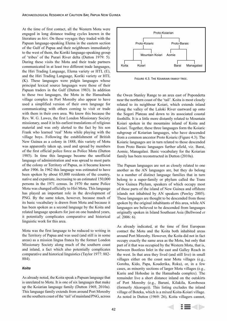
42
Archaeological Research at Caution Bay, Papua New Guinea
At the time of first contact, all the Western Motu were engaged in long distance trading cycles known in the literature as hiri. On these voyages they traded with the Papuan language-speaking Elema in the eastern section of the Gulf of Papua and their neighbours immediately to the west of them, the Koriki language-speaking group of ‘tribes’ of the Purari River delta (Dutton 1979: 5). During these visits the Motu and their trade partners communicated in at least two different trade languages, the Hiri Trading Language, Elema variety or HTL (E), and the Hiri Trading Language, Koriki variety or HTL (K). These languages were pidgin languages whose principal lexical source languages were those of their Papuan traders in the Gulf (Dutton 1983). In addition to these two languages, the Motu in the Hanuabada village complex in Port Moresby also appear to have used a simplified version of their own language for communicating with others coming to visit or trade with them in their own area. We know this because the Rev. W. G. Lawes, the first London Missionary Society missionary, used it in his earliest translations of religious material and was only alerted to the fact by his son Frank who learned ‘real’ Motu while playing with the village boys. Following the establishment of British New Guinea as a colony in 1888, this variety of Motu was apparently taken up, used and spread by members of the first official police force as Police Motu (Dutton 1985). In time this language became the unofficial language of administration and was spread to most parts of the colony or Territory of Papua, as it became known after 1906. In 1962 this language was estimated to have been spoken by about 65,000 residents of the country, native and expatriate, increasing to an estimated 150,000 persons in the 1971 census. In 1970 the name Police Motu was changed officially to Hiri Motu. This language has played an important role in the development of PNG. By the same token, however, because much of its basic vocabulary is drawn from Motu and because it has been spoken as a second language by the Koita and related language speakers for just on one hundred years, it potentially complicates comparative and historical linguistic work for this area.
Motu was the first language to be reduced to writing in the Territory of Papua and was used (and still is in some areas) as a mission lingua franca by the former London Missionary Society along much of the southern coast and inland, a fact which also potentially complicates comparative and historical linguistics (Taylor 1977: 882-884).
Koita
As already noted, the Koita speak a Papuan language that is unrelated to Motu. It is one of six languages that make up the Koiarian language family (Dutton 1969, 2010a). This language family extends from around Port Moresby on the southern coast of the ‘tail’ of mainland PNG, across
the Owen Stanley Range to an area east of Popondetta near the northern coast of the ‘tail’. Koita is most closely related to its neighbour Koiari, which extends inland along the valley of the Laloki River eastward up onto the Sogeri Plateau and down to its associated coastal foothills. It is a little more distantly related to Mountain Koiari spoken in the mountains inland of Koita and Koiari. Together, these three languages form the Koiaric subgroup of Koiarian languages, who have descended from a common ancestor Proto Koiaric (Figure 4.3). The Koiaric languages are in turn related to those descended from Proto Baraic languages further afield, viz. Barai, Aomie, Managalasi. Basic vocabulary for the Koiarian family has been reconstructed in Dutton (2010a).
The Papuan languages are not as closely related to one another as the AN languages are, but they do belong to a number of distinct language families that in turn belong to a super-family or phylum called the Trans New Guinea Phylum, speakers of which occupy most of those parts of the island of New Guinea and offshore islands not inhabited by AN speakers (Pawley 2005). These languages are thought to be descended from those spoken by the original inhabitants of this area, while AN languages are believed to be descended from languages originally spoken in Island Southeast Asia (Bellwood et al. 2006: 6).
As already indicated, at the time of first European contact the Motu and the Koita both inhabited areas around Port Moresby. However, the Koita did not in fact occupy exactly the same area as the Motu, but only that part of it that was occupied by the Western Motu, that is, between Bootless Inlet in the east and Galley Reach in the west. In that area they lived (and still live) in small villages either on the coast near Motu villages (e.g., Gorohu, Kido, Papa, Kouderika, Roku), or, in a few cases, as minority sections of larger Motu villages (e.g., Kuriu and Hohodae in the Hanuabada complex). The remainder live a short distance inland on the outskirts of Port Moresby (e.g., Baruni, Kilakila, Korobosea (formerly Akorogo)). This listing excludes the inland village of Boteka, which is a mixed Koita-Koiari village. As noted in Dutton (1969: 26), Koita villagers cannot,
Proto-Koiarian
Proto-Koiaric Proto-Baraic
Mountain Koiari Aomie
Koita Koiari Barai Managalasi
Figure 4.3. The Koiarian family tree.

43
Tom Dutton: Motu-Koita Contact in the Caution Bay Area
for the most part, be distinguished from Motu, except linguistically. In former times the Koita maintained their identity in dress (particularly with the chignon hairstyle), language, and occupation. By tradition they are the hunters and gardeners who owned the land, but now those who live near the sea fish and sail. The Koita have also intermarried extensively with the Motu and most are fluent in that language today. In fact, many have adopted Motu as their first and only language. Yet the Koita are keen to preserve their identity, especially as expressed through language.
Although the Koita now live close to the sea, their ancestral territory extends inland from the coast to the region of the Laloki River from where, according to oral historical evidence, they seem to have moved to the coast in the not-too-distant past (Dutton 1969: 32-36; Oram 1981: 223-224); the oral evidence collected by Oram (1981: 223-224) suggests that this was only about five or so generations ago. They trace their origin back, however, to a point called Wudurumava in the eastern foothills of the Sogeri Plateau (Dutton 1969: 102-104). The reasons for the putative movement to the coast are not known, but the presence of the Motu on the coast may have been an important factor. In any event, the Motu and the Koita entered into a symbiotic relationship whereby the Motu provided sea foods and other cultural products in return for bush foods and other products (Dutton 1969: 26). Today Koita patrilineal descent groups known as iduhu are found in all villages of the Western Motu except Manumanu on the west side of Galley Reach (Oram 1981: 221-118). Only in Hanuabada have iduhu maintained separate sections (Kuriu and Hohodae).
In 1966 I surveyed Koita villages as part of a general survey of Koiarian family languages. In that survey I used S. A. Wurm’s modified TRIPP list to gather comparative lexical and phonological information. Wurm’s list contains 292 items of ‘basic’ vocabulary, presumed to be universal, non-cultural, easily elicited and matched with corresponding words used in other communities, e.g., pronouns, numbers, objects of natural phenomena, common adjectives, body parts, and simple action verbs. For various reasons, however, only between 215 and 240 words were generally elicited in most communities. Other information collected included elementary grammatical and socio-cultural information (such as origin stories, putative migration movements, villagers’ views on their linguistic environment). While this provided a good general picture of the linguistic situation, it now needs to be followed up with a fine-grained study of dialectology.
The survey showed that, lexically and grammatically, Koita is a close-knit language with little variation from east to west. The only significant variation is in phonology, where the two western villages of Gorohu and Kido (an offshoot from Gorohu) have f and sometimes
s corresponding to h, and sometimes ɣ corresponding to v in the remaining villages (the symbol ɣ is used to represent a voiced velar fricative, sometimes called a ‘soft g’ or ‘gutteral g’). This is an intriguing situation that suggests that either the survey technique was not fine-grained enough to identify dialects, or that the Koita have only relatively recently expanded into their present village positions and split up into two dialects, or that there has been closer contact between most villages than one might have otherwise suspected.
When surveyed in 1966, there were estimated to be 2260 speakers of Koita.
Motu-Koita Contact: The Linguistic Evidence
The earliest linguistic evidence of the close contact between Motu and Koita is to be found in the vocabulary of Koita published in the already referred to British New Guinea Annual Report for 1889-1890 (MacGregor 1890). This vocabulary was apparently largely recorded by the London Missionary Society’s Rev. W. G. Lawes (MacGregor 1890: 21) and therefore represents the Koita spoken in Hohodae and/or Kuriu in the Hanuabada complex adjacent to where Lawes and his family lived at Metoreia (Seligmann 1910: 45). The 1890 vocabulary is potentially particularly valuable historically, therefore, as a record of Koita at that time, especially as it was collected when the socio-linguistic situation of the immediate post-contact period was relatively undisturbed and especially before Motu had become established as a church language. It was also collected before Police Motu had developed as a lingua franca and spread widely. But, as potentially important as it is, it still needs to be assessed to establish its utility.
The British New Guinea Annual Report for 1889-90 Vocabulary
The British New Guinea Annual Report for 1889-90 (MacGregor 1890) vocabulary contains over 500 items as well as a selection of numbers up to 1,000 and some simple phrases and sentences. When this list is compared with a similar one for Motu (Lister-Turner and Clark 1931), one is struck by the number of items of Koita vocabulary that are identical or nearly so in form and meaning with those of Motu (in this chapter all Motu data are taken from Lister-Turner and Clark (1931) unless otherwise indicated). There are some 50 such items or approximately 10% of the list (see Appendix A). Since Motu and Koita are unrelated, these correspondences must represent borrowings in one or the other of these two languages. Borrowing is the most common result of languages in contact. Mostly the borrowing is of a kind referred to as ‘cultural’ borrowing, characterized by the borrowing of terms that refer to physical items that are acquired or coveted. What is less common is a second kind of borrowing called ‘intimate’ borrowing, where
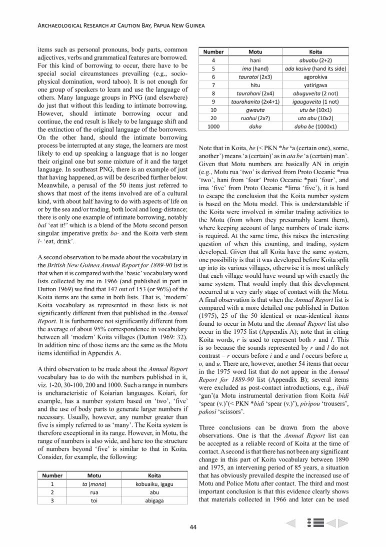
44
Archaeological Research at Caution Bay, Papua New Guinea
items such as personal pronouns, body parts, common adjectives, verbs and grammatical features are borrowed. For this kind of borrowing to occur, there have to be special social circumstances prevailing (e.g., socio-physical domination, word taboo). It is not enough for one group of speakers to learn and use the language of others. Many language groups in PNG (and elsewhere) do just that without this leading to intimate borrowing. However, should intimate borrowing occur and continue, the end result is likely to be language shift and the extinction of the original language of the borrowers. On the other hand, should the intimate borrowing process be interrupted at any stage, the learners are most likely to end up speaking a language that is no longer their original one but some mixture of it and the target language. In southeast PNG, there is an example of just that having happened, as will be described further below. Meanwhile, a perusal of the 50 items just referred to shows that most of the items involved are of a cultural kind, with about half having to do with aspects of life on or by the sea and/or trading, both local and long-distance; there is only one example of intimate borrowing, notably bai ‘eat it!’ which is a blend of the Motu second person singular imperative prefix ba- and the Koita verb stem i- ‘eat, drink’.
A second observation to be made about the vocabulary in the British New Guinea Annual Report for 1889-90 list is that when it is compared with the ‘basic’ vocabulary word lists collected by me in 1966 (and published in part in Dutton 1969) we find that 147 out of 153 (or 96%) of the Koita items are the same in both lists. That is, ‘modern’ Koita vocabulary as represented in these lists is not significantly different from that published in the Annual Report. It is furthermore not significantly different from the average of about 95% correspondence in vocabulary between all ‘modern’ Koita villages (Dutton 1969: 32). In addition nine of those items are the same as the Motu items identified in Appendix A.
A third observation to be made about the Annual Report vocabulary has to do with the numbers published in it, viz. 1-20, 30-100, 200 and 1000. Such a range in numbers is uncharacteristic of Koiarian languages. Koiari, for example, has a number system based on ‘two’, ‘five’ and the use of body parts to generate larger numbers if necessary. Usually, however, any number greater than five is simply referred to as ‘many’. The Koita system is therefore exceptional in its range. However, in Motu, the range of numbers is also wide, and here too the structure of numbers beyond ‘five’ is similar to that in Koita. Consider, for example, the following:
Number Motu Koita1 ta (mona) kobuaiku, igagu2 rua abu3 toi abigaga
Number Motu Koita4 hani abuabu (2+2)5 ima (hand) ada kasiva (hand its side)6 tauratoi (2x3) agorokiva7 hitu yatirigava8 taurahani (2x4) abuguveita (2 not)9 taurahanita (2x4+1) igauguveita (1 not)
10 gwauta utu be (10x1)20 ruahui (2x?) uta abu (10x2)
1000 daha daha be (1000x1)
Note that in Koita, be (< PKN *be ‘a (certain one), some, another’) means ‘a (certain)’ as in ata be ‘a (certain) man’. Given that Motu numbers are basically AN in origin (e.g., Motu rua ‘two’ is derived from Proto Oceanic *rua ‘two’, hani from ‘four‘ Proto Oceanic *pati ‘four’, and ima ‘five’ from Proto Oceanic *lima ‘five’), it is hard to escape the conclusion that the Koita number system is based on the Motu model. This is understandable if the Koita were involved in similar trading activities to the Motu (from whom they presumably learnt them), where keeping account of large numbers of trade items is required. At the same time, this raises the interesting question of when this counting, and trading, system developed. Given that all Koita have the same system, one possibility is that it was developed before Koita split up into its various villages, otherwise it is most unlikely that each village would have wound up with exactly the same system. That would imply that this development occurred at a very early stage of contact with the Motu. A final observation is that when the Annual Report list is compared with a more detailed one published in Dutton (1975), 25 of the 50 identical or near-identical items found to occur in Motu and the Annual Report list also occur in the 1975 list (Appendix A); note that in citing Koita words, r is used to represent both r and l. This is so because the sounds represented by r and l do not contrast – r occurs before i and e and l occurs before a, o, and u. There are, however, another 54 items that occur in the 1975 word list that do not appear in the Annual Report for 1889-90 list (Appendix B); several items were excluded as post-contact introductions, e.g., ibidi ‘gun’(a Motu instrumental derivation from Koita bidi ‘spear (v.)’(< PKN *bidi ‘spear (v.)’), piripou ‘trousers’, pakosi ‘scissors’.
Three conclusions can be drawn from the above observations. One is that the Annual Report list can be accepted as a reliable record of Koita at the time of contact. A second is that there has not been any significant change in this part of Koita vocabulary between 1890 and 1975, an intervening period of 85 years, a situation that has obviously prevailed despite the increased use of Motu and Police Motu after contact. The third and most important conclusion is that this evidence clearly shows that materials collected in 1966 and later can be used

45
Tom Dutton: Motu-Koita Contact in the Caution Bay Area
quite reliably as evidence of the borrowing situation at the time of contact.
Even so, there is nothing in these lists of similarities to indicate who borrowed what from whom, and when, although those in Koita do look suspiciously like borrowings from Motu. But those questions can only be resolved when the lists are analysed in more detail, a task I undertook in 1994 and describe in the next sub-section.
The 1994 Study
In 1994, I made an in-depth study of apparent borrowings from the available published and unpublished materials in Koita (Dutton 1994). These included material obtained by Sandra Warwick-Smith as a PhD student in the Department of Linguistics, Research School of Pacific Studies, the Australian National University in the early 1960s. Unfortunately, Ms Warwick-Smith did not finish her studies and her materials were passed on to me through the Head of Department, Professor S. A. Wurm, when I began studying Koiarian languages. In all, over 130 probable borrowings were identified. Of these, 29 are reflexes of established AN etyma reconstructed to different levels such as Proto Oceanic, Proto Papuan Tip and Proto Central Papuan. In that case, they must be borrowings in Koita (Appendix C). Five others were identified as most probably borrowings from Sinagoro:
Item Koita Koiari Motu Sinagoroalive maɣuri iha mauri maɣuribush ura mata uda ɣura, ɣuramatafence ɣara vara ara ɣala
pandanus gereka vani geregere geregere
evil spirit, forbidden tabu tabu taravatu
tabu (< POc *tabu ‘forbidden’)
Among others are four which are also derived from Proto Oceanic, and therefore constitute borrowings from Motu in Koita. These are:
Item Motu Koitaaunt (f. sis.) lala (< POc *aya) yaya
sail (n.) lara (< POc *layaR) yaraNW monsoon lahara (< POc *qapaRat) yaha
widow vabu (< PWOc *kwabu(r,R)) ɣobu
In the Motu village of Tubusereia yaia (or iaia in modern Motu spelling) is used as a common term of address for ‘mother’ as well as for ‘aunt’ (or classificatory mother) (Andrew Taylor, pers. com.). Motu vabu (< PWOc *kwabu(r,R)) must have been borrowed into Koita at a time when the Motu form was ɣwabu (Malcolm Ross, pers. com.). In addition there is one,
canoe (trading) laɣatoi yaɣatoi
that may also be taken to be derived from Proto Oceanic *waga-tolu (lit. ‘canoe-three’) if an irregular loss of *w- is accepted. Three others are assumed to be of local AN origin for the phonological reason that Motu l becomes Koita y before o or in the middle of words, which is unexpected according to Proto Oceanic derivational sound laws. These are:
Item Motu Koitachief lohia yohi
paddle (v.) kalo-a kayo-ashark kwalaha koiya
In relation to Koita yohi, note that y is not a phoneme (or contrastive sound) in Motu, but Lister-Turner and Clark (1931) contains two entries for i in which they indicate that i is pronounced [y]. These are: iahu (pronounced yahu) ‘an old man or woman; senior’; and iara (pronounced yara) ‘porridge of sago, bananas or yam’.
At least three of the items in the first set (‘aunt, sail, NW monsoon’) reflect borrowings from Motu into Koita at a pre-Motu stage when Motu l was some palatal sound like [y] (see Blust (1990: 11-12) for a discussion of the accretion of l in Motu words). These words presumably represent the earliest borrowings into Koita from Motu. They contrast with other words in Motu and Koita in which Motu l corresponds with Koita l. These must be more recent borrowings. Consider, for example:
Item Motu Koitabreath laɣa laɣa-ne
year laɣani laɣani
A few other items provide evidence of contact between AN and Papuan languages of the Port Moresby area and beyond, although few of these can be accurately sourced with probable directions of borrowing suggested. These are:
Item Motu Koitaa, some haida ɣaita
ankle ae komukomuna vasi komukonebat (insect) sisiboi sisika
lightning gibaru gibarumother (voc.) ina ineka
owner biagu biagu
pawpaw nita nita (< PKC *(n,m)itani ‘pawpaw’)
round niu komukomuna komuko
In relation to Motu ina, Lister-Turner and Clark (1931) note: Ina address of child to its mother. Ina used also when speaking to a child of its mother. Ina mama address

46
Archaeological Research at Caution Bay, Papua New Guinea
of child to its mother and father. A stranger speaking to a child would say ‘Where are your ina mama?’ Ina mama edeseni? The origin of this item is unclear. It could be a shortened form of the normal Motu word for ‘mother’, sina (< Proto Oceanic *tina ‘mother’) but it could also be derived from Koita ineka (with vocative form ine), in turn derived from Koita neina ‘mother’ (< PKC *neina ‘mother’). All of the above list are of Koiaric origin except gibaru ‘lightning’, which is probably from Toaripi (Eleman). If so, it probably entered Motu via the Hiri Trading Language (Eleman variety) that the Motu used in trading with the Elema people in the Gulf of Papua. Of the probable Koiaric borrowings, half (‘a (some), ankle, mother (voc.!), round’) have alternatives in Motu and are not really true borrowings, as they do not replace existing Motu words. One, ‘pawpaw’, has alternatives: nita is used in the Western dialect and loku in the Eastern dialect (Andrew Taylor, pers. com.). It is clear then that the number of Koita words that have been borrowed into Motu are far fewer than the reverse, even including some probable Koita loans that have not been discussed before (these are suspect of being Koita in origin for phonological, environmental and/or social reasons, e.g., ogo ɣami ‘orphan’ is derived from Koita ogo ‘house, village’ and ɣami ‘boy, child’ (< PKN * ɣami ‘boy, baby, child’):
Item Motu Koita
big bauge (‘grandchild’)
bauge (<PKC *baruge (e,a) ‘big’)
black palm goru gorucanoe tree irimo irimo
dry season, famine doe doefamily, nation bese bese
nose ornament mukuro mukiorphan ogoɣami ogoɣamiparrot kiroki kirokishield kesi kesi
sling, catapult vilipopo viripopo
wallaby gove (black wallaby) gove
youth eregabe ata eregabe
Many other probable borrowings that provide evidence of contact between the two languages were identified in both Motu and Koita (others are to be found in Dutton (2007)). In addition, there are two words in Koiari in which Koiari f corresponds to Motu h when the correspondence should be Koiari h to Motu h, e.g., Koiari foi (Motu hoi) ‘buy, sell, barter’ and fodu (Motu hodu) ‘water pot’. Since we know on independent grounds that Motu h is derived from pre-Motu *p, which in turn is derived from Proto Oceanic *p, the Motu and Koiari must have been in contact at a time when Motu h was already a p or an f. How long ago that change occurred cannot be determined on present evidence. It is curious, however, that there is no evidence of this change in borrowings in Koita, and there are no borrowings in Koiari which
manifest the Motu y > l change. Nevertheless, the change is further evidence for the existence of the Motu for some considerable time in the Port Moresby region.
The remainder of the apparent borrowings in Motu and Koita (approximately 50%) cannot be accurately sourced, nor can a probable direction of borrowing be suggested, for want of better evidence (e.g., cognates in related languages). Given the large number of identifiable Motu borrowings in Koita, however, most (if not all) of these remaining items can probably be taken as borrowings from Motu. Many of these have to do with coastal life and/or trading (Dutton 1994: appendix 4). This question of pre-existing populations borrowing language elements from incoming AN-speaking populations (with little evidence of the AN speakers borrowing elements from pre-existing local languages) is likely to be of relevance to the question of how AN language speakers were affected by pre-existing populations in other aspects of cultural practice both here and elsewhere in Near Oceania, for example as postulated by Green’s (1991) Triple-I model of Lapita development.
Historical Implications of the Linguistic Evidence
Assuming that the borrowing pattern described above reflects the nature of contact between the Motu and Koita in the Port Moresby area, then this implies that:
1. There has been considerable contact between Motu and Koita in that area;
2. The Motu and Koita have been in close contact for some time. Just how long, however, is impossible to say, but it has been long enough for pre-Motu y to have changed in to Motu l by the time of European contact. The Koita numeral system which is based on the Motu model must also have been developed during contact with the Motu at an early stage and it must have been developed before the expansion of Koita into its present-day villages, otherwise there would not be the noted consistency in forms across all villages;
3. Koiari and Motu must have been in contact at a time when Motu h was pre-Motu *p. How long ago that was cannot be determined on present evidence. It is curious, however, that there is no evidence of this change in borrowings in Koita and there are no borrowings in Koiari which manifest the Motu y > l change. Nevertheless, the change is further evidence for the antiquity of the Motu in the Port Moresby area;
4. Koita and Koiari have been in contact with Sinagoro at some time in the past. This is not only evidenced by the five words (‘alive, bush, fence, pandanus, and evil spirit’) referred to above but also by several others that occur in Sinagoro but not in Motu that were not included in this study

47
Tom Dutton: Motu-Koita Contact in the Caution Bay Area
because here I focus on Motu. These five shared words are:
Item Koita Koiari Sinagoroa, another ɣaita vaita ɣaita
bush mata matasorcerer (evil) godio ata ɣodio taunatable, bench naganaga nakanakatrunk (tree) gaba(ka) gaba(ka) ɣabana
Sinagoro ɣaita as in ɣelemaɣaita ‘Papuan brown snake’ (i.e., literally ‘a/another ɣelema kind of snake’).
5. Of these five words, only two occur in Koita while all occur in Koiari. These words do not necessarily imply Koita-Sinagoro contact, however, because one, gabaka, could have been borrowed from Koiari. On the other hand, Koita ɣaita could not have been borrowed from Koiari, because Koiari v would have been borrowed as Koita v. Both probable Koita-Sinagoro and Koiari-Sinagoro contact patterns are of interest, however, for Koita and Koiari are nowadays both separated from Sinagoro by other, unrelated populations – in Koita’s case by the Eastern Motu, some southern Koiari and the Papuan Humene-speaking village of Manugoro; in the Koirai case by this latter and its distantly related Kwale further inland. Consequently, either the Koita-Koiari and Sinagoro have moved away from each other for some reason and their former positions occupied by others just mentioned, or they were forced out of those positions by the latter. In any case, the fact remains that the Koita must have once been farther east where they were in contact with some Motu before they, the Koita, came to occupy their present positions around and west of Port Moresby. Curiously enough, both the Koita and the Motu have traditions of coming from positions farther east;
6. The Koita were people with a land-based economy who had little to do with the sea or its environment;
7. Contact between Motu and Koita was of a practical kind and of a pattern that reflects the symbiotic relationship between the two groups. Both borrowed the vocabulary for items traded, exchanged or coveted. But the Koita seem to have borrowed more from the Motu than vice versa and there is virtually no borrowing of intimate Motu vocabulary in Koita. This situation would seem to imply that the Koita felt they had most to gain from the contact. Yet, they were able to maintain their social distance from the Motu despite the fact that at the time of contact they were:
• intermingled with the Motu even to the extent of living in the same villages,
• intermarried with the Motu,
• had many patrilineal descent groups in Motu villages,
• participated in Motu hiri.
How they maintained this social distance over time is uncertain. One might suggest, however, that the most important aspect was the use of the Koita language itself. Another was probably the enforcement of land rights. A third aspect was probably sorcery, both good and bad. Seligmann (1910: 167) describes how in the case of sickness, ‘a Motu would generally send for a Koita man, or more often a woman, to treat him’. Groves (2011: 9, fn. 12) gives other evidence of ‘the extent to which the Motu feared Koita witchcraft. A fourth social distance-maintaining strategy may have also been that the Koita used Simplified Motu as a lingua franca. In fact, this simplified form may well have developed out of the contact between the Motu and the Koita. Regardless, Motu is the main source of borrowings in Koita, a fact not affected by whether they spoke ‘real’ Motu or only a simplified form of it. During my survey of Koita in 1966, I often asked the Motu why they never learned Koita. The answer was always the same: ‘It’s too hard.’ This cannot be the real reason, however, because when the Motu were in a different, supplicant situation (as traders seeking to do business with the Elema and Koiriki in the Gulf of Papua), they made every attempt to learn the equally ‘difficult’ languages of their trade partners. What they presumably really meant by ‘It’s too hard’ was that they didn’t need to learn Koita as they could easily communicate with them in their own language. In any case, the Motu-Koita contact appears to be qualitatively quite different from other cases of AN-Papuan contact in central and southeast mainland PNG. There are three cases to consider here: Maisin, Ouma (and neighbouring remnant languages) and Lau’una (Figure 4.1).
Three Comparative Cases
Maisin
Maisin is an AN language spoken in two dialects – one in Collingwood Bay near Tufi on the northeast coast, and the other in several small villages in the swamps of the Kosiraga district at the mouth of the Musa River which runs into Dyke Ackland Bay. When surveyed in 1970, the Collingwood Bay, or Uiaiku, dialect was spoken by about 1500 speakers and the Kosirava dialect by only about 250 (Dutton 1971). The Kosirava dialect is surrounded by speakers of members of the Papuan Binanderean language family. Uiaku dialect speakers live near and among AN language speakers whose language belongs to the Papuan Tip cluster. Maisin’s vocabulary and grammar are so mixed that it is no longer possible to identify the particular languages from which those elements are derived. It is clear, however, that pre-Maisin was an AN language that, like its present day neighbours, belonged to the Papuan Tip cluster and that

48
Archaeological Research at Caution Bay, Papua New Guinea
the influencing language or languages was/were Papuan (Ross 1996). How it came to be such a mixed language is not clear, but bilingualism must have been involved. Yet, as pointed out earlier on, while bilingualism is a necessary condition for such a result, it is not a sufficient one. Many PNG communities are bilingual in their own language and that of a neighboring one, without them incorporating elements from the neighboring language into their own to the same degree as in the Maisin case. Something unusual in that case caused pre-Maisin to take over elements from the Papuan language they were learning. Then the borrowing process was interrupted so that speakers were left with a mixed AN and Papuan language as their mother tongue.
Ouma and Related Remnant Languages
On the far south coast of the mainland of PNG are to be found the remnants of four AN languages: Ouma, Magori, Yoba and Bina. These languages belong to what I shall call the Oumic subgroup of Central Papuan languages. Within this subgroup, Magori, Yoba and Bina are more closely related to one another than either is to Ouma (Figure 4.2). These languages were once spoken in the coastal area between Table Bay in the west and Orangerie Bay in the east. When surveyed in 1969, there were only four speakers of Ouma left, 124 of Magori, and two each of Yoba and Bina (Dutton 1971). At that time, Magori was spoken in two small villages in the valley of the Bailebo River which runs into Table Bay. Speakers of the others were living either on the edge of, or in, villages where the dominant Papuan language of the area, Magi, is/was spoken. All are/were fluent in Magi.
Magi itself is the largest and best known member of the Mailuan language family. Speakers of it inhabit a number of villages along the coast between Sandbank Bay in the west and Orangerie Bay in the east. At the time of the 1969 survey, the number of speakers of Magi was estimated to be 4662. The language consists of nine dialects that differ mostly in the amount of Austronesian vocabulary each contains (Thomson 1975: 56). The Mailu Island dialect is the largest and most prestigious and includes the inhabitants of Mailu Island and the nearby islands of Laluoro and Loupomu. It is also spoken in the village of Kurere on the western side of Amazon Bay, on the mainland opposite and in the relatively recently established colonies of Boru and Magaubo (or Dedele) west of there. The Island dialect is also spoken to some extent at Gadaisu and Laimodo in Orangerie Bay, where there has been intermarriage between Magi speakers and AN Suau speakers (Thomson 1975: 43). All the other dialects are much smaller than the Island one, the largest being at Domara in the west.
At the time of first contact, Mailu Island was the centre of a thriving pottery industry and long distance and local
trading network (see Irwin 1985). In the west, Mailu Islanders traded with the Aroma, a section of the AN Keapara language-speaking area, and in the east with the Suau and other AN language speakers beyond them, groups that are linguistically closely related to speakers of the Oumic languages (Figure 4.2). In many respects, this trade was very similar to the Motu hiri in terms of items traded and in the large double-hulled crab-claw sail-equipped canoes used. However, whereas the Motu used pidgin trade languages in their trading with Papuan language speakers in the Gulf of Papua, the Magi seem to have learned and used the languages of their AN trade partners (Dutton 1978). At this time, speakers of Oumic languages were not potters and did not engage in long distance trade.
Archaeological evidence suggests that the island of Mailu was first settled by pottery-using people associated with the arrival of AN colonists about 2,000 years ago (Irwin 1985: 246). Local archaeological evidence also indicates that the island has been continuously occupied by pottery-using peoples since that time. But the present-day inhabitants do not speak an AN language, but an unrelated Papuan one. It follows, therefore, that there has been a language shift in the meantime. Yet, there is nothing in the archaeological record to indicate how or when this shift occurred. Linguistic and other evidence give some perspective on this.
Thus, a noticeable and striking feature of the AN and Papuan languages in the Oumic-Mailu Island area is that both sets of languages have borrowed a great deal of vocabulary from each other. For example, Magi contains about 20% Ouma-Magori-derived basic vocabulary, while Ouma-Magori contains about 50% Magi-derived vocabulary (Dutton 1978), although there are many more borrowings that cannot be so sourced because of the similarities in the sound systems of the languages involved. As a result of this borrowing, the Oumic languages have come to resemble Magi superficially. Hence, the speakers are often referred to as ‘bush Magi’. But except for Ouma, whose emphatic pronouns use a Magi form for ‘self’ in their construction, none of the Oumic languages has borrowed grammatical structures from Magi. Nor have the Magi borrowed grammatical structures from Oumic languages. This situation contrasts sharply with the Maisin case outlined above. There can only be one explanation for this borrowing pattern, and that is, that each of the sets of languages has been (physically and/or culturally) dominant at different times. Given that Magi was the dominant member at the time of first contact, it must be the case that the AN culture of the Oumic languages had previously been the dominant member. Such a conclusion is furthermore supported by the historical sequence of borrowing in the two sets of languages revealed by a detailed study of borrowings in them. In this sequence, speakers of Magi first borrowed words from the AN Oumic languages (no

49
Tom Dutton: Motu-Koita Contact in the Caution Bay Area
detailed study of borrowings in Yoba and Bina has yet been made), and then speakers of these languages in turn borrowed words from speakers of Magi and related languages – sometimes even borrowing back words that had once been their own but were now in a different form (Dutton 1982b).
These observations, when taken together with those concerning Lau’una to be described below, support the hypothesis that:
1. The coastline between Amazon Bay and Cloudy Bay was once occupied by AN settlers speaking languages ancestral to the Oumic languages and Lau’una (and probably others that are now extinct);
2. These settlers came with similar cultural traits to their closest linguistic relatives to the west and east, but especially with a knowledge of pottery making, canoe building and sailing;
3. The new arrivals maintained contact with their linguistic relatives west and east of their own positions;
4. The Oumic ANs first settled on the coast somewhere near where Ouma and Magori are today. This area would have provided an ideal environment for AN settlers – access to offshore reefs, plentiful supplies of sago, coastal hills providing defensive and defendable village sites if needed, access to virgin land and reasonably-sized rivers providing fresh water and access to the interior;
5. Some Oumic settlers later moved to Mailu Island (which may have also been inhabited by Magi speakers), from where they continued to make pots and trade with linguistic relatives east and west;
6. At the time the AN settlers arrived, Mailuan family language speakers generally lived inland on the foothills of the main range and on hills that come down towards the coast in the Cloudy Bay area to the west and the Amazon Bay, Mayri Bay, Port Glasgow areas to the east. They may well have also inhabited Mailu and associated islands immediately off shore. These different AN and Papuan groups of people gradually came into close contact with each other, the Papuans presumably attracted by the ANs’ technology and trading activities. Eventually, the Papuans learned the crafts and trading secrets of their AN seafaring ‘friends’. Then the relationship between them changed, and the ANs were attacked and forced to flee the coast and offshore islands to survive. At the time of European contact, only small numbers of these AN language speakers remained and most of those were to be found attached to Papuan language-speaking villages (especially Magi-speaking ones) in the area they formerly occupied.
Such an hypothesis not only accords with archaeological evidence, but would also appear to explain a number of otherwise puzzling features of that evidence and the present-day sociolinguistics of the area. Thus, it would seem to explain:
1. Why there was a radical change in settlement patterns on the mainland during the recent prehistory of the Mailu area from about 300 BP onwards (Irwin 1985: 204). This was the time when Oumic and Magi speakers moved closer together;
2. Why the Mailu Islanders have the attitude they do towards Oumic language speakers in the area;
3. Why the Mailu Islanders are predominantly Austronesian genetically (Kirk 1992: 188-90) and why they are culturally and physically similar to Austronesians.
Such an hypothesis might also help explain why no Lapita pottery has yet been found in the Mailu area. If Lapita pottery is associated with the arrival of AN speakers in central and southeast mainland PNG, and if the Ouma were among the original, if not the original, settlers in the Mailu area, then the most likely place to find such pottery would be the claimed homeland of the Ouma, notably the Ouma hills. These hills are a set of two low hills about 15km west of their present position in the village of Labu at the mouth of the Bonua River and inland of Table Point and Magaubo village. According to Ouma oral traditions, these hills were at that time, and before the beach had prograded to its present position, islands (see Dutton (1982b: 154) for an aerial photo of these hills in relation to the prograded coast).
Informants also claimed that, at the time that they lived on their homeland islands, Mailu Islanders lived there with them, but later moved to Mailu Island itself, to which they later took some Ouma as captives. These subsequently married into the island population and never returned. Their descendants still live on the island (Dutton 1982b: 155).
Ouma informants also said that their forefathers were seafarers and traders, and in particular that they traded with Gavuone, Paramana and Aroma along the Aroma coast, whence they went on sailing canoes and on outrigger canoes to buy pigs. Such a claim would seem to be supported by some borrowings in Magi which show that the first Oumic-speaking peoples to come into contact with them must have been sailors and traders. Consider, for example, the following English equivalents of Magi terms having to do with sailing technology: ‘(outrigger) canoe, sail (n.), outrigger, steer, sew, NW Monsoon, (canoe) pole, current (n.), salt water, coral, beach, sorcery, flag’ and the following having to do with trade items and contacts: ‘barter, how many/much, pig, salt, mat, sweet potato, chief’ (Dutton 1982b: 156).

50
Archaeological Research at Caution Bay, Papua New Guinea
Lau’una
Lau’una is also an AN language or a divergent dialect of one, Keapara. When a vocabulary of it was recorded in 1917 by E. M. Bastard, Resident Magistrate at Abau, there were only two speakers left living at the village of Eaula, near Cape Rodney. According to Bastard (1918), these two men were the last members of a ‘tribe’ that he says was called ‘Lau’una’. Members of this tribe are said to have once lived in the villages of Bulumai, Dedele and Bomguina River around Cloudy Bay east of Eaula.
Linguistic and other evidence collected for Lau’una suggests that:
1. Lau’una was a rather divergent dialect of Keapara or a separate language very closely related to it. As a divergent dialect of Keapara, it represented the easternmost member of the chain of dialects that make up the present-day Keapara language. As a separate AN language closely related to Keapara, it was part of a chain of Central Papuan AN languages that once occupied the coastal area between Cheshunt Bay in the west and Amazon Bay (perhaps even Orangerie Bay) in the east, an area that is now occupied by members of the Papuan Mailuan family (Dutton 1971). At some time in the past, however, the Mailuan Domu people from inland of Cheshunt Bay moved to the coast where they were later joined by Magi speakers about 200 years ago (Grist 1926: 92; Thomson 1975);
2. The Lau’una were once in contact with Papuan speakers with whom they were living prior to European contact, notably Magi and Magi-related peoples. But there are not as many Papuan borrowings in the Lau’una material as might be expected given the social situation the Lau’una were once in, viz. a dying tribe living in or attached to Papuan villages. However, contact between the Lau’una and Papuans appears to have been of a different kind from that experienced by their linguistic relatives to the east, Oumic language speakers whose languages contain substantially more Papuan borrowings (Dutton 1982b). There are two possible reasons for this. One is that the Lau’una were overwhelmed rather rapidly by Magi speakers as they, the Magi speakers, expanded westwards 200 or 300 years ago, and were dispersed and/or absorbed by them, leaving no trace except for the two speakers who had shifted to the AN village of Eaula. Alternatively, the Lau’una were able to maintain their separateness for a long time without feeling threatened by local Papuans and hence feeling no necessity to learn Magi as a second language to survive, as the speakers of the Oumic languages further east did. In any case, they would seem to
have died out without trace except for the 130-item vocabulary recorded by Bastard, unless descendants are still to be found in Lalaura or in Papuan villages further east around Cloudy Bay.
Motu-Koita Contact in the Caution Bay Area
As indicated earlier, no linguistic evidence of the kind that was collected in Port Moresby in 1889-90 was collected from the Caution Bay area. The first materials collected from the latter area were by me in 1966 when I surveyed it as part of a larger survey of the Koita language. At that time, the two villages of Boera and Papa were in existence, as they still are today. Oral tradition taken together with the position of villages shown on the first maps of the area (O’Malley and Stanley 1918; Seligmann 1910: 45) show that the two villages were in existence at the time of first European contact. A second inland Koita village, Namura, had been ‘exterminated shortly before the annexation of the country’ (Seligmann 1910: 41). Boera is/was a Motu-speaking village and Papa a Koita-speaking one. Boera villagers speak the Western Motu dialect. As already noted, this raises an interesting question: why don’t the Boera speak a distinct dialect of Motu given that they (or a section of them) have a tradition of coming from Yule Island (west of Galley Reach) as the Apau (Oram 1981; Taylor 1970). The reasons for this are not clear, but could simply be that only a small group of them came as Apau and quickly blended into the village speaking an indistinct dialect of Motu. We should also be careful of blindly accepting oral tradition as hard and complete evidence of events of the distant past. In Dutton (2010b), I point to the mismatch between oral tradition of the movement of a Koiari village and dialectal evidence. When Boera was surveyed in 1966, there were four male residents and one female resident who were said to be able to speak Koita. Several others were said to be able to understand it but could not speak it. This situation is in contrast to Papa where most, if not all villagers were said to know and use Motu; I did not enquire as to whether the purported Koita speakers in Boera identified themselves as Koita. Whether or not this was the situation when Europeans first arrived is not known. However, it was probably so given that the people of Boera participated in the hiri and knew the hiri trading languages (Dutton 1979; Dutton and Kakare 1977). At the time of my survey Moi Higo was one of the few Motu still living who was widely recognized as an authority on the hiri, having been on many of them as crew and captain to both Elema and Koriki language-speaking ports. It was also probably so given that the Papa villagers do not speak a distinct dialect of Koita and use the same numeral system as other Koita. We can reasonably expect, therefore, that Motu-Koita contact in Caution Bay was similar to that in the Port Moresby area as described above.

51
Tom Dutton: Motu-Koita Contact in the Caution Bay Area
Conclusion
Assuming that Motu-Koita contact in Caution Bay was similar to that in the Port Moresby area, we may recapitulate the nature of this contact as follows:
1. Borrowing between Motu and Koita has been mostly one way, notably from Motu to Koita;
2. The borrowing between Motu and the Koita has been of a cultural kind reflecting the symbiotic relationship between the two groups; the few borrowings from Koita into Motu have been of a practical or superficial kind, where a Koita word is used as an alternative to a Motu word without the Motu word being lost;
3. Contact between the Motu and Koita was of a qualitatively different kind from that of other
AN-Papuan language speakers in mainland southeast PNG. Although the Koita learned Motu as a preferred option for communicating with them, they did not lose their identity nor were they forced to flee from the Motu (Namura is a different case. As already pointed out they were ‘exterminated’ by other Koita before European contact (Seligmann 1910: 41)). Both groups have been able to maintain their identity and separateness, despite prolonged close social contact with each other;
4. The Motu and Koita have been in close contact for a time long enough for pre-Motu y and p/f to change into l and h respectively.

52

53
Introduction
A loss of place-names, and of the knowledge of history those named places hold, is effectively a significant cultural loss, and for this reason it was deemed important to record named places at Caution Bay before those localities were permanently altered. Therefore, named, culturally meaningful places within and near the Caution Bay study area were recorded in conjunction with local Koita and Motu community members in 2008-2010 (Figures 5.1 and 5.2). This mapping was undertaken in two steps, the first consisting of opportunistic recording of place names during early, preliminary stages of fieldwork in 2008 and 2009; and the second a focused study undertaken in early 2010 explicitly aimed at recording place names and their cultural significance in the face of imminent developments that would forever transform the landscape. This chapter presents the results of these studies.
Preliminary Place-Name Study
In early 2008, prior to the commencement of archaeological surveys in the study area (see Chapter 8), archaeologists from the Caution Bay survey team visited all of the villages of Caution Bay, except Kido, to discuss forthcoming fieldwork and to elicit information on traditional locations of importance, especially former villages and other named places. While this was not a land use study, our aim for this first mapping study was to attain a sense of place so as to situate the archaeological pattern within an ethnographic cultural landscape. This was facilitated when community members asked the project team on a number of occasions to ensure that we reported on how the landscape was understood by them to consist of a rich array of named places that in many cases articulated closely with oral traditions, histories and localized activity areas.
Interviews were undertaken by Brad Duncan with local fishermen in particular, as well as others from Lea Lea, Papa and Boera villages who had a demonstrated deep knowledge of the offshore reef environment. Fishermen in all three villages demonstrated a particularly in-depth knowledge of the seascape in those areas utilized for their fishing activities. Most of the fishing in this region is today undertaken by free-diving from small outrigger canoes to spear fish and crustacea, and to collect
molluscs (giant clams, a variety of smaller shellfish, and sea urchins) and bêche-de-mer (sea cucumbers). These local fisherfolk possess intimate knowledge of the submarine topography and reefs, including locations that feature prominently in oral traditions and mythologies.
Three community representatives, Auda Delena (Lea Lea), Gau Ario (Papa) and Moi Dobi (Boera), after consultation with village elders and other community members, produced a map of Caution Bay showing the location of known traditional sites, especially those associated with traditional fishing activities. That information, as well as several onshore and offshore locations associated with the ancestral hero Edai Siabo and his first lagatoi, is reproduced as Figure 5.3. Particularly noticeable on this map is the number of place-names, as well as the variety of types of places. Motu terms on the map include: iduka – point or headland; dogu – deep bay; motumotu – detached portion of reef or small island; pore – mudflat; sinavai – intertidal inlet; and nadi – rock or stone (translations from Lister-Turner and Clarke 1931). The Koita term tanamu – low hill, also appears. Several of the above terms seem to be applications to submerged, or at least intertidal features, of terms that also are used for terrestrial topographic features.
Four traditional sites associated with the story of Edai Siabo were identified in the Caution Bay area, each of which was inspected during the course of the fieldwork. Each of these four locations is an integral component of the first lagatoi story that is said to have given birth to the annual hiri trade voyages (see Chapter 6 for details of the hiri). These four sites are of the highest cultural significance, relating to what is arguably the most important customary oral tradition of the Western Motu.
Daro Avei, a fisherman from Boera village, identified the first of these Edai Siabo sites, and although its exact location could not be identified, it is said to be located between Boera and the Vaihua River. Avei (personal communication 2008) maintains that stone flakes produced when making the stone axes to carve the first canoe become exposed on the ground during the dry season in this area. This is a traditional cultural site where a tree was felled, and the trunk roughly shaped, before the resulting hull was transported through the mangroves to the ancient village where Edai Siabo lived near Davage. This was the only instance during the entire
Chapter 5. Koita and Motu Landscapes and Seascapes of Caution Bay
Linus S. digim’Rina, Thomas Richards, Bruno David, Matthew Leavesley, Michael Goddard, Tom Dutton, Robert Skelly, Brad Duncan, Laura Naidi
and Julia Hagoria

54
Archaeological Research at Caution Bay, Papua New Guinea
surveys when the story of this site was told and, as far as we know, it is the first time that this story place has been recorded.
The second location was where the first lagatoi was built. The site is situated at Davage, close to a stream outlet that collects into a small pool just above the high tide mark on the northern extremity of the beach. In the old days, fishermen were said to have washed in this
pool after they returned from their day fishing at sea. A dugout canoe was being built at this locality when it was visited by the archaeological mapping team in 2008.
The third location is the place associated with the story about where Edai Siabo anchored the first lagatoi (Figure 5.4a-b). Moi and Mea Dobi (personal communications 2008) related the following story:
Buria Koki
DareboLauragabi
Goroto Koita
NebiraKonekaru
Bogi Bokina Bokina
HarakiareBubuaiaVaihua
Aemakara
DavageBoera Clay Source
DiroraIokoruMetago Taoro
Laba
Moiapu
Nemu
Dirora Gotera (Range)
Urivaka SagaeragareNadivasiga
Boilada
Dobi
Kahiru
Former Village
LocalityBogiHill or Mountain
BoeraHead
Porebada
CAUTION
Boera
Papa
Lea Lea
BAY
0 2km
N
Swampland
GrasslandSavannahMangrove
Forest Road
Papa Lea Lea R
oad
Present Village
Figure 5.1. Motu and Koita landscape place-names at Caution Bay (excluding creek and river names).

55
Linus S. digim’Rina et al.: Koita and Motu Landscapes and Seascapes of Caution Bay
This beach is associated with the [story of the] first lagatoi canoe. That anchor is where Edai Siabo from Boera first came ashore. There are underwater caves at Hidiha [Idihi] Island. He was pulled into an underwater cave by sea spirits and they taught him how to build the first lagatoi canoe. His mates saw his legs sticking out from the sea, and pulled him out of the cave. He later made a model of a lagatoi, but his mates laughed at him. He then made a full-scale model of it, which was the first large lagatoi canoe. They were hard times then, so he went to Kerema and established the hiri trade. He built the first lagatoi on the beach at Apau [Davage], which was the village before Boera. He sailed in around to here, and threw in the anchor here. The anchor was left where he came ashore. This is the location of the
sacred stone anchor from the first lagatoi boat [Moi pointed to a rounded, light grey stone whose partial exposure indicates that the stone is >20cm thick and >60cm long].
This is a traditional place for us, and we do not disturb the anchor. One time a researcher [name not recorded] came and tried to take a piece of the anchor, you know to see what rock type it was, but the bees came and stung him and scared him off.
The basalt anchor remains in this location, and part of it is still visible as it becomes exposed at low tide (Figure 5.4b). The anchor is probably of a type designed to fit in a cane or rattan basket, which was then attached via ropes to the vessel. Similar stone anchors were observed
Bubuaia
Vaihua
Bogi
Konekaru
Laba
Bokina BokinaMoiapuHarakiare
Aemakara
Nadivasiga
Metago TaoroNebira
Urivaka Sagaergare
Papa Lea Lea Road
0 1
ki lometre
N
GrasslandMangroveSaltflat Savannah
Roku Creek
Vaih u a River
Rui s as
i Cre ek
Edubu Creek
Dirora Cr
ee
kSoneso C
reek
Mageto Creek
Ehoragare Creek
Kiohed ova Creek
Ebutodahan a Creek
Moi
apu
Cree
k
Figure 5.2. Motu and Koita landscape place-names in the Caution Bay study area (including creek and river names).

56
Archaeological Research at Caution Bay, Papua New Guinea
by missionaries in 1883 and were often attached to boats by 100 fathoms (~180m) of line (e.g., Lennox 1903: 1). The beach in this area has high concentrations of ceramic sherds scattered over a very large area. High concentrations of stone artefacts (cores and flakes) along this beach were also identified by Mea Dobi (personal communication 2008) as kavari, which were used to make shell armbands, a practice that ended locally in the 1960s.
The fourth place is the site of the sea cave in which Edai Siabo was instructed how to make the first lagatoi by the spirit-being, as in the story recounted above. That
site lies c. 50m offshore to the southeast of Idihi (or Hidiha) Island, as pointed out to us by Moi Dobi (Boera fisherman). The cave mouth is set in a shallow reef-top in water less than 1m deep. No features of the cave could be discerned during an inspection of the site, due to it being currently filled with sand.
Detailed Mapping of Caution Bay Place-Names: The Focused Study
The goal of the more detailed 2010 study was to locate and record Koita and Motu named places with the assistance of knowledgeable local consultants prior to
Vaihu a R
Brown R i ve r
Laloki River
Laloki River
PORT MORESBY
Roku
HaidanaIsland
LarebaTaurarauPore Tanona
AhutaKuabo Reefs Edai Siabo
first lagatoianchor stone
Porebada
CORAL SEA
CAUTION
Boera
PapaIOKORU HILL
KOKORO HILL
ROUND TREE HILL
HUHUNAMA HILL
Lea Lea
Kido
BAY
Idihi Island
Edai Siabo cave(underwater)
BavaIsland
Dua Tanona
GwanauDadorio
Baruni
TOVABADA HILL
Kido River
RedscarHead
GigiraMaramara
Derekwaidu
Gaburu MatuLagava Iduka
Geva Sinavai
Madai Doko
Reef
DAREBO HILL
Sisiakahi
Iduka
Garoramo Motumotu
Atuahu Iduka
Ha’Hane
Gabi Dogu
Kirima Iduka Motumotu
Kirima Iduka
Bogi Iduka
Veadi Gagi
Kahi MotumotuKonekaru Motumotu
Konekaru IdukaDikadikanaGabamaru
Ataga SebisebiBogi Tanamu
Vaiua Dogu
Daragi NeseHekoi Nadi
Tanamu TanamuNadi Vasiga
MauruUbo Makana
(Boera Head)Iduata
0 5
ki lometres
N
Swampland GrasslandMangrove ForestReef Savannah
Figure 5.3. Motu and Koita place-names on the Caution Bay seascape, including Edai Siabo First Lagatoi story places.

57
Linus S. digim’Rina et al.: Koita and Motu Landscapes and Seascapes of Caution Bay
Figure 5.4. Motu and Koita places at Caution Bay: a. Location of First Lagatoi Landing/Stone Anchor site (red rectangle), west of Boera village, February 2008 (Photo: Brad Duncan); b. Anchor stone at First Lagatoi Landing/Stone Anchor site,
during low tide, west of Boera village, February 2008 (scale in 20 cm increments) (Photo: Brad Duncan); c. Cultural material scatter at Konekaru, March 2009 (Photo: Robert Skelly); d. Outrigger canoes on beach, Papa village, January 2008 (Photo: Brad Duncan). e. Partly buried possible anchor stone at archaeological site ABIV, Square C, Bogi locality,
February 2010 (Photo: Simon Coxe); f. Julia Hagoria holding a stadia rod in front of a pool on lower Ruisasi Creek where seiri, kwaru and fire-fish are caught, March 2010 (Photo: Robert Skelly).
25 cm
a b
c
d
e
f

58
Archaeological Research at Caution Bay, Papua New Guinea
the area’s physical transformation by development. The second stage of the place-names field survey occurred over six days in January to March 2010. The information presented here was provided by individuals from the villages of Papa (Renagi Koiari, Gau Ario, and Vaguia Seri), Boera (Kara Henao and Moi Miria), Lea Lea (Ray Auda and Nou Vagi), and Porebada (Goasa Ova), and is a record of major places and some lesser ones, along with their cultural meanings. The team avoided recording names of individuals and iduhu (corporate groups within a residential section of a village; see Chapter 3) or any other information relating to land ownership claims due to the contentiousness of the latter issue.
Methods
Linus digim’Rina was the principal investigator for the place-names study, aided by archaeologists and University of Papua New Guinea archaeology students, a community liaison person, and one or more knowledgeable local community representatives. The team travelled primarily by vehicle, visiting each named location and recording information provided by the Koita and Motu consultants. Starting in the villages, all located outside the study area proper but representing the closest extant villages to it, the team often began by visiting gardens and other localities nearby, a process of familiarization between the survey team and Koita and Motu consultants, before beginning the more formal surveying and recording of the study area itself. This usually began by traversing the periphery of the study area by vehicle to narrow the target area of interest for the Koita and Motu consultants, who all had broad knowledge of the surrounding areas as well. Initially, the Koita and Motu consultants would point out a landscape feature from the vehicle. Then the team would alight at the given location, which would usually be explored on foot while one or more consultants explained the origin of the name, the significance of the place, and other relevant social, linguistic or historical details. The traditional anthropological method of ‘listening and absorbing’ during travels through the bush, forest, beaches and the like was adopted and certainly made the local consultants comfortable and appreciative of the fact that the survey team was recording their knowledge in a respectful manner.
Recorded Places
The results of the place-names survey are presented in two parts, localities within the study area and those in the vicinity of the study area. Figure 5.1 shows the location of the recorded Caution Bay place-names except for rivers and creeks, while Figure 5.2 shows the location of all named locations, including rivers and creeks, in and immediately around the study area. In most cases a named place refers to a reasonably broad locality rather than to a specific spot, so that villages and the
general area around them have the same name, as do certain associated geographic features (see, for example, Konekaru below).
Named Places in the Study Area
Konekaru
Konekaru (Motu for ‘coconut beach’) is both a beach and a former village site (Figure 5.5). Konekaru village was still occupied at the time of initial European contact in the late 1800s (Seligmann 1910: 41). Konekaru is still frequented by locals, especially for fishing, crab and shellfish collection, and villagers occasionally also camp there. Konekaru beach stands out as a highly visible local landmark, being the only natural beach opening towards the northwestern end of the mangrove vegetation fringing the study area. Midden shells, stone artefacts and pottery fragments indicative of the presence of former human settlement are strewn across the surface of the beach area (Figure 5.4c), extending landward along the drier sandbanks surrounded by mudflats, and were also observed on the reef top offshore to the west during spring low tides. Present-day Papa and Boera villagers have identified Konekaru as a locality of particular cultural and historical importance to them.
Further north, outside the study area towards the present Papa village is found Marohata – the unmapped Papa village burial site – followed by Kahiru picnic beach, and then Papa village (Figure 5.4d). According to consultants from Papa, the village was named after the northern rocky point along its shoreline, mainly because each time the fishermen tried to insert a mooring stick into the water they would hit the hard rock almost everywhere, and the sound made is onomatopoeically referred to as ‘papapapa’, thus Papa (although papapapa is Motu for flat rock). Additionally, certain historical versions assert that the initial inhabitants of Papa village were settled somewhere within the present village and at the base of a veasi (Koita) tree, thus the village is sometimes known as Veadi (Motu).
The Konekaru locality ends at a point to the south where the salt-flats, that run from the north, curve in and meet a small tidal inlet named Nadivasiga (nadi, stone, plus vasiga, scattered pebble flakes, in Motu). From afar, this locality is clearly marked by a large rain-tree with an extensive canopy.
Bogi
Bogi is a coastal locality, including a small inter-tidal inlet. The name Bogi is a Motu word for a specific type of fish. For local people at the time of the survey, perhaps the most significant cultural feature of the Bogi area was its vast mangrove vegetation, said to be home to eagles, flying foxes, crabs and fish. Nearby is a flying fox hunting

59
Linus S. digim’Rina et al.: Koita and Motu Landscapes and Seascapes of Caution Bay
ground (locals believe that eagles remain here because of the flying foxes). Bogi is an important crab extraction area for women, and male fishermen recognize the entire stretch of the mangrove environment covering Konekaru, Bogi, Bubuaia and Vaihua as a major fish spawning area. A great deal of fishing activity occurs along the shoreline of these four areas of richly endowed marine resources.
The partly buried surface find of a large unmodified rock at archaeological site ABIV (PNG National Museum and Art Gallery site registration code) along the Bogi sand dune is said by some local people to be an abandoned trading ship (lagatoi in Motu) anchor (dogo in Motu), although it is common for locals to attribute a lagatoi origin to any largish rock along this coast (Figure 5.4e). Nevertheless, this rock is a manuport that had to have been deliberately placed on top of the dune. Of the three local consultants who observed this rock, two stated it was too small for a lagatoi dogo, but that the stone might have been suitable for smaller canoes/rafts that travelled eastwards on occasional trading trips (tautauna in Motu). However, sometimes several smaller stones were bound together with rattan to comprise a lagatoi anchor.
Bubuaia
Continuing southward, the next major place name after Bogi is Bubuaia, a locality comprised of mangrove forest and salt-flats on tidal inlets north of the bigger Vaihua inter-tidal inlet, with a channel running through the mangroves to the sea. At Bubuaia, salt-flats on the east (the lower Ruisasi Creek) and west bracket the sand ridge extending southwards from the Bogi locality. On slightly higher ground on the tip of the sand ridge at the southern end of this dune is a well-known fish-smoking area named Harakiare, within the Bubuaia locality.
Vaihua
Vaihua tidal inlet is the largest inlet within the survey area and is culturally significant for various reasons. It has an extensive area of mangrove vegetation and salt-flats that receive sediment deposition from the Vaihua River and Moiapu, Dirora, Edubu, Ubutodahana and Kiohedova tributary creeks (Figure 5.2). Eastward towards higher ground, the line of pandanus (geregere in Motu) vegetation along Edubu Creek marks several deep
Figure 5.5. Konekaru locality, showing open ocean beach bounded by mangrove forest to north and south, and backed by mudflats to the east (Google Earth Pro imagery dated 16 May 2010).

60
Archaeological Research at Caution Bay, Papua New Guinea
pools that provide home to several freshwater fish species targeted by local villagers, and fishing continues to take place here today. Aemakara, southeast of Vaihua, was said to have formerly been a permanent village. Further south is a locality known as Roga, though specific details of this location are not available.
Aemakara
Aemakara is a locality south of the Vaihua River study area that played an important role in ancestral times, especially in regard to migrations of the Isumata Koita. Aemakara was a former Koita village location on a low hill of the same name. There are also vague suggestions of burial grounds marked by stones here. It was suggested by some local consultants that some of the later inhabitants (in pre-contact times) of Aemakara, Davage, Konekaru, and Boera were closely related.
Ruisasi
Ruisasi is a creek that rises north of Moiapu Hill where several smaller tributaries combine before it crosses the Papa-Lea Lea Road and flows westward and southward down to the Bogi area before discharging into the Bubuaia tidal inlet. Lower Ruisasi Creek contains a series of mudflat pools, including a stretch of deeper spots along the creek used for fishing (seiri koa) (Figure 5.4f). This area is commonly used as a present-day fishing ground for several types of fish including the local delicacy seiri or ‘milk fish’. Other fishes caught from this location include kwaru (Motu) (smaller mullets) and ‘fire-fish’. Ruisasi Creek is also sometimes referred to as the North Vaihua River.
Moiapu
Moiapu Hill is a significant landmark from any point within the study area. Moiapu is a SSW-NNE-oriented ridge that constitutes the watershed between the Ruisasi Creek and Vaihua River drainages. Some local people say that their ancestors settled Moiapu Hill. The name variation Moiapu or Moiopu appears to matter little. Hunters of wallabies, feral pigs and bandicoots from Lea Lea village use the hill as an ambush point and a lookout during major hunting expeditions involving men divided into several groups (seviro). For instance, if the hunting camp was set up at Buo Creek (at the northern foot of Metago Hill, where the present Bible College is situated), a hunting group would be left at Metago to set fire to the grass, while the other groups would locate themselves in the Moiapu Hill area to trap the wallabies escaping from the fire in nets so they could be easily speared. Ideally, this hunting activity is best done when the lahara (westerly trade winds in Motu) are blowing (although other accounts suggest wallaby hunting in this area occurred a month or two before the lahara).
Bokina Bokina
Bokina Bokina is a cultural area in the southeast of the study area that is said to include a former settlement, although the location of the former village is unknown. In a culture-story of lagatoi construction, Bokina Bokina was the name of an important Koita man from Dirora village located in the hills approximately 5km to the northeast of the locality reported here and it is not known why this is also the name of the locality in the study area. Logs from the akaka tree that were used to build the lagatoi were said to have been brought down from the hills along Moiapu Creek, which runs through the reported Bokina Bokina locality.
Edubu
Edubu Creek is a major tributary of the Vaihua River that is bigger and deeper than nearby Moiapu and Dirora Creeks, and unlike the latter, is lined with pandanus palms as it descends to the Papa-Lea Lea Road. One villager advanced the name Geregere for the creek, presumably due to the abundance of pandanus palms bordering the creek (geregere in Motu), but this appears to be an error in nomenclature.
Laba
Laba (Motu) refers to the fertile land area extending from the southern banks of Edubu Creek south towards Ubutodahana Creek. Historically, this is an area of crop cultivation, particularly yams, bananas and sugarcane.
Ubutodahana
South from Laba is Ubutodahana, an east-west-oriented tributary creek of the Vaihua River. Ubutodahana Creek (ubuto, ‘juicy red tropical fruit’ and dahana, ‘creek’ in Koita) is lined with rain-trees along its banks. There are at least six additional named tributary creeks of the Vaihua River south of Ubutodahana Creek, namely: Kiohedova, Rabiana, Variomoto, Inuhavaka, Omoro and Manubada. The locations of most of these creeks have not been identified with full certainty as they were not visited and consequently only Kiohedova is mapped.
Roku
Roku is a large creek flowing along the western edge of the Dirora Hills, cutting across the northeastern corner of the study area. Roku is fed by smaller but notable westward-flowing creeks originating in the Dirora Hills: from north to south, Soneso, Mageto and Ehoragare Creeks. Roku is recognized as an ancestral drinking water location, providing respite for travellers moving to and from the coast carrying garden crops, fish and shellfish. Roku means pawpaw or similar fruit in Motu and also refers to a variety of local shellfish in that

61
Linus S. digim’Rina et al.: Koita and Motu Landscapes and Seascapes of Caution Bay
language. A number of culturally significant nata trees were observed standing several meters from the creek during the surveys. Wooden bowls for water storage and/or serving food are carved from the broad-leafed and stout nata trees. Roku Creek is known as Kauka Creek on the topographic maps for the area; it is possible that Kauka Creek refers to the lower portions of this creek and Roku to the upper.
Named Places Near the Study Area
Urivaka Sagaeragare and Nebira
Urivaka Sagaeragare ‘seeing through the nostril’ (one where the septum has been severed) is the name of a low hill a few hundred metres to the north of the study area, adjacent to a similar landmark called Nebira Hill.
Goroto Koita
Goroto Koita (Koita) Hill is another significant cultural site and is a vantage point for animal hunters. While a fire-setting group is left at Goroto, other hunting groups would descend and strategically locate themselves at various places within the vicinity of the Konekaru-Bogi area, intercepting fleeing animals at these locations.
Metago Taoro
Metago Taoro Hill played a similarly significant role for hunters as Goroto Koita Hill. Fire-setting groups remain on Metago Hill, while ambush-hunting groups wait at Moiapu Hill to intercept animals fleeing the fires. It is from such hunting trips and during camping at locally renowned spots like Buo Creek that songs are composed and recited, telling of sojourns and adventures within one’s own territories. One such song was Vaurabada (big cuscus in Motu), which has a poetic and melodic rhythm about hunting. This song was kindly sung to the mapping team by an Elder from Lea Lea village. Seated at the top of Metago Hill, with Moiapu Hill visible to the southwest, Dirora/Iokoru Hill to the east, and Konekaru to the west, and with the northwesterly breeze blowing, the old man launched into this melodic song (songs about places are not unusual in PNG, being part of a wider way in which the landscape is layered with intangible knowledge; e.g., see Feld 2012; Halvaksz 2003; Rumsey and Niles 2011; Weiner 2002).
Buo is a creek that reportedly begins near the northeastern foot of Metago Taoro Hill and flows north towards Koba catchment. However, it is Roku/Kauka Creek that flows along the east side of Metago Taoro, and perhaps Buo refers to a branch of Mokeke Creek, located just over a kilometre to the northeast of Metago Taoro. At Buo hunter’s camp, the people rested after hunting, and cleaned and dried their meat to take home.
Dirora Gotera
Dirora Gotera refers to the closest range of hills east of the study area. Beginning with Dirora Hill (Iokoru in Koita) in the north, these hills and ridges extend southwards with a Y-shape and gradually terminate to the south. The only access to the steep Dirora Hill is via the relatively flat area to its northeastern side. The narrow stretch of grassland surrounded by thick vegetation at Dirora peak is frequently compared with a man’s balding head. Dirora also refers to an abandoned settlement site on the hilltop. Bokina Bokina, an Elder or leader of Dirora, was reported to have driven out the rest of the villagers when, one afternoon, he discovered that the people had carelessly helped themselves to his ancestral water-well and left it murky.
The Dirora Gotera range has the thickest of all local vegetation, and local people recall it as a place of mystery woven with vague traces of historical migrations and sojourns. Locals report losing consciousness for days without food here, as if captivated by invisible spirit-inhabitants. Once released, one appears wasted, nearing death. It is said that feral pigs, birds and other animals abound in this area. Giant snakes and lizards are said to have been sighted, carrying whole pigs up trees for their meals.
Due to the difficult terrain and remoteness of this area, and the seeming elusiveness of the trees themselves, locals infrequently collect sandalwood (boto in Motu) here. As boto is considered gendered and is therefore never far from its opposite sex, once one is located, its partner should be somewhere nearby. Locals raise good money from buyers in Port Moresby when such sandalwood is sold.
Davage
Davage is the ancestral village of the present Boera village. Located just a few kilometres along the coastline south of the study area, this very large cultural site is covered with potsherds and stone artefacts. The small Davage beach is bounded by low hills on either side running parallel to the coast (Figure 5.6a-b). Their ridges of grassland and peaks are lightly vegetated and sparsely covered with piles of rocks (Figure 5.6b). It is from these hills, especially the southern ones, that the women looked out westward for returning lagatoi during the season known as lahara. Eastward to the back of the former village is a short ridge oriented north-south. The highest point on this ridge is called Nemu, which was also formerly used as a lookout for returning lagatoi and more recently as a strategic observation point during WWII; concrete gun emplacements, magazines and other structures are still visible.

62
Archaeological Research at Caution Bay, Papua New Guinea
Davage is said to be the site where Edai Siabo in collaboration with Bokina Bokina, an important man from Dirora, and Guamo Hada an important leader from Buria, brought down the akaka logs for the construction of lagatoi hulls. It is said that relics of this venture remain ‘petrified’ at Davage. The involvement of Buria in the north, Dirora in the northeast and Davage/Boera in the southwest give an indication of the scale of effort involved in what is culturally said to be the first hiri trade ventures emanating from this region.
Clay for the Davage potters was collected from one source only, located on the eastern outskirts of present Boera village. This still exists, but is on private property and not freely accessible.
Lea Lea
Lea Lea (also sometimes Rea Rea) village is a Motuan village on the coast near the centre of Caution Bay,
where stilt houses with traditional elements are still used (Figure 5.6c). It was reported that people migrated from the inland mountains of Koita, Sogeri and Koiari and, after stopping at various places along the way, settled first on Darebo Hill and later on Buria Hill (wrongly marked on the topographic map 1:100,000 series as Darebo Hill) before moving to Lea Lea. Darebo is about 1.5km to the southeast of Buria, and was an important settlement location after Dirora but before Buria. Presently the Lea Lea villagers cultivate around Darebo Hill, which is culturally significant to the locals.
Buria Hill provided a traditional lookout spot for the returning lagatoi during the hiri. Some claim that the significance of Buria lies in its possession of a wide variety of innate powers which people can access and use to their advantage, albeit only if correct ritual procedures are adhered to. A particular variety of wood is only found at Buria, named buria buria that is used for carving spearheads. To the immediate east of Buria is
a b
dc
Figure 5.6. Caution Bay Motu and Koita places: a. Southern edge of Davage beach, looking north, March 2010 (Photo: Robert Skelly); b. Hill directly south of former village of Davage, where women would watch for returning Lagatoi rounding Lagava Island at the northern end of Caution Bay, March 2010. Present Boera village in left foreground
(Photo: Robert Skelly); c. Stilt house, south side of Lea Lea village, January 2008. Note canoe platform at front (Photo: Brad Duncan); d. Smoke from grass fires set by hunting party from Boera village, October 2009. Archaeological site
ABBK Square B excavation in progress under shelter (Photo: Ian McNiven).

63
Linus S. digim’Rina et al.: Koita and Motu Landscapes and Seascapes of Caution Bay
the Koki locality, a hill and water source that continues to supply the locals to the present. East of Koki is Dobi Hill, another ancient village site, that similarly forms part of the ancestral landscape of the Lea Lea villagers.
Immediately north of Lea Lea is Boilada, an area of gardens where several varieties of yams and tapioca were cultivated, along with bananas, sweet potatoes and sugarcane. Locals state that sugarcane figured significantly in traditional times, especially during ceremonies, but cultivation of this crop has declined dramatically in recent years. Traditionally, yams grown here are considered to have comprised of five different varieties: taitu (Dioscorea esculenta), sovoro (D. alata), and three others whose details were not recorded. A particular variety of the taitu yam was said to have been harvested two years after planting, which is unusual. Its harvest was associated with a ritual performed immediately after the first crops have been harvested. The first taitu harvested were either boiled in clay pots or roasted over the fire. All members of the iduhu (see Chapter 3) were called together and seated before the iduhu leader in a circle. The leader takes the first bite and, in one hand, moves the yam around his head and down to the abdomen area for the second round motion, before descending down to the leg area, and is further moved under the knee joints and out towards the next iduhu member, who is usually the heir apparent, eldest son of the leader. Every member of the iduhu repeats this procedure until the yam reaches the last person who finally discards it from the house. Sovoro grown near Lea Lea is so favored by the Porebada villagers that they seek these yams each time they visit, along with coconuts and mud crabs. Generally, planting of yams is seasonal and occurs between October and March, while harvesting commences in July.
Conclusions
The Caution Bay study area and its immediate environs was predominantly a hunting, fishing and, to a limited extent, gardening area, that contributed to the subsistence requirements of Lea Lea, Papa, Boera and Porebada villages at the time of this study. Since the cessation of cattle herding (see Chapter 7) and other related activities on the land a few decades ago, a small number of gardens have been established in the study area (e.g., a banana patch at Konekaru), with a few more just outside it towards Papa village next to hamlets around Nebira Hill. Crab collecting and fishing along the shorelines of Konekaru, Bogi, Bubuaia and Vaihua, and occasional hunting of flying foxes among the mangroves, occur in the study area. Hunting in groups aided with the burning of Kunai grass (seviro) is less common these days, although a few small-scale hunts of this nature were witnessed in the study area on separate occasions in late 2009 and early 2010 by archaeologists conducting the excavations (McNiven et al. 2012a: 144–145) and involved substantial grass fires (Figure 5.6d).
The number of places recorded on the seascape indicates the ongoing importance of the sea to the local people for subsistence, but also because of the former activities and stories associated with the culture hero Edai Siabo and the hiri.
The oral historical information recorded for this study mentioned several former permanent settlements located at Caution Bay: Konekaru, Aemakara, Davage, Dirora, Buria and Darebo. Of these, only Konekaru was located in the study area, with Aemakara a short distance outside the study area to the southwest. The Bokina Bokina locality, also within the study area, presents the possibility of an older settlement locality, with the inhabitants said to have originated from the former hilltop settlement of Dirora.

64

65
Introduction
The Port Moresby region of the south coast of mainland Papua New Guinea (PNG) is well known ethnographically as the source-area for the Motu hiri trade, a long-distance maritime enterprise involving shell valuables and the annual local manufacture of tens of thousands of clay pots sent westward in fleets of lagatoi (large Indigenous sailing ships) in exchange for large logs to make hulls and hundreds of tons of sago starch from trading partners in the Gulf of Papua swamplands up to 400km away (Figure 6.1). Local oral histories relating to the hiri come from the Motu and Koita of the Port Moresby area, two peoples who speak unrelated languages and who have lived in close proximity for an extended period. The Motu are the principal hiri traders and makers of pottery,
and while Koita lived near and among them, they made relatively little pottery and did not participate in the hiri to the same extent as the Motu.
Based on genealogical reckoning, the predominant Motu and Koita oral histories relating to the hiri only go back a maximum of c. 400 years, often considerably less (e.g., Oram 1982: 5), although more recent studies (including by Oram) have placed doubts on the usefulness of these oral traditions for dating the origins of the hiri (e.g., see Goddard 2011b; Oram 1991). As Goddard (2011b) emphasizes, Motu mythic narratives such as the story of Edai Siabo that speaks of the ‘origins’ of the hiri bring the past and present together ahistorically. We have recently established archaeologically that at Caution Bay in the heart of the Motu pottery manufacturing and
Chapter 6. Historicizing Motu Ceramics and the Hiri Trade
Bruno David, Thomas Richards, Michael Goddard, Tom Dutton, Matthew Leavesley, Ian J. McNiven and Herman Mandui
Figure 6.1. ‘Loading the lakatoi, Port Moresby’, 1885 (Lindt 1887, 12, plate V) (photograph by J. W. Lindt).

66
Archaeological Research at Caution Bay, Papua New Guinea
hiri trade area, pottery-making was introduced much earlier than the oral historical (dating back <400 years) and documentary, ethnographic (dating back 140 years) evidence for the hiri, with the arrival of Lapita colonists c. 2900 cal BP. These new findings have stimulated new questions about the origins of the hiri trade; the deep historical roots of ceramic use, manufacture and trade; relationships between maritime-focused, coast-dwelling and pottery-making Lapita colonists and existing aceramic, terrestrial-focused populations; and the cultural and linguistic antecedents of the ethnographic Motu and Koita. Here we review ethnographic, oral historical, and linguistic information on hiri trade and associated pottery manufacturing as a prelude to historicizing the hiri from this new archaeological evidence in forthcoming volumes.
The Hiri Trade
The hiri was part of a much larger inter-connected trade network that geographically, socially and culturally enchained people and distributed food and objects along a west-east axis along the south coast to Hula and Keapara, inland to the Koita and Koiari, to the near-west coastal villages of Waima, and westward to more distant lands (e.g., Allen 1977b; Skelly and David in press). The voyage nowadays denoted by the single term hiri (‘tie’ or ‘fasten together’) was one among several, of various kinds and purposes and involving different types of craft. For example, hiri lata (‘long hiri’) were conducted to the distant Elema and Purari. Hiri lou (‘return hiri’) travelled to peoples at the eastern border of the Gulf area. These did not require crew to stay for recovery and repairs. Hiri kwadogi (‘short hiri’) and gaura (‘reaching/sharing’) went to closer groups to the west. Short trips known as daiva were also made to people to the east, especially to the Vula’a (who are nowadays commonly called ‘Hula’). The vessels varied depending on the length and type of voyage. Lagatoi were for hiri lata; hakona (two- or three-hulled) were mostly used for hiri lou; togodava (double-hulled goods carriers) were mostly for hiri kwadogi, as were irai (the simplest double-hulled form of goods carrier) (Oram n.d.b).
Ethnographically, the peoples of the Port Moresby area – in particular the Western Motu, but also to a much lesser degree the Koita – were renowned makers of ceramic vessels. Bulmer (1978: 42, following Oram 1975) noted:
All of the Motu villages made pots, with the exception of two, Vabukori and Tatana, that specialized in the manufacture of shell ornaments … Thus there were manufacturing specialties even among the villages participating in the same trade system. The potters were described as recent immigrants to the area, one group coming from the east to Taurama, and another group coming from the west to Boera.
During ethnographic times, these pottery-making villages included Porebada, Boera, Lea Lea, Manumanu, Pari, Hanuabada, Elevara, and Tanobada (Chalmers 1887: 11; Haddon 1894: 149; Lampert 1968: 77, after Barton 1910). Coastal clay sources have been documented ‘between Lea Lea and Papa (Groves 1960: 11), Tubusereia, Boera, and Pari … that were used in the proto-historic period by Motu potters. These all seem to occur in the coastal areas’, although ‘inland clays were probably used’ (Bulmer 1978: 15). Pottery was manufactured by women both for domestic use and for local, regional and distant (hiri) trade. The regional trade involved women carrying pots by canoe or on foot to kin or trade partners in nearby inland Gabadi, Doura and Koita villages – in particular villages along the Aroa River – in exchange for garden and meat produce, in particular yams, bananas and wallaby. In time the Gabadi, Doura and Koita villagers themselves would exchange some of these pots further afield (Groves 1960: 8).
Hiri trade journeys are well documented in the late nineteenth and early twentieth century literature (e.g., Barton 1910; Chalmers 1895; Chester 1878; see Oram 1982 for a review). Trade voyagers set-off in fleets of (typically around 20) multi-hulled sailing lagatoi from the region spanning Bootless Bay (Port Moresby) to Caution Bay (including Boera-Papa-Lea Lea) when the southeast Trade winds blew in October or November, and returned with the monsoons around January. These trading expeditions took ceramic pots and shell artefacts to their Elema and Purari-speaking trading partners who occupied villages located from Yule Island to Orokolo Bay, and westward as far as the Purari River delta, in return for sago and canoe hulls that would be lashed to the ships for the return voyage. So large were these expeditions that Seymour Fort (1886: 15) wrote in his government report in 1886 that annually ‘20,000 pots were taken, for which they would bring back in exchange about 150 tons of sago’; other estimates indicate around 30,000 pots and 600 tons of sago per annum (e.g., see Allen 1977b; Allen and Rye 1982 for reviews). Oram collated data on 90 voyages from the 1870s to the 1950s (when the tradition of hiri voyages finally ended) and gave a variety of examples of the amount of goods carried (Oram 1982), commenting that the number of vessels sailing from each Motu village varied according to conditions of war and peace, the state of gardens and availability of materials (Oram 1982: 22). His examples included a fleet of 20 lagatoi in 1885 with 600 men, carrying 30,000 pots – an average of 1500 pots for each lagatoi. Another fleet in 1902 totalled 20 canoes from 10 villages. The most complete account of a load found by Oram was Barton’s (1910) report of a four-hulled lagatoi that, in 1903, carried 1294 pots, 57 armshells, 2 pearl-shells, 8 shell beads, tobacco, and other imported trade articles. The lagatoi (repaired at the Gulf end of the voyage) returned with 10 hulls, carrying 25 tons of sago (Oram 1982: 22). The amount of sago obtained by a

67
Bruno David et al.: Historicizing Motu Ceramics
single lagatoi appeared to vary between 25 and 35 tons. After being rebuilt in the Gulf of Papua, the lagatoi were often considerably wider on the return voyage – where the number of hulls on a departing lagatoi was generally between four and six, Oram (1982: 22) found reports of vessels returning with as many as 14 hulls.
Hiri traders regularly travelled to coastal villages on the Gulf of Papua as far west as Vaimuru along the Purari River delta. These villages then served as redistribution centres for inland villages and villages further to the west (e.g., Chester 1978: 9; Oram 1982). However, there are suggestions in some oral traditions that in the past the hiri trade expeditions may have gone to villages further west to the Kikori River, although the evidence is suggestive rather than conclusive (e.g., Oram 1982). The finding of a rock painting of a large, lagatoi-like crab-claw canoe on the island of Dauan in northern Torres Strait (McNiven et al. 2004: 244) suggests that at least on rare occasions hiri traders may have ventured yet further west again. As Groves (1960: 8) concludes from the ethnography, the Motu hiri trading network was ‘more extensive than any other yet reported from Papua and New Guinea’, and in this it holds a special place in PNG’s cultural history.
Genealogical and archaeological research since the late 1960s indicate that the ethnographically recognizable hiri system and its associated ceramic traditions probably began 300-500 years ago (see David 2008). However, evidence of ceramics in recipient villages along the Kikori River indicates that pottery was traded to this region as far back as 1800 years ago, although the precise mechanisms by which those ceramics reached the Kikori River (e.g., through direct exchange or redistribution networks) are unknown (David et al. 2010).
Origin of the Hiri
Motuan hiri trading vessels and expeditions are well described by early observers (e.g., Barton 1910). Lennox (1903) describes an 1883 expedition in this way:
These Motuans are the traders of Eastern New Guinea. The staple manufacture of the district is pottery, and the earthenware vessels made by the Motu tribe are used for cooking and other purposes throughout the land. The generic name for articles of this ware is uro; but uro is really the cooking vessel, while water vessels, dishes for serving food, large and small cups, small pots, large and small basins, pots with rims, and large vessels for holding sago are varied forms of domestic utensils manufactured by the Motuans, and each has its particular name. The distribution of uros is secured by barter. Foodstuffs are brought into Port Moresby and exchanged for uros, or the trading Motuan voyages along the coast and barters his uros for other commodities.
Once a year the Motuans make a trip of two hundred miles to the westwards, faring forth with boat-loads of pottery and – in more recent years – of knives, beads, looking-glasses, red cloth, and tobacco; purchase in exchange large quantities of sago; and sell that again to the coast natives nearer home, receiving payment this time in arm-shells and other articles that represent the native currency.
This great westward trip is made by a fleet of lakatois, vessels made up by the combination of several large canoes, and capable of carrying a considerable crew and a large cargo. Here is Tamate’s [Rev. J. Chalmers’] description of these strange craft: ‘Four large canoes are lashed together. Their bulwarks are made from the leaves of the Nipa palm sewn together, well fastened with long, strong mangrove poles, and caulked with dried banana leaves. A stage is made all round, so that the sailors can work her without getting inside of the bulwarks. Masts of mangrove, with the roots, are stepped on to the centre, and large sails, made of mats all sewn together and shaped like crab toes, are fixed for working, with ropes made from the bark of the large yellow hibiscus. The anchor is a large stone made fast with long canes, sometimes one hundred fathoms in length. Fore and aft are small covered-in houses, strong enough to withstand a very heavy sea, where the captain, mates, and boatswains sleep and smoke. There are strong divisions of wicker work in each canoe, into which pottery is put, each division having an owner. The pottery is well packed with dried banana leaves, and only when thrown ashore in a gale do they have much breakage.
…On this occasion Tamate secured a passage on board the Kevaubada, one of these lakatois, and, after a voyage of five days, arrived in far-distant Elema, making the port of Vailala. The Kevaubada was a two-master, and he took up his sleeping quarters on two planks covered with a mat and set on the top of a large crate of pottery between the masts. [see Chalmers 1895: 74-92 for a first-hand account of this hiri expedition].
Preparations for a hiri voyage began when a man decided he had enough resources to build a lagatoi, and sought a seconder for his proposal and supporters willing to build and sail on the craft. The inaugurator of a lagatoi was known as the baditauna (source- or base-man). His seconder was known as the doritauna (top- or tip-man). These two would act as the two ‘captains’ of the vessel, and during building would subject themselves to strict regimes of fasting, sexual abstinence and other self-disciplinary rituals. Village women would intensify their pot-making to provide the cargo. After enough lagatoi

68
Archaeological Research at Caution Bay, Papua New Guinea
were built to make up a viable hiri fleet, departure rituals were undertaken, including dancing by village women and special songs. During the voyage the baditauna and doritauna would confine themselves to small designated areas of the lagatoi. They would be isolated from the other crew members and attended by specially chosen young boys. They would maintain severely restricted diets, and stay in a state of potency known as helaga enabling them to seek protection from ancestors for their lagatoi. Each crew member had responsibility for maintaining and protecting a specific part of the lagatoi, using magic and incantations as well as physical efforts. Wives of the hiri voyagers would also observe a variety of taboos both before the lagatoi departed and while it was away. The return of the hiri fleet was celebrated with dancing, singing and feasting (Groves 1972; Gwilliam 1982; Oram 1982: 11-12; Price 1975: 66-75).
Despite the extensive rituals and precautions, the voyages were dangerous and sometimes ended in tragedy. The heavily laden lagatoi with their crab-claw sails were picturesque to European eyes, as many early colonial photographs attest, but they were clumsy and unstable craft, vulnerable to disintegration due to heavy seas and winds, as well as attack from coastal groups between Motu territory and their distant destinations (Groves 1972; Oram 1982: 10).
Motuan oral tradition has it that the hiri trading voyages originated at Boera village (e.g., Barton 1910; Lewis 1994: 134-135), although there are also a number of other, and somewhat different accounts. In 1910, Army Captain, amateur anthropologist and Colonial Service administrator Francis Barton published a widely known origin story in Seligmann’s The Melanesians of British New Guinea (see Skelly and David in press for more details of key personages mentioned here, such as Barton). This oral tradition has been handed down for generations and continues to be retold today by Western Motuans of the study area. The origin story is recounted in some detail here because of its great significance to Motu history, and because it is widely known to inform present-day understandings of the origins of the hiri.
‘A very long time ago’, writes Barton (1910: 97-100), ‘there lived at the Motu village of Boera a man named Edai Siabo’. He continues:
One day he sailed with some other men in a canoe to the islands of Bava and Idiha (small coral islands on the barrier reef off Boera) to catch turtle. They were unsuccessful, and at night the other men went to sleep on the island, whilst Edai Siabo, who was varo biaguna (‘master’ of the turtle net) slept alone in the canoe. During the night a being named Edai, of the kind called dirava, arose from the water, seizing hold of him and carrying him under water to the cave among
the rocks which was his abode. The dirava drew Edai Siabo head-foremost into the cave so that he lay prone with his feet projecting from the entrance, and he then informed him that he had brought him there to tell him about lakatoi (composite trading canoes). ‘Do not be afraid,’ he said; ‘as soon as I have told you all about lakatoi, you can go back to your canoe.’ The dirava went on to explain how these vessels should be made, and how, if he and his fellows went to the west in a lakatoi, they would be able to obtain plenty of sago to tide them over the season of scarcity. At daylight next morning the men who had slept ashore swam out to the canoe, and when they saw that Edai Siabo was gone they wept. While they were talking, and weeping, and wondering what had become of him, one of them looked over the side and saw their comrade’s feet and called to the others to come and see. So they all dived into the sea and caught hold of his feet, and tried to haul him out of the cave, but the dirava held the shoulders of Edai Siabo, and the men could not move him, and they had to rise to the surface again to take breath. Again and again they dived down but were unable to pull him out for the dirava still held fast to Edai Siabo because he had not finished telling him about lakatoi. At last, when all had been told he allowed the men to haul Edai Siabo out of the cave to the surface of the sea, and they placed him in the canoe. He was apparently dead and the men wept sorely over him, but after a while he opened his eyes and revived. His companions asked him what he had been doing, and he told them that he had seen and heard many strange things. When the men asked him what these things were, he told them that the dirava Edai had taken him into his rock-cave, and instructed him as to the manner of making a lakatoi, and about the hiri (the trading voyage on which the lakatoi must sail). The men inquired the meaning of these words, and Edai Siabo promised that he would repeat all that the dirava Edai had said to him when they had returned to Boera. So they made sail for that place. There Edai Siabo built a model of a lakatoi according to all that the spirit had told him, and when he put it upon the sea it sailed along quickly, and all the assembled people exclaimed: ‘Inai! (behold!) who taught you to make such a thing?’ and he told them that the dirava Edai had taught him thus to make a big vessel, and to sail in it to the west for sago. Then he took the little lakatoi to his house, and the men of the village went there to examine it and ask questions. Edai Siabo explained to them how to lash the canoes together, and how to step the mast, and how to make the sail, and so forth. So the people went away and built a lakatoi, and they called it Oalabada. A Koita – a brother-in-

69
Bruno David et al.: Historicizing Motu Ceramics
law of Edai Siabo – tried to dissuade him from going to the west, telling him that in his garden there were plenty of bananas, and in his house good store of yams, so that he would not want, but Edai Siabo remained stubborn. When the lakatoi was finished it was loaded with earthenware pots, and as soon as all the pots had been stowed aboard the people wanted to dance on the lakatoi, and they called for their drums; but Edai Siabo forbade them to beat drums on the vessel. He told them that instead of drums they must use sede (a percussion instrument made of bamboo), and he explained to them how these should be made. So the men went into the jungle, and cut bamboos and made sede, and when they beat them they were delighted with the sound given forth. After that they went aboard again, and poled the lakatoi through the shallow water, intoning meanwhile the following words:
‘Dokaimu Oalabada dokaimu, Ido-Ido, Ido-ido-ido-ido,’
and all the while they kept beating the sede. Presently they asked what song they should sing, and Edai Siabo then told them the words and tune of the lakatoi ehona (song) as the dirava Edai had taught him, and the words of it were these:
‘Oalabada Oviria nanaia
Ario Visiu O Veri Auko
Bogebada Eraroia Nanaia
Irope Umanai Ela Dauko’ (and many other verses).
When the song was ended those who were not going on the hiri went ashore, and the others hoisted the sail and left. They sailed for many days into the west until they came to a large village on the banks of a river, and there they stopped. The people received them with great joy inasmuch as they never before had pots in which to boil their sago. The travellers remained there until all the pots had been bartered for sago and then the lakatoi being loaded they set sail for home.
Now Edai Siabo was married to a woman named Oiooio, and when he sailed away to the west, he told her that after fifty days were past, her daughter-in-law was to climb every day to the summit of the hill called Taubarau, to look out for the lakatoi returning. Day after day she returned to Oiooio saying she could see nothing. The wives of the men who had gone, took other husbands, but Oiooio remained faithful, in the sure belief that
her husband would return, till one morning her daughter-in-law said she had seen something near Varivari islets, but she could not be sure that it was not a piece of floating driftwood. Oiooio told her to hurry back and look again. As it came nearer and grew larger she saw it was indeed the lakatoi and ran down to tell the good news. Oiooio swept the house, washed herself, put oil upon her body and in her richest ornaments paddled off to the lakatoi when it rounded the point to the village. There she told those aboard that their wives had been faithless, and that she and her daughter-in-law had alone been obedient to the commands imposed on them by Edai Siabo before leaving. She took some sago from the lakatoi and returned to her house, and after Edai Siabo had washed in the sea, he and those with him went ashore. The men were greatly grieved to find that Oiooio had spoken the truth about their wives, for many of them were big with child by other men. Then Edai Siabo told all the people that the words of the dirava were all true, and he admonished the faithless women and the men who had taken them as their wives. The women were very ashamed of themselves, and some of them were taken back by their husbands.
Since that time the lakatoi have gone every year to the west, and there has consequently been food in plenty during the season of scarcity.
There used to be other versions of the hiri’s origin, but to a large extent they have dropped out of popular and academic discourse. Barton’s Edai Siabo version has certainly become the documentary touchstone for popular reference, though it was refracted through Barton’s own interpretation of the stories he heard. Nigel Oram discussed a number of versions of the story in his 1991 piece, ‘Edai Siabo: An ethnographic study of a Papuan myth’, as did Goddard (2011b).
Linguistically, the names of hiri trade items are typically borrowed along with the items themselves. However, how the names for those items are pronounced in the borrowing languages tells a great deal about the source of those items. But at present it is not always possible to tell who borrowed what from whom because of the similarities of the sound systems of the languages involved. Thus, even where vocabulary in Motu and the different languages of the Gulf is obviously related and must therefore be borrowed, because the languages involved are not related, it is not possible to identify the source language of those items and the direction in which they have been borrowed. In the only study that has been made of this aspect of the hiri to date (Dutton 1982a), the author makes the following main points:

70
Archaeological Research at Caution Bay, Papua New Guinea
1. Given that the Motu used simplified and pidginised versions of Gulf languages (notably the Hiri Trading Language, Eleman variety, and the Hiri Trading Language, Purari variety) for trading purposes, the contact or contacts that first gave rise to them ‘must have been purposeful, probably trading, ones otherwise that contact would not have been repeated and no trade languages would have been developed.’ Not only that, but given the composition of those languages (with Eleman and Purari elements predominating), ‘it would appear that the initial stimulus for the trade did come from the Motu as the tradition has it. But the Motu evidently did not approach their Elema and Koriki [Purari] counterparts as equals or as superiors in any way for otherwise the resulting languages would have been of a different kind. Rather, the present composition of the trade languages reflects the weak or inferior [social] position the Motu were in vis-à-vis their hosts. They were after all strangers in a foreign port, heavily outnumbered and who had no way of forcing their Elema or Koriki [Purari] hosts to accept their cargoes and/or to exchange canoe logs or sago, or anything else for that matter, for them’ (Dutton 1982a: 70).
2. ‘Motu is the principal source of hiri related vocabulary (such as toea ‘armshell’, hodu ‘water pot’, ira ‘axe’, ageva ‘beads’, darima ‘outrigger’ and piri ‘tie/bind canoe’ amongst others) in Gulf languages’ (Dutton 1982a: 85). Of these, piri is particularly interesting as it shows (unless it is a chance correspondence which seems very unlikely given that Purari contains other borrowings derived from Motu and/or related languages in Central Papua) that the Motu were in contact with the Purari at a time when the Motu had no h in their language. ‘There is independent evidence that Motu phonology has gone through a sound change from Proto Oceanic *p to pre-Motu p to Motu h so that Koriki [Purari] piri most likely represents a borrowing from Motu at a time when the Motu form was piri. This independent evidence is Koiari foi ‘to buy, sell’. As this form can only be a borrowing from Motu when that Motu form was poi ‘to buy, sell’ it must mean that Motu hiri was once piri and hence that Koriki [Purari] piri was borrowed from Motu at a time when Motu had p where it now has h. Just how long ago that was, however, is impossible to say for sounds can change relatively slowly or quite rapidly depending on social conditions’ (Dutton 1982a: 92).
3. ‘There was a complex pattern of contact between Motu and Gulf peoples but that the main centre of distribution of Motu words (and therefore of goods and ideas) was Eastern Elema, although this does not necessarily imply that Eastern
Elema was also the first point of contact’ (Dutton 1982a: 85).
4. ‘There is no linguistic evidence of where the Motu made first contact with Gulf peoples nor how long ago that contact was established’ (Dutton 1982a: 85), except that ‘that contact was established some time before pre-Motu p changed into present-day h’ (Dutton 1982a: 79), as already described.
5. ‘The trade for sago was not motivated by an introduction of this product to Motu tastes (by speakers of Gulf area languages for example) but by some previous knowledge of it’ (Dutton 1982a: 85). That is, the Motu came with a knowledge of sago (as evidenced by the fact that their word for it, rabia, is a reflex of Proto Oceanic *rampia/*rumpia ‘sago’) and did not have to be introduced to it by speakers of Gulf area languages. As there are relatively few stands of sago growing in the Motu occupied Port Moresby area, the Motu were motivated to find better supplies elsewhere, and once found, to maintain trade for it.
The Ceramic Industry
Murray Groves (1960: 3) writes that in the 1950s ‘Motu pottery traditionally found its way, and still finds its way, into almost every village along the shores of the Papuan Gulf and in the immediate hinterland’ (Figure 6.2). The ubiquity of this cultural product gives it great archaeological potential, allowing archaeologists to
Figure 6.2. Heirloom ceramic pot (uro) in the Gulf Province village of Epemeavo in August 2007, previously obtained through hiri trade (photograph: Bruno David).

71
Bruno David et al.: Historicizing Motu Ceramics
investigate cultural change, including past inter-regional relations and interactions across close and distant communities.
The late nineteenth and early twentieth century ethnographic records from Motu pottery-manufacturing villages identify a number of formal pottery shapes and decorative designs within a single general ceramic style. As noted above, pottery was made in most Motu-speaking villages (including Delena village near Yule Island to the west of the study area, where Motuans are said to have lived in the past). Seneca (1976: 4) describes how a Boera woman called Boio Siabo (Edai Siabo’s sister) introduced Western Motu knowledge of pottery manufacture to the Koita after she was ‘carried off by a Koitabu tribesman called Bokina Bokina after a tribal war raid. She spread the knowledge of pot making to her husband’s village women’. Following Groves (1960), Haddon (1894: 156) and Stone (1880: 141), Bulmer (1978: 55-56) notes that ‘Pottery is also made in Koita-speaking communities … but it was generally thought that the Koita learned the skill from the Motu’.
Numerically predominant among ceramic vessels were uro cooking pots, hodu water jars (typically larger and deeper than the uro), and nau dishes (Arifin 1990: 31).
As Arifin (1990: 31-39) notes, however, other named forms were also present (such as kibokibo, e.g., Bulmer 1971), with Chalmers (1887: 122) documenting 10 named vessel types, Finsch (1914: 270) eight, and Barton (1910: 114) seven. More recent, mid-twentieth century commentators have documented up to 12 Motu pottery types (Figure 6.3). Not all of these pottery types are said to have been traded out by the Motu. Additionally, a number of pot shapes were further sub-divided into size classes by the Motu to create a broader range of distinctive and recognized vessel types than shape alone would suggest (Arifin 1990: 35). Figure 6.4 shows examples of vessel types recognized by the Motu during ethnographic times.
Pottery was manufactured by the Motu and, to a lesser extent, the Koita for a number of reasons: domestic use, short-distance (mainly inland) trade with the Gabadi, Doura, Koita and Koiari (Bulmer 1978: 56), and long-distance (maritime) hiri trade with communities along the Gulf of Papua. Detailed accounts, from the ethnographic period, of pottery-making in Boera, Manumanu and Porebada (Groves 1960; Seneca 1976) indicate common techniques among Motu villages. Collected clay was sifted and kneaded, then mixed with sand and water to a desired consistency. Coiling was not practiced.
Function Stone (1876) Chalmers (1887) Finsch (1903) Seligmann (1910) Groves (1960)
Large cooking pot
ura Р15-18ӯ uro Рlarge vessel uro Рeverted rimmed
spherical pot uro Р10-12ӯ uro Р10-16ӯ everted rimmed spherical pot
Small cooking pot keikei – small pot keikei – small pot
shaped like uro
Sago storage pot tohe
tohe – same shape as uro, but several times
larger
tohe – same shape as uro, but several times
larger
? kaeva – pot with rim
kaiwa – pot with horizontal ‘collar’
Water vessel hordo hodu – water vesselhodu – spherical pot
with narrow neck and vertical rim
hodu Р12-18ӯ hodu Р12-18ӯ
Serving dish nao nau nau – oblong dish with lugs at either end
nau Р12-20ӯ circular bowl
nau Р12-20ӯ circular open dish
? ohoru – large cup oburo – deep slightly incurved bowl
? ituru – small cup itulu – cup with goblet-like stem and base
itulu – small basin with legs, for dye
? kebo - basin kebo kibo – basin
? kibokibo – small basin
Figure 6.3. Traditional categories of Motu pottery (after Bulmer 1971:63, 1978:58; Groves 1960:14).

72
Archaeological Research at Caution Bay, Papua New Guinea
Instead, sections of old pots were used as cradles, and the clay was hand-pressed into cylinders, then worked into spherical shapes with wooden paddles and stone anvils (Figure 6.5). The paddles were commonly ridged, although ‘This ridging is normally erased by the potter in the final paddling with a smooth paddle’ (Bulmer 1978: 57). The pots were marked on the rim with the maker’s ‘signature’ and dried in the sun. They were subsequently fired several times in beds of fast-burning tinder. A liquid dye made from mangrove bark was sometimes spread on pots, giving them a reddish hue.
Ceramic manufacturers made both plain (undecorated) and decorated wares, the latter representing makers’ marks enabling the male traders on the hiri to keep track of whose (female kin) products they were exchanging (see Groves 1960 for details of such siaisiai services). However, uro, in ethnographic times the principal trade item, were usually undecorated. More generally, pottery made for domestic use was undecorated (Bulmer 1978: 61). Bulmer (1978: 57, 59) notes that ‘pottery decoration has been rapidly forgotten’ by recent Motu and Koita generations, and ‘the historic period has seen the reduction of the “kinds” manufactured from ten to four, only one of which remains numerically common’ (Figure 6.3).
It is also widely recognized that ceramic traditions have changed significantly through time. Bulmer (1978: 59-60) thus notes that:
The distribution of pottery making is said to have changed during the proto-historic period, with separate introductions of pottery making from both the west and east into an area for which no earlier tradition is described. The fact that Motu style pottery was found to be made in two non-Motu-speaking settlements to the east and west may be taken as a possible indication of a process of expansion of the industry in the proto-historic period. Indeed, Haddon (1900: 275) said that pottery making was introduced into the Yule Island area by the Motu. Another change in the pottery industry in the historic period has been the reduction in the number of pottery-making villages, and in the quantities of pots.
The clays and sand tempers used in the manufacture of pottery also differ from village to village, and through time. ‘In spite of the basic common technology [the widespread use of paddle and anvil technique]’, writes Bulmer (1978: 57), ‘the differences in clays, tempers, and the individual trademarks ought to provide a basis for identifying the villages of origin of Motu pottery’.
Previous archaeological research along the southern lowlands of PNG has revealed the existence of a range of past ceramic conventions that were not practiced during ethnographic times (see Chapter 2). This historical dynamism highlights the significance of archaeological ceramics as testimony to past ceramic-making traditions
0
cm20
a b
c
d e f
Figure 6.4. Motu ceramic pot types from Hanuabada, 1879-1882: a = uro, b = hodu, c = oburo, d= kaiwa, e = itulu (ituru), f = nao (nau) (after Finsch 1914: plate XVII).

73
Bruno David et al.: Historicizing Motu Ceramics
(in a way that oral traditions alone cannot, due to loss of such details from social memory) across the Motu homeland:
The dominance of Motu pottery and its widespread distribution through trade makes its ethnographic and archaeological study a vital one, not only for the history of the Port Moresby district but for that of a large part of Papua. … Largely on the basis of pottery analysis we can reasonably expect archaeological sites in the Port Moresby district to provide a sequence of material culture reflecting both the movements and identity of people … the sites will no doubt reveal long forgotten and unrecorded facets of the everyday lives of people. (Lampert 1968: 77)
Conclusion
The above ethnographic and archaeological evidence testifies to Motu and Koita pottery manufacture and trade over the past 150 to 500 years in particular, as shown by both radiocarbon dating and genealogical evidence. Long-distance seafaring hiri ventures; the mass manufacture of ceramic vessels, in particular of uro
design; and the co-ordinated commercial hiri enterprise between local Motu-Koita villages and distant Gulf of Papua villages all either began, or significantly intensified, during the past 300-500 years according to the existing evidence. It is within this period of heightened ceramic production and trade that the ethnographic hiri is said to have commenced. Therefore, if the ethnographically known hiri trade system only began during the past few hundred years, we would expect a major rise in ceramic production that fed the trade to be archaeologically visible in ceramic production centres during that time.
However, it has also been long known that some level of ceramic trade occurred between Port Moresby and the Gulf of Papua region prior to the hiri, due to the presence of sourced ceramics in earlier contexts in recipient Gulf of Papua archaeological sites (e.g., Bickler 1997; Summerhayes and Allen 2007; Worthing 1980). Indeed, recent archaeological research both in the source region and in Gulf of Papua recipient sites indicate a significantly deeper ceramic history than is evident from ethnography, with archaeological evidence of imported ceramics in the Gulf of Papua region going as far back as 2600 cal BP (Skelly and David in press; Skelly et al. 2014).
Figure 6.5. Motu pottery manufacture, Hanuabada. Archive image description: ‘clay dug from nearby hillside, made, sundried and burnt; “glaze” from pulp of mangrove applied when hot’, 1921 (photograph by Frank Hurley). Courtesy
Australian Museum Archives – AMS320/V4422.

74
Archaeological Research at Caution Bay, Papua New Guinea
The questions thus remain: what is the archaeological evidence for the large scale, long distance trade of pottery originating in the Port Moresby region, when did this trade begin, and when does it become recognizable
as the hiri? It is one of the primary aims of forthcoming monographs in this series to present new evidence from our investigations at Caution Bay to elucidate these and other related questions.

75
Introduction
In this chapter, we review the present and past environment of Caution Bay set in a broader geographical context, including both terrestrial and marine habitats. Our primary objective is to sketch the general canvas upon which the past 6,000 or so years of local human presence, as represented by the Caution Bay archaeological record, played out. A secondary objective is to document the range of contemporary landforms and explore the spatial distribution and ecological dynamics of the various plant and animal communities that still occupy the present landscape, or did so at the time when Europeans first arrived in the 1870s. Knowledge of the contemporary landscape and its resources represents the starting point for inferring continuities and changes in ways of life for the region’s past inhabitants as these are tracked back from the present to the mid-Holocene, and ultimately for understanding the choices people made as they balanced various primary extractive and commercial activities to maintain cultural practices, adopt and develop new ones, survive and prosper. Relationships between people and locales at Caution Bay were, and continue to be, dynamic, with people playing a major role in shaping both the physical and biological landscape, just as the landscape and its resources have influenced the course of human history in this area.
Our geographic scope in this chapter extends outside the Caution Bay study area where this is required for interpretative context or to include all of the habitats that could have been exploited directly by people residing at Caution Bay or by other populations involved in local exchange networks.
Location and General Topography
Caution Bay is a shallow coastal basin located 25km northwest of Port Moresby (Figure 7.1). The bay is gently curving and faces to the southwest. It is bounded to the southeast by Boera Head and an outer barrier reef that lies offshore of Boera and Porebada villages; and to the northwest by Lagada ‘Island’ that is connected to the mainland by low-lying swampy terrain and which bears the prominent landmark of Redscar Head as well as the
village of Kido. The coastal villages of Papa and Lea Lea are located in the central part of the bay, just north of the archaeological study area.
Two major estuaries are present within Caution Bay, Vaihua River in the south and the much broader Lea Lea River to the north (Figure 7.1). Together these represent the points of egress of much of the onshore fluvial catchment of Caution Bay, which on average extends inland only 10km from the coast. Further inland, stream flow is initially directed inland where it joins the catchment of the Laloki River, a large perennial river that flows to the northwest, paralleling the coast, before it debouches into Galley Reach in Redscar Bay to the north of Caution Bay.
The complex drainage pattern of the hinterland of Caution Bay is a product of regional uplift and deformation of a broad coastal plain that extends inland for 30 to 40km. Inland of the Laloki River (Mabbutt 1965), the coastal plain rises to meet the foothills of the Owen Stanley Range, a massif with peaks rising to more than 3000m above sea level (a.s.l.) in the region. The coastal plain behind Caution Bay supports a variety of different landforms and habitats, including alluvial plains and swamps, plateaus and undulating hills, and elevated ridges that rise locally to a maximum of 320m a.s.l.
The marine environment of Caution Bay features a more or less continuous nearshore ‘fringing’ reef, and an outer ‘barrier’ reef that is restricted to the southwest of the bay (Figure 7.1). The fringing reef commences anywhere from 100m to 700m offshore and varies in width from 150m to 400m. Between the reef and the shoreline is a protected lagoon with a substrate mosaic of open sandy and muddy patches and areas of seagrass meadow (Figure 7.2). The fringing reef is absent from the central portion of Caution Bay, in the vicinity of Papa and Lea Lea villages, probably due to the higher sediment load and greater turbidity caused by outflowing water and alluvial sediments in this part of the bay.
From just south of Papa village the fringing reef creates a well-protected shoreline that today supports a more or less continuous belt of mangroves that extends to
Chapter 7. The Natural Setting of Caution Bay: Climate, Landforms, Biota, and
Environmental Zones
Ken Aplin, Cassandra Rowe, Helene Peck, Brit Asmussen, Sean Ulm, Patrick Faulkner and Thomas Richards

76
Archaeological Research at Caution Bay, Papua New Guinea
the southern end of Caution Bay and is particularly prominent in the vicinity of the Vaihua River estuary, where it extends up to 1.5km inland (Figure 7.2).
The barrier reef forms the southern boundary of Caution Bay, beyond which the sea floor drops away rapidly to depths exceeding 1,000m (Figure 7.1). Between the two reef complexes, water depths average 25m and reach a maximum of 50m, although there are many isolated coral bommies rising to depths up to 5m below sea level, especially in the southern part of the bay. The barrier reef at Caution Bay forms part of the extensive Papuan
Barrier Reef that runs more or less continuously along the south coast of Papua New Guinea (PNG) from Yule Island, approximately 80km to the northwest of Caution Bay, down to the tip of the Southeast Papuan Peninsula at Milne Bay (Huber 1994). This barrier reef provides effective protection for the coastline from ocean swells.
Idihi Island is a coral cay surrounded by the outer barrier reef, located 15km southwest of the Vaihua River mouth. By sea, access in and out of Caution Bay is via natural openings in the barrier reef to the north of Idihi Island and to the south via Liljeblad Passage, a narrow natural
Liljeb
lad P
assa
ge
Brown R i v e r
Laloki River
Laloki River
PORT MORESBY
Roku
HaidanaIsland
BoeraHead
Porebada
CORAL SEA
CAUTION
Boera
PapaIOKORU HILL
KOKORO HILL
ROUND TREE HILL
HUHUNAMA HILL
Lea LeaInlet
Lea Lea
Kido
BAY
Idihi Island
Baruni
0 5
ki lometres
N
Swampland Grassland SavannahMangroveForest
TOVABADA HILL
Kido River
RedscarHead DAREBO HILL
Fringing reef
Barrier reef
Vaihua River
Figure 7.1. Distribution and extent of offshore barrier reef and the fringing reef at Caution Bay (Sources: Google Earth Pro; PNG 1:100,000 Port Moresby Topographic Map).

77
Ken Aplin et al.: The Natural Setting of Caution Bay
break in the barrier reef that lies offshore of the villages of Boera and Porebada (Figure 7.1).
Sources of Information
A major source of information on the Caution Bay environment is Australia’s Commonwealth Scientific and Industrial Research Organisation (CSIRO) Division of Land Research and Regional Survey study of the Port Moresby-Kairuku area, undertaken in 1962 (Mabbutt et al. 1965). Caution Bay is centrally located within the Port Moresby-Kairuku study area, and the integrated ‘land systems’ approach employed by the CSIRO provides a wealth of information on the regional climate, geology, geomorphology, soils, and vegetation, as well as some information on historical and contemporary patterns of land use. However, the survey did not extend to the terrestrial fauna, nor did it include any characterization of freshwater aquatic or marine ecosystems.
More recent information on all components of the regional environment was collected as part of the
environmental impact assessments for the then-planned liquefied natural gas plant at the southern end of Caution Bay (CNS 2008a, 2008b, 2009; Hydrobiology 2008; Woxvold 2008). A major conclusion of the marine study was that the near-shore and reef environments of Caution Bay have been heavily degraded in recent times (CNS 2008a). Accordingly, to gain a sense of how these environments might have looked in the past, even for a mere 50 or so years ago, we must rely on information gleaned more widely from along the southern coast of mainland PNG, especially in areas where recent human impacts have been less pronounced than at Caution Bay and, more generally, than in the Port Moresby region. A useful summary of traditional and recent patterns of human exploitation of marine resources in this area is provided by Pernetta and Hill (1981; see also Swadling 1977b, 1994).
The terrestrial fauna of the Caution Bay area has also been impacted by historic to modern land use practices (Woxvold 2008). For the vertebrate fauna we can draw certain inferences from historical collections made in
Coral reef Submerged sand and mud patches
Mangrove Mixed forestSea grass Saline mud flats
Vaihua River
km
0 1
N
SavannahGrassland
Figure 7.2. Marine and terrestrial habitats of the Caution Bay study area (Source information includes: PNG 1:100,000 Port Moresby Topographic Map; Google Earth Pro; Woxvold 2008: figures 5 and 9).

78
Archaeological Research at Caution Bay, Papua New Guinea
Figure 7.3. Molluscan taxa from excavated archaeological sites in the Caution Bay study area, with a summary of their likely occurrence across the various marine to freshwater habitats. Habitat information has been predominantly drawn
from Poutiers’ comprehensive chapters on bivalves and gastropods of the Western Central Pacific found in the FAO Species Identification Guide prepared by Carpenter and Niem (1998). Additional supplementary resources were referred to when we encountered species in the archaeological assemblages that were not present in this guide. These include Baron and Clavier (1992), Bellchambers et al. (2011), Coleman (2003), Houbrick (1987), Lamprell and Healy (1998), Malaquias and
Reid (2008), Poiner and Catterall (1988) and Tebano and Paulay (2000). The online World Register of Marine Species was also consulted in each instance (WoRMS Editorial Board 2014).
Family Taxon Common Name
Estuaries, Mangroves and Upper Tidal Mud Flats
Inte
rtid
al S
and-
Mud
Fla
ts
Shal
low
San
dy S
eaflo
or
and
Seag
rass
Bed
s
Inte
rtid
al R
ocky
Sho
res
Cora
l Ree
f Fla
ts
Fres
hwat
er E
nviro
nmen
ts
Man
grov
e Ro
ots
Man
grov
e an
d Es
tuar
ine
Mud
s
Tida
l Mud
Fla
ts
Bivalvia
Arcidae Anadara antiquata (Linnaeus, 1758) Antique ark X X
Arcidae Anadara spp. (Gray, 1847) Ark X X X XArcidae Barbatia foliata (Forsskål, 1775) Decussate ark X
Arcidae Tegillarca granosa (Linnaeus, 1758) Granular ark X X
Mytilidae Mytilidae (Rafinesque, 1815) Sea mussels XPinnidae Pinnidae (Leach, 1819) Pen shells X XPteriidae Pinctada spp. (Röding, 1798) Pearl oysters XIsognomonidae Isognomon spp. (Lightfoot, 1786) Tree oysters X XMalleidae Malleus spp. (Lamarck, 1799) Hammer oysters X X X
Pectinidae Decatopecten radula (Linnaeus, 1758) Flatribbed scallop X X X
Pectinidae Mimachlamys sanguinea (Linneaus, 1758) Common scallop X X X
Spondylidae Spondylus spp. (Linnaeus, 1758) Thorny oysters X X
the wider Port Moresby region, which was a focus for the earliest biological exploration of the southern half of PNG, the Territory of Papua (Frodin and Gressitt 1982). Woxvold (2008: appendices 1 and 2) lists the vertebrates that are either known to occur in the hinterland of Caution Bay or are likely to have occurred there in recent times, based on the distributional summaries provided by Flannery (1995a) for mammals – see also Bonaccorso (1998) for bats; Beehler et al. (1986), Bell (1982), Coates (1985, 1990) and Mackay (1970) for birds; O’Shea (1996) for snakes; Georges and Thomson (2010) for turtles; and Menzies (2006) for frogs.
The extant molluscan fauna of Caution Bay has not been investigated at any stage. For this taxonomic group we compiled a species list based on our ongoing analysis of
molluscan assemblages from excavated archaeological sites in the Caution Bay study area, including Bogi 1, Tanamu 1, 2 and 3, Edubu 1, Ataga 1, and Nese 1. Since most of the species represented in these sites are widely distributed in the Indo-Pacific region, their habitat preferences and behaviours are generally well known from studies elsewhere. Figure 7.3 shows the habitat associations of the molluscan taxa found in archaeological contexts at Caution Bay. Additional relevant information for the most common taxa recorded in the sites is provided in the descriptions of each of the major habitats.
Additional primary sources on the Caution Bay environment are Pain and Swadling’s (1980) study of the geomorphological origin of the coastal plain and Rowe

79
Ken Aplin et al.: The Natural Setting of Caution Bay
Family Taxon Common Name
Estuaries, Mangroves and Upper Tidal Mud Flats
Inte
rtid
al S
and-
Mud
Fla
ts
Shal
low
San
dy S
eaflo
or
and
Seag
rass
Bed
s
Inte
rtid
al R
ocky
Sho
res
Cora
l Ree
f Fla
ts
Fres
hwat
er E
nviro
nmen
ts
Man
grov
e Ro
ots
Man
grov
e an
d Es
tuar
ine
Mud
s
Tida
l Mud
Fla
ts
Placunidae Placuna ephippium (Philipsson, 1788) Saddle oyster X X X
Placunidae Placuna placenta (Linnaeus, 1758)
Windowpane oyster X X X
Ostreidae Ostreidae (Rafinesque, 1815) Oysters X X
Lucinidae Anodontia edentula (Linnaeus, 1758) Toothless lucine X X
Lucinidae Austriella corrugata (Deshayes, 1843) Corrugate lucine X X
Chamidae Chama spp. (Linneaus, 1758) Jewel box shells X X
Carditidae Beguina semorbiculata (Linnaeus, 1758) Halfround cardita X
Cardiidae Fragum unedo (Linnaeus, 1758) Pacific strawberry cockle X
Tridacnidae Hippopus hippopus (Linnaeus, 1758) Bear paw clam X
Tridacnidae Tridacna spp. (Bruguière, 1797) Giant clam XMactridae Mactra spp. (Linneaus, 1758) Trough shells X XMesodesmatidae Atactodea striata (Gmelin, 1791) Striate beach clam XTellinidae Tellina palatum (Iredale, 1929) Palate tellin XTellinidae Tellina remies (Linnaeus, 1758) Remies tellin X XTellinidae Tellina spp. (Linnaeus, 1758) Tellins XTellinidae Tellina staurella (Lamarck, 1818) Cross tellin X
Psammobiidae Asaphis violascens (Forsskål, 1775) Pacific asaphis X
Psammobiidae Gari occidens (Gmelin, 1791) Sunset shell X XCyrenidae Batissa violacea (Lamarck, 1806) Violet batissa X XCyrenidae Geloina) erosa (Lightfoot, 1786) Common geloina X
Corbulidae Corbula fortisulcata (Smith, 1879) Basket shell X X
Modulidae Modulus tectum (Gmelin, 1791) Knobby snail X X
Semelidae Semele cordiformis (Holten, 1802) Semele shell X
Veneridae Anomalodiscus squamosus (Linnaeus, 1758) Squamose venus X
Veneridae Gafrarium tumidum (Röding, 1798) Tumid venus X
Veneridae Gafrarium pectinatum (Linnaeus, 1758) Comb venus X
Veneridae Periglypta puerpera (Linneaus, 1771)
Princess venus clam X X
Veneridae Pitar pellucidus (Lamarck, 1818) Pellucid pitar venus X
Veneridae Prototapes gallus (Gmelin, 1791) Rooster venus XVeneridae Tapes literatus (Linnaeus, 1758) Lettered venus XGastropoda
Angariidae Angaria delphinus (Linnaeus, 1758)
Common delphinula X X

80
Archaeological Research at Caution Bay, Papua New Guinea
Family Taxon Common Name
Estuaries, Mangroves and Upper Tidal Mud Flats
Inte
rtid
al S
and-
Mud
Fla
ts
Shal
low
San
dy S
eaflo
or
and
Seag
rass
Bed
s
Inte
rtid
al R
ocky
Sho
res
Cora
l Ree
f Fla
ts
Fres
hwat
er E
nviro
nmen
ts
Man
grov
e Ro
ots
Man
grov
e an
d Es
tuar
ine
Mud
s
Tida
l Mud
Fla
ts
Bullidae Bulla ampulla (Linneaus, 1758) Bubble shell X
Calliostomatidae Calliostoma spp. (Swainson, 1840)
Calliostoma top snails X
Chilodontidae Euchelus atratus (Gmelin, 1791) Blackish margarite X X
Fasciolariidae Benimakia fastigium (Reeve, 1847)
Red mouthed latirus X X X
Fissurellidae Hemitoma spp. (Swainson, 1840) Slit limpets XLiotiidae Liotina peronii (Kiener, 1839) Peron’s delphinula X
Trochidae Monodontia labio (Linnaeus, 1758) Labio monodont X X
Trochidae Tectus fenestratus (Gmelin, 1791) Fenestrate top X
Trochidae Tectus niloticus (Linnaeus, 1767) Commercial top XTrochidae Trochidae (Rafinesque, 1815) Top shells X X
Trochidae Trochus maculatus (Linnaeus, 1758) Maculated top X X
Trochidae Trochus nigropunctatus (Reeve, 1861) Black-spotted top X X
Trochidae Trochus spp. (Linnaeus, 1758) Top shells X
Turbinidae Turbo argyrostomus (Linnaeus, 1758)
Silvermouth turban X
Turbinidae Lunella cinerea (Born, 1778) Smooth moon turban X
Turbinidae Turbo crassus (Wood, 1828) Crass turban XNeritidae Nerita albicilla (Linnaeus, 1758) Oxpalate nerite XNeritidae Nerita balteata (Reeve, 1855) Black nerite X X
Neritidae Nerita chameleon (Linnaeus, 1758) Chameleon nerite X
Neritidae Nerita planospira (Anton, 1839) Flat-spired nerite X XNeritidae Nerita spp. (Linneaus, 1758) Nerites X X
Neritidae Theodoxus fluviatilis (Linneaus, 1758) River nerite X
Littorinidae Littoraria filosa (Sowerby, 1832) Periwinkle X
Littorinidae Littoraria scabra (Linnaeus, 1758) Rough periwinkle X
Cerithiidae Cerithiidae (Fleming, 1822) Ceriths X X
Cerithiidae Cerithium citrinum (Sowerby, 1855) Cerith X X
Cerithiidae Cerithium coralium (Kiener, 1841) Coral cerith X
Cerithiidae Cerithium zonatum (Wood, 1828) Cerith X
Cerithiidae Clypeomorus batillariaeformis (Habe and Kosuge, 1966) Necklace cerith X X
Planaxidae Planaxis sulcatus (Born, 1778) Furrowed clusterwinkle X
Potamididae Cerithidea cingulata (Gmelin, 1791) Girdled horn shell X

81
Ken Aplin et al.: The Natural Setting of Caution Bay
Family Taxon Common Name
Estuaries, Mangroves and Upper Tidal Mud Flats
Inte
rtid
al S
and-
Mud
Fla
ts
Shal
low
San
dy S
eaflo
or
and
Seag
rass
Bed
s
Inte
rtid
al R
ocky
Sho
res
Cora
l Ree
f Fla
ts
Fres
hwat
er E
nviro
nmen
ts
Man
grov
e Ro
ots
Man
grov
e an
d Es
tuar
ine
Mud
s
Tida
l Mud
Fla
ts
Potamididae Cerithidea largillierti (Philippi, 1848) Horn snail X
Potamididae Telescopium telescopium (Linnaeus, 1758) Telescope snail X
Potamididae Terebralia sulcata (Born, 1778) Sulcate swamp cerith X X
Turritellidae Turritellidae (Loven, 1847) Turret shells X X
Strombidae Canarium labiatum (Linnaeus, 1758) Plicate conch X X
Strombidae Canarium urceus (Linnaeus, 1758)
Little pitcher conch X
Strombidae Conomurex luhuanus (Linnaeus, 1758) Strawberry conch X X X
Strombidae Euprotomus aurisdianae (Linnaeus, 1767) Diana conch X X X
Strombidae Gibberulus gibberulus (Linnaeus, 1758) Gibbose conch X X X
Strombidae Laevistrombus canarium (Linnaeus, 1758) Dog conch X X X
Strombidae Lambis crocata (Link, 1807) Orange spider conch X
Strombidae Lambis lambis (Linnaeus, 1758) Common spider conch X X X
Strombidae Lambis scorpius (Linnaeus, 1758) Scorpio spider conch X X
Strombidae Lambis spp. (Röding, 1798) Spider conch X XCypraeidae Cypraeidae (Rafinesque, 1815) Cowrie shells X X
Cypraeidae Mauritia arabica (Linnaeus, 1758) Arabian cowrie X X
Cypraeidae Monetaria annulus (Linnaeus, 1758) God ring cowrie X
Naticidae Naticidae (Guilding, 1834) Moon shells XNaticidae Mammilla sebae (Recluz, 1844) Seba’s moon snail XNaticidae Natica stellata (Hedley, 1913) Starry moon snail X X X
Naticidae Notocochlis gualteriana (Recluz, 1844)
Gualteri’s moon snail X X X
Naticidae Polinices mammilla (Linnaeus, 1758)
Pear-shaped moon snail X X
Naticidae Polinices peselephanti (Link, 1807)
Elephant’s-foot moon snail X
Tonnidae Tonna sp. (Brünnich, 1771) Tun shell XRanellidae Cymatium sp. (Röding, 1798) Triton shell X X
Muricidae Chicoreus capucinus (Lamarck, 1822) Mangrove murex X X
Muricidae Chicoreus sp. (Montfort, 1810) Murex shell X X X
Muricidae Cronia aurantiaca (Hombron and Jacquinot, 1848) Golden rock shell X X
Muricidae Drupella margariticola (Broderip, 1833)
Shouldered castor bean X

82
Archaeological Research at Caution Bay, Papua New Guinea
Family Taxon Common Name
Estuaries, Mangroves and Upper Tidal Mud Flats
Inte
rtid
al S
and-
Mud
Fla
ts
Shal
low
San
dy S
eaflo
or
and
Seag
rass
Bed
s
Inte
rtid
al R
ocky
Sho
res
Cora
l Ree
f Fla
ts
Fres
hwat
er E
nviro
nmen
ts
Man
grov
e Ro
ots
Man
grov
e an
d Es
tuar
ine
Mud
s
Tida
l Mud
Fla
ts
Muricidae Morula uva (Röding, 1798) Grape drupe X X
Muricidae Thais sp. (Röding, 1798) Rock shell X
Buccinidae Cantharus spp. (Röding, 1798) Whelks X
Columbellidae Mitrella scripta (Linnaeus, 1758) Dotted dove shell X X
Nassariidae Nassarius spp. (Dumeril, 1805) Dog whelk mud snails X
Nassariidae Nassarius crematus (Hinds, 1844) Burned dog whelk X
Nassariidae Nassarius distortus (Adams, 1852)
Distorted dog whelk X
Nassariidae Nassarius olivaceus (Bruguière, 1789)
Olivaceus dog whelk X
Nassariidae Nassarius pullus (Linnaeus, 1758) Black dog whelk X
Turbinelliidae Vasum turbinellus (Linnaeus, 1758) Top vase X X
Olividae Oliva spp. (Bruguière, 1789) Olive shells X
Mitridae Cancilla sp. (Swainson, 1840) Miter shell X
Mitridae Mitra sp. (Lamarck, 1798) Miter shell X
Costellariidae Vexillum rugosum (Gmelin, 1791) Rugose miter X
Costellariidae Vexillum vulpecula (Linnaeus, 1758) Little-fox miter X
Conidae Conus arenatus (Hwass, 1792) Sand-dusted cone X X
Conidae Conus flavidus (Lamarck, 1810) Yellow Pacific cone X X
Conidae Conus lividus (Hwass, 1792) Livid cone X X
Conidae Conus spp. (Linnaeus, 1758) Cone shells X X X
Conidae Conus striatus (Linnaeus, 1758) Striated cone X X
Conidae Conus textile (Linnaeus, 1758) Textile cone X X X
Turridae Lophiotoma indica (Röding, 1798) Indian turrid X
Terebridae Duplicaria duplicata (Linnaeus, 1758)
Duplicate auger shell X X
Terebridae Terebridae (Mörch, 1852) Auger shells X X X
Dolabellidae Dolabella auricularia (Lightfoot, 1786) Sea cats X
Ellobiidae Cassidula sp. (Gray, 1847) Mangrove ear snail X X
Ellobiidae Ellobium aurisjudae (Linnaeus, 1758) Judas ear cassidula X X
Ellobiidae Ellobiidae (Pfeiffer, 1854) Hollow-shelled snails X
Ellobiidae Melampus luteus (Quoy & Gaimard, 1832) Yellow melampus X

83
Ken Aplin et al.: The Natural Setting of Caution Bay
et al.’s (2013) study of Holocene vegetation history from palynological records, the latter undertaken by the Caution Bay Archaeology Project.
Finally, extensive use has been made of Google Earth satellite imagery which is especially helpful in a locality such as Caution Bay, where topographic mapping accuracy is uneven. The satellite images were employed to determine the presence and extent of natural features including coral reefs, sandy beaches, mudflats, grasslands, savannah, watercourses, etc., as well as man made features such as villages and gardens.
Terminology of Environmental Zones and Habitats
Four broad-scale landscape components make up the present-day physical environment of Caution Bay and its environs, namely the: 1) littoral plains zone; 2) hinterland zone; 3) inshore marine zone; and 4) offshore marine zone.
The aforementioned ‘land systems’ report (Mabbutt et al. 1965) contains a comprehensive classification of regional terrestrial landscape components, based on a combination of physiographic, geomorphic and biotic parameters, and created a hierarchical nomenclature of ‘zones’ and ‘land systems’ within zones. We have adopted the ‘zone’ terminology of Mabbutt et al. (1965) and used it throughout this chapter. However, because the ‘land system’ nomenclature is based on ‘typical’ localities (e.g., ‘Waigani Land System’) that fall outside of Caution Bay, and which bear names that provide no clues as to the associated plant and animal resources, we have elected not to follow this terminology. Instead we have developed a slightly broader set of categories that are descriptors of the natural environment, and where possible and relevant, we cross-reference our categories with the Mabbutt et al. (1965) land systems.
Climate
The nearest long-term climate data to Caution Bay come from Port Moresby located only 20km to the southeast (BoM 2015a). The two areas are sufficiently similar in topography and biotic environments to regard these records as representative for the study area. Figure 7.4 shows averaged monthly trends for a number of important climate parameters, based on measurements taken over the past 40 years at Jackson Airport, Port Moresby.
The climate of the Port Moresby-Caution Bay region is classified as Tropical Savanna (Köppen code Aw; henceforth ‘savannah’) under the international Köppen-Geiger system (Peel et al. 2007). Tropical Savanna is defined by a combination of elevated year-round temperatures and a high annual rainfall with pronounced seasonality. Across New Guinea only a few, relatively
small areas of the lowlands meet these criteria; the dominant climate regime for the island is Tropical Rainforest (Köppen code Af; Peel et al. 2007).
Daily mean minima and maxima air temperatures at Port Moresby attain peak monthly averages of 24°C and 32°C respectively in the months of December and January, and low monthly averages of 23°C and 28°C respectively in the months of July and August (BBC 2006). The recorded daytime minima and maxima across the full 40 years is 18°C to 36°C. Daily temperature maxima are usually slightly higher away from the coast due to the ameliorating effects of sea breezes (see below). Further inland, daily temperatures remain high until significant elevation is reached in the foothills of the Owen Stanley Range. Overnight temperature minima fall with distance from the coast, and continue to fall with increasing elevation.
Average annual rainfall measured at Port Moresby is 1,012mm, making it one of the driest localities in PNG. Rainfall events are exceptionally low through the period June to October, with average monthly totals of 18mm to 36mm. A distinct wet season is experienced from December to April when average monthly rainfalls are between 112mm and 193mm. Over the full 40 years of records, February stands out as the wettest month (BBC 2006).
0
50
100
150
200
250
Average Precipitation (mm)
Relative Humidity
15
20
25
30
35
40
Apr
Average Minimum Temperature (°C)
Average Maximum Temperature (°C)
Record Minimum Temperature (°C)
Record Maximum Temperature (°C)
MonsoonSE Trade
May Jun
Jul
Aug Sep Oct Nov Dec Jan
Feb Mar
AprMay Jun
Jul
Aug Sep Oct Nov Dec Jan
Feb Mar
Figure 7.4. Averaged monthly trends for important climate parameters, based on measurements taken over
the past 40 years at Jackson Airport, Port Moresby (based on data from BoM 2015a).

84
Archaeological Research at Caution Bay, Papua New Guinea
Relative humidity shows a narrow range of variation, with monthly averages of 72% to 78% for morning readings and 69% to 78% for afternoon readings. Slightly higher humidity is observed during the winter months of May to August.
Winds during the summer months are generally less than 31km/hour (17 knots), with stronger winds occurring only 15% of the time. Windier conditions prevail during the winter, in association with southeast Trade winds (see below), with winds exceeding 31km/hour for 30% of the time.
Annual evaporation ranges between 1,900mm to 2,400mm for the dry coastal-lowlands of southern PNG (McAlpine et al. 1983), with average monthly evaporation peaking at 210mm in November and falling to a low of 145mm in June. As rainfall during the June to October period clearly falls well below effective evaporation in the Port Moresby-Caution Bay region, there are significant periods of negative regional water balance each year. McAlpine et al. (1983) provide further information on this seasonal water deficit and its effects.
The seasonal climatic pattern of southern PNG is under predominant control of two regional weather systems – a ‘monsoonal’ system that operates during December to April and produces the (austral) summer ‘wet’ season; and the southeast Trade wind system which blows from June to October and produces a contrasting winter ‘dry’ season (McAlpine et al. 1983; Sturman and Tapper 2001). Short periods of more changeable weather, sometimes called the ‘doldrums’, occur during the transitional months of May and November (Prentice and Hope 2006; Sturman and Tapper 2001).
The monsoon season in southern New Guinea can commence any time from late November to mid-January, although the most likely time of onset is late December. Variation in the time of onset probably has multiple causes. El Niño-Southern Oscillation (ENSO) phases tend to be preceded by an early-onset monsoon followed by a later-onset monsoon. A delayed-onset of the monsoon in southern New Guinea has also been linked to a weak Indian monsoon, while the reverse also seems to be true.
Rainfall during the monsoon season is typically episodic, with alternating episodes of ‘burst’ (wet) and inactivity or ‘break’ (dry) conditions. ‘Break’ conditions typically account for around 20% of the monsoon season (McAlpine et al. 1983; Sturman and Tapper 2001). Sturman and Tapper (2001) identify a possible 40-50 day oscillation in the ‘burst and break’ cycle, and discuss the underlying climatic mechanisms.
The monsoon season in southern New Guinea is also the cyclone season. However, most tropical cyclones
originate to the east of Port Moresby, further down the Papuan Peninsula, and their impact in Port Moresby and Caution Bay is usually limited to episodes of intense windiness and heavy rainfall. Only three cyclones have tracked within 100km of Caution Bay in the last 40 years (1970-2010) (BoM 2015b).
Local weather conditions in the Port Moresby-Caution Bay region are also determined by the interplay of land and sea surface temperatures. McAlpine et al. (1983) describe how ‘sea breeze cells’ form just offshore during the morning and expand both landward and seaward as the day progresses. Movement of the landward frontal zone across the coastline is accompanied by local wind gusts, rain showers, and falling temperatures and humidity. In addition, convective clouds may develop along the frontal zone, reaching thunderstorm stage by the time the front reaches the inland ranges. After sunset the sea breeze cell diminishes and dies, to be replaced on occasion by a ‘land breeze cell’ that creates offshore winds (Fitzpatrick 1965; McAlpine et al. 1983). Regular sea breezes in the Port Moresby-Caution Bay region ensure that daily temperature maxima are usually lower close to the coast than further inland on the coastal plain (Fitzpatrick 1965; Löffler 1982).
Topographic factors also play a role in determining local weather patterns at various scales along southern PNG. At a broad scale, the complex amalgam of mountain ranges that make up the Central Cordillera of New Guinea induces heavy orographic rainfall throughout much of the year. The forested ranges also produce their own local climate systems. A daily cycle of heating and cooling of air masses within steep-sided valleys creates convection cells that produce afternoon and overnight rainfalls throughout the year, but at variable intensities depending on the moisture content of regional air masses (Löffler 1982; Whittow 2000). The Owen Stanley Range that forms the backdrop to Caution Bay thus has a climate that, while still seasonal, is not subject to the dry season moisture deficit that characterizes the adjacent coast.
At a regional scale, the alignment of mountain ranges and valleys relative to prevailing winds has a significant impact on rainfall patterns. For the Port Moresby-Caution Bay region, the unusually low annual rainfall is likely due in part to the generally parallel alignment of the coast and ranges with both the monsoonal and Trade winds. By contrast, areas to the east and northwest have the coast and ranges set obliquely to the prevailing winds. This creates a more effective funnelling and uplift of moisture-laden air, resulting in correspondingly higher rainfall (Fitzpatrick 1965; Löffler 1982; McAlpine et al. 1983).
At a local scale, the topographic relief of a few hundred meters across the lowland plain is sufficient to produce slight variations in rainfall and temperature, with

85
Ken Aplin et al.: The Natural Setting of Caution Bay
implications for natural biotic communities and human activity (Fitzpatrick 1965; McAlpine et al. 1983). Contributing factors include the rain-shadow effects of hills and ridges, the daily cycle of local air and moisture movement along valleys and across adjacent plains in response to differential rates of heating and cooling, and the variable frictional properties of different landforms and plant communities that create contrasting patterns of wind-shear and turbulence, with impacts on rainfall frequency and intensity.
Inter-annual climatic variability in southern New Guinea is strongly influenced by ENSO cycles (Hastenrath 2012; Prentice and Hope 2006). El Niño and La Niña events typically begin to develop in May or June and last for just under one year (Allen and Bourke 2009). La Niña events bring increased rainfall that can lead to flooding and slope instability, while El Niño events typically involve prolonged droughts. In Port Moresby-Caution Bay, El Niño events create cooler dry and wet seasons than normal, and lower seasonal sea level and tidal reach. In contrast, during La Niña events only the dry season is warmer and both seasonal sea level and tidal reach are significantly higher (BoM 2015a). Tropical cyclones are more frequent in southeastern New Guinea in ENSO-neutral years (eight cyclones per decade) and less so under El Niño and La Niña (four cyclones per decade) (BoM 2015a).
Minor ENSO events typically occur around every five to six years, with more pronounced events every 12 years on average (BoM 2015a). Particularly severe ENSO events with widespread consequences across PNG occurred in the years centring on 1902, 1914, 1941 and 1997 (Allen and Bourke 2009; Sturman and Tapper 2001).
Environmental Zones and their Resources
The Littoral Plains Zone
The Littoral Plains Zone was a clear focus of local human activity from the mid-Holocene into recent times, as shown especially by the Caution Bay archaeological results. It is thus an appropriate place to begin our description of the Caution Bay landscape.
Littoral Plains Zone Landforms
The Littoral Plains Zone is 0.4km to 1.75km wide along the Caution Bay study area coastline and contains a variety of landforms including sandy beaches, barrier dunes, sand spits, beach ridges, estuarine mouths, and a differentiated complex of tidal mudflats (outer tidal, lower inner and higher inner flats) that differ in inundation depth and frequency. The landforms of the Littoral Plains Zone were created by the interplay of littoral, fluvial and aeolian processes, and are indicative
of an accreting (i.e., growing or extending) coastal plain. For the most part, these landforms appear to date to the most recent marine transgression, i.e., the mid- to late Holocene (Pain and Swadling 1980). The sandy beach and barrier/spit/beach ridge complexes correspond with the Hisiu land system of Mabbutt et al. (1965), while the tidal flats are representative of their Papa land system.
Narrow sandy beaches are present along much of the Caution Bay coastline that does not support a fringing mangrove community, but there is presently only one small beach in the study area, at Konekaru where there is a small break in the mangrove barrier (Figure 5.6). Beach sediments are medium to fine sands mixed in variable proportion with triturated coral and shell. The beach-fronts are low-angled and relatively stable, reflecting the generally low wave action of the protected environment of the coastal lagoon. Beach drift varies seasonally according to the direction of the prevailing on-shore winds that create local wave trains; beach drift is predominantly easterly or southeasterly under the influence of the stronger winter winds.
Sandy beaches at Caution Bay typically merge landwards to low barrier systems of foredunes and/or beach ridges. These landforms are usually best defined near the present shore-line and become more subdued inland. According to Mabbutt (1965), the dunes and ridges were initially produced by the combination of wave and wind action, while secondary modification by the prevailing southeasterly winds account for the subdued forms of older dunes and ridges inland. The beach ridge habitat attains a maximum width of 1.5km.
Beach ridges (or sand spits) are most prominently developed around the Vaihua River inlet. In this area three ridge systems are present, together with small remnants, all lying along approximately the same line (Pain and Swadling 1980). As noted above, the ridges and remnants show different stages of soil development and may signal prior high sea level episodes dating to the Quaternary. A prominent beach ridge feature of mid to late Holocene age runs north of the Vaihua River inlet, paralleling the coast along a length of ~ 2km, with a crest ~ 4-5m above the high tide mark. Many key excavated archaeological sites, including Bogi 1 and Tanamu 1, are located on this ridge (David et al. 2011; McNiven et al. 2011).
Rowe et al. (2013) reported additional low beach ridges within the belt of fringing mangrove vegetation a short distance to the west of Bogi 1. These are representative of episodes of slightly higher sea level during the late Holocene, when seaward growth of the mudflats was briefly interrupted by the formation of more continuous sandy beaches under a regime of reduced protection from a submerged offshore reef.

86
Archaeological Research at Caution Bay, Papua New Guinea
Mudflats are present along relatively well-protected sections of the coastline and in the various estuaries. Such mudflats occur at a number of distinct tide levels, including subtidal, tidal (incorporating outer tidal and inner tidal) and supratidal, each more elevated than the last. Each of these categories has a characteristic inundation depth and frequency, a contrasting sedimentology, and typical biotic communities (both plants and animals; see below). The supra-tidal mudflats represent the extreme upper limit of tidal reach (Mabbutt 1965; Pain and Swadling 1980). Drainage of the various tidal and supra-tidal mudflats is by a network of small creeks and lagoons with transient flow.
The main occurrences of supra-tidal mudflats are behind the protective barrier complex of dunes and sand spits, and around the Vaihua River estuary. These surfaces are flat to very gently sloping. Here surface sediments are predominantly clays and muds. In places tidal scour has removed finer materials, creating localized sandy patches. Finer sandy materials are also present where sand spits are being eroded. Patches of coarser sand and gravel occur along the landward margin of the supra-tidal mudflats where ephemeral watercourses debouch from the hinterland area; examples include Ruisasi Creek in the centre of the study area and Moiapu, Dirora, Ebutodahana, Kiohedova and Edubu Creeks in the south (Figure 5.2).
The Vaihua River estuary is located in the southwest corner of the Caution Bay study area and represents the major landward incursion of mudflat landforms in the southern part of Caution Bay. Prior to development of the mudflats, the Vaihua River would have received direct, albeit intermittent, flow from each of Moiapu, Dirora, Ebutodahana, Kiohedova and Edubu Creeks. However, as noted above, each of these creeks now debouches onto the supra-tidal mudflat, and continuation of flow into the Vaihua River occurs via a series of ephemeral channels that link interconnected shallow basins, and through subsurface seepage.
Littoral Plains Zone Soils
The following characterizations are drawn from the general accounts of Scott (1965) and Mabbutt (1965), supplemented with information provided by Rowe et al. (2013) and observations made during the Caution Bay archaeological excavations.
Beach Soils
Scott (1965: 131) divided this soil group into three soil families based on colour and profile development, with systematic variations observed with distance inland:
1. Grey fine sands are typically well-sorted and, as a result of instability of the surface layer, show no
obvious development of an A horizon. Grey fine sands occur on foredunes, and those developed on higher surfaces are especially well-drained. The profiles are alkaline throughout but can show mottling at depth.
2. Brown fine sands are similar in most respects to the grey sands, but stable enough to show weak development of an A horizon. They occur on inner beach ridges and sand plains. The A horizon is typically 20-30cm-thick and comprises black to dark brown, mildly granular to loose fine sands. This is underlain by dark greyish to olive brown fine sands lacking obvious structure. Alkalinity generally increases with depth but can be quite high even near the surface. Subsurface character is strongly influenced by relations with the water-table; poorly drained soils show strong mottling at depth and a greying in the vicinity of the water-table. Mobilization of carbonates within the soil profile, and the formation of a carbonate crust over clasts (especially but not exclusively of bone), was observed in a number of excavations carried out within the Littoral Plains Zone, including at the sites of Bogi 1 and Tanamu 1 (for general information on these sites, see David et al. 2011; McNiven et al. 2011).
3. Grey sands are loose sands found along the active beach margin. Grey sands usually contain significant but variable components of coarsely to finely triturated coral and shell. Fine fractions are often removed by wind action. Beach-front sediments of this kind were encountered at depth in a number of the archaeological excavations, especially those on the beach ridge north of the Vaihua River inlet. These typically showed a moderate to high degree of carbonate cementation and encrustation, especially of bone fragments.
Mudflat Soils
Scott (1965: 131-133) distinguished two soil groups occurring on this general landform: mangrove soils and intertidal alluvial soils. They differ primarily in their subsurface macro-organic contents.
Mangrove soils are characterized by a 30-100cm-thick layer of organic sandy clay to sand, overlying a mangrove peat layer. All mangrove soils are regularly inundated by tides and are thus poorly drained; the majority is subject to regular bioturbation by crabs (Mabbutt 1965; Scott 1965). Scott (1965: 132) distinguished three soil families in this group, distinguished by the sediment grade of surficial levels:
1. Grey sandy peats found on the outer tidal flats and subject to daily inundation and regular winnowing through wave action.

87
Ken Aplin et al.: The Natural Setting of Caution Bay
2. Grey loamy peats found on the inner tidal flats behind beach ridges; these are typically inundated to depths of 1m to 1.5m at high tide. Mabbutt (1965: 126) describes prominent crab-built mounds from mean sea level up to the high water mark; these were ‘closely spaced platforms up to 4 ft high and 5 yd across, with a maze of interconnecting tidal leads’.
3. Grey clayey peats found on the innermost tidal or supra-tidal flats, where inundation is shallow and limited to very high tides.
Intertidal Alluvial Soils
Intertidal alluvial soils are subject to tidal and/or estuarine influence and are variably saline to neutral, the latter where under a dominant riverine influence. Scott (1965: 133) distinguished three soil families in this group:
1. Grey to brown sticky clays found on tidal mudflats subject to shallow inundation at very high tides. The soil is strongly alkaline throughout the profile.
2. Brown sticky clays found in pans or depressions, possibly marking the position of former lagoons. The upper soil profile is typically black to very dark grey-brown sandy to heavy clays, with a blocky structure and a propensity to deep surface cracking. The soil colour changes to grey at the water table. Deeper sediments are sometimes sand or sandy loams, representing buried littoral deposits. The profile is strongly alkaline. Inundation occurs infrequently either by very high tides or through freshwater runoff from the landward margins. This soil type is well represented at Caution Bay.
3. Silty grey clays found in estuarine tidal flats and back-plains. These soils differ from the previous families in being neutral throughout, suggesting a stronger alluvial contribution and a lack of regular tidal inundation. At Caution Bay this soil family is also well represented in the Hinterland Zone (see below).
Rowe et al. (2013) described three sediment cores taken on the outer tidal, inner tidal and supra-tidal mudflats along a transect just north of the Vaihua River inlet; the first two cores were taken in current mangrove communities, while the third was taken on a bare supra-tidal mudflat. All three cores encountered a basal unit of pale, inorganic, gritty (shell and stone) consolidated clays. This was reached at the greatest depth (180cm) in the outer tidal core, and at shallowest depth (148cm) in the supra-tidal core. In the outer tidal core, a basal unit (180-105cm depth) of pale grey clay with sig nificant shell fragments and sand but lacking fibrous organics or root materials was overlain by very dark brown organic clay with patchy fibrous and mud-like texture, and
containing fine root material and occasional complete molluscan shells. In the supra-tidal core most of the profile (148-14cm depth) was dark, coarse organic clay with unidentifiable organic remains, fine root material and some fragmented shell and sandy fraction. The upper 14cm was mottled fine grey clay with localized red-brown colour but no sand, shell frag ments or visible plant material.
Littoral Plains Zone Plant Communities
Vegetation communities show strong differentiation across the Littoral Plains Zone and there is a close association with landforms and depositional units (Heyligers 1965; Rowe et al. 2013):
1. A dense groundcover of Spinifex-Canavalia growing as a pioneer community on beach foredunes.
2. A dense coastal belt of tall (up to 10m height) mangrove forest dominated by Rhizophora stylosa (this community is also present in other low-lying areas subject to deep inundation).
3. A lower, more open mangrove forest dominated by Avicennia marina and growing in areas of shallower inundation, usually landward of the Rhizophora belt.
4. Dense scrub and thickets growing on the barrier dune and beach ridge landforms. Thickets differ from scrub through the presence of an open tree canopy above the scrub layer. Naturally occurring scrub and thicket typically occur in contexts unsuited to forest growth, and both vegetation types can incorporate evergreen and deciduous plant types (Brock 2001; Heyligers 1965). However, they can also represent an early stage of forest regeneration after fire or clearing.
5. Saltmarsh-like vegetation and grassland that occurs around the margins of otherwise bare saline mudflats or on low rises within these areas.
6. Herbfields and grasslands which grow on beach ridges and littoral sand plains.
The following more detailed accounts of plant communities derive from the descriptions of Heyligers (1965) and Rowe et al. (2013).
Spinifex-Canavalia Dune Vegetation
At maximum development this pioneer community forms a dense mat of sand-binding grasses (Spinifex, Thuarea, Remirea, with minor Sporobolus, Digitaria, Apluda, Setaria, and Imperata), with interwoven creeping herbs (Ipomoea, Canavalia, Cassytha, and Passiflora) and scattered emergent Crotalaria. At Caution Bay this association of taxa is found on several beaches above high water mark and on low foredunes. On more mobile beach-fronts only a few plant taxa may be present.

88
Archaeological Research at Caution Bay, Papua New Guinea
According to Paijmans (1976), herbs and creepers tend to be more effective colonists of seaward dune and/or beach-ridge slopes, while grasses and sedges are more likely to dominate on dune crests.
Rhizophora-Bruguiera Mangrove Forest
This forest type occupies areas subject to the most frequent and deepest tidal inundation. These areas of prolonged inundation include the seaward fringe and the mouth of the Vaihua River inlet. Areas of recent establishment have dense, even-aged and single-tiered stands of Rhizophora. Mixed forests of Rhizophora-Bruguiera represent a more mature community. Away from the margin, the forest becomes more complex in structure through the addition of Camptostemon, Heritiera and Xylocarpusi at canopy level and Aegiceras, Brownlowia, Dolichandrone, Myristica, palms and pandans as a multi-tiered understorey. Particularly open patches may have dense understoreys of pandans and tall sedges.
In most places, the boundary between the Rhizophora-Bruguiera and Avicennia-Ceriops mangrove forests is sharp as it corresponds with different aged and height sedimentary units within the overall mudflats landform. However, along the estuarine margin the Rhizophora-Bruguiera community grades into Avicennia-Ceriops mangrove forest along the salinity gradient, due to freshwater intolerance on the part of Rhizophora and Bruguiera (Johnstone and Frodin 1982).
Avicennia-Ceriops Mangrove Forest
Avicennia-Ceriops mangrove forest can occur on well-drained sandy as well as muddy substrates in the littoral zone (Johnstone and Frodin 1982). It typically occurs as extensive and continuous tracts, but can also be found as narrow fringes around saline mudflats. The dominant species in this community is Avicennia marina, a species with thick broad crowns and abundant pneumatophores that can form a dense ground cover in areas regularly under tidal inundation. Ceriops, Aegicera, Xylocarpus and Bruguiera are also present and tend to increase in proportion with distance inland. Where flooding is less frequent, a ground cover of Sesuvium, Chloris and Sporobolus can be present.
Premna-Scaevola Scrub
This scrub type occupies sandy beach ridges located within the broader mudflat landform. It may separate stands of Rhizophora-Bruguiera and Avicennia-Ceriops or subdivide a large stand of the latter community. The community consists of tall shrubs and low trees usually up to 6m to 7m high and with representation of Premna, Scaevola, Thespesia, Hibiscus, Clerodendrum, Gyrocarpus and Pandanus. The scrub can be variably
open to dense, with scrub density generally increasing with distance inland. Pandanus can be dominant, particularly in open situations (Heyligers 1966, 1972). An herbaceous layer that includes Achyranthes is often present under gaps in the canopy. Various lianes and creepers are also commonly present, including Ipomea and Flagellaria.
Clerodendrum-Flagellaria Thicket
In this thicket type an open layer of Acacia or Pittosporum (up to ~ 10m high) stands above a dense 6m to 7m high scrub of Clerodendrum, Harpullia, Pluchea, and Hibiscus. The ground cover, incorporating Acrostichum and Chloris, can be well developed below gaps in the shrub layer, and in places climbers such as Flagellaria form dense tangles. This community occurs on beach ridges, but also extends in places into depressions where it grades into the understorey of mixed littoral forest with Ceriops and/or Excoecaria additionally present as emergents (Heyligers 1966, 1972; Paijmans 1976).
Gyrocarpus-Harpullia Thicket
Gyrocarpus-Harpullia thicket is semi-deciduous and occurs on inner beach ridges within the Littoral Plains Zone. It is also found further inland where it occurs as patches within hill savannah, especially in gullies and foot-slope areas. Floristically this thicket is related to Bombax-Celtis forest (see below), but it differs having a more open upper layer and a denser scrub layer. The emergent tree layer includes representatives of Bombax, Gyrocarpus, Garuga, Adenanthera, Brachychiton, Erythrina and Planchonella, with occasional Acacia, Eucalyptus alba, E. papuana, Ficus and Livistona. The shrub layer includes representatives of Harpullia, Clerodendrum, Santalum, Cycas, Alsontia, Glochidion, Pandanus and Myoporum, as well as climbers including Flagellaria.
Sesuvium-Tecticornia Salt Marsh
This vegetation type is found on the supra-tidal mudflats, typically growing around the margin of bare ‘salt flats’ and on hummocks within these areas. These areas experience occasional saltwater inundation under exceptional high tides and freshwater flooding during high rainfall events. Saltmarsh vegetation commonly occurs as a marginal strip, either passing seawards into Avicennia-Ceriops mangrove forest, or landwards into grasslands. Sesuvium portulacastrum is present either in pure stands or in combination with Tecticornia species. Sporobolus sometimes also co-exists with Sesuvium (see also Paijmans 1976). Mabbutt (1965: 132) mooted that the large hummocks within the supra-tidal mudflat landform might be the remains of abandoned crab mounds.

89
Ken Aplin et al.: The Natural Setting of Caution Bay
Sporobolus-Eriochloa Grassland
Sporobolus-Eriochloa grassland is a low vegetation community that occurs around the margin of exposed salt flats and on local rises, but it also appears to form a complete cover over some parts of supra-tidal mudflats. Typically, a dense cover of Sporobolus occurs between scattered tussocks of Eriochloa, with occasional individuals or small clumps of Cassia, Pluchea and Imperata. In areas not occupied by grasses, Sesuvium and Tecticornia may occur. Transition zones to higher ground, typically on the inland margin of the Littoral Plain Zone, see the addition of Themeda and Heteropogon, as well as scattered Pandanus. This transitional community characteristically grades into Themeda-Eucalyptus savannah (see also Henty 1982).
Hyptis-Imperata Herbfield
This predominantly herbaceous community represents an early succession stage following gardening or other forms of disturbance on beach ridges and littoral sand plains. It is broadly distributed in the Caution Bay Littoral Plains zone. Weeds (Hyptis, Sida, and Crotalaria) co-exist with grasses (Imperata, Heteropogon, Themeda, Rhynchelytrum, Eriachne, and Saccharum) below remnant shrubs and low trees (Hibiscus, Premna, Pandanus, Albizia, Timonius, and Leucaena).
Imperata-Themeda australis Grassland
Imperata-Themeda australis grassland is a mid-height community that grows on sand plains of the Littoral Plains Zone. It appears to be a successional derivative of the largely herbaceous Hyptis-Imperata community and is distinguished primarily by an increased dominance of Imperata and Themeda (see also Henty 1982; Heyligers 1966). Paijmans (1976) regarded local high-density stands of Imperata cylindrica on inner beach ridges to be an essentially anthropogenic feature of the landscape.
Littoral Plains Zone Animal Resources
Sandy Foreshore Habitats
The open sandy beaches contain a low diversity of economically significant animal resources. The only economically important molluscan taxon found on sandy beaches (and exclusively so) is the Striate Beach Clam (Atactodea striata) (Baron and Clavier 1992: 108). Ghost and fiddler crabs (Family Ocypodidae) are also exclusive to sandy beaches. They burrow at high tidal levels or sometimes further inland in dune complexes. They are active and thus accessible mainly at night (Jones and Morgan 1994: 193). Ocypodids are mostly small crabs but they can occur in very high densities and could represent a significant food resource.
Numerous waders and other sea birds forage along the beach strandline (Woxvold 2008a: appendices 1 and 2). No mammals use the beach or foredune habitat to any extent, and the only marine vertebrates that might be encountered in this specific context as distinct from the adjacent offshore waters are several species of marine turtles (Green Turtle Chelonia mydas; Hawksbill Turtle Eretmochelys imbricata; and Leatherback Turtle Dermochelys coriacea) and the Saltwater Crocodile Crocodylus porosus (CNS 2009).
Marine turtles generally come ashore on sandy beaches only to lay eggs. In the Caution Bay area, the only record of turtle breeding comes from Idihi Island, situated 15km southwest of the mouth of the Vaihua River. This record comes from local people who claim to have harvested turtle eggs occasionally from the island, with nesting activity by Green and Leatherback Turtles said to occur in December (CNS 2008a: annex D table 1). However, no turtle tracks or nests were seen during a visit in December 2007 by Coffey Natural Systems staff (CNS 2008a: annex D table 1). The possibility must be entertained that in times past, sandy beach habitats in Caution Bay may have served as rookery sites for one or more species of turtles and that both adult turtles and eggs were available from this habitat.
Mangroves and Other Mudflat Habitats
Molluscan species that inhabit muddy bottoms of mangroves and tidal flats include the Granular Ark (Tegillarca granosa), Common Geloina (Geloia erosa), Corrugate Lucine (Austriella corrugata) and Telescope Snail (Telescopium telescopium). Tree oysters (Isognomon spp.) live in dense colonies, attached to rocks or trees and other hard substrates in muddy estuaries and mangroves (Poutiers 1998a: 190).
Mud Crabs (Scylla serrata) and other members of the family Portunidae (e.g., Thalamita spp., Portunus spp., Charybdis spp.) are common in mangrove habitats. They generally prefer subtidal rather than inter-tidal reaches, although juveniles often live in shallower water than adults (Jones and Morgan 1994: 155-156). In contrast, members of the family Sesarmidae (which Jones and Morgan [1994: 181-191] included within Grapsidae) usually occur inter-tidally, especially near the high tide mark. These crabs burrow in soft muddy or sandy substrates, or live under rocks and logs, and they are often found in estuaries and mangroves. Some species climb to escape predation.
The more fully aquatic fish fauna of the mangrove and estuarine habitats will be described in the account of the Inshore Marine Zone.
The recorded vertebrate fauna of mangrove forest habitats at Caution Bay consists of 20 species of

90
Archaeological Research at Caution Bay, Papua New Guinea
birds and one snake, the Little Filesnake Acrochordus granulatus (see Woxvold 2008: appendices 1 and 2). However, at least one marsupial, two or more rodents, six or more bats, two other semi-aquatic snakes, two monitors as well as various small lizards, the Saltwater Crocodile, and around 60 additional birds are known to occur elsewhere within this habitat, at least on a seasonal basis (see Woxvold 2008: appendices 1 and 2). The Mangrove Monitor (Varanus indicus) is the largest of these mangrove forest species; although it also occurs in fully terrestrial habitats, in mangroves it feeds principally on crustaceans.
The Common Water Rat (Hydromys chrysogaster) is best known as an inhabitant of freshwater streams and rivers in Australia and New Guinea. However, across northern Australia it also forages into mangroves and along open sandy beaches (see account in Van Dyck and Strahan 2008). It is a generalist carnivore that consumes molluscs, crustaceans and fish, and is a capable digger, excavating conspicuous tunnel systems at water level into stream banks. A smaller relative, the False Water Rat (Xeromys myoides), is found regionally in mangrove habitats but not yet recorded from the Port Moresby-Caution Bay region. The nearest record is from the coast of the Trans-Fly area far to the west (Hitchcock 1998), but this species is hard to detect and may yet prove to be more widely distributed in southern New Guinea.
The occurrence of Spotted Cuscus (Spilocuscus maculatus) in any mangrove habitat in southern PNG is not confirmed. However, this species is reported to be locally abundant in seasonally flooded swamp forests in the lower Purari River catchment to the northwest (Liem and Haines 1977), and other species of phalangerid marsupials are known to reside in mangrove communities in northern Australia.
There are no confirmed records of flying foxes (Pteropus spp.) in the Caution Bay area. However, they are likely to occur at least as sporadic visitors, and it is possible that they formerly made use of the mangrove forests, as sites for seasonal courtship or maternity aggregations.
The Hinterland Zone
Mabbutt et al. (1965) distinguished five ‘zones’ within the broad, undulating lowland plain that extends for 30km or more between the coastal margin and the foothills of the Owen Stanley Range. Three of these zones occur in strict succession between the coast and the inland ranges:
1. Coastal Hill Zone, underlain by various sedimentary rocks, with ridges formed by limestone and cherty beds mainly near the coast, and lowlands cut largely in mudstone on the inland side. Local relief ranges from near sea level to 320m a.s.l. Annual rainfall is mainly between
1,000 and 1,200mm. Streams are ephemeral and these often terminate in flood-out areas behind the coastal barriers of the Littoral Plains Zone. Much of this zone is covered with a mosaic of eucalypt savannah and grassland, with deciduous forest or semi-deciduous thicket in gullies and on remote hills, and tall grassland and gallery forest in valleys and plains. In the vicinity of Caution Bay, this zone is represented by the strip of land that forms the local catchments of the Vaihua River, and Ruisasi Creek and Lea Lea Creek to the north.
2. Foothill Zone, formed on gently dipping volcanic rocks and having the general form of an uplifted and deformed ‘peneplain’, now dissected to produce a complex terrain of broad ridges and broad to narrower valleys, with up to 155m of local relief (Löffler 1977; Mabbutt 1965). Inland of Caution Bay, this zone includes the broad deformational basin which forms the local catchment of the westward-flowing Laloki River. Annual rainfall in this area typically exceeds 1,200mm, and larger streams and all major channels are perennial. The lower parts of the zone are covered with savannah and strongly deciduous forests, grading upward into extensive, slightly deciduous to evergreen forests.
3. Upland Zone, extending up to 460m a.s.l. and heavily dissected with ridges and small plateau, forming up to 230m of local relief. Inland of Caution Bay, this zone is formed of volcanic agglomerate and tuff. Local annual rainfall is approximately 1,500-2,030mm and all watercourses are perennial. The zone is largely covered with tall evergreen forest, including oak forest in the higher parts, with some slightly deciduous forests on crests and with patches of savannah in rainshadows.
Mabbutt et al. (1965) distinguished two other zones, both inset locally within the Foothill Zone:
4. Fluvial Plains Zone, formed of depositional landforms associated with the various large, perennial rivers that drain the southwestern slopes of the Owen Stanley Range. At Caution Bay, this is the Laloki River with its two major feeders, the Brown and Goldie Rivers. The fluvial plains are traversed by meandering rivers, with a tall evergreen riparian forest present on active levees. Former meander tracts have mainly mid-height to tall grassland, while back-plains and lower reaches of the zone mainly support evergreen forest.
5. Swamp Zone, situated in poorly drained sections of the tectonic depression that forms the local catchment of the Laloki River. It includes areas of permanent or seasonal standing water as well

91
Ken Aplin et al.: The Natural Setting of Caution Bay
as periodically flooded plains. The permanent swamps range from large basins (such as Waigani Swamp near Port Moresby) to smaller back-swamps in former meander channels. These swamps typically have floating herbaceous vegetation, tall grassland and sago palms around their margins, with surrounding mid-height to tall evergreen forest. The seasonal swamps are usually fringed by tall evergreen forest and sometimes support stands of sago palms. Periodically flooded back-plains typically support patches of mainly evergreen thicket.
Within the Hinterland Zone, the Caution Bay study area is completely inside the Coastal Hill Zone. The following account of hinterland habitats is thus focused principally on the landforms, soils and biota of the Coastal Hill Zone, with much less detail provided on the four remaining hinterland zones, all of which are located well inland of the study area. Additional information on the climate, landforms, soils and vegetation of the Foothill, Swamp, Fluvial Plains and Upland Zones can be found in Mabbutt et al. (1965), as well as in more general sources such as Löffler (1982), McAlpine et al. (1983) and Paijmans (1976) for regional climate, geomorphology and vegetation, respectively.
Hinterland Zone Landforms
The Coastal Hill Zone is a complex undulating landscape of low plateaus, hills and ridges. Local relief is usually measured in tens of meters, but there are a number of larger hills and ridges; for example, Round Tree Hill, 6.5km to the east of the Vaihua River mouth rises to over 320m a.s.l. (Figure 7.1). The following account of the landforms of this zone draws heavily on the descriptions provided by Mabbutt (1965).
The drainage net of Caution Bay is complex and appears poorly structured. In the upper catchment, watercourses are largely oriented along strike ridges. Most channels are small and all are ephemeral, but some contain pools that retain freshwater for significant periods after rain. In the lower reaches, the valleys are broader and tend to be straighter, with less obvious structural control. The drainage pattern is indicative of high run-off, much of it as sheet flow from long gentle slopes on relatively impermeable bedrock. Other than in the lowermost parts of the system, all channels are ephemeral or they display discontinuous flow between pools.
Ruisasi Creek, which drains much of the northern half of the Caution Bay study area, continues through the Littoral Plains Zone to make ocean outfall just north of the Vaihua River mouth. In contrast, the various creeks that drain the southern half of the study area are currently blocked by barrier landforms positioned inland of the Vaihua River mouth. When in flow, these creeks
debouch onto and fill a series of supra-tidal mudflats that encircle the mangrove-lined Vaihua River inlet, with the flow making its way seaward via ephemeral channels as well as subsurface seepage (see also Pain and Swadling 1980).
Further inland, Roku Creek, which drains the northeast corner of the Caution Bay study area, flows northwest to join Lea Lea Creek.
The landforms of the Coastal Hill Zone owe their initial genesis to uplift and deformation of a marine plain. According to Mabbutt (1965: 114), the plain was probably formed subaerially; remnants of degraded coral reef are today concentrated on broad interfluves. Duricrust relics also occur on higher surfaces, while in places stable foot-slope sediments show signs of lateritic weathering. Mabbutt (1965: 114) regarded these varied features as evidence of prolonged exposure and weathering through both subhumid interglacial phases and drier glacial phases through the Quaternary.
The bedrock formations of the Coastal Hill Zone at Caution Bay have not been mapped in detail, but include formations of both Cretaceous to Palaeocene age (cherty limestones, mudstones, gabbro, and volcanic tuff) and Miocene age (thick-bedded, crystalline limestones, marls, conglomerates, and some volcanic tuff), with the latter probably predominant in terms of land area (Speight 1965). All sedimentary units display steep dips. In many places these are mantled by coral rubble of Pleistocene age.
Following Rowe et al. (2013), the heterogeneous Coastal Hill Zone at Caution Bay is here subdivided into three distinct landform complexes: a Coastal Lowlands Complex, a Hill-Ridge Complex and an Alluvial Plains Complex. These complexes correspond in part with Mabbutt et al.’s (1965) Fairfax, Hanuabada and Boroko land systems, respectively.
The Coastal Lowlands Complex
The Coastal Lowlands is the predominant landform complex in the Caution Bay catchment. It includes the landforms created by weathering and fluvial dissection of the raised marine plain, producing low plateaus, rounded hills and ridges, and a weakly entrenched drainage net of primarily ephemeral streams.
Mabbutt et al. (1965: 30) provided the following brief description of the typical geology of the Fairfax land system: ‘In the south-west, thick-bedded, crystalline limestone and soft marl, with steep dips; in the north-east, coarse conglomerate of mixed rocks, generally intensely silicified; both of Neogene age (?Siro beds). Extensive coral rubble of Pleistocene age’.

92
Archaeological Research at Caution Bay, Papua New Guinea
The Siro Beds consist of pebbly sandstone and coarse boulder conglomerates, notably quartz, igneous rocks, schist, chert, and feldspar grains (Glaessner 1952; Speight 1965). Candidate beds for the ‘thick-bedded, crystalline limestone and soft marl’ include the Miocene Boira tuff and limestone group that was characterized from near the village of Boera at the southern end of Caution Bay. It is a coarse-bedded sequence that includes tuffaceous grit, gravelly limestone grit, limestone blocks, and massive limestone (Glaessner 1952). The dominant strike is north to northwest, the dip is moderate at high angles to the east, and the limestone units are richly fossiliferous, containing abundant foraminifera of lower Miocene age.
Other regionally occurring Miocene formations include:
1. The Gidobada series (Stanley 1919), which is an ill-defined group of volcanic rocks that also includes one bed of pink coralline limestone of possible lower to mid-Miocene age; it dips moderately to the northwest (Pieters 1982; Speight 1965).
2. A thick conformable sequence comprised of the Kaieu greywacke, the Bokama limestone, the Diumana limestone, and the Vanuamai siltstone (Speight 1965) that, according to Speight (1965), is extended northwest as far as Yule Island by correlated but unnamed beds.
Much of the local topography of the Coastal Lowlands Complex is probably the expression of contrasting harder and softer beds (Mabbutt 1965). Drainage lines are aligned with the dominant strike, especially in the upper catchment area, and are often formed in fine-grained and softer rocks of the sedimentary series such as mudstone and marl. These break down uniformly to produce fine-textured sediments. Ridge profiles tend to be smooth and ridge crests are typically rounded. Free-standing rock faces are small or absent.
Slope form reflects structural control, especially dip. As expressed by Mabbutt (1965: 111):
… the characteristic form is the strike ridge with a somewhat rectilinear dip slope and a concave escarpment steepening to about 27° and becoming rectilinear in its upper part. The escarpments are typically shallowly embayed by parallel primary valleys with open alcove-shaped heads lacking channels and more narrowly incised lower sectors which tend to open out on foot slopes. A short basal concavity connects the lower hill slope to the foot slope, which is characteristically less than 5°.
Rock outcrops are mainly limited to boulder chert bands on ridge crests and upper slopes. However, loose, essentially unaltered rock lies near the surface on most
Caution Bay hill slopes. Soils are typically thin and generally dry. Mass movement is subordinate to slope-wash as an erosional process and true colluviums are generally absent at the base of hill slopes. On most hill slopes an abrupt basal concavity gives way to a smooth, concave foot-slope on which is found a mantle of fine slope-wash sediments.
The Hill-Ridge Complex
The Hill-Ridge Complex is characterized by greater overall relief and by precipitous terrain that is subject to slumping and rock falls. It is deeply incised with fairly closely spaced valleys that carry flow only after heavy rainfall. Small areas of the Caution Bay catchment area qualify as Hill-Ridge Complex.
Mabbutt et al. (1965: 30) provided the following brief description of the typical geology of the Hanuabada land system: ‘Thin-bedded limestone, siltstone, and sandstone, very cherty except in the north-west; striking NW and dipping steeply NE; Upper Cretaceous to Lower Miocene (including Bogara limestone, Barune sandstone, Port Moresby group, Boira limestone)’.
The Bogara limestone and Barune sandstone are lenses associated with the regionally prominent Port Moresby group of Upper Eocene age (Glaessner 1952). The Port Moresby group as described by Speight (1965: 100) includes ‘nummulitic limestone with silicified lenses, limestone metamorphosed up to garnet-pyroxene grade, and beds of green and red mudstone and calcareous sandstone’. As a second major class of rocks, it includes ‘hard chert, either massive and concretionary or thin-bedded, which lenses into cherty mudstone; these cherty rocks are interbedded with soft mudstone and marl, and are characterized by intraformational slumping and the formation of chert balls and rolls’. The rocks of the group show ‘a north-west strike and high angles of dip generally to the north-east’.
The Alluvial Plains Complex
The Alluvial Plains Complex comprises alluvial plains and swamps, with elevations ranging from ~ 15m to 30m a.s.l. These landforms variously occur in inland strike vales, along the lower reaches of the drainage systems, and behind the coastal barrier systems of the Littoral Plains Zone. Many zones of alluviation are discontinuous, but larger continuous floodplains of silty alluvium occur along the lower reaches of the larger, near-perennial streams, as well as along the Vaihua River (see also Pain and Swadling 1980). Where floodplains are defined, the margins slope to varying degrees and are generally well drained.
At the Vaihua River mouth, the fluvial plain extends into the littoral zone. Well developed landforms such

93
Ken Aplin et al.: The Natural Setting of Caution Bay
as levees, grassy plains and small swamps are present, resulting in a variety of fluvial landforms within a relatively small area. The riparian habitats of the Vaihua River inlet are flooded each year for short periods, while more extensive inundation flows out over the surrounding mudflats and even back onto the lowermost alluvial plains, where the soils are consequently mottled (see also Pain and Swadling 1980).
The dominant geomorphic process in this landform is down-system fluvial transport of fine-textured alluvium. Although the sediments are derived ultimately from weathering of fine-textured sedimentary rocks, because most slopes in the catchment retain a soil mantle, the more proximal determinant of sediment budget within the fluvial system are: 1) rates of soil erosion from slopes; and 2) the competency of the fluvial system to move sediment through the system. The two are probably related insofar as denuded slopes subject to higher rates of erosion will also create stronger runoff and more extreme flows through the system, thereby increasing the short-term competency of the system.
In the highest reaches of the Caution Bay catchment, valley-floor sediments consist of coarser-textured deposits left behind after winnowing of finer sediments and emplaced through a combination of small-scale mass movement and local slope wash. By contrast, recent sediment build-up in the lower reaches of the system are typically fine silts and clays. These are often underlain by coarser-textured deposits. This repeated profile is suggestive of headward encroachment of fine-textured alluviation into the Caution Bay catchments (Mabbutt 1965: 115). Possible reasons for this trend include a change in base level (the level to which a fluvial system is graded, usually sea level, sometimes a lake) and local deformation, but the more likely reason, given the short time frame, is an increased sediment input into these systems leading to overload of the competency of the system. Colonization of the fine-grained sediments by herbaceous vegetation and/or grasses might also serve to reduce flow rates and entrap more sediment, thereby hastening the process of siltation.
Surveys of the freshwater drainages of the Caution Bay catchment in the 2007 dry season found the headwater reaches of each of the Vaihua River and the Karuka/Mokeke Creek systems (including Roku Creek in the study area) to consist of remnant stagnant pools in channels incised 1-2m below the alluvial plains (Hydrobiology 2008: figure 3.5). In lower reaches of these systems, some short sections of flowing freshwater were observed. The authors of the report speculated that these remnant, largely disconnected pools would be reconnected during the wet season and, further, would establish biological continuity with the estuarine environment of the Vaihua River.
Hinterland Zone Soils
The Coastal Hill Zone features a wide variety of soil types that reflect the interplay of a diverse lithology, landscape history and contemporary geomorphic processes. The following accounts are drawn from the descriptions of Scott (1965) and Mabbutt (1965), supplemented with observations made during the Caution Bay archaeological excavations.
The depositional landforms of the Alluvial Plains Complex range from poorly drained massive clays in low-lying swampy areas to silty clays on moderately well-drained surfaces and cracking clays on older alluvial surfaces with little if any active deposition. Alluvial soils derived from volcanic and sedimentary rocks are typically fine-textured, while those originating from metamorphic rocks are texturally more variable and can include a significant sand fraction.
The primarily erosional landforms of the Coastal Lowlands and Coastal Hill-Ridge Complexes typically have shallow lithosol soils. Fine-grained sedimentary rocks typically produce neutral fine-textured soils, while limestone produces alkaline soils. Lower slopes have texture-contrast or brown-clay soils of varying depth derived from colluvium and/or weathered parent material.
Soils of the Coastal Lowlands and Coastal Hill-Ridge Complexes
Four of the main soil groups distinguished by Scott (1965) are represented in the Coastal Lowlands and Hill-Ridge Complexes at Caution Bay:
Lithosols
The lithosol soil group consists of shallow soils overlying variably weathered parent rocks. They occur on slopes and ridge crests and show a close relationship to the texture, chemistry and dip of the parent rock. In areas such as Caution Bay with complex bedrock formations, different lithosols can occur on the same hill slope. Three lithosol soil families, based on colour and soil reaction, occur within the Caution Bay catchment:
1. Alkaline dark lithosols are derived from crystalline and muddy limestone, calcareous tuff and calcareous sandstone. They are black to greyish brown sandy loams to clays with crumbly to fine subangular blocky structure. They are moderately alkaline. At depths rarely exceeding 15cm, the soil passes abruptly or gradually into parent rock with variable degrees of weathering. Gravel lenses and isolated stones can be present in the profile, and surficial outcrops of bedrock also occur.

94
Archaeological Research at Caution Bay, Papua New Guinea
2. Neutral brown lithosols are derived from gabbro and tuff. They are dark brown to greyish brown sandy clay loams to clays with crumbly to fine subangular blocky structure and neutral reaction. These soils overlie weathered rock at depths of 15cm to 30cm. Gravel lenses and isolated stones may be present, but rock outcrops are uncommon.
3. Neutral red lithosols are derived from cherty shales. They are brown to reddish brown sandy clay loams to clays with crumbly texture and a neutral reaction. They overlie red-weathering rock and are often gravelly (see also Eden 1974).
Red Gravelly Clay Soils
Soils of this group have reddish brown gravelly or stony upper horizons overlying gravel-free, red lower horizons. Many are probably polygenetic, the upper horizons being transported colluvium and the lower horizons being the product of in situ soil genesis. In many cases, the colluvial layer appears to derive from cherty shale, while the lower horizon is made of weathered shale or tuff. Some soils within this group lack the clear separation of horizons; these tend to be found on upper foot-slopes and lower hill slopes, in positions subject to seepage and run-on from higher ground.
Scott (1965: 140-141) identified two families in this group, distinguished on the basis of soil reaction:
1. Nebrie Family soils are moderately alkaline throughout. They exhibit strong texture-contrast between a very gravelly, dark brown reddish brown sand clay loam to clay overlying dark red, massive, plastic clay in which fragments of weathered rock may occur. Weak stone-lines are sometimes present between the two horizons. These soils are moderately permeable.
2. The Bom Family soils are similar to the foregoing, but are neutral to slightly acidic (see also Eden 1974).
Brown Clays
Brown Clay soils are found in the hills of the Coastal Hill Zone. These are mainly non-gravelly soils of moderate depth, derived from in situ or short transport of relatively soft parent rocks.
Scott (1965: 140-141) identified two families in this group, distinguished on the basis of soil reaction which in turn reflects the parent material:
1. Fairfax Family soils are formed on and derived from calcareous tuff or coral limestone. They are located across undulating plains to upper foot-slopes. The surface material is black to dark brown sandy clay to clay, with moderately
crumbly structure, which grades at a depth of 10cm to 20cm into more plastic sandy clay to clay with subangular blocky structure. Calcareous concretions are typically present in the lower horizon. Occasional fragments of chert and/or lenses of quartz gravel are also present. Underlying these materials is weathered bedrock, varying in colour from yellowish brown to dark greyish brown and with a similar sandy to sandy clay texture. The regolith layer includes common carbonate concretions. Soil reactions are mildly alkaline at the surface, becoming moderately alkaline with depth. Permeability is moderate to slow.
2. Bomana Family soils are similar to the foregoing family, but the soil reaction is neutral to very strongly acid, and calcareous concretions are absent. These soils derive from the weathering of tuff and gabbro. They occur on undulating plains, upper foot-slopes, and rounded rises (see also Dearden 1987).
Texture-Contrast Soils
Texture-contrast soils feature a coarse-textured surface horizon abruptly overlying finer-textured subsurface material (see also McKenzie et al. 2004). They occur on foot-slopes extending to stable interfluves in the Coastal Hill Zone and to a lesser extent in the Foothill Zone. These soils have slow permeability. In the wet season they tend to become boggy, but after prolonged dry periods the surface horizon hardens and can produce rapid run-off of breaking rains. Concentrations of quartz and chert gravel are sometimes present in the A horizon. Scott (1965: 141) subdivided this group according to soil reaction, followed by the presence-absence of a bleached A2 horizon.
3. Ouou Family soils have an A horizon of very dark grey to brown sandy loam to sandy clay loam with crumbly structure, merging into grey to light greyish brown, massive compact, sandy loam to sandy clay loam with frequent mottling. An abrupt transition is observed at 200mm to 400mm to the B horizon which has weakly developed columnar structure, ranging in colour from dark grey through brown to yellowish brown and with frequent mottling, varying in colour from yellow to red. Texture in the B horizon varies from sandy clay to heavy clay. Soil reaction varies from neutral to mildly alkaline in the A horizon to strongly alkaline in the B horizon. Carbonate concretions are restricted to the B horizon and become more frequent with depth.
4. Ward Family soils are similar to the foregoing but lack a distinct A2 horizon and any mottling within the A horizon. These features may be indicative of better drainage (Scott 1965: 142).

95
Ken Aplin et al.: The Natural Setting of Caution Bay
Soils of the Alluvial Plains Complex
Four of the main soil groups distinguished by Scott (1965) are represented in the Alluvial Plains Complex at Caution Bay:
5. Alkaline olive silty clays. These are moderately well-drained alluvial soils that occur on elevated plains subject to occasional flooding. Through the wet season these areas may experience high water-tables, and low permeability may result in persistent surface water. There is little active deposition on these surfaces. They are dark-coloured, weakly crumbly to massive silty clays that merge with depth into paler massive silty clays. Darker surface bands, probably representing buried A horizons, are occasionally present. Mottling and alkalinity increase with depth, and calcareous concretions may be present. This soil family is widely observed on alluvial landforms.
6. Neutral olive silty clays. These are similar to foregoing group but differ in being neutral to slightly acidic, probably reflecting contrasting parent materials.
7. Grey sticky clays. These are typically found in depressions subject to frequent inundation. These consist of grey to dark grey massive clays, often with a surface peaty layer composed of fibrous root matt or peaty clay. Gleying (Fe reduction) can occur with depth, sometimes producing mottling at depth. These soils are neutral.
8. Dark cracking clay soils. These are formed on older, stable alluvial surfaces where there is little or no active deposition or erosion. They exhibit seasonal cracking. Scott (1965: 137-138) distinguished three soil families in this group:
a. Boroko Family soils are black to very dark grey heavy clays with a blocky surface layer that dries to produce cracking up to 4cm wide. These soils are moderately alkaline at the surface, increasingly so with depth. Calcareous concretions are common, especially at depth. Lenses of rounded gravel may occur at depth, demonstrating the alluvial origin of the sediments.
b. Jackson Family soils are similar to the foregoing, but they are neutral from the surface to a depth of almost 1 m, becoming alkaline only at greater depth. They occur in similar contexts to the Boroko soil family and may be formed on sediment of contrasting parent lithology.
c. Inapi Family soils generally occur upslope from the Boroko and Jackson families. These soils are formed on sandy to heavy clays and feature a thin hard-crumbly surface horizon that shows minor cracking on the surface and more prominent cracking below (see also Mohr et al.
1972). In wetter locations the surface layer is more organic and friable. Calcareous concretions are frequently observed at depth, together with slight mottling.
Hinterland Zone Plant Communities
The Coastal Hill Zone is in broad terms a ‘savannah landscape’. However, this description belies a considerable diversity in plant communities that is underpinned by a range of natural and anthropogenic factors. The interplay of these factors is discussed at some length in a later section of this chapter.
Four broad categories of vegetation are distinguished here, following the structural categories of Specht (1981, 1983) and Gillison (1983) and defined as follows:
1. Savannah: Plant formations that combine a ground layer dominated by graminoids and a woody plant component over 3m tall with non-intersecting crowns. The term ‘woodland’ is often used interchangeably (Walker and Gillison 1982). The Savannah category can be subdivided as follows:
• Woodland savannah with >0.2% cover of single-stemmed woody plants over 3m tall and a >2% graminoid cover.
• Very low woodland savannah with >0.2% cover of trees <3m tall. Pandanus and palms may be dominant in the tree layer.
• Shrub savannah with >0.2% cover of multistemmed woodland plants and a >2% graminoid cover.
2. Grassland: Graminoid-dominated formations where woody plants are present only as widely-spaced individuals (up to 0.2% cover). The term ‘Grass Savannah’ can be employed interchangeably. The Grassland category can be subdivided according to height, into low (<1 m), mid-height (<2 m) and tall grassland (>2 m). Shorter grasslands tend to be more species-rich than taller grasslands. Grasslands grade into savannah or scrub as woody cover increases above arbitrary thresholds (see below). Legumes often occur among the grasses during recovery after burning (Heyligers 1965, 1966).
3. Scrub and thickets: Plant formations where multi-stemmed plants form one or more distinct layers and where the cover provided by the tallest shrub layer is sparse (<30%), mid-dense (30%-70%) or dense (>70%).
4. Forest: Plant formations dominated by trees forming one or more distinct strata and where the cover provided by the tallest tree layer is mid-dense (30%-70%) or dense (>70%) (Heyligers 1965; Specht 1983). Further categorization is based on tree height: ‘tall’ forest exceeds 30m,

96
Archaeological Research at Caution Bay, Papua New Guinea
‘mid’ forest ranges from 10m to 30m, and ‘low’ forest ranges from 5m to 10m (Specht 1983). With increasing height the evergreen forest formations at Caution Bay become increasingly tiered. Low evergreen forests are either mangrove vegetation or woody regrowth communities. Mid-height evergreen forests are taller mangrove vegetation or forest occurring on estuarine margins or around swamps. Tall evergreen forest is limited to areas where soil moisture is available year round (Paijmans 1976). Forests of the Caution Bay area are further subdivided according to the proportion of deciduous tree species, as well as their behaviour, i.e., whether the species are slightly or strongly deciduous.
5. Mixed herbaceous vegetation: Plant formations where non-graminoid herbs are dominant. At Caution Bay, these communities are most common in the Littoral Plains Zone but some extend into the Alluvial Plains Complex of the Coastal Hill Zone, while others are associated with freshwater pools in ephemeral streams.
Savannah Communities
Savannah communities are found on all landforms within the Coastal Hill and Foothill Zones. The accounts of each community in this and subsequent vegetation categories draw heavily on Heyligers (1965).
Themeda australis-Eucalytpus Savannah
This savannah covers extensive areas of the Coastal Hill Zone and is also present in the Foothill Zone. It is found on a variety of landforms including ridges and hill crests, slopes, and undulating plains. Grasses can reach 1m in height and Themeda australis is predominant. Tussock spacing varies from open to dense. In communities with open spacing, Sehima nervosum is codominant and Eriachne, Stipa and Cymbopogon also occur. Forbs (broad-leaf herbs) are scarce. Themeda australis has a preference for dry sites, although it is able to tolerate waterlogging for short periods.
Predominant tree species are Eucalyptus alba, E. confertiflora and E. papuana. Secondary tree species include Albizia, Timonius and Antidesma. With distance inland, this community grades toward deciduous forest (see also Heyligers 1966, 1972).
Ophiuros-Eucalyptus alba Savannah
This community occurs across numerous landforms in the Coastal Hill and Foothill Zones, and is commonly found on crests, slope-lines and drainage depressions (see also Heyligers 1966; Paijmans 1976). The grass layer attains heights to 1m and incorporates equal proportions of Ophiuros and Themeda, with patches of Heteropogon,
Sorghum, and/or Imperata possibly indicative of disturbance (Heyligers 1965: 158). Forbs are rare and usually limited to members of Papilionaceae. Tree cover varies in composition and density, and typically includes Eucalyptus alba and one or other of E. confertiflora and E. papuana. Albizia and Acacia are uncommon associates. More frequently found in this community are Antidesma, Timonius and Desmodium, all growing to lesser height. Cycas also occurs in the context of a very open shrub layer.
Themeda novoguineensis-Eucalytpus Savannah
The grass Themeda novoguineensis is the primary defining element of this community that occurs on a variety of landforms in the Coastal Hill and Foothill Zones, including rocky crests, slope-lines and drainage depressions (see also Heyligers 1966). Ophiuros species are absent and T. australis occurs only in low abundance. In damp situations additional grass species are present (Panicum, Arundinella, Imperata, Heteropogon, Eriachne, and Eulalia) along with a variety of forbs (Indigofera, Desmodium, Zornia, and Tephrosia). The tree layer is lower than in other savannah communities and consists of Eucalyptus alba, E. papuana, E. confertiflora, Albizia, Desmodium and Antidesma. An open shrub layer includes canopy tree seedlings, Cycas, myrtaceous shrubs and representatives of Papilionaceae.
Mixed Savannah
Mixed savannah is sometimes present at the interface between other savannah formations and evergreen and/or deciduous forest. The structure and floristic composition varies according to local relief and drainage, and possibly with the frequency of burning. On well-drained undulating terrain it is as tall as the evergreen or deciduous forest that it fringes, but it contains fewer species. The commonest trees are species of Tristania, Melaleuca, Acacia and Xanthrostemon. Eucalypts are present but never abundant. Tall shrubs including Choriceras and Helicteres may be present, along with a variety of tall grasses including Imperata, Ophiuros and Ischaemum. Trees are irregularly spaced but denser than in the more typical savannah categories. On flatter, poorly drained terrain, the mixed savannah is typically lower and more open. It grades into sedge-grassland with increasing moisture levels. Melaleuca, Banksia, Grevillea, and notably Pandanus become more abundant along the gradient of increasing moisture. Pandanus is often the only tree species in the final transition to sedge-grassland. Melaleuca savannah has been described elsewhere on low-lying seasonally inundated flats adjacent to the littoral zone; in some examples Melaleuca viridiflora grows as pure stands of thin trees over a ground cover of grasses and sedges (see also Johns 1982; Paijmans 1976).

97
Ken Aplin et al.: The Natural Setting of Caution Bay
Grassland Communities
Ophiuros-Imperata Grassland
This mid-height grassland occurs as dense mixed stands of Ophiuros and Imperata, usually without other grasses. However, Saccharum species may co-occur near forest margins or in localized depressions. A sparse overstorey of low shrubs including Melastoma, Crotalaria and Glochidion as well as Cycas is often present, along with occasional small trees (Timonius, Antidesma, Pandanus, and Nauclea). This community occupies quite large areas on low-lying alluvial plains and may extend onto relict plains of the Coastal Hill Zone (see also Henty 1982). Heyligers (1965: 156) understood this community to be maintained if not produced by a history of repeated burning and gardening.
Saccharum-Imperata Grassland
This tall grassland community is usually dominated by Saccharum spontaneum, but Imperata cylindrica may be prominent in areas that have been recently burnt (Imperata is the first to sprout after burning) and in areas subject to episodic waterlogging. Saccharum grows to a height of 3.5m and Imperata to over 1.5m. Herbs and other grasses are largely excluded by the dense shade below the tall, dense sward. Fire-tolerant trees and/or shrubs are often present as scattered individuals, with Albizia, Nauclea, Antidesma, Melaleuca and Pandanus prevalent.
Saccharum-Imperata grasslands are widespread on alluvial plains of the Coastal Hill Zone, but they also extend onto surrounding slopes wherever sufficient moisture is available (e.g., foot-slopes, forest borders; see also Henty 1982). This grassland community is very prone to firing (Gillison 1983; Paijmans 1976). Paijmans (1976) considered it to be a product of repeated burning and gardening with consequent reduction of tree cover.
Phragmites-Saccharum Grassland
This tall community is variably categorized as grassland (e.g., Heyligers 1965) or as grass-swamp (e.g., Paijmans 1976). It is variably found in permanent swamps through to poorly drained areas subject to seasonal flooding. Wetter sites typically have more Saccharum that does not tend to survive extended dry periods. The grasses often occur together with ferns (Cyclosorus) and lianes/creepers (Convolulaceae, Cayratia, Flagellaria, and Lygodium). Scattered trees and/or shrubs may be present (Glochidion, Nauclea, Antidesma, and Melaleuca) along with Livistona palm.
Scrub and Thickets
Garuga-Rhodomyrtus Thicket
Small patches of this community occur on lower-lying areas of the Coastal Hill Zone. Scattered deciduous trees are present over thin shrubs. Among the emergent trees, Garunga is dominant, with occasional Adenanthera, Bombax, Ficus, and Gyrocarpus. Rhodomyrtus, Celtis, Psychotria, Antidesma, Desmodium, Canthium, Pittosporum, Alstonia, Eucalyptus alba, Trema and Cordia are present in the shrub layer. Numerous lianes may be present. A groundcover herb, Oplismenus, is recorded growing with ferns.
Adenanthera-Colona Thicket
In this semi-deciduous thicket, the scrub layer is dominated by Colona, with Harpullia, Celtis, Glochidion and Lagerstroemia usually present. Adenanthera is the most common emergent, with occasional Terminalia, Garuga and Grevillea. The understorey includes a range of small-leaved shrubs, along with lianes and other climbers. Ground cover consists of sedges, Oplismenus, and scattered ferns. This community occurs as patches within the undulating plateau and hill savannah of the Coastal Hill and Foothill Zones.
Forest Communities
Bombax-Celtis Forest
This ‘strongly deciduous’ community features an emergent canopy of deciduous trees (Bombax, Gyrocarpus, Brachychiton, Adenanthera, Garuga, Erythrina, and Terminalia) that gives it a seasonally ‘open’ appearance. However, a well-shaded internal environment is created by a lower canopy layer of evergreen and semi-deciduous trees including Celtis, Santalum, Micromelum, Colona, Dysoxylum, Harpullia, Ficus, Terminalia, Mallotus, Cryptocarya, Canarium, Sterculia and Myristica, and a variably open to dense shrub layer formed mainly of shrub-lianes and Flagellaria. Ground cover is patchy and consists of forbs and ferns. Rare epiphytes are present. Bombax-Celtis Forest is confined to the Coastal Hill and Foothill Zones, along drainage lines and associated plains (where it grades into wooded savannah), gullies in tracts of savannah, as well as foot-slopes (see also Paijmans 1976).
Planchonia-Adenanthera Forest
Planchonia-Adenanthera Forest is a slightly deciduous community found on alluvial plains, outwash flats and foothills of the Coastal Hill Zone. It is the lushest of the forest types in Caution Bay. It combines an open emergent layer of Planchonia, Adenanthera, Casearia, Pangium, Nauclea, Alstonia, Pterocarpus,

98
Archaeological Research at Caution Bay, Papua New Guinea
Ficus, Sterculia, Terminalia, Bombax and Garuga, with a denser lower canopy layer of Kleinhovia, Ficus, Jagera, Barringtonia, Semecarpus and Pleomele. The lower canopy averages 30-35m in height with taller emergents that have notable buttress formations and wide crowns. Shrub and herbaceous ground layers are sparse under dense canopy and better developed in areas with greater light penetration. The understorey layers feature Pseuderanthemum, Pandanus, Zingiberaceae and Arenga, along with numerous lianes. Palms are rare.
Melaleuca-Nauclea Forest
This community occupies poorly drained depressions in the alluvial landforms at Caution Bay. It combines a thin and irregular upper canopy, an open secondary canopy, and a denser shrub layer. The upper canopy is floristically diverse and incorporates Melaleuca, Nauclea, Erythrina, Terminalia, Alstonia, Plancpnia, Ficus, Sapium, Acacia and Livistona. Lower canopy elements include Kleinhovia, Premna, Semecarpus, Pandia, Macaranga, Hibiscus and Pandanus. Livistona and Areca palms are sometimes present. The shrub layer is dominated by palms including climbing forms, Flagellaria, Cordyline and tall Marantaceae. This forest type is closely related to the ‘lowland mixed swamp forest-woodland’ recognized by Paijmans (1976).
Octomeles-Artocarpus Forest
This forest community occurs on flood-out zones on the alluvial plains (see also Paijmans 1976). An open upper canopy includes species of Octomeles, Artocarpus, Terminalia, Ficus, Nauclea, Intsia, Pometia, Planchonia, Alstonia, Pterocarpus, Dracontomelum, Spondias and Bischoffia. A secondary canopy contains mainly Kelinhovia and Artocarpus, with scattered Horsfieldia, Ficus, Dysoxylum, Macaranga, Sterculia and Livistona. Lianes and climbing palms are common. The understorey is patchy and varied, and includes Pandanus and representatives of Zingiberaceae, Marantaceae and Musaceae. Species of Cyclosorus, Stenochlaena and Paspalum and representatives of Araceae form a thin ground cover. Heyligers (1965: 167) mentioned that Octomeles-Artocarpus Forest is often disturbed by shifting cultivation on account of its favourable topography and soil associations.
Freshwater Plant Communities
The freshwater streams of the Coastal Hill Zone are highly dynamic environments for plant growth. Stream flow is strongly episodic and floodwaters are usually silt-laden. Sedimentation encourages the development of successional plant communities rather than the establishment of stable communities. Plant succession on wetlands may be retarded by dry season fires (Henty 1982; Johns 1982; Paijmans 1976).
The vegetation of standing or slowly moving freshwater consists of either floating or submerged plants. Free-floating aquatics found in streams and pools of the Caution Bay catchment include Lemna, Azolla, Pistia and Utricularia. These grow either in mixed communities or in a mosaic of single-species colonies. In shallower water, rooted herbaceous communities tend to establish, with sedges, herbs and ferns dominant in water that is frequently stagnant, and grasses predominant in more typically flowing water. Common non-graminoid rooted taxa of the Caution Bay catchment include species of Ceratophyllum, Nymphaea and Nymphoides (Heyligers 1965; Paijmans 1976). Swamp grass communities, already described above, form dense cover over alluvial plains that are subject to regular shallow flooding.
Vegetation Dynamics of the Coastal Hill Zone
The savannah vegetation of southern New Guinea has long been a focus of debate regarding its origins, with variable emphasis placed on the contrasting roles of natural climatic controls and anthropogenic influences. Heyligers (1965: 170-173) regarded natural variation in soil moisture budget through the year to be the primary determinant of most non-graminoid vegetation types (i.e., not including dry land grasslands and savannah) in the southern lowlands of New Guinea, with the duration of periods of water stress being the primary limiting factor for evergreen versus deciduous communities. For savannah, mid-height grassland, and tall grassland, by contrast, he concluded that their patterns of occurrence are ‘not reliable indicators of climate and soil conditions because of the overriding influence of repeated burning’ (Heyligers 1965: 170). However, he stopped short of declaring the savannah-grassland communities to be entirely a product of their fire history. Interestingly enough, Mabbutt (1965) seemed to favour the opposing view in his summary of the diverse information derived from the land systems survey. He included savannah with semi-deciduous thicket and strongly deciduous forest as communities whose occurrence is determined by ‘edaphic drought due to mainly shallow or fine-textured soils’ under a climate of relatively low rainfall (Mabbutt 1965: 17).
Later authors including Eden (1974) and Paijmans (1976) clearly viewed the evergreen and deciduous forests of the Port Moresby-Caution Bay region as remnants of formerly more continuous woody vegetation cover that had become fragmented through a combination of clearance for gardening and burning. Eden (1974) observed that the distribution of savannah and grassland vegetation in the Port Moresby-Caution Bay region could not be accounted for entirely by environmental factors. He suggested that these plant communities had at least expanded as a consequence of anthropogenic burning associated with shifting cultivation and hunting. However, like Heyligers (1965), Eden (1974)

99
Ken Aplin et al.: The Natural Setting of Caution Bay
remained uncertain as to the origin of the local savannah communities and left open the possibility that they had some natural occurrences. By contrast, Oram (1977: 83) seems more certain in his statement that the savannah and grasslands along the coast between Boera and Lea Lea (i.e., the Caution Bay hinterland) existed ‘probably as a result of human occupation’. Allen (1977a, 1991) has emphasized the importance of firing of the grassland communities as a specific method for hunting the Agile Wallaby (Macropus agilis) which was not only consumed locally, but following preparation through smoking, was also used as a trade commodity. The use of fire in wallaby hunting activities within the Caution Bay was mentioned specifically by informants and is reported in more detail in Chapter 5 of this volume.
The potential ecological role of fire in this context needs to be considered in relation to three different ecological processes, namely 1) the initial destruction of forest in areas that are climatically suited to its growth; 2) the maintenance of non-forest habitats; and 3) the exclusion of savannah tree species that are climatically suited to their growth.
Although many broad-leaf forest species are tolerant of seasonal drought, the majority do not possess either the physiological or regenerative capacity to survive and recover from burning. It is this extra ability that represents the key adaptive trait of savannah woodland plant species and distinguishes them from other forest plant species (see Gillison 1983 for a review of such features). Many grasses also display this ability as a result of the long evolutionary association of the grasses with savannah communities since the Miocene. Within savannah habitats, fire typically destroys the above-ground biomass of grasses but has little impact on the root systems that quickly reshoot as soon as new moisture is available (Gillon 1983). Trees may experience little impact or they may suffer partial defoliation. In the hottest fires where the trunks are also damaged, sprouting generally can occur from epicormic buds within the bark.
While fire can destroy individual forest trees and shrubs, a moist forest community as a whole, as well as many of its component plants, is relatively non-flammable and most fires are either unable to get established within the forest or to penetrate far into it. Accordingly, in a mosaic of forest and savannah, burning generally serves to maintain established boundaries rather than play a key role in forest conversion.
The destructive impacts of firing can be amplified when it follows the prior death or removal of forest. Forest trees can die of water stress en masse during prolonged droughts such as those that occurred during the last extreme El Niño event in the mid-1990s (Allen and Bourke 2009). Following loss of the canopy foliage, the forest understorey typically desiccates to the point where
it will support fire; large areas of formerly forested terrain were effectively denuded as a consequence of this climatic event. Various ‘dieback’ diseases of trees might also have comparable effects.
Forest removal in the lowlands generally occurs through shifting cultivation (Eden 1974). Understorey shrubs and smaller trees are generally piled up after being cut and, once dry enough, they are burnt. The fire often kills shrubs and trees around the perimeter of the garden, thereby increasing its area of impact.
Gillison (1983) used a combination of aerial and ground surveys in the plains and foothills surrounding Port Moresby-Caution Bay to infer the following five-stage ecological pathway from deciduous mixed forest to eucalypt savannah:
• Stage 1: Semi-deciduous vine forest on interfluves commonly with Anacardiaceae (Dracontomelon, Mangnifera, and Pleiogynium), Bombaceae (Bombax, Salmalia), Burseraceae (Canarium), Combretaceae (Combretum, Terminalia), Dipterocarpaceae (Anisoptera), Fabaceae (Albizia, Pterocarpus), Hernandiaceae (Gyrocarpus) Proteaceae (Finschia, Helicia) and Sterculiaceae (Firmiana, Sterculia).
• Stage 2: Clearing of this community for subsistence gardening, followed by periodic burning, leading to tall grassland savannah.
• Stage 3: Invasion of short-lived, scattered low trees such as species of Antidesma, Desmondium, Kleinhovia, and Timonius.
• Stage 4: Increase in fire frequency with some elimination of low trees and gradual increase in short grasses. First appearance of eucalypts.
• Stage 5: Dominance on interfluves of eucalypts (Eucalyptus alba, E. confertiflora, and E. papuana) and scattered woody understorey genera such as Atylosia, Cycas, Desmondium, Timonius and Moghania. Sharply defined edges are present against forest in fluvial ‘fire-shadow’ zones.
Once a savannah/grassland community has been created in this way, its subsequent history may be determined chiefly by fire intensity and frequency. In the complete absence of fire, forest trees as well as savannah trees are sooner or later likely to be re-established either from seed stock in the soil or from seed dispersal by animals or wind. In time, with increasing tree cover, grasses are shaded out and the community reverts entirely to forest. According to Brock (2001), the fire-free interval required for woody tropical forest vegetation to establish on dry sites ranges from five to ten years. In the case of relatively intense fires, even longer periods between fires will be required for forest to re-establish over grassland or savannah.

100
Archaeological Research at Caution Bay, Papua New Guinea
For the Port Moresby-Caution Bay region, Eden (1974) and Gillison (1983) both consider the dominant fire frequency in grassland/savannah habitats in this area to be annual. However, fire can be initiated through natural as well as human agency, and it is not possible in the context of this landscape to distinguish the frequency of natural as against human ignition events. Lightning strikes in forest are unlikely to result in a spreading fire, due to the moisture content of the litter layer. By contrast, a lightning strike in grassland can be an effective means of ignition. Under this regime, re-establishment of forest communities seems unlikely to occur, even where human-induced ignition is infrequent.
Small savannah seedlings are also prone to destruction by grass fires. The frequency and intensity of firing required to prevent re-establishment of savannah tree species is not known with any precision. Paijmans (1976) intimated that relatively frequent and intense fires are needed to prevent eucalypt regeneration over open grassland. However, frequent lower intensity fires that destroy young seedlings may eventually deplete seed stock in the soil and lead to a more lasting absence of savannah trees in a grassland environment.
Hinterland Zone Animal Resources
The animal resources of the hinterland habitats have been heavily impacted by recent intensification of land use in the Caution Bay area. However, in 2007 local residents were still hunting regularly for wallabies, feral pigs, and cuscuses (Woxvold 2008).
From wider regional and historical records, we can reconstruct a strong dichotomy in the mammal fauna in the hinterland, with one suite of species found in savannah and grassland habitats, and another found in evergreen and deciduous forests (see Woxvold 2008: appendices 1 and 2). Native mammals of savannah and grassland include the Agile Wallaby (Macropus agilis, a grass-eating herbivore), the Short-Nosed Bandicoot (Isoodon macrourus, an omnivore), several small rats (Rattus gestri and Melomys lutillus) and a selection of insectivorous bats. Many of these species (or closely related forms) also occur widely in savannah habitats across northern Australia.
Riparian rainforest growing along watercourses, and patches of evergreen and deciduous forest growing in sheltered contexts, formerly supported a more diverse mammal fauna that included a different species of wallaby, the Grey Forest Wallaby (Dorcopsis luctuosa, a leaf-browsing species of dense forests), two or three species of bandicoot (Echymipera kalubu, E. rufescens and Peroryctes broadbenti, all omnivores), four medium-sized to large arboreal marsupials (Spotted Cuscus, Spilocuscus maculatus; Ground Cuscus, Phalanger gymnotis; Southern Lowland Cuscus, P. intercastellanus;
and Striped Possum Dactylopsila trivirgata), one medium-sized carnivorous marsupial (New Guinea Quoll, Dasyurus albopuntatus), one large rat (White-Tailed Tree Rat, Uromys cf. caudimaculatus), a suite of smaller rats in the genera Melomys, Paramelomys, Pogonomys and Rattus, and a range of small bats including both blossom and fruit eaters and insectivorous forms (see Woxvold 2008: appendices 1 and 2). A third wallaby, the Dusky Pademelon (Thylogale brunii, a grass-eating herbivore) is primarily a species of forest-savannah/grassland ecotones, although it also occurs within large continuous tracts of closed evergreen forest, albeit as a rare element.
Scrub and thicket habitats probably act as daytime refuges for Agile Wallabies and Dusky Pademelons and they may also support dense populations of several species of bandicoots (most likely the Short-Nosed Bandicoot and Common Echymipera) and various small rodents. Like most other New Guinean mammals, bandicoots are nocturnal; they spend the day in temporary grass or leaf nests constructed anywhere that provides shelter, such as at the base of a tree or shrub, among rocks, or inside a hollow fallen log.
The majority of the larger arboreal species such as cuscuses, striped possums and the White-tailed Tree Rat are limited in their habitat use by access to suitable daytime refuges. All are strictly nocturnal animals and most spend the day asleep either inside cavities formed in the trunks of large mature trees, or within large clumps of epiphytes. These retreats are generally unavailable in scrub and thicket habitats that might otherwise provide adequate food resources for these species. One marsupial, the Ground Cuscus (Phalanger gymnotis), is unusual in that it shelters during the day on or below the ground, usually in spaces between rocks or among the roots of large rainforest trees. However, it is not a prolific digger and does not excavate burrows away from these contexts. It is not known to occur in true savannah or grassland habitats, but it has been recorded in riparian forests and patches of evergreen and deciduous forest growing within a regional savannah environment.
The alluvial landforms within the Caution Bay hinterland represent a prime foraging habitat for the Agile Wallaby on account of the relatively diverse grass communities and the slightly elevated soil moisture content that is presumably reflected in higher water content of the browse. Slightly higher soil moisture in these areas would also make them attractive targets for bandicoots and feral pigs, both of which dig through the topsoil in pursuit of invertebrate prey as well as tubers and corms. Several small rodent species may also attain peak local densities in this habitat, including the Grassland Melomys (Melomys lutillus) and Gestri’s Rat (Rattus gestri). The former species constructs grass nests in dense tussocks, while the latter digs short burrows among the tussocks

101
Ken Aplin et al.: The Natural Setting of Caution Bay
and also creates conspicuous runways that criss-cross the ground. Both species are dietary generalists, but grass-seed available in seasonal pulses is likely to not only form a significant part of their annual food budgets but to also drive their reproductive cycles.
One mammal species that may be restricted to alluvial landforms within the hinterland zone is the Common Water Rat, Hydromys chrysogaster. As mentioned earlier, this species probably also inhabits the mangrove communities. Indeed, given the relatively small areas and ephemeral nature of the freshwater habitat in the Caution Bay area, mangroves are more likely to represent the primary local habitat for this species, possibly with transient populations only in the hinterland.
A few native mammal species may have ranged widely across all of the hinterland habitats. One of these is the Short-Nosed Echidna (Tachyglossus aculeatus) that is able to occupy any habitat type provided it contains adequate numbers of ant and termite nests. This species can be active either by day or night; to rest it simply digs a temporary burrow among rocks or tree roots, or enters a fallen log.
Fruit bats of the genus Pteropus also probably range throughout the hinterland region, making use of seasonally available flowers and fruits including those growing in gardens. Fruit bats are congregatory species and they typically use tall trees along watercourses as ‘camps’ for rest and social activity. Small groups of a few tens of animals usually signify a temporary camp occupied during a foraging foray. Larger congregations typically form for specific purposes including courtship and mating, and for birthing and rearing of the young. Major roost sites for some species can contain tens to hundreds of thousands of individuals and are often situated in large tracts of mangrove or swamp forest where they are more-or-less protected against human predation. No major roost sites are known in the vicinity of Caution Bay.
Feral pigs today occur widely through the habitats of the hinterland and any patterning to their distribution is more likely a product of variable hunting pressure rather than of habitat preference. Elsewhere in southern New Guinea feral pigs occur at high densities in both closed lowland forests (evergreen and deciduous) and in savannah and grassland habitats (Hide 2003). Pigs are highly mobile omnivores. During the day small family groups usually shelter in thick scrub or shady gullies; they move out together after dark to favoured feeding areas. These may include swampy areas where the pigs root up large areas of soil in search of tubers and worms, patches of forest where they search for fallen fruit, and gardens where they can wreak havoc to most crops. One reason for the success of pigs as feral animals is
their propensity to exploit a wide diversity of seasonally available food resources.
The reptile and amphibian fauna also contain species that are characteristic of each of the major habitat types (see Woxvold 2008: appendices 1 and 2). Native reptile species restricted to savannah and grassland habitats include a dragon lizard (Lophognathus temporalis), various small skinks (species of Carlia, Cryptoblepharus and Sphenomorphus) and a gecko (Nactus cf. pelagicus), the Carpet Python (Morelia spilota), and a small whip snake (Demansia vestigiata) (Woxvold 2008; see also Allison 2007; O’Shea 1996). Native frogs confined to wetland habitats within the savannah grassland mosaic include the Green Tree Frog (Litoria caerulea).
Closed evergreen and deciduous forests also support a number of restricted native species including a dragon lizard (Hypilurus dilophus), the Emerald Monitor (Varanus prasinus; this species is also found in the mangrove communities), the Ground Boa (Candoia aspera), the Emerald Python (Morelia viridis), the White-Lipped Python (Leiopython albertisii) and several arboreal back-fanged snakes (Green Tree Snake, Dendrelaphis punctulata; Slatey Grey Snakes, Stegonotus spp.). Various small frogs are locally restricted to the closed forests, most notably members of the family Microhylidae that undergo direct development from eggs and thus occur in the absence of standing water.
Many more species of reptiles and amphibians are broadly distributed across the major habitats of the hinterland, including several additional pythons (the Scrub Python, Morelia amethystina; the Papuan Python, Apodora papuana), several species of a variety of highly venomous terrestrial front-fanged snakes (the Papuan Black, Pseudechis papuana; the Taipan, Oxyuranus scutellatus; the Death Adder, Acanthophis laevis), one or more arboreal back-fanged snakes (the Cat-Eyed Snake, Boiga irregularis), and the Blue-Tongued Skink (Tiliqua gigas). The White-Lipped Tree Frog (Litoria infrafraenata), the largest of the locally occurring native frogs, is a notable habitat generalist.
The resident bird fauna of the hinterland numbers around 150 species, with a further 50 or more species present as seasonal migrants. Sixty or more of these species are probably restricted to the closed forest habitats within the hinterland, although a significant proportion of these are also active within the mangrove forest communities. Several species are probably restricted to the grassland and savannah habitats, including various grass-seed eating birds such as finches that forage in conspicuous flocks. Many more species are widely distributed across the available habitat types, although many of these rely on patches of dense scrub and thicket and/or the ecotonal habitats along the margins of forest communities for shelter.

102
Archaeological Research at Caution Bay, Papua New Guinea
Wetland habitats within the hinterland are used as foraging areas by various kinds of birds including herons, egrets, bitterns and ducks. However, since none of these habitats are especially productive, no major feeding congregations are likely to occur.
Cassowaries and mound-building megapodes are two groups of birds of economic importance. Cassowaries are large flightless fruit-eating birds that primarily inhabit closed forests across New Guinea. They are solitary and territorial, and individual birds occupy large home ranges to ensure an adequate supply of fruit year round. Cassowaries are thought to play a critical role in forest ecosystem dynamics by dispersing the seeds of many rainforest plants, including those with large fruits that lack other agents of dispersal (Mack 1995; Mack and Wright 2005; Westcott et al. 2008).
The Southern Cassowary (Casuarius casuarius) is not currently found in the immediate Caution Bay hinterland, but its former occurrence can be confidently predicted. This species is sensitive to hunting and the harvesting of its eggs and populations have been suppressed across its range wherever exploitation exceeds moderate levels. Cassowaries breed in late winter or spring in the southern lowlands of New Guinea.
Megapodes are large, ground-foraging birds that are often exploited for meat and for their eggs. Two species are present in the southern lowlands of New Guinea, the Black-Billed Brush-Turkey (Talegalla fuscirostris) and Orange-Footed Scrubfowl (Megapodius reinwardt). Both may have formerly occurred in the hinterland of Caution Bay, most likely confined to patches of closed forest and in moister scrub and thicket communities.
Male megapodes construct and maintain large mounds of soil and leaf litter and also defend the mound against rival birds. Multiple females usually deposit eggs into a single mound where incubation is achieved by heat generated from decomposing vegetation. The young are independent from the moment of hatching.
Megapode eggs are large and contain a high proportion of nutritious yolk. Females of some species commonly produce more than their own body weight in egg mass within a single breeding season (Jones et al. 1995). Megapode mounds represent an important seasonal resource in many parts of PNG, and the eggs of an individual mound may be harvested over multiple years. Adult birds are also widely eaten. The mounds are also commonly raided for eggs by monitor lizards, bandicoots and feral pigs. Both species of megapode breed from September-February in the southern lowlands of New Guinea.
Although virtually all species of birds were consumed in at least some traditional Melanesian societies, certain
groups such as pigeons are typically prized as game animals on account of their size. The Southern Crowned Pigeon (Goura scheepmakeri) is a terrestrial-foraging species found regionally in lowland closed forests. It is the world’s largest pigeon and in many parts of PNG it is highly prized for its meat and plumes (Coates 1985; King and Nijboer 1994). Other large-bodied pigeons that would be expected to occur in the Caution Bay hinterland include the Torresian Imperial Pigeon (Ducula spilorrhoa) and various species of fruit dove (Ptilinopus spp.). Many of the pigeons forage across both open and closed habitat types, but a few are restricted to forest communities (Woxvold 2008: appendices 1 and 2).
The ephemeral waterways of the hinterland contain a restricted number of small native fishes and crustaceans (Hydrobiology 2008), a number of freshwater mollusc species, and potentially several resident freshwater turtle species. At least in recent times, the dry season biomass is low across all groups of animals that inhabit these waterways (Hydrobiology 2008).
Only four species of freshwater fishes were detected during the dry season in the hinterland watercourses of Caution Bay; one of these is a recently introduced fish (Tilapia, Oreochromis mossambica) (Hydrobiology 2008: table 3-3). Regionally, the freshwater fish fauna of small catchments along the south coast of PNG is comprised of predominantly amphidromous species. These species breed in the freshwater environment, probably cued by high flows, and the eggs are transported downstream into estuaries (see Hydrobiology 2008: figure 3-5 for schematic summary). Subsequently, juveniles migrate back upstream to freshwater. It is not clear whether or not this cycle can be completed in the Vaihua River itself, which appears to lack direct channelling into the upstream reaches. However, it is possible that the cycle is facilitated through the intermediate habitats of the flooded saltpans. Whatever the case, it is possible that in the wet season, the freshwater habitats of the hinterland waterways carry both higher fish species diversity and higher abundances.
The crustacean fauna of these systems is dominated by prawns of the genus Macrobranchium (Fruscher 1983); these can be locally abundant but they are small and delicate, and their remains are unlikely to survive in most archaeological contexts.
Five species of freshwater turtle are known to occur in the southern lowlands of PNG (Georges and Thomson 2010). All but one of these may occur in the Caution Bay catchment (see Woxvold 2008: appendices 1 and 2). The potential candidate species are all members of the family Chelidae, which includes both the long-necked turtles (Chelodina spp.) and several genera of short-necked turtles including Emydura and Myuchelys. The species of Chelodina and Emydura are essentially semi-

103
Ken Aplin et al.: The Natural Setting of Caution Bay
aquatic animals that can cross large areas of forest or grassland to find suitable new aquatic habitats. Species in both genera are recorded in the Laloki River and it is likely that they either reside in the coastal catchments of Caution Bay or else disperse on occasion into this area. By contrast, the Soft-Shelled Turtle Pelochlys bibroni that is also recorded in the Laloki and Brown Rivers (Georges and Thomson 2010) is a fully aquatic species of freshwater habitats that would be unable to exist in the estuarine environment of the Vaihua River inlet and unable to colonize the hinterland habitats of Caution Bay from the north.
Molluscan taxa drawn from freshwater environments that are present in archaeological contexts at Caution Bay include the Violet Batissa (Batissa violacea) and small river snail gastropods (e.g., Theodoxus fluviatilis) (Lamprell and Healy 1998: 180-182; WoRMS Editorial Board 2014).
The Inshore Marine Zone
The Inshore Marine Zone includes all of the habitats out to and including the fringing reef. Mean water depths in this zone are typically less than 5m.
The tidal cycle in the Port Moresby region is semi-diurnal, with two high and low tides per day (CNS 2008a: 9). Mean spring tidal height in Caution Bay is less than 3m (i.e., +1.5m and -1.5m from mean spring sea level).
The coastline of Caution Bay is exposed to local surface waves generated during the southeast Trade winds which blow onshore through the winter months (Hemer et al. 2004; see ‘Climate’ section, above). By contrast, during the northwest monsoon winds are primarily offshore and result in little or no swell. In the southern part of Caution Bay, the severity of the waves is reduced by the presence of the fringing reef (CNS 2008a: 9).
Inshore Marine Zone Substrates and Habitats
Four distinct substrates and habitat types run more or less parallel to the shoreline as a series of discontinuous bands. From the shore outwards, these are:
• Submerged sand patches. • Seagrass meadows.• A Sargassum (brown algae) community. • A fringing reef, situated <1km offshore.
The broad-scale distribution of sand patches, seagrass and fringing reef habitats is mapped in Figure 7.2 for the sea offshore of the archaeological study area.
The submerged sand patches are essentially devoid of plant or algal growth. They typically lie offshore of
sandy beaches, providing a continuity of substrate that extends to the inner margin of the fringing reef.
Seagrass meadows grow at shallow depth in two main contexts in Caution Bay: 1) between the sand patches and the fringing reef; and 2) as an outer band, without protection of a fringing reef. No seagrass meadows are found outside the fringing reef (CNS 2008a).
Johnstone (1982) provided a detailed characterization of a local seagrass community in which four zones were recognized:
Zone 1 Halodule uninervis: A narrow-leaf phenotype of H. uninervis forms pure, but often sparse, stands located at shallower tidal height of the main seagrass meadow. This zone is found where the sandy substrate is relatively stable.
Zone 2a Cymodocea rotundata: This zone forms the upper fringe of the main seagrass bed. On coral reef flats it can be several hundreds of meters wide. The main associate of C. rotundata is Halodule univervis (wide- and narrow-leaf phenotypes), while Syringodium isoetifolium, Halophila ovate, H. ovalis, Thalassia hemprichii and Enhalus acoroides may also be present.
Zone 2b Halophila ovate, Halophila ovalis: In areas where sand substrates are unstable, the landward edge of the C. rotundata zone is replaced by stands of H. ovate and H. ovalis. Occasional C. rotundata make up the assemblage.
Zone 3 Enhalus acoroides-Thalassia hemprichii: This zone typically forms the bulk of the seagrass meadow, and at least one of the two dominant species is present. Other species are variably present, including Halophila ovalis, Halodule uninervis (wide-leaf phenotype) and, where the substrate is sandy rather than muddy, Syringodium isoetifolium. When Enhalus species are absent, Cymodocea serrulata can be moderately common.
Zone 4 Halophila spinulosa: This zone occurs at the greatest depth, located below the Enhalus-Thalassia zone. The community is distinctly open, and aside from H. spinulosa, there are only two other common associates (C. serrulata and wide-leaf H. uninervis). Halophila ovalis is less often present. All of these species are unlikely to occur together in any one location.
Thalassodendron ciliatum does not occur in any of the zones but forms monospecific stands on rocky or coral outcrops.
Seagrass communities are of ecological significance as nursery habitats for prawns, lobsters, crabs, turtles,

104
Archaeological Research at Caution Bay, Papua New Guinea
dugongs and fish. They also serve to stabilize sandy substrate.
Within Caution Bay, macro-, coralline and turf algae are all present. The most commonly encountered algae are species of Padina, Sargassum, Turbinaria, Caulerpa, Halimeda, Actinotrichia, Dictyota and Lyngbya (CNS 2008a). Slimes formed by various blue-green algae (Cyanophyceae) are located on accreting mud banks (Johns 1982).
Prolific growth of the brown alga, Sargassum sp., currently occurs in a zone between the fringing reef and the seagrass beds (CNS 2008a). Sargassum is the dominant algal species in tropical latitudes (Womersley 1987), occurring wherever there is a stable substrate in relatively clear water with limited grazing pressure (Cribb 1990; Vuki and Price 1994). Macroalgal beds in shallow tropical waters can support high primary and secondary biotic production (Schaffelke et al. 1996) that may also be an effective indicator of increased nutrient inputs (Schaffelke and Klumpp 1998). The reef slope and crest are largely free of Sargassum growth.
The fringing reef at Caution Bay is predominantly made up of massive Porites corals with Acropora spp. present in greater diversity but lower cover (CNS 2008a: 30). Porites spp. accounted for between 7.7% and 87.5% of the hard coral cover at all Coffey Natural Systems sampling locations in 2007 (CNS 2008a: 30). Branching Acropora spp. coral was observed infrequently during the Coffey Natural Systems study.
In 2007, the major substrate type across all sampling sites was abiotic lifeforms such as dead coral, rubble and sand. To some extent this may reflect incomplete protection by the barrier reef from ocean swells or from wind-generated waves during storms and the dominant winter southeast Trade winds. However, it is probably also a result of the recent use of dynamite in fishing (CNS 2008a).
Inshore Marine Zone Animal Resources
Intertidal Rocky Shores
Caution Bay molluscan taxa commonly associated with intertidal rocky shore environments include mussels (Mytilidae), oysters (Ostreidae), Furrowed Clusterwinkle (Planaxis sulcatus), Nerita spp., species of top shells (Trochus spp.) and Lunella cinerea (Houbrick 1987; Poutiers 1998a, b).
Intertidal Sand-Mud Flats
Ark shells (e.g., Anadara antiquata), cockles (Fragum unedo) and tellins (Tellinidae) are shallow burrowers in clean to muddy sands (Poutiers 1998a: 255, 322).
Shallow Sandy Seafloor and Seagrass Beds
Anadara antiquata is a poor burrower and, although found in intertidal sand-mud flats, prefers sandy gravels and shallow lagoon bottoms. Gafrarium spp. also favour shallow, sandy habitats and seagrass meadows of the high intertidal zone (Tebano and Paulay 2000). The Strawberry Conch (Conomurex luhuanus) along with other strombid species (e.g., Gibberulus gibberulus and Laevistrombus canarium) reside in shallow waters, mainly in sandier areas within the seagrass beds (Coleman 2003; Poiner and Catterall 1988: 192). Bubble Shells (Bulla ampulla) occur in sheltered habitat areas characterized by sand or mud and seaweed (Malaquias and Reid 2008: 516).
Seagrass communities are important nursery habitats for prawns, lobsters, crabs, turtles, and many kinds of fish. They can also be important feeding sites for dugongs (Dugong dugon; Hudson 1977), although according to a recent study dugongs are ‘rarely caught’ in Caution Bay (CNS 2008b: table 2).
Based on wider regional studies (e.g., Honda et al. 2013; Unsworth et al. 2007), the sandy inshore and seagrass habitats would be expected to support a distinctive fish community made up of some resident species and others that forage in these areas but move to and from shelter within either the fringing reef or the mangroves. Among the more characteristic residents of these habitats are a variety of rays (Orders Myliobatiformes and Rajiformes) and boxfishes (Family Ostraciidae).
Estuaries, Mangroves and Upper Tidal Mudflats
Common taxa found in Caution Bay archaeological sites, inhabiting muddy bottoms of mangroves and tidal flats, include the Granular Ark (Tegillarca granosa), Common Geloina (Polymesoda erosa), Corrugate Lucine (Austriella corrugata) and Telescope Snail (Telescopium telescopium). Tree oysters (Isognomon spp.) live in dense colonies, attached to rocks or trees and other hard substrates in muddy estuaries and mangroves (Poutiers 1998a: 190).
Estuaries along the southern mainland coast of PNG harbour a distinctive fish community that includes families not well represented in reef or sandy inshore habitats (Munro 1967). These include the mullets (Family Mugilidae), hardyheads (Family Atherinidae), garfish (Family Hemirrhamphidae) and trevally or jacks (Family Carangidae). Many of these same species also occur in mangroves.
Coral Reef Flats
The jewel box shells (Chama spp.) and pearl oysters (Pinctada spp.) are commonly found attached to coral and rock reefs in the littoral and sublittoral zones. Giant-

105
Ken Aplin et al.: The Natural Setting of Caution Bay
clam shells (Tridacnidae) and Commercial Top-Shells (Tectus niloticus) are obtained from clear, shallow waters of coral reefs. Relatively large conch shells (Lambis spp.) also inhabit reef flats and coral rubble bottoms of the intertidal and subtidal zones (Bellchambers et al. 2011; Poutiers 1998b: 467).
Present-day fish populations on the Caution Bay reef appear to be heavily impacted by over-fishing (CNS 2008a). Surveys in 2007 and 2008 found the larger reef fish typically targeted by fishermen (and occasionally, fisherwomen) to be rare, including snappers (Lutjanidae), emperors (Lethrinidae), groupers (Serranidae), and sharks. In contrast, reef-dependent species that rely upon the structural complexity of corals for refuge and protection remained common at most sampling sites. However, the majority of these are small fishes of the families Pomacentridae (damselfish), Chaetodontidae (coralfish, butterflyfish) and Acanthuridae (surgeonfish), typically with body lengths up to 15-20cm. Less common but still moderately common were Labridae (wrasses or tuskfish) and Acanthuridae (surgeonfish), among which larger body sizes are attained in some species.
Other useful comparative information on regional reef communities comes from a survey of marine resource use at Barakau village, 20km east of Port Moresby (Raga 2006). At this site, the reef has also been damaged by dynamite-fishing. Nevertheless, the most speciose group of fish appeared to be the groupers with 15 species, followed by cods and emperors with 10 species each, parrot fish and surgeon fish with seven species each, and trout and snappers with five species each.
The fringing reef in Caution Bay currently supports high densities of the sea urchin Diadema sp. (CNS 2008a). Population densities of this ‘weedy’ urchin species are typically controlled by predatory fish and octopus, and they are known to increase in numbers when overfishing causes a reduction in numbers of these predators (Steiner and Williams 2006). Overgrazing by Diadema sp. can hinder the rate of coral settlement and recovery after damage.
The Offshore Marine Zone
The offshore marine zone includes the lagoon located between the fringing reef and the outer barrier reef, or where the latter does not occur, then the shallow ocean between the fringing reef and the edge of the continental shelf. It also includes the pelagic zone beyond the barrier reef.
Offshore Marine Zone Substrates and Habitats
Seafloor depth in the zone between the fringing and barrier reefs averages 25m across the bay, but reaches 47m at the seaward margin (CNS 2008a: 7). The seafloor across
much of the inter-reef lagoon is characterized ‘mainly by terrigenous silt and clay sediments with evidence of epibenthic faunal activity in the form of mounds and burrows’ (CNS 2008a: 7). In areas of deeper water, from 30m to 50m, the seafloor is predominately muddy and there is sparse visible biota. Closer to the coast, the fringing reef bottom sediments are characterized by coarser coral sands and coral rubble.
As noted above, Caution Bay contains a large number of offshore shoals and coral bommies that rise from the lagoon seafloor to within 5m of the surface (CNS 2008a). These structures are focal places for fishes and other marine organisms. Between the offshore shoals, the seafloor consists of fine sands.
Beyond the barrier reef, the sea floor drops away rapidly off the edge of the continental shelf. This pelagic zone is located within 15km of Caution Bay, which is exceptionally close by PNG standards.
Offshore Marine Zone Animal Resources
The deeper waters offer little in the way of animal resources other than individuals or shoals of fish that may be moving through this zone. The deeper water fish communities have not been surveyed at Caution Bay, either between the barrier reef and fringing reef, or in the pelagic zone.
Information on the fishes of pelagic waters beyond a barrier reef off the village of Barakau, 20km east of Port Moresby (Raga 2006), provides useful comparative data for Caution Bay. Pelagic fishes observed in this area included Chevron Barracuda (Sphyraena genie), Rainbow Runner (Elagatis bipunnulata), Spanish Mackerel (Scomberomorus commersoni) and a trevally (Caranx sp.). Fishermen (and more rarely fisherwomen) using trolling methods in this area reported mainly catching the following species: Bonito (Katsuwonus pelamis), Yellowfin Tuna (Thunnus albacares), Giant Barracuda (Sphyraena barracuda), Giant Trevally (Caranx ignobilis) and Rainbow Runner. Deep-sea catches include Long-Nosed Emperor (Lethrinus elongatus), Red Emperor (Lutjanus sebae), Red Snapper (Lutjanus sp.) and Coronation Trout (Variola louti).
Environmental History
Regional Scale Influences and Events
The late Quaternary period saw dramatic changes unfold along the southern coast of New Guinea, with major impacts observed not only in the distribution of land and water but also in the nature of the terrestrial environments (Chappell 2005; Hope 2007; Hope and Aplin 2005; Nix and Kalma 1972).

106
Archaeological Research at Caution Bay, Papua New Guinea
The contemporary arrangement of land and sea was broadly established across southern New Guinea as regional sea-level maxima were attained around 7,000 cal BP (Chappell 2005; Perry and Smithers 2011). One consequence was the re-establishment of water-flow between the Pacific and Indian Oceans through Torres Strait, thereby contributing to a thermal maximum for the Indo-Pacific Warm Pool (IPWP) between 6,800-5,500 cal BP (Gagan et al. 2004). Stronger gradients in sea surface temperature caused southward migration and likely widening of the Inter-Tropical Convergence Zone (ITCZ), strengthening convective uplift and resulting in intensification of the monsoon system (Prentice and Hope 2006; Reeves, et al. 2013a, 2013b; Shulmeister and Lees 1995). According to Shulmeister and Lees (1995), poleward heat flux was more prominent than west to east transfer of heat in the early to mid-Holocene, causing higher monsoonal rainfall but a reduction in inter-annual variability via weak Walker Circulation (see below). Regionally warmer and wetter conditions are confirmed for the mid-Holocene in numerous pollen records that document conversion of savannah to evergreen forests (e.g., Indonesia) or the expansion of existing humid rainforest patches out of glacial refugia (Hope and Aplin 2005; Hope et al. 2004; Kaars et al. 2000).
The second half of the Holocene saw climatic changes in southern New Guinea that reflect a more general global trend toward slightly cooler conditions. Among the various linked changes that occurred in the millennium centred c. 6,000 cal BP, the IPWP appears to have contracted (Gagan et al. 2004) and the ITCZ appears to have narrowed and moved equatorward, both probably resulting in a weakening of the monsoonal systems. By contrast, a likely increase in the Pacific Ocean pressure gradient would result in stronger winds, particularly in the westerlies and easterly Trade systems and a strengthening of east to west heat exchange (the Walker Circulation).
The Walker Circulation has an inbuilt regulatory mechanism expressed as the ENSO cycle. Perturbations in ENSO can be initiated by internal stochastic events and do not require the action of external drivers (Hastenrath 2012; Prentice and Hope 2006). However, the intensity of ENSO cycles, and the scale of any impacts on weather patterns, are determined by the strength of the Walker Circulation system.
ENSO cycles are a major determinant of contemporary inter-annual climatic variability in New Guinea (BoM 2015a; Prentice and Hope 2006). As described in an earlier section (see ‘Climate’, above), in the Port Moresby-Caution Bay region La Niña events bring increased rainfall that can lead to flooding and slope instability, while El Niño events typically involve prolonged droughts. Both kinds of events have a lower
incidence of tropical cyclones than ENSO-neutral years in southeastern New Guinea (BoM 2015a).
Numerous regional studies have detected an apparent intensification of ENSO cycles in the Western Pacific region during the late Holocene. These include studies of vegetation history based on pollen (e.g., Prebble et al. 2010; Shulmeister and Lees 1995), studies of coral growth rates (e.g., Gagan et al. 2004), and studies of dune activity from dust deposits in northern Australian lakes (Lees 1992). Lees (1992) also inferred an overall drying trend from the mid-to-late Holocene in the north Australia record, interrupted by periods of increased precipitation from 3,500 to 2,800 BP, again from 2,100 to 1,600 BP, and over several brief intervals in the past 1,000 years. Rowe (2007, 2015) demonstrated an expansion of wetlands on several islands in Torres Strait at c. 2,500 cal BP and again after 1,000 cal BP.
Hope et al. (2004) concluded from a review of available evidence from the Australasian region that simple models of late Holocene cooling and drying relative to the early Holocene may be of little utility to explain observed landscape and vegetation responses. Instead, they urged attention to the role of extreme climatic events as potentially significant determinants of environmental change, and episodic disturbance by people as another potentially independent factor.
Rising sea levels through the terminal Pleistocene and early Holocene saw the widespread drowning of both coral reef systems and coastal mangrove communities throughout the Indo-Pacific region. As sea levels peaked, corals and mangrove plant species colonized the new coastlines and began to re-assemble their characteristic communities. Ideal conditions for coral reef growth are slowly rising sea levels, while mangroves are favoured by stable sea levels on accreting coastlines. Grindrod et al. (2002) and Hope et al. (2004) reviewed the regional histories of mangrove histories and concluded that this kind of plant community most faithfully reflects the interplay of relative sea level fluctuations, coastal physiography and local sediment budgets. This interplay is apparent around the New Guinea coastline.
Numerous geomorphic studies and pollen records have been developed to map the changing extent and composition of mangrove communities around the New Guinea coast, and to understand the response of coastal vegetation to coastal progradation and sea level change, including regional studies along the southwestern New Guinea coast and along the Fly-Digul platform (Ellison 2005; Woodroffe 2000) and at Caution Bay itself (Rowe et al. 2013; see below). In the more westerly sites, present-day estuarine locations document freshwater ecosystems at 9,600-8,700 cal BP, followed by a dominance of shallow water mangrove species (especially Bruguiera) until c. 2,500 cal BP, and then by deeper water mangrove

107
Ken Aplin et al.: The Natural Setting of Caution Bay
species (especially Rhizophora) (Ellison 2005). These changes track a rise in relative sea level through the Holocene at rates that match local sediment accretion (Ellison 2005).
Along much of the south coast of PNG, the ranges of the Central Cordillera are fringed by an uplifted coastal plain of either marine or alluvial origin, although here it lacks the steep coastal margin and coral terraces seen in northern parts of PNG (Löffler 1977, 1982). These elevated plains have been emergent above sea level through much of the Quaternary and are narrowly incised by the various large rivers that emerge from the Central Cordillera. As a result, the mangrove communities of the southern coast of PNG, although substantial, never quite matched the scale of those that occurred in the northern lowlands.
Local Influences and Events in Southern New Guinea
A vegetation history spanning the past c. 4,500 years is available from Waigani Swamp, a wetland complex in the Laloki River catchment located ~ 25km northeast of Caution Bay (Osborne et al. 1993). Here peat formation commenced around 4,400 BP, within a swamp dominated by a species of Melaleuca. These conditions persisted until c. 2,500 BP, although water depth appears to have increased gradually through this period. From 2,500 to 1,200 BP, the swamp was subjected to more frequent inundation but nonetheless supported a swamp forest community in the vicinity of the coring location; peak water levels are indicated after 1,700 BP. Between c. 1,000 and 700 BP there was a fall in water levels, tree cover declined, and an herbaceous reed swamp developed in its place, with Nymphoides, Characeae and grasses dominant. Osborne et al. (1993) were unsure whether these changes in moisture availability were due to increases in precipitation or to decreases in temperature and evaporation.
A pollen record obtained from Caution Bay itself is available from cores taken across the mudflat series just seaward of the archaeological site of Bogi 1, as reported by Rowe et al. (2013). As described earlier, the Caution Bay area has a relatively narrow Littoral Plains Zone as a consequence of the local deformational structure of the coastal plain that results in the major outflow from the Owen Stanley Range being carried westward by the Laloki River. By contrast, the various drainages that egress directly into Caution Bay have relatively small catchments. One outcome of this unusual local topography is that the record of sedimentation in Caution Bay is in effect a local record, albeit mediated by the effects of longshore sediment drift.
Initially, following post-glacial sea level rise, the Caution Bay landscape featured a dynamic open coastline. Fine sediments brought into the bay from the various
hinterland catchments were removed by long-shore drift under incident wave action, and wind blowing across the sandy shore resulted in the construction of beach-bordering sand dunes (David et al. 2012). The offshore outer barrier reef system, which today lies about 5-10km offshore of Caution Bay, is rooted on the sea floor at a depth of ~ 40m or so below current mean sea level. The barrier reef may contain the remains of older reef systems within its core; however, the contemporary growth phase would only be initiated after it was inundated by rising seas. Since coral growth typically cannot keep up with sea level rise, the early phases of growth of the reef most likely occurred at depth and would have had little if any effect on conditions at the coast. However, as growth along the crest of the barrier reef caught up with the new sea level high stand, the reef would have started to block deeper ocean swells. Reduced wave action on the shoreline would have allowed finer sediments to accumulate along the shoreline. Reduced wave action may also have led to the establishment and growth of the fringing reef that today lies no more than 1km offshore and creates an even more protected environment along the shoreline.
Around 2,000 cal BP, rapid siltation commenced within Caution Bay. This was coincident with an inferred regional fall in relative sea level (Lewis et al. 2013) and may be explained fully or in part by this factor. However, local siltation might also have occurred as a consequence of increased sediment input from the hinterland, perhaps due to clearing for gardens or increased burning. Whatever the cause, the siltation appears to have been accompanied by a seaward extension of the fringing reef. Pollen preserved in the earliest sediments of the investigated cores document the occurrence of a Rhizophora mangrove forest growing on a newly deposited expanse of tidal mud flats between c. 2,000 and 1,740 cal BP (Rowe et al. 2013). At this time, Rhizophora forest appears to have been established across the tidal profile, with a direct border onto the terrestrial habitats. Around 1,000 cal BP, Avicennia appears and presumably assumes its current position in shallower tidal water, with Rhizophora and its associates withdrawing to deeper water zones around the periphery of the mangrove belt (Rowe et al. 2013). Simultaneously (and perhaps also correlated with a further, slight fall in relative sea level), a supra-tidal mudflat expanse was created, thereby separating the mangrove belt from the terrestrial habitats. Chenopodiaceae pollen that occur from this time onwards are suggestive of a saltmarsh community that probably occupied the margins around, and perhaps patches within, an otherwise unvegetated supra-tidal mudflat.
The pollen record also documents changes in terrestrial vegetation communities through the past 2,000 years at Caution Bay. During the earliest period from c. 2000-1740 cal BP, the occurrence of Ficus, Euodia and

108
Archaeological Research at Caution Bay, Papua New Guinea
Kleinhovia indicate the presence of a relatively moist dune thicket ecosystem with emergent trees with lower-lying depressions occupied by Pandanus, swamp grasses and sedges, ferns and the aquatic herb Nymphaea/Nymphoides. The presence of Pandanus and Nymphaea/Nymphoides are particularly suggestive of intermittent freshwater-logging on alluvial plains at this time.
Beginning c. 1,740 cal BP, there is a decline in tree taxa such as Celtis and Kleinhovia, along with coincident increases in Fabaceae, Desmodium and Scaevola. These changes most likely indicate a decline in moist thickets and an expansion of scrub, most likely on the littoral beach ridges and dunes. Through the past 1,000 years an increase in lower-layer shrubs such as Hibiscus and Solanaceae, as well as ferns and the climber Flagellaria, all point to the presence of dense low scrub on the coastal dunes. An increase in the relative abundance of Pandanus after 1,000 cal BP is noted by Rowe et al. (2013) as a possible indication of greater human disturbance.
Pollen derived from hinterland plant communities appears to become more prominent after c. 1,300 cal BP. The hinterland pollen was initially dominated by Barringtonia, followed by Casuarina. Palm types and Terminalia are incorporated, particularly after 1,000 cal BP.
Barringtonia was noted by Heyligers (1965) as an element of Planchonia-Adenanthera Forest, a slightly deciduous community found on alluvial plains, outwash flats and foothills of the Coastal Hill Zone, and one of the lushest of the forest types in Caution Bay. However, Barringtonia occurs elsewhere in southern New Guinea as the dominant tree species of an open woodland community growing in seasonally flooded watercourses (Paijmans 1976; Ken Aplin, personal observation). Casuarina received no mention from Heyligers (1965), and it may not have been present in the Caution Bay area at the time of the CSIRO land systems surveys in 1962. Casuarinas are common pioneer and beach-front species. In the broader Port Moresby area they are more often found growing in an ecotonal community between forest and savannah (Gillison 1983). It is unclear under what contexts casuarinas once grew within or around Caution Bay.
Myrtaceae pollen is scarce throughout the Caution Bay record. Values for Poaceae are also relatively low except at the surface of one of the pollen cores. Little can be concluded regarding the extent of savannah communities through this period.
Microcharcoal counts through the Caution Bay pollen cores suggest that burning occurred within the catchment throughout the past 2,000 years. There is a small but consistent decline in microcharcoal counts after c. 1,400
cal BP, with a possible return to higher levels between 750 and 300 cal BP (Rowe et al. 2013).
Changes in near-shore habitats through the past 6,000 years presumably had profound impacts on the availability of littoral and marine resources, and these changes in turn would have influenced local subsistence practices. Archaeological molluscan remains analysed to date indicate that prior to c. 2,000 cal BP people obtained resources from a variety of intertidal habitats, but generally with few mangrove species represented (McNiven et al. 2012).
Identifying the precise nature and timing of changes in the marine resources of Caution Bay, and quantifying and understanding the nature of human responses to these changes are two of the major objectives of the reporting of the Caution Bay archaeological molluscan remains.
Historical and Contemporary Land Use
Terrestrial Environments
Caution Bay was extensively cleared of vegetation for agricultural and/or pastoral purposes in the early 20th Century. The following quote from Stuart (1970: 277) provides hints as to the earliest colonial phases of European modification of the landscape:
A little way further on the road branches again, that going to the right running for about 12 miles across the grass plains to Lea Lea Village on the mouth of Mokeke Creek. On the plains is situated Fairfax cattle station which was once a sisal plantation. The plant, from which hemp is produced, grew well and for a time seemed to be a promising cash crop for Papua but prices fell and the plantation was abandoned in the early 1920s. Shortly after the Lea Lea turnoff, the main road divides once more, the right fork leading to the large marine villages of Porebada and Boera.
Fairfax cattle station operated from the 1920s until into the early 1980s, with the station itself located in the northwest portion of the study area.
A detailed description of regional land use was produced as part of the CSIRO land systems survey in 1962 (Scott 1965). At that time, the Coastal Hill Zone supported a combination of commercial cattle stations and small-scale shifting agriculture, carried out primarily for subsistence purposes but supplemented by some cash cropping. Hunting and gathering of marine resources were also reported. These practices continue today to a significant extent, although cash cropping has risen in economic importance.

109
Ken Aplin et al.: The Natural Setting of Caution Bay
Gardening
Traditional shifting agriculture was carried out by local Motu and Koita landowners. In order of importance, the main food crops were banana, taro, sweet potato, and sugar-cane. These were usually planted together inside a perimeter fence designed to exclude feral pigs. Coconuts were also an important source of food; these were planted in small groves on the sandy beach ridges, while gardens were more often located inland along narrow river levees or in favourable locations within the forest-savannah mosaic.
Garden size was mostly around one to two acres (Eden 1974) and garden placement generally reflected the location of settlements. At Caution Bay, most gardens probably were located close to the coastal villages, with more remote gardens situated inland in the Alluvial Plains and Coastal Plains Complexes of the Coastal Hill Zone (Scott 1965). Eden (1974) records a regional preference for gardening at the savannah-forest ecotone, due to enhanced soil fertility and the ease of planting in topsoil without the need to remove grass roots. However, in a later publication Eden (1993) reported that larger communal garden complexes were variably placed in forest and savannah, and stated that savannah locations were not only common but actually favourable for taro cultivation.
New gardens were established in the dry season (Dearden 1987; Eden 1993; Paijmans 1976). To create a new garden in forest, undergrowth was first cut by hand, then small trees were felled and larger trees either cut or ring-barked. This small-scale land clearance typically occurred from June to August. Cut debris typically was stacked around tree stumps and left to dry before being burnt in late October and November. Planting usually took place in December, generally using seeds retained from previous crops, usually followed immediately by fence construction. Weeding and repair of fences were constant, ongoing tasks through to the time of harvest.
Where gardens were created in grassland or savannah, grass cover was usually burnt or else cut prior to turning over the grass sward. Grass that was cut from one plot was typically laid down on another as surface mulch. This practice of mulching was commonplace for new gardens created in savannah habitat (Dearden 1987; Eden 1993; Paijmans 1976). The typical lifespan of gardens was three to four years (Eden 1974), followed by a fallow period under grassland or scrub that ranged from 5 to 15 years (Dearden 1987).
Following abandonment, gardens located in forested areas tend to revert to a mixed woody shrub community. The garden area is quickly overgrown by herbaceous communities of garden weeds, grasses and creepers, followed by fast-growing woody plants. The floristic
composition of young regrowth depends on several factors including the soil seed bank, root stock survival and chance establishment after seed dispersal by wind or animals including birds and bats. Species of Euphorbiaceae are usually common in the early woody regrowth (Dearden 1987; Eden 1974), while Paijmans (1976) lists Kleinhovia, Macaranga and Althoffia as also common in these contexts. In the absence of any continued gardening activity or burning, the vegetation gradually becomes more varied in composition, growth form and structure. Light-demanding shrubs and/or trees are gradually replaced by more shade-tolerant species, herbaceous climbers are replaced by woody climbers, and herbaceous ground cover is replaced by ferns, gingers and shade-loving herbs. The canopy layer of old secondary growth commonly features one or more species of Cananga, Endospermum, Canarium, Euodia, Laportea and Sterculia. Pandanus and palms increase in abundance over time, and bamboo may also be common (Paijmans 1976).
Gardens in grassland areas initially revert into mixed dense herbaceous and grass communities (Dearden 1987). Subsequent events depend largely on which grasses are involved in early colonization after abandonment, which in turn is influenced by the intensity of prior weeding as well as the degree of depletion of the soil, and whether or not the grasses are subsequently burnt. Some grasses such as Imperata species are more likely to sustain fires of sufficient intensity to destroy woody regrowth. If this process does not occur, regrowth tends to proceed as described for forest plots, with the result that grasses are soon shaded out.
Studies carried out elsewhere in the seasonal lowlands of PNG demonstrate generally higher soil fertility under forest communities than under adjoining eucalypt savannah (Gillison 1983), and with particularly elevated fertility in ecotonal contexts (Gillison 1983: 198-199). This probably reflects the greater diversity in the ecotones of plants capable of fixing atmospheric nitrogen, including representatives of Cycadaceae, Casuarinaceae, Eleagnaceae, Fabaceae, Myoporaceae, Rubiaceae and Ulmaceae. This may partly explain the documented preference in many parts of PNG for garden establishment along forest edges (Gillison 1983; see also Walker 1966), although other factors such as ease of access may also be influential.
Cash Cropping
Cash cropping was being introduced into the regional subsistence economy on a small scale with the assistance of Government agriculture officers at the time of the CSIRO land system surveys in the early 1960s. Some developments were run on a community basis, but the close proximity of Caution Bay to Port Moresby also allowed individuals or families to participate directly in

110
Archaeological Research at Caution Bay, Papua New Guinea
cash crop economies (Dearden 1987; Scott 1965). The main local cash crops in the 1960s to 1980s were copra, coffee, cocoa and betel nut. Today betel nut is the most important cash crop throughout the region surrounding Port Moresby.
At the time of the Caution Bay archaeological fieldwork, only a small number of gardens were being tended across the study area (e.g., a banana patch at Konekaru), with a few more just outside the study area next to hamlets along the northward running coastal road to Papa village (Papa Lea Lea Road). Subsistence agricultural practices were evidently in decline compared with the level of activity of the recent past. In part, this trend may reflect the increased work opportunities associated with the development project itself and a greater reliance on store-bought foods.
Hunting
Animal exploitation during the early period of European settlement of Caution Bay most likely followed the regional pattern described by early European visitors to the Port Moresby region in the late 19th Century. These accounts mention the husbandry of pigs and also highlight the importance of wallaby hunting, particularly among the Koita, and the prominence of fishing, particularly among the Motu (Chalmers 1887: 14-15; Lawes 1879: 373, 375; Stone 1876: 47, 60; Turner 1878: 482, 487, 495; see also Allen 1977b, 1991; Oram 1977; Vasey 1982). Turner provided the most detailed account, observing that ‘the food of the Motu consists principally of wallaby, fish, yams, bananas, cocoa-nuts, and sago’ (Turner 1878: 481) and further remarked that in ‘winter they live upon yams, bananas, and fish. In August the hunting season commences, and for two or three months they live almost entirely on the flesh of the wallaby’ (Turner 1878: 481). Several of the early accounts make mention of widespread seasonal burning of savannah and grasslands to aid the hunting of wallabies (e.g., Romilly 1889: 164; Seligmann 1910: 87; Turner 1878: 471, 487; see discussion by McNiven et al. 2012: 144-145).
Hunting was still carried out by residents of the Caution Bay villages at the time of the scientific studies for the PNG liquefied natural gas plant environmental impact assessments (Woxvold 2008). Local residents identified the Agile Wallaby and the Southern Common Cuscus as the two most common target species. Hunting was carried out singly or in groups, with communal hunts usually carried out with the assistance of packs of dogs. As reported historically, communal wallaby hunts are often accompanied by the burning of grassland patches, especially of the dominant Saccharum-Imperata and Imperata-Themeda australis plant communities. Burning has the function of flushing out the game, but may also be undertaken in the knowledge that it promotes new growth preferred by grazing animals and
also inhibits the regrowth of woody vegetation, thereby maintaining the open landscapes preferred by wallabies. Large-scale communal hunts are no longer as common as they were in the recent past, but small-scale hunts of this nature were witnessed on two separate occasions in late 2009 and early 2010 by archaeologists conducting the excavations at Caution Bay (see McNiven et al. 2012: 144-145; Figure 5.14); both instances involved the setting of substantial grass fires.
Other Terrestrial Resources
At the time of the scientific studies for the PNG liquefied gas plant environmental impact assessments, building materials and firewood were regularly harvested from the mangrove forests by local Motu and Koita communities, especially along their margins where access is possible by canoe (CNS 2008a). The extent of timber utilization from the hinterland was not documented, nor was information obtained on the utilization of non-timber forest products from the savannah or forest habitats.
Marine Environment
The marine environment of Caution Bay was still heavily exploited by local peoples at the time of the scientific studies for the PNG liquefied gas plant environmental impact assessments (CNS 2008b). During the field studies, local people (almost always men) were regularly observed to be fishing in the Vaihua River estuary using gill nets and spears, typically from small canoes, while a number of larger boats and canoes were observed offshore in Caution Bay. Most fishing in shallower water is done with hand-held bottom lines, use of nets or spearing at night with torches. In deeper water, people use a mask and spear gun, as well as long-line trolling techniques. People also reported collecting sea cucumbers from the sandy inshore environment, mud crabs and shellfish from the mudflats, lobsters, shellfish and urchins from the fringing reef, and octopus and squid from unspecified habitats (CNS 2008b: table 2). Most of these resources were harvested for local consumption and for sale at various afternoon markets in Port Moresby.
Discussions held between Coffey Natural Systems staff and local residents indicated that dynamite fishing has occurred in Caution Bay in recent times. However, no fresh evidence of dynamite fishing was observed during the marine field survey by Coffey Natural Systems. Coral rubble was observed to be covered in algal or bacterial films, indicating that some time had elapsed since any dynamite fishing (CNS 2009: 36).
Fewer fishing vessels and canoes were observed in the vicinity of offshore islands. However, one group of around 40 people was observed in 2007 on Idihi Island, where they were spearing and netting for sharks and reef

111
Ken Aplin et al.: The Natural Setting of Caution Bay
fish, which they intended to transport to local villages for sale.
Interviews with local residents produced a list of 57 fish species from 21 families that could be caught in Caution Bay in relatively shallow waters, including the littoral lagoon inside the fringing reef, over or along the outer margin of the fringing reef, or over coral bommies within the deeper waters of the bay (CNS 2008b: table 2). Special mention was made of Red Emperor (Lutjanus sebae), which is not only commonly taken but also attracts a high sale price at markets. This species was said to be most often taken in deeper waters (~ 40m depth). People also identified nine pelagic fish species, including several kinds of tuna and mackerel that can be caught in deeper water around the outer barrier reef. Only two species were said to be caught exclusively within the estuarine environment of the Vaihua River inlet: Barramundi (Lates calcarifer) and Black Bass (Lutjanus goldei). Pelagic species were targeted with long line fishing.
Turtles were said to be caught only occasionally (around one per month), with mask and spear gun.
Concluding Comments
Archaeological sites of the Caution Bay study area are strategically located on or near a major estuarine system,
which in the past would also have included extensive sandy beaches open to a sheltered lagoon bounded by a substantial offshore fringing coral reef. Over the past few thousand years, the open sandy shoreline was replaced with a closed mangrove-bounded one in the vicinity of the Vaihua River mouth, marking a change in the littoral and shallow marine resource composition and relative abundance. Regionally significant grassland covering the plains of the study area testifies to long-term human modification of the hinterland, including forest clearing for gardening and the use of fire in wallaby hunting. In short, the study area consists of, and is in close proximity to, rich habitats that for many thousands of years would have supported abundant populations of terrestrial and marine mammals, reptiles, birds, fish, crustaceans and shellfish. While other parts of Caution Bay also contain similar potential resources, only one other locality, Lea Lea Inlet in central Caution Bay, also has a major estuarine system, and this area was undoubtedly a focus for human occupation in the past, as it is in the present. A major difference, however, between the lower Lea Lea and the Vaihua drainages is the preponderance of low-lying swampland associated with the former, while grassland and savannah plain above flood level surround the latter, suggesting that prior to the appearance of the mangroves, human settlements in the study area would not only have had access to a varied set of ecozones with abundant plant and animal resources, but also extensive land suitable for gardening.

112

113
Introduction
In 2008 and 2009, the southern end of Caution Bay some 20km northwest of Port Moresby, Papua New Guinea’s capital city, witnessed intensive archaeological surveys undertaken in relation to a major development project (see Chapter 1, this volume). This chapter describes the methods and results of the archaeological surveys that prefaced later and substantial archaeological excavations at Caution Bay (Figure 8.1).
Those archaeological surveys took place in an area devoid of present-day villages, although three villages dating to the late nineteenth or early twentieth century – Namura/Dirora, Aemakara and Konekaru – have been reported in the vicinity in historical sources and later oral traditions by Kauga (2008), Rakatani (2008) and Seligmann (1910) (see also Chapter 5, this volume).
Seligmann (1910: 41) writes that the Koita village of Namura ‘stood between Boera and Lealea in the bush, a short distance from the coast’. Writing down oral histories on 4 March 2008 on behalf of the Namura clan, Rakatani (2008: 2) notes that the original name of Namura village was Dirora, and that it was ‘the biggest of all the villages ever known in [Koita] history’. The site of Dirora lies outside the survey area, although the survey areas covered in this chapter include land said to have been used by Namura ancestors ‘for hunting and gardening activities’ (Rakatani 2008: 9). To this day, the ancestral village site of Dirora remains of great cultural and ancestral significance to many Koita families.
Aemakara is also an ancient Koita village mentioned by Seligmann (1910: 41, figure 3) and Rakatani (2008). Rakatani (2008: 5) writes:
Perhaps around the mid 1750s [as calculated by genealogical reasoning], the Namura tribe broke camp at Boiodubu Darovaina and relocated at Mageto land. Rest of the family members moved together with the Isu Tribe and established Aemakara village inland of Boera.
Members of Papa village today identify Aemakara as an important ancestral village located to the south of
the survey areas, a short distance to the south of Vaihua River.
The village of Konekaru was occupied at the time of initial European contact in the late 1800s (e.g., Seligmann 1910: 41). Konekaru was a gateway to the coast for the Koita (Rakatani 2008: 11) that enabled Koita and Motu fishers to co-ordinate fishing and sailing activities (Kauga 2008: 2). The Konekaru village location and its associated beach are located at the northwestern end of the archaeological survey area. Together, the village-and-beach area remains an important ancestral place in oral traditions today.
The closest extant villages to the survey area are Boera and Porebada to the south, and Papa and Lea Lea to the north, all on the coast. Lea Lea and Porebada appear to have been first settled less than 200 years ago as indicated by genealogical reckoning (although archaeological research may still reveal earlier cultural deposits not evident in oral traditions as compiled by Swadling in 1977) (see also Hicks 1973; Oram 1968: 87-89; Tau 1976):
About 6 to 4 generations ago, people began to leave Badihagwa and establish the village group now known as Hanuabada. Tanobada was built below the mission at Metoreia, Elevala around the island of the same name, and Poreporena on the mainland further to the east (Oram n.d.). Later people left Hanuabada and founded four new Motu villages and a section settled at Boera. The new villages were LeaLea, Pari, ManuManu and Porebada. The last village, Porebada, was founded not long before the first Europeans landed in the early 1870s. (Swadling 1977a: 40-41)
Archaeological Surveys
Prior to the excavations at Caution Bay, archaeological surveys were carried out to locate and record archaeological sites within the study area, to determine what, if anything, was there; to provide information on artefact and site distributions across the landscape; and to identify significant sites suitable for excavation (Figure 8.2). Archaeological field surveys focussed largely on
Chapter 8. Archaeological Surveys at Caution Bay
Bruno David, Thomas Richards, Robert Skelly, Siobhán Walker, Matthew Leavesley, Jeremy Ash and Herman Mandui

114
Archaeological Research at Caution Bay, Papua New Guinea
three contiguous coastal and hinterland areas between the ethnographically-documented village locations of Konekaru to the north and Aemakara to the south (see Figure 5.1):
• Core Study Area Survey – intensive systematic survey of the core study area measuring 3.00km north-south by 3.05km east-west (9.15km2) towards the southeastern end of Caution Bay.
• Peripheral Survey – intensive systematic survey of an area 10.05km long by 50m-wide (0.503km2) enveloping the Core Study Area Survey.
• Vaihua River Survey – reconnaissance survey of an area measuring 1.00km north-south by 2.23km east-west area (2.23km2), undertaken directly south of the Core Study Area Survey.
Additional surveys were undertaken along a linear corridor beginning immediately to the south of the above locations:
• Papa Lea Lea Road Survey – targeted survey within an 8.50km long by 50m-wide (0.425km2) corridor oriented along the centre-line of the Papa
Papa Lea Lea Road
Brown Riv e r
Laloki River
Laloki River
PORT MORESBY
Roku
HaidanaIsland
BoeraHead
Porebada
CORAL SEA
CAUTION
Boera
PapaIOKORU HILL
KOKORO HILL
ROUND TREE HILL
HUHUNAMA HILL
Lea LeaInlet
Lea Lea
Kido
BAY
Idihi Island
Baruni
0 5
ki lometres
N
Swampland Grassland SavannahMangroveForest
TOVABADA HILL
Kido River
RedscarHead
DAREBO HILL
Survey area Roads
Vaihua River
Figure 8.2
Figure 8.1. Location of Caution Bay Study Area surveys.

115
Bruno David et al.: Archaeological Surveys at Caution Bay
Lea Lea Road, extending from the southeastern edge of the Peripheral Survey area to the turnoff to Porebada village.
For the Caution Bay surveys, an archaeological ‘site’ was defined as a discrete area containing one or more artefacts on the surface separated by ≥15m from its closest neighbouring artefact(s). Small sites (i.e., individual artefacts and artefact scatters) are for the purposes of our surveys defined as those covering an area up to 25m2; medium-sized sites cover 26-1000m2; and large sites cover >1000m2. We define a low-density site as one with a maximum density value of ≤20 cultural items/m2; a medium-density site has a maximum of 21-50 cultural items/m2; and a high-density site has a maximum of >50 cultural items/m2.
Patches of thick grass cover across the predominately open grassland survey area significantly reduced ground
visibility and thus limited site visibility and the presence, density and spatial extent of cultural materials (Figure 8.3a). In some areas, particularly bordering waterways, dense grass (ground visibility 0-25%) obscured cultural materials and made the edges of some sites unclear, although even in these areas small patches of bare earth were present. Some small sites (especially those consisting of single items) have likely been missed in areas with the densest grass cover, however, in no area was visibility low enough to conceal medium-sized (26-1000m2) or larger sites (>1000m2).
Discovery of WWII-era unexploded ordnance (UXO) (see Chapter 7) posed a second survey constraint (Figure 8.3b). UXO clearance was not undertaken in the Vaihua River Survey area, thus preventing full systematic coverage of this locality, but UXOs were thoroughly cleared by experts in the Core and Peripheral survey areas, and archaeological surveys thereafter proceeded
Peripheral Survey
Papa Lea Lea Road Survey (continues for 7.5 km to south)
Vaihua River Survey
Core Study Area Survey
Papa Lea Lea Road
0 1
ki lometre
N
GrasslandMangroveSaltflat Savannah
Moi
apu
Creek
Roku C reek
Vaihu a River
Ruis as
i Creek
Edubu Creek
Dirora C
reek
Soneso Creek
Mageto Creek
Ehoragare C
reekKiohed o va Creek
Ebutodahana C reek
Figure 8.2. Caution Bay survey areas.

116
Archaeological Research at Caution Bay, Papua New Guinea
with disruptions to the field schedule but with no impact on survey methods.
The methods and results for each survey are described in further detail below.
Core Study Area Survey
The Core Study Area Survey comprised a full coverage, intensive systematic survey of the entire core study area, located near the southeastern end of Caution Bay (Figure 8.4). The core study area measures 3.00km north-south by 3.05km east-west, with a total area of 9.15km2. The core study area mostly extends inland east from mangroves and salt flats fringing the shoreline, except in the extreme northwest where it extends west onto an outer sandy beach at the site of the former village of Konekaru (see above). South of Konekaru, the core study area runs along the ecotone between salt flats or mangroves and grassland. To the south, the study area runs near the lower Vaihua River, where several tributaries discharge
into the salt flats fringing the River and beyond into the mangroves surrounding the estuarine River mouth.
From the shoreline inland, the ground is initially very low-lying, generally at elevations under 20m above sea level (a.s.l.), and the grassland in the northwest of the study area is subject to seasonal inundation (Figure 8.3c). The ground continues to rise gently to just over 40m a.s.l. in the northern half of the study area. The southern half is dominated by Moiapu Hill, which rises gradually along its northern side, but more steeply to the south and south east, reaching elevations above 45m a.s.l. in a few places along its broad ridge-like peak. The ground is low-lying to the south and east of Moiapu Hill, generally under 20m a.s.l., but rises again in the extreme southeast, reaching elevations in excess of 60m a.s.l. on two small hills just outside the core study area. By contrast, in the extreme northeast of the core study area the ground falls from a high of 40m a.s.l. down towards Roku Creek, located outside the core study area.
a b
c d
Figure 8.3. Caution Bay surveys in progress: a. Site survey across open grassland in the vicinity of site AAPH, located in the south of the Core Survey Area, 24 February 2009 (Photo: Robert Skelly); b. UXO encountered during survey at
Caution Bay, February 2009 (Photo: Jeremy Ash); c. Survey of patchy grassland in the northwest of the Core Survey Area, 6 May 2008 (Photo: Matthew Leavesley); d. Survey and recording of site ABAV, located in savannah in the southeast of the
Core Survey Area, 6 November 2008 (Photo: Robert Skelly).

117
Bruno David et al.: Archaeological Surveys at Caution Bay
In terms of vegetation cover, the core study area was almost entirely grassland (Figures 8.3a,c, 8.4) with a patch of savannah on the southeast (Figure 8.3d), and a small amount of mangroves and salt flats along the western margin (see Chapter 7, this volume, for a detailed description of the study area environment).
The Core Study Area Survey resulted in the recording of 591 archaeological sites, including all of the sites excavated during the Caution Bay project (Figure 8.5).
Core Study Area Survey Strategy, Methods and Intensity
The survey strategy involved a full coverage systematic transect survey over 100% of the core study area. Survey teams walked parallel transects, aided by compasses and GPS units, as well as by making use of cultural features such as roads and fence-lines, and topographic features such as creek lines and salt flats as guiding reference points. Survey teams comprised archaeologists, cultural heritage officers and local community representatives.
Vaih u a River
0 1
ki lometres
N
GrasslandMangroveSaltflat Savannah
Figure 8.4. Caution Bay Core Study Area Survey (red outline) sites (red dots).
Each time an archaeological site was identified, based on cultural materials visible on the ground surface, members of the team would stop to determine and measure the extent of the site (Figure 8.6a). Once the spatial extent of the site was established, details of site location and contents were recorded on purposely-formatted field site survey record sheets.
This was a high-intensity survey, with individual survey transects being typically 5m apart. Thus, each survey member was responsible for inspecting the ground surface 2.5m on either side, which was well suited to our aim of identifying in particular all medium and large archaeological sites in the study area (and the bulk of the small sites).
Core Study Area Survey Results
Five hundred and ninety-one archaeological sites were recorded from the core study area, including two previously registered sites (ARJ, ARM) that were re-

118
Archaeological Research at Caution Bay, Papua New Guinea
Figure 8.5. Core Study Area Survey site descriptions.
PNG National Museum Site Code
Archaeological Site Type Grid Reference (AGD66 Datum)
Maximum Density of
Cultural Items (items/m2)
Site SizeIsolated artefact Artefact scatter
Ston
e
Cera
mic
Shel
l
Ston
e
Cera
mic
Shel
l
Vert
ebra
te fa
unal
re
mai
ns
Euro
pean
item
s
East
ing
Nor
thin
g Smal
l (≤
25m
2 )
Med
ium
(2
6-10
00m
2 )
Larg
e
(>10
00 m
2 )
AAHL x 0501800 8967935 Low xAAHM x x x 0501196 8967932 Low xAAHN x x x x 0501162 8968132 High xAAHO x x 0500785 8967943 Medium xAAHP x 0502304 8967469 Low xAAHQ x 0502462 8967467 Low xAAHR x 0502535 8967467 Low xAAHS x x 0502682 8967471 Low xAAHT x 0502775 8967468 Low xAAHU x x 0502802 8967469 Low xAAHV x 0502873 8967470 Low xAAHW x 0502009 8967470 Low xAAHX x 0501928 8967468 Low xAAHY x 0501473 8968257 Low xAAHZ x 0501975 8968314 Low xAAIB x x 0501651 8967759 Low xAAIC x x 0502826 8967793 Low xAAID x 0502154 8968187 Low xAAIE x 0502127 8968090 Low xAAIF x 0502498 8968112 Low xAAIG x 0501496 8968278 Low xAAIH x 0501680 8968276 Low xAAII x 0501742 8968272 Low xAAIJ x x 0501029 8967598 Low xAAIK x 0501727 8968270 Low xAAIL x 0502738 8968270 Low xAAIN x x 0500269 8968389 High xAAIO x x 0501766 8966620 Medium xAAIQ x 0501329 8966770 Low xAAIS x 0501434 8967897 Low xAAIT x x x 0502039 8968590 Medium xAAIU x x 0502123 8968595 Low xAAIV x 0502213 8968596 Low xAAIX x 0501508 8968324 Low xAAIZ x x x 0501473 8968285 Low xAAJA x 0501386 8968245 Low xAAJB x 0501532 8968176 Low xAAJC x 0501316 8968185 Low xAAJD x 0501253 8968171 Low xAAJF x 0501152 8967596 Low xAAJG x 0501166 8967640 Low xAAJH x x 0501148 8967677 Low xAAJI x 0501146 8967720 Low xAAJJ x x 0501143 8967765 Low x

119
Bruno David et al.: Archaeological Surveys at Caution Bay
PNG National Museum Site Code
Archaeological Site Type Grid Reference (AGD66 Datum)
Maximum Density of
Cultural Items (items/m2)
Site SizeIsolated artefact Artefact scatter
Ston
e
Cera
mic
Shel
l
Ston
e
Cera
mic
Shel
l
Vert
ebra
te fa
unal
re
mai
ns
Euro
pean
item
s
East
ing
Nor
thin
g Smal
l (≤
25m
2 )
Med
ium
(2
6-10
00m
2 )
Larg
e
(>10
00 m
2 )
AAJK x x 0501113 8967768 Medium xAAJL x 0501110 8967746 Low xAAJM x x 0501047 8967763 High xAAJN x 0501229 8967765 Low xAAJO x 0501239 8967831 Low xAAJP x 0501280 8967988 Low xAAJQ x 0501308 8968005 Medium xAAJR x 0501304 8968151 Low xAAJS x 0501362 8968015 Low xAAJT x 0501397 8967986 Low xAAJU x 0501500 8967946 Low xAAJV x 0501667 8967977 Low xAAJW x 0501629 8967998 Low xAAJX x 0501611 8968089 Low xAAJY x x 0501583 8968144 Low xAAJZ x 0501694 8967973 Low xAAKA x 0502195 8967488 Low xAAKB x 0502169 8967506 Low xAAKC x 0502087 8967590 Low xAAKD x 0501940 8967739 Low xAAKE x 0501916 8967790 Low xAAKF x 0501775 8967891 Low xAAKG x 0501929 8967704 Low xAAKK x 0501977 8967639 Low xAAKL x 0502060 8967587 Low xAAKM x x 0502091 8967537 Low xAAKN x x 0502054 8967510 Low xAAKO x 0501956 8967585 Low xAAKP x 0501902 8967660 Low xAAKQ x x 0501715 8967883 Low xAAKR x 0501898 8967594 Low xAAKS x 0501923 8967485 Low xAAKT x 0501875 8967534 Low xAAKU x 0501776 8967573 Low xAAKV x 0501547 8967891 Low xAAKW x 0501596 8967733 Low xAAKX x 0501634 8967708 Low xAAKY x 0501602 8967650 Low xAAKZ x 0501293 8967692 Low xAALA x x 0501293 8967544 Low xAALB x 0501520 8967934 Low xAALC x 0501290 8967895 Low xAALD x 0501488 8967878 Low xAALE x 0501322 8967794 Low xAALF x 0501914 8967451 Low xAALG x 0501880 8967396 Low x

120
Archaeological Research at Caution Bay, Papua New Guinea
PNG National Museum Site Code
Archaeological Site Type Grid Reference (AGD66 Datum)
Maximum Density of
Cultural Items (items/m2)
Site SizeIsolated artefact Artefact scatter
Ston
e
Cera
mic
Shel
l
Ston
e
Cera
mic
Shel
l
Vert
ebra
te fa
unal
re
mai
ns
Euro
pean
item
s
East
ing
Nor
thin
g Smal
l (≤
25m
2 )
Med
ium
(2
6-10
00m
2 )
Larg
e
(>10
00 m
2 )
AALH x 0501830 8967384 Low xAALI x 0501755 8967414 Low xAALJ x 0501722 8967416 Low xAALK x 0501811 8967448 Low xAALL x 0501389 8967416 Low xAALM x 0502312 8967398 Low xAALN x 0502226 8967344 Low xAALO x 0502076 8967312 Low xAALP x 0501997 8967414 Low xAALQ x 0501967 8967416 Low xAALR x 0501979 8967314 Low xAALS x 0501980 8967277 Low xAALT x 0501844 8967155 Low xAALU x x 0501772 8967174 Low xAALV x 0501844 8967082 Low xAALW x x 0501458 8966896 Low xAALX x x 0502492 8967199 Low xAALY x x 0502504 8967233 Low xAALZ x x 0502283 8967358 Low x
AAMA x 0502315 8967322 Low xAAMB x x x 0502295 8967279 Low xAAMC x x 0502328 8967236 Low xAAMD x 0502366 8967203 Low xAAME x x 0502390 8967179 Low xAAMF x x x 0502232 8967231 High xAAMG x x x 0502216 8967088 Medium xAAMH x 0502165 8966910 Low xAAMI x x 0502135 8966909 Low xAAMJ x x 0502142 8966856 Low xAAMK x x 0502112 8966877 Low xAAML x x 0502181 8966746 High xAAMM x 0502118 8966608 Low xAAMN x 0502025 8966471 Low xAAMO x 0501857 8966450 Low xAAMP x 0502025 8966563 Low xAAMQ x x 0501841 8966492 Low xAAMR x 0501809 8966633 Low xAAMS x x 0501767 8966619 Low xAAMT x 0501620 8966785 Low xAAMU x x 0501952 8967133 Low xAAMV x x 0501908 8967012 Low xAAMW x 0501955 8967065 Low xAAMX x x x 0502019 8967068 Low xAAMY x x 0501932 8966995 Low xAAMZ x 0501929 8966966 Low xAANA x 0502103 8966928 Low x

121
Bruno David et al.: Archaeological Surveys at Caution Bay
PNG National Museum Site Code
Archaeological Site Type Grid Reference (AGD66 Datum)
Maximum Density of
Cultural Items (items/m2)
Site SizeIsolated artefact Artefact scatter
Ston
e
Cera
mic
Shel
l
Ston
e
Cera
mic
Shel
l
Vert
ebra
te fa
unal
re
mai
ns
Euro
pean
item
s
East
ing
Nor
thin
g Smal
l (≤
25m
2 )
Med
ium
(2
6-10
00m
2 )
Larg
e
(>10
00 m
2 )
AANB x 0502121 8967024 Medium xAANC x x 0502126 8967077 Low xAAND x 0502108 8967150 Low xAANE x 0502109 8967215 Low xAANF x 0502156 8967216 Low xAANG x 0502186 8966993 Low xAANH x 0502184 8967042 Low xAANI x 0502177 8967180 Low xAANJ x 0502579 8967231 Low xAANK x 0502529 8967191 Low xAANL x x 0502526 8967136 Low xAANM x x 0502552 8967137 Low xAANN x 0502598 8967069 Low xAANO x 0502523 8967107 Medium xAANP x 0502460 8967154 Low xAANQ x 0502529 8967040 Low xAANR x 0502337 8967000 Low xAANS x x 0502310 8967023 Low xAANT x 0502519 8966864 Low xAANU x 0502442 8966910 Low xAANV x x x 0502312 8966974 Medium xAANW x 0502307 8966944 Low xAANX x x x 0502324 8966900 Low xAANY x 0502417 8966849 Low xAANZ x x 0502471 8966812 Low xAAOA x 0502360 8966850 Low xAAOB x 0502246 8966853 Low xAAOC x 0502316 8966812 Low xAAOD x 0502376 8966757 Low xAAOE x 0502426 8966727 Low xAAOF x 0502346 8966741 Low xAAOG x 0502271 8966791 Low xAAOH x 0502232 8966770 Low xAAOI x x x 0502399 8966626 High xAAOK x 0502310 8966714 High xAAOL x 0502253 8966621 Medium xAAOM x 0502210 8966465 Low xAAON x 0502226 8966486 Low xAAOO x 0502295 8966552 Low xAAOP x 0502423 8966502 Low xAAOQ x x x 0502198 8966406 Low xAAOR x x x 0502268 8966355 Low xAAOS x x 0502276 8966232 High xAAOT x 0502852 8966571 Medium xAAOU x x 0502714 8966442 Low xAAOV x x x 0502639 8966486 Low x

122
Archaeological Research at Caution Bay, Papua New Guinea
PNG National Museum Site Code
Archaeological Site Type Grid Reference (AGD66 Datum)
Maximum Density of
Cultural Items (items/m2)
Site SizeIsolated artefact Artefact scatter
Ston
e
Cera
mic
Shel
l
Ston
e
Cera
mic
Shel
l
Vert
ebra
te fa
unal
re
mai
ns
Euro
pean
item
s
East
ing
Nor
thin
g Smal
l (≤
25m
2 )
Med
ium
(2
6-10
00m
2 )
Larg
e
(>10
00 m
2 )
AAOW x 0502618 8966455 Low xAAOX x 0502610 8966304 Low xAAOY x 0502528 8966454 Low xAAOZ x 0502607 8966268 Low xAAPA x x 0502544 8966206 Medium xAAPB x 0502507 8966205 Low xAAPC x 0502357 8966351 Low xAAPD x 0502342 8966308 Low xAAPE x x x 0502375 8966211 Low xAAPF x 0502474 8966487 Low xAAPG x 0502669 8966524 Low xAAPH x x 0502466 8966625 High xAAPI x 0502591 8966625 Low xAAPJ x x 0502609 8966594 Low xAAPK x x 0502849 8966610 Low xAAPL x 0502795 8966646 Low xAAPM x x 0502546 8966657 Low xAAPN x x 0502507 8966666 Medium xAAPO x x 0502795 8966679 Low xAAPP x 0502700 8966725 Low xAAPQ x 0502516 8966848 Low xAAPR x x x x 0502592 8966836 Low xAAPS x x 0502726 8966836 Low xAAPT x x 0502757 8966879 Low xAAPU x x 0502570 8966885 Low xAAPV x 0502598 8966956 Low xAAPW x x x 0502763 8966946 Low xAAPX x 0503074 8966254 Low xAAPY x 0502987 8966407 Low xAAPZ x 0503069 8966126 Low xAAQA x 0503090 8966085 Low xAAQB x x 0503035 8966043 Low xAAQC x x 0502831 8966230 Medium xAAQD x 0502834 8966090 Low xAAQE x x 0502633 8966160 Medium xAAQF x 0502657 8966103 Low xAAQG x x 0502609 8966147 High xAAQP x x 0503197 8966000 Medium xAARB x 0502948 8966883 Low xAARC x x 0503173 8966330 Low xAARD x x 0503159 8966279 Low xAARE x x 0503258 8966422 Low xAARF x 0502928 8966883 Low xAARG x x 0503195 8967571 Low xAARH x 0503200 8967848 Low xAARI x 0503251 8967652 Low x

123
Bruno David et al.: Archaeological Surveys at Caution Bay
PNG National Museum Site Code
Archaeological Site Type Grid Reference (AGD66 Datum)
Maximum Density of
Cultural Items (items/m2)
Site SizeIsolated artefact Artefact scatter
Ston
e
Cera
mic
Shel
l
Ston
e
Cera
mic
Shel
l
Vert
ebra
te fa
unal
re
mai
ns
Euro
pean
item
s
East
ing
Nor
thin
g Smal
l (≤
25m
2 )
Med
ium
(2
6-10
00m
2 )
Larg
e
(>10
00 m
2 )
AARJ x x x 0503266 8967609 Low xAARK x x x 0503372 8967650 Low xAARM x 0503482 8967653 Low xAARN x 0502133 8968165 Low xAARO x 0502212 8968133 Low xAARP x x x 0502192 8968090 Low xAARQ x 0502261 8968094 Low xAARR x x 0503227 8967522 Low xAARS x x 0503350 8967577 Low xAART x x 0503476 8967634 Low xAARU x 0503320 8967598 Low xAARV x x x 0503153 8967495 Low xAARW x 0503111 8967476 Low xAARX x 0503008 8967565 Low xAARY x x 0503081 8967502 Low xAARZ x x 0503084 8967582 Low xAASA x x 0503117 8967581 Low xAASB x 0503036 8967727 Low xAASC x 0503063 8967857 Low xAASD x x x 0503149 8967543 Low xAASE x x 0503143 8967387 Low xAASF x x x 0503269 8967447 Low xAASG x x 0503309 8967466 Low xAASH x x 0503384 8967503 Low xAASI x x 0503456 8967527 Low xAASJ x x 0503485 8967574 Low xAASK x x 0503455 8967583 Low xAASL x 0503344 8967527 Low xAASM x x 0503297 8967519 Low xAASN x x 0503246 8967473 Low xAASO x x 0503110 8967407 Low xAASP x x 0503137 8967451 Low xAASQ x x 0503176 8967473 Low xAASS x 0503290 8966556 Low xAAST x x 0501256 8968958 Low xAASU x 0503462 8966981 Low xAASV x x 0503392 8966969 Low xAASW x x x 0503221 8966883 Low xAASX x x x 0503237 8966909 Low xAASY x x 0503216 8967003 Low xAASZ x x 0503375 8967144 Low xAATA x x x 0503290 8967153 Low xAATB x x x 0503354 8967163 Low xAATC x 0503408 8967230 Low xAATD x x 0503491 8967345 Low xAATE x x 0503315 8967202 Low x

124
Archaeological Research at Caution Bay, Papua New Guinea
PNG National Museum Site Code
Archaeological Site Type Grid Reference (AGD66 Datum)
Maximum Density of
Cultural Items (items/m2)
Site SizeIsolated artefact Artefact scatter
Ston
e
Cera
mic
Shel
l
Ston
e
Cera
mic
Shel
l
Vert
ebra
te fa
unal
re
mai
ns
Euro
pean
item
s
East
ing
Nor
thin
g Smal
l (≤
25m
2 )
Med
ium
(2
6-10
00m
2 )
Larg
e
(>10
00 m
2 )
AATF x x x 0503225 8967164 Low xAATG x x 0503461 8967371 Low xAATH x x 0503212 8967296 Low xAATI x 0503147 8967191 Low xAATJ x x x 0503309 8967325 Low xAATK x 0503441 8967415 Low xAATL x x x 0503483 8967460 Low xAATM x x 0503389 8967412 Low xAATN x x x 0503326 8967392 Low xAATO x x 0503266 8967337 Low xAATP x x x 0503237 8967289 Low xAATQ x x 0503122 8967260 Low xAATR x x x 0503482 8967509 Low xAATS x 0502411 8967701 Low xAATT x x 0502312 8967973 Low xAATU x 0502345 8968011 Low xAATV x 0502373 8967919 Low xAATW x 0502450 8967670 Low xAATX x 0502379 8968034 Low xAATY x 0502373 8968114 Low xAATZ x 0502450 8967953 Low xAAUA x 0502492 8967846 Low xAAUB x 0502811 8968105 Low xAAUC x 0502807 8967829 Low xAAUD x 0502771 8968189 Low xAAUE x 0502823 8968118 Low xAAUF x x 0503026 8968202 Low xAAUG x x 0502391 8968411 Low xAAUH x x 0502184 8968342 Low xAAUI x 0502100 8968323 Low xAAUJ x 0503366 8968098 Low xAAUK x 0502349 8968729 Low xAAUL x x 0502144 8968539 Low xAAUM x 0502469 8968874 Low xAAUN x 0502489 8968858 Low xAAUO x x 0502424 8968780 Low xAAUP x 0502432 8968910 Low xAAUQ x x 0502562 8968556 Low xAAUR x x 0502645 8968519 Low xAAUS x 0502712 8968583 Low xAAUT x 0502859 8968696 Low xAAUU x 0502676 8968496 Low xAAUV x x x 0502088 8968520 Low xAAUW x x x 0502085 8968484 Low xAAUX x 0502052 8968470 Low xAAUY x 0502000 8968501 Low x

125
Bruno David et al.: Archaeological Surveys at Caution Bay
PNG National Museum Site Code
Archaeological Site Type Grid Reference (AGD66 Datum)
Maximum Density of
Cultural Items (items/m2)
Site SizeIsolated artefact Artefact scatter
Ston
e
Cera
mic
Shel
l
Ston
e
Cera
mic
Shel
l
Vert
ebra
te fa
unal
re
mai
ns
Euro
pean
item
s
East
ing
Nor
thin
g Smal
l (≤
25m
2 )
Med
ium
(2
6-10
00m
2 )
Larg
e
(>10
00 m
2 )
AAUZ x x 0502021 8968564 Low xAAVA x x 0502010 8968646 Low xAAVB x 0501938 8968662 Low xAAVC x 0501947 8968539 Low xAAVD x x x 0501925 8968469 Low xAAVE x 0501842 8968741 Low xAAVF x 0501854 8968628 Low xAAVG x 0501869 8968507 Low xAAVH x 0501860 8968436 Low xAAVI x x 0501635 8968923 Low xAAVJ x 0501589 8968708 Low xAAVK x x 0501523 8968651 Low xAAVL x 0501532 8968839 Low xAAVM x 0501544 8968968 Low xAAVN x 0502594 8968742 Low xAAVO x 0502585 8968907 Low xAAVP x 0502576 8968904 Low xAAVQ x 0502511 8968763 Low xAAVR x x 0502535 8968928 Low xAAVS x 0502529 8968947 Low xAAVT x 0502706 8967443 Low xAAVU x x 0502610 8967543 Low xAAVW x 0502690 8967621 Low xAAVX x x 0502927 8967441 Low xAAVY x x x 0502934 8967527 Low xAAVZ x x 0502945 8967502 Low xAAWA x x x 0502981 8967554 Low xAAWB x 0503018 8967534 Low xAAWC x x 0503038 8967496 Low xAAWD x 0503030 8967437 Low xAAWE x x x 0503011 8967425 Low xAAWF x 0502927 8967390 Low xAAWG x x 0502904 8967352 Low xAAWH x x x 0502892 8957301 Low xAAWI x x 0502966 8967390 Low xAAWJ x x x 0503017 8967387 Low xAAWK x 0503099 8967421 Low xAAWL x 0503075 8967372 Low xAAWM x x 0503053 8967368 Low xAAWN x x 0503023 8967350 Low xAAWO x x 0502976 8967306 Low xAAWP x 0502969 8967292 Low xAAWQ x 0502960 8967311 Low xAAWR x x 0502929 8967296 Low xAAWS x x 0502918 8967270 Low xAAWT x x 0501830 8968164 Low x

126
Archaeological Research at Caution Bay, Papua New Guinea
PNG National Museum Site Code
Archaeological Site Type Grid Reference (AGD66 Datum)
Maximum Density of
Cultural Items (items/m2)
Site SizeIsolated artefact Artefact scatter
Ston
e
Cera
mic
Shel
l
Ston
e
Cera
mic
Shel
l
Vert
ebra
te fa
unal
re
mai
ns
Euro
pean
item
s
East
ing
Nor
thin
g Smal
l (≤
25m
2 )
Med
ium
(2
6-10
00m
2 )
Larg
e
(>10
00 m
2 )
AAWU x 0501784 8968206 Low xAAWV x 0501782 8968230 Low xAAWW x 0501779 8968251 Low xAAWX x 0501740 8968269 Low xAAWY x 0501740 8968292 Low xAAWZ x 0502109 8967911 Low xAAXA x 0502049 8967930 Low xAAXB x 0502510 8967582 Low xAAXC x 0502436 8967641 Low xAAXD x x 0502205 8967930 Low xAAXE x 0501950 8968198 Low xAAXF x 0502082 8968158 Low xAAXG x 0502130 8968153 Low xAAXH x x x 0502216 8968171 Low xAAXI x 0502621 8967250 Low xAAXJ x 0502462 8967439 Low xAAXK x x 0502591 8967366 Low xAAXL x x x 0502615 8967357 Medium xAAXM x x 0502685 8967467 Low xAAXN x 0502652 8968481 Low xAAXO x 0502682 8968441 Low xAAXP x x x 0502268 8968419 Low xAAXQ x x 0502256 8968405 Low xAAXR x x 0502234 8968390 Low xAAXS x x 0501980 8967820 Low xAAXT x 0502228 8967542 Low xAAXU x 0501829 8967985 Low xAAXV x x 0501797 8968039 Low xAAXW x 0501785 8968030 Low xAAXX x 0501775 8968054 Low xAAXY x 0501781 8968143 Low xAAXZ x 0501781 8968133 Low xAAYA x 0501818 8968095 Low xAAYB x x 0502289 8967604 Low xAAYC x 0502376 8967525 Low xAAYD x x 0502349 8967598 Low xAAYE x 0502339 8967606 Low xAAYF x x 0502346 8967635 Low xAAYG x 0502114 8967816 Low xAAYH x 0502900 8967257 Low xAAYI x 0502760 8967162 Low xAAYJ x x x 0502811 8967137 Low xAAYK x 0502796 8967158 Low xAAYL x x x 0502844 8967180 Low xAAYM x x x 0502906 8967217 Low xAAYN x x 0502963 8967260 Low x

127
Bruno David et al.: Archaeological Surveys at Caution Bay
PNG National Museum Site Code
Archaeological Site Type Grid Reference (AGD66 Datum)
Maximum Density of
Cultural Items (items/m2)
Site SizeIsolated artefact Artefact scatter
Ston
e
Cera
mic
Shel
l
Ston
e
Cera
mic
Shel
l
Vert
ebra
te fa
unal
re
mai
ns
Euro
pean
item
s
East
ing
Nor
thin
g Smal
l (≤
25m
2 )
Med
ium
(2
6-10
00m
2 )
Larg
e
(>10
00 m
2 )
AAYO x x x 0502976 8967266 Low xAAYP x x 0503009 8967284 Low xAAYQ x 0503023 8967297 Low xAAYR x x 0503044 8967300 Low xAAYS x x 0503059 8967329 Low xAAYT x x x 0503077 8967334 Low xAAYU x x x 0503075 8967292 Low xAAYV x x x 0503038 8967248 Low xAAYW x 0502967 8967228 Low xAAYX x x 0502967 8967197 Low xAAYY x x x 0502922 8967181 Low xAAYZ x x x 0502889 8967148 Medium xAAZD x x x 0502858 8967128 Low xAAZE x 0502811 8967108 Low xAAZF x x 0502855 8967054 Low xAAZG x x 0503005 8967119 Low xAAZH x x 0502955 8967136 Low xAAZI x x 0502967 8967148 Low xAAZJ x 0502982 8967159 Low xAAZK x x x 0502996 8967181 Low xAAZL x x 0502876 8967036 Low xAAZM x x 0502921 8967076 Low xAAZN x x 0502973 8967115 Low xAAZO x 0503003 8967086 Low xAAZP x x x 0502967 8967043 Low xAAZQ x x x 0502942 8967013 Low xAAZR x x x 0502885 8966936 Low xAAZS x 0502900 8966966 Low xAAZT x 0502913 8966955 Low xAAZU x 0503107 8967047 Low xAAZV x 0503065 8967041 Low xAAZW x 0503024 8967041 Low xAAZX x x x 0502937 8966924 Low xAAZY x x 0502910 8966901 Low xAAZZ x 0502853 8966861 Low xABAA x x x x x 0503201 8966248 Medium xABAB x 0503315 8966173 Low xABAC x 0503305 8966247 Low xABAD x x 0503356 8966258 Low xABAE x 0503356 8966293 Low xABAF x 0503348 8966315 Low xABAG x 0503375 8966355 Low xABAH x 0503423 8966396 Low xABAI x 0503392 8966451 Low xABAJ x x 0503251 8966420 Low xABAK x 0503261 8966444 Low x

128
Archaeological Research at Caution Bay, Papua New Guinea
PNG National Museum Site Code
Archaeological Site Type Grid Reference (AGD66 Datum)
Maximum Density of
Cultural Items (items/m2)
Site SizeIsolated artefact Artefact scatter
Ston
e
Cera
mic
Shel
l
Ston
e
Cera
mic
Shel
l
Vert
ebra
te fa
unal
re
mai
ns
Euro
pean
item
s
East
ing
Nor
thin
g Smal
l (≤
25m
2 )
Med
ium
(2
6-10
00m
2 )
Larg
e
(>10
00 m
2 )
ABAL x 0503365 8966478 Low xABAM x x x 0503359 8966487 Low xABAN x x x 0503311 8966531 Low xABAO x x x 0503345 8966601 High xABAP x 0503411 8966566 Low xABAQ x x 0503470 8966602 Low xABAR x 0503441 8966561 Low xABAS x 0503407 8966480 Low xABAT x 0503524 8966496 Low xABAU x x 0503554 8966551 Medium xABAV x x 0503551 8966629 Low xABAW x x 0503558 8966652 Low xABAX x 0503516 8966603 Low xABAY x x x 0503492 8966599 Low xABAZ x x 0503531 8966687 Low xABBA x 0503548 8966674 Low xABBB x 0503504 8966656 Low xABBC x 0503473 8966605 Low xABBD x 0503476 8966621 Low xABBE x 0503438 8966638 Low xABBF x x x 0503363 8966664 Low xABBG x x 0503369 8966684 Low xABBH x x x 0503384 8966721 Low xABBI x 0503402 8966752 Low xABBJ x x x 0503405 8966776 Low xABBK x x x 0503426 8966814 Medium xABBL x x 0503450 8966900 Low xABBM x 0503473 8966946 Low xABBN x x x 0503558 8966889 Low xABBO x 0503560 8966870 Low xABBP x 0503531 8966861 Low xABBQ x x 0503513 8966740 Low xABBR x 0503593 8966722 Low xABBS x x x 0503641 8966850 Low xABBT x x x 0503636 8967064 Low xABBU x x x 0503561 8967382 Low xABBV x x x 0503545 8967386 Low xABBW x x x 0503563 8967348 Low xABBX x x x 0503575 8967362 Low xABBY x x x 0503585 8967350 Low xABBZ x x x 0503591 8967340 Low xABCA x x x 0503590 8967324 Low xABCB x x x 0503552 8967324 Low xABCC x x 0503645 8967464 Low xABCD x 0503591 8967434 Low xABCE x x 0503543 8967508 High x

129
Bruno David et al.: Archaeological Surveys at Caution Bay
PNG National Museum Site Code
Archaeological Site Type Grid Reference (AGD66 Datum)
Maximum Density of
Cultural Items (items/m2)
Site SizeIsolated artefact Artefact scatter
Ston
e
Cera
mic
Shel
l
Ston
e
Cera
mic
Shel
l
Vert
ebra
te fa
unal
re
mai
ns
Euro
pean
item
s
East
ing
Nor
thin
g Smal
l (≤
25m
2 )
Med
ium
(2
6-10
00m
2 )
Larg
e
(>10
00 m
2 )
ABCF x x 0503507 8967604 Low xABCG x 0503573 8967894 Low xABCH x x x 0503687 8967880 Low xABCI x 0503651 8967966 Low xABCJ x x 0503524 8967984 Low xABCK x x 0503585 8968006 Low xABCL x x 0503630 8968044 Low xABCM x x 0503507 8968178 Low xABCN x x 0503536 8968218 Low xABCO x x 0503534 8968382 Low xABCP x 0503474 8968480 Low xABCQ x 0503302 8968392 Low xABCR x 0503279 8968698 Low xABCS x 0503254 8968724 Low xABCT x 0503239 8968742 Low xABCU x 0503131 8968712 Low xABCV x 0503092 8968766 Low xABCW x 0503067 8968926 Low xABCX x 0503110 8968888 Low xABCY x 0503033 8968938 Low xABCZ x 0502960 8968982 Low xABDA x x 0502943 8968880 Low xABDB x 0502885 8969032 Low xABDC x 0502267 8969168 Low xABDD x 0502249 8969162 Low xABDE x 0502226 8969150 Low xABDF x 0502220 8969142 Low xABDG x 0501896 8969106 Low xABDH x 0501893 8969134 Low xABDI x 0501586 8969062 Low xABDJ x 0501577 8969056 Low xABDK x 0501578 8969052 Low xABDL x 0501542 8969070 Low xABDM x 0501517 8969067 Low xABEN x x x 0500750 8967725 Medium xABEO x x x 0500650 8968058 Low xABEP x x x 0500593 8968144 Low xABEQ x x x 0500485 8968441 Low xABES x x x 0500812 8967639 Low xABHA x x x 0500812 8967724 Low xABHC x x x 0500905 8967712 High xABHD x x x 0500913 8967855 Medium xABHE x x 0500374 8968526 Low xABHF x x x x 0501097 8967149 High xABHG x 0503534 8966829 Low xABHH x 0503537 8966791 Low x

130
Archaeological Research at Caution Bay, Papua New Guinea
PNG National Museum Site Code
Archaeological Site Type Grid Reference (AGD66 Datum)
Maximum Density of
Cultural Items (items/m2)
Site SizeIsolated artefact Artefact scatter
Ston
e
Cera
mic
Shel
l
Ston
e
Cera
mic
Shel
l
Vert
ebra
te fa
unal
re
mai
ns
Euro
pean
item
s
East
ing
Nor
thin
g Smal
l (≤
25m
2 )
Med
ium
(2
6-10
00m
2 )
Larg
e
(>10
00 m
2 )
ABIM x x 0500184 8969033 High xABIN x 0500193 8969157 Medium xABIP x x x 0500455 8969070 High xABIS x x x 0501010 8967427 High xABIT x x x 0500934 8967427 High xABIU x x x 0501010 8967530 High xABIV x 0500832 8967576 Medium xABIW x x x 0500782 8967853 Low xABJR x 0501429 8969203 Low xABJS x 0501393 8969195 Low xABJT x x 0501349 8969186 Low xABJV x x x 0500641 8969144 Low xABJX x x x 0501358 8969032 Low xABJY x x 0501355 8968974 Low xABJZ x 0500494 8968916 Low xABKA x 0501394 8968930 Low xABKB x x x 0500490 8968788 Low xABKC x x 0501313 8968804 Low xABKD x x x 0500530 8968716 Low xABKE x x 0500448 8968702 Low xABKF x x 0500533 8968546 Low xABKG x x 0500650 8968058 Low xABKH x x 0500976 8968147 Medium xABKI x x x 0500576 8968328 Low xABKJ x x x 0500586 8968212 Low xABKK x x 0500835 8968096 Low xABKL x x x 0500775 8967984 Low xABKN x x x 0500857 8968044 Low xABKO x x 0500910 8968006 Medium xABKQ x 0501388 8968788 Low xABKR x 0501332 8968334 Low xABKV x 0501890 8967538 Low xABLM x x x 0503480 8965262 Low xABME x x 0501361 8969118 Low xABMF x x x 0501295 8969105 Low xABOK x 0501520 8968358 Low xABOL x x x 0500673 8968135 Medium xABRT x 0502159 8967791 Low xARJ x x x 0501338 8966678 Low x
ARM x x x 0501005 8967323 High xNA/BH
109 x 0501721 8967661 Medium x
Total 10 80 35 144 396 305 4 4 - - - 336 201 54
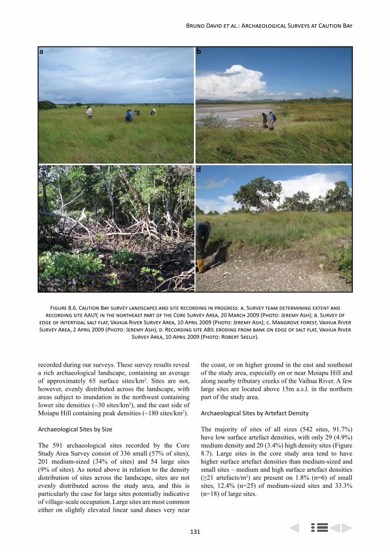
131
Bruno David et al.: Archaeological Surveys at Caution Bay
a b
c d
Figure 8.6. Caution Bay survey landscapes and site recording in progress: a. Survey team determining extent and recording site AAUY, in the northeast part of the Core Survey Area, 20 March 2009 (Photo: Jeremy Ash); b. Survey of
edge of intertidal salt flat, Vaihua River Survey Area, 10 April 2009 (Photo: Jeremy Ash); c. Mangrove forest, Vaihua River Survey Area, 2 April 2009 (Photo: Jeremy Ash); d. Recording site ABIL eroding from bank on edge of salt flat, Vaihua River
Survey Area, 10 April 2009 (Photo: Robert Skelly).
recorded during our surveys. These survey results reveal a rich archaeological landscape, containing an average of approximately 65 surface sites/km2. Sites are not, however, evenly distributed across the landscape, with areas subject to inundation in the northwest containing lower site densities (~30 sites/km2), and the east side of Moiapu Hill containing peak densities (~180 sites/km2).
Archaeological Sites by Size
The 591 archaeological sites recorded by the Core Study Area Survey consist of 336 small (57% of sites), 201 medium-sized (34% of sites) and 54 large sites (9% of sites). As noted above in relation to the density distribution of sites across the landscape, sites are not evenly distributed across the study area, and this is particularly the case for large sites potentially indicative of village-scale occupation. Large sites are most common either on slightly elevated linear sand dunes very near
the coast, or on higher ground in the east and southeast of the study area, especially on or near Moiapu Hill and along nearby tributary creeks of the Vaihua River. A few large sites are located above 15m a.s.l. in the northern part of the study area.
Archaeological Sites by Artefact Density
The majority of sites of all sizes (542 sites, 91.7%) have low surface artefact densities, with only 29 (4.9%) medium density and 20 (3.4%) high density sites (Figure 8.7). Large sites in the core study area tend to have higher surface artefact densities than medium-sized and small sites – medium and high surface artefact densities (≥21 artefacts/m2) are present on 1.8% (n=6) of small sites, 12.4% (n=25) of medium-sized sites and 33.3% (n=18) of large sites.

132
Archaeological Research at Caution Bay, Papua New Guinea
Archaeological Sites by Contents
Within the core study area, 466 sites (78.8%) are scatters of cultural materials containing stone artefacts, pottery sherds, shells and vertebrate faunal remains, the remaining 125 sites (21.2%) consisting of single cultural items. Four hundred and seventy-six sites contain pottery sherds (80.6% of sites), 340 sites (57.5% of sites) have shells, 154 sites (26.1% of sites) have stone artefacts, and eight sites (1.4% of sites) contain vertebrate faunal remains. Four sites (ABAA, ABAY, AAOI, AAPR) (0.7% of sites) additionally contain colonial-period objects (glass, metal or ceramic) dating to the post-1870s era, and one site (ABIM) is at the location of the documented 19th century village of Konekaru. A post-European contact age is indicated for the most recent occupation of these few sites, while the vast majority of sites are of pre-European contact age.
Peripheral Survey
The Peripheral Survey involved systematic, full-coverage survey of a corridor 10.05km long by 50m-wide (0.503km2) located to the north, east and south of the Core Study Area Survey, and bounding the Vaihua River Survey and Papa Lea Lea Survey areas on the south (Figure 8.2). The Peripheral Survey corridor runs from the salt flats at the extreme northwest of the study area and runs inland for 4.18km in an east-northeast orientation before sharply turning to the south and continuing for a further 4.18km before making a right-angle turn to the west and running for 1.70km towards the coast (Figure 8.8). The corridor covers areas with elevations of 5m to 45m a.s.l., traversing grassland and savannah, crossing creeks at the western end and towards the northeast, most notably Roku Creek (twice), as well as Edubu Creek and Ebutodahana Creek (also twice) in the southeast. In terms of local places, the Peripheral Survey area covers the area from Konekaru at its northwestern end and runs just
south of two low hills, Urivaka Sagaergare and Nebira in the middle of the northern section, continuing through the Bokina Bokina locality in the middle of the eastern side and then the Laba locality in the southeast, finally ending near the Aemakara and Vaihua localities at the southwestern end of the survey corridor (see Chapter 5).
Peripheral Survey Strategy, Methods and Intensity
The survey strategy for the Peripheral Survey was the same as for the Core Study Area Survey – high intensity, systematic coverage of 100% of the survey area. In the case of the Peripheral Survey a number of elements came together that resulted in a higher intensity survey than the earlier Core Study Area Survey, including the involvement of a larger number of professional archaeologists and a reduced grass cover.
Survey transects were walked at 2-5m intervals. Much of the grass cover across the survey area had been cut or burned a few days before the survey, providing ground surface visibility in the 50-75% range across the great majority of the survey corridor. However, some sections, particularly to the southeast, retained long grass, negatively impacting on ground surface visibility (and therefore restricting the detection of surface artefacts). Despite variability in ground visibility, all medium- and large-size sites are likely to have been discovered given the survey intensity. In many more cases, however, the boundaries of sites were able to be fully traced, with several extending a considerable distance beyond the survey corridor.
Peripheral Survey Results
Systematic, high-intensity full-coverage ground sur-face survey of the Peripheral Survey area revealed 84 archaeological sites partly or entirely within the survey corridor (Figure 8.9). Site density within the
Low Density(≤20 items/m2)
Medium Density(21-50 items/m2)
High Density(>50 items/m2) Row Totals
Small (≤25 m2) 330 5 1 336
Medium (26-1000 m2) 176 17 8 201
Large (>1000 m2) 36 7 11 54
Column Totals 542 29 20 591
Figure 8.7. Core Study Area Survey site surface artefact density (maximum number of items/m2) by site size (m2).

133
Bruno David et al.: Archaeological Surveys at Caution Bay
0.503km2 survey corridor is 167 sites/km2, but this is an unrealistically inflated figure due to the narrowness of the survey corridor which means that many sites are only partially located within the corridor.
Archaeological Sites by Size
Of the 84 archaeological sites recorded during the Peripheral Survey, 32 (38.1% of sites) are small, 35 (41.7%) are medium-sized, and 17 (20.2%) are large sites (Figure 8.10). These results indicate a much higher
proportion of medium and large sites in the Peripheral Survey area than in the core study area, a difference probably resulting from superior average ground surface visibility conditions in the Peripheral Survey area allowing better detection of artefact distributions and thus more accurate determinations of site size. In other words, instead of several small sites separated by gaps where artefacts were not observed, higher ground surface visibility led to the identification of artefacts filling in gaps between smaller scatters, leading to the identification of proportionally more larger sites in
ABLP
ABLQ
ABNUABNV
ABNXABNW
ABNYABNZ
ABOAABOB
ABOC
ABKW
ABNE
ABNF
ABNGABNH
AAKJ
AAKI
ABLN
ABNC
ABNB
ABLIABND
ABLKABMIABMJ
ABMKABMLABMM
ABMNABMOABMPABMQ
ABMR
ABMS
ABMTABMUABMV
ABMWABMXABMY
ABMZABLBABOJ
ABODABLA
ABNA
ABLHABOE
ABLCABLD
ABLE
ABNI
ABNJ
ABNK
ABNL
ABNNABNOABNPABNQ
ABNRABNM
ABNT
ABOI
ABKZ
ABKY
ABOHABOG
ABOF
ABLY
ABLZ
ABMA
ABMCABMD
ABMBABLR ABLS
ABLTABLU
ABLVABLW
ABLX
ABLO
AAIW
ABKX
ABLJABLL
ABLM
ABLF
ABLG
PFML1
AAIY
ABKS
ABKU
ABKT
ABNSABMH
ABMGABJUABJW
Vaih u a River
N
GrasslandMangroveSaltflat Savannah
0 500
metres
Figure 8.8. Caution Bay Peripheral Survey area (blue outline) sites (blue dots), plus other recorded sites (orange dots), with Papua New Guinea National Museum and Art Gallery registration codes.
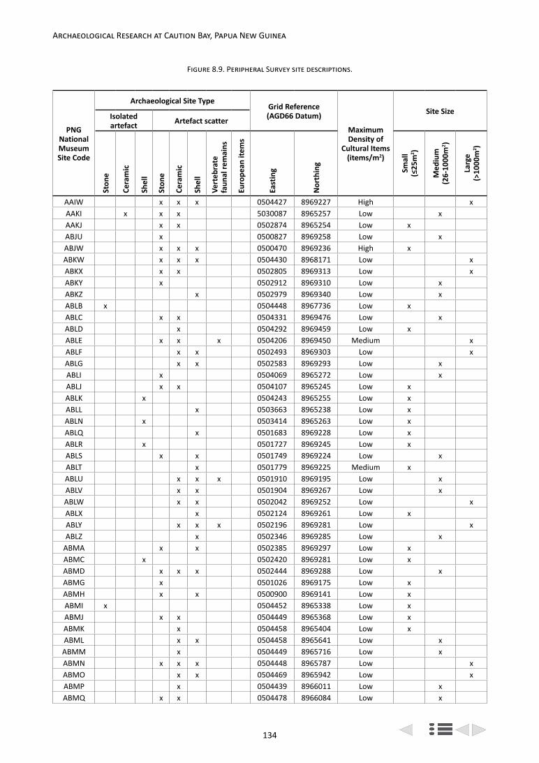
134
Archaeological Research at Caution Bay, Papua New Guinea
Figure 8.9. Peripheral Survey site descriptions.
PNG National Museum Site Code
Archaeological Site TypeGrid Reference (AGD66 Datum)
Maximum Density of
Cultural Items (items/m2)
Site SizeIsolated artefact Artefact scatter
Ston
e
Cera
mic
Shel
l
Ston
e
Cera
mic
Shel
l
Vert
ebra
te
faun
al re
mai
ns
Euro
pean
item
s
East
ing
Nor
thin
g
Smal
l (≤
25m
2 )
Med
ium
(2
6-10
00m
2 )
Larg
e
(>10
00m
2 )
AAIW x x x 0504427 8969227 High xAAKI x x x 5030087 8965257 Low xAAKJ x x 0502874 8965254 Low xABJU x 0500827 8969258 Low xABJW x x x 0500470 8969236 High xABKW x x x 0504430 8968171 Low xABKX x x 0502805 8969313 Low xABKY x 0502912 8969310 Low xABKZ x 0502979 8969340 Low xABLB x 0504448 8967736 Low xABLC x x 0504331 8969476 Low xABLD x 0504292 8969459 Low xABLE x x x 0504206 8969450 Medium xABLF x x 0502493 8969303 Low xABLG x x 0502583 8969293 Low xABLI x 0504069 8965272 Low xABLJ x x 0504107 8965245 Low xABLK x 0504243 8965255 Low xABLL x 0503663 8965238 Low xABLN x 0503414 8965263 Low xABLQ x 0501683 8969228 Low xABLR x 0501727 8969245 Low xABLS x x 0501749 8969224 Low xABLT x 0501779 8969225 Medium xABLU x x x 0501910 8969195 Low xABLV x x 0501904 8969267 Low xABLW x x 0502042 8969252 Low xABLX x 0502124 8969261 Low xABLY x x x 0502196 8969281 Low xABLZ x 0502346 8969285 Low x
ABMA x x 0502385 8969297 Low xABMC x 0502420 8969281 Low xABMD x x x 0502444 8969288 Low xABMG x 0501026 8969175 Low xABMH x x 0500900 8969141 Low xABMI x 0504452 8965338 Low xABMJ x x 0504449 8965368 Low xABMK x 0504458 8965404 Low xABML x x 0504458 8965641 Low xABMM x 0504449 8965716 Low xABMN x x x 0504448 8965787 Low xABMO x x 0504469 8965942 Low xABMP x 0504439 8966011 Low xABMQ x x 0504478 8966084 Low x

135
Bruno David et al.: Archaeological Surveys at Caution Bay
PNG National Museum Site Code
Archaeological Site TypeGrid Reference (AGD66 Datum)
Maximum Density of
Cultural Items (items/m2)
Site SizeIsolated artefact Artefact scatter
Ston
e
Cera
mic
Shel
l
Ston
e
Cera
mic
Shel
l
Vert
ebra
te
faun
al re
mai
ns
Euro
pean
item
s
East
ing
Nor
thin
g
Smal
l (≤
25m
2 )
Med
ium
(2
6-10
00m
2 )
Larg
e
(>10
00m
2 )
ABMR x 0504448 8966152 Low xABMT x 0504440 8967037 Low xABMU x 0504436 8967088 Low xABMV x x 0504481 8967152 Low xABMW x 0504476 8967314 Low xABMX x 0504448 8967376 Low xABMY x x 0504472 8967405 Low xABMZ x 0504487 8967528 Low xABNB x 0503973 8965250 Low xABNC x x x 0504032 8965295 Low xABNE x x 0502775 8965285 Low xABNF x 0502794 8965267 Low xABNG x x 0502872 8965294 Low xABNH x 0502946 8965287 Low xABNI x x 0504083 8969466 Low xABNJ x 0503899 8969436 Low xABNK x 0503839 8969439 Low xABNL x x x 0503759 8969385 Low xABNN x 0503741 8969416 Low xABNO x 0503726 8969421 Low xABNP x x 0503673 8969387 Low xABNQ x x 0503422 8969395 Low xABNR x x 0503398 8969359 Low xABNT x 0503296 8969326 Low xABNU x x 0504472 8968972 Low xABNV x 0504455 8968945 Low xABNW x 0504434 8968913 Low xABNX x x 0504455 8968897 Low xABNY x x 0504445 8968864 Low xABNZ x x x 0504442 8968653 Medium xABOA x x 0504463 8968631 Low xABOB x x 0504448 8968567 Low xABOC x x 0504421 8968363 Low xABOD x x x 0504439 8967876 Low xABOF x x 0502625 8969289 Low xABOG x x x 0502730 8969331 Low xABOH x 0502852 8969321 Low xABOI x x x 0503132 8969342 Low xABOJ x x x 0504466 8967764 Low x
PFML1 x x x 0503786 8965278 Low x
Total 4 5 4 44 54 34 3 0 - - - 32 35 17

136
Archaeological Research at Caution Bay, Papua New Guinea
the Peripheral Survey area. This conclusion is further supported by the slightly lower percentage of isolated artefacts in the Peripheral Survey area (15.5% of sites) than in the Core Study Area Survey (21.2% of sites), which suggests that when surface visibility conditions provide an opportunity to more accurately trace artefact distributions, artefacts tend to be more frequently grouped in scatters rather than occurring in isolation.
Archaeological Sites by Artefact Density
The vast majority of sites, 79 (94.1%), have low surface artefact densities, with only five sites (5.9%) having medium or high surface artefact densities of ≥21 artefacts/m2. These results compare closely with those of the core study area. We note that variations in the intensity (spacing of survey transects) of survey and ground surface visibility between the Peripheral Survey and the Core Study Area Survey likely influenced the number of medium and large sites recorded in the two areas. However, these variations did not affect the quantification of site artefact densities once sites had been found, because the method of determining site boundaries and recording site contents was the same for both surveys.
Archaeological Sites by Contents
Fifty-four archaeological sites (64.3% of sites) contain pottery sherds exposed on the ground surface; 44 (53.4%) contain stone artefacts; 34 (40.5%) contain shells and three (3.6%) contain vertebrate faunal remains. Thirteen sites (15.5%) are isolated finds while 71 (84.5%) are scatters of cultural materials. No European materials were observed on the Peripheral Survey sites. The above results are notably different from those of the Core Study Area Survey, which has much higher values for both potsherds and shells and much lower values for stone artefacts. The lower incidence of shell on sites in the Peripheral Survey area is probably related to the
fact that a substantial part of this area is further inland, and thus further away from the sea where most of the shell originated, than any part of the core study area. The lower frequency of ceramics on sites in the Peripheral Survey area suggests that pottery-making and use was more extensive in the core study area.
Vaihua River Survey
The Vaihua River Survey Area is located directly south of the southern edge of the Core Study Area Survey area (Figure 8.2). According to local people, the west side of the survey area is locally known as Vaihua, the eastern end as Laba and immediately south of the survey area is the Aemakara locality, site of the former village noted by Seligmann (1910: 41, figure 3) (see above). The Vaihua River Survey Area measures 1.00km north-south by 2.23km east-west, with an area of 2.23km2 (Figure 8.11).
The survey area is very low-lying, entirely under 25m a.s.l. and mostly under 10m a.s.l., with a fair amount essentially intertidal, including salt flats and mangrove forest, or subject to seasonal inundation (Figures 8.6b,c).
Twenty-eight archaeological sites were recorded in this area through a combination of reconnaissance-level surveying and updating records from previously-recorded sites (Figure 8.12). Eight archaeological sites were recorded in this locality by Pamela Swadling of the PNG National Museum and Art Galley during the 1970s, during reconnaissance surveys between Boera and Papa (Swadling, personal communication 2014), representing the only previous survey work in the Caution Bay study area.
Systematic survey across this area was not possible due to the recognition of UXO hazards early in the survey, which resulted in a withdrawal of access to this locality (see above).
Low Density(≤20 items/m2)
Medium Density(21-50 items/m2)
High Density(>50 items/m2) Row Totals
Small (≤25 m2) 30 1 1 32
Medium (26-1000 m2) 35 0 0 35
Large (>1000 m2) 14 2 1 17
Column Totals 79 3 2 84
Figure 8.10. Peripheral Survey site surface artefact density (maximum number of items/m2) by site size (m2).

137
Bruno David et al.: Archaeological Surveys at Caution Bay
N
GrasslandMangroveSaltflat Savannah
0 500
metres
Vaihua R iver
ARL
ARK ARI
ARF
ARGARH
ARD
AAKHAAQZAARA
ARE
AAIPABIL
AAQHAAQJ
AAQO
AAQSAAQQ
AAQN
AAQKAAQV AAQT
AAQM
AAQYAAQW AAQU
AAQX
AAQL
Figure 8.11. Caution Bay Vaihua River Survey area (yellow outline) sites (yellow dots) with Papua New Guinea National Museum and Art Gallery registration codes.
Figure 8.12. Vaihua River Survey site descriptions.
PNG National Museum Site Code
Archaeological Site TypeGrid Reference (AGD66 Datum)
Maximum Density of
Cultural Items
(items/m2)
Site SizeIsolated artefact Artefact scatter
Ston
e
Cera
mic
Shel
l
Ston
e
Cera
mic
Shel
l
Vert
ebra
te fa
unal
re
mai
ns
Euro
pean
item
s
East
ing
Nor
thin
g
Smal
l (≤
25m
2 )
Med
ium
(2
6-10
00m
2 )
Larg
e (>
1000
m2 )
AAIP x 0501964 8965569 High xAAKH x 0502811 8965330 Low xAAQH x x 0502658 8965852 High xAAQJ x x 0502735 8965883 Low xAAQK x x x 0502910 8965682 High xAAQL x 0503038 8965708 Medium xAAQM x x 0502987 8965770 Low xAAQN x x 0503062 8965772 Low xAAQO x x 0503255 8965722 Low xAAQQ x x 0503490 8965458 Low xAAQS x 0503435 8965395 Low xAAQT x 0503129 8965662 Low xAAQU x 0503104 8965620 Medium xAAQV x 0503017 8965580 Low xAAQW x 0503044 8965517 Low xAAQX x x 0503063 8965477 Medium x

138
Archaeological Research at Caution Bay, Papua New Guinea
Although our survey resulted in a further 20 archaeological sites being recorded in addition to eight previously recorded ones, there are probably many more unrecorded sites in this area. All indications are that this is an area of considerable archaeological potential, much like the adjacent core study area, especially: (1) the northward projecting dune to the south of the Vaihua River mouth, comparable to the similar, but larger dune extension to the north of the river where sites Bogi 1, Tanamu 1 and other deeply stratified sites are found; (2) land immediately adjacent to the edge of the extensive salt flats within the survey area; (3) land above 10m a.s.l. on the east bank of Ebutodahana Creek.
Only one of the sites in the Vaihua River Survey area consists of an isolated artefact, the remainder being artefact scatters (with three previously recorded sites being of indeterminate content and size). Of the scatters, five are both large and with high artefact densities, the remainder being mostly small to medium in size, with low artefact densities (Figure 8.13). The large, high density sites (ARE, AAQH, AAQK, ABIL, AAIP) are mostly located on higher ground adjacent to either salt flats or Ubotodahana Creek (Figure 8.6d).
In terms of surface artefact assemblages recorded by the Vaihua River Survey, 25 sites (89.3% of sites) have ceramics, 11 sites (39.3%) have shell, and six sites (21.4%) have stone artefacts.
Papa Lea Lea Road Survey
The Papa Lea Lea Road Survey was a targeted survey within an 8.5km long by 50m-wide (0.43km2) corridor oriented along the centre-line of the Papa Lea Lea Road through terrain dominated by grassland and savannah. The survey corridor extends from the southeastern edge of the Peripheral Survey area to the turnoff to Porebada village (Figures 8.2 and 8.14), running along the inland side of a series of ridges parallel to the coast, including Uda Bada Hill and Taurama Hill and crossing several tributaries of Kiohedova Creek on the northern section of the corridor. The corridor is 2.5km inland from the shoreline at its northern end, 1.9km inland in the mid-section and 2.7km inland at the southern end. Elevation varies from 12m a.s.l. at the southern end of the survey corridor to 70m a.s.l. in the mid-section, where the Papa Lea Lea Road runs across high ground between coastal ridges and the inland forested upland to the east.
The Papa Lea Lea Road Survey corridor had the existing road running in the centre of it at the time of the surveys, leaving undisturbed space, usually on the order of 10-20m, on either side of the road to survey.
PNG National Museum Site Code
Archaeological Site TypeGrid Reference (AGD66 Datum)
Maximum Density of
Cultural Items
(items/m2)
Site SizeIsolated artefact Artefact scatter
Ston
e
Cera
mic
Shel
l
Ston
e
Cera
mic
Shel
l
Vert
ebra
te fa
unal
re
mai
ns
Euro
pean
item
s
East
ing
Nor
thin
g
Smal
l (≤
25m
2 )
Med
ium
(2
6-10
00m
2 )
Larg
e (>
1000
m2 )
AAQY x x 0503091 8965458 Low x
AAQZ x 0502692 8965331 Low x
AARA x 0502979 8965416 Low x
ABIL x x x 0502120 8965553 High x
ARD x 0503500 8965500
ARE x 0501962 8965357 High x
ARF x 0501600 8965500 Low x
ARG x 0502100 8965800
ARH x 0502200 8965700
ARI x 0501700 8966300 Low x
ARK x x 0501500 8966200 Low x
ARL x x 0501300 8966100 Low x
Total 0 1 0 6 24 11 0 0 - - - 10 7 8

139
Bruno David et al.: Archaeological Surveys at Caution Bay
Papa Lea Lea Road Survey Strategy, Methods and Intensity
The original intention for the Papa Lea Lea Road Survey was to undertake a 100% high intensity, systematic coverage survey of the unbuilt portions of the survey area. However, a severe constraint in the form of very tall and dense grasses resulted in both exceptionally poor ground surface visibility (approaching 0%) and a corresponding unacceptably high very-venomous snake hazard (e.g., Papuan Taipan, New Guinea Death Adders, etc.) rendered this form of field survey unacceptable at the time. Instead, a targeted survey strategy was devised to obtain a preliminary overview of the surface archaeological record for this area, preparatory to systematic survey when the high grass had been cut or burnt. However, the latter was beyond our control and did not eventuate. The survey strategy was thus limited to the targeting of areas with reduced grass cover. These patches of reduced grass cover were systematically surveyed with parallel transects spaced 5m apart.
Survey intensity was high within the surveyed patches of reduced grass cover. These patches of low grass cover were identified in the survey corridor by walking along the Papa Lea Lea Road and scanning the ground on either side of the road for areas with suitably reduced grass cover to then target.
Papa Lea Lea Road Survey Results
A total of 44 archaeological sites were identified in the limited sections of the survey corridor that were surveyed, so the number of sites recorded does not represent the total number of sites located in the Papa Lea Lea Road Survey area (Figure 8.15). Nevertheless, this preliminary survey provides an indicative sample of inland sites for an area to the south of the core study area.
Archaeological Sites by Size
Of the 44 archaeological sites identified within the surveyed sections, 33 (75% of sites) are small, 10 (23%) are medium-sized and one (2%) is a large site. When compared with the size-distribution of sites in the core study area, where 57% of sites are small, 34% medium-sized and 9% large, there is a significantly higher proportion of smaller sites recorded for the Papa Lea Lea Road Survey. This difference may be accounted for by three factors: 1) there genuinely is a higher proportion of small sites in this area, which could mean the area covered by the Papa Lea Lea Road Survey area had not been as densely populated in the past as the core study area; 2) survey constraints (disturbance and low ground visibility) have hampered effective detection of the closest neighbouring artefacts (within 15m of each other) that are relied on to link clusters of surface artefacts into larger groupings (medium and large sites); 3) the patches of the Papa Lea Lea Road Survey corridor that were examined are not representative of sites along the whole of the corridor and a greater proportion of medium and larger sites may be present in this area than was revealed by the preliminary survey. Given the often poor ground visibility and the distance inland from the coast (~2-2.5km), it seems likely that the first two factors contributed most to the high proportion of small sites recorded in the Papa Lea Lea Road Survey area.
Archaeological Sites by Artefact Density
Of the 44 archaeological sites identified, 17 sites (37%) are individual finds while 27 (62%) are artefact scatters. None of the sites recorded have more than 11 artefacts/m2 (Figure 8.16); this contrasts with the presence of numerous sites with over 30 artefacts/m2 in the Peripheral Survey corridor and sites with over 100 artefacts/m2 in the core study area. This difference may be partly
Low Density(≤20 items/m2)
Medium Density(21-50 items/m2)
High Density(>50 items/m2)
Density Indeterminate Row Totals
Small (≤25 m2) 9 1 0 0 10
Medium (26-1000 m2) 5 2 0 0 7
Large (>1000 m2) 3 0 5 0 8
Size Indeterminate 0 0 0 3 3
Column Totals 17 3 5 3 28
Figure 8.13. Vaihua River Survey site surface artefact density (maximum number of items/m2) by site size (m2).

140
Archaeological Research at Caution Bay, Papua New Guinea
due to the endemic dense grass cover problem along the Papa Lea Lea Road Survey corridor obscuring the ground surface and thus affecting both the detection of many sites (very dense grass areas avoided) and perhaps the detection of the most dense portions of partially obscured sites. Another factor may be that the inland corridor runs through a formerly less densely occupied
landscape and the observed densities are a reasonably accurate reflection of relative occupation intensity.
Archaeological Sites by Contents
Of the 44 archaeological sites identified, 25 (56.8% of sites) contain ceramics, 23 (52.3%) contain shell,
Vai h ua R
N
Porebada
GrasslandSavannahMangrove Forest Roads
Boera
Papa Lea Lea Road Survey Corridor
.
ABHW
ABJCABGW
ABJDABHE
ABHF
ABIE
ABHGABIA
ABHX
ABHHABIH
ABHZ
ABHV
ABIGABICABIB
ABGU
ABGVABIK
ABIFABHY ABHL
ABHTABIJ ABII
ABHU
ABJAABJB
ABIDABHR
ABHQ
ABGTABHS
ABHJ
ABHM
ABHNABHP
ABHOABGX
ABGY ABGZABHI
ABHK
0 1
ki lometre
Figure 8.14. Caution Bay Papa Lea Lea Road Survey sites (black dots) with Papua New Guinea National Museum and Art Gallery registration codes.

141
Bruno David et al.: Archaeological Surveys at Caution Bay
Figure 8.15. Papa Lea Lea Road Survey site descriptions.
PNG National Museum
Site Code
Archaeological Site TypeGrid Reference
(AGD66 Datum) Maximum Density of
Cultural Items
(items/m2)
Site SizeIsolated artefact Artefact scatter
Ston
e
Cera
mic
Shel
l
Ston
e
Cera
mic
Shel
l
Vert
ebra
te
faun
al re
mai
ns
Euro
pean
item
s
East
ing
Nor
thin
g
Smal
l(≤
25m
2 )
Med
ium
(26-
1000
m2 )
Larg
e (>
1000
m2 )
ABGT x 0504480 8963673 Low xABGU x x 0505160 8962140 Low xABGV x x 0505143 8962032 Low xABGW x 0507830 8959239 Low xABGX x 0503817 8965074 Low xABGY x 0504002 8964843 Low xABGZ x 0504216 8964380 Low xABHE x 0507280 8959981 Low xABHF x x 0507103 8960138 Low xABHG x 0506812 8960381 Low xABHH x x 0505671 8961090 Low xABHI x 0504297 8964193 Low xABHJ x 0504429 8963881 Low xABHK x 0504480 8963673 Low xABHL x 0504939 8962705 Low xABHM x 0503768 8965158 Low xABHN x x 0503844 8965073 Low xABHO x x 0503871 8965030 Low xABHP x 0503922 8964930 Low xABHQ x 0504345 8963979 Low xABHR x 0504405 8963797 Low xABHS x x 0504443 8963767 Low xABHT x 0504657 8963219 Low xABHU x 0504656 8963216 Low xABHV x 0505282 8961674 Low xABHW x x 0508340 8958724 Low xABHX x 0505681 8961055 Low xABHY x 0504930 8962734 Low xABHZ x 0505860 8960927 Low xABIA x 0506262 8960616 Low xABIB x 0503912 8965009 Low xABIC x x 0505156 8962153 Low xABID x 0504461 8963782 Low xABIE x 0506839 8960383 Low xABIF x 0505034 8962469 Low xABIG x x 0505148 8962175 Low xABIH x x 0505560 8961152 Low xABII x 0504632 8963324 Low xABIJ x x 0504627 8963305 Low xABIK x x 0505128 8962101 Low xABJA x 0504549 8963490 Low xABJB x 0504581 8963433 Low xABJC x 0507922 8959094 Low xABJD x 0507784 8959658 Low x
Total 4 7 6 5 18 17 0 0 - - - 33 10 1

142
Archaeological Research at Caution Bay, Papua New Guinea
Low Density(≤20 items/m2)
Medium Density(21-50 items/m2)
High Density(>50 items/m2) Row Totals
Small (≤25 m2) 33 0 0 33
Medium (26-1000 m2) 10 0 0 10
Large (>1000 m2) 1 0 0 1
Column Totals 44 0 0 44
Figure 8.16. Papa Lea Lea Road Survey site surface artefact density (maximum number of items/m2) by site size (m2).
PNG National
Museum Site Code
Archaeological Site TypeGrid Reference (AGD66 Datum)
Maximum Density of
Cultural Items (items/m2)
Site SizeIsolated artefact Artefact scatter
Ston
e
Cera
mic
Shel
l
Ston
e
Cera
mic
Shel
l
Vert
ebra
te fa
unal
re
mai
ns
Euro
pean
item
s
East
ing
Nor
thin
g
Smal
l (≤2
5m2 )
Med
ium
(2
6-10
00m
2 )
Larg
e
(>10
00m
2 )
AAIY x 0504250 8969233 Low xABKS x x 0504373 8967840 Medium xABKT x 0503689 8965892 Low xABKU x 0503893 8966824 Low xABLA x 0504431 8968075 Low xABLH x x 0503924 8968995 Low xABLO x 0503136 8965226 Low xABLP x 0501619 8969162 Medium x
ABMB x x 0502424 8969309 Low xABMS x 0504394 8966895 Low xABNA x 0504095 8969075 Low xABND x 0504155 8965309 Low xABNM x 0503719 8969378 Low xABNS x x 0503398 8969329 Low xABOE x x 0503752 8969057 Low xTotal 1 2 2 4 6 4 1 0 - - - 9 5 1
Figure 8.17. Descriptions of other sites recorded at Caution Bay.

143
Bruno David et al.: Archaeological Surveys at Caution Bay
and nine (20.5%) contain stone artefacts. No European materials were observed on the Papa Lea Lea Road Survey sites.
Other Sites
Fifteen additional sites were recorded outside the four survey areas, but close to them (Figure 8.8). These sites were recorded opportunistically while travelling to and from formal survey areas, pausing at localities while undertaking reconnaissance visits in and around the survey areas, and in a few cases surface sites found while monitoring construction-related subsurface testing of underlying sediment composition, water quality, etc.
The sites consist of five isolated artefacts and ten artefact scatters; most of the latter are small to medium-sized and of low density, with one site being of medium size and medium density (Figure 8.17). The most notable site is a large, medium density stone artefact scatter (ABKS) located on high ground above Roku Creek in the far east of the study area.
Conclusions
A total of 747 archaeological sites were recorded in four survey areas at Caution Bay plus an additional 15 sites outside of, but near, the formal survey areas. The same recording methods were used for all sites, although survey strategies and intensities varied between surveys. While the Core Study Area Survey and Peripheral Survey were systematic, full coverage surveys, not all areas of the Papa Lea Lea Road Survey and Vaihua River Survey areas could be surveyed due to unacceptably high occupational safety hazards at the time of first survey and subsequent access restrictions for these areas. The partial survey results for the Papa Lea Lea Road and Vaihua River survey areas provide useful additional information regarding surface site distributions and site contents at and near Caution Bay.
Discussions of landscape use based on the survey data, but relying on excavation results for chronological information, will take place in future volumes of the Caution Bay archaeology project.

144

145
Introduction
This chapter reports on the personnel, research structure and analytical methods employed in the Caution Bay project, constituting the sum of the various phases of field and laboratory research at Caution Bay. We stress that from the onset our approach has been to investigate through excavation the character of the archaeological record at a landscape scale, rather than more detailed investigations of a handful of sites that would have provided limited spatial understandings across the whole of the study area. That is, limited excavations at numerous sites were favoured over large-scale horizontal excavations of a few sites. This choice of strategy has arguably been vindicated by the discovery of rich cultural deposits that would have been entirely missed had we focused on the ‘best’ surface sites, none of which possess the treasured and then-unexpected Lapita horizons subsequently found at depth following excavation at sites with minor post-Lapita surface cultural deposits. Be that as it may, we present here baseline details into the analytical methods used for all of our excavations and laboratory research, critical background information that details how 122 Caution Bay sites have been excavated and analysed, towards publication in a sequence of forthcoming monographs.
Project Personnel and Research Structure
The Caution Bay Project is co-directed by Bruno David, Thomas Richards and Ian McNiven from Monash University, and Ken Aplin, Research Associate with the Smithsonian Institution’s National Museum of Natural History. As Project Manager, Thomas Richards is responsible for the overall running of the project, which has included coordinating the field research, laboratory processing, and analysis of finds, as well as appointing and managing personnel, and now increasingly focused on the assembling of monographs. Bruno David, Project Director, originally conceived the project, supervised the surveys in 2008-2009 and emergency salvage excavations at six sites in early 2009, and continues to guide all aspects of the research. Field Director Ian McNiven supervised the major archaeological salvage excavations of late 2009-early 2010, with overall responsibility for
the major fieldwork program including the scheduling of excavations, implementation of fine-grained excavation protocols, quality control, standardization of methods, and compilation and checking of excavation data and notes.
Monash University employed 91 field staff to supervise and carry out the salvage excavations (Appendix D). In addition, many local community representatives, primarily from Boera, Papa, Lea Lea and Porebada villages, were employed directly by the developer, and it was common for 30 to 50 community representatives to assist in the archaeological excavations and field laboratory work on a daily basis.
Matthew Leavesley, then of the University of Papua New Guinea (UPNG), was the UPNG Student Coordinator, responsible for recruiting, training and supervising the many UPNG Student Archaeology Trainees who worked on the salvage excavations and in the field laboratory (Appendix D).
Each excavation square was under the immediate supervision of an Excavation Director, who supervised a team usually consisting of an Assistant Archaeologist and others, including UPNG Student Archaeology Trainees and local community representatives. Each Excavation Director was responsible for ensuring that the Caution Bay excavation protocols were followed throughout the excavations, including photography, record-keeping, labelling and packaging of in situ finds and excavated sediment for transport to the field laboratory. The Excavation Directors received instructions on field methods from the Field Director (Ian McNiven) who regularly held meetings to ensure the maintenance of standard methods.
The Field Laboratory Supervisor, Cassandra Rowe, was responsible for managing the flow of excavated material for processing into the field laboratory and on to Monash University and the UPNG for subsequent university-based laboratory processing and analysis. Other supervisory staff in the field laboratory included the Sieving Supervisor, and expanded operations to cover for the processing of backlog from late March to
Chapter 9. The Caution Bay Project Field and Laboratory Methods
Bruno David, Thomas Richards, Ian J. McNiven, Jerome Mialanes, Ken Aplin, Fiona Petchey, Helene Peck, Brit Asmussen, Sean Ulm, Katherine Szabó,
Holly Jones-Amin, Patrick Faulkner, Claire Perrette, Cassandra Rowe, Matthew Leavesley and Bryce Barker

146
Archaeological Research at Caution Bay, Papua New Guinea
early June 2010 required the appointment of a Deputy Laboratory Supervisor, Assistant Laboratory Supervisor and an Assistant Sieving Supervisor (Appendix D).
The Caution Bay field and laboratory investigations have been conducted in accordance with standardized protocols; these are presented below rather than repeated in the many excavation reports to be published in this monograph series. All aspects of the field salvage operations are considered first, beginning with the excavation strategy, followed by the excavation and field laboratory methods, before moving on to the post-fieldwork laboratory processing and specialist analytical methods.
Field Methods
The entire study area was surveyed before excavation plans were devised; i.e., we already knew how many (surface) sites existed across the core study area before excavations began (see Chapter 8). All excavated sites are located within the core study area, but not all of the 591 sites recorded there were available for excavation during the major salvage operations. Fifty sites, 15 located in the northwest and 35 in the southwest of the core study area, were excluded because development project redesign left them outside the main construction impact area. Of the remaining sites, 150 showed evidence of being stratified (i.e., surface clues indicated the presence of buried deposits) and thus suitable for excavation (e.g., Figure 9.1), although one of these was found to contain unexploded ordnance from World War II, rendering it unexcavatable, leaving 149 stratified archaeological sites to potentially excavate with the time and resources available. A desire to obtain an excavation sample from each of a range of small (up to 25m2 in size), medium (26-1000m2) and large (>1000m2) sites across the study area landscape guided selection of the sites for excavation. Where numerous sites of the same size were available in a portion of the study area, and not all of these could be excavated due to time restrictions, those with the highest surface artefact density and diversity were chosen for excavation.
One hundred and twenty-two sites were excavated in the core study area at Caution Bay, with 211 excavation squares, each usually measuring 1m × 1m in size, and together totalling 207.5m2 (Figure 9.2; Figure 1.2). Six of the sites (ABEN, ABEO, ABEP, ABEQ, ABES and ABIP) were initially excavated in early 2009, and the other 116 during the major salvage operations which occurred from late September 2009 to late March 2010, although four of the early 2009 sites also had additional squares excavated during the major operations. Generally, 1m2 was excavated on small sites, 1m2 to 2m2 on medium-size sites, and 3m2 to 5m2 on large sites (Figure 9.3).
Excavations at Caution Bay were conducted in accordance with the following standard procedures (except ‘stepping out’ squares)(Figure 9.4):
1. A few days before a site was scheduled for excavation, a team re-located each site and confirmed its extent by re-checking the limits of the spatial distribution of surface cultural materials. The location(s) of pits to be excavated was determined and, if necessary, the grass was cut around the planned excavation area prior to the commencement of excavations.
2. A site datum (wooden or metal peg) was established and used for site mapping and excavation (elevation) recording purposes.
3. A site description was written by the Excavation Director, noting the topography, vegetation cover, other natural features, relative position of excavation squares and datum, extent and nature of cultural material on the surface, and the nature and location of any disturbance on or adjacent to the site. These new details complemented records from the original surveys.
4. An excavation pit, usually a 1m × 1m square, was strung onto offset metal survey arrows with coloured string line (Figure 9.4b). Each excavation square was aligned in a N-S/E-W orientation. A differently coloured string was used along the southern side of each square to facilitate orientation during excavation and on photographs.
5. Digital photographs were taken of the site surrounds, the site surface and the excavation square prior to excavation. Photographs were
Figure 9.1. Pot sherds on the surface (red rectangles) and embedded in the ground (blue rectangle), site AAJB, west-central core study area, 12 February 2009 (Photo: Jeremy
Ash).

147
Bruno David et al.: The Caution Bay Project Field and Laboratory Methods
Figure 9.2. Sites excavated in the Caution Bay study area, with numbers of excavation squares and stepping out squares. (PNG NMAG = Papua New Guinea National Museum and Art Gallery).
Site Identification Excavation Squares Stepping Out Squares
PNG NMAG
Site Code
Monash University Field
CodeSite Name
Number of
Squares
Pit Length
(m)
Pit Width
(m)
Area Excavated
(m2)
Number of Squares
Pit Length
(m)
Pit Width
(m)
Area Stepped Out (m2)
AAHM JDA2 1 1.00 1.00 1.00AAHN JDA3 1 1.00 1.00 1.00AAHO JDA5 2 1.00 1.00 2.00AAHP JDA6 1 1.00 1.00 1.00AAHR JDA8 1 1.00 1.00 1.00AAHS JDA9 1 1.00 1.00 1.00AAHV JDA12 1 0.50 0.50 0.25AAHX JDA14 1 1.00 1.00 1.00AAIB JDA18 1 1.00 1.00 1.00AAIC JDA19 1 0.50 0.50 0.25AAIG MLA1 1 1.00 1.00 1.00AAIJ MLA4 1 1.00 1.00 1.00AAIT MLA14 2 1.00 1.00 2.00AAIU MLA15 1 1.00 1.00 1.00AAIZ AK2 1 1.00 1.00 1.00AAJB AK4 1 1.00 1.00 1.00AAJH AK10 1 1.00 1.00 1.00AAJI AK11 1 1.00 1.00 1.00AAJJ AK12 1 1.00 1.00 1.00AAJK AK13, MLA12 1 1.00 1.00 1.00AAJM AK15 2 1.00 1.00 2.00AAJN AK16 1 1.00 1.00 1.00AAJQ AK19 1 1.00 1.00 1.00AAJU AK23 Kurukuru 1 1 1.00 1.00 1.00AAJV AK24 1 1.00 1.00 1.00AAJX AK26 1 1.00 1.00 1.00AAKD AK32 2 1.00 1.00 2.00AAKL AK37 1 1.00 1.00 1.00AAKM AK38 2 1.00 1.00 2.00AAKQ AK42 1 1.00 1.00 1.00AAKX AK49 1 1.00 1.00 1.00AAKZ AK51 1 1.00 1.00 1.00AALG AK58 1 1.00 1.00 1.00AALR AK69 1 1.00 1.00 1.00AALU AK72 1 1.00 1.00 1.00AALW AK74, MLA7 2 1.00 1.00 2.00AAMC AK80 1 0.50 0.50 0.25AAMG AK84 1 1.00 1.00 1.00AANB AK105 1 1.00 1.00 1.00AANM AK116 1 1.00 1.00 1.00AANO AK118 1 1.00 1.00 1.00AANR AK121 1 1.00 1.00 1.00AANV AK125 1 1.00 1.00 1.00AANX AK127 1 1.00 1.00 1.00
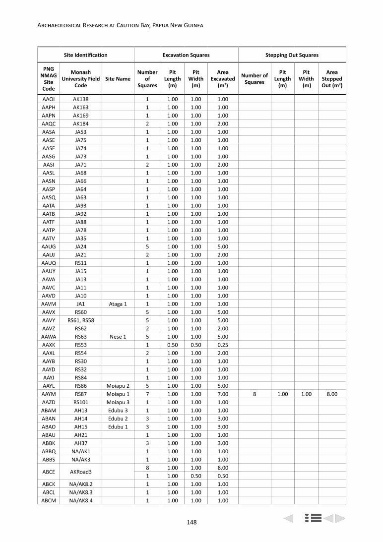
148
Archaeological Research at Caution Bay, Papua New Guinea
Site Identification Excavation Squares Stepping Out Squares
PNG NMAG
Site Code
Monash University Field
CodeSite Name
Number of
Squares
Pit Length
(m)
Pit Width
(m)
Area Excavated
(m2)
Number of Squares
Pit Length
(m)
Pit Width
(m)
Area Stepped Out (m2)
AAOI AK138 1 1.00 1.00 1.00AAPH AK163 1 1.00 1.00 1.00AAPN AK169 1 1.00 1.00 1.00AAQC AK184 2 1.00 1.00 2.00AASA JA53 1 1.00 1.00 1.00AASE JA75 1 1.00 1.00 1.00AASF JA74 1 1.00 1.00 1.00AASG JA73 1 1.00 1.00 1.00AASI JA71 2 1.00 1.00 2.00AASL JA68 1 1.00 1.00 1.00AASN JA66 1 1.00 1.00 1.00AASP JA64 1 1.00 1.00 1.00AASQ JA63 1 1.00 1.00 1.00AATA JA93 1 1.00 1.00 1.00AATB JA92 1 1.00 1.00 1.00AATF JA88 1 1.00 1.00 1.00AATP JA78 1 1.00 1.00 1.00AATV JA35 1 1.00 1.00 1.00AAUG JA24 5 1.00 1.00 5.00AAUJ JA21 2 1.00 1.00 2.00AAUQ RS11 1 1.00 1.00 1.00AAUY JA15 1 1.00 1.00 1.00AAVA JA13 1 1.00 1.00 1.00AAVC JA11 1 1.00 1.00 1.00AAVD JA10 1 1.00 1.00 1.00AAVM JA1 Ataga 1 1 1.00 1.00 1.00AAVX RS60 5 1.00 1.00 5.00AAVY RS61, RS58 5 1.00 1.00 5.00AAVZ RS62 2 1.00 1.00 2.00AAWA RS63 Nese 1 5 1.00 1.00 5.00AAXK RS53 1 0.50 0.50 0.25AAXL RS54 2 1.00 1.00 2.00AAYB RS30 1 1.00 1.00 1.00AAYD RS32 1 1.00 1.00 1.00AAYJ RS84 1 1.00 1.00 1.00AAYL RS86 Moiapu 2 5 1.00 1.00 5.00AAYM RS87 Moiapu 1 7 1.00 1.00 7.00 8 1.00 1.00 8.00AAZD RS101 Moiapu 3 1 1.00 1.00 1.00ABAM AH13 Edubu 3 1 1.00 1.00 1.00ABAN AH14 Edubu 2 3 1.00 1.00 3.00ABAO AH15 Edubu 1 3 1.00 1.00 3.00ABAU AH21 1 1.00 1.00 1.00ABBK AH37 3 1.00 1.00 3.00ABBQ NA/AK1 1 1.00 1.00 1.00ABBS NA/AK3 1 1.00 1.00 1.00
ABCE AKRoad38 1.00 1.00 8.001 1.00 0.50 0.50
ABCK NA/AK8.2 1 1.00 1.00 1.00ABCL NA/AK8.3 1 1.00 1.00 1.00ABCM NA/AK8.4 1 1.00 1.00 1.00

149
Bruno David et al.: The Caution Bay Project Field and Laboratory Methods
taken at the base of each XU of each excavated square, and of significant finds or features during excavation.
6. Each square was excavated in <3cm thick Excavation Units (XUs) following the sub-surface site stratigraphy.
7. Excavation was by small hand trowel and brush (Figure 9.4c,d); in the case of human burials, pointing trowels, small plastic spatulas, fine paint brushes and wooden toothpicks were also used.
8. Elevation readings were taken at five locations (four corners and centre of square) at the base of each XU, to the nearest millimetre using an automatic level (Figure 9.4e).
9. The most significant finds, such as charcoal for radiocarbon dating, decorated ceramics, worked
shell items, ground stone artefacts, obsidian items and any unusual finds were recorded in situ in three dimensions, given a consecutive identification number within its corresponding XU and individually bagged.
10. Small, sealed bags of unsieved sediment samples were taken from each XU for laboratory-based sediment and pollen analyses.
11. All other excavated sediment from each XU was double-bagged in the field and, along with any separately bagged in situ finds, was sent to the field laboratory for processing, including weighing, wet sieving, and sorting (Figure 9.4f).
12. At the completion of excavation, stratigraphic sections were drawn to scale on graph paper of two to four faces of each excavation square;
Site Identification Excavation Squares Stepping Out Squares
PNG NMAG
Site Code
Monash University Field
CodeSite Name
Number of
Squares
Pit Length
(m)
Pit Width
(m)
Area Excavated
(m2)
Number of Squares
Pit Length
(m)
Pit Width
(m)
Area Stepped Out (m2)
ABCN NA/AK8.5 1 1.00 1.00 1.00ABCO NA/AK8.6 1 1.00 1.00 1.00ABEN Bogi1 Bogi 1 8 1.00 1.00 8.00 61 1.00 1.00 61.00ABEO ML19, Bogi2 2 1.00 1.00 2.00ABEP Nadi1 2 1.00 1.00 2.00 8 1.00 1.00 8.00ABEQ Nadi2 2 1.00 1.00 2.00ABER Kon1, JD5 Konekaru 1 3 1.00 1.00 3.00ABES Line 11 Mound 1 1.00 1.00 1.00ABHA JD6 Tanamu 1 2 1.00 1.00 2.00 28 1.00 1.00 28.00ABHC JD15 Tanamu 2 2 1.00 1.00 2.00ABHD JD16 Tanamu 3 5 1.00 1.00 5.00ABHF JD8 Harakiare 1 2 1.00 1.00 2.00ABIS JD11 2 1.00 1.00 2.00 16 1.00 1.00 16.00ABIT JD12 2 1.00 1.00 2.00ABIU JD13 3 1.00 1.00 3.00ABIV JD14 5 1.00 1.00 5.00 20 1.00 1.00 20.00ABIW JD17 1 1.00 1.00 1.00 8 1.00 1.00 8.00ABJX ML4 1 1.00 1.00 1.00ABJY ML5 1 1.00 1.00 1.00ABKA ML7 2 1.00 1.00 2.00ABKC ML9 1 1.00 1.00 1.00ABKF ML12 3 1.00 1.00 3.00ABKH ML14 1 1.00 1.00 1.00ABKI ML15 2 1.00 1.00 2.00ABKK ML17 1 1.00 1.00 1.00
ABKL ML182 1.00 1.00 2.00 4 1.00 0.50 2.00
4 0.50 0.50 1.00ABKN ML20 2 1.00 1.00 2.00ABKO ML21 Ruisasi 1 2 1.00 1.00 2.00ARM JD9, JD10 5 1.00 1.00 5.00
Totals 211 207.50 157 152.00

150
Archaeological Research at Caution Bay, Papua New Guinea
photographs were also taken of the four walls of the completed pits.
13. Details of the excavation of each XU were recorded on a standard Excavation Form that included the following information:
• Observations on sediments excavated and cultural material content.
• The total volume (to closest 0.5 l) of excavated sediments (calculated using graduated buckets).
• The elevation readings for the centre and corners at the base of each XU.
• A plan drawing showing the position of sub-XUs, stratigraphic units, sub-strata, disturbances, features, rocks, and in situ finds.
• A table listing the three-dimensional coordinates of each in situ find, with brief description and consecutive find number.
a
b
Figure 9.3. Excavations in progress at Caution Bay: (a) View from site ABIW east to excavations at site Tanamu 3 (ABHD) (left and centre) and AAJM (far right, in mid-distance), in the west of the study area, with the Dirora Gotera Range in the background, 7 December 2009 (Photo: Nic Dolby); (b) View of excavations at site Nese 1 (AAWA) on the northern slope of
Moiapu Hill, in the east of the study area, 10 November 2009 (Photo: Ceri Shipton).

151
Bruno David et al.: The Caution Bay Project Field and Laboratory Methods
Figure 9.4. Excavation at site Edubu 1 (ABAO), 26 September 2009 (Photos: Thomas Richards): a. Excavation in progress at (left to right) Squares A, B and C; b. Square B, strung out with offset metal
survey arrows, prior to commencement of excavation; c. Start of excavation in Square B; d. Excavation of Square C; e. Elevation reading being taken with automatic level; f. Excavated soil being transferred to
plastic bag for transport to field laboratory for wet sieving.
a
b
c d
e f

152
Archaeological Research at Caution Bay, Papua New Guinea
In addition to the 211 pits thus excavated, a further 157 ‘stepping out’ pits, each usually 1.0m × 1.0m in size and together totalling 152m2, were excavated from eight of the sites (Figure 9.2). Our original plan was to shore the sides of the deeper squares, but when the time came to put this into practice, the study area was considered to be a construction site and new occupational health and safety requirements gave us no alternative but to ‘step out’ (and thereby expand the size of excavations on all sides) once any given square exceeded 1.20m depth (Figure 9.5). Furthermore, as the excavated squares increased in depth, so did the stepping out squares, and with increasing depth, new rows of stepping out pits were added. In sandy sites, the outer stepping out pit faces were shored with plywood and star pickets where deeper excavations were required, and safety fences were additionally erected beyond these (Figure 9.5a). The stepping out squares were variously excavated in 10cm or 50cm XUs, primarily with trowels (Figure 9.5b), but also sometimes shovels, and also partly with mattocks at one inland clay site. At another site with very deep cultural deposits a backhoe was employed to excavate parts of some of the stepping out squares, scraping in 10cm vertical increments. Sediment from stepping out operations was not sieved, but stockpiled in the vicinity of the excavation ready for backfilling operations at the completion of excavations. The archaeologists recorded the provenance and collected significant artefacts during stepping out operations – typically decorated pottery, ground stone artefacts, obsidian, other flaked stone, and worked shell items were collected and bagged. Three substantially complete Lapita pots were partially exposed during stepping out operations at sites Tanamu 1 and Bogi 1, and here excavation was refined while the pottery was carefully hand-excavated and collected (David et al. 2013: fig. 10). The practice of stepping out reached its climax with the Bogi 1 excavation, where the excavation of adjoining 1m × 1m Squares C and D extended to a depth of 3.5m within an approximately 8m × 8m stepping out area (McNiven et al. 2011: fig. 2; David et al. 2013: fig. 8). Significant lower portions of several other squares at Bogi 1, two containing a human burial, were also carefully excavated following removal of more than a metre of overlying sediment by stepping out operations. These operations will be further reported in the Bogi 1 monograph.
Professional surveyors working with the archaeologists undertook detailed mapping of each archaeological site. The site datum, excavation squares, vegetation cover, roads and tracks, and hydrological features were recorded and later reproduced in the form of digital topographic maps with 10cm contour intervals for all sites except a few along the eastern edge of the study area, for which 50cm contour intervals were employed. The final site maps to be presented in the forthcoming Caution Bay monographs are drafted from these surveyor maps.
A well-equipped, custom-built, secure field laboratory that included wet sieving, drying, sorting and storage areas was established within the field base camp located on the southern edge of the study area (Figures 9.6-9.8). The purpose of the field laboratory was to complete the basic processing of the excavated sediment, including sieving and preliminary sorting and to package materials for transportation to Monash University or, in a few cases, to the University of Papua New Guinea for detailed sorting and analysis.
Each day, the excavated material (XU bags, sediment sample bags and bags of individual in situ finds) from sites undergoing excavation was transported to the field laboratory, logged-in upon arrival and temporarily stored while awaiting processing. The process undertaken was
a
b
Figure 9.5. Stepping out operations at Caution Bay: a. Phase 1 of stepping out completed at site Bogi 1 (ABEN) with excavation Squares C and D protected by a wooden cover in the centre of the stepping out area, 5 January
2010 (Photo: Ian McNiven). Note the star picket and plywood shoring around the periphery of the stepping out pit, as well as other protective and safety measures being installed prior to the next stage of excavation; b.
Hand excavation of stepping out squares in progress around excavation Squares D and E (with plywood on
bottom in centre of photo) at site (ABIV), 9 March 2010 (Photo: Ben Shaw).

153
Bruno David et al.: The Caution Bay Project Field and Laboratory Methods
as follows, with all actions tracked and measurements recorded:
1. Each bag of sediment was weighed prior to wet sieving through 2.1mm-mesh sieves.
2. Materials retained in the sieves were placed on labelled trays to air-dry for several days.
3. The dried retained materials from the sieves were weighed and subject to an initial sorting to remove larger non-cultural items (e.g., rootlets,
rocks, carbonate concretions, fossil coral, etc.), the nature and weight of which were also recorded on discard, and the residue rebagged.
4. Approximately one-fifth of the total excavated XUs were further sorted to separate cultural shell, bone, pottery, stone artefacts, charcoal, etc., from non-cultural material, the latter being recorded and then discarded.
5. For each XU, the unsieved sediment samples, special finds and in situ charcoal samples,
a
b c d
e
Figure 9.6. Wet sieving and sorting operations in the Caution Bay field laboratory, September 2009 – May 2010 (Photos: Cassandra Rowe): a. Wet sieving team at work; b. Close-up of wet sieving through
2.1mm mesh sieve; c. Wet sieve residue on trays drying on shelves prior to sorting; d. Sorted sieve residue on trays; e. Sorting team at work on sieve residue.
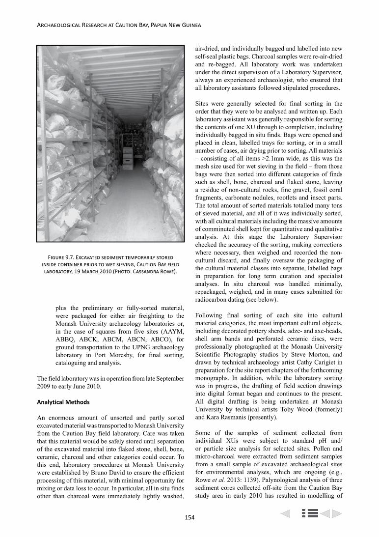
154
Archaeological Research at Caution Bay, Papua New Guinea
plus the preliminary or fully-sorted material, were packaged for either air freighting to the Monash University archaeology laboratories or, in the case of squares from five sites (AAYM, ABBQ, ABCK, ABCM, ABCN, ABCO), for ground transportation to the UPNG archaeology laboratory in Port Moresby, for final sorting, cataloguing and analysis.
The field laboratory was in operation from late September 2009 to early June 2010.
Analytical Methods
An enormous amount of unsorted and partly sorted excavated material was transported to Monash University from the Caution Bay field laboratory. Care was taken that this material would be safely stored until separation of the excavated material into flaked stone, shell, bone, ceramic, charcoal and other categories could occur. To this end, laboratory procedures at Monash University were established by Bruno David to ensure the efficient processing of this material, with minimal opportunity for mixing or data loss to occur. In particular, all in situ finds other than charcoal were immediately lightly washed,
air-dried, and individually bagged and labelled into new self-seal plastic bags. Charcoal samples were re-air-dried and re-bagged. All laboratory work was undertaken under the direct supervision of a Laboratory Supervisor, always an experienced archaeologist, who ensured that all laboratory assistants followed stipulated procedures.
Sites were generally selected for final sorting in the order that they were to be analysed and written up. Each laboratory assistant was generally responsible for sorting the contents of one XU through to completion, including individually bagged in situ finds. Bags were opened and placed in clean, labelled trays for sorting, or in a small number of cases, air drying prior to sorting. All materials – consisting of all items >2.1mm wide, as this was the mesh size used for wet sieving in the field – from those bags were then sorted into different categories of finds such as shell, bone, charcoal and flaked stone, leaving a residue of non-cultural rocks, fine gravel, fossil coral fragments, carbonate nodules, rootlets and insect parts. The total amount of sorted materials totalled many tons of sieved material, and all of it was individually sorted, with all cultural materials including the massive amounts of comminuted shell kept for quantitative and qualitative analysis. At this stage the Laboratory Supervisor checked the accuracy of the sorting, making corrections where necessary, then weighed and recorded the non-cultural discard, and finally oversaw the packaging of the cultural material classes into separate, labelled bags in preparation for long term curation and specialist analyses. In situ charcoal was handled minimally, repackaged, weighed, and in many cases submitted for radiocarbon dating (see below).
Following final sorting of each site into cultural material categories, the most important cultural objects, including decorated pottery sherds, adze- and axe-heads, shell arm bands and perforated ceramic discs, were professionally photographed at the Monash University Scientific Photography studios by Steve Morton, and drawn by technical archaeology artist Cathy Carigiet in preparation for the site report chapters of the forthcoming monographs. In addition, while the laboratory sorting was in progress, the drafting of field section drawings into digital format began and continues to the present. All digital drafting is being undertaken at Monash University by technical artists Toby Wood (formerly) and Kara Rasmanis (presently).
Some of the samples of sediment collected from individual XUs were subject to standard pH and/or particle size analysis for selected sites. Pollen and micro-charcoal were extracted from sediment samples from a small sample of excavated archaeological sites for environmental analyses, which are ongoing (e.g., Rowe et al. 2013: 1139). Palynological analysis of three sediment cores collected off-site from the Caution Bay study area in early 2010 has resulted in modelling of
Figure 9.7. Excavated sediment temporarily stored inside container prior to wet sieving, Caution Bay field laboratory, 19 March 2010 (Photo: Cassandra Rowe).

155
Bruno David et al.: The Caution Bay Project Field and Laboratory Methods
the timing and formation of the mangrove-dominated shoreline, as well as characterisation of nearby inland vegetation changes over the past c. 2000 years (Rowe et al. 2013).
Also in preparation for write-up, many sites have been radiocarbon-dated, with XUs to be dated selected by the archaeologist principally responsible for writing up the site, with actual sample identification and selection in the case of molluscan remains usually undertaken by specialist archaeomalacologists. About a third of the sites have so far been subjected to very detailed radiocarbon dating often involving many dozens of AMS radiocarbon determinations on individual items. Many other sites have already had preliminary dating completed and are awaiting more intensive radiocarbon dating to occur in conjunction with detailed analyses.
Following sorting, analysis of the different classes of materials has and continues to be undertaken by experts who are an integral part of the Caution Bay research team. Pottery analysis is being undertaken by Bruno David, with Holly Jones-Amin (Monash University) undertaking ceramic conservation and reconstruction. Jerome Mialanes (Monash University) is undertaking the stone artefact analyses. Ken Aplin is studying the
non-molluscan faunal remains. Molluscan remains are undergoing analysis by the team of Helene Peck (James Cook University), Brit Asmussen (Queensland Museum and University of Queensland), Patrick Faulkner (University of Sydney) and Sean Ulm (James Cook University). Katherine Szabó and Claire Perrette (University of Wollongong) are studying the worked shell artefacts. Fiona Petchey is overseeing the Caution Bay Accelerator Mass Spectrometry (AMS) dating at the Waikato Radiocarbon Dating Laboratory in Hamilton, New Zealand and has undertaken, with Sean Ulm and others, a detailed study of ∆R values for molluscan species commonly occurring in the Caution Bay excavated assemblages. Bayesian chronological model-building employing the AMS dates is also undertaken by Fiona Petchey in conjunction with the lead archaeologist working on each site.
Each site to be included in the forthcoming monographs on the Caution Bay investigations is under the overall responsibility of one archaeologist, who prepares a site report chapter that discusses the environmental setting of the site, investigations, stratigraphy, finds, and in conjunction with Fiona Petchey, chronological modelling of site occupation. The specialists analyse the finds and write them up in light of the chrono-
Figure 9.8. Excavated sediment temporarily stored outside container prior to wet sieving, Caution Bay field laboratory, 19 March 2010 (Photo: Cassandra Rowe).

156
Archaeological Research at Caution Bay, Papua New Guinea
stratigraphy worked out by the lead archaeologist. The specialists either prepare stand-alone chapters on the results of their analysed materials (e.g., ceramics, shell, etc.), or where there is not much material, sections to go in the site report chapter.
As is commonplace in archaeological analyses, data were analysed and visualized at a number of scales:
• Excavation Unit (XU): For each square in each site, the XU forms the minimum unit for presentation of the raw data. However temporal and spatial comparisons, and taphonomic issues, cannot be clearly and confidently explained at this scale.
• Stratigraphic Unit (SU): All materials attributed to the same stratum may be quantified and analysed as one unit that represents stratigraphically associated remains. However, this can only happen after the sum of XUs from a given SU has been empirically demonstrated to represent a discrete temporal unit.
• Analytical Unit (AU): For the purposes of analysis some assemblages are divided into separate analytical units that encompass materials from the same time frame or chronostratigraphic unit. These analytical units incorporate stratigraphic units that essentially represent chronologically modelled temporal phases or human occupation horizons at the site.
• Square: The results of quantified materials are reported for each square from a site. This enables past activities in discrete spatial areas at a site to be considered independently of other squares. Also, it is at this level that taphonomic issues affecting the condition of cultural materials and their vertical distribution were identified and discussed.
• Site: Discussion of each material occurred at a site scale, and involved all excavated squares in a consideration of chronological trends and spatial patterns in all variables of interest, including taxonomic, technological, raw material and decorative.
The analytical methods employed by the specialist experts are detailed below.
Pottery Analysis
The variables we have chosen to record on pottery sherds are particularly aimed at retrieving information about vessel decoration and vessel form, and broadly correspond to those utilized by archaeology projects previously undertaken for the south coast of New Guinea, in particular those investigating the history of the ancestral hiri trade (e.g., Frankel et al. 1994; Irwin 1985). Vessel parts are illustrated in Figure 9.9.
At the start of analysis of each site, the total number and total weight of sherds are calculated for each XU. The sherds are then separated into two size categories: <3.0cm and ≥3.0cm maximum length. For the <3.0cm sherds, the decorated body and rim sherds are analysed for their decoration, and the number of total rim sherds quantified. All other sherds <3.0cm long – the plain body sherds – are only counted and weighed by XU without further analyses. For the ≥3.0cm sherds, the following characteristics are recorded:
1. Instances of conjoining sherds.2. Weight (in grams, to nearest 0.01 g).3. Maximum length (in millimetres, to nearest
0.01mm).4. Presence of complete or partial pre-firing
perforations.5. Presence of finger or tool (e.g., rock) dimple
impressions on internal sherd surfaces (indicating manufacture by paddle and anvil technique).
6. Presence of paddle decoration or paddle grooves on external sherd surfaces (indicating manufacture by paddle and anvil technique).
7. Presence of paddle edge marks on external neck surfaces (indicating manufacture by paddle and anvil technique).
8. Techniques of body decoration (e.g., impression, incision, drilling, painting, slipping, infilling, modelling). Each instance of body decoration was identified and characterized sherd-by-sherd, rather than fitting observed instances into pre-established typologies of decorative techniques and forms.
9. Colours of painting, slipping and infilling.10. Tools employed in body decoration (e.g., shell,
comb).11. Techniques, colours and tools used in lip
decoration.12. Location of decoration. The ‘Decorative Fields’
of Frankel et al. (1994) are followed here.13. Maximum lip thickness (in millimetres, to within
2 decimal points).14. Maximum rim thickness (in millimetres, to within
2 decimal points).15. Maximum neck thickness (in millimetres, to
within 2 decimal points).16. Maximum carination thickness (in millimetres, to
within 2 decimal points).17. Maximum body thickness (in millimetres, to
within 2 decimal points).18. Maximum rim or body thickness (for non-
lip sherds where rim and body cannot be differentiated; in millimetres, to within 2 decimal points).
19. Orientation angle.20. Inclination angle.21. Rim length, measured along external sherd surface
(in millimetres, to within 2 decimal points).
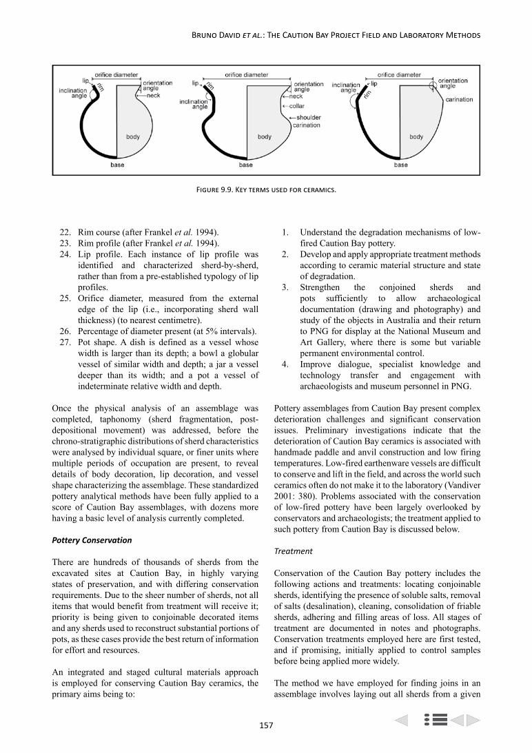
157
Bruno David et al.: The Caution Bay Project Field and Laboratory Methods
22. Rim course (after Frankel et al. 1994).23. Rim profile (after Frankel et al. 1994).24. Lip profile. Each instance of lip profile was
identified and characterized sherd-by-sherd, rather than from a pre-established typology of lip profiles.
25. Orifice diameter, measured from the external edge of the lip (i.e., incorporating sherd wall thickness) (to nearest centimetre).
26. Percentage of diameter present (at 5% intervals).27. Pot shape. A dish is defined as a vessel whose
width is larger than its depth; a bowl a globular vessel of similar width and depth; a jar a vessel deeper than its width; and a pot a vessel of indeterminate relative width and depth.
Once the physical analysis of an assemblage was completed, taphonomy (sherd fragmentation, post-depositional movement) was addressed, before the chrono-stratigraphic distributions of sherd characteristics were analysed by individual square, or finer units where multiple periods of occupation are present, to reveal details of body decoration, lip decoration, and vessel shape characterizing the assemblage. These standardized pottery analytical methods have been fully applied to a score of Caution Bay assemblages, with dozens more having a basic level of analysis currently completed.
Pottery Conservation
There are hundreds of thousands of sherds from the excavated sites at Caution Bay, in highly varying states of preservation, and with differing conservation requirements. Due to the sheer number of sherds, not all items that would benefit from treatment will receive it; priority is being given to conjoinable decorated items and any sherds used to reconstruct substantial portions of pots, as these cases provide the best return of information for effort and resources.
An integrated and staged cultural materials approach is employed for conserving Caution Bay ceramics, the primary aims being to:
1. Understand the degradation mechanisms of low-fired Caution Bay pottery.
2. Develop and apply appropriate treatment methods according to ceramic material structure and state of degradation.
3. Strengthen the conjoined sherds and pots sufficiently to allow archaeological documentation (drawing and photography) and study of the objects in Australia and their return to PNG for display at the National Museum and Art Gallery, where there is some but variable permanent environmental control.
4. Improve dialogue, specialist knowledge and technology transfer and engagement with archaeologists and museum personnel in PNG.
Pottery assemblages from Caution Bay present complex deterioration challenges and significant conservation issues. Preliminary investigations indicate that the deterioration of Caution Bay ceramics is associated with handmade paddle and anvil construction and low firing temperatures. Low-fired earthenware vessels are difficult to conserve and lift in the field, and across the world such ceramics often do not make it to the laboratory (Vandiver 2001: 380). Problems associated with the conservation of low-fired pottery have been largely overlooked by conservators and archaeologists; the treatment applied to such pottery from Caution Bay is discussed below.
Treatment
Conservation of the Caution Bay pottery includes the following actions and treatments: locating conjoinable sherds, identifying the presence of soluble salts, removal of salts (desalination), cleaning, consolidation of friable sherds, adhering and filling areas of loss. All stages of treatment are documented in notes and photographs. Conservation treatments employed here are first tested, and if promising, initially applied to control samples before being applied more widely.
The method we have employed for finding joins in an assemblage involves laying out all sherds from a given
Figure 9.9. Key terms used for ceramics.
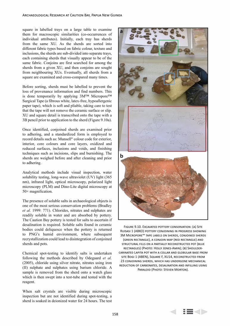
158
Archaeological Research at Caution Bay, Papua New Guinea
square in labelled trays on a large table to examine them for macroscopic similarities (co-occurrences of individual attributes). Initially, each tray has sherds from the same XU. As the sherds are sorted into different fabric types based on fabric colour, texture and inclusions, the sherds are sub-divided into separate trays, each containing sherds that visually appear to be of the same fabric. Conjoins are first searched for among the sherds from a given XU, and then conjoins are sought from neighbouring XUs. Eventually, all sherds from a square are examined and cross-compared many times.
Before sorting, sherds must be labelled to prevent the loss of provenance information and find numbers. This is done temporarily by applying 3M™ Micropore™ Surgical Tape (a fibrous white, latex-free, hypoallergenic paper tape), which is soft and pliable, taking care to test that the tape will not remove the ceramic surface or slip. XU and square detail is transcribed onto the tape with a 3B pencil prior to application to the sherd (Figure 9.10a).
Once identified, conjoined sherds are examined prior to adhering, and a standardized form is employed to record details such as: Munsell® colour code for exterior, interior, core colours and core layers, oxidized and reduced surfaces, inclusions and voids, and finishing techniques such as incisions, slips and burnishing. The sherds are weighed before and after cleaning and prior to adhering.
Analytical methods include visual inspection, water solubility testing, long-wave ultraviolet (UV) light (365 nm), infrared light, optical microscopy, polarized light microscopy (PLM) and Dino-Lite digital microscopy at 50× magnification.
The presence of soluble salts in archaeological objects is one of the most serious conservation problems (Bradley et al. 1999: 771). Chlorides, nitrates and sulphates are readily soluble in water and are absorbed by pottery. The Caution Bay pottery is tested for salts to ascertain if desalination is required. Soluble salts found in ceramic bodies could deliquesce when the pottery is returned to PNG’s humid environment, where subsequent recrystallization could lead to disintegration of conjoined sherds and pots.
Chemical spot-testing to identify salts is undertaken following the methods described by Odegaard et al. (2005), chloride using silver nitrate, nitrates using iron (II) sulphate and sulphates using barium chloride. A sample is removed from the sherd onto a watch glass which is then swept into a test-tube and tested with the reagent.
When salt crystals are visible during microscopic inspection but are not identified during spot-testing, a sherd is soaked in deionized water for 24 hours. The test
a
b
Figure 9.10. Excavated pottery conservation: (a) Site Ruisasi 1 (ABKO) pottery conjoining in progress showing 3M Micropore™ tape labels on sherds, conjoined sherds
(green rectangle), a conjoin map (red rectangle) and structural fills on a partially reconstructed pot (blue
rectangles) (Photo: Holly Jones-Amin); (b) Shoulder-carinated Lapita pot with a collar and globular base from
site Bogi 1 (ABEN), Square F, XU14, reconstructed from 23 conjoining sherds, which has undergone mechanical
reduction of carbonates, desalination and infilling using Paraloid (Photo: Steven Morton).

159
Bruno David et al.: The Caution Bay Project Field and Laboratory Methods
solution is then measured for salts with a conductivity meter. A chloride meter (Jenway model PCLM3) is used to confirm or rule out the presence of chloride salts. Two vessels have had further tests to confirm that soluble salts were not present using Environmental Scanning Electron Microscopy Backscattered Electron (ESEM-BSE) images and Environmental Scanning Electron Microscopy Energy Dispersive Spectroscopy (ESEM-EDS) observations utilizing secondary electron (SE) and backscattered imaging (BSE). X-ray powder diffraction (XRPD) require ~1g of ceramic sample, which is crushed by hand in a mortar and pestle to sub-10 µm particle size, and scanned using a Bruker D8 Advance diffractometer. These tests also identify minerals present.
Highly friable sherds are tested for water solubility to ascertain methods and materials for cleaning, desalination and consolidation. Non-conjoining test sherds are immersed in a bath, or swabbed with, deionized water. Sherds exhibiting solubility soften and crumble during this process. Disintegration indicates the vulnerability of the ceramic bodies to water and the solubility of some constituents. Consolidation is required before desalination treatment of friable Caution Bay pottery (see consolidation section below).
Prolonged immersion of porous ceramics can leach out trace elements from manufacture and from pottery use, therefore desalination is only undertaken when salts have been identified via spot tests, and when necessary, by employing ESEM-EDS and XRPD.
Pottery with identified salt problems are placed in plastic tubs and introduced to deionized water via capillary action. Once the sherds are wet, water is added to the bath and a line is drawn on the container to indicate the level of water for subsequent changes of water that is measured in millilitres. Sherds are monitored for any changes to their hardness and surface decoration. Water is tested with a conductivity meter to see if salt ions are present. Water is changed weekly until the conductivity is close to the deionized water. Samples of desalinated water are kept and tested for the presence of chlorides using a Jenway Model PCLM3 Chloride meter at another institution. During desalination, sherds are cleaned by brushing gently with a boar or a synthetic bristle brush. Care is taken with slipped surfaces that can be damaged when the sherds are wet.
Although sherds were subject to wet sieving on site, and some also to very brief and gentle hand cleaning in water during lab sorting activities prior to conservation, conservation cleaning allows for more accurate visual information about the manufacture or decoration of the pottery, and can assist in the identification of slips and allow access to the sherd surface should any surficial or geochemical analysis be required (Tschegg 2009: 2156). Conservation cleaning of soil and rootlets is undertaken
prior to consolidation and adhesion. Pottery that cannot be washed due to solubility is cleaned by brushing with soft artist brushes. Rootlets are removed using tweezers in a ‘picking action’. More stubborn sediment is gently loosened with a bamboo skewer and swabbed with a barely-dampened cotton wool swab. Swabs are frequently changed to prevent micro-scratching from dirty swabs. Vacuuming is undertaken through tulle net to prevent small sherd fragments from being vacuumed up. Micro-cleaning is undertaken for concretions with the aid of a microscope, using micro-swabs dampened with deionized water, bamboo skewers and a scalpel. Swabs are examined for pottery slip transfer under the microscope, if slip transfer is found alternative solvents are tested for cleaning.
No chemical treatments have been used to reduce carbonates; instead carbonates have so far only been removed manually using a scalpel. Carbonates are visible as a film of calcareous accretion on sherds belonging to a vessel from site Bogi 1, Square F, XU14 that is now reconstructed (Figure 9.10b). The presence of carbonates was confirmed using a hydrochloric acid and barium hydroxide spot-test (Odegaard et al. 2005: 102-103) and interpretation of elemental data obtained from ESEM-EDS. In addition, XRPD identified the presence of carbonates in the sherds from this vessel. Carbonates may be an indication that a calcareous beach sand temper (containing shell matter) was used (Leach et al. 2008: 436, 446). Alternatively, the carbonates may be from the depositional environment, as shell grit is abundant within the Bogi 1 sediment, so the carbonate may have been redeposited in the pores of the ceramic during burial (Freestone 2001: 621).
Consolidation is a standard practice for weakened archaeological ceramics, both for lifting fragmenting objects out of the ground and also post-excavation to hold weakened structures together (Pye 2001: 138; Strahan and Unruh 2002). Consolidation can be seen as a preventative treatment, as it safeguards the object against future disintegration, and as a remedial measure as it counters the damage that has already taken place (Pye 2001: 138). Consolidation is a major treatment intervention and is only undertaken with considerable forethought. Reversible consolidants added to friable objects cannot be removed successfully, as breaking down the secondary forces between the consolidant and its substrate can severely damage or destroy a weak object. Consolidants may not penetrate completely and, consequently, they may exacerbate weaknesses, or they can interfere with analytical testing, making re-treatment difficult and can change the visual appearance of the ceramic by changing the patina of the surfaces, changing its colour and/or imparting sheen.
Two consolidants are currently used for the Caution Bay project: Paraloid B-72® in acetone (Coote and Sand 1999:

160
Archaeological Research at Caution Bay, Papua New Guinea
337; Koob 2009: 113; Loo 2007: 3), and tetraethoxysilane (TEOS) Wacker Silres BS OH 100 (Franzoni et al. 2013). Paraloid B-72® is a Class A material with excellent ageing characteristics (Horie 2010: 159) that forms mechanical reinforcement throughout a consolidated substrate without reacting to it.
The glass transition temperature (Tg) of Paraloid B-72® is 40°C (Buys and Oakley 1993: 191) and is suitable for an object to be displayed and stored at the PNG National Museum and Art Gallery in Port Moresby where the temperature range is usually 25-28°C (Hoare 2005) and relative humidity levels range from ~70% to 90% (Sunshine State Stories 2011). Paraloid B-72® was prepared for consolidation in an acetone/ethanol solution (5% w/v solution, 90:10 acetone/ethanol v/v) based on results and recommendations from previous applications (e.g., Coote and Sand 1999: 337; Koob 2009: 113; Loo 2007: 3). Consolidation using Paraloid B-72® produces a shiny film that is reduced by brushing the consolidated ceramic surface with acetone and blotting the brush.
The Wacker Silres BS OH 100 consolidant is a partially hydrophobic polymerized ethyl silicate base with ethanol. It is a commercial stone strengthener that has been previously applied to ceramics (e.g., Constancio et al. 2010). Wacker Silres BS OH 100 cross-links in situ to form a 3-D network. The resultant polymer bonds chemically to the ceramic structure, building strengthening supportive networks (Wacker Chemie AG 2006: 12). The silane is applied by dripping the solution from a pipette until the ceramic fabric is completely wetted. On drying, it changes the patina minimally, remaining matt and only slightly darker; and soil and accretions are easily removed from the surface after application of this consolidant.
Application methods for both consolidants are informed by the existing literature, and we have trialled methods on low-fired ceramic sherds donated for testing purposes. Caution Bay sherds consolidated with Paraloid B-72® have had consolidant both applied using a pipette onto the dry sherd and by pre-wetting with ethanol before application; the latter procedure ensures good penetration and distribution of the consolidant into the ceramic matrix. This method results in a sherd with less sheen requiring little reduction of excess consolidant prior to adhesion.
Once conjoins have been identified, the order of bonding is planned and a dry run (using adhesive tape only) is undertaken, to identify the correct sequence for adhering sherds to prevent misassembly. Preparation for complex reconstructions includes hand-drawing a map of conjoining sherds (Figure 9.10a).
Paraloid B-72® is used for adhering pottery. A 40% Paraloid B-72® (w/w) solution in acetone is prepared
using Koob’s (2009: 117) method and poured into 40mL collapsible aluminium tubes. To reduce sherd edge crumbling, the sherd edges are consolidated with 5% Paraloid B-72® (w/v solution, 90:10 acetone/ethanol v/v) prior to adhering sherds together. Once adhesive has been applied to sherds for conjoining, non-friable surfaces are taped together with 3M Micropore tape precut to differing lengths and widths to suit the conjoin and weight of sherds, to hold them in place while the adhesive sets. For sherds with friable surfaces, clamps and bamboo skewers standing in a tray containing glass beads are used to help support joins as the adhesive dries (Loo 2007: 3). After setting, if alignment is not satisfactory, realignment is achieved by the application of heat from a heat gun until the thermoplastic adhesive becomes flexible (Koob 2009: 117).
Conjoins which have small areas of adjoining edges due to sherd edge erosion are sometimes reinforced with fill. Structural fills are undertaken only for larger vessel reconstructions where critical sherds are missing and without which the reconstruction would be unstable (Figure 9.10a). Fill consists of 40% Paraloid B-72®
(w/w) in acetone, bulked with microballoons and tinted with Kremer pigment. Infills are smoothed with acetone, scalpel and files. Aesthetic fills are not carried out.
Final Comments on Pottery Conservation
Pottery conservation is still in progress on the Caution Bay ceramics and variations on the above described methods or new methods may be applied if warranted. As with the above methods, the most suitable potential methods will be tested prior to application and systematically reported. A further consideration is that all of the pottery will be repatriated to PNG in the near future, so preparations for transportation and display are in progress. Conjoined pottery is currently stored in clear polypropylene containers padded with low-density polyethylene foam sheeting (Cell-Aire®) for support and protection during forthcoming transportation. Custom-made marine grade stainless steel supports have been prepared for several large reconstructed pots soon to be taken to Port Moresby and displayed at the PNG National Museum and Art Gallery. Pottery conservation results will also be seen in forthcoming Caution Bay volumes, usually where conjoined sherds are illustrated in the pottery analysis chapters for specific sites, but more extensively for sites where large-scale vessel reconstructions occur (e.g., David et al. 2013).
Stone Artefact Analysis
Almost all of the excavated sites at Caution Bay have stone artefacts, and frequently in considerable quantity, especially due to the recovery of numerous small flakes in the 2.1mm mesh sieves following wet sieving operations at the field laboratory. It was apparent from the start that

161
Bruno David et al.: The Caution Bay Project Field and Laboratory Methods
the stone artefact assemblages were generally comprised of a large amount of knapping debris and low numbers of retouched artefacts and formal implement types, so an emphasis on typology would have been inappropriate as the vast majority of stone artefacts would have been ignored. As such, a technological analysis of all the recovered stone artefact assemblages from Caution Bay is being undertaken.
Technological approaches to flaked stone artefacts in Melanesia, and along the south coast of mainland PNG in particular, remain largely untried. Such approaches can reveal previously unknown information on techniques of manufacture, a particularly useful avenue of enquiry when considering the distinctiveness and connections between local pre-ceramic, Lapita and post-Lapita cultural practices (e.g., Clarkson and Schmidt 2011; Hanslip 2001; McCoy 1982; Pavlides and Kennedy 2007; Reepmeyer et al. 2011; Sheppard 1993; Symons 2003; Torrence 2011). A technological attribute-based analysis was thus conducted for all Caution Bay sites with these aims in mind.
The following sections detail the information recorded during the analysis of flaked stone artefact assemblages, how measurements were made and variables recorded, and how the results are presented and discussed.
Raw Materials
Raw material type was recorded for each stone artefact, with chert proving to be the most common type at the excavated Caution Bay sites. Chert can be found together with deep-water limestone in the Eocene Port Moresby beds located ‘along the south coast of the mainland at Port Moresby’ where they ‘form coastal foot hills’ (Davies and Smith 1971). Chert is distributed across the study area landscape in the form of nodules of varying sizes (Glaessner 1952). Chalcedony has a similar distribution, but is less common than chert, and it is also less commonly represented in the excavated assemblages. Quartz is another material used for flaking at Caution Bay, albeit in small quantities. Quartz was most likely procured from local creek-beds and riverbeds. Igneous materials (basalt, gabbro, dolerite) must have been imported from elsewhere as there are no local sources, with the closest known potential sources located in areas to the north of Port Moresby within the Sadowa intrusive complex (Davies and Smith 1971), east of Port Moresby on the Sogeri Plateau (Davies and Jaques 1984; Mabbutt 1965), or to the southwest in Torres Strait (Rhoads and Mackenzie 1991).
Another stone material identified among the sites investigated is obsidian, a high-quality volcanic glass. The closest source of obsidian to the study region is on Fergusson Island (Summerhayes 2009), part of the D’Entrecasteaux group east of the island of New Guinea
and approximately 380km from Caution Bay as the crow flies (~600km following the coastline by sea). However, a number of obsidian sources known to have been widely used by Lapita peoples elsewhere are found in the Talasea region of New Britain, a straight-line distance 540km away to the northeast (~1450km by sea). Determining the source(s) of the obsidian artefacts from the study area is important to our research (see Other Analyses below), as it should inform on the degree to which local human populations maintained contacts – directly or indirectly – with their ultimate homelands during the Lapita-period, or continued Lapita-era trading patterns into the post-Lapita period, or renewed or initiated entirely new contacts in post-Lapita times.
Technological Variables
Attributes recorded on stone artefacts were selected in order to answer questions regarding the different types of reduction strategies used (unipolar and/or bipolar percussion, core rotation as evidenced by the number of core platforms, flake scars on cores, dorsal flake scar numbers and orientations, and remnant platforms on the dorsal surfaces of flakes), the type of reduction stage performed in situ (flake size, cortex presence, termination type), and whether these strategies varied in intensity over time and across space (core size, flake size, platform type, size, and preparation, retouching). Figure 9.11 defines the measurement methods used and attributes recorded for each piece of analysed artefactual flaked stone from the Caution Bay sites. The attribute values and how these characterize each stone assemblage are presented in detail in each site report. Analytical results are also tabulated by number and percentage of items belonging to the different fracture types, providing a summary of the size and composition of each assemblage. Additional tables provided in the individual stone artefact reports record metric attributes of cores, unretouched flakes, and retouched flakes. A summary table of technological indicators, primarily consisting of secondary variables (including Minimum Number of Flakes, Minimum Number of Flakes to core ratios, etc.), is also provided for each site, with results from different excavation squares listed in adjacent columns to assist comparisons.
Minimum Number of Flakes (MNF) was calculated for each assemblage as it helps to estimate knapping intensity. A modified version of Hiscock’s (2002) MNF was employed using the following formula:
MNF = C + T + CL
Where C stands for the number of complete flakes, T for the highest sample of transversally broken flakes (either proximal or distal) and CL for the highest sample of complete longitudinally broken flakes. The MNF was calculated for each XU and then summed for the entire
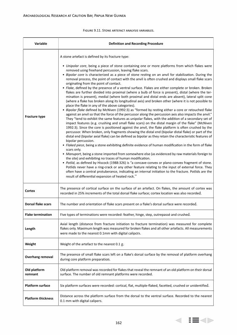
162
Archaeological Research at Caution Bay, Papua New Guinea
Figure 9.11. Stone artefact analysis variables.
Variable Definition and Recording Procedure
Fracture type
A stone artefact is defined by its fracture type:
• Unipolar core, being a piece of stone containing one or more platforms from which flakes were removed using freehand percussion, leaving flake scars.
• Bipolar core is characterized as a piece of stone resting on an anvil for stabilization. During the removal process, the point of contact with the anvil is often crushed and displays small flake scars originating from the point of contact.
• Flake, defined by the presence of a ventral surface. Flakes are either complete or broken. Broken flakes are further divided into proximal (where a bulb of force is present), distal (where the ter-mination is present), medial (where both proximal and distal ends are absent), lateral split cone (where a flake has broken along its longitudinal axis) and broken other (where it is not possible to place the flake in any of the above categories).
• Bipolar flake defined by McNiven (1992:3) as “formed by resting either a core or retouched flake against an anvil so that the force of the percussor along the percussion axis also impacts the anvil.” They “tend to exhibit the same features as unipolar flakes, with the addition of a secondary set of impact features (e.g. crushing and small flake scars) on the distal margin of the flake” (McNiven 1992:3). Since the core is positioned against the anvil, the flake platform is often crushed by the percussor. When broken, only fragments showing the distal end (bipolar distal flake) or part of the distal end (bipolar axial flake) can be defined as bipolar as they retain the characteristic features of bipolar percussion.
• Flaked piece, being a stone exhibiting definite evidence of human modification in the form of flake scars only.
• Manuport, being a stone imported from somewhere else (as evidenced by raw materials foreign to the site) and exhibiting no traces of human modification.
• Potlid, as defined by Hiscock (1988:326) is “a concave-convex or plano-convex fragment of stone. Potlids never have a ring-crack or any other feature relating to the input of external force. They often have a central protuberance, indicating an internal initiation to the fracture. Potlids are the result of differential expansion of heated rock.”
CortexThe presence of cortical surface on the surface of an artefact. On flakes, the amount of cortex was recorded in 25% increments of the total dorsal flake surface; cortex location was also recorded.
Dorsal flake scars The number and orientation of flake scars present on a flake’s dorsal surface were recorded.
Flake termination Five types of terminations were recorded: feather, hinge, step, outrepassé and crushed.
LengthAxial length (distance from fracture initiation to fracture termination) was measured for complete flakes only. Maximum length was measured for broken flakes and all other artefacts. All measurements were made to the nearest 0.1mm with digital calipers.
Weight Weight of the artefact to the nearest 0.1 g.
Overhang removalThe presence of small flake scars left on a flake’s dorsal surface by the removal of platform overhang during core platform preparation.
Old platform remnant
Old platform removal was recorded for flakes that reveal the remnant of an old platform on their dorsal surface. The number of old remnant platforms were recorded.
Platform surface Six platform surfaces were recorded: cortical, flat, multiple-flaked, facetted, crushed or unidentified.
Platform thicknessDistance across the platform surface from the dorsal to the ventral surface. Recorded to the nearest 0.1 mm with digital calipers.

163
Bruno David et al.: The Caution Bay Project Field and Laboratory Methods
square. While this method could overestimate the MNF calculated for a square as a whole, calculating the MNF using overall complete and broken flake numbers for the entire square as a single combined analytical unit would lead to a significant underestimation of the MNF. However, since the MNF calculation method does not include all types of flake fragments, in particular the category ‘broken flake, other’ which makes up most of the lithic assemblage at each site, the MNF is still likely to remain a slight under – rather than over–estimate of the actual number of flakes present.
Colours and Heat Alteration
In the early stages of analysis it was observed that the colours of chert artefacts vary significantly, although the source material seemed to be of similar quality and apparent origin, suggesting the possibility of colour alteration of the chert through high-temperature heating. We were interested in determining the presence or absence of deliberate heat-treatment of lithic raw materials, applied for the purpose of improving the flaking characteristics before tool production, but also any other origin of extreme heating of the chert that could have taphonomic implications for the assemblages, especially in relation to increased brittleness and therefore the post-depositional fracturing of flakes.
The colour of stone artefacts was recorded using the Munsell® Geological Rock-Color Chart (Munsell Color 2011). Figure 9.12 lists the different colour values identified on chert and other materials studied thus far in assemblages from across the Caution Bay study area. Colour values #5 and #6 appear to be natural chert colours as indicated on naturally occurring chert samples found in the study area. These two colour values were sometimes observed together on the same sample. Colour values #17 to #19 are likely to be caused by the oxidization of iron elements present within the stone during heat application (Purdy and Brooks 1971). However, the presence of these two colour values is not sufficient to tell whether heat application was intentional or accidental. It was necessary to record additional indicators of thermal alteration to circumvent this problem (see Hiscock 1985, 1990 for the importance of measuring thermal alteration on stone artefact assemblages). Recording the location of potlid scars on flakes was required, since potlid scars on a flake’s ventral surface (especially on small flakes) confirm that heat application was unintentional as it took place after rather than before manufacture (Mercieca 2000).
Non-Molluscan Faunal Remains
The non-molluscan faunal assemblages from the Caution Bay sites include three main categories of remains:
Variable Definition and Recording Procedure
Platform widthDistance across the platform surface from one lateral margin to the other. Recorded to the nearest 0.1 mm with digital calipers.
Raw material Type of rock used to manufacture the artefact.
Termination type Four types of terminations were recorded: feather, step, hinge and outrepassé (See Cotterell and Kamminga 1987 for definitions).
Thermal alterationCrazing and the presence of potlid scars caused by a rapid increase in temperature were recorded on artefacts. On flakes, the surfaces on which potlid scars occur were recorded.
Thickness
The axial thickness (distance between the flake dorsal and ventral surfaces, measured at the intersection of the axial length and axial width) was measured for complete flakes only. Maximum thickness was measured for broken flakes and all other artefacts. All measurements were recorded to the nearest 0.1mm with digital calipers.
WidthThe axial width (distance between the flake lateral margins, measured half way along the length) was measured for complete flakes only. Maximum width was measured for broken flakes and all other artefacts. All measurements were recorded to the nearest 0.1mm with digital calipers.
RetouchingRetouching was recorded when an edge exhibited a minimum of 5mm of continuous retouch flake scars. Its location, direction (dorsal and/or ventral) and type (fine, abrupt, invasive) were also noted.

164
Archaeological Research at Caution Bay, Papua New Guinea
1. Bone from vertebrate animals.2. Eggshell from bird and reptile eggs. 3. Cytoskeleton of invertebrates including
exoskeleton of crustaceans and urchins, and endoskeleton of cuttlefish.
Each of these categories of remains is readily distinguished in the excavated assemblages from Caution Bay. Different procedures were used to characterize each category.
Bone from Vertebrate Animals
Five major groups of vertebrates can be represented in any excavated assemblage – fish, frogs, reptiles, birds
and mammals. Each of these vertebrate groups has a distinctive skeletal anatomy and, with undamaged bones, virtually any bone can be allocated to one of the five groups. Fish bone is the most readily distinguished of the five groups, partly on account of textural properties that are not seen in other groups of vertebrates. Uniquely, fish bone often has a ‘ropey’, finely granular, or flaky, plate-like surface texture.
Fragmentation of bone results in a loss of diagnostic morphological features. For fish bone, this is countered to some degree by the textural differences noted above, allowing even very small bone fragments to be allocated to this group. By contrast, for other groups of vertebrate fauna, the ability to identify fragmented remains depends
Figure 9.12. Colours (Munsell Color 2011) recorded on flaked stone artefacts from Caution Bay.
Colour Munsell Colour Code Munsell Colour Name Rock Type
1 5YR 3/4 Moderate Brown Chert
2 5YR 5/2 Pale Brown Chert
3 10YR 4/6 Moderate Reddish Brown Chert
4 10R 6/6 Moderate Reddish Orange Chert
5 10YR 8/2 Very Pale Orange Chert
6 10YR 6/6 Dark Yellowish Orange Chert
7 10YR 6/2 Pale Yellowish Brown Chert
8 10Y 4/2 Grayish Olive Chert
9 5R 6/6 Light Red Chert
10 5YR 4/1 Brownish Gray Chert
11 5YR 2/2 Dusky Brown Chert
12 5R 2/2 Blackish Red Chert
13 10YR 4/2 Dark Yellowish Brown Chert
14 5R 8/2 Grayish Pink Chert, Chalcedony
15 10R 2/2 Very Dusky Red Chert
16 N3 Dark Grey Chert, Obsidian
17 5R 4/2 Grayish Red Chert
18 5R 5/4 Moderate Red Chert
19 10R 5/4 Pale Reddish Brown Chert
21 5Y 8/1 Yellowish Gray Chert
22 N1 Black Chert, Obsidian
25 10G 6/2 Pale Green Chert

165
Bruno David et al.: The Caution Bay Project Field and Laboratory Methods
on how much morphology is preserved. Fragments that retain some part of an articular surface are potentially identifiable, whereas fragments derived from long bone shafts are rarely identifiable even to major group. Fragments of turtle carapace and plastron also show a distinctive surface texture coupled with a spongy internal structure that allow discrimination down to quite small fragments.
The first step in sorting an excavated bone assemblage was to separate bone fragments derived from each of the major vertebrate groups – fish, frogs, reptiles (excluding turtles), turtles, birds, and mammals. Bone that could not be confidently allocated to any group was left in an ‘unidentified’ category.
Within each major group, a second step involved attempts to identify individual fragments to lower taxonomic levels. Identification used the following resources:
• For fish, Barnett’s (1978) manual and the underlying collection of the Department of Archaeology and Natural History, Research School of Pacific and Asian Studies, the Australian National University (ANU prefix when referring to particular reference specimens); and the osteological collection of the Northern Territory Museum and Art Gallery (NTMF prefix).
• For other groups, the osteological collections of the Australian National Wildlife Collection, CSIRO (CM prefix), and the Australian Museum, Sydney (AM prefix), combined with primary taxonomic literature for mammals.
The level of taxonomic discrimination varies across groups. For fish and reptiles, identifications were generally possible to genus or family level only. The great majority of the fish bone derives from members of the Class Osteichthyes (the bony fish). The other major group of fish – the Class Chondricthyes (sharks and rays) – has highly mineralized teeth but otherwise possess a cartilaginous skeleton that rarely survives in archaeological contexts. For mammals, the degree of taxonomic resolution depended on the particular skeletal elements and their degree of completeness. For mammalian teeth, identification to species level is generally possible. In contrast, post-cranial elements are often determined only to family level, though for some groups this can be further refined if assumptions are made concerning geographic ranges of potential species. Distributional information for Melanesian mammals is summarized by Flannery (1995a, 1995b) and Bonaccorso (1998).
Quantification of Taxonomic Composition
The bone from each of the major vertebrate groups was weighed as a single category, by excavation square and
excavation unit, i.e., fish bone, turtle bone, mammal bone, etc. These weights were used to characterize the overall taxonomic composition of each sample. All weights were taken on an electronic balance to a resolution of 0.01 g.
For each of the major vertebrate groups, a list was made of the individual taxa represented, the body part(s) represented, the total number of fragments, and in certain cases, the burning state of the remains. A greater level of detail was recorded for species of particular interest, including pig, dog and rodents (see below).
The assemblages contain too few identifiable specimens to warrant the application of standard methods such as Minimum Number of Individuals (MNI).
Assessment of Taphonomic Condition
The bone from at least one excavated square of each site was subject to detailed examination from a taphonomic perspective, following the general approach of Domínguez-Rodrigo et al. (2007). Bone surfaces and fracture edges were examined microscopically for surface modifications including cut and tooth marks, percussion marks, corrosion associated with root contact, abrasion caused by post-depositional movement, and pitting caused by microbial activity. In addition, the burning condition of the bone from each major taxonomic group was quantified by separation (and weighing) of three categories that reflect the intensity and duration of heating (Koon et al. 2003; Shipman et al. 1984):
1. Unburnt bone – showing no obvious heat alteration.
2. Burnt bone – showing a variable degree of heat alteration but retaining a significant organic component (variably brown, black and blue-green).
3. Calcined bone – showing extreme heat modification and lacking any residual organic component (variably pale grey to white, often fissured and warped).
The burning composition of an assemblage will reflect the intensity of heating of bones that occurs during the cooking process, following discard into a hearth, and following burial if a hearth is subsequently built in that position. However, because the chemical and physical properties of bone are altered by the heating process, which in turn affects its susceptibility to various post-depositional processes including scavenging, microbial breakdown, and chemical solution, the burning composition of an assemblage is also influenced by its post-depositional environment (see Hedges 2002 for review). Under most circumstances, unburnt bone is subject to the most rapid degradation, while calcined bone is the most resistant as it contains the least organic

166
Archaeological Research at Caution Bay, Papua New Guinea
matter and is more densely crystalline in structure (Thompson et al. 2011).
Sampling for DNA Analysis and Direct AMS Radiocarbon Dating
Important archaeological issues revolve around the dual questions of the antiquity of various introduced animals in Melanesia, and the genetic affinities of past populations. The greatest interest concerns the history of the three main domesticates – pigs, dogs and chickens. However, there is also considerable interest in two species of commensal rats that have spread with people throughout the western Pacific region – the Pacific Rat (Rattus exulans) and the Black Rat (representatives of the Rattus rattus complex, including R. tanezumi).
Bones of the domesticated and commensal species were assessed for their potential value as a source of ancient DNA and for direct AMS radiocarbon dating. To be useful in either regard, the bone should be unburnt and retain a significant proportion of its original organic component. Bone that has lost most of its organic content typically has a dry, powdery texture.
Eggshell
Bird and reptile eggshell fragments are readily distinguished by a number of characteristics.
Bird eggshell consists of a protein matrix lined with crystals of calcium carbonate. It is rigid and brittle, and usually has a smooth inner surface and a smooth to granular external surface. The combined features of a smooth inner surface and a crystalline fracture surface allows even very small pieces of bird eggshell to be distinguished from other thin-walled rigid materials such as thin-walled bone and invertebrate exoskeleton. Burnt eggshell retains its essential properties, but is often fissured and warped.
Two kinds of bird eggshell are commonly encountered in Melanesian archaeological contexts: cassowary and megapode eggshell. Megapodes (members of the family Megapodidae) are typically mound-building galliform birds found in Australia, Melanesia and Sulawesi. Megapode eggshell is essentially smooth, both inside and out, and are quite thin-walled for their size, usually less than 1mm in thickness. The crystalline texture is visible under low magnification. Cassowary eggshell is typically 1.5-2mm thick and has a coarsely granular outer surface.
Reptile eggshell is thin-walled, typically less than 0.5mm in thickness, and less heavily calcified, with no crystalline structure visible even under low magnification. It has smooth inner and outer surfaces, and is very flexible, with a leathery or parchment-like texture. Eggs of crocodiles
and turtles are widely harvested throughout Melanesia but the remains are rarely reported from archaeological contexts, presumably due to their less robust nature.
Only bird eggshell was identified from the excavations. The eggshell fragments are very uniform in thickness and show no significant variation in surface texture. All are likely to derive from megapode eggs.
The bird eggshell was weighed as a single category without reference to burning condition.
Invertebrate Exoskeleton
Three major groups of invertebrates are represented in the assemblages: Echinodermata (urchins), Decapoda (crabs) and Sepiida (cuttlefish).
Urchins are represented by fragments of the test and spines. Test fragments possess a highly distinctive, tuberculate external surface and an internal surface marked by regular alignments of pores. Spines have a radial crystalline structure visible in broken cross-section and a distinctive basal articulation.
Crabs are mostly represented by fragments of claws which are usually more robust than other elements of the exoskeleton. However, all parts of the exoskeleton possess a distinctive gross morphology and a distinctive crystalline internal structure that allows even small fragments to be distinguished from bone.
Further work is required before the bulk of the urchin and crab remains can be identified to lower taxonomic levels. However, prominent among the crab remains are distinctive elements of the mud crab (Scylla serrata), while the bulk of the urchin remains appear to be referable to one taxon, the Collector Urchin, Tripneustes gratilla.
Crab, urchin and cuttlefish remains were each weighed as single categories.
Reporting
The broad composition of each assemblage is reported by weight, with the bone generally subdivided further and weighed according to separate burning classes. By contrast, for more detailed taxonomic composition of groups such as fish, mammals and crabs the basic unit of comparison is generally a Number of Individual Specimens (NISP) from which proportional abundances are calculated. NISP values are used in preference to a Minimum Number of Individuals (MNI; the smallest number of original animals needed to account for all of the recovered remains) because the small samples available from the majority of the analysed sites dictate

167
Bruno David et al.: The Caution Bay Project Field and Laboratory Methods
that the likelihood of recovering multiple fragments of any one individual is low.
Molluscan Remains
Molluscan remains recovered from each site at Caution Bay were separated by excavation square and excavation unit (XU), with the latter forming the basic unit for quantification and analysis (Bowdler 2014). Laboratory assistants undertook the preliminary sorting of whole or nearly complete specimens to the appropriate taxonomic level (family, genera or species), and fragments into broad possibly identifiable and unidentifiable categories. The senior analysts checked those preliminary classifications and then performed the final identifications, quantification and recording.
Taxonomic Identification of Molluscan Remains
A comparative reference collection of mollusc species from the Indo-Pacific region, with a particular focus on the Port Moresby area, was assembled from the personal collections of the principal archaeomalacologists in combination with the molluscan reference collections of the Archaeology Program, School of Social Sciences, The University of Queensland and the Tropical Archaeology Research Laboratory, James Cook University. In addition, a range of published literature was consulted to support identifications, including Abbot and Dance (1982), Beesley et al. (1998), Carpenter and Niem (1998), Cernohorsky (1972, 1978), Coleman (2003), Dance (1977), Habe (1964), Hinton (1972), Kira (1965), Lamprell and Healy (1998), Lamprell and Whitehead (1992), Short and Potter (1987), Springsteen and Leobrera (1986), Wilson (2002), and Wilson and Gillett (1988). Taxonomic identification of the archaeological material was achieved by one-to-one comparison with material from the physical reference collection or, where corresponding taxa were missing from the reference collection, with images and descriptions in the published literature cited above.
All shells and shell fragments irrespective of size (material was recovered in 2.1mm mesh sieves during wet sieving operations in the field laboratory, see above) were identified to the lowest possible taxonomic level based on the presence of diagnostic characteristics, with taxonomic lists created for each excavated square. Care was taken not to ‘over-identify’ specimens. Where fragmented or heavily degraded material could not be confidently assigned to species level based on preserved diagnostic features, for example, these specimens were identified to genus or family levels only, even where shell morphology resembled the dominant taxa (Szabó 2009: 186). An ‘unidentified shell’ category was utilized for any specimens that could not be assigned to species, genus or family levels. This procedure minimized any methodological assumptions and avoided subsequent
analytical uncertainty, with the unidentified shell being quantified wherever shell assemblage composition is reported. In common with Szabó (2009: 186), during identification and quantification of the molluscan assemblages no assumptions were made concerning whether specific taxa represented subsistence or technologically important species (see Worked Shell Analysis below) within each assemblage. This approach provides for a more comprehensive understanding of assemblage richness and diversity, as well as acknowledging that all specimens (including those subsequently identified as being incidental species or those collected opportunistically) can potentially contribute to an understanding of how past peoples interacted with their environment (see Rowland 1994 for examples).
Modes of Quantification
Several methods are routinely used to calculate the absolute or relative abundance of shell material from archaeological deposits. Further information on quantification methods can be found in Claassen (1998), Grayson (1984) and Reitz and Wing (2008). The four measures used in the Caution Bay analyses are:
• Weight.• Number of Identified Specimens (NISP).• Minimum Number of Elements (MNE).• Minimum Number of Individuals (MNI).
Weights were calculated in grams (to nearest 0.01g) by taxon for each XU, with all specimens identified for a given taxon included in the weight. This method has been used here due to the speed at which quantification can be undertaken following the process of identification, as well as the fact that this method includes all the pieces of shell identifiable to a given taxon as well as the unidentified shell category (as discussed by Bailey 1993; Rowland 1982). One of the major criticisms of this method centres on the loss of shell weight with diagenesis and fragmentation, which has the potential to affect different species (and different-sized individuals within taxonomic groups) at different rates (e.g., Claassen 1998: 60; Zuschin et al. 2003: 43). For example, the older the site or more acidic the sediment, there is greater potential for differential loss of calcium carbonate within and between species. The other concern with using weight as a measure of abundance is that heavier-shelled species can be disproportionately represented when compared with lighter-shelled species (see also Mason et al. 1998; Szabó 2009: 187). Nevertheless, this is a useful general method for comparing the amount of molluscan versus non-molluscan material within a deposit, as well as determining gross variation in the total mass of shell through an archaeological sequence (e.g., Muckle 1985: 22).
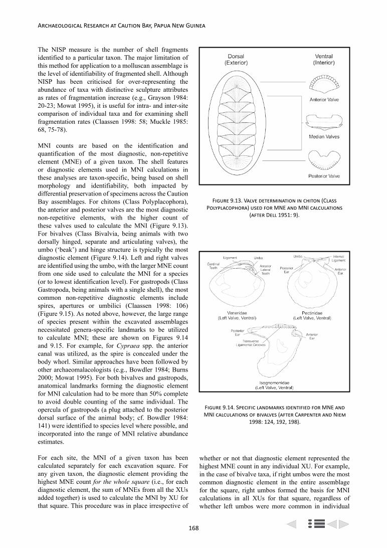
168
Archaeological Research at Caution Bay, Papua New Guinea
The NISP measure is the number of shell fragments identified to a particular taxon. The major limitation of this method for application to a molluscan assemblage is the level of identifiability of fragmented shell. Although NISP has been criticised for over-representing the abundance of taxa with distinctive sculpture attributes as rates of fragmentation increase (e.g., Grayson 1984: 20-23; Mowat 1995), it is useful for intra- and inter-site comparison of individual taxa and for examining shell fragmentation rates (Claassen 1998: 58; Muckle 1985: 68, 75-78).
MNI counts are based on the identification and quantification of the most diagnostic, non-repetitive element (MNE) of a given taxon. The shell features or diagnostic elements used in MNI calculations in these analyses are taxon-specific, being based on shell morphology and identifiability, both impacted by differential preservation of specimens across the Caution Bay assemblages. For chitons (Class Polyplacophora), the anterior and posterior valves are the most diagnostic non-repetitive elements, with the higher count of these valves used to calculate the MNI (Figure 9.13). For bivalves (Class Bivalvia, being animals with two dorsally hinged, separate and articulating valves), the umbo (‘beak’) and hinge structure is typically the most diagnostic element (Figure 9.14). Left and right valves are identified using the umbo, with the larger MNE count from one side used to calculate the MNI for a species (or to lowest identification level). For gastropods (Class Gastropoda, being animals with a single shell), the most common non-repetitive diagnostic elements include spires, apertures or umbilici (Claassen 1998: 106) (Figure 9.15). As noted above, however, the large range of species present within the excavated assemblages necessitated genera-specific landmarks to be utilized to calculate MNI; these are shown on Figures 9.14 and 9.15. For example, for Cypraea spp. the anterior canal was utilized, as the spire is concealed under the body whorl. Similar approaches have been followed by other archaeomalacologists (e.g., Bowdler 1984; Burns 2000; Mowat 1995). For both bivalves and gastropods, anatomical landmarks forming the diagnostic element for MNI calculation had to be more than 50% complete to avoid double counting of the same individual. The opercula of gastropods (a plug attached to the posterior dorsal surface of the animal body; cf. Bowdler 1984: 141) were identified to species level where possible, and incorporated into the range of MNI relative abundance estimates.
For each site, the MNI of a given taxon has been calculated separately for each excavation square. For any given taxon, the diagnostic element providing the highest MNE count for the whole square (i.e., for each diagnostic element, the sum of MNEs from all the XUs added together) is used to calculate the MNI by XU for that square. This procedure was in place irrespective of
whether or not that diagnostic element represented the highest MNE count in any individual XU. For example, in the case of bivalve taxa, if right umbos were the most common diagnostic element in the entire assemblage for the square, right umbos formed the basis for MNI calculations in all XUs for that square, regardless of whether left umbos were more common in individual
Figure 9.13. Valve determination in chiton (Class Polyplacophora) used for MNE and MNI calculations
(after Dell 1951: 9).
Figure 9.14. Specific landmarks identified for MNE and MNI calculations of bivalves (after Carpenter and Niem
1998: 124, 192, 198).

169
Bruno David et al.: The Caution Bay Project Field and Laboratory Methods
XUs. MNI counts are slightly lower when selecting this approach over others, however the implementation of this more conservative method avoids the effects of aggregation via analysis of arbitrary analytical units and maintains consistency in relative abundance based on MNI regardless of scale, so whether reporting by XU, SU, Analytical Unit, square or site (Grayson 1984: 29).
Worked Shell Analysis
Worked shell is a feature of pre-Lapita, Lapita and post-Lapita archaeological deposits at Caution Bay, with a wide variety of raw materials used and artefacts shaped. While the traditional focus in regional worked shell analysis has been upon the recognition and discussion of defined culture-historical types, such as beads, rings and adzes, assemblages also frequently yield evidence of expedient shell artefact production and use as well as débitage related to artefact production and curation. In order to isolate, analyse and discuss all of these various manifestations of shell working at Caution Bay, a range of methodological procedures were developed; these are outlined here.
Determination of the Worked Shell Sample
A number of artefacts in shell, including beads, ring fragments and other clearly worked items, were identified during the course of the Caution Bay excavations. These were often recorded in situ, bagged separately, and later transported to the University of Wollongong for further analysis. In acknowledgment that on-site recognition
was unlikely to capture the full extent of shell working, particularly with regard to unfinished or expedient artefacts and fragments of débitage, protocols were developed for the separation of worked, and potentially worked shell during the course of laboratory sorting. During the analysis of molluscan remains in particular, any obvious or potentially worked shell fragments, where morphology or surface features did not accord with standard patterns seen through the bulk of the midden shell, were separated out (see Molluscan Remains, above). Fragments of shell from taxa that are known to be important raw materials within Pacific sites, such as Conus spp., were also set aside. All of the separated shell was sent to the University of Wollongong for further analysis and potential incorporation into the worked shell sample. Detailed analysis of this material has confirmed a number of worked shell and débitage pieces that have greatly increased the sample size, and our understanding of production methods and on-site activities. It is clear that between in situ recording of more-or-less finished shell artefacts in the field, identification of less obvious worked items during general laboratory sorting, and a final rigorous scrutiny for traces of working during the analysis of the midden shell has captured the vast majority of worked shell originally present in the molluscan assemblages.
Protocols for the Identification of Worked Shell
A range of working techniques are typically applied to shell in the generation of formal artefacts, with some forms of modification – such as grinding – being
Figure 9.16. Cut Conus sp. body with fragment surfaces heavily eroded through acid dissolution (at x30
magnification). From site ABHD, Square C, XU 13b (Photo: Katherine Szabó).
Figure 9.15. Specific landmarks identified for MNE and MNI calculations of gastropods (after Carpenter and
Niem 1998: 364, 370, 394, 486 and Harris et al. 2015: 170).

170
Archaeological Research at Caution Bay, Papua New Guinea
more easily recognizable than others. When the scope of identification and analysis is wide enough, heavily worked pieces with clear evidence of shaping tend to be in the minority in Pacific worked shell assemblages. With most fragments, traces of working are subtle and such traces are often muted or partially obscured by the actions of taphonomic processes (Figure 9.16). These observations are certainly true of the Caution Bay worked shell assemblages. Especially in the upper layers of sites, varying degrees of acid dissolution of shell surfaces from contact with the surrounding semi-humic matrix, probably compounded by accessibility to rainwater, has resulted in degraded chalky surfaces on which no potential traces of working could have been detected. However, on the whole the shell fragments analysed were in relatively good condition, and careful inspection under magnification could usually positively confirm or deny distinct traces of cultural modification.
There seems to be a broad relationship between the structural type of shell being worked and the application of different working techniques (Szabó 2008), which can act as a starting point for initial laboratory analysis. For example, the primary reduction of larger shells with a crossed-lamellar microstructure – where bundles of calcium carbonate crystals are set at a 45° angle from neighbouring bundles – is often direct percussion. Although fractures generated by direct impact in cross-lamellar shell are generally rough with little capacity for fine control, the 45° angle of the crystal bundles means that force generally dissipates without travelling into, and potentially splitting, key parts of the preform. This contrasts with the reduction techniques most often applied to nacreous (mother-of-pearl) shell, which include cutting, sawing, and other abrasive techniques. Although there are structural differences between gastropod (e.g., Trochus and Turbo), bivalve (e.g., Pinctada and Isognomon) and cephalopod (e.g., Nautilus) nacre, all transform over time to form thin sheets of aragonite separated by organic layers (Figure 9.17). This structure is prone to splitting laterally, with layers shearing apart if impact force is applied, and this is particularly so in empty older shells where the protein ‘glue’ between aragonite sheets has degraded. Given this, it is unsurprising that the controlled application of force, such as seen in pressure flaking, and various forms of abrasion are predominantly applied to nacreous shell, making reduction by shell-workers much less risky. These are but two of a range of recognized microstructural types that respond differently to force applied in different ways, and are also divergent in the responses to taphonomic processes (Szabó 2008, 2013).
Analytical Procedures
As a starting point all fragments were visually assessed with the naked eye, and if necessary were gently cleaned using a soft-haired calligraphy brush. If fractures
were noted to be recent, or taphonomic alteration had removed all surface and edge details, the fragments were not analysed further. The remaining fragments were inspected using a Dino-Lite Premier AM7013MT digital microscope under low (× 15 to × 60) magnification. Any evidence of working as well as examples of taphonomic alterations was photographed with the Dino-Lite. Small artefacts and fragments were photographed entirely with the Dino-Lite, while larger fragments and artefacts were also photographed using an Olympus OM-D EM5 camera and macro lens. Observations on working and taphonomic modifications were entered into spreadsheets during the visual analysis.
Context of Interpretation
The overarching aim of the identification and analysis of worked shell from Caution Bay was to piece together a holistic picture of shell working through the local pre-Lapita, Lapita and post-Lapita phases. As well as drawing out the distinctive practices and techniques of each chronological point, linkages and divergences between each of these can shed light on cultural transformations and relationships through time. Additionally, potential contrasts between contemporaneous deposits can enhance our understandings of cultural variability, spatial distributions of sites and site types and from that the patterns of human actions within the landscape.
This starting point represents a distinct break from typological approaches, with the basal aim being to identify modes and patterns of shell modification. Thus, in addition to standard types frequently recorded from Pacific archaeological sites, expedient tools exhibiting
Figure 9.17. Freshwater mussel (Alathyria jacksoni) nacre delaminating and crumbling due to organic loss
and microbiological taphonomic action which has produced numerous tiny holes. SEM micrograph at x1100
magnification (Micrograph: Erica Weston).

171
Bruno David et al.: The Caution Bay Project Field and Laboratory Methods
use-wear with little modification as well as débitage from artefact production attain a status of equal importance in interpretations. This not only increases sample size, but also provides a different perspective on cultural practices, the selection of raw materials, the range of working techniques, and the life history of artefacts from production through use and curation to discard (Bonnardin 2003, 2012; Taborin 1993).
AMS Radiocarbon Dating and Chronological Model-Building
Radiocarbon samples were prepared and analysed at the University of Waikato Radiocarbon Dating Laboratory in New Zealand following standard AMS protocols whereby the shells were washed in dilute HCl to remove surface contamination and charcoal samples were treated with a series of dilute HCl, NaOH and HCl washes prior to CO2 collection. All shells were tested for recrystallization prior to dating using the Feigl staining technique (Friedman 1959). AMS targets were measured at the Keck Radiocarbon Laboratory, University of California, Irvine, and GNS Science, Wellington.
Before embarking on the chronometric evaluation of the Caution Bay radiocarbon dates it was essential that a number of issues were addressed, including the effects of post-depositional disturbance, wood/charcoal inbuilt age and local marine reservoir (commonly referred to as delta R [ΔR]) offsets in shellfish and other marine samples (e.g., urchins) (Allen and Wallace 2007; Specht 2009; Spriggs and Anderson 1993). All are well-recognized chronometric interpretative issues that have been discussed at length in the literature, but few have been directly addressed except through the exclusion of suspect dates via various ‘chronometric hygiene’ protocols (e.g., Spriggs 2003; see also Denham et al. 2012; Specht 2007) that can reject potentially useful information, and may reduce the chronological evaluation to materials with limited specificity to the event. Typically, the favoured samples for dating archaeological deposits are identified short-lived plant materials. Unfortunately, the reality of research in the Pacific region is that such materials are often rare, difficult to locate and identify, and the association between radiocarbon sample and the target event is often problematic owing to localized disturbance of deposits. Caution Bay is no exception, with only a handful of short-lived charcoal samples identified, and common post-depositional movement of tiny pieces of charcoal through the middens. The remains of shellfish, however, dominate these sites and are generally easy to identify to taxa, while the larger and flatter surfaces of the shell ensures limited vertical and horizontal displacement. Shell, therefore, is the logical sample type on which to develop radiocarbon chronologies once reliable offsets from the global marine reservoir (Reimer et al. 2013) can be established. To overcome these issues at Caution
Bay, and enable the development of high precision, well-constrained, multi-date sequences, we have undertaken a two-step process to our chronological model-building. First, we developed species-specific marine reservoir [ΔR] corrections for shellfish and urchins specifically for Caution Bay; and second, we used Bayesian techniques to evaluate the radiocarbon data according to observed contextual associations and established understanding of 14C outliers.
Caution Bay Marine Reservoir Corrections
Caution Bay forms part of an open coastline, well-washed by ocean waters, without the upwelling or eddy disturbance typically caused by a fast-flowing current or impingement on this current (Petchey et al. 2013). Although the hydrographic diversity of the bay suggests a regime , and therefore regional ΔR value, in keeping with the South Pacific Gyre and water circulation in Torres Strait generally (Petchey et al. 2008; Ulm et al. 2007), there remains a very real possibility that shellfish reservoir values will vary depending upon habitat and feeding mechanisms of the animals (cf. Hogg et al. 1998; Keith et al. 1964). The coastline itself is underlain by limestone bedrock and fed by the Lea Lea River as well as a number of small rivers, and although wave scour and tidal currents remove much of this material from the bay, larger particles are laid down on the intertidal flats (Rowe et al. 2013) providing a range of enriched and depleted 14C sources to coastal marine animals. To establish species-specific ΔR values for this area, a total of 78 shells belonging to herbivores, suspension feeders and deposit-feeding shellfish and Echinoids – all common throughout the excavated middens – were selected from XU6-XU16a in Square C of Bogi 1, an archaeologically short duration dense shell midden deposit. ΔR results were calculated by comparing the shell 14C results with dates on charcoal with a maximum 1-year lifespan from these same XUs (charred fruit, nut endocarp and culm) (for details see Petchey et al. 2012, 2013).
The results of this research are summarized in Figure 9.18 and indicate that suspension feeding bivalves Gafrarium and Anadara can be reliably dated following the application of a suitable ∆R. Gafrarium spp. tended to have slightly depleted 14C signatures (ΔR = 60 ± 11 14C years) relative to the South Pacific Gyre average of 6 ± 21 14C years (Petchey et al. 2012), that is indicative of high intertidal estuarine habitats at risk from terrestrial carbon interference – in particular 14C from ancient limestone. More surprising was the enrichment of suspension-feeding Anadara granosa shells relative to A. antiquata. Isotope values for A. granosa (average ΔR = -71 ± 15 14C years) were influenced by the ingestion of enriched terrestrial carbon sources, in keeping with this species’ preference for sandy mud bordering mangrove forest. Conversely, A. antiquata had an average ΔR value (-1 ± 16 14C years) closer to the global marine average,

172
Archaeological Research at Caution Bay, Papua New Guinea
Figure 9.18. Recommended species-specific ∆R for Caution Bay marine shells (adapted from Petchey et al. 2012, 2013).
Shellfish/Echinoidea DietAverage ∆R (14C years) for Species
Average ∆R (14C years) for Genera
Habitat Isotopic Influence
Batissa violacea Suspension Feeder -207 ± 28 - Associated with rivers.
BRACKISH
Polymesoda erosa Suspension Feeder -154 ± 23 - Landward side of the high intertidal area.
Cerithidea largillierti Deposit Feeder -55 ± 159 - High intertidal, in mangroves.
ES TU A R I N E
Gafrarium tumidum
Suspension Feeder
67 ± 16
60 ± 11 High intertidal.
Gafrarium pectinatum 53 ± 16
Anadara granosa -71 ± 15
-39 ± 22 Mid-intertidal to marginally sub-tidal.
Anadara antiquata -1 ± 16
MARINE
Echinoidea Omnivore 11 ± 17 Low intertidal/sub-tidal fringe.
Conomurex luhuanus
Herbivore
13 ± 31 -Intertidal and shallow sub-tidal to ~10m
depth. On sand, rubble and seagrass bottoms.
MARINE/ESTUARINE
Laevistrombus canarium 156 ± 72 - Intertidal and sub-tidal to ~55m depth. On muddy sand and algal bottoms.
Gibberulus gibberulus 31 ± 37 - Intertidal and shallow sub-tidal to ~20m depth. On sand and seagrass bottoms.
Canarium labiatum 63 ± 20 - Intertidal and shallow sub-tidal to ~20m depth. On seagrass and algal bottoms.
Canarium urceus 55 ± 34 - Intertidal and shallow sub-tidal to ~40m depth. On seagrass bottoms and sand.
Euprotomus aurisdianae 70 ± 42 -Low intertidal and shallow sub-tidal to ~10m depth. On seagrass bottoms and
sand.
Lambis spp. 71 ± 53 - Shallow sub-tidal to ~5m depth. On sand and mud – various.
reflecting a preference for sandy-gravels, seagrass beds and shallow-lagoon bottoms (Afiati 2007: 105; Broom 1985: 4-6). Surprisingly, omnivorous echinoids also had an average ΔR (11 ± 17 14C years) close to the global marine average, but these animals cover a wide range of environments and further work is needed to fully assess the reliability of this genera for 14C chronologies,
although results so far show it to be reliable for this part of Caution Bay.
The ΔR values for the herbivorous gastropods were typical of animals living at the boundary between the marine and estuarine environments, though they tended to show more variation than the suspension-feeding bivalves because of the potential to ingest sediment

173
Bruno David et al.: The Caution Bay Project Field and Laboratory Methods
while they graze (Figure 9.18). As with the suspension-feeders, specific habitat choice also had an impact on carbon content of the herbivores, with those animals displaying a preference for muddy substrates being most variable. Two outliers were immediately apparent – Laevistrombus canarium, which had an elevated average ∆R (156 ± 72 14C years), and Conomurex luhuanus with lower average ∆R values (13 ± 31 14C years). L. canarium has a preference for muddier substrates (Coleman 2003; Carpenter and Niem 1998) whereas C. luhuanus prefers sandy environments. We therefore considered C. luhuanus to be more reliable for the development of the Caution Bay chronology and utilised this species when necessary. The least reliable shellfish studied were Polymesoda (Geloina) erosa (average ∆R = -154 ± 23 14C years) and Batissa violacea (average ∆R = -207 ± 28 14C years), both of which had a significant terrestrial 14C input related to their tolerance of brackish waters, and Cerithidea largillierti which displayed more variation than all other shellfish combined (individual ∆R values range between -287 ± 36 and 223 ± 36 14C years). We recommend that careful consideration of dietary and environmental conditions are made before Polymesoda and Batissa spp. shellfish are dated. We do not consider Ceriths suitable for 14C age determination.
For the Caution Bay sites, the most specific ∆R value was applied in calibration procedures – i.e., where a radiocarbon sample was identified to species, the species-
specific ∆R offset was applied. Where radiocarbon samples could only be identified to genus, the genus average ∆R offset was applied and so forth.
Chronological Model-Building
To refine the chronological interpretation of the Caution Bay sites we have also utilized Bayesian statistical methods integrated into the program OxCal v4.2.2 (Bronk-Ramsey 2009a, 2013) whereby 14C ages are constrained by prior information such as stratigraphic sequence and archaeological provenance. Radiocarbon dates are grouped within phases (i.e., samples belonging to random scatter of events in no particular order) and each phase is arranged within a sequence separated by a boundary that provides an estimated transition date. The program then calculates how successfully the 14C measurements conform to this prior knowledge and narrows down the calibrated age ranges according to the assumptions that compose the stratigraphic model (cf. Bronk-Ramsey 2009a). The overall model is assessed by the calculation of an agreement index (Amodel) that measures/evaluates how well the model agrees with the observations. If A falls below 60% (equivalent to the 5% level of a c2 test), the model should be re-evaluated (Bronk-Ramsey 1995). This methodology enables us to better define the age of onset, end and duration (span) of a site.
Figure 9.19. Example from site Ataga 1 (AAVM) of an OxCal multi-plot showing the 68.2% and 95.4% probability age ranges as outlined in the text.

174
Archaeological Research at Caution Bay, Papua New Guinea
such as are found in rainforest settings, and applies the following formula: (Exp(1,-10,0), U(0,3),’t’) whereby the exponential distribution runs from -10 to 0 with a time-constant of 1, ensuring modification only to those charcoal determinations that are older. The shifts are then scaled by a common scaling factor that can lie anywhere between 0 and 1000 years.
We have variously presented the results in two ways. Multi-plots of the calibrated data illustrate the 68.2% and 95.4% probability calibrated age ranges, whereby the outline distributions show the calibrated ages for each individual sample and the solid black distributions show the calculated ranges when applying the Bayesian model (Figure 9.19). The model agreement index is shown at the top left of the diagram. Alternatively, we have displayed the dates in the form of the model schematic, which provides a visual representation of the Bayesian model applied and gives an indication of how we have interpreted the archaeological information (Figure 9.20).
Other Analyses
In addition to the analyses described above undertaken for almost every excavated site from Caution Bay, there are also important studies of more limited scope in progress by other collaborating scholars. These include several lines of research at the University of Otago: temper and clay sourcing on ceramics and obsidian sourcing under the supervision of Glenn Summerhayes; technological analysis and raw material sourcing of adze and axe blades by Anne Ford; human skeletal analysis by Hallie Buckley; and aDNA analysis of human, pig, dog, and commensal rat remains led by Lisa Matisoo-Smith.
Finally, a number of student research projects involving Caution Bay material have been completed or are in progress, including BA Honours, MA and PhD theses focusing on certain aspects of stone artefacts, ceramics or molluscan remains at Monash University, the University of Papua New Guinea, the University of Southern Queensland, the University of Otago, and the University of Wollongong. The results of these research projects will be included with the relevant site reports, but some may also be published as stand-alone studies.
Concluding Comments
The above procedures and methods are the standard practices employed for the analyses reported in detail for each of the Caution Bay sites and will not be repeated in the forthcoming monographs, although variations on these methods will be remarked on where relevant.
In all specialist analyses presented in the forthcoming site reports, descriptive results for each square at sites with multiple squares are presented separately, with raw data presented by XU, and many items illustrated with
Beginning Sq A
Wk-32611
Wk-32612
Wk-36624
Wk-36625
Wk-36626
Wk-36627
End Sq A
Beginning Sq B
Wk-35731
Wk-36628
Wk-36629
Wk-36630
Wk-35733
Wk-36631
Wk-35734
Wk-36632
Wk-35735
Wk-36633
End Sq B
Beginning Sq C
LocalMarine
Wk-35736
Wk-36634
Wk-35737
Wk-36637
Wk-36638
Wk-35740
Wk-36639
Wk-36640
Wk-36641
Wk-36642
End Sq C
Beginning Sq D
Wk-30773
Wk-32892
Wk-32893
Wk-36643
Wk-32895
Wk-32896
Wk-32897
Wk-32898
Wk-36644
Wk-32900
Wk-36645
Wk-36646
End Sq D
Beginning Sq E
Wk-36647
Wk-36648
Wk-36649
Wk-35743
Wk-36650
Wk-36651
Wk-35747
Wk-35746
Wk-36652
End Sq E
SqA
SqB
SqC
SqD
SqE
Figure 9.20. OxCal model schematic showing the overlapping phase model for site Nese 1 (AAWA).
For some sites (e.g., Nese 1, Ataga 1, and Tanamu 3) we have relied on the dominance of shell determinations to arrive at a model-averaging approach that does not require the few charcoal samples dated to be identified to short-lived materials. However, at others (e.g., Tanamu 1 and 2), because of the large number of charcoal dates, we have opted to apply an outlier correction as described by Bronk-Ramsey (2009b). The correction factor employed is based on the prior knowledge that the plants used could have come from long-lived taxa

175
Bruno David et al.: The Caution Bay Project Field and Laboratory Methods
drawings and photographs. This was done to provide a lasting chronicle of these sites and to allow future researchers the opportunity to independently assess and use the data for their own investigations. In each case, however, we conclude with spatial and chronological trends, and other patterns, for each site, or occupation period within a site. Wider trends and conclusions are discussed at the end of each monograph according to its research theme(s).
The results of the Caution Bay project represent a rare opportunity for the Asian-Pacific region, to study in great detail cultural trends that consider large numbers of sites at a regional landscape scale. These results now offer an opportunity to investigate what has taken place in a region when Lapita settlers arrived in an already-populated land-and-seascape, and how those community connections developed through time into the ethnographic period. This, too, represents a unique situation in Pacific archaeology, one that we begin to unfold by telling archaeological stories that revolve around explicit data presentation systematically documented through this monograph series.

176

177
Appendix A
1 2
Item Motu AR (1889-90) Dutton (1966) Dutton (1975)
Arrow diba dibaBad dika dika (sick) dika (sick) dikaBaggage, possessions kohu kohuBasket bosea botekaBeach kone kone koneBlack dubaduba (very black) dubu dubuBottle (lime) gudi1 ɣudi ɣudi kouka (< PKN * ɣudi ‘lime’)Bow peva pevaBurn gabu-a gabu (vanu) gabu (va-)Butterfly kaubebe beberuka beberuka beberukaCanoe (small) vanagi vanagiCanoe (trading) lagatoi yagatoi yagatoiChief lohia (bada) rohi (bauge)Chin, jaw ade hate hateClothes dabua dabuaCoconut (young) karu karu karuCord, rope kwanau qanau konaɣuCrayfish ura ura uraDirt miro miroEat (imp)! bai2 bai bai (< ba M imp.+K i- eat)Family, clan iduhu iduhu iduhuFence ara gara ɣara ɣaraFish hook kimai kimaiFlag, banner pepe pepeForest, bush uda ura ura uraGinger agi agiGod, spirit dirava diravaIsland motumotu motumotu motumotuMany momo momoMast au tubua au tubuaMat geda geda North mirigini miriginiOyster siro tiloPaddle (n.) hode hode Paddle (v.) kalo-a kayoaPassage (boat) matu matunaPepper karekare karePigeon pune bunePole (canoe) aivara aivara ɣaivaraReef moemoe moemoeRiver sinavai tinavai tinavai tinavaiSago rabia rabi (gera) rabiSail (n.) lara yiara yara
1 According to Kidu Taylor (personal communication) ahu is ‘lime’ and ahu popou is the lime pot. Gudi is not given in Lister-Turner and Clark (1931).2 The normal Motu imperative ‘Eat!’ is (b)avaniani or simply aniani (Kidu Taylor, personal communication).
Appendix A. Comparison of Motu and Koita Vocabulary in the British New Guinea Annual Report for 1889-1890 (MacGregor 1890) with that in Dutton
(1966) and Dutton (1975)

178
Archaeological Research at Caution Bay, Papua New Guinea
Item Motu AR (1889-90) Dutton (1966) Dutton (1975)
Salt damena damena damenaShark kwalaha koiya koyaShut (the gate) kou-a (udua) kou South-east wind laurabada laurabada kasive (side)Spear (fish) (n.) karaudi karaudi karaudi karaudiSwim nahu nahu nahu (vanu) nahu (va-)Tobacco kuku kuku kukuWound bero bero

179
Appendix B
3 4
Item Motu Koita
Alive mauri maɣuriAncestor sene teneAunt (f.sis.) lala yae (kava)Banana (type) papala papalaBase, origin badi-na badinaBat (insect) sisiboi sisikaBetween pada-na (space between) pada-heBig bauge (great grandchild) baugeBlack palm goru goruCrab kokopa kokopaCrocodile huala huyeDeaf taia kudima ihiko kudima, kudibaDecoration, flowers hera heraDesire ura uraDugong rui3 ruiEuropean, foreign nao naoFall (from heit) moru- moruɣo-Family, nation bese beseFingernail koukou-na ada kouke
Ground oven amudo-a (bake in oven) ‘cook (in ground) oven’) amudo (< PKC *amufa-
Kunai grass kurukuru kuruLightning (summer) gibaru gibaruNose ornament mukuro mukiMangrove hagwa haguMother neina4 neinaka (< PKC *neina ‘mother’)Outrigger darima darimaPaddle (oar) bara baraPandanus (beach) gone gonePandanus (edible) geregere gerekaParrot (type) kiroki kirokiPawpaw loku rokuPayment, money damu damunaPlatform, table pata patapataPorpoise kidurui kiduruiRainbow kevau kevauRubbish momo, momoru momoShell koukouna koukaSink mutu mutu (vanu)Sling, catapult vilipopo viripopoSneeze asimana asimenaSpider magera magenaStar hisiu vamumo, hisiuTired, unwilling hesiku hesiku (vanu)
3 ‘Dugong’ is actually rui in Motu. Kidurui is ‘porpoise’ (Andrew Taylor, personal communication).4 Neina is common in Tatana and Vabukori and may well be used more widely in Western Motu. The corresponding term in Eastern Motu is iaia (Andrew Taylor, personal communication).
Appendix B. Other Apparent Borrowings in Motu and Koita in Dutton (1975) not
Included in Appendix A

180
Archaeological Research at Caution Bay, Papua New Guinea
Item Motu Koita
Tobacco (native) siomu siomuTrade wind (NW) lahara yahaTurtle (green sea) era eraWallaby gove (black wallaby) goveWater pot hodu hoduWidow vabu ɣobuWidower doɣae doɣodoYouth eregabe ata eregabe

181
Appendix C
Note: In this listing the Sinagoro data comes from Tauberschmidt (1995). In it, blanks represent ‘no related word’ and ? means ‘uncertain; no evidence’.’.5 6 7 8 9 10 11 12 13 14
Item Motu Koita Sinagoro Keapara
Alive mauri maɣuri maɣuli maɣuriArmshell toea toɣeaArrow diba diba dibaAshes (grey) rahurahu rahu kauBlack dubaduba5 dubu dubadubaBush uda ura ɣuramata6 uraButterfly kaubebe beberuka kaubebeCanoe laɣatoi yaɣatoi yaɣatoi/laɣatoiCanoe pole aivara aivara ?Ceremonial platform dubu dubu rubuChief lohia rohi (old)Clan iduhu iduhuCrayfish ura uraDugong rui ruiFence ara ɣara ɣara alaFish net koe7 koeGinger agi agiGrass kurukuru8 kuruIMPs (2nd sg.) ba ba [in K: bai ‘eat!’]Island motumotu motumotu motumotuKnow diba diba riba ripaOutrigger darima darima darima9 dalimaPandanus geregere gereka geregere10 gelekaPawpaw loku roku rokuPlace gabu gabu gabuSago rabia gerarabi rabiaSail lara yara laya11 lalaShark kwalaha koya Salt damena damena dama(na)Shoot pidi-a pidi-a fidiThatch (sago) biri biri biti12
Thorn gini ginika gini13
Water pot uro ɣuro ɣuro14
Widow vabu ɣobu vabu ?
5 Kidu Taylor (personal communication) advises that dubaduba is used to refer to very dark clouds. The everyday word for ‘black’ is korema.6 This is a Balawaia (a dialect of Sinagoro) word (Andrew Taylor, personal communication). The common word is boɣa.7 In Motu koe is a net in which fish are sometimes boiled. The ordinary word for fishing net is reke (Andrew Taylor, personal communication).8 In Motu kurukuru refers to the long grass used for thatching. Ordinary grass is rei (Andrew Taylor, personal communication).9 Given in Tauberschmidt (1995) as ‘helper, partner’ (usually said of a wife by her husband). This is an extended meaning in Motu so it may be that darima also means ‘outrigger’ in Sinagoro, a conclusion supported by dalima ‘outrigger’ in Keapara.10 Given in Tauberschmidt (1995) as ‘a plant for making mats and baskets’.11 Not given in Tauberschmidt (1995) but given in Dutton (1994).12 Given in Tauberschmidt (1995) as ‘sago palm branches (dried) used for wall of house’.13 Given in Tauberschmidt (1995) as (1) ‘prick, sting’, (2) ‘to spear’.14 ɣuro is a clay pot with a big opening used for cooking.
Appendix C. Established Borrowings in Koita with Comparative Evidence from
Motu, Sinagoro and Keapara

182

183
Appendix D
Appendix D. Caution Bay Project Field Staff, 2009-2010
Title First Name Surname Nationality Position(s)
Mr Kerry Andrew Papua New Guinea (PNG)
University of Papua New Guinea (UPNG) Student Archaeology Trainee
Mr Nick Araho PNG Assistant ArchaeologistMr Jeremy Ash Australia Excavation DirectorMs Avis Babalu PNG UPNG Student Archaeology TraineeDr Bryce Barker Australia Excavation Director, Acting Field DirectorMs Laura Bates Australia, UK Excavation Director, Field ManagerMs Sheahan Bestell Australia Excavation DirectorMs Letizia Boin PNG UPNG Student Archaeology TraineeMr Michael Bonner Australia Assistant Archaeologist, Excavation DirectorMs Joann Bowman Australia Assistant ArchaeologistMs Kirsten Bradley Australia Assistant ArchaeologistMs Sarah Collins Australia Excavation DirectorMs Alana Colbert Australia Assistant ArchaeologistMr Sean Connaughton USA Excavation Director, Acting Field ManagerMr Gordon Copland Australia Assistant ArchaeologistMr Andrew Costello Australia Assistant Archaeologist, Excavation DirectorMr Simon Coxe UK Excavation Director, Field ManagerMr Warren Dagen PNG UPNG Student Archaeology TraineeMs Jenny Dalton PNG UPNG Student Archaeology TraineeDr Bruno David Australia Excavation Director, Field Director of Emergency SalvageDr Linus digim’Rina PNG Assistant Archaeologist, Place Names Survey AnthropologistMr Berkay Dincer Turkey Excavation DirectorMr Nicolas Dolby Australia Excavation DirectorMr Edward East Australia Assistant ArchaeologistMr Chris Egan Australia Assistant ArchaeologistMs Tina Ericho PNG UPNG Student Archaeology TraineeMr Nicolas Garnier PNG UPNG Student Archaeology TraineeMr Mark Gepa PNG UPNG Student Archaeology TraineeMs Shoshanna Grounds Australia Assistant ArchaeologistMs Legu Guba PNG UPNG Student Archaeology TraineeMs Julia Hagoria PNG UPNG Student Archaeology Trainee, Place Names Survey Assistant
Ms Tanja Harding Australia Assistant Archaeologist, Assistant Laboratory Supervisor, Assistant Field Manager
Ms Leslie Iabo PNG UPNG Student Archaeology TraineeMr Raymond Isifu PNG UPNG Student Archaeology TraineeMs Robyn Jenkins Australia Assistant Archaeologist, Excavation DirectorMr Chris Jennings New Zealand Excavation Director, Acting Field ManagerMs Susanne Jones Australia Assistant ArchaeologistMs Valerie Kairi PNG UPNG Student Archaeology TraineeMs Everlyne Kalohu PNG UPNG Student Archaeology TraineeMr Jason Kariwiga PNG UPNG Student Archaeology TraineeMr Vincent Kewibu PNG Assistant Archaeologist, Assistant UPNG Student CoordinatorMs Pauline Kombut PNG UPNG Student Archaeology TraineeMr Wilson Kopeap PNG UPNG Student Archaeology TraineeMs Matilda Kopunye PNG UPNG Student Archaeology TraineeMs Evangelyne Kove PNG UPNG Student Archaeology TraineeMr Danny Kuim PNG UPNG Student Archaeology TraineeMr Gideon Kupul PNG UPNG Student Archaeology Trainee

184
Archaeological Research at Caution Bay, Papua New Guinea
Title First Name Surname Nationality Position(s)
Mr Stanley Kuri PNG UPNG Student Archaeology TraineeDr Matthew Leavesley Australia, PNG Excavation Director, UPNG Student CoordinatorMs Jeanie Maingu PNG UPNG Student Archaeology TraineeMr Liam Mannix Ireland Excavation DirectorMs Nidatha Martin PNG UPNG Student Archaeology TraineeDr Ian McNiven Australia Excavation Director, Field DirectorMr Kenneth Miamba PNG UPNG Student Archaeology TraineeMr Jesse Morin Canada Excavation DirectorMr Greg Morrissey Canada Excavation DirectorMr Silas Moses PNG UPNG Student Archaeology TraineeMs Lesley Muke PNG UPNG Student Archaeology TraineeMs Laura Naidi PNG UPNG Student Archaeology Trainee, Place Names Survey AssistantMs Betty Neanda PNG UPNG Student Archaeology TraineeDr Ladislav Nejman Australia Excavation DirectorMr Alex Nimi PNG UPNG Student Archaeology TraineeMs Clara Numbasa PNG UPNG Student Archaeology Trainee
Ms Siobhan Paterson Australia Excavation Director, Field Manager, Deputy Field Laboratory Supervisor
Mr James Robinson New Zealand Excavation DirectorMr Peter Ross Canada Excavation DirectorDr Cassandra Rowe Australia Field Laboratory Supervisor, Field Manager
Mr Jean-Pierre de Saint Aubert France Assistant Archaeologist
Ms Kimberly Sambua PNG UPNG Student Archaeology TraineeMr Thomas Samson PNG UPNG Student Archaeology TraineeMr Andrew Sarar PNG UPNG Student Archaeology TraineeMs Belinda Semi PNG UPNG Student Archaeology TraineeMr Benjamin Shaw New Zealand Excavation Director, Acting Field ManagerDr Ceri Shipton UK Excavation DirectorMr Manius Simon PNG UPNG Student Archaeology TraineeMr Mou Sisima PNG UPNG Student Archaeology Trainee, Assistant Sieving SupervisorMs Najat El hafi Skeate Luxembourg Excavation Director, Acting Field Laboratory SupervisorMr Robert Skelly Ireland Excavation Director, Place Names Survey AssistantMs Emma St Pierre Australia Assistant Archaeologist, Excavation DirectorMs Tracey Taleng PNG UPNG Student Archaeology TraineeMr Cedrick Tarum PNG UPNG Student Archaeology TraineeMr Robert Timothy PNG UPNG Student Archaeology Trainee, Sieving SupervisorMs Delphy Totonia PNG UPNG Student Archaeology TraineeMs Deborah Tuma PNG UPNG Student Archaeology TraineeMs Cathy Wanga PNG UPNG Student Archaeology TraineeMs Grace Wii Hosea PNG UPNG Student Archaeology TraineeMr Jacob Wik PNG UPNG Student Archaeology TraineeMr Edson Willie Vanuatu UPNG Student Archaeology TraineeMr Duncan Wright Australia Excavation DirectorMr Vincent Yawimbari PNG UPNG Student Archaeology TraineeMs Dianna Zwart Netherlands Assistant Archaeologist, Excavation Director

185
Abbot, R. T. and Dance, S. P. 1982. Compendium of Seashells. New York, E. P. Dutton.
Afiati, N. 2007. Gonad maturation of two intertidal blood clams: Anadara granosa (L.) and Anadara antiquata (L.) (Bivalvia: Arcidae) in central Java. Journal of Coastal Development 10: 105–113.
Allen, B. and Bourke, R. M. 2009. People, land and environment. In R. M. Bourke and T. Harwood (eds), Food and Agriculture in Papua New Guinea: 28–121. Canberra, ANU E Press.
Allen, J. 1972. Nebira 4: an early Austronesian site in central Papua. Archaeology and Physical Anthropology in Oceania 8: 92–124.
Allen, J. 1977a. Fishing for wallabies: trade as a mechanism for social interaction, integration and elaboration on the central Papuan coast. In J. Friedman and M. J. Rowlands (eds), The Evolution of Social Systems: 419–455. London, Duckworth.
Allen, J. 1977b. Sea traffic, trade and expanding horizons. In J. Allen, J. Golson and R. Jones (eds), Sunda and Sahul: 387–417. London, Academic Press.
Allen, J. 1977c. Adaptations to the food quest in prehistoric Papua New Guinea. In J. V. S. Megaw (ed.), Hunters, Gatherers, and First Farmers Beyond Europe: 167–188. London, Leicester University Press.
Allen, J. 1978. The physical and cultural setting of Motupore Island, Central Province, Papua New Guinea. Bulletin of the Indo-Pacific Prehistory Association 1: 47-55.
Allen, J. 1982. Pre-contact trade in Papua New Guinea. In R. J. May and H. Nelson (eds), Melanesia: Beyond Diversity: 193–206. Research School of Pacific Studies. Canberra, Australian National University.
Allen, J. 1984. Pots and poor princes: a multidimensional approach to the role of pottery trading in coastal Papua. In S. E. van der Leeuw and A. C. Pritchard (eds), The Many Dimensions of Pottery: 407–463. Amsterdam, University of Amsterdam.
Allen, J. 1991. Hunting for wallabies: the importance of Macropus agilis as a traditional food resource in the Port Moresby hinterland. In A. Pawley (ed.), Man and a Half: Essays in Pacific Anthropology and Ethnobiology in Honour of Ralf Bulmer: 457–451. The Polynesian Society Memoir 48. Auckland, The Polynesian Society.
Allen, J., Holdaway, S. and Fullagar, R. 1997. Identifying specialisation, production and exchange in the archaeological record: the case of shell bead manufacture on Motupore Island, Papua. Archaeology in Oceania 32: 13–38.
Allen, J. and Rye, O. S. 1982. The importance of being earnest in archaeological investigations of prehistoric trade in Papua. In T. E. Dutton (ed.), The Hiri in History: Further Aspects of Long Distance Motu Trade in Central Papua: 99–115. Pacific Research Monograph 8, Research School of Pacific Studies, Australian National University. Canberra, Australian National University.
Allen, J., Summerhayes, G. R., Mandui, H. and Leavesley, M. 2011. New data from Oposisi: implications for the Early Papuan Pottery phase. Journal of Pacific Archaeology 2: 69–81.
Allen, M. S. and Wallace, R. 2007. New evidence from the East Polynesian gateway: substantive and methodological results from Aitutaki, Southern Cook Islands. Radiocarbon 49: 1163–1179.
Allison, A. 2007. Herpetofauna of Papua. In A. J. Marshall and B. M. Beehler (eds), The Ecology of Papua, Part One: 564–616. The Ecology of Indonesia Series, Volume VI. Hong Kong, Periplus Editions.
Arifin, K. 1990. Social Aspects of Pottery Manufacture in Boera, Papua New Guinea. Unpublished MA thesis, Australian National University.
Bailey, G. 1993. Shell mounds in 1972 and 1992: reflections on recent controversies at Ballina and Weipa. Australian Archaeology 37: 1–18.
Barham, A. J. 2000. Late Holocene maritime societies in the Torres Strait Islands, northern Australia: cultural arrival or cultural emergence? In S. O’Connor and P. Veth (eds), East of Wallace’s Line: Studies of Past and Present Maritime Cultures of the Indo-Pacific Region: 223–314. Rotterdam, A. A. Balkema.
Barnett, G. L. 1978. A Manual for the Identification of Fish Bones: A Guide to the Comparative Skeletal Collection in the Department of Prehistory, Australian National University. Technical Bulletin of the Department of Prehistory, Research School of Pacific Studies. Canberra, Australian National University.
Baron, J. and Clavier, J. 1992. Effects of environmental factors on the distribution of the edible bivalves Atactodea striata, Gafrarium tumidum and Anadara scapha on the coast of New Caledonia (SW Pacific). Aquatic Living Resources 5: 107–114.
Barton, F. R. 1910. The annual trading voyages to the Papuan Gulf. In C. G. Seligmann (ed.), The Melanesians of British New Guinea: 96–120. Cambridge, Cambridge University Press.
Bastard, E. M. 1918. Vocabularies: Abau Station, Eastern Division. Name of tribe, Lau’una. Names of villages, Bulumai, Dedele, and Bomguina River, E.D. In J. H.
References
186
Archaeological Research at Caution Bay, Papua New Guinea
P. Murray (ed.), Papua: Annual Report for the Year 1917-18: 89. Melbourne, Government Printer.
Beehler B. M., Pratt, T. K. and Zimmerman, D. A. 1986. Birds of New Guinea. Princeton, Princeton University Press.
Beesley P. L., Ross, G. J. B. and Wells, A. (eds) 1998. Mollusca: The Southern Synthesis. Fauna of Australia. Volume 5. Melbourne, CSIRO Publishing.
Bell, H. L. 1982. Abundance and seasonality of the savanna avifauna at Port Moresby, Papua New Guinea. Ibis 124: 252-274.
Bellchambers, L. M., Meeuwig, J. J., Evans, S. N. and Legendre, P. 2011. Modelling habitat associations of the Common Spider Conch in the Cocos (Keeling) Islands. Marine Ecology Progress Series 432: 83–90.
Bellwood, P., Fox, J. J. and Tryon, D. (eds) 2006. The Austronesians: Historical and Comparative Perspectives. Canberra, ANU E Press.
Belshaw, C. 1957. The Great Village. London, Routledge and Kegan Paul.
Bickler, S. H. 1997. Early pottery exchange along the south coast of Papua New Guinea. Archaeology in Oceania 32: 151–162.
Blust, R. 1990. Three recurrent changes in Oceanic languages. In J. H. C. S. Davidson (ed.), Pacific Island Language: Essays in Honour of G. B. Milner: 7–28. London, School of Oriental and African Studies, University of London.
Bonaccorso, F. J. 1998. Bats of Papua New Guinea. Conservation International Tropical Field Guide Series, 2. Washington D.C., Conservation International.
Bonnardin S. 2003. La parure funéraire des 6e et 5e millénaires avant J.-C. dans le bassin Parisien et la plaine du Rhin supérieur: traces d’usure, fonctionnement et fonction des objets de parure. In P. Chambon and J. Leclerc (eds), Pratiques Funéraires du Néolithique Ancien et Moyen en France et dans les Régions Limitrophes entre 5000 et 3500 Environ av. J.-C.: 93–113. Musée des Antiquités Nationales, Saint-Germain-en-Laye, Mémoire de la Société Préhistorique Française, t. XXXIII.
Bonnardin S. 2012. Parures de coquillages du Néolithique en Europe (VIe-Ve millénaires av. J.-C.). In E. Faugère and I. Sénépart (eds), Itinéraires de Coquillages, Techniques & Culture: 27–43. Edition de la Maison des Sciences de l’Homme, n°59.
Bowdler, S. 1984. Hunter Hill, Hunter Island. Terra Australis 8. Canberra, Research School of Pacific Studies, Australian National University.
Bowdler, S. 2014. Shell middens and mollusks. In J. Balme and A. Paterson (eds), Archaeology in Practice: A Student Guide to Archaeological Analyses: 361–384. Chichester, John Wiley and Sons Inc.
Bradley, S., Shashoua, Y. and Walker, W. 1999. A novel inorganic polymer for the conservation of ceramic objects. In J. Bridgland and J. Brown (eds), ICOM-
CC 12th Triennial Meeting/Conference Preprints, Lyon, 29th August–3rd September 1999: 770–776. London, ICOM Committee for Conservation.
British Broadcasting Corporation [BBC]. 2006. Average conditions, Port Moresby, Papua New Guinea. http://www.bbc.co.uk/weather/world/city_guides/results. shtml?tt=TT003090 (15 September 2008).
Brock, J. 2001. Native Plants of Northern Australia. Sydney: Reed New Holland Press.
Bronk Ramsey, C. 1995. Radiocarbon calibration and analysis of stratigraphy: the OxCal Program. Radiocarbon 37: 425–430.
Bronk Ramsey, C. 2009a. Bayesian analysis of radiocarbon dates. Radiocarbon 51:337–360.
Bronk Ramsey, C. 2009b. Dealing with outliers and offsets in radiocarbon dating. Radiocarbon 51: 1023–45.
Bronk Ramsey, C. 2013. OxCal Program v4.2.2. Radiocarbon Accelerator Unit, University of Oxford.
Broom, M. J. 1985. The Biology and Culture of Marine Bivalve Molluscs of the Genus Anadara. Manila, International Center for Living Aquatic Resources Management.
Bulmer, S. E. 1969. Archaeological Field Survey and Excavations in Central Papua, 1968. Report to the Department of Anthropology and Sociology, the University of Papua and New Guinea.
Bulmer, S. E. 1971. Prehistoric settlement patterns and pottery types in the Port Moresby area: a preliminary review. Journal of the Papua and New Guinea Society 5(2): 28–91.
Bulmer, S. E. 1978. Prehistoric Culture Change in the Port Moresby Region. Unpublished PhD thesis, University of Papua New Guinea.
Bulmer, S. E. 1982. West of Bootless Inlet: archaeological evidence for prehistoric trade in the Port Moresby area and the origins of the Hiri. In T. E. Dutton (ed.), The Hiri in History: Further Aspects of Long Distance Motu Trade in Central Papua: 117–130. Pacific Research Monograph 8, Research School of Pacific Studies. Canberra, Australian National University.
Bureau of Meteorology [BoM]. 2015a. Climate and past weather. Commonwealth of Australia, Bureau of Meteorology, Canberra. http://www.bom.gov.au/climate/ (27 January 2015).
Bureau of Meteorology [BoM]. 2015b. Southern hemisphere tropical cyclone data portal. Canberra, Commonwealth of Australia, Bureau of Meteorology. http://www. bom.gov.au/cyclone/history/tracks/ (2 February 2015).
Burns, T. 2000. Late Holocene Indigenous Economies of the Tropical Australian Coast: An Archaeological Study of the Darwin Region. Unpublished PhD thesis, Northern Territory University.
Buys, S. and Oakley, V. 1993. Conservation and Restoration of Ceramics. London, Butterworth-Heinemann.

187
References
Carpenter, K. E. and Niem, V. H. (eds) 1998. The Living Marine Resources of the Western Central Pacific. Volume 1: Seaweeds, Corals, Bivalves and Gastropods. Rome, Food and Agriculture Organisation of the United Nations.
Carter, M., Barham, A. J., Veth, P., Bird, D. W., O’Connor, S. and Bird, R. B. 2004. The Murray Islands Archaeological Project: preliminary results of excavations on Mer and Dauar, eastern Torres Strait. In I. J. McNiven and M. Quinnell (eds), Torres Strait Archaeology and Material Culture: 163–182. Memoirs of the Queensland Museum, Cultural Heritage Series, No. 3, Pt. 1. South Brisbane, Queensland Museum.
Cernohorsky, W. O. 1972. Marine Shells of the Pacific, Volume 2. Sydney, Pacific Publications.
Cernohorsky, W. O. 1978. Tropical Pacific Marine Shells. Sydney, Pacific Publications.
Chalmers, J. 1887. History and description of pottery trade: a Papuan Enoch Arden. In J. W. Lindt (ed.), Picturesque New Guinea: 118–125. London, Longmans, Green.
Chalmers, J. 1895. Pioneering Life and Work in New Guinea 1877-1894. London, Religious Tract Society.
Chappell, J. 2005. Geographic changes of coastal lowlands in the Papuan past. In A. Pawley and R. Attenborough (eds), Papuan Pasts: Cultural, Linguis tic and Biological Histories of Papuan-Speaking Peoples: 525–539. Canberra, ANU Press.
Chatterton, P. 1968. The story of a migration. The Journal of the Papua and New Guinea Society, 2: 92–95.
Chatterton, P. 1980. Day that I have Loved. Sydney, Pacific Publications.
Chester, H. M. 1878. Narrative of Expedition to New Guinea. Brisbane, Government Printer.
Claassen, C. L. 1998. Shells. Cambridge, Cambridge University Press.
Clarkson, C. and Schmidt, L. 2011. Stone artefact manufacture at the Natunuku, Votua, Kulu and Ugaga Sites, Fiji. In G. Clark and A. Anderson (eds), The Early Prehistory of Fiji: 345-372. Terra Australis 31. Canberra, ANU E Press.
Coates, B. J. 1985. The Birds of Papua New Guinea, Including the Bismarck Archipelago and Bougainville. Volume I, Non-Passerines. Alderley, Queensland, Dove Publications.
Coates, B. J. 1990. The Birds of Papua New Guinea, Including the Bismarck Archipelago and Bougainville. Volume II, Passerines. Alderley, Queensland, Dove Publications.
Coffey Natural Systems [CNS]. 2008a. Nearshore marine impact assessment. Report prepared by Coffey Natural Systems Pty Ltd for Esso Highlands Ltd, PNG LNG Project. Appendix 23 in CNS 2009, PNG LNG Project. Environmental Impact Statement. http://www.pnglng.com/downloads/eis_appendix23.pdf (27 January 2015).
Coffey Natural Systems [CNS]. 2008b Resource use survey of Caution Bay. Report prepared by Coffey Natural Systems Pty Ltd for Esso Highlands Ltd, PNG LNG Project. Appendix 24 in CNS 2009, PNG LNG Project. Environmental Impact Statement. http://www.pnglng.com/downloads/eis_appendix24.pdf (27 January 2015).
Coffey Natural Systems [CNS]. 2009. PNG LNG Project. Environmental impact statement. Environmental impact statement commissioned by ExxonMobil Corporation for the purpose of section 50 of the Environment Act 2000 (PNG) and prepared by Esso Highlands Ltd and Coffey Natural Systems Pty Ltd. http://www.pnglng.com/commitment/environment/eis (27 January 2015).
Coleman, N. 2003. Sea Shell Catalogue of Indo Pacific Mollusca. Springwood, Litho Art.
Constancio, C., Franco, L., Russo, A., Anjinho, C., Pires, J., Vaz, M. and Carvalho, A. 2010. Studies on polymeric conservation treatments of ceramic tiles with Paraloid B-72 and two alkoxysilanes. Journal of Applied Polymer Science 116: 2833–2839.
Coote, K. and Sand, C. 1999. The conservation of Lapita pottery: ignore it at your peril. In J. C. Galipaud and I. Lilley (eds), The Western Pacific from 5000 to 2000 BP. Colonisation and Transformations: 333–343. Paris, IRD Éditions.
Cotterell, B. and Kamminga, J. 1987. The formation of flakes. American Antiquity 52: 675–708.
Cribb, A. B. 1990. Coral reefs. In M. N. Clayton and R. J. King (eds), Biology of Marine Plants: 350-366. Melbourne, Longman Cheshire.
Crocombe, M. 1982. Ruatoka: a Cook Islander in Papuan history. In R. Crocombe and M. Crocombe (eds), Polynesian Missions in Melanesia: 55–78. Suva, University of the South Pacific.
Dance, S. P. 1977. The Encyclopedia of Shells. Sydney, Australia and New Zealand Book Company.
David, B. 2008. Rethinking cultural chronologies and past landscape engagement in the Kopi region, Gulf Province, Papua New Guinea. The Holocene 18: 463–479.
David, B., Araho, N., Barker, B., Kuaso, A., and Moffat, I. 2009. Keveoki 1: exploring the Hiri ceramics trade at a short-lived village site near the Vailala River, Papua New Guinea. Australian Archaeology 68: 11–23.
David, B., Araho, N., Kuaso, A., Moffat, I. and Tapper, N. 2008. The Upihoi find: wrecked wooden Bevaia (Lagatoi) hulls of Epemeavo Village, Gulf Province, Papua New Guinea. Australian Archaeology 66: 1–14.
David, B., Geneste, J.-M., Aplin, K., Delannoy, J.-J., Araho, N., Clarkson, C., Connell, K., Haberle, S., Barker, B., Lamb, L., Stanisic, J., Fairbairn, A., Skelly, R. and Rowe, C. 2010. The Emo site (OAC), Gulf Province, Papua New Guinea: resolving long-standing questions of antiquity and implications

188
Archaeological Research at Caution Bay, Papua New Guinea
for the history of the ancestral Hiri maritime trade. Australian Archaeology 70: 39–54.
David, B., McNiven, I. J., Jones-Amin, H., Connaughton, S. P., Parkinson, C., Rowe C., Richards, T., Leavesley, M., Barker, B., Mandui, H., Campanelli, G. and Flood, N. 2013. Three reconstructed Lapita pots from Caution Bay, south coast of mainland Papua New Guinea. In G. R. Summerhayes and H. Buckley (eds), Pacific Archaeology: Documenting the Past 50,000 Years: 157–170. University of Otago Studies in Archaeology No. 25.
David, B., McNiven, I. J., Leavesley, M., Barker, B., Mandui, H., Richards, T. and Skelly, R. 2012. A new ceramic assemblage from Caution Bay, south coast of mainland Papua New Guinea: the Linear Shell Edge-Impressed tradition from Bogi 1. Journal of Pacific Archaeology 3: 73–89.
David, B., McNiven, I. J., Mitchell, R., Orr, M., Haberle, S., Brady, L. and Crouch, J. 2004. Badu 15 and the Papuan-Austronesian settlement of Torres Strait. Archaeology in Oceania 39: 65–78.
David, B., McNiven, I. J., Richards, T., Connaughton, S. P., Leavesley, M., Barker, B. and Rowe, C. 2011. Lapita sites in the Central Province of mainland Papua New Guinea. World Archaeology 43: 576–593.
Davies, H. L. and Jaques, A. L. 1984. Emplacement of ophiolite in Papua New Guinea. In I. G. Gass, S. J. Lippard and A. W. Shelton (eds), Ophiolites and Oceanic Lithosphere: 341–349. Geological Society, London, Special Publications, Volume 13. London, Geological Society.
Davies, H. L. and Smith, I. E. 1971. Geology of Eastern Papua. Geological Society of America Bulletin 82: 3299.
Dearden, P. N. 1987. Soil Survey and Land Use Potential of the Aroa River Area Central Province. Research Bulletin No. 40. Port Moresby, Department of Primary Industry.
Dell, R. K. 1951. A key to the common chitons of New Zealand. Tuatara 4(1): 4-12.
Denham, T., Bronk Ramsey, C. and Specht, J. 2012. Dating the appearance of Lapita pottery in the Bismarck Archipelago and its dispersal to remote Oceania. Archaeology in Oceania 47: 39–46.
Domínguez-Rodrigo, M., Egeland, C. P. and Barba, R. 2007. The ‘physical attribute’ taphonomic approach. In M. Domínguez-Rodrigo, R. Barba and C. P. Egeland (eds), Deconstructing Olduvai: A Taphonomic Study of the Bed I Sites: 23–32. Vertebrate Paleobiology and Paleoanthropology Series. Dordrecht, Springer.
Dutton, T. E. 1966. Koita Word Lists. Unpublished manuscript in possession of author.
Dutton, T. E. 1969. The Peopling of Central Papua: Some Preliminary Observations. Australian National University, Pacific Linguistics, Series B, No. 9. Canberra, Australian National University.
Dutton, T. E. 1970. Notes on the languages of the Rigo area of the Central District of Papua. In S. A. Wurm
and D. C. Laycock (eds), Pacific Linguistics Studies in Honour of Arthur Capell: 879-985. Australian National University, Pacific Linguistics, Series C, No. 13. Canberra, Australian National University.
Dutton, T. E. 1971. Languages of South-East Papua: A Preliminary Survey. Australian National University, Pacific Linguistics, Series A, No. 28. Canberra, Australian National University.
Dutton, T. E. 1975. A Koita grammar sketch and vocabulary. In T. E. Dutton (ed.), Studies in Languages of Central and South-East Papua: 281-412. Australian National University, Pacific Linguistics, Series C, No. 29. Canberra, Australian National University.
Dutton, T. E. 1978. Language and trade in central and south-east Papua. Mankind 11: 341–353.
Dutton, T. E. 1979. Simplified Koriki: a second trade language used by the Motu in the Gulf of Papua. Kivung 12: 3–74.
Dutton, T. E. 1982a. Towards a history of the Hiri: some beginning linguistic observations. In T. E. Dutton (ed.), The Hiri in History: Further Aspects of Long Distance Motu Trade in Central Papua: 65-98. Australian National University, Research School of Pacific Studies, Pacific Research Monograph, No. 8. Canberra, Australian National University.
Dutton, T. E. 1982b. Borrowing in Austronesian and non-Austronesian languages of coastal south-east mainland Papua New Guinea. In A. Halim, L. Carrington and S. A. Wurm (eds), Papers from the Third International Conference on Austronesian Linguistics: Currents in Oceania: 109–177. Australian National University, Pacific Linguistics, Series C, No. 74. Canberra, Australian National University.
Dutton, T. E. 1983. Birds of a feather: a pair of rare pidgins from the Gulf of Papua. In E. Woolford and W. Washabaugh (eds), The Social Context of Creolization: 77–105. Chicago, Karoma Press.
Dutton, T. E. 1985. Police Motu: Iena Sivarai. Port Moresby, University of Papua New Guinea Press.
Dutton, T. E. 1994. Motu-Koiarian contact, Papua New Guinea. In T. E. Dutton and Darrell Tryon (eds), Language Contact and Change in the Austronesian World: 181-232. Berlin, Mouton de Gruyter.
Dutton, T. E. 2007. A Dictionary of Koita, Papua New Guinea. Unpublished typescript, National Archives of Papua New Guinea, Port Moresby and in the Pacific Research Archives in the Menzies Library, Australian National University, Canberra.
Dutton, T. E. 2010a. Reconstructing Proto Koiarian: The History of a Papuan Language Family. Australian National University, Pacific Linguistics, 610. Canberra, Australian National University.
Dutton, T. E. 2010b. The dialects of Koiari revisited. In K. A. McElhanon and G. P. Reesink (eds), A Mosaic of Languages and Cultures: Studies Celebrating the

189
References
Career of Karl J. Franklin: 111–137. Dallas, Summer Institute of Linguistics International.
Dutton, T. E. and Kakare, I. 1977. The Hiri Trading Language of Central Papua: A First Survey. Occasional Paper 15. Port Moresby, Department of Language, University of Papua New Guinea.
Eden, M. J. 1974. The origin and status of savanna and grassland in southern Papua. Transactions of the Institute of British Geographers 63: 97–110.
Eden, M. J. 1993. Swidden cultivation in forest and savanna in lowland southwest Papua New Guinea. Human Ecology 21: 145–166.
Ellison, J. 2005. Holocene palynology and sea-level change in two estuaries in southern Irian Jaya. Palaeogeography, Palaeoclimatology, Palaeoecology 220: 291–309.
Feld, S. 2012. Sound and Sentiment: Birds, Weeping, Poetics, and Song in Kaluli Expression. Durham, Duke University Press.
Filer, C. 2011. New land grab in Papua New Guinea. Pacific Studies 34: 269–294.
Filer, C. 2012. Why green grabs don’t work in Papua New Guinea. Journal of Peasant Studies 39: 599–617.
Finsch, O. 1903. Papua-töpferei. Globus 84: 329–34.Finsch, O. 1914. Südseearbeiten. Gewerbe- und
Kunstfleiss, Tauschmittel und ‘Geld’ der Eingeborenen auf Grundlage der Rohstoffe und der georaphischen Verbreitung. Abhandlungen des Hamburgischen Kolonialinstituts, Band XIV. Reihe B, Völkerkunde, Kulturgeschichte und Sprachen, Band 9. Hamburg, L. Friederichsen and Co.
Firth, S. 1975. The Missions: from Chalmers to indigenisation. Meanjin 34: 342–350.
Fitzpatrick, E. A. 1965. Climate of the Port Moresby-Kairuku area. In Lands of the Port Moresby-Kairuku Area, Territory of Papua and New Guinea: 83–97. Commonwealth Scientific and Industrial Research Organisation, Land Research Series No. 14. Melbourne, CSIRO.
Flannery, T. F. 1995a. Mammals of New Guinea. New Edition. Chatswood, Reed Books.
Flannery, T. F. 1995b. Mammals of the South-West Pacific and Moluccan Islands. Chatswood, Reed Books.
Fort, G. S. 1886. British New Guinea. Report on British New Guinea from Data and Notes by the Late Sir Peter Scratchley, Her Majesty’s Special Commissioner. Melbourne, John Ferres, Government Printer.
Fox, R. 1976. Kinship and Marriage. Middlesex, Penguin Books.
Frankel, D., Thompson, K. and Vanderwal, R. 1994. Kerema and Kinomere. In D. Frankel and J. W. Rhoads (eds), Archaeology of a Coastal Exchange System: Sites and Ceramics of the Papuan Gulf: 1–49. Division of Archaeology and Natural History, Research School of Pacific and Asian Studies,
Australian National University. Canberra, Australian National University.
Frankel, D. and Vanderwal, R. 1982. Prehistoric research at Kinomere Village, Papua New Guinea, 1981: preliminary field report. Australian Archaeology 14: 86–95.
Frankel, D. and Vanderwal, R. 1985. Prehistoric research in Papua New Guinea. Antiquity 59: 113–115.
Franzoni, E., Pigino, A., Leema, A. and Lura, P. 2013. Use of TEOS for fired-clay bricks consolidation. Materials and Structures 47: 1175–1184.
Freestone, I. C. 2001. Post depositional changes in archaeological ceramics and glasses. In D. R. Brothwell and A. M. Pollard (eds), Handbook of Archaeological Sciences: 615–625. West Sussex, John Wiley and Sons, Ltd.
Friedman, G. M. 1959. Identification of carbonate minerals by staining methods. Journal of Sedimentary Petrology 29: 87–97.
Frodin, D. G. and Gressitt, J. L. 1982. Biological exploration of New Guinea. In J. L. Gressitt (ed.), Biogeography and Ecology of New Guinea: 87–130. The Hague, Dr W. Junk Publishers.
Fruscher, S. D. 1983. The ecology of juvenile Penaeid prawns, Mangrove Crab (Scylla serrata) and the Giant Freshwater Prawn (Macrobrachium rosenbergii) in the Purari Delta. In T. Petr (ed.), The Purari – Tropical Environment of a High Rainfall River Basin: 341–353. Monographiae Biologicae, 51. The Hague, Springer Netherlands.
Gagan, M. K., Hendy, E. J., Haberle, S. G. and Hantoro, W. S. 2004. Post-glacial evolution of the Indo-Pacific Warm Pool and El Nino-Southern Oscillation. Quaternary International 118: 127–143.
Georges, A. and Thomson, S. 2010. Diversity of Australasian freshwater turtles, with an annotated synonymy and keys to species. Zootaxa 2496: 1-37.
Gillison, A. N. 1983. Tropical savannas of Australia and the southwest Pacific. In F. Bourliére (ed.), Ecosystems of the World: Tropical Savannas: 183–238. Amsterdam, Elsevier Publishing.
Gillon, D. 1983. The fire problem in tropical savannas. In F. Bourliére (ed.), Ecosystems of the World: Tropical Savannas: 617–638. Amsterdam, Elsevier Publishing.
Glaessner, M. 1952. Geology of Port Moresby, Papua. In M. F. Glaessner and E. A. Rudd (eds), Sir Douglas Mawson Anniversary Volume, Contributions to Geology in Honour of Professor Sir Douglas Mawson’s 70th Birthday Anniversary: 63–86. Adelaide, The University of Adelaide.
Goddard, M. 2001. Rethinking Western Motu descent groups. Oceania 71: 313–333.
Goddard, M. 2003. The age of steam: constructed identity and recalcitrant youth in a Papua New Guinea village. In S. Dinnen (ed.), A Kind of Mending: Restorative Justice in the Pacific Islands: 45–72. Canberra, Pandanus Books.

190
Archaeological Research at Caution Bay, Papua New Guinea
Goddard, M. 2007. Le Fijien fou avec le singe et autres histoires d’une petite île près de Port Moresby (Papuasie Nouvelle-Guinée). Journal de la Société des Océanistes 125: 237–247.
Goddard, M. 2008. From ‘my story’ to ‘the story of myself’: colonial transformations of personal narratives among the Motu-Koita of Papua New Guinea. In B. Lal and V. Luker (eds), Telling Pacific Lives: Prisms of Progress: 35–50. Canberra, ANU E Press.
Goddard, M. 2010. Heat and history: the Motu-Koita and Moresby. In M. Goddard (ed.), Villagers and the City: Melanesian Experiences of Port Moresby, Papua New Guinea: 19–46. Wantage, Sean Kingston Press.
Goddard, M. 2011a. Bramell’s rules: custom and law in contemporary land disputes among the Motu-Koita of Papua New Guinea. Pacific Studies 34: 323–349.
Goddard, M. 2011b. Historicizing Edai Siabo: a contemporary argument about the pre-colonial past among the Motu-Koita of Papua New Guinea. Oceania 81: 280–296.
Goddard, M. 2013. Knowing and the truth: three histories of Daugo Island, Papua New Guinea. Australian Journal of Anthropology 24: 1–17.
Golson, J. 1968. Introduction to Taurama archaeological site Kirra Beach. Journal of the Papua and New Guinea Society 2: 67–71.
Grayson, D. K. 1984. Quantitative Zooarchaeology: Topics in the Analysis of Archaeological Fauna. Orlando, Academic Press.
Green, R. C. 1991. The Lapita Cultural Complex: current evidence and proposed models. Bulletin of the Indo-Pacific Prehistory Association 11: 295–305.
Gregory, C. 1980. Gifts to men and gifts to God: gift exchange and capital accumulation in contemporary Papua. Man 15: 626–652.
Grindrod, J., Moss, P. and van der Kaars, S. 2002. Mangrove palynology in continental shelf and deep sea cores in the North Australia-Indonesian region. In P. Kershaw, B. David, N. J. Tapper, D. Penny, and J. Brown (eds), Bridging Wallace’s Line, the Environmental and Cultural History and Dynamics of the SE Asian-Australian Region: 119-146. Advances in GeoEcology 34. Reiskirchen: Catena Verlag.
Grist, R. W. 1926. Languages of the Abau District. In J. H. P. Murray (ed.), Territory of Papua: Annual Report for the Year 1925-1926: 92–97. Melbourne, Government Printer.
Groves, M. 1954. Dancing in Poreporena. Journal of the Royal Anthropological Institute of Great Britain and Ireland 84: 75–90.
Groves, M. 1958. Motu kinship terminology. Man 58: 131–132.
Groves, M. 1960. Motu pottery. Journal of the Polynesian Society 69: 3-22.
Groves, M. 1963. Western Motu descent groups. Ethnology 2: 15–30.
Groves, M. 1972. Hiri. In P. Ryan (ed.), Encyclopaedia of Papua and New Guinea: 523–526. Melbourne, Melbourne University Press.
Groves, M. 2011. The Motu of Papua: Tradition in a Time of Change. Vancouver, Webzines of Vancouver.
Gwilliam, J. W. 1982. Some religious aspects of the Hiri. In T. E. Dutton (ed.), The Hiri in History: Further Aspects of Long Distance Motu Trade in Central Papua: 35–63. Pacific Research Monograph 8, Research School of Pacific Studies, Australian National University. Canberra, Australian National University.
Habe, T. 1964. Shells of the Western Pacific in Color, Volume 2. Osaka, Hoikusha Publishing Company.
Haddon, A. C. 1894. The Decorative Art of British New Guinea: A Study in Papuan Ethnography. Cunningham Memoir 10. Dublin, Royal Irish Academy.
Haddon, A. C. 1900. Studies in anthropogeography of British New Guinea. Geographical Journal 16: 265–291, 414–441.
Haddon, A. C. 1975 [1937]. The Canoes of Melanesia, Queensland, and New Guinea, Volume 2 of Canoes of Oceania, A. Haddon and J. Hornell. Bernice P. Bishop Museum Special Publications, 28. Honolulu, Bishop Museum.
Halvaksz, J. 2003. Singing about the land among the Biangai. Oceania 7: 153–169.
Hanslip, M. D. 2001. Expedient Technologies?: Obsidian Artefacts in Island Melanesia. Unpublished PhD thesis, Australian National University.
Harding, T. G. 1967. Voyagers of the Vitiaz Strait: A Study of a New Guinea Trade System. Seattle, University of Washington Press.
Harris, M., Weisler, M. and Faulkner, P. 2015. A refined protocol for calculating MNI in archaeological molluscan shell assemblages: a Marshall Islands case study. Journal of Archaeological Science 57: 168-179.
Hastenrath, S. 2012. Contempory climate and circulation of the tropics. In S. E. Metcalfe and D. J. Nash (eds), Quaternary Environmental Change in the Tropics: 34–43. Oxford, Blackwell Scientific Publishers.
Hatab, L. 1990. Myth and Philosophy: A Contest of Truths. Illinois, Open Court.
Hauck, V., Mandie-Filer, A. and Bolger, J. 2005. Ringing the Church Bell: The Role of Churches in Governance and Public Performance in Papua New Guinea. European Centre for Development Policy Management, Discussion Paper no. 57E. Maastricht, European Centre for Development Policy Management.
Haynes, C. 1990. Urban Land Tenure and Administration in Papua New Guinea. Unpublished PhD thesis, Australian National University.
Hedges, R. E. M. 2002. Bone diagenesis: an overview of processes. Archaeometry 44: 319–328.

191
References
Hemer, M. A., Harris, P. T., Coleman, R. and Hunter, J. 2004. Sediment mobility due to currents and waves in the Torres Strait – Gulf of Papua region. Continental Shelf Research 24: 2297–2316.
Henty, E. E. 1982. Grasslands and grassland succession in New Guinea. In J. L. Gressitt (ed.), Biogeography and Ecology of New Guinea: 459–474. The Hague, Dr W. Junk Publishers.
Heyligers, P. C. 1965. Vegetation and ecology of the Port Moresby-Kairuku area. In Lands of the Port Moresby-Kairuku Area, Territory of Papua and New Guinea: 146–173. Commonwealth Scientific and Industrial Research Organisation, Land Research Series No. 14. Melbourne, CSIRO.
Heyligers, P. C. 1966. Observations on Themeda australis-Eucalypt savannah in Papua. Pacific Science 20: 477–489.
Heyligers, P. C. 1972. Analysis of the plant geography of the semideciduous scrub and forest and the eucalypt savannah near Port Moresby. Pacific Science 26: 229–241.
Hicks, A. 1973. An account of the origins of Porebada Village. Oral History 4: 3-8.
Hide, R. 2003. Pig Husbandry in New Guinea. A Literature Review and Bibliography. ACIAR Monograph No. 108. Canberra, Australian Centre for International Agricultural Research.
Hinton, A. 1972. Shells of New Guinea and the Central Pacific Indo-Pacific. Port Moresby, Robert Brown and Associates and Jacaranda Press.
Hiscock, P. 1985. The need for a taphonomic perspective in stone artefact analysis. Queensland Archaeological Research 2: 82–97.
Hiscock, P. 1988. Prehistoric Settlement Patterns and Artefact Manufacture at Lawn Hill, Northwest Queensland. Unpublished PhD thesis, University of Queensland.
Hiscock, P. 1990. A study in scarlet: taphonomy and inorganic artefacts. In S. Solomon, I. Davidson and D. Watson (eds), Problem Solving in Taphonomy: 34–49. Tempus Archaeology and Material Culture Studies in Anthropology, Vol. 2. St. Lucia, Anthropology Museum, University of Queensland.
Hiscock, P. 2002. Quantifying the size of artefact assemblages. Journal of Archaeological Science 29: 251–258.
Hitchcock, G. 1998. First record of the False Water-Rat, Xeromys myoides (Rodentia: Muridae), in New Guinea. Science in New Guinea 23: 141–144.
Hoare, R. 2005. Climate data for 9°S 147°E: Port Moresby, Papua New Guinea. http://www.world-climates.com/city-climate-port-moresby-papua-new-guinea-oceania/ (17 August 2014).
Hogg, A. G., Higham, T. F. G. and Dahm, J. 1998. 14C dating of modern marine and estuarine shellfish. Radiocarbon 40: 975–84.
Holy, L. 1996. Anthropological Perspectives on Kinship. London, Pluto.
Honda, K., Nakamura, Y., Nakaoka, M., Uy, W. H. and Fortes, M. D. 2013. Habitat use by fishes in coral reefs, seagrass beds and mangrove habitats in the Philippines. PLoS ONE 8(8): e65735. doi:10.1371/journal.pone.0065735.
Hope, G. 2007. Palaeoecology and palaeoenvironments of Papua. In A. J. Marshall and B. M. Beehler (eds), The Ecology of Papua: 255–266. Singapore, Periplus Editions.
Hope, G. and Aplin, K. 2005. Environmental change in the Aru Islands. In S. O’Connor, M. Spriggs and P. Veth (eds), The Archaeology of the Aru islands, Eastern Indonesia: 25–40. Terra Australis 22. Canberra, ANU E Press.
Hope, G., Kershaw, A. P., van der Kaars, S., Xiangjun, S., Liew, P-M., Heusser, L. E., Takahara, H., McGlone, M., Miyoshi, N. and Moss, P. T. 2004. History of vegetation and habitat change in the Austral-Asian region. Quaternary International 118-119: 103–126.
Horie, V. 2010. Materials for Conservation: Organic Consolidants, Adhesives and Coatings, 2nd Edition. Oxford, Butterworth-Heinemann.
Houbrick, R. S. 1987. Anatomy, reproductive biology, and phylogeny of the Planaxidae (Cerithiacea: Prosobranchia). Smithsonian Contributions to Zoology 445: 1–68.
Huber, M. E. 1994. An assessment of the status of the coral reefs of Papua New Guinea. Marine Pollution Bulletin 29: 69–73.
Hudson, B. T. 1977. Dugong: Distribution, Hunting, Protective Legislation and Cultural Significance in Papua New Guinea. Wildlife in Papua New Guinea, No. 77/16. Port Moresby, Wildlife Division, Dept. of Lands and Environment.
Hydrobiology, 2008. Aquatic fauna impact assessment. Report prepared by Hydrobiology Pty Ltd for the PNG LNG Project. Appendix 13 in CNS 2009, PNG LNG Project. Environmental Impact Statement. http://www.pnglng.com/ downloads/eis_appendix13. pdf (27 January 2015).
Irwin, G. R. 1978. Pots and entrepots: a study of settlement, trade and the development of economic specialization in Papuan prehistory. World Archaeology 9: 299–319.
Irwin, G. R. 1985. The Emergence of Mailu as a Central Place in Coastal Papuan Prehistory. Department of Prehistory, Research School of Pacific Studies, Terra Australis 10. Canberra, Australian National University.
Irwin, G. R. 1991. Themes in the prehistory of coastal Papua and the Massim. In A. Pawley (ed.), Man and a Half: Essays in Pacific Anthropology and Ethnobiology in Honour of Ralph Bulmer: 503–511. Auckland, Polynesian Society.
Johns, R. J. 1982. Plant zonation. In J. L. Gressitt (ed.), Biogeography and Ecology of New Guinea: 309–330. The Hague, Dr W. Junk Publishers.

192
Archaeological Research at Caution Bay, Papua New Guinea
Johnstone, I. M. 1982. Ecology and distribution of the seagrasses. In J. L. Gressitt (ed.), Biogeography and Ecology of New Guinea: 497–512. The Hague, Dr W. Junk Publishers.
Johnstone, I. M. and Frodin, D. G. 1982. Mangroves of Papuan subregion. In J. L. Gressitt (ed.), Biogeography and Ecology of New Guinea: 513–528. The Hague, Dr W. Junk Publishers.
Jones, D. S. and Morgan, G. J. 1994. A Field Guide to Crustaceans of Australian Waters. Chatswood, Reed Books.
Jones, D. N., Dekker, R. W. R. J. and Roselaar, C. S. 1995. The Megapodes: Megapodiidae. Oxford, Oxford University Press.
Kaars, S. v. d., Wang, X., Kershaw, P., Guichard, F. and Setiabudi, D. A. 2000. A late Quaternary palaeoecological record from the Banda Sea, Indonesia: patterns of vegetation, climate and biomass burning in Indonesia and northern Australia. Palaeogeography, Palaeoclimatology, Palaeoecology 155: 135–153.
Kauga, R. (ed.) 2008. A Brief History of Caution Bay. Report given by local community representatives to Bruno David.
Keesing, R. 1975. Kin Groups and Social Structure. New York, Holt, Rinehart and Winston.
Keith, M. L., Anderson, G. M. and Eichler, R. 1964. Carbon and oxygen isotopic composition of mollusk shells from marine and fresh-water environments. Geochimica et Cosmochimica Acta 28: 1757–86.
Kidu, C. and Homoka, S. 2001. Towards a Sustainable Development for Motu Koita Landowners in the National Capital District of Papua New Guinea. Paper presented at Indigenous Rights in the Commonwealth South Pacific Regional Expert Meeting, Nadi, Fiji, 15–16 October 2001.
King, C. E. and Nijboer, J. 1994. Conservation considerations for crowned pigeons, genus Goura. Oryx 28: 22–30.
King, J. 1909. W. G. Lawes of Savage Island and New Guinea. London: Religious Tract Society.
Kira, T. 1965. Shells of the Western Pacific in Color. Volume 1. Revised Edition. Osaka, Hoikusha Publishing Company.
Kirk, R. L. 1992. Population origins in Papua New Guinea – a human biological overview. In R. D. Attenborough and M. P. Alpers (eds), Human Biology in Papua New Guinea: The Small Cosmos: 172–197. Oxford, Clarendon Press.
Koler-Matznick, J., Yates, B. C., Bulmer, S. and Brisbin, I. L., Jr 2007. The New Guinea singing dog: its status and scientific importance. Australian Mammalogy 29: 47–56.
Koob, S. 2009. Paraloid B-72: 5 years of use as a consolidant and adhesive for ceramics and glass. In J. Ambers, C. Higgitt, L. Harrison and D. Saunders (eds), Holding it All Together Ancient and Modern
Approaches to Joining, Repairs and Consolidation: 113–119. London, Archetype Publications.
Koon, H. E. C., Nicholson, R. A. and Collins, M. J. 2003. A practical approach to the identification of low temperature heated bone using TEM. Journal of Archaeological Science 30: 1393–1399.
Lampert, R. J. 1968. Some archaeological sites of the Motu and Koiari areas. The Journal of the Papua and New Guinea Society 2: 73–78.
Lamprell, K. and Healy, J. 1998. Bivalves of Australia. Volume 2. Leiden, Backhuys Publications.
Lamprell, K. and Whitehead, T. 1992. Bivalves of Australia. Volume 1. Bathurst, Crawford House Press.
Larson, G., Cucchi, T., Fujita, M., Matisoo-Smith, E., Robins, J., Anderson, A., Rolett, B., Spriggs, M., Dolman, G., Kim, T.-H., Thuy, N. T. D., Randi, E., Doherty, M., Due, R. A., Bollt, R., Djubiantono, T., Griffin, B., Intoh, M., Keane, E., Kirch, P., Li, K.-T., Morwood, M., Pedriña, L. M., Piper, P. J., Rabett, R. J., Shooter, P., Van den Bergh, G., West, E., Wickler, S., Yuan, J., Cooper, A. and Dobney, K. 2007. Phylogeny and ancient DNA of Sus provides insights into neolithic expansion in Island Southeast Asia and Oceania. Proceedings of the National Academy of Sciences 104: 4834–4839.
Lawes, W. 1879. Ethnological notes on the Motu, Koitapu and Koiari tribes of New Guinea. Journal of the Anthropological Institute of Great Britain and Ireland, 8: 369–377.
Leach, F., Davidson, J., Claridge, G., Ward, G. and Craib, J. 2008. The physical and mineralogical characteristics of pottery from Mochong, Rota, Mariana Islands. In G. Clarke, F. Leach and S. O’Connor (eds), Islands of Enquiry: Colonisation, Seafaring and the Archaeology of Maritime Landscapes: 435–452. Terra Australis 29. Canberra, ANU E Press.
Leask, M. F. 1943. A kitchen midden in Papua. Oceania 13: 235–242.
Lees, B. G. 1992. Geomorphological evidence for late Holocene climatic change in northern Australia. Australian Geographer 23: 1–10.
Lennox, C. 1903. James Chalmers of New Guinea: Missionary, Pioneer, Martyr. Chapter 14 – Work and Adventures in the Gulf: 1883. http://www. e lect r icscot land.com/His tory/other / james_chalmers_14.htm (25 June 2014).
Lévi-Strauss, C. 1969. The Elementary Structures of Kinship. Boston, Beacon Press.
Lewis, D. 1994. We, the Navigators: The Ancient Art of Landfinding in the Pacific. Honolulu, University of Hawai‘i Press.
Lewis, S. E., Sloss, C. R., Murray-Wallace, C. V., Woodroffe, C. D. and Smithers, S. G. 2013. Post-glacial sea-level changes around the Australian margin: a review. Quaternary Science Reviews, 74: 115-138.

193
References
Liem, D. S. and Haines, A. K. 1977. The Ecological Significance and Economic Importance of the Mangrove and Estuarine Communities of the Gulf Province, Papua New Guinea. Purari River (Wabo) Hydroelectirc Scheme Environmental Studies, Vol. 3. Waigani, Papua New Guinea, Office of Environment and Conservation.
Lindt, J. W. 1887. Picturesque New Guinea. London, Longmans, Green and Co.
Lister-Turner, R. and J. B. Clark. 1931. A Dictionary of the Motu Language of Papua. 2nd edition, ed. P. Chatterton. Sydney, A. H. Pettifer, Government Printer.
Löffler, E. 1977. Geomorphology of Papua New Guinea. Canberra, Commonwealth Scientific and Industrial Research Organisation and Australian National Univesity Press.
Löffler, E. 1982. Landforms and landform development. In J. L. Gressitt (ed.), Biogeography and Ecology of New Guinea: 57–76. The Hague, Dr W. Junk Publishers.
Loo, I. 2007. ‘Wow, you must be really good at jigsaws’: the Lapita pot reconstruction, Australian Museum, Jan-Feb 2007, Sc@mogram, Easter Edition, SC@M, Melbourne University.
Mabbutt, J. A. 1965. Geomorphology of the Port Moresby-Kairuku area. In Lands of the Port Moresby-Kairuku Area, Territory of Papua and New Guinea: 106–128. Commonwealth Scientific and Industrial Research Organization, Land Research Series, 14. Melbourne, CSIRO.
Mabbutt, J. A., Heyligers, P. C., Pullen, R., Scott, R. M. and Speight, J. G. 1965. Land systems of the Port Moresby-Kairuku area. In Lands of the Port Moresby-Kairuku Area, Territory of Papua and New Guinea: 20–82. Commonwealth Scientific and Industrial Research Organization, Land Research Series, 14. Melbourne, CSIRO.
Macgillivray, J. 1852. Narrative of the Voyage of the H.M.S. Rattlesnake. London, T. and W. Boone.
MacGregor, W. 1890. British New Guinea. Annual Report by Her Majesty’s Administrator of the Government, from 1st July 1889 to 30th June 1890; With Appendices and Maps. Brisbane, James C. Beal, Government Printer.
Macintyre, M. and Allen, J. 1990. Trading for subsistence: the case from the southern Massim. In D. E. Yen and J. M. J. Mummery (eds), Pacific Production Systems: Approaches to Economic History: 120-136. Occasional Papers in Prehistory 18, Department of Prehistory, Research School of Pacific Studies. Canberra, Australian National University.
Mack, A. L. 1995. Distance and non-randomness of seed dispersal by the Dwarf Cassowary Casuarius bennetti. Ecography 18: 286–295.
Mack, A. L. and Wright, D. D. 2005. The frugivore community and the fruiting plant flora in a New Guinea rainforest: identifying keystone frugivores.
In L. J. Dew and J. P. Boubli (eds), Tropical Fruits and Frugivores: The Search for Strong Interactors: 18–203. The Netherlands, Springer.
Mackay, R. D. 1970. The Birds of Port Moresby and District. Melbourne, Thomas Nelson (Australia) Limited.
Malaquias, M. A. and Reid, D. G. 2008. Systematic revision of the living species of Bullida (Mollusca: Gastropoda: Cephalaspidea), with a molecular phylogenetic analysis. Zoological Journal of the Linnean Society 153: 453–543.
Malinowski, B. n.d. Fieldnotes. Photocopy in Nigel Oram Papers 1963-69, Box 5, Folder 32, National Library of Australia, Canberra.
Mason, R. D., Peterson, M. L. and Tiffany, J. A. 1998. Weighing vs counting: measurement reliability and the California school of midden analysis. American Antiquity 63: 303–324.
May, R. 2001. State and Society in Papua New Guinea: The First Twenty-Five Years. Adelaide, Crawford House Publishing.
McAlpine, J. R., Keig, G. and Falls, R. 1983. Climate of Papua New Guinea. Canberra, Commonwealth Scientific and Industrial Research Organisation and Australian National University Press.
McCoy, P. C. 1982. Manufacturing technology. In P. V. Kirch and D. E. Yen (eds), Tikopia: The Prehistory and Ecology of a Polynesian Outlier: 261–269. B. P. Bishop Museum Bulletin, No. 238. Honolulu, Bishop Museum Press.
McKenzie, N., Jacquier, D., Isbell, R. and Brown, K. 2004. Australian Soils and Landscapes. Melbourne, Commonwealth Scientific and Industrial Research Organisation Publishing.
McNiven, I. J. 1992. Bone Cave, Stone Artefact Initial Attribute Analysis. Report produced for the Southern Forests Archaeological Project, La Trobe University, Bundoora, Australia.
McNiven, I. J., David, B., Aplin, K., Mialanes, J., Asmussen, B., Ulm, S., Faulkner, P., Rowe, C. and Richards, T. 2012a. Terrestrial engagements by terminal Lapita maritime specialists on the southern Papuan coast. In S. G. Haberle and B. David (eds), Peopled Landscapes: Archaeological and Biogeographic Approaches to Landscapes: 121–156. Terra Australis 34. Canberra, ANU E Press.
McNiven, I. J., David, B., Brady, L. and Brayer, J. 2004. Kabadul Kula rock-art site, Dauan Island, Torres Strait. In I. J. McNiven and M. Quinnell (eds), Torres Strait: Archaeology and Material Culture: 227–255. Memoirs of the Queensland Museum, Cultural Heritage Series, No. 3, Pt. 1. South Brisbane, Queensland Museum.
McNiven, I. J., David, B., Richards, T., Aplin, K., Asmussen, B., Mialanes, J., Leavesley, M., Faulkner, P. and Ulm, S. 2011. New direction in human colonisation of the Pacific: Lapita settlement of south coast New Guinea. Australian Archaeology 72: 1–6.

194
Archaeological Research at Caution Bay, Papua New Guinea
McNiven, I. J., David, B., Richards, T., Rowe, C., Leavesley, M., Mialanes, J., Connaughton, S. P., Barker, B., Aplin, K., Asmussen, B., Faulkner, P. and Ulm, S. 2012b. Lapita on the south coast of Papua New Guinea: challenging new horizons in Pacific archaeology. Australian Archaeology 75: 16–22.
McNiven, I. J., Dickinson, W. R., David, B., Weisler, M., von Gnielinski, F., Carter, M. and Zoppi, U. 2006. Mask Cave: red-slipped pottery and the Australian-Papuan settlement of Zenadh Kes (Torres Strait). Archaeology in Oceania 41: 49–81.
Menzies, J. I. 2006. The Frogs of New Guinea and the Solomon Islands. Sofia, Bulgaria, Pensoft Publishers.
Mercieca, A. 2000. Burnt and broken: an experimental study of heat fracturing in silcrete. Australian Archaeology 51: 40–47.
Moffat, I., David, B., Barker, B., Kuaso, A., Skelly, R. and Araho, N. 2011. Magnetometer surveys in archaeological research in Papua New Guinea: Keveoki 1, Gulf Province. Archaeology in Oceania 46: 17–22.
Mohr, E. C. J., van Baren, F. A. and van Schuylenborgh, J. 1972. Tropical Soils. A Comprehensive Study of their Genesis. The Hague, Mouton Publishing.
Moi, K. 1979. The first Hiri trade expedition from the Central Province. Oral History 7: 41–81.
Moi, O. 1979. Boera association: impact of the association of the social, political and economic activities of the village people. Yagl-Ambu 6: 19–30.
Mowat, F. 1995. Variability in Western Arnhem Land Shell Midden Deposits. Unpublished MA thesis, Northern Territory University.
Muckle, R. J. 1985. Archaeological Considerations of Bivalve Shell Taphonomy. Unpublished MA thesis, Simon Fraser University.
Munro, I. S. R. 1967. The Fishes of New Guinea. Port Moresby, Department of Agriculture, Stock and Fisheries.
Munsell Color. 2011. Geological Rock-Color Chart, 2009 Revised Edition. Rock-Color Chart Committee. Grand Rapids, Geological Society of America.
Murray, H. 1925. Papua of Today. London, P. S. King and Son.
National Capital District Commission [NCDC]. 1992. National Capital District Commission (Motu-Koitabu Village Development Committees) Regulation 1992. Port Moresby, National Capital District Commission.
Niles, D. 2000. Polynesian hymns in Papua: the synthesis of a Christian educational tool and local creative expression. Journal of International Development and Cooperation 6: 145–158.
Nix, H. A. and Kalma, J. D. 1972. Climate as a dominant control in the biogeography of northern Australia and New Guinea. In D. Walker (ed.), Bridge and Barrier: The Natural and Cultural History of Torres Strait: 63–92. Canberra, Research School of Pacific Studies, Department of Biogeography and Geomorphology, Australian National University.
O’Connor, S., Barham, A., Aplin, K., Dobney, K., Fairbairn, A. and Richards, M. 2011. The power of paradigms: examining the evidential basis for early to mid-Holocene pigs and pottery in Melanesia. Journal of Pacific Archaeology 2: 1–25.
Odegaard, N., Carroll, S. and Zimmt, W. S. 2005. Material Characterization Tests for Objects of Art & Archaeology, 2nd Edition. London, Archetype Publications Ltd.
O’Malley, J. T. 1912. Native affairs. In Papua Annual Report, Year Ending 30 June 1912: 98–105. Canberra, Government Printer.
O’Malley, J. T. and Stanley, E. R. 1918. Map of the Central Division, Papua – 1916. Sydney, H. E. C. Robinson Ltd.
Oram, N. D. 1968. Culture change, economic development and migration among the Hula. Oceania 38: 243–275.
Oram, N. D. 1969. Taurama: oral sources for a study of recent Motuan prehistory. In K. S. Inglis (ed.), The History of Melanesia: 423–441. Research School of Pacific Studies, Australian National University, Canberra with University of Papua New Guinea, Port Moresby. Reprinted from Journal of the Papua and New Guinea Society 2: 79–91 (1968).
Oram, N. D. 1970. Land and race in Port Moresby. Journal of the Papua and New Guinea Society 4: 5–28.
Oram, N. D. 1971. The London Missionary Society pastorate and the emergence of an educated elite in Papua. Journal of Pacific History 6: 115–132.
Oram, N. D. 1975. Environmental Factors Determining Migration and Site Selection. Paper delivered to the 1975 Waigani Seminar, Port Moresby, Papua New Guinea.
Oram, N. D. 1976. Colonial Town to Melanesian City. Canberra, Australian National University Press.
Oram, N. D. 1977. Environment, migration and site selection in the Port Moresby coastal area. In J. H. Winslow (ed.), The Melanesian Environment: 74–99. Canberra, ANU Press.
Oram, N. D. 1981. The history of the Motu-speaking and Koitabu-speaking peoples according to their own traditions. In D. Denoon and R. Lacey (eds), Oral Tradition in Melanesia: 207–229. Port Moresby, University of Papua New Guinea and Institute of Papua New Guinea Studies.
Oram, N. D. 1982. Pots for sago: the Hiri trading network. In T. E. Dutton (ed.), The Hiri in History: Further Aspects of Long Distance Motu Trade in Central Papua: 1–33. Pacific Research Monograph 8, Research School of Pacific Studies, Australian National University. Canberra, Australian National University.
Oram, N. D. 1991. Edai Siabo: an ethnographic study of a Papuan myth. In A. Pawley (ed.), Man and a Half: 520–35. Auckland, Journal of the Polynesian Society.

195
References
Oram, N. D. n.d.a. Towards a Study of the London Missionary Society in Hula 1875-1968. Mimeo, University of Papua New Guinea, Port Moresby, Papua New Guinea.
Oram, N. D. n.d.b. Nigel Oram Collection, MS9436, Australian National Library, Canberra.
Orrell, J. 1977. Kila Kila village, Port Moresby sub-Province, Central Province. Oral History 5: 14–30.
Osborne, P. L., Humphreys, G. S. and Polunin, N. V. C. 1993. Sediment deposition and late Holocene environmental change in a tropical lowland basin: Waigani Lake, Papua New Guinea. Journal of Biogeography 20: 599–613.
O’Shea, M. 1996. A Guide to the Snakes of Papua New Guinea. Port Moresby, Independent Publishing.
Paijmans, K. 1976. New Guinea Vegetation. Canberra, Commonwealth Scientific and Industrial Research Organisation and Australian National Univesity Press.
Pain, C. and Swadling, P. 1980. Sea level changes, coastal landforms and human occupation near Port Moresby. Science in New Guinea 7: 57–68.
Papua New Guinea Church Partnership Program [PNGCPP]. 2006. Annual Program Report July 2005-June 2006, Port Moresby.
Papua New Guinea Church Partnership Program [PNGCPP]. 2007a. 4th Annual Program Strategy July 2007-June 2008. Port Moresby.
Papua New Guinea Church Partnership Program [PNGCPP]. 2007b. Garamut [Newsletter], 5.
Papua New Guinea Church Partnership Program [PNGCPP]. 2008. Garamut [Newsletter], 6.
Papua New Guinea Consolidated Legislation [PNGCL]. 1992. National Capital District Commission (Motu-Koitabu Village Development Committees) Regulation 1992, Port Moresby.
Papua New Guinea Law Reports [PNGLR]. 1973. High Court of Australia: The Administration of the Territory of Papua New Guinea v. Guba and Doriga.
Papuan Villager. 1931. Sorcery. Volume 3: 81–82.Pavlides, C. and Kennedy, J. 2007. Pre-Lapita horizons
in the Admiralty Islands: flaked stone technology from GAC and GFJ. In J. Specht and V. Attenbrow (eds), Archaeological Studies of the Middle and Late Holocene, Papua New Guinea: 197–215. Technical Reports of the Australian Museum, No. 20. Sydney, Australian Museum.
Pawley, A. 2005. The chequered career of the trans New Guinea hypothesis: recent research and its implications. In A. Pawley, R. Attenborough, R. Hide and J. Golson (eds), Papuan Pasts: Cultural, Linguistic and Biological Histories of Papuan-Speaking Peoples: 67–107. Australian National University, Pacific Linguistics, 572. Canberra, Australian National University.
Peel, M. C., Finlayson, B. L. and McMahon, T. A. 2007. Updated world map of the Köppen-Geiger climate
classification. Hydrological Earth Systems Sciences Discussions 4: 439–473.
Pernetta, J. C. and Hill, L. 1981. A review of marine resource use in coastal Papua. Journal de la Société des Océanistes 37: 175–191.
Perry, C. T. and Smithers, S. G. 2011. Cycles of coral reef ‘turn-on’, rapid growth and ‘turn-off’ over the past 8500 years: a context for understanding mod-ern ecological states and trajectories. Global Change Biology 17: 76–86.
Petchey, F., Anderson, A., Zondervan, A., Ulm, S. and Hogg, A. 2008. New marine ΔR values for the South Pacific Subtropical Gyre region. Radiocarbon 50: 373–397.
Petchey, F., Ulm, S., David, B., McNiven, I. J., Asmussen, B., Tomkins, H., Dolby, N., Aplin, K., Richards, T., Rowe, C., Leavesley, M. and Mandui, H. 2013. High-resolution radiocarbon dating of marine materials in archaeological contexts: radiocarbon marine reservoir variability between Anadara, Gafrarium, Batissa, Polymesoda spp. and Echinoidea at Caution Bay, southern coastal Papua New Guinea. Archaeological and Anthropological Sciences 5: 69–80.
Petchey, F., Ulm, S., David, B., McNiven, I. J., Asmussen, B., Tomkins, H., Richards, T., Rowe, C., Leavesley, M., Mandui, H. and Stanisic, J. 2012. Radiocarbon marine reservoir variability in herbivores and deposit-feeding gastropods from an open coastline, Papua New Guinea. Radiocarbon 54: 967–978.
Pieters, P. E. 1982. Geology of New Guinea. In J. L. Gressitt (ed.), Biogeography and Ecology of New Guinea: 15–38. The Hague, Dr W. Junk Publishers.
Poiner, I. R. and Catterall, C. P. 1988. The effects of traditional gathering on populations of the marine gastropod Strombus luhuanus Linne 1758, in southern Papua New Guinea. Oecologia 76: 191–199.
Poutiers, J. M. 1998a. Bivalves. In K. E. Carpenter and V. H. Niem (eds), The Living Marine Resources of the Western Central Pacific. Volume 1: Seaweeds, Corals, Bivalves and Gastropods: 123–361. FAO Species Identification Guide for Fishery Purposes. Rome, Food and Agriculture Organization of the United Nations.
Poutiers, J. M. 1998b. Gastropods. In K. E. Carpenter and V. H. Niem (eds), The Living Marine Resources of the Western Central Pacific. Volume 1: Seaweeds, Corals, Bivalves and Gastropods: 363–648. FAO Species Identification Guide for Fishery Purposes. Rome, Food and Agriculture Organization of the United Nations.
Prebble, M., Kennedy, J. and Southern, W. 2010. Holocene lowland vegetation change and human ecology in Manus Province, Papua New Guinea. In S. Haberle, J. Stevenson and M. Prebble (eds), Altered Ecologies: Fire, Climate and Human Influence on Terrestrial Landscapes: 299–321. Terra Australis 32. Canberra, ANU E Press.

196
Archaeological Research at Caution Bay, Papua New Guinea
Prentice, M. L. and Hope, G. S. 2006. Climate of Papua. In A. J. Marshall and B. M. Beehler (eds), The Ecology of Papua, Part One: 177–195. The Ecology of Indonesia Series, Volume VI. Hong Kong, Periplus Editions.
Pretty, G. L. 1967. Report on an Inspection of Certain Archaeological Sites and Field Monuments in the Territory of Papua New Guinea. Report to the Papua and New Guinea Public Museum and Art Gallery.
Price, A. V. G. 1975. Traditional Motu Customs. Port Moresby, Institute of Papua New Guinea Studies.
Purdy, B. A. and Brooks, H. K. 1971. Thermal alteration of silica minerals: an archaeological approach. Science 173: 322–325.
Pye, E. 2001. Caring For the Past. Issues in Conservation For Archaeology and Museums. London, James and James (Science Publications) Ltd.
Raga, M. N. 2006. Reef and Mangrove Survey Reports, Barakau Village, Central Province, PNG. IWP-Pacific Technical Report (International Waters Project), no. 24. Apia, Samoa, Secretariat of the Pacific Regional Environment Programme.
Rakatani, H. (ed.) 2008. The History of Namura Tribe. Report given to Bruno David by Namura members.
Reepmeyer, C., Spriggs, M., Bedford, S. and Ambrose, W. 2011. Provenance and technology of lithic artifacts from the Teouma Lapita site, Vanuatu. Asian Perspectives 49: 205–225.
Reeves, J. M., Barrows, T. T., Cohen, T. J., Kiem, A. S., Bostock, H. C., Fitzsimmons, K. F., Jansen, J. D., Kemp, J., Krause, C., Petherick, L., Phipps, S. J. and OZ-INTIMATE Members 2013a. Climate variability over the last 35,000 years recorded in marine and terrestrial archives in the Australian region: an OZ-INTIMATE compilation. Quaternary Science Reviews 74: 21–34.
Reeves, J. M., Bostock, H. C., Ayliffe, L. K., Barrow, T., De Deckker, P., Devriendt, L. S., Dunbar, G. B., Drysdale, R., Fitzsimmins, K. E., Gagan, M. K., Griffiths, M. L., Haberle, S. G., Jansen, J. D., Krause, C., Lewis, S., McGregor, H. V., Mooney, S. D., Moss, P., Nanson, G. C., Purcell, A. and van der Kaars, S. 2013b. Palaeoenvironmental change in tropical Australasia over the last 30,000 years – a synthesis by the OZ-INTIMATE group. Quaternary Science Reviews 74: 97–114.
Reimer, P. J., Bard, E., Bayliss, A., Beck, J. W., Blackwell, P. G., Bronk Ramsey, C., Buck, C. E., Cheng, H., Edwards, R. L., Friedrich, M., Grootes, P. M., Guilderson, T. P., Haflidason, H., Hajdas, I., Hatté, C., Heaton, T. J., Hoffmann, D. L., Hogg, A. G., Hughen, K. A., Kaiser, K. F., Kromer, B., Manning, S. W., Niu, M., Reimer, R. W., Richards, D. A., Scott, E. M., Southon, J. R., Staff, R. A., Turney, C. S. M., and van der Plicht, J. 2013. IntCal13 and Marine13 radiocarbon age calibration curves, 0-50,000 years cal BP. Radiocarbon 55: 1869–1887.
Reitz, E. J. and Wing, E. S. 2008. Zooarchaeology. Cambridge, Cambridge University Press.
Rhoads, J. W. 1980. Through a Glass Darkly. Unpublished PhD thesis, Australian National University.
Rhoads, J. W. 1982. Prehistoric Papuan exchange systems: the Hiri and its antecedents. In T. E. Dutton (ed.), The Hiri in History: Further Aspects of Long Distance Motu Trade in Central Papua: 131–151. Australian National University, Research School of Pacific Studies, Pacific Research Monograph, No. 8. Canberra, Australian National University.
Rhoads, J. W. 1994. The Popo site. In D. Frankel and J. W. Rhoads (eds), Archaeology of a Coastal Exchange System: Sites and Ceramics of the Papuan Gulf: 53–69. Division of Archaeology and Natural History, Research School of Pacific and Asian Studies, Australian National University, Research Papers in Archaeology and Natural History, No. 25. Canberra, Australian National University.
Rhoads, J. and Mackenzie, D. 1991. Stone axe trade in prehistoric Papua: the travels of Python. Proceedings of the Prehistoric Society 57: 35–49.
Rodman, M. 1987. Masters of Tradition: Consequences of Customary Land Tenure in Longana, Vanuatu. Vancouver, University of British Columbia Press.
Romilly, H. 1889. From My Verandah in New Guinea: Sketches and Traditions. London, David Nutt.
Rosenstiel, A. 1953. The Motu of Papua New Guinea: A Study of Successful Acculturation. Unpublished PhD thesis, Columbia University.
Ross, M. D. 1994. Central Papuan culture history: some lexical evidence. In A. K. Pawley and M. D. Ross (eds), Austronesian Terminologies: Continuity and Change: 389–479. Australian National University, Pacific Linguistics, Series C, No. 127. Canberra, Australian National University.
Ross, M. D. 1996. Contact-induced change and the comparative method: case studies from Papua New Guinea. In M. Durie and M. Ross (eds), The Comparative Method Reviewed: Regularity and Irregularity in Language Change: 180–217. New York, Oxford University Press.
Rowe, C. 2007. A palynological investigation of Holocene vegetation change in Torres Strait, seasonal tropics of northern Australia. Palaeogeography, Palaeoclimatology and Palaeoecology 251: 83–103.
Rowe, C. 2015. Late Holocene swamp transition in the Torres Strait, northern tropical Australia. Quaternary International 385: 56-68.
Rowe, C., McNiven, I. J., David, B., Richards, T. and Leavesley, M. 2013. Holocene pollen records from Caution Bay, southern mainland Papua New Guinea. The Holocene 23: 1130–1142.
Rowland, M. J. 1982. Shell middens: weights or numbers? A problem not so easily resolved. New Zealand Archaeological Association Newsletter 25: 113–119.

197
References
Rowland, M. J. 1994. Size isn’t everything: shells in mounds, middens and natural deposits. Australian Archaeology 39: 118–124.
Rumsey, A. and Niles, D. (eds) 2011. Sung Tales from the Papua New Guinea Highlands: Studies in Form, Meaning, and Sociocultural Context. Canberra, ANU E Press.
Schaffelke, B. and Klumpp, D. W. 1998. Short-term nutrient pulses enhance growth and photosynthesis of the coral reef Macroalgae Sargassum baccularia. Marine Ecology Progress Series 170: 95–105.
Schaffelke, B., McCook, L., Klumpp, D. and McKinnon, D. 1996. Seagrasses and seaweeds (Macroalgae) of Exmouth Gulf: their distribution and importance in primary production. AIMS Western Australian Research Activities, 1994-1996. Australian Institute of Marine Science. http://www.aims.gov.au/pages/research/wa-research/pages/wa9496-13.htm (15 January 2015).
Scott, R. M. 1965. Soils of the Port Moresby-Kairuku area. In Lands of the Port Moresby-Kairuku Area, Territory of Papua and New Guinea: 129–145. Commonwealth Scientific and Industrial Research Organisation, Land Research Series, No. 14. Melbourne, CSIRO.
Seligmann, C. G. 1910. The Melanesians of British New Guinea. Cambridge, Cambridge University Press.
Seneca, M. 1976. Pottery in Boera village. Oral History 4: 4-8.
Sheppard, P. J. 1993. Lapita lithics: trade/exchange and technology. A view from the Reefs/Santa Cruz. Archaeology in Oceania 28: 121–137.
Shipman, P., Foster, G. and Schoeninger, M. 1984. Burnt bones and teeth: an experimental study of color, morphology, crystal structure and shrinkage. Journal of Archaeological Science 11: 307–325.
Short, J. W. and Potter, D. G. 1987. Shells of Queensland and the Great Barrier Reef: Marine Gastropods. Drummoyne, Golden Press.
Shulmeister, J. and Lees, B. G. 1995. Pollen evidence from tropical Australia for the onset of an ENSO-dominated climate at c.4000 yr BP. The Holocene 5: 10-18.
Sinclair, R. 1982. Samoans in Papua. In R. Crocombe and M. Crocombe (eds), Polynesian Missions in Melanesia: 17–38. Suva, University of the South Pacific.
Skelly, R. 2014. From Lapita to the Hiri: Archaeology of the Kouri Lowlands, Gulf of Papua, Papua New Guinea. Unpublished PhD thesis, Monash University.
Skelly, R. and David, B. in press. Hiri: Archaeology of Long-Distance Maritime Trade Along the South Coast of Papua New Guinea. Honolulu, University of Hawaii Press.
Skelly, R., David, B., Barker, B., Kuaso, A. and Araho, N. 2010. Migration sites of the Miaro clan (Vailala River Region, Papua New Guinea): tracking Kouri
settlement movements through oral tradition sites on ancient landscapes. The Artefact 33: 16-29.
Skelly, R., David, B., Petchey, F. and Leavesley, M. 2014. Tracking ancient beach-lines inland: 2600 year old dentate-stamped ceramics at Hopo, Vailala River region, Papua New Guinea. Antiquity 88: 470–487.
Specht, J. 2007. Small islands in the big picture: the formative period of Lapita in the Bismarck Archipelago. In S. Bedford, C. Sand and S. P. Connaughton (eds), Oceanic Explorations: Lapita and Western Pacific Settlement: 51–70. Terra Australis 26. Canberra, ANU E Press.
Specht, J. 2009. The aceramic to ceramic boundary in the Bismarck Archipelago. In P. J. Sheppard, T. Thomas and G. R. Summerhayes (eds), Lapita: Ancestors and Descendants: 11–34. New Zealand Archaeological Association, Monograph 28. Auckland, New Zealand Archaeological Association.
Specht, R. L. 1981. The use of foliage projective cover. In A. N. Gillison and D. J. Anderson (eds), Vegetation Classification in Australia: 10–21. Canberra, Commonwealth Scientific and Industrial Research Organisation and Australian National Univesity Press.
Specht, R. L. 1983. Foliage projective covers of overstorey and understorey strata of mature vegetation in Australia. Australian Journal of Ecology 8: 433–439.
Speight, J. G. 1965. Geology of the Port Moresby-Kairuku area. In Lands of the Port Moresby-Kairuku Area, Territory of Papua and New Guinea: 98–105. Commonwealth Scientific and Industrial Research Organisation, Land Research Series, No. 14. Melbourne, CSIRO.
Spriggs, M. 2003. Chronology of the Neolithic transition in Island Southeast Asia and the western Pacific: A View from 2003. Review of Archaeology 24: 57–80.
Spriggs, M. and Anderson, A. 1993. Late colonization of east Polynesia. Antiquity 67: 200-217.
Springsteen, F. J. and Leobrera, F. M. 1986. Shells of the Phillipines. Malate, Carfel Seashell Museum.
Standish, W. 1999. Papua New Guinea 1999: crisis of governance. Parliament of Australia. http://www.aph.gov.au/library/pubs/rp/1999-2000/2000rp04.htm (10 October 2013).
Stanley, E. R. 1919. Geological expedition across the Owen Stanley Range. In Papua: Annual Report for the Year 1917-18: 75–84. Parliament of the Commonwealth of Australia. Melbourne, Albert J. Mullett, Government Printer.
Steiner, S. C. C. and Williams, S. M., 2006. The density and size distribution of Diadema antillarum on Dominica (Lesser Antilles): 2001-2004. Marine Biology 149: 1071–1078.
Stone, O. C. 1876. Description of the country and natives of Port Moresby and neighbourhood New Guinea. Journal of the Royal Geographical Society 46: 34–62.

198
Archaeological Research at Caution Bay, Papua New Guinea
Stone, O. C. 1880. A Few Months in New Guinea. London, Sampson Low, Marston, Searle and Rivington.
Strahan, D. and Unruh, J. 2002. Conservation of ceramic artifacts on archaeological sites. Field Notes – Practical Guides for Archaeological Conservation and Site Preservation, No. 12. Japanese Institute of Anatolian Archaeology. http://www.jiaa-kaman.org/ images/fn/pdf/fieldnotes_no_12.pdf (1 June 2014).
Stuart, I. 1970. Port Moresby: Yesterday and Today. Sydney, Pacific Publications.
Sturman, A. and Tapper, N. 2001. The Weather and Climate of Australia and New Zealand. Melbourne, Oxford University Press.
Sullivan, M. E. and Sassoon, M. 1987. Prehistoric occupation of Loloata Island Papua New Guinea. Australian Archaeology 24: 1–9.
Summerhayes, G. R. 2009. Obsidian network patterns in Melanesia – sources, characterisation and distribution. Indo-Pacific Prehistory Association Bulletin 29: 109–123.
Summerhayes, G. R. and Allen, J. 2007. Lapita writ small? Revisiting the Austronesian colonisation of the Papuan south coast. In S. Bedford, C. Sand and S. P. Connaughton (eds), Oceanic Explorations: Lapita and Western Pacific Settlement: 97–122. Terra Australis 26. Canberra, ANU E Press.
Sunshine State Stories 2011. Papua New Guinea climate, temperatures and weather review. http://www.sunshinestatestories.com/interesting-stuff/papua-new-guinea-climate-temperatures-weather-review (18 May 2011).
Swadling, P. 1976. Was there a Hiatus in Human Settlement 1000 Years Ago in the Port Moresby Area? Unpublished manuscript, Papua New Guinea National Museum and Art Gallery, Port Moresby.
Swadling, P. 1977a. A review of the traditional and archaeological evidence for early Motu, Koita and Koiari settlements along the central south Papua coast. Oral History 5: 37–57.
Swadling, P. 1977b. Depletion of shellfish in the traditional gathering beds of Pari. In J. H. Winslow (ed.), The Melanesian Environment: 182–187. Canberra, Australian National University Press.
Swadling, P. 1980. Decorative features and sources of selected potsherds from archaeological sites in the Gulf and Central Provinces. Oral History 8: 101–125.
Swadling, P. 1981. The settlement history of the Motu and Koita speaking people of the Central Province, Papua New Guinea. In D. Denoon and R. Lacey (eds), Oral Tradition in Melanesia: 240–251. Port Moresby, University of Papua New Guinea and Institute of Papua New Guinea Studies.
Swadling, P. 1994. Changing shellfish resources and their exploitation for food and artifact production in Papua New Guinea. Man and Culture in Oceania 10: 127–150.
Swadling, P. and Kaiku, O. 1980. Radiocarbon date from a fireplace in the clay surface of an eroded village site
in the Papa salt pans, Central Province. Oral History 8: 86.
Symons, J. 2003. Obsidian artefacts and land-use in the mid-Holocene of the Willaumez Peninsula, Papua New Guinea. Australian Archaeology 57: 128–134.
Szabó, K. 2008. Shell as a raw material: mechanical properties and working techniques in the Indo-West Pacific. Archaeofauna 17: 125–138.
Szabó, K. 2009. Molluscan remains from Fiji. In G. Clark and A. Anderson (eds), The Early Prehistory of Fiji: 183–211. Terra Australis 31. Canberra, ANU E Press.
Szabó, K. 2013. Identifying worked shell: a consideration of methodological issues with particular reference to Pleistocene contexts. In G. Bailey, K. Hardy and A. Camara (eds), Shell Energy: Mollusc Shells as Coastal Resources: 277–286. Oxford, Oxbow Books.
Taborin, Y. 1993. La Parure en Coquillage au Paléolithique. CNRS éditions, Supplément à Gallia Préhistoire, n°29. Paris, CNRS.
Tau, K. H. 1976. Porebada village, Port Moresby sub-Province, Central Province. Oral History 4: 5–6.
Tauberschmidt, G. 1995. Sinaugoro Dictionary. Dictionaries in Papua New Guinea, Volume 15. Ukarumpa, Papua New Guinea, Summer Institute of Linguistics.
Taylor, A. J. 1970. Syntax and Phonology of Motu (Papua): A Transformational Approach. Unpublished PhD thesis, Australian National University.
Taylor, A. J. 1977. Missionary lingue franche: Motu. In S. A. Wurm (ed.), New Guinea Area Languages and Language Study Vol. 3: Language, Culture, Society and the Modern World: 881-891. Australian National University, Pacific Linguistics, C40. Canberra, Australian National University.
Tebano, T. and Paulay, G. 2000. Variable recruitment and changing environments create a fluctuating resource: the biology of Anadara uropigmelana (Bivalvia: Arcidae) on Tarawa Atoll. Atoll Research Bulletin No. 488. Washington DC, National Museum of Natural History, Smithsonian Institution. http://www.sil.si. edu/ digitalcollections/ atollresearchbulletin/ARB_RecordSingle.cfm?issue=488 (15 January 2015).
Thompson, T. J. U., Islam, M., Piduru, K. and Marcel, A. 2011. An investigation into the internal and external variables acting on crystallinity index using Fourier transform infrared spectroscopy on unaltered and burned bone. Palaeogeography, Palaeoclimatology, Palaeoecology 299: 168–174.
Thomson, N. P. 1975. The dialects of Magi. In Papers in New Guinea Linguistics 18: 37–90. Australian National University, Pacific Linguistics, Series A, No. 40. Canberra, Australian National University.
Torrence, R. 2011. Finding the right question: learning from stone tools on the Willaumez Peninsula, Papua New Guinea. Archaeology in Oceania 46: 29–41.

199
References
Tschegg, C. 2009. Post-depositional surface whitening of ceramic artifacts: alteration mechanisms and consequences. Journal of Archaeological Science 36: 2155–2161.
Turner, W. 1878. The ethnology of the Motu. Journal of the Anthropological Institute of Great Britain and Ireland 7: 470–499.
Uberoi, J. P. S. 1962. Politics of the Kula Ring: An Analysis of the Findings of Bronislaw Malinowski. Manchester, Manchester University Press.
Ulm, S., Barham, A. J., David, B., Jacobsen, G., McNiven, I. J., Petchey, F. and Rowland, M. J. 2007. Marine carbon reservoir variability in Torres Strait: preliminary results of AMS dating of live collected shell specimens. Abstracts from XVII INQUA Congress (Cairns, Australia, 28 July–3 August 2007). Quaternary International 167-168: 426.
UNESCO. 2001. Partners in Coastal Development: the Motu Koitabu People of Papua New Guinea. Coastal Region and Small Island Papers, No. 10. Paris, UNESCO.
Unsworth, R. K., Bell, J. J. and Smith, D. J. 2007. Tidal fish connectivity of reef and sea grass habitats in the Indo-Pacific. Journal of The Marine Biological Association of the United Kingdom 87: 1287–1296.
Vanderwal, R. L. 1973. Prehistoric Studies in Central Coastal Papua. Unpublished PhD thesis, Australian National University.
Vanderwal, R. L. 1976. Tradition, history and potting: a Papuan example of changing settlement and economy. Oral History 4: 2–15.
Vanderwal, R. L. 1978. Exchange in prehistoric coastal Papua. In J. Specht and J. P. White (eds), Trade and Exchange in Oceania and Australia: 416–428. Special issue of Mankind, 11(3). Sydney, Australian Museum and the Anthropological Society of New South Wales.
Vandiver, P. 2001. The role of materials research in ceramics and archaeology. Annual Review of Materials Research 31: 373–385.
Van Dyck, S. and Strahan, R. 2008. The Mammals of Australia. Sydney, Reed New Holland.
Van Heekeren, D. 2011. ‘Singing it local’: the appropriation of Christianity in the Vula’a villages of Papua New Guinea. Asia Pacific Journal of Anthropology 12: 44–59.
Vasey, D. E. 1982. Subsistence potential of the pre-colonial Port Moresby area, with reference to the Hiri trade. Archaeology in Oceania 17: 132–142.
Vuki, V. C. and Price, I. R. 1994. Seasonal changes in the Sargassum populations on a fringing coral reef, Magnetic Island, Great Barrier Reef region, Australia. Aquatic Botany 48: 153–166.
Wacker Chemie AG 2006. Lasting protection for building fabric with Silres BS Silicon masonry protection agents, Wacker Chemie AG. http://www.wacker.com/ cms/ media/ publications/ downloads/ 6187_EN.pdf (1 June 2014).
Walker, D. 1966. Vegetation of the Lake Ipea region, New Guinea highlands: forest, grassland and garden. Journal of Ecology 54: 445–456.
Walker, J. and Gillison, A. N. 1982. Australian savannas. In B. J. Huntley and B. H. Walker (eds), Ecology of Tropical Savannas: 5–24. Ecological Studies Volume 42. New York, Springer-Verlag Publishing.
Wari, R. 2004. Pari women get K81,000 from US Government. The National, 16 November 2004. http://www.thenational.com.pg/1116/nation21.htm (10 October 2013).
Weiner, J. 2002. The work of inscription in Foi poetry. In B. David and M. Wilson (eds), Inscribed Landscapes: Marking and Making Place: 270–283. Honolulu, University of Hawai‘i Press.
Weiner, J. 2013. The incorporated what group: ethnographic, economic and ideological perspectives on customary land ownership in contemporary Papua New Guinea. Anthropological Forum 23: 94–106.
Westcott, D. A., Setter, M., Bradford, M. G., McKeown, A. and Setter, S. 2008. Cassowary dispersal of the invasive pond apple in a tropical rainforest: the contribution of subordinate dispersal modes in invasion. Diversity and Dispersal 14: 432–439.
Whittow, J. 2000. Dictionary of Physical Geography. London, Penguin Books.
Wilson, B. R. 2002. A Handbook to Australian Seashells on Seashores East to West and North to South. French’s Forest, NSW, Reed Books.
Wilson, B. R. and Gillett, K. 1988. A Field Guide to Australian Shells: Prosobranch Gastropods. French’s Forest, NSW, Reed Books.
Womersley, H. B. S. 1987. The Marine Benthic Flora of South Australia Part II. Adelaide, SA Government Printer.
Woodroffe, C. D. 2000. Deltaic and estuarine environments and their late Quaternary dynamics on the Sunda and Sahul shelves. Journal of Asian Earth Sciences 18: 393–413.
WoRMS Editorial Board. 2014. World register of marine species. http://www. marinespecies.org (28 May 2014).
Worthing, M. A. 1980. South Papuan coastal sources of potsherds from the Gulf area of PNG. Oral History 8: 87–100.
Woxvold, I. A. 2008. Assessment and impact analysis of terrestrial biodiversity at the LNG Facilities Site, Central Province, Papua New Guinea. Final Report to Coffey Natural Systems. Appendix 12 in CNS 2009, PNG LNG Project. Environmental Impact Statement. http://www.pnglng.com/downloads/eis_appendix12.pdf (27 January 2015).
Zuschin, M., Stachowitsch, M. and Stanton, R. J. 2003. Patterns and processes of shell fragmentation in modern and ancient marine environments. Earth-Science Reviews 63: 33–82.
Copyright © 2022 FDOKUMEN