Old Excavations near the Top of the Velatouri at Thorikos: a Revision
36
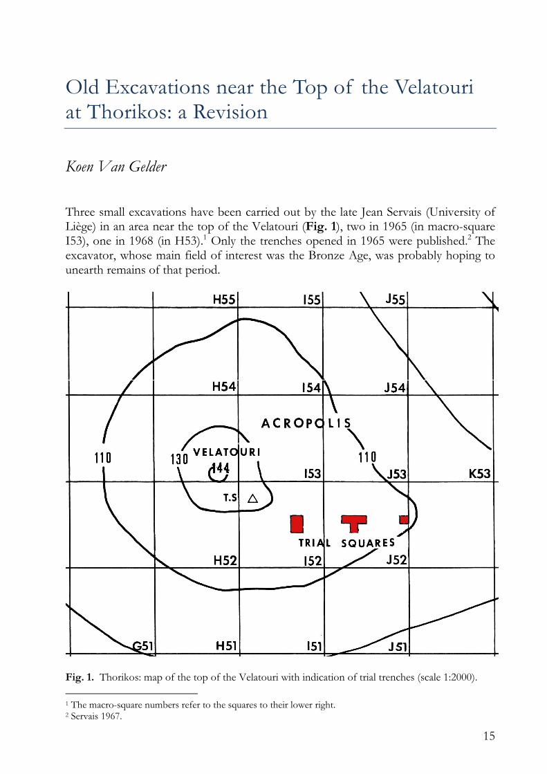
15 Old Excavations near the Top of the Velatouri at Thorikos: a Revision Koen Van Gelder Three small excavations have been carried out by the late Jean Servais (University of Liège) in an area near the top of the Velatouri (Fig. 1), two in 1965 (in macro-square I53), one in 1968 (in H53). 1 Only the trenches opened in 1965 were published. 2 The excavator, whose main field of interest was the Bronze Age, was probably hoping to unearth remains of that period. Fig. 1. Thorikos: map of the top of the Velatouri with indication of trial trenches (scale 1:2000). 1 The macro-square numbers refer to the squares to their lower right. 2 Servais 1967.
-
Upload
independent -
Category
Documents
-
view
2 -
download
0
Transcript of Old Excavations near the Top of the Velatouri at Thorikos: a Revision
15
Old Excavations near the Top of the Velatouri at Thorikos: a Revision
Koen Van Gelder Three small excavations have been carried out by the late Jean Servais (University of Liège) in an area near the top of the Velatouri (Fig. 1), two in 1965 (in macro-square I53), one in 1968 (in H53).1 Only the trenches opened in 1965 were published.2 The excavator, whose main field of interest was the Bronze Age, was probably hoping to unearth remains of that period.
Fig. 1. Thorikos: map of the top of the Velatouri with indication of trial trenches (scale 1:2000).
1 The macro-square numbers refer to the squares to their lower right. 2 Servais 1967.
16
During my study of the Geometric pottery from Thorikos, I had access to the comprehensive diary of the 1965 excavations, the maps and photographs, and the labels of the finds of the excavation of 1968, and got a strong suspicion that the publication of the excavations of 1965 did not correspond with all observations. I examined the available information and was brought to a largely divergent interpretation. I then wished to get some clarifications in view of the final publication of the finds. Besides, apart from a brief mention, nothing had been published, after thirty years, about the trench opened in 1968, the year the round tholos3 was studied, and the excavator had passed away since. Some verification was desirable or necessary to confirm, if possible, the new interpretation of the largest excavation of 1965, to look at the situation in the smaller trench excavated that year and to gain a better understanding of the excavation of 1968. By the courtesy of the Greek archaeological service and the financial support of a former student of Ghent University, this work could be done in September 2000.4 The available time was extremely limited, as the walls of the trenches had collapsed and a mass of mixed earth from the archaeological layers had fallen on top of the black layer of ashes caused by the fire of 1993. Activities were therefore limited to the strictly necessary. Attention was given mainly to the areas with Geometric or so-called Subgeometric material.5 The aim of this article, therefore, is threefold: the rendering of my doubts about the interpretation of the excavations in 1965, the report of the inspection of 2000 and — as well as possible — the publication of the excavation of 1968, together with the additional work of 2000 in that trench.
The central trench (1965)
The excavation of 1965
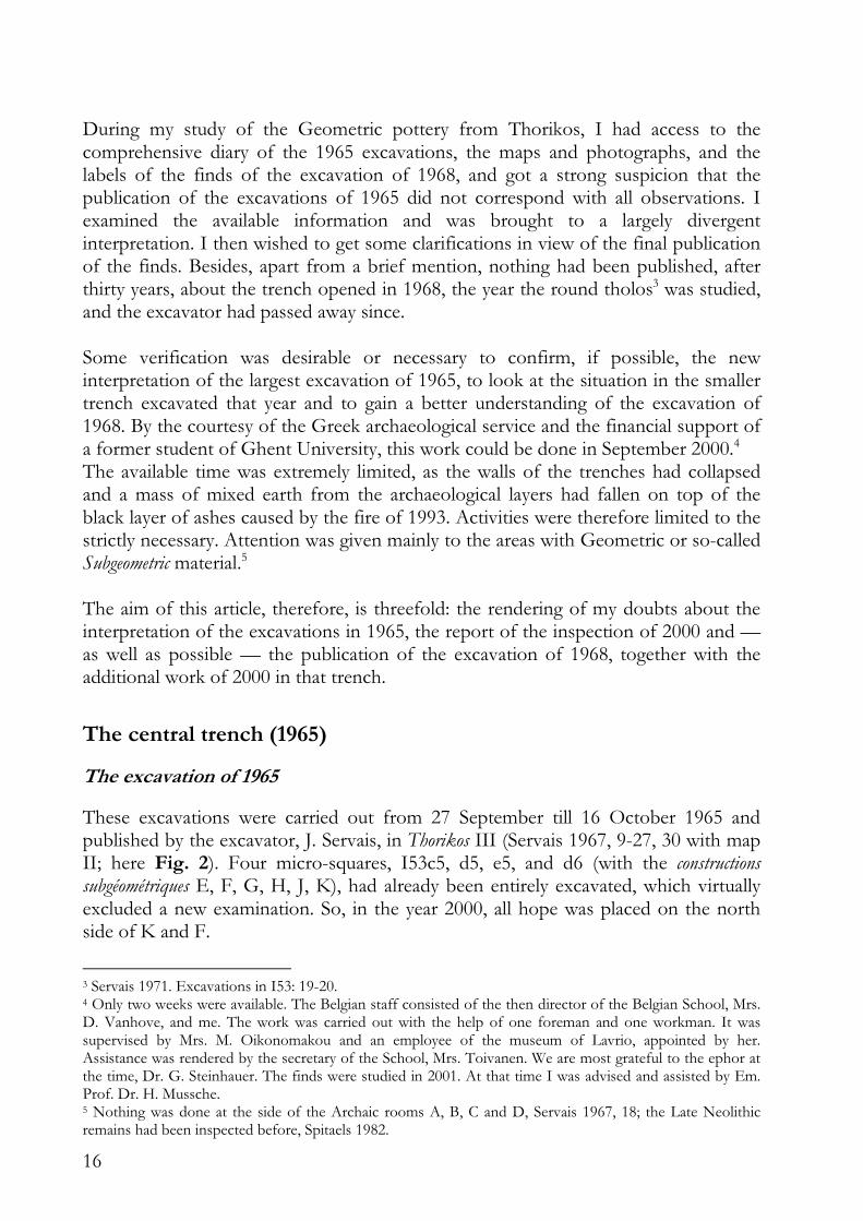
These excavations were carried out from 27 September till 16 October 1965 and published by the excavator, J. Servais, in Thorikos III (Servais 1967, 9-27, 30 with map II; here Fig. 2). Four micro-squares, I53c5, d5, e5, and d6 (with the constructions subgéométriques E, F, G, H, J, K), had already been entirely excavated, which virtually excluded a new examination. So, in the year 2000, all hope was placed on the north side of K and F.
3 Servais 1971. Excavations in I53: 19-20. 4 Only two weeks were available. The Belgian staff consisted of the then director of the Belgian School, Mrs. D. Vanhove, and me. The work was carried out with the help of one foreman and one workman. It was supervised by Mrs. M. Oikonomakou and an employee of the museum of Lavrio, appointed by her. Assistance was rendered by the secretary of the School, Mrs. Toivanen. We are most grateful to the ephor at the time, Dr. G. Steinhauer. The finds were studied in 2001. At that time I was advised and assisted by Em. Prof. Dr. H. Mussche. 5 Nothing was done at the side of the Archaic rooms A, B, C and D, Servais 1967, 18; the Late Neolithic remains had been inspected before, Spitaels 1982.
17
Fig. 2. Central trench (based on original plan by Cl. Zerck-Mulder and L. Van Damme-Renard).
The excavator summarized the situation the following way: “(...); mais la couche subgéométrique elle-même n’a heureusement jamais subi de perturbation. On l’a retrouvée uniformément répandue dans les compartiments K, F, E, J, G et H: elle était faite d’une terre argileuse ocre brune, très compacte, dure et homogène, sans aucune variation de stratigraphie décelable depuis le haut jusqu’aux sols, formés eux-mêmes d’une seule épaisseur de terre battue particulièrement dure, riche en tessons, parfois tassée au-dessus d’un léger remblai plus meuble (contenant quelques tessons HM [Helladique moyenne, KVG]) (…). L’unité de cette couche d’habitation, très manifeste, (…).”6 This text poses a problem: there is, on the floors, a couche d’habitation that reaches untill the preserved upper level of the walls. Further examination, from room to room and from ‘layer’ to ‘layer’ only raised more doubts. Moreover, five pages further the excavator presents another interpretation: “(…) au contraire, l’épaisseur quasi uniforme de terre compacte — relativement peu mêlée de pierres mais spécialement riche en tessons dans sa partie inférieure — qui couvrait les sols jusqu’à la crête généralement rectiligne des murs, cette couche épaisse et homogène pourrait bien être le résidu de parois et de cloisons en briques crues tombées en ruines puis dissoutes (...)”.7
6 Servais 1967, 10. 7 Servais 1967, 15.
18
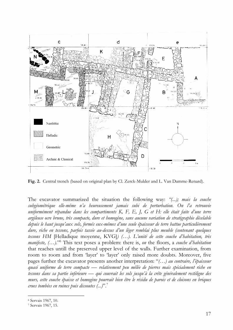
On the base of the excavation documents it became clear that there was indeed a yellow or yellow-brown layer between the humus and the bedrock (infra). The conclusion that most sherds were found in its lower part is correct in E, not correct in G and H,8 and unverifiable in F, J, and K. The next issue are the floors, which were not consistently mentioned. With the possible exception of a fragmentary floor in E, no floor is mentioned in the diary, nor are sherds from a floor registered. On different occasions the diary notes the absence of floors. All data about a possible excavation of the lowest level in K are lacking. On a photograph one can observe that a number of stones, also indicated on the map, rest on a fill. Floors were found in this trench: in B (Archaic) and in L (Middle Helladic). The interpretation of the yellow layer as a habitation layer can hardly be maintained. It is too thick, and from the location of TC65.50 and some photographs can be deduced that, in places, it is even thicker than the preserved height of the walls. The conflicting interpretation as a collapse layer is not consistent with the rather homogeneous distribution of finds in this layer. The remaining possibility is a fill, perhaps containing sherds and bricks that once belonged to the construction. This interpretation is supported (albeit not conclusively demonstrated) by the presence of a few sherds with a funerary character9 (Fig. 3: TC65.48d) and the fact that one sherd (TC65.46ad)10 could be joined with a fragment from the terrace of the eastern trench (TC65.1bn). TC65.44c could also be joined with TC65.1c, but the former may have been found in the humus.
Fig. 3. Rim TC65.48d of amphora or hydria with plastic snake. Sscale ca. 2:1.
8 A relatively large number of sherds (62) was found at the bottom, but laying on top of the fill of the cavities of the rock, which also contained Middle Helladic material and obsidian, with no clear distinction recorded. 9 Two fragments with plastic snake in I53d6: TC65.44m, humus and beginning of yellow layer; TC65.48d (Fig. 3), H, northwest corner, couche de démolition → sol. 10 H, niveau seuils.
19
Finally we have to look at the date of fill and construction. The fill contained, beside Late Geometric pottery, mainly 7th-century Subgeometric and Protocorinthian material. Nothing points to developing black-figure or to Black and White style (let alone black glaze). This layer thus can be dated to the Early Protoattic or early Middle Protoattic.11 The excavator used two ceramic elements to date the construction, but neither could convince me: 1. TC65.5012
The fragments of this one-handled cup were, according to the publication, “trouvés au sud de d6, bloqués sous quelques pierres éboulées qui obstruaient la porte ouvrant sur H.”, which leads to the conclusion: “Fournit donc un terminus post quem à l’abandon de la demeure”. In the inventory, however, this cup is mentioned as: “I53d6 - H coin S.O. Eboulis obstruant la porte, sur crète des murs. -40”, and the diary says: “D108 A -40, dans la couche jaune, tout à fait au coin S.O. du carré et à l’extérieur du mur (donc au sud), et au-dessus de la crète des murs, skyphos presque complet, assez étroit et allongé de forme.”13
2. TC65.3414 This sherd of an Early Protocorinthian skyphos is used to date the building. The report (p. 17) states: “Trouvé en G, bloqué sous la banquette ouest, contre le rocher et le pied du mur. Fournit donc un terminus post quem à l’ensemble du bâtiment lui-même.” Again, this doesn’t seem entirely correct. The inventory gives a slightly different mention: “tesson bloqué dans fond de la salle à banquettes” and the diary mentions it as: “Dans nettoyage du mur de fond de la salle aux banquettes: tesson subgéométrique (flanc de grand skyphos) pris dans la blocaille inférieur du mur. Daterait la construction?”. Elsewere the diary uses the word blocaille for the small stones between the wall and the ‘banquette’. In this blocaille, in the middle of the northern ‘banquette’, was found TC65.33 (label D040), nine sherds of the neck of an oinochoe. In any case TC65.34 was no more than TC65.33 found under the ‘banquette’ (which was of course not dismantled).
L, M and N, were probably outside the Iron Age building. The Late Neolithic material and most of the Middle Helladic remains were found there.15 In M and N a small amount of Geometric material was also unearthed. The stratigraphy was as follows: — humus; — dark grey debris (TC65.55); — powdery black layer that passes over the Middle Helladic wall (TC65.56, and lower TC65.57); — grey layer — only in N (TC65.59; end of grey layer, beginning of red: TC65.60;16 contact with red layer: TC65.62).
11 The date, of course, of the earth, before it was used as a fill. 12 Servais 1967, 17, fig. 7. 13 Underlining by the excavator. There might have been confusion with another find: “Nettoyage de l’entrée. Tessons p.ê. importants, bloqués entre les pierres d’éboulis qui encombrent la porte — Date la démolition.”, but that one comes from the ‘door’ between G and H. 14 Servais 1967, 17, fig. 8. 15 Servais 1967, 20-27; see Spitaels 1982, 9-44. 16 For the ‘red layer’, see Spitaels 1982, 12.
20
Only a few fragments from these layers can be dated:
TC65.55 contains a fragment of a plate, Late Geometric – Subgeometric, a fragment of a one-handled cup, Late Geometric IIb – Early Subgeometric, and a fragment of a Late Protogeometric amphora.
TC65.56 and 57 contain a fragment of a kalathos, Late Geometric II, and a fragment of a louterion, Late Geometric Ib – Early Subgeometric.
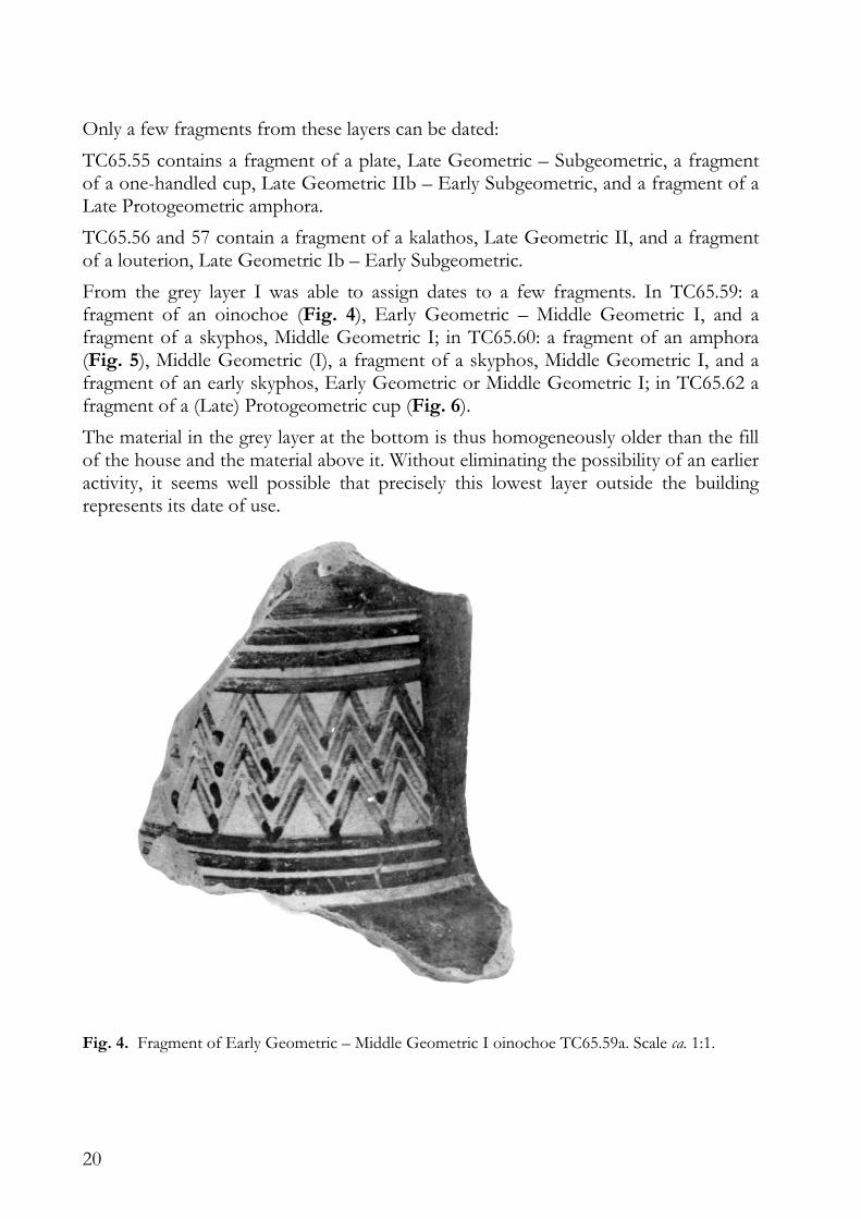
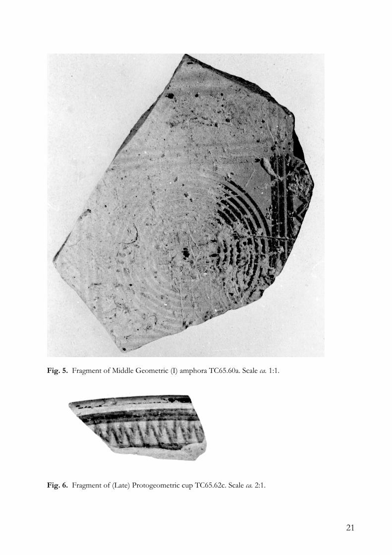
From the grey layer I was able to assign dates to a few fragments. In TC65.59: a fragment of an oinochoe (Fig. 4), Early Geometric – Middle Geometric I, and a fragment of a skyphos, Middle Geometric I; in TC65.60: a fragment of an amphora (Fig. 5), Middle Geometric (I), a fragment of a skyphos, Middle Geometric I, and a fragment of an early skyphos, Early Geometric or Middle Geometric I; in TC65.62 a fragment of a (Late) Protogeometric cup (Fig. 6).
The material in the grey layer at the bottom is thus homogeneously older than the fill of the house and the material above it. Without eliminating the possibility of an earlier activity, it seems well possible that precisely this lowest layer outside the building represents its date of use.
Fig. 4. Fragment of Early Geometric – Middle Geometric I oinochoe TC65.59a. Scale ca. 1:1.
21
Fig. 5. Fragment of Middle Geometric (I) amphora TC65.60a. Scale ca. 1:1.
Fig. 6. Fragment of (Late) Protogeometric cup TC65.62c. Scale ca. 2:1.
22
The inspection in 2000 Although we knew in advance that the possibilities to check the old excavation were limited, the results of the inspection on 28 and 29 September 2000 were disappointing.
In room K appeared, after the removal of a considerable amount of earth and plants, the level of 1965. The situation was simple, but a bit confusing: the humus, mixed with stones, rests upon a yellow-brown layer, which stayed, in the southern part, clearly below the top of the southern wall of K. The stones that are drawn on the map in the southern part in K, rest upon this yellow-brown layer, which slopes down from the west to the centre. The north-south row of stones in K also rests largely upon the yellow-brown layer. The moellons in the northeast at the other hand were most likely covered by the yellow-brown layer.17 The distinction between the fallen stones at the bottom of the humus and the stones at the top of the yellow-brown layer is not always clear. Below the level that contains the stones the yellow-brown layer is hard; it contains schist in many places, but no sherds. If K was inside the building, this could be a floor, but this is obviously not the same yellow-brown layer once considered as a habitation layer, another time as a collapse layer.18
Between the stones in the upper part of the yellow-brown layer was found some Early Archaic material. The only sherd found at the top of the lower level without stones can be from the 8th or 7th century BCE. However, finds are scarce.
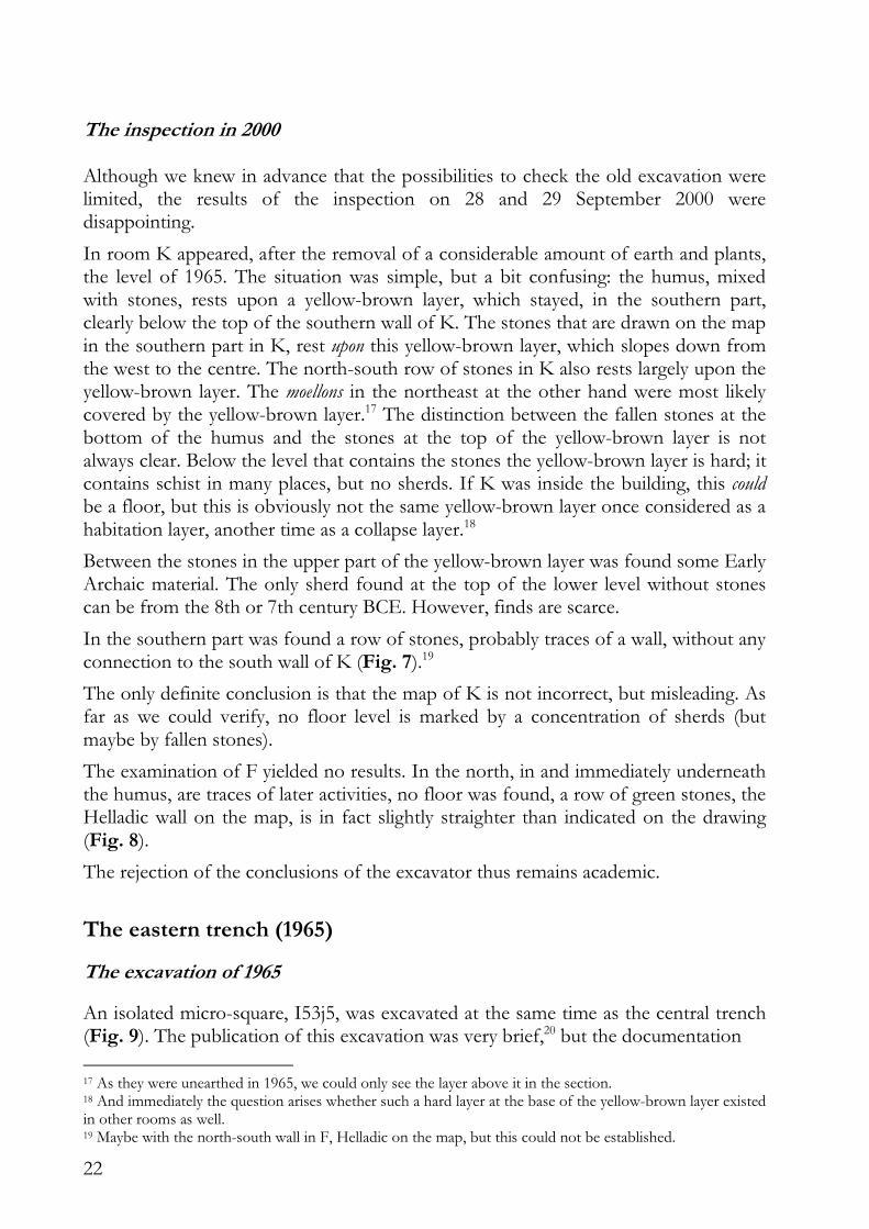
In the southern part was found a row of stones, probably traces of a wall, without any connection to the south wall of K (Fig. 7).19
The only definite conclusion is that the map of K is not incorrect, but misleading. As far as we could verify, no floor level is marked by a concentration of sherds (but maybe by fallen stones).
The examination of F yielded no results. In the north, in and immediately underneath the humus, are traces of later activities, no floor was found, a row of green stones, the Helladic wall on the map, is in fact slightly straighter than indicated on the drawing (Fig. 8).
The rejection of the conclusions of the excavator thus remains academic.
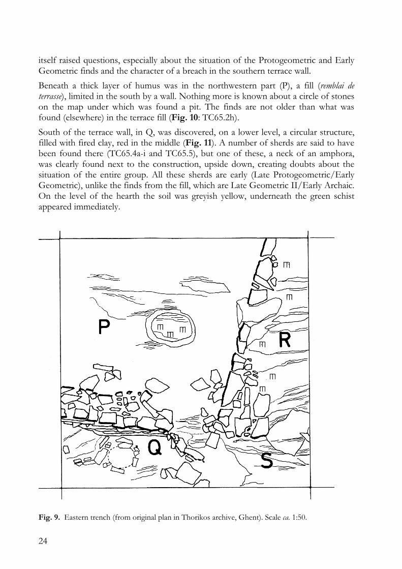
The eastern trench (1965)
The excavation of 1965
An isolated micro-square, I53j5, was excavated at the same time as the central trench (Fig. 9). The publication of this excavation was very brief,20 but the documentation
17 As they were unearthed in 1965, we could only see the layer above it in the section. 18 And immediately the question arises whether such a hard layer at the base of the yellow-brown layer existed in other rooms as well. 19 Maybe with the north-south wall in F, Helladic on the map, but this could not be established.
23
Fig. 7. Central trench: K, facing south (2000).
Fig. 8. Central trench: F, northern bank (2000).
20 Servais 1967, 27-30.
24
itself raised questions, especially about the situation of the Protogeometric and Early Geometric finds and the character of a breach in the southern terrace wall.
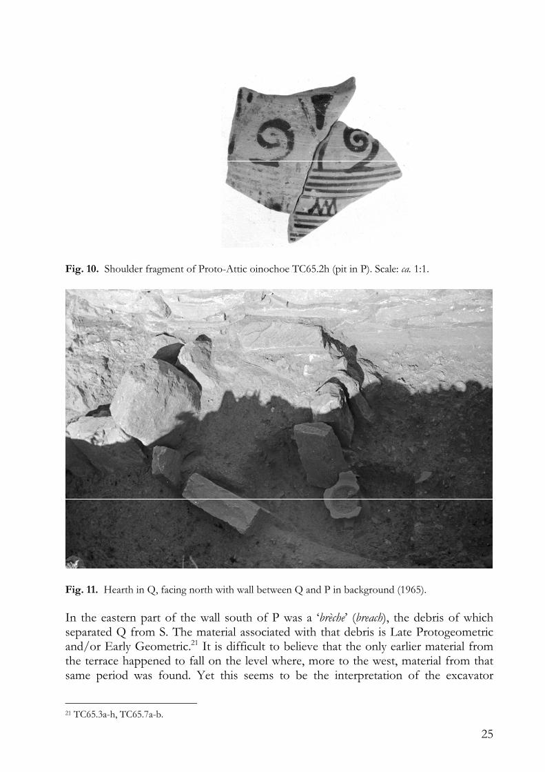
Beneath a thick layer of humus was in the northwestern part (P), a fill (remblai de terrasse), limited in the south by a wall. Nothing more is known about a circle of stones on the map under which was found a pit. The finds are not older than what was found (elsewhere) in the terrace fill (Fig. 10: TC65.2h).
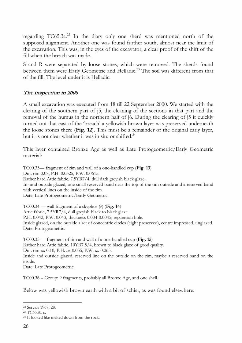
South of the terrace wall, in Q, was discovered, on a lower level, a circular structure, filled with fired clay, red in the middle (Fig. 11). A number of sherds are said to have been found there (TC65.4a-i and TC65.5), but one of these, a neck of an amphora, was clearly found next to the construction, upside down, creating doubts about the situation of the entire group. All these sherds are early (Late Protogeometric/Early Geometric), unlike the finds from the fill, which are Late Geometric II/Early Archaic. On the level of the hearth the soil was greyish yellow, underneath the green schist appeared immediately.
Fig. 9. Eastern trench (from original plan in Thorikos archive, Ghent). Scale ca. 1:50.
25
Fig. 10. Shoulder fragment of Proto-Attic oinochoe TC65.2h (pit in P). Scale: ca. 1:1.
Fig. 11. Hearth in Q, facing north with wall between Q and P in background (1965).
In the eastern part of the wall south of P was a ‘brèche’ (breach), the debris of which separated Q from S. The material associated with that debris is Late Protogeometric and/or Early Geometric.21 It is difficult to believe that the only earlier material from the terrace happened to fall on the level where, more to the west, material from that same period was found. Yet this seems to be the interpretation of the excavator
21 TC65.3a-h, TC65.7a-b.
26
regarding TC65.3a.22 In the diary only one sherd was mentioned north of the supposed alignment. Another one was found further south, almost near the limit of the excavation. This was, in the eyes of the excavator, a clear proof of the shift of the fill when the breach was made.
S and R were separated by loose stones, which were removed. The sherds found between them were Early Geometric and Helladic.23 The soil was different from that of the fill. The level under it is Helladic.
The inspection in 2000
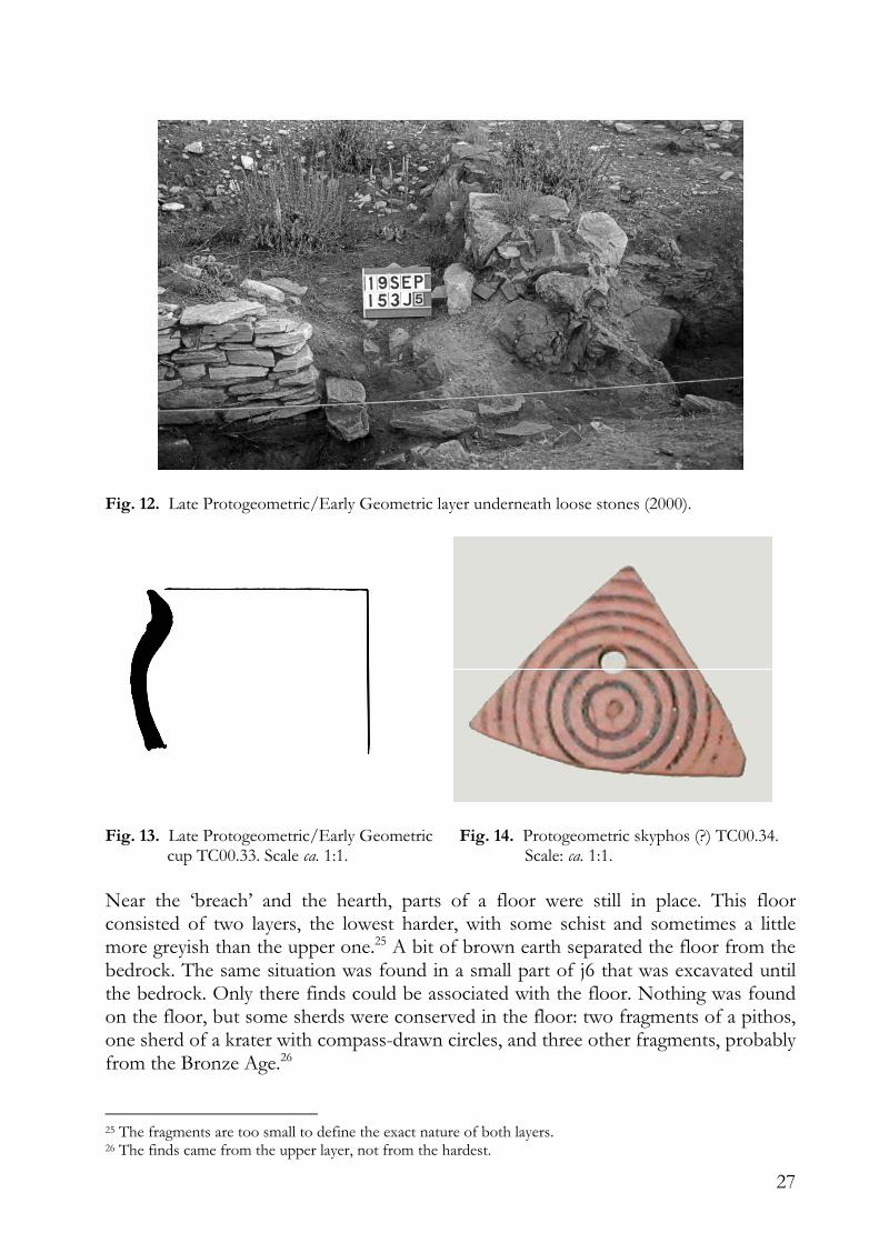
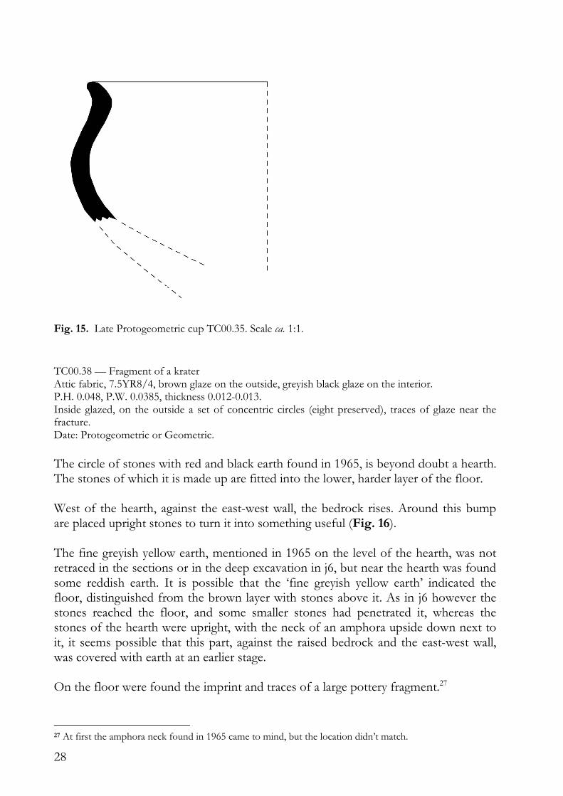
A small excavation was executed from 18 till 22 September 2000. We started with the clearing of the southern part of j5, the cleaning of the sections in that part and the removal of the humus in the northern half of j6. During the clearing of j5 it quickly turned out that east of the ‘breach’ a yellowish brown layer was preserved underneath the loose stones there (Fig. 12). This must be a remainder of the original early layer, but it is not clear whether it was in situ or shifted.24 This layer contained Bronze Age as well as Late Protogeometric/Early Geometric material: TC00.33— fragment of rim and wall of a one-handled cup (Fig. 13) Dm. rim 0.08, P.H. 0.0325, P.W. 0.0615. Rather hard Attic fabric, 7.5YR7/4, dull dark greyish black glaze. In- and outside glazed, one small reserved band near the top of the rim outside and a reserved band with vertical lines on the inside of the rim. Date: Late Protogeometric/Early Geometric. TC00.34 — wall fragment of a skyphos (?) (Fig. 14) Attic fabric, 7.5YR7/4, dull greyish black to black glaze. P.H. 0.042, P.W. 0.043, thickness 0.004-0.0045; reparation hole. Inside glazed, on the outside a set of concentric circles (eight preserved), centre impressed, unglazed. Date: Protogeometric. TC00.35 — fragment of rim and wall of a one-handled cup (Fig. 15) Rather hard Attic fabric, 10YR7.5/4, brown to black glaze of good quality. Dm. rim ca. 0.10, P.H. ca. 0.055, P.W. ca. 0.065. Inside and outside glazed, reserved line on the outside on the rim, maybe a reserved band on the inside. Date: Late Protogeometric. TC00.36 – Group: 9 fragments, probably all Bronze Age, and one shell.
Below was yellowish brown earth with a bit of schist, as was found elsewhere.
22 Servais 1967, 28. 23 TC65.8a-c. 24 It looked like melted down from the rock.
27
Fig. 12. Late Protogeometric/Early Geometric layer underneath loose stones (2000).
Fig. 13. Late Protogeometric/Early Geometric Fig. 14. Protogeometric skyphos (?) TC00.34. cup TC00.33. Scale ca. 1:1. Scale: ca. 1:1.
Near the ‘breach’ and the hearth, parts of a floor were still in place. This floor consisted of two layers, the lowest harder, with some schist and sometimes a little more greyish than the upper one.25 A bit of brown earth separated the floor from the bedrock. The same situation was found in a small part of j6 that was excavated until the bedrock. Only there finds could be associated with the floor. Nothing was found on the floor, but some sherds were conserved in the floor: two fragments of a pithos, one sherd of a krater with compass-drawn circles, and three other fragments, probably from the Bronze Age.26
25 The fragments are too small to define the exact nature of both layers. 26 The finds came from the upper layer, not from the hardest.
28
Fig. 15. Late Protogeometric cup TC00.35. Scale ca. 1:1.
TC00.38 — Fragment of a krater Attic fabric, 7.5YR8/4, brown glaze on the outside, greyish black glaze on the interior. P.H. 0.048, P.W. 0.0385, thickness 0.012-0.013. Inside glazed, on the outside a set of concentric circles (eight preserved), traces of glaze near the fracture. Date: Protogeometric or Geometric.
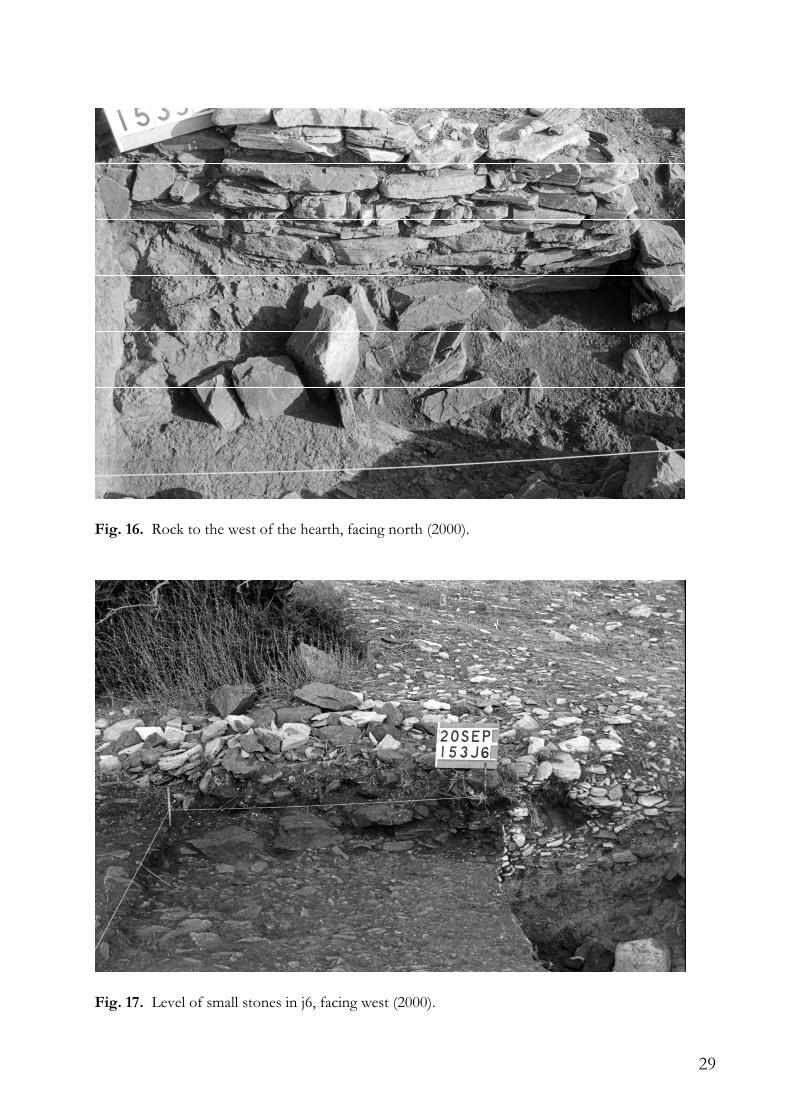
The circle of stones with red and black earth found in 1965, is beyond doubt a hearth. The stones of which it is made up are fitted into the lower, harder layer of the floor. West of the hearth, against the east-west wall, the bedrock rises. Around this bump are placed upright stones to turn it into something useful (Fig. 16). The fine greyish yellow earth, mentioned in 1965 on the level of the hearth, was not retraced in the sections or in the deep excavation in j6, but near the hearth was found some reddish earth. It is possible that the ‘fine greyish yellow earth’ indicated the floor, distinguished from the brown layer with stones above it. As in j6 however the stones reached the floor, and some smaller stones had penetrated it, whereas the stones of the hearth were upright, with the neck of an amphora upside down next to it, it seems possible that this part, against the raised bedrock and the east-west wall, was covered with earth at an earlier stage. On the floor were found the imprint and traces of a large pottery fragment.27
27 At first the amphora neck found in 1965 came to mind, but the location didn’t match.
29
Fig. 16. Rock to the west of the hearth, facing north (2000).
Fig. 17. Level of small stones in j6, facing west (2000).
30
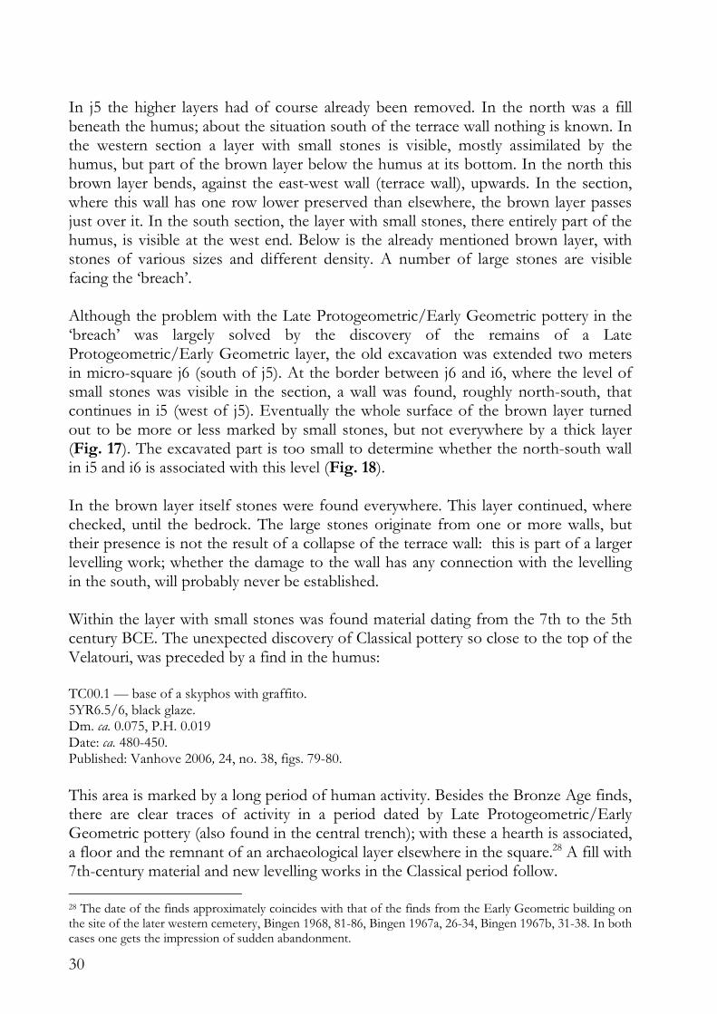
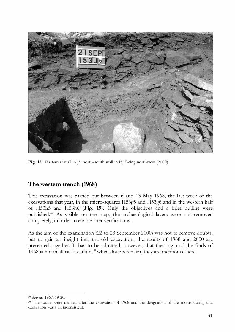
In j5 the higher layers had of course already been removed. In the north was a fill beneath the humus; about the situation south of the terrace wall nothing is known. In the western section a layer with small stones is visible, mostly assimilated by the humus, but part of the brown layer below the humus at its bottom. In the north this brown layer bends, against the east-west wall (terrace wall), upwards. In the section, where this wall has one row lower preserved than elsewhere, the brown layer passes just over it. In the south section, the layer with small stones, there entirely part of the humus, is visible at the west end. Below is the already mentioned brown layer, with stones of various sizes and different density. A number of large stones are visible facing the ‘breach’. Although the problem with the Late Protogeometric/Early Geometric pottery in the ‘breach’ was largely solved by the discovery of the remains of a Late Protogeometric/Early Geometric layer, the old excavation was extended two meters in micro-square j6 (south of j5). At the border between j6 and i6, where the level of small stones was visible in the section, a wall was found, roughly north-south, that continues in i5 (west of j5). Eventually the whole surface of the brown layer turned out to be more or less marked by small stones, but not everywhere by a thick layer (Fig. 17). The excavated part is too small to determine whether the north-south wall in i5 and i6 is associated with this level (Fig. 18). In the brown layer itself stones were found everywhere. This layer continued, where checked, until the bedrock. The large stones originate from one or more walls, but their presence is not the result of a collapse of the terrace wall: this is part of a larger levelling work; whether the damage to the wall has any connection with the levelling in the south, will probably never be established. Within the layer with small stones was found material dating from the 7th to the 5th century BCE. The unexpected discovery of Classical pottery so close to the top of the Velatouri, was preceded by a find in the humus: TC00.1 — base of a skyphos with graffito. 5YR6.5/6, black glaze. Dm. ca. 0.075, P.H. 0.019 Date: ca. 480-450. Published: Vanhove 2006, 24, no. 38, figs. 79-80.
This area is marked by a long period of human activity. Besides the Bronze Age finds, there are clear traces of activity in a period dated by Late Protogeometric/Early Geometric pottery (also found in the central trench); with these a hearth is associated, a floor and the remnant of an archaeological layer elsewhere in the square.28 A fill with 7th-century material and new levelling works in the Classical period follow.
28 The date of the finds approximately coincides with that of the finds from the Early Geometric building on the site of the later western cemetery, Bingen 1968, 81-86, Bingen 1967a, 26-34, Bingen 1967b, 31-38. In both cases one gets the impression of sudden abandonment.
31
Fig. 18. East-west wall in j5, north-south wall in i5, facing northwest (2000).
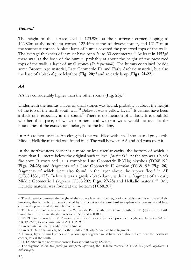
The western trench (1968)
This excavation was carried out between 6 and 13 May 1968, the last week of the excavations that year, in the micro-squares H53g5 and H53g6 and in the western half of H53h5 and H53h6 (Fig. 19). Only the objectives and a brief outline were published.29 As visible on the map, the archaeological layers were not removed completely, in order to enable later verifications. As the aim of the examination (22 to 28 September 2000) was not to remove doubts, but to gain an insight into the old excavation, the results of 1968 and 2000 are presented together. It has to be admitted, however, that the origin of the finds of 1968 is not in all cases certain;30 when doubts remain, they are mentioned here.
29 Servais 1967, 19-20. 30 The rooms were marked after the excavation of 1968 and the designation of the rooms during that excavation was a bit inconsistent.
32
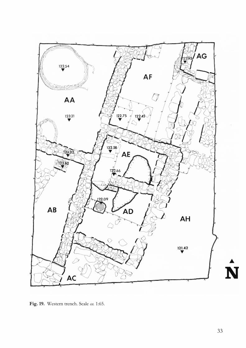
General The height of the surface level is 123.98m at the northwest corner, sloping to 122.82m at the northeast corner, 122.46m at the southwest corner, and 121.71m at the southeast corner. A black layer of humus covered the preserved tops of the walls. The average thickness of it must have been 20 to 30 centimetres.31 At least in H53g6 there was, at the base of the humus, probably at about the height of the preserved tops of the walls, a layer of small stones (lit de pierraille). The humus contained, beside some Bronze Age material, Late Geometric IIa and Early Archaic material, but also the base of a black-figure lekythos (Fig. 20)32 and an early lamp (Figs. 21-22).
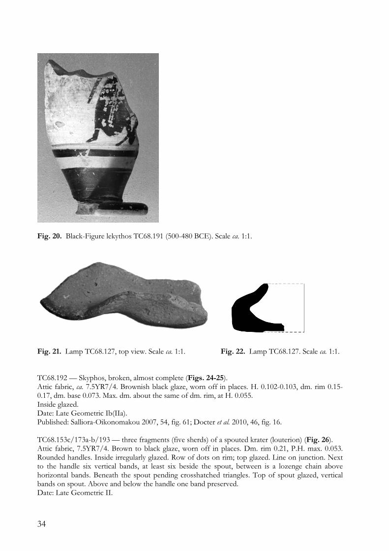
AA
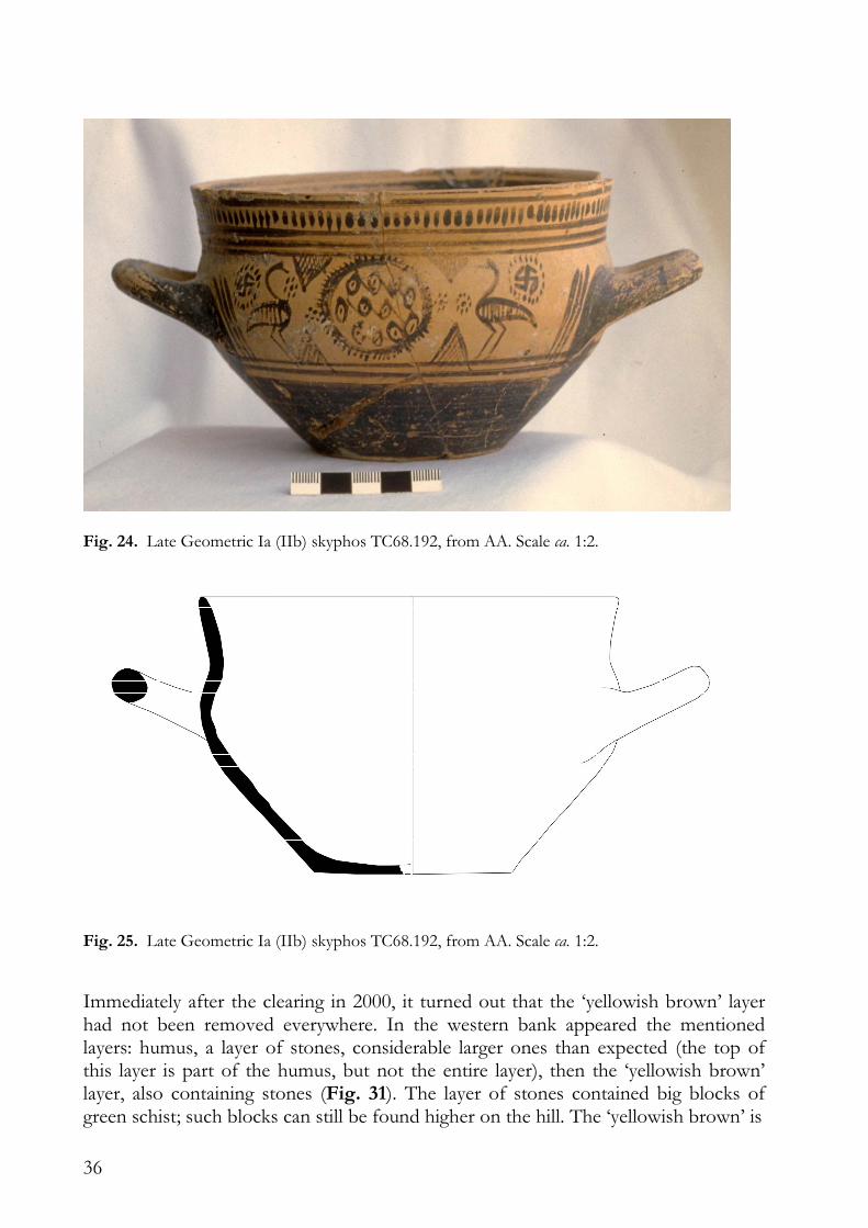
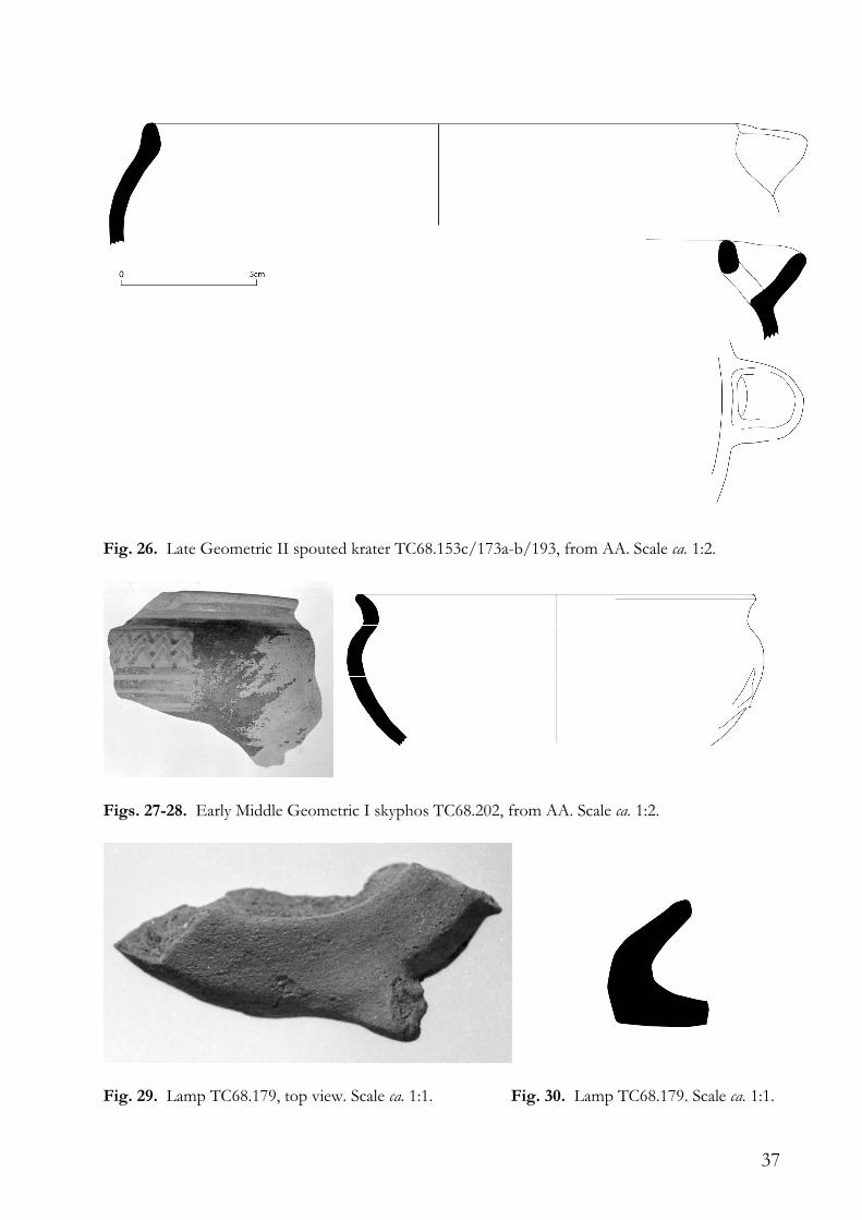
AA lies considerably higher than the other rooms (Fig. 23).33 Underneath the humus a layer of small stones was found, probably at about the height of the top of the north-south wall.34 Below it was a yellow layer.35 It cannot have been a thick one, especially in the south.36 There is no mention of a floor. It is doubtful whether this space, of which northern and western walls would be outside the boundaries of the excavation, belonged to the building. In AA are two cavities. An elongated one was filled with small stones and grey earth. Middle Helladic material was found in it. The wall between AA and AB runs over it. In the northwestern corner is a more or less circular cavity, the bottom of which is more than 1.4 metre below the original surface level (‘bothros’).37 At the top was a black fire spot. It contained i.a. a complete Late Geometric Ib(/IIa) skyphos (TC68.192; Figs. 24-25) and fragments of a Late Geometric II louterion (TC68.193; Fig. 26), fragments of which were also found in the layer above the ‘upper floor’ in AF (TC68.153c, 173). Below it was a greyish black layer, with i.a. a fragment of an early Middle Geometric I skyphos (TC68.202; Figs. 27-28) and Helladic material.38 Only Helladic material was found at the bottom (TC68.207).
31 The difference between the height of the surface level and the height of the walls (see map). It is unlikely, however, that all walls had been covered by it, since it is otherwise hard to explain why Servais would have chosen the position of the trench exactly here. 32 The lekythos has been attributed by W. van de Put to either the Class of Athens 581 (?) or to the Little Lion Class. In any case, the date is between 500 and 480 BCE. 33 123.21m in the south to 123.29m in the northeast. For comparison: preserved height wall between AA and AB: 123.22m, top column base in AD: 122.09m. 34 Finds: Late Geometric and/or Early Archaic. 35 Finds: TC68.161a unclear; both other finds are (Early-?) Archaic base fragments. 36 Humus, layer of small stones and yellow layer together must have been about 30cm near the northeast corner, less at the south. 37 H. 123.98m in the northwest corner, lowest point cavity 122.54m. 38 The skyphos TC68.202 (couche gris-noir partie inférieure), the Helladic material in TC68.203 (couche inférieure → rocher rouge).
33
Fig. 19. Western trench. Scale ca. 1:65.
34
Fig. 20. Black-Figure lekythos TC68.191 (500-480 BCE). Scale ca. 1:1.
Fig. 21. Lamp TC68.127, top view. Scale ca. 1:1. Fig. 22. Lamp TC68.127. Scale ca. 1:1. TC68.192 — Skyphos, broken, almost complete (Figs. 24-25). Attic fabric, ca. 7.5YR7/4. Brownish black glaze, worn off in places. H. 0.102-0.103, dm. rim 0.15-0.17, dm. base 0.073. Max. dm. about the same of dm. rim, at H. 0.055. Inside glazed. Date: Late Geometric Ib(IIa). Published: Salliora-Oikonomakou 2007, 54, fig. 61; Docter et al. 2010, 46, fig. 16. TC68.153c/173a-b/193 — three fragments (five sherds) of a spouted krater (louterion) (Fig. 26). Attic fabric, 7.5YR7/4. Brown to black glaze, worn off in places. Dm. rim 0.21, P.H. max. 0.053. Rounded handles. Inside irregularly glazed. Row of dots on rim; top glazed. Line on junction. Next to the handle six vertical bands, at least six beside the spout, between is a lozenge chain above horizontal bands. Beneath the spout pending crosshatched triangles. Top of spout glazed, vertical bands on spout. Above and below the handle one band preserved. Date: Late Geometric II.
35
Fig. 23. AA (in the left upper corner), facing north (1968). TC68.202 — Fragment of rim and wall of a skyphos, one handle attachment partly preserved (Figs. 27-28). Hard Attic fabric, 7.5YR7/4. Brown to brownish black glaze. P.H. 0.062, P.W. 0.078, dm. rim 0.13. Inside glazed. In any case groups of vertical bands on rim (rim inadequately cleaned). Date: early Middle Geometric I.
AB
The data of 1968 are very limited: on level with the top of the big north-south wall was a layer of small stones, below a yellowish brown layer (fill?) with a lot of rubble. Finally some material was found on the bedrock.39 In the layer of small stones was found mainly Geometric material. The oldest find is a shoulder fragment of a Late Protogeometric oinochoe decorated with semicircles (TC68.156). In the yellowish brown layer was found Late Geometric, but also Archaic material. On the bedrock was found a fragment of a lamp: TC68.179 — Fragmentary lamp (Figs. 29-30). H. 0.023. Date: Archaic.
39 The excavator noted: Regroupe avec 240, i.e. the finds from the yellowish brown layer, but in view of the finds of 2000 mentioned separately here.
36
Fig. 24. Late Geometric Ia (IIb) skyphos TC68.192, from AA. Scale ca. 1:2.
Fig. 25. Late Geometric Ia (IIb) skyphos TC68.192, from AA. Scale ca. 1:2.
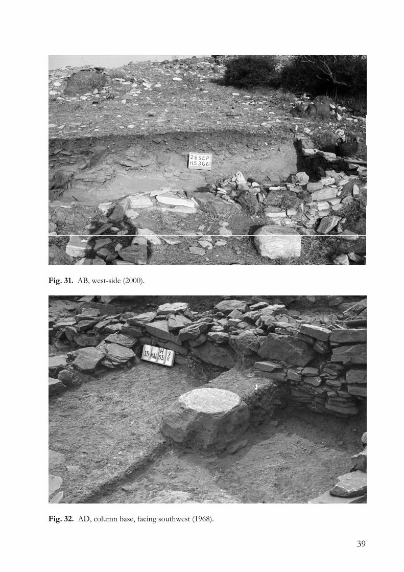
Immediately after the clearing in 2000, it turned out that the ‘yellowish brown’ layer had not been removed everywhere. In the western bank appeared the mentioned layers: humus, a layer of stones, considerable larger ones than expected (the top of this layer is part of the humus, but not the entire layer), then the ‘yellowish brown’ layer, also containing stones (Fig. 31). The layer of stones contained big blocks of green schist; such blocks can still be found higher on the hill. The ‘yellowish brown’ is
37
Fig. 26. Late Geometric II spouted krater TC68.153c/173a-b/193, from AA. Scale ca. 1:2.
Figs. 27-28. Early Middle Geometric I skyphos TC68.202, from AA. Scale ca. 1:2.
Fig. 29. Lamp TC68.179, top view. Scale ca. 1:1. Fig. 30. Lamp TC68.179. Scale ca. 1:1.
38
in fact brown, unlike the fill elsewhere. In 1968 the excavation was left on an irregular floor level. The layer with stones yielded mainly Late Geometric material, but also some smaller sherds dating from the 7th to the 4th century BCE. For the brown layer the Archaic, more specific 7th-century, date is confirmed. In the western section appeared an oblique wall. This wall was indicated on the map from 1968, but looked like a line of loose stones. The wall probably goes with the floor. The stones drawn on the map in the northern part of the room are loose stones. The layer of stones covers the top of the wall, except where this wall is preserved on a lower level; there it is covered by the brown layer. Against this wall a smaller, lower, wall was built (support?). At the foot of it were found a spindle whorl and a fragment of a lamp: TC00.23 — fragment of lamp. P.H. 0.021, P.L. 0.068, P.W. 0.028. Unglazed, 7.5YR7/4. Overhanging rim, nozzle unbridged. Agora type 2b (Agora IV, 9-10). Date: late 7th to late 6th century BCE.
In the upper part of the floor were found 7th-century sherds, on it were found fragments of lead, iron and a millstone.
AC
This is a vague space at the border of the excavation; there seems to be no division (anymore) between AC and AH. Two groups of sherds were probably found in AC, but were not kept. Another group came from AC or AD, but yielded no relevant information. A few sherds (one of them Archaic) were found directly underneath the humus. Beneath the humus was a ‘yellow’ layer, then stones, called dallage by the excavator, then another layer. No work was done in AC in 2000.
AD
In AD, which apparently had a passage to AE, a base of a column was found (Fig. 32). South of it the last level had not been excavated in 1968; the level above it, between the base and the large north-south wall, was also left in place. The upper layers of the entire micro-square were removed in 1968.40 Once the top of the walls was reached, the distinction was made between the following layers in AD: the beginning of the yellow layer, immediately underneath the black layer; on the floor with the column base; fill (remblai) (?) underneath the floor with the column base; and
40 There is some uncertainty about the upper layers: first the “couche humique noire, au dessus du lit de pierraille” was removed, then came “Fin de la couche noire → affleurement des murs”. It is not sure if there was really a layer with small stones, or that the existence of this layer was assumed before the level where it should be was reached. The humus contains mainly Late Geometric material, the second group however, contains a black-figure fragment that, at first sight, must date to the early 6th century BCE.
39
Fig. 31. AB, west-side (2000).
Fig. 32. AD, column base, facing southwest (1968).
40
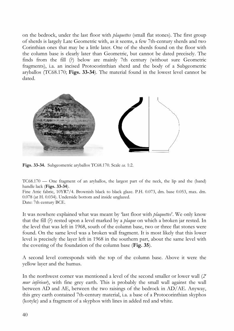
on the bedrock, under the last floor with plaquettes (small flat stones). The first group of sherds is largely Late Geometric with, as it seems, a few 7th-century sherds and two Corinthian ones that may be a little later. One of the sherds found on the floor with the column base is clearly later than Geometric, but cannot be dated precisely. The finds from the fill (?) below are mainly 7th century (without sure Geometric fragments), i.a. an incised Protocorinthian sherd and the body of a Subgeometric aryballos (TC68.170; Figs. 33-34). The material found in the lowest level cannot be dated.
Figs. 33-34. Subgeometric aryballos TC68.170. Scale ca. 1:2. TC68.170 — One fragment of an aryballos, the largest part of the neck, the lip and the (band) handle lack (Figs. 33-34). Fine Attic fabric, 10YR7/4. Brownish black to black glaze. P.H. 0.073, dm. base 0.053, max. dm. 0.078 (at H. 0.034). Underside bottom and inside unglazed. Date: 7th century BCE.
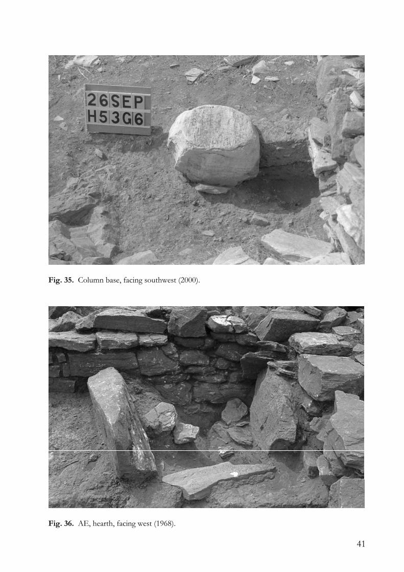
It was nowhere explained what was meant by ‘last floor with plaquettes’. We only know that the fill (?) rested upon a level marked by a plaque on which a broken jar rested. In the level that was left in 1968, south of the column base, two or three flat stones were found. On the same level was a broken wall fragment. It is most likely that this lower level is precisely the layer left in 1968 in the southern part, about the same level with the covering of the foundation of the column base (Fig. 35). A second level corresponds with the top of the column base. Above it were the yellow layer and the humus. In the northwest corner was mentioned a level of the second smaller or lower wall (2e
mur inférieur), with fine grey earth. This is probably the small wall against the wall between AD and AE, between the two raisings of the bedrock in AD/AE. Anyway, this grey earth contained 7th-century material, i.a. a base of a Protocorinthian skyphos (kotyle) and a fragment of a skyphos with lines in added red and white.
41
Fig. 35. Column base, facing southwest (2000).
Fig. 36. AE, hearth, facing west (1968).
42
In 2000, it was ascertained that the upper level left in 1968 (fill?) was made up of soft brown earth and contained Geometric and Archaic (7th-century?) sherds. It also contained a large stone. The layer under it consisted of fine sand. In it were found sherds of the same kind and a fragment of a lamp.41 Between both layers was nothing that could have been used as a floor. The only floor then must have been at a higher level, upon the ‘fill’, the top of which was about 9cm below the top of the column base.
AE
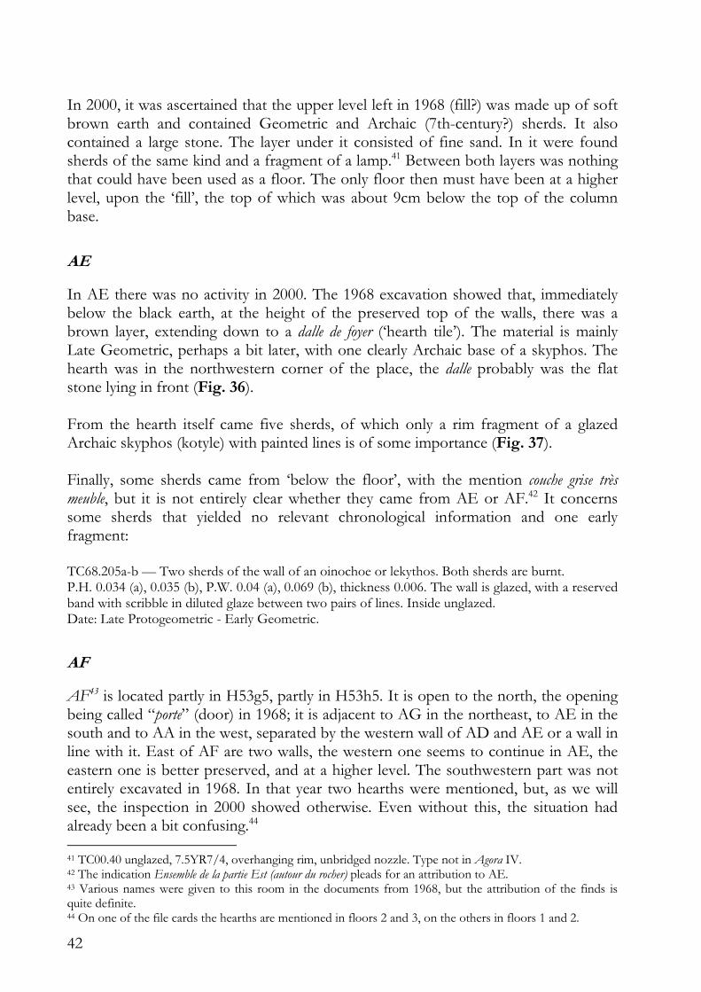
In AE there was no activity in 2000. The 1968 excavation showed that, immediately below the black earth, at the height of the preserved top of the walls, there was a brown layer, extending down to a dalle de foyer (‘hearth tile’). The material is mainly Late Geometric, perhaps a bit later, with one clearly Archaic base of a skyphos. The hearth was in the northwestern corner of the place, the dalle probably was the flat stone lying in front (Fig. 36). From the hearth itself came five sherds, of which only a rim fragment of a glazed Archaic skyphos (kotyle) with painted lines is of some importance (Fig. 37). Finally, some sherds came from ‘below the floor’, with the mention couche grise très meuble, but it is not entirely clear whether they came from AE or AF.42 It concerns some sherds that yielded no relevant chronological information and one early fragment: TC68.205a-b — Two sherds of the wall of an oinochoe or lekythos. Both sherds are burnt. P.H. 0.034 (a), 0.035 (b), P.W. 0.04 (a), 0.069 (b), thickness 0.006. The wall is glazed, with a reserved band with scribble in diluted glaze between two pairs of lines. Inside unglazed. Date: Late Protogeometric - Early Geometric.
AF
AF43 is located partly in H53g5, partly in H53h5. It is open to the north, the opening being called “porte” (door) in 1968; it is adjacent to AG in the northeast, to AE in the south and to AA in the west, separated by the western wall of AD and AE or a wall in line with it. East of AF are two walls, the western one seems to continue in AE, the eastern one is better preserved, and at a higher level. The southwestern part was not entirely excavated in 1968. In that year two hearths were mentioned, but, as we will see, the inspection in 2000 showed otherwise. Even without this, the situation had already been a bit confusing.44 41 TC00.40 unglazed, 7.5YR7/4, overhanging rim, unbridged nozzle. Type not in Agora IV. 42 The indication Ensemble de la partie Est (autour du rocher) pleads for an attribution to AE. 43 Various names were given to this room in the documents from 1968, but the attribution of the finds is quite definite. 44 On one of the file cards the hearths are mentioned in floors 2 and 3, on the others in floors 1 and 2.
43
Fig. 37. Rim fragment of Archaic shyphos (kotyle) TC68.154. Scale ca. 1:1.
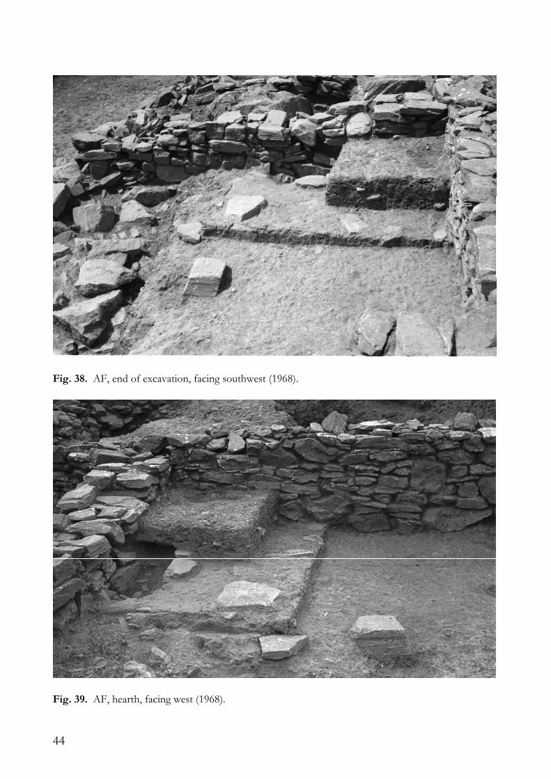
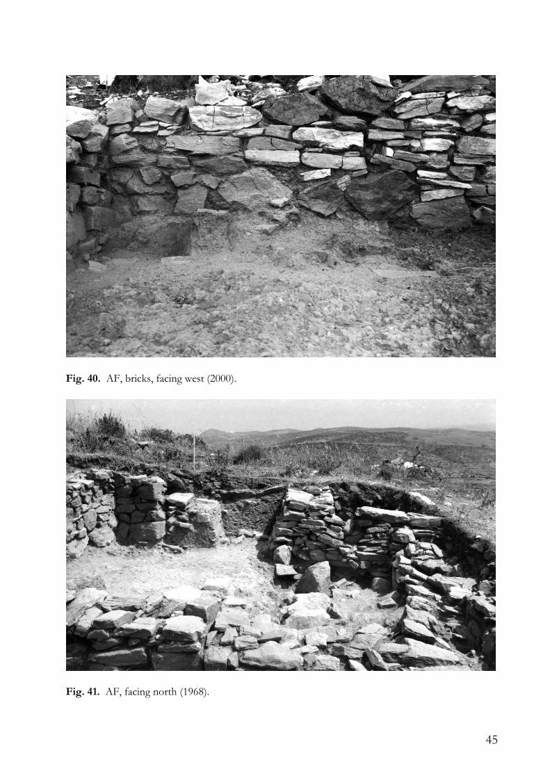
At the start of the excavation the upper layers were removed down to a depth of 15 and 30cm below the preserved height of the walls. Underneath (or partly identical with) there is a brown layer, about which it was said that it ran until a sol clair de niveau avec mur entre 1 et 2. This is unclear; it could be on level with the top of the eastern part of the wall between AF and AE (based on photographs). From this layer came a few Late Geometric/Subgeometric (one Protocorinthian) sherds, and some fragments of the same louterion of which the beak was found in the ‘bothros’ in AA (supra). In the following sequence of excavation, the labels mention, beneath the upper floor (said to be hard), a soft grey layer, a destruction layer on the entire surface of the room, and a grey destruction layer. Most sherds are Late Geometric/Subgeometric again, but some are clearly Archaic (rays, added red, added white, also two with rosettes, one of them with incisions, but from label D250, not explicitly mentioned to be found under the ‘floor’). Just above and upon the ‘lower floor’ a millstone and a number of sherds were found, including Late Geometric, but also older material. In the floor was found Late Geometric and older material, in the ‘hearth’ of the lower floor three fragments were found, one probably and two certainly Archaic. At this point the second ‘hearth’ is mentioned, as being no longer in the same spot in floor 2; “the hard layer runs over it”. Underneath floor 1, and probably in AF, some material was found, but not kept. A photograph (Fig. 38) clearly shows the situation at the end of the excavation in 1968, with the note sols et foyers superposés de AF, dans son coin SO. The function of the block of stone, if there was any, on the 1968 photograph and still there in 2000, is unknown. On another photograph of 1968, taken from the east, one can see that the ‘lower hearth’ was dug out somewhat deeper (Fig. 39).45 Some stones in the north may be remains of the hearth.
45 And that the tunnelling method was used.
44
Fig. 38. AF, end of excavation, facing southwest (1968).
Fig. 39. AF, hearth, facing west (1968).
45
Fig. 40. AF, bricks, facing west (2000).
Fig. 41. AF, facing north (1968).
46
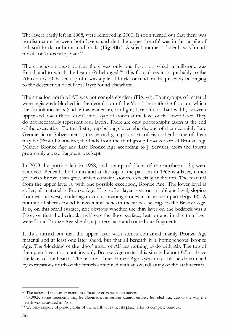
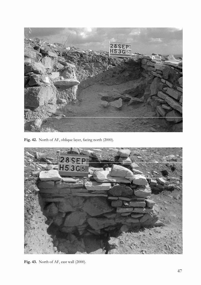
The layers partly left in 1968, were removed in 2000. It soon turned out that there was no distinction between both layers, and that the upper ‘hearth’ was in fact a pile of red, soft bricks or burnt mud bricks (Fig. 40).46 A small number of sherds was found, mostly of 7th-century date.47 The conclusion must be that there was only one floor, on which a millstone was found, and to which the hearth (?) belonged.48 This floor dates most probably to the 7th century BCE. On top of it was a pile of bricks or mud bricks, probably belonging to the destruction or collapse layer found elsewhere. The situation north of AF was not completely clear (Fig. 41). Four groups of material were registered: blocked in the demolition of the ‘door’; beneath the floor on which the demolition rests (and left as evidence), hard grey layer; ‘door’, half width, between upper and lower floor; ‘door’, until layer of stones at the level of the lower floor. They do not necessarily represent four layers. There are only photographs taken at the end of the excavation. To the first group belong eleven sherds, one of them certainly Late Geometric or Subgeometric; the second group consists of eight sherds, one of them may be (Proto)Geometric; the finds from the third group however are all Bronze Age (Middle Bronze Age and Late Bronze Age according to J. Servais); from the fourth group only a base fragment was kept. In 2000 the portion left in 1968, and a strip of 30cm of the northern side, were removed. Beneath the humus and at the top of the part left in 1968 is a layer, rather yellowish brown than grey, which contains stones, especially at the top. The material from the upper level is, with one possible exception, Bronze Age. The lower level is softer; all material is Bronze Age. This softer layer rests on an oblique level, sloping from east to west, harder again and containing stones in its eastern part (Fig. 42). A number of sherds found between and beneath the stones belongs to the Bronze Age. It is, on this small surface, not obvious whether the thin layer on the bedrock was a floor, or that the bedrock itself was the floor surface, but on and in this thin layer were found Bronze Age sherds, a pottery base and some bone fragments. It thus turned out that the upper layer with stones contained mainly Bronze Age material and at least one later sherd, but that all beneath it is homogeneous Bronze Age. The ‘blocking’ of the ‘door’ north of AF has nothing to do with AF. The top of the upper layer that contains only Bronze Age material is situated about 0.5m above the level of the hearth. The nature of the Bronze Age layers may only be determined by excavations north of the trench combined with an overall study of the architectural
46 The nature of the earlier mentioned ‘hard layer’ remains unknown. 47 TC00.5. Some fragments may be Geometric; intrusions cannot entirely be ruled out, due to the way the hearth was excavated in 1968. 48 We only dispose of photographs of the hearth, or rather its place, after its complete removal.
47
Fig. 42. North of AF, oblique layer, facing north (2000).
Fig. 43. North of AF, east wall (2000).
48
remains north of AF. I restrict myself to the publication of a photograph of the eastern wall of the ‘door’, which is clearly altered (Fig. 43).49 Whether AF was a room, a courtyard or an open space adjacent to the Early Archaic building, it is unclear where the entrance(s) were.
AG
Only a corner of AG, in the northeast of H53h5, had been excavated. In 1968 the same grey layer as in the north of AF was found. No material was kept.
Area south of AG, east of AF
This area, in H53h5, is east of the two eastern walls of AF. Near the border of the excavation are stones, probably remains of a wall. In the south the area is separated from AH by another ruined structure, in line with the wall between AF and AE. A part of the finds was not kept; it is not entirely sure whether the conserved material came from this area or from AF.
AH
AH occupies most of H53h6. The (supposed) eastern and southern parts are outside the excavated area. The southwestern corner lies in H53g6. It is separated from the unclear area at the north by the ruined wall; to the west are AD and AE, from which AH is separated by a north-west wall. There is no (more) division from AC. AH was called ‘compartiment vide’, a black layer filled it down to the bedrock. AH was probably outside the construction. We do not know for sure that it was hedged.
Conclusion
The building that was partly excavated in 1968 dates to the 7th century BCE. It had only one habitation phase. The lamps, especially in AB, suggest an advanced stage of that century. At one place, in AE or AF, were found two Early Geometric or Late Protogeometric sherds, but they had nothing to do with the use of the building. In AE and AF (?) was a hearth, in AD a column base. In AB the floor level was recovered, with several utensils left or fallen upon it. AA was probably outside the building50 and the Late Geometric skyphos found in a pit there, was unconnected to it. North of AF nearly all finds are of the Bronze Age.
49 For the sake of completeness some heights: west wall of ‘door’, corner: 123.26m, east wall, second stone from the south: 122.93m, stone on top of the part left in 1968: 122.98, bedrock: 122.34m. 50 Or might be an inner courtyard, if I’m underestimating the size of the building.
49
References Agora IV: Howland R., 1958, Greek Lamps and their Survivals (The Athenian Agora.
Results of Excavations conducted by the American School of Classical Studies at Athens 4), Princeton, New Jersey.
Bingen J., 1967a, L’etablissement du IXe siècle et les nécropoles du secteur ouest 4, in: H.F. Mussche, J. Bingen, J. De Geyter, G. Donnay, T. Hackens, Thorikos 1964. Rapport préliminaire sur la deuxième campagne de fouilles – Voorlopig verslag over de tweede opgravingscampagne, Bruxelles-Brussel, 24-46.
Bingen J., 1967b, L’établissement géométrique et la nécropole ouest, in: H.F. Mussche, J. Bingen, J. Servais, J. De Geyter, T. Hackens, P. Spitaels, A. Gauthier, Thorikos 1965. Rapport préliminaire sur la troisième campagne de fouilles – Voorlopig verslag over de derde opgravingscampagne, Bruxelles-Brussel, 31-56.
Bingen J., 1968, La nécropole ouest, in: H.F. Mussche, J. Bingen, J. Servais, R. Paepe, T. Hackens, Thorikos 1963. Rapport préliminaire sur la première campagne de fouilles – Voorlopig verslag over de eerste opgravingscampagne, Bruxelles-Brussel, 59-86.
Docter R.F., Monsieur P., Nazou M., van de Put W., Van Gelder K., 2010, Thorikos. A Picture in Pottery, in: P. Iossif (ed.), “All that glitters...” The Belgian Contribution to Greek Numismatics, Athens, 44-51.
Salliora-Oikonomakou M., 2007, Lavreotiki –The Lavrion Museum, Athens. Servais J., 1967, Les fouilles sur le haut du Vélatouri, in: H.F. Mussche, J. Bingen, J.
Servais, J. De Geyter, T. Hackens, P. Spitaels, A. Gauthier, Thorikos 1965. Rapport préliminaire sur la troisième campagne de fouilles – Voorlopig verslag over de derde opgravingscampagne, Bruxelles-Brussel, 9-30.
Servais J., 1971, Les fouilles sur le haut du Vélatouri, in: H.F. Mussche, J. Bingen, J. Servais, R. Paepe, H. Bussers, H. Gassche, Thorikos 1968. Rapport préliminaire sur la cinqième campagne de fouilles – Voorlopig verslag over de vijfde opgravingscampagne, Bruxelles-Brussel, 1971, 17-102.
Spitaels P., 1982, Final Neolithic Pottery from Thorikos, in: P. Spitaels (ed.), Studies in South Attica I. Miscellanea Graeca 5, Gent, 9-44.
Vanhove D., 2006, Thorikos. Graffiti Dipinti and Stamps (Fouilles de Thorikos III / Opgravingen van Thorikos III), Paris, Leuven, Dudley MA.
Dr. Koen Van Gelder Department of Archaeology Ghent University Sint-Pietersnieuwstraat 35 B-9000 Gent (Belgium)

50