OIL, WATER, MINERALS, AND THE CRISIS IN DARFUR, SUDAN
14
41 OIL, WATER, MINERALS, AND THE CRISIS IN DARFUR, SUDAN ABBAS M. SHARAKY DEPARTMENT OF NATURAL RESOURCES, INSTITUTE OF AFRICAN RESEARCH AND STUDIES, CAIRO UNIVERSITY, GIZA 12613, EGYPT [email protected] INTRODUCTION Sudan is a vast country of approximately 2.5 million km 2 making it the largest country in Africa and the eleventh among the other world countries. This wide area has made the Sudan a country of varied ecologies and natural resources. Sudan includes nine territories that subdivided into 26 states. It is predominately rural and sparsely populated with a population of about 40.2 millions (July 2005; PRP, 2005). The climate in Sudan ranges from deserts in the north to tropical rainforests in the south. Agriculture is the mainstay of Sudan’s economy, contributing approximately 43% to the GDP and employing more than 80% of the working population. Most farms remain rain-fed and susceptible to drought. The most important mineral resources in Sudan are gold, silver, iron, base metals, salt, gypsum, marble and the recent discoveries of oil and natural gas, which have changed the energy sector and the economy of Sudan. Darfur, the largest territory, is subdivided into three states (Northern, Southern, and Western Darfur). It is located in the northwestern region of Sudan, bordering Chad to the west, Libya to the northwest, and Central African Republic to the southwest, Bahr El Ghazal to the south and Kordofan to the east. Ecologically, Darfur is classified from desert in the north to high woodland savanna in the south. The population of Darfur Region is estimated at just over 6 millions with 1.6 millions in Northern Darfur, 3.1 millions in Southern Darfur, and 1.6 millions in Western Darfur (UNFPA, 1999). The most important minerals in Darfur are uranium, copper, iron ore, gold, Lead-zinc, nickel, chromium, bauxite, kaolinite and natron (hydrated sodium carbonate). Southern Darfur, as well as southern Sudan, is rich in oil. It has numerous water drainage subsystems, but most streams are seasonal. Fortunately, most Darfur area is located in the Nubian Sandstone Aquifer (NSA) containing a huge non-renewable water resource, and located in the eastern Sahara desert in northeastern Africa. NSA is shared among four countries: Egypt, Sudan, Chad and Libya; and contains about 150,000 km 3 of groundwater. Darfur has been affected by intermittent bouts of conflict for several decades. Pastoralists from the north, including the northern Rizeigat, Mahariya, Zaghawa, and others, typically migrate south in search of water sources and grazing in the dry season typically from November to April (HRW, 2003). In the late-1980s, when much of the Sahel region was hit by recurrent episodes of drought and increasing desertification, clashes became progressively bloodier through the introduction of automatic weapons. The conflict has been strengthened since February 2003. The struggle over resources is not only about cattle and water, farmer and herder, but also extends to who will control the next big reserve of oil that is discovered recently in southern Sudan including Southern Darfur. Darfur Crisis, Inst. of African Res. and Studies, Cairo University, November. 2005
Transcript of OIL, WATER, MINERALS, AND THE CRISIS IN DARFUR, SUDAN
41
OIL, WATER, MINERALS, AND THE CRISIS IN DARFUR, SUDAN
ABBAS M. SHARAKY DEPARTMENT OF NATURAL RESOURCES, INSTITUTE OF AFRICAN RESEARCH AND STUDIES,
CAIRO UNIVERSITY, GIZA 12613, EGYPT [email protected]
INTRODUCTION
Sudan is a vast country of approximately 2.5 million km2 making it the largest country in Africa and the eleventh among the other world countries. This wide area has made the Sudan a country of varied ecologies and natural resources. Sudan includes nine territories that subdivided into 26 states. It is predominately rural and sparsely populated with a population of about 40.2 millions (July 2005; PRP, 2005). The climate in Sudan ranges from deserts in the north to tropical rainforests in the south. Agriculture is the mainstay of Sudan’s economy, contributing approximately 43% to the GDP and employing more than 80% of the working population. Most farms remain rain-fed and susceptible to drought. The most important mineral resources in Sudan are gold, silver, iron, base metals, salt, gypsum, marble and the recent discoveries of oil and natural gas, which have changed the energy sector and the economy of Sudan.
Darfur, the largest territory, is subdivided into three states (Northern, Southern, and Western Darfur). It is located in the northwestern region of Sudan, bordering Chad to the west, Libya to the northwest, and Central African Republic to the southwest, Bahr El Ghazal to the south and Kordofan to the east. Ecologically, Darfur is classified from desert in the north to high woodland savanna in the south. The population of Darfur Region is estimated at just over 6 millions with 1.6 millions in Northern Darfur, 3.1 millions in Southern Darfur, and 1.6 millions in Western Darfur (UNFPA, 1999). The most important minerals in Darfur are uranium, copper, iron ore, gold, Lead-zinc, nickel, chromium, bauxite, kaolinite and natron (hydrated sodium carbonate). Southern Darfur, as well as southern Sudan, is rich in oil. It has numerous water drainage subsystems, but most streams are seasonal. Fortunately, most Darfur area is located in the Nubian Sandstone Aquifer (NSA) containing a huge non-renewable water resource, and located in the eastern Sahara desert in northeastern Africa. NSA is shared among four countries: Egypt, Sudan, Chad and Libya; and contains about 150,000 km3 of groundwater.
Darfur has been affected by intermittent bouts of conflict for several decades. Pastoralists from the north, including the northern Rizeigat, Mahariya, Zaghawa, and others, typically migrate south in search of water sources and grazing in the dry season typically from November to April (HRW, 2003). In the late-1980s, when much of the Sahel region was hit by recurrent episodes of drought and increasing desertification, clashes became progressively bloodier through the introduction of automatic weapons. The conflict has been strengthened since February 2003. The struggle over resources is not only about cattle and water, farmer and herder, but also extends to who will control the next big reserve of oil that is discovered recently in southern Sudan including Southern Darfur.
Darfur Crisis, Inst. of African Res. and Studies, Cairo University, November. 2005
42
TOPOGRAPHY OF DARFUR Darfur has an area of 490,000 km2 (about 50% of Egypt) and lies between
latitude 10º and 20ºN and 22º and 27º 30'E. The topography of the area is characterized by almost level or gently undulating plateau, with elevations ranging from 600 to 900 meters above sea level (m.a.s.l.). A range of mountains including Jebel Marra is volcanic in origin, and erupted about 4,000 years ago. Jebel Marra consists of a range of mountains 240 km long and 80 km. wide, with waterfalls and volcanic lakes. It runs N-S at the line of the 24ºE. The elevation of Jebel Marra is 3,042 m, making it the highest peak in Sudan. Jebel Marra area is also one of the most distinct places in Darfur region. It stretches for several hundred kilometers from the small town of Kas in the south up to the outskirts of AI Fasher in the north, covering an area of almost 12,800 km2. Jebel Medob, a range much distorted by volcanic action; and Bir El Melh, an extinct volcano with 50 m deep crater; are located in northeast of Jebel Marra. Plains of Dar Dima and Dar Uma (1,200 m.a.s.l.) are located south of Jebel Marra. There are wadies (dry rivers) that are filled with water from Jebel Marra in the rainy season. Water usually lies shallow depths in the dry season. The wadi floors are good cultivated lands. CLIMATE
Darfur is one of the largest and environmentally most varied regions of the Sudan. It is divided into four ecological zones based on the amount of rainfall and vegetation types (Catterson et al., 2003). They are from the north to south: 1) desert (<50 mm/yr rainfall), 2) semi-desert (50-200 mm/yr), 3) low woodland savanna (200-750 mm/yr) and 4) high woodland savanna (750-1,250 mm/yr).
The northern part that is desert is part is the most ecologically fragile zone and the least densely populated area in Darfur. The central region including Jebel Marra Mountains is the most fertile zone, and the richest in agriculture. The climate of the mountains is mild, where it rains almost the whole year round and that allows for the growth of abundant vegetation of citrus, apples and clusters of dense forest trees. Jebel Marra's heavy rainfall and numerous gorges supply vast arable lands with a continuous flow of water turning it into ideal soil for the cultivation of sorghum, millet, vegetables and a wide variety of orchard trees. Although southern zone is more stable in climate than the north, it is prone to drought and sensitive to fluctuations in rainfall. The rainy season in Darfur lasts for three months, from the middle of June to the middle of September. Rainfall is distributed erratically between years. As the rest of the whole country, Darfur is subjected to recurring drought. The last century alone recorded at least 17 major droughts. For over three decades, recurrent drought, with intermittent severe droughts, had become normal phenomenon in Sudan. The most heavily affected areas are Darfur and Northern Kordofan. Severity of drought depends on the variability of rainfall both in amount, distribution and frequency. GEOLOGICAL OUTLINE OF DARFUR
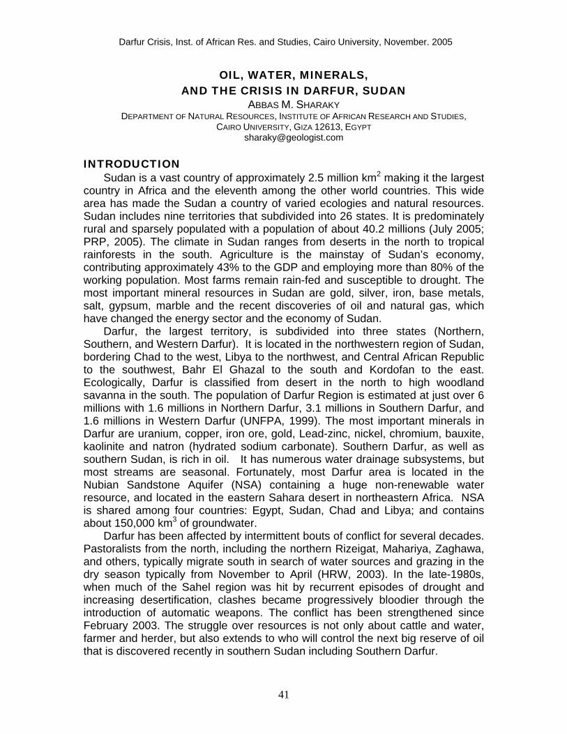
Geology of Darfur, as the whole country, is extremely diverse with a variety of metamorphic, igneous and sedimentary rocks. Precambrian basement
43
complex, including mostly igneous and metamorphic rocks, underlies horizontal and subhorizontal Phanerozoics sedimentary sequences in large parts of Northern Darfur, where extensive areas are covered by continental clastic sequences of the predominantly Mesozoic Nubian Series (Fig. 1). Western Darfur is mainly covered by a large area of Precambrian basement complex that extends westwards across the Chad border. The dominant rock types of the basement complex are granitic gneisses, quartzo-feldthpathic and rare calcareous or volcanic rocks. Wadi Howar basin, oriented NE-SW, is cutting the basement block in the northern part to Dongola. There are many post-orogenic granitic batholiths cutting the metamorphic rocks, in which quartz veins and pegmatites are developed in places and tin and wolfram mineralization occur (Cahen et al., 1984). Paleozoic sandstone rocks overlay the basement complex in some places in Darfur. The eastern part of Southern Darfur is characterized by Tertiary sedimentary rocks that extend and overlain the basement rocks westwards to Chad. They are holding oil as an extension of the oil fields of southern Sudan. The most famous geologic feature in Darfur is the range of high volcanic mountains including Jebel Marra. WATER RESOURCES IN DARFUR
Water resources in Darfur comprise rainfall, groundwater, and seasonal river flows. In Darfur especially in the north, water scarcity is one of the principal causes of tension. In general, Darfur has numerous water drainage subsystems, but most streams are seasonal. The duration and amount of rainfall increase from north to south in Darfur. Rainfall varies from year to year. This variation is crucial for rainfed farming. The watershed separating the basins of the Nile and Lake Chad runs north and south through the centre of Darfur. The mountains are scored by numerous khors that formerly contained large rivers flowing NE and E to the Nile, W and SW to Lake Chad, and S and SE to the Bahr El Ghazal. The streams running NE drain to the Wadi Melh, a dry river that joins the Nile near Debba, but on reaching the plain the water penetrates through sandy surface to groundwater. The torrents flowing directly east towards the Nile also disappear in the sandy deserts. The khors in the W, SW and S are the most fertile part of Darfur, which contain turbulent torrents in the rainy season when much of the southern district is flooded. Darfur has no perennial streams, but in times of heavy rainfall the waters of some khors reach the Bahr El Homr tributary of the Bahr El Ghazal that marks the southern frontier of the Southern Darfur. In the west and south, water can always be obtained in the dry season by digging 1 or 2 m below the surface in the khors. Another major old Nile tributary, which has been dry for perhaps three thousand years, once flowed from Chad through the Sahara and intersected the Nile near modern Dongola, Sudan. This ancient river system, called the Wadi Howar, kept the western desert of Sudan well watered thousands of years ago (Nubianet.org, 2004). It terminates into the Nile at Dongola.
44
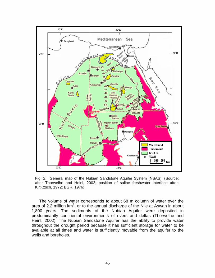
Darfur region is mostly located in the Nubian Sandstone Aquifer System that
covers about 2.2 million km2 and made of two similar geologic basins, Kufra in Libya and Dakhla in Egypt (Fig. 2). The aquifer is also extended into Chad. The groundwater volume of Nubian Sandstone Aquifer is estimated to be 150,000 km3 (Ambrogi, 1966). Gischler (1976) mentioned that the aquifer includes at least 60,000 km3. Based on updated subsurface data, the first estimate of 150,000 km3 is more reliable than the second one (Thorweihe and Heinl, 2002).
Fig. 1. Geologic map of Darfur territory (after Whiteman, 1971).
45
The volume of water corresponds to about 68 m column of water over the
area of 2.2 million km2, or to the annual discharge of the Nile at Aswan in about 1,800 years. The sediments of the Nubian Aquifer were deposited in predominantly continental environments of rivers and deltas (Thorweihe and Heinl, 2002). The Nubian Sandstone Aquifer has the ability to provide water throughout the drought period because it has sufficient storage for water to be available at all times and water is sufficiently movable from the aquifer to the wells and boreholes.
Fig. 2. General map of the Nubian Sandstone Aquifer System (NSAS). (Source: after Thorweihe and Heinl, 2002; position of saline freshwater interface after: KlitKzsch, 1972; BGR, 1976).

46
This is mostly governed by the transmissivity of the aquifer in Darfur, which increases from 100 m2/d south to 6,000 m2/d in the north. Groundwater level ranges from 500 m.a.s.l. in the Northern Darfur to 1,000 m.a.s.l. in Western and Southern Darfur. The aquifer north of Darfur highlands is utilized for drinking purposes at an annual rate of 6.74 million m2 (CEDARE and IFAD, 2001). The groundwater is probably recharged at rates less than 1 mm/yr, which is extremely slow. Since no appreciable groundwater recharge occurs in this region in modern climate conditions, this resource must be considered as non-renewable (fossil), similar to the situation for fossil fuels such as petroleum. The groundwater recharge from recent precipitation is only conceivable in the mountain areas or south of Wadi Howar (Sonntag, 1985).
The groundwater of Nubian Sandstone Aquifer at Jebel Uweinat, southern Egypt has 14C ages up to 20,000 years (Thorweihe and Heinl, 2002) when the climate of North Africa was humid and quite different from that of today. Groundwater in Nubian Sandstone Aquifer is usually good in quality with low total dissolved solids (salinity), often less than 100 mg/L and rarely exceeding 400 mg/L.
The frequency of drought has been increasing over the past 30 years, resulting in significant social, economic and environmental costs, with the poor bearing most of the cost. The global mean surface temperature has increased by 0.6ºC (04ºC to 0.8ºC) over the last century. Rainfall has been decreased by 3% on averaging over much of the subtropical land areas including central and northern Sudan. It has also been decreased by 30% in Darfur, 40% in northern Sudan and up to 50% in West Africa. Rainfall has been increased in other areas such as the coastal zone of Somalia and Tanzania by up to 20%.(Gitay et al., 2002).
Natural changes in climate associated with population increase (over 6 million people) accompanied by growing demands in Darfur, are projected the territory into water scarcity conditions. The Nubian Sandstone Aquifer can help in reducing the effect of lacking rainfall on the residents of Darfur. The Centre for Environment and Development for the Arab Region and Europe (CEDARE) and International Fund for Agricultural Development (IFAD) are developing a regional strategy for the sustainable utilization of the aquifer, to be adopted by the four sharing countries. This strategy will consider sustainability of the resource, as well as the development dimension in each country, based on current and future needs.
CRUDE OIL
Exploration activity began in Sudan at the end of the 1950s in the coastal waters of the Red Sea and Sudanese continental shelf. In the central region of Sudan, Cretaceous Rift Basins have oil fields that are relatively small, most lack adequate source rock and poor reservoir quality. Until future work reveals some encouraging data this area is considered to have some potential, but at a higher risk level. In the southern regions, where oil potential is very high, which is estimated in the range of 2-3 billion barrels.
47
The most important achievement of the development of the oil industry in Sudan was the construction of the 1,540 km export pipeline to Port Sudan. The pipeline was completed in August of 1999 and currently has the capacity to produce 280,000 barrels of oil per day. By adding additional pump stations, the maximum capacity of this line is expected to be 450,000 barrels of oil per day. The first export of crude oil from Sudan was in early September 1999 through the export pipeline.
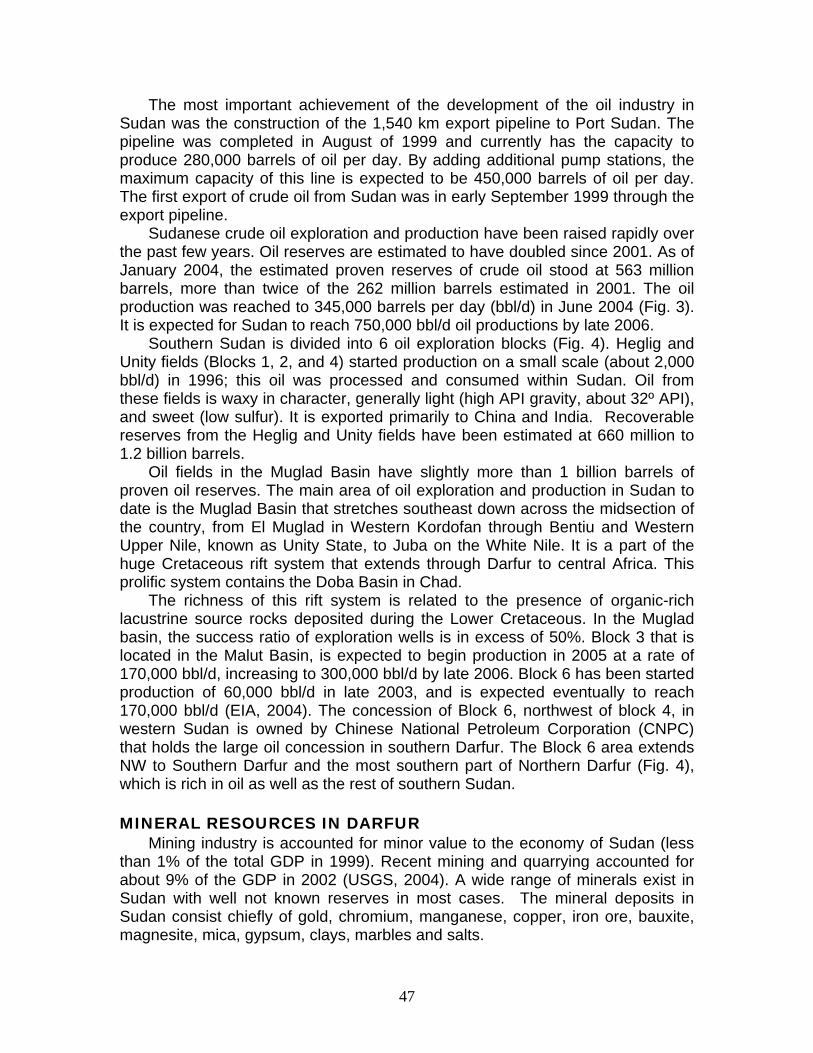
Sudanese crude oil exploration and production have been raised rapidly over the past few years. Oil reserves are estimated to have doubled since 2001. As of January 2004, the estimated proven reserves of crude oil stood at 563 million barrels, more than twice of the 262 million barrels estimated in 2001. The oil production was reached to 345,000 barrels per day (bbl/d) in June 2004 (Fig. 3). It is expected for Sudan to reach 750,000 bbl/d oil productions by late 2006.
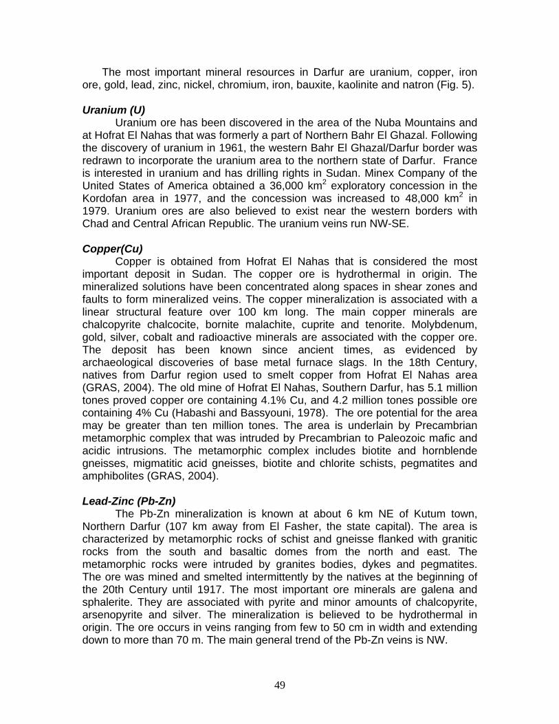
Southern Sudan is divided into 6 oil exploration blocks (Fig. 4). Heglig and Unity fields (Blocks 1, 2, and 4) started production on a small scale (about 2,000 bbl/d) in 1996; this oil was processed and consumed within Sudan. Oil from these fields is waxy in character, generally light (high API gravity, about 32º API), and sweet (low sulfur). It is exported primarily to China and India. Recoverable reserves from the Heglig and Unity fields have been estimated at 660 million to 1.2 billion barrels.
Oil fields in the Muglad Basin have slightly more than 1 billion barrels of proven oil reserves. The main area of oil exploration and production in Sudan to date is the Muglad Basin that stretches southeast down across the midsection of the country, from El Muglad in Western Kordofan through Bentiu and Western Upper Nile, known as Unity State, to Juba on the White Nile. It is a part of the huge Cretaceous rift system that extends through Darfur to central Africa. This prolific system contains the Doba Basin in Chad.
The richness of this rift system is related to the presence of organic-rich lacustrine source rocks deposited during the Lower Cretaceous. In the Muglad basin, the success ratio of exploration wells is in excess of 50%. Block 3 that is located in the Malut Basin, is expected to begin production in 2005 at a rate of 170,000 bbl/d, increasing to 300,000 bbl/d by late 2006. Block 6 has been started production of 60,000 bbl/d in late 2003, and is expected eventually to reach 170,000 bbl/d (EIA, 2004). The concession of Block 6, northwest of block 4, in western Sudan is owned by Chinese National Petroleum Corporation (CNPC) that holds the large oil concession in southern Darfur. The Block 6 area extends NW to Southern Darfur and the most southern part of Northern Darfur (Fig. 4), which is rich in oil as well as the rest of southern Sudan. MINERAL RESOURCES IN DARFUR
Mining industry is accounted for minor value to the economy of Sudan (less than 1% of the total GDP in 1999). Recent mining and quarrying accounted for about 9% of the GDP in 2002 (USGS, 2004). A wide range of minerals exist in Sudan with well not known reserves in most cases. The mineral deposits in Sudan consist chiefly of gold, chromium, manganese, copper, iron ore, bauxite, magnesite, mica, gypsum, clays, marbles and salts.

48
Fig. 3. Sudan's crude oil production from May 1999 to June 2004 (EIA, 2004).
DA
RF
UR
Fig. 4. Oil concessions in center and southern Sudan as of August 2002 (HRW, 2003).
Northern Darfur
Western Darfur
Southern Darfur
49
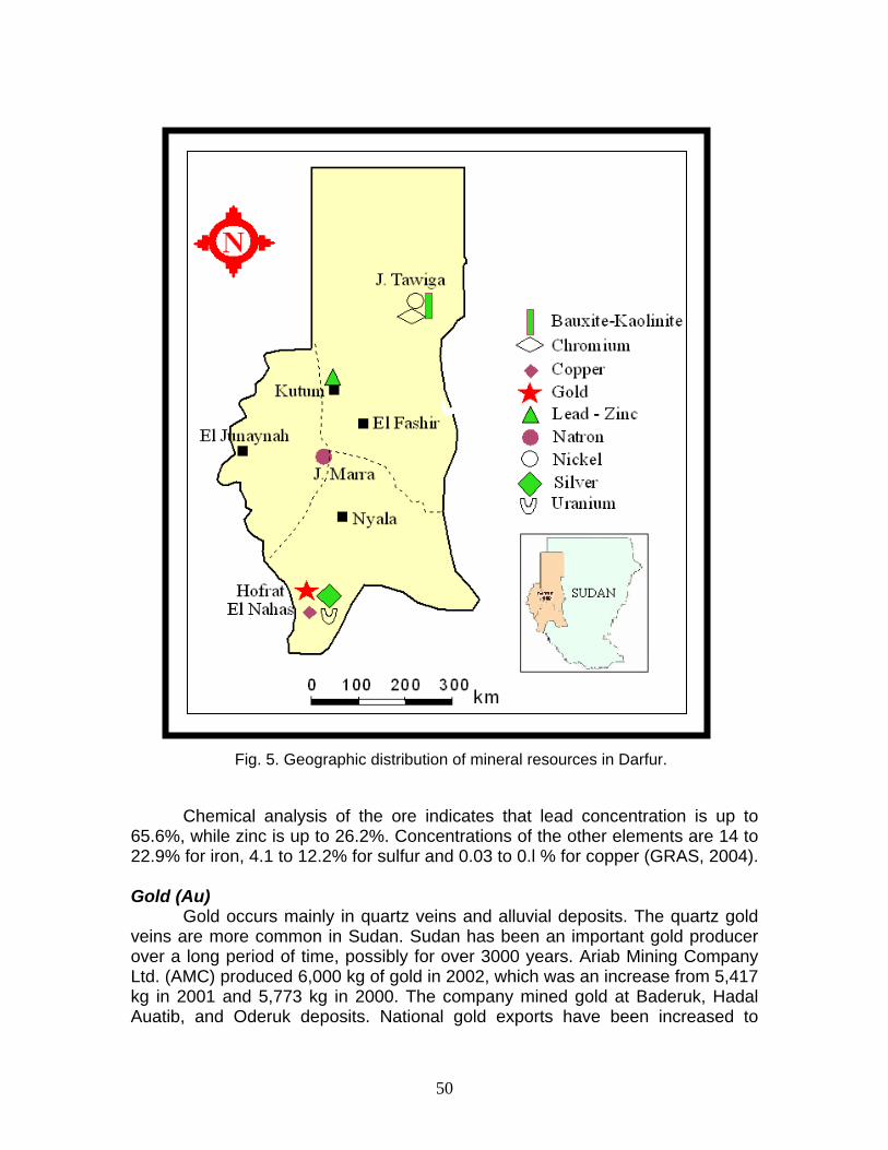
The most important mineral resources in Darfur are uranium, copper, iron ore, gold, lead, zinc, nickel, chromium, iron, bauxite, kaolinite and natron (Fig. 5). Uranium (U)
Uranium ore has been discovered in the area of the Nuba Mountains and at Hofrat El Nahas that was formerly a part of Northern Bahr El Ghazal. Following the discovery of uranium in 1961, the western Bahr El Ghazal/Darfur border was redrawn to incorporate the uranium area to the northern state of Darfur. France is interested in uranium and has drilling rights in Sudan. Minex Company of the United States of America obtained a 36,000 km2 exploratory concession in the Kordofan area in 1977, and the concession was increased to 48,000 km2 in 1979. Uranium ores are also believed to exist near the western borders with Chad and Central African Republic. The uranium veins run NW-SE.
Copper(Cu)
Copper is obtained from Hofrat El Nahas that is considered the most important deposit in Sudan. The copper ore is hydrothermal in origin. The mineralized solutions have been concentrated along spaces in shear zones and faults to form mineralized veins. The copper mineralization is associated with a linear structural feature over 100 km long. The main copper minerals are chalcopyrite chalcocite, bornite malachite, cuprite and tenorite. Molybdenum, gold, silver, cobalt and radioactive minerals are associated with the copper ore. The deposit has been known since ancient times, as evidenced by archaeological discoveries of base metal furnace slags. In the 18th Century, natives from Darfur region used to smelt copper from Hofrat El Nahas area (GRAS, 2004). The old mine of Hofrat El Nahas, Southern Darfur, has 5.1 million tones proved copper ore containing 4.1% Cu, and 4.2 million tones possible ore containing 4% Cu (Habashi and Bassyouni, 1978). The ore potential for the area may be greater than ten million tones. The area is underlain by Precambrian metamorphic complex that was intruded by Precambrian to Paleozoic mafic and acidic intrusions. The metamorphic complex includes biotite and hornblende gneisses, migmatitic acid gneisses, biotite and chlorite schists, pegmatites and amphibolites (GRAS, 2004). Lead-Zinc (Pb-Zn)
The Pb-Zn mineralization is known at about 6 km NE of Kutum town, Northern Darfur (107 km away from El Fasher, the state capital). The area is characterized by metamorphic rocks of schist and gneisse flanked with granitic rocks from the south and basaltic domes from the north and east. The metamorphic rocks were intruded by granites bodies, dykes and pegmatites. The ore was mined and smelted intermittently by the natives at the beginning of the 20th Century until 1917. The most important ore minerals are galena and sphalerite. They are associated with pyrite and minor amounts of chalcopyrite, arsenopyrite and silver. The mineralization is believed to be hydrothermal in origin. The ore occurs in veins ranging from few to 50 cm in width and extending down to more than 70 m. The main general trend of the Pb-Zn veins is NW.
50
Chemical analysis of the ore indicates that lead concentration is up to 65.6%, while zinc is up to 26.2%. Concentrations of the other elements are 14 to 22.9% for iron, 4.1 to 12.2% for sulfur and 0.03 to 0.l % for copper (GRAS, 2004). Gold (Au)
Gold occurs mainly in quartz veins and alluvial deposits. The quartz gold veins are more common in Sudan. Sudan has been an important gold producer over a long period of time, possibly for over 3000 years. Ariab Mining Company Ltd. (AMC) produced 6,000 kg of gold in 2002, which was an increase from 5,417 kg in 2001 and 5,773 kg in 2000. The company mined gold at Baderuk, Hadal Auatib, and Oderuk deposits. National gold exports have been increased to
Fig. 5. Geographic distribution of mineral resources in Darfur.
51
8,660 kg in 2002 from 6,833 kg in 2001 and 8,452 kg in 2000. In addition to the gold produced and exported by AMC and Sudanese artisanal miners, some Ethiopia’s artisanal gold output was reported to be smuggled through Sudan (Tribune, 2003; Bank of Sudan, undated; from USGS 2004). Sudan consists of typical Precambrian continental craton of granite-gneiss terrain with occasional long narrow greenstone belts. In Sudan, the gold deposits occur in the greenstone belts that consist of basic and ultra basic rocks (ophiolites). The most famous gold mines in Sudan occur along the Red Sea Hills and in the Northern Province. Some gold deposits were found in Hofrat El Nahas, Southern Darfur, where the gold was deposited in quartz veins. Gold occurs in primary sulfide zones (estimated reserves are 10 million tones of gold ore), which has been enriched in the oxide zone. The grade of gold is 1 to 3 g/t increased to 10 g/t in some surface samples. Chromium (Cr)
Podiform chromite occurrences were first reported in Sudan early in the 1930s. Small-scale mining of the ore has been in progress since the 1950s. Sudan produced about 48,000 tones of chromite in 2002 from Ingessana Hills by Ingessana Hills Mines Corp. (a state-owned company). Resources were estimated to be 2 million tones at a grade of 54% chromium oxide. Ophiolites, the mantle sequences, contain numerous pods of chromite that occurs in Jebel Rahib area, Northern Darfur. Chromite ore is dominated by a low-grade sequence of rift-type sediments with a complete, but dismembered Late Proterozoic ophiolite complex. It is very compact, massive and coarse-grained with average 55% Cr2O3.
Nickel (Ni)
Nickel deposits in Darfur are classified as lateritic deposits. Nickel occurs in Jebel Tawiga-Tageru area, Northern Darfur. Concentration of nickel is up to 4,000 ppm (0.4%) in the laterite (Wipki, 2004). The area is characterized by low-grade metasediments and metavolcanics that lateratized in Late Proterozoic. Iron (Fe)
Iron ore is widely spread in Sudan especially in the Red Sea Hills, Kordofan, Darfur and the ironstone plateau of southern Sudan. It occurs mainly in the basement complexes and laterites in the tropical areas. Iron in Darfur occurs in Jebel Barberi that contains about 10 million tones of iron ore at 51% iron content. Kaolinite and Bauxite
Bauxite is the main source for aluminum. Kaolinite and Bauxite were discovered in Jebel Tawiga area, 440 km north of El Fashir, Northern Darfur in the 1980s. Warm and humid climates during Early Paleozoic formed favorable climatic conditions to form a deep weathering crust of about 25 m in thickness. The weathered crust was preserved in situ on top of metabasalts in Jebel Tawiga. The weathering crust covers an area of about 1,000 km2 and reaches

52
thickness of about 25 m. The weathering profile consists of a thick kaolinitic saprolite covered by 2–10 m of laterite. The laterite is mostly hard and dense. The main mineral composition is kaolinite, boehmite, gibbsite, minor diaspore, hematite, anatase, rutile and aluminum phosphate minerals. The bauxite minerals (boehmite, gibbsite, diaspore) are partly altered to kaolinite. The average concentration of boehmite and gibbsite in the laterite ranges between less than 4% and 30% (Wipki, 2004).
Gypsum
Sudan produced 2,422 tones of gypsum in 2001, which was a decrease from 13,808 tones in 2000 and 11,144 tones in 1999. Gypsum mainly occurs along the Red Sea coast at Bir Eit, Jebel Saghum and Jabel Tobanam. It forms a 25 km North-South trending discontinuous belts located 5 to 9 km inland from the Red Sea cost north of Port Sudan. The gypsum deposits are typical Miocene evaporates. These Miocene sediments unconformably overlie the Precambrian basement rocks and are further overlain by gravels and superficial deposits. Chemical analysis of composite ore samples recorded average grade of 94.95% (CaS)4·H2O with minor impurities. Gypsum occurs also in Southern Darfur. Natron
Natron is hydrated sodium carbonate formed by evaporation of water formed in volcanic or crater lakes in the mountain areas in Darfur such as Jebel Marra that erupted carbonates of sodium (Na2CO3) and calcium (CaCO3). SUMMARY AND CONCLUSIONS:
Darfur, the largest territory in Sudan, is classified ecologically into four zones from the north to south: desert, semi-desert, low woodland savanna and high woodland savanna. Jebel Marra, the highest peak in Sudan, is one of the most distinct topographic features in the state. Darfur has oil that have been discovered recently, and mineral resources such as uranium, copper, iron ore, gold, lead-zinc, nickel, chromium, bauxite, kaolinite and natron (hydrated sodium carbonate. Water resources in Darfur comprise rainfall, groundwater, and seasonal river flows. Darfur has been affected by intermittent bouts of conflict for several decades. It has had some natural disasters because of low rainfall and continuous desert expansion from north to south, which threatens pastoral and agricultural areas. One of the causes of conflicts in Darfur is the migration of the people who are forced to move southwards during drought periods. This migration led to add more pressure on water and grazing resources. That was happening for several centuries without reaching the point of crisis. Drilling some groundwater wells in the north and center regions may reduce the effect of lacking rainfall. Mineral resources except oil are not numerous to cause the present crisis. At present, the struggle over resources is not about cattle and water, farmer and herder; but it extended beyond those to gain control over the big oil resources that have been recently discovered in Southern Darfur. More geologic studies are needed to help in developing the Darfur territory and minimize the conflicts.
53
REFERENCES
AMBROGGI, R.P., 1966, Water under the Sahara, Scientific American, 214, 21-29, New York.
BANK OF SUDAN, undated, Annual report 2001—Agricultural and industrial production. URL:
http://www.bankofsudan.org/english/Periodicals/annual01e/chap4e01.htm. BGR, BUNDESANSTALT FÜR GEOWISSENSCHAFTEN UND ROHSTOFFE,
1976, Water Resources and Soil Potential Development in the New Valley/Egypt.- Mission Report, Vol. II, unpublished report of Bundesanstalt für Geowissenschaften und Rohstoffe, Geographisches Institut der Universität Würzburg, Salzgitter Consult GmbH, Hannover.
CAHEN, L., SNELLING, N.J., DELHAL, J., VAIL, J.R., BONHOMME, M. AND LEDENT, D., 1984, The geochronology and evolution of Africa, Clarendon Press., Oxford, 512 p.
CATTERSON, T., EJIGU, M., DOKA, M., EMILIO, J.T. AND LUKE IPOTO OJOK, L.I., 2003, Environmental threats and opertunities assessment, USAID integration strategic plan in the Sudan 2003 – 2005, Washington, 146p.
CEDARE and IFAD, 2001, Regional strategy for the utilization of the Nubian Sandstone Aquifer System, Executive Summary, v.1., 64p.
EIA, 2004, ENERGY INFORMATION ADMINISTRATION (EIA), Country analysis briefs- Africa. URL: www.eia.doe.gov
GISCHLER, C.E., 1976, Present and future trends in water resources development in Arab countries. UNESCO report.
GITAY, H., SUAREZ, A., WATSON, R.T., and Dokken, D.J., eds., 2002, Climatic change and biodiversity, UNEP, 77p.
GRAS, 2004, THE GEOLOGICAL RESEARCH AUTHORITY OF THE SUDAN (GRAS), URL: http://www.gras-sd.com
HABASHI, F., AND BASSYOUNI, F.A., 1978, Mineral resources of the Arab countries, Laval Univ., Quebec, Canada, 128p.
HRW, 2003, HUMAN RIGHTS WATCH: Sudan, Oil, and Human Rights, Washington, D.C., 467p. URL: http://www.hrw.org
KLITZSCH, E., 1972, Salinität und Herkunft des Grundwassers im mittleren Nordafrika.- Geol. Jb., C2, 251-260, Hannover.
PRB, 2005, POPULATION REFERENCE BUREAU, World Population Data Sheet of the Population Reference Bureau: Demographic Data and Estimates for the Countries and Regions of the World 2005 URL: www.prb.org/
SONNTAG, C., 1985, Ein zeitabhängiges Modell der Paläowässer in der Ostsahara aufgrund von Isotopendaten.- Unpublished thesis, TU Berlin, 91 p.
THORWEIHE, U AND HEINL, M., 2002, Groundwater Resources of the Nubian Aquifer System, NE-Africa, Technical University of Berlin, 24p.
TRIBUNE, A., 2003, Saving country’s gold, URL: http://allafrica.com/stories/printable/200304040725.html.

54
UNFPA, 1999, GOVERNMENT OF SUDAN: Central Bureau for Statistics and the Federal Ministry of Health, Safe Motherhood Survey.
USGS, 2004, UNITED STATES GEOLOGICAL SURVEY OF AMERICA, URL: http://minerals.usgs.gov/minerals/pubs/country/africa.html WIPKI, M., 1995, Eigenschaften, Verbreitung und Entstehung von
Kaolinlagerstätten im Nordsudan.- 213 S., Dissertation, Berlin , Verlag: Dr. Köster.
WHITEMAN, A.J., 1971, Structural geology of Sudan, in: UNESCO, 1971, Tectonics of Africa, pp. 433-445.