Ogden Valley General Plan Recreation Element - Envision Utah
180
Ogden Valley General Plan Recreation Element OCTOBER 2005 Weber County, Utah
-
Upload
khangminh22 -
Category
Documents
-
view
1 -
download
0
Transcript of Ogden Valley General Plan Recreation Element - Envision Utah
Ogden Valley General Plan Recreation Element
OCTOBER 2005
Weber County, Utah
TABLE OF CONTENTS
Recreation Element
vii
TABLE OF CONTENTSCHAPTER 1: INTRODUCTION . . . . . . . . . . . . . . . . . . . . . . . . . . . . . . . . . . . . . . . . . . 1
Project Purpose . . . . . . . . . . . . . . . . . . . . . . . . . . . . . . . . . . . . . . . . . . . . . . . . . . . 2Planning Background . . . . . . . . . . . . . . . . . . . . . . . . . . . . . . . . . . . . . . . . . . . . . . 3Ogden Valley Vision Statement . . . . . . . . . . . . . . . . . . . . . . . . . . . . . . . . . . . . . . . 5Relevant General Plan Goals and Objectives . . . . . . . . . . . . . . . . . . . . . . . . . . . . . 7
OVGP Goal: Enhance Quality Recreational Opportunities . . . . . . . . . . . . 7Document Overview . . . . . . . . . . . . . . . . . . . . . . . . . . . . . . . . . . . . . . . . . . . . . . . 8
CHAPTER 2: LAND USE AND ZONING ANALYSIS . . . . . . . . . . . . . . . . . . . . . . . . . . . 9
Land Use and Development Assessment . . . . . . . . . . . . . . . . . . . . . . . . . . . . . . . 10Ogden Valley’s Development Potential . . . . . . . . . . . . . . . . . . . . . . . . . . . . . . . . 19
Current Conditions . . . . . . . . . . . . . . . . . . . . . . . . . . . . . . . . . . . . . . . . . . 19Higher Development Intensities through Clustering . . . . . . . . . . . . . . . . . . 21Summary of Ogden Valley’s Development Potential . . . . . . . . . . . . . . . . . 26
Powder Mountain Resort Development Analysis . . . . . . . . . . . . . . . . . . . . . . . . . 27Resort Land Ownership . . . . . . . . . . . . . . . . . . . . . . . . . . . . . . . . . . . . . . 27Development Constraint Assessment . . . . . . . . . . . . . . . . . . . . . . . . . . . . 30Resort Development Potential . . . . . . . . . . . . . . . . . . . . . . . . . . . . . . . . . . 31Summary of Development Potential at Powder Mountain Resort . . . . . . . 34
Snowbasin Resort Development Analysis . . . . . . . . . . . . . . . . . . . . . . . . . . . . . . 34Development Constraint Assessment . . . . . . . . . . . . . . . . . . . . . . . . . . . . 36Resort Development Potential . . . . . . . . . . . . . . . . . . . . . . . . . . . . . . . . . . 38Summary of Development Potential at Snowbasin Resort . . . . . . . . . . . . . 40
Nordic Valley Resort Development Analysis . . . . . . . . . . . . . . . . . . . . . . . . . . . . 40Development Constraint Assessment . . . . . . . . . . . . . . . . . . . . . . . . . . . . 41Resort Development Potential . . . . . . . . . . . . . . . . . . . . . . . . . . . . . . . . . . 43Summary of Development Potential at Nordic Valley Resort . . . . . . . . . . . 44
CHAPTER 3: RECREATION ANALYSIS . . . . . . . . . . . . . . . . . . . . . . . . . . . . . . . . . . . 45
Community-Oriented Recreational Facilities and Resources . . . . . . . . . . . . . . . . . 45Public and Private Recreational Facilities and Resources . . . . . . . . . . . . . . . . . . . 52
Forest Recreation . . . . . . . . . . . . . . . . . . . . . . . . . . . . . . . . . . . . . . . . . . . 54Pineview Reservoir . . . . . . . . . . . . . . . . . . . . . . . . . . . . . . . . . . . . . . . . . . 56Trails - Hiking, Biking, and Equestrian . . . . . . . . . . . . . . . . . . . . . . . . . . . 57Fishing . . . . . . . . . . . . . . . . . . . . . . . . . . . . . . . . . . . . . . . . . . . . . . . . . . . 58Hunting . . . . . . . . . . . . . . . . . . . . . . . . . . . . . . . . . . . . . . . . . . . . . . . . . . 58Camping . . . . . . . . . . . . . . . . . . . . . . . . . . . . . . . . . . . . . . . . . . . . . . . . . . 59Climbing . . . . . . . . . . . . . . . . . . . . . . . . . . . . . . . . . . . . . . . . . . . . . . . . . . 60
TABLE OF CONTENTS
Ogden Valley General Plan
viii
Scenic Driving . . . . . . . . . . . . . . . . . . . . . . . . . . . . . . . . . . . . . . . . . . . . . 60Golf . . . . . . . . . . . . . . . . . . . . . . . . . . . . . . . . . . . . . . . . . . . . . . . . . . . . . 61Snow Skiing . . . . . . . . . . . . . . . . . . . . . . . . . . . . . . . . . . . . . . . . . . . . . . 61Snowmobiling . . . . . . . . . . . . . . . . . . . . . . . . . . . . . . . . . . . . . . . . . . . . . 62
Tourism Visitation . . . . . . . . . . . . . . . . . . . . . . . . . . . . . . . . . . . . . . . . . . . . . . . 63
CHAPTER 4: ENVIRONMENTAL RESOURCES ANALYSIS . . . . . . . . . . . . . . . . . . . 69
Natural Resources . . . . . . . . . . . . . . . . . . . . . . . . . . . . . . . . . . . . . . . . . . . . . . . . 70Soil Resources . . . . . . . . . . . . . . . . . . . . . . . . . . . . . . . . . . . . . . . . . . . . . 70Water Resources . . . . . . . . . . . . . . . . . . . . . . . . . . . . . . . . . . . . . . . . . . . 71Vegetation Resources . . . . . . . . . . . . . . . . . . . . . . . . . . . . . . . . . . . . . . . . 72Wildlife Resources . . . . . . . . . . . . . . . . . . . . . . . . . . . . . . . . . . . . . . . . . . 73
Environmental Constraints . . . . . . . . . . . . . . . . . . . . . . . . . . . . . . . . . . . . . . . . . 73Steep Slopes . . . . . . . . . . . . . . . . . . . . . . . . . . . . . . . . . . . . . . . . . . . . . . 73Geologic Hazards . . . . . . . . . . . . . . . . . . . . . . . . . . . . . . . . . . . . . . . . . . 75Stream Corridors and Wetlands . . . . . . . . . . . . . . . . . . . . . . . . . . . . . . . . 76Floodplains . . . . . . . . . . . . . . . . . . . . . . . . . . . . . . . . . . . . . . . . . . . . . . . 76Essential Wildlife Habitat . . . . . . . . . . . . . . . . . . . . . . . . . . . . . . . . . . . . . 77Scenic Corridors . . . . . . . . . . . . . . . . . . . . . . . . . . . . . . . . . . . . . . . . . . . 78Agricultural Lands . . . . . . . . . . . . . . . . . . . . . . . . . . . . . . . . . . . . . . . . . . 78
Development Suitability Analysis . . . . . . . . . . . . . . . . . . . . . . . . . . . . . . . . . . . . 79Sensitive Lands Ordinance . . . . . . . . . . . . . . . . . . . . . . . . . . . . . . . . . . . . . . . . . 80
CHAPTER 5: TRANSPORTATION ANALYSIS . . . . . . . . . . . . . . . . . . . . . . . . . . . . . 81
Existing Roads and Their Capacities . . . . . . . . . . . . . . . . . . . . . . . . . . . . . . . . . . 82Ogden Canyon Road (SR-39) . . . . . . . . . . . . . . . . . . . . . . . . . . . . . . . . . 82New Trappers Loop (SR-167) . . . . . . . . . . . . . . . . . . . . . . . . . . . . . . . . . 83North Ogden Divide (Weber County 3464) . . . . . . . . . . . . . . . . . . . . . . . 83SR-39 . . . . . . . . . . . . . . . . . . . . . . . . . . . . . . . . . . . . . . . . . . . . . . . . . . . 84SR-158 . . . . . . . . . . . . . . . . . . . . . . . . . . . . . . . . . . . . . . . . . . . . . . . . . . 84Huntsville to Eden Roads (Weber County 3468) . . . . . . . . . . . . . . . . . . . 85Eden to Liberty Roads (Weber County 3464) . . . . . . . . . . . . . . . . . . . . . 86Avon Divide Road . . . . . . . . . . . . . . . . . . . . . . . . . . . . . . . . . . . . . . . . . . 87
Existing Levels of Service (LOS) . . . . . . . . . . . . . . . . . . . . . . . . . . . . . . . . . . . . . 87Existing Transportation Improvement Projects . . . . . . . . . . . . . . . . . . . . . . . . . . 90Recommended Transportation Improvement Projects . . . . . . . . . . . . . . . . . . . . . 90Potential Revenue Sources for Transportation Improvement Projects . . . . . . . . . 91
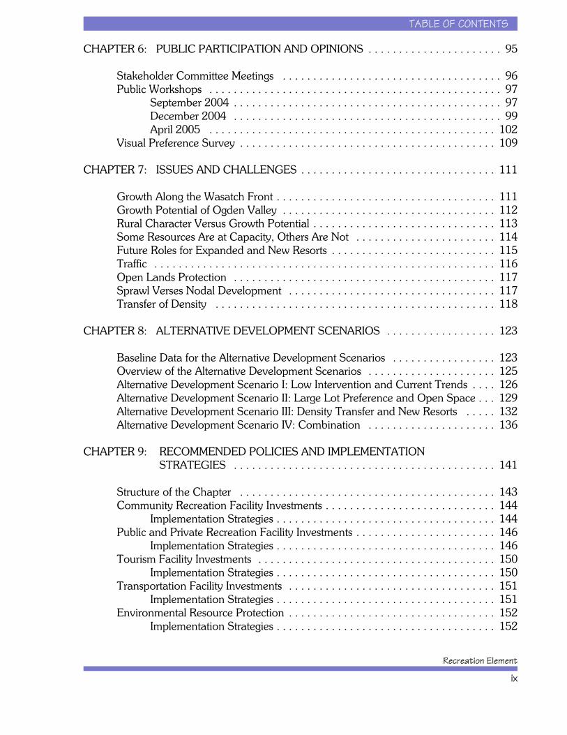
TABLE OF CONTENTS
Recreation Element
ix
CHAPTER 6: PUBLIC PARTICIPATION AND OPINIONS . . . . . . . . . . . . . . . . . . . . . . 95
Stakeholder Committee Meetings . . . . . . . . . . . . . . . . . . . . . . . . . . . . . . . . . . . . 96Public Workshops . . . . . . . . . . . . . . . . . . . . . . . . . . . . . . . . . . . . . . . . . . . . . . . . 97
September 2004 . . . . . . . . . . . . . . . . . . . . . . . . . . . . . . . . . . . . . . . . . . . . 97December 2004 . . . . . . . . . . . . . . . . . . . . . . . . . . . . . . . . . . . . . . . . . . . . 99April 2005 . . . . . . . . . . . . . . . . . . . . . . . . . . . . . . . . . . . . . . . . . . . . . . . 102
Visual Preference Survey . . . . . . . . . . . . . . . . . . . . . . . . . . . . . . . . . . . . . . . . . . 109
CHAPTER 7: ISSUES AND CHALLENGES . . . . . . . . . . . . . . . . . . . . . . . . . . . . . . . . 111
Growth Along the Wasatch Front . . . . . . . . . . . . . . . . . . . . . . . . . . . . . . . . . . . . 111Growth Potential of Ogden Valley . . . . . . . . . . . . . . . . . . . . . . . . . . . . . . . . . . . 112Rural Character Versus Growth Potential . . . . . . . . . . . . . . . . . . . . . . . . . . . . . . 113Some Resources Are at Capacity, Others Are Not . . . . . . . . . . . . . . . . . . . . . . . 114Future Roles for Expanded and New Resorts . . . . . . . . . . . . . . . . . . . . . . . . . . . 115Traffic . . . . . . . . . . . . . . . . . . . . . . . . . . . . . . . . . . . . . . . . . . . . . . . . . . . . . . . . 116Open Lands Protection . . . . . . . . . . . . . . . . . . . . . . . . . . . . . . . . . . . . . . . . . . . 117Sprawl Verses Nodal Development . . . . . . . . . . . . . . . . . . . . . . . . . . . . . . . . . . 117Transfer of Density . . . . . . . . . . . . . . . . . . . . . . . . . . . . . . . . . . . . . . . . . . . . . . 118
CHAPTER 8: ALTERNATIVE DEVELOPMENT SCENARIOS . . . . . . . . . . . . . . . . . . 123
Baseline Data for the Alternative Development Scenarios . . . . . . . . . . . . . . . . . 123Overview of the Alternative Development Scenarios . . . . . . . . . . . . . . . . . . . . . 125Alternative Development Scenario I: Low Intervention and Current Trends . . . . 126Alternative Development Scenario II: Large Lot Preference and Open Space . . . 129Alternative Development Scenario III: Density Transfer and New Resorts . . . . . 132Alternative Development Scenario IV: Combination . . . . . . . . . . . . . . . . . . . . . 136
CHAPTER 9: RECOMMENDED POLICIES AND IMPLEMENTATION STRATEGIES . . . . . . . . . . . . . . . . . . . . . . . . . . . . . . . . . . . . . . . . . . . 141
Structure of the Chapter . . . . . . . . . . . . . . . . . . . . . . . . . . . . . . . . . . . . . . . . . . 143Community Recreation Facility Investments . . . . . . . . . . . . . . . . . . . . . . . . . . . . 144
Implementation Strategies . . . . . . . . . . . . . . . . . . . . . . . . . . . . . . . . . . . . 144Public and Private Recreation Facility Investments . . . . . . . . . . . . . . . . . . . . . . . 146
Implementation Strategies . . . . . . . . . . . . . . . . . . . . . . . . . . . . . . . . . . . . 146Tourism Facility Investments . . . . . . . . . . . . . . . . . . . . . . . . . . . . . . . . . . . . . . . 150
Implementation Strategies . . . . . . . . . . . . . . . . . . . . . . . . . . . . . . . . . . . . 150Transportation Facility Investments . . . . . . . . . . . . . . . . . . . . . . . . . . . . . . . . . . 151
Implementation Strategies . . . . . . . . . . . . . . . . . . . . . . . . . . . . . . . . . . . . 151Environmental Resource Protection . . . . . . . . . . . . . . . . . . . . . . . . . . . . . . . . . . 152
Implementation Strategies . . . . . . . . . . . . . . . . . . . . . . . . . . . . . . . . . . . . 152
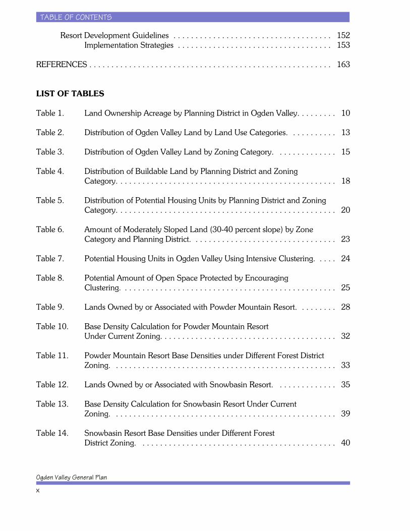
TABLE OF CONTENTS
Ogden Valley General Plan
x
Resort Development Guidelines . . . . . . . . . . . . . . . . . . . . . . . . . . . . . . . . . . . . 152Implementation Strategies . . . . . . . . . . . . . . . . . . . . . . . . . . . . . . . . . . . 153
REFERENCES . . . . . . . . . . . . . . . . . . . . . . . . . . . . . . . . . . . . . . . . . . . . . . . . . . . . . . . 163
LIST OF TABLES
Table 1. Land Ownership Acreage by Planning District in Ogden Valley. . . . . . . . . 10
Table 2. Distribution of Ogden Valley Land by Land Use Categories. . . . . . . . . . . 13
Table 3. Distribution of Ogden Valley Land by Zoning Category. . . . . . . . . . . . . . 15
Table 4. Distribution of Buildable Land by Planning District and Zoning Category. . . . . . . . . . . . . . . . . . . . . . . . . . . . . . . . . . . . . . . . . . . . . . . . . . 18
Table 5. Distribution of Potential Housing Units by Planning District and ZoningCategory. . . . . . . . . . . . . . . . . . . . . . . . . . . . . . . . . . . . . . . . . . . . . . . . . . 20
Table 6. Amount of Moderately Sloped Land (30-40 percent slope) by Zone Category and Planning District. . . . . . . . . . . . . . . . . . . . . . . . . . . . . . . . . 23
Table 7. Potential Housing Units in Ogden Valley Using Intensive Clustering. . . . . 24
Table 8. Potential Amount of Open Space Protected by Encouraging Clustering. . . . . . . . . . . . . . . . . . . . . . . . . . . . . . . . . . . . . . . . . . . . . . . . . 25
Table 9. Lands Owned by or Associated with Powder Mountain Resort. . . . . . . . . 28
Table 10. Base Density Calculation for Powder Mountain Resort Under Current Zoning. . . . . . . . . . . . . . . . . . . . . . . . . . . . . . . . . . . . . . . . 32
Table 11. Powder Mountain Resort Base Densities under Different Forest DistrictZoning. . . . . . . . . . . . . . . . . . . . . . . . . . . . . . . . . . . . . . . . . . . . . . . . . . . 33
Table 12. Lands Owned by or Associated with Snowbasin Resort. . . . . . . . . . . . . . 35
Table 13. Base Density Calculation for Snowbasin Resort Under Current Zoning. . . . . . . . . . . . . . . . . . . . . . . . . . . . . . . . . . . . . . . . . . . . . . . . . . . 39
Table 14. Snowbasin Resort Base Densities under Different Forest District Zoning. . . . . . . . . . . . . . . . . . . . . . . . . . . . . . . . . . . . . . . . . . . . . 40
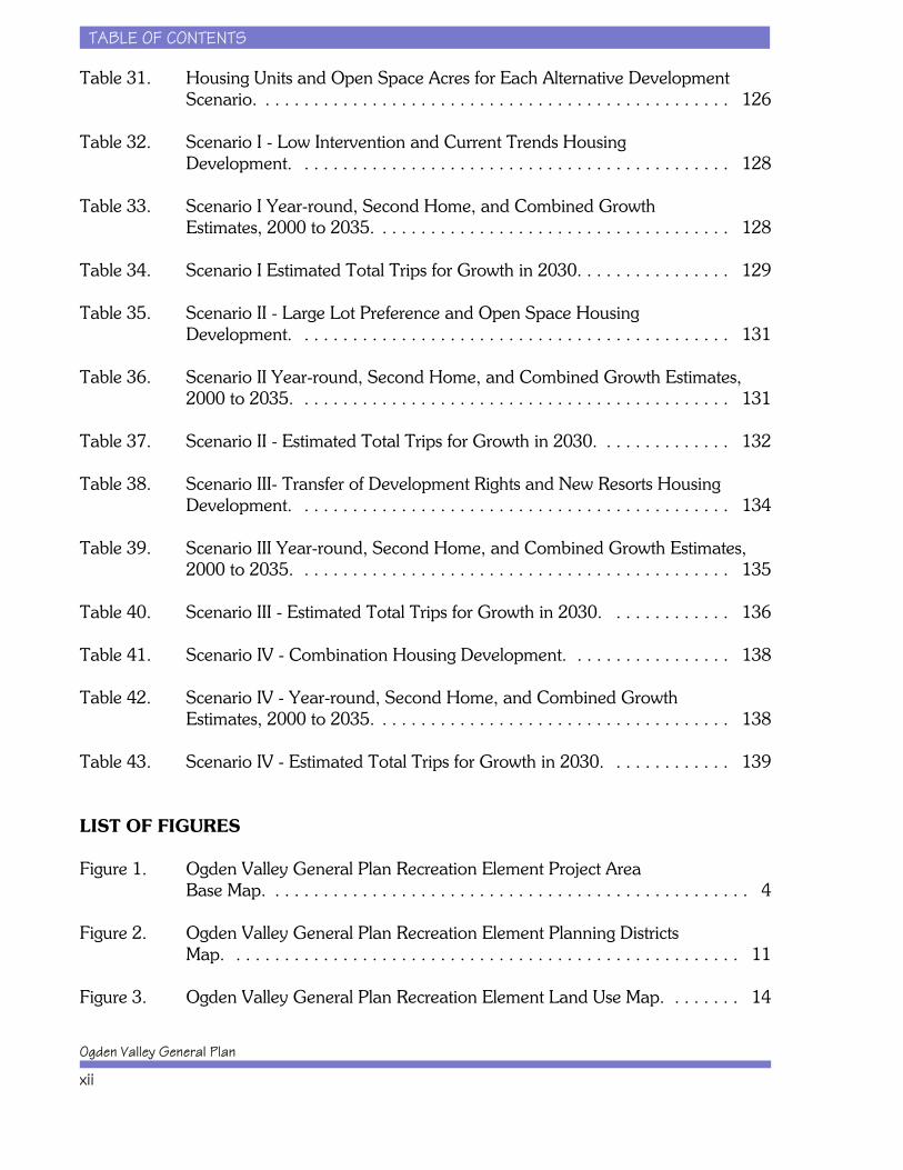
TABLE OF CONTENTS
Ogden Valley General Plan
xii
Table 31. Housing Units and Open Space Acres for Each Alternative DevelopmentScenario. . . . . . . . . . . . . . . . . . . . . . . . . . . . . . . . . . . . . . . . . . . . . . . . . 126
Table 32. Scenario I - Low Intervention and Current Trends Housing Development. . . . . . . . . . . . . . . . . . . . . . . . . . . . . . . . . . . . . . . . . . . . . 128
Table 33. Scenario I Year-round, Second Home, and Combined Growth Estimates, 2000 to 2035. . . . . . . . . . . . . . . . . . . . . . . . . . . . . . . . . . . . . 128
Table 34. Scenario I Estimated Total Trips for Growth in 2030. . . . . . . . . . . . . . . . 129
Table 35. Scenario II - Large Lot Preference and Open Space Housing Development. . . . . . . . . . . . . . . . . . . . . . . . . . . . . . . . . . . . . . . . . . . . . 131
Table 36. Scenario II Year-round, Second Home, and Combined Growth Estimates,2000 to 2035. . . . . . . . . . . . . . . . . . . . . . . . . . . . . . . . . . . . . . . . . . . . . 131
Table 37. Scenario II - Estimated Total Trips for Growth in 2030. . . . . . . . . . . . . . 132
Table 38. Scenario III- Transfer of Development Rights and New Resorts HousingDevelopment. . . . . . . . . . . . . . . . . . . . . . . . . . . . . . . . . . . . . . . . . . . . . 134
Table 39. Scenario III Year-round, Second Home, and Combined Growth Estimates,2000 to 2035. . . . . . . . . . . . . . . . . . . . . . . . . . . . . . . . . . . . . . . . . . . . . 135
Table 40. Scenario III - Estimated Total Trips for Growth in 2030. . . . . . . . . . . . . 136
Table 41. Scenario IV - Combination Housing Development. . . . . . . . . . . . . . . . . 138
Table 42. Scenario IV - Year-round, Second Home, and Combined Growth Estimates, 2000 to 2035. . . . . . . . . . . . . . . . . . . . . . . . . . . . . . . . . . . . . 138
Table 43. Scenario IV - Estimated Total Trips for Growth in 2030. . . . . . . . . . . . . 139
LIST OF FIGURES
Figure 1. Ogden Valley General Plan Recreation Element Project Area Base Map. . . . . . . . . . . . . . . . . . . . . . . . . . . . . . . . . . . . . . . . . . . . . . . . . . 4
Figure 2. Ogden Valley General Plan Recreation Element Planning Districts Map. . . . . . . . . . . . . . . . . . . . . . . . . . . . . . . . . . . . . . . . . . . . . . . . . . . . . 11
Figure 3. Ogden Valley General Plan Recreation Element Land Use Map. . . . . . . . 14
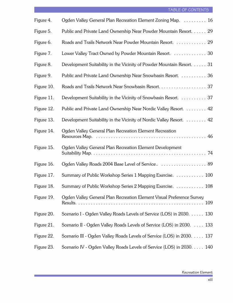
TABLE OF CONTENTS
Recreation Element
xiii
Figure 4. Ogden Valley General Plan Recreation Element Zoning Map. . . . . . . . . . 16
Figure 5. Public and Private Land Ownership Near Powder Mountain Resort. . . . . . 29
Figure 6. Roads and Trails Network Near Powder Mountain Resort. . . . . . . . . . . . . 29
Figure 7. Lower Valley Tract Owned by Powder Mountain Resort. . . . . . . . . . . . . . 30
Figure 8. Development Suitability in the Vicinity of Powder Mountain Resort. . . . . . 31
Figure 9. Public and Private Land Ownership Near Snowbasin Resort. . . . . . . . . . . 36
Figure 10. Roads and Trails Network Near Snowbasin Resort. . . . . . . . . . . . . . . . . . . 37
Figure 11. Development Suitability in the Vicinity of Snowbasin Resort. . . . . . . . . . . 37
Figure 12. Public and Private Land Ownership Near Nordic Valley Resort. . . . . . . . . 42
Figure 13. Development Suitability in the Vicinity of Nordic Valley Resort. . . . . . . . . 42
Figure 14. Ogden Valley General Plan Recreation Element Recreation Resources Map. . . . . . . . . . . . . . . . . . . . . . . . . . . . . . . . . . . . . . . . . . . . . 46
Figure 15. Ogden Valley General Plan Recreation Element Development Suitability Map. . . . . . . . . . . . . . . . . . . . . . . . . . . . . . . . . . . . . . . . . . . . . . 74
Figure 16. Ogden Valley Roads 2004 Base Level of Service.. . . . . . . . . . . . . . . . . . . 89
Figure 17. Summary of Public Workshop Series 1 Mapping Exercise. . . . . . . . . . . . 100
Figure 18. Summary of Public Workshop Series 2 Mapping Exercise. . . . . . . . . . . . 108
Figure 19. Ogden Valley General Plan Recreation Element Visual Preference SurveyResults. . . . . . . . . . . . . . . . . . . . . . . . . . . . . . . . . . . . . . . . . . . . . . . . . . . 109
Figure 20. Scenario I - Ogden Valley Roads Levels of Service (LOS) in 2030. . . . . . 130
Figure 21. Scenario II - Ogden Valley Roads Levels of Service (LOS) in 2030. . . . . 133
Figure 22. Scenario III - Ogden Valley Roads Levels of Service (LOS) in 2030. . . . . 137
Figure 23. Scenario IV - Ogden Valley Roads Levels of Service (LOS) in 2030. . . . . 140

TABLE OF CONTENTS
Ogden Valley General Plan
xiv
This page intentionally left blank.
Acknowledgments
Funding for this project was provided jointly by Weber County and Envision Utah.
Stakeholders Committee
The planning process for the Ogden Valley General Plan Recreation Element was directed by aWeber County appointed Stakeholders Committee. The following individuals dedicated their timeand expertise in the development of this document as Stakeholder Committee members:
x Cindy Berger, Liberty Nordic Valley Planning Commissionx Steve Clarke, Eden Planning Committeex Paul DeLong, Eden Planning Committeex Jim Gentry, Weber County Planningx Jim Hasenyager, Ogden Valley Land Trustx Kevin Hamilton, Weber County Planningx Sharon Holmstrom, Weber County Planning Commissionx Lisa Karam, Ogden Valley Business Associationx Pam Kramer, Utah Division of Wildlife Resourcesx Kirk Langford, Eden Planning Committeex Helene Liebman, Weber Pathways / Ogden Valley Pathwaysx Jamie Lythgoe, Powder Mountain Resortx Larry Nalder, Nordic Valley Resortx DeVon Nelson, Weber County Public Lands Advisory Committeex Denzel Rowland, Snowbasin Resortx Roger Richins, Liberty Nordic Valley Planning Commissionx Rick Vallejos, U.S. Forest Servicex Tim Watkins, Envision Utahx Kim Wheatley, East Huntsville Planning Commissionx Jeromy Williams, Wolf Creek Properties
BIO-WEST Project Team
BIO-WEST, Inc.Sandy Blackner, Andrea Moser, Christopher Sands, Sandra Turner, Chadd VanZanten
GEO/Graphics, Inc.Gerald Hughes, Wallace Macfarlane
Wilbur Smith AssociatesBarry Banks, Ivan Hooper, Vikram Kalyani
Whiteman ConsultingJohn Whiteman
Special thanks to all the citizens and property owners who took the time to participate in publicworkshops and to provide their input.
INTRODUCTION
Recreation Element
1
CHAPTER 1: INTRODUCTIONIn early 2004, Weber County, in cooperation withEnvision Utah, initiated efforts to develop the RecreationElement of the OVGP. Adopted in 1998, the OVGP haslacked a carefully planned Recreation Element toaddress the growing demand for recreational activitiesand resort development in Ogden Valley. As noted in“An Update on the Adopted Ogden Valley GeneralPlan” (Weber County 2001), recreation planning wascalled for in the OVGP but no conclusions or decisionshave been made to date on this item. This RecreationElement helps to meet this need.
In the State of Utah, governing bodies (Cities andCounties) are required to prepare a General Plan thatacts as an advisory guide for making land use decisionswithin their jurisdictional boundaries. Followingadoption of a General Plan, governing bodies must thenadopt land use ordinances that require all forms ofdevelopment to comply with the General Plan. Sinceadoption of the Ogden Valley General Plan (OVGP),

INTRODUCTION
Ogden Valley General Plan
2
Weber County has prepared and adopted a number ofnew ordinances to implement the policies included inthe OVGP. Preparation of the remaining ordinances insome cases is currently in progress and in other cases isstill pending. This Recreation Element document alsoidentifies what ordinances and investments WeberCounty will need to make in order to implement thiscomponent of the OVGP.
Project Purpose
The proposed Recreation Element is needed to establishcriteria and direction for general recreation planning,with guidelines and standards for recreation resortdevelopment throughout Ogden Valley. As acomponent of the OVGP, the Recreation Element ispredominantly a policy document to serve as a guide tostaff, property developers, and governing bodies ofWeber County in response to the wants, needs, anddesires of the community. This document is the result ofthe planning efforts that have occurred over the pastyear, including:
x Facilitation of monthly Stakeholders Committeemeetings to guide the planning process.
x Facilitation of a comprehensive communityinvolvement program to ensure adequate publicinput.
x Review of the OVGP's vision statements to meshwith the Recreation Element.
x Analyzing the recreation, open space, and resortneeds of Ogden Valley.
x Analyzing the tourism and economicdevelopment aspects of recreation and resortdevelopment in Ogden Valley.
x Analyzing the traffic implications of recreationand resort development in Ogden Valley.

INTRODUCTION
Recreation Element
3
x Preparing a set of recreation and resort planningalternatives.
x Preparing appropriate policies to guide futurerecreation and resort developments.
Planning Background
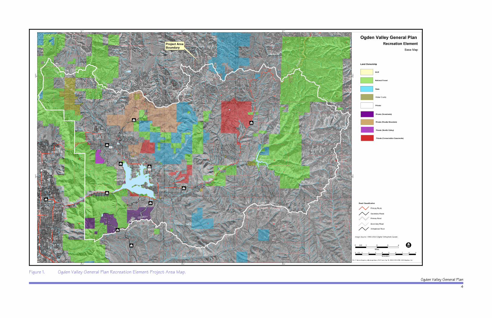
Ogden Valley, located about 8 miles east of Ogden,Utah, in Weber County is a high elevation, northwest- tosoutheast-trending valley about 4 miles wide and 12miles long. The general landscape character is a valleysurrounded by mountains with rolling foothills dissectedby the three major tributaries to the Ogden River. TheProject Area for the OVGP Recreation Element is shownin Figure 1, and includes approximately 207,875 acresor about 325 square miles of community, agricultural,and forested lands. Popular recreational destinationswithin the Project Area include Pineview Reservoir,Powder Mountain Resort, Snowbasin Resort, NordicValley Ski Area, Ogden Canyon, and the Ogden River. Residential development is primarily concentrated in theValley floor area, extending up gentle slopes into themountain foothill areas. The population beginning in2005 is estimated at about 5,400 year-round residentsin Ogden Valley.
The Ogden Valley General Plan was prepared duringthe mid-1990s, completed in 1996, and adopted by theWeber County Commission in 1996 and 1998. Thegeographic focus of that document was on the Valleyfloor (i.e., the zoning districts other than the hillside andmountainous “Forest” zones). Thus, the OVGP lookedcarefully at the portion of the Valley that holds themajority of current and future housing units, but it didnot assess the majority of the overall land base or themountainous areas that are home to the Valley's threeski resorts and large holdings of state and federal lands.
The OVGP assessed the carrying capacity of OgdenValley (i.e., the number of dwelling units or populationthat could be sustained) in terms of traffic, water supply,and waste water treatment. It clearly indicated thattraffic capacity limitations in Ogden Canyon, as well as
Ogden Valley General Plan
4
Figure 1. Ogden Valley General Plan Recreation Element Project Area Map.
INTRODUCTION
Recreation Element
5
potential water quality damage that might result fromhigh growth levels, merited defining a target growthlevel. The OVGP defined a projected growthmanagement limit for a 20-year time horizon (1996 to2016) of 6,200 units (Weber County 1998). As a resultof that planning process, a majority of the Ogden Valleyfloor was rezoned from one housing unit per one acredensities to one housing unit per three acre densities. However, the OVGP did not determine the maximumgrowth potential for Ogden Valley (i.e., the “by right”development entitlement of landowners) given therevised zoning densities. This planning process fordevelopment of the Recreation Element helped to fillthis gap in citizens understanding of Ogden Valley'smaximum growth potential under current conditions.
Ogden Valley Vision Statement
The narrative for the Ogden Valley Vision Statementfrom the OVGP is as follows:
The residents of Ogden Valley care deeplyabout the Valley they call “home.” Theyenjoy their rural lifestyle and the naturalbeauty that surrounds them. They arejustifiably proud of the uniquecharacteristics of Ogden Valley, itstimeless mix of pioneer heritage,agricultural lands, recreationopportunities, abundant wildlife, scenicvistas, and quiet living. Visitors to theValley are struck by its unspoiledcharacter and its unassuming charm. Thepeople of Ogden Valley value thesequalities and recognize that protecting,preserving and fostering these qualitiesrequires foresight and wisdom. Theirshared affection of this Valley and theirhopes for its future guide them as theyembark on this planning process.

INTRODUCTION
Ogden Valley General Plan
6
The two guiding principles from the OVGP VisionStatement are:
x Protect the natural beauty and natural resourcesof the Valley.
x Maintain the Valley’s rural atmosphere and rurallifestyle.
Within the Vision Statement narrative for the secondguiding principle, the following discussion highlights thedesires of Ogden Valley residents concerning recreation:
There are recreational opportunitieseverywhere. Parents teach their childrento fish in the Ogden River, teach them to ski in nearby resorts, and teach them tohunt in the Wasatch Mountains. Residents can hike and horseback ride themany trails which wind their way throughthe surrounding mountains and hills. They can ride mountain bikes alongcountry roads, golf at courses in NordicValley and Wolf Creek, or camp at one of many U.S. Forest Service campgrounds. They can gather at the Huntsville CityPark for an impromptu softball game or afamily picnic. They can windsurf or waterski on Pineview Reservoir. Visitors alsoenjoy the recreational opportunities in theValley. Lower Valley residents oftenspend at least a portion of their weekendin and around the Valley. In the winter,visitors come to the Valley to ski atSnowbasin, Powder Mountain and NordicValley. In the summer, they come to theValley to camp, boat and fish on thePineview and Causey Reservoirs and hikeand bike in the Wasatch Mountains. Although these visitors do not live in theValley, they appreciate its outstandingrecreational resources.
INTRODUCTION
Recreation Element
7
Relevant General Plan Goals and Objectives
Specific OVGP Goals and Objectives related torecreation and resort development that guided theRecreation Element planning process include thefollowing:
OVGP Goal: Enhance QualityRecreational Opportunities
OVGP Objectivesx Identify recreational assets, facilities and activities
in the Valley and determine which facilities mightbe expanded to meet increased recreationaldemand and plan for such expansion.
x Identify areas suitable for community parks,campgrounds or trail systems.
x Determine the amount and degree ofrecreational development necessary to supporthigh quality recreation experiences in the Valley.
x Promote public/private cooperation in recreationplanning.
x Coordinate with Federal and State agencies inrecreation planning.
x Promote safe and responsible recreation conductin the Valley.
x Ensure that recreational activities do not harmthe natural resources within the Valley.
TABLE OF CONTENTS
Recreation Element
xi
Table 15. Lands Owned by or Associated with Nordic Valley Resort. . . . . . . . . . . . . 41
Table 16. Base Density Calculation for Nordic Resort Area Under Current Zoning. . . . . . . . . . . . . . . . . . . . . . . . . . . . . . . . . . . . . . . . . . . . . . . . . . . . 43
Table 17. Base Density Calculation for Nordic Resort Area Under Current Zoning. . . . . . . . . . . . . . . . . . . . . . . . . . . . . . . . . . . . . . . . . . . . . . . . . . . . 44
Table 18. Summary of existing community recreational facilities and resources in Ogden Valley. . . . . . . . . . . . . . . . . . . . . . . . . . . . . . . . . . . . . . . . . . . . . 47
Table 19. Summary of the estimated acreage needed for existing recreational facilities and resources in Ogden Valley. . . . . . . . . . . . . . . . . . . . . . . . . . . 48
Table 20. Summary of community recreational facility needs for Ogden Valley – 2005. . . . . . . . . . . . . . . . . . . . . . . . . . . . . . . . . . . . . . 48
Table 21. Summary of community recreational facility needs for Ogden Valley – 2030. . . . . . . . . . . . . . . . . . . . . . . . . . . . . . . . . . . . . . 50
Table 22. Summary of recommended community recreational facility expansions in Ogden Valley – 2030. . . . . . . . . . . . . . . . . . . . . . . . . . . . . . . . . . . . . . . 53
Table 23. Developed Recreation Sites on the Ogden Ranger District of the Wasatch-Cache National Forest (USFS 2003). . . . . . . . . . . . . . . . . . . . . . . . . . . . . 56
Table 24. Developed Public Recreation Facilities in the Ogden Valley Project Area. . . . . . . . . . . . . . . . . . . . . . . . . . . . . . . . . . . . . . . . . . . . . . . . 59
Table 25. Ogden Valley Skier Days, Skiers and Trips, 2003-2004. . . . . . . . . . . . . . . 65
Table 26. Summary of Area Affected by Environmental Constraint for Ogden Valley. . . . . . . . . . . . . . . . . . . . . . . . . . . . . . . . . . . . . . . . . . . . 80
Table 27. Level of Service (LOS) Criteria for Class I & Class II Two-Lane Highways. . . . . . . . . . . . . . . . . . . . . . . . . . . . . . . . . . . . . . . . . . . . . . . . . . 88
Table 28. Average Annual Growth Rates in Traffic for year 2004. . . . . . . . . . . . . . . 88
Table 29. Capacity and AADTs for the years 2001, 2002, 2003, and 2004. . . . . . . . 88
Table 30. Transportation Needs and Cost Estimates for Ogden Valley. . . . . . . . . . . . 92
INTRODUCTION
Ogden Valley General Plan
8
Document Overview
This document has been divided into the following ninechapters:
1. Introduction2. Land Use and Zoning Analysis 3. Recreation Analysis4. Environmental Resources Analysis5. Transportation Analysis6. Public Participation and Opinions7. Issues and Challenges8. Alternative Development Scenarios9. Recommended Policies and Implementation
Strategies
LAND USE AND ZONING ANALYSIS
Recreation Element
9
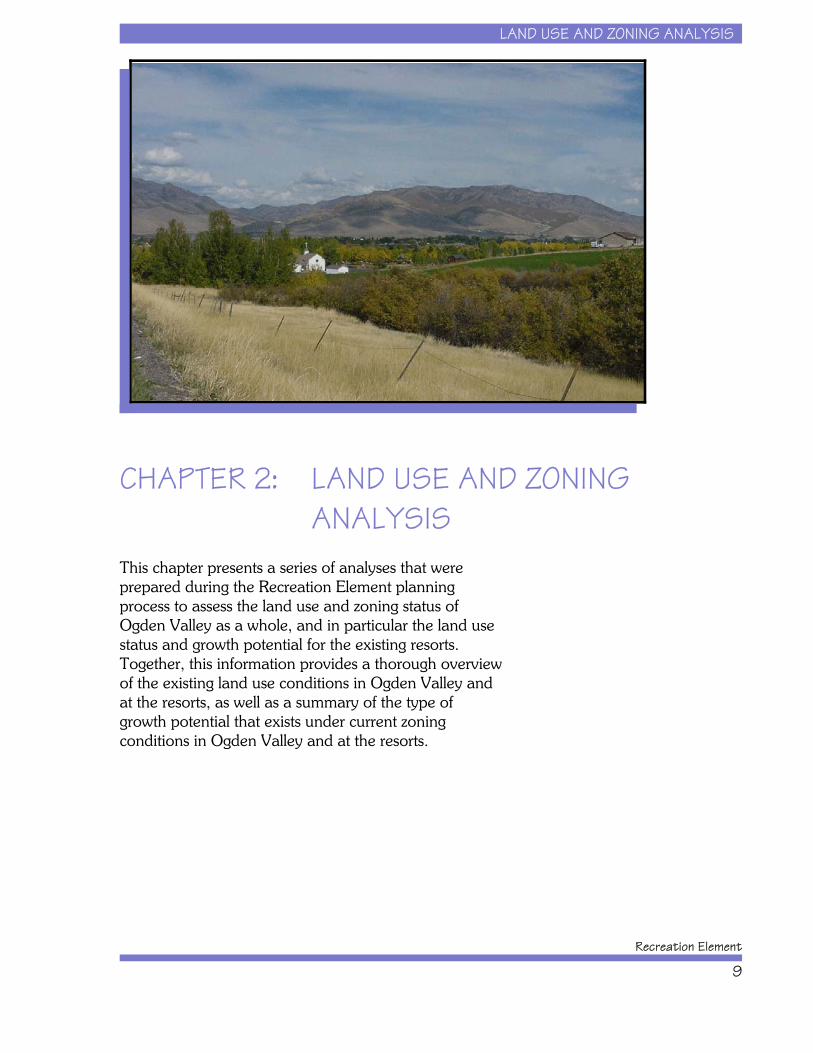
CHAPTER 2: LAND USE AND ZONINGANALYSIS
This chapter presents a series of analyses that wereprepared during the Recreation Element planningprocess to assess the land use and zoning status ofOgden Valley as a whole, and in particular the land usestatus and growth potential for the existing resorts. Together, this information provides a thorough overviewof the existing land use conditions in Ogden Valley andat the resorts, as well as a summary of the type ofgrowth potential that exists under current zoningconditions in Ogden Valley and at the resorts.
LAND USE AND ZONING ANALYSIS
Ogden Valley General Plan
10
Land Use and DevelopmentAssessment
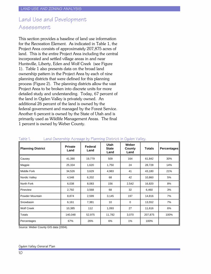
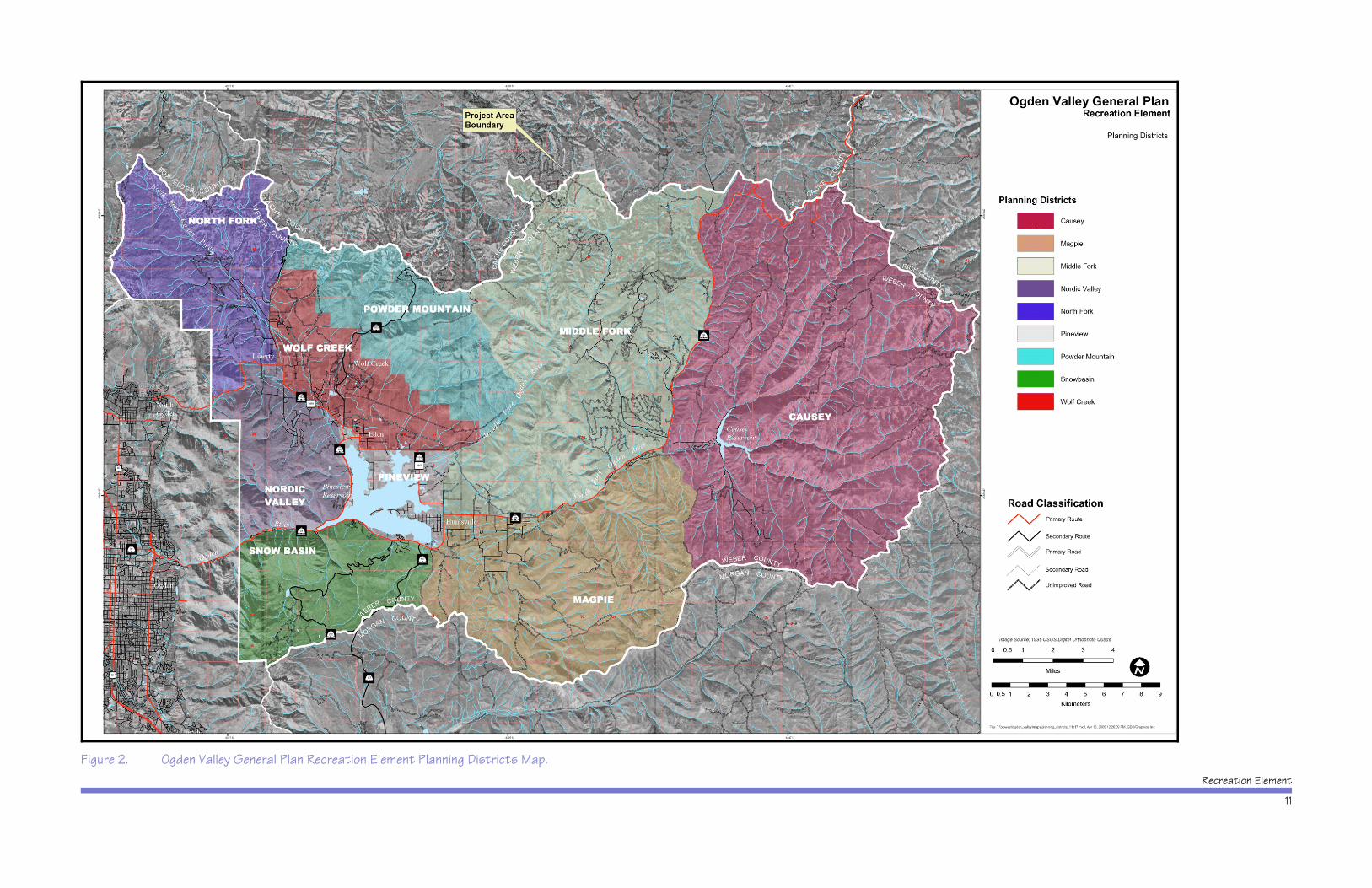
This section provides a baseline of land use informationfor the Recreation Element. As indicated in Table 1, theProject Area consists of approximately 207,875 acres ofland. This is the entire Project Area including the centralincorporated and settled village areas in and nearHuntsville, Liberty, Eden and Wolf Creek (see Figure 1). Table 1 also presents data on the broad landownership pattern in the Project Area by each of nineplanning districts that were defined for this planningprocess (Figure 2). The planning districts allow the vastProject Area to be broken into discrete units for moredetailed study and understanding. Today, 67 percent ofthe land in Ogden Valley is privately owned. Anadditional 26 percent of the land is owned by thefederal government and managed by the Forest Service. Another 6 percent is owned by the State of Utah and isprimarily used as Wildlife Management Areas. The final1 percent is owned by Weber County.
Table 1. Land Ownership Acreage by Planning District in Ogden Valley.
Planning District Private Land
FederalLand
Utah State Land
WeberCountyLand
Totals Percentages
Causey 41,390 19,779 509 164 61,842 30%
Magpie 25,334 1,620 1,750 24 28,728 14%
Middle Fork 34,526 3,629 4,983 41 43,180 21%
Nordic Valley 4,548 6,202 68 42 10,860 5%
North Fork 6,038 8,083 156 2,542 16,820 8%
Pineview 2,792 3,568 68 32 6,460 3%
Powder Mountain 8,874 2,599 3,145 197 14,816 7%
Snowbasin 6,161 7,381 10 0 13,552 7%
Wolf Creek 10,385 112 1,093 27 11,616 6%
Totals 140,048 52,975 11,782 3,070 207,875 100%
Percentages 67% 26% 6% 1% 100%
Source: Weber County GIS data (2004).
Recreation Element
11
Figure 2. Ogden Valley General Plan Recreation Element Planning Districts Map.
LAND USE AND ZONING ANALYSIS
Ogden Valley General Plan
12
The major implication of this information is that,contrary to what some might think, there are largeamounts of private land (140,048 acres) in OgdenValley that could be available for some level ofdevelopment. This means there is the potential for theresident and visitor populations to grow significantly,whether there is resort development or not.
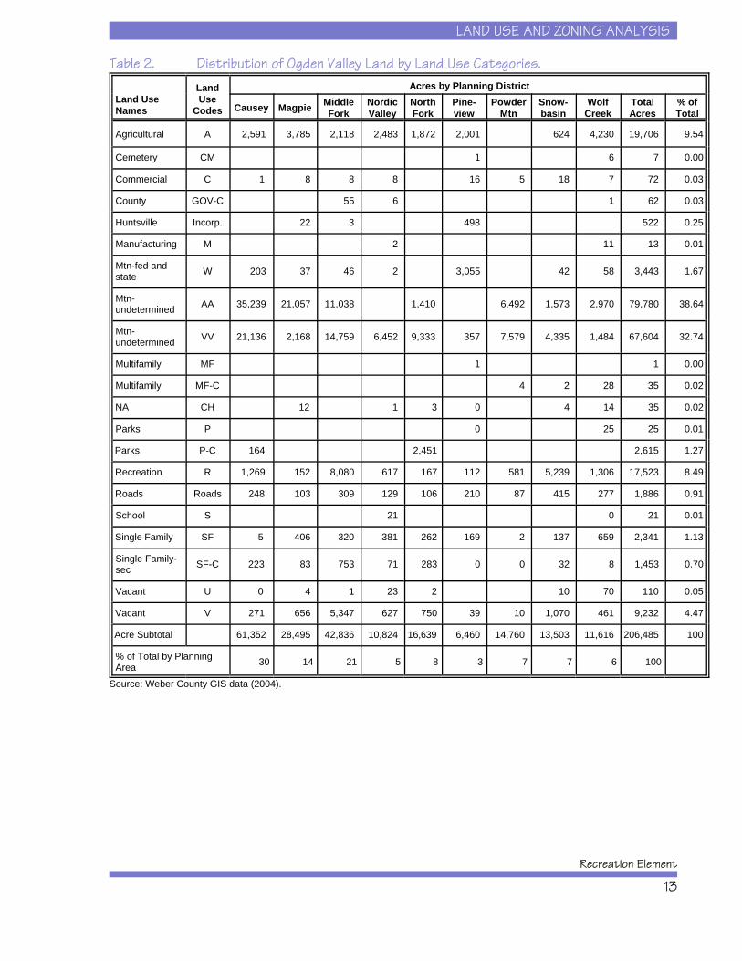
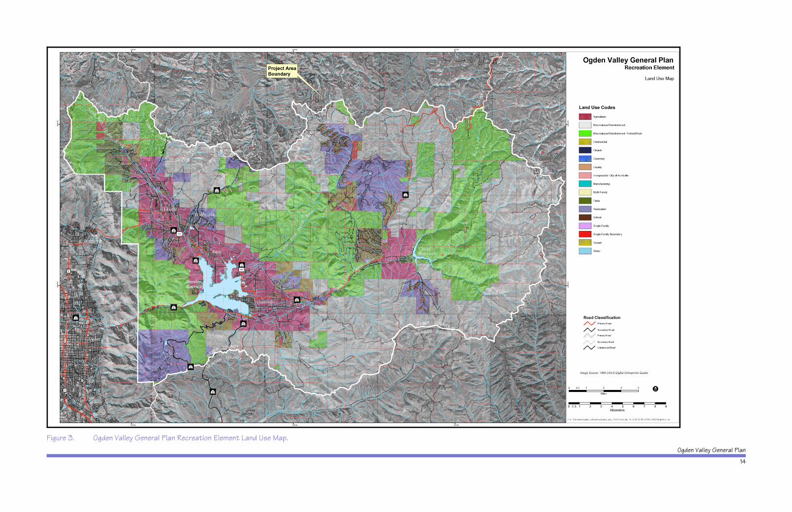
Table 2 presents Weber County data on the variousland use categories in Ogden Valley organized by theplanning districts. Although the land use categories arenot defined with great specificity, they nonethelessillustrate how much land is currently in use foragriculture (19,706 acres), commercial and publicrecreation (17,523 acres), year round homes (2341acres) and second homes (1453 acres). The somewhatvague category of “Mtn undetermined” refers tomountainous land, the current use of which is unclear. This no doubt covers much of the undeveloped forestedland under U.S. Forest Service management as well asprivately owned forested lands. This category accountsfor over 146,000 acres or 70 percent of the total. Figure3 shows the location of these land uses within theProject Area.
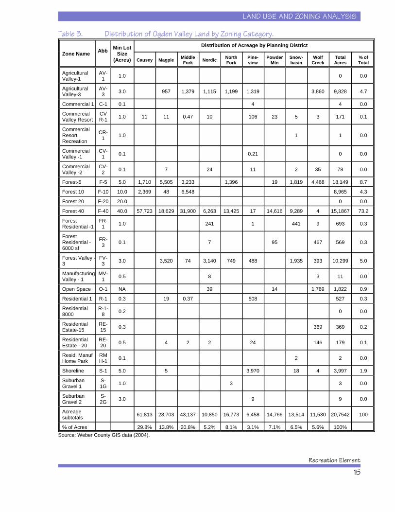
Table 3 presents data on the distribution of land byzoning category. The most notable aspect of thisinformation is that 73 percent of all the land in OgdenValley is zoned for F-40 or 40 acre minimum lot sizes. Much of this land overlaps with the “Mountainous -undetermined” from the land use table. The other largezoning categories of land are the F-5 (18,149 acres), theFV-3 (10,299 acres), the AV-3 (9828 acres), and theF-10 (8965 acres). From the perspective ofdevelopment impacts, although there is less land in thehigher density zoning categories, more housing units willbe generated from those zoning categories than the F-40zoning category. Figure 4 shows the location of currentzoning categories within the Project Area. For completedescriptions of Weber County zoning categories, pleasevisit the Planning Commission section of their website athttp://www1.co.weber.ut.us/.
LAND USE AND ZONING ANALYSIS
Recreation Element
13
Table 2. Distribution of Ogden Valley Land by Land Use Categories.
Land Use Names
LandUse
Codes
Acres by Planning District
Causey Magpie MiddleFork
NordicValley
NorthFork
Pine-view
PowderMtn
Snow-basin
WolfCreek
TotalAcres
% ofTotal
Agricultural A 2,591 3,785 2,118 2,483 1,872 2,001 624 4,230 19,706 9.54
Cemetery CM 1 6 7 0.00
Commercial C 1 8 8 8 16 5 18 7 72 0.03
County GOV-C 55 6 1 62 0.03
Huntsville Incorp. 22 3 498 522 0.25
Manufacturing M 2 11 13 0.01
Mtn-fed and state W 203 37 46 2 3,055 42 58 3,443 1.67
Mtn- undetermined AA 35,239 21,057 11,038 1,410 6,492 1,573 2,970 79,780 38.64
Mtn- undetermined VV 21,136 2,168 14,759 6,452 9,333 357 7,579 4,335 1,484 67,604 32.74
Multifamily MF 1 1 0.00
Multifamily MF-C 4 2 28 35 0.02
NA CH 12 1 3 0 4 14 35 0.02
Parks P 0 25 25 0.01
Parks P-C 164 2,451 2,615 1.27
Recreation R 1,269 152 8,080 617 167 112 581 5,239 1,306 17,523 8.49
Roads Roads 248 103 309 129 106 210 87 415 277 1,886 0.91
School S 21 0 21 0.01
Single Family SF 5 406 320 381 262 169 2 137 659 2,341 1.13
Single Family- sec SF-C 223 83 753 71 283 0 0 32 8 1,453 0.70
Vacant U 0 4 1 23 2 10 70 110 0.05
Vacant V 271 656 5,347 627 750 39 10 1,070 461 9,232 4.47
Acre Subtotal 61,352 28,495 42,836 10,824 16,639 6,460 14,760 13,503 11,616 206,485 100
% of Total by Planning Area 30 14 21 5 8 3 7 7 6 100
Source: Weber County GIS data (2004).
Ogden Valley General Plan
14
Figure 3. Ogden Valley General Plan Recreation Element Land Use Map.
LAND USE AND ZONING ANALYSIS
Recreation Element
15
Table 3. Distribution of Ogden Valley Land by Zoning Category.
Zone Name Abb Min LotSize
(Acres)
Distribution of Acreage by Planning District
Causey Magpie MiddleFork Nordic North
ForkPine-view
PowderMtn
Snow-basin
WolfCreek
TotalAcres
% ofTotal
AgriculturalValley-1
AV-1 1.0 0 0.0
AgriculturalValley-3
AV-3 3.0 957 1,379 1,115 1,199 1,319 3,860 9,828 4.7
Commercial 1 C-1 0.1 4 4 0.0
CommercialValley Resort
CVR-1 1.0 11 11 0.47 10 106 23 5 3 171 0.1
CommercialResortRecreation
CR-1 1.0 1 1 0.0
CommercialValley -1
CV-1 0.1 0.21 0 0.0
CommercialValley -2
CV-2 0.1 7 24 11 2 35 78 0.0
Forest-5 F-5 5.0 1,710 5,505 3,233 1,396 19 1,819 4,468 18,149 8.7
Forest 10 F-10 10.0 2,369 48 6,548 8,965 4.3
Forest 20 F-20 20.0 0 0.0
Forest 40 F-40 40.0 57,723 18,629 31,900 6,263 13,425 17 14,616 9,289 4 15,1867 73.2
ForestResidential -1
FR-1 1.0 241 1 441 9 693 0.3
ForestResidential -6000 sf
FR-3 0.1 7 95 467 569 0.3
Forest Valley -3
FV-3 3.0 3,520 74 3,140 749 488 1,935 393 10,299 5.0
ManufacturingValley - 1
MV-1 0.5 8 3 11 0.0
Open Space O-1 NA 39 14 1,769 1,822 0.9
Residential 1 R-1 0.3 19 0.37 508 527 0.3
Residential8000
R-1-8 0.2 0 0.0
ResidentialEstate-15
RE-15 0.3 369 369 0.2
ResidentialEstate - 20
RE-20 0.5 4 2 2 24 146 179 0.1
Resid. ManufHome Park
RMH-1 0.1 2 2 0.0
Shoreline S-1 5.0 5 3,970 18 4 3,997 1.9
SuburbanGravel 1
S-1G 1.0 3 3 0.0
SuburbanGravel 2
S-2G 3.0 9 9 0.0
Acreagesubtotals 61,813 28,703 43,137 10,850 16,773 6,458 14,766 13,514 11,530 20,7542 100
% of Acres 29.8% 13.8% 20.8% 5.2% 8.1% 3.1% 7.1% 6.5% 5.6% 100%Source: Weber County GIS data (2004).
Ogden Valley General Plan
16
Figure 4. Ogden Valley General Plan Recreation Element Zoning Map.
LAND USE AND ZONING ANALYSIS
Recreation Element
17
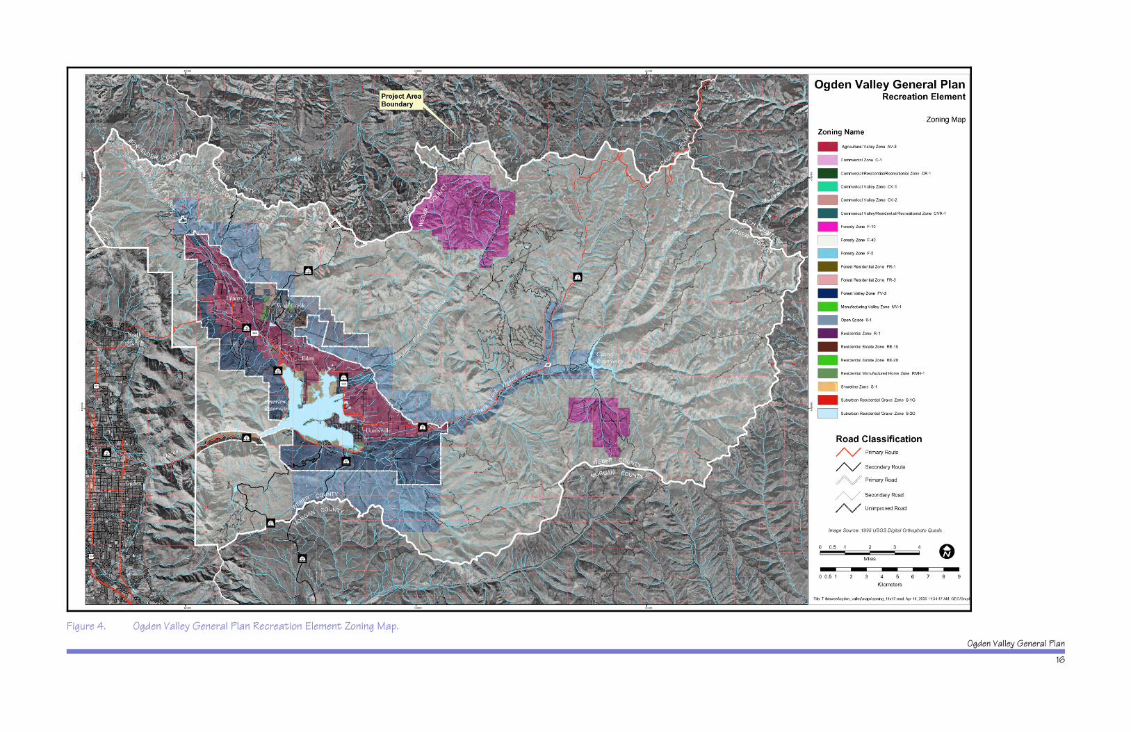
From a recreation and resort planning perspective, thisinformation indicates that the existing resorts are notcurrently zoned to allow development of a densityapproaching that of many established resorts in theregion. In other words, the current zoning is well-suitedfor ski resorts that wish to make skiing their primaryfocus; the zoning does not currently encourage skiresorts to move toward high density real estatedevelopment.
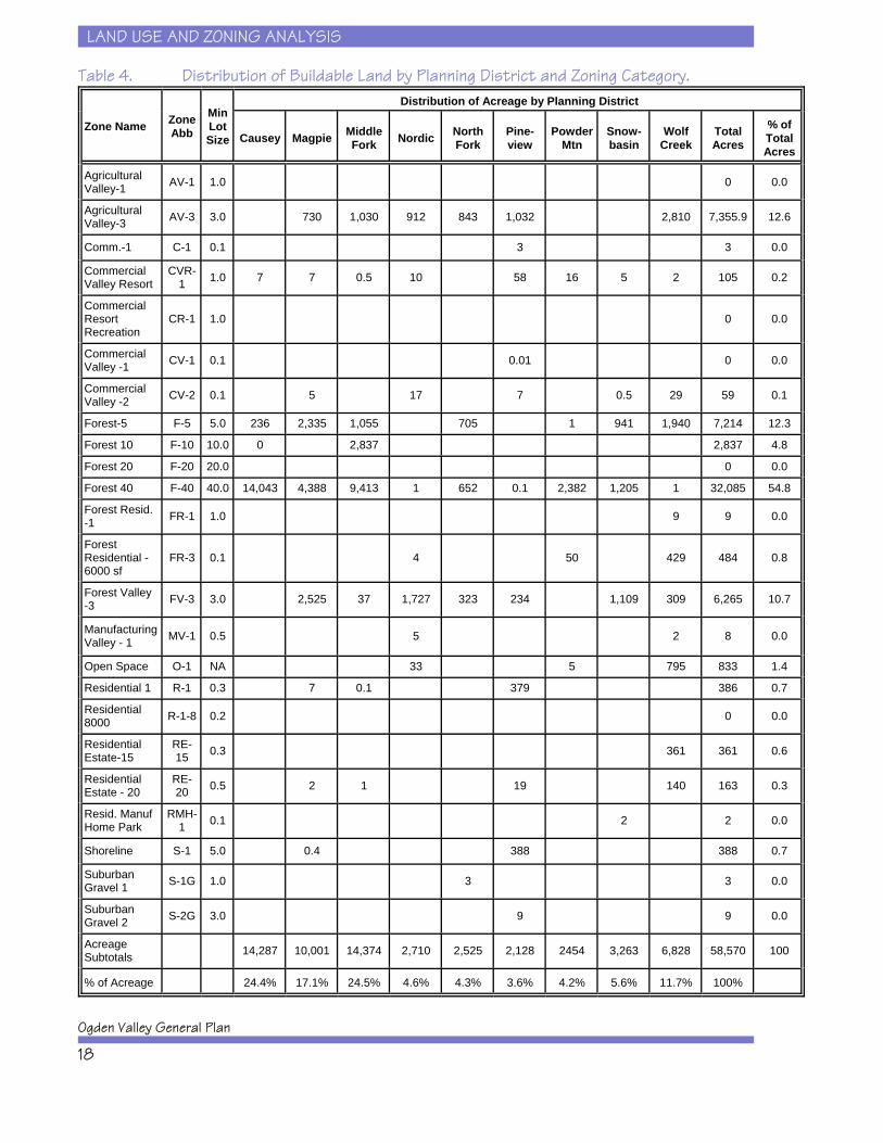
Table 4 presents the results of an analysis of buildableland in Ogden Valley using a geographic informationsystem (GIS). The GIS integrated parcel maps withownership, zoning, and physical characteristics data toallow an assessment of buildable land. This analysis isbased on Weber County’s current zoning, includingprovisions of its proposed Sensitive Lands Ordinance(see Chapter 4 for more details on the Sensitive LandsOrdinance). Thus, the definition of buildable land inthis analysis is land that is in private ownership, has nosignificant environmental (i.e., wetlands, floodplains,stream corridors, and scenic corridors) or geologicalsensitivity (i.e., seismic faults), and has slopes less than30 percent. The results of this computer analysisindicate there are at least 58,570 acres of buildable land remaining in Ogden Valley. The majority of this landlies in the Causey, Middle Fork and Magpie planningdistricts, largely in the form of low density Forest zoningcategories (F-40) as well as some 3 and 5 acre lot sizedistricts (AV-3 and F-5). Again, these higher densityzoning categories will have a major impact on totalhousing unit potential in Ogden Valley. In particular,the CVR-1 zoning categories will have a large impactgiven that the Planned Residential Unit Development(PRUD) provision can be used in these districts. ThePRUD allows densities of up to 22 units per acre inCVR-1 zones.
LAND USE AND ZONING ANALYSIS
Ogden Valley General Plan
18
Table 4. Distribution of Buildable Land by Planning District and Zoning Category.
Zone Name ZoneAbb
MinLotSize
Distribution of Acreage by Planning District
Causey Magpie MiddleFork Nordic North
ForkPine-view
PowderMtn
Snow-basin
WolfCreek
TotalAcres
% ofTotalAcres
AgriculturalValley-1 AV-1 1.0 0 0.0
AgriculturalValley-3 AV-3 3.0 730 1,030 912 843 1,032 2,810 7,355.9 12.6
Comm.-1 C-1 0.1 3 3 0.0
CommercialValley Resort
CVR-1 1.0 7 7 0.5 10 58 16 5 2 105 0.2
CommercialResortRecreation
CR-1 1.0 0 0.0
CommercialValley -1 CV-1 0.1 0.01 0 0.0
CommercialValley -2 CV-2 0.1 5 17 7 0.5 29 59 0.1
Forest-5 F-5 5.0 236 2,335 1,055 705 1 941 1,940 7,214 12.3
Forest 10 F-10 10.0 0 2,837 2,837 4.8
Forest 20 F-20 20.0 0 0.0
Forest 40 F-40 40.0 14,043 4,388 9,413 1 652 0.1 2,382 1,205 1 32,085 54.8
Forest Resid.-1 FR-1 1.0 9 9 0.0
ForestResidential -6000 sf
FR-3 0.1 4 50 429 484 0.8
Forest Valley-3 FV-3 3.0 2,525 37 1,727 323 234 1,109 309 6,265 10.7
ManufacturingValley - 1 MV-1 0.5 5 2 8 0.0
Open Space O-1 NA 33 5 795 833 1.4
Residential 1 R-1 0.3 7 0.1 379 386 0.7
Residential8000 R-1-8 0.2 0 0.0
ResidentialEstate-15
RE-15 0.3 361 361 0.6
ResidentialEstate - 20
RE-20 0.5 2 1 19 140 163 0.3
Resid. ManufHome Park
RMH-1 0.1 2 2 0.0
Shoreline S-1 5.0 0.4 388 388 0.7
SuburbanGravel 1 S-1G 1.0 3 3 0.0
SuburbanGravel 2 S-2G 3.0 9 9 0.0
AcreageSubtotals 14,287 10,001 14,374 2,710 2,525 2,128 2454 3,263 6,828 58,570 100
% of Acreage 24.4% 17.1% 24.5% 4.6% 4.3% 3.6% 4.2% 5.6% 11.7% 100%
LAND USE AND ZONING ANALYSIS
Recreation Element
19
The GIS analysis also indicated 4064 acres of buildableland at the Powder Mountain Resort, 1923 acres atSnowbasin Resort, and 74 acres at Nordic Valley. Ontop of these base densities, each resort has the potentialto develop more units under Weber County’s currentcluster zoning provisions. This information is presentedin more detail in later sections of this chapter.
Ogden Valley’s Development Potential
As a next step toward understanding how Ogden Valleymay change in the future and how that change willimpact the resort and recreation qualities of the Valley,this section asks and begins to answer the followingquestion: What might be the magnitude of futuredevelopment in Ogden Valley?
The following analysis envisions that Ogden Valley andthe resorts all develop within the limits of current zoning. In other words, if every property owner immediatelydecided to build to the base density of his or herproperties, how many housing units would result?
Current Conditions
Extrapolating from the data in Table 5 allows us toestimate the total number of potential housing units thatmight be built in Ogden Valley if every acre of buildableland was used for housing, as allowed under currentzoning. Please note that this data includes the alreadydeveloped portions of Ogden Valley; it is an estimate oftotal development potential in Ogden Valley. Thus, thenumber of future additional units will be the totalsuggested for Ogden Valley minus the existing units.
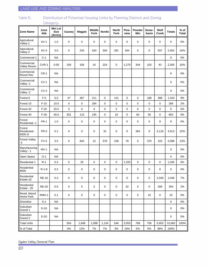
Table 5 shows that there are 15,660 housing units thatcan be built in Ogden Valley under current zoning. Thelargest number of units can occur within the FR-3 zone(3513 units), the AV-3 zone (2452 units), the CVR-1zone (2305 units) and the FV-3 zone (2088 units). These zoning categories are all located on the Valley
LAND USE AND ZONING ANALYSIS
Ogden Valley General Plan
20
Table 5. Distribution of Potential Housing Units by Planning District and ZoningCategory.
Zone Name ZoneAbb
Min LotSize
(Acres)Causey Magpie Middle
Fork Nordic NorthFork
Pine-view
PowderMtn
Snow-basin
WolfCreek Totals % of
Total
AgriculturalValley-1 AV-1 1.0 0 0 0 0 0 0 0 0 0 0 0%
AgriculturalValley-3 AV-3 3.0 0 243 343 304 281 344 0 0 937 2,452 16%
Commercial 1 C-1 NA 0 0%
CommercialValley Resort CVR-1 0.05 156 156 10 224 0 1,270 344 103 43 2,305 15%
CommercialResort Rec CR-1 NA 0 0%
CommercialValley -1 CV-1 NA 0 0%
CommercialValley -2 CV-2 NA 0 0%
Forest-5 F-5 5.0 47 467 211 0 141 0 0 188 388 1,443 9%
Forest 10 F-10 10.0 0 0 284 0 0 0 0 0 0 284 2%
Forest 20 F-20 20.0 0 0 0 0 0 0 0 0 0 0 0%
Forest 40 F-40 40.0 351 110 235 0 16 0 60 30 0 802 5%
ForestResidential -1 FR-1 1.0 0 0 0 0 0 0 0 0 9 9 0%
ForestResidential -6000 sf
FR-3 0.1 0 0 0 31 0 0 364 0 3,118 3,513 22%
Forest Valley-3 FV-3 3.0 0 842 12 576 108 78 0 370 103 2,088 13%
ManufacturingValley - 1 MV-1 NA 0 0%
Open Space O-1 NA 0 0%
Residential 1 R-1 0.3 0 25 0 0 0 1,320 0 0 0 1,345 9%
Residential8000 R-1-8 0.2 0 0 0 0 0 0 0 0 0 0 0%
ResidentialEstate-15 RE-15 0.3 0 0 0 0 0 0 0 0 1,049 1,049 7%
ResidentialEstate - 20 RE-20 0.5 0 5 2 0 0 42 0 0 306 354 2%
Resid. ManufHome Park RMH-1 0.1 0 0 0 0 0 0 0 15 0 15 0%
Shoreline S-1 NA 0 0%
SuburbanGravel 1 S-1G NA 0 0%
SuburbanGravel 2 S-2G NA 0 0%
Total Units 554 1,848 1,098 1,134 546 3,053 768 706 5,953 15,660 100%
% of Total 4% 12% 7% 7% 3% 19% 5% 5% 38% 100%

LAND USE AND ZONING ANALYSIS
Recreation Element
21
floor and thus indicate that the vast majority of all futurehousing will be located on the Valley floor. The amountof units by zoning category and by planning district areshown in Table 5. Today, there are approximately3000 existing housing units in Ogden Valley. Thus,there is the potential for another 12,660 housing units tobe built under current zoning.
It is also important to note that these estimates ofdevelopment potential do not take into accountpotential infrastructure constraints that might limitdevelopment. For example, it is unknown how muchwater is actually available within Ogden Valley fordomestic use. It is conceivable that there are watersupply limits that might constrain complete buildout. Itis also quite reasonable to assume that local watercompanies would find additional water to pipe intoOgden Valley if demand was sufficient to cover the costsof such a transfer. There is also no question that thethree roads into Ogden Valley pose some limits,especially the Ogden Canyon and the North OgdenDivide roads. However, there is adequate capacity onTrappers Loop and North Ogden Divide toaccommodate much additional traffic, and TrappersLoop could be expanded. Will traffic be a growthconstraint? It might at some point in the future, but it isalso true that people are quite adaptable to varyingtraffic conditions and Ogden Valley’s traffic might bequite acceptable to a large number of people and thusnot be a significant growth constraint.
Higher Development Intensities throughClustering
Another potential growth projection for Ogden Valley isbased on the concept of assertively encouraging theexisting zoning provisions in order to cluster as muchdevelopment as possible in areas most suitable fordevelopment. The focus of this exercise is to explorehow much land could be set aside as open space inexchange for the higher densities included within currentcluster zoning provisions.
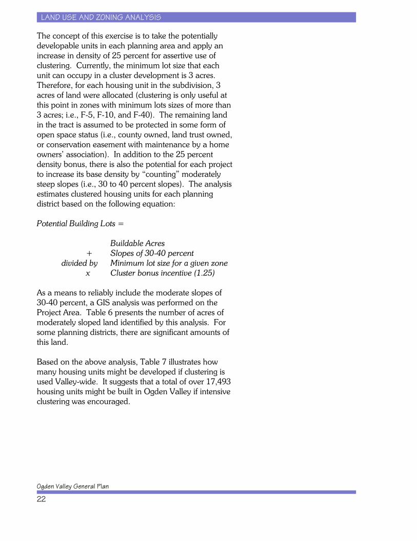
LAND USE AND ZONING ANALYSIS
Ogden Valley General Plan
22
The concept of this exercise is to take the potentiallydevelopable units in each planning area and apply anincrease in density of 25 percent for assertive use ofclustering. Currently, the minimum lot size that eachunit can occupy in a cluster development is 3 acres. Therefore, for each housing unit in the subdivision, 3acres of land were allocated (clustering is only useful atthis point in zones with minimum lots sizes of more than3 acres; i.e., F-5, F-10, and F-40). The remaining landin the tract is assumed to be protected in some form ofopen space status (i.e., county owned, land trust owned,or conservation easement with maintenance by a homeowners’ association). In addition to the 25 percentdensity bonus, there is also the potential for each projectto increase its base density by “counting” moderatelysteep slopes (i.e., 30 to 40 percent slopes). The analysisestimates clustered housing units for each planningdistrict based on the following equation:
Potential Building Lots =
Buildable Acres + Slopes of 30-40 percent
divided by Minimum lot size for a given zonex Cluster bonus incentive (1.25)
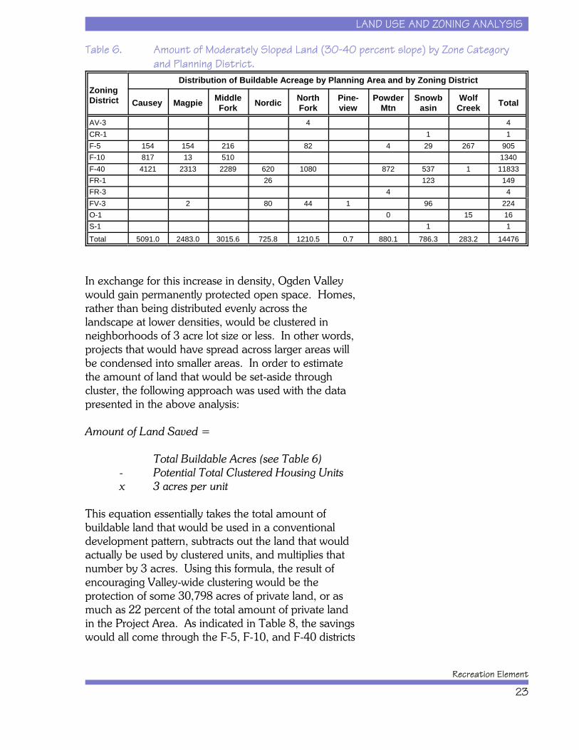
As a means to reliably include the moderate slopes of30-40 percent, a GIS analysis was performed on theProject Area. Table 6 presents the number of acres ofmoderately sloped land identified by this analysis. Forsome planning districts, there are significant amounts ofthis land.
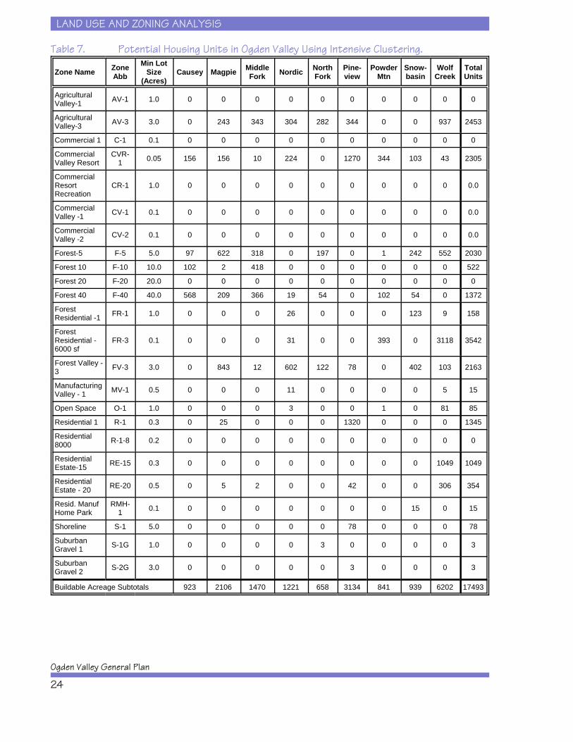
Based on the above analysis, Table 7 illustrates howmany housing units might be developed if clustering isused Valley-wide. It suggests that a total of over 17,493housing units might be built in Ogden Valley if intensiveclustering was encouraged.
LAND USE AND ZONING ANALYSIS
Recreation Element
23
Table 6. Amount of Moderately Sloped Land (30-40 percent slope) by Zone Categoryand Planning District.
ZoningDistrict
Distribution of Buildable Acreage by Planning Area and by Zoning District
Causey Magpie MiddleFork Nordic North
ForkPine-view
PowderMtn
Snowbasin
WolfCreek Total
AV-3 4 4CR-1 1 1F-5 154 154 216 82 4 29 267 905F-10 817 13 510 1340F-40 4121 2313 2289 620 1080 872 537 1 11833FR-1 26 123 149FR-3 4 4FV-3 2 80 44 1 96 224O-1 0 15 16S-1 1 1Total 5091.0 2483.0 3015.6 725.8 1210.5 0.7 880.1 786.3 283.2 14476
In exchange for this increase in density, Ogden Valleywould gain permanently protected open space. Homes,rather than being distributed evenly across thelandscape at lower densities, would be clustered inneighborhoods of 3 acre lot size or less. In other words,projects that would have spread across larger areas willbe condensed into smaller areas. In order to estimatethe amount of land that would be set-aside throughcluster, the following approach was used with the datapresented in the above analysis:
Amount of Land Saved =
Total Buildable Acres (see Table 6)- Potential Total Clustered Housing Units x 3 acres per unit
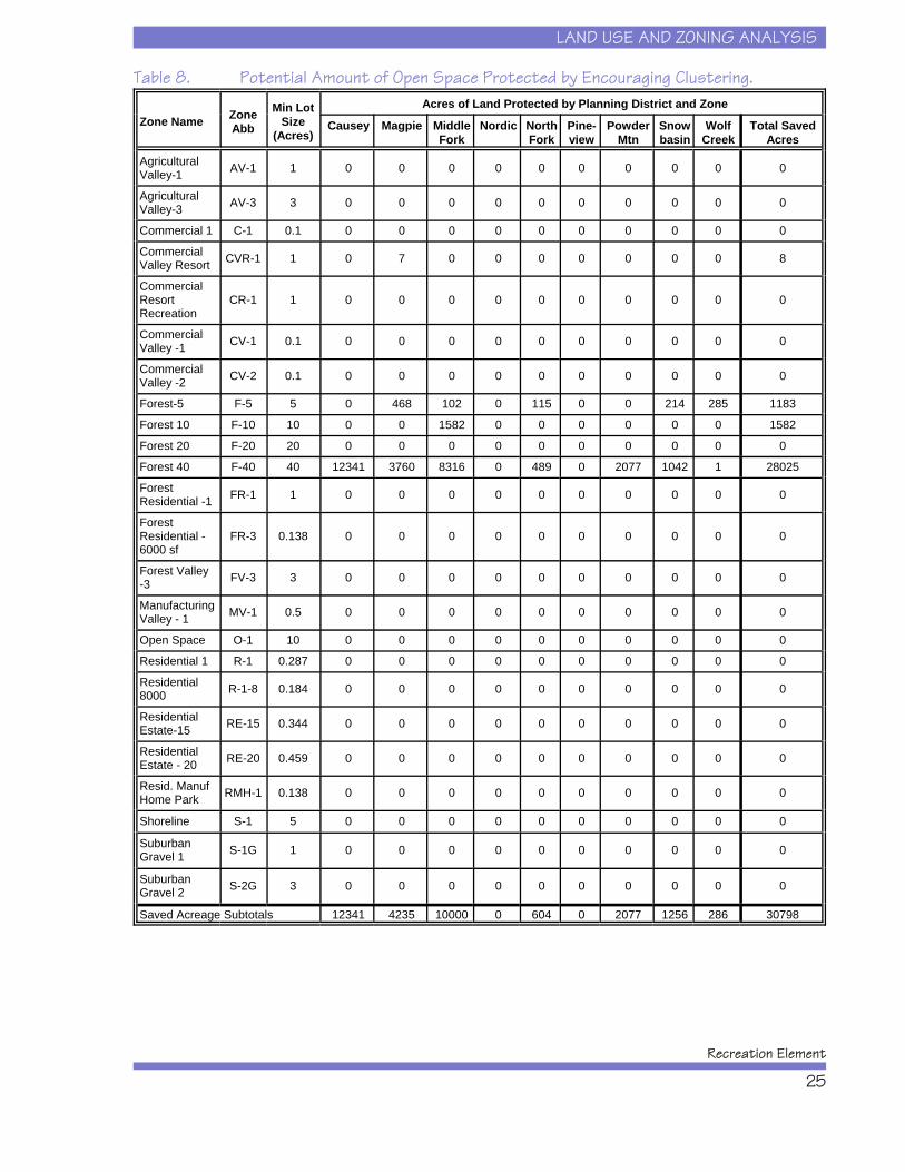
This equation essentially takes the total amount ofbuildable land that would be used in a conventionaldevelopment pattern, subtracts out the land that wouldactually be used by clustered units, and multiplies thatnumber by 3 acres. Using this formula, the result ofencouraging Valley-wide clustering would be theprotection of some 30,798 acres of private land, or asmuch as 22 percent of the total amount of private landin the Project Area. As indicated in Table 8, the savingswould all come through the F-5, F-10, and F-40 districts
LAND USE AND ZONING ANALYSIS
Ogden Valley General Plan
24
Table 7. Potential Housing Units in Ogden Valley Using Intensive Clustering.
Zone Name ZoneAbb
Min LotSize
(Acres)Causey Magpie Middle
Fork Nordic NorthFork
Pine-view
PowderMtn
Snow-basin
WolfCreek
TotalUnits
AgriculturalValley-1 AV-1 1.0 0 0 0 0 0 0 0 0 0 0
AgriculturalValley-3 AV-3 3.0 0 243 343 304 282 344 0 0 937 2453
Commercial 1 C-1 0.1 0 0 0 0 0 0 0 0 0 0
CommercialValley Resort
CVR-1 0.05 156 156 10 224 0 1270 344 103 43 2305
CommercialResortRecreation
CR-1 1.0 0 0 0 0 0 0 0 0 0 0.0
CommercialValley -1 CV-1 0.1 0 0 0 0 0 0 0 0 0 0.0
CommercialValley -2 CV-2 0.1 0 0 0 0 0 0 0 0 0 0.0
Forest-5 F-5 5.0 97 622 318 0 197 0 1 242 552 2030
Forest 10 F-10 10.0 102 2 418 0 0 0 0 0 0 522
Forest 20 F-20 20.0 0 0 0 0 0 0 0 0 0 0
Forest 40 F-40 40.0 568 209 366 19 54 0 102 54 0 1372
ForestResidential -1 FR-1 1.0 0 0 0 26 0 0 0 123 9 158
ForestResidential -6000 sf
FR-3 0.1 0 0 0 31 0 0 393 0 3118 3542
Forest Valley -3 FV-3 3.0 0 843 12 602 122 78 0 402 103 2163
ManufacturingValley - 1 MV-1 0.5 0 0 0 11 0 0 0 0 5 15
Open Space O-1 1.0 0 0 0 3 0 0 1 0 81 85
Residential 1 R-1 0.3 0 25 0 0 0 1320 0 0 0 1345
Residential8000 R-1-8 0.2 0 0 0 0 0 0 0 0 0 0
ResidentialEstate-15 RE-15 0.3 0 0 0 0 0 0 0 0 1049 1049
ResidentialEstate - 20 RE-20 0.5 0 5 2 0 0 42 0 0 306 354
Resid. ManufHome Park
RMH-1 0.1 0 0 0 0 0 0 0 15 0 15
Shoreline S-1 5.0 0 0 0 0 0 78 0 0 0 78
SuburbanGravel 1 S-1G 1.0 0 0 0 0 3 0 0 0 0 3
SuburbanGravel 2 S-2G 3.0 0 0 0 0 0 3 0 0 0 3
Buildable Acreage Subtotals 923 2106 1470 1221 658 3134 841 939 6202 17493
LAND USE AND ZONING ANALYSIS
Recreation Element
25
Table 8. Potential Amount of Open Space Protected by Encouraging Clustering.
Zone Name ZoneAbb
Min LotSize
(Acres)
Acres of Land Protected by Planning District and Zone
Causey Magpie MiddleFork
Nordic NorthFork
Pine-view
PowderMtn
Snowbasin
WolfCreek
Total SavedAcres
AgriculturalValley-1 AV-1 1 0 0 0 0 0 0 0 0 0 0
AgriculturalValley-3 AV-3 3 0 0 0 0 0 0 0 0 0 0
Commercial 1 C-1 0.1 0 0 0 0 0 0 0 0 0 0
CommercialValley Resort CVR-1 1 0 7 0 0 0 0 0 0 0 8
CommercialResortRecreation
CR-1 1 0 0 0 0 0 0 0 0 0 0
CommercialValley -1 CV-1 0.1 0 0 0 0 0 0 0 0 0 0
CommercialValley -2 CV-2 0.1 0 0 0 0 0 0 0 0 0 0
Forest-5 F-5 5 0 468 102 0 115 0 0 214 285 1183
Forest 10 F-10 10 0 0 1582 0 0 0 0 0 0 1582
Forest 20 F-20 20 0 0 0 0 0 0 0 0 0 0
Forest 40 F-40 40 12341 3760 8316 0 489 0 2077 1042 1 28025
ForestResidential -1 FR-1 1 0 0 0 0 0 0 0 0 0 0
ForestResidential -6000 sf
FR-3 0.138 0 0 0 0 0 0 0 0 0 0
Forest Valley-3 FV-3 3 0 0 0 0 0 0 0 0 0 0
ManufacturingValley - 1 MV-1 0.5 0 0 0 0 0 0 0 0 0 0
Open Space O-1 10 0 0 0 0 0 0 0 0 0 0
Residential 1 R-1 0.287 0 0 0 0 0 0 0 0 0 0
Residential8000 R-1-8 0.184 0 0 0 0 0 0 0 0 0 0
ResidentialEstate-15 RE-15 0.344 0 0 0 0 0 0 0 0 0 0
ResidentialEstate - 20 RE-20 0.459 0 0 0 0 0 0 0 0 0 0
Resid. ManufHome Park RMH-1 0.138 0 0 0 0 0 0 0 0 0 0
Shoreline S-1 5 0 0 0 0 0 0 0 0 0 0
SuburbanGravel 1 S-1G 1 0 0 0 0 0 0 0 0 0 0
SuburbanGravel 2 S-2G 3 0 0 0 0 0 0 0 0 0 0
Saved Acreage Subtotals 12341 4235 10000 0 604 0 2077 1256 286 30798
LAND USE AND ZONING ANALYSIS
Ogden Valley General Plan
26
(please note that any zoning category with a minimumlot size equal to or less than 3 acres would not benefitfrom the current cluster provision since there would beno density savings; the only zoning categories showing acluster land savings are those with minimum lots sizeslarger than 3 acres). The major savings are in the F-40category with the potential for setting aside 28,025 acresof land or 48 percent of the total amount of buildableland in Ogden Valley (58,570 acres). The result of thisapproach would be a trade: Ogden Valley residentswould accept 1833 more housing units in exchange forsetting aside 30,798 acres of private land.
Summary of Ogden Valley’s DevelopmentPotential
The analysis above indicates that there is significantdevelopment potential in Ogden Valley. Therefore,recreation and resort planning must consider how thisgrowth potential will impact future recreation by residents, second home owners, and recreation visitors. The most important conclusion from this analysis is theunderstanding that there may be a time in the futurewhen all potential housing units are built and when theyare occupied by a combination of year-round andseasonal residents. At that time, Ogden Valley will havea population of almost 40,000 persons. Recreationplanning must account for that level of demand.
In addition, the five county urban region along theWasatch Front, which is the primary market for OgdenValley today, holds 480,000 people. In 20 years, thatpopulation is projected to grow to over 720,000persons. That regional population will also place greaterdemands on Ogden Valley. And finally, due to publicityfrom the Winter 2002 Olympics and other activities,Ogden Valley is becoming known as one of the lastplaces to buy second home property in a pristine settingnear great skiing. This suggests that Ogden Valley willsee more visitors and potential investors from aroundthe nation and the world. Together, these groups –local residents, second home owners, Wasatch Frontresidents, and tourists – will place demands on resourcesin Ogden Valley of a magnitude not
LAND USE AND ZONING ANALYSIS
Recreation Element
27
experienced in the past. This Recreation Element mustanticipate their arrival and plan for their recreationneeds.
Powder Mountain Resort DevelopmentAnalysis
The purpose of this section is to examine thedevelopment potential in and around the existingPowder Mountain Resort. This skiing facility is along-standing and well-loved part of Ogden Valley’scharacter and economy. As a part of assessing howWeber County and Ogden Valley should manage andshape future recreation-related growth, it is important tounderstand the potential of what could happen at thisfacility and the other resorts. Please note that thematerial covered in this section does not advocate onelevel of development over another; rather, it reviews what could happen so that Ogden Valley residents andelected officials can make informed decisions.
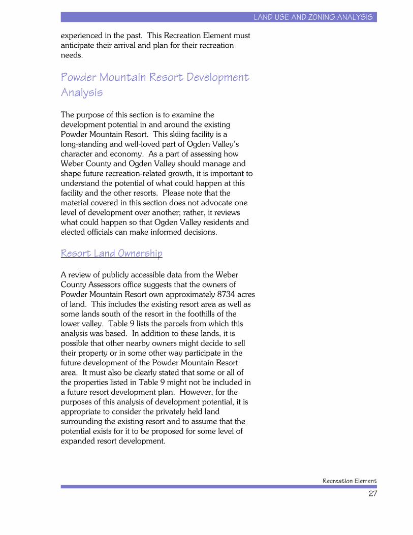
Resort Land Ownership
A review of publicly accessible data from the WeberCounty Assessors office suggests that the owners ofPowder Mountain Resort own approximately 8734 acresof land. This includes the existing resort area as well assome lands south of the resort in the foothills of thelower valley. Table 9 lists the parcels from which thisanalysis was based. In addition to these lands, it ispossible that other nearby owners might decide to selltheir property or in some other way participate in thefuture development of the Powder Mountain Resortarea. It must also be clearly stated that some or all ofthe properties listed in Table 9 might not be included ina future resort development plan. However, for thepurposes of this analysis of development potential, it isappropriate to consider the privately held landsurrounding the existing resort and to assume that thepotential exists for it to be proposed for some level ofexpanded resort development.
LAND USE AND ZONING ANALYSIS
Ogden Valley General Plan
28
Table 9. Lands Owned by or Associated with Powder Mountain Resort.Parcel Map
Serial # Acres Owner Name Parcel MapSerial # Acres Owner Name
220010011 15.35 West Wide Enterprises 2.2E+08 927.4 Elkhorn
220010004 273.24 West Wide Enterprises 2.2E+08 2 Elkhorn
220010003 40.00 West Wide Enterprises 2.2E+08 1066 Elkhorn
220010006 35.80 West Wide Enterprises 2.2E+08 311.64 Elkhorn
220010008 44.16 West Wide Enterprises 2.2E+08 40 Elkhorn
220060007 80.00 Western American 2.2E+08 477.15 Elkhorn220060018 80.00 Western American 2.2E+08 40 Elkhorn220060002 640.00 Western American 2.2E+08 40 Elkhorn230120052 91.81 Western American 2.2E+08 160 Elkhorn230120029 135.95 Western American 2.2E+08 240.03 Elkhorn230120028 160.00 Western American 2.2E+08 212.09 Elkhorn230120027 51.80 Western American 2.2E+08 20.2 Elkhorn230120069 80.00 Western American 2.2E+08 40 Elkhorn230120031 528.12 Western American 2.2E+08 80 Elkhorn230120032 640.00 Western American 2.22E+08 24.34 Elkhorn230120033 320.00 Western American230120034 400.00 Western American230120035 883.58 Western American230120068 50.20 Western American
230440010 277.35 Elkhorn
2301200630 143.64 Elkhorn
2301200654 82.47 Elkhorn
Total Acres 8734Source: County Property Records (Weber County Assessors Department 2004).
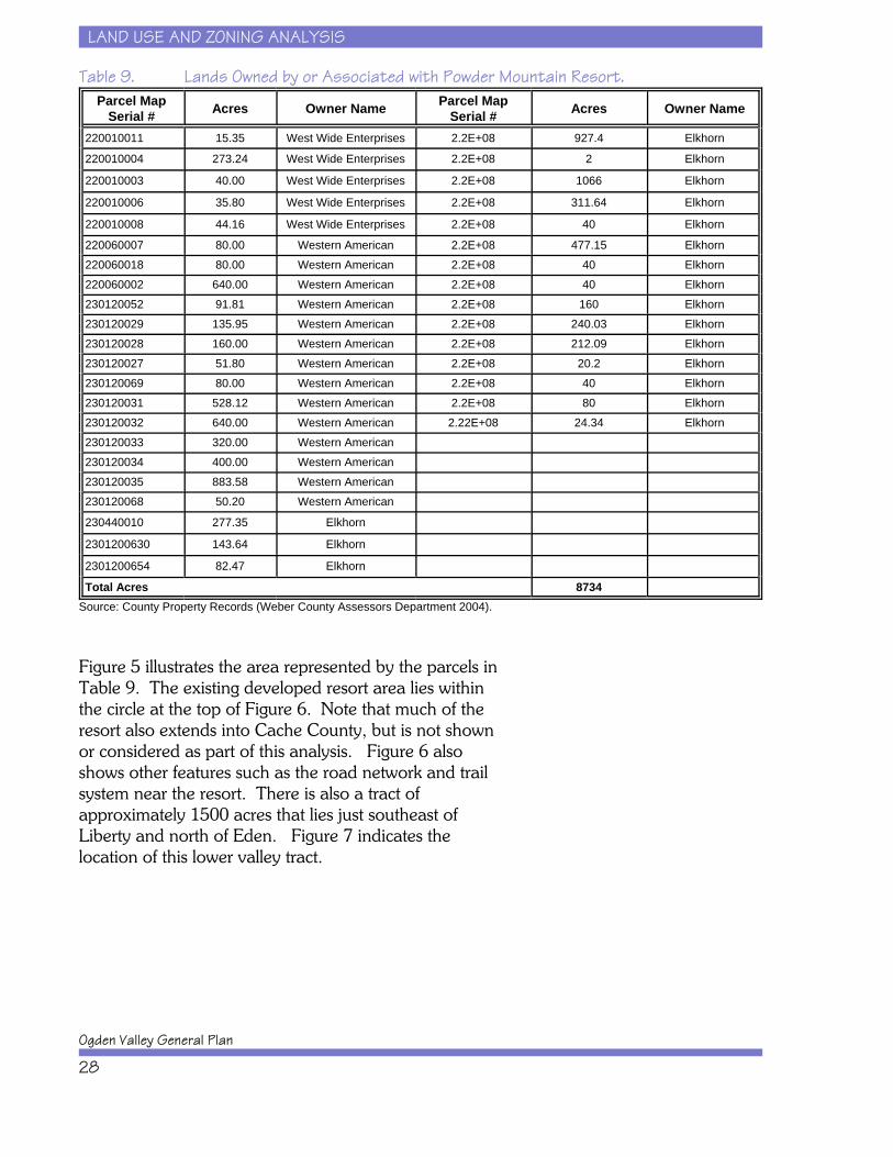
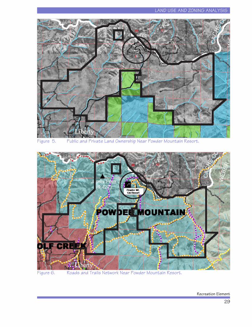
Figure 5 illustrates the area represented by the parcels inTable 9. The existing developed resort area lies withinthe circle at the top of Figure 6. Note that much of theresort also extends into Cache County, but is not shownor considered as part of this analysis. Figure 6 alsoshows other features such as the road network and trailsystem near the resort. There is also a tract ofapproximately 1500 acres that lies just southeast ofLiberty and north of Eden. Figure 7 indicates thelocation of this lower valley tract.
LAND USE AND ZONING ANALYSIS
Recreation Element
29
Figure 5. Public and Private Land Ownership Near Powder Mountain Resort.
Figure 6. Roads and Trails Network Near Powder Mountain Resort.

LAND USE AND ZONING ANALYSIS
Ogden Valley General Plan
30
Figure 7. Lower Valley Tract Owned by Powder Mountain Resort.
Development Constraint Assessment
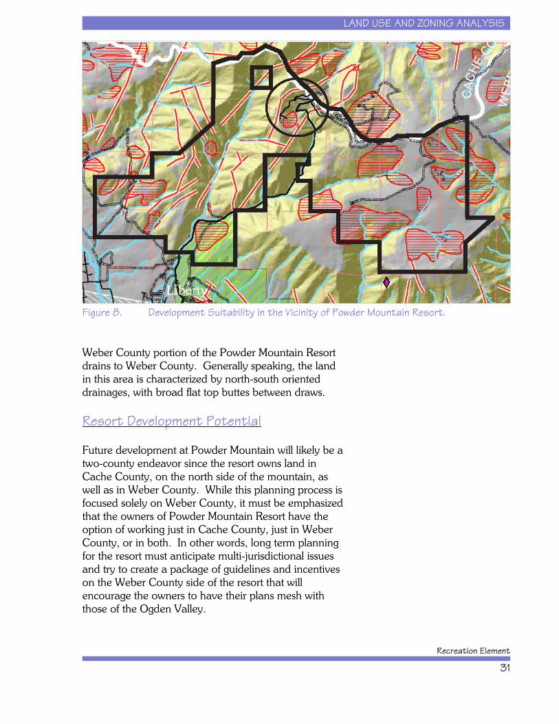
Using land ownership and environmental constraintsdata, development suitability for all lands within theProject Area was determined (see Chapter 4 for adiscussion and maps concerning Project Areadevelopment suitability).
Figure 8 shows the portion of the DevelopmentSuitability Map covering the area in the PowderMountain Resort vicinity. As indicated, the areaconsists of large amounts of steeply sloped land (slopesexceeding 30 percent) as well as numerous areas ofunstable soils and some geologic hazards. Sensitivewildlife habitats also lie along the southern lower slopesof the resort area and cover the majority of the southerntract southeast of Liberty. As shown in Figure 8, thearea has four major drainages. As the dividing linebetween Cache and Weber Counties, all land within
LAND USE AND ZONING ANALYSIS
Recreation Element
31
Figure 8. Development Suitability in the Vicinity of Powder Mountain Resort.
Weber County portion of the Powder Mountain Resortdrains to Weber County. Generally speaking, the landin this area is characterized by north-south orienteddrainages, with broad flat top buttes between draws.
Resort Development Potential
Future development at Powder Mountain will likely be atwo-county endeavor since the resort owns land inCache County, on the north side of the mountain, aswell as in Weber County. While this planning process isfocused solely on Weber County, it must be emphasizedthat the owners of Powder Mountain Resort have theoption of working just in Cache County, just in WeberCounty, or in both. In other words, long term planningfor the resort must anticipate multi-jurisdictional issuesand try to create a package of guidelines and incentiveson the Weber County side of the resort that willencourage the owners to have their plans mesh withthose of the Ogden Valley.
LAND USE AND ZONING ANALYSIS
Ogden Valley General Plan
32
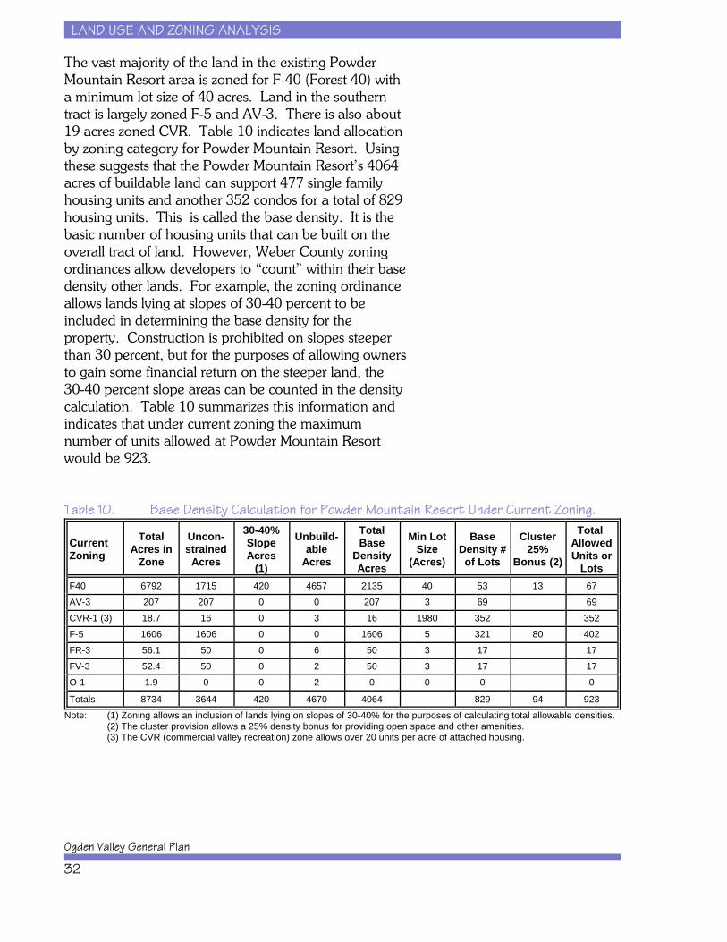
The vast majority of the land in the existing PowderMountain Resort area is zoned for F-40 (Forest 40) witha minimum lot size of 40 acres. Land in the southerntract is largely zoned F-5 and AV-3. There is also about19 acres zoned CVR. Table 10 indicates land allocationby zoning category for Powder Mountain Resort. Usingthese suggests that the Powder Mountain Resort’s 4064acres of buildable land can support 477 single familyhousing units and another 352 condos for a total of 829housing units. This is called the base density. It is thebasic number of housing units that can be built on theoverall tract of land. However, Weber County zoningordinances allow developers to “count” within their basedensity other lands. For example, the zoning ordinanceallows lands lying at slopes of 30-40 percent to beincluded in determining the base density for theproperty. Construction is prohibited on slopes steeperthan 30 percent, but for the purposes of allowing ownersto gain some financial return on the steeper land, the30-40 percent slope areas can be counted in the densitycalculation. Table 10 summarizes this information andindicates that under current zoning the maximumnumber of units allowed at Powder Mountain Resortwould be 923.
Table 10. Base Density Calculation for Powder Mountain Resort Under Current Zoning.
Current Zoning
TotalAcres in
Zone
Uncon-strained
Acres
30-40%SlopeAcres
(1)
Unbuild-able
Acres
TotalBase
DensityAcres
Min LotSize
(Acres)
BaseDensity #of Lots
Cluster25%
Bonus (2)
Total AllowedUnits or
LotsF40 6792 1715 420 4657 2135 40 53 13 67AV-3 207 207 0 0 207 3 69 69CVR-1 (3) 18.7 16 0 3 16 1980 352 352F-5 1606 1606 0 0 1606 5 321 80 402FR-3 56.1 50 0 6 50 3 17 17FV-3 52.4 50 0 2 50 3 17 17O-1 1.9 0 0 2 0 0 0 0
Totals 8734 3644 420 4670 4064 829 94 923Note: (1) Zoning allows an inclusion of lands lying on slopes of 30-40% for the purposes of calculating total allowable densities.
(2) The cluster provision allows a 25% density bonus for providing open space and other amenities.(3) The CVR (commercial valley recreation) zone allows over 20 units per acre of attached housing.
LAND USE AND ZONING ANALYSIS
Recreation Element
33
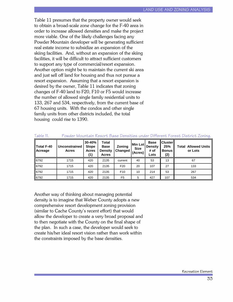
Table 11 presumes that the property owner would seekto obtain a broad-scale zone change for the F-40 area inorder to increase allowed densities and make the projectmore viable. One of the likely challenges facing anyPowder Mountain developer will be generating sufficientreal estate income to subsidize an expansion of theskiing facilities. And, without an expansion of the skiingfacilities, it will be difficult to attract sufficient customersto support any type of commercial/resort expansion. Another option might be to maintain the current ski areaand just sell off land for housing and thus not pursue aresort expansion. Assuming that a resort expansion isdesired by the owner, Table 11 indicates that zoningchanges of F-40 land to F20, F10 or F5 would increasethe number of allowed single family residential units to133, 267 and 534, respectively, from the current base of67 housing units. With the condos and other singlefamily units from other districts included, the totalhousing could rise to 1390.
Table 11. Powder Mountain Resort Base Densities under Different Forest District Zoning.
Total F-40 Acreage
UnconstrainedAcres
30-40%SlopeAcres
(1)
TotalBase
DensityAcres
ZoningChanged
Min LotSize
(Acres)
BaseDensity
# ofLots
Cluster25%
Bonus(2)
Total Allowed Unitsor Lots
6792 1715 420 2135 current 40 53 13 67
6792 1715 420 2135 F20 20 107 27 133
6792 1715 420 2135 F10 10 214 53 267
6792 1715 420 2135 F5 5 427 107 534
Another way of thinking about managing potentialdensity is to imagine that Weber County adopts a newcomprehensive resort development zoning provision(similar to Cache County’s recent effort) that wouldallow the developer to create a very broad proposal andto then negotiate with the County on the final shape ofthe plan. In such a case, the developer would seek tocreate his/her ideal resort vision rather than work withinthe constraints imposed by the base densities.
LAND USE AND ZONING ANALYSIS
Ogden Valley General Plan
34
Summary of Development Potential atPowder Mountain Resort
The above analysis indicates that Powder MountainResort has the current zoning “rights” to buildapproximately 923 housing units on its 8,734 acres ofland (please note that these s do not represent in anyform the owner’s intentions or any submitted plans, butinstead are projections of what could happen given theowner’s land base and the current zoning on theproperty). In order to increase densities or create amixed use project, the owners might desire to rezonesome or all of their land. Under the most intense zoningoption open to them today, they could attain a basehousing density of approximately 1,390 units. Creatinga resort similar to what one sees in other parts of Utahtoday might require that Weber County put in place amore flexible resort development zoning provision thatwould likely allow even more units than shown in thisanalysis.
Snowbasin Resort DevelopmentAnalysis
The purpose of this section is to examine thedevelopment potential in and around the existingSnowbasin Resort. This resort is one of the finest skiingmountains in Utah, as indicated by its selection in the2002 Winter Olympics as the site of the downhill andsuper G events. As a part of assessing how WeberCounty and Ogden Valley should manage and shapefuture recreation-related growth, it is important to understand the potential of what could happen at thisfacility and the other resorts. Please note that thematerial covered in this section does not advocate onelevel of development over another; rather, it reviewswhat could happen so that Ogden Valley residents andelected officials can make informed decisions.
LAND USE AND ZONING ANALYSIS
Recreation Element
35
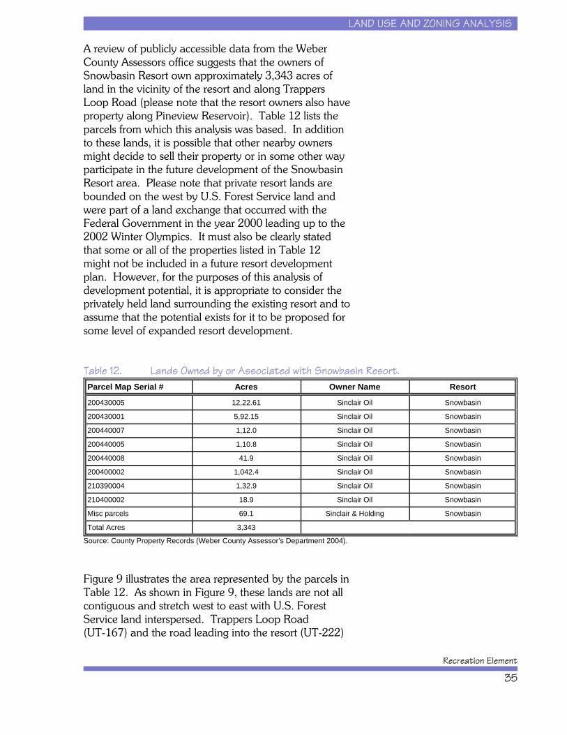
A review of publicly accessible data from the WeberCounty Assessors office suggests that the owners ofSnowbasin Resort own approximately 3,343 acres ofland in the vicinity of the resort and along TrappersLoop Road (please note that the resort owners also haveproperty along Pineview Reservoir). Table 12 lists theparcels from which this analysis was based. In additionto these lands, it is possible that other nearby ownersmight decide to sell their property or in some other wayparticipate in the future development of the SnowbasinResort area. Please note that private resort lands arebounded on the west by U.S. Forest Service land andwere part of a land exchange that occurred with theFederal Government in the year 2000 leading up to the2002 Winter Olympics. It must also be clearly statedthat some or all of the properties listed in Table 12might not be included in a future resort developmentplan. However, for the purposes of this analysis ofdevelopment potential, it is appropriate to consider theprivately held land surrounding the existing resort and toassume that the potential exists for it to be proposed forsome level of expanded resort development.
Table 12. Lands Owned by or Associated with Snowbasin Resort.Parcel Map Serial # Acres Owner Name Resort
200430005 12,22.61 Sinclair Oil Snowbasin
200430001 5,92.15 Sinclair Oil Snowbasin
200440007 1,12.0 Sinclair Oil Snowbasin
200440005 1,10.8 Sinclair Oil Snowbasin
200440008 41.9 Sinclair Oil Snowbasin
200400002 1,042.4 Sinclair Oil Snowbasin
210390004 1,32.9 Sinclair Oil Snowbasin
210400002 18.9 Sinclair Oil Snowbasin
Misc parcels 69.1 Sinclair & Holding Snowbasin
Total Acres 3,343
Source: County Property Records (Weber County Assessor’s Department 2004).
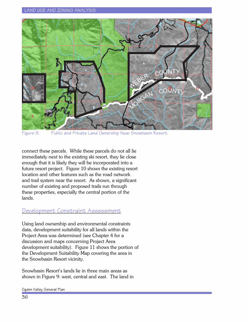
Figure 9 illustrates the area represented by the parcels inTable 12. As shown in Figure 9, these lands are not allcontiguous and stretch west to east with U.S. ForestService land interspersed. Trappers Loop Road (UT-167) and the road leading into the resort (UT-222)
LAND USE AND ZONING ANALYSIS
Ogden Valley General Plan
36
Figure 9. Public and Private Land Ownership Near Snowbasin Resort.
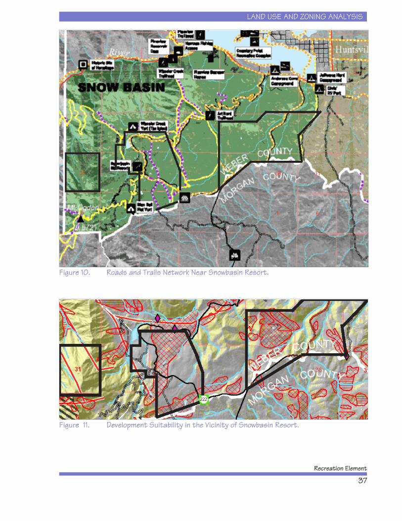
connect these parcels. While these parcels do not all lieimmediately next to the existing ski resort, they lie closeenough that it is likely they will be incorporated into afuture resort project. Figure 10 shows the existing resortlocation and other features such as the road networkand trail system near the resort. As shown, a significantnumber of existing and proposed trails run throughthese properties, especially the central portion of thelands.
Development Constraint Assessment
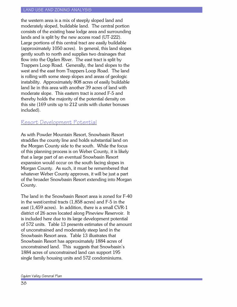
Using land ownership and environmental constraintsdata, development suitability for all lands within theProject Area was determined (see Chapter 4 for adiscussion and maps concerning Project Areadevelopment suitability). Figure 11 shows the portion ofthe Development Suitability Map covering the area inthe Snowbasin Resort vicinity.
Snowbasin Resort’s lands lie in three main areas asshown in Figure 9: west, central and east. The land in
LAND USE AND ZONING ANALYSIS
Recreation Element
37
Figure 10. Roads and Trails Network Near Snowbasin Resort.
Figure 11. Development Suitability in the Vicinity of Snowbasin Resort.
LAND USE AND ZONING ANALYSIS
Ogden Valley General Plan
38
the western area is a mix of steeply sloped land andmoderately sloped, buildable land. The central portionconsists of the existing base lodge area and surroundinglands and is split by the new access road (UT-222). Large portions of this central tract are easily buildable(approximately 1050 acres). In general, this land slopesgently south to north and supplies two drainages thatflow into the Ogden River. The east tract is split byTrappers Loop Road. Generally, the land slopes to thewest and the east from Trappers Loop Road. The landis rolling with some steep slopes and areas of geologicinstability. Approximately 808 acres of easily buildableland lie in this area with another 39 acres of land withmoderate slope. This eastern tract is zoned F-5 andthereby holds the majority of the potential density onthis site (169 units up to 212 units with cluster bonusesincluded).
Resort Development Potential
As with Powder Mountain Resort, Snowbasin Resortstraddles the county line and holds substantial land onthe Morgan County side to the south. While the focusof this planning process is on Weber County, it is likelythat a large part of an eventual Snowbasin Resortexpansion would occur on the south facing slopes inMorgan County. As such, it must be remembered thatwhatever Weber County approves, it will be just a partof the broader Snowbasin Resort extending into MorganCounty.
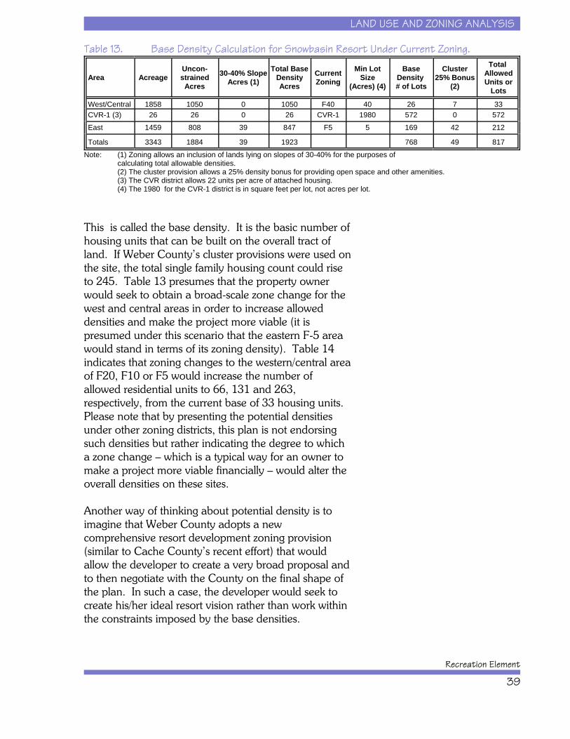
The land in the Snowbasin Resort area is zoned for F-40in the west/central tracts (1,858 acres) and F-5 in theeast (1,459 acres). In addition, there is a small CVR-1district of 26 acres located along Pineview Reservoir. Itis included here due to its large development potentialof 572 units. Table 13 presents estimates of the amountof unconstrained and moderately steep land in theSnowbasin Resort area. Table 13 illustrates thatSnowbasin Resort has approximately 1884 acres ofunconstrained land. This suggests that Snowbasin’s1884 acres of unconstrained land can support 195single family housing units and 572 condominiums.
LAND USE AND ZONING ANALYSIS
Recreation Element
39
Table 13. Base Density Calculation for Snowbasin Resort Under Current Zoning.
Area AcreageUncon-strained
Acres30-40% Slope
Acres (1)Total Base
DensityAcres
CurrentZoning
Min LotSize
(Acres) (4)
BaseDensity # of Lots
Cluster25% Bonus
(2)
Total AllowedUnits or
Lots
West/Central 1858 1050 0 1050 F40 40 26 7 33CVR-1 (3) 26 26 0 26 CVR-1 1980 572 0 572East 1459 808 39 847 F5 5 169 42 212
Totals 3343 1884 39 1923 768 49 817Note: (1) Zoning allows an inclusion of lands lying on slopes of 30-40% for the purposes of
calculating total allowable densities.(2) The cluster provision allows a 25% density bonus for providing open space and other amenities.(3) The CVR district allows 22 units per acre of attached housing.(4) The 1980 for the CVR-1 district is in square feet per lot, not acres per lot.
This is called the base density. It is the basic number ofhousing units that can be built on the overall tract ofland. If Weber County’s cluster provisions were used onthe site, the total single family housing count could riseto 245. Table 13 presumes that the property ownerwould seek to obtain a broad-scale zone change for thewest and central areas in order to increase alloweddensities and make the project more viable (it ispresumed under this scenario that the eastern F-5 areawould stand in terms of its zoning density). Table 14indicates that zoning changes to the western/central areaof F20, F10 or F5 would increase the number ofallowed residential units to 66, 131 and 263,respectively, from the current base of 33 housing units. Please note that by presenting the potential densitiesunder other zoning districts, this plan is not endorsingsuch densities but rather indicating the degree to whicha zone change – which is a typical way for an owner tomake a project more viable financially – would alter theoverall densities on these sites.
Another way of thinking about potential density is toimagine that Weber County adopts a newcomprehensive resort development zoning provision(similar to Cache County’s recent effort) that wouldallow the developer to create a very broad proposal andto then negotiate with the County on the final shape ofthe plan. In such a case, the developer would seek tocreate his/her ideal resort vision rather than work withinthe constraints imposed by the base densities.
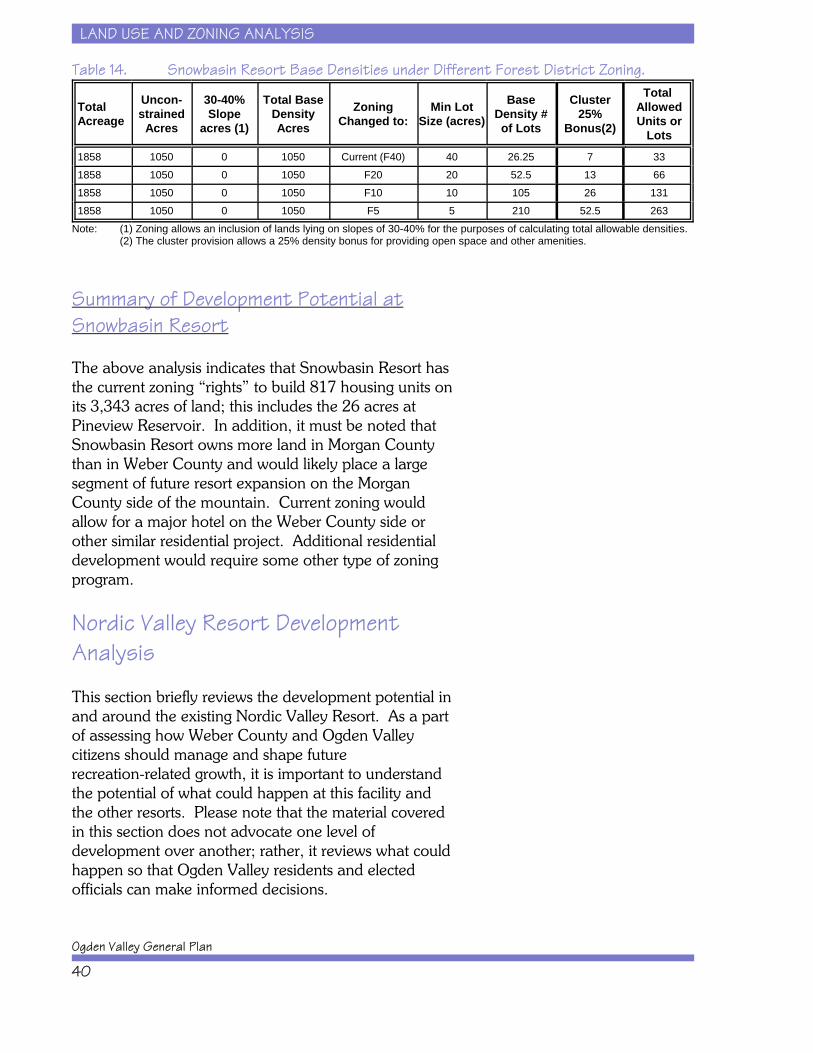
LAND USE AND ZONING ANALYSIS
Ogden Valley General Plan
40
Table 14. Snowbasin Resort Base Densities under Different Forest District Zoning.
TotalAcreage
Uncon-strained
Acres
30-40%Slope
acres (1)
Total BaseDensityAcres
ZoningChanged to:
Min LotSize (acres)
BaseDensity #of Lots
Cluster25%
Bonus(2)
Total AllowedUnits or
Lots1858 1050 0 1050 Current (F40) 40 26.25 7 331858 1050 0 1050 F20 20 52.5 13 661858 1050 0 1050 F10 10 105 26 1311858 1050 0 1050 F5 5 210 52.5 263
Note: (1) Zoning allows an inclusion of lands lying on slopes of 30-40% for the purposes of calculating total allowable densities.(2) The cluster provision allows a 25% density bonus for providing open space and other amenities.
Summary of Development Potential atSnowbasin Resort
The above analysis indicates that Snowbasin Resort hasthe current zoning “rights” to build 817 housing units onits 3,343 acres of land; this includes the 26 acres atPineview Reservoir. In addition, it must be noted thatSnowbasin Resort owns more land in Morgan Countythan in Weber County and would likely place a largesegment of future resort expansion on the MorganCounty side of the mountain. Current zoning wouldallow for a major hotel on the Weber County side orother similar residential project. Additional residentialdevelopment would require some other type of zoningprogram.
Nordic Valley Resort DevelopmentAnalysis
This section briefly reviews the development potential inand around the existing Nordic Valley Resort. As a partof assessing how Weber County and Ogden Valleycitizens should manage and shape futurerecreation-related growth, it is important to understandthe potential of what could happen at this facility andthe other resorts. Please note that the material coveredin this section does not advocate one level ofdevelopment over another; rather, it reviews what couldhappen so that Ogden Valley residents and electedofficials can make informed decisions.
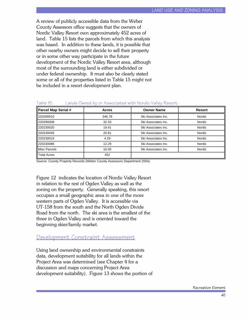
LAND USE AND ZONING ANALYSIS
Recreation Element
41
A review of publicly accessible data from the WeberCounty Assessors office suggests that the owners ofNordic Valley Resort own approximately 452 acres ofland. Table 15 lists the parcels from which this analysiswas based. In addition to these lands, it is possible thatother nearby owners might decide to sell their propertyor in some other way participate in the futuredevelopment of the Nordic Valley Resort area, althoughmost of the surrounding land is either subdivided orunder federal ownership. It must also be clearly statedsome or all of the properties listed in Table 15 might notbe included in a resort development plan.
Table 15. Lands Owned by or Associated with Nordic Valley Resort.Parcel Map Serial # Acres Owner Name Resort220290010 346.78 Ski Associates Inc. Nordic220290008 32.33 Ski Associates Inc. Nordic220230020 19.41 Ski Associates Inc. Nordic220230045 20.81 Ski Associates Inc. Nordic220230019 4.29 Ski Associates Inc. Nordic220230086 12.29 Ski Associates Inc. NordicMisc Parcels 16.00 Ski Associates Inc. NordicTotal Acres 452
Source: County Property Records (Weber County Assessors Department 2004).
Figure 12 indicates the location of Nordic Valley Resortin relation to the rest of Ogden Valley as well as thezoning on the property. Generally speaking, this resortoccupies a small geographic area in one of the morewestern parts of Ogden Valley. It is accessible viaUT-158 from the south and the North Ogden DivideRoad from the north. The ski area is the smallest of thethree in Ogden Valley and is oriented toward thebeginning skier/family market.
Development Constraint Assessment
Using land ownership and environmental constraintsdata, development suitability for all lands within theProject Area was determined (see Chapter 4 for adiscussion and maps concerning Project Areadevelopment suitability). Figure 13 shows the portion of
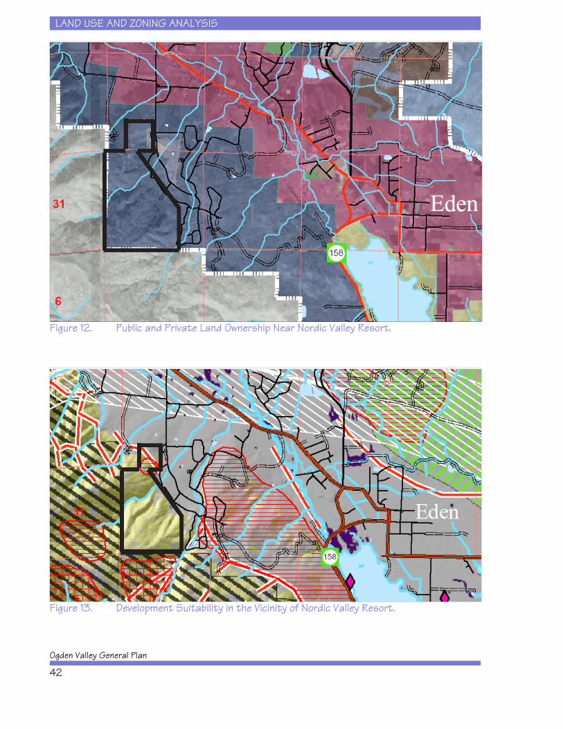
LAND USE AND ZONING ANALYSIS
Ogden Valley General Plan
42
Figure 12. Public and Private Land Ownership Near Nordic Valley Resort.
Figure 13. Development Suitability in the Vicinity of Nordic Valley Resort.
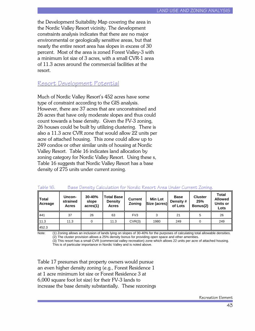
LAND USE AND ZONING ANALYSIS
Recreation Element
43
the Development Suitability Map covering the area inthe Nordic Valley Resort vicinity. The developmentconstraints analysis indicates that there are no majorenvironmental or geologically sensitive areas, but thatnearly the entire resort area has slopes in excess of 30percent. Most of the area is zoned Forest Valley-3 witha minimum lot size of 3 acres, with a small CVR-1 areaof 11.3 acres around the commercial facilities at theresort.
Resort Development Potential
Much of Nordic Valley Resort’s 452 acres have sometype of constraint according to the GIS analysis. However, there are 37 acres that are unconstrained and26 acres that have only moderate slopes and thus couldcount towards a base density. Given the FV-3 zoning,26 houses could be built by utilizing clustering. There isalso a 11.3 acre CVR zone that would allow 22 units peracre of attached housing. This zone could allow up to249 condos or other similar units of housing at NordicValley Resort. Table 16 indicates land allocation byzoning category for Nordic Valley Resort. Using these s,Table 16 suggests that Nordic Valley Resort has a basedensity of 275 units under current zoning.
Table 16. Base Density Calculation for Nordic Resort Area Under Current Zoning.
TotalAcreage
Uncon-strained
Acres
30-40%slope
acres(1)
Total BaseDensityAcres
CurrentZoning
Min LotSize (acres)
BaseDensity #of Lots
Cluster25%
Bonus(2)
Total AllowedUnits or
Lots
441 37 26 63 FV3 3 21 5 26
11.3 11.3 0 11.3 CVR(3) 1980 249 0 249
452.3Note: (1) Zoning allows an inclusion of lands lying on slopes of 30-40% for the purposes of calculating total allowable densities.
(2) The cluster provision allows a 25% density bonus for providing open space and other amenities.(3) This resort has a small CVR (commercial valley recreation) zone which allows 22 units per acre of attached housing.This is of particular importance in Nordic Valley and is noted above.
Table 17 presumes that property owners would pursuean even higher density zoning (e.g., Forest Residence 1at 1 acre minimum lot size or Forest Residence 3 at6,000 square foot lot size) for their FV-3 lands toincrease the base density substantially. These rezonings

LAND USE AND ZONING ANALYSIS
Ogden Valley General Plan
44
Table 17. Base Density Calculation for Nordic Resort Area Under Current Zoning.
TotalAcreage
Uncon-strained
Acres
30-40%slope acres
Total BaseDensityAcres
ZoningChanged
Min LotSize (acres)
BaseDensity #of Lots
Cluster25% Bonus
Total AllowedUnits or
Lots
441 37 26 63 FR-1 1.0 63 16 79
441 37 26 63 FR-3 0.14 457 114 572Source: Analysis of Weber County GIS data (BIO-WEST 2004).
would be quite unlikely given that the area already has3-acre minimum lot size zoning, but if rezoning didoccur then densities could rise to 79 units under FR-1 or572 units under FR-3 zoning.
Summary of Development Potential atNordic Valley Resort
Nordic Valley Resort is the one resort that lies entirely inWeber County; Powder Mountain and SnowbasinResorts both straddle the county line and thus will havemore complicated development futures. Nordic ValleyResort is governed only by Weber County land use regulations. As such, the county has a significant abilityto help shape this project to the benefit of both theowners and Ogden Valley residents. As currently zonedand given the development constraints of the land,Nordic Valley Resort has limited options fordevelopment over most of its terrain. However, its CVRzone will allow a substantial number of condominiums. This planning effort should look carefully at whether andhow development of this site can benefit Ogden Valleyand Nordic Valley Resort.
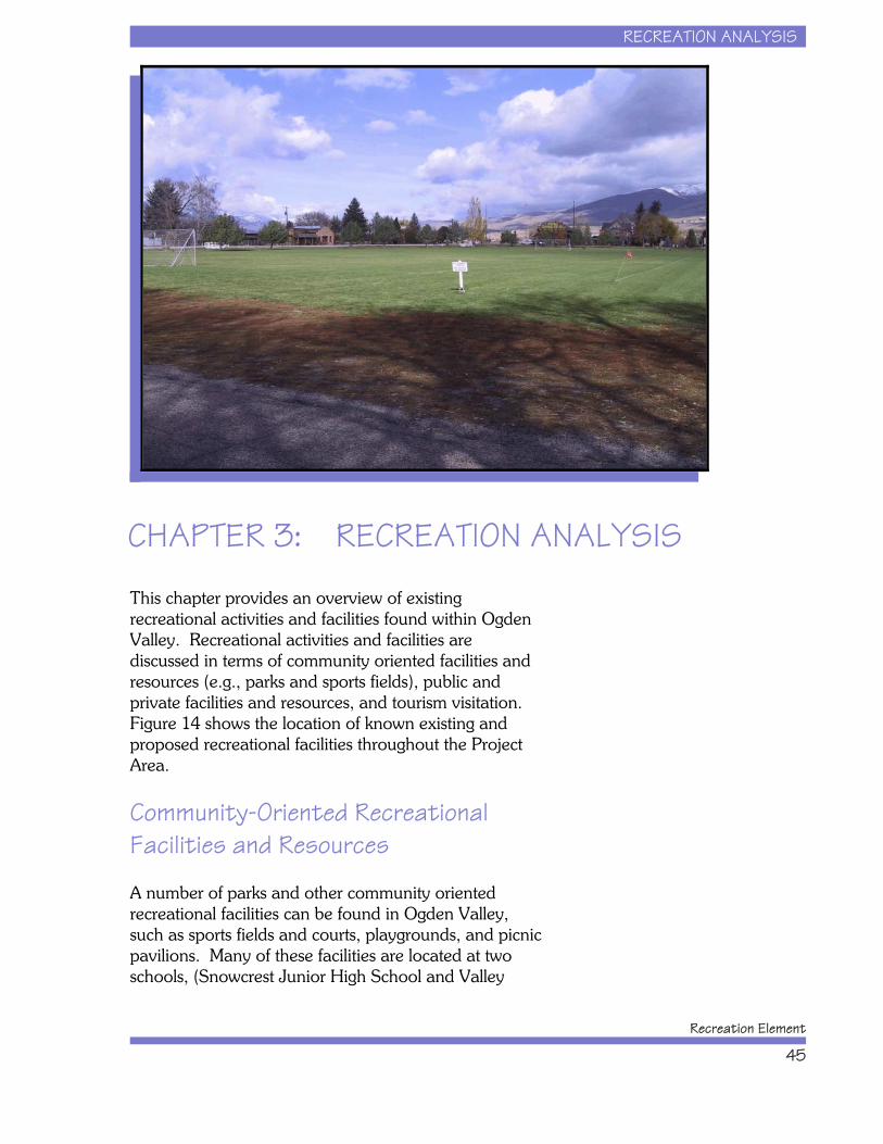
RECREATION ANALYSIS
Recreation Element
45
CHAPTER 3: RECREATION ANALYSIS
This chapter provides an overview of existingrecreational activities and facilities found within OgdenValley. Recreational activities and facilities arediscussed in terms of community oriented facilities andresources (e.g., parks and sports fields), public andprivate facilities and resources, and tourism visitation. Figure 14 shows the location of known existing andproposed recreational facilities throughout the ProjectArea.
Community-Oriented RecreationalFacilities and Resources
A number of parks and other community orientedrecreational facilities can be found in Ogden Valley,such as sports fields and courts, playgrounds, and picnicpavilions. Many of these facilities are located at twoschools, (Snowcrest Junior High School and Valley
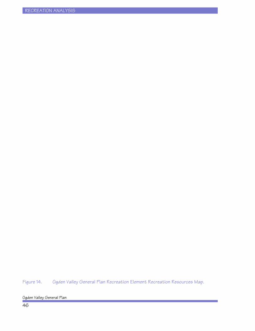
RECREATION ANALYSIS
Ogden Valley General Plan
46
Figure 14. Ogden Valley General Plan Recreation Element Recreation Resources Map.
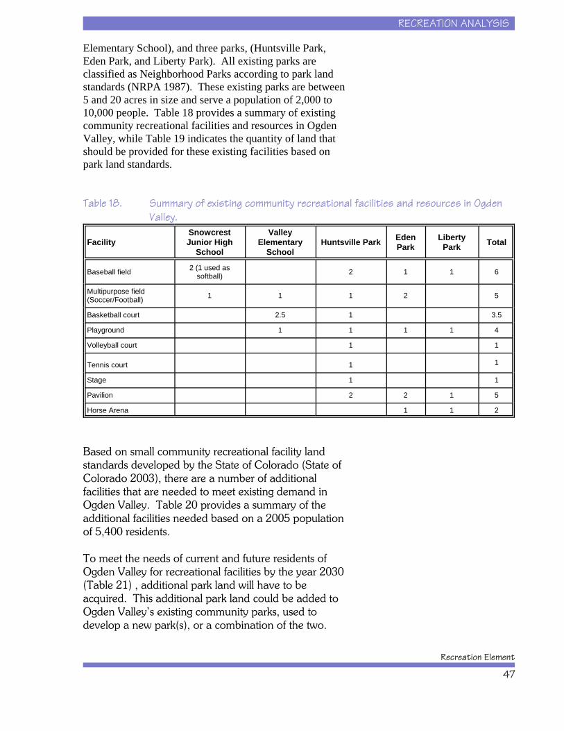
RECREATION ANALYSIS
Recreation Element
47
Elementary School), and three parks, (Huntsville Park,Eden Park, and Liberty Park). All existing parks areclassified as Neighborhood Parks according to park landstandards (NRPA 1987). These existing parks are between5 and 20 acres in size and serve a population of 2,000 to10,000 people. Table 18 provides a summary of existingcommunity recreational facilities and resources in OgdenValley, while Table 19 indicates the quantity of land thatshould be provided for these existing facilities based onpark land standards.
Table 18. Summary of existing community recreational facilities and resources in OgdenValley.
FacilitySnowcrestJunior High
School
ValleyElementary
SchoolHuntsville Park Eden
ParkLiberty
Park Total
Baseball field 2 (1 used assoftball) 2 1 1 6
Multipurpose field(Soccer/Football) 1 1 1 2 5
Basketball court 2.5 1 3.5
Playground 1 1 1 1 4
Volleyball court 1 1
Tennis court 1 1
Stage 1 1
Pavilion 2 2 1 5
Horse Arena 1 1 2
Based on small community recreational facility landstandards developed by the State of Colorado (State ofColorado 2003), there are a number of additionalfacilities that are needed to meet existing demand inOgden Valley. Table 20 provides a summary of theadditional facilities needed based on a 2005 populationof 5,400 residents.
To meet the needs of current and future residents ofOgden Valley for recreational facilities by the year 2030(Table 21) , additional park land will have to beacquired. This additional park land could be added toOgden Valley’s existing community parks, used todevelop a new park(s), or a combination of the two.
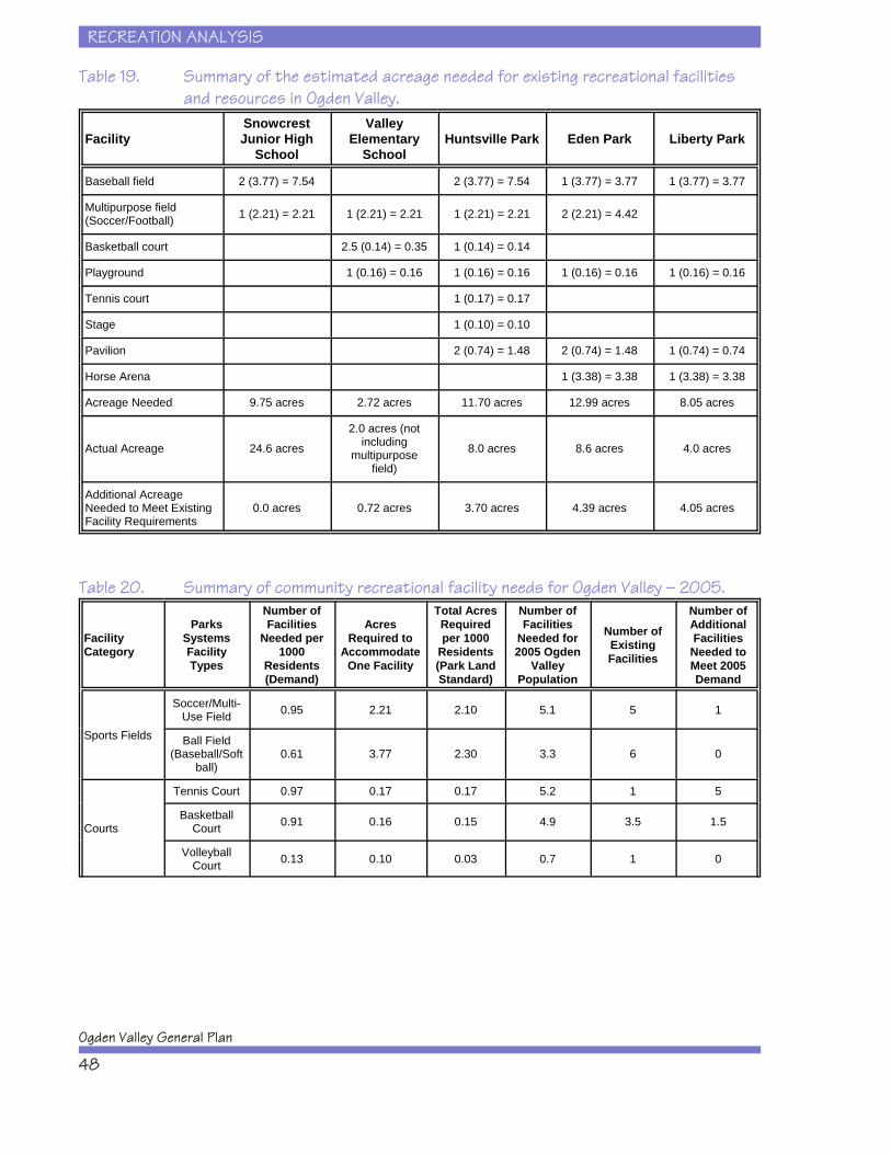
RECREATION ANALYSIS
Ogden Valley General Plan
48
Table 19. Summary of the estimated acreage needed for existing recreational facilitiesand resources in Ogden Valley.
FacilitySnowcrestJunior High
School
ValleyElementary
SchoolHuntsville Park Eden Park Liberty Park
Baseball field 2 (3.77) = 7.54 2 (3.77) = 7.54 1 (3.77) = 3.77 1 (3.77) = 3.77
Multipurpose field(Soccer/Football) 1 (2.21) = 2.21 1 (2.21) = 2.21 1 (2.21) = 2.21 2 (2.21) = 4.42
Basketball court 2.5 (0.14) = 0.35 1 (0.14) = 0.14
Playground 1 (0.16) = 0.16 1 (0.16) = 0.16 1 (0.16) = 0.16 1 (0.16) = 0.16
Tennis court 1 (0.17) = 0.17
Stage 1 (0.10) = 0.10
Pavilion 2 (0.74) = 1.48 2 (0.74) = 1.48 1 (0.74) = 0.74
Horse Arena 1 (3.38) = 3.38 1 (3.38) = 3.38
Acreage Needed 9.75 acres 2.72 acres 11.70 acres 12.99 acres 8.05 acres
Actual Acreage 24.6 acres
2.0 acres (notincluding
multipurposefield)
8.0 acres 8.6 acres 4.0 acres
Additional AcreageNeeded to Meet ExistingFacility Requirements
0.0 acres 0.72 acres 3.70 acres 4.39 acres 4.05 acres
Table 20. Summary of community recreational facility needs for Ogden Valley — 2005.
FacilityCategory
ParksSystemsFacilityTypes
Number ofFacilities
Needed per1000
Residents(Demand)
AcresRequired to
AccommodateOne Facility
Total AcresRequiredper 1000
Residents(Park LandStandard)
Number ofFacilities
Needed for2005 Ogden
ValleyPopulation
Number ofExistingFacilities
Number ofAdditionalFacilities
Needed toMeet 2005Demand
Sports Fields
Soccer/Multi-Use Field 0.95 2.21 2.10 5.1 5 1
Ball Field(Baseball/Soft
ball)0.61 3.77 2.30 3.3 6 0
Courts
Tennis Court 0.97 0.17 0.17 5.2 1 5
BasketballCourt 0.91 0.16 0.15 4.9 3.5 1.5
VolleyballCourt 0.13 0.10 0.03 0.7 1 0
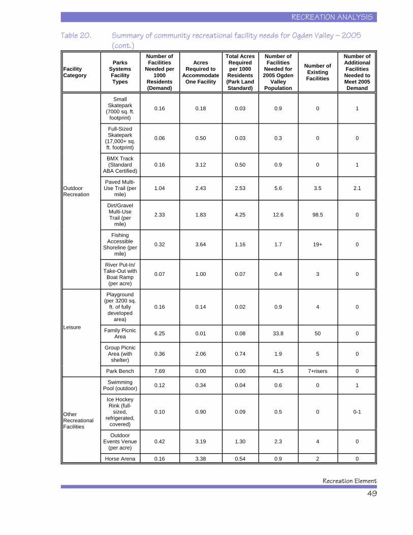
RECREATION ANALYSIS
Recreation Element
49
Table 20. Summary of community recreational facility needs for Ogden Valley — 2005(cont.)
FacilityCategory
ParksSystemsFacilityTypes
Number ofFacilities
Needed per1000
Residents(Demand)
AcresRequired to
AccommodateOne Facility
Total AcresRequiredper 1000
Residents(Park LandStandard)
Number ofFacilities
Needed for2005 Ogden
ValleyPopulation
Number ofExistingFacilities
Number ofAdditionalFacilities
Needed toMeet 2005Demand
OutdoorRecreation
SmallSkatepark
(7000 sq. ft.footprint)
0.16 0.18 0.03 0.9 0 1
Full-SizedSkatepark
(17,000+ sq.ft. footprint)
0.06 0.50 0.03 0.3 0 0
BMX Track(Standard
ABA Certified)0.16 3.12 0.50 0.9 0 1
Paved Multi-Use Trail (per
mile)1.04 2.43 2.53 5.6 3.5 2.1
Dirt/GravelMulti-UseTrail (per
mile)
2.33 1.83 4.25 12.6 98.5 0
FishingAccessible
Shoreline (permile)
0.32 3.64 1.16 1.7 19+ 0
River Put-In/Take-Out with
Boat Ramp(per acre)
0.07 1.00 0.07 0.4 3 0
Leisure
Playground(per 3200 sq.
ft. of fullydeveloped
area)
0.16 0.14 0.02 0.9 4 0
Family PicnicArea 6.25 0.01 0.08 33.8 50 0
Group PicnicArea (with
shelter)0.36 2.06 0.74 1.9 5 0
Park Bench 7.69 0.00 0.00 41.5 7+risers 0
OtherRecreationalFacilities
SwimmingPool (outdoor) 0.12 0.34 0.04 0.6 0 1
Ice HockeyRink (full-
sized,refrigerated,
covered)
0.10 0.90 0.09 0.5 0 0-1
OutdoorEvents Venue
(per acre)0.42 3.19 1.30 2.3 4 0
Horse Arena 0.16 3.38 0.54 0.9 2 0
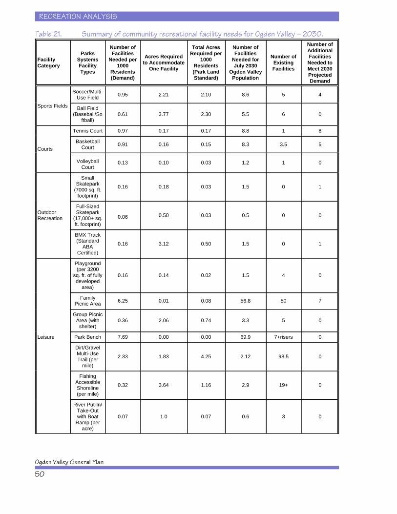
RECREATION ANALYSIS
Ogden Valley General Plan
50
Table 21. Summary of community recreational facility needs for Ogden Valley — 2030.
FacilityCategory
ParksSystemsFacilityTypes
Number ofFacilities
Needed per1000
Residents(Demand)
Acres Requiredto Accommodate
One Facility
Total AcresRequired per
1000Residents(Park LandStandard)
Number ofFacilities
Needed forJuly 2030
Ogden ValleyPopulation
Number ofExistingFacilities
Number ofAdditionalFacilities
Needed toMeet 2030ProjectedDemand
Sports Fields
Soccer/Multi-Use Field 0.95 2.21 2.10 8.6 5 4
Ball Field(Baseball/So
ftball)0.61 3.77 2.30 5.5 6 0
Courts
Tennis Court 0.97 0.17 0.17 8.8 1 8
BasketballCourt 0.91 0.16 0.15 8.3 3.5 5
VolleyballCourt
0.13 0.10 0.03 1.2 1 0
OutdoorRecreation
SmallSkatepark
(7000 sq. ft.footprint)
0.16 0.18 0.03 1.5 0 1
Full-SizedSkatepark
(17,000+ sq.ft. footprint)
0.06 0.50 0.03 0.5 0 0
BMX Track(Standard
ABACertified)
0.16 3.12 0.50 1.5 0 1
Leisure
Playground(per 3200
sq. ft. of fullydeveloped
area)
0.16 0.14 0.02 1.5 4 0
FamilyPicnic Area 6.25 0.01 0.08 56.8 50 7
Group PicnicArea (with
shelter)0.36 2.06 0.74 3.3 5 0
Park Bench 7.69 0.00 0.00 69.9 7+risers 0
Dirt/GravelMulti-UseTrail (per
mile)
2.33 1.83 4.25 2.12 98.5 0
FishingAccessibleShoreline(per mile)
0.32 3.64 1.16 2.9 19+ 0
River Put-In/Take-Outwith Boat
Ramp (peracre)
0.07 1.0 0.07 0.6 3 0
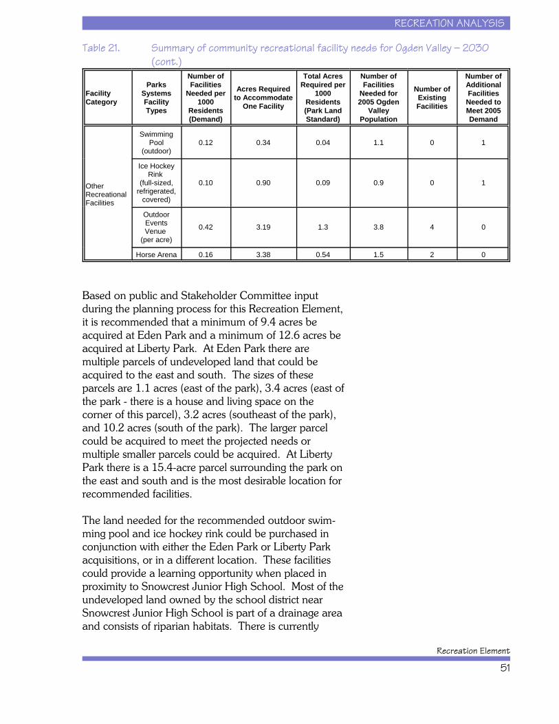
RECREATION ANALYSIS
Recreation Element
51
Table 21. Summary of community recreational facility needs for Ogden Valley — 2030(cont.)
FacilityCategory
ParksSystemsFacilityTypes
Number ofFacilities
Needed per1000
Residents(Demand)
Acres Requiredto Accommodate
One Facility
Total AcresRequired per
1000Residents(Park LandStandard)
Number ofFacilities
Needed for2005 Ogden
ValleyPopulation
Number ofExistingFacilities
Number ofAdditionalFacilities
Needed toMeet 2005Demand
OtherRecreationalFacilities
SwimmingPool
(outdoor)0.12 0.34 0.04 1.1 0 1
Ice HockeyRink
(full-sized,refrigerated,
covered)
0.10 0.90 0.09 0.9 0 1
OutdoorEventsVenue
(per acre)
0.42 3.19 1.3 3.8 4 0
Horse Arena 0.16 3.38 0.54 1.5 2 0
Based on public and Stakeholder Committee inputduring the planning process for this Recreation Element,it is recommended that a minimum of 9.4 acres beacquired at Eden Park and a minimum of 12.6 acres beacquired at Liberty Park. At Eden Park there aremultiple parcels of undeveloped land that could beacquired to the east and south. The sizes of theseparcels are 1.1 acres (east of the park), 3.4 acres (east ofthe park - there is a house and living space on thecorner of this parcel), 3.2 acres (southeast of the park),and 10.2 acres (south of the park). The larger parcelcould be acquired to meet the projected needs ormultiple smaller parcels could be acquired. At LibertyPark there is a 15.4-acre parcel surrounding the park onthe east and south and is the most desirable location forrecommended facilities.
The land needed for the recommended outdoor swim-ming pool and ice hockey rink could be purchased inconjunction with either the Eden Park or Liberty Parkacquisitions, or in a different location. These facilitiescould provide a learning opportunity when placed inproximity to Snowcrest Junior High School. Most of theundeveloped land owned by the school district nearSnowcrest Junior High School is part of a drainage areaand consists of riparian habitats. There is currently
RECREATION ANALYSIS
Ogden Valley General Plan
52
sufficient developable land for the recommended tenniscourts at Snowcrest Junior High.
To meet existing (2005) recreational facility needs atHuntsville Park, 3.7 acres would need to be acquired. Similarly at Valley Elementary, 0.7 acres would need tobe acquired to meet existing recreational facility needs. At this time, there is no undeveloped land availableadjacent to Huntsville Park or Valley Elementary Schoolwith the exception of one small parcel northeast of thepark and east of the school. Future recreational facilityexpansion at Huntsville Park or Valley ElementarySchool will be substantially limited by land availabilityand it may be more prudent to consider new park landselsewhere to serve the growing population in Huntsville.
Consideration should be given to future communitypark needs in the southern portion of Ogden Valley,south of Pineview Reservoir. This is a rapidly growingand developing area of the Ogden Valley that issomewhat separated geographically from existingcommunity parks north of Pineview Reservoir. However, much of the future recreational facility needsfor Ogden Valley residents for the next 25 years can beaccommodated at existing park and school facilities. Table 22 provides a summary of recommended facilityexpansions by the year 2030 for existing communityoriented recreational facilities.
Public and Private RecreationalFacilities and Resources
Non-organized recreational facilities and resources coveractivities that typically occur on public lands (e.g., U.S.Forest Service and State of Utah lands), though someactivities also occur on private lands (e.g., golf, hunting,fishing, skiing). The context and extent of theseactivities within Ogden Valley are presented below byactivity category.
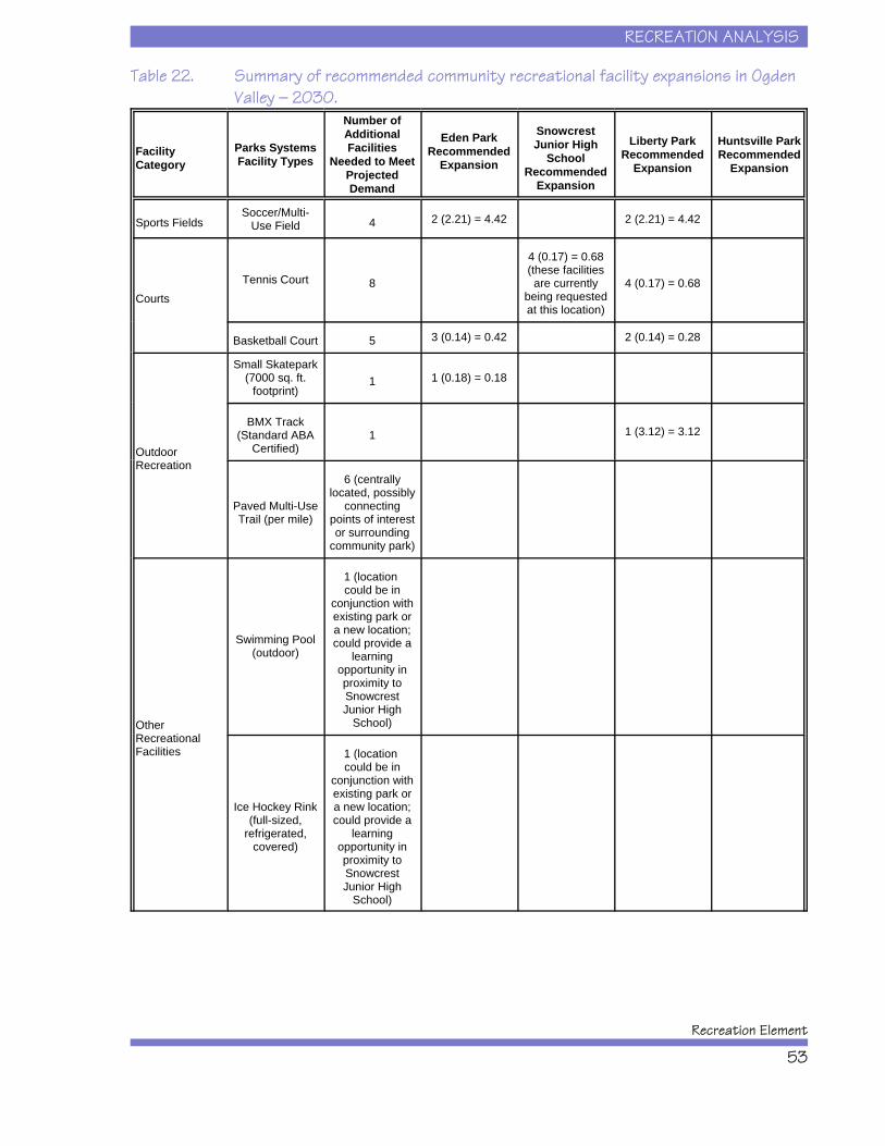
RECREATION ANALYSIS
Recreation Element
53
Table 22. Summary of recommended community recreational facility expansions in OgdenValley — 2030.
FacilityCategory
Parks SystemsFacility Types
Number ofAdditionalFacilities
Needed to MeetProjectedDemand
Eden ParkRecommended
Expansion
SnowcrestJunior High
SchoolRecommended
Expansion
Liberty ParkRecommended
Expansion
Huntsville ParkRecommended
Expansion
Sports FieldsSoccer/Multi-
Use Field 4 2 (2.21) = 4.42 2 (2.21) = 4.42
CourtsTennis Court 8
4 (0.17) = 0.68(these facilitiesare currently
being requestedat this location)
4 (0.17) = 0.68
Basketball Court 5 3 (0.14) = 0.42 2 (0.14) = 0.28
OutdoorRecreation
Small Skatepark(7000 sq. ft.
footprint)1 1 (0.18) = 0.18
BMX Track(Standard ABA
Certified)1 1 (3.12) = 3.12
Paved Multi-UseTrail (per mile)
6 (centrallylocated, possibly
connectingpoints of interestor surrounding
community park)
OtherRecreationalFacilities
Swimming Pool(outdoor)
1 (location could be in
conjunction withexisting park ora new location;could provide a
learningopportunity inproximity toSnowcrestJunior High
School)
Ice Hockey Rink(full-sized,
refrigerated,covered)
1 (location could be in
conjunction withexisting park ora new location;could provide a
learningopportunity inproximity toSnowcrestJunior High
School)
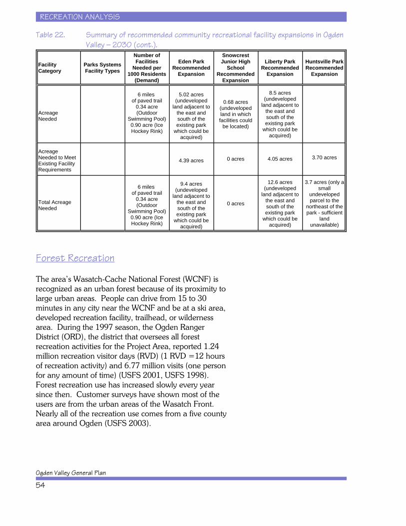
RECREATION ANALYSIS
Ogden Valley General Plan
54
Table 22. Summary of recommended community recreational facility expansions in OgdenValley — 2030 (cont.).
FacilityCategory
Parks SystemsFacility Types
Number ofFacilities
Needed per1000 Residents
(Demand)
Eden ParkRecommended
Expansion
SnowcrestJunior High
SchoolRecommended
Expansion
Liberty ParkRecommended
Expansion
Huntsville ParkRecommended
Expansion
AcreageNeeded
6 miles of paved trail
0.34 acre(Outdoor
Swimming Pool)0.90 acre (IceHockey Rink)
5.02 acres(undeveloped
land adjacent tothe east andsouth of theexisting park
which could beacquired)
0.68 acres(undevelopedland in whichfacilities could
be located)
8.5 acres(undeveloped
land adjacent tothe east andsouth of theexisting park
which could beacquired)
AcreageNeeded to MeetExisting FacilityRequirements
4.39 acres 0 acres 4.05 acres 3.70 acres
Total AcreageNeeded
6 miles of paved trail
0.34 acre(Outdoor
Swimming Pool)0.90 acre (IceHockey Rink)
9.4 acres(undeveloped
land adjacent tothe east andsouth of theexisting park
which could beacquired)
0 acres
12.6 acres(undeveloped
land adjacent tothe east andsouth of theexisting park
which could beacquired)
3.7 acres (only asmall
undevelopedparcel to the
northeast of thepark - sufficient
landunavailable)
Forest Recreation
The area’s Wasatch-Cache National Forest (WCNF) isrecognized as an urban forest because of its proximity tolarge urban areas. People can drive from 15 to 30minutes in any city near the WCNF and be at a ski area,developed recreation facility, trailhead, or wildernessarea. During the 1997 season, the Ogden RangerDistrict (ORD), the district that oversees all forestrecreation activities for the Project Area, reported 1.24million recreation visitor days (RVD) (1 RVD =12 hoursof recreation activity) and 6.77 million visits (one personfor any amount of time) (USFS 2001, USFS 1998). Forest recreation use has increased slowly every yearsince then. Customer surveys have shown most of theusers are from the urban areas of the Wasatch Front. Nearly all of the recreation use comes from a five countyarea around Ogden (USFS 2003).
RECREATION ANALYSIS
Recreation Element
55
Popular summer activities on the WCNF includecamping, scenic driving, hiking, biking, boating,swimming, bird watching, hunting, and fishing. Winteractivities include snowmobiling, ice fishing, downhill andcross-country skiing (USFS 2003). There are thirteencampgrounds, one picnic-ground, two marinas, threeswim beaches, two fisherman parking areas, eleventrailheads, and two overlooks on the ORD. Most of thedeveloped recreation sites are located at either PineviewReservoir, Causey Reservoir, or along the South Fork ofthe Ogden River.
Undeveloped recreation occurs along most of the pavedand natural surface roads in the ORD. Hardenedundeveloped areas, to protect resources, have beenprovided in the Monte Cristo area near State Highway39. Many of the inventoried undeveloped sites are usedonly during the big game hunting season. In winter,most of the Monte Cristo and Curtis Creek areas areextremely popular for snowmobiling. The snowmobiletrailhead at Monte Cristo is one of the highest use wintertrailheads in the state (USFS 2003). At the same time,this area is surrounded by private lands and trespassingis a major issue for property owners.
The USFS recommended an area east of CauseyReservoir as the Upper South Fork Wilderness Area inthe Revised Forest Plan in February 2003. According tothe Revised Forest Plan, the Upper South Forkrecommended wilderness area will be surveyed andboundaries marked to clearly identify the area. Existingtrails will be maintained and/or relocated to meet safetystandards and to prevent watershed/soil impacts. Newtrail development will be limited. A trailhead will beprovided in the Cabin Ridge/Bluebell Flat areas toprovide access (USFS 2003).
The number of developed forest recreation sites and thecapacity of those sites are shown in Table 23. Theweighted average occupancy by percent and season ofuse of these facilities are 51 percent during high use, 30percent during shoulder-season use, 8 percent duringlow/closed use, and 85 percent during holiday use.
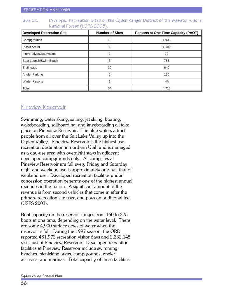
RECREATION ANALYSIS
Ogden Valley General Plan
56
Table 23. Developed Recreation Sites on the Ogden Ranger District of the Wasatch-CacheNational Forest (USFS 2003).
Developed Recreation Site Number of Sites Persons at One Time Capacity (PAOT)
Campgrounds 13 1,935
Picnic Areas 3 1,190
Interpretive/Observation 2 70
Boat Launch/Swim Beach 3 758
Trailheads 10 640
Angler Parking 2 120
Winter Resorts 1 NA
Total 34 4,713
Pineview Reservoir
Swimming, water skiing, sailing, jet skiing, boating,wakeboarding, sailboarding, and kneeboarding all takeplace on Pineview Reservoir. The blue waters attractpeople from all over the Salt Lake Valley up into theOgden Valley. Pineview Reservoir is the highest userecreation destination in northern Utah and is managedas a day-use area with overnight stays in adjacentdeveloped campgrounds only. All campsites atPineview Reservoir are full every Friday and Saturdaynight and weekday use is approximately one-half that ofweekend use. Developed recreation facilities underconcession operation generate one of the highest annualrevenues in the nation. A significant amount of therevenue is from second vehicles that come in after theprimary recreation site user, and pays an additional fee(USFS 2003).
Boat capacity on the reservoir ranges from 160 to 375boats at one time, depending on the water level. Thereare some 4,900 surface acres of water when thereservoir is full. During the 1997 season, the ORDreported 481,972 recreation visitor days and 2,232,145visits just at Pineview Reservoir. Developed recreationfacilities at Pineview Reservoir include swimmingbeaches, picnicking areas, campgrounds, angleraccesses, and marinas. Total capacity of these facilities

RECREATION ANALYSIS
Recreation Element
57
is 3,445 people at one time (USFS 2001). In 2002, 15acres of USFS land on the shores of Pineview Reservoirwas designated as the Gunn McKay Nature Preserve byan act of the U.S. Congress.
Trails - Hiking, Biking, and Equestrian
According to the Ogden Valley Pathway Master Plan(Weber Pathways 2002), there are at least thirty-twonamed trails located in the Project Area and even moreare currently being planned. There are currently 118miles of developed trails in the Project Area and over215 additional miles of developed trails planned. Thesetrails provide access to a variety of landscapes fordiffering users. Some trails allow equestrians, mountainbikes, and hikers, while others permit motorized uses. There are many equestrian trails in the Ogden Valleyand up to the Monte Cristo area, but they areparticularly popular in the Middle Fork area of OgdenValley. Some of the popular trailheads that exist in theProject Area are: Art Nord, Ben Lomond, Cutler Basin,Green Pond, Middle Fork, Monte Cristo Snowmobile,North Arm, North Ogden Divide, Pineview, Skull Crack,Skyline, Snowbasin, Wheatgrass, and Wheeler Creek.
One of the trails in the Project Area, the Skyline Trail, isa trail of national, regional, and statewide importance asit is a section of the Great Western Trail that stretchesfrom Canada to Mexico through the Rocky Mountains ofthe United States. The overall plan for this trail is toinclude over 4,455 miles of roads and trails crossing fivestates, including Utah. Approximately 1,600 miles ofthe trail are in Utah. The trail has been proposed as anational trail in a new designation called “NationalDiscovery Trails.” These National Discovery Trails willbe continuous interstate trails, and their purpose is tohelp users experience and learn about aspects ofAmerican life and history while connecting urban areaswith rural backcountry areas.
RECREATION ANALYSIS
Ogden Valley General Plan
58
Fishing
In Ogden Valley there is year-round fishing in streamsand lakes. Rainbow trout and brown trout are found inthe Ogden River, while Wheeler Creek containscutthroat trout. The Middle Fork of the Ogden River,which discharges into Pineview Reservoir, contains anextremely high density of mottled sculpin, as well assignificant numbers of cutthroat trout, rainbow trout,and cutthroat-rainbow hybrids. Pineview Reservoirsupports a variety of fish species including rainbowtrout, brown trout, largemouth bass, bluegill, blackcrappie, black bullhead, green sunfish, carp, Utah chub,tiger muskellunge, channel catfish, and yellow perch. Kokannee salmon spawn in the tributaries of CauseyReservoir, and Bonneville cutthroat trout are also foundin these tributaries (USFS 2001, USFS 1998). CauseyReservoir also has populations of splake, tiger trout, andrainbow trout. There are five developed angler accesspoints at Pineview Reservoir: Old Highway, GeertsenBay, Spring Creek, Narrows, and BOR.
Hunting
Deer, elk, pheasant, grouse, chukar, and duck huntingare tremendous attractions for residents and visitors ofOgden Valley each year. Some permits are also givenfor moose and mountain lion. The Utah Department ofNatural Resources, Division of Wildlife Resources(UDWR) establishes annual hunting proclamations forlands within the Project Area. The UDWR also managesabout 10,000 acres in the Project Area as the MiddleFork of the Ogden River Wildlife Management Area toprovide hunting and other recreational opportunitiesand to protect big game winter range. Red Rock Ranchand Outfitters has guided hunting and fishing trips alongwith horseback riding, hay rides, sleigh rides,snowmobiling, and Dutch oven cooking. The RockingC Ranch is located just outside of the Project Area inCache County and provides similar services. TheWeber Wildlife Federation owns 320 acres of privateproperty along the Avon Divide Road that has beenused as a shooting range since 1956 and is the onlylegal, open public shooting range in Weber County.
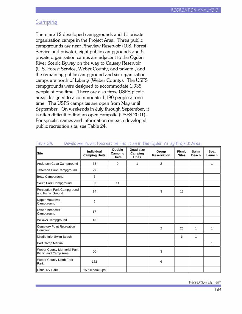
RECREATION ANALYSIS
Recreation Element
59
Camping
There are 12 developed campgrounds and 11 privateorganization camps in the Project Area. Three publiccampgrounds are near Pineview Reservoir (U.S. ForestService and private), eight public campgrounds and 5private organization camps are adjacent to the OgdenRiver Scenic Byway on the way to Causey Reservoir(U.S. Forest Service, Weber County, and private), andthe remaining public campground and six organizationcamps are north of Liberty (Weber County). The USFScampgrounds were designed to accommodate 1,935people at one time. There are also three USFS picnicareas designed to accommodate 1,190 people at onetime. The USFS campsites are open from May untilSeptember. On weekends in July through September, itis often difficult to find an open campsite (USFS 2001). For specific names and information on each developedpublic recreation site, see Table 24.
Table 24. Developed Public Recreation Facilities in the Ogden Valley Project Area.
Site IndividualCamping Units
DoubleCamping
Units
Quad-sizeCamping
UnitsGroup
ReservationPicnicSites
SwimBeach
BoatLaunch
Anderson Cove Campground 58 9 1 2 1
Jefferson Hunt Campground 29
Botts Campground 8
South Fork Campground 33 11
Perception Park Campground and Picnic Ground 24 3 13
Upper MeadowsCampground 9
Lower MeadowsCampground 17
Willows Campground 13
Cemetery Point RecreationComplex 2 26 1 1
Middle Inlet Swim Beach 6 1
Port Ramp Marina 1
Weber County Memorial ParkPicnic and Camp Area 60 3
Weber County North ForkPark 182 6
Chris’ RV Park 15 full hook-ups
RECREATION ANALYSIS
Ogden Valley General Plan
60
The private organizational camps that exist are CampAtoka, Camp Browning-Camp Kiesel, Camp Utaba,Camp Lamondi, Valley Camp, Pioneer Bible Camp,Pleasant View Stake Camp, Stake Camp: KanesvilleRoy Hooper Midland, Camp Shawnee, Camp Beaver,and Camp Red Cliff. These camps are owned andoperated by family associations, the Boy Scouts ofAmerica, and various churches including the UtahAmerican Baptist Association, the Church of JesusChrist of Latter-day Saints, and the Midvalley BibleChurch. There are no public facilities at these camps.
Climbing
Geologic formations make Ogden Canyon attractive torock climbers. Some of the climbs were originallyestablished in the 1960s by Jeff and Greg Lowe whenthey began their climbing careers. There are between30 and 40 different climbs ranging from 5.6 to 5.13+. Some areas are closed to climbing and local climbingshops have information on open climbing areas(Mecham nd). In addition to rock climbing, there areseveral ice climbs that bring people to Ogden Canyon. There are eight ice climbs inside of Ogden Canyon,located on the north canyon wall where the streamdrops beneath the road and switches sides. These iceclimbs are on the man-made waterfall created by apipeline. These climbs range from W12-3, I to W15, I. The combined length of these ice climbs is 2,010 feet(Black 2000). Most of these rock and ice climbs arelocated just outside the Project Area.
Scenic Driving
There are several opportunities for area scenic drivingloops that connect with the Ogden River Scenic Bywaythat runs through Ogden Valley. Ogden Valley is apopular destination, especially in the fall when theleaves begin to change colors. A drive thatencompasses this entire byway, and traverses another,begins in Ogden and follows the byway through MonteCristo to Woodruff, to Bear Lake, through Logan, andpast the Wellsville Mountains to Brigham City and thenback to Ogden. This route connects the Ogden River
RECREATION ANALYSIS
Recreation Element
61
Scenic Byway with the Bear Lake Scenic Byway and theLogan Canyon Scenic Byway. There are also threeshorter loops: one begins in Ogden and goes toHuntsville, across Trapper’s Loop, through WeberCanyon, and back to Ogden; another runs from Ogdento Huntsville, through Eden and Liberty, down NorthOgden Canyon, and back to Ogden; and a third runsfrom Pineview Reservoir up Trappers Loop toSnowbasin Resort, down the old Snowbasin accessroad, and back to the reservoir.
Golf
There is one 18-hole golf course operating and locatedwithin the Project Area at Wolf Creek Resort. NordicValley Resort has a golf course on its property, which iscurrently closed.
Snow Skiing
Utah, home to the 2002 Winter Olympics, is dotted withnumerous ski resorts. Several of these are in themountains surrounding Ogden Valley, includingSnowbasin, Powder Mountain, and Nordic Valley. Theback country in and around these resorts is also afavorite to cross-country skiers. There are ten trails forcross-country skiers in the Ogden Valley area, some ofwhich are groomed.
Snowbasin Resort, owned by Mr. Earl Holding andfounded in 1939, is one of the oldest continuouslyoperated major mountains in America. SnowbasinResort made significant improvements to its facilitiesprior to the 2002 Winter Olympics, in anticipation of thedownhill and super G events that were held at themountain. In addition to skiing, the resort offers a lodgeand many miles of biking and hiking trails. The ownershave major plans for the resort and hope that it will oneday be quite similar to Sun Valley Resort in Idaho with afull range of entertainment, recreation, shopping, diningand lodging facilities. Along with its 3,300 acres of landin Weber County, the resort owns many thousands ofacres across the county line to the south in MorganCounty. The estimate of skier visits at Snowbasin Resort
RECREATION ANALYSIS
Ogden Valley General Plan
62
in 2000/2001 was 150,000 (USFS 2001). With onedouble and four triple chairs, one high speed quad, twogondolas, one jig back tram, and two magic carpets,Snowbasin Resort can transport 14,650 skiers per houronto 2,650 acres of packed trails, powder bowls, andglades. Snowbasin Resort has 2,950 vertical feet and 53designated trails. The runs consist of 20 percent novice,50 percent intermediate, and 30 percent expert(Snowbasin 2004). Much of Snowbasin Resort’s skitrails are under permit by the USFS and affect 1,850acres of National Forest System Lands as well asadjacent private property. There is authorization inconcept for continued development of a four-seasondestination resort at Snowbasin (USFS 2003).
Powder Mountain Ski Resort was founded by Dr. AlvinCobabe on land owned by his family. Since that time,the Cobabe family has built Powder Mountain into apopular ski resort that sees over 90,000 skier days peryear. Powder Mountain has seven chair lifts servingover 2,800 acres, including Powder Country backsideshuttle, Lightning Ridge snowcat skiing, guided tours ofWolf Creek Canyon, and over 5,500 total acres ofterrain from the serene to the extreme (PowderMountain 2004). Powder Mountain has begun todevelop some of its land for residential propertiesincluding both single family and condos. The top of themountain holds a variety of small lodging facilities andmain ski lodge.
Nordic Valley is a smaller family-oriented resort with 16trails, two lifts, and 100 acres of skiing terrain and acapacity of 1,800 skiers per hour (Nordic Valley 2004). Future plans for the facility include maintaining the skioperation and building its allotment of houses andcondominiums.
Snowmobiling
The longest groomed snowmobile trails in Utah are inthe Monte Cristo area and accessed from the OgdenRiver Scenic Byway (State Highway 39). The road onthis segment closes during the winter, and the areaforms the largest trailhead in Utah for approximately
RECREATION ANALYSIS
Recreation Element
63
125 miles of state-groomed snowmobile trails that leadnorth to Hardware Ranch in Blacksmith Fork Canyonnear Logan (USFS 2001). This area is managed by theState of Utah, Department of Parks and Recreation.
Tourism Visitation
Ogden Valley has almost every type of outdoorrecreation that one might seek. The Project Areasupports downhill skiing, river and lake fishing, boating,hiking, snowmobiling, rock climbing, horseback riding,hunting, camping, bicycling, scenic driving, wildlifeviewing, cross-country skiing, and just about any otheroutdoor activity that the people of Utah enjoy. As such,Ogden Valley is becoming a more and more popularrecreation destination with locals as well as non-residents with each passing year.
In some respects, there is nothing new about this trend,for Ogden Valley has a long history of providing spaceand resources for recreation. From the early days ofOgden City’s establishment, the springs of Ogden Valleyas well as the beautiful setting and bountiful fish andgame made the area popular with residents and 19thcentury and early 20th century tourists. At one point atrolley car carried visitors from the bottom of OgdenCanyon to Ogden Valley and its resources.
But, as with many things, that which can easily beaccommodated in the early stages of growth can thenbecome more troublesome as growth proceeds. Today,Ogden Valley is heavily used by local residents, otherUtah residents, and out-of-state visitors. The use levelsof today dwarf those of 100 years ago, but OgdenValley is sufficiently large that the majority of resourcesin the Valley are currently not over-used, though someare at capacity. It is likely, however, that these trendswill continue and that resources will become more andmore constrained. Therefore, the focus of theRecreation Element is on how Ogden Valley shouldaccommodate increasing numbers of visitors andresidents over the next three decades.

RECREATION ANALYSIS
Ogden Valley General Plan
64
Ogden Valley is a playground for northern Utahresidents. Much of the population of Weber, Davis,Morgan, Rich and Box Elder counties finds some reasonto visit Ogden Valley at least once a year. Thepopulation of that urbanizing area totals over 480,000people and is projected to grow to more than 720,000persons by the year 2020. The five county areacurrently comprises 22 percent of Utah’s population.
Local residents, the region’s population, and out-of-areavisitors combine to make up Ogden Valley’s tourismvisitor base. While there is no centralized visitorcounting system for Ogden Valley, by piecing togethervarious sources of information, one can understand thegeneral magnitude of visitation to Ogden Valley.
x Pineview Reservoir is managed by the U.S.Forest Service and periodically measuresvisitation. Its last visitation count was in 1997. At that time, the Forest Service estimated that thelake’s visitor day count exceeded 484,000 peryear. A visitor day is a 12 hour period of use. Given that many people do not spend a full 12hours on the lake, this figure translates into ahigher actual number of people and cars flowinginto and out of Ogden Valley to visit PineviewReservoir. If we use a conservative figure andassume that 50 percent of the visitors stay lessthan a full day, then one can increase the484,000 figure to at least 726,000 visitors. Given that the reservoir is used primarily fromMay to October, this translates into an average of121,000 visitor days per month. This equates to30,000 visitor days per week. Assuming that 75percent of weekly use is on the weekends, thenthis translates to 22,500 visitor days on eachweekend, which means there are approximately11,250 visitor days per weekend day. Assumingan average of two people per car for each visitorday, this means that approximately 5,625 carscome into Ogden Valley each weekend day forPineview Reservoir during the summer months. This equates to 11,250 trips assuming one trip in
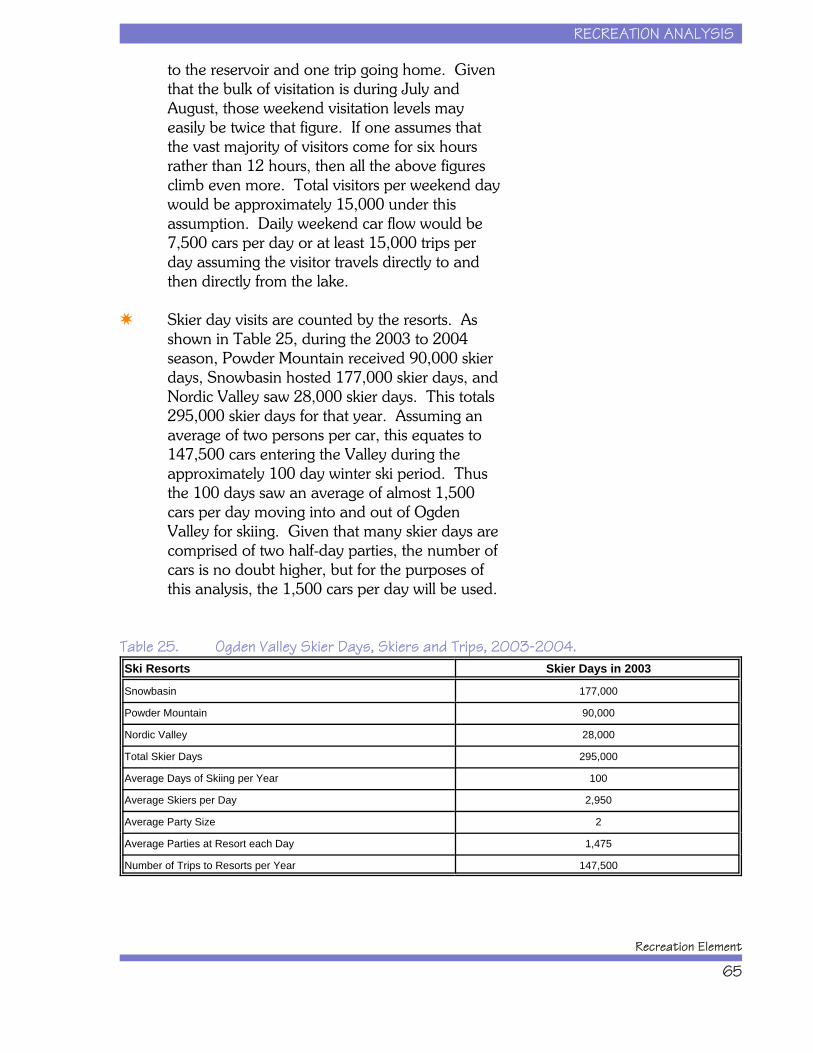
RECREATION ANALYSIS
Recreation Element
65
to the reservoir and one trip going home. Giventhat the bulk of visitation is during July andAugust, those weekend visitation levels mayeasily be twice that figure. If one assumes thatthe vast majority of visitors come for six hoursrather than 12 hours, then all the above figuresclimb even more. Total visitors per weekend daywould be approximately 15,000 under thisassumption. Daily weekend car flow would be7,500 cars per day or at least 15,000 trips perday assuming the visitor travels directly to andthen directly from the lake.
x Skier day visits are counted by the resorts. Asshown in Table 25, during the 2003 to 2004season, Powder Mountain received 90,000 skierdays, Snowbasin hosted 177,000 skier days, andNordic Valley saw 28,000 skier days. This totals295,000 skier days for that year. Assuming anaverage of two persons per car, this equates to147,500 cars entering the Valley during theapproximately 100 day winter ski period. Thusthe 100 days saw an average of almost 1,500cars per day moving into and out of OgdenValley for skiing. Given that many skier days arecomprised of two half-day parties, the number ofcars is no doubt higher, but for the purposes ofthis analysis, the 1,500 cars per day will be used.
Table 25. Ogden Valley Skier Days, Skiers and Trips, 2003-2004.Ski Resorts Skier Days in 2003
Snowbasin 177,000
Powder Mountain 90,000
Nordic Valley 28,000
Total Skier Days 295,000
Average Days of Skiing per Year 100
Average Skiers per Day 2,950
Average Party Size 2
Average Parties at Resort each Day 1,475
Number of Trips to Resorts per Year 147,500

RECREATION ANALYSIS
Ogden Valley General Plan
66
x Second Homes in Ogden Valley currentlyaccount for about 1,028 of the 3,000 existingresidences. A large portion of these (750) arewithin the Wolf Creek Resort and the rest arespread across Ogden Valley in the form ofcondos and single family units. As illustrated inChapter II of this Recreation Element, there issignificant potential for the total number ofhousing units to grow in Ogden Valley. Basedon current zoning and land capacity, the totalnumber of houses in Ogden Valley could grow ashigh as 15,000 to 17,000. This is well above the3,000 total units of today. It is likely that a largeportion of those future houses will be secondhomes. Moderate projections for the future,completed as part of this planning processestimate that the future second home countcould rise to 6,000 to 7,000 in the next 30 years. Assuming that today's 1,028 second homesgenerate at least an average of twelve visits ayear (by owners and renters), and assumingaverage party size of 3, then second homesgenerate another 37,000 visitors per year. Forsecond homes that are actively renting during skiseason, these figures are low.
x Other Ogden Valley Visitation. There arenumerous other types of outdoor visitation thatoccurs each year in Ogden Valley. Again, thereare no counting systems to know exactly howmany people flow into and out of the Valley eachyear for these activities. Using the inventory offacilities (e.g., parking spaces, campsites) inOgden Valley and conservative visitationassumptions, the following annual visitationlevels appear reasonable: Camping = 150,000;Hunting, fishing, hiking = over 100,000;Snowmobiling = over 30,000; Scenic Driving =over 75,000.
x Special Events. The various special events heldin Ogden Valley bring in at least another 50,000visitors per year.

RECREATION ANALYSIS
Recreation Element
67
Based on the above figures, Ogden Valley hosts over1.5 million visitors per year, spread out across the fourseasons and across the large geography of OgdenValley. With regional population growth expected toexceed 50 percent over the next 20 years, Ogden Valleygrowth having the potential to quadruple, and localresorts looking to expand and aggressively marketOgden Valley, all the variables are in position to suggestthat visitation to Ogden Valley could grow substantially. The amount of growth and use of resources will largelybe dependent on how this Recreation Element guidesWeber County in recreation and growth managementefforts.

RECREATION ANALYSIS
Ogden Valley General Plan
68
This page intentionally left blank.
RECREATION ANALYSIS
Recreation Element
69
Community-Oriented Recreational Facilities and Resources . . . . . . . . . . . . . . . . . . . . . 45Public and Private Recreational Facilities and Resources . . . . . . . . . . . . . . . . . . . . . . . . 52
Forest Recreation . . . . . . . . . . . . . . . . . . . . . . . . . . . . . . . . . . . . . . . . . . . . . . . . . 54Pineview Reservoir . . . . . . . . . . . . . . . . . . . . . . . . . . . . . . . . . . . . . . . . . . . . . . . 56Trails - Hiking, Biking, and Equestrian . . . . . . . . . . . . . . . . . . . . . . . . . . . . . . . . 57Fishing . . . . . . . . . . . . . . . . . . . . . . . . . . . . . . . . . . . . . . . . . . . . . . . . . . . . . . . . . 58Hunting . . . . . . . . . . . . . . . . . . . . . . . . . . . . . . . . . . . . . . . . . . . . . . . . . . . . . . . . 58Camping . . . . . . . . . . . . . . . . . . . . . . . . . . . . . . . . . . . . . . . . . . . . . . . . . . . . . . . . 59Climbing . . . . . . . . . . . . . . . . . . . . . . . . . . . . . . . . . . . . . . . . . . . . . . . . . . . . . . . 60Scenic Driving . . . . . . . . . . . . . . . . . . . . . . . . . . . . . . . . . . . . . . . . . . . . . . . . . . . 60Golf . . . . . . . . . . . . . . . . . . . . . . . . . . . . . . . . . . . . . . . . . . . . . . . . . . . . . . . . . . . 61Snow Skiing . . . . . . . . . . . . . . . . . . . . . . . . . . . . . . . . . . . . . . . . . . . . . . . . . . . . . 61Snowmobiling . . . . . . . . . . . . . . . . . . . . . . . . . . . . . . . . . . . . . . . . . . . . . . . . . . . 62
Tourism Visitation . . . . . . . . . . . . . . . . . . . . . . . . . . . . . . . . . . . . . . . . . . . . . . . . . . . . . . 63
Table 18. Summary of existing community recreational facilities and resources in OgdenValley. . . . . . . . . . . . . . . . . . . . . . . . . . . . . . . . . . . . . . . . . . . . . . . . . . . . . . . . . . 47
Table 19. Summary of the estimated acreage needed for existing recreational facilities andresources in Ogden Valley. . . . . . . . . . . . . . . . . . . . . . . . . . . . . . . . . . . . . . . . . . 48
Table 20. Summary of community recreational facility needs for Ogden Valley – 2005.. . . . . . . . . . . . . . . . . . . . . . . . . . . . . . . . . . . . . . . . . . . . . . . . . . . . . . . . . . . . . . . . . . . . . 48
Table 21. Summary of community recreational facility needs for Ogden Valley – 2030.. . . . . . . . . . . . . . . . . . . . . . . . . . . . . . . . . . . . . . . . . . . . . . . . . . . . . . . . . . . . . . . 50
Table 22. Summary of recommended community recreational facility expansions in OgdenValley – 2030. . . . . . . . . . . . . . . . . . . . . . . . . . . . . . . . . . . . . . . . . . . . . . . . . . . . 53
Table 23. Developed Recreation Sites on the Ogden Ranger District of the Wasatch-CacheNational Forest (USFS 2003). . . . . . . . . . . . . . . . . . . . . . . . . . . . . . . . . . . . . . . . 56
Table 24. Developed Public Recreation Facilities in the Ogden Valley Project Area. . . . . 59Table 25. Ogden Valley Skier Days, Skiers and Trips, 2003-2004. . . . . . . . . . . . . . . . . . . 65
Figure 14. Ogden Valley General Plan Recreation Element Recreation Resources Map. . . 46
Figure 14. Ogden Valley General Plan Recreation Element Recreation Resources Map. . . 46
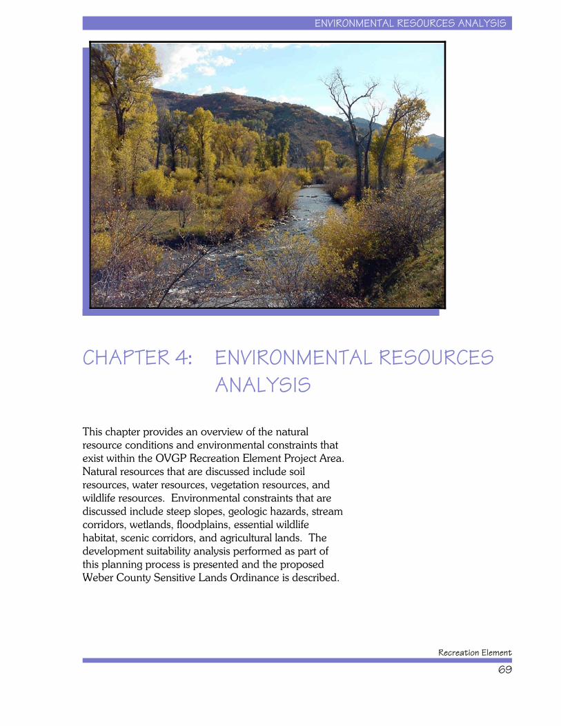
ENVIRONMENTAL RESOURCES ANALYSIS
Recreation Element
69
CHAPTER 4: ENVIRONMENTAL RESOURCESANALYSIS
This chapter provides an overview of the naturalresource conditions and environmental constraints thatexist within the OVGP Recreation Element Project Area. Natural resources that are discussed include soilresources, water resources, vegetation resources, andwildlife resources. Environmental constraints that arediscussed include steep slopes, geologic hazards, streamcorridors, wetlands, floodplains, essential wildlifehabitat, scenic corridors, and agricultural lands. Thedevelopment suitability analysis performed as part ofthis planning process is presented and the proposedWeber County Sensitive Lands Ordinance is described.
ENVIRONMENTAL RESOURCES ANALYSIS
Ogden Valley General Plan
70
Natural Resources
Natural resources abound in Ogden Valley. Theresources of relevance to this planning process includesoils, water, vegetation, and wildlife. These aredescribed below by resource category.
Soil Resources
Soil resources within Ogden Valley are detailed in thesoil survey for the Morgan Area, which includes theeastern part of Weber County (USDA 1980). The soilsin Ogden Valley range from shallow, skeletal, residual,high mountain soils to very deep, fine textured, alluvialsoils in the valley bottom and lower mountain slopes. Most are well drained with moderately slow tomoderately high infiltration and permeability rates. Much of the soils in Ogden Valley are relatively stable toerosion, until they are disturbed.
Soil properties dictate resource conditions for crops andpasture, rangeland, wildlife habitat, recreation, andengineering capabilities throughout the Project Area. Over 9,000 acres of land are used for crops in OgdenValley, primarily for hay, grain, and silage. Soils inOgden Valley are susceptible to frost in late spring andearly fall, limiting the production of vegetables, smallfruits, or orchards. Both sheep and cattle are grazedthroughout much of the Project Area. The soil survey(USDA 1980) rates the engineering capabilities ofdifferent soil types for building sites, sanitary facilities,construction materials, and water management. Soillimitations include shallow depth to bedrock, soilwetness, shallow depth to water table, steep slope,likelihood of flooding, erodibility, permeability, shrink-swell potential, and shear strength. The characteristicsof a soil are determined by such factors as parentmaterial, climate, topography, moisture content,aeration, and biological forces.
ENVIRONMENTAL RESOURCES ANALYSIS
Recreation Element
71
Water Resources
The Ogden River and its primary tributaries form themain hydrology for Ogden Valley. The North Forkdrains the northwestern portion of the Valley, the MiddleFork drains the northeastern portion of the Valley, andthe South Fork drains the entire southern portion of theValley. The Ogden River watershed generally drainsfrom east to west, from the higher elevation mountainsinto Ogden Canyon. Surface water is stored in threereservoirs within the Ogden Valley watershed: Utaba, asmall irrigation storage reservoir located in the NorthFork of the Ogden River; Causey, located in the upperSouth Fork of the Ogden River drainage; and Pineview,located at the confluence of the three main tributaries atthe bottom of Ogden Valley.
Causey Reservoir and the top 60 percent of PineviewReservoir help supply water to every city and waterwholesaler from North Ogden to North Salt Lake. Deepwells in Ogden Valley supply about 60 percent of thewater for Ogden City, while 13 to 14 percent is fromWheeler Creek and Pineview Reservoir. Groundwaterfrom wells used by the city is of excellent quality. It isnot treated in the filter plant, but it is chlorinated. Surface water from Pineview Reservoir and WheelerCreek is treated in the filter plant that is just west ofPineview Dam. Filtration is needed to remove sedimentand organisms not easily killed by chlorination, such asGiardia and Cryptosporidium. The shallowgroundwater aquifer surrounding Pineview Reservoirposes the greatest threat to water quality degradation asa result of septic tank drain field contamination. Thedeeper artesian aquifer currently is not threatened bydevelopment (Physical Resources Council 1996, USFS1998).
Groundwater from the deep aquifer provides nearly allof Ogden Valley resident’s drinking water supplythrough public community water systems, public non-community water systems, and private water wells.
ENVIRONMENTAL RESOURCES ANALYSIS
Ogden Valley General Plan
72
Vegetation Resources
Ogden Valley is home to many distinct plantcommunities. At the lower elevations, sagebrush,grasses and oakbrush predominate. At higherelevations, there are both open and dense stands ofaspen, coniferous timber, and mountain brush. Themajor plant communities and their primary constituentsare listed below:
x Aspen Forest: aspen, fir spruce maple,ceanothus, snowberry, serviceberry, chokecherry;
x Mixed Conifer Forest: Douglas fir, white fir,alpine fir, spruce, maple, snowberry, ninebark,mahogany, chokecherry, ceanothus;
x Pinyon-Juniper Forest: pinyon pine, Utahjuniper, grasses;
x Sagebrush Grassland: sagebrush, bitterbrush,rabbit brush, snowberry, grasses, forbs;
x Oak-Maple Deciduous Forest: Gambel oak,bigtooth maple, chokecherry, elderberry,snowberry, serviceberry, mahogany, bitterbrush,ceanothus;
x Riparian-Wetlands: cottonwood, willow,dogwood, alder, cottonwood, birch, sedge, rush,cattail, grasses, forbs;
x Agricultural: alfalfa, barley, grasses; and
x Urban: introduced species, parkland types,non-native turf grasses.
The importance of these plant communities is in theircontribution as wildlife habitat, landscape character,erosion control, scenic quality, and educational value.
ENVIRONMENTAL RESOURCES ANALYSIS
Recreation Element
73
Wildlife Resources
The diversity of plant communities in Ogden Valleyprovide habitat for abundant resident and migrantwildlife populations. A variety of animals are foundwithin Ogden Valley including avian species, big gamespecies, and non-game species. Common animalsinclude mule deer, moose, elk, striped skunk, raccoon,porcupine, chipmunks, chickaree, several species ofmice, squirrels, snakes, lizards, salamanders, frogs,beaver, muskrat, rabbit, and several species of bats. Large predators, such as fox, coyote, mountain lion, andbobcat live in Ogden Valley but are seldom seen. Common birds include wrens, chickadees, thrashers,kinglets, thrushes, waxwings, vireos, wood warblers,juncos, grouse, and sparrows. Birds of prey include theprairie falcon, goshawk, owls, golden eagle, sharp-shinned hawk, Cooper’s hawk, and bald eagle.Important wildlife habitats include riparian-wetlandareas and big game winter range.
Environmental Constraints
To help protect the health, safety, and welfare ofresidents and visitors, there are a number ofenvironmental constraints that limit recreation and resortdevelopment throughout Ogden Valley. Some of theseconstraints are addressed in current Weber Countyzoning ordinances, while others are addressed in theproposed Sensitive Lands Ordinance. Each of theenvironmental constraints evaluated as part of thisplanning process are described below and shown onFigure 15.
Steep Slopes
All future development within Ogden Valley, whetherhomes, roads, or recreation facilities, must address thegradient or steepness of the land (i.e., the slope). Mostpeople recognize that building on a flat area is easierand less costly than building on steeper areas. Thisinformation is particularly important to communityleaders since infrastructure such as roads and sewers

Ogden Valley General Plan
74
Figure 15. Ogden Valley General Plan Recreation Element Development Suitability Map.
ENVIRONMENTAL RESOURCES ANALYSIS
Recreation Element
75
become more difficult to construct and maintain in areassteeper than 10 percent. In addition, steeper slopes are more prone to hazards such as landslides, rockfalls, anddebris flows. Weber County’s ordinance “Title 26:Subdivisions” states that land with an average slope of40 percent or more in the FR-1, FV-3, F-5, F-10, F-20and F-40 zones and 30 percent or more in all otherzones, shall not be classified as developable land andshall not be considered when determining the numberof lots in a proposed subdivision. Weber County’s“Chapter 22B: Cluster Subdivision Special Provisions”of the zoning ordinance (Title 28) provides for a 3percent housing density bonus for slope areas up to 40percent, as long as the development is done on slopesless than 30 percent. The Development Suitability Mapshows all areas with slopes greater than 30 percent forthe Project Area. There are approximately 70,684 acresof private land steeper than 30 percent within theProject Area.
Geologic Hazards
Several geologic hazards to development occur in theProject Area including rock fall, landslide and debrisflow, and earthquake faults. The steep mountain areaswith corresponding fault zones do pose rock falldangers. This is of particular concern in OgdenCanyon, where rock cliffs rise steeply above houses andthe highway. Ancient landslides and debris flows extendfrom the mountains out into the Valley floor in somelocations. In many places, unstable sediments aresusceptible to seismic shock and landsliding createdalong active fault lines. Active faults are consideredhazardous to development and knowledge of theirlocation is important to minimize impacts to criticalfacilities. Weber County’s “Chapter 38: Natural HazardsOverlay Districts” zoning ordinance provides that nocritical facility or structure for human occupancy shall beconstructed astride an active fault. Setbacks shall be aminimum of 50 feet from an active fault trace accordingto Chapter 38 of the zoning ordinance (Title 28). Figure15 shows the location of faults and other geologichazards. There are approximately 7,622 acres of
ENVIRONMENTAL RESOURCES ANALYSIS
Ogden Valley General Plan
76
private land within potential fault setback zones in theProject Area. According to the zoning ordinance, astudy must be prepared by an Engineering Geologist forany development proposed in or adjacent to mappedgeologic hazards.
Stream Corridors and Wetlands
Streams and wetlands throughout Ogden Valley providemany important hydrological, biological, ecological,aesthetic, recreational, and educational functions. Important functional values of these resources havebeen lost or significantly impaired as a result of variousdevelopment activities. State and Federal agencies havejurisdiction over these resources and no activities thatdisturb, remove, fill, dredge, clear, destroy, or alter theseareas are permitted without agency approval. TheSensitive Lands Ordinance provides policies for setbacksalong all perennial and ephemeral streams ranging from50 feet to 100 feet from the high water mark dependingupon the stream classification. Weber County’s“Chapter 22B: Cluster Subdivision Special Provisions”provides for a 4 percent housing density bonus forprotecting areas along major drainages such as theOgden River and its three main tributaries and PineviewReservoir. Stream corridors and wetlands are shown onFigure 15. There are approximately 10,861 acres ofstream corridors and 955 acres of wetlands within theProject Area on private land.
Floodplains
Every year, disasters are reported in Utah andthroughout the United States involving destruction ofproperty from flood events. Unfortunately, most floodevent disasters could be prevented by avoidingdevelopment within delineated floodplains. The FederalEmergency Management Agency (FEMA) and WeberCounty have produced official flood plain maps,depicting areas of potential stream flooding for majordrainages throughout Weber County. The mapping inOgden Valley, produced by Weber County, is currentlypreliminary and has not yet been officially adopted.
ENVIRONMENTAL RESOURCES ANALYSIS
Recreation Element
77
The FEMA recommends no new development bepermitted in the 100-year floodplain. Weber County’s“Chapter 38: Natural Hazards Overlay Districts” of thezoning ordinance (Title 28) provides policies fordevelopment within floodplain areas. Weber County’s“Title 12: Flood Damage Prevention” zoning ordinancealso provides policies for reducing the risk of floodhazards. Figure 15 shows the location of preliminaryfloodplain areas in Ogden Valley. Delineatedfloodplains encompass approximately 1,926 acres ofprivate land within the Project Area.
Essential Wildlife Habitat
Essential Wildlife Habitat has been defined by the Stateof Utah as the habitat that Utah must maintain to meetthe management objectives and the habitat conservationneeds of all species of protected wildlife in the state(UDWR 2001). The UDWR is in the process ofdeveloping maps that identify those wildlife habitats ofcritical concern. In a general sense, essential wildlifehabitat is the land and water base necessary to ensurethe long-term survival of wildlife populations. Thesehabitats may be important to a wide diversity of wildlifespecies and may contain such habitats as big gamewinter ranges, wetlands, riparian areas, and nestinghabitats.
Because big game animals can be considered indicatorspecies for the general condition of wildlife resourceswithin the Project Area, these areas are defined mostlyby big game winter range. Some common activities thatwill drive deer and elk from an area are: constructionprojects which result in roads, houses, or golf courses;habitat manipulation projects which result in newagricultural fields or pastures; and moderate snowmobileactivity. Highways, deep canals, or high fences canblock traditional migration routes. If healthy big gamepopulations are maintained, then it follows that thegeneral wildlife resources are in good condition. Policies for these areas are discussed as “CriticalWildlife/Critical Winter Range Areas” in the SensitiveLands Ordinance. Weber County’s “Chapter 22B:Cluster Subdivision Special Provisions” of the zoning
ENVIRONMENTAL RESOURCES ANALYSIS
Ogden Valley General Plan
78
ordinance (Title 28) provides for a 3 percent housingdensity bonus for protecting areas identified as criticalwildlife habitat. There is approximately 21,229 acres ofEssential Wildlife Habitat on private land within theProject Area. These areas are shown on Figure 17.
Scenic Corridors
It is the policy of Weber County to preserve the scenicquality of Ogden Valley for the benefit of residents andthe continued viability of a rural agricultural, residential,and recreational economy that is dependent upon thequality of its rural and natural setting. Weber Countydesires to preserve the natural appearance of OgdenValley, particularly as viewed from major activity areas,public roads, and trails by regulating the location,height, design, and screening of development. To thisend, Weber County has suggested that commercial,residential, or industrial structures be restricted within100 feet of the right-of-way of designated sceniccorridors including highways 39,162, and 166, NorthOgden Divide Road, Avon Divide Road, Trapper’s LoopRoad, and Pineview Reservoir. These policies arediscussed as “Entry and Scenic Corridors of the OgdenValley” in the proposed Sensitive Lands Ordinance. Proposed scenic corridors are shown on Figure 15 andcomprise approximately 986 acres of private land withinthe Project Area.
Agricultural Lands
Both Prime and Statewide Important Farmlands exist inOgden Valley and are a part of Weber County’sagricultural heritage. It is the policy of Weber County toprotect the economic viability of agricultural lands andoperations to ensure that large tracts of land, nowcommitted to or capable of sustaining agricultural uses,be protected where practicable, as a food resource area,as well as for aesthetics, open space, and in keepingwith the desire to maintain the rural atmosphere. Specifically, Weber County wishes to avoiddevelopment that will limit delivery of irrigation water,encourage development that clusters units to maintainopen space, and protect agricultural operations from
ENVIRONMENTAL RESOURCES ANALYSIS
Recreation Element
79
disruption by neighboring non-agricultural development.These policies are discussed as “Agricultural Lands” inthe proposed Sensitive Lands Ordinance.
Development Suitability Analysis
Development suitability for the Project Area wasdetermined by analyzing and synthesizing theenvironmental constraints information for Ogden Valley. The suitability for development of a specific parcel ofland is influenced by the ability of the existing resourcesto accommodate a particular land use or activity. Adetailed suitability analysis was conducted to identify thelocation of the following environmental constraints onprivate land as provided for in existing or proposedWeber County ordinances:
x Slopes steeper than 30 percent
x Presence of seismic faults (50-foot buffer)
x Presence of a stream corridor (50- to 100-footbuffer)
x Presence of wetlands
x Presence of the 100-year floodplain
x Presence of a scenic corridor
x Lands with conservation easements
The results of the development suitability analysis wereplaced on a map and are shown in Figure 15. Table 26indicates the amount of area affected by each of theenvironmental constraints mapped as part of thedevelopment suitability analysis. Based on a synthesis ofthe environmental constraint information, there isapproximately 81,086 acres of private land affected bythese environmental constraints.
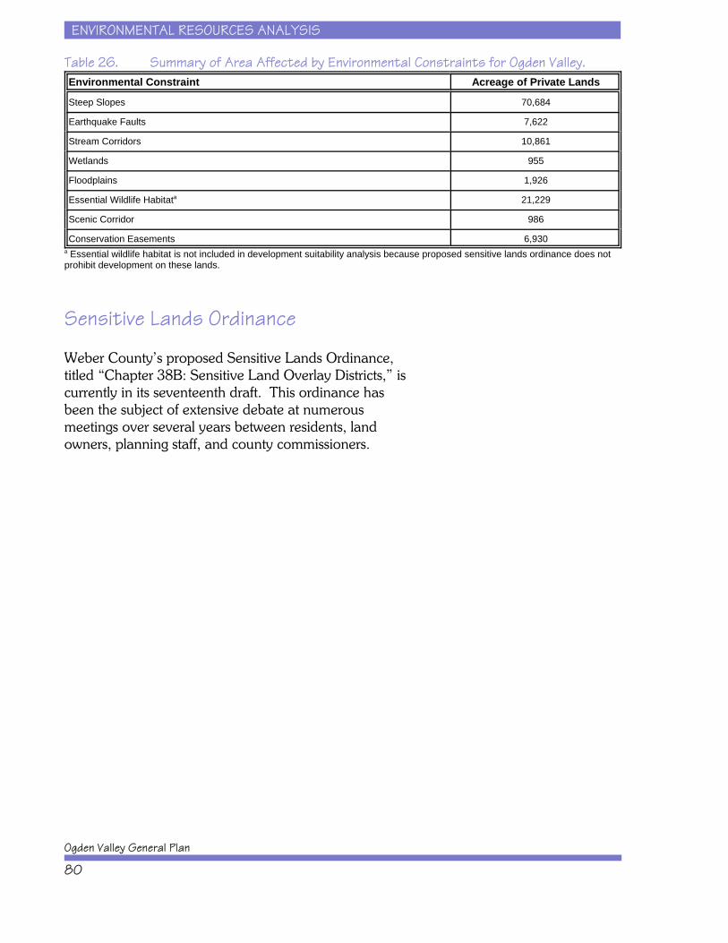
ENVIRONMENTAL RESOURCES ANALYSIS
Ogden Valley General Plan
80
Table 26. Summary of Area Affected by Environmental Constraints for Ogden Valley.Environmental Constraint Acreage of Private Lands
Steep Slopes 70,684
Earthquake Faults 7,622
Stream Corridors 10,861
Wetlands 955
Floodplains 1,926
Essential Wildlife Habitata 21,229
Scenic Corridor 986
Conservation Easements 6,930a Essential wildlife habitat is not included in development suitability analysis because proposed sensitive lands ordinance does notprohibit development on these lands.
Sensitive Lands Ordinance
Weber County’s proposed Sensitive Lands Ordinance,titled “Chapter 38B: Sensitive Land Overlay Districts,” iscurrently in its seventeenth draft. This ordinance hasbeen the subject of extensive debate at numerousmeetings over several years between residents, landowners, planning staff, and county commissioners.
TRANSPORTATION ANALYSIS
Recreation Element
81
CHAPTER 5: TRANSPORTATION ANALYSISTransportation access and circulation is one of the keyissues in the Ogden Valley. This chapter describesOgden Valley’s existing and future transportation needsand provides an analysis of the facilities that will be aconcern with the expected growth in population anddevelopment. The transportation analysis is limited tothe state routes in the Ogden Valley that provide accessto the Ogden urbanized area and surrounding counties. The existing conditions are presented in the form of2002, 2003, and 2004 year analysis of all the stateroutes in Ogden Valley. Since Ogden Valley does notcurrently have a regional travel demand model, theconsultant team made assumptions in developing futuretraffic volumes. The assumptions were applied suchthat the analysis remains consistent with UtahDepartment of Transportation’s Ogden ValleyTransportation Master Plan (UDOT 2004).
TRANSPORTATION ANALYSIS
Ogden Valley General Plan
82
Existing Roads and Their Capacities
Inside Ogden Valley, there are only a few regional roadsthat serve the entire Valley. There are only three accessroads from the Wasatch Front urbanized area intoOgden Valley. This section describes the characteristics,volumes, and capacities of the main roadways withinthe Ogden Valley.
Ogden Canyon Road (SR-39)
This facility is the primary access road for the OgdenValley. It connects Interstate 15 in the City of Ogden toOgden Valley. Once through Ogden Canyon, the roadcontinues to run along the south side of PineviewReservoir into Huntsville, which is discussed furtherbelow. Through Ogden Canyon into Ogden Valley, theroad is a two-lane facility with narrow shoulders. Leftturn lanes are provided at most intersections anddriveways. It is owned and maintained by UDOT andcarries the designation of State Road (SR) 39. According to UDOT, the 2002 Average Annual DailyTraffic (AADT) on the road was 7,350 vehicles.
Ogden Canyon is also home to one of three AutomaticTraffic Recorders in Weber County. These countersrecord traffic data throughout the year. The data showsthat over the last 10 years that July is the highestvolume month of the year at 129 percent of averagetraffic. During the three month summer period fromJune through August traffic volumes are 124 percent ofaverage traffic. September is the month that mostclosely matches average with traffic volumes at 98percent of average.
The traffic capacity of the roadway is estimated to beapproximately 12,500 vehicles per day. On an averageday in 2002 the road operated at 58.8 percent of itstotal capacity. During the summer the road would haveoperated at 73.2 percent of its capacity.
TRANSPORTATION ANALYSIS
Recreation Element
83
New Trappers Loop (SR-167)
This facility connects SR-39 in Ogden Valley to MorganCounty in the south and I-84, which in turn connects toDavis, Weber, and Summit counties. The road alsoprovides access to the Snowbasin Resort. Inpreparation for the 2002 Winter Olympic Games thisnew road was built and the old Trappers Loop wasturned over to Weber County, which closed the road tothrough access limiting it to local traffic only. This roadhas a 3-lane cross section for most of its length. Theuphill traffic has two lanes while downhill traffic has onelane.
The 2002 AADT on the road was 3,740 vehicles. Thetraffic capacity of the roadway is estimated to beapproximately 17,500 vehicles per day. On an averageday in 2002 the road operated at 21.4 percent of itstotal capacity. Assuming that monthly variations inOgden Canyon are consistent throughout the Valley,during the summer the road would have operated at26.6 percent of its capacity.
North Ogden Divide (Weber County 3464)
This facility is the third road that provides access to theOgden Valley, specifically the Liberty area on the northend of the Valley. It is a narrow, winding two-lane roadthat connects to Harrisville and I-15 in west WeberCounty. The road is characterized by its steep gradesand sharp curves. These features limit the capacity ofthe facility and the actual traffic on the road since somedrivers utilize Ogden Canyon instead of this road. TheWasatch Front Regional Council TransportationImprovement Program has programmed approximately$1.7 million for safety improvements along the NorthOgden Divide in 2004.
The 2002 AADT on the road was 960 vehicles. Thetraffic capacity of the roadway is estimated to beapproximately 9,500 vehicles per day. On an averageday in 2002 the road operated at 10.1 percent of itstotal capacity. Assuming that monthly variations inOgden Canyon are consistent throughout the Valley,
TRANSPORTATION ANALYSIS
Ogden Valley General Plan
84
during the summer the road would have operated at12.6 percent of its capacity.
SR-39
Within Ogden Valley, this facility extends from OgdenCanyon along the south side of Pineview Reservoir,which is where it intersects with Trappers Loop. It thenturns to the north along 7800 East into Huntsville andthen east along 100 North into South Fork Canyon andover Monte Cristo into Rich County and the city ofWoodruff. Causey Reservoir is accessed by CauseyDrive, a small street that intersects with SR-39. Thefacility is a two-lane road along its entire length with turnlanes provided at busy intersections and driveways. Within the valley the road is relatively flat, whichchanges as it enters the canyon towards Woodruff.
The 2002 AADT on the road varied from 7,580 at themouth of Ogden Canyon to 4,000 just south ofHuntsville to 2,000 east of Huntsville. The AADT at theWeber County line was 515 vehicles. The trafficcapacity of the roadway in the valley is estimated to beapproximately 17,500 vehicles per day. On an averageday in 2002 the road operated at 43.4 percent of itstotal capacity near the dam at the mouth of the canyon. Assuming that monthly variations in Ogden Canyon areconsistent throughout the Valley, during the summer theroad would have operated at 53.9 percent of its capacityin this same location. Obviously this percentagedecreases as volumes decrease as one moves east alongthe road.
SR-158
This facility travels across the Pineview Dam at themouth of Ogden Canyon along the western edge of thereservoir, past an intersection with the old Highway 166,and then northwards to Wolf Creek and PowderMountain Resorts. The road ends at the ski resort anddoes not continue on into Cache County. It is a two-lane facility with narrow shoulders and generallytraverses rolling terrain, which becomes steeper as the

TRANSPORTATION ANALYSIS
Recreation Element
85
road heads up towards Powder Mountain Resort. Forsecurity reasons the Bureau of Reclamation(Reclamation) would like to eliminate roads on top ofdams, which is the case with SR-158 across thePineview Reservoir dam. Reclamation would like toreplace that road with a bridge to the east of the dam;however, there is no funding for this proposed project.
The 2002 AADT on the road varied from 4,730 at thedam to 3,835 just north of Eden to 1,850 near PowderMountain Resort. The traffic capacity of the roadway inthe valley is estimated to be approximately 15,000vehicles per day. On an average day in 2002 the roadoperated at 31.5 percent of its total capacity near thedam. Assuming that monthly variations in OgdenCanyon are consistent throughout Ogden Valley, duringthe summer the road would have operated at 39.3percent of its capacity in this same location. Obviouslythis percentage decreases as volumes decrease whilemoving north along the road.
Huntsville to Eden Roads (Weber County3468)
These roads connect Huntsville to Eden on the northside of Pineview Reservoir through a series of 90 degreeturns. The entire route used to be part of SR-166;however, in 1990 the Utah Transportation Commissionrelinquished control of the road and turned it over toWeber County. Many maps and road signs still identifythe facility as Highway 166. Traveling from Huntsvillethe road begins at the intersection with SR-39 at thepoint where that road turns from 7800 East to 100North. This facility travels north on 7800 East for abouthalf a mile before turning west. The road turns back tothe north at 7000 East and then back to the west at1900 North, and back to the north again at 5500 East. From 2300 North the road largely travel northwest to ajunction with SR-158 at about 2500 North and 5100East. The road is a two-lane facility with shoulders andturn lanes at the main intersections and driveways. Theroad primarily serves local traffic within Ogden Valley.
TRANSPORTATION ANALYSIS
Ogden Valley General Plan
86
The 2002 AADT on the road was 1,405 vehicles. Thetraffic capacity of the roadway is estimated to beapproximately 17,500 vehicles per day. On an averageday in 2002 the road operated at 8.0 percent of its totalcapacity. Assuming that monthly variations in OgdenCanyon are consistent throughout the valley, during thesummer the road would have operated at 10.0 percentof its capacity.
Eden to Liberty Roads (Weber County3464)
These roads connect Eden to Liberty and the NorthOgden Divide. The route used to be part of SR-162;however, in 1990 the Utah Transportation Commissionrelinquished control of the road and turned in over toWeber County. Many maps and road signs still identifythe facility as Highway 162. Traveling from Eden theroad begins at the intersection with SR-158 at about2500 North and 5100 East. This facility travelsnorthwest for about two miles at which point it turnsnorth along 3500 East at about 3600 North. The roadcontinues north until 4100 North where it turns to thewest to provide access to the North Ogden Divide Road. The road is a two-lane facility with shoulders and turnlanes at the main intersections and driveways. Thisroad also connects to the Nordic Valley Resort accessroad.
The 2002 AADT on the road was 2,650 vehicles. Thetraffic capacity of the roadway is estimated to beapproximately 17,500 vehicles per day. On an averageday in 2002 the road operated at 15.1 percent of itstotal capacity. Assuming that monthly variations inOgden Canyon are consistent throughout Ogden Valley,during the summer the road would have operated at18.9 percent of its capacity.
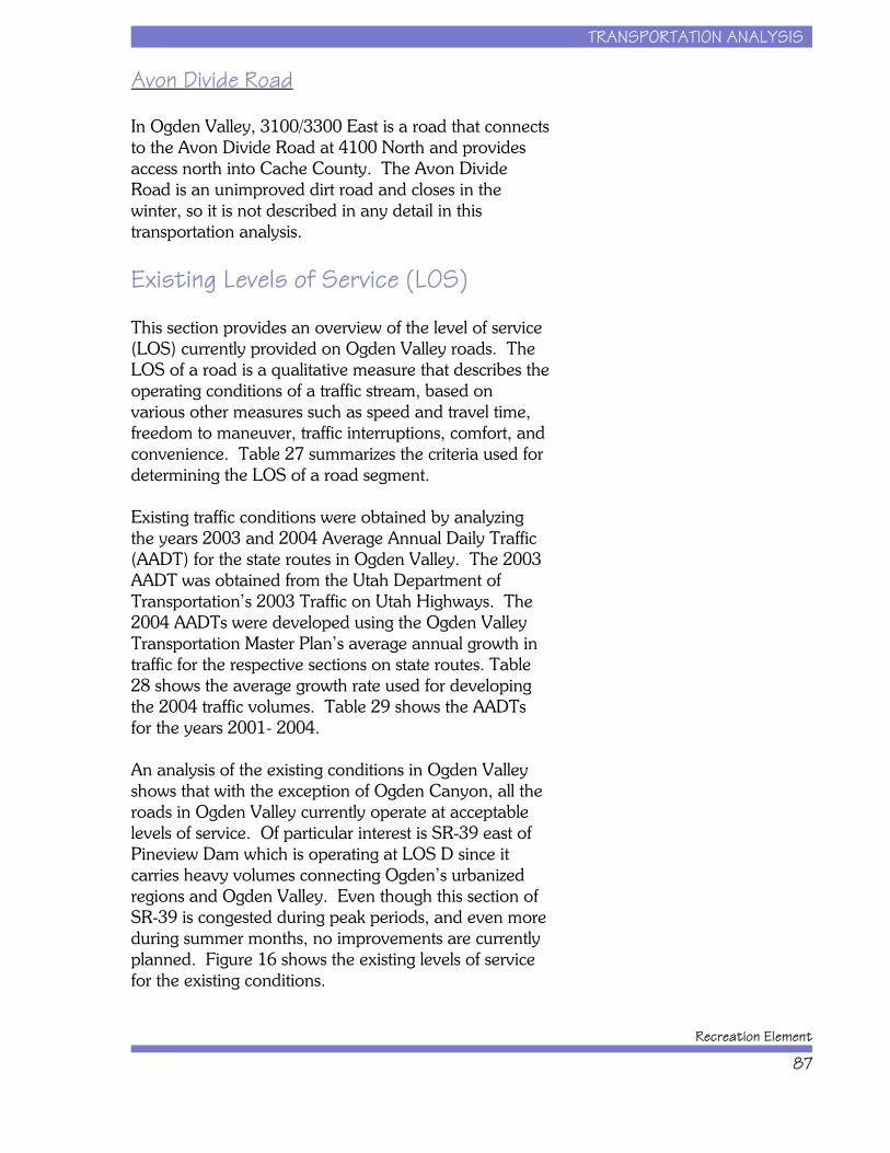
TRANSPORTATION ANALYSIS
Recreation Element
87
Avon Divide Road
In Ogden Valley, 3100/3300 East is a road that connectsto the Avon Divide Road at 4100 North and providesaccess north into Cache County. The Avon DivideRoad is an unimproved dirt road and closes in thewinter, so it is not described in any detail in thistransportation analysis.
Existing Levels of Service (LOS)
This section provides an overview of the level of service(LOS) currently provided on Ogden Valley roads. TheLOS of a road is a qualitative measure that describes theoperating conditions of a traffic stream, based onvarious other measures such as speed and travel time,freedom to maneuver, traffic interruptions, comfort, andconvenience. Table 27 summarizes the criteria used fordetermining the LOS of a road segment.
Existing traffic conditions were obtained by analyzingthe years 2003 and 2004 Average Annual Daily Traffic(AADT) for the state routes in Ogden Valley. The 2003AADT was obtained from the Utah Department ofTransportation’s 2003 Traffic on Utah Highways. The2004 AADTs were developed using the Ogden ValleyTransportation Master Plan’s average annual growth intraffic for the respective sections on state routes. Table28 shows the average growth rate used for developingthe 2004 traffic volumes. Table 29 shows the AADTsfor the years 2001- 2004.
An analysis of the existing conditions in Ogden Valleyshows that with the exception of Ogden Canyon, all theroads in Ogden Valley currently operate at acceptablelevels of service. Of particular interest is SR-39 east ofPineview Dam which is operating at LOS D since itcarries heavy volumes connecting Ogden’s urbanizedregions and Ogden Valley. Even though this section ofSR-39 is congested during peak periods, and even moreduring summer months, no improvements are currentlyplanned. Figure 16 shows the existing levels of servicefor the existing conditions.
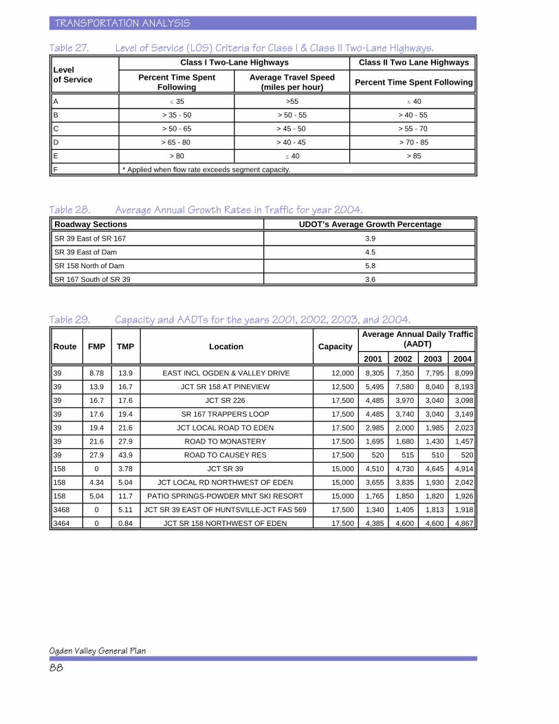
TRANSPORTATION ANALYSIS
Ogden Valley General Plan
88
Table 27. Level of Service (LOS) Criteria for Class I & Class II Two-Lane Highways.
Levelof Service
Class I Two-Lane Highways Class II Two Lane Highways
Percent Time SpentFollowing
Average Travel Speed(miles per hour) Percent Time Spent Following
A # 35 >55 # 40
B > 35 - 50 > 50 - 55 > 40 - 55
C > 50 - 65 > 45 - 50 > 55 - 70
D > 65 - 80 > 40 - 45 > 70 - 85
E > 80 # 40 > 85
F * Applied when flow rate exceeds segment capacity.
Table 28. Average Annual Growth Rates in Traffic for year 2004.Roadway Sections UDOT’s Average Growth PercentageSR 39 East of SR 167 3.9
SR 39 East of Dam 4.5
SR 158 North of Dam 5.8
SR 167 South of SR 39 3.6
Table 29. Capacity and AADTs for the years 2001, 2002, 2003, and 2004.
Route FMP TMP Location CapacityAverage Annual Daily Traffic
(AADT)
2001 2002 2003 200439 8.78 13.9 EAST INCL OGDEN & VALLEY DRIVE 12,000 8,305 7,350 7,795 8,099
39 13.9 16.7 JCT SR 158 AT PINEVIEW 12,500 5,495 7,580 8,040 8,193
39 16.7 17.6 JCT SR 226 17,500 4,485 3,970 3,040 3,098
39 17.6 19.4 SR 167 TRAPPERS LOOP 17,500 4,485 3,740 3,040 3,149
39 19.4 21.6 JCT LOCAL ROAD TO EDEN 17,500 2,985 2,000 1,985 2,023
39 21.6 27.9 ROAD TO MONASTERY 17,500 1,695 1,680 1,430 1,457
39 27.9 43.9 ROAD TO CAUSEY RES 17,500 520 515 510 520
158 0 3.78 JCT SR 39 15,000 4,510 4,730 4,645 4,914
158 4.34 5.04 JCT LOCAL RD NORTHWEST OF EDEN 15,000 3,655 3,835 1,930 2,042
158 5.04 11.7 PATIO SPRINGS-POWDER MNT SKI RESORT 15,000 1,765 1,850 1,820 1,926
3468 0 5.11 JCT SR 39 EAST OF HUNTSVILLE-JCT FAS 569 17,500 1,340 1,405 1,813 1,918
3464 0 0.84 JCT SR 158 NORTHWEST OF EDEN 17,500 4,385 4,600 4,600 4,867
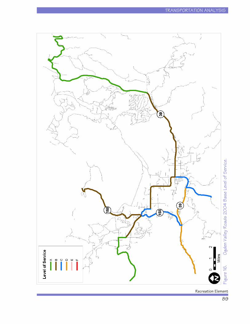
TRANSPORTATION ANALYSIS
Recreation Element
89
Figu
re 16
.Og
den
Valle
y Ro
ads
200
4 Ba
se L
evel
of S
ervic
e.
TRANSPORTATION ANALYSIS
Ogden Valley General Plan
90
Existing Transportation ImprovementProjects
According to the Ogden Valley Transportation MasterPlan (UDOT 2004), there are several projects underconsideration and investigation in the Project Area. Thecurrent Statewide Transportation Improvement Program(2004-2008 STIP) lists the following project:
x SR-39 at 500 South, Huntsville, SpotImprovement – Turning Lanes
Also, the following projects are currently listed on theState of Utah’s Long Range Plan, Utah Transportation2030:
x SR-39, Pineview Bridge Structure
x SR-158, from SR-39 at Pineview Dam to nearEden, highway reconstruction and bridge project
x SR-226, from SR-39 near Pineview toSnowbasin, highway reconstruction and safetyproject
Recommended TransportationImprovement Projects
The following list identifies the eight projects that havebeen recommended in the Ogden Valley TransportationMaster Plan (UDOT 2004) as having the highest priorityaccording to the Ogden Valley Transportation AdvisoryCommittee:
x Dedicated bike path through Ogden Canyon onthe existing rail bed.
x Roundabout at the junction of SR-158 and oldroute 162, by Valley Market.
x Bike path around Pineview reservoir withpreservation of rural characteristics.

TRANSPORTATION ANALYSIS
Recreation Element
91
x Bike path from Wolf Creek Resort to the ValleyMarket.
x Improved roadway across Avon Divide intoCache Valley.
x Intersection Improvement at SR-39 and SR-158to improve sight distance.
x Crosswalk study at SR-39 and 500 South inHuntsville.
x New interchange at I-84 and Trappers LoopRoad (in Morgan County).
A comprehensive list of transportation needs, asidentified by the Ogden Valley Transportation AdvisoryCommittee, and their costs is provided in Table 30.
Potential Revenue Sources forTransportation Improvement Projects
Federal and State participation will be important for thesuccess of implementing projects identified in Table 21. It will be important for Weber County to workproactively with UDOT and promote the projects thatcan be placed on the five-year STIP as soon as possible. Weber County and the City of Huntsville will have tofund the local portions of these projects. To generatethese funds, the following options may be considered:
x Increased transportation impact fees.
x Increased general fund allocation totransportation projects.
x General obligation bonds repaid with propertytax levies.
x Increased participation by developers, includingcooperative programs and incentives.
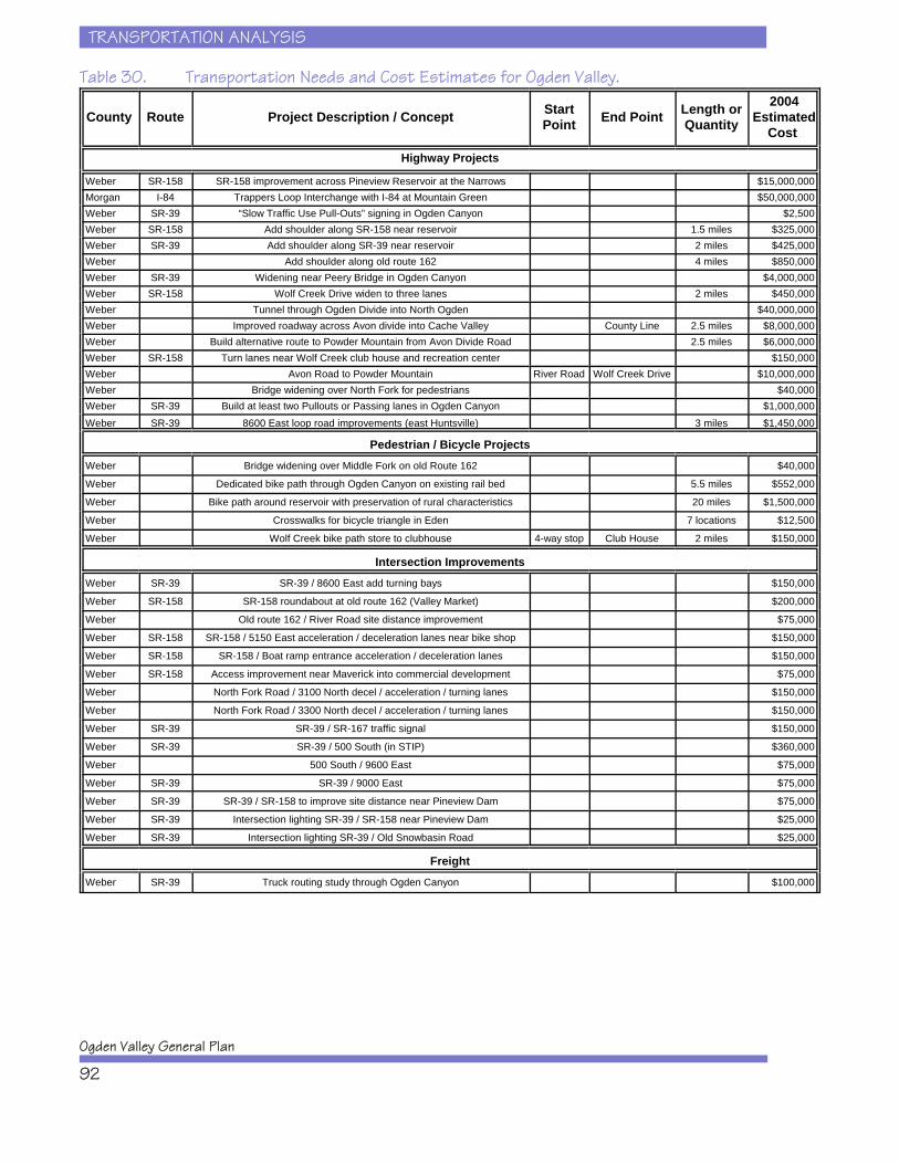
TRANSPORTATION ANALYSIS
Ogden Valley General Plan
92
Table 30. Transportation Needs and Cost Estimates for Ogden Valley.
County Route Project Description / Concept StartPoint End Point Length or
Quantity
2004Estimated
Cost
Highway Projects
Weber SR-158 SR-158 improvement across Pineview Reservoir at the Narrows $15,000,000 Morgan I-84 Trappers Loop Interchange with I-84 at Mountain Green $50,000,000 Weber SR-39 “Slow Traffic Use Pull-Outs” signing in Ogden Canyon $2,500 Weber SR-158 Add shoulder along SR-158 near reservoir 1.5 miles $325,000 Weber SR-39 Add shoulder along SR-39 near reservoir 2 miles $425,000 Weber Add shoulder along old route 162 4 miles $850,000 Weber SR-39 Widening near Peery Bridge in Ogden Canyon $4,000,000 Weber SR-158 Wolf Creek Drive widen to three lanes 2 miles $450,000 Weber Tunnel through Ogden Divide into North Ogden $40,000,000 Weber Improved roadway across Avon divide into Cache Valley County Line 2.5 miles $8,000,000 Weber Build alternative route to Powder Mountain from Avon Divide Road 2.5 miles $6,000,000 Weber SR-158 Turn lanes near Wolf Creek club house and recreation center $150,000 Weber Avon Road to Powder Mountain River Road Wolf Creek Drive $10,000,000 Weber Bridge widening over North Fork for pedestrians $40,000 Weber SR-39 Build at least two Pullouts or Passing lanes in Ogden Canyon $1,000,000 Weber SR-39 8600 East loop road improvements (east Huntsville) 3 miles $1,450,000
Pedestrian / Bicycle Projects Weber Bridge widening over Middle Fork on old Route 162 $40,000
Weber Dedicated bike path through Ogden Canyon on existing rail bed 5.5 miles $552,000
Weber Bike path around reservoir with preservation of rural characteristics 20 miles $1,500,000
Weber Crosswalks for bicycle triangle in Eden 7 locations $12,500
Weber Wolf Creek bike path store to clubhouse 4-way stop Club House 2 miles $150,000
Intersection Improvements Weber SR-39 SR-39 / 8600 East add turning bays $150,000
Weber SR-158 SR-158 roundabout at old route 162 (Valley Market) $200,000
Weber Old route 162 / River Road site distance improvement $75,000
Weber SR-158 SR-158 / 5150 East acceleration / deceleration lanes near bike shop $150,000
Weber SR-158 SR-158 / Boat ramp entrance acceleration / deceleration lanes $150,000
Weber SR-158 Access improvement near Maverick into commercial development $75,000
Weber North Fork Road / 3100 North decel / acceleration / turning lanes $150,000
Weber North Fork Road / 3300 North decel / acceleration / turning lanes $150,000
Weber SR-39 SR-39 / SR-167 traffic signal $150,000
Weber SR-39 SR-39 / 500 South (in STIP) $360,000
Weber 500 South / 9600 East $75,000
Weber SR-39 SR-39 / 9000 East $75,000
Weber SR-39 SR-39 / SR-158 to improve site distance near Pineview Dam $75,000
Weber SR-39 Intersection lighting SR-39 / SR-158 near Pineview Dam $25,000
Weber SR-39 Intersection lighting SR-39 / Old Snowbasin Road $25,000
Freight Weber SR-39 Truck routing study through Ogden Canyon $100,000
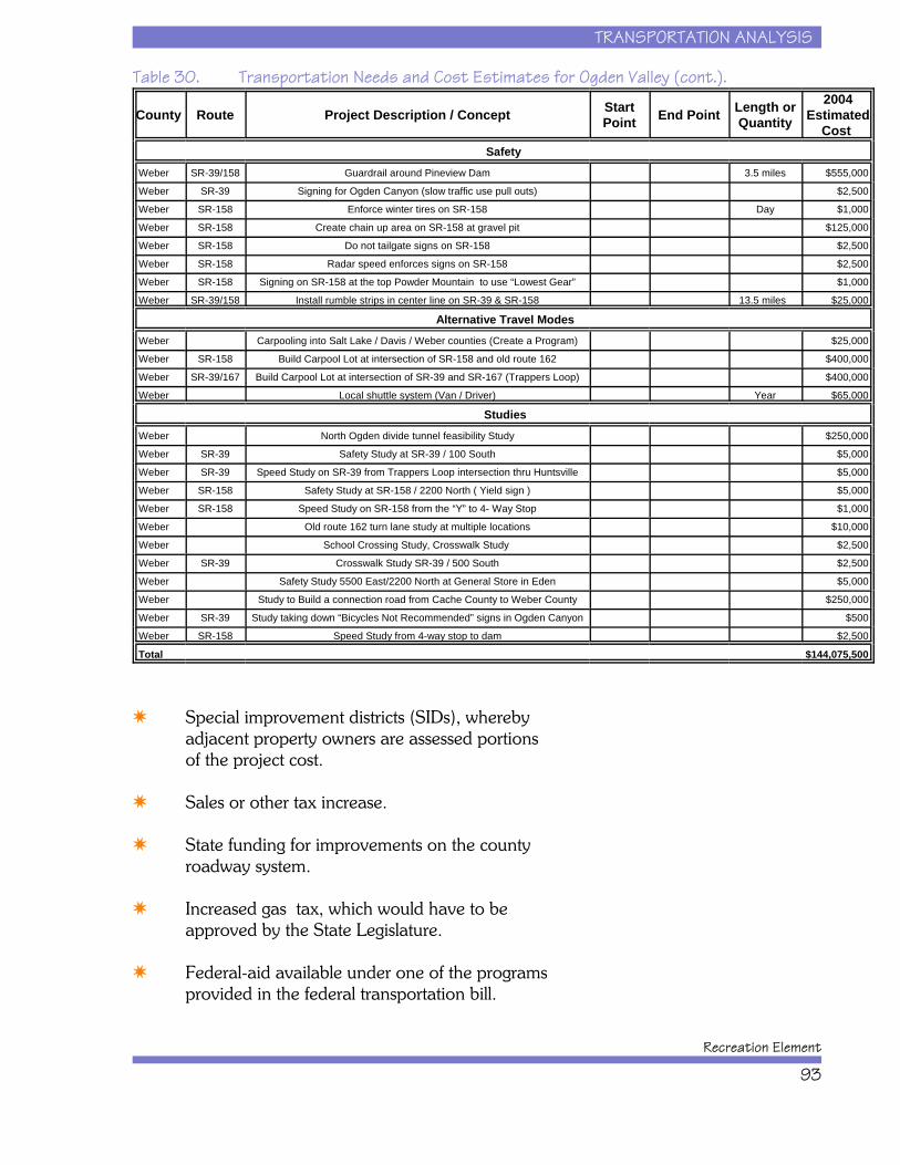
TRANSPORTATION ANALYSIS
Recreation Element
93
Table 30. Transportation Needs and Cost Estimates for Ogden Valley (cont.).
County Route Project Description / Concept StartPoint End Point Length or
Quantity
2004Estimated
Cost Safety
Weber SR-39/158 Guardrail around Pineview Dam 3.5 miles $555,000
Weber SR-39 Signing for Ogden Canyon (slow traffic use pull outs) $2,500
Weber SR-158 Enforce winter tires on SR-158 Day $1,000
Weber SR-158 Create chain up area on SR-158 at gravel pit $125,000
Weber SR-158 Do not tailgate signs on SR-158 $2,500
Weber SR-158 Radar speed enforces signs on SR-158 $2,500
Weber SR-158 Signing on SR-158 at the top Powder Mountain to use “Lowest Gear” $1,000
Weber SR-39/158 Install rumble strips in center line on SR-39 & SR-158 13.5 miles $25,000
Alternative Travel Modes Weber Carpooling into Salt Lake / Davis / Weber counties (Create a Program) $25,000
Weber SR-158 Build Carpool Lot at intersection of SR-158 and old route 162 $400,000
Weber SR-39/167 Build Carpool Lot at intersection of SR-39 and SR-167 (Trappers Loop) $400,000
Weber Local shuttle system (Van / Driver) Year $65,000
Studies Weber North Ogden divide tunnel feasibility Study $250,000
Weber SR-39 Safety Study at SR-39 / 100 South $5,000
Weber SR-39 Speed Study on SR-39 from Trappers Loop intersection thru Huntsville $5,000
Weber SR-158 Safety Study at SR-158 / 2200 North ( Yield sign ) $5,000
Weber SR-158 Speed Study on SR-158 from the “Y” to 4- Way Stop $1,000
Weber Old route 162 turn lane study at multiple locations $10,000
Weber School Crossing Study, Crosswalk Study $2,500
Weber SR-39 Crosswalk Study SR-39 / 500 South $2,500
Weber Safety Study 5500 East/2200 North at General Store in Eden $5,000
Weber Study to Build a connection road from Cache County to Weber County $250,000
Weber SR-39 Study taking down “Bicycles Not Recommended” signs in Ogden Canyon $500
Weber SR-158 Speed Study from 4-way stop to dam $2,500
Total $144,075,500
x Special improvement districts (SIDs), wherebyadjacent property owners are assessed portionsof the project cost.
x Sales or other tax increase.
x State funding for improvements on the countyroadway system.
x Increased gas tax, which would have to beapproved by the State Legislature.
x Federal-aid available under one of the programsprovided in the federal transportation bill.
TRANSPORTATION ANALYSIS
Ogden Valley General Plan
94
Increased general fund allocation means that StateGeneral Funds must be diverted from othergovernmental services and/or programs. Generalobligation bonds would provide initial capital fortransportation improvement projects but would also addto the debt service of Weber County. One way to avoidincreased taxes needed to retire the debt is to sell bondsrepaid with a portion of Weber County’s State Classmonies for a certain number of years.
Participation by private developers provides a promisingfunding mechanism for new projects. Developers cancontribute to transportation projects by constructing on-site improvements along their site frontage and bypaying development impact fees. A down-side to thisapproach is that roads are improved in pieces ratherthan logical segments. One way to overcome this is forWeber County to construct the necessary improvementsand simply charge developers their share when theydevelop adjacent property.
Development impact fees would be based on theadditional improvements required to accommodate newdevelopment and would be proportioned among eachdevelopment. The expenditure of additional fundsprovided by the fees would be subject to WeberCounty’s spending limit. However, development impactfees are often a controversial issue and may or may notbe an appropriate method of funding projects.
PUBLIC PARTICIPATION AND OPINIONS
Recreation Element
95
CHAPTER 6: PUBLIC PARTICIPATION ANDOPINIONS
This chapter reviews the methods used to engage thepublic during this planning process and the results oftheir input. Public participation involved severalactivities including formation of a StakeholderCommittee, facilitation of a series of open-house stylepublic workshops, implementation of an on-line visualpreference survey, and presentation of projectinformation to appointed and elected governing bodieswithin Weber County. Both the methods for and theresults from public participation during the OVGPRecreation Element planning process are discussedbelow.
PUBLIC PARTICIPATION AND OPINIONS
Ogden Valley General Plan
96
Stakeholder Committee Meetings
Early in the planning process, Weber County andEnvision Utah formed a Stakeholder Committee to helpguide the consultant team on all aspects of the OVGPRecreation Element. The Stakeholder Committee wasmade up of representatives from diverse interestsincluding citizen committees, public agencies,development interests, business interests, and landowners. Stakeholder Committee members included:
Cindy Berger, Liberty Nordic Valley Planning Commission
Steve Clarke, Eden Planning Committee
Paul DeLong, Eden Planning Committee
Jim Hasenyager, Ogden Valley Land Trust
Sharon Holmstrom, Weber County Planning Commission
Lisa Karam, Ogden Valley Business Association
Pam Kramer, Utah Division of Wildlife Resources
Kirk Langford, Eden Planning Committee
Helene Liebman, Weber Pathways / Ogden Valley Pathways
Jamie Lythgoe, Powder Mountain Resort
Larry Nalder, Nordic Valley Resort
DeVon Nelson, Weber County Public Lands Advisory Committee
Denzel Rowland, Snowbasin Resort
Roger Richins, Liberty Nordic Valley Planning Commission
Rick Vallejos, U.S. Forest Service
Kim Wheatley, East Huntsville Planning Commission
Jeromy Williams, Wolf Creek Properties
PUBLIC PARTICIPATION AND OPINIONS
Recreation Element
97
The Stakeholder Committee met a total of 10 times over12 months of the planning process.
Public Workshops
Three series of Public Workshops were held during theplanning process: September 2004; December 2004;and April 2005. Each series of Public Workshops washeld in both Ogden City and Ogden Valley onconsecutive evenings. Participants signed in and pickedup a project handout that summarized informationabout the Recreation Element planning process and theevening’s activities. Public Workshop handouts alsoincluded a survey with questions for all meetingparticipants to answer and submit. The format for theseworkshops generally involved a 45- to 60-minutepresentation by the consultant team followed by a 45 to60-minute group mapping exercise. Groups ofparticipants then presented their findings or suggestionsto all attendees before being adjourned. A summary ofeach Public Workshop and the results of the inputreceived are described below.
September 2004
The first series of Public Workshops was held onSeptember 29 and 30 in Ogden City and Ogden Valley,respectively. The September 29 meeting was attendedby 21 individuals while the September 30 meeting wasattended by 56 individuals. This workshop wasdesigned to identify and address the issues, concerns,and opportunities that the public believes should beaddressed in the Recreation Element. Participants listedboth issues and opportunities, and then mapped thoseon large Project Area maps. Based on input from themapping exercise and comment forms collected duringthe first series of Public Workshops, the consultant teamcategorized and ranked the top six most frequentcomments received.
The results are presented below for each of thequestions.
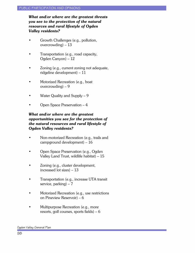
PUBLIC PARTICIPATION AND OPINIONS
Ogden Valley General Plan
98
What and/or where are the greatest threatsyou see to the protection of the naturalresources and rural lifestyle of OgdenValley residents?
• Growth Challenges (e.g., pollution,overcrowding) – 13
• Transportation (e.g., road capacity,Ogden Canyon) – 12
• Zoning (e.g., current zoning not adequate,ridgeline development) – 11
• Motorized Recreation (e.g., boatovercrowding) – 9
• Water Quality and Supply – 9
• Open Space Preservation – 4
What and/or where are the greatestopportunities you see for the protection ofthe natural resources and rural lifestyle ofOgden Valley residents?
• Non-motorized Recreation (e.g., trails andcampground development) – 16
• Open Space Preservation (e.g., OgdenValley Land Trust, wildlife habitat) – 15
• Zoning (e.g., cluster development,increased lot sizes) – 13
• Transportation (e.g., increase UTA transitservice, parking) – 7
• Motorized Recreation (e.g., use restrictionson Pineview Reservoir) – 6
• Multipurpose Recreation (e.g., moreresorts, golf courses, sports fields) – 6

PUBLIC PARTICIPATION AND OPINIONS
Recreation Element
99
What kind of additional recreationalfacilities or resort areas should bedeveloped and where should they belocated in Ogden Valley?
• Multipurpose Recreation (e.g., need newrecreation complex) – 6
• Non-motorized Recreation (e.g., moretrails and campgrounds) – 5
• Motorized Recreation (e.g., use restrictionson Pineview Reservoir) – 4
The results of the mapping exercise during the first seriesof Public Workshops are shown in Figure 17.
December 2004
The second series of Public Workshops was held onDecember 8 and 9 in Ogden City and Ogden Valley,respectively. The December 8 meeting was attended by9 individuals while the December 9 meeting wasattended by 17 individuals. This workshop wasdesigned to summarize recreational facility andtransportation needs and recommendations and toexplore different potential growth strategies anddevelopment scenarios for the Project Area. Participantsdiscussed the pros and cons of growth strategies such asclustering, transfer of development rights, and purchaseof development rights. And they identified areasrecommended for development versus preservation onlarge Project Area maps. Based on input from commentforms collected during the second series of PublicWorkshops, the consultant team summarized thecomments received. The results are presented below foreach of the questions.
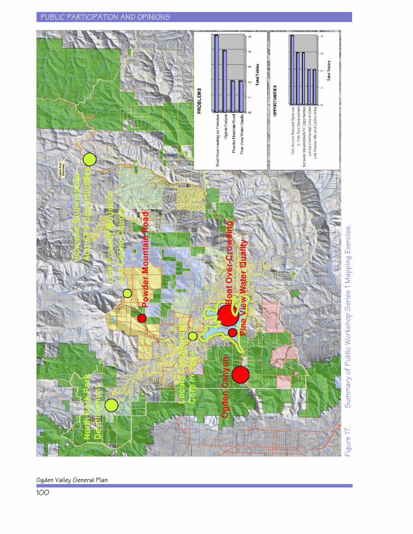
PUBLIC PARTICIPATION AND OPINIONS
Ogden Valley General Plan
100
Figu
re 17
.S
umm
ary
of P
ublic
Wor
ksho
p S
erie
s 1 M
appi
ng E
xerc
ise.

PUBLIC PARTICIPATION AND OPINIONS
Recreation Element
101
Do you agree or disagree with therecommendations to expand both the Edenand Liberty Parks to meet future organizedrecreation facility needs? Othersuggestions? Please explain.
• Number of participants who agreed – 10;disagreed – none
• Also need new parks near future resortsand developments – 3
Do you agree or disagree with therecommendations for maintaining anefficient transportation system in OgdenValley? Other suggestions? Pleaseexplain.
• Number of participants who agreed – 8;disagreed – none
• Recommend more bicycle and pedestrianopportunities – 2
• Recommend transit system expansion intoOgden Valley – 2
• Recommend bike path around PineviewReservoir – 1
• Recommend roundabout at Valley Market– 1
• Recommend improved access betweenOgden Valley and Cache Valley – 1

PUBLIC PARTICIPATION AND OPINIONS
Ogden Valley General Plan
102
Do you agree or disagree with therecommendations for Weber County toconsider implementing a transfer ofdevelopment rights (TDR) and/or purchaseof development rights (PDR) program forguiding future resort-style development inOgden Valley?
• Number of participants who agreed – 9;disagreed – none
• Recommend implementing TDR to ensurefair market value for land owners – 2
• PDR’s with recording/impact fees – 1
• Recommend combination approach – 1
• Recommend only one new resort area – 1
• Recommend purchasing 40 percent ofdevelopment rights – 1
• Recommend local/county-wide tax forPDR program – 1
The results of the mapping exercise during the secondseries of Public Workshops are shown in Figure 18.
April 2005
The third and final series of Public Workshops was heldon April 27 and 28 in Ogden City and Ogden Valley,respectively. The April 27 meeting was attended by 20individuals while the April 28 meeting was attended by68 individuals. This workshop was designed to providefor a detailed review of the draft Recreation Element.Participants reviewed and discussed therecommendations found in Chapter 9 of the DraftRecreation Element Document. Based on input fromcomment forms collected during the third series ofpublic workshops, the consultant team summarized thecomments received. The results are presented below foreach of the questions.
PUBLIC PARTICIPATION AND OPINIONS
Recreation Element
103
Do you agree or disagree with therecommendations for CommunityRecreation Facility Investments?
• Yes, definitely need more tennis courts.
• Parks enlargement is needed but I’m notsure if acres are available at Eden Park forexpansion. County funding should alsobe looked at because more than justValley residents can use.
• Agree. Strongly feel we need to keep theyouth in mind when making theseinvestments.
• I agree. As population increases the needincreases.
• Yes, including the recreation impact fee.
• I agree, especially with suggestion toexplore impact fee program.
• Agree. Action must take place or it will berandom chaos.
• Disagree.
Do you agree or disagree with therecommendations for Public and PrivateRecreation Facility Investments?
• Yes. This summer (2005) the ForestService has increased the number of boatson Pineview to 400 from 320 last year. This is a huge increase and way too manyto have safe boating. Last year at the 320limit it wasn’t safe.
• I’m not sure what the answer to thisproblem is. Public owned facilities needto be paid for by those who use them, notjust new residents.
PUBLIC PARTICIPATION AND OPINIONS
Ogden Valley General Plan
104
• Agree. Will private investments betax-deductible?
• Yes.
• Motorized and non-motorized trails don’tmix very well. Agree on 2nd homeproperty tax.
• Agree with last bullet about taxes onsecond homes. Not sure about combiningmotorized and non-motorized trails.
• Agree. They will come and we need toprepare.
• Disagree.
Do you agree or disagree with therecommendations for Tourism FacilityInvestments?
• No.
• The CVB should already be marketing thearea, but it’s my opinion that morefacilities isn’t just the answer. Uniqueitems, something to sell, or offer needs tobe addressed. County involvement otherthan promotion is small.
• Disagree. Would rather see the funds goto a pool or hockey rink than a historytour.
• Government no. Private investment,advertisement will do.
• I don’t believe we should encourage moreusage.
• Neutral.
PUBLIC PARTICIPATION AND OPINIONS
Recreation Element
105
• Agree.
• Disagree.
Do you agree or disagree with therecommendations for TransportationFacility Investments?
• Yes.
• Traffic has a way of limiting itself. Roadsdo need improvement, shoulders added. Ogden Valley has been ignored for a longtime. Conditions and facilities are old.
• Agree. More people = moreinfrastructure.
• Yes, we can’t be a one-way road.
• I’m especially in favor of UDOT’srecommendations regarding bike paths.
• Neutral.
• Agree. Sorry we lost bus service up here. Too bad old rail line was not saved.
• Disagree.
Do you agree or disagree with therecommendations for EnvironmentalResource Protection?
• Yes.
• Sensitive lands do need to be identified,but people still own them and shouldhave the right to use (not abuse). Itemssuch as sewer and water facilities shouldfigure into this.
• Agree.
PUBLIC PARTICIPATION AND OPINIONS
Ogden Valley General Plan
106
• Yes, but with balance. Your earlyplanning is good.
• Strongly favor a Sensitive LandsOrdinance.
• Very much agree County should adoptSensitive Lands Ordinance.
• Agree.
• Disagree.
Do you agree or disagree with therecommendations for Resort DevelopmentGuidelines?
• Yes, but need more information.
• Recreation zoning is a must. Both skiareas are split between Counties; ifMorgan County doesn’t have zoning inplace then a plan which incorporatesideas of Cache County needs setting up. Jut try and keep things as uniform aspossible. Zoning at top of Monte Cristoalso includes Rich County and should beconsidered. TDR should be implementedso that option is available. PDR’s I don’tfeel are a practical alternative because ofmoney necessary.
• Agree.
• Yes, there is a balance needed: demandverses what the area can support.
• Strongly agree with the PDR approach.
• Very much agree with proposed approachto retaining open space.
• Agree.
• Disagree.
PUBLIC PARTICIPATION AND OPINIONS
Recreation Element
107
Other comments:
• I didn’t stay for the Q/A session; however, I dohave strong views on the problems with urbansprawl, so put me on record as supportingconcentrated housing while putting an end tothese ranchettes that take up so much open space. After all, the main reason people move to theseareas is for their own open space (e.g., 1-5 acresor more). However, how long can this go on (i.e.,removing open space for those who can’t affordtheir own ranchette)? I would like to see lots ofopen space for everyone, so there’s a betterquality of life for more people.
• This would be fixed if one person owned WeberCounty. However, when you have many ownersand do this it is pure socialism. Where was themasses given the right to control me and myproperty that I pay the taxes on for their pleasure? This is the very thing that I went to war for. Preventing someone from controlling someoneelse and their property. A major property ownerin Huntsville area.
• I would offer, in the way of comments to the plan,a suggestion of further consideration of theenvironmental impacts that could be expectedfrom development. In particular, the impact onthe groundwater and the airshed. The impact onthe airshed would be felt most, as you know,during the winter months. People often seeOgden Valley as a winter respite from the smog ofOgden and the Wasatch Front in general. Thehigher elevations of the ski resorts would still befree from this problem, however the Valley maynot. This may have an impact. Just a thought.
• I hope our Weber County Commissioners willexercise visionary proactive leadership inadopting the TDR plan for managing OgdenValley’s growth, so as to attract quality investors,provide quality jobs for locals, enhance thecommunity in which we all want to live whileprotecting the very rural character of the Valleythat will allow us to compete with otherpreeminent national resort recreation destinations.

PUBLIC PARTICIPATION AND OPINIONS
Ogden Valley General Plan
108
Figu
re 18
.S
umm
ary
of P
ublic
Wor
ksho
p S
erie
s 2
Map
ping
Exe
rcis
e.
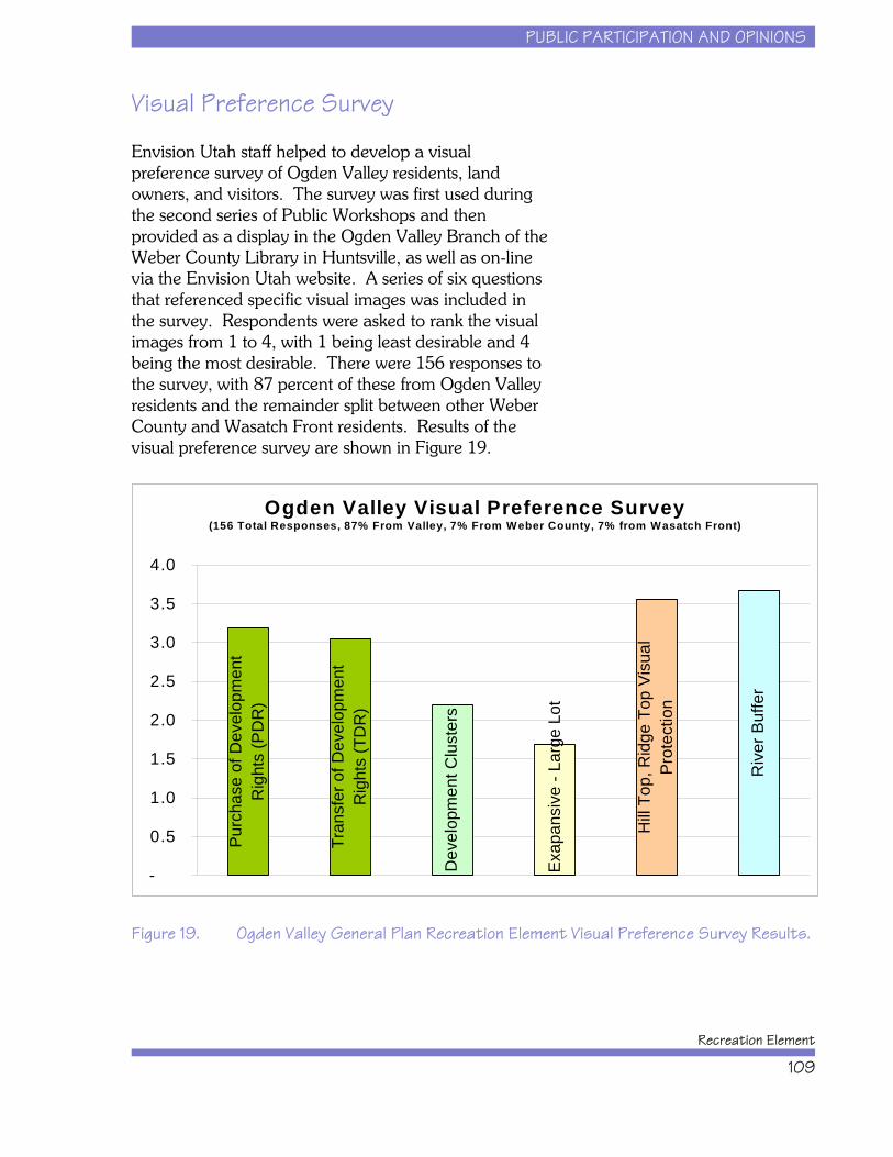
PUBLIC PARTICIPATION AND OPINIONS
Recreation Element
109
Ogden Valley Visual Preference Survey(156 Total Responses, 87% From Valley, 7% From Weber County, 7% from Wasatch Front)
Purc
hase
of D
evel
opm
ent
Rig
hts
(PD
R)
Tran
sfer
of D
evel
opm
ent
Rig
hts
(TD
R)
Dev
elop
men
t Clu
ster
s
Hill
Top,
Rid
ge T
op V
isua
l Pr
otec
tion
Riv
er B
uffe
r
Exap
ansi
ve -
Larg
e Lo
t
-
0.5
1.0
1.5
2.0
2.5
3.0
3.5
4.0
Visual Preference Survey
Envision Utah staff helped to develop a visualpreference survey of Ogden Valley residents, landowners, and visitors. The survey was first used duringthe second series of Public Workshops and thenprovided as a display in the Ogden Valley Branch of theWeber County Library in Huntsville, as well as on-linevia the Envision Utah website. A series of six questionsthat referenced specific visual images was included inthe survey. Respondents were asked to rank the visualimages from 1 to 4, with 1 being least desirable and 4being the most desirable. There were 156 responses tothe survey, with 87 percent of these from Ogden Valleyresidents and the remainder split between other WeberCounty and Wasatch Front residents. Results of thevisual preference survey are shown in Figure 19.
Figure 19. Ogden Valley General Plan Recreation Element Visual Preference Survey Results.

PUBLIC PARTICIPATION AND OPINIONS
Ogden Valley General Plan
110
This page intentionally left blank.
PUBLIC PARTICIPATION AND OPINIONS
Recreation Element
111
CHAPTER 6: PUBLIC PARTICIPATION AND OPINIONS . . . . . . . . . . . . . . . . . . . . . . . 95Stakeholder Committee Meetings . . . . . . . . . . . . . . . . . . . . . . . . . . . . . . . . . . . . 96Public Workshops . . . . . . . . . . . . . . . . . . . . . . . . . . . . . . . . . . . . . . . . . . . . . . . . 97
September 2004 . . . . . . . . . . . . . . . . . . . . . . . . . . . . . . . . . . . . . . . . . . . . 97December 2004 . . . . . . . . . . . . . . . . . . . . . . . . . . . . . . . . . . . . . . . . . . . . 99April 2005 . . . . . . . . . . . . . . . . . . . . . . . . . . . . . . . . . . . . . . . . . . . . . . . 102
Visual Preference Survey . . . . . . . . . . . . . . . . . . . . . . . . . . . . . . . . . . . . . . . . . . 104Recreation Element Adoption Meetings . . . . . . . . . . . . . . . . . . . . . . . . . . . . . . . 104
Figure 18. Summary of Public Workshop Series 2 Mapping Exercise. . . . . . . . . . . . 103Figure 19. Ogden Valley General Plan Recreation Element Visual Preference Survey
Results. . . . . . . . . . . . . . . . . . . . . . . . . . . . . . . . . . . . . . . . . . . . . . . . . . . 104
ISSUES AND CHALLENGES
Recreation Element
111
CHAPTER 7: ISSUES AND CHALLENGESBased on the analysis provided in previous chapters,there are a number of issues and challenges that mustbe considered and addressed within the OVGPRecreation Element. These issues and challenges arerelated in that they each have the ability to stronglyimpact the pace, quality, and character of growth andchange in Ogden Valley, and/or they will stronglyimpact the nature of the recreation and resortexperience in Ogden Valley. These issues andchallenges helped shape decisions regarding thealternative development scenarios and the finalrecommendations in this OVGP Recreation Element.
Growth Along the Wasatch Front
Utah’s Wasatch Front is the one of the fastest growingareas in the United States and there are no indicationsthat this trend will change in the foreseeable future. TheIntermountain West is one of the nation’s hot spots forbusiness investment, residential relocation, and tourismtravel. As the backyard mountain playground for thenorth-of-Salt Lake areas of Weber, Davis, Morgan, Rich
ISSUES AND CHALLENGES
Ogden Valley General Plan
112
and Box Elder counties, Ogden Valley will continue todraw large numbers of people. Estimates of theWasatch Front’s population rise in the coming yearsfrom today’s 480,000 people to over 720,000 people in2020 mean that recreation tourism and developmentpressure will be intense on Ogden Valley.
Implication: Resources will be pushed beyond theircapacity due to heavy demand during peak visitationperiods and increasingly during extended periods nearthe peaks. While congestion will act as a self-regulatingforce to some degree, mechanisms to limit or bettermanage recreational use during peak visitation periodsshould also be explored.
Growth Potential of Ogden Valley
As illustrated by the Recreation Element’s exploration ofOgden Valley’s growth potential, there are many morehousing units that could be built in Ogden Valley;current zoning and land capacity could allow a total ofat least 16,000 housing units up from today’s level of3,000 housing units. While there is the potential thatwater limitations will restrict the amount of growth, it isalso likely that new water sources and delivery systemswill be built to overcome any water shortages. As thesaying goes, water flows in two directions: downhill andtowards money.
Traffic is nearing capacity in Ogden Canyon, butTrapper’s Loop (SR-167) has additional capacity toaccommodate expected growth in Ogden Valley in thenear future. The road system will not be a growthregulator, though it may act as a tourism visitationregulator during peak holidays and special eventweekends.
There is some movement to explore a wastewatersystem for Ogden Valley in order to protect groundwaterquality as well as create more development potential. Implementation of such a system could lead to court-forced zoning changes that increase allowed density; thiswould increase Ogden Valley’s population faster and to
ISSUES AND CHALLENGES
Recreation Element
113
an even higher level than currently explored in thisRecreation Element.
Along with general residential growth in Ogden Valley,the existing resorts are likely to expand in the yearsahead seeking to upgrade their facilities and competemore directly with other top-notch Utah and Western skiareas. Or perhaps some Ogden Valley resorts maychoose not to pursue skiing as their prime attraction andinstead focus on the second home market or the all-season Ogden Valley visitor, similar to Wolf CreekResort’s strategy.
All in all, Ogden Valley is in the early stages of what islikely to be substantial amounts of growth. Barringdramatic growth management actions by Weber Countyand Ogden Valley municipalities, there will be manymore people living and visiting Ogden Valley in theyears ahead.
Implications: Recreation demand will continue to growin Ogden Valley due to local population growth as wellas resort expansion and growth. There will be a need tooffer more organized recreation facilities and locationsas well as a need to offer more ways to access thebackcountry. Increased non-organized recreationdemand will require consideration of how to bestmanage motorized and non-motorized recreation.
Rural Character Versus GrowthPotential
Ogden Valley is a rural place today, which is whyresidents live there and why many visitors choose tomake it a destination. It is one of the few high qualityskiing destinations in the U.S. that has not been eitherover-developed or developed in an upscale, exclusivemanner. The high levels of expected growth willdramatically change the character of Ogden Valley,especially in the eyes of its residents. Open space willbe less common; farms will transition to housingdevelopments; the sense of place will transition fromrural to suburban; and there will be many more people
ISSUES AND CHALLENGES
Ogden Valley General Plan
114
on the roads and using Ogden Valley’s resources. Whilethe surrounding mountains and vistas will always bepresent, the day-to-day experience of living in OgdenValley will change. With all the growth projected forOgden Valley, can its rural character be maintained – atleast to some degree?
Implication: Future planning for Ogden Valley shouldexplore ways to decrease the overall number of housingunits that would be built while still protecting propertyvalues and the rights of property owners to draw valuefrom their land. Efforts should be made to preserveopen space and encourage the continuation of farmingand agricultural uses in Ogden Valley. Participation byproperty owners in such programs must be voluntaryand values exchanged for land must be fair.
Some Resources Are at Capacity,Others Are Not
Pineview Reservoir, on a hot summer weekend day, isused at levels that meet or exceed its capacity in termsof safety, water quality degradation, and parkingfacilities. U.S. Forest Service campgrounds in OgdenValley are also often booked up and full during thesepeak periods. Parking areas giving anglers access toOgden Valley’s three branches of the Ogden River oftenfill up during peak visitation periods. The existing baseof community recreation facilities and resources inOgden Valley (i.e., parks, playgrounds, sports fields) isnot sufficient to accommodate existing residents letalone future population growth. Alternatively, there aremiles of trails that are never crowded and local huntersand anglers can find many times when use levels arelow. Skiing is still an uncrowded, pleasant experience inOgden Valley and those seeking a scenic drive caneasily find it with patience.
Implication: Generally speaking, growth during the next10 years will not overwhelm most of the recreationalresources in Ogden Valley. In other words, WeberCounty and Ogden Valley municipalities have time toprepare for future population and visitation levels. The
ISSUES AND CHALLENGES
Recreation Element
115
broader question is the degree to which Ogden Valleyresidents want to accommodate all the growth that itcould host. The highest levels of growth will eventuallyoverwhelm these resources.
Future Roles for Expanded and New Resorts
Ogden Valley has three existing ski resorts and one all-season resort (Wolf Creek). Each of these resorts hasthe land to significantly expand in the future (note thatWolf Creek is the only resort with an approveddevelopment plan and its future additional units areguaranteed by that plan). Market trends appear tosuggest that outside buyers will continue to find OgdenValley an attractive investment. While the overall skiingindustry is going through a period of stagnation, thereare few locations as pristine as Ogden Valley that offersuch relatively good real estate prices. It is thereforelikely that existing Ogden Valley resorts will expand inthe future. Those expansions will bring increased realestate values, increased property taxes, more visitors,and increased numbers of year-round and seasonaljobs.
Much of Snowbasin Resort’s expansion will occur inMorgan County. In addition, the Snowbasin Resort’slocation at the southern end of Ogden Valley will meanthat much of the resort traffic will not move into OgdenValley. Thus traffic impacts will be lower than whatwould be expected if the resort were located at anotherside of Ogden Valley. Powder Mountain Resort facesthe possibility of focusing its expansion solely withinWeber County or to also invest on the Cache Countyside of its property. There is sufficient land to pursue avery large resort offering a variety of lodging andactivities. Nordic Valley Resort is much smaller than itstwo peers, but the property is zoned for almost 250condominiums and it could thus accommodate amodest future expansion. In addition to these resorts,this Recreation Element discusses the potential ofencouraging development of one or more new resortswith the intention that these developments could pull
ISSUES AND CHALLENGES
Ogden Valley General Plan
116
density off from Ogden Valley’s farms and open landsand condense that development in higher density newvillages in strategic locations.
Implications: The above issues suggest that resortexpansion will occur in Ogden Valley, but themagnitude of the expansions will be a function of theproperty owners’ visions, finances, and marketconditions. Currently, Weber County has zoning thatcould handle resort expansions. And while somemodifications might be made to that zoning, it is not thecurrent zoning’s structure that is preventing resorts fromexpanding. Weber County and its residents mustconsider how they can gain as much benefit from theseexpansions as possible while minimizing impacts toresources. Potential benefits that could accompanyresort developments include integration of publiclyaccessible trails, camping, horse stables, fishing, andorganized recreation facilities such as ice rinks, tenniscourts, swimming pools and similar facilities, as well asopen space preservation and smart growth strategies.
Traffic
It appears from traffic analyses that Ogden Valley’s roadsystem can generally, with some exceptions, handlegrowth during the next 10 to 15 years. There will besome intersections and road segments that must bemodified to handle projected traffic growth. OgdenCanyon traffic is already past a point of comfortableflow and this congestion will only worsen during peakperiods in the future. It is very unlikely that any effortswill be made to modify Ogden Canyon to accommodatemore traffic. Trappers Loop has a significant amount ofunused capacity and will become the primary entranceand egress route for Ogden Valley in the future.
Implications: Traffic congestion will not prevent growthfrom coming. There is adequate road capacity tohandle expected resort and recreation developmentprojects, especially in the near future. Any efforts toreduce the number of future housing units in OgdenValley will thus place less stress on the Valley’s roadsystem.
ISSUES AND CHALLENGES
Recreation Element
117
Open Lands Protection
For the last five years, the Ogden Valley Land Trust(OVLT) has been the primary non-profit organizationdedicated to open space preservation of private lands inOgden Valley. During this period, the OVLT has beeninstrumental in placing conservation easements on over5,300 acres of private land in Ogden Valley. There areover 6,900 acres of land under conservation easementsin Ogden Valley, or less than 5 percent of the privateland in the Project Area.
Implications: Without a significant contribution fromOgden Valley residents, open lands protection will likelycontinue into the future at a modest pace with less than10 percent of the private lands protected. For OgdenValley residents to be able to protect those keylandscapes or properties that are important, a programfor purchasing of development rights needs to beimplemented. This program would have to be voted onfavorably by residents and implemented on a County-wide basis.
Sprawl Verses Nodal Development
Currently, Ogden Valley is zoned for sprawl; that is,current zoning laws encourage low density suburbandevelopment all across the Valley floor and into thesurrounding foothills. This pattern will eventuallyobliterate most of the farmland and all non-public openspace in Ogden Valley, and will virtually ensure thatsensitive wildlife habitats are interrupted by suburbanhousing. Another approach would be to encouragenodal or concentrated development. Wolf Creek Resortis the best example of what that might look like. Byconcentrating development, Weber County canencourage developers to either buy larger tracts andconcentrate the project on a small area of a particularsite, or to transfer densities from surrounding lands thatare owned by others through a transfer of developmentrights program. In either case, new houses are placedcloser together and the land that would have held allthose houses in a lower density situation can instead be
ISSUES AND CHALLENGES
Ogden Valley General Plan
118
protected forever. This will create a very differentpattern of development and it will allow Ogden Valley toprotect farmland and important open spaces. Preservation of key areas will help protect sensitivewildlife habitat, create a more pleasing visualenvironment, and provide opportunities for more trailsand open space recreation.
Implications: The major message from this issue is thatsprawl will be the natural consequence of currentzoning. While current zoning allows clustering, theincentives are not sufficient to result in dramatic savingsof open land in Ogden Valley. Weber County's zoningmust be revisited and amended if there is a seriousinterest to protect open land in Ogden Valley. Inaddition, other tools should be examined includingencouraging estate developments in some areas,allowing transfers of densities, and supporting purchaseof development rights where appropriate.
Transfer of Density
Transferable Development Rights (TDR’s) can beadopted by a local government to encourage landowners to sell the right to develop from one area (asending zone) to another area where development ismore desirable (a receiving zone). This practice, alsodefined as “density transfer,” simultaneously preservesland as development occurs. A TDR program allowsdevelopment rights to be separated from the usualbundle of property rights so that they can be traded inthe free market. The seller of the development rights ispaid and all future rights to develop that particular pieceof land are restricted by a conservation easement. Aconservation easement completes a TDR transaction toensure that current and future owners of preserved landin sending areas do not attempt to add additionaldevelopment.
ISSUES AND CHALLENGES
Recreation Element
119
To launch a successful TDR program in Ogden Valley,Weber County would have to consider the following:
x A TDR program should be voluntary rather thanmandatory. Tahoe Regional Planning Agency inSummit County, Nevada, has a mandatory TDRprogram that was challenged and appealed tothe U.S. Supreme Court. The Court found thatthis mandatory TDR program could bechallenged in court, not because it was a taking,but because of issues of adequate compensation.
x Support for TDR requires a strong educationaleffort of community stakeholders andofficials. Preliminary economic studies must takeplace to understand land values, developmenttrends, and development markets. Finding aprice that developers will pay for an increasedunit of density is key to the entire economicstructure of a TDR program.
x Potential TDR receiving zones require sewer andpressurized water services to accommodatedevelopment in receiving zones. To assuredevelopment transfers, a local governmentshould not grant re-zone requests to a higherdensity near the services unless developers havepurchased density or TDR’s from sending zoneland owners. This means that landowners nearthe services are not granted additional density asthey sell land to developers. This avoidsinequitable treatment of land owners bysubsidizing only some land owners with publicinfrastructure investments. If land is not re-zonedto a higher density, developers can purchaseprime development land at a lower density rate,and reserve a budget for the purchase of TDR’sfrom sending zone land owners.
x The value or price of a TDR is set in a privatetransaction between landowners. A communitycan encourage TDR transactions by providing abonus. For example, a 4:1 bonus (or 25%bonus) would provide one additional TDR for
ISSUES AND CHALLENGES
Ogden Valley General Plan
120
every 4 TDR’s transferred. A bonus may applyto both the purchaser and seller of TDRs.
x A TDR can be transferred to create an increase ofdensity for commercial development as well asadditional residential density. Studies for LaytonCity have suggested that one TDR could bepurchased to add an additional 4,000 square feetof commercial building area in a development. The additional square footage could be added byreducing site landscaping and parkingrequirements through shared parking.
x TDR zoning can require more administrativeeffort than most other zoning ordinances,particularly as the program is new and unfamiliarto the development market. However, a localland trust can greatly reduce local governmentstaff time by supplementing public outreach andeducation efforts. A TDR program creates agrowth pattern that preserves sensitive lands andguides growth into a more desirable or efficientdevelopment pattern. A more efficientdevelopment pattern means less cost to taxpayers to maintain and replace reduced roadmiles and infrastructure to service homes andbusinesses. While a TDR program may requiremore planning administration, preserved landand reduced service costs create a net increase ofbenefits and savings to the public.
x Increased TDR use nation-wide and statewidesuggests that local governments are becomingmore aware and capable of implementing thisunique tool. TDR is increasing in theIntermountain West, with new programsemerging in Idaho, Wyoming, Colorado, andUtah.
x Three communities in Utah have adopted andapplied TDR zoning, including Mapleton City,West Valley City, and Summit County. Eachprogram has preserved sensitive lands identifiedwithin their respective jurisdictions.
ISSUES AND CHALLENGES
Recreation Element
121
x Communities in Davis County are consideringTDR as a tool to preserve shorelands and/ormountain benchlands, including West Point,Layton, Farmington, and unincorporated DavisCounty. Other communities in the state arebeginning to study the feasibility of TDRincluding Cache County, North Logan City, andTooele County. This growing interest in TDRsuggests that as a few TDR programs emerge, thesuccesses of one program are likely to attractinterest by other local communities.
x A newly adopted TDR ordinance may requiretime before it is used regularly by developers andland owners. Mapleton has experienced moretransactions after a period of marketfamiliarization with TDR opportunities.
x A TDR program can be structured to fit specificneeds of a community or region. Programs willvary in complexity and focus, depending on thegoals of a community or region. TDR programsthat transfer density from one local governmentjurisdiction to another tend to be more complex,requiring more staff time to administer.
x A TDR program as a cluster ordinance for non-contiguous parcels can be relatively simple instructure and ease of administration. A clustersubdivision ordinance may be modified to allowdensity to be clustered, or transferred betweentwo non-adjacent parcels.
x East Summit County has introduced a TDRextension to their existing Agricultural ClusterOrdinance. Developers may cluster their owndevelopment rights onto a smaller portion oftheir property, and then purchase additionaldevelopment units by paying cash or purchasingdevelopment rights from other land owners. (Alsosee the discussion on cluster development fornon-adjacent parcels.)
ISSUES AND CHALLENGES
Ogden Valley General Plan
122
x In the Snyderville Basin Area of Summit County,developers negotiate with Summit County overdensity increases in their proposed developmentareas. Developers may build more units inexchange for regional amenities provided to thecounty, such as open space or affordable housingunits. Developers may also pay cash in lieu ofproviding an amenity, which the county may useto preserve additional land.
x Cash generated from density transfer may beused to match agricultural preservation fundsfrom the United States Farm Bill - Farm andRanchlands Protection Program, LeRayMcAllister Critical Lands Funding, or otherpotential land preservation funds. If a grantapplicant is awarded funding, the cash generatedfrom density transfer should be held in escrowuntil the Farm Bill Funds are paid. This way, thefarmland development value would not decreaseand reduce the 50 percent match offered by theFarm Bill (50 percent of the land’s developmentvalue). If density is sold prior to a grant award,the development value will have been reducedby 50 percent and the Farm Bill could only beapplied to half of the reduced developmentvalue.
Implications: A density transfer program in OgdenValley would provide opportunities for existing resortareas to expand, new resort areas to develop, andimportant lands to be protected, all without substantiallyincreasing the overall housing density in Ogden Valleybeyond what is provided under current zoning. A TDRprogram would require the commitment of staff andresources beyond what is currently provided at WeberCounty. However, TDR should not be viewed asunattainable given the number of programsimplemented in Utah and across the United States.
ISSUES AND CHALLENGES
Recreation Element
123
CHAPTER 7: ISSUES AND CHALLENGES . . . . . . . . . . . . . . . . . . . . . . . . . . . 105Growth Along the Wasatch Front . . . . . . . . . . . . . . . . . . . . . . . . . . . . . . . . . . . . 105Growth Potential of Ogden Valley . . . . . . . . . . . . . . . . . . . . . . . . . . . . . . . . . . . 106Rural Character Versus Growth Potential . . . . . . . . . . . . . . . . . . . . . . . . . . . . . . 107Some Resources Are at Capacity, Others Are Not . . . . . . . . . . . . . . . . . . . . . . . 108Future Roles for Expanded . . . . . . . . . . . . . . . . . . . . . . . . . . . . . . . . . . . . . . . . 109and New Resorts . . . . . . . . . . . . . . . . . . . . . . . . . . . . . . . . . . . . . . . . . . . . . . . . 109Traffic . . . . . . . . . . . . . . . . . . . . . . . . . . . . . . . . . . . . . . . . . . . . . . . . . . . . . . . . 110Open Lands Protection . . . . . . . . . . . . . . . . . . . . . . . . . . . . . . . . . . . . . . . . . . . 111Sprawl Verses Nodal Development . . . . . . . . . . . . . . . . . . . . . . . . . . . . . . . . . . 111Transfer of Density . . . . . . . . . . . . . . . . . . . . . . . . . . . . . . . . . . . . . . . . . . . . . . 112

ALTERNATIVE DEVELOPMENT SCENARIOS
Ogden Valley General Plan
123
CHAPTER 8: ALTERNATIVE DEVELOPMENTSCENARIOS
Based on the work completed to this point, it is clearthat the future of Ogden Valley’s recreational resourcesand its overall quality of life will largely be determinedby three factors:
x the pattern of future residential development,
x the nature of future resort development, and
x the management of Ogden Valley’s ruralcharacter.
These three variables are the core inputs for theequation of Ogden Valley’s future. Why is it importantfor this Recreation Element planning process tounderstand potential overall development patterns and

ALTERNATIVE DEVELOPMENT SCENARIOS
Recreation Element
124
growth? The answer is that the driving reasons behindOgden Valley’s current and future growth are itsrecreation and natural amenities. These assets aredrawing more and more people to Ogden Valley. Inother words, more people are coming to recreate, butthe more people that come, the worse the recreationexperience may be for some. Overcrowding is not asustainable equation for Ogden Valley; it will result inthe erosion of its natural resources and its resident’squality of life.
This Recreation Element planning process must seek apath for Ogden Valley that attempts to maintain highquality recreation, protect environmental quality, offergood property values and returns for residents andinvestors, provide fair resort development options and,in general, guide growth in patterns that support theabove ideas as well as create a sustainable and pleasingbuilt environment. This section examines the possiblefuture courses of action that Weber County andproperty owners might take and attempts to quantify thelikely results that residents of Ogden Valley mightexperience for each.
Baseline Data for the AlternativeDevelopment Scenarios
The following are some key statistics from previoussections that put each alternative developmentscenario’s projections in context and explain some ofthe assumptions:
x Total developable land in the Project Area:58,570 acres
x Minimum potential housing units under currentzoning: 15,660 units
x Minimum potential new units under currentzoning: 12,660 additional units
x Developable land and housing units on the valleyfloor: 14,934 acres and 10,131 units
ALTERNATIVE DEVELOPMENT SCENARIOS
Ogden Valley General Plan
125
x Developable land and housing units in thefoothills: 6,214 acres and 1,143 units
x Developable land and housing units in mountainareas: 32,085 acres and 802 units
x Powder Mountain Resort by-right housingallowance: 923 units
x Snowbasin Resort by-right housing allowance:817 units
x Nordic Valley Resort by-right housing allowance:275 units
x Valley floor average per acre cost of raw land:$20,000
x F-40 average cost per acre of raw land: $5,000
x Valley floor average single family home price:$300,000 (and up)
x Average condominium price: $175,000 (and up)
Overview of the AlternativeDevelopment Scenarios
This section presents information summarizing the fourdifferent growth scenarios developed as part of thisplanning process for Ogden Valley along withprojections of housing population for each of thesescenarios. Together, the alternative developmentscenarios paint a series of pictures of what Ogden Valleymight look like under different types of approaches togrowth management, resort expansion, and recreationdevelopment.
Please note that these alternative development scenariosare each viable approaches to the future. They are notconstructed to make the ends of the spectrum untenableand thus force people to choose a middle path. Eachrepresents different approaches to growth management
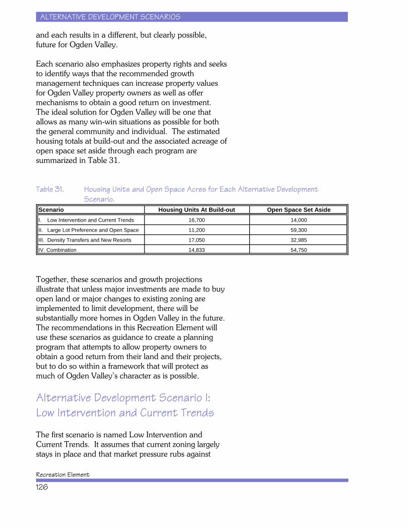
ALTERNATIVE DEVELOPMENT SCENARIOS
Recreation Element
126
and each results in a different, but clearly possible,future for Ogden Valley.
Each scenario also emphasizes property rights and seeksto identify ways that the recommended growthmanagement techniques can increase property valuesfor Ogden Valley property owners as well as offermechanisms to obtain a good return on investment. The ideal solution for Ogden Valley will be one thatallows as many win-win situations as possible for boththe general community and individual. The estimatedhousing totals at build-out and the associated acreage ofopen space set aside through each program aresummarized in Table 31.
Table 31. Housing Units and Open Space Acres for Each Alternative DevelopmentScenario.
Scenario Housing Units At Build-out Open Space Set AsideI. Low Intervention and Current Trends 16,700 14,000
II. Large Lot Preference and Open Space 11,200 59,300
III. Density Transfers and New Resorts 17,050 32,985
IV. Combination 14,833 54,750
Together, these scenarios and growth projectionsillustrate that unless major investments are made to buyopen land or major changes to existing zoning areimplemented to limit development, there will besubstantially more homes in Ogden Valley in the future. The recommendations in this Recreation Element willuse these scenarios as guidance to create a planningprogram that attempts to allow property owners toobtain a good return from their land and their projects,but to do so within a framework that will protect asmuch of Ogden Valley’s character as is possible.
Alternative Development Scenario I:Low Intervention and Current Trends
The first scenario is named Low Intervention andCurrent Trends. It assumes that current zoning largelystays in place and that market pressure rubs against
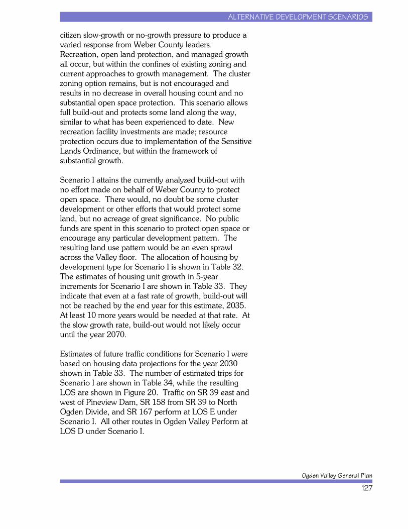
ALTERNATIVE DEVELOPMENT SCENARIOS
Ogden Valley General Plan
127
citizen slow-growth or no-growth pressure to produce avaried response from Weber County leaders.Recreation, open land protection, and managed growthall occur, but within the confines of existing zoning andcurrent approaches to growth management. The clusterzoning option remains, but is not encouraged andresults in no decrease in overall housing count and nosubstantial open space protection. This scenario allowsfull build-out and protects some land along the way,similar to what has been experienced to date. Newrecreation facility investments are made; resourceprotection occurs due to implementation of the SensitiveLands Ordinance, but within the framework ofsubstantial growth.
Scenario I attains the currently analyzed build-out withno effort made on behalf of Weber County to protectopen space. There would, no doubt be some clusterdevelopment or other efforts that would protect someland, but no acreage of great significance. No publicfunds are spent in this scenario to protect open space orencourage any particular development pattern. Theresulting land use pattern would be an even sprawlacross the Valley floor. The allocation of housing bydevelopment type for Scenario I is shown in Table 32.The estimates of housing unit growth in 5-yearincrements for Scenario I are shown in Table 33. Theyindicate that even at a fast rate of growth, build-out willnot be reached by the end year for this estimate, 2035. At least 10 more years would be needed at that rate. Atthe slow growth rate, build-out would not likely occuruntil the year 2070.
Estimates of future traffic conditions for Scenario I werebased on housing data projections for the year 2030shown in Table 33. The number of estimated trips forScenario I are shown in Table 34, while the resultingLOS are shown in Figure 20. Traffic on SR 39 east andwest of Pineview Dam, SR 158 from SR 39 to NorthOgden Divide, and SR 167 perform at LOS E underScenario I. All other routes in Ogden Valley Perform atLOS D under Scenario I.
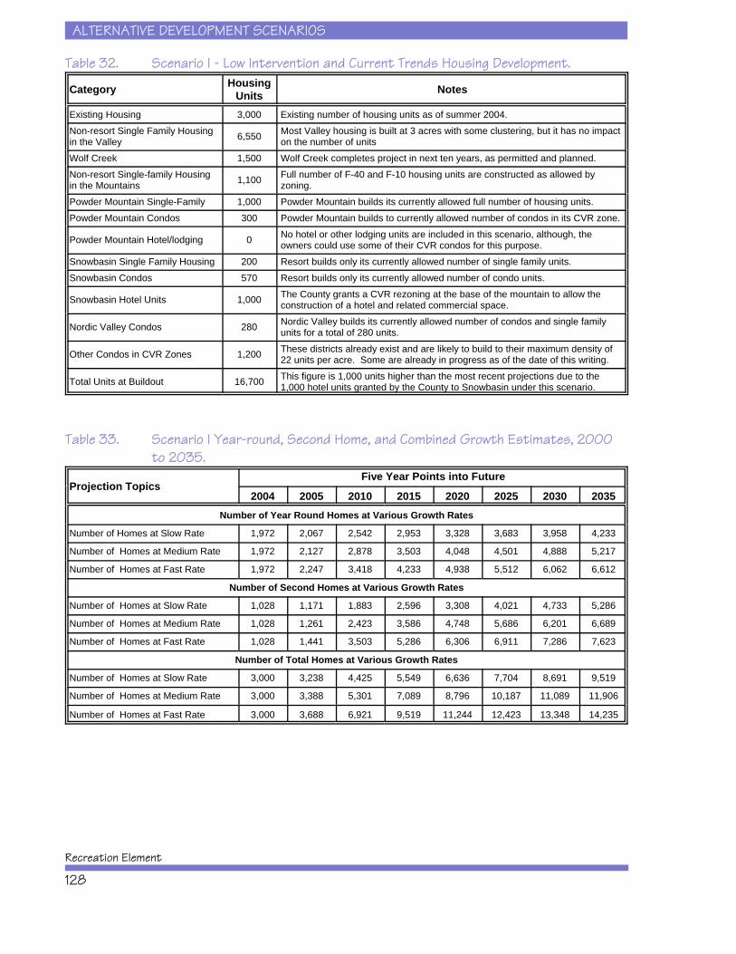
ALTERNATIVE DEVELOPMENT SCENARIOS
Recreation Element
128
Table 32. Scenario I - Low Intervention and Current Trends Housing Development.
Category HousingUnits Notes
Existing Housing 3,000 Existing number of housing units as of summer 2004.Non-resort Single Family Housingin the Valley 6,550 Most Valley housing is built at 3 acres with some clustering, but it has no impact
on the number of unitsWolf Creek 1,500 Wolf Creek completes project in next ten years, as permitted and planned.Non-resort Single-family Housingin the Mountains 1,100 Full number of F-40 and F-10 housing units are constructed as allowed by
zoning.Powder Mountain Single-Family 1,000 Powder Mountain builds its currently allowed full number of housing units.Powder Mountain Condos 300 Powder Mountain builds to currently allowed number of condos in its CVR zone.
Powder Mountain Hotel/lodging 0 No hotel or other lodging units are included in this scenario, although, theowners could use some of their CVR condos for this purpose.
Snowbasin Single Family Housing 200 Resort builds only its currently allowed number of single family units.Snowbasin Condos 570 Resort builds only its currently allowed number of condo units.
Snowbasin Hotel Units 1,000 The County grants a CVR rezoning at the base of the mountain to allow theconstruction of a hotel and related commercial space.
Nordic Valley Condos 280 Nordic Valley builds its currently allowed number of condos and single familyunits for a total of 280 units.
Other Condos in CVR Zones 1,200 These districts already exist and are likely to build to their maximum density of22 units per acre. Some are already in progress as of the date of this writing.
Total Units at Buildout 16,700 This figure is 1,000 units higher than the most recent projections due to the1,000 hotel units granted by the County to Snowbasin under this scenario.
Table 33. Scenario I Year-round, Second Home, and Combined Growth Estimates, 2000to 2035.
Projection TopicsFive Year Points into Future
2004 2005 2010 2015 2020 2025 2030 2035Number of Year Round Homes at Various Growth Rates
Number of Homes at Slow Rate 1,972 2,067 2,542 2,953 3,328 3,683 3,958 4,233
Number of Homes at Medium Rate 1,972 2,127 2,878 3,503 4,048 4,501 4,888 5,217
Number of Homes at Fast Rate 1,972 2,247 3,418 4,233 4,938 5,512 6,062 6,612
Number of Second Homes at Various Growth Rates
Number of Homes at Slow Rate 1,028 1,171 1,883 2,596 3,308 4,021 4,733 5,286
Number of Homes at Medium Rate 1,028 1,261 2,423 3,586 4,748 5,686 6,201 6,689
Number of Homes at Fast Rate 1,028 1,441 3,503 5,286 6,306 6,911 7,286 7,623
Number of Total Homes at Various Growth Rates
Number of Homes at Slow Rate 3,000 3,238 4,425 5,549 6,636 7,704 8,691 9,519
Number of Homes at Medium Rate 3,000 3,388 5,301 7,089 8,796 10,187 11,089 11,906
Number of Homes at Fast Rate 3,000 3,688 6,921 9,519 11,244 12,423 13,348 14,235
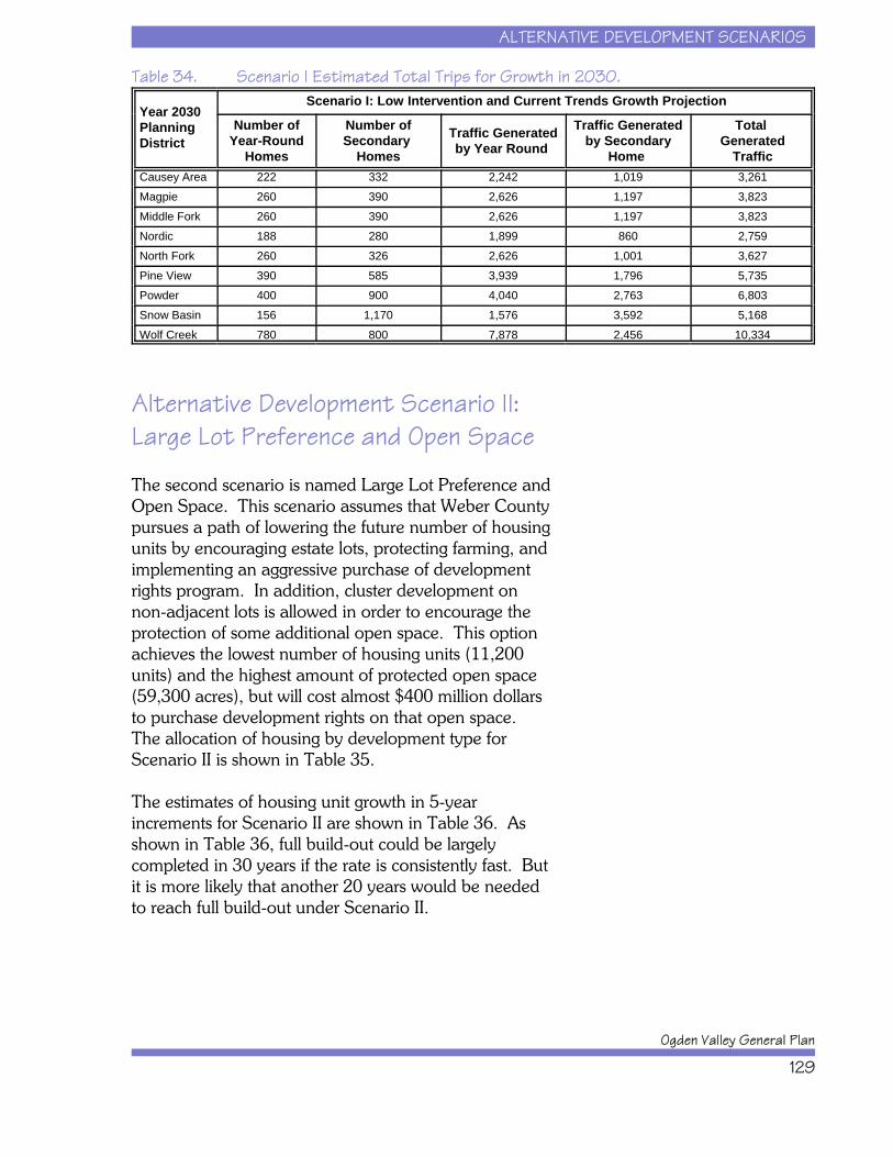
ALTERNATIVE DEVELOPMENT SCENARIOS
Ogden Valley General Plan
129
Table 34. Scenario I Estimated Total Trips for Growth in 2030.
Year 2030Planning District
Scenario I: Low Intervention and Current Trends Growth Projection
Number ofYear-Round
Homes
Number ofSecondary
Homes
Traffic Generatedby Year Round
Traffic Generatedby Secondary
Home
Total Generated
Traffic Causey Area 222 332 2,242 1,019 3,261Magpie 260 390 2,626 1,197 3,823Middle Fork 260 390 2,626 1,197 3,823Nordic 188 280 1,899 860 2,759North Fork 260 326 2,626 1,001 3,627Pine View 390 585 3,939 1,796 5,735Powder 400 900 4,040 2,763 6,803Snow Basin 156 1,170 1,576 3,592 5,168Wolf Creek 780 800 7,878 2,456 10,334
Alternative Development Scenario II:Large Lot Preference and Open Space
The second scenario is named Large Lot Preference andOpen Space. This scenario assumes that Weber Countypursues a path of lowering the future number of housingunits by encouraging estate lots, protecting farming, andimplementing an aggressive purchase of developmentrights program. In addition, cluster development onnon-adjacent lots is allowed in order to encourage theprotection of some additional open space. This optionachieves the lowest number of housing units (11,200units) and the highest amount of protected open space(59,300 acres), but will cost almost $400 million dollarsto purchase development rights on that open space. The allocation of housing by development type forScenario II is shown in Table 35.
The estimates of housing unit growth in 5-yearincrements for Scenario II are shown in Table 36. Asshown in Table 36, full build-out could be largelycompleted in 30 years if the rate is consistently fast. Butit is more likely that another 20 years would be neededto reach full build-out under Scenario II.
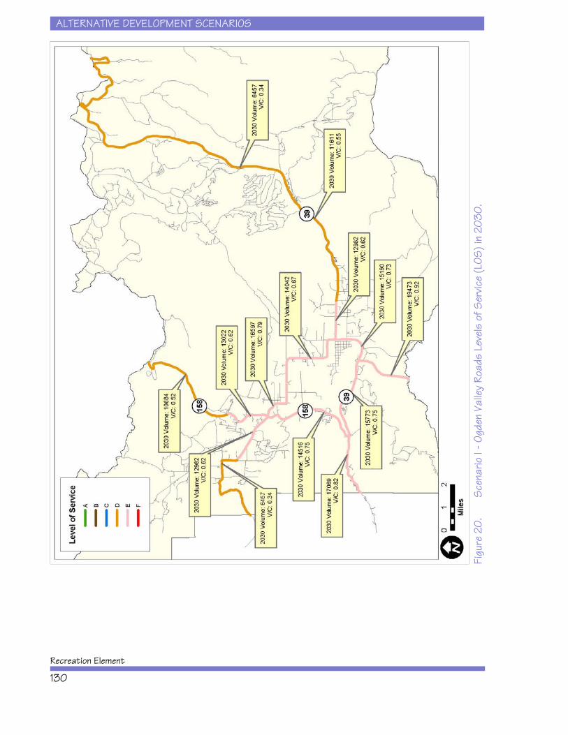
ALTERNATIVE DEVELOPMENT SCENARIOS
Recreation Element
130
Figu
re 2
0.
Sce
nario
I - O
gden
Val
ley
Road
s Le
vels
of S
ervic
e (L
OS) i
n 20
30.
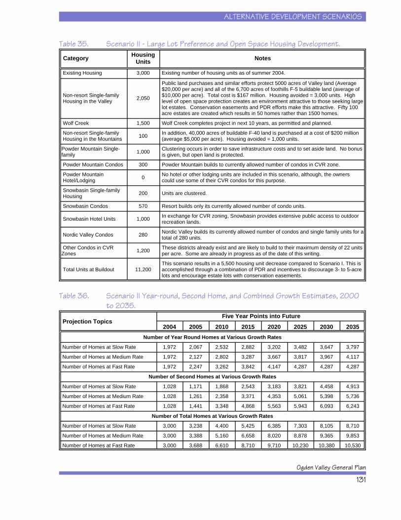
ALTERNATIVE DEVELOPMENT SCENARIOS
Ogden Valley General Plan
131
Table 35. Scenario II - Large Lot Preference and Open Space Housing Development.
Category HousingUnits Notes
Existing Housing 3,000 Existing number of housing units as of summer 2004.
Non-resort Single-family Housing in the Valley 2,050
Public land purchases and similar efforts protect 5000 acres of Valley land (Average$20,000 per acre) and all of the 6,700 acres of foothills F-5 buildable land (average of$10,000 per acre). Total cost is $167 million. Housing avoided = 3,000 units. Highlevel of open space protection creates an environment attractive to those seeking largelot estates. Conservation easements and PDR efforts make this attractive. Fifty 100acre estates are created which results in 50 homes rather than 1500 homes.
Wolf Creek 1,500 Wolf Creek completes project in next 10 years, as permitted and planned.
Non-resort Single-family Housing in the Mountains 100 In addition, 40,000 acres of buildable F-40 land is purchased at a cost of $200 million
(average $5,000 per acre). Housing avoided = 1,000 units.
Powder Mountain Single-family 1,000 Clustering occurs in order to save infrastructure costs and to set aside land. No bonus
is given, but open land is protected.
Powder Mountain Condos 300 Powder Mountain builds to currently allowed number of condos in CVR zone.
Powder Mountain Hotel/Lodging 0 No hotel or other lodging units are included in this scenario, although, the owners
could use some of their CVR condos for this purpose.
Snowbasin Single-family Housing 200 Units are clustered.
Snowbasin Condos 570 Resort builds only its currently allowed number of condo units.
Snowbasin Hotel Units 1,000 In exchange for CVR zoning, Snowbasin provides extensive public access to outdoorrecreation lands.
Nordic Valley Condos 280 Nordic Valley builds its currently allowed number of condos and single family units for atotal of 280 units.
Other Condos in CVRZones 1,200 These districts already exist and are likely to build to their maximum density of 22 units
per acre. Some are already in progress as of the date of this writing.
Total Units at Buildout 11,200This scenario results in a 5,500 housing unit decrease compared to Scenario I. This isaccomplished through a combination of PDR and incentives to discourage 3- to 5-acrelots and encourage estate lots with conservation easements.
Table 36. Scenario II Year-round, Second Home, and Combined Growth Estimates, 2000to 2035.
Projection TopicsFive Year Points into Future
2004 2005 2010 2015 2020 2025 2030 2035Number of Year Round Homes at Various Growth Rates
Number of Homes at Slow Rate 1,972 2,067 2,532 2,882 3,202 3,482 3,647 3,797
Number of Homes at Medium Rate 1,972 2,127 2,802 3,287 3,667 3,817 3,967 4,117
Number of Homes at Fast Rate 1,972 2,247 3,262 3,842 4,147 4,287 4,287 4,287
Number of Second Homes at Various Growth Rates
Number of Homes at Slow Rate 1,028 1,171 1,868 2,543 3,183 3,821 4,458 4,913
Number of Homes at Medium Rate 1,028 1,261 2,358 3,371 4,353 5,061 5,398 5,736
Number of Homes at Fast Rate 1,028 1,441 3,348 4,868 5,563 5,943 6,093 6,243
Number of Total Homes at Various Growth Rates
Number of Homes at Slow Rate 3,000 3,238 4,400 5,425 6,385 7,303 8,105 8,710
Number of Homes at Medium Rate 3,000 3,388 5,160 6,658 8,020 8,878 9,365 9,853
Number of Homes at Fast Rate 3,000 3,688 6,610 8,710 9,710 10,230 10,380 10,530
ALTERNATIVE DEVELOPMENT SCENARIOS
Recreation Element
132
Estimates of future traffic conditions for Scenario II werebased on housing data projections for the year 2030shown in Table 36. The number of estimated trips forScenario II are shown in Table 37, while the resultingLOS are shown in Figure 21. Traffic on SR 39 east andwest of Pineview Dam, SR 158 from SR 39 to Eden,and SR 167 perform at LOS E under Scenario II. Allother routes in Ogden Valley perform at LOS D underScenario II, with the exception of North Ogden Divide,which performs at LOS C.
Table 37. Scenario II - Estimated Total Trips for Growth in 2030.
Year 2030Planning District
Scenario II: Large Lot Preference and Open Space Scenario Growth Projection
Number of Year-Round
Homes
Number ofSecondary
Homes
Traffic Generated by Year Round
Traffic Generatedby Secondary
Home
Total Generated
Traffic Causey Area 20 30 202 92 294Magpie 160 310 1616 952 2568Middle Fork 160 210 1616 645 2261Nordic 60 280 606 860 1466North Fork 70 85 707 261 968Pine View 225 585 2273 1796 4069Powder 400 900 4040 2763 6803Snow Basin 120 1170 1212 3592 4804
Wolf Creek 780 800 7878 2456 10334
Alternative Development Scenario III:Density Transfer and New Resorts
The third scenario is named Density Transfer and NewResorts. This scenario would involve a very activeprogram by developers, Weber County government,and other entities to manage growth in Ogden Valley bytransferring density from lands throughout the ProjectArea to the four existing resorts and three new resortareas. This scenario results in more overall housingunits, but they are concentrated in several denserlocations with the result being large amounts of openspace set aside in the valley, foothills, and mountains.
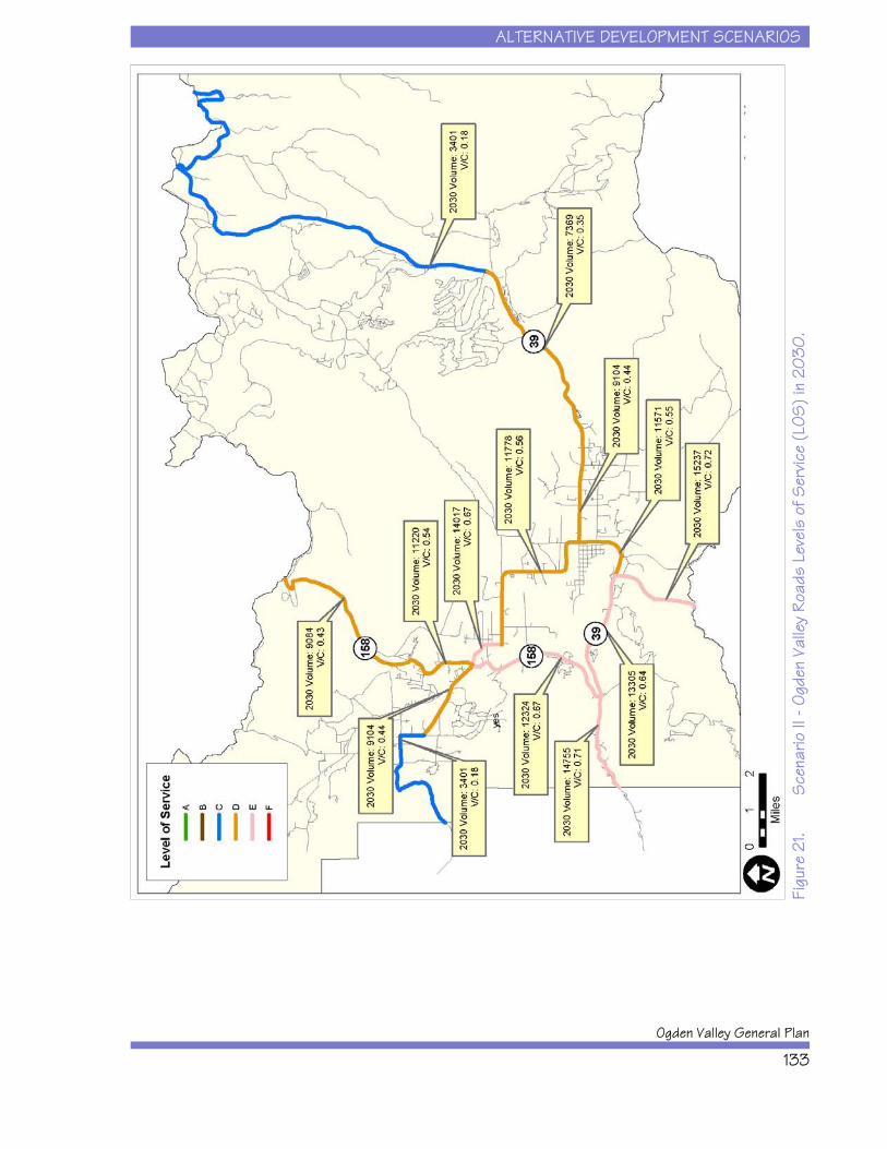
ALTERNATIVE DEVELOPMENT SCENARIOS
Ogden Valley General Plan
133
Figu
re 2
1.S
cena
rio II
- Og
den
Valle
y Ro
ads
Leve
ls o
f Ser
vice
(LOS
) in
2030
.
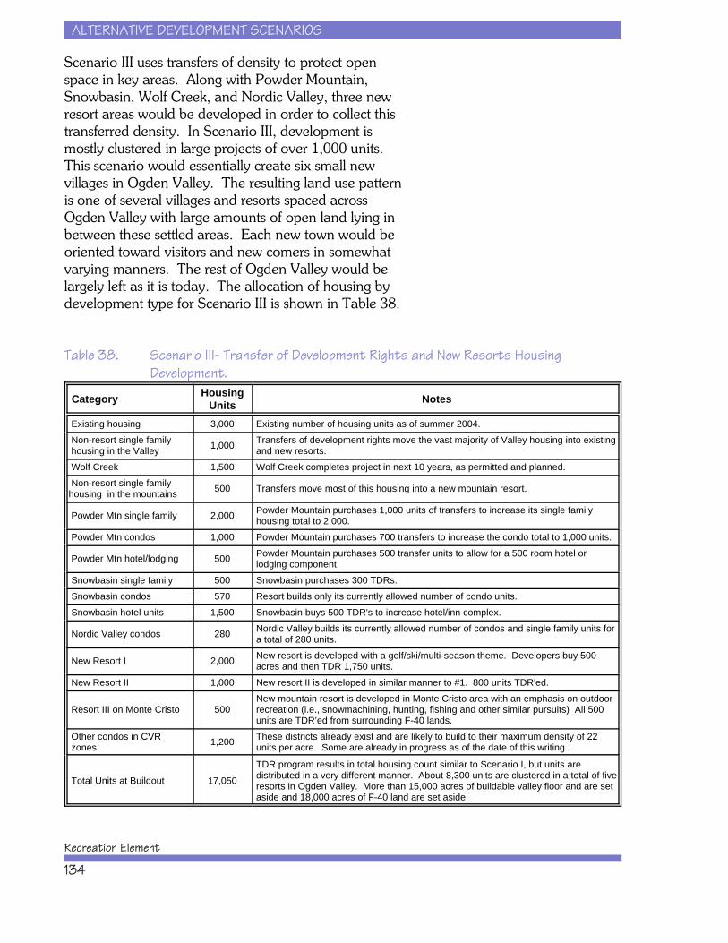
ALTERNATIVE DEVELOPMENT SCENARIOS
Recreation Element
134
Scenario III uses transfers of density to protect openspace in key areas. Along with Powder Mountain,Snowbasin, Wolf Creek, and Nordic Valley, three newresort areas would be developed in order to collect thistransferred density. In Scenario III, development ismostly clustered in large projects of over 1,000 units. This scenario would essentially create six small newvillages in Ogden Valley. The resulting land use patternis one of several villages and resorts spaced acrossOgden Valley with large amounts of open land lying inbetween these settled areas. Each new town would beoriented toward visitors and new comers in somewhat varying manners. The rest of Ogden Valley would belargely left as it is today. The allocation of housing bydevelopment type for Scenario III is shown in Table 38.
Table 38. Scenario III- Transfer of Development Rights and New Resorts HousingDevelopment.
Category HousingUnits Notes
Existing housing 3,000 Existing number of housing units as of summer 2004. Non-resort single family housing in the Valley 1,000 Transfers of development rights move the vast majority of Valley housing into existing
and new resorts. Wolf Creek 1,500 Wolf Creek completes project in next 10 years, as permitted and planned. Non-resort single familyhousing in the mountains 500 Transfers move most of this housing into a new mountain resort.
Powder Mtn single family 2,000 Powder Mountain purchases 1,000 units of transfers to increase its single familyhousing total to 2,000.
Powder Mtn condos 1,000 Powder Mountain purchases 700 transfers to increase the condo total to 1,000 units.
Powder Mtn hotel/lodging 500 Powder Mountain purchases 500 transfer units to allow for a 500 room hotel orlodging component.
Snowbasin single family 500 Snowbasin purchases 300 TDRs. Snowbasin condos 570 Resort builds only its currently allowed number of condo units. Snowbasin hotel units 1,500 Snowbasin buys 500 TDR's to increase hotel/inn complex.
Nordic Valley condos 280 Nordic Valley builds its currently allowed number of condos and single family units fora total of 280 units.
New Resort I 2,000 New resort is developed with a golf/ski/multi-season theme. Developers buy 500acres and then TDR 1,750 units.
New Resort II 1,000 New resort II is developed in similar manner to #1. 800 units TDR'ed.
Resort III on Monte Cristo 500New mountain resort is developed in Monte Cristo area with an emphasis on outdoorrecreation (i.e., snowmachining, hunting, fishing and other similar pursuits) All 500units are TDR’ed from surrounding F-40 lands.
Other condos in CVR zones 1,200 These districts already exist and are likely to build to their maximum density of 22
units per acre. Some are already in progress as of the date of this writing.
Total Units at Buildout 17,050
TDR program results in total housing count similar to Scenario I, but units aredistributed in a very different manner. About 8,300 units are clustered in a total of fiveresorts in Ogden Valley. More than 15,000 acres of buildable valley floor and are setaside and 18,000 acres of F-40 land are set aside.
ALTERNATIVE DEVELOPMENT SCENARIOS
Ogden Valley General Plan
135
The estimates of housing unit growth in 5-yearincrements for Scenario III are shown in Table 39. Growth could be largely completed in 30 years if therate is consistently fast. Assuming more moderate ratesof growth, full build-out will take another 20-30 years.
Table 39. Scenario III Year-round, Second Home, and Combined Growth Estimates, 2000to 2035.
Projection TopicsFive Year Points into Future
2004 2005 2010 2015 2020 2025 2030 2035
Number of Year Round Homes at Various Growth Rates
Number of Homes at Slow Rate 1,972 2,077 2,572 3,022 3,452 3,877 4,262 4,622
Number of Homes at Medium Rate 1,972 2,162 3,022 3,797 4,532 5,182 5,592 5,772
Number of Homes at Fast Rate 1,972 2,277 3,622 4,852 5,692 5,842 5,842 5,842
Number of Second Homes at Various Growth Rates
Number of Homes at Slow Rate 1,028 1,246 2,328 3,378 4,428 5,478 6,493 7,376
Number of Homes at Medium Rate 1,028 1,366 3,003 4,611 6,148 7,506 8,698 9,576
Number of Homes at Fast Rate 1,028 1,516 3,858 5,906 7,588 9,148 9,988 10,538
Number of Total Homes at Various Growth Rates
Number of Homes at Slow Rate 3,000 3,323 4,900 6,400 7,880 9,355 10,755 11,998
Number of Homes at Medium Rate 3,000 3,528 6,025 8,408 10,680 12,688 14,290 15,348
Number of Homes at Fast Rate 3,000 3,793 7,480 10,758 13,280 14,990 15,830 16,380
Estimates of future traffic conditions for Scenario III werebased on housing data projections for the year 2030shown in Table 39. The number of estimated trips forScenario III are shown in Table 40, while the resultingLOS are shown in Figure 22. Under Scenario III, trafficon SR 39, SR 158, SR 167, and the Hunstville to Edenroad perform at LOS F. All other routes in OgdenValley perform at LOS D or E under Scenario III.
ALTERNATIVE DEVELOPMENT SCENARIOS
Recreation Element
136
Table 40. Scenario III - Estimated Total Trips for Growth in 2030.
Year 2030 Planning District
Scenario III: Transfer of Development Rights and New Resort Scenario Growth Projection
Number of Year-Round
Homes
Number ofSecondary
Homes
Traffic Generated by Year Round
TrafficGenerated
by SecondaryHomes
Total Generated
Traffic
Causey Area 140 160 1,414 491 1,905
Magpie 30 40 303 123 426
Middle Fork 30 540 303 1,658 1,961
Nordic 60 280 606 860 1,466
North Fork 420 585 4,242 1,796 6,038
Pine View 220 585 2,222 1,796 4,018
Powder 900 2,340 9,090 7,184 16,274
Snow Basin 1,040 2,340 10,504 7,184 17,688
Wolf Creek 780 800 7,878 2,456 10,334
Alternative Development Scenario IV:Combination
The fourth scenario, named Combination, envisions thatWeber County uses a mixture of the growth techniquesdescribed in the three previous scenarios. This optionlowers full build-out to 14,833 units and protects some54,750 acres at a cost of $100 million by combiningpurchase of development rights programs with transferof development rights programs for Ogden Valley. Theexisting and new resorts would transfer density from themountainous areas throughout the Project Area. Theallocation of housing by development type is shown inTable 41 while the estimates of housing unit growth forScenario IV are shown in Table 42.
Estimates of future traffic conditions for Scenario IVwere based on data projections for 2030 shown in Table42. The number of estimated trips for Scenario IV areshown in Table 43, while the resulting LOS are shownin Figure 23. Under Scenario IV, traffic on SR 39, SR158, and the Huntsville to Eden road perform at LOS E,while traffic on SR 167 perform at LOS F. All otherroutes in Ogden Valley perform at LOS D or betterunder Scenario IV.
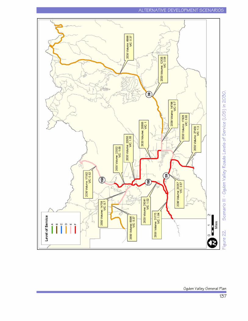
ALTERNATIVE DEVELOPMENT SCENARIOS
Ogden Valley General Plan
137
Figu
re 2
2.
Sce
nario
III -
Ogd
en V
alle
y Ro
ads
Leve
ls o
f Ser
vice
(LOS
) in
2030
.
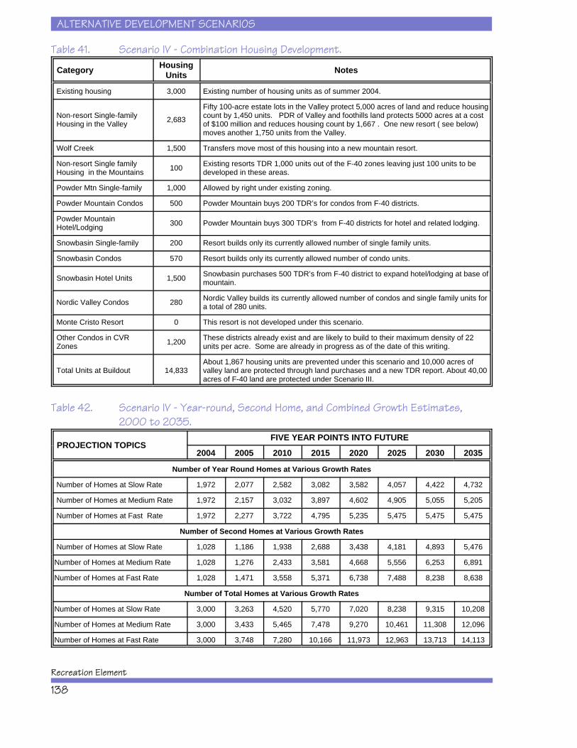
ALTERNATIVE DEVELOPMENT SCENARIOS
Recreation Element
138
Table 41. Scenario IV - Combination Housing Development.
Category HousingUnits Notes
Existing housing 3,000 Existing number of housing units as of summer 2004.
Non-resort Single-family Housing in the Valley 2,683
Fifty 100-acre estate lots in the Valley protect 5,000 acres of land and reduce housingcount by 1,450 units. PDR of Valley and foothills land protects 5000 acres at a costof $100 million and reduces housing count by 1,667 . One new resort ( see below)moves another 1,750 units from the Valley.
Wolf Creek 1,500 Transfers move most of this housing into a new mountain resort.
Non-resort Single family Housing in the Mountains 100 Existing resorts TDR 1,000 units out of the F-40 zones leaving just 100 units to be
developed in these areas.
Powder Mtn Single-family 1,000 Allowed by right under existing zoning.
Powder Mountain Condos 500 Powder Mountain buys 200 TDR’s for condos from F-40 districts.
Powder Mountain Hotel/Lodging 300 Powder Mountain buys 300 TDR’s from F-40 districts for hotel and related lodging.
Snowbasin Single-family 200 Resort builds only its currently allowed number of single family units.
Snowbasin Condos 570 Resort builds only its currently allowed number of condo units.
Snowbasin Hotel Units 1,500 Snowbasin purchases 500 TDR’s from F-40 district to expand hotel/lodging at base ofmountain.
Nordic Valley Condos 280 Nordic Valley builds its currently allowed number of condos and single family units fora total of 280 units.
Monte Cristo Resort 0 This resort is not developed under this scenario.
Other Condos in CVR Zones 1,200 These districts already exist and are likely to build to their maximum density of 22
units per acre. Some are already in progress as of the date of this writing.
Total Units at Buildout 14,833About 1,867 housing units are prevented under this scenario and 10,000 acres ofvalley land are protected through land purchases and a new TDR report. About 40,00acres of F-40 land are protected under Scenario III.
Table 42. Scenario IV - Year-round, Second Home, and Combined Growth Estimates,2000 to 2035.
PROJECTION TOPICSFIVE YEAR POINTS INTO FUTURE
2004 2005 2010 2015 2020 2025 2030 2035
Number of Year Round Homes at Various Growth Rates
Number of Homes at Slow Rate 1,972 2,077 2,582 3,082 3,582 4,057 4,422 4,732
Number of Homes at Medium Rate 1,972 2,157 3,032 3,897 4,602 4,905 5,055 5,205
Number of Homes at Fast Rate 1,972 2,277 3,722 4,795 5,235 5,475 5,475 5,475
Number of Second Homes at Various Growth Rates
Number of Homes at Slow Rate 1,028 1,186 1,938 2,688 3,438 4,181 4,893 5,476
Number of Homes at Medium Rate 1,028 1,276 2,433 3,581 4,668 5,556 6,253 6,891
Number of Homes at Fast Rate 1,028 1,471 3,558 5,371 6,738 7,488 8,238 8,638
Number of Total Homes at Various Growth Rates
Number of Homes at Slow Rate 3,000 3,263 4,520 5,770 7,020 8,238 9,315 10,208
Number of Homes at Medium Rate 3,000 3,433 5,465 7,478 9,270 10,461 11,308 12,096
Number of Homes at Fast Rate 3,000 3,748 7,280 10,166 11,973 12,963 13,713 14,113
ALTERNATIVE DEVELOPMENT SCENARIOS
Ogden Valley General Plan
139
Table 43. Scenario IV - Estimated Total Trips for Growth in 2030.
Year 2030PlanningDistrict
Scenario IV: Combination Scenario Growth Projection
Number ofYear-Round
Homes
Number ofSecondary
Homes
Traffic Generated by Year Round
Traffic Generated by Secondary
Homes
Total Generated
Traffic Causey Area 10 10 101 31 132Magpie 210 360 2121 1105 3226Middle Fork 210 260 2121 798 2919Nordic 100 330 1010 1013 2023North Fork 120 150 1212 461 1673Pine View 270 585 2727 1796 4523Powder 400 1170 4040 3592 7632Snow Basin 983 1560 9928 4789 14717
Wolf Creek 930 800 9393 2456 11849
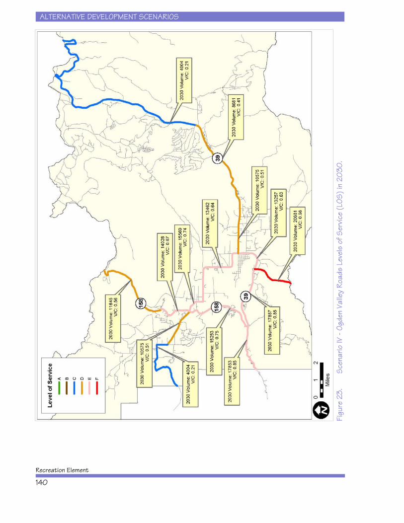
ALTERNATIVE DEVELOPMENT SCENARIOS
Recreation Element
140
Figu
re 2
3.S
cena
rio IV
- Og
den
Valle
y Ro
ads
Leve
ls o
f Ser
vice
(LOS
) in
2030
.
ALTERNATIVE DEVELOPMENT SCENARIOS
Ogden Valley General Plan
141
. . . . . . . . . . . . . . . . . . . . . . . . . . . . . . . . . . . . . . . . . . . . . . . . . . . . . . . . . . . . . 117Baseline Data for the Alternative Development Scenarios . . . . . . . . . . . . . . . . . 118Overview of the Alternative Development Scenarios . . . . . . . . . . . . . . . . . . . . . 119Alternative Development Scenario I: Low Intervention and Current Trends . . . . 120Alternative Development Scenario II: Large Lot Preference and Open Space . . . 123Alternative Development Scenario III: Density Transfer and New Resorts . . . . . 126Alternative Development Scenario IV: Combination . . . . . . . . . . . . . . . . . . . . . 130
Table 31. Housing Units and Open Space Acres for Each Alternative DevelopmentScenario. . . . . . . . . . . . . . . . . . . . . . . . . . . . . . . . . . . . . . . . . . . . . . . . . 120
Table 32. Scenario I - Low Intervention and Current Trends Housing Development.. . . . . . . . . . . . . . . . . . . . . . . . . . . . . . . . . . . . . . . . . . . . . . . . . . . . . . . . . . . . . 122
Table 33. Scenario I Year-round, Second Home, and Combined Growth Estimates,2000 to 2035. . . . . . . . . . . . . . . . . . . . . . . . . . . . . . . . . . . . . . . . . . . . . . 122
Table 34. Scenario I Estimated Total Trips for Growth in 2030.
Table 35. Scenario II - Large Lot Preference and Open Space HousingDevelopment. . . . . . . . . . . . . . . . . . . . . . . . . . . . . . . . . . . . . . . . . . . . . . . . . . 125
Table 37. Scenario II - Estimated Total Trips for Growth in 2030. . . . . . . . . . . . . . 126Figure 21. Scenario II - Ogden Valley Roads Levels of Service (LOS) in 2030.
. . . . . . . . . . . . . . . . . . . . . . . . . . . . . . . . . . . . . . . . . . . . . . . . . . . . . . . . . . . . . 127Table 38. Scenario III- Transfer of Development Rights and New Resorts Housing
Development. . . . . . . . . . . . . . . . . . . . . . . . . . . . . . . . . . . . . . . . . . . . . . 128Table 39. Scenario III Year-round, Second Home, and Combined Growth Estimates,
2000 to 2035. . . . . . . . . . . . . . . . . . . . . . . . . . . . . . . . . . . . . . . . . . . . . . 129Table 40. Scenario III - Estimated Total Trips for Growth in 2030. . . . . . . . . . . . . . 130Figure 22. Scenario III - Ogden Valley Roads Levels of Service (LOS) in 2030.
. . . . . . . . . . . . . . . . . . . . . . . . . . . . . . . . . . . . . . . . . . . . . . . . . . . . . . . . 131Table 41. Scenario IV - Combination Housing Development. . . . . . . . . . . . . . . . . . 132
ALTERNATIVE DEVELOPMENT SCENARIOS
Recreation Element
142
Table 42. Scenario IV - Year-round, Second Home, and Combined Growth Estimates,2000 to 2035. . . . . . . . . . . . . . . . . . . . . . . . . . . . . . . . . . . . . . . . . . . . . 132
Table 43. Scenario IV - Estimated Total Trips for Growth in 2030. . . . . . . . . . . . . 133Figure 23. Scenario IV - Ogden Valley Roads Levels of Service (LOS) in 2030.
. . . . . . . . . . . . . . . . . . . . . . . . . . . . . . . . . . . . . . . . . . . . . . . . . . . . . . . 134
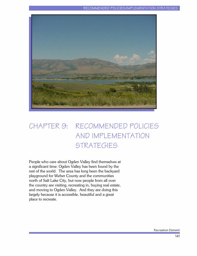
RECOMMENDED POLICIES/IMPLEMENTATION STRATEGIES
Recreation Element
141
CHAPTER 9: RECOMMENDED POLICIES AND IMPLEMENTATION STRATEGIES
People who care about Ogden Valley find themselves ata significant time: Ogden Valley has been found by therest of the world. The area has long been the backyardplayground for Weber County and the communitiesnorth of Salt Lake City, but now people from all overthe country are visiting, recreating in, buying real estate,and moving to Ogden Valley. And they are doing thislargely because it is accessible, beautiful and a greatplace to recreate.
RECOMMENDED POLICIES/IMPLEMENTATION STRATEGIES
Ogden Valley General Plan
142
People are drawn to Ogden Valley’s open spaces, itsviews, its farms and fields, Pineview Reservoir, theskiing, the trails, the backcountry, and all the otheroutdoor resources of the area. People are coming toOgden Valley to use those resources, but there is a limitto how many people can use a trail or safely boat at thereservoir at one time. Therefore, thinking ahead of timeabout how to manage increased recreation in OgdenValley is important to do now, just as the growth beginsto accelerate.
It became apparent as this planning process began thatthe greatest challenge facing recreation management isthe number of people who will move to the area andvisit the area given the way that Ogden Valley is zoned. Despite the good intentions of the OVGP’s policiesregarding carrying capacity, the zoning on the groundallows at least 12,000 more housing units to be built inOgden Valley. This population, while not extreme inmany other well established ski resort communities,would bring significant change to the character ofOgden Valley and it would raise important questionsabout the Valley’s ability to support such a population,whether the resource in question is drinking water, roadcapacity, or wastewater processing capacity.
So, Ogden Valley residents and property owners havesome choices to make. The reality is that growth iscoming, so the question is one of how to manage itintelligently. Fortunately, this planning effort revealedthat there are opportunities for Ogden Valley to partnerrecreation management with growth management. Asthe residents, businesspeople, landowners and electedofficials of Ogden Valley reviewed the possibledirections they might take with recreation and growthmanagement, it became clear that the preferred scenariois one that combines growth, land protection andcreative resort and recreation development. Afundamental principle for the recommendations thatfollow is that of protecting property rights, but alsoacknowledging the need for people to pitch in toconserve key aspects of Ogden Valley’s character. Anunfettered free rein of the development marketplace willmaximize short term profits, but erode long term value.
RECOMMENDED POLICIES/IMPLEMENTATION STRATEGIES
Recreation Element
143
An overbearing regulatory environment will stifleinnovation, drive up the cost of living, and limit propertyrights.
The recommendations that follow describe a middleground wherein creative regulatory guidelines allowlandowners to transfer density to designated resortvillages and thus provide them with financially attractivedevelopment options that also protect open land andencourage the creation of new recreation facilities by theprivate sector. This approach can expand the recreationopportunities in Ogden Valley, protect the currentlyoverused public lands, encourage open space protectionof farmlands, make transportation in the Valley moreefficient, and maintain the profit potential forlandowners.
Structure of the Chapter
To achieve the OVGP goal of enhancing qualityrecreational opportunities (see Chapter 1), this chapterpresents a set of policy statements to guide recreationand resort development, as well as the integratedstrategies that Weber County should undertake toimplement these policies. Implementation strategies aredesigned to guide decision-making and developmentreview, in addition to identifying the staffing needs thatWeber County must pursue. Recommended policy andimplementation strategy categories for this RecreationElement include the following.
x Community Recreation Facility Investments
x Public and Private Recreation FacilityInvestments
x Tourism Facility Investments
x Transportation Facility Investments
x Environmental Resource Protection
x Resort Development Guidelines
RECOMMENDED POLICIES/IMPLEMENTATION STRATEGIES
Ogden Valley General Plan
144
The following policy statements and implementationstrategies relate to the specific topic areas that OgdenValley property owners, developers, planners, andcommunity leaders will face in the years to come. Thesepolicy statements and implementation strategies offer anext level of detail beyond the goals and objectives interms of how recreation and resort issues will bemanaged in the future.
Community Recreation FacilityInvestments
Ogden Valley has a growing year-round population ofresidents who participate in a number of communityoriented recreational activities. Weber County will needto invest in the expansion of existing community parksand recreation facilities to meet existing and futurecommunity recreational facility needs. Right now,certain community recreational facilities are notadequate to meeting existing population-basedstandards or are subjected to over-use (e.g., soccer fieldsand tennis courts). And more facilities will be needed tomeet future population growth over the next 25 years.
Implementation Strategies
x A future neighborhood park (5 to 20 acres insize), with new recreation facilities and activities,should be planned for the south end of OgdenValley south of Pineview Reservoir to address therecreational needs for this growing area. Thispark may not be needed for 15 to 25 years, butland acquisition should occur as soon as ispracticable.
x Expansion of existing neighborhood parks, withnew recreation facilities and activities, shouldoccur immediately to meet existing demand. Aminimum of 9.4 acres should be acquired atEden Park and a minimum of 12.6 acres shouldbe acquired at Liberty Park.
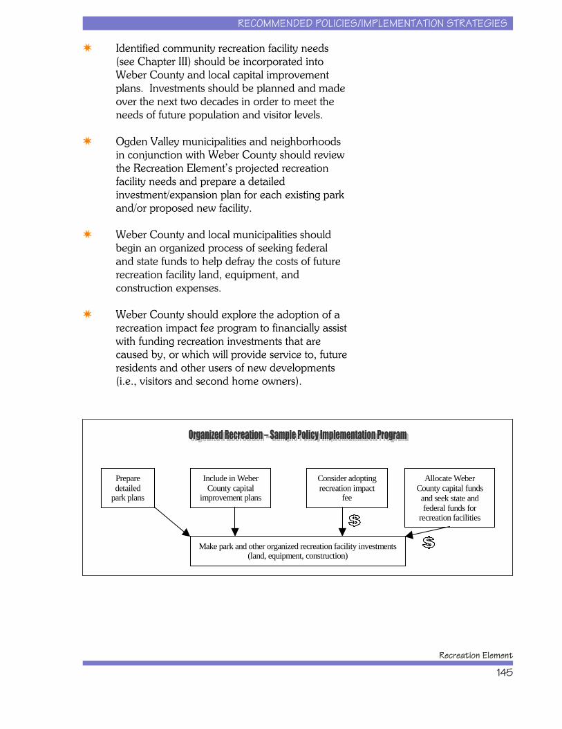
RECOMMENDED POLICIES/IMPLEMENTATION STRATEGIES
Recreation Element
145
Prepare detailed
park plans
Include in Weber County capital
improvement plans
Consider adopting recreation impact
fee
Allocate Weber County capital funds and seek state and federal funds for
recreation facilities
Make park and other organized recreation facility investments (land, equipment, construction)
x Identified community recreation facility needs(see Chapter III) should be incorporated intoWeber County and local capital improvementplans. Investments should be planned and madeover the next two decades in order to meet theneeds of future population and visitor levels.
x Ogden Valley municipalities and neighborhoodsin conjunction with Weber County should reviewthe Recreation Element’s projected recreationfacility needs and prepare a detailedinvestment/expansion plan for each existing parkand/or proposed new facility.
x Weber County and local municipalities shouldbegin an organized process of seeking federaland state funds to help defray the costs of futurerecreation facility land, equipment, andconstruction expenses.
x Weber County should explore the adoption of arecreation impact fee program to financially assistwith funding recreation investments that arecaused by, or which will provide service to, futureresidents and other users of new developments(i.e., visitors and second home owners).
RECOMMENDED POLICIES/IMPLEMENTATION STRATEGIES
Ogden Valley General Plan
146
Public and Private Recreation FacilityInvestments
Ogden Valley is fortunate to have extensive Federal andState land holdings that provide a plethora of outdoorrecreation opportunities. However, any substantialincreases in the amount or types of recreation that arecurrently occurring on National Forest lands areexpected to have measurable negative impacts on thenatural resources that sustain these activities. Therefore,it is unlikely that increased numbers of camping,picnicking, hiking, biking, boating, or skiing facilitieswould be developed on public lands. To promotepublic and private cooperation in recreation planningand to coordinate with Federal and State land managingagencies, Weber County will need to invest in a numberof strategies to meet the growing demand fromresidents, tourists, and visitors to Ogden Valley.
Implementation Strategies
x Develop an ongoing working group thatcontinually evaluates and oversees managementdecisions related to non-organized recreationactivities, especially as they relate to public lands. The U.S. Forest Service, Weber Pathways, UtahState Division of Wildlife Resources, WeberCounty officials, and representatives from otherrelevant user groups (e.g., motorized users,hunters, anglers, equestrian users, snowmobilers)should participate in this effort. An initialresponsibility of this group should be thedevelopment of an integrated means to assessthe capacity of recreation facilities to handleincreased use by visitors and residents.
x The working group should explore the potentialfor developing a permitting system for use ofpublic lands during peak seasons and considercharging visitor fees for use of Weber County andother public lands and resources during peakseasons. A system that focuses on parking/permitfees at parking areas would require a relatively
RECOMMENDED POLICIES/IMPLEMENTATION STRATEGIES
Recreation Element
147
low staff commitment. Seasonal passes could besold through Weber County offices. A similarsystem has also been discussed as a ForestService program under the Recreation FeeEnhancement Act. If implemented, it wouldrequire citizens who recreate at certain trailheads,fishing parking lots, and possibly certain areas ortrails, to purchase an annual or daily pass. Thisprogram would probably be implemented at aNational Forest of Northern Utah scale, not justat the Weber County level. A permit programalong with aggressive law enforcement arepossible solutions to maintain the designatedcapacities of improved facilities and to preventovercrowding.
x Future resort development projects shouldbroaden the array of outdoor recreationexperiences in Ogden Valley. Providing morecamping facilities, horseback riding trails, off-roadvehicle trails, cross country ski trails, and parkingfacilities for underused trails are examples of theways in which resorts could diversify and deepenOgden Valley’s outdoor recreation options. Thisshould be required through the land usepermitting and zoning process through specificlanguage in Weber County’s zoning ordinances.
x Relative to trails, implement the master planprepared by Weber Pathways and encouragethat organization to continue its work on WeberCounty’s trail needs. Weber County zoningshould set explicit conditions and parameters forincorporating and developing the adopted trailmaster plan segments associated with privateland development. Defining the sources forongoing maintenance funding through thedevelopment’s residents and users must be a partof the ordinances.
x A detailed investment and improvement planshould be prepared for all parking areas, formaland informal, that offer access to recreationresources. Currently, the mixture of formal and

RECOMMENDED POLICIES/IMPLEMENTATION STRATEGIES
Ogden Valley General Plan
148
informal parking areas has no connection withthe overall management objectives of resourcesin Ogden Valley. While improvements do notneed to be made at every pull-off area,consideration should be given as to whether theparking area is safe from a traffic perspective, isdamaging resources (e.g., is runoff from theparking area damaging the adjacent fishinghabitat), or is matching the capacity of the facility(i.e., does the parking area allow too manypeople to hike on a given trail or too few?).Some parking areas should provide sanitaryfacilities (e.g., restrooms) and/or equestrianfacilities. The plan should include a discussion ofthe recreation opportunities available for eachparking area to guide facility designs.
x Weber County and the U.S. Forest Serviceshould prepare a detailed plan exploring whereand how to separate or compatibly combinemotorized and non-motorized vehicles/uses onOgden Valley’s trail system and backcountryareas. Providing appropriate access to publiclands would be essential.
x Weber County should work to maintain the
quality of, and access to, hunting in the OgdenValley while conserving large sections of essentialwildlife habitat. In other words, developmentshould be managed to try to ensure that gamepopulations are maintained or enhanced andthat there are adequate access points for hunters.
x A recreation impact fee system should beexplored by Weber County in order to raisefunds to address the recreation needs generatedby new residents and the visitors associated withnew development projects. Please note that suchfunds can only be used to address the needsassociated with the new residents and visitors;they cannot address needs generated by thosewho already live or recreate in Ogden Valley.
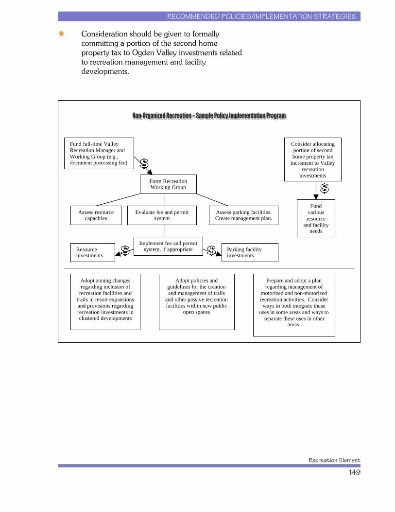
RECOMMENDED POLICIES/IMPLEMENTATION STRATEGIES
Recreation Element
149
Fund full-time Valley Recreation Manager and Working Group (e.g., document processing fee)
Form Recreation Working Group
Assess resource capacities
Evaluate fee and permit system
Assess parking facilities. Create management plan.
Implement fee and permit system, if appropriate Resource
investments Parking facility investments
Adopt zoning changes regarding inclusion of
recreation facilities and trails in resort expansions and provisions regarding recreation investments in clustered developments
Adopt policies and guidelines for the creation and management of trails
and other passive recreation facilities within new public
open spaces
Prepare and adopt a plan regarding management of
motorized and non-motorized recreation activities. Consider
ways to both integrate these uses in some areas and ways to
separate these uses in other areas.
Consider allocating portion of second home property tax
increment to Valley recreation
investments
Fund various resource
and facility needs
x Consideration should be given to formallycommitting a portion of the second homeproperty tax to Ogden Valley investments relatedto recreation management and facilitydevelopments.
RECOMMENDED POLICIES/IMPLEMENTATION STRATEGIES
Ogden Valley General Plan
150
Tourism Facility Investments
The greatest challenge regarding tourism in OgdenValley is whether existing tourism resources cancontinue to expand and develop while maintaining thequalities that make this a unique destination. If OgdenValley is going to compete with such popular resortdestinations as Park City, Utah, Sun Valley, Idaho, andSnowmass, Colorado, Weber County and its residents are going to have to find ways to keep the ruralcharacter and reasonable cost of living conditions thatexist for the most part today.
Implementation Strategies
x Weber County should work with resort managersand real estate developers in Ogden Valley tocreate additional visitor experience facilities ateach resort area. These might be museums,living history tours, theatres showingdocumentaries about the areas, recreationalactivities, or other experiences that visitors willwant to go and see. Lodging, dining, and othervisitor services (e.g., interpretation, guiding)should be considered as well.
x Weber County, Ogden Valley communities,property owners, developers, resort owners, theWasatch-Cache National Forest, the State ofUtah, and others should partner to establish theOgden Valley Heritage Alliance (or a similar termas agreed locally) as an informal cooperativemarketing and heritage protection organization. The concept is to pool resources, designconcepts, and marketing strategies to create adistinctive image and to manage visitors,residents, and recreationists in a manner thatprotects Ogden Valley’s natural and culturalresources. This group would work to preservethe character of Ogden Valley and avoid thehomogenization of the landscape.
RECOMMENDED POLICIES/IMPLEMENTATION STRATEGIES
Recreation Element
151
Transportation Facility Investments
A number of recommendations for improvements toOgden Valley’s transportation system can be found inthe OVGP (Weber County 1998) and theTransportation Master Plan (UDOT 2004). Recommendations are in the form of additional capacityand safety improvements on existing roads,development and implementation of park-and-ridefacilities, and expansion of mass transit services toOgden Valley.
Implementation Strategies
x Implement Weber County’s recommendationsfor specific routes leading into Ogden Valley asdescribed in Section Nine: Infrastructure of theOVGP. The future transportation system inOgden Valley will be made up of a variety oftransportation modes including roads, trails, masstransit, and carpooling.
x Weber County should explore opportunities forpotential funding sources to implement theprojects recommended in the Ogden ValleyTransportation Master Plan (UDOT 2004). Funding options may include increasedtransportation impact fees, increased generalfund allocations, general obligation bonds, andState/Federal-aid. Expansion of existing resortsand establishment of new “village” areas inOgden Valley should be evaluated for theircontribution towards meeting recommendedtransportation projects.
x Weber County should investigate potentialoptions for developing a secondary access roadto the Powder Mountain Resort area from SR-39. A secondary public access to the high-mountainarea surrounding Powder Mountain Resort isneeded to provide for emergency access, toprovide for access to private property, and toprovide for recreational driving opportunities
RECOMMENDED POLICIES/IMPLEMENTATION STRATEGIES
Ogden Valley General Plan
152
within Ogden Valley via a loop-road system. Options may include, but are not limited to,utilizing the existing access through the Sunridgeand Evergreen Park Subdivisions from SR-39 orutilizing new access through the Monte Cristoarea from SR-39 via new development.
Environmental Resource Protection
The future of recreational activities in Ogden Valley willbe largely dependant on the quality of the naturalresources upon which those activities rely. WeberCounty will continue to protect these resources througha variety of mechanisms.
Implementation Strategies
x Weber County should adopt a Sensitive LandsOrdinance to protect the health, safety, andwelfare of Ogden Valley residents. The policieswhich outline this ordinance can be found inSection Four of the OVGP.
Resort Development Guidelines
As discussed in the analysis portions of this RecreationElement, there is the potential for a significant increasein the amount of development in Ogden Valley. Themagnitude of the potential development is sufficientlygreat to safely say that if it should all eventually occur,the character of Ogden Valley would be dramaticallychanged forever and most vestiges of its rural characterwould be lost. To a large extent, the future of OgdenValley’s character will be dependant on the futuredevelopment success of its resort areas. Which is whypreserving Ogden Valley’s character is so tied to theneed for a variety of progressive resort developmentguidelines.
RECOMMENDED POLICIES/IMPLEMENTATION STRATEGIES
Recreation Element
153
Implementation Strategies
x Ogden Valley Open Space Program. WeberCounty, in cooperation with Ogden Valleymunicipalities and other entities should adopt aformal, multi-part open space program thatwould include the use of various policies, tools,techniques, and funding sources to implement. The objective will be to protect as much openspace as possible while maintaining the right forevery property owner to receive a fair return ontheir real estate investment. In other words, thiseffort will not take away value through zoning orother means, but will instead work to reallocatedensities and use a variety of funding techniquesto give every property owner the option to doone or more of the following:
a. develop his/her land at current alloweddensities but with incentives to cluster thehousing and keep as much land open aspossible, or,
b. sell the property as a high-value estate lotwhile protecting substantial portions ofhis/her property as open space throughconservation easement, or,
c. sell existing density to a “resort village”developer with the result that the ownermaintains ownership of the land as openspace or some other low impact use whilestill obtaining significant revenue from theland, or,
d. work with a conservation/publicorganization to place large amounts of theproperty in a protected open space statusfor both income and tax purposes.
RECOMMENDED POLICIES/IMPLEMENTATION STRATEGIES
Ogden Valley General Plan
154
x The Ogden Valley Open Space Program mighthave the following components:
a. Fund a full-time Ogden Valley open spacecoordinator to work with land-owners andvarious third-party groups (i.e.,developers, land trusts, potential estatebuyers, etc.) to create solutions for theirproperties and to find the best balancebetween development and open spaceprotection for a given property. Thisposition might be within government or itmight be a position in some form of not-for-profit that receives some percentage ofsupport from the public sector. It mightnot be a position, but instead be aworking group of farmers, land owners,developers, realtors, conservation groups,public land managers, and planning staffwho work together to accomplish thestated goals.
b. Support a program that markets largeOgden Valley properties as estates withthe intention to gain landowners asubstantial return on their propertywithout any development and subdivisioncosts and with the end result being theavoidance of new housing units. Providetechnical assistance to landownersconsidering this option (i.e., landplanning, financial planning, etc.). Financially support a marketing programthat promotes Ogden Valley to theseestate buyers.
RECOMMENDED POLICIES/IMPLEMENTATION STRATEGIES
Recreation Element
155
c. Encourage existing resorts to expand inorder to generate economic benefits forWeber County as well as to pull densitiesfrom other parts of Ogden Valley into theexpanded resort. The result would bedevelopment concentrated in theexpanded resorts with other areas leftpermanently undeveloped across OgdenValley.
d. Encourage a defined and limited numberof new resort areas that would generateeconomic benefits to Weber County andmove development from potential openspace into new villages. The result wouldbe development concentrated in someareas and other areas left permanentlyopen.
e. Adopt zoning changes that encouragedevelopment that fits with the overallgoals of this program including openspace management, progressive design,resource protection, and resourcemanagement provisions.
f. Create new sources of revenue to fund astaff person, land acquisition, siteplanning, and other tools to support thisprogram.
x New Ogden Valley Resort Village Centers. Encourage the creation of new resort villages inthe locations indicated in Figure 18. Theobjectives of these new resort villages will be thefollowing:
a. Accommodate expected demand forsecond home, year-round home, andresort-related development without generating suburban/resort sprawlthroughout Ogden Valley.

RECOMMENDED POLICIES/IMPLEMENTATION STRATEGIES
Ogden Valley General Plan
156
b. These projects should be part of anoverall effort to avoid the development ofkey open lands in Ogden Valley and tohelp to preserve as much open space aspossible while still providing ampleopportunity for property owners to obtaina fair return on their real estateinvestments.
c. Locate higher density projects in areasthat have good access to highways andwhich will, to the degree possible, reducethe need for future highway expansionsdue solely to the new resort.
d. Weber County would encouragedevelopment of limited capacity sewersystems to serve the projected demand foreach proposed village area. Theinvestment reduces start-up capital costsrequired by developers. Sewer systemsare limited to within a reasonablegeographic area for each villagedevelopment to reduce sewer pipe milesand reduce density speculation betweenvillages. New home builders in villageswould pay a sewer impact fee based on acost per acre rather than a cost per unit.The total sewer fee is then divided by thetotal units that are built in the villagedevelopment. This encourages moredensity to be transferred / clustered into more developments, and potentiallyreduces the cost of sewer services per unit.Impact fees apply only when buildingpermits are issued to reduce the up-frontcosts to the developer. Residents and landowners in the non-village areas could paysome tax to build the sewer system tokeep development costs from escalatingtoo high. The residents understand thatthis investment into the sewer systempreserves land as development is
RECOMMENDED POLICIES/IMPLEMENTATION STRATEGIES
Recreation Element
157
encouraged away from critical land areasand routed into village developments.
e. From a design perspective, new villagesshould seek to echo and reflect thehistoric development patterns andarchitectural themes of Ogden Valley. While these new higher density projectsare a new pattern to Ogden Valley, it is,nonetheless, reasonable for new projectsto review the existing design and land usepatterns and to propose design solutionsthat make these new projects “fit” into theValley rather than “stick out.” Forexample, the grid pattern of Huntsville is ahistorically accurate and useful pattern towork with in a new project. The agrarianarchitectural themes of barns, farmhouses,and gable-ended structures are allexamples of patterns that should beconsidered.
x Ogden Valley Transfer of Development RightsProgram. Develop and adopt an Ogden ValleyTransfer of Development Rights Program thatwould allow specified “low density areas” tomove their allowed development densities todesignated “higher density or resort villageareas.” In other words, property ownersinvolved with developing a resort village areawould buy development rights from propertyowners in the low density areas. Propertyowners in the low density areas would receive money for the development value of their land,while still maintaining ownership of the land forvery low density residential estate, farming, oropen space purposes. Coordination with theOgden Valley Open Space Program to make aconservation easement donation or to sell orlease the land to an organization for farming oropen space purposes would be ideal. Inaddition, a Weber County staff person dedicatedto this program would be necessary and coulddouble as the open space coordinator describedpreviously.
RECOMMENDED POLICIES/IMPLEMENTATION STRATEGIES
Ogden Valley General Plan
158
x The Ogden Valley Transfer of DevelopmentRights (TDR) program might have the followingcomponents:
a. Proposals for new resort communitiescould be established as new receivingzones for transferred development rights. These priority development areas couldreceive density through non-adjacentclusters or a TDR program to createvillages and towns, and preservesurrounding rural and sensitive habitat areas.
b. Weber County could bond for limitedcapacity sewer systems to serve theprojected demand for each villagearea. This public investment would reducestart-up capital costs required bydevelopers. Sewer systems would betreated within a reasonable distance fromeach development area to reduce sewerpipe miles and reduce density speculationbetween villages. This sewer investmentstrategy could help to kick-startdevelopment transfers, and preservecritical lands.
c. New home builders in villages pay asewer impact fee based on a cost per acrerather than a cost per unit. This woulddivide the total sewer fee by the total unitsbuilt in the development, and encouragemore density to be transferred / clusteredinto receiving areas, and reduce the costof sewer per unit. Impact fees could applyonly when building permits are issued toreduce the up-front costs to the developer.
d. Residents and land owners in the non-village areas could pay taxes to buildseveral small sewer systems and makeimmediate payments towards the sewerbond. This would cover the start up costsof sewer systems while developers and
RECOMMENDED POLICIES/IMPLEMENTATION STRATEGIES
Recreation Element
159
realtors purchase or transfer TDRs fromland owners. This investment into sewersystems would preserve land asdevelopment is encouraged away fromcritical land areas – and routed into villagedevelopments.
e. When receiving zone building permitshave yielded significant sewer impact fees,the public investment could bereimbursed, and the money initially paidas sewer bond payments could be used asa revolving TDR fund and preserveadditional acreage. A revolving TDR fundcould purchase TDRs from land ownersand sell them to developers to replenishthe fund. The cash from developers couldthen be used to purchase additional TDRsto sell again to developers.
f. Developers should not be required topurchase all TDRs for all phases of thevillage development up front. Thedeveloper could build phase one of aresort village by using existingdevelopment rights from the land ownersin the development area (densityreceiving area), and perhaps some otherdevelopment rights purchased fromsurrounding land owners.
g. As development units are sold from phaseone, a portion of the developer’s grossrevenues would be used to purchasedevelopment rights in preparation for approval of phase two. Realtors wouldremain busy selling village home andbusiness units and TDRs. Realtors couldemphasize in marketing that a new homeor condo purchase helps to preserve thesurrounding open space and quality of lifein the valley – assuring that theinvestment will remain valuable over time.
RECOMMENDED POLICIES/IMPLEMENTATION STRATEGIES
Ogden Valley General Plan
160
h. In lieu of paying cash fordevelopment rights, a developercould offer the equivalent value indeveloped real estate. In otherwords, a land owner could sell 50development rights in exchange forbuilding lots, or a portion of sharesin the resort community, or sharesof commercial enterprise, etc. Realtor’s services are key inmaking these negotiations work forthe developer and land owners.
The following is an example ofhow a developer could build aresort village of 2,000 bytransferring development rights inphases. The example assumes thata 25 percent density bonus will beapplied for transferring density,and that the developer andlandowners of the villagedevelopment currently hold 100development rights from existing zoning:
100 units x 125% bonus = 125 existingdevelopment rights
1,600 units x 125% bonus = 2,000 totaldesired development rights
1,600 units – 125 existing developmentrights = 1,475 TDRs to purchase
Phase 1: 125 existing units plus purchaseof 100 TDRs (+ 125% density bonus)yields 250 units
Phase 2: Purchase of 280 TDRs (+ 125%density bonus) yields 350 units
Phase 3: Purchase of 280 TDRs (+ 125%density bonus) yields 350 units
Phase 4: Purchase of 280 TDRs (+ 125%density bonus) yields 350 units
RECOMMENDED POLICIES/IMPLEMENTATION STRATEGIES
Recreation Element
161
Phase 5: Purchase of 280 TDRs (+ 125%density bonus) yields 350 units
Phase 6: Purchase of 280 TDRs (+ 125%density bonus) yields 350 units
Total Development: 2,000 units
x Ogden Valley Resort Zoning Ordinance. Develop and adopt an Ogden Valley Resortzoning ordinance that provides creative flexibilityto property owners and developers of resorts,and which also maintains or strengthens WeberCounty’s ability to shape projects that will benefitOgden Valley. Clear authority should bemaintained to deny projects that are not alignedwith Ogden Valley’s vision, goals, and objectives. Of particular importance is the need for suchprojects to fully assess their traffic, drinking watersupply, and wastewater disposal strategies interms of impacts on Ogden Valley’s naturalresources, existing property owners’ rights, andquality of life. Require that all resort projectsaddress the issue of employee housing andprovide a substantial portion of the expectedemployee housing that will be necessary for theresort’s development and operation. Moderateincome housing must be developed to somedegree in association with resort developmentand expansion. This ordinance must clearly statethat proposed increased density at a resort site beyond current zoning densities must beacquired from elsewhere in Ogden Valley toprohibit creating additional housing density.
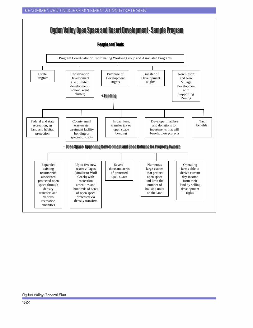
RECOMMENDED POLICIES/IMPLEMENTATION STRATEGIES
Ogden Valley General Plan
162
Estate Program
Conservation Development (i.e., limited
development, non-adjacent
cluster)
Purchase of Development
Rights
Transfer of Development
Rights
New Resort and New Village
Development with
Supporting Zoning
Program Coordinator or Coordinating Working Group and Associated Programs
Federal and state recreation, ag
land and habitat protection
County small wastewater
treatment facility bonding or
special districts
Impact fees, transfer tax or
open space bonding
Developer matches and donations for
investments that will benefit their projects
Expanded existing
resorts with associated
protected open space through
density transfers and
various recreation amenities
Tax benefits
Up to five new resort villages
(similar to Wolf Creek) with recreation
amenities and hundreds of acres
of open space protected via
density transfers
Several thousand acres
of protected open space
Numerous large estates that protect open space
and limit the number of
housing units on the land
Operating farms able to derive current day income from their
land by selling development
rights
RECOMMENDED POLICIES/IMPLEMENTATION STRATEGIES
Recreation Element
163
. . . . . . . . . . . . . . . . . . . . . . . . . . . . . . . . . . . . . . . . . . . . . . . . . . . . . . . . . . . . . 135
. . . . . . . . . . . . . . . . . . . . . . . . . . . . . . . . . . . . . . . . . . . . . . . . . . . . . . . . . . . . . . . . . . . 135Structure of the Chapter . . . . . . . . . . . . . . . . . . . . . . . . . . . . . . . . . . . . . . . . . . 137Community Recreation Facility Investments . . . . . . . . . . . . . . . . . . . . . . . . . . . . 138
Implementation Strategies . . . . . . . . . . . . . . . . . . . . . . . . . . . . . . . . . . . . 138Public and Private Recreation Facility Investments . . . . . . . . . . . . . . . . . . . . . . . 140
Implementation Strategies . . . . . . . . . . . . . . . . . . . . . . . . . . . . . . . . . . . . 140Tourism Facility Investments . . . . . . . . . . . . . . . . . . . . . . . . . . . . . . . . . . . . . . . 143
Implementation Strategies . . . . . . . . . . . . . . . . . . . . . . . . . . . . . . . . . . . . 143Transportation Facility Investments . . . . . . . . . . . . . . . . . . . . . . . . . . . . . . . . . . 145
Implementation Strategies . . . . . . . . . . . . . . . . . . . . . . . . . . . . . . . . . . . . 145Environmental Resource Protection . . . . . . . . . . . . . . . . . . . . . . . . . . . . . . . . . . 145
. . . . . . . . . . . . . . . . . . . . . . . . . . . . . . . . . . . . . . . . . . . . . . . . . . . . . . . . 145Implementation Strategies . . . . . . . . . . . . . . . . . . . . . . . . . . . . . . . . . . . . . . . . . 146Resort Development Guidelines . . . . . . . . . . . . . . . . . . . . . . . . . . . . . . . . . . . . . 146
Implementation Strategies . . . . . . . . . . . . . . . . . . . . . . . . . . . . . . . . . . . . 146
REFERENCES
Ogden Valley General Plan
163
REFERENCES
Black D.S. 2000. Climbing in Utah. Helena (MT): Falcon Publishing.
Mecham B. nd. Ogden Rock Climbs.
Nordic Valley. 2004. Mountain Resort Guides website accessed on 06/03/04. Location:http://www.utahskiresorts.com/stats.cfm/ut07.htm.
[NRPA] National Recreation and Park Association. 1987. Recreation, Park and OpenSpace Standards and Guidelines.
Powder Mountain. 2004. Powder Mountain Resort website accessed on 06/03/04.Location: http://www.powdermountain.net.
[Physical Resources Council] Ogden-Weber Chamber of Commerce. 1996. A guide toWeber County physical resources. Ogden (UT): Physical resources council - Mission2020. 42 p.

REFERENCES
Recreation Element
164
Snowbasin. 2004. Snowbasin Resort website accessed on 06/03/04. Location:http://www.snowbasin.com/mountain/facts.htm.
State of Colorado. 2003. Small Community Park and Recreation Planning Standards.Denver (CO): Colorado Department of Local Affairs. 52 p.
[UDWR] Utah Department of Wildlife Resources. 06/08/01. Utah conservation data center. Location: http://www.utahcdc.usu.edu/ucdc/DownloadGIS/Data/Habitat/arewhdraft.txt.
[USDA] U.S. Department of Agriculture. 1980. Soil Survey of Morgan Area, Utah –Morgan County and Eastern Part of Weber County. Washington (DC): U.S.Department of Agriculture. 300 p. plus maps.
[USFS] U.S. Forest Service. 1998. Pineview Reservoir management and facilityimprovements environmental assessment. Ogden (UT): Forest Service. 84 p.
[USFS] U.S. Forest Service. 2001. Draft Environmental Impact Statement. Ogden (UT):Forest Service.
[USFS]. 2003. Wasatch-Cache National Forest Land and Resource Management Plan(Revised Forest Plan). Ogden (UT): Forest Service. 251 p. plus appendices.
Weber County Assessors Department. 2004. Weber County GIS information. Location: http://www.co.weber.ut.us/gis/2002/psearch/
Weber County GIS data. 2004. Various data layers provided on CD-ROM. 4/6/2004. Weber County (UT): Weber County GIS
Weber County. 1998. Ogden Valley General Plan. Ogden (UT): Weber County. 27 p.
Weber County. 2001. An Update on the Adopted Ogden Valley General Plan. Ogden(UT): Weber County. 2 p.
Weber Pathways. 2002. The Ogden Valley Pathway Master Plan. Ogden (UT): WeberPathways. 24 p.