Ace Outfitters Special Recreation Permit for Commercial ...
67
Cottonwood Field Office, Idaho Ace Outfitters Special Recreation Permit for Commercial Outfitting ENVIRONMENTAL ASSESSMENT Cottonwood Field Office 2930/Project File code ID420-REC2-929 DOI-BLM-ID-C020-2013-0006-EA May 2014
-
Upload
khangminh22 -
Category
Documents
-
view
0 -
download
0
Transcript of Ace Outfitters Special Recreation Permit for Commercial ...
Cottonw
ood Field Office, Idaho
Ace Outfitters Special Recreation Permit for Commercial Outfitting
ENVIRONMENTAL ASSESSMENT
Cottonwood Field Office 2930/Project File code ID420-REC2-929 DOI-BLM-ID-C020-2013-0006-EA May 2014
Environmental Assessment (Draft May 2014) Page i
Cottonwood Field Office 1 Butte Drive
Cottonwood, ID 83522 208-962-3245
http://www.blm.gov/id/st/en.html
It is the mission of the Bureau of Land Management to sustain the health, diversity, and productivity of the public lands for the use and enjoyment of present and future generations.

Environmental Assessment (Draft May 2014) Page ii
Table of Contents 1 Introduction ................................................................................................................................ 1
1.1 Background ............................................................................................................................ 1 1.2 Purpose and Need .................................................................................................................. 1 1.3 Relationship to Laws, Policies and Land Use Plans .............................................................. 2 1.3.1 BLM Land Use Plan Conformance ................................................................................. 2 1.3.2 Consistency with BLM Policy ....................................................................................... 3 1.3.3 Consistency with Non-BLM Authorities ....................................................................... 3
1.4 Identification of Issues for Analysis ...................................................................................... 5 1.4.1 Issues to be Analyzed in Detail ....................................................................................... 5 1.5 Issues Considered but Eliminated from Detailed Analysis ................................................... 7 2 Alternatives ............................................................................................................................... 8 2.1 Alternatives Considered in Detail ......................................................................................... 8 2.1.1 Overview of Alternatives ................................................................................................ 8 2.1.2 Assumptions Used in Developing the Alternatives ......................................................... 9 2.2 Description of the Alternatives .............................................................................................. 9 2.2.1 Proposed Action .............................................................................................................. 9 2.2.1.1 Environmental Design/Resource Protection ........................................................... 11 2.2.2 Limited Action Alternative ........................................................................................... 11 2.2.3 No Action Alternative ................................................................................................... 11 3 Affected Environment and Effects of Alternatives .................................................................. 12 3.1 General Setting .................................................................................................................... 12
3.2 Related Past, Present and Reasonably Foreseeable Actions ............................................... 12 3.2.1 Past, Present, and Future Actions ................................................................................. 12 3.2.2 Reasonably Foreseeable Development ......................................................................... 14
3.3 Analytical Assumptions ...................................................................................................... 14 3.4 Affected Environment ......................................................................................................... 15 3.4.1 Upper Salmon River ACEC ......................................................................................... 15 3.4.2 Air Quality .................................................................................................................... 16 3.4.3 Cultural Resources ....................................................................................................... 18 3.4.4 Recreation ..................................................................................................................... 19 3.4.5 Social Economics ......................................................................................................... 22 3.4.6 Special Recreation Management Area ......................................................................... 23 3.4.7 Wild and Scenic Rivers ................................................................................................ 24 3.4.8 Wildlife, Habitats, and Special Status Species ............................................................ 25 3.4.9 Fisheries, Aquatic Habitat, and Special Status Species ................................................ 36 3.4.10 Vegetation – Upland and Riparian Habitats ................................................................ 40 3.4.11 Wilderness .................................................................................................................. 45 3.4.12 Wilderness Study ........................................................................................................ 46
3.5 Mitigation and Monitoring ............................................................................................... 48 3.5.1 Mitigation ...................................................................................................................... 48 3.5.2 onitoring ........................................................................................................................ 49
4 Consultation and Coordination ............................................................................................... 49 4.1 Persons, Groups or Agencies Consulted .............................................................................. 49 4.1.1 Coordination with Other Agencies ............................................................................... 50
Environmental Assessment (Draft May 2014) Page iii
4.1.2 Native American Consultation ...................................................................................... 51 4.2 Preparers .............................................................................................................................. 51 5 References .................................................................................................................................. 51
List of Tables Table 1: Cottonwood RMP Conformance .................................................................................... 2 Table 2: Alternatives Considered but not Analyzed .................................................................... 8 Table 3: Summary of Land Ownership in BGHUs 19A and 231 ................................................ 25 Table 4: General Big Game Seasons (2013) for Deer and Elk1 .................................................. 25 Table 5: General Hunting Seasons (2013) for Black Bear, Mountain Lion and Gray Wolf1 ........................................................................................................................................... 25 Table 6: 2012 Deer and Elk Harvest Statistics for BGHUs 19A and 231 ................................... 25 Table 7: Federally-Listed and Proposed Species Summary and Determination ......................... 25 Table 8: BLM Sensitive Species Summary and Determination1 ................................................ 25 Table 9: Federally Listed Species ............................................................................................... 39 Table 10: Restoration Seed Mixture for CFO1 ............................................................................ 43
List of Figures Figure 1: Looking upriver towards mouth of Elkhorn Creek ...................................................... 25 Figure 2: Looking down Maxwell Creek drainage towards Salmon River ................................. 25 Figure 3: Outfitter camp site located on Maxwell Ridge ............................................................ 25 Figure 4: Elkhorn Creek, looking downstream from Broken Leg Trail stream crossing ............ 33 Figure 5: View of Marshall Lake ................................................................................................ 34
List of Attachments Attachment 1: Ace Outfitters Inc. Hunting SRP-Map 1 ............................................................. 49 Attachment 2: Ace Outfitters Inc. Hunting SRP-Map 2 ............................................................. 50 Attachment 3: Ace Outfitters Inc. Hunting SRP-Map 3 ............................................................. 50 Attachment 4: Ace Outfitters Special Recreation Permit Terms, Conditions and Stipulations .................................................................................................................................. 51 Attachment 5: BLM WILDLIFE SENSITIVE SPECIES ........................................................... 61
List of Tables Table 1: BLM Sensitive Species (Mammals) ............................................................................. 61 Table 2: BLM Sensitive Species (Birds) .................................................................................... 61 Table 3: BLM Sensitive Species (Reptiles, Amphibians, and Invertebrates) ........................... 61

Ace Outfitters Special Recreation Permit for Commercial Outfitting
Environmental Assessment (Draft April 2014) Page 1
1 INTRODUCTION The Bureau of Land Management (BLM) Cottonwood Field Office proposes to authorize a Special Recreation Permit (SRP) to Ace Outfitters Inc. to conduct commercial hunting guide activities on BLM land in Idaho Fish and Game Management Units (GMU) 19A and 23 (see Map 1). Ace Outfitters Inc. is authorized to operate in this area by the Idaho Outfitter and Guide Licensing Board (IOGLB). The SRP would authorize a long-term base camp (3 months) hunting operation on Marshall Mountain as identified on Map 2, Camp #2. In addition, the SRP would authorize day hunts on BLM managed lands as identified on Map 3. The permit would be issued for a period of up to 5 years and would include year round operations throughout the management area, weather permitting as described in Section 2.2. 1.1 Background The BLM Cottonwood Field Office (CFO) administers approximately 130,480 acres of BLM lands. There are three hunting outfitters authorized to operate on CFO administered BLM managed lands. The Idaho Outfitter and Guide Licensing Board (IOGLB) defines each licensed outfitters area of operations within geographic boundaries predetermined by IOGLB with the caveat that outfitter receives authorization from the land managing agency or the private land owners of those lands. The BLM has a Memorandum of Understanding (MOU) with the Idaho Fish and Game (IDFG) and IOGLB that establishes an administrative framework of procedures and guidance for coordination and cooperation among the parties for any new or amended license and permits for outfitter business opportunities in Idaho. 1.2 Purpose and Need The CFO has received a request for a SRP for commercial outfitting on BLM managed lands to include an assigned three month base camp hunt operation and day hunts based out of the commercial outfitting buildings in GMU 19A and 23. According to Title 43 CFR, Subpart 2932.14 – Outfitters and Guides providing services to hunters, trappers, or anglers must obtain SRPs from the BLM to operate on BLM managed lands. The purpose of the proposed action is to comply with 43 CFR § 2931.3 and § 2932.26 by only issuing SRPs which:
(a) Conform to applicable laws and the Cottonwood Resource Management Plan, (b) Ensure public safety, (c) Do not result in conflicts with other uses, (d) Protect resources, (e) Serve the public interest.
Environmental Assessment (Draft May 2014) Page 2
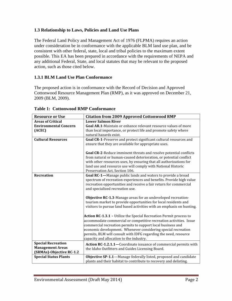
1.3 Relationship to Laws, Policies and Land Use Plans The Federal Land Policy and Management Act of 1976 (FLPMA) requires an action under consideration be in conformance with the applicable BLM land use plan, and be consistent with other federal, state, local and tribal policies to the maximum extent possible. This EA has been prepared in accordance with the requirements of NEPA and any additional Federal, State, and local statutes that may be relevant to the proposed action, such as those cited below. 1.3.1 BLM Land Use Plan Conformance The proposed action is in conformance with the Record of Decision and Approved Cottonwood Resource Management Plan (RMP), as it was approved on December 21, 2009 (BLM, 2009). Table 1: Cottonwood RMP Conformance
Resource or Use Citation from 2009 Approved Cottonwood RMP Areas of Critical Environmental Concern (ACEC)
Lower Salmon River Goal AR.1-Maintain or enhance relevant resource values of more than local importance, or protect life and promote safety where natural hazards exist.
Cultural Resources Goal CR-1-Preserve and protect significant cultural resources and ensure that they are available for appropriate uses. Goal CR-2-Reduce imminent threats and resolve potential conflicts from natural or human-caused deterioration, or potential conflict with other resources uses, by ensuring that all authorizations for land use and resource use will comply with National Historic Preservation Act, Section 106.
Recreation
Goal RC-1—Manage public lands and waters to provide a broad spectrum of recreation experiences and benefits. Provide high value recreation opportunities and receive a fair return for commercial and specialized recreation use. Objective RC-1.3-Manage areas for an undeveloped recreation-tourism market to provide opportunities for local residents and visitors to pursue land based activities with an emphasis on hunting.
Action RC-1.3.1 - Utilize the Special Recreation Permit process to accommodate commercial or competitive recreation activities. Issue commercial recreation permits to support local business and economic development. Whenever considering special recreation permits, BLM will consult with IDFG regarding the need, resource capacity and allocation to the industry.
Special Recreation Management Areas (SRMAs)-Objective RC-1.2
Action RC-1.2.1.1—Coordinate issuance of commercial permits with the Idaho Outfitters and Guides Licensing Board.
Special Status Plants Objective SP-1.1—Manage federally listed, proposed and candidate plants and their habitat to contribute to recovery and delisting.
Environmental Assessment (Draft May 2014) Page 3
1.3.2 Consistency with BLM Policy BLM Handbook – 2930-1 Recreation Permit Administration BLM Manual 6330- Management of Wilderness Study Areas BLM Manual 6340 - Management of Designated Wilderness Areas 43 CFR 2930 1.3.3 Consistency with Non-BLM Authorities The proposed action is consistent with other Federal, State and local land use policies and plans to include: Executive Order 13186 requires the BLM and other Federal agencies work with the U.S. Fish and Wildlife Service (USFWS) to provide protection for migratory birds. Migratory birds are addressed later in this document. Wilderness Act (P.L. 88-577), 1964-§4(d) (6) provides that commercial services "may be performed to the extent necessary for activities which are proper for realizing the recreational or other wilderness purposes of the areas. Commercial services such as those provided by packers, outfitters, and guides may be provided within wilderness areas to the extent necessary for activities which are proper for realizing the recreational or other wilderness purposes of the areas.
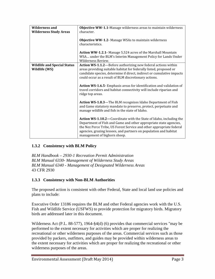
Wilderness and Wilderness Study Areas
Objective WW-1.1-Manage wilderness areas to maintain wilderness character. Objective WW-1.2- Manage WSAs to maintain wilderness characteristics. Action WW-1.2.1- Manage 5,524 acres of the Marshall Mountain WSA… under the BLM's Interim Management Policy for Lands Under Wilderness Review.
Wildlife and Special Status Wildlife (WS)
Action WS-1.1.2—Before authorizing new federal actions within areas providing suitable habitat for federally listed, proposed or candidate species, determine if direct, indirect or cumulative impacts could occur as a result of BLM discretionary actions. Action WS-1.6.5- Emphasis areas for identification and validation of travel corridors and habitat connectivity will include riparian and ridge top areas. Action WS-1.8.3—The BLM recognizes Idaho Department of Fish and Game statutory mandate to preserve, protect, perpetuate and manage wildlife and fish in the state of Idaho. Action WS-1.10.2—Coordinate with the State of Idaho, including the Department of Fish and Game and other appropriate state agencies, the Nez Perce Tribe, US Forest Service and other appropriate federal agencies, grazing lessees, and partners on population and habitat management of bighorn sheep.
Environmental Assessment (Draft May 2014) Page 4
In addition, the proposed action would comply with the following laws and/or agency regulations, other plans and are consistent with applicable Federal, State, and local laws, regulations:
• The Federal Land Policy and Management Act of 1976 (FLPMA), as amended, 43 U.S. Code (U.S.C.) 1701 et seq.
• Endangered Species Act of 1973 (ESA), as amended
• The National Historic Preservation Act of 1966, as amended (Public Law 89-665; 80 Stat. 915; 16 U.S.C. 470)
• The Antiquities Act of 1906, 16 U.S.C. 431-433
• The Archeological Resources Protection Act, 16 U.S.C. 470aa.
• The National Environmental Policy Act of 1969 (NEPA), as amended, 42 U.S.C. 4321 et seq.
• The Clean Air Act of 1990, as amended, 42 U.S.C. 7418
• The Outdoor Recreation Act of May 28, 1963 (16 U.S.C. 4601-1)
• Clean Air Act Section 176(c) (1)
• The Bald and Golden Eagle Protection Act (16 U.S.C. 668-668c) 1940
The project area is located in Idaho County, Idaho. The proposed action is consistent with the 2006 State Comprehensive Outdoor Recreation and Tourism Plan (SCORTP) which identifies the following areas of emphasis:
• Agency and other planning efforts should consider the guidance provided in the State Comprehensive Outdoor Recreation/Tourism Plan;
• Maintain public access to public recreation/tourism opportunities;
• Promote and provide for the safe and enjoyable use of public recreation/tourism facilities and opportunities;
• Comply with the “Americans with Disabilities Act” requirements to make facilities accessible to all people; and
• Consider opportunities to disperse use from the more heavily used areas to more lightly used areas. Consider marketing lightly used areas and de-marketing over use areas.
The draft 2012-16 SCORTP includes the following language: informed recreationists reduce the spread of invasive species on public lands and scenic byways by promoting the use of weed-free hay. In addition, as stated in the Idaho Recreation and Tourism Initiative, for which the BLM has an MOU, desired results include providing high-quality visitor experiences and increasing and improving environmental and outdoor recreation education opportunities across the State of Idaho.

Environmental Assessment (Draft May 2014) Page 5
Actions proposed under each alternative, must adhere to Idaho state laws and regulations including Idaho Code 49-666:
• MOTORCYCLE, MOTORBIKE, UTV AND ATV SAFETY HELMETS -- REQUIREMENTS AND STANDARDS. No person under eighteen (18) years of age shall ride upon or be permitted to operate a motorcycle, motorbike, utility type vehicle or an all-terrain vehicle unless at all times when so operating or riding upon the vehicle he is wearing, as part of his motorcycle, motorbike, Utility Vehicle (UTV) or All-Terrain Vehicle (ATV) equipment, a protective safety helmet of a type and quality equal to or better than the standards established for helmets by the director, except the provisions of this section shall not apply when such vehicles are operated or ridden on private property, or when used as an implement of husbandry.
• All Idaho owners of motorbikes, ATVs and UTVs must purchase and display a 'restricted vehicle' plate that is validated with the display of a current Idaho Department of Parks and Recreation (IDPR) OHV registration sticker on the plate itself. Residents must have both the restricted plate and a current IDPR OHV registration to operate their restricted vehicles on public lands. Nonresidents are not required to register in Idaho unless they have operated within the state for more than 30 days.
And Idaho IDAPA 13.01.08.411:
• Use Restriction-“In designated areas and hunts, hunters may only use motorized vehicles on established roadways which are open to motorized traffic and capable of being traveled by full-sized automobiles. Any other use by hunters is prohibited. All off-road use by hunters is prohibited.”
• Exceptions- This use restriction shall not apply to the following permissible motorized vehicle uses: (a) Holders of a valid Disabled Persons Motor Vehicle Permit may use a motorized vehicle as allowed by the landowner or manager.
• Travel is limited to roads, trails and areas that are designated open by the land management agency for motorized vehicle use.
• Travel by motorized vehicles that causes damage to wildlife habitat, riparian areas, cultural or natural resources, or property or improvements is prohibited.
1.4 Identification of Issues for Analysis The identification of issues for this EA was accomplished by considering the resources that could be affected by implementation of one of the alternatives. 1.4.1 Issues to be Analyzed in Detail The BLM conducted an internal interdisciplinary scoping meeting on January 15, 2013, which included the identification of any potentially affected resources, issues, and/or concerns; reasonable alternatives that could achieve the purpose and need; and potentially
Environmental Assessment (Draft May 2014) Page 6
interested or affected stakeholders. A scoping letter was mailed to 45 members of the public, affected stakeholders and interested parties on February 1, 2013. In addition, the NEPA project, DOI-BLM-ID-C020-2013-0006-EA, was posted on https://www.blm.gov/epl-front-office/eplanning/nepa/nepa_register.do After considering the public comments received during the scoping period, the BLM identified the following relevant issues which will be carried forward for evaluation in this EA are as follows:
• Air Quality: Actions authorized under the proposed action or alternatives would result in vehicle emissions and some fugitive dust from vehicular travel on unpaved roads in the project area.
• Area of Critical Environmental Concern (ACEC): Actions authorized under the proposed action or alternatives may affect the values of the Upper Salmon River ACEC.
• Special Recreation Management Area (SRMA): Actions authorized under the proposed action or alternatives may affect the values of the Salmon River Recreational SRMA.
• Wild and Scenic River (WSR): Actions authorized under the proposed action or alternatives may affect the outstandingly remarkable values of the Salmon River WSR.
• Aquatic Species: Actions authorized under the proposed action or alternatives may directly or indirectly affect ESA-listed and BLM sensitive fish species.
• Cultural Resources: The actions authorized under the proposed action or alternatives may impact culture resources. The project area contains numerous sensitive cultural archeological resources. Some of the project area has not been surveyed due to inaccessibility as a result of current road and trail conditions.
• Recreation: Actions authorized under the proposed action or alternatives may affect recreation users in the project area by creating user conflicts (hikers, hunters, ATV users, commercial vs. private use, and commercial competition), and public safety issues and saturation of commercial services affecting Limits of Acceptable Change (LAC).
• Socioeconomics: Actions authorized under the proposed action or the alternatives
may affect the socioeconomic conditions of the region.
• ESA-listed and Idaho BLM sensitive wildlife species: Actions authorized under the proposed action or the alternatives may directly or indirectly affect ESA-listed wildlife and Idaho BLM sensitive wildlife species and preferred habitats.
Environmental Assessment (Draft May 2014) Page 7
• Wilderness: Actions authorized under the proposed action or alternatives may directly or indirectly affect the 751 acres of the Frank Church River of No Return (Frank Church) Wilderness contained within the project area.
• Wilderness Study Area (WSA): Actions authorized under the proposed action or the alternatives may directly or indirectly affect the Marshall Mountain WSA.
• Wildlife (including and migratory birds): The project area contains numerous
wildlife species migratory birds, and preferred habitats for these species. The proposed action or the alternatives may directly or indirectly affect wildlife species and preferred habitats.
1.5 Issues Considered but Eliminated from Detailed Analysis During public scoping, a number of issues were proposed for consideration in this EA. Some of these are beyond the scope of this EA – actions beyond the scope of this EA include all actions not related to decisions that would occur as a result of the proposed action or one of the alternatives. They include decisions that are not under the jurisdiction of the BLM, are administrative actions, or are beyond the capability of the BLM to resolve as part of this EA process. Other issues identified apply to resources or uses that would not be affected by the proposed action. These types of issues are listed in Table 2. Table 2: Issues Considered but not Analyzed in Detail Issue Title RATIONALE FOR DETERMINATION Environmental Justice Neither the proposed action nor the alternative
would result in disproportionately high and adverse impacts to low income or minority populations.
Livestock Grazing The project area is located within the Sheep grazing allotment which is currently in non-use status. Vehicular traffic would be maintained on designated routes and previously used dispersed campsites. Campsites that impact range and wildlife waters would not be authorized or removed from authorization. Therefore, this project would not affect management or use of the allotments.
Nonnative Invasive Species Vehicular travel would occur on designated routes and established assigned dispersed campsite locations. The proposed action is not expected to contribute to the spread of invasive species because mitigation measures to decrease the potential for the spread of invasive species would be implemented (see Attachment 4).
Rangeland Health The proposed action includes measures to protect the area from vegetative impacts within the corral area (see Attachment 4).
Should work with existing outfitters and guides…Idaho Outfitter and Guide Association to determine whether or not a need exists to
The BLM does not have the obligation to protect guide services. BLM has an obligation to protect the resources, prevent impacts of commercial
Environmental Assessment (Draft May 2014) Page 8
expand outfitted hunting opportunities in the region and that any new permits will not take away existing business from adjacent outfitters.
SRPs on private users, and to avoid user conflicts. In addition allocation areas are determined by Idaho Outfitter and Guides Licensing Board (IOGLB)2. Areas are assigned to only 1 outfitter with rare exceptions. Applicants business has been in operation since 1978 under various owners thus creating a self-limiting process outside the control of the BLM.
Coordinate with IDFG…to authorize termination of permits in the event unacceptable impacts to target game populations occur.
Outside the scope of this analysis1; (administrative action, H-2930-1b).
Limit or prohibit any motorized game retrieval and should prohibit motorized use in association with new special use permits.
Outside the scope of this analysis, addressed in the RMP, "Game retrieval using motorized vehicles will be prohibited off designated routes yearlong." Motorized use is limited to designated routes as identified in the RMP or subsequent NEPA documents. Route designation or use of motorized game retrieval is not occurring in this analysis.
Establish probationary period for new SRPs Outside the scope of this analysis1 (administrative action, H-2930-1).
Why wasn't joint (USFS) scoping letter prepared?
Outside the scope of this analysis (administrative action, H-2930-1)1; Ace Outfitters hunts additional species and seasons on BLM lands versus USFS lands. In addition the USFS is not completing NEPA analysis on Ace Outfitters operations on USFS lands at this time.
How does the proposal for the outfitter to use motorized equipment in the WSA comply with BLM's policy?
Outside the scope of this analysis; Motorized use is limited to designated routes. Route designation or use of motorized equipment within the WSA is not proposed in this analysis.
Support use of outfitters to increase number of folks who can utilize the shown area
Outside the scope of this analysis; allocation areas are determined by IOGLB2. Areas are assigned to only 1 outfitter with rare exceptions.
Wastes (hazardous or solid) The proposed action includes measures to protect the area from hazardous or solid waste spills (see Attachment 4). Effects associated with the project would therefore be negligible.
“Outside the scope of this analysis” means that: 1) the action will be implemented as a standard operating procedure under existing policy (so NEPA review is not necessary); 2) the BLM does not have the authority to implement the action proposed. 2 ALTERNATIVES In order to meet the purpose and need of the proposed action in a way that resolves the relevant issues, the BLM has developed a two action alternatives. These alternatives are presented in this chapter in addition to a description of those alternatives the BLM 2.1 Alternatives Considered in Detail 2.1.1 Overview of Alternatives

Environmental Assessment (Draft May 2014) Page 9
The BLM has developed two alternative strategies (action alternatives) for managing commercial hunting operations within the project area. Each of the action alternatives has a different emphasis of management that reflects a different response to the purpose and need. This section summarizes these two alternatives and a No Action Alternative. It includes a brief description of each alternative plus a comparative summary by alternative. The alternatives were developed by considering the goals and objectives identified in the RMP that address specific prescriptions in the SRMAs and ACECs, as well as the attributes described in the Recreation Opportunity Spectrum (ROS). In addition, project design features identified for the proposed action and alternatives along with SRP stipulations (Attachment 4) minimize potential for adverse effects to special status species and other resources. 2.1.2 Assumptions Used in Developing the Alternatives Existing trends and levels of competition for hunting areas, campsites, hunter use of areas (private and commercial), and other public uses would be expected to occur and be similar for all alternatives. 2.2 Description of the Alternatives 2.2.1 Proposed Action Authorize a SRP for Ace Outfitters Inc. to conduct commercial hunting guide activities on BLM managed lands in Marshall Mountain, Idaho, located between Riggins and the Rattlesnake Creek area on the east side of Highway 95 in Idaho Fish and Game hunting units 19A and 23 as defined on Map 2 and Map 3. The permit would be issued for a period of up to 5 years and would include a base camp and hunting activities. Total use days would be 92 client days for BLM managed-lands. The amended proposed action would include the occupation of campsite #2 of the Marshall Mountain base camps as identified on Map 2 from August 28 to November 5 of each year. Camp Site #1 has been removed from analysis due to the improbability that Shoshone Mining Corporation will develop or improve the Kimberly Mining Site in the near future. Camp Site #3 has also been removed from analysis due to conflicts experienced with local hunters during the 2012 hunting season when the outfitter occupied the site. The Marshall Mountain hunts would occur between August 30 and November 3 of each year and have a group size of no more than six clients; two guides and one camp cook per 4-6 day hunt. The maximum number of clients on Marshall Mountain could expand to 24 clients per big game season and 4 clients per bear season, if the economics and demand for guided hunts increases. Base camp operations would include the use of two 14’ x 16’ and one-16’ X 20’ tent, a 20’ x 4’ hitching rack, a 100’ x 60’ corral, a toilet, wood stoves for warmth and

Environmental Assessment (Draft May 2014) Page 10
occasional campfires during the cold season. Base camp would include 15 gallons of gasoline and propane stored on site, up to 6 stock animals (horses or mules) which are fed weed free hay year-round, and parking for outfitter vehicles on an area less than one acre. Ace Outfitters Inc. would provide transportation for Marshall Mountain clients between the community of Burgdorf and the base camp approximately once a week with one supply run taking place after each group exits the site to remove trash and resupply the camp. All motorized operations (vehicles and ATVs) by Ace Outfitters Inc. staff would be limited to designated state, county, BLM or USFS open routes. In addition, the applicant will be required to obtain land owner approval to access or cross private property. Hunting parties travel by horseback to access Maxwell Point Trail by horseback on the old mining and skidder roads. The applicant on rare occasions would perform trail maintenance in mid to late August along Maxwell Ridge, which is within the Marshall Mountain WSA, using hand tools or a chainsaw to clear downed trees within the established trail tread as necessary. Ground disturbance would not be permitted, nor would tread and/or drainage improvements occur without prior authorization from the BLM. The trail segment known locally as Maxwell Point Trail has been utilized and maintained by Ace Outfitter Inc. guided hunting operations since 1978. In addition, the applicant proposes day hunts on and/or crossing BLM managed lands identified on Map 3, for bear, lion, elk or deer. Transportation would be provided by 4-wheel drive vehicles operated by Ace Outfitter from the Ace Outfitter’s property, where the hunters stay during day hunts. No livestock use would be authorized for day hunts. Spring bear hunting would occur in April 15 and June 15 consisting of approximately two hunts a year with a group size of no larger than two clients and two guides per week, using bear baiting and other equipment as authorized by IOGLB. Lion hunting would occur between December 1 and March 31 consisting of approximately 2 hunts a year. These involve one client and two guides per week, using dogs and other equipment as authorized by IOGLB. Active hunting for bear or lion is dependent on where the guides pick up the spore and may occur on either BLM managed lands or United States Forest Service (USFS) managed lands as authorized under the USFS Special Use Permit (SUP). If the applicant obtains an IOGLB authorization to hunt wolves then wolf hunts would be authorized by the BLM under this SRP, as long as the scope of the action is the same as contained within this proposed action. American Disabilities Act (ADA) hunts that require special accommodations outside the scope of the proposal would require a 90-day advance notice to the BLM to adapt the hunting permit as necessary. Commercial photography or filming of the hunting activity would be authorized under this SRP (see the Recreation Permit Administration Handbook, H-2930-1, pages 13 and 14) so long as the photography takes place at the same time, location, and in association with the activity permitted under the SRP. A 2920 filming permit would not be required.
Environmental Assessment (Draft May 2014) Page 11
However, both the commercial filming fee (43 CFR 2920) would be charged. Filming is limited to the use of hand-held and tripod mounted cameras with no set construction or site adaptations; see specific stipulations attached to this EA (see Attachment 4). Any photographs taken by the permittee for use in the permittee’s own promotional material or given to guests as a memento of the trip, and any motion or still picture photography done by guests or using a guest’s camera equipment for non-commercial purposes would not require a film permit or filming fees in conjunction with the SRP. 2.2.1.1 Environmental Design/Resource Protection Stipulations Attachment 4 lists general SRP commercial use stipulations for all permits issued by the BLM and also specific stipulations as they relate to commercial hunting outfitters, the use of base camps and special use areas for hunting activities. Stipulations are subject to modification as needed to accommodate new regulations, issues and/or any resource concerns identified in SRP or land use monitoring practices. Design Feature If future SRP soil/vegetation disturbances are identified as a result of standard SRP monitoring procedures and the disturbances requires any rehabilitation, the seed mixture shown in Table 3, below is recommended for restoration of disturbed areas. Areas should also be mulched and larger sized woody debris placed to prevent adverse erosion as necessary. All mulch and seed utilized for revegetation activities shall be certified as weed free.
Table 3. Restoration Seed Mixture for CFO Species – Common Name Scientific Name Lbs. Per Acre
Mountain brome “Bromar” Bromus marginatus 7 Streambank wheatgrass “Sodar” Elymus lanceolatus ssp.
psammophilus 8
Tufted hairgrass Deschampsia caespitosa 2 Western yarrow Achillea millefolium 0.5 Golden pea Thermopsis montana 2 TOTAL 19.5 2.2.2 Limited Action Alternative Under the limited action alternative, the BLM would authorize the SRP as described under the proposed action, except the SRP area would not include the 751 acre Frank Church River of No Return River Wilderness segment within Marshall Mountain. 2.2.3 No Action Alternative The No Action Alternative would deny Ace Outfitters Inc. a hunting SRP. No commercial guided hunting activities or camps would be authorized on BLM lands within

Environmental Assessment (Draft May 2014) Page 12
the project area nor would the applicant be able to cross BLM lands during hunting activities performed on other parcels of land. 3 AFFECTED ENVIRONMENT AND EFFECTS OF ALTERNATIVES This chapter characterizes the resources and uses related to the issues that have the potential to be affected by the proposed action, followed by a comparative analysis of the direct, indirect and cumulative impacts of the alternatives. Direct effects are caused by the action and occur at the same time and place. Indirect effects are caused by the action and are later in time or farther removed in distance, but are still reasonably foreseeable. Cumulative impacts result from the incremental impacts of the action when added to other past, present, and reasonably foreseeable future actions. 3.1 General Setting The project area includes public lands contained within Idaho County, Idaho east of Riggins, south of the Salmon River, Idaho and north of McCall, Idaho (see Map 1). It is within Cottonwood Field Office and borders Idaho Department of Lands and US Forest Service Payette National Forest lands in addition to segments of private property. Basecamp operations are contained within the area known as Marshall Mountain. Several small residential/commercial areas are located nearby. 3.2 Related Past, Present and Reasonably Foreseeable Actions As defined by NEPA regulations (40 CFR 1508.7), “Cumulative impacts result from the incremental impacts of the action when added to other past, present, and reasonably foreseeable future actions regardless of what agency (Federal or non-Federal) or person undertakes such other actions.” 3.2.1 Past, Present, and Future Actions Human caused and natural events have had varying levels of impacts on the resource values associated with BLM managed lands located within the project area. Past, present and reasonably foreseeable actions within the analysis area are pertinent to the analysis of cumulative effects and include: public and commercial recreational uses; wild fires; vegetation/timber harvest activities; invasive plants and control actions; special status plant, wildlife, and fish conservation and restoration actions; livestock grazing; mining; road construction, use, private land development, and maintenance.
Historical mining, road construction, road maintenance/reconstruction, timber harvest, sheep grazing, recreation, and private land development have had localized low to moderate effects on resources such as vegetation, soils, water quality, fish and wildlife habitat. The BLM issued Variety Excursions a Right-of-Way (ROW) in 2003 to develop access to the Bear Lake Mining operations and private residence. The Bear Lake Mining BLM operating plan, which outlines exploration activities on the mining claims in Section 9 of Township 24 North, Range 5 East, Boise Meridian; also referred to as the Marshall
Environmental Assessment (Draft May 2014) Page 13
Mountain Township, was signed on October 6, 2009. Bear Lake Mining operating plan activities include the use and occupancy of an existing shop and cabin; construction of a fuel storage building and a washroom; possible improvements to Bear Creek Road; the old mine access; re-establishing the mine entrance and landing (work area) in front of the mine; constructing a sample stockpile area; and establishing a water source for dust abatement and underground drilling efforts. These activities are located adjacent to the north central portion of the WSA.
In addition, the Payette National Forest, McCall Ranger District, has authorized a Plan of Operations for Walla Walla Mining Inc., an underground gold mine and milling operation at the old Walla Walla mine site in Section 23 of Township 24 North, Range 5 East, Boise Meridian. The Walla Walla mine site is adjacent to the eastern edge of the WSA. Past wildfires occurred in 1949, 1966, and 1994, and 391 total acres (USDA-FS 2000). The 1994 Corral Fire burned the upper portion of the Bear Creek watershed. In addition, the largest documented fire in the Bear Creek watershed is the Burgdorf Junction Fire which occurred in 2000, burning a total of 1,356 acres. The 2000 Burgdorf Junction fire burned approximately 47 percent of the Bear Creek watershed, and natural re-vegetation and current ground cover is adequate to prevent adverse erosion and sediment delivery to streams. The 2000 fire resulted in the 2001 BLM, Bear Creek Timber Sale. Historically, big game hunting is one of the popular recreational activities occurring on BLM lands located within the project area along with occasional day hikes, sight-seeing, camping, photography and ATV or horseback use. General hunt tags are available for hunting of white-tailed deer, mule deer, elk, black bear, mountain lion, and gray wolf. It is expected that BLM, USFS, and Idaho Department of Lands (IDL) lands will continue to provide high value public recreational opportunities. Private land recreational opportunities are dependent on private land owner permission. US Forest Service, Nez Perce National Forest, Salmon River Ranger District issued a Five-Year Outfitter Operating Plan to Ace Outfitters, signed August 14, 2012. The USFS operating plan encompassing USFS and BLM managed lands was first issued in 1978. A commercial hunting outfitter has operated in this area as described in the Proposed Action Section 2.2.1 of this EA since 1978 excluding the addition of alternate base camp locations. The alternate base camps were identified in 2012 due to the inability to access the preferred historic base camp identified on Map 2 as Camp Site # 1 and the removal of the permittee from the Kimberly Mine base camp as a temporary solution to loosing access to Camp Site #1. Each outfitter, from the original owner to the current owner was under the assumption that their activity on BLM managed lands was authorized under the US Forest Service permit as directed by the language in that permit and the direction provided by the USFS. Historically, the BLM had a summer sheep grazing allotment (Marshall Mountain Allotment – 4,109 acres) in the Marshall Mountain Township that includes 555 acres in

Environmental Assessment (Draft May 2014) Page 14
the upper portion of the watershed. The BLM temporarily closed the sheep grazing allotment in 2011 and has not reopened it. 3.2.2 Reasonably Foreseeable Development 3.3 ANALYTICAL ASSUMPTIONS The Franck Church Wilderness 751 acre segment within Marshall Mountain is rugged and requires hunters to be in excellent shape in order to access the area by foot restricting use in the Wilderness by hunting clients to an average of three days a year. U.S. trends indicate that U.S. citizens are becoming less fit and more overweight each year. Therefore it is assumed that the physicality of hunters will not increase over time and the use of the Frank Church River of No Return Wilderness by the applicant as a result of the challenging and isolated hunting location would not increase. Camp Site #1 has been removed from consideration as there is no longer a foreseeable action by the owners of Kimberly Mine to re-open the mine and as a result re-open the road up to the WSA boundary at the base of the Maxwell Ridge Trail. Access to the trail will still occur via horseback and/or mules along the original road and trail prisms. Camp Site #2 was used exclusively by a squatter until the Burgdorf Junction Fire in 2000 burned down the trailer and associated buildings. It was not used again until Ace Outfitters cleared the site in August of 2013. The only conflict of use reported to the BLM since 1978 relating to the hunting operation, was in 2012 and related to use Campsite #3 as a basecamp, which has since been removed from analysis. Therefore it would be assumed that there would be no increased competition for the hunting areas, campsites or increased impacts to hunters or other users in the area from authorizing operations that have existed at the same frequency for 36 years. Vehicular use will be restricted to Ace Outfitter vehicles only, which includes three pick-ups and two ATVs. Ace Outfitter employs one cook and two guides including the owner, therefore vehicle use would be restricted to no more than 3 vehicles and/or two ATVs during each week of hunting in Marshall Mountain and two vehicles and no ATVs during day hunting activities. ATVs could potentially be used as part of ADA accessible hunts although these hunts would require additional approval from the BLM and special permits from F&G. Historically, authorized commercial operations including, grazing, mining, forestry and outfitters and guides, administered by the BLM and other federal agencies have resulted in increased monitoring of resources (identification of invasive species, species of interest, archeological site locations), education of users of dangerous environmental or social issues, compliance with or identification of illegal outfitting, poaching and other land use violations as the commercial operations act as the eyes and ears of the agency as staffing and budgets diminish. Third party monitoring of public resources have resulted in multiple convictions around the country. The lack of commercial operations leads to increased illegal activity ranging from timber theft, mining, road creation, other resource
Environmental Assessment (Draft May 2014) Page 15
damage and commercial outfitting that is generally identified when death, injury or other associated violations are brought to the forefront. Finally, the numbers of clients analyzed in this EA is at the extreme high end of the spectrum of what could happen as hunting allocations fluctuate or economic recovery is realized, and as a result there are an increased number of individuals looking for guided hunting opportunities. As a result, the maximum number of clients will likely never be reached. In addition, the maximum total number of clients in each area is the maximum number of clients Ace Outfitters would be able to accommodate within the confines of Ace Outfitters’ guide business. The clients are not from the local area or region and are not familiar with the topography, land status and other characteristics of hunting within north central Idaho. If the no-action alternative occurs, these clients will be displaced or removed from the landscape, the local economy will suffer and hunting permit fees collected by Fish and Game will decrease. No commercial outfitting business would occur within this portion of GMU 19A and 23 on BLM or USFS lands. 3.4 AFFECTED ENVIRONMENT 3.4.1 Upper Salmon River ACEC Affected Environment The Upper Salmon River Area of Critical Environmental Concern (ACEC) includes 5,759 acres of public lands that are contiguous to the Salmon River from White Bird Creek to French Creek along the river corridor, which are generally 0.25 – 0.5 mile from the river (see Map 3). The ACEC has nationally significant scenic and cultural resources. The ACEC has regional and statewide significant wildlife, fisheries, and botanical resources, including federal listed and BLM sensitive species. These values include segments of Nez Perce National Historic Trail (although the trail is located more than 18 miles from the project area), and federally listed species that includes sockeye salmon, fall chinook salmon, spring/summer chinook salmon, steelhead trout, bull trout, bald eagle and MacFarlane’s four-o’clock. The ACEC primarily encompasses canyon grasslands and over-steepened canyon slopes, with moderately sloped terraces, and benches. The Big Salmon River Road, also known as County Road 1614, parallels the Salmon River between Vinegar Creek and the community of Riggins. Several USFS, BLM and county roads travel south off the Big Salmon River Road through the ACEC to reach the uplands of Warm Springs, Indian Mountain and French Creek. The highlands south of the ACEC can also be accessed from the community of Burgdorf and other Forest Service roads or trails although these routes are often inaccessible during the winter months when snow is present.
Environmental Assessment (Draft May 2014) Page 16
Direct and Indirect Effects of Alternatives The proposed action consists of motorized travel by Ace Outfitters staff (as many as 2-3 vehicles a week in the fall and as many as 1-2 vehicles a day in the spring and winter), through the ACEC to access Marshall Mountain and the uplands area located outside the boundary of the ACEC. These routes are used by the general public, recreationists, and timber and mining operations. The outfitter may access the area mostly from the southern routes during the fall, depending on road conditions and other outfitter activities. Hunting activities will not occur within the ACEC boundary. Overall, a small amount of commercial outfitting hunting would be expected to occur from this action on BLM lands with a short period of time spent traveling through the ACEC. Therefore, all alternatives would have limited direct or indirect effects on the ACEC. Cumulative Impacts A variety of land uses have had varying effects to the ACEC within the cumulative effects analysis area. Primary land uses impacting the ACEC include timber harvest, road construction and maintenance, livestock grazing, mining, prescribed burning, and recreation. Natural events such as wildfires have also had impacts on ACEC values. Overall, non-guided hunting activities, Forest Service authorized commercial hunting, fishing, boating, and other activities identified above would contribute to more potential for adverse effects ACEC values. Overall low effects of 2-4 vehicles a week during the fall or 1 vehicle a day during active day-hunting from the proposed, limited, and no action alternatives on Big Salmon Road and the routes accessing the uplands; would not contribute to significant adverse cumulative impacts to the ACEC. 3.4.2 Air Quality Affected Environment The Clean Air Act (CAA), as amended, establishes National Ambient Air Quality Standards (NAAQS). Geographic areas (commonly referred to as airsheds) are designated attainment, non-attainment, or unclassified for ambient air quality and pollutant emission sources. Areas in which levels of a pollutant measure below the NAAQS are designated “attainment” areas; areas that exceed the NAAQS may be designated “non-attainment” – these are usually urban regions and/or regions with higher density industrial development. The given status of an area is designated separately for each pollutant. The air quality within the project area meets ambient air quality standards. The project area is located 11.5 air miles east of the Class I Hells Canyon Airshed, 25 miles north of the McCall Impact Zone and 45 air miles south west of the Class I Selway Bitterroot Airshed.
Environmental Assessment (Draft May 2014) Page 17
Fugitive dust experiments have been performed in similar environments on dry soils utilizing different types of motorized vehicles. The information from these studies is useful in helping to predict fugitive dust generation from vehicle use within the project area. Goossens and Buck (2009) conducted field experiments in Clark County, Nevada to investigate emission of dust produced by off-road driving. Experiments were carried out with three types of vehicles (ATVs, dirt bikes, and dune buggies) on 17 soil types characteristic for a desert environment. Tests were done at various driving speeds, and emissions were measured for a large number of dust grain sizes. The amount of dust produced varied greatly with the type of soil, vehicle type, and driving speed. Experiments showed that the most dust (from all types of vehicles) was produced on silt/clay with gravel and desert pavements, while the sandy surfaces produced the least amounts of dust. Use of unpaved roads in the project area would create localized air pollution in the form of light fugitive dust, with the amount of fugitive dust created depending on the type of soil, the amount of moisture in the soil, the amount of wind and humidity, the number of participants, and their speed (higher speeds tend to produce more dust). Operation of motorized vehicles would also result in emissions of CO, SO2, NOX, PM10, PM2.5, VOCs, and CO2. However, these emissions would be localized, limited (1-2 vehicles per week) and temporary when they did occur. The project area generally has sandy to sandy-gravel surfaces that have a low potential for producing fugitive dust. In addition, road conditions and limited visibility limits speed, which further reduces the level of dust and associated impacts to visibility (BLM 2007). Thus, engine and fugitive dust emissions would be minimized by the presence of sandy to sandy gravel soils and natural speed limitations due to the primitive nature of the roads within the project area. . Idaho’s State Implementation Plan for air quality indicates under “miscellaneous area sources” unpaved roads produce particulate emissions. Air quality in the project area is generally good. Exceptions include short-term pollution (particulate matter) resulting from vehicular traffic on unpaved roads, seasonal wildfires, control burns and mining operations that apply dust abatement protocols. Direct and Indirect Effects of Alternatives Proposed Action and Limited Action These alternatives limits motorized travel to designated routes and established seasons of use if any apply, for as many as 2-3 vehicles a week in the fall and as many as 1-2 vehicles a day in the spring and winter, on preexisting designated routes, or state or local highways. These routes are used by the general public, recreationists, and timber and mining operations. Overall, the small amount of motorized travel that would be expected to occur from this action on BLM lands would result in negligible effects on air quality. Therefore, the proposed action and limited action alternatives would have limited direct or indirect effects on the air quality.
Environmental Assessment (Draft May 2014) Page 18
No Action The denial of the permit will remove the Ace Outfitter vehicles from the project area assuming illegal outfitting does not replace legal outfitting and if the outfitters clients do not attempt to hunt the area by themselves. If clients unfamiliar with the area hunt the area by themselves, vehicular travel would likely increase as those clients search for camping areas and travel the roadways regularly during hunting season, rather than the outfitter making one trip to camp with the clients and one trip to town to restock the camp and remove waste. This alternative may have increased localized impacts to air quality if displaced clients attempt to hunt an unfamiliar area on their own. It is more likely the displaced clients would simply locate an outfitter outside of central Idaho to hunt and would therefore have no impact on the air quality in the local or regional area. Cumulative Impacts A variety of land uses have had varying effects to the air quality within the cumulative effects analysis area. Primary land uses impacting air quality include timber harvest, road construction and maintenance, livestock grazing, mining, prescribed burning, and recreation. Natural events such as wildfires have also had impacts on air quality. Ace Outfitters commercial vehicles traveling a small segment of roads used for the same purpose in the same area during the same period of time as has been used for the last 36 years would not alter historic levels of particulate emissions or fugitive dust as a result of the any of the alternatives. In addition, the lack of mining activity at Kimberly mine has improved the local air quality, therefore, the proposed action and alternatives would not contribute to significant adverse cumulative impacts to the air quality of the McCall Impact Zone, the two Class I airsheds or the local airshed. 3.4.3 Cultural Resources Affected Environment A cultural resource inventory was conducted on two of the three originally proposed campsites. No historic properties were located on camp site #3, now removed from analysis. One historic property was located at the proposed camp site #2. It consists of a scatter of historic material which was associated with a camp trailer that burned in the 2000 from a wildfire. This property is not considered eligible for the National Register of Historic Places. Historic mine sites are located in the Marshall Mountain area but none are associated with the proposed campsite. Direct and Indirect Effects of Alternatives Proposed Action No known impacts to cultural resources are expected from either of the two inventoried campsites. No impacts to other mine sites are expected from dispersed hunting activities.

Environmental Assessment (Draft May 2014) Page 19
Limited Action No effect is anticipated, it will be the same as the proposed action. No Action Under this alternative there would be no designated campsites or commercial hunting. There would be no impacts to cultural resources under this alternative. Cumulative Impacts Since there are no impacts to cultural resources there are no cumulative effects anticipated. 3.4.4 Recreation Affected Environment The Marshall Mountain project area provides semi-primitive motorized recreation with no developed recreation facilities. Primary use is exploring historic mining structures, local mountain lakes and utilizing the land for hunting and motor vehicular exploration. The BLM managed lands outside of Marshall Mountain provides semi-primitive recreation consisting of hiking, hunting, camping, rafting and sightseeing. The nearest recreation facilities managed by the BLM are adjacent to the Salmon River although there is a Forest Service campground located at Burgdorf and Carey Dome Lookout just to the west of Marshall Mountain. There are multiple mine sites and associated structures within the project area that could potentially re-open in the next 10 years but this potential cannot be predicted at this time as it is dependent on shifting ownership, mineral prices and other variables. Mining activities affect recreation by creating dust, heavy and frequent vehicular traffic, disturb sound and sight values, create new roads and restrict traffic on current road networks if those roads travel through mining operations. Direct and Indirect Effects of Alternatives Proposed Action A portion (up to 25%) of the General Non-resident Deer and Elk Tag quota approved by the IDFG Commission is to be “Set-aside” for the use of Outfitted Clients. These tags are intended for the exclusive use of clients of outfitters that have entered into an agreement with licensed outfitters who operate in General Hunt Units. Set aside tags are for use by the outfitted public (clients of outfitters) and are not considered allocated tags and they are not managed by the IOGLB (2013 IOGLB Allocation Handbook under definitions). Although, guided hunts have more success and a higher potential to harvest trophy animals, according to IDF&G, this does not reduce the opportunity for non-guided hunters in the GMUs as IDFG Commission sets aside permits for Outfitted Clients. Also, unclaimed tags not used by this applicant would be available to other outfitters and if left
Environmental Assessment (Draft May 2014) Page 20
unclaimed by July 1st, are available to the non-guided hunters. In addition, a certain number of tags are reserved annually for sale to non-residents on a statewide basis. This number is established and administered by the IDFG and includes all categories of non-resident tags. Since Ace Outfitter clients are generally non-resident hunters and non-resident tag numbers and outfitter set aside permits are established and administered by the IDFG, there would be minimal potential impact on non-guided hunters by Ace Outfitters proposed action in regard to obtaining hunting tags in GMU 19A and 23. Under the amended proposed action, Camp #2 will be the only camp authorized for use by the applicant. Although Camp #2 was utilized by one individual in the 1970’s and 80’s who created an unauthorized semi-permanent camp, it has not been used by the public since the 2000 fire known as the Burgdorf-Junction Fire and may have been abandoned prior to the fire. As a result of the fire, the camp was completely inaccessible due to deadfall and was not able to be located by BLM staff until directed to the site by the applicant. The applicant was approved to clear the road prism leading to the camp of hazardous deadfall to provide access and safety of the occupants during the applicants 2013 hunting season. During the 2013 season, there was no conflict of use observed by the applicant, regular BLM law enforcement patrols or commented on by the public to the BLM, USFS or F&G. Therefore, it is very unlikely that there would be a renewed competition for or conflict arising from the applicant continued use of this site for their outfitting operations. The applicants hunting activities occur up in the foothills above the Salmon River up to twice a week during the fall hunting season and may be daily during the bear or lion seasons. This activity would have no impact on river recreationists or the recreation facilities associated with the Salmon River as the applicant travels through the area to access hunting locations but does not hunt within the SRMA or river corridor. Recreational users and hunters have been using the area in conjunction with the applicant for 36 years. The only conflict between users resulted from the placement of the applicant at a hunting camping in 2012 after being displaced from their hunting camp on Maxwell Point. This indicates that the proposed action alternative would have little to no impacts to recreation users to include other hunters in the area or guided hunts (as they are the only authorized Idaho hunting outfitter in the project area). In addition, the proposed action would have no negative effect on the need for increased Law Enforcement or other monitoring of the project area. Therefore, the presence of the outfitter will enhance the ability for the BLM to monitor the area and result in limited direct or indirect effects on recreation. Limited Action This alternative would prevent commercial operations within the Wilderness depriving clients from accessing and having wilderness experiences absent of human influence while hunting. The two to three displaced clients would have decreased access to a unique hunting experience and decreased access to unique game populations. This alternative would affect two to three recreationists a year and would therefore result in limited direct or indirect effects on recreation.

Environmental Assessment (Draft May 2014) Page 21
No Action SRPs allow the BLM to regulate and monitor appropriate activity within specific areas. In addition, permittees provide self-promoted monitoring services by providing timely information and details of unauthorized commercial operations, poaching, and resource damage. Not authorizing hunting SRPs, which focus on specialized recreation niches, would diminish the ability for the BLM to receive aid in monitoring remote locations and would limit opportunities for many members of the public to recreate in areas that require specialized equipment, skills or knowledge of the area. It could adversely affect BLM’s ability to work with outfitters and monitor commercial activities from the fear of losing one’s business. Unregulated activity could have greater resource impacts and create additional enforcement problems. Therefore, under this alternative there would be direct and indirect impacts on recreation as there would be one less guide service authorized to operate in the region and no guide service available in project area and adjoining USFS segments of GMU 19A and 23. Cumulative Impacts The BLM issues commercial SRPs to operators as a discretionary action. The RMP states that the BLM will “manage lands for non-motorized, mechanized, and motorized recreation activities in a variety of settings”. A SUP has been issued by the USFS to Ace Outfitters and/or its previous owners since 1978 on both BLM and USFS managed lands within the area for the activities on BLM managed lands which are now being analyzed under the proposed action. With the removal of the BLM managed lands portion of the permit, the USFS operating plan would consist of day-use bear, elk, deer, and cougar trips. The USFS will complete a new operations plan (no NEPA review) after the BLM EA has been completed on the remainder of Ace Outfitters IOGLB operating area located to the north, south and east of the project area as described by the IOGLB.
There are three hunting outfitters authorized to operate on CFO BLM managed-lands whose boundaries are defined by the IOGLB. One outfitter operates adjacent to the western boundary of the Ace Outfitters IOGLB boundary while two USFS big game outfitters operation on the southern boundaries. In addition the USFS has a vacant outfitter operating area located to the east of Ace Outfitters. One USFS outfitter is providing a wide range of hunting (elk, deer, moose, goat, sheep, bear, cougar and incidental bobcat, predators, forest grouse) and recreation outfitting (backpacking and snowmobiling) year-round that does not extend into the Frank Church River of No Return Wilderness, while the other outfitter had only 3 group hunts in 2013.
In addition, there are multiple Salmon River water based outfitters authorized to operate on BLM and USFS managed lands within and adjacent to the project area. The majority of the operations are floating and fishing although a few of the outfitters hunt chukars at the waters edge. Ace Outfitters does not hunt along the Salmon River, but merely travels through the area by vehicle to reach the uplands hunting area.
Environmental Assessment (Draft May 2014) Page 22
If the proposed action is authorized, there could be up to 92 client days on BLM managed lands and up to 214 client days on USFS managed lands. The proposed and limited actions would have minimal cumulative impacts on recreation. The no action alternative would provide for no opportunity for commercial hunting operations within the project area and could result in increased illegal commercial hunting activities. 3.4.5 Social Economics Actions authorized under the proposed action or the alternatives may affect the social and economic conditions of the region. Affected Environment 52% of Idaho County total personal income in 2012 was not from the labor force (2012 Census). Of those residents that receive income from labor, 28% are employed by state, local and federal government, 22% are employed by tourism, recreation and accommodations as part of the services and retail trades, with a small fragment of employment from commercial uses such as agriculture, grazing, forestry and fisheries (3%), and mining (2%). (Headwaters Economics, 2006) These uses provide economic benefits to local communities including the towns of McCall, Riggins and Pollock, Idaho, which has a population of 270. The applicants guide business, including bunk houses and associated services is based out of Pollock, Idaho. There were 246,000 hunters in Idaho according to the 2011 National Survey of Fishing, Hunting & Wildlife, 162,000 of which were in-state residents of which only 54% of hunted for big game. 46% of non-resident hunters hunted for big game. Hunting brought in $477,548 in 2011, an increase of over 63% since 2001. Fishing and hunting activities, not broken down by sport, were responsible for 5,750 Idaho jobs in 2006 with salaries and wages totally $324 million. Direct and Indirect Effects of Alternatives Proposed Action The proposed action would have no direct or indirect effect on social economics as the business has been in existence since 1978. The continuation of the business would therefore stabilize the local economy of Pollock, by ensuring that the outfitter business would continue to exist. Clients would continue to purchase hunting tags in Idaho (returning clients) and provide an opportunity for new clients to hunt in Idaho. Limited Action This alternative would prevent commercial operations within the Wilderness depriving clients from accessing and having wilderness experiences while hunting. The two to three clients who have the rare opportunity to hunt within the wilderness boundaries would be diverted to areas outside of the wilderness resulting in the likelihood of decreasing access to a unique hunting experiences; decreasing access to specific game populations; and may displace those who wish to hunt within wilderness absent of other

Environmental Assessment (Draft May 2014) Page 23
human influences. The Limited Action Alternative would have an impact on socio-economics in that it would displace two to three hunters a year within GMU 19A and 23. No Action Actions authorized under this alternative will affect the economy or social aspect of the region by displacing or disrupting an established hunting outfitter, and other businesses that are supported by the outfitter clients in nearby communities. This alternative would result in no commercial hunting operations within the applicants’ area of operations. The loss of a commercial outfitting business would result in job loss, income loss, revenue loss within the local community and surrounding areas. This alternative would therefore provide for no opportunity for commercial hunting operations within the project area and would have direct and indirect effects on the socio-economics of a local business and the local economy. Cumulative Impacts The proposed action would have a stabilizing effect on the local socio-economics as it relates to a 36 year old guiding business and its residual effects on the local economy where more than 22% of the local economy is supported by tourism and of the seven businesses in Pollock, Idaho, identified on Visit Idaho, 6 are tourism related. It would have a limited effect on the regional socio-economics. The limited alternative could have minimal to minor impacts on the local socio-economics depending on whether or not authorizing operations within the wilderness would displace those hunters seeking a wilderness experience although it would likely have little effect on regional socio- economics. The no action alternative would likely have a domino effect on local socio- economics especially when the town of Pollock, losses one of the few local businesses within the community, resulting in the loss of jobs, income and local and regional revenue. 3.4.6 Special Recreation Management Area Affected Environment The 6,899 acre Salmon Recreational Special Recreation Management Area (SRMA) more than half of which is outside the project area boundaries. The SRMA is managed as community-recreation-tourism market for general water-based river recreation, including swimming, fishing, whitewater float boating and motorized/non-motorized anadromous fishing (spring/fall) experience in a scenic, accessible and developed river canyon. Direct and Indirect Effects of Alternatives All alternatives limit motorized travel within the SRMA to designated open roads which receive regular traffic. The proposed action consists of motorized travel by Ace Outfitters staff (up to 4 vehicles a week in the fall and up to 2 vehicles a day in the spring and winter), through the SRMA to access Marshall Mountain and the uplands area located outside the SRMA on routes that are used by the general public, recreationists,

Environmental Assessment (Draft May 2014) Page 24
and timber and mining operations. Hunting activities will not occur within the SRMA. Therefore, the alternatives would have no direct or indirect effects on the SRMA. Cumulative Impacts Since there are no impacts to the SRMA there are no cumulative effects anticipated. 3.4.7 Wild and Scenic Rivers The 112-mile segment of the Lower Salmon River, from Long Tom Bar to the confluence of the Snake River, was designated a study river in 1968. The river segments were recommended to Congress for inclusion in the National Wild & Scenic River System (WSR) as Recreational (59 miles Long Tom Bar to Hammer Creek) and (53 miles Hammer Creek to the Snake River Confluence). BLM guidance requires that interim management be developed and followed to protect the free-flowing nature and the outstanding remarkable values (ORV’s) identified as scenic, recreational, fisheries/water quality and cultural/historic values for these river segments until congressional action regarding designation is acted upon. The project area includes only the first segment of river, the 59 miles from Long Tom Bar to Hammer Creek. The other river segment, from Hammer Creek to the Snake River, is outside the analyzed area. Direct and Indirect Effects of Alternatives Proposed Action The proposed action limits of motorized travel by Ace Outfitters staff (up to 4 vehicles a week in the fall and up to 2 vehicles a day in the spring and winter) to designated roads, through the WSR to access Marshall Mountain and the uplands area located outside the boundary of the WSR in the uplands above the Salmon River, on routes that are used by the general public, recreationists, and timber and mining operations including County Road 1614, known locally as Big Salmon Road, and US Highway 95 as well as others. Hunting activities will not occur within the WSR boundary. Therefore, the proposed or limited alternatives would have no direct or indirect effects on the OVR’s association with the WSR. No Action Alternative The Cottonwood Field Office would deny the SRP application and there would be no direct or indirect effects to the WSR ORVs. Cumulative Impacts The proposed action and limited action alternative includes the 53 mile segment of the WSR-Recreation section from Long Tom Bar to Hammer Creek. Commercial hunting in the uplands outside the ¼ mile WSR corridor includes traveling adjacent to the WSR corridor only in so far as motorized vehicles are permitted to travel on designated roads

Environmental Assessment (Draft May 2014) Page 25
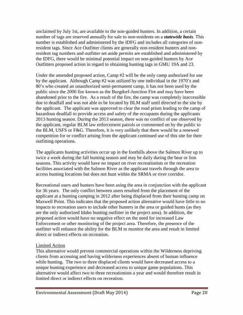
including County Road 1614, known locally as Big Salmon Road, and US Highway 95. Therefore no cumulative impacts anticipated by the alternatives that will change the management or ORV’s or future potential for inclusion into the WSR. 3.4.8 Wildlife, Habitats, and Special Status Species The analysis area for wildlife, habitats, and special status species includes proposed commercial hunting areas identified under the alternatives occurring in Big Game Hunting Unit (BGHU) 19A and 23. Primary concerns and issues that would be addressed are in regard to commercial hunting and related activities, and any direct or indirect effects to special status species, other wildlife species, and wildlife habitats. Affected Environment Wildlife and Habitats The analysis area includes a variety of wildlife habitats, from low elevation canyon grasslands, timbered stringers in the canyon breaklands, forested areas, forest/shrub areas, riparian habitats, meadow areas, and high elevation subalpine habitats. The general analysis area provides habitat for a variety of wildlife species, which includes big game, upland game, non-game birds and mammals, amphibians, and reptiles. BLM lands comprise 4.1% of BGHU 19A and 5.9% of BGHU 23. BLM lands occurring in BGHU 19A includes the BLM lands in the Marshall Mountain Township (Map 2) and BLM lands in the French Creek drainage east of the French Creek – Burgdorf – Summit Creek Road. BLM lands occurring in BGHU 23 include lands west of the French Creek – Burgdorf – Summit Creek Road and lands within the Little Salmon River drainage. Primary focus of the analysis will include BLM lands within the Marshall Mountain Township and BLM lands east of Riggins. Refer to Table 3 below for a summary of land ownership within BGHUs 19A and 23. Table 4: Summary of Land Ownership in BGHUs 19A and 23
Ownership
BGHU 19A BGHU 23 Acres Percentage Acres Percentage
U.S. Forest Service 278,165 94.4% 314,906 66.1% Private Lands 3,143 1.1% 116,025 24.4% Idaho Department of Lands 1,192 0.4% 16,270 3.4% Bureau of Land Management 11,958 4.1% 28,232 5.9% (BLM Proposed Action Alt.) (11,958) (4.1%) (9,064) 1.90% (BLM Limited Action Alt.) (11,207) (3.8%) (9,064) 1.90% Other 887 0.3% 764 0.2% State – Idaho Dept. Fish & Game --- --- 32 Trace Total 294,458 100% 476,229 100%
Big game species that occur within BGHUs 19A and 23 include mule deer, white-tailed deer, elk, black bear, mountain lion, and bighorn sheep. Big game seasonal or year-long use of an area would vary by elevation, climate, topography, and habitat. Mule deer are primarily utilizing the canyon grasslands, breakland habitats, timber/shrub habitats, and

Environmental Assessment (Draft May 2014) Page 26
riparian habitats. White-tailed deer utilize a variety of habitats; which includes canyon grasslands (lesser extent than mule deer), timbered/shrub areas, riparian habitats, and agriculture areas. Elk use the canyon grasslands, shrub/timber and riparian habitats. Black bear utilize the timber/shrub and riparian habitats. During the spring, black bear will also utilize some of the canyon grassland habitats in close proximity to timber/shrub habitats. Suitable habitats for mountain lion are also associated with habitats that are utilized by deer and elk. Bighorn sheep are primarily utilizing the canyon grassland habitats and canyon breaklands. Steep and rugged topography, cliffs, and rock outcrops are an important escape habitat component for bighorn sheep.
Figure 1: Looking upriver towards mouth of Elkhorn Creek, BGHU 23 is located on south side of Salmon River (right side of photo) (photo taken June 22, 2008). Common upland game found within the analysis area include chukar partridge, gray partridge, ruffed grouse, blue grouse, California quail, mountain quail, ring-necked pheasant, mourning dove, and turkeys. Popular upland game hunting associated with public lands within the analysis area includes chukar partridge and gray partridge in the canyon grasslands. Ruffed grouse are commonly found in forest and riparian habitats. Turkeys are associated with timbered and riparian habitats. California quail are often found in a mixture of shrub/timber, agriculture, and riparian habitats. There is no open hunting season for mountain quail. Common waterfowl utilizing the Salmon River include Canada geese, mallards, common merganser, and goldeneye. A variety of land uses have varying levels of effects on wildlife and habitats within the analysis area and include: timber harvest, livestock grazing, road construction and associated uses, recreation, prescribed burning, mining, and residences. Human uses can
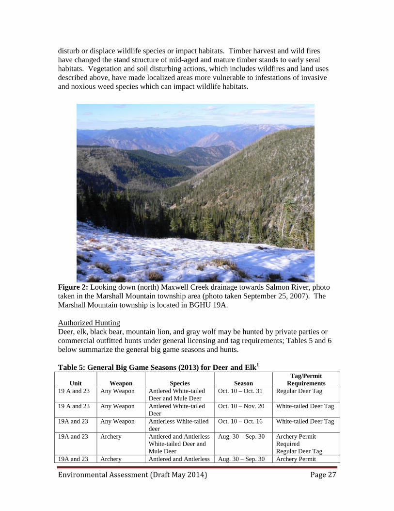
Environmental Assessment (Draft May 2014) Page 27
disturb or displace wildlife species or impact habitats. Timber harvest and wild fires have changed the stand structure of mid-aged and mature timber stands to early seral habitats. Vegetation and soil disturbing actions, which includes wildfires and land uses described above, have made localized areas more vulnerable to infestations of invasive and noxious weed species which can impact wildlife habitats.
Figure 2: Looking down (north) Maxwell Creek drainage towards Salmon River, photo taken in the Marshall Mountain township area (photo taken September 25, 2007). The Marshall Mountain township is located in BGHU 19A. Authorized Hunting Deer, elk, black bear, mountain lion, and gray wolf may be hunted by private parties or commercial outfitted hunts under general licensing and tag requirements; Tables 5 and 6 below summarize the general big game seasons and hunts. Table 5: General Big Game Seasons (2013) for Deer and Elk1
Unit
Weapon
Species
Season
Tag/Permit Requirements
19 A and 23 Any Weapon Antlered White-tailed Deer and Mule Deer
Oct. 10 – Oct. 31 Regular Deer Tag
19 A and 23 Any Weapon Antlered White-tailed Deer
Oct. 10 – Nov. 20 White-tailed Deer Tag
19A and 23 Any Weapon Antlerless White-tailed deer
Oct. 10 – Oct. 16 White-tailed Deer Tag
19A and 23 Archery Antlered and Antlerless White-tailed Deer and Mule Deer
Aug. 30 – Sep. 30 Archery Permit Required Regular Deer Tag
19A and 23 Archery Antlered and Antlerless Aug. 30 – Sep. 30 Archery Permit
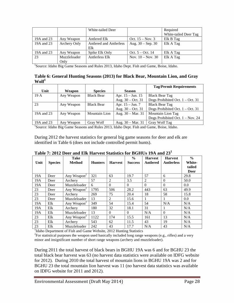
Environmental Assessment (Draft May 2014) Page 28
White-tailed Deer Required White-tailed Deer Tag
19A and 23 Any Weapon Antlered Elk Oct. 15 – Nov. 3 Elk B Tag 19A and 23 Archery Only Antlered and Antlerless
Elk Aug. 30 – Sep. 30 Elk A Tag
19A and 23 Any Weapon Spike Elk Only Oct. 5 – Oct. 14 Elk A Tag 23 Muzzleloader
Only Antlerless Elk Nov. 10 – Nov. 30 Elk A Tag
1Source: Idaho Big Game Seasons and Rules 2013, Idaho Dept. Fish and Game, Boise, Idaho. Table 6: General Hunting Seasons (2013) for Black Bear, Mountain Lion, and Gray Wolf1
Unit
Weapon
Species
Season
Tag/Permit Requirements
19 A Any Weapon Black Bear Apr. 15 – Jun. 15 Aug. 30 – Oct. 31
Black Bear Tag Dogs Prohibited Oct. 1 – Oct. 31
23 Any Weapon Black Bear Apr. 15 – Jun. 7 Aug. 30 – Oct. 31
Black Bear Tag Dogs Prohibited Oct. 1 – Oct. 31
19A and 23 Any Weapon Mountain Lion Aug. 30 – Mar. 31 Mountain Lion Tag Dogs Prohibited Oct. 1 – Nov. 24
19A and 23 Any Weapon Gray Wolf Aug. 30 – Mar. 31 Gray Wolf Tag 1Source: Idaho Big Game Seasons and Rules 2013, Idaho Dept. Fish and Game, Boise, Idaho. During 2012 the harvest statistics for general big game seasons for deer and elk are identified in Table 6 (does not include controlled permit hunts). Table 7: 2012 Deer and Elk Harvest Statistics for BGHUs 19A and 231
Unit
Species
Take Method
Hunters
Harvest
% Success
Harvest Antlered
Harvest Antlerless
% White-tailed Deer
19A Deer Any Weapon2 321 63 19.7 57 6 29.8 19A Deer Archery 57 2 3.5 2 0 50.0 19A Deer Muzzleloader 6 0 0 0 0 0.0 23 Deer Any Weapon2 1795 506 28.2 443 63 49.9 23 Deer Archery 269 75 20.4 18 58 15.8 23 Deer Muzzleloader 13 2 15.6 1 1 0.0 19A Elk Any Weapon2 349 54 15.4 54 N/A N/A 19A Elk Archery 180 32 18.1 31 1 N/A 19A Elk Muzzleloader 13 0 0 N/A 0 N/A 23 Elk Any Weapon2 1122 174 15.5 161 13 N/A 23 Elk Archery 543 62 11.5 43 19 N/A 23 Elk Muzzleloader 242 43 17.7 N/A 43 N/A 1Idaho Department of Fish and Game Website, 2012 Hunting Statistics 2For statistical purposes the weapon used basically included long range weapons (e.g., rifles) and a very minor and insignificant number of short range weapons (archery and muzzleloader). During 2011 the total harvest of black bears in BGHU 19A was 6 and for BGHU 23 the total black bear harvest was 63 (no harvest data statistics were available on IDFG website for 2012). During 2010 the total harvest of mountain lions in BGHU 19A was 2 and for BGHU 23 the total mountain lion harvest was 11 (no harvest data statistics was available on IDFG website for 2011 and 2012).
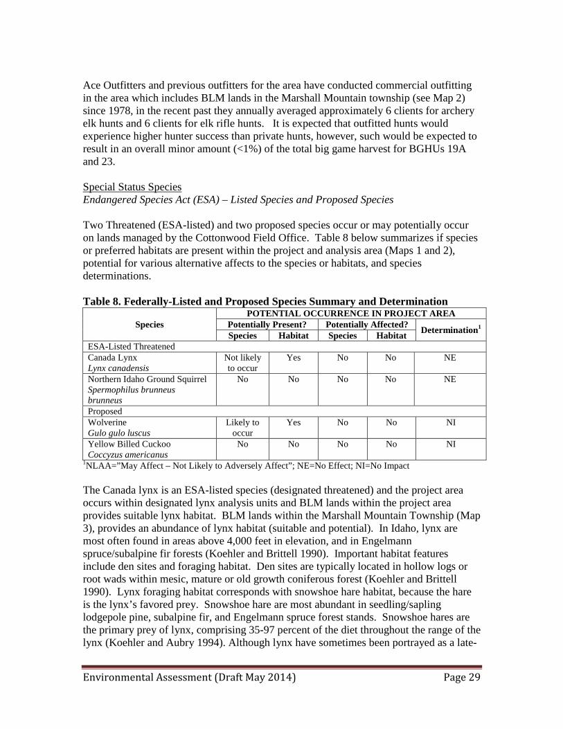
Environmental Assessment (Draft May 2014) Page 29
Ace Outfitters and previous outfitters for the area have conducted commercial outfitting in the area which includes BLM lands in the Marshall Mountain township (see Map 2) since 1978, in the recent past they annually averaged approximately 6 clients for archery elk hunts and 6 clients for elk rifle hunts. It is expected that outfitted hunts would experience higher hunter success than private hunts, however, such would be expected to result in an overall minor amount (<1%) of the total big game harvest for BGHUs 19A and 23. Special Status Species Endangered Species Act (ESA) – Listed Species and Proposed Species Two Threatened (ESA-listed) and two proposed species occur or may potentially occur on lands managed by the Cottonwood Field Office. Table 8 below summarizes if species or preferred habitats are present within the project and analysis area (Maps 1 and 2), potential for various alternative affects to the species or habitats, and species determinations. Table 8. Federally-Listed and Proposed Species Summary and Determination
Species POTENTIAL OCCURRENCE IN PROJECT AREA
Potentially Present? Potentially Affected? Determination1 Species Habitat Species Habitat
ESA-Listed Threatened Canada Lynx Lynx canadensis
Not likely to occur
Yes No No NE
Northern Idaho Ground Squirrel Spermophilus brunneus brunneus
No No No No NE
Proposed Wolverine Gulo gulo luscus
Likely to occur
Yes No No NI
Yellow Billed Cuckoo Coccyzus americanus
No No No No NI
1NLAA=”May Affect – Not Likely to Adversely Affect”; NE=No Effect; NI=No Impact The Canada lynx is an ESA-listed species (designated threatened) and the project area occurs within designated lynx analysis units and BLM lands within the project area provides suitable lynx habitat. BLM lands within the Marshall Mountain Township (Map 3), provides an abundance of lynx habitat (suitable and potential). In Idaho, lynx are most often found in areas above 4,000 feet in elevation, and in Engelmann spruce/subalpine fir forests (Koehler and Brittell 1990). Important habitat features include den sites and foraging habitat. Den sites are typically located in hollow logs or root wads within mesic, mature or old growth coniferous forest (Koehler and Brittell 1990). Lynx foraging habitat corresponds with snowshoe hare habitat, because the hare is the lynx’s favored prey. Snowshoe hare are most abundant in seedling/sapling lodgepole pine, subalpine fir, and Engelmann spruce forest stands. Snowshoe hares are the primary prey of lynx, comprising 35-97 percent of the diet throughout the range of the lynx (Koehler and Aubry 1994). Although lynx have sometimes been portrayed as a late-

Environmental Assessment (Draft May 2014) Page 30
successional forest species, lynx appear to be more closely associated with a mosaic of late- and early-successional habitats (Koehler and Aubry, 1994:86–89). No commercial outfitting actions are expected to have adverse impacts on suitable or potential lynx habitat. Implementation of the alternatives would not adversely impact Canada lynx, suitable habitats, or connectivity between suitable habitats or LAUs, a “no effect” determination is concluded and no further discussion for the species will occur in this document. The wolverine is a federally designated proposed species and the analysis area has documented sightings of wolverine (Marshall Mountain Township) and the higher elevation areas found in the Marshall Mountain Township provide suitable habitat for the species. In the western United States, wolverines are restricted to high mountain environments near treeline, where conditions are cold year-round and snow cover persists well into the month of May. Deep, persistent, spring snow is required for successful wolverine reproduction because female wolverines dig elaborate dens in the snow for their offspring. These den structures are thought to protect wolverine kits from predators and the harsh conditions of alpine winters. Wolverines live in remote and inhospitable place, at high elevations away from human populations. Wolverines naturally occur at low densities, and are rarely encountered where they do occur. The alternatives would not include any authorized winter or late spring use which would impact wolverine denning habitat. Commercial hunting and associated uses which may occur from the action alternatives would be negligible and would not adversely impact wolverines or preferred habitats. Implementation of the alternatives would not adversely impact the wolverine or suitable habitats, “no effect” determination is concluded and no further discussion for the species will occur in this document. The northern Idaho ground squirrel prefers dry, rocky, sparsely vegetated meadows surrounded by ponderosa pine or Douglas fir at elevations of 3,800 to 5,200 feet. Its present range is north of Council, Idaho, extending to the Boulder Creek drainage. No known populations are documented as occurring on BLM lands within the project area. Yellow-billed cuckoos prefer riparian areas with dense large stands of cottonwood and willow. In northern and central Idaho there have been four records of yellow-billed cuckoo documented reports over the last century. Because no potential exists for the Northern Idaho ground squirrel or yellow-billed cuckoo to occur within the project area and preferred habitats do not occur for the project area, a “no impact” determination was concluded and no further discussion will occur for these species in this document. BLM Sensitive Species Because the project area involves a variety of habitats, from low elevation canyon grasslands to higher elevation subalpine habitats, and riparian/wetland habitats a large

Environmental Assessment (Draft May 2014) Page 31
number of BLM sensitive species occur or potentially may occur in the analysis area (see Table 9 below). Table 9. BLM Sensitive Species Summary and Determinations1
Species POTENTIAL OCCURRENCE IN PROJECT AREA
Potentially Present? Potentially Affected? Determination2 Species Habitat Species Habitat
Gray Wolf Canis lupus
Yes Yes Yes No MI
Fisher Martes pennant
Yes Yes No No NI
California Myotis Myotis californicus
Not likely to occur
Yes No No NI
Fringed Myotis Myotis thysanodes
Yes Yes No No NI
Townsend’s Big Eared Bat Plecotus tonsendii
Yes Yes No No NI
Coast Mole Scapanus orarius
No No No No NI
Bald Eagle Haliaeetus leucocephalus
Yes Yes No No NI
Peregrine Falcon Falco peregrinus anatum
Yes Yes No No NI
Northern Goshawk Accipiter gentilis
Yes Yes No No NI
Prairie Falcon Falco mexicanus
Yes Yes No No NI
Flammulated Owl Ottus flammeolus
Yes Yes No No Ni
American White Pelican Pelecanus erythrorhynchus
Yes Yes No No NI
Harlequin Duck Histrionicus histrionicus
Yes Yes No No NI
Lewis Woodpecker Melanerpes lewis
Yes Yes No No NI
White-headed Woodpecker Picoides albolarvatus
Yes Yes No No NI
Willamsons’s Sapsucker Sphyrapicus thryoideus
Yes Yes No No NI
Mountain Quail Oreotys pictus
Yes Yes No No NI
Olive-sided Flycatcher Contopus borealis
Yes Yes No No NI
Hammond’s Flycatcher Empidonax hammondii
Yes Yes No No NI
Willow Flycatcher Empidonax traillii
Yes Yes No No NI
Calliope Hummingbird Stellula calliope
Yes Yes No No NI
Brewer’s Sparrow Spizella breweri
Yes Yes No No NI
Common Garter Snake Thamnophis sirtalis
Yes Yes Yes No MI
Coeur d’Alene Salamander No No No No NI

Environmental Assessment (Draft May 2014) Page 32
Species POTENTIAL OCCURRENCE IN PROJECT AREA
Potentially Present? Potentially Affected? Determination2 Species Habitat Species Habitat
Plethodon idahoensis Idaho Giant Salamander Dicamptodon
Yes Yes No No NI
Western Toad Bufo boreas
Yes Yes Yes No MI
Woodhouse Toad Bufo woodhousii
No No No No NI
Columbia River Tiger Beetle Cicindela columbica
No No No No NI
Marbled disc Discus marmorensis
No No No No NI
Shortface Lanx Fisherola nuttalli
No No No No NI
Columbia Pebblesnail Fluminicola fuscus
No No No No NI
Idaho Banded Mountainsnail Oreohelix idahoensis idahohensis
No No No No NI
Whorled Mountainsnail Oreohelix vortex
Not Likely to Occur
Limited No No NI
Boulder Pile Mountainsnail Oreohelix jugalis
Not Likely to Occur
Limited No No NI
Striate Mountainsnail Oreohelix strigosa goniogyra
Not Likely to Occur
Limited No No NI
Lava rock Mountainsnail Oreohelix waltoni
Not Likely to Occur
Limited No No NI
1NI=No Impact; MI=May impact individuals or habitat but not likely to cause trend toward federal listing or reduce viability for the population or species. Refer to Appendix 4, Table 1, for a summary of preferred habitats for BLM sensitive species that occur or potentially occur within the project area. Direct and Indirect Effects of Alternatives Proposed Action Wildlife and Wildlife Habitats Overall, a small amount of commercial hunting uses would be expected to occur from this action on BLM lands (Maps 1 and 2). Archery elk hunts may occur for 6 to 12 clients annually and rifle hunts may potentially occur for 6 to 12 clients annually, which is potentially an average increase of 6 clients each for archery and rifle hunts. Commercial big game hunting authorized on BLM lands would include 11,958 acres in BGHU 19A (4.1% of the unit) and 9,064 acres in BGHU 23 (1.90% of the unit), for a total of 21,022 acres (see Maps 1 and 2, and Table 9 above). Annual use of one of the three potential designated camp sites would result in concentrated human uses and soil/vegetation disturbances in the immediate area. Such use would be localized and involve a very small area (approximately 1 acre or less), see Figure 3 below. Motorized vehicle use would only be authorized on designated roads
Environmental Assessment (Draft May 2014) Page 33
and trails that are open for such use. Trail and road maintenance and clearing would have minor soil and vegetation impacts. Dispersed hunting activity and hiking cross country would have minor short term disturbances and displacement to wildlife. Potential client hunter success and harvest of deer and elk would be expected to be similar to or above what was identified in Table 7 and total number of harvested animals may vary annually dependent on number of clients and hunter days (see 2.2.1 Proposed Action). Client success for bear and mountain lion hunting would be improved with the use of dogs or bait for bear. Annual harvest of black bear and mountain lions would be dependent on number of clients (see section 2.2.1 Proposed Action) and potential hunter success may be expected to approach 90 – 100 percent. Potential harvest of gray wolf may occur, which would be expected to be incidental to big game hunting, however, overall potential harvest would be discountable. Within the very large McCall – Weiser Zone (BGHUs 19A, 22, 23, 24, 25, 31, 32, and 32A) during the 2013 – 2014 wolf hunting and trapping season a total of 15 wolves were harvested by hunting and 8 by trapping (current to March 3, 2014). The hunting season for wolves is August 30 – March 31. BLM lands authorized for hunting under this alternative would only include 1.9 percent of BGHU 23 and 4.1 percent of BGHU 19A, see Table 3 above. The proposed SRP would have stipulations to avoid or minimize any adverse effects to upland and riparian/wetland wildlife habitats (Appendices, Attachment 4 – SRP Terms, Conditions, and Stipulations). However, disturbances and temporary displacement of wildlife may occur from hunting related activities; such as hiking, scouting and hunting, horse riding and packing, motorized use, trail maintenance, etc.. Authorized commercial hunting under the proposed actions would be expected to have no adverse impacts to sustainable wildlife populations. Overall, with the exception of a few localized areas (i.e., annually one hunting camp – less than one acre), discountable disturbance to soils, vegetation, and wildlife habitats would occur. Low risks are expected to occur from commercial hunting activities resulting in increased invasive plant encroachment on wildlife habitats. Therefore, existing upland and riparian/wetland habitat conditions and trends would be expected to continue. Special Status Species The project area provides suitable habitat for ESA-listed Canada lynx and the wolverine, a proposed species. Suitable habitat for these species primarily occurs in the Marshall Mountain area (Map 2). Commercial hunting activities are not expected to have adverse effects on the species or suitable habitat for Canada lynx and wolverine. A “no effect” determination is concluded for these two species (see Table 8 above). BLM sensitive species occupy a variety of habitats, from streams/rivers, riparian habitats, canyon grasslands, and shrub/timbered areas (Attachment 5). BLM sensitive species effects would be similar to those described above for Wildlife and Habitats. Primary potential for commercial hunting related effects to BLM sensitive species is from short
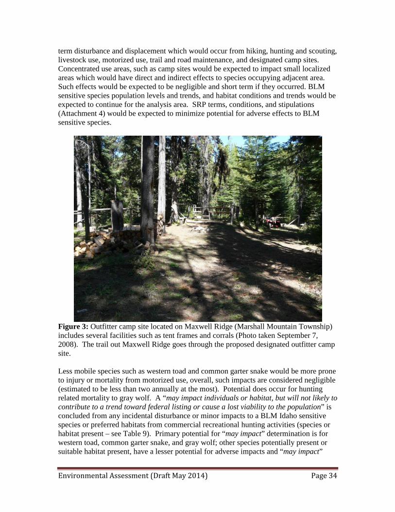
Environmental Assessment (Draft May 2014) Page 34
term disturbance and displacement which would occur from hiking, hunting and scouting, livestock use, motorized use, trail and road maintenance, and designated camp sites. Concentrated use areas, such as camp sites would be expected to impact small localized areas which would have direct and indirect effects to species occupying adjacent area. Such effects would be expected to be negligible and short term if they occurred. BLM sensitive species population levels and trends, and habitat conditions and trends would be expected to continue for the analysis area. SRP terms, conditions, and stipulations (Attachment 4) would be expected to minimize potential for adverse effects to BLM sensitive species.
Figure 3: Outfitter camp site located on Maxwell Ridge (Marshall Mountain Township) includes several facilities such as tent frames and corrals (Photo taken September 7, 2008). The trail out Maxwell Ridge goes through the proposed designated outfitter camp site. Less mobile species such as western toad and common garter snake would be more prone to injury or mortality from motorized use, overall, such impacts are considered negligible (estimated to be less than two annually at the most). Potential does occur for hunting related mortality to gray wolf. A “may impact individuals or habitat, but will not likely to contribute to a trend toward federal listing or cause a lost viability to the population” is concluded from any incidental disturbance or minor impacts to a BLM Idaho sensitive species or preferred habitats from commercial recreational hunting activities (species or habitat present – see Table 9). Primary potential for “may impact” determination is for western toad, common garter snake, and gray wolf; other species potentially present or suitable habitat present, have a lesser potential for adverse impacts and “may impact”

Environmental Assessment (Draft May 2014) Page 35
determination (see Table 9). Overall, a “no impact” determination is concluded for the majority of BLM sensitive wildlife species. Limited Action Overall, this alternative would have the same level of effects to special status species, other wildlife, and upland and riparian/wetland habitats as described under the proposed action above. The only difference is that 751 acres (Frank Church River of No Return Wilderness) in BGHU 19A would not be available for commercial hunting activities (see Table 4 above). Commercial big game hunting authorized on BLM lands would include 11,207 acres in BGHU 19A (3.8% of the unit) and 9,064 acres in BGHU 23 (1.90% of the unit), for a total of 20,271 acres (Maps 1 and 2). Commercial hunting harvest would be expected to be the same level that was identified under the proposed action and annual clients would be the same. Because no motorized use is authorized in Wilderness, the potential impacts to the less mobile western toad and common garter snake would be the same in all alternatives and potential harvest of gray wolf would also be very similar to the proposed action alternative. A “may impact individuals or habitat, but will not likely to contribute to a trend toward federal listing or cause a lost viability to the population” is concluded from any incidental disturbance or minor impacts to a BLM Idaho sensitive species or preferred habitats from commercial hunting activities (species or habitat present – see Table 9).Compared to the proposed action, this alternative would have no potential for adverse effects to special status wildlife, other wildlife or upland and riparian/wetland wildlife habitats that occur on 751 acres within the Frank Church River of No Return Wilderness (Map 2). No Action This alternative would authorize no commercial hunting related activities to occur on 21,022 acres of BLM lands. No commercial hunting related caused disturbance or displacement of wildlife would occur on BLM lands. No adverse effects to special status wildlife, other wildlife or upland and riparian/wetland wildlife habitats would occur under this alternative. Authorizing no SRP for commercial hunting would result in no potential for any commercial hunting effects to big game populations on BLM lands. Existing upland and riparian/wetland wildlife habitat and wildlife population conditions and trends would be expected to continue. Cumulative Impacts A variety of land uses have had varying effects to special status species, other wildlife, and habitats within the cumulative effects analysis area. Primary land uses impacting wildlife species and habitats include timber harvest, road construction and maintenance, livestock grazing, mining, prescribed burning, and recreation. Natural events such as wildfires have also had impacts on wildlife habitats, which have converted mid-aged and mature forests to early seral. Human caused impacts occurring within the Frank Church River of No Return Wilderness and Marshall Mountain Wilderness Study Area has been minimal.

Environmental Assessment (Draft May 2014) Page 36
Overall, non-guided hunting activities, Forest Service authorized commercial hunting and other activities identified above would contribute to more potential for adverse effects to wildlife species and habitats. Overall low effects to special status species, other wildlife or habitats from the proposed, limited, and no action alternatives; would not contribute to significant adverse cumulative impacts. 3.4.9 Fisheries, Aquatic Habitat, and Special Status Species Affected Environment The analysis area for aquatic habitat and special status species includes the Lower Salmon River subbasin, Middle Salmon River subbasin, and South Fork Salmon River subbasin; and tributary watersheds that occur within the proposed commercial outfitting use area in BGHUs 19A and 23. The Salmon River, South Fork Salmon River, and designated watersheds provide aquatic habitats for five Endangered Species Act (ESA)-listed species. The analysis area will focus on watersheds including BLM lands within the Marshall Mountain Township (Map 2) and Salmon River watersheds east of Riggins, Idaho (Map 3). The Salmon River, South Fork Salmon River, and tributary streams provide aquatic habitat for 23 native fish species and 9 non-native fish species. Five Endangered Species Act (ESA) listed fish and three BLM sensitive fish species occur within the analysis area. Native fish species include anadromous (i.e., salmon and steelhead trout) and resident species (e.g., redband trout, westslope cutthroat trout). Other native species found in the analysis area include species such as northern pikeminnow, dace, sculpins, chiselmouth, and others. Common non-native species include species such as the smallmouth bass, carp, rainbow trout, and others. Threatened and Endangered Fish Species (ESA-Listed) Rivers and streams occurring within the analysis area provide suitable and occupied aquatic habitats for ESA-listed sockeye salmon, fall Chinook salmon, spring/summer Chinook salmon, steelhead trout and bull trout. Designated critical habitat for these species also occurs within the analysis area, and includes the Salmon River, Lake Creek (Salmon River tributary), Elkhorn Creek, French Creek, Bear Creek, and upper Lake Creek (Secesh River tributary). For additional information regarding ESA-listed species distribution and species specific information for the analysis area, refer to subbasin/watershed Biological Assessments that were prepared for ESA-listed fish (BLM 2000a and BLM 2000b). The ESA-listed endangered sockeye salmon uses the Salmon Rivers for upriver and down river passage. Sockeye salmon spawn in the upper portions of the Salmon River drainage, but no spawning or early rearing occurs within the analysis area. The Salmon River is designated critical habitat for the sockeye salmon.

Environmental Assessment (Draft May 2014) Page 37
The ESA-listed threatened fall Chinook salmon uses the Salmon River for upstream and downstream passage, spawning and early rearing. The mainstem Lower Salmon River (French Creek downriver) is designated critical habitat for the fall Chinook salmon. The ESA-listed threatened spring/summer Chinook salmon uses the Salmon River and South Fork Salmon River for upstream and downstream passage, and accessible streams with suitable habitat for spawning and juvenile rearing. Within the general analysis area, streams used for spawning by spring/summer Chinook salmon are very limited. Accessible streams and rivers with suitable habitat are designated critical habitat for spring/summer Chinook salmon. The watershed with primary spring/summer Chinook salmon spawning and early rearing includes Lake Creek (South Fork Salmon River tributary – Marshall Mountain Township). Other Salmon River tributary streams are primarily used for spring/summer Chinook salmon juvenile rearing and include Lake Creek, Partridge Creek, Elkhorn Creek, French Creek, and California Creek. The ESA-listed threatened steelhead trout uses the Salmon River for upstream and downstream passage and staging areas prior to migrating to natal spawning streams or hatcheries. Accessible streams with suitable habitat are used by steelhead trout for spawning and/or juvenile rearing. Rivers and larger streams with suitable habitat are designated critical habitat for steelhead trout. Salmon River streams (East of Riggins – Map 3) used by steelhead trout for spawning and early rearing include: Lake Creek, Partridge Creek, Elkhorn Creek, and French Creek. Marshall Mountain watersheds (Map 2) utilized by steelhead trout for spawning and early rearing include: Carey Creek (lower reach), Bear Creek (lower reach), California Creek, Maxwell Creek (lower reach), and Lake Creek. Streams occurring on BLM lands within the Marshall Mountain Township have fish passage barriers which generally restrict steelhead use of streams flowing across BLM lands (e.g., Carey Creek, Bear Creek, and Maxwell Creek). ESA-listed bull trout use the Salmon River and South Fork Salmon River for upstream and downstream passage and for adult and subadult foraging area. Streams within the analysis area that are designated critical habitat for bull trout include: Lake Creek (Salmon River tributary), Partridge Creek, Elkhorn Creek, French Creek, California Creek, and Lake Creek (Secesh River Tributary).

Environmental Assessment (Draft May 2014) Page 38
Figure 4. Elkhorn Creek, looking downstream from Broken Leg Trail stream crossing (August 22, 2013). BLM Sensitive Fish Species Idaho BLM sensitive fish species which utilize the Salmon River and accessible streams include westslope cutthroat trout, redband trout, and Pacific lamprey. Westslope cutthroat would occur in some of the larger tributary streams and would primary use the lower stream reaches for adult/subadult rearing. Redband trout would occur in streams accessible to steelhead trout. Pacific lamprey would potentially occur in some of the larger tributary streams accessible to spring/summer Chinook salmon and steelhead trout, overall, population levels very low in Salmon River basin. Marshall Mountain Township Lakes Within the Marshall Mountain township (Map 2) a total of five lakes are fish bearing, with the exception of Marsahll Lake (headwaters of Lake Creek) all other lakes have downstream fish passage barriers and fish occurrences in these lakes are dependent on Idaho Department of Fish and Game fish transplant efforts (Bear Lake, Upper Kimberly Lake, Lower Kimberly Lake, and an unnamed lake located in Section 28). Fish transplants in the past included brook trout, rainbow trout, westslope cutthroat trout, and grayling (e.g., Upper Kimberly Lake). Current transplants efforts are primarily westslope cutthroat trout.
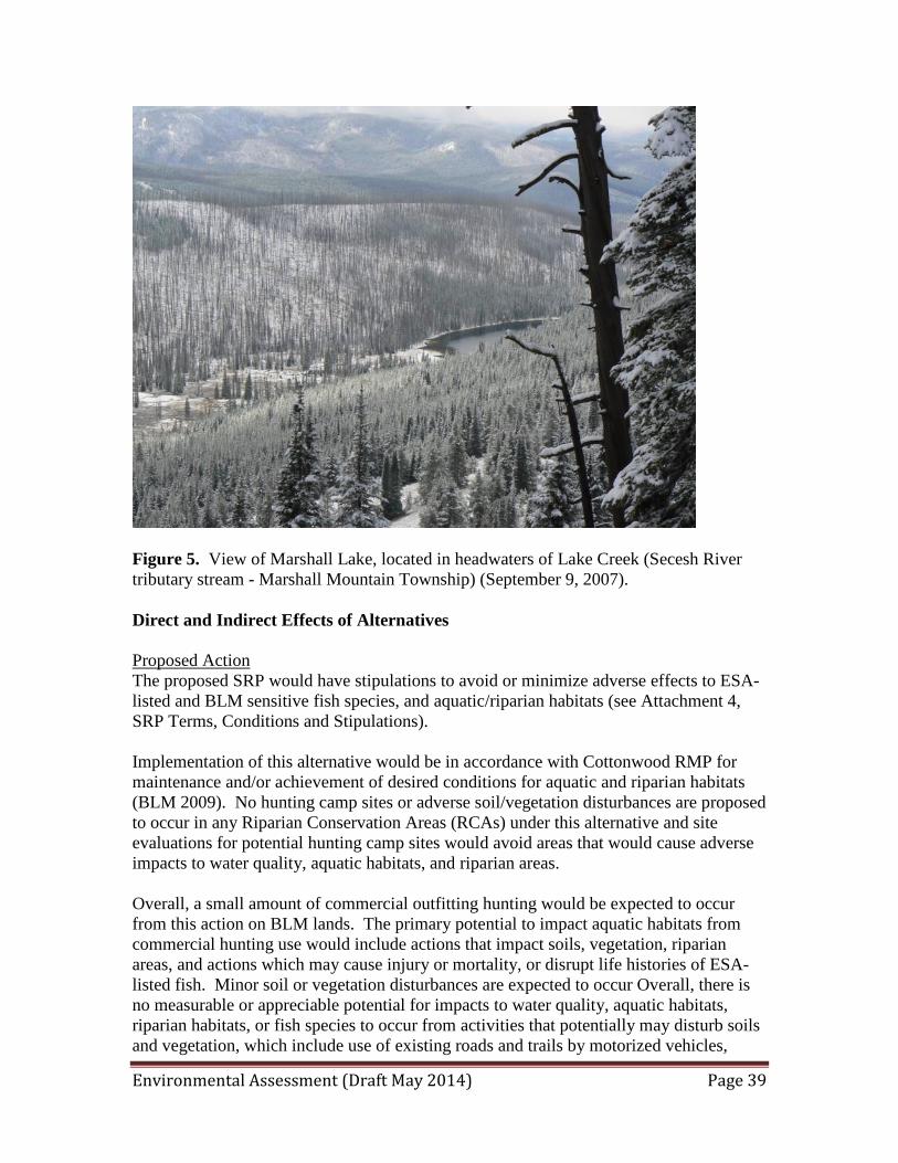
Environmental Assessment (Draft May 2014) Page 39
Figure 5. View of Marshall Lake, located in headwaters of Lake Creek (Secesh River tributary stream - Marshall Mountain Township) (September 9, 2007). Direct and Indirect Effects of Alternatives Proposed Action The proposed SRP would have stipulations to avoid or minimize adverse effects to ESA-listed and BLM sensitive fish species, and aquatic/riparian habitats (see Attachment 4, SRP Terms, Conditions and Stipulations). Implementation of this alternative would be in accordance with Cottonwood RMP for maintenance and/or achievement of desired conditions for aquatic and riparian habitats (BLM 2009). No hunting camp sites or adverse soil/vegetation disturbances are proposed to occur in any Riparian Conservation Areas (RCAs) under this alternative and site evaluations for potential hunting camp sites would avoid areas that would cause adverse impacts to water quality, aquatic habitats, and riparian areas. Overall, a small amount of commercial outfitting hunting would be expected to occur from this action on BLM lands. The primary potential to impact aquatic habitats from commercial hunting use would include actions that impact soils, vegetation, riparian areas, and actions which may cause injury or mortality, or disrupt life histories of ESA-listed fish. Minor soil or vegetation disturbances are expected to occur Overall, there is no measurable or appreciable potential for impacts to water quality, aquatic habitats, riparian habitats, or fish species to occur from activities that potentially may disturb soils and vegetation, which include use of existing roads and trails by motorized vehicles,
Environmental Assessment (Draft May 2014) Page 40
minor trail and road maintenance, and cross country hiking and horse use. A “no effect” determination was concluded for ESA-listed and BLM sensitive fish and designated critical habitat for ESA-listed fish. Limited Action Overall, this alternative would have the same level of potential effects to special status species and aquatic and riparian described under the proposed action above. The only difference is that 751 acres (Frank Church River of No Return Wilderness) in BGHU 19A would not be available for commercial hunting activities. Commercial big game hunting authorized on BLM lands would include 11,207 acres in BGHU 19A (3.8% of the unit) and 9,064 acres in BGHU 23 (1.90% of the unit), for a total of 20,271 acres (see Maps 1 and 2). Commercial hunting harvest would be expected to be the same level that was identified under the proposed action and annual clients would be the same. Compared to the proposed action, this alternative would have no potential for adverse effects to special status fish species and aquatic habitats that may be indirectly affected from activities occurring on 751 acres within the Frank Church River of No Return Wilderness (Map 2). No Action This alternative would authorize no commercial hunting related activities to occur on 21,022 acres of BLM lands. No commercial hunting related caused impacts to aquatic habitats and special status fish species would occur on BLM lands. Existing aquatic and riparian habitats and special status fish population conditions and trends would be expected to continue. Cumulative Impacts There would be no appreciable effects to special status species and aquatic habitats from the proposed, limited, and no action alternatives, therefore the alternatives would not contribute to cumulative impacts. 3.4.10 Vegetation – Upland and Riparian Habitats Affected Environment The analysis area for vegetation (riparian and upland habitats) includes the area proposed for commercial hunting within BGHU 19A (Map 2) and BGHU 23 (Map 3). Vegetation types are diverse and represent a range of seral stages which are primarily influenced by soils, aspect, elevation, topography, wildfires; and associated land uses including roads, trails, timber harvest, livestock grazing, mining, and recreation. Habitats include low elevation canyon grasslands to high elevation subalpine habitats. Various human caused vegetation and soil disturbing actions have resulted in invasive plant encroachment in localized areas. Primary human caused impacts to vegetation include timber harvest, road construction, livestock grazing, mining, and recreation.

Environmental Assessment (Draft May 2014) Page 41
Wildfires and flood events have also varying levels of impact on vegetation within the analysis area, with wildfire converting mid-age and mature timber stands to early seral condition. Common invasive plants within the analysis area include Canadian thistle, bull thistle, hounds tongue, spotted knapweed, and annual bromes. Upland Vegetation Vegetation types are diverse and represent a range of seral stages which are primarily influenced by livestock grazing, agriculture, timber harvest, fires, and development. Large wildfires within the past 20 years have occurred within the analysis area which has resulted in a mosaic of different stand structure for forest areas, which have included stand replacement fires and conversion to early seral shrub forest stands to low severity underburns. The canyon grasslands are primarily a broad extension of the Pacific bunchgrass formation. The dominant habitat types are bluebunch wheatgrass and Idaho fescue. Sand dropseed and red three-awn have become dis-climax species on some river benches, bars, and toeslope areas. Interspersed with canyon grasslands are mixed conifer sites which include ponderosa pine, Douglas fir, larch, and shrubs. Elevations above 3,000 feet often have patterned grassland and timbered sites, with bluebunch wheatgrass/Idaho fescue on south and west aspects and Douglas-fir sites on north and east aspects. Dry south-facing slopes may have grasslands, with scattered overstory conifers and shrubs. Basalt outcrops may be common on these sites. Draw bottoms, and north and east facing slopes have mixed conifers and shrubs. Localized, steep rocky areas exist with low vegetation production. The mixed conifer overstory includes Douglas-fir, grand fir, larch, and ponderosa pine. Above 5,000 feet, Douglas fir and grand fir habitat types are common. At higher elevations (above 7,000 feet), Engelmann spruce, subalpine fir, and whitebark pine habitat types are common (Marshall Mountain township). The Engelmann spruce and subalpine fir habitats may be interspersed with patches of perennial grassland, brush, and riparian vegetation while other areas are dominant forest stands with shrub understories. Floodplain, Riparian, and Wetlands Riparian and wetland vegetation occurs along the water courses within the analysis area, which includes perennial and intermittent streams, rivers, ponds, lakes, and springs/seeps. Tributary streams often have narrow riparian zones and are often confined by the steep side slopes. The lower elevation riparian areas are dominated by white alder, black hawthorn, and water birch, with occasional ponderosa pine, Douglas-fir, and black cottonwood. Common understory species include mockorange, serviceberry, blue elderberry, coyote willow, red osier dogwood, poison ivy, oceanspray, and grasses/forbs. At the mid- to upper-elevation areas, Douglas-fir and grand fir are more common in the overstories of the riparian areas. The higher elevation areas may have grand fir, Engelmann spruce, lodgepole pine, and subalpine fir. Meadow areas may be dominated with sedges, grasses, forbs, willow, and alder.
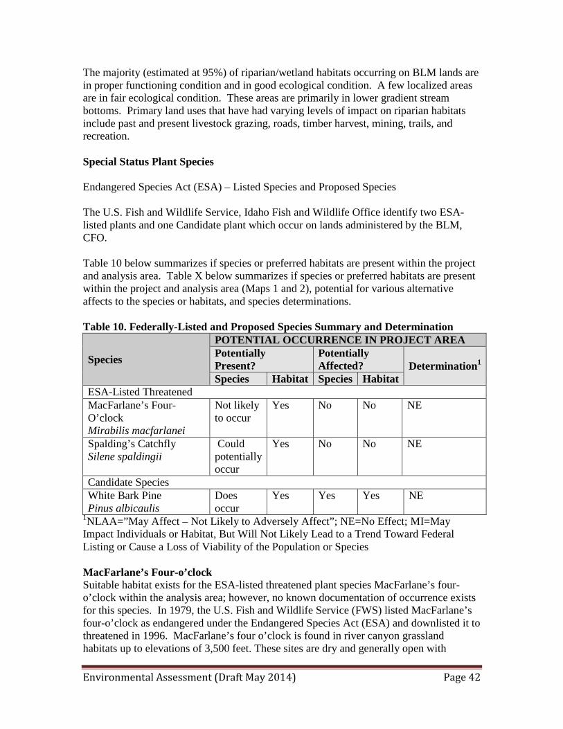
Environmental Assessment (Draft May 2014) Page 42
The majority (estimated at 95%) of riparian/wetland habitats occurring on BLM lands are in proper functioning condition and in good ecological condition. A few localized areas are in fair ecological condition. These areas are primarily in lower gradient stream bottoms. Primary land uses that have had varying levels of impact on riparian habitats include past and present livestock grazing, roads, timber harvest, mining, trails, and recreation. Special Status Plant Species Endangered Species Act (ESA) – Listed Species and Proposed Species The U.S. Fish and Wildlife Service, Idaho Fish and Wildlife Office identify two ESA-listed plants and one Candidate plant which occur on lands administered by the BLM, CFO. Table 10 below summarizes if species or preferred habitats are present within the project and analysis area. Table X below summarizes if species or preferred habitats are present within the project and analysis area (Maps 1 and 2), potential for various alternative affects to the species or habitats, and species determinations. Table 10. Federally-Listed and Proposed Species Summary and Determination
Species
POTENTIAL OCCURRENCE IN PROJECT AREA Potentially Present?
Potentially Affected? Determination1
Species Habitat Species Habitat ESA-Listed Threatened MacFarlane’s Four-O’clock Mirabilis macfarlanei
Not likely to occur
Yes No No NE
Spalding’s Catchfly Silene spaldingii
Could potentially occur
Yes No No NE
Candidate Species White Bark Pine Pinus albicaulis
Does occur
Yes Yes Yes NE
1NLAA=”May Affect – Not Likely to Adversely Affect”; NE=No Effect; MI=May Impact Individuals or Habitat, But Will Not Likely Lead to a Trend Toward Federal Listing or Cause a Loss of Viability of the Population or Species MacFarlane’s Four-o’clock Suitable habitat exists for the ESA-listed threatened plant species MacFarlane’s four-o’clock within the analysis area; however, no known documentation of occurrence exists for this species. In 1979, the U.S. Fish and Wildlife Service (FWS) listed MacFarlane’s four-o’clock as endangered under the Endangered Species Act (ESA) and downlisted it to threatened in 1996. MacFarlane’s four o’clock is found in river canyon grassland habitats up to elevations of 3,500 feet. These sites are dry and generally open with
Environmental Assessment (Draft May 2014) Page 43
scattered shrubs. Plants can be found on all aspects, but plants often occur on southeast to western aspects. Spalding’s Catchfly Suitable habitat exists for the ESA-listed threatened plant species Spalding’s catchfly within the analysis area; however, no known documentation of occurrence exists for this species. The FWS listed Spalding’s catchfly as threatened under the ESA in 2001. This species occurs in open bunchgrass grasslands in the interior Pacific Northwest. It usually occurs in grasslands with a minor shrub component and occasionally on grassland sites with scattered conifers up to elevations of 5,200 feet. In Idaho, this species occurs on Palouse Prairie and northern Camas Prairie remnants, as well as in mesic canyon grassland communities. Whitebark Pine The ESA candidate plant species Whitebark pine occurs within the analysis area and is in the general vicinity of Ace Outfitters proposed campsite (See Ace Outfitters Inc. Hunting SRP Map 2). Whitebark pine was accorded candidate status by the U.S. Fish and Wildlife on July 19, 2011 (FR Vol. 76, No. 138, 42631-42654). The US Fish and Wildlife Service issued their twelve (12) month finding on a petition to list whitebark pine as a threatened or endangered species on July 19, 2011 in Federal Register Volume 76, Number 138. The finding was that of “warranted but precluded” with a Listing Priority Number (LPN) of 2. The Listing Priority Number of 2 indicates that the species has a very high priority for listing as threatened or endangered because of eminent threats to the species. Whitebark pine is considered a keystone species in high elevation ecosystems (alpine and subalpine habitats) because it increases biodiversity and contributes to critical ecosystem functions. This pine is very long-lived species with some individuals documented at over 1,000 years. Whitebark pine is a stone pine (so-called for their stone-like seeds). Only five species of stone pines are recognized worldwide, and whitebark pine is the only stone pine that occurs in North American. Characteristics of stone pine include five pine needles per cluster, cones that stay on the tree, and wingless seeds that remain fixed to the cone and cannot be dislodge by the wind. Because whitebark pine seeds cannot be wind-disseminated, primary seed dispersal occurs almost exclusively by Clark’s nutcrackers (Nucifraga columbiana). BLM Sensitive Plant Species There is potential suitable habitat for several BLM sensitive plant species, especially in the river canyon grassland habitats portion of the analysis area. Proposed Action Within BGHUs 19A and 23 a total of 21,022 acres of BLM lands would be available for commercial hunting related activities. Primary areas susceptible to vegetation and soil disturbance are primarily associated with designated camp sites or area along roads and trails. Motorized vehicle use would only be authorized on designated open roads and trails and no cross-country motorized travel would be authorized on BLM lands.
Environmental Assessment (Draft May 2014) Page 44
Motorized use of existing roads and minor road and trail maintenance is expected to result in discountable impacts to vegetation and soils. Weed control activities and stipulations for weed seed free hay would minimize additional weed infestations. Cross-country hiking and horse use would occur and disturbances to soil and vegetation would be minor or discountable. The proposed SRP activities would have stipulations to avoid or minimize any adverse effects to upland and riparian/wetland vegetation and stipulations to minimize potential for infestations of invasive species. Overall, a small amount of commercial hunting and associated outfitter/hunting related use would be expected to occur from this action on BLM lands. No measurable or appreciable effects to soils, vegetation, and riparian/wetland areas would occur under the proposed action. Overall, with the exception of a few localized areas, existing upland and riparian/wetland vegetation conditions trends and conditions would be expected to continue. Past commercial uses did not result in any known problem areas to upland or riparian habitats on BLM lands. Overall, at a watershed level, existing vegetation conditions and trends are expected to continue. As discussed above, no measurable or appreciable effects are expected to occur to soils and vegetation from the various commercial activities with the SRP stipulations. This would be because vehicle uses would only be authorized to use designated open roads and cross country hiking and horse use would have low potential to impact potential ESA listed, candidate (whitebark pine), or potential BLM sensitive plants. The main effects to these plants would occur in concentrated use areas such as access routes or the designated campsite. Because the primary place the potential ESA listed and potential sensitive plant species occur is in canyon grassland habitats and mesic canyon grassland habitats, a “no effect” determination is concluded for potential ESA listed plants and a “no impact” determination is concluded for potential BLM sensitive plants. A “no effect” determination is concluded for the ESA candidate whitebark pine (see stipulations #16 and #32 in Ace Outfitters Special Recreation Permit Terms, Conditions, and Stipulations). In effect, cutting or damaging living and standing dead vegetation in any way is prohibited. Therefore, there should be no effect to whitebark pine from any of Ace Outfitters activities. In summary, overall, existing potential ESA listed, Candidate, and potential BLM sensitive plant species and preferred habitat conditions and trends would be expected to continue in the long term within the project/analysis area from implementation of the proposed action. Limited Action This alternative would have the same level of potential effects to riparian and upland vegetation habitats and potential ESA listed, Candidate, and potential BLM sensitive plant species and habitats identified for the proposed action above. The only difference is that 751 acres (Frank Church River of No Return Wilderness) in BGHU 19A would not be available for commercial hunting activities. Commercial big game hunting authorized on BLM lands would include 11,207 acres in BGHU 19A (3.8% of the unit) and 9,064 acres in BGHU 23 (1.90% of the unit), for a total of 20,271 acres (see attached Maps 1 and 2). Overall, at a watershed level, existing vegetation conditions and trends are expected to continue.
Environmental Assessment (Draft May 2014) Page 45
No Action This alternative would authorize no commercial hunting related activities to occur on 751 acres of BLM lands. No commercial hunting related caused impacts to vegetation or soils would occur on BLM lands. Existing riparian and upland habitat conditions and trends would be expected to continue. Cumulative Impacts There would be no appreciable effects to riparian and upland vegetation and habitats; and potential ESA listed, Candidate, and potential BLM sensitive plant species and habitats from the proposed, limited, and no action alternatives; therefore the alternatives would not contribute to cumulative impacts. 3.4.11 Wilderness Affected Environment The Frank Church-River of No Return Wilderness was designated in 1980. Although it totals over 2.3 million acres, only 751 acres are within the boundary of the proposed permit. The Marshall Mountain wilderness segment requires hunters to be in excellent shape in order to access the area by foot restricting use in the wilderness by Ace Outfitter hunting clients to an average of three clients a year. U.S. trends indicate that U.S. citizens are becoming less fit and more overweight each year. Therefore it is assumed that the physicality of hunters will not increase over time and the use of the Frank Church River of No Return Wilderness by the applicant as a result of the challenging and isolated hunting location would not increase. Direct and Indirect Effects of Alternatives Proposed Action The Wilderness Act allows some commercial services to be permitted "to the extent necessary … for realizing the recreational or other wilderness purposes of the area" (Wilderness Act Section 4(d) (6)). The public purpose of recreation within “wilderness” encompasses opportunities that allow visitors to experience wilderness. Examples of wilderness recreational use include hiking, camping, hunting, fishing, and wildlife viewing2. During Ace Outfitters years of operating within the wilderness, at no time did the outfitter meet other hunters or users of the wilderness within the 751 acres located in Marshall Mountain as seen in Map 2. There is no competition for commercial outfitters within the wilderness, as Ace Outfitters Inc. has exclusive use of this area for commercial hunting operations. In addition, in the 10 years of operating within the wilderness, the outfitter has not encountered private hunters within the wilderness area. In addition, the proposed activity does not violate 4 (c) of the Wilderness Act nor the CFO RMP which restricts commercial use within the Wilderness to non-competitive uses such as the proposed action which would provide safe access to wilderness for recreational hunting that requires special skills or experience while preventing resource damage from
Environmental Assessment (Draft May 2014) Page 46
unauthorized use of motorized or mechanized equipment within the wilderness by the outfitters clients. Therefore the proposed action of three clients a year for one week or less would have no direct or indirect effects on wilderness characteristics (opportunity for solitude, naturalness, primitive unconfined recreation) and the opportunity to enjoy the wilderness experience. Limited and No Action The limited action and no action alternatives would authorize no commercial hunting related activities to occur within Wilderness. Therefore these alternatives would have direct or indirect effects on the opportunity to enjoy the wilderness experience therefore the public purpose of recreation within wilderness as defined in BLM Manual 6340- Management of BLM Wilderness would not be met. These alternatives would have no direct or indirect effects wilderness characteristics (opportunity for solitude, naturalness, primitive unconfined recreation). Cumulative Impacts There would be no appreciable effects to the Frank Church-River of No Return Wilderness or the associated wilderness characteristics from the proposed, limited, and no action alternatives. Commercial services can be allowed only where the authorization will not impair wilderness character as a whole2. Two to three hunters a year within 751 acres of wilderness in which no other hunters or recreation users have been seen in 10 years of operations, indicates that no impairment to wilderness characteristics occur, therefore the alternatives would not contribute to cumulative impacts on wilderness although the limited and no action alternatives would have cumulative effects on the public purpose of recreation within wilderness as defined in BLM Manual 6340- Management of BLM Wilderness by preventing recreation by the guided hunters within the wilderness within the outfitters area of operations. 3.4.12 Wilderness Study Affected Environment The Marshall Mountain WSA, 22 miles east of the town of Riggins, Marshall Mountain borders the Payette National Forest.
BLM’s North Idaho Proposed MFP Amendment & Final Environmental Impact Statement – Wilderness, 1986 analyzed the suitability of the Marshall Mountain WSA and specifies that the Marshall Mountain WSA would be open to recreational activities including hiking, hunting, camping, and sightseeing with projections of 100 visitor use days. The 5,527 acre WSA was submitted to Congress for designation September of 1992 with a recommendation of non-suitable for wilderness. While Congressional action is pending, the WSA is managed in accordance with the BLM Manual 6330—Management of BLM Wilderness Study Areas3. Examples of uses that may be authorized
Environmental Assessment (Draft May 2014) Page 47
include river trip outfitters, hunting or fishing guides, group backpack trips, and providers of pack animals and saddle horses. The trail known locally as Maxwell Ridge or Maxwell Point was present and actively utilized by Whitten and Bigfoot Outfitters now known as Ace Outfitters Inc. in 1978 under a USFS SUP and is identified on the 1967 and 1981 BLM Warren Map as a trail. This is documented proof that the route existed prior to the preparation of the WSA suitability study and subsequent submission to Congress as non-suitable for wilderness designation, June 18, 1982. Therefore the trail meets Section 202 of FLPMA (202 WSAs) as defined in Manual 63303 Section 1.6.D.6.a: “Most recreational activities (including hiking, horseback riding, fishing, hunting and trapping, camping, and other primitive forms of recreation) are allowed on WSAs,” and Manual 63303 Section 1.6.D.6.b.i.B if:
I. identified in the original wilderness inventory; or II. if not identified as in I., having documented proof that the route existed at that time; and iv. Primitive routes within WSAs may only be used to the extent that the physical impacts of the primitive route are no greater than existed on October 21, 1976 (or prior to the designation date for Section 202 WSAs not reported to Congress).
Direct and Indirect Effects of Alternatives Although the WSA recommendation is non-wilderness, consideration is being made to verify the proposed action conforms with Manual 63303, Section 1.6.D.6.m: “Special Recreation Permits in that activities that require authorization under a Special Recreation Permit (SRP) will be allowed only if the use and related facilities satisfy the non-impairment criteria” (and therefore do not involve a use of the WSA that would be incompatible with wilderness designation). The proposed actions would satisfy the non-impairment criteria for naturalness of the WSA in that the Maxwell Ridge trail, which existed prior to the WSA study to include the clearing of the felled tree to allow foot and horse travel as needed. There will be no new trail construction or ground disturbance related to the maintenance of the trail for horse travel which includes the removing of trees downed across the trail, and trimming trees and brush to allow for the 3 X 4 ‘ clearance required for safe horse travel. The removal of downed trees on the trail will alleviate resource damage created from satellite trail formation. If the trail washes out or requires waterbars or culvert installation, cultural analysis will be completed prior to the applicants or BLM’s installation of fore mentioned items to maintain or repair drainage issues as authorized under 6.C.iii. A primitive route closed to motor vehicles is utilized by hiking or horseback riding. The primitive route may be managed as a trail, including constructing water drainage and re-routing of unsustainable sections as defined in (c.i) and (c.ii), above. The proposed action would not directly or indirectly affect the non-impairment criteria of the solitude, remoteness or primitive and unconfined types of recreation of the WSA. Commercial hunting activities were present in the area since 1978, including the use and

Environmental Assessment (Draft May 2014) Page 48
maintenance of the trail, prior to the designation date for Section 202 WSAs, would not affect naturalness or primitive and unconfined recreation and would therefore meet the non-impairment criteria in addition to Manual 63303 Section 1.6.C.1.b. “Certain activities allowed in wilderness areas, such as recreational hiking, use of pack stock, or domestic livestock grazing, are recognized as acceptable within a WSA, although, in the literal sense, they cause surface disturbance.” Limited and No Action The ability to recreate (hunt) within the WSA requires special skills to successful hunt the area in addition to the requirement that pack animals be used to pack out game due to the ruggedness and inaccessibility of the area. These alternatives would not directly or indirectly affect the non-impairment criteria of the solitude, remoteness or primitive and unconfined types of recreation of the WSA although they would impair the ability to recreation and enjoy the recreation activities of hunting, horseback riding and hiking authorized in WSAs. Cumulative Impacts Bear Lake mining exploration activities include use and occupancy of an existing shop and cabin; improving the road that accesses the old mine, re-establishing the mine entrance and landing (work area) in front of the mine, constructing a sample stockpile area, and establishing a water source for dust abatement and underground drilling efforts to include the use of generators and other heavy equipment. These activities are located adjacent to WSA as the Bear Lake Mining claim is surrounded by the WSA in close proximity to Maxwell Ridge and impact the sense of solitude and remoteness within the WSA adjoining the mining operations.
Walla Walla mining and milling operations impact the sense of solitude and remoteness within the WSA. Six horsemen traveling through the area, scoping for animals and firing a single shot would not be noticeable within the WSA impacted by the mining operations.
Maintenance of the trail would disperse use in the WSA, minimizing potential user conflicts and permits the area to be managed for primitive, unconfined recreation, including hunting guides and providers of pack animals and saddle horses as directed by the RMP. The proposed actions or no action alternatives would have no cumulative impacts on wilderness characteristics as identified although the limited and no action alternatives would have direct and indirect impacts on the ability to recreate within WSA. 3.5 Mitigation and Monitoring 3.5.1 Mitigation All mitigation measures identified during this analysis are identified as design features or permit conditions under Attachment 4-Stipulations under the description of the proposed action in section 2 of this document.
Environmental Assessment (Draft May 2014) Page 49
3.5.2 Monitoring Limits of Acceptable Change (LAC) would be the primary framework used to identify and monitor the project area and specifically the base camp assigned to Ace Outfitter allowing the BLM over time to assess the condition and trend of various recreation settings and the effectiveness of the proposed stipulations and site locations and methods by which the SRP operates. LAC monitoring would include periodic inspections in the project area, which would check visitor use, recreation use-related impacts, and user conflicts. Field monitoring using photo documentation of assigned base camp impacts related to proposed activity, post use reports submitted by the outfitter at the end of each season, the documentation of user comments, complaints, or concerns (if any) and other indicators of visitor satisfaction and preference surveys would be used to evaluate the success or failure in achieving the objectives of the proposed commercial permit to meet recreation goals as stated in the RMP. In addition, BLM law enforcement provide on-site monitoring during their regular hunting season patrols of the project area allowing the BLM to comply with the requirement for the SRP field monitoring. Monitoring data would be used for adaptive management of future authorizations of use. If LAC inventory and monitoring identifies adverse impacts to the resources, the SRP could be suspended or modified so that the impacts can be avoided, removed or reduced. Visitor limits, regulations, or restrictions can be instituted and/or adjusted when monitoring of resource and social conditions indicate a trend that detects adverse impacts on resources from the approved activities. In addition, violating IOGLB, state or federal regulations including the stipulations in Appendix 1 can result in the SRP being suspended, canceled or denied renewal. No additional mitigation or monitoring measures have been identified for this action. 4 CONSULTATION AND COORDINATION 4.1 Persons, Groups or Agencies Consulted Scoping for preparation of this EA included coordination with the following affected interests. The BLM sent a letter describing the proposal to the following contacts on February 1, 2013. A notice of availability or copy of this EA will be sent to the following interested entities whom commented during scoping and/or requested one. Businesses Ace Outfitters - Applicant/Proponent Barker Trophy Hunts Hells Canyon Outfitter Permittees/Lessees (Livestock Grazing, ROWs) Non-Governmental Organizations

Environmental Assessment (Draft May 2014) Page 50
Backcountry Horsemen Clearwater Tribune Friends of the Clearwater Idaho Conservation League Idaho County Free Press Idaho Environmental Council Idaho Outfitter and Guides Licensing Board Idaho Rivers United Idaho Statesman Idaho Wildlife Federation Lewiston Morning Tribune Mountain Meadows Press Sportsman for Fish & Wildlife The Nature Conservancy Trout Unlimited The Wilderness Society Western Watersheds Tribes Nez Perce Tribe, Lapwai, ID Federal, State and Local Governmental Agencies NOAA Fisheries, Boise ID NOAA Fisheries, Grangeville ID U.S. Environmental Protection Agency U.S. Fish and Wildlife Service, Boise ID U.S. Forest Service, Nez Perce National Forest, Grangeville, ID U.S. Forest Service, Payette National Forest, McCall, ID U.S. Forest Service, Salmon River District, McCall, ID U.S. Army Corp of Engineers, Walla Walla, Washington Idaho Department of Environmental Quality, Grangeville, ID Idaho Department of Environmental Quality, Lewiston ID Idaho Department of Fish and Game, Boise ID Idaho Department of Fish and Game Commissioner, Orofino, ID Idaho Department of Lands, McCall, ID Idaho Department of Parks and Recreation, Boise, ID Idaho State Historic Preservation Office, Boise, ID This EA will be available from the Idaho BLM public internet site at:
http://www.blm.gov/id/st/en/Districts-Idaho/CDA.html Copies may be requested by calling or visiting the BLM offices in Coeur D’Alene (208
769-5000) or Cottonwood (208-962-3245). 4.1.1 Coordination with Other Agencies
Environmental Assessment (Draft May 2014) Page 51
Consultation under section 7 of the Endangered Species Act is ongoing for ESA-listed wildlife and fish. BLM coordinated with NOAA Fisheries and USFWS biologists in preparing a biological assessment specific to the Proposed Action. Consultation under section 106 of the National Historic Preservation Act with the Idaho State Historic Preservation Office was completed in November, 2012 for Marshall Mountain and 2013 for the rest of the project area. 4.1.2 Native American Consultation The BLM has conducted consultation with the Nez Perce Tribe to ensure that the proposed project does not impede values that might be identified by the Tribe under the Indian Religious Freedom Act (P.L. 95-341) or Executive Order 13007, Indian Sacred Sites. The nature of the proposed action or the alternatives will not affect any known values. 4.2 Preparers Judy Culver (Team Lead), Recreation; SRMAs, WSR, Visual Resource Management; Wilderness; WSAs; Transportation: Socio-Economic
Craig Johnson, Wildlife, Fisheries, Special Status Species, Vegetation
David Sisson, Cultural Resources
Kristen Sanders, Fire/fuels, Air Quality
Lynn Danly, Invasive Species, Livestock Grazing, Health and Human Safety
Mark Lowry, Special Status Plants
Scott Pavey, Planning and Environmental Coordinator
Zach Peterson, Forest Vegetation
Mike Stevenson, Soils, Water Resources 5 REFERENCES BLM. 1986. North Idaho Proposed MFP Amendment & Final Environmental Impact Statement Wilderness. BLM. 2000A. Lower Salmon River subbasin biological assessment of ongoing and
proposed Bureau of Land Management activities on sockeye salmon, fall Chinook salmon, spring/summer Chinook salmon, steelhead trout, bull trout, and BLM sensitive species. U.S. Dept. of Interior, Bureau of Land Management, Upper Columbia-Salmon Clearwater District, Cottonwood Field Office, Cottonwood, ID. 433pp.
BLM. 2000B. Middle Salmon River and South Fork Salmon River subbasins biological
assessment of ongoing and proposed Bureau of Land Management activities on sockeye salmon, fall Chinook salmon, spring/summer Chinook salmon, steelhead
Environmental Assessment (Draft May 2014) Page 52
trout, bull trout, and BLM sensitive species. U.S. Dept. of Interior, Bureau of Land Management, Upper Columbia-Salmon Clearwater District, Cottonwood Field Office, Cottonwood, ID. 166pp.
BLM. 2009. Cottonwood Field Office Resource Management Plan and Record of
Decision. U. S. Department of the Interior, Bureau of Land Management, Coeur D’Alene, Idaho. http://www.blm.gov/id/st/en/prog/planning.html
BLM. 2012. BLM Manual 6340—Management of BLM Wilderness2
BLM. 2012. BLM Manual 6330—Management of BLM Wilderness Study Areas3 Goossens, D., Buck, B., Dust emission by off-road driving: Experiments on 17 arid soil
types, Nevada, USA, Geomorphology (2009), doi:10.1016/j.geomorph.2008.12.001
Headwaters Economics. A Socioeconomic Profile Idaho County, Idaho. 2006 Koehler, G.M. and K.B. Aubry. 1994. Pages 74-98 In Ruggiero and others 1994. The
scientific basis for conserving forest carnivores: American marten, fisher, lynx and wolverine in the western United States. USDA Forest Service, Rocky Mountain Forest and Range Experiment Station. General Technical Report RM-254. 184 pp.
Koehler, G.M. and J.D. Brittell. 1990. Managing spruce-fir habitat for lynx and snowshoe
hares. Journal of Forestry 88:10-14. USDA-FS. 2000. Burgdorf Junction Fire – Burned Area Emergency Rehabilitation Report. U.S. Dept. of Agriculture, Payette National Forest, McCall, Idaho. US. Fish and Wildlife Service. FHW/11-ID (RV) Revised February 2014, 2011 National Survey of
Fishing, Hunting & Wildlife-associated Recreation, http://www.census.gov/prod/2013pubs/fhw11-id.pdf
6. ATTACHMENTS Attachment 1: Map 1
Attachment 2: Map 2
Attachment 3: Map 3
Attachment 4: Stipulations
Attachment 5: BLM Wildlife Sensitive Species
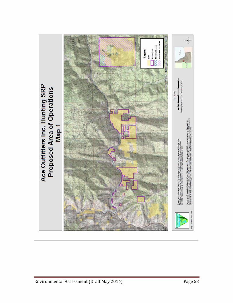
Environmental Assessment (Draft May 2014) Page 53

Environmental Assessment (Draft May 2014) Page 54
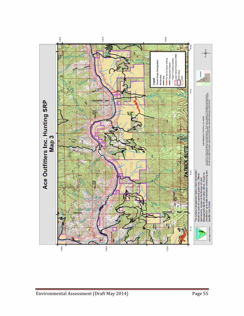
Environmental Assessment (Draft May 2014) Page 55
Environmental Assessment (Draft May 2014) Page 56
DOI-BLM-ID-C020-2013-006-EA Cottonwood Field Office
ATTACHMENT 4 ACE OUTFITTERS SPECIAL RECREATION PERMIT
TERMS, CONDITIONS AND STIPULATIONS In order to protect and preserve the natural and cultural resource values within the Cottonwood Field Office management area and provide for public safety, the attached supplemental stipulations and rules are in effect. These stipulations are considered a part of the permit and are specific to the Cottonwood Field Office. They in addition to those found within Form 2930-1 (SRP Application Permit) and Bureau of Land Management (BLM) BLM H-2930-1 (Recreation Permit Administration). Failure to comply with these stipulations can result in loss of permit privileges. Thank you for your interest and stewardship of your public lands.
GENERAL STIPULATIONS
1. Any filming/photography of permitted activities that takes place with the express intent to sell the product back to the guided client(s) as souvenirs or training videos, etc. would be subject to a vending permit being included as part of the Special Recreation Permit. A separate Land Use Permit would be required for other commercial filming on public lands, defined in IM No. 2004-73 as, "The use of motion picture, videotaping, sound recording, or other moving image or audio recording equipment on public lands that involves the advertisement of a product or service, the creation of a product for sale, or the use of actors, models, sets, or props, but not including activities associated with broadcasts for news programs. For purposes of this definition, creation of a product for sale includes a film, videotape, television broadcast, or documentary of participants in commercial sporting or recreation event created for the purpose of generating income."
2. SRPs for commercial recreation uses requiring a State license (i.e., outdoor youth programs, hunting guides, outfitting, etc.) will be valid only when accompanied by a valid State license.
3. BLM issued SRPs do not cover operations on the US Forest Service administered portion of the hunting units, private or state lands. A separate permit is required for activities on US Forest Service managed lands.
4. For hunting outfitters, a Post-Use Report to the Cottonwood Field Office must be submitted by December 31 for every year the permit is in effect. This report will be used to determine if additional fees are required of the permittee based upon total permitted use. If the permittee desires, use reports may be submitted on a quarterly basis throughout the permit period. The report must contain a trip-by-trip log of: trip location, beginning and ending dates of each trip, number of clients, number of guides, and gross receipts for the trip. In reporting gross receipts, the outfitter will report all payments made by the customer, with the only exception being retail sales of durable goods that remain the property of the customer and have an expected service life extending beyond the guided activity. The request for deductions based on pre/post trip transportation and lodging expenses and percentage of time on public land, if being claimed, must also be submitted at this time. Requests for transportation and lodging deductions must be accompanied by copies of supporting receipts documenting proof of payment.
5. Permittee may not leave unattended personal property on public lands administered by the Bureau of Land Management (BLM) for more than 72 hours without written
Environmental Assessment (Draft May 2014) Page 57
permission of the authorized officer, with the exception that vehicles may be parked in designated parking areas for as many as 14 consecutive days. Unattended personal property is subject to disposition under the Federal Property and Administrative Services Act of 1949 as amended.
6. Food, water, and/or equipment caches will not be allowed unless prior approval is obtained from the BLM's authorized officer. Location of proposed caches must be identified in the permittee’s approved operating plan.
7. SRP holders must adhere to 43 CFR 4140.1 which prohibits: installing, using, maintaining, modifying, and/or removing range improvements without authorization; cutting, burning, spraying, destroying, or removing vegetation without authorization; damaging or removing U.S. property without authorization; littering; failing to reclose any gate or other entry during periods of livestock use; and interfering with lawful uses or users including obstructing free transit through or over the public lands by force, threat, intimidation, signs, barriers, or locked gates.
8. No use of aircraft on or over BLM lands for the purpose of this SRP will be authorized unless specifically approved by the authorized officer.
9. All signs placed on public lands by the permittee must be authorized by the BLM in writing. Permittee shall not construct cairns, use flagging or paint to mark trails, unless specified in their permit. All permitted signs and flagging must be removed from public lands at the end of the use period.
10. Collection of prehistoric or historic artifacts is prohibited on Federal, State, and Indian Lands and is prosecutable under the Archaeological Resources Protection Act, and other laws both Federal and State. Disturbance, defacement, or excavation of prehistoric and historic sites is also prohibited.
11. If in connection with use any human remains, funerary objects, sacred objects or objects of cultural patrimony as defined in the Native American Graves Protection and Repatriation Act (P.L. 101-601; 104 Stat. 3048; 25 U.S.C. 3001) are discovered, the permittee shall stop use in the immediate area of the discovery, protect the remains and objects, and immediately notify the authorized officer (CFO Will Runnoe 208-962-3745). The permittee shall continue to protect the immediate area of the discovery until notified by the authorized officer that use may resume.
12. In time of severe fire danger or other emergencies, in order to protect public resources, the BLM may close large areas to the public. This permit does not entitle the holder to an exception to emergency closures. Permittee is responsible for informing employees and clients of the current fire danger and required precautions that may be placed in effect by the BLM or the State.
13. Wildfires inadvertently caused by the permittee shall be reported immediately by calling 911 and the nearest BLM office (208-962-3245).
14. Adequate first aid and safety equipment i.e. SAT phone or radio, shall be provided by permittee while performing the permitted activities.
OUTFITTERS BASE CAMP STIPULATIONS 15. All structures will be dismantled at the end of each season. The poles (including those
from corrals {unless using Site #2}, tent frames, toilets and hitch racks) will be stacked upright against a tree, outside the camp perimeter. Meat racks will be designed to be installed just prior to use and removed after use.
Environmental Assessment (Draft May 2014) Page 58
16. All equipment (including stoves, tables, beds, tools, dishes, etc.), water systems and supplies, including horse feed and animal bedding will be packed out at the end of each season.
17. Permittee will only be authorized to camp at designated camp sites, which are identified and approved in the SRP. The designated approved camp site is limited to one acre to include camping, parking, corrals and other camp related activities.
18. Permittee will monitor assigned campsite for weed introduction. Introduced weeds must be hand pulled and the infestation location reported to BLM for follow-up weed control or monitoring.
19. Washing or bathing with soap is not permitted in tributary streams, springs, or other natural water sources. Dishwater must be strained before dispersal and disposed of in a sump hole located at least 200 feet of streams, springs, or other natural water sources. Only biodegradable soap may be used.
20. All refuse must be carried out of the area and disposed of in a county approved disposal site. Burying garbage is prohibited.
21. Once established, all camps, including base camps (camps used for more than three nights and typically the point from which other operations related to the SRP are based) and smaller camps, should be clearly identified by posting the name of the outfitter, the SRP number and contact information for the BLM in clear weatherproof protection.
22. The permittee must use existing campfire circles when they exist, rather than construct new ones. If no existing fire circles, sites should be selected that can be "naturalized" at departure.
23. Camp fires will have a vegetation free barrier of five feet or more away from trees, shrubs and other vegetation. A metal fire ring will be required to prevent fire scars on the surrounding ground cover and/or rocks.
24. The permittee may use only dead and down wood for campfires (unless otherwise directed). Cutting or removing any live vegetation or standing dead vegetation is prohibited.
25. The permittee must take all reasonable precautions to prevent wild land fires. Fires must be out and cold when camp is unattended.
26. Permittee will avoid the use of the root cellar at Campsite #2, placing all camp structures at least 200 feet from the cellar walls.
27. If Campsite #1 becomes accessible, cultural clearance would need to be completed and an approval letter for use of the campsite received from the BLM prior to permittee’s use of the site.
28. Disposal of human waste: a. At vehicle accessible base camps, portable toilets are the preferred method for
human waste disposal and if utilized, must be emptied only at approved disposal sites.
b. At camps not accessible by vehicles, group latrines will be located on sites that maximize direct sunlight and no closer than 200 feet from water sources and dry washes. A pit toilet hole will be excavated to between three and six feet deep. The pit should be abandoned when the sewage comes within sixteen (16”) inches of the ground surface or when camp is broken for the season. An abandoned pit shall be filled with soil, free of rock, allowing for about twelve (12”) inches of settling and marked. (IDAPA 58.01.03). SRP holders are required to bury or dispose of toilet paper in the trash. Burning toilet paper is prohibited.

Environmental Assessment (Draft May 2014) Page 59
OUTFITTERS USING PACKSTOCK STIPULATIONS 29. Livestock use is limited to four horses or mules, all other types of livestock must be
approved by the authorized officer prior to use. 30. The permittee is required to use certified weed-free feed for 48 hours in advance of and
for the duration of the trip on public lands for livestock and bedding for livestock and/or dogs.
31. Permittee may not clean out stock trucks or trailers onto public lands. 32. All animals will be under control en route and in camp to protect wildlife, other livestock,
and range forage. 33. Lost or dead animals must be reported within 48 hours of end of trip. An appropriate
response will be determined by the authorized officer. OFF-HIGHWAY VEHICLES (OHV) AND MOTOR VEHICLES STIPULATIONS
34. Any OHV or motorized vehicle use must be specifically provided for in the permit and operating plan.
35. All motorized vehicles (e.g., pickups, all-terrain vehicles, dirt bikes, etc.) that have been used outside BLM lands must be free of accumulated soil and plant parts (including the undercarriage) prior to their use on BLM managed lands in order to prevent the possible introduction and spread of noxious weeds.
36. Permittee shall limit vehicle traffic to the designated routes as approved in the Cottonwood Field Office RMP, 2009 or supplemental designations. No cross-country travel is permitted.
37. Permittee will be familiar and comply with State of Idaho and BLM OHV laws. Operators must follow state regulations and manufacturer’s recommendations regarding operations. Clients are not authorized to use OHVs as part of this permit.
38. Permittee will operate in accordance with 43 CFR 8340 concerning OHV use on public lands.
39. All motorized vehicles must yield to non-motorized users. 40. Operators must not intentionally chase or harass wildlife. 41. Permittee is responsible for the proper cleanup of all vehicle fluid (including, but not
limited to, fuel, motor oil, hydraulic fluid, gear oil, and coolants), vehicle parts, etc., prior to submission of the Post-Use Report and prior to the release of any required posted bond.
42. Permittee will not be authorized to conduct snow plow or road maintenance operations unless prior approval is obtained from the authorized officer.
43. Motorized use of roads and trails will not result in adverse rutting or erosion.
MAXWELL POINT TRAIL AND CAMPSITES MAINTENANCE STIPULATIONS
44. Permittee is authorized to clear dead and downed trees within the road and campsite
prism using chainsaws and hand tools. 45. Permittee is authorized to clean dead and downed and standing/leaning trees identified as
hazardous within the campsite prism. 46. Permittee is authorized to maintain the Maxwell Point Trail prism as necessary to
accommodate livestock travel using hand tools with minimal use of chain saws each year. There will be no new trail construction or ground disturbance
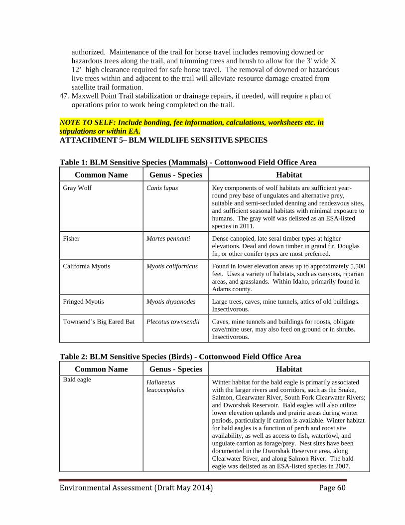
Environmental Assessment (Draft May 2014) Page 60
authorized. Maintenance of the trail for horse travel includes removing downed or hazardous trees along the trail, and trimming trees and brush to allow for the 3' wide X 12’ high clearance required for safe horse travel. The removal of downed or hazardous live trees within and adjacent to the trail will alleviate resource damage created from satellite trail formation.
47. Maxwell Point Trail stabilization or drainage repairs, if needed, will require a plan of operations prior to work being completed on the trail.
NOTE TO SELF: Include bonding, fee information, calculations, worksheets etc. in stipulations or within EA. ATTACHMENT 5– BLM WILDLIFE SENSITIVE SPECIES Table 1: BLM Sensitive Species (Mammals) - Cottonwood Field Office Area
Common Name Genus - Species Habitat Gray Wolf Canis lupus Key components of wolf habitats are sufficient year-
round prey base of ungulates and alternative prey, suitable and semi-secluded denning and rendezvous sites, and sufficient seasonal habitats with minimal exposure to humans. The gray wolf was delisted as an ESA-listed species in 2011.
Fisher Martes pennanti Dense canopied, late seral timber types at higher elevations. Dead and down timber in grand fir, Douglas fir, or other conifer types are most preferred.
California Myotis Myotis californicus Found in lower elevation areas up to approximately 5,500 feet. Uses a variety of habitats, such as canyons, riparian areas, and grasslands. Within Idaho, primarily found in Adams county.
Fringed Myotis Myotis thysanodes Large trees, caves, mine tunnels, attics of old buildings. Insectivorous.
Townsend’s Big Eared Bat Plecotus townsendii Caves, mine tunnels and buildings for roosts, obligate cave/mine user, may also feed on ground or in shrubs. Insectivorous.
Table 2: BLM Sensitive Species (Birds) - Cottonwood Field Office Area
Common Name Genus - Species Habitat Bald eagle
Haliaeetus leucocephalus
Winter habitat for the bald eagle is primarily associated with the larger rivers and corridors, such as the Snake, Salmon, Clearwater River, South Fork Clearwater Rivers; and Dworshak Reservoir. Bald eagles will also utilize lower elevation uplands and prairie areas during winter periods, particularly if carrion is available. Winter habitat for bald eagles is a function of perch and roost site availability, as well as access to fish, waterfowl, and ungulate carrion as forage/prey. Nest sites have been documented in the Dworshak Reservoir area, along Clearwater River, and along Salmon River. The bald eagle was delisted as an ESA-listed species in 2007.
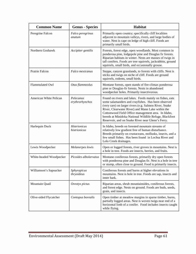
Environmental Assessment (Draft May 2014) Page 61
Common Name Genus - Species Habitat Peregrine Falcon Falco peregrinus
anatum Primarily open country; specifically cliff localities adjacent to mountain valleys, rivers, and large bodies of water. Nest is cape on ledge of high cliff. Foods are primarily small birds.
Northern Goshawk Accipiter gentilis Forests, forest edge, open woodlands. Most common in ponderosa pine, lodgepole pine and Douglas fir forests. Riparian habitats in winter. Nests are masses of twigs in tall conifers. Foods are tree squirrels, jackrabbits, ground squirrels, small birds, and occasionally grouse.
Prairie Falcon Falco mexicanus Steppe, canyon grasslands, to forests with cliffs. Nest is sticks and twigs on niche of cliff. Foods are ground squirrels, rodents, small birds.
Flammulated Owl Otus flammeolus Montane forests, open stands of fire-climax ponderosa pine or Douglas-fir forests. Nests in abandoned woodpecker holes. Primarily insectivorous.
American White Pelican Pelecanus erythrorhynchos
Found on rivers and lakes. Feeds mainly on fishes, eats some salamanders and crayfishes. Has been observed (very rare) on larger rivers (e.g. Salmon River, Snake River, Clearwater River) and Mann Lake within the Cottonwood Field Office management area. In Idaho, breeds at Minidoka National Wildlife Refuge, Blackfoot Reservoir, and on Snake River near Glenn’s Ferry.
Harlequin Duck Histrionicus histrionicus
In Idaho, breeds on forested mountain streams of relatively low gradient free of human disturbance. Breeds primarily on crustaceans, mollusks, insects, and a few small fishes. Has been found in Lochsa River and Lolo Creek drainages.
Lewis Woodpecker Melanerpes lewis Open or logged forests, river groves in mountains. Nest is a hole in tree. Foods are insects, berries, and fruits.
White-headed Woodpecker Picoides albolarvatus Montane coniferous forests, primarily dry open forests with ponderosa pine and Douglas fir. Nest is a hole in tree or stump, often close to ground. Food is primarily insects.
Williamson’s Sapsucker Sphyrapicus thryoideus
Coniferous forests and burns at higher elevations in mountains. Nest is hole in tree. Foods are sap, insects and inner bark.
Mountain Quail Oreotys pictus Riparian areas, shrub mountainsides, coniferous forests, and forest edge. Nests on ground. Foods are buds, seeds, grain, and insects.
Olive-sided Flycatcher Contopus borealis Open timber at meadow margins in sparse timber, burns, partially logged areas. Nest is woven twigs near end of a horizontal limb of a conifer. Food includes insects caught while flying.
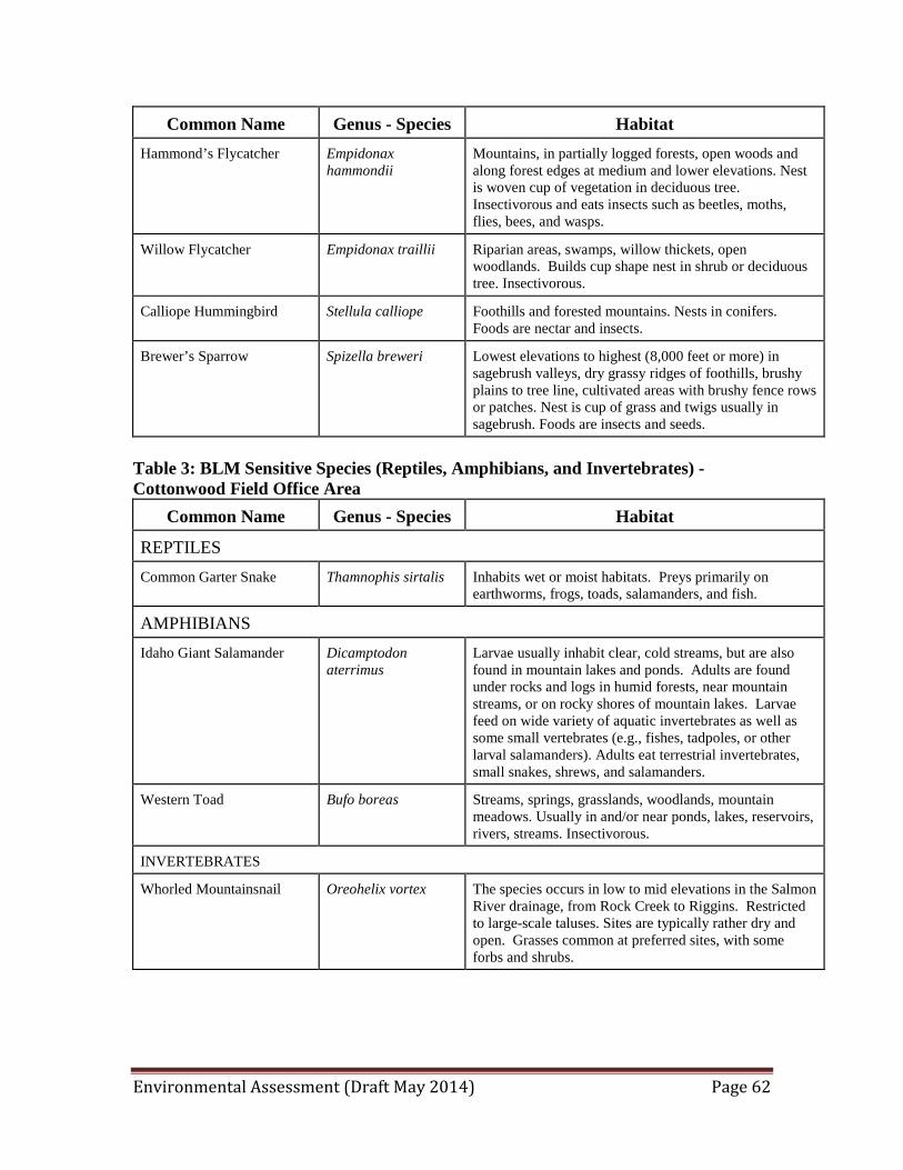
Environmental Assessment (Draft May 2014) Page 62
Common Name Genus - Species Habitat Hammond’s Flycatcher Empidonax
hammondii Mountains, in partially logged forests, open woods and along forest edges at medium and lower elevations. Nest is woven cup of vegetation in deciduous tree. Insectivorous and eats insects such as beetles, moths, flies, bees, and wasps.
Willow Flycatcher Empidonax traillii Riparian areas, swamps, willow thickets, open woodlands. Builds cup shape nest in shrub or deciduous tree. Insectivorous.
Calliope Hummingbird Stellula calliope Foothills and forested mountains. Nests in conifers. Foods are nectar and insects.
Brewer’s Sparrow Spizella breweri Lowest elevations to highest (8,000 feet or more) in sagebrush valleys, dry grassy ridges of foothills, brushy plains to tree line, cultivated areas with brushy fence rows or patches. Nest is cup of grass and twigs usually in sagebrush. Foods are insects and seeds.
Table 3: BLM Sensitive Species (Reptiles, Amphibians, and Invertebrates) - Cottonwood Field Office Area
Common Name Genus - Species Habitat
REPTILES Common Garter Snake Thamnophis sirtalis Inhabits wet or moist habitats. Preys primarily on
earthworms, frogs, toads, salamanders, and fish.
AMPHIBIANS Idaho Giant Salamander Dicamptodon
aterrimus Larvae usually inhabit clear, cold streams, but are also found in mountain lakes and ponds. Adults are found under rocks and logs in humid forests, near mountain streams, or on rocky shores of mountain lakes. Larvae feed on wide variety of aquatic invertebrates as well as some small vertebrates (e.g., fishes, tadpoles, or other larval salamanders). Adults eat terrestrial invertebrates, small snakes, shrews, and salamanders.
Western Toad Bufo boreas Streams, springs, grasslands, woodlands, mountain meadows. Usually in and/or near ponds, lakes, reservoirs, rivers, streams. Insectivorous.
INVERTEBRATES
Whorled Mountainsnail Oreohelix vortex The species occurs in low to mid elevations in the Salmon River drainage, from Rock Creek to Riggins. Restricted to large-scale taluses. Sites are typically rather dry and open. Grasses common at preferred sites, with some forbs and shrubs.
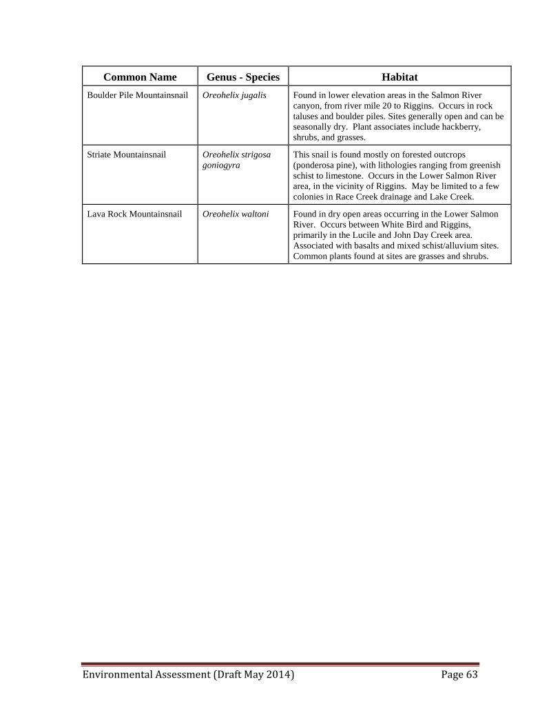
Environmental Assessment (Draft May 2014) Page 63
Common Name Genus - Species Habitat Boulder Pile Mountainsnail Oreohelix jugalis Found in lower elevation areas in the Salmon River
canyon, from river mile 20 to Riggins. Occurs in rock taluses and boulder piles. Sites generally open and can be seasonally dry. Plant associates include hackberry, shrubs, and grasses.
Striate Mountainsnail Oreohelix strigosa goniogyra
This snail is found mostly on forested outcrops (ponderosa pine), with lithologies ranging from greenish schist to limestone. Occurs in the Lower Salmon River area, in the vicinity of Riggins. May be limited to a few colonies in Race Creek drainage and Lake Creek.
Lava Rock Mountainsnail Oreohelix waltoni Found in dry open areas occurring in the Lower Salmon River. Occurs between White Bird and Riggins, primarily in the Lucile and John Day Creek area. Associated with basalts and mixed schist/alluvium sites. Common plants found at sites are grasses and shrubs.