OFFPRINT - Coe
16
OFFPRINT
-
Upload
khangminh22 -
Category
Documents
-
view
0 -
download
0
Transcript of OFFPRINT - Coe
OFFPRINT
5
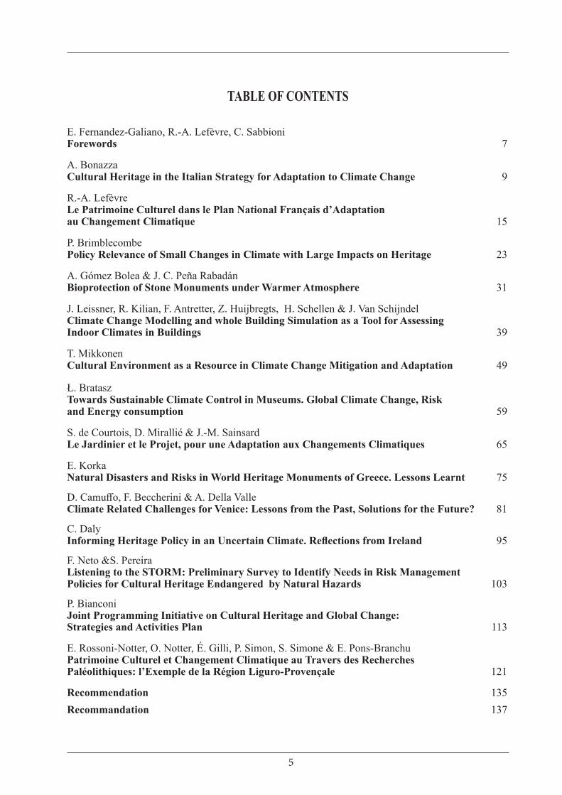
TABLE OF CONTENTS
E. Fernandez-Galiano, R.-A. Lefèvre, C. Sabbioni Forewords 7
A. Bonazza Cultural Heritage in the Italian Strategy for Adaptation to Climate Change 9
R.-A. LefèvreLe Patrimoine Culturel dans le Plan National Français d’Adaptation au Changement Climatique 15
P. BrimblecombePolicy Relevance of Small Changes in Climate with Large Impacts on Heritage 23
A. Gómez Bolea & J. C. Peña RabadánBioprotection of Stone Monuments under Warmer Atmosphere 31
J. Leissner, R. Kilian, F. Antretter, Z. Huijbregts, H. Schellen & J. Van SchijndelClimate Change Modelling and whole Building Simulation as a Tool for Assessing Indoor Climates in Buildings 39
T. MikkonenCultural Environment as a Resource in Climate Change Mitigation and Adaptation 49
Ł. BrataszTowards Sustainable Climate Control in Museums. Global Climate Change, Risk and Energy consumption 59
S. de Courtois, D. Mirallié & J.-M. SainsardLe Jardinier et le Projet, pour une Adaptation aux Changements Climatiques 65
E. KorkaNatural Disasters and Risks in World Heritage Monuments of Greece. Lessons Learnt 75
D. Camuffo, F. Beccherini & A. Della ValleClimate Related Challenges for Venice: Lessons from the Past, Solutions for the Future? 81
C. DalyInforming Heritage Policy in an Uncertain Climate. Reflections from Ireland 95
F. Neto &S. PereiraListening to the STORM: Preliminary Survey to Identify Needs in Risk Management Policies for Cultural Heritage Endangered by Natural Hazards 103
P. BianconiJoint Programming Initiative on Cultural Heritage and Global Change: Strategies and Activities Plan 113
E. Rossoni-Notter, O. Notter, É. Gilli, P. Simon, S. Simone & E. Pons-BranchuPatrimoine Culturel et Changement Climatique au Travers des Recherches Paléolithiques: l’Exemple de la Région Liguro-Provençale 121
Recommendation 135Recommandation 137
81
Climate Related Challenges for Venice: Lessons from the Past, Solutions for the Future? Dario CAMUFFO, Francesca BECHERINI, Antonio DELLA VALLENational Research Council (CNR) - Institute of Atmospheric Sciences and Climate, Padua, Italy
Abstract: Venice, a unique coastal city included in the UNESCO World List of Cultural Heritage, since ancient times has suffered a number of climate related challenges, i.e. sea level rise, storm surges flooding the city, the Lagoon frozen over during the most severe winters and fires. Over the last millennium, the above challenges have been reconstructed from sources of different nature, i.e. instrumental records, documentary written records and visual arts. The strategies adopted in the past are discussed; some of them have been genial and effective, others need improvement. The lesson from the past has evidenced risks and weakness. Resilience and mitigation measures need further research and novel policy approaches.
Résumé: Venise, une cité côtière unique incluse dans la liste du Patrimoine mondial de l’UNESCO, a souffert depuis des temps anciens de défis relatifs au climat, par exemple la montée du niveau de la mer, des tempêtes déferlantes inondant la ville, le gel de la Lagune durant des hivers sévères et des incendies. Durant le dernier millénaire, les défis ci-dessus ont été reconstruits à partir de sources de différentes natures, par exemple instrumentales, documentaires écrites et des arts visuels. Les stratégies adoptées dans le passé sont discutées; quelques-unes ont été géniales et efficientes, d’autres demandent des améliorations. Les leçons du passé ont mis en évidence des risques et des faiblesses. Les mesures de résilience et d’atténuation nécessitent de futures recherches et des approches politiques nouvelles.
Key-words: climate change, sea level rise, storm surges, cold spells, lagoon frozen over, fire risk.
Mots Clés: changements climatiques, hausse du niveau des mers, marées de tempête, vagues de froid, lagune gelée, risque d’incendie.
1. Introduction
Venice is a unique coastal city included in the UNESCO World List of Cultural Heritage. In its long and well documented story, it had, and continues to have, a number of climate related challenges, e.g. sea-level rise and building submersion, increase of flooding storm surges, cold spells and frozen Lagoon water, lightning and fire. So far, the research has been able to reconstruct the above challenges for over one millennium. In the past centuries, the Venice Republic faced each situation with incredible resilience and brilliant solutions. However, with the global warming, critical events are occurring once more today.
The aim of this paper is to analyze the major past challenges and their solutions, and to highlight the research still needed to find efficient measures for the present time and the future.
2. The main challenges affecting Venice
2.1 The 1st challenge: the sea level rise
Venice is being submerged by sea waters, hence for the safeguarding of the city it is crucial to know the past sea level rise on the long-term period to make an accurate forecast. The sea level rise (SLR) in Venice is governed by the synergistic effect of global warming and land subsidence. The latter is 11±1 cm per century, mainly due to geological factors and is almost constant over time except for a short period of underwater pumping from 1920 to 1970 that caused 10-12 cm additional sinking later followed by some rebounding (Bondesan et al., 2001; Carbognin et al., 2004; Carminati et al., 2005). Today the land subsidence is 0.9 ± 0.7 mm year−1
(Tosi et al., 2013, 2016). Over the last century, the SLR has been 25.4 cm century-1 (R2= 0.773)

8282
Climate Related Challenges for Venice: Lessons from the Past, Solutions for the Future?
(Camuffo et al., 2017). The tide gauge record (1871-today) is quite long, but it is not sufficient to get a clear interpretation of the trend because of the superposition of multi-decadal oscillations and other departures connected with natural and anthropic factors.
At present, the sea level has reached and invaded most ground floors that in turn have been raised to avoid water entering at high tides. Also, most sea stairs are submersed and dock walk-ways have been built to reach the doors (fig. 1).
In the pre-instrumental period, the SLR was reconstructed from a combination of documentary and pictorial proxies of biological nature. Going back in time, the first indication was given by Zendrini (1811) who reported in an official document the level reached by the green algae belt in relation with a recognizable architectonic item of a specified building. The level of the algae belt is determined by the upper limit periodically reached by the tidal cycles and local waves, and constitutes a useful reference for the high tides and the mean sea level, being 47 cm above it. This level was nicknamed common marine level (CM) and officially used in the past centuries; it is all over the Venice canals and provides an excellent biological proxy. Fortunately, Canaletto and Bellotto accurately reproduced this algae belt in their paintings in the period from 1725 to 1758.
1.- The sea level has reached and submerged the doorstep. (a) A view during maintenance works. The floor has been raised 1 m and the lower part of the door has been bricked up and used to host sewage drainage pipes (photo D. Resini, courtesy INSULA, Venice). (b) The Frogman of the State Police is taking measurements standing on the bottom step of the sea stair, that now is fully submerged; a wooden walk-way was built to reach the door.Le niveau de la mer a atteint et submergé le seuil de la porte. (a) Une vue durant les travaux de maintenance. Le sol a été remonté d’1 m et la partie basse de la porte a été murée par des briques et utilisée pour le passage de tuyaux drainant les eaux usées (Photo D. Resini, avec l’autorisation d’INSULA, Venise). (b) L’homme grenouille de la Police d’Etat fait des mesures sur la marche inférieure de l’escalier, qui actuellement est complètement submergé; un ponton en bois a été construit pour atteindre la porte.
(a)
(b)
2. - Sea level rise in Venice. Source of data and covered periods are specified in the bottom with curly braces (for periods) and arrows (for an individual year), i.e.: water stairs (1350-1800); V: Veronese (1571); C&B: Canaletto and Bellotto (1725 to 1758); Z: Zendrini (1811); Tide gauge (1871-2014).La montée du niveau de la mer à Venise. Les sources de données et les périodes couvertes sont spécifiées en bas avec parenthèses (pour les périodes) et des flèches (pour les années individuelles), par exemple escaliers submergés (1350-1800); V: Veronese (1571); C&B: Canaletto et Bellotto (1725 à 1758); Z : Zendrini (1811); Marégraphe (1871-2014).
8383
Dario Camuffo, Francesca Becherini, Antonio Della Valle
The CM level is accurate because Canaletto and Bellotto used a camera obscura to obtain precise views and marked the real projection of the CM on their paintings. This allowed recognizing 12 independent CM levels from 1725 to 1758, and each CM level was matched with the painting date (Camuffo & Sturaro, 2003; 2004). A painting by Veronese, dated 1571, also made with the camera obscura, provided another CM, with the related date, for the second half of the 16th century (Camuffo, 2010).
The sea level in the Mediaeval period was reconstructed with the help of a novel proxy, i.e. the submersion of water stairs of the historic palaces facing the Grand Canal. Today the stairs are almost fully submersed, but when they had been built, the level of the bottom step was related with the tide and the algae belt because the steps colonized by algae were slippery and couldn’t be used. With the support of the Italian Police Frogmen, the submersion depth of the bottom step of 82 palaces was measured and their depth was matched with the date of each building. This proxy allowed the reconstruction of the SLR from 1350 to 1800, giving an independent confirmation of the documentary and pictorial biological proxies (Camuffo et al., 2017).
Combining the instrumental record with all the above proxies, the result is that the SLR in Venice occurred at increasing rate over the last 6.5 centuries (fig. 2). The best-fit interpolation shows that the dataset composed of the instrumental record and the various proxies is equally well represented (i.e. both with the same Pearson determination coefficient R2 = 0.96) by a second-order polynomial (i.e. parabola) with acceleration acc = +0.0030 ± 0.0004 mm year−2 or by an exponential with growth rate λ = 0.00163 ± 0.0002 year−1 (Camuffo et al., 2017).
2.2 The 2nd challenge: storm surges flooding the city
Venice is sometimes flooded by exceptionally high sea levels for a synergism of forcing factors, triggered when a low pressure lies over the central Mediterranean Sea. This meteorological situation generates the Sirocco wind blowing for several days along the major axis of the Adriatic (i.e. from
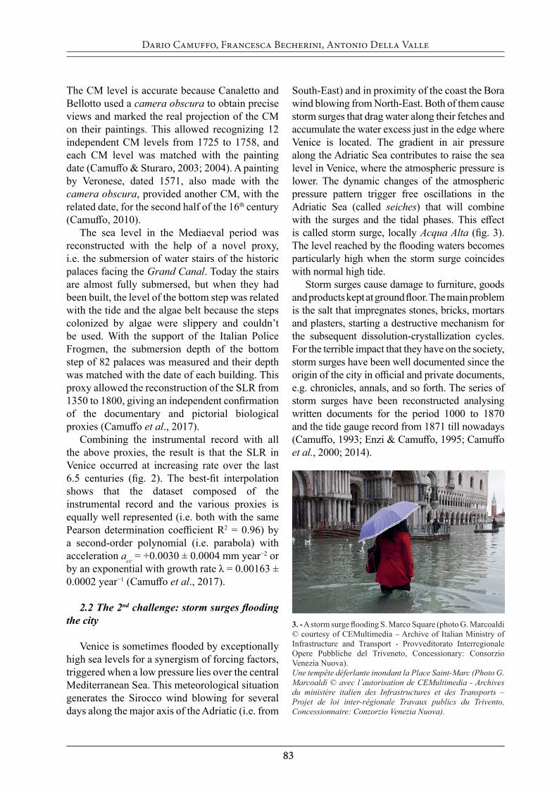
South-East) and in proximity of the coast the Bora wind blowing from North-East. Both of them cause storm surges that drag water along their fetches and accumulate the water excess just in the edge where Venice is located. The gradient in air pressure along the Adriatic Sea contributes to raise the sea level in Venice, where the atmospheric pressure is lower. The dynamic changes of the atmospheric pressure pattern trigger free oscillations in the Adriatic Sea (called seiches) that will combine with the surges and the tidal phases. This effect is called storm surge, locally Acqua Alta (fig. 3). The level reached by the flooding waters becomes particularly high when the storm surge coincides with normal high tide.
Storm surges cause damage to furniture, goods and products kept at ground floor. The main problem is the salt that impregnates stones, bricks, mortars and plasters, starting a destructive mechanism for the subsequent dissolution-crystallization cycles. For the terrible impact that they have on the society, storm surges have been well documented since the origin of the city in official and private documents, e.g. chronicles, annals, and so forth. The series of storm surges have been reconstructed analysing written documents for the period 1000 to 1870 and the tide gauge record from 1871 till nowadays (Camuffo, 1993; Enzi & Camuffo, 1995; Camuffo et al., 2000; 2014).
3. - A storm surge flooding S. Marco Square (photo G. Marcoaldi © courtesy of CEMultimedia – Archive of Italian Ministry of Infrastructure and Transport - Provveditorato Interregionale Opere Pubbliche del Triveneto, Concessionary: Consorzio Venezia Nuova).Une tempête déferlante inondant la Place Saint-Marc (Photo G. Marcoaldi © avec l’autorisation de CEMultimedia - Archives du ministère italien des Infrastructures et des Transports –Projet de loi inter-régionale Travaux publics du Trivento, Concessionnaire: Conzorzio Venezia Nuova).
8484
Climate Related Challenges for Venice: Lessons from the Past, Solutions for the Future?
The sea level reached at a storm surge (SSL) is determined by five contributions: the eustatic sea level (ESL), the local land subsidence (LLS), the astronomical tide (AT), the weather forcing (WF) and the onset of free oscillations of the Adriatic Sea (FOA):
SSL = ESL + LLS + AT + WF + FOAOn the long term, ESL and LLS are dominant.
However, the former grows exponentially and is largely dominant; the latter grows linearly except for some natural or anthropic departures. AT has a stronger semidiurnal component (lunar) and a weaker diurnal one (solar); it modulates the water level during the day, the month and the seasons, but the range remains unchanged over centuries. WF is the main variable that triggers the storm surge and may persist for days, even a week. Finally, FOA has 23 hr period, similar to AT.
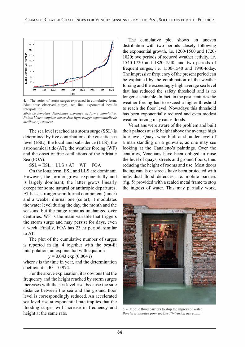
The plot of the cumulative number of surges is reported in fig. 4 together with the best-fit interpolation, an exponential with equation
y = 0.043 exp (0.004 t)where t is the time in year, and the determination coefficient is R2 = 0.974.
For the above explanation, it is obvious that the frequency and the height reached by storm surges increases with the sea level rise, because the safe distance between the sea and the ground floor level is correspondingly reduced. An accelerated sea level rise at exponential rate implies that the flooding surges will increase in frequency and height at the same rate.
The cumulative plot shows an uneven distribution with two periods closely following the exponential growth, i.e. 1200-1500 and 1720-1820; two periods of reduced weather activity, i.e. 1540-1720 and 1820-1940, and two periods of frequent surges, i.e. 1500-1540 and 1940-today. The impressive frequency of the present period can be explained by the combination of the weather forcing and the exceedingly high average sea level that has reduced the safety threshold and is no longer sustainable. In fact, in the past centuries the weather forcing had to exceed a higher threshold to reach the floor level. Nowadays this threshold has been exponentially reduced and even modest weather forcing may cause floods.
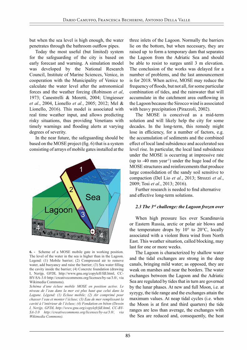
Venetians were aware of the problem and built their palaces at safe height above the average high tide level. Quays were built at shoulder level of a man standing on a gunwale, as one may see looking at the Canaletto’s paintings. Over the centuries, Venetians have been obliged to raise the level of quays, streets and ground floors, thus reducing the height of rooms and use. Most doors facing canals or streets have been protected with individual flood defences, i.e. mobile barriers (fig. 5) provided with a sealed metal frame to stop the ingress of water. This may partially work,
4. - The series of storm surges expressed in cumulative form. Blue dots: observed surges; red line: exponential best-fit interpolation. Série de tempêtes déferlantes exprimée en forme cumulative. Points bleus: tempêtes observées; ligne rouge: exponentielle de meilleur ajustement.
5. - Mobile flood barriers to stop the ingress of water.Barrières mobiles pour arrêter l’intrusion des eaux.
8585
Dario Camuffo, Francesca Becherini, Antonio Della Valle
but when the sea level is high enough, the water penetrates through the bathroom outflow pipes.
Today the most useful (but limited) system for the safeguarding of the city is based on early forecast and warning. A simulation model was developed by the National Research Council, Institute of Marine Sciences, Venice, in cooperation with the Municipality of Venice to calculate the water level after the astronomical forces and the weather forcing (Robinson et al, 1973; Canestrelli & Moretti, 2004; Umgiesser et al., 2004, Lionello et al., 2005; 2012; Mel & Lionello, 2016). This model is associated with real time weather input, and allows predicting risky situations, thus providing Venetians with timely warnings and flooding alerts at varying degrees of severity.
In the near future, the safeguarding should be based on the MOSE project (fig. 6) that is a system consisting of arrays of mobile gates installed at the
three inlets of the Lagoon. Normally the barriers lie on the bottom, but when necessary, they are raised up to form a temporary dam that separates the Lagoon from the Adriatic Sea and should be able to resist to surges until 3 m elevation. The conclusion of the works was delayed for a number of problems, and the last announcement is for 2018. When active, MOSE may reduce the frequency of floods, but not all, for some particular combination of tides, and the rainwater that will accumulate in the catchment area outflowing in the Lagoon because the Sirocco wind is associated with heavy precipitation (Pirazzoli, 2002).
The MOSE is conceived as a mid-term solution and will likely help the city for some decades. In the long-term, this remedy might lose in efficiency, for a number of factors, e.g. the accumulation of sediments and the combined effect of local land subsidence and accelerated sea level rise. In particular, the local land subsidence under the MOSE is occurring at impressive rate (up to -40 mm year-1) under the huge load of the MOSE structures and reinforcements that produce large consolidation of the sandy soil sensitive to compaction (Del Lio et al., 2013; Strozzi et al., 2009; Tosi et al., 2013; 2016).
Further research is needed to find alternative and effective long-term solutions.
2.3 The 3rd challenge: the Lagoon frozen over
When high pressure lies over Scandinavia or Eastern Russia, arctic or polar air blows and the temperature drops by 10° to 20°C, locally associated with a violent Bora wind from North East. This weather situation, called blocking, may last for one or more weeks.
The Lagoon is characterized by shallow water and the tidal exchanges are strong in the deep canals, bringing mild water; as opposed, they are weak on marshes and near the borders. The water exchanges between the Lagoon and the Adriatic Sea are regulated by tides that in turn are governed by the lunar phases. At new and full Moon, i.e. at syzygy, the tide range and the exchanges attain the maximum values. At neap tidal cycles (i.e. when the Moon is at first and third quarters) the tide ranges are less than average, the exchanges with the Sea are reduced and, consequently, the heat
6. - Scheme of a MOSE mobile gate in working position. The level of the water in the sea is higher than in the Lagoon. Legend: (1) Mobile barrier; (2) Compressed air to remove water, add buoyancy and raise the barrier; (3) Sea water filling the cavity inside the barrier; (4) Concrete foundation (drawing I, Nerijp, GFDL http://www.gnu.org/copyleft/fdl.html, CC-BY-SA-3.0 http://creativecommons.org/licenses/by-sa/3.0/, via Wikimedia Commons).Schéma d’une écluse mobile MOSE en position active. Le niveau de l’eau dans la mer est plus haut que celui dans la Lagune. Légend: (1) Ecluse mobile; (2) Air comprimé pour chasser l’eau et monter l’écluse; (3) Eau de mer remplissant la cavité à l’intérieur de l’écluse; (4) Fondation en béton (Dessin I, Nerijp, GFDL http://www.gnu.org/copyleft/fdl.html, CC-BY-SA-3.0 http://creativecommons.org/licenses/by-sa/3.0/, via Wikimedia Commons).
8686
Climate Related Challenges for Venice: Lessons from the Past, Solutions for the Future?
supply from the Sea. The frost is determined by a dynamic balance between atmospheric cooling (especially in the presence of fresh and cold wind) and marine warming (tidal exchange). The typical winter temperature of the Adriatic Sea ranges from +4° to +10°C, so that the Lagoon may freeze more easily at the odd Moon quarters. Ice may form when the heat removed by the atmosphere exceeds the heat supplied by the sea and the marine water temperature drops below -2°C. This requires at least one week of intense cold.
The formation of ice slabs on the Venice Lagoon is an exceptional event, and was reported for the impact that it had on the society. The series of the Lagoon frozen over have been reconstructed, analysing chronicles, annals and official documents kept in public and private
archives and libraries (Camuffo, 1987; Camuffo et al., 2016). The events of extreme cold when the Lagoon was frozen over may be categorized into three classes based on some objective consequences, and certain levels of them, that the cold had on the hinterland and the waters, as follows.
1st level: Severe winter. People, animals and plants suffered for frost and, in the hinterland, rivers and lakes were partially frozen. The Lagoon was frozen at the borders with the hinterland where the water is shallow and the exchanges with the sea are small. Ice slabs were floating on the Lagoon and canals. The frost caused damages and restrictions, but boat transports were not interrupted. This situation was neither frequent, nor rare.
7. - The Lagoon frozen over in 1789 viewed from St Giobbe toward St Secondo Island. People walk on the ice slab following the same path; a canal has been created, breaking ice (Venetian Anonymous, XVIII century, oil on canvas 53x70 cm, © & courtesy of Museum Correr, Venice, Cl. I n. 2054).La Lagune gelée en 1789 vue depuis St Giobbe vers l’ile St Secondo. Personnes marchant sur la plaque de glace en suivant le même chemin ; un canal a été créé en cassant la glace ( Anonyme vénitien, XVIIIème siècle, huile sur toile 53x70 cm, © & autorisation du Musée Correr, Venise, Cl. I n. 2054).
8787
Dario Camuffo, Francesca Becherini, Antonio Della Valle
2nd level: Very severe winter. Some people, animals and plants were killed by frost, and in the hinterland rivers and lakes were frozen over. The Lagoon was mostly frozen, i.e. all the shallow waters except where the tidal exchanges brought mild water from the sea. The frost interrupted boat transports, but the ice slab was not thick enough to support people walking on it. This situation caused severe problems to the city that remained isolated, practically besieged by frost, without food, beverages, wood for fire, etc., with a terrible social impact. This situation was rare.
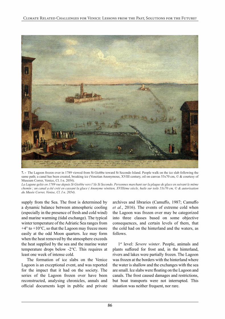
3rd level: Great winters: are extreme, exceptional events. An extreme cold lasted for weeks, killing people, animals and trees. Wine in barrels and water in wells were frozen over. In Venice the ice sheet was thick over the whole Lagoon. The siege caused by frost was over. People and carts or wagons could safely cross the frozen Lagoon on foot, reach the mainland and return back transporting animals, barrels, food, beverages, wood and other rescue items (fig. 7). This situation was extremely rare.
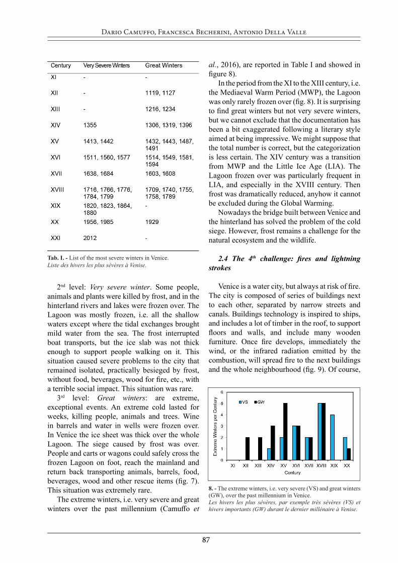
The extreme winters, i.e. very severe and great winters over the past millennium (Camuffo et
al., 2016), are reported in Table I and showed in figure 8).
In the period from the XI to the XIII century, i.e. the Mediaeval Warm Period (MWP), the Lagoon was only rarely frozen over (fig. 8). It is surprising to find great winters but not very severe winters, but we cannot exclude that the documentation has been a bit exaggerated following a literary style aimed at being impressive. We might suppose that the total number is correct, but the categorization is less certain. The XIV century was a transition from MWP and the Little Ice Age (LIA). The Lagoon frozen over was particularly frequent in LIA, and especially in the XVIII century. Then frost was dramatically reduced, anyhow it cannot be excluded during the Global Warming.
Nowadays the bridge built between Venice and the hinterland has solved the problem of the cold siege. However, frost remains a challenge for the natural ecosystem and the wildlife.
2.4 The 4th challenge: fires and lightning strokes
Venice is a water city, but always at risk of fire. The city is composed of series of buildings next to each other, separated by narrow streets and canals. Buildings technology is inspired to ships, and includes a lot of timber in the roof, to support floors and walls, and include many wooden furniture. Once fire develops, immediately the wind, or the infrared radiation emitted by the combustion, will spread fire to the next buildings and the whole neighbourhood (fig. 9). Of course,
Tab. I. - List of the most severe winters in Venice. Liste des hivers les plus sévères à Venise.
8. - The extreme winters, i.e. very severe (VS) and great winters (GW), over the past millennium in Venice.Les hivers les plus sévères, par exemple très sévères (VS) et hivers importants (GW) durant le dernier millénaire à Venise.
8888
Climate Related Challenges for Venice: Lessons from the Past, Solutions for the Future?
the risk of fire increased with the growth of the city, and the increasing density of the population and buildings.
The series of fires have been reconstructed analysing documents for the period 900 to 2000 (Camuffo, 2000). The sources for the period 900-1899 are chronicles, annals and other written documents in archives and libraries, while for 1900-2000 local newspapers and the records of the firemen brigade of Venice were considered. The result of this research is reported in fig. 10 with a distinction between minor fires (i.e. one or two buildings) and major fires (several buildings).
In the following, the adopted strategies are analysed, pointing out their successes and limits.
2.4.1 To regulate and remove furnacesIn order of time, the first strategy was to
regulate and remove all furnaces from the city. In the early period, furnaces and glass factories worked inside the city and kept fire burning day and night. In order to avoid frequent fires, in the late XIII century furnaces and glass factories were regulated and moved off from Venice, to Murano Island. Shipyards were concentrated in the Arsenal, far from the city center.
2.4.2 To invent and adopt exhaust chimneysMost fires were due to domestic heating. In the
early period, buildings were mainly heated by a central radiant heat source, typically a brazier or a wood fireplace. The smoke was dispersed in the room and extracted by natural leakage through openings in the roof. This method was very risky because the presence of wood and even straw on the roof.
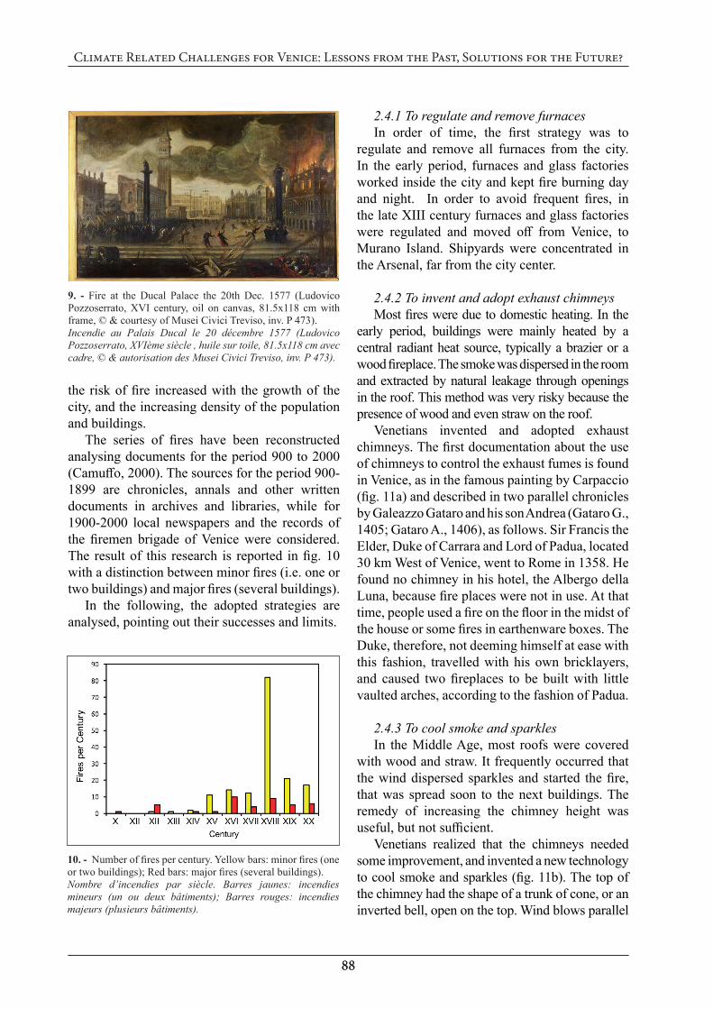
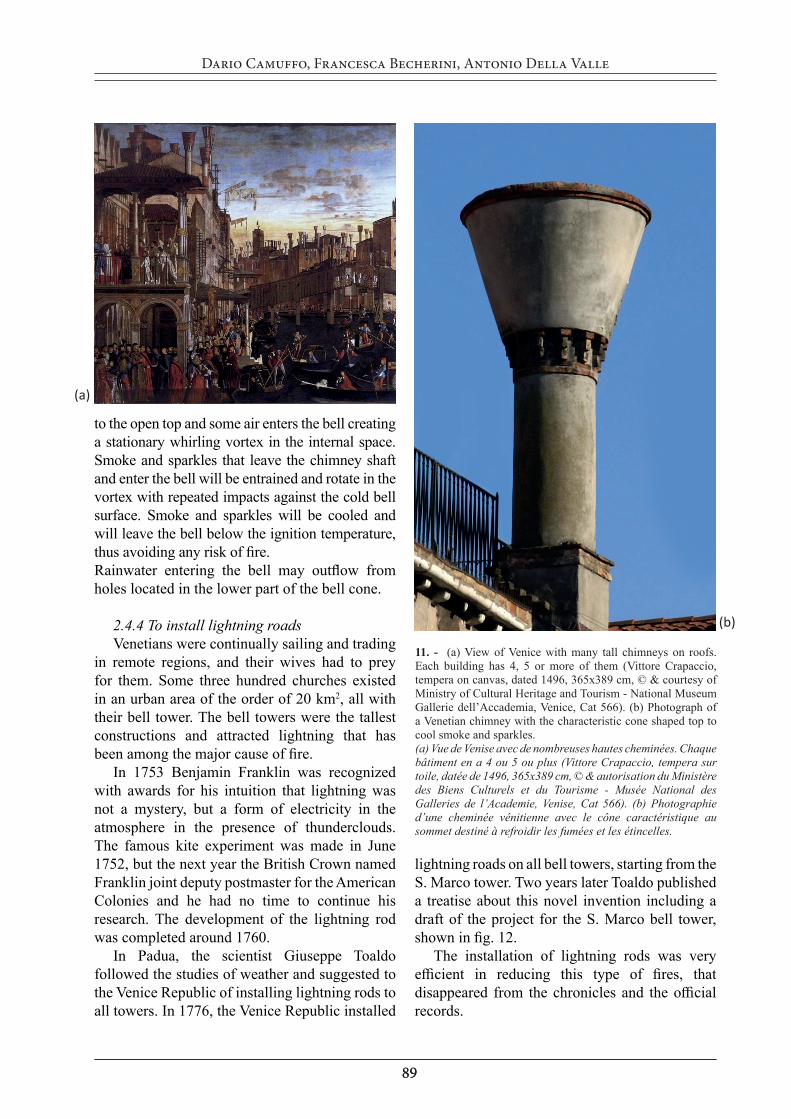
Venetians invented and adopted exhaust chimneys. The first documentation about the use of chimneys to control the exhaust fumes is found in Venice, as in the famous painting by Carpaccio (fig. 11a) and described in two parallel chronicles by Galeazzo Gataro and his son Andrea (Gataro G., 1405; Gataro A., 1406), as follows. Sir Francis the Elder, Duke of Carrara and Lord of Padua, located 30 km West of Venice, went to Rome in 1358. He found no chimney in his hotel, the Albergo della Luna, because fire places were not in use. At that time, people used a fire on the floor in the midst of the house or some fires in earthenware boxes. The Duke, therefore, not deeming himself at ease with this fashion, travelled with his own bricklayers, and caused two fireplaces to be built with little vaulted arches, according to the fashion of Padua.
2.4.3 To cool smoke and sparklesIn the Middle Age, most roofs were covered
with wood and straw. It frequently occurred that the wind dispersed sparkles and started the fire, that was spread soon to the next buildings. The remedy of increasing the chimney height was useful, but not sufficient.
Venetians realized that the chimneys needed some improvement, and invented a new technology to cool smoke and sparkles (fig. 11b). The top of the chimney had the shape of a trunk of cone, or an inverted bell, open on the top. Wind blows parallel
9. - Fire at the Ducal Palace the 20th Dec. 1577 (Ludovico Pozzoserrato, XVI century, oil on canvas, 81.5x118 cm with frame, © & courtesy of Musei Civici Treviso, inv. P 473).Incendie au Palais Ducal le 20 décembre 1577 (Ludovico Pozzoserrato, XVIème siècle , huile sur toile, 81.5x118 cm avec cadre, © & autorisation des Musei Civici Treviso, inv. P 473).
10. - Number of fires per century. Yellow bars: minor fires (one or two buildings); Red bars: major fires (several buildings).Nombre d’incendies par siècle. Barres jaunes: incendies mineurs (un ou deux bâtiments); Barres rouges: incendies majeurs (plusieurs bâtiments).
8989
Dario Camuffo, Francesca Becherini, Antonio Della Valle
to the open top and some air enters the bell creating a stationary whirling vortex in the internal space. Smoke and sparkles that leave the chimney shaft and enter the bell will be entrained and rotate in the vortex with repeated impacts against the cold bell surface. Smoke and sparkles will be cooled and will leave the bell below the ignition temperature, thus avoiding any risk of fire. Rainwater entering the bell may outflow from holes located in the lower part of the bell cone.
2.4.4 To install lightning roadsVenetians were continually sailing and trading
in remote regions, and their wives had to prey for them. Some three hundred churches existed in an urban area of the order of 20 km2, all with their bell tower. The bell towers were the tallest constructions and attracted lightning that has been among the major cause of fire.
In 1753 Benjamin Franklin was recognized with awards for his intuition that lightning was not a mystery, but a form of electricity in the atmosphere in the presence of thunderclouds. The famous kite experiment was made in June 1752, but the next year the British Crown named Franklin joint deputy postmaster for the American Colonies and he had no time to continue his research. The development of the lightning rod was completed around 1760.
In Padua, the scientist Giuseppe Toaldo followed the studies of weather and suggested to the Venice Republic of installing lightning rods to all towers. In 1776, the Venice Republic installed
lightning roads on all bell towers, starting from the S. Marco tower. Two years later Toaldo published a treatise about this novel invention including a draft of the project for the S. Marco bell tower, shown in fig. 12.
The installation of lightning rods was very efficient in reducing this type of fires, that disappeared from the chronicles and the official records.
11. - (a) View of Venice with many tall chimneys on roofs. Each building has 4, 5 or more of them (Vittore Crapaccio, tempera on canvas, dated 1496, 365x389 cm, © & courtesy of Ministry of Cultural Heritage and Tourism - National Museum Gallerie dell’Accademia, Venice, Cat 566). (b) Photograph of a Venetian chimney with the characteristic cone shaped top to cool smoke and sparkles. (a) Vue de Venise avec de nombreuses hautes cheminées. Chaque bâtiment en a 4 ou 5 ou plus (Vittore Crapaccio, tempera sur toile, datée de 1496, 365x389 cm, © & autorisation du Ministère des Biens Culturels et du Tourisme - Musée National des Galleries de l’Academie, Venise, Cat 566). (b) Photographie d’une cheminée vénitienne avec le cône caractéristique au sommet destiné à refroidir les fumées et les étincelles.
(a)
(b)
9090
Climate Related Challenges for Venice: Lessons from the Past, Solutions for the Future?
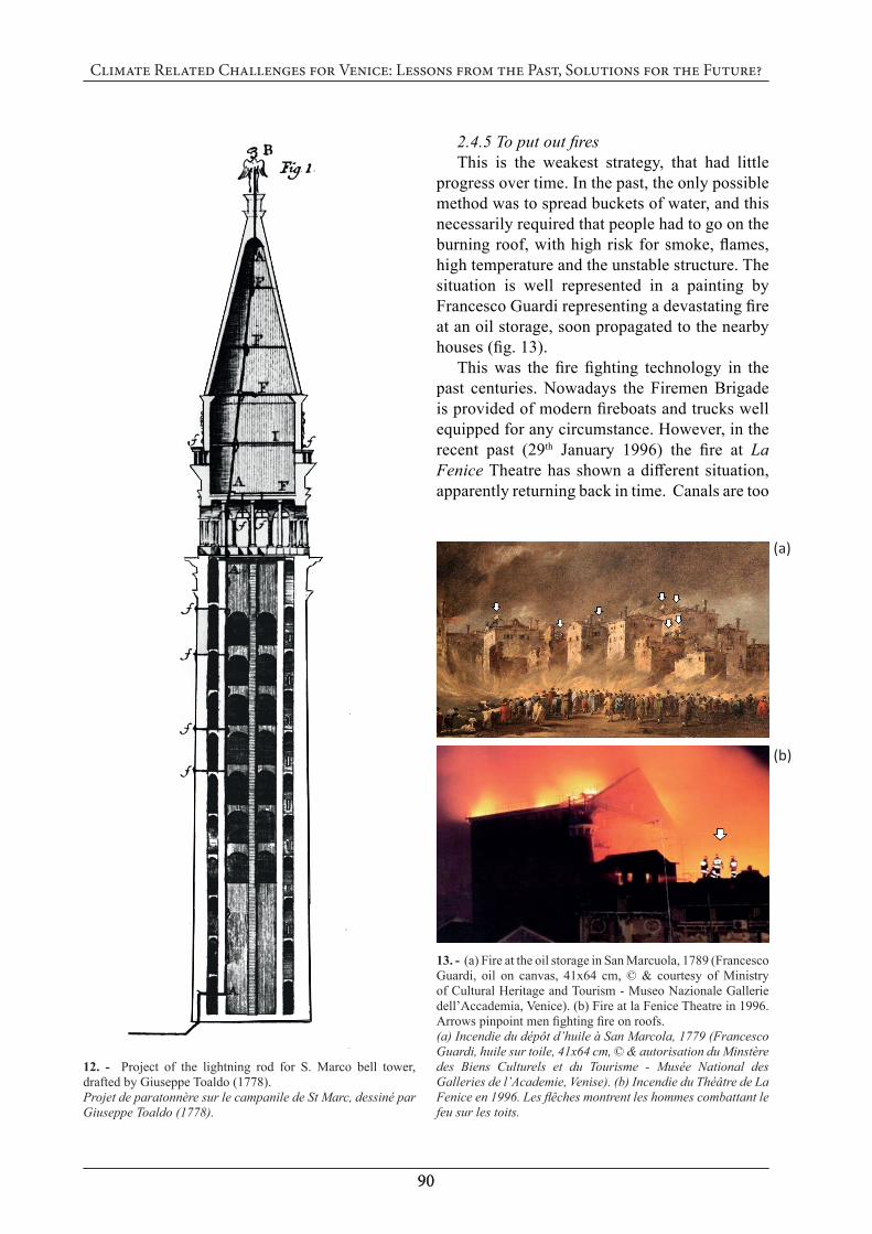
2.4.5 To put out firesThis is the weakest strategy, that had little
progress over time. In the past, the only possible method was to spread buckets of water, and this necessarily required that people had to go on the burning roof, with high risk for smoke, flames, high temperature and the unstable structure. The situation is well represented in a painting by Francesco Guardi representing a devastating fire at an oil storage, soon propagated to the nearby houses (fig. 13).
This was the fire fighting technology in the past centuries. Nowadays the Firemen Brigade is provided of modern fireboats and trucks well equipped for any circumstance. However, in the recent past (29th January 1996) the fire at La Fenice Theatre has shown a different situation, apparently returning back in time. Canals are too
12. - Project of the lightning rod for S. Marco bell tower, drafted by Giuseppe Toaldo (1778).Projet de paratonnère sur le campanile de St Marc, dessiné par Giuseppe Toaldo (1778).
13. - (a) Fire at the oil storage in San Marcuola, 1789 (Francesco Guardi, oil on canvas, 41x64 cm, © & courtesy of Ministry of Cultural Heritage and Tourism - Museo Nazionale Gallerie dell’Accademia, Venice). (b) Fire at la Fenice Theatre in 1996. Arrows pinpoint men fighting fire on roofs.(a) Incendie du dépôt d’huile à San Marcola, 1779 (Francesco Guardi, huile sur toile, 41x64 cm, © & autorisation du Minstère des Biens Culturels et du Tourisme - Musée National des Galleries de l’Academie, Venise). (b) Incendie du Théâtre de La Fenice en 1996. Les flêches montrent les hommes combattant le feu sur les toits.
(a)
(b)
9191
Dario Camuffo, Francesca Becherini, Antonio Della Valle
narrow and bridges too low for large or medium fireboats with water cannons that may be useful on the Grand Canal or on the border of islands. Streets are too narrow as well, and interrupted with stair stepped bridges, making not possible the passage of trucks that in turn may be used in the Venice hinterland. Briefly, the city centre can only be reached with very small boats with limited technological apparatus. The Firemen Brigade was obliged to operate from roofs, in a situation not much different from the past except for some pumps to uptake water from canals and some long fire hoses.
The only realistic solution is to organize a network of fire hydrants in all streets and squares, but this has not been taken seriously for fear of the many difficulties and related costs.
3. Conclusions
The sea level is rising at accelerated rate and the buildings of the XIV century sunk by 1.20 m. For most of them the sea has reached or even exceeded the ground floor. Storm surges are increasing in frequency and height at exponential rate. MOSE, the mobile dam system, will likely improve the situation for some decades, but cannot be a long-term solution. Further research is needed to find a fully satisfactory, durable solution.
Even with global warming, extreme cold spells are likely to return, freezing water in the Lagoon. The bridge connecting the city to the mainland has solved the siege problem and allows the free transportation of food and other goods. However, internal shipping remains dangerous for the floating ice slab and the wildlife is still at risk with fish frozen in the marshes and marine birds with legs trapped in the ice slab.
In the past various measures have been adopted to reduce fire risk; in particular, genial chimneys and lightning roads have been an effective remedy. However, because of the small canals, streets and bridges, fire boats and trucks are unable to reach the city centre. A network of fire hydrants should be a priority.
Acknowledgements
The authors are especially grateful to the following persons who have made possible this study: Dr Rossella Granziero (Correr Museum, Venice); Dr Paola Marini, Dr Rossella Battaglia and Mrs Diana Ziliotto, Ministry of Cultural Heritage and Tourism – Museo Nazionale Gallerie dell’Accademia, Venice; Dr Maria Paola Lamarina, Civic Museums, Treviso; Mr Daniele Resini, Mrs Elena Fumagalli and Dr Manuela Lamberti (Insula spa, Venice); Mr Giorgio Marcoaldi, CEMultimedia - Consorzio Venezia Nuova, Venice, for having kindly supplied visual art and documentation. The Frogmen Team of the Italian National Police, Venice, made the underwater measurements concerning the monumental stairs in the Grand Canal. Last but not least, Prof Chiara Bertolin, Norwegian University of Science and Technology (NTNU), Trondheim, Norway, for her cooperation over the past years. This study was made in the framework of the EU-funded project Climate for Culture (Grant 226973).
References
BONDESAN, M., GATTI, M., RUSSO, P. - Vertical Ground Movements Obtained from IGM Levelling Surveys. In: Illustrative Notes of the Geomorphological Map of the Po Plain. Castiglioni, G., B. and Pellegrini, G., B. (eds.). Suppl. Geogr. Fis. Dinam. Quat. 4, 2001, p.141–148.
CAMUFFO, D. - Le niveau de la mer à Venise d’après l’œuvre picturale de Véronèse, Canaletto et Bellotto. Rev Hist Mod Contemp, 57(3), 2010, p.92-110.
CAMUFFO, D., STURARO, G. - Sixty-cm submersion of Venice discovered thanks to Canaletto’s paintings. Climatic Change, 58, 2003, p.333-343.
CAMUFFO, D., STURARO, G. - Use of proxy-documentary and instrumental data to assess the risk factors leading to sea flooding in Venice. Global and Planetary Change, 40, 2004, p.93-103.
9292
Climate Related Challenges for Venice: Lessons from the Past, Solutions for the Future?
CAMUFFO, D., BERTOLIN, C., CRAIEVICH, A., GRANZIERO, R., ENZI, S. - When the Lagoon was frozen over in Venice from A.D. 604 to 2012: evidence from written documentary sources, visual arts and instrumental readings. Méditerranée – Revue géographique des pays méditerranéens, Varia, 2016, p.1-58.
CAMUFFO, D. - Freezing of the Venetian Lagoon since the 6th Century AD, in Comparison to the Climate of Western Europe and England. Climatic Change, 10, 1987, p.43-66.
CAMUFFO, D. - Analysis of the Sea Surges at Venice from A.D. 782 to 1990, Theoretical and Applied Climatology, 47, 1993, p.1-14.
CAMUFFO, D. - A thousand years of fire pol-lution-environmental impact on Venice. Fire International, 176, 2000, p.12-14.
CAMUFFO, D., BERTOLIN, C., SCHENAL, P. - A novel Proxy and the Sea Level Rise in Venice, Italy, from 1350 to 2014. Climatic Change 143(1), 2017, p.73-86.
CAMUFFO, D., BERTOLIN, C., SCHENAL., P., CRAIEVICH, A., GRANZIERO, R. - The Little Ice Age in Italy from documentary proxies and early instrumental records. In: Le Petit Age Glaciaire autour de la Méditerranée. Special issue of: Méditerranée – Revue géographique des pays méditerranéens, Morange, C. and Darques, R. (eds). 122, 2014, p.17-30.
CAMUFFO, D., SECCO, C., BRIMBLE-COMBE, P., MARTIN-VIDE, J. - Sea Storms in the Adriatic Sea and the Western Mediter-ranean During the Last Millennium. Climatic Change, 46, 2000, p.209-223.
CANESTRELLI, P., MORETTI, F. - I model-li statistici del comune di Venezia per la pre-visione della marea: valutazioni e confronti sul quinquennio 1997–2001, In: Atti Dell’Istituto Veneto di Scienze Lettere ed Arti, Tomo CLXII, 2004, p. 479–516.
CARBOGNIN, L., TEATINI, P., TOSI, L. - Eustasy and land subsidence in the Venice lagoon at the beginning of the new millennium. J. Marine Syst., 51, 2004, p.345-353.
CARMINATI, E., DOGLIONI, C., SCROCCA, D. - Magnitude and causes of long-term sub-sidence of the Po Plain and Venetian region. In: Flooding and Environmental Challenges for Venice and its Lagoon: State of Knowledge.
Fletcher, C.A., Spencer, T. (eds.). Cambridge University Press, Cambridge, 2005, p.21-28.
DA LIO, C., TOSI, L., ZAMBON, G., VIANEL-LO, A., BALDIN, G., LORENZETTI, G., MANFÈ, G., TEATINI, P. - Long-term groundwater dynamics in the coastal confined aquifers of Venice (Italy). Estuarine, Coastal and Shelf Science, 135, 2013, p.248-259.
ENZI, S., CAMUFFO, D. - Documentary Sources of Sea Surges in Venice from A.D. 787 to 1867. Natural Hazards, 12, 1995, p.225-287.
GATARO G. - 1405 Cronaca Carrarese codex Est. Ital. 1144 (now F.3.18). Bibliotheca Estensis, Modena. Reprinted by L. Muratori (eds.), Chronicon Patavinum Italica lingua conscriptum ab anno MCCCXI usque ad annum MCCCCVI, Rerum Italicaruum Scriptores XVII, Milano, 1730.
GATARO A. - 1406 Cronaca Carrarese codex Est. Ital. 1134 (now S.1.7). Bibliotheca Estensis, ModenA. Reprinted by L. Muratori (eds.), Chronicon Patavinum Italica lingua conscriptum ab anno MCCCXI usque ad annum MCCCCVI, Rerum Italicaruum Scriptores XVII, Milano, 1730.
LIONELLO, P., CAVALERI, L., NISSEN, K., PINO, C., RAICICH, F., ULBRICH, U. - Severe marine storms in the Northern Adriatic: characteristics and trends. Physics and Chemistry of the Earth, 40-41, 2012, p. 93–105.
LIONELLO, P., MUFATO, R., TOMASIN, A. - Sensitivity of free and forced oscillations of the Adriatic Sea to sea level rise. Climate Research, 29(1), 2005, p. 23–39.
MEL, R., LIONELLO, P. - Probabilistic Dressing of a Storm Surge Prediction in the Adriatic Sea. Advances in Meteorology Volume 2016 (2016), Article ID 3764519, 8 pages.
PIRAZZOLI, P.A. - Did the Italian Government approve an obsolete project to save Venice? - Eos, Transactions, American Geophysical Union, 83(20), 14 May 2002, p.217-223.
ROBINSON, A. R., TOMASIN, A., ARTEGIANI, A. - Flooding of Venice: phenomenology and prediction of the Adriatic storm surge. Quarterly Journal of the Royal Meteorological Society, 99 (422), 1973, p. 688–692.
9393
Dario Camuffo, Francesca Becherini, Antonio Della Valle
STROZZI, T., TEATINI, P., TOSI, L. - TerraSAR-X reveals the impact of the mobile barrier works on the Venice coastal stability. Remote Sens. Environ., 113, 2009, p.2682-2688.
TING, M., KUSHNIR, Y., SEAGER, R., LI, C. - Robust features of Atlantic multi‐decadal variability and its climate impacts. Geophys. Res. Lett., 38, L17705, 2011. doi:10.1029/2011GL048712.
TOALDO, G. - Dei conduttori per preservare gli edifizi da’ fulmini. Storti, Venice, 1778, p.104.
TOSI, L., DA LIO, C., STROZZI, T., TEATINI, P. - Combining L- and X-Band SAR Interferometry to Assess Ground Displacements in Heterogeneous Coastal
Environments: The Po River Delta and Venice Lagoon, Italy. Remote Sens. 8 (308), 2016, p.1-22.
TOSI, L., TEATINI, P., STROZZI, T. - Natural versus anthropogenic subsidence of Venice. Nature Scientific Reports, 3:2710, 2013. doi:10.1038/srep02710.
UMGIESSER, G., CANU, D. M., CUCCO, A., SOLIDORO, C. - A finite element model for the Venice Lagoon. Development, set up, calibration and validation. Journal of Marine Systems, 51(1–4), 2004, p. 123–145.
ZENDRINI, B. - Memorie storiche dello stato antico e moderno delle lagune di Venezia. Book 7. Stamperia del Seminario, Padua, 1811.