OBSERVATION AND REPLY To, Date - Environmental ...
330
OBSERVATION AND REPLY To, Date: ____ Member Secretary, State Level Environment Impact Assessment Authority Haryana Bays no. 55-58, Paryantan Bhawan Sector-2, Panchkula Subject: Reply of Observation raised during 22 nd EAC meeting dated 08.09.2017 for Environment Clearance for Sand Minor Minerals at at Nagli Block YNR/B-15 (Area-77.25 Ha.) Village- Nagli, Tehsil- Radaur, District-Yamuna Nagar, Haryana for the production capacity of 28.00 Lakh TPA By M/s M.P. Traders. Dear Sir, With reference to above subjected project which was considered in 22 nd EAC meeting held on 08.09.2017 for appraisal of Environmental Clearance. During the EAC meeting the members member of EAC have raised certain points for their reply before granting the environment clearance. The point wise reply of the same is given below for your kind perusal and for grant of Environment Clearance # Observation Reply/ Document 1. Comments of the Department of Mines and Geology, Haryana on the replenishment of the downstream area. Comments of the Department of Mines and Geology, Haryana on the replenishment of the downstream area is attached as Annexure-A. 2. Revised EIA Report after incorporating the correct emission rate, GLC of PM 10 & PM 2.5 , water requirement for the project, monitoring plan for free silica, assessment of impact on environment due to transportation on the five haul roads along with mitigation plan and budget for the same, summary of EIA report needs to be revised as the mining is not permitted outside the riverbed. 1. Revised EIA-Complied and attached as Annexure-B 2. GLC of PM 10 &PM 2.5 , - Given in Chapter-4 of revised EIA at page -84-89 3. Water requirement for the project- Given in chapter 2 of revised EIA at page 24-25. 4. Monitoring plan for free silica_ Given in revised EIA at page 91 and preventive measure elaborated at page 143 5. Assessment of impact on environment due to transportation on the five haul roads along with mitigation plan and budget for the same is given in Chapter 4 of revised EIA at Page 102. 6. Summary of EIA report has been revised accordingly. 3. The worst case scenario needs to be submitted (i.e. level of pollutants without using any mitigation measures). Detail of the worst case scenario given in the chapter 4 of revised EIA at page 91. 4. Legal Status of the bore-wells from which water will be withdrawn and permission of Central Ground Water Control Board for withdrawal of ground water. We have applied for permission for withdrawal of ground water to Central Ground Water Control Board, the proof of submission of Application is attached as Annexure-IV-B in EIA Report. We hope you would find the same in order your kind perusal as necessary action. For, M/s M.P. Traders. (Authorized Signatory) Encl :As above.
-
Upload
khangminh22 -
Category
Documents
-
view
0 -
download
0
Transcript of OBSERVATION AND REPLY To, Date - Environmental ...

OBSERVATION AND REPLY
To, Date: ____
Member Secretary,
State Level Environment Impact Assessment Authority
Haryana Bays no. 55-58, Paryantan Bhawan
Sector-2, Panchkula
Subject: Reply of Observation raised during 22nd
EAC meeting dated 08.09.2017 for Environment
Clearance for Sand Minor Minerals at at Nagli Block YNR/B-15 (Area-77.25 Ha.) Village- Nagli, Tehsil-
Radaur, District-Yamuna Nagar, Haryana for the production capacity of 28.00 Lakh TPA By M/s M.P.
Traders.
Dear Sir,
With reference to above subjected project which was considered in 22nd EAC meeting held on 08.09.2017 for
appraisal of Environmental Clearance. During the EAC meeting the members member of EAC have raised
certain points for their reply before granting the environment clearance. The point wise reply of the same is
given below for your kind perusal and for grant of Environment Clearance
# Observation Reply/ Document
1. Comments of the Department of Mines and
Geology, Haryana on the replenishment of the
downstream area.
Comments of the Department of Mines and Geology,
Haryana on the replenishment of the downstream area is
attached as Annexure-A.
2. Revised EIA Report after incorporating the
correct emission rate, GLC of PM10 & PM2.5,
water requirement for the project, monitoring
plan for free silica, assessment of impact on
environment due to transportation on the five
haul roads along with mitigation plan and
budget for the same, summary of EIA report
needs to be revised as the mining is not
permitted outside the riverbed.
1. Revised EIA-Complied and attached as Annexure-B
2. GLC of PM10 &PM2.5, - Given in Chapter-4 of revised
EIA at page -84-89
3. Water requirement for the project- Given in chapter
2 of revised EIA at page 24-25.
4. Monitoring plan for free silica_ Given in revised EIA
at page 91 and preventive measure elaborated at page
143
5. Assessment of impact on environment due to
transportation on the five haul roads along with
mitigation plan and budget for the same is given in
Chapter 4 of revised EIA at Page 102.
6. Summary of EIA report has been revised accordingly.
3. The worst case scenario needs to be submitted
(i.e. level of pollutants without using any
mitigation measures).
Detail of the worst case scenario given in the chapter 4 of
revised EIA at page 91.
4. Legal Status of the bore-wells from which
water will be withdrawn and permission of
Central Ground Water Control Board for
withdrawal of ground water.
We have applied for permission for withdrawal of ground
water to Central Ground Water Control Board, the proof of
submission of Application is attached as Annexure-IV-B
in EIA Report.
We hope you would find the same in order your kind perusal as necessary action.
For, M/s M.P. Traders.
(Authorized Signatory)
Encl :As above.

Annexure-A

Annexure-A

Annexure-A

Annexure-A

Annexure-A

Annexure-A

Annexure-A

To, Date:
The Director
Expert Appraisal Committee (Non-coal Mining)
Ministry of Environment Forest and Climate Change
Indira Paryavaran Bhawan, Jor Bagh Road
New Delhi-110003
Subject: Submission of Revised Final EIA/EMP Report of proposed Sand Mining at Nagli Block YNR/B-15 (area-
77.25 Ha.) with Production Capacity-28,00,000 TPA in District Yamunanagar Haryana, Environmental Clearance
regarding.
Reference: As per MOM of 22nd EAC meeting held on 18.09.2017
Sir,
With respect to the EIA notification dated 14.09.2006 and consecutive amendments, the final EIA report was
submitted online on 08.06.2017 and 17.08.2017 and the proposal was considered during the EAC meeting held
during 18-19th September, 2017 for consideration of the EC. After due deliberation the committee decided that the
PP should submit the revised EIA in line of suggested observations, accordingly we are submitting revised EIA
report and point wise replies for kind perusal and necessary action.
Thanking You
Yours Faithfully
For M/s M.P. TRADERS
(Authorized Signatory)
Encl: As Above

REVISED FINAL ENVIRONMENTAL IMPACT ASSESSMENT REPORT AND ENVIRONMENTAL MANAGEMENT PLAN
FOR MINING OF SAND FROM YAMUNA RIVER BED
AT VILLAGE- NAGLI, TEHSIL- RADAUR,
DISTRICT- YAMUNA NAGAR, HARYANA MINE LEASE AREA- 77.25 HA
MINE LEASE PERIOD - 10 YEARS PRODUCTION CAPACITY-28.00 LAKHS TONS PER ANNUM
STUDY PERIOD: 1ST DECEMBER TO 28TH FEBUARY, 2017 [CATEGORY ‘A’ AS MINING AREA IS MORE THAN 50 HACTARE]
APPLICANT VEDPAL MANDHAN M/s M.P. TRADERS
Near Nirankari Colony, Karnal Road Indri, Yamuna Nagar Haryana-135001
Haryana-135001
Rev.02_2017
ENVIRONMENT CONSULTANT
VARDAN ENVIRONET (QCI/NABET ACCREDITED NO. NABET/EIA/1619/RA 0037)
D-142, SUSHANT LOK-III, SECTOR 57 GURGAON (HARYANA)
E-Mail: [email protected] Contact: 0124-4291036, 09899651342, +91 9810355569
FINAL EIA (2017)
Mining of Sand (Minor Mineral) at Nagli Block YNR/B-15 (area-77.25 Ha.) Final EIA/EMP Report Village- Nagli, Tehsil-Radaur, District-Yamuna Nagar, Haryana.
Page i | (Revision History)
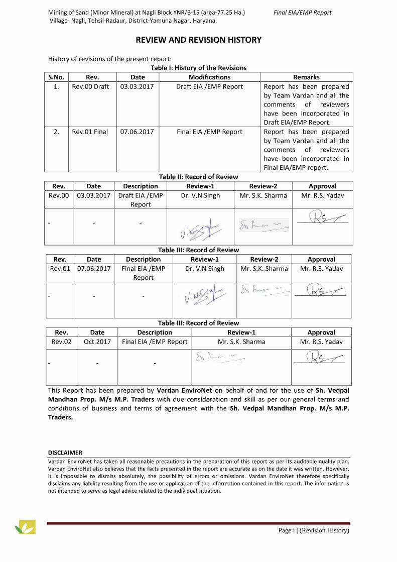
REVIEW AND REVISION HISTORY History of revisions of the present report:
Table I: History of the Revisions
S.No. Rev. Date Modifications Remarks
1. Rev.00 Draft 03.03.2017 Draft EIA /EMP Report Report has been prepared by Team Vardan and all the comments of reviewers have been incorporated in Draft EIA/EMP Report.
2. Rev.01 Final 07.06.2017 Final EIA /EMP Report Report has been prepared by Team Vardan and all the comments of reviewers have been incorporated in Final EIA/EMP report.
Table II: Record of Review
Rev. Date Description Review-1 Review-2 Approval
Rev.00 03.03.2017 Draft EIA /EMP Report
Dr. V.N Singh Mr. S.K. Sharma Mr. R.S. Yadav
-
-
-
Table III: Record of Review
Rev. Date Description Review-1 Review-2 Approval
Rev.01 07.06.2017 Final EIA /EMP Report
Dr. V.N Singh Mr. S.K. Sharma Mr. R.S. Yadav
-
-
-
Table III: Record of Review
Rev. Date Description Review-1 Approval
Rev.02 Oct.2017 Final EIA /EMP Report Mr. S.K. Sharma Mr. R.S. Yadav
-
-
-
This Report has been prepared by Vardan EnviroNet on behalf of and for the use of Sh. Vedpal Mandhan Prop. M/s M.P. Traders with due consideration and skill as per our general terms and conditions of business and terms of agreement with the Sh. Vedpal Mandhan Prop. M/s M.P. Traders. DISCLAIMER
Vardan EnviroNet has taken all reasonable precautions in the preparation of this report as per its auditable quality plan. Vardan EnviroNet also believes that the facts presented in the report are accurate as on the date it was written. However, it is impossible to dismiss absolutely, the possibility of errors or omissions. Vardan EnviroNet therefore specifically disclaims any liability resulting from the use or application of the information contained in this report. The information is not intended to serve as legal advice related to the individual situation.

QCI-NABET Scheme for accreditation of EIA Consultant Organisations/Version 3/June 2015
DECLARATION BY CONSULTANT
Page ii
NABET Annexure – VII
Declaration by Experts contributing to the EIA of M/s M.P. Traders at Nagli Block/YNR B-15 village
Nagli, Tehsil-Raradur, District- Yamunanagar.
Declaration by Experts contributing to the EIA:
I, hereby, certify that I was part of the EIA team in the following capacity that developed the above
EIA.
EIA Co-ordinator:
Name : Mr. S.K Sharma
Signature & Date :
Period of involvement : December, 2016 – Till date
Contact information : D-142, Sector-57, Sushant Lok-III, Golf Course Extension Road,
Gurgaon (Haryana)
Contact no: 9899651342
Email: [email protected]
Functional Area Experts (FAEs):
S.No. Functional
Areas
Name of the
expert/s
Involvement during
December , 2016 – Till date
Signature & Date
1. AP Mr. S.k Sharma
FAA
Monika Gupta
a) Identifying the sources of emissions and
mitigation measures.
b) Site-specific micro meteorology monitoring.
C) Ambient Air Quality (AAQ) monitoring
Impact predictions and mitigations.

QCI-NABET Scheme for accreditation of EIA Consultant Organisations/Version 3/June 2015
DECLARATION BY CONSULTANT
Page iii
d) Impact identification
2. WP Mr. S.k
Sharma
a) selection of sampling locations
b) Ground water quality monitoring and
assessment, impacts on water environment
and mitigations.
b) Identification, characterisation of
effluent and treatments there of
c) Water balance and conservation measures
3. SHW
Mr. SK
Sharma
a) Identification of haz, solid w.g, and their
disposal and mitigation measure.
b) Recycling and disposal
4. SE Ms. Shilpa
Mishra
FAA
Mr. Bhagwan
Sahay
a) Determination of demographic profile
including socio economy & livelihood
b) Assessing the changes in socio economic
pattern
5. EB
Dr. Vivek
Naryan singh
Involvement during
December , 2016 – Till date
a) Biological environment status in respect
of terrestrial fauna and aquatic eco system
b) Impact on ecological environment
6. HG/Geo
Mr. R.S Yadav
a) Ground water resource assessment
b) Impact on ground water potential and
mitigation measures for avoiding ground
water contamination.

QCI-NABET Scheme for accreditation of EIA Consultant Organisations/Version 3/June 2015
DECLARATION BY CONSULTANT
Page iv
7. AQ Mr. Asif
Hussain
FAA
Avi
a) Processing of site specific micro-
meteorological data.
b) Collection and use of data for modelling.
c) Air dispersion modelling for prediction of
GLCS due to PM10, S02 and Nox
8. NV Mr. Asif
Hussain
FAA
Ms. Neha Jain
a) Analysis of ambient noise quality data
b) Impact due to plant noise and abatement
measures
9. LU Mr. Asif
Hussain
FAA
Mr. Bhagwan
Sahay
a) Analysis of data related to land use pattern
b) Land use map development.
c) Impact on land environment in respect to
land form change
10.
RH Mr. Kuldipak Ahuja
a ) Identification of hazardous prone areas
b) Environment risk evaluation
c) On-site and Off-site emergency planning
11.
SC Mr. S. K
Sharma
a) Monitoring, analysis and characterisation
of soil
b) Assessment of impact on soil quality and
mitigation measure.

QCI-NABET Scheme for accreditation of EIA Consultant Organisations/Version 3/June 2015
DECLARATION BY CONSULTANT
Page v
Declaration by the Head of the accredited consultant organization/ authorized person
I, R.S. Yadav, hereby, confirm that the above mentioned Sand mining case of M/s M.P. Traders at Nagli
Block/YNR B-15.
I, hereby, certify that I was a part of the EIA team in the following capacity that developed the above
EIA.
I also confirm that I shall be fully accountable for any mis-leading information mentioned in this
statement.
Name: R.S.Yadav
Signature
Designation: Managing Director
Name of the EIA Consultant Organization: Vardan Environet, QCI/NABET Accredited Environment
Consultancy
NABET Certificate No. & Issue Date: NABET/EIA/1619/RA0037 valid up-to 09.11.2019.

Mining of Sand (Minor Mineral) at Nagli Block YNR/B-15 (area-77.25 Ha.) Final EIA/EMP Report Village- Nagli, Tehsil-Radaur, District-Yamuna Nagar, Haryana.
Page | vi
TABLE OF CONTENTS
Chapter Title Page No.
i Review And Revision History i
ii NABET Annexure ii-v
iii Table of Content vi-xi
iv List of Tables xii-xiii
v List of Figures xiii-xiv
vi Abbreviations xiv-xvi
vii TOR Compliance xvii-xxxv
1 INTRODUCTION 1-8
1.0 Purpose of the Project 1
1.1 Details of mining activity and LOI 1
1.2 Identification of Project and Project Proponent 2
1.3 Brief Description of Nature, Size, Location of the Project and its Importance to the Country Region
2
1.4 Scope of the Study 7
1.4.1 Preparation of EIA 7
1.5 Laws applicable to this project 8
2 PROJECT DESCRIPTION 9-26
2.0 General 9
2.1 Type of the project 9
2.2 Need for the project 9
2.3 Description of mine lease area 9
2.3.1 Location of the Project 9
2.3.2 Site Location 11
2.3.3 Five mining project are present in 10 Km radius 12
2.4 Size or magnitude of operation (Incl. associated activities required by the project.
13
2.4.1 Topography of the area 13
2.4.2 Geology 13
2.4.2.1 Regional geology 13
2.4.2.2 Local Geology 15
2.4.3 Sediment Composition 15
2.4.4 Physiography 16
2.4.5 Drainage 16
2.4.6 Climate 17
2.4.7 Rainfall 17
2.5 Seismicity of the area 17
2.5.1 Largest Instrumented Earthquake in Haryana 18
2.5.2 Conclusion 19
2.6 Floods 19
2.6.1 History of Flood in Yamuna Nagar 19
2.7 Exploration and reserves 21
2.7.1 Method of estimation of reserve 21
2.7.2 Reserves estimation 21
2.7.3 Geological Reserves 21
2.7.4 Mineable reserves 22

Mining of Sand (Minor Mineral) at Nagli Block YNR/B-15 (area-77.25 Ha.) Final EIA/EMP Report Village- Nagli, Tehsil-Radaur, District-Yamuna Nagar, Haryana.
Page | vii
2.7.5 Details of Production and Dispatches of Five Years 22
2.7.6 Life of mine 22
2.8 Mining methodology 22
2.8.1 Mining in riverbed 22
2.8.2 Reclamation of Mined out Area 23
2.9 Extent of Mechanization 23
2.10 Transportation 23
2.11 Drainage near mine site 23
2.12 Waste management 23
2.13 Use of Mineral 24
2.14 Land Use Pattern at various stages 24
2.15 Utilities and site facilities 24
2.15.1 Water Requirement 24
2.15.2 Manpower Requirement 25
2.15.3 Power Requirement 25
2.15.4 Infrastructure/Site Services 25
2.16 Statutory obligations and litigation 25
2.16.1 Statutory Obligations 25
2.16.2 Litigation 25
2.17 Summary 26
3 DESCRIPTION OF THE ENVIRONMENT 27-81
3.0 General 27
3.1 Land Environment 28
3.1.1 Data used 28
3.1.2 Methodology 28
3.1.3 Observation of Land Use Study 28
3.1.4 Topography 28
3.1.5 Mine Drainage 29
3.2 Seismicity of the area 29
3.3 Floods 33
3.4 Meteorology 33
3.4.1 Climate of the Area 33
3.4.2 Rainfall of the Area 33
3.4.3 Meteorological Status at the Project Site 33
3.4.4 Relative humidity 34
3.4.5 Wind speed / wind rose diagram 34
3.5 Ambient Air Quality 35
3.5.1 Selection of Sampling Station 35
3.5.2 Baseline data 36
3.5.2.1 Sampling and Analytical Techniques and Instruments Used for Sampling 36
3.5.3 Interpretation of Results 37
3.6 Noise environment 40
3.6.1 Noise Analysis within the Study Area 40
3.6.2 Methodology Adopted for Selection of Sampling Station 40
3.6.3 Result of Noise Monitoring 40
3.7 Water Environment 43
3.7.1 Methodology Adopted for Selection of Sampling Station 43
3.7.2 Results 47
3.8 Soil Environment 48

Mining of Sand (Minor Mineral) at Nagli Block YNR/B-15 (area-77.25 Ha.) Final EIA/EMP Report Village- Nagli, Tehsil-Radaur, District-Yamuna Nagar, Haryana.
Page | viii
3.8.1 Soil Profile of district Yamuna Nagar 48
3.8.2 Soil Quality 48
3.8.3 Methodology adopted for Selection of Sampling Station 48
3.8.4 Interpretation of Results 50
3.9 Traffic Study 51
3.9.1 Conclusion 53
3.10 Baseline Status For Flora And Fauna 56
3.10.1 Methodology for Terrestrial Ecology 56
3.10.2 Methodology for Inland Water Sampling 58
3.10.3 Terrestrial Floral and Faunal Components of the Study Area 58
3.10.4 Floral Diversity of the Study Area 61
3.10.4.1 Trees 61
3.10.4.2 Shrubs 63
3.10.4.3 Herbs 64
3.10.4.4 Climbers and Twiners 66
3.10.5 Cultivated Plants in the Study Area 65
3.10.6 Rare and Endangered Flora in the Study Area 66
3.10.7 Endemic Plants of the Study Area 67
3.10.8 Faunal Biodiversity of Study Area 67
3.10.8.1 Butterflies from the study area 69
3.10.8.2 Herpetofauna 69
3.10.8.3 Mammals 70
3.10.8.4 Fishes 70
3.10.8.5 Domestic Animals 70
3.10.8.6 Endemic Fauna of the Study Area 70
3.10.9 Conclusion 71
3.11 Socio-Economic Environment 71
3.11.1 Socio-Economic survey 74
3.12 Summary 80-81
4 ANTICIPATED ENVIRONMENTAL IMPACT AND MITIGATION MEASURES 82-106
4.0 Introduction 82 4.1 Environmental Impact Assessment 82
4.1.1 Construction Phase 82 4.1.2 Operation Phase 82 4.2 Prediction of Impacts and Mitigation Measures 83
4.3 Air quality modeling 83
4.3.1 ISCST3 dispersion model 83
4.3.1.1 Model Options Used For Computations 83
4.3.2 Model Set Up 83
4.3.2.1 Emission of PM10 83
4.3.2.2 Loading of Material 84
4.3.2.3 Emission of PM10 Due to Transportation 84 4.3.2.4 Emission of CO from vehicles 84 4.3.2.5 Summary of calculated emission rates 84 4.3.3 Meteorological data 85 4.3.4 Input Parameters 85
4.3.4.1 ISCST3 Model Input Parameters 85 4.3.4.2 Results 85 4.3.5 Conclusion 90 4.3.6 Mitigation Measures 90

Mining of Sand (Minor Mineral) at Nagli Block YNR/B-15 (area-77.25 Ha.) Final EIA/EMP Report Village- Nagli, Tehsil-Radaur, District-Yamuna Nagar, Haryana.
Page | ix
4.4 Impacts of air pollution and mitigation measures 91
4.4.1 Conclusion 92
4.5 Impacts of Noise Environment and Mitigation Measures 92
4.5.1 Conclusion 92
4.6 Impact on Water Environment 93
4.6.1 Conclusion 93
4.7 Impact on Land use and mitigation measures 94
4.7.1 Conclusion 94
4.8 Impacts on Soil Environment and mitigation measures 94
4.9 Impacts on Hydrology and mitigation measures 95
4.9.1 Conclusion 95
4.10 Impact on ecology and biodiversity and its mitigation measure 94
4.11 Impacts On Socio Economic and mitigation measures 98
4.12 Impacts due to solid waste/overburden and mitigation measures 101
4.13 Impacts on occupational health and safety 101
4.14 Traffic Environment 101
4.15 Impacts on Geology and Mitigation 103 4.16 Mine Closure Plan 104
4.16.1 General 104 4.16.2 Reason for Closure 104 4.16.3 Statutory Obligations 104 4.16.4 Disposal of Mining Machinery 105 4.16.5 Safety and security 105 4.16.6 Time Scheduling for Abandonment 105 4.16.7 Financial Assurance 105
4.17 Summary 105-106
5 ANALYSIS OF ALTERNATIVE SITE (TECHNOLOGY & SITE) 107-108
5.0 Introduction 107
5.1 Alternative for Mine Lease 107
5.2 Alternative for Technology and Other Parameters 107
5.3 Summary 108
6 ENVIRONMENTAL MONITORING PROGRAM 109-113
6.0 Introduction 109
6.1 Environmental Management Cell 109
6.1.1 Responsibilities for Environmental Management Cell (EMC) 110
6.2 Environmental Monitoring and Reporting Procedure 110
6.3 Monitoring Methodologies and Parameters 110
6.4 Monitoring Schedule 112
6.5 Locations of Monitoring Stations 112
6.6 Budget Allocation For Monitoring 113
6.7 Summary 113
7 ADDITIONAL STUDIES 114-131
7.0 General 114
7.1 Public consultation 114
7.1.1 Public Hearing Notice 114
7.1.2 Photographs of Public Hearing 111
7.1.3 Action plan as per Public Hearing Demand 116
7.2 Hazard identification and risk assessment methodology 123

Mining of Sand (Minor Mineral) at Nagli Block YNR/B-15 (area-77.25 Ha.) Final EIA/EMP Report Village- Nagli, Tehsil-Radaur, District-Yamuna Nagar, Haryana.
Page | x
7.2.1 Risks due to Inundation 123
7.2.2 Risks Due to Failure of Pit Slope 123
7.2.3 Risks due to Failure of Waste Dumps 123
7.2.4 Risks of Accidents due to Trucks and Dumpers 123
7.3 Disaster and its Management 124
7.3.1 Identification of Hazards 124
7.3.2 Sand Loading 124
7.3.3 Sand Transport 125
7.3.4 Sand Dumping and Storage 125
7.3.5 Heavy Machinery 125
7.3.6 Inundation / Flooding 125
7.3.7 Quick Sand Condition 126
7.3.8 Drowning 126
7.3.9 Mitigation of Hazards 126
7.3.9.1 Measures to Prevent Accidents during Sand Loading 126
7.3.9.2 Measures to Prevent Accidents during Sand Transportation 127
7.3.9.3 Safety Features Required in Tippers/Trucks 127
7.3.9.4 Measures to Prevent Accidents during Sand Dumping and Storage 127
7.3.9.5 Measures to Prevent Accidents due to Trucks/ Dumpers etc. 128
7.3.9.6 Measures to Prevent Dangerous Incidents during Inundation/Flooding 128
7.3.9.7 Measures to Prevent Quick Sand Condition 128
7.3.9.8 Measures to Prevent Drowning 128
7.3.9.9 Training and Human Resources Development 128
7.4 Occupational health hazards 129
7.4.1 Physical Hazards Due To Mining Operations 129
7.4.2 Medical Examination Schedule 129
7.5 Annual Replenishment of Minerals 130
7.6 Summary 130-131
8 PROJECT BENEFITS 132-133
8.0 General 132
8.1 Physical Benefits 132
8.2 Social Benefits 132
8.2.1 Environmental and social responsibility 132
8.3 Ecological Benefits 133
8.4 Summary 133
9 ENVIRONMENTAL COST BENEFIT ANALYSIS 134
9.0 Project cost 134
9.1 Environment cost analysis and project implementation 134
10 ENVIRONMENTAL MANAGEMENT PLAN 135-150
10.0 Introduction 135
10.1 Land Use Pattern 136
10.2 Air Environment Management 136
10.2.1 Control of Gaseous Pollution 136
10.2.2 Control of Dust Pollution 136
10.3 Noise and Vibration Environment 137
10.3.1 Noise Abatement and Control 137
10.3.2 Vibration Abatement 137

Mining of Sand (Minor Mineral) at Nagli Block YNR/B-15 (area-77.25 Ha.) Final EIA/EMP Report Village- Nagli, Tehsil-Radaur, District-Yamuna Nagar, Haryana.
Page | xi
10.4 Water Management 137
10.4.1 Surface Water Management 137
10.4.2 Ground Water Management 137
10.4.2 Waste Water Management 137
10.4.3 Water Conservation 137
10.5 Solid Waste And Top Soil Management 137
10.6 Green Belt Development 138
10.6.1 Plan for Link road and haulage road 138
10.7 Socio-Economic Environment 141
10.7.1 Management Plan for Socio-Economic Environment 141
10.8 Occupational Health And Safety 142
10.9 Cost of EMP Measures 143
10.10 Rehabilitation and Resettlement (R & R) 143
10.10.1 Mines and Minerals Development, Restoration and Rehabilitation Fund 144
10.11 Conservation plan for scheduled fauna in the study area 144
10.11.1 Conservation plan for Indian Peafowl (Peacock) 144
10.11.2 Conservation Plan For Schedule-I Species (Bengal monitor lizard) 147
10.11.3 Conservative Measures 148
10.11.4 Conclusion 149
10.11.5 Financial projection for conservation 149
10.12 Summary 149-150
11 Summary and Conclusion 151-155
11.0 General 151
11.1 Introduction 151
11.2 Project Description 151
11.3 Analysis of Alternatives 152
11.4 Description of The Environment 153
11.5 Anticipated Environmental Impacts and Mitigation Measures 154
11.6 Environmental Monitoring Program 154
11.7 Additional Studies 154
11.8 Project Benefit 155
11.9 Environmental Cost Benefit Analysis 155
11.10 Environmental Management Plan 155
11.11 Conclusion 155
12 DISCLOSURE OF CONSULTANTS ENGAGED 156
12.0 Introduction 156
12.1 Declaration 156
ANNEXURES
I Copy of TOR
II LoI
III Mining Plan and Progressive Mine Closure Plan Approval Letter
IV NOC Forest
V Vardan NABL Accrediation Certificate
VI(a) Air Report
VI(b) National Ambient Air Quality Standards, 2009
VII(a) Noise Report

Mining of Sand (Minor Mineral) at Nagli Block YNR/B-15 (area-77.25 Ha.) Final EIA/EMP Report Village- Nagli, Tehsil-Radaur, District-Yamuna Nagar, Haryana.
Page | xii
VII(b) Ambient Air Quality Standardsin Respect of Noise
VIII(a) Water Report
VIII(b) Indian Standard Drinking Water Specification
IX(a) Soil Report
IX(b) Standard Soil Classification
X Traffic Study
XI Environmental Policy
XII Public Hearing Proceedings
LIST OF TABLE
Table No. Title Page No.
1.1 Brief Description of the Project 2
2.1 Five Mining project are present in 10 Km radius 12
2.2 Details of Mining 13 2.3 Regional stratigraphic sequence 14 2.4 Catchment of River Yamuna 16
2.5 Details of Site Elevation 16 2.6 Loss Estimation at State Level 17
2.7 Loss Estimation at District Level 17 2.8 Major Earthquake in Haryana 18
2.9 List of Flood Prone Villages 20
2.10 Geological Reserves Estimation 22
2.11 Five Years Proposed Production Details (Tons/annum) 22
2.12 List of Machineries 23
2.13 Land Use Pattern at Various Stages 24
2.14 Employment Details 25
3.1 Land Use Pattern of the Study Area 28
3.2 Monthly Average Rainfall (in mm) (for year 2010-2014) 33
3.3 Meteorological Condition of the Study Area 34
3.4 Monthly Average Relative Humidity (%) 34
3.5 Ambient Air Quality Monitoring Stations 36 3.6 Testing Procedure Used for Determining Various Air Quality Parameters 36
3.7 Ambient Air Quality Monitoring Results in µg/m3 (Oct- December 2016) 36
3.8 Mineralogical composition of free Silica in PM10 37 3.9 Noise Monitoring Sampling Stations 40
3.10 Noise Levels in Study Area 40
3.11(a) List of Ground Water Quality Monitoring Stations 43 3.11(b) List of Surface Water Sampling Stations 43
3.12 Water Analysis Result (Ground Water) 45
3.13 Water Analysis Result (Surface Water) 46 3.14 Soil Monitoring Station 48 3.15 Soil Analysis Result No. of Vehicles per day 50 3.16 Roads and Highways in the Study Area 51 3.17 Number of Vehicles in existing road 52
3.18 Existing Traffic Scenario and LOS 52
3.19 Modified Traffic Scenario & LOS 53
3.20 List of Villages for Baseline study 56
3.21 Mode of data collection and parameters considered during the Survey 57 3.22 Trees in the Study area 61
3.23 List of Shrubs in the Study Area 63

Mining of Sand (Minor Mineral) at Nagli Block YNR/B-15 (area-77.25 Ha.) Final EIA/EMP Report Village- Nagli, Tehsil-Radaur, District-Yamuna Nagar, Haryana.
Page | xiii
Table No. Title Page No. 3.24 List of Herbaceous species observed in the study area 64
3.25 List of Climbers Observed in the Study Area 65
3.26 Schedule –I Bird(s) of Study Area 67
3.27 Systematic Lists of Birds in the Study Area 67
3.28 Butterflies in the Study Area 69
3.29 Reptiles and Amphibian in the Study Area 69
3.30 Mammals in Study Area 70
3.31 Fishes in the study area 70
3.32 Domestic Animals in Study area 70
3.33 List of Schedule –I and II Fauna Observed During the Study 71
3.34 List of the Villages for Field Surveyed during the study 75
3.35 Summarized Demographic Structure of the Study Area 75
3.36 Demographic structure of the study area (Karhera) 76
3.37 Occupational Structure of the Study Area 78
4.1 Emissions Rates 84 4.2 Predicted GLC of PM10 at Ambient Air Quality Monitoring Stations
(WORST CASE) 86
4.3 Predicted GLC of PM10 at Ambient Air Quality Monitoring Stations (WITH MITIGATION MEASURES)
87
4.4 Ecological Impact Assessment 96
4.5 Impact on Ecology due to Mining Activity 98
4.6 Impacts on socio economy and mitigation measures 96
6.1 Monitoring Methodologies and Parameters 110 6.2 Monitoring Schedule 112 6.3 Locations of Monitoring Stations 112 7.1 Check List for Likely Risks in Sand Mines 124 7.2 Medical Examination Schedule 130
9.1 Project Cost and Benefit 129 9.2 Environmental Cost Analysis 129
10.1 Plan for Afforestation 138 10.2 List of Species for Greenbelt Development 140 10.3 Budgetary outlets of greenbelt development for five years 140 10.4 Need Specific Proposed ESR Activities 141
10.5 Budget for Environmental and Social Responsibility 142
10.6 Budget for Occupational Health and Safety of the workers (Lakhs) 143
10.7 Budget for EMP 143
10.8 Budget for Conservation/Management Plan 149
LIST OF FIGURE
Figure No. Title Page No.
1.1 Key Plan showing the Environmental Settings of the Study area along with the Coordinates of Mine Lease area
5
1.2 Digitized map showing the Environmental Settings of the Study area 6
2.1 Location Map of the Project Site 10
2.2 Site visit Photographs 10
2.3 Connectivity route Map from proposed mine site to Tehsil Radaur 11
2.4 Google Image (Short View) of the Project Site 11
2.5 Google Image (Long View) of the Project Site 12
2.6 Map of the Proposed Mining Project are present in 10 Km Radius 13
2.7 Geological and Geomorphological Map of Haryana (Source: GSI) 15

Mining of Sand (Minor Mineral) at Nagli Block YNR/B-15 (area-77.25 Ha.) Final EIA/EMP Report Village- Nagli, Tehsil-Radaur, District-Yamuna Nagar, Haryana.
Page | xiv
Figure No. Title Page No.
2.8 Map of Intensity of Injured in Haryana 18
2.9 Flood Hazard Map of Haryana 21
2.10 Process Flow Chart of Mining of Sand 23
2.11 Water Balance 24
3.1 Land Use Pattern of the Study Area (10 km Radius from the Mine Site) 30
3.2 FCC Map of the Study Area (10 Km Radius from the Mine Site) 31
3.3 Drainage Map of the Study Area 32
3.4 Wind Rose Diagram of Study Area 35
3.5 Graph Showing PM10Concentration in µg/m3 37
3.6 Graph Showing PM2.5 Concentration in µg/m3 38
3.7 Graph Showing SO2 Concentration in µg/m3 38
3.8 Graph Showing NO2 Concentration in µg/m3 38
3.9 Key plan of Air Monitoring Stations 39
3.10 Noise Quality Monitoring Results 41
3.11 Key plan of Noise Monitoring Station 42
3.12 Key Plan of Water Sampling Stations 44
3.13 Key Plan of Soil Sampling Stations 49
3.14 Sampling Photographs for Air, Water, Noise and Soil 51
3.15 Showing the Typically Haul Road which is Connected to Highways for Transportation of Sand
54
3.16 Showing the Evacuation Gates & Haulage Road /Motorable Road Map 55
3.17 Aquatic Habitat of the Study Area 59
3.18 Terrestrial Habitat of the Study area 59
3.19 Agriculture Land of Study Area 60
3.20 Non agriculture Land of Study area 60
3.21 Scenario of Project site 61
3.22 Scrub area 61
4.1 Section showing variation in PM10 concentration in Pre-dominant direction 86
4.2 Graphical representation of model results ISCST3 Model Setup 86
4.3 Spatial distribution of predicted GLCs of PM10 (ISCST3) 88
4.4 Spatial distribution of predicted GLCs of PM10 (CALINE4) 89
4.5 Impact of Mining on Ground Water 93
6.1 Hierarchy of Environment System for Dealing Environmental Issues 109
7.1 Notice For Public Hearing 114
7.2 Government Officers present in Public Hearing 115
7.3 Local Public present for Public Hearing 115
7.4 Environment Consultants with Project Proponent at Public Hearing 115
7.5 Identification of Hazards in Mines 126
10.1 Flow Chart of EMP 135
10.2 Plantation Map 140
ABBREVIATIONS AAQM Ambient Air Quality Monitoring CM Centimeter CPCB Central Pollution Control Board dB Decibel DG Diesel Generator E East

Mining of Sand (Minor Mineral) at Nagli Block YNR/B-15 (area-77.25 Ha.) Final EIA/EMP Report Village- Nagli, Tehsil-Radaur, District-Yamuna Nagar, Haryana.
Page | xv
ABBREVIATIONS EIA Environmental Impact Assessment EMC Environmental Management Cell EMP Environmental Management Plan ENE East Of North- East EPA Environmental Protection Agencies ESE East Of South East FCC False Colour Composite GIS Geological Information System GPS Global Positioning System HP Horse Power Hr Hour IMD Indian Meteorological Department IRS Indian Remote Sensing Satellite ISCST Industrial Source Complex, Short Terms ISO International Organization Of Standardization ISS Indian Standard Specification KLD Kilo Litre Per Day Km Kilometer KVA Kilo Volt Ampere KW Kilo Watt M Meter M asl Mean Sea Level MCDR Mining Conservation & Development Rules M bgl Meter Below Ground Level mg Milligram MoEF&CC Ministry Of Environment Forest and Climate Change mRL Mean Reference Level MT Million Tonne MTPA Million Tonn s Per Annum N North NE North-East NH National Highway NNE North Of North-East NNW North Of North-West NO2 Nitrogen Dioxides NTU Naphelo Turbidity Unit NW North-West OB Over Burden OHSAS Occupational Health & Safety Assessment PPE Personal Protective Equipment PPM Part Per Million Pvt. Private R&R Rehabilitation & Resettlement RDS Respirable Dust Sampler RPM Respirable Particulate Matter RSPM Respirable Suspended Particulate Matter
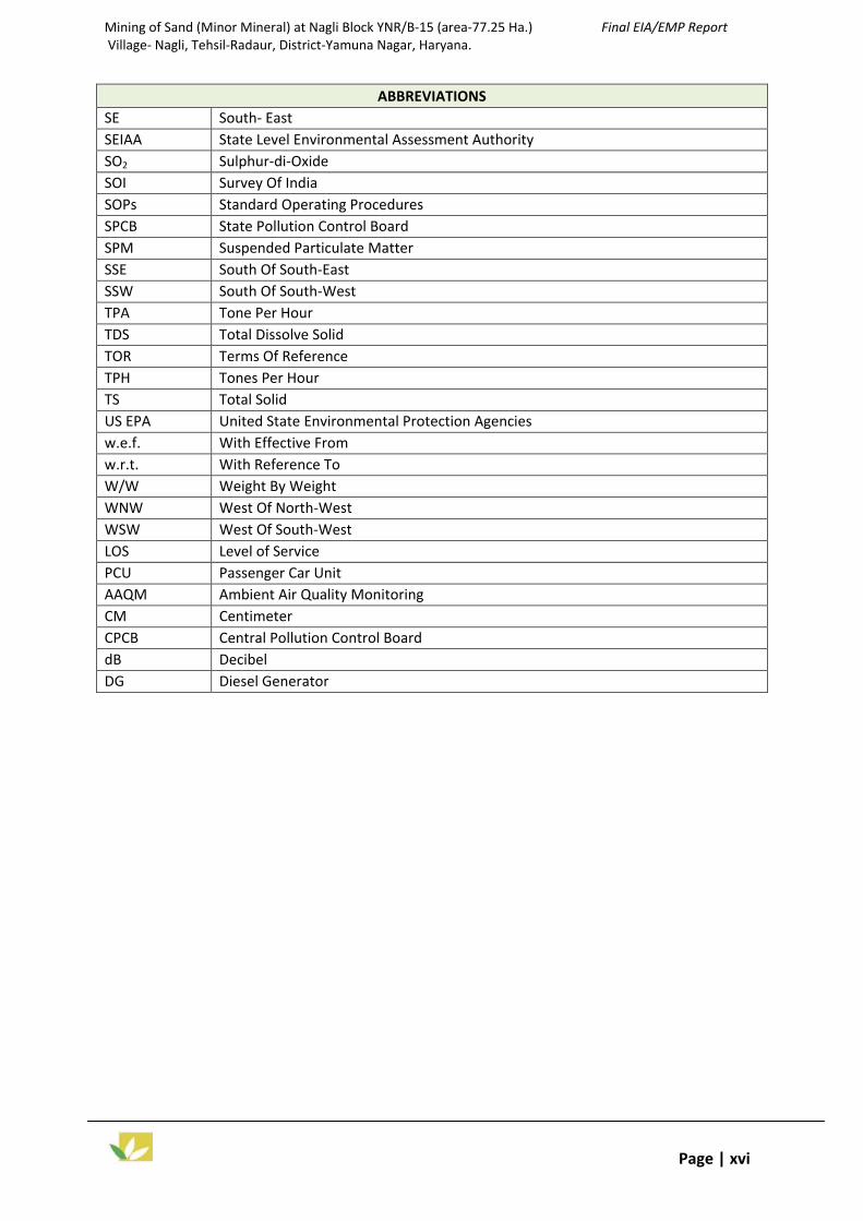
Mining of Sand (Minor Mineral) at Nagli Block YNR/B-15 (area-77.25 Ha.) Final EIA/EMP Report Village- Nagli, Tehsil-Radaur, District-Yamuna Nagar, Haryana.
Page | xvi
ABBREVIATIONS SE South- East SEIAA State Level Environmental Assessment Authority SO2 Sulphur-di-Oxide SOI Survey Of India SOPs Standard Operating Procedures SPCB State Pollution Control Board SPM Suspended Particulate Matter SSE South Of South-East SSW South Of South-West TPA Tone Per Hour TDS Total Dissolve Solid TOR Terms Of Reference TPH Tones Per Hour TS Total Solid US EPA United State Environmental Protection Agencies w.e.f. With Effective From w.r.t. With Reference To W/W Weight By Weight WNW West Of North-West WSW West Of South-West LOS Level of Service PCU Passenger Car Unit AAQM Ambient Air Quality Monitoring CM Centimeter CPCB Central Pollution Control Board dB Decibel DG Diesel Generator

Mining of Sand (Minor Mineral) at Nagli Block YNR/B-15 (area-77.25 Ha.) Compliance to ToR Conditions Village- Nagli, Tehsil-Radaur, District-Yamuna Nagar, Haryana
Vardan Environet, Sec-57, Gurgaon Haryana Page | xvii ToR Compliances
COMPLIANCE TO TOR CONDITIONS Point wise compliance of ToR issued by Ministry of Environment & Forests, New Delhi vide file No. J-11015/214/2016-IA.II (M) on dated 16.01.2017
for the project Mining of Sand (minor mineral) Mine-“Nagli Block/YNR B-15” Mine Lease Area –77.25 Ha. Capacity 28,00,000 TPA by M/s M.P. Traders.
ToR Description Reply Citation
1 Year-wise production details since 1994 should be given, clearly stating the highest production achieved in any one year prior to 1994. It may also be categorically informed whether there had been any increase in production after the EIA Notification, 1994 came into force w.r.t. the highest production achieved prior to 1994.
This is a fresh Mining Lease area auctioned by Govt. of Haryana and LOI was issued vide letter.DMG/HY/Cont/Nagli Block/YNR B-15//2016/5414 dated 20.10.2016 attached as Annexure II, no production is started yet. Production will be commenced only after obtaining Environmental Clearance from MOEF & CC GOI, Delhi and CTE/CTO from Haryana State Pollution Control Board, Panchkula. Hence, this is not applicable for the proposed Mining Project.
Annexure-II.
2 A copy of the document in support of the fact that the Proponent is the rightful lessee of the mine should be given.
The copy of letter of intent (LOI) of mining lease issued by Director of Mines & Geology Department, Chandigarh, Haryana, vide letter no. DMG/HY/Cont/Nagli Block/YNR B-15//2016/5414 dated 20.10.2016 was issued in favor of M/s M. P. Traders who has applied for Environmental Clearance, is enclosed as Annexure-II.
Annexure-II.
3 All documents including approved mine plan, EIA and public hearing should be compatible with one another in terms of the mine lease area, production levels, waste generation and its management and mining technology and should be in the name of the lessee.
All documents are synchronizing with one another in terms of mine lease area, production levels, waste generation, its management and mining technology and both the Final mining plan and ML area in the name of. M/s M. P. Traders Prop. Vedpal Mandhan who is the lessee of this project.

Mining of Sand (Minor Mineral) at Nagli Block YNR/B-15 (area-77.25 Ha.) Compliance to ToR Conditions Village- Nagli, Tehsil-Radaur, District-Yamuna Nagar, Haryana
Vardan Environet, Sec-57, Gurgaon Haryana Page | xviii ToR Compliances
4 All corner coordinates of the mine lease area, superimposed on a High Resolution Imagery/toposheet should be provided. Such an Imagery of the proposed area should clearly show the land use and other ecological features of the study area (core and buffer zone).
All corners of the coordinates of ML area are superimposed on topo sheet of survey of India Toposheet (OSM) No. H43L8, H43L5, H43R1, H43L4 Coordinates of the mine lease area.
Pillar No. Latitude Longitude
A N 29° 58’ 29” E 77° 13’ 47”
B N 29° 58’ 30” E 77° 13’ 50.5”
C N 29° 58’ 16” E 77° 13’ 48.5”
D N 29° 58’ 02” E 77° 13’ 46”
E N 29° 58’ 02” E 77° 13’ 45”
F N 29° 57’ 38” E 77° 13’ 45”
G N 29° 57’ 24” E 77° 13’ 37”
H N 29° 57’ 38” E 77° 13’ 13”
I N 29° 57’ 40” E 77° 13’ 20.5”
J N 29° 57’ 46” E 77° 13’ 27”
K N 29° 58’ 06” E 77° 13’ 28”
L N 29° 58’ 10” E 77° 13’ 32”
M N 29° 58’ 10” E 77° 13’ 39”
N N 29° 58’ 15” E 77° 13’ 43”
O N 29° 58’ 15” E 77° 13’ 42”
P N 29° 58’ 25” E 77° 13’ 42”
Imagery of the proposed area clearly shows the land use and other ecological features of the study area (core and buffer zone) for Land use and High resolution Imagery FCC maps are prepared with use a RS–GIS technique.
Chapter-1, Figure 1.1 at Page 5. Chapter-3, Figure 3.1 & 3.2 at Page 30 & 31.
5 Information should be provided in Survey of India Toposheet in 1:50,000 scale indicating geological map of the area, geomorphology of land forms of the area, existing minerals and mining history of the area, important water bodies, streams and rivers and soil characteristics.
All maps are provided superimposed on toposheet of survey of India in 1:50,000 scale showing all land forms of the area, important water bodies, streams and rivers etc. Geological & Geomorphological map of Haryana state is given.
Chapter-1, Figure 1.1 at Page 5. Chapter-2, Figure 2.7 at Page 15.

Mining of Sand (Minor Mineral) at Nagli Block YNR/B-15 (area-77.25 Ha.) Compliance to ToR Conditions Village- Nagli, Tehsil-Radaur, District-Yamuna Nagar, Haryana
Vardan Environet, Sec-57, Gurgaon Haryana Page | xix ToR Compliances
6 Details about the land proposed for mining activities should be given with information as to whether mining conforms to the land use policy of the State; land diversion for mining should have approval from State land use board or the concerned authority.
As per revenue record land proposed for mining is riverbed area. The proposed area is 77.25 ha. falls in Nagli Block, Tehsil-Radaur, District-Yamunanagar, Haryana. The mining is carried out in Yamuna riverbed and mineral rights vest with Mining Department, Govt. of Haryana. Hence, there is no need of land diversion in this case.
Annexure II
7 It should be clearly stated whether the proponent company has a well laid down Environment Policy approved by its Board of Directors? If so, it may be spelt out in the EIA report with description of the prescribed operating process/ procedures to bring into focus any infringement/deviation/violation of the environmental or forest norms/ conditions? The hierarchical system or administrative order of the Company to deal with the environmental issues and for ensuring compliance with the EC conditions may also be given. The system of reporting of non-compliances/ violations of environmental norms to the Board of Directors of the Company and/or shareholders or stakeholders at large may also be detailed in the EIA report.
Yes, The company has formulated Environmental policy which is approved by M/s M.P. Traders and has been incorporated in EIA report. The operating process or the implementation of policy will be as follows: Compliance with all applicable environmental laws and regular maintenance of
their records. Acquaintance of all employees and contractors with their environmental
responsibilities. Focus on continuous improvement. Continuous review of environmental achievements. Half yearly submission of Compliance reports.
Closing of NCs and Conducting MRM.
The Policy contains the hierarchical system of the company to deal with the environmental issues and for ensuring the compliance with EC conditions. All the non compliances/violations of environmental laws will be reported to the Project Proponent.
Annexure XI Chapter-6, Item 6.1 at Page 109.
8 Issues relating to Mine Safety, including subsidence study in case of underground mining and slope study in case of open cast mining, blasting study
Mines safety for workers working at the site has been taken care of. Safety measures related to risks during mining activity, natural disasters, etc has been proposed. The details are incorporated in the EIA/EMP Report. This is an inside riverbed mining. There will be no underground mining; hence subsidence study is not required.
Chapter 7, Item 7.3 at Page 124.

Mining of Sand (Minor Mineral) at Nagli Block YNR/B-15 (area-77.25 Ha.) Compliance to ToR Conditions Village- Nagli, Tehsil-Radaur, District-Yamuna Nagar, Haryana
Vardan Environet, Sec-57, Gurgaon Haryana Page | xx ToR Compliances
etc. should be detailed. The proposed safeguard measures in each case should also be provided.
Slope Study As working will be done in the river bed to maximum depth of 3.0 m only, thus slope study is not required. Blasting Study This is a Sand (minor mineral) mining project, no blasting is proposed.
9 The study area will comprise of 10 km zone around the mine lease from lease periphery and the data contained in the EIA such as waste generation etc should be for the life of the mine/ lease period.
Study area comprises of 10 Km radius around the mine lease boundary. Map showing 10 Km radius of the ML area has been furnished in the EIA report and 10 Km radius of mine lease. All the data contained in the EIA/EMP Report are for lease period of mine. Minerals are generally depleting asset once mined; but minerals like sand will be replenished naturally. Lease period is 10 years. There will be no waste generation from mining operation as per mining plan.
Chapter-1, Figure 1.1 and Page 5. Chapter-2, Item 2.12 and Page 24.
10 Land use of the study area delineating forest area, agricultural land, grazing land, wildlife sanctuary, national park, migratory routes of fauna, water bodies, human settlements and other ecological features should be indicated. Land use plan of the mine lease area should be prepared to encompass preoperational, operational and Post-operational phases and submitted. Impact, if any, of change of land use should be given.
Land Use of the 10 Km study area delineating forest area, agricultural land, grazing land, wildlife sanctuary, National park, migratory routes of fauna, water bodies, human settlements and other ecological features has been incorporated.
Land use Area (In Ha.) % Area
Agricultural 17670.78 56.00
Grazing Land 10850.76 34.38
fallow land 979.38 3.10
Sand/river Bank 778.32 2.46
Settelment 958.26 3.03
Water bodies 318.87 1.01
Total 31556.37 100
Land use plan of the mine lease area showing the preoperational, operational and post operational phases is incorporated in the EIA/EMP Report.
Chapter-3, Table 3.1 at page 28 & Figure 3.1 at Page 30. Chapter-2, Table-2.13 at Page 24.

Mining of Sand (Minor Mineral) at Nagli Block YNR/B-15 (area-77.25 Ha.) Compliance to ToR Conditions Village- Nagli, Tehsil-Radaur, District-Yamuna Nagar, Haryana
Vardan Environet, Sec-57, Gurgaon Haryana Page | xxi ToR Compliances
11 Details of the land for any Over Burden Dumps outside the mine lease, such as extent of land area, distance from mine lease, its land use, R&R issues, if any, should be given.
River Bed: There is no generation of Overburden / waste material in case of river bed mining. There is no human settlement in lease area.Hence R&R is not applicable on this project.
Chapter-2, Item 2.12 at Page 23. Chapter-1, figure 1.1 at Page 5.
12 A Certificate from the Competent Authority in the State Forest Department should be provided, confirming the involvement of forest land, if any, in the project area. In the event of any contrary claim by the Project Proponent regarding the status of forests, the site may be inspected by the State Forest Department along with the Regional Office of the Ministry to ascertain the status of forests, based on which, the Certificate in this regard as mentioned above be issued. In all such cases, it would be desirable for representative of the State Forest Department to assist the Expert Appraisal Committees.
The Mining Lease area does not involve any forest land. The same has been confirmed by Forest Department vide letter No 7892 on dated 30.03.2017 is attached as Annexure IV.
Annexure-IV
13 Status of forestry clearance for the broken up area and virgin forestland involved in the Project including deposition of net present value (NPV) and compensatory afforestation (CA) should be indicated. A copy of the forestry clearance should also be furnished.
The land of the Mining lease area is Government land on the river bed of Yamuna and this area is free from any reservation of Forest Department Haryana Government. Letter from DFO, Yamuna Nagar vide letter No 7892 on dated 30.03.2017 attached as Annexure IV. Hence Forest Clearance is not applicable for the proposed project.
Annexure-IV

Mining of Sand (Minor Mineral) at Nagli Block YNR/B-15 (area-77.25 Ha.) Compliance to ToR Conditions Village- Nagli, Tehsil-Radaur, District-Yamuna Nagar, Haryana
Vardan Environet, Sec-57, Gurgaon Haryana Page | xxii ToR Compliances
14 Implementation status of recognition of forest rights under the Scheduled Tribes and other Traditional Forest Dwellers (Recognition of Forest Rights) Act, 2006 should be indicated.
There is no involvement of forest land in the project area as per Letter No. 7892 on dated 30.03.2017 attached as Annexure IV. Hence it is not applicable.
Annexure-IV
15 The vegetation in the RF/ PF areas in the study area, with necessary details, should be given.
Project area not falling under forest reserve. So, no approval is required. There is no National Park, Wild Life Sanctuary Biosphere Reserve within 10 km of project site as per DFO Letter No. 7892 on dated 30.03.2017 attached as Annexure IV.
Annexure-IV
16 A study shall be got done to ascertain the impact of the Mining Project on wildlife of the study area and details furnished. Impact of the project on the wildlife in the surrounding and any other protected area and accordingly detailed mitigative measures required, should be worked out with cost implications and submitted.
EB Study has been carried out by the Ecology and Biodiversity Expert in and around the lease area. There is no protected area in 10km radius of the proposed mine, however 2 species of Schedule I (Indian Peafowl (Pavo cristatus) and Goh (Varanus Bengalensis) and 2 species of Schedule II (Common Mongoose, Herpestes edwardsi and Rhesus macaque, Macaca mulatta) were recorded. The conservation Plan has been prepared and submitted to PCCF Panchkula on dated 07.03.2017 and has been approved vide letter no. 7892 on dated 30.03.2017 and the budget provision was revised from Rs. 10 Lakhs to Rs. 15 Lakhs.
Para 3.10 of Chapter 3 at Page 56. Chapter 4, Item 4.10 Table 4.3 at Page 96 & Annexure-IV
17 Location of National Parks, Sanctuaries, Biosphere Reserves, Wildlife Corridors, Tiger/ Elephant Reserves/ (existing as well as proposed), if any, within 10 km of the mine lease should be clearly indicated, supported by a location map duly authenticated by Chief Wildlife Warden. Necessary clearance, as may be applicable to such projects due to proximity of the ecologically sensitive areas as mentioned above, should be obtained from the State Wildlife Department/ Chief Wildlife Warden
No National Parks, Sanctuaries, Biosphere Reserves Wildlife Corridors, Tiger/Elephant Reserves/Critically Polluted areas/Aravali are falling within 10 Km of the study area. Same has been confirmed by Forest Department vide letter No 7892 on dated 30.03.2017 attached as Annexure IV.
Chapter-1, Figure 1.1 at Page 5
Annexure IV

Mining of Sand (Minor Mineral) at Nagli Block YNR/B-15 (area-77.25 Ha.) Compliance to ToR Conditions Village- Nagli, Tehsil-Radaur, District-Yamuna Nagar, Haryana
Vardan Environet, Sec-57, Gurgaon Haryana Page | xxiii ToR Compliances
under the Wildlife (Protection) Act, 1972 and copy furnished.
18 A detailed biological study of the study area [core zone and buffer zone (10 km radius of the periphery of the mine lease)] shall be carried out. Details of flora and fauna, duly authenticated, separately for core and buffer zone should be furnished based on such primary field survey, clearly indicating the Schedule of the fauna present. In case of any scheduled-I fauna found in the study area, the necessary plan for their conservation should be prepared in consultation with State Forest and Wildlife Department and details furnished. Necessary allocation of funds for implementing the same should be made as part of the project cost.
A detailed biological study (of 10 Km radius study area) was conducted by Ecology and Biodiversity Expert and the details are incorporated in the EIA/EMP Report. List of Flora and Fauna has been prepared based on primary survey species of Schedule I (Indian Peafowl (Pavo cristatus) and Goh (Varanus Bengalensis) and 2 species of Schedule II (Common Mongoose, Herpestes edwardsi and Rhesus macaque, Macaca mulatta) were recorded. The conservation Plan has been prepared and submitted to PCCF Panchkula on dated 07.03.2017 and has been approved vide letter no. 7897-99 dated 30.03.2017 and the budget provision was revised from Rs. 10 Lakhs to Rs. 15 Lakhs. The proper mitigation measures have been proposed to mitigate negative impacts due to the proposed mining project.
Para 3.10 of Chapter 3 at page 56-71. Para 10.11 of Chapter 10 at Page 144-149.
19 Proximity to Areas declared as ‘Critically Polluted’ or the Project areas likely to come under the ‘Aravali Range’, (attracting court restrictions for mining operations), should also be indicated and where so required, clearance certifications from the prescribed Authorities, such as the SPCB or State Mining Dept. Should be secured and furnished to the effect that the proposed mining activities
The project site is neither falling in proximity to area declared as Critically Polluted nor falling in Aravali Range. The valid and lawful LoI of this project site has been granted to the lease holder by the Mining Department of Haryana Government is enclosed as Annexure-II. Letter from DFO, Yamuna Nagar vide letter No 7892 on dated 30.03.2017 is attached as Annexure IV stating that the mine lease area is neither falling under Aravali Plantation nor in forest under section 4 and 5 PLPA 1900 as per record of Forest Department, Govt. of Haryana.
Annexure-II Annexure-IV

Mining of Sand (Minor Mineral) at Nagli Block YNR/B-15 (area-77.25 Ha.) Compliance to ToR Conditions Village- Nagli, Tehsil-Radaur, District-Yamuna Nagar, Haryana
Vardan Environet, Sec-57, Gurgaon Haryana Page | xxiv ToR Compliances
could be considered.
20 Similarly, for coastal projects, A CRZ map duly authenticated by one of the authorized agencies demarcating LTL, HTL, CRZ area, location of the mine lease w.r.t. CRZ, coastal features such as mangroves, if any, should be furnished. (Note: The Mining Projects falling under CRZ would also need to obtain approval of the concerned Coastal Zone Management Authority).
Not Applicable, since the project site does not comes under coastal area. See Table 1.1 of Chapter-1 at Page 5.
21 R&R Plan/compensation details for the Project Affected People (PAP) should be furnished. While preparing the R&R Plan, the relevant State/ National Rehabilitation & Resettlement Policy should be kept in view. In respect of SCs /STs and other weaker sections of the society in the study area, a need based sample survey, family-wise, should be undertaken to assess their requirements, and action program prepared and submitted accordingly, integrating the sectoral program of line departments of the State Government. It may be clearly brought out whether the village located in the mine lease area will be shifted or not. The issues relating to shifting of Village including their R&R and socio-economic aspects should be discussed in the report.
There is no Project Affected Person (PAP) by the proposed mining activities. Hence, there is no need of R&R Plan. However, as per the point xiv of LoI the lease holder will deposit 10% of the annual contract money i.e. 40.15 Lakhs to the Mines and Minerals Development, Restoration and Rehabilitation Fund. This amount will be spent by lease holder for the protection of environment in the nearby surrounding area. The officers of the State Government Haryana will strictly monitor the compliance of lease holder in this regard.
See Table 1.1 of Chapter-1 at Page 5. Para 10.10 of Chapter -10 at page 143.

Mining of Sand (Minor Mineral) at Nagli Block YNR/B-15 (area-77.25 Ha.) Compliance to ToR Conditions Village- Nagli, Tehsil-Radaur, District-Yamuna Nagar, Haryana
Vardan Environet, Sec-57, Gurgaon Haryana Page | xxv ToR Compliances
22 One season (non-monsoon) [i.e. March-May (Summer Season); October-December (post monsoon season); December-February (winter season)] primary baseline data on ambient air quality as per CPCB Notification of 2009, water quality, noise level, soil and flora and fauna shall be collected and the AAQ and other data so compiled presented date-wise in the EIA and EMP Report. Site-specific meteorological data should also be collected. The location of the monitoring stations should be such as to represent whole of the study area and justified keeping in view the pre-dominant Downwind direction and location of sensitive receptors. There should be at least one monitoring station within 500 m of the mine lease in the pre-dominant downwind direction. The mineralogical composition of PM10, particularly for free silica, should be given.
Baseline data of study area within 10 Km radius of the project site was collected during Winter season (1st December, 2016- 28th February, 2017) as per ToR no. J-11015/214/2016-IA.II(M) approved from MoEF&CC dated 27.01.2017. Ambient Air :
PM 10 – 68.7 g/m3 to 88.8 g/m3
PM 2.5 – 31.2 g/m3 to 49.4 g/m3
SO2 – 6.3 g/m3 to 14.6 g/m3
NOx – 11.6 g/m3 to 28.3 g/m3
Free Silica- 2.48 % to 3.1 %. Ground Water: TDS (229.0 to 335.0 mg/L) pH (8.28 to 8.52) Total Hardness (132.25 to 172.35 mg/L) Surface Water: TDS (227.00 to 288.0 mg/L) pH (7.54 to 7.86) Total Hardness (150.23 to 202.32 mg/L) Noise Level: Noise Level in Day Time 50.50 Leq dB to 53.60 Leq dB Noise Level in Night Time – 41.40 Leq dB to 44.10 Leq dB Soil Quality: pH – 7.45 to 8.10 Texture – Clay to Sandy Organic Matter – 0.42 % to 3.1 %
Chapter-3 Item 3.5 at Page 35-39. Annexure-VI (a) Annexure-VIII (a) Annexure-VII (a) Annexure-IX (a)
Site specific meteorology data was collected and incorporated in EIA/EMP Report. Table 3.3 of Chapter 3 at Page 34.
The location of Air Monitoring stations was selected to represent the whole mine lease area (10 Km radius). One Location is also selected in 500 m of dominant downwind direction.
Chapter 3, Table 3.5 at Page 36, Figure 3.9 at Page 40.
Mineralogical composition of PM10 particularly for Free silica is incorporated in the EIA/EMP Report. The range of Free Silica in PM10 was found to be 2.4% to 3.1%.
Table 3.8 of Chapter 3, at Page 37.
23 Air quality modeling should be carried Air quality modeling was carried out and impact of Air quality has been incorporated Chapter 4, Item 4.3 at

Mining of Sand (Minor Mineral) at Nagli Block YNR/B-15 (area-77.25 Ha.) Compliance to ToR Conditions Village- Nagli, Tehsil-Radaur, District-Yamuna Nagar, Haryana
Vardan Environet, Sec-57, Gurgaon Haryana Page | xxvi ToR Compliances
out for prediction of impact of the project on the air quality of the area. It should also take into account the impact of movement of vehicles for transportation of mineral. The details of the model used and input parameters used for modeling should be provided. The air quality contours may be shown on a location map clearly indicating the location of the site, location of sensitive receptors, if any, and the habitation. The wind roses showing predominant wind direction may also be indicated on the map.
in the EIA/EMP report. The maximum incremental concentration of PM10 wiz 1.42099 ug/m3 was predicted inside the core zone near active mining area (loading locations).The predicted highest incremental concentration due to loading was found at A1 (located inside mining lease) wiz. 0.2824µg/m3 (24-hourly average). The second highest incremental concentration was found at A2 (located in southern direction at 400m distance) viz. 0.2024µg/m3 (24-hourly average). The predominant wind direction recorded during study period was from WNS to ESE Direction as per Wind rose diagram.
Page 83-90 Figure 3.4 of Chapter 3, at Page 35.
24 The water requirement for the Project, its availability and source should be furnished. A detailed water balance should also be provided. Fresh water requirement for the Project should be indicated.
Water requirement in this project site is 45 KLD. The details are incorporated in the EIA/EMP report. Total Water Requirement= 45 KLD Dust Suppression = 22 KLD Plantation= 15 KLD Domestic Purpose= 8 KLD
Chapter 2 Figure 2.10 at Page 24
25 Necessary clearance from the Competent Authority for drawl of requisite quantity of water for the Project should be provided.
We have applied for Ground water extraction from CGWB and proof of application submission is attached as Annexure IV B.
Annexure-IV B
26 Description of water conservation measures proposed to be adopted in the Project should be given. Details of rainwater harvesting proposed in the Project, if any, should be provided.
The project do not consume any process water except for drinking, dust suppression and plantation. Plantation is proposed, which will increase the water holding capacity and help in recharging of ground water. No artificial rainwater harvesting is proposed for the present project.
----

Mining of Sand (Minor Mineral) at Nagli Block YNR/B-15 (area-77.25 Ha.) Compliance to ToR Conditions Village- Nagli, Tehsil-Radaur, District-Yamuna Nagar, Haryana
Vardan Environet, Sec-57, Gurgaon Haryana Page | xxvii ToR Compliances
27 Impact of the project on the water quality, both surface and groundwater, should be assessed and necessary safeguard measures, if any required, should be provided.
Surface Water No permanent infrastructure will be developed which may obstruct the river flow, the proposed sand (minor mineral) mining will not be done in rainy days hence there will not be any adverse impact on the surface water. Ground Water The ground water quality will not be changed because mining activity will not intersect the ground water table as it is restricted to 3m depth in river bed. Impact of the project on the water quality and its mitigation measures has been incorporated in the EIA/EMP report.
Chapter 4, Item 4.6 at page 93 Figure 4.5 at Page 93.
28 Based on actual monitored data, it may clearly be shown whether working will intersect groundwater. Necessary data and documentation in this regard may be provided. In case the working will intersect groundwater table, a detailed Hydro Geological Study should be undertaken and Report furnished. Necessary permission from Central Ground Water Authority for working below ground water and for pumping of ground water should also be obtained and copy furnished.
The maximum working depth of mining will be 3 m bgl in river bed where the groundwater table exists at an average depth of 5-10 m bgl. So mining depth will not intersect the ground water table. Hence permission is not required from CGWA. Systematic diagram of mining depth also incorporated in the EIA/EMP report. Water will be sourced from the hired tankers; hence permission from CGWA is not applicable.
Chapter 4, Item 4.6 at page 93 & Figure 4.5 at Page 93.
29 Details of any stream, seasonal or otherwise, passing through the lease area and modification /diversion proposed, if any, and the impact of the same on the hydrology should be brought out.
There is no stream modification/ diversion diversion due to prposed mining activity. It is opencast mining of sand (minor mineral) located on the river bed and mining is permitted only upto depth of 3 meter; hence, there will be no stream diversion/ modifications.
----
30 Information on site elevation, working depth, groundwater table etc. Should be provided both in AMSL and bgl. A
Maximum Working Depth : 3m bgl Ground water Table: 5-10 m bgl Site elevation: 258 to 261 m amsl
Chapter 2, Table 2.4 and Page 13

Mining of Sand (Minor Mineral) at Nagli Block YNR/B-15 (area-77.25 Ha.) Compliance to ToR Conditions Village- Nagli, Tehsil-Radaur, District-Yamuna Nagar, Haryana
Vardan Environet, Sec-57, Gurgaon Haryana Page | xxviii ToR Compliances
schematic diagram may also be provided for the same.
Schematic diagram of mining depth also incorporated in Chapter-4. Chapter 4, Item 4.6 at page 93 & Figure 4.5 at Page 93.
31 A time bound Progressive Greenbelt Development Plan shall be prepared in a tabular form (indicating the linear and quantitative coverage, plant species and time frame) and submitted, keeping in mind, the same will have to be executed up front on commencement of the project. Phase-wise plan of plantation and compensatory afforestation should be charted clearly indicating the area to be covered under plantation and the species to be planted. The details of plantation already done should be given. The plant species selected for green belt should have greater ecological value and should be of good utility value to the local population with emphasis on local and native species and the species which are tolerant to pollution.
A suitable combination of trees that can grow fast and also have good leaf cover shall be adopted to develop the greenbelt. It is proposed to plant 3900 number/annum of native species along with some fruit bearing and medicinal trees during the plan period Schedule of Plantation for the Five Years has been given in EIA/ EMP Report.
Year Sapling to be
planted
Survival (@
70%)
Species Place of Plantation
I 3900 2730 Neem, Peepal, Ber, Shisham, Sirish, and other native species as per DFO Yamunanagar.
Along the roads, in barren area, Plantation in nearby Village: Nagli and also along the Haul road. Plantatioin in schools like Maharaja Agrasain Public School. Plantation in surrounding office & rest shelter and other social forestry program.
II 3900 2730
III 3900 2730
IV 3900 2730
V 3900 2730
Para 10.6 and Table 10.1 of chapter 10 at page 138.
32 Impact on local transport infrastructure due to the Project should be indicated. Projected increase in truck traffic as a result of the Project in the present road network (including those outside the Project area) should be worked out, indicating whether it is capable of
Cumulative impact of transportation due to all existing mines with in 10 Km area has been assessed. The LOS of SH-6 network will change i.e. from Excellent to Good and for MDR-1 and MDR3 it will change from Excellent to v. good and for MDR-2 network will change from Excellent to poor. Traffic density from the proposed mining activity has been incorporated in the EIA/EMP report and traffic study is enclosed as Annexure-X.
Chapter 4, Item 4.14 Page 101 Para. 3.9 of of Chapter 3 at Page 51-55.

Mining of Sand (Minor Mineral) at Nagli Block YNR/B-15 (area-77.25 Ha.) Compliance to ToR Conditions Village- Nagli, Tehsil-Radaur, District-Yamuna Nagar, Haryana
Vardan Environet, Sec-57, Gurgaon Haryana Page | xxix ToR Compliances
handling the incremental load. Arrangement for improving the infrastructure, if contemplated (including action to be taken by other agencies such as State Government) should be covered. Project Proponent shall conduct Impact of Transportation study as per Indian Road Congress Guidelines.
Figure 3.15 of Chapter 3 at Page 54. Annexure X
33
Details of the onsite shelter and facilities to be provided to the mine workers should be included in the EIA report.
Adequate infrastructure and other facilities will be provided to mine worker. Information about onsite shelter and facilities for workers has been incorporated in the EIA/EMP Report.
Chapter 2 , Item 2.15 at Page 24
34 Conceptual post mining land use and Reclamation and Restoration of mined out areas (with plans and with adequate number of sections) should be given in the EIA report.
Conceptual post mining Land use is incorporated in the EIA/EMP Report. The land use of the lease area will remain same as the proposed activity for extraction of deposited Sand (minor mineral) from river bed which will get replenished during succeeding monsoon seasons.
Chapter 2, Table 2.12 at Page 24
35 Occupational Health impacts of the Project should be anticipated and the proposed preventive measures spelt out in detail. Details of pre-placement medical examination and periodical medical examination schedules should be incorporated in the EMP. The project specific occupational health mitigation measures with required facilities proposed in the mining area May be detailed.
The impact on OHS of employee and proper mitigation along with budgetary provision incorporated in the EIA/EMP Report. Person protective measures, pre-placement medical examination and periodical medical examination schedules, management plan have been furnished in the EIA/EMP Report.
Para 4.13 of Chapter 4, Page-101 Table 7.2 of Chapter-7 atPage 130.
36 Public health implications of the Project and related activities for the
Public health implication like respiratory disorder, noise induced problems are major issues which will be addressed properly. Study has been performed which includes to
Table 10.5 of Chapter 10, Page 142.

Mining of Sand (Minor Mineral) at Nagli Block YNR/B-15 (area-77.25 Ha.) Compliance to ToR Conditions Village- Nagli, Tehsil-Radaur, District-Yamuna Nagar, Haryana
Vardan Environet, Sec-57, Gurgaon Haryana Page | xxx ToR Compliances
population in the impact zone should be systematically evaluated and the proposed remedial measures should be detailed along with budgetary allocations.
gain an understanding of the source, identification of exposure pathway and determination of likely receptor. The impact will not be concentrated and confined to particular zone. Periodic health camps will be undertaken under ESR activities in the villages. Rs 20 Lakhs will be spent on Health check up camps, for the Public, Sanitation and drinking water facilities. The ESC budget will be distributed as per the discussion with Gram panchayat.
37 Measures of socio economic significance and influence to the local community proposed to be provided by the Project Proponent should be indicated. As far as possible, quantitative dimensions may be given with time frames for implementation.
Socio economic measures for the local people have been proposed under the component of the Enterprise social commitment along with the budgetary allocation have been incorporated in the EIA/EMP Report. Proposed project will provide the employment opportunity to the local community hence project will have positive impact on the surrounding local community. An amount of Rs. 30.00 Lakhs per year is allocated for ESC activities. Detailed break up is incorporated in the EIA/EMP Report.
Chapter 10, Table 10.4,10.5 Page 141-142.
38 Detailed environmental management plan to mitigate the environmental impacts which, should inter-alia include the impacts of change of land use, loss of agricultural and grazing land, if any, occupational health impacts besides other impacts specific to the proposed Project.
Environmental management plan to mitigate the environmental impacts which inter-alia included the impacts of change of land use, loss of agricultural and grazing land, occupational health, air, water soil, noise, Socioeconomic and ecology; incorporated in chapter 4 and 10 of EIA/EMP.
Chapter-10, Item 10.1 -10.5 at Page 136-137. Para 4.4-4.15 of Chapter 4,Page 91-103.
39 Public hearing points raised and commitment of the project proponent on the same along with time bound action plan to implement the same should be provided and also incorporated in the final EIA/EMP Report of the Project.
Public hearing points raised and commitment of the project proponent on the same along with time bound action plan is attached in the Ch-7 of EIA/EMP report.
Para 7.1 of Chapter-7 at 114-122. Annexure- XII.
40 Details of litigation pending against the project, if any, with direction /order
There is no court case against this project, however there is a court case in the matter of M/s Om minerals v/s State of Haryana and others [CWP No. 7991 of 2014], wherein
__

Mining of Sand (Minor Mineral) at Nagli Block YNR/B-15 (area-77.25 Ha.) Compliance to ToR Conditions Village- Nagli, Tehsil-Radaur, District-Yamuna Nagar, Haryana
Vardan Environet, Sec-57, Gurgaon Haryana Page | xxxi ToR Compliances
passed by any Court of Law against the project should be given.
the petitioner had challenged the demand/levy of stamp duty on execution of (Contract Agreement). The State Government (Dept. of Mines and Geology) has issued LoI subject to the outcome of this case. The above mentioned case is still pending before Hon’ble Punjab and Haryana High Court for adjudication. The Project Proponent has not filed any court case against any department neither he is a party in this case.
41 The cost of the project (capital cost and recurring cost) as well as the cost towards implementation of EMP should clearly be spelt out.
Head Cost Project l cost Rs.9.0 Crores EMP Rs. 30.00 Lakhs/ year
ESC Rs. 30.00 Lakhs/ year
OH&S Rs. 10.00 Lakhs/year
Budget for Conservation Plan Rs. 15.00 Lakhs
Para 9.0 & 9.1 of Chapter 9 at Page 134.
42 A Disaster Management Plan shall be prepared and included in the EIA/EMP report.
The Disaster Management Plan for sand mining and mine closure has been prepared and incorporated in EIA/EMP report.
Para 7.3 of Chapter 7 at Page 124
43 Benefits of the project if the project is implemented should be spelt out. The benefits of the project shall clearly indicate environmental, social, economic, employment potential etc.
Physical, social and ecological benefits of the proposed sand mining project has been prepared and incorporated in the of EIA/EMP report.
Chapter 8 at Page 132-133.
General Points
44. Besides the above, the below mentioned general points are also
a) All documents to be properly referenced with index and continuous page numbering. Compiled
b) Where data are presented in the Report especially in Tables, the period in which the data were collected and the sources should be
indicated.
Indicated
c) Project Proponent shall enclose all the analysis/testing reports of water, air, soil, noise etc. using the MoEF&CC/NABL accredited
laboratories. All original analysis/testing reports should be available during appraisal of the project.
Enclosed
d) Where the documents provided are in language other than English, an English translation should be provided. Provided

Mining of Sand (Minor Mineral) at Nagli Block YNR/B-15 (area-77.25 Ha.) Compliance to ToR Conditions Village- Nagli, Tehsil-Radaur, District-Yamuna Nagar, Haryana
Vardan Environet, Sec-57, Gurgaon Haryana Page | xxxii ToR Compliances
e) The Questionnaire for environmental appraisal of mining projects as devised earlier by the Ministry shall be filled and submitted. Enclosed
f) While preparing the EIA report, the instructions for the proponents and instructions for the Consultants issued by MoEF vide O.M. No. J-
11013/41/2006-IA.II(I) dated 4th August, 2009, which are available on the website of this Ministry, should be followed.
Followed
g) Changes, if any made in the basic scope and project parameters (as submitted in Form-1 and the PFR for securing TOR) should be
brought to the attention of MoEF&CC with reasons for such changes and the permission should be sought, as the TOR may also have to
be altered. Post Public Hearing changes in structure and content of the Final EIA/EMP (other than modifications arising out of the P.H.
process) will entail conducting the PH again with the revised documentation.
No
Modifications
done
h) A per the circular No.-J-11011/618/2010-IA.II (I) dated 30.05.2012, certified report of the status of compliance of the conditions
stipulated in the environment clearance for the existing operations of the project, should be obtained from the Regional Office of
Ministry of Environment, Forest and Climate Change, as may be applicable.
Complied
i) The EIA report also include (i) surface plan of the area indicating contours of main topographic features, drainage and mining area, (ii)
geological maps and sections and (iii) sections of the mine pit and external dumps, if any, clearly showing the land features of the
adjoining area.
Included

Mining of Sand (Minor Mineral) at Nagli Block YNR/B-15 (Area-77.25 Ha.)Final EIA/EMP Report Village- Nagli, Tehsil-Radaur, District-Yamuna Nagar, Haryana.
VardanEnvironet, Sec-57, Gurgaon Haryana Page | 1 (Chapter-1)
CHAPTER-1
INTRODUCTION PRELUDE EIA is different from other decision-making tools like environment audit, which is conducted on existing projects, while the EIA is applied to new projects and the expansion of existing projects. EIA uses the techniques of science, economics, sociology, geology etc while assessing the project because it is dealing with events, which have not yet occurred, may not occur, but whose chances of occurrence may be strong in future. There are various other tools like cost-benefit analysis, environment management systems and risk analysis. EIA is by far the most suitable tool for any proposed project. It is also one of the most popular decision-making tools and has been integrated in the regulatory system of many countries. 1.0 PURPOSE OF REPORT The Environmental Impact Assessment Report has been prepared to assess the current environmental scenario of the area and then based on the activities of the proposed mining;prepare carry out Environment Management Plan (EMP). This plan will identify and address the impacts, where these are adverse in nature, and thereafter design mitigative measures to manage such impacts in a manner as to conserve environment and ecology of the area. The EMP has been prepared with a view to ultimately ensure that the adverse impacts are minimized if these cannot be prevented altogether.
Category “A”- As per EIA Notification dated 14th September, 2006 and new amendment in EIA Notificationdated 15.01.2016 this project falls under Category “A”, 1(a), due to lease area more than 50 hectare. In this context, Form-I and Pre-Feasibility Report has been submitted to Ministry of Environment & Forests, NewDelhi on date 24.10.2016 online and on date 04.11.2016 hard copy requesting for issue of “Terms of Reference” (ToR).The request for baselinedata collection has been submitted to MoEF&CC dated 25th Oct. 2016.TheToR Presentation was held on 23.11.2016/15.12.2016 before EAC of MoEF&CC New Delhi. Subsequently, the ToR wasissued on date 16.01.2017by Honorable MoEF&CC vide letter no J-11015/214/2016-IA.II (M) (enclosed asAnnexure-I).We have collected data for one season i.e. from 1st December 2016 to 28th February 2017. 1.1 DETAILS OF MINING ACTIVITY AND LOI Inthee-Auctionheld on 30.08.2016and31.08.2016 on the State Government Web Portalhttps://haryanaeprocurment.gov.inM/sM.P. Traders, Yamuna Nagar Haryanahas offered highest bid of Rs.04,01,50,000/- as against the reserve price of Rs. 04,01,00,000/- per annum for obtaining the mining Contract of Sand minor minerals mines namely “Nagli Block” for extraction of sand having tentative area of 77.25Ha. falling in Village-Nagli, Tehsil Radaur, District- Yamuna Nagar (Haryana). Letter of Intent: The letter of intent (LoI) has been issued by the Director of Mines & Geology department, Haryana vide Memo no. DMG/HY/Cont/Nagli Block/YNR B 15/2016/5414dated 20.10.2016 in favor of M/sM.P. Traders for mining of Sand (Copy of LOI has been enclosed as Annexure-II). Lease Period:10 Years. Mine Plan and Progressive Mine Closure Plan:ApprovedMining Plan of proposed mining lease area was submitted to the Director General of Mines and Geology Department, Haryanaand they have approved the mining plan vide letter no. DMG/HY/MP/Nagli Block/ YNR B-15/2016/927on dated06.03.2017 (Copy enclosed as Annexure-III).

Mining of Sand (Minor Mineral) at Nagli Block YNR/B-15 (Area-77.25 Ha.)Final EIA/EMP Report Village- Nagli, Tehsil-Radaur, District-Yamuna Nagar, Haryana.
VardanEnvironet, Sec-57, Gurgaon Haryana Page | 2 (Chapter-1)
1.2 IDENTIFICATION OF PROJECTAND PROJECT PROPONENT
# Name of the Mine lease
area
Applicant Proponent Name
1. Nagli Block YNR/B-15 Area–77.25 Ha. District- Yamuna Nagar (Haryana).
M/s M.P. Traders Near Nirankari Colony, Karnal Road, Indri, Karnal
Sh. VedpalMandhan Mob No: +91-9896670267, 9896248266 Email id:[email protected]
1.3 BRIEF DESCRIPTION OF NATURE, SIZE, LOCATION OF THE PROJECTAND ITS IMPORTANCE TO THE COUNTRY REGION
Table1.1 Brief Description of the Project
S. No. Particulars Details A. Nature and Size of
the Project Mining of Sand Minor Minerals with Production Capacity of 28,00,000 TPA (M.L. Area- 77.25 ha).
B. Location Name of Unit Khasra Number Area of Block in ha Nagli Block YNR/B-15 1//18 min, 19, 21, 22, 23 min
5//1, 2,3 min,8 min, 9, 10, 11, 12, 13 min,18 min, 19, 20, 21, 22, 23 min. 6//5, 6, 15, 16, 25 11//5, 6, 14, 15, 16, 17, 18, 19, 20 min, 21, 22, 23, 24, 25. 12//1, 2, 9, 10, 11, 12 min,19 min, 20, 21, 22 min 21//1, 2 min, 9 min, 10, 11, 20, 21 22//1 to 25 23//4 min, 5, 6, 7 min, 14 min, 15,16,17 min, 24 min, 25 28//4 min, 5, 6, 7 min, 14 min, 15, 16, 17 min, 24 min, 25 29//1 to 25 30//1, 10, 11, 20, 21 37//1, 10,11, 20, 21 min 38//1 to 24, 25 39//4 min, 5, 6, 7, 8 min,12 min, 13,14, 15, 16, 17, 18, 19, 20 min, 21, 22, 23,24,25. 40// 16 min, 17 min, 24, 25 41//5, 42//1 to 9, 10,12,13, to 17, 18, 24, 25, 43//1, 2, 3, 4, 8, 9, 10, 11, 12,20,19,21, 44//1, 45//5.
77.25
Total 77.25 Village Nagli
Tehsil Pillar No. Latitude Longitude
A N 29° 58’ 29” E 77° 13’ 47”
B N 29° 58’ 30” E 77° 13’ 50.5”
C N 29° 58’ 16” E 77° 13’ 48.5”
D N 29° 58’ 02” E 77° 13’ 46”
E N 29° 58’ 02” E 77° 13’ 45”
F N 29° 57’ 38” E 77° 13’ 45”
G N 29° 57’ 24” E 77° 13’ 37”
H N 29° 57’ 38” E 77° 13’ 13”
I N 29° 57’ 40” E 77° 13’ 20.5”
J N 29° 57’ 46” E 77° 13’ 27”
K N 29° 58’ 06” E 77° 13’ 28”

Mining of Sand (Minor Mineral) at Nagli Block YNR/B-15 (Area-77.25 Ha.)Final EIA/EMP Report Village- Nagli, Tehsil-Radaur, District-Yamuna Nagar, Haryana.
VardanEnvironet, Sec-57, Gurgaon Haryana Page | 3 (Chapter-1)
Raduar L N 29° 58’ 10” E 77° 13’ 32”
M N 29° 58’ 10” E 77° 13’ 39”
N N 29° 58’ 15” E 77° 13’ 43”
O N 29° 58’ 15” E 77° 13’ 42”
P N 29° 58’ 25” E 77° 13’ 42”
District Yamuna Nagar
State Haryana
Geographical Coordinates
Latitude and Longitude of
Toposheet (OSM) No.
H43L8, H43L5, H43R1, H43L4
C. Lease Area Details Lease Area 77.25 ha
Type of Land Yamuna River Topography Undulated (Riverbed)
Site Elevation Range
258 m RL to 261 m RLas per approved Mining Plan
D. Cost Details
Cost of the project Rs. 9.00 Crore/- Cost for EMP Rs.30.00Lakhs/Yr
Cost for ESC Rs. 30.00Lakhs/Yr
OH&S Rs. 10.00 Lakhs/Yr
Mines and Minerals Development, Restoration &Rehabilitation Fund.
40.15 Lakhs/Yr
Cost For Biodiversity Conservation
Rs.15.00 Lakhs/-
E. Environmental Settings of the area Ecological Sensitive
Areas (National Park, Wild Life Sanctuary, Biosphere Reserve, Reserve/ Protected Forest etc.) within 10 Km radius
There is no any National Park and Biosphere Reserve within 10 Km radius. Nearest National Park/ Wildlife Sanctuary is Kalesar which is about 45 km in NE direction from mine lease area.
Interstate boundary within 5 Km radius
Interstate boundary situated at 1.0 Km away towards East direction (Haryana and Uttar Pradesh) from mine lease boundary.
Archaeological Important Place
Sheikh Chilli Tomb, Kurukshetra Haryana approx 37.00Km towards W.
Nearest Town/ Radaur- 9.1 Km in NW direction (Popultaion-13,690)

Mining of Sand (Minor Mineral) at Nagli Block YNR/B-15 (Area-77.25 Ha.)Final EIA/EMP Report Village- Nagli, Tehsil-Radaur, District-Yamuna Nagar, Haryana.
VardanEnvironet, Sec-57, Gurgaon Haryana Page | 4 (Chapter-1)
Major City with 200000 population Nearest Railway Station
Kalanaur (~16 km in NE direction).
Nearest State Highway
SH- 6 (~4 km in North direction).
Nearest Airport Chandigarh (~ 88 km in NW direction).
Nearest Post Office Gumthala Post office (~1.5 km in SW direction).
Nearest Police Station
Jathlana police station (~7 km in North direction).
Medical Facilities Sh.HeeraNand Memorial Health Care Centre, Gumthala (~0.5 km in SW direction).
Education Facilities Maharaja Agrasain Public School (~2 km in SW direction).
Seismic Zone Zone III (IS 1893: 2002)
Water Body Yamuna River(Riverbed) Augmentation Canal(~ 9 km in NW direction) BudhiNadi(~ 1 km in SE direction) PuraniNadi(~ 6.1 Km in SW) KunjpuraBandh(~ 6.1 Km in SW)
(Source: Site visit /Baseline Data and Pre-feasibility Report) All corner-coordinates of ML area are superimposed on Toposheet(OSM No.) H43L8, H43L5, H43R1, H43L4 of survey of India Figure 1.1.

Mining of Sand (Minor Mineral) at Nagli Block YNR/B-15 (Area-77.25 Ha.)Final EIA/EMP Report Village- Nagli, Tehsil-Radaur, District-Yamuna Nagar, Haryana.
VardanEnvironet, Sec-57, Gurgaon Haryana Page | 5 (Chapter-1)
Figure 1.1: Key Plan showing the Study area(10 km radius) along with the Coordinates of Mine Lease area

Mining of Sand (Minor Mineral) at Nagli Block YNR/B-15 (Area-77.25 Ha.)Final EIA/EMP Report Village- Nagli, Tehsil-Radaur, District-Yamuna Nagar, Haryana.
VardanEnvironet, Sec-57, Gurgaon Haryana Page | 6 (Chapter-1)
Figure 1.2: Digitized map showing the Environmental Settings of the Study area

Mining of Sand (Minor Mineral) at Nagli Block YNR/B-15 (Area-77.25 Ha.)Final EIA/EMP Report Village- Nagli, Tehsil-Radaur, District-Yamuna Nagar, Haryana.
VardanEnvironet, Sec-57, Gurgaon Haryana Page | 7 (Chapter-1)
1.4. SCOPE OF STUDY The scope of the study includes a detailed characterization of the environment in an area of 10 Km. radius of the Mine Lease Area for various environmental parameters like Air, Water, Noise, and Land, Biological and Socio-economic aspects. 1.4.1 Preparation of EIA The EIA includes the following details:
1) Study of the reports like Geological report, Pre-Feasibility Report (PFR) or mining plan made available by the client.
2) Present Environmental Setting 3) Identification, prediction and evaluation of Anticipated Environmental Impact due to the proposed
mine and related facilities. The environmental impacts would be anticipated in core and buffer zone on:
Topography and drainage,
Climate,
Water quality (Surface/Ground),
Hydro-geological Regime,
Air quality,
Noise Levels,
Soil Quality,
Flora and Fauna,
Traffic density survey,
Land-Use,
Socio-Economic Conditions,
Habitat,
Health, culture, human environment including public health, occupational health and safety
Sensitive Places/Historical Monuments.
This EIA Report is prepared in accordance with has been divided into twelve chapters (in addition to Executive Summary) as briefed hereunder:
Chapter 1 – Introduction The chapter provides description of project background, site and surroundings, objectives, scope and organization of the study and format of this report. Chapter 2 – Project Description This chapter provides information on project and capacity; need for the project; location; size or magnitude of operation; technology and process description; maps showing project layout, component of projects etc. Chapter 3– Description of the Environment This chapter deals with the methodology and findings of field studies undertaken with respect to ambient air, meteorology, water, soils, noise levels, ecology to define the various existing environmental status in the area of the project. This also deals with the infrastructural development as a part of project and sources of pollution from the proposed mining project. Chapter 4 – Anticipated Environmental Impacts and Mitigation Measures In this chapter, the potential impacts of the proposed mining and allied activities, which could cause significant environmental concerns, are identified and discussed. This discussion will form the basis for environmental management activities.

Mining of Sand (Minor Mineral) at Nagli Block YNR/B-15 (Area-77.25 Ha.)Final EIA/EMP Report Village- Nagli, Tehsil-Radaur, District-Yamuna Nagar, Haryana.
VardanEnvironet, Sec-57, Gurgaon Haryana Page | 8 (Chapter-1)
Chapter 5 – Analysis of Alternatives (Technology and Site) This chapter will include a comparison of alternatives in this chapter to determine the best method of achieving the project objectives with minimum environmental impacts or indicates the most environmentally friendly and cost effective options, if any. Chapter 6 – Environmental Monitoring Program This chapter will include ascertaining the environmental impacts; state of pollution within the mine lease and in its vicinity; planning for predictive or corrective actions in respect of pollution to keep it within permissible limits. Chapter 7 – Additional Studies This chapter will include outcomes of public consultation, risk assessment, social impact assessment, R&R action plan, biodiversity conservation plan, watershed management etc. Chapter 8 – Project Benefits This chapter deals with improvements in the physical infrastructure, social infrastructure, employment potential and other tangible benefits due to proposed project activity. Chapter 9 – Environmental Cost Benefit Analysis This chapter includes environmental value enhancement (biodiversity, crop productivity, eco-tourism etc.) Chapter 10 – Environmental Management Plan This chapter will include the description of administrative aspects of ensuring that the mitigation measures suggested are implemented and their effectiveness is monitored, after approval of the EIA. Chapter 11 – Summary This will constitute the summary of EIA Report. Chapter 12 – Disclosure of Consultant This will includes the names of the consultants engaged in preparation of EIA and nature of consultancy rendered. 1.5 LAWS APPLICABLE TO THIS PROJECT The Acts, Notifications, Rules and Amendments applicable for setting up a new mining industry or its expansion of an existing mine and for operation of a mine include the following:
Haryana Mines and Mineral Concession, Stock, Transportation of Mineral and Prevention of Illegal Mining Rules, 2012.
The Mines and Mineral (Development and Regulation) Act, 1957.
The Mines Act, 1952.
Mines Rules, 1955.
Mineral Concession Rules, 1960.
Mineral Conservation and Development Rules, 1968
The Water (Prevention & Control of Pollution) Acts1974/ Rules1975
The Air (Prevention & Control of Pollution) Acts1981/ Rules1982
The Environment (Protection) Acts1986/Rules 1986
The Forest (Conservation) Act, 1980.
Note: In addition to the above, MoEF&CC notification dated 18.11.2009 has also given National Ambient Air Quality Standards (NAAQS) for residential, commercial, industrial and sensitive zones for the country as a whole.

Mining of Sand (Minor Mineral) at Nagli Block YNR/B-15 (area-77.25 Ha.)Final EIA/EMP Report
Village- Nagli, Tehsil-Radaur, District-Yamuna Nagar, Haryana.
VardanEnvironet, Sec-57, Gurgaon Haryana Page | 9 (Chapter-2)
CHAPTER-2
PROJECT DESCRIPTION 2.0 GENERAL This chapter gives broad description of the project, location, type of mineraldeposit(s), quality of reserve, Mining methodology, various site utilities and infrastructure, etc. The downstream use of sand for value addition and its importance is also described. 2.1TYPE OF THE PROJECT The project is proposed for mining of “Sand”located at Nagli Block/ YNR B 15 over an area of 77.25 ha with production capacity of 28,00,000 TPA in Village- Nagli, Tehsil- Radaur, District- Yamunanagar (Haryana) by M/s M.P. Traders. It is an opencast semi mechanized mining project to excavate Sand (minor minerals). 2.2 NEED FOR THE PROJECT River channels and their floodplains are important sources of construction grade aggregate materials like sand. The durability of river-borne coarser clastics and their sorting by fluvial action make them best suitable raw materials/ingredients for building constructions. The market demand of river sand is high throughout the country for construction of infrastructure projects. The project lies on bed of Yamuna and also on the palaeochannels (derived from “palaeo” or “old”, and channel ;) of the river. The sediment in the form of river bed material i.e. sand has deposited in the last many years as a process of sedimentation in the palaeochannels. Sand bars have been formed at various places hindering the flow of water and excess deposition had changed the shape of the river bed. Because of this, during monsoon season, the water may rise above the high flood level causing heavy and devastating floods. Such disasters may damage large tracts of land laying on both the banks of the river especially the agricultural lands. Hence, it is necessary to remove the materials so that the river gets channelized. Apart from this the project will also serve the following:
Generate various employment opportunities especially to the local people hosting the mining project
Economic development of the state by contributing to state exchequer. 2.3 DESCRIPTION OF MINE LEASE AREA The proposed activity of sand mining is located at NagliBlock/YNR B15over an area of 77.25 ha.inYamuna riverbed in Tehsil-Radaurand District-Yamuna Nagar, Haryana.The lease area falls in Survey of India Toposheet (OSM) No.H43L8, H43L12, H43R1, H43L4. 2.3.1 Location of Project The general location is given below:The proposed Sand (minor minerals) mining project has lease area of 77.25 ha and the status of the land is given below:
Particular Area (ha)
Yamuna River (GairMumkinNadi, Nala). 77.25
Total 77.25 ha
Source:Mining Plan
The general location is given below:

Mining of Sand (Minor Mineral) at Nagli Block YNR/B-15 (area-77.25 Ha.)Final EIA/EMP Report
Village- Nagli, Tehsil-Radaur, District-Yamuna Nagar, Haryana.
VardanEnvironet, Sec-57, Gurgaon Haryana Page | 10 (Chapter-2)
Figure 2.1: Location Map of the Project Site
.
Figure-2.2: Site visit Photographs

Mining of Sand (Minor Mineral) at Nagli Block YNR/B-15 (area-77.25 Ha.)Final EIA/EMP Report
Village- Nagli, Tehsil-Radaur, District-Yamuna Nagar, Haryana.
VardanEnvironet, Sec-57, Gurgaon Haryana Page | 11 (Chapter-2)
Figure-2.3: Connectivity route Map from proposed mine site to Tehsil Radaur
2.3.2 Site Location Naglivillage is located inTehsil- Radaur, District- Yamuna Nagar (Haryana). It is situated 9.1Km away from sub-district headquarter Radaur and 18.6 Km away from District Headquarter Yamuna Nagar. The Rout Map is given in Figure- 2.2.
Figure-2.4: Google Image (Short View) of the Project Site

Mining of Sand (Minor Mineral) at Nagli Block YNR/B-15 (area-77.25 Ha.)Final EIA/EMP Report
Village- Nagli, Tehsil-Radaur, District-Yamuna Nagar, Haryana.
VardanEnvironet, Sec-57, Gurgaon Haryana Page | 12 (Chapter-2)
Figure-2.5: Google image (Long View) of the Project Site
Table-2.1: Five Mining project are present in 10 Km radius-
S.No. Name of the Mine
Applicant Direction Distance Area (Ha.)
Production (TPA)
Minerals
1. Jathlana YNR B-12
M/S P.S. Buidtech Upstream 2.7 Km 101.27 45,00,000 Sand
2. Pobari Block/YNR B11
M/s Development strategies India Pvt. Ltd.
Upstream 4.4 Km 23.05 11,00,000 Sand
3.
Gumthala North Block/YNR B16
M/s Joginder Singh Downstream 250m 44.62 21,00,000 Sand
4. Nagli Block YNR/B-15
M/s M.P Traders Mine site Mine site 77.25 28,00,000 Sand
5.
M.T. Karhera Block YNR/B-13
M/s KawaljeetsinghBatra
Upstream 1.3 Km 67.79 2360000 Sand

Mining of Sand (Minor Mineral) at Nagli Block YNR/B-15 (area-77.25 Ha.)Final EIA/EMP Report
Village- Nagli, Tehsil-Radaur, District-Yamuna Nagar, Haryana.
VardanEnvironet, Sec-57, Gurgaon Haryana Page | 13 (Chapter-2)
Figure 2.6: Map of the Proposed Mining Project are present in 10 Km Radius
2.4 SIZE OR MAGNITUDE OF OPERATION (Incl. Associated activities required by or for the project) The proponent has taken an area of 77.25 ha.on contract as per LoI. The mining department has taken prior clarification from the Forest department before putting it into the auction. Hence this area is free from the forest. However, the NOC from the DFO Yamuna Nagar is attached as Annexure IV which clearly shows that the area is free from forest.
Table 2.2: Details of Mining
2.4.1 Topography of the Area The topography of the district is flat terrain and the elevation ranges from 258 to 261 m amsl. The general slope is from Northtowards south. 2.4.2 Geology
2.4.2.1 Regional Geology The north-eastern and central part of Haryana is predominantly characterized by sedimentary litho logy in
S. No. Particulars Details
1. Method of Mining Open Cast Semi-mechanized
2. Geological Reserves 46,35,000 MT
3. Mineable Reserves 35, 22,600 MT
4. Proposed Production 28,00,000 TPA
5. Elevation Range of the Mine Site From 258 to 261 mRL
6. Bench Height 3 m in Riverbed
7. Bench Width (Average) Width of the bench around 20 m
8. Bench Slope 45°

Mining of Sand (Minor Mineral) at Nagli Block YNR/B-15 (area-77.25 Ha.)Final EIA/EMP Report
Village- Nagli, Tehsil-Radaur, District-Yamuna Nagar, Haryana.
VardanEnvironet, Sec-57, Gurgaon Haryana Page | 14 (Chapter-2)
the Sub-Himalayan zone comprising Subathus, Dagshais, Kasaulis and Siwaliks. A general Regional stratigraphic sequence in the area is given in Table-2.3.
Table 2.3: Regional stratigraphic sequence
Age Super
group
Group Formation Lithology
Holocene Newer alluvium and
Newer Aeolian
Deposits
Gravel, Sand, silt, clay, limestone,
gypsum
Lower to upper
Pleistocene
older alluvium and
Older Aeolian Deposits
Gravel, grey sand, silt, clay, brown sand,
calcrete
Lower to Middle
Pleistocene
S
I
W
A
L
I
K
Upper
Siwalik
Boulder Conglomerates
formation
Conglomerate, sandstone, silt, clay
Upper Pliocene Pinjore Formation Coarse grit, red sand stone and clay,
conglomerate
Tat rot Formation Friable Sandstone and variegated clay
Middle
Siwalik
Dhokpathar Formation Brown sandstone and orange clay
Middle Miocene Nagri Formation Hard grey sand stone, mudstone and
minor shale
Lower
Siwalik
Nahan Formation Coarse gritty ,clay and red sandstone
often calcareous, brownish shale with
lignite lenticels, greenish white Quartzite
Lower Miocene
Sirmur
Kausauli Formation Grey and stone, green shale and grey
clay
Dagsai Formation Purple and green sand stone, deep red
gritty, clay, white sandstone with
ferruginous concretions
Upper Eocene Subathu formation Sandstone with grit clay. Impure
fossiliferous limestone calcareous slate,
greenish shale and dark brown quartzite
Pre-proterozoic Tundapathar Thickly bedded,stromatolite limestone
with carboniferous shale and quartzite.

Mining of Sand (Minor Mineral) at Nagli Block YNR/B-15 (area-77.25 Ha.)Final EIA/EMP Report
Village- Nagli, Tehsil-Radaur, District-Yamuna Nagar, Haryana.
VardanEnvironet, Sec-57, Gurgaon Haryana Page | 15 (Chapter-2)
Figure 2.7: Geomorphology of Haryana (Source: GSI)
2.4.2.2 Local Geology The litho units encountered in the riverbed and surrounding areas belongs to the Shivalik super groups. The sediments are river borne and has deposited in the riverbed and the flood plains. The different formations of the area belong to Shivalik Super group and are a mixture of boulders, pebbles, sand, silt and clay. The following sequences have been observed in the area.
Soil/Alluvium,
Sand
There is no clear demarcation between the litho units. They have been deposit in a mixed form. The Litho- units exposed around the riverbed belong to Shivalik Super- Group. The mineral sand have formed by weathering of rocks and then deposition on the flood plains of the rivers originated from the Shivaliks. These have been washed by rainwater during rainy season and deposited in river bed in the form of sand of different sizes and shapes. These minerals are sorted by screening. The max depth of the minerals is not known. Soil/ alluvium varying in thickness from 0.50-1.50 m constitute the top horizons in the area suitable for agriculture. Yamuna River meanders through the area exposing the alluvium and soil at the banks. Sand is found in the river bed. Sand is deposited up to great depths. This bed is presently dry and water flows only during the rainy season The Sand exposed in the River bed of Yamuna and surrounding areas is the product of the deposition of the sediments brought and deposited in the flood plains of River Yamuna. These sediments are of recent geological formation. The litho-units exposed within the river and surrounding areas have formed as water borne sediments brought by flood water during rainy season every year and deposited in riverbed. 2.4.3 Sediment Composition Most sand is made of quartz or its microcrystalline cousin chalcedony, because that common mineral is

Mining of Sand (Minor Mineral) at Nagli Block YNR/B-15 (area-77.25 Ha.)Final EIA/EMP Report
Village- Nagli, Tehsil-Radaur, District-Yamuna Nagar, Haryana.
VardanEnvironet, Sec-57, Gurgaon Haryana Page | 16 (Chapter-2)
resistant to weathering. The farther from its source rock sand is, the closer it is to impure quartz. But Yamuna sands contain quartz grains, tiny bits of rock (lithics), or dark minerals like limestone and ferruginous concretions. The size of the sediments is variable. The grains whether small or large area rounded in the shape. Sand is grey, brown in color, coarse to fine grained. The present deposits are of good quality and can be used for building industries. There is no other use of this material. 2.4.4 Physiography The district is divided into four Physiographic units:
• Siwaliks, • Dissected Rolling Plains, • Interfluvial Plains, • Active And Recent Flood Plains, • Relict Plains.
Siwaliks hills - Siwalik hill ranges occupy the northern fringe of Yamuna Nagar district and attain the height up to 950m amsl. The hills are about 500m high with respect to the adjacent alluvial plains. These are characterized by the broad tableland topography that has been carved into quite sharp slopes by numerous ephemeral streams come down to the outer slopes of the Siwaliks and spread much of gravels boulders, pebbles in the beds of these streams. Kandi Belt - A dissected rolling plain in the northern parts of district is a transitional tract between Siwaliks hills and alluvial plains. It is about 25 Km wide and elevation varies between 250 and 375m amsl. Interfluvial plains - This tract is part of higher ground between Ghaggar and Chautang and includes high mounds and valleys. In general, the slope is from northeast to southwest. Active and recent flood plains-This plain is narrow tract along river Yamuna in the district. Relict wedge plain-This is almost in alignment to the surface water divide between the westward flowing Ghaggar and eastward flowing Yamuna River. 2.4.5 Drainage The Yamuna River Flow from North to South which originates from the Himalayas Provides the major drainage in the mining area. The general slop of the land surface is from N to S and elevation of the Mining area varies from 258mRL in the north end side of the mining area to 261m RL in south end side of the mining area. There is flow of water in the river bed in a narrow area in post monsoon period. Area is having 1067 mm rainfall in a year. During rainy season, Catchment water flows in the river.During dry period the Sand is excavated which gets replenished during rainy period. No mining activities will becarried out during rainy season when there is water flowing in the working area. There will be no intersection of water table as working will be carried out upto 3.0 m depth only from surface of river bed while the water level is 5-10 m below the surface of river bed.
Table 2.4: Catchment of River Yamuna
Name of state Total catchment area in Yamuna (Sq.Km.) Percentage contribution
U.P. (including Uttrakhand) 74208 21.5
Himachal Pradesh 5799 1.6
Haryana 21265 6.5
Rajasthan 102883 29.8
Madhya Pradesh 14028 40.6
Delhi 1485 0.4 Source: CPCB, 2006

Mining of Sand (Minor Mineral) at Nagli Block YNR/B-15 (area-77.25 Ha.)Final EIA/EMP Report
Village- Nagli, Tehsil-Radaur, District-Yamuna Nagar, Haryana.
VardanEnvironet, Sec-57, Gurgaon Haryana Page | 17 (Chapter-2)
Table 2.5: Details of Site Elevation
Lowest Elevation (mRL)
Highest Elevation (mRL)
Working Depth (in meters)
Ground Water Table
258 261 River Bed: 3 m bgl River Bed: 5-10 m bgl
(Source: Mining Plan and Progressive Mine Closure Plan) 2.4.6 Climate The climate of Yamuna Nagar district can be classified as subtropical monsoon, mild and dry winter, hot summer and sub-humid which is mainly dry with hot summer and cold winter except during monsoon season when moist air of oceanic origin penetrates into the district. There are four seasons in a year. The hot weather season starts from mid-March to last week of the June followed by the southwest monsoon which lasts up to September. The transition period from September to November forms the post monsoon season. The winter season starts late in November and remains up to first week of March.(Source: http://cgwb.gov.in/District_Profile/Haryana/Yamuna%20Nagar.pdf). 2.4.7 Rainfall
The normal annual rainfall of the district is 1067 mm, which is unevenly distributed over the area in 44 days. The south west monsoon sets in from last week of June and withdraws in end of September, contributed about 81% of annual rainfall. July and August are the wettest months. Rest 19% rainfall is received during non-monsoon period in the wake of western disturbances and thunderstorms. Generally rainfall in the district increases from southwest to northwest. The Mean temperature is 40.8°C (May and June) and Mean Minimum is 6.8°C (January) of the district.Normal Annual Rainfall: 1076 mm and Normal monsoon Rainfall 879 mm(Source: http://cgwb.gov.in/District_Profile/Haryana/Yamuna%20Nagar.pdf). 2.5 SEISMICITY OF THE AREA Many parts of the Indian subcontinent have historically high Seismicity. Seven catastrophic earthquakes of magnitude greater than 8 (Richter scale) have occurred in the western, northern and eastern parts of India and adjacent countries in the past 100 years. By contrast, peninsular India is relatively less seismic, suffered only infrequent earthquakes of moderate type. The main seismogenic belts are associated with the collision plate boundary between the Indian and Eurasian plates. The project site falls under seismic zone IV which is a high damage risk zone (MSK VIII). The IS code assigns zone factor of 0.24 for zone IV. Source:http://www.imd.gov.in/section/seismo/dynamic/welcome.htm. The loss estimation outcome based on the census data of Haryana State, projected deaths and injuries calculated by researcher are tabulated below.
Table 2.6: Loss Estimation at State Level
State Population (Census, 2011) Injuries Deaths
Haryana 2,53,53,081 15,04,200 3,23,400
Table 2.7: Loss Estimation at District Level
S.No. District Population (Census, 2011)
Injuries Injuries (%)
Deaths Deaths (%)
1. Panchkula 5,58,890 51,900 9.2 11,400, 2.0
2. Ambala 11,36,784 121,700 10.7 26,200 2.3
3. YamunaNagar 12,14,162 114,000 9.3 25,500 2.1
4. Kurukshetra 9,64,231 85,200 8.8 19,500 2.0
5. Kaithal 10,72,861 93700 8.7 20400 1.9
6. Karnal 15,06,323 125700 8.3 28400 1.8

Mining of Sand (Minor Mineral) at Nagli Block YNR/B-15 (area-77.25 Ha.)Final EIA/EMP Report
Village- Nagli, Tehsil-Radaur, District-Yamuna Nagar, Haryana.
VardanEnvironet, Sec-57, Gurgaon Haryana Page | 18 (Chapter-2)
7. Panipat 12,02,811 85100 7.0 19200 1.5
8. Sonipat 14,80,080 86700 5.8 19800 1.3
9. Jind 13,32,042 91600 6.8 21200 1.5
10. Hisar 17,42,815 88500 5.0 20100 1.1
11. Bhiwani 16,29,109 71100 4.3 15000 0.9
12. Rohtak 10,58,683 55500 5.2 12700 1.1
13. Jhajjar 9,56,907 46200 4.8 9700 1.0
Source: NDMA, Government of India, 2014.
Source: NIDM, Haryana, 2014
Figure 2.8: Map of Intensity of Injured in Haryana
2.5.1 Largest Instrumented Earthquake in Haryana The instrumental earthquakes in this region are listed in Table given below. General locations are provided for historical events for which generalized epicentral co-ordinates are available. Some events which were significant for other reasons are also included.
Table-2.8: Major Earthquake in Haryana
S. No. Date Time Latitude Longitude Depth (Km) Magnitude Region
2006
1. February, 15 1:37:47.5 HRS (UTC)
29.1° N 76.6 ° E 05.0 3.2 Sonipat, Haryana
2. March, 31 11:25:39.3 HRS (UTC)
28.7° N 76.8° E 22.0 3.4 Jhajjar, Haryana
3. April, 07 18:56:38.0 HRS (UTC)
29.0° N 77.0° E 11.5 3.0 Sonipat, Haryana
4. May, 01 5:13:47.9 HRS (UTC)
29.0° N 76.7° E 10.0 3.6 Rohtak, Haryana
5. May, 07 16:1:0.5 HRS (UTC)
28.7° N 76.6° E 20.2 4.1 Jhajjar, Haryana
6. December, 09 18:52:03.7 HRS (UTC)
29.0° N 76.7° E 06 2.8 Rohtak, Haryana

Mining of Sand (Minor Mineral) at Nagli Block YNR/B-15 (area-77.25 Ha.)Final EIA/EMP Report
Village- Nagli, Tehsil-Radaur, District-Yamuna Nagar, Haryana.
VardanEnvironet, Sec-57, Gurgaon Haryana Page | 19 (Chapter-2)
2007
7. April, 03 15:35:10.3 HRS (UTC)
29.0° N 76.6° E 8.8 2.8 Rohtak, Haryana
8. May, 14 7:22:47.4 HRS (UTC)
29.0° N 76.6° E 5.0 3.2 Rohtak, Haryana
9. November, 20 17:11:5.6 HRS (UTC)
28.0° N 76.6° E 1.2 3.3 Rajasthan- Haryana Border Region
2008
10. February, 27 11:13:55.2 HRS (UTC)
28.9° N 76.6° E 15.0 2.8 Rohtak, Haryana
11. November, 1 22:34:49 HRS (UTC)
28.9° N 76.8° E 10 2.7 Rohtak, Haryana
12. October, 19 07:56:48 HRS (UTC)
29.1° N 76.9° E 7 3.2 Sonipat, Haryana
2009
13. May, 10 11:02:47.0 HRS (UTC)
30.3° N 76.9° E 11 3.5 Ambala, Haryana
2010
14. February, 24 19:20:52 HRS (UTC)
28.6° N 76.9° E 17 2.5 Rohtak , Haryana
15. March, 03 11:48:18.0 HRS (UTC)
28.8° N 77.0° E 15 2.3 Delhi- Haryana Border Region
16. October, 12 10:27:25 HRS (UTC)
28.2° N 76.0° E 6 3.5 Rajasthan- Haryana Border Region
17. September, 07 17:58:18 HRS (UTC)
28.6° N 77.0° E 8 4.2 Delhi- Haryana Border Region
18. November, 24 19:09:22 HRS (UTC)
28.8° N 77.0° E 10 2.5 Delhi- Haryana Border Region
2011
19. March, 05 07:41:03 HRS (UTC)
28.7° N 76.7° E 10 4.9 Haryana- Delhi Border Region
Source: http://www.imd.gov.in/section/seismo/dynamic/welcome.htm 2.5.2 Conclusion As per outcome of the data collected from IMD, Haryana, only three earthquakes were observed more than 4.0 magnitudes.Due to low intensity of these earthquakes it can be concluded there will be no major impact on the environment due to proposed activity. 2.6 FLOODS Floods have been a recurrent phenomenon in Haryana from time immemorial. Many part of the state of Haryana are prone to flooding. The devastating floods hit Haryana many times. In 1977, 1978, 1980, 1983, 1988, 1993 and 1995, 1996 floods occurred in Haryana. Floods have been causing extensive damage not only to standing crops but also loss of lives and cattle. The floods in Haryana can occur because of some natural reasons such as its physiographic situation which makes a depressional saucer shape zone around the Delhi-Rohtak-Hisar-Sirsa axis and it has a poor natural drainage system and sometimes the heavy precipitation becomes a major contributing factor in causing flood as such in case of Rohtak flood, 1995. The state receives an average rainfall of about 650 mm. In flood manual of Haryana, there are 102 vulnerable points in Haryana which need special attention during monsoon. 2.6.1 History of Flood in Yamuna Nagar Situation of Yamuna Nagar District is such that the northern part of the district falls in the foothills of Shiwalik ranges while remaining part lies on the hill-slopes and plains. A number of Streams and rivulets flow

Mining of Sand (Minor Mineral) at Nagli Block YNR/B-15 (area-77.25 Ha.)Final EIA/EMP Report
Village- Nagli, Tehsil-Radaur, District-Yamuna Nagar, Haryana.
VardanEnvironet, Sec-57, Gurgaon Haryana Page | 20 (Chapter-2)
through this district and these cause damage to crops in the monsoon season in many ways. River Yamuna Passes along the eastern boundary of this district dividing it from district Saharanpur of U.P. State. The important rivers, streams and rivulets passing through this district are somb, Pathrala, Chautang, SadhuraNadi part of the Markanda River etc. Whenever there are heavy rains, large areas of the district are affected by heavy discharge from HathaniKund Barrage in the catchment areas of Himachal Pradesh. On the basis of information available, heavy rains/ floods affected the district badly in the years 1978, 1988, 1989, 1990, 1995, 1998, 2008, 2010, 2011 and 2013. Khadar area of this district along river Yamuna was affected by high floods. It has been experienced that people of this area have always taken the floods in their stride and they hardly faced any difficulty before 1978. It was in this year that villages like Kalesar, Mandewala, Mamdubas, Kaniawala, Bhilpura, LakarmaiPartappur, Nawajpur, MandoliGaggar, Kanalsi, Bhogpur, BibipurLapra, Karera, Model Town, KamalpurTapu, Bagwali, Jathlana, LalChappra, Sandhala, Gumthala, Pobari etc. were cut off due to over flow of water in river Yamuna as its discharge exceeded 8 Lakhs cusecs. The discharge in river Yamuna reaches to 8.63 Lakhs cusecs in the year 2013 Khadar area in this district is affected whenever there is more than 2.00 Lakhs cusecs of water in river Yamuna. The situation becomes alarming when it increases beyond 2.5 Lakhs cusecs. After the year 1965, bund swere constructed and protection works completed hence there was no such village which could be termed as dangerously exposed, but during the floods of 1978, 1988 and 1998, 2005 and 2008 villages namely Bhilpura, Kaniawala,Sandhala, Sandhali, Jathlana, GhoronPipli, TapuMajri, Lakkar Mai Partappur, Mali Majra, Nawajpur, Mandouli, GhaggarKanyawala, Odri, Lapra, TapuKamalpur, Gumthala etc. were affected. There are still some vulnerable villages which required special attention / vigilance for the sake of safety. They are as under:
Table-2.9: List of Flood Prone Villages
S.No. Chhachhrauli Tehsil Jagadhri Tehsil Bilaspur Tehsil
1. Kalesar Gadhaula Ranjitpur
2. Mandewala Rajpura Jaitpur
3. Lakkar Mai Partappur Kanalsi Bihta
4. Nawajpur Bhogpur Mujafat
5. MandouliGaggar Bibipur Bhamnauli
6. Urjani Odri Chintpur
7. BaroliMajra Lapra Khanuwala
8. KotSarkari Jathlana Lalhari
9. KotBasawa Singh Sandhala
10. Naggal Patti Sandhali
11. MuzafatKalanandMuzafatKhurd Gumthala
12. Khanuwala Naharpur
13. Chintpur GhoroPipli
14. Khizri TapuMajri

Mining of Sand (Minor Mineral) at Nagli Block YNR/B-15 (area-77.25 Ha.)Final EIA/EMP Report
Village- Nagli, Tehsil-Radaur, District-Yamuna Nagar, Haryana.
VardanEnvironet, Sec-57, Gurgaon Haryana Page | 21 (Chapter-2)
Figure-2.9: Flood Hazard Map of Haryana
2.7 EXPLORATION AND RESERVES 2.7.1 Method of Estimation of Reserve Survey was conducted in the proposed area of Yamuna River bed as per the area allocated in different villages vide list given by Director of Mines and geology, Haryana. This is the basic document provided by the authorities. Khasra plan was provided by the applicant. For River bed: Mineral reserves are calculated up to 3 m depth from existing river bed. All reserves are proved reserves. Details are given as below: 2.7.2 Reserve Estimation For estimating the reserve of sand the following parameters are considered:
1. The reserves are calculated on the basis of established width, thickness and strike length/influence of the mineralized formation in the area.
2. The entire reserves of Sand up to the depth of 3.0 m are calculated for river bed area. 3. The bulk density of Sand is considered 2.0. 4. Mineral Reserves falling in the river bed area has been calculated taking the maximum permissible
depth of 3 m from the river bed surface RL. 5. It is considered that river bed Sand shall be replenished every year as evident from preceding
paragraph (3.2.6) on “Annual Replenishment of Mineral in River Bed Area vis-à-vis Sedimentation”
2.7.3 Geological Reserves: - The reserves of Sand calculated by volumetric method and are summarized here below: -

Mining of Sand (Minor Mineral) at Nagli Block YNR/B-15 (area-77.25 Ha.)Final EIA/EMP Report
Village- Nagli, Tehsil-Radaur, District-Yamuna Nagar, Haryana.
VardanEnvironet, Sec-57, Gurgaon Haryana Page | 22 (Chapter-2)
Table 2.10:Geological Reserves Estimation
S.No. Nature of land
Lease area Inha.
Total proved Geological reserves MT=Area x depth x BD (A )
Blocked area of 50m strip after each km, 25% blocked in riverbanks,railways,roads/bridges/lease boundary etc.
Blocked Geological Reserves in blocked area (B)
Total Mineable reserves A-B=C
Minable Reserve (Per Year)
1. Riverbed 77.25 46,35,000 18.54 11,12,400 35,22,600 28,00,000
2.7.4 Mineable Reserves: - A)Geological and Proved Reserves as Per UNFC Code (111) Total Reserves = 46,35,000 MT B)Blocked Reserves as Per UNFC Code (211 and 222) = 11,12,400MT C)Mineable Reserves = A-B = 35,22,600MT 2.7.5 Details of Production and Dispatches of Five Years This is a new mining area allotted to the applicant. Mining Contract has been allotted for a period of 10 years only. Mining area consist of 77.25 Ha. area in Nagli Block/YNR B-15out of which about 18.54 Ha. area is under restricted zone. About58.71 Ha. area is free from restriction and the mining is proposed in this area only. Daily production proposed= 9,333 MT from River bed/day Production program is 373 trips/ day @ 25 ton per trip. Working days have been taken as 300 days per annum. Projected Production per Year =28,00,000MT
Table 2.11: Five Years Proposed Production Details (Tons/annum)
Year Production From River bed (TPA) I 28,00,000 II 28,00,000 III 28,00,000 IV 28,00,000 V 28,00,000
Source: Mining Plan and Progressive Mine Closure Plan at Page NO. 30 2.7.6 Life of mine The period of contract for mining will be for 10 years commencing with effect from the date of grant of Environmental Clearance or an expiry of a period of 12 months from issuance of LOI. Mine area will be worked in blocks for ease of operation. This will be further replenishment during rainy season. Hence, new mineral will be added every year in the River bed. 2.8 MINING METHOLOGY Mining is proposed up to 3.0 m in river bed.River bed mining is for extracting Sand from Yamuna River bed. As per Haryana Minor Mineral Concession Rule, 2012 extraction is limited to 3.0 m depth only in river bed. Mining area allotted is 77.25 in District- Yamuna Nagar. Mining activity will be carried out in allocated areas only. 2.8.1 Mining in River Bed
Light weight excavators will be deployed for extraction.
Mineral will be removed in 3.0 m layer only forming one bench and then it will be loaded in trucks of 25 tons capacity. There will be no overburden or waste generation as the Sand is exposed in the river bed.
Bench will advance parallel to the banks of the river. Height of bench will be 3.0 m. Width of the bench

Mining of Sand (Minor Mineral) at Nagli Block YNR/B-15 (area-77.25 Ha.)Final EIA/EMP Report
Village- Nagli, Tehsil-Radaur, District-Yamuna Nagar, Haryana.
VardanEnvironet, Sec-57, Gurgaon Haryana Page | 23 (Chapter-2)
will be around 20.0 m. Workings will be restricted within the mining area/ khasra as per the description report given by Mining Department.
Mining activities will be carried out in a manner so that there is no obstruction to the movement of water flow, if any, during rainy season. The bench will be in the form of slices/ strips parallel to the banks of the river. Roads in the mining area for the movement of loaded trippers/ trucks will not have slopes more than 1 in 20. However, movement of trucks after mineral loading will be towards both sides through approach roads connecting to tar roads. Every block will have its own approach roads, well connected to main highways. No processing of mineral will be done.
Total production envisaged is 9333.33 TPD (3-4 trips of 105 trucks of 25 MT capacity) from River bed.
Figure-2.10: Process Flow Chart of Mining of Sand
2.8.2 Reclamation of Mined out Area There is no generation of over burden/ waste material in case of river bed mining. No backfilling has been proposed in the excavated zone in river bed. River bed will be replenished by sediments during rainy season. 2.9 EXTENT OF MECHANIZATION This is a new mining contract. Following equipments are proposed to be deployed for the desired production.
Table 2.12: List of Machineries
S. No. Name of machinery Capacity Nos.
1 Light weight excavator 1.0 m3 10
2 Tippers/ Trucks 25 tons 105 hf
3 Water Tanker 4000 liters 2
4 Light vehicles /jeep -- 1
5 Maintenance Van -- 1
2.10 TRANSPORTATION Mineral river sand will be transported by hired trucks. Light weight excavators/JCB will be deployed for extraction. Mineral will be loaded in trucks of 25 tons capacity. Loaded trucks will travel on Kuccha road made for plying of trucks. No. of such temporary road will provide access to the river bed and the movement of loaded trucks.
2.11 DRAINAGE NEAR MINE SITE The River Yamuna flow from N to S which originates from the Himalayas provides the major drainage in the mining area. The general slope of the land surface is From NE to S and elevation of the mining area varies from 261amsl in the north endside of the mining area to 258mRL in south end side of the mining area. There is flow of water in the river bed in a narrow area in post monsoon period. During rainy season, catchment water flows in the river. During dry period the Sand is excavated which gets replenished during rainy period. No mining activities will be carried out during rainy season when there is water flowing in the working area. There will be no intersection of water table as working will be carried out up to 3.0 m depth only from surface of river bed while the water level is 5 -10 m below the surface of river bed.
2.12 WASTE MANAGEMENT As stated in mining method, there will be no waste of any kind. Therefore no waste management s required.
Exacavation of Sand
Loading
Transportation to Local Market

Mining of Sand (Minor Mineral) at Nagli Block YNR/B-15 (area-77.25 Ha.)Final EIA/EMP Report
Village- Nagli, Tehsil-Radaur, District-Yamuna Nagar, Haryana.
VardanEnvironet, Sec-57, Gurgaon Haryana Page | 24 (Chapter-2)
2.13 USE OF MINERAL
Sand Minor Mineral is mainly consumed in construction work in construction work in infrastructure, housing, road projects and other development projects.
Virtually there is no construction or infrastructure building work possible without this minor mineral, hence the same can be assumed as back bone of the infrastructural growth of India.
2.14 LAND USE PATTERN OF MINING AREA AT VARIOUS STAGES
Table 2.13: Land Use Pattern at Various Stages
S. No.
Particulars Present Land use (Ha)
At the End of 5th year of Mining (Ha)
At the end of mining
1. Safety Zone
Bridge and anicuts, roads, 7.5 m mining area boundary, 25% restricted area of river banks, 50 m barrier at each Km.
0.00 18.54 0.00
2. Infrastructure (Office, Temporary Shelters etc)
0.00 0.02* 0.00
3. Area available for mining in River Bed/ Naturally reclaimed
77.25 58.71 77.25
Total 77.25 77.25 77.25
2.15 UTILITIES AND SITE FACILITIES
2.15.1 Water Requirement Total water requirement for the mining project is 45.00 KLDthat quantity will be fulfil from ground water resource. Application has been submitted for getting prior permission from CGWB Haryana.(Attached as annexure-IV-B)
Water Requirement Domestic water requirement for the proposed project has been calculated on the basis of total 210 man power (115 (Mining staff as per mining plan) @ 45 L/day each = 5175 (105 truck drivers will requires @ 10 L/day= 1050L/day) which requires 6.50 KLD water. The water requirement for dust suppression during operation phase of mine and along the haul road (Motrable connecting road) has been calculated on the basis of 1 KLD water requires for 1 Km haul road (Motrable connecting road). As per transportation route the total length of haul road (Motrable connecting road) for the entry and exit from mine lease area to mettle road will be around 8.9 Km maximum. Water requirement for dust suppression of 8.9 Km haul road (Motrable connecting road)requires ~8 KLD in single turn therefore maximum turn will be 3 in a day so 24 KLD water will be utilized in dust suppression. The water requirement for plantation as per statuary norms total 33% area will be cover by plantation which is 25.5 ha. As for as the proposed project total area 77.25 ha.has been allotted under riverbed in such condition there is no plantation will be done in riverbed so plantation will be done both the side of river (pollution prone side) and haul road (Motrable connecting road).3560 plants will be planted on haul road (Motrable connecting road) for which 14.5 KLD water will be used.

Mining of Sand (Minor Mineral) at Nagli Block YNR/B-15 (area-77.25 Ha.)Final EIA/EMP Report
Village- Nagli, Tehsil-Radaur, District-Yamuna Nagar, Haryana.
VardanEnvironet, Sec-57, Gurgaon Haryana Page | 25 (Chapter-2)
Total water requirement for the mining project is 45.00 KLD.
Figure 2.11: Water Balance
2.15.2 Man Power Requirement of Technical and other supervisory staff will be as follows for the proposed systematic and scientific mining:
Table 2.14: Employment Details
S. No. Category Numbers 1. Manager 1st class 1 2. Assistant Manager 1 3. Foreman/Mates 3 4. Skilled personnel 15 5. Semi-skilled personnel 90 6. Unskilled 5
Total 115
2.15.3 Power Electric connection shall be taken for office and security purpose from the near bye sub-station of Haryana Electricity Board. All the activities will be carried out in a mechanized manner. The material will be excavated and loaded directly into, dumpers etc by the diesel run excavator cum loaders. The electricity required for the project will be sources from nearby villages. 2.15.4 Infrastructure/Site Services The workers are mostly locals living in the close proximity of area and will work in shifts during day time only thus there is no requirement of major infrastructural facilities at the site. The following infrastructure facilities will be made available for the workers. (i) Manager’s Office One competent Manager and one Assistant Manager will be required to supervise the mining operations. An office for Manager 5 x 3 meters shall be provided at the central location of quarry. An additional room for other supervisory staff is also proposed at each mine.
(ii) Canteen -cum-rest shelter In order to provide the rest shelter for the workers working in the mine and also to provide tea etc. the arrangement shall be made to install a rest shelter-cum-canteen at each quarry and shall be utilized by the workers. The rest shelter will be for having rest during the lunch hours by the workers/ labor. The size of rest shelter shall be about 10 x 3 meter to accommodate the workers.
Total Water Requirement (45.00 KLD)
Dust Suppression (24.00 KLD)
Plantation (14.50 KLD)
Domestic (6.50 KLD)
Water will be used for bio-toilets
Zero Liquid Discharge
Water will be evaporated
Water will be used for Green Belt

Mining of Sand (Minor Mineral) at Nagli Block YNR/B-15 (area-77.25 Ha.)Final EIA/EMP Report
Village- Nagli, Tehsil-Radaur, District-Yamuna Nagar, Haryana.
VardanEnvironet, Sec-57, Gurgaon Haryana Page | 26 (Chapter-2)
(iii) First Aid Room To provide the first aid for any sort of injuries encountered during the mining operation, one small first aid room shall be provided at each sub block. First aid kit and sufficient stock of material/medicines needed for first aid shall be provided as per requirement. As the Mining Engineer/Manager and Mining Mates are qualified first aides, they can provide first aid to the labor on the spot.
(iv) Crèche No woman employment is proposed in mine operation. However, in case of women workers are employed for other ancillary works like minor road repair, plantation etc, arrangement for a small crèche shall be made as per requirement. (v) Water Supply The water supply for drinking purpose proposed will be made available by hired tanker. 2.16 STATUTORY OBLIGATIONS AND LITIGATION 2.16.1 Litigation There is no court case against this project, however there is a court case in the matter of M/s Om minerals v/s State of Haryana and others [CWP No. 7991 of 2014], wherein the petitioner had challenged the demand/levy of stamp duty on execution of (Contract Agreement). The State Government (Dept. of Mines and Geology) has issued LoI subject to the outcome of this case. The above mentioned case is still pending before Hon’ble Punjab and Haryana High Court for adjudication. The Project Proponent has not filed any court case against any department neither he is a party in this case. 2.17 SUMMARY The proposed project is for mining of Sand (Minor Mineral) by open cast semi-mechanized method in riverbed over an area of 77.25 Ha. by M/s M.P. Traders in Tehsil-Radaurand District-Yamuna Nagar, Haryana with proposed production capacity of 28, 00,000 TPAof Sand (Minor Mineral). The climate of the district is characterized by the dryness of the air with an intensely hot summer and a cold winter. About 76% of the annual rainfall is recorded during the southwest monsoon from June-September. The project site falls under seismic zone IV which is a high damage risk zone (MSK VIII). Many part of the state of Haryana are prone to flooding. The total geological reserve is 46,35,000Tons and total mineable reserve is 35,22,600Tons. Mine lease area will be worked in blocks and the digging depth will be restricted to 3.0 m only in riverbed. Riverbed block will be further replenished during rainy season. Mineral Sand will be transported by trucks. The deposit is moderate to good quality sand. It is widely used in construction, buildings, bridges and other infrastructure. It is free from clay and non-sticky in nature. Total water requirement for the project is 45 KLD. Total man power requirement for the project is 115. The site facilities like canteen, rest-shelter, first aid facility, water and electricity supply etc. will be provided as per requirement.There is no litigation pending against this project.

Mining of Sand (Minor Mineral) at Nagli Block YNR/B-15 (area-77.25 Ha.) Final EIA/EMP Report Village- Nagli, Tehsil-Radaur, District-Yamuna Nagar, Haryana.
Vardan Environet, Sec-57, Gurugram (Haryana) Page | 27 (Chapter-3)
CHAPTER-3
DESCRIPTION OF THE ENVIRONMENT
3.0 GENERAL
The main objectives of describing the environment, which may be potentially affected, are (i) to assess present environmental quality and the environmental impacts and (ii) to identify environmentally significant factors that could preclude Mine development. This chapter discuss about the present scenario of the study area with reference to the prominent environmental attributes. The study area covers 10 Km radius of the mine lease area. Baseline data has been collected out during the Post- Monsoon Season 1st December to 28th February 2017 by M/s Vardan Envirolab, Gurgaon {NABL Accredited Lab, Certificate No. T-2629 (Certificate enclosed as Annexure V)} in accordance with the Guidelines for EIA issued by the Ministry of Environment Forests and Climate Change, Govt. of India and CPCB, New Delhi. The impact identification always commences with the collection of baseline data such as Ambient Air Quality, Micro-Meteorology, Ground and Surface Water Quality, Noise levels, Soil Quality, Land use pattern, Biological Environment and Socio-economic aspects, Solid and Hazardous waste, Risk Assessment, Geology and Hydrology within the study zone of 10 Km. radius. Long term meteorological data recorded at the nearest IMD station, Karnal was also collected. Micrometeorological data at site was recorded using automatic weather station. Apart from these, secondary data have been collected from Census Handbook, Revenue Records, Statistical Department, Soil Survey and Land use Organization, District Industries Centre, Forest Department, Central Ground Water Authority, Botanical Survey of India, Zoological Survey of India, Geological Survey of India etc. The generation of primary data as well as collection of secondary data and information from the site and surroundings was carried out during post monsoon season. The EIA study is being done for the Mine Lease (core zone) and area within 10 Km distance from mine lease boundary (buffer zone), both of which together comprise the study area. The following data, through field survey and other sources, has been collected by Vardan Environet, for preparing the EIA/EMP for the proposed mining area with related facilities.
Following environmental attributes has been assessed during baseline study are;
Physical environment (Air, Water, Soil and Noise) baseline data. Relevant meteorological data, for previous decades from Indian Meteorological
Department (IMD) and primary data. Land use pattern within core zone (Mine lease area) and buffer zone (10 Km radial area
around the core zone) based on Survey of India Toposheet map, ground truth and satellite image.
Identification of water bodies, hills, roads etc. within 10 Km radius. Eco-sensitive places, sanctuaries, biosphere reserves within 10 Km radius. Religious places / historical monuments and tourist places within 10 Km radius. Details of fauna and flora within a distance of 10 Km from the project site and information
about forests, if any. Demography and Socio-economic study related information is based on Census, 2011
(Ministry of Home Affairs). Major industries within 10 Km radius. Study of present environmental protection and mitigation measures in nearby operating
similar projects, if any.

Mining of Sand (Minor Mineral) at Nagli Block YNR/B-15 (area-77.25 Ha.) Final EIA/EMP Report Village- Nagli, Tehsil-Radaur, District-Yamuna Nagar, Haryana.
Vardan Environet, Sec-57, Gurugram (Haryana) Page | 28 (Chapter-3)
3.1 LAND ENVIRONMENT Area statistics of land use classes has been generated within 10 Km radius from mine lease area (Core zone and Buffer zone) . 3.1.1 Data Used Indian Remote Sensing satellite IRS-P6, LISS III, multi-spectral digital data has been used for the preparation of land use/ land cover map of present study. Survey of India reference map on 1:50,000 scales have been used for the preparation of base map and geometric correction of satellite data. Ground truth has been carried out to validate the interpretation accuracy and reliability of remotely sensed data, by enabling verification of the interpreted details and by supplementing with the information, which cannot be obtained directly on satellite imagery.
3.1.2 Methodology The methodology used for the study consists of following components.
(i) Base Map Preparation Base map was prepared using Survey of India reference map on 1:50,000 scale. Interpreted thematic details were transferred on the base map. Besides, other supporting data like project report and statistical data published by various Government departments have also been used.
(ii) Ground Truth Data Collection Ground data on geo-environmental components of the study area was collected for verification of information about the different features on the study areas, which are responsible for the occurrence of specific spectral reflectance behavioral patterns. During the ground truth detailed information on agricultural practices, wastelands, mining, industrial area etc. were collected along with other land features.
(iii) Interpretation of Remote Sensing Data A hybrid technique has been used i.e. visual interpretation and digital processing for identification of different land use /land cover classes based on the image characteristics like tone, size, shape, pattern, texture, location and association etc. An image interpretation key was developed based on such image characteristics, which enables interpretation of satellite images for land use/land cover features. Further, the land use / land cover and other baseline layers was put in GIS database for integration, analysis, statistics generation and final out in the form of land use land cover map.
3.1.3 Observation of Land Use Study In the present study, both digital image processing and using visual interpretation technique were used to generate output of Land use / Land cover map of study area on 1: 50,000 scale.
Table-3.1: Land Use Pattern of the Study Area
Land use Area (In Ha.) % Area
Agricultural 17670.78 56.00
Grazing Land 10850.76 34.38
8-fallow land 979.38 3.10
Sand/river Bank 778.32 2.46
Settelment 958.26 3.03
Water bodies 318.87 1.01
Total 31556.37 100
(Source: Land use map) 3.1.4 Topography The mine lease area exhibits plain to undulated topography. The maximum elevation of the mine lease area is 261 m amsl (above mean sea level).

Mining of Sand (Minor Mineral) at Nagli Block YNR/B-15 (area-77.25 Ha.) Final EIA/EMP Report Village- Nagli, Tehsil-Radaur, District-Yamuna Nagar, Haryana.
Vardan Environet, Sec-57, Gurugram (Haryana) Page | 29 (Chapter-3)
3.1.5 Mine Drainage The drainage pattern is already discussed in Chapter- 2 of this EIA/EMP Report. 3.2 SEISMICITY OF THE AREA The details of the seismicity of the area have been already discussed in Para 2.5 in Chapter 2 of this EIA report. As per outcome of the data collected from IMD, Haryana, only two earthquakes of 3.0-3.2 intensity in richer scale were observed in past 10 years. Hence, there will be no major impact on the environment due to proposed activity.

Mining of Sand (Minor Mineral) at Nagli Block YNR/B-15 (area-77.25 Ha.) Final EIA/EMP Report Village- Nagli, Tehsil-Radaur, District-Yamuna Nagar, Haryana.
Vardan Environet, Sec-57, Gurugram (Haryana) Page | 30 (Chapter-3)
Figure 3.1: Land Use Pattern of the Study Area (10 Km Radius from the Mine Site)

Mining of Sand (Minor Mineral) at Nagli Block YNR/B-15 (area-77.25 Ha.) Final EIA/EMP Report Village- Nagli, Tehsil-Radaur, District-Yamuna Nagar, Haryana.
Vardan Environet, Sec-57, Gurugram (Haryana) Page | 31 (Chapter-3)
Figure 3.2: FCC Map of the Study Area (10 Km Radius from the Mine Site)

Mining of Sand (Minor Mineral) at Nagli Block YNR/B-15 (area-77.25 Ha.) Final EIA/EMP Report Village- Nagli, Tehsil-Radaur, District-Yamuna Nagar, Haryana.
Vardan Environet, Sec-57, Gurugram (Haryana) Page | 32 (Chapter-3)
Figure 3.3: Drainage Map of the Study Area

Mining of Sand (Minor Mineral) at Nagli Block YNR/B-15 (area-77.25 Ha.) Final EIA/EMP Report Village- Nagli, Tehsil-Radaur, District-Yamuna Nagar, Haryana.
Vardan Environet, Sec-57, Gurugram (Haryana) Page | 33 (Chapter-3)
3.3 FLOODS The flood in the area has been discussed in details in the Chapter 2 of this EIA report. Floods have been a recurrent phenomenon in Haryana from time immemorial. Many part of the state of Haryana are prone to flooding. In flood manual of Haryana, there are 102 vulnerable points in Haryana which need special attention during monsoon. 3.4 METEOROLOGY Meteorology plays a vital role in affecting the dispersion of pollutants, once discharged into the atmosphere cannot be controlled. Since meteorological factors show wide fluctuations with time, meaningful interpretation can be drawn only from long-term reliable data. Such source of data is the India Meteorological Department (IMD), which maintains a network of meteorological stations at several important locations. The nearest IMD station to the study area is located at Karnal. The Meteorological parameters obtained from this station are temperature, humidity, rainfall, wind speed, and wind direction etc. A micro meteorological station was installed at site to record micrometeorological parameters on hourly basis during study period to understand the wind pattern, temperature variation, relative humidity variation etc. 3.4.1 Climate of the Area The climate of Yamunanagar district can be classified as subtropical monsoon, mild and dry winter, hot summer and sub-humid which is mainly dry with hot summer and cold winter except during monsoon season when moist air of oceanic origin penetrates into the district. There are four seasons in a year. The hot weather season starts from mid March to last week of the June followed by the southwest monsoon which lasts up to September. The transition period from September to November forms the post monsoon season. The winter season starts late in November and remains up to first week of March. 3.4.2 Rainfall of the Area The normal annual rainfall of the district, based on the record for the period 2009-2013 is 686.1-1367.7 mm. About 88.5% of the annual rainfall is recorded during the southwest monsoon from June-September. August is the wettest month of the year with 1566.9 mm rainfall.
Table-3.2: Monthly Average Rainfall (in mm) (for year 2009-2013)
Months/Year 2009 2010 2011 2012 2013
January 3.5 7 2.8 9.0 76.0
February 20.5 27 19.5 0 142.4
March 4.0 0 14.2 2.0 9.9
April 20 0 4.9 12.1 1.4
May 0 8.3 55.4 0.3 17.7
June 7 25.4 303.5 4.7 330.6
July 159 459.4 225.9 179.3 121.2
August 220 357.1 228.5 347 414.3
September 308 437.1 65.9 122 98.3
October 6 11 0 0 15.7
November 0 6.7 0 0 7.8
December 0 28.7 1.6 9.7 23.9
Total Rainfall 748 1367.7 922.2 686.1 1259.2
(Source: http://imd.gov.in/section/hydro/distrainfall/webrain/haryana/yamunanagar.txt)
As we can see that the average annual rainfall of the district from the year 2009-2013 shows a variable pattern and will make a curved graph with decreasing and increasing heights. 3.4.3 Meteorological Status at the Project Site Meteorological station was set-up at site to record surface meteorological parameter during study period; 1st December 2016 to 28th February, 2017. The nearest IMD station is taken at Karnal.

Mining of Sand (Minor Mineral) at Nagli Block YNR/B-15 (area-77.25 Ha.) Final EIA/EMP Report Village- Nagli, Tehsil-Radaur, District-Yamuna Nagar, Haryana.
Vardan Environet, Sec-57, Gurugram (Haryana) Page | 34 (Chapter-3)
Site specific climatology during study period (1st December 2016 to 28th February, 2017)
Maximum Temperature : 29 °C
Minimum Temperature : 5.6 °C
Relative humidity : 73 %
Wind speed : 3.5 Km/hr
Table-3.3: Meteorological Condition of the Study Area
Month Temperature °C Relative Humidity % Wind Speed (Km/Hr)
Max Min Max Min Max Min
Dec. 2016 29.0°C 10.3 °C 72 45 0.55 0.19
Jan.. 2017 23.4°C 5.6 °C 74 51 0.46 0.15
Feb. 2017 27.0°C 7.4°C 71 45 0.42 0.14
3.4.4 Relative Humidity The humidity is highest in July, August and September.
Table-3.4: Monthly Average Relative Humidity (%)
Months Maximum Minimum
January 75 48
February 70 44
March 61 34
April 44 25
May 42 27
June 55 38
July 75 64
August 80 69
September 71 56
October 61 40
November 63 41
December 72 47
Average 64 44
(Source: Climatological Table – 1961 to 1990, IMD, GoI, New Delhi) 3.4.5 Wind Speed / Wind Rose Diagram Wind speed and wind direction data recorded during the study period is useful in identifying the influence of meteorology on the air quality of the area. Based on the collected meteorological data, relative percentage frequencies of different wind directions are calculated and plotted as wind roses of Sixteen directions viz., N, NNE, NE, ENE, E, ESE, SE, SSE, S, SSW, SW, WSW, W, WNW, NW and NNW for twenty four hour duration respectively. Maximum and minimum temperatures including percentage relative humidity were recorded simultaneously. The average wind speed recorded was 1.3 m/s. wind rose diagram from the monitored data shows that the predominant wind direction during the study period was mainly from west of north-west (WNW) to east of south-east (ESE) direction.

Mining of Sand (Minor Mineral) at Nagli Block YNR/B-15 (area-77.25 Ha.) Final EIA/EMP Report Village- Nagli, Tehsil-Radaur, District-Yamuna Nagar, Haryana.
Vardan Environet, Sec-57, Gurugram (Haryana) Page | 35 (Chapter-3)
Figure-3.4: Wind Rose Diagram of Study Area
3.5 AMBIENT AIR QUALITY The ambient air quality with respect to the study area of 10 Km radius around the lease area forms the baseline information. The various sources of air pollution in the region are dust rising from unpaved roads, domestic fuel burning, vehicular traffic, agricultural activities etc. The prime objective of baseline air quality monitoring is to assess existing air quality of the area. This will also be useful in assessing the conformity to standards of the ambient air quality during the operations. 3.5.1 Selection of Sampling Station The baseline status of the ambient air quality has been assessed through scientifically designed Ambient Air Quality Network. The design of monitoring network in the air quality surveillance program has been based on the following considerations: a) Representation of Mine leases area. b) Representation of the down wind direction and cross-sectional distribution. c) Representation of residential areas. d) Representation of regional background levels. e) Representation of sensitive receptor. f) Meteorological conditions (predominant wind direction and wind speed. g) Topography of the study area. Keeping in view above mentioned points, 06 nos. of Ambient Air Quality Monitoring Stations were established with in the study area. It can be observed from the wind rose diagram, that the predominant wind direction during the study period was from West. Villages/locations have been selected in downwind direction as well as in the upwind direction for AAQ monitoring from the proposed activity site.

Mining of Sand (Minor Mineral) at Nagli Block YNR/B-15 (area-77.25 Ha.) Final EIA/EMP Report Village- Nagli, Tehsil-Radaur, District-Yamuna Nagar, Haryana.
Vardan Environet, Sec-57, Gurugram (Haryana) Page | 36 (Chapter-3)
Table-3.5: Ambient Air Quality Monitoring Sampling Stations
Stations Sampling Locations Coordinates Aerial Distance (Km) and Direction from Mine Site Latitude Longitude
A1 Project Site 29°57'55.543"N 77°13'30.27"E Project Site
A2 500m from Mine Site 29°57'17.193"N 77°13'24.988"E 0.4 Km South
A3 Rajheri 29°59'27.528"N 77°10'58.906"E 4.5 Km North West
A4 Tabar 29°58'27.452"N 77°16'19.312"E 3.5 Km East
A5 Model Town 30°0'26.863"N 77°13'32.929"E 3.5 Km North
A6 Shukartal 29°55'25.74"N 77°16'35.382"E 5.8 Km South East
(Source: SOI Toposheet and Field Visit)
3.5.2 Baseline Data Ambient air monitoring at 06 locations were carried out on during 1st December to 28th February 2017 (winter Season) in the study area to assess the ambient air quality at the source. Major air pollutants viz., Particulate Matter (PM10), Sulphur Dioxide (SO2), Nitrogen Dioxide (NO2), representing the basic air quality in the region were identified for Ambient Air Quality Monitoring (AAQM).
3.5.2.1 Sampling and Analytical Techniques and Instruments Used for Sampling The various instruments used and technique adopted for sampling is given in table below:
Table-3.6: Testing Procedure Used for Determining Various Air Quality Parameters
Parameters Testing Procedure
PM 10 Gravimetric Method by using Repairable particulate matter sampler “Repairable Dust Sampler” (RDS)
PM 2.5 Cyclonic Method by using Fine particulate sampler.
NO2 Absorption in diluted NaOH and then estimated calorimetrically with sulphanilamide and N (I-Nepthyle) Ethylene Diamine Dihydrochloride and Hydrogen Peroxide (IS: 5182 1975, Part-VI).
SO2 Absorption in Sodium Tetra Chloromercurate followed by Colorimetric estimation using P-Rosaniline hydrochloride and Formaldehyde (IS: 5182 Part – II, 2001).
Free Silica Colorimetric method by Spectrophotometer
Table-3.7: Ambient Air Quality Monitoring Results
Station Description SO2 (µg/m3) NO2 (µg/m3) PM10 (µg/m3) PM2.5 (µg/m3)
CORE ZONE
A1 Max. 14.6 24.1 88.2 48.8
Min. 7.8 11.6 68.7 34.2 98th % tile 14.1 23.7 86.55 48.7
A2 Max. 12.7 22.6 87.6 45.6
Min. 7.8 14.3 70.6 32.1
98th % tile 12.55 22.05 84.94 45.6
BUFFFER ZONE
A3 Max. 14.3 22.4 85.4 46.5
Min. 6.3 14.3 75.3 36.2 98th % tile 14.2 22.35 85.4 46
A4 Max. 13.2 28.3 86.3 46.1
Min. 7.8 15.3 74.2 34.1
98th % tile 12.8 26.85 85.95 45.75

Mining of Sand (Minor Mineral) at Nagli Block YNR/B-15 (area-77.25 Ha.) Final EIA/EMP Report Village- Nagli, Tehsil-Radaur, District-Yamuna Nagar, Haryana.
Vardan Environet, Sec-57, Gurugram (Haryana) Page | 37 (Chapter-3)
A5 Max. 13.6 24.7 85.7 49.4
Min. 8.3 15.2 74.3 32.5
98th % tile 13 24.3 85.4 47.4
A6 Max. 13.2 23.3 88.8 46.1
Min. 7.8 15.2 74.3 31.2
98th % tile 13.05 22.85 87.15 45.85
CPCB Standard 80 (24 hrs) 80(24 hrs) 100 (24 hrs) 60 (24 hrs)
(Source: Vardan envirolab report)
Table-3.8: Mineralogical composition of free Silica in PM10*
Station PM10 (µg/m3)
Free Silica (% in PM10)
Ca (µg/m3)
Mg (µg/m3)
Ni (ng/m3)
Pb (µg/m3)
CORE ZONE
A1 76.3 3 1.66 0.51 <0.5 0.11
A2 80.7 2.4 1.31 0.54 <0.5 0.08
BUFFFER ZONE
A3 78.2 2.9 1.49 0.69 <0.5 0.09
A4 80.2 2.7 1.51 0.58 <0.5 0.07
A5 80.7 2.8 1.68 0.46 <0.5 0.12
A6 79.6 3.1 1.57 0.75 <0.5 0.15
(Source: Vardan envirolab report)
3.5.3 Interpretation of Results Ambient Air Quality Monitoring reveals that the minimum and maximum concentrations of SO2 were
found to be 6.3 g/ m3 and 14.6 g/ m3 respectively. The minimum and maximum concentrations of
NO2 were found to be 11.6 g/ m3 and 28.3 g/ m3 respectively. The prescribed CPCB limit of SO2 and
NO2 is 80 g/m3 for residential and rural areas has never surpassed at any monitoring station. The
minimum & maximum concentrations of PM10 for all the 6 AAQM stations were found to be 68.7 g/
m3 and 88.8 g/ m3 respectively and minimum and maximum concentrations of PM2.5 for all the 6
AAQM stations were found to be 31.2 g/ m3 and 49.4 g/ m3 respectively. The range of Free Silica in PM10 was found to be 2.4% to 3.1 %. Detailed Air Quality Monitoring Lab report is attached as Annexure-VI (a). Ambient Air Quality Standards are enclosed as Annexure- VI (b). From the above study and discussions, it can be concluded that air quality of the area is good as the levels are well within the prescribed limits as prescribed by CPCB.
Figure-3.5: PM10 Concentration in µg/m3
0
50
100
150
A1 A2 A3 A4 A5 A6
PM10
Limit Max Min 98 percentile

Mining of Sand (Minor Mineral) at Nagli Block YNR/B-15 (area-77.25 Ha.) Final EIA/EMP Report Village- Nagli, Tehsil-Radaur, District-Yamuna Nagar, Haryana.
Vardan Environet, Sec-57, Gurugram (Haryana) Page | 38 (Chapter-3)
Figure-3.6: PM2.5 Concentration in µg/m3
Figure-3.7: SO2 Concentration in µg/m3
Figure-3.8: NO2 Concentration in µg/m3
0
20
40
60
80
A1 A2 A3 A4 A5 A6
PM 2.5
Limit Max Min 98 percentile
0
20
40
60
80
100
A1 A2 A3 A4 A5 A6
SO2
Limit Max Min 98 percentile
0
10
20
30
40
50
60
70
80
90
A1 A2 A3 A4 A5 A6
NO2
Limit Max Min 98 percentile

Mining of Sand (Minor Mineral) at Nagli Block YNR/B-15 (area-77.25 Ha.) Final EIA/EMP Report Village- Nagli, Tehsil-Radaur, District-Yamuna Nagar, Haryana.
Vardan Environet, Sec-57, Gurugram (Haryana) Page | 39 (Chapter-3)
Figure-3.9: Key plan of Air Monitoring Stations

Mining of Sand (Minor Mineral) at Nagli Block YNR/B-15 (area-77.25 Ha.) Final EIA/EMP Report Village- Nagli, Tehsil-Radaur, District-Yamuna Nagar, Haryana.
Vardan Environet, Sec-57, Gurugram (Haryana) Page | 40 (Chapter-3)
3.6 NOISE ENVIRONMENT Noise in general is sound, which is composed of many frequency components of various loudness distributed over the audible frequency range. Various noise scales have been introduced to describe, in a single number, the response of an average human being to a complex sound made up various frequencies at different loudness levels. The most common and heavily favored of those scales is the A weighted decibel (dBA). This is more suitable for audible range of 20 to 20,000 Hertz. The scale has been designed to weigh various components of noise according to the response of a human ear. The main objective of the noise level monitoring is to assess the background noise levels in different zones viz., industrial, commercial, residential and silence zones within the study area. Noise levels were measured in residential areas, bus stands and other settlements located within 10 Km radius around the site. 3.6.1 Noise Analysis within the Study Area The noise analysis within the study area was recorded using 4012 Maxtech sound level meter. The instrument was calibrated with a Standard Acoustic calibrator before using in the field. The measurements were carried out continuously for the 24-hour period to obtain hourly equivalent sound pressure level, 1 hour Leq. From these values, day and night time as well as 24-hour Leq values were also calculated. The Leq value is the equivalent continuous sound level, which is equivalent to the same sound energy as the fluctuating sound measured in the same period. 3.6.2 Methodology adopted for Selection of Sampling Station Noise levels are more annoying in the night time particularly in the residential areas. The environmental impact of noise can have several effects varying from annoyance to hearing loss depending on loudness of noise levels. The monitoring for noise levels were done in 4 locations keeping considering the population and traffic of the area.
Table-3.9: Noise Monitoring Sampling Stations
Stations Sampling Locations Coordinates Aerial Distance (Km) and Direction from Mine Site
Latitude Longitude
N1 Sandhala 29°58'39.937"N 77°12'57.714"E 0.9 km North West
N2 Gumthala 29°57'27.024"N 77°12'17.871"E 0.4 Km South
N3 District Road (Near Nakur Village)
29°55'27.933"N 7°18'12.201"E 8.2 Km North West
N4 State Highway (Near Model Town Village)
30°0'33.448"N 77°13'30.188"E 3.5 Km East
Table-3.10: Noise Levels in Study Area
S. No. Average Day Time Noise Level Leq. dB (A) Average Night Time Noise Level Leq. dB (A)
Day Time (6:00 a.m. to 10:00 p.m.) Night Time (10:00 p.m. to 6:00 a.m.)
N1 52.40 41.40
N2 53.60 43.60
N3 50.50 44.10
N4 53.30 42.50
3.6.3 Result of Noise Monitoring Ambient noise levels were measured at 4 locations around the proposed project site. The noise levels recorded during the day time were from 50.50 Leq dB to 53.60 Leq dB respectively and level of noise during night time were from 41.40 Leq dB to 44.10 Leq dB respectively. Thus noise levels at all

Mining of Sand (Minor Mineral) at Nagli Block YNR/B-15 (area-77.25 Ha.) Final EIA/EMP Report Village- Nagli, Tehsil-Radaur, District-Yamuna Nagar, Haryana.
Vardan Environet, Sec-57, Gurugram (Haryana) Page | 41 (Chapter-3)
locations were observed to be within the prescribed limits. Noise Quality data and CPCB standard is attached as Annexure VII (a) and AnnexureVII (b) respectively. From the above study and discussions it can be concluded that noise levels in the study area are well within the prescribed limits as prescribed by the CPCB and State Pollution Control Board.
Figure-3.10: Noise Monitoring Result
0
10
20
30
40
50
60
N1 N2 N3 N4 N5 N6
Day Time Night Time

Mining of Sand (Minor Mineral) at Nagli Block YNR/B-15 (area-77.25 Ha.) Final EIA/EMP Report Village- Nagli, Tehsil-Radaur, District-Yamuna Nagar, Haryana.
Vardan Environet, Sec-57, Gurugram (Haryana) Page | 42 (Chapter-3)
Figure-3.11: Key plan of Noise Monitoring Station

Mining of Sand (Minor Mineral) at Nagli Block YNR/B-15 (area-77.25 Ha.) Final EIA/EMP Report Village- Nagli, Tehsil-Radaur, District-Yamuna Nagar, Haryana.
Vardan Environet, Sec-57, Gurugram (Haryana) Page | 43 (Chapter-3)
3.7 WATER ENVIRONMENT
3.7.1 Methodology Adopted for Selection of Sampling Station The sampling was done both for surface water and underground water. The samples were taken from the identified monitoring locations within the 10 Km radius of the study area. Total of 9 samples were taken (6 for ground water and 3 for surface water).
Table-3.11 (a): Ground Water Sampling Stations
Station Sampling Location Coordinates Aerial Distance (Km) and Direction from Mine Site Latitude Longitude
GW1 Project Site 29°57'55.543"N 77°13'30.27"E Mine Site
GW2 500m from 29°57'17.193"N 77°13'24.988"E 0.4 Km South
GW3 Rajheri 29°59'27.528"N 77°10'58.906"E 4.5 Km from North West
GW4 Tabar 29°58'27.452"N 77°16'19.312"E 3.5 Km East
GW5 GW5 Model Town 30°0'26.863"N 77°13'32.929"E 3.5 Km North
GW6 Shukartal 29°55'25.74"N 77°16'35.382"E 5.8 Km South East
Source: SOI Toposheet and Field Visit
Table-3.11 (b): Surface Water Sampling Stations
Station Sampling Location Coordinates Aerial Distance (Km) and Direction from Mine Site Latitude Longitude
SW1 Near River Mine site 29°57'33.547"N 77°13'2.857"E 0.4 km South West
SW2 Down -wind (Near Rampur Barsi
29°54'18.453"N 77°12'42.081"E 6.0 Km South
SW3 Up Wind (Near Dikha Khurd Village
30°1'6.118"N 77°17'26.102"E 7.4 Km from North

Mining of Sand (Minor Mineral) at Nagli Block YNR/B-15 (area-77.25 Ha.) Final EIA/EMP Report Village- Nagli, Tehsil-Radaur, District-Yamuna Nagar, Haryana.
Vardan Environet, Sec-57, Gurugram (Haryana) Page | 44 (Chapter-3)
Figure-3.12: Key Plan of Water Sampling Station

Mining of Sand (Minor Mineral) at Nagli Block YNR/B-15 (area-77.25 Ha.) Final EIA/EMP Report Village- Nagli, Tehsil-Radaur, District-Yamuna Nagar, Haryana.
Vardan Environet, Sec-57, Gurugram (Haryana) Page | 45 (Chapter-3)
Table-3.12: Water Analysis Result (Ground Water)
S. No. Parameter GW1 GW2 GW3 GW4 GW5 GW6
1. pH (at 25 °C) 8.31 8.37 8.52 8.26 8.44 8.30
2. Colour (Hazen) <5 <5 <5 <5 <5 <5
3. Turbidity (NTU) <1 <1 <1 <1 <1 <1
4. Odour Agreeable Agreeable Agreeable Agreeable Agreeable Agreeable
5. Taste Agreeable Agreeable Agreeable Agreeable Agreeable Agreeable
6. Total Hardness as CaCO3 (mg/L) 142.56 141.63 139.60 132.25 157.90 172.35
7. Calcium as Ca (mg/L) 26.30 24.36 30.25 28.45 40.09 43.25
8. Alkalinity as CaCO3(mg/L) 163.26 126.00 135.00 128.00 180.00 142.00
9. Chloride as Cl (mg/L) 43.63 58.09 28.45 27.36 51.48 36.25
10. Cyanide as CN (mg/L) <0.02 <0.02 <0.02 <0.02 <0.02 <0.02
11. Magnesium as Mg (mg/L) 18.70 19.65 15.58 14.89 14.06 15.66
12. Total Dissolved Solids (mg/L) 312.00 290.00 234.00 229.00 335.00 260.00
13. Sulphate as SO4 (mg/L) 32.25 26.57 24.8 27.14 39.88 18.12
14. Fluoride as F (mg/L) 0.45 0.41 0.43 0.38 0.56 0.34
15. Nitrate as NO3 (mg/L) 26.3 19.15 18.36 20.14 16.35 24.17
16. Iron as Fe (mg/L) 0.35 0.37 0.37 0.22 0.40 0.37
17. Aluminium as Al (mg/L) <0.03 <0.03 <0.03 <0.03 <0.03 <0.03
18. Boron (mg/L) <0.01 <0.01 <0.01 <0.01 <0.01 <0.01
19. Hexa Chromium as Cr+6 (mg/L) <0.01 <0.01 <0.01 <0.01 <0.01 <0.01
20. Conductivity mS/cm 0.524 0.492 0.393 0.386 0.561 0.443
21. Phenolic Compounds (mg/L) <0.001 <0.03 <0.03 <0.03 <0.03 <0.03
22. Mineral Oil(mg/L) <0.01 <0.01 <0.01 <0.01 <0.01 <0.01
23. Anionic Detergents as MBAS (mg/L) <0.02 <0.02 <0.02 <0.02 <0.02 <0.02
24. Zinc as Zn (mg/L) 0.75 0.64 0.72 0.66 0.39 0.63
25. Copper as Cu (mg/L) 0.09 0.17 0.36 0.14 0.10 0.15
26. Manganese as Mn (mg/L) <0.10 <0.10 <0.10 <0.10 <0.10 <0.10
27. Cadmium as Cd (mg/L) <0.001 <0.001 <0.001 <0.001 <0.001 <0.001

Mining of Sand (Minor Mineral) at Nagli Block YNR/B-15 (area-77.25 Ha.) Final EIA/EMP Report Village- Nagli, Tehsil-Radaur, District-Yamuna Nagar, Haryana.
Vardan Environet, Sec-57, Gurugram (Haryana) Page | 46 (Chapter-3)
Note: There are more than 60 parameters as per IS 10500:2012, here 33 parameters have been analyzed as per discussed by team. IS 10500:2012
Table-3.13: Water Analysis Result (Surface Water)
28. Lead as Pb (mg/L) <0.01 <0.01 <0.01 <0.01 <0.01 <0.01
29. Selenium as Se (mg/L) <0.01 <0.01 <0.01 <0.01 <0.01 <0.01
30. Arsenic as As (mg/L) <0.01 <0.01 <0.01 <0.01 <0.01 <0.01
31. Mercury as Hg (mg/L) <0.001 <0.001 <0.001 <0.001 <0.001 <0.001
32. Total Coliform (MPN/100 mL) <2/100 <2/100 <2/100 <2/100 <2/100 <2/100
33. E. coli (mpn/100 mL) Absent Absent Absent Absent Absent Absent
S. No. Parameter SW1 SW2 SW3
1. pH (at 25 0C) 7.86 7.54 7.62
2. Colour Hazen <5 <5 <5
3. Turbidity NTU 10 15 13
4. Odour Agreeable Agreeable Agreeable
5. Total Hardness as CaCO3 (mg/L) 176.06 202.32 150.23
6. Calcium as Ca (mg/L) 29.55 38.64 27.45
7. Alkalinity as CaCO3 (mg/L) 156 146.00 126.00
8. Chloride as Cl (mg/L) 41.23 55.76 38.65
9. Residual free Chlorine (mg/L) <0.20 <0.20 <0.20
10. Cyanide as CN (mg/L) <0.02 <0.02 <0.02
11. Magnesium as Mg (mg/L) 24.87 25.74 19.86
12. Total Dissolved Solids (mg/L) 258.00 288.00 227.00
13. Total Suspended solids (mg/L) 50.00 76.00 47.00
14. Dissolved Oxygen (mg/L) 7.0 6.9 7.2
15. Sulphate as SO4 (mg/L) 27.65 35.12 21.09
16. Fluoride as F (mg/L) 0.40 0.29 0.31
17. BOD (3 Days at 270C) (mg/L) 5.85 6.92 <5.0
18. COD (mg/L) 13.36 19.08 11.8

Mining of Sand (Minor Mineral) at Nagli Block YNR/B-15 (area-77.25 Ha.) Final EIA/EMP Report Village- Nagli, Tehsil-Radaur, District-Yamuna Nagar, Haryana.
Vardan Environet, Sec-57, Gurugram (Haryana) Page | 47 (Chapter-3)
3.7.2 INTERPRETATION Analysis results of Ground water reveal the following;
pH varies from to 8.26 to 8.52. Total Hardness varies from 132.25 to 172.35 mg/L. Total Dissolved Solids varies from 229.00 to 335.00 mg/L. Fluoride varies from 0.34 to 0.56 mg/L Chloride varies from 27.36 to 58.09 mg/L
Analysis results of Surface water reveal the following; pH varies from to 7.54 to 7. 86 Total Hardness varies from 150.23 to 202.32 mg/L. Total Dissolved Solids varies from 227.00 to 288.00 mg/L. Fluoride varies from 0.29 to 0.40 mg/L Chloride varies from 38.65 to 55.76 mg/L COD varies from 11.8 to 19.08 mg/L BOD varies from <5.00 to 6.9 mg/L
19. Conductivity mS/cm 0.433 9.53 0.380
20. Nitrate as NO3 (mg/L) 12.08 20 10.97
21. Sodium as Na (mg/L) 18 4 23
22. Potassium as K (mg/L) 2 0.19 1
23. Iron as Fe (mg/L) 0.25 0.482 0.26
24. Aluminium as Al (mg/L) <0.03 <0.03 <0.03
25. Boron (mg/L) 0.39 0.32 0.18
26. Chromium as Cr (mg/L) <0.01 <0.01 <0.02
27. Phenolic Compounds (mg/L) <0.001 <0.001 0.15
28. Mineral Oil (mg/L) <0.01 <0.01 <0.02
29. Anionic Detergents as MBAS (mg/L) <0.02 <0.02 <0.10
30. Zinc as Zn (mg/L) 0.39 0.63 0.58
31. Copper as Cu (mg/L) 0.12 0.09 0.17
32. Manganese as Mn (mg/L) <0.10 <0.10 <0.10
33. Cadmium as Cd (mg/L) <0.001 <0.001 <0.001
34. Total Coliform (MPN/100ml) 2100 2500 1700
35. Fecal Coliform (MPN/100ml) 1700 1400 800

Mining of Sand (Minor Mineral) at Nagli Block YNR/B-15 (area-77.25 Ha.) Final EIA/EMP Report Village- Nagli, Tehsil-Radaur, District-Yamuna Nagar, Haryana.
Vardan Environet, Sec-57, Gurugram (Haryana) Page | 48 (Chapter-3)
A review of the above chemical analysis reveals that there is some variation in chemical composition of water tapped from different sources but the ground water from all sources remains suitable for drinking purposes as all the constituents are within the limits prescribed for drinking water standards promulgated by Indian Standards (IS: 10500). Water Quality data and CPCB standard for water quality parameters is attached as Annexure VIII (a) and Annexure VIII (b). 3.8 SOIL ENVIRONMENT 3.8.1 Soil Profile of District Yamuna Nagar The soil is generally alluvial in nature which prone to water logging. Also nature of recently alluvial calcareous has been observed. 3.8.2 Soil Quality Assessment of soil quality is an important aspect with reference to tree plantations, percolation of water, ground water impact etc. The information on soils has been collected from various secondary sources and also through primary soil sampling analysis of which is described in this section. 3.8.3 Methodology adopted for Selection of Sampling Station Random soil samples were collected up to depth of 15 cm and homogenized samples were then sent to the laboratory for analysis. The physical and chemical characteristics of the soil of the study area have been assessed by analyzing various parameters as per the methods described in “Soil Chemical Analysis” (Jackson, 1967).The soil quality of the study area has been assessed by collecting samples from 4 different locations.
Table-3.14: Soil Monitoring Station Details
Stations Sampling Location Coordinates Aerial Distance (Km) And Direction From Mine Site Latitude Longitude
S1 Rajheri 29°59'27.528"N 77°10'58.906"E 4.5 Km from North West
S2 Tabar 29°58'27.452"N 77°16'19.312"E 3.5 Km East
S3 Model Town 30°0'26.863"N 77°13'32.929"E 3.5 Km North
S4 Shukartal 29°55'25.74"N 77°16'35.382"E 5.8 Km South East

Mining of Sand (Minor Mineral) at Nagli Block YNR/B-15 (area-77.25 Ha.) Final EIA/EMP Report Village- Nagli, Tehsil-Radaur, District-Yamuna Nagar, Haryana.
Vardan Environet, Sec-57, Gurugram (Haryana) Page | 49 (Chapter-3)
Figure-3.13: Key Plan of soil Sampling Stations

Mining of Sand (Minor Mineral) at Nagli Block YNR/B-15 (area-77.25 Ha.) Final EIA/EMP Report Village- Nagli, Tehsil-Radaur, District-Yamuna Nagar, Haryana.
Vardan Environet, Sec-57, Gurugram (Haryana) Page | 50 (Chapter-3)
Table-3.15: Soil Analysis Result
3.8.4 Interpretation of Results The analysis results show that soil is basic in nature as pH value ranges from 7.45 to 8.10 with organic matter 0.42 % to 0.47 %. The concentration of Nitrogen, Phosphorus and Potassium has been found to be in good amount in the soil samples. Soil texture is clay to Sandy. Soil Quality data and CPCB standard for Soil Parameters is attached as Annexure- IX (a) and Annexure-IX (b).
S.No. Parameter S1 S2 S3 S4
1. pH (at 25 °C) 7.45 7.86 8.10 8.05
2. Conductivity (mS/ cm) 0.310 0.295 0.325 0.288
3. Soil Texture Sandy Loam Silty Loam Sandy Loam Sandy Loam
4. Color
Brownish White
Brownish White
Brownish White
Brownish White
5. Water holding capacity (%) 28.63 34.62 36.24 32.36
6. Bulk density (gm/cc) 1.45 1.38 1.42 1.37
7. Chloride as Cl (mg/100g) 35.12 30.16 40.12 44.12
8. Calcium as Ca (mg/100g) 30.24 32.64 35.41 33.24
9. Sodium as Na(mg/100g) 42.30 46.35 44.71 47.12
10. Potassium as K(kg/ha) 140.30 155.30 176.00 210.00
11. Organic Matter (%) 0.45 0.42 0.47 0.46
12. Magnesium as Mg (mg/100g) 13.36 17.21 28.16 26.54
13. Available Nitrogen (kg/ha) 224.00 240.32 246.00 236.00
14. Available Phosphorus (kg/ha) 14.12 21.53 35.42 27.63
15. Zinc as Zn (mg/100g) 2.53 2.42 1.78 1.86
16. Manganese as Mn (mg/100g) 3.21 4.32 3.26 3.14
17. Chromium as Cr (mg/100g) 0.42 1.06 1.05 1.02
18. Lead as Pb (mg/100g) 0.16 0.20 0.23 0.26
19. Cadmium as Cd (mg/100g) 0.53 0.37 0.47 0.46
20. Copper as Cu (mg/100g) 1.20 1.16 1.10 1.16

Mining of Sand (Minor Mineral) at Nagli Block YNR/B-15 (area-77.25 Ha.) Final EIA/EMP Report Village- Nagli, Tehsil-Radaur, District-Yamuna Nagar, Haryana.
Vardan Environet, Sec-57, Gurugram (Haryana) Page | 51 (Chapter-3)
Figure-3.14: Sampling Photographs for Air, Water, Noise and Soil
3.9 TRAFFIC STUDY Traffic study measurements were performed at State Highway-6, MDR-1, MDR-2 & MDR-3 and Major District Road-1 to assess impact on local transport infrastructure due to this mining project. Traffic study measurements were performed at three locations of these highways. The cumulative traffic study has been conducted in August 2017.
Table 3.16: Roads and Highways in the Study Area
Traffic data collected continuously for 24 hours by visual observation and counting of vehicles under three categories, viz., heavy motor vehicles, light motor vehicles and two/three wheelers. As traffic densities on the roads are high, two skilled persons were deployed simultaneously at each station during each shift- one person on each of the two directions for counting the traffic. At the end of each hour, fresh counting and recording was undertaken. Total numbers of vehicles per hour under the three categories were determined.
Name of State Highway/District Road
Direction Dispatched Ratio in Percentage Up Down
SH-6 Yamunanagar Ladwa 40 % MDR-1 NH-73 Gangoh 10% MDR-2 Jagadhri Indri 40% MDR-3 Radure Jagadhari 10%
Total Mineral transported through the Highways 100 %

Mining of Sand (Minor Mineral) at Nagli Block YNR/B-15 (area-77.25 Ha.) Final EIA/EMP Report Village- Nagli, Tehsil-Radaur, District-Yamuna Nagar, Haryana.
Vardan Environet, Sec-57, Gurugram (Haryana) Page | 52 (Chapter-3)
V/C LOS Performance
0.0-0.2 A Excellent
0.2-0.4 B Very Good
0.4-0.6 C Good/ Average/ Fair
0.6-0.8 D Poor
0.8-1.0 E Very Poor
Table-3.17: Number of Vehicles in existing road
Vehicles Distribution
Numbers of vehicles in one day Total Number of Vehicle in PCU Total Number of Vehicle (PCU)/Hour
SH-6
MDR-1
MDR-2
MDR-3
PCU
SH-6
MDR-1 MDR-2 MDR-3 SH-
6 MDR-1 MDR-2
MDR-3
Cars 1235 579 500 970 1 1235 579 500 480 51 24 21 40
Buses 60 30 28 48 3 180 90 84 144 8 4 4 6
Trucks 800 350 335 405 3 2400 1050 1215 900 100 43 42 50
Two wheelers 1230 1080 987 1100 0.5 615 540 494 499 26 23 21 23
Three wheelers 618 400 370 750 0.75 464 300 278 328 19 13 12 23
Total 3943 2439 2220 3238 4894 2559 2361 2351 204 107 100 142
Table-3.18: Existing Traffic Scenario and LOS
Road V (Volume in
PCU/hr) C (Capacity in
PCU/hr) Existing V/C Ratio LOS
SH-6 204 1250 0.16 A
MDR-1 107 900 0.12 A
MDR-2 100 900 0.11 A
MDR-3 142 900 0.16 A
Total material will be transported through available existing MDR (1,2 &3) and State Highways (SH-6)
During Mine Operation
Total PCU in POBRI Total Capacity of mine : 11,00,000 TPA Extraction and Transportation of mineral : 3667 MT/day Working hours per day : 8 hour Truck Capacity : 25 Tons Frequency of trucks/tankers deployed /day (50x 3 trips/day x 2(up/dwn) : 300 Frequency of trucks deployed/hr : 38 Increase in PCU/hr : 114
Total PCU in Gumthala Total Capacity of mine : 21,00,000 TPA Extraction and Transportation of mineral : 7000 MT/day Working hours per day : 8 hour Truck Capacity : 25 Tons

Mining of Sand (Minor Mineral) at Nagli Block YNR/B-15 (area-77.25 Ha.) Final EIA/EMP Report Village- Nagli, Tehsil-Radaur, District-Yamuna Nagar, Haryana.
Vardan Environet, Sec-57, Gurugram (Haryana) Page | 53 (Chapter-3)
Frequency of trucks/tankers deployed/ day (70 x 4 trips/day x 2 up/down) : 560 Frequency of trucks deployed/hr : 70 Increase in PCU/hr : 210
Total PCU in Jathlana Total Capacity of mine : 45,00,000 TPA Extraction and Transportation of mineral : 15000 MT/day Working hours per day : 8 hour Truck Capacity : 25 Tons Frequency of trucks/tankers deployed/ day (200 x 3 trips/day x 2(up/dwn) : 1200 Frequency of trucks deployed/hr : 150 Increase in PCU/hr : 450
Total PCU in Nagli During Mine Operation Total Capacity of mine : 28,00,000 TPA Extraction and Transportation of mineral : 9333 MT/day Working hours per day : 8 hour Truck Capacity : 25 Tons Frequency of trucks/tankers deployed/ day (105 x 4 trips/day x 2 up/down) : 840 Frequency of trucks deployed/hr : 105 Increase in PCU/hr : 315
Total PCU in Karhera Total Capacity of mine : 23,60,000 TPA No. of working days : 300 Extraction and Transportation of mineral : 7867 MT/day Working hours per day : 8 hour Truck Capacity : 25 Tons Frequency of trucks/tankers deployed/ day (90 x 4 trips/day x 2 up/down) : 720 Frequency of trucks deployed/hr : 90 Increase in PCU/hr : 270
Total PCU of above 5 lease area will be1359 Table-3.19: Modified Traffic Scenario and LOS
Roads V (Volume in
PCU/Hr C(Capacity in
PCU/Hr) V/C Ratio LOS
SH-6 748 1250 0.59 C
MDR-1 244 900 0.27 B
MDR-2 643 900 0.71 D
MDR-3 277 900 0.30 C
3.8.1 Conclusion Cumulative impact of transportation due to all existing mines with in 10 Km area has been assessed. The LOS of SH-6 network will change i.e. from Excellent to Good and for MDR-1 and MDR3 it will change from Excellent to v. good and for MDR-2 network will change from Excellent to poor. So the additional load on the carrying capacity of the concern roads is not likely to have major affect. The details of Traffic study is attached as Annexure X.

Mining of Sand (Minor Mineral) at Nagli Block YNR/B-15 (area-77.25 Ha.) Final EIA/EMP Report Village- Nagli, Tehsil-Radaur, District-Yamuna Nagar, Haryana.
Vardan Environet, Sec-57, Gurugram (Haryana) Page | 54 (Chapter-3)
Figure-3.15: Showing the Typically Haul road (Motrable connecting road) which is Connected to Highways for Transportation of Sand

Mining of Sand (Minor Mineral) at Nagli Block YNR/B-15 (area-77.25 Ha.) Final EIA/EMP Report Village- Nagli, Tehsil-Radaur, District-Yamuna Nagar, Haryana.
Vardan Environet, Sec-57, Gurugram (Haryana) Page | 55 (Chapter-3)
Figure 3.16: Showing the Evacuation Gates and Haulage Road /Motarable Road Map

Mining of Sand (Minor Mineral) at Nagli Block YNR/B-15 (area-77.25 Ha.) Final EIA/EMP Report Village- Nagli, Tehsil-Radaur, District-Yamuna Nagar, Haryana.
Vardan Environet, Sec-57, Gurugram (Haryana) Page | 56 (Chapter-3)
3.10 BASELINE STATUS FOR FLORA AND FAUNA The baseline study was conducted for the evaluation of the floral and faunal biodiversity of the terrestrial and aquatic environment of the study area (10 Km radius from the lease mine area- Refer Figure 3.16 & 3.17) and The study area within the 10 km covers 80 villages of Radaur Tehsil of Yammuna Nagar District, Indri Tehsil of Karnal District and Nakur Tehsil of Saharanpur District of Uttar Pradesh. Field study period: The ecological survey has been conducted for one season. The ground truthing has been conducted on 13th, 14th and 15th December, 2016. Survey sites: Project site. Core zone: Mining Lease Area Buffer zone: Around the project site in 10 Km radius. 3.10.1 Methodology for Terrestrial Ecology The primary objective of survey was to describe the floral and faunal communities within the study area. The sampling plots for floral inventory were selected randomly in the suitable habitats (Anderson, 1867; Jain and Rao, 1983; Dixit, 1984; Wilson and Reeder, 2005; Kumar, 2013; Kumar et al., 2013). The methodology adopted for faunal survey involve random survey, opportunistic observations, diurnal bird observation, active search for reptiles, faunal habitat assessment, active search for scats and foot prints, animal call, and review of previous studies. The aim was to set baselines in order to monitor and identify trends after the commissioning of the mining activity. Emphasis has been placed on presence of endemic species, threatened species if any present in the study area. The qualitative study has been carried out only. Desktop literature review was conducted to indentify the representative spectrum of threatened species, population and ecological communities listed by IUCN, WCMC, ZSI, BSI and Indian Wild life Protection Act, 1972 (Bentham and Hooker, 1862-1883; Hunter, 1879; Dixit, 1984; Ghosh et al., 2004; Lushington, 1915; Wilson and Reeder, 1993; BirdLife International, 2000; BirdLife International, 2004a, b; Wilson and Reeder, 2005; BirdLife International, 2010; Kumar and Srivastava, 2012; Kumar, 2013; Kumar et al., 2013; Kumar and Aggarwal, 2013a,b). The status of individual species was assessed using the revised IUCN/SSC category system (WCMC, 1988; IUCN, 1994; WCMC, 2000; IUCN, 2001, 2003, 2008, 2010).
Table-3.20: List of Villages for Baseline study
S.No. Name of Village S.No. Name of Village
Yamunanagar (HR)
1. Nagli 42. Chogawan
2. Majri Dayalgarh 43. Hanso Majra
3. Karhera 44. Makhala
4. Lal Chhapar 45. Makhali
5. Jathlana 46. Garhi Birbal
6. Pobari 47. Kharak
7. Bagwali 48. Chandraon
8. Unheri 49. Labkari
9. Marrupur Saharanpur (U.P.)
10. Khajuri 1. Mandhaur Must.
11. Bahadurpur 2. Kazi Bans
12. Khurdban 3. Tabar Must
13. Potli 4. Tabar Aht
14. Bhagwanpur 5. Nasrulla Garh Must.
15. Rapri 6. Mugal Mazra
16. Bhagwangarh 7. Kasampur

Mining of Sand (Minor Mineral) at Nagli Block YNR/B-15 (area-77.25 Ha.) Final EIA/EMP Report Village- Nagli, Tehsil-Radaur, District-Yamuna Nagar, Haryana.
Vardan Environet, Sec-57, Gurugram (Haryana) Page | 57 (Chapter-3)
17. Nachraon 8. Malha Mazra
18. Rattangarh 9. Narayanpur
19. Palewala 10. Latifpur
20. Kanjnon 11. Sahaba Mazra
21. Kartarpur 12. Meharpur
22. Alahar 13. Saroorpur Taga
23. Lakhi Bans 14. Saroorpur Taga
24. Barsan 15. Nakur(Dehat)
25. Mohri 16. Ladde Bans
26. Barheri 17. Shukartal
27. Madho Bas 18. Nathauri
28. Rajheri 19. Sultanpur
29. Fatehgarh 20. Meerpur
30. Thaska Khadar 21. Fatehpur Jat Must.
31. Kandrauli 22. Badhi Must.
32. Mandhar 23. Feru Mazra
33. Sandhali 24. Roshanpur
34. Sandhala 25. Nahar Mazra Must.
35. Gumthala Rao 26. Ranipur Barsi Must.
36. Rao 27. Dala Mazra
Karnal District (HR) 28. Sahaspur Jat
37. Dhanora Jagir 29. Tigri Ramgarh
38. Kalri Jagir 30. Dola Mazra
39. Dhano Kheri 31. Sirsaka
40. Kalra
41. Khokhni
Table-3.21: Mode of data collection and parameters considered during the Survey
# Aspect Data Mode of Data collection
Parameters monitored
Remarks
1. Terrestrial Ecology
Primary data collection
By field survey Floral and Faunal diversity
Random survey, opportunistic observations, diurnal bird observation, active search for reptiles, faunal habitat assessment, active search for scats and foot prints, animal call
2. Secondary data collection
From authentic sources like Forests department of Haryana and available published literatures from ZSI, BSI etc.
Floral and Faunal diversity and study of vegetation, forest type, importance etc.
Bentham and Hooker, 1862-1883; Hunter, 1879; Dixit, 1984; Ghosh et al., 2004; Lushington, 1915; Wilson and Reeder, 1993; BirdLife International, 2000; BirdLife International, 2004a, b; Wilson and Reeder, 2005; BirdLife International, 2010; Kumar and Srivastava, 2012; Kumar, 2013;

Mining of Sand (Minor Mineral) at Nagli Block YNR/B-15 (area-77.25 Ha.) Final EIA/EMP Report Village- Nagli, Tehsil-Radaur, District-Yamuna Nagar, Haryana.
Vardan Environet, Sec-57, Gurugram (Haryana) Page | 58 (Chapter-3)
Kumar et al., 2013; Kumar and Aggarwal, 2013a,b). The status of individual species was assessed using the revised IUCN/SSC category system (WCMC, 1988; IUCN, 1994; WCMC, 2000; IUCN, 2001, 2003, 2008, 2010.
3. Aquatic Ecology
Primary data By field survey Floral and Faunal diversity
For Plankton Study- Lackey’s drops method and light microscope For other aquatic- Random survey, opportunistic observations
4. Secondary data collection
From authentic sources like Forests department of Haryana.
Floral and Faunal diversity and study of vegetation, forest type, importance etc.
Desktop literature review to indentify the representative spectrum of threatened species, population and ecological communities.
3.10.2 Methodology for Inland Water Sampling The samples for qualitative and quantitative analysis of planktons were collected from the sub surface layer at knee depth. Water samples were filtered through plankton net of 20µ mesh size (APHA, 1971). The filtered samples were concentrated by using the centrifuge. By using Lackey’s drops method and light microscope (Lackey, 1938), the qualitative analysis was carried out for phytoplankton and zooplankton. The standard flora and other literature were followed for the qualitative evaluation of Plankton (Welch, 1948; Vollenweider, 1969; Edmondson, 1974). 3.10.3 Terrestrial Floral and Faunal Components of the Study Area The area of for the present biological baseline study falls under 36 villages of Yamuna Nagar District and 11 villages of District Karnal of Haryana state and 31 villages of Saharanpur of Uttar Pradesh State. The study area belongs to almost plain without much undulation, a fallow land; hence not much vegetation covers, except scattered forest (reserve and protected). The entire region is filled with bio-diversity having thick Sal woodland, Khair woodland and coverings of sward lands, which supports rich diversity of flora and fauna. Flora of the park include different species of trees such as sal, small sindoor, khair, shisham, sain, jhingan, chhal (Anogeissus latifolia) along with many varieties of medicinal plants.

Mining of Sand (Minor Mineral) at Nagli Block YNR/B-15 (area-77.25 Ha.) Final EIA/EMP Report Village- Nagli, Tehsil-Radaur, District-Yamuna Nagar, Haryana.
Vardan Environet, Sec-57, Gurugram (Haryana) Page | 59 (Chapter-3)
Figure-3.17: Aquatic Habitat of the Study Area
Figure-3.18: Terrestrial Habitat of the Study area
Most of villages in the study area (Yamuna Nagar and Saharanpur) are engaged in agriculture practice and people are depending on the same, major crops are wheat and sugar cane (winter), while in summer paddy is the major crops. Major source of irrigation water is Western Yamuna Canal and its subsidiary canals. Villages are scattered in between the large patches of agriculture lands. The tree cover in the study area is scanty restricted only in the habituated areas of the village and few along the boundary of the agricultural fields and road sides. It was observed that some of the villages in the study area are with talabs (pond) used in rain water harvesting. The study area is also characterized by many water logged regions occupied by hydrophytes. Some people are engaged in poultry farming while many people are engaged in domestic animal for milk production like Buffalo and cows.

Mining of Sand (Minor Mineral) at Nagli Block YNR/B-15 (area-77.25 Ha.) Final EIA/EMP Report Village- Nagli, Tehsil-Radaur, District-Yamuna Nagar, Haryana.
Vardan Environet, Sec-57, Gurugram (Haryana) Page | 60 (Chapter-3)
Figure-3.19: Agriculture Land of Study Area
Figure-3.20: Non agriculture Land of Study area

Mining of Sand (Minor Mineral) at Nagli Block YNR/B-15 (area-77.25 Ha.) Final EIA/EMP Report Village- Nagli, Tehsil-Radaur, District-Yamuna Nagar, Haryana.
Vardan Environet, Sec-57, Gurugram (Haryana) Page | 61 (Chapter-3)
Figure-3.21: Scenario of Project site
Figure-3.22: Scrub Area
3.10.4 FLORAL DIVERSITY OF THE STUDY AREA The objective this floral inventory of the study area, is to provide necessary information on floristic structure in the study area for formulating effective management and conservation measures. The climatic, edaphic and biotic variations with their complex interrelationship and composition of species, which are adapted to these variations, have resulted in different vegetation cover, characteristic of each region (Ohasi, 1975). The tree species, herbs, shrubs, climbers and major crops, were documented during this base line study (Jain, 1968; 1991). Riparian vegetation: Riparian vegetation is found along the river side. In stagnant water growth of hydrophytes likes Hydrolea zeylanica, Ipomoea carnea, Ludwigia adscendens, Marsilea minuta, Sagittaria sagittifolia, Spilanthes paniculata, Typha latifolia, etc. can be commonly observed. 3.10.4.1 Trees: The dominant trees in the study area are Azadirachta indica (Neem), Mangifera indica (Aam), Acacia nilotica, Butea monosperma, Terminalia arjuna, Bombax ceiba (Semal), Delonix regia (Gaulmor), Prosopis cineraria, Lantana camara, sal, small sindoor, khair, shisham, sain, jhingan, chhal (Anogeissus latifolia) along with many varieties of medicinal plants. Total 42 tree species were observed.
Table-3.22: Trees in the Study area
S. No. Scientific Name Family Common name
1. Acacia nilotica Fabaceae Babul
2. Acalypha ceylon Euphorbiaceae Fire Dragon

Mining of Sand (Minor Mineral) at Nagli Block YNR/B-15 (area-77.25 Ha.) Final EIA/EMP Report Village- Nagli, Tehsil-Radaur, District-Yamuna Nagar, Haryana.
Vardan Environet, Sec-57, Gurugram (Haryana) Page | 62 (Chapter-3)
3. Adenanthera pavonina Fabaceae Barbados Pride
4. Aegle marmelos Rutaceae Bel
5. Azadirachta indica Meliaceae Neem Tree
6. Bambusa arundinacea Poaceae Giant Thorny Bamboo
7. Bambusa polymorpha Poaceae Bamboo
8. Bombax ceiba Malvaceae Cotton Tree
9. Broussonetia papyrifera Moeaceae Paper Mulberry
10. Butea frondosa Fabaceae Bastard Teak
11. Butea monosperma Fabaceae Flame of the Forest
12. Cassia fistula Fabaceae Golden Shower Tree
13. Cedrela toona Meliaceae Indian Mahogany
14. Dalbergia sissoo Fabaceae Sisam
15. Delinia pentagyna Dilleniaceae Fox-Tail Palm
16. Delonix regia Fabaceae Flamboyant
17. Eucalyptus camaldulensis Myrtaceae Gum Tree
18. Ficus bengalensis Moeaceae Indian Fig
19. Ficus religiosa Moraceae Sacred Fig
20. Ficus retusa Moraceae Cuban Laurel
21. Jacaranda mimosifolia Bignoniaceae Nil Mohar
22. Jatropha curcas Euphorbiaceae Biodiesel Plant
23. Koelreuteria paniculata Sapindaceae Varnish Tree
24. Mangifera indica Anacardiacea Mango
25. Melia azedarach Meliaceae China Berry
26. Milletia pinnata Fabaceae Indian Beech Tree

Mining of Sand (Minor Mineral) at Nagli Block YNR/B-15 (area-77.25 Ha.) Final EIA/EMP Report Village- Nagli, Tehsil-Radaur, District-Yamuna Nagar, Haryana.
Vardan Environet, Sec-57, Gurugram (Haryana) Page | 63 (Chapter-3)
27. Mimusops elengi Sapotaceae Bullet wood Tree
28. Murraya koenigii Rutaceae Curry Plant
29. Polyalthia longifolia Annonaceae False Ashoka
30. Populus ciliata Salicaceae Poplar
31. Psidium guajava Myrtaceae Common Guava
32. Pterospermum acerifolium Malvaceae Bayur Tree
33. Saraca indica Fabaceae Ashoka
34. Strychnos nux - vomica Loganiaceae Strychnine Tree
35. Syzigium cumini Myrtaceae Jambolan Plum
36. Tectona grandis Lamiaceae Sal
37. Terminalia arjuna Combretaceae Arjun
38. Terminalia bellirica Combretaceae Bastard Myrobalan
39. Thevetia peruviana Apocynaceae Punjab Fig/ Anjiri
40. Typha angustata Typhaceae Cat Tail
41. Ziziphus muritiana Rhamnaceae Indian Plum
42. Ziziphus jujuba Rhamnaceae Jujube
3.10.4.2 Shrubs: Shrubs encountered during the present survey are given in the table below. The dominant shrub community in this area was represented by Kaner (Thevetia peruviana), Prosopis juliflora (Bilayati babool), Calotropis procera, C. gigantea (Akoda), Ipomoea fistulosa and Abutilon indicum, etc.
Table-3.23: Lists of Shrubs in the Study Area
S.No. Family and Scientific name Vernacular name 1 Apocynaceae 1/1 Oxypetalum acerosum - 2/2 Thevetia peruviana Merr. Pili Kaner 2 Asclepiadaceae 3/1 Calotropis gigantea (L.) R. Br Akoda 4/2 Calotropis procera (Ait.) R.Br Akoda 3 Balanitaceae 5/1 Balanites aegyptiaca (L.) Del. - 4 Bignoniaceae

Mining of Sand (Minor Mineral) at Nagli Block YNR/B-15 (area-77.25 Ha.) Final EIA/EMP Report Village- Nagli, Tehsil-Radaur, District-Yamuna Nagar, Haryana.
Vardan Environet, Sec-57, Gurugram (Haryana) Page | 64 (Chapter-3)
6/1 Tecoma stans (L.) H.B. and K. Peilafol 5 Cactaceae 7/1 Cereus peruvianus Cactus 5 Caesalpiniaceae 8/1 Cassia auriculata L - 6 Capparaceae 9/1 Capparis decidua (Forsk.) Edgew Kerda 7 Compositae 10/1 Xanthium strumarium L. Gokhru 8 Convolvulaceae 11/1 Ipomoea fistulosa Mart.ex Choisy Besharm 9 Euphorbiaceae 12/1 Euphorbia neriifolia L. Thor 13/2 Jatropha curcas L. Ratanjot 14/3 Ricinus communis L. Arand 10 Lythraceae 15/1 Decodon verticillatus Water willow 11 Malvaceae 16/1 Abelomoschus manihot (L.) Medic. Jagali bhindi 17/2 Abutilon indicum (L.) Sw. Khapat 18/3 Hibiscus rosasinensis Gurhal 12 Musaceae 19/1 Musa paradisiaca L. Kela 13 Mimosaceae 20/1 Prosopis juliflora DC Bilayati babool 14 Nyctaginaceae 21/1 Bougainvillea spectabilis Willd. Bougainvelia 15 Papilionaceae 22/1 Sesbania sesban (L.) Merr. Sesban 16 Rhamnaceae 23/1 Zizyphus nummularia (Burm.f.) W. and. Jharbera 17 Solanaceae 24/1 Datura metel L Datura 25/2 Solanum incanum L Junglee baigan
3.10.4.3 Herbs: The herbaceous cover observed in this region is given in the table below. The most of the undergrowth was dried up, except near water logged regions and along the periphery of the village ponds. Total 33 species belongs to 18 family were recorded from the study area.
Table-3.24: List of Herbaceous species observed in the study area
S.No. Family and Scientific name Vernacular name
1 Acanthaceae 1/1 Hygrophila auriculata (Schum.) Kokilaksha 2 Asteraceae 2/1 Blumea sps. - 3/2 Eclipta prostrata (L.) L. Bhangro 4/3 Echinops echinatus Roxb Shulia 5/4 Tridax procumbens L Pardesi bhangra 3 Boraginaceae 6/1 Trichodesma indicum l. Undha fuli 4 Chenopodiaceae

Mining of Sand (Minor Mineral) at Nagli Block YNR/B-15 (area-77.25 Ha.) Final EIA/EMP Report Village- Nagli, Tehsil-Radaur, District-Yamuna Nagar, Haryana.
Vardan Environet, Sec-57, Gurugram (Haryana) Page | 65 (Chapter-3)
7/1 Suaeda nudiflora (willd) Moq. Moras 8/2 S. fruticosa L. - 5 Cyperaceae 9/1 Cyperus bulbosus Vahl. - 10/2 Cyperus difformis L. - 11/3 Cyperus stoloniferus Retz. - 12/4 Cyperus rotundus L. - 6 Lamiaceae ( Labiatae) 13/1 Ocimum basilicum L. Damaro 14/2 Ocimum sanctum L. Tuli 7 Liliaceae 15/1 Aloe barbadensis Mill. Kunvarpato 8 Nymphaeaceae 16/1 Nymphaea pubescens Willd Kamal 17/2 Nymphaea stellata - 9 Nyctaginaceae 18/1 Boerhavia diffusa L. - 19/2 Boerhavia chinensis Druce - 10 Papaveraceae 20/1 Argemone mexicana L. Darudi 11 Papilionaceae - 21/1 Cortalaria medicaginea Lam Ran methi 22/2 Indigofera oblongifolia Forks. - 12 Poaceae (Gramineae) 24/2 Aleuropus lagopoides Trin - 25/3 Cynodon dactylon Pers. - 26/4 Pennisetum typhoides (Burm.) Bajri 13 Poligonaceae 27/1 Poligonum sp. - 14 Pontederiaceae 28/1 Eichhornia crassipes (Mart.) Jalkumbhi 15 Potamogetonaceae 29/1 Potomogeton sp. - 16 Solanaceae 30/1 Solanum surattense Burm. Bhoringini 31/2 Datura metel Dhatura 17 Typhaceae 32/1 Typha angustata Bory and Chaub - 18 Zygophyllaceae 33/1 Tribulus terrestris L Gokhru
3.10.4.4 Climbers and Twiners: The climbers and twiners observed along the agricultural hedges and road side hedges of the study area are given in the table. Total 6 species of climbers/ twiners belongs to 3 families are recorded from the area.
Table-3.25: List of Climbers Observed in the Study Area
S.No. Family and Scientific name Vernacular name 1. Convolvulaceae 1/1 Ipomoea pes-caprae Dariani vel 2/2 Ipomoea obscura (L.) Ker – Gawl. Vad fudardi 2. Cucurbitaceae 3/1 Citrulus colocynthis (L) Indravarna

Mining of Sand (Minor Mineral) at Nagli Block YNR/B-15 (area-77.25 Ha.) Final EIA/EMP Report Village- Nagli, Tehsil-Radaur, District-Yamuna Nagar, Haryana.
Vardan Environet, Sec-57, Gurugram (Haryana) Page | 66 (Chapter-3)
4/2 Coccinia grandis (L.) Voigt Ghiloda 5/3 Luffa cylindrica (L.) M.J.Roem Galku 3. Cuscutaceae 6/1 Cuscuta chinensis Lam. Amarval
3.10.5 Cultivated Plants in the Study Area The soil is more alluvial, the typical riverine basin characteristics and is mixed with sand making it more useful for agricultural purposes. The crop occupying the highest percentage of the sown area of this region is taken as the major crop and all other possible alternative crops which are sown in this region either as substitutes of the base crop in the same season or as the crops which fit in the rotation in the subsequent season, are considered as minor crop. The yields for most of the crops are one of the best in India. The major produces are that of wheat, rice, maize, sugarcane and oilseeds.
a. Major Crops: Mainly people of Yamunanagar area are dependent on Wheat (Triticum aestivum) and Sugar cane (Saccharum officinarum). Other crops in the study area are Mustard (Brassica rapa), Paddy (Oryza sativa), Maize (Zea mays) and Barley (Hordeum vulgare).
b. Minor crops: The minor crops of this region are Mustard (Brassica campestris var.), Green gram (Vigna radiate), Sesamum (Sesamum inicum), Pigeon Pea (Punica granatum) Jowar (Sorghum bicolar) and Black Gram (Vigna mungo).
c. Major horticultural crops: Aam (Mangifera indica L.), Papaya (Carica papaya L.), Banana (Musa Paradisiaca L.), Lime (Citrus aurantifolia), Guava (Psidium guajava), Jack-fruit (Artocarpus heterophyllus), Jujube (Ziziphus mauritiana), Myriobalan (Phyllanthus emblica) and Palmgranate (Punica granatum). d. Major Vegetable corps: The major vegetables grown in the study area are:
1. Amari: Hibiscus subderifa. 2. Brinjal: Solanum melongena. 3. Cabbage: Brassica oleracea. 4. Carrot: Daucus carota. 5. Cauliflower: Brassica oleracea. 6. Chilli: Capsicum annum. 7. Coriander: Coriandrum sativum 8. Garlic: Allium sativum 9. Potato: Solanum tuberosum. 10. Radish: Raphanus sativus. 11. Spinach: Beta olirecia. 12. Sponge gourd: Luffa cylindrica. 13. Tomato: Lycopersicum esculantum 14. White gourd (winter melon): Benincasa hispida.
e. Major Ornamental Plants: Following is the list of ornamental plants in the study area.
1. Marigold: Tagates erecta. 2. Periwinkle: Catharanthus roseus. 3. China rose: Hibiscus rosasinensis. 4. Chrysanthemum: Chrysanthemum americanum. 5. Rose: Rosa indica. 6. Jasmin: Jasminum sambac. 7. Stick Rose: Polyanthes tuberose.
3.10.6 Rare and Endangered Flora in the Study Area: The IUCN Red List is the world's most comprehensive inventory of the global conservation status of plant and animal species. It uses a set of criteria to evaluate the extinction risk of thousands of species and subspecies. These criteria are

Mining of Sand (Minor Mineral) at Nagli Block YNR/B-15 (area-77.25 Ha.) Final EIA/EMP Report Village- Nagli, Tehsil-Radaur, District-Yamuna Nagar, Haryana.
Vardan Environet, Sec-57, Gurugram (Haryana) Page | 67 (Chapter-3)
relevant to all species and all regions of the world. With its strong scientific base, the IUCN Red List is recognized as the most authoritative guide to the status of biological diversity. Out of 17000 species of higher plants known to occur in India, nearly 614 higher plant species were evaluated by IUCN. Among them 247 species are under threatened category (IUCN, 2008). Among the enumerated flora in the study area, none of them were assigned any threat category by Red data book of Indian Plants (Jain and Sastry, 1984; Nayar and Sastry, 1987; 1988; 1990; Oldfield et al., 1998; Kholia and Bhakuni, 2009) and Red list of threatened Vascular plants (IUCN, 2010). 3.10.7 Endemic Plants of the Study Area: De Candolle (1855), Swiss botanist, first used the concept of Endemic, which is defined as an area of a taxonomic unit, especially a species which has a restricted distribution or habitat, isolated from its surrounding region through geographical, ecological or temporal barriers. Out of 17000 species of known flowering plants of India nearly 5000 species are said to be endemic. Nearly 58 genera and 1932 taxa are found to be endemic to peninsular India (Nayar, 1980; Ahmedullah and Nayar, 1986; 1987; Jain 1992; Nayar, 1996; Vijaya Shankar et al., 2005; Nautiyal et al., 2009a,b; Shendage et al., 2010). Among recorded plant species none can be assigned the status of endemic plant of this region. 3.10.8 FAUNAL BIODIVERSITY OF STUDY AREA For the documentation of the faunal biodiversity of the study area with respect to mammals, birds, reptiles, amphibians, and butterfly species, a baseline survey had been conducted. The study area falls under two States Haryana and Uttar Pradesh (interstate boundary). Birds: The sighting of bird species was very less during the study period during December 2016 to February 2017. The most commonly spotted bird species of this area are; Cattle Egret, Intermediate Egret, Black-winged Stilt, Red-wattled Lapwing, Rock Pigeon, Eurasian Collared-Dove, Spotted Dove, Chestnut-headed Bee-eater, Bank Myna and Common Myna. Only one bird species, Indian Peafowl was observed which is listed as schedule –I as per IWPA, 1972.
Table-3.26: Schedule –I Bird(s) of Study Area
Species As IWPA 1972 IUCN CITES Indian Peafowl (Pavo cristatus)
Schedule I Least Concern ver 3.1 Not listed
GOh (Varanus Bengalensis) Schedule I Least Concern ver 3.1 Not listed
Table-3.27: Systematic Lists of Birds in the Study Area with Its Distribution and Migratory Status
Old Common name New Common Name Scientific Name Distribution I ORDER: APODIFORMES Family: Apodidae (swifts) Common Swift Common Swift Apus apus R House swift Little Swift Apus affinis R II ORDER: FALCONIFORMES Family: Accipitridae (vulture, Sparrow hawk, Eagle, Harrier, Kite and Vulture) Shikra Shikra Accipiter badius R Black-winged Kite Black-winged Kite Elanus caeruleus R III. ORDER: : CICONIIFORMES Family: Ardeidae (heron, Egret, Bittern) Cattle Egret Cattle Egret Bubulcus ibis R
Median or Smaller Egret Intermediate Egret Mesophoyx intermedia Egretta intermedia
R
Little Egret Little Egret Egretta garzetta R Pond Heron Indian Pond-Heron Ardeola grayii R

Mining of Sand (Minor Mineral) at Nagli Block YNR/B-15 (area-77.25 Ha.) Final EIA/EMP Report Village- Nagli, Tehsil-Radaur, District-Yamuna Nagar, Haryana.
Vardan Environet, Sec-57, Gurugram (Haryana) Page | 68 (Chapter-3)
Family: Charadriidae (Plover, Stilt, Oystercatcher, Lapwing, Avocet ) Black-winged Stilt Black-winged Stilt Himantopus himantopus R Red-wattled Lapwing Red-wattled Lapwing Vanellus indicus R Family: Threskiornithidae (Spoonbill and Ibis) Black Ibis Red-naped Ibis Pseudibis papillosa R IV ORDER: COLUMBIFORMES Family: Columbidae (Pigeon, Dove) Blue Rock Pigeon Rock Pigeon Columba livia R Ring Dove Eurasian Collared-Dove Streptopelia decaocto R Rufous Turtle Dove Oriental Turtle-Dove Streptopelia orientalis R Spotted Dove Spotted Dove Streptopelia chinensis R V : ORDER: CORACIFORMES Family: Dacelonidae (Kingfishers)
White breasted Kingfisher White-throated Kingfisher
Halcyon smyrnensis R
Family: Coraciidae (Roller)
BlueJay or Roller Indian Roller Coracias benghalensis R Family: Meropidae (Bee Eater)
Chestnut-headed Bee-eater Chestnut-headed Bee-eater
Merops leschenaulti R
Blue-cheeked Bee-eater Blue-cheeked Bee-eater Merops persicus R Olive Bee eater Olive Bee eater Merops superciliosus W VI. ORDER: CUCULIFORMES Family: Centropodidae (Cocucal) Crow-Pheasant or Coucal Greater Coucal Centropus sinensis R Family: Cuculidae (cuckoo, Koel) Koel Asian Koel` Eudynamys scolopacea R Indian Drongo Cuckoo Drongo Cuckoo Surniculus lugubris R VII. ORDER: GALLIFORMES Family: Phasianidae (Peafowl, Partridge, Quail, francolin, Spur fowl, Jungle fowl, Monal) Common Peafowl Indian Peafowl Pavo cristatus R Grey Partridge Grey Francolin Francolinus pondicerianus R Common Quail Common Quail Coturnix coturnix R Red jungle fowl Red jungle fowl Gallus gallus R VIII. ORDER: GRUIFORMES Family: Rallidae (Waterhen, coot, crake water cock, Moorhen, Rail)
White-breasted Water hen White-breasted Water hen
Amaurornis phoenicurus R
Indian Moorhen Common Moorhen Gallinula chloropus R XI. ORDER: PASSERIFORMES Family: Paridae (Tit ) Grey Tit Great Tit Parus major R Family: Corvidae Raven Common Raven Corvus corax R House Crow House Crow Corvus splendens R Black drongo- King Crow Black Drongo Dicrurus macrocercus R Tree Pie Rufous Treepie Dendrocitta vagabunda R Family: Muscicapidae (Short wing, Chat, Robin, Shama Indian Robin Indian Robin Saxicoloides fulicata R Pied Bushchat Pied Bushchat Saxicola caprata R Family: Nectariniidae (Sun Birds, Flower pecker, Spider hunter )

Mining of Sand (Minor Mineral) at Nagli Block YNR/B-15 (area-77.25 Ha.) Final EIA/EMP Report Village- Nagli, Tehsil-Radaur, District-Yamuna Nagar, Haryana.
Vardan Environet, Sec-57, Gurugram (Haryana) Page | 69 (Chapter-3)
Purple Sunbird Purple Sunbird Nectarinia asiatica R Small Sunbird Crimson-backed Sunbird Nectarinia minima R Family: Passeridae (Avadavat, Pipit, Wagtail, Munia, Snowfinch, Sparrow, Accentor) House Sparrow House Sparrow Passer domesticus R Grey Tit Great Tit Parus major R Family: Pycnonotidae (Bulbul) Red-whiskered Bulbul Red-whiskered Bulbul Pycnonotus jocosus R Red-vented Bulbul Red-vented Bulbul Pycnonotus cafer R Family: Sturnidae (Myna, Starling) Bank Myna Bank Myna Acridotheres ginginianus R Indian Myna Common Myna Acridotheres tristis R Family: Sylviidae (Warbler, Browning, Fulvetta ,Babbler, Laughing thrash, Tailor birds) Common Babbler Common Babbler Turdoides caudatus R Jungle Babbler Jungle Babbler Turdoides striatus R Tailorbird Common Tailorbird Orthotomus sutorius R X. ORDER: PSITTACIFORMES Family: Psittacidae (Parrot and Parakeet) Rose-ringed Parakeet Rose-ringed Parakeet Psittacula krameri R Family: Ploceidae Baya Baya weaver Ploceus philippinus R XI. ORDER: STRIGIFORMES Family: Strigidae (Owl and Owlet) Owl Indian Great Horned owl Bubo bubo R Note: R = Widespread Resident, r = Very Local Resident, W = Widespread Winter Visitor, w = Sparse Winter Visitor, RW =Resident and winter visitor as per the distribution given in WCMC, Check list of Indian Birds.
3.10.8.1 Butterflies from the study area: Butterflies observed during the present study are documented in the table below.
Table-3.28: Butterflies in the Study Area
Scientific name and family Common name
Family Papilionidae
Papilio polytes Common Mormon
Family Pieridae
Eurema hecabe Common Grass yellow
Ixias Marianne White orange tip
Family: Nymphalidae
Danaus genutia Cramer Stripped Tiger
Hypolimanas misippus Danaid egg fly
Mycalesis perseus Common bush brown
3.10.8.2 Herpetofauna: Frog, toad, Common Garden Lizard, Indian Monitor, etc. were sighted during the study period during Dec. 2016. The reptiles’ document in the region is given in the table below.
Table-3.29: Reptiles and Amphibian in the Study Area
S. No. Common Name Scientific name Schedule as IWPA, 1972
1. Toad Bufo bufo Not listed
2. Marbled toad Bufo stomaticus -
3. Common Toad Bufo melanostictus -
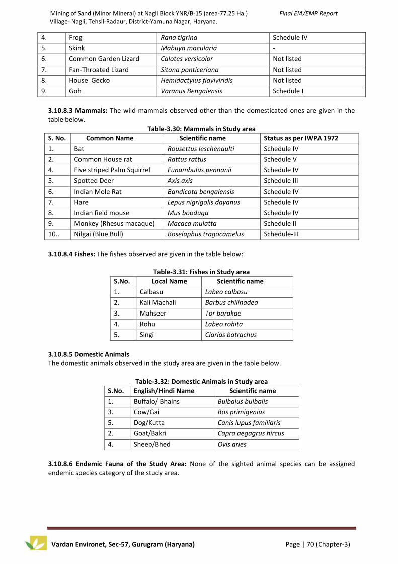
Mining of Sand (Minor Mineral) at Nagli Block YNR/B-15 (area-77.25 Ha.) Final EIA/EMP Report Village- Nagli, Tehsil-Radaur, District-Yamuna Nagar, Haryana.
Vardan Environet, Sec-57, Gurugram (Haryana) Page | 70 (Chapter-3)
4. Frog Rana tigrina Schedule IV
5. Skink Mabuya macularia -
6. Common Garden Lizard Calotes versicolor Not listed
7. Fan-Throated Lizard Sitana ponticeriana Not listed
8. House Gecko Hemidactylus flaviviridis Not listed
9. Goh Varanus Bengalensis Schedule I
3.10.8.3 Mammals: The wild mammals observed other than the domesticated ones are given in the table below.
Table-3.30: Mammals in Study area
S. No. Common Name Scientific name Status as per IWPA 1972
1. Bat Rousettus leschenaulti Schedule IV
2. Common House rat Rattus rattus Schedule V
4. Five striped Palm Squirrel Funambulus pennanii Schedule IV
5. Spotted Deer Axis axis Schedule III
6. Indian Mole Rat Bandicota bengalensis Schedule IV
7. Hare Lepus nigrigolis dayanus Schedule IV
8. Indian field mouse Mus booduga Schedule IV
9. Monkey (Rhesus macaque) Macaca mulatta Schedule II
10.. Nilgai (Blue Bull) Boselaphus tragocamelus Schedule-III
3.10.8.4 Fishes: The fishes observed are given in the table below:
Table-3.31: Fishes in Study area
S.No. Local Name Scientific name
1. Calbasu Labeo calbasu
2. Kali Machali Barbus chilinadea
3. Mahseer Tor barakae
4. Rohu Labeo rohita
5. Singi Clarias batrachus
3.10.8.5 Domestic Animals The domestic animals observed in the study area are given in the table below.
Table-3.32: Domestic Animals in Study area
S.No. English/Hindi Name Scientific name
1. Buffalo/ Bhains Bulbalus bulbalis
3. Cow/Gai Bos primigenius
5. Dog/Kutta Canis lupus familiaris
2. Goat/Bakri Capra aegagrus hircus
4. Sheep/Bhed Ovis aries
3.10.8.6 Endemic Fauna of the Study Area: None of the sighted animal species can be assigned endemic species category of the study area.

Mining of Sand (Minor Mineral) at Nagli Block YNR/B-15 (area-77.25 Ha.) Final EIA/EMP Report Village- Nagli, Tehsil-Radaur, District-Yamuna Nagar, Haryana.
Vardan Environet, Sec-57, Gurugram (Haryana) Page | 71 (Chapter-3)
Table-3.33: List of Schedule –I and II Fauna observed During the Study
S.No. Scientific Name Local Name Schedule As Per
(WPA, 1972)
IUCN Category CITES
Listing
1. Pavo cristatus Indian Peafowl Schedule I Least Concern ver 3.1 Not listed
2. Varanus Bengalensis Goh Schedule I Least Concern ver 3.1 Not listed
3. Herpestes edwardsi Common
Mongoose
Schedule II Least Concern ver 3.1 Appendix III
4 Macaca mulatta Rhesus
macaque
Schedule II Least Concern ver 3.1 Not listed
3.10.9 Conclusion The study area comprise of two districts of two states i.e. Yamuna Nagar (Haryana) and other part falls in Saharanpur (Uttar Pradesh). The current study reveals that the study area has most of agriculture land and vegetable corps. 3.11 SOCIO-ECONOMIC ENVIRONMENT Any developmental activity exerts a direct impact on the socio-economic environment of the region. Usually, the beneficial impacts such as better job opportunities, improved education, communication, energy, housing, health, transportation facilities etc. outweighs the adverse impacts, if any.
The study of socio-economic component of environment is incorporating various facets, viz. demographic structure, availability of basic amenities such as housing, education, health and medical services, occupation, water supply, sanitation, communication and power supply, prevailing diseases in the region as well as features such as places of tourist attraction and monuments of archaeological importance. The study of these parameters helps in identifying predicting and evaluating the likely impacts due to project activity in the surrounding region.
LOI over an area of 77.25 ha of Mining lease has been granted in favor of M/s. M.P. Traders by The Director General, Department of Mines & Geology, Haryana vide memo no.- DMG/ HY/ Cont/ Nagli Block/ YNR B-15/ 2016/ 5414 dated 20.10.2016 for a period of 10 years The proposed production capacity of sand is 28 Lakhs TPA. The lease area lies on riverbed of Yamuna River in District- Yamuna Nagar (Haryana). Total mining lease area is 77.25 ha which is non- forest land. The proposed mining project land has been allotted as a single unit for mining of Sand (Minor Mineral) through the riverbed of District Yamuna Nagar (Haryana). The land for mining lease area is mostly barren land therefore there are no issues involved like land acquisition, displacement, compensation, resettlement & rehabilitation.
Baseline data such as demographic pattern, occupational status, educational, health and other amenities as existing in the study area have been studied.
Baseline Status The latest available data has been complied to generate the existing socio-economic scenario of the study area. Information on socio-economic profile was collected from the Primary Census Abstract CD 2011 including the population details of the region. Village The basic unit for rural areas is the revenue village which has definite surveyed boundaries. The revenue village may comprise of one or more hamlets but the entire village is treated as one unit for presentation of data.

Mining of Sand (Minor Mineral) at Nagli Block YNR/B-15 (area-77.25 Ha.) Final EIA/EMP Report Village- Nagli, Tehsil-Radaur, District-Yamuna Nagar, Haryana.
Vardan Environet, Sec-57, Gurugram (Haryana) Page | 72 (Chapter-3)
Demographic Structure Demographic structure of the study area was estimated for the selected parameters as households, population, sex ratio, scheduled caste, scheduled tribes, literacy from primary census abstract, CD 2011. The summarized demographic structure of the study area is presented in Table, while the village wise demographic pattern is shown in Table. The study area within the 10 km covers 80 villages of Jagdhari Tehsil of Yammunanagar District, Indri Tehsil of Karnal District and Nakur Tehsil of Saharanpur District of Uttar Pradesh. Household and Population As per Census 2011 the total number of household in the study area is about 22091 with the total population of about 124251 with Male-65702 i.e. 52.87% and Female 58549 (47.12%) and the household ratio i.e. person per family is about 5.6. The population of children in the age group of 0-6 in the study area is about 15757 (12.68%) Sex Ratio Sex ratio (number of female per thousand male) figure of the study is 891. Scheduled Castes & Scheduled Tribes Population The ratios of scheduled caste and scheduled tribe as compared to the total population of the Study area is about 29574 (23.80%) while the scheduled tribe population is nil. Literacy A person who can both read and write with understanding of any one language is treated as “Literate”. The literacy rate within the study areas is on an average of about 81484 (65.58%) with 57.95 % male literates and 42.04 % female literates. Occupational Pattern Occupational Pattern of any region mainly depends upon its economically active group i.e. the working population involved in productive work. ‘Work’ has been defined as participation in any economically productive activity. Such participation may be physical or mental. Persons on leave and under training are also treated as workers. However, rent receivers and pensioners are not treated as workers. There are different types of workers that may be classified as: Main Workers Main workers are those who have worked for a major part of the year (i.e. at least six months or 183 days). Main activity of a person who was engaged in more than one activity was reckoned in terms of time disposition. The main worker population within the study area is 32146 (25.87%) out of which 13876 (43.16%) are engaged as cultivators, 10485 (32.61%) as agricultural laborers, only 1.21% are engaged as Household Laborers, and the other worker population is about 7316 i.e.23%. Non-Workers Non-Workers may be defined as those persons who have not worked at all during the entire year under the reference period. The proportion of non workers may show the unemployment level of the region. The non worker population in the study area is very high of about 83829 (67.46%). Infrastructure Resource Base The details of infrastructure resources base of the study area with reference to education, medical facility, water supply, post and telegraph, transportation, communication facility, power supply, existence of nearest town etc. are presented in Table. The significant features of these important parameters for each study area are discussed as below:

Mining of Sand (Minor Mineral) at Nagli Block YNR/B-15 (area-77.25 Ha.) Final EIA/EMP Report Village- Nagli, Tehsil-Radaur, District-Yamuna Nagar, Haryana.
Vardan Environet, Sec-57, Gurugram (Haryana) Page | 73 (Chapter-3)
Educational Facility
The numbers of educational institution in the study area are primary schools (58), Middle school (37), and Secondary schools (15). There are 6 Public Senior secondary school and 6 private schools in the study area. For further studies people have to avail the facility from the nearest town i.e. Radaur, Karnal and Nakur.
Drinking Water Facility The numbers of major sources of drinking water in the study area are treated Tap water (58) village, Covered Wells ( 11), uncovered wells ( 4) Hand Pump (64), Tube Wells in 57 villages of the study area. Medical Facility Medical institutions in rural parts of the region are inadequate, as per the data recorded in the village amenities CD there is Primary health Centre in 4 villages (Alahar village of Radaur Tehsil, Khokni village of Indri Tehsil of Karnal district and Tabar Must and Tabar Aht village of Nakur Tehsil of Uttar Pradesh), Primary health sub-centre in 13 villages, Maternal Child Welfare Centre in 9 villages and Dispensary in 5 villages. People generally prefer private hospitals because of the inadequate and poor facilities at government hospitals. Sanitation & Drainage Facility Sanitation facility is poor in the villages of the study area. Villages only have the open drainage system available in 71 villages. Community Waste Disposal system after house to house collection is available only in 4 villages that are Bahadurpur, Ratangarh Sandhali and Sandhala village of Jagdhari Tehsil and Kazi Bans village of Nakur Tehsil. Communication Facility Communication facility is available in the form of Post office is available only in 3 villages (Alahar 9kms from project site, Sandhala approx.2 kms and Gumthala village about 1.6 km from village Nagli). ATM facility is also available in Gumthala village. At the present time most of the villagers have mobile phones for communication. Power Supply Electricity is available for domestic in most of the villages of the study area but is available for only 10-11 hours a day. Electricity is not available for agriculture and commercial purpose. Economic Resource Base Minerals and Mining: Major part of the district is formed of alluvium rocks of recent period. The underground water in the district is generally fresh and suitable for domestic and irrigation purposes. The part of outer Himalayas confined to a narrow belt along northern boundary of the district contains traces of placer gold, deposits of cement, chemical grade limestone, shale, building material and clay minerals. Sand, bajri, pebbles, gravel and boulders are found in the river bed of the Yamuna, the Saraswati, the Chautang, the Somb and the Pathrala rivers/Nadis. Ordinary clay suitable for manufacturing of bricks is available in plenty in all parts of the district.Agriculture and its allied activities are the major income sources of the people in the rural region of the study areas. Major crops are grown in both Kharif & Rabi seasons. Major Kharif crops are cotton & tur. Major Rabi crops are Jawar, tur, soyabean & channa. Due to poor irrigation facilities, the productivity of land is mostly low in the study areas. However, most of the local populations are engaged in the sand mining either as contractors or laborers. Mining activities plays an important role in increasing the economic resource base for the people in the region. Cultural and Aesthetic Attributes

Mining of Sand (Minor Mineral) at Nagli Block YNR/B-15 (area-77.25 Ha.) Final EIA/EMP Report Village- Nagli, Tehsil-Radaur, District-Yamuna Nagar, Haryana.
Vardan Environet, Sec-57, Gurugram (Haryana) Page | 74 (Chapter-3)
As such no culturally and aesthetically important places are located within the seven study areas. 3.11.1 Socio-economic Survey In order to access and evaluate likely impacts arising out of any development projects on socio economic environment, it is necessary to gauge the apprehensions of the people in the study areas. Methodology applied for selection of sample & data collection The methodology which is applied for primary source of data collection i.e. gathering data through field survey for socio-economic environment is depicted below:
Sampling Method A judgmental and purposive sampling method was used for choosing respondents of various sections of the society i.e. Sarpanch, adult males and females, teachers, medical practitioners, businessmen, agriculture laborers, unemployed group etc. Judgmental and purposive sampling method includes the right cases from the total population that helps to fulfill the purpose of research needs.
Data Collection Method For the process of data collection through primary source certain methods are used among that are: a) Field Survey and Observations Field survey and observations is made at each sampling village and the socioeconomic status of that region is studied. Visits are made at hospitals, primary health centers and sub-centers to know the health status of the region. Various governmental organizations such as statistical department, department of census operations are visited to collect the population details of that region.
b) Interview Method Structured interview method is used to collect data regarding the awareness and opinion from the samples selected of the various socio- economic sections of the community. Structured interviews involve the use of a set of predetermined questions that includes fixed and alternative questions. The questionnaire mainly highlights the parameters such as income, employment and working conditions, housing, food, water supply, sanitation, health, energy, transportation and communication, education, environment and pollution to assess the standard of living of that particular region and general awareness, opinion and expectation of the respondents about the proposed project. Interview method helps to collect more correct and accurate information as the interviewer is present during the field survey.
Socio-economic survey was conducted in the villages within the study areas located in all directions with reference to the clusters. 6 villages were surveyed from study area.
The respondents were asked for their awareness / opinion about the existing sand mining and also of their opinion about the impacts of the sand mining which are an important aspect of socio-economic environment, viz. job opportunities, education, health care, housing, transportation facility and economic status.
The salient observations recorded during socio economic survey in the study areas are depicted below:
Livelihood of the villagers is primarily based on agriculture sector. Majority of main workforce are engaged either in cultivation in own land & or in laboring activities in other agricultural land owners.
About 58% of the farmers are practicing farming activities through irrigation source such as Tube well, river etc.
Most of the villages have Primary School (PS) while in some villages it is extended up to Middle School (MS). While for further education villagers go to the town places such as Radur town.

Mining of Sand (Minor Mineral) at Nagli Block YNR/B-15 (area-77.25 Ha.) Final EIA/EMP Report Village- Nagli, Tehsil-Radaur, District-Yamuna Nagar, Haryana.
Vardan Environet, Sec-57, Gurugram (Haryana) Page | 75 (Chapter-3)
The main source of drinking water supply is through tap, dug well, bore well & hand pump. But majority of respondents expressed unsatisfactory opinion regarding the availability of drinking water facility i.e. Scarcity of drinking water is a major problem in the surveyed villages.
The Government medical facilities in the form of primary health sub- centre and private medical representatives are available in the villages. Villagers expressed positive opinion regarding the facilities available at the centre. ANM (Auxiliary Nurse Midwife) frequently visits all the villages and regular vaccination and health checkup camps are organized by the health centre.
Two wheelers, auto rickshaws & bus facility are the main mode of transportation used by natives in the study area
Power supply is available in mostly all the sampling villages. Street lights are also available in all villages but frequent power cut/ load shedding problem is experienced by the people in the area.
Wood, kerosene and LPG gas is a major fuel used for cooking purpose.
Availability of Post office and banking facilities in the surveyed villages.
Majority of surveyed population opted positive response regarding the stone quarry activities as most of the local population are employed in the stone crushers either as contractors, drivers, or laborers and the activity has helped in development of auxiliary as well as ancillary jobs in the region.
Table-3.34: List of the Villages Surveyed during the Study
Source: SOI Toposheet and Field Survey
Table-3.35: Summarized Demographic Structure of the Study Area
S. No. Parameter Study Area
1. No. of Villages 80
2. Household 22091
3. Household Ratio 5.6
4. Total Population 124251
5. Male Population% 65702(52.87)
6. Female Population% 58549(47.12)
7. Population (0-6 Years.)% 15757(12.68)
8. Sex Ratio 891
9. Scheduled Caste % 29574(23.80)
10. Literates % 81484(65.58)
11. Main Workers % 32146(25.87)
12. Marginal Workers % 8276(6.66)
13. Non-Workers % 83829(67.46)
Source: Primary Census Abstract-CD; 2011, Haryana & Uttar Pradesh State
S. No. Villages Direction
1. 1. Nagli Project Site
2. 2. Gumthala S
3. 3. Barheri N
4. 4. Hansu Majra W
5. 5. Fatehgarh NE
6. 6. Sandhala N

Mining of Sand (Minor Mineral) at Nagli Block YNR/B-15 (area-77.25 Ha.) Final EIA/EMP Report Village- Nagli, Tehsil-Radaur, District-Yamuna Nagar, Haryana.
Vardan Environet, Sec-57, Gurugram (Haryana) Page | 76 (Chapter-3)
Table-3.36: Demographic Structure of the Study Area
S.No. Villages Households Total
Population
Population
(0-6 Years)
Scheduled
Caste
Literates
Yamunanagar District ,Haryana State
1. Nagli (23) 9 47 5 7 28
2. Majri
Dayalgarh(29) 21 180 22 14 128
3. Karhera (30) 348 1941 238 783 1316
4. Lal Chhapar (28) 154 900 115 199 615
5. Jathlana (4) 1342 7018 887 1557 4847
6. Pobari (35) 76 443 103 0 9
7. Bagwali (36) 20 111 14 0 80
8. Unheri (38) 430 2516 326 671 1638
9. Marrupur (39) 119 658 64 131 494
10. Khajuri (159) 535 3003 312 763 2111
11. Bahadurpur
(162) 325 1791 197 577 1199
12. Khurdban (17) 448 2299 250 863 1548
13. Potli (16) 266 1473 158 675 1004
14. Bhagwanpur (12) 44 230 36 195 154
15. Rapri (13) 94 494 71 222 314
16. Bhagwangarh
(11) 86 467 60 72 331
17. Nachraon (9) 480 2876 381 560 1906
18. Rattangarh (10) 127 669 73 167 462
19. Palewala (7) 234 1354 141 271 964
20. Kanjnon (42) 321 1887 210 427 1254
21. Kartarpur (6) 78 461 46 24 339
22. Alahar (1) 728 3760 407 1300 2694
23. Lakhi Bans (2) 141 761 86 180 556
24. Barsan (3) 210 1221 138 134 914
25. Mohri (5) 172 896 127 267 481
26. Barheri (27) 243 1403 140 459 1004
27. Madho Bas (8) 131 749 99 284 500
28. Rajheri (15) 284 1566 208 199 1092
29. Fatehgarh (14) 140 836 62 50 598
30. Thaska Khadar
(18) 258 1325 145 335 955
31. Kandrauli (19) 236 1314 150 419 861
32. Mandhar (26) 220 1198 111 117 905
33. Sandhali (25) 302 1703 195 125 1231
34. Sandhala (24) 250 1397 141 441 995

Mining of Sand (Minor Mineral) at Nagli Block YNR/B-15 (area-77.25 Ha.) Final EIA/EMP Report Village- Nagli, Tehsil-Radaur, District-Yamuna Nagar, Haryana.
Vardan Environet, Sec-57, Gurugram (Haryana) Page | 77 (Chapter-3)
35. Gumthala Rao
(21) 832 4455 582 1525 2947
36. Rao (20) 47 339 39 61 229
Total 9751 53741 6339 14074 36703
Indri Tehsil, Karnal District
37. Dhanora Jagir (1) 414 2155 279 250 1406
38. Kalri Jagir (5) 431 2310 240 398 1593
39. Dhano Kheri (4) 277 1546 196 301 1047
40. Kalra (3) 106 565 55 231 382
41. Khokhni (6) 422 2344 302 533 1543
42. Chogawan (7) 530 2788 353 574 1826
43. Hanso Majra (8) 156 808 99 98 545
44. Makhala (13) 207 1256 173 429 845
45. Makhali (9) 212 995 151 185 606
46. Garhi Birbal (32) 739 4129 457 596 2808
47. Kharak (12) 107 551 64 87 378
48. Chandraon (10) 422 2269 309 508 1342
49. Labkari (34) 323 1851 193 263 1320
Total 4346 23567 2871 4453 15641
Saharanpur District, Uttar Pradesh State
50. Mandhaur Must. 403 2367 320 723 1489
51. Kazi Bans 267 1536 254 24 1007
52. Tabar Must 1099 6259 857 2048 3901
53. Tabar Aht 6 35 2 0 21
54. Nasrulla Garh
Must. 630 3982 575 714 2413
55. Mugal Mazra 114 653 96 229 394
56. Kasampur 106 659 68 16 464
57. Malha Mazra 398 2201 402 690 1025
58. Narayanpur 48 300 44 151 203
59. Latifpur 286 1813 259 168 1150
60. Sahaba Mazra 229 1411 176 346 920
61. Meharpur 13 81 11 0 56
62. Saroorpur Taga 267 1534 191 22 1040
63. Saroorpur Taga 19 100 21 71 35
64. Nakur(Dehat) 358 1845 254 727 1229
65. Ladde Bans 66 400 49 109 234
66. Shukartal 368 2162 258 549 1429
67. Nathauri 185 1158 119 274 825
68. Sultanpur 125 770 99 463 461
69. Meerpur 28 161 21 7 106
70. Fatehpur Jat 362 2204 346 478 1379

Mining of Sand (Minor Mineral) at Nagli Block YNR/B-15 (area-77.25 Ha.) Final EIA/EMP Report Village- Nagli, Tehsil-Radaur, District-Yamuna Nagar, Haryana.
Vardan Environet, Sec-57, Gurugram (Haryana) Page | 78 (Chapter-3)
Must.
71. Badhi Must. 392 2089 282 789 1330
72. Feru Mazra 149 860 121 281 529
73. Roshanpur 126 892 113 3 643
74. Nahar Mazra
Must. 108 695 72 191 510
75. Ranipur Barsi
Must. 316 1788 275 160 985
76. Dala Mazra 110 809 128 13 524
77. Sahaspur Jat 233 1295 205 69 736
78. Tigri Ramgarh 433 2475 390 391 1371
79. Dola Mazra 261 1392 152 277 924
80. Sirsaka 489 3017 387 1064 1807
Total 7994 46943 6547 11047 29140
Grand Total 22091 124251 15757 29574 81484 Source: Primary Census Abstract-CD; 2011, Haryana & Uttar Pradesh State
Table-3.37: Occupational Structure of the Study Area
S.No. Villages Total
Main
Workers
Main Workers Marginal
Workers
Non-
Workers Cultivators Agricultural
Laborers
Household
Laborers
Other
Workers
Jagdhari Tehsil , Yamunanagar District
1. Nagli (23) 14 12 2 0 0 0 33
2. MajriDayalgarh(29) 8 0 0 0 8 38 134
3. Karhera (30) 421 172 132 2 115 151 1369
4. Lal Chhapar(28) 250 83 115 0 52 47 603
5. Jathlana (4) 1477 356 326 22 773 571 4970
6. Pobari (35) 103 0 101 0 2 21 319
7. Bagwali (36) 40 20 1 0 19 1 70
8. Unheri (38) 782 239 445 7 91 35 1699
9. Marrupur (39) 162 92 3 7 60 80 416
10. Khajuri (159) 779 176 243 3 357 97 2127
11. Bahadurpur (162) 455 189 158 10 98 187 1149
12. Khurdban (17) 660 128 396 9 127 10 1629
13. Potli (16) 443 123 272 8 40 6 1024
14. Bhagwanpur (12) 73 10 35 0 28 1 156
15. Rapri (13) 168 18 98 2 50 5 321
16. Bhagwangarh (11) 134 28 68 2 36 25 308
17. Nachraon (9) 830 325 359 0 146 75 1971
18. Rattangarh (10) 220 46 140 5 29 6 443
19. Palewala (7) 342 177 85 4 76 45 967
20. Kanjnon (42) 399 179 44 4 172 291 1197
21. Kartarpur (6) 136 83 33 0 20 27 298

Mining of Sand (Minor Mineral) at Nagli Block YNR/B-15 (area-77.25 Ha.) Final EIA/EMP Report Village- Nagli, Tehsil-Radaur, District-Yamuna Nagar, Haryana.
Vardan Environet, Sec-57, Gurugram (Haryana) Page | 79 (Chapter-3)
22. Alahar (1) 937 301 141 7 488 318 2505
23. Lakhi Bans (2) 216 92 61 0 63 2 543
24. Barsan (3) 311 109 34 1 167 220 690
25. Mohri (5) 226 84 105 1 36 159 511
26. Barheri (27) 419 148 130 7 134 66 918
27. Madho Bas (8) 239 92 94 1 52 4 506
28. Rajheri (15) 617 192 325 5 95 11 938
29. Fatehgarh (14) 244 207 13 0 24 7 585
30. Thaska Khadar (18) 356 212 79 5 60 35 934
31. Kandrauli (19) 400 148 119 27 106 15 899
32. Mandhar (26) 292 227 30 1 34 71 835
33. Sandhali (25) 439 216 122 1 100 37 1227
34. Sandhala (24) 413 132 189 4 88 13 971
35. Gumthala Rao (21) 1105 275 433 9 388 351 2999
36. Rao (20) 101 46 43 1 11 24 214
Total 14211 4937 4974 155 4145 3052 36478
Indri Tehsil, Karnal District
37. Dhanora Jagir (1) 681 355 218 4 104 233 1241
38. Kalri Jagir (5) 799 273 353 21 152 50 1461
39. Dhano Kheri (4) 485 169 206 1 109 212 849
40. Kalra (3) 168 118 12 1 37 3 394
41. Khokhni (6) 691 248 285 11 147 167 1486
42. Chogawan (7) 792 403 273 2 114 330 1666
43. Hanso Majra (8) 254 135 57 7 55 22 532
44. Makhala (13) 228 155 14 3 56 155 873
45. Makhali (9) 402 124 216 1 61 11 582
46. Garhi Birbal (32) 1122 455 283 11 373 139 2868
47. Kharak (12) 135 49 43 0 43 47 369
48. Chandraon (10) 626 188 327 7 104 194 1449
49. Labkari (34) 365 189 7 3 166 166 1320
Total 6748 2861 2294 72 1521 1729 15090
Nakur Tehsil, Saharanpur District
50. Mandhaur Must. 431 200 186 0 45 314 1622
51. Kazi Bans 431 285 95 2 49 9 1096
52. Tabar Must 1682 799 674 41 168 463 4114
53. Tabar Aht 11 11 0 0 0 0 24
54. Nasrulla Garh Must. 832 557 99 49 127 292 2858
55. Mugal Mazra 15 0 1 0 14 139 499
56. Kasampur 198 155 13 8 22 2 459
57. Malha Mazra 620 136 440 1 43 48 1533
58. Narayanpur 93 39 5 1 48 4 203

Mining of Sand (Minor Mineral) at Nagli Block YNR/B-15 (area-77.25 Ha.) Final EIA/EMP Report Village- Nagli, Tehsil-Radaur, District-Yamuna Nagar, Haryana.
Vardan Environet, Sec-57, Gurugram (Haryana) Page | 80 (Chapter-3)
59. Latifpur 508 172 170 2 164 17 1288
60. Sahaba Mazra 403 270 46 5 82 1 1007
61. Meharpur 28 20 5 0 3 0 53
62. Saroorpur Taga 428 292 55 6 75 137 969
63. Saroorpur Taga 5 2 0 0 3 23 72
64. Nakur(Dehat) 359 69 149 21 120 179 1307
65. Ladde Bans 99 60 17 0 22 39 262
66. Shukartal 486 290 111 0 85 221 1455
67. Nathauri 252 223 0 4 25 123 783
68. Sultanpur 237 137 88 0 12 2 531
69. Meerpur 26 19 7 0 0 30 105
70. Fatehpur Jat Must. 618 316 246 0 56 110 1476
71. Badhi Must. 393 258 42 2 91 239 1457
72. Feru Mazra 219 70 99 4 46 85 556
73. Roshanpur 203 71 91 2 39 68 621
74. Nahar Mazra Must. 113 80 4 0 29 90 492
75. Ranipur BarsiMust. 458 232 166 1 59 95 1235
76. Dala Mazra 234 178 16 0 40 99 476
77. Sahaspur Jat 372 227 93 3 49 23 900
78. Tigri Ramgarh 621 364 141 3 113 292 1562
79. Dola Mazra 389 235 115 2 37 8 995
80. Sirsaka 423 311 43 5 64 343 2251
Total 11187 6078 3217 162 1730 3495 32261
Grand Total 32146 13876 10485 389 7396 8276 83829
3.12 SUMMARY The generation of primary data as well as collection of secondary data and information from the site and surroundings was carried out during Post Monsoon Season i.e. 1st December 2016 to 28th February 2017. The EIA study is being done for the Mine Lease (core zone) and area within 10 Km distance from mine lease boundary (buffer zone), both of which together comprise the study area. The mine lease area exhibits plain to undulated topography. The project site falls under seismic zone IV which is a high damage risk zone (MSK VIII). Many part of the state of Haryana are prone to flooding. In flood manual of Haryana, there are 102 vulnerable points in Haryana which need special attention during monsoon. Meteorological station was set-up at site to record surface meteorological parameter during study period; Post Monsoon Season, i.e. 1st December to 28th February, 2017. Ambient Air Quality Monitoring reveals that the minimum and maximum concentrations of PM10 for
all the 6 AAQM stations were found to be 68.7 g/m3 and 88.8 g/m3 respectively, PM2.5 were found
to be 31.2 g/m3 and 49.4 g/m3 respectively, for SO2 it is found to be 6.3 µg/m3 and 14.6 µg/m3
respectively. The minimum and maximum concentrations of NO2 were found to be 11.6 g/m3 and
28.3 g/m3 respectively. The range of free Silica was found to be from 2.4 % to 3.1 %. Ambient noise levels were measured at 6 locations around the proposed project site. minimum and maximum noise levels recorded during the day time were from 50.50 Leq dB to 53.60 Leq dB respectively and level of noise during night time were from 41.40 Leq dB to 44.10 Leq dB respectively. Thus noise levels at all locations were observed to be within the prescribed limits. Analysis results of ground water reveal that pH varies from 8.26 to 8.52, Total Hardness varies from 132.25 to 172.35 mg/L and Total Dissolved Solids varies from 229 to 335 mg/L. The Analysis results of surface water reveal that pH

Mining of Sand (Minor Mineral) at Nagli Block YNR/B-15 (area-77.25 Ha.) Final EIA/EMP Report Village- Nagli, Tehsil-Radaur, District-Yamuna Nagar, Haryana.
Vardan Environet, Sec-57, Gurugram (Haryana) Page | 81 (Chapter-3)
varies from 7.54 to 7.86, Total Hardness varies from 150.23 to 202.32 mg/L, Total Dissolved Solids varies from 227 to 288 mg/L. The LOS value from the proposed mining will be change i.e. LOS value for MDR-1, MDR-2, MDR-3 and SH-6 will change from ‘excellent’ to ‘very Good’. So the additional load on the carrying capacity of the concern roads is not likely to have major affect. Random soil samples were collected up to depth of 15 cm and homogenized samples were then sent to the laboratory for analysis. The analysis results show that soil is basic in nature as pH value ranges from 7.45 to 8.10 with organic matter 0.42% to 0.47 %. The concentration of Nitrogen, Phosphorus and Potassium has been found to be in good amount in the soil samples. Soil texture is Clay to Sandy. The study area comprise of two districts of two states i.e. Yamuna Nagar (Haryana) and other part falls in Saharanpur (Uttar Pradesh). The implementation of this mining project will generate both direct and indirect employment. Yamuna Nagar district in which the mine contract area falls is an agriculturally based district. All the basic facilities like road and rail network, medical facilities, post and telegraph, market, drinking water facilities and education facilities are available. The project will also provide impetus to industrialization of the area and mining would be boon for the district as it will not only result in employment opportunity but also infrastructure development and overall growth of the area. At present agriculture is the main occupation of the people as more than half of the population depends on it. It was found that most of the parameters were within the limits as per the Indian Standards. In general, there is no major threat to the quality of these parameters. Similarly, the study for the biotic factors was conducted. Hence it can be concluded that the present environment status of the study area is good enough for the project activity. Adoption of adequate pollution control measures will protect the surrounding environment.

Mining of Sand (Minor Mineral) at Nagli Block YNR/B-15 (area-77.25 Ha.) Final EIA/EMP Report Village- Nagli, Tehsil-Radaur, District-Yamuna Nagar, Haryana.
Vardan Environet, Sec-57, Gurgaon Haryana Page | 82 (Chapter-4)
CHAPTER-4
ANTICIPATED ENVIRONMENTAL IMPACT AND ITS MITIGATION MEASURES
4.0 INTRODUCTION The environmental parameters likely to be affected by mining are related to many factors, i.e. physical, social, economic, agriculture and aesthetic. Opencast mining involves drilling, blasting, loading and transport of overburden and ore. The excavated sand will be transported via trucks to outsiders. The operations may disturb environment of the area in various ways, such as removal of mass, change of landscape, flora and fauna of the area, surface drainage, and change in air, water and soil quality. While for the purpose of development and economic up-liftment of people, there is need for establishment of mining industries, but these should be environment friendly. Therefore, it is essential to assess the impacts of mining on different environmental parameters, before starting the mining operations, so that abatement measures could be planned in advance for eco-friendly mining in the area. 4.1 ENVIRONMENTAL IMPACT ASSESSMENT Environment and development should be considered as mutually complementary, interdependent, and an instrument of reinforcing the quality of life. Environmental Impact Assessment (EIA) is the important aspect of overall environmental management strategy and an important tool for sustainable development. It identifies major impacts of mining and associated activities on environment and provides guideline to prepare the necessary control measure termed as Environmental Management Plan (EMP). Alteration or modification of the above attributes may cause hazardous impact on ecological equilibrium of site. Besides this there will be some other reasons which will affect the environment viz. traffic network, and other vehicular movements, impacts on flora and fauna of that area, surface drainage, and change in air, water and soil quality. While for purpose of development and economic upliftment of people, there is need for establishment of industries and mining, but these have to be environmental friendly. Therefore, it is essential to assess the impacts of mining on different environmental parameters, before starting the mining operations, so that abatement measures could be planned in advance for eco-friendly mining in the area. The increasing awareness among the people about ecological imbalance and environmental degradation has raised many apprehensions. The impacts on different environmental parameters due to this mining project are discussed below: 4.1.1 CONSTRUCTION PHASE This is a sand mining project in riverbed. There will be no impacts as no construction stage is envisaged in this project. 4.1.2 OPERATION PHASE Some of the impacts identified in various phases of operation are insignificant and do not warrant much attention whereas some others are important especially with respect to the present context. Therefore objective is to identify those impacts, which are significant and require a detailed analysis for decision making or formulating adequate management measures. This section deals with an assessment of impact of various mining activities on the existing environmental conditions. The methodology of assessment is based upon identification and description of the existing project activities as well as environmental components followed by evaluating the impact of mining and associated activities on the environment. The environmental components that are likely to be influenced or modified by the continuation of project activities are:
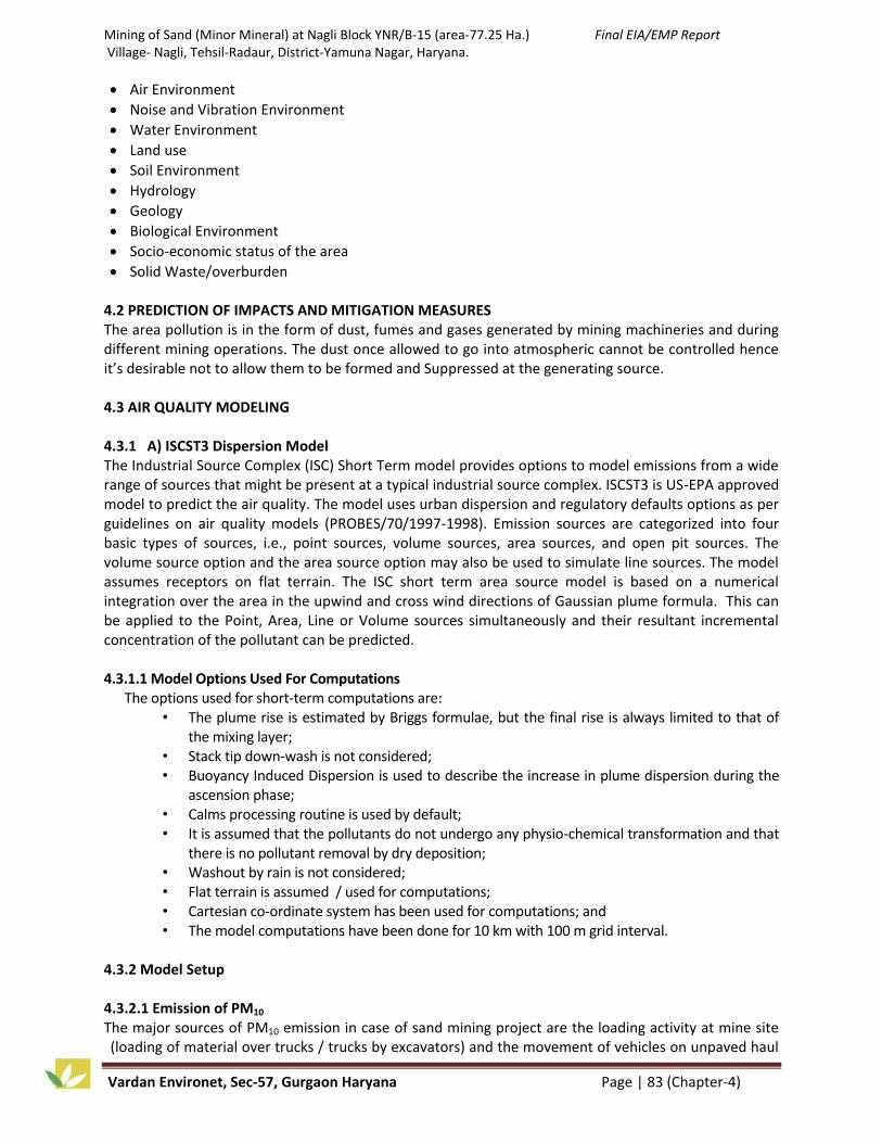
Mining of Sand (Minor Mineral) at Nagli Block YNR/B-15 (area-77.25 Ha.) Final EIA/EMP Report Village- Nagli, Tehsil-Radaur, District-Yamuna Nagar, Haryana.
Vardan Environet, Sec-57, Gurgaon Haryana Page | 83 (Chapter-4)
Air Environment
Noise and Vibration Environment
Water Environment
Land use
Soil Environment
Hydrology
Geology
Biological Environment
Socio-economic status of the area
Solid Waste/overburden 4.2 PREDICTION OF IMPACTS AND MITIGATION MEASURES The area pollution is in the form of dust, fumes and gases generated by mining machineries and during different mining operations. The dust once allowed to go into atmospheric cannot be controlled hence it’s desirable not to allow them to be formed and Suppressed at the generating source. 4.3 AIR QUALITY MODELING 4.3.1 A) ISCST3 Dispersion Model The Industrial Source Complex (ISC) Short Term model provides options to model emissions from a wide range of sources that might be present at a typical industrial source complex. ISCST3 is US-EPA approved model to predict the air quality. The model uses urban dispersion and regulatory defaults options as per guidelines on air quality models (PROBES/70/1997-1998). Emission sources are categorized into four basic types of sources, i.e., point sources, volume sources, area sources, and open pit sources. The volume source option and the area source option may also be used to simulate line sources. The model assumes receptors on flat terrain. The ISC short term area source model is based on a numerical integration over the area in the upwind and cross wind directions of Gaussian plume formula. This can be applied to the Point, Area, Line or Volume sources simultaneously and their resultant incremental concentration of the pollutant can be predicted. 4.3.1.1 Model Options Used For Computations
The options used for short-term computations are: • The plume rise is estimated by Briggs formulae, but the final rise is always limited to that of
the mixing layer; • Stack tip down-wash is not considered; • Buoyancy Induced Dispersion is used to describe the increase in plume dispersion during the
ascension phase; • Calms processing routine is used by default; • It is assumed that the pollutants do not undergo any physio-chemical transformation and that
there is no pollutant removal by dry deposition; • Washout by rain is not considered; • Flat terrain is assumed / used for computations; • Cartesian co-ordinate system has been used for computations; and • The model computations have been done for 10 km with 100 m grid interval.
4.3.2 Model Setup 4.3.2.1 Emission of PM10 The major sources of PM10 emission in case of sand mining project are the loading activity at mine site (loading of material over trucks / trucks by excavators) and the movement of vehicles on unpaved haul

Mining of Sand (Minor Mineral) at Nagli Block YNR/B-15 (area-77.25 Ha.) Final EIA/EMP Report Village- Nagli, Tehsil-Radaur, District-Yamuna Nagar, Haryana.
Vardan Environet, Sec-57, Gurgaon Haryana Page | 84 (Chapter-4)
roads. The emission rates for these sources are given in latest USEPA’s AP-42 guidelines. 4.3.2.2 Loading of Material The sand will be loaded on trucks/tippers using excavators. Ten light weight excavators/JCBs will be used for loading total 9334 MT of sand during the working shift of 8 hours/day. The PM10 emission rate due to loading activity is calculated using below equation.
E = k X 0.0016 X
U
2.2
1.3
M
2
1.4 (USEPA’s AP42, (Nov 2006)
Where, E = Emission Factor, kg/ton k = Particle size multiplier, 0.35 for PM10 M = Moisture Content, % u = Mean wind speed, m/s 4.3.2.3 Emission of PM10 due to Transportation The hauling of sand from the mining pit to outside via unpaved roads (haul roads and connecting roads) will cause emission of particulate matters. The emission generated gets settled in proximity of the unpaved road only. As per the mining plan, transportation of 9334 tonnes of mineral will be carried out for 8 hours/day. Each day maximum 105 trucks will do about 374 trips for transporting sand. The following empirical expression is used to estimate the quantity in pounds (lb) of size-specific particulate emissions from an unpaved road in industrial sites, per vehicle mile traveled (VMT).
𝐸 = 𝑘 𝑠
12 𝑎 𝑊
3 𝑏
+ 𝐶 --- AP42 (Nov 2006)
Where, k, a, b are empirical constants i.e. different for different particle size. E = size-specific emission factor (lb/VMT) s = surface material silt content (%) W = mean vehicle weight (tons) C = emission factor for 1980's vehicle fleet exhaust, brake wear and tire wear, 0.0047 lb/VMT for PM10. The source characteristics S and W are referred to as correction parameters for adjusting the emission estimates to local conditions. The effective emission rate after considering reduction in emission potential of haul roads due to water sprinkling was calculated for use in model. 4.3.2.4 Emission of CO from Vehicles The sand will be transported outside the mining area for end use. Each day maximum 105 trucks will do about 374 trips for transporting sand. In order to estimate the emission of CO from these vehicles exhaust ARAI-2007 emission factors were used. The ARAI emission factors for CO emitting from heavy vehicles (diesel) is 3.92 gm/km or 6.32 g/mile. 4.3.2.5 Summary of calculated Emission Rates
Table-4.1: Emissions Rates
S. No. Activities Units Emission Rates 1. Loading of Material (Worst Case – Without using
mitigation measures) g/s 0.003168
2. Transportation on Haul Road (PM10 Emission) (Worst Case – Without using mitigation measures)
g/mile 1267.981544
3. Transportation on Haul Road (PM10 Emission) (With mitigation measures)
g/mile 316.995386
4. Transportation (CO Emission) g/mile 6.32

Mining of Sand (Minor Mineral) at Nagli Block YNR/B-15 (area-77.25 Ha.) Final EIA/EMP Report Village- Nagli, Tehsil-Radaur, District-Yamuna Nagar, Haryana.
Vardan Environet, Sec-57, Gurgaon Haryana Page | 85 (Chapter-4)
4.3.3 Meteorological Data The meteorology of the project area plays very important role in dispersion of pollutants and build-up of pollution within the atmosphere. In the present study, one season (December 2016 – February 2017) meteorological data has been taken to find the dispersion of pollutant concentration. The mixing height for study period, which is an important parameter to express the dispersive potential of atmosphere, has been taken from the atlas of hourly mixing height and assimilative capacity of atmosphere in India (S.D. Attri et al., 2008). Windrose diagram of one season meteorological data used for modelling is shown in Chapter-3. 4.3.4 Input Parameters 4.3.4.1 ISCST3 Model Input Parameters The ISCST3 model was used to predict the GLC of PM10 due to loading activity at mine site. Excavators will be used to load total 28,00,000 TPA of Sand on dumpers for further transportation to end users. Point source resembling loading activity at mine site and having equivalent emission rates were setup in mining lease to predict the maximum incremental concentration of PM10 at baseline monitoring location (as shown in Figure 4.1). The predicted incremental concentration PM10 was added to baseline concentration to obtain the cumulative concentration level at baseline stations. 4.3.4.2 CALINE4 Line sources resembling the proposed transportation routes were setup inside and outside the mining lease. Point receptors resembling baseline monitoring stations were setup for prediction of incremental concentrations. The model was run in 1-hour worst case conditions. Since CALINE4 has options to predict only 1-hour and 8-hour pollutant concentration, the model was used to predict 1-hour worst case PM10 GLC which was later converted into 24-hour GLC using Turner Equation. The predicted incremental concentration PM10 was added to baseline concentration to obtain the cumulative concentration level at baseline stations. 4.3.4.3 Results The maximum incremental concentration of PM10 viz. 1.42099 µg /m3 was predicted inside the core zone near active mining area. A section depicting variation in predicted PM10 concentration from upwind to pre-dominant wind direction is presented in Figure 4.1. As evident from Figure-4.1, the incremental concentration of PM10 drops drastically with distance due to settling of PM10 particles under gravity. The maximum impact of loading activities will take place within 500m radius. The predicted highest incremental concentration due to loading was found at A1 (located inside mining lease) viz. 0.2824µg/m3 (24-hourly average). The second highest incremental concentration was found at A2 (located in southern direction at 400m distance) viz. 0.2024µg/m3 (24-hourly average). The predicted concentrations due to transportation were much higher than loading activities. The worst-case predicted maximum incremental concentration due to transportation was found at A1 (Project Site) viz. 25.5780µg/m3 (24-hourly average). The second highest incremental concentration was found at A2 (falling at about 500m distance from nearest transportation routes) viz. 17.3420µg/m3 (24-hourly average). The incremental concentration at all other locations was significantly less due to large distances. The predicted maximum cumulative GLC of PM10 was found to be 114.060 µg/m3 at A1, which is located inside mining lease and close the transportation route modeled. The second highest predicted cumulative GLC of PM10 was found to be 105.144 µg/m3 at A2. At both locations, the predicted cumulative concentrations are exceeding the prescribed NAAQ standard for PM10 concentration (100µg/m3). However, these levels are predicted based on worst case scenario without applying

Mining of Sand (Minor Mineral) at Nagli Block YNR/B-15 (area-77.25 Ha.) Final EIA/EMP Report Village- Nagli, Tehsil-Radaur, District-Yamuna Nagar, Haryana.
Vardan Environet, Sec-57, Gurgaon Haryana Page | 86 (Chapter-4)
mitigation measures. The predicted 24 hours GLCs at baseline air quality monitoring locations are presented in Table 4.2 below. The graphical representation is given in Figure 4.2. The predicted concentration for CO was insignificant (<0.1ppm) owing to very less traffic to and from the mining lease.
Figure-4.1: Section showing variation in PM10 concentration in Pre-dominant direction
Table-4.2: Predicted GLC of PM10 at Ambient Air Quality Monitoring Stations
(WORST CASE)
Location Code
Location Name Max Baseline Conc. (µg/m3)
Predicted GLC (µg/m3) – Loading
Predicted GLC (µg/m3) –
Transportation
Cumulative GLC (µg/m3)
A1 Project Site 88.2 0.2824 25.5780 114.060
A2 500 m from Mine Site
87.6 0.2024 17.3420 105.144
A3 Village Rajheri 85.4 0.0013 7.5400 92.941
A4 Village Tabar 86.3 0.0024 4.7560 91.058
A5 Model Town 85.7 0.0017 5.8000 91.502
A6 Village Shukartal 88.8 0.0166 3.3640 92.181
Figure-4.2: Graphical representation of model results
75.0
80.0
85.0
90.0
95.0
100.0
105.0
A1 A2 A3 A4 A5 A6
Co
nce
ntr
atio
n (
µg/
m3
)
Predicted GLC (µg/m3) – Transportation Predicted GLC (µg/m3) – Loading
Max Baseline Conc. (µg/m3) Permissible Limit (µg/m3)

Mining of Sand (Minor Mineral) at Nagli Block YNR/B-15 (area-77.25 Ha.) Final EIA/EMP Report Village- Nagli, Tehsil-Radaur, District-Yamuna Nagar, Haryana.
Vardan Environet, Sec-57, Gurgaon Haryana Page | 87 (Chapter-4)
The contour maps showing the predicted concentration levels of PM10 are presented in Figure 4.3.and Figure 4.4. The predicted 24 hours GLCs at baseline air quality monitoring locations predicted under controlled conditions by application of mitigations measures are presented in Table 4.3 below.
Table-4.3: Predicted GLC of PM10 at Ambient Air Quality Monitoring Stations (WITH MITIGATION MEASURES)
Location Code
Location Name Max Baseline Conc. (µg/m3)
Predicted GLC (µg/m3) – Loading
Predicted GLC (µg/m3) –
Transportation
Cumulative GLC (µg/m3)
A1 Project Site 88.2 0.3026 6.3800 94.862
A2 500 m from Mine Site
87.6 0.2169 4.3500 92.152
A3 Village Rajheri 85.4 0.0014 1.8560 87.257
A4 Village Tabar 86.3 0.0025 1.2180 87.520
A5 Model Town 85.7 0.0019 1.4500 87.152
A6 Village Shukartal 88.8 0.0178 0.8700 89.687
The predicted concentration for CO was insignificant (<0.1ppm) owing to very less traffic to and from the mining lease.

Mining of Sand (Minor Mineral) at Nagli Block YNR/B-15 (area-77.25 Ha.) Final EIA/EMP Report Village- Nagli, Tehsil-Radaur, District-Yamuna Nagar, Haryana.
Vardan Environet, Sec-57, Gurgaon Haryana Page | 88 (Chapter-4)
Figure-4.3: Spatial distribution of predicted GLCs of PM10 (ISCST3)

Mining of Sand (Minor Mineral) at Nagli Block YNR/B-15 (area-77.25 Ha.) Final EIA/EMP Report Village- Nagli, Tehsil-Radaur, District-Yamuna Nagar, Haryana.
Vardan Environet, Sec-57, Gurgaon Haryana Page | 89 (Chapter-4)
Figure-4.4: Spatial distribution of predicted GLCs of PM10 (CALINE4)

Mining of Sand (Minor Mineral) at Nagli Block YNR/B-15 (area-77.25 Ha.) Final EIA/EMP Report Village- Nagli, Tehsil-Radaur, District-Yamuna Nagar, Haryana.
Vardan Environet, Sec-57, Gurgaon Haryana Page | 90 (Chapter-4)
4.3.5 Conclusion
The predicted concentrations from mining activities are insignificant; whereas transportation is the major of source of dust emission.
Under worst case conditions with no mitigation measure, the predicted cumulative concentrations at A1 (Project Site) and A2 (500m from Mine Site) are exceeding the prescribed NAAQ standard for PM10 concentration (100µg/m3).
Under controlled conditions (with mitigation measures), all predicted cumulative concentrations are meeting the prescribed NAAQ standard for PM10 concentration (100µg/m3).
The concentration of CO due to vehicle exhaust is negligible due to small number of vehicles plying on haul road.
The concentrations of SOx and NOx generated from mining area are expected to be low due to absence of any major source.
The predicted concentrations are due to proposed sand mine only and higher pollutant concentrations may be observed in the study area due to simultaneous operations of other mines / anthropogenic activities, data for which is not available.
The overall impact on air quality due to proposed mining project is expected to be high with 500m radius of mining lease.
4.3.6 Mitigation Measures The proposed mining operations are not anticipated to raise the concentration of the pollutants beyond prescribed limits. However, the following measures are suggested to mitigate any harmful impacts of pollutants -
Planning multiple transportation routes in different direction to minimize the dust generation.
Planning paved roads outside mine lease area to minimize the dust generation. Alternatively, planning transportation routes so as to reach the nearest paved roads by shortest route. (minimize transportation over unpaved road);
Frequent water sprinkling on unpaved roads (>2L/m2)
Plantation of trees along haul roads, especially near settlements, to help to reduce the impact of dust on the nearby villages;
Dust mask shall be provided to the workers engaged at dust ge1neration points like excavations and loading points;
Transportation of material shall be carried out during day time only;
The speed of trucks plying on the haul road should limited to avoid generation of dust;
Covering of material during transportation on trucks to prevent spillage of sand from the trucks. The trucks shall be covered by tarpaulin. Overloading shall be avoided.

Mining of Sand (Minor Mineral) at Nagli Block YNR/B-15 (area-77.25 Ha.) Final EIA/EMP Report Village- Nagli, Tehsil-Radaur, District-Yamuna Nagar, Haryana.
Vardan Environet, Sec-57, Gurgaon Haryana Page | 91 (Chapter-4)
4.4 IMPACTS OF AIR POLLUTION AND MITIGATION MEASURES
Attributes Impact Mitigation Measure Budget/annum
Human WORST CASE without using Mitigation Measures A predicted cumulative GLC of PM10 was 114.060 µg/m3 at proposed Mine site (WORST CASE) against the threshold limit of 100 µg/m3 which can cause adverse effect on human health. WORST CASE after Mitigation Measures After implementation of suggested mitigation measures the Worst Case cumulative value would be 94.862 µg/m3 which is under threshold limit. Dust generation due to loading and unloading of mineral and due to transportation can also affect the workers as well as nearby villagers. The excess of Free silica content in the air may cause health related issues (Silicosis) in human being.
24 KLD water will be proposed for dust suppression at mine site and haul road (Mortable Connecting road) by sprinklers to avoid dust generation during mining activity and transportation. Personal Protective Equipments like Eye Goggles, Dust Mask, Leather gloves, safety Shoes & Boots will be provided to the workers engaged at dust generation points like excavation and loading points. Planning transportation routes of sand so as to reach the nearest paved roads by shortest route (minimize transportation over unpaved road). Alternatively, new haul road (8.9 Km) will be constructed by Project Proponent for transportation of excavated minerals from mine to nearest approach road. The speed of trucks plying on the haul road will be limited to avoid generation of dust and covering of material during transportation on trucks to prevent sand leak from the trucks. The trucks will be covered by tarpaulin. Overloading will be avoided. It is proposed to plant 3900 Nos. of local species per year with consultation of Forest department with some fruit bearing and medicinal trees, along the haul roads, outer periphery within the lease area to prevent the impact of dust in the nearby village. Periodic Heath Check-up Camp will be organized by Project Proponent for Mine workers. Medical control measures will be taken for the miners with a view to protect their health. The medical officer will visit the mine site once in a month and shall undertake the following need based functions.
Rs. 6.0 Lakhs under Dust Suppression Rs. 10.00 Lakhs under OH&S. 45.00 Lakhs (@ 5.00 Lakhs /KM) proposed for the Construction of haul road (8.9 Km) and 5.00 Lakhs/annum (in EMP budget) will be used for regular maintenance. Other fund for this activity will be utilized from ‘Mines and Mineral Development, Restoration and Rehabilitation fund’ i.e. Rs. 40.15* Lakhs per year.
Animal Grassing land will be reduced.
Rs. 6.00 Lakhs per year (Plantation)
Plant Stomatal index may be minimized due to dust deposit on leaf.
Crops Crop yield will be reduced. Rs. 3.00 Lakhs per year (under OH&S Budget)
*Note:- proposed amount submitted to Department of Mines & Geology, Haryana as MMDRR Fund by project proponent for various activity under MMDRR scheme executed by DMG, Haryana.

Mining of Sand (Minor Mineral) at Nagli Block YNR/B-15 (area-77.25 Ha.) Final EIA/EMP Report Village- Nagli, Tehsil-Radaur, District-Yamuna Nagar, Haryana.
Vardan Environet, Sec-57, Gurgaon Haryana Page | 92 (Chapter-4)
4.4.1 Conclusion In this mining project the only source of emission of air pollution is excavation, transportation, loading, hauling operation and handling of sand etc. The proposed mining operations are not anticipated to raise the concentration of the pollutants beyond prescribed limits. However, the measures are suggested to mitigate any harmful impacts of pollutants like plantation of trees along haul roads, specially near settlements, to help to reduce the impact of dust on the nearby villages; planning transportation routes of mined material so as to reach the nearest paved roads by shortest route (minimize transportation over unpaved road); regular water sprinkling on unpaved roads to avoid dust generation during transportation etc. 4. 5 IMPACTS OF NOISE/VIBRATIONS AND MITIGATION MEASURES
Attributes Impact Mitigation Measure Budget/annum
Human Noise from the machinery can cause hypertension, high stress level, hearing loss, sleep disturbance etc due to prolonged exposure. No. of 315 PCU/hr will increase in the existing traffic due to this mining activity hence vehicle collation may occur unwanted sound and can also cause impact on human health of neighboring villagers like effect on breathing and respiratory system, damage to lung tissue, cancer and premature death, influenza or asthma. Accidents may be occur due to fast movement of vehicles.
The machinery (Light Weight Excavator) will be maintained in good running condition so that noise will be reduced to minimum possible level. Vehicles with PUC Certificate will be hired. Regular maintenance of vehicles will be done to ensure smooth running of vehicle. Awareness will be imparted to the workers about the permissible noise level and effect of maximum exposure to those levels. Personal protective equipment will be provide to prevent the noise exposure. Personal Protective Equipment will be provided during mining activity. In addition, truck drivers will be instructed to make minimum use of horns in the village area and sensitive zones. It is proposed to plant 3900 Nos. of local species per year with consultation of Forest department with some fruit bearing and medicinal trees, along the haul roads, outer periphery within the lease area to reduce the impact of noise in the study area. The trucks will be diverted on different roads viz. SH-6 and district roads to avoid traffic congestion. Regular Health checkup camps will be organized.
Rs.10.00 lakhs/year under OH&S Rs. 6.00 Lakhs per year (Plantation) Rs. 5.00 Lakhs per year (under ESC Budget)
Animals
Crops
There is no major impact on plants and crops due this mining operation.
4.5.1 Conclusion In summary, it can be stated that the impact on the present noise levels due to mining operations will be restricted to the work zone areas only. The impact on the ambient noise levels will not be felt at the settlement areas due to masking effect with the existing noise levels. There is no drilling and blasting envisaged in the sand mining so there is no impact of vibration due to this project. Hence, the noise levels and vibration impact due to the proposed mining operations on community will be minimal.

Mining of Sand (Minor Mineral) at Nagli Block YNR/B-15 (area-77.25 Ha.) Final EIA/EMP Report Village- Nagli, Tehsil-Radaur, District-Yamuna Nagar, Haryana.
Vardan Environet, Sec-57, Gurgaon Haryana Page | 93 (Chapter-4)
4.6 IMPACTS OF WATER POLLUTION AND ITS MITIGATION MEASURES
Attributes Impact Mitigation Measure Budget/annum
Human The mining in the riverbed area may cause the ground water contamination due to intersection of the water table. The municipal waste water disposed from the mining activity may cause contamination of surface water. Ground Water contamination due to discharge of mine run off.
The water table will not be intersected during mining in the riverbed as ultimate depth is limited upto 3 meters as the water table is 5-10 m bgl. Proper analysis/Monitoring will be done to check the ground water. The municipal wastewater will be disposed off into septic tanks. No chemical having toxic elements will be used for carrying out mining activity. Waste water will be disposed off in septic tank. There are 7 Nos. of septic tank of capacity 1 KL (Total 7KL capacity). Water required for domestic use= 8 KLD. Waste water generation= 7 KLD.
Rs. 1.25 Lakhs (Monitoring) Rs. 3.00 Lakhs (Wastewater Treatment)
Animals
Crops Waste water discharges through mining operation direct affect the crops and plants. Plants
Figure-4.5: Impact of Mining on Ground Water
4.6.1 Conclusion In this mining project in the entire lease period the ground water table will not be intersected hence there will be no impact on the water environment.

Mining of Sand (Minor Mineral) at Nagli Block YNR/B-15 (area-77.25 Ha.) Final EIA/EMP Report Village- Nagli, Tehsil-Radaur, District-Yamuna Nagar, Haryana.
Vardan Environet, Sec-57, Gurgaon Haryana Page | 94 (Chapter-4)
4.7 IMPACTS ON LAND USE AND MITIGATION MEASURES The project area does not consist of any forest land. It does not consist of any human habitations. Land use plan of the mining lease area during pre-operational, operational and post operational is shown in the Chapter 2.
Impact Mitigation Measure Budget
The mining activity in the mine site will be converted into the pit. which may cause soil erosion, soil degradation etc.
It is proposed to plant 3900 Nos. of local species with consultation of Forest department with some fruit bearing and medicinal trees, along the haul roads, outer periphery within the mining area which enhances the binding property of the soil.
6.00 Lakhs per year (Plantation)
Reclamation of land affected by mining activities during and at the end of mining lease period.
It is proposed to improve the effected land wherever possible for better land use, so as to support forestry and creation of water reservoir etc. Accordingly, the land reclamation portion shall be done by planting trees on the dumps along the roads surroundings the office building on the waste barren land and in the open pits when they reach their ultimate stage. The regular health checkup camp will be organized.
__
4.7.1 Conclusion The most of the land of this lease area is in the riverbed and the entire excavated land will get replenished every year hence there will be no impact on the land use. It is a eco-friendly mining project. Every year the sediments in the riverbed accumulated, if these are not removed/excavated then riverbed level may be increased and the river may change its course which may cause heavy losses to the life of nearby villagers and habitants. 4.8 IMPACTS ON SOIL ENVIRONMENT AND MITIGATION MEASURES
Attributes Impact Mitigation Measure Budget/annum
Human
Mining in the riverbed may change complete land use pattern including channel geometry, bed elevation, sediment transportation capacity which can reduce flow of the river and downstream erosion.
The mined out area river bed block will be reclaimed naturally every year. The mining is planned in non monsoon seasons only so that the excavated area will be replenished naturally during the subsequent rainy season for the river bed mining block. The regular health checkup camp will be organized. Mine lease area has been proposed leaving a safety distance of 1/4th of
Crops Mining activity may increase the soil erosion and soil

Mining of Sand (Minor Mineral) at Nagli Block YNR/B-15 (area-77.25 Ha.) Final EIA/EMP Report Village- Nagli, Tehsil-Radaur, District-Yamuna Nagar, Haryana.
Vardan Environet, Sec-57, Gurgaon Haryana Page | 95 (Chapter-4)
Plantation degradation which have adverse impact on soil fertility.
the width of the river from the bank inwards which will protect the banks so channel geometry will not be disturbed. Pre and post monsoon survey for sedimentation in the riverbed will be done regularly.
Rs 5.00 Lakhs per year (under EMP Budget)
4.9 IMPACTS ON HYDROLOGY AND MITIGATION MEASURES
Impact Mitigation Measure Budget
The mining in the riverbed area may cause the ground water contamination due to intersection of the water table.
The water table will not be intersected during mining in the riverbed as ultimate depth is limited up-to 3 meters as the water table is 5-10 m bgl. Proper analysis/Monitoring will be done to check the ground and surface water.
1.25 Lakhs per year (monitoring)
Change in topography will divert the river flow.
There is no proposal of any stream modification/diversion due to this mining activity hence there will be no any impact on flow of the river.
The fund for this activity will be utilized from ‘Mines and Mineral Development, Restoration and Rehabilitation fund’ i.e. 40.15 Lakhs per year.
4.9.1 Conclusion The flow of surface/ground water (sub surface flow) is following the trend of topography, which is in the North to South direction. There is no proposal of any stream modification/diversion. Hence, there will be no any impact on hydrology of the study area. The depth of excavation in riverbed where ground water table is at 5-10 m bgl hence the water table is not expected to be intersected at any stage of mining.

Mining of Sand (Minor Mineral) at Nagli Block YNR/B-15 (area-77.25 Ha.) Final EIA/EMP Report Village- Nagli, Tehsil-Radaur, District-Yamuna Nagar, Haryana.
Vardan Environet, Sec-57, Gurgaon Haryana Page | 96 (Chapter-4)
4.10 IMPACTS ON ECOLOGY & BIODIVERSITY AND ITS MITIGATION MEASURES Table-4.3: Ecological Impact Assessment
Ecological Criteria
Identified Impacts
Ecological significance of Impact
Magnitude Duration /Timing/
Frequency
Reversibility Mitigation Cumulative Impact
Zone of Influence
Project site habitat Due to Site clearance.
The proposed mining lease is located in Yamuna River. No site clearance is required. Only some scrub area will be cleared.
Low impact - Reversible - No Cumulative
impact
Zone of Influence
Ecological Impact Surrounding habitat due to fugitive emission.
Not much impact on the surrounding habitat is envisaged due to the transportation activity except some fugitive emission.
Temporary Impact
Only during the transportation activity.
Reversible The green belt/community forestry near river bank and approach road will restrict the fugitive emission.
No cumulative
impact
Accessibility Ecological Impact due to road construction
No Road construction is required to assess the project site. The existing internal Roads are connected the project site to the existing SH road and then to the highway.
Low impact - Reversible - No Cumulative
impact
Zone of Influence
Ecological Impact on Surrounding/ Eco sensitive habitat due to waste water generated from the project activity.
During operation phase daily water requirement of the proposed mining activity will be 45 KLD of which 6.5 KLD will be required for drinking which will be met through Borewells. No waste water will be
No impact During operation Phase
No The waste water will be disposed off into septic tanks.
No impact

Mining of Sand (Minor Mineral) at Nagli Block YNR/B-15 (area-77.25 Ha.) Final EIA/EMP Report Village- Nagli, Tehsil-Radaur, District-Yamuna Nagar, Haryana.
Vardan Environet, Sec-57, Gurgaon Haryana Page | 97 (Chapter-4)
discharged in the nearby area.
Zone of Influence
Ecological Impact on Surrounding/Eco sensitive habitat due to Noise generated from the project activity.
The Noise level during the operation phase is around 65 dB. The impact on ambient noise level will be restricted only on the factory premises. The ambient air quality of the surrounding villages may not have any significance increase due to the project activity.
Low impact on Flora and
fauna
During operation Phase
No As given in The EMP section.
No impact
Zone of Influence
Ecological Impact on Surrounding/Eco sensitive habitat due to Transportation
Transportation of Sand in the trucks/dumper will disturb the movement of Wild animals like jungle cat, jackal, and other reptiles. Fugitive emission from vehicle movement will form a layer in leaves thus reducing the gaseous exchange process. This ultimately affects the growth of plants. Chances of vehicle collisions with wildlife attempting to cross roads are possible.
Moderate Impact
During operation Phase
No As given in EMP. Access roads will not encroach into the riparian zones. To the extent practicable, the right-of-way (ROW) to avoid residential areas and important wildlife habitat areas (e.g. rookeries, raptor nesting areas, and calving areas) will be provided.
Low Cumulative impact

Mining of Sand (Minor Mineral) at Nagli Block YNR/B-15 (area-77.25 Ha.) Final EIA/EMP Report Village- Nagli, Tehsil-Radaur, District-Yamuna Nagar, Haryana.
Vardan Environet, Sec-57, Gurgaon Haryana Page | 98 (Chapter-4)
Table-4.4: Impact on Ecology due to Mining Activity S.No Impact Mitigation Measure Budget
1. Mining on the streambed, braided flow or subsurface inter-sand flow may hinder the Movement of fishes between pools. Transportation of Sand in the trucks/dumper will disturb the movement of Wild animals and reptiles.
Transportation of mineral will be minimize in the morning and evening and cannot be done in night. Access roads will not encroach into the riparian zones. Plantation will be carried out on approach roads and nearby vicinity at river banks areas. It is proposed to include Azadirachta indica, Ficus religosa, Pongamia glabra and Ficus recimosa in the plantation program as they serve as sinks for gaseous emissions.
Rs.6.00 Lakhs per year
2. Fugitive emission from vehicle movement will form a layer in leaves thus reducing the gaseous exchange process. This ultimately affects the growth of plants.
Haul roads will be sprinkled with water which would reduce the dust emission, thus avoiding damage to the crops. Annual bio-monitoring of roadside plants exposed to vehicular pollution will be done to check the dust load and Air Pollution Tolerance Index (APTI).
Rs. 6.00 Lakhs per
year
3. Chances of vehicle collisions with wildlife attempting to cross roads are possible.
Transportation of mineral will be minimize in the morning and evening and cannot be done in night.
--
4. Any human settlement in the mining area will disturb the vegetation cover and reptiles.
No human settlement will be permitted in the lease mining or nearby area.
--
5. Indiscriminate mining from active channels of rivers causes many adverse effects on the benthic fauna, which inhabits the bottom sandy substratum.
Scientific mining will be done --
6. Excessive mineral extraction from rivers affects the eco-biology of many terrestrial insects whose initial life history begins in aquatic environments.
No mining will be carried out during the rainy season to minimize impact on aquatic life.
--
7. The Indian peafowl movement is very common in the area; the noise from sand mining will hinder the same.
Wild life conservation plan for schedule-I species (WPA, 1972) has been given in chapter 10.
Rs. 15.00 Lakhs
4.11 SOCIO ECONOMIC IMPACT OF THE PROJECT AND SAFETY MEASURES Socio Economic Impact Assessment (SEIA) refers to systematic analysis of various social and economic characteristics of human being living in a given geographical area during a given period. SEIA is carried out separately but concurrently with Environment Impact Assessment (EIA). It focuses the effect of the project on social and economic well being of the community. a) Impact on Demographic Composition The proposed project will hardly make any difference in the demographic composition of the study area as the additional employment it envisages to create will be met locally to the maximum extent. Hence, the chances of im-migration of people from outside the study area are remote. Accordingly, there will be no variation in the total population of the study area including that of sex ratio, when the mine starts operating.

Mining of Sand (Minor Mineral) at Nagli Block YNR/B-15 (area-77.25 Ha.) Final EIA/EMP Report Village- Nagli, Tehsil-Radaur, District-Yamuna Nagar, Haryana.
Vardan Environet, Sec-57, Gurgaon Haryana Page | 99 (Chapter-4)
b) Employment Opportunities The proposed project will provide employment to the local people. It has been estimated that 200 people will get direct employment in this mining project. It is a positive impact of the project since it is providing employment opportunities to the local people. c) Increased Supply of Sand in the Market With the commencement of the proposed mining project the supply of sand will increase and the gap between demand and supply will decrease to some extent, if not fully. d) Impact on Agriculture The entire mining area is part of river bed and the entire land is Government Revenue Land. It is a non forest land and the proposed activity is to take place in the bed of river Yamuna. Scientific mining will be adopted in the proposed mining project the area will be free from annual floods, which destroy standing crops, land and property. This is a positive impact of the proposed mining project. e) Impact on Road Development Movement of tractor-trolleys and other vehicles to and fro the mining site is expected to increase substantially, when mining will start. The existing roads connecting the quarry with the National and State Highways are mostly narrow mud roads. There will be mud slide and traffic bottle neck if these roads are not widened and their conditions are not improved. Hence, there is good scope for road development in the mining area. Further, there are risks of accidents during loading of extracted minerals into tractor-trolleys and transportation to markets for sell. However, accidents can be avoided by taking due care and precautions. f) Income to Government The proposed mining activity will benefit the State in the form of royalty, dead rent, fees and earning from taxes. g) Impact on Law and Order As most of the workers to be employed in the proposed mining project are local residents no law and order problem is envisaged. It is expected that the workers will attend to their duties from their residence and return to their homes after the day’s work. There would have been law and order problem if the workers were migrants and lived in shanties closed to the mining area. However, to meet any untoward incident one police post may be set up closed to the mining area. h)Impact on Health There are no chances of occurring diseases, due to manual mining of sand. Sand is non-toxic. However, sand using activities such as sand blasting require precautions since it create respiratory problems among mine workers. Excessive inhalation of sand is a serious health concern. To avoid respiratory problem from sand necessary protection will be taken.
Table-4.5: Impacts On Socio Economy And Mitigation Measures
Impact Mitigation Measure Budget/annum
Due to mining and transportation of sand will generate the small shops, dhabas, garage, restaurant, vegetable shops etc. along the road and generate direct employment.
Positive Impact --

Mining of Sand (Minor Mineral) at Nagli Block YNR/B-15 (area-77.25 Ha.) Final EIA/EMP Report Village- Nagli, Tehsil-Radaur, District-Yamuna Nagar, Haryana.
Vardan Environet, Sec-57, Gurgaon Haryana Page | 100 (Chapter-4)
Mining activity will generate direct employment by recruiting 120 people which will be employed locally and preference will be given to local people.
Positive Impact --
Extraction from river banks and beds and the resultant generation of fugitive dust cause workers of the mine to suffer from occupational hazards like skin allergies, eye and respiratory problems etc
Mine lease area has been proposed leaving a safety distance of 1/4th of the width of the river from the bank inwards which will protect the banks. Dust mask will be provided to the workers engaged at dust generation points like excavation and loading points. Regular water sprinkling on unpaved roads to avoid dust generation
Rs. 2.00 Lakh/ year ( for worker safety equipments under OH&S) Rs. 6.00 Lakhs/year (for water sprinkling on haul road under EMP budget)
Further, the pits created in the channel also can contribute to an increase in accidents in the working environment. This creates serious threat to residents in the area who depend on river water for their domestic purposes.
The mined out area in river bed block will be reclaimed naturally every year.
The mining is planned in non monsoon seasons only so that the excavated area will be replenished naturally during the subsequent rainy season for the river bed mining block.
The fund for this activity will be utilized from ‘Mines and Mineral Development, Restoration and Rehabilitation fund’ i.e. 40.15 Lakhs per year.
The major source of socio-health impacts of transportation will generate from truck, dust etc. Increase in accidents as a result of rash driving of dumpers carrying mineral through the roads may be possible.
It is proposed to plant 3900 Nos. of local species per year with consultation of Forest department with some fruit bearing and medicinal trees, along the haul roads, outer periphery within the mining area to control the dust. Planning transportation routes of mined material so as to reach the nearest paved roads by shortest route (minimize transportation over unpaved road). Alternatively, graveled road may be constructed between mine lease area and nearest paved road connectivity; The speed of trucks plying on the haul road should limited to avoid generation of dust; and Covering of material during transportation on trucks to prevent spillage of sand from the trucks. The trucks will be covered by tarpaulin. Overloading will be avoided. Regular water sprinkling on unpaved roads to avoid dust generation during transportation.
Rs. 6.00 Lakhs/ year (Plantation under EMP Budget)
Rs. 6.00 Lakhs /year (for maintenance of haul road under EMP Budget ) Rs. 6.00 Lakhs/year (for water sprinkling on haul road under EMP budget)

Mining of Sand (Minor Mineral) at Nagli Block YNR/B-15 (area-77.25 Ha.) Final EIA/EMP Report Village- Nagli, Tehsil-Radaur, District-Yamuna Nagar, Haryana.
Vardan Environet, Sec-57, Gurgaon Haryana Page | 101 (Chapter-4)
4.12 IMPACTS DUE TO SOLID WASTE/OVERBURDEN AND MITIGATION MEASURES
Impact Mitigation Measure Budget
The mine worker will generate municipal solid waste of about 29 Kg per day which will have adverse impact on human health.
6 Nos. of Garbage bins will be provided for the safe disposal of solid waste as per MSW, 2016.
The fund for this activity will be utilized from ‘Mines and Mineral Development, Restoration and Rehabilitation fund’ i.e. 40.15 Lakhs per year.
4.13 IMPACTS ON OCCUPATIONAL HEALTH AND SAFETY
Impact Mitigation Measure Budget The mining of sand (minor mineral) from the river bed can cause the lung disease and respiratory disorder due to dust exposure.
Dust masks will be provided as additional personal protection equipment (helmet and safety shoes) to the workers working in the dust prone area. Regular water sprinkling will be done and dust masks will be provided to the workers.
2.0 Lakhs
Other fund for occupational health safety will be utilized from ‘Mines and Mineral Development, Restoration and Rehabilitation fund’ i.e. 40.15 Lakhs per year.
Due to noise exposure, hearing disorder may be resulted.
Ear-muffs will be provided to the workers and good maintenance of vehicles will be provided
The accident at the site due to mining operation may be anticipated
Workers are informed, kept aware and trained about possible accidents during the mining operation and persona protective equipments will be provided viz. gloves, safety shoes, dust mask, safety jackets, helmet etc. In addition to, the awareness about the occupational health hazards due to mining activities to avoid any incident will be provided to the workers Pre- placement health checkup will be made mandatory and periodic heath checkup will be done quarterly.
The details of the proposed budget for the Occupational Health and Safety are given as in Chapter 10 of this EIA/EMP report. 4.14 TRAFFIC ENVIRONMENT
Impact Mitigation Measure Budget
No. of 315 PCU/hr will increase due to mining in existing traffic scenario lead to air pollution which can cause adverse effect on human health of neighboring villagers like effect on breathing and respiratory system, damage to lung tissue, cancer and premature death, influenza or asthma.
Vehicles with PUC Certificate will be hired. Regular maintenance of vehicles will be done to ensure smooth running of vehicle. It is proposed to plant 3900 Nos. of local species duning five years with consultation of Forest department with some fruit bearing and medicinal trees, along the haul roads, outer periphery within the lease area to prevent the impact of dust in the nearby village.
The fund for this activity will be utilized from ‘Mines and Mineral Development, Restoration and Rehabilitation fund’ i.e. 40.15 Lakhs per year. 6.00 Lakhs/year (Plantation under EMP Budget)

Mining of Sand (Minor Mineral) at Nagli Block YNR/B-15 (area-77.25 Ha.) Final EIA/EMP Report Village- Nagli, Tehsil-Radaur, District-Yamuna Nagar, Haryana.
Vardan Environet, Sec-57, Gurgaon Haryana Page | 102 (Chapter-4)
Regular Health checkup camps will be organized.
5.0 Lakhs per year
No. of 315 PCU/Hr will increase in the existing traffic due to this mining activity hence vehicle collation may occur unwanted sound and can also cause impact on human health.
In addition, truck drivers will be instructed to make minimum use of horns in the village area and sensitive zones. It is proposed to plant 3900 Nos. of local species during five years with consultation of Forest department with some fruit bearing and medicinal trees, along the haul roads, outer periphery within the lease area to reduce the impact of noise in the study area. The trucks will be diverted on three roads viz SH-6 and a district road to avoid traffic congestion. Regular Health checkup camps will be organized.
The fund for this activity will be utilized from ‘Mines and Mineral Development, Restoration and Rehabilitation fund’ 6.00 Lakhs per year 5.0 Lakhs per year
Accidents may be occurring due to fast movement of vehicles.
To avoid accidents the speed of vehicles will be low near habitation areas.
The fund for this activity will be utilized from ‘Mines and Mineral Development, Restoration and Rehabilitation fund’ i.e. 40.15 Lakhs per year.
4.14.1 Traffic Density Impact on Haul Roads (Motorable Connection Roads)- Nagli Mine Project
S. No. Road Name Road Length
(m)
Road Connectivity Total Number of Dumpers/ Day (8Hrs.)
Total Trips (Up/
Down)
Total Volume of Mineral
Transported (MT)
From To
1. Haul Road 1 1600 Mine Site Nagla Village 72 144 1800
2. Haul Road 2 1200 Mine Site Sandhala Village 78 156 1950
3. Haul Road 3 1300 Mine Site Gumthla Village 77 154 1925
4. Haul Road 4 1400 Mine Site Nasrullahgarh Village
70 140 1750
5. Haul Road 5 3400 Mine Site Mughal Majra Village
76 152 1908
Total 8900 -- -- 373 746 9333
Total Production Capacity = 28 TPA Production/ day = 9333 MT/ Day Dumper Capacity = 25 MT Total No. of Haul Roads (Motorable Connecting Roads) = 5 Total Dumper required = 373 Dumpers

Mining of Sand (Minor Mineral) at Nagli Block YNR/B-15 (area-77.25 Ha.) Final EIA/EMP Report Village- Nagli, Tehsil-Radaur, District-Yamuna Nagar, Haryana.
Vardan Environet, Sec-57, Gurgaon Haryana Page | 103 (Chapter-4)
In this mining project there are 5 haul roads originating from mine site and connecting to MDR (all are metalled). The details of haul roads with the length and transportation of dumpers (trips)/MT/Day are mentioned in the above table. These haul roads will be constructed by the lease holders from their own expenses and he will pay the due compensation to the land owners for using assess for transportation of minerals as per Rule 62 & 63 (Chapter-9) of Haryana Mineral Concession Rules, 2012. It is also clarified that these haul roads will be exclusively used for the minerals loaded dumpers of this lease area only to transport the mineral, Hence the impact of traffic density on these haul/ motorable roads will be quite negligible. Budget A budget of INR 40 Lakhs per year i.e. 10% of the annual contract money will also be deposited in “Restoration & Rehabilitation Fund” by the lease holder in the mining department for protection of environment of nearby area and maintenance as well as repair of roads. In addition to above INR 30 Lakhs per year as EMP budget is also proposed for protection of environment of nearby area and part amount of the same will be used for road maintenance. Mitigation Measures
1. These motorable roads will be regularly repaired and maintained on their own expenses and also to control the air and noise pollution.
2. In peak hours. of traffic the transportation of dumpers will be suspended.
3. Speed of dumpers will be limited to 20km/hr on these haul roads.
4. Dumpers will be transported during day time only. Budget Approx 8.9 Km haul road will be constructed to connect the mine lease to nearest approach roads for transportation of minerals and a budget of Rs. 45.00 Lakhs (@ Rs.5.00 Lakhs/Km) proposed for the Construction of haul road. 4.15 IMPACTS ON GEOLOGY AND MITIGATION
Impact Mitigation Measure Budget
Slope of mining area will change which can create soil erosion and divert rain water runoff channel.
The maximum depth of mining in the river bed will not exceed 3 meters and the maximum depth of mining. In riverbed, more than 100 % replenishment will be done every year hence no slope will be changed due to mining.
The fund for this activity will be utilized from ‘Mines and Mineral Development, Restoration and Rehabilitation fund’ i.e. 40.15 Lakhs per year.

Mining of Sand (Minor Mineral) at Nagli Block YNR/B-15 (area-77.25 Ha.) Final EIA/EMP Report Village- Nagli, Tehsil-Radaur, District-Yamuna Nagar, Haryana.
Vardan Environet, Sec-57, Gurgaon Haryana Page | 104 (Chapter-4)
Soil weathering due to dumping and mining.
Mine lease area has been proposed leaving a safety distance of 1/4th of the width of the river from the bank inwards which will protect the banks. It is proposed to plant 3900 No. of local species per year with consultation of Forest department with some fruit bearing and medicinal trees, along the haul roads, outer periphery within the mining area which enhances the binding properties of the soil. 24.00 KLD water will be proposed for sprinkling on unpaved roads to avoid soil weathering.
The fund for this activity will be utilized from ‘Mines and Mineral Development, Restoration and Rehabilitation fund’ 6.00 Lakhs per year 6.00 Lakhs per year
Change in topography can change the river flow and flood may occur.
Scientific mining has been proposed hence no any topographical change will occur during mining activity. Mining will be prohibited in monsoon season.
The fund for this activity will be utilized from ‘Mines and Mineral Development, Restoration and Rehabilitation fund’ i.e. 40.15 Lakhs per year.
4.16 MINE CLOSURE PLAN 4.16.1 General Mine closure plan is one of the most important requirements in the environment management of mining projects. The closure operation is a continuous series of activities right from the commencement to decommissioning of the project. Therefore, progressive mine closure plan is specifically included in the mining plan, which is to be reviewed every five years in the scheme of mining. The primary aim is to ensure that the following broad objectives along with the abandonment of the mine can be successfully achieved:
Creation of a productive and sustainable after-use for the site, acceptable to mine owners, regulatory agencies, and most importantly to the community.
Protection of public health and safety of the surrounding habitation.
Minimization of environmental damage.
Conservation of valuable attributes and aesthetics.
Counter balancing the adverse socio-economic impacts. 4.16.2 Reason for Closure The progressive mine closure plan has been prepared in compliance of Haryana Minor Mineral Concession Rules 2012 under MMCR 1986. No immediate closure is planned as sufficient reserves are available to carry on the activities. There is market potential in domestic demands. 4.16.3 Statutory Obligations
i. As per LOI condition No. XIV, the lease holder is bound to deposit additional amount equal to 10 % of the due contract money in along with monthly installments towards the “Mines and Minerals, Development, Restoration and rehabilitation Fund” i.e. Rs. 40.15 Lakhs per annum. To the mining department, Haryana (Haryana Minor Mineral Concession, Stocking, transportation of Mineral and Prevention of Illegal Mining Rule-2012). Hence, accordingly after the mine closure the mining department will spend the fund for the same.
ii. The mining contractor is bound to submit the Progressive mine closure plan either with Mining plan or Scheme of Mining.

Mining of Sand (Minor Mineral) at Nagli Block YNR/B-15 (area-77.25 Ha.) Final EIA/EMP Report Village- Nagli, Tehsil-Radaur, District-Yamuna Nagar, Haryana.
Vardan Environet, Sec-57, Gurgaon Haryana Page | 105 (Chapter-4)
iii. Mining contractor is bound to follow the terms and conditions as will be stipulated in the mining contract.
iv. In addition to it the rules pertaining to the Protection of Environment i.e. Environment Act. Environment Rules and other associated rules for the protection of environment will have to be followed.
v. During the course of mining the rules stipulated in Mines Act, Mines rules Metalliferous Mines Regulation 1961 and HMMCR, 2012 will be followed.
vi. All other rules pertaining to the mining existing at that time will be followed during the course of mining activities.
4.16.4 Disposal of Mining Machinery Machinery is proposed on hire basis. Hence no de-commissioning of mining machinery is proposed. 4.16.5 Safety and security Safety measures to be implemented to prevent access to excavations area by un-authorized persons as per Mines Act 1952, MMR, 1961. i. Safety measures will be implemented as per Mines Act 1952, MMR, 1961, Mines Rules 1955. ii. Provision of MMR, 1961 will be followed strictly and all roads will be 10 m wide and have a gradient
of not more than 1 in 20. iii. Excavation will not be more than 3 m in river bed. iv. Width of bench will be kept around 20.0 m for ease of operations and provide sufficient room for
the movement of equipments. v. Protective equipment like dust masks, ear plugs / muffs and other equipments will be provided for
use by the work persons. vi. Notice giving warning to prevent inadvertent entry of persons will be displayed at all conspicuous
places and in particular near mine entries. vii. Danger signs will be displayed near the excavations. viii. Security guards will be posted. ix. In the event of temporary closer, approaches will be fenced off and notice displayed. 4.16.6 Time Scheduling for Abandonment The mining area has enormous potential for continuance of operations even after the expiry of the awarded period. The details of time schedule of all abandonment will be given at the time of final closer plan. Mining activities are confined to river bed, up to 3.0 m. depth, relatively shallow depth of workings. Partial replenishment of the Sand being removed from the river bed is a natural process particularly during monsoon periods. 4.16.7 Financial Assurance As per LoI term and condition and Minor Mineral Concession Rule 2012, Haryana; the lease holder will deposit 10% of the annual contract money in “Mines and Mineral development, Restoration and Rehabilitation Fund” to the Mining Department i.e. about Rs. 40.15 Lakhs per annum. This fund will be deposited yearly till mine period. 4.17 SUMMARY The proposed mining operations are not anticipated to raise the concentration of the pollutants beyond prescribed limits. However, the measures are suggested to mitigate any harmful impacts of pollutants like plantation of trees along haul roads, specially near settlements, to help to reduce the impact of dust on the nearby villages; planning transportation routes of mined material so as to reach the nearest

Mining of Sand (Minor Mineral) at Nagli Block YNR/B-15 (area-77.25 Ha.) Final EIA/EMP Report Village- Nagli, Tehsil-Radaur, District-Yamuna Nagar, Haryana.
Vardan Environet, Sec-57, Gurgaon Haryana Page | 106 (Chapter-4)
paved roads by shortest route; regular water sprinkling on unpaved roads to avoid dust generation during transportation etc. Some of impacts may be due to increase in the PCU/hr which is 315 PCU/hr. Transportation of sand should be minimized in the morning and evening and cannot be done in night. Access roads will not encroach into the riparian zones. Fugitive emission from vehicle movement will form a layer in leaves thus reducing the gaseous exchange process. The impact on the present noise levels due to mining operations will be restricted to the work zone areas only. The impact on the ambient noise levels will not be felt at the settlement areas due to masking effect with the existing noise levels. There is no drilling and blasting envisaged in the sand mining so there is no impact of vibration due to this project. Hence, the noise levels and vibration impact due to the proposed mining operations on community will be minimal. There will be no impact on water environment due to mining in riverbed as well as in the riverbed since there is no intersection of water table due to mining activity. There will be no waste water generation from the proposed mining activity except sanitary waste water generation that will be treated in septic tanks and will be used for plantation purpose. There will be no overburden due to mining in the riverbed area. The mining activities will be done in a systematic manner by maintaining the road infrastructure and vehicle transport which will be protective measure for preserving the topography and drainage in the area. The ownership will not be changed as the land has been taken on contract which will be returned as it is after the contract period is over. No human settlement should be permitted in the lease mining or nearby area. No mining will be carried out during the rainy season to minimize impact on aquatic life. There are 2 species of Schedule I and 2 species of Schedule II are observed during study period hence, for the same conservation plan was prepared. Subsequently, a budget of Rs. 15.00 Lakhs has allotted for the conservation of wildlife species. The mining of sand is likely to increase the per capita income of local people by which the socio-economic status of the people will be improved. The local people have been provided with either direct employments or indirect employment such as business, contract works and development work like roads, etc. and other welfare amenities such as medical facilities, conveyance, free education, drinking water supply etc. Except dust generation, there is no source which can show a probability for health related diseases. Regular water sprinkling will be done with sprinkle mounted tankers and dust masks will be provided to the workers. All workers will be subjected to medical examination as per Mines Rule 1955 both at time of appointment and at least once in a year. Medical camps will be organized for this activity. Insurance of all employees as per the rules will also be carried out. R&R issues are not involved with this project. As per the point xiv of LOI, the lease holder will deposit 10% of the annual contract money i.e. approx. Rs. 40.15 Lakhs to the Mines and Minerals Development, Restoration and Rehabilitation Fund. This amount will be spent by lease holder for the protection of environment, mineral conservation in the surrounding area of core and buffer zone.

Mining of Sand (Minor Mineral) at Nagli Block YNR/B-15 (area-77.25 Ha.)Final EIA/EMP Report Village- Nagli, Tehsil-Radaur, District-Yamuna Nagar, Haryana.
VardanEnvironet, Sec-57, Gurgaon Haryana Page | 107 (Chapter-5)
CHAPTER-5
ANALYSIS OF ALTERNATIVES (TECHNOLOGY & SITE)
5.0 INTRODUCTION Consideration of alternatives to a project proposal is a requirement of EIA process. During the scoping process, alternatives to a proposal can be considered or refined, either directly or by reference to the key issues identified. A comparison of alternatives help to determine the best method of achieving the project objectives with minimum environmental impacts or indicates the most environmentally friendly and cost effective options. 5.1 ALTERNATIVE FOR MINE LEASE
During monsoon season, when rivers reach high stage, Yamuna River also bears significant catchment area and it transports river bed material (sand) which gets accumulated at such stretch which widens river width and concave banks. Thus, it is evident that the proposed site will be mined for the purpose of preventing land cutting during heavy rainfall and floods.
Sand (minor mineral) deposits are site specific. It is present in Yamuna river bed (77.25ha.). The mining of the material will be done by opencast semi-mechanized method in riverbed. The mining will be done as per laid down procedures Haryana Minor Mineral Concession, Stocking, Transportation of Minerals and Prevention of Illegal Mining Rules, 2012. The mined out area in river bed block will get replenished annually after monsoon. Therefore, no alternate site is suggested as existing land use of mine lease classified as “River Body” and will continue to be so even after the current mining project is over. 5.2 ALTERNATIVE FOR TECHNOLOGY AND OTHER PARAMETERS Some alternatives considered during EIA study are discussed below:
S.No. Particular Alternative Option 1
Alternative Option 2
Remarks
1 Technology Opencast semi mechanized mining
Opencast mechanized mining
Opencast semi-mechanized for riverbed is preferred Benefits:
No electric power requirement
Minimal noise will be generated
Minimal air pollution will be generated
Overburden will not be generated
2 Employment Local employment
Outsource employment
Local employment is preferred Benefits:
Provides employment to local people along with financial benefits
No residential building/housing is required
3 Labourer transportation
Public transport
Private transport
Local labors will be deployed so they will either reach mine site by bicycle or by foot. Benefits:
Cost of transportation of men will be negligible.
4 Material transportation
Private transport
Private transport
Material will be transported through trucks/trolleys on the contract basis

Mining of Sand (Minor Mineral) at Nagli Block YNR/B-15 (area-77.25 Ha.)Final EIA/EMP Report Village- Nagli, Tehsil-Radaur, District-Yamuna Nagar, Haryana.
VardanEnvironet, Sec-57, Gurgaon Haryana Page | 108 (Chapter-5)
Benefits:
It will give indirect employment
5 Water requirement
Tanker supplier Ground water with CGWB permission
Tanker supply will be preferred. Benefits:
No change in the surface water or ground water quality
6 Road Haul road Metallic road Haul road will be considered for linking mine site from metallic road for transportation purpose Minimum distance will be measured along with less number of trees for considering optimum haul road roots. Benefits:
Less distance, less fuel used, minimum or negligible no. of trees will be cut in best opted haul road root.
5.3 SUMMARY We have analyzed all the option for alternatives of the proposed mine site. This project is sand specific project and existing land use of mine lease classified as River Body which will continue to be so even after the current mining project is over, hence no alternate site is suggested for this project.

Mining of Sand (Minor Mineral) at Nagli Block YNR/B-15 (area-77.25 Ha.)Final EIA/EMP Report Village- Nagli, Tehsil-Radaur, District-Yamuna Nagar, Haryana.
VardanEnvironet, Sec-57, Gurugram (Haryana) Page | 109 (Chapter-6)
CHAPTER: 6
ENVIRONMENTAL MONITORING PROGRAM 6.0 INTRODUCTION Regular monitoring of the various environmental parameters is necessary to evaluate the effectiveness of the management programme so that the necessary corrective measures can be taken in case there are some drawbacks in the proposed programme. Since environmental quality parameters at work zone and surrounding area are important for maintaining sound operating practices of the project in conformity with environmental regulations, the post project monitoring work forms part of Environmental Monitoring Program. Environmental Monitoring Program will be implemented once the project activity commences. Environmental Monitoring Program includes: (i) environmental surveillance (ii) analysis and interpretation of data (iii) preparation of reports to support environmental management system and (iv) organizational set up responsible for the implementation of the programme.Environmental Monitoring will be taken up for various environmental components as per conditions stipulated in Environmental Clearance Letter issued by MoEF&CC and Consent to Operate issued by the State Pollution Control Board. Compliance of same will be submitted to respective authorities on regular basis.
6.1 ENVIRONMENTAL MANAGEMENT CELL In order to maintain the environmental quality within the stipulated standards, regular monitoring of various environmental components is necessary which will complied as per conditions. For this the lesseeM/s M.P. Tradershas taken decision to formulate an Environment Policy of the mine and constitute an Environmental Management Cell and committed to operate the proposed mine with the objectives mentioned in approved Environment Policy. (Copy of approved Environmental Policy attached as Annexure XI).The system of reporting of Non-conformances /violation of any Environmental Law/Policy will be as per quality management system. The internal audit will be conducted on periodic basis and any Non-conformances/violation to Environmental Law/Policy will be closed and discussed during Management Review Meetings of board of directors/partners.
Hierarchy An EHS Manager will be appointed to look after all environmental issues and ensure compliance with Environmental Clearance conditions/SPCB norms. An Assistant Manager and Executive Environment Engineer will be appointed under the EHS Manager. EHS Manager will report to the Lessee directly and discuss the non-compliance if so any. An immediate solution will be arrived to ensure compliance with norms.
Figure- 6.1: Hierarchy of Environment System for Dealing Environmental Issues
MD/DIRECTIOR OF THE COMPANY
MANAGER (EHS)
ASST. MANAGER (ENVIRONMENT)
ENVIRONMENTAL EXECUTIVE
HORTICULTURIST (2)
SUPERVISOR (2)

Mining of Sand (Minor Mineral) at Nagli Block YNR/B-15 (area-77.25 Ha.)Final EIA/EMP Report Village- Nagli, Tehsil-Radaur, District-Yamuna Nagar, Haryana.
VardanEnvironet, Sec-57, Gurugram (Haryana) Page | 110 (Chapter-6)
6.1.1 Responsibilities for Environmental Management Cell (EMC) The responsibilities of the EMC include the following:
Environmental Monitoring of the surrounding area
Developing the green belt/Plantation
Ensuring minimal use of water
Proper implementation of pollution control measures
Access the risk area
Implementation of QMS
Conducting Internal Audits
Closing of NCs and conduction Management Review Meetings. 6.2 ENVIRONMENTAL MONITORING AND REPORTING PROCEDURE Monitoring shall confirm that commitments are being met. This may take the form of direct measurement and recording of quantitative information, such as amounts and concentrations of discharges and wastes, for measurement against corporate or statutory standards, consent limits or targets. It may also require measurement of ambient environmental quality in the vicinity of a sit using ecological/biological, physical and chemical indicators. Monitoring may include socio-economic interaction, through local liaison activities or even assessment of complaints. The key aims of environmental monitoring are:
To ensure that results/ conditions are as forecast during the planning stage, and where they are not, to pinpoint the cause and implement action to remedy the situation.
To verify the evaluations made during the planning process, in particular with risk and impact assessments and standards and target setting and to measure operational and process efficiency.
Monitoring will also be required to meet compliance with statutory and corporate requirements. Finally, monitoring results provide the basis for auditing, i.e. to identify unexpected changes. 6.3 MONITORING METHODOLOGIES AND PARAMETERS
Table-6.1: Monitoring Methodologies and Parameters
Attributes Sampling Measurement Method
Test Procedure
A. Air Environment Network Frequency Meteorology Wind speed Wind direction Dry bulb temperature Wet bulb temperature Relative humidity Rainfall
Minimum 1 site in the project impact area
Regularly in one season by Weather Monitoring Station
Mechanical/ automatic weather station
-
Pollutants PM10
6 locations in the project impact area (Minimum 2 locations in upwind side, more sites in downwind side / impact zone)
Revised National Ambient Air Quality Standards (NAAQS) vide MoEF circular, dated 16.11.2009
Gravimetric method -
SO2
EPA Modified West and Geake method
Absorption in Potassium Tetra Chloromercurate followed by Colorimetric estimation using P-Rosanilinehydrochlo

Mining of Sand (Minor Mineral) at Nagli Block YNR/B-15 (area-77.25 Ha.)Final EIA/EMP Report Village- Nagli, Tehsil-Radaur, District-Yamuna Nagar, Haryana.
VardanEnvironet, Sec-57, Gurugram (Haryana) Page | 111 (Chapter-6)
ride and Formaldehyde (IS: 5182 Part - II).
NO2
Arsenite modified Jacob and Hochheiser
Absorption in dill NaOH and then estimated colorimetrically with sulphanilamide and N (I-Nepthyle) Ethylene diamineDihydrochloride and Hydrogen Peroxide (CPCB Method).
Free Sillica 2-3 locations (Mine site, Haul road and near Habitation) will be monitored during six monthly compliance.
24 hr monitoring twice in a year
Gravimetric Method by using Repairable particulate matter sampler “Repairable Dust Sampler” (RDS)
Data analysis by using laboratory methods ( Colorimetric method by Spectrophotometer)
B. Water Environment pH, Turbidity, Colour, Odour, Taste, TDS, Total Hardness, Calcium hardness, Magnesium hardness, Chloride, Fluoride, Sulphate, Nitrates, Alkalinity, Iron, Copper, Manganese, Mercury, Cadmium, Selenium, Arsenic, Cyanide, Lead, Zinc, Chromium, Aluminum, Boron, Phenolic compounds
Set of grab samples during pre and post-monsoon for 6 ground water samples and 3 surface water samples for 10 km distance area.
Twice in a week As per IS 10500-
Samples for water quality should be collected and analyzed as per : IS : 2488 (Part 1-5) methods for sampling and testing of Industrial effluents Standard methods for examination of water and wastewater analysis published by American Public Health Association.
C. Noise
Noise levels at Day and night time -Leq dB (A)
Mine Boundary, High noise generating areas within the lease
Quarterly As per CPCB norms
As per CPCB norms
D. Soil pH, Bulk Density, Soil texture, Nitrogen, Available Phosphorus, Potassium, Calcium,
4 locations in the project impact area
Quarterly As per CSSRI, IISWC Method
As per CSSRI, IISWC Method

Mining of Sand (Minor Mineral) at Nagli Block YNR/B-15 (area-77.25 Ha.)Final EIA/EMP Report Village- Nagli, Tehsil-Radaur, District-Yamuna Nagar, Haryana.
VardanEnvironet, Sec-57, Gurugram (Haryana) Page | 112 (Chapter-6)
6.4 MONITORING SCHEDULE Regular Monitoring of all the environmental parameters viz., air, water, noise and soil as per the formulated program based on CPCB and MoEF&CC guidelines will be carried out every year in order to detect any changes from the baseline status.
Table-6.2: Monitoring Schedule
S. No. Description Schedule Of Monitoring
1. Air Quality Free Sillica
Twice in a week 24 hr monitoring twice in a year
2. Water Quality (Surface and Ground Water) Twice in a week
3. Noise Level Quarterly
4. Ecology and Biodiversity Yearly
5. Soil Quality Quarterly
6. Socio-economic Condition Yearly
7. Plantation Monitoring Once in a season
6.5 LOCATIONS OF MONITORING STATIONS The location of the monitoring stations was selected on the basis of prevailing micro meteorological conditions of the area like; wind direction and wind speed, relative humidity, temperature. Locations for the post project monitoring shall be as under.
Table-6.3: Locations of Monitoring Stations
S. No. Description Location
1. Ambient Air Quality Lease area, Villages in down-wind direction from the Lease Boundary.
Magnesium, Sodium, Electrical Conductivity, Organic Matter, Chloride E. Socioeconomic Status
Network Frequency Measurement Method
Test Procedure
Demographic structure
Infrastructure resource base
Economic resource base Health status: Morbidity
pattern
Cultural and aesthetic attributes
Education
Socio-economic survey is based on proportionate, stratified and random sampling method
Yearly Primary data collection through questionnaire
Secondary data from census records, statistical hard books, topo sheets, health records and relevant official records available with Govt. agencies
Ecological Impact
Green Belt Development
Conservation of Wild Life
Survey Yearly Primary data collection.
Secondary data from statistical hard books, toposheets and relevant official records available with Govt. agencies

Mining of Sand (Minor Mineral) at Nagli Block YNR/B-15 (area-77.25 Ha.)Final EIA/EMP Report Village- Nagli, Tehsil-Radaur, District-Yamuna Nagar, Haryana.
VardanEnvironet, Sec-57, Gurugram (Haryana) Page | 113 (Chapter-6)
2. Noise Level Monitoring Lease Boundary, High noise generating areas within the lease boundary
3. Water Level and Quality Nearby Surface and Ground water sources
4. Soil Quality Lease area and Villages within study area.
Reporting Schedule during Operation of Mine After completion of analysis, copies of all the analysis reports will be sent to MoEF&CC Regional Office and SPCB. Copies of the reports will be maintained in the office and will be made available to the concerned inspecting authorities. 6.6 BUDGET ALLOCATION FOR MONITORING The cost of the project is Rs9.00 Croresanda budget for monitoring of Air, water, Noise and Soil will be Rs. 5.00 Lakhsto be incurred by the project proponent for undertaking pollution prevention measures during the mining activity. 6.7 SUMMARY In order to maintain the environmental quality within the stipulated standards, regular monitoring of various environmental components is necessary which will complied as per conditions. For this lessee M/s M.P. Tradershas taken decision to formulate an Environment Policy of the mine and constitute an Environmental Management Cell and committed to operate the proposed mine with the objectives mentioned in approved Environment Policy. EMP may also require measurement of ambient environmental quality in the vicinity of a sit using ecological/biological, physical and chemical indicators. Monitoring may include socio-economic interaction, through local liaison activities or even assessment of complaints. Regular Monitoring of all the environmental parameters viz., air, water, noise and soil as per the formulated program based on CPCB and MoEF&CC guidelines will be carried out every year. The location of the monitoring stations was selected on the basis of prevailing micro meteorological conditions of the area like; wind direction and wind speed, relative humidity, temperature. A budget for monitoring of Air, water, Noise and Soil will be Rs. 5.00 Lakhs to be incurred by the project proponent for undertaking pollution prevention measures during the mining activity.

Mining of Stone (Minor Mineral) at Pichopa Kalan Plot-2 over an area-22.40 Ha.Cat.B1 Village-Pichopa Kalan, Tehsil-
VardanEnvironet, Sec-57, Gurgaon Haryana Page | 114 (Chapter-7)
Mining of Sand (Minor Mineral) at Nagli Block YNR/B-15 (area-77.25 Ha.)Final EIA/EMP Report Village- Nagli, Tehsil-Radaur, District-Yamuna Nagar, Haryana.
CHAPTER: 7
ADDITIONAL STUDIES 7.0 GENERAL Mining operations are associated with several potential hazards that affect adversely the human health and environment. It would normally require the assistance of emergency services to handle it effectively. The mining operation will be taken up under the supervision and control of qualified staff including Mine Manager (Grade I). Similarly Sand mines also have impending dangers and risk which need to be addressed for which a disaster management plan has been prepared with an aim of taking precautionary steps to avert disasters and also to take such action after the disaster which limits the damage to the minimum. Nevertheless, the following natural/industrial problems may be encountered during the mining operation.
1. Inundation due to excessive rains. 2. Accidents by heavy machinery. 3. Slope failures at the mine faces etc.
7.1 PUBLIC CONSULTATION Public hearing is very significant part of the process of public participation envisaged under the guidelines issued by MoEF&CC, Government of India. It facilitates involvement of all the stake holders of the project which is essential for ensuring smooth running of project and benefitting all sections of society in the process of economic development of the region.The public hearing of “mining of Sand (Minor Mineral)” mining project at Nagli Block-2 in Village Nagli, Tehsil Radaur, District Yamuna Nagar over an area of 77.25 Ha. with production capacity of 28,00,000 TPA by M/s M.P. Traders Limited was conducted on 23.05.2017 at 12.00 pm at Mine Site in Village Nagli, Distt. Yamunanagar reply for the same has been given by consultant on behalf of the project proponent and PP will follow the same as per undertaking given by PP. 7.1.1 Public Hearing Notice
Figure-7.1: Notice For Public Hearing

Mining of Stone (Minor Mineral) at Pichopa Kalan Plot-2 over an area-22.40 Ha.Cat.B1 Village-Pichopa Kalan, Tehsil-
VardanEnvironet, Sec-57, Gurgaon Haryana Page | 115 (Chapter-7)
Mining of Sand (Minor Mineral) at Nagli Block YNR/B-15 (area-77.25 Ha.)Final EIA/EMP Report Village- Nagli, Tehsil-Radaur, District-Yamuna Nagar, Haryana.
7.1.2 Photographs of Public Hearing
Figure-7.2: Government Officers present in Public Hearing
Figure-7.3: Local Public present for Public Hearing
Figure-7.4: Environment Consultants with Project Proponent at Public Hearing

Mining of Sand (Minor Mineral) at Nagli Block YNR/B-15 (area-77.25 Ha.)Final EIA/EMP Report Village- Nagli, Tehsil-Radaur, District-Yamuna Nagar, Haryana.
VardanEnvironet, Sec-57, Gurgaon Haryana Page | 116 (Chapter-7)
7.1.3 Action plan as per Public Hearing Demand Proceeding of the Public Consultation (Hearing) under the provision of EIA notification 2006 (amended to date) for proposed mining of Sand (Minor Mineral) in Yamuna Nagar allotted M/s M.P. Traders on 23.05.2017 at 12:00 P.M. at Project Site Village –Nagli, Tehsil-Radaur, District-Yamuna Nagar having lease area of 77.25ha. Having the capacity 28,00,000TPA and the Project cost of Rs. 9.00 Crores held under Chairmanship of Sh. Rohtash Singh Kharb I.A.S., Deputy Commissioner, Yamuna Nagar. is attached as Annexure XII. The action plan has been prepared accordingly as per demand of public during the public consultation and given below.
S.No Name of Stakeholder
Question Reply Action Plan Fund Allocation
1.
Sh. Isham Singh Vill- Chorpura
1.) He asked that how many people will be employed from this proposed Sand Mining project?
1) Sh. RS Yadav Environment Consultant and lease holder replied that so many employment opportunities will be generated from this project. 115 skilled and semi-skilled people will get direct employment from this project. 105 dumpers will be used in this project and each dumper requires 4-5 people i.e. driver, cleaner, helper. About 500-700 people will be employed for this purpose. Every year 39000 trees will be planted that will need so many gardeners to take care of the plants. 22 KLD water will be used for dust suppression for which many persons will be employed. Bill clerks will also be needed for this project and to fulfil this purpose graduated students will be employed from the local villages. These are the direct employment opportunities. Apart from this so many indirect
Lease holder assured that first preference in employment will be given to the local villagers only. About 500-700 persons will be deployed directly and indirectly in this mining project.
A budget ofRs. 30 lakhs per year is proposed in CSR for welfare of local villages.

Mining of Sand (Minor Mineral) at Nagli Block YNR/B-15 (area-77.25 Ha.)Final EIA/EMP Report Village- Nagli, Tehsil-Radaur, District-Yamuna Nagar, Haryana.
VardanEnvironet, Sec-57, Gurgaon Haryana Page | 117 (Chapter-7)
employment will also be generated i.e. many hotels, workshop repair, tea stalls, general store will be established and so many employment opportunities will be generated. Lease holder assured that first priority for employment will be given to local villagers only.
2. Sh. Satish Kumar
He asked that what arrangements will be done for the health of mine workers?
Sh. RS Yadav Environment Consultant replied that a budget of Rs. 10 Lakhs/year has been proposed for the health safety of mine workers. A qualified MBBS doctor will be appointed, first aid, medical centre will be established at project site. Regular health checkup will be conducted by doctors and villagers also take advantage of that. Dust mask will be provided to the workers to protect themselves from dust. Awareness training programme will also be organized periodically to the workers to minimize the impact of air pollution. Proper care will be taken of the workers so that it won’t affect the health of workers. Medical camps will be organized quarterly/ six monthly in which our workers and villagers will also be benefitted. A budget of Rs. 10 Lakhs per year
Systematic and scientific mining will be carried out under the supervision of the qualified Mining engineer. A first aid station with qualified doctor will be setup at the mining site. For the safe transportation of the mineral is separate road will be constructed outside the village AabadiRoad.Regular health checkup will be conducted by doctors and villagers also take advantage of that.Dust mask will be provided to the workers to protect themselves from dust. Awareness training programme will also be organized periodically to the workers to minimize the impact of air pollution.
A budget of Rs.10.00 Lakhs per year is provided for Occupational Health and Safety.
S. No. Description Amount (in Lakhs)
1. Measures to Prevent Accidents during Sand Loading
1.00
2. Measures to Prevent Accidents during minerals Transportation.
1.00
3. Measures to Prevent Accidents due to Trucks/ Dumpers etc.
1.00
4. Measures to Prevent Dangerous Incidents during Inundation/Flood
ing
2.00
5. Education awareness and first aid kit
2.00

Mining of Sand (Minor Mineral) at Nagli Block YNR/B-15 (area-77.25 Ha.)Final EIA/EMP Report Village- Nagli, Tehsil-Radaur, District-Yamuna Nagar, Haryana.
VardanEnvironet, Sec-57, Gurgaon Haryana Page | 118 (Chapter-7)
is proposed for occupational health safety of mine workers.
6. Medical Examination Schedule
3.00
Total 10.00
3. Sh. Mohit He asked what will be the benefits of this project to the villagers?
Sh. RS Yadav Environment Consultant replied that firstly this project is environment friendly project. The sediment comes along with the flow of river and get accumulated so the level of river get raised and if the accumulated sediments/sand will not be excavated then the river can divert from its original path that could lead to the flood. So, the mining will be done upto 3 m in systematic scientific manner and the sand will excavated on regular basis, so the river will flow in channel and will not divert in any other direction and the flow will be smooth. Secondly, good opportunity for generation of employment from this project and first preference will be given to the local villagers only. Details has been already given in reply of para no.-1. This sand is used for development of infrastructure in the state of Haryana and the NCR. So this project is beneficial in every manner.
This river sand mining project will protect from the flood in villages and also generate employment for the local people.About 115 technical, nontechnical, skilled, semi-skilled persons will be deployed in this mining project. Overall about 500-700 persons will get direct and indirect employment. Lease holder also assured that the first preference will be given to the local villagers. This river sand is used for development of infrastructure project of State and NCR.
___
4. Sh. Gurdayal Singh
He said that how many trees will be planted?
Sh. RS Yadav Environment Consultant replied that approx
It is ensured by lease holder that 39000 trees will be
A budget of Rs.30.00 Lakhs per year is provided for EMP activities

Mining of Sand (Minor Mineral) at Nagli Block YNR/B-15 (area-77.25 Ha.)Final EIA/EMP Report Village- Nagli, Tehsil-Radaur, District-Yamuna Nagar, Haryana.
VardanEnvironet, Sec-57, Gurgaon Haryana Page | 119 (Chapter-7)
Village: GadiGujran
39000-40000 trees will be planted in five years. Only local species of trees will be planted after consultation with DFO. These trees will be planted to minimize the air pollution and noise pollution. Plantation will also be done along with the road of transportation, premises of Gram PanchayatBhawan, Hospitals, schools etc. A budget of Rs. 30 Lakhs/year has been proposed for EMP.
planted per year and these trees will be planted along the haul roads, in Govt. schools, gram Panchayat compound, hospitals etc. Local species of plantation will be done with the consultation of DFO Yamuna nagar.
out of which 4.00 Lakhs is provided for Plantation. In addition of above a budget of Rs. 40.15 Lakhs per annum available in “Mines and Minerals Development Rehabilitation and Restoration Fund. As per requirement part amount may also be utilized from this fund.

Mining of Sand (Minor Mineral) at Nagli Block YNR/B-15 (area-77.25 Ha.)Final EIA/EMP Report Village- Nagli, Tehsil-Radaur, District-Yamuna Nagar, Haryana.
VardanEnvironet, Sec-57, Gurgaon Haryana Page | 120 (Chapter-7)
5. Sh. Nekiram Village: GadhiBirbal
He asked that what kind of pollution will be generated due to proposed mining project?
Sh. RS Yadav Environment Consultant replied that in this sand mining project there is a possibility of air pollution due to mining and transportation of sand. To mitigate this, a proper management plan is being proposed, a budget of Rs. 30 Lakhs/year is also proposed for EMP. Regular sprinkling of water will be done at active mining area,and on haul road for dust suppression. 39000trees per year will be planted along haul road, that will be helpful in minimizing dust generation. Trucks will not be driven overloaded and the trucks will also be covered with Tarpaulin. If wind blows in high velocity than the mining work and transportation will be suspended until it becomes stable, and minimize the impact of air pollution.
The lease holder assured that Regular water sprinkling will be carried out on the mining site and also on the haul road/Kaccha roads used for transportation of minerals to prevent the air pollution. For this 22.00 KLD water per day will be used.
39000 trees per year will be planted along haul road, that will be helpful in minimizing dust generation. These plants will be watered and managed regularly. The mineral loaded trucks also covered with tarpaulin and trucks will not be transported overloaded. Mining operation will be temporary suspended during heavy wind flow to curb the air pollution.
The detailed EMP budget of Rs.30.00 Lakhs per year is given as below:
S. No.
Description Amount (in Lakhs)
1. Pollution monitoring
– Air, Water, Noise
and Soil
5.00
2. Dust Suppression 6.00
3. Plantation will be at
Villages-Nagli, Nagla
and Sandhla, near
School- Maharaja
Agrasein Public
School and along the
Haul road of these
villages.
8.00
4. Haul road and other
roads repair and
Maintenance
6.00
5. Pre-monsoon and post monsoon survey for sedimentation in the river bed
4.00
6. Waste Water
Treatment
3.00
Total 30.00

Mining of Sand (Minor Mineral) at Nagli Block YNR/B-15 (area-77.25 Ha.)Final EIA/EMP Report Village- Nagli, Tehsil-Radaur, District-Yamuna Nagar, Haryana.
VardanEnvironet, Sec-57, Gurgaon Haryana Page | 121 (Chapter-7)
6. Sh. Vikram Singh Village: KarodaJaagir
He asked that what is the provision of social development of this village?
Sh. RS Yadav Environment Consultant replied that a CSR budget of Rs. 30 Lakhs/year has been proposed which includes provision of toilets in govt. schools, drinking water facility in local villages and scholarships for students, vocational training. A meeting will be organized with Gram Panchayat before Commissioning Mining Activity and priority list will be prepared as per the need of villages. Monitoring of these activities will also be done. Regularly compliance report will be sent to the HSPCB after getting Environmental Clearence and if they find any deficiency in compliance then District Administration officers may take legal action against the lease holder
The project proponent assured providing of toilets in govt. schools, drinking water facility in local villages and scholarships for students, vocational training. A meeting will be organized with Gram Panchayat before Commissioning mining activity and priority of work will be prepared as per the need of villages.
The detailed CSR budget of Rs.30 Lakhs per year is given as below:
S. No.
Description Amount (in Lakhs)
1. Vocational training on Villages:- Nagli, Nagla&Sandhla
Fire and safety,
Health and safety,
Awareness program on cancer and AIDS.
5.00
2. Sanitations(Bio-toilets)
and drinking water
facility at Village
Nagli
5.00
3. Sanitations(Bio-toilets)
and drinking water
facility at Village
Nagla
5.00
4. Sanitations(Bio-toilets)
and drinking water
facility at Village
Sandhla
5.00
5. Assistance to self help
groups
5.00
6. Health check up camps
at mine site and
nearby villages
(Nagli, Nagla and
Sandhla)
5.00
Total 30.00
7. Sh. Avtaar Singh Village: Gumthala
He said that mining is being done in our village Gumthala and there is no provision of sprinkling of water to control the air pollution and no local
Sh. RS Yadav Environment Consultant replied that this is related to another project and advised to complain RO, DC and mining officer in this regard. Lease holder assured that for
Lease holder assured that for social and religious work, sand will be given free of cost. A CSR budget of Rs. 30 Lakhs/year has been proposed which includes development
A budget of Rs.30.00 Lakhs per year is provided for CSR activities.

Mining of Sand (Minor Mineral) at Nagli Block YNR/B-15 (area-77.25 Ha.)Final EIA/EMP Report Village- Nagli, Tehsil-Radaur, District-Yamuna Nagar, Haryana.
VardanEnvironet, Sec-57, Gurgaon Haryana Page | 122 (Chapter-7)
people have been employed. You are saying that mining will be done only upto 3 m but they are excavating upto 9m so that should be restricted. Whether the sand is free for local villagers?
social and religious work, sand will be given free of cost. A CSR budget of Rs. 30 Lakhs/year has been proposed which includes development of toilets in govt. schools, drinking water facility and scholarships for students, vocational training. Lease holder assured that first priority for employment will be given to local villagers only. Priority list will be prepared as per the need of villages.
of toilets in govt. schools, drinking water facility and scholarships for students, vocational training. Lease holder assured that first priority for employment will be given to local villagers only.
8. Deputy Commissioner
Deputy Commissioner, Yamuna Nagar suggested that this sand mining project is very beneficial for the local villagers. Villagers will be benefited in employment and CSR activity. This is eco-friendly mining project which prevent the flooding in the village area. The mining material will be given to the villagers on concessional rate. He also directed the R.O. and mining officers to inspect the mining site of village gumthala and ensure the compliance of EC granted to the lease holder.
Detail replies already given in above paras.
We will comply all the rule and regulations regarding Environmental Clearance.
A budget of Rs40.15 Lakhs/annum will be deposited in “Mines and Minerals Development, Restoration and Rehabilitation Fund”. As per requirement this amount is utilized for protection of environment of nearby village across and affected persons from this mining.

Mining of Sand (Minor Mineral) at Nagli Block YNR/B-15 (area-77.25 Ha.)Final EIA/EMP Report Village- Nagli, Tehsil-Radaur, District-Yamuna Nagar, Haryana.
VardanEnvironet, Sec-57, Gurgaon Haryana Page | 123 (Chapter-7)
7.2 HAZARD IDENTIFICATION AND RISK ASSESSMENT METHODOLOGY All types of industries face certain types of hazards which can disrupt normal activities abruptly. Similar river bed mines also have risks which need to be addressed for which a disaster management plan has been formulated with an aim of taking precautionary steps to avert disasters and also take such action after disaster which limits the damage to minimum. In the sections below, the identification of various hazards, probable risks during the operational phase of the mining, maximum credible accident analysis and consequences analysis are addressed either qualitatively or quantitatively. Risk assessments will help mine operators to identify high, medium and low risk levels. This is a requirement of the Occupational Health and Safety Act 2000. Risk assessments will help to priorities the risks and provide information on the need to safely control the risks. In this way, mine owners and operators will be able to implement safety improvements. The following natural/industrial problem may be encountered during the mining operation.
Inundation: Filling of the mine pit due to excessive rains
Slope failures at the mine faces or stacks
Accident due to fire (in forested areas) As per proposal made under the mining plan the area will be developed by means of opencast mining method. Extraction of minerals is to be carried out by semi-mechanized. Water table will not be touched during the mining process. No high risk accidents like landslides, subsidence flood etc have been apprehended. 7.2.1 Risks due to Inundation Mining will be done during the non-monsoon periods (October-June); therefore problem of inundation is not likely to happen. 7.2.2 Risks Due to Failure of Pit Slope In order to allay dangers due to open cast slope failure, final pit, slope stability estimations will be made for the existing mines. Determining the factor of safety, the slopes should be monitored at regular intervals to check for any possible failure. 7.2.3 Risks due to Failure of Waste Dumps During extraction of sand from mining areas silt and clay will also be removed in form of waste materials. The excavated silt and clay will be used for backfilling of the pits. Therefore there is no risk associated with failure of waste dumps. 7.2.4 Risks of Accidents due to Trucks and Dumpers Identifying the hazards that come along with the presence of vehicles at the workplace (e.g. reversing operations, loading) can cause harm if not properly handled. Among some of the factors that may make vehicle accidents more likely are:
Rough access roads
Time pressure
Inadequate brakes (Possibly from lack of maintenance)
Carelessly parked vehicles (e.g. being parked on a slope without being adequately secured)
Unsafe coupling and uncoupling of trailers, and
Untrained drivers
Overturning vehicles

Mining of Sand (Minor Mineral) at Nagli Block YNR/B-15 (area-77.25 Ha.)Final EIA/EMP Report Village- Nagli, Tehsil-Radaur, District-Yamuna Nagar, Haryana.
VardanEnvironet, Sec-57, Gurgaon Haryana Page | 124 (Chapter-7)
To avoid such instances we will talk to the workers and their representatives and will involve them in the risk assessment process and tell them what to do, to reduce risk. All transportation within the mine lease area should be carried out directly under the supervision and control of management.
The vehicles will be maintained in good working condition and checked thoroughly at least once a month by the competent person authorized for the purpose by the management.
Road signs will be provided at each and every turning point up to the main road (wherever required)
To avoid danger while reversing the vehicles especially at working place/loading points, stopper should be posted to properly guide reversing/spotting operating.
Only trained drivers will be hired. 7.3 DISASTERS AND ITS MANAGEMENT Mining and allied activities are associated with several potential hazards to both the employees and the public at large. A worker in a mine will be able to work under conditions, which are adequately safe and healthy. At the same time the environmental conditions also will not impair his working efficiency. This is possible only when there is adequate safety in mines. Hence mine safety is one of the most essential aspects of any working mine. The safety of the mine and the employees is taken care of by the Mines Act 1952, which is well defined with laid down procedure to ensure safety and constantly monitored and supervised by Directorate General of Mines Safety and Department of Mines, State Government. 7.3.1 Identification of Hazards There are various factors, which can create disaster in sand mine. These hazards are as follows: a) Inundation / Flooding. b) Quick Sand Condition. c) Drowning. d) Accident due to vehicular movement. e) Accident during sand loading, transporting and dumping.
Table-7.1: Check List for Likely Risks in Sand Mines
S. No. Activities Human Risk Ecological Risk
Probability of
Occurrence
Consequence Risk level Land Air Water
1. Sand Loading Possible Critical 6 0 0 0
2. Sand Transport Possible Critical 6 0 0 0
3. Sand Dumping and
Storage
Possible Critical 6 0 1 0
4. Inundation/Flooding Possible Minor 3 1 0 0
5. Quick Sand Condition Possible Minor 3 0 0 0
6. Drowning Possible Critical 4 0 0 0
7. Vehicular Movement High Critical 8 1 2 0
7.3.2 Sand Loading The sand is loaded in the trucks using hand shovels and back-hoe. There are possibilities of injury in the hands during loading with shovels and staying under bucket movement.
i. There are possibilities that the workers standing on the other side of loading may get injury due to over thrown sands with pebbles.
ii. There are possibilities of workers getting injured during opening of side covers of the trucks to facilitate sand loading.

Mining of Sand (Minor Mineral) at Nagli Block YNR/B-15 (area-77.25 Ha.)Final EIA/EMP Report Village- Nagli, Tehsil-Radaur, District-Yamuna Nagar, Haryana.
VardanEnvironet, Sec-57, Gurgaon Haryana Page | 125 (Chapter-7)
iii. There are possibilities of riverbank collapse due to close proximity of sand extraction. iv. There are chances of falling of cattle/children into sand pit in river bed-- instances of death due to fall in
such pits were reported from other areas to the Department of Mines. v. Chance of workers getting injured due to improper balancing of truck while loading.
7.3.3 Sand Transport The sands loaded in 25 Tons trucks are being sent to the collieries through public roads.
i. All possibilities of road accidents are possible. ii. Accident may also occur during movement in the mine (sand dunes).
iii. There are possibilities that due to overloading, some pebbles or big boulder may injure the passerby public. 7.3.4 Sand Dumping and Storage
i. There are possibilities of the trucks rolling/ sliding down the sand bunker during dumping operation. ii. The dumper /trucks may cause injury to the workers working near the stowing plant.
iii. Dumping the sand in an empty sand bunker may cause injury to the stowing operator if the bunker chute is in open condition.
iv. Dumping the sand in an empty sand bunker may cause burying the stowing machineries if the bunker chute is in open condition. 7.3.5 Heavy Machinery Most of the accidents occur during transportation by dumpers, trucks and other heavy vehicles and are often attributable to mechanical failures, in which the factor of human errors cannot be ruled out. 7.3.6 Inundation / Flooding
i. The possibility of inundation/flooding of the sand mines are very high during monsoon or during heavy rains in lean season as the mine area lies over the sand dunes of a riverbed.
ii. There are dangers to the trucks and other machineries due to flooding. iii. There are dangers to the workers working in the sand dunes.
Inundation or flooding is expected and beneficial for these sand mines as during this time only the sand reserve gets replenished.

Mining of Sand (Minor Mineral) at Nagli Block YNR/B-15 (area-77.25 Ha.)Final EIA/EMP Report Village- Nagli, Tehsil-Radaur, District-Yamuna Nagar, Haryana.
VardanEnvironet, Sec-57, Gurgaon Haryana Page | 126 (Chapter-7)
Figure-7.5: Identification of Hazards in Mines
7.3.7 Quick Sand Condition
i. This condition occurs when the working crosses the water table at a certain depth and the permeability of the strata is very high.
ii. This condition occurs when the effective stress in the sand becomes zero due to influx of water i.e., i = icr = ϒ’/ϒw; where i = Hydraulic gradient, icr = Critical Hydraulic gradient, ϒ = submerged unit weight, ϒw = unit weight of water.
iii. This creates danger condition to the trucks and other machineries plying over the sand dunes. 7.3.8 Drowning There are possibilities of drowning in the deeper part of the river. However safety jackets, floating tube will be kept at the site office to prevent any mishap. 7.3.9 Mitigation of Hazards 7.3.9.1 Measures to Prevent Accidents during Sand Loading
i. The trucks will be brought to a level so that the sand loading operation suits to the ergonomic condition of the workers and the back-hoe.
ii. The loading will be done from one side of the truck only. iii. The workers will be provided with gloves and safety shoes during loading. iv. Opening of the side covers (pattas) will be done carefully and with warning to prevent injury to the
loaders. v. No sand will be collected within 7.5m from bank, especially from outer bank of the meandering river.
Safe clearance will be mainly determined by the height of the river bank and thickness of sand to be extracted from the close vicinity of that bank.
vi. Ponding in the river bed shall not be allowed. vii. Operations during daylight only.

Mining of Sand (Minor Mineral) at Nagli Block YNR/B-15 (area-77.25 Ha.)Final EIA/EMP Report Village- Nagli, Tehsil-Radaur, District-Yamuna Nagar, Haryana.
VardanEnvironet, Sec-57, Gurgaon Haryana Page | 127 (Chapter-7)
viii. No foreign material (garbage’s) will be allowed to remain/spill in river bed and catchment area, or no pits/pockets are allowed to be filled with such material.
ix. Stockpiling of harvested sand on the river bank will be avoided. x. For particular operations, approaching river bed from both the banks will be avoided.
7.3.9.2 Measures to Prevent Accidents during Sand Transportation.
i. All transportation within the main working will be carried out directly under the supervision and control of the management.
ii. The Vehicles must be maintained in good repairs and checked thoroughly at least once a week by the competent person authorized for the purpose by the Management.
iii. Road signs will be provided at each and every turning point especially for the guidance of the drivers at the evening/night.
iv. To avoid danger while reversing the trackless vehicles especially at the embankment and tipping points, all workers will be removed from all areas for reversing of lorries, and the vehicle will have audio-visual alarm during reversing.
v. A statutory provision of the fences, constant education, training etc. will go along way in reducing the incidents of such accidents.
vi. Generally, overloading will not be permitted. Big boulders will not be loaded. This is unsafe and may damage equipment and stowing bunker.
vii. The truck will be covered and maintained to prevent any spillage. viii. The maximum permissible speed limit will be ensured.
ix. The truck drivers will have proper driving license. 7.3.9.3 Safety Features Required in Tippers/Trucks
a) Exhaust/ Retard Brake: Required as per DGMS circular 02 of 2004. b) Propeller shaft guard: Propeller shaft guard as per DGMS circular 10 of 1999. c) Tail gate protection: Protection of cabin against collision either by head to head or head to tail. d) Limiting speed device: To ensure speed limits as decided by management. The device may be Electronic
or mechanical type speed governors. e) Reverse gear for audio-visual alarm: The audio-visual alarm provided for equipments will confirm to
DGMS (Tech.) Tests to be carried out on the audio-visual alarm and certificates shall be issued to user industries.
f) Provision of two brakes: One of brakes shall be fail safe and for details refer DGMS circular 09 of 1999. g) Body lifting position locking arrangement: A hooter along with an indication may be provided to show
the body is lifted. h) Fire suppression System: Semi-automatic fire suppression system. For details refer DGMS circular 10 of
2004. The fire suppression system shall be a factory fitment. i) Blind spot mirror: Better view of front blind spot by operator. j) Retro reflective reflectors on all sides: For visibility of truck during night k) Seat belt reminder: To alert operator for using the seat belt l) Proximity warning device: To alert operator m) Rear Vision System: For assisting operator to have back view during reversing n) Auto dipping System: To reduce glaring of eyes of operator during night o) Load Indicator and Recorder: Enables management to detect and prevent over loading. p) Global Positioning system: To prevent illegal transport and selling of sand, restricting short-cut routes
other than stipulated routes and computerized monitoring. It is the responsibility of the Project Proponent to mention these terms and conditions in the tender document.

Mining of Sand (Minor Mineral) at Nagli Block YNR/B-15 (area-77.25 Ha.)Final EIA/EMP Report Village- Nagli, Tehsil-Radaur, District-Yamuna Nagar, Haryana.
VardanEnvironet, Sec-57, Gurgaon Haryana Page | 128 (Chapter-7)
7.3.9.4 Measures to Prevent Accidents during Sand Dumping and Storage i. The Stowing Sand bunkers will be covered by steel grizzly (netting) to prevent inadvertent fall of human
being or the vehicles during dumping operation. ii. The dumping will be done only when the chute of the sand bunker is in closed condition or partially
filled. iii. The vehicles/trucks will not be brought over the grizzly. iv. There will be a duly constructed berm made up of concrete or other material to prevent the rear wheels
come/roll over the grizzly of sand bunker. v. Dozers are used near the sand bunkers to maintain the safety bern and to push material over the edge
as required. vi. The dumping operation will be done under strict supervision.
7.3.9.5 Measures to Prevent Accidents due to Trucks/ Dumpers etc.
i. All transportation within applied mining lease working will be carried out directly under the supervision and control of the management.
ii. The vehicles will be maintained in good condition and checked thoroughly at least once a month by the competent person authorized for the purpose by the management.
iii. Road signs will be provided at each and every turning point up to the main road (wherever required). iv. To avoid danger while reversing the equipment’s/ vehicles especially at the working place / loading
points, stopper will be posted to properly guide reversing/ spotting operating, otherwise no person will be there within 10 Km radius of machine.
v. A statutory provision of the fences, constant education, training etc. will go a long way in reducing the incidents of such accidents.
vi. Regular training will be provided to the operators by the Company or the Contractors.
7.3.9.6 Measures to Prevent Dangerous Incidents during Inundation/Flooding
i. Inundation or flooding is expected and beneficial for these sand mines as during this time only the sand reserve gets replenished.
ii. During monsoon months and heavy rains the sand mining operations are ceased. iii. The Trucks and other vehicle plying over the dunes will be kept on the river banks beyond HFL. iv. The workers are not allowed to go over the dunes during heavy rains. v. There will be mechanism/warning system of heavy rains and discharges from the upstream dams.
7.3.9.7 Measures to Prevent Quick Sand Condition
i. The only way to avoid quick sand condition is by avoiding sand lifting below water table. ii. The critical hydraulic gradient (icr) will be maintained at less than 1 to prevent high artesian pressure in
a coarse sand area. iii. At least 0.5m sand bed will be left in-situ while harvesting sand from riverbed.
7.3.9.8 Measures to Prevent Drowning i. The sand mining will be done under strict supervision.
ii. The workers are not allowed to go to the deeper areas of the rivers. iii. The workers are not allowed to fish in the river during working hours. iv. In case it is required to cross the river, it is done under strict supervision and over the shallow area using
life lines. v. Few life jackets, inflated tubes will be kept near the mine site.
7.3.9 Training and Human Resources Development i. Appointment and delegating qualified and experienced personnel in various disciplines.

Mining of Sand (Minor Mineral) at Nagli Block YNR/B-15 (area-77.25 Ha.)Final EIA/EMP Report Village- Nagli, Tehsil-Radaur, District-Yamuna Nagar, Haryana.
VardanEnvironet, Sec-57, Gurgaon Haryana Page | 129 (Chapter-7)
ii. Adequate training/refresher training will be provided to the supervisors, workers keeping in view provisions of Mines Vocational Training Rules, 1966; Mine Rules, 1955, Mines Rescue Rules, 1985.
iii. Personnel who have to operate and maintain HEMM, Trucks etc are to be trained under the guidance of the manufacturers and as per provisions of DGMS Circular Technical 1/1989 regarding accidents in opencast mines. Recommendation of Seventh Conference on Safety in Mines on “Safety in Open Cast Mining”, “Traffic Rules and Procedures”, “Mobile equipments and Highway Delivery Vehicles”, “Operations and Operator Training” and other related circulars.
iv. The training of mine personnel shall be provided regularly with respect to environmental protection. v. Special courses for employees will be arranged for afforestation, revegetation, reclamation, health
hazards (identification), malaria eradication, HIV prevention etc in the training centre of the company. 7.4 OCCUPATIONAL HEALTH HAZARDS Dry-pit mining by open cast method involves dust generation by excavation, loading and transportation of mineral. At site, during excavation and loading activity, dust is main pollutant which affects the health of workers whereas environmental and climatic conditions also generate the health problems. Addressing the occupational health hazard means gaining an understanding of the source (its location and magnitude or concentration), identifying an exposure pathway (e.g. a means to get it in contact with someone), and determination of likely a receptor (someone receiving the stuff that is migrating). Occupational hazard due to sand mining mainly comes under the physical hazards. Possible physical hazards are as below mention: 7.4.1 Physical Hazards Due To Mining Operations Following health related hazards were indentified due to riverbed sand mining operations to the workers:
a) Light: The workers may be exposed to the risk of poor illumination or excessive brightness. The effects
are eye strain, headache, eye pain and lachrymation, congestion around the cornea and eye fatigue.
b) Heat and Humidity: The most common physical hazard is heat. The direct effects of heat exposure are burns, heat exhaustion, heat stroke and heat cramps; the indirect effects are decreased efficiency, increased fatigue and enhanced accident rates. Heat and humidity are encountered in hot and humid condition when temperatures and air temperatures increase in summer time up to 480C or above in the river bed mining area.
c) Eye Irritation: During the high windy days in summer the sand could be the problems for eyes like itching and watering of eyes.
d) Respiratory Problems: Large amounts of dust in air can be a health hazard, exacerbating respiratory disorders such as asthma and irritating the lungs and bronchial passages.
e) Noise Induced Hearing Loss: Machinery is the main source of noise pollution at the mine site. 7.4.2 Medical Examination Schedule To minimize the health impacts PPE like dust masks, ear plugs/ muffs and other equipments will be provided for use by the work personnel. All workers will be subjected to Initial Medical Examination as per Mines Rule 1955 at the time of appointment. Periodical Medical Examination will be conducted at least once in five years. Medical camps will be organized. The detail of health check up and periodical medical examination schedule is given below.
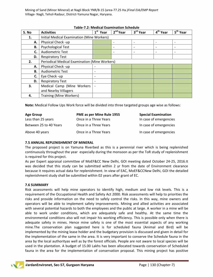
Mining of Sand (Minor Mineral) at Nagli Block YNR/B-15 (area-77.25 Ha.)Final EIA/EMP Report Village- Nagli, Tehsil-Radaur, District-Yamuna Nagar, Haryana.
VardanEnvironet, Sec-57, Gurgaon Haryana Page | 130 (Chapter-7)
Table-7.2: Medical Examination Schedule
S. No Activities 1st Year 2nd Year 3rd Year 4th Year 5th Year
1. Initial Medical Examination (Mine Workers)
A. Physical Check -up - - - -
B. Psychological Test - - - -
C. Audiometric Test - - - -
D. Respiratory Test
2. Periodical Medical Examination (Mine Workers)
A. Physical Check -up -
B. Audiometric Test -
C. Eye Check -up -
D. Respiratory Test -
3. Medical Camp (Mine Workers and Nearby Villagers
-
4. Training (Mine Workers)
Note: Medical Follow Ups Work force will be divided into three targeted groups age wise as follows: Age Group
PME as per Mine Rule 1955
Special Examination
Less than 25 years Once in a Three Years In case of emergencies
Between 25 to 40 Years Once in a Three Years In case of emergencies
Above 40 years Once in a Three Years In case of emergencies
7.5 ANNUAL REPLENISHMENT OF MINERAL The proposed project is on Yamuna Riverbed as this is a perennial river which is being replenished continuously throughout the year especially during the monsoon as per the ToR study of replenishment is required for this project. As per Expert appraisal committee of MoEF&CC New Delhi, GOI meeting dated October 24-25, 2016.It was decided that this study can be submitted within 2 yr from the date of Environment clearance because it requires actual data for replenishment. In view of EAC, MoEF&CCNew Delhi, GOI the detailed replenishment study shall be submitted within 02 years after grant of EC. 7.6 SUMMARY Risk assessments will help mine operators to identify high, medium and low risk levels. This is a requirement of the Occupational Health and Safety Act 2000. Risk assessments will help to priorities the risks and provide information on the need to safely control the risks. In this way, mine owners and operators will be able to implement safety improvements. Mining and allied activities are associated with several potential hazards to both the employees and the public at large. A worker in a mine will be able to work under conditions, which are adequately safe and healthy. At the same time the environmental conditions also will not impair his working efficiency. This is possible only when there is adequate safety in mines. Hence mine safety is one of the most essential aspects of any working mine.The conservation plan suggested here is for scheduled fauna (Animal and Bird) will be implemented by the mining lease holder and the budgetary provision is discussed and given in detail for the implementation of the same in the area. It is very important to conserve the Schedule fauna in the area by the local authorityas well as by the forest officials. People are not aware to local species will be used in the plantation. A budget of 15.00 Lakhs has been allocated towards conservation of Scheduled fauna in the area for the implementation of conservation proposal. This mining project has positive

Mining of Sand (Minor Mineral) at Nagli Block YNR/B-15 (area-77.25 Ha.)Final EIA/EMP Report Village- Nagli, Tehsil-Radaur, District-Yamuna Nagar, Haryana.
VardanEnvironet, Sec-57, Gurgaon Haryana Page | 131 (Chapter-7)
impact on social and economic well being of the community because this project provides employment opportunities to local people and many social welfare works done by project proponent. The percentage of replenishment is more than 100% every year. In view of this huge amount of sedimentation there are fare chances of replenishment of the river bed annually. There is no displacement of the population within the project area and adjacent nearby area. However, as per the point 14 of LoI the lease holder will deposit 10% of the annual contract money i.e. Rs. 40.15 Lakhs to the Mines and Minerals Development, Restoration and Rehabilitation Fund. This amount will be spent by lease holder for environmental protection and mineral conservation in the surrounding area of core and buffer zone.

Mining of Sand (Minor Mineral) at Nagli Block YNR/B-15 (Area-77.25 Ha.)Final EIA/EMP Report Village- Nagli, Tehsil-Radaur, District-Yamuna Nagar, Haryana.
Document No. 2015_VM_10089_Draft EIA Page | 132 (Chapter-8)
CHAPTER-8
PROJECT BENEFITS 8.0 GENERAL The execution of the project bring overall improvement in the locality, neighborhood and the State by bringing industry, roads, employment and hence improving living standard and economic growth. 8.1 PHYSICAL BENEFITS The opening of the proposed project will enhance the following physical infrastructure facilities in the adjoining areas:
a. Road Transport: There will be improved road communication due to the proposed project and maintenance will also be done time to time.
b. Market: Generating useful economic resource for construction. Excavated mineral will provide a good market opportunity.
c. Infrastructure:Creation of community assets (infrastructure) like provision for drinking water, construction of school buildings, village roads/ linked roads, dispensary and health centre, community centre, market place etc, as a part of corporate social responsibility.
d. Enhancement of Green Cover: As a part of reclamation plan, plantation will be carried along the river banks or along the road sides or near the civic amenities.
e. Green Belt Development: A suitable combination of trees that can grow fast and also have good leaf cover will be adopted to develop the green belt. It is proposed to plant 39000 no’s of native species along with some fruit bearing and medicinal trees during the mining plan period.
f. Local Employment: This project will enhance the opportunities of employment for the local villagers near the lease area due to which their economic status become better
8.2 SOCIAL BENEFITS The mining in the area will create rural employment. It has been observed that conditions of the villages around mining areas are better than that of distant villages. The mining activity in the region will have positive impact on the social economic condition of the area by way of providing employment to the local in-habitants; wages paid to them will increase the per capita income, housing, education, medical and transportation facilities, economic status, health and agriculture. A detailed program for socio economic development of the area has been framed. The salient features of the programme are as follows:
i) Social welfare program like provision of medical facilities educational facilities, water supply for the employees as well as for nearby villagers will be taken.
ii) A well laid plan for employment of the local people has been prepared by giving priority to local people.
iii) Supplementing Govt. efforts in health monitoring camps, social welfare and various awareness programs among the rural population.
iv) Assisting social forestry program.
v) Adoption of villages for general development.
vi) Supply of water to village nearby villages.
vii) Development of facilities within villages like roads, etc. 8.2.1 Environmental and social Commitments The project proponent is conscious of its social commitments and as any good corporate citizen; it is proposed to undertake the need specific proposed ESC activities in the surrounding areas of the mine. The mining operations will provide employment to 115 people. The project proponent has proposed to incur budget of Rs. 30.00 Lakhs for ESC activities and discussed in chapter 7.

Mining of Sand (Minor Mineral) at Nagli Block YNR/B-15 (Area-77.25 Ha.)Final EIA/EMP Report Village- Nagli, Tehsil-Radaur, District-Yamuna Nagar, Haryana.
Document No. 2015_VM_10089_Draft EIA Page | 133 (Chapter-8)
8.3 ECOLOGICAL BENEFITS A green belt will be developed along the boundary of the mining lease area. The area for green belt plantation consists of undisturbed soil; hence plantation could be made as in any garden or road side plantation. Green belt is erected not from biodiversity conservation point of view but is basically developed as a screen to check the spread of dust pollution.It is proposed to plant 39000Nos. of native species per year along with some fruit bearing and medicinal trees during the plan period and a budget of Rs. 6.00Lakhs/yrfor plantation is given in EMP. A green belt, 7.5m in width will be developed around the core zone. Green belt plantation will be started with the beginning of the mining and will be completed within five years from the beginning.
8.4 SUMMARY The management will recruit the semi-skilled and unskilled workers from the nearby villages. The project activity and the management will definitely support the local Panchayat and provide other form of assistance for the development of public amenities in this region. The company management will contribute to the local schools, dispensaries for the welfare of the villagers. A suitable combination of trees that can grow fast and also have good leaf cover will be adopted to develop the green belt. It is proposed to plant 39000 no’s of native species along with some fruit bearing and medicinal trees during the mining plan period. The project proponent has allocated Rs. 30.00 Lakhs per annum for ESC Activities and Rs. 40.15 Lakhsper annum to the Mines and Minerals Development, Restoration and Rehabilitation Fund. This amount will be spent by lease holder for the protection of environment in the nearby surrounding area. The officers of the State Government Haryana will strictly monitor the compliance of lease holder in this regard. Other than this social development of village will be considered as per social activities.

Mining of Sand (Minor Mineral) at Nagli Block YNR/B-15 (area-77.25 Ha.)Final EIA/EMP Report Village- Nagli, Tehsil-Radaur, District-Yamuna Nagar, Haryana.
VardanEnvironet, Sec-57, Gurugram (Haryana) Page | 134 (Chapter-9)
CHAPTER-9
ENVIRONMENTAL COST BENEFIT ANALYSIS
9.0 PROJECT COST After making exhaustive study, it is considered desirable that the mining project may be implemented.Project cost for the proposed Sand Mining namely “Nagli Block/YNR B15” over an area of 77.25 Ha. falling in Village-Nagli, Tehsil-Radaur,District-Yamuna Nagar (Haryana) is Rs. 9.0 Crores.
Table 9.1: Project Cost and Benefit
Major Heads Total
Production Capacity 28,00,000 Ton per annum
Production Cost of Mineral Rs112.50/- Per Ton or Rs.4.50 per cu. ft.
Sale Value of Mineral Rs116.50/- Per Ton or Rs.4.66 per cu. ft.
Profit Rs.4.00 per Ton
Estimated Profit per Annum 1,12,00, 000/- Per Annum approx.
9.1 ENVIRONMENT COST ANALYSIS AND PROJECT IMPLEMENTATION
The Environment cost for this proposed mining includes Environmental Management Plan, Environmental and Social Responsibility, Occupational Health and Safety which is likely to comeRs. 10.00 Lakhs per annum. The detailed cost for Environmental Expenses is given below in the Table.
Table 9.2: Environmental Cost Analysis
S. No. Major Heads Expenses per annum(Lakhs)
1. Environmental Management Plan Rs. 30.00Lakhs
2. Environmental and Social Responsibility Rs. 30.00 Lakhs
3. Occupational Health and Safety Rs. 10.00 Lakhs
Total Rs. 70.00 Lakhs
The estimated capital cost and financial viability of the present scheme has been worked out on the assumption that the above scheme shall be completed by the end of Year, 2035 i.e. end of lease period. From the above financial analysis, it is clear that this stone mining project is financial and technically viable.The estimated profit will be 1,12,00,000-70, 00,000=4,20,00,000 per annum.

Mining of Sand (Minor Mineral) at Nagli Block YNR/B-15 (area-77.25 Ha.)Final EIA/EMP Report Village- Nagli, Tehsil-Radaur, District-Yamuna Nagar, Haryana.
VardanEnvironet, Sec-57, Gurugram (Haryana) Page | 135 (Chapter-10)
CHAPTER-10
ENVIRONMENTAL MANAGEMENT PLAN 10.0 INTRODUCTION The mine development in the ML area needs to be intertwined with judicious utilization of natural resources within the limits of permissible assimilative capacity. The assimilative capacity of the study area is the maximum amount of pollution load that can be discharged in the environment without affecting the designated use and is governed by dilution, dispersion and removal due to natural physicochemical and biological processes.
The environmental management must be integrated into the process of mine planning so that ecological balance of the area is maintained and adverse affects are minimized. An Environmental Management Plan (EMP) is a site specific plan developed to ensure that the project is implemented in an environmentally sustainable manner. An effective EMP ensures the application of best practice environment management to a project. The purpose of an EMP is to:
i. Assists proponent in the preparation of an effective and user friendly EMP. ii. Improve the contribution that an EMP can make to the effectiveness of the environmental
management process. iii. Ensure a minimum standard and consistent approach to the preparation of EMP’s. iv. Ensure that the commitments made as part of the project’s EIA are implemented throughout
the project life. v. Ensure that environment management details is captured and documented at all stages of a
project. The design of EMP for operational phase has been aimed to achieve the following objectives:
i. To ensure adoption of state of art technological environmental control measures and implementing them satisfactorily.
ii. Effectiveness of mitigatory measures in mitigation of impacts. iii. Description of monitoring program of the surrounding environment. iv. Institution arrangements to monitor effectively and take suitable corrective steps for
implementation of proper EMP. v. An Environmental Management Cell (EMC) should be set up to take care of all environment
aspects and to maintain environmental quality in the project area. The detailed hierarchy and responsibilities of Environment Management Cell is discussed in Chapter6.
Figure-10.1: Flow Chart of EMP

Mining of Sand (Minor Mineral) at Nagli Block YNR/B-15 (area-77.25 Ha.)Final EIA/EMP Report Village- Nagli, Tehsil-Radaur, District-Yamuna Nagar, Haryana.
VardanEnvironet, Sec-57, Gurugram (Haryana) Page | 136 (Chapter-10)
10.1 LAND USE PATTERN River bed mining can lead to river bank erosion and sedimentation arising from changes in hydrology due to alteration in water depths and river bed morphology. Sand and gravel in lowland river landforms are biologically important and an economic asset. Keeping this in mind, the following management plans are suggested:
i. There will be no mining near the banks. This is to protect the bank erosion and river migration. ii. Proper wide benches in the mining area will be created to prevent any erosion.
iii. Slopes of the sides in mine will be at least 45° to prevent any erosion. 10.2 AIR ENVIRONMENT MANAGEMENT Mitigative measures suggested for air emission control will be based on the baseline ambient air quality monitoring data. From the point of view of maintenance of an acceptable ambient air quality in the region, it is desirable that the air quality needs to be monitored on a regular basis to check it vis-à-vis the NAAQS prescribed by MoEF&CC and in cases of non-compliance, appropriate mitigative measures will be adopted. In order to minimize impacts of mining on air and to maintain it within the prescribed limits of CPCB/ SPCB, an Environmental Management Plan (EMP) has been prepared. This will help in resolving all environmental and ecological issues likely to cause due to mining in the area.During the course of mining no toxic substances are released into the atmosphere as such there seems to be no potential threat to health of human beings.In the mining activities, the only source of gaseous emissions is from the engines of vehicles. The reasons may be quality of fuel, improper operation of the engine, etc; proper maintenance of engines will improve combustion process and brings reduction in pollution. 10.2.1 Control of Gaseous Pollution In mining activities, the only source of gaseous emissions is from the engines of transport vehicles. The emissions from the diesel engines of the machinery can be controlled by proper maintenance andmonitoring of machines. 10.2.2 Control of Dust Pollution The main pollutant in air is PM10, which is generated due to various mining activities. However to reduce the impact of dust pollution the following steps have been taken during various mining activities.
a) During loading operation
i) Latest loading equipment like hydraulic excavators will be used with dumpers. This reduces the number of buckets to fill from height and thus have comparatively less dust generation. The propagation of this dust is confined to loading point only and does not affect any person both the operators of excavator and dumpers who will sit in closed chamber and will be equipped with dust mask.
ii) Skilled operators will operate excavators.
iii) Avoid overloading of dumpers and consequent spillage on the roads.
iv) The operators’ cabin in the drills, dumpers will be provided with dust free enclosure and persons working at high dust prone areas will be provided with dust mask.
b) During Transport operation
i) All the haulage roads including the main ramp be kept wide, leveled, compacted and properly maintained and watered regularly during the shift operation to prevent generation of dust due to movement of dumpers, and other vehicles.
ii) Mineral carrying trucks will be effectively covered by Tarpaulin to avoid escape of fines to atmosphere.
iii) Regular Compaction and grading of haul road (Motrable connecting road)s to clear accumulation of loose material.
iv) Air quality will be regularly monitored both in the core zone and the buffer zone.

Mining of Sand (Minor Mineral) at Nagli Block YNR/B-15 (area-77.25 Ha.)Final EIA/EMP Report Village- Nagli, Tehsil-Radaur, District-Yamuna Nagar, Haryana.
VardanEnvironet, Sec-57, Gurugram (Haryana) Page | 137 (Chapter-10)
c) Plantation work carried out In order to reduce air pollution in the surroundings, green belt will be developed around mines office, mine approach road. The plantation will be done around the lease boundary.
d) Monitoring of air pollution Periodic air quality survey will be carried out to monitor the changes consequent upon mining
activities as per the norms of Haryana State Pollution Control Board.
10.3 NOISE AND VIBRATION ENVIRONMENT The ambient noise level monitoring carried out in and around the proposed mine lease area shows that ambient noise levels are well within the stipulated limits of MoEF&CC.There is no drilling and blasting for mineral extraction. Noise pollution will only be due to loading and transporting equipment. Effective steps will be taken to keep the noise level well below the DGMS prescribed limit of 65 dbA. 10.3.1 Noise Abatement and Control
i. Proper maintenance of all machines is being carried out, which help in reducing generation of noise during operations.
ii. No other equipments accept the Transportation vehicles and Excavator and Loaders (as and when required) for loading is allowed.
iii. Noise generated by these equipments is intermittent and does not cause much adverse impact.
iv. Periodical monitoring of noise will be done to adopt corrective actions wherever needed.
v. Plantation will be taken up along the approach roads. The plantation minimizes propagation of noise and also arrests dust.
10.4 WATER MANAGEMENT There will be no wastewater generate from the mining operations. Only wastewater generation will be sanitary wastewater, which will be treated in the septic tank. 10.4.1 Surface and Ground Water Management
i. Mining will neither intersect the ground water table of the area. So not at all disturbing water environment.
ii. The mining does not have any impact on the topography and natural drainage of surrounding area. 10.4.2 Waste Water Management No waste water is generated from the mining activity of minor minerals as the project only involves lifting/excavation of Sand and transportation directly to the consumers. 10.4.3 Water Conservation The project do not consume any process water except for drinking, dust suppression and plantation. Plantation is proposed, which will increase the water holding capacity and help in recharging of ground water. No artificial rainwater harvesting is proposed for the present project. 10.5 SOLID WASTE MANAGEMENT Waste management is an important facet of environment management. Thus, solid waste management is important for both aesthetics and environment viewpoints.
i. Solid waste (sand and silt) that will be generated during mining activities as spillage will be utilized for filling of the mine voids. Apart from this, no other solid wastes will be generated from the said mining operations.
ii. Generated food waste or any other domestic waste will be collected in dustbins and will be properly disposed off.
iii. There are no toxic elements present in the mineral which may contaminate the soil or river water.

Mining of Sand (Minor Mineral) at Nagli Block YNR/B-15 (area-77.25 Ha.)Final EIA/EMP Report Village- Nagli, Tehsil-Radaur, District-Yamuna Nagar, Haryana.
VardanEnvironet, Sec-57, Gurugram (Haryana) Page | 138 (Chapter-10)
10.6 GREEN BELT DEVELOPMENT The proposed green belt in the lease area is to be developed taking into consideration the availability of area as the efficiency of green belt in pollution control mainly depends on tree species, its width, distance from pollution sources, side of the habitat from working place and tree height. The proposed green belt has been designed to control PM10, gaseous pollutants, noise, surface run off and soil erosion etc. While considering the above aspects due care will be taken for selecting the suitable characteristics plant species such as fast growing, locally suitable plant species, resistant to specific pollutant and those which would maintain the regional ecological balance, soil and hydrological conditions. 10.6.1 Plan for Link road and haulage road This Sand mining site is located in village Nagli district Yamuna Nagar and connected with the metalled road. M.T. Karhera mining site is 4.0 Km away from SH-6, and there five haul road (Motrable connecting road) connected to this mining site are as follows – Sandhala is 1.2 Km, Lalchhapar is 1.6 Km, Nagla is 3.4 Km, 1.3 Km is Gumthala, 1.4 Km Nasrulluagarh from Nagli mining site. Its annual maintenance cost is above 5.0 lakhs this amount will be utilized from the EMP budget and a budget 40.15 Lakhs is also available in Restoration and rehabilitation fund part amount may also be utilized from this fund. A map (Fig 10.2) is also enclosed showing the existing network of road and the proposed moterable road. Under the afforestation plan, plantation in nearby villages and connecting roads will be done. The implementation for development of greenbelt will be of paramount importance as it will not only add up as an aesthetic feature but will also act as a pollution sink. The species to be grown in the areas will be dust tolerant and fast growing species so that a permanent greenbelt is created. Plantation in the barrier zone and roads is necessary as these areas will contain fine particulates resulting from mining operation and vehicle movement Plantation will also be carried out as social forestry program in village, school and the areas allocated by the Panchayat/State authorities. Native plants like Neem, Peepal, and other local species will be planted. A suitable combination of trees that can grow fast and also have good leaf cover shall be adopted to develop the greenbelt. It is proposed to plant 39000 Nos of native species along with some fruit bearing and medicinal trees during the plan period. The greenbelt development program is given in Table 10.1
Table 10.1: Plan for Afforestation
Year Saplings to be
planted
Survival (@ 70%)
Species Place of Plantation
I 3900 2730 Neem, Peepal, Ber, Shisham, Sirish, and other native species as per DFO Yamunanagar.
Along the roads, in barren area,
Plantation in nearby Village: Nagli approx 1.1 Km towards S from the mining site.
Plantatioin in schools likeMaharaja Agrasain Public School (~2 km in SW direction).
Plantation in surrounding office & rest shelter and other social forestry program.
II 3900 2730 III 3900 2730 IV 3900 2730
V 3900 2730
Guidelines for plantation: The plant species identified for greenbelt development shall be planted using pitting technique. The pit size will be either 45 cm x 45 cm x 45 cm or 60 cm x 60 cm x 60 cm. bigger pit size will be considered at marginal and poor quality soil. Soil used for filling the pit should be mixed with well decomposed farm yard manure or sewage sludge at the rate of 2.5 kg (on dry weight basis) and 3.6 kg (on dry weight basis) for 45cm x 45 cm x 45 cm and 60 cm x 60 cm x 60 cm size pits respectively. The filling of soil should be completed at least 5-10 days before actual plantation. Healthy sapling of identified species should be planted in each pit with the commencement of monsoon. Provision for regular and liberal watering during the summer period during the commissioning stage of the plant will be arranged from the local available resources. The authorities responsible for plantation will also make adequate measures for the protection of the saplings. While making choices of plant species for cultivation in green belt, weightage has been given to the natural native species, bio climatic condition,

Mining of Sand (Minor Mineral) at Nagli Block YNR/B-15 (area-77.25 Ha.)Final EIA/EMP Report Village- Nagli, Tehsil-Radaur, District-Yamuna Nagar, Haryana.
VardanEnvironet, Sec-57, Gurugram (Haryana) Page | 139 (Chapter-10)
plants which can be grown as per normal horticultural practices. Plant species identified for greenbelt development, considering the bio-climatic and soil condition. Selection of Plants for Greenbelts The main limitation for plants to function as scavenger of pollutants are, plant’s interaction to air pollutants, sensitivity to pollutants, climatic conditions and soil characteristics. While making choice of plants species for cultivation in green belts, due consideration has to be given to the natural factor of bio-climate. Xerophytes plants are not necessarily good for greenbelts; they with their sunken stomata can withstand pollution by avoidance but are poor absorber of pollutants. Character of plants mainly considered for affecting absorption of pollutant gases and removal of dust particle are as follows. For absorption of gases:
Tolerance towards pollutants in question, at concentration, that are not too high to be instantaneously lethal
Longer duration of foliage
Freely exposed foliage
Adequate height of crown
Openness of foliage in canopy
Big leaves (long and broad laminar surface)
Large number of stomatal apertures For Removal of Suspended Particular matter:
Height and spread of crown.
Leaves supported on firm petiole
Abundance of surface on bark and foliage
Roughness of bark
Abundance of axillaries hairs
Hairs or scales on laminar surface
Protected Stomata
Objective of Plan: The main purpose of this plan is to develop greenbelt and landscape at project site so that following specific purpose is met with after completion of the project:
a. General pollution abatement. b. Air pollution attenuation. c. Dust absorption.
As envisaged in the National Forest Policy 1988 that one third of the total area should be under green cover to maintain ecological balance in the country. It is very difficult target to attain agricultural state like Haryana but their enormous scope for attaining this target under the developmental projects where the project is designed as fresh and there is change of land use from agriculture primarily to other uses. Therefore, to attain the target as envisaged under State Forest Policy and National Forest Policy, the provision of green belts/avenue plantations is made under developmental projects. The species proposed should be long rotation, ornamental, evergreen, hardy, wind firm. The species proposed should be long rotation, ornamental, evergreen, hardy, wind firm. The species suitable for urban areas should have capacity to combat pollution.
Plantation program The project will be implemented on an area of 77.25 Ha and plantation will be done on 33% of this mining area i.e26 ha. This is river bed mining area so the plantation will be done on the haul road (Motrable connecting road), Grampanchayat land,School and village land detail of plantation is given in below table:

Mining of Sand (Minor Mineral) at Nagli Block YNR/B-15 (area-77.25 Ha.)Final EIA/EMP Report Village- Nagli, Tehsil-Radaur, District-Yamuna Nagar, Haryana.
VardanEnvironet, Sec-57, Gurugram (Haryana) Page | 140 (Chapter-10)
Mine Area (Ha) 77.25 1/3 Plantation area 26 ha
Total No of plants @1500/ha 39000 Life of Mine (Yrs) 10
Houl Road Area (Km) 8.9Kmor 8900 m Plantation on haul road (Motrable connecting road) (5mt spacing) sqM 3560
Village, School and Gram panchayat area for plantation Area for Plantation (Ha)
17.1 ha
Total plantation on Village, School and Gram panchayat area 35440 Total no of plant 39000
Table-10.2List of Species for Greenbelt Development
S.No. Scientific Name Common Name Type Effective in Control
1. Azadirachta indica Neem Tree Dust, air pollution, noise pollution
2. Prosopis cineraria Khejari Tree Air Pollution
3. Zizyphus mauratiana Beri Tree Air Pollution, noise pollution
4. Acacia Nilotica var-indica
Kikar Tree Air Pollution, noise pollution
5 Delbergia sissoo Shisham Tree Air Pollution, noise pollution
6. Ficus religiosa Pipal Tree Air Pollution, noise pollution
7. Ficus bengalensis Bargad Tree Air Pollution, noise pollution
8. Ficus glomerata Gullar Tree Air Pollution, noise pollution
9. Melia azedarch Bakain Tree Air Pollution, noise pollution
10. Syzygium cumini Jamun Tree Air Pollution, noise pollution
Table 10.3: Budgetary outlets of greenbelt development for five years
S. No. Year No.of plants Budget (Rs. in Lakhs) 1. I 3900 6.00 2. II 3900 6.00 3. III 3900 6.00 4. IV 3900 6.00 5. V 3900 6.00
Total budget for project=60 lakhs for 10 year
Calculation of Cost for Green belt Development for five year
Plant Rs. 50*39000 = 19.50 Lakhs/-
Recurring Cost: Fencing Rs.7,00,000 Annual weeding and soil working Charges=6,00,000/- Irrigation = 7,50,000/- Fertilization =7,00,000/- Security and vigilance (Rs13,00,000/-) For 7 years Total Expenditure = Rs. 60.00 Lakhs Total Budget for the construction of Haul Roads/Mortable Connected Roads Approx 8.9 Km haul road will be constructed to connect the mine lease to nearest approach roads for transportation of minerals and a budget of Rs. 45.00 Lakhs (@ Rs.5.00 Lakhs/Km) proposed for the Construction of haul road.

Mining of Sand (Minor Mineral) at Nagli Block YNR/B-15 (area-77.25 Ha.)Final EIA/EMP Report Village- Nagli, Tehsil-Radaur, District-Yamuna Nagar, Haryana.
VardanEnvironet, Sec-57, Gurugram (Haryana) Page | 140 (Chapter-10)
Figure 10.2: Plantation Map

Mining of Sand (Minor Mineral) at Nagli Block YNR/B-15 (area-77.25 Ha.)Final EIA/EMP Report Village- Nagli, Tehsil-Radaur, District-Yamuna Nagar, Haryana.
VardanEnvironet, Sec-57, Gurugram (Haryana) Page | 141 (Chapter-10)
10.7 SOCIO-ECONOMIC ENVIRONMENT Proposed ESC Activities - Apart from the various environmental protection measures, the project proponent is conscious of its social responsibility and as any good corporate citizen, it is proposed to undertake the following works in the surrounding areas of the mine.
Community Health Improvement activities such as periodically medical checkup camps, blood donation camps and health awareness camps for child and mother care, health and hygiene practices shall be implemented
Disinfection of dug wells and other potable water sources and awareness camps shall be organized on water borne diseases, health and hygiene etc.
Improvement in community educational activities will cover the distribution of educational books, stationary and aids and other infrastructure facilities etc.
Afforestation programs will involve the activities such as greenbelt development, plantation of trees in villages’ road side and development of nursery for maintaining the greenery of the area and preventing pollution.
Therefore, the proposed mining project can be considered “significantly positive” i.e. keep regular watch on adverse impacts through practicing pollution control measures and post monitoring with simultaneous contribution towards raising standard of living of the people in study area together with its development. M/s M.P. Traders proposed to incur approx. Rs. 30.00 Lakhs per annum towards Environmental and Social Responsibility given below in Table 10.4.
Table-10.4: Need Specific Proposed ESC Activities
S. No. Planned Activities under ESR as per specific needs 1. Community Education Facilities
Augmentation of furniture, blackboard, etc in village schools Award scholarship to meritorious students Distribution of educational books, stationary, uniforms and aids etc.
2. Community Health Improvement
Disinfection facilities for dug wells and other potable water sources. Periodically medical checkup camps, blood donation camps.
Eye checkup camps Health awareness camps for child and mother care, health and hygiene practices.
3. Community Welfare Activities Worship places development and beautification
Distribution of seeds and saplings Promotion and support to various Govt. Schemes.
4. Infrastructural Development Installation/ Repair of Hand Pumps/ Bore wells
Grampanchayat dug-well de-siltation and deepening Construction and mantainence of village roads adjacent to project site
5. Community Water Conservation Water conservation awareness programs
6. Afforestation Programs
Plantation of trees in villages road side Development of nursery
7. Community Capacity Building
Imparting vocational training for technical skills, self employment training for women as stitching, embroidery, tailoring, handicrafts

Mining of Sand (Minor Mineral) at Nagli Block YNR/B-15 (area-77.25 Ha.)Final EIA/EMP Report Village- Nagli, Tehsil-Radaur, District-Yamuna Nagar, Haryana.
VardanEnvironet, Sec-57, Gurugram (Haryana) Page | 142 (Chapter-10)
Table-10.5: Budget for Environmental and Social Responsibility
S.No. Description Budget (Lakhs)
1. Vocational training on Villages:- Nagli, Nagla &Sandhla
Fire and safety, Health and safety,
Awareness program on cancer and AIDS.
5.00
2. Sanitations(Bio-toilets) and drinking water facility at Village Nagli 5.00
3. Sanitations(Bio-toilets) and drinking water facility at Village Nagla 5.00
4. Sanitations(Bio-toilets) and drinking water facility at Village Sandhla 5.00
5. Assistance to self help groups 5.00
6. Health check up camps at mine site and nearby villages (Nagli, Nagla and Sandhla)
5.00
Total 30.00 It is expected that this will improve the socio-economic status of the people and at the same time the popularity of the project proponent will enhance. The local community in the study area desired that the project proponent should take up the following development initiatives for the betterment of the local people. a) Health camps in project village b) Distribution of books and stationeries to meritorious students in the study area c) One time donation to the schools for drinking water facilities d) Training camps for skill development
For each activity the funds to be earmarked by the proponent will be decided after discussion with the local authority and the beneficiaries. It has been planned to undertake a concurrent evaluation of the activities to be taken up under the ESR program.
10.7.1 Management Plan for Socio-Economic Environment
i. In general, socio-economic environment will have positive impact due to the mining project in the area.
ii. The deployed laborers will be from nearby villages only as these people are mainly dependent upon such mining activities.
iii. In order to further improve the socio-economic conditions of the area, the management will contribute for development works in consultation with local bodies.
The lessee has already allocated Rs 30.00 Lakhs(As per demand) for Socio-Economic Measures.
10.8 OCCUPATIONAL HEALTH AND SAFETY Occupational Health and Safety professionals develop and coordinate safety and health systems and strategies within organizations. They identify workplace hazards, assess risks to employee health and safety, and recommend solutions. Increasingly, Health and Safety Professionals are also responsible for many of the environmental aspects of their workplace. As this profession matures there is an increased emphasis on risk management strategy and on the development of workplace culture. Occupational Health and Safetyprofessionals in the minerals industry may perform the following tasks:
i. The collection of minor minerals from the Sand mine does not cause any occupational ill effects. ii. Except fugitive dust generation there is no source which can show a probability for health
related diseases and proper dust suppression will control dust generation and dispersion. iii. Dust masks will be provided to the workers working in the dust prone areas as additional
personal protective equipment. iv. The occupational health hazards have so far not been reported. v. Awareness program will be conducted about likely occupational health hazards so as to have a
preventive action in place.

Mining of Sand (Minor Mineral) at Nagli Block YNR/B-15 (area-77.25 Ha.)Final EIA/EMP Report Village- Nagli, Tehsil-Radaur, District-Yamuna Nagar, Haryana.
VardanEnvironet, Sec-57, Gurugram (Haryana) Page | 143 (Chapter-10)
vi. Any worker’s health related problem will be properly addressed. vii. The Periodical medical checkup will be conducted.
viii. Promote occupational health and safety within their organization and develop safer and healthier ways of working;
ix. Help supervise the investigation of accidents and unsafe working conditions, study possible causes and recommend remedial action;
x. Develop and implement training sessions for management, supervisors and workers on health and safety practices and legislation;
xi. Coordinate emergency procedures, mine rescues, fire fighting and first aid crews; xii. Communicate frequently with management to report on the status of the health and safety
strategy and risk management strategy, and Develop occupational health and safety strategies and systems, including policies, procedures and manuals.
xiii. Project Proponent shall appoint an Occupational Health Specialist for Regular and Periodical medical examination of the workers engaged in the Project and records maintained for silicosis and other occupational diseases.
Table-10.6: Budget for Occupational Health and Safety of the workers (Lakhs)
S. No. Items Capital Cost(in Lakh)
1. Measures to Prevent Accidents during mineral Loading 1.00
2. Measures to Prevent Accidents during minerals Transportation.
1.00
3. Measures to Prevent Accidents due to Trucks/ Dumpers etc. 1.00
4. Measures to Prevent Dangerous Incidents during Inundation/Flooding.
2.00
5. Education awareness and first aid kit 2.00
6. Medical Examination Schedule 3.00
Total 10.00
10.9 COST OF EMP MEASURES Following provisions are proposed to be taken for improving, control and monitoring of environment protection measures.
Table-10.7: Budget for EMP
S. No. Particulars Cost (in Lakh)
1. Pollution monitoring – Air, Water, Noise and Soil 5.00
2. Dust Suppression 6.00
3. Plantation will be at Villages- Nagli, Nagla and Sandhla, near School- Maharaja Agrasein Public School and along the Haul road (Motrable connecting road) of these villages.
6.00
4. Haul road (Motrable connecting road) and other roads repair and Maintenance
6.00
5. Pre-monsoon and post monsoon survey for sedimentation in the river bed 4.00
6. Waste Water Treatment 3.00
Total 30.00
10.10 REHABILITATION AND RESETTLEMENT (R &R)
There is no displacement of the population within the project area and adjacent nearby area and the complete lease area is Govt. land. However, Social development of village will be considered as per social activities. Reclamation and rehabilitation by back filling the worked out area, Provision and maintenance of protective works like drains, parapet walls, retaining walls, check dams, Management of Air and water quality, Management of Waste, top soil, infrastructure and mining machinery disposal, Safety and security. The resources required for

Mining of Sand (Minor Mineral) at Nagli Block YNR/B-15 (area-77.25 Ha.)Final EIA/EMP Report Village- Nagli, Tehsil-Radaur, District-Yamuna Nagar, Haryana.
VardanEnvironet, Sec-57, Gurugram (Haryana) Page | 144 (Chapter-10)
management of these operations will be supervision, raw materials (mainly sand available at mines), gates, fencing, transport and Communication. All the above operations will be carried out in three months time. 10.10.1 Mines and Minerals Development, Restoration and Rehabilitation Fund As per the point XIV of LoI the lease holder will be deposited 10% of the annual contract money i.e. Rs. 40.15 Lakhs approx. to the Mines and Minerals Development, Restoration and Rehabilitation Fund. This amount will be spent by lease holder for the protection of environment in the nearby surrounding area. The officers of the State Government Haryana will strictly monitor the compliance of lease holder in this regard. Other than this social development of village will be considered as per social activities. The following objectives are intended to be achieved through the aforesaid fund: i. Funding of the restoration or reclamation or rehabilitation works in the sites affected by mining
operations. ii. Provision of common facilities for the benefit of community in and around areas where mining
activities are undertaken. iii. Development of infrastructure facilities for orderly growth of the mining operations and allied
activities e.g. roads, water supply etc. iv. Funding rehabilitation measures along with the environmental safeguards, mineral conservation and
others. In this way this amount will be spent by the lease holder for environmental protection and mineral
conservation in the surrounding area of core and buffer zone. 10.11 CONSERVATION PLAN FOR SCHEDULED FAUNA IN THE STUDY AREA
10.11.1. Conservation plan for Indian Peafowl (Peacock) Zoological name–Pavo cristatus Peacock or Indian peafowl (Pavo cristatus) is a very familiar bird and also recognized as National Bird of India Asiatic peafowl like the Indian Blue Peafowl and especially the Green Peafowl occupy a similar niche as the roadrunners, secretary bird and seriema. All of these birds hunt for small animals including arthropods on the ground and tall grass and minnows in shallow streams. Because of human encroachment into their natural territories, peafowl and humans have come into increasing contact. Because of their natural beauty some are reluctant to classify the birds as pests, but their presence can be disturbing.
CLASSIFICATION Kingdom: Animalia Phylum: Chordata Class: Aves

Mining of Sand (Minor Mineral) at Nagli Block YNR/B-15 (area-77.25 Ha.)Final EIA/EMP Report Village- Nagli, Tehsil-Radaur, District-Yamuna Nagar, Haryana.
VardanEnvironet, Sec-57, Gurugram (Haryana) Page | 145 (Chapter-10)
Order: Galliformes Family: Phasianidae Genus: Pavo Species: cristatus Vernacular name: Mor or Peacock Conservation Status
IUCN: Others (LC) ver. 3.1 IWPA: Schedule I. CITES:Not listed.
Geographical Distribution: Pakistan, India and Sri Lanka. Many feral populations exist throughout the world. Description of Pavo cristatus: The male, known as a peacock, is a large bird with a length from bill to tail of 100 to 115 cm (40 to 46 inches) and to the end of a fully grown train as much as 195 to 225 cm (78 to 90 inches) and weigh 4–6 kg (8.8–13.2 lbs). The females, or peahens, are smaller at around 95 cm (38 inches) in length and weigh 2.75–4 kg (6–8.8 lbs). Indian Peafowl are among the largest and heaviest representatives of the Phasianidae family. Their size, colour and shape of crest make them unmistakable within their native distribution range. The male is metallic blue on the crown, the feathers of the head being short and curled. The fan-shaped crest on the head is made of feathers with bare black shafts and tipped with bluish-green webbing. A white stripe above the eye and a crescent shaped white patch below the eye are formed by bare white skin. The sides of the head have iridescent greenish blue feathers. The back has scaly bronze-green feathers with black and copper markings. The scapular and the wings are buff and barred in black, the primaries are chestnut and the secondary are black. The tail is dark brown and the train is made up of elongated upper tail coverts (more than 200 feathers, the actual tail has only 20 feathers) and nearly all of these feathers end with an elaborate eye-spot. A few of the outer feathers lack the spot and end in a crescent shaped black tip. The underside is dark glossy green shading into blackish under the tail. The thighs are buff colored. The male has a spur on the leg above the hind toe. Peacocks are polygamous and the breeding season is spread out but appears to be dependent on the rains. Several males may congregate at a leek site and these males are often closely related. Males at leek appear to maintain small territories next to each other and they allow females to visit them and make no attempt to guard harems. Females do not appear to favor specific males. Peafowl are omnivorous and eat seeds, insects, fruits and reptiles. A large percentage of their food is made up of the fallen berries. Around cultivated areas, peafowl feed on a wide range of crops such as groundnut, tomato, paddy, etc. Around human habitations, they feed on a variety of food scraps. In the countryside, it is particularly partial to crops and garden plants. Habitat: The Indian Peafowl is found mainly on the ground in open scrub forest or on land under cultivation where they forage for berries, grains but will also prey on snakes, lizards and small rodents. Their loud calls make them easy to detect and in forest areas often indicate the presence of a predator such as a tiger. They forage on the ground in small groups and will usually try to escape on foot through undergrowth and avoid flying, though they will fly into tall trees to roost. The bird has a celebrated status in Indian mythology and hence protected culturally in India. The Indian Peafowl is listed as Least Concern by IUCN.

Mining of Sand (Minor Mineral) at Nagli Block YNR/B-15 (area-77.25 Ha.)Final EIA/EMP Report Village- Nagli, Tehsil-Radaur, District-Yamuna Nagar, Haryana.
VardanEnvironet, Sec-57, Gurugram (Haryana) Page | 146 (Chapter-10)
Peafowl Behavior Peacocks are gregarious by nature. In the breeding season they are usually seen in small parties of one male with three to five females whereas in the non breeding season they remain in separate parties of adult males and females with juveniles. Peacocks roost in tall trees and emerge from the dense thickets to feed in fields and openings in forests and fields. Life Cycle Voice/Call: Kee-ow, Kee-ow, Kee-ow, Ka-an, Ka-an, Ka-an, Kok-kok, Kok-kok, cain-kok Breeding: April-September. Nest site: On ground in undergrowth (wild), on buildings by semi-feral birds in villages. Life Span: The life expectancy is about 10-15 years. Food Habit: Peacocks are ground feeders. Indian peafowl’s do most of their foraging early in the morning and shortly before sunset. They retreat to the shade and security of the trees for the hottest portion of the day. They make a meal of grains, berries drupes wild figs and some cultivated crops. They can also eat insect’s small reptiles and small mammals. Relationship with Man The great beauty and popularity of the Indian Peafowl has ensured its protection throughout its native ranges. It is a National bird of India. The peafowl is prominent in the mythology and folklore of the Indian people. The Hindus consider the bird to be sacred because of its association with Lord Krishna who used to wear its feather as crown (Mor Mokut). It is also associated with the God Kartikeya, son of the Lord Shiva and Parvati and brother of Lord Ganesh. It is Vaahan (transport) of Lord Kartikeya. This long and close association with humans has proven the peafowl’s adaptability to human altered landscapes. In villages where it is protected it becomes quite tame, but is very shy and secretive where hunted. In the buffer area of mine site peacock is generally protected by the local people. Threats in the Study Area: No perceptible threats were identified in the villages surveyed. Village residents are against hunting or poaching of the peafowl, due to culture and mythology reasons. Adult peafowl can usually escape ground predators by flying into trees.
a) Foraging in groups provides some safety as there are more eyes to look out for predators. b) Habitat loss, specially the shortage of tall trees in and around the villages for roosting and for
providing shade during hot summer months. c) Shortage of drinking water for the birds during the hot summer days. d) Casualties caused by eating chemically treated agricultural crop seeds. e) Illegal hunting by some communities.
Conservation through Habitat Improvement and Awareness: Habitat improvement program will be undertaken through plantation of suitable tree species in the surrounding villages. While selecting the tree/ shrub species care shall be provided for beery plants which attract these birds. During summer period, villagers will be encouraged to use the old earthen pots to fill with water for drinking these birds. Summer is the time when these. Birds are facing shortage of feeds; there by supplying the feed like Bajri, Juwar, Maize to the identified villages will suffix the problem of food shortage. The proponent can directly supply these feed to the villages directly or by funding to the NGOs active in this mission. Feeding and Watering Arrangement: Artificial water holes will be created along the natural drained nallahs which can sufficient drinking water up to summer of the region. An anicut and open wall will be created by the company as their community development program involving the local panchayats in this work. Proposition for the suitable place to increase population of birds near plant nursery and office plantation will help. Provision for artificial nests, feeding

Mining of Sand (Minor Mineral) at Nagli Block YNR/B-15 (area-77.25 Ha.)Final EIA/EMP Report Village- Nagli, Tehsil-Radaur, District-Yamuna Nagar, Haryana.
VardanEnvironet, Sec-57, Gurugram (Haryana) Page | 147 (Chapter-10)
trays and water troughs is under consideration. To support furgivorous birds, artificial feed like wild fruits and vegetables will be provided. Direct and indirect approach is required to provide effective conservation, which is recommended as under: i) Increasing the tree cover in the buffer area for shelter and roosting of peacocks. This will be
achieved by planting of tree groves (a group of trees that grow close together, generally without many bushes or other plants) in buffer area. Some local species such as Neem, Siris, Amaltash, Ardu, Shesham, Dhak, Peepal tree etc. will be plant. Planting of tree groves in school compounds in the villages of buffers area will be plant as per the plantation program.
ii) By conducting awareness program (community and school level) for conservation of peacocks in the area and also through organizing competitions during Wildlife Week and Van Mahotsave celebrations.
iii) Some provision of rewards to informers for the control of poaching and illegal trade in wildlife. iv) Carrying out census and research projects to know the potential threats and population status of
the species. v) Provision of veterinary care and cages for injured or sick or deformed birds. vi) Suggest strategies to minimize negative impacts of changing environment in nearby area of
peacock populations and to promote conservation of peacock habitats. vii) Another way to help preserve the endangered species is to create society dedicated to ecological
ethics. All the conservation measures will be implemented with the help of and in the consultation of the district forest department, Sikar.
viii) With the objective of effectively protecting the wild life and to control poaching, smuggling and illegal trade in wildlife and its derivatives, the Government of India enacted Wild Life (Protection) Act 1972. The Act was amended in January 2003 and punishment and penalty for offences under the Act have been made more stringent.
The proponent has proposed a sum of Rs 90,000/- for the Peacock conservation plan under the following heads: 10.11.2. CONSERVATION PLAN FOR SCHEDULE-I SPECIES (Bengal monitor lizard)
(Varanus Bengalensis) Kingdom: Animalia Phylum: Chordata Subphylum: Vertebrata Class: Reptilia Order: Squamat Suborder: Autarchoglossa Family: Varanidae Genus: Varanus Species: Varanus bengalensis

Mining of Sand (Minor Mineral) at Nagli Block YNR/B-15 (area-77.25 Ha.)Final EIA/EMP Report Village- Nagli, Tehsil-Radaur, District-Yamuna Nagar, Haryana.
VardanEnvironet, Sec-57, Gurugram (Haryana) Page | 148 (Chapter-10)
The name of “Monitor” bestowed upon these creatures has a curious origin, owing to a ridiculousetymological mistake. The Arabic term for lizard is “Ouaran”. This has been wrongly taken to mean warning lizard, hence the Latin word Monitor. Geographical Distribution: Although called the Bengal Monitor, this species is among the most widely distributed of varanid lizards. It is found in river valleys in eastern Iran, Afghanistan, western Pakistan, India, Nepal, Sri Lanka, Bangladesh and Myanmar. Habitat: Many different types like (Rain) forests, valleys, farmlands, desert like areas and so on. It seems to be most common in farmlands and dry, open forests. Food: Although these creatures are relatively large in size, especially for a lizard, they mostly feed on insects such as ants and beetles scorpions, They also eat animals such as ground birds, and their eggs, fish, frogs, snakes, other lizards, snails and small mammals like rodents. Monitors are reported to have a very special preference for eggs. Behavior: Mainly ground dweller, but is a very good climber as well. Bengal Monitors are usually solitary and usually found on the ground although the young are often seen on trees. They shelter and spend nights in burrows or crevices in rocks and buildings, make use also of abandoned termite mounds. In the night their body temperature drops below ambient. In the morning they raise their body temperatures by basking before commencing activity and for this reason they are rarely active early in the morning and most active in the afternoons when temperatures are highest. Mean active body temperature is 34.5 Life span: About 15 years Status: Status: Not Listed (IUCN 2000); Endangered (ESA). Threats: The species is facing threat due to human activity. The species is still hunted for skin, oil for medicines for body ailments and meat for food. In some places, they are killed thinking that these animals as poisonous. Increased road network and traffic also causing risk of accidental death. The habitat destruction and alteration due to expansion of agriculture and urbanization also posing serious threats. 10.11.3.Conservation Measures Habitat improvement works will be carried out by planting bushes and shrubs in
surrounding areas. Natural habitat places will be preserved in the surrounding. Speed limits of vehicles will be controlled to avoid accidental deaths. The people living in the surrounding area and employee of the company would be
motivated towards the protection of the animal. Motivation will lead to timely information to the concerned authorities about any threat
to wild life or any cases of pouching/hunting. Education and Awareness: This is the most important aspect of wild life conservation. People will be educated regarding the importance of wildlife conservation through mass publicity by installing sign-boards, conducting audio visual classes and distributing literature in the respective villages in the buffer zone. Experts in the field of wildlife conservation will also be invited to deliver talks through slides.

Mining of Sand (Minor Mineral) at Nagli Block YNR/B-15 (area-77.25 Ha.)Final EIA/EMP Report Village- Nagli, Tehsil-Radaur, District-Yamuna Nagar, Haryana.
VardanEnvironet, Sec-57, Gurugram (Haryana) Page | 149 (Chapter-10)
People Participation: With the help of the local people and employees of the Company watch will be kept on the wild life as well as illegal tree felling. Forest and police department will be informed if such incident occurs, to take legal action against the offenders. For this they will be trained for motivation. Conservation The people living in the surrounding area and employee of the company would be motivated towards the protection of the animal. Motivation will lead to timely information to the concerned authorities about any threat to wild life or any cases of pouching/hunting. Special Staff for the Protection and Anti-poaching: Special Staffs will be deployed by the forest department for patrolling and protection of the fauna and flora under their jurisdiction because the regular staff deployed for this purpose, due to their busy schedule, is unable to perform their work properly. Each of the special staff will be equipped with dress, raincoat, gumboots, sticks and wireless set for communication. Financial burden for the same has been included in financial projection of this report. Reducing man wildlife conflicts: Unauthorized entry into the forest for illegal grazing, cutting or poaching are the major causes of Man-Wildlife conflicts. These practices will be reduced as much as possible. Training and Awareness Program: This is the most important aspect of wildlife conservation. People will be educated regarding the importance of wildlife conservation through mass publicity by installing sign-boards, conducting audio visual classes and distributing literature in the respective villages in the buffer zone. Experts in the field of wildlife conservation will also be invited to deliver talks through slides. 10.11.4 CONCLUSION The conservation plan suggested here is for scheduled fauna (Animal and Bird) will be implemented by the mining lease holder and the budgetary provision is discussed and given in detail for the implementation of the same in the area. It is very important to conserve the scheduled fauna in the area of the local authority as well as by the forest officials. People are not aware about the wildlife and protection of wild animals. There is an urgent need of education and awareness for local people about the wildlife and their importance. 10.11.5 FINANCIAL PROJECTIONFOR CONSERVATION Rs.15.00 Lakhs has been allocated towards conservation of scheduled fauna in the area for the implementation of conservation proposal. The budgetary allocation for all scheduled fauna is listed table below.
Table-10.8: Budget for Conservation/Management Plan S. No. Component/ Intervention Provision (Lakhs)
1. Planting of tree groves in the surrounding area 3.20
2. Promotion of agroforestry in villages by planting fruits trees along the crop land
2.40
3. Plantation of the shelterbelt along and canal side in surroundingvillage and maintenance
2.40
4. Construction of water hole in strategic location and inside the nearby protected area and regular filling of water
2.00
5. Development of pastures on the Panchayatland 1.40
6. Awareness generation of labors and local people 2.60
7. Study of the impact of mining on wildlife and habitation 1.00
TOTAL 15.00

Mining of Sand (Minor Mineral) at Nagli Block YNR/B-15 (area-77.25 Ha.)Final EIA/EMP Report Village- Nagli, Tehsil-Radaur, District-Yamuna Nagar, Haryana.
VardanEnvironet, Sec-57, Gurugram (Haryana) Page | 150 (Chapter-10)
10.12 SUMMARY As per Above discussion there is no measurable impact on the environment due to mining except fugitive emission in the form of dust generated during handling of mineral. The adequate preventive measures will be adopted to contain the various pollutants within permissible limits. Plantation development will be carried out within the mine office premises, along the approach roads, around Govt. buildings, schools approx 3900 trees per year. It will prove an effective pollution mitigate technique, and help avoid soil erosion during monsoon season. Employment opportunities will be provided to the locals only as providing extraction of minerals from the mine site is the only prevailing occupation for them for their livelihood. A budget of Rs.30.00 Lakhs for Corporate Social Responsibility, budget of Rs. 10.00 Lakhs for Occupational Health and Safety and budget of Rs. 15.00 Lakh for conservation of schedule-I species will be incurred by Project Proponent. The lease holder will also deposit 10% of the annual contract money,i.e. Rs 40.15 Lakhs approx. to the Mines and Minerals Development, Restoration and Rehabilitation Fund.

Mining of Sand (Minor Mineral) at Nagli Block YNR/B-15 (area-77.25 Ha.)Final EIA/EMP Report Village- Nagli, Tehsil-Radaur, District-Yamuna Nagar, Haryana.
Document No. 2015_VM_10089_Draft EIA Page | 151 (Chapter-11)
CHAPTER-11
SUMMARY & CONCLUSION 11.0 GENERAL The chapter discuses about the summary of whole EIA/EMP report along with recommendation and conclusion. The proposed mining lease area falls in Survey of India Toposheet (OSM) No. H43L4, H43L8, H43R1, H43R5. The lease area is located near Village-Nagli, Tehsil-Radaur and District - Yamuna Nagar, Haryana. Details of the Project
A Lease Area Details
Lease Area 77.25 Ha
Type of Land (Yamuna River).
Topography Undulating
Site Elevation Range 258 m RL to 261 m RL
B Production Details
Proposed production 28,00,000 Tons Per Annum
C Cost Details
Cost of the project Rs. 9.00 Crores
Budget for Environmental Management Plan Rs. 30.00Lakhs/Yr
Budget of Environment Social Commitment Rs. 30.00Lakhs/Yr
Budget for Occupational Health & Safety Rs. 10.00 Lakhs/Yr Budget for Construction of Haul Road Rs. 45.00 Lakhs
Budget for Wildlife Conservation Plan Rs.15.00 Lakhs D Details of Environmental Setting
Ecological Sensitive Areas (National Park, Wild Life Sanctuary, Biosphere Reserve, Reserve/ Protected Forest etc.) within 10 Km radius
There is no any National Park and Biosphere Reserve within 10 Km radius.
National Park/ Wildlife Sanctuary-Kalesar (~ 45 km in NE direction).
Archaeological Important Place Sheikh Chilli Tomb, Kurukshetra Haryana approx 37.00Km towards W.
CRZ areas within 10 Kmradius None within 10 Km radius of the project
Nearest major city with 200000 population
Radaur- 9.1 Km in NW direction (Popultaion-13,690)
Nearest Railway Station Kalanaur Railway Station (~16 km in NE direction).
Nearest National Highway SH- 6 (~4 km in North direction).
Nearest Airport Chandigarh (~ 88 km in NW direction).
Seismic Zone Zone IV
11.1 INTRODUCTION As per MoEF, New Delhi Gazette dated 14th September 2006 and amended thereof, the proposed mining project is categorized as category ‘A’, due to Mining lease area is more than 50 ha. The project involves extraction of sand from River bed of Yamuna of Yamuna Nagar district Haryana. The Letter of Intent (LoI) (dated20.10.2016) has been issued by Department of Mines & Geology, Haryana in favor of M/s M.P. Traders for excavation of sand from the river bed in village Nagli. The validity period of the contract is 10 years. The project involves total area of 77.25Ha. at villageNagli, Tehsil-Radaur and District-Yamuna Nagar, Haryana. 11.2 PROJECT DESCRIPTION The proposed project is for mining of Sand (Minor Mineral) by open cast semi-mechanized method in riverbed over an area of 77.25ha. by M/s M.P. Tradersin Tehsil-Radaur and Distt- Yamuna Nagar, Haryana with proposed production capacity of 28,00,000 TPAof Sand (Minor Mineral).The climate of the district is

Mining of Sand (Minor Mineral) at Nagli Block YNR/B-15 (area-77.25 Ha.)Final EIA/EMP Report Village- Nagli, Tehsil-Radaur, District-Yamuna Nagar, Haryana.
Document No. 2015_VM_10089_Draft EIA Page | 152 (Chapter-11)
characterized by the dryness of the air with an intensely hot summer and a cold winter. About 76% of the annual rainfall is recorded during the southwest monsoon from June-September. The project site falls under seismic zone IV which is a high damage risk zone (MSK VIII). Many part of the state of Haryana are prone to flooding. The total geological reserve is46,35,000 MTand total mineable reserve is35, 22,600 MT.Mine lease area will be worked in blocks and the digging depth will be restricted to 3.0 m only in riverbed. Riverbed block will be further replenished during rainy season. Mineral Sand will be transported by trucks. The deposit is moderate to good quality sand. It is widely used in construction, buildings, bridges and other infrastructure. It is free from clay and non sticky in nature. Total water requirement for the project is 45 KLD. Total man power requirement for the project is115. The site facilities like canteen, rest-shelter, first aid facility, water and electricity supply etc. will be provided as per requirement.There is no litigation pending against this project. 11.3 DESCRIPTION OF THE ENVIRONMENT Environmental data has been collected in relation to proposed mining for Air, Noise, Water, Soil, Ecology and Biodiversity.The generation of primary data as well as collection of secondary data and information from the site and surroundings was carried out during Post Monsoon Season i.e.1st December 2016 to 28th February 2017. The EIA study is being done for the Mine Lease (core zone) and area within 10 Km distance from mine lease boundary (buffer zone), both of which together comprise the study area. The mine lease area exhibits plain to undulated topography. The project site falls under seismic zone IV which is a high damage risk zone (MSK VIII). Many part of the state of Haryana are prone to flooding. In flood manual of Haryana, there are 102 vulnerable points in Haryana which need special attention during monsoon. Meteorological station was set-up at site to record surface meteorological parameter during study period; Post Monsoon Season, i.e. 1st December to 28th February, 2017. Ambient Air Quality Monitoring reveals that the minimum and maximum concentrations of PM10 for all
the 6 AAQM stations were found to be 68.7 g/m3 and 88.8 g/m3respectively, PM2.5 were found to be
31.2 g/m3 and 49.4 g/m3 respectively, for SO2 it is found to be 6.3 µg/m3 and 14.6 µg/m3 respectively.
The minimum and maximum concentrations of NO2 were found to be 11.6 g/m3 and 28.3 g/m3 respectively. The range of free Silica was found to be from 2.4 % to 3.1 %. Ambient noise levels were measured at 6 locations around the proposed project site. Minimum and Maximum noise levels recorded during the day time were from 50.50 Leq dB to 53.60 Leq dB respectively and level of noise during night time were from 41.40 Leq dB to 44.10 Leq dB respectively. Thus noise levels at all locations were observed to be within the prescribed limits. Analysis results of ground water reveal that pH varies from 8.26 to 8.52, Total Hardness varies from 132.25 to 172.35 mg/Land Total Dissolved Solids varies from 229 to 335 mg/L. The Analysis results of surface water reveal that pH varies from 7.54 to 7.86, Total Hardness varies from 150.23 to 202.32 mg/L, Total Dissolved Solids varies from 227 to 288 mg/L. The LOS value from the proposed mining will be change i.e. LOS value for MDR-1, MDR-2, MDR-3 and SH-6 will change from ‘excellent’ to ‘very Good’. So the additional load on the carrying capacity of the concern roads is not likely to have major affect. Random soil samples were collected up to depth of 15 cm and homogenized samples were then sent to the laboratory for analysis. The analysis results show that soil is basic in nature as pH value ranges from 7.45 to 8.10with organic matter 0.42% to 0.47 %. The concentration of Nitrogen, Phosphorus and Potassium has been found to be in good amount in the soil samples. Soil texture is Clay to Sandy. There is no wildlife sanctuary/biosphere reserve/national parks present within 10 Km radius of the study area. 1 species of schedule-I and 2 species of Schedule-II were observed during study. Subsequently, a budget of Rs. 15.00 Lakhs has been earmarked for conservation of wildlife.

Mining of Sand (Minor Mineral) at Nagli Block YNR/B-15 (area-77.25 Ha.)Final EIA/EMP Report Village- Nagli, Tehsil-Radaur, District-Yamuna Nagar, Haryana.
Document No. 2015_VM_10089_Draft EIA Page | 153 (Chapter-11)
The study area comprise of two districts of two states,i.e. Yamuna Nagar (Haryana) and other part falls in Saharanpur (Uttar Pradesh). The implementation of this mining project will generate both direct and indirect employment. Yamuna Nagar district in which the mine contract area falls is an agriculturally based district. All the basic facilities like road and rail network, medical facilities, post and telegraph, market, drinking water facilities and education facilities are available. The project will also provide impetus to industrialization of the area and mining would be boon for the district as it will not only result in employment opportunity but also infrastructure development and overall growth of the area. At present agriculture is the main occupation of the people as more than half of the population depends on it. It was found that most of the parameters were within the limits as per the Indian Standards. In general, there is no major threat to the quality of these parameters. Similarly, the study for the biotic factors was conducted. Hence it can be concluded that the present environment status of the study area is good enough for the project activity. Adoption of adequate pollution control measures will protect the surrounding environment. 11.4 ANTICIPATED ENVIRONMENTAL IMPACTS AND MITIGATION MEASURES The proposed mining operations are not anticipated to raise the concentration of the pollutants beyond prescribed limits. However, the measures are suggested to mitigate any harmful impacts of pollutants like plantation of trees along haul roads, specially near settlements, to help to reduce the impact of dust on the nearby villages; planning transportation routes of mined material so as to reach the nearest paved roads by shortest route; regular water sprinkling on unpaved roads to avoid dust generation during transportation etc. The impact on the present noise levels due to mining operations will be restricted to the work zone areas only. The impact on the ambient noise levels will not be felt at the settlement areas due to masking effect with the existing noise levels. There is no drilling and blasting envisaged in the sand mining so there is no impact of vibration due to this project. Hence, the noise levels and vibration impact due to the proposed mining operations on community will be minimal. The soil removed from riverbed will be simultaneously utilized for reclamation purpose before shifting in to next hectare area/field. There will be no impact on water environment due to mining in riverbed as well as in the riverbed since there is no intersection of water table due to mining activity. There will be no waste water generation from the proposed mining activity except a sanitary waste water generation that will be treated in septic tanks and will be used for plantation purpose. The mine worker will generate municipal solid waste of about 29 Kg per day, which will have an adverse impact on human health. There will be 6 Nos. of garbage, provided for domestic waste collection. There will be no overburden due to mining in the riverbed area. The mining activities will be done in a systematic manner by maintaining the road infrastructure and vehicle transport, which will be protective measure for preserving the topography and drainage in the area. The ownership will not be changed as the land has been taken on contract which will be returned as it is after the contract period is over. No human settlement should be permitted in the lease mining or the nearby area. No mining will be carried out during the rainy season to minimize impact on aquatic life. There are 2 species of Schedule I and 2 species of Schedule II are observed during study period hence, for the same conservation plan was prepared. Subsequently, a budget of Rs. 15.00 Lakhs has allotted for the conservation of wildlife species. The mining of sand is likely to increase the per capita income of local people by which the socio-economic status of the people will be improved. The local people have been provided with either direct employments or indirect employment such as business, contract works and development work like roads, etc. and other welfare amenities such as medical facilities, conveyance, free education, drinking water supply etc. Except dust generation, there is no source which can show a probability for health related diseases. Regular water sprinkling will be done with sprinkle mounted tankers and dust masks will be provided to the workers. All workers will be subjected to medical examination as per Mines Rule 1955 both at time of appointment and at least once in a year. Medical camps will be organized for this activity.

Mining of Sand (Minor Mineral) at Nagli Block YNR/B-15 (area-77.25 Ha.)Final EIA/EMP Report Village- Nagli, Tehsil-Radaur, District-Yamuna Nagar, Haryana.
Document No. 2015_VM_10089_Draft EIA Page | 154 (Chapter-11)
Insurance of all employees as per the rules will also be carried out. R&R issues are not involved with this project. As per the point xiv of LoI, the lease holder will deposit 10% of the annual contract money,i.e. approx. Rs.40.15 Lakhs to the Mines and Minerals Development, Restoration and Rehabilitation Fund. This amount will be spent by lease holder for the protection of environment, mineral conservation in the surrounding area of core and buffer zone. 11.5 ANALYSIS OF ALTERNATIVES We have analyzed all the option for alternatives of the proposed mine site. This project is sand specific project and existing land use of mine lease classified as River Body which will continue to be so even after the current mining project is over, hence no alternate site is suggested for this project.
11.6 ENVIRONMENTAL MONITORING PROGRAM In order to maintain the environmental quality within the stipulated standards, regular monitoring of various environmental components is necessary which will complied as per conditions. For this the lessee M/s M.P. Traders has taken decision to formulate an Environment Policy of the mine and constitute an Environmental Management Cell and committed to operate the proposed mine with the objectives mentioned in approved Environment Policy. EMP may also require measurement of ambient environmental quality in the vicinity of a sit using ecological/biological, physical and chemical indicators. Monitoring may include socio-economic interaction, through local liaison activities or even assessment of complaints. Regular Monitoring of all the environmental parameters viz., air, water, noise and soil as per the formulated program based on CPCB and MoEF&CC guidelines will be carried out every year. The location of the monitoring stations was selected on the basis of prevailing micro meteorological conditions of the area like; wind direction and wind speed, relative humidity, temperature. A budget for monitoring of Air, water, Noise and Soil will be Rs. 5.00 Lakhs which is to be incurred by the project proponent for undertaking pollution prevention measures during the mining activity. 11.7 ADDITOINAL STUDIES This is a requirement of the Occupational Health and Safety Act 2000. Risk assessments will help to priorities the risks and provide information on the need to safely control the risks. In this way, mine owners and operators will be able to implement safety improvements. Mining and allied activities are associated with several potential hazards to both the employees and the public at large. A worker in a mine will be able to work under conditions, which are adequately safe and healthy. At the same time the environmental conditions also will not impair his working efficiency. This is possible only when there is adequate safety in mines. Hence mine safety is one of the most essential aspects of any working mine. The conservation plan suggested here is for scheduled fauna (Animal and Bird) will be implemented by the mining lease holder and the budgetary provision is discussed and given in detail for the implementation of the same in the area. It is very important to conserve the scheduled fauna in the area of the local authority as well as by the forest officials. People are not aware about the wildlife and protection of wild animals. There is an urgent need of education and awareness to local people about the wildlife and their importance. A green belt will be developed around the core zone. The green belt plantation will be started with the beginning of the mining and will be completed within five years from the beginning. This plantation will be done at selected places only and only local species will be used in the plantation. A budget of Rs 15.00 Lakhs has been allocated towards conservation of scheduled fauna in the area for the implementation of conservation proposal. This mining project has positive impact on social and economic well being of the community because this project provides employment opportunities to local people and many social welfare works done by project proponent. The percentage of replenishment is more than 100% every year. In view of this huge amount of sedimentation there are fare chances of replenishment of the river bed annually. There is no displacement of the population within the project area and adjacent nearby area. However, as per the point 14 of LOI the lease holder will deposit 10% of the annual contract money i.e. Rs. 40.15 Lakhs to the Mines and Minerals Development, Restoration and Rehabilitation Fund. This amount will be spent by lease holder for environmental protection and mineral conservation in the surrounding area of core and buffer zone.

Mining of Sand (Minor Mineral) at Nagli Block YNR/B-15 (area-77.25 Ha.)Final EIA/EMP Report Village- Nagli, Tehsil-Radaur, District-Yamuna Nagar, Haryana.
Document No. 2015_VM_10089_Draft EIA Page | 155 (Chapter-11)
11.8 PROJECT BENEFIT The management will recruit the semi-skilled and unskilled workers from the nearby villages. The project activity and the management will definitely support the local Panchayat and provide other form of assistance for the development of public amenities in this region. The company management will contribute to the local schools, dispensaries for the welfare of the villagers. A suitable combination of trees that can grow fast and also have good leaf cover will be adopted to develop the green belt. It is proposed to plant 39000 no’s of native species along with some fruit bearing and medicinal trees during the mining plan period. The project proponent has allocated Rs. 30.00 Lakhs per annum for ESC Activities and Rs. 40.15 Lakhs to the Mines and Minerals Development, Restoration and Rehabilitation Fund. This amount will be spent by lease holder for the protection of environment in the nearby surrounding area. The officers of the State Government Haryana will strictly monitor the compliance of lease holder in this regard. Other than this social development of village will be considered as per social activities. 11.9 ENVIRONMENTAL COST BENEFIT ANALYSIS It is considered desirable that the mining project may be implemented. Project cost for the proposed Sand Mining namely “Nagli Block/YNR B-15” over an area of77.25Ha. falling in Village-Nagli, Tehsil Radaur, District Yamuna Nagar(Haryana) is Rs. 9.00Crores. The profit will be Rs. 4.00 per tons. 11.10 ENVIRONMENTAL MANAGEMENT PLAN As per Above discussion there is no measurable impact on the environment due to mining except fugitive emission in the form of dust generated during handling of mineral. The adequate preventive measures will be adopted to contain the various pollutants within permissible limits. Plantation development will be carried out in the mine office premises, along the approach roads, around Govt. buildings, schools approx 1000 trees per year. It will prove an effective pollution mitigate technique, and help avoid soil erosion during monsoon season. Employment opportunities will be provided to the locals only as providing extraction of minerals from the mine site is the only prevailing occupation for them for their livelihood. A budget of Rs.30.00 Lakhs for Corporate Social Responsibility, budget of Rs. 10.00 Lakhs for Occupational Health and Safety and budget of Rs. 30.00 Lakhs for EMP are incurred by Project Proponent. The lease holder will also deposit 10% of the annual contract money,i.e. Rs 40.15 Lakhs approx. to the Mines and Minerals Development, Restoration and Rehabilitation Fund. 11.11 CONCLUSION From the baseline study and various discussion on probable impacts of all the operational activity, it has been concluded that this project will more positive impact and will generate the revenue and employment in the area. On the above facts and baseline study, the proposed activity is recommended for the commencement with proper mitigation measure as suggested.

Mining of Sand (Minor Mineral) at Nagli Block YNR/B-15 (Area-77.25 Ha.)Final EIA/EMP Report Village- Nagli, Tehsil-Radaur, District-Yamuna Nagar, Haryana.
VardanEnvironet, Sec-57, GurgaonPage | 158(Chapter-12)
CHAPTER-12
DISCLOSURE OF CONSULTANT ENGAGED
12.0 INTRODUCTION
VardanEnviroNet, established on 16th August 2012, is an accredited organization by Quality Council of
India/NABET (National Accreditation Board for Education and Training) certificate no.
NABET/EIA/1619/RA0037. The updated list of accredited consultant is also available online at
http://nabet.qci.org.in/environment/pop.asp?file=documents/Annexure7.pdfandheading=Accredited%2
0EIA%20Consultant%20Organizations%20with%20accredited%20sectors. We have our in-house
Environmental Laboratory named “VardanEnviroLab” at Village Samaspur, Opposite Amity International
School, Sector 51, Gurgaon (Haryana) approved by National Accreditation Board for Testing and
Calibration Laboratories, Govt. of India (NABL-T 2629).
12.1 Declaration
I, hereby, certify that I was a part of the EIA team in the following capacity that developed the above
EIA.
EIA Coordinator:Mr. S.K. Sharma
Signature
Date: 3rdOct 2017 I, hereby, certify that I was a part of the EIA team in the following capacity that developed the above EIA.
Team Member:Mr.Anshul Yadav
Signature
Date: 3rdMarch 2017

Vardan
Typewritten Text
Annexure-I
Vardan
Typewritten Text
Vardan
Typewritten Text
Vardan
Typewritten Text
Vardan
Typewritten Text
145

Vardan
Typewritten Text
146

Vardan
Typewritten Text
Vardan
Typewritten Text
147

Vardan
Typewritten Text
Vardan
Typewritten Text
Vardan
Typewritten Text
148

Vardan
Typewritten Text
149

Vardan
Typewritten Text
150

Vardan
Typewritten Text
151

Vardan
Typewritten Text
Vardan
Typewritten Text
152

Vardan
Typewritten Text
153

Vardan
Typewritten Text
154

Vardan
Typewritten Text
155

Vardan
Typewritten Text
Annexure-II
Vardan
Typewritten Text
156

Vardan
Typewritten Text
157
Vardan
Typewritten Text
Vardan
Typewritten Text

Vardan
Typewritten Text
158
Vardan
Typewritten Text
Vardan
Typewritten Text

Vardan
Typewritten Text
159
Vardan
Typewritten Text
160

Vardan
Typewritten Text
Vardan
Typewritten Text
161

Vardan
Typewritten Text
Vardan
Typewritten Text
162


Forest Department, Government of Haryana
o/o P.C.C.F. cum chief wildlife warden, HaryanaVanBhawan,c-18,sector-6,Panchkula-134109Phone/Fax0172-2561224'E-mail-apccfwl@gmail'com
Dated 3 ")lrZNo. q89A
To,
M/s M P TradersNear Nirankari ColonY,Karnal Road, IndriHaryana.
subject: The sand minor mineral mines of "Nagli Block IYnr B 15, area 77'25
Ha in the Tehsil- Raduar District Yamuna Nagar, offered in e-auctoin
held on 31.08.2016 issue of Letter of lntent (Lol) - regarding.
The project site was inspected on 11-03-2017 by a team comprising
Conservator of Forest (WL), Panchkula, lnspector Wild Life, Kalesar and DWLO'
Panchkula:-
1 This is proposed Mining Project named as sand minor mineral at Tehsil Raduar'
District- Yamunanagar- "Nagli, Blockl/nr B 15, area 77 '25 ha M/s M'P Traders'
Near Nirankari colony, Karan Road, Indri Karnal is the applicant' Letter of
intent has been issued by the Director Mines & Geology Department, Govt' of
Haryana, vide Letter No. DMG/Hy/Cont Nagli , Block fYnr B 151201615414 dated
28.10.2016.
2 The proposed site is mining area lies riverbed in Yamuna river. The mine lease
area is located at Village Nagli in Raduar Distt. Yamunanagar, Haryana (Total
77.25 ha.).
3 There is no National Park and Wildlife Sanctuarywith in the 10 Km radius of
project site and project site is outside National Park, Sanctuary' Biosphere
Reserve, Tiger/Elephant Reserve or notified Eco-sensitive zones falling within
territory of in Haryana boundary (Map attached)'
4 The Kalesar National Park and Wildlife Sanctuary situated in the Yamuna
Nagar but the project site is outside the notified Eco-sensitive Zone
boundaries of Kalesar National Park and Wildlife Sanctuary. The Eco-sensitive
Zone of Kalesar National Park and Wildlife Sanctuary varies from 0-1900
meter from its boundary as per find notification dated 22-04-2016.
5 Main vegetation found in the area arc Delbergia sisoo, Acacia nilotica, Acacia
catechu, Storea robusta, Azadirachta Indica, Prosopis juliflora, Bombax ceiba,

Morus arba, Ficus bengarensis, Ficus rerigiosa, syzygium cumini, Magniferaindica, Butea monosperma, Terminaria arjuna, Meria azadirach, pongamiapinnata' Albezia lebbek, Tamaridus indica, phoenix sylvestris, Moringaoleifera, popuras dertoides, Eucaryptus hybrid, carotropis procera, cyperusrotandus, sachhorum munia, cannabis sativa, rpomea cornea, Zyziphusmouritiana etc.
6 Prominent fauna of the area includes lndian panther (panthera pardus-schedure-r), Neergai, (Boseraphus tragocamerus), Jackar (canis aureus_schedule-lf)' Monitor Lizzard (Varanaus bengalensis-schedule-;, part- lf),Mangoose (Herpestis edwardii, schedure- il), Jungre-cat ( feris chaus,
. l_li"^ill.i,, pansorin ( Manis crassicauda), Five stripped parm squirrel
(runamburus pennant, schedure- rV), Indian cobra (Naja naja), wird pig (susscrofa), sambar (cervus unicoror), chitar (Axis axis), Indian Hare (Lepusnigricollis, schedule-lV) Gray Patridges (Francolinus pondicerianus, schedule.lV) Poned Heron (Ardenia grayii, schedule -lV), catfle Egrets (Bubulcus ibis.schedule-lV)' Peafowl (Pavo cristatus schedule-l) parrot (psitta culakrameri.schedule- lV), small blur Kingfisher (Alcedo atthis, schedule-lV), Rat snake(Ptyas mucosus, schedure-il) and aquatic rife of Riverine Ecosystem.
7 The mining activities at proposed site wifl have negative impact on the localflora and fauna' The possibte adverse impact includes hampering of naturaf Iregeneration' uprooting of plants and rootstocks and disturbance & destructionand fragmentation of natural habitat of the local fauna, soil erosion streambank erosion in addition to other pollution hazard and degradation of naturalresources.
8 The committee has perused the conservation plan submitted by the projectproponent' The conservation plan (copy attached) prepared for schedule-l andschedule-ll animal found in the area is in order hence acceptable as itincludes all the necessary interventions required for the conservation of thelocal fauna included in schedule I and ll of wildlife protection Act, 1g72. Thespecies of schedule-l and schedule- ll includes Leopard, peafowr, Monitorlizard, Jackar, Jungre cat, Mongoose, Indian cobra and Rat snake. Theinterventions in the proposed conservation plan includes planting of treegroves' promotion of agro-forestry in the area, plantation of shelterbelt on theroad/canals' construction of water ponds to providing drinking water to thewildlife animals, planting of herb/shrub/bushes along the river bank,awareness generation among the taborer and rocat peopre. The proposed

10
11
conservation plan will be implemented in a phased manner with a total cost of
Rs. 15.00 lac within a period of Ten (10) years. You are hereby directed to
deposit the conservation plan cost with DWLO, Panchkula before
implementation of work.
The clearance of the forest related laws, rules and instructions may be
obtained from the Conservator of Forests (Forests Conservation).
The project proponent will seek necessary/mandatory permissions from the
other concerned department as applicable and will not violate the Hon'ble
Court order, if any.
The Project Proponent shall carry out mining operations strictly in accordance
with the orders of the Hon'ble Supreme Court, dated the 4th August, 2006 in
the matter of T.N. Godavaman Thirumulpad Vs. Union of India in Writ Petition
(Civil) No. 202 of 1995 and dated the 21't April, 2014 in the matter of Goa
Foundation Vs. Union of India in Writ Petition (Civil) No. 435 of 2012.
The project proponent shall furnish an undertaking on 100 rupees non judicial
stamp paper regarding deposition of cost of conservation plan and other
conditions mentioned in this letter. The undertaking must be duly signed by the
authorized person of the firm and attested by notary-
Endst. No. Dated
A copy is fonruarded to following for information & necessary action :-
1 CF (Wildlife), Panchkula2 DWLO, Panchkula3 DFO (T), Yamunagar.
o )^ --/l/"P.C.C.F. cumChief Wildlife Warden,Haryana, Panchkula.
12
Haryana, Panchkula.

9/30/2017 NOCAP
http://www.cgwa-noc.gov.in/ExternalUser/MiningNew/Submit.aspx 1/2
Location Details
Communication Address
Land Use Details
Dewatering Existing
Structure
Dewatering Proposed
Structure
Utilization of pumped water
Monitoring of groundwater
regime
Groundwater Abstraction
Structure- Existing
Groundwater Abstraction
Structure- Proposed
Other Details
Self Declaration
Attachment
Final Submit
Government of IndiaCentral Ground Water Authority (CGWA)
Ministry of Water Resources, River Development and Ganga Rejuvenation
Application for Issue of NOC to Abstract Ground Water (NOCAP)Welcome : anshul523 Previous Login Date Time: 29/09/2017 23:37:35 PM , IP Address: 139.167.8.214
Logout
<
MINING USE : SUCCESSFUL SUBMISSION
Print Application
Your Application Submitted Successfully.Your Application Detail here :
Application Number : 21-4/1210/HR/MIN/2017
Name of Industry : M/S M.P. TRADERS
Submitted Date : 30/09/2017
Please note your application number for future reference.
This e-application will be processed only after receipt of printed form duly signed by the
applicant along with all relevant enclosures at the Regional Director within seven (7) days of
uploading completed application online. Please send your applicaiton to Given Address below.
Regional Director
Central Ground Water Board North Western Region
Bhujal Bhawan
Plot No. 3A, Sector 27-B
CHANDIGARH
CHANDIGARH
Applicant Home Apply Feedback Change Password Profile

9/30/2017 NOCAP
http://www.cgwa-noc.gov.in/ExternalUser/MiningNew/Submit.aspx 2/2
PinCode : 160019
Note:-
a) The Processing Fee is Non-Refundable. Applicant should ensure "Check Eligibility" and
"Documents Required" before Submitting Application Online.
b) Applicant has to Submit Processing Fee of Rs 1000.00 /- (Rupees One Thousand Only) through
NON TAX RECEIPT PORTAL (https://bharatkosh.gov.in). A receipt will be generated. Please fill in
the Transaction Ref No. and Date from the receipt, in print out of application and attach receipt
along with hard copy of application.
c) Submitted Application will not be Processed till the Print Out of the Signed Complete Application
is Submitted to Regional Office.

Annexure V
Vardan
Typewritten Text
166

Annexure V
Vardan
Typewritten Text
Vardan
Typewritten Text
Vardan
Typewritten Text
Vardan
Typewritten Text
167

Annexure V
Vardan
Typewritten Text
Vardan
Typewritten Text
Vardan
Typewritten Text
168

Annexure V
Vardan
Typewritten Text
Vardan
Typewritten Text
169

Vardan
Typewritten Text
Annexure-VI(a)
Vardan
Typewritten Text
Vardan
Typewritten Text
Vardan
Typewritten Text
170

Vardan
Typewritten Text
171

Vardan
Typewritten Text
172

Vardan
Typewritten Text
173

Vardan
Typewritten Text
Vardan
Typewritten Text
174

Vardan
Typewritten Text
175

Vardan
Typewritten Text
176

Vardan
Typewritten Text
177

Vardan
Typewritten Text
178

Vardan
Typewritten Text
179

Vardan
Typewritten Text
180

Vardan
Typewritten Text
181

Annexure VI (b)
182
Vardan
Typewritten Text
Vardan
Typewritten Text
Vardan
Typewritten Text
Vardan
Typewritten Text
Vardan
Typewritten Text
Vardan
Typewritten Text
Vardan
Typewritten Text
Vardan
Typewritten Text
Vardan
Typewritten Text

Annexure VI (b)
183

Vardan
Typewritten Text
Annexure-VII(a)
Vardan
Typewritten Text
Vardan
Typewritten Text
Vardan
Typewritten Text
Vardan
Typewritten Text
Vardan
Typewritten Text
Vardan
Typewritten Text
Vardan
Typewritten Text
Vardan
Typewritten Text
Vardan
Typewritten Text
184

Vardan
Typewritten Text
185

Vardan
Typewritten Text
186

Vardan
Typewritten Text
187

SCHEDULE
(see rule 3(1) and 4(1))
Ambient Air Quality Standards in respect of Noise
Area Category of Area / Zone Limits in dB(A) Leq* Code ------ ------------------------------ Day Time Night Time (A) Industrial area 75 70 (B) Commercial area 65 55 (C) Residential area 55 45 (D) Silence Zone 50 40 Note:- 1. Day time shall mean from 6.00 a.m. to 10.00 p.m.
2. Night time shall mean from 10.00 p.m. to 6.00 a.m. 3. Silence zone is an area comprising not less than 100 metres
around hospitals, educational institutions, courts, religious places or any other area which is declar ed as such by the competent authority
4. Mixed categories of areas may be declared as one of the four above mentioned categories by the competent authority.
* dB(A) Leq denotes the time w eighted average of the level of sound in decibels on scale A which is relatable to human hearing. A “decibel” is a unit in which noise is measured. “A”, in dB(A) Leq, denotes the frequency weighting in the measurement of noise and corresponds to frequency response characteristics of the human ear. Leq: It is an energy mean of the noise level over a specified period.
Annexure VIII (b)
188

Vardan
Typewritten Text
Annexure-VIII(a)
Vardan
Typewritten Text
189

Vardan
Typewritten Text
190

Vardan
Typewritten Text
191

Vardan
Typewritten Text
192

Vardan
Typewritten Text
193

Vardan
Typewritten Text
194

Vardan
Typewritten Text
195

Vardan
Typewritten Text
196
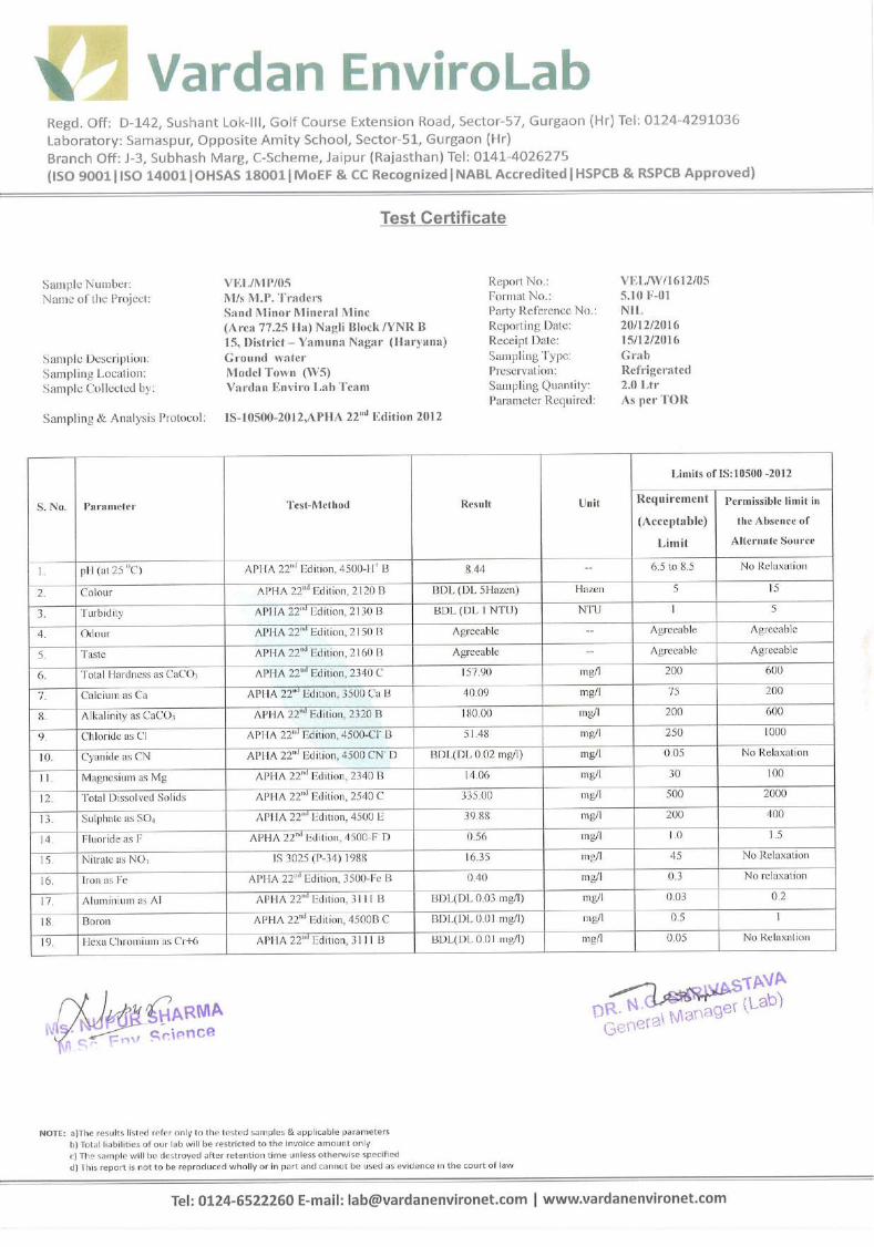
Vardan
Typewritten Text
197

Vardan
Typewritten Text
198

Vardan
Typewritten Text
199

Vardan
Typewritten Text
200

Vardan
Typewritten Text
201

Vardan
Typewritten Text
202

Vardan
Typewritten Text
203

Vardan
Typewritten Text
Vardan
Typewritten Text
Vardan
Typewritten Text
204

Vardan
Typewritten Text
205

Vardan
Typewritten Text
206

© BIS 2012
B U R E A U O F I N D I A N S T A N D A R D SMANAK BHAVAN, 9 BAHADUR SHAH ZAFAR MARG
NEW DELHI 110002
May 2012 Price Group 6
IS 10500 : 2012
Hkkjrh; ekud
ihus dk ikuh — fof'kf"V¼ nwljk iqujh{k.k ½
Indian Standard
DRINKING WATER — SPECIFICATION
( Second Revision )
ICS 13.060.20
Annexure VIII (b)
207

Drinking Water Sectional Committee, FAD 25
FOREWORD
This Indian Standard (Second Revision) was adopted by the Bureau of Indian Standards, after the draft finalizedby the Drinking Water Sectional Committee had been approved by the Food and Agriculture Division Council.
This standard was originally published in 1983. A report prepared by the World Health Organization in cooperationwith the World Bank showed that in 1975, some 1 230 million people were without safe water supplies. Theseappalling facts were central to the United Nations decision to declare an International Drinking Water Supply andSanitation decade, beginning in 1981. Further, the VI Five-Year Plan of India had made a special provision foravailability of safe drinking water for the masses. Therefore, the standard was formulated with the objective ofassessing the quality of water resources, and to check the effectiveness of water treatment and supply by theconcerned authorities.
The first revision was undertaken to take into account the up-to-date information available about the nature andeffect of various contaminants as also the new techniques for identifying and determining their concentration.Based on experience gained additional requirements for alkalinity; aluminium and boron were incorporated andthe permissible limits for dissolved solids, nitrate and pesticides residues modified.
As per the eleventh five year plan document of India (2007-12), there are about 2.17 lakh quality affected habitationsin the country with more than half affected with excess iron, followed by fluoride, salinity, nitrate and arsenic inthat order. Further, approximately, 10 million cases of diarrhoea, more than 7.2 lakh typhoid cases and 1.5 lakhviral hepatitis cases occur every year a majority of which are contributed by unclean water supply and poorsanitation. The eleventh five year plan document of India (2007-2012) recognizes dealing with the issue of waterquality as a major challenge and aims at addressing water quality problems in all quality affected habitations withemphasis on community participation and awareness campaigns as well as on top most priority to water qualitysurveillance and monitoring by setting up of water quality testing laboratories strengthened with qualifiedmanpower, equipments and chemicals.
The second revision was undertaken to upgrade the requirements of the standard and align with the internationallyavailable specifications on drinking water. In this revision assistance has been derived from the following:
a) EU Directives relating to the quality of water intended for human consumption (80/778/EEC) and CouncilDirective 98/83/EC.
b) USEPA standard — National Primary Drinking Water Standard. EPA 816-F-02-013 dated July, 2002.
c) WHO Guidelines for Drinking Water Quality. 3rd Edition Vol. 1 Recommendations, 2008.
d) Manual on Water Supply and Treatment, third edition — revised and updated May 1999, Ministry ofUrban Development, New Delhi.
This standard specifies the acceptable limits and the permissible limits in the absence of alternate source. It isrecommended that the acceptable limit is to be implemented as values in excess of those mentioned under‘Acceptable’ render the water not suitable. Such a value may, however, be tolerated in the absence of an alternativesource. However, if the value exceeds the limits indicated under ‘permissible limit in the absence of alternatesource’ in col 4 of Tables 1 to 4, the sources will have to be rejected.
Pesticide residues limits and test methods given in Table 5 are based on consumption pattern, persistence andavailable manufacturing data. The limits have been specified based on WHO guidelines, wherever available. Incases where WHO guidelines are not available, the standards available from other countries have been examinedand incorporated, taking in view the Indian conditions.
In this revision, additional requirements for ammonia, chloramines, barium, molybdenum, silver, sulphide, nickel,polychlorinated biphenyls and trihalomethanes have been incorporated while the requirements for colour, turbidity,total hardness, free residual chlorine, iron, magnesium, mineral oil, boron, cadmium, total arsenic, lead, polynucleararomatic hydrocarbons, pesticides and bacteriological requirements have been modified.
In this revision, requirement and test method for virological examination have been included. Further, requirementsand test methods for cryptosporidium and giardia have also been specified.
Routine surveillance of drinking water supplies should be carried out by the relevant authorities to understandthe risk of specific pathogens and to define proper control procedures. The WHO Guidelines for Drinking WaterQuality, 3rd Edition, Vol. 1 may be referred for specific recommendations on using a water safety approachincorporating risk identification. Precautions/Care should be taken to prevent contamination of drinking waterfrom chlorine resistant parasites such as cryptosporidium species and giardia.
Annexure VIII (b)
208

1
IS 10500 : 2012
Indian Standard
DRINKING WATER — SPECIFICATION
( Second Revision )
1 SCOPE
This standard prescribes the requirements and themethods of sampling and test for drinking water.
2 REFERENCES
The standards listed in Annex A contain provisionswhich through reference in this text, constituteprovisions of this standard. At the time of publication,the editions indicated were valid. All standards aresubject to revision and parties to agreements based onthis standard are encouraged to investigate thepossibility of applying the most recent editions of thestandards indicated in Annex A.
3 TERMINOLOGY
For the purpose of this standard the following definitionshall apply.
3.1 Drinking Water — Drinking water is waterintended for human consumption for drinking andcooking purposes from any source. It includes water(treated or untreated) supplied by any means for humanconsumption.
4 REQUIREMENTS
Drinking water shall comply with the requirementsgiven in Tables 1 to 4. The analysis of pesticide residuesgiven in Table 3 shall be conducted by a recognizedlaboratory using internationally established test methodmeeting the residue limits as given in Table 5.
Drinking water shall also comply with bacteriologicalrequirements (see 4.1), virological requirements(see 4.2) and biological requirements (see 4.3).
4.1 Bacteriological Requirements
4.1.1 Water in Distribution System
Ideally, all samples taken from the distribution systemincluding consumers’ premises, should be free fromcoliform organisms and the following bacteriologicalquality of drinking water collected in the distributionsystem, as given in Table 6 is, therefore specified whentested in accordance with IS 1622.
4.2 Virological Requirements
4.2.1 Ideally, all samples taken from the distribution
Table 1 Organoleptic and Physical Parameters(Foreword and Clause 4)
Sl No. Characteristic Requirement Permissible Method of Test, Remarks(Acceptable Limit in the Ref to Part of
Limit) Absence of IS 3025Alternate
Source(1) (2) (3) (4) (5) (6)
i) Colour, Hazen units, Max 5 15 Part 4 Extended to 15 only, if toxic substancesare not suspected in absence of alter-nate sources
ii) Odour Agreeable Agreeable Part 5 a) Test cold and when heatedb) Test at several dilutions
iii) pH value 6.5-8.5 No relaxation Part 11 —iv) Taste Agreeable Agreeable Parts 7 and 8 Test to be conducted only after safety
has been establishedv) Turbidity, NTU, Max 1 5 Part 10 —
vi) Total dissolved solids, mg/l, 500 2 000 Part 16 —Max
NOTE — It is recommended that the acceptable limit is to be implemented. Values in excess of those mentioned under ‘acceptable’render the water not suitable, but still may be tolerated in the absence of an alternative source but up to the limits indicated under‘permissible limit in the absence of alternate source’ in col 4, above which the sources will have to be rejected.
Annexure VIII (b)
209

2
IS 10500 : 2012
Table 2 General Parameters Concerning Substances Undesirable in Excessive Amounts(Foreword and Clause 4)
Sl No. Characteristic Requirement Permissible Method of Test, Remarks(Acceptable Limit in the Ref to
Limit) Absence ofAlternate
Source(1) (2) (3) (4) (5) (6)
i) Aluminium (as Al), mg/l, Max 0.03 0.2 IS 3025 (Part 55) —ii) Ammonia (as total ammonia-N), 0.5 No relaxation IS 3025 (Part 34) —
mg/l, Maxiii) Anionic detergents (as MBAS) 0.2 1.0 Annex K of IS 13428 —
mg/l, Maxiv) Barium (as Ba), mg/l, Max 0.7 No relaxation Annex F of IS 13428* —
or IS 15302v) Boron (as B), mg/l, Max 0.5 1.0 IS 3025 (Part 57) —
vi) Calcium (as Ca), mg/l, Max 75 200 IS 3025 (Part 40) —vii) Chloramines (as Cl
2), mg/l, Max 4.0 No relaxation IS 3025 (Part 26)* —
or APHA 4500-Cl Gviii) Chloride (as Cl), mg/l, Max 250 1 000 IS 3025 (Part 32) —
ix) Copper (as Cu), mg/l, Max 0.05 1.5 IS 3025 (Part 42) —x) Fluoride (as F) mg/l, Max 1.0 1.5 IS 3025 (Part 60) —
xi) Free residual chlorine, mg/l, Min 0.2 1 IS 3025 (Part 26) To be applicable only whenwater is chlorinated. Testedat consumer end. When pro-tection against viral infec-tion is required, it should beminimum 0.5 mg/l
xii) Iron (as Fe), mg/l, Max 0.3 No relaxation IS 3025 (Part 53) Total concentration of man-ganese (as Mn) and iron (asFe) shall not exceed 0.3 mg/l
xiii) Magnesium (as Mg), mg/l, Max 30 100 IS 3025 (Part 46) —xiv) Manganese (as Mn), mg/l, Max 0.1 0.3 IS 3025 (Part 59) Total concentration of man-
ganese (as Mn) and iron (asFe) shall not exceed 0.3 mg/l
xv) Mineral oil, mg/l, Max 0.5 No relaxation Clause 6 of IS 3025 —(Part 39) Infraredpartition method
xvi) Nitrate (as NO3), mg/l, Max 45 No relaxation IS 3025 (Part 34) —
xvii) Phenolic compounds (as C6H
5OH), 0.001 0.002 IS 3025 (Part 43) —
mg/l, Maxxviii) Selenium (as Se), mg/l, Max 0.01 No relaxation IS 3025 (Part 56) or —
IS 15303*xix) Silver (as Ag), mg/l, Max 0.1 No relaxation Annex J of IS 13428 —xx) Sulphate (as SO
4) mg/l, Max 200 400 IS 3025 (Part 24) May be extended to 400 pro-
vided that Magnesium doesnot exceed 30
xxi) Sulphide (as H2S), mg/l, Max 0.05 No relaxation IS 3025 (Part 29) —
xxii) Total alkalinity as calcium 200 600 IS 3025 (Part 23) —carbonate, mg/l, Max
xxiii) Total hardness (as CaCO3), 200 600 IS 3025 (Part 21) —
mg/l, Maxxxiv) Zinc (as Zn), mg/l, Max 5 15 IS 3025 (Part 49) —
NOTES
1 In case of dispute, the method indicated by '*' shall be the referee method.
2 It is recommended that the acceptable limit is to be implemented. Values in excess of those mentioned under ‘acceptable’ render thewater not suitable, but still may be tolerated in the absence of an alternative source but up to the limits indicated under ‘permissiblelimit in the absence of alternate source’ in col 4, above which the sources will have to be rejected.
Annexure VIII (b)
210

Vardan
Typewritten Text
Annexure-IX (a)
Vardan
Typewritten Text
Vardan
Typewritten Text
Vardan
Typewritten Text
Vardan
Typewritten Text
Vardan
Typewritten Text
211

Vardan
Typewritten Text
212

Vardan
Typewritten Text
Vardan
Typewritten Text
213

Vardan
Typewritten Text
214

Standard Soil Classification S. NO.
PARAMETERS
CLASSIFICATION
1. pH
<4.5 extremely acidic 4.51 – 5.0 very strong acidic 5.01 – 5.5 strongly acidic 5.51-6.0 moderately acidic 6.1 – 6.5 slightly acidic 6.51-7.3 Neutral 7.31-7.8 slightly alkaline 7.81-8.5 moderately alkaline 8.51 – 9.0 strongly alkaline >9.0 Very strongly alkaline
2. Salinity Electrical Conductivity (mho/cm) 1 mho/cm = 640 ppm
Up to 1.0 average 1-2 harmful to germination 2-3 harmful to crops
3. Nitrogen (kg/ha)
Up to 50 very less 51-100 less 110-150 good 151-300 better >300 sufficient
4. Phosphorus (kg/ha)
Up to 15 very less 15 – 30 less 31-50 medium 51-65 on average sufficient 66-80 sufficient >80 more than sufficient
5. Potassium (kg/ha)
0-120 very less 120-180 less 180-240 medium 241-300 average 301-360 better >360 more than sufficient
Annexure IX (b)
216

Annexure-X
TRAFFIC STUDY
Name of the Project: Mining of Sand (minor mineral) at karhera Block/YNR B-14 Date of Traffic Survey: 26.08.2017 Name of the Road: SH-6 Up: Yamuna Nagar
Down: Ladwa
Fast Moving Vehicles Slow Moving Vehicles Time Two Wheelers Three Wheelers Car/Vans Buses Trucks Cycles Cycle Rishkaw
Up Dn Up Dn Up Dn Up Dn Up Dn Up Dn Up Dn 06:00-07:00 hours 25 24 12 15 23 28 2 1 12 11 6 8 - 1 Day 07:00-08:00 hours 25 22 18 11 25 23 1 1 15 18 9 7 3 2 Day 08:00-09:00 hours 28 25 21 16 28 35 2 1 29 17 10 9 4 5 Day 09:00-10:00 hours 22 20 12 18 24 34 1 1 12 12 5 4 - 1 Day 10:00-11:00 hours 24 12 11 17 24 23 3 1 12 11 7 5 - - Day 11:00-12:00 hours 23 23 17 15 23 13 1 1 18 17 5 4 - - Day 12:00-13:00 hours 40 28 15 10 24 19 2 1 15 15 5 2 - 1 Day 13:00-14:00 hours 21 29 11 2 22 29 1 1 21 16 3 - - - Day 14:00-15:00 hours 32 21 13 10 22 21 2 1 22 28 4 2 1 2 Day 15:00-16:00 hours 36 38 16 14 26 24 2 1 20 19 - - - - Day 16:00-17:00 hours 26 27 12 7 26 26 1 1 10 10 5 2 - 1 Day 17:00-18:00 hours 29 23 15 18 25 23 1 1 22 18 3 4 2 2 Day 18:00-19:00 hours 21 23 16 7 23 24 2 1 22 12 9 9 1 3 Day 19:00-20:00 hours 25 28 12 11 25 24 1 1 17 19 10 12 - - Day 20:00-21:00 hours 31 21 9 8 22 22 1 1 12 17 6 4 2 1 Night 21:00-22:00 hours 22 21 7 13 22 23 2 2 24 18 4 6 - - Night 22:00-23:00 hours 24 22 12 10 24 22 2 1 23 15 1 - - - Night 23:00-00:00 hours 20 27 13 12 32 37 1 1 27 12 - - - - Night 00:00-01:00 hours 27 29 13 12 27 25 1 1 10 17 - - - - Night 01:00-02:00 hours 36 18 15 12 30 28 1 1 10 8 - - - - Night 02:00-03:00 hours 28 15 17 15 28 27 1 1 16 8 - - - - Night 03:00-04:00 hours 40 25 10 15 30 28 2 1 20 15 - - - - Night 04:00-05:00 hours 38 13 10 16 28 21 1 1 10 28 - - - - Night 05:00-06:00 hours 37 16 13 14 27 46 1 1 11 29 2 1 - - Day

Name of the Project: Mining of Sand (minor mineral) at karhera Block/YNR B-14 Date of Traffic Survey: 27.08.2017 Name of the Road: MDR1 Up: NH73
Down: Gangoh
Fast Moving Vehicles Slow Moving Vehicles Time Two Wheelers Three Wheelers Car/Vans Buses Trucks Cycles Cycle Rishkaw
Up Dn Up Dn Up Dn Up Dn Up Dn Up Dn Up Dn 06:00-07:00 hours 18 25 7 6 16 15 3 2 8 5 6 8 - 1 Day 07:00-08:00 hours 13 30 10 7 5 12 2 2 7 5 9 7 3 2 Day 08:00-09:00 hours 22 22 9 5 8 16 2 3 9 4 10 9 4 5 Day 09:00-10:00 hours 12 30 9 12 9 18 1 1 12 10 5 4 - 1 Day 10:00-11:00 hours 24 24 10 7 11 10 1 1 8 7 7 5 - - Day 11:00-12:00 hours 13 21 11 6 17 15 1 1 6 6 5 4 - - Day 12:00-13:00 hours 27 20 12 10 15 12 10 9 5 2 - 1 Day 13:00-14:00 hours 21 29 10 7 11 12 7 4 3 - - - Day 14:00-15:00 hours 22 11 10 10 13 10 10 8 4 2 1 2 Day 15:00-16:00 hours 29 10 12 11 16 15 12 10 - - - - Day 16:00-17:00 hours 26 21 6 8 1 13 8 10 5 2 - 1 Day 17:00-18:00 hours 25 33 12 8 5 13 8 9 3 4 2 2 Day 18:00-19:00 hours 23 23 10 2` 7 10 9 6 9 9 1 3 Day 19:00-20:00 hours 15 25 12 17 10 10 `7 4 10 12 - - Day 20:00-21:00 hours 21 20 19 10 9 18 8 7 6 4 2 1 Night 21:00-22:00 hours 22 21 10 13 13 13 17 13 4 6 - - Night 22:00-23:00 hours 24 22 12 8 10 12 8 4 1 - - - Night 23:00-00:00 hours 30 27 13 9 14 16 1 1 9 10 - - - - Night 00:00-01:00 hours 27 20 13 12 13 13 1 1 15 2 - - - - Night 01:00-02:00 hours 18 28 4 4 11 2 1 1 4 4 - - - - Night 02:00-03:00 hours 18 20 8 5 8 15 1 1 5 3 - - - - Night 03:00-04:00 hours 25 28 9 5 10 10 1 1 10 2 - - - - Night 04:00-05:00 hours 28 20 5 6 25 9 6 5 - - - - Night 05:00-06:00 hours 27 20 3 4 23 10 4 3 2 1 - - Day

Name of the Project: Mining of Sand (minor mineral) at karhera Block/YNR B-14 Date of Traffic Survey: 28.08.2017 Name of the Road:MDR2 Up: Jagadhari
Down: Indri
Fast Moving Vehicles Slow Moving Vehicles Time Two Wheelers Three Wheelers Car/Vans Buses Trucks Cycles Cycle Rishkaw
Up Dn Up Dn Up Dn Up Dn Up Dn Up Dn Up Dn 06:00-07:00 hours 18 25 10 8 14 7 1 1 6 7 6 8 - 1 Day 07:00-08:00 hours 20 16 8 6 15 3 1 1 7 8 9 7 3 2 Day 08:00-09:00 hours 23 12 8 7 18 5 1 1 7 7 10 9 4 5 Day 09:00-10:00 hours 14 27 6 9 12 3 2 2 7 9 5 4 - 1 Day 10:00-11:00 hours 24 22 6 7 7 7 2 2 9 8 7 5 - - Day 11:00-12:00 hours 33 29 7 15 5 4 1 1 8 7 5 4 - - Day 12:00-13:00 hours 25 21 5 10 5 14 1 1 5 5 5 2 - 1 Day 13:00-14:00 hours 21 28 11 12 7 6 1 1 7 9 3 - - - Day 14:00-15:00 hours 22 21 13 10 17 5 1 1 4 9 4 2 1 2 Day 15:00-16:00 hours 26 17 16 7 4 18 1 1 4 6 - - - - Day 16:00-17:00 hours 26 21 8 6 10 6 5 9 5 2 - 1 Day 17:00-18:00 hours 22 22 8 8 6 6 2 8 3 4 2 2 Day 18:00-19:00 hours 23 21 7 2` 8 4 3 7 9 9 1 3 Day 19:00-20:00 hours 25 20 7 `7 19 4 5 9 10 12 - - Day 20:00-21:00 hours 21 10 9 8 8 21 6 9 6 4 2 1 Night 21:00-22:00 hours 22 21 7 8 7 23 9 7 4 6 - - Night 22:00-23:00 hours 13 22 12 5 9 17 8 2 1 - - - Night 23:00-00:00 hours 20 23 7 23 10 3 4 3 - - - - Night 00:00-01:00 hours 13 20 3 9 16 12 2 5 - - - - Night 01:00-02:00 hours 10 18 5 6 17 14 1 1 18 5 - - - - Night 02:00-03:00 hours 18 20 9 5 6 10 1 1 19 6 - - - - Night 03:00-04:00 hours 19 25 10 5 11 14 1 1 17 7 - - - - Night 04:00-05:00 hours 17 20 5 2 19 16 1 1 8 6 - - - - Night 05:00-06:00 hours 10 21 3 4 10 18 1 1 5 2 2 1 - - Day

Name of the Project: Mining of Sand (minor mineral) at karhera Block/YNR B-14 Date of Traffic Survey: 29.08.2017 Name of the Road:MDR3 Up: Radaur
Down: Jagadhari Fast Moving Vehicles Slow Moving Vehicles
Time Two Wheelers Three Wheelers Car/Vans Buses Trucks Cycles Cycle Rishkaw
Up Dn Up Dn Up Dn Up Dn Up Dn Up Dn Up Dn 06:00-07:00 hours 17 34 33 12 20 28 2 2 12 17 6 8 - 1 Day 07:00-08:00 hours 20 31 35 14 22 28 1 2 14 12 9 7 3 2 Day 08:00-09:00 hours 32 24 14 17 22 27 1 1 12 16 10 9 4 5 Day 09:00-10:00 hours 28 29 13 18 26 22 1 1 4 19 5 4 - 1 Day 10:00-11:00 hours 25 10 22 15 21 23 1 1 9 14 7 5 - - Day 11:00-12:00 hours 20 23 18 23 23 12 1 1 12 16 5 4 - - Day 12:00-13:00 hours 21 22 16 22 25 14 2 1 7 12 5 2 - 1 Day 13:00-14:00 hours 23 25 15 12 23 13 1 2 10 3 - - - Day 14:00-15:00 hours 16 20 14 6 12 18 9 2 4 2 1 2 Day 15:00-16:00 hours 12 11 14 16 27 20 1 13 3 - - - - Day 16:00-17:00 hours 27 21 5 12 12 21 1 1 1 5 5 2 - 1 Day 17:00-18:00 hours 23 14 14 17 11 22 8 4 3 4 2 2 Day 18:00-19:00 hours 26 11 11 12 14 26 1 3 2 9 9 1 3 Day 19:00-20:00 hours 22 13 7 2 23 28 5 4 10 12 - - Day 20:00-21:00 hours 16 24 22 14 15 29 14 14 6 4 2 1 Night 21:00-22:00 hours 16 17 17 12 23 25 13 7 4 6 - - Night 22:00-23:00 hours 21 23 12 21 12 22 10 3 1 - - - Night 23:00-00:00 hours 31 29 17 10 17 10 1 1 16 9 - - - - Night 00:00-01:00 hours 30 33 10 19 17 20 2 2 6 6 - - - - Night 01:00-02:00 hours 21 23 11 18 18 15 2 2 2 3 - - - - Night 02:00-03:00 hours 22 24 18 10 25 16 2 2 9 9 - - - - Night 03:00-04:00 hours 27 23 18 12 20 28 2 2 4 9 - - - - Night 04:00-05:00 hours 29 29 10 21 27 20 2 2 4 2 - - - - Night 05:00-06:00 hours 25 37 24 25 25 3 1 2 6 12 2 1 - - Day

Environmental Policy
M/s M.P. Traders, District Yamuna Nagar acknowledges its responsibility to manage the environmental effects
associated with the Mining of Sand Minor Mineral Mining at Nagli Block/YNR B 15, Yamuna Nagar, Haryana; as
we pursue our goal of generating value for our employees and our local communities.
Implementation:
Comply with applicable environmental laws and regulations at all time; at all locations and at all stages of exploration, development, operations and reclamation.
Establish and maintain standards, procedures and management controls to ensure that environmental considerations are balanced equally with competing priorities and other key business activities.
Ensure that all employees and contractors are trained to understand their environmental responsibilities and create an environment that adheres to the Company’s Policies, procedures and applicable regulations.
Hold leadership accountable for good environment performance of our operations and projects. Inherent in that accountability will be the commitment of senior management to provide resources and successfully create an appropriate environment.
Reward and recognize behavior that supports environmental stewardship.
Implement procedures to measure environmental performance, including regular inspection by our consultancy to verify compliance with all the applicable regulations.
Communicate openly with employees, regulatory agencies, the public and shareholders on environmental issues.
Work proactively with other mining companies, policy makers and the public to define environmental priorities and to contribute to the development of responsible laws and regulations to protect the environment.
Actively engage with credible third parties to develop continuous improvement in our environmental policies and practices.
Continuously review environmental achievements and technologies to share and promote implementation of best practices.
The system of reporting of Non-conformances/ violation of any Environmental Law/Policy will be as per quality management system. The internal audit will be conducted on periodic basis and any Non-conformances/ violation to Environmental Law/Policy will be closed and discussed during Management Review Meetings of board of directors/partners.
For M/s M.P. Traders
Vardan
Typewritten Text
Annexure-XI
Vardan
Typewritten Text
219

Hierarchy of Environment for dealing Environmental Issues
For M/s M.P. Traders
Supervisor (4)
Horticulturist (4)
Environment Executive (2)
Asst. Manager (Environment)
Manager (EHS)
Vardan
Typewritten Text
220
Vardan
Typewritten Text

Regional OfficeHaryana State Pollution Control Board
S.C.O No. 131, Sector-l 7, I agadhri (Yamuna Nagar), Ph - 07732-?50737
No. HSPCB / YMN /820To
Dt:Otl06l2OL7
The Chairman, ,
Haryana State Pollution Control Boar{Panchkula.
Sub: Proceedings of the Public Hearing held under provisions of EIA Notification,14.9.2006(amended to date) for proposed mining of Sand (Minor Mineral) in Yamuna Nagarallotted IWs M.P. Traders on 23.05.2017 at 12:00 P.M. at Project Site Village - Nagli,Tehsil -Radaur, District Yamuna Nagar.
Please refer to the subject noted above.
In this connection, it is intimated that public hearing of the above said unit was held on23.05.2017for Environmental Clearance for proposed project for minor mineral sand quarry *l!f,P.
Traderls" (Area 77.25 Ha), Proposed production capacity: 28,00,000 TPA) at village Nagli, TehsilRadaur, Disfict Yamuna Nagar under the Chairmanship of Deputy Commissioner, Yamuna Nagar.The proceedings of the public hearing has been approved by the Deputy Commissioner, YamunaNagar received on 01.06.2017and is hereby enclosed for your further necessary action please.
It is submitted for your kind information and further necessary action please.
.€..IEqE!L$$E.w
DA/l.Copy of attendance register of offrcerspresent during the hearing.
2. Copy of attendance register of Publicpresent during the hearing.
. 3. Soft copy (CD) of proceedings of hearing (2 No.)4. Photographs ofthe hearing (2 No.)5. Approved copy in original of proceeding of hearing
by Deputy Commissioner, Yamuna Nagar.
11 Regional
lTxamunaNagar.
oi\o6Offrcer,
HP
Typewritten Text
Annexure-XII

: '. ' .. . , | '..a
roYision of EIA notification 2006Sub:- ProceeSirrg of the Public'Heanng under the'pt
(amended to dhtej forproposed minins of $and (Minor Miner{)-in T:.T"-" T:eT ?:to:lio nd/r:'M.p. Trad.r* ou 21.0s;eorr at 12100 P.M. at Proibct $iteVrltaged"gtt' Tehsil-
Radaur, District-Yamuna Nagar. :
The draft proceeding of the Public Heaqrng:cortducted on dated 23'05'2917 at Village Nagli'
Tehsil,Radaur, Eistrict-yamuna Nagar for project of Minor Mineral Sand Mining of Village
Nagli, District Yamuna Nagar regarding Environmental Clearance for propOsed project of
miniye fo1 Minol Mineral sand query by tws M.P. Traders at villagq - Nagli; Tehsil-Radaur,
oisYict-yamunaNaga has been prepared which is enclosed herewith for approval please' ' ,
!!
HSPCB, Yamuna Nagar
ldtu4Deputy Commfo,sffier,
Yamuna Nagar.
'-"r

proceeding of the Public consultation (Ilearing) ol*t the provision of EIA notification
2006 (amended to JJ") rot proposed mininf of Sand 11y1inor Mineral) in Yamuna
Nagar atlotted l1/r M.p: 1'.uO"rs'on zl.its-Zgil at 12:00 P'M' at Project Site Viltage -Nagli, Tehsil-Radaur, District-Yamuna Nagar having lease area of 77'25ha'' Having the
capaciry 28,00,000iirA and the Proieci c91 ^o1i.s. 9.00 Crores held under
Chairmanship of Sn nontash Singh, titrarU I.A.S.' Deputy Commissioner' Yamuna
Nagar.
'l'he Pubic hearing was held as a mandatory requirement under EIA notification dated
14,09.2006 and subsequent amendment on date l5'01 '2016'
venue : At Site village Nagli, Tehsil Radaur;, District-Yamuna Nagar Haryana'
Date & Time: 23.05.2Q17 at 12:00 PM'
Officers Present:-
1.Sh'RohtashSinghKharbI.A.S.'DeputyC_ommissioner,YamunaNagar.2. Dr.Pooja Bharti, SDM Raduar, Yamuna Nagar' \r - -,3. sh. Rajiv Dhiman, Mining officer, Mines and GeologY' YamunaNagar'
4. Sh.Dinarrath Sharma, BD & Po, Radaur, YamunaNagar.
5. Sh Rajinder Sharma, Regional Officer' YampnaNagar'
6. Sh.Virender Singh Punia , AEE, Yamuna Nagar Region, Haryana State Pollution
Control Board.
7. Sh. Kamaljit Singh, AEE, Yamuna Nagar Region, Haryana State Pollution control
Board'
S.Sh.omDuttSharma,Mininglnspector,MiningDepartment,YamunaNagar
9. Sh.Jai Singh,IPRO, DIPRO, YamunaNagar
10.Sh.V.P. Singh Walia, IF'O, o/o GMDIC' YamunaNagar
11.Sh Shashi Bhushan Sharma, J'E o/o DTP ' YamunaNagar'
The attendance sheet of Officers and Putiiic men/villagers present during the Public
Hearing is annexed as Annexure-A'
copies.of the presentation in Hindi of draft EIA of yr.Y:*. Traders at village -Nagli, Tehsil-Radaur, Distriot-Yamuna Nagar were distributed to the officials and
other present in the hearing'
At the onset of Public Hearing, Rajinder Sharma' Regional officer, Yamuna Nagar
Region, Haryana State Pollution control Board, welcomed sh. R's' Kharab, I'A'S''
DeputyCommissioner,YamunaNagarandotherofficersoftheDishictAdministration, panches & Sarpanches of sunounding area and public present in the
;;il;. il iri"r"o about the necessity of the public hearing being held under
provision of EIA notification of dated 14th Septemb er 2006, amended to date' Then he
iequested the project proponent to explain in detail about the project'
Further formal permission to inaugurate the process of public hearing was granted by
the chairman Sh. Rohtash Singh Kharb, I.A.S., Deputy commissioner, Yamuna
Nagar. i
nsultant to make theThereafter, Regional Offiier' HSPCB requested project co:
presentationfortheprojectforinforrnationofallthepeoplepresent.
Environment consultant sh. R.s. Yadav, of the project proponent lws M'P' Traders at
village -Nagli, Tehsil-Radaur, District-Yamuna Nagar explained in detail abgultfe
project of Mining by way of presentation. They explained that the mining shall be
done in Nagli Viliage in ,in., bed. They explained about the pollution. and
degradation of Environment to be expected from the proposed project and the
measures to be taken by the project proponent. He also explained the contents of the
Environment managemlnt plan in brief prepared by them for the project and impact
of the project on Environment along with control measures/steps.
The details submitted by the consultant were recorded'
After the presentation, Regional officer, Yamuna Nagar, Haryana state Pollution
Control Board called for.the questions/suggestion/objection to seek information or
clarification on the project by the public and the following issues
/objection/suggestion raised and information/clarification sought - on the project'
environment related issues by the participant and reply given by the representative
unO .nuironmental consultant ofthe projeet proponent and other concerned are given
below:-
The following questions were raised:
Sh.IshamSingh,Vill-Chorpura,gavefollowingsuggestionandaskedquestion/suggestiondetailedasbelow:- , ^ ! rr:,-He asked that how many people will be employed from this proposed Sand Mining
Project?.
Reply.:-sh. RS Yadav, Environment_ consultant and lease holder replied that so many
employment opportunities will be generated from this project' 115 skilled and semi-
skilled pebple witt get direct employment from this project, 105 dumpers will be used
in this project and each dumper requires 4.5 people i'e' driver, cleaner' helper' About
500-700 people will be employed for this purpose. Every year 7,800 trees will be
planted that will need so many gardeners to take care of the plants. 22KLD water will
be used for dust suppression for which many persons will be employed' Bill clerks
J1 also be needed ior this project and to fulfil this purPose graduated students will
beemployedfromthelocalvillages.Thesearethedirectemploymentopportunities.
t;?r"; this so many indirect employment will also be generated i.e. niany hotels,
workshop repair, tea stalls, general store will be established and so many employment
opportunities will be generated. Lease holder assured that first priority for
employment will be given to local villagers only'
l.

2. sh. satish Kumar, gave following suggestion and asked question/suggestion
detailed as below:-
He asl.<ed that what arrdngements will be done for the health of mine workers?
Reply:- Sh. RS Yadav, Environment Consultant replied that a budget of Rs' 10 Lakhsiyear
has been propgsed for the health safety of mine workers. A qualified MBBS doctor
will U" uppoini.O, first aid, medical centre will be established at project site' Regular
health checkup *itt U" conductbd by doctors and villagers also take adrrantage of that'
Dust mask will be provided to the workers to protect themselves frorn dust'
Awareness training pfoglamme will also be organized periodically to the workers to
minimize the impaci of air pollution. Proper care will be taken of the workers :" lh:'it won't affect the health of workers. Medical camps will be organized quarterly/ six
monthly in which our workers and villagers will also be benefitted'
A budiet of Rs. 10 t akh/year is proposed for occupational health safety of mine
workers.
3: Sh. Mohit, gave following suggestion and asked question/suggestion detailed as
below:-. FIe asked what will be the benefits of this project to the villagers?
Reply:-Sh. RS Yadav, Environment consultant replied that firstly this project is
environment friendly project. The sediment comes along with the flow of river and
get accumulated so the level of river get raised and if the accumulated sediments/sand
will not be excavated then the river can divert from its original path that could lead to
the flood. So, the mining will be done upto 3 m in systematic scientific manner and
thesandwillexcavatedonregularbasis'sotheriverwillflowinchannelandwillnotdivertinanyotherdirectionandtheflowwillbesmooth.
Secondly, good opportunity for generation of erirployment from this project and first
preference will be given to the local villagers only. Details has been already given in
reply of para no.-l. lhis sanO is used for development of infrastructure in the state of
HaryanaandtheNCR.Sothisprojectisbeneficialineverymanner.
4. Sh, Gurdayal Singh, Village: Gadi Guiran' gave following suggestion and asked
question/suggestion detailed as below:-
He said that how many trees will be planted?
n"pfyr- it. RS Yudun, Environment Consultant replied that 7,800 trees will be planted per
year, that means approx. 39000:40000 trees will be planted in five years' only local
speciesoftreeswillbeplantedafterconsultationwithDFo.These trees will be planted tq minimize the air pollution and noisb pollution'
plantatioh will also be done along with the road of hansportation, premises of Gram
Panchayat Bhawan, Hospitals, schools etc' .
A budept of Rs. 30 Lakhs/year has been OtoSttU for EMP'
K'2-
Sh. Nekiram, Village: Garhi Birbal gave following
question/suggestion detailed as below:-
He asked that what kihd of pollution will be generated
suggestion and asked
due to proPosed mining
i
1
Projeet? ,! - r a,.^r :- iReply:- sh. RS Yadav, Environment consultant replied that in this sand mining project there
is a possibility of air pollution due to mining and transportation bf sand' To mitigate
this, u Orop".iounugt-"n1plT i'being proposed' a budget of Rs' 30 Lakhs/year is
. also proposed for EMp. Regularuprintting of.water will be done at active mining
atea, and on haul road for dust suppression'
7800 trees per year will be planted along haul road, that will be helpful in minimizing
dust generation. Trucks will not bg driven overloaded and the trucks will also be
covered with Tarpaulin. If wind blows in high velocity than the mining work and
transportationwillbesuspendeduntilitbecomesstable,andminimizetheimpactofair Pollution.
6. Sh. vikram Singh, village: Karoda Jaagir, gave following stiggestion and asked
question/suggestion detailed as below:-
He asked tfraiwtrat is the provision of social development of this village?
Reply:- sh. RS Yadav, Environment consultant replied.that a csR budget of Rs' 30
Lakhs/year has been proposed which includes provision of toilets in govt' schools'
drinking . water faciliiy in local villages and scholarships for students' vocational
training. A meeting will be organizeJwith Gram Panchayat before commissioning
Mining Activity Jnd priority list will be prepared as per the need of villages'
Monitoririg of these activities will also be done.'Regularly compliance report will be
sent to the HSPCB after gettin$ Environmental clearance and if they find any
deficiency in compliance then oiltrict Administration officers may t4ke legal action
against the lease holder'
j.Sh.AvtarSingh,Village:GumthalaRao,gavefollowingsuggestionandaskedquestion/.uggi'ion detailed as below:-
HesaidthatminingisbeingdoneinourvillageGumthalaandthereisnoprovisionofsprinklingofwatertocontroltheairpollutionandnolocalpeoplehavebeen
...-employed.Youaresayingthatminingwill.bedoneonlyupto3mbuttheyareexcavating upto 9m so that should be res{ricted'
Whether the sand is free for local Villagers?
Reply:-Sh.RSYadav'F,nvironmentConsultantrepliedthatthisisrelatedtoanotherprojectandadvisedtomadecomplainttoRegionaloffice,HSPCB,DeputyCommissioner'
: . Yamuna Nagar and mining officer in this regard'
Lease holder assured that for social and religious work' sand will be given free of
cost.
A cSR budget of Rs. 30 Lakhs/year has been proposed which lntlul"t developr-nent
of toilets i,i gon,. schools, orint<ing water facility and scholarships for students'
vocational training.
Lease holder assured that first priority for employment-will be given to local villagers
;"t Priority list will be prepared as per the need of villages'

wSh.R.s.Kharb,I.A.S.,DeputyCommissioner-YamunaNagar:.Deputycommissioner,, Yamuna Nagar suggested that this sand mining proiect is very
beneficial for the local villagers. villagers *itt be benefited in employment and csR
activity. This is eco-friendly mining project which prevent the flooding in the village
ur"u. Th" mining material willbe given to the villagers on concessional rate'
He also direqted the Regional officer, HSPCB and mining offtcers tO inspeit the
mining site of village gumthala and ensure the compliance of EC granted to the lease
holder.
Rajinder sharma, Regional offtcer, Haryan4 State Pollution-control Board' Yamuna
Nagal requested for any other suggestion/query from the public'
l-here after, with the permission of Deputy commissioner, Yamuna Nagar,
Regional officer, Haryana State Pollution control Board, Yamuna Nagar declared the
publi"hqa.ingtobeconcluded&endedwithavoteofthanks.
- zGle<t?
Raiinder Sharmh, I'[t/;4
Sh.R.S.M,Regional Officer, HSPCB,
YamunaNagar
Deputy Commissioner,
YamunaNagar

VL

%los / e-o t+


{u
"()

Page No.
--
4 )nl


Mining of Sand (Minor Mineral) at Nagli Block YNR/B-15 (area-77.25 Ha.)
Village- Nagli, Tehsil-Radaur, District-Yamuna Nagar, Haryana. Questionnaire
PROFORMA FOR ENVIRONMENTAL APPRAISAL OF MINING PROJECTS
(MINING SECTOR PROJECTS)
1. General Information
(a) Name of the project : Mining of ‘Sand’ (Minor Mineral) at Nagli Block/ YNR
B 15 (ML Area- 77.25 Ha.) for production of 28,00,000 TPA.
Name of the proponent : Sh. Vedpal Mandhan
Mailing Address : Prop M/s M.P. Traders
Near Nirankari Colony, Karnal Road, Indri, Karnal
E-mail : [email protected]
Telephone : +91-9896670267, 9896248266
Fax No. : -------------------
(b) Objective of the project : Mining of ‘Sand’ (Minor Mineral) at Nagli Block/ YNR B15
(c) Location of mine (s) :Block- Nagli, Tehsil-Radaur, District Yamuna Nagar (HR)
(d) Does the proposal relate to:
(i) New mine Yes No
(ii) Expansion Yes No
Increase in ML area Yes No
Increase in annual
production Yes No
(iii) Renewal of ML Yes No
(iv) Modernization Yes No
(e) Site Information
(i) Geographical Location
Latitude and Longitude
Pillar No. Latitude Longitude
A N 29° 58’ 29” E 77° 13’ 47”
B N 29° 58’ 30” E 77° 13’ 50.5”
C N 29° 58’ 16” E 77° 13’ 48.5”
D N 29° 58’ 02” E 77° 13’ 46”
E N 29° 58’ 02” E 77° 13’ 45”
F N 29° 57’ 38” E 77° 13’ 45”
G N 29° 57’ 24” E 77° 13’ 37”
H N 29° 57’ 38” E 77° 13’ 13”
I N 29° 57’ 40” E 77° 13’ 20.5”
Note 1: All information to be given in the form of Annex/s should be properly numbered and form part of reply
to this proforma.
Note 2: Please enter √ in appropriate box where answer is Yes / No
Note 3: No abbreviation to be used - Not available or Not applicable should be clearly mentioned.
Note 4: Core zone is the mining lease area.
Buffer zone in case of ML area up to 25 ha. is to be considered as 5 Km all around the periphery of the
core zone and for ML area above 25 ha. an area 10 Km all around the periphery of the core zone.
Note 5: Adopt Scoping process in carrying out EIA study.
Note 6: Please indicate source of data.

Mining of Sand (Minor Mineral) at Nagli Block YNR/B-15 (area-77.25 Ha.)
Village- Nagli, Tehsil-Radaur, District-Yamuna Nagar, Haryana. Questionnaire
Survey of India Toposheet number
Elevation above Mean Sea Level
Total mining lease area (in ha.)
(ii) Dominant nature of terrain
Flat Yes No
Undulated Yes No
Hilly Yes No
2. Land usage of the mining lease area (in ha.)
(a) Agricultural
(b) Forest
(c) Waste land
(d) Grazing
(e) Surface water bodies
(f) Others (Specify)
Total
3. Indicate the seismic zone in which ML area falls. In case of zone IV and V, details of earth
quakes in last 10 years.
The project site falls under seismic zone IV which is a high damage risk zone (MSK VII-VIII) Details
incorporated in Chapter 2 with the heading of Seismicity of Area, Point No. 2.5
(a) Severity (Richter Scale): No major earthquake in recent years.
(b) Impact i.e. Damage to
Life Yes No
Property Yes No
Existing mine Yes No
J N 29° 57’ 46” E 77° 13’ 27”
K N 29° 58’ 06” E 77° 13’ 28”
L N 29° 58’ 10” E 77° 13’ 32”
M N 29° 58’ 10” E 77° 13’ 39”
N N 29° 58’ 15” E 77° 13’ 43”
O N 29° 58’ 15” E 77° 13’ 42”
P N 29° 58’ 25” E 77° 13’ 42”
NIL
NIL
NIL
NIL
NIL
Yamuna Riverbed
77.25 Ha.
H43L8, H43L5, H43R1, H43L4
Lowest Elevation -258 m amsl,
Highest Elevation-261 m amsl
77.25 Ha.

Mining of Sand (Minor Mineral) at Nagli Block YNR/B-15 (area-77.25 Ha.)
Village- Nagli, Tehsil-Radaur, District-Yamuna Nagar, Haryana. Questionnaire
4. Break-up of mining lease area (in ha.) as per approved conceptual plan:
Purpose
Mining Lease Area
Total
Area acquired Area to be acquired
Government Private Government Private Government Private
Forest Others Agri. Others Forest Others Agri. Others Forest Others Agri. Others
1. Area to be excavated Nil 58.71 Nil Nil 58.71 Nil 58.71 Nil Nil Nil Nil Nil Nil
2. Storage for top soil Nil Nil Nil Nil Nil Nil Nil Nil Nil Nil Nil Nil Nil
3. Overburden / Dumps Nil Nil Nil Nil Nil Nil Nil Nil Nil Nil Nil Nil Nil
4. Mineral storage Nil Nil Nil Nil Nil Nil Nil Nil Nil Nil Nil Nil Nil
5. Infrastructure (Workshop,
Administrative Building) Nil 0. 02* Nil Nil 0. 02* Nil 0. 02* Nil Nil Nil Nil Nil Nil
6. Roads Nil Nil Nil Nil Nil Nil Nil Nil Nil Nil Nil Nil Nil
7. Railways Nil Nil Nil Nil Nil Nil Nil Nil Nil Nil Nil Nil Nil
8. Green Belt Nil 8.00* Nil Nil 8.00* Nil 8.00* Nil Nil Nil Nil Nil Nil
9.Tailings pond Nil Nil Nil Nil Nil Nil Nil Nil Nil Nil Nil Nil Nil
10.Effluent treatment plant Nil Nil Nil Nil Nil Nil Nil Nil Nil Nil Nil Nil Nil
11.Coal handling plant /
mineral separation plant Nil Nil Nil Nil Nil Nil Nil Nil Nil Nil Nil Nil Nil
12. Township area Nil Nil Nil Nil Nil Nil Nil Nil Nil Nil Nil Nil Nil
13.Other (Specify)
(Safety Zone
= Restricted + unworked area)
Nil 18.54 Nil Nil 18.54 Nil 18.54 Nil Nil Nil Nil Nil Nil
TOTAL --- 77.25 Nil --- 77.25 Ha. --- 77.25 Ha. Nil --- --- --- --- ---
* Infrastructure (0.02 Ha.) and Green Belt development (5.0 Ha.) are included in Safety Zone (i.e. 18.54 Ha.).

Mining of Sand (Minor Mineral) at Nagli Block YNR/B-15 (area-77.25 Ha.)
Village- Nagli, Tehsil-Radaur, District-Yamuna Nagar, Haryana. Questionnaire
5. Township (outside mining lease): Not Applicable
(a) Total area (in ha)
(b) No. of dwelling units
(c) Distance from mine site
6. Distance of water bodies (in Km): Lease area is on River bed Yamuna River.
Distance
from
River Bank * Other Water bodies *
Sea / creek / lake / nalla etc. (specify)
Mining lease boundary 0.0 Yamuna River (Riverbed)
Augmentation Canal ( 9 km in NW )
Budhi Nadi (1 km in SE)
Purani Nadi (6.1 Km in SW)
Kunjpura Bandh (6.1 Km in SW)
Ancillary facilities Nil Nil
[* From highest flood line / high tide line]
7. For projects falling within the Coastal Regulation Zone (CRZ)
Whether the mineral to be mined is of rare
nature and not available outside CRZ? Yes No
if yes, annex a scaled location map showing low tide line (LTL), high tide line (HTL) duly
demarcated by one of the authorized agencies* [ *Director, Space Application Centre,
Ahmedabad: Centre for Earth Sciences Studies, Thiruvananthapuram: Institute of Remote
Sensing, Anna University, Chennai: Institute of Wetland Management & Ecological Designs,
KolKata: Naval Hydrographers‟s Office, Dehradun: National Institute of Oceanography,
Panjim, Goa: and National Institute of Ocean Technology, Chennai], boundary of mining
lease area, distance of ML area from LTL and HTL CRZ boundary and CRZ classification of
the project area as per the approved Coastal Zone Management Plan, and settlements, sand
dunes, mangroves, forest land/patches, turtles breeding and nesting sites etc., if any, in the
project area.
8. Indicate aerial distance from the periphery of core zone / area from the periphery of the
buffer zone to the boundary of following (up to 10 Km):
S. No. Areas Name Aerial distance from
(in Km.)
Core * Buffer*
Zone Zone
1. National Park / Sanctuary NOT PRESENT IN STUDY AREA --
2. Biosphere Reserve / Tiger
Reserve / Elephant
Reserve / any other
Reserve
NOT PRESENT IN STUDY AREA --
3. Forest (RF / PF /
unclassified)
NOT PRESENT IN STUDY AREA --
4. Habitat for migratory
birds
None with in 10 Km radius of the
project
--
NA
NA
NA

Mining of Sand (Minor Mineral) at Nagli Block YNR/B-15 (area-77.25 Ha.)
Village- Nagli, Tehsil-Radaur, District-Yamuna Nagar, Haryana. Questionnaire
5. Corridor for animals of
schedule I & II of the
Wildlife (Protection) Act,
1972
There is no any corridor for wild
animals. However Peafowl movement is
very common in the study area. The
conservation Plan has been prepared to
conserve for wildlife.
--
6. Archaeological sites
* Notified
* Others
None with in 10 Km radius of the
project
--
7.
Defense Installation None with in 10 Km radius of the
project
--
8. Industries / Thermal
Power Plants
NONE with in 10 Km radius of the
project
--
9. Other Mines NONE with in 10 Km radius of the
project.
--
10. Airport Chandigarh Airport 88.0 Km North West
11. National / State
Highways
SH-6 4 Km in N
[* Buffer zone in case of ML area up to 25 ha. is to be considered as 5 Km all around the periphery of the core zone and for
ML area above 25 ha. an area 10 Km all around the periphery of the core zone].
9. Description of flora & fauna separately in the core and buffer zones.* [* Consult the Wildlife (Protection) Act, 1972 as amended subsequently and list species with (1) Common name (2)
Scientific name and (3) under which schedule of the Wildlife (Protection) Act the identified species fall. Get the list
authenticated by an Expert in the field / credible scientific institute / University /Chief Wildlife Warden Office. Information
to be based on field survey.]
A. Flora
S. No. Type Core Zone Buffer Zone
1. Agricultur
al crops
There is no any crop
in River dry bed.
a. Major Crops:
Wheat (Triticum aestivum), Paddy (Oryza sativa),
Sugar cane (Saccharum officinarum), Maize (Zea mays)
and Barley (Hordeum vulgare)
b. Minor crops: The minor crops of this region are
Mustard (Brassica campestris var.), Green gram
(Vigna radiate), Sesamum (Sesamum inicum), Pigeon Pea
(Punica granatum), Lentil (Lens culinaris) and Black
Gram (Vigna mungo).
2. Commerci
al crops
None in Riverbed
area.
Sugar Cane,
Major Vegetable corps:
Amari: Hibiscus subderifa.
Brinjal: Solanum melongena.
Cabbage: Brassica oleracea.
Carrot: Daucus carota.
Cauliflower: Brassica oleracea.
Chilli: Capsicum annum.
Coriander: Coriandrum sativum
Garlic: Allium sativum
Potato: Solanum tuberosum.
Radish: Raphanus sativus.
Spinach: Beta olirecia.
Sponge gourd: Luffa cylindrica.
Tomato: Lycopersicum esculantum
White gourd (winter melon): Benincasa hispida.

Mining of Sand (Minor Mineral) at Nagli Block YNR/B-15 (area-77.25 Ha.)
Village- Nagli, Tehsil-Radaur, District-Yamuna Nagar, Haryana. Questionnaire
3. Plantation None Detail List of Plantation including Trees, Herbs, Shrubs,
Climbers are incorporated in Chapter-4 of EIA/EMP
report and as Annexure-XII.
4. Natural
vegetatio
n / forest
type
None There are 1 Protected and Reserve Forests found
within the study area. The detailed list of forests is
already given in point No. 8 of this Questionnaire.
5. Grass
lands
None None
6. Endangere
d species
None None
7. Endemic
species
None None
8. Others
(Specify)
None None
B. Fauna
S.
No.
Type Core Zone Buffer Zone
1. Total listing of faunal
elements
None Detail List of fauna including Mammals,
Birds, Reptiles, Fishes, Domestic animals are
incorporated in Chapter-4 of the EIA/EMP
report and as Annexure-XII.
2. Endangered species None None
3. Endemic species None None
4. Migratory species None None
5. Details of aquatic
fauna, if applicable.
None None
10. Details of mineral reserves (as per approved Mining Plan)
Quantity (in million tonnes)
(a) Proved
(b) Indicated
(c) Inferred
(d) Mineable reserves
11. Major geological formation / disturbances in the mining lease area
(a) Geological maps submitted Yes No
(b) Geological sections submitted Yes No
(c) Contour map submitted Yes No
(d) Whether the presence, if any, noted of
(i) Faults Yes No
46,35, 000 MT
---
---
35,22 ,600 MT

Mining of Sand (Minor Mineral) at Nagli Block YNR/B-15 (area-77.25 Ha.)
Village- Nagli, Tehsil-Radaur, District-Yamuna Nagar, Haryana. Questionnaire
(ii) Dykes Yes No
(iii) Shear Zone Yes No
(iv) Folds Yes No
(v) Other weak zones Yes No
(e) Source of data (Indicate)
12. Production of mineral(s) and life of mine
a. Rated capacity of mine mineral wise (Tonnes / annum)
b. Life of mine at proposed capacity (Years)
c. Lease period (Years)
d. Date of expiry of lease (D /M /Y)
(d) Indicate in case of existing mines
(i) Date of opening of mine
(ii) Production in the last 5 years 1st year 5th year
From year……… to year ………
in million tones.
(iii) Projected production for the next 6th to 10th year
5 years from year ……… to year
………..in million tones.
(iv) Whether mining was suspended after Yes No
opening of the mine?
If yes, details thereof including last production
figure and reason for the same.
(f) Whether plans & sections provided? Yes No
13. Type and method of mining operations
TYPE METHOD
Opencast
(For Riverbed)
Manual
Underground Semi-mechanized
(For Riverbed)
28,00,000 TPA
This is River bed mining project
so Sand will be replenished
every year.
10 Year (20.10.2026)
10 years
NOT APPLICABLE
NA
NA
NA
NA
Approved Mining Plan
-
-

Mining of Sand (Minor Mineral) at Nagli Block YNR/B-15 (area-77.25 Ha.)
Village- Nagli, Tehsil-Radaur, District-Yamuna Nagar, Haryana. Questionnaire
Both Mechanized
14. Details of ancillary operations for mineral processing
(a) Existing
(b) Additional
15. Mine details
(a) Opencast mine
(i) Stripping ratio (mineral in tonnes to over burden in m3)
(ii) Ultimate working depth (in m bgl)
(iii) Indicate present working depth in case of
existing mine (in m bgl)
(iv) Thickness of top soil (in m.)
Minimum
Maximum
Average
(v) Thickness of overburden (in m.)
Minimum
Maximum
Average
(vi) Mining Plan
Height and width of the bench in
overburden / waste.
Height & width of the bench in ore body / coal seam.
Proposed inclination / slope of the sides of the
opencast mine (separately for overburden, coal /
ore and overall slope of the pit sides) both while
operating the mine as well as at the time of
closure of the mine.
Whether transverse sections across the Yes No
opencast mine at the end of fifth year
and at the end of the life of the mine
have been submitted?
(vii) Type of blasting, if any, to be adopted.
(b) Underground mine
(i) Seam / Ore body Min. Depth (m) Max. Depth (m) Avg. thickness (m)
No Soil cover as lease area
in River bed.
No Generation of
Overburden in Riverbed.
NOT APPLICABLE
NOT APPLICABLE
NOT
APPLICABLE
3 m height (riverbed).
NOT
NOT APPLICABLE
- -
3 m (in Riverbed)
Not Applicable as it is
river bed mining.
Not Applicable
NOT APPLICABLE

Mining of Sand (Minor Mineral) at Nagli Block YNR/B-15 (area-77.25 Ha.)
Village- Nagli, Tehsil-Radaur, District-Yamuna Nagar, Haryana. Questionnaire
Rate of dip in degree Direction of dip
(ii) Mode of entry into the mine NOT APPLICABLE
Shaft
Adit
Incline
(iii) Details of machinery
On surface
At Face
For transportation
Others
(iv) Method of stoping (metalliferrous mines)
Open
Filled
Shrinkage
Caving
Combination of above
Others (Specify)
(v) Extraction method
Caving
Stowing
Partial extraction
(vi) Subsidence
Predicted max. subsidence (in m)
Max. value of tensile strain (in mm/m)
Max. slope change (in mm/m)
Whether identified possible subsidence
area(s) superimposed on Surface Yes No
NA NA
NA
NA
NA
NA
NA
NA
NA
NA
NA
NA
NA
- NA
NA
-
NA
NA
NA
NA
NA
NA
NA
NA
NOT APPLICABLE
NOT APPLICABLE
NOT APPLICABLE

Mining of Sand (Minor Mineral) at Nagli Block YNR/B-15 (area-77.25 Ha.)
Village- Nagli, Tehsil-Radaur, District-Yamuna Nagar, Haryana. Questionnaire
Plan has been submitted?
Major impacts on surface features
like natural drainage pattern, houses,
buildings, water bodies, roads, forest,
etc.
Salient features of subsidence
management (monitoring and control).
16. Surface drainage pattern at mine site
(a) Whether the pre-mining surface drainage plan Yes No
submitted?
(b) Do you propose any modification / diversion Yes No
in the existing natural drainage pattern at any
stage? If yes, when. Provide location map
indicating contours, dimensions of water body to be
diverted, direction of flow of water and proposed
route / changes, if any i.e. realignment of river / nallah /
any other water body falling within core zone and
its impact.
17. Embankment and / or weir construction
(a) Do you propose, at any stage, construction of
(i) Embankment for protection against flood? Yes No
(ii) Weir for water storage for the mine? Yes No
(b) If so, provide details thereof.
(a) Impact of embankment on HFL and settlement
around.
(d) Impact of weir on down stream users of water.
18. Vehicular traffic density (outside the ML area)
Type of vehicles No. of vehicles per day
(a) Existing
(b) After the proposed activity
(c) Whether the existing road network is adequate? Yes No
If no, provide details of alternative
proposal?
19. Loading, transportation and unloading of mineral and waste rocks on surface:
-
Heavy and light vehicles
and two/three wheelers
-
SH-6 -3943
MDR 1- 2439
MDR 2- 2220 MDR 3- 3238
Truck/Dumpers, JCB,
Water Tankers, Light
Vehicles, Maintenance Van.
-
-
-

Mining of Sand (Minor Mineral) at Nagli Block YNR/B-15 (area-77.25 Ha.)
Village- Nagli, Tehsil-Radaur, District-Yamuna Nagar, Haryana. Questionnaire
(a) Manual Yes No
(b) Tubs, mine cars, etc. Yes No
(c) Scraper, shovels, dumpers / trucks. Yes No
(d) Conveyors (belt, chain, etc.) Yes No
(e) Others (specify).
20. Mineral(s) transportation outside the ML area
Qty. (in TPD) Percentage (%) Length (in Km)
(a) Road
(b) Rail
(c) Conveyors
(d) Rope way
(e) Water ways
(f) Pipeline
(g) Others (Specify)
Total
21. Baseline Meteorological and Air Quality data
(a) Micro-meteorological data
[Continuous monitoring through autographic instrument for one full season other than monsoon]
(i) Wind rose pattern for one full season (16 points of compass i.e. N, NNE, NE, ENE,
E, ESE, SE, SSE, S, SSW, SW, WSW, W, WNW, NW and NNW) based on 24-
hourly data. For coastal area also furnish day-time and night time data.
Day time,
Night time,
24 hours period.
Wind Rose pattern of the study period, (1st December 2016 to 29th Feb. 2017)
9333
---
9333
---
---
---
---
---
--- 100%
---
100%
---
---
---
---
---
---
---
-
-
-
-
JCB
---
---
---
---
---

Mining of Sand (Minor Mineral) at Nagli Block YNR/B-15 (area-77.25 Ha.)
Village- Nagli, Tehsil-Radaur, District-Yamuna Nagar, Haryana. Questionnaire

Mining of Sand (Minor Mineral) at Nagli Block YNR/B-15 (area-77.25 Ha.)
Village- Nagli, Tehsil-Radaur, District-Yamuna Nagar, Haryana. Questionnaire
Predominant wind direction is west of north-west (WNW) to east of south-east (ESE)
(ii) Site specific monitored data
Month Temperature °C Relative Humidity % Wind Speed (Km/Hr)
Max Min Max Min Max Min
Dec. 2016 29.0°C 10.3°C 72 45 0.55 0.19
Jan.. 2017 23.4°C 5.6°C 74 51 0.46 0.15
Feb. 2017 27°C 7.4°C 71 45 0.42 0.14
* 24-hours rainfall should be reported from 08:30 hrs. IST of previous day to 08:30 hrs. IST of the day.
* Rainy day is considered when 24 hrs. rainfall is 2.5 mm.
** Visual observations of cloud cover should be recorded four times a day at regular intervals.
(iii) Indicate name and distance of the nearest IMD meteorological
station from which climatological data have been obtained
for reporting in the EIA report, if any.
The Nearest IMD station is Gaya.
(b) Ambient air quality data* (RPM, SPM, SO2, and NOx)
[*Monitoring should be carried out covering one full season except monsoon – same season as in 21 (a) (i)]
[*Frequency of sampling: Sampling to be done twice a week for the entire season 24 hourly for SPM & RPM. For gaseous pollutants 24- hourly
data be given irrespective of the sampling period. ]
(i) Season and period for which monitoring has been carried out. : Winter season (1st December 2016 to 28th Feb2017).
(ii) No. of samples collected at each monitoring station: 26 sample for three months
Name of monitoring equipment used
PM10 PM2.5 SO2 Nox
Absorption in Sodium Tetra
Chloromercurate followed by
Colorimetric estimation using
P-Rosaniline hydrochloride
and Formaldehyde (IS: 5182
Part – II, 2001).
Gravimetric Method
by using Repairable
particulate matter
sampler “Repairable
Dust Sampler”
(RDS)
Cyclonic Method by
using Fine
particulate sampler.
Absorption in diluted
NaOH and then
estimated
calorimetrically with
sulphanilamide and N
(I-Nepthyle) Ethylene
diamine
Dihydrochloride and
Hydrogen Peroxide
(IS: 5182 1975, Part-
VI).

Mining of Sand (Minor Mineral) at Nagli Block YNR/B-15 (area-77.25 Ha.)
Village- Nagli, Tehsil-Radaur, District-Yamuna Nagar, Haryana. Questionnaire
Equipment sensitivity <0.5(µg/m3) <0.02(µg/m
3) <0.02(µg/m
3)
Permissible AAQ standard (CPCB) R
I
S
100(µg/m3) 80(µg/m
3) 80(µg/m
3)
100(µg/m3) 80(µg/m
3) 80(µg/m
3)
100(µg/m3) 80(µg/m
3) 80(µg/m
3)
Monitoring
Location
No. of
sample
Drawn
Category*
(R, I, S)
Min Max 98%
tile
Min Max 98%
tile
Min Max 98%
tile
Min Max 98%
tile
A1 26 Residential 68.7 88.2 86.55 34.2 48.8 48.7 7.8 14.6 14.1 11.6 24.1 23.7
A2 26 Residential 70.6 87.6 84.95 32.1 45.6 45.6 7.8 12.7 12.55 14.3 22.6 22.05
A3 26 Residential 75.3 85.4 85.4 36.2 46.5 46 6.3 14.3 14.2 14.3 22.4 22.35
A4 26 Residential 74.2 86.3 85.95 34.1 46.1 45.75 7.8 13.2 12.8 15.3 28.3 26.85
A5 26 Residential 74.3 85.7 85.4 32.5 49.4 47.4 8.3 13.6 13 15.2 24.7 24.3
A6 26 Residential 74.3 88.8 87.15 31.2 46.1 45.85 7.8 13.2 13.05 15.2 23.3 22.85 *R = Residential; I = Industrial; S = Sensitive
**Pb for mineral specific sites only.
# Annex a location map indicating location of AAQ stations, their direction and distance with respect to project site.
The Key Plan Showing AAQM monitoring locations is enclosed in Final EIA/EMP report Chapter-4.
22. Stack and emission details, if any* Not Applicable
Sl.
No.
Process / unit of
operation (e.g.
DG Set, Boiler)
Height
of stack
(m)
Internal
top dia.
(m)
Flue gas exit
velocity
(m/sec)
Emission rate (kg/hr) Heat emission rate
from top of stack
(K.cal/hr)
Exhaust / Flue gas
SPM SO2 NOx CO Temp °C
Density Specific
Heat
Volumetric flow
rate (m3/hr.)
-- -- -- -- --- -- -- -- -- --
-- -- -- -- -- -- -- -- -- --
-- -- -- -- -- -- -- -- -- --
23. Details of fugitive emissions during mining operations*
24. Air Quality Impact Prediction (AQIP)*
(a) Details of model(s) used for AQIP including grid
size, terrain features, and input meteorological data

Mining of Sand (Minor Mineral) at Nagli Block YNR/B-15 (area-77.25 Ha.)
Village- Nagli, Tehsil-Radaur, District-Yamuna Nagar, Haryana. Questionnaire
(b) Maximum incremental GLC values of pollutants based on
prediction exercise (in μg/m3)
S. No. Pollutants
Incremental Value Ambient Air Quality Resultant Air Quality
1. PM 6.3800 88.2 94.862
2**. SO2 --- --- ---
3**. NOX --- --- ---
[* Question Number 22, 23 and 24 need not be filled-in for mines having ML area of 25 Ha. or less.]
[**Information on item no. 2 and 3 to be provided in cases with captive power generation of 500 KVA and above]

Mining of Sand (Minor Mineral) at Nagli Block YNR/B-15 (area-77.25 Ha.)
Village- Nagli, Tehsil-Radaur, District-Yamuna Nagar, Haryana. Questionnaire
Predicted GLC of PM10 at Ambient Air Quality Monitoring Stations
Location
Code Location Name
Max Baseline
Conc. (µg/m3)
Predicted GLC
(µg/m3) –
Loading
Predicted GLC
(µg/m3) –
Transportation
Cumulative
GLC
(µg/m3)
A1 Project Site 88.2 0.3026 6.3800 94.862
A2 500 m from Mine
Site 87.6 0.2169 4.3500 92.152
A3 Village Rajheri 85.4 0.0014 1.8560 87.257
A4 Village Tabar 86.3 0.0025 1.2180 87.520
A5 Model Town 85.7 0.0019 1.4500 87.152
A6 Village Shukartal 88.8 0.0178 0.8700 89.687
The Detailed Air Modeling Report is incorporated in Chapter 5 of Final EIA/EMP report
25. Water requirement (m3/day)
Purpose Avg. Demand Peak Demand
A. Mine site
1. Mine operation
2. Land reclamation
3. Dust suppression
4. Drinking
5. Green Belt
6. Beneficiation
7. Washeries
8. Fire Service
9. Others (specify)
B. Township
1. Green Belt
2. Domestic
3. Other (specify)
--
--
--
--
--
--
--
--
--
--
--
--
--
--
24.00 KLD
650 KLD
14.50 KLD
--
--
--
--
--
--
--
Total -- 45.00 KLD
26. Source of water supply*: water Requirement will be fulfilled through hired tankers
S. No. Source m3/day
1. River (name) --
2. Ground water 45 KLD
3. Mine water (sump / pit) --
4. Other surface water bodies (specify) -- [*Annex a copy of sanction letter / permission from the concerned authority (Central Ground Water
Authority in case of ground water abstraction is from notified area / State Ground Water Board in case of
non-notified area / State Irrigation Department for surface water pumping) for drawing water.]
27. Lean season flow in case of pumping from river / nalla (cumecs)
28. Ground water potential of the study area
28.1. Ground water availability
(a) Range of water table (m bgl): The Range of Water Table is 5-10m bgl
(i) Pre-monsoon (April/May)
Core Zone
Buffer zone
(ii) Post-monsoon (November)
Core Zone
Not Applicable
5-10 m bgl
5-10 m bgl
4-8 m bgl

Mining of Sand (Minor Mineral) at Nagli Block YNR/B-15 (area-77.25 Ha.)
Village- Nagli, Tehsil-Radaur, District-Yamuna Nagar, Haryana. Questionnaire
Buffer zone
(b) Total annual replenishable recharge (million m3/ year)
By ground water table fluctuation method
By rainfall infiltration factor method
(c) Annual draft excluding estimated draft through
mine discharge (million m3/ year)
(d) Estimated draft through mine discharge (million m3/ year)
(e) Net annual ground water availability (million m3/ year)
(f) Stage of ground water development in %
28.2. Water demand- Competing users of the water source
S.
No.
Usage Present Consumption
(m3/day)
Additional proposed
as per local plan (m3/day)
Total
(m3/day)
Surface Ground Surface Ground Surface Ground
1 Domestic -- -- -- 8.00 KLD -- 8.00 KLD
2 Irrigation
(Plantation)
-- -- -- 15.00 KLD -- 15.00 KLD
3 Industry -- -- -- -- -- --
4 Mining (Dust
Suppression)
-- -- -- 22.00 KLD -- 22.00 KLD
5 Others
(specify)
-- -- -- -- -- --
Total -- -- -- 45.00KLD -- 45.00KLD
29. Water quality*
(a) Annex physico -chemical analysis of water at intake point **
The details of phisico-chemical analysis of water are incorporated in Chapter 3, section
3.13and 3.14 of the final EIA/EMP report.
(b) In case of existing mine, annex report on quality of water discharge
i.e. complete physico - chemical analysis** Not Applicable
[*For non-discharging mines at least four ground water samples to be taken preferably from downstream direction of
the mine in pre-monsoon and post-monsoon periods and analysed. For discharging mines six samples are to be
analysed]
**All parameters as per BIS 10500. Indicate name of Methodology, Equipment used for analysis, and Detection
Level (DL) for each parameter.
*** Wherever any analytical parameter is below detection level, “BDL ” (Below Detection Level) should be written
instead of „NIL‟.
30. Impact on ground water regime / stream / lake / springs due to mine dewatering *: Not
Applicable
(a) Radius of influence (in m)
[To be estimated based on analysis of pumping
test data and application of empirical formula]
--
---
4-8 m bgl
--
--
--
--
--

Mining of Sand (Minor Mineral) at Nagli Block YNR/B-15 (area-77.25 Ha.)
Village- Nagli, Tehsil-Radaur, District-Yamuna Nagar, Haryana. Questionnaire
(b) Whether saline water ingress will take place? Yes No
(applicable to coastal areas)
(c) Impact on stream / lake / springs
[* Provide a comprehensive hydro-geological assessment report if the average mine dewatering is more than 100
m3/day and or going below water table in non-monsoon period. The report should be based on preferably latest one
year pre-monsoon and post-monsoon baseline data covering information on ground water situation, aquifer
characteristics, water level conditions (April – May and November), estimate of ground water resources, predicted
impact of the project on ground water regime and detailed remedial / conservation measures such as artificial
recharge of ground water etc. The report should be based on actual field inventory out of existing wells, at least 30
observation wells in the buffer zone with supplementary information from secondary sources (mention name). For
estimation** of ground water resource (refer question no. 28 above) be designated study area of the buffer zone may
be sub-divided into command and non-command areas, watershed-wise (in case of hard rock / consolidated
formations) / block-wise / mandal-wise in case of alluvial / unconsolidated formations)]
[**For estimating ground water resources in the area follow the Ground Water Estimation Committee
recommendations of 1997]
31. Waste Water Management
Mine
(a) Daily average discharge (m3/day) from different sources
There will be no waste water discharge from the mine lease area.
(i) Mine water discharge during
Lean period
Monsoon period
(ii) Workshop
(iii) Domestic (mine site)
(iv) Beneficiation / Washeries
(v) Coal Handling Plant
(vi) Tailings pond
(vii) Others (Specify)
Total
(b) Waste water treatment plant; flow
sheet for treatment process attached. Yes No
Not Applicable
(c) Quantity of water recycled / reused /
to be recycled in Not Applicable
(i) Percentage
(ii) m3 /day
(d) Point of final discharge
--
--
--
--
--
--
--
--
-

Mining of Sand (Minor Mineral) at Nagli Block YNR/B-15 (area-77.25 Ha.)
Village- Nagli, Tehsil-Radaur, District-Yamuna Nagar, Haryana. Questionnaire
Final Point Quantity discharged (in m3/day)
1. Surface
(i) Agricultural land
(ii) Waste land
(iii) Forest land
(iv) Green belt
--
2. River / nallah --
3. Lake --
4. Sea --
5. Others (specify) --
Total --
(e) Users of discharge water : Not Applicable
(i) Human Yes No
(ii) Livestock Yes No
(iii) Irrigation Yes No
(iv) Industry Yes No
(v) Others (specify)
(e) Details of the river / nalla, if final effluent is / will be discharged (cumecs) Not Applicable
(i) Average flow rate
(ii) Lean season flow rate
(iii) Aquatic life
(iv) Analysis of river water 100 meters Yes No
upstream and 100 meters downstream
of discharge point submitted.
Township: Not Applicable
(a) Waste water generation from
township (m3/day)
(b) Are you planning to provide sewage Yes No
treatment plant?
(c) Usage of treated water: Not Applicable
32. Attach water balance statement in the form of a flow diagram indicating source (s),
consumption (Section-wise) and output.
--
--
--
--
--
--
--
--
--
--
--
--

Mining of Sand (Minor Mineral) at Nagli Block YNR/B-15 (area-77.25 Ha.)
Village- Nagli, Tehsil-Radaur, District-Yamuna Nagar, Haryana. Questionnaire
33. Ambient noise level Leq dB(A)
S. No. Average Day Time Noise Level Leq. dB
(A)
Average Night Time Noise Level Leq. dB (A)
Day Time (6:00 a.m. to 10:00 p.m.) Night Time (10:00 p.m. to 6:00 a.m.)
N1 52.40 41.40
N2 53.60 43.60
N3 50.50 44.10
N4 53.30 42.50
34. Solid Waste
(a) Top soil and Solid waste quantity and quality: No Solid Waste is generated from the mining
activities in Riverbed area/Operation
Name
(Lump/fines/slurry/
Sludge/others)
Composition Quantity
(m3/month)
Method of disposal
Mining activity*
a. Top Soil
b. Over burden
c. Others (specify)
---
As this is sand mining project,
in dry riverbed there will be no
overburden in this mining.
Effluent Treatment Plant
(sludge)
--- --- ---
Total --- --- ---
[* Annex layout plan indicating the dump sites.] Not Applicable
(b) (i) Does waste (s) contain any
hazardous/toxic substance/
radioactive materials or Yes No
heavy metals?
(ii) If yes, whether details and Yes No
precautionary measures
provided?
(c) Recovery and recycling possibilities. : Not Applicable
(d) Possible user(s) of the solid waste: Not Applicable
(e) (i) Is the solid waste suitable for
backfilling? Yes No
(ii) If yes, when do you propose
Total Water Requirement
(45.0 KLD)
Dust Suppression
(24.0 KLD)
Domestic
(6.5 KLD)
Plantation
(14.5 KLD)
activi
ty* [ a.
Top
Soil [ b.
Over
activi
ty* [ a.
Top
Soil [ b.
Over
activi
ty* [ a.
Top
Soil [ b.
Over
burd
en [ c.
Othe
rs
(spec
ify)
a
c
t
i
v
i
t
y
* [ a.
Top
Soil [ b.
Over
burd
en [ c.
Othe
rs
activi
ty* [ a.
Top
Soil [ b.
Over
burd
en [ c.
Othe
rs
(spec
ify)
activi
ty* [ a.
Top
Soil [ b.
Over
burd
en [ c.
Othe
rs
(spec
ify)

Mining of Sand (Minor Mineral) at Nagli Block YNR/B-15 (area-77.25 Ha.)
Village- Nagli, Tehsil-Radaur, District-Yamuna Nagar, Haryana. Questionnaire
to start backfilling. Not Applicable
(in million m3)
Solid waste (s) Already
accumulated (A)
To be generated
(B)
% of A & B to be
backfilled
A B
Over burden NA NA NA NA
Others (specify) NA NA NA NA
Land reclamation Plan
(f) In case waste is to be dumped on the ground, indicate: There is no solid waste generation
from the proposed mining project (Not Applicable).
(i) Associated environmental problems
(ii) Number & type of waste dumps
No. of external dumps
Max. projected height of dumps (in m)
No. of terraces and height of each stage
Overall slope of the dump (degree)
Proposed reclamation measures
(iii) Section of the waste dump in relation
to the adjacent ground profile attached. Yes No
35. Fuel / Energy requirements*
[*To be furnished for mines having ML area more than 25 ha. or captive power generation of
500KVA and above]
(a) Total power requirement Not Applicable (in MW)
S. No. Mine Site Township Others (specify) Total
1 Present -- -- -- --
2 Proposed / additional -- -- -- --
Total -- -- -- --
(b) Source of power (in MW)
S. No. SEB/Grid* Captive power plant DG Sets
1 Present -- -- --
2 Proposed -- -- --
Total -- -- --
[* Annex a copy of the sanction letter from the concerned authority]
(b) Details of fuels: HSD oil 8260 LPD shall be required for running mining
Machinery.
S.No. Fuel Daily Consumption (TPD) Calorific value
(Kcals/kg)
% Ash % Sulphur
Existing Proposed
1.
2.
3.
HSD
LSHS
Other
(specify)
--
--
--
8260 LPD
--
--
--
--
--
--
--
--
--
--
--
NIL
NIL
NIL
NIL

Mining of Sand (Minor Mineral) at Nagli Block YNR/B-15 (area-77.25 Ha.)
Village- Nagli, Tehsil-Radaur, District-Yamuna Nagar, Haryana. Questionnaire
36. Storage of inflammable / explosive materials: Not Applicable
S.
No.
Name Number of
Storages
Consumption
(in TPD)
Maximum Quantity at any point of
time
1. Fuels -- -- --
2. Explosives -- -- --
37. Human Settlement
Core Zone Buffer Zone
Population* Nil 78742
No. of villages Nil 43
Number of households village-wise Nil 13683
[* As per 2001 census record or actual survey]
Village wise details are incorporated in Final EIA/EMP report.
38. Rehabilitation & Resettlement (R&R) Plan* R&R is not applicable for the proposed mining
project.
[*Provide a comprehensive rehabilitation plan, if more than 1000 people are likely to be
displaced, other-wise a summary plan]
(a) Villages falling within the study area
Villages
Number Name
Core zone NA NA
500 m from the blasting site (s) NA NA
Buffer zone NA NA
Township site NA NA
(b) Details of village(s) in the core zone
S. No. Village name
Population* Average Annual Income
Tribal Others
(a) -- -- -- --
(b) -- -- -- --
(c) -- -- -- --
[*As per 2001 census / actual survey]
(c) Population to be displaced and / or Land oustees: There will be no displacement. So this is not
applicable
Name of village(s)
falling within
Number of oustees
Land (only) Homestead (only) Land and Homestead (both)
Mining Lease -- -- --
Township Site -- -- --
(d) Whether R&R package has been finalised?
Lessee will deposit /pay an additional amount equal to 10% of the due contract money
along with the monthly installments towards with the Mines and Mineral Development,
R&R fund, (Final EIA/EMP report, LoI, Annexure I clause- xiv) Rs. 93,45,000 per
annum will be deposited yearly in this fund by lease holder.
If yes, salient features of R&R plan for oustees:
(i) Site details where the people are proposed to
be resettled & facilities existing / to be created. Not Applicable
(ii) Funds earmarked for compensation package. Not Applicable

Mining of Sand (Minor Mineral) at Nagli Block YNR/B-15 (area-77.25 Ha.)
Village- Nagli, Tehsil-Radaur, District-Yamuna Nagar, Haryana. Questionnaire
(iii) Agency /Authority responsible for their resettlement. Not Applicable
(iv) Time of commencement of resettlement of Project Affected People (PAP). Not Applicable
(v) Period by which resettlement of PAP will be over. Not Applicable
39. Lease -wise plantation details
(a) Lease area (in ha.) Existing mine New mine
(i) Area broken up
(ii) To be broken up
(iii) Area not to be broken-up
(b) Township area (in ha.)
(c) Area afforested and proposed (in ha.)
Peripheral Dumps Roads Township Others
(i) Existing : Not Applicable
(ii) Proposed : 5.0 Ha.
(d) No. and type of trees planted and proposed
(i) Existing: Not Applicable
When plantation was started? Month / Year
No. of plant species planted Number saplings (per ha.)
-- --
Survival rate % ● Avg. height
(ii) Proposed
No. of plant species to be planted Number of saplings (per ha.)
3900 trees per annum 2730
40. Environmental health and safety
(a) What major health and safety hazards are anticipated?
Dust related health problems such as respiratory related issues are anticipated.
(b) What provisions have been made/proposed to be
Made to conform to health and safety requirements?
The collection of minor minerals from the Sand mine does not cause any serious
occupational ill effects.
Except fugitive dust generation there is no source which can show a probability for
health related diseases and proper dust suppression will control dust generation and
dispersion.
Dust masks will be provided to the workers working in the dust prone areas as
additional personal protective equipment.
The occupational health hazards have so far not been reported.
Nil
-- --
Not Applicable
Not Applicable
- -
-
-
-
18.54 Ha. (Safety zone)

Mining of Sand (Minor Mineral) at Nagli Block YNR/B-15 (area-77.25 Ha.)
Village- Nagli, Tehsil-Radaur, District-Yamuna Nagar, Haryana. Questionnaire
Awareness program will be conducted about likely occupational health hazards so as to
have preventive action in place.
Periodical medical checkup will be conducted.
Promote occupational health and safety within their organization and develop safer and
healthier ways of working
Develop and implement training sessions for management, supervisors and workers on
health and safety practices and legislation;
Communicate frequently with management to report on the status of the health and
safety strategy and risk management strategy, and Develop occupational health and
safety strategies and systems, including policies, procedures and manuals.
(c) In case of an existing mine: Not Applicable
(i) Comprehensive report on health status
of the workers as under the Mines Act annexed. Yes No
(ii) Mineralogical composition of RPM (dust)
Free silica
Chromium* (Total as well as Hexavalent)
Lead**
[* Only for Chromite mines]
[**Only for Base Metal mines]
(d) Information on radiation protection measures, if applicable: Not applicable
41. Environmental Management Plan
Salient features of environmental protection measures
S. No.
Environmental
issues*
Already
practiced, if
applicable
Proposed
1 Air Pollution
Not
Applicable Regular water sprinkling on unpaved roads to avoid dust
generation during transportation.
Use of latest loading technologies.
Skilled operated to operate excavators.
Green belt development.
Periodic Air quality monitoring as per the norms of CPCB and
HSPCB.
2 Water Pollution Not
Applicable
Surface Water: There will be no waste water generation from
the proposed mining activity. There will be only sanitary waste
water generation that will be treated in septic tanks and will be
used for plantation purpose.
Ground Water: There will be no extraction of ground water
from the proposed mining activity.
Mining activity will not intersect the ground water table of the
area.
3. Water
conservation
Not
Applicable For water conservation, rainwater harvesting system has been
already proposed
4. Noise pollution Not
Applicable No other equipments except the Transportation vehicles and
Excavator for loading will be allowed.

Mining of Sand (Minor Mineral) at Nagli Block YNR/B-15 (area-77.25 Ha.)
Village- Nagli, Tehsil-Radaur, District-Yamuna Nagar, Haryana. Questionnaire
Noise generated by these equipments shall be intermittent and
does not cause much adverse impact.
Proper maintenance of all equipments/machines will be carried
out which help in reducing noise during operations.
Plantation will be taken up along the approach roads and side.
The plantation minimizes propagation of noise and also arrests
dust.
5. Solid waste /
Tailings
Not
Applicable
No solid waste is generated from the said mining project.
There is not any Toxic element generate during mining project.
6.
Land
degradation
Not
Applicable
Sand will be mined out from riverbed and sufficient safety
barrier should be taken during mining.
7. Erosion &
Sediment
Not
Applicable
Water sprinkling will be done regularly to check the erosion.
8. Top soil Not
Applicable
There is no Top soil in riverbed mining.
9.
Ground
vibration
Not
Applicable
It is a sand mining, blasting process is not involved. There will
be not ground vibration.
10. Wildlife
conservation
Conservati
on Plan
Submitted
The detailed Conservation plan will be submitted to Chief Wild
Life Warden, Panchkula, Haryana. A fund of Rs. 9.10 Lakhs has
been allocated for conservation of Wildlife.
11. Forest
protection
Not
Applicable
----
12. Others
(specify)
Not
Applicable
----
[* As applicable]
42. Compliance with environmental safeguards (For existing units): Not Applicable
(a) Status of the compliance of conditions of
environmental clearance issued by MoEF, Yes No
if any, enclosed.
(b) Status of the compliance of „Consent to
Operate‟ issued by SPCB, if any, enclosed. Yes No
(c) Latest 'environmental statement' enclosed. Yes No
43. Scoping of EIA
a) Whether environmental impact assessment
of the project has been carried out by Yes No
following scoping process?
b) If yes, a copy of scoping of EIA Yes No
annexed. : Please refer ToR reply of
Final EIA/EMP report.
44. Mine closure
(a) Have you planned mine closure? Yes No
(b) Submitted a conceptual mine Yes No
Closure plan.
(c) If yes, indicate estimated amount for
Implementing the same (in Rs. Lakhs)
Not Applicable

Mining of Sand (Minor Mineral) at Nagli Block YNR/B-15 (area-77.25 Ha.)
Village- Nagli, Tehsil-Radaur, District-Yamuna Nagar, Haryana. Questionnaire
45. Capital cost of the project
(Based on latest estimate)
46. Cost of environmental protection measures (in Rs. Lakh).
S. No. Capital cost
Existing Proposed
1 Pollution Control
(Separately provide break-
up)
Not
Applicable 6.00 Lakhs (Dust Suppression)
(Included in EMP Cost)
2 Pollution Monitoring
(Separately provide break-
up)
Not
Applicable 5.00 Lakhs (Included in EMP Cost)
3 Occupational Health Not
Applicable 10.00 Lakhs (Other than EMP)
4 Green Belt
Mine
Township)
Not
Applicable 6.00 Lakhs
(Included in EMP)
5 Reclamation / Rehabilitation
of mined out area.
Not
Applicable ---
6 Others (specify)
Not
Applicable Haul road and road maintenance: 6.00
Lakhs
Survey for sedimentation, 4.00 Lakhs.
47. Amount earmarked for socio-economic ,
Welfare measures for the nearby villages
other than R&R plans.
48. Public Hearing
(a) Date of Advertisement
(b) Newspapers in which the advertisement appeared
(c) Date of public hearing (DD/MM/YYYY)
(d) Public Hearing Panel chaired by & members present
(e) No. of people attended the public hearing meeting
And number of people from the lease area.
Rs 30.00 Lakhs
Rs. 9.00 Crores
30.00 Lakhs
20.04.2017
The Tribune
23.05.2017
Sh. Rohtash Singh Kharb (I.A.S) Deputy
Comissioner, Yamunanagr
Detailed Public Hearing attendance sheet
is incorporate as Annexure XIV in Final
EIA/EMP report.

Mining of Sand (Minor Mineral) at Nagli Block YNR/B-15 (area-77.25 Ha.)
Village- Nagli, Tehsil-Radaur, District-Yamuna Nagar, Haryana. Questionnaire
(f) Summary/details of public hearing in tabular form.
S.No
Name of Stakeholder
Question Reply Action Plan Fund Allocation
1.
Sh. Isham Singh Vill- Chorpura
1.) He asked that how many people will be employed from this proposed Sand Mining project?
1) Sh. RS Yadav Environment Consultant and lease holder replied that so many employment opportunities will be generated from this project. 115 skilled and semi-skilled people will get direct employment from this project. 105 dumpers will be used in this project and each dumper requires 4-5 people i.e. driver, cleaner, helper. About 500-700 people will be employed for this purpose. Every year 7,800 trees will be planted that will need so many gardeners to take care of the plants. 22 KLD water will be used for dust suppression for which many persons will be employed. Bill clerks will also be needed for this project and to fulfil this purpose graduated students will be employed from the local villages. These are the direct employment opportunities. Apart from this so many indirect employment will also be generated i.e. many hotels, workshop repair, tea stalls, general store will be established
The lease holder assured that about 115 technical, nontechnical, skilled, semi-skilled persons will be deployed in this mining project. Lease holder also assured that the first preference will be given to the local villagers and employment opportunities will also come indirectly through this project like bill clerks, Account person, security guards and gardeners. In addition to above many workshops, repair shops, spare parts shop, hotels, canteen, tea stalls, daily need shops will be setup in the area by local villagers first.
The budget allocation for employment of 115 technical person is included in the project report.

Mining of Sand (Minor Mineral) at Nagli Block YNR/B-15 (area-77.25 Ha.)
Village- Nagli, Tehsil-Radaur, District-Yamuna Nagar, Haryana. Questionnaire
and so many employment opportunities will be generated. Lease holder assured that first priority for employment will be given to local villagers only.
2. Sh. Satish Kumar He asked that what arrangements will be done for the health of mine workers?
Sh. RS Yadav Environment Consultant replied that a budget of Rs. 10 Lakhs/year has been proposed for the health safety of mine workers. A qualified MBBS doctor will be appointed, first aid, medical centre will be established at project site. Regular health checkup will be conducted by doctors and villagers also take advantage of that. Dust mask will be provided to the workers to protect themselves from dust. Awareness training programme will also be organized periodically to the workers to minimize the impact of air pollution. Proper care will be taken of the workers so that it won’t affect the health of workers. Medical camps will be organized quarterly/ six monthly in which our workers and villagers will also be benefitted. A budget of Rs. 10 Lakhs per year
Mining will be carried out under the supervision of the qualified mining engineers. A first aid station with qualified doctors will be setup at the mining site. For the safe transportation of the mineral is separate road will be constructed outside the village Aabadi Road. Regular health checkup will be conducted by doctors and villagers also take advantage of that. Dust mask will be provided to the workers to protect themselves from dust. Awareness training programme will also be organized periodically to the workers to minimize the impact of air pollution.
A budget of Rs.10.00 Lakhs per year is provided for Occupational Health and Safety.
S. No. Description Amount (in Lakhs)
1. Measures to Prevent Accidents during Sand Loading
1.00
2. Measures to Prevent Accidents during minerals Transportation.
1.00
3. Measures to Prevent Accidents due to Trucks/ Dumpers etc.
1.00
4. Measures to Prevent Dangerous Incidents during Inundation/Flood
ing
2.00
5. Education
awareness and first aid kit
2.00

Mining of Sand (Minor Mineral) at Nagli Block YNR/B-15 (area-77.25 Ha.)
Village- Nagli, Tehsil-Radaur, District-Yamuna Nagar, Haryana. Questionnaire
is proposed for occupational health safety of mine workers.
6. Medical
Examination Schedule
3.00
Total 10.00
3. Sh. Mohit He asked what will be the benefits of this project to the villagers?
Sh. RS Yadav Environment Consultant replied that firstly this project is environment friendly project. The sediment comes along with the flow of river and get accumulated so the level of river get raised and if the accumulated sediments/sand will not be excavated then the river can divert from its original path that could lead to the flood. So, the mining will be done upto 3 m in systematic scientific manner and the sand will excavated on regular basis, so the river will flow in channel and will not divert in any other direction and the flow will be smooth. Secondly, good opportunity for generation of employment from this project and first preference will be given to the local villagers only. Details has been already given in reply of para no.-1. This sand is used for development of infrastructure in the state of Haryana and the NCR. So this project is beneficial in
This mining project will protect from the flood and also generate employment for the local people about 115 technical, nontechnical, skilled, semi-skilled persons will be deployed in this mining project. Lease holder also assured that the first preference will be given to the local villagers and employment opportunities will also come indirectly through this project like bill clerks, Account person, security guards and gardeners. In addition to above many workshops, repair shops, spare parts shop, hotels, canteen, tea stalls, daily need shops will be setup in the area by local villagers first.
___

Mining of Sand (Minor Mineral) at Nagli Block YNR/B-15 (area-77.25 Ha.)
Village- Nagli, Tehsil-Radaur, District-Yamuna Nagar, Haryana. Questionnaire
every manner.
4. Sh. Gurdayal Singh Village: Gadi Gujran
He said that how many trees will be planted?
Sh. RS Yadav Environment Consultant replied that 3900 trees will be planted per year that means approx. 39000-40000 trees will be planted in five years. Only local species of trees will be planted after consultation with DFO. These trees will be planted to minimize the air pollution and noise pollution. Plantation will also be done along with the road of transportation, premises of Gram Panchayat Bhawan, Hospitals, schools etc. A budget of Rs. 30 Lakhs/year has been proposed for EMP.
It is ensured by lease holder that 3800 trees per year will be planted per year and these trees will be planted along the haul roads, in schools, gram Panchayat compound, hospitals etc. Plantation will be done with the consultation of DFO Yamuna nagar. It will be done on both sides of road, school, panchayat land, etc.
A budget of Rs.30.00 Lakhs per year is provided for EMP activities out of which 4.00 Lakhs is provided for Plantation. In addition of above a budget of Rs. 40.15 Lakhs per annum available in “Mines and Minerals Development Rehabilitation and Restoration Fund. As per requirement part amount may also be utilized from this fund.

Mining of Sand (Minor Mineral) at Nagli Block YNR/B-15 (area-77.25 Ha.)
Village- Nagli, Tehsil-Radaur, District-Yamuna Nagar, Haryana. Questionnaire
5. Sh. Nekiram Village: Gadhi Birbal
He asked that what kind of pollution will be generated due to proposed mining project?
Sh. RS Yadav Environment Consultant replied that in this sand mining project there is a possibility of air pollution due to mining and transportation of sand. To mitigate this, a proper management plan is being proposed, a budget of Rs. 30 Lakhs/year is also proposed for EMP. Regular sprinkling of water will be done at active mining area,and on haul road for dust suppression. 3900 trees per year will be planted along haul road, that will be helpful in minimizing dust generation. Trucks will not be driven overloaded and the trucks will also be covered with Tarpaulin. If wind blows in high velocity than the mining work and transportation will be suspended until it becomes stable, and minimize the impact of air pollution.
The lease holder assured that Regular water sprinkling will be carried out on the mining site and also on the haul road/Kaccha roads used for transportation of minerals to prevent the air pollution. For this 15.00 KLD water per day will be used.
3900 trees per year will be planted along haul road, that will be helpful in minimizing dust generation. These plants will be watered and managed regularly. The mineral loaded trucks also covered with tarpaulin and trucks will be plying in slow speed. The mining operation will be temporary suspended during heavy wind flow to curb the air pollution. A budget of Rs. 30.00 Lakhs per year as EMP is also provided to control the air pollution.
The detailed EMP budget of Rs.30.00 Lakhs per year is given as below:
Particulars Cost (in Lakh)
Pollution monitoring – Air, Water, Noise and Soil
5.00
Dust Suppression 6.00
Plantation will be at Villages- Nagli, Nagla and Sandhla, near School- Maharaja Agrasein Public School and along the Haul road (Motrable connecting road) of these villages.
6.00
Haul road (Motrable connecting road) and other roads repair and Maintenance
6.00
Pre-monsoon and post monsoon survey for sedimentation in the river bed
4.00
Waste Water Treatment
3.00
Total 30.00

Mining of Sand (Minor Mineral) at Nagli Block YNR/B-15 (area-77.25 Ha.)
Village- Nagli, Tehsil-Radaur, District-Yamuna Nagar, Haryana. Questionnaire
6.
Sh. Vikram Singh Village: Karoda Jaagir
He asked that what is the provision of social development of this village?
Sh. RS Yadav Environment Consultant replied that a CSR budget of Rs. 30 Lakhs/year has been proposed which includes provision of toilets in govt. schools, drinking water facility in local villages and scholarships for students, vocational training. A meeting will be organized with Gram Panchayat before Commissioning Mining Activity and priority list will be prepared as per the need of villages. Monitoring of these activities will also be done. Regularly compliance report will be sent to the HSPCB after getting Environmental Clearence and if they find any deficiency in compliance then District Administration officers may take legal action against the lease holder.
The project proponent assured that the provision of toilets in govt. schools, drinking water facility in local villages and scholarships for students, vocational training. A meeting will be organized with Gram Panchayat before Commissioning Mining Activity and priority list will be prepared as per the need of villages.
The detailed CSR budget of Rs.30 Lakhs per year is given as below:
S. No.
Description Amount (in Lakhs)
1. Vocational training on Villages:- Nagli, Nagla & Sandhla
Fire and safety,
Health and safety,
Awareness program on cancer and AIDS.
5.00
2. Sanitations(Bio-
toilets) and
drinking water
facility at Village
Nagli
5.00
3. Sanitations(Bio-
toilets) and
drinking water
facility at Village
Nagla
5.00
4. Sanitations(Bio-
toilets) and
drinking water
facility at Village
Sandhla
5.00
5. Assistance to self
help groups
5.00

Mining of Sand (Minor Mineral) at Nagli Block YNR/B-15 (area-77.25 Ha.)
Village- Nagli, Tehsil-Radaur, District-Yamuna Nagar, Haryana. Questionnaire
6. Health check up
camps at mine site
and nearby villages
(Nagli, Nagla and
Sandhla)
5.00
Total 30.00
7. Sh. Avtaar Singh Village: Gumthala
He said that mining is being done in our village Gumthala and there is no provision of sprinkling of water to control the air pollution and no local people have been employed. You are saying that mining will be done only upto 3 m but they are excavating upto 9m so that should be restricted. Whether the sand is free for local villagers?
Sh. RS Yadav Environment Consultant replied that this is related to another project and advised to complain RO, DC and mining officer in this regard. Lease holder assured that for social and religious work, sand will be given free of cost. A CSR budget of Rs. 30 Lakhs/year has been proposed which includes development of toilets in govt. schools, drinking water facility and scholarships for students, vocational training. Lease holder assured that first priority for employment will be given to local villagers only. Priority list will be prepared as per the need of villages.
Lease holder assured that for social and religious work, sand will be given free of cost. A CSR budget of Rs. 30 Lakhs/year has been proposed which includes development of toilets in govt. schools, drinking water facility and scholarships for students, vocational training. Lease holder assured that first priority for employment will be given to local villagers only.
A budget of Rs.30.00 Lakhs per year is provided for CSR activities.
8. Deputy Commissioner
Deputy Commissioner, Yamuna Nagar suggested that this sand mining project is very beneficial for the local villagers. Villagers will be benefited in employment
Detail replies already given in above paras.
We will comply all the rule and regulations regarding Environmental Clearance.
A budget of Rs 40.15 Lakhs/annum will be deposited in “Mines and Minerals Development, Restoration and Rehabilitation Fund” for settlement of compensation with the land owner.

Mining of Sand (Minor Mineral) at Nagli Block YNR/B-15 (area-77.25 Ha.)
Village- Nagli, Tehsil-Radaur, District-Yamuna Nagar, Haryana. Questionnaire
and CSR activity. This is eco-friendly mining project which prevent the flooding in the village area. The mining material will be given to the villagers on concessional rate. He also directed the R.O. and mining officers to inspect the mining site of village gumthala and ensure the compliance of EC granted to the lease holder.

Mining of Sand (Minor Mineral) at Nagli Block YNR/B-15 (area-77.25 Ha.)
Village- Nagli, Tehsil-Radaur, District-Yamuna Nagar, Haryana. Questionnaire
49. Whether the following approvals* (wherever applicable) have been obtained?
(i) Site clearance from MoEF Yes No
(ii) „Consent for Establishment‟ from the
State Pollution Control Board Yes No
(iii) NOC from Atomic Mineral Division Yes No
(iv) Mining plan approval from IBM /
Ministry of Coal Yes No
(v) In case of existing mines, mining
scheme approval from IBM Yes No
(vi) Forestry clearance under FCA, 1980 Yes No
(vii) NOC from Chief Controller of
Explosives Yes No
(viii) Commitment regarding availability /
pumping of water from the concerned Yes No
Authorities
(ix) In case of ML area falling in notified areas
of the Central Ground Water Authority, Yes No
NOC from them.
[*Annex copies of approvals and number them]: Copy of Letter of Approved Mining Plan enclosed as
Annexure II along with EIA/EMP report. The Mining Plan was Approved Haryana vide Memo no.
DMG/HY/MP/Nagli Block/YNR B-15 /2016/746 dated 20/02/2017.
50.Was / is there any court case relating to the project or related activities? If so, provide details present
status.
There is no litigation pending against this project.
There is no court case against this project, however there is a court case in the matter of M/s Om minerals
v/s State of Haryana and others [CWP No. 7991 of 2014], wherein the petitioner had challenged the
demand/levy of stamp duty on execution of (Contract Agreement). The State Government (Dept. of Mines
and Geology) has issued LoI subject to the outcome of this case. The above mentioned case is still pending
before Hon‟ble Punjab and Haryana High Court for adjudication.
The Project Proponent has not filed any court case against any department neither he is a party in
this case.