NTI IIBA for Conservation Areas - Nunavut Tunngavik Inc.
339
Volume 2 of 2 Prepared for Nunavut Tunngavik Inc. 1 May 2011 NTI IIBA for Conservation Areas Phase I: Cultural Heritage Resources Report and Inventory Appendices Cultural Heritage and Interpretative Materials Study Area: Queen Maud Gulf Migratory Bird Sanctuary
-
Upload
khangminh22 -
Category
Documents
-
view
0 -
download
0
Transcript of NTI IIBA for Conservation Areas - Nunavut Tunngavik Inc.

Volume 2 of 2
Prepared for Nunavut Tunngavik Inc.
1 May 2011
NTI IIBA for Conservation Areas
Phase I: Cultural Heritage Resources Report and Inventory Appendices
Cultural Heritage and Interpretative Materials Study
Area: Queen Maud Gulf Migratory Bird Sanctuary


This report is part of a set of studies and a database produced for Nunavut Tunngavik Inc. as part of the project:
NTI IIBA for Conservation Areas, Cultural Resources Inventory and Interpretative Materials Study
Inquiries concerning this project and the report should be addressed to:
David Kunuk Director of Implementation Nunavut Tunngavik Inc. 3rd Floor, Igluvut Bldg. P.O. Box 638 Iqaluit, Nunavut X0A 0H0 E: [email protected] T: (867) 975‐4900
Project Manager, Consulting Team:
Julie Harris Contentworks Inc. 137 Second Avenue, Suite 1 Ottawa, ON K1S 2H4 Tel: (613) 730‐4059 Email: [email protected]
Report Authors:
Philip Goldring, Consultant: Historian and Heritage/Place Names Specialist (primary author) Julie Harris, Contentworks Inc.: Heritage Specialist and Historian Nicole Brandon, Consultant: Archaeologist
Note on Place Names: The current official names of places are used here except in direct quotations from historical documents. Throughout the document Umingmaktok, for example, refers to the settlement previously known as Bay Chimo. Names of places that do not have official names will appear as they are found in the source documents.


NTI IIBA Queen Maud Gulf Cultural Heritage Page 4
Contents
Section 1: Introduction .................................................................................................................... 6
Geographical Scope ......................................................................................................................7
Methodologies .............................................................................................................................7
Non‐Local Research .................................................................................................................7
Local Knowledge ......................................................................................................................7
Products .......................................................................................................................................8
Cultural Heritage Resources Report ........................................................................................8
Cultural Heritage Inventory (MS Access Electronic Database) ................................................8
Section 2: Community Context ........................................................................................................ 9
Inuit Groups in the Queen Maud Gulf Area from Ethnographic and Archaeological Sources .....9
Section 3: Description of the Conservation Area .......................................................................... 11
Physical Description and Boundaries ........................................................................................ 11
Queen Maud Gulf Bird Sanctuary: Physical Description and Boundaries ............................ 11
Inuit Land Use ........................................................................................................................... 13
Pre‐1950................................................................................................................................ 14
Modern Era ........................................................................................................................... 17
Information from Non‐Inuit Sources .................................................................................... 21
Section 4: Cultural Heritage Resources Survey ............................................................................. 23
Category: Archaeology .............................................................................................................. 23
Registered Archaeological Sites ............................................................................................ 23
Category: Historic Events ...................................................................................................... 27
Category: Places .................................................................................................................... 28
Category: Place Names ......................................................................................................... 29
Category: Collections and Archives ........................................................................................... 30
Kitikmeot Heritage Society (KHS) .......................................................................................... 30
Nunavut ................................................................................................................................ 32
Northwest Territories ........................................................................................................... 33
Federal Agencies ................................................................................................................... 34
Other Institutions .................................................................................................................. 35
Universities and Private Collections ..................................................................................... 37
Section 5: Sources ......................................................................................................................... 39 Appendices .................................................................................................................................... 42

NTI IIBA Queen Maud Gulf Cultural Heritage Page 5
Maps and Figures
Figure 1: Nunavut map showing the location of the Queen Maud Gulf Migratory Bird Sanctuary (black oval) in the context of the territory. Umingmatok is located to the west; Cambridge Bay to the north and Gjoa Haven to the northwest. Source: Nunavut Planning Corporation. ...................6
Figure 2: Map showing the boundaries of Queen Maud Gulf Migratory Bird Sanctuary in relation to the Gulf itself, to the major rivers draining the sanctuary, and to the communities of Cambridge Bay and Gjoa Haven. Bathurst Inlet and Umingmaktok are located just to the west of the land shown here. Source: Didiuk and Ferguson (2005) p. 8, accessed 19 March 2011 at dsp‐psd.pwgsc.gc.ca/Collection/CW69‐1‐111E.pdf ............................................................................. 22
Tables
Table 1: Published information on land use in the Bathurst Inlet and Cambridge Bay areas, 1903 to 1962. Source: Milton Freeman Research Limited, Inuit Land Use and Occupancy Report (Ottawa: Dept. of Supply and Services, 1976). .............................................................................. 15
Table 2: Published information on land use to 1976. Source: Milton Freeman Research Limited, Inuit Land Use and Occupancy Report (Ottawa: Dept. of Supply and Services, 1976). ................ 17
Table 3: Map list from the Cambridge Bay, Bathurst Inlet and Gjoa Haven sections of the Inuit Land Use and Occupancy report. Source: Milton Freeman Research Limited, Inuit Land Use and Occupancy Report (Ottawa: Dept. of Supply and Services, 1976). ................................................ 17
Table 4: Index of Nunavut Atlas map sheets of relevance to Queen Maud Gulf Bird Sanctuary. The initials in descriptions of land use areas refer to present‐day community names. The base maps are NTS maps at a scale of 1:500,000, reduced to the equivalent of 1:1,000,000. For Queen Maud Gulf, the large number of map sheets reflects the size of the Sanctuary. .............. 18
Appendices Cultural Heritage Resources Listing
Named Places Listing
Inventory Sources Listing
Collections Listing

NTI IIBA Queen Maud Gulf Cultural Heritage Page 6
Section 1: Introduction
Figure 1: Map of Nunavut showing the location of the Queen Maud Gulf Migratory Bird Sanctuary (black oval). Umingmatok is located to the west, Cambridge Bay to the northwest and Gjoa Haven to the northeast. Source: Nunavut Planning Corporation.
NTI engaged Contentworks Inc. in the fall of 2010 to work on cultural inventories for the Queen Maud Gulf Migratory Bird Sanctuary (MBS) as provided for in Article 6 of the Inuit Impact and Benefit Agreement (IIBA). The objectives of Article 6 are:
(a) document the archaeological, ethnographic, and oral history records of NWAs and MBSs;
(b) identify Cultural Sites of Importance to Inuit and Wildlife Areas of Importance to Inuit;
(c) develop Interpretative Materials in support of tourism that is appropriate to NWAs and MBSs;
(d) educate Nunavut residents and Visitors about NWA and MBS resources including, in particular, Inuit cultural and heritage resources;
(e) use Inuit Language place names in the establishment and management of NWAs and MBSs; and
(f) promote the understanding of Inuit Qaujimajatuqangit, and other aspects of Inuit culture and heritage.

NTI IIBA Queen Maud Gulf Cultural Heritage Page 7
The focus of the 2010‐11 work is to: develop and population of a databse about cultural heritage resources related to four conservation areas, including the Queen Maud Gulf MBS; summarize known information about cultural heritage resources in and near the MBS; advise on follow‐up work required to meet the expectations of the IIBA in the areas of cultural heritage, archaeology and oral history; consider interpretative materials that should be developed; and identify potential partners and funding sources for interpretative materials. The project is intended to support the Area Co‐Management Committee (ACMC) and to inform Environment Canada’s work in developing a management plan for the MBS.
Geographical Scope This inventory focused on the cultural heritage of Inuit, including sites, objects, routes, landscapes (including tidal and fresh water), place names and Inuit Qaujimajatuqangit, primarily of relevance to MBS lands. Due to the large scale of the MBS and the scheduling of the ACMC meeting, the consultants used the time to focus on the MBS itself and took advantage of a meeting in Cambridge Bay to conduct research at the impressive Kitikmeot Heritage Society. A brief meeting with the ACMC was helpful in refining the recommendations and priorities for future work and demonstrated the need to expand the inventory beyond the boundaries of the MBS to areas (about 80km in radius) around each of the affected communities: Cambridge Bay, Gjoa Haven and Umingmaktok.
Methodologies
Non-Local Research The consultants are commencing an inventory using publicly accessible sources, such as:
• Inuit Land Use and Occupancy Study publications and records (1970s) at the Library and Archives of Canada
• Parks Canada studies • Other surveys, such as the DIAND/Environment Canada Northern Land Information
mapping project (1980s) or observations of individuals who participated in surveys • Oral histories • Records and maps documenting Inuit place names • Archaeological site records and reports on sites within the boundaries of the Queen
Maud Gulf MBS
An emphasis was placed on sources that included information collected and/or analyzed with input from Inuit.
Local Knowledge The consultant (Julie Harris) met with the ACMC and hamlet CLOs in March 2011 to describe the inventory work and to obtain direction about their priorities for inventory work and to discuss Gjoa Haven’s planned multi‐use centre. Travel to Cambridge Bay was also used to conduct research at the Kitikmeot Heritage Society offices. The society’s collection (described below) includes oral histories and reports of specific relevance to this cultural heritage inventory.

NTI IIBA Queen Maud Gulf Cultural Heritage Page 8
Products
Cultural Heritage Resources Report This Cultural Heritage Resources Report provides an overview of the cultural heritage and history of the Queen Maud Gulf MBS area, as well as a description of collections of information about land use, place names, archaeology and oral histories. It includes a brief history of the affected communities, Cambridge Bay, Gjoa Haven and Umingmaktok, as well as a description of cultural heritage features described or known through published surveys or local knowledge. The report also includes: a listing place names of relevance to both the community and the conservation area; a description of the geographic and Inuit land‐use context of the conservation area; a description of the main cultural collections associated with the communities; and a list of sources used for the report.
The purporse of the report and the accompanying database (described below and presented as appendices to this report) is to assist NTI and the ACMC in identifying where information is available to support the work of the ACMC and where there are gaps in knowledge. One of the identified ‘gaps’, that should be completed before this report is finalized for distribution to the communities, is an illustrated map that would describe the relationship between the words in this report and the lands that Inuit in Cambridge Bay, Gjoa Haven and Umingmaktok know and understand more completely than the Ottawa‐based consultants who have been responsible for placing pen to paper.
Cultural Heritage Inventory (MS Access Electronic Database) In line with the priorities set out under “geographical scope” the researchers identified collections of archival documents, oral histories, published sources, local sources and archaeological records relevant to the cultural heritage of each conservation areas, as well as resources, such as archaeological sites, located within or near the MBS. The information was reviewed to the greatest extent possible within the scope of the contract. Whenever possible, the researchers collected information in a digital format for submission to NTI. Gaps have been identified and addressed in the work plan submitted to NTI.

NTI IIBA Queen Maud Gulf Cultural Heritage Page 9
Section 2: Community Context This section of the report would normally include histories of each of the affected communities – Umingmaktok, Cambridge Bay and Gjoa Haven. In the 2010‐11 fiscal year, work was focused on information on the conservation itself, which is very large and associated with numerous groups.
Due to the overlapping histories of various groups using lands in the conservation area, a brief overview of the various groups is included here using information from from ethnographies and archaeological reports. While the terminology reflects academic practice rather than local knowledge, the information will help anyone seeking information about the history of the area in published sources by non‐Inuit.
Inuit Groups in the Queen Maud Gulf Area from Ethnographic and Archaeological Sources The prehistory of the Queen Maud Gulf follows a similar pattern as other areas of the Arctic, that is the first people were the Pre‐Dorset (Paleoeskimo), followed by the Dorset who were replaced by the Thule. The Thule transitioned into the Inuit, although there are different Inuit groups and sub‐groups that occupy particular territories.
The Queen Maud Gulf Bird Sanctuary is divided between two Inuit groups1: the Copper Inuit, who occupy the west portion (their territory stretches west to Wise Point, northwest to the south coast of Banks Island, across Victoria Island between Walker Bay and Denmark Bay and south to Great Bea Lake and the Back River); and the Netsilik, who occupy the east portion (the territory stretches east to Simpson Peninsula, north to Bellot Strait and south to Gary Lake). The commonly referenced boundary between the two is the Perry River, which represents the easternmost occupation area of the Copper Inuit.2 The territories of the two groups were separated by an area of sparsely used land. It is believed the Copper Inuit and the Netsilik did not have contact with each other until the abandonment of the ships Victory by Sir John Ross near Thom Bay in 1832 and the Investigator by Captain Robert McClure at Mercy Bay in 1853,
1 The terms Copper Inuit and Netsilik are the names given by academic researchers (anthropologists). Researchers such as David Damas, William Kemp and Asen Balikci, among others, interviewed local Inuit and used Inuit input when referring to particular groups. In their articles about the Copper Inuit and the Netsilik, Damas and Balikci used the Inuit names for the sub‐groups. The correct naming for the groups of people from the affected communities associated with Queen Maud Gulf is considered in the recommendations of this project. Copper Inuit were so named (by anthropologists) due to their extensive use of copper implements. The name continues to be used by many Inuit, in part because no other name has been formally used in English to describe the group as a whole. Some other Inuit groups referred to the Copper Inuit as the Kitlinermiut (because the Inuit name for Victoria Island, which the Copper Inuit occupy, is Kitlineq). The Netsilik refer to themselves as the Netsilingmiut. Groups within the area can also be identified by language and dialect. On the west side of the Queen Maud Gulf area people speak Inuinnaqtun, which has four local subdialects (Kangiryuarmiutun, Kugluktuk, Bathurst, Cambridge. On the east side, people speak the Inuktitut dialect of Natsilingmiutut which has three subdialects: Natsilik, Arviligjuaq and Utkuhiksalik. See Louis‐Jacques Dorais, The Language of the Inuit: Syntax, Semantics, and the Society of the Arctic (Montreal and Kingston: McGill‐Queen’s University Press, 2010), 33‐34. 2 David Damas, “Copper Eskimo,” in Handbook of North American Indians, Volume 5, Arctic (Washington: Smithsonian Institution, 1984), 397.

NTI IIBA Queen Maud Gulf Cultural Heritage Page 10
leaving supplies of wood and metal for the Inuit to collect.3
The Copper Inuit and the Netsilik in the pre‐modern era were very similar in terms of their travel patterns, procurement of animal resources, division of labour and housing. For example, both groups employed the same methodology during the winter seal hunt to maximize the catch. Thus, in December, people came together in large groups (about 100 people per group) for the breathing‐hole seal hunt, allowing as many breathing holes as possible covered by hunters. The distribution of seal parts was similar between the Copper and the Netsilik as well, with hunters having seal‐meat‐sharing partnerships.4
Despite their many similarities, the Copper Inuit and the Netsilik differ in some ways. Although they employed similar methods and tools for hunting and housing, the technology was somewhat different in that the Copper Inuit had access to wood and copper while the Netsilik did not.5 Another main difference is in their respective beliefs. They share some taboos in common (for example, both observe strict rules about the separation of land and sea), but the Netsilik rigidly observe a large number of taboos. The Netsilik’s strong belief in supernatural beings also made them fearful of them because they could be angered if the taboos were broken.6 The Netsilik also practiced female infanticide (the decision rested with the father) which led to an imbalance between males and females. Marriage was arranged at birth to ensure a partner and cousins were the preferred matches. The lack of available wives was the greatest source of conflict in the group, leading to jealousy and sometimes wife‐stealing.7 The Netsilik kinship ties were strong with male‐oriented linkages such as father‐son and brother‐brother bonds and a preference for the extended family unit, whereas the kinship ties of the Copper Inuit were looser and ties could vary or be denied with a preference for the nuclear family unit.8
3 David Damas, “Central Eskimo: Introduction,” in Handbook of North American Indians, Volume 5, Arctic (Washington: Smithsonian Institution, 1984), 395. 4 Damas, “Copper Eskimo,” 402; Asen Balikci, “Netsilik,” in Handbook of North American Indians, Volume 5, Arctic (Washington: Smithsonian Institution), 424. 5 Damas, “Copper Eskimo,” 412. 6 Balikci, 425. 7 Balikci, 425. 8 Balikci, 422‐423; Damas, 400; David Damas, “Central Eskimo: Introduction,” 393.

NTI IIBA Queen Maud Gulf Cultural Heritage Page 11
Section 3: Description of the Conservation Area
Physical Description and Boundaries
Queen Maud Gulf Bird Sanctuary: Physical Description and Boundaries General Location
Situated on the south coast of Queen Maud Gulf, Nunavut.
Area
6 278 200 ha.
Altitude
Range is from sea level to 100 m.
Overview
Apart from some off‐shore islands and a certain extent of coastal waters, the Sanctuary is a single land mass stretching from the Ellice River in the west to the Kaleet River in the east. The width is approximately 225 kilometres from west to east. The southern boundary is at 66º 20’ North Latitude. The maximum distance from north to south is approximately 175 kilometres.
The Queen Maud Gulf Lowlands cover an area of over 60,000 km2 in the central Canadian Arctic. They are located approximately 75 km south of the community of Cambridge Bay and are bounded to the north by the Queen Maud Gulf. The landscape is comprised of a flat plain of Precambrian bedrock, overlain with glacial till, marine clays and silts that extends approximately 135 km inland. Much of the area has recently emerged from the sea. In low‐lying areas the vegetation consists of wet sedge meadows and marsh tundra, while the upland areas contain lichens, mosses, and vascular plants.9
This is the world's second largest Ramsar site (as of October 2001).10 It includes numerous types of marine and coastal wetlands: marine waters, rocky marine shores, estuarine waters, and intertidal mud, sand, and salt flats and marshes. Inland wetland types are permanent rivers and streams, inland deltas, permanent freshwater lakes, permanent freshwater ponds, marshes, and swamps, and peatlands.
Physical Features (Geology, Geomorphology, Hydrology, Soils, Water, Climate): A mixture of coastal marine deposits with rocky outcrops dominate the landscape.
Ecological Features (Habitats, Vegetation): The Sanctuary contains a wide range of wetland habitats including permanent shallow waters in open sea and bays, intertidal zones, tidal estuaries, deltas, lowland rivers and fresh oligotrophic lakes. The vegetation is marsh tundra and consists of well vegetated hummocky tussocks, many of which flood during the spring. Mosses Aulocomnium turigidum, Drepanocladus revolvens, Meesea triataria and Tetraplodon urceolatus occur on the wet ground between hummocks. The hummocks support cotton grass Eriophorum
9 See IBACanada, “Important Bird Areas, Site Summary: Queen Maud Gulf”, accessed 22 March 2011 at www.ibacanada.com/site.jsp?siteID=NU009&lang=EN. 10 Ramsar Sites Information Service, “CANADA 12: QUEEN MAUD GULF MIGRATORY BIRD SANCTUARY, NUNAVUT TERRITORY Information Sheet on Ramsar Wetlands”, accessed 22 March 2011 at www.wetlands.org/RSIS/_COP9Directory/Directory/ris/4CA012en.pdf

NTI IIBA Queen Maud Gulf Cultural Heritage Page 12
vaginatum and sedge Carex chordorrhiza. Emergent species include sedge Carex stans and mare's tail Hippuris vulgaris. Land cover mapping (ground truthing of satellite images) was completed for the entire sanctuary in the late 1990s.
Noteworthy Fauna: Some 46 species of bird and six species of mammal have been recorded in the Sanctuary. The Sanctuary is one of the few nesting areas with both the Atlantic and Pacific Brant Brant bernicla hrota and Brant bernicla nigricans. Almost the entire population of Ross' Goose Chen rossii nest here. Its population has increased ten‐fold in 35 years to at least 125 000 in 1981. Lesser Snow Goose Chen caerulescens has recently moved westward into the area, with over 500 000 nesting geese in the late 1990s. There are at least two nesting groups of Canada Goose Branta canadensis, known as the tall grass prairie and short grass prairie populations. The latter is further west than the former at all times of the year.
Reasons for Ramsar Designation: The Sanctuary contains the largest variety of geese of any nesting area in North America. The Sanctuary is one of the few nesting areas for both the Atlantic and Pacific Brant Brant bernicla hrota and Brant bernicla nigricans. Almost the entire population of Ross' Goose Chen rossii nest here.
Legal Description11
In the Northwest Territories, in the districts of Mackenzie, Keewatin and Franklin, and the waters of Queen Maud Gulf, the whole of Queen Maud Gulf Bird Sanctuary more particularly described as follows:
COMMENCING at a point in the easterly shore of McLaughlin Bay at latitude 69°50′; THENCE, east along parallel of latitude 67°50′ to the westerly shore of Sherman Inlet; THENCE, southeasterly in a straight line to the northernmost point in the shore of the promontory east of the mouth of the Kaleet River at Latitude 67°41′ and longitude 97°09′; THENCE, southerly along the easterly banks of the Kaleet River and its widenings to latitude 66°20′; THENCE, west along parallel of latitude 66°20′ to the westerly bank of the Ellice River; THENCE, northerly along the westerly bank of the Ellice River and westerly bank of that tributary which flows into the Ellice River at latitude 66°48 1/2′ and longitude 104°38′ to longitude 105°30′; THENCE, due north to the northwesterly shore of Labyrinth Bay; THENCE, northerly and easterly along the shore of Labyrinth Bay to the southeasternmost point in the shore of Cape Roxborough; THENCE, southeasterly in a straight line to the northernmost point in the shore of Whitebear Point; THENCE, southeasterly in a straight line to the point of commencement; all being described with reference to map sheets 66 N.W. and 66 N.E. dated 1953, 76 N.W. and 76 N.E. dated 1954, 77 S.W. and 77 S.E. dated 1958, of the National Topographic Series, scale 8 miles to 1 inch, and map sheet 67 S.W. and 67 S.E. dated 1958, of said series, scale 1:500,000, said sanctuary containing about 24,240 square miles.
11 “Migratory Bird Sanctuary Regulations, C.R.C., c1036,” accessed 22 March 2011, available online at www.canlii.org/en/ca/laws/regu/crc‐c‐1036/latest/crc‐c‐1036.html.

NTI IIBA Queen Maud Gulf Cultural Heritage Page 13
Inuit Land Use
Overview Traditional Inuit land use includes all the ways in which Inuit know, own and use their land and its resources. The knowledge and actions involved vary from place to place and from season to season, and include not only land but water, both open and in the form of ice, especially the land‐fast ice over salt water. The cultural values associated with land use may be either tangible or intangible; travel routes, place names and knowledge of weather and the ways of animals are a few examples of intangible heritage, while fish weirs, kayak stands, the many types of inuksuit, and the remains of past habitations are all part of the tangible heritage of Inuit land use.
Much of Inuit Qaujimajatuqangit deals with knowledge and use of the land. The Queen Maud Gulf Bird Sanctuary, the largest in Canada, occupies an area of coastland and low‐lying inland terrain in the traditional use areas of Inuit who now live in Cambridge Bay and Gjoa Haven and also at Bathurst Inlet or Umingmaktok.12 There are parcels of Inuit‐owned land (surface only) along the coasts in the extreme west and east of the Sanctuary. The patterns of Inuit knowledge and use of the bird sanctuary are evident on land use and occupancy maps compiled in 1973‐76 by the Inuit Tapirisat of Canada and in 1985‐92 by the Tungavik Federation of Nunavut.
The Inuit Land Use and Occupancy Project Report explained and mapped the historical development of Inuit occupancy of much of the surface of Nunavut (including sea ice). The Nunavut Atlas refined this by showing the most intensively used lands, those which were visited by Inuit every year before the centralization of people into their present communities, along with those lands which were visited regularly, though not necessarily every year, up to the time when the Nunavut Atlas was published in 1992. These two publications, the Inuit Land Use and Occupancy Project and the Nunavut Atlas, valuable though they are, are limited by their focus on subsistence practices rather than other cultural practices.
The main lines of Inuit activity in the Queen Maud Gulf Bird Sanctuary have been determined by the extensive coastline and by rivers flowing north into the Gulf from the south of the sanctuary. For several decades in the first half of the 20th century trading posts in the sanctuary helped support subsistence activities and trapping along the coast and in the interior. None of these places became a year‐round community in the centralized era after 1960, and out‐migration from the area reduced the amount of activity in the central parts of the Sanctuary around the mouth of the Perry River.
The community land use recorded in the 1970s and 1980s requires explanation. By this time, almost the whole population was living in centralized settlements. People were interviewed where they lived, and consequently many reported using areas which they, as individuals, no longer visited. In the Queen Maud Gulf region, the many distinct populations before 1920 had their own “restricted and customary area of land use”, which they expanded considerably during the fox‐trapping era after 1920. Before 1976, many populations used the Queen Maud Gulf Bird Sanctuary seasonally but it was to some degree peripheral to their whole seasonal round. For one population, the Ahiakmiut or Kogmiut of Perry River, the Gulf was the centre rather than a periphery of their area of use. The description in this report attempts to link up the former
12 Although some online sources indicate there was no resident population in 2006, the government of Nunavut lists both Bathurst Inlet and “Umingmaktuuq” as communities receiving services from a regional office in Cambridge Bay.See Government of Nunavut, Regional Offices website, cgs.gov.nu.ca/en/regional‐offices/ accessed 19 March 2011.

NTI IIBA Queen Maud Gulf Cultural Heritage Page 14
dispersed populations with the post‐1970 centralized populations, and actual places on the land. In this approach it follows the structure of the Land Use and Occupancy Project, which may seems distorted from the perspective of the people who were living on it year‐round or seasonally before 1970.
Pre-1950 The following information is taken from the “Bathurst Inlet” information in the descriptive texts in Milton Freeman Research Limited, Inuit Land Use and Occupancy Report (Ottawa: Dept. of Supply and Services, 1976)
Bathurst Inlet and Cambridge Bay ILUO Information
Period I pre‐1920
Vol. 1, Description of Land Use (p. 49)
BATHURST INLET ‐‐ Umingmaktomiut
Before the establishment of trading posts in the region, Bathurst Inlet was central to four groups of Inuit, one of which, the Umingmaktomiut, lived and hunted primarily in the north‐east of the region, nearest to the western boundary of lands that are now in the Sanctuary. Typically they spent winter and spring on the ice or coast of Bathurst Inlet itself but in summer moved east towards Brichta Lake; some reached all the way across the Sanctuary to hunt caribou around Garry Lake on the Back River, about half‐way to Baker Lake from their wintering places.
After 1920 trading posts were established at Tree River (west of Bathurst Inlet) and at Bathurst Inlet itself. This introduced rifles and steel traps to a people who previously hunted with bows and arrows and used stones or ice to trap. As late as 1930 some of the Umingmaktomiut still did not have rifles, but over time they stabilized a new seasonal round which included trapping, and which also led to some overlap between the previously‐distinct hunting areas of distinct groups.
A large number of people migrated to Cambridge Bay after the DEW Line was established, and no centralized settlement emerged around the former trading posts in Bathurst Inlet. In addition, relocation and acquisition of snowmobiles further changed the make‐up of hunting groups using the lands southeast of Cambridge Bay and within the Bird Sanctuary.
Period I pre‐1920
Vol. 1, Description of Land Use (pp. 42‐44)
CAMBRIDGE BAY – Ahiakmiut or Kogmiut
In common with other areas, before 1920 people in the Cambridge Bay area “had restricted and customary areas of land use”, although individuals might travel greater distances for social and trade purposes. “Prior to the establishment of trading posts in the area... most people followed a generalized seasonal activity cycle that included spring hunting of sleeping seals and fish jigging, followed by a move inland to hunt migrating caribou; summer caribou hunting and fishing inland; fall fishing at weirs during the char run and hunting caribou for winter clothing; and... winter camps on

NTI IIBA Queen Maud Gulf Cultural Heritage Page 15
the ice and hunting seals at breathing holes.”
The Ahiakmiut or Kogmiut, the Perry River people, generally lived between Ellice River and Sherman Basin, which is almost synonymous with the Queen Maud Gulf Bird Sanctuary. In the eastern part of this tract they overlapped with other Inuit groups who were associated with Gjoa Haven. Typically, they moved inland in spring to hunt caribou, to fish and collect eggs. Some stayed around MacAlpine Lake while others moved even further south. Later they returned to the coast, following the caribou whose skins were in best condition in the autumn. Some of their winter camps were established on the sea ice of Queen Maud Gulf, where they caught seals and occasionally hunted polar bears.
Rifles, steel traps and trade store goods changed the annual routine considerably. Some of the Perry River people travelled even further than before. Winter camps were as far west as Ellice River and included Whitebear Point, Perry Island, and the mouths of the Perry, Armark and Simpson rivers. Some established themselves as far east as Klutschak Peninsula and others, after the introduction of firearms, began to winter around MacAlpine Lake. The Perry River valley offered an excellent route to the interior. Traplines were common in the interior, and fishing (char, whitefish and occasionally lake trout) was also important. Seal hunting in this period was similar to pre‐1920, though perhaps extended over a wider area. By the 1940s, some Perry River people had wooden boats and travelled as far as Cambridge Bay. Throughout this period, bird hunting and egg‐gathering was concentrated along the coast but also extended up the rivers; polar bear hunting was probably more common than before 1920.
The Sherman Inlet trading post closed in 1955; people concentrated more to the western side of the Gulf, and the last permanent residents of the Perry River area left there for Cambridge Bay in 1968.
Period III 1954‐1962
Vol. 1, Description of Land Use (p. 49)
CAMBRIDGE BAY ‐‐ Ahiakmiut or Kogmiut
During Period III, there was a general movement in the Cambridge Bay area towards DEW Line sites and other “established centres”. For the time being these included Perry River. The last permanent residents of Perry River left in 1968.
Table 1: Published information on land use in the Bathurst Inlet and Cambridge Bay areas, 1903 to 1962. Source: Milton Freeman Research Limited, Inuit Land Use and Occupancy Report (Ottawa: Dept. of Supply and Services, 1976).

NTI IIBA Queen Maud Gulf Cultural Heritage Page 16
Gjoa Haven ILUO Information
Period I 1903‐1926
Vol. 1, Description of Land Use (pp. 76‐78)
GJOA HAVEN – Ugjulingmiut and Kuuqruaqmiut
Gjoa Haven in this period was the centre for a number of discrete population groups, but there was considerable movement beyond customary hunting territories, with movement for visiting, hunting and trade. Among the six major groups, two are particularly connected to the bird sanctuary. The Ugjulingmiut customarily hunted in or off‐shore from the eastern part of the sanctuary, while the Kuuqruaqmiut were distributed around Perry River. They therefore overlapped with the customary territories of the Ahiakmiut (Kogmiut) and even, at times, the Umingmaktomiut. Territories were chiefly defined by preferred areas for seal hunting (winter) and hunting of the northward‐migrating caribou (summer, especially August and September). Most winter camps were located on or near the sea ice. Although the major fishing river – the Back River – is outside the Sanctuary, fishing was also important on the Ellice, Perry, Simpson and Kaleet rivers, and in some interior lakes.
As people acquired rifles, their territories changed somewhat. The Ugjulingmiut began to hunt as far west as the Armark River, and the Kuuqruaqmiut followed the Perry River inland to MacAlpine Lake. Throughout this period, migratory birds were hunted and their eggs were taken along the Gulf coast throughout the summer.
Period II 1927‐1954
Vol. 1, Description of Land Use (pp. 78‐80)
GJOA HAVEN ‐‐ Ugjulingmiut and Kuuqruaqmiut
A combined hunting and trapping economy followed the establishment of year‐round trading posts. People spent less time on the sea ice and more time in the interior. Rowboats and canoes became available for retrieving shot seals, including the bearded seals which were most common in the Gulf between the Perry and Simpson rivers. It was fox trapping that led people to focus more on the coasts and inland areas. Inland, traps were still being set in general areas where linear traplines were commonly used along the coasts and up the rivers. Fishing remained a mainstay, caught both by jigging through the ice and by nets during the period when fresh water was open, which was mainly during the spring and fall runs. All the main rivers flowing south to north, as well as the big interior lakes were fished. Caribou were now taken all year‐round, especially in the southern and easterly parts of the Sanctuary. Although musk‐oxen were less often taken, they continued to be hunted west of Perry River and in the east around McNaughton Lake (Tasiqruaq) and along the Kaleet River.
Period III 1954‐1962
Vol. 1, Description of Land Use (pp. 80‐81)
GJOA HAVEN ‐‐ Ugjulingmiut and Kuuqruaqmiut
Land use in the Migratory Bird Sanctuary continued in much the way it had before 1954, except for a tendency of many annual activities to contract into a smaller space or to be concentrated more towards the east. Trapping occurred mainly along the coast between the Perry and Simpson rivers, and up the valleys of those rivers. There was some interior trapping around MacAlpine Lake. Musk‐ox hunting dropped off and when it did occur was limited to the mouth of the Kaleet River. On the other hand, some of the Kuugarjuaqmiut began to orient their travel towards Cambridge Bay, consequently spending more time hunting caribou

NTI IIBA Queen Maud Gulf Cultural Heritage Page 17
in the extreme west of Queen Maud Gulf.
Period IV 1962 ‐ 1974
Vol. 1, Description of Land Use (p. 81)
GJOA HAVEN
During Period IV the contraction of people towards Gjoa Haven and the coast and away from the interior continued. Caribou continued to be hunted in a band about 100 kilometres inland from the coast. There was no interior fishing though people continued to fish on the major rivers close to the coast. Birds were taken in association with fishing. Muskoxen were rarely taken, and only at the mouth of the Kaleet River. The effects of centralization were strongly felt and the closing of the Perry Island trading post in 1967 led to withdrawal of the year‐round population to other settlements, east and west.
Table 2: Published information on land use to 1976. Source: Milton Freeman Research Limited, Inuit Land Use and Occupancy Project (Ottawa: Dept. of Supply and Services, 1976).
Modern Era Cambridge Bay, Bathurst Inlet and Gjoa Haven ILUO Information
Vol. 3, Maps 29, 31, 33, 35 (Cambridge Bay), 36, 37, 38, 39 (Bathurst Inlet), 63, 64, 65, 66 (Gjoa Haven)
The maps illustrate the species taken by numerous Inuit groups over an extensive terrain and various periods of used, as defined by changes in trade, hunting technology, and post‐DEW Line migrations and centralization. The maps are complex but add little except a degree of precision and detail to the texts summarized above.
The maps do not fully illustrate seasonal patterns, but they provide strong guidance for understanding the range over which particular food species were hunted.
Table 3: Map list from the Cambridge Bay, Bathurst Inlet and Gjoa Haven sections of the Inuit Land Use and Occupancy report. Source: Milton Freeman Research Limited, Inuit Land Use and Occupancy Report (Ottawa: Dept. of Supply and Services, 1976).
Information from text and maps in the Nunavut Atlas (ed. R. Riewe 1992)
Consultations and research for the Nunavut Atlas13 were undertaken in advance of Land Selection under the Nunavut Land Claim. Earlier surveys had been concerned with the extent of land use; the Atlas focussed more strongly on intensity, to help land selection negotiators retain ownership of the lands most significant to the current generation of hunters. The Nunavut Atlas displays land use information collected from three sources:
• the research information and published data of the Inuit Land Use and Occupancy Project (1973‐76) which was based on mapping, oral histories and data collection by southern researchers with Inuit hunters and trappers
13 Rick Riewe, ed., Nunavut Atlas (Edmonton: Canadian Circumpolar Institute and Tungavik Federation of Nunavut), 1992.
NTI IIBA Queen Maud Gulf Cultural Heritage Page 18
• the federal government’s Northern Land Use Information mapping series (1972‐85); and
• interviews carried out in 1986‐87 with Inuit, primarily to update the Land Use and Occupancy material from 1973 to 1976
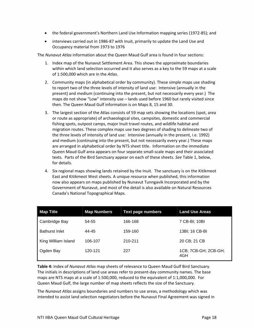
The Nunavut Atlas information about the Queen Maud Gulf area is found in four sections:
1. Index map of the Nunavut Settlement Area. This shows the approximate boundaries within which land selection occurred and it also serves as a key to the 59 maps at a scale of 1:500,000 which are in the Atlas.
2. Community maps (in alphabetical order by community). These simple maps use shading to report two of the three levels of intensity of land use: Intensive (annually in the present) and medium (continuing into the present, but not necessarily every year.) The maps do not show “Low” intensity use – lands used before 1960 but rarely visited since then. The Queen Maud Gulf information is on Maps 8, 15 and 30.
3. The largest section of the Atlas consists of 59 map sets showing the locations (spot, area or route as appropriate) of archaeological sites, campsites, domestic and commercial fishing spots, outpost camps, major Inuit travel routes, and wildlife habitat and migration routes. These complex maps use two degrees of shading to delineate two of the three levels of intensity of land use: Intensive (annually in the present, i.e. 1992) and medium (continuing into the present, but not necessarily every year.) These maps are arranged in alphabetical order by NTS sheet title. Information on the immediate Queen Maud Gulf area appears on four separate small‐scale maps and their associated texts. Parts of the Bird Sanctuary appear on each of these sheets. See Table 1, below, for details.
4. Six regional maps showing lands retained by the Inuit. The sanctuary is on the Kitikmeot East and Kitikmeot West sheets. A unique resource when published, this information now also appears on maps published by Nunavut Tunngavik Incorporated and by the Government of Nunavut, and most of the detail is also available on Natural Resources Canada’s National Topographical Maps.
Map Title Map Numbers Text page numbers Land Use Areas
Cambridge Bay 54-55 166-168 7 CB-BI; 10BI
Bathurst Inlet 44-45 159-160 13BI; 16 CB-BI
King William Island 106-107 210-211 20 CB; 21 CB
Ogden Bay 120-121 227 1CB; 7CB-GH; 2CB-GH; 4GH
Table 4: Index of Nunavut Atlas map sheets of relevance to Queen Maud Gulf Bird Sanctuary. The initials in descriptions of land use areas refer to present‐day community names. The base maps are NTS maps at a scale of 1:500,000, reduced to the equivalent of 1:1,000,000. For Queen Maud Gulf, the large number of map sheets reflects the size of the Sanctuary.
The Nunavut Atlas assigns boundaries and numbers to use areas, a methodology which was intended to assist land selection negotiators before the Nunavut Final Agreement was signed in

NTI IIBA Queen Maud Gulf Cultural Heritage Page 19
1994. The cartographic and textual information related to the Queen Maud Gulf Bird Sanctuary is summarized here, moving from west to east and from seacoast to interior. Almost the whole of the Sanctuary is contained on one sheet (Ogden Bay) which includes the coast around Perry Island and most of the inland regions. However, the areas further west are important because they are close to the major population centre of Cambridge Bay, and include large parcels of Inuit‐owned land, extending a considerable distance along the coast and inland.14 The sheet named King William Island includes some important hunting lands around Whitebear Point.
• The Cambridge Bay map sheet, which is at the north‐west corner of the four sheets discussed here, contains inhabited places outside the Bird Sanctuary: the hamlet of Cambridge Bay and the smaller settlements in Bathurst Inlet. It shows two use areas inside the Bird Sanctuaries, 7CB‐BI which is primarily coastal and 10BI, interior. Notable land uses within the Bird Sanctuary include winter trapping and caribou hunting inland, and hunting, fishing and trapping along the preferred travel routes both in the interior and parallel to the coast of Queen Maud Gulf.
• Map 54 shows a single archaeological site on the coastline south of Melbourne Island within the Bird Sanctuary and a number of recent camp sites, some associated with fishing places, along the coast.
• Travel routes enter the sanctuary from the southwest for hunting, and others follow the coastline, which is described as the preferred route from Bathurst Inlet to the Perry River area.
• Due south of the Cambridge Bay sheet, the Bathurst Inlet sheet also lists two use areas, 13BI and 16CB‐BI.
• The Bathurst Inlet map sheet, due south of the Cambridge Bay sheet, shows two inland areas of medium use, due east of Bathurst Inlet in the watersheds of the Ellice and Angimajuk rivers. Use of area 13BI is described as occurring mainly in fall and winter (barren‐ground caribou and rarely muskox) and in winter (fox trapping). Use area 16 CB‐BI, also an interior area, was used “from time to time” for hunting caribou and trapping fox, wolves, and wolverine.
The largest part of the land mass of the Queen Maud Gulf Bird Sanctuary appeared on the coastal portions of the 1:500,000‐series King William Island sheet and (directly to the south) the primarily inland area on the sheet at the same scale named for its only major coastal feature, Ogden Bay. Although less intensively hunted today, these areas also show evidence of extensive land use within recorded memory, and earlier. They also contain, on the eastern edge of the Bird Sanctuary, parcels of Inuit‐owned land near Gjoa Haven.
• The sheet titled “King William Island” shows a large extent of Queen Maud Gulf, where ringed seals are often hunted (20CB), as well as the coastal feature officially named Whitebear Point. Recent campsites are shown all around Whitebear Point, and the map and accompanying text describe an important use (21CB) of the mouth of the Ellice River for char fishing by a number of families from Cambridge Bay. Despite the extensive present‐day use, the map does not indicate archaeological resources at
14 Note that these sheets are named, not numbered, and are at a scale of 1:500,000. Maps in the more familiar NTS 1:250,000 series are both numbered and named; the names sometimes duplicate those found on maps at the smaller scale. The 1:500,000 series has been discontinued.

NTI IIBA Queen Maud Gulf Cultural Heritage Page 20
Whitebear Point.
• The map sheet titled “Ogden Bay” is the most southeasterly of the four 1:500,000 sheets discussed here; it contains most of the Bird Sanctuary. Unfortunately there are NO travel routes shown on this map except a coastal route towards Cambridge Bay, depicted in the northwest corner of the sheet. Our discussion of Inuit land use here is organized around the rivers which give access to the interior. For convenience sake, the description here moves west to east, describing land use in relation to the few rivers which flow from deep in the interior to Queen Maud Gulf. Most of these are important enough to appear on the appended overview map (Map 1).
• Perry River. This area (1CB and 2CB‐GH) includes important ringed seal habitat on the Gulf, the mouth of the Perry River and the sites of important 20th‐century trading posts at Perry Island and Flagstaff Island. Atlas text describes the area 1CB as an area along the Perry River and adjoining Gulf shores where caribou are hunted in spring, summer and fall; ducks, geese and seals (ring and bearded) are hunted in spring and summer. Arctic fox are trapped along the coast and up the river, and char and whitefish are taken in the river and many of the lakes. In area 2CB‐GH the seasonal activities are similar to the ones described for the more local area at the mouth of the Perry River; in addition, hunters from Gjoa Haven “may hunt caribou and muskox”.
• The map shows a significant water or sea ice travel route running parallel to the coast in the direction of Cambridge Bay.
• The mouth of the Perry River is described as an area of archaeological interest on both sides of the river for about 40 kilometres upstream, in the area where fishing and caribou hunting continue.
• Pitok and Armark rivers: East of Perry River, these two rivers run parallel and close together, draining an extensive territory around Armark Lake into Ogden Bay. The area within 80 kilometres of the coast form part of the use area 2CB‐GH, described above. The headwaters were not being used during the late 1980s, but the locations of both archaeological sites and recent camps were noted, especially near Armark Lake. Along the coast, from the mouth of the Pitok River eastwards, the map depicts the sites of numerous recent camps and archaeological sites.
• Karrak River and Simpson River: These two parallel rivers flow close together across a low and extremely wet area south of Johnson Point. They are on the border of use areas labeled as 2CB‐GH and 4GH; in other words, in the late 1980s they were regarded as the limits of the overlap area between residents of Cambridge Bay and of Gjoa Haven. 2CH‐GH has already been described as a place where caribou, wildfowl, char and whitefish were taken in season. The area labeled 4GH is described in the Nunavut Atlas as follows: “This large area is an important hunting area for Inuit from Gjoa Haven. Caribou are hunted year‐round. In winter, occasional trapping for Arctic foxes takes place near McNaughton Lake and along the coast of Queen Maud Gulf. Wolf, wolverine and muskox are also hunted.” Along the coast, “Bearded and some ringed seals are hunted in the Queen Maud Gulf ... and in McLoughlin Bay during spring and summer.” In addition, “Inuit from Cambridge Bay and from the outpost on the Perry River, occasionally hunt barren‐ground caribou.”15 The Nunavut Atlas reported little site‐
15 Riewe, Nunavut Atlas, p. 227.

NTI IIBA Queen Maud Gulf Cultural Heritage Page 21
specific evidence of land use apart from about equal numbers of archaeological sites and recent camps associated with fishing.
• McNaughton River and McNaughton Lake: McNaughton River drains a portion of the low‐lying mainland described above as use area 4GH. Inuit‐owned land occupies the seacoast both west and east of the mouth of the McNaughton River for a considerable distance, as the area is about 150 kilometres southwest of Gjoa Haven. About 60 kilometres due south of the coast is McNaughton Lake, the centre of a large area of Archaeological interest, with both specific archaeological sites and recent campsites noted.
• Kaleet River: For most of its course the Kaleet River forms the eastern boundary of the Queen Maud Gulf Bird Sanctuary. It reaches tidal water in Sherman Basin, between the Klutschak and Adelaide peninsulas. The Kaleet River watershed is also part of the use area labeled 4GH by the Nunavut Atlas and already described above. The headwaters of the Kaleet River are near the Back River, outside the Bird Sanctuary.
Note: The Nunavut Atlas is large, difficult to use and is especially difficult to reproduce, and its images have not been successfully copied for this report. The recommendations from this study include digitization of the Nunavut Atlas maps as well as the textual data referenced in the study.
Information from Non-Inuit Sources While the most exhaustive descriptions of Inuit land use are those compiled by Inuit, captured in oral histories or retained in living memories, various non‐Inuit reports, such as those by anthropologists or by government agents in the Area Economic Survey of the 1960s16, document the manner and extent of Inuit land use based on their interviews and experiences with Inuit in the areas. They also document the changes brought about by the pressures and opportunities of increased involvement of traders, missionaries and the Canadian government in the affairs of Inuit.
Because of the isolation of the Queen Maud Gulf Bird Sanctuary, relatively few narratives of scientific or recreational use of the sanctuary exist, and there are consequently few non‐Inuit observers to report on land uses, even along the coast.17 Although rarely expert in Inuit culture or land use, passing canoe parties also examined the landscape; some trips are inventoried in Bruce W. Hodgins and Gwyneth Hoyle, Canoeing North into the Unknown; a record of River Travel 1874‐1974 (Toronto: Natural Heritage, 1994) pp. 177‐84.
A thorough survey of records created by parties working on the land, or by non‐witness reporters at a distance such as RCMP officers on patrol, could potentially add time‐specific or place‐specific detail to the broad patterns created from Inuit information.
16 G. Abrahamson, The Copper Eskimos; an area economic survey 1963 (Canada. Department of Northern Affairs and National Resources, 1963); see “Perry Island Trading Area”, pp. 111‐17. 17 An early and interesting exception is Peter Scott, Wild Geese and Eskimos; a Journal of the Perry River Expedition of 1949 (London: Country Life, 1951).

NTI IIBA Queen Maud Gulf Cultural Heritage Page 22
Figure 2: Map showing the boundaries of Queen Maud Gulf Migratory Bird Sanctuary in relation to the Gulf itself, to the major rivers draining the sanctuary, and to the communities of Cambridge Bay and Gjoa Haven. Bathurst Inlet and Umingmaktok are located just to the west of the land shown here. Source: Didiuk and Ferguson (2005) p. 8, accessed 19 March 2011 at dsp‐psd.pwgsc.gc.ca/Collection/CW69‐1‐111E.pdf

NTI IIBA Queen Maud Gulf Cultural Heritage Page 23
Section 4: Cultural Heritage Resources Survey The survey includes the identification of key collections of information, materials and knowledge related to Inuit experience, archaeology and land‐use in and near the Queen Maud Gulf MBS. Further work will be needed to extend the survey to each of the three affected communities: Umingmaktok, Cambridge Bay and Gjoa Haven. The survey emphasizes collections of first‐hand Inuit knowledge that are directly associated with Cambridge Bay, Gjoa Haven, Umingmaktok and the Queen Maud Gulf MBS. The survey is divided into 5 categories: Archaeology, Historic Events, Places, Place Names and Cultural Collections and Projects.
Category: Archaeology
Registered Archaeological Sites A list of registered sites within the Queen Maud Gulf Bird Sanctuary was provided by the Director of Heritage of CLEY. The list was broken down by map sheet and, due to the large area the sanctuary covers, sites from nine map sheets were listed (map sheets 66I, 66J, 66K, 66M, 66N, 66O, 66P, 67B, and 77A). It turned out that most registered archaeological sites were, in fact, outside the sanctuary boundary. Nevertheless, it became apparent during the research that there are more archaeological sites nearby the sanctuary than were provided in the CLEY list. It is unclear what criteria CLEY used to select sites for the list, but a good possibility is that sites were decided by Borden block within the nine map sheets that cover areas of the sanctuary. Additional sites outside the sanctuary boundary that were not listed by CLEY but were found in consultants’ reports are not discussed here and were not added to the inventory. An exception was made for the Nadlok Site, excavated by an archaeologist at the Canadian Museum of Civilization. This site is discussed below.
Reference materials in the CLEY list that were available at the Canadian Museum of Civilization (CMC) archives were reviewed. Not all documents were accessible, and there were not documents available at the CMC for all sites (reports for archaeological assessments done since 2005 were not on file at the CMC).
Registered Archaeological Sites In the Conservation Area
There are 32 registered archaeological sites within the boundaries of the Queen Maud Gulf Bird Sanctuary, a remarkably small number when the land area (55 055 square kilometres) and the approximately 500 kilometres of coastline are considered. None of the 32 sites were recorded by professional or academic archaeologists. Instead, the sites were reported by professionals in other disciplines who were in the area for other types of projects. Dr. Robert K. S. Lee, a botanist with the National Museum of Natural Sciences in 1973, noticed an Inuit campsite (NbNc‐1) in Foggy Bay when he and his crew nearly landed on it (presumably in a helicopter) during an expedition to study algae.18 Five sites (MhLm‐1 to 5) were recorded in 1988 by Dr. A.W. Diamond, head of Migratory Bird Studies with the Canadian Wildlife Service. The sites, located around Karrak Lake, contained features such as a goose corral, tent rings, cairns, an inuksuk, a stone pillar and a stone tower or column, among others. Diamond recorded the sites with drawings, colour prints photographs, and, in two cases, VHS video, and sent his findings to the Archaeological Survey of Canada and Parks Canada. A crewman of Kennecott Canada, a mineral exploration company, Mr. A. Vary, reported three burial sites (MkLt‐1, MjLs‐1 & MjLs‐2)
18 K.R.S. Lee, Cairn and Tent Rings (n.p., 1973).
NTI IIBA Queen Maud Gulf Cultural Heritage Page 24
on Perry River while exploring for mineral deposits in 1995. Finally, David Pelly reported 12 sites identified during a canoe expedition down the Pitok River in 1999 and 11 sites identified during a canoe expedition down the Simpson River in 2001. David Pelly is a writer, researcher, historian and photographer who devotes most of his time to Arctic projects, such as recording Inuit stories of the past and present. Pelly records and reports archaeological features he finds, often accompanied by local Inuit residents who provide him with information about the features and/or their location whenever possible. In addition to the 12 sites recorded within the sanctuary, Pelly recorded another 3 sites on the Pitok River just south of the sanctuary boundary. Pelly wrote an article about the Pitok River expedition entitled “Going Home to Kutgajuk,” published in Above & Beyond, a magazine for which Pelly has been a featured writer for more than 20 years.19
Because these site were not recorded as part of a systematic archaeological investigation, archaeological analysis (culture, date, context, comparative data, etc) has not been completed for the sites within the boundaries of the conservation area.
Registered Archaeology Surrounding the Conservation Area
There have been many more archaeological investigations conducted outside the boundary of the conservation area than within it. The list of registered archaeological sites provided by CLEY contains 294 sites nearby the sanctuary, although there are even more sites registered.20 For the most part, these sites are to the west and north of the sanctuary. Furthermore, most sites (187 of the 294) were recorded by consulting archaeologists doing archaeological assessments prior to development. Several of these projects were concentrated in the Hope Bay Belt (term used by the consultant), just west of the sanctuary. The Hope Bay Belt encompasses north‐south trail routes between the east side of the bay locally known as Roberts Bay (east of Hope Bay) at the north end to the south end of Spyder Lake at the south end (approximately 70 kilometres). The Belt includes Dorris Lake, Patch Lake, Wolverine Lake, Windy Lake and the Koignuk River. The assessments were done primarily by Points West Heritage Consulting Ltd. between 1995 and 2010, though a few assessments were conducted by other consultants.21 The Hope Bay Belt area includes 141 of the 294 registered sites listed by CLEY, as well as at least another 59 sites that were not included in CLEY’s list. Of the sites where cultural affiliation could be determined, most of the Hope Bay Belt sites are identified as Copper Inuit, although there is one site attributed to the Arctic Small Tool tradition (Paleoeskimo; NaNh‐21), and one site that
19 David Pelly, “Going Home to Kutgajuk,” in Above & Beyond (July/August 2000): 34‐39. 20 During a review of the available reports at the CMC archives, it was noticed that some consultant reports contained sites that were not on the CLEY list provided. It is not known why these sites were excluded from CLEY’s list. Nevertheless, it is evident that there are sites beyond the 294 listed for this project. 21 Jean Bussey, Archaeological investigations for the Boston Globe Bulk Sample Project, Northwest Territories, Consultant’s report, 1995; Gabriella Prager and Jean Bussey, Archaeological Investigations for BHO’s Hope Bay Belt Project (Boston and Doris Lake), Northwest Territories, 1996, (Northwest Territories Archaeologists Permit 96‐821), Consultant’s report, 1997; Gabriella Prager, 1997 Archaeological Investigation for BHP’s Hope Bay Belt Project, Northwest Territories, Consultant’s report, 1998; Gabriella Prager, Archaeological Investigations Hope Bay Joint Venture Project – 2000, Nunavut Territory Archaeologists permit no. 00‐013, 2001; Gabriella Prager, Final Report Doris North (Hope Bay) Project, Nunavut Archaeological Investigations in 2003 – Permit 2003‐05A, Consultant’s report, 2003; Gabriella Prager, Hope Bay Belt, Nunavut, 2005 Archaeological Investigations, Final Permit Report, Consultant’s report, 2006.

NTI IIBA Queen Maud Gulf Cultural Heritage Page 25
might be Thule (NaNh‐5).22 Artifacts were collected by archaeologist Gabriella Prager from 13 sites, and these are located in the Prince of Wales Northern Heritage Centre (PWNHC). The first site to be registered in the Hope Bay area is NaNi‐1, recorded in 1965 by R. Savard. Unfortunately, there is very little information about this site. Further west, four sites are located in the Bathurst Inlet area (NaNk‐1 to 4). These sites were reported by F.H.A. Campbell in 1975, and, although Campbell was working for the Geological Survey of Canada, it appears from his report that he was specifically searching for “evidence of Inuit habitation”.23 He engaged local residents for assistance and credits William Quaja in particular for his help. Also in the Bathurst Inlet area is the Nadlok Site (MbNs‐1), located on an island on the Burnside River which is part of the Bathurst caribou herd migration route. This site is unique in that caribou antler was used for architectural purposes.24 Archaeologist Bryan Gordon of the Canadian Museum of Civilization excavated the site and believes it represents a rare example of when the Copper Inuit transitioned from the Thule. Furthermore, the site demonstrates that this transition may have occurred in the interior, even though the Thule were mainly coastal dwellers. Nadlok was occupied between the years 1450 and 1750.25
Most of the remaining sites from CLEY’s list are located north of the sanctuary. Dr. James Savelle, an archaeologist at McGill University, and Arthur Dyke, a geologist with the Geological Survey of Canada, worked together on a project that focused “on an assessment of the relationship between initial and subsequent Paleoeskimo and Thule and historic Inuit occupations in the central and eastern Arctic and the nature of local ocean circulation and sea‐ice patterns.”26 One of their study areas was northeastern Kent Peninsula where they conducted archaeological site surveys and geological surveys. A total of 74 Paleoeskimo archaeological sites were recorded.27 Savelle collected artifacts from 22 sites, now housed in the PWNHC.
22 The human history of the Canadian arctic is as follows, from oldest: Pre‐Dorset (also known as Paleoeskimo), Dorset, Thule, Inuit. The Pre‐Dorset were the first arctic inhabitants who arrived about 4000 years ago. The Dorset Culture appeared sometime between 800 B.C. and 500 B.C. and is characterized by snow knives for snowhouse construction, bone sled shoes and ice creepers; see Moreau S. Maxwell, “Pre‐Dorset and Dorset Prehistory of Canada,” in Handbook of North American Indians, edited by William C. Sturtevant, (Washington: Smithsonian Institution, 1984),pp.359‐368. In Inuit legend the Dorset were giants who were easily scared off. They were replaced by the Thule who moved into the Canadian arctic from Alaska in ca. 1000 A.D. The Thule had more sophisticated technology, especially for whaling, than the Dorset; see Robert McGhee, Ancient Canada (Hull: Canadian Museum of Civilization, 1989), 97. The Thule used driftwood in house construction in Alaska and adapted to the Canadian arctic by substituting whale bones for driftwood; see Robert McGhee, “Thule Prehistory of Canada,” in Handbook of North American Indians, vol. 5, edited by William C. Sturtevant (Washington: Smithsonian Institution, 1984), 369‐376. 23 F.H.A. Campbell, Archaeological Report, Bathurst Inlet Area (n.p., 1975), 1. 24 Bryan C. Gordon, “Nadlok and the Origin of the Copper Inuit,” in Threads of Arctic Prehistory: Papers in Honour of William E. Taylor, Jr., edited by David Morrison and Jean‐Luc Pilon (Hull: Canadian Museum of Civilization, 1994), 326. 25 Gordon, 337. 26 James Savelle and Arthur Dyke, Preliminary Report of Archaeological Investigations on Kent Peninsula and King William Islands, Nunavut, July‐August 2006 (n.p., 2007), 1. 27 Savelle and Dyke, 3. The Savelle and Dyke report states that 74 sites were found at Kent Peninsula; however, the CLEY list totals 73 sites. It is not known which is correct. The project and conclusions are summarised in the published article “Paleoeskimo Demography and Sea‐Level History, Kent Peninsula and King William Island, Central Northwest Passage, Arctic Canada”.

NTI IIBA Queen Maud Gulf Cultural Heritage Page 26
The CLEY list of registered sites shows 16 sites on Victoria Island. Twelve sites were recorded by Dr. William E. Taylor in 1963 during a survey between Cape Parry and Cambridge Bay, two of which are in CLEY’s list: NfNd‐1, the Stromnes Bay site and NfLt‐1, the Cape Colborne site. Both sites were attributed to the Copper Inuit. Artifacts were collected from both sites, including 10 objects from the Stromnes Bay site and 24 objects from the Cape Colborne site, all of which are housed in the Canadian Museum of Civilization (CMC). Another two sites were recorded by the botanist, Dr. Lee, in 1975: NfLt‐2 and NfNb‐1, both in the southwest corner of the island. A single bone artifact was collected from NfNb‐1 and it is now in the CMC. Dr. Robert McGee of the CMC recorded an Inuit site, NdNu‐1, located at the mouth of the Nakyoktok River in southern Victoria Island in 2009. Another four sites, located in Cape Colborne and Anderson Bay, were recorded in 2008 by archaeologist Dr. Max Friesen of the University of Toronto. Three of these were attributed to the Dorset, while the fourth site exhibited a Dorset and a Thule component. Caribou bone samples were collected from two sites for radiocarbon dating. Finally, seven sites are located in Sturt Point, one of which, NfLx‐1, was recorded in 1989 by Dr. James Helmer of the University of Calgary as part of a research project that compared the site to another in Cape Peel.28 The other six sites were recorded during an assessment of the CAM‐A DEW Line site by an archaeological consultant, Sean Webster, in 2010. All six sites (NeLv‐1 to 3; NeLw‐1 to 3) are described as pre‐dating the DEW Line and are probably early 20th century.
Other nearby sites near DEW Line facilities were also assessed by consulting archaeologists. Brent Murphy identified three archaeological sites (NbLm‐1 to 3) on Hat Island for an assessment of the Intermediate DEW Line site in 2008. Two of the three sites were dated to ca. 1950s/1960s. A total of 38 sites were identified at the CAM‐1 DEW Line facility on Jenny Lind Island during archaeological assessments by Glenn Stuart in 1990 and Callum Thomson in 2008.29 Most of these sites were attributed to Inuit, with five sites identified as Thule (NdLr‐1 & 2; NdLr‐15; NdLr‐18; NeLr‐10). Another site, NdLr‐27, located on the southeastern shore of Jenny Lind Island, was recorded by Dr. Robert McGee in 2009. This site is identified by stone features and weathered bone fragments and is attributed to the Dorset.
A handful of archaeological sites are located beyond the northeast boundary of the sanctuary, all of which were recorded by Dr. Savelle of McGill University in 1981/2. Savelle identified five sites on the Adelaide Peninsula (MlLg‐1 to 5) and four sites on the nearby O’Reilly Island (MlLi‐1 to 4). All these sites are Thule and/or Inuit. An additional site, MlLa‐1, is located on Montreal Island. Artifacts were collected from MlLg‐2, MlLa‐1 and MlLi‐3, now located in the CMC. The CMC on‐line catalogue confirms the artifacts from MlLg‐2 are there, although there are no images of the objects available.
Finally, five sites are located east of the sanctuary in the Franklin Lake/Back River area (MfLa‐1 to 5). These sites were identified by Dr. J.V. Wright of the Archaeological Survey of Canada in 1970. All the sites have at least one tent ring. One site was described as “contemporary” and another as “prehistoric,” although cultural affiliations were not assigned. Artifacts were collected from all five sites and are stored at the CMC. The on‐line catalogue lists four lithic artifacts, though no images are available. The only other interior sites are the three sites identified by David Pelly during his Pitok River expedition. These are located just south of the
28 Full citation for Helmer 1989 required. 29 Fedirchuk McCullough and Associates Ltd. Environmental Clean‐Up Study – 21 DEW sites in Canada, Heritate Resources Study, Consultant’s report, 1990; Callum Thomson, Final Report on Archaeological Mitigation Study at CAM1, Jenny Lind Island, Queen Maud Gulf, NU, Consultant’s report, 2009.

NTI IIBA Queen Maud Gulf Cultural Heritage Page 27
sanctuary boundary.
Locally known archaeology
A locally known archaeological site is a site that has been identified and is known to at least one person in the local area, but the site is not registered with the territory. Thus, it does not have a Borden number. Features described in Inuit stories could also be thought of as locally known archaeological sites, even when the precise location of the feature is not documented. The information recorded about locally known archaeological sites and features will vary, depending on who recorded it and what was important about the site to that person. There are undoubtedly many locally known archaeological sites within the Queen Maud Gulf Bird Sanctuary and many more near and around the affected communities. Recommendations concerning archaeology have been presented to NTI. They emphasize the need to involve people from the area in identifying priorities for archaeology and the value of integrating oral history and archaeological work.
Category: Historic Events The following list of events is not exhaustive. It is intended to provide guidance to anyone undertaking further research on the history of the area by providing a short‐cut to the dates and types of events that could be investigated or highlighted for interpretative materials. It should be noted that some of these events (especially the Third Franklin Expedition and Amundsen’s pioneer crossing of the Northwest Passage) are among the most famous exploration journeys of the modern world. Their histories have been recast through the work of Inuit and researchers working with Inuit who have sought to understand events from the perspectives of individuals who helped or were affected by the explorations.
1846 HMS Erebus and HMS Terror under Sir John Franklin are frozen in near King William Island; Inuit witness struggles of survivors to travel south
1903 Roald Amundsen winters at Gjoa Haven while crossing the Northwest Passage 1903‐1905
1910 Vilhjalmur Stefansson encounters Inuit at Victoria Island
1923 HBC establishes post at Cambridge Bay
1924 Knud Rasmussen crosses continent from east to west (Fifth Thule Expedition)
1925 Lachlan Burwash crosses from Mackenzie River to King William Is. to report on economy, resources and people to Dept. of Interior
1926 Three trading posts established in Gulf; only one (Perry River) survives
1927 HBC Trading post established at Gjoa Haven
1929 Eight mining engineers in two aircraft led by Lt‐Col C.D.H. MacAlpine of Dominion Explorers are stranded at Dease Point; Inuit help them reach Cambridge Bay on foot.
1947 A. Gavin publishes Birds of the Perry River District

NTI IIBA Queen Maud Gulf Cultural Heritage Page 28
1949 Peter Scott et. all spend season on Perry River
1955 DEW Line main station constructed at Cambridge Bay
1961 Queen Maud Gulf Bird Sanctuary established
1967 Trading post in Perry River is closed and population is withdrawn
1981 Gjoa Haven achieves Hamlet status
1984 Cambridge Bay achieves Hamlet status
Category: Places Significant places in the Queen Maud Gulf area are associated with Inuit use since time immemorial. They are sorted here roughly as (a) rivers flowing from inland to the coast through the Bird Sanctuary (b) coastal features, (c) interior features, and (d) settled places.
Rivers flowing north
Tingmeak River
Whitebear Point
Ellice River
Perry River
Amark River
Simpson River
Kaleet River
Kuugaarjuk River
Angimajuk River
Coastal Features
Perry Island
Flagstaff Island
McLoughlin Bay
Ogden Bay
Sherman Basin
Whitebear Point
Brown Point
Dease Point
Connolly Bay
Spalding Islets
Trefoil Bay
Campbell Bay
Interior features
Brichta Lake
McAlpine Lake
Armark Lake
Pitok River
Karrak River
McNaughton River
McNaughton Lake
Settled Places
Cambridge Bay (on Victoria Island)
Bathurst Inlet (formerly Burnside River)
Umingmaktok (formerly Bay Chimo)
Gjoa Haven (on King William Island)
Perry Island (not inhabited year‐round since 1967)

NTI IIBA Queen Maud Gulf Cultural Heritage Page 29
Category: Place Names
Place names for Queen Maud Gulf Migratory Bird Sanctuary This is an exceptionally large conservation area in a region that is sparsely populated. It is south of and between the communities of Cambridge Bay and Gjoa Haven, and east of Umingmaktok. The hunting areas in this general region extend across the sea ice and islands north of the bird sanctuary, so that many historical and scientific references to the communities describe activities that are outside the Sanctuary and off the travel corridors that lead towards it.
Extensive collection of traditional Inuit‐language place names has been carried out in recent years, chiefly by the Kitikmeot Heritage Society. For much of the region around Queen Maud Gulf the results of this research may be observed on the website of the Kitikmeot Place Name Atlas. The “spoken map” on the KHS website, at http://atlas.kitikmeotheritage.ca/names.html offers an insight into this work, although there are very few names reported inside the Bird Sanctuary east of Whitebear Point. The Kitikmeot Heritage Society uploaded a number of paper maps to its website in April, 2010. This set is incomplete and only the three westernmost map sheets (of a potential 12) display names in the Bird Sanctuary. 30
Important toponymic research and place name mapping has been conducted in Cambridge Bay by Béatrice Collignon; though the bulk of her research was with Inuit experts who knew lands west of the Bird Sanctuary, they did assist her in documenting some names in the western part of Bird Sanctuary.31
Coastal features including rivers flowing north out of the interior
Tingmeak River
Whitebear Point
Ellice River
Perry River
Amark River
Simpson River
Kaleet River
Perry Island
Flagstaff Island
McLoughlin Bay
30 The three are 67B, 77A, and 76P, whose Inuit language sheet names are, in order, Ikaaqturijjat, Kiillinnguy, and Mautarina. The corresponding names of the government maps are Queen Maud Gulf, Elu Inlet, and Brichta Lake. 31 Béatrice Collignon. Knowing Places; the Innuinnait, Landscapes, and the Environment. Edmonton: Canadian Circumpolar Institute, 2006.

NTI IIBA Queen Maud Gulf Cultural Heritage Page 30
Ogden Bay
Sherman Basin
Interior features not named above
Brichta Lake
Tingmeak River
McAlpine Lake
Armark Lake
Pitok River
Karrak River
McNaughton River
McNaughton Lake
Nearby
Gjoa Haven
Cambridge Bay
Bathurst Inlet
Burnside River (former name of Bathurst Inlet)
Category: Collections and Archives
Kitikmeot Heritage Society (KHS)32 Overview
Since its inception in 1995, the Kitikmeot Heritage Society (KHS) has assumed the mandate of documenting and preserving Inuinnaqtun language and heritage throughout Nunavut’s Kitikmeot region. The KHS engages the local communities of Kitikmeot by providing in‐school traditional skill workshops, accessible archives and exhibit displays, with the goal of promoting the cultural history and traditional knowledge of Nunavut’s people. As an elder‐directed organization, the KHS forefronts projects encouraging the Inuit worldviews of Ilippallianginnarniq (continuing learning) and Inuit Qaujimajatuqangit (traditional and modern Inuit knowledge), ensuring an underlying ethos of cultural relevance in areas of local education and information accessibility. Over the last decade, an extensive roster of publications, educational modules, and cross‐disciplinary collaborations has been successfully developed towards these ends (see additional information at www.kitikmeotheritage.ca).
Kuukyuak (Perry River) as a Targeted Area for Cultural Heritage Research
The Kuukyuak, or Perry River area, plays an important part role in the history of Kitikmeot Inuit. For generations, the area has served as both a permanent camp and site for seasonal resource acquisition; a fact attested to by an abundance of archaeological features and recorded oral
32 This section of the draft report was written by Brendan Griebel, a member of the staff of the Kitikmeot Heritage Society who is completing a PhD in archaeology at the University of Toronto.

NTI IIBA Queen Maud Gulf Cultural Heritage Page 31
histories from local elders. Although the Kuukyuak area is rich in archaeological deposits, there are—to the best of our knowledge—no sites currently registered with the Archaeological Survey of Canada.
Regional History
From archaeological features and information recalled by elders, it is evident that Inuit have used the Kuukyuak area for generations. While the area was rich in waterfowl and fish, a person might have to walk for many miles to find caribou. When a caribou was killed, the reserve of meat was cached along the river to be used during the winter months. In the spring, the region around the mouth of the river was used as a meeting place to organize seal hunts further out on the sea ice. Elders James Evetalegak and Mackie Kaosoni describe a point of land in the Kuukyuak area, where Inuit used to herd geese off the water into stone enclosures known as kalgi. Using kayaks, Inuit would herd the geese from the water up onto the shore. Others, who were hiding behind rocks, would then drive the geese up to the kalgi where they would be trapped and killed. The excess meat would be stored in kikuyak or caches to be used in leaner times. Both Kaosoni and Evetalegak said that although they themselves had never used the kalgi, they had been told how many times by their grandfathers. The kalgi, they said, had been used long before they had rifles and bullets.
In 1926, former Hudson’s Bay employee Hugh Clark opened the region’s first trading post (Canalaska Trading Company) in Perry River. In 1928, in response to a report that the area was being overhunted, the federal government withdrew the trading licenses of both the Canalaska post and the Hudson’s Bay Company. The Canalaska operation was taken over by local Inuk, Stephen Angulalik, who moved the post to Iglookagakpik (Flagstaff Island), where it continued to operate until 1958. Angulalik opened a second post east of the Perry River at Sherman Inlet in 1947. Angulalik assisted in the opening of another Hudson’s Bay Company post (managed by Red Petersen) in the location of Innakhavik (Perry Island). Families continued to live permanently in outpost camps near Perry River until 1977, after which time they moved to Cambridge Bay in order to seek out new employment prospects and better living conditions. Low fur prices are often cited as the reason behind this move.
KHS Research in the Kuukyuak Area
Few written historical records exist regarding early life in the Perry River area (see exceptions of Phillip Allen’s 1950’s text, Peter Scott “Wild Geese and Eskimos,” Duncan Pryde 1977). The general paucity of available information about the Kuukyuak area prompted the Kitikmeot Heritage Society to launch a two‐year research program in the area from 1996‐97. Two extensive summer fieldcamps were organized to begin documenting the culture and history associated with the region. In 1997 alone, the camp included 18 elders, 8 organizers, a cameraman/producer from I.B.C. in Baker Lake, 12 youth, and 5 additional family members. The program’s primary objective was to research and document oral histories from individuals who once lived in the area. As stated in the original 1997 report:
“The Elders said that they were grateful to be given the opportunity to share their knowledge. Traveling out on the land and living in much the same way as they used to gave them the opportunity to communicate their in‐depth knowledge of the land and to demonstrate their considerable skills. As well, seeing the landmarks and other visual cues brought back very strong, and often overwhelming, memories.”
Documentation of stories and legends took place exclusively through video recording. Eighteen hours of video were recorded and subsequently translated and transcribed. Footage from the

NTI IIBA Queen Maud Gulf Cultural Heritage Page 32
Kuukyuak project is currently contained in the Kitikmeot Heritage Society archives in the form of nine 8mm videocassettes, thirteen mini DV tapes, and twenty‐three DVD discs (Accession # 2007.30). Select footage and interviews from these tapes are currently in the process of being uploaded into the Kitikmeot Heritage Society’s community archives theatre and on‐line heritage channel with IsumaTV. Written copies of interview transcripts were originally stored in Kitikmeot Heritage Society archives and were made available to the general public as well as Cambridge Bay’s Nunavut Arctic College and Kiilinik High School. Many of the transcribed interviews were destroyed in a large fire that engulfed the archives and high school in 1998.
Over the last several years, local elders and community members have increasingly identified the Kuukyuak area as a priority for continued research. A large collection of early demographic information on Perry River has recently emerged from the archives of the R.C. Mission Church, prompting a renewed interest in both traditional lifestyles and post‐contact history of the area. Many of the elders brought out on the first research trip have since passed on, and a new generation of elders is keen to contribute their knowledge of the region. Children and grandchildren of Kuukyuak residents are eager to visit the area and learn more about its history. For much of the younger population in Cambridge Bay, Perry River exists as a part of their heritage known only through photographs and stories. Both the Kitikmeot Heritage Society and the local community would like to have the area’s material history properly documented (both archaeologically and otherwise) before it succumbs to the wear of time and individuals visiting the area.
Nunavut Culture, Language, Elders and Youth (CLEY)
The Nunavut Department of Culture, Language, Elders and Youth (CLEY) is responsible for policies, programs and services that support the culture and heritage of Nunavummiut. Contentworks received information from officials of CLEY on archives, place names and archaeology. Details, including contact information, will be found in the NTI‐CA IIBA Database.
Archives
The Nunavut Archives has its headquarters in Igloolik, and additions to the collection since 1999 are housed there. By arrangement with the Government of the Northwest Territories, older accessions that are of specific interest to Nunavut remain in Yellowknife (Prince of Wales Northern Heritage Society) until facilities exist in Nunavut to offer suitable environmental controls and user services. Many collections of joint interest, including public records of the pre‐1999 territorial government, remain in Yellowknife.
The Nunavut Archivist provided a summary of relevant holdings (both in Igloolik and in Yellowknife) and this initial review indicates one fonds relevant to affected communities of the Queen Maud Gulf Bird Sanctuary at the Archives in Igloolik:
• Fonds No. NU‐7 – David Pelly Fonds. One series consists of audiotapes and transcripts of interviews with elders who were among the seven families relocated from Perry River to Gjoa Haven in 1967.
In addition, at least seven relevant fonds are held by the Prince of Wales Northern Heritage Centre in Yellowknife.
Place names
The office of the Nunavut Toponymist is in Igloolik. The GN toponymy program manages CLEY’s

NTI IIBA Queen Maud Gulf Cultural Heritage Page 33
responsibility for receiving and reviewing proposals to name geographical features, arranging for review of proposals by expert bodies, especially the Inuit Heritage Trust, preparing submissions to the Nunavut Geographic Names Committee and Minister, and communicating approvals and other decisions as appropriate. The Nunavut Toponymist is a member of the Geographical Names Board of Canada and final decisions of the Minister are approved for use by all government bodies in Canada and become part of the Canadian Geographical Names Data Base.33
The correspondence files of the Nunavut Toponymist were reviewed for this project. The results for the 12 sheets at a scale of 1:250,000 which display the Queen Maud Gulf Bird Sanctuary were uninformative. There is relatively routine correspondence on the adoption of Angimajuq River on 76P (1968).
The absence of much further information reflects the near‐total lack of recent official toponymic activity on that map sheet.
Oral Histories
For the duration of this project in 2010‐2011, most efforts to locate oral histories and in printed materials such as Inuktitut Magazine.
The Nunavut Archivist confirmed that copies of most oral histories (tapes and transcripts) funded by GNWT were required to be deposited in the Prince of Wales Northern Heritage Centre, and that no other archives or cultural centre in Nunavut is acting as a regional repository for material from other communities.
Northwest Territories Prince of Wales Northern Heritage Centre
By arrangement with the Government of Nunavut, the Prince of Wales Northern Heritage Centre in Yellowknife holds private fonds, government records, photographs and newspapers which relate to Nunavut. The Nunavut Archives provided Contentworks with an inventory titled “Archival Fonds of Specific Interest” which, in seven lists, itemizes the principal items of Nunavut interest in the PWNHC. It has not been possible to examine this material completely or break it down by Affected Community.34
However, at least eight fonds are determined to have material directly related to the Queen Maud Gulf Bird Sanctuary or one of the affected communities. These eight are listed in the NTI Conservation Areas IIBA Database.
An online database search35 located 27 photographs with the term “Perry River” appearing in their descriptions. Not all those images are currently online. “Cambridge Bay” occurs 22 times, Gjoa Haven 114 times, “Bathurst Inlet” 160 times, Bay Chimo fewer than 13 times, and “Umingmaktok” four times. These items should be examined to determine which are truly relevant.
33 Individual name records are accessible through the Geographical Names Search Service, accessed 23 March 2011, available online at gnss.nrcan.gc.ca/gnss‐srt/searchName.jsp?language=en. 34 Edward Atkinson, “Archival Fonds of Specific Interest”, forwarded by e‐mail to P. Goldring,. 3 Feb. 2011. 35 Prince of Wales Northern Heritage Centre, “NWT Archives Databases,” accessed 7 April 2011. available online at pwnhc.learnnet.nt.ca/databases/Archives/index.asp.

NTI IIBA Queen Maud Gulf Cultural Heritage Page 34
Federal Agencies Library and Archives Canada
The Library and Archives of Canada is the major national repository of documentary heritage in Canada, with a complicated and evolving mandate of which the most significant element may be “To serve as the continuing memory of the government of Canada and its institutions.” 36 It has acquired material from donors and other private sources. It holds nationally important collections of maps, photographs, documentary art and other specialized media. In addition to archival materials it manages the holdings and programs of the former National Library of Canada.
Access to these materials is partially assisted by a variety of online databases, especially for government records and photographs acquired before the 1990s. The institution’s Project Naming37, an effort to name many previously‐unidentified Inuit in photographs in the LAC, represents an attempt to replicate the kind of community‐created metadata for photographs which the Prince of Wales Northern Heritage Centre pioneered in the 1980s.38 Search terms related to the Queen Maud Gulf Bird Sanctuary and its affected communities indicate substantial collections, mainly from the 1920s and 1960s or 1970s. 39 These may be incomplete, as some of the items are from albums, in which only selected items have been described.
It was possible during the life of this project only to sample certain online descriptions of LAC holdings to attempt to inventory material related to the Queen Maud Gulf Bird Sanctuary and its affected communities. A cursory survey of one of the older databases of government records identified a number of files including some referring to Perry River. The level of detail in such headquarters records ranges from complaints against individual through to general discussions of the most important policies affecting conditions in the region and community. A similar online survey turned up no references to the Queen Maud Gulf Bird Sanctuary in government records.40 Since the bird sanctuary is a federal creation and responsibility, it is evident that a more contextual search is needed to locate relevant files, as it is unlikely that they would have been destroyed.
In consultation with LAC officials and users of the material, Contentworks determined that the Department of Indian Affairs and Northern Development deposited a large amount of material created during the Inuit Land Use and Occupancy Project. This is chiefly from Inuit sources but is in the custody of a national institution. Although the depth of research varied from region to region, at best it contains individual hunters’ map biographies and taped interviews. At present access to this information is restricted under federal Privacy legislation. Since two of the key parties being protected by this restriction are Nunavut Tungavik Incorporated and the communities where information was gathered. It is recommended that NTI, seek support from
36 Library and Archives Canada, “Mandate,” www.collectionscanada.gc.ca/about‐us/012‐204‐e.html accessed 23 March 2011. 37 Library and Archives Canada, Project Naming website, www.collectionscanada.gc.ca/inuit/index‐e.html , accessed 23 March 2011. 38 Andrew Rodger, personal communication, e‐mail to P. Goldring, 15 March 2011. 39 Library and Archives Canada, Archives Search page, www.collectionscanada.gc.ca/lac‐bac/search/arch, accessed 23 March 2011. Because many but not all item‐level records are duplicated in English and French it is impossible to determine how many unique items a lengthy report contains. 40 Library and Archives Canada, Archivianet Search page, www.collectionscanada.gc.ca/archivianet/02010502_e.html

NTI IIBA Queen Maud Gulf Cultural Heritage Page 35
the Area Co‐Management Committees in affected communities to obtain clearance for its contractors to examine all information pertaining to the Conservation Areas.
In addition to government records, LAC holds privately‐created records which have been deposited by donors. Most can be located in online and paper‐based discovery tools by a variety of keyword searches including personal names, names of ships, and place names. Some materials relating to affected communities are known to exist. Finally, the institution’s collection of printed material is available in downtown Ottawa and all except the rarest or most fragile may also be available via inter‐library loan.
Canadian Museum of Civilization
Federal museums that own heritage collections from Cambridge Bay, Gjoa Haven and Umingmaktok include the Canadian Museum of Civilization (CMC) in Gatineau, Quebec and the National Gallery of Canada in Ottawa. A search of the CMC online artifact catalogue found 34 records of items from the communities surrounding the Queen Maud Gulf Migratory Bird Sanctuary. No artifacts were listed in relation to the Affected Communities, but the collection includes audio footage of songs and stories collected in the area. Recommendations made to NTI include setting up a special meeting with the CMC to identify all varieties of collections that could be useful for understanding and interpreting Inuit history, culture and land‐use.
Parks Canada Agency
The Queen Maud Gulf area does not include a national park or any national historic sites administered by Parks Canada. Since 1989, the Parks Canada Agency has conducted research and consultations on potential national historic sites within Nunavut. No national historic sites have been designated in the Conservation Area but in the 1990s extensive research was carried out to promote the designation of a cultural site on the Back River. The designation process has been delayed pending negotiation of an Inuit Impact and Benefit Agreement for national historic sites in Nunavut.
The site in question is just outside the Bird Sanctuary to the southeast and when the administrative questions have been resolved, it is expected that some of the research conducted in the 1990s may be relevant to travel routes and population movements across the wider area.
Oral History: Parks Canada also funded (1994‐1998) the preparation of an oral history of Nunavut, published in 2004 under the title Uqallurait, edited and introduced by John Bennett and Susan Rowley. This volume includes material from oral histories collected in the Kitikmeot Region.
Other Institutions Churches and Special Collections
No archival collections have been examined but certain repositories, fonds or search tools have been identified for further inquiry.
Both the Roman Catholic Oblates of Mary Immaculate and the Anglican Church conducted missions in Cambridge Bay from the mid‐1920s onwards and in Gjoa Haven from about 1960. Personal and corporate records of their clergy are likely to appear in various fonds still in church

NTI IIBA Queen Maud Gulf Cultural Heritage Page 36
custody, notably in the Archives Deschâtelets in Ottawa41 and the General Synod Archives in Toronto.42 These bodies do not have individual websites or a significant presence on the Archives Canada national search tool.
Anglican General Synod Archives / Diocese of the Arctic
Nancy Hurn 80 Hayden Street Toronto, ON M4Y 3G2 Tel.: 416‐924‐9199 x279 Fax: 416‐968‐7983 Archive’s e‐mail: [email protected]
Archives Deschâtelets (Archives of the Oblates in Canada)
175 Main Street, Ottawa
http://www.racontemoiottawa.com/en/Archives_of_Religious_Institutions_97/items/3.html accessed 23 March 2011
Archives Canada
Formerly the Canadian Archives Information Network, this is an online tool linking databases of certain institutions across Canada. The collections of the Kitikmeot Heritage Society are listed on this portal.
A search using the term Cambridge Bay retrieved 63 items, almost all of which were already known. “Omingmaktok” returned one fonds (relating to the Bathurst Inlet Oral History Project, 1993‐95); “Bay Chimo” returned at most 14 records, “Perry River” six records, and “Gjoa Haven” nine records. Many of these are in Yellowknife or in Cambridge Bay, and a high proportion are photographs, video or audio‐tape. 43
Direct contact should be made or renewed with the relevant religious archives. Additional searches should be conducted to obtain information about collections in other institutions, including both those which do and those which do not participate in Archives Canada.
The Hudson’s Bay Company Archives, Winnipeg
130‐200 Vaughan St., Winnipeg, MB Email: [email protected]
The Archives of the Hudson’s Bay Company document activities at the headquarters and district levels and in the trading posts. Headquarters and district records contain plans and summaries of different degrees of interest or value. In a survey of the online catalogue limited to post records, Contentworks identified records from only one post inside the Bird Sanctuary:
Perry River
41 Ottawa, raconte‐moi website, “Deschatelets Archives,” accessed 23 March 2011, available online at www.racontemoiottawa.com/en/Archives_of_Religious_Institutions_97/items/3.html 42 Anglican Church of Canada website. “General Synod Archives,” accessed 23 March 2011, available online at http://www.anglican.ca/resources/gsarchives/ 43 Archives Canada website, Search page, accessed 23 March 2011, available online at www.archivescanada.ca/english/search/RouteRqst.asp?sessionKey=1300902168016_142_78_200_11 .

NTI IIBA Queen Maud Gulf Cultural Heritage Page 37
Post Number: B.461 Shelf space occupied: 2 cm Years covered by records: 1926‐1928
Universities and Private Collections
University collections of potential importance have not been exhaustively inventoried. One collection are known to contain historical, cultural and scientific information of relevance to understanding Inuit land‐use and experience in the region.
University of Calgary: Arctic Institute of North America44
The Arctic Institute of North America is based at the University of Calgary and includes researchers and infrastructure (library and databases) which support scientific and cultural studies about the Arctic. They include:
• ASTIS: Arctic Science and Technology Information System. This database contains 72,000 records describing publications and research projects about northern Canada. Items of relevance to Nunavut can be searched through a sub‐set of 29,000 records known as the Nunavut Database. See http://136.159.147.171/ned/
• Nunavut Database. In collaboration with the Nunavut Planning Commission, the AINA hosts the Nunavut Database. It is a subset of the ASTIS database. According to its description, it contains two different types of records: citations to publications, and research project descriptions. See http://136.159.147.171/ned In a search using geographical names relevant to the conservation area and affected communities, entries were found with respect to the topics of human behaviour and life sciences, of which approximately half were Research Projects and the remainder were print materials. A selection of the most relevant are in the NTI‐IIBA Database. This is an important source, but gaps have been noted, and its website does not explain which journals or puiblishers it monitors and what criteria are applied in deciding whether to list a title in the Database.
• Other holdings. The Institute collections include a variety of papers, reports and photographs which have not been surveyed for this project. The Institute’s online Photographic Archives & Research project (PARP) database contains about 40 relevant images retrievable through keywords Perry River, Queen Maud Gulf, Bathurst Inlet, Cambridge Bay and Gjoa Haven. This site should be searched more closely. As a cautionary note, regional coverage is uneven and may be disappointing for aspecific locations.
As the NTI Conservation Areas – Inuit Impact and Benefit Agreement cultural resources project continues, further efforts should be made to assess the holdings of the Arctic Institute and other
44 Arctic Institute of North America website, accessed 1 April 2011, available online at www.arctic.ucalgary.ca
NTI IIBA Queen Maud Gulf Cultural Heritage Page 38
non‐government repositories. Information should be obtained from the Arctic Institute concerning its selection procedures, so that important sources that appear to be excluded (e.g. Polar Record) may receive individual attention.

NTI IIBA Queen Maud Gulf Cultural Heritage Page 39
Section 5: Sources Following is a list of particularly relevant sources related to the cultural heritage and history of the Queen Maud Gulf Migratory Bird Sanctuary.
Abrahamson, G. The Copper Eskimos; an area economic survey 1963. Canada. Department of Northern Affairs and National Resources, 1963.
Anglican Church of Canada website. “General Synod Archives.” Accessed 23 March 2011. http://www.anglican.ca/resources/gsarchives/
Archives Canada website. Search page. Accessed 23 March 2011. www.archivescanada.ca/english/search/RouteRqst.asp?sessionKey=1300902168016_142_78_200_11 .
Arctic Institute of North America website. Accessed 1 April 2011. www.arctic.ucalgary.ca
Edward Atkinson, “Archival Fonds of Specific Interest”, forwarded by e‐mail to P. Goldring,. 3 Feb. 2011.
Balikci, Asen. “Netsilik.” Handbook of North American Indians, vol. 5 Arctic. Washington: Smithsonian Institution, 1984, pp. 415‐430.
Bussey, Jean. Archaeological investigations for the Boston Gold Bulk Sample Project, Northwest Territories. Consultant’s report, 1995.
Campbell, F.H.A. Archaeological Report, Bathurst Inlet Area, 1975.
Canada. Natural Resources Canada. “Geographical Names Search Service”. Accessed 23 March 2011. gnss.nrcan.gc.ca/gnss‐srt/searchName.jsp?language=en
Damas, David. “Central Eskimo: Introduction.” Handbook of North American Indians, vol. 5 Arctic. Washington: Smithsonian Institution, 1984, pp. 391‐396.
‐‐‐‐‐. “Copper Eskimo.” Handbook of North American Indians, vol. 5 Arctic. Washington: Smithsonian Institution, 1984, pp. 397‐414.
Dorais, Louis‐Jacques. The Language of the Inuit: Syntax, Semantics, and the Society of the Arctic. Montreal & Kingston: McGill‐Queen’s University Press, 2010.
Fedirchuck McCullough and Associates Ltd. Environmental Clean‐Up Study ‐ 21 DEW sites in Canada, Heritage Resources Study. Consultant’s report, 1990.
Gordon, Bryan C. “Nadlok and the Origin of the Copper Inuit.” In Threads of Arctic Prehistory: Papers in Honour of William E. Taylor, Jr. David Morrison and Jean‐Luc Pilon, editors. Hull: Canadian Museum of Civilization, 1994, pp. 325‐340.
Helmer, 1989. Full citation information required.
IBA Canada, “Important Bird Areas, Site Summary: Queen Maud Gulf”. Accessed 22 March 2011.www.ibacanada.com/site.jsp?siteID=NU009&lang=EN
Lee, R.K.S. Cairn and Tent Rings. N.p., 1973.
Library and Archives Canada. “Mandate.” Accessed 23 March 2011. http://www.collectionscanada.gc.ca/about‐us/012‐204‐e.html
‐‐‐‐‐. Project Naming website. Accessed 23 March 2011.

NTI IIBA Queen Maud Gulf Cultural Heritage Page 40
http://www.collectionscanada.gc.ca/inuit/index‐e.html
‐‐‐‐‐. Archives Search page. Accessed 24 March 2011. http://www.collectionscanada.gc.ca/lac‐bac/search/arch
‐‐‐‐‐. Archivianet Search page. Accessed 23 March 2011. http://www.collectionscanada.gc.ca/archivianet/02010502
Maxwell, Moreau S. “Pre‐Dorset and Dorset Prehistory of Canada.” Handbook of North American Indians, William C. Sturtevant ed., Washington: Smithsonian Institution, vol. 5: 359‐368, 1984.
McGhee, Robert. “Thule Prehistory of Canada.” Handbook of North American Indians. Edited by William C. Sturtevant. Washington: Smithsonian Institution, vol. 5, 1984, 369‐376.
McGhee, Robert. Ancient Canada, Canadian Museum of Civilization, 1989.
“Migratory Bird Sanctuary Reculations, C.R.C., c1036.” www.canlii.org/en/ca/laws/regu/crc‐c‐1036/latest/crc‐c‐1036.html , accessed 22 March 2011.
Nunavut. Regional Offices website. Accessed 1 April 2011. Cgs.gov.nu.ca/en/regional‐offices.
Ottawa, raconte‐moi website, “Deschatelets Archives.” Accessed 23 March 2011. http://www.racontemoiottawa.com/en/Archives_of_Religious_Institutions_97/items/3.html
Pelly, David. “Going Home to Kutgajuk.” Above & Beyond (July/August 2000): 34‐39.
Prager, Gabriella, and Jean Bussey. Archaeological Investigations for BHP's Hope Bay Belt Project (Boston and Doris Lake), Northwest Territories, 1996 (Northwest Territories Archaeologists Permit 96‐821). Consultant’s report, 1997.
Prager, Gabriella. 1997 Archaeological Investigation for BHP's Hope Bay Belt Project, Northwest Territories. Consultant’s report, 1998.
‐‐‐‐‐. Archaeological Investigations Hope Bay Joint Venture Project ‐ 2000, Nunavut Territory Archaeologists permit no. 00‐013. Consultant’s report, 2001.
‐‐‐‐‐. Final Report Doris North (Hope Bay) Project, Nunavut Archaeological Investigations in 2003 ‐ Permit 2003‐05A. Consultant’s report, 2003.
‐‐‐‐‐. Hope Bay Belt, Nunavut, 2005 Archaeological Investigations, Final Permit Report. Consultant’s report, 2006.
Prince of Wales Northern Heritage Centre. “NWT Archives Databases.” Accessed 7 April 2011 Available online at pwnhc.learnnet.nt.ca/databases/Archives/index.asp
Ramsar Sites Information Service. “CANADA 12: QUEEN MAUD GULF MIGRATORY BIRD SANCTUARY, NUNAVUT TERRITORY Information Sheet on Ramsar Wetlands”. Accessed 22 March 2011. www.wetlands.org/RSIS/_COP9Directory/Directory/ris/4CA012en.pdf
Riewe, Rick, editor. Nunavut Atlas. Edmonton: Canadian Circumpolar Institute and Tungavik Federation of Nunavut, 2002.
Rodger, Andrew. Personal correspondence. Email to Philip Goldring, 15 March 2011.
Savelle, James, and Arthur Dyke. Preliminary Report of Archaeological Investigations on Kent Peninsula and King William Islands, Nunavut, July‐August 2006, 2007.
Scott, Peter. Wild Geese and Eskimos; a Journal of the Perry River Expedition of 1949. London:

NTI IIBA Queen Maud Gulf Cultural Heritage Page 41
Country Life, 1951.

NTI IIBA Queen Maud Gulf Cultural Heritage Page 42
Appendices
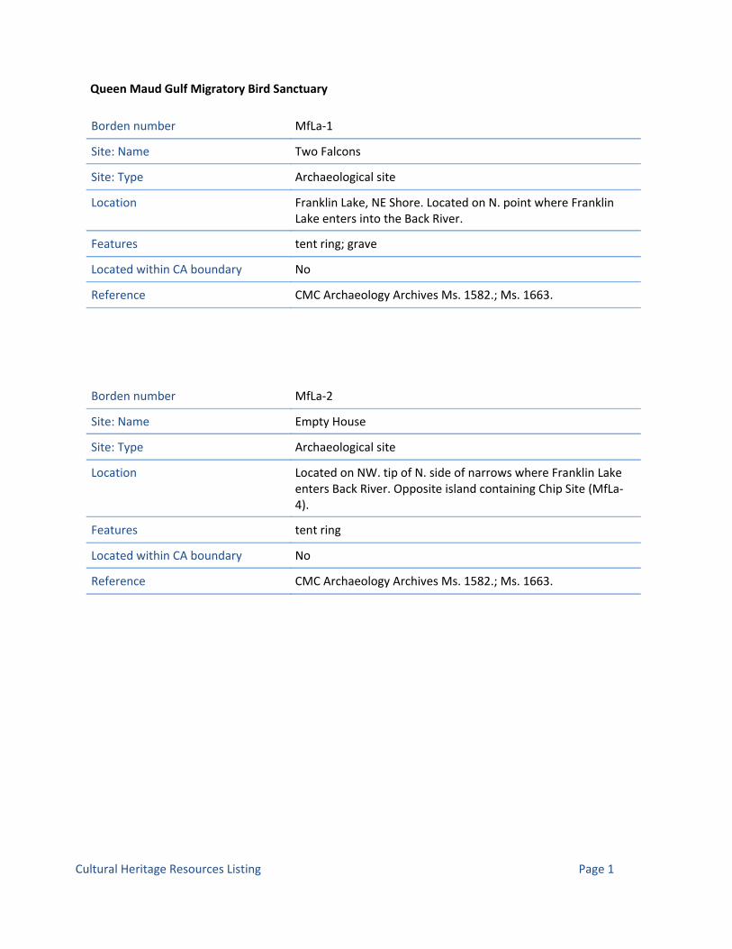
Queen Maud Gulf Migratory Bird Sanctuary
Borden number MfLa‐1
Site: Name Two Falcons
Site: Type Archaeological site
Location Franklin Lake, NE Shore. Located on N. point where Franklin Lake enters into the Back River.
Features tent ring; grave
Located within CA boundary No
Reference CMC Archaeology Archives Ms. 1582.; Ms. 1663.
Borden number MfLa‐2
Site: Name Empty House
Site: Type Archaeological site
Location Located on NW. tip of N. side of narrows where Franklin Lake enters Back River. Opposite island containing Chip Site (MfLa‐4).
Features tent ring
Located within CA boundary No
Reference CMC Archaeology Archives Ms. 1582.; Ms. 1663.
Page 1Cultural Heritage Resources Listing

Borden number MfLa‐3
Site: Name Tin Boat
Site: Type Archaeological site
Location Located on NE. corner of first large island in middle of Back River after leaving Franklin Lake heading east.
Features tent ring
Located within CA boundary No
Reference CMC Archaeology Archives Ms. 1582.; Ms. 1663.
Borden number MfLa‐4
Site: Name Chip
Site: Type Archaeological site
Location Located on S. end of first large island in Back River after leaving Franklin Lake heading east. Opposite major rapids, or at normal water level what is probably the fastest section of the swift.
Features tent ring
Located within CA boundary No
Reference CMC Archaeology Archives Ms. 1582.; Ms. 1663.
Page 2Cultural Heritage Resources Listing
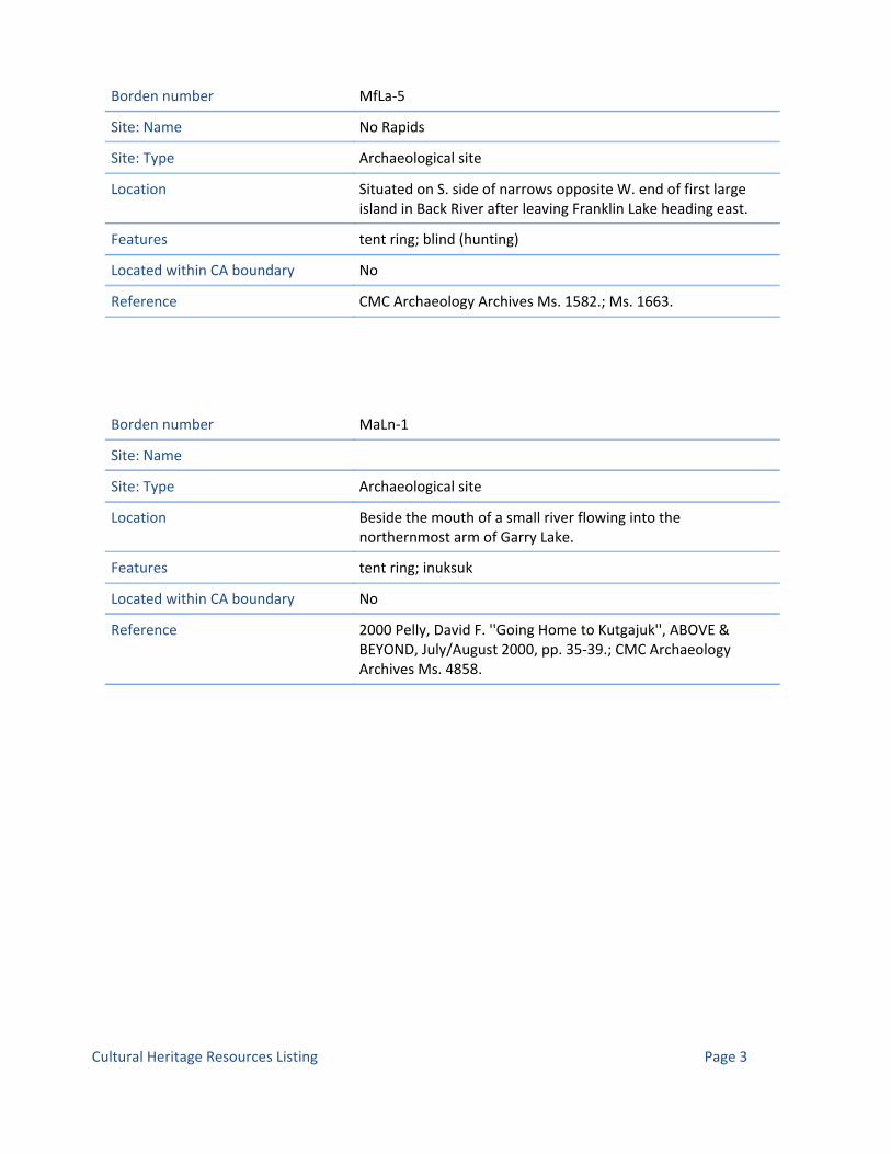
Borden number MfLa‐5
Site: Name No Rapids
Site: Type Archaeological site
Location Situated on S. side of narrows opposite W. end of first large island in Back River after leaving Franklin Lake heading east.
Features tent ring; blind (hunting)
Located within CA boundary No
Reference CMC Archaeology Archives Ms. 1582.; Ms. 1663.
Borden number MaLn‐1
Site: Name
Site: Type Archaeological site
Location Beside the mouth of a small river flowing into the northernmost arm of Garry Lake.
Features tent ring; inuksuk
Located within CA boundary No
Reference 2000 Pelly, David F. ''Going Home to Kutgajuk'', ABOVE & BEYOND, July/August 2000, pp. 35‐39.; CMC Archaeology Archives Ms. 4858.
Page 3Cultural Heritage Resources Listing
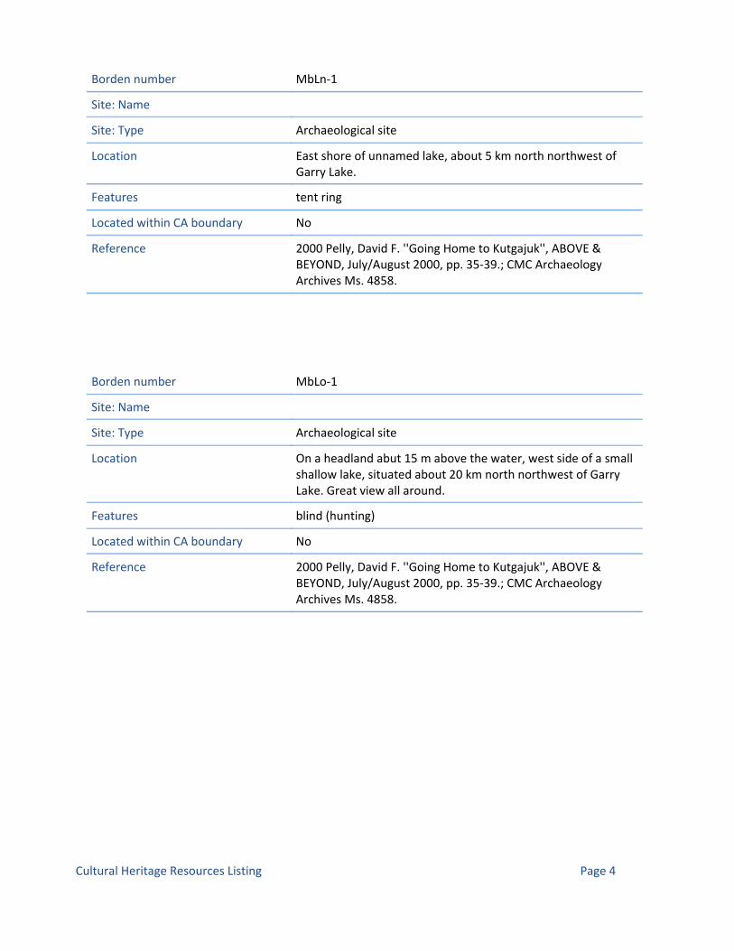
Borden number MbLn‐1
Site: Name
Site: Type Archaeological site
Location East shore of unnamed lake, about 5 km north northwest of Garry Lake.
Features tent ring
Located within CA boundary No
Reference 2000 Pelly, David F. ''Going Home to Kutgajuk'', ABOVE & BEYOND, July/August 2000, pp. 35‐39.; CMC Archaeology Archives Ms. 4858.
Borden number MbLo‐1
Site: Name
Site: Type Archaeological site
Location On a headland abut 15 m above the water, west side of a small shallow lake, situated about 20 km north northwest of Garry Lake. Great view all around.
Features blind (hunting)
Located within CA boundary No
Reference 2000 Pelly, David F. ''Going Home to Kutgajuk'', ABOVE & BEYOND, July/August 2000, pp. 35‐39.; CMC Archaeology Archives Ms. 4858.
Page 4Cultural Heritage Resources Listing

Borden number MlLa‐1
Site: Name
Site: Type Archaeological site
Location On prominent knoll on northeast corner of Montreal Island.
Features cairn; cache; tent ring
Located within CA boundary No
Reference CMC Archaeology Archives Ms. 2159.
Borden number NfLt‐1
Site: Name Stromness Bay
Site: Type Archaeological site
Location Stromness Bay, SE. corner of Victoria Island.
Features
Located within CA boundary No
Reference 1972 Taylor, W.E. An Archaeological Survey between Cape Parry and Cambridge Bay, Northwest Territories, Canada in 1963, National Museum of Man Mercury Series No. 1.; 1964 Taylor, W.E. Interim Account of an Archaeological Survey in the Central Arctic, 1963, Anthropological Papers of the University of Alaska, Vol. 12, No. 1.aska, Vol. 12, No. 1.; CMC Archaeology Archives Ms. 700.
Page 5Cultural Heritage Resources Listing

Borden number NfLt‐2
Site: Name
Site: Type Archaeological site
Location SW. Victoria Island. Kean Point.
Features
Located within CA boundary No
Reference CMC Archaeology Archives Ms. 1405.
Borden number NeLr‐1
Site: Name
Site: Type Archaeological site
Location The site is located ca 1500 m northeast of the station and ca 1200 m west of the present shoreline. Jenny Lind Island.
Features tent ring; hearth
Located within CA boundary No
Reference CMC Archaeology Archives Ms. 3264.
Borden number NeLr‐2
Site: Name
Site: Type Archaeological site
Location The site is located ca 2700 m northeast of the station and 300 m west of the present shoreline. Jenny Lind Island.
Features cache; tent structure
Located within CA boundary No
Reference CMC Archaeology Archives Ms. 3264.
Page 6Cultural Heritage Resources Listing

Borden number NeLr‐3
Site: Name
Site: Type Archaeological site
Location The site is located ca 3700 m north of the station and 1200 m from the present shoreline. Jenny Lind Island.
Features tent ring (mid‐passage)
Located within CA boundary No
Reference CMC Archaeology Archives Ms. 3264.
Borden number NdLr‐1
Site: Name
Site: Type Archaeological site
Location The site is located ca 4500 m SSE of the station (ca 500 m south of end of road) on beach ridges one and two. (Stuart 1990). CAM‐1 DEW Line site, on the first and second beach ridges above the present shoreline, approximately 400 m south of the end of the road running south of the airstrip to East Point, in the vicinity of Borrow Area 8. (Thomson 2008). Jenny Lind Island, Queen Maud Gulf.
Features cache; tent ring
Located within CA boundary No
Reference CMC Archaeology Archives Ms. 3264.; Ms. 4972.
Page 7Cultural Heritage Resources Listing

Borden number NdLr‐2
Site: Name
Site: Type Archaeological site
Location The site is located ca 2700 m southeast of the station (700 m ESE of the east end of the runway) and 200 m from the present shoreline. (Stuart 1990). CAM‐1 DEW Line site, southeast corner of CAM‐1 federal Reserve, 900 m ESE of east end of airstrip on beach ridge overlooking stream in flat valley. (Thomson 2008). Jenny Lind Island, Queen Maud Gulf.
Features house (semi‐subterranean); trap (fox)
Located within CA boundary No
Reference CMC Archaeology Archives Ms. 3264.; Ms. 4972.
Borden number NdLr‐3
Site: Name
Site: Type Archaeological site
Location The site is located ca 2000 m southwest of the station (500 m northwest of the beach tanks). Jenny Lind Island.
Features tent ring; dog stake; hide drying ring; boat
Located within CA boundary No
Reference CMC Archaeology Archives Ms. 3264.; Ms. 4972.
Page 8Cultural Heritage Resources Listing
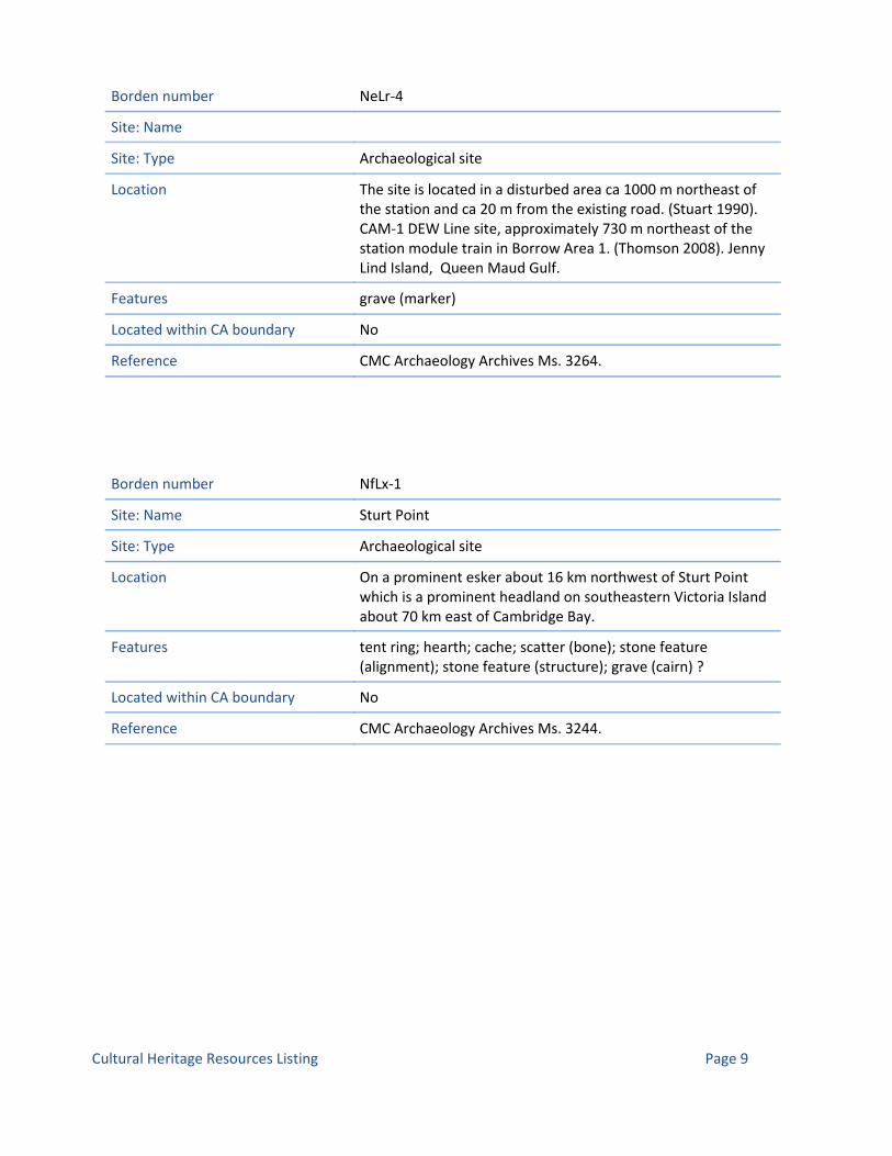
Borden number NeLr‐4
Site: Name
Site: Type Archaeological site
Location The site is located in a disturbed area ca 1000 m northeast of the station and ca 20 m from the existing road. (Stuart 1990). CAM‐1 DEW Line site, approximately 730 m northeast of the station module train in Borrow Area 1. (Thomson 2008). Jenny Lind Island, Queen Maud Gulf.
Features grave (marker)
Located within CA boundary No
Reference CMC Archaeology Archives Ms. 3264.
Borden number NfLx‐1
Site: Name Sturt Point
Site: Type Archaeological site
Location On a prominent esker about 16 km northwest of Sturt Point which is a prominent headland on southeastern Victoria Island about 70 km east of Cambridge Bay.
Features tent ring; hearth; cache; scatter (bone); stone feature (alignment); stone feature (structure); grave (cairn) ?
Located within CA boundary No
Reference CMC Archaeology Archives Ms. 3244.
Page 9Cultural Heritage Resources Listing

Borden number NdLr‐4
Site: Name
Site: Type Archaeological site
Location CAM‐1 DEW Line site, Jenny Lind Island, Queen Maud Gulf, approximately 300 m northwest of the Beach POL on the shore of Jenny Lind Bay
Features tent ring
Located within CA boundary No
Reference CMC Archaeology Archives Ms. 4972.
Borden number NdLr‐5
Site: Name
Site: Type Archaeological site
Location CAM‐1 DEW Line site, Jenny Lind Island, Queen Maud Gulf, approximately 800 m west of the airstrip on the shore of Jenny Lind Bay
Features tent ring
Located within CA boundary No
Reference CMC Archaeology Archives Ms. 4972.
Page 10Cultural Heritage Resources Listing

Borden number NdLr‐6
Site: Name
Site: Type Archaeological site
Location CAM‐1 DEW Line site, Jenny Lind Island, Queen Maud Gulf, approximately 65 m east of the nearest (south easternmost) tank in the Beach POL, 100 m from the shore of Jenny Lind Bay
Features cache
Located within CA boundary No
Reference CMC Archaeology Archives Ms. 4972.
Borden number NdLr‐7
Site: Name
Site: Type Archaeological site
Location CAM‐1 DEW Line site, Jenny Lind Island, Queen Maud Gulf, in Borrow Area 5 about 900 m west northwest of the airstrip on a high beach ridge
Features cache
Located within CA boundary No
Reference CMC Archaeology Archives Ms. 4972.
Page 11Cultural Heritage Resources Listing

Borden number NdLr‐8
Site: Name
Site: Type Archaeological site
Location CAM‐1 DEW Line site, Jenny Lind Island, Queen Maud Gulf, in Borrow Area 5 about 650 m west northwest of the airstrip on a high beach ridge
Features tent ring; hearth
Located within CA boundary No
Reference CMC Archaeology Archives Ms. 4972.
Borden number NdLr‐9
Site: Name
Site: Type Archaeological site
Location CAM‐1 DEW Line site, Jenny Lind Island, Queen Maud Gulf, in Borrow Area 5 about 700 m northwest of the airstrip on a high beach ridge
Features tent ring; trap (fox); cache; dog stake
Located within CA boundary No
Reference CMC Archaeology Archives Ms. 4972.
Page 12Cultural Heritage Resources Listing

Borden number NdLr‐10
Site: Name
Site: Type Archaeological site
Location CAM‐1 DEW Line site, Jenny Lind Island, Queen Maud Gulf, in Borrow Area 5 about 750 m west northwest of the airstrip on a high beach ridge
Features tent ring; cache; stone feature (alignment)
Located within CA boundary No
Reference CMC Archaeology Archives Ms. 4972.
Borden number NdLr‐11
Site: Name
Site: Type Archaeological site
Location CAM‐1 DEW Line site, Jenny Lind Island, Queen Maud Gulf, on the east side of Borrow Area 5 about 450 m west northwest of the airstrip on a high beach ridge.
Features tent ring
Located within CA boundary No
Reference
Page 13Cultural Heritage Resources Listing

Borden number NdLr‐12
Site: Name
Site: Type Archaeological site
Location CAM‐1 DEW Line site, Jenny Lind Island, Queen Maud Gulf, on the east side of Borrow Area 5 about 450 m west northwest of the airstrip on a high beach ridge.
Features tent ring; cache
Located within CA boundary No
Reference CMC Archaeology Archives Ms. 4972.
Borden number NdLr‐13
Site: Name
Site: Type Archaeological site
Location CAM‐1 DEW Line site, Jenny Lind Island, Queen Maud Gulf, on the south side of the access road to East Point on an intact beach ridge adjacent to the road, southwest of the former summer water supply lake, 600 m southwest of the east end of the airstrip
Features cache; blind (shooting) ?
Located within CA boundary No
Reference CMC Archaeology Archives Ms. 4972.
Page 14Cultural Heritage Resources Listing

Borden number NdLr‐14
Site: Name
Site: Type Archaeological site
Location CAM‐1 DEW Line site, Jenny Lind Island, Queen Maud Gulf, on the west side of the access road to East Point on the first beach ridge above the shore, near the end of the road, 2.1 km south of the east end of the airstrip.
Features tent ring
Located within CA boundary No
Reference CMC Archaeology Archives Ms. 4972.
Borden number NdLr‐15
Site: Name
Site: Type Archaeological site
Location CAM‐1 DEW Line site, Jenny Lind Island, Queen Maud Gulf, on a gravel beach ridge on the east side of a small pond on the summit of a low hill immediately east of Borrow Area 8 at East Point, 2.3 km south southeast of the airstrip.
Features tent ring; toy (tent ring)
Located within CA boundary No
Reference CMC Archaeology Archives Ms. 4972.
Page 15Cultural Heritage Resources Listing

Borden number NdLr‐16
Site: Name
Site: Type Archaeological site
Location CAM‐1 DEW Line site, Jenny Lind Island, Queen Maud Gulf, on the southwest side of Borrow Area 5 about 200 m northwest of the airstrip on low beach ridges.
Features tent ring; cache
Located within CA boundary No
Reference CMC Archaeology Archives Ms. 4972.
Borden number NdLr‐17
Site: Name
Site: Type Archaeological site
Location CAM‐1 DEW Line site, Jenny Lind Island, Queen Maud Gulf, on the north side of a branch road leading east off the East Point road towards a small borrow area, 750 m southeast of the east end of the airstrip.
Features cache
Located within CA boundary No
Reference CMC Archaeology Archives Ms. 4972.
Page 16Cultural Heritage Resources Listing

Borden number NdLr‐18
Site: Name
Site: Type Archaeological site
Location CAM‐1 DEW Line site, Jenny Lind Island, Queen Maud Gulf, on the east side of the CAM‐1 Reserve on the highest beach ridges about 200 m east of the nearest borrow activity about 1 km southeast of the east end of the airstrip.
Features tent ring
Located within CA boundary No
Reference CMC Archaeology Archives Ms. 4972.
Borden number NeLr‐5
Site: Name
Site: Type Archaeological site
Location CAM‐1 DEW Line site, Jenny Lind Island, Queen Maud Gulf, at the extreme southeast end of Borrow Area 4 750 m due east of the Station access road on a small undisturbed beach ridge 950 m south of the southeast end of the station module train.
Features tent ring; cache
Located within CA boundary No
Reference CMC Archaeology Archives Ms. 4972.
Page 17Cultural Heritage Resources Listing

Borden number NdLr‐19
Site: Name
Site: Type Archaeological site
Location CAM‐1 DEW Line site, Jenny Lind Island, Queen Maud Gulf, on the east side of the CAM‐1 Reserve on the highest beach ridges about 200 m east of the nearest borrow activity about 1 km southeast of the east end of the airstrip.
Features tent ring
Located within CA boundary No
Reference CMC Archaeology Archives Ms. 4972.
Borden number NdLr‐20
Site: Name
Site: Type Archaeological site
Location CAM‐1 DEW Line site, Jenny Lind Island, Queen Maud Gulf, in Beach Area, 70 m south of berm around large round fuel tank on the edge of the slope to the active beach.
Features cache
Located within CA boundary No
Reference CMC Archaeology Archives Ms. 4972.
Page 18Cultural Heritage Resources Listing

Borden number NdLr‐21
Site: Name
Site: Type Archaeological site
Location CAM‐1 DEW Line site, Jenny Lind Island, Queen Maud Gulf, on a beach ridge on the south side of a small pond near Borrow Area 8, East Point, 2 km south southeast of the east end of the airstrip.
Features tent ring; stone feature (pavement); grave ?; stone feature (shelter)
Located within CA boundary No
Reference CMC Archaeology Archives Ms. 4972.
Borden number NeLr‐6
Site: Name
Site: Type Archaeological site
Location CAM‐1 DEW Line site, Jenny Lind Island, Queen Maud Gulf, on a beach ridge about 900 m east southeast of the CAM‐1 Station.
Features stone feature (wall)
Located within CA boundary No
Reference CMC Archaeology Archives Ms. 4972.
Page 19Cultural Heritage Resources Listing

Borden number NdLr‐22
Site: Name
Site: Type Archaeological site
Location CAM‐1 DEW Line site, Jenny Lind Island, Queen Maud Gulf, at west end of pond on top of knoll near Borrow Area 8, East Point, 2.3 km south of the east end of the airstrip.
Features tent ring; stone feature (pavement)
Located within CA boundary No
Reference CMC Archaeology Archives Ms. 4972.
Borden number NdLr‐23
Site: Name
Site: Type Archaeological site
Location CAM‐1 DEW Line site, Jenny Lind Island, Queen Maud Gulf, on same beach ridge as NdLr‐1, East Point, 2.5 km south of east end of airstrip.
Features tent ring; stone feature (shelter); cache; stone feature (shelter)
Located within CA boundary No
Reference CMC Archaeology Archives Ms. 4972.
Page 20Cultural Heritage Resources Listing

Borden number NdLr‐24
Site: Name
Site: Type Archaeological site
Location CAM‐1 DEW Line site, Jenny Lind Island, Queen Maud Gulf, on highest beach ridge between East Point and Beach POL Area, 1.3 km south of east end of airstrip.
Features cache
Located within CA boundary No
Reference CMC Archaeology Archives Ms. 4972.
Borden number NdLr‐25
Site: Name
Site: Type Archaeological site
Location CAM‐1 DEW Line site, Jenny Lind Island, Queen Maud Gulf, on highest beach ridge between East Point and Beach POL Area, 800 m southwest of the east end of the airstrip.
Features cairn
Located within CA boundary No
Reference CMC Archaeology Archives Ms. 4972.
Page 21Cultural Heritage Resources Listing

Borden number NdLr‐26
Site: Name
Site: Type Archaeological site
Location CAM‐1 DEW Line site, Jenny Lind Island, Queen Maud Gulf, on same ridge as NdLr‐2, about 250 m further east, north of the west spur off the East Point road, 750 m east southeast of the east end of the airstrip.
Features tent ring; hearth
Located within CA boundary No
Reference CMC Archaeology Archives Ms. 4972.
Borden number NeLr‐7
Site: Name
Site: Type Archaeological site
Location CAM‐1 DEW Line site, Jenny Lind Island, Queen Maud Gulf, on high beach ridge full of massive boulders about 1.7 km northeast of the CAM‐1 Station
Features cache
Located within CA boundary No
Reference CMC Archaeology Archives Ms. 4972.
Page 22Cultural Heritage Resources Listing

Borden number NeLr‐8
Site: Name
Site: Type Archaeological site
Location CAM‐1 DEW Line site, Jenny Lind Island, Queen Maud Gulf, on high beach ridge full of massive boulders about 1.7 km northeast of the CAM‐1 Station
Features cache
Located within CA boundary No
Reference CMC Archaeology Archives Ms. 4972.
Borden number NeLr‐9
Site: Name
Site: Type Archaeological site
Location CAM‐1 DEW Line site, Jenny Lind Island, Queen Maud Gulf, on high beach ridge full of massive boulders about 1.7 km northeast of the CAM‐1 Station
Features cache; scatter (bone)
Located within CA boundary No
Reference CMC Archaeology Archives Ms. 4972.
Page 23Cultural Heritage Resources Listing
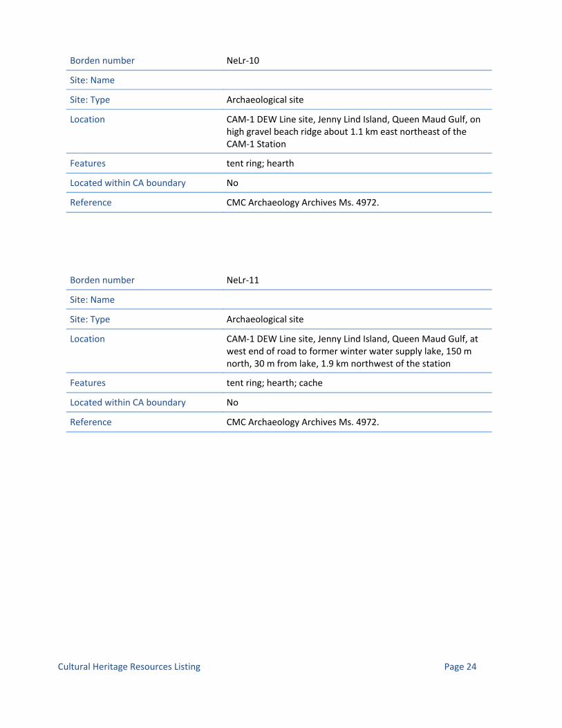
Borden number NeLr‐10
Site: Name
Site: Type Archaeological site
Location CAM‐1 DEW Line site, Jenny Lind Island, Queen Maud Gulf, on high gravel beach ridge about 1.1 km east northeast of the CAM‐1 Station
Features tent ring; hearth
Located within CA boundary No
Reference CMC Archaeology Archives Ms. 4972.
Borden number NeLr‐11
Site: Name
Site: Type Archaeological site
Location CAM‐1 DEW Line site, Jenny Lind Island, Queen Maud Gulf, at west end of road to former winter water supply lake, 150 m north, 30 m from lake, 1.9 km northwest of the station
Features tent ring; hearth; cache
Located within CA boundary No
Reference CMC Archaeology Archives Ms. 4972.
Page 24Cultural Heritage Resources Listing

Borden number NbLm‐1
Site: Name
Site: Type Archaeological site
Location The Intermediate DEW Line Site is located on Hat Island in the Queen Maud Gulf 220 km south east of Cambridge Bay.
Features tent outline; cache
Located within CA boundary No
Reference
Borden number NbLm‐2
Site: Name
Site: Type Archaeological site
Location The Intermediate DEW Line Site is located on Hat Island in the Queen Maud Gulf 220 km south east of Cambridge Bay.
Features tent ring; cache
Located within CA boundary No
Reference
Page 25Cultural Heritage Resources Listing

Borden number NbLm‐3
Site: Name
Site: Type Archaeological site
Location The Intermediate DEW Line Site is located on Hat Island in the Queen Maud Gulf 220 km south east of Cambridge Bay.
Features house; tent ring
Located within CA boundary No
Reference
Borden number NdLr‐27
Site: Name
Site: Type Archaeological site
Location On a raised gravel beach at elevation of 8 m asl, the first major terrace above the shore. Southeastern shore of Jenny Lind Island.
Features stone feature (pavement); scatter (bone)
Located within CA boundary No
Reference
Page 26Cultural Heritage Resources Listing

Borden number NdNu‐1
Site: Name
Site: Type Archaeological site
Location Southern Victoria Island. On the hillside above the Inuit cabins at the mouth of the river.
Features tent ring
Located within CA boundary No
Reference
Borden number NeLv‐1
Site: Name
Site: Type Archaeological site
Location CAM‐A is located on Sturt Point, approximately 85 km southeast of Cambridge Bay.
Features cache; blind (hunting)
Located within CA boundary No
Reference
Page 27Cultural Heritage Resources Listing

Borden number NeLw‐1
Site: Name
Site: Type Archaeological site
Location CAM‐A is located on Sturt Point, approximately 85 km southeast of Cambridge Bay.
Features cache
Located within CA boundary No
Reference
Borden number NeLw‐2
Site: Name
Site: Type Archaeological site
Location CAM‐A is located on Sturt Point, approximately 85 km southeast of Cambridge Bay.
Features cache
Located within CA boundary No
Reference
Page 28Cultural Heritage Resources Listing

Borden number NeLw‐3
Site: Name
Site: Type Archaeological site
Location CAM‐A is located on Sturt Point, approximately 85 km southeast of Cambridge Bay.
Features tent ring
Located within CA boundary No
Reference
Borden number NeLv‐2
Site: Name
Site: Type Archaeological site
Location CAM‐A is located on Sturt Point, approximately 85 km southeast of Cambridge Bay.
Features cache; cairn
Located within CA boundary No
Reference
Page 29Cultural Heritage Resources Listing

Borden number NeLv‐3
Site: Name
Site: Type Archaeological site
Location CAM‐A is located on Sturt Point, approximately 85 km southeast of Cambridge Bay.
Features grave
Located within CA boundary No
Reference
Borden number NaNh‐21
Site: Name Lucy Haniliak
Site: Type Archaeological site
Location The site is located approximately 4.2 km south of Roberts Bay. It is situated about 500 m north of the north end of a lake known locally as Tail Lake. It is on a small bedrock knoll which is surrounded by grassy meadow on a large plateau. The knoll surface is irregular with bedrock humps, gravel patches and some vegetation.
Features scatter (lithic)
Located within CA boundary No
Reference CMC Archaeology Archives Ms. 4293.; Ms. 4484.
Page 30Cultural Heritage Resources Listing

Borden number NaNh‐22
Site: Name
Site: Type Archaeological site
Location The site is located approximately 5 km south of Roberts Bay, on a large, high, north‐south trending bedrock ridge between two lakes known locally as Doris and Tail lakes. The ridge surface is very irregular, comprising grass meadow with periodic bedrock outcrops and rising to a rocky height. At the level of the landform containing the site, the ridge is about 40 m wide.
Features stone feature (circle); cache; hearth; drying rack
Located within CA boundary No
Reference CMC Archaeology Archives Ms. 4293.
Borden number NaNh‐23
Site: Name
Site: Type Archaeological site
Location The site is located approximately 5 km south of Roberts Bay, on a large, high, north‐south trending bedrock ridge between two lakes known locally as Doris and Tail lakes. The ridge surface is very irregular, comprising grassy meadow with periodic bedrock outcrops and rising to a rocky height south of the site. At the point of the landform containing the site, the ridge surface is about 30 m wide.
Features stone feature (circle); hearth; drying rack ?
Located within CA boundary No
Reference CMC Archaeology Archives Ms. 4293.
Page 31Cultural Heritage Resources Listing

Borden number NbNh‐24
Site: Name
Site: Type Archaeological site
Location The site is located on the west side of Roberts Bay, on a large, high, east‐west trending bedrock ridge. At the water's edge, the ridge is rocky and covered with boulders, then the large grass covered bench containing the site is elevated about 20 m above the water. Northwest of the circles, the ridge rises to a high, irregular rock outcrop.
Features stone feature (circle)
Located within CA boundary No
Reference CMC Archaeology Archives Ms. 4293.
Borden number NbNh‐25
Site: Name
Site: Type Archaeological site
Location The site is located at the southwest end of Roberts Bay, on a low projection of a north‐south trending bedrock ridge. South of the site location, the rock outcrops rise substantially. At the water, the landform rises relatively sharply and is characterized by hummocky bedrock surface with boulders. The surface levels out and is very irregular, comprising bedrock exposures with periodic grass patches. At the site location, the water of the bay is at the base of the ridge on the east side and grassy meadow is on the west side.
Features stone feature (circle)
Located within CA boundary No
Reference CMC Archaeology Archives Ms. 4293.
Page 32Cultural Heritage Resources Listing

Borden number NaNh‐24
Site: Name
Site: Type Archaeological site
Location The site is located approximately 5.5 km south of Roberts Bay, on the east side of a large, high, north‐south trending bedrock ridge between two lakes known locally as Doris and Tail lakes. The knoll surface is very irregular, composed of grass meadow with periodic rock outcrops. The site is on a gravel patch on a low bedrock exposure.
Features stone feature (circle)
Located within CA boundary No
Reference CMC Archaeology Archives Ms. 4293.
Borden number NaNh‐25
Site: Name
Site: Type Archaeological site
Location The site is located approximately 7.5 km south of Roberts Bay, on the west side of a high bedrock ridge between two lakes known locally as Doris and Tail lakes, about 200 m north of a small creek. It is near the south end of a narrow bedrock extension. The ridge surface is very irregular, composed mainly of rock outcrops of various sizes. The site is on a gravel patch on a low bedrock exposure.
Features stone feature (circle)
Located within CA boundary No
Reference CMC Archaeology Archives Ms. 4293.
Page 33Cultural Heritage Resources Listing
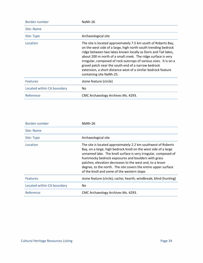
Borden number NaNh‐26
Site: Name
Site: Type Archaeological site
Location The site is located approximately 7.5 km south of Roberts Bay, on the west side of a large, high north‐south trending bedrock ridge between two lakes known locally as Doris and Tail lakes, about 200 m north of a small creek. The ridge surface is very irregular, composed of rock outcrops of various sizes. It is on a gravel patch near the south end of a narrow bedrock extension, a short distance west of a similar bedrock feature containing site NaNh‐25.
Features stone feature (circle)
Located within CA boundary No
Reference CMC Archaeology Archives Ms. 4293.
Borden number NbNh‐26
Site: Name
Site: Type Archaeological site
Location The site is located approximately 2.2 km southwest of Roberts Bay, on a large, high bedrock knoll on the west side of a large unnamed lake. The knoll surface is very irregular, composed of hummocky bedrock exposures and boulders with grass patches; elevation decreases to the west and, to a lesser degree, to the north. The site covers the entire upper surface of the knoll and some of the western slope.
Features stone feature (circle); cache; hearth; windbreak; blind (hunting)
Located within CA boundary No
Reference CMC Archaeology Archives Ms. 4293.
Page 34Cultural Heritage Resources Listing

Borden number NaNh‐27
Site: Name
Site: Type Archaeological site
Location The site is located approximately 7.5 km south of Roberts Bay, on the west side of a large, high north‐south trending bedrock ridge between two lakes known locally as Doris and Tail lakes, about 200 m north of a small creek. The ridge surface is very irregular, composed of rock outcrops of various sizes. It is on a gravel patch near the south end of a narrow bedrock extension, a short distance west of a similar bedrock feature containing site NaNh‐25.
Features trap (fox)
Located within CA boundary No
Reference CMC Archaeology Archives Ms. 4293.
Borden number NaNi‐1
Site: Name
Site: Type Archaeological site
Location E. shore of Hope Bay. S. shore of Melville Sound.
Features
Located within CA boundary No
Reference
Page 35Cultural Heritage Resources Listing

Borden number NfNd‐1
Site: Name Cape Colborne
Site: Type Archaeological site
Location Cape Colborne, 12 miles SSW. of Cambridge Bay settlement gravel beach near middle of northeast side of Cape.
Features tent ring; cache
Located within CA boundary No
Reference 1972 Taylor, W.E. An Archaeological Survey between Cape Parry and Cambridge Bay, Northwest Territories, Canada in1963, National Museum of Man Mercury Series No. 1.; 1964 Taylor, W.E. Interim Account of an Archaeological Survey in the Central Arctic, 1963, Anthropological Papers of the University of Alaska, Vol. 12, No. 1.aska, Vol. 12, No. 1.; CMC Archaeology Archives Ms. 700.
Borden number NbNh‐27
Site: Name
Site: Type Archaeological site
Location The site is located on the peninsula at the south end of Robert's Bay (off Melville Sound). It is situated about 600 m south of the north tip, on a bedrock exposure near the centre of the high ridge which runs the length of the peninsula.
Features stand (boat)
Located within CA boundary No
Reference CMC Archaeology Archives Ms. 4484.
Page 36Cultural Heritage Resources Listing

Borden number NbNh‐28
Site: Name
Site: Type Archaeological site
Location The site is located near the south end of the peninsula extending into the southern portion of Robert's Bay (off Melville Sound). It is situated on the lower edge of the bedrock outcrop that extends the length of the peninsula, about 700 m south of the north tip.
Features cache; stone feature (circle)
Located within CA boundary No
Reference CMC Archaeology Archives Ms. 4484.
Borden number NaNh‐28
Site: Name
Site: Type Archaeological site
Location The site is located approximately 4.5 km south of Robert's Bay (off Melville Sound), on a lower bedrock bench at the south end of large bedrock ridge northeast of Doris Lake. It is overlooking the creek between Doris and Tail lakes.
Features hearth; windbreak
Located within CA boundary No
Reference CMC Archaeology Archives Ms. 4484.
Page 37Cultural Heritage Resources Listing

Borden number NaNh‐29
Site: Name
Site: Type Archaeological site
Location The site is located approximately 5 km southeast of Robert's Bay (off Melville Sound) and about 1.5 km east of the north end of Doris Lake, near the south end of a high bedrock ridge overlooking a small lake about 150 m to the east.
Features stone feature (circle); cache; blind (hunting); inuksuk
Located within CA boundary No
Reference CMC Archaeology Archives Ms. 4484.
Borden number NaNh‐30
Site: Name
Site: Type Archaeological site
Location The site is located approximately 6.5 km southeast of Robert's Bay (off Melville Sound) and about 550 m east of Tail Lake. It is on the east side of a large bedrock ridge overlooking an expanse of grassland and a small lake about 500 m to the east.
Features stone feature (circle)
Located within CA boundary No
Reference CMC Archaeology Archives Ms. 4484.
Page 38Cultural Heritage Resources Listing

Borden number NbNh‐29
Site: Name Tony Akoluk
Site: Type Archaeological site
Location The site is located approximately 600 m south of Robert's Bay (off Melville Sound). It is centrally situated on the south side of a large bedrock outcrop. The outcrop surface is very irregular, composed of higher bedrock exposures along the north and east margins with periodic grassy meadow in the interior and southern sections.
Features stone feature (circle)
Located within CA boundary No
Reference CMC Archaeology Archives Ms. 4484.
Borden number NaNh‐31
Site: Name
Site: Type Archaeological site
Location The site is located approximately 7 km south of Robert's Bay (off Melville Sound), about 100 m west of Tail Lake. It is on a partly vegetated gravel patch on a narrow bench on the east side of a large bedrock outcrop. It is elevated about 20 m above the grassland adjacent to the lake shore.
Features stone feature (circle)
Located within CA boundary No
Reference CMC Archaeology Archives Ms. 4484.
Page 39Cultural Heritage Resources Listing

Borden number NaNh‐32
Site: Name
Site: Type Archaeological site
Location The site is located approximately 7 km south of Robert's Bay (off Melville Sound), on the western section of a large bedrock ridge west of Tail Lake. It is on a bedrock exposure about 100m west of the outcrop containing site T7, and a total of 200 m west of Tail Lake.
Features stone feature (circle)
Located within CA boundary No
Reference CMC Archaeology Archives Ms. 4484.
Borden number NaNh‐33
Site: Name
Site: Type Archaeological site
Location The site is located approximately 4.6 km south of Robert's Bay (off Melville Sound) and about 1.2 km east of a lake known locally as Glen Lake. It at the base of the south tip of a large bedrock knoll surrounded by grassland. The knoll surface is irregular, composed of hummocky bedrock exposures and boulders with occasional vegetated patches.
Features stone feature (circle) ?; stone feature (blind) ?
Located within CA boundary No
Reference CMC Archaeology Archives Ms. 4484.
Page 40Cultural Heritage Resources Listing

Borden number NaNh‐34
Site: Name
Site: Type Archaeological site
Location The site is located approximately 4.2 km south of Robert's Bay (off Melville Sound) and about 1.2 km east of a lake known locally as Glen Lake. It on a broad bench near the north end of a large bedrock knoll surrounded by grassland. The knoll surface is irregular, composed of hummocky bedrock exposures and boulders with occasional vegetated patches.
Features stone feature (circle); hearth
Located within CA boundary No
Reference CMC Archaeology Archives Ms. 4484.
Borden number NaNh‐35
Site: Name
Site: Type Archaeological site
Location The site is located approximately 7.7 km south of Robert's Bay (off Melville Sound), about 100 m west of Tail Lake. It is on a large bedrock outcrop elevated about 4 m to 10 m above the grassland adjacent to the lake shore.
Features stone feature (circle); windbreak
Located within CA boundary No
Reference CMC Archaeology Archives Ms. 4484.
Page 41Cultural Heritage Resources Listing

Borden number NaNh‐36
Site: Name
Site: Type Archaeological site
Location The site is located approximately 7.8 km south of Robert's Bay (off Melville Sound), on a large bedrock ridge between the south end of Tail Lake and Doris Lake about 250 m west of Tail Lake.
Features stone feature (circle); cache
Located within CA boundary No
Reference CMC Archaeology Archives Ms. 4484.
Borden number NaNh‐37
Site: Name
Site: Type Archaeological site
Location The site is located approximately 14.5 km south of Robert's Bay (off Melville Sound), on the east side of Patch Lake. It is in a gravel exposure on a rocky bench on the south end of a large bedrock outcrop elevated about 20 m above the lake shore.
Features stone feature (circle)
Located within CA boundary No
Reference CMC Archaeology Archives Ms. 4484.
Page 42Cultural Heritage Resources Listing

Borden number NfNb‐1
Site: Name
Site: Type Archaeological site
Location SW. Victoria Island. Large island in Anderson Bay.
Features cache
Located within CA boundary No
Reference CMC Archaeology Archives Ms. 1405.
Borden number NaNk‐1
Site: Name
Site: Type Archaeological site
Location On an unnamed island off the S. shore of Melville Sound, about 3 mi. NE. from the N. of the Sarvartor River.
Features tent ring; cache
Located within CA boundary No
Reference CMC Archaeology Archives Ms. 1254.
Borden number NaNk‐2
Site: Name
Site: Type Archaeological site
Location On the S. shore of Melville Sound at the mouth of a small freshwater stream.
Features tent ring; cache
Located within CA boundary No
Reference CMC Archaeology Archives Ms. 1254.
Page 43Cultural Heritage Resources Listing

Borden number NaNk‐3
Site: Name
Site: Type Archaeological site
Location At the mouth of the Sarvartor River on the S. shore of Melville Sound.
Features tent ring; cache
Located within CA boundary No
Reference CMC Archaeology Archives Ms. 1254.
Borden number NaNk‐4
Site: Name
Site: Type Archaeological site
Location At the mouth of an unnamed stream on the S. shore of Melville Sound.
Features cairn; tent ring
Located within CA boundary No
Reference CMC Archaeology Archives Ms. 1254.
Page 44Cultural Heritage Resources Listing

Borden number NfNg‐1
Site: Name
Site: Type Archaeological site
Location Cobble beach of sandstone, quartzite, occasional carbonate clasts. Northeast Kent Peninsula.
Features mid‐passage; hearth ?
Located within CA boundary No
Reference CMC Archaeology Archives Ms. 4873.
Borden number NfNg‐2
Site: Name
Site: Type Archaeological site
Location Cobble beach of sandstone, quartzite, occasional carbonate clasts. Northeast Kent Peninsula.
Features mid‐passage; hearth; wood (worked); tent ring
Located within CA boundary No
Reference CMC Archaeology Archives Ms. 4873.
Borden number NfNg‐3
Site: Name
Site: Type Archaeological site
Location Coarse cobble‐boulder beach. Northeast Kent Peninsula.
Features mid‐passage; hearth
Located within CA boundary No
Reference CMC Archaeology Archives Ms. 4873.
Page 45Cultural Heritage Resources Listing

Borden number NfNg‐4
Site: Name
Site: Type Archaeological site
Location Cobble beach of sandstone/quartzite with few boulders. Northeast Kent Peninsula.
Features mid‐passage; tent ring (mid‐passage)
Located within CA boundary No
Reference CMC Archaeology Archives Ms. 4873.
Borden number NfNg‐5
Site: Name
Site: Type Archaeological site
Location Cobble beach. Northeast Kent Peninsula.
Features tent ring
Located within CA boundary No
Reference CMC Archaeology Archives Ms. 4873.
Page 46Cultural Heritage Resources Listing

Borden number NfNg‐6
Site: Name
Site: Type Archaeological site
Location Cobble beach. Northeast Kent Peninsula.
Features tent ring (mid‐passage); hearth (box); mid‐passage
Located within CA boundary No
Reference CMC Archaeology Archives Ms. 4873.; 2009 Dyke, A.S. and J. Savelle, ''Paleoeskimo Demography and Sea‐Level History, Kent Peninsula and King William Island, Central Northwest Passage, Arctic Canada'', ARCTIC, Vol. 62, No. 4 (December 2009), p. 371‐392.
Borden number NfNg‐7
Site: Name
Site: Type Archaeological site
Location Cobble beach of sandstone/quartzite. Northeast Kent Peninsula.
Features tent ring (mid‐passage); hearth; mid‐passage
Located within CA boundary No
Reference CMC Archaeology Archives Ms. 4873.; 2009 Dyke, A.S. and J. Savelle, ''Paleoeskimo Demography and Sea‐Level History, Kent Peninsula and King William Island, Central Northwest Passage, Arctic Canada'', ARCTIC, Vol. 62, No. 4 (December 2009), p. 371‐392.
Page 47Cultural Heritage Resources Listing

Borden number NfNg‐8
Site: Name
Site: Type Archaeological site
Location Cobble beach of sandstone/quartzite. Northeast Kent Peninsula.
Features tent ring; hearth; scatter (lithic)
Located within CA boundary No
Reference CMC Archaeology Archives Ms. 4873.
Borden number NfNg‐9
Site: Name
Site: Type Archaeological site
Location Cobble beach of sandstone/quartzite. Northeast Kent Peninsula.
Features mid‐passage; tent ring
Located within CA boundary No
Reference CMC Archaeology Archives Ms. 4873.; 2009 Dyke, A.S. and J. Savelle, ''Paleoeskimo Demography and Sea‐Level History, Kent Peninsula and King William Island, Central Northwest Passage, Arctic Canada'', ARCTIC, Vol. 62, No. 4 (December 2009), p. 371‐392.
Page 48Cultural Heritage Resources Listing

Borden number NfNg‐10
Site: Name
Site: Type Archaeological site
Location Cobble beach of sandstone/quartzite. Northeast Kent Peninsula.
Features tent ring (mid‐passage); hearth
Located within CA boundary No
Reference CMC Archaeology Archives Ms. 4873.
Borden number NfNg‐11
Site: Name
Site: Type Archaeological site
Location Cobble beach of sandstone/quartzite. Northeast Kent Peninsula.
Features tent ring (mid‐passage); hearth
Located within CA boundary No
Reference CMC Archaeology Archives Ms. 4873.
Page 49Cultural Heritage Resources Listing
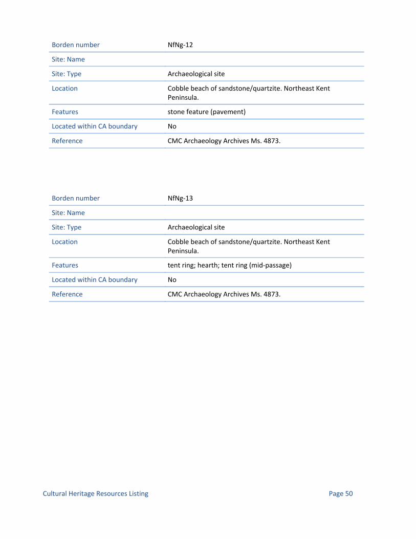
Borden number NfNg‐12
Site: Name
Site: Type Archaeological site
Location Cobble beach of sandstone/quartzite. Northeast Kent Peninsula.
Features stone feature (pavement)
Located within CA boundary No
Reference CMC Archaeology Archives Ms. 4873.
Borden number NfNg‐13
Site: Name
Site: Type Archaeological site
Location Cobble beach of sandstone/quartzite. Northeast Kent Peninsula.
Features tent ring; hearth; tent ring (mid‐passage)
Located within CA boundary No
Reference CMC Archaeology Archives Ms. 4873.
Page 50Cultural Heritage Resources Listing

Borden number NfNg‐15
Site: Name
Site: Type Archaeological site
Location Cobble beach of sandstone/quartzite. Northeast Kent Peninsula.
Features mid‐passage; tent ring (mid‐passage)
Located within CA boundary No
Reference CMC Archaeology Archives Ms. 4873.; 2009 Dyke, A.S. and J. Savelle, ''Paleoeskimo Demography and Sea‐Level History, Kent Peninsula and King William Island, Central Northwest Passage, Arctic Canada'', ARCTIC, Vol. 62, No. 4 (December 2009), p. 371‐392.
Borden number NfNg‐14
Site: Name
Site: Type Archaeological site
Location Cobble beach of sandstone/quartzite. Northeast Kent Peninsula.
Features tent ring; hearth; tent ring (mid‐passage); mid‐passage; stone feature (pavement)
Located within CA boundary No
Reference CMC Archaeology Archives Ms. 4873.; 2009 Dyke, A.S. and J. Savelle, ''Paleoeskimo Demography and Sea‐Level History, Kent Peninsula and King William Island, Central Northwest Passage, Arctic Canada'', ARCTIC, Vol. 62, No. 4 (December 2009), p. 371‐392.
Page 51Cultural Heritage Resources Listing

Borden number NfNg‐16
Site: Name
Site: Type Archaeological site
Location Cobble beach of sandstone/quartzite. Northeast Kent Peninsula.
Features mid‐passage
Located within CA boundary No
Reference CMC Archaeology Archives Ms. 4873.
Borden number NfNg‐17
Site: Name
Site: Type Archaeological site
Location Cobble beach of sandstone/quartzite. Northeast Kent Peninsula.
Features tent ring (mid‐passage)
Located within CA boundary No
Reference CMC Archaeology Archives Ms. 4873.; 2009 Dyke, A.S. and J. Savelle, ''Paleoeskimo Demography and Sea‐Level History, Kent Peninsula and King William Island, Central Northwest Passage, Arctic Canada'', ARCTIC, Vol. 62, No. 4 (December 2009), p. 371‐392.
Page 52Cultural Heritage Resources Listing
Borden number NfNg‐18
Site: Name
Site: Type Archaeological site
Location Cobble beach of sandstone/quartzite. Northeast Kent Peninsula.
Features mid‐passage
Located within CA boundary No
Reference CMC Archaeology Archives Ms. 4873.
Borden number NfNg‐19
Site: Name
Site: Type Archaeological site
Location Cobble beach of sandstone/quartzite. Northeast Kent Peninsula.
Features mid‐passage; stone feature (pavement)
Located within CA boundary No
Reference CMC Archaeology Archives Ms. 4873.
Page 53Cultural Heritage Resources Listing

Borden number NfNg‐20
Site: Name
Site: Type Archaeological site
Location Cobble beach of sandstone/quartzite. Northeast Kent Peninsula.
Features mid‐passage; stone feature (pavement)
Located within CA boundary No
Reference CMC Archaeology Archives Ms. 4873.
Borden number NfNg‐21
Site: Name
Site: Type Archaeological site
Location Cobble beach of sandstone/quartzite. Northeast Kent Peninsula.
Features tent ring; stone feature (pavement); hearth
Located within CA boundary No
Reference CMC Archaeology Archives Ms. 4873.
Page 54Cultural Heritage Resources Listing

Borden number NfNg‐22
Site: Name
Site: Type Archaeological site
Location Cobble beach of sandstone/quartzite. Northeast Kent Peninsula.
Features stone feature (pavement); NULL; hearth
Located within CA boundary No
Reference CMC Archaeology Archives Ms. 4873.
Borden number NfNg‐23
Site: Name
Site: Type Archaeological site
Location Cobble beach of sandstone/quartzite. Northeast Kent Peninsula.
Features tent ring; stone feature (pavement); hearth
Located within CA boundary No
Reference CMC Archaeology Archives Ms. 4873.
Borden number NfNg‐24
Site: Name
Site: Type Archaeological site
Location Sandstone shingle beach. Northeast Kent Peninsula.
Features stone feature (pavement)
Located within CA boundary No
Reference CMC Archaeology Archives Ms. 4873.
Page 55Cultural Heritage Resources Listing

Borden number NfNg‐25
Site: Name
Site: Type Archaeological site
Location Sandstone shingle beach. Northeast Kent Peninsula.
Features tent ring (mid‐passage); stone feature (pavement)
Located within CA boundary No
Reference CMC Archaeology Archives Ms. 4873.
Borden number NfNg‐26
Site: Name
Site: Type Archaeological site
Location Cobble beach. Northeast Kent Peninsula.
Features mid‐passage
Located within CA boundary No
Reference CMC Archaeology Archives Ms. 4873.
Page 56Cultural Heritage Resources Listing

Borden number NfNg‐27
Site: Name
Site: Type Archaeological site
Location Cobble beach. Northeast Kent Peninsula.
Features hearth
Located within CA boundary No
Reference CMC Archaeology Archives Ms. 4873.; 2009 Dyke, A.S. and J. Savelle, ''Paleoeskimo Demography and Sea‐Level History, Kent Peninsula and King William Island, Central Northwest Passage, Arctic Canada'', ARCTIC, Vol. 62, No. 4 (December 2009), p. 371‐392.
Borden number NfNg‐28
Site: Name
Site: Type Archaeological site
Location Cobble beach of brown sandstone. Northeast Kent Peninsula.
Features mid‐passage; tent ring
Located within CA boundary No
Reference CMC Archaeology Archives Ms. 4873.
Page 57Cultural Heritage Resources Listing

Borden number NfNg‐29
Site: Name
Site: Type Archaeological site
Location Sandstone shingle beach. Northeast Kent Peninsula.
Features tent ring (mid‐passage)
Located within CA boundary No
Reference CMC Archaeology Archives Ms. 4873.
Borden number NfNg‐30
Site: Name
Site: Type Archaeological site
Location Sandstone shingle beach. Northeast Kent Peninsula.
Features tent ring (mid‐passage)
Located within CA boundary No
Reference CMC Archaeology Archives Ms. 4873.; 2009 Dyke, A.S. and J. Savelle, ''Paleoeskimo Demography and Sea‐Level History, Kent Peninsula and King William Island, Central Northwest Passage, Arctic Canada'', ARCTIC, Vol. 62, No. 4 (December 2009), p. 371‐392.
Page 58Cultural Heritage Resources Listing

Borden number NfNf‐1
Site: Name
Site: Type Archaeological site
Location Cobble‐boulder beach. Northeast Kent Peninsula.
Features mid‐passage
Located within CA boundary No
Reference CMC Archaeology Archives Ms. 4873.
Borden number NfNf‐2
Site: Name
Site: Type Archaeological site
Location Sandstone cobble beach. Northeast Kent Peninsula.
Features mid‐passage
Located within CA boundary No
Reference CMC Archaeology Archives Ms. 4873.
Borden number NfNf‐3
Site: Name
Site: Type Archaeological site
Location Cobble beach. Northeast Kent Peninsula.
Features mid‐passage
Located within CA boundary No
Reference CMC Archaeology Archives Ms. 4873.
Page 59Cultural Heritage Resources Listing

Borden number NfNf‐4
Site: Name
Site: Type Archaeological site
Location Cobble beach. Northeast Kent Peninsula.
Features tent ring (mid‐passage)
Located within CA boundary No
Reference CMC Archaeology Archives Ms. 4873.
Borden number NfNf‐5
Site: Name
Site: Type Archaeological site
Location Sandstone cobble beach. Northeast Kent Peninsula.
Features mid‐passage; hearth
Located within CA boundary No
Reference CMC Archaeology Archives Ms. 4873.
Borden number NfNf‐6
Site: Name
Site: Type Archaeological site
Location Cobble beach. Northeast Kent Peninsula.
Features tent ring (mid‐passage)
Located within CA boundary No
Reference CMC Archaeology Archives Ms. 4873.
Page 60Cultural Heritage Resources Listing

Borden number NfNf‐7
Site: Name
Site: Type Archaeological site
Location Sandstone cobble beach. Northeast Kent Peninsula.
Features hearth
Located within CA boundary No
Reference CMC Archaeology Archives Ms. 4873.; 2009 Dyke, A.S. and J. Savelle, ''Paleoeskimo Demography and Sea‐Level History, Kent Peninsula and King William Island, Central Northwest Passage, Arctic Canada'', ARCTIC, Vol. 62, No. 4 (December 2009), p. 371‐392.
Borden number NfNf‐8
Site: Name
Site: Type Archaeological site
Location Cobble‐shingle beach of brown sandstone with occasional dolomite. Northeast Kent Peninsula.
Features mid‐passage; hearth
Located within CA boundary No
Reference CMC Archaeology Archives Ms. 4873.; 2009 Dyke, A.S. and J. Savelle, ''Paleoeskimo Demography and Sea‐Level History, Kent Peninsula and King William Island, Central Northwest Passage, Arctic Canada'', ARCTIC, Vol. 62, No. 4 (December 2009), p. 371‐392.
Page 61Cultural Heritage Resources Listing

Borden number NfNf‐9
Site: Name
Site: Type Archaeological site
Location Cobble‐shingle beach of brown sandstone with occasional dolomite. Northeast Kent Peninsula.
Features mid‐passage
Located within CA boundary No
Reference CMC Archaeology Archives Ms. 4873.
Borden number NfNf‐10
Site: Name
Site: Type Archaeological site
Location Sandstone cobble beach. Northeast Kent Peninsula.
Features mid‐passage
Located within CA boundary No
Reference CMC Archaeology Archives Ms. 4873.; 2009 Dyke, A.S. and J. Savelle, ''Paleoeskimo Demography and Sea‐Level History, Kent Peninsula and King William Island, Central Northwest Passage, Arctic Canada'', ARCTIC, Vol. 62, No. 4 (December 2009), p. 371‐392.
Page 62Cultural Heritage Resources Listing

Borden number NfNh‐9
Site: Name
Site: Type Archaeological site
Location Cobble beach. Northeast Kent Peninsula.
Features tent ring (mid‐passage); mid‐passage
Located within CA boundary No
Reference CMC Archaeology Archives Ms. 4873.
Borden number NfNh‐1
Site: Name
Site: Type Archaeological site
Location Shingle beach of gray sandstone with occasional boulders of carbonate, red sandstone and gneiss. Northeast Kent Peninsula.
Features tent ring; hearth ?
Located within CA boundary No
Reference CMC Archaeology Archives Ms. 4873.
Page 63Cultural Heritage Resources Listing

Borden number NfNh‐2
Site: Name
Site: Type Archaeological site
Location Shingle beach of gray sandstone with occasional boulders of carbonate, red sandstone and gneiss. Northeast Kent Peninsula.
Features mid‐passage; hearth (box)
Located within CA boundary No
Reference CMC Archaeology Archives Ms. 4873.; 2009 Dyke, A.S. and J. Savelle, ''Paleoeskimo Demography and Sea‐Level History, Kent Peninsula and King William Island, Central Northwest Passage, Arctic Canada'', ARCTIC, Vol. 62, No. 4 (December 2009), p. 371‐392.
Borden number NfNh‐3
Site: Name
Site: Type Archaeological site
Location Sandstone cobble beach. Northeast Kent Peninsula.
Features mid‐passage; hearth (box)
Located within CA boundary No
Reference CMC Archaeology Archives Ms. 4873.; 2009 Dyke, A.S. and J. Savelle, ''Paleoeskimo Demography and Sea‐Level History, Kent Peninsula and King William Island, Central Northwest Passage, Arctic Canada'', ARCTIC, Vol. 62, No. 4 (December 2009), p. 371‐392.
Page 64Cultural Heritage Resources Listing

Borden number NfNh‐4
Site: Name
Site: Type Archaeological site
Location Flagstone (sstn) beach. Northeast Kent Peninsula.
Features hearth (box)
Located within CA boundary No
Reference CMC Archaeology Archives Ms. 4873.; 2009 Dyke, A.S. and J. Savelle, ''Paleoeskimo Demography and Sea‐Level History, Kent Peninsula and King William Island, Central Northwest Passage, Arctic Canada'', ARCTIC, Vol. 62, No. 4 (December 2009), p. 371‐392.
Borden number NfNh‐5
Site: Name
Site: Type Archaeological site
Location Flagstone (sstn) beach. Northeast Kent Peninsula.
Features tent ring; hearth (box); grave (cairn)
Located within CA boundary No
Reference CMC Archaeology Archives Ms. 4873.
Page 65Cultural Heritage Resources Listing

Borden number NfNh‐6
Site: Name
Site: Type Archaeological site
Location Cobble‐shingle beach, mainly sandstone. Northeast Kent Peninsula.
Features mid‐passage; hearth (box); stone feature (pavement)
Located within CA boundary No
Reference CMC Archaeology Archives Ms. 4873.; 2009 Dyke, A.S. and J. Savelle, ''Paleoeskimo Demography and Sea‐Level History, Kent Peninsula and King William Island, Central Northwest Passage, Arctic Canada'', ARCTIC, Vol. 62, No. 4 (December 2009), p. 371‐392.
Borden number NfNh‐7
Site: Name
Site: Type Archaeological site
Location Cobble beach. Northeast Kent Peninsula.
Features mid‐passage; hearth (box)
Located within CA boundary No
Reference CMC Archaeology Archives Ms. 4873.
Page 66Cultural Heritage Resources Listing

Borden number NbNh‐31
Site: Name
Site: Type Archaeological site
Location On peninsula in Roberts Bay, on gravel on northern tip of land.
Features stone feature (circular)
Located within CA boundary No
Reference CMC Archaeology Archives Ms. 4509.; CMC Archaeology Archives Ms. 4509.
Borden number NaNh‐38
Site: Name
Site: Type Archaeological site
Location On west side of high bedrock ridge on west side of creek flowing north of Windy Lake.
Features stone feature (circular)
Located within CA boundary No
Reference CMC Archaeology Archives Ms. 4509.; CMC Archaeology Archives Ms. 4509.
Page 67Cultural Heritage Resources Listing

Borden number NbNh‐30
Site: Name
Site: Type Archaeological site
Location On peninsula in Robert Bay, on bedrock outcrop on western point of land.
Features tent ring; stand (boat); trap
Located within CA boundary No
Reference CMC Archaeology Archives Ms. 4509.; CMC Archaeology Archives Ms. 4509.
Borden number NfNh‐10
Site: Name
Site: Type Archaeological site
Location Cobble beach of sandstone and quartzite. Northeast Kent Peninsula.
Features tent ring; mid‐passage; hearth
Located within CA boundary No
Reference CMC Archaeology Archives Ms. 4873.; 2009 Dyke, A.S. and J. Savelle, ''Paleoeskimo Demography and Sea‐Level History, Kent Peninsula and King William Island, Central Northwest Passage, Arctic Canada'', ARCTIC, Vol. 62, No. 4 (December 2009), p. 371‐392.
Page 68Cultural Heritage Resources Listing
Borden number NfNh‐8
Site: Name
Site: Type Archaeological site
Location Located directly downslope from NfNh‐6. Cobble beach with numerous boulders. Northeast Kent Peninsula.
Features mid‐passage; hearth (box)
Located within CA boundary No
Reference CMC Archaeology Archives Ms. 4873.
Borden number NfNh‐11
Site: Name
Site: Type Archaeological site
Location Shingle beach of sandstone flags. Northeast Kent Peninsula.
Features stone feature (pavement); hearth; mid‐passage
Located within CA boundary No
Reference CMC Archaeology Archives Ms. 4873.
Borden number NfNh‐12
Site: Name
Site: Type Archaeological site
Location Shingle‐cobble beach of sandstone & quartzite with numerous boulders. Northeast Kent Peninsula.
Features stone feature (pavement); NULL; mid‐passage
Located within CA boundary No
Reference CMC Archaeology Archives Ms. 4873.
Page 69Cultural Heritage Resources Listing

Borden number NeNh‐1
Site: Name
Site: Type Archaeological site
Location Northeast Kent Peninsula.
Features tent ring
Located within CA boundary No
Reference CMC Archaeology Archives Ms. 4873.
Borden number NeNi‐1
Site: Name
Site: Type Archaeological site
Location Shingle‐cobble beach. Northeast Kent Peninsula.
Features hearth (box)
Located within CA boundary No
Reference CMC Archaeology Archives Ms. 4873.
Borden number NeNi‐2
Site: Name
Site: Type Archaeological site
Location Shingle‐cobble beach. Northeast Kent Peninsula.
Features tent ring; tent ring (mid‐passage)
Located within CA boundary No
Reference CMC Archaeology Archives Ms. 4873.
Page 70Cultural Heritage Resources Listing

Borden number NeNi‐3
Site: Name
Site: Type Archaeological site
Location Shingle‐cobble beach. Northeast Kent Peninsula.
Features stone feature (pavement); hearth
Located within CA boundary No
Reference CMC Archaeology Archives Ms. 4873.
Borden number NeNi‐4
Site: Name
Site: Type Archaeological site
Location Shingle beach. Northeast Kent Peninsula.
Features tent ring (mid‐passage); hearth
Located within CA boundary No
Reference CMC Archaeology Archives Ms. 4873.; 2009 Dyke, A.S. and J. Savelle, ''Paleoeskimo Demography and Sea‐Level History, Kent Peninsula and King William Island, Central Northwest Passage, Arctic Canada'', ARCTIC, Vol. 62, No. 4 (December 2009), p. 371‐392.
Page 71Cultural Heritage Resources Listing

Borden number NeNi‐5
Site: Name
Site: Type Archaeological site
Location Shingle‐cobble beach mix of sandstone and carbonates. Northeast Kent Peninsula.
Features mid‐passage; hearth row; stone feature (lamp stand); stone feature (cutting board)
Located within CA boundary No
Reference CMC Archaeology Archives Ms. 4873.; 2009 Dyke, A.S. and J. Savelle, ''Paleoeskimo Demography and Sea‐Level History, Kent Peninsula and King William Island, Central Northwest Passage, Arctic Canada'', ARCTIC, Vol. 62, No. 4 (December 2009), p. 371‐392.
Borden number NeNi‐6
Site: Name
Site: Type Archaeological site
Location Boulder beach. Northeast Kent Peninsula.
Features stone feature (lamp stand); stone feature (cutting board)
Located within CA boundary No
Reference CMC Archaeology Archives Ms. 4873.
Page 72Cultural Heritage Resources Listing

Borden number NfNg‐31
Site: Name
Site: Type Archaeological site
Location Cobble beach of sandstone & quartzite. Northeast Kent Peninsula.
Features tent ring (mid‐passage)
Located within CA boundary No
Reference CMC Archaeology Archives Ms. 4873.
Borden number NfNf‐11
Site: Name
Site: Type Archaeological site
Location Cobble‐shingle beach of sandstone & quartzite. Northeast Kent Peninsula.
Features stone feature (pavement); hearth
Located within CA boundary No
Reference CMC Archaeology Archives Ms. 4873.
Page 73Cultural Heritage Resources Listing

Borden number NfNf‐12
Site: Name
Site: Type Archaeological site
Location Cobble‐shingle beach of sandstone & quartzite. Northeast Kent Peninsula.
Features hearth (box); mid‐passage
Located within CA boundary No
Reference CMC Archaeology Archives Ms. 4873.; 2009 Dyke, A.S. and J. Savelle, ''Paleoeskimo Demography and Sea‐Level History, Kent Peninsula and King William Island, Central Northwest Passage, Arctic Canada'', ARCTIC, Vol. 62, No. 4 (December 2009), p. 371‐392.
Borden number NfNf‐13
Site: Name
Site: Type Archaeological site
Location Cobble beach of sandstone. Northeast Kent Peninsula.
Features tent ring; mid‐passage; hearth
Located within CA boundary No
Reference CMC Archaeology Archives Ms. 4873.
Page 74Cultural Heritage Resources Listing

Borden number NfNf‐14
Site: Name
Site: Type Archaeological site
Location Cobble beach of sandstone. Northeast Kent Peninsula.
Features mid‐passage ?; stone feature (pavement)
Located within CA boundary No
Reference CMC Archaeology Archives Ms. 4873.
Borden number NfNf‐15
Site: Name
Site: Type Archaeological site
Location Cobble beach of sandstone. Northeast Kent Peninsula.
Features mid‐passage ?; stone feature (pavement)
Located within CA boundary No
Reference CMC Archaeology Archives Ms. 4873.
Borden number NfNf‐16
Site: Name
Site: Type Archaeological site
Location Cobble beach of sandstone. Northeast Kent Peninsula.
Features mid‐passage
Located within CA boundary No
Reference CMC Archaeology Archives Ms. 4873.
Page 75Cultural Heritage Resources Listing

Borden number NfNf‐17
Site: Name
Site: Type Archaeological site
Location Cobble beach of sandstone. Northeast Kent Peninsula.
Features mid‐passage
Located within CA boundary No
Reference CMC Archaeology Archives Ms. 4873.
Borden number NfNf‐18
Site: Name
Site: Type Archaeological site
Location Cobble beach of sandstone. Northeast Kent Peninsula.
Features mid‐passage
Located within CA boundary No
Reference CMC Archaeology Archives Ms. 4873.
Borden number NfNf‐19
Site: Name
Site: Type Archaeological site
Location Shingle beach. Northeast Kent Peninsula.
Features mid‐passage
Located within CA boundary No
Reference CMC Archaeology Archives Ms. 4873.
Page 76Cultural Heritage Resources Listing

Borden number NfNf‐20
Site: Name
Site: Type Archaeological site
Location Cobble beach of sandstone. Northeast Kent Peninsula.
Features mid‐passage
Located within CA boundary No
Reference CMC Archaeology Archives Ms. 4873.
Borden number NfNf‐21
Site: Name
Site: Type Archaeological site
Location Cobble beach of sandstone. Northeast Kent Peninsula.
Features tent ring (mid‐passage)
Located within CA boundary No
Reference CMC Archaeology Archives Ms. 4873.
Borden number NfNf‐22
Site: Name
Site: Type Archaeological site
Location Cobble beach of sandstone. Northeast Kent Peninsula.
Features tent ring (mid‐passage)
Located within CA boundary No
Reference CMC Archaeology Archives Ms. 4873.
Page 77Cultural Heritage Resources Listing

Borden number NfNf‐23
Site: Name
Site: Type Archaeological site
Location Cobble beach of sandstone. Northeast Kent Peninsula.
Features tent ring (mid‐passage)
Located within CA boundary No
Reference CMC Archaeology Archives Ms. 4873.
Borden number NbNh‐1
Site: Name
Site: Type Archaeological site
Location On an island at the south end of a bay (locally referred to as Roberts Bay) off Melville Sound. It is the first bay east of Hope Bay. On a saddle between two bedrock outcrops on the north side of a bay that is south‐centrally located on the western side of the island.
Features tent ring; hearth ?; windbreak ?
Located within CA boundary No
Reference CMC Archaeology Archives Ms. 3864.; Ms. 4293.
Page 78Cultural Heritage Resources Listing

Borden number NbNh‐2
Site: Name
Site: Type Archaeological site
Location On an island at the south end of a bay (locally referred to as Roberts Bay) off Melville Sound. It is the first bay east of Hope bay. On a raised beach terrace approximately 4 m above Roberts Bay. It is on the east side of the island a few meters north of a rock outcrop approximately 430 m north of the southern tip of the island.
Features tent ring; hearth ?; windbreak ?
Located within CA boundary No
Reference CMC Archaeology Archives Ms. 3864.; Ms. 4293.
Borden number NbNh‐3
Site: Name
Site: Type Archaeological site
Location On an island at the south end of a bay (locally referred to as Roberts Bay) off Melville Sound. It is the first bay east of Hope Bay. The site is situated approximately 4 m above Roberts Bay on the east side of the island. It is approximately 350 m north of the southern tip of the island.
Features tent ring; hearth ?; windbreak ?; depression
Located within CA boundary No
Reference CMC Archaeology Archives Ms. 3864.; Ms. 4293.
Page 79Cultural Heritage Resources Listing

Borden number NbNh‐4
Site: Name
Site: Type Archaeological site
Location On an island at the south end of a bay (locally referred to as Roberts Bay) off Melville Sound. It is the first bay east of Hope Bay. The site is situated approximately 3 m above Roberts Bay on the east side of the island. It is approximately 300 m north of the southern tip of the island.
Features tent ring
Located within CA boundary No
Reference CMC Archaeology Archives Ms. 3864.; Ms. 4293.
Borden number NbNh‐5
Site: Name
Site: Type Archaeological site
Location On an island at the south end of a bay (locally referred to as Roberts Bay) off Melville Sound. It is the first bay east of Hope Bay. The site is situated approximately 1 m above Roberts Bay on the north end and east side of the island.
Features tent ring; cache; trap
Located within CA boundary No
Reference CMC Archaeology Archives Ms. 3864.; Ms. 4293.
Page 80Cultural Heritage Resources Listing

Borden number NbNh‐6
Site: Name
Site: Type Archaeological site
Location On an island at the south end of a bay (locally referred to as Roberts Bay) off Melville Sound. It is the first bay east of Hope Bay. The site is situated approximately 15 m above Roberts Bay on the west side of the island near its northern end.
Features cache
Located within CA boundary No
Reference CMC Archaeology Archives Ms. 3864.; Ms. 4293.
Borden number NbNh‐7
Site: Name
Site: Type Archaeological site
Location On an island at the south end of a bay (locally referred to as Roberts Bay) off Melville Sound. It is the first bay east of Hope Bay. The site is situated approximately 8 m above Roberts bay on the west side of the island near the southern end of the large bay or cove that is centrally to southerly located.
Features trap
Located within CA boundary No
Reference CMC Archaeology Archives Ms. 3864.; Ms. 4293.
Page 81Cultural Heritage Resources Listing
Borden number NbNh‐8
Site: Name
Site: Type Archaeological site
Location On an island at the south end of a bay (locally referred to as Roberts Bay) off Melville Sound. It is the first bay east of Hope Bay. The site is situated in or adjacent to a saddle located between two high bedrock knolls at the southern end of the island. The site is approximately 100 m north of the southern tip and 6 m above Roberts bay.
Features tent ring; trap
Located within CA boundary No
Reference CMC Archaeology Archives Ms. 3864.; Ms. 4293.
Borden number NbNh‐9
Site: Name
Site: Type Archaeological site
Location On an island at the south end of a bay (locally referred to as Roberts Bay) off Melville Sound. It is the first bay east of Hope Bay. The site consists of two areas that represent the height of land; one in the south‐central portion of the island and the other centrally located. One area is approximately 290 m north of the southern tip and the other is approximately 400 to 450 m north. Both are 15 m above Roberts Bay.
Features cairn
Located within CA boundary No
Reference CMC Archaeology Archives Ms. 3864.; Ms. 4293.
Page 82Cultural Heritage Resources Listing

Borden number NbNh‐10
Site: Name
Site: Type Archaeological site
Location On a peninsula of land that extends north into the southern end of a bay (locally referred to as Roberts Bay) off Melville Sound. It is the first bay east of Hope Bay. The site is located approximately 200 m south of the northern tip of this peninsula. An island is located immediately to the north of this peninsula.
Features tent ring
Located within CA boundary No
Reference CMC Archaeology Archives Ms. 3864.; Ms. 4293.; Ms. 4484.; Ms. 4509.
Borden number NbNh‐11
Site: Name
Site: Type Archaeological site
Location On a peninsula of land that extends north into the southern end of a bay (locally referred to as Roberts Bay) off Melville sound. It is the first bay east of Hope Bay. The site is located approximately 400 m south of the northern end of this peninsula on the northern edge of the highest point of land in the northern half of this landform. An island is located immediately to the north of this peninsula.
Features cairn
Located within CA boundary No
Reference CMC Archaeology Archives Ms. 3864.; Ms. 4293.; Ms. 4484.; Ms. 4509.
Page 83Cultural Heritage Resources Listing

Borden number NbNh‐12
Site: Name
Site: Type Archaeological site
Location On a peninsula of land that extends north into the southern end of a bay (locally referred to as Roberts Bay) off Melville Sound. It is the first bay east of Hope Bay. Approximately 500 m south of the northern end of this peninsula. On the south‐western edge of the highest point of land in the northern half of this landform. An island is located immediately to the north of this peninsula.
Features trap
Located within CA boundary No
Reference CMC Archaeology Archives Ms. 3864.; Ms. 4293.; Ms. 4484.; Ms. 4509.
Borden number NbNh‐13
Site: Name
Site: Type Archaeological site
Location At the southern end of a peninsula of land that extends north into the southern end of a bay (locally referred to as Roberts Bay) off Melville Sound. It is the first bay east of Hope Bay. The site is located on the west side of the peninsula northeast of a seasonal drainage. It is immediately adjacent to Roberts Bay at the base of a higher landform. An island is located immediately to the north of this peninsula.
Features tent ring; stone feature (alignment)
Located within CA boundary No
Reference CMC Archaeology Archives Ms. 3864.; Ms. 4024.; Ms. 4293.; Ms. 4484.
Page 84Cultural Heritage Resources Listing

Borden number NbNh‐32
Site: Name
Site: Type Archaeological site
Location The site is located along the southeastern portion of Robert's Bay (off Melville Sound), on vegetated gravel on the first beach ridge above the water level near the outlet of Little Roberts Creek.
Features stone feature (circle); windbreak
Located within CA boundary No
Reference CMC Archaeology Archives Ms. 4765.
Borden number NbNh‐33
Site: Name
Site: Type Archaeological site
Location Approximately 300 m south of the southeastern portion of Robert's Bay (off Melville Sound), on a small bedrock outcrop that is one of the initial, lower bedrock exposures near the base of a large bedrock outcrop complex.
Features trap
Located within CA boundary No
Reference CMC Archaeology Archives Ms. 4765.
Page 85Cultural Heritage Resources Listing

Borden number NbNh‐34
Site: Name
Site: Type Archaeological site
Location Along the southeastern portion of Robert's Bay (off Melville Sound), approximately 300 m southeast of the outlet of Little Roberts Creek, on a bedrock knoll with undulating surface exposures and patches of vegetation.
Features stone feature (circle); hearth; windbreak; shelter ?; blind (hunting)
Located within CA boundary No
Reference CMC Archaeology Archives Ms. 4765.
Borden number NaNh‐1
Site: Name
Site: Type Archaeological site
Location The site is located approximately 60 km. east of Bathurst Inlet and 18 km. south of Roberts Bay (off Melville Sound). It is situated on a bedrock ridge at the southwest corner of a large lake known locally as Patch Lake, on a narrow height of land between Patch Lake and a smaller lake to the west which is locally referred to as Wolverine Lake.
Features stone feature (circular); cache; blind (hunting); scatter (bone)
Located within CA boundary No
Reference CMC Archaeology Archives Ms. 3934.; Ms. 4024.
Page 86Cultural Heritage Resources Listing
Borden number NaNh‐2
Site: Name
Site: Type Archaeological site
Location The site is located approximately 4 km. south of Roberts Bay (off Melville Sound). It is situated near the western edge of a high bedrock ridge northeast of a large lake known locally as Doris Lake.
Features trap
Located within CA boundary No
Reference CMC Archaeology Archives Ms. 3934.; Ms. 4024.; Ms. 4293.
Borden number NaNh‐3
Site: Name
Site: Type Archaeological site
Location The site is located approximately 4 km. south of Roberts Bay (off Melville Sound). It is situated near the northern edge of a high bedrock ridge northeast of a large lake known locally as Doris Lake.
Features stone feature (circular); trap
Located within CA boundary No
Reference CMC Archaeology Archives Ms. 3934.; Ms. 4293.
Page 87Cultural Heritage Resources Listing

Borden number NaNh‐4
Site: Name
Site: Type Archaeological site
Location The site is located approximately 4 km. south of Roberts Bay (off Melville Sound). It is situated on a small bedrock knoll on the west side of a creek which drains a large lake known locally as Doris Lake. The knoll is within a valley flanked by high bedrock ridges and is adjacent to some small rapids on the creek.
Features stone feature (circular); cache ?; trap ?; hearth; house ?
Located within CA boundary No
Reference CMC Archaeology Archives Ms. 3934.; Ms. 4024.; Ms. 4293.; Ms. 4484.
Borden number NaNh‐5
Site: Name
Site: Type Archaeological site
Location The site is located approximately 16 km. south of Roberts Bay (off Melville Sound) and about 2.5 km. south of a large lake known locally as Windy Lake. It is situated on a large elevated bedrock ridge.
Features stone feature (circular); hearth; windbreak; blind (hunting) ?; shelter ?; stone feature
Located within CA boundary No
Reference CMC Archaeology Archives Ms. 3934.
Page 88Cultural Heritage Resources Listing

Borden number NaNh‐6
Site: Name
Site: Type Archaeological site
Location The site is located approximately 7 km. south of Roberts Bay (off Melville Sound) and about 0.5 km. north of a large lake known locally as Windy Lake. It is situated on a grassy flat between two bedrock knolls on the west side of a stream draining Windy Lake.
Features stone feature (circular); hearth; windbreak
Located within CA boundary No
Reference CMC Archaeology Archives Ms. 3934.; Ms. 4293.
Borden number NaNi‐2
Site: Name
Site: Type Archaeological site
Location The site is located approximately 5 km. south of Roberts Bay (off Melville Sound). It is situated on a large flat topped bedrock outcrop on the east side and near the south end of a large lake known locally as Glen Lake.
Features stone feature (circular); blind (hunting); cache
Located within CA boundary No
Reference CMC Archaeology Archives Ms. 3934.; Ms. 4293.; Ms. 4509.
Page 89Cultural Heritage Resources Listing

Borden number NbNh‐15
Site: Name
Site: Type Archaeological site
Location The site is located on the western shore of Roberts Bay (off Melville Sound). It is situated in a rock crevasse on the south side of a prominent bedrock promontory.
Features cache
Located within CA boundary No
Reference CMC Archaeology Archives Ms. 3934.; Ms. 4024.; Ms. 4293.
Borden number NbNh‐16
Site: Name
Site: Type Archaeological site
Location The site is located on the western side of Roberts Bay (off Melville Sound). It is situated on a low, flat gravel area, in the lee of high bedrock outcrops, about 30 m. from the shore.
Features stone feature (circular); hearth; windbreak
Located within CA boundary No
Reference CMC Archaeology Archives Ms. 3934.; Ms. 4024.; Ms. 4293.
Page 90Cultural Heritage Resources Listing

Borden number NbNh‐17
Site: Name
Site: Type Archaeological site
Location The site is located along the west side of Roberts Bay (off Melville Sound). It is situated on a large flat area near the southern end of the bay, south of a prominent bedrock promontory and north of a small river which flows from a lake known locally as Glen Lake. The site is about 75 m. from shore.
Features stone feature (circular); hearth; windbreak
Located within CA boundary No
Reference CMC Archaeology Archives Ms. 3934.; Ms. 4293.
Borden number NbNh‐18
Site: Name
Site: Type Archaeological site
Location The site is located on the eastern side of Roberts Bay (off Melville Sound), north of the creek that drains a large lake known locally as Doris Lake. Site features are situated on two bedrock knolls beginning about 50 m. from the ocean shore.
Features stone feature (circular); cache; scatter (bone)
Located within CA boundary No
Reference CMC Archaeology Archives Ms. 3934.; Ms. 4293.
Page 91Cultural Heritage Resources Listing

Borden number NbNh‐19
Site: Name
Site: Type Archaeological site
Location The site is located on the southeast shore of Roberts Bay (off Melville Sound), adjacent to the south side of the small creek that drains a lake known locally as Doris Lake. Features are situated on the flats near the shore and on a slightly elevated bedrock outcrop.
Features stone feature (circular); hearth; trap; drying rack
Located within CA boundary No
Reference CMC Archaeology Archives Ms. 3934.; Ms. 4293.; Ms. 4765.
Borden number NbNh‐20
Site: Name
Site: Type Archaeological site
Location The site is located approximately 2 km. southeast of Roberts Bay (off Melville Sound). It is situated on and adjacent to a bedrock knoll near a stream outlet on the west side of a large unnamed lake northeast of Doris Lake.
Features stone feature (circular); cache ?
Located within CA boundary No
Reference CMC Archaeology Archives Ms. 3934.; Ms. 4293.
Page 92Cultural Heritage Resources Listing

Borden number NbNh‐21
Site: Name
Site: Type Archaeological site
Location The site is located on the east side of Roberts Bay (off Melville Sound). It is situated on an elevated rocky outcrop consisting of various levels which gradually slope down toward the north. It is a short distance north of a small unnamed creek.
Features stone feature (circular); cache
Located within CA boundary No
Reference CMC Archaeology Archives Ms. 3934.; Ms. 4293.
Borden number NaNi‐3
Site: Name
Site: Type Archaeological site
Location In Hope Bay (off Melville Sound), on a large bedrock outcrop adjacent to the west side of northwest tip of Patch Lake.
Features stone feature (circle)
Located within CA boundary No
Reference CMC Archaeology Archives Ms. 4765.
Page 93Cultural Heritage Resources Listing

Borden number NbNh‐14
Site: Name
Site: Type Archaeological site
Location The site is located on the west shore of Roberts Bay (off Melville Sound). It is situated about 20 m. from the eastern edge of a prominent bedrock promontory.
Features stone feature (circular)
Located within CA boundary No
Reference CMC Archaeology Archives Ms. 3934.; Ms. 4024.; Ms. 4293.
Borden number NaNi‐4
Site: Name
Site: Type Archaeological site
Location In Hope Bay (off Melville Sound), on a shale saddle, approximately 15 m from the water and about 400 m north of the Koignuk River outlet.
Features stone feature (circle); hearth
Located within CA boundary No
Reference CMC Archaeology Archives Ms. 4765.
Page 94Cultural Heritage Resources Listing

Borden number NaNi‐5
Site: Name
Site: Type Archaeological site
Location In Hope Bay (off Melville Sound), on a shale saddle, approximately 15 m from the water and about 500 m north of the Koignuk River outlet.
Features stone feature (circle)
Located within CA boundary No
Reference CMC Archaeology Archives Ms. 4765.
Borden number NaNi‐6
Site: Name
Site: Type Archaeological site
Location In Hope Bay (off Melville Sound), on a low, gently sloping, vegetation covered rise, approximately 130 m east from the water and about 350 m north of the Koignuk River outlet.
Features stone feature (circle); hearth; windbreak
Located within CA boundary No
Reference CMC Archaeology Archives Ms. 4765.
Page 95Cultural Heritage Resources Listing

Borden number NaNi‐7
Site: Name
Site: Type Archaeological site
Location In Hope Bay (off Melville Sound), on a low, gently sloping, vegetation covered rise, approximately 130 m east from the water and about 350 m north of the Koignuk River outlet.
Features stone feature (circle); hearth
Located within CA boundary No
Reference CMC Archaeology Archives Ms. 4765.
Borden number NaNh‐39
Site: Name
Site: Type Archaeological site
Location Approximately 12 km south of Robert's Bay (off Melville Sound), on a small bedrock outcrop adjacent to the east side of Patch Lake.
Features stone feature (circle)
Located within CA boundary No
Reference CMC Archaeology Archives Ms. 4765.
Page 96Cultural Heritage Resources Listing

Borden number NaNh‐40
Site: Name
Site: Type Archaeological site
Location Approximately 11.8 km south of Robert's Bay (off Melville Sound), on a large bedrock outcrop adjacent to the west side of northwest tip of Patch Lake.
Features stone feature (circle); shelter; hearth
Located within CA boundary No
Reference CMC Archaeology Archives Ms. 4765.
Borden number NbNh‐35
Site: Name
Site: Type Archaeological site
Location Bedrock outcrop overlooking Melville Sound, facing east.
Features tent ring
Located within CA boundary No
Reference
Page 97Cultural Heritage Resources Listing

Borden number NbNh‐36
Site: Name
Site: Type Archaeological site
Location Bedrock outcrop overlooking Melville Sound, facing east. A beach lies to the south.
Features cache
Located within CA boundary No
Reference
Borden number NbNh‐37
Site: Name
Site: Type Archaeological site
Location Bedrock outcrop 150 metres west of Melville Sound.
Features cache
Located within CA boundary No
Reference
Borden number NbNh‐38
Site: Name
Site: Type Archaeological site
Location Bedrock outcrop 1km north of Robert's Lake.
Features tent ring ?
Located within CA boundary No
Reference
Page 98Cultural Heritage Resources Listing

Borden number NbNh‐39
Site: Name
Site: Type Archaeological site
Location Ridge (bedrock, with some glacial deposits) 1 km north of Roberts Lake.
Features tent ring
Located within CA boundary No
Reference
Borden number NbNh‐40
Site: Name
Site: Type Archaeological site
Location Ridge (bedrock, with some glacial deposits) 1 km north of Roberts Lake.
Features tent ring ; trap (fox); trap; cache
Located within CA boundary No
Reference
Page 99Cultural Heritage Resources Listing

Borden number NbNh‐41
Site: Name
Site: Type Archaeological site
Location Ridge (bedrock, with some glacial deposits) 500m north of Roberts Lake.
Features cairn
Located within CA boundary No
Reference
Borden number NbNh‐42
Site: Name
Site: Type Archaeological site
Location Ridge (bedrock, with some glacial deposits) immediately above Roberts Lake.
Features tent ring; hearth; hide drying ring; blind
Located within CA boundary No
Reference
Page 100Cultural Heritage Resources Listing
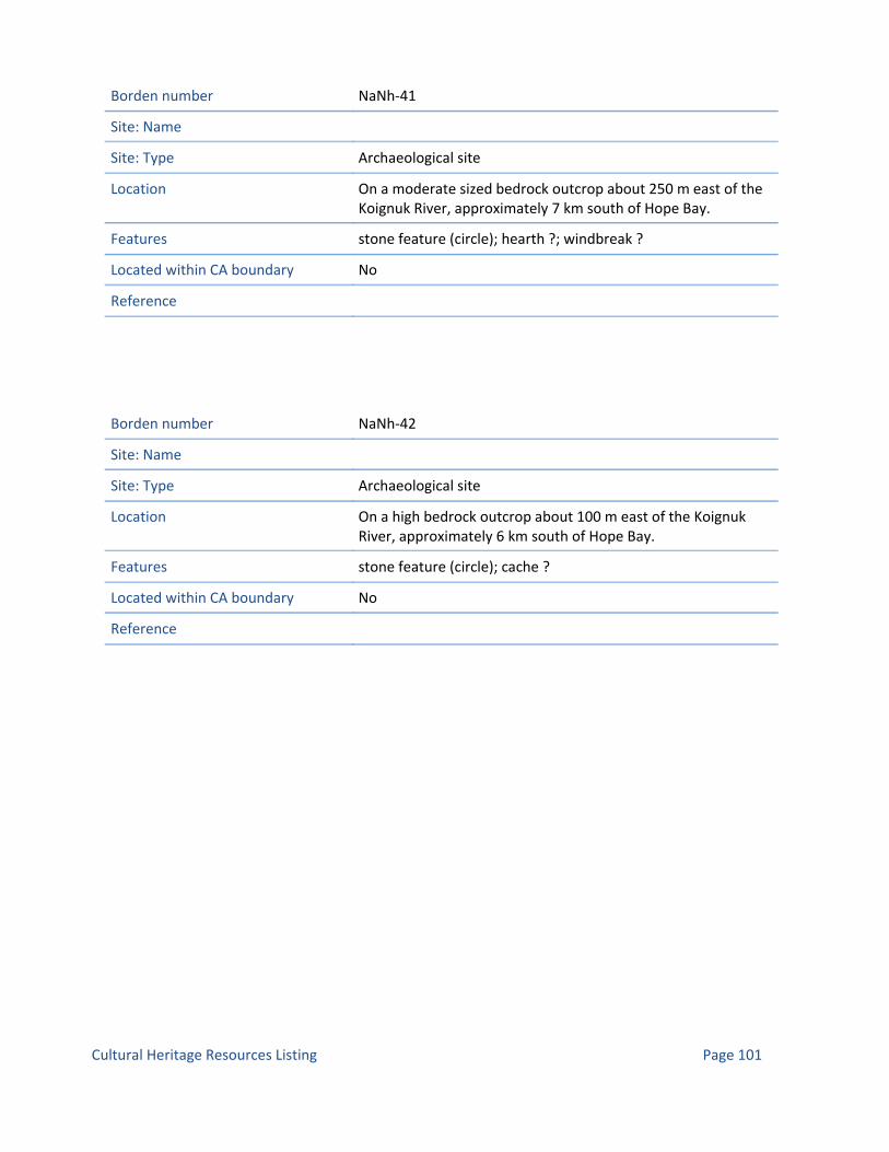
Borden number NaNh‐41
Site: Name
Site: Type Archaeological site
Location On a moderate sized bedrock outcrop about 250 m east of the Koignuk River, approximately 7 km south of Hope Bay.
Features stone feature (circle); hearth ?; windbreak ?
Located within CA boundary No
Reference
Borden number NaNh‐42
Site: Name
Site: Type Archaeological site
Location On a high bedrock outcrop about 100 m east of the Koignuk River, approximately 6 km south of Hope Bay.
Features stone feature (circle); cache ?
Located within CA boundary No
Reference
Page 101Cultural Heritage Resources Listing

Borden number NaNi‐8
Site: Name
Site: Type Archaeological site
Location On a gently sloping bench overlooking the southeastern portion of Hope Bay (off Melville Sound), approximately 70 m east from the water and about 2.3 km north of the Koignuk River outlet.
Features stone feature (circle); hearth ?; windbreak ?
Located within CA boundary No
Reference
Borden number NaNi‐9
Site: Name
Site: Type Archaeological site
Location On a high shale pass forming the neck of a peninsula in the southeastern portion of Hope Bay (off Melville Sound), approximately 300 m from the water and about 2.7 km north of the Koignuk River outlet.
Features stone feature (circle); hearth ?; windbreak ?
Located within CA boundary No
Reference
Page 102Cultural Heritage Resources Listing

Borden number NaNi‐10
Site: Name
Site: Type Archaeological site
Location On the beach in the southeastern portion of Hope Bay (off Melville Sound), between 2 and 15 m from the water and about 1.8 km north of the Koignuk River outlet.
Features stone feature (circle)
Located within CA boundary No
Reference
Borden number NaNh‐43
Site: Name
Site: Type Archaeological site
Location On a vegetated bench on a high bedrock outcrop at the northeast end of Patch Lake, approximately 11 km south of Roberts Bay.
Features hearth
Located within CA boundary No
Reference
Page 103Cultural Heritage Resources Listing

Borden number NaNh‐44
Site: Name
Site: Type Archaeological site
Location on a small knoll at the south end of Doris Lake, approximately 10 km south of Roberts Bay.
Features stone feature (circle); stone feature (semi‐circular); cache
Located within CA boundary No
Reference
Borden number NaNh‐45
Site: Name
Site: Type Archaeological site
Location On a large bedrock ridge about 2.5 km east of Patch Lake, and approximately 13.5 km southeast of Roberts Bay.
Features stone feature (circle); cache; stone feature (alignment)
Located within CA boundary No
Reference
Page 104Cultural Heritage Resources Listing

Borden number NaNh‐46
Site: Name
Site: Type Archaeological site
Location On the upper bedrock surface of a large knoll approximately 2 km south of Roberts Bay.
Features stone feature (circle)
Located within CA boundary No
Reference
Borden number NaNh‐47
Site: Name
Site: Type Archaeological site
Location On a low bedrock outcrop approximately 1 km due south of the southwest end of Patch Lake.
Features stone feature (circle)
Located within CA boundary No
Reference
Page 105Cultural Heritage Resources Listing

Borden number NaNh‐48
Site: Name
Site: Type Archaeological site
Location On the east side of a large bedrock ridge, approximately 8 km south of Roberts Bay.
Features stone feature (circle)
Located within CA boundary No
Reference
Borden number NaNh‐49
Site: Name
Site: Type Archaeological site
Location Along a north‐south trending bedrock outcrop in an open flat area. The site is sheltered to the north and east by outcrops.
Features tent ring; hearth; stone feature (alignment)
Located within CA boundary No
Reference
Page 106Cultural Heritage Resources Listing

Borden number NaNh‐50
Site: Name
Site: Type Archaeological site
Location Stone marker is at the north end of a large bedrock ridge along the eastern margin bordering tundra.
Features stone feature (marker)
Located within CA boundary No
Reference
Borden number NaNh‐51
Site: Name
Site: Type Archaeological site
Location Stone marker is located along eastern margin of low bedrock ridge bordering tundra to the east and further outcrop to the west, north and south.
Features stone feature (marker)
Located within CA boundary No
Reference
Page 107Cultural Heritage Resources Listing

Borden number NaNh‐52
Site: Name
Site: Type Archaeological site
Location Single large stone marker located at the centre of a large bedrock outcrop ridge along it's western margin. The terrain is uneven leading up to it from the tundra.
Features stone feature (marker)
Located within CA boundary No
Reference
Borden number NaNh‐53
Site: Name
Site: Type Archaeological site
Location The site is located at the southern end of a 750 m long north‐south oriented bedrock ridge. The site consists of two small stone circles located approximately 3.5 m apart (at a bearing of 79º). The circles have been constructed on sloping flat outcrops which face south.
Features stone feature (hide drying ring)
Located within CA boundary No
Reference
Page 108Cultural Heritage Resources Listing

Borden number NaNh‐54
Site: Name
Site: Type Archaeological site
Location In the centre close to the south end of a long north‐south oriented bedrock ridge. The single stone marker has been placed on a flat exposed bench of bedrock with an excellent view to the south, west and to the west side of Windy Lake.
Features stone feature (hide drying ring)
Located within CA boundary No
Reference
Borden number NaNh‐55
Site: Name
Site: Type Archaeological site
Location The site consists of 6 single stone markers placed at various distances from one another at the south and southwest end of a long bedrock ridge. The markers are placed at various elevations but all can be visible from the base of the ridge.
Features stone feature (hide drying ring)
Located within CA boundary No
Reference
Page 109Cultural Heritage Resources Listing

Borden number NaNh‐56
Site: Name
Site: Type Archaeological site
Location A single stone marker located along the centre along the western edge of a north‐south oriented bedrock ridge. The marker is located in close proximity to the surrounding tundra.
Features stone feature (hide drying ring)
Located within CA boundary No
Reference
Borden number NaNh‐57
Site: Name
Site: Type Archaeological site
Location Two stone markers located at the southern end of a north‐south oriented bedrock outcrop. The markers are located on outcrops along the southern margin in close proximity to the surrounding tundra.
Features stone feature (hide drying ring)
Located within CA boundary No
Reference
Page 110Cultural Heritage Resources Listing

Borden number NaNh‐58
Site: Name
Site: Type Archaeological site
Location The site is located in the centre of a north south oriented bedrock ridge. The marker is located on a small narrow bench at a lower point in the ridge while the rifle shells are located 15 m to the north close to where the ridge meets the Tundra.
Features stone feature (marker)
Located within CA boundary No
Reference
Borden number NaNh‐59
Site: Name
Site: Type Archaeological site
Location The site is located in the centre close to the south end of a long north‐south oriented bedrock ridge. The single stone marker has been placed on a flat exposed bench of bedrock with an excellent view to the south, west and to the west side of Windy Lake.
Features stone feature (marker); stone feature (circle)
Located within CA boundary No
Reference
Page 111Cultural Heritage Resources Listing

Borden number NaNh‐60
Site: Name
Site: Type Archaeological site
Location The site is located roughly at the southern end of a long north‐south oriented high bedrock outcrop just north of a seasonally fluctuating pond. The site consists of two angular stones placed one on top of the other on top of an eroded boulder on. There is an excellent view to southwest, south and southeast and should be visible from the tundra below.
Features stone feature (marker)
Located within CA boundary No
Reference
Borden number NaNh‐61
Site: Name
Site: Type Archaeological site
Location The site consists of two stone markers located approximately 60 m from one another in a north‐south orientation. The stones have been placed on one of the highest points along the formation which has an excellent view to southwest, west and north west.
Features stone feature (marker)
Located within CA boundary No
Reference
Page 112Cultural Heritage Resources Listing

Borden number NaNh‐62
Site: Name
Site: Type Archaeological site
Location The site is located on a small and low bedrock outcrop to the west of Windy Lake. The surrounding tundra is relatively flat with Windy Lake approximately 350 m to the west.
Features stone feature (marker)
Located within CA boundary No
Reference
Borden number NaNh‐63
Site: Name
Site: Type Archaeological site
Location The site consists of a single tent oval/rectangular tent ring and a stone marker located on a bedrock outcrop approximately 350 m to the east of the north end of Windy Lake. The bedrock is in an upland area with further bedrock outcrops to the west and closer to Windy lake.
Features tent ring; stone feature (marker); hearth
Located within CA boundary No
Reference
Page 113Cultural Heritage Resources Listing

Borden number NaNh‐64
Site: Name
Site: Type Archaeological site
Location The site consists of three distinct stone features and is located on a low bedrock outcrop on the east side of Windy Lake, approximately 225 m from the shore. The overall topography of the outcrop is irregular with only one relatively flat area which contains the circular tent ring.
Features tent ring; stone feature (marker); cache
Located within CA boundary No
Reference
Borden number NfNd‐2
Site: Name
Site: Type Archaeological site
Location Cape Colborne. Victoria Island.
Features longhouse; hearth row; cache
Located within CA boundary No
Reference
Page 114Cultural Heritage Resources Listing

Borden number NfN
Site: Name
Site: Type Archaeological site
Location Cape Colborne. Victoria Island.
Features longhouse; hearth row; cache
Located within CA boundary No
Reference
Borden number NfNb‐2
Site: Name
Site: Type Archaeological site
Location West shore of Anderson Bay. Southwest Victoria Island.
Features NULL; dwelling; cache
Located within CA boundary No
Reference
Borden number NfNb‐3
Site: Name
Site: Type Archaeological site
Location East shore of Anderson Bay. Southwest Victoria Island.
Features NULL; tent ring; cache
Located within CA boundary No
Reference
Page 115Cultural Heritage Resources Listing

Borden number NaNh‐65
Site: Name
Site: Type Archaeological site
Location On a small bench on bedrock outcropping on the uppermost terrace level on the east side of Patch Lake, about 350m from the water edge and 13.2 km south of Roberts Bay. East of Hope Bay.
Features stone feature (circle); hearth
Located within CA boundary No
Reference
Borden number NaNh‐66
Site: Name
Site: Type Archaeological site
Location On the second highest bench on the east side of Patch Lake, about 40m from the water edge and 13km south of Roberts Bay. East of Hope Bay.
Features cache
Located within CA boundary No
Reference
Page 116Cultural Heritage Resources Listing

Borden number NaNh‐67
Site: Name
Site: Type Archaeological site
Location On exposed surface on a small bedrock outcrop on the uppermost terrace level on the east side of Patch Lake, about 100m from the water edge and 13.6km south of Roberts Bay. East of Hope Bay.
Features stone feature (circle); hearth
Located within CA boundary No
Reference
Borden number NaNh‐68
Site: Name
Site: Type Archaeological site
Location On the highest point of a large bedrock outcrop on the east side of Patch Lake, about 200m from the water edge and 14km south of Roberts Bay.; East of Hope Bay.
Features inuksuk
Located within CA boundary No
Reference
Page 117Cultural Heritage Resources Listing

Borden number NaNh‐69
Site: Name
Site: Type Archaeological site
Location On exposed bedrock surface on an elongated, moderately elevated outcrop surrounded by level tundra, about 1.5km south of Patch Lake and 19km south of Roberts Bay. East of Hope Bay.
Features stone feature (circle)
Located within CA boundary No
Reference
Borden number NaNh‐70
Site: Name
Site: Type Archaeological site
Location On one of the higher portions of the large elevated bedrock outcroppings about 1.7km north of the base of Doris Mesa and 1.6km south of Roberts Bay. East of Hope Bay.
Features trap
Located within CA boundary No
Reference
Page 118Cultural Heritage Resources Listing

Borden number NaNh‐71
Site: Name
Site: Type Archaeological site
Location On exposed bedrock surface and lower vegetated portions on the south end of an elongated, moderately elevated outcrop surrounded by level tundra, about 1.8km south of Patch Lake and 19.5km south of Roberts Bay. East of Hope Bay.
Features stone feature (circle); hearth; stone feature (cluster)
Located within CA boundary No
Reference
Borden number NaNh‐72
Site: Name
Site: Type Archaeological site
Location On a small bench on the east side of a large bedrock outcrop, about 1.8km west of Doris Lake and 6.6km south of Roberts Bay. East of Hope Bay.
Features stone feature (circle)
Located within CA boundary No
Reference
Page 119Cultural Heritage Resources Listing

Borden number NbNh‐43
Site: Name
Site: Type Archaeological site
Location In a rock flow on the elevated bedrock outcropping complex between Doris Mesa and Roberts Bay, about 2km north of the base of Doris Mesa and 1.3km south of Roberts Bay. East of Hope Bay.
Features trap
Located within CA boundary No
Reference
Borden number NbNh‐44
Site: Name
Site: Type Archaeological site
Location On the north edge of an elevated bedrock outcropping complex between Doris Mesa and Roberts Bay, about 2.5km north of the base of Doris Mesa and 700m south of Roberts Bay. East of Hope Bay.
Features cairn; stone feature (alignment)
Located within CA boundary No
Reference
Page 120Cultural Heritage Resources Listing

Borden number NaNi‐11
Site: Name
Site: Type Archaeological site
Location On a bench and upper height of a high, large bedrock outcrop, about 500m east of the point at which the Koignuk River turns to flow into Hope Bay, and approximately 8.5 km south of Roberts Bay. East of Hope Bay.
Features stone feature (circle); hearth; scatter (artifact)
Located within CA boundary No
Reference
Borden number NaNh‐73
Site: Name
Site: Type Archaeological site
Location On a low bedrock exposure that is rising gradually from the base of Doris Mesa, about 250m north of the Mesa and 2.7km south of Roberts Bay.; East of Hope Bay.
Features stone feature (circle); hearth
Located within CA boundary No
Reference
Page 121Cultural Heritage Resources Listing

Borden number NaNh‐74
Site: Name
Site: Type Archaeological site
Location Hope Bay.
Features
Located within CA boundary No
Reference
Borden number NaNh‐75
Site: Name
Site: Type Archaeological site
Location Hope Bay.
Features
Located within CA boundary No
Reference
Borden number NaNh‐76
Site: Name
Site: Type Archaeological site
Location Hope Bay.
Features
Located within CA boundary No
Reference
Page 122Cultural Heritage Resources Listing

Borden number NaNh‐77
Site: Name
Site: Type Archaeological site
Location Hope Bay.
Features
Located within CA boundary No
Reference
Borden number NaNh‐78
Site: Name
Site: Type Archaeological site
Location Hope Bay.
Features
Located within CA boundary No
Reference
Borden number NaNh‐79
Site: Name
Site: Type Archaeological site
Location Hope Bay.
Features
Located within CA boundary No
Reference
Page 123Cultural Heritage Resources Listing

Borden number NaNh‐80
Site: Name
Site: Type Archaeological site
Location Hope Bay.
Features
Located within CA boundary No
Reference
Borden number NaNh‐81
Site: Name
Site: Type Archaeological site
Location Hope Bay.
Features
Located within CA boundary No
Reference
Borden number NaNh‐82
Site: Name
Site: Type Archaeological site
Location Hope Bay.
Features
Located within CA boundary No
Reference
Page 124Cultural Heritage Resources Listing

Borden number NaNh‐83
Site: Name
Site: Type Archaeological site
Location Hope Bay.
Features
Located within CA boundary No
Reference
Borden number NaNh‐84
Site: Name
Site: Type Archaeological site
Location Hope Bay.
Features
Located within CA boundary No
Reference
Borden number NaNh‐85
Site: Name
Site: Type Archaeological site
Location Hope Bay.
Features
Located within CA boundary No
Reference
Page 125Cultural Heritage Resources Listing

Borden number NaNh‐86
Site: Name
Site: Type Archaeological site
Location Hope Bay.
Features
Located within CA boundary No
Reference
Borden number NaNh‐87
Site: Name
Site: Type Archaeological site
Location Hope Bay.
Features
Located within CA boundary No
Reference
Borden number NaNh‐7
Site: Name
Site: Type Archaeological site
Location On the north end of a bedrock ridge along the east side of Wolverine lake.
Features stone feature (circular)
Located within CA boundary No
Reference CMC Archaeology Archives Ms. 4024.
Page 126Cultural Heritage Resources Listing

Borden number NaNh‐8
Site: Name
Site: Type Archaeological site
Location On a large bedrock knoll at the south end of the ridge between patch Lake and Wolverine lake.
Features stone feature (circular); cache; trap
Located within CA boundary No
Reference CMC Archaeology Archives Ms. 4024.
Borden number NaNh‐9
Site: Name
Site: Type Archaeological site
Location In the interior of a high bedrock ridge at the north end of Wolverine Lake.
Features stone feature (circular)
Located within CA boundary No
Reference CMC Archaeology Archives Ms. 4024.
Page 127Cultural Heritage Resources Listing

Borden number NaNh‐10
Site: Name
Site: Type Archaeological site
Location At the south end of Patch Lake. On a large bedrock knoll and an adjacent low bedrock outcrop.
Features stone feature (circular); stone feature (alignment)
Located within CA boundary No
Reference CMC Archaeology Archives Ms. 4024.; Ms. 4484.
Borden number NaNh‐11
Site: Name
Site: Type Archaeological site
Location On exposed bedrock surface at the north end of an elevated bedrock ridge south of small lake which is south of Windy Lake.
Features stone feature (circular)
Located within CA boundary No
Reference CMC Archaeology Archives Ms. 4024.; Ms. 4293.
Page 128Cultural Heritage Resources Listing

Borden number NaNh‐12
Site: Name
Site: Type Archaeological site
Location On a small, narrow bench on the west side and north end of a ridge which runs along the west side of Patch Lake. (Prager 1997). The site is located on the west side on a raised north‐south oriented outcrop at the north‐west end of Patch Lake. The tent rings have been constructed in a gravelled area with a slight ridge separating the site. The area has an excellent view of the south end of Windy Lake to the west and the low open tundra between both lakes. (Green 2008).
Features tent ring
Located within CA boundary No
Reference CMC Archaeology Archives Ms. 4024.; Ms. 4293.
Borden number NaNh‐13
Site: Name
Site: Type Archaeological site
Location On a bedrock knoll south of Ogama Lake, on the east side of a drainage between the eastern arm of Patch Lake and south end of Ogama Lake.
Features stone feature (circular)
Located within CA boundary No
Reference CMC Archaeology Archives Ms. 4024.; Ms. 4293.
Page 129Cultural Heritage Resources Listing

Borden number NaNh‐14
Site: Name
Site: Type Archaeological site
Location On a bedrock knoll at the north end of the northeast arm of Patch Lake.
Features stone feature (circular); hearth ?; stone feature (support)
Located within CA boundary No
Reference CMC Archaeology Archives Ms. 4024.; Ms. 4293.; Ms. 4509.
Borden number NaNh‐15
Site: Name
Site: Type Archaeological site
Location In the interior of a large, undulating bedrock ridge east of Windy Lake and northwest of Patch Lake.
Features stone feature (circular)
Located within CA boundary No
Reference CMC Archaeology Archives Ms. 4024.; Ms. 4293.; Ms. 4509.
Page 130Cultural Heritage Resources Listing

Borden number NaNh‐16
Site: Name
Site: Type Archaeological site
Location On sparsely vegetated gravel flats on the west side of the creek which drains from the north end of Windy Lake.
Features stone feature (circular); scatter (refuse)
Located within CA boundary No
Reference CMC Archaeology Archives Ms. 4024.; Ms. 4293.
Borden number NaNh‐17
Site: Name
Site: Type Archaeological site
Location On an island in the southern portion of Doris Lake.
Features stone feature (circular); hearth ?; blind; trap
Located within CA boundary No
Reference CMC Archaeology Archives Ms. 4024.; Ms. 4293.
Page 131Cultural Heritage Resources Listing

Borden number NaNh‐18
Site: Name
Site: Type Archaeological site
Location On an undulating bedrock surface immediately south of the stream running between Doris and Ogama Lake, on the east shore of Doris Lake.
Features stone feature (circular); blind; stone feature (marker)
Located within CA boundary No
Reference CMC Archaeology Archives Ms. 4024.; Ms. 4293.
Borden number NaNh‐19
Site: Name
Site: Type Archaeological site
Location This site is located on a high bedrock ridge at the north end of Ogama Lake.
Features stone feature (circular)
Located within CA boundary No
Reference CMC Archaeology Archives Ms. 4024.; Ms. 4293.
Page 132Cultural Heritage Resources Listing

Borden number NaNh‐20
Site: Name
Site: Type Archaeological site
Location On a large bedrock knoll in the middle of meadowland east of Glen Lake.
Features stone feature (circular); blind
Located within CA boundary No
Reference CMC Archaeology Archives Ms. 4024.; Ms. 4293.
Borden number NbNh‐22
Site: Name
Site: Type Archaeological site
Location On a gently sloping gravel surface in a small cove on the west side of Roberts Bay.
Features stone feature (circular)
Located within CA boundary No
Reference CMC Archaeology Archives Ms. 4024.; Ms. 4293.
Borden number NbNh‐23
Site: Name
Site: Type Archaeological site
Location On a low bedrock outcrop on the south shore of Roberts Bay.
Features stone feature (circular); hearth ?
Located within CA boundary No
Reference CMC Archaeology Archives Ms. 4024.; Ms. 4293.; Ms. 4484.
Page 133Cultural Heritage Resources Listing
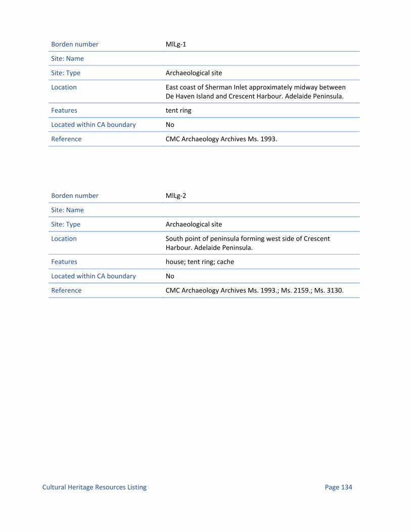
Borden number MlLg‐1
Site: Name
Site: Type Archaeological site
Location East coast of Sherman Inlet approximately midway between De Haven Island and Crescent Harbour. Adelaide Peninsula.
Features tent ring
Located within CA boundary No
Reference CMC Archaeology Archives Ms. 1993.
Borden number MlLg‐2
Site: Name
Site: Type Archaeological site
Location South point of peninsula forming west side of Crescent Harbour. Adelaide Peninsula.
Features house; tent ring; cache
Located within CA boundary No
Reference CMC Archaeology Archives Ms. 1993.; Ms. 2159.; Ms. 3130.
Page 134Cultural Heritage Resources Listing

Borden number MlLg‐3
Site: Name
Site: Type Archaeological site
Location On knoll overlooking south part of Sherman Inlet. Adelaide Peninsula.
Features tent ring
Located within CA boundary No
Reference CMC Archaeology Archives Ms. 1993.
Borden number MlLi‐1
Site: Name
Site: Type Archaeological site
Location On prominent beach ridge overlooking southeast coast of O'Reilly Island. Approximately 500 m. south of 81‐112.
Features tent ring
Located within CA boundary No
Reference CMC Archaeology Archives Ms. 1993.
Page 135Cultural Heritage Resources Listing

Borden number MlLi‐2
Site: Name
Site: Type Archaeological site
Location Southeast coast of O'Reilly Island, approximately 1 km north of southeastern most point.
Features tent ring; cache
Located within CA boundary No
Reference CMC Archaeology Archives Ms. 1993.
Borden number MlLi‐3
Site: Name
Site: Type Archaeological site
Location Tip of southeastern most point on O'Reilly Island.
Features tent ring; stand (kayak); cache
Located within CA boundary No
Reference CMC Archaeology Archives Ms. 1993.
Borden number MlLi‐4
Site: Name
Site: Type Archaeological site
Location Southwestern most point on O'Reilly Island.
Features cache; tent ring
Located within CA boundary No
Reference CMC Archaeology Archives Ms. 1993.
Page 136Cultural Heritage Resources Listing

Borden number MlLg‐4
Site: Name
Site: Type Archaeological site
Location Neck of peninsula forming east side of Crescent Harbour. Adelaide Peninsula.
Features caribou fence; tent ring; cache
Located within CA boundary No
Reference CMC Archaeology Archives Ms. 2159.
Borden number MlLg‐5
Site: Name
Site: Type Archaeological site
Location On west coast of peninsula forming west side of Crescent Harbour. Approximately 1.5 km north of south tip of peninsula. Adelaide Peninsula.
Features tent ring; cache
Located within CA boundary No
Reference CMC Archaeology Archives Ms. 2159.
Page 137Cultural Heritage Resources Listing

Borden number NbNc‐1
Site: Name Foggy Bay
Site: Type Archaeological site
Location E. side of peninsula forming part of Foggy Bay. S. of Melbourne Island in the area of the SW. Queen Maud Gulf.
Features cache
Located within CA boundary Yes
Reference CMC Archaeology Archives Ms. 1405.
Borden number MkLt‐1
Site: Name
Site: Type Archaeological site
Location On a point of land, east of Perry Island. Perry River Area, 40 ft. from Queen Maud Gulf.
Features grave (box)
Located within CA boundary Yes
Reference CMC Archaeology Archives Ms. 3996.
Page 138Cultural Heritage Resources Listing

Borden number MjLs‐1
Site: Name
Site: Type Archaeological site
Location On the east side of Perry River, about 8 km. upstream from where the river discharges into Chester Bay. Opposite northeast end of Lee Island.
Features grave
Located within CA boundary Yes
Reference CMC Archaeology Archives Ms. 3996.
Borden number MjLs‐2
Site: Name
Site: Type Archaeological site
Location Near southwest corner of Lee Island. South of Winter Island. Perry River, near its discharge into Chester Bay.
Features grave
Located within CA boundary Yes
Reference CMC Archaeology Archives Ms. 3996.
Page 139Cultural Heritage Resources Listing
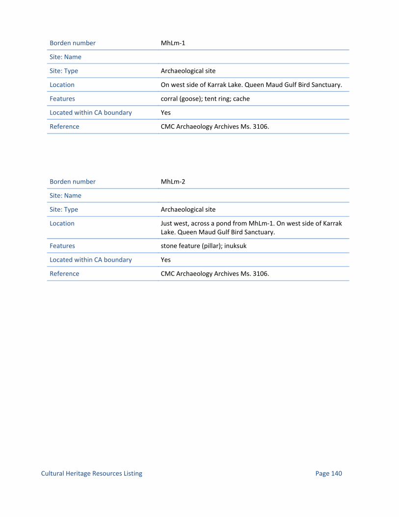
Borden number MhLm‐1
Site: Name
Site: Type Archaeological site
Location On west side of Karrak Lake. Queen Maud Gulf Bird Sanctuary.
Features corral (goose); tent ring; cache
Located within CA boundary Yes
Reference CMC Archaeology Archives Ms. 3106.
Borden number MhLm‐2
Site: Name
Site: Type Archaeological site
Location Just west, across a pond from MhLm‐1. On west side of Karrak Lake. Queen Maud Gulf Bird Sanctuary.
Features stone feature (pillar); inuksuk
Located within CA boundary Yes
Reference CMC Archaeology Archives Ms. 3106.
Page 140Cultural Heritage Resources Listing

Borden number MhLm‐3
Site: Name
Site: Type Archaeological site
Location About 5 km ENE of MhLm‐1 on the east side of Karrak Lake. Queen Maud Gulf Bird Sanctuary.
Features stone feature (tower); tent ring; cairn ? ;depression; post hole (tent) ?
Located within CA boundary Yes
Reference CMC Archaeology Archives Ms. 3106.
Borden number MhLm‐4
Site: Name
Site: Type Archaeological site
Location On the southwest mainland area of Karrak Lake. Queen Maud Gulf Bird Sanctuary.
Features tent ring
Located within CA boundary Yes
Reference CMC Archaeology Archives Ms. 3106.
Page 141Cultural Heritage Resources Listing

Borden number MhLm‐5
Site: Name
Site: Type Archaeological site
Location On a small esker, on the west side of a river, near its mouth. West side of Karrak Lake.
Features tent ring; cache
Located within CA boundary Yes
Reference CMC Archaeology Archives Ms. 3106.
Borden number MgLp‐1
Site: Name
Site: Type Archaeological site
Location On the northeast tip of an island in Pitok River.
Features trap (fox)
Located within CA boundary Yes
Reference 2000 Pelly, David F. ''Going Home to Kutgajuk'', ABOVE & BEYOND, July/August 2000, pp. 35‐39.; CMC Archaeology Archives Ms. 4858.
Page 142Cultural Heritage Resources Listing

Borden number MhLp‐1
Site: Name
Site: Type Archaeological site
Location High on top of a hill 52 km upstream from the mouth of the Pitok River.
Features stone feature (ring); hearth; cache; inuksuk; stone feature (pillar)
Located within CA boundary Yes
Reference 2000 Pelly, David F. ''Going Home to Kutgajuk'', ABOVE & BEYOND, July/August 2000, pp. 35‐39.; CMC Archaeology Archives Ms. 4858.
Borden number MiLp‐1
Site: Name
Site: Type Archaeological site
Location On top of a ridge on the east bank of the Pitok River. About 30 km south of the mouth of the river at Queen Maud Gulf.
Features inuksuk
Located within CA boundary Yes
Reference 2000 Pelly, David F. ''Going Home to Kutgajuk'', ABOVE & BEYOND, July/August 2000, pp. 35‐39.; CMC Archaeology Archives Ms. 4858.
Page 143Cultural Heritage Resources Listing
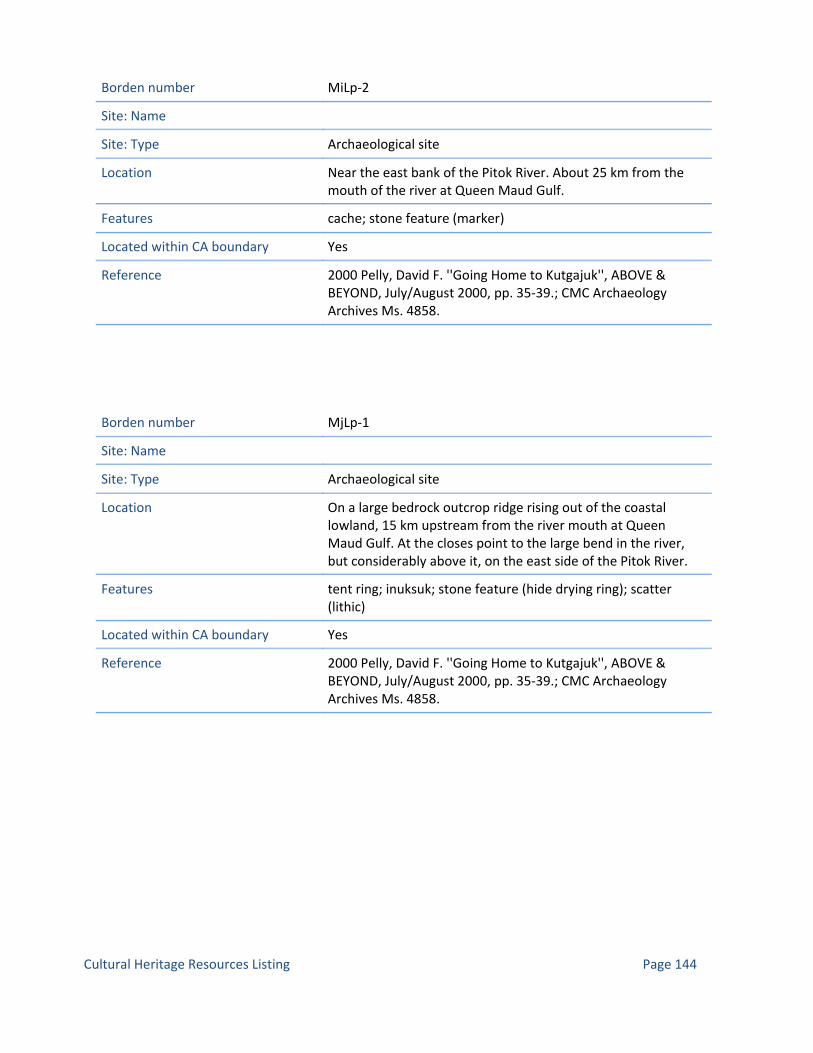
Borden number MiLp‐2
Site: Name
Site: Type Archaeological site
Location Near the east bank of the Pitok River. About 25 km from the mouth of the river at Queen Maud Gulf.
Features cache; stone feature (marker)
Located within CA boundary Yes
Reference 2000 Pelly, David F. ''Going Home to Kutgajuk'', ABOVE & BEYOND, July/August 2000, pp. 35‐39.; CMC Archaeology Archives Ms. 4858.
Borden number MjLp‐1
Site: Name
Site: Type Archaeological site
Location On a large bedrock outcrop ridge rising out of the coastal lowland, 15 km upstream from the river mouth at Queen Maud Gulf. At the closes point to the large bend in the river, but considerably above it, on the east side of the Pitok River.
Features tent ring; inuksuk; stone feature (hide drying ring); scatter (lithic)
Located within CA boundary Yes
Reference 2000 Pelly, David F. ''Going Home to Kutgajuk'', ABOVE & BEYOND, July/August 2000, pp. 35‐39.; CMC Archaeology Archives Ms. 4858.
Page 144Cultural Heritage Resources Listing

Borden number MjLp‐2
Site: Name
Site: Type Archaeological site
Location On a large ridge that continues about 500 m along parallel to the Pitok river, on the east side. At the highest point, affording a tremendous view in all directions. Approx.15 km upstream from the river mouth.
Features tent ring; inuksuk; cache
Located within CA boundary Yes
Reference 2000 Pelly, David F. ''Going Home to Kutgajuk'', ABOVE & BEYOND, July/August 2000, pp. 35‐39.; CMC Archaeology Archives Ms. 4858.
Borden number MjLp‐3
Site: Name
Site: Type Archaeological site
Location On top of a 200m long rocky ridge, 300 m east of the Pitok river, approx. 10 km from its mouth.
Features tent ring; cache; hearth; stone feature (hide drying ring); stone feature (pillar); scatter (metal); grave
Located within CA boundary Yes
Reference 2000 Pelly, David F. ''Going Home to Kutgajuk'', ABOVE & BEYOND, July/August 2000, pp. 35‐39.; CMC Archaeology Archives Ms. 4858.
Page 145Cultural Heritage Resources Listing

Borden number MjLp‐4
Site: Name
Site: Type Archaeological site
Location On a high bedrock ridge, 1 km north of MjLp‐3.3 East side of the Pitok river, approx. 10 km from its mouth.
Features cache
Located within CA boundary Yes
Reference 2000 Pelly, David F. ''Going Home to Kutgajuk'', ABOVE & BEYOND, July/August 2000, pp. 35‐39.; CMC Archaeology Archives Ms. 4858.
Borden number MkLp‐1
Site: Name
Site: Type Archaeological site
Location On a large flat bedrock slab, adjacent to the coast near the Pitok river mouth on Queen Maud Gulf. About 200 m from the sea.
Features tent ring; cache; stand (kayak)
Located within CA boundary Yes
Reference 2000 Pelly, David F. ''Going Home to Kutgajuk'', ABOVE & BEYOND, July/August 2000, pp. 35‐39.; CMC Archaeology Archives Ms. 4858.
Page 146Cultural Heritage Resources Listing

Borden number MjLm‐1
Site: Name
Site: Type Archaeological site
Location On the east side of Simpson River. Immediately adjacent to a rapid/chute.
Features tent ring; scatter (bone)
Located within CA boundary Yes
Reference CMC Archaeology Archives Ms. 4857.
Borden number MjLm‐2
Site: Name
Site: Type Archaeological site
Location High on a hill overlooking this final large rapid (i.e. the first major impediment met by travellers coming upstream from the coast 40 km away). On the east side of Simpson River.
Features tent ring; house
Located within CA boundary Yes
Reference CMC Archaeology Archives Ms. 4857.
Page 147Cultural Heritage Resources Listing

Borden number MjLm‐3
Site: Name
Site: Type Archaeological site
Location High on a hill overlooking this final large rapid (i.e. the first major impediment met by travellers coming upstream from the coast 40 km away). On the east side of Simpson River.
Features inuksuk; cache; stone feature
Located within CA boundary Yes
Reference CMC Archaeology Archives Ms. 4857.
Borden number MkLn‐1
Site: Name
Site: Type Archaeological site
Location On a hilltop on the east side of Simpson River. About 20 km upstream from the coast.
Features tent ring; cache
Located within CA boundary Yes
Reference CMC Archaeology Archives Ms. 4857.
Page 148Cultural Heritage Resources Listing

Borden number MkLn‐2
Site: Name
Site: Type Archaeological site
Location On a hilltop on the east side of Simpson River. About 20 km upstream from the coast.
Features inuksuk; tent ring; cache
Located within CA boundary Yes
Reference CMC Archaeology Archives Ms. 4857.
Borden number MgLk‐1
Site: Name
Site: Type Archaeological site
Location On the east side of Simpson River.
Features tent ring; cache; inuksuk
Located within CA boundary Yes
Reference CMC Archaeology Archives Ms. 4857.
Borden number MgLk‐2
Site: Name
Site: Type Archaeological site
Location On the east side of Simpson River. On top of a ridge above our camp, 500 m. from the river.
Features tent ring; cache
Located within CA boundary Yes
Reference CMC Archaeology Archives Ms. 4857.
Page 149Cultural Heritage Resources Listing

Borden number MhLl‐1
Site: Name
Site: Type Archaeological site
Location On the east side of Simpson River.
Features tent ring; tent ring (mid‐passage)
Located within CA boundary Yes
Reference CMC Archaeology Archives Ms. 4857.
Borden number MfLj‐1
Site: Name
Site: Type Archaeological site
Location East side of Simpson River.
Features tent ring; stone feature; qaggiq (house, communal) ?; tent ring (mid‐passage)
Located within CA boundary Yes
Reference CMC Archaeology Archives Ms. 4857.
Borden number MfLj‐2
Site: Name
Site: Type Archaeological site
Location On a small ridge near the shore, on the east side of Simpson River.
Features tent ring; grave ?
Located within CA boundary Yes
Reference CMC Archaeology Archives Ms. 4857.
Page 150Cultural Heritage Resources Listing

Borden number MfLk‐1
Site: Name
Site: Type Archaeological site
Location On the east side of Simpson River.
Features tent ring; cache
Located within CA boundary Yes
Reference CMC Archaeology Archives Ms. 4857.
Borden number McLo‐1
Site: Name
Site: Type Archaeological site
Location On top of a hill adjacent to the height of land between the Armark River system and the Back River (Garry Lake) system. The hilltop about 35 m above Armark Lake, overlooking it to the north, and commanding a tremendous view all around. Much of the hill is bald exposed bedrock, with large glacial erratics.
Features inuksuk; tent ring; stone feature (hide drying ring ?); cache; scatter (bone); grave
Located within CA boundary Yes
Reference 2000 Pelly, David F. ''Going Home to Kutgajuk'', ABOVE & BEYOND, July/August 2000, pp. 35‐39.; CMC Archaeology Archives Ms. 4858.
Page 151Cultural Heritage Resources Listing

Borden number McLo‐2
Site: Name
Site: Type Archaeological site
Location At southern end of Armark Lake. On flat, dry tundra approx. two metres above Armark Lake.
Features tent ring
Located within CA boundary Yes
Reference 2000 Pelly, David F. ''Going Home to Kutgajuk'', ABOVE & BEYOND, July/August 2000, pp. 35‐39.; CMC Archaeology Archives Ms. 4858.
Borden number MdLp‐1
Site: Name
Site: Type Archaeological site
Location At southern end of Armark Lake. On flat, dry tundra approx. two metres above Armark Lake.
Features
Located within CA boundary Yes
Reference 2000 Pelly, David F. ''Going Home to Kutgajuk'', ABOVE & BEYOND, July/August 2000, pp. 35‐39.; CMC Archaeology Archives Ms. 4858.
Page 152Cultural Heritage Resources Listing

Borden number MbNs‐1
Site: Name Nadlok
Site: Type Archaeological site
Location Nadlok Island is in the Burnside River, southwest of Bathurst Inlet.
Features Five pairs of antler huts and stone houses, four tent rings, semi‐subterranean structures.
Located within CA boundary No
Reference Gordon 1994
Page 153Cultural Heritage Resources Listing

Queen Maud Gulf Migratory Bird Sanctuary
Name McNaughton Lake
Status of Name Official
Location: Coordinates 67o 19' 59" North 98o 25' 0" West
Location: Affected Community Bathurst Inlet; Cambridge Bay; Gjoa Haven
Location: NTS Map sheet 66O
Entity Type Lake
Other Names: Local
Other Names: Formerly Official
Other Names: Variant or unofficial exonyms
Other Name: Variant and unoffical local names
Administrative: Date of approval
Administrative: date first recorded
Comments
Text35:
Name Simpson River
Status of Name Official
Location: Coordinates 67o 49' 0" North 100o 34' 0" West
Location: Affected Community Bathurst Inlet; Cambridge Bay; Gjoa Haven
Location: NTS Map sheet 66O
Entity Type River
Other Names: Local
Other Names: Formerly Official
Other Names: Variant or unofficial exonyms
Other Name: Variant and unoffical local names
Administrative: Date of approval
Administrative: date first recorded
Comments
Text35:
Page 1Named Places Listing

Name Sherman Basin
Status of Name Official
Location: Coordinates 67o 46' 59" North 97o 34' 59" West
Location: Affected Community Bathurst Inlet; Cambridge Bay; Gjoa Haven
Location: NTS Map sheet 66P
Entity Type Bay
Other Names: Local
Other Names: Formerly Official
Other Names: Variant or unofficial exonyms
Other Name: Variant and unoffical local names
Administrative: Date of approval
Administrative: date first recorded
Comments
Text35:
Name Trefoil Bay
Status of Name Official
Location: Coordinates 67o 40' 59" North 97o 7' 59" West
Location: Affected Community Bathurst Inlet; Cambridge Bay; Gjoa Haven
Location: NTS Map sheet 66P
Entity Type Bay
Other Names: Local
Other Names: Formerly Official
Other Names: Variant or unofficial exonyms
Other Name: Variant and unoffical local names
Administrative: Date of approval
Administrative: date first recorded
Comments
Text35:
Page 2Named Places Listing

Name Kaleet River
Status of Name Official
Location: Coordinates 67o 40' 0" North 97o 10' 59" West
Location: Affected Community Bathurst Inlet; Cambridge Bay; Gjoa Haven
Location: NTS Map sheet 66P
Entity Type River
Other Names: Local
Other Names: Formerly Official
Other Names: Variant or unofficial exonyms
Other Name: Variant and unoffical local names
Administrative: Date of approval
Administrative: date first recorded
Comments
Text35:
Name Queen Maud Gulf
Status of Name Official
Location: Coordinates 68o 19' 59" North 101o 59' 59" West
Location: Affected Community Bathurst Inlet; Cambridge Bay; Gjoa Haven
Location: NTS Map sheet 67B
Entity Type Bay
Other Names: Local
Other Names: Formerly Official
Other Names: Variant or unofficial exonyms
Other Name: Variant and unoffical local names
Administrative: Date of approval
Administrative: date first recorded
Comments
Text35:
Page 3Named Places Listing

Name Spalding Islets
Status of Name
Location: Coordinates 68o 8' 59" North 103o 55' 0" West
Location: Affected Community Bathurst Inlet; Cambridge Bay; Gjoa Haven
Location: NTS Map sheet 67B
Entity Type Island
Other Names: Local
Other Names: Formerly Official
Other Names: Variant or unofficial exonyms
Other Name: Variant and unoffical local names
Administrative: Date of approval
Administrative: date first recorded
Comments
Text35:
Name Whitebear Point
Status of Name Official
Location: Coordinates 68o 10' 0" North 103o 25' 59" West
Location: Affected Community Bathurst Inlet; Cambridge Bay; Gjoa Haven
Location: NTS Map sheet 67B
Entity Type Cape
Other Names: Local
Other Names: Formerly Official
Other Names: Variant or unofficial exonyms
Other Name: Variant and unoffical local names
Administrative: Date of approval
Administrative: date first recorded
Comments
Text35:
Page 4Named Places Listing

Name Campbell Bay
Status of Name Official
Location: Coordinates 68o 7' 59" North 104o 0' 0" West
Location: Affected Community Bathurst Inlet; Cambridge Bay; Gjoa Haven
Location: NTS Map sheet 67B
Entity Type Bay
Other Names: Local
Other Names: Formerly Official
Other Names: Variant or unofficial exonyms
Other Name: Variant and unoffical local names
Administrative: Date of approval
Administrative: date first recorded
Comments
Text35:
Name Gernon Bay
Status of Name Official
Location: Coordinates 68o 1' 0" North 103o 14' 59" West
Location: Affected Community Bathurst Inlet; Cambridge Bay; Gjoa Haven
Location: NTS Map sheet 67B
Entity Type Bay
Other Names: Local
Other Names: Formerly Official
Other Names: Variant or unofficial exonyms
Other Name: Variant and unoffical local names
Administrative: Date of approval
Administrative: date first recorded
Comments
Text35:
Page 5Named Places Listing

Name Ellice River
Status of Name Official
Location: Coordinates 68o 1' 59" North 103o 58' 0" West
Location: Affected Community Bathurst Inlet; Cambridge Bay; Gjoa Haven
Location: NTS Map sheet 67B
Entity Type River
Other Names: Local
Other Names: Formerly Official
Other Names: Variant or unofficial exonyms
Other Name: Variant and unoffical local names
Administrative: Date of approval
Administrative: date first recorded
Comments
Text35:
Name Ellice River
Status of Name Official
Location: Coordinates 68o 1' 59" North 103o 58' 0" West
Location: Affected Community Bathurst Inlet; Cambridge Bay; Gjoa Haven
Location: NTS Map sheet 76P
Entity Type River
Other Names: Local
Other Names: Formerly Official
Other Names: Variant or unofficial exonyms
Other Name: Variant and unoffical local names
Administrative: Date of approval
Administrative: date first recorded
Comments
Text35:
Page 6Named Places Listing

Name Kuugaarjuk River
Status of Name Official
Location: Coordinates 68o 16' 0" North 105o 1' 59" West
Location: Affected Community Bathurst Inlet; Cambridge Bay; Gjoa Haven
Location: NTS Map sheet 76P
Entity Type River
Other Names: Local
Other Names: Formerly Official
Other Names: Variant or unofficial exonyms
Other Name: Variant and unoffical local names
Administrative: Date of approval
Administrative: date first recorded
Comments
Text35:
Name Angimajuk River
Status of Name Official
Location: Coordinates 68o 10' 59" North 106o 19' 59" West
Location: Affected Community Bathurst Inlet; Cambridge Bay; Gjoa Haven
Location: NTS Map sheet 76P
Entity Type River
Other Names: Local
Other Names: Formerly Official
Other Names: Variant or unofficial exonyms
Other Name: Variant and unoffical local names
Administrative: Date of approval
Administrative: date first recorded
Comments
Text35:
Page 7Named Places Listing

Name Brichta Lake
Status of Name Official
Location: Coordinates 67o 46' 0" North 104o 49' 59" West
Location: Affected Community Bathurst Inlet; Cambridge Bay; Gjoa Haven
Location: NTS Map sheet 76P
Entity Type Lake
Other Names: Local
Other Names: Formerly Official
Other Names: Variant or unofficial exonyms
Other Name: Variant and unoffical local names
Administrative: Date of approval
Administrative: date first recorded
Comments
Text35:
Name Tingmeak River
Status of Name Official
Location: Coordinates 65o 15' North 104o 59' West
Location: Affected Community Bathurst Inlet; Cambridge Bay; Gjoa Haven
Location: NTS Map sheet 76P
Entity Type River
Other Names: Local
Other Names: Formerly Official
Other Names: Variant or unofficial exonyms
Other Name: Variant and unoffical local names
Administrative: Date of approval
Administrative: date first recorded
Comments
Text35:
Page 8Named Places Listing

Name Queen Maud Gulf
Status of Name Official
Location: Coordinates 68o 19' 59" North 101o 59' 59" West
Location: Affected Community Bathurst Inlet; Cambridge Bay; Gjoa Haven
Location: NTS Map sheet 77A
Entity Type Bay
Other Names: Local
Other Names: Formerly Official
Other Names: Variant or unofficial exonyms
Other Name: Variant and unoffical local names
Administrative: Date of approval
Administrative: date first recorded
Comments
Text35:
Name Labyrinth Bay
Status of Name Official
Location: Coordinates 68o 28' 0" North 105o 16' 59" West
Location: Affected Community Bathurst Inlet; Cambridge Bay; Gjoa Haven
Location: NTS Map sheet 77A
Entity Type Bay
Other Names: Local
Other Names: Formerly Official
Other Names: Variant or unofficial exonyms
Other Name: Variant and unoffical local names
Administrative: Date of approval
Administrative: date first recorded
Comments
Text35:
Page 9Named Places Listing

Name Cape Roxborough
Status of Name Official
Location: Coordinates 68o 28' 0" North 105o 16' 59" West
Location: Affected Community Bathurst Inlet; Cambridge Bay; Gjoa Haven
Location: NTS Map sheet 77A
Entity Type Cape
Other Names: Local
Other Names: Formerly Official
Other Names: Variant or unofficial exonyms
Other Name: Variant and unoffical local names
Administrative: Date of approval
Administrative: date first recorded
Comments
Text35:
Name Dease Point
Status of Name Official
Location: Coordinates 68o 22' 0" North 104o 58' 0" West
Location: Affected Community Bathurst Inlet; Cambridge Bay; Gjoa Haven
Location: NTS Map sheet 77A
Entity Type Cape
Other Names: Local
Other Names: Formerly Official
Other Names: Variant or unofficial exonyms
Other Name: Variant and unoffical local names
Administrative: Date of approval
Administrative: date first recorded
Comments
Text35:
Page 10Named Places Listing

Name Foggy Bay
Status of Name Official
Location: Coordinates 68o 16' 59" North 104o 46' 59" West
Location: Affected Community Bathurst Inlet; Cambridge Bay; Gjoa Haven
Location: NTS Map sheet 77A
Entity Type Bay
Other Names: Local
Other Names: Formerly Official
Other Names: Variant or unofficial exonyms
Other Name: Variant and unoffical local names
Administrative: Date of approval
Administrative: date first recorded
Comments
Text35:
Name Fitzgerald Island
Status of Name Official
Location: Coordinates 68o 13' 19" North 104o 20' 14" West
Location: Affected Community Bathurst Inlet; Cambridge Bay; Gjoa Haven
Location: NTS Map sheet 77A
Entity Type Island
Other Names: Local
Other Names: Formerly Official
Other Names: Variant or unofficial exonyms
Other Name: Variant and unoffical local names
Administrative: Date of approval
Administrative: date first recorded
Comments
Text35:
Page 11Named Places Listing

Name Conolly Bay
Status of Name Official
Location: Coordinates 68o 12' 0" North 104o 30' 0" West
Location: Affected Community Bathurst Inlet; Cambridge Bay; Gjoa Haven
Location: NTS Map sheet 77A
Entity Type Bay
Other Names: Local
Other Names: Formerly Official
Other Names: Variant or unofficial exonyms
Other Name: Variant and unoffical local names
Administrative: Date of approval
Administrative: date first recorded
Comments
Text35:
Name Brown Point
Status of Name Official
Location: Coordinates 68o 14' 59" North 104o 32' 59" West
Location: Affected Community Bathurst Inlet; Cambridge Bay; Gjoa Haven
Location: NTS Map sheet 77A
Entity Type Cape
Other Names: Local
Other Names: Formerly Official
Other Names: Variant or unofficial exonyms
Other Name: Variant and unoffical local names
Administrative: Date of approval
Administrative: date first recorded
Comments
Text35:
Page 12Named Places Listing

Name Tingemeak River
Status of Name Official
Location: Coordinates 65o 15' North 104o 59' West
Location: Affected Community Bathurst Inlet; Cambridge Bay; Gjoa Haven
Location: NTS Map sheet 77A
Entity Type River
Other Names: Local
Other Names: Formerly Official
Other Names: Variant or unofficial exonyms
Other Name: Variant and unoffical local names
Administrative: Date of approval
Administrative: date first recorded
Comments
Text35:
Name Kuugaarjuk River
Status of Name Official
Location: Coordinates 69o 3' 44" North 93o 12' 20" West
Location: Affected Community Bathurst Inlet; Cambridge Bay; Gjoa Haven
Location: NTS Map sheet 77A
Entity Type River
Other Names: Local
Other Names: Formerly Official
Other Names: Variant or unofficial exonyms
Other Name: Variant and unoffical local names
Administrative: Date of approval
Administrative: date first recorded
Comments
Text35:
Page 13Named Places Listing

Name Campbell Bay
Status of Name Official
Location: Coordinates 68o 7' 59" North 104o 0' 0" West
Location: Affected Community Bathurst Inlet; Cambridge Bay; Gjoa Haven
Location: NTS Map sheet 77A
Entity Type Bay
Other Names: Local
Other Names: Formerly Official
Other Names: Variant or unofficial exonyms
Other Name: Variant and unoffical local names
Administrative: Date of approval
Administrative: date first recorded
Comments
Text35:
Name Queen Maud Gulf
Status of Name Official
Location: Coordinates 68o 19' 59" North 101o 59' 59" West
Location: Affected Community Bathurst Inlet; Cambridge Bay; Gjoa Haven
Location: NTS Map sheet 76P
Entity Type Bay
Other Names: Local
Other Names: Formerly Official
Other Names: Variant or unofficial exonyms
Other Name: Variant and unoffical local names
Administrative: Date of approval
Administrative: date first recorded
Comments
Text35:
Page 14Named Places Listing

Name Queen Maud Gulf
Status of Name Official
Location: Coordinates 68o 19' 59" North 101o 59' 59" West
Location: Affected Community Bathurst Inlet; Cambridge Bay; Gjoa Haven
Location: NTS Map sheet 66M
Entity Type Bay
Other Names: Local
Other Names: Formerly Official
Other Names: Variant or unofficial exonyms
Other Name: Variant and unoffical local names
Administrative: Date of approval
Administrative: date first recorded
Comments
Text35:
Name Queen Maud Gulf Bird Sanctuary
Status of Name Official
Location: Coordinates 67° 5' North 101° 45' West
Location: Affected Community Cambridge Bay; Bathurst Inlet; Gjoa Haven
Location: NTS Map sheet 77A; 76P; 76I; 67B; 66M; 66N; 66O; 66P; 66L; 66K; 66J; 66I
Entity Type Conservation Area
Other Names: Local
Other Names: Formerly Official
Other Names: Variant or unofficial exonyms
Other Name: Variant and unoffical local names
Administrative: Date of approval
Administrative: date first recorded
Comments
Text35:
Page 15Named Places Listing

Name Perry Island
Status of Name Official
Location: Coordinates 67o 47' 59" North 102o 32' 59" West
Location: Affected Community Cambridge Bay; Bathurst Inlet; Gjoa Haven
Location: NTS Map sheet 66M
Entity Type Formerly inhabited place
Other Names: Local
Other Names: Formerly Official
Other Names: Variant or unofficial exonyms
Other Name: Variant and unoffical local names
Administrative: Date of approval 05/07/1961
Administrative: date first recorded
Comments
Text35:
Name Karrak River
Status of Name Official
Location: Coordinates 67o 39' 0" North 100o 26' 59" West
Location: Affected Community Bathurst Inlet; Cambridge Bay; Gjoa Haven
Location: NTS Map sheet 66K
Entity Type River
Other Names: Local
Other Names: Formerly Official
Other Names: Variant or unofficial exonyms
Other Name: Variant and unoffical local names
Administrative: Date of approval
Administrative: date first recorded
Comments
Text35:
Page 16Named Places Listing

Name Armark River
Status of Name Official
Location: Coordinates 67o 44' 59" North 101o 4' 59" West
Location: Affected Community Bathurst Inlet; Cambridge Bay; Gjoa Haven
Location: NTS Map sheet 66K
Entity Type River
Other Names: Local
Other Names: Formerly Official
Other Names: Variant or unofficial exonyms
Other Name: Variant and unoffical local names
Administrative: Date of approval
Administrative: date first recorded
Comments
Text35:
Name Pitok River
Status of Name Official
Location: Coordinates 67o 43' 0" North 101o 14' 59" West
Location: Affected Community Bathurst Inlet; Cambridge Bay; Gjoa Haven
Location: NTS Map sheet 66K
Entity Type River
Other Names: Local
Other Names: Formerly Official
Other Names: Variant or unofficial exonyms
Other Name: Variant and unoffical local names
Administrative: Date of approval
Administrative: date first recorded
Comments
Text35:
Page 17Named Places Listing
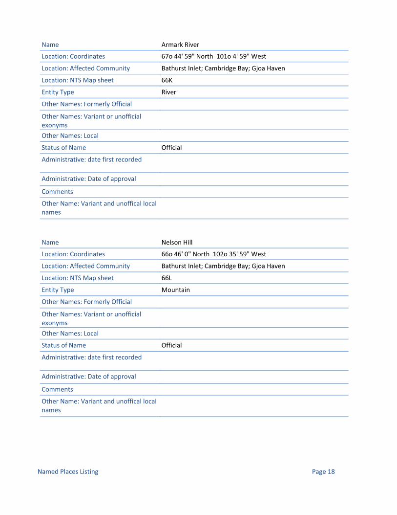
Name Armark River
Status of Name Official
Location: Coordinates 67o 44' 59" North 101o 4' 59" West
Location: Affected Community Bathurst Inlet; Cambridge Bay; Gjoa Haven
Location: NTS Map sheet 66K
Entity Type River
Other Names: Local
Other Names: Formerly Official
Other Names: Variant or unofficial exonyms
Other Name: Variant and unoffical local names
Administrative: Date of approval
Administrative: date first recorded
Comments
Text35:
Name Nelson Hill
Status of Name Official
Location: Coordinates 66o 46' 0" North 102o 35' 59" West
Location: Affected Community Bathurst Inlet; Cambridge Bay; Gjoa Haven
Location: NTS Map sheet 66L
Entity Type Mountain
Other Names: Local
Other Names: Formerly Official
Other Names: Variant or unofficial exonyms
Other Name: Variant and unoffical local names
Administrative: Date of approval
Administrative: date first recorded
Comments
Text35:
Page 18Named Places Listing

Name MacAlpine Lake
Status of Name Official
Location: Coordinates 66o 31' 59" North 102o 45' 0" West
Location: Affected Community Bathurst Inlet; Cambridge Bay; Gjoa Haven
Location: NTS Map sheet 66L
Entity Type Lake
Other Names: Local
Other Names: Formerly Official
Other Names: Variant or unofficial exonyms
Other Name: Variant and unoffical local names
Administrative: Date of approval
Administrative: date first recorded
Comments
Text35:
Name Kaleet River
Status of Name Official
Location: Coordinates 67o 40' 0" North 97o 10' 59" West
Location: Affected Community Bathurst Inlet; Cambridge Bay; Gjoa Haven
Location: NTS Map sheet 66I
Entity Type River
Other Names: Local
Other Names: Formerly Official
Other Names: Variant or unofficial exonyms
Other Name: Variant and unoffical local names
Administrative: Date of approval
Administrative: date first recorded
Comments
Text35:
Page 19Named Places Listing

Name Kaleet River
Status of Name Official
Location: Coordinates 67o 40' 0" North 97o 10' 59" West
Location: Affected Community Bathurst Inlet; Cambridge Bay; Gjoa Haven
Location: NTS Map sheet 66J
Entity Type River
Other Names: Local
Other Names: Formerly Official
Other Names: Variant or unofficial exonyms
Other Name: Variant and unoffical local names
Administrative: Date of approval
Administrative: date first recorded
Comments
Text35:
Name Ellice River
Status of Name Official
Location: Coordinates 68o 1' 59" North 103o 58' 0" West
Location: Affected Community Bathurst Inlet; Cambridge Bay; Gjoa Haven
Location: NTS Map sheet 76I
Entity Type River
Other Names: Local
Other Names: Formerly Official
Other Names: Variant or unofficial exonyms
Other Name: Variant and unoffical local names
Administrative: Date of approval
Administrative: date first recorded
Comments
Text35:
Page 20Named Places Listing

Name Ellice River
Status of Name Official
Location: Coordinates 68o 1' 59" North 103o 58' 0" West
Location: Affected Community Bathurst Inlet; Cambridge Bay; Gjoa Haven
Location: NTS Map sheet 66M
Entity Type River
Other Names: Local
Other Names: Formerly Official
Other Names: Variant or unofficial exonyms
Other Name: Variant and unoffical local names
Administrative: Date of approval
Administrative: date first recorded
Comments
Text35:
Name Gernon Bay
Status of Name Official
Location: Coordinates 68o 1' 0" North 103o 14' 59" West
Location: Affected Community Bathurst Inlet; Cambridge Bay; Gjoa Haven
Location: NTS Map sheet 66M
Entity Type Bay
Other Names: Local
Other Names: Formerly Official
Other Names: Variant or unofficial exonyms
Other Name: Variant and unoffical local names
Administrative: Date of approval
Administrative: date first recorded
Comments
Text35:
Page 21Named Places Listing

Name Mulroak Islands
Status of Name Official
Location: Coordinates 67o 56' 59" North 102o 40' 59" West
Location: Affected Community Bathurst Inlet; Cambridge Bay; Gjoa Haven
Location: NTS Map sheet 66M
Entity Type Island
Other Names: Local
Other Names: Formerly Official
Other Names: Variant or unofficial exonyms
Other Name: Variant and unoffical local names
Administrative: Date of approval
Administrative: date first recorded
Comments
Text35:
Name Keith Islands
Status of Name Official
Location: Coordinates 67o 54' 0" North 102o 10' 0" West
Location: Affected Community Bathurst Inlet; Cambridge Bay; Gjoa Haven
Location: NTS Map sheet 66M
Entity Type Island
Other Names: Local
Other Names: Formerly Official
Other Names: Variant or unofficial exonyms
Other Name: Variant and unoffical local names
Administrative: Date of approval
Administrative: date first recorded
Comments
Text35:
Page 22Named Places Listing

Name Atkinson Point
Status of Name Official
Location: Coordinates 67o 55' 0" North 102o 55' 0" West
Location: Affected Community Bathurst Inlet; Cambridge Bay; Gjoa Haven
Location: NTS Map sheet 66M
Entity Type Cape
Other Names: Local
Other Names: Formerly Official
Other Names: Variant or unofficial exonyms
Other Name: Variant and unoffical local names
Administrative: Date of approval
Administrative: date first recorded
Comments
Text35:
Name Perry Island
Status of Name Official
Location: Coordinates 67o 47' 59" North 102o 32' 59" West
Location: Affected Community Bathurst Inlet; Cambridge Bay; Gjoa Haven
Location: NTS Map sheet 66M
Entity Type Island
Other Names: Local
Other Names: Formerly Official
Other Names: Variant or unofficial exonyms
Other Name: Variant and unoffical local names
Administrative: Date of approval
Administrative: date first recorded
Comments
Text35:
Page 23Named Places Listing

Name Kettle Island
Status of Name Official
Location: Coordinates 67o 49' 59" North 102o 32' 59" West
Location: Affected Community Bathurst Inlet; Cambridge Bay; Gjoa Haven
Location: NTS Map sheet 66M
Entity Type Island
Other Names: Local
Other Names: Formerly Official
Other Names: Variant or unofficial exonyms
Other Name: Variant and unoffical local names
Administrative: Date of approval
Administrative: date first recorded
Comments
Text35:
Name Blackwood Point
Status of Name Official
Location: Coordinates 67o 49' 0" North 102o 32' 59" West
Location: Affected Community Bathurst Inlet; Cambridge Bay; Gjoa Haven
Location: NTS Map sheet 66M
Entity Type Cape
Other Names: Local
Other Names: Formerly Official
Other Names: Variant or unofficial exonyms
Other Name: Variant and unoffical local names
Administrative: Date of approval
Administrative: date first recorded
Comments
Text35:
Page 24Named Places Listing

Name Flagstaff Island
Status of Name Official
Location: Coordinates 67o 47' 59" North 102o 16' 0" West
Location: Affected Community Bathurst Inlet; Cambridge Bay; Gjoa Haven
Location: NTS Map sheet 66M
Entity Type Island
Other Names: Local
Other Names: Formerly Official
Other Names: Variant or unofficial exonyms
Other Name: Variant and unoffical local names
Administrative: Date of approval
Administrative: date first recorded
Comments
Text35:
Name Chester Bay
Status of Name Official
Location: Coordinates 67o 44' 59" North 102o 15' 0" West
Location: Affected Community Bathurst Inlet; Cambridge Bay; Gjoa Haven
Location: NTS Map sheet 66M
Entity Type Bay
Other Names: Local
Other Names: Formerly Official
Other Names: Variant or unofficial exonyms
Other Name: Variant and unoffical local names
Administrative: Date of approval
Administrative: date first recorded
Comments
Text35:
Page 25Named Places Listing

Name Rainy Island
Status of Name Official
Location: Coordinates 67o 43' 59" North 102o 13' 0" West
Location: Affected Community Bathurst Inlet; Cambridge Bay; Gjoa Haven
Location: NTS Map sheet 66M
Entity Type Island
Other Names: Local
Other Names: Formerly Official
Other Names: Variant or unofficial exonyms
Other Name: Variant and unoffical local names
Administrative: Date of approval
Administrative: date first recorded
Comments
Text35:
Name Winter Island
Status of Name Official
Location: Coordinates 66o 16' 0" North 83o 4' 0" West
Location: Affected Community Bathurst Inlet; Cambridge Bay; Gjoa Haven
Location: NTS Map sheet 66M
Entity Type Island
Other Names: Local
Other Names: Formerly Official
Other Names: Variant or unofficial exonyms
Other Name: Variant and unoffical local names
Administrative: Date of approval
Administrative: date first recorded
Comments
Text35:
Page 26Named Places Listing

Name Perry River
Status of Name Official
Location: Coordinates 67o 43' 0" North 102o 13' 59" West
Location: Affected Community Bathurst Inlet; Cambridge Bay; Gjoa Haven
Location: NTS Map sheet 66N
Entity Type River
Other Names: Local
Other Names: Formerly Official
Other Names: Variant or unofficial exonyms
Other Name: Variant and unoffical local names
Administrative: Date of approval
Administrative: date first recorded
Comments
Text35:
Name Perry River
Status of Name Official
Location: Coordinates 67o 43' 0" North 102o 13' 59" West
Location: Affected Community Bathurst Inlet; Cambridge Bay; Gjoa Haven
Location: NTS Map sheet 66M
Entity Type River
Other Names: Local
Other Names: Formerly Official
Other Names: Variant or unofficial exonyms
Other Name: Variant and unoffical local names
Administrative: Date of approval
Administrative: date first recorded
Comments
Text35:
Page 27Named Places Listing

Name Gavin River
Status of Name Official
Location: Coordinates 67o 37' 59" North 102o 4' 59" West
Location: Affected Community Bathurst Inlet; Cambridge Bay; Gjoa Haven
Location: NTS Map sheet 66M
Entity Type River
Other Names: Local
Other Names: Formerly Official
Other Names: Variant or unofficial exonyms
Other Name: Variant and unoffical local names
Administrative: Date of approval
Administrative: date first recorded
Comments
Text35:
Name Gavin River
Status of Name Official
Location: Coordinates 67o 37' 59" North 102o 4' 59" West
Location: Affected Community Bathurst Inlet; Cambridge Bay; Gjoa Haven
Location: NTS Map sheet 66N
Entity Type River
Other Names: Local
Other Names: Formerly Official
Other Names: Variant or unofficial exonyms
Other Name: Variant and unoffical local names
Administrative: Date of approval
Administrative: date first recorded
Comments
Text35:
Page 28Named Places Listing

Name Lee Island
Status of Name Official
Location: Coordinates 67o 37' 59" North 102o 7' 0" West
Location: Affected Community Bathurst Inlet; Cambridge Bay; Gjoa Haven
Location: NTS Map sheet 66M
Entity Type Island
Other Names: Local
Other Names: Formerly Official
Other Names: Variant or unofficial exonyms
Other Name: Variant and unoffical local names
Administrative: Date of approval
Administrative: date first recorded
Comments
Text35:
Name Mann Island
Status of Name Official
Location: Coordinates 67o 35' 59" North 102o 3' 0" West
Location: Affected Community Bathurst Inlet; Cambridge Bay; Gjoa Haven
Location: NTS Map sheet 66M
Entity Type Island
Other Names: Local
Other Names: Formerly Official
Other Names: Variant or unofficial exonyms
Other Name: Variant and unoffical local names
Administrative: Date of approval
Administrative: date first recorded
Comments
Text35:
Page 29Named Places Listing

Name Laine Creek
Status of Name Official
Location: Coordinates 67o 35' 59" North 102o 7' 59" West
Location: Affected Community Bathurst Inlet; Cambridge Bay; Gjoa Haven
Location: NTS Map sheet 66M
Entity Type River
Other Names: Local
Other Names: Formerly Official
Other Names: Variant or unofficial exonyms
Other Name: Variant and unoffical local names
Administrative: Date of approval
Administrative: date first recorded
Comments
Text35:
Name Highland Lake
Status of Name Official
Location: Coordinates 67o 22' 59" North 102o 7' 0" West
Location: Affected Community Bathurst Inlet; Cambridge Bay; Gjoa Haven
Location: NTS Map sheet 66M
Entity Type Lake
Other Names: Local
Other Names: Formerly Official
Other Names: Variant or unofficial exonyms
Other Name: Variant and unoffical local names
Administrative: Date of approval
Administrative: date first recorded
Comments
Text35:
Page 30Named Places Listing

Name Arlone Lake
Status of Name Official
Location: Coordinates 67o 22' 59" North 102o 13' 59" West
Location: Affected Community Bathurst Inlet; Cambridge Bay; Gjoa Haven
Location: NTS Map sheet 66M
Entity Type Lake
Other Names: Local
Other Names: Formerly Official
Other Names: Variant or unofficial exonyms
Other Name: Variant and unoffical local names
Administrative: Date of approval
Administrative: date first recorded
Comments
Text35:
Name Simpson River
Status of Name Official
Location: Coordinates 67o 49' 0" North 100o 34' 0" West
Location: Affected Community Bathurst Inlet; Cambridge Bay; Gjoa Haven
Location: NTS Map sheet 66J
Entity Type River
Other Names: Local
Other Names: Formerly Official
Other Names: Variant or unofficial exonyms
Other Name: Variant and unoffical local names
Administrative: Date of approval
Administrative: date first recorded
Comments
Text35:
Page 31Named Places Listing

Name McNaughton River
Status of Name Official
Location: Coordinates 67o 46' 59" North 98o 29' 59" West
Location: Affected Community Bathurst Inlet; Cambridge Bay; Gjoa Haven
Location: NTS Map sheet 66J
Entity Type River
Other Names: Local
Other Names: Formerly Official
Other Names: Variant or unofficial exonyms
Other Name: Variant and unoffical local names
Administrative: Date of approval
Administrative: date first recorded
Comments
Text35:
Name Joe Lake
Status of Name Official
Location: Coordinates 66o 16' 0" North 98o 29' 59" West
Location: Affected Community Bathurst Inlet; Cambridge Bay; Gjoa Haven
Location: NTS Map sheet 66J
Entity Type Lake
Other Names: Local
Other Names: Formerly Official
Other Names: Variant or unofficial exonyms
Other Name: Variant and unoffical local names
Administrative: Date of approval
Administrative: date first recorded
Comments
Text35:
Page 32Named Places Listing

Name Bowes Point
Status of Name Official
Location: Coordinates 67o 47' 59" North 101o 55' 59" West
Location: Affected Community Bathurst Inlet; Cambridge Bay; Gjoa Haven
Location: NTS Map sheet 66N
Entity Type Cape
Other Names: Local
Other Names: Formerly Official
Other Names: Variant or unofficial exonyms
Other Name: Variant and unoffical local names
Administrative: Date of approval
Administrative: date first recorded
Comments
Text35:
Name McTavish Point
Status of Name Official
Location: Coordinates 67o 46' 59" North 101o 4' 0" West
Location: Affected Community Bathurst Inlet; Cambridge Bay; Gjoa Haven
Location: NTS Map sheet 66N
Entity Type Cape
Other Names: Local
Other Names: Formerly Official
Other Names: Variant or unofficial exonyms
Other Name: Variant and unoffical local names
Administrative: Date of approval
Administrative: date first recorded
Comments
Text35:
Page 33Named Places Listing

Name Johnson Point
Status of Name Official
Location: Coordinates 75o 22' 59" North 79o 28' 0" West
Location: Affected Community Bathurst Inlet; Cambridge Bay; Gjoa Haven
Location: NTS Map sheet 66N
Entity Type Cape
Other Names: Local
Other Names: Formerly Official
Other Names: Variant or unofficial exonyms
Other Name: Variant and unoffical local names
Administrative: Date of approval
Administrative: date first recorded
Comments
Text35:
Name Armark River
Status of Name Official
Location: Coordinates 67o 44' 59" North 101o 4' 59" West
Location: Affected Community Bathurst Inlet; Cambridge Bay; Gjoa Haven
Location: NTS Map sheet 66N
Entity Type River
Other Names: Local
Other Names: Formerly Official
Other Names: Variant or unofficial exonyms
Other Name: Variant and unoffical local names
Administrative: Date of approval
Administrative: date first recorded
Comments
Text35:
Page 34Named Places Listing

Name Simpson River
Status of Name Official
Location: Coordinates 67o 49' 0" North 100o 34' 0" West
Location: Affected Community Bathurst Inlet; Cambridge Bay; Gjoa Haven
Location: NTS Map sheet 66N
Entity Type River
Other Names: Local
Other Names: Formerly Official
Other Names: Variant or unofficial exonyms
Other Name: Variant and unoffical local names
Administrative: Date of approval
Administrative: date first recorded
Comments
Text35:
Name Pitok River
Status of Name Official
Location: Coordinates 67o 43' 0" North 101o 14' 59" West
Location: Affected Community Bathurst Inlet; Cambridge Bay; Gjoa Haven
Location: NTS Map sheet 66N
Entity Type River
Other Names: Local
Other Names: Formerly Official
Other Names: Variant or unofficial exonyms
Other Name: Variant and unoffical local names
Administrative: Date of approval
Administrative: date first recorded
Comments
Text35:
Page 35Named Places Listing

Name Karrak River
Status of Name Official
Location: Coordinates 67o 39' 0" North 100o 26' 59" West
Location: Affected Community Bathurst Inlet; Cambridge Bay; Gjoa Haven
Location: NTS Map sheet 66N
Entity Type River
Other Names: Local
Other Names: Formerly Official
Other Names: Variant or unofficial exonyms
Other Name: Variant and unoffical local names
Administrative: Date of approval
Administrative: date first recorded
Comments
Text35:
Name Queen Maud Gulf
Status of Name Official
Location: Coordinates 68o 19' 59" North 101o 59' 59" West
Location: Affected Community Bathurst Inlet; Cambridge Bay; Gjoa Haven
Location: NTS Map sheet 66N
Entity Type Bay
Other Names: Local
Other Names: Formerly Official
Other Names: Variant or unofficial exonyms
Other Name: Variant and unoffical local names
Administrative: Date of approval
Administrative: date first recorded
Comments
Text35:
Page 36Named Places Listing

Name Karrak Lake
Status of Name Official
Location: Coordinates 67o 15' 0" North 100o 14' 59" West
Location: Affected Community Bathurst Inlet; Cambridge Bay; Gjoa Haven
Location: NTS Map sheet 66N
Entity Type Lake
Other Names: Local
Other Names: Formerly Official
Other Names: Variant or unofficial exonyms
Other Name: Variant and unoffical local names
Administrative: Date of approval
Administrative: date first recorded
Comments
Text35:
Name Queen Maud Gulf
Status of Name Official
Location: Coordinates 68o 19' 59" North 101o 59' 59" West
Location: Affected Community Bathurst Inlet; Cambridge Bay; Gjoa Haven
Location: NTS Map sheet 66O
Entity Type Bay
Other Names: Local
Other Names: Formerly Official
Other Names: Variant or unofficial exonyms
Other Name: Variant and unoffical local names
Administrative: Date of approval
Administrative: date first recorded
Comments
Text35:
Page 37Named Places Listing

Name McLoughlin Bay
Status of Name Official
Location: Coordinates 67o 50' 35" North 98o 34' 45" West
Location: Affected Community Bathurst Inlet; Cambridge Bay; Gjoa Haven
Location: NTS Map sheet 66O
Entity Type Bay
Other Names: Local
Other Names: Formerly Official
Other Names: Variant or unofficial exonyms
Other Name: Variant and unoffical local names
Administrative: Date of approval
Administrative: date first recorded
Comments
Text35:
Name Sherman Inlet
Status of Name Official
Location: Coordinates 67o 58' 0" North 98o 16' 59" West
Location: Affected Community Bathurst Inlet; Cambridge Bay; Gjoa Haven
Location: NTS Map sheet 66O
Entity Type Bay
Other Names: Local
Other Names: Formerly Official
Other Names: Variant or unofficial exonyms
Other Name: Variant and unoffical local names
Administrative: Date of approval
Administrative: date first recorded
Comments
Text35:
Page 38Named Places Listing

Name School of Whales
Status of Name Official
Location: Coordinates 67o 47' 59" North 98o 4' 0" West
Location: Affected Community Bathurst Inlet; Cambridge Bay; Gjoa Haven
Location: NTS Map sheet 66O
Entity Type Island
Other Names: Local
Other Names: Formerly Official
Other Names: Variant or unofficial exonyms
Other Name: Variant and unoffical local names
Administrative: Date of approval
Administrative: date first recorded
Comments
Text35:
Name Sherman Basin
Status of Name Official
Location: Coordinates 67o 46' 59" North 97o 34' 59" West
Location: Affected Community Bathurst Inlet; Cambridge Bay; Gjoa Haven
Location: NTS Map sheet 66O
Entity Type Bay
Other Names: Local
Other Names: Formerly Official
Other Names: Variant or unofficial exonyms
Other Name: Variant and unoffical local names
Administrative: Date of approval
Administrative: date first recorded
Comments
Text35:
Page 39Named Places Listing

Name Stewart Point
Status of Name Official
Location: Coordinates 67o 46' 0" North 98o 49' 59" West
Location: Affected Community Bathurst Inlet; Cambridge Bay; Gjoa Haven
Location: NTS Map sheet 66O
Entity Type Cape
Other Names: Local
Other Names: Formerly Official
Other Names: Variant or unofficial exonyms
Other Name: Variant and unoffical local names
Administrative: Date of approval
Administrative: date first recorded
Comments
Text35:
Name McNaughton River
Status of Name Official
Location: Coordinates 67o 46' 59" North 98o 29' 59" West
Location: Affected Community Bathurst Inlet; Cambridge Bay; Gjoa Haven
Location: NTS Map sheet 66O
Entity Type River
Other Names: Local
Other Names: Formerly Official
Other Names: Variant or unofficial exonyms
Other Name: Variant and unoffical local names
Administrative: Date of approval
Administrative: date first recorded
Comments
Text35:
Page 40Named Places Listing

Queen Maud Gulf Migratory Bird Sanctuary
Citation Balikci, Asen. 'Netsilik.' Handbook of North American Indians. Vol. 5, Arctic. Edited by David Damas. Washington: Smithsonian Institution, 1984, pp. 415‐430.
Description
Topic Archaeology, Ethnology, Arts and Culture
Item Path
Citation Bussey, Jean. Archaeological investigations for the Boston Gold Bulk Sample Project, Northwest Territories. Consultant’s report, 1995.
Description
Topic Archaeology
Item Path
Citation Damas, David. 'Central Eskimo: Introduction.' Handbook of North American Indians. Vol. 5, Arctic. Edited by David Damas. Washington: Smithsonian Institution, 1984, pp. 391‐396.
Description
Topic Ethnology, Arts and Culture
Item Path
Citation Damas, David. 'Copper Eskimo.' Handbook of North American Indians. Vol. 5, Arctic. Edited by David Damas. Washington: Smithsonian Institution, 1984, pp. 397‐414.
Description
Topic Ethnology, Arts and Culture
Item Path
Inventory Sources Listing Page 1

Citation Dyke, Arthur, and James Savelle. 'Paleoeskimo Demography and Sea‐Level History, Kent Peninsula and King William Island, Central Northwest Passage, Arctic Canada.' Arctic, vol. 62, no. 4 (2009): pp. 371‐392.
Description
Topic Archaeology
Item Path
Citation Lee, R.K.S. Cairn and Tent Rings. N.p., 1973.
Description
Topic Archaeology
Item Path
Citation Pelly, David. 'Going Home to Kutgajuk.' Above & Beyond (July/August 2000): pp. 34‐39.
Description
Topic Ethnology, Arts and Culture
Item Path
Citation Pelly, David. 'Iqaluktuuq: Inuit Elders and Archaeologists Unravel Our Past.' Above & Beyond (March/April 2002): pp. 43‐51.
Description
Topic Ethnology, Arts and Culture, Interpretation, Oral History
Item Path
Inventory Sources Listing Page 2

Citation Prager, Gabriella. Final Report Doris North (Hope Bay) Project, Nunavut Archaeological Investigations in 2003 ‐ Permit 2003‐05A. Consultant’s report, 2003.
Description
Topic Archaeology
Item Path
Citation Prager, Gabriella. Archaeological Investigations Hope Bay Joint Venture Project ‐ 2000, Nunavut Territory Archaeologists permit no. 00‐013. Consultant’s report, 2001.
Description
Topic Archaeology
Item Path
Citation Prager, Gabriella. 1997 Archaeological Investigation for BHP's Hope Bay Belt Project, Northwest Territories. Consultant’s report, 1998.
Description
Topic Archaeology
Item Path
Citation Prager, Gabriella. Hope Bay Belt, Nunavut, 2005 Archaeological Investigations, Final Permit Report. Consultant’s report, 2006.
Description
Topic Archaeology
Item Path
Inventory Sources Listing Page 3

Citation Prager, Gabriella, and Jean Bussey. Archaeological Investigations for BHP's Hope Bay Belt Project (Boston and Doris Lake), Northwest Territories, 1996. Northwest Territories Archaeologists Permit 96‐821. Consultant’s report, 1997.
Description
Topic Archaeology
Item Path
Citation Scott, Peter. Wild Geese and Eskimos; a Journal of the Perry River Expedition of 1949. London: Country Life, 1951.
Description
Topic Ethnology, Arts and Culture, Umingmaktok History
Item Path
Citation Thomson, Callum. Final Report on Archaeological Mitigation Study at CAM1, Jenny Lind Island, Queen Maud Gulf, NU. Consultant’s report, 2009.
Description
Topic Archaeology
Item Path
Citation George, Jane. 'Norway brings Roald Amundsen's photo exhibit to Gjoa Haven.' Nunatsiaq News, 23 August, 2010. Accessed 4 April 2011. Available online at www.nunatsiaqonline.ca/stories/article/230810_Norway_brings_Amundsen_photo_exhibit_to_Gjoa_Haven_/
Description
Topic Gjoa Haven History, Interpretation
Item Path
Inventory Sources Listing Page 4

Citation Kitikmeot Heritage Society. Caribou Drive Diorama, May Hakongak Community Library and Cultural Centre. Accessed 5 April 2011. Available online at www.kitikmeotheritage.ca/exhibits/diorama.htm
Description The Caribou Drive Diorama, sponsored by Tahera Diamond Corporation, is flanked by photograph displays provided through funding from the Millennium Partnership Program, Government of Canada.
The caribou drive diorama is depicting a hunter and his son hiding in a hunting blind or taluq, at the end of a caribou drive. The caribou drive in the diorama scene is an actual drive that was located by archaeologist Max Friesen at Iqaluktuuq.
A caribou drive was constructed out of a line of markers or inuksuit. A piece of turf was placed on top of them to make them look human. Beaters would follow the caribou making sounds and movements to scare them towards the waiting hunters who were waiting with their bows, sometimes in a taluq (blind). Frank Analok Ekalluk …by putting dirt on the tops [of the inuksuit] would make them look like people, because it looks like a human head it would scare the caribou away… I have seen the remains of them, sometimes they would be really small, the tops of markers… My adoptive parents would tell me about using them during the fall caribou hunt…It was our ancestors that used bows and arrows that made the markers…The women would make noises, they would make some sort of sound…Uu‐uuu, uu‐uuu, yeah, making noises… Yeah, women, they would deter the caribou toward the men that were waiting with their bows, yeah, the women. (Frank Analok )
Topic Interpretation, Tourism
Item Path
Citation Condon, Richard G. With Julia Ogina and the Holman elders. The Northern Copper Inuit: A History. Norman, OK: University of Okalhoma Press, 1996.
Description
Topic Archaeology, Nunavut History
Item Path
Inventory Sources Listing Page 5
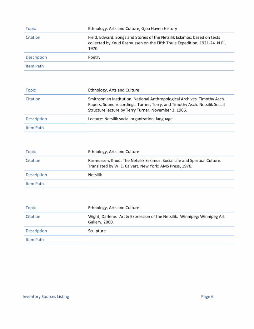
Citation Field, Edward. Songs and Stories of the Netsilik Eskimos: based on texts collected by Knud Rasmussen on the Fifth Thule Expedition, 1921‐24. N.P., 1970
Description Poetry
Topic Ethnology, Arts and Culture, Gjoa Haven History
Item Path
Citation Smithsonian Institution. National Anthropological Archives. Timothy Asch Papers, Sound recordings. Turner, Terry, and Timothy Asch. Netsilik Social Structure lecture by Terry Turner, November 3, 1966.
Description Lecture: Netsilik social organization, language
Topic Ethnology, Arts and Culture
Item Path
Citation Rasmussen, Knud. The Netsilik Eskimos: Social Life and Spiritual Culture. Translated by W. E. Calvert. New York: AMS Press, 1976.
Description Netsilik
Topic Ethnology, Arts and Culture
Item Path
Citation Wight, Darlene. Art & Expression of the Netsilik. Winnipeg: Winnipeg Art Gallery, 2000.
Description Sculpture
Topic Ethnology, Arts and Culture
Item Path
Inventory Sources Listing Page 6

Citation Taylor, J. Garth. Netsilik Eskimo material culture: the Roald Amundsen Collection from King William Island. Oslo: Universitetsforlaget, 1974.
Description Art, clothing, implements.
Topic Ethnology, Arts and Culture
Item Path
Citation Rasmussen, Knud. A Journey to the Arctic. Adapted from the Netsilik Eskimos. Cambridge, MA: Educational Development Centre, 1970.
Description
Topic Ethnology, Arts and Culture
Item Path
Citation Cadzow, Donald A. Native Copper Objects of the Copper Eskimo. New York, Museum of the American Indian, Heye Foundation, 1920.
Description Material culture, copper.
Topic Ethnology, Arts and Culture
Item Path
Citation Arctic Institute of North America. 'The Bathurst Inlet Patrol and the RCMP in the Arctic.' Accessed 25 February 2011. Available online at http://www.ucalgary.ca/arcticexpedition/rcmp
Description
Topic Cambridge Bay History, Gjoa Haven History, Umingmaktok History
Item Path http://www.ucalgary.ca/arcticexpedition/rcmp
Inventory Sources Listing Page 7

Citation Jurick, D., compiler. A summary of background information on migratory bird sanctuaries in the western and northern region. Winnipeg, MB: Canadian Wildlife Service, July 1985.
Description
Topic Wildlife and Environment
Item Path
Citation Alisauskas, R.T. Distribution and abundance of geese in the Queen Maud Gulf Migratory Bird Sanctuary: June 20 – July 1, 1991. Report to the Ekaluktutiak Hunters' and Trappers' Association, Cambridge Bay, Northwest Territories. Saskatoon: Canadian Wildlife Service, 1992.
Description
Topic Wildlife and Environment
Item Path
Citation 'Biography of Mary Cousins (Panigusiq) taken to Cambridge Bay by the St Roch.' Inuktitut Magazine 103, p. 36.
Description
Topic Cambridge Bay History, Ethnology, Arts and Culture
Item Path
Citation 'Bryan Nakoyak, from Cambridge Bay; selected for Nunavut Youth Abroad Program.' Inuktitut Magazine 85, p. 42.
Description
Topic Cambridge Bay History, Ethnology, Arts and Culture
Item Path
Inventory Sources Listing Page 8

Citation 'Moses Tookoome moved from Gjoa Haven to Baker Lake.' Inuktitut Magazine 97, p. 21.
Description
Topic Ethnology, Arts and Culture, Gjoa Haven History
Item Path
Citation 'Profile of whaler, George Porter, living in Gjoa Haven.' Inuktitut Magazine (March 1983): pp. 58‐68.
Description
Topic Ethnology, Arts and Culture, Gjoa Haven History
Item Path
Citation 'Simon Anaviapik mentions traveling with three men from Cape Dorset, wintering at Gjoa Haven.' Inuktitut Magazine 83, pp. 13‐14.
Description
Topic Cape Dorset History, Ethnology, Arts and Culture
Item Path
Citation 'Spiritual Sky, band from Cambridge Bay.' Inuktitut Magazine (December 1983): p. 44.
Description
Topic Cambridge Bay History, Ethnology, Arts and Culture
Item Path
Inventory Sources Listing Page 9

Citation 'Tanya Tagaq Gillis of Cambridge Bay invited to come throat sing with Bjork.' Inuktitut Magazine 95: p. 20.
Description
Topic Cambridge Bay History, Ethnology, Arts and Culture
Item Path
Citation 'Vera Panaktak from Cambridge Bay received journalism training.' Inuktitut Magazine (Winter 1984): p. 5.
Description
Topic Cambridge Bay History, Ethnology, Arts and Culture
Item Path
Citation Nunavut Tunngavik. Request for Proposals, Conservation Areas IIBA Gjoa Haven Project. 2009.
Description Request for Proposals for developing a community tourism program featureing the community's position adjacent to the Northwest Passage. The priorities for Gjoa Haven are: 1) To take advantage of the current increase in cruise‐ship traffic, by establishing a program that encourages cruise‐ship operators to visit the community, and keep coming back in future years; 2) To take advantage of an apparent opportunity to establish a Northwest Passage Centre in Gjoa Haven; and 3) To establish a Northwest Passage Centre that serves a multitude of purposes throughout the year, focusing on Inuit culture, NW Passage heritage, and tourism and business development.
Topic Tourism
Item Path
Inventory Sources Listing Page 10

Citation RT Associates. Gjoa Haven Multi‐Use Centre Business Plan. Prepared for NTI, 2010.
Description In October 2009, NTI contracted RT Associates (Robert Trudeau and Bill Davidson) to undertake a feasibility study/business plan to confirm how the Multi‐Use Centre might best operate as an on‐going self supporting business and, if not, the level of capital and O&M required support, potential sources and potential community benefits.
Topic Tourism
Item Path
Citation Keith, Darren, et al. 'Inuit knowledge of polar bears: a project of the Gjoa Haven Hunters' and Trappers' Organization.' Edmonton: CCI Press, 2005.
Description
Topic Gjoa Haven History, Wildlife and Environment
Item Path
Inventory Sources Listing Page 11

Citation Keith, Darren, and Andrew Stewart. '1999‐48, Utkuhiksalik: An Ancient Cultural Landscape.' Meridian Geographic Consulting, for Historic Sites and Monuments Board of Canada. Parks Canada, 1999.
Description Abstract: The cultural landscape of Utkuhiksalik, located between Franklin Lake and Chantrey Inlet on the lower Back River, Nunavut, is the setting of a specialized and unique Inuit way of life. The people of the region ‐ the Utkuhiksalingmiut ‐ developed a summer and fall fishery as the principle element of their subsistence economy, part of the larger Netsilik hunting, sealing and fishing subsistence pattern. Utkuhiksalik and its fisheries represent the most interesting aspect of this regional economy. The importance of Utkuhiksalik is reinforced by its documented cultural antiquity and by the many names and stories associated with places in the Utkuhiksalik landscape which refer to Inuit myhology and universally held expressions of Inuit oral tradition. Oral traditions hold that the area, and specific cultural features within the proposed site area, were inherited from the Tuniit, legendary predecessors of the Inuit. The fishery sites are sacred, requiring the performance of prescribed rituals by people living and working at these sites. Beyond the fisheries, several places within Utkuhiksalik are understood to be the sites for events of mythological importance to all Inuit.
Topic Ethnology, Arts and Culture, Wildlife and Environment
Item Path
Citation Abrahamson, G. The Copper Eskimos: an area economic survey, 1963. Ottawa: Industrial Division, Northern Administration Branch, Department of Northern Affairs & National Resources, 1964.
Description
Topic Ethnology, Arts and Culture
Item Path
Citation Hudson's Bay Company Archives (HBCA): Perry River. B.461. Post Journals 1926‐1928. Reel Nos. 1MA51‐1MA52.
Description
Topic Cambridge Bay History, Gjoa Haven History, Umingmaktok History
Item Path
Inventory Sources Listing Page 12

Citation W. Hodgins, Bruce and Gwyneth Hoyle. Chapter 9, 'Queen Maud Gulf and East; Rivers flowing into the Arctic Ocean', in Canoeing North Into the Unknown: A Record of River Travel, 1874 to 1974, esp. pp. 177‐80,
Description
Topic Arviat History, Nunavut History, Place Names
Item Path
Citation Eber, Dorothy. 'Regina v. Angulakik, 1957'. In Images of Justice: a legal history of the Northwest Territories. Montreal: McGill‐Queens, 1997.
Description
Topic Nunavut History
Item Path
Citation Kitikmeot Heritage Society. 'Kitikmeot Place Name Atlas'. Accessed 12 December 2010. Available online at www.kitikmeotheritage.ca/atlas.htm
Description The Kitikmeot Place Name Atlas is the result of an ongoing program of place name recording in the communities of the Kitikmeot Region, led by the Kitikmeot Heritage Society. The purpose of the project is to comprehensively record the traditional Inuktitut and Inuinnaqtun place names of the region, including their pronunciations, meanings and associated oral traditions. This work will ensure that the region’s place names will continue to be known to future generations of Nunavummiut.
Topic Place Names
Item Path www.kitikmeotheritage.ca/atlas.htm
Citation McCormick, K.J. and B. Poston. A survey of Lesser Snow Geese and Canada Geese on Jenny Lind Island, Northwest Territories. Unpublished report. Yellowknife: Canadian Wildlife Service, 1986.
Description
Topic Wildlife and Environment
Item Path
Inventory Sources Listing Page 13

Citation 'Community Sketches of Cambridge Bay, Gjoa Haven, Bathurst Inlet.' Inuktitut Magazine (March 1983): pp. 43‐52.
Description
Topic Cambridge Bay History, Ethnology, Arts and Culture, Gjoa Haven History, Umingmaktok History
Item Path
Citation 'Interview with James Kavana, mention of traveling to Cambridge Bay.' Inuktitut Magazine (March 1983): pp. 24‐33.
Description
Topic Cambridge Bay History, Ethnology, Arts and Culture, Oral History
Item Path
Citation 'James Taipana's story, courtesy of Kitikmeot Heritage Society, Cambridge Bay.' Inuktitut Magazine 86, p. 86.
Description
Topic Cambridge Bay History, Ethnology, Arts and Culture, Oral History
Item Path
Citation 'Jason Tologanak of Cambridge Bay elected president of National Inuit Youth Council.' Inuktitut Magazine 96, pp. 100‐101.
Description
Topic Cambridge Bay History, Ethnology, Arts and Culture
Item Path
Inventory Sources Listing Page 14

Citation 'Josh Haiblen, Australian, took canoe trips coming out at Eskimo Point, visited Gjoa Haven.' Inuktitut Magazine 82, p.4.
Description
Topic Arviat History, Ethnology, Arts and Culture, Gjoa Haven History
Item Path
Citation Kerbes, R.H. Colonies and numbers of Ross' Geese and Lesser Snow Geese in the Queen Maud Gulf Migratory Bird Sanctuary. Ottawa: Canadian Wildlife Service Occasional Paper No. 81, 1994.
Description
Topic Wildlife and Environment
Item Path
Citation Kitikmeot Heritage Society website. Kitikmeot Atlas Map Series 67B. Accessed 6 April 2011. Available online at atlas.kitikmeotheritage.ca/pdf_maps/MAP%2067B_Kitikmeot%20Map%20Series.pdf
Description Map including small portion of the south coast of Queen Maud Gulf. Map by Darren Keith, Kitikmeot Heritage Society; Place names provided by Cambridge Bay Elders between 2000 and 2008; corresponds to NTS Map 67B Queen Maud Gulf @ 1:250,000.
Topic Gjoa Haven History, Place Names
Item Path http://atlas.kitikmeotheritage.ca/pdf_maps/MAP%2067B_Kitikmeot%20Map%20Series.pdf
Inventory Sources Listing Page 15
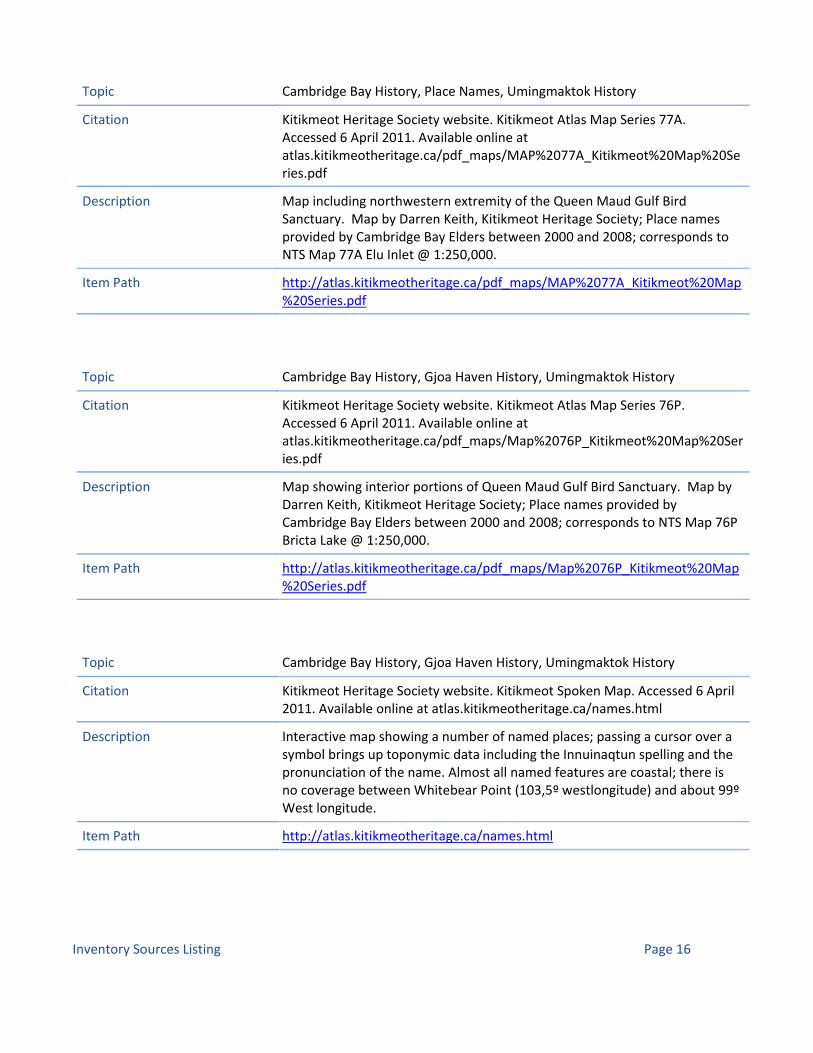
Citation Kitikmeot Heritage Society website. Kitikmeot Atlas Map Series 77A. Accessed 6 April 2011. Available online at atlas.kitikmeotheritage.ca/pdf_maps/MAP%2077A_Kitikmeot%20Map%20Series.pdf
Description Map including northwestern extremity of the Queen Maud Gulf Bird Sanctuary. Map by Darren Keith, Kitikmeot Heritage Society; Place names provided by Cambridge Bay Elders between 2000 and 2008; corresponds to NTS Map 77A Elu Inlet @ 1:250,000.
Topic Cambridge Bay History, Place Names, Umingmaktok History
Item Path http://atlas.kitikmeotheritage.ca/pdf_maps/MAP%2077A_Kitikmeot%20Map%20Series.pdf
Citation Kitikmeot Heritage Society website. Kitikmeot Atlas Map Series 76P. Accessed 6 April 2011. Available online at atlas.kitikmeotheritage.ca/pdf_maps/Map%2076P_Kitikmeot%20Map%20Series.pdf
Description Map showing interior portions of Queen Maud Gulf Bird Sanctuary. Map by Darren Keith, Kitikmeot Heritage Society; Place names provided by Cambridge Bay Elders between 2000 and 2008; corresponds to NTS Map 76P Bricta Lake @ 1:250,000.
Topic Cambridge Bay History, Gjoa Haven History, Umingmaktok History
Item Path http://atlas.kitikmeotheritage.ca/pdf_maps/Map%2076P_Kitikmeot%20Map%20Series.pdf
Citation Kitikmeot Heritage Society website. Kitikmeot Spoken Map. Accessed 6 April 2011. Available online at atlas.kitikmeotheritage.ca/names.html
Description Interactive map showing a number of named places; passing a cursor over a symbol brings up toponymic data including the Innuinaqtun spelling and the pronunciation of the name. Almost all named features are coastal; there is no coverage between Whitebear Point (103,5º westlongitude) and about 99º West longitude.
Topic Cambridge Bay History, Gjoa Haven History, Umingmaktok History
Item Path http://atlas.kitikmeotheritage.ca/names.html
Inventory Sources Listing Page 16

Citation Ramsar Sites Information Service. CANADA 12: QUEEN MAUD GULF MIGRATORY BIRD SANCTUARY, NUNAVUT TERRITORY. Information Sheet on Ramsar Wetlands. Accessed 6 April 2011. Available online at www.wetlands.org/RSIS/_COP9Directory/Directory/ris/4CA012en.pdf
Description Four‐page scientific and administrative summary, including terrain, wildlife, land uses current to 2001, and research activities
Topic Wildlife and Environment
Item Path http://www.wetlands.org/RSIS/_COP9Directory/Directory/ris/4CA012en.pdf
Citation MacDonald, R. Aerial fixed‐wing survey of waterfowl on south Victoria Island, Kent Peninsula, Rasmussen lowlands, King William Island, Adelaide Peninsula, and Queen Maud Gulf Migratory Bird Sanctuary. United States, Office of Migratory Bird Management. Nunavut Wildlife Research Permit, no. 894, 2007.
Description
Topic Wildlife and Environment
Item Path
Citation Underwood McLellan & Associates. General development plan ‐ Gjoa Haven, Northwest Territories. Underwood McLellan & Associates, 1976.
Description 76 pages, 4 folded maps.
Topic Ethnology, Arts and Culture, Tourism
Item Path
Citation Legatos, J. 'The fast and the curious.' Photography by F. O'Hara. Canadian geographic Vol. 127, no. 2 (Mar./Apr. 2007): pp. 100‐101.
Description
Topic Ethnology, Arts and Culture
Item Path
Inventory Sources Listing Page 17

Citation Pelly, D.F., and K. Crockatt, editors. Uvajuq: the origin of death. Illustrated by E.A. Klengenberg.Cambridge Bay, NU, and Toronto, ON: Kitikmeot Heritage Society and Betelgeuse Books, 1999.
Description 84 pages.
Topic Ethnology, Arts and Culture
Item Path
Citation Alisauskas, R.T., D. Kellett, G. Samelius, and J. Traylor. Waterfowl ecosystem studies in Queen Maud Gulf Bird Sanctuary (small mammals). Canadian Wildlife Service, Prairie and Northern Wildlife Centre. Sponsored by the Nunavut Wildlife Management Board, Polar Continental Shelf Project (Canada), United States Fish and Wildlife Service, Central Flyway Council, Mississippi Flyway Council, University of Saskatchewan, Ducks Unlimited, Delta Waterfowl and Wetlands Research Station, Institute for Wetland and Waterfowl Research, and Northern Scientific Training Program (Canada). Nunavut Wildlife Research Permit, no. 775, 2006.
Description
Topic Wildlife and Environment
Item Path
Citation Alisauskas, R.T., J. Aitaok, B. Eyegetok, D. Kellett, and K. Drake. Waterfowl/ecosystem studies in Queen Maud Gulf Bird Sanctuary. Canadian Wildlife Service, Prairie and Northern Wildlife Centre. Sponsored by the Nunavut Wildlife Management Board, Polar Continental Shelf Project (Canada), California, Department of Fish and Game, Central Flyway Council, and Mississippi Flyway Council. Nunavut Wildlife Research Permit, no. 194, 2003.
Description
Topic Wildlife and Environment
Item Path
Inventory Sources Listing Page 18

Citation Crockatt, K. The Iqaluktuuq Project. Kitikmeot Heritage Society. Nunavut Research Licence, 2002.
Description
Topic Ethnology, Arts and Culture, Oral History
Item Path
Citation Pollick, J. Objects of power in traditional Inuit culture. University of Laval, Groupe d'études inuit et circumpolaires. Nunavut Research Licence, 2001.
Description
Topic Ethnology, Arts and Culture
Item Path
Citation Crockatt, K. Kitikmeot Oral History Project. Kitikmeot Heritage Society. Nunavut Research Licence, no. 0401797, 1997.
Description
Topic Ethnology, Arts and Culture, Oral History
Item Path
Citation Schledermann, P. Survey of the historic area at Cambridge Bay. Arctic Institute of North America. Northwest Territories, Department of Economic Development and Tourism. Northwest Territories Archaeologists Permit, no. 91‐713, 1991.
Description
Topic Ethnology, Arts and Culture, Interpretation, Tourism
Item Path
Inventory Sources Listing Page 19

Citation EDA Collaborative Inc. Cambridge Bay historic area: planning and design. Yellowknife: Northwest Territories, Department of Economic Development and Tourism, n.d.
Description 35 pages
Topic Cambridge Bay History, Ethnology, Arts and Culture, Interpretation, Tourism
Item Path
Citation Fraser, J.K. Historical geography of the communities of Cambridge Bay and Spence Bay, N.W.T. Northwest Territories Scientific Research Licence, ref. no. 12 410 389, 1992.
Description
Topic Cambridge Bay History, Ethnology, Arts and Culture, Interpretation
Item Path
Citation Farquharson, D.R. 'Inuit land use in the west‐central Canadian Arctic.' In Inuit land use and occupancy project, Volume 1: Land use and occupancy. Edited by Milton M.R. Freeman. Ottawa: Supply and Services Canada, 1976, pp. 33‐61.
Description
Topic Ethnology, Arts and Culture, Wildlife and Environment
Item Path
Citation Bertulli, M. Assessment of disturbed archaeological sites near Cambridge Bay. Prince of Wales Northern Heritage Centre.Northwest Territories Archaeologists Permit, no. 87‐611, 1987.
Description
Topic Archaeology
Item Path
Inventory Sources Listing Page 20

Citation Lok, C.M., and J.A.J. Vink. 'Birds at Cambridge Bay, Victoria Island, Northwest Territories.'Canadian field‐naturalist Vol.100, no. 3 (July‐Sept. 1986): pp. 315‐318.
Description
Topic Wildlife and Environment
Item Path
Citation Washburn, A.L. 'J.J. O'Neill (1886‐1966).' Arctic Vol. 19, no. 4 (Dec. 1966): p. 361.
Description
Topic Ethnology, Arts and Culture, Nunavut History
Item Path
Citation Angulalik, E., J. Panioyak, K. Crockatt, and M. Angulalik. Kuukyuak Project. Kitikmeot Heritage Society. Nunavut Research Licence, no. 0400896N‐A, 1996.
Description
Topic Ethnology, Arts and Culture, Oral History
Item Path
Citation Hanson, H.C., P. Queneau, P. Scott, and D. Rowley. 'The geography, birds, and mammals of the Perry River region.' Special publication, Arctic Institute of North America, no. 3, 1956.
Description 96 pages
Topic Wildlife and Environment
Item Path
Inventory Sources Listing Page 21

Citation Streisinger, E. 'Exploring Canada's Ellice River: observing Arctic tundra flora and fauna.' Explorers journal Vol. 58, no. 2 (June 1980): pp. 84‐90.
Description
Topic Wildlife and Environment
Item Path
Citation Crockatt, K. Simpson River Oral History Project. Kitikmeot Heritage Society. Nunavut Research Licence, 1999.
Description
Topic Ethnology, Arts and Culture, Oral History
Item Path
Citation Mallory, M. Traditional knowledge of the Cape Searle and Reid Bay candidate National Wildlife Areas. Canadian Wildlife Service. Sponsored by Qikiqtarjuaq (Nunavut), and the World Wildlife Fund (Canada). Nunavut Research Licence, 2001.
Description
Topic Ethnology, Arts and Culture, Oral History, Wildlife and Environment
Item Path
Citation Wynne‐Edwards, V.C. 'The fulmars of Cape Searle.' Arctic Vol. 5, no. 2 (July 1952): pp. 104‐117.
Description
Topic Wildlife and Environment
Item Path
Inventory Sources Listing Page 22

Citation National Film Board of Canada and Education Development Center Incorporated. Building a Kayak: Part 1. Produced by Quentin Brown. 1967.
Description Part of a series on the Netsilik Inuit as documented by the Education Development Center. In this part, it is high summer. The run‐off is in full flow and it is time for the Inuit to build a kayak. The whole family is involved in shaping this invaluable tool. Film without words.32 min 20 s
Topic Ethnology, Arts and Culture
Item Path
Citation National Film Board of Canada and Education Development Center Incorporated. Building a Kayak: Part 2. Produced by Quentin Brown. 1967.
Description Part of a series on the Netsilik Inuit as documented by the Education Development Center. In this part, work continues on the kayak. There are more skins to soak, more ribs to be split and shaped, more bending and binding. Finally, the kayak is ready. The men launch and test their new kayak and admire its performance. Film without words.32 min 46 s
Topic Ethnology, Arts and Culture
Item Path
Citation National Film Board of Canada and Education Development Center Incorporated. Fishing at the Stone Weir: Part 1. Produced by Quentin Brown. 1967.
Description Part of a series on the Netsilik Inuit as documented by the Education Development Center. In this film, it is full summer. The skin tents are up, and it is time to fish. The men go into the river to form enclosures to trap fish. Once trapped, they are speared with three‐pronged leisters. A woman cleans the catch, which has been strung on a thong. Everyone enjoys bits of raw fish. Film without words.30 min 20 s
Topic Ethnology, Arts and Culture
Item Path
Inventory Sources Listing Page 23
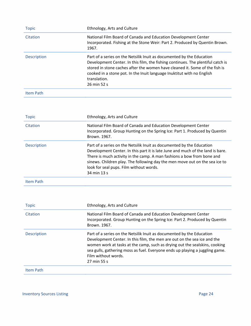
Citation National Film Board of Canada and Education Development Center Incorporated. Fishing at the Stone Weir: Part 2. Produced by Quentin Brown. 1967.
Description Part of a series on the Netsilik Inuit as documented by the Education Development Center. In this film, the fishing continues. The plentiful catch is stored in stone caches after the women have cleaned it. Some of the fish is cooked in a stone pot. In the Inuit language Inuktitut with no English translation.26 min 52 s
Topic Ethnology, Arts and Culture
Item Path
Citation National Film Board of Canada and Education Development Center Incorporated. Group Hunting on the Spring Ice: Part 1. Produced by Quentin Brown. 1967.
Description Part of a series on the Netsilik Inuit as documented by the Education Development Center. In this part it is late June and much of the land is bare. There is much activity in the camp. A man fashions a bow from bone and sinews. Children play. The following day the men move out on the sea ice to look for seal pups. Film without words.34 min 13 s
Topic Ethnology, Arts and Culture
Item Path
Citation National Film Board of Canada and Education Development Center Incorporated. Group Hunting on the Spring Ice: Part 2. Produced by Quentin Brown. 1967.
Description Part of a series on the Netsilik Inuit as documented by the Education Development Center. In this film, the men are out on the sea ice and the women work at tasks at the camp, such as drying out the sealskins, cooking sea gulls, gathering moss as fuel. Everyone ends up playing a juggling game. Film without words.27 min 55 s
Topic Ethnology, Arts and Culture
Item Path
Inventory Sources Listing Page 24

Citation National Film Board of Canada and Education Development Center Incorporated. Group Hunting on the Spring Ice: Part 3. Produced by Quentin Brown. 1967.
Description Part of a series on the Netsilik Inuit as documented by the Education Development Center. In this part, the men, out on the ice, catch seals, relishing the liver and blood. Upon their return, the women cut away the blubber from the meat and everyone sits down to eat. Film without words.33 min 01 s
Topic Ethnology, Arts and Culture
Item Path
Citation National Film Board of Canada and Education Development Center Incorporated. Jigging for Lake Trout. Produced by Quentin Brown. 1967.
Description Part of a series on the Netsilik Inuit as documented by the Education Development Center. In this part, more wildlife returns as winter draws to an end. The family is now living in a ikarmak r. The man chips a hole on the lake ice and jigs the line to attract the fish. His wife joins him, and both remain at the hole through a severe blizzard. Film without words.31 min 56 s
Topic Ethnology, Arts and Culture
Item Path
Citation National Film Board of Canada and Education Development Center Incorporated. Stalking Seal on the Spring Ice: Part 1. Produced by Quentin Brown. 1967.
Description Part of a series on the Netsilik Inuit as documented by the Education Development Center. In this film, the Inuit are camped on the shore of Pelly Bay in May and June. A hunter catches a seal and drags it back to camp, where he and his wife cut it up. There is a use for everything‐‐blubber, hide, fur, even the intestines.24 min 31 s
Topic Ethnology, Arts and Culture
Item Path
Inventory Sources Listing Page 25

Citation National Film Board of Canada and Education Development Center Incorporated. Stalking Seal on the Spring Ice: Part 2. Produced by Quentin Brown. 1967.
Description Part of a series on the Netsilik Inuit as documented by the Education Development Center. In this part, a hunter attempts to harpoon a seal, but he moves too soon and misses his catch. He prepares for a night vigil at the seal's breathing‐hole.33 min 45 s
Topic Ethnology, Arts and Culture
Item Path
Citation CBC News North. Amundsen Honoured in Gjoa Haven: Nunavut hamlet hosted Norwegian explorer in early 1900s. 25 August 2010. Accessed 6 April 2011. Available online at www.cbc.ca/news/canada/north/story/2010/08/25/nunavut‐gjoa‐haven‐norway‐amundsen.html
Description News article about a flag‐raising ceremony to honour Roald Amundsen with Norwegian officials at Gjoa Haven in summer 2010.
Topic Gjoa Haven History, Nunavut History
Item Path http://www.cbc.ca/news/canada/north/story/2010/08/25/nunavut‐gjoa‐haven‐norway‐amundsen.html
Citation Briggs, Jean L. Never in Anger: Portrait of an Eskimo Family. Cambridge: Harvard University Press, 1970.
Description Anthropologist Jean Briggs spent seventeen months living on a remote Arctic shore as the "adopted daughter" of an Eskimo family. Through vignettes of daily life she unfolds a warm and perceptive tale of the behavioral patterns of the Utku, their way of training children, and their handling of deviations from desired behavior.
Topic Ethnology, Arts and Culture
Item Path
Inventory Sources Listing Page 26

Citation Gordon, Bryan C. 'Nadlok and the Origin of the Copper Inuit.' In Threads of Arctic Prehistory: Papers in Honour of William E. Taylor, Jr. David Morrison and Jean‐Luc Pilon, editors. Hull: Canadian Museum of Civilization, 1994, pp. 325‐340.
Description Abstract: Nadlok is the only known site clearly spanning the transition between the first Inuit culture in Canada, called Thule, and that of the Copper Inuit described by the first explorers in the western Central Arctic. Radiocarbon dates and the absence of European trade goods suggest this transition occurred over several centuries, between A.D. 1450 and 1750. An inland site with abundant evidence of caribou hunting, Nadlok is a marked departure from traditional Thule coastal seal hunting, a change induced by increased ice thickness caused by the Little Ice Age which destroyed breathing hole hunting.
Topic Archaeology
Item Path
Citation Pelly, David. Porter Family Oral History Project. 2009. Government of Nunavut.
Description Porter Family Oral History Project. Gjoa Haven, funded by the Government of Nunavut, intended to begin the process of recording the history of this important central Arctic family.Summary from: http://www3.sympatico.ca/dpelly/projects.html
Topic Oral History
Item Path
Citation Pelly, David. Community Tourism Package Development, 2008‐2009.Nunavut Tunngavik Inc. and The Tourism Company.
Description Community Tourism Package Development, funded by Nunavut Tunngavik Inc., working together with The Tourism Company of Toronto, to help three communities in Nunavut (Arviat, Cape Dorset, and Gjoa Haven) each work collectively to design and develop a community based, sustainable tourism package up to a market‐ready standard. Summary available here: http://www3.sympatico.ca/dpelly/projects.html
Topic Tourism
Item Path
Inventory Sources Listing Page 27

Citation Pelly, David. Erebus & Terror National Historic Site. Nunavut Tunngavik Inc., 2004.
Description Erebus & Terror National Historic Site (on contract to Nunavut Tunngavik Inc.) to consult with the community of Gjoa Haven and document the collective ideas and preferences held by the community with regard to how it might benefit from proximity to the National Historic Site, given that an Inuit Impact & Benefit Agreement is to be negotiated in the near future. Summary from: http://www3.sympatico.ca/dpelly/projects.html
Topic Tourism
Item Path
Citation Pelly, David. Perry River Project. Nunavut Tunngavik Inc., 2003‐2004.
Description Perry River Project (on contract to Nunavut Tunngavik Inc.) documenting the experiences of seven Inuit families forced to relocate to Gjoa Haven when the trading post at Perry River, on the Arctic coast, closed in 1967. Summary from: http://www3.sympatico.ca/dpelly/projects.html
Topic Gjoa Haven History, Oral History
Item Path
Citation Pelly, David. Mt. Pelly Oral History Project. NWT Government Contract, 1996‐1997.
Description Mt. Pelly Oral History Project (NWT Government contract). A combined oral‐history and archaeological project, working with Elders in Cambridge Bay, to document the traditional knowledge, the legends, and the historic use of the area surrounding Mt. Pelly, known by Inuit as Uvajuq, near Cambridge Bay. Summary from: http://www3.sympatico.ca/dpelly/projects.html
Topic Oral History
Item Path
Inventory Sources Listing Page 28

Citation Keith, Darren, Max Friesen, and the Kitikmeot Heritage Society. Iqaluktuurmiutat: Life at Iqaluktuuq: La vie a Iqaluktuuq. Kitikmeot Heritage Society. Yellowknife, NWT: Artisan Press, n.d.
Description Booklet with 12 pages in each language. Includes maps and photos
Topic Ethnology, Arts and Culture, Interpretation, Oral History, Tourism, Wildlife and Environment
Item Path
Citation Keith, Darren. Stephen Angulalik: Kitikmeot Fur Trader. Kitikmeot Heritage Society. Yellowknife, NWT: Artisan Press, n.d.
Description Booklet with 10 pages in each language.
Topic Cambridge Bay History, Ethnology, Arts and Culture, Interpretation
Item Path
Citation Lagasse, Robert. 'Artists At The Opening.' About Arts & Crafts (Spring 179): p. 22.
Description 1‐page article on recent Gjoa Haven exhibits.
Topic Ethnology, Arts and Culture, Interpretation, Tourism
Item Path
Citation Landon, T.C. Life at Gjoa Haven: The Old Ways and the New. The Beaver (August‐September 1991): pp. 41‐48.
Description 8‐page article.
Topic Gjoa Haven History
Item Path
Inventory Sources Listing Page 29

Citation Kitikmeot Heritage Society. Elders Display, May Hakongak Community Library and Cultural Centre. Accessed 5 April 2011. Available online at www.kitikmeotheritage.ca/exhibits/elders.htm
Description The Elders Display, sponsored by the Kitikmeot Inuit Association, profilesthe lives of Cambridge Bay Elders.(Funded by the Department of Culture, Language, Elders & Youth). The stories of 5 elders are available online as sound files with translation.
Topic Interpretation, Oral History, Tourism
Item Path www.kitikmeotheritage.ca/exhibits/elders.htm
Citation Poncins, Gontran de. Kabloona. Saint Paul, MN: Graywolf Press, 1972.
Description Netsilik social life and customs.
Topic Gjoa Haven History
Item Path
Citation Banci, Vivian, Chris C. Hanks and Rosemary M. Spicker, editors. Walking in the path of the caribou: knowledge of the Copper Inuit, place names atlas. Naonayaotit Traditional Knowledge Project. Cambridge Bay and Kugluktuk, Nunavut: Kitikmeot Inuit Association, 2004.
Description
Topic Place Names
Item Path
Citation Collignon, Beatrice. Knowing places: the Inuinnait, landscapes, and the environment. N.p., n.d.
Description
Topic Place Names
Item Path
Inventory Sources Listing Page 30

Citation Canadian Arctic Expedition. Report of the Canadian Arctic Expedition, 1913‐18. F.A. Acland Ottawa, 1919‐1946.
Description Volumes 1‐16. Last five volumes about the Copper Inuit.
Topic Ethnology, Arts and Culture
Item Path
Citation Eber, Dorothy Harley. Encounters on the Passage: Inuit Meet the Explorers. Toronto: University of Toronto Press, 2008.
Description
Topic Gjoa Haven History
Item Path
Citation Crockatt, K. Simpson River Oral History Project. Kitikmeot Heritage Society. Nunavut Research Licence, 1999.
Description
Topic Oral History
Item Path
Citation CMC Audio Archives. Control no. IV‐C‐220T to IV‐C‐222T. Cavanagh, Beverley. Arctic ‐ Central ‐ Music. Sound recordings. 1972.
Description Collection of audio tapes of music recorded in Gjoa Haven.
Topic Ethnology, Arts and Culture, Gjoa Haven History, Oral History
Item Path
Inventory Sources Listing Page 31

Citation CMC Audio Archives. Control no. IV‐C‐223T. Cavanagh, Beverley. Arctic ‐ Central ‐ Music and Stories. Sound recording. 1972.
Description Audio tape of music and stories recorded in Gjoa Haven.
Topic Ethnology, Arts and Culture, Gjoa Haven History, Oral History
Item Path
Citation CMC Audio Archives. Control no. IV‐C‐224T. Cavanagh, Beverley. Arctic ‐ Central ‐ Stories. Sound recording. 1972.
Description Audio tape of stories recorded in Gjoa Haven.
Topic Ethnology, Arts and Culture, Gjoa Haven History, Oral History
Item Path
Citation CMC Audio Archives. Control no. IV‐C‐310T to IV‐C‐320T. Cavanagh, Beverley. Arctic ‐ Central ‐ Songs. Sound recording. 1960; 1972; 1975.
Description Collection of audio tapes of songs recorded in Gjoa Haven. Record Summary: Transcription of songs from pages 218 to 367 of final report "Music of the Netsilik People". Related material See related manuscript IV‐C‐111M,IV‐C‐85M,IV‐C‐109M.
Topic Ethnology, Arts and Culture, Gjoa Haven History, Oral History
Item Path
Citation CMC Ethnology Archives. B829, f3. Accession no. E2007.22. Cavanagh, Beverley. Music of the Netsilik Eskimo: a study of stability and change. Canadian Ethnology Service Paper No. 82. A Diamond Jenness Memorial Volume. Toronto: 1978, 1979.
Description Dissertation. Volume 1. iii, 326 pages : ill., includes maps and figures. Volume 2. xv, 427 pages : ill., includes maps and figures.
Topic Ethnology, Arts and Culture
Item Path
Inventory Sources Listing Page 32

Citation CMC Ethnology Archives. B348, f7. Control no. IV‐C‐137M. Accession no. 82/80. Cavanagh, Beverley. Nontraditional music in Gjoa Haven and Pelly Bay; the Netsilik drum dance. 1982.
Description 71 pages. Nontraditional music in Gjoa Haven and Pelly Bay ‐ 43 pages. The Netsilik drum dance ‐ 28 pages and appendix and 6 examples.
Topic Ethnology, Arts and Culture, Gjoa Haven History, Oral History
Item Path
Citation CMC Ethnology Archives. B207, f5. Control no. IV‐C‐85M. Accession no. 75/123. Cavanagh, Beverley. Progress report: Oral and music tradition at Gjoa Haven. 1975.
Description 1 page report. See related tapes: IV‐C‐310T to IV‐C‐320T.
Topic Ethnology, Arts and Culture, Gjoa Haven History, Oral History
Item Path
Citation CMC Audio Archives. Control no. IV‐C‐155T. Lutz, Maija M. Arctic ‐ Central ‐ Music. 1973.
Description Audio tape of music recorded in Gjoa Haven by Simon Okpukok.
Topic Ethnology, Arts and Culture
Item Path
Inventory Sources Listing Page 33

Citation CMC Audio Archives. Control no. IV‐X‐47T and IV‐X‐48T. Accession no. 77/157. Mayo, Tony. Arctic ‐ General ethnology. 1975.
Description Audio tapes recorded in Gjoa Haven. Record Summary: Side 1 ‐ Drum dance, throat singing, juggling game song, singing by the oldest lady in Gjoa Haven. Side 2 ‐ Old blind lady singing. Really slow drumming is her husband's Kublagak (oldest man in Gjoa Haven, born in 1900). Last part of tape in Coppermine. Side 3 ‐ Coppermine Singers & Dancers Note strong Indian influence, fast part of tape is Eskimo dogs howling at Gjoa Haven. Side 4 ‐ Paul & Agnes Kublogak, the two oldest people in Gjoa Haven talking to me and Mart Tostisk about their early life on the land.Reference to Curatorial Accessions Collection 77/157. Reference to colour slides collection 1 to 101, acc. 77/157.
Topic Ethnology, Arts and Culture, Gjoa Haven History, Oral History
Item Path
Citation CMC Video Archives. Video P7.J.5. Control no. V95‐0025. McMahon, Kevin. In the Reign of Twilight. TV Ontario production, 1994.
Description 1 videocassette, 90 minutes. Record Summary: In the Reign of Twilight is a film about the history and the 50 years of modern development of the Canadian Arctic. It weaves together a series of ideas about the global village and the impact of technological progress on aboriginal people in undeveloped regions. Interviews with three generations of Inuit. Documentary on Canadian government's exploitation of Arctic region and Inuit culture, D.E.W. (Distant Early Warning) Line, media clips. Locations: Gjoa Haven, Hall Beach, Iqaluit. Based on the book Arctic Twilight, by Kevin McMahon.
Topic Ethnology, Arts and Culture
Item Path
Citation Canadian Arctic Producers and Innuit Gallery of Eskimo Art. From the bottom of the kudlik: carvings and artifacts from Gjoa Haven. Toronto: Innuit Gallery of Eskimo Art, 1974.
Description Book based on Inuit sculpture exhibition.
Topic Ethnology, Arts and Culture, Interpretation
Item Path
Inventory Sources Listing Page 34

Citation CMC Audio Archives. Control no. IV‐C‐3T. Accession no. 72/12. Cass, Elizabeth. Arctic ‐ Central ‐ Music (sound recording). 1959.
Description Audio tape of drum dancing. CCFCS Collection Elizabeth Cass
Topic Ethnology, Arts and Culture
Item Path
Citation CMC Archaeology Archives. Ms. 4109, V.2. Damkjar, Eric R. Historical Resources Impact Assessment, Cambridge Bay DEW Line Clean Up Project, Cambridge Bay, Nunavut. 1999.
Description Record Summary: final report;site forms;correspondence‐cover letter typescript;fig. (43);table (2);appendix (2)
Topic Ethnology, Arts and Culture, Interpretation
Item Path
Citation CMC Archaeology Archives. Ms. 4109, V.1. Damkjar, Eric R. Site forms and map, Cambridge Bay DEW Line Station Cleanup Project. 1998.
Description Record Summary: site forms, map.
Topic Archaeology
Item Path
Citation CMC Archaeology Archives. Ms. 4299. Friesen, T. Max. The Iqaluktuuq Project, archaeology on the Ekalluk River near Cambridge Bay, Nunavut. 2000.
Description Record Summary: Report;artifact catalogue;correspondence‐cover letter. 45 pages : typescript photocopy;fig. (12);table (7);appendix (5).
Topic Archaeology
Item Path
Inventory Sources Listing Page 35

Citation CMC Audio Archives. Control no. IV‐C‐214T. Gilbert, J.E. Arctic ‐ Central ‐ Music. C.197?
Description Record Summary: R.A. Davis collection. 72/7 Provincial Archives OMI Edmonton, Centre d'Anthropologie. Chants et messages Eskimos 1. chants Eskimo 2. en groupe 3.Renes 4. Chant d'hommes tambour 5. Autre chant 6. Autre chant. Pere Henry chant. poralis. femme messages. Side 2 1.Chants d'Eskimos avec tambour 2. chants d'Eskimos 3.Chants d'Eskimos avec tambour 4. Messages Camsell Hospital (French) 5.Song Chant and laughs 6. Messages 7. Betsy Marluk ‐ Eskimo ‐ Song 8. Joan Alyak ‐ Eskimo 9. Conversation ‐ french.
Topic Ethnology, Arts and Culture, Interpretation
Item Path
Citation CMC Archaeology Archives. Ms. 3441, V.1. Schledermann, Peter. Survey and assessment of archaeological resources Cambridge Bay, NWT. 1991.
Description Record Summary: Report;correspondence‐cover letter;map (1) 20 pages : typescript (photocopy);fig. (1).
Topic Archaeology
Item Path
Citation CMC Archaeology Archives. Ms. 3081. Map Cabinet 2, Drawer 6. Taylor, William E. Topographic map, Cape Baring to Cambridge Bay, Coronation Gulf. N.d.
Description Record Summary: Map of Cape Baring to Cambridge Bay, Coronation Gulf indicating the location of site NeNo‐1 which was designated 20/4/89.
Topic Archaeology, Place Names
Item Path
Inventory Sources Listing Page 36

Citation CMC Archaeology Archives. Ms. 3074. Map Cabinet 2, Drawer 6. Taylor, William E. Topographic map, Cambridge Bay. N.d.
Description Map of Cambridge Bay and Approaches, Victoria Island indicating site NgNg‐1.
Topic Archaeology, Place Names
Item Path
Citation CMC Archaeology Archives. Box 20, f1‐f30, Taylor. Taylor, William E. William E. Taylor collection ‐ field work 1957 to 1990.
Description Record Summary: Handwritten and typed notes related to the field work of Dr. Taylor between 1957 and 1990. Related material: See related field work materials in Box 1 to 6 and Box 18 (for the publications written by Dr. Taylor related to his field work).
Topic Archaeology, Ethnology, Arts and Culture
Item Path
Citation CMC Archaeology Archives. Ms. 700, V.1. Taylor, William E. An archaeological survey between Cape Parry and Cambridge Bay, NWT. 1963.
Description 74‐page report.
Topic Archaeology
Item Path
Inventory Sources Listing Page 37

Citation CMC Film and Video Archives. DVD 1044. Kelly, Randy. Arctic hip hop [videorecording]: 5 days, 2 cultures, 1 beat: a documentary by Randy Kelly.
Description 43‐minute DVD. Produced in association with Global Television, a division of Canwest Mediaworks Inc. Producers, Jacques Ménard and Micheline Shoebridge, direction, camera and editing, Randy Kelly, location sound, Marc Paquette, original music, Daniel Boivin, post‐production services, In Extenso. Summary: "Capitalizing on the popularity of Hip Hop, social worker and longtime B‐boy Stephen Leafloor has been bringing positive Hip Hop workshops to the north, this time to the remote Hamlet of Cambridge Bay, Nunavut. While dancing to the beat, kids are encouraged to blend their rich, ancient culture with a modern one. Between backspins and body‐waves, they discuss bullying, body image and suicide. Five days later they emerge not only better dancers, but more confident kids, who have a clearer idea of how to balance their cultural identity with modern times" ‐‐ Container.
Topic Ethnology, Arts and Culture, Interpretation
Item Path
Citation CMC Archaeology Archives. Ms. 3424, V.2. Bertulli, Margaret. Archaeological inspections at George Lake, District of Mackenzie, Northwest Territories 3‐4 July 1991.
Description Record Summary: Cover letter to G. Eustache from M. Bertulli. Letter to Bertulli from L. Johanis re grid co‐ordinates and Borden number for the George Lake site. Report on archaeological surveys (July 3‐4, 1991) in the George Lake region, northwestern Barren Grounds, south of Umingmaktok and north of the Back River in the Western River region. One small archaeological site (LkNk‐1) was found on an esker SW of the camp. Cultural materials consisted of 2 stone tent rings, a rusted tin lid and an extensive scattering of caribou bone. No other visible artifacts were associated with the features. Photographs of the George Lake camp, LkNk‐1 features, and the eskers north and SW of the camp.
Topic Archaeology
Item Path
Inventory Sources Listing Page 38

Citation CMC Audio Archives. CD AU‐CD2006‐0007. IV‐D‐30T. Binnington, Doreen Luverne Bethune. Arctic ‐ Coppermine ‐ Song & Material culture traditions. 1973.
Description Record Summary: Talking about copper, trading at Umingmaktok, soapstone, chasing caribou, Jenness' arrowheads, tapes and session recording.
Topic Ethnology, Arts and Culture, Interpretation
Item Path
Citation CMC Archaeology Archives. Ms. 4371, V.3. Blower, David. Heritage resources studies, Mitigation and assessment 2002, Bathurst Inlet Port and Road Project. 2003.
Description 207‐page report, including site list.
Topic Ethnology, Arts and Culture, Interpretation
Item Path
Citation CMC Archaeology Archives. Ms. 1254. Campbell, F.H.A. Archaeological report, Bathurst Inlet area. 1975.
Description 19 pages
Topic Archaeology
Item Path
Citation CMC Archaeology Archives. Ms. 4332, V.2. Fedirchuk McCullough and Associates Ltd. Heritage Resources Studies, Bathurst Inlet Port and Road Project. 2001.
Description Record Summary: Final report, correspondence‐cover letter fig. (25);table (2);plate (162);appendix (1).
Topic Ethnology, Arts and Culture, Interpretation
Item Path
Inventory Sources Listing Page 39

Citation CMC Archaeology Archives. Ms. 2051. Gordon, A. Correspondence re: Iglorua Island Site. 1967.
Description Record Summary: Letter to W.E. Taylor from A.G. Gordon, Area Administrator, Northern Administration Br., DIAND re an Eskimo village site on Iglorua Island, Umingmaktok. Letter from Taylor to Gordon acknowledging receipt of specimens from this site. Taylor suggests that the specimens represent an early 20th century Copper Eskimo village.
Topic Archaeology
Item Path
Citation CMC Archaeology Archives. Ms. 3075. Gordon, Bryan H.C. 1985 Preliminary Fieldwork Report on MbNs‐1, 'NADLAK ‐ AN ARCTIC HUNTER'S CAMP'. 1985.
Description Record Summary: Memo to ASC and PWNHC from B. Gordon. Preliminary report on the 1985 excavations at Nadlak, a fifteen house hunter's camp, located SW of Umingmaktok on an island midway along the Burnside R. and S of the Arctic Circle. Excavation and reconstruction of House 2: Buried antler numbered 4,400 while bones exceeded 10000. Beneath the antler ring were hundreds of stone floor and wall slabs, which, when reassembled, formed a metre high wall beneath an open‐domed meshed antler roof. The four floors had copper knives, rivets and a fish hook; bone arrowheads, needle case and fishing spoon; antler harpoons, tool handles and a lancehead; pottery and much birchbark including a rim of a 20‐25 cm diameter bark basket. Included in this report is a catalogue of specimens for MbNs‐1, site survey forms, a map showing site locations, a map of Nadlak Island showing all structures plus the excavation and reconstructed house 2, and photocopies of photos of the house 2 excavation including vertical profile. Related Material: ASC acc. 2498.
Topic Archaeology
Item Path
Inventory Sources Listing Page 40

Citation CMC Archaeology Archives. Ms. 3311. Gordon, Bryan H.C. Final report for Archaeological Permit 87‐615. 1990.
Description 11‐page report. Record Summary: Results of 1987 field research at Umingmaktok. Revisited Morrison's Fishing Creek Lake site and MeNm‐4. Ubiquitous gray quartzite and Dorset artifacts including chert and obsidian microblades, knives, and side‐notched arrowheads were collected at Fishing Creek Lake. At MeNm‐4, a gun cartidge primer and a basalt biface knife were found. A new site, MfNl‐14, produced 55 quartzite and basalt flakes. Artifact catalogues for Fishing Creek Lake site (MeNl‐14), 1978 and 1987 seasons, as well as MfNl‐4 and MeNm‐4, 1987 season. Related material ASC acc. 2588.
Topic Archaeology
Item Path
Citation CMC Film and Video Archives. DVD DVD2009‐0116. Gordon, Bryan H.C. Nadlok: crossing place of the deer (DVD). c.1986.
Description 30 minute colour DVD (also available as videocassette). Record Summary: An archaeological dig and reconstruction of ancient Copper Inuit caribou hunting grounds and camps, followed by an examination of some of the artifacts unearthed at the sites.
Topic Wildlife and Environment
Item Path
Citation CMC Archaeology Archives. Ms. 1465. Morrison, David A. The archaeology of Bathurst Inlet, NWT ‐ literature search. 1979.
Description 27‐page report. Record Summary: Published and unpublished sources describing archaeological excavation and survey in Umingmaktok and published sources relevant to the understanding of Umingmaktok's prehistory. Appendix A: Data sheets on sites in Umingmaktok. Appendix B: Copy of F.H.A. Campbell's "Archaeological Report, Bathurst Inlet Area".
Topic Archaeology
Item Path
Inventory Sources Listing Page 41

Citation CMC Archaeology Archives. Ms. 1432. Morrison, David A. Archaeological survey of southern Bathurst Inlet, N.W.T. 1978.
Description 176‐page report. Record Summary: Archaeological survey of southern Bathurst Inlet. A total of 61 sites were found including Palaeoeskimo (Dorset and Pre‐Dorset), "Indian" (Taltheilei tradition ‐ prehistoric Dene), and Historic Inuit sites. Fishing Creek Lake (MdNl‐1), a Middle Dorset site, is recommended for further excavation. The prehistoric archaeology proved to be very sparse, in fact southern Bathurst Inlet appeared to have been largely unoccupied until well into the Historic period. Using historical as well as archaeological evidence, it is suggested that the area served as a "buffer zone" between interior Indian and coastal Eskimo cultures until the beginning of the present century.
Topic Archaeology
Item Path
Citation Thorpe, Natasha, Naikak Hakongak and Sandra Eyegetok, with Kitikmeot Elders. Thunder on the tundra: Inuit qaujimajatuqangit of the Bathurst caribou. Ikaluktuuthak, Nunavut: Tuktu and Nogak Project, 2001.
Description 208 pages.
Topic Ethnology, Arts and Culture, Wildlife and Environment
Item Path
Citation CMC Archaeology Archives. Ms. 2057. Williams, E. Correspondence regarding Iglorua Island site. 1967.
Description 2 pages of correspondence. Record Summary: Letter from E.J. Williams, District Superintendent of Industrial Development for K.W. Hawkins, Administrator of the Mackenzie, re an archaeological site on an island which is part of the Barry Islands in the Bathurst Inlet. Letter to C.M. Bolger, Director, Northern Administration Br., DIAND from W.E. Taylor concerning the archaeological finds on Iglorua Island in Coronation Gulf.
Topic Archaeology
Item Path
Inventory Sources Listing Page 42

Citation CMC Film and Video Archives. Shelf 1 and 2. FILM 4.F.18. Control no. 5655‐5659. Bathurst Inlet Arctic Expedition Reels 1‐8. 1970.
Description Colour 16mm film, silent.
Topic Ethnology, Arts and Culture, Interpretation
Item Path
Citation Amundsen, Roald E.G. 'The North‐West Passage': Being the Record of a Voyage of Exploration of the Ship 'Gjoa' 1903‐1907. 2 vols. New York: E.P. Dutton, 1908.
Description
Topic Archaeology
Item Path
Citation Balikci, Asen. Le Regime matrimonial des Esquimaux Netsilik. L'Homme 3 no. 3 (1963): pp. 89‐101.
Description
Topic Ethnology, Arts and Culture
Item Path
Citation Balikci, Asen. Shamanistic Behaviour Among the Netsilik Eskimos. Southwestern Journal of Anthropology 19 no. 4 (1963): pp. 380‐396.
Description
Topic Ethnology, Arts and Culture
Item Path
Inventory Sources Listing Page 43

Citation Balikci, Asen. Ethnographic Filming and the Netsilik Eskimos. ESI Quarterly Report, Spring‐Summer, 1966. Reprinted in Polar Record 15, no. 94 (1970): pp. 64‐69.
Description
Topic Ethnology, Arts and Culture
Item Path
Citation Balikci, Asen. 'The Netsilik Eskimos: Adaptive Processes.' In Man the Hunter, edited by Richard B Lee and Irvin DeVore. Chicago: Aldine, 1968, pp. 78‐82.
Description
Topic Ethnology, Arts and Culture
Item Path
Citation Balikci, Asen. The Netsilik Eskimo. Garden City, N.Y.: Natural History Press, 1970.
Description
Topic Ethnology, Arts and Culture
Item Path
Citation Balikci, Asen. The Netsilik Inuit Today. Etudes/Inuit/Studies 2 no. 1 (1978): pp. 111‐119.
Description
Topic Ethnology, Arts and Culture
Item Path
Inventory Sources Listing Page 44

Citation Balikci, Asen, and Quentin Brown. Ethnographic Filming and the Netsilik Eskmos. Newton, MA: Educational Services, 1966.
Description
Topic Ethnology, Arts and Culture
Item Path
Citation National Film Board of Canada. The Eskimo: Fight for Life. Directed by Robert Young. 1970.
Description An authentic record of the life of the Netsilik Inuit of the Pelly Bay region of the Canadian Arctic during their last migratory camp. It shows the old Inuit culture, the communal life of the seal hunters and their families, and their complete adaptation to their environment. This film was produced, with commentary, from footage brought out of the Arctic by anthropologists. (Adapted from the Netsilik Eskimos series.) 51 min 06 s
Topic Ethnology, Arts and Culture
Item Path
Citation Education Development Center Incorporated & the National Film Board of Canada. The Netsilik Eskimo Today. Directed by Gilles Blais. 1972.
Description This film, made in 1972, shows the life of an Inuit family in the settlement of Pelly Bay inside the Arctic Circle. Under a federal government scheme, permanent heated housing, a school and a store are provided for the community. This film affords a glimpse of the Inuit adaptation to these changed conditions. (See also Yesterday ‐‐ Today: The Netsilik Eskimo). 17 min 49 s
Topic Ethnology, Arts and Culture
Item Path
Inventory Sources Listing Page 45

Citation National Film Board of Canada and the British Broadcasting Corporation. People of the Seal, Part 1: Eskimo Summer. Produced by Richard Robinson and Michael McKennirey. 1971.
Description The first of two coproductions by the British Broadcasting Corporation and the National Film Board of Canada, People of the Seal, Part 1: Eskimo Summer is compiled from some of the most vivid footage ever filmed of the life of the Netsilik Inuit in the Pelly Bay region of the Canadian Arctic. Together, the two films provide insight and understanding of a culture now almost vanished, as they show the incredible resourcefulness of the Netsilik (People of the Seal) who have adapted to one of the world's harshest environments. Part 1: Eskimo Summer shows how Inuit families prepare for winter by hunting seal, birds and caribou and by fishing for Arctic Char during the exentded hours of daylight.51 min 47 s
Topic Ethnology, Arts and Culture
Item Path
Citation National Film Board of Canada and the British Broadcasting Corporation. People of the Seal, Part 2: Eskimo Summer. Produced by Richard Robinson and Michael McKennirey. 1971.
Description The second of two coproductions by the British Broadcasting Corporation and the National Film Board of Canada, People of the Seal, Part 2: Eskimo Winter is compiled from some of the most vivid footage ever filmed of the life of the Netsilik Inuit in the Pelly Bay region of the Canadian Arctic. Together, the two films provide insight and understanding of a culture now almost vanished, as they show the incredible resourcefulness of the Netsilik (People of the Seal) who have adapted to one of the world's harshest environments. Part 2: Eskimo Winter shows how Inuit families gather in communities on the sea ice to harpoon seal as they come up through breating holes in the ice. Also seen is the mid‐winter season, a time of intense socializing in the communal igloo, with games, contests and ceremonial activities.51 min 39 s
Topic Ethnology, Arts and Culture
Item Path
Inventory Sources Listing Page 46

Citation National Film Board of Canada and Education Development Center Incorporated. At the Autum River Camp: Part 1. Produced by Quentin Brown. 1967.
Description Part of a series on the Netsilik Inuit as documented by the Education Development Center. In this film, it is late autumn. The Inuit move to the river valley where they build karmaks‐‐shelters with snow walls and roofs of skins. The men fish with spears and their catch is cooked over an exterior fire. The family then eats inside the karmak. Film without words. 26 min 18 s
Topic Ethnology, Arts and Culture
Item Path
Citation National Film Board of Canada and Education Development Center Incorporated. At the Autum River Camp: Part 2. Produced by Quentin Brown. 1967.
Description Part of a series on the Netsilik Inuit as documented by the Education Development Center. In this part, the family moves once again, this time into an igloo built by the men. A sleigh is constructed from skins, frozen fish and caribou antlers. When ready, it is loaded and the family heads down the river to the coast. Film without words.33 min 06 s
Topic Ethnology, Arts and Culture
Item Path
Citation National Film Board of Canada and Education Development Center Incorporated. At the Caribou Crossing Place: Part 1. Produced by Quentin Brown. 1967.
Description Part of a series on the Netsilik Inuit as documented by the Education Development Center. In this part, the time is early autumn, the place an Inuit camp in the Pelly Bay region of the Canadian Arctic. A woman, a boy and two men are shown occupied with their various activities. A woman works on caribou skins. Men return from the hunt with another caribou. A boy picks berries and then plays at being a hunter. Film without words. 30 min 15 s
Topic Ethnology, Arts and Culture
Item Path
Inventory Sources Listing Page 47

Citation National Film Board of Canada and Education Development Center Incorporated. At the Caribou Crossing Place: Part 2. Produced by Quentin Brown. 1967.
Description Part of a series on the Netsilik Inuit as documented by the Education Development Center. In this part, two men join the four people at camp. The men build a row of inukshuit, manlike figures which they use to deflect the oncoming caribou into the water, where they are subsequently speared and floated ashore. A great feast follows. Film without words.29 min 21 s
Topic Ethnology, Arts and Culture
Item Path
Citation National Film Board of Canada and Education Development Center Incorporated. At the Spring Sea Ice: Part 1. Produced by Quentin Brown. 1967.
Description Part of a series on the Netsilik Inuit as documented by the Education Development Center. In this part, the Inuit families travel across the sea ice. Before night falls, they build igloos. A boy practises throwing his spear at a figure he has made in the snow. A woman crimps the sole of a sealskin boot she is making. Film without words.26 min 40 s
Topic Ethnology, Arts and Culture
Item Path
Citation National Film Board of Canada and Education Development Center Incorporated. At the Spring Sea Ice: Part 2. Produced by Quentin Brown. 1967.
Description Part of a series on the Netsilik Inuit as documented by the Education Development Center. In this part, the men hunt seal through the sea ice. A hunter strikes, and takes his catch home to skin. A polar bear skin is pegged out to dry, and people nibble on raw fish from the cache. Film without words.26 min 36 s
Topic Ethnology, Arts and Culture
Item Path
Inventory Sources Listing Page 48
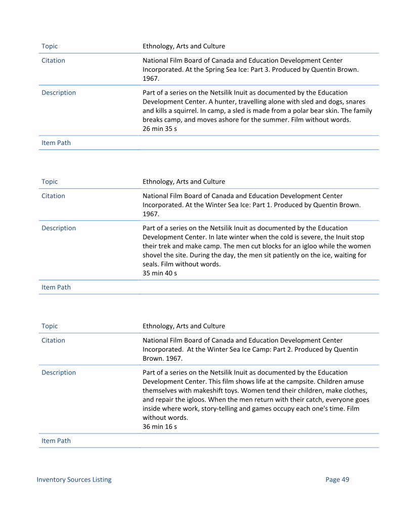
Citation National Film Board of Canada and Education Development Center Incorporated. At the Spring Sea Ice: Part 3. Produced by Quentin Brown. 1967.
Description Part of a series on the Netsilik Inuit as documented by the Education Development Center. A hunter, travelling alone with sled and dogs, snares and kills a squirrel. In camp, a sled is made from a polar bear skin. The family breaks camp, and moves ashore for the summer. Film without words.26 min 35 s
Topic Ethnology, Arts and Culture
Item Path
Citation National Film Board of Canada and Education Development Center Incorporated. At the Winter Sea Ice: Part 1. Produced by Quentin Brown. 1967.
Description Part of a series on the Netsilik Inuit as documented by the Education Development Center. In late winter when the cold is severe, the Inuit stop their trek and make camp. The men cut blocks for an igloo while the women shovel the site. During the day, the men sit patiently on the ice, waiting for seals. Film without words.35 min 40 s
Topic Ethnology, Arts and Culture
Item Path
Citation National Film Board of Canada and Education Development Center Incorporated. At the Winter Sea Ice Camp: Part 2. Produced by Quentin Brown. 1967.
Description Part of a series on the Netsilik Inuit as documented by the Education Development Center. This film shows life at the campsite. Children amuse themselves with makeshift toys. Women tend their children, make clothes, and repair the igloos. When the men return with their catch, everyone goes inside where work, story‐telling and games occupy each one's time. Film without words.36 min 16 s
Topic Ethnology, Arts and Culture
Item Path
Inventory Sources Listing Page 49

Citation National Film Board of Canada and Education Development Center Incorporated. At the Winter Sea Ice Camp: Part 3. Produced by Quentin Brown. 1967.
Description Part of a series on the Netsilik Inuit as documented by the Education Development Center. In this part, work begins on a spacious community igloo. When the men return to their hunt, the women continue with their work and play games with the children. A seal is dragged into the igloo to be shared by everyone, including the dogs, who are called in to clean up. Film without words.30 min 16 s
Topic Ethnology, Arts and Culture
Item Path
Citation National Film Board of Canada and Education Development Center Incorporated. At the Winter Sea Ice Camp: Part 4. Produced by Quentin Brown. 1967.
Description Part of a series on the Netsilik Inuit as documented by the Education Development Center. This film shows the life of the community inside the igloo. A stone chip is removed from a woman's eye. Men and women gamble at spear‐the‐peg game. Day ends with a drum performance. The next day the big igloo is deserted and the Inuit are again trekking over the broad expanse of sea ice. Film without words.34 min 40 s
Topic Ethnology, Arts and Culture
Item Path
Inventory Sources Listing Page 50

All Conservation Areas
Citation Riewe, Rick. The Nunavut Atlas (Edmonton: Canadian Circumpolar Institute and Tungavik Federation of Nunavut, 1992).
Description
Topic Place Names
Item Path
Citation Damas, David, ed. Handbook of North American Indians : Arctic, Volume 5. General Editor William C. Sturtevant. Washington, D.C.: Smithsonian Institution, 1984.
Description
Topic Ethnology, Arts and Culture
Item Path
Citation Canada and the Tungavik Federation of Nunavut. 'Article 9 ‐ Conservation Areas.' Nunavut Land Claims Agreement. 25 May 1993. Accessed 1 February 2011. Available online at nlca.tunngavik.com/?page_id=931
Description Article 9 ‐ Conservation Areas, of the Nunavut Land Claims Agreement
Topic Interpretation, Obligations, Wildlife and Environment
Item Path http://nlca.tunngavik.com/?page_id=931
Citation Nunavut Wildlife Management Board. Minutes: Meeting No. 18. Broughton Island, NT, 12‐14 May 1998. Accessed 1 February 2011. Available online at www.nwmb.com/english/meetings/regular_meetings/pdf/rm_18.pdf.
Description Minutes for the meeting of the Nunavut Wildlife Management Board in May 1998.
Topic Obligations, Wildlife and Environment
Item Path www.nwmb.com/english/meetings/regular_meetings/pdf/rm_18.pdf
Inventory Sources Listing Page 1

Citation Nunavut. State of Knowledge in Maps. Nunavut Planning Commission, 2009.
Description This State of Knowledge in Maps Report (SOKIM) has been created by the Nunavut Planning Commission (NPC) as a first step towards the development of a Regional Land Use Plan for the entire Nunavut Settlement Area. The purpose of this document is to open up dialog and encourage feedback concerning the many data layers on the maps. The data from the maps contained herein are derived from:• Existing NPC Land Use Plans,• “Nunavut Wildlife Resource and Habitat Values Report”, prepared for the NPC, October, 2008 by Jacques Whitford• “Socio‐Demographic and Economic Sector Analysis Report”, prepared for the NPC, August, 2008 by Terriplan Consultants.
Topic Obligations, Place Names
Item Path www.nunavut.ca/userfiles/Final_sokim_combined.pdf
Citation Morrison, David. 'Inuit History.' Accessed 11 Febrary 2011. Available online at www.jrank.org/history/pages/7441/Inuit‐history.html
Description Cutural history of Arctic peoples
Topic Ethnology, Arts and Culture
Item Path http://www.jrank.org/history/pages/7441/Inuit‐history.html
Citation Stenton, Douglas R. 'Guidelines for Applicants and Holders of Nunavut Territory Archaeology and Palaeontology Permits.' Government of Nunanatu, CLEY, 2003.
Description Regulations, permits, collections management for conducting archaeological investigations in Nunavut.
Topic Archaeology
Item Path http://www.cley.gov.nu.ca/pdf/Guide_English.pdf
Inventory Sources Listing Page 2

Citation Aarluk Consulting Inc. 'Draft Options Paper.' Prepared for the Canada‐Inuit IIBA for NWAs and MBSs in Nunavut, Inuit Tourism Providers Fund, Nunavut Tunngavik Inc., Kivalliq Inuit Association, Kitikmeot Inuit Association, Qikiqtani Inuit Association, 2009.
Description As part of the implementation funding for the Conservation Areas IIBA concluded between Inuit and the Government of Canada, the Government of Canada is providing $4million to NTI for establishment and operation of an Inuit Tourism Providers Fund (ITPF). The purpose of the ITPF is to “build capacity among Inuit Tourism Providers in the Affected Communities, and to develop effective community‐based tourism services” in the adjacent communities. The bulk of the moneys will be transferred to NTI over the next five years, and must be utilized within the year received. The purpose of this Options Paper is to provide options to NTI and the RIAs for ways that the ITPF can be used most effectively and the means by which the moneys available each year should be disbursed. The options have been developed from extensive interviews with agencies involved in tourism development and tourism funding, and these options will be reviewed by at a meeting of NTI and the RIAs early in 2009‐10.
Topic Tourism
Item Path
Inventory Sources Listing Page 3

Citation Aarluk Consulting Inc. 'Qikiqtarjuaq: Community Tourism Assessment.' Prepared for the Conservation Area Inuit Impact Benefits Agreement, Inuit Tourism Providers Fund, Nunavut Tunngavik Incorporated, 2009.
Description The Inuit Impact and Benefit Agreement‐in‐Principle for National Wildlife Areas and Migratory Bird Sanctuaries in the Nunavut Settlement Area (the “Conservation Areas Inuit Impact and Benefit Agreement” or CAIIBA) contains a provision that Government of Canada provide Nunavut Tunngavik Inc. (NTI) $4 million for establishment and operation of an Inuit Tourism Providers Fund (ITPF). Development of sustainable tourism activities in Qikiqtarjuaq, related to the Akpait and Qaqulluit National Wildlife Areas, is addressed separately from the ITPF: a separate allocation of three hundred thousand dollars ($300,000) of CAIIBA funds has been specifically allocated for this purpose. NTI approached Aarluk Consulting Inc. to conduct a community tourism assessment of Qikiqtarjuaq in order to provide guidance as to how best to allocate the available funds. A key requirement established for the Community Assessment is that the report would identify those business ventures that will “have the most likely chance at success”. To meet this requirement, the Community Assessment addressed tourism opportunities and businesses that already existed or were previously planned. The primary tourism development requirements assessed in Qikiqtarjuaq involved the community’s needs for training, infrastructure, and/or marketing.
Topic Tourism
Item Path
Citation Provincial Archives of Manitoba website. 'HBC Post Map ‐ Nunavut.' n.d. Accessed 6 April 2011. Available online at www.gov.mb.ca/chc/archives/hbca/resource/cart_rec/postmap/nun_c.html
Description Interactive map showing posts of the Hudson's Bay Company in Nunavut with links to finding aids for loal records.
Topic Nunavut History
Item Path http://www.gov.mb.ca/chc/archives/hbca/resource/cart_rec/postmap/nun_c.html
Inventory Sources Listing Page 4

Citation Canada. Canadian Permanent Committee on Geographical Names. Native Canadian Geographical Names: an annotated bibliography. Ottawa: CPGN, 1997.
Description Native geographical names have a very special place in the toponymy of Canada. Although some have been the subject of considerable documentation, others have only recently been recorded from oral tradition and their use in written texts is uncommon. The Canadian Permanent Committee onGeographical Names (CPCGN) has for many years been assembling a bibliography on Canadian toponymy. Recently, with the growing interest in Native issues, members decided to concentrate their efforts on collecting information on Native toponymy, so that this part of the bibliography could be expanded and upgraded for publication.This specialized toponymic bibliography is the first of its kind in Canada to be developed from a data base covering the whole country. Of particular assistance to users will be the annotations which accompany nearly all the 1240 entries. In addition to over 1000 records on Native Canadian toponymy, we have also included, for comparison purposes, some records on Native toponymy in other countries.
Topic Place Names
Item Path http://geonames.nrcan.gc.ca/pdf/nativebibsecure_ef.pdf
Citation Nowlan, Linda. Arctic Legal Regime for Environmental Protection. IUCN Environmental Policy and Law Paper No. 44.
Description This report describes the current Arctic environmental legal regime. The report also discusses the possibility of negotiating a sustainability treaty for the Arctic, with similar high standards of environmental protection as those in the 1991 Protocol on Environmental Protection to the Antarctic Treaty. The Arctic treaty could encompass the sustainable development focus of the Arctic Council, and enshrine innovative legal approaches already in use, such as the unique role of indigenous peoples.
Topic Obligations
Item Path http://weavingaweb.org/pdfdocuments/EPLP44EN.pdf
Inventory Sources Listing Page 5

Citation Oakes, Jill E. Copper and Caribou Inuit Skin Clothing Production. Mercury series. Hull, Quebec: Canadian Museum of Civilization, 1991.
Description This study of caribou skin clothing made by Inuit seamstresses in Coppermine, Umingmaktok, Cambridge Bay and Arviat, Northwest Territories, includes information collected from seamstresses as the author constructed skin clothing under their direction, and a comparison of garments made by Copper and Caribou Inuit as well as by Paallirmiut and Ahiarmiut groups. The text includes numerous clothing patterns, for parkas, mittens, stockings, pants anboots, a list of Inuit clothing terminology, an extensive bibliography and a map.
Topic Ethnology, Arts and Culture, Interpretation, Tourism
Item Path
Citation Issenman, Betty. Sinews of survival: the living legacy of Inuit clothing. Vancouver: UBC Press, 1997.
Description
Topic Ethnology, Arts and Culture, Interpretation, Tourism
Item Path
Citation Andrews, Thomas D. 'The Land is Like a Book': Cultural Landscapes Management in the Northwest Territories, Canada.' In Ethnographic Landscapes: Perspectives from Circumpolar Nations, 2004.
Description
Topic Interpretation, Tourism
Item Path
Inventory Sources Listing Page 6

Citation Corless, Gillian. 'Community Based Tourism Planning and Policy: The Case of the Baffin Region, Nunavut'. Master thesis. Montreal: McGill University, 1999.
Description This thesis explores twenty years of community based tourism policy and planning in the Baffin Region. This rise of local participation in tourism development is reviewed. Such an approach is seen as being potentially beneficial to marginalized aboriginal people in remote areas. This, combined with political support for Inuit self determination, formed the rationale behind community based tourism policy in Baffin.With its extensive community participation program, the planning process formed a strategy for sustainable tourism. Since then, the industry has grown but some of the strategy's goals have not been met. The number of Inuit involved in the industry initially increased, but is now beginning to decline and turnover is high. lnterest in the industry, and initiatives such as training, need to arise from inside communities rather than the government. To complement traditional subsistence hunting, the tourism industry must support short term employment.
Topic Interpretation, Tourism
Item Path http://www.collectionscanada.gc.ca/obj/s4/f2/dsk1/tape4/PQDD_0034/MQ64136.pdf
Inventory Sources Listing Page 7

Citation Wachowich, Nancy. 'Making a Living, Making a Life: Subsistence and the Re‐enactment of Iglulingmiut Cultural Practices.' Ph. D. Thesis. Vancouver: University of British Columbia, 2001.
Description AbstractThis thesis is about the Inuit effort to adapt to a changing arctic environment through their engagement with outsiders in projects to document their "traditional culture". The Inuit ability to draw subsistence from what southerners perceive as an inhospitable Arctic environment has been an ongoing fascination to the western public. I argue that while westerners seek to reinforce these idealized and exotic notions of the pristine Arctic environment and of the "authentic Inuit" who inhabit it, Inuit themselves have simultaneously and deliberately drawn upon these western iconic categories to communicate their cultural knowledge for social and political ends. Based on 1997 fieldwork in the Eastern High Arctic Inuit community of Igloolik, as well as fieldwork undertaken between 1991 and 1998 in the neighbouring community of Pond Inlet, in Iqaluit and in Ottawa, my dissertation analyses various sites where Iglulingmiut (Inuit from Igloolik) and southerners come together to construct Inuit identities. Each chapter focuses on a different context where Inuit cultural traditions are produced: explorer narratives; arctic ethnography; local community projects in Igloolik; ethnographic film; life histories and national museum exhibits. Drawing on Myers notion of "culture‐making", I describe how identity construction at these sites via new representational media (print, film, museum exhibits and others) has become a form of subsistence that co‐exists with and supports traditional subsistence hunting. Yet, this social and economic strategy functions at the interface between Inuit and southern cultures. It is an intercultural process largely dependent on southern funding agencies for economic support. Just as the Inuit in the past navigated new territories in search of migratory animals, another type of navigation has emerged in this new cross‐cultural environment as Iglulingmiut seek to market their cultural representations on a global scale. Political issues related to land claims, environmental protection, sustainable development and hunting rights intensify this Inuit effort to assert themselves in global arenas. I describe how the particular dynamics of each contact zone provoke new and unique cross‐cultural dialogues as Iglulingmiut creatively draw on elements from their past to reiterate their tradition as an adaptive, hunting people.
Topic Interpretation, Oral History
Item Path http://www.collectionscanada.gc.ca/obj/s4/f2/dsk3/ftp04/NQ61191.pdf
Inventory Sources Listing Page 8
Citation Canada. Environment Canada. 'Backgrounder: Three New National Wildlife Areas Protect Key Habitat in Nunavut.' Accessed 22 March 2011. Available online at www.ec.gc.ca/default.asp?lang=En&n=714D9AAE‐1&news=C3C56CEE‐D439‐4C74‐8F63‐EDFB58A6FF78
Description
Topic Interpretation, Tourism
Item Path www.ec.gc.ca/default.asp?lang=En&n=714D9AAE‐1&news=C3C56CEE‐D439‐4C74‐8F63‐EDFB58A6FF78
Citation Canada. Statutory Orders and Regulations. SOR/2010‐118 June 3, 2010: CANADA WILDLIFE ACT. Regulations Amending the Wildlife Area Regulations. P.C. 2010‐705 June 3, 2010.
Description
Topic Obligations
Item Path
Citation Duffy, R. Quinn. The Road To Nunavut. Montreal and Kingston: McGill‐Queen’s University Press, 1988.
Description
Topic Nunavut History
Item Path
Citation Library and Archives Canada. Project Naming website. Accessed 23 March 2011. Available online at www.collectionscanada.gc.ca/inuit/index‐e.html
Description
Topic Ethnology, Arts and Culture, Oral History
Item Path www.collectionscanada.gc.ca/inuit/index‐e.html
Inventory Sources Listing Page 9

Citation McGhee, Robert. Canadian Arctic Prehistory. Ottawa: National Museums of Canada, 1978.
Description
Topic Archaeology
Item Path
Citation McGhee, Robert. 'Thule Prehistory of Canada.' Handbook of North American Indians. Edited by William C. Sturtevant. Washington: Smithsonian Institution, vol. 5, 1984, pp. 369‐376.
Description
Topic Archaeology, Ethnology, Arts and Culture
Item Path
Citation Nunavut. Regional Offices website. Accessed 1 April 2011. Available online at Cgs.gov.nu.ca/en/regional‐offices
Description
Topic Interpretation, Tourism
Item Path
Citation Bell, Jim. 'Inuit commission calls for big healing effort.. Nunatsiaq News 21 October 2010. Accessed 4 April 2011. Available online at www.nunatsiaqonline.ca/stories/article/98789_qikiqtani_inuit_commission_calls_for_big_healing_effort/
Description
Topic Ethnology, Arts and Culture, Nunavut History
Item Path
Inventory Sources Listing Page 10

Citation Taylor, D.R. Fraser. Nunavummi Nunarjuattigut Illinniarnig ‐ Learning in Nunavut through our Earth. IPY Training, Outreach and Communications Program. With Dr. Scot Nickels and the Inuit Tapiriit Kanatami. 2008. Accessed 6 April 2011. Available online at https://gcrc.carleton.ca/confluence/display/GCRCWEB/Northern+Research
Description Nunavummi Nunarjuattigut Illinniarnig ‐ Learning in Nunavut through our Earth, a three year project funded by the Canadian International Polar Year Secretariat Office in 2008 under the IPY Training, Outreach and Communications Program. D. R. Fraser Taylor is the principal investigator. A supplemental agreement to this entitled Distributed Data Management System for Northern and Traditional Knowledge ‐ Implementation Plan was received from IPY in August 2010 for the period August 2010 ‐ March 31, 2011. Partners for this supplementary agreement are Dr. Scot Nickels, Science Advisory, Inuit Tapiriit Kanatami (ITK) and Director, Inuite Qaujisarvingat: The Inuit Knowledge Centre and with Cindy Cowan, Director, Academc Studies and Community Programs, Nunavut Arctic College.The GCRC is also collaborating on Views from the North: A Collaborative Visual Repatriation Project with Inuit in Nunavut. with Carol Payne as the lead investigator
Topic Ethnology, Arts and Culture, Wildlife and Environment
Item Path
Citation Kitkmeot Inuit Association. Myths and realities of Inuit impact benefits agreements: a perspective on myths and realities of Inuit impact benefits agreements ‐ and highlights of the first IIBA negotiated under the Nunavut Land Claim Agreement. Kitikmeot Inuit Association, 1998.
Description 33 pages. Call number FC 4322.9 .C57 M9 1998.
Topic Obligations
Item Path
Citation Tagoonah, Armand, 'Tagoona Remembers'. Inuit Monthly Volume 2, no. 6 (1973): 22‐23, pp. 59‐60.
Description
Topic Oral History
Item Path
Inventory Sources Listing Page 11

Citation Alexander, S.A., T.W Barry, D.L. Dickson, H.D. Prus, and K.E. Smyth. Key areas for birds in coastal regions of the Canadian Beaufort Sea. Edmonton: Northern Oil and Gas Action Program Report, Canadian Wildlife Service, 1988.
Description
Topic Wildlife and Environment
Item Path
Citation Alexander, S.A., R.S. Ferguson, and K.J. McCormick. Key migratory bird terrestrial habitat sites in the Northwest Territories. 2nd ed. Ottawa: Canadian Wildlife Service Occasional Paper No. 71, 1991.
Description
Topic Wildlife and Environment
Item Path
Citation McGrath, Robin. 'Inuktitut Index: Summer 1972‐Summer 1985.' Inuktitut 1985. n.p.
Description
Topic Ethnology, Arts and Culture, Interpretation, Place Names
Item Path McGrath.Inuktitut Index.1985.pdf
Citation Annex 1: Amendments to the IIBA Approved at Meeting of the Parties, December 2009. Word document.
Description
Topic Obligations
Item Path
Inventory Sources Listing Page 12

Citation Hanks, Christopher C. 1996‐24, The 1825‐26 wintering place of Sir John Franklin's Second Expedition: A Dene perspective. Historic Sites and Monuments Board Agenda Paper, Parks Canada, 1996.
Description The Deline Dene Band of Deline (formerly Ft. Franklin), NWT, has proposed the site of Sir John Franklin's 1825 wintering quarters as a site of national historic significance. Fort Franklin is an important place in Canadian history because of the rich historical associations between the winter quarters of Franklin's second expedition and one of the most productive subsistence fisheries in the western Arctic. The Deline fishery on the western end of Great Bear Lake's Keith Arm has been used by the ancestors of the Sahtu Dene since time immemorial. Supplemented by the catch of Aboriginal hunters, the fishery supported the winter quarters of the second Franklin expedition between 1825 and 1827. Aboriginal Hare, Slavey and Dogrib, who frequented the shores of Great Bear Lake, provided the expedition with both direct support by trading meat, and passively by permitting Franklin's men to use their prime winter fishery. The descendants of these people, who still live by Great Bear Lake, have since become collectively known as the Sahtu Dene. As a result of their ancestors' role in provisioning the expedition, the people of Deline feel the fort is the appropriate historic site to commemorate Sahtu Dene and Metis participation in Subarctic exploration.Over‐wintering in the Subarctic was the key factor in a successful overland expedition to the Arctic. The number of men who wintered in the Subarctic determined the size of the party for summer exploration in the Arctic. Without the help of the Sahtu Dene at their winter quarters, the Franklin party could not have mapped the north slope from western Alaska east to the Coppermine River in a single season.
Topic Archaeology, Nunavut History
Item Path
Citation The Tourism Company. 'Gjoa Haven Tourism Project Detail.' Prepared for the Conservation Area Inuit Impact Benefits Agreement, Inuit Tourism Providers Fund, 2009.
Description
Topic Tourism
Item Path
Inventory Sources Listing Page 13

Citation Nunavut Tunngavik Incorporated and the Minister of Environment. Contribution Agreement for Inuit Activities Related to the Implementation of the Inuit Impact and Benefit Agreement for National Wildlife Areas and Migratory Bird Sanctuaries in the Nunavut Settlement Area. N.p., n.d.
Description
Topic Obligations, Tourism, Wildlife and Environment
Item Path
Citation Nunavut Settlement Area and the Minister of Environment. Inuit Impact and Benefit Agreement for National Wildlife Areas and Migratory Bird Sanctuaries in the Nunavut Settlement Area. N.p., n.d.
Description
Topic Obligations, Tourism, Wildlife and Environment
Item Path
Citation Paul Emingak, Acting Director of the Kitikmeot Inuit Association. Letter to David Kunuk, Director, Implementation, NTI, re: CA IIBA ITPF implementation work plan and funding request. N.p., 29 June 2009.
Description
Topic Obligations, Tourism
Item Path
Citation Kitikmeot Inuit Association. CA IIBA Implementation Work Plan, 09‐10 to 13‐14. N.p., 29 June 2009.
Description
Topic Obligations
Item Path
Inventory Sources Listing Page 14

Citation The Tourism Company. Proposed Plan for the Conservation Areas IIBA Tourism Fund. N.p., March 2009.
Description
Topic Tourism
Item Path
Citation Kivalliq Inuit Association. Coral Harbour Tourism Assessment. Winnipeg, MB: Imaituk, 18 June 2010.
Description
Topic Tourism
Item Path
Citation Fall Caribou Crossing National Historic Site Commemorative Integrity Statement. Parks Canada Agency, 1997.
Description
Topic Obligations, Tourism, Wildlife and Environment
Item Path
Citation IBA Canada. Important Bird Areas of Canada. N.p.: Bird Studies Canada, BirdLife International, and Nature Canada, 2004.
Description
Topic Wildlife and Environment
Item Path
Inventory Sources Listing Page 15

Citation Chitty, Helen. 'Canadian Arctic Wild Life Enquiry 1943‐49: With a Summary of Results Since 1933.' The Journal of Animal Ecology 19, no. 2 (November 1950): pp. 180‐193.
Description
Topic Wildlife and Environment
Item Path
Citation Collis, Dirmid R.F. 'Arctic Languages: An Awakening.' France: UNESCO, 1990, pp. 185‐240.
Description
Topic Ethnology, Arts and Culture, Place Names
Item Path
Citation Canada. Inuktitut. Department of Indian Affairs and Northern Development. Winter 1987.
Description
Topic Ethnology, Arts and Culture, Nunavut History, Obligations
Item Path
Citation Crnkovich, Mary. 'Gossip': A Spoken History of Women in the North. Ottawa: Canadian Arctic Resources Committee, 1990.
Description
Topic Ethnology, Arts and Culture, Oral History
Item Path
Inventory Sources Listing Page 16

Citation Prince of Wales Northern Heritage Centre Archives #G1992‐051. Irons, Joanne. Coppermine: A Community Remembers Its Past. 1989.
Description Transcripts from Coppermine community members recorded 1988‐89 y Joanne Irons.
Topic Oral History
Item Path
Citation Parks Canada Archives. Mannik, Hattie. Oral Histories: Baker Lake, Northwest Territories. Ottawa, 1992‐1993.
Description
Topic Oral History
Item Path
Citation Steenhoven, Geert van den. 'Song and Dance: Characteristic Life‐Expression of the Eskimo.' Eskimo 50 (March 1959): pp. 3‐6.
Description
Topic Ethnology, Arts and Culture, Interpretation
Item Path
Citation Collins, Henry B. And W.E. Taylor Jr. 'Diamond Jenness (1886‐1969).' Arctic 23, pp. 71‐91.
Description
Topic Ethnology, Arts and Culture, Nunavut History
Item Path
Inventory Sources Listing Page 17

Citation Jenness, Diamond. The Indians of Canada. Revised edition Ottawa: National Museum of Canada Bulleton No. 65 (1955): n.p.
Description
Topic Ethnology, Arts and Culture
Item Path
Citation Jenness, Stuart E. The Diary of Diamond Jenness 1913‐1916: Ethnologist with the Canadian Arctic Expedition in Northern Alaska and Canada. Hull: Canadian Museum of Civilization, 1991.
Description
Topic Ethnology, Arts and Culture, Nunavut History
Item Path
Citation Kulchisky, Peter. 'Anthropology in the Service of the State: Diamond Jenness and Canadian Indian Policy.' Journal of Canadian Studies 28 no. 2 (1993): pp. 21‐50.
Description
Topic Ethnology, Arts and Culture, Nunavut History
Item Path
Citation Richling, Barnett. 'An Anthropologist's Apprenticeship: Diamond Jenness' Papuan and Arctic Fieldwork.' Culture 9 no. 1 (1989): 71‐86.
Description
Topic Ethnology, Arts and Culture, Nunavut History
Item Path
Inventory Sources Listing Page 18

Citation Boas, Franz. The Central Eskimo. Reprint of 1888 edition. Lincoln: University of Nebraska Press, 1964.
Description
Topic Ethnology, Arts and Culture
Item Path
Citation Boas, Franz. Race, Language and Culture. Reprint of 1940 edition. New York: The Free Press, 1966.
Description
Topic Ethnology, Arts and Culture
Item Path
Citation Goldschmidt, Walter, ed. The Anthropology of Franz Boas: Essays on the Centennial of His Birth. Memoirs of the American Anthrological Association, No. 89. Menasha, WI, 1959.
Description
Topic Ethnology, Arts and Culture, Nunavut History
Item Path
Citation Herskovits, Melville J. Franz Boas: The Science of Man in the Making. New York: Charles Scribner's Sons, 1953.
Description
Topic Ethnology, Arts and Culture, Nunavut History
Item Path
Inventory Sources Listing Page 19

Citation Stocking, George W., Jr., ed. The Shaping of American Anthropology 1883‐1911: A Franz Boas Reader. New York: Basic Books, 1974.
Description
Topic Ethnology, Arts and Culture, Nunavut History
Item Path
Citation Latour, P.B. Key migratory bird terrestrial habitat sites in the Northwest Territories and Nunavut. 3rd ed. Ottawa: Canadian Wildlife Service, 2008.
Description
Topic Wildlife and Environment
Item Path
Citation Anglican Church of Canada. 'General Synod Archives.' Accessed 23 May 2011. Available online at www.anglican.ca/resources/gsarchives/
Description
Topic Arviat History, Nunavut History
Item Path http://www.anglican.ca/resources/gsarchives/
Citation Arctic Institute of North America website. Accessed 1 April 2011. Available online at www.arctic.ucalgary.ca
Description
Topic Ethnology, Arts and Culture, Nunavut History, Wildlife and Environment
Item Path www.arctic.ucalgary.ca
Inventory Sources Listing Page 20

Citation Canada. Natural Resources Canada. 'Geographical Names Search Service'. Accessed 23 March 2011. Available online at http://gnss.nrcan.gc.ca/gnss‐srt/searchName.jsp?language=en
Description
Topic Place Names
Item Path http://gnss.nrcan.gc.ca/gnss‐srt/searchName.jsp?language=en
Citation Getty Conservation Institute. Assessing the Value of Cultural Heritage. Getty Conservation Institute, 2002. Accessed online 1 April 2011. Available online at www.getty.edu/conservation/publications/pdf_publications/assessing.pdf
Description
Topic Interpretation
Item Path www.getty.edu/conservation/publications/pdf_publications/assessing.pdf
Citation McGhee, Robert. Ancient Canada. Hull: Canadian Museum of Civilization, 1989.
Description
Topic Archaeology, Ethnology, Arts and Culture
Item Path
Citation 'Migratory Bird Sanctuary Reculations, C.R.C., c1036.' Accessed 22 March 2011. Available online at www.canlii.org/en/ca/laws/regu/crc‐c‐1036/latest/crc‐c‐1036.html
Description
Topic Wildlife and Environment
Item Path www.canlii.org/en/ca/laws/regu/crc‐c‐1036/latest/crc‐c‐1036.html
Inventory Sources Listing Page 21

Citation Milton Freeman Research Limited. Inuit Land Use and Occupancy Project. Ottawa: Minister of Supply and Services 1976.
Description
Topic Ethnology, Arts and Culture
Item Path
Citation Robinson, J.L. 'Eskimo Population in the Canadian Arctic.' Canadian Geographical Journal 9, no. 3 (Sept. 1944): pp. 128–42.
Description
Topic Ethnology, Arts and Culture
Item Path
Citation Tester, Frank, and Peter Kulchyski. Tammarniit (Mistakes): Inuit Relocation in the Eastern Arctic 1939‐63. Vancouver: University of British Columbia Press, 1994.
Description
Topic Ethnology, Arts and Culture
Item Path
Citation Tester, Frank, and Peter Kulchyski. Kiumajut (Talking Back): Game Management and Inuit Rights 1900‐70. Vancouver: University of British Columbia Press, 2007
Description
Topic Ethnology, Arts and Culture, Wildlife and Environment
Item Path
Inventory Sources Listing Page 22

Citation Dorais, Louis‐Jacques. The Language of the Inuit: Syntax, Semantics, and Society in the Arctic. Montreal and Kingston: McGill‐Queen’s University Press, 2010.
Description Maps the geographical distribution and linguistic differences between the Eskaleut and Inuit languages and dialects. Providing details about aspects of comparative phonology, grammar, and lexicon as well as Inuit prehistory and historical evolution, Louis‐Jacques Dorais shows the effects of bilingualism, literacy, and formal education on Inuit language and considers its present status and future. An enormous task, masterfully accomplished, The Language of the Inuit is not only an anthropological and linguistic study of a language and the broad social and cultural contexts where it is spoken but a history of the language's speakers.
Topic Ethnology, Arts and Culture
Item Path
Citation Stenton, Douglas R., and Robert W. Park. Ancient Stone Tools of Nunavut: An Illustrated Guide. Parks Canada, 1998.
Description 59 pages. In English and Inuktitut.
Topic Archaeology
Item Path
Citation Australia ICOMOS. Code on the Ethics of Co‐existence in Conserving Significant Places. N.p., 1998.
Description 2 pages.
Topic Interpretation, Obligations
Item Path
Inventory Sources Listing Page 23

Citation Aarluk Consulting. Nunavut Heritage Network Strategic Plan, 2010‐2015. Accessed 30 March 2011. Availabe online at www.ihti.ca/eng/NHN‐StrategicPlan‐2010‐2015.pdf.
Description 67 pages. PDF available online. Also hyperlinked.
Topic Interpretation, Tourism
Item Path http://www.ihti.ca/eng/NHN‐StrategicPlan‐2010‐2015.pdf
Inventory Sources Listing Page 24

Citation
Description P. David Webster, C.M.Ottawa, OntarioMember of the Order of CanadaAwarded on April 19, 1991; Invested on October 30, 1991An adult educator in the Keewatin district of the Northwest Territories for many years, he was one of the first to begin reversing the tragedy of a people who were losing their language and culture. He is greatly respected for his tireless efforts at instigating new programs, including retraining for unemployed youth and introducing elders into the classrooms, thus helping to revive and strengthen the Inuit heritage during a time of intense technological, economic and social change. David also managed the Inuit Culture and Linguistics program of the Department of Indian and Northern Affairs (including responsibility for Inuktitut magazine) before leaving INAC to work for several years for Parks Canada as an Inuit cultural specialist, managing the process which produced the 1998 thematic study of Inuit history and spearheading the pilot projects which led to designation of national historic sites near Arviat and near Baker Lake. After retiring from Government he returned north and was living in Baker Lake where was serving as mayor when ill health forced him to retire and come south.
In conversation we established that David has retained no relevant reports or other papers and that his wife Sally, as head of Pauktitut for a number of years, led that organization's efforts in the areas of drugs, alcohol, and traditional costumes. •Some time around 1990 the Inuit Cultural Institute was removed from Arviat by its new head who transferred the collections to Rankin Inlet. At that time INAC realigned its cultural grants program to award grants directly to community‐based organizations instead of ‐‐ as previously ‐‐ to the ICI. •Strongly recommended Ludger Muller‐Wille and Luke Suluk for place names records; was pleased to learn that we are working with them •Some of the Baker Lake oral histories and place names surveys in the Inuit Heritage Centre, Baker Lake [Qamani'tuaq] might contain material that overlaps with the Arviat traditional use area. Otherwise there is no Arviat material in that centre.We agreed to meet for a personal chat in the spring but also agreed that he does not have information of immediate use to the NTI cultural reosurce inventory project.
P.
Topic Ethnology, Arts and Culture, Nunavut History
Item Path
Inventory Sources Listing Page 25

Citation Pelly, David. Oberholtzer Geography Research Project. Quetico Foundation and Oberholtzer Foundation, 2004‐2007.
Description A major historical geography research project, funded by the Quetico Foundation (Toronto) and the Oberholtzer Foundation (Minnesota), examining the time and place witnessed by Ernest Oberholtzer as he travelled through northern Manitoba and southern Nunavut in 1912. This research ultimately led to the writing and publication of The Old Way North in 2008. Summary from: http://www3.sympatico.ca/dpelly/projects.html
Topic Nunavut History
Item Path
Citation Pelly, David. Akiliniq Place Names Project. Baker Lake Hunters and Trappers Organization. CLEY, Government of Nunavut, 2005.
Description Akiliniq Place Names Project (on contract to the Baker Lake Hunters and Trappers Organization, funded by the Department of CLEY, Government of Nunavut) to document traditional land use and place names in the Akiliniq region of the Thelon valley, west of Baker Lake. Summary from: http://www3.sympatico.ca/dpelly/projects.html
Topic Oral History, Place Names
Item Path
Citation Pelly, David. Hanningajuq Project. Baker Lake Hunters and Trappers Organization, World Wildlife Fund Canada, Kivalliq Inuit Association, 2003‐2005.
Description Hanningajuq Project (on contract to the Hunters & Trappers Organization, Baker Lake, funded by World Wildlife Fund Canada, Kivalliq Inuit Association and others) documenting traditional land‐use, place names, legends and personal histories from all the surviving Inuit elders who formerly lived and hunted in Hanningajuq, now an uninhabited section of the Back River, in the central barrenlands, 300km northwest of Baker Lake, Nunavut. Summary from: http://www3.sympatico.ca/dpelly/projects.html
Topic Oral History, Place Names
Item Path
Inventory Sources Listing Page 26

Citation Pelly, David. Netsilik Lake Project. Inuit Heritage Trust, 2004.
Description Netsilik Lake Project (on contract to the Inuit Heritage Trust), documenting Inuit elders’ stories and memories from a traditional area near Taloyoak on the Boothia Peninsula. Summary from: http://www3.sympatico.ca/dpelly/projects.html
Topic Oral History
Item Path
Citation Pelly, David. Sacred Hunt: A Portrait of the Relationship between Seals & Inuit. Douglas and McIntyre/GreyStone, 2001.
Description
Topic Ethnology, Arts and Culture, Nunavut History, Oral History, Wildlife and Environment
Item Path
Citation Pelly, David. 'Kitikmeot' film series. Produced by Les Productions Vic Pelletier Inc., 1998.
Description 'Kitikmeot' film series, consisting of three one‐hour television documentaries: "The Voyage of the Stone," "The Drum Dancer," and "Uvajuq: The Origin of Death." David proposed the film series, wrote the story‐lines and scripts, and worked closely with the film producer, Les Productions Vic Pelletier Inc., during the filming, editing and final production. All three films deal with Inuit culture and heritage, including both historical perspectives and contemporary efforts to preserve an awareness of history. The films have been broadcast internationally (Canada, US, Europe and Australia) in English and French. Summary from: http://www3.sympatico.ca/dpelly/films.html
Topic Ethnology, Arts and Culture, Nunavut History, Oral History
Item Path
Inventory Sources Listing Page 27
Citation Pelly, David. Thelon: A River Sanctuary. Toronto: University of Toronto Press, 1996.
Description This is the definitive book about Canada's largest and oldest fully protected wilderness. An outstanding biography of a special place.
David was moved to write this book at a time when the Thelon Sanctuary was under threat, in what the federal government called a "Mineral Review." Consideration was being given to opening the Sanctuary to exploration by mining companies. Although it had been set aside in 1927, and had remained uniquely untouched ever since, the end threatened. This book, and David's cross‐country speaking tour upon its publication ‐ 40 venues in six weeks ‐ contributed to raising the Canadian public's awareness and helped generate the letter‐writing campaign which was instrumental in saving the Sanctuary.
In his preface, David writes: "It is the richness of human experience, layered on top of the natural splendour of the river valley and its wildlife, that really sets the Thelon apart. The place has a history, both Native and non‐Native, which gives it standing beyond the intrinsic value of wilderness itself. That may prove to be the difference between preservation and destruction of the Thelon wilderness; history may be its saving grace. This book is my attempt to render that history accessible, thinking it may make a difference to the future� Wilderness, to survive as wilderness, needs a voice. Its own voice cannot be heard beyond those who enter it as a sanctum. It cannot speak for itself, to defend itself against our intrusions. That underlies my motive for writing this book, to add my effort to the communal voice speaking on behalf of the Thelon wilderness."
David tells the Thelon's story, exploring the mystery of Man's relationship with this special place in the heart of Canada's vast arctic barrenlands. From Thanadelthur and Telaruk to JW Tyrrell, John Horny and Eric Morse, the history is detailed, complete and exciting. The Thelon is the setting for a compelling Canadian adventure tale with all its drama, intrigue, joy and tragedy."
Topic Nunavut History, Wildlife and Environment
Item Path
Inventory Sources Listing Page 28

Citation Pelly, David. Ukkusiksalik (Wager Bay) Oral History Project. Parks Canada, 1996.
Description Ukkusiksalik [Wager Bay] Oral History Project (Parks Canada contract). Follow‐up to the 1991‐92 project (below), involving travel in Wager Bay with five elders and their families, to old campsites and hunting grounds, to record stories and memories at these historic sites, then to produce a comprehensive historical synthesis entitled "The History of Ukkusiksalik.'
Topic Oral History
Item Path
Citation Pelly, David. Wager Bay Oral History Project. Parks Canada, 1991‐1992.
Description Wager Bay Oral History Project (Parks Canada contract). A two‐volume oral history and historical analysis of the proposed National Park surrounding Wager Bay, based on interviews with 20 Inuit elders, former residents of the area, conducted over a two‐year period of community visits. Summary from: http://www3.sympatico.ca/dpelly/projects.html
Topic Oral History
Item Path
Inventory Sources Listing Page 29

Queen Maud Gulf Migratory Bird Sanctuary
Repository CMC Archaeology Archives
Repository Type Archives
Collection or Fonds
Series, Volume or File Ms. 700
Consulted Yes
Search Parameters Archaeology; Cambridge Bay
Relevance High
General Description Multi‐volume with two copies of the report, field books and artifact plates.
Materials Textual; images
Researcher(s) N. Brandon
Follow Up n/a
Repository CMC Archaeology Archives; Contentworks
Repository Type Archives
Collection or Fonds
Series, Volume or File Ms. 1254
Consulted Yes
Search Parameters Archaeology; Bathurst Inlet
Relevance High
General Description Report
Materials Textual
Researcher(s) N. Brandon
Follow Up n/a
Collections Listing Page 1

Repository CMC Archaeology Archives
Repository Type Archives
Collection or Fonds
Series, Volume or File Ms. 1405
Consulted Yes
Search Parameters Archaeology; Victoria Island
Relevance Moderate
General Description Letter to Dr. R.K.S. Lee of the NMNS from W.E. Taylor, Jr. acknowledging receipt of artifacts, b&w photos, and colour slides. Photographs of sites (cairns and tent rings) on Victoria Island south of Dehaven Point and at Cape Svedrup. Also south of Melbourne Island in the SW Queen Maud Gulf area (Foggy Bay).
Materials Textual; images
Researcher(s) N. Brandon
Follow Up n/a
Repository CMC Archaeology Archives
Repository Type Archives
Collection or Fonds
Series, Volume or File Ms. 1582
Consulted Yes
Search Parameters Archaeology; Back River
Relevance Low
General Description Memo summarizing several sites in Ontario and NWT.
Materials Textual
Researcher(s) N. Brandon
Follow Up n/a
Collections Listing Page 2

Repository CMC Archaeology Archives
Repository Type Archives
Collection or Fonds
Series, Volume or File Ms. 1663
Consulted Yes
Search Parameters Archaeology; Back River
Relevance High
General Description 1970 Back River area survey notes ‐ Tin boat site, Chip site, Empty House site, Two Falcons site, Franklin Lake site, No Rapids site, Lemming site.
Materials Textual
Researcher(s) N. Brandon
Follow Up n/a
Repository CMC Archaeology Archives; Contentworks
Repository Type Archives
Collection or Fonds
Series, Volume or File Ms. 2159
Consulted Yes
Search Parameters Archaeology; Netsilikt Inuit
Relevance Moderate
General Description Progress report on surveys and excavations in the regions of Crescent Harbour, Victoria Harbour, Felix Harbour, Sheriff Harbour, Sherman Inlet, Todd Island, Lord Mayor Bay, Netsilik River/Netsilik Lake, Montreal Island and northern M'Clintock Channel ‐ Stefansson Island, Goldsmith Channel. A total of 75 archaeological sites were recorded, of which approximately 5 had been previously reported. Cultural occupations/affiliations include recent Inuit, 19th century Inuit, Thule Eskimo, Palaeoeskimo, and European expedition material and/or graves.
Materials Textual
Researcher(s) N. Brandon
Follow Up n/a
Collections Listing Page 3

Repository CMC Archaeology Archives; Contentworks
Repository Type Archives
Collection or Fonds
Series, Volume or File Ms. 1993
Consulted Yes
Search Parameters Archaeology; Netsilikt Inuit
Relevance Moderate
General Description Preliminary report
Materials Textual
Researcher(s) N. Brandon
Follow Up n/a
Repository CMC Archaeology Archives
Repository Type Archives
Collection or Fonds
Series, Volume or File Ms. 3106
Consulted Yes
Search Parameters Archaeology; Karrak Lake
Relevance High
General Description Descriptions for 5 sites observed in 1976 and 1988 and location data for the 3 sites located in 1988 ‐ the stone corral, stone column and Diamond tent ring sites. Maps of the Karrak Lake region indication site locations. Plans/maps of the stone corral and stone column sites. Photos of the Karrak Lake region, the stone corral, tent rings on esker N of corral, stone igloo (cache), stone man, stone column site, stone column, square "post" hole.
Materials Textual; images
Researcher(s) N. Brandon
Follow Up n/a
Collections Listing Page 4

Repository CMC Archaeology Archives
Repository Type Archives
Collection or Fonds
Series, Volume or File Ms. 3130
Consulted Yes
Search Parameters Archaeology
Relevance Low
General Description Faunal catalogue; correspondence‐cover letter
Materials Textual
Researcher(s) N. Brandon
Follow Up n/a
Repository CMC Archaeology Archives
Repository Type Archives
Collection or Fonds
Series, Volume or File Ms. 3244
Consulted Yes
Search Parameters Archaeology; Sturt Point; Cape Peel
Relevance Moderate
General Description Report that compares two archaeological sites
Materials Textual
Researcher(s) N. Brandon
Follow Up n/a
Collections Listing Page 5

Repository CMC Archaeology Archives
Repository Type Archives
Collection or Fonds
Series, Volume or File Ms. 3864
Consulted Yes
Search Parameters Archaeology; Hope Bay; Roberts Bay
Relevance High
General Description Consultant's report
Materials Textual; images
Researcher(s) N. Brandon
Follow Up n/a
Repository CMC Archaeology Archives
Repository Type Archives
Collection or Fonds
Series, Volume or File Ms. 3934
Consulted Yes
Search Parameters Archaeology; Hope Bay; Roberts Bay
Relevance High
General Description Consultant's report
Materials Textual; images
Researcher(s) N. Brandon
Follow Up n/a
Collections Listing Page 6

Repository CMC Archaeology Archives
Repository Type Archives
Collection or Fonds
Series, Volume or File Ms. 4293
Consulted Yes
Search Parameters Archaeology; Hope Bay; Roberts Bay
Relevance High
General Description Consultant's report
Materials Textual; images
Researcher(s) N. Brandon
Follow Up n/a
Repository CMC Archaeology Archives
Repository Type Archives
Collection or Fonds
Series, Volume or File Ms. 4484
Consulted Yes
Search Parameters Archaeology; Hope Bay; Roberts Bay
Relevance High
General Description Consultant's report
Materials Textual; images
Researcher(s) N. Brandon
Follow Up n/a
Collections Listing Page 7

Repository CMC Archaeology Archives
Repository Type Archives
Collection or Fonds
Series, Volume or File Ms. 4509
Consulted Yes
Search Parameters Archaeology; Hope Bay; Roberts Bay
Relevance Low
General Description Correction of coordinates for some sites
Materials Textual
Researcher(s) N. Brandon
Follow Up n/a
Repository CMC Archaeology Archives
Repository Type Archives
Collection or Fonds
Series, Volume or File Ms. 4765
Consulted Yes
Search Parameters Archaeology; Hope Bay; Roberts Bay
Relevance High
General Description Consultant's report
Materials Textual; images
Researcher(s) N. Brandon
Follow Up n/a
Collections Listing Page 8

Repository CMC Archaeology Archives
Repository Type Archives
Collection or Fonds
Series, Volume or File Ms. 4024
Consulted Yes
Search Parameters Archaeology; Hope Bay; Roberts Bay
Relevance High
General Description Consultant's report
Materials Textual; images
Researcher(s) N. Brandon
Follow Up n/a
Repository CMC Archaeology Archives; Contentworks
Repository Type Archives
Collection or Fonds
Series, Volume or File Ms. 4873
Consulted Yes
Search Parameters Archaeology; Kent Peninsula; King William Island
Relevance Moderate
General Description Report
Materials Textual
Researcher(s) N. Brandon
Follow Up n/a
Collections Listing Page 9

Repository CMC Archaeology Archives
Repository Type Archives
Collection or Fonds
Series, Volume or File Ms. 4972
Consulted Yes
Search Parameters Archaeology; Jenny Lind Island; CAM‐1
Relevance High
General Description Consultant's report
Materials Textual; images; disk
Researcher(s) N. Brandon
Follow Up n/a
Repository CMC Archaeology Archives
Repository Type Archives
Collection or Fonds
Series, Volume or File Ms. 4857
Consulted No
Search Parameters Archaeology; Simpson River
Relevance
General Description Summary report of descriptions of archaeological sites observed on a canoe trip, Simpson River, summer 2001. David Pelly
Materials Textual
Researcher(s) N. Brandon
Follow Up n/a
Collections Listing Page 10

Repository CMC Archaeology Archives
Repository Type Archives
Collection or Fonds
Series, Volume or File Ms. 3996
Consulted No
Search Parameters Archaeology; Perry River
Relevance
General Description Site forms; Kennecott Canada
Materials Textual
Researcher(s) N. Brandon
Follow Up n/a
Repository CMC Archaeology Archives
Repository Type Archives
Collection or Fonds
Series, Volume or File Ms. 4858
Consulted No
Search Parameters Archaeology; Simpson River
Relevance
General Description Summary report of descriptions of archaeological resources encountered during a canoe trip, Pitok River, 1999. Published article entitled, "Going Home to Kutgajuk" (Above and Beyond, July/August 2000).
Materials Textual
Researcher(s) N. Brandon
Follow Up n/a
Collections Listing Page 11

Repository Contentworks
Repository Type
Collection or Fonds
Series, Volume or File Gordon 1994
Consulted Yes
Search Parameters Copper Inuit; Bathurst Inlet
Relevance
General Description Short article about the Nadlok Site (archaeology); transitional Thule to Copper Inuit
Materials Textual
Researcher(s) N. Brandon
Follow Up
Repository CLEY: Nunavut Archives
Repository Type Archives
Collection or Fonds David Pelly Fonds NU‐7
Series, Volume or File Series II
Consulted
Search Parameters
Relevance
General Description Perry River Project, 2003; These are interviews with Inuit Elders that documented the experiences of seven Inuit families that had to relocate to Gjoa Haven when the trading post at Perry River was closed in 1967.
Materials A. Nine audio cassette‐tape records (2003); B. Bound copy of Perry River to Gjoa Haven transcripts
Researcher(s) P. Goldring
Follow Up For information contact Edward Atkinson, Nunavut Archivist, [email protected]
Collections Listing Page 12

Repository Prince of Wales Northern Heritage Centre
Repository Type Archives
Collection or Fonds Howard Rokeby‐Thomas fonds Accession Number N‐1993‐008.
Series, Volume or File
Consulted No
Search Parameters
Relevance Moderate
General Description Black and white photos of life in the Arctic
Materials 21 Black and white photos
Researcher(s) P. Goldring
Follow Up Search NWT Archives databases at http://pwnhc.learnnet.nt.ca/databases/Archives/index.asp
Repository Prince of Wales Northern Heritage Centre
Repository Type Archives
Collection or Fonds Jack Wood family fonds Accession No. N‐1988‐041
Series, Volume or File
Consulted No
Search Parameters
Relevance Moderate
General Description 5 cm of textual material ; 916 photographs : 809 b&w prints and 107 b&w negatives; Administrative history or biographical sketch
Materials 916 Photos, 809 B&W Prints, 107 B&W Negatives, 5cm of text
Researcher(s) P. Goldring
Follow Up Search NWT Archives databases at http://pwnhc.learnnet.nt.ca/databases/Archives/index.asp
Collections Listing Page 13

Repository Prince of Wales Northern Heritage Centre
Repository Type Archives
Collection or Fonds Raymond De Coccola and Paul King fonds
Series, Volume or File
Consulted No
Search Parameters
Relevance Moderate
General Description Jesuit biography
Materials 457 page manuscript
Researcher(s) P. Goldring
Follow Up Search NWT Archives databases at http://pwnhc.learnnet.nt.ca/databases/Archives/index.asp
Repository Prince of Wales Northern Heritage Centre
Repository Type Archives
Collection or Fonds Stephen Angulalik fonds
Series, Volume or File
Consulted No
Search Parameters
Relevance Moderate
General Description Biography and accompanying photos for life of S. Angulalik, hunter and trader
Materials 86 cm of textual material 474 photographs : b&w printsAdministrative history or biographical sketch
Researcher(s) P. Goldring
Follow Up Search NWT Archives databases at http://pwnhc.learnnet.nt.ca/databases/Archives/index.asp
Collections Listing Page 14
Repository Prince of Wales Northern Heritage Centre
Repository Type Archives
Collection or Fonds Miriam Aglukkaq fonds
Series, Volume or File
Consulted No
Search Parameters
Relevance High
General Description Cultural preservation data assembled by Inuk schoolteacher
Materials 18 audio cassettes; 35 videocassettes : 8 mm, 4 DAT audio cassettes
Researcher(s) P. Goldring
Follow Up Search NWT Archives databases at http://pwnhc.learnnet.nt.ca/databases/Archives/index.asp
Repository Prince of Wales Northern Heritage Centre
Repository Type Archives
Collection or Fonds Marjory Robertson fonds
Series, Volume or File
Consulted No
Search Parameters
Relevance Moderate
General Description Photos and interview of Marjory Robertson who lived in Cambridge Bay, subject of interview
Materials Physical description 1 audio cassette 1 DAT audio cassette 34 photographs : b&w negatives
Researcher(s) P. Goldring
Follow Up Search NWT Archives databases at http://pwnhc.learnnet.nt.ca/databases/Archives/index.asp
Collections Listing Page 15

Repository Prince of Wales Northern Heritage Centre
Repository Type Archives
Collection or Fonds Ian Mackay Christie fonds
Series, Volume or File
Consulted No
Search Parameters
Relevance Moderate
General Description Audio interview re life in central arctic, photos of schooner and Central Arctic text re: death of Ian Christie
Materials 3 sound cassettes 1 folder of textual material 3 DAT audio cassettes 36 photographs : b&w prints
Researcher(s) P. Goldring
Follow Up Search NWT Archives databases at http://pwnhc.learnnet.nt.ca/databases/Archives/index.asp
Repository Prince of Wales Northern Heritage Centre
Repository Type Archives
Collection or Fonds Canon Harold Webster fonds
Series, Volume or File
Consulted No
Search Parameters
Relevance Moderate
General Description Photos of family, Inuit '27‐'44. Telegrams to Edmonton Journal
Materials 1 folder of textual material ; 46 photographs : b&w prints
Researcher(s) P. Goldring
Follow Up Search NWT Archives databases at http://pwnhc.learnnet.nt.ca/databases/Archives/index.asp
Collections Listing Page 16

All
Repository Library and Archives of Canada
Repository Type
Collection or Fonds RG85M 77803/16.Inuit Land Use and Occupancy Records
Series, Volume or File
Consulted No
Search Parameters
Relevance High
General Description See Description on LAC Website at http://collectionscanada.gc.ca/ourl/res.php?url_ver=Z39.88‐2004&url_tim=2011‐02‐15T15%3A21%3A53Z&url_ctx_fmt=info%3Aofi%2Ffmt%3Akev%3Amtx%3Actx&rft_dat=3677893&rfr_id=info%3Asid%2Fcollectionscanada.gc.ca%3Apam.This is the master collection of data on land use gathered through interviews with Inuit experts and creation of map biographies. Quantity of types of data vary among communities. Numerous individuals are named, which limits access because to some material under the Privacy Act. his information was heavily compressed for publication in three volumes in 1976.
Materials Maps; audio cassettes; typed transcripts and lists; 361 archival catalogue entries; 280 + 177 hours audio tapes; file lists at http://collectionscanada.gc.ca/ourl/res.php?url_ver=Z39.88‐2004&url_tim=2011‐02‐23T19%3A28%3A14Z&url_ctx_fmt=info%3Aofi%2Ffmt%3Akev%3Amtx%3Actx&rft_dat=3677893&rfr_id=info%3Asid%2Fcollectionscanada.gc.ca%3Apam
Researcher(s) P. Goldring
Follow Up Obtain lists and detailed inventory material from the responsible cartographic archivist, Marc.Cockburn@lac‐bac.gc.ca 819‐934‐6823
Collections Listing Page 1

Repository Library and Archives of Canada
Repository Type
Collection or Fonds Photographic holdings
Series, Volume or File
Consulted Yes
Search Parameters
Relevance Medium
General Description LAC has large collections of government photographs and a smaller quantity of private photographs taken in Nunavut during the 19th and 20th centuries. Because most of these were taken by scientists, administrators, tourists and other transients, the identification of individuals is poor and the identification of places may be imprecise or unreliable. LAC has worked with Inuit since 2005 to identify individuals in some photographs. See http://www.collectionscanada.gc.ca/inuit/index‐e.html.
Materials Photographic negatives, slides and prints, many in albums. Thousands of items. A limited number of items are online and can be viewed at http://www.collectionscanada.gc.ca/lac‐bac/search/arch
Researcher(s) P. Goldring
Follow Up Online descriptive database and online images to be searched
Collections Listing Page 2

Repository Library and Archives of Canada
Repository Type
Collection or Fonds British Admiralty Charts
Series, Volume or File
Consulted Yes
Search Parameters Davis Strait; Hudson Bay; Arctic Ocean
Relevance Medium
General Description LAC has a major holding of British naval cartography, including hydrographic charts of the Davis Strait area. Many of these, updated and reprinted from time to time, incorporate the most recent topnymic information derived from field work.
Materials Hydrographic charts; about 10 relevant sheets, with repeated revisions and updates; most are online
Researcher(s) P. Goldring
Follow Up Currently incomplete
Collections Listing Page 3

Repository Library and Archives of Canada
Repository Type
Collection or Fonds RG85, Northern Administration Branch Fonds
Series, Volume or File
Consulted Yes
Search Parameters
Relevance High
General Description RG85 contains records of the northern affairs program, mainly dealing with operational matters, information gathering and input to policy. After 1951 files were created for each community. Some files were transferred to Yellowknife in 1967 and others may have been stripped, i.e. contents removed for destruction.
Search tools include an older online database (Archivianet), a newer database which has some overlap with the older one, and paper finding aids held at LAC.
Materials Files were created to document the affairs of individuals, institutions and government bodies and operations in each community. Topics may include general administration, health and welfare (community as well as individuals), town planning, schools, arts and crafts, Game Act.
Researcher(s) P. Goldring
Follow Up 1. Use online and paper indexes to create community and CA bibliographies; 2. search most relevant files
Collections Listing Page 4

Repository Natural Resources Canada: Geographical Names Board of Canada Secretariat
Repository Type
Collection or Fonds Operational files
Series, Volume or File
Consulted Yes
Search Parameters NTS Map sheets
Relevance Medium
General Description The Secretariat coordinates federal interests in research and officialization of geographical names in Canada. Its files document past scientific field work, mapping research and office treatment of geographical names. Records before about 1960 are in the Library and Archives of Canada, with microformat copies at the Secretariat. There is some overlap between these Secretariat files and files with a similar structure (organized by sectional map sheet) held by the Government of Nunavut's Toponymy program.
Materials Textual files with numerous maps and lists of toponyms. Recent files are organized by NTS Map Sheet number at all the available scales and include administrative correspondence, research inquiries and decisions about names.
Researcher(s) P. Goldring; H. Goldring
Follow Up Contact should be made with Jocelyne Revie, Executive Secretary, GNBC, 615 Booth Street, 06Ath Floor, Room 634A; Ottawa, Ontario K1A 0E9 ; Telephone : 613‐992‐4100 ; Jocelyne.Revie@NRCan‐RNCan.gc.ca
Collections Listing Page 5

Repository Kemp, William
Repository Type
Collection or Fonds Maps and research files
Series, Volume or File
Consulted No
Search Parameters
Relevance Medium
General Description Dr. Kemp is a former professor at McGill University who managed the southern Baffin Island sector of the Inuit Land Use and Occupancy Project in the 1970s. He continues to do extensive research on the records of the Land Use Projects and can advise on the contents of those records. The records themselves are in the Library and Archives of Canada
Materials
Researcher(s) P. Goldring
Follow Up Contact info: [email protected]‐514‐938‐5255
Collections Listing Page 6

Repository Arctic Institute of North America (University of Calgary)
Repository Type Website
Collection or Fonds ASTIS Bibliography
Series, Volume or File Nunavut Data Base
Consulted Yes
Search Parameters Names of conservation areas and affected communities incl. former communities
Relevance High
General Description Arctic Science and Technology Information System contains 72,000 records of citations to publications and descriptions of research projects. Research project descriptions are prepared using information collected by the organizations that licence northern research. The Nunavut Database is a subset database providing about 30,000 individual records relating chiefly to the social sciences and life sciences in Nunavut. It is an excellent source of information on research projects but by no means exhaustive in reporting research publications. Selected titles and projects are included in the NTI Reference Bibliography.
Materials Online
Researcher(s) H. Goldring
Follow Up Continuous updating requires regular follow‐up at http://136.159.147.171/ned/
Collections Listing Page 7

Repository Social Sciences and Humanities Research Council ‐ database of grants
Repository Type Website
Collection or Fonds Awards Search Engine
Series, Volume or File
Consulted Yes
Search Parameters Geographical
Relevance Moderate
General Description SSHRC makes grants for research throughout Canada and publishes some details of grants online. Lead researchers are always named but not the communities in which they are working.
Materials Online
Researcher(s) H. Goldring
Follow Up Annual updating required at http://www.outil.ost.uqam.ca/CRSH/RechProj.aspx?vLangue=Anglais
Repository Government of Nunavut; Department of Community Elders Language and Youth; Toponymy Program
Repository Type Government
Collection or Fonds Official records of Toponymy Program
Series, Volume or File
Consulted Yes
Search Parameters Relevant map sheets
Relevance High
General Description The Toponymy program works closely with communities to identify, document and give approval to local geographic names. Toponymy information is gathered through a combination of field, archival, and library research.
Materials Maps; official correspondence and decisions on proposed names
Researcher(s) P. Goldring
Follow Up Contact Pauline Arnatsiaq, Nunavut Toponymist, Department of Culture, Language, Edlers and Youth ; PO Box 310 ; IGLOOLIK NU X0A 0L0 ; Ph. 1‐867‐934‐2042 ; e‐mail [email protected]
Collections Listing Page 8