Northumbria's southern frontier: a review: Northumbria's southern frontier: a review
27
Early Medieval Europe () – © Blackwell Publishing Ltd , Garsington Road, Oxford OX DQ, UK and Main Street, Malden, MA , USA Blackwell Publishing Ltd Oxford, UK EMED Early Medieval Europe 0963-9462 (c) Blackwell Publishing Ltd. XXX Original Article Northumbria’s southern frontier: a review > Northumbria’s southern frontier: a review N H Northumbria’s southern frontier was arguably the most important polit- ical boundary inside pre-Viking England. It has, however, attracted little scholarly attention since Peter Hunter Blair’s seminal article in Archaeo- logia Aeliana in 1948, which later commentators have generally followed rather uncritically. This essay reviews his arguments in the light of more recent research and casts doubt on several key aspects of his case: firstly, it contests his view that this boundary was fundamental to the naming of both southern and northern England and its kingdoms; secondly, it queries the supposition that the Roman Ridge dyke system is likely to have been a Northumbrian defensive work; thirdly, it critiques the view that the Grey Ditch, at Bradwell, formed part of the frontier; and, finally, it argues against the boundary in the west being along the River Ribble. Rather, pre-Viking Northumbria more probably included those parts of the eleventh-century West Riding of Yorkshire which lie south of the River Don, with a frontier perhaps often identical to that at Domesday, and it arguably met western Mercia not on the Ribble but on the Mersey. It was probably political developments in the tenth century, and particularly under Edward the Elder and his son Athelstan, that led to the Mercian acquisi- tion of southern Lancashire and the development of a new ecclesiastical frontier between the sees of Lichfield and York on the Ribble, in a period that also saw the York archdiocese acquire northern Nottinghamshire. Early medieval boundaries in Britain – whether political or otherwise – have begun in recent decades to attract renewed attention. 1 However, few have been the object of long-term research projects: only the western margins of Anglo-Saxon England, towards Wales, have seen successive, extended campaigns across the twentieth century. Archaeological research here has centred on exploration of the massive linear earthworks of 1 See, for example, the papers offered in Boundaries in Early Medieval Britain, ed. D. Griffiths, A. Reynolds and S. Semple, Anglo-Saxon Studies in Archaeology and History 12 (Oxford, 2003).
-
Upload
manchester -
Category
Documents
-
view
0 -
download
0
Transcript of Northumbria's southern frontier: a review: Northumbria's southern frontier: a review

Early Medieval Europe
(
)
–
© Blackwell Publishing Ltd
,
Garsington Road, Oxford OX
DQ, UK and
Main Street, Malden, MA
, USA
Blackwell Publishing LtdOxford, UKEMEDEarly Medieval Europe0963-9462(c) Blackwell Publishing Ltd.XXXOriginal Article
Northumbria’s southern frontier: a review
>
Northumbria’s southern frontier: a review
N
H
Northumbria’s southern frontier was arguably the most important polit-ical boundary inside pre-Viking England. It has, however, attracted littlescholarly attention since Peter Hunter Blair’s seminal article in
Archaeo-logia Aeliana
in 1948, which later commentators have generally followedrather uncritically. This essay reviews his arguments in the light of morerecent research and casts doubt on several key aspects of his case: firstly,it contests his view that this boundary was fundamental to the namingof both southern and northern England and its kingdoms; secondly, itqueries the supposition that the Roman Ridge dyke system is likely to havebeen a Northumbrian defensive work; thirdly, it critiques the view thatthe Grey Ditch, at Bradwell, formed part of the frontier; and, finally, itargues against the boundary in the west being along the River Ribble.Rather, pre-Viking Northumbria more probably included those parts ofthe eleventh-century West Riding of Yorkshire which lie south of the River Don,with a frontier perhaps often identical to that at Domesday, and it arguablymet western Mercia not on the Ribble but on the Mersey. It was probablypolitical developments in the tenth century, and particularly underEdward the Elder and his son Athelstan, that led to the Mercian acquisi-tion of southern Lancashire and the development of a new ecclesiasticalfrontier between the sees of Lichfield and York on the Ribble, in a periodthat also saw the York archdiocese acquire northern Nottinghamshire.
Early medieval boundaries in Britain – whether political or otherwise –have begun in recent decades to attract renewed attention.
1
However,few have been the object of long-term research projects: only the westernmargins of Anglo-Saxon England, towards Wales, have seen successive,extended campaigns across the twentieth century. Archaeological researchhere has centred on exploration of the massive linear earthworks of
1
See, for example, the papers offered in
Boundaries in Early Medieval Britain
, ed
.
D. Griffiths,A. Reynolds and S. Semple, Anglo-Saxon Studies in Archaeology and History 12 (Oxford,2003).

Early Medieval Europe
(
) © Blackwell Publishing Ltd
392
Nick Higham
(primarily) Offa’s and Wat’s Dykes,
2
while additional research has focusedon evidence for the politico-cultural interface with the Welsh kingdomsprovided by Domesday Book.
3
In contrast, other major political fron-tiers or frontier zones generally lack impressive archaeological featuresand had already been internalized by the expanding late Anglo-Saxonstate long before 1066, so have proved more resistant to investigation.Use of the Thames, for example, as a boundary between the pre-Vikingkingdom of Kent, to the south, and the East Saxons to the north, isevidenced by Bede’s comments on the foundation of a see at Londonin the first decade of the seventh century.
4
Despite the initial locationof a see for the West Saxons (or the
Gewisse
as Bede called them) onthe north bank of the Thames at Dorchester (Oxon.) at some datebetween 635 and 642, subsequent expansion of Mercia by King Pendasoon led to the adoption of the same river as the northern boundary ofWessex.
5
Despite various later changes of political fortune, such as thetemporary expansion of West Saxon influence to embrace London andits see late in the seventh century,
6
the Thames was the normal frontierbetween Wessex and Mercia into the ninth century and beyond.
7
Thereis, however, no obvious means today by which to research a frontiermarked by a river and devoid of earthwork defences of any sort.
Its clarity as a marker made the Thames an obvious frontier for mostof its course, but no such single, natural feature was available to delin-eate Northumbria from Mercia. These were, however, the two largestand most powerful kingdoms of Anglo-Saxon England during much ofthe seventh and eighth centuries, and the nature and locality of theinterface between them was, and is, an issue of some significance. Therehave been comparatively few attempts to explore this interface: PeterHunter Blair’s discussion, published in 1948,
8
remains the seminal work
2
Sir C. Fox,
Offa’s Dyke: A Field Survey of the Western Frontier Works of Mercia in the Seventhand Eighth Centuries
(London, 1955); F. Noble,
Offa’s Dyke Reviewed
, British ArchaeologicalReports, British Series 114 (1983); D.H. Hill, ‘Offa’s and Wat’s Dykes: Some Aspects ofRecent Work’,
Transactions of the Lancashire and Cheshire Antiquarian Society
79
(1977),pp. 21–33; M. Worthington, ‘The Wat’s Dyke – A Comment on the Work of Sir Cyril Foxin Clwyd’,
Archaeology in Clwyd
8
(1986), pp. 14–16; D. Hill and M. Worthington,
Offa’sDyke: History and Guide
(Stroud, 2003).
3
C.P. Lewis,
English and Norman Government and Lordship in the Welsh Borders, 1039–1087
,D. Phil. thesis (University of Oxford, 1985).
4
Bede,
The Ecclesiastical History of the English People
(henceforth
HE
), ed. B. Colgrave andR.A.B. Mynors (Oxford, 1969), II.3.
5
Bede,
HE
III.
6
In the Prologue to his law code, King Ine of Wessex termed Eorcenwold, bishop of London,‘my bishop’: the standard translation is D. Whitelock,
English Historical Documents
1, 2ndedn (London, 1979), p. 399.
7
Despite the acquisition of London and Oxford, and ‘all the lands which belonged to them’,in 910 on the death of his brother-in-law, Æthelræd of Mercia:
ASC(D,E)
910.
8
P.H. Blair, ‘The Northumbrians and their Southern Frontier’,
Archaeologia Aeliana
, 4th ser.
26
(1955), pp. 98–126.

© Blackwell Publishing Ltd
Early Medieval Europe
(
)
Northumbria’s southern frontier: a review
393
on the subject, which has since only been revisited explicitly by Nicho-las Brooks, very briefly in 1989,
9
myself, even more briefly, in 1993,
10
and then David Rollason in 2003,
11
in discussions most of which – andBrooks is clearly the exception here – have been too accepting of hisarguments. Blair’s was, however, very much an exercise in informedspeculation, and also a product of its time, over a half century ago, theoutcomes of which it may now be appropriate to re-visit in the light ofmore recent scholarship.
This paper attempts, therefore, to reconsider Blair’s arguments insome detail and to examine evidence drawn from all of the availablewritten sources, place-name research, field monuments and the land-scape more generally, in an attempt to increase our understanding ofthe frontier between Northumbria and Mercia.
Naming Northumbria
Blair began by examining evidence for the various names given tothe Northumbrians in written sources of the late seventh, eighth andearly ninth centuries. His strategy was to confer significance on theNorthumbrian/Mercian frontier by establishing it as the decisive featureaccording to which both peoples had been named at an early date, sopostulating that both
Nor
9
anhymbre
and
Su
9
anhymbre
were vernacularterms in common usage already by the second half of the seventhcentury. Only then did he go on to explore the actual line of theboundary.
Excluding Bede’s
Historia Ecclesiastica
, which has far more referencesto ‘Northumbrians’ than all our other sources combined and to whichwe will return, the relevant early texts to which Hunter Blair referredare offered in Table 1.
Of these six examples in five texts, none use the ‘Northumbrian’ stylewhich Bede standardized in his
Historia Ecclesiastica.
Three particularlyemphasized ‘northern-ness’, being Stephen’s
rex Aquilonalium
and
rexAquilonensium
, and Bede’s rather clumsy phrase,
transhumbrana gens adaquilonem
. By contrast, the majority use Latinized terms based on thevernacular
Hymbre
(the River Humber) to denote the ‘Anglo-Saxon’peoples living north of the Humber, who would eventually be termed‘Northumbrians’. This was certainly in use in the north, since it occurs
9
N. Brooks, ‘The Formation of the Mercian Kingdom’, in S. Bassett (ed.),
The Origins of theAnglo-Saxon Kingdoms
(London, 1989), pp. 159–70, at pp. 160–2.
10
N.J. Higham,
The Kingdom of Northumbria, 350–1100
(Stroud, 1992), pp. 142–4.
11
D. Rollason,
Northumbria, 500–1100, Creation and Destruction of a Kingdom
(Cambridge,2003), pp. 25–43.

Early Medieval Europe
(
) © Blackwell Publishing Ltd
394
Nick Higham
in the anonymous
Life of Gregory the Great
, written in Deira, arguablyat Whitby,12 in which the author refers to his own people as Humb-renses. This admittedly small body of evidence implies two styles ofdepiction for early Northumbrians, one focusing on their ‘northern-ness’, and the other on the Humber, each as the defining feature dis-tinguishing or separating them from other Angles seu Saxones.13 Theabsence of a tribal element such as is commonly used in the south (as‘East Saxons’, ‘East Angles’) is a striking feature to which we will return.
12 Accepting the traditional collation of Streanæshalch with Whitby, rather than Strensall, avillage a few kilometres north of York the name of which could easily derive from the earlierone but which has so far produced no evidence whatever for the presence of a major pre-Viking nunnery. For a brief summary and references, see M. Lapidge, The Blackwell Encyclo-pedia of Anglo-Saxon England (Oxford, 1999), pp. 472–3, but the point made here would beno less valid were the alternative preferred.
13 To utilize one of Bede’s terms for the English, which appears first in HE I.15.
Table 1 References to the ‘Northumbrians’ in pre-Viking insular literature as discussed by Blair, excluding Bede’s Historia Ecclesiastica
Author Date Reference Term used
‘Whitby Anon.’ c.704–14 Vita Gregorii 12 Gens nostra que dicitur Humbrenses (‘our people which is called the Humbrensans’)
Stephen of Ripon 710 × 715 Vita Wilfridi 43, 51
43: Aldfrith rex Aquilonalium (Aldfrith king of the Northern [People]’) 51: rex Alfrith Aquilonensium (‘king Aldfrith of the Northerners’)
Bede c.718 Historia Abbatum 4
Transhumbranae regionis rex (‘king of the Transhumbran region’ [referring to Ecgfrith])
Bede c.725 De Temporum Ratione
Transhumbrana gens ad aquilonem (‘Transhumbran people to the north’)
Anon. Early 8th century
Penitential attributed toTheodore, preface of the putative author
Discipulus Umbrensis (‘[H]umbrensan Disciple’)

© Blackwell Publishing Ltd Early Medieval Europe ()
Northumbria’s southern frontier: a review 395
Blair’s was not, however, an inclusive treatment of early usage. Stephenof Ripon made reference to the kings or peoples of the ‘English’ or‘Angles’ of the north eleven times in his vita. Seven of these use Ultra-humbrenses (‘the beyond-Humbrians’),14 which has obvious similaritieswith Bede’s Transhumbrana gens (‘the cross-Humbrian-people’). Elsewhere,however, he used rex Deyrorum et Berniciorum (‘king of the Deirans andBernicians’), of Oswiu and then Ecgfrith,15 and this phrase recurs inChapter 54, which purports to be quoting from a letter of Pope John,written c.704, in which Aldfrith was addressed as rex Deiorum et Berni-ciorum. This owes nothing to the previous correspondence betweenPope Boniface and King Edwin, since the latter was addressed thereinrather more portentously as rex Anglorum (‘king of the English/Angles’),16
nor from Vitalian’s address to Oswiu, in which the latter appears some-what oddly as rex Saxonum (‘king of the Saxons’).17 Any derivation forthe address, therefore, in the papal archive, would seem to be later thanthe mid-660s, and it seems very likely that this in fact reflects contem-porary practice, as conveyed to John by Wilfrid, who Stephen impliesknew him well.18 In this context, the Vita Gregorii, Chapter 9, also makesreference to Deira in the infamous punning account of Gregory’s initialacquaintance with the paganism of the English, albeit by reference to aperiod when Deirans and Bernicians were still considered separate peoples.19
These terms clearly, therefore, still had a relevance to audiences as late asthe opening years of the eighth century, who were still familiar with theearlier terms even though alternatives were by then being canvassed.
Somewhat earlier,20 Aldhelm had dispatched a lengthy and highlyrhetorical letter to his godson, King Aldfrith of Northumbria, in whichhe addressed him as ACIRCIO, Aquilonalis imperii sceptra gubernanti(‘ACIRCIUS, governing the kingdom of the northern empire’).21 Useof aquilonalis here is comparable to Stephen of Ripon’s usage a genera-tion later, and his ACIRCIUS, as a metaphor for the king himself
14 Vita Wilfridi, ed. B. Colgrave, as The Life of Bishop Wilfrid by Eddius Stephanus (Cambridge,1927), Chapters 44, 45, 47 (three instances), 58, 65.
15 Vita Wilfridi, Chapter 15, referring to AD 669, this being the earliest attempt to name thekingship in this text, and then 20, referring to the early 670s.
16 HE II.10.17 HE III.29.18 As Vita Wilfridi, Chapter 21, where Stephen has John advising Wilfrid against his habit of
nightly washing with holy water, apparently for fear that he might suffer from the cold in winter.19 The Earliest Life of Gregory the Great by an Anonymous Monk of Whitby, ed. B. Colgrave
(Lawrence, 1968), Chapter 9: ‘Tribus quoque illius nomen de qua errant proprie requisivit.Et dixerunt, “Deire” ’ (‘He asked the proper name of their own tribes. And they said “Deiri” ’).
20 Arguably not long after Aldfrith’s accession in 685. For discussion of the date, see M. Lapidgeand M. Herren, Aldhelm The Prose Works (Cambridge, 1969), p. 32, offering a probable daterange of 685 × 695. For an excellent translation, see ibid., p. 34.
21 Sancti Aldhelmi, opera quae extant, ed. J.A. Giles (Oxford, 1844), p. 216.

Early Medieval Europe () © Blackwell Publishing Ltd
396 Nick Higham
(meaning ‘from the north’),22 re-emphasizes the point. Aldhelm’s workoffers another example, therefore, where the ‘northern-ness’ of North-umbria was prioritized. It may be significant that this early usage comesin a text written by an author normally resident in England below theThames and with a very southern perspective, but it was presumablysensitive to Aldfrith’s perceptions of his own position and of the appro-priateness of different terms of reference.
Bede’s account of the synods of Hertford (673) and Hatfield (679–80) may also be admissible as containing genuine seventh-centuryterms for Northumbria,23 given that both seem to have been based oncontemporary accounts apparently written either by or on behalf ofTheodore of Canterbury, so by southerners. In 673, Wilfrid was termedNordanhymbrorum gentis episcopus (‘bishop of the people of the North-umbrians’), and in the account of the meeting at Hatfield Ecgfrith wasnamed rex Humbronensium (‘king of the Humbrians’). That these‘Humbrian’ type names occur here some two generations earlier thanother recorded instances raises the possibility that they derive from avision of the structure of Anglo-Saxon England as perceived from Can-terbury, where the emergence of an England-wide archdiocese in thelate 660s was perhaps making new demands on the political nomencla-ture of the day. Focus on the location of Wilfrid’s see north of theHumber offered a unique means of distinguishing it,24 particularly froma Canterbury-centric perspective.
It seems, therefore, that various designations for the ‘Northumbrians’were in use in parallel by the period 670–720. The oldest was arguably‘Deirans’ and ‘Bernicians’ used in tandem, harping back to the namesof what had been two separate kingships prior to the long process ofamalgamation which began under King Æthelfrith (d. c.616). Thisusage was apparently still acceptable in 704, when the pope wrote toKing Aldfrith, but was by then perhaps becoming anachronistic, giventhat the last known sub-king of the Deirans died in battle againstthe Mercians in 679, since when the kingship was apparently unitary.That said, Bede’s notice of the diocese of Whithorn as ad prouinciamBerniciorum pertinens (‘pertaining to the province of the Bernicians’),25
22 Lapidge and Herren, Aldhelm, p. 32. Circius is an example of precisely the type of obscure,literary Latin which Aldhelm delighted in, being used in classical literature for the west-north-west wind, but dropping out of use in the Middle Ages.
23 HE IV.5, IV.17(15). In each instance Bede purports to be quoting from a record of the synodmade at the time, which he had presumably obtained from Canterbury.
24 Whether or not the expansion of Wilfrid’s see south of the Humber, to include Lindsey, hadoccurred when the synod of Hertford took place is unclear. Colgrave estimated the chrono-logy as 673–5: Vita Wilfridi, Chapter 20. The terminology used would obviously have beenmore appropriate if the synod pre-dated Ecgfrith’s victory over the Mercians, on which theexpansion of Wilfrid’s see was predicated.
25 HE III.4.

© Blackwell Publishing Ltd Early Medieval Europe ()
Northumbria’s southern frontier: a review 397
confirms that at least one of the old tribal names was still in use in 731,at least in a local, ecclesiastical context. However, subsequent kings,and, from 735, archbishops, probably preferred to stress the unity of thepeople over whom they ruled, in which case the dual designation mayhave seemed both politically unhelpful and overly clumsy. No otherkingships were distinguished by such inelegant designations in theseworks: the Mercian kingship was perhaps the closest comparator interms of the multiplicity of peoples ruled but the king was uniformlydescribed as rex Merciorum (‘king of the Mercians’) from the earliestdate from which evidence survives.26 Use of ‘Deirans and Bernicians’seems to have been dying out in the early eighth century and experi-ments had by then already begun to find a replacement. Firstly, ‘Hum-brensans’ occurs in reference to King Ecgfrith in 679–80 in what wasprobably a Canterbury text. It was then adopted by the author of theVita Gregorii in Deira very early in the eighth century, by the authorof the Penitential Attributed to Theodore, and later by Bede in workspre-dating the Ecclesiastical History, adding the prepositional prefix trans(‘across’). Blair believed that the author of the Historia Brittonum, writ-ing in Wales, then used the term in the early ninth century, but theword used here (Historia Brittonum, Chapters 57 and 63) was in factAmbrones. Following Gildas, this term has the meaning of ‘savages’ andis nothing to do with the River Humber. Secondly, terms highlightingthe ‘northern-ness’ of the kingdom likewise appear initially in worksemanating from southern England, the earliest of which was againarguably a Canterbury text, the account of the synod of Hertford,673. Aldhelm, who was well acquainted with Canterbury having beentrained there, adopted a variant, arguably in the mid to late 680s, whichthen recurred in the Vita Wilfridi early in the eighth century. These twoapproaches are found in combination earliest in a document probablywritten by a member of Theodore’s household c.673 concerning thesynod of Hertford. This account was known to Bede, to whose tran-scription we owe our knowledge of it. He had used other terminologiesin both his Historia Abbatum and De Temporum Ratione, so it may wellhave been from this text that he took the term which he used compar-atively consistently in his Historia Ecclesiastica in 731.
It therefore seems difficult to justify the backdating of a vernacularversion of Nordanhymbre (or similar) in local usage in the north to thesecond half of the seventh century, as Blair postulated.27 Rather, it ismore likely to have originated as a Latin construct formulated by thosearound Theodore, in search of a designation for the northern diocese
26 As, for example, Vita Wilfridi, Chapter 20, of Wulfhere. Bede’s reproduction of the accountof the synod of Hertford (HE IV.5) similarly terms the Mercian see provinciae Merciorum.
27 Blair, ‘The Northumbrians’, p. 104.

Early Medieval Europe () © Blackwell Publishing Ltd
398 Nick Higham
and kingship, in the very different circumstances in which his arch-diocese was operative following the unification of the English churchunder the authority of Canterbury and Rome in 664.
It should also be remembered that the political separation of ‘Trans-Humbran’ England from the Midlands was heavily contested across theseventh century. King Rædwald’s victory over the Bernician Æthelfrithc.616,28 enabled him to establish the Deiran Edwin in both the northernkingdoms, and Edwin-controlled parts, at least, of the Midlands to 633.29
Penda of the Mercians invaded the north repeatedly during the 640sand early 650s,30 and then Oswiu of the Bernicians seized power innorthern Mercia, 655–8.31 Efforts to construct a kingship or overking-ship spanning the Humber failed, but the effort seems only to havebeen finally abandoned in the 680s. Ecgfrith had temporarily recoveredLindsey in the early 670s,32 but lost it in battle against the Mercians in 679,then suffered defeat and death against the Picts in 685. There was a veryreal fluidity to political boundaries between the Northumbrians andMercians, therefore, up to the last two decades of the seventh century,and nomenclature was arguably struggling to keep up.
The Latinized terminology, Nordanhymbri (usually in the genitiveplural and associated with ‘king’, ‘bishop’, or ‘people’) was only reallystandardized by Bede in 731. It occurs in forty-four separate passages inthe Ecclesiastical History, but Bede was careful to explain the meaningby a subordinate clause associated with three of its earliest occurrencesin his text,33 thus implying that this was by no means a self-explanatoryterm or widely recognized at the time. Bede had clearly re-visited theissue of the nomenclature appropriate to his own people since writingDe Temporum Ratione c.725, and decided to standardize his own usageby reference to just one of the several terms he had available to him.He adopted the form which he had come across in the official accountof the synod of Hertford, which then became by far his most commonterm. He was not, however, entirely consistent in his usage in this work,even if we set aside instances which occur in passages transcribed frompre-existing writings.34 He used, for example, provincia Anglorum (‘province
28 HE II.12.29 HE II.16: the account of Paulinus on the banks of the Trent and at Lincoln clearly implies
that Edwin controlled Lindsey.30 HE III.16, 17, 24.31 HE III.24.32 The battle by the River Trent in 679, which Ecgfrith lost to his Mercian rival, was probably
fought over the same issues: HE IV.20; see also Vita Wilfridi, Chapter 20.33 HE I.15, II.5, II, 9. These are three of the first five occurrences.34 As in HE II.10, in which he quoted Pope Boniface’s letter to King Edwin, which addressed
him as rex Anglorum (‘king of the English’). Boniface perhaps based his address on Gregory’searlier letter to Æthelberht, which Bede also quoted in I.32.

© Blackwell Publishing Ltd Early Medieval Europe ()
Northumbria’s southern frontier: a review 399
of the English’) to locate the Irish episcopacy in England before 664,35
and both regnum Anglorum (‘kingdom of the English’) and rex Anglo-rum (‘king of the English’) to describe the kingdom/kingships ofEcgfrith and Aldfrith respectively.36 Each centred on Northumbria,even if they might not be entirely exclusive to that region, and eachcould have been designated by reference to the Nordanhymbri.
There is no good reason to think, therefore, that a vernacular form,Nordanhymbre, was in circulation in the north in the seven century.Rather, ‘the Northumbrians’ is a term which is more likely to haveemerged first in its Latin form, in southern clerical circles. This hasimportant consequences for our understanding also of Su9anhymbre.As part of his case for the centrality of the Humber in naming peoplesto both north and south, Hunter Blair argued that the occurrence ofSu9anhymbre in the Anglo-Saxon Chronicle is likely to have been basedon now-lost, northern chronicles of an early date, suggesting, therefore,early witnesses to this usage.37 However, the author of the Chronicle wasvery familiar with Bede’s Ecclesiastical History and it is a far simplerexplanation of this vernacular expression that it derived from his famil-iarity with Bede’s Nordanhymbri. In practice, arguments for early usageof Su9anhymbre, or Latin versions thereof, are impossible to sustain inthe face of their omission from texts of the period.38 Even Bede fails toconstruct a Latin term, referring in his own day to the southern peoplessubject to Æthelbald of the Mercians ad confinium usque Humbraefluminis (‘to the boundary even of the River Humber’), which has morethan a passing connection with his earlier description of the northernlimits of Æthelberht’s ‘overkingship’, to which we shall return.39 Theauthor of the Vita Gregorii, in Chapter 18, used Sudrangli (‘SouthernEnglish’) in reference to Wilfrid’s monasteries south of the Humber,rather than a Latin version of Su9anhymbre, and this usage was mir-rored by a charter written for King Æthelbald in 736, which referred tohim as ‘king, not only of the Mercians, but also of all the provinces thatare called by the general name Sutangli’.40 Stephen made regular use ofMercii (‘Mercians’),41 but never offered a Latin version of Su9anhymbri,
35 HE III.26. Bede’s usage of ‘Northumbrians’ and ‘English’ has been usefully reviewed byP. Wormald, ‘The Venerable Bede and the Church of the English’, in The English ReligiousTradition and the Genius of Anglicanism, ed. G. Rowell (Oxford, 1992), pp. 13–32, at pp. 21–3.
36 HE IV.26, V.15.37 As argued by Blair, ‘The Northumbrians’, pp. 105–12.38 As Nicholas Brooks has noted already: Brooks, ‘Formation of the Mercian Kingdom’,
p. 160.39 HE V.23, in a chapter in which he uses Nordanhymbrorum on three occasions; HE II.5.40 E.A. Bond, Facsimiles of Ancient Manuscripts in the British Museum, 4 vols (London, 1973–
83), I, p. 7.41 As, for example, in Chapters 20, 40, 43, 45, 47, 51.

Early Medieval Europe () © Blackwell Publishing Ltd
400 Nick Higham
even where he was directly contrasting North- and Southumbrians,as in Chapter 65, where he has tam principium quam subditorum Ultra-humbrensium, ad Australia regna (‘both the leaders and subjects of thebeyond-Humbrensans, to the southern kingdoms’).
We must conclude, therefore, that the Humber should not be viewedas a key divider from which both southern and northern English peo-ples named themselves and/or each other at an early date. Rather, it wasa major and well-known geographical feature, which gradually emergedacross the late seventh century as demarcating the boundary betweentwo major political systems within England. Those dwelling beyond it,and separated by it from the remainder of the English, became known,probably initially among southerners, by reference to it. Between 680and 731, the political frontier stabilized on this line, leading Bede even-tually to prefer the term ‘Northumbrian’ to the various alternatives withwhich he was familiar, even though he had earlier used different terms.It was arguably Bede’s championing of this nomenclature that led it tobe adopted universally. Given the existence of a single northern king-ship throughout this period, it is unsurprising that the older tribalnames Bernicii and Deiri ceased to define the region effectively. Thedistinction between a ‘Northumbrian’ north and a ‘Mercian’ centre ofAnglo-Saxon England emerged in the context of royal politics and wasthen entrenched from 735 onwards by the creation of a ‘Northumbrian’archdiocese, so the separation of the English church into ‘southern’ and‘Northumbrian’ spheres of influence.
Use of Humbrenses by the author of the Vita Gregorii c.700 invites,of course, the suggestion that it might once have been applied topeoples on both sides of the Humber estuary, so to Lindsey as much asto the north.42 Successive attempts by Northumbrian kings to establishthemselves in control of Lindsey, which was achieved for periods byKings Æthelfrith,43 Edwin,44 Oswald,45 Oswiu,46 and Ecgfrith,47 mightoffer a context appropriate to such usage, but the names of Lindsey andits smaller neighbour, Hatfield, do seem well established at an early
42 As argued by J.N.L. Myres, ‘The Teutonic Settlement of Northern England’, History 20(1935), pp. 250–62; and The English Settlements (Oxford, 1989), pp. 174–7.
43 This is at least one interpretation of his presence without a large army on the east bank ofthe River Idle, on the borders of Mercia, where he was attacked and killed by Rædwald ofthe East Angles c.616: HE II.12.
44 HE II.16, details Edwin’s presence at mass baptisms c.627 in the River Trent at Littleborough.45 HE III.11: Oswald had ‘once conquered’ Lindsey.46 Lindsey formed part of the diocese of Diuma, Oswiu’s Irish protégé, in the mid-650s: HE
III.24.47 Lindsey seems to have been the fruit of Ecgfrith’s victory over Wulfhere, as mentioned in
passing in Vita Wilfridi, Chapter 20, dated by Colgrave 673 × 675, but was then apparentlylost as a consequence of the battle by the River Trent in 679: HE IV.21.

© Blackwell Publishing Ltd Early Medieval Europe ()
Northumbria’s southern frontier: a review 401
date,48 and are not known to have been incorporated into the titles ofthe Northumbrian kings. There seems to have been little continuity tothese various episodes and the small amount of available evidence sug-gests that such attempts at agglomeration were resented by the localpolitical establishment south of the Humber.49 While the royal housesof Bernicia and Deira fused by successive marriages to form a ‘North-umbrian’ dynasty, albeit one with several competing lineages, that ofLindsey seems not to have been involved. There is insufficient evidenceto demonstrate that the term Humbrenses was never extended to includethe south shores of the Humber, and northern kings may indeed havewished to encourage use of the term in that context, but there is noreason to suppose that it was ever secure there or widely accepted.
Why should the northern kingdom have become known by referenceto a topographical feature marking its south-eastern frontier? Thepeople-naming by reference to legendary tribal affiliation plus directionalindicator which was common in southern England (as East Angles,South Saxons, etc.), seems never to have become established in thenorthern Midlands or the north, where naming by reference to topo-graphical features was more common. Hence the Pecsæte were namedafter the Peaks of the southern Pennines, Hatfield after the ‘heaths’ ofthe lower Don and Trent, and the W[r]ocensæte after either or both ofthe Wrekin or Wroxeter.50 It is generally agreed that Bernicia and Deira,like Elmet and regio Loidis,51 were in origin British regional or tribalnames of Celtic origin, so pre-dated the English takeover, and this wasarguably a common feature of the north. Indeed, some such names arearguably even pre-Celtic, such as the district name of Craven.52 Theetymology of neither Bernicia nor Deira is now secure, but the latterperhaps shares its root with the river Derwent,53 beside which it arguably
48 Bede refers to both repeatedly without any attempt at an explanation, although there is today someconfusion as to whether the Council of Hatfield (HE IV.17) should be identified with Hatfield inHertfordshire, near where other councils occurred, or with the Yorkshire Hatfield to which hehad already referred in HE II.20. Both share an entry in the Tribal Hideage, as if the two partsof a single political entity: D. Dumville, ‘The Tribal Hidage: An Introduction to its Texts and theirHistory’, The Origins of Anglo-Saxon Kingdoms, ed. S. Bassett (London, 1989), Fig. 16.1 (unpaginated).
49 Bede, HE III.11, provides a miracle which depends on the natural hostility of the monks ofBardney, in Lindsey, who had been heavily patronized by the Mercian Æthelræd, to theinterment of Oswald’s putative remains.
50 All three occur in the Tribal Hideage: Dumville, ‘The Tribal Hidage’.51 HE II.14, III. 24.52 R. Coates, ‘Introduction’, in R. Coates and A. Breeze, Celtic Voices English Places: Studies in
the Celtic Impact on Place-Names in England (Stamford, 2000), p. 1.53 Bede referred to the Yorkshire Derwent as Deruventio: HE II.9, 13. His source is not known.
In his Vita Cuthberti, Bede had earlier referred to the Cumbrian river of the same name asDeoruuentio: Two Lives of Saint Cuthbert, ed. B. Colgrave (Cambridge, 1940), Chapter 28.The name Derventio occurs earlier as the name for the Roman fort at Malton in both theNotiitia Dignitatum and Antonine Itinerary: A.L.F. Rivet and C. Smith, The Place-Names ofRoman Britain (London, 1979), pp. 155, 333–4.

Early Medieval Europe () © Blackwell Publishing Ltd
402 Nick Higham
originated. The need to negotiate active support of a dual kingshipfrom what had been two warring elites as late as 650 presumably miti-gated against the preference of one of these old regional names over theothers, leaving the establishment either to use both or come up with anew terminology. When considering the options available, Bede hadreason to feel comfortable with a term the stem of which referredprimarily to a topographical feature.
Use of the major southern boundary in the construction of a newname arguably had considerable value for Northumbrians for whom theprincipal need by the late seventh century was to distinguish themselvesfrom the Mercians, who were becoming increasingly dominant acrosscentral England. Parts of Northumbria close to the Humber were ofparticular historical and economic importance to this community andits kingship. Cemetery evidence from the pre-Christian period indicatesa socially ranked society which had adopted continental styles of dressand burial rites, centred predominantly in the heartland of Deira ineastern Yorkshire in a square roughly defined by the Humber, the coast,the North York Moors and the Derwent.54 In that respect, this couldbe considered the cultural and ethnic heartland of Northumbria. Addi-tionally, environmental factors suggest that the Yorkshire lowlands andWolds formed the economic heartland of the kingdom in the eighthcentury: York emerged both as ecclesiastical capital and as Northum-bria’s sole emporium, with a mint in the reign of Aldfrith. Claims onthis region were, therefore, of considerable significance to the kingdomas a whole. Given the lack of any major hills such as were used innaming other local peoples, the Humber was perhaps the most promi-nent topographical feature of relevance. This was the most considerableestuary along the east coast between the Wash and the Firth of Forth,with a nomenclature which was already ancient by 700.55 It offered aclear and highly visible marker for the delineation of the influence ofthe kingships of Northumbria and Mercia, while at the same timeacting as a conduit for shipping, travellers and trade entering bothkingdoms from the sea. It should also be noted that the Humber was,after 679, the boundary of episcopal authority, and was understood inBritain as the natural break between the southern archdiocese envisagedby Pope Gregory and his more speculative northern proposal,56 whichfinally came into existence in 735.
It may also be relevant that the Humber had acted as a major boundarymarker over many centuries. It almost certainly marked the southern
54 For a map, see Higham, Kingdom of Northumbria, p. 69.55 The derivation is either British: E. Ekwall, The Concise Oxford Dictionary of English Place-
Names, 4th edn (Oxford, 1960), p. 245, or perhaps pre-Celtic: Coates, ‘Introduction’, p. 1.56 As set out in his letter to Augustine, quoted in Bede, HE I.29.

© Blackwell Publishing Ltd Early Medieval Europe ()
Northumbria’s southern frontier: a review 403
limits of the Parisi of the Late Pre-Roman Iron Age (LPRIA) and Romanperiod and, from the third century onwards, was arguably used todistinguish one, and later two, provinces in the north of Roman Britainfrom others in the south. Looking forward to 1086, the most easterlyfifty-five kilometres (approx.) of the boundary of Yorkshire (so, effectively,of the Northumbrian earldom and erstwhile kingdom) at Domesday layalong the Humber. The estuary is in many places about five kilometreswide, with extensive and potentially treacherous mudflats, albeit it waspresumably crossed regularly by ferry from South to North Ferriby, asit had been during the Roman period to connect Lincoln via ErmineStreet with York and the north. Interestingly, no road described in theAntonine Itinerary attempted to cross either the Humber or the wet-lands around the confluence of its several feeder rivers: rather, the routenorthwards therein ran from Lincoln north-westwards towards Doncas-ter and Pontefract, to join the route now marked by the A1. The roleof the Humber in the Classical period had presumably been forgottenby the seventh century but continuing use as a political frontier couldeasily have been an unwitting legacy of its recognition as an obstacle toland traffic in late antiquity.
The Humber estuary was, therefore, eventually central to the namingof the English kingdom extending northwards, but does not seem tohave had the direct influence on the naming of peoples to the souththat Blair suggested. He offered in addition an alternative possibility:while acknowledging the long-standing assumption that the name‘Mercia’ (Old English Mierce) stemmed from reference to a frontierwith British peoples,57 he suggested that this people name might insteadhave derived from the same frontier with the Northumbrians, on thebasis of early Welsh/Mercian cooperation in war against Northumbriaand the way that Bede repeatedly referred to the Humber as a majorboundary.58 This argument is far from compelling, however. The dis-tinction between British and English peoples was of far greater momentthan any internal division of the English themselves, and a socio-polit-ical boundary which was also a cultural frontier between different lan-guages, historical traditions and religions is arguably more likely to havebecome enshrined in the naming of tribal entities than a much dis-puted, inter-Anglian march.59 Bede used the term Mercii (‘Mercians’)in the context of King Edwin’s marriage to King Ceorl’s daughterCwenburh, before 616, which suggests that he at least considered it appro-priate to the early seventh century, at a date when the core kingdoms
57 From OE mære, meaning ‘boundary’.58 Blair, ‘The Northumbrians’, pp. 112–15.59 Brooks, ‘Formation of the Mercian Kingdom’, p. 162.

Early Medieval Europe () © Blackwell Publishing Ltd
404 Nick Higham
of Northumbria were arguably separated from the Mercians by a stringof other peoples or kingships, such as Elmet, Hatfield, Lindsey andthe Pecsæte. If the origins of the name ‘Mercia’ lie in the Trent valleyin the sixth or very early seventh centuries, then the boundary to whichthe name refers is most unlikely to be that separating the greater Mercia ofthe late seventh and eighth centuries from its northern neighbour, onceboth had absorbed their neighbours. Either the Mercians were namedin recognition of their proximity to a major boundary, presumably withBritish-ruled territories,60 or they took their name from pre-existingboundaries, such as those of the Roman province of Britannia Secunda,the core of which they occupied and which uniquely had land frontierswith all three of the other fourth-century provinces of Britain.61
The land frontier
The case for arguing that their mutual border was central to the namingof both Mercia and Northumbria in the seventh century thereforeseems ill-founded. However, the emergence of that boundary, and itsactual position, both retain significance for the histories of these import-ant kingdoms. Bede implied that a boundary had already been estab-lished by the beginning of the seventh century, stating that Æthelberht‘tertius quidem in regibus gentis Anglorum cunctis australibus eorumprovinciis, quae Humbrae fluuio et contiguis ei terminis sequestrantura borealibus, imperavit’ (‘was the third of the kings of the English torule over all the southern kingdoms, which are divided from the northby the River Humber and contiguous boundaries’).62 Bede is not, how-ever, likely to have been in a position to report with any degree ofaccuracy on the detail of political frontiers in being well over a centuryearlier, and this claim, that the Kentish king exercised a degree ofoverlordship as far north as the Humber, is not in any case entirelyconsistent with other passages in his work.63 In practice, this descriptionis safer read as meaningful in the context of the date of composition,
60 Such as Gildas perhaps referred to: Gildas: The Ruin of Britain and Other Documents, ed.M. Winterbottom (Chichester, 1978), translated his Chapter X.2, ‘si non lugubri divortiobarbarorum’ as ‘by the unhappy partition with the barbarians’, but the meaning is arguablymore complex than this would imply, referring back to his earlier reference in III.3 to therepresentation of Britain as a metaphorical bride, presumably for the Britons as a people.Such a boundary was eventually represented by the Welsh March, further west, and the severaldykes which defined that frontier.
61 As suggested by N.J. Higham, An English Empire (Manchester, 1995), pp. 150–1.62 HE II.5: ‘ruled imperially over all the southern provinces of the peoples of the English, which are
divided from the north by the river Humber and boundaries contiguous to it ’ (my emphasis).63 As, for example, his remarks regarding King Cearl of the Mercians, whose freedom of action
makes it unlikely that he was tributary to the Kentish king: HE II.14. Æthelberht’s imperiumdid not certainly extend beyond East Anglia to the north and the Hwicce of Worcestershireto the north-west.

© Blackwell Publishing Ltd Early Medieval Europe ()
Northumbria’s southern frontier: a review 405
rather than the date of attribution, so the late 720s and very early 730s,as opposed to c.600. Even so, the frontier of 731 is likely to havechanged little since the failure of the last attempt by a Northumbrianking to control Lindsey, which was ended by the battle by the RiverTrent of 679 and the peace settlement negotiated by ArchbishopTheodore which was consequent thereon.64
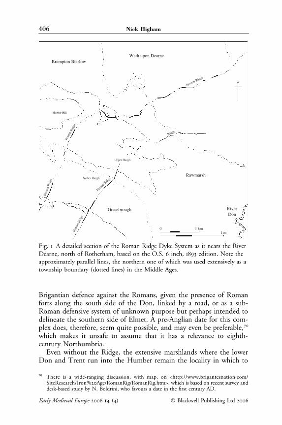
The name ‘Humber’ in the modern period only applies to the estu-ary. Blair made a case for the term having been used further west in thepre-Viking period,65 but the argument is not particularly convincing: wesimply do not have sufficient evidence. How should we, then, interpretBede’s phrase et contiguis ei terminis (‘and boundaries contiguous to [theHumber]’)? Blair very properly noted the presence of extensive marsh-lands along the several tributaries of the Humber, and in particular theRiver Don, and the presence of a major Roman road detouring roundthe wetlands westward, via Doncaster, heading north from Lincolntowards York (and clearly visible in township boundaries around Don-caster: see Fig. 3), which seems to figure repeatedly in the military andconversion history of the seventh century.66 His view was that the RiverDon was the key natural obstacle to which the frontier is likely to havegravitated, and that the ditch and bank complex north of the river butapproximately parallel to it, known variously as the Roman Ridge orRoman Rig,67 should be viewed as an eighth-century, Northumbriandefensive system built to deter penetration by Mercian forces. Thislatter hypothesis should, however, now be treated with considerablecaution. Earlier dates have been offered for the majority of West York-shire’s linear earthworks, including Grim’s Ditch, South Bank and theBecca Banks.68 The Roman Ridge remains undated by excavation,despite several attempts, although pre-Anglian finds have been found inassociation with it. However, its dual nature, with two somewhat errat-ically sited, parallel bank-ditch alignments generally some kilometreapart, and its position often set well back from the scarp of the rivervalley (Fig. 1), are both features which distinguish this monument fromOffa’s Dyke, which provides the only real comparison available in aneighth-century context.69 It may be more easily interpreted either as a
64 HE IV.21, which stresses the length of time over which the ensuing peace lasted.65 Blair, ‘The Northumbrians’, p. 116.66 Blair, ‘The Northumbrians’, pp. 117–20. The road runs via Bawtry and Doncaster to Pontefract.67 I accepted it as plausible in my own discussion of the frontier: Higham, Kingdom of North-
umbria, pp. 142–3, as did Rollason, Northumbria, p. 26, map 2.68 Most recently, see I. Roberts, A. Burgess and D. Berg, A New Link to the Past: The Archae-
ological Landscape of the M1–A1 Link Road (Leeds, 2001).69 The sense of planning underlying Offa’s Dyke is graphically and comprehensibly illustrated
by Hill and Worthington, Offa’s Dyke, pp. 113–28, and its generally clear direction contrastsdramatically with the erratic route adopted for the Roman Ridge dykes, for example northof Greasbrough (Fig. 1).
Early Medieval Europe () © Blackwell Publishing Ltd
406 Nick Higham
Brigantian defence against the Romans, given the presence of Romanforts along the south side of the Don, linked by a road, or as a sub-Roman defensive system of unknown purpose but perhaps intended todelineate the southern side of Elmet. A pre-Anglian date for this com-plex does, therefore, seem quite possible, and may even be preferable,70
which makes it unsafe to assume that it has a relevance to eighth-century Northumbria.
Even without the Ridge, the extensive marshlands where the lowerDon and Trent run into the Humber remain the locality in which to
70 There is a wide-ranging discussion, with map, on <http://www.brigantesnation.com/SiteResearch/Iron%20Age/RomanRig/RomanRig.htm>, which is based on recent survey anddesk-based study by N. Boldrini, who favours a date in the first century AD.
Fig. 1 A detailed section of the Roman Ridge Dyke System as it nears the River Dearne, north of Rotherham, based on the O.S. 6 inch, 1893 edition. Note the approximately parallel lines, the northern one of which was used extensively as a township boundary (dotted lines) in the Middle Ages.

© Blackwell Publishing Ltd Early Medieval Europe ()
Northumbria’s southern frontier: a review 407
seek a frontier immediately west of the Humber, in part simply as a con-sequence of the particular topography, in part in reference to the deathsin battle of Kings Æthelfrith by the River Idle, Edwin at Hatfield,and Penda on the Winwæd, in the region of Loidis (around Leeds).71
That said we now have a far better understanding of the Humberlowlands than was available to Hunter Blair, as a consequence of thework of the Humber Wetlands Project,72 which has recently been excel-lently summarized in a single volume by the project’s senior officer.73
What emerges is a landscape which witnessed high levels of activityduring the Roman period, when specialized economic exploitation ofthe wetlands was both considerable and extensive. These were broughtto an end in part by a late-Roman marine transgression, which depos-ited a layer of silt across the whole area. Secondly, with the integratedmarket-oriented economy of the Roman world collapsing during thefifth century, specialized exploitation of the wetlands became non-viable, and the lowland countryside was deserted, with a shift of therural population to dryer land better suited to mixed agriculture, and areversion of the wetlands to waste.74 In the sub-Roman period the wet-lands became, therefore, both more difficult to traverse than hitherto,on account of thicker vegetation and abandoned route-ways, and far lessused either as a resource or a place of settlement. This virtual wastelandarguably constituted a natural frontier zone dividing more densely set-tled regions to the north (Deira), the west (Elmet until the early seventhcentury) and the south (Lindsey, Hatfield, Mercia). The whole areaoffered considerable natural barriers, with a significant concentrationof wetland place names along Yorkshire’s Domesday borders, such asFenwick, Sykehouse, Moss, Fishlake, and Moorends (all around thelower Don) signifying land which would have been difficult to farm oreven traverse. In 1086, there was a real scarcity of recorded settlements,ploughlands and woodland across the lowland expanses of peat thendominating the wapentakes of Barkston Ash and Osgoldcross, andthe eastern fifth (or so) of Strafforth (later the eastern half of LowerStrafforth), around Hatfield.
That these lowlands may more generally have constituted a compar-atively insecure habitat in the pre-Viking period may also be one readingof the concentration of place names making reference to fortification.Some of these obviously refer to Roman fortifications (as Templeborough),but others include Sprotbrough, Barnburgh, Mexborough, Conisbrough,
71 HE II.12, II.20, III.24.72 Funded by English Heritage between 1992 and 2000.73 R. Van de Noort, The Humber Wetlands: The Archaeology of a Dynamic Landscape (Maccles-
field, 2004), which contains full references to the more detailed reports of the project.74 Van de Noort, The Humber Wetlands, pp. 127–9.

Early Medieval Europe () © Blackwell Publishing Ltd
408 Nick Higham
Worsbrough and Mosborough. While names in burh are scatteredwidely in the North Midlands and southern Northumbria, they areparticularly dense in this region of Yorkshire, perhaps confirming thatthis should be considered a frontier zone.
If the Roman Ridge dyke system be set aside as evidence, there is nooverriding reason to prioritize the claims of the Don as a boundarybetween Northumbria and Mercia. Control of the wetlands and the keyroute-ways across is likely to have been debateable far to the south, andmay have fluctuated with the fortunes of individual rulers, but someNorthumbrian rulers certainly conducted business on the south side ofthe river, even after the loss of Lindsey in 679. The synod at Austerfield,in 702,75 for example, was conducted under the protection and in thepresence of King Aldfrith of Northumbria, dealing with Northumbrianaffairs apparently within the kingdom (Figs 2, 3).
Notices of the frontier further west are equally difficult to reconcilewith the assumption that the Don played a key role: the earliest is areference in the Anglo-Saxon Chronicle to a meeting of King Egberht ofWessex/Mercia with his Northumbrian counterpart in 827 at Dore,which implies that this was then a meeting place on or very near thefrontier.76 This is confirmed by a slightly fuller reference offered in thesame text for the year 942, which in a triumphant poem apparentlywritten to celebrate the recovery of Mercia to its pre-Viking bordersdefined the northern boundary of Mercia by reference to ‘Dore, Whit-well gate and the broad stream, the river Humber’.77 Although bothreferences occur in a manuscript which post-dates the Viking Age,the earlier of these two events pre-dates the Scandinavian settlementand implies, at least, that the frontier between Northumbria andMercia then lay at or very near the eleventh-century boundary betweenDerbyshire and the West Riding: in 1086 Dore lay on the northernperiphery of Scarsdale Wapentake in Derbyshire, its northern boundaryserving to divide Mercia from Northumbria (Fig. 3). Dore means ‘door’or ‘pass’, and it may even have been named from its role as a point ofaccess between Northumbria and Mercia,78 on the edge of the Pennineuplands, as King Egberht’s presence there with an army perhapsimplies. Domesday Whitwell similarly lay in Scarsdale Wapentake,79
but in the extreme north-east, again on the very border of Yorkshire.
75 As Blair noted, ‘The Northumbrians’, p. 118; Vita Wilfridi, Chapter 46.76 The Anglo-Saxon Chronicle, A Collaborative Edition, MS A, ed. J . Bately (Cambridge, 1986),
p. 42: ‘Ecgbryht ledde fierd to Dore wip Norpanhymbre’ (‘Egberht led an army to Doreagainst the Northumbrians’).
77 Bately (ed.), Anglo-Saxon Chronicle, p. 73: ‘swa Dor scadep Hwitanwylles geat Humbre bradabrimstream. The translation is by Whitelock, English Historical Documents 1, pp. 186, 221.
78 Ekwall, Oxford Dictionary, p. 142.79 For the name, see A.H. Smith, The Place-Names of Derbyshire (Cambridge, 1959), II, p. 327.

© B
lackwell Publishing Ltd
Early Medieval Europe
()
Northum
bria’s southern frontier: a review409Fig. 2 The frontier zone between Northumbria and Mercia in its environmental context, locating various places discussed
in the text.

Early Medieval Europe
()
© B
lackwell Publishing Ltd
410N
ick Higham
Fig. 3 The Yorkshire/Derbyshire frontier region, to illustrate the geo-political context of Dore and Whitwell in detail.

© Blackwell Publishing Ltd Early Medieval Europe ()
Northumbria’s southern frontier: a review 411
The name Hwitanwylles means ‘white spring’ but reference here to a geat(‘road’) focuses attention again on the route-way as opposed to settle-ment. Use of these two places as markers of the boundary presumablyreflects their significance as the points at which the frontier changeddirection: Whitwell marks the most southerly point of Yorkshire’sDomesday boundary; Dore is the point which divides the two northernwapentakes of Derbyshire and Yorkshire, from which the frontierclimbs northwards into the uplands of the South Pennines, marked bya string of exceptionally large townships such as Hope Woodlands,Charlesworth, Thurlstone and Bradfield (Fig. 3). For Dore and Whitwellto have been meaningful as boundary markers between Northumbriaand Mercia in the ninth and tenth centuries, much of the area betweenWorksop and Doncaster, south of the River Don, needs to have thenlain in Northumbria. This was the case in 1086, when the boundaryleft the Humber at the point where both the Rivers Trent and Ouseentered it, running then south-west between the West Riding wapentakeof Strafforth and, from north to south, the Lincolnshire wapentake ofEpworth, the Nottinghamshire wapentakes of Bernedelawe (Bassetlaw)and then Broclvestov (Broxtow). This tells against interpretation of theDon as the eighth-century frontier, in favour of a boundary line similar(if not identical) to later Domesday Yorkshire’s, much as seems to havebeen in situ in the 920s, when Edward the Elder reinforced the defencesof Nottingham then built a new burh at Bakewell, both in Mercia(Figs 2, 3), prior to meeting with the rulers of the north to hammerout a peace.80
West of Dore, Hunter Blair noted the presence of the Grey Ditch,putatively running from the prehistoric hillfort of Mam Tor (Castleton)to Bradwell,81 which he felt might have had some relevance to thefrontier, in which he has since been followed by David Rollason.82
However, as Blair recognized, the Grey Ditch faces north, not south,so cannot be considered a Northumbrian work and has no obvious rolein an eighth-century context, unless it was constructed by the Mercians.Recent excavation and survey work has confirmed that the bank overliesRomano-British plough-soil,83 so this should perhaps be viewed as asub-Roman earthwork, but it could as easily have been constructed bythe British inhabitants of the Peak District, to oppose their eastern
80 Bately (ed.), Anglo-Saxon Chronicle, p. 69.81 The earthwork was described in some detail by B.H. St. J. O’Neill, ‘Grey Ditch, Bradwell,
Derbyshire’, Antiquity 19 (1945), pp. 11–19, but there is a danger that the ditch and bank atBradwell may have become confused with an entirely separate collection of earthworks asso-ciated with Mam Tor, since the two sets of monuments do not today appear continuous.
82 Hunter Blair, ‘The Northumbrians’, p. 121; Rollason, Northumbria, map 2.83 My thanks to Steve Malone for his correspondence regarding the as-yet unpublished out-
comes, and see also <http://www.nottingham.ac.uk/wac2Sjm/gdbc.html>.

Early Medieval Europe () © Blackwell Publishing Ltd
412 Nick Higham
neighbours, be those British or English. As it survives, the Grey Ditchis a cross-valley/ridgeway earthwork, apparently designed to cut or atleast control communication into the Peak from the Hope valley andthe Roman fort at Brough. This role is markedly different from thatenvisaged for the Roman Ridge, and the putative connection betweenthem should be set aside pending further evidence. Once again, there-fore, there is no real case for connecting this earthwork with the North-umbrian frontier, and it should certainly not be interpreted as part ofa national boundary work for southern Northumbria along with theRoman Ridge.
If the Grey Ditch is of only dubious relevance in this context, theleast implausible solution to the problem the frontier poses in theuplands is to suggest that it approximated to the northern and easternboundaries of the Derbyshire wapentakes of Scarsdale and High Peak,on the assumption that this Viking Age frontier, first identifiable in1086, is likely to have merely perpetuated the existing border betweenMercia and its northern neighbour in these comparatively barren waste-lands. If not, the sad fact is that this section of the frontier is nowbeyond recall.
The Mersey and the frontier
Further west, Blair argued on the basis of the lands donated to Riponat its foundation,84 and the presence of the late Anglo-Saxon ecclesiast-ical frontier between Lichfield and York,85 that the south-west frontierof Northumbria in the late seventh and eighth centuries is likely to havelain on the Ribble. There is some evidence to support this view, inparticular the presence of a linguistic frontier zone between Mercianand Northumbrian dialects of English identifiable in the place-namingin this area,86 to which Blair referred, and the fact that Lancashire southof the Ribble was attached to Cheshire for the purposes of the Domes-day Survey, and was hidated and divided into hundreds, while Lanca-shire beyond the Ribble was counted with Yorkshire and assessed incarucates. That said, there is a danger that this is to take a somewhatpartial view of the evidence. East of the Pennines, the late Anglo-Saxon
84 Hunter Blair, ‘The Northumbrians’, p. 123; Vita Wilfridi, Chapter 17.85 Hunter Blair, ‘The Northumbrians’, p. 124; for high-quality mapping of the frontier, see D.H.
Hill, An Atlas of Anglo-Saxon England (Oxford, 1982), map 257 on p. 163.86 E. Ekwall, Place-Names of Lancashire, Chetham Society, ns 81 (1922), pp. 228–33. Ekwall
argues on the basis of dialect evidence in place names for Mercian control of southernLancashire before the Viking period, but his fundamentally migrationist model of languagechange needs revision. Additionally, he notes both the presence of ‘Mercian’ dialect formsnorth of the Ribble and ‘Northumbrian’ to the south, both of which circumstances signific-antly weaken the argument in favour of an early Mercian conquest of southern Lancashire.

© Blackwell Publishing Ltd Early Medieval Europe ()
Northumbria’s southern frontier: a review 413
archdiocese of York extended far into Nottinghamshire. This is gener-ally accepted as a late re-ordering of the boundary, and there is noreason in principle not to suppose something similar in the west. Thata group of estates or territories around the Ribble and Dent, but notfurther south, should have been granted to the monastery at Ripon inthe late seventh century, makes good sense in terms of their accessibilityfrom a site comparatively close to the Ribble–Aire gap into northernand central Lancashire (Fig. 2). There is simply no surviving record ofland grants of this period south of the Ribble, so this evidence is notgermane to the issue of the frontier.
The earliest period when the south-eastern frontier between North-umbria and Mercia is well evidenced is the first two decades of thetenth century, when the rulers of Mercia constructed a series ofdefences on the lower Dee and the Mersey, beginning at Chester in 907and terminating with Edward the Elder’s despatch in 919 of Merciantroops from his new defences at Thelwall to build a burh at Mameceasteron Norphymbrum (‘Manchester in Northumbria’).87 Edward’s subsequentpeace accord with the northern rulers has frequently been interpretedas the most plausible moment when the West Saxon/Mercian kingshipobtained control of Lancashire below the Ribble.88
There is, in practice, much to be said for the view that southernLancashire was a post-Viking addition to Mercia. Domesday Bookmakes it clear that, at some unknown date, English hidation had beensuperimposed on carucates,89 which can only derive from a period ofScandinavianization. That process is amply demonstrated in the place-name evidence, with considerable numbers of Scandinavian place namesoccurring in south-western Lancashire (particularly West Derby Hun-dred). South of the Mersey, this nomenclature is only to be found insignificant densities at the very tip of the Wirral peninsula.90 Addition-ally, the tenurial system of southern Lancashire, based on thegnage anddrengage, is entirely unlike that of Cheshire, which had been manori-alized: customary obligations to the hundredal manor and their legalstatus have no parallels below the Mersey and seem to have struck the
87 Bately (ed.), Anglo-Saxon Chronicle, p. 69.88 The case was first made by E.B. Demarest, ‘Inter Ripam et Mersham’, English Historical
Review 38 (1923), pp. 161–70.89 Domesday Book, Cheshire, ed. P. Morgan (Chichester, 1978), fol. 269d: ‘In each hide there are
6 carucates of land’.90 The place-name evidence has been discussed in detail by Ekwall, Place-Names of Lancashire ;
G. Fellows-Jensen, Scandinavian Settlement Names in the North-West (Copenhagen, 1985);D. Kenyon, The Origins of Lancashire (Manchester, 1991); M.C. Higham, ‘ScandinavianSettlement in North-West England, with a Special Study of Ireby Names’, in ScandinavianSettlement in Northern Britain, ed. B.E. Crawford (Leicester, 1995), pp. 195–205; N.J. Higham,‘Viking-Age Settlement in the North-Western Countryside: Lifting the Veil?’, in Land, Sea andHome, ed. J. Hines, A. Lane and M. Redknap (Leeds, 2004), pp. 297–312.

Early Medieval Europe () © Blackwell Publishing Ltd
414 Nick Higham
commissioners as so different that they set them out in some detail forWest Derby, the first instance to be reported. While the Cheshire hun-dreds were characterized by obscure meeting places generally devoid ofsettlement, those of south Lancashire were all inhabited locations,91 afterwhich the hundreds were named and which look to have been estab-lished comparatively recently. The localities which served these central-place functions additionally look designed to suit Mercia’s rulers andmay well derive from a reorganization undertaken by a southern authority:Warrington was a bridgehead or major ford site on the Mersey, withNewton and Leyland both further north on the Roman road headingfor the Ribble, while both Salford and Blackburn were similarly acces-sible from the south and located on Roman roads. On the south bankof the Ribble lay the small Domesday borough of Penwortham, which,if it was not founded after 1066, may even have been a forward baseestablished by English authority to combat the potential in the earlytenth century of the Ribble estuary as a hosting point for the Irish Sea Norse.92
Taken together, the evidence from the tenth and eleventh centuriesdoes suggest that southern Lancashire had been a part of ninth-centuryNorthumbria, but had then been subject to a southern English take-over, presumably prior to Athelstan’s seizure of Northumbria in the late920s and his granting of Amounderness – central Lancashire – to thearchbishop of York, c.934.93 Before the Viking period, there is a strongpresumption that the Mersey acted as the frontier between Mercia andNorthumbria. This reasoning is based first and foremost on the nameitself, (ge)mære, which literally means in Old English, ‘river at theboundary’.94 Rivers of this size, particularly in western England, havegenerally retained their pre-English names, or derivatives thereof.95 It issurely significant that the Mersey has not (although the earlier namemay survive in the River Tame, one of its tributaries96). It is difficult tooffer any alternative to the view that the boundary concerned was thatseparating the two major English kingdoms of the eighth century. Thisargument is strengthened by the presence of both a broad marshy river
91 As (West) Derby, Newton, Warrington, Leyland, Blackburn and Salford.92 For further discussion, see N.J. Higham, ‘The Cheshire Burhs and the Mercian Frontier to
924’, Transactions of the Antiquarian Society of Lancashire and Cheshire, 85 (1988), pp. 193–221;‘Northumbria, Mercia and the Irish Sea Norse, 893–926’, in Viking Treasure from the NorthWest: The Cuerdale Hoard in its Context, ed. J. Graham-Campbell (Liverpool, 1992), pp. 21–30.
93 P.H. Sawyer, Anglo-Saxon Charters (London, 1968), p. 170; Whitelock, English HistoricalDocuments, no. 104, pp. 548–50, dated 934 or only shortly before.
94 J. McN. Dodgson, The Place-Names of Cheshire I (Cambridge, 1970), pp. 31–2.95 As have, from north to south along this coast, the Dee, Alt, Douglas, Brock, Wyre and Lune.96 Dodgson, Place-Names of Cheshire I, p. 36, remarking that the name Tame survived only
where it did not mark the boundary, but note the name provided by Ptolemy, Geography II.3,2, ‘Seteia’ the origin of which is obscure: see Rivet and Smith, Place-Names of Roman Britain,pp. 456–7.

© Blackwell Publishing Ltd Early Medieval Europe ()
Northumbria’s southern frontier: a review 415
valley and extensive peat mosses on the flatlands along both sides ofthe river, which made the Mersey particularly difficult to cross duringthe Middle Ages (Fig. 2). It is also strengthened by its proximity to theputative land frontier on the uplands, running north-westwards fromDore and Whitwell, which seems more likely to have descended toCheshire’s ‘panhandle’ in Lonsdale on the headwaters of the Merseythan the Ribble. Like the Humber, it should also be added that theMersey seems to have been a significant boundary in the LPRIA, andthen a frontier between provinces in the later Roman period.
The distribution of pre-Scandinavian place names offers some sup-port for the notion of a long-lived boundary on the Mersey. Whilethere are a number of pre-English place names surviving in Cheshire,including one suggestive of a pre-English church (Eccleston, from OWelsheglwys), there is a significantly higher density in southern Lancashire,particularly in West Derby Hundred, plus an ‘eccles’ place name in eachof five of the later medieval hundreds, from Amounderness south.97
Both could be interpreted as areas of cultural conservatism on the edgesof expanding Anglian kingdoms, where Brittonic survived as a spokenlanguage into the eighth century, but the nature of the evidence isnot uniform. The survival of ‘eccles’ names in southern Lancashireis similar to that in Elmet,98 rather than in Cheshire, suggesting thatboth may have shared a common process of ‘Northumbrianization’, dif-ferent in subtle ways to ‘Mercianization’ south of the Mersey. Morespecifically, there are parallels with the southern wapentakes of the oldWest Riding around Sheffield, where the ‘eccles’ place names Ecclesalland Ecclesfield survive alongside such other names containing Britishelements as Rossington and Penistone, and the Old English name Wales,which was perhaps indicative of Welsh speakers at a comparativelylate date.99 Similarly, the settlement versus woodland place-naming(primarily in –tUn and –le-ah), which is so typical of western Mercia,100
and which is such a major feature of place-naming in Cheshire, breaksdown on the Mersey. Small groups of township names in southernLancashire do indicate old woodland settings,101 but these are the excep-tion, and large areas are devoid of woodland-type names at the township
97 R. Coates and A. Breeze, Celtic Voices, English Places (Stamford, 2000), pp. 279–281, 316–20.98 M.L. Faull and S.A. Moorhouse, West Yorkshire: An Archaeological Survey to A.D. 1500 I
(Wakefield, 1981), pp. 174–5, lists Eccleshill, Ecclesdo (in Kirkheaton), Exley and Exley Headas identified from medieval manuscripts, plus Eccles in Haworth, Ecclesgrass Head in Hors-forth and Great Eccles in Allerton, all as field names from tithe awards. There are additionallyEccles Parlour (Soyland), Bill Exley (Horsforth) and Exley Farme (Heaton).
99 A.H. Smith, The Place-Names of the West Riding of Yorkshire I (Cambridge, 1960), pp. 49,155, 244, 336; vii, 29, respectively.
100 See, for example, M. Gelling, Signposts to the Past (Chichester, 1988), pp. 126–8.101 Such as the grouping of Worsley, Astley, Tyldesley and Shakerley, West Leigh and Hindley,
on the borders of Warrington and Salford Hundreds.
Early Medieval Europe () © Blackwell Publishing Ltd
416 Nick Higham
level, even where extensive woodland clearly occurred. Likewise, use ofthe element burh differs markedly north and south of the Mersey: inCheshire there are nineteen occurrences at township level, which includeseven of Anglo-Saxon Cheshire’s seventeen (or so) great multi-townshipparishes,102 plus eleventh-century church sites at Mobberley and Burton.There are nine place names using burh at township level in Lancashire,yet none were parochial centres before the Black Death, in a region ofsimilarly large-scale parishes.
In terms of place-naming practice, therefore, significant differencesseem to have characterized Cheshire and Lancashire even before theViking Age, when Old Norse made an impact on the latter but not theformer (excepting only the tip of the Wirral). The likeliest explanationof these long-term processes would seem to be that the Mersey formedthe frontier between Northumbria and Mercia, from the later decadesof the seventh century until the 920s.
Conclusions
Fuller examination of the evidence than Hunter Blair attempted wouldseem to suggest that their mutual frontier was less central to the namingof either Northumbria or Mercia than he suggested. The combinationof the two elements, ‘north’ and ‘Humber’, in Nordanhymbri, is firstevidenced in a southern ecclesiastical text in Latin and was then popu-larized by Bede in his later work. There is virtually no evidence of avernacular term at an earlier date. We cannot even be sure that theNorthumbrians and Mercians shared a border before the mid-seventhcentury, since numerous other peoples occupied the frontier zone,although it is fair to imagine that their respective ‘overkingships’ fre-quently interacted. Despite Bede, the existence of a relevant boundaryduring the Kentish supremacy of the early seventh century seemsanachronistic: the Humber boundary was probably only consolidatedfollowing the battle by the River Trent in 679. Even thereafter, there islittle reason to imagine that it was fortified by major dyke systems. Themain features of the frontier in the pre-Viking period were arguablytopographical: major estuaries and adjacent low-lying wetlands madenorth–south communication difficult on both sides of the Pennines andconfined armies and other large groups to a small number of route-ways. Between lay a poorly defined boundary across the southernPennines. Our earliest clear evidence comes from the ninth and tenth
102 Including Bancornaburg (Bangor-is-y-coed), Astbury, Prestbury, Wrenbury, Bunbury,Wybunbury and Bromborough. Prior to the construction of an Edwardian burh at Runcorn,to which the parochial church apparently migrated, the church may well have been at one ofDaresbury or Preston-on-the-Hill.

© Blackwell Publishing Ltd Early Medieval Europe ()
Northumbria’s southern frontier: a review 417
centuries, when a frontier approximate to that enshrined in DomesdayBook seems to be indicated. The only alternative is to suppose that thecentral section of the pre-Viking boundary is now lost.
Border areas on both sides of the Pennines were characterized bylater and less total processes of Anglicization than the core territories ofeither Northumbrians or Mercians, in which traces of earlier place-naming, for example, have survived. A virtual absence of pre-Christian,Anglo-Saxon burials underlines the peripheral nature of both southernLancashire and the West Riding to early Northumbria – or Deira – andsimilarly of Cheshire to Mercia. Elmet, between Leeds and York, andthe vicinity of Sheffield, where several place names survive which implya British presence, were arguably in some sense British territory into theseventh century: it seems very likely that both southern Lancashire andCheshire were likewise in some sense ‘British’. Neither can boast docu-mented, pre-Viking monastic sites or other signs of centrality to eitherregime. When English place-naming spread to these areas, perhapsfrom the later seventh century onwards, contrasting practices are detect-able on each side of the Mersey: while the same terms were often used,the pattern of occurrence is in some respects different.
The Mersey was almost certainly the frontier between English Merciaand Viking Northumbria at the start of the tenth century, and thedistribution of Old Norse place names would suggest that it had beenalready for some decades. That this boundary dates back to the lateseventh and eighth centuries would seem to be the simplest explanationof the evidence that has been assembled. Change occurred, arguably inthe 920s, with ‘Between Ribble and Mersey’ falling under Merciantenure,103 while Amounderness became attached to the minster at Yorka decade or so later. The last century and a half of the Anglo-Saxonperiod, therefore, saw the creation of a new boundary on the Ribblebetween Mercian influence, centred variously on Lichfield and Chester,and that of the Northumbrian elite, focused on York, but this shouldbe interpreted as a comparatively late change to the western section ofthe historic boundary between Northumbria and Mercia, which hadlong lain along the Mersey, and to which the boundary eventuallyreverted in the twelfth century.
University of Manchester
103 Including Wulfric Spot, around AD 1000: P.H. Sawyer, Charters of Burton Abbey (London,1979), p. xviii: ‘lands betwux Ribbel et Mærse’ (Ribble and Mersey) and ‘on Wirhalum’ (Wirral)were willed to his nephews, Ælfhelm and Wulfheah, on condition each annually sent 3,000shad (in this context presumably salmon from the major rivers of the region, salted inCheshire) to Burton monastery.