montessori st nicholas limited (limited by guarantee) trustees ...
Upload
khangminh22Category
view
1download
0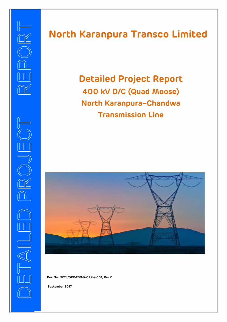
Detailed Project Report
400 kV D/C (Quad Moose)
North Karanpura–Chandwa
Transmission Line
Doc No. NKTL/DPR-ES/NK-C Line-001, Rev.0
September 2017
North Karanpura Transco Limited
North Karanpura Transco Ltd Detailed Project Report
400 kV D/C (Quad Moose) North Karanpura – Chandwa
Transmission Line
Doc No. NKTL/DPR-ES/NK-C Line-001, Rev.0 Page : 2
Table of Contents
1.0 Project Details ................................................................................................ 3
1.1 Introduction ................................................................................................... 3
1.2 Geographical Information .......................................................................... 6
1.3 Transport ........................................................................................................ 7
1.4 Methodology/ Philosophy of Route Selection ....................................... 8
1.5 Map Study .................................................................................................... 10
1.6 Remote Sensing ...........................................................................................11
1.7 Satellite Image (Google Map) ................................................................... 12
1.8 Updating of Base map using Satellite Imageries ................................. 13
1.9 Seismic and Wind Zone Details ................................................................ 14
1.10 Wind Zone Details ...................................................................................... 16
1.11 Methodology for Route Identification .................................................... 17
1.12 Route survey techniques .......................................................................... 18
2.0 Environmental Impact Assessment ............................................................. 19
2.1 Forest involvement / Clearance .............................................................. 20
3.0 Project Cost.................................................................................................. 20
4.0 Features & Methodology of DGPS survey ...... Error! Bookmark not defined.
5.0 Approvals and Clearances ............................................................................ 21
6.0 Notification & DGPS Survey MAPS: ................ Error! Bookmark not defined.
North Karanpura Transco Ltd Detailed Project Report
400 kV D/C (Quad Moose) North Karanpura – Chandwa
Transmission Line
Doc No. NKTL/DPR-ES/NK-C Line-001, Rev.0 Page : 3
1.0 PROJECT DETAILS 1.1 Introduction
With the introduction of Electricity act 2003, competition was brought into power
sector and its sub sectors. Power generation business was delicensed which led to
huge capacity addition by the private sector and this warranted transmission network
to be reinforced so that all the power generated could be supplied to the end users.
The provision for independent transmission licenses were created for private sector to
get in to the business.
The Government of India, Ministry of Power, vide Gazette Notification dated July 08,
2014 has notified REC Transmission Project Company Ltd. to be the Bid Process
Coordinator (BPC) for the purpose of selection of Bidder as Transmission Service
Provider (TSP) to establish Transmission System for “Immediate Evacuation for North
Karanpura (3X660MW) generation project of NTPC along with creation of 400/220kV
Substation at Dhanbad (ERSS-XIX)” through tariff based competitive bidding process.
The BPC invited Bids for selection of Transmission Service Provider to establish the
Transmission System for “Immediate Evacuation for North Karanpura (3X660MW)
generation project of NTPC along with creation of 400/220kV Substation at Dhanbad
(ERSS-XIX)” (hereinafter referred to as 'Project’) on Build, Own, Operate and Maintain
basis, and to provide transmission service on a long term basis to the Long Term
Transmission Customers. As part of said project the Special Purpose Vehicle (SPV)
“North Karanpura Transco Ltd” to develop the proposed project.
North Karanpura Transco Ltd Detailed Project Report
400 kV D/C (Quad Moose) North Karanpura – Chandwa
Transmission Line
Doc No. NKTL/DPR-ES/NK-C Line-001, Rev.0 Page : 4
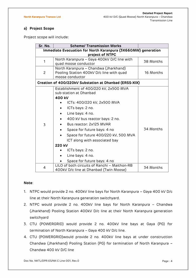
a) Project Scope
Project scope will include:
Sr. No. Scheme/ Transmission Works Immediate Evacuation for North Karanpura (3X660MW) generation
project of NTPC
1 North Karanpura – Gaya 400kV D/C line with quad moose conductor
38 Months
2 North Karanpura – Chandwa (Jharkhand) Pooling Station 400kV D/c line with quad moose conductor
16 Months
Creation of 400/220kV Substation at Dhanbad (ERSS-XIX)
3
Establishment of 400/220 kV, 2x500 MVA sub-station at Dhanbad
400 kV
ICTs: 400/220 kV, 2x500 MVA
ICTs bays: 2 no.
Line bays: 4 no.
400 kV bus reactor bays: 2 no.
Bus reactor: 2x125 MVAR
Space for future bays: 4 no
Space for future 400/220 kV, 500 MVA
ICT along with associated bay
220 kV
ICTs bays: 2 no.
Line bays: 4 no.
Space for future bays: 4 no
34 Months
4 LILO of both circuits of Ranchi – Maithon-RB 400kV D/c line at Dhanbad (Twin Moose)
34 Months
Note: 1. NTPC would provide 2 no. 400kV line bays for North Karanpura – Gaya 400 kV D/c
line at their North Karanpura generation switchyard.
2. NTPC would provide 2 no. 400kV line bays for North Karanpura – Chandwa
(Jharkhand) Pooling Station 400kV D/c line at their North Karanpura generation
switchyard
3. CTU (POWERGRID) would provide 2 no. 400kV line bays at Gaya (PG) for
termination of North Karanpura – Gaya 400 kV D/c line.
4. CTU (POWERGRID)would provide 2 no. 400kV line bays at under construction
Chandwa (Jharkhand) Pooling Station (PG) for termination of North Karanpura –
Chandwa 400 kV D/C line
North Karanpura Transco Ltd Detailed Project Report
400 kV D/C (Quad Moose) North Karanpura – Chandwa
Transmission Line
Doc No. NKTL/DPR-ES/NK-C Line-001, Rev.0 Page : 5
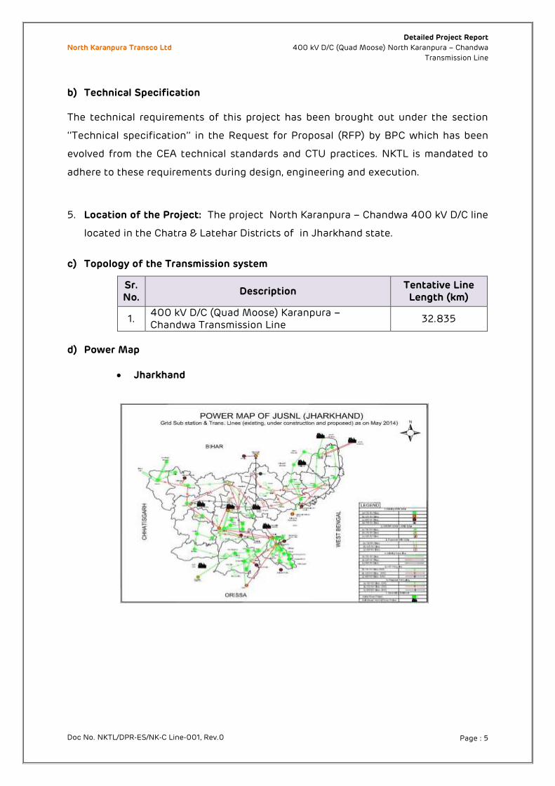
b) Technical Specification
The technical requirements of this project has been brought out under the section
‘’Technical specification’’ in the Request for Proposal (RFP) by BPC which has been
evolved from the CEA technical standards and CTU practices. NKTL is mandated to
adhere to these requirements during design, engineering and execution.
5. Location of the Project: The project North Karanpura – Chandwa 400 kV D/C line
located in the Chatra & Latehar Districts of in Jharkhand state.
c) Topology of the Transmission system
Sr. No.
Description Tentative Line Length (km)
1. 400 kV D/C (Quad Moose) Karanpura – Chandwa Transmission Line
32.835
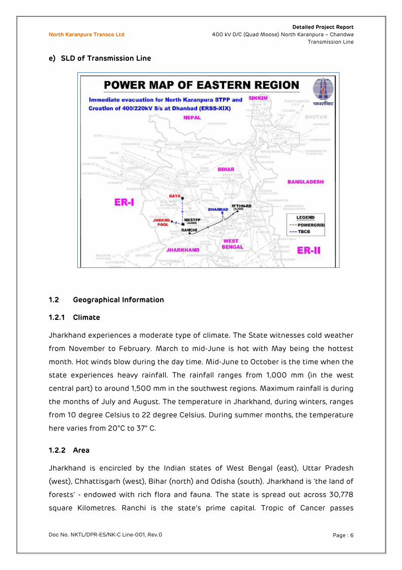
d) Power Map
Jharkhand
North Karanpura Transco Ltd Detailed Project Report
400 kV D/C (Quad Moose) North Karanpura – Chandwa
Transmission Line
Doc No. NKTL/DPR-ES/NK-C Line-001, Rev.0 Page : 6
e) SLD of Transmission Line
1.2 Geographical Information 1.2.1 Climate Jharkhand experiences a moderate type of climate. The State witnesses cold weather
from November to February. March to mid-June is hot with May being the hottest
month. Hot winds blow during the day time. Mid-June to October is the time when the
state experiences heavy rainfall. The rainfall ranges from 1,000 mm (in the west
central part) to around 1,500 mm in the southwest regions. Maximum rainfall is during
the months of July and August. The temperature in Jharkhand, during winters, ranges
from 10 degree Celsius to 22 degree Celsius. During summer months, the temperature
here varies from 20°C to 37° C.
1.2.2 Area Jharkhand is encircled by the Indian states of West Bengal (east), Uttar Pradesh
(west), Chhattisgarh (west), Bihar (north) and Odisha (south). Jharkhand is 'the land of
forests' - endowed with rich flora and fauna. The state is spread out across 30,778
square Kilometres. Ranchi is the state's prime capital. Tropic of Cancer passes
North Karanpura Transco Ltd Detailed Project Report
400 kV D/C (Quad Moose) North Karanpura – Chandwa
Transmission Line
Doc No. NKTL/DPR-ES/NK-C Line-001, Rev.0 Page : 7
through Kanke, few kilometres away from Ranchi, the capital of Jharkhand, making it
the only state in India touched by Tropic of Cancer.
1.2.3 Topography The topography of Jharkhand is rich in minerals. The abundance in minerals also
enhances the prospects of the industries in Jharkhand. It is noteworthy that although
being an industrial belt, Jharkhand also provides enough scope for cultivation of
crops, such as wheat, paddy, pulses, maize, etc. within the territory. Agriculture and
industries flourish side by side within the territory of Jharkhand.
Soil and land resources help to plan for sustainable management of these natural
resources. Red soil, black soil, sandy soil, micaceous soil, laterite soils are found in
Jharkhand. The soil has been formed from disintegration of stones and rocks. Agro
forestry and horticulture, plantation of trees, measures like terracing, bunding,
trenching etc. have been resorted to for soil and water conservation. The fertility
status of soil depends on nature of vegetation, topography, texture of soil, climate
and decomposition rate of organic matter.
1.3 Transport 1.3.1 Roads The JTDC (Jharkhand Tourism Development Corporation), which is a state-owned
organization, offers regular bus services to different parts of the state. Privately
owned operators also run bus services.
The total length of State Highways is about 4,662 km. A two-lane road project
between Govindpur (near Dhanbad) and Sahebganj is nearing completion. There are
12 National Highways in the state. The total length of National Highways in Jharkhand
is 1,805 km. The National Highways running through the state are: NH-2,NH-6,NH-
23,NH-31,NH-32,NH-33,NH-75,NH-78,NH-80,NH-98,NH-99,NH-100.NH-33 and NH-23
pass through Ranchi. Buses ply regularly from Ranchi to other cities of Jharkhand.
Three flyovers are coming up for smooth movement of traffic in the city. Most of the
National Highways and other roads are being widened to 6 lanes or 8 lanes.
1.3.2 Rail network
North Karanpura Transco Ltd Detailed Project Report
400 kV D/C (Quad Moose) North Karanpura – Chandwa
Transmission Line
Doc No. NKTL/DPR-ES/NK-C Line-001, Rev.0 Page : 8
The state of Jharkhand is situated in the eastern part of the country. The entire
railway-route length in Jharkhand is 1,955 km. Ranchi is one of the most profitable
stations in South-Eastern Railways. Goods-handling facilities are available in Ranchi,
Dhanbad, Bokaro and Jamshedpur stations. There are various trains to reach the cities
in Jharkhand from all over the country. Jharkhand has an extensive line of railway
network including 97 main railway stations and many railway junctions. Some of the
important railway stations in the state of Jharkhand include Barharwa Junction,
Chandil Junction, Katrasgarh, Bokaro Steel City, Dhanbad Junction, Ranchi, Madhupur
Junction, Tatanagar Junction, etc.
1.3.3 Air Ports Jharkhand has two operational airports at Ranchi & Jamshedpur and One private
airport at Bokaro. Birsa Munda Airport is a public domestic airport serving the city of
Ranchi and is managed by Airports Authority of India. It is located in Hinoo locality,
approximately 7 km (4.3 mi) from the centre of the city. It is the 37th busiest airport in
India. Sonari Airport is a public airport located in Jamshedpur. Bokaro Airport is a
private airport located in Bokaro Steel City. It is situated on National Highway-23 (Also
known as the Bokaro-Chas road). There are no scheduled flights into this airport.
Further, Tata Steel has proposed a new airport for city of Jamshedpur on 600 acres in
the Adityapur - Seraikela area. The airport is to have a 7,000 feet long runway and will
be able to handle Airbus A320 flights.
1.4 Methodology/ Philosophy of Route Selection
In order to execute such transmission system, precise planning, costing, scheduling
etc. were required. Optimum deployment of resources also was of prime target in
implementing this transmission system. It is essential that at the planning stage itself
various alternative routes and technical solutions for transmission lines be examined
in detail.
For undertaking such studies, one of the major requirements is obtaining adequate
information regarding physical constrains, environmental factors etc. along the route
so that optimum solutions are identified. Subsequently, during implementation of the
project, it is required to obtain elaborate details about terrain, soil conditions,
constraints etc. of the route for proper resource planning, costing etc. as well as
reduction in implementation time.
North Karanpura Transco Ltd Detailed Project Report
400 kV D/C (Quad Moose) North Karanpura – Chandwa
Transmission Line
Doc No. NKTL/DPR-ES/NK-C Line-001, Rev.0 Page : 9
Presently, conventional methods of survey like walk over survey, preliminary survey
and detailed survey are carried out at various stages from conceptualization of the
project to implementation, which are time consuming tasks. There are new means
available which is used to conduct route survey using Google, DGPS based survey etc.
Following are the major factors taken into account while deciding the line route of
the project as per the provisions of the acts and rules –
Major habitation & settlement area avoided.
Wild Life Sanctuary’s, Biosphere’s, dense forest avoided.
Minimum vegetation / tree cutting in the line route
Minimum no of River Crossings, Railway Crossings, Highway Crossings, and
Power Line Crossings are considered.
Lowest minimum forest area demand in the proposed route
Archaeological structures, defense sites, airport area, etc. are avoided.
Accessibility of approach road to the project site.
Rich gardens, plantations, notified industrial area, etc. to be avoided.
Economic viability of the route
1.4.1 Preliminary & Route Alignment Survey
Preliminary Survey included the following steps:
Map study
Walkover survey
Route survey was carried out for following benefits:
To select optimal route from the alternatives for ease of construction followed
by O&M with economy.
Maintenance & additional construction cost can be brought to the minimum.
Material Estimation and procurement can be done fairly on realistic basis.
Limited Reserve/Protected/Private Forest Area.
Proper planning can be done for networks keeping provision for future routes
etc.
Approvals from Railways, Civil Aviation, Forest authorities etc. can be obtained
faster.
North Karanpura Transco Ltd Detailed Project Report
400 kV D/C (Quad Moose) North Karanpura – Chandwa
Transmission Line
Doc No. NKTL/DPR-ES/NK-C Line-001, Rev.0 Page : 10
Preparation of Master Network and fixing construction/erection targets can be
done on realistic basis, which will help in the judicious planning of materials
flow, cash flow and manpower requirements.
Appreciable time can be saved during construction & maintenance of roads, if
selection of Rivers, route along hill sections and power line etc., are properly
made.
1.5 Map Study
After drawing various routes of alignment network within the topo maps, a
comparative study was made on the basis of the following data:
Route length.
Nos. and type of important road points in each indicating alignment of each
road as measured on the map.
Nature and number of major crossings.
Mapping the industrial installations, structures, and important places for
identification of Roads.
Approach to the line in general for construction & maintenance.
Reaches through protected or Reserved Forests
Continuously long stretches in paddy fields.
Close parallelism with Railway lines.
Restricted areas such as civil and military airfield are avoided.
Aircraft landing approaches are avoided. Walkover Survey was carried out going over the area associated with the routes and
collecting features observed other than those existing on the map. In addition the
indications on following features are also checked.
Communication lines
Accessibility and smoother approach.
Logistics of the route.
Economic viability of the route.
Existing and Present course of River
Power lines (existing)
Expanding villages and towns
Rich gardens and plantations
Reserved forests and high tree areas
North Karanpura Transco Ltd Detailed Project Report
400 kV D/C (Quad Moose) North Karanpura – Chandwa
Transmission Line
Doc No. NKTL/DPR-ES/NK-C Line-001, Rev.0 Page : 11
National Parks & Wild life sanctuaries
Archeological monuments
Aerodromes, radar centers etc.
Steep sloping terrain, Areas prone to landslides, soil instability etc.
Prohibited areas declared under statutory regulations
1.6 Remote Sensing Remote Sensing is modern technique in mapping sciences. It is now a major
tool to map any area on earth’s surface for transmission of power. The planning
for installation of large transmission towers needs proper planning. For this,
updated base maps are required. Remote sensing imageries can help in
updating of the available topographic maps. The recently launched satellites
like IKONOS, IRS-1C, 1D (PAN) having its very good spatial resolution of 1mt and
5.8mts through digital image processing techniques; it is able to identify even
small features with the resolution as given above.
To select site for putting new transmission towers and lines especially in hilly
terrains, the density of trees, elevation differences has to be carefully studied
in detail. In such cases, remote sensing is the main technology, plays a vital role
for the preparation of database on landforms, land use / land cover and related
database. Integrating these information in GIS platform, it is able to generate
three dimensional terrain model (DTMs) of the area, which can be further
updated with the multi dated satellite images and aerial photographs also.
Digital Photogrammetry is the potential technology to provide the
information’s on terrain elevation which has to be studied before locating site
for transmission towers and lines. This has found great success in many
European countries but yet to be implemented in the developing countries like
India.
North Karanpura Transco Ltd Detailed Project Report
400 kV D/C (Quad Moose) North Karanpura – Chandwa
Transmission Line
Doc No. NKTL/DPR-ES/NK-C Line-001, Rev.0 Page : 12
1.7 Satellite Image (Google Map)
Satellite Images were used as most authoritative document to record latest
topographical changes along the surveyed routes. This involved the initiations
of the following activities.
Transferring of images to studios for processing and detailed
measurements.
Ground Verification was undertaken to study the authenticity of the images.
Camera is supposed to see topographic details vividly, that is the only reason,
why satellite images are used in detailed survey in comparison to the
traditional field work. The ground profile in digital form could be obtained from
satellite images, which in turn enable the user to estimate various types
earthwork involved like benching, revetments etc. could be computed by using
the relevant software.
Appropriate techniques for obtaining soil conditions, depth of ground water,
terrain conditions etc. for correct estimation of civil works could be explored.
Due to “Shadow Effect”, some errors crop up in the satellite imageries, which
affect the preliminary surveys, and it becomes difficult to differentiate
between the forests and other greenery, consequently it becomes difficult to
mark the forest boundaries etc.
Proper resolution plays an important role in interpreting satellite images;
higher resolution improves the quality of visual Context and may
differentiate the ground realities closely.
Relief data and subsoil data cannot be assessed from Satellite imageries.
Digitization of Complete Zonal maps, rather selected features would
provide a complete replica in integrated environment.
Satellite data of resolution 1 – 5.8m will be preferable. However, the overall
cost economy shall have to be worked out, as this data will be more costly,
but will avoid field assignment in many places.
North Karanpura Transco Ltd Detailed Project Report
400 kV D/C (Quad Moose) North Karanpura – Chandwa
Transmission Line
Doc No. NKTL/DPR-ES/NK-C Line-001, Rev.0 Page : 13
Symbols of physical features in satellite imageries are not easily recognized
by transmission line engineers.
1.8 Updating of Base map using Satellite Imageries
Digital maps prepared are subjected to refinement by using imagery. Details of
Topography which might have undergone changes between the period of topographic
survey and input of satellite imagery, like the rivers and nala courses, forestry and
vegetation, highways and rail routes are re-incorporated in the digitized drawings, by
using satellite imageries. The regions where the topography does not match with the
imageries, ground verification survey is undertaken. IRS 1D PAN & LISS III images were
procured from NRSA. The satellite imagery rectifications include Geo-referencing,
ortho-rectification, transformation and projections. The images are rectified using
ERDAS Imagine Software. The digitization process involves on screen digitization of
imagery using AutoCAD Map and Map Info Software.
a) Satellite Data Selection For updating of base maps NRSA Pan (5.88 m) and LISS-III (23.5 m) merged imagery
are used.
b) Satellite Data Pre-Processing
This phase includes the standard operations of geometric correction and registration
of the satellite images into the required Co-ordinate System. Ground control points
(GCP’s) on the satellite images and on the topographic/paper maps are identified and
the liner geometric correction functions available in the ERDAS Images 8.3.1 are
applied.
c) Satellite Data Classification
For unsupervised classification, the ISODATA methods are applied, and for supervised
classification, the Maximum Likelihood Classification (MLC) is preferred. To identify
the sample areas for supervised classification, specific procedures and information
from topographic/paper maps are used together with thematic maps and expert
knowledge of the terrain after field checking.
d) Satellite Data Interpretation and Vectorization of the Resulting Units
North Karanpura Transco Ltd Detailed Project Report
400 kV D/C (Quad Moose) North Karanpura – Chandwa
Transmission Line
Doc No. NKTL/DPR-ES/NK-C Line-001, Rev.0 Page : 14
Interpretation and vectorization on the screen, available in Arc View shape format are
preferred because polygons created have vector format and can be directly
transformed to a land base maps. In order to update line features (railroads, roads,
streams) the ERDAS Imagine’s Edge Enhancement filter is used.
e) Classification
A Comprehensive and standardized classification system would be created for
mapping exercises. The classification of features would use a set of criteria that
would allow correlation with existing classifications and legends for creation of land
base map.
f) Field Checking
Field visits would be undertaken in all areas under study to collect terrain information
and interpretation keys useful for image interpretation. Later, field checking would be
carried out to test accuracy of image interpretation at selected sites and to clarify
interpretation assumptions. GPS would be used to precisely locate the ground sites
investigated.
g) Composition of final Land Base Maps
Vector shape files would be created manually, in Arc View using both the original
image and the result of the supervised classification in the background to provide a
basis for visual interpretation.
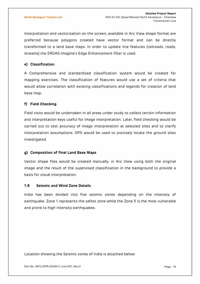
1.9 Seismic and Wind Zone Details India has been divided into five seismic zones depending on the intensity of
earthquake. Zone 1 represents the safest zone while the Zone 5 is the most vulnerable
and prone to high intensity earthquakes.
Location showing the Seismic zones of India is attached below:
North Karanpura Transco Ltd Detailed Project Report
400 kV D/C (Quad Moose) North Karanpura – Chandwa
Transmission Line
Doc No. NKTL/DPR-ES/NK-C Line-001, Rev.0 Page : 15
North Karanpura Transco Ltd Detailed Project Report
400 kV D/C (Quad Moose) North Karanpura – Chandwa
Transmission Line
Doc No. NKTL/DPR-ES/NK-C Line-001, Rev.0 Page : 16
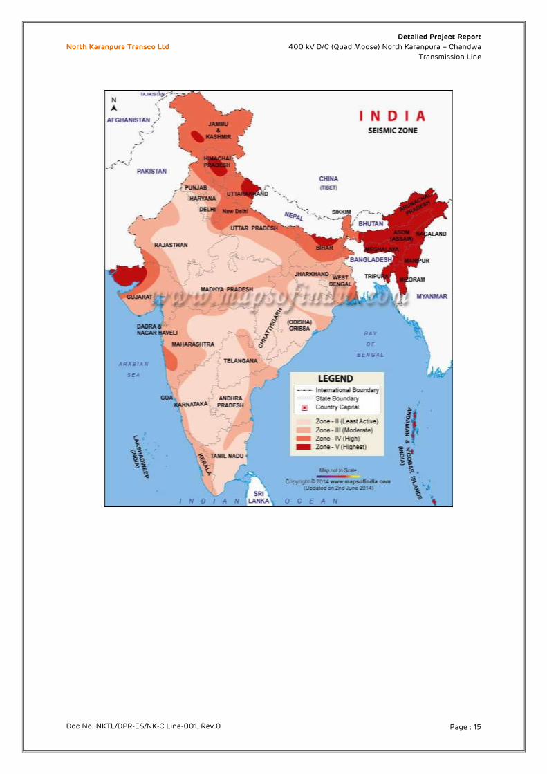
1.10 Wind Zone Details
The proposed line routes passing through the following:
Location showing the Wind zones of India is attached below.
North Karanpura Transco Ltd Detailed Project Report
400 kV D/C (Quad Moose) North Karanpura – Chandwa
Transmission Line
Doc No. NKTL/DPR-ES/NK-C Line-001, Rev.0 Page : 17
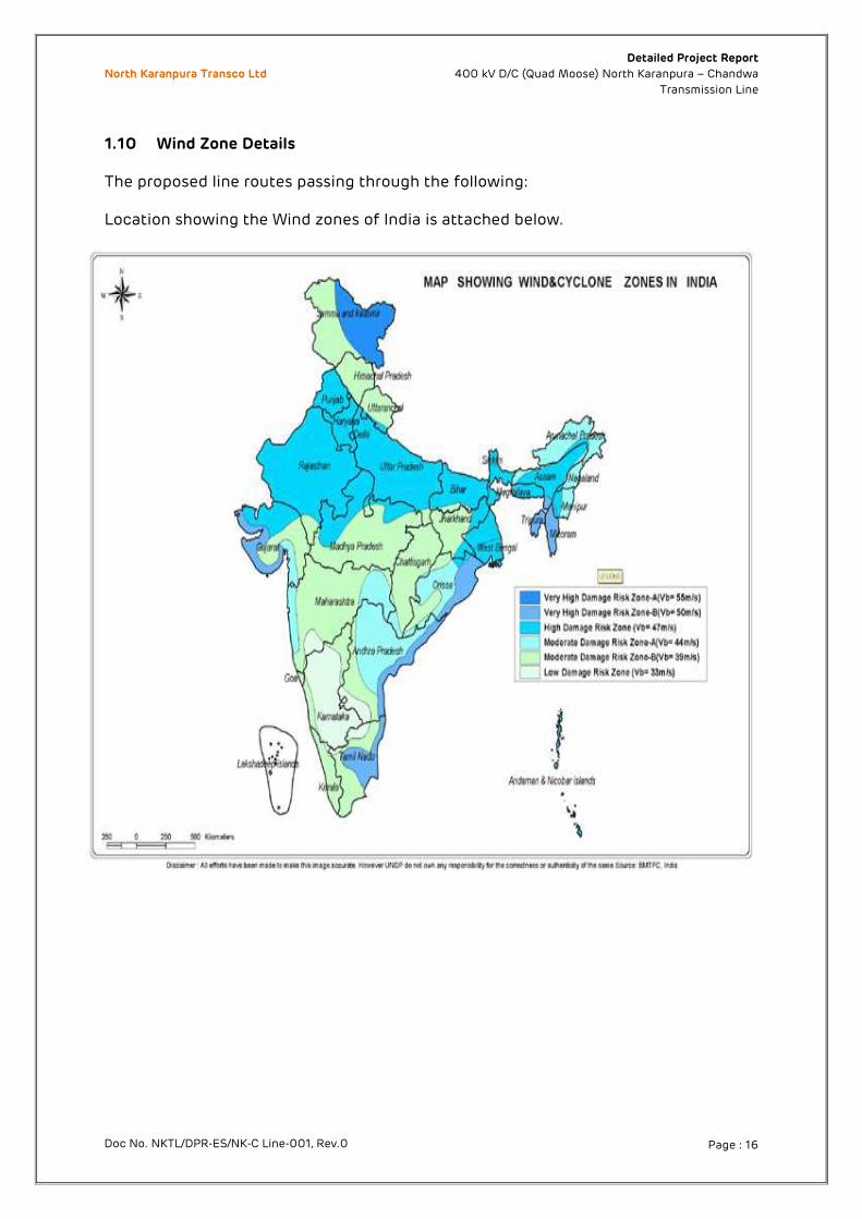
1.11 Methodology for Route Identification
Fig 9.1 Flow Chart of the Methodology for Route Identification
North Karanpura Transco Ltd Detailed Project Report
400 kV D/C (Quad Moose) North Karanpura – Chandwa
Transmission Line
Doc No. NKTL/DPR-ES/NK-C Line-001, Rev.0 Page : 18
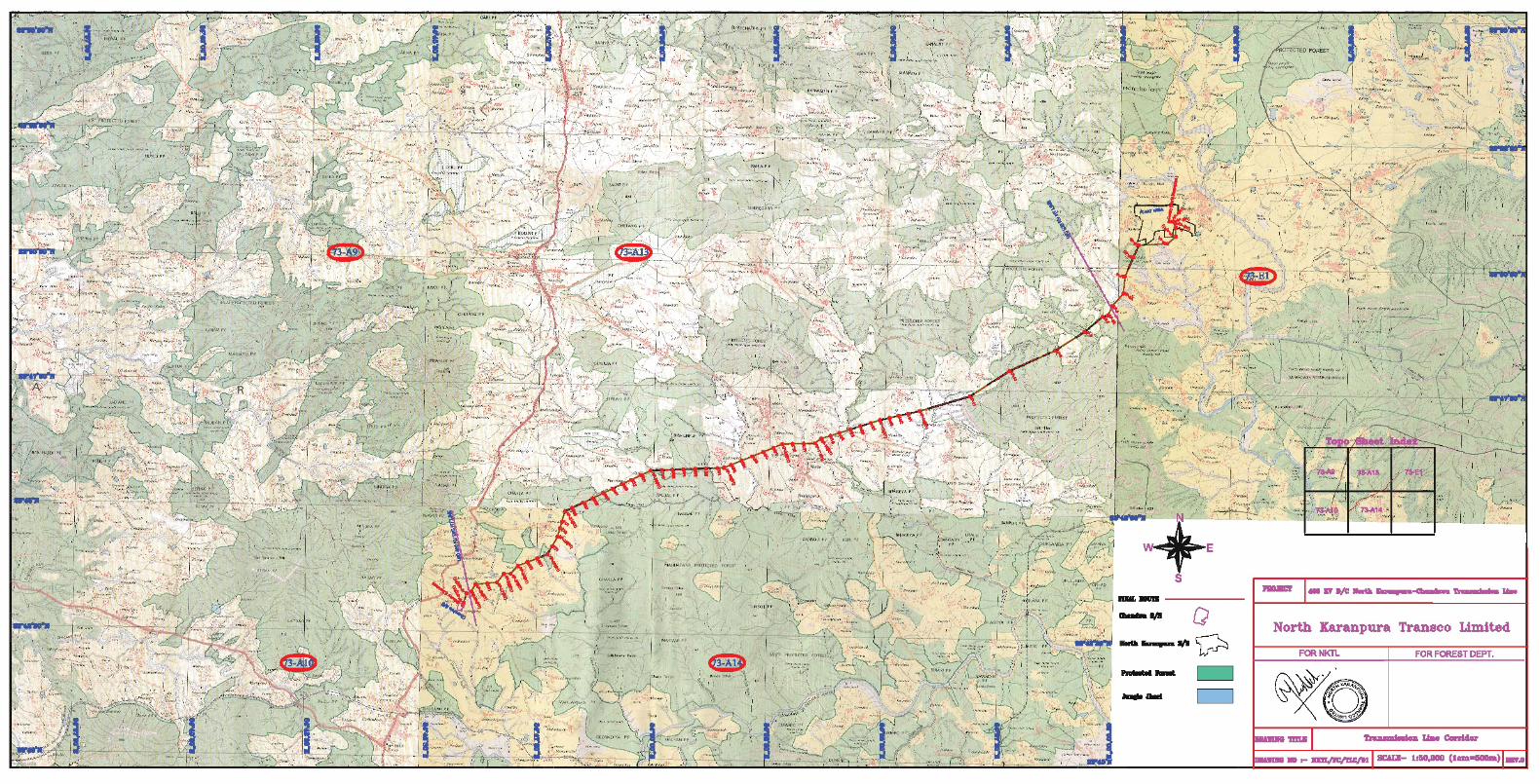
1.12 Route survey techniques
Three (3) alternate route alignments were carried out by help of satellite images
available in google map. Physical walk over survey was conducted on all the three
routes and GPS coordinates were collected at every 100 meters along with soil strata.
Based on the information so collected, the best route was selected after evaluation of
factors like, minimum forest coverage, angle points, river crossing, power line crossing,
habitation etc.
The Infrastructural Details along the Routes are as follows:
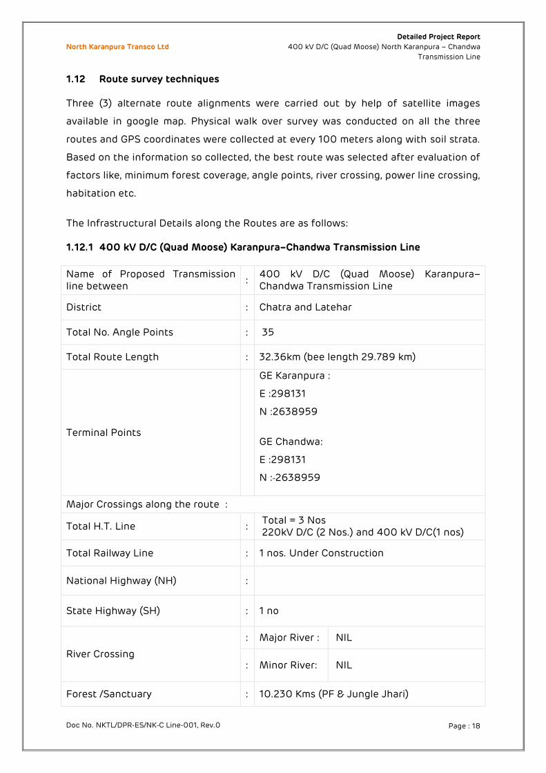
1.12.1 400 kV D/C (Quad Moose) Karanpura–Chandwa Transmission Line
Name of Proposed Transmission line between
: 400 kV D/C (Quad Moose) Karanpura–Chandwa Transmission Line
District : Chatra and Latehar
Total No. Angle Points : 35
Total Route Length : 32.36km (bee length 29.789 km)
Terminal Points
GE Karanpura :
E :298131
N :2638959
GE Chandwa:
E :298131
N : 2638959
Major Crossings along the route :
Total H.T. Line : Total = 3 Nos 220kV D/C (2 Nos.) and 400 kV D/C(1 nos)
Total Railway Line : 1 nos. Under Construction
National Highway (NH) :
State Highway (SH) : 1 no
River Crossing
: Major River : NIL
: Minor River: NIL
Forest /Sanctuary : 10.230 Kms (PF & Jungle Jhari)
North Karanpura Transco Ltd Detailed Project Report
400 kV D/C (Quad Moose) North Karanpura – Chandwa
Transmission Line
Doc No. NKTL/DPR-ES/NK-C Line-001, Rev.0 Page : 19
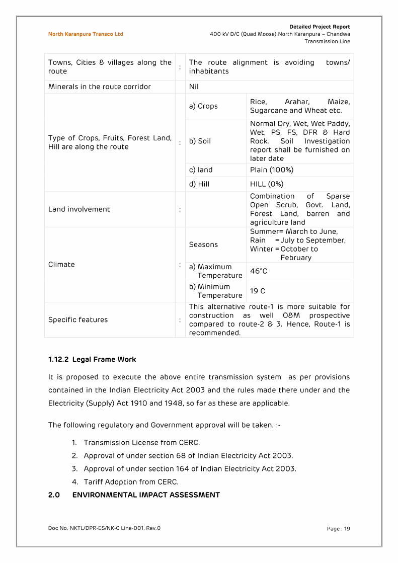
Towns, Cities & villages along the route
: The route alignment is avoiding towns/ inhabitants
Minerals in the route corridor Nil
Type of Crops, Fruits, Forest Land, Hill are along the route
:
a) Crops Rice, Arahar, Maize, Sugarcane and Wheat etc.
b) Soil
Normal Dry, Wet, Wet Paddy, Wet, PS, FS, DFR & Hard Rock. Soil Investigation report shall be furnished on later date
c) land Plain (100%)
d) Hill HILL (0%)
Land involvement :
Combination of Sparse Open Scrub, Govt. Land, Forest Land, barren and agriculture land
Climate :
Seasons
Summer= March to June, Rain = July to September, Winter = October to
February a) Maximum
Temperature 46°C
b) Minimum Temperature
19 C
Specific features :
This alternative route-1 is more suitable for construction as well O&M prospective compared to route-2 & 3. Hence, Route-1 is recommended.
1.12.2 Legal Frame Work
It is proposed to execute the above entire transmission system as per provisions
contained in the Indian Electricity Act 2003 and the rules made there under and the
Electricity (Supply) Act 1910 and 1948, so far as these are applicable.
The following regulatory and Government approval will be taken. :-
1. Transmission License from CERC.
2. Approval of under section 68 of Indian Electricity Act 2003.
3. Approval of under section 164 of Indian Electricity Act 2003.
4. Tariff Adoption from CERC.
2.0 ENVIRONMENTAL IMPACT ASSESSMENT
North Karanpura Transco Ltd Detailed Project Report
400 kV D/C (Quad Moose) North Karanpura – Chandwa
Transmission Line
Doc No. NKTL/DPR-ES/NK-C Line-001, Rev.0 Page : 20
2.1 Forest involvement / Clearance As per the practice, preliminary route selection is done based on such documents as
the Forest Atlas and the survey of India maps using “bee” line method followed by
field clarification through walk over survey. All possible steps are taken to avoid the
route alignment through forest. In case where it becomes unavoidable due to the
geography of terrain, the alignment is made in such a way that the route through the
forest is the barest minimum.
2.1.1 For selection of optimum routes following points are taken into consideration
The route of the transmission line does not involve any human rehabilitation.
Any monument of culture or historical importance is not getting affected.
The route does not create any threat to the survival of any community with special
reference to tribal.
It does not affect any Public Utility Services like Play Ground, School, other
Establishment, etc.
It does not pass through any sanctuaries, Nation Park etc. if any alternative route
is feasible.
It does not infringe with areas of natural resources.
Away from major towns to account for future urban expansion In case where it becomes unavoidable due to the geography of terrain, the alignment
is made in such a way that the bare minimum line route through forest is selected.
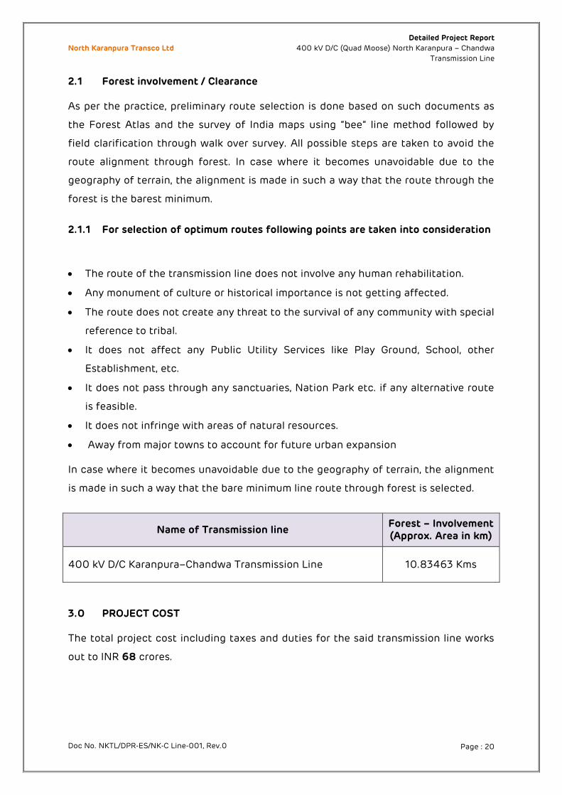
Name of Transmission line Forest – Involvement (Approx. Area in km)
400 kV D/C Karanpura–Chandwa Transmission Line 10.83463 Kms
3.0 PROJECT COST The total project cost including taxes and duties for the said transmission line works
out to INR 68 crores.
North Karanpura Transco Ltd Detailed Project Report
400 kV D/C (Quad Moose) North Karanpura – Chandwa
Transmission Line
Doc No. NKTL/DPR-ES/NK-C Line-001, Rev.0 Page : 21
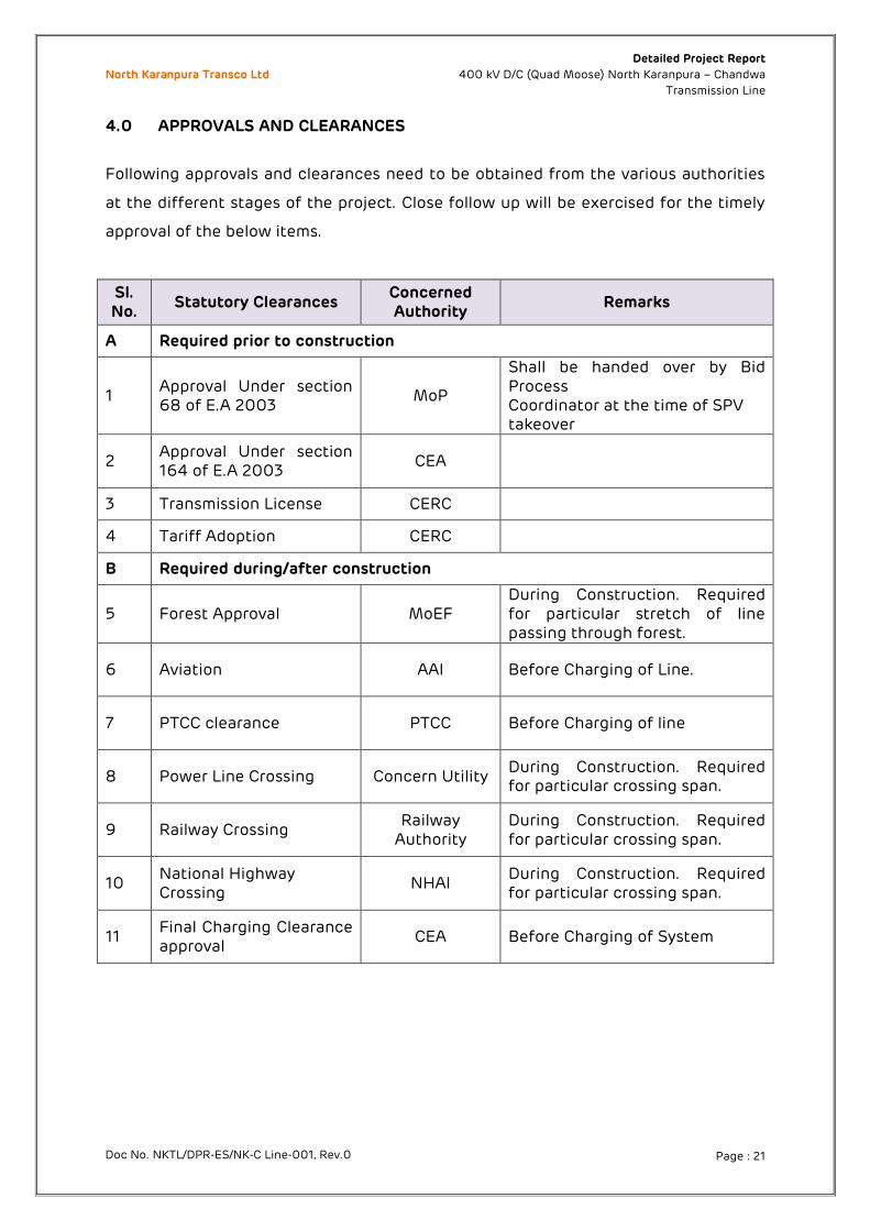
4.0 APPROVALS AND CLEARANCES
Following approvals and clearances need to be obtained from the various authorities
at the different stages of the project. Close follow up will be exercised for the timely
approval of the below items.
Sl. No.
Statutory Clearances Concerned Authority
Remarks
A Required prior to construction
1 Approval Under section 68 of E.A 2003
MoP
Shall be handed over by Bid Process Coordinator at the time of SPV takeover
2 Approval Under section 164 of E.A 2003
CEA
3 Transmission License CERC
4 Tariff Adoption CERC
B Required during/after construction
5 Forest Approval MoEF During Construction. Required for particular stretch of line passing through forest.
6 Aviation AAI Before Charging of Line.
7 PTCC clearance PTCC Before Charging of line
8 Power Line Crossing Concern Utility During Construction. Required for particular crossing span.
9 Railway Crossing Railway
Authority During Construction. Required for particular crossing span.
10 National Highway Crossing
NHAI During Construction. Required for particular crossing span.
11 Final Charging Clearance approval
CEA Before Charging of System
North Karanpura Transco Ltd Detailed Project Report
400 kV D/C (Quad Moose) North Karanpura – Chandwa
Transmission Line
Doc No. NKTL/DPR-ES/NK-C Line-001, Rev.0 Page : 22
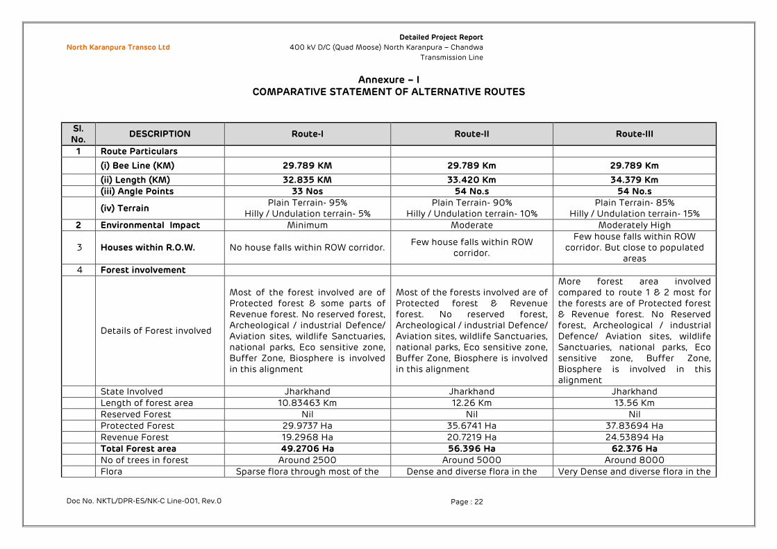
Annexure – I COMPARATIVE STATEMENT OF ALTERNATIVE ROUTES
Sl. No.
DESCRIPTION Route-I Route-II Route-III
1 Route Particulars
(i) Bee Line (KM) 29.789 KM 29.789 Km 29.789 Km
(ii) Length (KM) 32.835 KM 33.420 Km 34.379 Km (iii) Angle Points 33 Nos 54 No.s 54 No.s
(iv) Terrain Plain Terrain- 95%
Hilly / Undulation terrain- 5% Plain Terrain- 90%
Hilly / Undulation terrain- 10% Plain Terrain- 85%
Hilly / Undulation terrain- 15% 2 Environmental Impact Minimum Moderate Moderately High
3 Houses within R.O.W. No house falls within ROW corridor. Few house falls within ROW
corridor.
Few house falls within ROW corridor. But close to populated
areas
4 Forest involvement
Details of Forest involved
Most of the forest involved are of Protected forest & some parts of Revenue forest. No reserved forest, Archeological / industrial Defence/ Aviation sites, wildlife Sanctuaries, national parks, Eco sensitive zone, Buffer Zone, Biosphere is involved in this alignment
Most of the forests involved are of Protected forest & Revenue forest. No reserved forest, Archeological / industrial Defence/ Aviation sites, wildlife Sanctuaries, national parks, Eco sensitive zone, Buffer Zone, Biosphere is involved in this alignment
More forest area involved compared to route 1 & 2 most for the forests are of Protected forest & Revenue forest. No Reserved forest, Archeological / industrial Defence/ Aviation sites, wildlife Sanctuaries, national parks, Eco sensitive zone, Buffer Zone, Biosphere is involved in this alignment
State Involved Jharkhand Jharkhand Jharkhand Length of forest area 10.83463 Km 12.26 Km 13.56 Km Reserved Forest Nil Nil Nil Protected Forest 29.9737 Ha 35.6741 Ha 37.83694 Ha
Revenue Forest 19.2968 Ha 20.7219 Ha 24.53894 Ha Total Forest area 49.2706 Ha 56.396 Ha 62.376 Ha No of trees in forest Around 2500 Around 5000 Around 8000 Flora Sparse flora through most of the Dense and diverse flora in the Very Dense and diverse flora in the

North Karanpura Transco Ltd Detailed Project Report
400 kV D/C (Quad Moose) North Karanpura – Chandwa
Transmission Line
Doc No. NKTL/DPR-ES/NK-C Line-001, Rev.0 Page : 23
Sl. No.
DESCRIPTION Route-I Route-II Route-III
alignment Commonly found species like Palash, Arjun, Arjun,
Neem, Eucalyptus, etc., found
alignment through species like Sal, Jackfruit, Jamun, Kendu,
Gambhar, Shisham, Mahua,. etc., found
alignment through species Katha, Lac, Pesar, Mango, Aasan, Baheda
and Bamboo, etc., found.
Fauna Antelope, Rabbit, Fox, common monkey, Sambhar, Wild boar, Squirrel, Mongoose, etc.,
Antelope, Rabbit Jackal, Deer, Langur, Rhesus, Porcupine, Wild cat, etc.,
Malabar giant, Antelope, Rabbit Honey badger, common monkey,
Porcupine, Nilgai, etc., 5 Railway Crossing 1 No 1 No 1 No 6 Highway Crossing Nil Nil Nil 7 Power Line Crossing: 2 Nos 2 Nos 2 Nos
8 Industrial Corridor Nil Nil 01 ( Patches of industries) 9 Site Connectivity Good Moderately Good Not Good
10 Recommendations
This route length are comparable minimum crossings, well connected by road network which is convenient for construction /O&M. this route has no wildlife sanctuaries Biosphere, ESZs, Defence & Aviation zones, Industrial corridors. This route has less vegetation, away from settlements areas and least forest land involved Least no of trees will be impacted. Hence this route is more feasible economical, environment friendly and beaning recommended.
This route is ruled out due to ecological reasons as forest land involved is more compared to Route I, The proposed corridor is passing through some of the settlements areas and no proper approach roads to project sites alternative route is uneconomical & unfeasible.
This route is ruled out due to longest route length compared to Route I & II Impact on ecology is expected to be high due to higher forest area, Involvement of Industrial corridor and involvement most of the area is not feasible in terms of constructability and approach roads.
Copyright © 2022 FDOKUMEN