North Chico - Butte County
309
Department of Development Services Paula M. Daneluk, AICP, Director Pete Calarco, Assistant Director 7 County Center Drive T: 530.552.3700 Oroville, California 95965 F: 530.538.7785 buttecounty.net/dds April 22, 2021 To: Butte County Planning Commission From: Paula M. Daneluk, Development Services Director Subject: North Chico Village Vision Plan Workshop I. RECOMMENDATION Review the North Chico Village Vision Plan and make recommendations to the Butte County Board of Supervisors to begin the process of amending the Specific Plan and associated environmental analysis. II. EXECUTIVE SUMMARY The North Chico Village Vision Plan, provided in Attachment A, is a planning study document evaluating updates to a portion of the existing North Chico Specific Plan (NCSP) that was approved in 1995. The Vision Plan will be the basis of a future Specific Plan Amendment. The existing Specific Plan accommodates up to 2,275 potential dwelling units with densities ranging from 6 dwelling units per acre to 20 units per acre. The proposed North Chico Vision Plan continues the same density range of residential land uses but allows for additional circulation network, parks and open space buffers by slightly increasing the proportion of Medium High Density Residential (MHDR) from the existing plan. Development Services staff is seeking both the community and Planning Commission member’s review and direction through this public workshop. Direction from the Planning Commission will be Butte County Planning Commission AGENDA REPORT North Chico Village Vision Plan Workshop
-
Upload
khangminh22 -
Category
Documents
-
view
3 -
download
0
Transcript of North Chico - Butte County

Department of Development Services Paula M. Daneluk, AICP, Director Pete Calarco, Assistant Director 7 County Center Drive T: 530.552.3700 Oroville, California 95965 F: 530.538.7785
buttecounty.net/dds
April 22, 2021
To: Butte County Planning Commission
From: Paula M. Daneluk, Development Services Director
Subject: North Chico Village Vision Plan Workshop
I. RECOMMENDATION Review the North Chico Village Vision Plan and make recommendations to the Butte County Board of Supervisors to begin the process of amending the Specific Plan and associated environmental analysis. II. EXECUTIVE SUMMARY The North Chico Village Vision Plan, provided in Attachment A, is a planning study document evaluating updates to a portion of the existing North Chico Specific Plan (NCSP) that was approved in 1995. The Vision Plan will be the basis of a future Specific Plan Amendment. The existing Specific Plan accommodates up to 2,275 potential dwelling units with densities ranging from 6 dwelling units per acre to 20 units per acre. The proposed North Chico Vision Plan continues the same density range of residential land uses but allows for additional circulation network, parks and open space buffers by slightly increasing the proportion of Medium High Density Residential (MHDR) from the existing plan. Development Services staff is seeking both the community and Planning Commission member’s review and direction through this public workshop. Direction from the Planning Commission will be
Butte County Planning Commission
AGENDA REPORT
North Chico Village Vision Plan Workshop

Butte County Department of Development Services April 22, 2021 Agenda Report – North Chico Village Vision Plan. Page 2
incorporated into the Plan for consideration by the Butte County Board of Supervisors. The Planning Commission is not approving any land use entitlement or Specific Plan at this time. This Vision Plan must ultimately be incorporated into a Specific Plan Amendment and analyzed under the California Environmental Quality Act (CEQA). The future Specific Plan Amendment will then be processed by staff and set for public hearings at the Planning Commission and Board of Supervisors. The Vision Plan is an integration of community-based design ideas. It encompasses community outreach results, planning strategies and options which adhere to state and local regulations, and corresponding research to inform maps, diagrams and experiential illustrations that help to demonstrate a vision for the North Chico Village site. The intent of the Plan is to provide a foundation for continuing planning efforts necessary for the development of the North Chico Village. The foundation for the vision includes community outreach that solicited public input regarding opportunities for the future of the North Chico Village. Three community workshops were held between October and December 2020. Areas of study included experiential desires, physical form and character, scale of development, circulation, and infrastructure improvements, among others. Staff notes that there was a high level of opposition to any development in this portion of the NCSP. It was clear through the public input process that many of those opposed were not aware that this portion of the NCSP has been designated for development since 1995. The Vision Plan, combined with updated infrastructure planning and environmental studies will provide the necessary documentation for amending the NCSP. Upon certification of an environmental document and approval of the amended NCSP by the Butte County Board of Supervisors, the Village Plan Area may be submitted to the Local Agency Formation Commission (LAFCO) by the City of Chico for annexation into the City. III. BACKGROUND The North Chico Village site is located north of the City of Chico, west of the Chico Municipal Airport, and east of State Route 99. The site is located south of Mud Creek and north of Sycamore Creek, with Hicks Lane forming the area's eastern boundary. Portions of the site are within the 100-year Federal Emergency Management Agency (FEMA) flood zone of Mud Creek, as well as the 200-year flood plain. The mixed-use North Chico Village, known as the heart of the NCSP, is a 484-acre portion of the larger 2,980-acre NCSP adopted by Butte County. The existing North Chico Specific Plan (NCSP), found in Attachment C, was approved by the Board of Supervisors in 1995 and continues to be used as an active planning tool. The purpose of the plan is to address infrastructure, land use, and county policies for the area at a more concise and comprehensive level than the General Plan’s goals and policies. The Specific Plan is intended to serve as a site planning

Butte County Department of Development Services April 22, 2021 Agenda Report – North Chico Village Vision Plan. Page 3
tool to allow large scale planning and potential future development and to develop regulations to fit the specific needs and goals of the community. Butte County Development Services with land use consultant SWA has undertaken a reassessment North Chico Village, called the North Chico Village Vision Plan. The Existing 1995 North Chico Specific Plan Village Core Area The 1995 NCSP approval set existing land use designations (updated in the 2030 General Plan, completed in 2010) within in the Village area with a mix of single-family residential, multi-family residential, commercial, industrial and public. The Village Core is 380-acres of the larger NCSP area of 3,590-acres. The Village Core is the area of more urban level development in the NCSP with the outlying areas primarily being 1-acre minimums or larger. The NCSP, including the Village Core, was affirmed as a growth area through the General Plan 2030 update in 2010. Existing residential densities range from a 1 dwelling use per acre to 20 dwelling units per acre. The Village area consist of a range of densities including Medium Density Residential (MDR), Medium High Density Residential (MHDR) and High Density Residential (HDR), for total of 2,275 potential dwelling units. Medium Density Residential (MDR), which comprises of the majority of existing residential designations in the Village Core Area, allows for up to 6 dwelling units per acre. Medium High Density Residential (MHDR) allows for up to 14 dwelling units per acre and High Density Residential (HDR) allows for up to 20 dwelling units per acre. The proposed Vision Plan keeps this same density range of MDR to HDR residential land uses but incorporates a more realistic circulation network, parks and open space buffers by slightly increasing the proportion of Medium High Density Residential (MHDR) from the existing plan. High Density Residential (HDR) sites remain the same size and are condensed in the middle of the Village, similar to the existing plan. The remaining acreage for residential uses are all designated as Medium Density Residential (MDR) and used to provide a transition to the surrounding neighborhoods, replacing Medium High Density and Industrial uses that were abutting adjacent neighborhoods in the existing plan. A large portion of the existing site is designated to accommodate non-residential uses such as Light Industrial with some commercial, business, and public uses such as open space and a designated school site. Table 1 demonstrates a comparison of land use changes from the existing North Chico Specific Plan and the proposed North Chico Vision Plan. Most notably, there is a 38.4- acre and 230 maximum unit reduction in Medium Density Residential. Medium High Density Residential acreage in turn increases by 16-acres and 230 maximum unit accommodation from the existing Specific Plan, re-allocating the number of units to allow for more public space and transportation connectivity. This allows for a 6-acre increase in park facilities, and 73-acres of resource conservation land dedication. High Density Residential designated zones do not change in acreage or maximum unit capacity.

Butte County Department of Development Services April 22, 2021 Agenda Report – North Chico Village Vision Plan. Page 4
TABLE 1 EXISTING NCSP AND PROPOSED VISION PLAN COMPARISON
Village Vision Plan The North Chico Village planning effort includes coordination with the City of Chico, area property owners, and a “re-visioning” of the North Chico Village with an emphasis on maintaining residential development and density. The intent of this planning effort is to meet current and future needs in the areas of housing, sustainability, quality of life, and economic development. The project will update existing constraints, provide for a mix of housing types, including multi-family and low-income, recommend internal and external circulation routes working in coordination with the City’s Infrastructure Plan, and include commercial uses that will help reduce vehicle miles traveled (VMT). The proposed Vision Plan differs from the existing plan by increasing larger areas of density with the inclusion of more Medium High Density Residential (MHDR), in the existing plan, and allowing for more condensed acreages of Medium High and High Density Residential sites. More detail concerning these designations are provided in the Vision Plan found in Attachment A. These higher densities are condensed in the middle of the Village area. Of the 380-acres in the Village Core, 4.8-acres are proposed designated as retail and office and 107.1-acres are proposed for public uses such as open space, public school site, and resource conservation. The proposed Village Plan removes all industrial uses and has reduced commercial uses while allowing for large open space buffers and amenities along Hicks Lane and the creeks bordering the site.

Butte County Department of Development Services April 22, 2021 Agenda Report – North Chico Village Vision Plan. Page 5
Overall, the Vision Plan proposes seven land use categories which include varying levels of development intensities. High Density Residential (HDR), Medium High Density Residential, and retail are positioned in the centermost portion of the site, forming the core of the Village. This accommodates up to 1,486 dwelling units and retail to include stores and restaurants designed to City of Chico development standards after future annexation. Medium Density Residential (MDR) zoning is placed along the outer portion of the site which include up to 797 dwelling units with density ranging 3 to 6 DU/acre. Total residential land uses include up to 2,275 dwelling units, consistent with the existing allowable residential development, and in line with SB 166 which requires “no net loss” of residential development capacity. State law requires a local jurisdiction to maintain the level of available residentially zoned land within its jurisdiction. Therefore, if housing units are removed via an entitlement such as the Specific Plan Amendment or Rezoning, the County would have to designate, in the same action, other land use changes in the County that would make up for the change. Open Space, Resource Conservation, Parks and Public (P) zoning are intentionally designed, based on community input, to border along the edges of the site in order to maintain a sense of place and preserve the rural feel of the community. Land Use designations are designed to meet both Regional Housing Needs Allocation (RHNA), described in greater detail below, housing allocation goals and the values of the community. Exhibit A below illustrates the proposed Land Use Plan for the Village area.

Butte County Department of Development Services April 22, 2021 Agenda Report – North Chico Village Vision Plan. Page 6
EXHIBIT A Proposed Village Land Use Designation
A series of three workshops were conducted in the fall and winter months of 2020. The workshops were held on October 28th (Workshop 1), November 18th (Workshop 2), and December 9th (Workshop 3) of 2020 through the online Zoom platform, in compliance with COVID-19 protocols, and led by consultant firm, SWA. Approximately 60 households attended each workshop where they provided their ideas, needs and goals for the North Chico Village site and assisted staff with the final creation of

Butte County Department of Development Services April 22, 2021 Agenda Report – North Chico Village Vision Plan. Page 7
the vision plan. The community expressed a strong value for large open spaces with an emphasis in lower density single-family home development and identified a sense of place with a rural, small community feel. Open space, circulation networks, and parks were increased to better accommodate the values expressed in the workshops. Much of the community concerns centered on traffic and road improvements, safety, and the maintenance of a more rural setting. Summaries of each of the three workshops can be found in Attachment B. Regional Housing Needs State law mandates that the General Plan of every of city and county in the State allocate land uses for minimum number of housing units specified through the Regional Housing Needs Allocation (RHNA, pronounced “reena”). Not providing the land use categories for housing, particularly higher densities deemed by the State to accommodate affordable housing, has significant ramifications. This includes loss of State funding, elimination from State programs, and other actions that can result in loss of millions of dollars of State funding annually. The California Department of Housing and Community Development (HCD), in association with the Butte County Association of Governments has determined a Regional Housing Needs Allocation (RHNA), which allocates each jurisdiction with a total number of primary dwellings and the number of dwellings affordable to each income bracket. The proposed Vision Plan combines density opportunities to achieve state allocated numbers alongside community values in the Vision Plan in order to fulfill the state RHNA obligations. The North Chico Specific Plan currently has the capacity for 2,275 dwelling units in the Village Core, of which 1,146 dwelling units have been designated to accommodate RHNA allocation for affordable housing units. The areas within the Village Core that have been designated for RHNA affordable units include 20.8 acres of HDR at 20 units per acre, 64.1 acres of MHDR at 14 units per acre, and 105.3 acres of MDR at 6 units per acre. Table 2 shown below provides details to the zoning mix and unit capacity in the North Chico Specific Plan.

Butte County Department of Development Services April 22, 2021 Agenda Report – North Chico Village Vision Plan. Page 8
TABLE 2 EXISTING NCSP RHNA PROJECTIONS
Source: Butte County 2014 1. Assumes 75% of maximum capacity. 2. Sites 1 and 2 will be counted toward the 5th round RHNA and are included in Table A-42 in the 2030 Butte County Housing Element.
The RHNA for Butte County is, at present, within the 8 ½ year cycle (Cycle 5) which spans from January 2014 through June 2022 as prepared by the Butte County Association of Governments (BCAG) and approved by the BCAG Board of Directors on December 13, 2012. The allocation numbers are required to be met by the end of each of the 8 ½ year time frame. Within the total allocation number, a certain number of dwellings are assigned and required to be constructed based off on of income levels in an effort to develop to provide more affordable housing throughout the state. These income levels are determined by median household income reported by each County in a given year. A breakdown of the allocation numbers are shown in Table 3 below:
TABLE 3
BUTTE COUNTY CYCLE 5 RHNA
Zoning Acreage Unit Capacity Medium Density Residential 105.3 473
Medium High Density Residential 64.1 673
High Density Residential 20.8 312
TOTAL 190.2 1,458

Butte County Department of Development Services April 22, 2021 Agenda Report – North Chico Village Vision Plan. Page 9
Table 4 below illustrates a breakdown of land use designations for the Village Vision Plan. The total unit capacity of the Vision Plan is 2,275 units of that. 1,706 units would contribute to the County’s needed RHNA allocated units in future RHNA cycles. Zoning designations will be adapted to the City’s comparable land uses and subject to applicable development standards upon annexation, however, unit capacities, acreage and percentage of the site designated will remain the same.
TABLE 4 VILLAGE VISION PLAN RHNA PROJECTIONS
Public Outreach and Engagement The North Chico Vision Plan process included community outreach efforts to ensure a wide representation of public participation. Outreach included social media posts in Facebook and Twitter, distribution of project flyers, B-Line bus advertisements, mailed notices to owners within the North Chico Specific Plan, and outreach to various organizations throughout the County. Local news outlets were notified and reported across outlet platforms and ads were posted to the County’s social media platforms within a week of the workshops. In conjunction with these efforts, the following organizations were included in the outreach: Chico Unified School District, housing resources including the Butte County Housing Authority, Northern Valley Catholic Social Services, Community Housing Improvement Program, Habitat for Humanity, Butte County Action Agency, Butte County DESS-HHOME, Torres Shelter, Sierra North Valley Realtors Association, North Valley Property Owners Association, and the Jesus Center. Various industry contacts such as Chico Chamber of Commerce were also notified and encouraged to attend and provide information to the public. All divisions of Development Services, in a collective effort, handed flyers to the general public and posted at local businesses in the downtown Chico area. Postcards were sent to owners Specific Plan site to notify neighbors of the second and third workshops.
Zoning Acreage Unit Capacity RHNA Capacity* Medium Density
Residential 121.1 727 545
Medium High Density Residential
80.9 1,132 849
High Density Residential 20.8 416 312
TOTAL 222.8 2,275 1,706
Butte County Department of Development Services April 22, 2021 Agenda Report – North Chico Village Vision Plan. Page 10
Coordination with the City of Chico Utilizing approximately $150,000 of its SB2 Planning Grant funding from the State of California, the City of Chico (City) is collaborating with the County on the North Chico Village land use plan and will be identifying infrastructure needs for build-out of the Plan area. The Village Plan area is also known as Special Planning Area-1 (North Chico) in the City’s 2030 General Plan. While the County is taking the lead on the North Chico Vision Plan land use planning effort, the City is focusing on infrastructure planning, including financing options to fund required infrastructure. The City has contracted with an engineering firm, GHD, to assist in developing a public infrastructure plan that ensures that facilities are adequately sized and phased to allow for the integrated and thoughtful development of the Village Core. The infrastructure planning will also include a traffic and circulation analysis that can be incorporated into the California Environmental Quality Act (CEQA) analysis for the project. The two efforts are being closely coordinated and will rely on shared data and information as the planning process proceeds. The CEQA requires all discretionary projects, including specific plans, to undergo environmental review. The North Chico Specific Plan amendment related to the Village Plan is considered a major development that necessitates the preparation of an EIR (Environmental Impact Report) to analyze and identify environmental impacts and to identify mitigation measures. The EIRs evaluation consists of various study components including technical studies and public participation. Butte County was awarded a REAP grant on February 5, 2021 to conduct the CEQA portion of the plan. City of Chico Sphere of Influence (SOI) The North Chico Village is fully encompassed within the City of Chico Sphere of Influence (SOI) and is indicated in the Chico 2030 General Plan as a Special Planning Area. This inclusion allows the City to meet future housing and employment needs and is subject to the master planning requirements identified in the Chico 2030 General Plan. Areas of these Special Planning Areas, such as North Chico, are to be developed as connected and complete neighborhoods with a mix of housing types, services, employment and shopping opportunities, parks, and open space. The City of Chico 2030 General Plan identifies the North Chico Specific Plan area as a Special Planning Area Designation which is intended to meet the City’s growth needs (LU-6.1, Chico 2030 General Plan) and an annexation of the site is identified.

Butte County Department of Development Services April 22, 2021 Agenda Report – North Chico Village Vision Plan. Page 11
Chico Area Greenline Butte County’s Chico Area Greenline is intended to Plan for growth while protecting agriculture resources and other rural lands surrounding the City. The current alignment places the North Chico Village area east of State Highway 99 and approximately 0.33 miles east of the Greenline (see Attachment A, Page 10). Given the proximity of the site, the Village Area is intended to accommodate future urban and suburban growth (LU-P13.8, Butte County 2030 General Plan) in conformance with Greenline policy. Development of the Village site is emphasized in both the City of Chico and Butte County General Plans as an optimal growth area. The existing 1995 North Chico Specific Plan prioritizes the integrity of the Greenline (14.1.1) as a reflection of the Butte County General Plan requirements and any amendments to the plan maintain a continuance of this protection effort. Circulation Issues The North Chico Specific Plan circulation element outlines the necessary roadway improvements necessary for development in the plan area. The existing plan includes expansion of Hicks Lane to 4 lanes south of Kitty Hawk Drive and improves the existing 2 lane portion of Hicks Lane north of Kitty Hawk Drive. In addition to these improvements, new pedestrian and cycle facilities are situated along Hicks Lane to increase pedestrian mobility and safety. However, other requirements of the existing Plan do not reflect the demands of potential future development capacities. Circulation constraints on the site include only two access points, north and south on Hicks Lane. The NCSP proposes an additional connection to the west, along Kitty Hawk Dr. and the NWCSP (Northwest Chico SP) proposes an additional connection from the south. The ability to accommodate potential growth with the existing roadways was a concern expressed by members of the public in the Vision Plan Workshops recently held. The City of Chico has a current project underway to upgrade the Eaton Road and State Highway 99 intersection with a roundabout to better facilitate existing and potential traffic flows, with construction slated to commence July of 2021. A proposed system of streets is planned to serve the North Chico Village which are designed to maximize connectivity with grids of two-lane collector roads. In accord with the existing specific plan, Kittyhawk Drive is planned to be extended across Mud and Sycamore Creeks to connect with a new parkway road on the other side of the creeks and terminate at Hicks Lane. Proposed Parkway Road includes a series of roundabouts at intersections with collector roads that all connect back to Hicks Lane. An extensive, interconnected bicycle and pedestrian network will connect through the landscape corridors and open space buffers. As part of the Environmental Impact Review (EIR), a traffic analysis will be conducted that will assess needs to accommodate anticipated growth, and will include a traffic study with a Vehicle Miles Traveled (VMT) assessment. Mitigation measures may be applied upon resulting findings through required studies as part of the CEQA process.

Butte County Department of Development Services April 22, 2021 Agenda Report – North Chico Village Vision Plan. Page 12
Levee System The North Chico Village contains existing levees along Mud and Sycamore Creeks with portions shown as uncertified. Community feedback through the workshop series expressed concern of the levees and the effects of flooding which may occur. FEMA Flood Maps currently depict a portion of the Plan area along the levee area to be within the 100-year Flood Zone (Zone A), shown in Attachment D. As part of the reassessment efforts, the EIR will contain a study of current and potential risks which may occur and mitigation measures may be applied upon findings in the study. Butte County Public Works will lead the assessment with the intention to receive accreditation of the levee system in the near future. Impacts related to drainage will be analyzed in the CEQA process and appropriate mitigation measures identified where needed. Schools and Public Safety The Chico Unified School District (CUSD) has a site reserved within the Village Core as part of the existing NCSP however they are focused on prioritizing resources to current schools (such as recently upgrading Shasta Elementary) rather than building another school at this time. The reserved site has thus been given the option to revert to residential uses should CUSD determine that the site is not needed. CUSD is prepared to accommodate for potential future growth along the north-westerly portion of the Village site. The CUSD provides preschool, elementary, junior high and high school facilities within the district. The Village is within the Shasta Elementary School Boundary, the Bidwell Junior High School Boundary and the Pleasant Valley High School Boundary. The Butte County Fire Department provides structural and wildland fire protection and other emergency services to the unincorporated areas of Butte County, as well as the cities of Biggs and Gridley. Station 41, located west of the Plan Area on Hwy 99, is currently within 5 miles of the site. When Kittyhawk Drive is completed, Station 41 will be within 2 miles of the Plan Area. Additionally, the City of Chico Fire Department Station 2 is also within 5 miles away, to the south of the NC Village.

ATTACHMENT A

North Chico VillageVision Plan


North Chico Village
April 2, 2021
Prepared For:
Prepared By:
SWA GroupSherwood Design Engineers
Butte County, CADepartment of Development Services
Vision Plan

4
North Chico Village Vision Plan
Introduction .......................... 9Location ................................................ 10
Purpose & Scope ................................. 10
Relationship to Other Plans .............. 12
How to use this Document ................ 13
Context & Planning Considerations .................... 15
Surrounding Land Uses ..................... 16
Existing Circulation & Access ........... 16
Topography ........................................... 16
Hydrology .............................................. 16
Airport Land Use Compatibility ........ 16
Vision & Framework ............23Guiding Principles ...............................24
Plan Framework ...................................25
Table of ContentsCirculation & Mobility .........29
Street Network .................................... 30
Micro-Mobility ......................................36
Land Use...............................39Land Use Concept .............................. 40
Infrastructure & Public Services ...............................49
Stormwater Management ................ 50
Sanitary Sewer .....................................52
Utilities ..................................................54
Public Safety ........................................56
Schools ..................................................56
Implementation ..................59Conceptual Phasing Plan ................. 60
Approvals and Entitlements ............ 60

5
Table of Contents

6
North Chico Village Vision Plan
Introduction .......................... 9Figure 1: North Chico Village Plan Area ......................................................... 11
Context & Planning Considerations .................... 15
Figure 2: Existing (2020) Land Use ..17
Figure 3: Existing and Planned Circulation & Access ........................... 18Figure 4: Topography .......................... 19
Figure 5: Hydrology .............................20
Figure 6: Airport Land Use Compatibility ........................................ 21
Vision & Framework ............23Figure 7: Plan Framework Diagram ..25
Figure 8: North Chico Village Illustrative .............................................26Figure 9: Illustrative Enlargement ...27
List of FiguresCirculation & Mobility .........29
Figure 10: Street Network .................. 31
Figure 11: Hicks Lane (4-Lane) ..........32
Figure 12: Hicks Lane (4-Lane) .........32
Figure 13: Hicks Lane (2-Lane) .........33
Figure 14: Kittyhawk Drive .................33
Figure 15: Parkway Road ....................34
Figure 16: Collector Roads .................34
Figure 17: Residential Roads .............35
Figure 18: Alley .....................................35
Figure 19: Class I Trail .........................36
Figure 20: Pedestrian Path ...............36
Figure 21: Micro-Mobility ...................37

7
Table of Contents
List of TablesTable 1: Land Use Table .......................... 40Land Use...............................39
Figure 22: Land Use Plan ................... 41
Figure 23: Land Use Plan if School Site is Not Needed .............................. 44Figure 24: Landscape Greenbelt Adjacent to Collector Road ...............46Figure 25: Landscape Greenbelt Adjacent to Kittyhawk Drive .............46Figure 26: Hicks Lane Corridor .........47
Figure 27: Typical Open Space adjacent to Mud & Sycamore Creeks ..47
Infrastructure & Public Services ...............................49
Figure 28: Storm Drainage Network 51
Figure 29: Sanitary Sewer Network .53
Figure 30: Utility Network ..................55
Figure 31: Public Facilities .................57
Implementation ..................59Figure 32: Phasing Plan ..................... 61

Hic
ks L
ane
Gar
ne
r L
ane
Kittyhawk Drive
Mud Cre
ek
Sycamore Creek
99
[This Page intentionally Included]

Chico Municipal
Airport
Eaton Road
Introduction

10
North Chico Village Vision Plan
LocationThe North Chico Village (NC Village) is a 380-acre area located north of the City of Chico as shown in Figure 1 and is known as the Village Core of the North Chico Specific Plan (NCSP). The area is bounded by Sycamore Creek to the south, Mud Creek to the north and west, and Hicks Lane to the east. Within this area is an existing development, consisting of ±1-acre lots, accessed from Hicks Lane via Caballo Way. This development is not considered to be a part of the North Chico Village Plan Area as it was built prior to the plan’s adoption.
Though the NC Village Plan Area is currently located outside of the City of Chico, it is within the City’s Sphere of Influence and identified as a Special Planning Area (SPA) of the City’s General Plan Land Use Diagram. Additionally, the North Chico Village lies to the east of Butte County’s Chico Area Greenline, within the area considered for urban development.
The NC Village Plan Area is currently undeveloped and primarily consists of agricultural uses, specifically orchards.
Purpose & ScopeSponsored by the County of Butte and funded by an SB2 Planning Grant, the North Chico Village Vision Plan is intended to reassess the Village Core of the original NCSP, adopted by the Butte County Board of Supervisors in 1995. The Vision Plan is intended to address changes in the surrounding conditions,development costs, and other factors that have constrained the development of the Village Core.
What is this Vision Plan?This Vision Plan is an integration of community-based design ideas. It includes results from community outreach combined with planning strategies and options as well as research to form maps, diagrams and experiential illustrations that communicate a vision for a place. The intent of the North Chico Village Vision Plan is to provide the basis for the continued planning efforts necessary for the development of the North Chico Village. This document, combined with an updated infrastructure planning and Environmental Impact Report (EIR) with its associated technical studies will provide the necessary documentation for amending the NCSP.
The visioning process has included the two key steps; first setting a foundation for the vision, and then planning for the vision.
Foundation for a VisionThe foundation for the vision included community outreach that solicited public input regarding opportunities for the future of the North Chico Village. Areas of study included experiential desires, physical form and character, scale of development, circulation and infrastructure improvements, among others. Public input is a major component of the Vision Plan.
Plan for a VisionBased on meetings and activities with the community, a set of guiding principles, strategies and concepts have been created to communicate the proposed vision. This Vision Plan articulates the NC Village Plan Area’s future development potential – including physical use, form and character, public spaces, mobility, relationships to natural features, and conceptual utilities and infrastructure.

0
0
1,000
0.2
3,000
0.5FeetMiles
North Chico Specific Plan Area
City Sphere of InfluenceLEGEND
Project Boundary
City Limits
State HighwayGreenline
Chico Municipal
AirportH
icks
Lan
e
Gar
ne
r L
ane
Eaton Rd
Mud C
reek
Sycamore Creek
11
Introduction
Figure 1: North Chico Village Plan Area

12
North Chico Village Vision Plan
Relationship to Other PlansNorth Chico Specific PlanAdopted in 1995, the North Chico Specific Plan (NCSP) has provided for the development of the 3,590-acre area to the north of Chico. The North Chico Village is a portion of the larger North Chico Specific Plan. Since 1995, the portions of the NCSP north of Mud Creek have seen incremental development, largely in the form of 1+ acre lots. Prior to the implementation of the North Chico Village Vision Plan, an amendment to the NCSP and updated EIR will need to be adopted.
Butte County General Plan 2030The Butte County General Plan 2030 provides the general guidelines for orderly growth and development within the County. Specific Plans and Specific Plan Amendments must be consistent with the local government’s General Plan. Although the Vision Plan lacks the implementation mechanisms of a Specific Plan Amendment, it has been crafted to be consistent with and implement elements of the Butte County General Plan 2030.
Chico 2030 General PlanThe North Chico Village Plan Area is currently included as a Special Planning Area within the Chico 2030 General Plan. Special Planning Areas are considered to be areas of new growth to meet future housing and job needs through compact development that are connected and complete neighborhoods with a mix of housing types, services, employment and shopping opportunities, parks, and open space. Special Planning Areas are subject to the master planning requirements identified in the Chico 2030 General Plan.
Airport Land Use CompatibilityThe basic function of the Airport Land Use Compatibility Plan (ALUCP), adopted by the Butte County Airport Land Use Commission (ALUC) in 2000, is to promote compatibility between Chico Municipal Airport and the land uses surrounding it. The ALUCP identifies zones for safety, noise contours, and height restrictions, along with associated compatible land uses. General Plans and any applicable Specific Plans should be consistent with the ALUCP.

13
Introduction
How to use this DocumentCommunity MembersFor community members who are interested in learning about this plan, Vision & Framework (Chapter 3), will help you understand the vision and key strategies for development of the North Chico Village. Subsequent chapters have more detailed information about Circulation (Chapter 4), Land use (Chapter 5), and the necessary Infrastructure (Chapter 6) that will be required in the NC Village Plan Area.
Property Owners or DevelopersProperty owners who are interested in developing in the NC Village Plan Area should become familiar with the NC Village Plan Area’s Planning Considerations (Chapter 2) and the overall Vision and Framework, as described in Chapter 3. Development applications and project designs should be consistent with the Vision Plan’s guidance for Mobility (Chapter 4), Land Use (Chapter 5), and Infrastructure (Chapter 6).

[This Page intentionally Included]

Context & Planning Considerations

16
North Chico Village Vision Plan
Surrounding Land UsesThe North Chico Village lies at the convergence of several different land use patterns. Across Mud Creek to the north and west, is the majority of the NCSP that was planned for and developed with a low density, rural residential character. Additionally, there is an existing low density residential development that forms an island within the NC Village Plan Area on Caballo Way. This development takes access from Hicks Lane and has a character similar to the area north of Mud Creek. To the east, across Hicks Lane, is the Chico Municipal Airport along with a considerable area that is zoned Industrial but which remains largely undeveloped due to environmental constraints. To the south, across Sycamore Creek, is the City of Chico. This area of the City is currently experiencing residential infill development with a suburban character at higher densities, primarily along Eaton Road to the southeast of the NC Village Plan Area. The surrounding land uses are illustrated in Figure 2: Surrounding Land Uses.
Existing Circulation & AccessAs illustrated in Figure 3: Existing and Planned Circulation & Access, the NC Village Plan Area is currently only accessible from Hicks Lane along the eastern edge of the site. Hicks Lane extends south to Eaton Road and Highway 99. The City of Chico is currently upgrading this intersection to be a roundabout in order to better facilitate traffic flows. Hicks Lane also extends to the north and connects with the rest of the NCSP area. The NCSP also envisions a connection across Mud Creek on Kittyhawk Drive that extends to Highway 99. Currently, only portions of this connection have been built. Additionally, the Northwest Chico Specific Plan in the City of Chico, envisions a connection across Sycamore Creek to the south of the NC Village Plan Area.
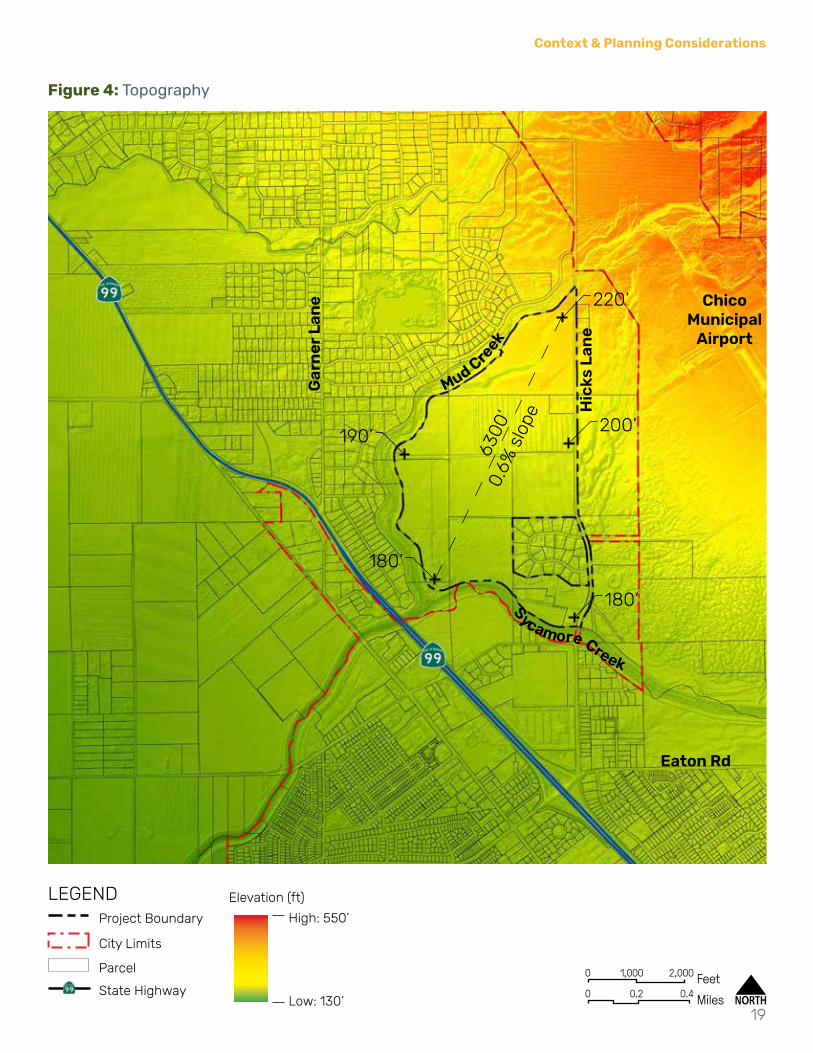
TopographyAs depicted in Figure 4: Topography, the North Chico Village enjoys flat topography that is ideally suited for development. The site has a gentle slope of 0.6% from the northeast to southwest.
HydrologyAs illustrated in Figure 5: Hydrology, the North Chico Village lies at the confluence of the Sycamore Creek Watershed and the Maple Branch of the Mud Creek Watershed. These two creeks merge at the NC Village Plan Area’s southwest corner to form the Kusal Slough portion of the Mud Creek Watershed. Although proximate, drainage from the North Chico Village does not impact Keefer Slough and the Rock Creek Watershed to the north.
The North Chico Village has existing levees along Mud and Sycamore Creeks. Despite this, FEMA Flood Maps depict a portion of the NC Village Plan Area as being within the 100-year Flood Zone (Zone A). As the levees adjacent to the North Chico Village site have yet to be certified, a further investigation of the risks will need to occur before development proceeds in this area and if necessary, any improvements done.
Airport Land Use CompatibilityAs depicted in Figure 6: Airport Land Use Compatibility, the North Chico Village Plan Area is within multiple Airport Land Use Compatibility Zones. The majority of the NC Village Plan Area is in Zone C1. The primary constraints for this zone are a 4 DU/Ac minimum and an intensity criteria of 300 People/Ac maximum. The northeast corner of the NC Village Plan Area is encumbered with the slightly more restrictive Zones B1 & 2. These zones are incompatible with multi-family residential, schools, and major retail centers. Finally, the southwest portion of the NC Village Plan Area is in Zone D, the primary encumbrance of which requires a review for objects greater than 70’-0” in height. Refer to the Butte County Airport Land Use Compatibility Plan for more detail.

0
0
500
0.1
1,000
0.2FeetMiles
Chico Municipal
Airport
Gar
ne
r L
ane
Eaton Rd
Mud C
reek
Sycamore Creek
17
Context & Planning Considerations
Figure 2: Existing (2020) Land Use
Waterways
LEGENDProject Boundary
City Limits
Parcel
State Highway
AG MHDR
HDR
P
PUBLIC
RTL
I
RC CITY OF CHICO
RR
VLDR
MDR

0
0
1,000
0.2
2,000
0.4FeetMiles
Chico Municipal
Airport
Hic
ks L
ane
Gar
ne
r L
ane
Eaton Rd
Kittyhawk Dr
Mud C
reek
Sycamore Creek
18
North Chico Village Vision Plan
Figure 3: Existing and Planned Circulation & Access
LEGENDProject Boundary
City Limits
Waterways
State Highway
ArterialCollectorLocalPrivate
Planned 2-Lane Arterial
Bus Stops
0
0
1,000
0.2
2,000
0.4FeetMiles
Chico Municipal
Airport
Hic
ks L
ane
Gar
ne
r L
ane
Eaton Rd
Mud C
reek
Sycamore Creek
19
Context & Planning Considerations
Figure 4: Topography
High: 550’
Low: 130’
Elevation (ft)LEGENDProject Boundary
City Limits
Parcel
State Highway
220’
200’
6300
’0.
6% s
lope
180’
190’
180’

0
0
1,000
0.2
2,000
0.4FeetMiles
Chico Municipal
Airport
Hic
ks L
ane
Gar
ne
r L
ane
Eaton Rd
Mud C
reek
Sycamore Creek
20
North Chico Village Vision Plan
Figure 5: Hydrology
LEGENDProject Boundary
City Limits
Parcel
State Highway
Waterways
100-yr Flood Zone (High Risk)
Rock Creek Watershed
Maple Branch - Mud Creek Watershed
Kusal Slough - Mud Creek Watershed
Sycamore Creek Watershed

0
0
1,000
0.2
2,000
0.4FeetMiles
Chico Municipal
Airport
Hic
ks L
ane
Gar
ne
r L
ane
Eaton Rd
Mud C
reek
Sycamore Creek
21
Context & Planning Considerations
Figure 6: Airport Land Use Compatibility
LEGENDProject Boundary
City Limits
Parcel
State Highway
A
B1
B2
C
C1/C2
D

[This Page intentionally Included]

Vision & Framework

24
North Chico Village Vision Plan
Guiding Principles
Celebrate the rural beauty of North Chico
Promote a distinct character of place
Maintain a flexible framework
Maximize Single Family homes on larger lots
Provide for safety and accessibility

Chico Municipal
Airport
Hic
ks L
ane
Sycamore Creek
Gar
ne
r L
ane
Mud C
reek
25
Vision & Framework
Plan FrameworkOpen SpaceThe North Chico Village seeks to leverage existing natural amenities by locating open space buffers adjacent to the Mud and Sycamore Creek. Extending into the NC Village Plan Area are a series of interconnected landscape greenbelts with Class I Trails that allow for pedestrian movement throughout the site and along Hicks Lane. These landscape greenbelts connect to important features of the North Chico Village, including the Retail area, school site and the joint-use Neighborhood Park.
Figure 7: Plan Framework Diagram
Core/Development TypologiesThe North Chico Village should provide a mix of housing options at differing densities. Lower density, single family homes should be located at the edges of the NC Village Plan Area to transition to existing development. Higher density residential development should be located towards the center of the NC Village Plan Area and along Hicks Lane to form a neighborhood core. If needed, the school site should be located adjacent to the creeks. By right-sizing the commercial area and removing industrial uses, the framework reflects the current and future market viability of these uses in North Chico.

0
0
500
0.1
1,000
0.2FeetMiles
Hic
ks L
ane
Kittyhawk Dr
Sycamore Creek
Gar
ne
r L
ane
Mud Creek
26
North Chico Village Vision Plan
Figure 8: North Chico Village Illustrative

0
0
250 500
0.1FeetMiles
Hic
ks L
ane
Kittyhawk Dr
Mud Creek
27
Vision & Framework
Figure 9: Illustrative Enlargement

[This Page intentionally Included]

Circulation & Mobility

30
North Chico Village Vision Plan
Street NetworkThe North Chico Village street network is defined by a flexible, modified grid of two-lane streets that increase connectivity for both vehicles and pedestrians and allows for incremental and cohesive development over time.
Improvements to Existing InfrastructureAs anticipated in the NCSP, Hicks Lane will need to be improved in order to accommodate projected traffic volumes and provide appropriate pedestrian facilities. Hicks Lane was envisioned as expanding to 4 lanes south of Kittyhawk Drive with an improved 2 lane Hicks Lane north of Kittyhawk Drive. This Vision Plan proposes new street sections for Hicks Lane that accommodate the original vision while also including new Class II cycle facilities.
Proposed StreetsA hierarchical system of streets is planned to serve the North Chico Village. This system is designed to maximize connectivity by utilizing a modified grid of two-lane collector roads. Two signature image roads punctuate this system. Kittyhawk Drive serves as the primary access from Hicks Lane to the core of the NC Village Plan Area. Kittyhawk Drive extends to the Parkway Road along the Mud and Sycamore Creek open space corridors to help create an identity for the village while connecting residents to these open spaces. The Parkway Road includes roundabouts at intersections with collector roads that create a distinct character and serve as potential points of connection across Mud and Sycamore Creeks. Residential roads should transition from a regimented, block structure along Hicks Lane to a relaxed, curvilinear form as they near Mud and Sycamore Creek.

Potential Connection per North Chico SP
Potential Connection per Northwest Chico SP
0
0
500
0.1
1,000
0.2FeetMiles
Hic
ks L
ane
Kittyhawk Dr
Sycamore Creek
Gar
ne
r L
ane
Mud C
reek
31
Circulation & Mobility
Figure 10: Street Network
Waterways
LEGENDProject Boundary
City Limits
Parcel
State Highway
Hicks Lane (4-Lane)Hicks Lane (2-Lane)Kittyhawk DrParkway RoadCollector Roads
Potential Connection

0 8 16Feet
0 8 16Feet
32
North Chico Village Vision Plan
Figure 11: Hicks Lane (4-Lane)
Figure 12: Hicks Lane (4-Lane)

0 8 16Feet
0 8 16Feet
33
Circulation & Mobility
Figure 13: Hicks Lane (2-Lane)
Figure 14: Kittyhawk Drive

0 8 16Feet
0 8 16Feet
34
North Chico Village Vision Plan
Figure 16: Collector Roads
Figure 15: Parkway Road

0 8 16Feet
0 8 16Feet
35
Circulation & Mobility
Figure 17: Residential Roads
Figure 18: Alley

36
North Chico Village Vision Plan
Micro-MobilityBicycle NetworkLeveraging the flat topography of the site, the North Chico Village will include a network of Class II bike lanes on all street that are collector level or higher. This will form an extensive, interconnected bicycle network that has the ability to connect beyond the NC Village Plan Area.
Pedestrian NetworkThe North Chico Village will also include a network of off-street, Class I Trails that connect through the landscape greenbelts. This includes a connection along Hicks Lane and through the open space adjacent to Mud and Sycamore Creeks.
Figure 19: Class I Trail Figure 20: Pedestrian Path

Potential Connection per North Chico SP
Potential Connection per Northwest Chico SP
Hic
ks L
ane
Kittyhawk Dr
Sycamore Creek
Gar
ne
r L
ane
Mud C
reek
37
Circulation & Mobility
Figure 21: Micro-Mobility
Waterways
LEGENDProject Boundary
City Limits
Parcel
State Highway
Class II Bike LaneClass I TrailPotential Connection

[This Page intentionally Included]

Land Use

Acreage Min. Units
Max. Units % of Site
North Chico Village 379.9ResidentialMedium Density Residential 3 to 6 121.1 363 727 32%Medium High Density Residential 6 to 14 80.9 485 1,133 21%High Density Residential 14 to 20 20.7 290 414 5%
Total Residential Acreage 222.7 1,139 2,273 59%
CommercialRetail and Office 4.8 1%PublicPublic (School) 14.0 4%Park 6.0 2%Resource Conservation 87.1 23%Non-DevelopableStreets 45.3 12%
Total Acreage 379.9
Units/Ac
North Chico Village
40
North Chico Village Vision Plan
Table 1: Land Use Table
Land Use ConceptThe North Chico Village Vision Plan proposes seven land use categories which include the following land use designations: Medium Density Residential (MDR), Medium High Density Residential (MHDR), High Density Residential (HDR), Retail (RTL), Public (PUB), Parks (P) and Resource Conservation (RC).
A breakdown of the land use designations are listed below in Table 1: Land Use Table.

0
0
500
0.1
1,000
0.2FeetMiles
Hic
ks L
ane
Kittyhawk D
r
Sycamore Creek
Gar
ne
r L
ane
Mud C
reek
41
Land Use
Figure 22: Land Use Plan
Waterways
LEGENDProject Boundary Residential Road with Phase 1
Infrastructure ConnectionCity Limits
Parcel
State Highway
P
PUB
RTL
RC
CITY OF CHICO
MDR
MHDR
HDR

42
North Chico Village Vision Plan
Medium Density ResidentialAreas designated Medium Density Residential (MDR) include up to 727 dwelling units with a density range of 3 to 6 DU/Ac, amenities and open space. Upon annexation into the City of Chico, the MDR land use designation is envisioned to be the City’s Low Density Residential (LDR) land use and be subject to the applicable development standards.
Medium High Density ResidentialAreas designated Medium High Density Residential (MHDR) include up to 1,133 dwelling units with a density range of 6 to 14 DU/Ac, amenities and open space. Upon annexation into the City of Chico, the MHDR land use designation is envisioned to be the City’s Medium Density Residential (MDR) land use and be subject to the applicable development standards.

43
Land Use
High Density ResidentialAreas designated for High Density Residential (HDR) include up to 414 dwelling units with a density range of 14 to 20 DU/Ac, amenities and open space. Upon annexation into the City of Chico, the HDR land use designation is envisioned to be the City’s Medium High Density Residential (MHDR) land use and be subject to the applicable development standards.
RetailAreas designated for Retail (RTL) include neighborhood serving retail stores and restaurants with a maximum FAR of 0.4. Upon annexation into the City of Chico, the RTL land use designation is envisioned to be the City’s Neighborhood Commercial (NC) land use and be subject to the applicable development standards.

0
0
250 500
0.1FeetMiles
Kittyhawk Dr
Mud Creek
44
North Chico Village Vision Plan
PublicThe area designated as Public (PUB) is intended as a potential school site should it be needed by the Chico Unified School District (CUSD). If the CUSD determines that they no longer need the school site, the area and adjacent MHDR site will be converted to MDR. Additionally, the Park should be shifted to be adjacent to Kittyhawk Dr.
Figure 23: Land Use Plan if School Site is Not Needed
Waterways
LEGENDProject Boundary
City Limits
Parcel
State Highway
P
RTL
RCMDR
MHDR
HDR

45
Land Use
ParkThe area designated as Park (P) provides recreational and gathering opportunities and should be designed to support a variety of recreational programs that serve the local needs of residents with active and passive recreational opportunities. The park site is located directly adjacent to the school site and has the potential to be joint-use. If a joint-use agreement is made, the park design will be coordinated with the requirements of the CUSD.
Resource ConservationAreas designated as Resource Conservation (RC) provides for landscape and buffer areas at the important edges of the North Chico Village. These landscape areas provide a consistent character and quality of development at the edges of the NC Village Plan Area. In addition, these areas provide passive recreation opportunities and trails.

0 8 16Feet
0 8 16Feet
46
North Chico Village Vision Plan
Figure 25: Landscape Greenbelt Adjacent to Kittyhawk Drive
Figure 24: Landscape Greenbelt Adjacent to Collector Road

0 8 16Feet
0 16 32Feet
47
Land Use
Figure 26: Hicks Lane Corridor
Figure 27: Typical Open Space adjacent to Mud & Sycamore Creeks

[This Page intentionally Included]

Infrastructure & Public Services

50
North Chico Village Vision Plan
Stormwater ManagementThe strategy for stormwater management in North Chico Village is predicated on limiting robust man-made infrastructure to manage rainfall. The community will be comprised primarily of Medium to Medium-High Residential, presenting an opportunity to manage stormwater on a micro-local scale - each lot captures and retains precipitation on-site with little to no runoff. Promoting strategies that allow rainfall to freely infiltrate nearest to it’s place of origin limits disruptions to the natural hydrological system while also maintaining a healthy water-table.
Development where hard-scape is predominant, such as High Density Residential and Retail zones, may elect to manage stormwater locally or at the district-scale. Localized on-site treatment/detention may be sized to control smaller, more frequent storms via rain gardens, flow-through planters, and underground storage cisterns. Macro detention and treatment design can be achieved by conveying stormwater runoff via pipe networks to large naturalized park-like basins where detention, treatment, and infiltration can occur over time. Rainfall volume attributed to district treatment for High-Density Residential and Retail zones is approximately 15,000 ft3, or approximately one-quarter of an inch spread across the open-space southwestern treatment feature shown.
North Chico Village’s stormwater treatment strategy may also account for larger infrequent storms where heavy rainfall often inundates natural systems by accounting for such events in flood-relief areas. The green space adjacent and east of Mud Creek, and the open-space stormwater management feature can slow, spread and detain excess water limiting flood potential from the development.
Detailed design of the stormwater conveyance and attenuation networks will be prepared in collaboration with the City/County to ensure that existing flood protection systems are maintained or improved during the course of development. Conveyance and retention systems will ensure that increased runoff from new impervious surfaces is treated for quality and mitigated to reduce downstream flood conditions. Detailed hydraulic analysis and design will be performed to demonstrate that operation of existing/proposed outfalls protected by flap gates function as needed to release runoff as allowed under regulatory requirements. Where necessary, improvements to the existing conveyances, outfalls, and flap gates will be made to ensure long term resilient performance.
Flood MitigationA portion of the NC Village Core site is currently shown to be within the FEMA 100-Year flood zone. Though a levee has been constructed along Mud and Sycamore Creeks, it has never been fully certified on the side adjacent to the NC Village Core site. In 2009, the sides of the levee adjacent to the NC Village Core site were designated as a Provisionally Accredited Levee (PAL), however the certification process was never completed and the PAL designation expired in 2011. The levees along Mud and Sycamore Creeks should be certified before development occurs in areas that can be removed from the FEMA 100-year flood zone.
Furthermore, localized flooding outside of the 100-year flood zone has been noticed to the east of the site along Hicks Lane. A landscape corridor has been designed to help convey any surface flows through the site to help reduce local flooding.

Stormwater Management Open Space
Open Space designed to slow down and spread out
stormwater during excessive rain events
Localized Stormwater Management - Roadway Corridors
Greenbelts flanking streets through North Chico Village present an opportunity for
management and treatment directly adjacent to runoff. Limiting man-made infrastructure
mimics natural hydrological conditions, promotes healthy ecologic corridors, while
saving utility infrastructure costs
Hicks Lane Flood MitigationSeasonal meandering stream diversion at Hicks Lane allows runoff to continue on its natural path towards the confluence of Sycamore & Mud Creek, while enhancing North Chico Village’s landscape features and natural aesthetics
0
0
500
0.1
1,000
0.2FeetMiles
Hic
ks L
ane
Kittyhawk Dr
Sycamore Creek
Gar
ne
r L
ane
Mud Creek
51
Infrastructure & Public Services
Figure 28: Storm Drainage Network
Waterways
LEGENDProject Boundary
City Limits
Parcel
State Highway
Storm Drain Overflow Pipe Network
Local Stream DiversionCommunity-Scale Stormwater Management Feature
High-Density Stormwater Treatment Area

52
North Chico Village Vision Plan
Sanitary SewerNorth Chico Village’s natural topography allows the majority of the on-site sanitary network to exploit gravity for conveyance. Strategically planning the primary sanitation infrastructure in the initial phase, allows the project to utilize one central pump station located in southwest quadrant - the lowest elevation of the community.
An extension to the municipal sanitary sewer main north along Hicks Lane provides North Chico Village a viable point of connection for effluent generated. In addition to the Hicks sanitation main extension, the initial infrastructure necessary for phased expansion is the Primary Sanitary Pump Station. Subsequent phases will connect to local sanitation gravity collector mains bisecting Phases 1 & 2 in route to the Primary Sanitary Pump Station.
Conservative estimates for peak sanitation loading at the pump station for the full community is anticipated to be 0.57 MGD (Million Gallons per Day) based on the 2,275 DU currently zoned including the public school and retail zoning.
Peak sanitation loading by phase:Phase 1: 0.155 MGDPhase 2: 0.058 MGDPhase 3: 0.184 MGDPhase 4: 0.071 MGDPhase 5: 0.070 MGDPhase 6: 0.031 MGD

Sanitary Pump StationPhase 1 Backbone Sanitary
Infrastructure
Sewer Main ExtensionPhase 1 Backbone Sanitary Infrastructure. Extension from south of Sycamore Creek
0
0
500
0.1
1,000
0.2FeetMiles
Hic
ks L
ane
Kittyhawk Dr
Sycamore Creek
Gar
ne
r L
ane
Mud C
reek
53
Infrastructure & Public Services
Figure 29: Sanitary Sewer Network
Waterways
LEGENDProject Boundary
City Limits
Parcel
State Highway
Phase 1 Local Gravity Sewer Main to Primary Pump StationLocal Gravity Sewer Main to Primary Pump StationForce Main Connection to Municipal Sanitary MainHicks Lane Municipal Sanitary Main Extension
Central Sanitary Pump Station
54
North Chico Village Vision Plan
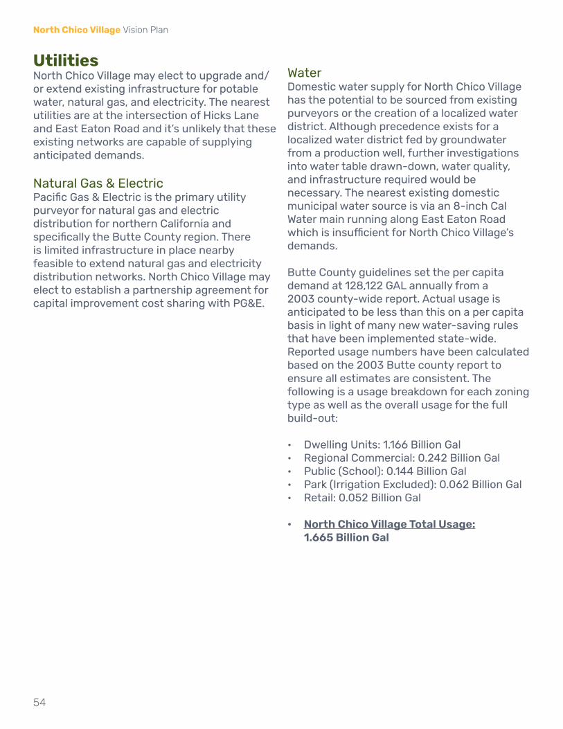
UtilitiesNorth Chico Village may elect to upgrade and/or extend existing infrastructure for potable water, natural gas, and electricity. The nearest utilities are at the intersection of Hicks Lane and East Eaton Road and it’s unlikely that these existing networks are capable of supplying anticipated demands.
Natural Gas & ElectricPacific Gas & Electric is the primary utility purveyor for natural gas and electric distribution for northern California and specifically the Butte County region. There is limited infrastructure in place nearby feasible to extend natural gas and electricity distribution networks. North Chico Village may elect to establish a partnership agreement for capital improvement cost sharing with PG&E.
WaterDomestic water supply for North Chico Village has the potential to be sourced from existing purveyors or the creation of a localized water district. Although precedence exists for a localized water district fed by groundwater from a production well, further investigations into water table drawn-down, water quality, and infrastructure required would be necessary. The nearest existing domestic municipal water source is via an 8-inch Cal Water main running along East Eaton Road which is insufficient for North Chico Village’s demands.
Butte County guidelines set the per capita demand at 128,122 GAL annually from a 2003 county-wide report. Actual usage is anticipated to be less than this on a per capita basis in light of many new water-saving rules that have been implemented state-wide. Reported usage numbers have been calculated based on the 2003 Butte county report to ensure all estimates are consistent. The following is a usage breakdown for each zoning type as well as the overall usage for the full build-out:
• Dwelling Units: 1.166 Billion Gal• Regional Commercial: 0.242 Billion Gal• Public (School): 0.144 Billion Gal• Park (Irrigation Excluded): 0.062 Billion Gal• Retail: 0.052 Billion Gal
• North Chico Village Total Usage: 1.665 Billion Gal

0
0
500
0.1
1,000
0.2FeetMiles
Hic
ks L
ane
Kittyhawk Dr
Sycamore Creek
Gar
ne
r L
ane
Mud C
reek
55
Infrastructure & Public Services
Figure 30: Utility Network
Waterways
LEGENDProject Boundary
City Limits
Parcel
State Highway
High Voltage Electric Service ExtensionPotable Water Main ExtensionNatural Gas Distribution Main Extension

56
North Chico Village Vision Plan
Public SafetyFireFire protection services for the NC Village are currently provided by the Butte County FireDepartment. Station 41, located west of the Plan Area on Hwy 99, is currently within 5 miles of the site. When Kittyhawk Drive is completed, Station 41 will be within 2 miles of the Plan Area. Additionally, the City of Chico Fire Department Station 2 is also within 5 miles away, to the south of the NC Village.
PolicePublic Safety Services for the NC Village are currently provided by the Butte County Sheriff.
Schools
The NC Village is located within the Chico Unified School District. The CUSD provides preschool, elementary, junior high and high school facilities within the district. The NC Village is within the Shasta Elementary School Boundary, the Bidwell Junior High School Boundary and the Pleasant Valley High School Boundary.

Butte County Fire Department Station 41
Bidwell Junior High School & Pleasant
Valley High School
City of Chico Fire Department Station 2
Shasta Elementary School
0
0
500
0.1
1,000
0.2FeetMiles
Hic
ks L
ane
Sycamore Creek
Hwy 99
Gar
ne
r L
ane
Keefer Rd
Mud Cre
ek
Kittyhawk D
r
57
Infrastructure & Public Services
Figure 31: Public Facilities
Waterways
LEGENDProject Boundary
City Limits
Parcel
State Highway
Kittyhawk Dr
[This Page intentionally Included]

Implementation
60
North Chico Village Vision Plan
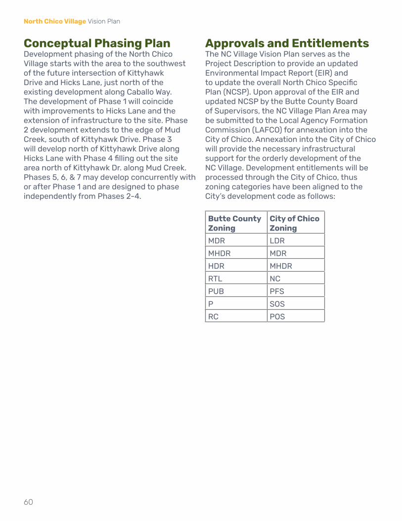
Conceptual Phasing PlanDevelopment phasing of the North Chico Village starts with the area to the southwest of the future intersection of Kittyhawk Drive and Hicks Lane, just north of the existing development along Caballo Way. The development of Phase 1 will coincide with improvements to Hicks Lane and the extension of infrastructure to the site. Phase 2 development extends to the edge of Mud Creek, south of Kittyhawk Drive. Phase 3 will develop north of Kittyhawk Drive along Hicks Lane with Phase 4 filling out the site area north of Kittyhawk Dr. along Mud Creek. Phases 5, 6, & 7 may develop concurrently with or after Phase 1 and are designed to phase independently from Phases 2-4.
Approvals and EntitlementsThe NC Village Vision Plan serves as the Project Description to provide an updated Environmental Impact Report (EIR) and to update the overall North Chico Specific Plan (NCSP). Upon approval of the EIR and updated NCSP by the Butte County Board of Supervisors, the NC Village Plan Area may be submitted to the Local Agency Formation Commission (LAFCO) for annexation into the City of Chico. Annexation into the City of Chico will provide the necessary infrastructural support for the orderly development of the NC Village. Development entitlements will be processed through the City of Chico, thus zoning categories have been aligned to the City’s development code as follows:
Butte County Zoning
City of Chico Zoning
MDR LDR
MHDR MDR
HDR MHDR
RTL NC
PUB PFS
P SOS
RC POS

0
0
500
0.1
1,000
0.2FeetMiles
Hic
ks L
ane
Kittyhawk D
r
Sycamore Creek
Gar
ne
r L
ane
Mud C
reek
Phase1
Phase2
Phase3
Phase4
Phase5
Phase6
Phase7
61
Implementation
Figure 32: Phasing Plan
Waterways
LEGENDProject Boundary Phases
City Limits
Parcel
State Highway
5
6
7
1
2
3
4

ATTACHMENT B

Hicks Lane
Chico Municipal AirportGarner Lane
North Chico Village Vision PlanEnvision the Heart of North Chico
Workshop 1 SummaryOctober 28, 2020

North Chico Village Vision PlanWorkshop #1 Summary
Workshop Overview
PURPOSE & SUMMARY ACTIVITIES & MAJOR THEMESThe County of Butte hosted the first community workshop for the North Chico Village Vision Plan. The virtual workshop was held on Wednesday, October 28, 2020 via Zoom. The materials and content were presented by their joint-selected planning and urban design consultant - SWA group.
Community members from approximately 60 households attended the workshop to share their ideas, needs and goals for the North Chico community and the project site.
The purpose of the workshop was to:• Inform the community about the project• Explain the various opportunities to participate• Understand the changes desired by the community• Solicit input on North Chico’s unique qualities,
needs and goals related to development and place-making opportunities
• Present opportunities and constraints related toexisting conditions of the project site and thesurrounding area
SWA Group gave a presentation that included the following topics:• Project introduction• Site-scaled comparisons - varying from city center/
college campus scale to a site-specific use scale• North Chico analysis and inventory with
opportunities and constraints• Overview of the visioning process and upcoming
workshops
The first activity was a pop-quiz; attendees were asked to respond to 10 questions including one bonus question at the end while the breakout room facilitator records each answer on a screen-shared word document.
The major themes that resulted from this exercise desires for:
1. Low density, rural setting2. Traffic and road improvements3. Trails and open spaces4. Neighborhood and community-oriented uses5. Safety and privacy
The second activity was a dot-polling exercise where participants were given access to an online ideas wall where they were asked to engage with various character imagery by clicking ‘like’ or ‘dislike’, They are also given the opportunity to add their own images or ideas for other community members to respond to.
This exercise is on-going and a summary of this activity will be available after Workshop #2.

North Chico Village Vision PlanWorkshop #1 Summary
Activity: Breakout Discussion Pop Quiz Results
What qualities of North Chico do you and your family value the most?
Name something that you enjoy in other places and wish you could find in North Chico.
1.Rural
Quiet
Privacy
Bike Lane
Better RoadsSafety
Flood Mitigation
Access to Public Transit
Neighbors
No Light Pollution
Better Internet Speed
Additional Police/Fire Safety
Low Crime
Open Spaces
Nothing
(x)(x)(x)
(x)
2.
Overview: Answers to the pop quiz questions below are sized based on the amount of responses received tallied by phrase.
= high
= medium/high
= medium
= low

North Chico Village Vision PlanWorkshop #1 Summary
Activity: Breakout Discussion Pop Quiz Results
Where do you go to feel connected to fellow community members in North Chico?
What do you think is unique and important about the area being planned for the North Chico Village?
3. 4.
Walks
LeveeOrchards
Low Density
Traffic
Wildlife/Livestock
Degarmo Park
Neighbor’s Homes
LeveeStars at Night
Church
Neighborhood Gatherings
Almond Blossoms
View of Planes
Schools Schools
Flooding
Open Space

North Chico Village Vision PlanWorkshop #1 Summary
Activity: Breakout Discussion Pop Quiz Results
What one use do you with could go in the North Chico Village?
What would make the North Chico Village site feel more connected to the surrounding community?
5. 6.
Parks Better Traffic
Improved Roads
Parks/Open Spaces
Trails
Police/Fire Station
Community Garden
Family Spaces
Paths/Trails
Recreational Amenities
WIldlife Preservation Area
Outdoor Exercise Equipment
Wildlife Viewing AreasAgriculture
School Walkability
Low Density

North Chico Village Vision PlanWorkshop #1 Summary
Activity: Breakout Discussion Pop Quiz Results
Do you believe that the North Chico Village has the ability to address housing shortages and housing affordability in Butte County?
Would you trade off less personal outdoor space for more neighborhood amenities such as parks, greenbelts and gathering spaces?
7. 8.
NoNo
Seems Unattainable
Up to those who live there
Like the idea
Maybe with better transit access
Livability will DeclineYes, if
Sports Complex
Shouldn’t lose natural beauty
Smaller Homes
Unsure
Maybe with different policies
Depends

North Chico Village Vision PlanWorkshop #1 Summary
Activity: Breakout Discussion Pop Quiz Results
In thinking about the next generation of residents in North Chico - the children and teens of today - what would they want to see in the North Chico Village?
How important to you is high quality neighborhood design in choosing a place to live?
9. 10.
Nature
Public Safety
Very Important
Additional Schools
Rural Feeling
Smaller Homes
Public TransitCritical
ExtremelyOpen Space
Fast-Food
Shopping
Lake
Space for FFA

North Chico Village Vision PlanWorkshop #1 Summary
Online Engagement Input
Quick Recap:
• Project Website <www.northchicovillage.com>• 1,657 unique visitors to the project website (as of 10/30/20)• 75 total survey responses (summary of online survey responses and
ideas wall engagements will be available after Workshop #2 )
Takeaways:
• Traffic and speeding is a big concern at Eaton Road, Hicks Lane, Garner Lane and Hwy 99 exit
• Hicks Lane floods annually• New developments in the area are not affordable for many
community members

Hicks Lane
Chico Municipal AirportGarner Lane
North Chico Village Vision PlanEnvision the Heart of North Chico
Appendix: Breakout Discussion Pop Quiz Notes

North Chico Village Vision PlanWorkshop #1 Summary
Breakout Group Notes
Group 1 NotesQuestion #1What qualities of North Chico do you and your family value the most?Responses:• Non-urban quality, limited traffic, open spaces• Open Spaces, Ranchette homes, low density• Less traffic, country feel• Views from levees to foothills
Question #2Name something that you enjoy in other places and wish you could find in North Chico.Responses:• Access to bus/public transit that is walkable• Bike Lanes• Enjoy what is currently there
Question #3Where do you go to feel connected to fellow community members in North Chico?Responses:• Significant number of walkers on streets/levees• Schools/churches• Tagamo Park for the library
Question #4What do you think is unique and important about the area being planned for the North Chico Village?Responses:• Orchards• Water/flooding challenges• Aquifer going down• Water quality concerns from orchards
Question #5What one use do you wish could go in the North Chico Village?Responses:• Open Space/Recreation/Community Gardens• Parks next to existing housing• Follow North Chico Specific plan – 1 acre low density
Question #6What would make the North Chico Village site feel more connected to the surrounding community?Responses:• Walkability – extend walks from levee• Housing similar to the rest of North Chico• Open Spaces
Question #7
Do you believe the North Chico Village has the ability to address housing shortages and housing affordability in Butte County? Responses:• No• Any housing development should include a portion• Keep houses smaller with bigger yards• Affordable housing should go where there are already more affordable houses• Need access to public transit/buses
Question #8Would you trade-off less personal outdoor space for more neighborhood amenities such as parks, greenbelts, and gathering places?Responses:• Question more for people that will be living there• What are the needs of the future• Concerns about losing the natural beauty for small parks• Wants to keep personal outdoor space•
Question #9In thinking about the next generation of residents in North Chico – the children and teens of today – what would they want to see in the North Chico Village?Responses:• Fast food restaurants/shopping• Depends on upbringing• Open Space• Move-up Housing• Access to public transit
Question #10How important to you is high quality neighborhood design in choosing a place to live?Responses:• Extremely important• Critical• Critical especially as it relates to roads, need roads wide enough to accommodate all of the cars. More kids living at home for longer

North Chico Village Vision PlanWorkshop #1 Summary
Breakout Group Notes
Group 2 NotesQuestion #1What qualities of North Chico do you and your family value the most?Responses:• Wide open spaces, away from urban areas, a different type of lifestyle• To be away from apartments, traffic concerns, not a welcome project• Causing hostility within the area• No light pollution at night, lack of density• Concerns of low income housing bringing down value of the area• Zoning allows for a peaceful/rural setting• Concerns of lowering housing values• Doubling of unit count in limited space will cause traffic congestion• Will require proper infrastructure support
Question #2Name something that you enjoy in other places and wish you could find in North Chico.Responses:• Nothing
Question #3Where do you go to feel connected to fellow community members in North Chico?Responses:• Neighbors
Question #4What do you think is unique and important about the area being planned for the North Chico Village?Responses:• Leave as is• Nothing unique• Distance from others• Prefer not to be surrounded by cheap neighborhoods
Preferred:• 5-acre lots preferred• High-end big lots• No multi-family
Question #5What one use do you wish could go in the North Chico Village?Responses:• Recreation• Park• Trail system that extends to bike on Eaton Rd• Wildlife preservation areas
Question #6What would make the North Chico Village site feel more connected to the surrounding
community?Responses:• Continuity – match what is currently on site• Esplanade on Eaton• Emergency services • Op1 Sewage – connect to Chico sewer / Op2 – building wastewater treatment plan = no• Schools are at maximum capacity – density can overcrowd schools• Multiple on-going projects in one area• Traffic is an on-going concern
Question #7Do you believe the North Chico Village has the ability to address housing shortages and housing affordability in Butte County? Responses:• Not the answer for housing shortages in the area• Will not improve affordability• North Chico should not be developed beyond current density• Livability will severely decline• Identification of housing shortage
Question #8Would you trade-off less personal outdoor space for more neighborhood amenities such as parks, greenbelts, and gathering places?Responses:• No
Question #9In thinking about the next generation of residents in North Chico – the children and teens of today – what would they want to see in the North Chico Village?Responses:• Leave it the way it is• Space, animals, acreage• Sense of being in the countryside • Outdoors, agriculture and nature• Not want to see – being closer to the airport
Question #10How important to you is high quality neighborhood design in choosing a place to live?Responses:• No to planned neighborhoods• North Chico is a unique area – recognize neighbors, comfortable, small community• High quality neighborhood design is very important • Living in Chico is a choice• Controlled neighborhood setting is important but without shops and density• Accountability
Other Comments:• Road improvements (potholes) – Hicks Lane• Reports on the development happening soon – clarification on timeline of project

North Chico Village Vision PlanWorkshop #1 Summary
Breakout Group Notes
Group 3 NotesQuestion #1What qualities of North Chico do you and your family value the most?Responses:• Out in the Country• Separation of Houses (rural)• ***Open Space (walk along creeks)• Safety of the creek (kids can ride bike without worrying)• Larger lot sizes, not as much traffic o Closer Neighborhood feel o Vs. Chico- Not as many Homeless• Large Open Space for horses, etc. • ***Recognize neighbors- Safer, more welcome feeling
Question #2Name something that you enjoy in other places and wish you could find in North Chico.Responses:• Views of Mountains – Paradise transplants who enjoy that feeling• Restaurants• “Like what we’ve got”• More open space
**Vote- Who wants development and who doesn’t**
Question #3Where do you go to feel connected to fellow community members in North Chico?Responses:• Connect with people around when walking horse (don’t have to worry about traffic) and people come to visit• Established friendships over the years• Degarmo Park• Close knit community naturally
Question #4What do you think is unique and important about the area being planned for the North Chico Village?Responses:• “Nobody there”• Good buffer between development o Orchard are nice greenlines
Question #5What one use do you wish could go in the North Chico Village?Responses:• Police station• Fire station• Airport Access that betters traffic• Garner backs up to
Question #6What would make the North Chico Village site feel more connected to the surrounding community?Responses:• Bike paths, walking paths • Sycamore creek to bidwell park• More rural feeling will help the community feel more connected• Park possibly
Question #7Do you believe the North Chico Village has the ability to address housing shortages and housing affordability in Butte County? Responses:• No• Worried about high density housing-
Question #8Would you trade-off less personal outdoor space for more neighborhood amenities such as parks, greenbelts, and gathering places?Responses:• No
Question #9In thinking about the next generation of residents in North Chico – the children and teens of today – what would they want to see in the North Chico Village?Responses:• Like things to stay the same• Like the room to do FFA, etc.
Question #10How important to you is high quality neighborhood design in choosing a place to live?Responses:• Very important to have high quality, well thought out design• Design important due to flooding issues

North Chico Village Vision PlanWorkshop #1 Summary
Breakout Group Notes
Group 4 NotesQuestion #1What qualities of North Chico do you and your family value the most?Responses:• Privacy• Rural setting. Low density housing• Minimal light pollution• Low crime area• Low traffic
Question #2Name something that you enjoy in other places and wish you could find in North Chico.Responses:• Vineyards• Everything we have is already here.
Question #3Where do you go to feel connected to fellow community members in North Chico?Responses:• Next Door App (Online)• Travel next door to speak with neighbors.
Question #4What do you think is unique and important about the area being planned for the North Chico Village?Responses:• Cattle ranch, Open space, Nature• Recharge area for groundwater.
Question #5What one use do you wish could go in the North Chico Village?Responses:• Keep open space and agriculture uses.
Question #6What would make the North Chico Village site feel more connected to the surrounding community?Responses:• Improving roads and intersection on Hwy 99 and Hicks.• Feel more connected to the surrounding community by not building anything. The open space is what is enjoyed by the surrounding community.
Question #7Do you believe the North Chico Village has the ability to address housing shortages and housing affordability in Butte County? Responses:• No additional housing.
Question #8Would you trade-off less personal outdoor space for more neighborhood amenities such as parks, greenbelts, and gathering places?Responses:• No
Question #9In thinking about the next generation of residents in North Chico – the children and teens of today – what would they want to see in the North Chico Village?Responses:• Children would like to experience the open space and interact with nature.• Children and teens can experience and play in their own yards.
Question #10How important to you is high quality neighborhood design in choosing a place to live?Responses:• Enjoy large lots.

North Chico Village Vision PlanWorkshop #1 Summary
Breakout Group Notes
Group 5 NotesQuestion #1What qualities of North Chico do you and your family value the most?Responses:• Close to freeway/downtown, but quiet, not densely packed, Rural, animal keeping, horse riding on slough/4H projects• Likes rural lifestyle, expanse of space, not crowded• Low Traffic• Costs of public services for adjacent parcels if sewer hookups are required.• Does not want City water/sewer• Water quality concerns
Question #2Name something that you enjoy in other places and wish you could find in North Chico.Responses:• Schools are busy/Needs of children• Does not mind traveling into town to get to services• Peace and quiet is the main attraction to living in North Chico• Likes being outside of town• Grocery Store is missing
Question #3Where do you go to feel connected to fellow community members in North Chico?Responses:• Does not feel need to be connected to North Chico, does feel community connection to coffee shops nearby• The main hub is downtown Chico that is where we connect with community• Can get to everything in Chico within 15 minutes from North Chico, not necessary to have these services in north chico.
Question #4What do you think is unique and important about the area being planned for the North Chico Village?Responses:• Wildlife/doves, turkeys• Open Space• Relatively close to town and rural setting• 4H groups, great for raising children
Question #5What one use do you wish could go in the North Chico Village?Responses:• Maybe a grocery store• Greenbelt Park along creeks• No rec centers or playgrounds
Question #6What would make the North Chico Village site feel more connected to the surrounding
community?Responses:• Every home to be 1 to 2 acres, develop in the same way as the adjacent properties• Continue with openness, large lots• High density close to freeway to help block noise for this area
Question #7Do you believe the North Chico Village has the ability to address housing shortages and housing affordability in Butte County? Responses:• Yes it does unfortunately, but that comes with other issues; • Definitely help with availability but not affordability, prices will follow the market• What are we describing as affordable?• Small starter type family housing would be helpful but not at this location
Question #8Would you trade-off less personal outdoor space for more neighborhood amenities such as parks, greenbelts, and gathering places?Responses:• Text here
Question #9In thinking about the next generation of residents in North Chico – the children and teens of today – what would they want to see in the North Chico Village?Responses:• Text here
Question #10How important to you is high quality neighborhood design in choosing a place to live?Responses:• Text here

North Chico Village Vision PlanWorkshop #1 Summary
Breakout Group Notes
Group 6 NotesQuestion #1What qualities of North Chico do you and your family value the most?Responses:• Privacy and not a downtown feel• Resident for over 40 years. Lot size are larger. Out of the city and a little bit of country, but not too far from town. Have animals. Future improvements for the development. Less traffic in the area.• Lived in Chico whole live. The area is larger lots. Want their space. One of the few areas left that don’t have a lot of neighbors. Like the country like setting. Get away from crime.
Question #2Name something that you enjoy in other places and wish you could find in North Chico.Responses:• We already have what we need. Amenities are not too far away• Like it the way it is• Hicks Lane bike lane would be helpful
Question #3Where do you go to feel connected to fellow community members in North Chico?Responses:• School, other people’s houses• Neighborhood’s involved organizing gatherings• Existing wide streets to allow kids to play
Question #4What do you think is unique and important about the area being planned for the North Chico Village?Responses:• Lot of wildlife• Open space• Proper road development is needed• Like the ability to watch the planes• Use the levy for exercise, pedestrian use, more freedom• Agriculture in the area along with neighborhoods and close enough to Chico• Will miss the almonds blossoms and the agriculture when it is gone.• With the development, loss of wildlife in the area.
Question #5What one use do you wish could go in the North Chico Village?Responses:• Nothing• Family park use space, safer family area
Question #6What would make the North Chico Village site feel more connected to the surrounding community?Responses:
• Each building area have an open space/playground (1 acre minimum)• Wildlife viewing areas• Parcels aren’t planned as clustered development. Larger lots to be compatible to surrounding uses• Limit to 2 story development. Don’t like the high rise development• Outdoor exercise equipment incorporated into the open space area
Question #7Do you believe the North Chico Village has the ability to address housing shortages and housing affordability in Butte County? Responses:• No• Hope not• How putting in a big housing development (multi-family) be affordable housing, based on the location.• Additional development along Hicks Lane will add issues to the existing Hicks Lane/Eaton Avenue Intersection
Question #8Would you trade-off less personal outdoor space for more neighborhood amenities such as parks, greenbelts, and gathering places?Responses:• Would not trade-off personal space for more community/neighborhood amenities.• Don’t want to trade-off personal space for more common open space areas which will equate more people with the additional development• Area stay rural – larger personal lots• Don’t have issues with traveling to community parks other open space areas
Question #9In thinking about the next generation of residents in North Chico – the children and teens of today – what would they want to see in the North Chico Village?Responses:• Impacts on schools in the area. Children need to be advocated for, additional schools are needed.• NCSP did identify an elementary school• Have their neighborhoods they grew up in preserved.• Like being in the rural area and want it to remain that way. Forgo being close to friends and parks to enjoy the natural open space. Like the existing wildlife and open space.• Public safety for the area. Need more police needed keep the area safe, for kids as well.
Question #10How important to you is high quality neighborhood design in choosing a place to live?Responses:• Like the high quality neighborhood we have already, larger lots• Extra wide streets, larger lots.• Wider streets, more cul-de-sac for kids to play on safely• No tract homes or low income neighborhoods

North Chico Village Vision PlanWorkshop #1 Summary
Breakout Group Notes
Group 7 NotesQuestion #1What qualities of North Chico do you and your family value the most?Responses:• Open space, low crime rate• Lack of congestion• Low density
Question #2Name something that you enjoy in other places and wish you could find in North Chico.Responses:• Wide open spaces• Country feel• Better infrastructure• Flood mitigation• Additional police and fire
Question #3Where do you go to feel connected to fellow community members in North Chico?Responses:• Neighbors, staying within the neighborhood• Levee• On walks
Question #4What do you think is unique and important about the area being planned for the North Chico Village?Responses:• Sticking to similar feelings around the area currently• The rural feeling• Low density housing• The quiet• The agricultural land, having livestock around• A quiet neighborhood • Dark, not too many street lights o Being able to see the stars
Question #5What one use do you wish could go in the North Chico Village?Responses:• Bike trail• Opening the creek area between the levees for recreation, within the flood plains• Walking trails• Lake, something that would really assist with flooding
Question #6What would make the North Chico Village site feel more connected to the surrounding community?Responses:• What we already have• Really would like to keep housing density low o Want to keep the area as close to it is now as possible• Stay rural
Question #7Do you believe the North Chico Village has the ability to address housing shortages and housing affordability in Butte County? Responses:• No, it depends on your interpretation of affordability• It doesn’t seem attainable as it is• If we stay low density housing, the answer to this would likely be no
Question #8Would you trade-off less personal outdoor space for more neighborhood amenities such as parks, greenbelts, and gathering places?Responses:• No
Question #9In thinking about the next generation of residents in North Chico – the children and teens of today – what would they want to see in the North Chico Village?Responses:• Lake• We want a space in which the children can experience a rural life• We don’t want to lose the agricultural feel that we currently have• Having a space for Future Farmers of America kids• A place to raise animals• Schools within close proximity
Concerns about this plan:• A concern is that there are few amenities o This ties into poor infrastructure• This community makes the choice to drive a bit further for amenities for this rural space• Traffic gets backed up on Eaton, Keefer, and Garner• Sewage System• Well water for homes o An addition of a water system• Highway 99 in general
o Specifically the capacity and interchanges o The 99 intersection is rated F o Would like to see it widened and better access• Evacuation routes o Minimal lanes• Limited police and fire support in the area o Wait times associated o Impacted by the highway and traffic related• Flooding • Don’t necessarily want more sidewalks
Question #10How important to you is high quality neighborhood design in choosing a place to live?Responses:• Very important

North Chico Village Vision PlanWorkshop #1 Summary
Breakout Group Notes
Group 8 NotesQuestion #1What qualities of North Chico do you and your family value the most?Responses:• Wide open spaces and land; quite, not as populated• Traffic is limited compared to more urban areas – depending on the time of day -Garner traffic is getting bad and accidents• Like not having businesses in the area• Like rural area and space; being in the country but be near the City.• Country atmosphere• Things are perfect right now• Feel safe to have children grow up in; don’t worry about crime
Question #2Name something that you enjoy in other places and wish you could find in North Chico.Responses:• Better internet connections and internet service• Better roads. Roads do not get treated or maintained; there are pot holes
Question #3Where do you go to feel connected to fellow community members in North Chico?Responses:• We don’t have to go anywhere – we go to our neighbors house with a balance of privacy and community
Question #4What do you think is unique and important about the area being planned for the North Chico Village?Responses:• There is no one there. Unpopulated. Can it be farm land?• Like the airplanes flying in the area, love the airport and airplanes. Concern about constraints on the airport and people pressuring the airport. Need to support expansion of the airport.• Support the air shows and air museum
Question #5What one use do you wish could go in the North Chico Village?Responses:• State park or park• Next to airport will be noisy• Sports/play complex including baseball, track, enclosed roller hockey; uses that families can be used in a safe environment; uses to support the existing community
Question #6What would make the North Chico Village site feel more connected to the surrounding community?Responses:• Make housing minimum of 1-acre parcels to blend in to the surrounding area
• Bike lanes or paths to connect to the area including down Hicks
Question #7Do you believe the North Chico Village has the ability to address housing shortages and housing affordability in Butte County? Responses:• This is not a fair question; any 390 acre are could do this given the resources.
Question #8Would you trade-off less personal outdoor space for more neighborhood amenities such as parks, greenbelts, and gathering places?Responses:• Like the idea of community and connections to neighbors without parks, greenbelts and gathering places• Space is important for walking and getting outdoors• Not interested in high density development• Prefer to have a sports complex or park over housing
Question #9In thinking about the next generation of residents in North Chico – the children and teens of today – what would they want to see in the North Chico Village?Responses:• Family feel of the community, place to get together to interact and be active• Youth return to enjoy the rural large lot space that this area offers• Quality of life in the north Butte County area to raise their children• Keep as is – meaning large lots, 1-acre size parcels• Water situation, wells have been running dry, need a plan for water to sustain households and not deprive my well• Would not like to see any commercial in this area• Do not want traffic or downtown Chico problems• Keep neighbors connected to each other• Not interested in seeing Chico annexation of the area
Question #10How important to you is high quality neighborhood design in choosing a place to live?Responses:• Very important• Priceless• This means that you have thought about parcel sizes, traffic flow, impact to environment, and how things blend• Value the existing design of rural, 1-acre minimum parcels

North Chico Village Vision PlanWorkshop #1 Summary
Breakout Group Notes
Group 9 NotesQuestion #1What qualities of North Chico do you and your family value the most?Responses:• Open space, large lots, less traffic• Safety, less transients
Question #2Name something that you enjoy in other places and wish you could find in North Chico.Responses:• Nothing – love it as it is• Enjoys the space as it is• Residents live here understanding that they’ll travel to Chico for commercial needs etc.
Question #3Where do you go to feel connected to fellow community members in North Chico?Responses:• Know and love neighbors, visit on each other’s properties, go into town for other activities• Go for runs and walks, know all neighbors and see them often o DeGarmo park
Question #4What do you think is unique and important about the area being planned for the North Chico Village?Responses:• Parks, open space, housing o Would NOT like to see businesses come in• Would take major reconstruction of roads to accommodate for exponentially more traffic• Garner 99 intersection currently a disaster o Accidents almost daily o No lights, fast traffic, blind turn• 1 mile drive took 15 minutes pre-COVID (from house to Garner 99 intersection)
Question #5What one use do you wish could go in the North Chico Village?Responses:• If building additional medium density, need another school
Question #6What would make the North Chico Village site feel more connected to the surrounding community?Responses:• Industrial wouldn’t make sense; something different that fits with the community
Question #7Do you believe the North Chico Village has the ability to address housing shortages and housing affordability in Butte County? Responses:
• Essentially not
Question #8Would you trade-off less personal outdoor space for more neighborhood amenities such as parks, greenbelts, and gathering places?Responses:• Should be up to the people who live there• Currently parks and greenbelts are dangerous• With different policies this could be great, but with current policies would be a nightmare
Question #9In thinking about the next generation of residents in North Chico – the children and teens of today – what would they want to see in the North Chico Village?Responses:• A safe place to go and to play
Question #10How important to you is high quality neighborhood design in choosing a place to live?Responses:• Incredibly important (all aspects)

North Chico Village Vision PlanWorkshop #1 Summary
Workshop Chat Box18:16:16 From Ben Juliano : Missing challenge: Fire service/support?18:16:50 From 452923 : Good point18:17:48 From Mike : Butte County fire has acquired 5 acres on corner of Keefer and Garner. 18:20:21 From Ben Juliano : I have been informed via a Cal Fire connection that our Fire Station 41 north of Chico is already enundated with having to service downtown Chico ...18:21:40 From Jen Skinner : closing station 42 his significantly increased the burden on station 41.18:22:22 From hartman : Whatever happened to the green line in Chico/Butte?18:23:47 From Debra Lucero : The Green Line still exists. Perhaps one of the staff can include a map link for everyone.18:24:08 From K : What about the impact on Shasta elemetary?18:24:37 From 452923 : I was wondering about the green belt, would love to see the map18:24:59 From Tom and Carol Huston : does this impact future growth plans for the airport?18:25:12 From Jeff and Eva Moore : What about schools in general. They are all overcrowded.18:25:18 From Tom and Carol Huston : what about flooding from the two sloughs?18:25:35 From b4bc2 : Green belt/line is mostly on the westside of Chico18:25:45 From Ben Juliano : What about law enforcement services?18:26:12 From Jen Skinner : none of these families in the new development will be Shasta families. Redistricting looked like new development in north chico would be directed to Neal Dow or other schools18:26:16 From Jeanie : my question is about hicks which is a disaster once it become county and is heavily used18:26:47 From Lori Adrian : So will Kittyhawk….18:27:09 From Tom and Carol Huston : impact on traffic on Sierra Moon is a significant concern18:28:04 From Ben Juliano : Chat gets saved in the archive, so you should be using it!18:28:05 From Mike : Kittyhawk will become a major road thru a quiet neighborhood18:28:14 From Ben Juliano : THANK YOU!18:28:33 From iPhone Sierra Moon Resident : does anyone in this area want this? we are blown away that this is a possibility18:29:00 From heather bettencourt : No! We do not want this! Peace and quiet is why we moved out here!18:29:07 From Ben Juliano : I don’t want it.18:29:20 From AJ Patton : My biggest concern is the amount of transient garbage and crime that will come with the spaces being proposed with policies currently in place that allow lawlessness and the law abiding residents are punished.18:29:27 From Ben Juliano : Too many concerns presented already ...18:29:32 From Kelly Jimerfield : Concerned about the ability to evacuate in an emergency, to much traffic congestion currently18:29:32 From danebaxter : Nobody wants it who live out here18:29:33 From 452923 : I moved here because I like being away from the urban areas18:29:37 From b4bc2 : Surface street to Hwy 99 is one thing but what about on and off ramps to Hwy 99? 18:29:37 From Tom and Carol Huston : we do not want it either.... so much more traffic. Will border an expensive subdivision18:29:38 From Christina Palmer : No we do not want it. We moved out of the city for a reason.18:29:38 From Debra Lucero : Please continue to use chat. It will be considered; questions will not be answered tonight via chat. That was the message.18:29:38 From K : I think a majority of North Chico does not want this.19:25:57 From Jeanie : We’re out here for rural because we don’t want urban19:26:18 From Mike : Amen19:26:39 From Troy Franzen : Amen x219:26:56 From Carol Huston : I question the relevance of the 1995 plan now that low density, high cost home developments have been built in the area. It is not the same as it was in 199519:27:00 From Tina : Amen x100019:27:33 From Christina Palmer : Thats a great point Carol!
19:27:44 From Gitta : agreed19:28:24 From Tina : A grocery store is less than 5 mies away!!!!!!19:29:00 From Jeanie : put them on the east side. this end is upper end19:29:06 From K : Dan Breedon I believe our group said no this would NOT solve the housing issue.19:30:05 From Carol Huston : the idea that Kittyhawk could provide a corridor to the freeway was in the 1995 plan. Again, that was long before Kittyhawk became a low density thriving neighborhood19:30:14 From Gitta : I think size19:30:20 From Lauren Gunter : our break out session was not recorded and the summary comments were very abridged in this recorded session 19:30:38 From Gitta : Of the project is extreme19:30:50 From Jeanie : I think you could put affordability out west near Meadowbrook or East near Ceres and those streets with current building. But stay out of this middle area for more density. we are here for low density19:31:46 From Carol Huston : There are areas in Chico where high density, affordable housing is the norm. That is not the case here. Why the efforts to change the culture of north Chico when there is growth in other areas where high density, low cost is the norm?19:32:07 From Gitta : I suggest you can keep low density and also keep housing prices lower by building smaller homes on large lots.19:32:22 From Desta : I wasn’t in Dan’s group but I certainly agree this area does NOT have the ability or responsibility to solve the affordable housing issue. There have to be starter neighborhoods, middle neighborhoods and move-up neighborhoods. You can’t destroy the move up neighborhood by forcing something that doesn’t belong here. High density and low income housing should go where the services already are and where the housing is similar.19:32:38 From Mary Ellen Woodmansee : no mention about airport concerns19:33:05 From Kathy Hughes : they stopped the building in east Chico once the one acre minimums were held up19:33:17 From Troy Franzen : Well said Desta19:33:57 From Mike : The Otterson Drive Extension in South Chico to the Hegan Lane Industrial Park was planned years ago too.. concerned citizens gathered 2500 signatures to force a referendum..it was defeated by the voters and it was not extended and no bridge was built to Hegan Lane Business Park.19:34:11 From MinerManor : some of us live on privately owned streets. The increased traffic and use will affect the lifespan of our paving. It will cost us in the long run...19:34:13 From Kathy Hughes : and apts were stopped. no longer financial benefit to developer19:34:20 From Tina : Can we petition this project? 19:34:34 From K : The lack of available law enforcement in the city to deal with the numbers pf individuals that are being proposed.19:34:42 From K : of*19:34:43 From Gitta : Jamming 2000 housing units in for starters means 6000 more residents if they are families of 319:34:43 From Sara Alderson : let’s start a petition hoe do we start that?19:34:43 From Greg : Good to hear all our rooms have similar concerns and like our current live style.19:36:00 From Christina Palmer : Thank you everyone for spending your night here…trying to preserve everything that we love about our area. I hope we were heard loud and clear.19:36:50 From Jeanie : change to minimum lot size of 1 acre. no density stuff that is on current plan19:37:07 From Jeanie : no multifamily lots19:37:15 From N. Chico Resident : How do we make the “plan” to be to leave it as agriculture or an open space without any development EVER19:37:16 From Carol Huston : In 1995, there were limited homes in this area and no low density, high cost subdivisions. To keep referring to a 30 year old plan that has little relevance to what the area looks like now, is frustrating19:37:37 From Sara Alderson : How do we see the current 1995 North Butte County Plan?19:37:47 From Kathy Hughes : high density is more tax money

North Chico Village Vision PlanWorkshop #1 Summary
Workshop Chat Box19:37:50 From Jeanie : the current plan has a bunch of high density areas which is what we don’t want19:37:59 From AJ Patton : Yes after 30 years there needs to be major adjustments to that original plan19:38:26 From Jeanie : so we have to change it to stop from having 2000 units in the small area?19:38:48 From Tina : Yes one acre minimums for sure!19:38:55 From Greg : Leave as is in the current NCSP and address the areas that have not been completed in the current NCSP.19:38:56 From Jen Skinner : That’s why they are asking for input on whether that plan should change or stay the same. They are gathering our input on that.19:39:37 From Gitta : Idk why they say there is no project when the North Chico Village Vision is talking about 2000 housing units? A bit confusing, I’ld say19:40:08 From Cindy Reiswig : Exactly. I just asked in our room if this was a done deal and was told yes.19:40:09 From Desta : Could you please investigate OTHER locations for your high density/low income project? I don’t think people out here would object to parks, tree, walking paths and small, low density development -- but the majority of us (as you’ve heard) moved out here for a reason and don’t want high density housing/development.19:40:12 From Kathy Hughes : if state funded research and city/county are looking for funding while addressing access to housing. up hill fight. I’m in!19:41:02 From Gitta : Now Austin is cling it a project again19:41:06 From N. Chico Resident : IF they are going to develop the land, it should reflect the current layout... 1 acre+ parcels and orchards, not apartments or anything that lowers the quality of our neighborhood19:41:27 From Desta : Right!19:42:05 From Carol Huston : certainly sounds like a project... not just an investigation of ideas19:42:22 From Jeanie : something is going on that’s for sure19:42:54 From Christina Palmer : Our group had a lot of specific questions and they were all deflected. Every single one.19:42:56 From Tina : WEneed to have a neighbohood meeting!!!19:42:59 From Marissa Maxey : Thank you!19:43:03 From heather bettencourt : We moved from Long Beach to get away from people and traffic. We don’t want to see it come to our neighborhood!19:43:03 From Kathy Hughes : yea!19:43:16 From Jeanie : NO project lol19:43:17 From Debra Lucero : Thanks to everyone!19:43:23 From Kathy Hughes : from LA area19:43:23 From Gitta : Yes we need a neighborhood initiative19:43:29 From Kathy Hughes : yes19:43:56 From Jeanie : someone needs to discover an endangered species in these flood zones. 19:44:17 From Tina : Meadow Foam!!!! The Brine Shrimp!19:44:25 From Jeanie : there ya go lol19:44:28 From heather bettencourt : What happened to the endangered meadow foam?19:44:28 From Gitta : They probably exist, Jeanie19:44:33 From Jen Skinner : lol19:44:34 From Christina Palmer : Jeanie-my husband just said the same thing!19:45:15 From Jeanie : can you reexplain what those are paula?19:45:27 From Jeanie : tell us again what R3 is?19:45:58 From K : That plan needs to be readily available for residents to see.19:46:40 From Marissa Maxey : They are asking for community input so they can possibly amend and change the plan.19:46:52 From Tina : She needs to head up the neighborhood meeting!!!!19:47:29 From AJ Patton : original 1995 plan: https://s3-us-west-2.amazonaws.com/mysocialpinpoint/uploads/redactor_assets/documents/21256/NCSP.pdf19:47:52 From Jen Skinner : Thanks AJ!
19:48:14 From Jeanie : so we want to change to one acre minimum or ag usage? rural residential?19:48:22 From Ben Juliano : the questions posed in the survey and by the planning design team did not lend themselves to rolling back...19:48:30 From K : I think the community would like it to stay 1 acre minimum, single family!19:48:48 From K : Thats not wanting to be heard.19:49:46 From Ben Juliano : also not wanting to be heard is a strong request for data that supports local housing shortage claims.19:50:34 From heather bettencourt : I don’t understand how this could be affordable housing when we live in an expensive area.19:50:42 From K : agreed19:50:54 From MinerManor : If it’s possible to change this, why are they hiring these people to work for the next 3-4 months? I understand it’s grant money but seems it could be better spent...19:51:20 From Tina : yes like on the homeless downtown19:51:40 From Jeanie : yes19:53:00 From Kathy Hughes : thx Debra19:53:12 From AJ Patton : @ Gitta: where do we find the amendments to the 1995 plan?19:53:58 From K : Mailers…..19:54:13 From K : would be considerate19:54:36 From Debra Lucero : [email protected]:54:37 From Troy Franzen : Neighborhood Facebook group?19:54:50 From Jeanie : I just heard on the news last night19:54:55 From heather bettencourt : Yes, north chico neighbors group on facebook19:54:58 From Carol Huston : I first heard about this last night on the news when they announced public input was needed for the proposed/planned new development of 4000 units in north Chico19:55:04 From Christina Palmer : Troy-I posted on the link on fb tonight19:55:16 From Troy Franzen : Thanks!19:55:20 From Christina Palmer : In North Chico Neighbors19:55:20 From Jeanie : what f b page?19:55:37 From Jen Skinner : yes! our n Chico page was how I found out as well.19:57:47 From MinerManor : couldn’t the mailers be paid for by the grant money?19:58:05 From Jeanie : you could make a facebook page for this project. a group folks to join or page to see specific to this19:58:19 From Ben Juliano : Anyone can save the chat messages, in case you are interested ...
19:58:42 From Jeanie : yes click the three dots on right in chat and save19:58:56 From K : I think that should be a very important budget item!!! Reaching the people this affects. Send mail!19:59:01 From Desta : Thank you for your time tonight.

Hicks Lane
Chico Municipal AirportGarner Lane
North Chico Village Vision PlanEnvision the Heart of North Chico

North Chico Village Vision PlanEnvision the Heart of North Chico
Workshop 2 SummaryNovember 18, 2020
Hicks Lane
Chico Municipal AirportGarner Lane

North Chico Village Vision PlanWorkshop #2 Summary
2
PURPOSE & SUMMARY ACTIVITIES & MAJOR THEMESThe County of Butte hosted the second community workshop for the North Chico Village Vision Plan. The virtual workshop was held on Wednesday, November 18, 2020 via Zoom. The materials and content were presented by their selected planning and urban design consultant – SWA Group.
Approximately 74 households attended the second workshop to share their ideas, needs and goals for the North Chico community and the planning site.
The purpose of the workshop was to:
• Inform the community about the existing specific plan• Explain the various opportunities to modify the existing plan• Present case studies illustrating comparable studies whose goals exhibit the ideas expressed in themes from the first workshop• To involve community members in an “hands-on” virtual design activity to generate planning concepts for consideration in the future alternatives study
SWA Group gave a presentation that included the following topics:
• Workshop 1 Summary• Overview of the existing North Chico Specific Plan• Overview of the planning site • Summary of improvement areas in and around the planning site• Comparable Studies
The first activity was a land use survey where participants were given questions regarding their preferred location of various site amenities and land uses and asked to indicate preference in the form of a multiple choice survey.
The second activity was a mapping exercise. Participants were given access to an online map where they were presented with various site amenity markers to be pinned into any location of their preference within the planning site. A comment box was provided with each pin where community members
can write down detailed descriptions of the reasoning behind their desired land uses and amenities and the preferred location.
The major themes that resulted from this exercise are:
1. Trails and open space along the creek2. Light Industrial and/or retail along Hicks Ln3. School at the center of the site4. Bike lanes on Hicks Ln5. Larger lots adjacent to existing single family
homes on Caballo Way6. High density homes closer to the freeway
Workshop Overview

North Chico Village Vision PlanWorkshop #2 Summary
3
38%
27%
35%
WOULD YOU RATHER HAVE:
Mostly low-intensity residentialdevelopment (single family and/or smalllot homes) with less open space (eg.only community trails)
A mix of low-intensity and medium-intensity residential development withsome open space (eg. community trailsand a small neighborhood park)
Some medium-intensity residentialdevelopment (small lot homes and/ortown homes and multi-family) withmore open space (eg. community trails,a small neighborhood park plus a largercommunity park)
Activity #1: Land Use Survey
*Gathered from a total of 36 participants
HOUSING

North Chico Village Vision PlanWorkshop #2 Summary
4
Along Sycamore
Creek28%
Along Mud Creek35%
Along Hicks Lane18%
In the middle of the site
19%
WHAT IS A GOOD LOCATION FOR LOW-INTENSITY RESIDENTIAL DEVELOPMENT (SELECT ALL THAT APPLY)?
Along Sycamore Creek Along Mud Creek
Along Hicks Lane In the middle of the site
Along Sycamore Creek21%
Along Mud Creek11%
Along Hicks Lane43%
In the middle of the site
25%
WHAT IS A GOOD LOCATION FOR MEDIUM-INTENSITY RESIDENTIAL DEVELOPMENT (SELECT ALL THAT APPLY)?
Along Sycamore Creek Along Mud Creek
Along Hicks Lane In the middle of the site
Activity #1: Land Use Survey
HOUSING
*Gathered from a total of 36 participants

North Chico Village Vision PlanWorkshop #2 Summary
5
Sports Park32%
Hockey Rink5%
Swim Center18%
Community Farm45%
WOULD SOME MORE INTENSE RESIDENTIAL DEVELOPMENT BE OK IF ONE OF THE FOLLOWING COMMUNITY AMENITIES COULD BE PROVIDED?:
Sports Park
Hockey Rink
Swim Center
Community Farm
Activity #1: Land Use Survey
HOUSING
*Gathered from a total of 36 participants

North Chico Village Vision PlanWorkshop #2 Summary
6
Along Sycamore Creek
7%
Along Mud Creek20%
Along Hicks Lane25%
In the middle of the site
48%
WHAT IS A GOOD LOCATION FOR A SCHOOL (SELECT ALL THAT APPLY)?
Along Sycamore Creek
Along Mud Creek
Along Hicks Lane
In the middle of the site
Activity #1: Land Use Survey
COMMUNITY & COMMERCIAL
*Gathered from a total of 36 participants

North Chico Village Vision PlanWorkshop #2 Summary
7
Activity #1: Land Use Survey
COMMUNITY & COMMERCIAL
Along Sycamore Creek13%
Along Mud Creek15%
Along Hicks Lane57%
In the middle of the site
15%
WHAT IS A GOOD LOCATION FOR A COMMERCIAL USE (RESTAURANT/CAFE OR SMALL MARKET) (SELECT ALL THAT APPLY)?
Along Sycamore Creek
Along Mud Creek
Along Hicks Lane
In the middle of the site
*Gathered from a total of 36 participants
North Chico Village Vision PlanWorkshop #2 Summary
8
Activity #1: Land Use Survey
COMMUNITY & COMMERCIAL
No change36%
Less Light-Industrial
56%
More Light-Industrial
8%
A SMALL PART OF THE NORTH CHICO VILLAGE PLAN AT THE INTERSECTION OF HICKS LANE AND MUD CREEK IS CURRENTLY DESIGNATED FOR LIGHT-INDUSTRIAL.
WOULD YOU LIKE TO SEE:
No change
Less Light-Industrial
More Light-Industrial
*Gathered from a total of 36 participants

North Chico Village Vision PlanWorkshop #2 Summary
9
Big Ideas & Recurring Themes:
• Parks, trails and bike lanes along the creek
• Bike lanes along Hicks Ln• High density housing along the
freeway (southwest of the site)• Industrial near main arterial• Larger single family lots • New grocery store• School in the middle of the site
Activity #2: Land Use Mapping
GROUP 1

North Chico Village Vision PlanWorkshop #2 Summary
10
Big Ideas & Recurring Themes:
• New homes farthest away from existing development (along Caballo Way)
• Open space and trails along the creek
• Open space and trails at the perimeter of existing development (along Caballo Way)
Activity #2: Land Use Mapping
GROUP 2

North Chico Village Vision PlanWorkshop #2 Summary
11
Big Ideas & Recurring Themes:
• Community farms and orchards• Trails and bike lanes at site
perimeter• High density housing along Hicks
Ln• Low density housing at the center
of site • Low density housing close to
existing single family development along Caballo Way
• Retail along the freeway 99 and Hicks Ln
Activity #2: Land Use Mapping
GROUP 3

North Chico Village Vision PlanWorkshop #2 Summary
12
Big Ideas & Recurring Themes:
• Bike lanes along Hicks Ln• Lots of trees site-wide• New community farm• Trail along the creek
Activity #2: Land Use Mapping
GROUP 4

North Chico Village Vision PlanWorkshop #2 Summary
13
Big Ideas & Recurring Themes:
• School near main road• Coffee shop near main road• High and medium density housing
at southern parts of the site• Trails along the creek• Lots of planting site-wide
Activity #2: Land Use Mapping
GROUP 5
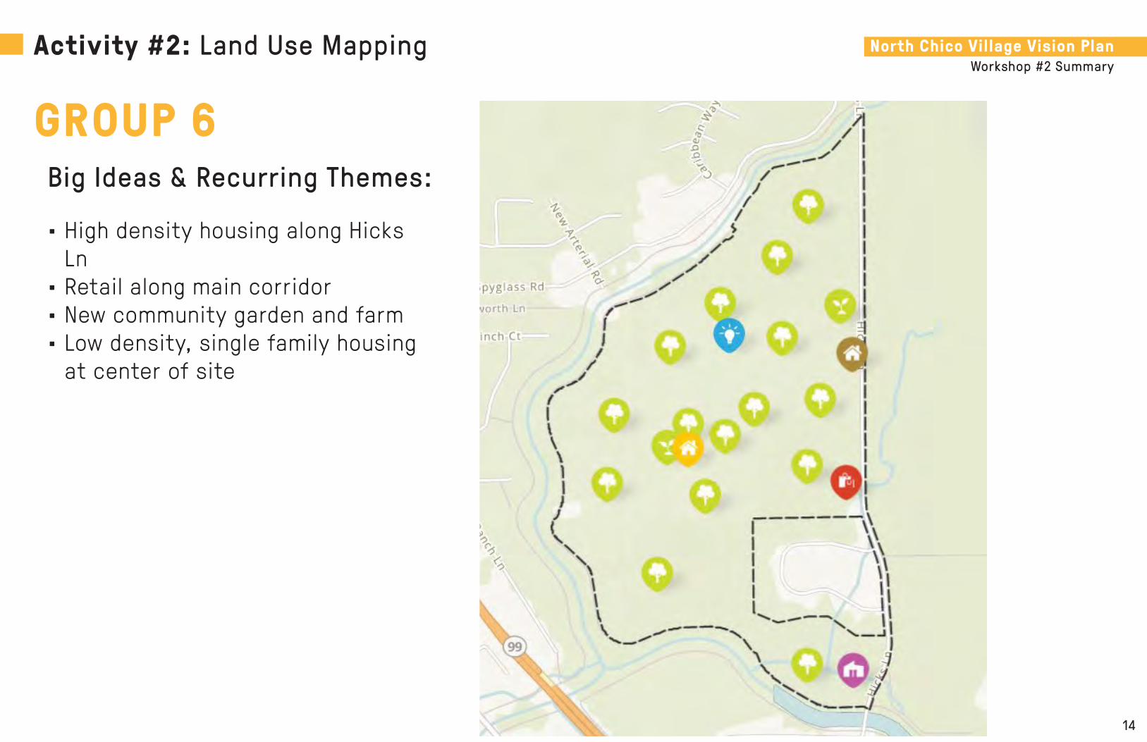
North Chico Village Vision PlanWorkshop #2 Summary
14
Big Ideas & Recurring Themes:
• High density housing along Hicks Ln
• Retail along main corridor• New community garden and farm• Low density, single family housing
at center of site
Activity #2: Land Use Mapping
GROUP 6

North Chico Village Vision PlanWorkshop #2 Summary
15
Big Ideas & Recurring Themes:
• Bike lanes and trails throughout the site
• Flood buffer from creeks• New golf course• Nature center and learning area• Lots of open space site-wide
Activity #2: Land Use Mapping
GROUP 7

North Chico Village Vision PlanWorkshop #2 Summary
16
Big Ideas & Recurring Themes:
• Riparian corridors along the creek• Light industrial at the center of
the site• High density residential at the core
of planning area• Commercial and businesses along
Hicks Ln • Transportation hub at south of site
Activity #2: Land Use Mapping
GROUP 8

Hicks Lane
Chico Municipal AirportGarner Lane
North Chico Village Vision PlanEnvision the Heart of North Chico

North Chico Village Vision PlanEnvision the Heart of North Chico
Workshop 3 SummaryDecember 9, 2020
Hicks Lane
Chico Municipal AirportGarner Lane

North Chico Village Vision PlanWorkshop #3 Summary
2
PURPOSE & SUMMARY ACTIVITIES & MAJOR THEMESThe County of Butte hosted the third and final community workshop for the North Chico Village Vision Plan. The virtual workshop was held on Wednesday, December 9, 2020 via Zoom. The materials and content were presented by their selected planning and urban design consultant – SWA Group.
Approximately 53 households attended the third workshop to share their ideas, needs and goals for the North Chico community and the planning site.
The purpose of the workshop was to gather feedback on three different planning concepts proposed by SWA in order to develop a revised plan to be reviewed at workshops with the County Planning Commission and Board of Supervisors. Five planning goals used for the concepts prepared for this workshop are as follows:
1. Celebrate the rural beauty of North Chico2. Provide for safety and accessibility3. Promote a distinct character of place4. Maintain a flexible framework5. Maximize single family homes on larger lots
SWA Group gave a presentation that included the following topics:
• Summaries of Workshop 1 and 2 • Overview of Goals and Framework Strategies• North Chico Village Vision Concepts• Overview of Activity 1 (Vision Concept Breakout Discussion) • Overview of Activity 2 (Community Polling)• Next Steps
The first activity was a vision concept discussion. Attendees were divided into breakout rooms where they were asked to discuss the advantages and drawbacks to each of the concepts presented during the workshop presentation while the facilitator records the answers in a screen-shared word document.
Some major themes that resulted from this exercise are:
Concept A - Max Large Lot• Maintains density most resemblant to the rest of
North Chico• Not enough open space
Concept B - Village on Hicks• Better transition and distribution of land uses• Increase in traffic from school and retail
Concept C - Big Buffer• Larger buffers and better access to levees• Too much high density housing
The second activity was a polling exercise. Participants were presented with 7 questions in a multiple choice style and asked to either rank or select a preferred concept that best represent their interest within the question given.
Workshop Overview

North Chico Village Vision PlanWorkshop #3 Summary
3
Community Poll: Planning Goals
*Gathered from a total of 44 out of 53 participants present at the workshop.
Celebrate the rural beauty of North Chico
29%
Provide for safety and accessibility
21%
Promote a distinct character of place
16%
Maintain a flexible framework
10%
Maximize Single Family homes on larger lots
24%
What Planning Goals are important to you (select all that apply)?Q:

North Chico Village Vision PlanWorkshop #3 Summary
4
Celebrate Mud and Sycamore Creeks
14%
Utilize Open Space Buffers
20%
Create Parks Central to Neighborhoods
0%
Preserve Agricultural Character
16%Provide Access along Creeks
12%
Increase Trail Connections
13%
Reduce Non Residential Uses
13%
Transition to Larger Lots at Edges
12%
Community Poll: Framework Strategy
*Gathered from a total of 45 out of 53 participants present at the workshop.
Which Framework Strategies are important to you (select all that apply)?Q:

North Chico Village Vision PlanWorkshop #3 Summary
5
A - Max Large Lot
99
Activity #1: Vision Concept Discussion Summary
Advantages• School site farthest away from
airport• Retail close to main road to support
more vehicular movement• Larger lots• Less density similar to current
character of North Chico • Less traffic• Reduce flooding potential• Trail connectivity• Provides additional housing in Butte
County• Creates a variety of living
experiences for a variety of people• Minimize number of high density
units and industrial land use• More of the country feel
Drawbacks• Medium high and high density
housing• School too close to existing
residential area and will draw traffic• Potential noise impact to
residences• Least open space• Less affordable• Street parking could be problematic• Density too high• Potential Kittyhawk traffic• Public zoning should be located
north of the proposed retail• The 4% open space allotment• General site-wide traffic concerns• Increase in more automobile
dependent households in Chico area• Loses country atmosphere• Retail space is larger than
necessary

North Chico Village Vision PlanWorkshop #3 Summary
6
B - Village on Hicks
99
Activity #1: Vision Concept Discussion Summary
Advantages• Compromise option if Concept A is not
feasible• More open space than the previous
option• More affordable in a high demand area• Creates a variety of housing options
and living experiences for a variety of people
• Potential to create a sense of place for this area
• Provides a stronger and more seamless transition of uses
• More effectively distributes green or open space
• More effectively planned for flood mitigation
• Proximity of the proposed HDR to the public zoning may allow for ease of access and safer routes to school
• Walkability• Community atmosphere from retail• Shared community spaces• Enough open space for families to get
outside time while maintaining country feel that people moved to the area for
• Space for businesses to rebuild
Drawbacks• Concerns about highway access
capacity• School site appears to be smaller and
closer to the airport• Too many medium high and high density
housing• Increase in higher density homes for
larger open space is not a good trade-off
• Higher density homes close to creeks• Could bring down housing values and
desirability• Multi-family units and the village idea
changes the feeling of this community• Open space may invite homelessness• It may create roundabout concerns at
Hicks and Eaton before highway 99• May create a need for traffic calming
measures.• Lot size is too small• General site-wide traffic concerns• Increase in more automobile dependent
households in Chico area• Loses country atmosphere• Retail space is larger than necessary

North Chico Village Vision PlanWorkshop #3 Summary
7
C - Big Buffer
99
Activity #1: Vision Concept Discussion Summary
Advantages• Larger buffers contribute more open
space to the levees• Orchards and access to levees• More open space• Small farms and community farms• Increased density to avoid development
in rural areas• Infill development to meet housing
needs• There could be multifamily units that
are desirable by their look• Affordability is an advantage with this
one as it has the most multifamily units• Community feel with many different
people of different socioeconomics• Open space can enhance the rural feel
that the community currently highly values
• Create a variety of living experiences for a variety of people
• School and retail close to Hicks• Big buffer along the creek to be used by
people seems very helpful• School location closer to the center is
advantageous for kids living in higher density homes to walk to school
Drawbacks• School site appears to be smaller and
closer to the airport• Too much higher density housing• The increase in higher density homes
for larger open space is not a good trade-off
• Higher density homes close to creeks• Inability for roads to handle increase in
density• Safety concern around traffic, fire and
police personnel and bikers• Impact of traffic through low density
neighborhoods• Potential Kittyhawk traffic• Open space may invite homelessness• There is a poorer transition (“choppier”)
between residential densities• General site-wide traffic concerns• Increase in more automobile dependent
households in Chico area• Loses country atmosphere• Retail space is larger than necessary

North Chico Village Vision PlanWorkshop #3 Summary
8
A16%
B24%
C60%
WHICH VISION CONCEPT DO YOU PREFER THE LEAST?
A B C
A56%B
24%
C20%
WHICH CONCEPT BEST EXHIBITS THE CHARACTER YOU PREFER?
A B C
A12%
B40%
C48%
WHICH CONCEPT HAS THE OPEN SPACE BUFFERS THAT YOU PREFER?
A B C
A52%B
28%
C20%
WHICH VISION CONCEPT DO YOU PREFER THE MOST?
A B C
Activity #2: Community Poll
KEY:A: Max Large LotB: Village on HicksC: Big Buffer
*Gathered from a total of 25 out of 53 participants present at the workshop.
Which vision concept do you prefer the most?*
Which concept best exhibits the character you prefer?
Which vision concept do you prefer the least?
Which concept has the open space buffers that you prefer?
1.
3.
2.
4.

North Chico Village Vision PlanWorkshop #3 Summary
9
A16%
B48%
C36%
WHICH CONCEPT HAS THE TRAIL NETWORK YOU PREFER?
A B C
A64%
B16%
C20%
WHICH CONCEPT HAS THE MIX OF HOUSING YOU PREFER?
A B C
Activity #2: Community Poll
KEY:A: Max Large LotB: Village on HicksC: Big Buffer
*Gathered from a total of 25 out of 53 participants present at the workshop.
Which concept has the trail network that you prefer?
Which concept has the school location you prefer?
Which concept has the mix of housing you prefer?5.
7.
6.
A36%
B52%
C12%
WHICH CONCEPT HAS THE SCHOOL LOCATION YOU PREFER?
A B C

Hicks Lane
Chico Municipal AirportGarner Lane
North Chico Village Vision PlanEnvision the Heart of North Chico
Appendix: Vision Concept Breakout Discussion Notes

North Chico Village Vision PlanWorkshop #3 Summary
11
Breakout Group Notes
Group 1 NotesVISION CONCEPT A: Max Large Lot
Advantages• Preferred if feasible
Drawbacks• Roads are currently backed-up (all)• Lose the country atmosphere of currently traveling along Hicks Ln (all)• Already enough retail and grocery nearby, not needed in North Chico (all)• Like it the way it is
VISION CONCEPT B: Village on Hicks
Advantages• Compromise Option if Concept A is not feasible
Drawbacks• Concerns about overlooking the same problems again• Concerns about capacity on access to highway• Hicks Lane hits Eaton too close to highway
VISION CONCEPT C: BIG BUFFER
Advantages• Like the open space feel that the buffers can contribute to the levees• The more open space the better• Likes the orchards, likes access to levees
Drawbacks• Don’t want to see any high density

North Chico Village Vision PlanWorkshop #3 Summary
12
Breakout Group Notes
Group 2 NotesVISION CONCEPT A: Max Large Lot
Advantages• School site farthest away from airport
Drawbacks• All concepts have medium high density and high density as part of the housing
mix
VISION CONCEPT B: Village on Hicks
Advantages• More open space
Drawbacks• School site appears to be smaller and closer to the airport• All concepts have medium high density and high density as part of the housing
mix• The increase in higher density homes for larger open space is not a good tradeoff• Higher density homes in this option is close to the waterway
VISION CONCEPT C: BIG BUFFER
Advantages• More open space
Drawbacks• School site appears to be smaller and closer to the airport• All concepts have medium high density and high density as part of the housing
mix• The increase in higher density homes for larger open space is not a good tradeoff • Higher density homes in this option is close to the waterway

North Chico Village Vision PlanWorkshop #3 Summary
13
Breakout Group Notes
Group 3 NotesVISION CONCEPT A: Max Large Lot
Advantages• N/A
Drawbacks• School near Kitty Hawk will drive more traffic (traffic is already an issue) into
residential neighborhoods
VISION CONCEPT B: Village on Hicks
Advantages• N/A
Drawbacks• N/A VISION CONCEPT C: BIG BUFFER
Advantages• N/A
Drawbacks• N/A

North Chico Village Vision PlanWorkshop #3 Summary
14
Breakout Group Notes
Group 4 NotesVISION CONCEPT A: Max Large Lot
Advantages• Retail near by the main road (Hicks). More ability for the road to support the
increased traffic.• Larger lots.
Drawbacks• School needs to be closer to the road (Hicks Road). It would have less traffic
impacts on the neighborhood.• School too close to the existing neighborhood. Potential noise impact to
residences.• Avoid school parking in close proximity of residential areas.• Traffic Infrastructure does not currently have the ability to accommodate the
traffic for this concept and current traffic levels.
VISION CONCEPT B: Village on Hicks
Advantages• N/A
Drawbacks• Too much medium high density and high density housing VISION CONCEPT C: BIG BUFFER
Advantages• Small farms and community farms in open space concept. Carbon sequestration.
Food security. • Increased density to avoid development in rural areas.• Infill development to meet housing needs.
Drawbacks
N/A
OVERALL COMMENTS FOR ALL CONCEPTS:• Major disadvantages of this proposal are increasing the amount of automobile
dependent households in the Chico Area. Our road systems can’t handle the additional vehicles and our climate cannot handle additional automobile dependent households. We need to minimize housing units this far out from the urban core. We need to avoid sprawl like this to meet state and local climate goals.
• Bus services in the community.• Infrastructure to support existing and proposed development.• What’s wrong with placing high density housing closer to downtown Chico.. where
bus service exists.. like the old diamond match property that sits empty and an eyesore.
• Isn’t there still plenty of room along Bruce Road?

North Chico Village Vision PlanWorkshop #3 Summary
15
Breakout Group Notes
Group 5 NotesVISION CONCEPT A: Max Large Lot
Advantages• N/A
Drawbacks• Absence of greenspace, no access, buffer or parks.• Too many homes, not consistent with what was asked for at last workshop• Plans tell us that we are not being heard.• Removes value of existing homes• Does not allow for country living, uses, horses, farm animals• Is not a Country concept• Continuation of Kitty Hawk to 99 intersection is not suitable• 2275 units -This is the largest project ever proposed in the Chico area and the
impact on the area is dramatic• Huge percentage of housing required from state is being proposed in this one
area• Concerns about the Airport viability with more housing units in the area; airport
needs to be preserved for business and fire protection.• Retail and office space is not necessary.
VISION CONCEPT B: Village on Hicks
Advantages• N/A
Drawbacks• N/A VISION CONCEPT C: BIG BUFFER
Advantages• N/A
Drawbacks• N/A

North Chico Village Vision PlanWorkshop #3 Summary
16
Breakout Group Notes
Group 6 NotesVISION CONCEPT A: Max Large Lot
Advantages• Less density• Less traffic• Reduce flooding potential• Preserve the existing character • Trail connectivity is good
Drawbacks• Retail space is a bit larger than necessary (all of them)• Least open space• Less affordable• Not enough roads, there would be a lot of traffic• Parking could be problematic with street parking• Parking on a street with two cars simultaneously driving by is a big concern
VISION CONCEPT B: Village on Hicks
Advantages• More open space than the previous option• More affordability, where there is a huge demand
Drawbacks• More density• Could bring housing prices down, bringing the value down as well as the
desirability• This changes the feeling of this community, with multifamily units and the village
idea
VISION CONCEPT C: BIG BUFFER
Advantages
• More open space• There could be multifamily units that are desirable by their look• Affordability is an advantage with this one, as it has the most multifamily units• Community feel with many different people, of different socioeconomics• This community really values the rural feel, which could be enhanced with the
open space
Drawbacks• Attached multifamily units are not desirable for those who live here• The roads cannot handle the density• There is a safety concern around traffic with this plan• Safety with fire and police personnel • A concern would be bike safety with any of these

North Chico Village Vision PlanWorkshop #3 Summary
17
Breakout Group Notes
Group 7 NotesVISION CONCEPT A: Max Large Lot
Advantages• Density appeals to the large lot feel of NCSP• Provides additional housing in Butte County.• Strives to create a variety of living experiences for a variety of people.
Drawbacks• Too high of density• Impact of traffic through low density neighborhoods.• Kittyhawk traffic
VISION CONCEPT B: Village on Hicks
Advantages• Strives to create a variety of living experiences for a variety of people.• Variety of housing options and accent on sharable land.• Hoping this creates the sense of community up north.• Larger open space a plus• School close to center a strength so that kids will be able to walk to school
Drawbacks• Too high of density• Impact of traffic through low density neighborhoods.• Kittyhawk traffic• Open space may invite homelessness
VISION CONCEPT C: BIG BUFFER
Advantages• Strives to create a variety of living experiences for a variety of people.• Larger open space a plus
• Placed school and retail close to hicks.• Big buffer along the creek to be used by people seems very helpful• School close to the center a plus because it means that kids living in higher
density areas are able to walk.
Drawbacks• Too high of density• Impact of traffic through low density neighborhoods.• Kittyhawk traffic• Open space may invite homelessness
OUTSIDE OF THE CONCEPT SCOPE:
• Detracts from Country feel.• Garner Lane and 99 very busy• Traffic considerations?• North end of Hicks Lane the infrastructure the flood water is immense. Tires 6”
underwater.• So many other areas this could be happening…next to a freeway, out to where
this kind of atmosphere already exists.• This is a complicated conversation, with existing way of life. Lost a kind of open
space that folks in the 1970’s had experienced.• Homeless issue in the buffer areas. If we cannot fix homelessness then the open
space does not sound like a safe or tenable choice.• Need for school given online platform or lack of teachers.• Hicks to a four lane to accommodate additional traffic?
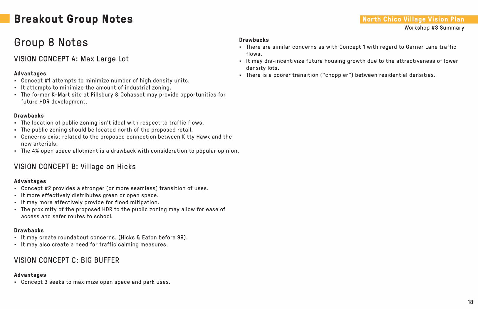
North Chico Village Vision PlanWorkshop #3 Summary
18
Breakout Group Notes
Group 8 NotesVISION CONCEPT A: Max Large Lot
Advantages• Concept #1 attempts to minimize number of high density units.• It attempts to minimize the amount of industrial zoning. • The former K-Mart site at Pillsbury & Cohasset may provide opportunities for
future HDR development.
Drawbacks• The location of public zoning isn’t ideal with respect to traffic flows.• The public zoning should be located north of the proposed retail.• Concerns exist related to the proposed connection between Kitty Hawk and the
new arterials. • The 4% open space allotment is a drawback with consideration to popular opinion.
VISION CONCEPT B: Village on Hicks
Advantages• Concept #2 provides a stronger (or more seamless) transition of uses. • It more effectively distributes green or open space.• it may more effectively provide for flood mitigation. • The proximity of the proposed HDR to the public zoning may allow for ease of
access and safer routes to school.
Drawbacks• It may create roundabout concerns. (Hicks & Eaton before 99).• It may also create a need for traffic calming measures.
VISION CONCEPT C: BIG BUFFER
Advantages• Concept 3 seeks to maximize open space and park uses.
Drawbacks• There are similar concerns as with Concept 1 with regard to Garner Lane traffic
flows.• It may dis-incentivize future housing growth due to the attractiveness of lower
density lots.• There is a poorer transition (“choppier”) between residential densities.

North Chico Village Vision PlanWorkshop #3 Summary
19
Breakout Group Notes
Group 9 NotesVISION CONCEPT A: Max Large Lot
Advantages• More of the country feel
Drawbacks• Need to travel to downtown to meet retail needs
VISION CONCEPT B: Village on Hicks
Advantages• Walkability• Community atmosphere from retail• Shared community spaces• Enough open space for families to get outside time while maintaining country
feel that people moved to the area for• Space for businesses to rebuild
Drawbacks• Lot size is too small
VISION CONCEPT C: BIG BUFFER
Advantages• Diverse housing options• Lots of open space for recreation• Retail space provides new business opportunities
Drawbacks• School lot is small
North Chico Village Vision PlanWorkshop #3 Summary
20
Post-Workshop Responses
VISION CONCEPT A: Max Large Lot
Advantages• School site adjacent to creek• Less airport noise for learning environment• Educational opportunities along the creek
Drawbacks• N/A
VISION CONCEPT B: Village on Hicks
Advantages• Acceptable plan - like the buffer along the creek
Drawbacks• N/A
VISION CONCEPT C: BIG BUFFER
Advantages• N/A
Drawbacks• N/A

Hicks Lane
Chico Municipal AirportGarner Lane
North Chico Village Vision PlanEnvision the Heart of North Chico

ATTACHMENT C

orth Chico
March 28, 1995
Butte County Department of Development Services
Planning Division 7 County Center Drive
Oroville CA 95965-3397 (530) 538-7601 Fax (530) 538 7785

NORTH CHICO SPECIFIC PLAN
PREPARED FOR:
' ~ -·.- .... , .. ~-· . . .
THE BUTTE couNTY BOARD oF suPEi=l\hsoRs ..• ·.- . . - ' . :: .
PREPARED BY:HEE\lTAGE PARTNERS
VAIL ENGINEERING, INC. ·
APPROVED BY THE BOARD OF SUPERVISORS
MARCH 28, 1995
1. INTRODUCTION
County Service Area 87
In 1983, as a result of drainage studies conducted in the north Chico area, County Service Area 87 (CSA 87) was formed to provide funding for maintenance of drainageways and drainage improvements in what now generally constitutes the North Chico Specific Plan area. However, no drainage improvements were authorized nor funded, and maintenance has consisted of occasional clearing of vegetation from creek channels.
Over the last several years development pressures have increased in the north Chico area as population in the Chico Urban Area has continued to increase. In order to allow development to proceed in a responsible manner, areawide issues related to drainage, circulation, and provision of public services must be addressed.
The Planning Process
I
The Butte County Board of Supervisors initiated the preparation of the North Chico Specific Plan to comprehensively respond to development proposals and incorporate them into a concept of i land use for the area, while evaluating and providing for areawide solutions to drainage, circulation, and provision of public services. This planning and environmental review process has been conducted through expansion of the authority of CSA 87. At the request of the Board of Supervisors, the Local Agency Formation Commission authorized the addition of areawide land use planning to the previous county service area scope of drainage maintenance services. .
Subsequent assessment of properties within CSA 87 provided the necessary funding. To provide a degree of balance and equity, a ''two-tier" assessment was levied. A nominal rate for existing homes and smalf parcels provided a fraction of the total funds. A second, per-acre assessment for larger, potentially developable parcels provided the bulk of the funds in rough proportion to expected landowner benefit.
Numerous meetings with property owners and residents of the Plan area have been held during which presentation and discussion of planning goals and ideas occurred. Concerns regarding the preservation of existing neighborhood. characteristics, the cost of potential road and drainage improvements, and the desire of owners of vacant land to beneficially utilize their property were extensively discussed.
lntro~~ction 1-1

NORTH CHICO SPECIFIC PLAN
In addition to community meetings, presentations and workshop meetings were conducted with many local agency representatives and interest groups, including:
0 the Butte County Airport Land Use Commission 0 the Butte County Local Agency Formation Commission o the Butte County Planning Commission o the City of Chico General Plan Task Force 0 the Greater Chico Chamber of Commerce Airport Committee o the Greater Chico Chamber of Commerce Economic Development Committee 0 the Intergovernmental/ Chico Issues Committee
Economic Development
In addition to the resolution of the planning issues cited herein, the process has examined the preparation of lands in the vicinity of the Chico Municipal Airport for job-creation and economically beneficial uses. The adjacency of the Chico Municipal Airport provides a unique opportunity to locate industrial, commercial, and office uses which would utilize and heighten the importance of the Chico Municipal Airport as both a carrier of freight and passengers. The addition of industrial land adjacent to the airport and improved vehicular access will help to
) insure the long term viability of the airport.
)
Purpose of a Specific Plan
A specific plan is fundamentally a tool for the "systematic implementation" of the general plan, typically within a defined area. Because the general plan must address policy issues on a broad scale and throughout the agency's jurisdiction, it cannot easily deal with the needs of a smaller area. Although the specific plan must be consistent with the general plan, a specific plan can address infrastructure, land use, and financial issues in a more appropriately focused and detailed manner.
A specific plan is prepared, adopted and amended in the same manner as the general plan, except that it may be adopted by resolution or ordinance and it may be amended as often as deemed necessary by the local agency. Once a specific plan is adopted, zoning ordinances, subdivisions, public works projects, development agreements, and land projects must be consistent with the specific plan.
The purpose of the North Chico Specific Plan (NCSP) is to provide a comprehensive description of all land uses provided for in the Plan area and to specify concise policies and regulations which implement the broader goals and policies of the Butte County General Plan. The NCSP is a specific plan developed within the framework established by California Government Code Section 65450 et seq.
1-2 Introduction

NORTH CHICO SPECIFIC PLAN
All the requirements of the Government Code pertaining to the preparation, approval, and implementation of specific plans are addressed in this document including text and diagrams specifying the following:
o The distribution, location, and extent of the uses of land, including open space, within the area covered by the Plan;
o the proposed distribution of major components of transportation, sewage, water, drainage, solid waste disposal, energy, and other essential facilities proposed to be located within the area covered by the Plan and needed to support the land uses described in the Plan;
o standards and criteria by which development will proceed, and standards for the conservation, development, and utilization of natural resources, where applicable;
o a program of implementation measures including regulations, programs, public works projects, and financing measures necessary to carry out the above; and,
o a statement of the relationship of the North Chico Specific Plan to the Butte County General Plan.
This Plan is intended to focus and assist the development planning and review process by providing a direct and comprehensive correlation between land use and public facilities and services necessary for support of that development. The NCSP includes an infrastructure and facilities element, and an implementation and financing element which together identify all necessary services and facilities and the means of financing those improvements.
In a similar manner, the environmental review process is simplified and streamlined by allowing an overall evaluation of impacts associated with development of the entire Plan area. In this manner, individual applications for development will be able to utilize the NCSP certified EIR in their environmental review, thus reducing costs and processing time. Some properties may require focused studies for the delineation of wetland area, biological studies for flora and fauna specific to their propo~ development. It is anticipated that most development projects, if found to be consistent with the NCSP and the certified EIR, will be able to utilize a negative declaration for their environmental determination.
The NCSP is intended to serve as a broad reaching site planning tool to allow for creative and imaginative large scale planning of large scale, mixed-use development. The NCSP also allows the CountY to tailor zoning or development regulations to fit the dictates of the specific plan.
Introduction 1-3

2. SPECIFIC PLAN OVERVIEW
Project Location and Setting
The North Chico Specific Plan (NCSP) area is located north of the City of Chico as shown on Figure 2-1. The 3,590-acre area is bounded by Sycamore Creek on the south, State Route 99 on the west, Rock Creek on the north and Chico Municipal Airport on the east. Two small portions of the study area, consisting of approximately 180 acres, are located south of Sycamore Creek, see Figure 2-1.
The area primarily contains open space lands, but a pattern of rural and semi-rural residential development has resulted due to development of several subdivisions located along Keefer Road, east of State Route 99 (SR99), and off of Hicks Lane in the vicinity of Sycamore Creek. The existing land use in the project area is a mix of agriculture, open space, and single-family residential uses with an estimated 640 dwelling units and 1 ,450 residents. Lot size are variable, ) ranging from 1 to 5 ± acres in the area adjacent to Keefer Road to smaller, more suburban-sized lots (0.5 ±acres) in the subdivisions east of SR99.
)
The remainder of the project area is undeveloped, consisting of agricultural uses, mostly in the western half of the study area, and open space/grazing lands in the eastern portion of the study area. A former quarry is located in the central portion of the area, north of Mud Creek and east of Gamer Lane. A small area off of State Route 99 and Garner Lane contains heavy commercial and light industrial uses.
The NCSP area is relatively flat and bisected by four major creeks and drain-ages: Sycamore Creek on the south, Mud Creek and Keefer Slough in the central portion of the area and Rock Creek on the north. Natural vegetation is sparse.
Site Constraints and Planning Issues
Prior to developing the draft North Chico Specific Plan, numerous community meetings, data collection, field surveying, agency contacts, and an agency workshop were conducted and a description of existing conditions and constraints of the plan area was prepared. This information was used in developing the Specific Plan land use concept and elements. The specific site constraints and planning issues that were considered in development of the Specific Plan are summarized in Table 2-1.
Specific Plan Overview 2-1

NORTH CHICO SPECIFIC PLAN
Summary of Specific Plan Elements
The NCSP contains six elements:
o land use, o · circulation, o open space/recreation/resource management, o provision of public services, o funding, and o implementation measures.
Each element explains the development concepts. In general, the land uses proposed in the NCSP are primarily residential with a mix of commercial, office, heavy and light industrial, public (elementary school, park, and fire station), and open space. Intensive development is concentrated south of Mud Creek. North of Mud Creek, large-lot residential uses are left unchanged in order to maintain and foster compatibility with existing development and to maintain the existing rural character of the area.
Land Use:
Hydrology:
Biology:
Circulation:
Noise:
Pubfoc Services:
TABLE 2-1 SUMMARY OF CONSTRAINTS & PLANNING ISSUES
CONSIDERED BY THE NORTH CHICO SPECIFIC PLAN
Existing residents- to maintain rural character; consistency with General Plan; and polenlial eonfliels between land use o.e., areas adjacent to airport, agricultural uses, or commercial/ industrial uses). Existing flood-prone areas primarily along Keefer Slough and Sycamore c.-; inadequale flood capacity along Keefer Slough; inadequale flood capacity through local bridges and culverts; and U.S. Army Corps of Engineers permtt reqUirementS for discharging addttlonal flows into Sycamom Creek.
Significant wetland acreage exists primarily in southeastemmost portion of the plan area; riparian vegetation and habitat occurs along western end of Keefer Slough; and presence of special status species. Intersection of Keefer road and State Route 99 has existing traffic problems; the geometries of Eallon Road, . State Route 99, and Hicks Lane intersection will have traffic problems with addttlonal growth; lack of easiiWest connector through the plan area; and potential prohibition of new signalized intersections on State Route 99. Proximtty to the Chico Municipal Airport and State Route 99.
No sewer facifities exist in the Plan area; soil condilions limit use of septic systems; sewer treatment plant approaching capacity; Ctty policy requiring that any area receMng Ctty sewer services be annexed into the City; insufficient capacity in Chico Unified School District to accommodate Plan area growth; regional landfill approaching capacity; park -rd for provision of park and recreational facilities; proposed park areas in Plan area; existing understaffed Sheriffs Department; and need for addttlonal police and fire -· equipment, and facifities to serve Plan area growth.
2-2 Specific Plan Overview

)
NORTH CHICO SPECIFIC PLAN
Land Use
The majority of the Plan area is planned for low density suburban residential development ( 1 to 3 acre lots) north of Mud Creek. Low and medium density residential development (4 to 8 units per acre for single-family) and a high density residential area (7.1 to 18 units per acre) are proposed south of Mud Creek. A total of approximately 2,803 new dwelling units are contemplated under the proposed Plan.
The Village Core is the heart of the specific plan. Commercial, office, public (elementary school site and park site), and multi-family residential uses would be located in the Village Core. It is centrally located within the Plan area south of Mud Creek and north of Sycamore Creek. The Village Core will provide area residents with a central commercial shopping and professional services area in close proximity to other community services and amenities, such as an elementary school and park. Industrial development is proposed east and southeast of the Village Core, along the easternmost boundary of the plan area, adjacent to the Chico Municipal Airport.
Between 412 and 580 acres are designated for open space and parks, a portion of which are located along area creeks and drainages. Open space corridors are located throughout the Plan area and serve as recreational corridors, drainage courses, resources, and provide buffers between land uses.
Circulation
The NCSP provides for a comprehensive circulation system that includes streets, paths, and trails designed to facilitate safe and efficient movement within and through the Plan area for improved automobile, pedestrian, bicycle, and equestrian travel.
Access to the Village Core and industrial development would be provided primarily by widening and realigning Hicks Lane northerly from Eaton Road through the Plan area, ~nd constructing a new arterial road extending from the village core westerly to State Route 99. This route would become a new east-west route through the plan area, with construction of expanded or new bridges over Sycamore and Mud Creeks, respectively. It would provide for improved internal circulation, as well as alternative access routes into the plan area. Pedestrian paths and trails provide a non-vehicular travel alternative for the convenience of walkers, joggers, bicyclists, and equestrians.
Parks, Open Space and Resource Management
) The NCSP provides for a wide variety of recreational and open space uses within the Plan area.
Specific Plan Overview 2-3

NORTH CHICO SPECIFIC PLAN
The Plan area devoted to either natural or improved open space, including, parks, greenbelts and trail corridors, and natural open spaces areas such as wetlands and drainage corridors ranges from 412 to 580 acres (exact acreage will depend on site specific biotic surveys; see Chapter 5). The active use areas will primarily consist of parkland. Passive areas will include wetland areas and portions of the natural waterway corridors. They will be required to be maintained and/or enhanced.
Open space plays a key role· in the design and function of the Plan area. While providing for wildlife habitat and passive recreation, it also serves to separate and define the neighborhoods that make up the Plan area. Further, the preservation and maintenance of large areas of natural open space enhance the overall aesthetic and visual character of the Plan area and the community. Open space lands throughout the Plan area are intended to protect natural !!!nd cultural resources (wetlands, riparian vegetation, major drainages, and sensitive cultural resources), and to maintain the rural character of the area.
Public Facilities & Services
Water, sewer, drainage, and other facilities and public services are needed to serve the Plan area population. Domestic water supply will be provided by California Water Service Company. A minimum of 7 new wells and water distribution mains will be necessary to serve the Plan area.
Plan area development north of Mud Creek will rely on septic systems, whereas public sewers will be provided for new development south of Mud Creek. The NCSP presents two alternatives for provision of sanitary sewer service. The first alternative considers connection to the City of Chico sewer system via connection to a new, as. yet unconstructed, trunk line along Eaton Road or connection (on an interim basis) to existing lines with construction of a new force main sewer line and pump station.
Under the second alternative, a package treatment plant would be constructed at an unidentified location west of State Route 99. Treated effluent from the package plant could be discharged into Mud Creek, used for agricultural irrigation, and/or for wetland enhancement/creation programs.
Storm drainage management consists of a combination of facilities including channel improvements to existing creeks, detention basin(s), and natural drainage swales. Stormwater runoff from proposed Plan area development would be directed to Keefer Slough, Mud Creek, and Sycamore Creek through a system of open channels (incorporating roadside ditches and greenbelt drainage swales). This open channel system will be combined with a closed conduit drainage system and on-site detention areas in the southern and southeastern portions of the Plan area.
2-4 Specific Plan Overview

)
NORTH CHICO SPECIFIC PLAN
Development Regulations and Standards
The regulations and design standards to guide future development are detailed here. Development standards include the County zoning ordinance requirements, as well as general development standards specific to the NCSP area. Standards are also presented for road construction, landscaping, and design.
Implementation
Capital improvements that will be needed for buildout of the Plan area and financing strategies needed to fund those improvements are contained here. Other necessary implementation actions for also include processing of subsequent development proposals.
Specific Plan Goals and Policies
The overall goal of the NCSP is to create a detailed and comprehensive plan for the area which implement the goals and policies of the Butte County General Plan. The NCSP is a more detailed level of planning with goals and policies tailored to the NCSP area. The goals of the Plan are summarized in Table 2-2. NCSP policies are summarized in Table 2-3 and are intended to achieve the goals of the Specific Plan and to provide direction to decision makers in the implementation and administration of this Plan.
Relationship of Specific Plan to Butte County General Plan
The NCSP planning process included a general plan amendment to bring the specific plan into consistency with the Butte County General Plan. While the current general plan is being updated it is anticipated that the update will incorporate the NCSP, as adopted by the Board into the general plan update.
A detailed review of the NCSP consistency with all existing General Plan goals, objectives, and policies is provided in Appendix A.
Specific Plan overview 2-5

3.
4.
5.
6.
7.
NORTH CHICO SPECIFIC PLAN
TABLE 2-2 NORTH CHICO SPECIFIC PLAN GOALS.
Create a functional and attrac:ti'Je - community, complimented by cultural amenities and an public facilities and services necessmy to support the pcpulaliOn which will result from Plan development, with development of a variety of housing types to accommodate a broad range of household needs.
Create u 4egiated open space, parks and ll!Ciea!ioual amenities which wiU resu~ in improved quality of life for residents of both the Plan area and greater Chico area.
Plan areas for comrnert:ial goods and services, and employment opportunities which will meet the needs of area residents and reduce the need for daily travel outside the Plan area. Traffic on all streets within the plan area should not exceect a Level of Service (LOS) ·c·. In no ease shall the LOS exceed ·o·.
Develop a circulation system which provides for the efficient and uncongested movement of vehicles, pedestrians, and bicyclists with minimUm intrUsion upon the rural and residential character of the area.
1nc:rease the mobility of residents through development of an adequate and balanced transportation system thai inciudes automotive and non-vehicular transportation considerations.
Develop a community complimenled by compatible and hannonious archileclural and landscape design.
Establish a balanced, pedeslriarH>rienle VIUage Core which supports a variety of uses.
f:0 . Provide public and communitY services which both serve the communitY and are cost..,ffecliva
General Policies
TABLE2-3 SPECIFIC PLAN POUCIES
~ Creale a functional and attraetive residential community, with development of a variety of housing types to accommodale a broad range of household needs complimented by cu~ural amenities and au pubi'JC facilities and services nee s sa: y to support the population which will resu~ from Plan development.
@;) Creale inlegraled open space, parks and recreational amenities which Will resu~ in improved quality of life for residents of both the Plan area and greater Chico area.
3. Provide commercial goods and services, and employment opportunities which will meet the needs of area residents and reduce the need for daily travel outside the Plan area.
4. Develcp a circulation system which provides for the efficient and uncongesled movement of velhicles, pedestii<ulS, and bicyclists with minimum intrUsion upon the rural and residential character of the area.
5. Increase the mobility of the residents through development of a transportation system which inciUdes automotive and non-velhicular transportation. 6. Develcp a community of compatible and hannonious architectural and landscape design.
7. Establish a balanced, pedeslriarH>rie ViUage Core which supports a variety of uses and provide a focal pcint for the area
@ Provide public and communily services which both adequately serve the community and are cost effective.
9. Preserve the semi-rural fotestyle of the Plan area, while providing for the future housing needs.
10. Protect the long-term operations of the Chico Municipal Airport by providing compatible land uses, adequate setbacks, avigalion easements, signing, and other measures.
2-6 Specific Plan Overview

NORTH CHICO SPECIFIC PLAN
Agricultural Policies
All existing orchards shaU be pennitted to continue, without interference or interruption by development.
Residential Policies
1. Provide buffers betWeen residential uses and industrial uses and/or arterial thoroughfare sbeets by using landscaped conidors, berms, greenbelts, and/or selbacks.
2. Preserve and enhance the existing land use pattems and densitieS north of Mud Creek.
3. Develop a pedestrian-oriented Village Core Which provides shopping, social and recreational facilities for the Plan area.
4. Locate multi-family residential uses in and acfJ3cenl to the Village Core to maximize the benefi!s of community amenities and to minimize travel within the development
5. Provide for a mix of land uses (residential, retail and public) in the Village Core.
Commercial/Industrial Policies
1. Locate and orient commercial buildings to minimize negatiVe impects on adjoining residences. OutdOor activity areas and noisegenerating equipment should be located 1Nla'f from residential areas.
2. Incorporate outdoor public gathertng areas, including fountains, arbors, seats, publiC art, or other elements, into commercial sites to facilitate social interaclion by Pian area residents and employees.
3. Identify opportunities to integrate economically beneficialac:tivities such as the designation or improvement of industrial land or the ). removal of c:onstrain1s to the development of existing indusbially-zoned land adjacent to the Plan area and westerly of the airport.
)
Circulation Poncies
1. Limtt access from resider!Ces and businesses along major ariertals to a general spacing of 1 access point for each 300 feel. utilize reciprocal access agreements, shanad driveways, easements and other methods. In no case is tt the intent of this policy to deny vehicular access to any legal lot.
2. Design local sbeets within residential neighborhoods to discourage automobile and truck through-traffic by use of cuJ.de.sac streets or other design techniques.
3. In order to er!COurage use of the proposed pathsltrail system, design street pattems which utilize single loaded sbeets and other street and lot design techniques along propoSed path&'trails.
4. Where cukle-sac streets are proposed, utilize designs Which Will provide pedestrian/bicycle (and equestrian Where approprtale) access. This access shoUld lead to or connect to the overall planned path/trail system. Key lots (lots located at the end of cuJ.de.sac streets) should be minimized.
5. In order to encourage public transtt usage, the arterta1 street design shall provida for bus turnouts and for the location of bus shelters.
Specific Plan Overiliew 2-7

NORTH CHICO SPECIFIC PLAN
6. All path and trails designated within properties which are proposed for subdivision shall be required to be designed and improved by the developer of the subdivision in accordance with the requirements of this Plan and good planning and engineering practice. Maintenance of these areas will be the responsibility of CSA 87. ·
7. Encounage non-vehicular access through the Plan area and to the commercial and industrial areas by requiring the construction of sidewalks, pedestrian/bicycle paths and bicycle parking facilities.
8. Enhanced street entries shall be required at ihe following location:
a. The new arteriai!Highway 99. b. The north and south entry to the industrial area. c. The new Hicks RoadJEaton Road. d. The new arterial near Mud Creek. e. The new arterial near Sycamore Creek.
The entry shaD consist of landscaping and hardscape. Rock or block walls shaU be inslalled behind the sidewalk. The name of each land use area shall be designed into the Industrial Park, and the like. Shrubbery and at least four specimen size trees shaU be used to further enhance the entry. Each entry area shall aiso have a raised landscaped median with a left tum pocket. The design of the street entries shaD be approved by the Directors of Development Services and Public Works.
9. A detailed alignment study for Old Hicks Road/New Hicks Road and Eaton Road shaU be prepared by or under the direction of Butte County. The study shall indicate the precise engineering of the (righl~f-way} alignment, the removal or relocation of structures, the installation of curb, gutter, Sidewalk, and other infrastructure necessary to accompilsh the realignment.
1 o. Noise _,uation along existing and proposed a-shall be required to protect - development proposed to be located adjacent to the proposed .-. Noise - measures shall be required to reduce interior noise levels to 45 dB for proposed residential development acfJBcenl to existing or planned arterials and/or when adjacent to Highway 99.
11. No new streat alignments shaU exclude safe and convenient access to properties. County slaff shaH pursue negolialions with Caltrans for appropriate traffic control, including, but not runiled to, traffic signals and streat alignments along Highway 99, primanly at the intersections of Keefer Road and the new arterial.
Parks and Open Space Policies
1. Provide a network of 6near open space along identified drainage and creek areas and connecting pathslllails to the ViUage Core and industrial area.
2. Provide parks and recreational facilities located in order to adequately Se!Ve the existing and future residents of the Plan area. Incorporate, as appropriate, wetland and riparian habitat protection, and nature interpnative facilities.
3. Provide a process where the Plan area residents and owners can participate in the design ct the parks and the recreational faci66es.
4. Locate the neighborhood park sit"'! adjacent to the elementary school sites and encourage CARD and the Chico Unified School District to enter into a joint-use agreemenl
5. Require that all park and open space areas maintenance are funded through the amendment of the existing CSA or other rnelhod acceptable to LAFCo, Butte County, and the responsible maintenance group or agency.
Environmental Protection Policies
1. Minimize impacts to archaeological, biological, riparian and other natural resources through avoidance.
2. LUilize avoidance as the main form of mitigation of impacts on identified wetlands. Where avoidance Is not possible due to the need to provide critical feature of the NCSP, a no net loss concept wiD be used. This may require the acquisition of unencumbeled wetlands, payment into a wetlands mitigation fund, or other appropriate mitigation in effect at the lime of development.
3. If found to be compatible With the protection of wetland resource areas, reserve locations in major wetland preservation areas for possible nature interpretation areas ,such as Viewing or lookout areas and interpretive walking trails.
2-8 Specific Plan Overview

)
)
NORTH CHICO SPECIFIC PLAN
Water Poficies
1. Plan for the installation of public water facilities in the Plan area south of MUd Creek, While continuing to allow for the use of well water for those developments north of MUd Creek. ·
2. In the area north of MUd Creek. require the use of community water system may be required parcels. The community water system shall be established in accordance with the requirements of state law.
Wastewater Disposal Policies
1. Prior to any development in the Plan area south of MUd Creek, a sewer alternatiVe must be selected. The selected a~ematiVe shall meet the requirements of state law and Butte County.
2. In the area north of MUd Creek, community septic systems may be required parcels. Operation and maintenance of these systems shall meet the requirements of state law and standard engineering practice.
3. In the area north of MUd Creek, developments shall meet the requirements of Department of Environmental Health relaUve to the instatlation of septic systems.
Drainage Policies
1. Utilize, to the maximum extent possible, natural, or natural-appearing, stream or drainage courses for storm drainage.
2. Design stormwater facilities, inclUding detention besins, to ensure pub6c safety, to be visually unobtrusive and to prt>lide, Where feasible, recreational uses.
3. Development within a designated floodplain shall be required to meet County and FEMA regula6ons. No development shall be permitied in the floodway.
4. Utilize pollution control traps or sediment basins for storm drainage systems designed in accordance with County standards and/or requirements.
5. AU drainage areas shall be mainlained through amendment to the CSA, or olhar means acceplable to LAFCo, Butte County, and the maintaining group or agency.
Schools Policies
1. In consultation with the Chico Unified School District, plan for educational facilities in the Plan area.
2. Locate educational facilities in the Plan area adjacent to neighborhood parks In order to facilitate joint use recrealion faCilities. 3. Encourage CUSD and CARD to work cooperatively to prt>lide joint use recreation faci6ties. 4. Impacts to school facirrties within the Chico Unified School District (CUSD) shall be fully mitigated through the payment of mitiga6on fees In the amounts justified by CUSD prepared nexus studies, including adjustments, and adopted by the District, or through the implementation of olhar equivalent measures acceplable to CUSD, including those measures specified in the CUSD Board of Educa6on Resolution No. 486-92.
Fire
The County recognizes that the new res-1 growth contsmplated by this Specific Plan will resutt in significant n 101eases in the student population of the Chico Unified School District ("CUSD"). The County also recognizes that funding limitations have severely hampered CUSD's ability to accommodate students generaied by new residential development. Accordingly, the County, as a condition of approval of this Specific Plan, has required that new resi- development fully mitigate its impacts to school facilttles. Bu1 for this full mitiga6on requirement, the County would not have approved this Specific Plan.
1. Provide for the location of a future fire station and work with the appropriate fire service agencies to determine the nature and level of fire services required to serve the extsting and future residents.
2. Amend the extsting CSA, or provide anolhar funding mechanism, to provide funds for continued fire services.
Specific Plan Over\/iew 2-9

NORTH CHICO SPECIFIC PLAN
Financing Plan Policies
Financing Plan Policies have been established to ensure that the deVelopment in the NCSP area: (a) pays the full costs of the infrastructure needed to serve the area; (b) funds the costs of mitigating adverse impacts on existing Butte County and City of Chico intrastructure, where affected; (c) provides for reimbursements from other deVelopment areas for costs that the NCSP was required to advance (If any); and (d) provides a lair allocation of costs between land uses.
The financing policies are set forth as follows:
Policy 1: Fund the full costs of on- and off~e public infrastructure and public services required to support deVelopment in the Plan area from revenues generated by deVelopment within the Plan area.
Policy 2: Use pay-as-you-go financing to the extent possible. Use deb! financing only when essential to provide facilities necessary to penni! development or to maintain service standards.
Policy 3: Allocate the backbone infra-slructure costs to property within the Plan area based on the general principles of benefit received, with com;;-.. to the financial feasibility of the proposed land use. ·. , ,, ,..,.
Policy 4: Require -pers Who proceed ahead of the infrastructure financing sequence to pay the costs of extending the backbone infrastructure to their project subject to future reimbursement
Policy 5: Landowners Who do no! wish to deVelop will no! be requ~ed to participate in deb! financing that would resut in a financial obligafion on their property.
2-10 Specific Plan Overview

)
)
3. LAND USE ELEMENT
Purpose
The purpose and intent of this element is to detail the land use concept, set forth the goals and policies which will guide the development, preservation and continued viability of the NCSP area. The goals and policies of this element will provide the structure or framework for the remaining elements of the NCSP.
Existing Land Use
The North Chico Specific Plan (NCSP) consists of 3,590 acres of land generally bounded by Sycamore Creek on the south, State Route 99 on the west, Rock Creek on the north, and Chico Municipal Airport and Airport Clear Zone on the easl A small portion of the Plan area, approximately 170 acres, is located north of and adjacent to Eaton Road and south of Sycamore Creek.
Existing land uses are a .mix of agriculture, open space, and single-family residential uses, currently with an estimated 640 dwelling units and 1 ,450 residents. The area contains predominately_ undeveloped lands, with some rural and semi-rural residential development evident along Keefer Road, Gamer Lane and off of Hicks Lane in the vicinity of Sycamore Creek. Existing lot size varies from 1 to 5 ± acres in the area adjacent to Keefer Road to smaller, more suburban-sized lots (0.5 ±acres) east of State Route 99.
Most of the project area (2, 1 00 ± acres) is undeveloped, consisting of agricultural uses in the western half of the area, and open space grazing lands in the eastern portion area. A former quarry is located in the central portion of the area, north of Mud Creek and east of Gamer Lane. An area near State Route 99 and the Esplanade contains heavy commercial and light industrial land uses .
. The Land Use Concept
The land use concept for the NCSP utilizes a 'Village Core" concept in conjunction with utilizing the adjacency of the Chico Municipal Airport as an attractor for industry and commercial uses. The Plan takes advantage of the existing drainage courses designating them for greenbelt connectors, as well as for drainage. A new east/west and north/south arterial is proposed to provide safe and convenient access from SR99 and Eaton Road.
A key component in the NCSP is the 'Village Core" encompassing approximately 285 acres southeast of Mud Creek, where the higher density housing, commercial, and industrial uses are concentrated.
Land Use Element 3-1

NORTH CHICO SPECIFIC PLAN
The commercial and industrial areas are the key incentive to providing mix of land use to assist in reducing automobile dependence and in encouraging pedestrian/bicycle travel. The Village Core will provide an integrated community containing housing, shops, work places, schools, parks, and civic facilities essential to the daily life of the area residents. The area of the Village Core is designed so that all activities are within easy walking distances to each other. It will also serve as a community focal point by providing an activity center and a place for formal and informal social and community interaction.
The physical design of the Village Core will create an aesthetic composition of buildings and open space that will encourage frequent use. Development regulations and guidelines contained in Chapter 7 of this document, will prevent the standard subdivision, industrial, and strip shopping center look.
Proposed Land uses in the NCSP area are primarily single family and multiple family residential with a mix of commercial, office, heavy and light industrial. The area will also contain a public elementary school with an adjacent neighborhood park, a fire station, and open space. Intensive development is concentrated south and east of Mud Creek. Northwest of Mud Creek, the existing planned large lot residential uses are to remain ensuring compatibility with existing development and maintaining the existing rural character of the area.
Over 500 acres are designated for open space/drainage. These corridors are located throughout the Plan area and serve as multipurpose trails, drainage corridors and buffers ~~,, between land uses. The proposed Specific Plan map is presented on Figure 3-1; land uses are summarized on Table 3-1. ~
Residential Uses
The NCSP accommodates a broad spectrum of housing types and densities through five residential zones/land uses. There is a maximum potential for approximately 2,803 additional new dwelling units within the NCSP. ~
The majority of residential acreage will be single-family detached homes on one acre lots located northwest of Mud Creek. The remainder of residential uses will be a mix of more urban densities within the Village Core area and south of Sycamore Creek. Up to 1,741 dwelling units could be constructed in areas designated for 4 units per acre and 6 to 8 units per acre. In addition to the single-family units, multi-family housing is proposed on 17.1 acres within the Village Core, which could result in approximately 308 dwelling units.
3-2 Land Use Element
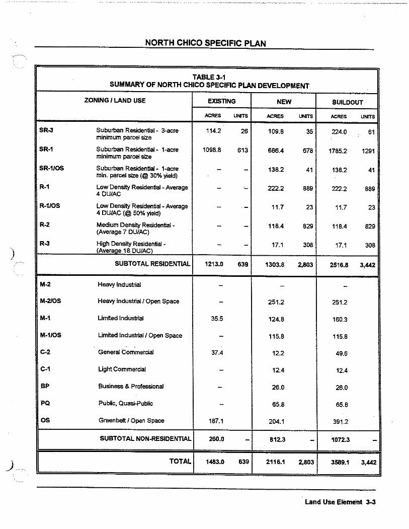
NORTH CHICO SPECIFIC PLAN
TABLE3-1 SUMMARY OF NORTH CHICO SPECIFIC PLAN DEVELOPMENT .
ZONING I LAND USE EXISTING NEW BUILDOUT
ACRES UNITS ACRES UNITS ACRES UNITS
SR-3 Suburban Residential- 3-acre 114.2 26 109.8 35 224.0 61 minimum parcel size
SR-1 Suburban Residential- 1-acre 1098.8 613 686.4 678 1785.2 1291 minimum parcel size
SR-1/0S Suburban Residential- 1-acre - - 138.2 41 138.2 41 min. parcel size(@ 30% yield)
R-1 Low Density Residential - Average - ·- 222.2 889 222.2 889 4DU/AC
R-1/0S Low Density Residential - Average - - 11.7 23 11.7 23 4 DU/AC (@ 50% yield)
R-2 Medium Density Residential - - - 118.4 829 118.4 829 (Average 7 DU/AC)
R-3 High Density Residential - - - 17.1 308 17.1 308
) CAveraae 18 DU/ACl
SUBTOTALRE~DENTIAL 1213.0 639 1303.8 2,803 2516.8 3,442
M-2 Heavy Industrial - - -M-2/0S Heavy Industrial/ Open Space - 251.2 251.2
M-1 Umited Industrial 35.5 124.8 160.3
M-1/0S Umited Industrial/ Open Space - 115.8 115.8
C-2 General Commercial 37.4 12.2 49.6
C-1 Ught Commercial - 12.4 12.4
BP Business & Professional - 26.0 26.0
PQ Public, Quesi-Public - 65.8 65.8
OS Greenbelt I Open Space 187.1 204.1 391.2
SUBTOTAL NON-RESIDENTIAL 260.0 - 812.3 - 1072.3 -
) TOTAL 1483.0 639 2116.1 2,803 3589.1 3,442
Land Use Element 3-3

North Chico Specific Plan LAND USE MAP
LEGEND
=> SPECIAC PLAN AREA BOUNDARY
=
"'"'"' =
SPHERE OF INFLUENCE (CITY OF CHICO)
SlliEET WITH FLEXIBLE AUGNMENT
STREET WITH FIXED AUONMENT
IL.Ait\40> Q.JJSE
SR-3 SUBURBAN RESI. 3 AC. MIN.
SR·1 SUBURBAN RESI. 1 AC. MIN.
R·1 LOW DENSITY RESIDENTIAL
R·2 MED. DENSITY RESIDENTIAL
R·3 HIGH DENSITY RESIDENTIAL
l\11·2 HEAVY INDUSTRIAL
M·1 UGHT INDUSTRIAL·
c. a GENERAL COMMERCIAL
C·1 UMITED COMMERCIAL
BP BUSINESS (1, PROFESSIONAL
PQ PUBUC I QUASI·PUBUC
OS GREENBELT I OPEN SPACE
THE PRECISE BOUNDARY OF THE "GlREENBELT I OPEN SPACE" LAND USE DESIGlNATIOIII SHALL IBIE DETERMINED AT THE TIME OF DEVELOPMENT. CROSS•HATCH INDICATES LANDS THAT MAY CONTAIN BIOLOGICAL RESOURCES OR SENSinVE HABITAT AND REQUIRE SITE·SPECIFIC PLANNINGl AND REVIEW PRIOR TO DEVELOPMENT. ALTERNATING COLOR INDICATES UNDERLYING LAND USE CATECi\ORY.
0 1500 3000
i r===LJ====, SCALI!
,
H~rito~e Pennel'!' - ------------------------' ~~----------------------------------------------------------------------------------------- ---------------------------------------------·------
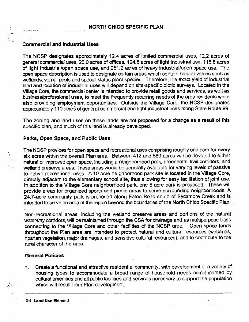
i _/········
NORTH CHICO SPECIFIC PLAN
Commercial and Industrial Uses
The NCSP designates approximately 12.4 acres of limited commercial uses, 12.2 acres of general commercial uses, 26.0 acres of offices, 124.8 acres of light industrial use, 115.8 acres
. of light industrial/open space use, and 251.2 acres of heavy industrial/open space use. The open space description is used to designate certain areas which contain habitat values such as wetlands, vernal pools and special status plant species. Therefore, the exact yield of industrial land and location of industrial uses will depend on site-specific biotic surveys. Located in the Village Core, the commercial center is intended to provide retail goods and services, as well as business/professional uses, to meet the frequently recurring needs of the area residents while also providing employment opportunities. Outside the Village Core, the NCSP designates approximately 110 acres of general commercial and light industrial uses along State Route 99.
The zoning and land uses on these lands are not proposed for a change as a result of this specific plan, and much of this land is already developed.
Parks, Open Space, and Public Uses
The NCSP provides for open space and recreational uses comprising roughly one acre for every six acres within the overall Plan area. Between 412 and 580 acres will be devoted to either natural or improved open space, including a neighborhood park, greenbelts, trail corridors, and wetland preserve areas. These areas would be generally available for varying levels of passive to active recreational uses. A 1 0-acre neighborhood park site is located in the Village Core, directly adjacent to the elementary school site, thus allowing for easy facilitation of joint use. In addition to the Village Core neighborhood park, one 5 acre park is proposed. These will provide areas for organized sports and picnfc areas to serve surrounding neighborhoods. A 24.7-acre community park is proposed along Eaton Road south of Sycamore Creek and is intended to serve an area of the region beyond the boundaries of the North Chico Specific Plan.
Non-recreational areas, including the wetland preserve areas and portions of the natural waterway corridors, will be maintained through the CSA for drainage and as multipurpose trails connecting to the Village Core and other facilities of the NCSP area. Open space lands throughout the Plan area are intended to protect natural and cultural resources (wetlands, riparian vegetation, major drainages, and sensitive cultural resources), and to contribute to the rural character of the area.
General Policies
1. Create a functional and attractive residential community, with development of a variety of housing types to accommodate a broad range of household needs complimented by cultural amenities and all public facilities and services necessary to support the population which will result from Plan development.
3-4 Land Use Element
NORTH CHICO SPECIFIC PLAN
2. Create integrated open space, parks and recreational amenities which will result in improved quality of life for residents of both the Plan area and greater Chico area.
3. Provide commercial goods and services, and employment opportunities which will meet the needs of area residents and reduce the need for daily travel outside the Plan area.
4. Develop a circulation system which provides for the efficient and uncongested movement of vehicles, pedestrians, and bicyclists with minimum intrusion upon the rural and residential character of the area.
5. Increase the mobility of the residents through development of a transportation system which includes automotive and non-vehicular transportation.
6. Develop a community of compatible and hanmonious architectural and landscape design.
7. Establish a balanced, pedestrian-oriented Village Core which supports a variety of uses and provide a focal point for the area.
8. Provide public and community services which both adequately serve the community and are cost effective.
9. Preserve the semi-rural lifestyle of the Plan area, while providing for the future housing needs.
1 0. Protect the long-tenm operations of the Chico Municipal Airport by providing compatible land uses, adequate setbacks, avigation easements, signing, and other measures.
Agricultural Policies
1. All existing orchards shall be penmitted to continue, without interference or interruption by development.
Residential Policies
1. Provide buffers between residential uses and industrial uses and/or arterial thoroughfare streets by using landscaped corridors, benms, greenbelts, and/or setbacks.
2. Preserve and enhance the existing land use patterns and densities north of Mud Creek.
3. Develop a pedestrian-oriented Village Core which provides shopping, social and recreational facilities for the Plan area.
4. Locate multi-family residential uses in and adjacent to the Village Core to maximize the
Land Use Element 3-5

)
NORTH CHICO SPECIFIC PLAN
benefits of community amenities and to minimize travel within the development.
5. Provide for a mix of land uses (residential, retail and public) in the Village Core.
Commercialnndustrial Policies
1. Locate and orient commercial buildings to minimize negative impacts on adjoining residences. Outdoor activity areas and noisEHJenerating equipment should be located away from residential areas.
2. Incorporate outdoor public gathering areas, including fountains, arbors, seats, public art, or other elements, into commercial sites to facilitate social interaction by Plan area residents and employees.
3. Identify opportunities to integrate economically beneficial activities such as the designation or improvement of industrial land or the removal of constraints to the development of existing industrially-zoned land adjacent to the Plan area and westerly of the airport.
Parks and Open Space Policies
1. Provide open space, parks and recreational facilities proportionate to the needs of the area and coordinate as appropriate with other Plan elements including wetland and riparian habitat protection, educational facilities, and natural resources. ·
2. Design parks with recreational amenities and facilities consistent with the needs of nearby residents.
3. Where possible, locate park sites adjacent to school sites, with joint-use agreements with the school district. In such instances, recreation amenities, including play equipment, should be coordinated to minimize duplication.
4. Link parks and nature preserve areas by a pedestrian and bicycle circulation system to the maximum extent possible.
Implementation Measures
Section 7 of this Specific Plan provides development regulations and design guidelines for future development The design guideli_nes focus on development within the Village Core and commercial areas. Additionally, Airport Protection Measures are presented, to ensure the longterm compatibility of the Chico Municipal Airport with adjacent development. Development requirements for recreation and open space uses are detailed in the Development Regulations
) ...... and Design Guidelines, as well as the Parks and Open Space Element.
3-6 Land Use Element

4. CIRCULATION
Existing Traffic Conditions
The North Chico Specific Plan (NCSP) area currently is served by State Route 99, Eaton Road, Hicks Lane, Gamer Lane, Keefer Road, and secondarily, Cohasset Road as shown on Figure 4-1. State Route 99 (SR99), the primary north/south arterial in the area, is a two lane highway adjacent to most of the Plan area, with numerous driveways which serve both residential and commercial uses. Just south of the signalized intersection with Gamer Lane, SR99 transitions to a four lane, controiied access freeway.
There are three primary intersections on State Route 99 which serve the Plan area: Keefer Road, Gamer Lane, and Eaton Road. The Keefer Road/SR99 intersection has stop signs for traffic entering State Route 99. The Gamer Lane/SR99 intersection is fully signalized while the Eaton Road/SR99 intersection is characterized by a full diamond interchange with stop signs at the off ramp/Eaton intersections. The Wilson Landing intersection with SR99 is marked with a stop sign for eastbound traffic turning onto SR99, as is the Esplanade/SR99 intersection.
Access within the Plan area is provided by Gamer Lane, Hicks Lane, and Keefer Road. Gamer Lane is a north/south two lane roadway with a variable developed width of approximately 24 feet in areas of new development and approximately 18 to 20 feet elsewhere. Existing traffic volumes indicate that Gamer Lane serves as a primary access route to and from Chicq for existing development in the NCSP area. Hicks Lane is a secondary north/south two lane roadway which also serves as a primary north/south route to and from Chico, with a variable developed width of approximately 16 to 24 feet. Keefer Road is an east/west two-lane roadway with a variable developed width of approximately 20 to 28 feet. Existing traffic volumes indicate moderate use of this route to access SR99. Keefer Road provides the only existing continuous east/west route through the Plan area, including some through traffic from Cohasset Road. The levels of service (LOS) on area roadways and intersections are gemeraiiy very good (i.e., LOS A) with the notable exception of the left-tum movement from Keefer Road at the Keefer Road/SR99 intersection, which is currently operating at Level D for the AM peak and Level C for the PM peak.
Circulation Concept .
The overall circulation concept for the NCSP area is development of a circulation pattern which provides adequate levels of service, a reasonable and convenient access pattern, and recognizes and corrects existing and potential access problems. The circulation system for the Plan area was developed based on results of a traffic analysis prepared for the proposed NCSP land use plan.
The analysis identified projected traffic generation and evaluated road and intersection operation
Circulation Element 4-1

NORTH CHICO SPECIFIC PLAN
under existing and buildout conditions. Technical background data regarding traffic conditions is provided in the North Chico Specific Plan Draft Environmental Impact Report. The resulting roadway classifications, standards, and planned improvements identified in the traffic analysis are described below.
The plan provides for the safe and efficient movement of vehicles, bicyclists, pedestrians, and equestrians. A key component of the Plan is integration of land uses to minimize commute traffic and to provide a system of trails to encourage pedestrian and bicycle travel. The close proximity of residential, commercial, industrial, and grade school uses allow for greatly increased pedestrian and bicycle trips in place of automobile trips. The plan emphasizes the separation of automobile traffic from other modes of transportation increasing pedestrian/equestrian/bicycle safety and reducing automobile conflicts and usage.
A variety of street widths and designs are included to accommodate a range of anticipated traffic volumes in a manner compatible with adjacent land use. The Plan and street sections have also been designed to reflect and preserve the rural character of the area. Only in the area immediately adjacent to the Village Core and south of Sycamore Creek are standards proposed that reflect an urban character, and those standards have been designed to produce a village or small town atmosphere. Street sections have been designed to be consistent with underlying Butte County standards and to maintain the existing rural character of the area.
J Street System
The NCSP provides for four types of streets and three types of paths and trails:
Streets
0 Arterial streets 0 Collector streets (rural and urban types of both two and four lanes) 0 Local streets (rural and urban) o Alleys
Paths and Trails
0 Paved paths not adjacent to streets o Paved paths adjacent to streets D Dirt or gravel trails
Figure 4-1 illustrates the circulation components for the plan area, including generalized roadway alignments and number of lanes. A summary of primary roads and design standards is presented below. Detailed road standards and cross-sections are presented in Section 7 of this Plan.
j " Arterial Streets
4-2 Circulation Element

NORTH CHICO SPECIFIC PLAN
Arterial streets are at the top of the street hierarchy system. Arterial street are the widest streets and carry the most traffic. Driveway access to these streets should be limited as well as the ·~··· number of intersections. When this concept is followed, conflicts in circulation are minimized and the carrying capacity of the street is maximized.
Within the proposed Plan Gamer Lane, Keefer Road, and Hicks Lane are proposed to be upgraded to arterial streets. Eaton Road, adjacent to the southerly boundary of the Plan area, is currently planned as a four lane arterial and projected to extended westerly from the present terminus just west of the Esplanade to State Route 32.
The major new circulation feature within the NCSP area will be the new arterial street originating at Hicks Lane in the Village Core and extending westerly over Mud Creek to SR99. A realigned and widened Hicks Lane will serve as the primary entry to the Plan area from the south. Tne industrial and employment centers of the Plan will be served by a loop road collector extending · easterly from Hicks at Caballo and rejoining Hicks in the Village Core. The new circulation network is designed to prevent new, direct access from individual properties and to minimize cross-traffic turning movements.
With a single exception, all arterial streets will operate adequately with two lanes based on the results of the traffic analysis. As the southerly access road to the Plan Area, Hicks Lane between Eaton Road and the Village Core will require 4 lanes. Street sections for this road as well as other arterials, collectors and local streets are described in Chapter 7.
Collector Streets
Collector streets provide access from local streets to arterial streets and also serve as residential, commercial, and industrial streets. Street trees planted in parkways will create shaded streets. Street design will include concrete curbs and gutters with a parkway and sidewalks replicating a small town character. In larger lot areas where 1 acre and greater lots are proposed gravel shoulders and drainage swales may be used in lieu of curb and gutter, except where drainage concerns demand more urban facilities .
There are several collector streets that have somewhat higher traffic counts than local streets but not enough to warrant a full arterial section. Within the Plan area these include the Village Core loop road and other connecting streets to Hicks Lane, the new connecting road serving the industrial areas, and Sycamore Lane.
Local Streets
Local street provide the access to the various areas of the Plan. In the residential area they provide access to homes; in the commercial and industrial area to shopping and jobs. These street are generally characterized by numerous driveways in residential areas and project entrance driveways in commercial and industrial areas. Local streets are designed connect to the Collector Streets eventually leading to the Arterial Street system.
Circulation Element 4-3

)
• • • • • • , SPEOFIC PLAN BOUNDARIES
••• 0
STATEROUTEeQ
PLANNED INTERSECTlON llll'ROVEIIa<TS
. ••••• NEW ARTERIAL
----- NEW COLLECTOR
······- EXIS11NG a NEW LOCAL ROADS
--
CIRCULATION SYSTEM Figure 4-1
North Chico Specific Plan

NORTH CHICO SPECIFIC PLAN
Local residential streets provide access to homes. In the Village Core, local streets will have the same character as urban collector streets. with sidewalks and curbside landscaped parkways creating a traditional tree-lined street replicating the small town character.
Local streets within commercial areas will be designed to not only provide access through the commercial area, but also to provide direct access to stores. Diagonal parking designed in conjunction with the local street will be provided on both sides of the street with larger sidewalks and street tree planters.
Local streets in the industrial areas are designed to provide for large truck turning movements into driveways and will provide areas for parallel on-street parking. Required landscaped parkways, sidewalks, curbs and gutters will continue the overall NCSP street design theme.
In the remainder of the Plan area, local rural streets may be built as narrow as 24 feet (paved · width) to maintain the rural character of the area.
Special Streets
Alleys may be utilized in the Village Core where curved roads make pulling in and out of driveways unsafe and where driveways and garages taking access from the front would dominate and overpower the street. Alleys would be used for access to parking in the rear and allow for a much more attractive street. Alleys will have a 24 foot paved section with 2-foot planting strips bordering each side. They will be designed with a standard street crown section and not permit a center drainage area.
The Plan provides for numerous cul-de-sac streets in both rural and urban residential areas. All cui-de-sacs will have to meet Butte County standards in order to accommodate emergency vehicles, trash truck and the like.
Planned Road and Traffi~ Improvements
In order to provide an adequate circulation system through the Plan area, a number of road and intersection improvements will be necessary, as summarized on Table 4-1. As indicated above, a new arterial link will be constructed between Eaton Road and Highway 99.
Eaton Road, a major arterial bordering the Plan area on the South, will require widening to four lanes, with widening of the SR99 overpass and modifications of the interchange at this location. Both this widening to four lanes and interchange modifications are planned improvements of the City of Chico and County of Butte and are to be funded through the Chico Urban Area Street Facility Fees.
As development occurs, existing roadways will be widened and improved to meet road standards outlined in Section 7. Construction of widened and new bridges over Sycamore and Mud Creeks will be required as part of construction of the arterial link between Eaton Road and Highway 99.
4-4 Circulation Element

)
J .. ·····
NORTH CHICO SPECIFIC PLAN
Existing intersections will require some modifications, especially along Eaton Road where signals will be required at the on/off ramps of State Route 99, the New Arterial road, and Cohasset Road. Due to the proximity of Hicks Lane to the Eaton/SR99 interchange, the Plan requires traffic control on Hicks Lane to restrict turning movements to right-turns in and out, only. Internal road traffic controls include multiway stop at the intersections of realigned Hicks Road/New Arterial and Gamer Lane/New Arterial. Stop sign control will be provided on the westbound approach of the New Arterial at its intersection with SR99.
Trail System
A system of interconnected trails, paths, and sidewalks is incorporated into the Plan to facilitate travel within and beyond the Plan area by pedestrians, bicyclists, and equestrians. The routes are intended to not only provide an alternative to automobile travel but also to foster health and social interaction among residents.
Class I bike paths and trails are planned to accommodate a mix of travel and recreational modes. Class I paths occur adjacent to major roadways and through greenbelts. Recreational trails are located primarily along major drainages. Figure 4-2 illustrates locations of both Class I paths and trails in the Plan area. Class I paths along roadways occur along segments of the new arterial, on Gamer Lane, and on segments of key collector streets.
Additionally, a Class I path through the Village Core greenbelt and along the old Hicks Lane right-of-way provides primary access through the Plan area and points south. A number of paths branch off of this path to provide for direct bike and pedestrian circulation away from and generally uninterrupted by auto traffic. The paths would be a minimum of 8 feet wide and would meet CaiTrans standards for Class I paths.
It should be noted that the Chico Urban Area Bicycle Plan identifies bicycle trails in the NCSP area. The Bicycle Plan was prepared by the Community Transit Advisory committee, consisting of representatives from both the City of Chico and Butte County. Within the NCSP area Class I separated bike paths are proposed along Sycamore Creek, along portions of Mud Creek, and east of the NCSP area in the vicinity of the Airport. The proposed Specific Plan is consistent with, and implements, the Class I paths proposed in the Chico Bicycle Plan.
Circulation Element 4-5

- CLASS1 BIKE PATH
• • - • > CLASS 2 BIKE LANE
••••• PATKORTRAIL
____)/ ,. .. -'-..,/- __ ... • _,_,_11
' -·············• ,'
PATHS & TRAILS Figure4-2
North Chico Specific Plan
L,,

)
_)
NORTH CHICO SPECIFIC PLAN
TABLE4-1 SUMMARY OF .. ,nc:)Tu CHICO SPECIFIC PLAN TRAFFIC IMPROVEMENTS
SR991Keefer
Ealon/SR99 (SB ramps}
Ealon/SR99 (NB ramps -Hicks}
0 Same
to right tum in and out
0 lnstaU traffic signal 0 Same 0 lnstaU left tum lane. thru lane and thru-
right lane on au approaches
New Hid<siEaton/lntersedion o o None
Eaton
0
0
0
0 WKien to four lanes - new read to Esplanade
0 Same
0 Same as Existing + Project
0 Woden to four lanes !ttJm Cohasset to Esplanade
Trail corridors are proposed along existing creeks and drainages, and proposed drainage areas. . These corridors, in conjunction with Class I paths, provide an interconnecting system of pedestrian, bicycle, and equestrian travel. Trails are intended to link lower density residential areas with the Village Core and industrial areas, and serve as a place to walk, jog, ride bikes, or ride horses. These trails will be 8- to 14-feet wide. Section 7, Development Regulations, should be referred to for additional path and trail information relating to design, landscaping, lighting, etc.
Public Transit/Transportation System Management
4-6 Circulation Element

NORTH CHICO SPECIFIC PLAN
The use of various modes of public transit, including buses and carpooling, will lower automobile trips within the Plan area.
Circulation Goals and Policies
1. Develop a circulation system which provides for the efficient and uncongested movement of vehicles, pedestrians, and bicyclists with minimum intrusion upon the rural and residential character of the area. Traffic on all streets within the Plan area should not exceed a Level of Service (LOS) "C". In no case shall the LOS exceed "D".
2. Increase mobility of residents through development of an adequate, balanced transportation system that includes automotive and non-automotive transportation uses
Circulation Policies
1. Umit access from residences and businesses along major arterials to a general spacing of 1 access point for each 300 feet. Utilize reciprocal access agreements, shared driveways, easements and other methods. In no case is it the intent of this policy to deny vehicular access to any legal lot.
2. Design local streets within residential neighborhoods to discourage automobile and truck through-traffic by use of cul-de-sac streets or other design techniques.
3. In order to encourage use of the proposed paths/trail system, design street patterns which utilize single loaded streets and other street and lot design techniques along proposed paths/trails.
4. Where cul-de-sac streets are proposed, utilize designs which will provide pedestrian/bicycle (and equestrian where appropriate) access. This access should lead to or connect to the overall planned path/trail system. Key lots (lots located at the end of cul-de-sac streets) should beminimized.-
5. In order to encourage public transit usage, the arterial street design shall provide for bus turnouts and for the location of bus shelters.
6. All path and trails designated within properties which are proposed for subdivision shall be required to be designed and improved by the developer of the subdivision in accordance with the requirements of this Plan and good planning and engineering practice. Maintenance of these areas will be the responsibility of CSA 87.
7. Encourage non-vehicular access through the Plan area and to the commercial and industrial areas by requiring the construction of sidewalks, pedestrian/bicycle paths and
Circulation Element 4-7

) .. ·······
NORTH CHICO SPECIFIC PLAN
bicycle parking facilities.
8. Enhanced street entries shall be required at the following location:
a. The new arteriaVHighway 99. b. The north and south entry to the industrial area. c. The new Hicks Road/Eaton Road. d. The new arterial near Mud Creek. e. The new arterial near Sycamore Creek.
The entry shall consist of landscaping and hardscape. Rock or block walls shall be installed behind the sidewalk. The name of each land use area shall be designed into the entries such as, "Industrial Park," and the like. Shrubbery and at least four specimen size trees shall be used to further enhance the entry. Each entry area shall also have a raised landscaped median with a left turn pocket. The design of the street entries shall be approved by the Directors of Development Services and Public Works.
9. A detailed alignment study for Old Hicks Road/New Hicks Road and Eaton Road shall be prepared by or under the direction of Butte County. The study shall indicate the precise engineering of the (nght-of-way) alignment, the removal or relocation of structures, the installation of curb, gutter, sidewalk, and other infrastructure necessary to accomplish the realignment.
1 0. Noise attenuation along existing and proposed arterials shall be required to protect residential development proposed to be located adjacent to the proposed arterials. Noise attenuation measures shall be required to reduce interior noise levels to 45 dB for proposed residential development adjacent to existing or planned arterials and/or when adjacent to Highway99.
11. No new street alignments shall exclude safe and convenient access to properties. County staff shall pursue negotiations with CaiTrans for appropriate traffic control, including, but not limited to, traffic signals and street alignments along Highway 99, primarily at the intersections of Keefer Road and the new arterial.
4-8 Circulation Element

5. PARKS, OPEN SPACE, AND RESOURCE MANAGEMENT
Existing Park and Recreation Facilities
Park and recreation services ~nd facilities in the Chico Urban Area are provided by the Chico Area Recreation and Park District (CARD) and the City of Chico Parks Department. There are currently no park or recreational facilities in the North Chico Specific Plan (NCSP) area. The closest recreational facility to the area is the Pleasant Valley Recreation Center located on North Avenue approximately 2 miles from the southernmost end of the Specific Plan area.
It is the intent of this Plan to have the park and open space facilities managed by CARD, funded through CSA 87 or other funding mechanisms.
Park and Open Space Concept
The North Chico Specific Plan provides for an appropriate variety of recreational and open space uses within the Plan area. In total, approximately 40 acres of the Plan area will be devoted to park land and between 412 and 580 acres of land will be devoted to open space.
There is one type of park proposed in the Plan area, i.e. neighborhood park. It is the intent that two neighborhood parks will serve the needs of the existing and future residents of the area. All of the parks are proposed to be located adjacent to the open space/trail corridors in order to facilitate easy access and usage.
There are four basic functions of open space Including parks, path and trail corridors, natural open space areas for the protection of wetlands, and drainage corridors. These areas will be available for varying levels of passive to active recreational uses. Non-recreational areas, including wetland preserve areas and portions of the drainage corridors, will be managed for resource values such as riparian habitat, seasonal wetlands and vernal pools. Collectively, open space lands throughout the Plan area are intended to protect natural and cultural resources (wetlands, riparian vegetation, major drainages, and sensitive cultural resources), and to maintain the rural character of the area.
Plan area open space and park areas are illustrated in Figure 5-1. Table 5-1 summarizes the planned open space uses by acreage and anticipated uses. This element of the NCSP details the proposed open space uses identified above. · Additionally, Section 7, Development Standards and Design Guidelines, further defines the nature and use of open space areas.
Parks
Parks, Open Space, and Resource Management 5-1

)
NORTH CHICO SPECIFIC PLAN
Neighborhood Park Site: The proposed 14.8-acre neighborhood park site will be located in the Village Core, adjacent to the elementary school site and adjacent or near the neighborhood shopping district.
The park will provide primarily active recreational uses with some passive use areas. Based on the 1988 Pari< and Recreation Plan for CARD, facilities that could be provided in a neighborhood park include a playground, picnic facilities and shelter, trails, open space and nature areas, restroom, tennis courts, a basketball court and a multi-use open field.
5-2 Parks, Open Space, and Resource Management

NEIGHBORHOOD PARK
NEIGHBORHOOD PARK & ELEMENTARY SCHOOL GROUNDS
GREENBELT/ OPEN SPACE
CREEKS AND RIPARIAN SETBACKS ARE TO BE TREATED AS OPEN SPACE PER POUCIES IN "!EXT.
SEE NOTE ON FIGURE 3-1 REGARDING SPECIFIC BOUNDARIES OF "GREENBELT I OPEN SPACE".
COMMUNITY PARK
PARKS & OPEN SPACE Figure 5-1
North Chico Specific Plan
. . ,
·'
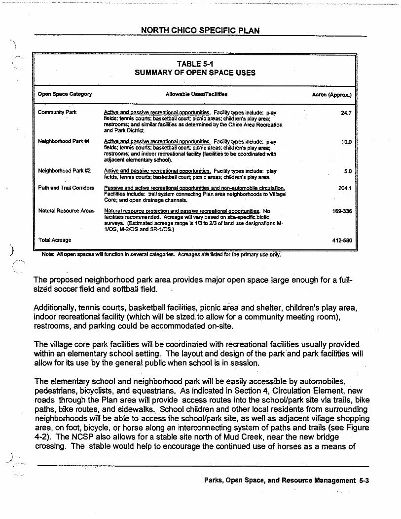
)
j
NORTH CHICO SPECIFIC PLAN
TABLE 5-1 SUMMARY OF OPEN SPACE USES
Open Space category Allowable Uses/Facilities Acres (Approx.)
Community Part< ActiVe and eassive recreational oellQrtunitie~. FaCility types include: play 24.7 fields; tennis courts; basketball court; picnic areas; children's play area; restrooms; and similar faCilities as detennined by the Chico Area Recreation and Part< District.
Neighborhood Part<#! Active and lli!SSive recreational oeeortunijies. Facility types include: play 10.0 fields; tennis courts; basketball court; picnic areas; children's play area; restrooms; and indoor recreational facirlty (facilities to be coordinated with adjacent elementary schooij.
Neighborhood Park #2 I!>I<IM= and lli!SSive recreational QllllQrtunities. FaaTrty types include: play 5.0 fields; tennis courts; basketball court; picnic areas; children's play area.
Path and Trail Corridors Passive and active recreational ogggrtunities and non-automobile circulation. 204.1 Facilities include: trail system connecting Plan area neighborhoods to Village Core; and open drainage channels.
Natural Resource Areas Natural resource g:rotection and gassive recreational OQQQrtunities. No 169-336 facilities recommended. Acreage wiD vary based on sfte-specilic biotic surveys. {Estimated acreage range is 1/3to 213 of land use designations M-1/0S, M-2/0S and SR-1/0S.)
Total Acreage 412-580
Note. AU open spaces will function m several categones. Acreages are rosted for the pnmary use orily.
The proposed neighborhood park area provides major open space large enough for a fullsized soccer field and softball field.
Additionally, tennis courts, basketball facilities, picnic area and shelter, children's play area, indoor recreational facility (which will be sizedto allow for a community meeting room), restrooms, and parking could be accommodated on-site.
The village core park facilities will be coordinated with recreational facilities usually provided within an elementary school setting. The layout and design of the park and park facilities will allow for its use by the general public when school is in session.
The elementary school .and neighborhood park will be easily accessible by automobiles, pedestrians, bicyclists, and equestrians. As indicated in Section 4, Circulation Element, new roads through the Plan area will provide access routes into the school/park site via trails, bike paths, bike routes, and sidewalks. School children and other local residents from surrounding neighborhoods will be able to access the school/park site, as well as adjacent village shopping area, on foot, bicycle, or horse along an interconnecting system of paths and trails (see Figure 4-2). The NCSP also allows for a stable site north of Mud Creek, near the new bridge crossing. The stable would help to encourage the continued use of horses as a means of
Parks, Open $pace, and Resource Management 5-3

NORTH CHICO SPECIFIC PLAN
transportation throughout the Plan area.
An additional five acre park is planned along Gamer Avenue near the planned fire station. The intent is to utilize this park site for active recreation. It should include facilities for soccer, little league and other team sports.
Path and Trail Corridors: As described in Section 4, Circulation Element, the NCSP provides for an interconnecting system of paths and trails (see Figure 4-2). This system not only provides for and encourages alternative transportation modes, but accentuates recreational opportunities in the Plan area and beyond. Trails and paths will connect area residents with Plan area parks and ultimately to recreational/park facilities outside the Plan area. Proposed trail and path corridors also provide areas for drainage and occasional stormwater detention areas (see Section 6, Drainage).
The NCSP provides for path/trail corridors along Mud and Sycamore Creeks, consistent with recommendations contained in the CARD Park and Recreation Plan (September 1988). The CARD Plan identifies portions of these creeks as Mure lineal parks that would provide for an interconnecting trail system around the greater Chico area. The Park and Recreation Plan stipulates that lineal parks are generally open space areas and/or trail systems that follow a stream corridor, ravine or other elongated feature. This type of park often contains pedestrian and/or bicycle trails.
The NCSP provides for a pathway corridor and Class I path along that portion of Sycamore Creek that crosses the Plan area.
Along Mud Creek and through the Village Core greenbelt, trail and path corridors will provide connections from the proposed neighborhood park centrally located within the Plan area, to the Chico Loop which will ultimately surround the 23-mile Chico Urban Area.
Section 7, Development Standards and Design Guidelines, provides a description and illustrative cross-sections of path and trail corridors .
. Community Park Site: There is a proposed 24.7-acre community park site located in the southeastern comer of the Plan Area. Though not originally programmed for the Specific Plan, the site proved ideal for the long-term planning objectives of the Chico Area Recreation and Parks District (CARD). As such, the site will serve the broader Chico community generally north of Lindo Channel. According to the 1994 Chico General Plan, community parks serve all ages and may include facilities for low-intensity/passive recreation use, lighted fields, courts, swimming pools, and areas and buildings for community festivals and civic events, as well as for organized sports and athletic competitions. Generally, restrooms and some off-street parking are provided; community parks are usually 20 acres or larger.
Open Space For Natural Resource Management
5-4 Parks, Open Space, and Resource Management

NORTH CHICO SPECIFIC PLAN
Up tp 500 acres of open space areas are designated throughout the Plan area to protect natural and cultural resources. Such resources include: wetlands, major drainage ways, riparian vegetation, special status species habitat, and sensitive archaeological resources. These areas are generally shown on the land Use Map, Figure 3-1, and on the Parks and Open Space Map, Figure 5-1. It should be noted that these are general locations and will need to be precisely located and set aside in conjunction with proposed development.
Wetlands
Several types of wetlands currently exist in the Plan area including, but not limited to perenniaVseasonal streams, vernal pools, ephemeral drainages, and seasonal ponds. Development of any area which directly or indirectly impacts these or other identified wetlands may be subject to a review permitting procedure under Section 404 of the Clean Water Act administered by the U.S. Army Corps of Engineers (COE) and other federal and state agencies.
This Plan recommends avoidance of the wetlands as the primary means of mitigation. It should be noted that COE also recommends avoidance as part of the 404 permit process. The NCSP provides where Butte County and COE determines that avoidance is not possible, the developer of the property shall be required to prepare a mitigation plan. The plan shall be based upon "no net loss" to wetland habitat values or acreage, and no adverse impacts upon any state or federally
) listed sensitive plant or animal species.
)
Approximately 57 acres of potential jurisdictional wetlands were preliminarily identified through field survey work. Formal wetlands delineation studies were not conducted and must be prepared prior to development of properties where wetlands have been identified or are likely to be found. Figure 5-2 generally indicates those areas where wetland habitat is known to exists and jurisdictional wetlands may occur.
Approximately 49 acres of wetlands are expected to be maintained by designation of three wetland preserve areas, designated as open space areas in the NCSP (see Figure 5-2). The NCSP provides for in-kind·compensation for approximately 15 acres of wetlands that could be filled or otherwise impacted as a result of proposed NCSP development. The use of the abandoned gravel pit as a groundwater recharge and detention basin would require a 404 permit.
Other Resources
Major drainage ways within the Plan area (Rock Creek, Keefer Slough, Mud Creek, and Sycamore Creek) will remain primarily unaltered as the drainage ways are currently managed for flood control and are mostly devoid of vegetation (with the exception of the westernmost portion of Keefer Slough). These drainage ways constitute an element of natural open space in the Plan area which, in conjunction with setbacks along specific reaches, will provide for protection of riparian vegetation and habitat, special status species, and sensitive archaeological resources in the Plan area.
Parks, Open Space, and Resource Management 5-5

AREAS IDENTIFIED AS CONTAINING POTENTIAL WETLAND HABITAT, AND REQUIRING ADDITIONAL MEASURES INCLUDING COMPUANCE WITH THE404 PERMIT PROCESS.
POTENTIAL WETLAND HABITAT Figure 5-2
North Chico Specific Plan
)
J
NORTH CHICO SPECIFIC PLAN
Parks and Open Space Goals and Policies
1. Create integrated open space, parks and recreational amenities which will result in improved quality of life for residents of both the plan area and greater Chico area.
Parks and Open Space Policies
1. Provide a network of linear open space along identified drainage and creek areas and connecting paths/trails to the Village Core and industrial area.
2. Provide parks and recreational facilities located in order to adequately serve the existing and future residents of the Plan area. Incorporate, as appropriate, wetland and riparian habitat protection, and nature interpretive facilities.
3. Provide a process where the Plan area residents and owners can participate in the design of the parks and the recreational facilities. · ·
4. Locate the neighborhood park sites adjacent to the elementary school sites and encourage CARD and the Chico Unified School District to enter into a joint-use agreement.
5. Require that all park and open space areas maintenance are funded through the amendment of the existing CSA or other method acceptable to LAFCo, Butte County, and the responsible maintenance group or agency.
Environmental Protection Policies
1. Minimize impacts to archaeological, biological, riparian and other natural resources through avoidance.
2. Utilize avoidance as the main form of mitigation of impacts on identified wetlands. Where avoidance is not possible due to the need to provide critical feature of the NCSP, a no net loss concept will be used.
This may require the acquisition of unencumbered wetlands, payment into a wetlands mitigation fund, or other appropriate mitigation in effect at the time of development.
3. If found to be compatible with the protection of wetland resource areas, reserve locations in major wetland preservation areas for possible nature interpretation areas ,such as viewing or lookout areas and interpretive walking trails.
Drainage Policies
1. Utilize, to the maximum extent possible, natural or natural-appearing streams or drainage courses for storm drainage.
5-6 Parks, Open Space, and Resource Management

NORTH CHICO SPECIFIC PLAN
2. Design stormwater facilities, including detention basins, to ensure public safety, to be visually unobtrusive, and to provide and, where feasible, recreational uses.
3. Development within designated floodplains shall conform to County and FEMA regulations. Development shall not be permitted in the floodway. Limited recreational activities, which are not in conflict with flood control, the tOO year floodplain, or habitat uses may be permitted.
4. Utilize pollution control traps or sediment basins, designed pursuant to County standards and/or direction, for storm drainage systems. Minimize releases of concentrated runoff _into wetland preserve areas.
5. All drainage areas shall be maintained though amendment to the CSA, or other means acceptable to LAFCo, Butte County, and the maintaining group or agency.
Implementation
Section 7, Development Standards and Design Guidelines, provides specific measures to guide development which, when implemented, will satisfy the "no net loss" of wetlands concept. In general, the standards provide for avoidance, minimization of impact, compensation for unavoidable fills, and protection of existing and created wetlands in the Plan area. Requirements and procedures for pursuing 404 permitting are also stipulated.
Section 7 also provides standards for the protection of other resources, such as riparian vegetation, special status species habitat, sensitive archaeological resources, and major drainage ways. Standards include protection through avoidance of resources and setbacks from resources.
Parks, Open Space, and Resource Management 5-7
/.~.,

"" \ '
Introduction
6. PUBLIC FACILITIES AND SERVICES ELEMENT
Public ·facilities and services are one of the more important components of the Plan. This element covers water services, wastewater disposal and the alternatives proposed, stormwater management, schools, fire protection, solid waste, and utilities.
Water Service
Existing Conditions: The North Chico Specific Plan (NCSP) area currently is not served by a domestic water company or public agency. Individual residences and businesses in the area rely on private wells for their domestic water needs.
Water service for the greater Chico area is provided by the California Water Service Company. California Water currently serves the airport immediately east of the NCSP area and developed residential areas south of Eaton Road .
. , ; The Company relies on groundwater for its supply and operates 62 deep wells and 5 storage tanks in the Chico water service area. The wells typically can supply approximately 1,000 gallons per minute (gpm). Historical water demands have required 1 well for every 500 residential units or a peak hour demand average of 2 gpm per residential unit. Water is distributed though a 6-inch and 8-inch diameter pipe grid system, with a few 12-inch diameter pipes to serve commercial and multi-family developments. The existing system can supply about 89 million gallons per day (mgd); existing peak demand has reached 40 mgd. The average demand on the water distribution system is 19 mgd.
)
Proposed Facilities: Domestic water service, for a portion of the Plan area, is proposed to be provided by California Water Service Company. The Company will require expansion of its service area to include the Village Core and other sewered portions of the NCSP area. The maximum day water demand for this proposed service area is 4,364 gpm, as shown on Table 6-1, with a peak hour demand of 6,546 gpm, based on a peaking factor of 1.5. Average day demand is approximately half of maximum day demand or 2,182 gpm.
Water supply for the Plan area will be met entirely from deep aquifer wells. A minimum of 7 ·wells capable of producing 1,000 gpm will be needed to meet the estimated peak demand of 7,050 gpm. The service area will be served by a well grid network. A well grid network does not require trunk transmission mains to deliver water from one area to another. Wells are located in close proximity to the demand source. Therefore, peak hour demand will be met completely from wells. The proposed distribution facilities will be sized to meet maximum day demand.
Public Facilities and Services Element 6-1

NORTH CHICO SPECIFIC PLAN
TABLE&-1 MAXIMUM DAY WATER DEMAND
Land Use Acreage/Units Max. Day Demand Total Maximum Gallons Per Minute
(ViDage Day Demand Gallons Per Minute CoreJSewered)
R-1: SinaleFamilvR-1 912 Units 1.7 1,550
R-2: SFIMF Residential 829 units 1.4 1,161
R-3: Multi-Familv Residential 308 units 1.0 308
CommerciaVOflice S0.6ae 3.1 157
Heavy Industrial 125.6ac~~~ 3.1 389 Ught Industrial 182.7aem 3.1 566
Parks 39.7ae 3.7 147
SChool 8.5ae 3.1 26
Ooen Soaee Ito be irriaated\ 100ae 0.6 60
Total 4,364
(1) Estimated net 50% of M-2/0S acreage after natural resource area set aside. (2) Estimated net 50% of M-1/0S acreage after natural resource area set aside; 100% of M-1 acreage.
Wastewater Disposal
Existing Conditions: The NCSP area is not currently served by wastewater collection and treatment facilities; residences in the area are served by septic systems.
The City of Chico operat~s the only sewer collection system currently in the area. The wastewater which is collected by the City's system is treated at the Water Pollution Control Plant west of the urban area on River Road, a regional facility that can serve the entire urban area. The plant has recently been expanded to a capacity of 6 mgd and is designed for continued modular expansion to an ultimate capacity of 30 mgd.
The City of Chico Sanitary Sewer Master Plan (December 1985) identifies a major new 33-inch gravity trunkline, approximately 7 miles long, extending from Eaton Road south of the Plan area to the regional treatment plant.
Elevated levels of nitrate in groundwater has become a significant problem in portions of the urban. area immediately south of the Specific Plan Area.
Septic tank leachate has been identified by the State Water Resources Control Board, as the major source of nitrates in the shallow and intermediate aquifers, with agricultural activities and urban runoff as the second and third highest contributors, respectively.

)
)
NORTH CHICO SPECIFIC PLAN
As a result of this contamination, the State Water Resources Control Board has adopted a prohibition order which prohibits the discharge of waste from individual disposal systems installed after July 1, 1990 and the discharge from all existing systems after July 1, 1995. Individual septic systems with less than one unit per acre (334 g/aclday) are exempt from the prohibition. Currently, only the industrial and adjacent residential area of the NCSP fall within the authority of the prohibition order.
Proposed Facilities: The NCSP proposes sanitary sewer service only in the area southeast of Mud Creek. According to the Butte County Department of Environmental Health, the area north and west of Mud Creek has potential for the use of septic tanks. The proposed land use for the area, one-acre lots or larger, meets the County required minimum lot size for septic systems.
Wastewater Generation Rates
Design flows are based on the City of Chico Sanitary Sewer Master Plan wastewater generation rates and are shown in Table 6-2. The average dry weather flow for the sewered portion of the Plan area is 1.05 mgd. The estimated peak wet weather flow is 2.48 mgd.
TABLE 6·2 WASTEWATER GENERATION
Rat.. · :Plan . Land Use Units Per People Per Average Dry Weather Total Acres Tolal Average Dry Weather Acre* unit Aow-Gallon Per Acre Flow
Per Day-
R-1 4 3.6 1,150 233.9 269,000
R-2 7 23 1,300 118.4 153,900
R--3 18 20 2,900 17.1 49,500
Commercial - - 1,500 24.6 36,900 Industrial - - 1,500 308.3.., 462,500
Ollice - - 1,500 26.0 39,000
School - - 1,500 8.5 12,500
TOTAL 1,023,700
• Unit nows are for net areas. -Assumes 80 gpcd. Peaking Factor = 1.97/Q"'' = 1.9 Peak Wet Weather Flow= (PF x Q) + (Acreagex650) = (1.9x 1,052,250) + (740x650) = 248 mg SOURCE: Cily of Chico Improvement Standards
· (11 Estimated net SO% ofM-2/0Sand M-1/0S acreaaeplus 100% ofM-1 acreage.
Public Facilities and Services Element 6-3
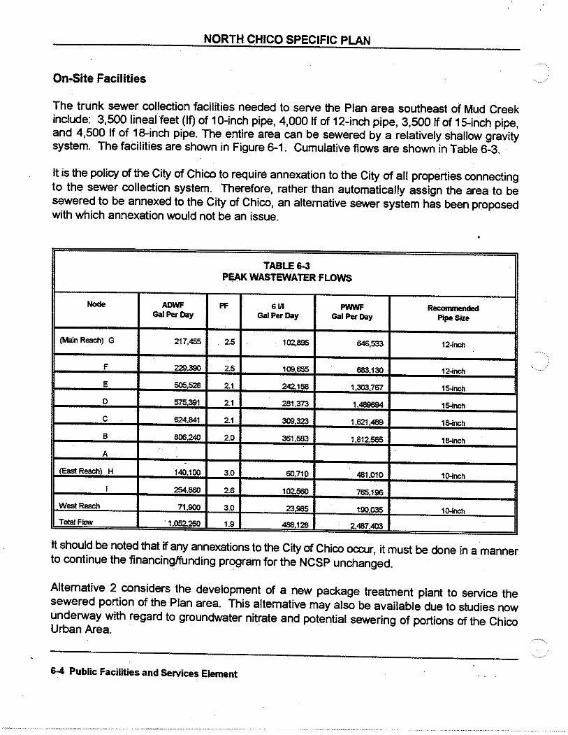
NORTH CHICO SPECIFIC PLAN
On-Site Facilities
The trunk sewer collection facilities needed to serve the Plan area southeast of Mud Creek include: 3,500 lineal feet (If) of 10-inch pipe, 4,000 If of 12-inch pipe, 3,500 If of 15-inch pipe, and 4,500 If of 18-inch pipe. The entire area can be sewered by a relatively shallow gravity system. The facilities are shown in Figure 6-1. Cumulative flows are shown in Table 6-3.
It is the policy of the City of Chico to require annexation to the City of all properties connecting to the sewer collection system. Therefore, rather than automatically assign the area to be sewered to be annexed to the City of Chico, an alternative sewer system has been proposed with which annexation would not be an issue.
TABLE6-3 PEAK WASTEWATER FLOWS
Node ADWF PF GUI PWWF Recommended Gal Per Day Gal Per Day Gal Per Day Pipe Size
(Main Reach) G 217,455 2.5 102,895 646,533 12~nch
F 229,390 25 109.655 683,130 12-
E 505,528 21 242.158 1,303,7$7 1~
D $75,391 21 281,373 1,489694 1~
c 624.841 21 309,323 1,621,489 1~
B 806,240 2.0 361.583 1,812585 1~nch
A .
fEast Reach\ H 140.100 3.0 60,710 481,010 1~
I 254.580 26 102.580 765,196
West Reach 71.900 3.0 23.965 190.036 1~nch
Tolal Flow '1 052.250 1.9 486.128 2.487.403
It should be noted that if any annexations to the City of Chico occur, it must be done in a manner to continue the financing/funding program for the NCSP unchanged.
Alternative 2 considers the development of a new package treatment plant to service the sewered portion of the Plan area. This alternative may also be available due to studies now underway with regard to groundwater nitrate and potential sewering of portions of the Chico Urban Area.
6-4 Public Facilities and Services Element

, NORTH CHICO SPECIFIC PLAN
" Alternative 1: Extension of City of Chico Sewer Services
)
)
Alternative 1 is based on the adopted City of Chico Sanitary Sewer Master Plan.
Collection: The Sanitary Sewer Master Plan proposes a gravity sewer outfall from Eaton Road, south of the Plan area, to the Water Pollution Control Plant on River Road. The outfall is approximately seven and one half miles long. The design of this outfall pipeline includes capacity for a portion of the proposed sewered area of the North Chico Specific Plan. The City's master plan peak wet weather flow (PWWF) capacity for this line is 3.5 mgd. The projected additional flows for the Plan area is 1.5 mgd, totaling 5.0 mgd. The total NCSP flow is 2.5 mgd. This new total flow would require the construction of an outfall line approximately one pipe diameter larger than identified in the current Master Plan. Based upon percentage of flow contributed, the NCSP area's share of the outfall line cost would be 50 percent. Cost estimates for installation of the trunk line are $7,702,000 with the NCSP share estimated at $3,851,000 (see detailed costs in Appendix D).
Interim Facilities: In advance of constructing the new outfall line, interim facilities are proposed to direct flows through existing lines as shown in the Sewer Master Plan. The proposed interim facilities would include a pumping station near the Eaton Road crossing of SR99 and a force main southeasterly to the existing Northeast Chico Assessment District trunkline at East Avenue and the Esplanade. The pumping station and force main would have a capacity of approximately 5.0 mgd (currently sized at 3.5 mgd in the City's Sewer Master Plan). Phased construction of the pump station in incremental capacities is proposed.
The gravity trunkline constructed in the interim improvement program would be sized for the ultimate design flows, and would remain in service after construction of the new gravity trunkline to the treatment plant. The total estimated cost of interim facilities is $2,026,000. The Plan area will generate 2.48 mgd of the 5.0 mgd flowing through the off-site sewer outfall at buildout. Based upon the contribution of flows, the NCSP share of the interim facility costs is $1,013,000 (see Appendix C for detailed costs).
Treatment: Wastewater treatment is provided at the Water Pollution Control Plant on River Road. New flows from .the Plan area will add 1.05 mgd average dry weather flow to the plant.
The existing City treatment plant connection fee required at the time of the building permit will provide revenues necessary to increase the planfs capacity to accommodate the Plan area flows.
Public Facilities and Services Element 6-5

NORTH CHICO SPECIFIC PLAN
Alternative 2: County North Chico Treatment Facility
If the City of Chico's annexation requirement proves an obstacle for sewer service to the NCSP area, or if a County treatment plant or trunk line is proposed in connection with the nitrate program, Alternative 2 is proposed as a solution. ·
This alternative proposes the development of a North Chico Treatment Facility owned and operated by the County through a County Service Area. A package plant would be constructed near the Plan area and west of Highway 99. The actual location of the plant site has not yet been identified and the final location may ultimately be established based upon its potential use for other County areas impacted by the groundwater nitrate plume condition. ·
Following the proper level of treatment, wastewater could possibly be discharged into Mud Creek, and then to the Sacramento River. The recommended use of the treated wastewater would be reclamation for agricultural irrigation. Initial discussions with the State Regional Water Quality Control Board staff have led to a recommendation for study of this alternative.
The Plan area would be served by a gravity line from Eaton Road at SR99 westerly to the new treatment plant site. The estimated cost of Alternative· 2 is $5,582,000 (see detailed cost estimate in Appendix D).
Stormwater Management
Existing Conditions: The 3,590-acre Plan area is relatively flat. Existing stormwater runoff is routed to levied and non-levied channels in the area within three primary drainages: Keefer
. Slough/Rock Creek, Mud Creek, and Sycamore Creek. Butte County currently is responsible for the maintenance of.the channel levees with the U.S. Army Corps of Engineers responsible for the channel bottom. Existing drainage patterns are shown on Figure 6-2.
Keefer Slough, the primary drainage channel within the area, collects runoff from approximately 50 percent of the project area, in addition to overflows from Rock Creek during high flood stages. Keefer Slough travels in a southwesterly direction, crossing under Hicks Road and Gamer Lane before being directed under State Route 99. West of SR99, Keefer Slough is practically non-existent due to agricultural land-leveling activities and eventually merges into Rock Creek; periodic out-of-bank flooding has resulted along this portion of Keefer Slough.
Flows from Rock Creek are diverted into Keefer Slough approximately 2,000 feet northeasterly of the Keefer Slough/Keefer Road Crossing which has exacerbated the periodic flooding of the SR99 crossing and adjoining homes. A new bridge has recently been completed at the Keefer Slough/Gamer Lane crossing. Flow capacity of the new structure has been designed to pass drainage from the upstream Keefer Slough drainageshed plus the Rock Creek overflow.
6-6 Public Facilities and Services Element

)
)
NORTH CHICO SPECIFIC PLAN
In addition to Keefer Slough, Mud Creek and Sycamore Creek also collect stormwater runoff from the Plan area. Levied channels along both creeks were constructed for regional flood control purposes and are limited in their ability to naturally collect and direct local stormwater runoff.
Runoff discharged into existing channels is either pumped or gravity flows via storm drains. The system is designed to prevent stormwater from passing until channel flood levels recede. Stormwater runoff from recent residential developments between Gamer Lane and Mud Creek is discharged into Mud Creek via pumping through the existing levee and/or gravity storm drain system. Pumping into either Mud Creek or Sycamore Creek is regulated by the State Reclamation Board. Permits are required from the State Reclamation Board and the U.S. Army Corps of Engineers.
Flood Hazards: Two primary flood-prone areas exist within the Plan area. These areas include Keefer Slough east of SR99, south of Keefer Road and northwesterly of the levied channel of Mud Creek, and the area easterly of Mud Creek and northerly of Sycamore Creek.
Keefer Slough Watershed Area: The capacity of the Keefer Slough channel between Gamer Lane and SR99 has been estimated at 525 cubic feet per second ( cfs) with the existing capacity of the Highway 99 crossing rated at 600 cfs. Keefer Slough channel currently experiences uncontrolled flooding due to the Rock Creek diversion. Flows in Keefer Slough are estimated at 3,500 cfs when the anticipated overflow from Rock Creek is included. A value of 2, 700 cfs has been accepted as the overflow amount from Rock Creek as determined by the "Rock Creek Flood Diversion" study prepared for Butte County Department of Public Works in May 1979. The 100-year floodplain is determined by Federal Emergency Management Administration (FEMA).
Development in this area will require mitigation of the Rock Creek diversion-related flooding issues arid/or specific on-site grade modifications to remove property from the 1 oo~year floodplain. Prior studies have indicated the possibility of routing the diverted overflow from its beginning point northeasterly of the Keefer Road/Hicks Road intersection in a southerly direction to Mud Creek.
However, the drainage study prepared for a proposed county service area in July 1982 indicated that Mud Creek was not capable of receiving the anticipated overflow from Rock Creek. Therefore the Rock Creek overflow must either be contained in Rock Creek or improvements . ' made to Keefer Slough to accommodate the flows.
Public Facilities and Services Element 6-7

NORTH CHICO SPECIFIC PLAN
Possible alternatives to alleviate the flooding of Keefer Slough are as follows:
1. Flood control dam on Rock Creek upstream of the overflow point to Keefer Slough.
2. Rock Creek channel improvements, primarily levees, to contain Rock Creek flows and prevent diversion.
3. Groundwater recharge and detention basin potentially located at the abandoned gravel pit between Gamer and Hicks Lane as explained below.
4. Creation of flood meadows north of Rock Creek.
5. Keefer Slough channel improvements from the Rock Creek diversion to the confluence of Keefer Slough and Rock Creek.
6. Increased flood storage through the use of off-stream detention areas and delineation of floodplains with federally subsidized flood insurance.
The limiting factor of Keefer Slough's discharge capacity is the crossing at SR99 (600 cfs) and its rated channel capacity of 525 cfs. The Rock Creek overflow of 2, 700 cfs results in a required storage volume of 1,070 acre-feet.
Theoretically, this volume could be detained on-site until the flows of Keefer Slough have subsided, allowing discharge at a rate not exceeding the slough capacity. One potential detention site is the existing sand/gravel pit located east of Gamer Lane and south of Keefer Slough, with an estimated capacity of 750 acre-feet, based on the May 1979 "Rock Creek Flood Diversion" study. The report indicates that by considering infiltration (groundwater recharge) the site could accommodate approximately 86 percent of the total overflow.
The remaining 14 percent would need to be achieved in one of several ways: deepen the pit to accommodate the total storage needed or acquire additional detention areas which would ·store the remaining 14 percent of the overflows (approximately 150 acre-feet). If the existing sand and gravel pit is used for runoff detention, the reach of Keefer Slough between the pit and Rock Creek overflow location might possibly need improvements to contain the design discharge.
Another alternative to accommodate the Rock Creek overflow would be to construct an outfall structure which would limit the overflow to 750 acre-feet and improve the existing Rock Creek channel to contain the remaining flow. · A third alternative involves channel improvements to Rock Creek to contain 100 percent of the watershed's runoff, allowing no diversion to Keefer Slough.
6-8 Public Facilities and Services ·etinnent

)
)
NORTH CHICO SPECIFIC PLAN
Sycamore Creek Watershed Area: Runoff from the southeastern portion of the Plan area is contained by the northern levy of Sycamore Creek. Outfalls are provided into Sycamore Creek at four locations and consist of corrugated metal pipes with flap gates. During high flows in Sycamore Creek, it is unlikely that any discharge from the plan area enters Sycamore Creek. Therefore, all runoff from the Plan area destined for Sycamore Creek is currently stored on-site until such time that it can gravity flow into Sycamore Creek. This storage volume has been estimated to be 425 acre-feet for the 1 00-year, 24-hour storm.
Proposed Facilities: The North Chico Specific Plan Drainage Concept is illustrated on Figure 6-3. Two different types of storm drainage systems are planned for the collection and release of stormwater into receiving channels. The Keefer Slough watershed area will use roadside ditches and drainage swales for directing runoff to Keefer Slough. Detention basins may also be included to detain runoff. Advantages of this open channel network include the reduction in peak discharge by increasing the expected travel time. As a result, the one-acre parcel designation and use of an open channel network with detention/retention does not increase the expected peak runoff from this area.
The Sycamore Creek drainage areas will incorporate the use of greenbelt drainage swales and an underground storm drainage network. Runoff will be detained in detention basins prior to discharge into Sycamore Creek. The levied channels of Sycamore Creek will likely require the pumping of storm runoff into the receiving waters. Development within this drainage area will be fully built-out with curb, gutter and sidewalk, in addition to the closed conduit system.
It is likely that the detention basins will be required to pump expected storm runoff into the receiving waters of Sycamore Creek after peak flows subside. The Anderson Report completed in 1979 identified approximately 3,000 cfs of excess capacity in Sycamore Creek and no capacity in Mud Creek. To pump into Sycamore Creek will require a permit from the State Department of Water Resources and the U.S. Army Corps of Engineers. To obtain a discharge/encroachment permit, the following must be accomplished:
1. Sufficient capacity of the receiving waters must be demonstrated.
2. · An environmental document addressing the discharge must be completed.
3. Endorsement of the maintaining agencies; Butte County and the U.S. Army Corps of Engineers.
4. Engineering plans of the proposed drainage.
Pubfic Facilities and Services Element 6-9

EWER FACILITIE
SCALE
liEGEND
AI> FLOW NODE
12" PROPOSED SEWER UNES go = SERVE NORTH CHICO SPE IFIC 1000' PLAN AREA)
ffi AVERAGE DRY WEATHER FLOW II INFLOW I INFILTRATION
= PROPOSED SEWER MAIN LINES
~ PUMP STATION
North Chico Specific Plan GRAVITY TRUNK U NE TO REGIONAL
WATER POLLUTION CONTROL PLANT ORPACKAGEOTREATIAENTPLANT
Airpor __J =
.(
Clear
~-· /
/
Zona
FORCE MAIN TO NECSAD LINE AT EAST AVE. So ESPLANADE IF8g~li"® $w~
SEWER f'AC~UiiUIES
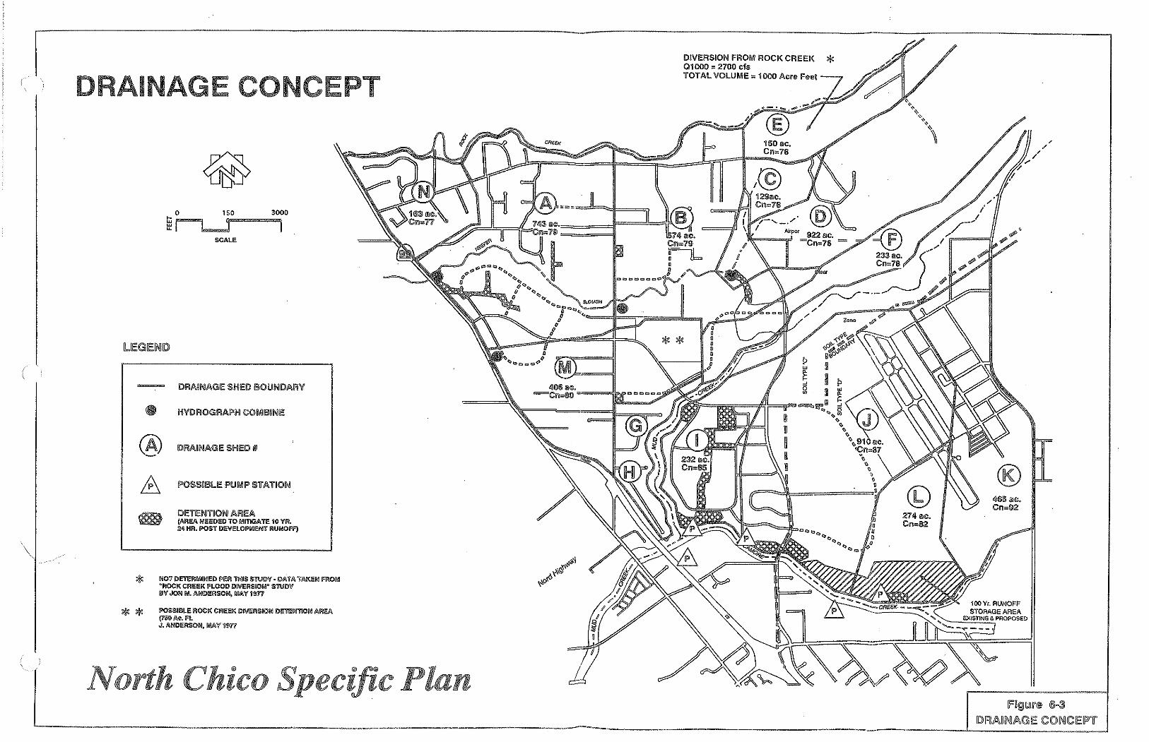
\"
DRAINAGE CONCEPT
0 150 3000
~~ SCALE
(A) DllAUli!AGIE SHED II
DETIE!'l'l"~Oi'! All!EA (AREA NEEDED TO 1\iliTIGA TE 10 VII. 24 HR. POST DE\I'ELOPMIENT RUNOFf)
* NOT DETERMINED PER THIS STIJDV ·DATA TAKEN moM "ROCK CREEK FLOOD DIIIEI'!SION" STIJDV
** BV JON M. ANDERSON, M.OV 1•n
POSSIBLE ROCK CI'!EEK !li\IEI!SIOO DETEN110N MEA (700Ac. R J. ANDERSON, !MIA 'If ~en
North Chico Specific
DIVIERSION FROI\II ROCK CRIEEK * 01000 = 2700 cis TOTAL VOLUI\IIE = 1000 Acre Feel
274 ac. Cll=82
' /
®
IFfi9J1!.111'® ®·3
·------------------------------------------ ~~A~~AG~~O~~~~T ------------------------L _______ __j

NORTH CHICO SPECIFIC PLAN
Schools
Existing Facilities and Projected Need: Schools in the Chico urban area are operated by the Chico Unified School District (CUSD). The District operates a total of 15 elementary schools, 2 junior high schools, and 3 high schools (includes a small continuation high school).
Existing CUSD enrollment and capacity indicate that there is currently remaining capacity .for 81 junior high school students. No additional capacity remains at the elementary and senior high levels. This assessment of existing capacity assumes the use of portable/interim classroom facilities.
To meet the needs of the projected enrollment through the 2011-2012 school year, up to 10 additional schools would be needed within the District (7 elementary schools, 2 junior high schools, and 1 senior high school). If the District were to implement year-round schedules for Grades 1 to 6, the number of new elementary schools required would drop to 5.
Implementation of the North Chico Specific Plan would result in the addition of approximately 1,205 new students to the CUSD at buildout. Table 6-4 provides the number of new students by grade. As there is currently insufficient remaining capacity in the District, such an increase ) in the student population would result in the need for approximately 1.7 new schools (total of .9 elementary schools and approximately .4 the capacity of a junior high school and . 4 the capacity
)
of a senior high school). ..~>
TABLE6-4 STUDENTS GENERATED BY THE NORTH CHICO SPECIFIC PLAN
School Student loading Number of New Number of New Number of New Schools Factor· Students Classrooms
Elementary 0.2322 651 24 0.9
Junior High 0.0989 'ZTl 11 0.4
Senior High 0.0989 'ZTl 11 0.4
Total 0.43 1,ZOS 46 1.7
Proposed Facilities: The NCSP provides one 8.5 acre elementary school site reservation which could accommodate the elementary school student population expected to reside in the Plan area at buildout. This site is located adjacent to the planned neighborhood park and is within the Village Core (see Figure 3-2). This location will allow cost savings through joint acquisition and maintenance of recreational faciliti~s. Additionally, such a location will provide
6-10 Public Facilities and Services Element

NORTH CHICO SPECIFIC PLAN
convenient access to other Village Core services. The junior high and senior high school students would be accommodated in either new or expanded school facilities planned for by the District.
Fire Protection
Existing Services and Facilities: The Butte County Fire Department, in cooperation with the California Department of Forestry and Fire Protection, hereafter referred to as CDF/BCFD, provides structural and wildland fire protection and other emergency services to the unincorporated areas of Butte County, as well as the cities of Biggs and Gridley. ·
The CDF/BCFD operates four fire stations in the Chico area which provide fire protection services to the unincorporated portions of the Chico urban area, including the NCSP area.
There are two stations north of the City of Chico (Stations 41 and 42) and two stations that are west and south of the City (Stations 43 and 44, respectively).
The North Chico and Nord Stations (#41 and #42), which are primarily responsible for serving the Plan area, have 1 and 2 engines, respectively. The Nord Station has 1 full-time firefighter during the winter and 2 firefighters in the summer, and the North Chico Station has 2 full-time firefighters year round. BCFD permanent staff is supported by two volunteer companies, the 60-member North Chico Volunteers, and the 25-member Durham Volunteers.
The Nord Station, adjacent to but without quick access to much of the plan area, has an average first response time of approximately 3 minutes. The North Chico Station, approximately 3 miles from the Plan area, has an average response time of approximately 5 minutes. A 5-minute response time is considered to be acceptable by the BCFD for urban areas (Brown, personal communication, 1992).
Planned Services and Facilities: While existing staffing, equipment, and response times are considered adequate, it is anticipated that planned growth in the area will require additional staffing, equipment, and facilities to maintain acceptable response times. The NCSP provides for a 1. 7 acre fire station site reservation. A new fire station will be constructed on this site as development of the plan area requires.
On an interim basis, 1 additional full-time (24-hour) firefighter and 1 new engine will be provided for the Nord Station (#41) at 25% buildout of the Plan area, and a second additional full-time firefighter will be provided for the Nord Station at 50% buildout of the Plan area. For additional information on the phasing of these improvements, see Section 8, Implementation.
Public Facilities and Services Element 6-11

-, ! NORTH CHICO SPECIFIC PLAN
Solid Waste
Existina Services: Solid waste that is currently generated in the Plan area is collected by private companies and disposed at the only landfill within the county, the Neal Road Landfill, located south of Chico, approximately 11 miles from the Plan area. The 100-acre facility is owned by Butte County, but is privately operated. Remaining capacity is expected to last until the year 2005 (McElroy, personal communication, March 1992).
The County is in the process of updating its Solid Waste Management Plan, which will address issues related to planning new landfill sites. Under requirements of the State Integrated Solid Waste Management Act of 1989, the County also is currently in the process of developing a comprehensive plan to divert wastes from the landfill by 25% by 1995 and 50% by the year 2000.
A variety of efforts by numerous agencies and organizations in the County currently are underway regarding recycling and diversion of materials from the wastestream. Presently approximately 6.6 percent of waste generated in the unincorporated portion of the County is diverted from the Neal Road Landfill, and approximately 19.9 percent of the waste stream } generated in the City of Chico is diverted (Solution Resources, Inc., September 1991). Except for scrap or other metal separation at the County Maintenance Yard, there are no other Countysponsored recycling programs in place. There are recycling/drop-off centers in the Chico area which recycle aluminum cans, ferrous metals, newspaper, and glass, among other materials. The City of Chico also has a permitted composting facility.
)
In developing its waste diversion plan, the County has identified a number of alternatives that are outlined in the Preliminary Draft Source Reduction and Recycling Element prepared for the County. The County is discussing the establishment of a Joint Powers Agreement with the City of Chico to provide municipal services including solid waste management services. The City of Chico now requires that each solid waste collector in the City holding a permit to collect solid waste from single-family and two-family residential customers provide these customers with a curbside recycling program. The County also is evaluating methods to reduce the waste stream of major commercial/industrial uses, and increase participation in local recycling centers.
The fact that the only County landfill is reaching capacity (in 1 0.± years) is a regional issue that currently is being addressed through preparation of the Solid Waste Management Plan.
Planned Services and Facilities: Solid waste associated with Plan area buildout will continue to be collected by private companies and disposed at the Neal Road Landfill until a new landfill is constructed. Opportunities and programs to expand existing and promote new source reduction strategies are being developed under the County's Solid Waste Management Plan
6-12 Public Facilities and Services Element

NORTH CHICO SPECIFIC PLAN
efforts. The proximity of the Plan area to the City of Chico, where a number of recycling centers and programs are underway, offers an opportunity for coordination of potential programs, such as curbside recycling. Development of the NCSP could also include a drop-off center and/or recycling programs, to be coordinated with other County programs. Measures to seek cooperation with County/City waste reduction efforts will be needed.
Utilities
Electricity and Natural Gas Services
Existing Facilities: Electricity and natural gas services are currently provided by Pacific Gas and Electric Company (PG&E). Existing residential development in the Plan area is served by both overhead and underground electrical facilities along Eaton Road, Gamer Lane, Hicks Lane, and Keefer Road, with line extensions to serve existing subdivisions. Overhead electrical transmission lines generally are 12 kilovolts (kv). However, a 115-kv overhead transmission line exists along Eaton Road. The nearest substation to the project area is located west of SR99 on Anita Road.
Natural gas lines currently serve only the Plan area residential developments along Eaton Road.
Planned Facilities: According to PG&E, there is sufficient electrical and natural gas capacity to serve development under the NCSP. No problems in providing electrical and gas services are foreseen (Rooke, personal communication, 1992). PG&E will charge new development for extending service and trenching utility lines. Many of these fees are refunded according to regulations set forth by the California Public Utilities Commission (CPUC), Rule 15.
New development would be served through extension of existing and installation of new electrical transmission lines (12 kv). All electrical line extensions to serve residential, commercial, and industrial development would be underground, in accordance with the CPUC Rule 15, unless otherwise exempted by the CPUC. No additional distribution substations would be required to serve new Plan area development. Natural gas services could also be extended to serve Plan area development. Lines would be extended from existing mains in the southernmost portion of the Plan area.
Telephone Services
Existing Facilities: Pacific Bell currently provides telephone services to existing residential development in the Plan area. Telephone lines currently exist along Gamer Lane and Hicks Lane and are both overhead and underground.
Public Facilities and Services Element 6-13

NORTH CHICO SPECIFIC PLAN
Planned Facilities: Pacific Bell anticipates sufficient ability to serve new development in the plan area with underground or overhead facilities (Hook, personal communication, 1992). Pacific Bell ···/ will pay for the extension of services to residential development. However, extension of telephone services to non-residential development within the Plan area will be the responsibility of the developer. . Goals and Policies
Overall Goal
1. Provide public and community services which both adequately serve the community and are cost effective.
Water Policies
1. Plan for the installation of public water facilities in the Plan area south of Mud Creek, while continuing to allow for the use of well water for those developments north of Mud Creek.
2. In the area north of Mud Creek, require the use of community water system may be required parcels. The community water system shall be established in accordance with ) the requirements of state law.
)
Wastewater Disposal Policies
1. Prior to any development in the Plan area south of Mud Creek, a sewer alternative must be selected. The selected alternative shall meet the requirements of state law and Butte County.
2. In the area north of Mud Creek, community septic systems may be required parcels. Operation and maintenance of these systems shall meet the requirements of state law and standard engineering practice.
3. . lri the area north of Mud Creek, developments shall meet the requirements of Department of Environmental Health relative to the installation of septic systems.
Drainage Policies
1. Utilize, to the maximum extent possible, natural, or natural-appearing, stream or drainage courses for storm drainage.
2. Design stormwater facilities, including detention basins, to ensure public safety, to be visually unobtrusive and to provide, where feasible, recreational uses.
6-14 Public Facilities .and Services Element

NORTH CHICO SPECIFIC PLAN
3. Development within a designated floodplain shall be required to meet County and FEMA regulations. No development shall be permitted in the floodway.
4. Utilize pollution control traps or sediment basins for storm drainage systems designed in accordance with County standards andlor requirements.
5. All drainage areas shall be maintained through amendment to the CSA, or other means acceptable to LAFCo, Butte County, and the maintaining group or agency.
Schools Policies
1. In consuHation with the Chico Unified School District, plan for educational facilities in the Plan area.
2. Locate educational facilities in the Plan area adjacent to neighborhood parks in order to facilitate joint use recreation facilities.
3. Encourage CUSD and CARD to work cooperatively to provide joint use recreation facilities.
4. Impacts to school facilities within the Chico Unified School District (CUSD) shall be fully mitigated through the payment of mitigation fees in the amounts justified by CUSD prepared nexus studies, including adjustments, and adopted by the District, or through the implementation of other equivalent measures acceptable to CUSD, including those measures specified in the CUSD Board of Education Resolution No. 486-92.
Fire
The County recognizes that the new residential growth contemplated by this Specific Plan will result in significant increases in the student population of the Chico Unified School District ("CUSD"). The County also recognizes that funding limitations have severely hampered CUSD's ability to accommodate students generated by new residential development. Accordingly, the County, as a condition of approval of this Specific Plan, has required that new residential development fully mitigate its impacts to school facilities. But for this full mitigation requirement, the County would not have approved this Specific Plan.
1. Provide for the location of a future fire station and work with the appropriate fire service agencies to determine the nature and level of fire services required to serve the existing and future residents ..
Public Facilities and Services Element 6-15

2.
NORTH CHICO SPECIFIC PLAN
Amend the existing CSA, or provide another funding mechanism, to provide funds for continued fire services.
Implementation
Water: Water distribution mains and wells will be installed by each individual developer as needed.
Water facilities to serve new development are typically financed by the developer and can be designed and constructed by either California Water or the developer under the supervision of California Water. Once the facilities are constructed and accepted, they will be operated. by, and become the property of, California Water Service. Facilities will be eligible for.the reimbursement agreements normally utilized by California Water Service as approved by the California Public Utility Commission.
Water systems will be developed in accordance with State standards and California Water Service Company requirements regarding pressure, standby power, and treatment. The company requires standby power for a third of their wells, therefore, four of the wells will be ) equipped with generators.
)
In addition to financing the facilities, the developer must also reimburse California Water for the income tax they are required to pay on the dedicated facilities. The tax rate is approximately 33 percent. California Water has a developer reimbursement program which refunds the money advanced by the developer, including the income tax component, at a rate of 2.5 percent per year. Future development using the facilities financed by the developer would also be required to reimburse the developer for their proportionate share of those facilities.
Wastewater Disposal: Construction of initial interim facilities to the City of Chico system Q[ construction of a package treatment plant would be financed through formation of a Mello-Roos Community Facilities District or Special Assessment District. The initial phase would include on-site sewer trunklines. Subsequent facilities, including treatment, will be phased according to demand and funded through a sewer fee program.
Stormwater Management: Drainage improvements will be constructed by individual developers as the need arises. Impact fees will be assessed to provide for a master drainage system and repayment for construction of oversized facilities.
Schools: A 10-acre elementary school site reservation is identified on the North Chico Specific Plan Land Use Map. Each developer within the Plan area shall pay applicable impact fees in accordance with County requirements prior to the issuance of a building permit.
6-16 Public Facilities and Services Element
NORTH CHICO SPECIFIC PLAN
Fire: The NCSP provides for a 1. 7 -acre fire station site reservation as identified on the North Chico Specific Plan Land Use Map. The site will be acquired and constructed with funds from a Mello-Roos Community Facilities District. The existing County Service Area No. 87 or a new CSA will provide interim funding for 2 full-time firefighters and 1 fire engine to the Nord Station, until the new station in the Plan area is constructed. This staffing will be moved to the new station upon its completion.
Public Facilities and Services Element 6-17

)
)
7. DEVELOPMENT REGULATIONS AND DESIGN GUIDELINES
Zoning and Development Regulations
The zoning and development regulations contained herein have been established to provide criteria and requirements for the development of projects within the NCSP area. The zoning regulations are intended to be identical to the existing zones currently used in other areas of the County, except as amended by this Specific Plan. Any changes or amendments to the Butte County Zoning Ordinance will automatically change the requirements of those identified zones. Changes may include, but not be limited to, a change in the title of the zone, a change in the development requirements, a change in the uses of the zone. Additionally, it should be noted that the other requirements· of the Butte County Zoning Ordinance, beyond the specific requirements of the individual zones, still apply. Zoning is one of the primary methods of this Plan's implementation.
When there is a conflict between these regulations and the applicable County ordinances, unless specifically stated herein to the contrary, the requirements of the NCSP shall govern.
Utilizing the Land Use Map, Figure 3-1 of this text, the County zoning designation for each land use designation is indicated as follows:
LAND USE ZONING 0 Suburban Residential (3 acre minimum) SR-3 0 Suburban Residential (1 acre minimum) SR-1 0 Low Density Residential R-1 0 Medium Density Residential R-2 0 Multi-family R-3 0 Light Industrial M-1 0 Heavy Industrial M-2 0 Business & Professional BP 0 Light Commercial C-1 0 General Commercial C-2 0 Open Space OS 0 Public/Quasi-Public PQ
Table 7-1 summarizes the proposed NCSP land use designations and corresponding zone districts.
Development Regulations and Design Guide1ines 7-1
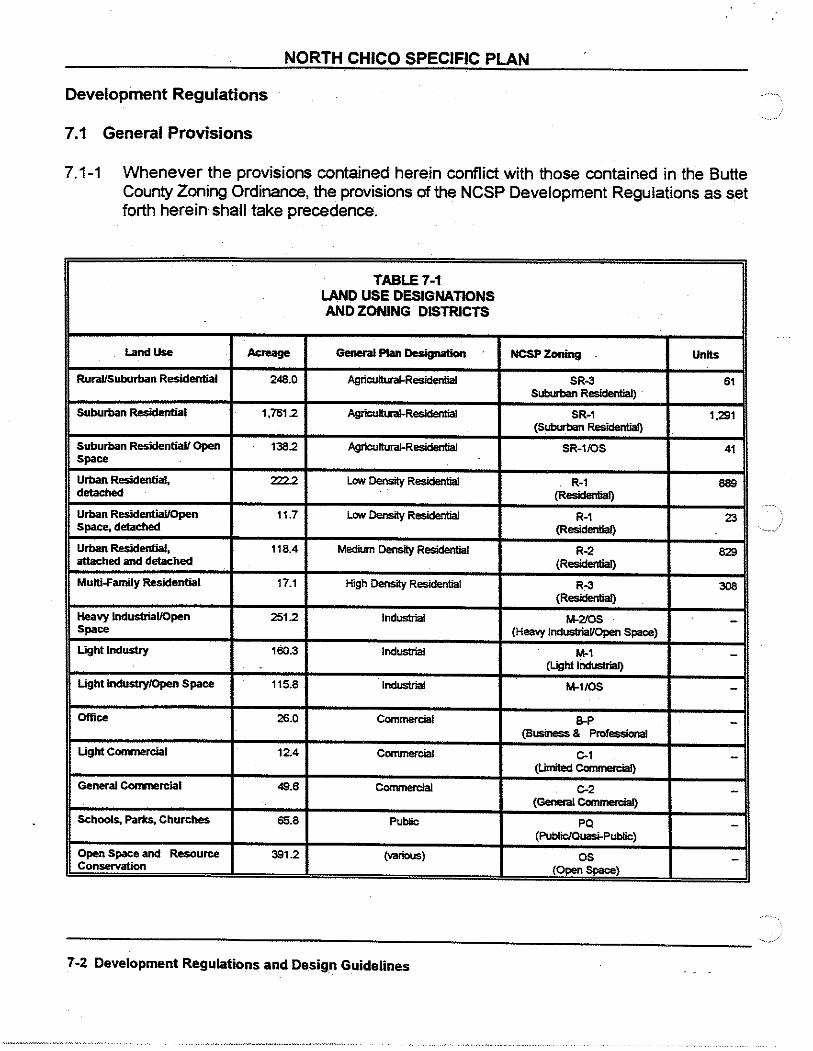
NORTH CHICO SPECIFIC PLAN
Development Regulations
7.1 General Provisions
7.1-1 Whenever the provisions contained herein conflict with those contained in the Butte County Zoning Ordinance, the provisions of the NCSP Development Regulations as set forth herein shall take precedence.
TABLE7-1 LAND USE DESIGNATIONS AND ZONING DISTRICTS
Land Use Acreage General Plan Designation NCSPZoning Units
RuraUSuburban Residential 248.0 Agriculturai-R....- SR-3 61 Suburban Residential)
Suburban Residential 1,761.2 Agriculturai-R....- SR-1 1,291 (Suburban Residential)
Suburban ResidentiaU Open 138.2 Agricultural-Residential SR-1/0S 41 Space .
Urban Residential, 222.2 Low Density Residential R-1 889 detached {Resideulial)
Urban ResidentiaUOpen 11.7 Low Density Residential R-1 23 Space, detached (Residential)
Urban Residential, 118.4 MediumOensityR- R-2 829 attached and detached (Resideulial)
Multi-Family Residential 17.1 High Density R....- R-3 308 {Residential)
Heavy Industrial/Open 251.2 Industrial M-2/0S -Space (Heavy Industrial/Open Space)
Light Industry 1S0.3 Industrial M-1 -(Light Industrial}
Light Industry/Open Space 115.8 Industrial M-1/0S -Office 26.0 Commercial B-P -
(BUSinesS& Professional
Ugh1 Corrmercial 12.4 Commercial C-1 -(Umited Ccmmercial)
General Conmercial 49.6 Ccmmercial C-2 -(General Ccmmetcial)
Schools, Parks, Churches 65.8 Pubflc PQ -(Public/Quasi-Public)
Open Space and Resource 3812 (various) OS -Conservation (Open Space)
7-2 Development Regulations and Design Guidelines

)
)
NORTH CHICO SPECIFIC PLAN
7.1-2 If specific development standards have not been established, or if an issue, condition, or situation arises or occurs that is not covered, provided for, or clearly understandable in the Specific Plan, then those provisions provided for by the Butte County Zoning Ordinance that are most applicable for the most similar issue, condition, or situation, as determined by the Development Services Director, or designee, shall apply.
7.1-3 Development may occur only after a determination, by the County staff, of consistency between the development proposal, these regulations, and any applicable policies and guidelines of the NCSP, has been made.
7.1-4 All construction and development within the Plan area shall comply with all provisions of applicable codes, standards, and requirements, and other Uniform Codes as adopted and updated from time to time by the County of Butte, including subdivision, building, mechanical, electrical, plumbing, fire, water, grading and excavation, design, and development regulations.
7.1-5 The boundaries of the NCSP area and of individual land use and zoning areas have been defined and delineated in this Plan. Adjustments resulting from final road alignments, and/or technical refinements to the development boundaries will not require a Specific Plan Amendment. The precise boundaries and acreage shall be determined by interpretation of the Development Services Director, or designee, as development plans are submitted via applications for subdivision maps, use permits, and site plan approvals.
7.1-6 The number of dwelling units and acreage for each land use designation is shown on the land use plan. These numbers may be revised as appropriate subject to the following:
o Any such revision shall be in accordance with established procedures intended to ensure compliance with the policies of the Specific Plan.
0 Such revisions shall take place through the subdivision map, use permit, or site plan approval process as applicable.
o Within the Village Core boundaries, any revision to increase or decrease the number of dwelling units within a particular designation by 10% or tess may be approved without amendment of the Plan.
0 Within the Village Core boundaries, any revision to increase or decrease the number of dwelling units within a particular designation by more than 10% shall be offset by a corresponding decrease in another designation so that the total number of units within the Village Core is not exceeded. Any such increase or decrease without such offset shall require amendment of the Plan.
Development Regulations and Design Guidelines 7-3
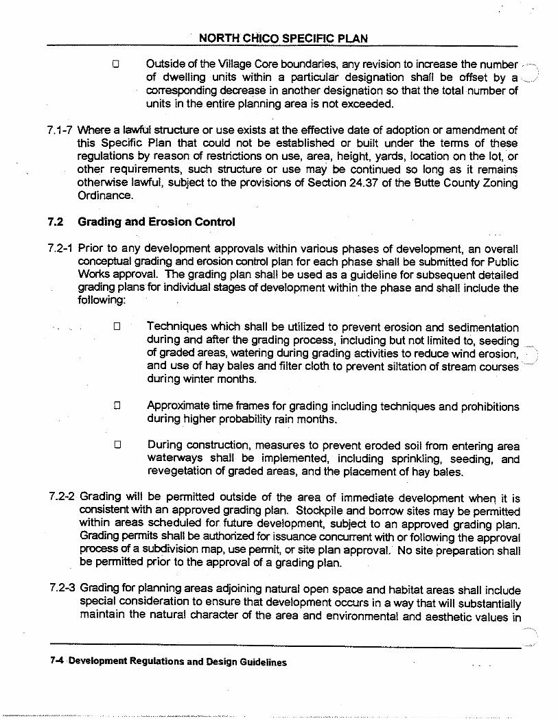
NORTH CHICO SPECIFIC PLAN
o Outside of the Village Core boundaries, any revision to increase the number of dwelling units within a particular designation shall be offset by a ...... / corresponding decrease in another designation so that the total number of units in the entire planning area is not exceeded.
7.1-7 Where a lawful structure or use exists at the effective date of adoption or amendment of this Specific Plan that could not be established or built under the terms of these regulations by reason of restrictions on use, area, height, yards, location on the lot, or other requirements, such structure or use may be continued so long as it remains otherwise lawful, subject to the provisions of Section 24.37 of the Butte County Zoning Ordinance.
7.2 Grading and Erosion Control
7.2-1 Prior to any development approvals within various phases of development, an overall conceptual grading and erosion control plan for each phase shall be submitted for Public Works approval. The grading plan shall be used as a guideline for subsequent detailed grading plans for individual stages of development within the phase and shall include the following: ·
0 Techniques which shall be utilized to prevent erosion and sedimentation during and after the grading process, including but not limited to, seeding of graded areas, watering during grading activities to reduce wind erosion, and use of hay bales and filter cloth to prevent siltation of stream courses during winter months.
0 Approximate time frames for grading including techniques and prohibitions during higher probability rain months.
o During construction, measures to prevent eroded soil from entering area waterways shall be implemented, including sprinkling, seeding, and revegetation of graded areas, and the placement of hay bales.
7.2-2 Grading will be permitted outside of the area of immediate development when it is consistent with an approved grading plan. Stockpile and borrow sites may be permitted within areas scheduled for future development, subject to an approved grading plan. Grading permits shall be authorized for issuance concurrent with or following the approval process of a subdivision map, use permit, or site plan approval. No site preparation shall be permitted prior to the approval of a grading plan.
7.2-3 Grading for planning areas adjoining natural open space and habitat areas shall include special consideration to ensure that development occurs in a way that will substantially maintain the natural character of the area and environmental and aesthetic values in
7-4 Development Regulations and Design Guidelines

)
)
NORTH CHICO SPECIFIC PLAN
accordance with the policies and regulations herein.
0 No building site shall be approved for construction which does not have provisions for conducting surface drainage from the site to . a natural drainage course, a drainage channel, or a public street Such drainage shall be in accordance with established engineering practices and approved by the Department of Public Works.
o All exposed slopes shall be planted or otherwise protected from the effects of water runoff and erosion according to established engineering practice within 90 days after completion of grading. Planting shall be in accordance with the design and landscaping standards established for the NCSP.
7.2-4 Erosion and sediment transport shall be minimized by incorporating the following design criteria into the proposed drainage system:
o Maintain earth-lined drainage swale velocities to less than 5 ft/sec.
o Require erosion control grasses on drainage swales with velocities between 5 and 7 ft/sec.
0 Require erosion control grouted rip-rap cobbles for drainage swales with velocities greater than 7 ft/sec.
o Detention facility outfall structures shall be sized in order to satisfy NPDES requirements prior to discharge into flood waters.
7.3 Drainage
7.3-1 Existing property outside the current 1 00-year floodplain shall design drainage facilities to limit peak runoff to flows at or below current undeveloped levels.
7.3-2 Existing property within the 1 00-year floodplain shall develop in accordance with County regulations and policies and FEMA regulations. In no case shall development be permitted in the floodway.
7-4 7.4-1
Resource Protection Development adjacent to Keefer Slough shall be set back 1 00 feet from top of bank to preserve existing riparian vegetation and habitat, to encourage the expansion of riparian habitat, and to provide a corridor for wildlife. Proposed trails shall be aligned along the outer edge of the 1 00-foot buffer zone. The precise location of top of bank shall be approved in the field by the Director of Development Services or designee in conjunction with the County Public Works Director.
Development Regulations and Design Guidelines 7-5

0 1500 3000
e~ """"
AREAS OF HIGH ARCHAEOLOGICAL SENSI11VITY, REQUIRING FIELD SURVEY, REPORT AND POSSIBLE MmGATION MEASURES PRIOR TO DEVELOPMENT.
' ,---/
' ;
ARCHAEOLOGICAL AREAS Figure 7-1
North Chico Specific Plan
·'
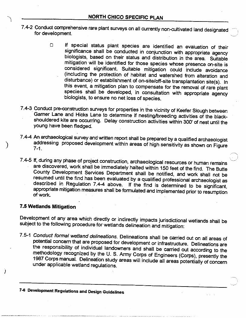
)
)
NORTH CHICO SPECIFIC PLAN
7.4-2 Conduct comprehensive rare plant surveys on all currently non-cultivated land designated for development.
0 If special status plant species are identified an evaluation of their significance shall be conducted in conjunction with appropriate agency biologists, based on their status and distribution in the area. Suitable mitigation will be identified for those species whose presence on-site is considered significant. Suitable mitigation could include avoidance (including the protection of habitat and watershed from alteration and disturbance) or establishment of on-site/off-site transplantation site(s). ·In this event, a mitigation plan to compensate for the removal of rare plant species shall be developed, in consultation with appropriate agency biologists, to ensure no net loss of species.
7.4-3 Conduct pre-construction surveys for properties in the vicinity of Keeter Slough between Gamer Lane and Hicks Lane to determine if nesting/breeding activities of the blackshouldered kite are occurring. Delay construction activities within 300' of nest until the young have been fledged.
7.4-4 An archaeological survey and written report shall be prepared by a qualified archaeologist addressing proposed development within areas of high sensitivity as shown on Figure 7-1.
7.4-5 If, during any phase of project construction, archaeological resources or human remains are discovered, work shall be immediately halted within 150 feet of the find. The Butte County Development Services Department shall be notified, and work shall not be resumed until the find has been evaluated by a qualified professional archaeologist as described in Regulation 7.4-4 above. If the find is determined to be significant, appropriate mitigation measures shall be formulated and implemented prior to resumption of work.
7.5 Wetlands Mitigation
Development of any area which directly·or indirectly impacts jurisdictional wetlands shall be subject to the following procedure for wetlands delineation and mitigation:
7.5-1 Conduct formal wetland delineations. Delineations shall be carried out on all areas of potential concern that are proposed for development or infrastructure. Delineations are the responsibility of individual landowners and shall be carried out according to the methodology recognized by the U. S. Army Corps of Engineers (Corps), presently the 1987 Corps manual. Delineation study areas will include all areas potentially of concern under applicable wetland regulations.
7-6 Development Regulations and Design Guidelines

NORTH CHICO SPECIFIC PLAN
This includes not only the sites of direct alteration (e. g. discharge of dredged or fill material), but also all upstream and downstream wetland areas that may be subject to hydrologic alterations resulting from fills, excavation, or drainage improvements.
Figure 5-2 identifies those areas that would require a formal delineation for development to proceed.
7.5-2 Obtain Corps permits. Wetland delineations shall be reviewed and approved by the Corps, and the required processes completed resulting in the issuance of nationwide, regional or individual permits.
7.5-3 Compensate for unavoidable wetland fiffs. Compensation will be in accordance with Corps regulations. Compensation for fills or alterations of wetland habitat shall ensure that an equal or greater acreage of wetlands, of equal or greater functions and values, will be created and shall include compensation for temporary habitat losses. These and other considerations usually require that proposed compensation exceed the acreage of wetland affected by a ratio of 2 to 1. Wetland creation or enhancement shall be conducted according to compensation plans approved by the Corps. Each proposed project will be responsible for adherence to Section 404(b)(1) guidelines, and for .providing compensation for wetland fills either independently or in conjunction with other projects, subject to Corps approval.
7.5-4 If elements of project design or of a Plan amendment would eliminate or render unsuitable any designated preservationfmitigation area, the documentation for that project or amendment must include designation of another mitigation area of equal of greater size and suitability.
o Preserve and protect existing or created wetlands. During . nearby construction, establish 50-foot buffers around wetlands (as measured from the outer edge of the pool's zone of influence) by construction of a barrier to prevent damage. Prohibit alteration of drainage into or out of a wetland. Prohibit artificial drainage or deposition into a wetland or its drainage without proper engineering design and necessary permits. Prohibit placement of materials or substances into a wetland or its drainage.
7.6 Protection of Chico Municipal Airport Operations
The proximity of the Plan area to the Chico Municipal Airport raises compatibility issues for development which are addrel?sed with the following regulations:
7.6-1 Avigation easements shall be required for all lands within the Plan area.
7.6-2 Noise attenuation features shall be incorporated into new construction.
Development Regulations and Design Guidelines 7-7

•
AIRCRAFT OVERFUGHTZONE 1 THIS AREA SUBJECT TO NOISE AND OTHER O!STURBANCE RELATED TO THE OVERFUGKT OF AIRCRAFT TO AND FR011 CHICO MUNICIPAL AIRPORT. AND TO AIRCRAFT OPERA noNS ATlHE AIRPORT •
...
l • •
,,.,-... J- ·-""' ,
~--
- APPROXIMATE LOCATION OF "OVERFUGHT ZONE" SIGNS
,'.=~=II
OVERFLIGHT ZONE SIGNAGE Figure 7-2
North Chico Specific Plan

NORTH CHICO SPECIFIC PLAN
7.6-3 Enhanced disclosure measures shall be developed and implemented to alert prospective home buyers and rental tenants as to the proximity of the Chico Municipal Airport, the existence of avigation easements, the existing and projected future overflight and noise levels, and such related issues as are appropriate to fully inform such prospective home buyer or rental tenant. Enhanced disclosure may be modeled on Butte County Code, Chapter 35 Protection of Agricultural Land.
7.6-4 "Overflight Zone" road signage shall be installed at key access points into the Plan area, including Eaton Road, Gamer Lane, Hicks Lane, New Arterial Road and Keefer Lane. Such signage shall be of such materials, size and design to be visible and readable from a moving vehicle. Figure 7-2 illustrates the concept.
7.6-5 The New Arterial Road and collector streets east of Gamer Lane shall be designated with aviation-related names as set forth in Butte County Code Chapter 32.
7.8 Principal Land Use Districts
The following section summarizes the principal underlying land use districts within the NCSP area. The existing Butte County Zoning Ordinance has been followed closely and modified, where necessary, to ensure that NCSP goals and policies are achieved while facilitating ) administration by county staff.
)
Definitions and Conditions
Terms used in this document shall have the same definitions as provided for in the Butte County Code, unless otherwise defined herein. All regulations, design criteria, requirements, and similar details not set forth herein shall be those as contained in appropriate sections of the Butte County Code.
Residential Development Regulations
Within the Plan area there are two basic residential categories: Suburban Residential and Residential. The standards contained herein are consistent with the County zoning standards although the designations are modified or "customized" for the NCSP. The Suburban Residential designation results in two districts, SR-3 and SR-1. The Residential designation has three zone districts- R-1 (Low Density Residential), R-2 (Medium Density Residential), and R-3 (High Density Residential). Table 7-2 summarizes basic development regulations of each district.
7-8 Development Regulations and Design Guidelines

l TABLE 7-2
SUMMARY OF ZONE DISTRICT DEVELOPMENT STANDARDS (Opllon B)
Des1gn Standard SR-J SR-1 R·l R-2 R-J
Lot Configuration In tenor ::J ac. 1 ac.. 8000 Sl 4000 sl 6500 sl
Min1mum Lol Size Corner J ac. 1 ac. 8000 sf 4000 sf rooo sf
l\rlin1mum Lot Widlh In tenor 130 II 130 II G!:i rt 4511 50 rt
Maxtmum Building Coverage t2
. 10% 15% 50% !j5% GO%
Minrmum Lanoscaped
Open S_pace1 - None None 40% JO% 25%
Open Space . . . .
Sile Oevelopmenl Reqwrements
. . . . .
Parktng Requ1red Off-Street S_pacas
. 2/du 2/du 2/du Z/du 2/d\1
Surfacing Malenat . None None Pcclac' Pcclac• Pcc/ac'
Building Sotboclls & ConflguraiJons (In lalltl
Front . 50~ so• 20 20 20
Re<Jr . 20 20 15 15 10
l Side . 5 5 5 5 5
I Mimmum Distance Between the Buildings
. 10 10 10 10 10
Maxtmum Building . 35 35 35 35 Hetghl ~
__ ____..___ ___ _ L__
I 4o
Foolnotes:
J .
G
Me~sured from properly line on ctly
Percentage of tolullot area.
Served lly public seiYer, or must me
Requrremenls vary by specific use~
Cotlc. Secllotl 24-JS.
Porlland ccrncmliliaus concrete (con
r.te~surctl from cenlerlfne of streel,
f'ronl setback shall be equal lo atlla ·~·:zone.
s· requucd II Jot alluls an "R" dlsluct shalt lm 15 lc:el.
t---
e of rrghl-ol·wav.
et onslle disposal slam.lartls.
.illun tone ~nd shall lle as sellorl11rn lhc Bulle Countv
crete 1 or aspllaUic ccncrelc.
JT 20" from propeelv lint!, whichever 15 greater.
:en I use lor a mmrmum l.llsi:Joce or 50" wllcre allulllno an
il lol rs on corner adliiCC!ntlo 1111 ·n· dis111ct. slda vard
n.
10.
11.
12
Zonm_g Dlstncts
BP C·1 C·2 M·2 M-1 p.Q ~ PO Non ~
6500 Sl 2000 s( None' Nona-' None .. None .. G sao~ None'·v
7000 sf 2000 sl None' None .. None .. None' 9..SOO" None ... "
50 Cl 25 It 25 (l None' None' NoneJ ~ None..o.•
GO% 60% GO% 70% GO% 50% .!.!. ZQ!g
25% 5% 5% 5% 50/a JO% .J!! .19:&
. . 25% 25%
- I . . . l!! .!JI
1/JOO s/ 1/200 sl Code~ Code• Code~ Code' a!Qy Code'
Pcc/ac• Pcctac• Pcclac• Pcclac• Pcclac• Pcc/ac• Pcc/ac• Pcc/ac•
20 None None None None None 50" None
5 None" None" None" None" None 15 None"
5 None" None" None" None" None" 5 None•
10 None None None None None ~ ~
50 50 50 jso 50 35 35 50
ThE! Planned Oevelonmenl (I"' D) Cumllm.ng ~one alfows for a varoet~ of lo! srzes to
accommollafe the destgnaled ~leltl.
Oevatoemenl Is ro eonrorm to the Slle Oevetooment Regurremonls as seecifi~d b~ llle Norrh
Chu:a Sgedfic Plnn under the Planned DevelolllllOnt(POJ Combrnrng Zone,
in accorc!ance with Table 7 ·2 (il..f
MaXIIllUill auU!llng Coven:rge IS a rnla( of <Ill slrucrures onchrdlng dcl1ldled IJilrrls, gar~ges
ga!iencs, ere,
Table above reflects amendments
approved by the Board of Supervisors . '
on August 17, 2004. -~--·---·----
.
i
I

Tnble 7·2 (a)
1\'Ja:x. Building Co..,ernge Limitations for the PD
Combining Zone
NOTE: Ma~tlmum Building Coverage is a lola! or an structures Including
detached barns garages ga~ebos etc:
Parcel Size Max Building
Coverage
>1-acre 6,530 sq n
> v., .. acre - !:1 -acre 6,530 sq.fl
>'A-acre- St. -acre 6,530 sq ft
>1/3-acre- ~~-acre 5,800 sq n -
> 1/:.l-acre ·· s/3-acle .:t,900sq n .
6,000 - ::V.-acrc 3,250 sq n
Table above reflects amendments approved by the Board of Supervisors on August 17, 2004.

NORTH CHICO SPECIFIC PLAN
SR-3 (Suburban Residential)
1. Site Requirements
o Lot Area Required: 3 acre minimum lot size per dwelling unit, including comet lots.
o Lot Width Required: 130 feet as measured from property line at edge of right-of-way, including comer lots.
o Front Yard Required: 50 feet centerline of adjacent streets, or 20 feet from property line, whichever is greater.
o Rear Yard Required: 20 feet
o Side Yard Required: 5 feet
o Maximum Building Height: 35 feet
o Maximum Building Cc:>verage: 1 0% of lot area.
o Minimum Landscaped Open Space: None
o Off-street Parking Required: 2 spaces per dwelling unit, no surfacing material required.
2. Uses Permitted
(1) One single-family dwelling per parcel, not including tents or trailers; (2) Accessory buildings pertinent to the permitted uses; (3) Agricultural uses, including the keeping of animals, subject to the animal maintenance
requirements of Sections 24-35.1 through 24-35.3 of the Zoning Code,
3. Uses Requiring Use Permits
The following uses are permitted subject to securing a use permit in each case:
(a) Public and quasi-public uses including churches, firehouses, and public utility buildings; (b) Sales tract office.
7-10 Development ~egulations and Design Guidelines

NORTH CHICO SPECIFIC PLAN
- SR-1 (Suburban Residential)
1. Site Requirements
0 Lot Area Required: 1 acre minimum lot size per dwelling unit, including comer lots.
o Lot Width Required: 130 feet as measured from property line at edge of right-of-way, including comer lots.
0 Front Yard Required: 50 feet centerline of adjacent streets, or 20 feet from property line, whichever is greater.
o Rear Yard Required: 20 feet.
o Side Yard Required: 5 feet.
o Maximum Building Height: 35 feet.
o Maximum Building Coverage: 15% of lot area.
) o Minimum Landscaped Open Space: None
)
0 Off-street Parking Required: 2 spaces per dwelling unit, no surfacing material required.
2. Uses Permitted
( 1) One single-family dwelling per parcel, not including tents or trailers; (2) Accessory buildings pertinent to the permitted uses; (3) Agricultural uses, including the keeping of animals, subject. to the animal maintenance
requirements of Sections 24-35.1 through 24-35.3 of the Zoning Code.
3. Uses Requiring Use Permits
The following uses are permitted subject to securing a use permit in each case:
(a) Public and quasi-public uses including churches, firehouses, and public utility buildings; (b) Sales tract office.
Development Regulations and Design Guidelines 7-11

NORTH CHICO SPECIFIC PLAN
R-1 (Low Density Residential)
1. Site Requirements
o Lot Area Required: 8,000 square feet, including comer lots.
o Lot Width Required: 65 feet interior lots, 75 feet comer lots.
o Front Yard Required: 20 feet
o Rear Yard Required: 15 feet, except 5 feet for accessory building when abutting an alley
o Side Yard Required: 5 feet, except street side of comer lot -10 feet.
o Maximum Building Height: 35feet
o Maximum Building Coverage: 50% of lot area.
o Minimum Landscape9 Open Space: 40% of lot area.
o Off-street Parking Required: 2 spaces per dwelling unit, concrete or asphalt surface.
2. Uses Permitted
(1) One single-family dwelling per parcel; (2) Accessory buildings
3. Uses Requiring Use Permits
The following uses are permitted subject to securing a use permit in each case:
(a) Rest homes, convalescent homes and sanitariums for more than six (6) residents (b) Licensed family, foster or group homes in conjunction with seven (7) or more children and
day care facilities for over twelve (12) children (c) Social halls, lodges, fraternal organizations and clubs operated by recognized non-profit
organizations (d) Sales tract offices
---------------------- .j
7-12 Development Regulations and Design Guidelines

NORTH CHICO SPECIFIC PLAN
R-2 (Medium Density Residential)
1. Site Requirements
o Lot Area Required: 4,000 square feet, including comer lots.
o Lot Width Required: 45 feet interior, 50 feet comer
o Front Yard Required: 20 feet
o Rear Yard Required: 15 feet, except 5 feet for accessory building when abutting an alley
o Side Yard Required: 5 feet, except street side of comer lot -10 feet. May be no set back if in connection with an approved planned unit development in which zero-lot-line planning is utilized.
o Maximum Building Coverage: 55% of lot area.
o Minimum Landscaped Open Space: 30% of lot area.
o Maximum Building Height: 35 feet
o Minimum Landscaped Open Space: 30% of lot area
o Off-street Parking Required: 2 spaces per dwelling unit, concrete or asphalt surface.
2. Uses Permitted
(1) One single-family dwelling per parcel; (2) One duplex or zero lot line single-family dwelling (halfplex per parcel). (3) Accessory buildings .
3. Uses Requiring Use Permits
The following uses are permitted subject to securing a use permit in each case:
(a) Rest homes, convalescent homes and sanitariums for more than six (6) residents (b) Licensed family, foster or group homes in conjunction with seven (7) or more children and
day care facilities for over twelve ( 12) children (c) Social halls, lodges, fraternal organizations and clubs operated by recognized non-profit
organizations (d) Sales tract offices
Development Regulations and Design Guidelines 7-13

NORTH CHICO SPECIFIC PLAN
R-3 (High Density Residential)
1. Site Requirements
o Lot Area Required: 6,500 square feet, 7,000 square feet comer lots.
o Lot Width Required: 50 feet interior, 65 feet comer
0 Front Yard Required: 20 feet
o Rear Yard Required: 10 feet, except 5 feet for accessory building when abutting an alley
o Side Yard Required: 5 feet, except street side of comer lot -15 feet.
o Maximum Building Coverage: 60% of lot area.
o Minimum Landscaped Open Space: 25% of Jot area.
o Maximum Building Height: 40 feet
D Off-street Parking Required: 2 spaces per dwelling unit, concrete or asphalt surface.
2. Uses Permitted
(1) Multiple family dwellings, condominiums, and apartments (2) Duplex or two-family dwellings (3) Accessory buildings
3. Uses Requiring Use Permits
The following uses are permitted subject to securing a use permit in each case:
(a) Churches (b) Rest homes, convalescent homes and sanitariums for more than six (6) residents (c) Licensed family, foster or group homes in conjunction with seven (7) or more children ·and
day care facilities for over twelve (12) children
7-14 Development Regulations and Design Guidelines

NORTH CHICO SPECIFIC PLAN
BP (Business & Professional Office)
1. Site Requirements
o Minimum Lot Size: 6,500 square feet interior, 7,000 square foot comer lot.
D Lot Width Required: 50 feet interior, including comer.
o Front Yard Required: 20 feet.
D Rear Yard Required: 5 feet.
o Side Yard Required: 5 feet.
D Maximum Building Coverage: 60%
o Maximum Building Height: 50 feet or 4 stories.
o Minimum Landscaped Open Space: 25% of lot area, including parking lot interior and perimeter landscaping.
) o Off-street Parking Required: 1 space per 300 square feet, concrete or asphalt.
2. Uses Permitted
( 1) General office (2) Professional office and clinics (3) Corporate and regional headquarters ( 4) Banking, insurance, and other financial operations (5) Computer programming, data processing, and other software services
) ../
Development Regulations and Design Guid~li!l~ 7-15

)
)
NORTH CHICO SPECIFIC PLAN
C-1 (Light Commercial)
1. Site Requirements
o Minimum Lot Size: 2,000 square feet, including comer lot
o Minimum Lot Width: 25 feet, including comer lot
o Front Yard Required: None, except where the front setback abuts an R district, in which case the front yard shall be equal to the adjacent use for a distance of not less than 50 feet.
o Rear Yard Required: None, except where the rear yard abuts an R district, in which case the rear yard shall be not less than five (5) feet.
o Side Yard Required: None, except when the side of a lot abuts upon the side of a lot in an R district, in which case the abutting side yard shall not be less than five (5) feet; and except where the side yard on the street side of a comer lot abuts on an R district, in which case the side yard on the street side shall be one-half the front yard required in such R districts.
o Maximum Lot Coverage: 60%
o Minimum Landscaped Open Space: 5% of lot area, including parking lot interior and perimeter landscaping.
o Maximum Building Height: 50 feet
o Parking Requirements: As required by Butte County Code section 24-35.
2. Uses Permitted
(1) Retail stores and shops of light commercial character and conducted within a building, including appliance stores, banks, and launderettes, dress shops, drugstores, food stores, furniture shops, studios and tailor shops, pubiic utility and other uses which are of similar character to those enumerated and which will not be detrimental or obnoxious to the neighborhood in which they are to be located;
3. Uses Requiring Use Permits .
The following uses are permitted subject to securing a use permit in each case: (a) Small animal hospitals, dance academies, pet shops, refreshment stands, service stations,
drive-in restaurants and other uses which are of similar character; (b) Recycling facilities as per section 24-68.
7-16 Development ~egulations and Design Guidelines

' 1
)
NORTH CHICO SPECIFIC PLAN
C-2 (General Commercial)
1. Site Requirements
0 Lot Area Required: None
o Lot Width Required: 25 feet, including comer lots.
o Front Yard Required: None
o Rear Yard Required: None, except where the rear yard abuts an R district, in which case the rear yard shall be not less than five (5) feet.
o Side Yard Required: None, except when the side of a lot abuts upon the side of an R district lot, in which case the abutting side yard shall not be less than five feet; and except where the side yard on the street side of a comer lot abuts on an R district, in which case the side yard on the street side shall be one-half the front yard required in the R district.
o Maximum Building Coverage: 60%
o Minimum Landscaped Open Space: 5% of lot area, including parking lot interior and perimeter landscaping.
o Maximum Building Height: 50 feet
o Parking Requirements: Off-street parking shall be provided at the rate as required by Butte County Code section 24-35.
2. Uses Permitted
General commercial uses, including art shops, aviaries, bars and cocktail lounges, billiard parlors and pool halls, bowling alleys, building material (retail), cleaning and pressing establishments, dance halls, interior decorating shops, employment agencies, governmental legislative buildings, gymnasiums, public commercial or physical cultural studios, hospitals, hotels and motels, laboratories and X-ray facilities, equipment rentals, pet shops, used car lots, repair garages, auto car washes, plumbing shops, cabinet shops, sign manufacturing shops, drive-in restaurants and other retail establishments when interpreted as similar.
3. Uses Requiring Use Permits
The following uses are permitted subject to securing a use permit in each case:
(a) Welding shops;
Development Regulations and Design Guide!ines 7-17

.. \
l
)
)
NORTH CHICO SPECIFIC PLAN
(b) Manufacturing of clothing, handicraft products, printing, lithographing and other light manufacturing or industrial uses of similar character;
(c) Public or quasi-public uses, including churches; (d) Service stations, kennels and small animal hospitals and mortuaries; {e) Recycling facilities as per section 2~8 of the Zoning Code.
7-18 Development Regulations and Design Guide6nes

) _/
NORTH CHICO SPECIFIC PLAN
M-1 (Light Industrial)
1. Site Requirements
o Lot Area Required: None
o Lot Width Required: None
o Front Yard Required: 10 feet minimum, 20 feet average.
o Rear Yard Required: None, except where the rear yard abuts an R district, in which case the rear yard shall be not less than five (5) feet.
o Side Yard Required: None, except when the side of a lot abuts upon the side of a Jot in an R district, in which case the abutting side yard shall not be less than five (5) feet; and except where the side yard on the street .side of a comer lot abuts on an R district, in which case the side yard on the street side shall be one-half the front yard required in such R districts.
o Maximum Building Coverage: 60%
o Minimum Landscaped Open Space: 5% of lot area, including parking lot interior and perimeter landscaping.
o Maximum Building Height: 50 feet
o Parking Requirements: Off-street parking shall be provided at the rate as required by Butte County Code section 24-35.
2. Uses Permitted
(1) Wholesale and storage warehouses; (2) The assembly and storage of goods, materials, liquids and equipment (except the storage
of inflammable matter or explosives or materials which create dust, odors or fumes);. (3) The manufacturing, processing, fabricating, assembling, refining, repairing, packaging, and
treatment of goods, materials and products by power (oil, gas or electric), including, by way of example and illustration, but not limited to, the manufacturing, fabrication and assembling of bathroom shower and patio partitions, enclosures and doors, windows and store fronts of aluminum, plastic and fiberglass, or other suitable material, and the processing, finishing, polishing and anodizing of aluminum extrusions and castings, assaying, broom and brush manufacturing, die casting, draying, freighting or trucking yards or terminals, heavy equipment rental or sale, heating and ventilating service shops, jewelry manufacturing, lumberyards, packaging plants, public utility service yards, truck repairing and overhauling
Development Regulations and Design Guidelines 7-19

)
)
NORTH CHICO SPECIFIC PLAN
and welding shops; (4) Dyeing and rug cleaning plants, veterinary hospitals and animal shelters and boarding
kennels, cabinet and woodworking shops, construction and material yards;
3. Uses Requiring Use Permits
The following uses are permitted subject to securing a use permit in each case:
(a) Storage of inflammables; (b) Manufacturing of acids, explosives, fertilizer, glue, gypsum, lime, plaster of paris, pulp and
paper, beet sugar, crushed rock, sand and gravel, cement, concrete and/or asphalt batching plants, concrete and clay products;
(c) Industrial uses which might be objectionable by reason of emission of noise, offensive odor, smoke, dust, bright light, vibration or involving the handling of explosives or dangerous materials;
(d) Recycling facilities as per section 24-68.
7 ·20 Development Regulations and Design Guidelines

NORTH CHICO SPECIFIC PLAN
~~ P-Q (Public, Quasi-Public)
1. Site Requirements
o Minimum Lot Size: None
o Minimum Lot Width: None
o Minimum Front Yard: 20 feet
0 Minimum Side Yard: 5 feet, except where the side yard on the street side of a comer lot abuts on an R district, in which case the side yard on the street side shall be one-half the corresponding front yard required in such R district.
o Maximum Building Coverage: 60%
o Minimum Landscaped Open Space: 5% of lot area, including parking lot interior and perimeter landscaping.
o Maximum Building Height: 50 feet
) o Parking Requirements: Off-street parking shall be provided at the rate as required by Butte
)
County Code section 24-35.
2. Uses Permitted
(1) Public schools; parks, playgrounds, publicly owned buildings, land, and recreational areas. (2) Churches, and the recreational, educational, religious, accessory residential and similar
uses incidental to a cohesive campus of related activities.
Develo~nt Regulations and Design Guidelines 7-21

)
)
OS (Open Space)
Permitted Uses
(1) Biking and hiking trails (2) Drainage improvements (3) Walls and fences
NORTH CHICO SPECIFIC PLAN
(4) Public parks (recreation centers and facilities) (5) Wetland preserves, reference to section 7.5 Wetlands Mitigation. (6) Private parks (active and passive) (7) Any other uses deemed compatible by the Director of Development Services or designee.
7 ·22 Development ~egulations and Design GuideRnes

)
NORTH CHICO SPECIFIC PLAN
ROAD DESIGN STANDARDS
Road Cross Sections
Arterial streets include Gamer Lane, Hicks Lane re-alignment and widening (from Eaton to the village core), Keefer Road (from Hicks Lane westerly), and the new road extending from Hicks Lane to State Route 99 (termed "New Arterial Road" or "New Arterial" herein). Arterial street cross sections vary in accordance with function, projected traffic load, and surrounding land uses. Both two-lane and four-lane arterials are specified. Class I bike paths and Class II bike Janes will be built within the right-of-way where shown in Figure 4~2 Paths & Trails. Drainage swales may occur on one or both sides of the streets either within the right-of-way or in an acf)Clcent drainage corridor. Lots fronting on arterials are allowed only in situations where there is no practical alternative. On-street parking is not allowed except in the heart of the Village Core.
Collector streets provide access from local residential streets to arterial streets and also serve as residential streets. Within the residential (R) zoning districts, collector streets will include curb, gutter and sidewalk, together with planting strips and street trees. Collector streets in the suburban-residential (SR) zoning districts retain the rural character of the area with open shoulders and drainage swales.
Local streets directly serve residential uses and, similarly, are designed with or without urban characteristics depending on location and land use. Local streets are intended to encourage slow speeds and pedestrian activity.
Alleys are specified in the residential areas where front driveways and garages would dominate the street, and where safety is enhanced by reducing tuming movements. Rear parking provided by alleys allows for a much more attractive street.
Table 7-3 presents a summarized version of street characteristics, and Figure 7-3 illustrates each street type in cross-section.
Development Regulations and Design Guidelines 7-23

"-- '--' _j
Street Typo Nama • Location • Criteria R.O.W. If of Pvmt. Curb& Side- Bike On-Street Street Deelgn Width Travel Wldthl1l Gutter walk Path Paridng Lights Stda.t2l
Lanee
Arterial Streets TypsA-11 New Arterial- Eaton to Village Core 64' 4 64' Yes Yes PI 'CI.2 No Yes RS-2(A) TypsA-111 New Arterial- Hicks to Mud Creek 60' 2 40' Yes Yesl'll Cl.2 No Yes RS-2(A) Typo A-IV New Arterial- Mud Creek to SR99; Keefer 60' 2 36' No No Cl.1 &2141 No No RS-3(A) Road; Gamer- Keeler to SR99;
Hicks- Eaton to Caballo.
Collector Streets Type C-1 VIllage Core tocp andd3) streets oonnecttng n to 60' 2 40' Yes YesPl No Yes Yes RS-2(A) Hicks; Hicks- Mud reek to Caballo; New
oonnector btwn Hicks and New Arterial; Sycamore Lane
TypeC-11 New street connecting Gamer and Hicks; 60' 2 32' No No Cl.214l No No RS-3(A) Hicks- Keeler to Mud Creek.
Local Streets Type L-1 All local streets In 'M' zones. 60' 2 40' Yes Yes I'll No No Yes RS-1 (A) TypsL-11 All local streets In 'A' zones not otherwise eo·· 2 40'
described. Yes Yesl3l No Yes Yes RS-2(B)
TypsL-111 All local streets In 'SR' zones not otherwise 50' 2 28' described.
No No No Yes No RS-2(C)
Type L-tv Cul-de--sac streets In •A" zones . 50' 2 32'. Yes Yesl3l No Yes Yes RS·2(C) Type L-V Cut-de-sse streets and streets In 'SR' zones 50' 2 24' No No No No No RS-3(C) serving fewer than 12tots. Type L-VI New one-w"l! loop street located betwaen 30' 1 18'
Gamerand R99. No No No One Side No RS-3(C)
Type L-VII Alleys wtthln R-1 and R-2 zones . 22' 1 18' No No No No No RS-9·LD(I)
1 Pavement width Includes gutter pan where applicable, but does not Include aggregate base shoulder.
3 Sidewalk to be separated from ourb by planter strip, see cross-section lot' dimensions.
2 Refers to desiJin details as set lo<th In standard plans used by the Butte County 4 Bike paths and lanes only where shown In Figure 4-2.
Department Public Works.
t"
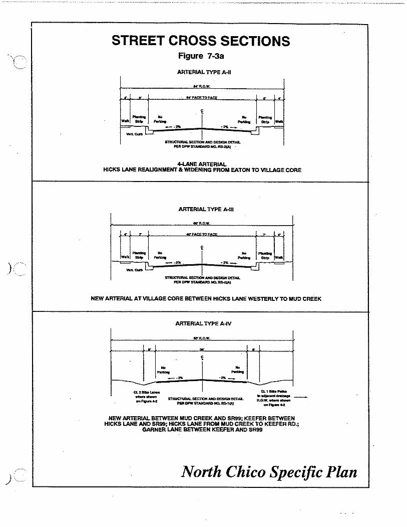
)
l /
.!
STREET CROSS SECTIONS Figure 7-3a
ARTERIAL lYPE A·ll
M'R..O.W.
lloi'FACETOFACE
No -.._ -won
--L .... . ...
4-I.ANE ARTERIAL HICKS LANE REAUGNMENT & WIDENING FROM EATON TO VILLAGE CORE
.. -
ARTERIAL lYPE A-111
IIIYR.O.W.
.... .... _ .. -1 r rl ~Wd;
NEW ARTERIAL AT VILLAGE CORE BETWEEN HICKS LANE WESTERLY TO MUD CREEK
.. -
ARTERIAL lYPE A-IV
IIO"R.O.W.
.... .. -.... _
~
CL1BibP81M .,tid~~R.O.W. 1llbtrl st»wn
onflg-4-2:
NEW ARTERIAL BETWEEN MUD CREEK AND SR9S; KEEFER BETWEEN HICKS LANE AND SR9S; HICKS LANE FROM MUD CREEK TO KEEFER RD.;
GARNER LANE BETWEEN KEEFER AND SR99
North Chico Specific Plan

STREET CROSS SECTIONS Figure 7-3b
COLLECTOR TYPE Cl
IIO'R.O.W.
[1~1-:!!Y FACE TO FACE
_/~tl •• Vert.e.t. b
.... . ... -c::J
5TRUCTUfW. SECnON AND DESIGN DErAIL. PER D9W STANDARD NO. R$.2(AJ
VILLAGE CORE LOOP ROAD AND CONNECTING STREETS TO HICKS LANE; NEW CONNECTING ROAD BETWEEN HICKS AND NEW ARTERIAL; . . .
SYCAMORE LANE.
COLLECTOR TYPE Cll
fllfR.O.W.
__.._
• No No .. _ -) ... ... _
- Q..281U~ -STRUCTURAL SECnON AND DESIGN DErAIL ---PER DPWSTAHDARDNO.~ on FJgur. 4-1
HICKS LANE BETWEEN KEEFER ROAD AND MUD CREEK.
LOCAL TYPE L-1
WR.O.W.
tl~l~ *I'FACETOFAC£
~1~C1 • Vwt.CR L::r
.... . ... ._!J
STRUC1'URAl SEC"'11N AND DESIGN OETAL PER DPWSTANDARD NO. ~1~
.ALL LOCAL STREETS IN M-1 (LIGHT INDUSTRIAL) AND M-2 (HEAVY INDUSTRIAL ZONES)
) North Chico Specific Plan

STREET CROSS SECTIONS Figure 7-3c
LOCAL TYPE L·ll
IO'R.O.W.
r1 T 1 WfM;Emng
1 T r1 £
w... "':':." ...... Partdng "'::;" w.a; _ ,.. _.,. _ -cJ ........
STRUCTURAL SEC'I10H AND DESIGN DETAL PER bPW STANDARD NO. RS-2(8J
ALL LOCAL STREETS IN R--1, R-2, AND R-3 ZONES UNLESS OTHERWISE DESCRIBED.
LOCAL TYPE L-111
!iD'R.O.W.
1·1_~ I r1 .... - I STRUC'FURALSECnOHANO DESION DETAIL
PER DPW C'rANDARD MO. RS-a(C)
ALL LOCAL STREETS IN SR-3 AND SR·1 ZONES UNLESS OTHERWISE DESCRIBED.
LOCAL TYPE L·IV
SO'R.O.W.
· Lt~t-l!l~!QF~
_t~tJ £
• ... .... • ...:.! _o .... S"''AUC'NMM..IECnON Arm DESIQH DETM.
- PER DPW stANDARD N0.~$.2(!~)
ALL CUL·DE.SAC STREETS IN R-1, R-2 AND R-3 ZONES.
j North Chico Specific Plan

J ..
STREET CROSS SECTIONS Figure 7-3d
LOCAL TYPE L·V
SO'R.O.W.
-CUL-DE-sAC STREETS AND LOCAL STREETS IN SR-1
AND SR-2ZONES SERVING FEWER THAN 12 LOTS.
LOCAL TYPE L·VI
- SR-1 OPEN -LOlS SPACE
,.
ONE·WAY LOOP STREET
LOCAL TYPE L-VII
~ ~ 22'R.O.W. ~
.... I . ..._
ALLEYS IN R-1 AND R·2 ZONES
North Chico Specific Plan

NORTH CHICO SPECIFIC PLAN
Street Landscaping
Street trees and shading requirements apply to all new development Street trees must be planted within six months of the completion of streets. Tree species should be selected based on their ability to grow well within the planning area and their ability to provide maximum pavement shading. The following is a planting list for streets within the Plan area:
o Local (Rural) Street Species can be selected by the developer and property owners. Trees should have a spreading structure and be planted 30 to 50 feet apart depending on species.
o Rural Collector Street. This street will be planted with California Sycamore (Platanus racemosa) 40 feet on center between Gamer Lane and Hicks Lane. Existing English walnuts can be used as an alternative.
o Local Urban Street. Local urban streets in the core will be planted with several varieties of trees of moderate size that do not raise or break concrete curbs and sidewalks. Individual streets should be lined with no more than two species. Acceptable varieties are: Goldenrain Tree (Koelreuteria paniculata), Bradford Pear (Pyrus calleryana), Chinese Pistashe (Pistacia chinensis).
o Collector Urban Street The street looping though the Village Core will be planted with Chinese Hackberry (Celtic sinensis).
o Arterial Streets. The New Arterial will be planted with London Plane Tree (Platanus acerifobia) from Eaton Road to Gamer Lane; except the area between Sycamore Creek and the Industrial area will be preserved as resource conservation area and will have street trees only in the center median. Existing walnut trees will be used from Gamer Lane to State Route 99. Gamer Lane and Keefer Road will be planted as desired by property owners. The realignment of Hicks Lane from the new arterial street to Mud Creek will be planted with London Plane.
o The Industrial streets will be planted with London Plane trees (Platanus acerifobia).
Planter Strips between streets and sidewalks will be planted and maintained by the adjacent property owners. Lawn or drought resistant planting no higher than one foot can be planted by the property owner.
Alleys. The section for alleys leaves a two foot planter between the paved section and the back yard because this area should be planted with shrubs or flowers.
Pathway Design
Development Regulations anc! Design Guidelines 7-25

)
)
NORTH CHICO SPECIFIC PLAN
Paved Multi-Use Paths will be paved to a minimum 8-foot width with 2 inches of asphalt on six inches of base work or with four inches of concrete. Paths next to streets without drainage swales should be located 5 feet beyond the street tree. The path should curve back to the street at intersections to form a typical street crosswalk configuration. The landscaping between the street and path will be local annual grasses. Paths next to streets in parks or areas of special biological significance will be 12 feet from the edge of the street. The vegetation between the road and the street will be consistent with the park or area of biological significance.
Unpaved Trails provide access for those on foot, horseback, or bicycle. Trails will have a minimum width of 1 0 feet except for short sections where existing trees may restrict.
The surface may be earth or gravel but must be well enough drained to be passable during wet weather. Trails will generally follow the creeks and greenways, providing an attractive alternative circulation system apart from streets.
Street and Pathway Lighting
The following guidelines address nighttime illumination on streets and paths. All streets and paths will be illuminated in the Village Core, industrial areas and the areas south of Sycamore Creek. In all instances, lighting shall be the minimum intensity necessary to achieve its intended purpose. Downward oriented, cut-off type fixtures and shielding shall be used in order to prevent light spillage and glare impacts beyond the target of illumination. Lighting for pedestrian pathways and parking areas shall illuminate only the pavement. Use of low, bollard-type fixtures is encouraged. Energy conservation shall be a prime consideration when designing any lighting system. Photocell operation is mandatory to ensure efficient use of energy and minimize unnecessary usage. Open space areas shall not be illuminated either directly or indirectly by light spillage from outside light sources. ·
PARKS AND OPEN SPACE DESIGN STANDARDS
The design standards for parks and open space are intended to maintain the rural character and protect and enhance the natural wildlife habitat of the Plan area. ·
Neighborhood Park
The following are design guidelines for the neighborhood park.
o The park design should be integrated with the·adjacent elementary school and school playfields.
o The area of the park located west of the school will be the site for tennis courts and basketball facilities as well as a large open space area that will serve as spillover parking for the park school and village commercial core.
7-26 Development Regulations and Design Guidelines

NORTH CHICO SPECIFIC PLAN
D The park could include the following facilities: a full size soccer field, a softball field, picnic area and shelter restrooms, area for children play apparatus, 3 tennis courts, a basketball court, 2,000 to 3,000 square feet indoor recreational room, and parking.
D Landscaping material should be chosen for low water use.
o The use of native shrubs and trees is encouraged.
o Trees around turf areas should be chosen to tolerate turf grass watering. The trees should have adequate size and spreading ability to form a solid backdrop to the playfield in order to create a meadow effect.
o Trees along paths, on the west side of the park and low water areas should be local natives such as Oaks and Black Walnuts and Sycamores.
o Visual access into park should be maintained from adjacent areas to reduce crime and vandalism. Fencing and/or vegetation should provide for such access.
o Drainage swales in the park should be extremely shallow with natural grass, irrigated turf or sand bottoms.
o Lighting will be limited to street and path lights. (See section on lighting)
o No provisions will be made to light playfields or courts for nighttime use in order to preserve the rural character of the area.
Village Core Greenbelt
The major Greenbelt runs north-south from the southern tip of the village core through the park north to Mud Creek. Only the New Arterial Road and the looping collector road near the southerly end interrupt this central greenbelt. The Village Core greenbelt is connected to the balance of the open space system via additional greenbelt corridors on all sides. These greenbelts all have an 8-foot wide bicycle and pedestrian path with drainage swales designed as periodic stormwater detention areas.
The landscaping will be low water requirement with Oaks and native shrubs where possible. Trees that tolerate irrigation will be used around turf grass areas. Trees should be planted to
. create alternating open and tree covered areas. Sixty percent of paths should be shaded by the mature landscape. The greenbelt overlaying the Hicks Lane alignment will have a dense planting of evergreen to serve as a visual buffer between the village core and the airport. Redwoods, Stone Pines and Kashurina will be planted with a minimum of two rows and less than 1 0-to 15-foot on center depending on species.
Development Regulations and Design Guidelines 7-27

)
)
NORTH CHICO SPECIFIC PLAN
Drainage swales should have natural grass, irrigated grass or sand bottoms. Grading should allow for the direct runoff from adjacent properties and streets. Swales should be shallow and wide without steep banks. In mini-parks the swales will have sand or irrigated turf grass bottoms.
Lighting will be limited to street or path lights. (See section on lighting) No additional lighting will be used.
Corridors
Street-side Path and Drainage Corridors: These corridors will be 20 feet minimum width, along road rights-of-way where indicated in Figure 4-2, and will complete important path and drainage linkages. They provide for an 8-foot wide bicycle and pedestrian path and additional room for drainage and tree plantings for buffers.
Landscaping will be predominantly the chosen street tree corresponding to the adjacent street and natural grass. The grass will need to be field-mowed two or three times a year for aesthetics and to reduce fire hazard.
A buffer of densely planted evergreen trees will be planted in the corridor running north of the realignment of Hicks Lane from the new arterial west to the industrial greenbelt on the old alignment of Hicks Lane. Two rows of trees planted 10to 15feet on center will be planted using Redwoods, Stone Pines, and Kashurina.
Drainage swales in these corridors will be away from the street on the outside of the bike path. They will be shallow with a natural grass or gravel bottom. If adjacent to residential lots, property owners may plant irrigated lawn in the bottom of the wall and to the edge of the paved path.
Trail and Drainage Corridors: There are two of these corridors, one connecting Mud Creek and Keefer Slough and one going north from Keefer Slough on the west side of Gamer Lane. These corridors are to be planted with native shrubs and trees and natural grasses. They will · have shallow swales and may have stormwater detention grass basins. They will have no lighting. They should ultimately look like natural areas with trail and paved paths.
Creek Corridors
All natural water corridors will have a 1 0 foot trail dirt or gravel but must be passable in wet weather. Should be located to disrupt wildlife and vegetation as little as possible.
7-28 Development Regulations and Design Guidelines

)
· NORTH CHICO SPECIFIC PLAN
Wetlands
Where streets cross wetlands there should be no street trees (except in center median, where applicable), natural grass should extend to edge of paved section or bicycle and pedestrian path and the area between the path and street should be natural grasses, street and paths should sheet drain into the wetlands with proper engineering design and pollution control devices.
Development Regulations and Design Guidelines 7·29

)
)
NORTH CHICO SPECIFIC PLAN
VILLAGE DESIGN GUIDELINES
The following section provides design guidelines and standards intended to preserve the rural character of the Plan area. The NCSP character is accentuated by the establishment of a Village with design standards that reflect traditional small valley towns. A critical element in the preservation of the rural character of the area will be keeping automobile traffic to a minimum. A combination of the centrally located Village Core easily accessible by walking and bicycling along with design standards that create safe and aesthetically pleasing routes should help to reduce automobile dependency.
Residential Design
The North Chico Specific Plan provides for a variety of housing types ranging from single-family low-density to multi- family. Streets have been laid out so most lots have a north-south orientation for possible solar design. Street trees were selected and streets laid out to assure solar access in winter and shading in summer.
The major design influence will come from the street and sidewalk layout, and also from the setbacks and orientation of structures and their front doors and garages to streets, paths, and alleys. ·
Multi-Family Design
The design standards for multi-family are intended to create structures that appear more like townhouses.
D All multi-family units must face with front doors onto streets, greenbelts or park area.
D Parking lots are to be on the interior of building clusters and not on the street side of the structure.
D Walkways to front doors will be from street side walks or from greenbelt or park paths.
D There should be no fencing over 3 feet high between apartments and street sidewalks or greenbelt orpark paths.
D Parking in multi-family will have shade trees no less than 40 feet on center.
D Trash containers must be enclosed and located within the center of building complexes.
7-30 Development Regulations and Design Guidelines

NORTH CHICO SPECIFIC PLAN
Village Core Commercial Design Guidelines
The Village Core commercial area has been designed to reduce dependence on the automobile, and encourage pedestrian and bicycle travel. The layout provides for a complete and integrated community continuing housing, shops, work places, schools, parks and civic facilities essential to the daily life of the residents. The site is designed so that housing, jobs, shopping, recreation and other activities are within easy walking distances of each other.
The design standards below are intended to produce an aesthetic composition of buildings and open space that will encourage frequent use and to create a more traditional village form and prohibit the standard strip shopping center look.
Building Siting
o Buildings shall face on street sidewalks and plazas. Parking shall be either on street or in back or side parking lots - not in parking lots directly adjacent to streets. Buildings shall be sited to emphasize their relationship to street plazas and the village green (part of the neighborhood park).
Office Use
) Office Use occurs on one site in the core.
o Buildings on this site shall face directly on to the street with parking on the side or in back.
o A 20-foot landscaped setback is required between the building and sidewalk.
o Entrances to the building must provide access to all sidewalks and the greenbelt.
Architectural Details
o Street level stores should use awnings or have sidewalk cover.
o Second level office or residential units should have windows and, if possible, balconies overlooking streets and plaza.
Commercial Core Landscaping
o Street trees shall be flowering crab apple (F/orabunda), plaza trees will be Bradford Pear.
Development Regulations and Design Gui~li~es 7-31

' !
i /
)
NORTH CHICO SPECIFIC PLAN
0 Planters and screening for parking areas shall be provided.
o Plant varieties should be selected for drought tolerance.
o Parking lot shade trees will be Chinese Hackberry planted approximately 40 feet on center.
Bicycle Parking
o Bicycle racks must be provided throughout the non-residential portion of the Village Core area.
7-32 Development Regulations and Design Guidelines

)
8. IMPLEMENTATION
Capital Improvement Program
Development within the North Chico Specific Plan (NCSP) area requires the completion of capital improvements as set forth in this section. The specific infrastructure requirements are described in the appropriate section of the Public Facilities and Services, Circulation, and Parks and Open Space Elements of this Plan. A summary of capital improvements and cost estimates . is shown in Table 8-1.
Onsite public improvements normally required to be constructed and installed by individual developers as part of specific development proposals are not covered by this section.
Financing
The identified public improvements which are required to facilitate development of the NCSP area and to mitigate the impacts associated with development are estimated to cost approximately $50 million dollars. The financing plan set forth herein has been developed to organize and ensure the overall funding of facilities and to provide a fair and equitable means of sharing the costs between property owners.
In devising the financing plan, all available public finance options were examined, including:
o Mello-Roos Community Facilities District, o Special Assessment District, 0 Infrastructure Financing District, 0 Integrated Financing District, o Certificates of Participation; o County Service Area, o Impact Fees, o Landscaping and Lighting District.
A full description of these financing options is set forth in Appendix B.
Financing Plan Policies
Financing Plan Policies have been established to ensure that the development in the NCSP area: (a) pays the full costs of the infrastructure needed to serve the area; (b) funds the costs of mitigating adverse impacts on existing Butte County and City of Chico infrastructure, where affected; (c) provides for reimbursements from other development areas for costs that the NCSP was required to advance (if any); and (d) provides a fair allocation of costs between land uses.
Implementation 8-1

)
)
NORTH CHICO SPECIFIC PLAN
The financing policies are set forth as follows:
Policy 1: Fund the full costs of on and offcsite public infrastructure and public services required to support development in the Plan area from revenues generated by development within the Plan area.
Policy 2: Use pay-as-you-go financing to the extent possible. Use debt financing only when essential to provide facilities necessary to permit development or to maintain service standards.
Policy 3: Allocate the backbone infrastructure costs to property within the Plan area based on the general principles of benefit received, with consideration to the financial feasibility of the proposed land use.
Policy 4: Require developers who proceed ahead of the infrastructure financing sequence to pay the costs of extending the backbone infrastructure to their project subject to future reimbursement.
Policy 5: Landowners who do not wish to develop will· not be required to participate in debt financing that would result in a financial obligation on their property.
Benefit Spread Analysis of Capital Facilities
A benefit spread analysis has been prepared to distribute the capital facility costs on a fair share basis. This cost allocation was the basis for establishing the proposed North Chico Specific Plan Impact Fee. A summary of the spread of costs for drainage, transportation, sewer, and trails is presented on the following pages. The fees for schools and parks have been established by the Chico Unified School District and Chico Area Recreation and Park District, respectively. A fee summary is presented in Table 8-7, and a facility cost and funding summary is provided in Table 8-8.
8-2 Implementation

)
NORTH CHICO SPECIFIC PLAN
TABLES-1 SUMMARY OF CAPITAL IMPROVEMENTS AND COSTS
Transportation Facilities: Hicks Lane Realignment and Widening
0 Acquisition of Right of Way OConstruction 0 Hicks Road Bridge Replacement at Mud Creek
New Arterial Road 0 Hicks Lane to Gamer o Gamer to SR 99
Intersections 0 SR 99/Keefer 0 Eaton!SR 99 (SB ramps) o Eaton!SR 99 (NB ramps)
Subtotal of Improvements
Sanitary Sewer Alternative 1 : City of Chico
0 On-site Main Unes o Interim Outfall Unes 0 Truck Une to Plant
Alternative 2: Countv 0 On-site Trunk Unes
fee Cost estimate; allocated per dwelling unit Figure derived by existing CUSD fee structure Cost estimate; allocated among land uses Figure derived fee structure
~~~ Sewer Alternative 1:
Total with Sewer Alternative 2:
$2,200,000 $207,000
$1,129,000
$2,705,000 $524,000
$45,000 $126,000 $215.000
6 Table 8-2 Sched. 4 Table 8-2 Scheel. 7 Table8-6 Table 8-2 Scheel. 8 Table8-5
Table 8-2, Improvement Cost Detail and Allocation Among Land Uses, is presented in 8 separate schedules showing the spread of costs for different infrastructure improvements and fees.
lmplementiltloit 8-3

NORTH CHICO SPECIFIC PLAN
Table 8-2- Schedule 1. Chico Urban Area (CUA) Street Facilities Fee
Land Use DUorSF Fee oer Unit . Total amount SR-3 35DU $1,331 $46,585 SR-1 719DU $1,331 $958,989 R-1 912DU $1,331 $1,213,872 R-2 829DU $804 $666,516 R-3 308DU $804 $247,632 Industrial 2,153,000 SF $0.10 $215,300 Commercial 268,000SF $1.75 $469,000 Office 283000SF $0.29 $82070 Total CUA Street Facilities Fee $3.897.964
Table 8-2 -Schedule 2. Chico Urban Area Sewer Trunk Une Capacity Fees
Land Use DU or Acres Fee oerUnit Total Amount
\ R-1 912DU $977 $891,024 ~.
' R-2 829DU $977 $809,933. .. R-3 308DU $619 $190,652 Industrial 247.1 AC $4,418 $1,091,781 Commercial 24.6AC $4,418 $108,683 Office 26.0AC $4418 $114 868 Total
$3,206,941
Table 8-2- Schedule 3. Chico Urban Area Sewer Treatment Plant Fees
Land Use DUorAcres Fee per Unit Total Amount R-1 912DU $824 $751,488 R-2 829DU $824 $683,096 R-3 308DU $522 $160,776 Industrial 247.1 AC $3,735 $920,526 Commercial 24.6AC $3,735 $91,635 Office 26.0AC $3735 $96850 Total
$2,704,371 )
8-4 Implementation ·

NORTH CHICO SPECIFIC PLAN
Table 8-2 -Schedule 4. Trail System
LF-Unit $/LF-Unit Total Amount Path of Trail (LP$/LF) 34,000 $6.00 $204,000 Off Street Path (LP$/LF} 18,000 $8.50 $153,000 Three Foot/Bike Bridges 3.00 $20,000 $60,000 Subtotal Trail System Direct Costs $417,000 Construction contingency 20% $3,735 $83,400 Enaineerina and Administration 15% $3 735 $62 550 Total Trail System $562,950
Table 8-2 -Schedule 5. Neighborhood Parks
Acres $/Acre . Total Amount
Land Acquisition 15.00 $25,000 . $375,000 Capital Improvements 15.00 $75,000 $1,125,000 Community Building (5,000 sf) $600,000 Total Neighborhood Park Facirlties cost $2,100,000
)
Table 8-2 -Schedule 6. Chico Area Recreation District cARD) Park Fees
Land Use DU or SF Fee per Unit Total amount
SR-3 35DU $2,126 $74,410 SR-1 719DU $2,126 $1,528,594
. R-1 912DU $2,126 $1,938,9~2
R-2 829DU $2,126 $1,762,454 R-3 308DU $1,799 $554,092 Industrial 2,153,000 SF $0.01 $21,530 Commercial 268,000 SF $0.02 $5,360 Office 283000 $0.01 $2830 Total cUA Street Facilities Fee $5,888,182
)
Implementation 8-5

NORTH CHICO SPECIFIC PLAN
Table 8-2 -Schedule 7. Chico Unified School District (CUSD) Fees
Land Use Avg. DUsize Fee/SF Fee per Unit #DU Total amount
SR-3 2,400 $1.84 $4,416 35 $154,560 SR-1 2,100 $1.84 $3,864 719 $2,778,216 R-1 1,750 $4.60 $8,050 912 $7,341,600 R-2 1,600 $4.60 $7,360 829 $6,101,440 R-3 700 $4.60 $3,220 308 $991,760 Total $17 367 576
Note. Fee per un~ wiU vaJY based upon square footage. See list of assumptions at the end Of this chapter.
Table 8-2 -Schedule 8. Butte CC)unty Sheriff Fee$
Land Use DU or SF Fee per Unit Total amount SR-3 35DU $360 $12,600 SR-1 719DU $360 $258,840 R-1 912DU $360 $328,320 R-2 829DU $360 $298,440 R-3 308DU $252 $77,616 Industrial 2,153,000 SF $0.03 $64,590 Commercial 268,000SF $0.03 $8,040 Office 283000 $0.03 $8490 Total .
$1,056,936
_)
8-6 Implementation
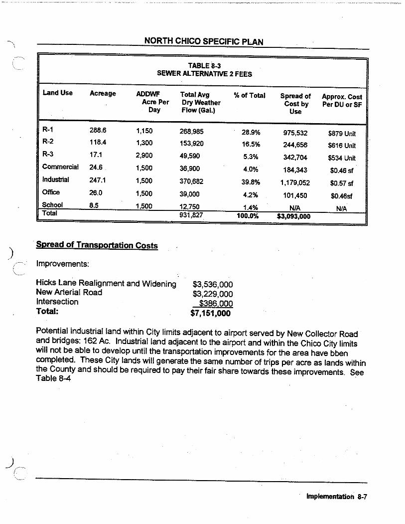
)
NORTH CHICO SPECIFIC PLAN
TABLE8-3 SEWER ALTERNATIVE 2 FEES
Land Use Acreage ADDWF Acre Per
Day
R-1 288.6 1,150
R-2 118.4 1,300
R-3 17.1 2,900
Commercial 24.6 1,500
Industrial 247.1 1,500
Office 26.0 1,500
School 8.5 1,500 Total
· Spread of Transportation Costs
Improvements:
Hicks Lane Realignment and Widening New Arterial Road Intersection Total:
TotaiAvg %of Total Dry Weather Flow(Gal.)
268,985
153,920
49,590
36,900
370,682
39,000
12,750 931,827
$3,536,000 $3,229,000
$386,000 $7,151,000
28.9%
16.5%
5.3%
4.0%
39.8%
4.2%
1.4% 100.0%
Spread of Approx. Cost Cost by PerDU or SF
Use
975,532 $879 Unit
244,656 $616 Unit
342,704 $534 Unit
184,343 $0.46 sf
1,179,052 $0.57 sf
101,450 $0.46sf
N/A N/A $3,093,000
Potential industrial land within City limits adjacent to airport served by New Collector Road and bridges: 162 Ac. Industrial land adjacent to the airport and within the Chico City limits will not be able to develop until the transportation improvements for the area have bben completed. These City lands will generate the same number of trips per acre as lands within the County and should be required to pay their fair share towards these improvements. See Table 8-4
Implementation 8-7

NORTH CHICO SPECIFIC PLAN
TABLES-4 SPREAD OF TRANSPORTATION COSTS
Land Use Number of Daily Tries Total %of ~read of Number of Approx. Units per Unit Trips Total ostsby DUorSF Cost Per Land Use DUorSF
SR-3 · 35DU 9.55JDU 334 0.5% $36,223 35DU $1,035/DU SR-1 719DU 9.55JDU 6,866 10.4% $744,118 719DU $1,035/DU R-1 912DU 9.55/DU 8,710 13.2% $943,860 912DU $1,035/DU R-2 829DU 9.55/DU 7,917 12.0% $857,960 829DU $1,035/DU . R-3 308DU 6.47/DU 1,993 3.0% $215,956 308DU $701/DU
"'--·~ Commercial 268KSF 54.5/KSF 14,600 22.1% $1,582,227 268,000SF 5.90/SF Industrial 247 Acres 51.8/AC 12,801 19.4% $1,387,231 2,153,000 SF 0.64/SF Industrial* 162Acres 51.8/Ac. 8,392 12.7% $909,398 1 ,411,344SF 0.64/SF Office 283KSF 14.03/KSF 3,972 -6.0% $430,495 283,000SF 1.52/SF School 30Emp. 13.39 402 0.6% $43,532 NIA Total 65,987 100.0% $7,151,000
• . . ) Note. City of ChiCO Will be reqUired to adopt a $0.64/SF fee for development withm City industrial lands west of the airport
)
Soread of Drainaae Costs
TABLE8-5
Land Use Acreage scs Acreage %of Sfcread Number of Ag~x. Curve Curve Total o Costs DUorSF Number Number DUISFPer Unit or SF
SR-3* 109.8 0.8% 12,000 35 $343DU . SR-1* 824.6 20.1% 288,000 719 $401 DU R-1 233.9 83 19,414 26% 419,267 912 363DU R-2 118.4 85 10,064 13.4% 5,216 829 213DU R-3 17.1 90 1,539 2.1% 63,326 308 88DU Commercial 24.6 94 2,313 3.2% 68,769 268,000 0.15 sff Industrial 247.1 91 22,488 3.0.1% 425,901 2,153,000 0.15 sf Office 26.0 94 2,444 3.2% 37,842 283,000 0.15 sf School 8.5 94 799 1.1% 24,679 NIA 1,645Acre Total 59,060 100.0% $1,435,000 . - - ... .. Note. $300,000 for SR 1 and SR 3 areas to be used for construction of facilities as identified m the Hazard Mitigation Grant program application for Keefer Slough d111inage improvements.
8-81mplementation

)
NORTH CHICO SPECIFIC PLAN
Spread of Trail and Pathway Costs
The cost of trails and pathways were spread over all residential property on a per unit basis. The total residential unit count including all residential categories is 2,803 units. The total estimated cost of traii and pathway facilities is $562,950. The total cost share per residential unit is $562,950/2,803 = $201/unit. (See Table 8-2 Schedule 4.) ·
Spread of Fire Station Costs
Fire protection costs are spread over the NCSP area based on the number of residents or employees. Employees are determined to benefit by 1/3 of that of people living in residential units.
TABLES-6 SPREAD OF FIRE STATION COSTS
Land Use ·Units DU or Res.IDU or Residenls or % Population Cost by Land Cost per SF SF/Employ Employees by Land Use Use DUorSF
SR-3 35DU 3.0 105 1.1% $17,094 $493DU
SR-1 719DU 3.0 2,157 23.4% $351,169 $493DU
R-1 912DU 3.0 2,736 29.7% $445,433 $493DU
R-2 829DU 2.5 2,073 22.5% $337,412 $411 DU
R-3 308DU 2.25 693 7.5% $112,824 $370DU
Industrial 2,153,00 750 957 10.4% $155,786 $0.07 SF .
Office 283,000 300 314 3.4%" $51,193 $0.18SF
Commercial 268,000 500 179 1 .9"-'> $29,088 $0.11 SF
Total 9,214 100.0% $1,500,000 .. Note. Non-reSidential uses assume_a 113 of employee (8 hour work day) to calculate population, e.g. 2,153,000 sf divided by 750 sf/employees
dMded by 1/3 (work day) equals 9'Sl
Finance Strategy Plan
Area North of Mud Creek
The phasing of capital facilities is not regulated in this sector of the NCSP area. Individual project proponents will fund and construct roads, water, and drainage facilities to the extent
) /.. necessary to meet the impacts of their specific projects.
Implementation 8-9

\,_ -i .J
NORTH CHICO SPECIFIC PLAN
--------
TABLE 8-7
Land Use Acres DUorSF Chico Chico Chico Trails Parks -School Shertrr Roads·& Storm Fire Total w/ Street Sewer Treatment System (CARD) (CUSD) (County) Bridges Drainage Statton Sewer Facility Trunkilne Plant AH.1
Table Reference 8-2 (1)' 8-2 (2) 8-2 (3) 8-2 (4) 8-2 (6) 8-2 (7) 8-2 (8) 8-4 8-5 8-6 Residential
SR-3 109.8 35 $1,529 nta n/a $201 $2,126 $4,416 $360 $1,035 $343 $493 $10,305/DU SR-1 824.6 719 $1,529 n/a n/a $201 $2,126 $3,861 $360 $1,035 $401 $493 $9,810/DU R-1 233.9 912 $1,529 $977 $824 $201 $2,126 $8,050 $360 $1,035 $409 $493 $15,857/DU R-2 116.4 629 $1,529 $977 $824 $201 $2,126 $7,360 $360 $1,035 $233 $411 $14,349/DU R-3 17.1 308 $956 $819 $522 $201 $1,799 $3,220 $252 $701 $96 $370 $8,591/DU I Total Residential UnHs 1,303.8 2,803
Industrial/Commercial
Industrial 247.1 21153,000 $0.56/SF $0.51/SF $0.43/SF n/a $0.01/SF nta $0.03/SF $0.64/SF $0.20/SF $0.07/SF $2.01/SF
Commercial 24.6 288,000 $5.13/SF $0.41/SF $0.34/SF nta $0.02/SF nta $0.03/SF $5.90/SF $0.17/SF $0.11/SF $8.74/SF
Olllce 26,0 283,000 $1.12/SF , $0.41/SF $0.34/SF n/a $0.01/SF n/a $0.03/SF $1.52/SF $0.17/SF $0.18/SF $3.9S!SF
Total industrial/ 271.1 2,421,00 Commercial
--- ----------------- ---- ----------- --------
8-10 Implementation
/

\._ )
~-··'
TABLEB-8 NORTH CHICO SPECIFIC PLAN FACILITY COST AND FUNDING SUMMARY
FaciiHy Type Total Estimated County, CARD NCSP School Fees City Sewer Cost Fees Impact Fees Fees
Transportation Facilities Hicks Realignment and widening $3,536,000 $3,086,000 New Arterial Road $3,229,000 $2,616,000 Intersections $366,000 $337,000 Chico Urban Area Street Facility Fees $3,696,000 $3,696,000
Sub-total Transportation FaciiHies $11 ,049,000 $3,696,000 $6,241,000
Sanitary Sewer AHernatlve 1: City of Chico OnsHe Main Lines $1,611,000 Trunk Line to Lift Station $1,047,000 $3,207,000 City Trunk Line Fees ' $3,207,000 $2,704,000
Total ewer Alternative #1 $6,569,000 $5,911,000
AHernatlve 2: County On-site Turnk Lines $1,611,000 $615,000 Package Plant, Mains, Outfall $6,628,000 $2,278,000
Total 1 ewer Alternative #2 $6,239,000 $3,093,000
Storm Drainage $1,435,000 $1,435,000
Parks (CARD Fee) $5,866,000 $5,886,000
Trail System $563,000 $563,000
Schools $17,366,000 $17,368,000
Fire Station $1,500,000 $1,500,000
Sheri If $1,057.000 $1,057,000
Total with Sanitary Sewer All. 1 :r·518,000 $10,843,000 $~9,828,000 $17,388,000 $5,911,000 , Total wHh sanltarv Sewer All. 2 7 188 000 $10 843 000 12 919 000 $17 368 000
Mello-Roos CHy or Assess. Contribution
$450,000 $410,000
$49,000
$910,000
$1,611,000 $1,047,000
$2,656,000
$796,000 $4,350,000
$5,146,000
$2,858,000 $910,000 $5 148 000 $91~
Any of these facilities that are a part of the fee funded or finance district funded facilities will be eligible for credits and/or reimbursements. Eligible facilities will include road improvements and drainage easemenVgreenbelt linear facilities (see Figure 8-1 ).
'

NORTH CHICO SPECIFIC PLAN
If sewers are required and/or desired along State Route 99 north of Sycamore Creek, it is recommended that a Special Assessment District be formed in this region over all benefiting property (as shown in Figure 8-2) to fund the sewer facilities described in the Public Facilities and Services Element and shown in Figure 6-2.
Area West of Gamer Lane
Development of the ±350 acres south of Keefer Slough and west of Gamer Lane is now in agricultural uses among four ownerships. Although limited development may occur in multiple phases among the properties, it may be desirable to facilitate construction of the new collector road from Garner to SR 99. It is recommended that a Special Assessment District be formed to fund an expedited construction of this road segment. As with similar facilities in other areas, appropriate improvements will be eligible for credits and/or reimbursements from the NCSP Impact Fees.
Area from Eaton Road to Mud Creek (including the Village Core)
The development in this region will require the formation of a Mello-Roos Community Facilities District to fund sewer outfall and/or treatment facilities. It is proposed that funding will occur in
) two bond sales as development occurs.
Bond Sale No. 1 (Prior to Development):
This initial bond sale will fund the initial sewer facilities to provide service to this area (see Figure 8-3). The amount of this funding will depend upon the alternative selected for sewer service.
Bond Sale No. 2 (At approximately 800 residential unit buildout):
The second bond sale will fond the construction of the southerly leg of the New Collector Road, Sycamore Creek Bridge, and the link from this collector to Hicks Lane (see Figure 8-4).
All other capital facilities will be funded by a fee program.
Operations and Maintenance Program
The operations and maintenance of "expand-ed services" within the NCSP area will be provided by a County Service Area (CSA).
Either the existing County Service Area No. 87 may be amended to include the proposed authorized services and the entirety of the NCSP area, or a new CSA may be established. ) Procedures for formation of a CSA are described in Appendix B.
8-12 Implementation

NORTH CHICO SPECIFIC PLAN
The intended services to be provided by the CSA are as follows:
0 Parks and Greenbelts: The CSA shall provide funds to CARD or shall contract for services with a private maintenance contractor to provide park and greenbelt maintenance. Budgets for annual maintenance shall be determined each year based upon anticipated costs and the level of park and greenbelt area that has been developed at that time. It is recommended that the first year budget be set at $10,000. The annual assessment for parks and greenbelt services shall be allocated within the NCSP area on the basis of acreage.
o Storm Drainage Maintenance: The CSA shall provide funds to Butte County to provide expanded storm drainage maintenance services. The expanded services include the linear drainage swales and greenbelt. Normal roadside ditch maintenance is not considered expanded services, . however, should local residents desire a higher level of service than provided by the County, funds may be budgeted for this purpose. It is recommended that the first year budget be set at a minimum of $10,000. The cost for storm drainage maintenance services shall be allocated on an acreage basis within the NCSP area.
o Community Building Maintenance: The NCSP identifies a 5,000-square-foot community building to be developed within the neighborhood park south of Mud Creek. The CSA will provide the funds for annual maintenance of this facility. The facility wil! be owned by the County and constructed with CARD fees allocated to the NCSP area. No initial budget has been identified for this facility. At the time of development of the facility, an annual budget can be established. The cost for community building maintenance shall be allocated on an acreage basis.
0 Interim Fire Station: The CSA will provide funds to the Butte County Fire Department to supplement staff at existing fire facilities until the new fire station is constructed within the NCSP area. The proposed. first years budget for the services is $40,000. The cost for interim fire protection services shall be allocated on an acreage basis. At 75% buildout of the Plan area, including industrial, commercial, office, and residential, the permanent $1.5 million station shall be complete.
o Alley Maintenance: The CSA shall provide funds to the County or to a private maintenance contractor to maintain alleys. The CSA shall establish a zone of benefit for alley maintenance to include only those benefiting properties that receive access from the alleys. The CSA zone and the annual budget for alley maintenance shall be developed at the time of f1nal map when any alleys are established. The first year's projected budget for the alleys established shall be deposited with the County at the time of recording of the final map.
The level of service for the maintenance shall be based upon the present level of service provided for the County roads in the area, however, if local residents desire a higher level of service, the CSA budget can be adjusted accordingly.
Implementation ·s-13

NORTH CHICO SPECIFIC PLAN
Project Phasing
Area Northwest of Mud Creek
This region of the NCSP is made up of numerous property owners. Development will occur within the region as driven by market forces and the individual desires of property owners.
The only capital facilities to be developed within this region are the New Collector Road, the realignment of Hicks Lane (north of Mud Creek), storm drainage greenbelts, and mini-parks. These facilities will be constructed by individual project proponents as needed to meet the impacts of their specific projects. The financing plan identifies a fee program for each of these elements to provide an equal basis for sharing costs to all the properties in this region. No specific phasing of infra-structure is proposed for this region. Phasing will be driven by the · ·· locations of projects and their specific need for facilities. Parks and trails will be developed over time as the fee pool of funds allows.
Projects that fall within the FEMA 1 00-year flood plain will be required to mitigate the flooding area on their project through project design. No areawide flood control or drainage facilities (other than drainage greenbelts and easements) are provided for in the capital facilities plan.
) AreaEaton Road to Mud Creek
This area-has a limited ownership and is better suited for a regional approach to capital facilities phasing. For any development to occur in this region, sanitary sewer service must be available. Additionally, the intersection of Hicks Lane and Eaton Road would need to be improved. With the improvement of this intersection, up to 800 new residential units can be accommodated on Hicks Lane prior to the need to construct a leg of the New Collector Road across Sycamore Creek. The following phasing plan describes only those facilities that need to be debt financed through a districtwide financing district. Facilities that will be funded through a fee program will phase according to need. In the event a project needs a facility ahead of the fee accumulation, the project proponent will·be required to privately finance the facility with a reimbursement agreement to be repaid from subsequent fees. The developer will be able to take credits offsetting any eligible facilities the. developer funds.
Phase 1
Sanitary Sewer
Construct initial interim facilities to the City of Chico system Q[ construct initial package wastewater treatment plant. Initial capacities should accommodate 0.50 million gallons per day. The financing plan proposes that the initial sewer facilities cost be funded through the· formation of a Mello-Roos Community Facilities District or Special Assessment District over all the ) benefiting property in this Eaton Road/Mud Creek region. The initial sewer system would include
8-14 Implementation

. l
)
NORTH CHICO SPECIFIC PLAN
on-site trunklines extended north across Sycamore Creek to serve the urban area between Sycamore Creek and Mud Creek (see Figure 8-3).
All subsequent sanitary sewer facilities (including treatment) will be phased as need demands and will be funded through a sewer fee program. Facilities that need to be installed in advance of sufficient fee funds will be the responsibility of the project requiring service. However, developers who advance funds for eligible facilities will be reimbursed on a first come basis as funds are available.
The timing for the extension of a 1 0" diameter trunk main from Eaton Road northerly along SR 99 to serve the existing commercial and industrial properties north of the SR 99/Esplanade intersection shall be determined based upon the need for sewer service. All property within this trunk extension sewer limits (see Figure 8-2) will be required to participate in an Special Assessment District to fund the facilities.
The Assessment District will include properties both inside and outside the NCSP area. The facilities to be funded with this Assessment District are 1 0" diameter trunk main, pump station, force main, and a pro-rata contribution to the regional outfall and treatment costs.
Transportation
As mentioned above, the only improvement required to enable development to start where there are resultant traffic impacts to Hicks Lane is the improvement of the intersection of Hicks Lane and Eaton Road. The improvement of this intersection will allow up to 800 new residential units to be developed with Hicks Lane as the only northerly access across Sycamore Creek. It is proposed that the intersection of Hicks Lane and Eaton Road be included in the initial financing district. ·
Phase 2
Transportation
At an approximate 800-unit buildout bench mark, the financing district will fund the first leg of the New Collector Road, the bridge across Sycamore Creek, and an extension of the link road from the New Collector Road to Hicks Lane (see Figure 8-4).
Required Development Regulations
The following regulations or ordinances must be adopted. in order to ensure the successful implementation of the NCSP: ·
). o Development Standards
Implementation ·a-1s

i _,
~ COMMUNITY FACIUllES lllSTRICT ~ (APPRO.XJMATE BOUNDARIES}
~ SPECIALASSESSMENT·DISTRICT I22Si!2S (APPROXIMATE BOUNOAR1ES)
FINANCING DISTRICTS Figure 8-2
)
North Chico Specific Plan
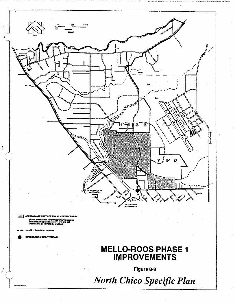
)
) ~
~ APPROXJMA.TE UIIITS OF PHASE 1 DEVELOPMENT
(Note: PhaMs-forlntratrvetur.piMnlng andflnwndng~onty • .nd- not lnt:anc*t to be llmtllng or binding} ..
-s- PHASE1SANITARYSEWER . ""''"''"'"'"' ""'"""'"'...,.
~,-'../-·--
' '
_ _j--
MELLO-ROOS PHASE 1 IMPROVEMENTS
Figure 8-3
North Chico Specific Plan
'
' ' ' -'

APPROlaiiAlE UMITS OF PHASE 2 DE.'VELOPMeNT (NCite: Phu. --~p~Mning =:n::.':ltbi$1~o:r~-not
-s- PHASE2SAMTARYSEWER
MELLO-ROOS PHASE 2 IMPROVEMENTS
Figure 8-4
North Chico Specific Plan

)
NORTH CHICO SPECIFIC PLAN
o Design Standards (including architectural town center theme, fences and walls, lighting, signs, lighting, loading, trash and storage areas, screening, and outdoor storage)
o Design Review
o Landscape Standards
o Site Plan Review
Subsequent Development Entitlements
The NCSP will be implemented by processing projects to ensure conformity with the Plan regulations and responsiveness to applicable guidelines. The basic procedures specified for processing of projects .are:
1) Site plan review for development within overlay and underlying zone districts within the NCSP area.
2) Tentative parcel or subdivision maps for the processing of any project requiring the creation of separate lots.
3) Use permit approval for projects that include uses identified within the various designations as conditionally allowed.
4) Design review and approval for commercial and industrial projects, and projects within the DR-OZ-3 (Design Review Overlay Zone) district.
Site Plan Review Procedures
The procedures for review of site plans shall be prepared at the direction of the Director of Development Services following approval of the NCSP.
Tentative Parcel Map Procedures
Chapter 20 of the Butte County Code relating to SUBDIVISIONS and IMPROVEMENT STANDARDS shall apply to all development within the NCSP area that is required to obtain approval of subdivision maps for the finance, sale, lease, or conveyance of property. The subdivision process shall implement the phasing plan.
Use Permit Approval Procedures
Sections 24-43 through 24-48.5 of the Butte County Zoning Ordinance relating to USE ) PERMITS shall apply to all development within the NCSP area involving land uses that are
8-16 Implementation

NORTH CHICO SPECIFIC PLAN
required to obtain conditional approval.
Design Review Approval Procedures
The procedures for design review and approval shall be prepared at the direction of the Director of Development Services following approval of the NCSP.
Amendment Procedures
In accordance with the California Government Code, Sections 65453 and 65454, specific plans shall be prepared, adopted, and amended in the same manner as general plans. This Plan may be amended as necessary in the same manner as it was adopted, by ordinance. Said amendment or amendments shall not require a concurrent general plan amendment unless it is determined by County staff that the proposed amendment would substantively affect the general plan goals, policies, objectives, or programs. An initial environmental assessment shall accompany the proposed amendment, in order to determine whether the proposed amendment would require environmental assessment beyond that addressed in the NCSP EIR.
Enforcement
A violation of the NCSP constitutes a violation of the Butte County Zoning Ordinance, and shall be so administered.
Implementation ·a-17

. \...__. '-...../
( CHAPTER 8 TABLEs--t.IST OF ASSUMPTIONS )
Residential
SR-3 SR-1 R-1 R-2 R-3 Total Residential Units
Acres Dwelling Units Average DU Size
109.8
824.6
233.9 118.4 .
17.1
1,303.8
35
719
912
829
308
2,803
2.400
2,100
1,750
1,600
700
Industrial GrossAc. Acreage YleiL._ NetA_c.._ Lami_E;F_ Floor/Area Flatlo Bldg. SF
M-2/0S
M-1
M-1/0S
Total Industrial
Commercial
Office
Total Non-Residential Units
251.2
124.8
115.8
491.8
24.6
26.0
542.4
33.3%
100.0%
33.3%
100.0%
100.0%
83.7
124.8
38.6
247.1
24.6
26.0
297.7
3,647,059
5,436,288
1,681,248
10,764,595
1,071,576
1,132,560
12,968,731
20%
20%
20%
25%
25%
City of Chico Industrial Land 162 100.0% 162.0 7,056,720 20%
Note 909,398 Equates to Improvement cost allocated to City of Chico Industrial land (see Table 8-4)
12.7% Percentage of above figure divided by total transportation Improvement costs (see Table 8·1 ).
11/12196
729,412
1,087,258
336,250
2,152,919
267,894
283,140
2,703,953
1,411,344
Tables. Chapter 8.FINAL

CHICO URBAN AREA
Heritage Partnen Planning &: D~velop~nJ

)
APPENDIX A BUTTE COUNTY GENERAL PLAN POLICIES
The following is a listing of those policies from the Butte County General Plan which are relevant to the planning and decision-making of the North Chico Specific Plan. The inclusion of these policies further underscores the intended role of a specific plan to be a tool of general plan implementation.- a framework upon which to interpret and fill out the larger plan's land use, infrastructure and development guidance with goals, details and financing mechanisms appropriate for the specific plan area.
The Butte County General Plan Land Use Element concludes the introduction of the policy sections with the following:
"No one policy by itself should always determine County action; decision-makers must consider all adopted policies which are relevant to a particular situation. The continual interpretation and application of policy statements to individual situations will frequently result in compromises reflecting balances and priorities among conflicting policies".
BUTTE COUNTY GENERAL PLAN LAND USE ELEMENT ·
B. General
Orderly Development: Government agencies, private companies and the public at large have invested substantial amounts of money in Butte County's existing system of roads, utilities and other public facilities. To maximize this investment and the level of services, utilization of existing facilities Is desirable, recognizing that all designated land for development is not immediately available for use. Land owners have plans for the timing of development on their land which are to be respected.
B.7.a. B.7.b. B.7.c.
c.
Encourage annexation to existing cities and existing districts. Promote the full utilization of sites served by existing public facilities. Encourage development in and around existing communities with public facilities.
Resource Management
C.1.b. Retain in an agricultural designation on the Land Use Map areas where location, natural conditions and water availability make lands well-suited to orchard and field crop use, while considering for non-agricultural use areas where urban encroachment has made inroads into agricultural areas and where past official actions have planned areas for development.
APPENDIX A1

NORTH CHICO SPECIFIC PLAN
C.1.d. Maintain m1mmum parcel sizes in designated agricultural areas by following comprehensive zoning principles.
C.1.e. Encourage urban expansion toward the least productive soils.
C.1.f. Allow rural residential development as a buffer between urban development and intensive crop use.
C.4.d. Require proof of adequate water supply for all new development.
C.4.e. Conservation of water and energy will be considered in approving plans for new development.
D. Residential Development
D.1.b. Provide a diversity of housing sites varying in size, density and location.
D.2.a. Correlate residential densities to soil, slope and other natural site characteristics.
D.2.b. Correlate residential densities to availability of water and sewage disposal and proximity to other public facilities.
D.2.c. Relate residential densities to intensity and compatibility of adjacent uses.
D.2.d. Balance residential densities with traffic-carrying capacities of existing and proposed circulation plans.
D.3.b. Regulate visibility, employment, advertising, parking, etc. of businesses allowed in residential areas in order to maintain a predominately residential character.
D.4.a. Allow agricultural uses and farm animals in designated residential areas where appropriate.
D.4.b. Limit density offarm animals in relation to type of animal and parcel size.
E. Economic Development
E.1.a. Provide sites and facilities to accommodate a variety of economic activities.
E.3.a. Encourage a full range of commercial services at the regional, community and neighborhood levels ..
APPENDIX A2

NORTH CHICO SPECIFIC PLAN
E.3.b. Coordinate future commercial facilities with existing and proposed transportation
systems, utilities and other public facilities.
E.3.c. Designate sufficient land for commercial facilities to fulfill needs for services and
employment. E.3.d. . Encourage the grouping of convenience and service facilities into integrated centers.
E.3.e. Designate retail and service commercial areas in close proximity to residential
development.
E.4.a. Promote the development of new industry in the County.
E.4.b. Locate industry near major transportation facilities which carry raw materials, finished
products and commuting workers.
E.4.c.. Direct new industry to locations adequately served by major utilities and provide
sufficient services and utilities to meet future industrial needs.
E.4.e. Encourage the grouping of industrial and heavy commercial uses into integrated
) industrial parks.
E.5.a. Relate the intensity and variety of commercial uses to the market accessibility of each
site.
E.5.b. Limit light commercial uses in planned industrial areas.
E.5.c. Limit manufacturing and wholesale activities in light commercial areas.
E.5.d. Limit residential uses in industrial and commercial areas.
E.5.e. Encourage the separation of heavy industrial and residential areas with other uses,
natural barriers or public facilities.
F. Public Facilities
F.1.b. Provide a circulation system and plan that is consistent with and will support existing
and proposed patterns and densities of land use.
F.2.a. Encourage expansion of public water and sewer systems where development to be
served conforms to adopted land use plans.
) ~··· F.3.a. Plan drainage facilities to serve areas of future urban growth.
APPENDIX A3
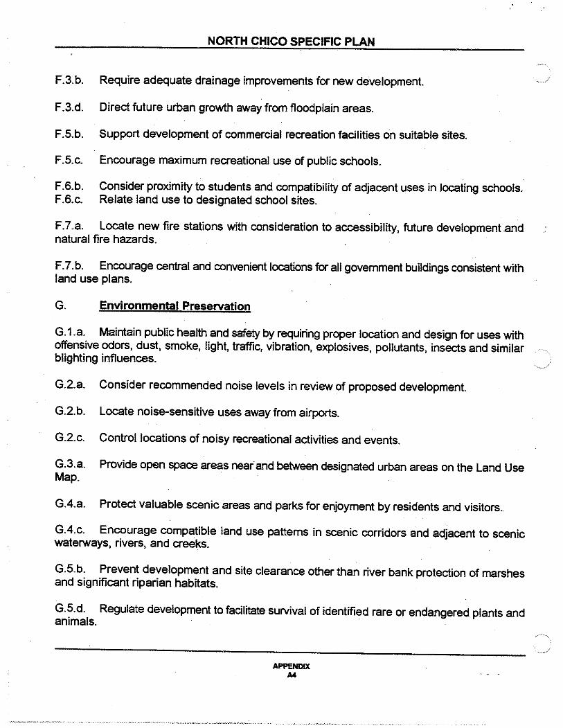
F.3.b.
F.3.d.
F.S.b.
F.S.c.
F.6.b. F.6.c.
NORTH CHICO SPECIFIC PLAN
Require adequate drainage improvements for new development.
Direct future urban growth away from floodplain areas.
Support development of commercial recreation facilities on suitable sites.
Encourage maximum recreational use of public schools.
Consider proximity to students and compatibility of adjacent uses in locating schools. Relate land use to designated school sites.
F.7.a. Locate new fire stations with consideration to accessibility, future development .and natural fire hazards.
F.7.b. Encourage central and convenient locations for all government buildings consistent with land use plans.
G. Environmental Preservation
G.1.a. Maintain public health and safety by requiring proper location and design for uses with offensive odors, dust, smoke, light, traffic, vibration, explosives, pollutants, insects and similar blighting influences.
G.2.a. Consider recommended noise levels in review of proposed development.
G.2.b. Locate noise-sensitive uses away from airports.
G.2.c. Control locations of noisy recreational activities and events.
G.3.a. Provide open space areas near and between designated urban areas on the Land Use Map.
G.4.a. Protect valuable scenic areas and parks for enjoyment by residents and visitors ..
G.4.c. Encourage compatible land use patterns in scenic corridors and adjacent to scenic waterways, rivers, and creeks.
G.S.b. Prevent development and site clearance other than river bank protection of marshes and significant riparian habitats.
G. S.d. Regulate development to facilitate survival of identified rare or endangered plants and ~~~ .
APPENDIX A4
NORTH CHICO SPECIFIC PLAN
G.6.a. Encourage the creation and expansion of natural and wilderness areas.
G.7.a. Identify and evaluate all cultural resources impacted by proposed projects before approval and development.
G.7.b. Preserve significant sites or require their detailed investigation by competent archaeologists.
H. Natural Hazards
H.1.a. Consider fire hazards in all land use and zoning decisions, environmental review, subdivision review and the provision of public services.
H.1.b. Guide development to areas with adequate fire protection services.
H.2.a. Consider the most recent information on seismic hazards in all zoning and subdivision decisions.
H.3.a. Limit development in areas with significant drainage and flooding problems until } adequate drainage or flood control facilities are provided.
H.4.a. Correlate allowable density of development to potential for landslides, erosion and other types of land instability.
Objective
BUTTE COUNTY GENERAL PLAN CIRCULATION ELEMENT
1.2 Provide an integrated system of roads and highways that serve all land use needs.
Policies
1.2.1 Road system "Planning will emphasize preservation of the existing roadway network while working to increase the efficiency and capacity of the existing network.
1.2.2 The most important roads and highways should be designed and maintained to the . highest possible level of service anci convenience. The least important roads and highways should receive only the improvements necessary to maintain their structural integrity and operational safety. The relative importance of the County's road highway network is graphically illustrated in Figure A.
APPENDIX A$

NORTH CHICO SPECIFIC PLAN
2.1.2 Butte County will encourage and support sincere efforts by County residents to form assessment districts for road maintenance and road drainage.
Objective
2.2 · Encourage development in areas that can be served by public roads in a manner that does not become an economic burden to the County, over time.
Policies
2.2.1 The short-term and long-term costs of improving and maintaining the circulation infrastructure will be a major factor in determining land use and development decisions. ' , ·"~
2.2.3 The cost of new roads shall be borne as equitably as possible among benefiting property owners and/or users. 3.1.3 Butte County will encourage transportation modes and programs that are capable of reducing total and per capita transportation energy consumption, including: public transit, bicycle commuting, ridesharing and carpooling, and increased federal vehicle fuel efficiency standards.
4.0 Provide for a road and highway network that meets the needs of existing and anticipated movements of people and goods.
Objective
4.1 Provide for adequately designed road and street patterns to serve present and future traffic volumes.
Policies
4.1.1 ·For general and circulation planning purposes, the County will follow the system of classification of streets, roads, and highways as described on Section 5.0 and illustrated by Figure A
4.1.2 Rural arterial road and highway traffic capacity levels should be planned to provide a level of service "B'' and be considered to be providing acceptable service at level of service "C" when fiscal, environmental, or site constraints are prohibitive.
APPENDIX AS

)
)
NORTH CHICO SPECIFIC PLAN
4.1.3 The County will insure that arterial routes continue to serve as major traffic carriers and remain free of unnecessary future intersections, driveways, on-street parking, and traffic overloads.
4.1.4 Right-of-way needed for new roads or expansion of existing roads shall be planned for; land uses that would preclude the timely development of such right-of-way shall be prohibited.
4.1.5 The County will ensure that all road systems, including private roads, connect various properties slated for potential development, both to each other and to a publicly-maintained road system.
4.1.6 Usable road easements of adequate width shall be located as to most beneficially serve the needs of all parcels.
4.1. 7 The County will assume maintenance responsibility only for roads which meet full County standards ..
4.1.8 Private subdivision roads will be built to full County standards and they will be privately maintained as such. throughout their maintenance cycle.·
4.1.9 New roads resulting from land divisions will be constructed to County standards whenever an area has potential for significant traffic from future development. A lower standard may be considered reasonable for roads which will always serve as only lot access and will never be suitable to become County roads.
4.1.1 0 New land divisions should be held responsible for their fair share of the off-site road improvements needed to handle the traffic increases that they cause.
4.1.11 The County should encourage the utilization of development agreements as one way of ensuring that road development standards and plans are met.
4.1.12 The County will require erosion mitigation and control plans for new developments and for road encroachment permits to prevent soil loss during and after road development activities.
Objective
5.1 Support safety standards established by emergency and protective service agencies.
APPENDIX A7

NORTH CHICO SPECIFIC PLAN
Policies
5. 1. 1 All road systems, both public and private, shall provide for the safe evacuation of residents and adequate access for fire and other emergency services by providing at least two means of emergency access to an interconnected collector system.
Objective
6.1 Planning areas should be encouraged to develop with integrated, efficient, and well designed road systems.
Policies
6.1.1 Specific plans shall be encouraged for land use, circulation, and cumulative transportation impacts for planning areas where land use designations and zoning lack significant provisions to adequately project Mure traffic conditions and/or where common circulation needs are appropriate.
6.1.2 Specific plans developed for each planning area· shall address circulation.
7 .1.4. The County and its cities should develop mutual and complimentary policies regarding the timing and phasing of new urban area developments, as necessary for the logical and timely development of each urban area circulation network.
8. 1. 1 Urban street and highway traffic capacity levels should be planned to provide a level of service "C'', and be considered to be providing acceptable service at level of service "D" when fiscal, environmental or site constraints are prohibitive.
8.1.3 Reduced street widths will be encouraged when there are practical site planning opportunities and development cost savings involved, while not jeopardizing public safety and future capacity requirements.
8.1.4 Arterial and collector streets shall be developed so as not to diminish the integrity and cohesiveness of urban neighborhoods.
8.1.5 Major residential developments should ensure adequate circulation by providing interconnecting loops and collector street patterns. Cul-de-sac and dead-end streets should be avoided on streets with more than twenty (20) units.
8.1.6 Trees located along urban streets should be preserved or replaced in the event maintenance or upgrading requires tree removal. Similar landscaping should be considered in conjunction with the development of new urban streets and parking facilities.
APPENDIX A8
NORTH CHICO SPECIFIC PLAN
The County should continue working towards finding new ways to finance street tree programs, including for public arid private sector contributions.
9.2.2 Developers of major traffic generating land uses shall provide fixed transit facilities such as bus shelters and pullouts, according to expected demand.
1 0. 0 Provide for a safe and convenient bicycle transportation system which is integrated with other transportation modes.
Objective
1 0.1 Provide for adequate bicycle circulation and facilities as a functional alternative to the automobile, and for recreation, as funding and planning opportunities allow.
Policies
1 0.1.2 Construction or expansion of all major arterials shall consider bicycle paths of Class ) II or better.
1 0.1.3 Residential developments should incorporate internal circulation networks that encourage bicycle use and which connect to the external bicycle circulation system.
Objective
1 0.2 Provide a bicycle system which can be integrated with other transportation modes.
Policies
10.2.1 Bicycle parking facilities should be encouraged in apartment complexes, major commercial, professional office, industrial, and educational sites, along with good routes which foster bicycle use.
10.2.2 Multi-modal transportation facilities such as park-and-ride lots and bus stops, should provide adequate and secure bicycle parking facilities.
Objective
11.1 Pedestrian access should be ensured throughout urban areas.
j Policies
APPENDIX A9

NORTH CHICO SPECIFIC PLAN
11. 1.1 Sidewalks, or their reasonable alternatives. should be provided · in all urban subdivisions.
11.1.2 Handicapped access shall be incorporated into all sidewalks and other pedestrian facilities as required by State law.
11 .1 .3 Hiking and jogging corridors should be encouraged in urban areas, as funding and . planning opportunities allow.
Objective
12.1 Provide for compatible land uses in areas that may be impacted by airport operations, so to mitigate safety and noise problems.
Policies
12.1.2 The County will ensure that land uses in the vicinity of public airports are compatible with respective airport land use plans.
13.1.3 The design and location of new development shall consider and incorporate provisions for appropriate transportation modes.
14.1.1 The County will maintain the integrity of the Chico area "greenline" adopted in 1982.
Objectives
BUTTE COUNTY GENERAL PLAN NOISE ELEMENT
o Avoid a mix of incompatible noise generating and noise-sensitive activities.
o Protect areas of the community which have "acceptable" or "sensitive" noise environments.
Policies
2. Where possible, control the sources of transportation noise to maintain acceptable levels.
3. Special consideration should be given to residential development and other noisesensitive activities near railroads and highways.
APPENDIX A10

)
)
NORTH CHICO SPECIFIC PLAN
4. Plan for airport development and discourage noise-sensitive activities near airports.
5. Control recreation activities that have the potential to cause objectionable noise.
APPENDIX A11

APPENDIX B: PUBUC FINANCE OPTIONS
The Following is a summary of many of the public financing vehicles that are currently
available to fund public facilities and/or services.
Mello-Roos Community Facilities District
The Mello-Roos Community Facilities Act {the "Act")[Section 53311 ct.seq. of the Government Code] was enacted by the California State Legislature in 1982 to provide an alternate means of financing public infrastructure and services subsequent to the passage of Proposition 13 in 1978. The Act complies with Proposition 13, which permits cities, counties and special districts to create defined ar~ within their jurisdiction and, by a two-thirds vote within the defined area, impose special taxes to pay for the public improvements and services needed to serve that area. The Act defines the area subject to a special tax as a Community Facilities District (CFD).
A CFD may provide for the purchase, construction, expansion or rehabilitation of any real or other tangible property with an estimated useful life of at least five years. A CFD may also finance the costs of planning, design, engineering and consultants involved in the construction of improvements of formation of the CFD. The facilities financed by the CFD do not have to be physically located within the CFD. The facilities that can be financed by a Mcllo-Roos CFD include, but are not limited to, the following:
• • • • • •
•
• • • • • •
Roads, water and sewer facilities,- flood control channels • Local park, recreation parkway and open-space facilities . School sites, structures, furnishings and equipment. Libraries. Child care facilities. Utility improvements {limited to five percent of bond proceeds it improvements are to be taken over by a non-publicly owned utility ageney). Any other governmental facilities which the legislative body creating the CFD is authorized by law to contnbute revenue to, construct. own or operate.
A CFD may also pay for public services. including the following:
Police protection . Fire protection. Recreation program services . Library services. Park and open space maintenance and operation . Removal or cleanup of hazardous substances .
A CFD, however, may only finance the services mentioned above to the extent that they are in addition to those provided in the area of CFD before the CFD was created, and may not supplant services already available within that area.
Page 81

)
_)
APPENDIX B
Formation
A CFD can be established by almost any governmental or public agency, including special
districts. Formation of a CFD in Butte County would be initiated by:
•
•
•
A motion by the Board of Supervisors (the "Board") .
A written request signed by two member of the Board .
A petition filed with the clerk of the Board signed by ten percent of either the registered voters residing within the proposed CFD, or ten percent of the landowners by land area within the proposed CFD.
Within the 90 days of initiating the proceedings to form the CFD, the Board would adopt a resolution of intention to establish a CFD and a resolution of necessity to incur bonded indebtedness, and determine a date for a public hearing on the formation of the CFD. The hearing must be not less than 30 days or more than 60 days from the date of the resolution of intention was adopted. At the public hearing, if the Board makes a decision to proceed with formation of the CFD, a resolution of formation, a resolution to incur bonded indebtedness, and a resolution calling for elections to authoriZe: special taxes and the issuance of bonds, will be adopted by the Board.
If ihe Board decides to proceed with establishing a CFD, it must submit the levy of the special tax to the qualified electors of the proposed CFD in the next general election or in a special election to be held at least 90 days. but not more than 180 days, following the close of the public bearing. However. these time limits may be waived with the unanimous consent of the qualified electors. As required by Proposition 13, two-thirds of the voters casting ballots must support the tax if. it is to be imposed. However, if there arc fewer than 12 registered voters residing in the proposed district. the vote shall be hy the landowners of the propo.-cd CFD. and each landowner shall have one vote for each acre or portion of an acre of land owned within the CFD.
In many instances, the public agency. underwriter and bond counsel require that the CFD formation be validated by a California Superior Court. Validation precludes the ability of other parties to challenge any issue included in the validation bearing. A validation proceeding may delay the sale of bonds for an additional 60 to 75 days subsequent to the election.
Revenue Sources
Formation of a CFD authorizes the public agency to levy a special tax on all taxable property
within the CFD, as defmed in the formation documcnl<. Property owned or irrevocably offered to
a public agency may be exempted from the special tax. Mello-Roos special taxes are collected at the
same time and in the same manner as regular property taxes, unless otherwise specified by the agency.
Special tax revenues may be used to pay the debt service on bonds which have been sold to fund the
construction or acquisition of public capital facilities. or to pay directly for facilities or public services.
There are two limitations on the amount of financing "v-dilablc from a CFD. The first is the
Page B2

APPENDIX B
value-to-lien ratio. "Value" is considered to be the appraised value of the properly, including any entitlement and improvements in place on the date the CFD bonds are to be sold. The value is then increased to account for the value added to the property by the improvements to he constructed with funds from the bond issue.
There is no statutory requirement for a value-to-lien ratio. The standard for land secured financing in California has been a 3:1 or 4:1 ratio, depending on other factors such as the real estate market, the financial status of the developer and the overall market acceptability for land secured bonds.
The second restriction on the amount of fmancing available from a CFD is the total effective tax rate ("ETR") paid by a homeowner or property owner in the CFD. The ETR consists of the basic one percent ad valorem property tax levy mandated by Proposition 13, plu.< overrides from voterapproved bonded indebtedness and non-ad valorem taxes. a<scs.<menL< and parcel charges (expressed as a percentage of market value). Market value can he determined based on input from local developers, a market consultant, local realtors or an appraiser.
Again, there is ilo legal maximum related to this limitation, but a maximum ETR of two percent of market value has developed as a standard for residential development in many areas throughout the State. It is thought that ETRs higher than two percent may lead to market resistance by prospective homebuyers, or potential "taxpayer revolts" by overburdened homeowners. The maximum supportable ETR for a given project should also consider the maximum tax rates paid by homes in competing projects in the area and, based on the strength of the real estate market, the demand for homes in generaL Commercial/industrial projects often support higher ETRs, as the property owner is able to spread the tax burden among many tenants and, therefore. is less sensitive to a higher ETR.
Special Assessment District
Introduction
In 1979, the California Court of Appeals, in the County of Fresno vs. Malmstrom, ruled that special benefit assessments levied pursuant to the Improvement Act of 191 I and Municipal Improvements Act of 1913 are not "special taxes" under Proposition 13 's definition of such taxes. The result of this decision has been a proliferation of Special Assessment Districts ("AD") throughout the Sutte, using the Municipal Improvements Act of 1913 to initiate proceedings for the formation of an AD, and the Improvement Bond Act of 1915 to issue bonds. These Acts provide mechanisms for Issuers to construct or acquire public improvc;ments, to apportion the co.<ts through liens against the
Page 83

)
APPENDIX B
properties in a designated area which directly benefit from the improvements (the "Assessment
District"), and to finance the liens through the issuance of tax-exempt bonds.
Public works improvements are eligible for Assessment District financing to the extent that
properties within the District receive a special, measurable, local and direct benefit from such
improvements. Traditionally, improvements to be financed using an AD include, hut are not limited,
to streets, and roads, water, sewer, flood control facilities, ulility lines and landscaping. Other types
of public improvements which have a "regional" significance (e.g., major roads. bridges. flood control
facilities, etc.) are only partially eligible, based on the proportion of benefit from the improvements
that can be assigned to parcels within the AD. Traditionally. items of general benefit to a community,
such as schools, fire stations and parks, have not been eligible for Assessment District financing.
Formation
The formation of an AD is initiated through either a petition submitted by sixty percent of
the landowners in a proposed AD, or through the adoption of a Resolution of Determination and
the preliminary approval of an investigative report by the County Board or Supervi.mn;. The Board
then adopts a Resolution oflntention which designates the boundaries of the proposed AD. descnbes
the proposed improvements, orders the issuance of bond< and declares the County's intention to levy
the assessments. This resolution must include an engineer's report that includes the proposed
assesSment diagram, which is used to determine the assessment levied against each property.
Once the Board approves the engineer's report and confirms the propo.<ed assessments,
notices are sent to all property owners within the proposed AD regarding a public hearing to be held
not less than thirty days after the Board adopts the resolution orintention. At or before the public
hearing, if a written protest is made by more than on-half of the property ownen; of the area to be
assessed, no further proceedings can be taken for one year, unless the Board overrules the protest
by a four-fifths vote. If no majority protests, at the t:onclusion of the public hearing. the ·Board will
confirm the assessments and create a lien against each assc.<.<ed parcel in the AD.
Subsequent to the confirmation of assessments, a thirty-day cash payment period is established
during which any property owner can pre-pay his asse.<Sment. Aftcrthis thin y-day period, bonds may
be sold for all unpaid assessments in the newly-formed AD.
Revenue Sources
Each parcel of property within an AD is assessed a portion of the costs of the public
improvements and services to be financed by the AD. hascd on the proportion of hcnelit received
Page B4

APPENDIX B
by that parceL Assessment liens are levied at the time of formation· on the timing of the · development. If a standby charge is incorporated into the program. bonds can he sold more quiclcly
to provide funding for water-related improvements needed prior to dcvclopmcnL
Infrastructure Finandng District
Introduction
In September 1990, the Governor approved Senate Bill ("SB") 308. which provides for the
formation of Infrastructure Financing Districts ("'FD") to finance regional infrastructure needs. SB
308 extends the use of tax increment ('Tl") financing to underdeveloped areas within the boundaries
of an IFD. IFD financing is sitrular to tax increment financing within redevelopment project .areas,
in that it uses ad valorem property lax property tax revenues to pay for public improvements without
imposing special taxes or assessments on the land.
The Legislative findings with respect to SB 308 state that the Bill wa.< adopted in response
to a number of factors, including the following:
•
•
•
Formation
the Staie·and Federal governments have withdrawn in whole or in part from their former role in financing major, regional or communitywide infra.<tructure:
the methods available to local agencies to finance public works often place an undue and unfair burden on buyers of new homes. especially for public works that benefit the broader community; and
it is equitable and in the public interest to provide alternative procedures for financing public works and services needed to meet the needs of new housing and other development projects.
An 1FD may finance the purchase. construction. expansion or improvement of any real or tangible property with an estimated useful life of fifl!!en years or longer. Autho~d facilities must be of communitywide significance and provide significant benefits to an area larger than the area of the proposed IFD. Examples of permissible projects include the following: ·
Highways. interchanges, arterial streets and transit facilities. Sewage treatment and water reclamation plants. Water collection and treatment facilities. · Flood control levees and dams. retention basins and drainage channels. Child care facilities and libraries. Parks and open space. Facilities for the transfer and disposal of solid waste ..
Proceedings to establish an lFD are initiated by the County Board of Supervisors through the
adoption of a Resolution of Intention. The resolution must identify the boundaries of the IFD, the
Page BS

)
_)
APPENDIX B
type of Cacilitica to be financed nnd a time and place for n public hcarin11. Followin11 adoption of the
Resolution of Intention, the Board must direct the appropriate ofr~eial to prepare an Infrastructure
Fmancing Plan to include a map of the proposed boundaries of the IFD. the location. timing and
costs of aU public facilities (whether or not to be provided by the IFD) required to serve the
proposed development, and a financing section.
The financing section should include all of the following:
• The maximum portion of TI revenue from each affected taxing entity proposed to be committed to the IFD for each year.
• The TI revenues projected to be rccc.:ived by the IFD in each year of the Plan. ·
• The amount of debt intended to he incurred. by the IFD.
• The maximum amount of TI revenue the IFD may receive.
• An analysis, for each affected taxing entity. of the costs and the taxes, fee, and other revenues to be (eceived.
•
•
A fiSCal impact analysis of the IFD, and the development within the IFD, on each of the affected taxing entities.
A date on which the IFD will cease to exist (maximum term of 30 years) .
A copy of the Plan is sent to each of the affected taxing entities and to the property owners within the proposed IFD. A public hearing on the Plan is held no sooner than 60 days after the Plan is sent to all affected taxing entities. The Board may not adopt a resolution proposing formation of the IFD unless a resolution approving the Plan has been adopted by all of the affected taxing entities prior to the hearing. . The Plan may be amended 10 exclude any affected· agency that does not approve the Plan, or to amend the percentage of increment from an agency that will be passed through to the IFD. . ·
Subsequent to the public hearing. if the Board adopt~ a resolution proposing adoption of the Plan and formation of the IFD. an election must be called to submit the proposal to the qualified electors. The election must be held at the next general or special election, at least 90 day, but no more than 180 days. following adoption of the resolution. This time limit may he waived with the unanimous consent of the qualified electors.
If there are twelve or more registered voters, the electors will be all registered voters within the IFD; otherwise, the quali!ied electors will he landowners within the IFD, with each landowner receiving one vote for each acre of property owned. If two-thirds of the votes cast are in favor of forming the IFD. the Board will adopt an ordinance creating the IFD and adopting the Plan.
Page 86

APPENDIX B
Revenue Sources
As discussed above, SB 308 extends tax increment financing to undeveloped areas within an
IFD to. allow financing of major, regional improvements without additional taxes and assessments
being levied on property owners. When forming an IFD. a "base year" is identified; the ad valorem
tax revenues paid on the assessed property value in the base year continue to be passed through to
the agencies that receive ad valorem tax revenues. However, the revenues that result from an
increase in assessed value above the base year assessed value are called tax increment ("TT") revenues,
and a portion of these revenues are retained by the IFD. An IFD can then issue bonds secured by
the TI revenue it receives, or will receive, because of the continuing increase in assessed value.
The TI revenues available from an IFD arc limited by the following:
• TI revenues to school districts, community college districts and county offices of eduction may not be allocated to an IFD.
• TI revenues to other agencies may be allocated to an IFD only if each agency approves the Plan by resolution. Agencies which fail to approve the Plan must be excluded from allocation of Tl revenues.
Revenues from an IFD may be pledged to repay bonds issued by a Special Assessment District or Mello-Roos CFD. or may be advanced to an Integrated Financing District as part of a reimbursement agreement. The IFD may issue tax allocation bonds or Certificates of Participation payable from anticipated tax increment. Bonds sold by an IFD must be sold at a public sale.
Integrated Financing District
Introduction
The Integrated Fmancing District Act (the • Aetj was designed to achieve overall equity
among landowners by providing a formal mechanism to reimburse the initial developers (or public
agency) for the up-[ront funding of infrastructure needed prior to development. The Act creates the
ability for local governmental entities to levy contingent asscs.•ments on owners orland within special
districts which are created to levy noncontingent assessments or special taxes for the financing of
public facilities (i.e., Mello-Roos or Special Assessment DistricL•). An Integrated Financing District
(IGFD) can be used to finance any improvements authorized in the legislation of any co-financing
district, including major regional improvements and local community facilities. such a.• schools and fire
stations.
In its most likely use, an IGFD is formed over an area that benefits from improvements being
fmanced through another financing mechanism. The benefit received by each parcel is determined
and a "contingent lien" is placed on all parcels that benefit from the improvement. hut have not paid
Page 87

' ,./
APPENDIX B
for its construction. A warrant is issued, in the amount of the contingent lien on a lien parcel, to the
party that wt11 ultimately receive the reimbursements. Once development begins on the parcel. the
contingent lien will become due and payable to the party who holds a "warrant" securing the lien.
Formation
An IGFD is created in the same proceedings to create the co-linancing district, if the
following items are incorporated in the resolution of intention to form thc districts:
• A description of the boundaries of the IGFD. which need not be the same as the boundaries of an existing Assessment District or Mello-Roos District
• A description of the rate and method of apportionment over time of any type of levy proposed within the IGFD, and the contingency under which each levy will be made. The contingent assessments will be identified as a fiXed dollar amount per parcel. which may be adjusted annually thereafter.
• A description and estimated cost of any facilities to be con.<tructed with funds contnbuted from the IGFD.
• A description of the proposed reimbursement·agrccment
Notice of a public hearing shall be made in the same manner as required for the eo-financing district being used in conjunction with the IGFD. If more than onehalf of the area of the property within the proposed I G FD protcsL< against the proposed contingent assessments, no further proceedings shall be taken for the period of one year. Without a majority protest. the Board may abandon the proposed establishment of the IGFD. or combine the co-financing district with the district to levy contingent liens. to create the Integrated Financing District,
Revenue Sources
An IGFD issues securities in the form of warrants which represent interest in a
reimbursement fund into which contingent assessments are paid. The contingent assessment is a lien
against pioperty which is not levied until the occurrence of a certain event that is IL<.<aeiated with land
development, such as the approval of a tentative or vesting tentative subdivi.<ion map, a zoning
change, or the issuance of a building permit
The assessments must be fiXed dollar amount which may be adjusted annually on a percentage
basis as determined by the Board. Assessments are levied on an acreage ba.<is, with allowance for
different rates for various land uses. The contingent assessment may be levied instead of, in
conjunction with, or in addition to a non-contingent asscs.<mcnt or special tax and may be collected
in annual installments or in lump sum payments similar to a fcc program. The combined levy of a
Page 88
'

APPENDIX B
contingent and non-a>ntingent assessment and/or special tax should result in an amount paid by a
parcel that represents the proportion of benefit received by that parcel.
The revenue potential from an IGFD is also limited by a value-to-lien ratio, in that the
contingent assessment, whether collected or not, represents an obligation of the parceL If the
contingent assessment is not required to be paid in one limp-sum, it may ultimately be passed on to
future homebuyers or purchasers of commerciaiJindustrial property. If this is the case. the contingent
assessment should be considered as part. of the total effective tax rate.
Certificates of Participation
Introduction
Certilicates of Participation ("COPs") provide long-term financing for public improvements
via a lease or installment sales structure. COPs permit the acquisition or construction of specific
equipment, land or facilities through the. occurrence of debt. without requiring a local election.
Although the structure of COPs sound complicated. it is actually an efficient and straight-forward
method of securing tax exempt financing for public facilities by taking advantage of an available
stream of revenues. ·
... :The principal parties to a COPs financing include a public agency, a non-profit corporation
and il •:trustee. The non-profit corporation may be formed specifically to construct necessary
improvements, the funds for which are generated from the proceeds of tbc COPs sale. The non
profit corporation may also be an existing agency, such as a redevelopment agency. a joint powers
authority or an economic development corporation. However, the actual responsibilities for
ci>nstruction arc generally delegated to the public agen~-y. The non-profit corporation then leases
or sells the land and facilities back to the public agcn~-y in return for lease or installment sales
payment.
The investors who purchased the COPs receive a specified portion of the public agency's
payment as payment of the principal and interest due on their COPs. The Certificates arc secured
by the by the public agency's pledge to make appropriations from its general fund (or other spcciaJ
fund) to cover its lease or installment sales payments. The trustee is respon.~iblc for accepting those
payments and then disbursing them to the Certificate holders.
Page 89
)
APPENDIX 8
.,,,,,,.., The issuance of COPs doe$ not require the lhrmallon or a special dbmlcL OORa aro llrlclly
a type of debt issuance and, therefore involve_ only the parties involved in pulling together the
transaction. The· players typically include an underwriter, a bond counseL a tru.•tee and, if necessary,
a financial consultant to evaluate the expected stream· of revenues.
A COPs issue requires a series of legal documents as well. First. a lea•e or installment sales
agreement has to be drafted between the County and the non-profit corporation. Second,
documentation is necessary to specify the procedures for issuance and payment of the COPs, and to
regulate the disbursement of COPs proceeds to finance the proposed facilities.
Finally, agreements are required to empower the County to oversee construction and to
obligate the trustees to receive lease or installment sales payments for dL•burscment to Certificate
holders. Issuance of COPs is authorized by approval of a rc.•olution by the Board of Supervisors.
Sources of Funds
COPs are secured by the covenant of the County_ to make annual appropriations in an amount
sufficient to service the certificates. The appropriation.• may come from the County general fund or
from a designated special fund, such as an enterprise fund for sewer and water services for installment
payments received from a private project. If the facility being financed by the COPs is revenue
producing, those revenues may also he used to make lease payments.
The revenue potential of COPs is limited by the availability of revenues which may be
appropriated each year to make lease payments. Since the pas.•age of the Gann Amendment in 1979,
annual appropriations of government agencies, including County government, have been limited to
prior year appropriations adjusted for changes in the cost of living and population. hi a period of
declining transfer paymel!ts from the Federal and State levels to County and local governments, the
availability of funds is further limited.
County Services Area
Introduction
County Service Areas ("CSA") are designed to provide a mcchanL•m to furnish extended
public services to unincorporated areas experiencing high growth. A CSA i.• authorized to provide
any governmental services which the County is authorized by law to perform and which the County
Page 810

APPENDIX B
does not already perform to the same extent on a counlywidc basis. The cosLS, then, arc borne by
the clt.lzens wbo directly benent from the {nereaaed liervlcea. while the declslon-maklng remalM with
the County Board of Supervisors.
Formation
Formation of a CSA can he initiated in three ways:
• A petition signed by ten percent of the registered voters residing within the proposed area
• A written request by two members of the Board of Supervisors or a resolution adopted by majority vote
• A resolution adopted by the city council of an incorporated city within the County
Once initiated, formation of the CSA requires application to and approval of the LAFCO. A CSA is not a special district. and therefore docs not require majority approval in a registered voter election.
·Revenue Sources
Services provided through a CSA can be funded through user fees or special assessments.
A u5er fee must directly relate to the cost of providing such se.rviccs and the benefit received by each
user; the revenues from this source are strictly limited. There i< no statutory limit on the amount of
· . special assessment levied by a CSA, but those assessments would be levied on the property tax bill
_and would therefore be considered as part of the total cffe~-'tive tax rate.
Impact Fees
Introduction
Impact fees are monetary exactions (other than taxes or special assessments) that are charged
by local agencies in conjunction with approval of a development project. Impact fees are levied for
the purpose of defraying all or a portion of the costs of any public facility. improvement or amenity
which benefits the project.
Formation
The collection of impact fees does not require formation of a special di.<trict._
Page 811

APPENDIX B
Revenue Sources ·
Impact fees are paid by builders or developers. typically at the time a building pemiit is issued.
The public facilities funded_ by impact fees must be specifically identified. and there must be a
reasonable relationship, or "nexus•, between. the type of development project and the need for the
facilities, the cost of the facilities and the need to impose a fcc.
While developer fees cannot typically be leveraged (i.e., provide security for bonds or other
debt instruments), fees can be used in conjunction with debt financing to help retire bonds secured
by other means (e.g., land). In this case, developer fees can generate supplemental revenues to
reduce future special taxes or assessments, or free up tax increment or other revenues for alternatiVe
uses. Developer fees can also be used to generate reimbursement revenues to property owners or
public agencies who have previously paid more than their fair share of public improvement costs.
Landscaping and Lighting District
The Landscaping and Lighting Act of 1972 permits the installation. maintenance and servicing
of landscaping and lighting through annual assessments on real property benefiting from the
improvements. The act also permits construction and maintenance of appurtenant features iJ!cluding
~ gutters, walls, sidewalks or paving, and irrigation or drainage facilities.
One or more Landscaping and Lighting District may be formed to fund the maintenance of
roadway medians and street trees, street lights, and parks. Park maintenance cosL< over the fair share
cost of park maintenance standards provided by the City General Fund will be funded through the
Landscaping and Lighting DistricL The District may also be used to fund the maintenance of the
retention basin landscaping, as well as certain landscaping improVc:menL< if it is deemed ~ the City
as the most cost-effective method.
Page 812

APPEND/XC:
SUMMARY OF STORM DRAINAGE COSTS.
PRELIMINARY STORM DRAINAGE COST OPINIONS
The following costs are in November, 1992 dollars (San Francisco Construction Cost Index= 6292). The costs include 15% for engineering design and administration and a 20% total project contingency.
TABLE T13 PRELIMINARY COST OPINIONS
NCSP STORM DRAINAGE TRUNK COLLECTION SYSTEM
Description Unit
24" Storm Drain Une LF
30" Storm Drain Une LF
36" Storm Drain Une LF
Storm Drain Manholes EA
Detention Basins w/ PumPS
Basin#1 JOB
o. < ""' JOB ~. < JOR
Basin#4 JOB
Subtotal
Enaineerina and Administration 8 15%
Subtotal
Proiect Cnntino .. ncv 8 20%
T"bl
Unit Cost
46.00
50.00
55.00
1750.00
130 "'AA M
94.200.00
10R7MOO
77650.00
APPENDIXC C1
Quantity
4530
2190
1070
20
1
1
1
1
Cost
.•.
$208,380
109.500
58,850
35,000
130.350
94200
108.700
77650
$822.630
123.395
otOAIOm.c;
189.205
S1 <~.c; ?VI
,•

APPENDIXD: SUMMARY OF SANITARY SEWER COSTS
PRELIMINARY SEWER COST OPINIONS
The following costs are in November, 1992 dollars (San Francisco Construction Cost Index== 6292). The costs include 15% for engineering design and administration and a 20% total project contingency.
TABLET14 PRELIMINARY COST OPINIONS
NCSP SEWER TRUNK COLLECTION SYSTEM
Description Unit Cost
1 0-inch sewer tine 60
12-inch sewer fine 70
15-inch sewer tine 80
. 18-inch sewer tine 90
Subtotal
Enaineerino and Administration at 15%
Subtotal
Proiect Continaencv at 20%
Total
Quantity
3,450 If
4,000 If
3,500 If
4,450 If
APPENDIXO 01
.
.
Cost
$207,000
280,000
280,000
400,500 ·.
$1,167.500
175,000
$1,342,500
268,500
$1,611,000

NORTH CHICO SPECIFIC PLAN
Key Assumption:
The North Chico Specific Plan Area will generate 2.68 mgd of the 5.1 mgd flowing through the off-site sewer outfall at buildout. Therefore, based on flow generations, the North Chico Specific Plan is responsible for approximately 50% of the outfall cost
TABLET15 PREUMINARY COST OPINIONS
SEWER TRUNK OUTFALL TO REGIONAL PLANT (OFF-SITE)
Description
33-inch SE!\W( line
27-inch SE!\WI" line
24-inch SE!\W( line
21-inch SE!\WI"Iine
Subtotal
E and Administration at 15%
Subtotal ---Proiecl Contingency at 20%
Total
North Chico Scecilie Plan Re$D011Sibilitv at 50%
'24-inch -line
'21-inch - rone .
5.0 rnQd pump-
Fon:e main to NECSAO Line
Subtotal
E andAdtninistralionat15%
Subtotal
Proiecl• at20%
Total
North Chico Specific Plan R ...
at SO%
*Facilities bull as a part of u/limato facilities.
Outfall to Plant .
26,6501f
7,950 If
3.250 If
1,600 If
Interim
9001f
1,600 If
LS
LS
APPENOIXD D2
.. Unit Cost
150
130
120
100
120.
100
Cost
$3,997,500
1,033,500
390.000
160.000
$5.581.000
837.000
$6,418,000
1.264.000
$7,702,000
$3,851,000
$108.000
160.000
700.000
500,000
$1.468.000
220,000
$1,688,000
338,000
$2.026,000
$1.013.000

( TABLE 8-3 ) SPREAD OF SEWER ALTERNATIVE 12 FEES
TotaiAvg Land ADDWFAcrw DryW- S.,..a<!ol Number of Approx.c-u.. -... Per!!.!!l: Row (Gal.) %Of Total Costs!!IU.. DUorSF PerDU or SF
R-1 233.9 1,150 268,985 28.9% 5992,838 912 $979 R-2 118.4 1,300 153,920 16.5% $510,905 829 $616 R-3 17.1 2,900 49,590 5.3% $164,603 308 $534 Industrial 247.1 1,500 370,662 39.8% $1,230,399 2,153,000 $0.57 Commercial 24.6 1,500 36,900 4:0% $122,482 268,000 $0.46 Office 26.0 1,500 39,000 4.2% $129,452 283,000 $0.46 School 8.5 1,500 12,750 1.4% $42,321 n/a n/a T- 1131,827 100.0% $3,093,000
TABLE 8-4 SPREAD OF TRANSPORTATION FACILITIES BASED ON TRIP GENERATION
Trip Factor Dally Trips Spread of Number of Approx.c-Land Use UnHNumbor Units Per Untt Per Unit %Of Total Costs!!IU.. OUorSF PerDU or SF
SR-3 35 OweHing Units 9.55 334 0.5% $36,223 35 $1,035 SR-1 719 Dwelling Units 9.55 6,866 10.4% 744,118 719 $1,035 R-1 912 Owening Units 9.55 8,710 13.2% 943,860 912 $1,035 R-2 829 Dwelfmg Units 9.55 7,917 12.0% 857,960 829 $1,035 R-3 308 DNelling Units 6.47 . 1,993 3.0% 215,956 308 $701 Industrial 247 Acres 51.80 12,801 19.4% 1,387,231 2,153,000 $0.64 Industrial 162 Acres 51.80 8,392 12.7% 909,398 1,411,000 $0.64 Commercial 268 Thousand SF 54.50 14,600 22.1% 1,562.2Z7 268,000 $5.90 Office 283 Thousand SF 14.03 3,972 6.0% 430,495 283,000 $1.52 School 30.0 Emeloyees 13.39 402 0.6% 43,532 nJa T- 65,987 100.0% $7,151,000
12.14/96 Tablec.Chaptor B. ANAL

';
TABLE 8-2 (Schedules 5-7) IMPROVEMENT COST DETAIL & ALLOCATION AMONG LAND USES
land Acquisition Capital Improvements
Community Building (5,000 sf) Total Neighborhood Park Facilities Cost
Land Use
SR-3
SR-1
R-1
R-2
R-3
Industrial
Commercial
Office
DUorSF
15
15
35 719
912
829 308
2,153,000
268,000
283,000 Total Chico Area Recreation District (CARD) Park Fee
' •IJ!! Q:ll' Av • DUSize Fee Per Unit
2,400 $1.84 $4,416 SR-1 2,100 $1.84 $3,884 R-1 1,750 $4.60 $8,050 R-2 1,600 $4.60 $7,360' R-3 700 $4.60 $3,220 Total CUA Street Facilities Fee
Land Use DUorSF Fee Unit SR-3 35 DweUing Unit SR-1 719 Dwelling Unit R-1 912 Dwelling Unit R-2 829 Dwelling Unit R-3 308 Dwelling Unit Industrial 2,153,000 Square Feet Commercial 268,000 Square Feet Office 283,000 Square Feet Total
12/4/96
Fee Per Unit
$2,126
$2,126
$2,126
$2,126
$1,799
$0.01
$0.02
$0.01
35 719
912
829
308
Fee Per Unit
$360
$360
$360 $360
$252
$0.03
$0.03
$0.03
$375,000
1,125,000
600,000
$2,100,000
Extension
$74,410
1,528,594
1,938.912
1,762,454
554,092
21,530
5,360
2,830
$5,888,182
2,778,216
7,341,600
6,101,440
991,760
$17,367,576
Extension
$12,600
258,840
328,320
298,440
77,616
84,590
8,040
8,490
$1,056,936
Tables.Chapter S.FINAL

,•
TABLE 8-2 (Schedules 1-4) IMPROVEMENT COST DETAIL & ALLOCATION AMONG LAND USES
Land Use DUorSF Fee Per Unit Extension SR-3 35 $1,331 $46,585 SR-1 719 $1,331 956,989 R-1 912 $1,331 1,213,872 R-2 829 $804 666,516 R-3 308 $804 247,632 Industrial 2,163,000 $0.10 215,300 Commercial 268,000 $1.75 469,000 Office 263,000 $0.29 82,070 Total CUA Stree1 Facilities Fee $3,897,964
Land Use DUorAcres Fee Unit Fee Per Unit Extension R-1 912 Dwelling Unit $9n $891,024 R-2 829 Dwelling Unit $9n 809,933 R-3 308 Dwelling Unit $819 190,652 Industrial 247.1 Acre $4,418 1,091,781 Commercial 24.6 Acre $4,418 108,663 Office 26.0 Acre $4,418 114,868 Total $3,206,941
e i
Land Use DUorAcres Fee Unit Fee Per Unit Extension R-1 912 Dwemng Unit $824 $751,488 R-2 829 Dwelling Unit $824 663,096 R-3 308 Dwelling Unit $522 1so,n6 Industrial 247.1 Acre $3,725 920,526 Commercial 24.6 Acre $3,725 91,635 Office 26.0 Acre $3,725 96,850 Total $2,704,371
,~.
Path of Trail (lP$/l.F) 34,000 $8.00 $204,000 Off Street Path (LF*$/LF) 18,000 $8.50 163,000 Three Foot/Bike Bridges 3.00 $20,000 60,000 Sub-Total Trail System Direct Costs $417,000 Construction Contingency 20% $63,400 Engineering & Administration 15% 62,550 Total Trail System $562,950
12/4/96 Tables. Chapter B.FINAL

(._ ___ c_HA_PT_E_R_a_T_A_B_L_e_s-u __ s_T_o_F_A_s_s_u_M_PT_Io_N_s ___ )
-SR-3 SR-1
R-1 R-2
R-3 TOia/ResidentialUnits
M-2/0S
M-1
M-1/0S TOial lndUstriBJ
Commercial Olllee
TOia/Non-Residenfial Units
City of Chico lnduslrial Land
1
- 909,398 12.7%
Acres Dwelfing Units Average OU Size
109.8 35 2.400 824.6 719 2.100 233.9 912 1,7.50 118.4 829 1,800
17.1 308 700 1,303.8 2.803
GrossAc. A!?!eage Yoeld NetAc. Land SF Roor/Area Ratio Bldg. SF 251.2 33.3% 83.7 3,647,059 2o% 729,412 124.8 100.0% 124.8 5,436.288 20% 1,067,258 115.8 33.3% 38.6 1,681.248 20% 336,250 491.8 247.1 10,764,595 2.152.919
24.6 100.0% 24.6 1,071,576 25% 2(;1 ,894 . 26.0 100.0% 26.0 1,132.560 25% 283,140
542.4 297.7 12.968,731 2.703,953
162 100.0% 162.0 7,056,720 20% 1,411,344 Equates to improvement cost allocated to City of Chico industrial land (see Table 8-4) I Pecoentage of above figure divided by total transportation imprOIIeiTle!lt costs (see Table 8-1)1
Tables..Chapter8.ANAL

( TABLE 8-1 )
SUMMARY OF CAPITAL IMPROVEMENTS & COSTS ______ __;
Hicks LBne Realignment & Widening Acquisition of Right of Way
Construction
Hicks Road Bridge Replacement at Mud Creek Nsw AlteriBJ Road
,_ Hicks Lane to Gamer Gamer to SR 99
SR99/Keefef
Eaton/SR 99 (SB Ramps)
Eai0111SR 99 (NB Ramps}
Sub-Total Transportation lmprovaments Plus Chico Urban Area Street Fscililies Fee Su-. Transporlatlon Facllltloo
A1temlttiYe 1: City of Chico
On-Site Main Unes Trunk line To Lift Station City Trunk Wne Fees
City Sewer Fees (WPCP Capacity Fee}
Totals.- Alt<lmatlve fl
Allemstive 2: County On-site Main Unes Treatment Plant, Land, Trunk Line
Total Sewer Altamative 112
$2,200,000
207,000 1,129,000
2.705.000
524,000
45,000
126,000
215,000
$1,611,000
1,047,000
3.207.000
2.704,000
$1,611,000
6,628,000
Fire Station Cost estimate; allocated among land uses. Storm Drainage Cost estimate; allocated among land usas. Ttatl System Cost estimate; allocated per dwelling unit Parl<s (CARD Fee} Frgure darived by existing CARD fee slruclure. Schools Frgure darived by existing CUSD fee S!ruclure.
Sheriff F!QtHe derived by existing Counlyfee slruclure. Total Other lnlrutruclu<e/Syems
!Total w/ Sanitary Sewer AlternatJve.1
!Total w/ Sanitary Sewer Altarnatlve 2
1214/96
$3,536,000
$3,229,000
$386,000
$7,151,000 TabJ&8-4
$3,898,000 Table ~2. Scheel 1
$11,1)49.000
$1,500,000 Table 8-5
$1,522,000 Table 8-6
$563,000 Table~2. Sc:hed. 4 $5,888,000 TableB-2. Sc:heclS
$17,388,000 Table8-2. ScheeL 6 $1,057,000 Table$-2. Sc:hecl.. 7
$27,898,000
$47,51s,ooo I
S47,1ea,ooo I
Tables.. Chapter S.ANAL
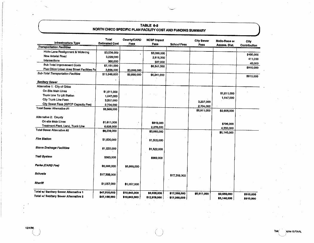
··~-··
TABLE 8·8 NORTH CHICO SPECIFIC PLAN FACIUTV COST AND FUNDING SUMMARY
Total lnf1 T' ...................... . E• _ ............... _ .....
Trsm•portatlon Facilities
Hicks Lane Realignment & Widening $3,536,000 New Arterial Road 3,229,000 lnlersecllons 386,000 Sub-Total Improvement Costs $7,161,000 Plus Chico Urban Area Street Facilities Fe 3,898,000
Sub· Tots/ Transportation FaeilltiBs $11,049,000
Sanlt~ry Sewer Alternative 1: City of Chico
On-Site Main Lines $1,611,000 Trunk Une To Lift Station 1,047,000 City Trunk Line Fees 3,207,000 Clly Sewer Fees (WPCP Capacity Fee) 2,704 000
Total Sewer Allematlve 111 $9,669,000
Alternative 2: County On-site Main Lines $1,611,000 Treatment Plant, Land, Trunk Line 6,628,000
Total Sewer Alternative 112 $8,239,000
FlrB Station $1,500,000
Storm Drainage Facilities $1,522,000
Trail System $563,000
Psrko (CARO FBB) $5,888,000
Schools $17,358,000
Sheri" $1,057,000
Total W/ Sanitary Sewer Alternative 1 $47,1518,000 Total w/ Sanitary Sewer Alternative 2 $47,188,000
1214/96. (
County/CARD F• . ......
$3,898 000 $3,898,000
$5,888,000
$1,057,000
$10,843,000
$10,843,000
NCSPimpact F• • .. w ..
$3,066,000
2,818,000
337,000 $6,241,000
$6,241,000
$815,000 2,278,000
$3,093,000
$1,500,000
$1,522,000
$553,000
$9,828,000 $12,91P,OOO
s, IF• _ ................
$17,368,000
$17,388,000 $17,388,000
City Sewer F• . ......
3,207,000
2,704,000 $5,911,000
$15,911,000
Mello-Rooa or .. ....... -.....
$1,611,000 1,047,000
$2,858,000
$796,000 4,350,000
$5,146,000
$2,658,000 $5,148,000
City Contributl . ..
$450,000
411,000 49,000
$910,000
$910,000
$910,000 $910,000
Tab,' ;epler 8.FINAL \,,

Land Use Acree
Table Reference
Residential
SR·3 109.8
SR·1 824.6
R·1 233.9
R·2 118.4
R·3 17.1
Total Residential Units 1,303.8
tndustrfai/Commerclsl
Industrial 247.1
Commercial 24.6
Office 25.0 Total Industrial/Commercial 271.7
12/4/96
DUorSF
35
719
912
829 308
2,603
2,153,000 266,000
263,000
2,421,000
Chloo Street
Facllltlel
Tbl. 8·2(1)
1,331
1,331
1,331
804
804
0.10
1.75
0.29
TABLE 8·7 NORTH CHICO SPECFIC PLAN FEE SUMMARY
Chico Chico sewer Treatment j Trail• Parke School Sheriff Road• & Storm
Trunkllne Plant 'system (CARD) (CUSD) (County) Bridget Drainage Fire
Station
Total w/ Sewer AH.W1
-------- ---- ------ -- - -- ---- ----- ----
Tbl. 8·2(2 Tbl. 8·2 31 Tbl. 8·2141 Tbl. 8·215 Tbl. 8·2 61 Tbl. 8-2m Tbl.8·4 Tbl. 8·5 Tbl.8·6
nta n/a 201 2,128 4,416 360 1,035 343 493 $10,305
nta nta 201 2,126 3,864 360 1,035 401 493 $9,810
977 824 201 2,126 9,050 360 1,035 440 493 $15,837
977 824 201 2,126 7,360 360 1,035 251 411 $14,349
619 . 522 201 1,799 3,220 252 701 103 370 $6,591
0.51 0.43 n/a 0,01 nta 0.03 0.64 0.22 0.07 $2.01 0.41 0.34 nta 0.02 n/a 0.03 5.90 0.16 0.11 $6.74 0.41 0,34 nta 0.01 nta 0.03 1.52 0.16 0.16 $2.96
Tabtes.Chapt e1NAL

/
NORTH CHICO SPECIFIC PLAN
TABLE T16 PRELIMINARY COST OPINIONS NCSP TREATMENT FEES
·Type Fee Quantity Total
Residential Unit S1 000/unit 4465 !>4.465 000
Commercialllnd. 4,400/acre 264 1,161,600
Total $5,626,600
TABLET17 PRELIMINARY COST OPINIONS
PACKAGED WASTEWATER TREATMENT PLANT
Description Quantity Unit Cost Cost
Sije Improvement 1 LS 400,000 $4,465,000
Package Treatment Plant 1.1 mgd 2/gal 2,200,000
Effluent Pump Station and Outfall LS 800,000 800,000
Subtotal $3,400,000
Engineering and Administration @ 15% 510,000
Subtotal $3,910,000
Plant Site 15Ac 50,000/acre 750,000 Subtotal $4,660,000
Proiect Continaencv@ 20% 932,000 *Total $5 592.000
* Packaged plant cost for North Chico Specific Plan Area only. There will be some economy of scale if other aiBas 319 added.
APPENOIXD D3

( TABLE 8-5 ) SPREAD OF STORM DRAINAGE COSiS
scs Acreage Sp111ad of Number of Approx. Cost Lond Use Acre!!!!! Curve No. Curve No. %Of Total Costa !!l Use DUorSF PerDU or SF
SR-3 109.8 $12.000 35 $343 SR-1 824.6 8268.000 719 $401 R-1 233.9 83 19,414 82.9% $401,685 912 $440 R-2 118.4 85 10,064 17.0% $208,232 829 $251 R-3 17.1 90 1,539 2.8% $31,843 308 $103 Industrial 247.1 91 22,488 38.1% $485.285 2.153,000 $0.22 Commer<:ial 24.6 94 2.312 3.9% $47,845 268,000 . $0.18 Office 26.0 94 2,444 4.1% $50,568 283,000 $0.18 S<:hool 8.5 94 799 1.4% $16,532 n/a $1,945 Total 59,060 100.0% $1,522,000
( TABLE 8-6 ) SPREAD OF FIRE STAllON COSiS
Units Raa./DU .,. Rosldants or % Population Cost By Cost Por Londllse Acres DUorSF SF/Employee Eml!!oveos ~Land Use Land Use DUorSF
SR-3 109.8 35 3.00 105 1.1% $17,094 $493 SR-1 824.6 719 3.00 2,157 23.4% $851,169 $493 R-1 233.9 912 3.00 2,736 29.7% $445,433 $493 R-2 118.4 829 2.50 2,073 22.5% $337,412 $411 R-3 17.1 308 2.25 693 7.5% $112,824 $370 Industrial 247.1 2,153,000 750 957 10.4% $155,786 $0.07 Commer<:ia! 24.6 268,000 500 179 1.9% $29,088 $0.11 Office 26.0 283,000 300 314 3.4% $51,193 $0.18 Total All Land Uses 9,214 100.0% $1,500,000
Note: Non--al uses assume 1/3 of employee (8-hour work day) to calculme population, e.g. 2.153,000sf divided by 750 employees/sf divided by 1/3 (work day) equals 957.
12/4/96 Tables.Chapter B.RNAL

Resolution No. 95-47 A RESOLUTION OF THE BUTTE COUNTY BOARD OF
SUPERVISORS AMENDING THE BUTTE COUNTY GENERAL PLAN AND ADOPTING THE NORTH CHICO SPECIFJC PLAN
WHEREAS, Butte County initiated the specific planning process for the land area generally known as CSA 87 in the north portion of Chico; and
WHEREAS, numerous informational and discussion meetings ware held by the consultants and representatives of the County with the property owners in CSA 87 and with representatives of the City of Chico on many subjects pertaining to the North Chico Specific Plan, Rezone, General Plan Amendment, including but not limited to, environmental constraints , growth pressures, circulation, drainage, airport compatibuity ; and
WHEREAS, a Draft Environmental Impact Report (DEIR) was prepared and circulated for public comment and the Planning Commission extended the public comment period for an additional thirty days beyond the statutonly required thirty days; and
WHEREAS, the Specific Plan text and accompanying maps were prepared with reference to and in consideration of the 1983 Airport Land Use Handbook and. when they became available, the 1993 Draft Airport Land Use Handbook and the Final 'Airport Land Use Handbook; and
WHEREAS, the Specific Plan text and accompanying maps ware prepared with reference to and in consideration of the FAR. Part 150 Noise Exposure Map and related reports drafted in connection with the City of Chico Airport Environs Plan update process and consultations regarding land use compatibiflty conducted with the City of Chico's airport planning consultant; and
WHEREAS, the Butte County Planning Commission held duly advertised and noticed public hearings starting on January 13, 1994 and concluding on November 16, 1994 with a recommendation to adopt the Rezone, General Plan Amendment, Specific Plan and EIR; and
WHEREAS, the Butte County Board of Supervisors held a duly advertised and noticed public hearing on January 10, 1995 to consider the Planning Commission's recommendations regarding the Rezone, General Plan Amendment, Specific Plan and
' 1

EIR and the action of the Butte County Airport Land Use Commission's finding of inconsistency with the 1978 Airport Land Use Plan; and
WHEREAS, pubfic hearings at both the Butte County Planning Commission and the Butte County Board of Supervisors considered the issue of overriding the findings of inconsistency with the 1 978 adopted Airport Land Use Plan for Chico Municipal Airport; and
WHEREAS, substantial testimony has been heard both pro and con, and changes to the Plan have been made as a result of testimony· and pubfic review of the Specific Plan and EIR;
NOW THEREFORE BE IT RESOLVED THAT the Butte County Board of Supervisors do hereby find and adopt the foUowing:
Section 1: Environmental Findings.
A. Art Environmental Impact Report (EIR) has been prepared in comp6ance with the Cafdomia Environmental Quality Act; and
B. Comments on the Draft EIR were solicited, received, adequately addressed and incorporated into the Final EIR; and
C. Changes, alterations or mitigation measures listed in Section 3 of the Final EIR have been required or incorporated into the project thereby eliminating or substantially lessening significant effects identified by the County, responsible agencies and members of the public; and
D. The Board of Supervisors has independently reviewed, analyzed and considered the EIR and finds that the EIR reflects the independent judgement of the County of Butte; and
E.. Implementation of the Specific Plan will result in unavoidable and adverse impacts in which no mitigation is available other than implementation of the NoProject/No Development Alternative. These significant unavoidable impacts include traffic and circulation, air quality impacts and land use impacts. However, benefits cfiScussed in 1, 2. and 3 below override these significant adverse impacts and the Board of Supervisors makes the foDowing Statement of Overriding Considerations:
1. Traffic and Circulation Impacts: As discussed on Pages 9-9 of the Draft EIR the impacts of the project were examined based upon the assumption that no new traffic signals would be installed along State Route 99 (per Caltrans poHcy) and that existing lane configurations would be used as a basis for all scenarios. In addition, the New Arterial
2

intersection is proposed to remain as an at grade intersection of State Route 99. As stated on Page 2-2 of the Final EIR (FEIR), traffic operations at the unsignafJZed intersection of Keefer Road/State Route 99 intersection will operate at unacceptable leveis, during the morning peak period only, for left tum movements from Keefer Road onto State Route 99. ·
The Specific Plan, through conditions of approval, has been modified to require the County to work with CalTrans on the installation of traffic signals at SR 99 and the new arterial and Keefer Road. The Specific Plan utilizes the existing creeks and sloughs as bicyde and pedestrian trails connecting to the various land use area This will assist in minimizing the use of ~e automobile. In addition, the Specific Plan has planned office, commerc:!al and industrial areas which will make local jobs avaJ1able for persons residing within the North Chico Specific Plan Area and thereby reduce commuting traffic into and out of the area
The Chico General Plan identifies this land as a future growth area and constrains growth in other areas. The Chico General Plan Map also depicts the Alternative Land Use Plan identified in the FEIR. Growth in the Chico area is further constrained through agricultural presel\lation policies, zoning, and "the greenline". The Chico General Plan requires the infilling and increased densities to create a more compact urban form. Thus, development within the North Chico Specific Plan (NCSP) area is necessary to accommodate future growth.
2. Air Ouafrty Impacts: As discussed on Pages 1 o-1 through 1 o-11 of the Draft EIR, the project will contribute indirect emissions associated with project-related automobile use, and will cumulatively exceed emissions thresholds contained in the Air Quafrty Attainment Plan.
Implementation of the Specific Plan will contribute indirect emissions associated with project related automobile use, and will cumulatively exceed emission thresholds contained in the Air Quality Attainment Plan. The NCSP, more than any plan In the vicinity is designed to reduce the dependency upon the automobile and to reduce automobile trips. The location of the Village Core, the connection of the VIllage Core to the various land uses within the Plan, and the extensive trail and pathway system, will contribute to lower emissions than standard urban/suburban development.
Air quality impacts affect a regional area much larger than just the North Chico Specific Plan. Air quality impacts from any development within the Northern Sacramento Valley Air Basin are of a type which would be expected to occur in connection with development anywhere in the
:
3

···---~ F.
County and can only effectively be addressed on a region-wide basis. It is questionable whether such cumulative impacts attributable to the adoption of this Plan are significant and they could not be completely mitigated without prohibiting all new development The cumulative impacts cannot be resolved with project specific mitigation measures, but could only be addressed in connection with overall development poficies in the Northern Sacramento Valley Air Basin as a whole.
3. Land Use Impacts: As discussed on Page 2-3 of the FEIR, the implementation of the Specific Plan will cause the conversion of approximately 1,630 acres of existing open space to urban/suburban uses. This area has been designated as a growth area for the City of Chico in their proposed General Plan Update. The use of a specific plan for more detailed planning allows for a workable solution to the traffic and drainage problems which have plagued the area
The Chico General Plan_identifies this land as a future growth area and constrains growth in other areas. The Chico General Plan Map also depicts the Alternative !-and Use Plan identified in the FEIR. Growth in the Chico area is further constrained through agricultural preservation poficies, zoning, and "the greennne·. The Chico General Plan requires the iniilling and increased densities to. create a more compact urban form. Thus, development within the NCSP area is necessary to accommodate future growth.
Project Alternative: In Chapter 5 of the FEIR, the Alternative Land Use Plan to the project represents an environmentally superior alternative to the proposed land Use Plan contained in the Specific Plan as Figure 3-2. The Alternative land Use Plan locates proposed residential at densities greater than 1 dweffing unit per acre, to a point 3, 700 feet or more from the centerune of the main runway of the Chico Municipal Airport The Alternative Land Use Plan relocates the main arterial of the proposed Plan out of known wetiand habitat, thus minimizing potential impacts to wetiands.
Section 2: Overriding Findings regarding the Airport Land Use Commission. On February 9, 1994 the Airport Land Use Commission found the North Chico Specific Plan inconsistent with the currently adopted Airport Land Use Plan for the Chico Municipal Airport, but did not make findings specifying the reasons for such inconsistency. Government Code Section 65302.3 requires the NCSP to be consistent with the said Airport Land Use Plan, unless the Board of Supervisors does not concur with any provision of the Plan and adopts findings pursuant to Section 21676 of the Public Utilities Code. The Board of Supervisors does not concur with provisions in the Chico Airport Land Use Plan which precludes any development in the airport environs other than 1 acre or larger residential lots and agricultural uses. Furthermore, foUowing the action of the Airport Land Use Commission, an Alternate Land Use Plan
4

was prepared and is incorporated into the FEIR and the NCSP to provide f6r the orderly development, expansion, and long term viability of the Chico Municipal Airport and orderly development of the area surrounding the airport. Therefore, the Board of Supervisors makes the following findings pursuant to Public Utilities Code section 21676.
A. The NCSP provides for the orderly development. expansion. and long term viabiflty of the Chico Municipal Airoort and orderly development of the area surrounding the airoort as follows:
1.
2.
3.
4.
6.
Existing general plan and zoning provisions would have allowed 1 acre parcels north of the airport which could create significant operational concerns for the airport. See attached City of Chico letter dated February 1, 1995.
The NCSP reduces existing allowed densities off the north end of the Clear Zone by increasing minimum parcel sizes from 1 acre to 3 acres, as shown on the Alternative Land Use Plan and thus makes the potential development in the area more compatible with the orderly development and expansion and long terin viability of the airport;
Residential land uses, at densities greater than 1 unit per acre, are not allowed within 3, 700 feet from the centerline of the main runway as shown on the Alternative Land Use Map in the FEIR, thus limiting the potential for complaints of incompatibility with airport uses;
Pursuant to the Alternative land Use Plan noise sensitive land uses are buffered from ground generated noise at the airport, such as engine run-up, by locating industrial, commercial and office land uses rather than residential uses, closest to and adjacent to the airport;
Open space has been planned fo( the area westerly of the Clear Zone, northerly of Mud Creek as shown on the Alternative land Use Plan in the FEIR, further reducing the potential for complaints of incompatibility with airport uses;
One acre minimum parcel sizes are planned for the area north and west of Mud Creek as shown on the Alternative land Use Plan in the FEIR, which is consistent with the currently adopted Airport land Use Plan for the Airport and with the Airport Land Use Handbook pages 3-13, 9-19 through 9-25;
5

7. Airport expansion through the year 2010 is accommodated by excluding new development within the 55 dB CNEL projected for the year 2010 as projected by the Noise Exposure Map for the Alternative Land Use Plan in Chapter 5 of the FEIR;
8. The Specific Plan provides for airport protection measures as part of the Development Regulations in Chapter 7 of the Specific Plan, pages 7-6 and 7-7;
.B. The NCSP protects the public health. safetv. and welfare by minimizing exoosure to excessive noise and safetv hazards within areas adjacent to the Chico Municioal Airoort as follows:
1. Intensive uses as shown on the Alternative Land Use Map, including the proposed elementary school, are located abeam the runway, where the great majority of the overflying traffic is light single engine aircraft, at reduced throttle settings prior to landing as stated by the County's consultant, Steve Honeycutt, in public hearings at the Planning Commission on November 16, 1994 and at the Board of Supervisors on January 10, 1995. This is also shown on the Generalized Flight Tracks exhibit following page 3-12 of the FEIR and is depicted on the exhibit titled Generalized Flight Tracks Over Chico Urban Area attached hereto and presented by the County's consultant, Steve Honeycutt at said hearing on January 10, 1995;
2. · Intensive uses as shown on the Alternative Land Use Map, including the proposed elementary school are located inside and away from the Heavy Aircraft Pattern 1 flight track, which will minimize overflight and single event noise occurrences from heavy aircraft, as stated by the County's consultant, Steve Honeycutt in public hearings at the Planning Commission on November 16, 1994 and at the Board of Supervisors on January ·=,a, 1995. This is also shown on the Generalized Flight Tracks exhibit following page 3-12 of the FEIR and is depicted on the exhibit titled Generalized Flight Tracks Over Chico Urban Area attached hereto and presented by the County's consultant, Steve Honeycutt at said hearing on January 10, 1995;
3. The State Division of Aeronautics, in its letter of May 19, 1992, determined that the proposed elementary school site provides the minimum level of safety suitable for a school;
' 6

4. Prior to development of an elementary school at the proposed location, which may be ten years or more in the future, there will be additional opportunities to re-evaluate safety and noise considerations through· involvement of the Chico Unified School District, the City of Chico, the State Division of Aeronautics, the Airport Land Use Commission, and the County.
5. Avigation easements are required, as indicated on page 7-6 of the NCSP text, for all residential development within the Plan area;
6. The NCSP provides for airport protection measures as part of the Development Regulation in Chapter 7 of the Specific Plan, pages 7-6 and 7-7;
7. The Accident Sites for Runways of 6,000 Feet or More, Figure SF, taken from the 1994 Airoort Land Use Handbook and superimposed with the Alternative Land Use Map for the NCSP ( see attached Exhibit A), together with testimony pertaining thereto at the Board of Supervisors' public hearing on January 10, 1995 by the County's consultant Steve Honeycutt, indicates that the accident probability is highest within the boundaries of the Chico Municipal Airport Clear Zones and very low in the vicinity of the Village Core, including high density residential and the elementary school site.
8. The attached Exhibit B, Comparison of Flight Tracks and School Sites, together with the testimony pertaining thereto at the Board of Supervisors' public hearing on January 10, 1995 by the County's consultant Steve Honeycutt, indicates that aircraft on flight tracks at Chico Municipal Airport are at a sufficient flight distance and altitude so as to not expose the high density residential and the elementary school sites to excessive noise or safety hazards.
C. The NCSP provide land use measures that minimize the public's exposure to excessive noise and safetv hazards within areas around the airoort as follows:
--1. Noise attenuation is required to be incorporated into all new residential construction as indicated in the additional requirements recommended by the Planning Commission and incorporated into the NCSP in Chapter 4 on page 4-7.;
2. Enhanced disclosure measures, alerting potential buyers and renters of the operations of the airport, avigation easements, and aircraft operations, will be required by Chapter 7, Section 7.6-3 of the NCSP;
7

3. The NCSP provides for airport protection measures as part of the Development Regulation in Chapter 7 of the Specific Plan, pages 7-6 and 7-7;
4. Intensive uses as shown on the Alternative Land Use Map, including the proposed elementary school are located inside and away from the Heavy Aircraft Pattern 1 flight track, which will minimize overflight and single event noise occurrences from heavy aircraft, as stated by the County's consultant, Steve Honeycutt in public hearings at the Planning Commission on November 16, 1994 and on January 10, 1995. This is also shown on the Generalized Flight Tracks exhibit following page 3-12 of the FEIR and is depicted on the exhibit titled Generalized Flight Tracks Over Chico Urban Area attached hereto and presented by the County's consultant, Steve Honeycutt at said hearing on January 10, 1995;
5. The State DMsion of Aeronautics, in its letter of May 19, 1992, detenmined that the proposed elementary school site provides the minimum level of safety suitable for a school;
6. Prior to development of an elementary school at the proposed location, which may be ten years or more in the future, there will be additional opportunities to re-evaluate safety and noise considerations through involvement of the Chico Unified School District, the City of Chico, the State DMsion of Aeronautics, the Airport Land Use Commission, and the County.
7. The NCSP reduces existing allowed densities off the north end of the Clear Zone have been reduced by increasing minimum parcel sizes from 1 acre to 3 acres, as shown on the Alternative Land Use Plan in the FEIR and thus makes the potential development in the area more compatible with the orderly development and expansion and long term viability of the airport;
8. Uses invoMng high concentrations of people, including such uses as social halls, churches, rest homes, convalescent homes, sanitariums and foster or group homes will not be allowed as a matter of right within areas designated as residential zones, but will only be allowed if a use permit is obtained in each case, subject to findings being made, following a public hearing, that such use would not be detrimental to the health and general welfare of the persons residing or working in the neighborhood or to the general health, welfare and safety. Chapter 7 of the NCSP, pages 7-os through 7-12, and Butte County Code Section 24-45.10.
Section 3: Action
' 8

A Certification of the EIR: Subject to the findings indicated in Sections 1 . and 2 of this resolution, certify the Final Environmental Impact Report with mitigation measures as contained in documents entitled Draft Environmental Impact Report on amendment of the General Plan and adoption of the North Chico Specific Plan, dated December, 1993, Final
Environmental Impact Report on amendment of the General Plan and adoption of the North Chico Specific Plan, dated October, 1994.
B. Adoption of the Specific Plan: Adopt the North Chico Specific Plan amended by the Revised Draft North Chico Specific Plan, dated Revised October, 1994 with the conditions indicated below:
1. The Alternative Land Use Plan shown attached and labeled Figure 3-2 shall replace Figure 3-2 contained in the North County Specific Plan (NCSP). This shall be the Land Use Plan for the NCSP.
2. The Final NCSP shall be revised to incorporate all of the changes shown in the Revised NCSP, dated October, 1994 and the mitigation measures of the FEIR, where appropriate, as policies or regulations of the NCSP. The Figures and Tables shall be revised to reflect the Alternative Land Use Plan. All Figures and Tables shall indicate the source, the preparer, and the date of preparation.· All references to the Rezone and the General Plan Amendment shall be purged from NCSP, except for a historical reference to this approval process.
3. An Agricultural Policies subsection shall be added to the Chapter 3 - Land Use and a policy shall be added which states as follows:
All existing orchards shall be permitted to continue, without interference or interruption by development.
4. Staff shall work with PG&E to select a street lighting fixture which shall be utilized as the standard street light in the area south of Mud Creek. The Specific Plan shall be amended to require the installation of street lights in the area south of Mud Creek as a requirem.§lnt of development. In addition, the CSA or other funding mechanism shall be utilized for the payment and maintenance of street lights.
5. The NCSP, Chapter 4- Circulation, page 4-7, shall be revised to add the following policies:
8. Enhanced street entries shall be required at the following locations:
a. The new arterial/Highway 99
' 9

b. The north and south entry to the industrial area
c. The new Hicks Road/Eaton Road
/ d. The new arterial near Mud Creek
e. The new arterial near Sycamore Creek
The entry shall consist of landscaping and hardscape. Rock or block walls shall be installed behind the sidewalk. The name of each land use area shall be designed into the Rock or block wall, such as Village Area, Industrial Park, and the like. Shrubbery and at least four specimen size trees shall be used to further enhance the entry. Each entry area shall also have a raised landscaped median with a left tum pocket The design of the street entries shall be approved by the Directors of Development Services and Public Works.
9. A detailed alignment study for Old Hicks Road/New Hicks Road and Eaton Road shall be prepared by or under the direction of Butte County. The study shall indicate the precise engineering of the (right of way) alignment , the removal or relocation of structures, the
. installation of curb, gutter, sidewalk, and other infrastructure necessary to accomplish the realignment.
10. Noise attenuation along existing and proposed arterials shall be required to protect residential development proposed to-be located adjacent to the proposed arterials. Noise attenuation measures shall be required to reduce interior noise levels to 45 dB for proposed residential development adjacent to existing or planned arterials andjor when adjacent to Highway 99.
6. The Alternative Land Use Plan contained in the FEIR indicates a mini park on the new arterial. The Land Use Plan shall be revised to eliminate the mini park.
: 10

7. The Alternative Land Use Plan shall be amended to remove the Land Use Summary table, to show the Heavy Industrial area and the surrounding Open Space/Greenbelt as a green and blue cross hatched area and to show an area west of Hicks Lane as R-1 Low Density Residential. In addition, the following note shall be added to the map:
Street alignments are conceptual and subject to precise engineering. The Greenbelt areas along the creeks and sloughs are conceptual in nature. The precise extent of those areas shall be defined on the basis of land dMsion maps, detailed engineered site plans and the like.
8. Add additional policies to the Circulation Chapter 4, which state, "No new street alignments shall exclude safe and convenient access to properties. • and "County staff shall pursue negotiations with Caltrans for appropriate traffic control, including but not limited to, traffic signals and street alignments along Highway 99, primarily at the intersections of Keefer Road and the new arterial. •
9. All revisions to the NCSP text and maps shall be made within 45 calendar days from the effective date of approval of the related rezone ordinance.
10. For all residential properties of the North Chico Specific Plan, full mitigation of school impacts shall be required in accordance with the following policy added to page 6-13, under Chapter 6, Public Facilities and Services Element, under Schoo~ Policies:
4. Impacts to school facilities within the Chico Unified School District (CUSD) shall be fully mitigated through the payment of mitigation fees in the amounts ju~ed by CUSD prepared nexus studies, including adjustments, and adopted by the District, or through the implementation of other equivalent measures acceptable to CUSD, including those measures specified irrthe CUSD Board of Education Resolution No. 486-92.
The County recognizes that the new residential growth contemplated by this Specific Plan will result in significant increases in the student population of the Chico Unified School District ("CUSD"). The County also recognizes that funding limitations have severely hampered CUSD's ability to
, 11

accommodate students generated by new residential development Accordingly, the County, as a condition of approval of this Specific Plan, has required that new residential development fully mitigate its impacts to school facilities. But for this full mitigation requirement, the County would not have approved this Specific Plan.
Section 4 Effective Date
This action shall become effective on April 28, 1995, thirty calendar days from the date of adoption of this Resolution.
PASSED AND ADOPTED by the Board of Supervisors of the County of Butte, State of California, on the 28th day of March , 1995 by the foUowing vote:
A~S: Supervisors Meyer, Dolan, Thomas and Vice Chair Houx
NOES: None
ABSENT: Chair McLaughlin
NOT VOTING: None
ATTEST: John Blacklock, Chief Administrative Officer and Clerk of the BoM
By Q suJ ~ Attachments: Exhibit A: Aircraft Accident Characteristics: Accident Sites for
Runways of 6,000 Feet or More Exhibit B: Comparison of Right Tracks and School Sites Exhibit C: Generalized Right Tracks Exhibit D: Generalized Right Tracks over Chico Urban Area Exhibit E: Increases in Residential Densities as a Result of the
Specific Plan FIGURE 3-2: North Chico Specific Plan Land Use Map
12

... · . .;.
.·' •' ~- ........
~--~
EXHIBIT A
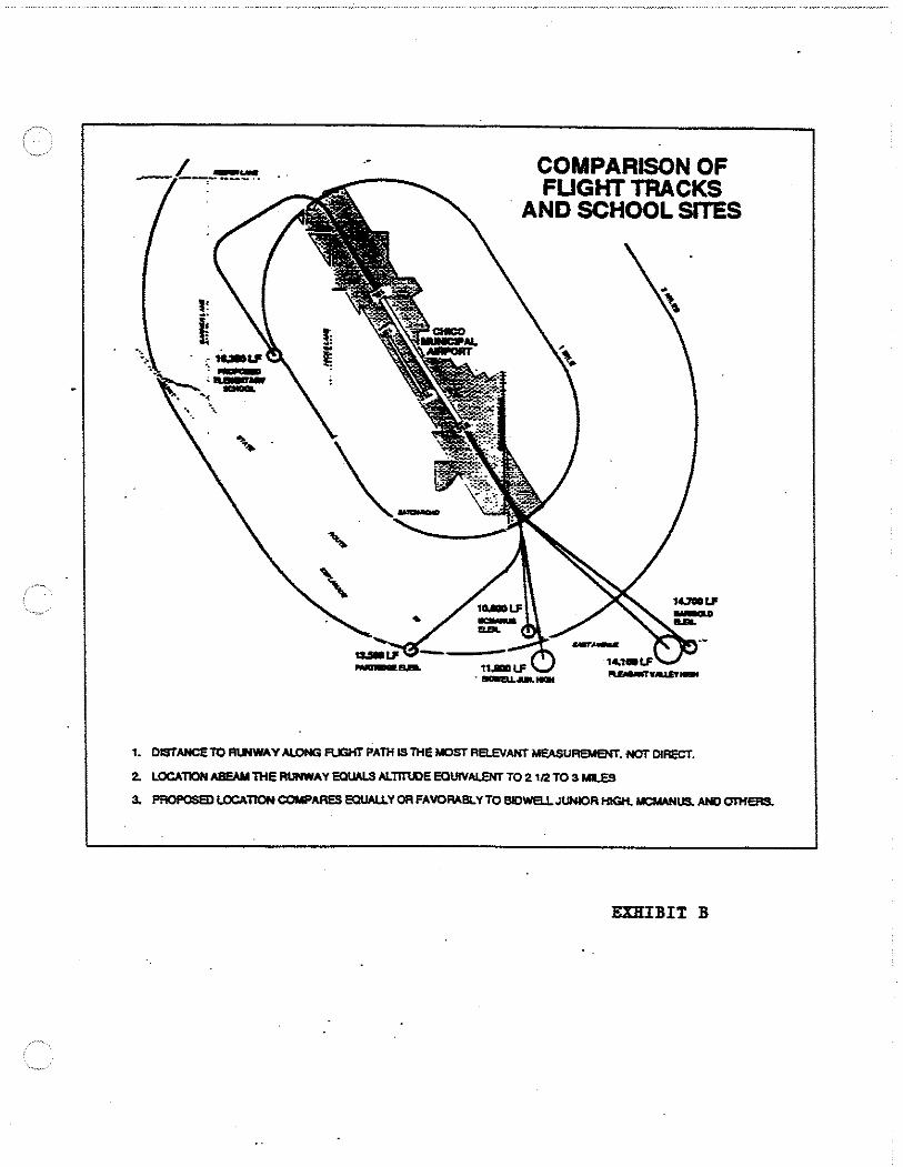
COMPARISON OF FUGHT TRACKS
. AND SCHOOL SITES
1. DISTANCE TO Rl.lfWAY AlONG FUGHT PATH IS THE MOST RB.EVANT MEASUREMENT. HOT DIRECT.
2. LOCATlOH ABEAM lHE RlmWAY EQUALS ALTITUDE EQUIVALENT TO 2 112 TO a M1.E5
3. PROPOSEDLOCATIONCOMPARESEOUALLYORFAVORABLYTOBIDWELLJUNIORHIGH.MCMANUS.ANDOTHERS.
EXHIBIT B

/17 I I j ... I~ Specific~ .. ·~ .. -,, ... , ....
CSA87 ,', ,·New Roads
\ I~ Bk07 T:J I I I I ( II CJ Ap06 •
CJAp47 ZONES
8-P C-1 C-2 M-1 M-2 OS P-Q •
~ R-1 R-2 R-3
!!!!!!!!!!! [:::J SR-1
~-..y '· c:J SR-3
.,

ORDINANCE NO.
AN ORDINANCE OF BUTTE COUNTY AMENDING THE ZONING FOR A PORTION OF BUTTE COUNTY,
CALIFORNIA, KNOWN AS THE NORTH CHICO SPECIFJC-pLAN AREA
1 The Board of Supervisors of the County of Butte, State of California, under and
2 pursuant to Chapter 24 of the Butte County Code of said County ORDAINS as
3 follows:
4 SECTION 1. · The attached Exhibit A shall be and is hereby adopted as the
5 zoning districts for the North Chico Specific Plan area, and such area shall be subject
6 to the restrictions and regulations of the North Chico Specific Plan text and Chapter
7 24 of the Butte County Code.
SECTION 2. This Ordinance shall be and it is hereby declared to be in full
9 force and effect from and after thirty (30) calendar days after the date of its passage,
10 and before the expiration of fifteen (15) calendar days after its passage, this
11 Ordinance shall be published once with the names of the members of the Board of
12 . Supervisors voting for and against it in the Enterprise Record, a newspaper published
13 in the County of Butte, State of California
.14 PASSED AND ADOPTED by the Board of Supervisors of the County of Butte,
15 State of California, on the day of -------'' 1995, by the following vote:
16 AYES:
17 NOES:
18 ABSENT:
1

ATTACHMENT D