No-Notice Urban Evacuations: Using Crowdsourced Mobile Data to Minimize Risk
14
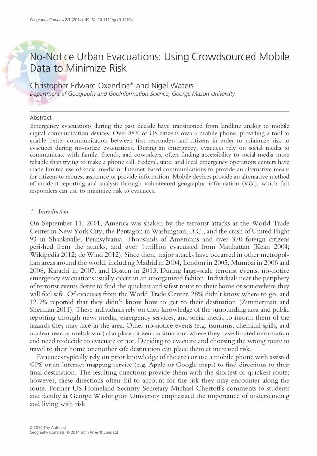
Geography Compass 8/1 (2014): 49–62, 10.1111/gec3.12104 No-Notice Urban Evacuations: Using Crowdsourced Mobile Data to Minimize Risk Christopher Edward Oxendine * and Nigel Waters Department of Geography and GeoInformation Science, George Mason University Abstract Emergency evacuations during the past decade have transitioned from landline analog to mobile digital communication devices. Over 88% of US citizens own a mobile phone, providing a tool to enable better communication between first responders and citizens in order to minimize risk to evacuees during no-notice evacuations. During an emergency, evacuees rely on social media to communicate with family, friends, and coworkers, often finding accessibility to social media more reliable than trying to make a phone call. Federal, state, and local emergency operations centers have made limited use of social media or Internet-based communications to provide an alternative means for citizens to request assistance or provide information. Mobile devices provide an alternative method of incident reporting and analysis through volunteered geographic information (VGI), which first responders can use to minimize risk to evacuees. 1. Introduction On September 11, 2001, America was shaken by the terrorist attacks at the World Trade Center in New York City, the Pentagon in Washington, D.C., and the crash of United Flight 93 in Shanksville, Pennsylvania. Thousands of Americans and over 370 foreign citizens perished from the attacks, and over 1 million evacuated from Manhattan (Kean 2004; Wikipedia 2012; de Wind 2012). Since then, major attacks have occurred in other metropol- itan areas around the world, including Madrid in 2004, London in 2005, Mumbai in 2006 and 2008, Karachi in 2007, and Boston in 2013. During large-scale terrorist events, no-notice emergency evacuations usually occur in an unorganized fashion. Individuals near the periphery of terrorist events desire to find the quickest and safest route to their home or somewhere they will feel safe. Of evacuees from the World Trade Center, 28% didn’t know where to go, and 12.9% reported that they didn’t know how to get to their destination (Zimmerman and Sherman 2011). These individuals rely on their knowledge of the surrounding area and public reporting through news media, emergency services, and social media to inform them of the hazards they may face in the area. Other no-notice events (e.g. tsunamis, chemical spills, and nuclear reactor meltdowns) also place citizens in situations where they have limited information and need to decide to evacuate or not. Deciding to evacuate and choosing the wrong route to travel to their home or another safe destination can place them at increased risk. Evacuees typically rely on prior knowledge of the area or use a mobile phone with assisted GPS or an Internet mapping service (e.g. Apple or Google maps) to find directions to their final destination. The resulting directions provide them with the shortest or quickest route; however, these directions often fail to account for the risk they may encounter along the route. Former US Homeland Security Secretary Michael Chertoff’s comments to students and faculty at George Washington University emphasized the importance of understanding and living with risk: © 2014 The Author(s) Geography Compass © 2014 John Wiley & Sons Ltd
Transcript of No-Notice Urban Evacuations: Using Crowdsourced Mobile Data to Minimize Risk
Geography Compass 8/1 (2014): 49–62, 10.1111/gec3.12104
No-Notice Urban Evacuations: Using Crowdsourced MobileData to Minimize Risk
Christopher Edward Oxendine* and Nigel WatersDepartment of Geography and GeoInformation Science, George Mason University
AbstractEmergency evacuations during the past decade have transitioned from landline analog to mobiledigital communication devices. Over 88% of US citizens own a mobile phone, providing a tool toenable better communication between first responders and citizens in order to minimize risk toevacuees during no-notice evacuations. During an emergency, evacuees rely on social media tocommunicate with family, friends, and coworkers, often finding accessibility to social media morereliable than trying to make a phone call. Federal, state, and local emergency operations centers havemade limited use of social media or Internet-based communications to provide an alternative meansfor citizens to request assistance or provide information. Mobile devices provide an alternative methodof incident reporting and analysis through volunteered geographic information (VGI), which firstresponders can use to minimize risk to evacuees.
1. Introduction
On September 11, 2001, America was shaken by the terrorist attacks at the World TradeCenter in New York City, the Pentagon inWashington, D.C., and the crash of United Flight93 in Shanksville, Pennsylvania. Thousands of Americans and over 370 foreign citizensperished from the attacks, and over 1million evacuated from Manhattan (Kean 2004;Wikipedia 2012; de Wind 2012). Since then, major attacks have occurred in other metropol-itan areas around the world, includingMadrid in 2004, London in 2005, Mumbai in 2006 and2008, Karachi in 2007, and Boston in 2013. During large-scale terrorist events, no-noticeemergency evacuations usually occur in an unorganized fashion. Individuals near the peripheryof terrorist events desire to find the quickest and safest route to their home or somewhere theywill feel safe. Of evacuees from the World Trade Center, 28% didn’t know where to go, and12.9% reported that they didn’t know how to get to their destination (Zimmerman andSherman 2011). These individuals rely on their knowledge of the surrounding area and publicreporting through news media, emergency services, and social media to inform them of thehazards they may face in the area. Other no-notice events (e.g. tsunamis, chemical spills, andnuclear reactor meltdowns) also place citizens in situations where they have limited informationand need to decide to evacuate or not. Deciding to evacuate and choosing the wrong route totravel to their home or another safe destination can place them at increased risk.Evacuees typically rely on prior knowledge of the area or use a mobile phone with assisted
GPS or an Internet mapping service (e.g. Apple or Google maps) to find directions to theirfinal destination. The resulting directions provide them with the shortest or quickest route;however, these directions often fail to account for the risk they may encounter along theroute. Former US Homeland Security Secretary Michael Chertoff’s comments to studentsand faculty at George Washington University emphasized the importance of understandingand living with risk:
© 2014 The Author(s)Geography Compass © 2014 John Wiley & Sons Ltd
50 Minimizing Risk in No-Notice Urban Evacuations
We must manage risk at the homeland security level. That means developing plans and allocatingresources in a way that balances security and freedom when calculating risks and implementingprotections. The most effective way, I believe, to apply this risk-based approach is by using the trioof threat, vulnerability and consequence as a general model for assessing risk and deciding on theprotective measures we undertake. (Chertoff 2005)
His comments emphasize the importance of increased awareness to the risk posed by terroristattacks. British Prime Minister David Cameron called for a “multifaceted approach instead ofjust militarily…including bringing together and forming great networks and alliances”( Johnston 2012). Citizens in close proximity to a terrorist attack are aware of the increasedrisk they face; however, they have no means of determining how to minimize risk as theynegotiate a way through an evacuation zone. During recent disasters and terrorist attacks,citizens have used their mobile devices to access social media platforms such as Twitter,Flickr, and Facebook to share information with friends, family, and others (Wallop 2011;Crowe 2012; Meier 2012). Social media provide a rarely used source of data that can beharnessed during such events. Zook et al. (2010) found in Haiti that aggregating data,including SMS messages, maximized the benefits to relief personnel. Collecting and analyzingmultiple sources of publicly available data and analyzing them to provide evacuees with anevacuation route are one method of minimizing risk to citizens and first responders during aterrorist attack.Several challenges exist for emergency management personnel when a no-notice evacua-
tion occurs including: determining what has happened, where it occurred, who is affected,how to mitigate the risk for evacuees and first responders, and how to communicate the riskand appropriate actions citizens should execute. These challenges involve analyzing multiplesources of geographic information so that emergency managers can quickly decide the bestcourse of action that minimizes further loss of life and property.Emergency managers are faced with providing direction to citizens on whether they
should evacuate, where the evacuation shelters are, and what is the safest and quickest route?Limited information about what exactly occurred and where it occurred often slows therelease of information from emergency managers to the public. Providing sufficient informa-tion on the impact to specific geographic areas and populations increases the likelihood thatcitizens will appropriately respond to directions from emergency managers (Glik 2007). Gal-loway 2003) highlights several important lessons learned from the attacks on the WorldTrade Center and Pentagon, including the importance of Geographic Information Systems(GISs), Decision Support Systems, and Public Communication. Galloway emphasized theimportance of GIS products in New York City to communicate with the public about risksand where to find available resources (evacuation zones, hazardous areas, shelters, and hospi-tals). Geographic information systems provide a toolset that enables emergency managers tocollect and analyze VGI, make more informed decisions about which routes citizens shoulduse during evacuations, and share this information with citizens as appropriate.VGI, introduced by Goodchild (2007a), refers to the information that volunteers
collect and submit, for example, to disaster management (Goodchild and Glennon2010). Elwood (2008) contrasts traditional data, which “prioritizes consensus, verifiableinformation, and finite and known data” with VGI. She recommends future researchon methods to incorporate VGI into government planning and decision-making. Services,such as Ushahidi, collected SMS messages from volunteers during crisis events to improvesituational awareness, planning, and decision-making during post-election violence inKenya (Okolloh 2009). This example of the collection of information from numeroussources is known as crowdsourcing (Howe 2006; Brabham 2008; Sui et al. 2012).
© 2014 The Author(s) Geography Compass 8/1 (2014): 49–62, 10.1111/gec3.12104Geography Compass © 2014 John Wiley & Sons Ltd
Minimizing Risk in No-Notice Urban Evacuations 51
Although there is no universal agreement on the definition of crowdsourcing, Estellés-Arolasand González-Ladrón-de-Guevara (2012) review previous literature on crowdsourcing anddefine crowdsourcing as “a type of participative online activity in which an individual, aninstitution, a non-profit organization, or company proposes to a group of individuals ofvarying knowledge, heterogeneity, and number, via a flexible open call, the voluntaryundertaking of a task.” VGI and crowdsourcing provide enhanced awareness to citizens andemergency personnel during crisis; however, there are privacy concerns that citizens may havewith how, when, and whom their data are shared. This article provides an overview ofemergency evacuations within the USA and discusses the use of VGI and mobile phones tomitigate risk during emergencies.
2. Overview of Emergency Evacuations
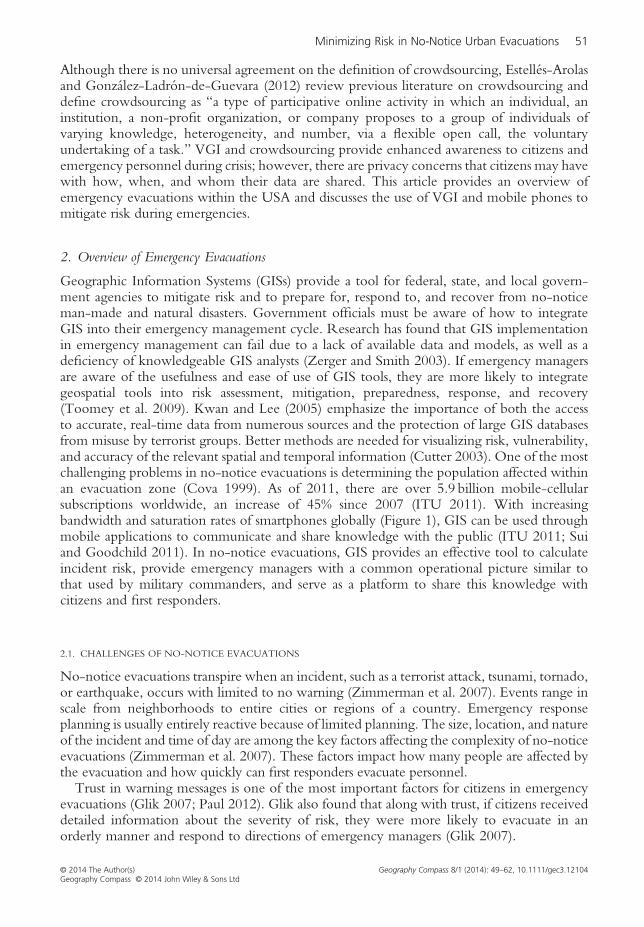
Geographic Information Systems (GISs) provide a tool for federal, state, and local govern-ment agencies to mitigate risk and to prepare for, respond to, and recover from no-noticeman-made and natural disasters. Government officials must be aware of how to integrateGIS into their emergency management cycle. Research has found that GIS implementationin emergency management can fail due to a lack of available data and models, as well as adeficiency of knowledgeable GIS analysts (Zerger and Smith 2003). If emergency managersare aware of the usefulness and ease of use of GIS tools, they are more likely to integrategeospatial tools into risk assessment, mitigation, preparedness, response, and recovery(Toomey et al. 2009). Kwan and Lee (2005) emphasize the importance of both the accessto accurate, real-time data from numerous sources and the protection of large GIS databasesfrom misuse by terrorist groups. Better methods are needed for visualizing risk, vulnerability,and accuracy of the relevant spatial and temporal information (Cutter 2003). One of the mostchallenging problems in no-notice evacuations is determining the population affected withinan evacuation zone (Cova 1999). As of 2011, there are over 5.9 billion mobile-cellularsubscriptions worldwide, an increase of 45% since 2007 (ITU 2011). With increasingbandwidth and saturation rates of smartphones globally (Figure 1), GIS can be used throughmobile applications to communicate and share knowledge with the public (ITU 2011; Suiand Goodchild 2011). In no-notice evacuations, GIS provides an effective tool to calculateincident risk, provide emergency managers with a common operational picture similar tothat used by military commanders, and serve as a platform to share this knowledge withcitizens and first responders.
2.1. CHALLENGES OF NO-NOTICE EVACUATIONS
No-notice evacuations transpire when an incident, such as a terrorist attack, tsunami, tornado,or earthquake, occurs with limited to no warning (Zimmerman et al. 2007). Events range inscale from neighborhoods to entire cities or regions of a country. Emergency responseplanning is usually entirely reactive because of limited planning. The size, location, and natureof the incident and time of day are among the key factors affecting the complexity of no-noticeevacuations (Zimmerman et al. 2007). These factors impact how many people are affected bythe evacuation and how quickly can first responders evacuate personnel.Trust in warning messages is one of the most important factors for citizens in emergency
evacuations (Glik 2007; Paul 2012). Glik also found that along with trust, if citizens receiveddetailed information about the severity of risk, they were more likely to evacuate in anorderly manner and respond to directions of emergency managers (Glik 2007).
© 2014 The Author(s) Geography Compass 8/1 (2014): 49–62, 10.1111/gec3.12104Geography Compass © 2014 John Wiley & Sons Ltd
Fig. 1. Worldwide mobile subscriptions, 2001–2011 (ITU 2011).
52 Minimizing Risk in No-Notice Urban Evacuations
2.2. COMMUNICATION DURING NO-NOTICE EMERGENCY EVACUATIONS
Although providing information to the public has improved dramatically over the past50 years, only limited research and applications have been introduced that improvetwo-way communication and additional methods of communication between citizens andemergency managers. Current methods of notification include the following: news, radio,social media, and, in the USA, the Commercial Mobile Alert System (CMAS). Communica-tion between the emergency managers and the community is primarily through 911 callcenters. Citizens receive information from numerous sources including news media, the Internet,social media, and recently through mobile phones. Currently, the only method of reporting anemergency situation in the USA is to call 911 or the local number for your 911-call center.Past incidents have illustrated the importance of multiple lines of communication (FederalCommunications Commission 2006; Callahan 2012); however, policies and procedures havenot been established to provide alternative methods of communication with 911 call centerssuch as using newer technologies including the Internet, Skype, or even social media.Some federal, state, and local agencies have made efforts to share information on the
Internet and social media (such as Twitter and Flickr); however, limited efforts have beenmade to use the Internet and social media as a two-way communication platform (Latoneroand Shklovski 2011;Wallop 2011;Meier 2012). The 2010Haiti earthquake was the first attemptby the US Government to rely on social media to coordinate efforts among various federalagencies (Yates and Paquette 2011). On June 29, 2012, over 2.3million residents in NorthernVirginia understood the importance of multi-modal communications when 911 services werelost following a derecho storm, with full service restored over 4 days later (Flaherty 2012).The US Federal Emergency Management Agency (FEMA), in coordination with the
Federal Communications Commission, developed CMAS, which was re-named in February2013 to Wireless Emergency Alerts (WEAs). WEA sends geographically targeted alerts tocitizens to notify them of hazards they may be exposed to, based on their mobile phonelocation (FEMA 2012). WEA is a complement to television, radio, Internet, and othernotification services. WEA is a one-way communication platform that is used to notify citizensabout hazards. WEA allows up to 90 characters to be transmitted in its alerts, limiting themessage content to type of event, time alert expires, and recommended action (FEMA
© 2014 The Author(s) Geography Compass 8/1 (2014): 49–62, 10.1111/gec3.12104Geography Compass © 2014 John Wiley & Sons Ltd
Minimizing Risk in No-Notice Urban Evacuations 53
2012). FEMA states that one-way communication is used in order to protect the privacyof citizens. WEA provides an initial platform for further integrating mobile devices intoemergency notifications. Recommended improvement to WEA includes developingprocedures and technologies to allow citizens to report incidents and their location providingtwo-way communication through WEA. This would provide increased reporting, situationalawareness, and an alternate method for citizens to request emergency services when theycannot reach a 911 operator.
2.3. MOBILE PHONE USE IN EMERGENCY EVACUATIONS
Mobile phones should not be regarded as a primary or sole-source communications device.They supplement other existing communication sources such as analog phones, television,radio, and social media. Mobile phones, which primarily offer only voice and SMS (shortmessage service), are different from and lack the capabilities of smartphones. Compared tostandard mobile phones, smartphones have a mobile operating system with additional featuressuch as access to the Internet, social media, and mobile applications.In 2011, the Pew Research Center found that over 40% of cell phone owners used their
cell phone during an emergency (Pew Research Center 2011). As of March 2012, over 88%of Americans own a mobile phone, and more than 46% of Americans own a smartphone(Pew Research Center 2012). Over 50% of citizens in Australia, the United Kingdom,Sweden, Norway, Saudi Arabia, and United Arab Emirates own a smartphone, and over 40%own a smartphone in New Zealand, Denmark, Ireland, Netherlands, Spain, and Switzerland(Pham 2012). With increasing numbers of citizens using GPS-enabled smartphones, emergencymanagement should evaluate how they can integrate newer technologies into 911 call centers aswell as how these technologies can better support response by first responders.Positional accuracies of mobile devices vary depending on whether the device is GPS
enabled and activated and on whether an individual shares their location as a coordinate suchas latitude and longitude or a description of their location (e.g. 34.2345, 58.8989 or NewYork City, NY). Although accuracies fluctuate, studies on cellular phone position data havefound up to 50-meter accuracy rates using 30-second updates (Cayford and Johnson 2003).Current models of phones have the ability to send GPS collected locations, although notall users provide location data with their GPS-enabled phones. More recent research onGPS-assisted phones found average accuracies of 8 meters (Zandbergen 2009).Mobile phones provide several opportunities to improve two-way communication between
citizens and emergency management personnel. First, they provide a means for sharing infor-mation through social networks, such as Twitter and Flickr among others. Second, aggregatedmobile phone location data could also be used to estimate diurnal population change in urbansettings to determine how many people are impacted by an event and what resources areneeded during the response. Third, mobile phones provide the ability to send low bandwidthtext messages to 911 call centers; however, the ability and procedures to capture and respond totext messages in 911 call centers do not yet exist. Finally, in the USA, smartphones provideFEMAwith the ability to deliver an all-in-one mobile application or mobile-enabled web pageto citizens. This application should incorporate features such as the following: shelter in placeprocedures, basic first aid, and the ability to download and save to the user’s phone local mapsand phone numbers of the evacuee’s local 911 call center, fire, EMS, and police services.
3. Mitigating Risk While Protecting the Privacy of Individuals
What are the new questions and implications for privacy in crowdsourced mobile data?Mobile phones can provide a wealth of information to support no-notice emergency
© 2014 The Author(s) Geography Compass 8/1 (2014): 49–62, 10.1111/gec3.12104Geography Compass © 2014 John Wiley & Sons Ltd

54 Minimizing Risk in No-Notice Urban Evacuations
evacuations; however, government officials must also be cognizant of protecting the privacyof its citizens. Modern computer technologies continue improving our ability to processlarger datasets and more challenging problems, including the use of individual location dataduring an emergency. Mobile applications have been developed that are tailored to a user’scurrent location and provide a means to track an individual’s movements, although fewindividuals are comfortable sharing their location at all times (Gruteser and Liu 2004).During an emergency, citizens expect to be protected by government agencies, but theyalso expect to maintain a certain level of anonymity. Implementing a GIS to facilitateemergency response using an individual’s mobile phone location poses the question ofhow do we provide assistance to citizens while also protecting their privacy (Li andGoodchild 2010)?The World Economic Forum recently published a report on the challenges of personal
data citing a lack of globally accepted policies and procedures that protect the privacy ofindividuals (World Economic Forum 2011). Research by Kwan et al. (2004) emphasizesnot only the importance of the use of geo-referenced, individual data but also the protectionof personal privacy. Leszczynski (2012) further addresses state and national governments’privacy concerns of the collection, analysis, and visualization of geographic information.In the realm of emergency evacuations, further analysis is needed to determine an
optimum solution to protect the privacy of citizens while also providing them with the optimumevacuation route that minimizes risk and distance traveled. There is a lack of guidelines onwhen it is appropriate to collect information from individuals without their knowledge whilemaintaining their privacy (Sui and Goodchild 2011). With increasing concerns over spatialdata privacy, Elwood and Leszczynski (2011) state that current privacy conflicts willinfluence expectations of citizens and policies and procedures that data stockholders follow.In a recent survey, Kar et al. (2013) found that the majority of US citizens agreed on thecollection of location data during an emergency; however, there was disagreement overhow the location data should be used.In conjunction with state, local, and tribal emergency managers, FEMA should evaluate
and implement better methods of integrating mobile devices and social media into emer-gency response while providing a solid measure of privacy for citizens. To alleviate concernsof citizens regarding location privacy, during an emergency evacuation, location data shouldonly be shared when an individual authorizes these data to be shared or when they sendlocation data directly to emergency managers. Placing a location sharing ‘on/off’ buttonwhere a message is sent would enable citizens more control over when their location isshared or not. As with a 911 call, if procedures are put in place to capture emergency reportsthrough the Internet or social media outlets, then location data should be sent automaticallyto 911 call centers using secure Internet protocols. This ensures that when an emergency isreported, first responders will have the ability to respond to an incident as needed.
3.1. SOCIAL MEDIA AND EMERGENCY EVACUATIONS
Emergency managers are beginning to understand the wealth of information that socialmedia can provide and are working to develop procedures for collecting reports from socialmedia. Understanding relationships and interactions within social networks provides anopportunity to gather and analyze valuable information leading to additional insight duringemergency response (Li and Goodchild 2010). Many emergency managers around the worldrealized the importance of smartphones and Twitter after the 2011 earthquake and tsunamiin Fukishima, Japan. In September 2012, the Japanese government conducted an exercise incoordination with Twitter to send initial quake alerts and evacuation routes. In turn, citizens
© 2014 The Author(s) Geography Compass 8/1 (2014): 49–62, 10.1111/gec3.12104Geography Compass © 2014 John Wiley & Sons Ltd
Minimizing Risk in No-Notice Urban Evacuations 55
were expected to report injured people along evacuation routes (Russell 2012). In the USA,several state and local governments used an Ushahidi crowdmap during Hurricane Sandy(Waters 2011). Twitter hashtags could be used to report power outages, downed trees, orother hazards. Ushahidi, established in 2008, was initially used following the Haitiearthquake in 2008 to collect VGI from users through SMS, MMS (Multimedia MessagingService), and the Internet (Okolloh 2009; Meier and Munro 2010; Zook et al. 2010). Thisinformation was shared with emergency response and relief workers, which enabled themto determine how to employ their limited resources efficiently (Okolloh 2009). Efforts tointegrate social media into emergency responses have improved. Additional efforts tooptimize the integration of social media during emergencies could include the following:(1) methods to geo-fence social media data based on a 911 call center jurisdiction, (2) proce-dures to use social media as an alternate two-way communication method, (3) ‘emergency’hashtags that are always geolocated, and (4) a process to educate the public on the appropriateuse of these hashtags.During emergencies, government agencies currently use VGI, primarily social media as a
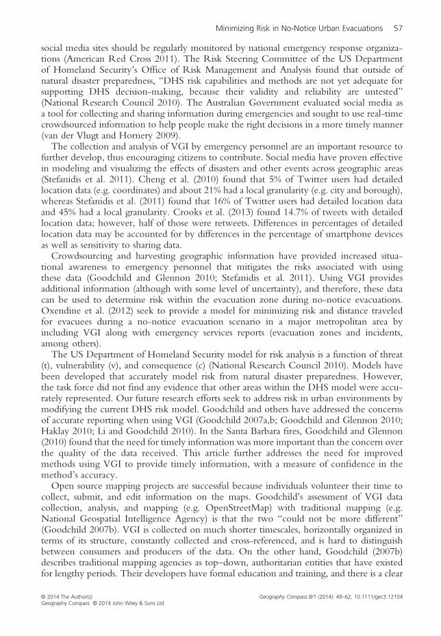
one-way communication tool. Social media are not a primary means of communication;however, social media can be used as an alternative method for two-way communicationbetween citizens and emergency management. Social media provide an ad hoc platformfor connecting individuals with different experience levels and enabling a flexible yet robustmethod for gathering, sharing, and employing knowledge for emergency response (Yates andPaquette 2011). A social network dedicated to emergencies would be an accepted tool,especially among younger citizens (White et al. 2009). Teen mobile phones rates haveincreased from 45% in 2004 to 77% in 2011 (Lenhart 2009). Figure 2 provides a recent analysisof mobile phone rates across individual generations (Zickuhr 2011). Brenner (2013) found that67% of online adults in the USA use social networking sites. Of women, 71% use social mediacompared to 62% of men, and 70% of urban citizens use social media compared to 61% in ruralareas. As shown in Figure 3, younger generations use social media more than older generations.As emergency managers realize the increasing value of mobile phones and social media as asituational awareness tool, additional efforts should be made to efficiently integrate these toolsinto the emergency management cycle via a common methodology and application.The phrase “given enough eyeballs, all bugs are shallow” is known as Linus Law
(Raymond 2008). The so-called “Linus Law” can be applied to the collection and analysisof VGI during emergency evacuations and terrorist events in densely populated areas. Forexample, in New York City or Washington, D.C., the majority of citizens use a smartphone,and most smartphones are GPS enabled. With a population of over 8million people, NYCprovides an excellent opportunity to use VGI to report emergency events (e.g. a car bomb ora hostage situation) (NYC, Population Division 2010). VGI, about the location and type ofevent, as well as photographs, could be used by emergency services and citizens to minimizetheir risk in the hazard zone. Although VGI may be a medium for sharing of unverified orfalse information, Richards and Lewis (2011) found that in the London riots, Twitter wasequally capable of discounting rumors. Further research is needed to evaluate the applicationof Linus Law to the collection and analysis of VGI during emergencies.
3.2. MINIMIZING RISK EITH VGI
Data fusion supports the collection, organizing, and interpreting of multiple sources of dataduring an emergency evacuation. Using GIS to analyze the data during an emergency evacua-tion assists planners and decision makers during the mitigation, preparation, response, and
© 2014 The Author(s) Geography Compass 8/1 (2014): 49–62, 10.1111/gec3.12104Geography Compass © 2014 John Wiley & Sons Ltd
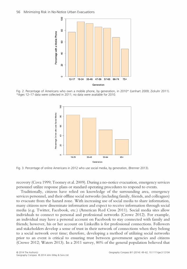
Fig. 2. Percentage of Americans who own a mobile phone, by generation, in 2010* (Lenhart 2009; Zickuhr 2011).*Ages 12–17 data were collected in 2011; no data were available for 2010.
Fig. 3. Percentage of online Americans in 2012 who use social media, by generation, (Brenner 2013).
56 Minimizing Risk in No-Notice Urban Evacuations
recovery (Cova 1999; Toomey et al. 2009). During a no-notice evacuation, emergency servicespersonnel utilize response plans or standard operating procedures to respond to events.Traditionally, citizens have relied on knowledge of the surrounding area, emergency
services personnel, and their offline social networks (including family, friends, and colleagues)to evacuate from the hazard zone. With increasing use of social media to share information,many citizens now disseminate information and expect to receive information through socialmedia (e.g. Twitter, Facebook, etc.) (American Red Cross 2011). Social media sites allowindividuals to connect to personal and professional networks (Crowe 2012). For example,an individual may have a personal account on Facebook to stay connected with family andfriends; however, his or her account on LinkedIn is for professional connections. Followersand stakeholders develop a sense of trust in their network of connections when they belongto a social network over time; therefore, developing a method of utilizing social networksprior to an event is critical to ensuring trust between government agencies and citizens(Crowe 2012; Waters 2013). In a 2011 survey, 80% of the general population believed that
© 2014 The Author(s) Geography Compass 8/1 (2014): 49–62, 10.1111/gec3.12104Geography Compass © 2014 John Wiley & Sons Ltd
Minimizing Risk in No-Notice Urban Evacuations 57
social media sites should be regularly monitored by national emergency response organiza-tions (American Red Cross 2011). The Risk Steering Committee of the US Departmentof Homeland Security’s Office of Risk Management and Analysis found that outside ofnatural disaster preparedness, “DHS risk capabilities and methods are not yet adequate forsupporting DHS decision-making, because their validity and reliability are untested”(National Research Council 2010). The Australian Government evaluated social media asa tool for collecting and sharing information during emergencies and sought to use real-timecrowdsourced information to help people make the right decisions in a more timely manner(van der Vlugt and Hornery 2009).The collection and analysis of VGI by emergency personnel are an important resource to
further develop, thus encouraging citizens to contribute. Social media have proven effectivein modeling and visualizing the effects of disasters and other events across geographic areas(Stefanidis et al. 2011). Cheng et al. (2010) found that 5% of Twitter users had detailedlocation data (e.g. coordinates) and about 21% had a local granularity (e.g. city and borough),whereas Stefanidis et al. (2011) found that 16% of Twitter users had detailed location dataand 45% had a local granularity. Crooks et al. (2013) found 14.7% of tweets with detailedlocation data; however, half of those were retweets. Differences in percentages of detailedlocation data may be accounted for by differences in the percentage of smartphone devicesas well as sensitivity to sharing data.Crowdsourcing and harvesting geographic information have provided increased situa-
tional awareness to emergency personnel that mitigates the risks associated with usingthese data (Goodchild and Glennon 2010; Stefanidis et al. 2011). Using VGI providesadditional information (although with some level of uncertainty), and therefore, these datacan be used to determine risk within the evacuation zone during no-notice evacuations.Oxendine et al. (2012) seek to provide a model for minimizing risk and distance traveledfor evacuees during a no-notice evacuation scenario in a major metropolitan area byincluding VGI along with emergency services reports (evacuation zones and incidents,among others).The US Department of Homeland Security model for risk analysis is a function of threat
(t), vulnerability (v), and consequence (c) (National Research Council 2010). Models havebeen developed that accurately model risk from natural disaster preparedness. However,the task force did not find any evidence that other areas within the DHS model were accu-rately represented. Our future research efforts seek to address risk in urban environments bymodifying the current DHS risk model. Goodchild and others have addressed the concernsof accurate reporting when using VGI (Goodchild 2007a,b; Goodchild and Glennon 2010;Haklay 2010; Li and Goodchild 2010). In the Santa Barbara fires, Goodchild and Glennon(2010) found that the need for timely information was more important than the concern overthe quality of the data received. This article further addresses the need for improvedmethods using VGI to provide timely information, with a measure of confidence in themethod’s accuracy.Open source mapping projects are successful because individuals volunteer their time to
collect, submit, and edit information on the maps. Goodchild’s assessment of VGI datacollection, analysis, and mapping (e.g. OpenStreetMap) with traditional mapping (e.g.National Geospatial Intelligence Agency) is that the two “could not be more different”(Goodchild 2007b). VGI is collected on much shorter timescales, horizontally organized interms of its structure, constantly collected and cross-referenced, and is hard to distinguishbetween consumers and producers of the data. On the other hand, Goodchild (2007b)describes traditional mapping agencies as top–down, authoritarian entities that have existedfor lengthy periods. Their developers have formal education and training, and there is a clear
© 2014 The Author(s) Geography Compass 8/1 (2014): 49–62, 10.1111/gec3.12104Geography Compass © 2014 John Wiley & Sons Ltd
58 Minimizing Risk in No-Notice Urban Evacuations
distinction between the expert and the consumer. Progress or change in the acceptance ofVGI will be a democratic process that requires time, patience, and increasing resources(Goodchild 2007b).Each individual may act as a sensor that can collect VGI with great detail (e.g. street names,
traffic flow, Automatic External Defibrillator (AED) locations, emergency service facilities,etc.) that our remote sensing technologies rarely detect (Goodchild 2007b). Mobile devicesprovide a platform for collecting VGI and provide two-way communication in the formof text messages, voice messages, and mobile applications. Current remote sensing technologieslack the fidelity that billions of mobile sensors provide to geographers, emergency personnel,academics, and others.Evacuation route optimization has been researched for many years leading to improve-
ments in emergency evacuations routing (ReVelle and Swain 1970; Church and Cova2000; Kwan and Lee 2005; Alçada-Almeida et al. 2009; Oxendine et al. 2012). Altay andGreen (2006) propose that operations research has significant applications during disasterresponse and call for better methods and technology to improve disaster management.Abdelgawad and Abdulhai (2009) outline two important challenges in determining routesduring emergency evacuations: a lack of hazard prediction methods that model the predictedhazard area and a lack of methods for dynamically assigning evacuation routes within thenetwork. Integrating VGI, such as citizen locations and reported incidents, into previousmodels enables emergency managers and citizens to model risk in an evacuation zone.VGI also enhances the ability of emergency managers to route citizens on evacuation routeswhile minimizing risk and distance traveled. Smartphones, social media, and mobile mappingapplications provide a toolset that enable two-way communication between citizens andgovernment officials and address the challenge of dynamically routing citizens during ano-notice evacuation.
4. Conclusion
Methods for leveraging evacuee locations and providing notification and evacuation routesin an evacuation zone cross into a new paradigm with the availability of smartphones andincreasing positional accuracy. The following elements must be implemented to successfullydevelop a mobile application platform that supports no-notice emergency evacuations:education of the public, enhanced integration of GIS for mobile devices during emergencies,development of methods of two-way communication, and a common platform for citizensand government officials.Education of the public on how mobile applications support emergency evacuations and
how their privacy is protected is key to building trust in the common platform. As part ofthis effort, FEMA and other emergency management organizations must continue theirefforts to educate citizens on the proper procedures for using mobile devices, mobile appli-cations, and social media during an emergency. Efforts to educate citizens on tools availableduring a crisis should occur on an ongoing basis. However, many citizens are likely to searchfor assistance or information just before or after an event. Increased marketing during thesetimes would most likely have the biggest benefit for citizens and emergency agencies.Researchers have called for additional methods for fusing GIS and social media (Sui and
Goodchild 2011). GIS-supported mobile applications and social media provide alternativemethods of two-way communication that allow citizens to report incidents to a 911-callcenter. Using GIS to analyze information reported through mobile applications and socialmedia during a no-notice emergency evacuation enables government officials to model riskand communicate said risk to citizens through various communication modes. As was seen in
© 2014 The Author(s) Geography Compass 8/1 (2014): 49–62, 10.1111/gec3.12104Geography Compass © 2014 John Wiley & Sons Ltd
Minimizing Risk in No-Notice Urban Evacuations 59
the past incidents, 911 operations centers lose communications through analog phones, andmethods must be established to provide alternative and contingency communicationmethods. The ability to connect through cellular or Internet networks as an alternativecommunication method is necessary. Mobile technologies are continuously improving andprovide an increased ability to emergency managers to augment risk awareness among citizensand therefore mitigate hazards during evacuations.For the duration of Hurricane Sandy, federal, state, and local agencies as well as corporate
entities made Internet and mobile applications available for reporting incidents. Yet with somany options available, there was limited collaboration across the mobile applications.Although a step in the right direction, there is a need for a common platform developedin coordination with international, national, and local government agencies that enablescitizens to communicate with emergency managers and for government agencies to shareinformation. This common platform should provide a spatially and temporally integratedcapability for the emergency operations center to receive and analyze reports from citizenswithin their jurisdiction.As noted above, the Japanese Government recently conducted an emergency exercise in
coordination with Twitter (Russell 2012). Twitter and smartphones were key tools usedby the Japanese Government for emergency notification and sharing information with itscitizens. The next step in improving these systems is enabling two-way communicationand improving accessibility of maps during an emergency, thus providing citizens with analternative communication method and mapping tool. Not only would citizens benefit,but non-government and government agencies would also benefit from a common platformthat could assist in identifying impacted areas and focusing response efforts in those regions(Oxendine et al. 2012). As part of this effort, citizens should be educated on alternativemethods of communicating risk during an evacuation resulting in increased awareness totheir community and emergency managers during the next disaster. Emergency managerswould also be more knowledgeable of the risk to citizens and be better prepared to commu-nicate this risk through multiple communication channels. With the capabilities of collectingdata, analyzing it, and sharing visual and textual information, geographic information systemsare ideally positioned to provide and coordinate these developments.
Short Biographies
Chris Oxendine completed his PhD in the Department of Geography and GeoInformationScience at George Mason University in May 2013. He has served over 10 years as a MilitaryPolice Officer, with assignments as Company Commander, Operations Officer, and as Officerin Charge, Special Reaction Team. Chris is an Assistant Professor position in the GIS Program,Department of Geography and Environmental Engineering at the US Military Academy.Current research interests include the following: GIS, emergency evacuations, spatial andtemporal modeling, and mobile devices and applications.Nigel Waters is a Professor in the Department of Geography and GeoInformation Science at
George Mason University and the Director of George Mason’s Center of Excellence inGeographic Information Science. Current research interests include the following: GIS;transportation GIS, network analysis, and optimization; GIS, the media, and democracy; medicalgeography applications including optimization of liver transplant and cardiac facilities; case-basedreasoning and traffic safety analysis; geographically explicit, complex dynamic systems; and theanalysis of social media and social networks. He is the Editor of Cartographica: The InternationalJournal for Geographic Information and Geovisualization, which is widely published in peer-reviewed journals and has numerous, well-cited book chapters to his credit.
© 2014 The Author(s) Geography Compass 8/1 (2014): 49–62, 10.1111/gec3.12104Geography Compass © 2014 John Wiley & Sons Ltd

60 Minimizing Risk in No-Notice Urban Evacuations
Note* Correspondence address: Christopher Edward Oxendine, United States Military Academy, Department of Geography & Envi-
ronmental Engineering, 745 BrewertonRoad, Rm 5415, West Point, NY 10996, USA. E-mail: [email protected]
References
Abdelgawad, H. and Abdulhai, B. (2009). Emergency evacuation planning as a network design problem: a criticalreview. Transportation Letters: The International Journal of Transportation Research 1 (1), pp. 41–58.
Alçada-Almeida, L., Tralhão, L., Santos, L. and Coutinho-Rodrigues, J. (2009). A multiobjective approach to locateemergency shelters and identify evacuation routes in urban areas. Geographical Analysis 41 (1), pp. 9–29.
Altay, N. and Green, W. G. (2006). OR/MS research in disaster operations management. European Journal of OperationalResearch 175 (1), pp. 475–493.
American Red Cross (2011). More Americans using social media and technology in emergencies. Retrieved on22 February 2012 from http://www.redcross.org/portal/site/en/menuitem.94aae335470e233f6cf911df43181aa0/?vgnextoid=7a82d1efe68f1310VgnVCM10000089f0870aRCRD
Brabham, D. C. (2008). Crowdsourcing as a model for problem solving an introduction and cases. Covergence: TheInternational Journal of Research Into New Media Technologies 14 (1), pp. 75–90.
Brenner, J. (2013). Pew internet: social networking. Pew Internet & American Life Project. Accessed April 19, 2013 http://pewinternet.org/Commentary/2012/March/Pew-Internet-Social-Networking-full-detail.aspx
Callahan, W. (2012). Fairfax county says Verizon to blame for 911 outages. Tysons Corner Patch. Retrieved on 29 August2012 from http://tysonscorner.patch.com/articles/fairfax-county-says-verizon-to-blame-for-911-outages
Cayford, R. and Johnson, T. (2003). Operational parameters affecting the use of anonymous cell phone tracking forgenerating traffic information. In Transportation research board 82nd annual meeting. pp. 03–3865.
Cheng, Z., Caverlee, J. and Lee, K. (2010). You are where you tweet: a content-based approach to geo-locating twitterusers. In Proceedings of the 19th ACM international conference on information and knowledge management, CIKM ’10, NewYork, NY, pp. 759–768.
Chertoff, M. (2005). DHS: remarks for Secretary Michael Chertoff U.S. Department of Homeland Security GeorgeWashington University Homeland Security Policy Institute. Retrieved on 18 February 2012 from https://www.dhs.gov/xnews/speeches/speech_0245.shtm
Church, R. L. and Cova, T. J. (2000). Mapping evacuation risk on transportation networks using a spatial optimizationmodel. Transportation Research Part C: Emerging Technologies 8 (1-6), pp. 321–336.
Cova, T. J. (1999). GIS in emergency management. Geographical Information Systems 2, pp. 845–858.Crooks, A., Croitoru, A., Stefanidis, A. and Radzikowski, J. (2013). #Earthquake: twitter as a distributed sensor system.Transactions in GIS 17 (1), pp. 124–147.
Crowe, A. (2012). Disasters 2.0: the application of social media systems for modern emergency management. 1st ed. Boca Raton:CRC Press.
Cutter, S. L. (2003). GI science, disasters, and emergency management. Transactions in GIS 7 (4), pp. 439–446.Elwood, S. (2008). Volunteered geographic information: future research directions motivated by critical, participatory,and feminist GIS. Geo Journal 72 (3-4), 173–183.
Elwood, S. and Leszczynski, A. (2011). Privacy, reconsidered: new representations, data practices, and the geoweb.Geoforum 42 (1), pp. 6–15.
Estellés-Arolas, E. and González-Ladrón-de-Guevara, F. (2012). Towards an integrated crowdsourcing definition.Journal of Information Science 38 (2), pp. 189–200.
Federal Communications Commission. (2006). FCC report on impact of hurricane Katrina on communicationsnetwork. Retrieved on 12 October from http://hraunfoss.fcc.gov/edocs_public/attachmatch/FCC-06-83A1.pdf
FEMA. (2012). FEMA: to private sector industry partner: CMAS participants. Retrieved on 2 April 2012 from http://www.fema.gov/emergency/ipaws/ps_plan_cmas.shtm
Flaherty, M. P. (2012). Verizon details errors in derecho, calls response to 911 outages “insufficient.” The Washington Post.Retrieved on 22 October 2012 from http://www.washingtonpost.com/local/crime/verizon-details-errors-in-derecho-calls-response-to-911-outages-insufficient/2012/08/13/e2589596-e57f-11e1-8741-940e3f6dbf48_story.html
Galloway, Gerald E. (2003). Emergency preparedness and response: lessons learned from 9/11. In the GeographicalDimensions of Terrorism. 27–34. New York: Routledge. http://trid.trb.org/view/706266
Glik, D. C. (2007). Risk communication for public health emergencies. Annual Review of Public Health 28 (1), pp. 33–54.Goodchild, M. F. (2007a). Citizens as sensors: the world of volunteered geography. GeoJournal 69 (4), pp. 211–221.Goodchild, M. F. (2007b). Citizens as voluntary sensors: spatial data infrastructure in the world of web 2.0. InternationalJournal of Spatial Data Infrastructures Research 2 (2), pp. 24–32.
Goodchild, M. F. and Glennon, J. A. (2010). Crowdsourcing geographic information for disaster response: a researchfrontier. International Journal of Digital Earth 3 (3), pp. 231–241.
© 2014 The Author(s) Geography Compass 8/1 (2014): 49–62, 10.1111/gec3.12104Geography Compass © 2014 John Wiley & Sons Ltd

Minimizing Risk in No-Notice Urban Evacuations 61
Gruteser, M. and Liu, X. (2004). Protecting privacy, in continuous location-tracking applications. IEEE Security &Privacy 2 (2), pp. 28–34.
Haklay, M. (2010). How good is volunteered geographical information? A comparative study of OpenStreetMap andOrdnance Survey datasets. Environment and Planning. B, Planning & Design 37 (4), p. 682.
Howe, J. (2006). The rise of crowdsourcing. Wired Magazine 14 (6), pp. 1–4.ITU. (2011). International Telecommunications Union (ITU) - ICT data and statistics. Retrieved on 27 November2012 from http://www.itu.int/ITU-D/ict/statistics/index.html
Johnston, A. (2012). David Cameron says terror fight needs diplomacy. The Epoch Times. Retrieved on 28 November 2012from: http://www.theepochtimes.com/n2/world/david-cameron-says-terror-fight-needs-diplomacy-207167.html
Kar, B., Crowsey, R. C. and Zale, J. J. (2013). The myth of location privacy in the United States: surveyed attitudeversus current practices. The Professional Geographer 65 (1), pp. 47–64.
Kean, T. (2004). The 9/11 commission report: final report of the national commission on terrorist attacks upon theUnited States. US Government Printing Office.
Kwan, M.-P., Casas, I. and Schmitz, B. (2004). Protection of geoprivacy and accuracy of spatial information: howeffective are geographical masks? Cartographica: The International Journal for Geographic Information and Geovisualization39 (2), pp. 15–28.
Kwan, M.-P. and Lee, J. (2005). Emergency response after 9/11: the potential of real-time 3D GIS for quick emergencyresponse in micro-spatial environments. Computers, Environment and Urban Systems 29 (2), pp. 93–113.
Latonero, M. and Shklovski, I. (2011). Emergency management, Twitter, and social media evangelism. InternationalJournal of Information Systems for Crisis Response and Management 3 (4), pp. 1–16.
Lenhart, A. (2009). Teens and mobile phones. Pew Research Center Internet & American Life Project. Retrievedon 6 December 2012 from http://pewinternet.org/Shared-Content/Data-Sets/2009/September-2009-Teens-and-Mobile.aspx
Leszczynski, A. (2012). Situating the geoweb in political economy. Progress in Human Geography 36 (1), pp. 72-89.Li, L. and Goodchild, M. F. (2010). The role of social networks in emergency management. International Journal ofInformation Systems for Crisis Response and Management 2, pp. 48–58.
Meier, P. (2012). What was novel about social media use during hurricane sandy? iRevolution. Retrieved on 20November 2012 from http://irevolution.net/2012/10/31/hurricane-sandy/
Meier, P. and Munro, R. (2010). The unprecedented role of SMS in disaster response: learning from Haiti. SAIS Review30 (2), pp. 91–103.
National Research Council. (2010). Review of the Department of Homeland Security’s approach to risk analysis. Washington,D. C.: The National Academies Press.
NYC, Population Division. (2010). Population - New York City Department of City Planning. Retrieved on 5 April2012 from http://www.nyc.gov/html/dcp/html/census/popdiv.shtml
Okolloh, O. (2009). Ushahidi, or “testimony”: web 2.0 tools for crowdsourcing crisis information. Participatory Learningand Action 59 (1), pp. 65–70.
Oxendine, C., Sonwalkar, M. and Waters, N. (2012). A multi-objective, multi-criteria approach to improve situationalawareness in emergency evacuation routing using mobile phone data. Transactions in GIS 16(3), pp. 375–396.
Paul, B. K. (2012). Factors affecting evacuation behavior: the case of 2007 cyclone Sidr, Bangladesh. The ProfessionalGeographer 64(3), pp. 401–414.
Pew Research Center. (2012). 46% Of American adults now own a smartphone of some kind, up from 35% in May 2011;Smartphone owners now outnumber users of more basic phones | Pew Internet & American Life Project. Retrieved on 3March 2012 from http://www.pewinternet.org/Reports/2012/Smartphone-Update-2012/Findings.aspx
Pew Research Center. (2011). Americans and their cell phones | Pew Research Center’s Internet & American LifeProject. Retrieved on 1 November 2012 from http://pewinternet.org/Reports/ 2011/Cell-Phones.aspx
Pham, D. (2012). Google mobile ads blog: new research shows 6 countries are the clear leaders in smartphone adoption.Do you know which ones? Google Mobile Ads Blog. Retrieved on 28 November 2012 from http://googlemobileads.blogspot.com/2012/05/new-research-shows-6-countries-are.html
Raymond, E. S. (2008). The cathedral & the bazaar: musings on Linux and open source by an accidental revolutionary.Revised & Expanded ed., O’Reilly Media.
ReVelle, C. S. and Swain, R. W. (1970). Central facilities location. Geographical Analysis 2 (1), pp. 30–42.Richards, J. and Lewis, P. (2011, 7 December). “How Twitter was used to spread – and knock down – rumours duringriots.” The Guardian. Retrieved from www.guardian.co.uk.
Russell, J. (2012). Japan tests Twitter and mobile apps in emergency situations. The Next Web. Retrieved on 4October 2012 from http://thenextweb.com/asia/2012/09/20/twitters-emergency-service-potential-tested-japanese-earthquake-drill/
Stefanidis, A., Crooks, A. and Radzikowski, J. (2011). Harvesting ambient geospatial information from social mediafeeds. GeoJournal. Retrieved on 2 February 2012 from http://www.springerlink.com/content/n104n67757131654/
© 2014 The Author(s) Geography Compass 8/1 (2014): 49–62, 10.1111/gec3.12104Geography Compass © 2014 John Wiley & Sons Ltd
62 Minimizing Risk in No-Notice Urban Evacuations
Sui, D., Elwood, S. and Goodchild, M. (eds.) (2012). Crowdsourcing geographic knowledge: volunteered geographic information(VGI) in theory and practice. Netherlands: Springer.
Sui, D. and Goodchild, M. (2011). The convergence of GIS and social media: challenges for GIScience. InternationalJournal of Geographical Information Science 25 (11), pp. 1737–1748.
Toomey, T., Frost, E. and Jennex, M. E. (2009). Strategies to prepare emergency management personnel to integrategeospatial tools into emergency management. International Journal of Information Systems for Crisis Response and Manage-ment 1 (4), pp. 33–49.
van der Vlugt, M. and Hornery, A. (2009). Social media helping emergency management: final report. Australia: NGIS.Wallop, H. (2011). Japan earthquake: how Twitter and Facebook helped. Retrieved on 5 November 2012 from http://www.telegraph.co.uk/technology/twitter/8379101/Japan-earthquake-how-Twitter-and-Facebook-helped.html
Waters, N. (2011). Crisis mapping with GIS: a game changer. Geoworld 23 (5), pp. 12–13.Waters, N. (2013). Social network analysis. In Handbook of regional science. Berlin, Heidelberg: Springer.White, C., Plotnick, L., Kushma, J. and Hiltz, S. R. (2009). An online social network for emergency management.International Journal of Emergency Management 6 (3), pp. 369–382.
Wikipedia. (2012). Casualties of the September 11 attacks. Wikipedia, the free encyclopedia. Retrieved on 3 December2012 from http://en.wikipedia.org/w/index.php?title=Casualties_of_the_September_11_attacks&oldid=524861981
de Wind, D. (2012). The largest maritime evacuation: it happened on 9/11. The Moderate Voice. Retrieved on 6 December2012 from http://themoderatevoice.com/136974/the-largest-maritime-evacuation-it-happened-on-911/
World Economic Forum. (2011). Personal data: the emergence of a new asset class. World Economic Forum. Availableat: http://www.weforum.org/reports/personal-data-emergence-new-asset-class.
Yates, D. and Paquette, S. (2011). Emergency knowledge management and social media technologies: a case study ofthe 2010 Haitian earthquake. International Journal of Information Management 31 (1), pp. 6–13.
Zandbergen, P. A. (2009). Accuracy of iPhone locations: a comparison of assisted GPS, WiFi and cellular positioning.Transactions in GIS 13, pp. 5–25.
Zerger, A. and Smith, D. I. (2003). Impediments to using GIS for real-time disaster decision support. Computers, Envi-ronment and Urban Systems 27 (2), pp. 123–141.
Zickuhr, K. (2011). Generations and their gadgets. Pew Research Center’s Internet & American Life Project. Retrievedon 6 December 2012 from http://pewinternet.org/Reports/2011/Generations-and-gadgets.aspx
Zimmerman, C., Brodesky, R. and Karp, J. (2007). Using highways for no-notice evacuations - routes to effectiveevacuation planning primer series. Retrieved on 16 July 2012 from http://www.ops.fhwa.dot.gov/publications/evac_primer_nn/index.htm
Zimmerman, R. and Sherman, M. F. (2011). To leave an area after disaster: how evacuees from the WTC buildings leftthe WTC area following the attacks. Risk Analysis 31 (5), pp. 787–804.
Zook, M., Graham, M., Shelton, T. and Gorman, S. (2010). Volunteered geographic information and crowdsourcingdisaster relief: a case study of the Haitian earthquake. World Medical & Health Policy 2 (2), pp. 7–33.
© 2014 The Author(s) Geography Compass 8/1 (2014): 49–62, 10.1111/gec3.12104Geography Compass © 2014 John Wiley & Sons Ltd