Nga Rawa Whakahira Appendix 2 - Constraints Analysis
58
72 BM T11117_001.6_AC_20111130 Appendices Appendix 1 – Significant Cultural Resources – Nga Rawa Whakahira Appendix 2 - Constraints Analysis - Issues and Opportunities Appendix 3 – Questionaire Appendix 4 – Response to Urban Development
-
Upload
khangminh22 -
Category
Documents
-
view
3 -
download
0
Transcript of Nga Rawa Whakahira Appendix 2 - Constraints Analysis

72 BM T11117_001.6_AC_20111130
Appendices
Appendix 1 – Significant Cultural Resources – Nga Rawa Whakahira
Appendix 2 - Constraints Analysis - Issues and Opportunities
Appendix 3 – Questionaire
Appendix 4 – Response to Urban Development

Page 5
Page 1
Page 2
Page 3
Page 4
Matakana and Rangiwaea IslandsCultural Values Assessment
Overview FigureDate: 29 November 2011 | Revision: 0
Plan Prepared by Boffa Miskell Limited
Author: [email protected] | Checked: Antoine Coffin
File R
ef: T
11
11
7_
Overvie
w_
Ma
pb
oo
k_A
3_
20
11
11
29
www.boffamiskell.co.nz
0 1.5 km
1:80,000 @ A3
These graphics have been produced as a result of information provided by the client and/or sourced by or provided to Boffa Miskell Limited by a third party for the purposes of providing the services. No responsibility is taken by Boffa Miskell Limited for any liability or action arising from any incomplete or inaccurate information provided to BoffaMiskell Limited (whether from the client or a third party). These graphics are provided to the client for the benefit and use by the client and for the purpose for which it is intended. © Boffa Miskell 2011
N
Projection: NZGD 2000 New Zealand Transverse MercatorSources: Bing Aerial Photography

Matakana and Rangiwaea Islands Cultural Values Assessment
Nga Rawa WhakahiraDate: 29 November 2011 | Revision: 0
Plan Prepared by Boffa Miskell Limited
Author: [email protected] | Checked: Antoine Coffin
File R
ef: T
11
11
7_
Herita
ge_
Ma
pb
oo
k_A
3_
20
11
11
29
www.boffamiskell.co.nz
0 0.5 km
1:27,500 @ A3
Leg
en
d
These graphics have been produced as a result of information provided by the client and/or sourced by or provided to Boffa Miskell Limited by a third party for the purposes of providing the services. No responsibility is taken by Boffa Miskell Limited for any liability or action arising from any incomplete or inaccurate information provided to BoffaMiskell Limited (whether from the client or a third party). These graphics are provided to the client for the benefit and use by the client and for the purpose for which it is intended. © Boffa Miskell 2011
N
Projection: NZGD 2000 New Zealand Transverse MercatorSources: Bing aerial photography
NZAA Cultural Sites
NZAA Pa Sites
Significant Cultural Resources
Significant Cultural Resources
Page 1

Matakana and Rangiwaea Islands Cultural Values Assessment
Nga Rawa WhakahiraDate: 29 November 2011 | Revision: 0
Plan Prepared by Boffa Miskell Limited
Author: [email protected] | Checked: Antoine Coffin
File R
ef: T
11
11
7_
Herita
ge_
Ma
pb
oo
k_A
3_
20
11
11
29
www.boffamiskell.co.nz
0 0.5 km
1:27,500 @ A3
Leg
en
d
These graphics have been produced as a result of information provided by the client and/or sourced by or provided to Boffa Miskell Limited by a third party for the purposes of providing the services. No responsibility is taken by Boffa Miskell Limited for any liability or action arising from any incomplete or inaccurate information provided to BoffaMiskell Limited (whether from the client or a third party). These graphics are provided to the client for the benefit and use by the client and for the purpose for which it is intended. © Boffa Miskell 2011
N
Projection: NZGD 2000 New Zealand Transverse MercatorSources: Bing aerial photography
NZAA Cultural Sites
NZAA Pa Sites
Significant Cultural Resources
Significant Cultural Resources
Page 2

Matakana and Rangiwaea Islands Cultural Values Assessment
Nga Rawa WhakahiraDate: 29 November 2011 | Revision: 0
Plan Prepared by Boffa Miskell Limited
Author: [email protected] | Checked: Antoine Coffin
File R
ef: T
11
11
7_
Herita
ge_
Ma
pb
oo
k_A
3_
20
11
11
29
www.boffamiskell.co.nz
0 0.5 km
1:27,500 @ A3
Leg
en
d
These graphics have been produced as a result of information provided by the client and/or sourced by or provided to Boffa Miskell Limited by a third party for the purposes of providing the services. No responsibility is taken by Boffa Miskell Limited for any liability or action arising from any incomplete or inaccurate information provided to BoffaMiskell Limited (whether from the client or a third party). These graphics are provided to the client for the benefit and use by the client and for the purpose for which it is intended. © Boffa Miskell 2011
N
Projection: NZGD 2000 New Zealand Transverse MercatorSources: Bing aerial photography
NZAA Cultural Sites
NZAA Pa Sites
Significant Cultural Resources
Significant Cultural Resources
Page 3

Matakana and Rangiwaea Islands Cultural Values Assessment
Nga Rawa WhakahiraDate: 29 November 2011 | Revision: 0
Plan Prepared by Boffa Miskell Limited
Author: [email protected] | Checked: Antoine Coffin
File R
ef: T
11
11
7_
Herita
ge_
Ma
pb
oo
k_A
3_
20
11
11
29
www.boffamiskell.co.nz
0 0.5 km
1:27,500 @ A3
Leg
en
d
These graphics have been produced as a result of information provided by the client and/or sourced by or provided to Boffa Miskell Limited by a third party for the purposes of providing the services. No responsibility is taken by Boffa Miskell Limited for any liability or action arising from any incomplete or inaccurate information provided to BoffaMiskell Limited (whether from the client or a third party). These graphics are provided to the client for the benefit and use by the client and for the purpose for which it is intended. © Boffa Miskell 2011
N
Projection: NZGD 2000 New Zealand Transverse MercatorSources: Bing aerial photography
NZAA Cultural Sites
NZAA Pa Sites
Significant Cultural Resources
Significant Cultural Resources
Page 4

Matakana and Rangiwaea Islands Cultural Values Assessment
Nga Rawa WhakahiraDate: 29 November 2011 | Revision: 0
Plan Prepared by Boffa Miskell Limited
Author: [email protected] | Checked: Antoine Coffin
File R
ef: T
11
11
7_
Herita
ge_
Ma
pb
oo
k_A
3_
20
11
11
29
www.boffamiskell.co.nz
0 0.5 km
1:27,500 @ A3
Leg
en
d
These graphics have been produced as a result of information provided by the client and/or sourced by or provided to Boffa Miskell Limited by a third party for the purposes of providing the services. No responsibility is taken by Boffa Miskell Limited for any liability or action arising from any incomplete or inaccurate information provided to BoffaMiskell Limited (whether from the client or a third party). These graphics are provided to the client for the benefit and use by the client and for the purpose for which it is intended. © Boffa Miskell 2011
N
Projection: NZGD 2000 New Zealand Transverse MercatorSources: Bing aerial photography
NZAA Cultural Sites
NZAA Pa Sites
Significant Cultural Resources
Significant Cultural Resources
Page 5

Tauwhao-Te Ngare Trust CULTURAL VALUES ASSESSMENT
BM T11117_001.5_AC_20111128 1
Appendix 1 – Significant Cultural Resources – Nga Rawa Whakahira
REF_ID Traditional Name
Other Name
Type Description Physical Address
SOURCE1 SOURCE2 SOURCE3 SOURCE4
001 Waikoura Ngahere, rakau, repo
Waikoura is located at the northern most point of Matakana Island, particularly notable for the presence of large repo (freshwater wetlands). This area has been mahinga (harvesting area) for a range of freshwater and aquatic flora and fauna. ‘he waahi harakeke; i whakatipu ngā harakeke hei ruruhau kia awhinatia te whenua me ngā manu mai nga ngaru me te rehutai kia kore e horo; he mea ano ka korikori a te harakeke ka mohio te kainga kua tae mai a iwi ke Waikoura is the name given to a large block of land that was part of lands returned to Maori individuals in 1886. The block included some 824 acres of land. The owners are listed as Harawira, Kereti, Kuawhero, Te Herewini and Te Wharenui.
Northern tip of Matakana Island.
Lands Returned - Matakana and Rangiwaea 1886
Te Iwi o Matakana. Matakana Island - Te Whakaruruhau o Tauranga.1990
Robert Rolleston. Assorted papers. 2011
002 Oturoa O Turoa Tauranga waka, Nohoanga
Part of lands returned to Maori individuals in 1886. Ko teera e tehi o ngaa waahi taha o te puihi ; tipu kai he taha pari ; he taha nohonga ki te whakaaro whakapono ki te karakia ; he waahi pai mo te taunga waka he taha marino.
Northern end of Matakana Island sand barrier
Lands Returned - Matakana and Rangiwaea 1886
Robert Rolleston 22 Nov 2011
Robert Rolleston. Assorted papers. 2011

2 BM T11117_001.6_AC_20111130
REF_ID Traditional Name
Other Name
Type Description Physical Address
SOURCE1 SOURCE2 SOURCE3 SOURCE4
003 Paretatā ki te remu
Hori Tupaeas Pa, Paretata No 2
Pa Part of lands returned to Maori individuals in 1886. Derives its name from the Tata (bird) and where it nests. He waahi mahi kai he waahi nohonga manu he waahi tohutohu ; ko ngaa manu tataa nei he manu korero engari kaare he korero peenei rawa ki te tangata kaao ; he korero ki aana reo tonu he manu huna he manu noho puku ki o raatou nei reremu ;he manu rawe hoki ki te rongo atu ki te kino o te taangata me ngaa mea katoa ; i ngaa waa e hiahia ana te tangata kia haere mai ki te mahi kino ki te kainga ka pepeke ngaa manu nei i o raatou nei remu kia tohungia ki te iwi kainga he raru kei te haere mai ; engari kei roto i te mohio kua ngaro ngaa manu nei ki taua waahi ; kei reira hoki he raakau e rite ana ki te manuka engari ko te rereketanga o taaua raakau ko toona ahua he tino maaro mee toona kara e rite ana ki te kura o te rangi ; he waahi mahinga kai ; kei reira hoki ko te awaiti rere wai ana ki taatahi ko toona ingoa ko parutiitii ; he waahi maataatoru hoki ki te paratiitii peera hoki ki te paratiitii ki te taha o koopuateetee kei te paamu whenua nei o ngaa ngaatai eenei waahi ; he waahi nohanga kai a o maatou nei tiipuna ; i ngaa waa o mua te kai paratiitii kai manu kai tuna ; ano nei i taua waahi he korero hoki he waahi nehunga ; anei ra ka tata panga mate te tangata ka haria ki reira ka tere rakuraku te oneone peenei rawa i te manu ; ka tahi ka tiitii ai te tupaapaku kei roto ka tahi ano ka panangia ki raro kia noho ai kei runga ki tana remu ; ma te ngahoro o te oneone ka kopia ; takaia ana ra ka ngaro ka pare.
Western harbour edge of Northern end of Matakana Island sand barrier
Lands Returned - Matakana and Rangiwaea 1886
004 Paretata Paretata No 1, Paretata No 2
Part of lands returned to Maori individuals in 1886. See 003 Paretata Pa
Northern end of Matakana Island sand barrier
Lands Returned - Matakana and Rangiwaea 1886

Tauwhao-Te Ngare Trust CULTURAL VALUES ASSESSMENT
BM T11117_001.5_AC_20111128 3
REF_ID Traditional Name
Other Name
Type Description Physical Address
SOURCE1 SOURCE2 SOURCE3 SOURCE4
005 Omanuwhiri O manuwhiri
Part of lands returned to Maori individuals in 1886. Place where the birds came to visit. Ko teenei te waahi whiringa o ngaa manu ; ka tuituia o raatou reo ; ka rere kia whakatohungia te hau kainga ; he kaupapa he take raanei kei te haere ;
Northern end of Matakana Island sand barrier
Lands Returned - Matakana and Rangiwaea 1886
Robert Rolleston. Assorted papers. 2011
006 Ohinetama Part of lands returned to Maori individuals in 1886. Associated with karakia ohi and gathering place. Ki taku mohio he paa tawhito kei teenei waahi ; he paepae mo te nuinga kia mahi waa raatou nei karakia ; he waahi huihuinga waahi whaagai tamaiti wairaka Ko teenei te waahi whakakahangia ngaa hapuu kia whakaratarata o raatou nei hinengaro me o raatou whakaaro o raatou wairua hoki ; kia pumautia te ngaakau kia whakarite ai te tinana kia pai ai te pawai nga hapu ahakoa te aha te aha. He puna he keria. Ko nga wai nei i pokina ai ki te para kia maa tonu ai tona ahua.
Northern end of Matakana Island sand barrier
Lands Returned - Matakana and Rangiwaea 1886
007 Wairaka Part of lands returned to Maori individuals in 1886. Named after the streams that run through the block, a stream that went from one side to the other.
Sand barrier of Matakana Island
Lands Returned - Matakana and Rangiwaea 1886

4 BM T11117_001.6_AC_20111130
REF_ID Traditional Name
Other Name
Type Description Physical Address
SOURCE1 SOURCE2 SOURCE3 SOURCE4
008 Tuingara Part of lands returned to Maori individuals in 1886. He waahi karanga he waahi whawhai he waahi tangi ; kei roto i teenei waahi he paa ko toona ingoa ko puke manu ; koinei te paa e whakakahangia nga toa ki te whawhai ; koinei hoki te nohanga o puapua i toona waa ; ko etehi o ngaa tikanga i taua wa kia raatou ko teenei ; ka mahingia he rongoa mo raatou a mua o to raatou nei haerenga ki te whawhai ; ko te rongoa nei i whakamahia mai i te mamaku o te punga ka tautauhia te mamaku kei roto i te wai ka tahi ka unuhia ; ka karakia ka tupere ; ana ka poroporoaki raatou kia raatou; ko etehi o ngaa tikanga no raatou ka whai ake ki te manu me oona ahuatanga peenei i toona peke toona haututu toona karanga toona ngarangaratanga eera tuu mea.
Sand barrier of Matakana Island
Lands Returned - Matakana and Rangiwaea 1886
009 Tuingara Pa Sand barrier of Matakana Island
Lands Returned - Matakana and Rangiwaea 1886
010 Pukekahu Part of lands returned to Maori individuals in 1886. Ka tu kei runga ki te puke kia marama ai te titiro ki ngaa tai e tere ana kei waho ; kia kitea i te kahu o te moana ka tahi ka whakatauria ka peehea ; kia rongo ake ki te reo o te manu kahu ;
Lands Returned - Matakana and Rangiwaea 1886
Robert Rolleston. Assorted papers. 2011
011 Pukenui Not located
012 O Kōtare Okotare wāhi tuna (taunga ika)
Part of lands returned to Maori individuals in 1886. Place of the kingfisher. There is a stream here Tunatare (eel). He manga rere kei reira he waahi tuna ; ko te tuna nei ko te kotaretare ; nei ra hoki ko te karanga o te manu ;
Lands Returned - Matakana and Rangiwaea 1886
Robert Rolleston. Assorted papers. 2011

Tauwhao-Te Ngare Trust CULTURAL VALUES ASSESSMENT
BM T11117_001.5_AC_20111128 5
REF_ID Traditional Name
Other Name
Type Description Physical Address
SOURCE1 SOURCE2 SOURCE3 SOURCE4
013 Purakau Pūrākau ki te Rae Pūrākau ki te Paretatā
Urupa, rakau
Part of lands returned to Maori individuals in 1886. Me whakatakato au kei raro i tooku maunga a mauao ; nehutia taku upoko pane ki toona taha kia pai ai taku rongo ki ngaa rehutai ; ki toona tu hei rangatira mo te moana me aana tipuranga ;kia taha hoki e u atu ki taku kainga ki Rangiwaea ; kia pai hoki taku titiro ki motiitii ; he urupa hoki ki reira ko tana ingoa ko te whakapau ake ka whaaki ; engari kaare te tino marama meena kei reira te waahi takato o te tiipuna nei kei roto i te mohio i aua waa koia raa ngaa tikanga ; kia kore e haere mai te tangata ki te whaka raru ai te moe a te rangatira ;nehutia aku waewae ki te Paretataa kia pai ai hoki taku mau ki te kainga ko Tuhua ; ano nei ra kia marama ai taku titiro ki Matakana te waahi nohanga o ngaa tiipuna o taku iwi ko Nga- i- te-rangi ; waiho ake au kia moe taku moe ; ko eenei ngaa marae tapu e takato mai ana te tiipuna nei a tupaea ; ko te ingoa o te waahi nei ko tuku ngaro ko te Puuraakau he waahi tuunga raakau ; te tino roopu o ngaa raakau katoa i taua waa ko te raakau purukamu .
Southern end of sand barrier on Matakana Island
Lands Returned - Matakana and Rangiwaea 1886

6 BM T11117_001.6_AC_20111130
REF_ID Traditional Name
Other Name
Type Description Physical Address
SOURCE1 SOURCE2 SOURCE3 SOURCE4
014 Panepane Pane Pane, Te Panepane o Raumati, Te Rae o te Panepane o Te Raumati
tohu maumahara, aukati
Part of lands returned to Maori individuals in 1886. Panepane is a small galaxid species of Duck Bay and streams. Ko te korero rongonuitia nei mo te whainga a te hatupatu kia te Raumati he korero ano no te kainga; ko te Panepane he tu ahua ika e rite ana ki te piipii poraka;ka mau te ika nei ka tahi ka kaingia ki taana mata ki taana whakarae;he rongoa pai mo te toto;ko te korero nei e paa ana mo te kohatu kei waho ra ; kei teena waahi ko te korero rongonuitia nei ko te manupihi;he tohu weera ki o maatou tiipuna meena ra ka pai ki te haere ki waho ka piha te tai ka kori kori ngaa tarawhata ka puta te toka nei ; ki taku mohio ko teera te toka i whakaingohia kei roto i tetehi o ngaa moteatea o te moana.
Southerntip of sand barrier on Matakana Island
Lands Returned - Matakana and Rangiwaea 1886
Robert Rolleston. Assorted papers. 2011

Tauwhao-Te Ngare Trust CULTURAL VALUES ASSESSMENT
BM T11117_001.5_AC_20111128 7
REF_ID Traditional Name
Other Name
Type Description Physical Address
SOURCE1 SOURCE2 SOURCE3 SOURCE4
015 Tirohanga Te Tirohanga Mataririki ki Waikoura
Part of lands returned to Maori individuals in 1886. Ngā Tirohanga Mataririki mai Matariki he paa teenei na ngaa uri o Tamawhariua me Ngai Tauaiti ; ko toona tino putake he waahi tirohanga he waahi nohanga tohunga ; ko ngaa tohunga nei ko takihi me tohaea ; he tohunga matatau ki te paanui ngaa honotanga o ngaa whetu ki te moana me te marama ki te moana ; ma teera ka taea raaua ki te tirohia meena he taua he aha ra nei e rere ana ki te moana ; he tohunga rawe hoki ki te whakarongo ki te haruru o te moana ; ma teera ka mohio raaua me pehea me aha ; he tohunga korero ki te reo a manu me te reo a ika ;ko to raaua tino tohungatanga ana ko teenei ; ka huri o raua kanohi ka tahi ka whakaririki o raaua nei mata kia pai ai to raaua nei tirohanga ki taatahi oti ra ki waikoura ; oti atu ki katikati huangakore kia kite ai meena he taua he tangata raanei kei te haere mai ka tahi ka tukua te karere ki ngaa paa katoa o te kainga e tu maranga mai e oho.
Lands Returned - Matakana and Rangiwaea 1886
Robert Rolleston. Assorted papers. 2011
016 Matariki Te Tirohanga Mataririki ki Waikoura
Part of lands returned to Maori individuals in 1886.
Lands Returned - Matakana and Rangiwaea 1886
017 Puketutu
018 Kokoreke under the heels of Koko
019 Pukeroa

8 BM T11117_001.6_AC_20111130
REF_ID Traditional Name
Other Name
Type Description Physical Address
SOURCE1 SOURCE2 SOURCE3 SOURCE4
020 Kikōheke Kikoheke place for preparing foods
021 Pukekaroro black backed seagull
022 Kopuatete Tete is the teal, it would swim here
023 Paratiti The hillside where the fernroots are. There is also a pa here.
024 Waitapu Te Waitapu a Tama[whariua]
025 Otahei not located - see korero
026 Te Uretureture Waikere, Ureturituri
Pā, parekura
This well preserved pa with deep ring ditch and high fosse is located on the northern side of the famland on Matakana Island. The pa has undergone a long period of occupation and construction periods. Most recently it was an important pa of Hori Tuapaea, paramount chief of Tauranga. He waahi whakatipu ; e whaa ngaa waahanga nei ; anei ra ko te tautara/taumata ; ko te terenga ; ko te whainga/te whaitu ; whakatipu kai ; whakatipu tangata ; whakatipu paa ; kei toona moana he nui te whakatipuranga kai he ika he kai mataitai ; he manu ; he wai ; kei te tautara e toru ngaa paa ko mai tara tieritaua ; ko puke taha ; ko teuretureture ; ko te paa tuakana o raatou ko te uretureture ;kei konei te waahi e huihui kotahi ai ngaa uri o tamawhariua ; kei raro i te mana whakahaere o tukorako ; tamapeke raatou ko puapua ; i noho te hapu nei a tamawhariua ki opuhi ki otautahi kei raro iho ko te wai o pare.ka tahi ka nuku ki te uretureture , katahi ka waihoa teera waaahi taha ki te whakatoopo.ka hoki ake ki te turupo i reira ka pungia te pou o ngaitamawhariua i raro o te marama nui.mai reira ka hui kotahi ai ki te karakia, -ka piki ake ki te puke tutu te waahi e rere mai te wai o runga i ngaa puke ka tahi puna ai kei raro hei wai kia mahingia te kaututu o nga manu hei kai.ka hoki ki te hikutu ki te tirau he patiki. I
Evelyn Stokes:Te Raupatu o Tauranga Moana:Volume 2-Documents relating to Tribal History, Confiscation and Reallocation of Tauranga Lands:1992:p49
Site visit Bay Of Plenty Times:7 February 1884:p2
Robert Rolleston. Assorted papers. 2011

Tauwhao-Te Ngare Trust CULTURAL VALUES ASSESSMENT
BM T11117_001.5_AC_20111128 9
REF_ID Traditional Name
Other Name
Type Description Physical Address
SOURCE1 SOURCE2 SOURCE3 SOURCE4
noho tuatahi a ngaitamawhariua ki opuhi ki otautahi kei raro ko te wai parenga,
027 Whakatopo
028 Oruarahi Te Rangihouhiri Marae
marae One of the whakatauki - te rahi o nga tangata, te rahi o nga kai, te rahi o nga mea katoa.

10 BM T11117_001.6_AC_20111130
REF_ID Traditional Name
Other Name
Type Description Physical Address
SOURCE1 SOURCE2 SOURCE3 SOURCE4
029 Tahatoru Tahutara, Tahutaru
Pa This pa located very close to Matakana Point was the main residence of Tamwhariua, the youngest son of Te Rangohouhiri, the eponymous ancestor of Ngaiterangi. The pa was directly associated with the lookout point of Matakana. Kei te turae puta ki te pirihaehae enei waahi; ki te mohio koia ra etehi o ngā pā o Tamawhariua; ko tahutoru tōna wāhi nohonga ariki ahurewa ; waahi karakia aua tu ahua mea katoa; kei tahu tara toona waahi tunu kai ;waahi nohonga a oona uri; mai reira ka tukua oona taua ki te mahi i ngaa mahi e hiahiatia ana ki te whawhai ; meena ko teera te kaupapa; meena ra hoki ahakoa heaha te kai ka whakahokia ki te tara o te paa ; ana ka tahi ka tunua he kai; kei raro iho o te paa nei ko ngaa waahi e mohio rongonuitia ko Ngā Matakerewhana me Te Umu ki Maketu ; ko te ingoa o ngā waahi katoa nei ko Te Umu Whaarangi ko Te Hikirewa; ki taku mohio kei waahi ke tetehi whānau umuwhaarangi kei te hikingia teenei ingoa tīpuna o te kainga e ngari i to raatou wehenga wehe noa atu ; he mea hoki koinei te waahi e karangatia ngaa taaua i to raatou nei waa; me hurihia to kanohi ki runga ki raro ki ngaa taha katoa kia tirohia o mata hei kana ; haamama mai kia rongo raatou kei konei matou e tatari ana.
Journal of the Tauranga Historical Society:Visit to Matakana Island:Vol39 pp23-25
Evelyn Stokes:Te Raupatu o Tauranga Moana:Volume 2-Documents relating to Tribal History, Confiscation and Reallocation of Tauranga Lands:1992:p45
Site visit Robert Rolleston. Assorted papers. 2011
030 Tawharangi Tahatoru, tapatoru
whenua this refers to the land

Tauwhao-Te Ngare Trust CULTURAL VALUES ASSESSMENT
BM T11117_001.5_AC_20111128 11
REF_ID Traditional Name
Other Name
Type Description Physical Address
SOURCE1 SOURCE2 SOURCE3 SOURCE4
031 Opuhi Te Puhipuhitanga o ngā pungarehu o Tauaiti,
Pa An area located on a point south east of Ratahi Rock associated with the ancestor Tauaiti. The land is called Hepetema.Ngā pupuhi tanga o te ahi o kai o Tauaiti. Kei te taha tata tonu ki ngaa pee o taanui teenei waahi ; he waahi kaharoa he waahi pari ; i ngaa waa o mua he ana ki toona pari engari i eenei waa kua ngaahoro te pari nei ana kua ngaro hoki te ana ; engari kei reira tonu toona wairua me toona mauri e haruru ana i te ata i te po ; ki ai ki ngaa waihotanga korero hoki i reira ka moe ai te tohunga no runga tainui mo te waa e tatari ana mo toona kai ; e tatari ana hoki ki te waka kia hohonutia te tai kia rerea tonu te waka ; ko ngaa korero e paa ana ki te korero kia opuhi ko eenei ; i te waa i mahingia a tauaiti ki toona mahi tahuna i te ahi ka rerea mai ngaa kongakonga ahi ki konei mai i te pupuhitanga o te hau maatangi ; i eenei raa tonu meena ka noho te tangata kei reira ka rongo te kakara ka rongo hoki ki nga tangi ; peena hoki ki ngaa tangi e rongo tangi ana ki te waihirere ; he mea hoki ; kei etehi o ngaa waahi nei ka kitea ngaa ahi kongakonga o te ahi puhipuhi e mohio rongonui tia ngaa hapuu o te kainga ra he urupa teena. I noho te hapuu a tauaiti ki ngaa rohe mai i Otahiti, Te Kutaroa, Te Umuhāpuku, Waihirere, Whakatōpo, Puke Mānuka, Oteihi. Paritai, Te Ahipuhipuhi.
Evelyn Stokes:Te Raupatu o Tauranga Moana:Volume 2-Documents relating to Tribal History, Confiscation and Reallocation of Tauranga Lands:1992:p47
032 Awakokopu wai Stream with kokopu.

12 BM T11117_001.6_AC_20111130
REF_ID Traditional Name
Other Name
Type Description Physical Address
SOURCE1 SOURCE2 SOURCE3 SOURCE4
033 Waihirere The stream and waterfall Lands Returned - Matakana and Rangiwaea 1886
Evelyn Stokes:Te Raupatu o Tauranga Moana:Volume 2-Documents relating to Tribal History, Confiscation and Reallocation of Tauranga Lands:1992:p47
034 Rangiata pa Evelyn Stokes:Te Raupatu o Tauranga Moana:Volume 2-Documents relating to Tribal History, Confiscation and Reallocation of Tauranga Lands:1992:p47
NZAA
035 Pukemanuka pa Robert Rolleston
036 Otahapu Evelyn Stokes:Te Raupatu o Tauranga Moana:Volume 2-Documents relating to Tribal History, Confiscation and Reallocation of Tauranga Lands:1992:p46
037 Opou
038 Whangawau
039 Te Ahipuhipuhi urupā

Tauwhao-Te Ngare Trust CULTURAL VALUES ASSESSMENT
BM T11117_001.5_AC_20111128 13
REF_ID Traditional Name
Other Name
Type Description Physical Address
SOURCE1 SOURCE2 SOURCE3 SOURCE4
040 Tauaroa
041 Onuakahu
042 Kauaenui
043 Tahunamanu Nohoanga Evelyn Stokes:Te Raupatu o Tauranga Moana:Volume 2-Documents relating to Tribal History, Confiscation and Reallocation of Tauranga Lands:1992:p46, 49
Site visit
044 Te Kutaroa Kutaroa Evelyn Stokes:Te Raupatu o Tauranga Moana:Volume 2-Documents relating to Tribal History, Confiscation and Reallocation of Tauranga Lands:1992:p46
045 Whakarau
046 Te Wharau Not located
047 Opureora Providing for the health of the the people from Motuhoa.
Site visit

14 BM T11117_001.6_AC_20111130
REF_ID Traditional Name
Other Name
Type Description Physical Address
SOURCE1 SOURCE2 SOURCE3 SOURCE4
048 Motu Ngaio motu, taunga ika, tauranga waka
Evelyn Stokes:Te Raupatu o Tauranga Moana:Volume 2-Documents relating to Tribal History, Confiscation and Reallocation of Tauranga Lands:1992:p46
049 Te Ko utu Te Koutu, Koutu
050 Umuhapuku
051 Matakana
052 Aukati aukati
053 Opureora Kotorerua Pa
Pa, Urupa, Church
This long and narrow pa is located north of Opureora Marae transected by Opureora Road with the Church to the west and the rest of the pa to the east. This pa is asscoiated with the ancestor Kotorerua, grandson of Te Rangihouhiri, and important leader of Ngaiterangi conquest of Tauranga. A karaka tree was located nearby which was associated with deat rites of Kotorerua.
Evelyn Stokes:Te Raupatu o Tauranga Moana:Volume 2-Documents relating to Tribal History, Confiscation and Reallocation of Tauranga Lands:1992:p48
NZAA Site visit
054 Ratahi Ratahi Rock
motu Journal of the Tauranga Historical Society:Visit to Matakana Island, 7 Feb 1970:Vol39 pp23-25
Te Iwi o Matakana. Matakana Island - Te Whakaruruhau o Tauranga.1990
Site visit
055 Opopoto, Tautuku
Robert Rolleston

Tauwhao-Te Ngare Trust CULTURAL VALUES ASSESSMENT
BM T11117_001.5_AC_20111128 15
REF_ID Traditional Name
Other Name
Type Description Physical Address
SOURCE1 SOURCE2 SOURCE3 SOURCE4
056 Te Umu ki Maketu
A small bay located near Ratahi Rock is mentioned in the lament 'Tamarangi' composed by Ngati Tunuhopu chief Haere Huka following the death of his son at the hands of Ngaiterangi. The naming of this place references the former occupation of Maketu by Ngaiterangi.
Haere Huka traditional lament:Tamarangi
Journal of the Tauranga Historical Society:Visit to Matakana Island, 7 Feb 1970:Vol39 pp23-25
Site visit
057 Pukewaro Pukawero hard black sand, charcoal Stokes map 1999 Robert Rolleston 22 Nov 2011
058 Rotoraupo roto not identified Stokes map 1999
059 Wairakei Stokes map 1999
060 Mauku Moku kainga Refers to a kakahu that surrounds the place Stokes map 1999 Robert Rolleston 22 Nov 2011
061 Maitaratara Mataratara, Uretureture (Stokes 1999), Tieretaua
pa one of three pa along cliff edge. This pa is near Te Uretureture.
Nessies 2011 Robert Rolleston 22 Nov 2011
062 Waiourua wai Stokes map 1999
063 Te Pina Stokes map 1999
064 Otamarene Pa Stokes map 1999
065 Korokōto Pa Stokes map 1999
066 Ruahine

16 BM T11117_001.6_AC_20111130
REF_ID Traditional Name
Other Name
Type Description Physical Address
SOURCE1 SOURCE2 SOURCE3 SOURCE4
067 Matakana Matakana Point, Flax Point
Pa, Urupā This place is located on a small promontory overlooking the Tauranga harbour on the southern side of Matakana Island. This place is associated with the ancestor Tamawhariua, who is reputed to have used it as a primary lookout point. There is a burial ground located on this point with visible formal gravestones.
Journal of the Tauranga Historical Society:Visit to Matakana Island, 7 Feb 1970:Vol39 pp23-25
Evelyn Stokes:Te Raupatu o Tauranga Moana:Volume 2-Documents relating to Tribal History, Confiscation and Reallocation of Tauranga Lands:1992:p47
Site visit
068 Te Umu Wharangi Urupa
Old Burial Ground
urupā This urupa is located at the end of Matakana Point Road, immediately adjacent east side of the road access and the beach
Evelyn Stokes:Te Raupatu o Tauranga Moana:Volume 2-Documents relating to Tribal History, Confiscation and Reallocation of Tauranga Lands:1992:p47
069 Taharaurangi Urupa
Old Burial Ground, Tawharanmgi nis the whenua
urupā This urupa is located between the end of Matakana Island Point Road and Ratahi Rock, at the margins of the beach.
Evelyn Stokes:Te Raupatu o Tauranga Moana:Volume 2-Documents relating to Tribal History, Confiscation and Reallocation of Tauranga Lands:1992:p47
Tauwhao-Te Ngare Trust CULTURAL VALUES ASSESSMENT
BM T11117_001.5_AC_20111128 17
REF_ID Traditional Name
Other Name
Type Description Physical Address
SOURCE1 SOURCE2 SOURCE3 SOURCE4
070 Urupa Old Burial Ground
urupā This urupa is located in the sandbank of the Motungaiao Block, east of Opureora Marae.
Evelyn Stokes:Te Raupatu o Tauranga Moana:Volume 2-Documents relating to Tribal History, Confiscation and Reallocation of Tauranga Lands:1992:p46
071 Waihirere Pa Pā NZAA
072 Purakau Duck Bay Small bay on harbour side between Matakana Island and Rangiwaea Island. Where nursery crop come from.
Lee Tutengaehe:22 Nov 2011
073 Kahakaharoa inland ridge where Te Kuka and Tiwai lived. Not located.
Robert Rolleston 22 Nov 2011
074 Manupeha Marupeha sandbank This sandbank near Panepane is associated with both the sound of water and wind (Marupeha) and the sound of birds (Manupeha). These sounds were used to identify any changes in conditions on the harbour.
Robert Rolleston 22 Nov 2011
Lee Tutengaehe:22 Nov 2011
075 Tieretaua Maitaratara
Pā pa near Te Uretureture. Location not confirmed by two sources.
Robert Rolleston 22 Nov 2011
076 Te Totara o Uretureture
Robert Rolleston 22 Nov 2011
077 Te Whaitū o Uretureture
Robert Rolleston 22 Nov 2011

18 BM T11117_001.6_AC_20111130
REF_ID Traditional Name
Other Name
Type Description Physical Address
SOURCE1 SOURCE2 SOURCE3 SOURCE4
078 Te Terenga o Uretureture
Te Uretureture ki Waikoura
Ko ngaa waahi nei he waahi haerere ana a o maatou nei tipuna he waahi kohinga kai ; peenei i te manu ; te ika ; he waahi nehunga ka mate te tangata ; i tono mai ngaa koroua ngaa kuia o Ngai Tamawhariua ki a Tahupotiki Ratana kia haere mai ki te waahi nei ki te tapaengia ngaa waahi tapu o te kaiinga kia pai ai te haere o ngaa hapuu o te kainga ki ngaa waahi katoa koina i taea o maatou nei tiipuna ki te mahi o raatou mahi kia whiwhi ai hei oranga mo ngaa hapu o te kainga ; te taetanga mai o te kehua nei a horokai a horomoni a te puku kai kino ka tahi ka timata te ngaangara nei ki te kaingia te mana o te uri whenua; ano nei ra ka parari o raatou hamuti ki runga ki to taatou nei kainga ko te otinga riro whenua riro whakapapa; ka whakamanene haere ngaa hapuu tuturu o to taatou nei kainga; i eenei mahi o te kai a te ahi ka noho maatou i mua i a koutou i roto i te tino whakamaa ki te mea atu kia koutou ko wai maatou hea aha te take e whawhai ana maatou mo to taatou kainga; anei ra te take ; me kaare te tangata e whakapapa ana ki ngaa hapuu e rima kua korerohia nei e au he manene he rawaho he taurawhi.
Robert Rolleston 22 Nov 2011
Robert Rolleston. Assorted papers. 2011
079 Te Kirihaehae mudflat The mudflat and sandy area in the tidal zone. Robert Rolleston 22 Nov 2011
080 Ngā Matakerewhana
a place just below the pa at Matakana Point. This place is referred to in the traditional lament 'Tamarangi'.
Robert Rolleston 22 Nov 2011
081 Pūharakeke the banks of the eastern edge of the Umuhapuku block.
Robert Rolleston 22 Nov 2011
082 Te Urunga taua
water body between Rangiwaea and Motu Ngaio Islands.
Robert Rolleston 22 Nov 2011

Tauwhao-Te Ngare Trust CULTURAL VALUES ASSESSMENT
BM T11117_001.5_AC_20111128 19
REF_ID Traditional Name
Other Name
Type Description Physical Address
SOURCE1 SOURCE2 SOURCE3 SOURCE4
083 Tiroupatiki taunga ika Fishing place Robert Rolleston 22 Nov 2011
084 Te Umu Kari Cut in the hill Robert Rolleston 22 Nov 2011
085 Otaki taunga ika Fishing place Robert Rolleston 22 Nov 2011
086 Waiwhero stream that feeds Waitapu Robert Rolleston 22 Nov 2011
087 Te Tahuna o Teoteo
the sheltered waters of Teoteo, Tamawhariua's gradson.
Robert Rolleston 22 Nov 2011
088 Whakapiripoua gathering place for kōrero. A place protected from the winds.
Robert Rolleston 22 Nov 2011
089 Te Tatai Remu wai stream by old burial grounds that sways around
Robert Rolleston 22 Nov 2011
090 Tarakeho a hill where track was, near spring. Robert Rolleston 22 Nov 2011
091 Urupa urupā Surveyed and fenced urupa in the Purakau block. There is some 179 owners for this block. It is unlcear whether the block (2.1498ha.) which is symetrical (square) in shape contains all the burials.
4449929 Pt Allotment 11B Katikati Parish
092 Te Uri Kotikoti The traditional name given to the full length of the sandspit at Matakana Island. The name refers to the many pieces or cuts along the spit.
Robert Rolleston 22 Nov 2011
093 Te Paiaka taunga ika Traditional fishing ground for eels Jason Murray:Workshop 29 Nov 2011
1000 Paeroa Lands Returned - Matakana and Rangiwaea 1886
Site visit to Rangiwaea Island:
1001 Mangakoheri Lands Returned - Matakana and

20 BM T11117_001.6_AC_20111130
REF_ID Traditional Name
Other Name
Type Description Physical Address
SOURCE1 SOURCE2 SOURCE3 SOURCE4
Rangiwaea 1886
1002 Aonganui Lands Returned - Matakana and Rangiwaea 1886
1003 Tangoio Lands Returned - Matakana and Rangiwaea 1886
Evelyn Stokes:Te Raupatu o Tauranga Moana:Volume 2-Documents relating to Tribal History, Confiscation and Reallocation of Tauranga Lands:1992:p46
1004 Iwituaroa Lands Returned - Matakana and Rangiwaea 1886
1005 Orau Lands Returned - Matakana and Rangiwaea 1886
1006 Patete Lands Returned - Matakana and Rangiwaea 1886
1007 Pikirangi Lands Returned - Matakana and Rangiwaea 1886
1008 Oponui Kainga, marae
Oponui was identified as a village in 1864. Lands Returned - Matakana and Rangiwaea 1886
1009 Otehotu Lands Returned - Matakana and Rangiwaea 1886

Tauwhao-Te Ngare Trust CULTURAL VALUES ASSESSMENT
BM T11117_001.5_AC_20111128 21
REF_ID Traditional Name
Other Name
Type Description Physical Address
SOURCE1 SOURCE2 SOURCE3 SOURCE4
1010 Tauranga Tauranga is described as a low spit of land at the eastern end of Rangiwaea Island, near the marae, and more specifically to a deep pool immediately to the north of this spit. The name referred also to the larger piece of adjoining land of some 63 acres, returned in 1886 following confiscation. There are some 36 original owners.
Journal of the Tauranga Historical Society:The Original Tauranga - J.P. Porter:Vol29:pp28-30
Lands Returned - Matakana and Rangiwaea 1886
Evelyn Stokes:The Allocation of Reserves for Maori in the Tauranga Confiscated Lands:Vol2-Index Lists:p74:1997
1011 Rangiwaea kainga, marae
Part of lands returned to Maori individuals in 1886, this block includes a pa at its southern, harbour edge. This was the location of the former wharf.
Lands Returned - Matakana and Rangiwaea 1886
Evelyn Stokes:Te Raupatu o Tauranga Moana:Volume 2-Documents relating to Tribal History, Confiscation and Reallocation of Tauranga Lands:1992:p48
1012 Whakatauaki Tauaki Pa Pā This pa is located just north east of Rangiwaea marae and papakainga area.
Journal of the Tauranga Historical Society:The Coming of Ngaiterangi to Matakana by Charlie Kuka:Vol39pp25-28
Evelyn Stokes:Te Raupatu o Tauranga Moana:Volume 2-Documents relating to Tribal History, Confiscation and Reallocation of Tauranga Lands:1992:p48
Site visit

22 BM T11117_001.6_AC_20111130
REF_ID Traditional Name
Other Name
Type Description Physical Address
SOURCE1 SOURCE2 SOURCE3 SOURCE4
1013 Motu O Tangaroa
Motuotangaroa
Pa, Motu This pa is located on a small Island on the western end of Rangiwaea Island. The name of teh Island has recived some historical interest and most likley refers to the traditional deity for the sea 'Tangaroa'. The pa is strategically placed adjacent to a tidal access to Matakana Island.
Journal of the Tauranga Historical Society:The Original Tauranga - J.P. Porter:Vol29:pp28-30
Site visit
1014 Otapu O Tapu, Hunters Creek
The body of water located between Matakana Island and Rangiwaea is traditionally known as Otapu. The name is conversely used to identify the bay opposite Rangiwaea Marae. This area has been a well known as popular area for harvesting shellfish and catching a range of fish species.
Journal of the Tauranga Historical Society:The Original Tauranga - J.P. Porter:Vol29:pp28-30
1015 Paneatua Pane Atua, Panetaua
Pā A pa located on the western cliffs of Rangiwaea Island.
Journal of the Tauranga Historical Society:Visit to Matakana Island:Vol39 pp23-25
Evelyn Stokes:Te Raupatu o Tauranga Moana:Volume 2-Documents relating to Tribal History, Confiscation and Reallocation of Tauranga Lands:1992:p46
NZAA
1016 Te Paerata low lying land and beach on eeastern side of Paeroa.
Robert Rolleston 22 Nov 2011
1017 Te Repo o Tutengaehe
Robert Rolleston 22 Nov 2011
1018 Ngā Matarae The area west and just offshore from Rangiwaea Island.
Robert Rolleston 22 Nov 2011
1019 Rangiwaea Marae
Marae Site visit
1020 Rangiwaea Urupa
Urupā Site visit

Tauwhao-Te Ngare Trust CULTURAL VALUES ASSESSMENT
BM T11117_001.5_AC_20111128 23
REF_ID Traditional Name
Other Name
Type Description Physical Address
SOURCE1 SOURCE2 SOURCE3 SOURCE4
1021 Oponui Urupa Urupā Site visit
1022 Former Oponui Marae
Marae Site visit
1023 Pa and urupa pā, urupā Site visit
1024 Pa and urupa pā, urupā Site visit

Page 5
Page 1
Page 2
Page 3
Page 4
Matakana and Rangiwaea IslandsCultural Values Assessment
Overview FigureDate: 29 November 2011 | Revision: 0
Plan Prepared by Boffa Miskell Limited
Author: [email protected] | Checked: Antoine Coffin
File R
ef: T
11
11
7_
Overvie
w_
Ma
pb
oo
k_A
3_
20
11
11
29
www.boffamiskell.co.nz
0 1.5 km
1:80,000 @ A3
These graphics have been produced as a result of information provided by the client and/or sourced by or provided to Boffa Miskell Limited by a third party for the purposes of providing the services. No responsibility is taken by Boffa Miskell Limited for any liability or action arising from any incomplete or inaccurate information provided to BoffaMiskell Limited (whether from the client or a third party). These graphics are provided to the client for the benefit and use by the client and for the purpose for which it is intended. © Boffa Miskell 2011
N
Projection: NZGD 2000 New Zealand Transverse MercatorSources: Bing Aerial Photography

Matakana and Rangiwaea Islands Cultural Values Assessment
Constraints AnalysisDate: 29 November 2011 | Revision: 0
Plan Prepared by Boffa Miskell Limited
Author: [email protected] | Checked: Antoine Coffin
File R
ef: T
11
11
7_
Co
nstra
ints_
Ma
pb
oo
k_A
3_
20
11
11
29
www.boffamiskell.co.nz
0 0.5 km
1:27,500 @ A3
Leg
en
d
These graphics have been produced as a result of information provided by the client and/or sourced by or provided to Boffa Miskell Limited by a third party for the purposes of providing the services. No responsibility is taken by Boffa Miskell Limited for any liability or action arising from any incomplete or inaccurate information provided to BoffaMiskell Limited (whether from the client or a third party). These graphics are provided to the client for the benefit and use by the client and for the purpose for which it is intended. © Boffa Miskell 2011
N
Projection: NZGD 2000 New Zealand Transverse MercatorSources: Bing aerial photography
Opportunity
Issue
Significant Constraint
Page 1

Matakana and Rangiwaea Islands Cultural Values Assessment
Constraints AnalysisDate: 29 November 2011 | Revision: 0
Plan Prepared by Boffa Miskell Limited
Author: [email protected] | Checked: Antoine Coffin
File R
ef: T
11
11
7_
Co
nstra
ints_
Ma
pb
oo
k_A
3_
20
11
11
29
www.boffamiskell.co.nz
0 0.5 km
1:27,500 @ A3
Leg
en
d
These graphics have been produced as a result of information provided by the client and/or sourced by or provided to Boffa Miskell Limited by a third party for the purposes of providing the services. No responsibility is taken by Boffa Miskell Limited for any liability or action arising from any incomplete or inaccurate information provided to BoffaMiskell Limited (whether from the client or a third party). These graphics are provided to the client for the benefit and use by the client and for the purpose for which it is intended. © Boffa Miskell 2011
N
Projection: NZGD 2000 New Zealand Transverse MercatorSources: Bing aerial photography
Opportunity
Issue
Significant Constraint
Page 2

Matakana and Rangiwaea Islands Cultural Values Assessment
Constraints AnalysisDate: 29 November 2011 | Revision: 0
Plan Prepared by Boffa Miskell Limited
Author: [email protected] | Checked: Antoine Coffin
File R
ef: T
11
11
7_
Co
nstra
ints_
Ma
pb
oo
k_A
3_
20
11
11
29
www.boffamiskell.co.nz
0 0.5 km
1:27,500 @ A3
Leg
en
d
These graphics have been produced as a result of information provided by the client and/or sourced by or provided to Boffa Miskell Limited by a third party for the purposes of providing the services. No responsibility is taken by Boffa Miskell Limited for any liability or action arising from any incomplete or inaccurate information provided to BoffaMiskell Limited (whether from the client or a third party). These graphics are provided to the client for the benefit and use by the client and for the purpose for which it is intended. © Boffa Miskell 2011
N
Projection: NZGD 2000 New Zealand Transverse MercatorSources: Bing aerial photography
Opportunity
Issue
Significant Constraint
Page 3

Matakana and Rangiwaea Islands Cultural Values Assessment
Constraints AnalysisDate: 29 November 2011 | Revision: 0
Plan Prepared by Boffa Miskell Limited
Author: [email protected] | Checked: Antoine Coffin
File R
ef: T
11
11
7_
Co
nstra
ints_
Ma
pb
oo
k_A
3_
20
11
11
29
www.boffamiskell.co.nz
0 0.5 km
1:27,500 @ A3
Leg
en
d
These graphics have been produced as a result of information provided by the client and/or sourced by or provided to Boffa Miskell Limited by a third party for the purposes of providing the services. No responsibility is taken by Boffa Miskell Limited for any liability or action arising from any incomplete or inaccurate information provided to BoffaMiskell Limited (whether from the client or a third party). These graphics are provided to the client for the benefit and use by the client and for the purpose for which it is intended. © Boffa Miskell 2011
N
Projection: NZGD 2000 New Zealand Transverse MercatorSources: Bing aerial photography
Opportunity
Issue
Significant Constraint
Page 4

Matakana and Rangiwaea Islands Cultural Values Assessment
Constraints AnalysisDate: 29 November 2011 | Revision: 0
Plan Prepared by Boffa Miskell Limited
Author: [email protected] | Checked: Antoine Coffin
File R
ef: T
11
11
7_
Co
nstra
ints_
Ma
pb
oo
k_A
3_
20
11
11
29
www.boffamiskell.co.nz
0 0.5 km
1:27,500 @ A3
Leg
en
d
These graphics have been produced as a result of information provided by the client and/or sourced by or provided to Boffa Miskell Limited by a third party for the purposes of providing the services. No responsibility is taken by Boffa Miskell Limited for any liability or action arising from any incomplete or inaccurate information provided to BoffaMiskell Limited (whether from the client or a third party). These graphics are provided to the client for the benefit and use by the client and for the purpose for which it is intended. © Boffa Miskell 2011
N
Projection: NZGD 2000 New Zealand Transverse MercatorSources: Bing aerial photography
Opportunity
Issue
Significant Constraint
Page 5
Tauwhao-Te Ngare Trust CULTURAL VALUES ASSESSMENT
BM T11117_001.5_AC_20111128 1
Appendix 2 - Constraints Analysis - Issues and Opportunities
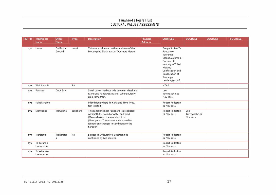
Ref_ID Title Description Category Score Response_Options Colour Time_Frame 1 Urupā, waro, koiwi Discrete and formal
burial places need to be protected in perpetuity.
Significant Constraint -5 Formal protection mechanisms to be addressed in hapu management plan.
Red long-term
2 Significant heritage areas Places and areas of significance need to be managed appropriately to protect their cultural values.
Issue -4 Refer to Matakana and Rangiwaea Islands Cultural Values Assessment, Significant Cultural Resources - Nga Rawa Whakahira, Map.
Yellow long-term
3 Access to the beach Access needs to be maintained along the Ocean Beach.
Issue -3 Identifying formal and informal access points.
Yellow long-term

2 BM T11117_001.6_AC_20111130
Ref_ID Title Description Category Score Response_Options Colour Time_Frame 4 Conflicts of use. There is potential for
the horticultural activities to be constrained by residential neighbours e.g. sprays, noise, shading. There is potential pressure on these blocks to be urbanized based on use and proximity to infrastructure i.e. residential land use on two sides of the property.
Issue -2 Identify at risk blocks to urbanisation/alienation. Proactively purchase or register covenants on these blocks to protect any encumbrances or places of special significance such as wāhi tapu. Also look at the conflicts of use and identify techniques that may reduce or mitigate conflict, such as buffer areas and changes in practice e.g. organic sprays
Yellow long-term
5 Economic Sustainability of Kiwifruit and Avocados.
There is anecdotal evidence suggesting kiwifruit exports will experience considerable competition from larger exporters such as China and Chile. The advent of PSA(v) has had a significant impact on kiwifruit.
Issue -3 Continue to investigate and make opportunities for diversification and niche marketing.
Yellow short-term

Tauwhao-Te Ngare Trust CULTURAL VALUES ASSESSMENT
BM T11117_001.5_AC_20111128 3
Ref_ID Title Description Category Score Response_Options Colour Time_Frame 6 Land Valuation and Rates. The potential increase
in the value of land at Matakana Island is a key driver for the setting of rates. The higher cost of rates puts pressure on Maori land owners to develop their lands to derive financial gain. If landowners do not develop their lands they are at financial risk of losing their lands.
Issue -3 Many submissions and reports have been prepared for Councils, Waitangi Tribunal, etc regarding this subject. A special designation may be required and/or legislation.
Yellow Long-term
7 Contamination of seafood resources and foreshore habitat.
The long-term contamination of kaimoana from the pipeline and unreticulated settlements are of particular concern to Maori.
Significant Constraint -5 In collaboration with other statutory bodies and community groups develop a clean-up strategy, capping, management programme and rahui. Investigate appropriate infrastructure systems / plans for the unreticulated settlements.
Red Long-term

4 BM T11117_001.6_AC_20111130
Ref_ID Title Description Category Score Response_Options Colour Time_Frame 9 Marae are community
centres. The two marae on Matakana Island and one on Rangiwaea have served the community for ceremonial activities and events for over 130 years. If the population increases there is potential to re-establish former marae or build new ones.
Opportunity 2 Provide for maintenance and growth of marae facilities to meet long term needs.
Green Long-term
10 View shafts from Marae. One marae has views of Mauao which provide physical and spiritual connection to the ancestral maunga and another has been obstructed by shelter belts.
Opportunity 3 Provide for protection of view shafts to Mauao in whole of Island plan and statutory planning documents and work with neighbours to remove constraints.
Green Long-term
11 Urupa are near capacity. The urupa on Matakana Island are near capacity requiring to be either closed or extended.
Issue -4 Assess the capacity of the existing urupa for the next 50 years. Identify and discuss with Hapu the location and size of future urupa on the respective Islands.
Yellow short-term/long-
term

Tauwhao-Te Ngare Trust CULTURAL VALUES ASSESSMENT
BM T11117_001.5_AC_20111128 5
Ref_ID Title Description Category Score Response_Options Colour Time_Frame 12 Fragmented Land Blocks. The fragmentation of
blocks limits the diversity of land use, consistent land management practises. Fragmentation also makes it more difficult for land to be returned to Maori.
Significant Constraint -5 Promote the use of overall concept and implementation plans for individual or clusters of smaller land blocks.
Red long-term
13 Future of the school. The primary school is the child learning centre for Matakana and Rangiwaea Islands. There is currently land for expansion however there is a very small roll which could put the school at risk of closure.
Issue -4 Provide opportunities for families to attend the school. Look at potential special character of the school.
Yellow long-term

6 BM T11117_001.6_AC_20111130
Ref_ID Title Description Category Score Response_Options Colour Time_Frame 14 Sports Clubs/Facilities. There are a small
number of clubs and sports facilities on both Islands but they are under resourced and may not be able to provide for the future expectations of the Matakana Island community. Whilst there is lots of open space there are very few sports fields or recreation spaces.
Issue -2 Develop a holistic sport, recreation and leisure strategy for both Islands.
Yellow long-term
15 Mahinga kaimoana. The customary practices and sustainable collection of shellfish for food is important to Matakana and Rangiwaea Island hapu. The depletion of this resource is of concern.
Issue 1 Conduct further kaimoana surveys in harvest areas for both Islands to investigate the possible causes of contamination and degradation of habitat. Develop strategy with actions to address the outcomes from the survey.
Yellow long-term

Tauwhao-Te Ngare Trust CULTURAL VALUES ASSESSMENT
BM T11117_001.5_AC_20111128 7
Ref_ID Title Description Category Score Response_Options Colour Time_Frame 16 Coastal erosion. There are areas of
foreshore that are eroding and some areas accreting as part of the tidal processes. Areas of particular importance to both Islands are those which are significant such as urupa and pa, dwellings and marae.
Issue -3 Develop a strategy for addressing where erosion and accretion are acceptable and not, including methods of preventing erosion form having significant impact on land.
Yellow short-term/long-
term
17 Accessibility - Roading, Pedestrian, Bicycle, Bus.
Future papakainga development over the next fifty years will require suitable roading, pedestrian access and bicycle paths.
Issue -2 Investigate options for roading and pedestrian access to and from papakainga.
Yellow long-term

8 BM T11117_001.6_AC_20111130
Ref_ID Title Description Category Score Response_Options Colour Time_Frame 18 Ecological
Areas/Whakaruruhau There are a number of ecological areas that provide a link to the past natural environment and abundance of Matakana and Rangiwaea Islands. Many of these places were and are used for harvesting food and resources. The coastal strip provides a barrier or shelter to inland areas, known to Maori as the Whakaruruhau.
Significant Constraint -5 Ecological areas and a coastal strip set aside for formal protection. There should be consideration of creating corridors to link ecological areas.
Red long-term
19 Maori and wildlife reserves There is an opportunity to create new reserves for the betterment and enjoyment of the community.
Opportunity 3 Identify lands suitable for Maori reserves, wildlife reserves and areas managed by tangata whenua. Consider vesting, management and administration.
Green short-term/long-
term
Tauwhao-Te Ngare Trust CULTURAL VALUES ASSESSMENT
BM T11117_001.5_AC_20111128 9
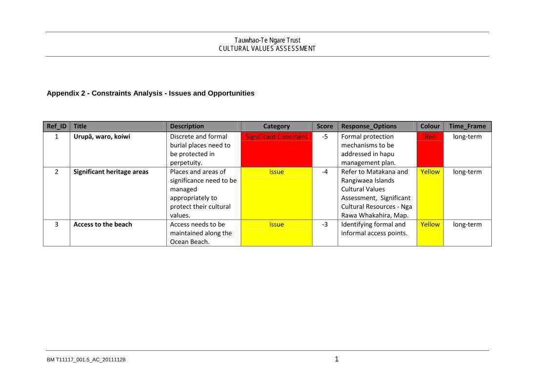
Ref_ID Title Description Category Score Response_Options Colour Time_Frame 20 Katikati Pipeline. A wastewater
interceptor traverses Tauranga harbour and Matakana Island. It's outfall discharges treated wastewater to the sea. The pipeline provides no benefits to Matakana Island residents and is a source of historical grievance.
Significant Constraint -5 Look at long-term decommissioning of the pipeline and use of more appropriate technology that does not discharge wastewater to water bodies.
Red long-term
21 Access to Karewa Island Traditional boat access to Karewa Island for the purposes of fishing and harvesting birds needs to be maintained and provided for.
Opportunity 4 to be addressed in hapu management plan
Green long-term
22 Water Supply The current water supply is predominantly by use of bores. There may be future need for water supply to service land production and community water bores on Matakana Island.
Issue -2 Collective bores and water infrastructure. Strengthen the relationship with BOPRC on water reticulation and management issues.
Yellow short-term/long-
term

10 BM T11117_001.6_AC_20111130
Ref_ID Title Description Category Score Response_Options Colour Time_Frame 23 Access to Affordable
Finance. The lending criteria and policies of many financial institutions are not sensitive to the nature of Maori land tenure. Many institutions will not provide loans an Multiply-owned Maori land
Significant Constraint -5 Keep abreast of recent policy and any programmes for lending on Multiply-owned Maori land. Investigate models for the Trusts and other entities.
Red short-term/long-
term
24 Damage to foreshore and seabed.
There are activities that are damaging the sensitive foreshore and seabed environment and therefore affecting shellfish.
Issue -2 Investigate the potential for use of bylaws that restrict or prohibit activities that damage shellfish and environment including horse riding, stock movement and major earthworks including dredging.
Yellow long-term
25 Future papakainga There are potential areas suitable for future papakainga development.There are no resident communities at these locations and there is limited infrastructure services (water, wastewater, stormwater, power) available at present.
Opportunity 3 Develop strategies and relationship to assist land Trusts with their papakainga.
Green long-term

Tauwhao-Te Ngare Trust CULTURAL VALUES ASSESSMENT
BM T11117_001.5_AC_20111128 11
Ref_ID Title Description Category Score Response_Options Colour Time_Frame 26 Opposition to urban
encroachment and residential development across the sand barrier
There is strong and active opposition from hapu to proposals for urban encroachment and residential development including infrastructure on the Matakana Is and barrier, Rangiwaea and surrounds.
Significant Constraint -5 Identify these areas and develop appropriate rules and rationale for these areas with Whole of Island Plan and subsequent WBOP District Plan.
Red long-term
27 Kohanga reo The Kohanga reo is a key method of maintaining the Maori language and tikanga specific to Matakana and Rangiwaea Islands.
Opportunity 5 The maintenance and enhancement of kohanga reo.
Green long-term
28 Wharekura There is an aspiration to have a wharekura that builds on the existing kohanga reo and kura.
Opportunity 4 Develop a wharekura establishment strategy.
Green long-term
29 Land leases A number of long-term leases are coming up for renewal. There are opportunities for land development including papakainga.
Opportunity 4 To be addressed in hapu management plan.
Green long-term

12 BM T11117_001.6_AC_20111130
Ref_ID Title Description Category Score Response_Options Colour Time_Frame 30 Low-tide access between
Matakana and Rangiwaea Island
There is a low tide 4 wheel drive access between Rangiwaea Island and Matakana Island.This informal access has been used for some time by Islanders. Vehicles will get stuck if they do not access at low tide. Access from near the school is very steep. Caution is required for this access.
Issue -2 Provide appropriate warning and signage for visitors and people unfamiliar with tides. Consider options for level of service in hapu management plan and whole of Island plan.
Yellow long-term
31 Boat and vehicle ferry access The ongoing cost of regular vehicle trips between both Islands and the mainland is significant. There is no regular barge / ferry service to Rangiwaea Is.
Issue -3 Consider a range of options for subsidies of ferries and maintenance of jetties.
Yellow long-term
32 Future development at the Mill Village
There is potential to extend the existing residential settlements on Matakana Is and identify appropriate commercial / industrial activity at the Mill Village. There is an opportunity to clean-up the contaminated
Opportunity 3 Feasibility study on the future land use activities for the Mill site.
Green long-term

Tauwhao-Te Ngare Trust CULTURAL VALUES ASSESSMENT
BM T11117_001.5_AC_20111128 13
Ref_ID Title Description Category Score Response_Options Colour Time_Frame site.
33 Tarsealed roads These metal roads are the source of considerable dust pollution, car wear and tear, and driver discomfort. There is an opportunity to tarseal these roads as part of the WBOPDC roading program.
Issue -4 Develop Matakana Is roading strategy with WBOPDC Roading Committee to address these roading issues.
Yellow short-term/long-
term
34 Residual oil from Rena and its impacts on bio-diversity.
There is residual oil along the ocean beach of Matakana Island. Clean-ups of the sand is on-going.
Issue -3 Maintain ongoing monitoring of the oil removal from the Matakana Is coastline and participation in the Tauranga Moana Oil Recovery Plan.
Yellow short-term/long-
term

14 BM T11117_001.6_AC_20111130
Ref_ID Title Description Category Score Response_Options Colour Time_Frame 35 Ecological restoration areas There is an
opportunity to restore and create ecological habitats, corridors and buffers along and adjacent to existing ecological areas.
Opportunity 5 Develop ecological restoration strategy and plans for these areas with the BOPRC environment enhancement fund or others funding sources.
Green long-term

Tauwhao-Te Ngare Trust CULTURAL VALUES ASSESSMENT
BM T11117_001.5_AC_20111128 1
Appendix 3 – Questionaire

2 BM T11117_001.6_AC_20111130
T11117 Matakana Island Cultural Values Assessment
Nga Patai - Questions
Introduction:
The primary purpose of the following questions is to understand the underlying values and views of the haukainga, rather than whether they oppose or support urban development and land-use change. This is important when evaluating the cultural impacts of various types of land-use activity and how each activity is perceived.
The questions will also look to see if there are generational differences in perception of the environment and land-use change. This particularly relates to existing forestry and farming activity.
The completed interview forms will not be shared with any other external party and are to be used for the purposes of the Matakana Island Planning project only. Answers are confidential. No names will be used in the report unless permission sought and obtained by interviewee.
Section 1 Hononga – Connections:
If you were talking to a group of people about what was important to Matakana Island people, what types of things would you mention? (Note: see if respondents identify lifestyle, specific places or wider areas or resources, social interaction, etc – looking for special characteristics)
•
How would you describe your relationship/connection with the area where you live? And the whole Island? (Note: See if respondents describe the relationship in cultural terms, short and long-term, Maori values, etc)
•
How do you maintain your connections with the land and waters of Matakana Island? (Note: looking for activities, values that are being maintained on the Island.)
•
What are some of the challenges to maintaining those connections –(note: looking for barriers that may be able to be overcome as part of whole of Island planning – both physical and spiritual )
•
How long have you lived on the Island and are you a permanent resident? Do you travel backwards and forwards from the mainland and for what reasons; (Checking transience, connections to mainland and for what reasons)
•

Tauwhao-Te Ngare Trust CULTURAL VALUES ASSESSMENT
BM T11117_001.5_AC_20111128 3
Section 2 – Quality of the environment:
For these different resources what do you think the state of the environment is now?
Waters (rivers, wetlands, harbour, sea) – (a) heavy degraded (Mauri Mate) (e) degraded (paru) (i) okay, ahau pai (o) pristine (Maori) (u) other
•
Traditional places and waahi tapu – (a) destroyed (e) partially modified (i) in good condition (o) Not sure (u) other
Forests and bush – (a) all gone – kua hinga (e) Some bush left (i) remnants only (o) not sure
Kaimoana – (a) all gone (e) hard to find (i) very rare (o) Some (u) plenty
•
What do you think are the main causes of environmental degradation (things getting worse)?
•
Section 3 – Response to urbanisation and land-use change:
What is your response to different kinds of development on Matakana Island (most importantly, why)
Strongly Opposed Opposed Neutral Support Strongly
Support Reasons
Farming
Forestry
Housing
Horticulture
Commercial

4 BM T11117_001.6_AC_20111130
Industrial
Reserves/Parks
Aquaculture (Oysters/mussels)
Water supply
Wastewater reticulation
Shops
Schools
Airstrips
Airports
Tourism operations
Sports grounds and clubs.
Marinas
Wharves
Jetties
Marae
Roading
Footpaths
Cycleways
Hotel/Motel accommodation.
Have things changed much while you have been resident on the Island?
Yes/No, if yes, in what way and has this been positive and/or negative.

Tauwhao-Te Ngare Trust CULTURAL VALUES ASSESSMENT
BM T11117_001.5_AC_20111128 5
What are kinds of changes would you support on the Island – economic, social, cultural, environment? Do you have a view on how long change should take to happen?
•
What do you think about pine forestry on the Island? – how would you feel if it was all gone and was not replanted? (Note: this tests perceptions of forestry as a working environment providing economic benefit and how this balances with other values. It also fleshes out if forestry provides other functions or meets other values not obvious or not expressed explicitly)
•
How important do you think it is to pass on your Matauranga to the next generation? And if so – why is it important for future generations?
•
Do you think new residents living here on Matakana will embrace the special character of Matakana Island, it’s people, the environment, ways of doing things? In what ways could new residents be part of Matakana Island Community?
•
Please return survey to:
Antoine Coffin
PO Box 13373
Tauranga

6 BM T11117_001.6_AC_20111130
Appendix 4 - Response to Urban Development
Prepared by Donna Poka, November 2011
For the record, the Land Use & Ownership History (the history) provided by John Page on behalf of TKC Holdings, does not accurately represent the events that occurred on Matakana Island during the last two decades. Instead the history consistently misrepresents and discredits tangata whenua and our efforts to maintain our rangatiratanga.
This CIA is not the appropriate vehicle to “correct the record”. To clarify the tangata whenua position, I have provided a brief overview of the last two decades to provide the context for today’s response to urban development.
Timeline:
1991 April: The Matakana Island Trust (MIT) applies for incorporation as a board under the Charitable Trusts Act 1957. Initial focus in the trust deed was to address unemployment, and establish sustainable Island-based ventures to offer training and business options to the young. Eventually, the focus of the community turned to the possibility of buying the forest assets outright. Funds had already been raised for earlier ventures in 1990-91; by 1992 the target was the purchase of the forest asset.
1991 May: Graeme Ingham presented a proposal to the Matakana Rangiwaea community to establish a company Matakana Island Corporation Ltd. 51% of the shareholding would be vested in MIT for the tangata whenua community. The main objective was to form a basis so foreign investors could meet with the community to negotiate agreements etc. Part of the proposal was a tri-partite Island tourism venture including Tuhua (Mayor Island), Motiti and Matakana. The original shareholding of this company was proposed, to reflect this arrangement:
*Matakana Island Trust – on behalf of community 51%, * Abe Aukaha – Motiti Island 10%, *Peri Murray – Mayor Island 10%, *Don Shaw & Graeme Ingham 29%.
The company was renamed Te Kotukutuku Corporation Ltd (‘TKC’) and the proposal and shareholding as presented was accepted by tangata whenua, although there were several issues that still needed to be sorted out.
1992: TKC became the vehicle to negotiate the forest asset purchase with the support of tangata whenua. The community now had a stake in the purchase of the forest asset because of the proposed 51% shareholding held by MIT in TKC.
The allocation of the remaining 49% of the TKC shares did not proceed as had been presented above. There was no reference to the shares being in trust for the other Islands Motiti and Tuhua as first proposed.
The shareholding in TKC then became recorded as: * Matakana Island Trust – on behalf of community 51%, * Abe Aukaha 8.3%, *Peri Murray 8.3%, *Mark Ngatai 8.3%, * Don Shaw 12%, * Graeme Ingham 12%. Mark Ngatai was included in the 49% shareholding by the individual

Tauwhao-Te Ngare Trust CULTURAL VALUES ASSESSMENT
BM T11117_001.5_AC_20111128 7
shareholders, as he had become part of the negotiating team trying to purchase the forest asset for TKC.
1993: TKC successfully purchase the forest asset against all odds. Tangata whenua are asked to financially assist TKC’s legal costs, in proportion to the MIT 51% shareholding.
The 49/51% MIT shareholding in TKC proposed in 1991, was never formalised. Instead the forest asset was owned by TKC & MIT in partnership.
To finance the TKC/MIT purchase of the forest asset, half of the land & forestry rights were onsold to Blakely Pacific Limited. Over the next 7 years TKC is in a legal battle to confirm ownership of the forest asset on Matakana, which culminates in a Privy Council case in Oct 1999.
1999 December: Privy Council decision, (in simple terms) confirms TKC/MIT partnership, is the rightful owner of the Matakana Island forestry asset and land.
TKC introduced the Waterways Development proposal (‘Waterways’) to MIT, a joint venture between the TKC/MIT partnership and Pritchard Development, an Otaki based developer. Proposed was a marina based residential subdivision of 166 sections, ‘Pauanui Style’, on 75ha of coastal land at Duck Bay.
2000 May: The Waterways proposal was presented to Matakana and Rangiwaea tangata whenua, but received significant opposition which continued for a number of years.
The TKC/MIT partnership eventually became the new company TKC Holdings (TKCH). TKCH's shareholding was established to reflect the original intended TKC shareholding; 51% MIT & 49% TKC.
MIT’s 51% majority shareholding in TKCH required the support of tangata whenua for the Waterways.
2002 June: MIT board split over the devolution of it’s 51% shareholding in TKCH to individuals, who had lent money for the legal battle in 1993. The next few years saw the transfer of shares to individuals from MIT’s 51% in TKCH. The MIT shareholding in TKCH diminishes to 27%.
The majority of the individuals then onsold their shares in TKCH to TKC. TKC was onsold to Matakana Investment Group (‘MIG’), a new company owned solely by a group of Pakeha businessmen, connected to the Waterways development. MIG eventually owns 69% of TKCH.
2006: Although 75ha was partitioned, due to the consistent opposition of tangata whenua, the Waterways proposal ceased to be discussed. In it’s place a “hapu partition” of the TKCH lands was proposed, whereby 30% of the land would be developed by TKC, in exchange for 70% of the land transferred to MIT for the hapu, i.e., tangata whenua of Matakana and Rangiwaea.
2007 – 2008: New proposals from TKCH and Blakely Pacific Limited (‘BPL’) were floated with tangata whenua. Western Bay District Plan allows rural subdivision of minimum of 40ha. TKCH proposed 56 x 40ha lots, including a turnaround barge ramp at Duck Bay. BPL proposed 48 x 40ha lots over their lands.
2008: BPL apply for resource consent to subdivide 48 x 40ha forest lots.

8 BM T11117_001.6_AC_20111130
2009: Tangata whenua enmasse, oppose the resource consent. The resource consent is granted by a Commissioner’s hearing, and is appealed by D. Poka on behalf of Nga Hapu O Matakana me Rangiwaea, and Te Runanga O Ngai Te Rangi Iwi Trust.
2010: TKCH approach MIT to canvass a proposal, whereby all 3 forest owners TKCH, BPL and Scorpions would return 70% of total forest lands of Matakana to the hapu, via the MIT shareholdings – approx 2700ha. In exchange, the remaining 30% of forest lands would be developed by the 3 forest owners into a residential subdivision, which tangata whenua, had to support. This land use would require a total plan change.
2011 May: The 70/30 ‘hapu partition’ was presented to the Matakana Island community. Again tangata whenua were strongly opposed. The discussion has stalled.
2011 July: The BPL appeal to the Environment court is held. The hapu case is combined with the Runanga o Ngai Te Rangi Iwi Trust case.
2011 November: Appeal is successful for the Iwi and hapu.