NEW ICHNOLOGICAL, PALEOBOTANICAL, AND DETRITAL ZIRCON DATA FROM AN UNNAMED ROCK UNIT IN...
12
BioOne sees sustainable scholarly publishing as an inherently collaborative enterprise connecting authors, nonprofit publishers, academic institutions, research libraries, and research funders in the common goal of maximizing access to critical research. NEW ICHNOLOGICAL, PALEOBOTANICAL, AND DETRITAL ZIRCON DATA FROM AN UNNAMED ROCK UNIT IN YUKON–CHARLEY RIVERS NATIONAL PRESERVE (CRETACEOUS: ALASKA): STRATIGRAPHIC IMPLICATIONS FOR THE REGION Author(s): ANTHONY R. FIORILLO, FEDERICO FANTI, CHAD HULTS, and STEPHEN T. HASIOTIS Source: PALAIOS, 29(1):16-26. 2014. Published By: Society for Sedimentary Geology URL: http://www.bioone.org/doi/full/10.2110/palo.2013.054 BioOne (www.bioone.org ) is a nonprofit, online aggregation of core research in the biological, ecological, and environmental sciences. BioOne provides a sustainable online platform for over 170 journals and books published by nonprofit societies, associations, museums, institutions, and presses. Your use of this PDF, the BioOne Web site, and all posted and associated content indicates your acceptance of BioOne’s Terms of Use, available at www.bioone.org/page/terms_of_use . Usage of BioOne content is strictly limited to personal, educational, and non-commercial use. Commercial inquiries or rights and permissions requests should be directed to the individual publisher as copyright holder.
Transcript of NEW ICHNOLOGICAL, PALEOBOTANICAL, AND DETRITAL ZIRCON DATA FROM AN UNNAMED ROCK UNIT IN...
BioOne sees sustainable scholarly publishing as an inherently collaborative enterprise connecting authors, nonprofit publishers, academic institutions, researchlibraries, and research funders in the common goal of maximizing access to critical research.
NEW ICHNOLOGICAL, PALEOBOTANICAL, AND DETRITAL ZIRCONDATA FROM AN UNNAMED ROCK UNIT IN YUKON–CHARLEY RIVERSNATIONAL PRESERVE (CRETACEOUS: ALASKA): STRATIGRAPHICIMPLICATIONS FOR THE REGIONAuthor(s): ANTHONY R. FIORILLO, FEDERICO FANTI, CHAD HULTS, and STEPHEN T.HASIOTISSource: PALAIOS, 29(1):16-26. 2014.Published By: Society for Sedimentary GeologyURL: http://www.bioone.org/doi/full/10.2110/palo.2013.054
BioOne (www.bioone.org) is a nonprofit, online aggregation of core research in the biological, ecological, andenvironmental sciences. BioOne provides a sustainable online platform for over 170 journals and books publishedby nonprofit societies, associations, museums, institutions, and presses.
Your use of this PDF, the BioOne Web site, and all posted and associated content indicates your acceptance ofBioOne’s Terms of Use, available at www.bioone.org/page/terms_of_use.
Usage of BioOne content is strictly limited to personal, educational, and non-commercial use. Commercial inquiriesor rights and permissions requests should be directed to the individual publisher as copyright holder.
PALAIOS, 2014, v. 29, p. 16–26
Research Article
DOI: http://dx.doi.org/10.2110/palo.2013.054
NEW ICHNOLOGICAL, PALEOBOTANICAL, AND DETRITAL ZIRCON DATA FROM AN UNNAMED ROCKUNIT IN YUKON–CHARLEY RIVERS NATIONAL PRESERVE (CRETACEOUS: ALASKA): STRATIGRAPHIC
IMPLICATIONS FOR THE REGION
ANTHONY R. FIORILLO,1 FEDERICO FANTI,2 CHAD HULTS,3 AND STEPHEN T. HASIOTIS4
1Perot Museum of Nature and Science, 2201 North Field Street, Dallas, Texas 75201, U.S.A.2Dipartimento di Scienze Biologiche, Geologiche e Ambientali, Alma Mater Studiorum, Universita di Bologna, via Zamboni 67, 40126 Bologna, Italy
3U.S. Geological Survey, Alaska Science Center, 4210 University Drive, Anchorage, Alaska 99508, U.S.A.4University of Kansas, Department of Geology, 1475 Jayhawk Boulevard, 120 Lindley Hall, Lawrence, Kansas 66045, U.S.A.
e-mail: [email protected]
ABSTRACT: A paleontological reconnaissance survey on Cretaceous and Paleogene terrestrial units along the Yukon Riverdrainage through much of east-central Alaska has provided new chronostratigraphic constraints, paleoclimatological data, andthe first information on local biodiversity within an ancient, high-latitude ecosystem. The studied unnamed rock unit is mostnotable for its historic economic gold placer deposits, but our survey documents its relevance as a source rock for Mesozoicterrestrial vertebrates, invertebrates, and associated flora. Specifically, new U-Pb ages from detrital zircons combined withichnological data are indicative of a Late Cretaceous age for at least the lower section of the studied rock unit, previouslyconsidered to be representative of nearly exclusively Paleogene deposition. Further, the results of our survey show that thissedimentary rock unit preserves the first record of dinosaurs in the vast east-central Alaska region. Lastly, paleobotanical data,when compared to correlative rock units, support previous interpretations that the Late Cretaceous continental ecosystem ofAlaska was heterogeneous in nature and seasonal.
INTRODUCTION
Over the last thirty years, reports of northern high-latitude dinosaurshave greatly increased (e.g., Roehler and Stricker 1984; Parrish et al.1987; Brouwers et al. 1987; Davies 1987; Fiorillo and Gangloff 2000,2001; Gangloff et al. 2005; Fiorillo et al. 2009a, 2010a, 2010b, 2011;Gangloff and Fiorillo 2010; Brown and Druckenmiller 2011; Chinsamy etal. 2012; Fiorillo and Tykoski 2012, 2013). The growing interest in thesenew discoveries has changed the scientific community’s perception ofpolar dinosaurs. First viewed as a geographic oddity, the record is nowappreciated as a valuable tool in understanding biological adaptation inpast extreme environments, ancient arctic biodiversity, and paleoclimate(Fiorillo and Gangloff 2000; Fiorillo and Parrish 2004; Gangloff et al.2005; Fiorillo et al. 2009a, 2009b, 2010a, 2011, 2012; Chinsamy et al.2012; Fiorillo and Tykoski 2012).
The purpose of this report is to add to this growing record bydescribing a dinosaurian pes impression, invertebrate trace fossils, andpaleobotanical and detrital zircon data from an unnamed Cretaceous–Paleogene largely fluviatile rock unit contained within the Yukon–Charley Rivers National Preserve of east-central Alaska. This unit is ofsome geologic and historic significance, as it was well known for itseconomic importance in producing significant quantities of placer gold(Mertie 1930, 1937, 1942; Beckstead 2003). This dinosaur track discoverywas made along a major tributary (Washington Creek) of the middlestretch of the Yukon River and the outcrop occurs within the TintinaFault zone, a large strike-slip fault system that extends from northernBritish Columbia into central Alaska. This is a new record of dinosaurs ina region previously not recognized for Cretaceous fossil vertebrate
remains. Further, since the original mapping of the area, the age of theseunnamed rocks has been uncertain, with discussion focused on whetherthe rocks are Cretaceous, Paleogene, or span the Late Cretaceous andearly Paleogene (Hollick 1936; Mertie 1942; Brabb and Churkin 1969;Dover and Miyaoka 1988; Johnsson 2000). This dinosaur track discoveryand these detrital zircon data corroborate that at least part of the sectionis rooted in the Cretaceous. Tectonic reconstructions show that by the endof the Cretaceous the basin containing these deposits was at, or near, itscurrent high latitude of 65u north (Lawver et al. 2002), thus adding to therichness of the high-latitude dinosaur record for northwestern Alaska.
Institutional abbreviations: DMNH, Perot Museum of Nature andScience, Dallas, Texas, U.S.A. YUCH, Yukon–Charley Rivers NationalPreserve, Alaska. Specimen referred to here is housed at the PerotMuseum of Nature and Science, Dallas, Texas.
GEOLOGICAL BACKGROUND
The study area is within an unnamed fluvial sedimentary unit locatedwithin the Tintina fault zone and overlying rocks of the Charley Riverfold-and-thrust belt (Fig. 1; Brabb and Churkin 1969; Dover 1994). TheCharley River fold-and-thrust belt encompasses approximately 11,000 mof sedimentary rocks ranging in age from the middle Proterozoic to theEarly Cretaceous (Dover 1994). The timing for much of the deformationof these rocks is likely post-Albian and before deposition of the unit TKs(Dover 1994) that forms the basis for this report.
The unit lies within the Tintina fault zone between the CharleyRiver fold-and-thrust belt on the north and polydeformed Paleozoicmetasedimentary and meta-igneous rocks of the Yukon–Tanana terrane
Published Online: May 2014
Copyright E 2014, SEPM (Society for Sedimentary Geology) 0883-1351/14/029-016/$03.00
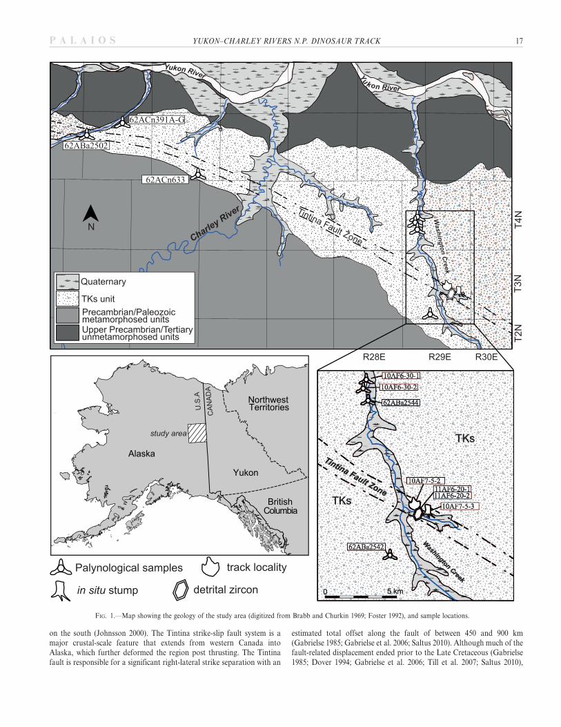
on the south (Johnsson 2000). The Tintina strike-slip fault system is amajor crustal-scale feature that extends from western Canada intoAlaska, which further deformed the region post thrusting. The Tintinafault is responsible for a significant right-lateral strike separation with an
estimated total offset along the fault of between 450 and 900 km(Gabrielse 1985; Gabrielse et al. 2006; Saltus 2010). Although much of thefault-related displacement ended prior to the Late Cretaceous (Gabrielse1985; Dover 1994; Gabrielse et al. 2006; Till et al. 2007; Saltus 2010),
FIG. 1.—Map showing the geology of the study area (digitized from Brabb and Churkin 1969; Foster 1992), and sample locations.
YUKON–CHARLEY RIVERS N.P. DINOSAUR TRACK 17P A L A I O S
relatively minor movement on the fault may have continued into thePaleogene (Dover 1994; Till et al. 2007).
In the study area, the Tintina fault zone separates two very differentgeological provinces. South of the fault lies a heterogeneous succession ofPrecambrian to Paleozoic metamorphosed rocks that were intruded bylarge Mesozoic and Cenozoic plutons (Foster 1976). To the north,deposits consist primarily of unmetamorphosed sedimentary rocksvarying in age from upper Precambrian to upper Paleogene (Brabb1967; Brabb and Churkin 1969; Churkin et al. 1982). To the south of theTintina fault zone lies the Yukon–Tanana terrane. The Yukon–Tananaterrane consists of polydeformed and metamorphosed quartz-mica schist,quartzite, gneiss, and metaplutonic and metavolcanic rocks (Silberling etal. 1992). Dusel-Bacon et al. (2006) broke down the Yukon–Tananaterrane into two primary parts: Neoproterozoic to early Paleozoicmetasedimentary rocks, thought to have been part of the passive NorthAmerican continental margin, and widespread Devonian to Mississippianmeta-igneous rocks thought to have formed during rifting of thecontinental margin. Three Mesozoic granitic pluton pulses intrude theYukon–Tanana terrane: Jurassic to Triassic plutons (186–215 Ma; Foster1976; Foster et al. 1994; Dusel-Bacon et al. 2002) crop out in this easternAlaska portion of the Yukon–Tanana terrane; mid-Cretaceous plutons(85–115 Ma), which were cogenetic with regional metamorphism andlocated south of the field area (Aleinikoff 1984; Nokleberg et al. 1992;Foster et al. 1994; Newberry et al. 1998; Mortensen 1999); and latestCretaceous to earliest Paleogene (50–70 Ma) plutons that crop out to thewest of the field area (Foster et al. 1994).
Local sedimentary units are distributed along the major axis of theTintina fault zone in a broad band. One of these nonmarine successions,unit TKs of Brabb and Churkin (1969) and TKd of Foster (1976), cropsout extensively in the study area where it is cut by the Charley andWashington drainage systems (Fig. 1; Brabb and Churkin 1969; Dover1994). The unit is unnamed, but the label of TKs has been used by mostsubsequent workers (Dover and Miyaoka 1988; Miyaoka 1990; Foster1992; Van Kooten et al. 1997; Johnsson 2000), so in this study we refer tothe studied deposits as TKs. The TKs unit is made up of dominantlyfluviatile rocks that are generally poorly indurated and consist ofconglomerate, sandstone, siltstone, and coal, and contain significant LateCretaceous and Paleogene flora (Brabb and Churkin 1969). Johnsson(2000) suggested the unit formed primarily as braided rivers with pebbleimbrications suggesting a westerly paleocurrent direction. Point countsconducted on sandstone samples by Johnsson (2000) plot in the recycledorogen fields of Dickinson (1985), which led him to suggest that the unitwas derived primarily from rocks of the fold-and-thrust belt. Grain typesobserved in thin section included monocrystalline quartz, foliatedpolycrystalline quartz, and sedimentary and metasedimentary fragments(Johnsson 2000). The presence of foliated polycrystalline quartz grainsand metasedimentary fragments led Johnsson (2000) to suggest that theYukon–Tanana terrane was also a source of sediment. Foster (1976)suggested that clasts in a basal conglomerate were derived from localsources that included quartzite, chert, and serpentized ultramafic rock.Clough et al. (1995) observed subrounded to well-rounded pebble-sizedclasts of quartzite and graywacke that they suggested were derived fromthe units underlying and outcropping northeast of the unit.
The TKs unit, which may be up to 2500 m thick, unconformablyoverlies Albian and older sedimentary rocks of the fold-and-thrust belt tothe north of the Tintina fault (Howell et al. 1992; Van Kooten et al. 1997)and possibly the rocks of the Yukon–Tanana terrane to the south of theTintina fault (Foster 1976). Howell et al. (1992) suggested the unit formedin a foreland basin derived from the eastward-advancing thrust sheetsduring thrusting of the underlying rocks. They observed drag folds in theunit that they interpreted as having been formed after deposition of theunit and during motion of the Tintina fault. However, other workerssuggest that the unit was deposited in a basin resulting from extension
starting in the latest Cretaceous (Van Kooten et al. 1997; Johnsson 2000).Foster (1976) noted that in places the unit appears to cover the trace ofthe Tintina Fault, but elsewhere, the unit is found brecciated along thefault trace. Van Kooten et al. (1997) observed normal faults affecting theunit that appear to be related to the Tintina Fault, so they suggested thatthe unit formed in an extensional basin produced by movement along theTintina Fault. Johnsson (2000) also interpreted its structures as indicatingthat the unit was deposited in a pull-apart basin in response to movementalong the Tintina fault. These structural and stratigraphic relationshipssuggest the unit is Late Cretaceous or younger.
Due perhaps to the sporadic nature of the outcrop pattern and thedifficulty in access, the geologic age of the sediments in this basin has notbeen well constrained. Early reports of megafloral remains (Prindle 1913)suggested an age assignment of Eocene. Martin (1926) in his comparativestudy of Mesozoic rocks throughout Alaska assigned the rocks in thisregion to the Late Cretaceous. Later Hollick (1930, 1936) sampled rocksin this region of the Yukon River and favored a Paleogene age, to accountfor a mixed set of ages from various samples. Hollick (1930, 1936)suggested that sedimentation was continuous in the region from the LateCretaceous into the Eocene. Unable to better resolve the issue, Mertie(1942) accepted the nature of the mixed age data and published his florallists as matter of record.
Subsequent work has carried through the concept that this unnamedrock unit spans the latest Cretaceous and early Paleogene. Van Kooten(in Johnsson 2000) reported that the earliest unequivocal ages within theTKs unit are Maastrichtian, while Foster and Igarashi (1989) report fossilpollen yielding an age of Paleogene and possibly as young as Eocene.Brabb and Churkin (1969) provided an age of Late Cretaceous toPaleogene, possibly as young as Pliocene, an age assignment repeated byFoster (1976). Using both megafloral data and fossil pollen data, Doverand Miyaoka (1988) revised the age as Eocene, Paleocene, and LateCretaceous.
MATERIALS AND METHODS
Data presented in this study were collected during the 2010 and 2011field seasons. The exact localities of individual sites are on file with theresource management office of YUCH, the Alaska Region National ParkService, and at the DMNH. The general location within YUCH is withinthe Washington Creek drainage, a significant tributary of the middlestretch of the Yukon River located approximately 60 km west of theU.S.–Canada boundary.
Detrital Zircon Analysis
Two sandstone samples were collected for detrital zircon analysis inorder to help define the maximum depositional age of the unit at thelocation where the tracks were found (Figs. 1, 2). A hand sample of sandymatrix (11AF6-20-1) was collected at the same locality with the dinosaurpes track (10AF7-5-2), and a second hand sample (11AF6-20-2) wascollected approximately 150 m from the pes track at the site analyzed forfossil pollen (10AF7-5-3). Samples were crushed, separated, and analyzedfor U/Pb detrital zircon ages by Apatite to Zircon, Inc. The samples werecrushed, and zircons were separated and mounted using the methodsdescribed in Donelick et al. (2005). U-Pb ages were obtained with aFinnigan Element II Magnetic Sector ICP-MS using a New WayNeodymium YAG laser ablation system, following the methods of Shenet al. (2012). Of the 110 detrital zircons analyzed for sample 2, 105 hadstable scans. Many of the scans of the zircons for sample 1 had serious Pbvariations during scans, suggesting zonation in the grains; only 56 of the110 detrital zircons analyzed produced stable scans (P.B. O’Sullivan,personal communication 2013). Measured isotopic ratios and their errors,corrected for common lead, were used to calculate ages and plotted using
18 A.R. FIORILLO ET AL. P A L A I O S
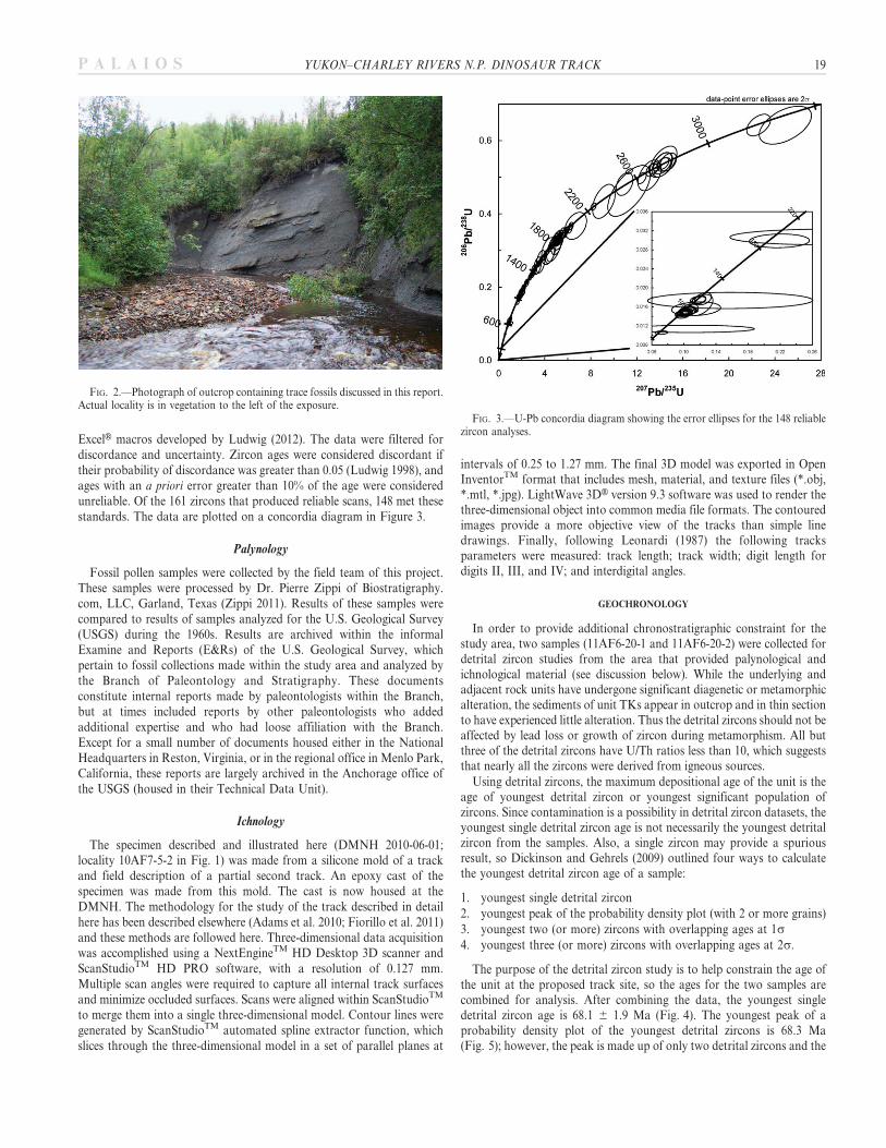
ExcelH macros developed by Ludwig (2012). The data were filtered fordiscordance and uncertainty. Zircon ages were considered discordant iftheir probability of discordance was greater than 0.05 (Ludwig 1998), andages with an a priori error greater than 10% of the age were consideredunreliable. Of the 161 zircons that produced reliable scans, 148 met thesestandards. The data are plotted on a concordia diagram in Figure 3.
Palynology
Fossil pollen samples were collected by the field team of this project.These samples were processed by Dr. Pierre Zippi of Biostratigraphy.com, LLC, Garland, Texas (Zippi 2011). Results of these samples werecompared to results of samples analyzed for the U.S. Geological Survey(USGS) during the 1960s. Results are archived within the informalExamine and Reports (E&Rs) of the U.S. Geological Survey, whichpertain to fossil collections made within the study area and analyzed bythe Branch of Paleontology and Stratigraphy. These documentsconstitute internal reports made by paleontologists within the Branch,but at times included reports by other paleontologists who addedadditional expertise and who had loose affiliation with the Branch.Except for a small number of documents housed either in the NationalHeadquarters in Reston, Virginia, or in the regional office in Menlo Park,California, these reports are largely archived in the Anchorage office ofthe USGS (housed in their Technical Data Unit).
Ichnology
The specimen described and illustrated here (DMNH 2010-06-01;locality 10AF7-5-2 in Fig. 1) was made from a silicone mold of a trackand field description of a partial second track. An epoxy cast of thespecimen was made from this mold. The cast is now housed at theDMNH. The methodology for the study of the track described in detailhere has been described elsewhere (Adams et al. 2010; Fiorillo et al. 2011)and these methods are followed here. Three-dimensional data acquisitionwas accomplished using a NextEngineTM HD Desktop 3D scanner andScanStudioTM HD PRO software, with a resolution of 0.127 mm.Multiple scan angles were required to capture all internal track surfacesand minimize occluded surfaces. Scans were aligned within ScanStudioTM
to merge them into a single three-dimensional model. Contour lines weregenerated by ScanStudioTM automated spline extractor function, whichslices through the three-dimensional model in a set of parallel planes at
intervals of 0.25 to 1.27 mm. The final 3D model was exported in OpenInventorTM format that includes mesh, material, and texture files (*.obj,*.mtl, *.jpg). LightWave 3DH version 9.3 software was used to render thethree-dimensional object into common media file formats. The contouredimages provide a more objective view of the tracks than simple linedrawings. Finally, following Leonardi (1987) the following tracksparameters were measured: track length; track width; digit length fordigits II, III, and IV; and interdigital angles.
GEOCHRONOLOGY
In order to provide additional chronostratigraphic constraint for thestudy area, two samples (11AF6-20-1 and 11AF6-20-2) were collected fordetrital zircon studies from the area that provided palynological andichnological material (see discussion below). While the underlying andadjacent rock units have undergone significant diagenetic or metamorphicalteration, the sediments of unit TKs appear in outcrop and in thin sectionto have experienced little alteration. Thus the detrital zircons should not beaffected by lead loss or growth of zircon during metamorphism. All butthree of the detrital zircons have U/Th ratios less than 10, which suggeststhat nearly all the zircons were derived from igneous sources.
Using detrital zircons, the maximum depositional age of the unit is theage of youngest detrital zircon or youngest significant population ofzircons. Since contamination is a possibility in detrital zircon datasets, theyoungest single detrital zircon age is not necessarily the youngest detritalzircon from the samples. Also, a single zircon may provide a spuriousresult, so Dickinson and Gehrels (2009) outlined four ways to calculatethe youngest detrital zircon age of a sample:
1. youngest single detrital zircon
2. youngest peak of the probability density plot (with 2 or more grains)
3. youngest two (or more) zircons with overlapping ages at 1s4. youngest three (or more) zircons with overlapping ages at 2s.
The purpose of the detrital zircon study is to help constrain the age ofthe unit at the proposed track site, so the ages for the two samples arecombined for analysis. After combining the data, the youngest singledetrital zircon age is 68.1 6 1.9 Ma (Fig. 4). The youngest peak of aprobability density plot of the youngest detrital zircons is 68.3 Ma(Fig. 5); however, the peak is made up of only two detrital zircons and the
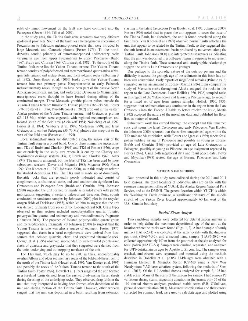
FIG. 2.—Photograph of outcrop containing trace fossils discussed in this report.Actual locality is in vegetation to the left of the exposure.
FIG. 3.—U-Pb concordia diagram showing the error ellipses for the 148 reliablezircon analyses.
YUKON–CHARLEY RIVERS N.P. DINOSAUR TRACK 19P A L A I O S

ages of two zircons making up the youngest peak do not overlap at 1s(Fig. 4). The youngest two or more zircons that overlap at 1s are ages 3–7 (Fig. 4), which have a weighted mean age of 94.0 6 1.3 Ma. Zircon ages3–15 are the youngest zircons that overlap within 2s (Fig. 4), and have aweighted mean age of 95.9 6 1.3 Ma.
Using the four methods of Dickinson and Gehrels (2009) forcalculating the youngest detrital zircon age, the maximum depositionalage of the unit at the location sampled is at most 95.9 6 1.3 Ma, but maybe as young as 68.1 6 1.9 Ma. However, the first two methods forcalculating the youngest detrital zircon age should be considered suspect,because the ages for these two methods are determined from a singlezircon age and two zircon ages that do not overlap within 1s error.Methods 3 and 4 are the most conservative in that they requirereproducibility of detrital zircon ages. These two methods indicate amaximum depositional age of 94.0 6 1.3 Ma to 95.9 6 1.3 Ma, which isour preferred maximum depositional age for the unit. A 93–97 Maminimum detrital zircon age is a robust estimate, because there are 13detrital zircons that fall in this age range. In addition, detrital mica fromthe TKs unit south of the Tintina fault zone also produced similar Ar/Arages 81–92 Ma (Newberry et al. 1998). These data suggest that themaximum depositional age of the unit at the sample location isCampanian.
PALEOBOTANICAL DATA
Palynology
Given the sporadic nature of the outcrops of TKs and the distancebetween exposures, the precise stratigraphic relationships betweenindividual rock exposures and the respective samples from separateoutcrops collected are unclear. In addition to the disparate nature of theoutcrop pattern, dip of bedding varied from outcrop to outcrop, and thelack of marker beds further exacerbated efforts at stratigraphicrefinement. The palynology samples yielded abundant well- to moder-ately preserved palynomorphs. All samples contained recognizableterrestrially derived palynomorphs and kerogen. Two of the samples(10AF6-30-1 and 10AF6-30-2) were collected along Washington Creekoutside of the Tintina Fault zone of Brabb and Churkin (1969), while athird sample (10AF7-5-3) was collected within the fault zone and near thedinosaur tracks described here (Fig. 1).
Sample Number 10AF7-5-3.—The sample within the fault zoneproduced indeterminate data for age resolution (Table 1). This samplehorizon was noted to have macrofossils of gymnosperm wood. The
kerogen component consists of abundant wood and charcoal, with veryrare cuticle, pollen, and fungi. The rare pollen and spores are poorlypreserved. This is likely due to the depositional environment, which mayhave favored the concentration and preservation of thick, durable organicparticles over smaller, thinner pollen and cuticle. The relatively lightpollen color indicates that these sediments were never deeply buried. Thepalynomorphs are inconclusive regarding geologic age resolution.
Sample Number 10AF 6-30-1.—In addition to diagnostic palynomorphs,this sample contained megafloral remains of horsetails, Metasequoia,gymnosperm wood, and rare angiosperm leaves. The kerogen consistsof abundant cuticle, pollen, wood, spores, and fungal spores. Pollen andspores are abundant and well- to moderately preserved. The floralcomposition suggests that the depositional environment was likely aTaxodium-dominated swamp or swampy margin of a low-gradient fluvialsystem (Zippi 2011). The palynomorphs (Table 2) indicate an age of LatePaleocene to middle Eocene.
Sample number 10AF 6-30-2.—This sample horizon was noted to havemacrofossils of Metasequoia, gymnosperm wood, and angiosperm leaves.The kerogen consists of pollen, wood, algae (ceratioid dinoflagellates),cuticle, spores, and fungal spores. Pollen and spores are abundant andwell- to moderately preserved. The palynomorph assemblage suggests thedepositional environment was a Taxodium-dominated swamp in a low-gradient fluvial system. The abundance of freshwater dinoflagellates andother algae indicates perennial or long-term seasonal standing water
FIG. 4.—Youngest U/Pb detrital zircon ages and their errors plotted at 2sand 1s.
FIG. 5.—Probability–density plot of detrital zircons less than 200 Ma.
TABLE 1.— Results of palynomorph analysis of sample 10AF7-5-3.Indeterminate age results.
Percent Taxon
1 Picea spp (probably Picea mariana black spruce)1 Tsuga?6 Cupressaceae?5 Monoporisporites spp
18 Taxodiaceapollenites hiatus2 Fungal fragment serial cells5 Bisaccate4 Fungal fragment indeterminate1 Betula
20 A.R. FIORILLO ET AL. P A L A I O S
(Zippi 2011). Several of the palynomorphs have restricted age rangesuseful for age determination (Table 3). All of the restricted age rangesoverlap and suggest a sample age of late Paleocene to middle Eocene.
Summary of Relevant USGS E&R Data
Nine E&Rs have bearing on this study (Table 4). Six of the sites wereindicative of a Paleogene age. Five sites were possibly Paleogene age andone site, sample 62ACn633 (located south of the Tintina Fault zoneapproximately 20 km west of the track locality), is either Cretaceous orPaleogene. Relevant to this study, all USGS E&R data refer to a largerstudy area characterized by the presence of the Tintina fault; similarly,single samples do not refer to any stratigraphic log, but rather to isolated,patchy outcrops generally referred to the TKs unit.
Fossil Tree and Associated Data
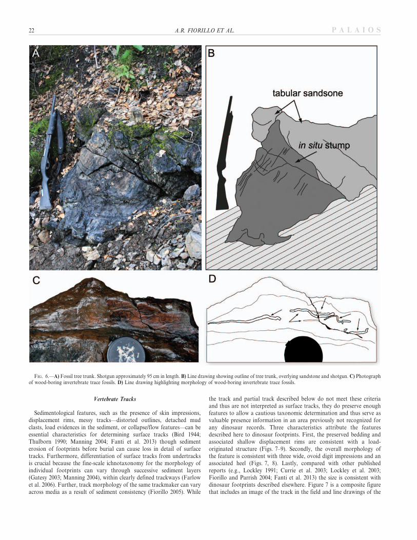
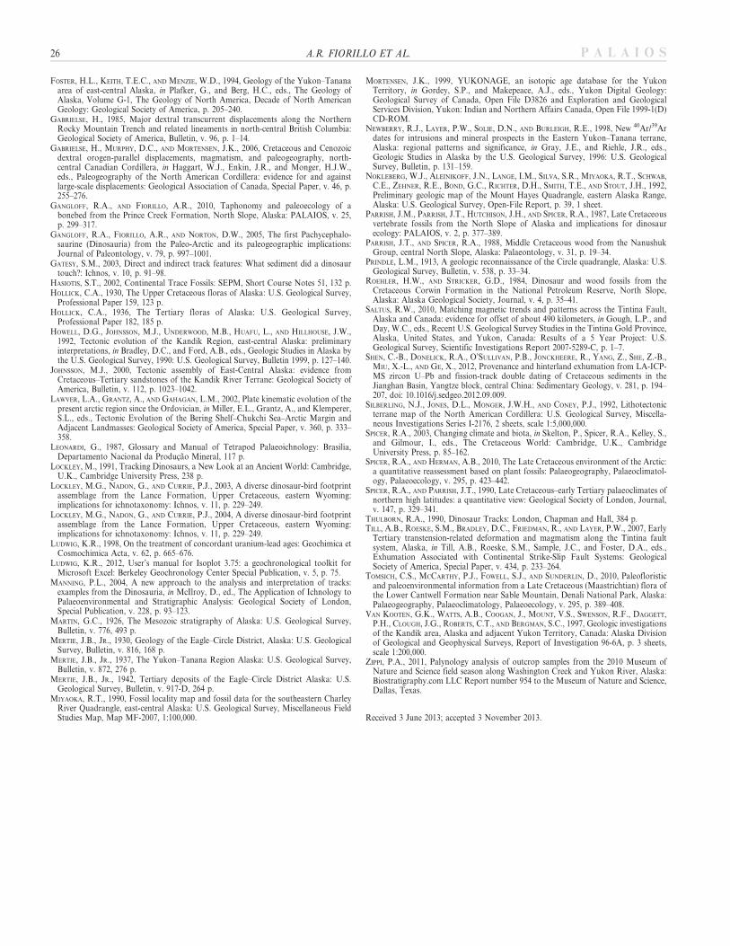
A large vertical tree trunk preserved in three dimensions was foundnear the tracksite described below (Fig. 6). The trunk contained the rootmass and measured 90 cm in diameter at approximately 30 cm above theroot mass. Cell structure was well preserved in hand specimens anddisplayed the homogeneous pattern of cells consistent with gymnospermwood rather than the heterogenic structure of angiosperm wood.Associated with this tree are poorly preserved pollen and spores describedabove for sample ID 10AF7-5-3 (Table 1).
ICHNOLOGY
Invertebrate Wood Borings
Permineralized wood was found at the site that produced the vertebratetrack described below. The fossil wood exhibited numerous borings
(Fig. 6). These traces are hollowed grooves that are parallel to andcrosscut the structure of the fossil wood. The grooves are approxi-mately 0.3 cm wide. While the beginning and end of each groove isnot well defined, the preserved grooves are each several centimeterslong. No fossilized frass (detritus produced by insect feeding) wasobserved.
These traces represent the feeding behavior of fossil invertebrates.Such structures are typically attributed to wood-boring beetles andhave a geologic range from the Carboniferous to recent. Further, thestructures are known from a variety of depositional settings rangingfrom levee to distal floodplain deposits (Hasiotis 2002). Modernwood-boring beetles are active during the summer months. Inwinter—cold months or cold and dark months—the beetle larvaeand adults are dormant and do not bore and/or feed. Their modernnorthern latitudinal distribution is controlled by the magnitude andduration of cold temperatures during the winter months. Thesestructures occur in fossil wood from a wide variety of climate settings(Hasiotis 2002).
TABLE 2.— Results of palynomorph analyses of sample 10AF 6-30-1 +indicates observations outside of the statistical count.
Percent Taxon Age
7 Picea spp3 Polypodium (smooth monolete)1 Ovoidites (cf Spirogyra) sp7 Cupressaceae?
62 Taxodiaceapollenites hiatus1 Bisaccate4 Betula6 Osmunda regalis (cf wellmanii)5 Sequoiapollenites paleocenicus L. Eocene–L. Santonian1 Foveodiporites cf anklesvarensis M. Miocene–L. Paleocene3 Cercidiphyllum M. Miocene–L. Paleocene
(high lat)100 Total
+1 Quercoidites microhenrici Recent–E. Eocene/L. Paleocene?+1 Cricotriporites (Celtis)
intrastructurusL. Miocene–L. Paleocene
+1 Brachysporites sp+1 Pterocarya 7p+1 Ulmipollenites 4p+1 Myriophylum+2 Carya prodromus M. Eocene–E. Paleocene+1 Podocarpidites cf nagi? M. Miocene–L. Paleocene+1 Sequoiapollenites polyformosus+1 Liriodendroipollis?
semiverrucatus?Recent–Paleocene
+1 Carya imparalis/wodehousei M. Eocene–E. Paleocene+1 Tilia vescipites M. Miocene–E. Paleocene+1 Diporicellaesporites cf
navicularisM. Eocene–L. Paleocene
+1 Larix?
TABLE 3.—Results of palynomorph analyses of sample 10AF 6-30-2 +indicates observations outside of the statistical count.
Percent Taxon Age
2 Picea spp1 Smooth algal cyst3 Polypodium (smooth monolete)6 Cupressaceae?
42 Taxodiaceapollenites hiatus1 Fungal fragment serial cells1 Fungal fragment indeterminate2 Betula3 Osmunda regalis (cf wellmanii)4 Sequoiapollenites paleocenicus L. Eocene–L. Santonian1 Ulmipollenites 4p1 Carya imparalis/wodehousei M. Eocene–E. Paleocene1 Larix?
21 Dinoflagellate thin ceratioid1 Micrhystridium recurvatum M. Eocene–Triassic1 Quercoidites microhenrici Recent–E. Eocene/L. Paleocene?3 Cyathidites spp2 Algae? ornamented2 Cibotiumspora spp1 Retitricolpites cf 2 ?Salix?1 Gleicheniidites cf senonicus darker
100 Total+1 Juglans?
TABLE 4.—List of nine Examine and Reports (E&R) from United StatesGeological Survey sites relevant to this study. Included in the table are age
determinations based on fossil pollen and E&R references.
USGS locality Age E&R reference
63AGs 285 Tertiary Scott - Jan. 9 1964-A-63-9D63AGs 286 Tertiary Scott - Jan. 9 1964-A-63-9D63ABa 4104 Tertiary Scott - Jan. 9 1964-A-63-9D62ACn 391A Tertiary Scott - Mar 29 1963-A-23-2D62ACn 391B-G Tertiary Scott - Mar 29 1963-A-23-2D62ACn 633 Cretaceous or Tertiary Scott - Mar 29 1963-A-23-2D62ABa 2501 Tertiary? Scott - Jan. 15 1963-A-62-5D62ABa 2502 Tertiary? Scott - Jan. 15 1963-A-62-5D62ABa 2542 Tertiary? Scott - Jan. 15 1963-A-62-5D62ABa 2544 Tertiary? Scott - Jan. 15 1963-A-62-5D62ABa 2594 Tertiary? Scott - Jan. 15 1963-A-62-5D62ACn 402 Tertiary Scott - Jan. 15 1963-A-62-5D
YUKON–CHARLEY RIVERS N.P. DINOSAUR TRACK 21P A L A I O S
Vertebrate Tracks
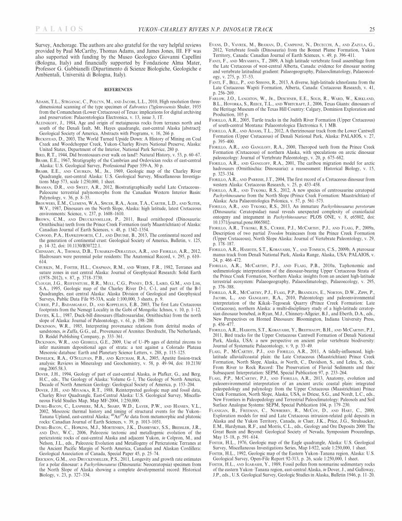
Sedimentological features, such as the presence of skin impressions,displacement rims, messy tracks—distorted outlines, detached mudclasts, load evidences in the sediment, or collapse/flow features—can beessential characteristics for determining surface tracks (Bird 1944;Thulborn 1990; Manning 2004; Fanti et al. 2013) though sedimenterosion of footprints before burial can cause loss in detail of surfacetracks. Furthermore, differentiation of surface tracks from undertracksis crucial because the fine-scale ichnotaxonomy for the morphology ofindividual footprints can vary through successive sediment layers(Gatesy 2003; Manning 2004), within clearly defined trackways (Farlowet al. 2006). Further, track morphology of the same trackmaker can varyacross media as a result of sediment consistency (Fiorillo 2005). While
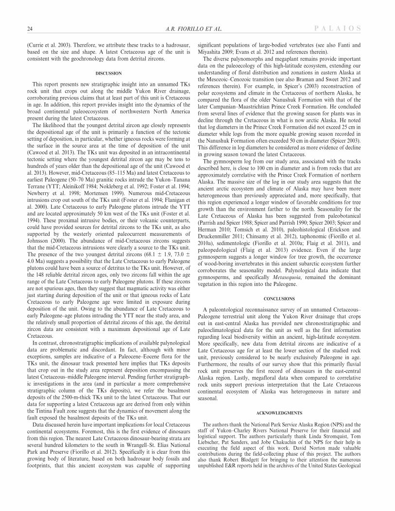
the track and partial track described below do not meet these criteriaand thus are not interpreted as surface tracks, they do preserve enoughfeatures to allow a cautious taxonomic determination and thus serve asvaluable presence information in an area previously not recognized forany dinosaur records. Three characteristics attribute the featuresdescribed here to dinosaur footprints. First, the preserved bedding andassociated shallow displacement rims are consistent with a load-originated structure (Figs. 7–9). Secondly, the overall morphology ofthe feature is consistent with three wide, ovoid digit impressions and anassociated heel (Figs. 7, 8). Lastly, compared with other publishedreports (e.g., Lockley 1991; Currie et al. 2003; Lockley et al. 2003;Fiorillo and Parrish 2004; Fanti et al. 2013) the size is consistent withdinosaur footprints described elsewhere. Figure 7 is a composite figurethat includes an image of the track in the field and line drawings of the
FIG. 6.—A) Fossil tree trunk. Shotgun approximately 95 cm in length. B) Line drawing showing outline of tree trunk, overlying sandstone and shotgun. C) Photographof wood-boring invertebrate trace fossils. D) Line drawing highlighting morphology of wood-boring invertebrate trace fossils.
22 A.R. FIORILLO ET AL. P A L A I O S
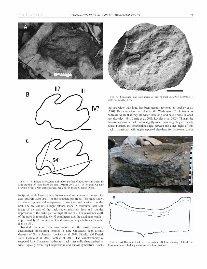
footprint, while Figure 8 is a laser-scanned and contoured image of acast (DMNH 2010-06001) of the complete pes track. This track showsan almost symmetrical morphology, three toes, and a wide, roundedheel. The heel exhibits a slight bilobed shape. A contoured laser scanimage of the cast of the track shows relatively deep and roundedimpressions of the distal pads of digit III and ?IV. The maximum widthof the track is approximately 35 centimeters and the maximum length isapproximately 37 centimeters. The divarication angle between the outerdigits is 54u.
Isolated tracks of large ornithopods are the most commonlyencountered dinosaurian ichnites in Late Cretaceous high-latitudedeposits of North America (Lockley et al. 2004; Fiorillo and Parrish2004; Fiorillo et al. 2012; Fanti et al. 2013). The ichnotaxonomy ofsupposed Late Cretaceous hadrosaur tracks, generally characterized bywide, typically ovoid digit impressions and almost symmetrical tracks
that are wider than long, has been recently reviewed by Lockley et al.(2004). Key characters that identify the Washington Creek tracks ashadrosaurid are that they are wider than long, and have a wide, bilobedheel (Lockley 1991; Currie et al. 2003; Lockley et al. 2003). Though thedimensions show a track that is slightly wider than long, they are nearlyequal. Further, the divarication angle between the outer digits of thistrack is consistent with angles reported elsewhere for hadrosaur tracks
FIG. 7.—A) Dinosaur footprint in the field. Surface of track wet with water. B)Line drawing of track based on cast (DMNH 2010-06-01) of original. C) Linedrawing of track with digits marked. Scale bar in B and C equals 10 cm.
FIG. 8.—Contoured laser scan image of cast of track (DMNH 2010-06001).Scale bar equals 10 cm.
FIG. 9.—A) Dinosaur track in cross section. B) Line drawing of track thedownward-bowed bedding indicative of a load structure.
YUKON–CHARLEY RIVERS N.P. DINOSAUR TRACK 23P A L A I O S
(Currie et al. 2003). Therefore, we attribute these tracks to a hadrosaur,based on the size and shape. A latest Cretaceous age of the unit isconsistent with the geochronology data from detrital zircons.
DISCUSSION
This report presents new stratigraphic insight into an unnamed TKsrock unit that crops out along the middle Yukon River drainage,corroborating previous claims that at least part of this unit is Cretaceousin age. In addition, this report provides insight into the dynamics of thebroad continental paleoecosystem of northwestern North Americapresent during the latest Cretaceous.
The likelihood that the youngest detrital zircon age closely representsthe depositional age of the unit is primarily a function of the tectonicsetting of deposition, in particular, whether igneous rocks were forming atthe surface in the source area at the time of deposition of the unit(Cawood et al. 2013). The TKs unit was deposited in an intracontinentaltectonic setting where the youngest detrital zircon age may be tens tohundreds of years older than the depositional age of the unit (Cawood etal. 2013). However, mid-Cretaceous (85–115 Ma) and latest Cretaceous toearliest Paleogene (50–70 Ma) granitic rocks intrude the Yukon–TananaTerrane (YTT; Aleinikoff 1984; Nokleberg et al. 1992; Foster et al. 1994;Newberry et al. 1998; Mortensen 1999). Numerous mid-Cretaceousintrusions crop out south of the TKs unit (Foster et al. 1994; Flanigan etal. 2000). Late Cretaceous to early Paleogene plutons intrude the YTTand are located approximately 50 km west of the TKs unit (Foster et al.1994). These proximal intrusive bodies, or their volcanic counterparts,could have provided sources for detrital zircons to the TKs unit, as alsosupported by the westerly oriented paleocurrent measurements ofJohnsson (2000). The abundance of mid-Cretaceous zircons suggeststhat the mid-Cretaceous intrusions were clearly a source to the TKs unit.The presence of the two youngest detrital zircons (68.1 6 1.9, 73.0 6
4.0 Ma) suggests a possibility that the Late Cretaceous to early Paleogeneplutons could have been a source of detritus to the TKs unit. However, ofthe 148 reliable detrital zircon ages, only two zircons fall within the agerange of the Late Cretaceous to early Paleogene plutons. If these zirconsare not spurious ages, then they suggest that magmatic activity was eitherjust starting during deposition of the unit or that igneous rocks of LateCretaceous to early Paleogene age were limited in exposure duringdeposition of the unit. Owing to the abundance of Late Cretaceous toearly Paleogene–age plutons intruding the YTT near the study area, andthe relatively small proportion of detrital zircons of this age, the detritalzircon data are consistent with a maximum depositional age of LateCretaceous.
In contrast, chronostratigraphic implications of available palynologicaldata are problematic and discordant. In fact, although with minorexceptions, samples are indicative of a Paleocene–Eocene flora for theTKs unit, the dinosaur track presented here implies that TKs depositsthat crop out in the study area represent deposition encompassing thelatest Cretaceous–middle Paleogene interval. Pending further stratigraph-ic investigations in the area (and in particular a more comprehensivestratigraphic column of the TKs deposits), we refer the basalmostdeposits of the 2500-m-thick TKs unit to the latest Cretaceous. That ourdata for supporting a latest Cretaceous age are derived from only withinthe Tintina Fault zone suggests that the dynamics of movement along thefault exposed the basalmost deposits of the TKs unit.
Data discussed herein have important implications for local Cretaceouscontinental ecosystems. Foremost, this is the first evidence of dinosaursfrom this region. The nearest Late Cretaceous dinosaur-bearing strata areseveral hundred kilometers to the south in Wrangell–St. Elias NationalPark and Preserve (Fiorillo et al. 2012). Specifically it is clear from thisgrowing body of literature, based on both hadrosaur body fossils andfootprints, that this ancient ecosystem was capable of supporting
significant populations of large-bodied vertebrates (see also Fanti andMiyashita 2009; Evans et al. 2012 and references therein).
The diverse palynomorphs and megaplant remains provide importantdata on the paleoecology of this high-latitude ecosystem, extending ourunderstanding of floral distribution and zonations in eastern Alaska atthe Mesozoic–Cenozoic transition (see also Braman and Sweet 2012 andreferences therein). For example, in Spicer’s (2003) reconstruction ofpolar ecosystems and climate in the Cretaceous of northern Alaska, hecompared the flora of the older Nanushuk Formation with that of thelater Campanian–Maastrichtian Prince Creek Formation. He concludedfrom several lines of evidence that the growing season for plants was indecline through the Cretaceous in what is now arctic Alaska. He notedthat log diameters in the Prince Creek Formation did not exceed 25 cm indiameter while logs from the more equable growing season recorded inthe Nanushuk Formation often exceeded 50 cm in diameter (Spicer 2003).This difference in log diameters he considered as more evidence of declinein growing season toward the latest Cretaceous.
The gymnosperm log from our study area, associated with the tracksdescribed here, is close to 100 cm in diameter and is from rocks that areapproximately correlative with the Prince Creek Formation of northernAlaska. The massive size of the log in our study area suggests that theancient arctic ecosystem and climate of Alaska may have been moreheterogeneous than previously appreciated and, more specifically, thatthis region experienced a longer window of favorable conditions for treegrowth than the environment farther to the north. Seasonality for theLate Cretaceous of Alaska has been suggested from paleobotanical(Parrish and Spicer 1988; Spicer and Parrish 1990; Spicer 2003; Spicer andHerman 2010; Tomsich et al. 2010), paleohistological (Erickson andDruckenmiller 2011; Chinsamy et al. 2012), taphonomic (Fiorillo et al.2010a), sedimentologic (Fiorillo et al. 2010a; Flaig et al. 2011), andpaleopedological (Flaig et al. 2013) evidence. Even if the largegymnosperm suggests a longer window for tree growth, the occurrenceof wood-boring invertebrates in this ancient subarctic ecosystem furthercorroborates the seasonality model. Palynological data indicate thatgymnosperms, and specifically Metasequoia, remained the dominantvegetation in this region into the Paleogene.
CONCLUSIONS
A paleontological reconnaissance survey of an unnamed Cretaceous–Paleogene terrestrial unit along the Yukon River drainage that cropsout in east-central Alaska has provided new chronostratigraphic andpaleoclimatological data for the unit as well as the first informationregarding local biodiversity within an ancient, high-latitude ecosystem.More specifically, new data from detrital zircons are indicative of aLate Cretaceous age for at least the lower section of the studied rockunit, previously considered to be nearly exclusively Paleogene in age.Furthermore, the results of our survey show that this primarily fluvialrock unit preserves the first record of dinosaurs in the east-centralAlaska region. Lastly, megafloral data when compared to correlativerock units support previous interpretation that the Late Cretaceouscontinental ecosystem of Alaska was heterogeneous in nature andseasonal.
ACKNOWLEDGMENTS
The authors thank the National Park Service Alaska Region (NPS) and thestaff of Yukon–Charley Rivers National Preserve for their financial andlogistical support. The authors particularly thank Linda Stromquist, TomLiebscher, Pat Sanders, and Jobe Chakuchin of the NPS for their help inexecuting the field aspect of this work. David Norton made valuablecontributions during the field-collecting phase of this project. The authorsalso thank Robert Blodgett for bringing to their attention the numerousunpublished E&R reports held in the archives of the United States Geological
24 A.R. FIORILLO ET AL. P A L A I O S
Survey, Anchorage. The authors are also grateful for the very helpful reviewsprovided by Paul McCarthy, Thomas Adams, and James Jones, III. FF wasalso supported with funding by the Museo Geologico Giovanni Capellini(Bologna, Italy) and financially supported by Fondazione Alma Mater,Professor G. Gabbianelli (Dipartimento di Scienze Biologiche, Geologiche eAmbientali, Universita di Bologna, Italy).
REFERENCES
ADAMS, T.L., STRGANAC, C., POLCYN, M., AND JACOBS, L.L., 2010, High resolution three-dimensional scanning of the type specimen of Eubrontes (?)glenrosensis Shuler, 1935from the Comanchean (Lower Cretaceous) of Texas: implications for digital archivingand preservation: Palaeontologica Electronica, v. 13, issue 3, 1T.
ALEINIKOFF, J., 1984, Age and origin of metaigneous rocks from terranes north andsouth of the Denali fault, Mt. Hayes quadrangle, east-central Alaska [abstract]:Geological Society of America, Abstracts with Programs, v. 16, 266 p.
BECKSTEAD, D., 2003, The World Turned Upside Down: A History of Mining on CoalCreek and Woodchopper Creek, Yukon–Charley Rivers National Preserve, Alaska:United States, Department of the Interior, National Park Service, 280 p.
BIRD, R.T., 1944, Did brontosaurs ever walk on land?: Natural History, v. 53, p. 60–67.BRABB, E.E., 1967, Stratigraphy of the Cambrian and Ordovician rocks of east-central
Alaska: U.S. Geological Survey, Professional Paper 559-A, 30 p.BRABB, E.E., AND CHURKIN, M., JR., 1969, Geologic map of the Charley River
Quadrangle, east-central Alaska: U.S. Geological Survey, Miscellaneous Investiga-tions Map 573, scale 1:250,000, 1 sheet.
BRAMAN, D.R., AND SWEET, A.R., 2012, Biostratigraphically useful Late Cretaceous–Paleocene terrestrial palynomorphs from the Canadian Western Interior Basin:Palynology, v. 36, p. 8–35.
BROUWERS, E.M., CLEMENS, W.A., SPICER, R.A., AGER, T.A., CARTER, L.D., AND SLITER,W.V., 1987, Dinosaurs on the North Slope, Alaska: high latitude, latest Cretaceousenvironments: Science, v. 237, p. 1608–1610.
BROWN, C.M., AND DRUCKENMILLER, P., 2011, Basal ornithopod (Dinosauria:Ornithischia) teeth from the Prince Creek Formation (early Maastrichtian) of Alaska:Canadian Journal of Earth Sciences, v. 48, p. 1342–1354.
CAWOOD, P.A., HAWKESWORTH, C.J., AND DHUIME, B., 2013, The continental record andthe generation of continental crust: Geological Society of America, Bulletin, v. 125,p. 14–32, doi: 10.1130/B30722.1.
CHINSAMY, A., THOMAS, D.B., TUMARKIN-DERATZIAN, A.R., AND FIORILLO, A.R., 2012,Hadrosaurs were perennial polar residents: The Anatomical Record, v. 295, p. 610–614.
CHURKIN, M., FOSTER, H.L., CHAPMAN, R.M., AND WEBER, F.R., 1982, Terranes andsuture zones in east central Alaska: Journal of Geophysical Research: Solid Earth(1978–2012), v. 87, p. 3718–3730.
CLOUGH, J.G., REIFENSTUHL, R.R., MULL, C.G., PINNEY, D.S., LAIRD, G.M., AND LISS,S.A., 1995, Geologic map of the Charley River D-1, C-1, and part of the B-1Quadrangles, east central Alaska: Alaska Division of Geological and GeophysicalSurveys, Public Data File 95-33A, scale 1:100,000, 3 sheets, p. 9.
CURRIE, P.J., BADAMGARAV, D., AND KOPPELHUS, E.B., 2003, The first Late Cretaceousfootprints from the Nemegt Locality in the Gobi of Mongolia: Ichnos, v. 10, p. 1–12.
DAVIES, K.L., 1987, Duck-bill dinosaurs (Hadrosauridae, Ornithischia) from the northslope of Alaska: Journal of Paleontology, v. 61, p. 198–200.
DICKINSON, W.R., 1985, Interpreting provenance relations from detrital modes ofsandstones, in Zuffa, G.G., ed., Provenance of Arenites: Dordrecht, The Netherlands,D. Reidel Publishing Company, p. 333–361.
DICKINSON, W.R., AND GEHRELS, G.E., 2009, Use of U–Pb ages of detrital zircons toinfer maximum depositional ages of strata: a test against a Colorado PlateauMesozoic database: Earth and Planetary Science Letters, v. 288, p. 115–125.
DONELICK, R.A., O’SULLIVAN, P.B., AND KETCHAM, R.A., 2005, Apatite fission-trackanalysis: Reviews in Mineralogy and Geochemistry, v. 58, p. 49–94, doi: 10.2138/rmg.2005.58.3.
DOVER, J.H., 1994, Geology of part of east-central Alaska, in Plafker, G., and Berg,H.C., eds., The Geology of Alaska: Volume G–1, The Geology of North America,Decade of North American Geology: Geological Society of America, p. 153–204.
DOVER, J.H., AND MIYAOKA, R.T., 1988, Reinterpreted geologic map and fossil data,Charley River Quadrangle, East-Central Alaska: U.S. Geological Survey, Miscella-neous Field Studies Map, Map MF-2004, 1:250,000.
DUSEL-BACON, C., LANPHERE, M.A., SHARP, W.D., LAYER, P.W., AND HANSEN, V.L.,2002, Mesozoic thermal history and timing of structural events for the Yukon–Tanana Upland, east-central Alaska; 40Ar/39Ar data from metamorphic and plutonicrocks: Canadian Journal of Earth Sciences, v. 39, p. 1013–1051.
DUSEL-BACON, C., HOPKINS, M.J., MORTENSEN, J.K., DASHEVSKY, S.S., BRESSLER, J.R.,AND DAY, W.C., 2006, Paleozoic tectonic and metallogenic evolution of thepericratonic rocks of east-central Alaska and adjacent Yukon, in Colpron, M., andNelson, J.L., eds., Paleozoic Evolution and Metallogeny of Pericratonic Terranes atthe Ancient Pacific Margin of North America, Canadian and Alaskan Cordillera:Geological Association of Canada, Special Paper 45, p. 25–74.
ERICKSON, G.M., AND DRUCKENMILLER, P.S., 2011, Longevity and growth rate estimatesfor a polar dinosaur: a Pachyrhinosaurus (Dinosauria: Neoceratopsia) specimen fromthe North Slope of Alaska showing a complete developmental record: HistoricalBiology, v. 23, p. 327–334.
EVANS, D., VAVREK, M., BRAMAN, D., CAMPIONE, N., DECECCHI, A., AND ZAZULA, G.,2012, Vertebrate fossils (Dinosauria) from the Bonnet Plume Formation, YukonTerritory, Canada: Canadian Journal of Earth Sciences, v. 49, p. 396–411.
FANTI, F., AND MIYASHITA, T., 2009, A high latitude vertebrate fossil assemblage fromthe Late Cretaceous of west-central Alberta, Canada: evidence for dinosaur nestingand vertebrate latitudinal gradient: Palaeogeography, Palaeoclimatology, Palaeoecol-ogy, v. 275, p. 37–53.
FANTI, F., BELL, P., AND SISSONS, R., 2013, A diverse, high-latitude ichnofauna from theLate Cretaceous Wapiti Formation, Alberta, Canada: Cretaceous Research, v. 41,p. 256–269.
FARLOW, J.O., LANGSTON, W., JR., DESCHNER, E.E., SOLIS, R., WARD, W., KIRKLAND,B.L., HOVORKA, S., REECE, T.L., AND WHITCRAFT, J., 2006, Texas Giants: dinosaurs ofthe Heritage Museum of the Texas Hill Country: Calgary, Dominion Exploration andProduction, 105 p.
FIORILLO, A.R., 2005, Turtle tracks in the Judith River Formation (Upper Cretaceous)of south-central Montana: Palaeontologica Electronica 8, 1 MB.
FIORILLO, A.R., AND ADAMS, T.L., 2012, A therizinosaur track from the Lower CantwellFormation (Upper Cretaceous) of Denali National Park, Alaska: PALAIOS, v. 27,p. 395–400.
FIORILLO, A.R., AND GANGLOFF, R.A., 2000, Theropod teeth from the Prince CreekFormation (Cretaceous) of northern Alaska, with speculations on arctic dinosaurpaleoecology: Journal of Vertebrate Paleontology, v. 20, p. 675–682.
FIORILLO, A.R., AND GANGLOFF, R.A., 2001, The caribou migration model for arctichadrosaurs (Ornithischia: Dinosauria): a reassessment: Historical Biology, v. 15,p. 323–334.
FIORILLO, A.R., AND PARRISH, J.T., 2004, The first record of a Cretaceous dinosaur fromwestern Alaska: Cretaceous Research, v. 25, p. 453–458.
FIORILLO, A.R., AND TYKOSKI, R.S., 2012, A new species of centrosaurine ceratopsidPachyrhinosaurus from the North Slope (Prince Creek Formation: Maastrichtian) ofAlaska: Acta Palaeontologica Polonica, v. 57, p. 561–573.
FIORILLO, A.R., AND TYKOSKI, R.S., 2013, An immature Pachyrhinosaurus perotorum(Dinosauria: Ceratopsidae) nasal reveals unexpected complexity of craniofacialontogeny and integument in Pachyrhinosaurus: PLOS ONE, v. 8, e65802, doi:10.1371/journal.pone.0065802.
FIORILLO, A.R., TYKOSKI, R.S., CURRIE, P.J., MCCARTHY, P.J., AND FLAIG, P., 2009a,Description of two partial Troodon braincases from the Prince Creek Formation(Upper Cretaceous), North Slope Alaska: Journal of Vertebrate Paleontology, v. 29,p. 178–187.
FIORILLO, A.R., HASIOTIS, S.T., KOBAYASHI, Y., AND TOMSICH, C.S., 2009b, A pterosaurmanus track from Denali National Park, Alaska Range, Alaska, USA: PALAIOS, v.24, p. 466–472.
FIORILLO, A.R., MCCARTHY, P.J., AND FLAIG, P.B., 2010a, Taphonomic andsedimentologic interpretations of the dinosaur-bearing Upper Cretaceous Strata ofthe Prince Creek Formation, Northern Alaska: insights from an ancient high-latitudeterrestrial ecosystem: Palaeogeography, Palaeoclimatology, Palaeoecology, v. 295,p. 376–388.
FIORILLO, A.R., MCCARTHY, P.J., FLAIG, P.P., BRANDLEN, E., NORTON, D.W., ZIPPI, P.,JACOBS, L., AND GANGLOFF, R.A., 2010, Paleontology and paleoenvironmentalinterpretation of the Kikak–Tegoseak Quarry (Prince Creek Formation: LateCretaceous), northern Alaska: a multi-disciplinary study of a high-latitude ceratop-sian dinosaur bonebed, in Ryan, M.J., Chinnery-Allgeier, B.J., and Eberth, D.A., eds.,New Perspectives on Horned Dinosaurs: Bloomington, Indiana University Press,p. 456–477.
FIORILLO, A.R., HASIOTIS, S.T., KOBAYASHI, Y., BREITHAUPT, B.H., AND MCCARTHY, P.J.,2011, Bird tracks for the Upper Cretaceous Cantwell Formation of Denali NationalPark, Alaska, USA: a new perspective on ancient polar vertebrate biodiversity:Journal of Systematic Palaeontology, v. 9, p. 33–49.
FLAIG, P., MCCARTHY, P.J., AND FIORILLO, A.R., 2011, A tidally-influenced, high-latitude alluvial/coastal plain: the Late Cretaceous (Maastrichtian) Prince CreekFormation, North Slope, Alaska, in North, C., Davidson, S., and Leleu, S., eds.,From River to Rock Record: The Preservation of Fluvial Sediments and theirSubsequent Interpretation: SEPM, Special Publication 97, p. 233–264.
FLAIG, P.P., MCCARTHY, P.J., AND FIORILLO, A.R., 2013, Anatomy, evolution andpaleoenvironmental interpretation of an ancient arctic coastal plain: integratedpaleopedology and palynology from the Upper Cretaceous (Maastrichtian) PrinceCreek Formation, North Slope, Alaska, USA, in Driese, S.G., and Nordt, L.C., eds.,New Frontiers in Paleopedology and Terrestrial Paleoclimatology: Paleosols and SoilSurface Analogue Systems: SEPM, Special Publication 104, p. 179–230.
FLANIGAN, B., FREEMAN, C., NEWBERRY, R., MCCOY, D., AND HART, C., 2000,Exploration models for mid and Late Cretaceous intrusion-related gold deposits inAlaska and the Yukon Territory, Canada, in Cluer, J.K., Price, J.G., Struhsacker,E.M., Hardyman, R.F., and Morris, C.L., eds., Geology and Ore Deposits 2000: TheGreat Basin and Beyond: Geological Society of Nevada, Symposium Proceedings,May 15–18, p. 591–614.
FOSTER, H.L., 1976, Geologic map of the Eagle quadrangle, Alaska: U.S. GeologicalSurvey, Miscellaneous Investigations Series, Map I-922, scale 1:250,000, 1 sheet.
FOSTER, H.L., 1992, Geologic map of the Eastern Yukon–Tanana region, Alaska: U.S.Geological Survey, Open-File Report 92-313, p. 26, scale 1:250,000, 1 sheet.
FOSTER, H.L., AND IGARASHI, Y., 1989, Fossil pollen from nonmarine sedimentary rocksof the eastern Yukon–Tanana region, east-central Alaska, in Dover, J., and Galloway,J.P., eds., U.S. Geological Survey, Geologic Studies in Alaska, Bulletin 1946, p. 11–20.
YUKON–CHARLEY RIVERS N.P. DINOSAUR TRACK 25P A L A I O S
FOSTER, H.L., KEITH, T.E.C., AND MENZIE, W.D., 1994, Geology of the Yukon–Tananaarea of east-central Alaska, in Plafker, G., and Berg, H.C., eds., The Geology ofAlaska, Volume G-1, The Geology of North America, Decade of North AmericanGeology: Geological Society of America, p. 205–240.
GABRIELSE, H., 1985, Major dextral transcurrent displacements along the NorthernRocky Mountain Trench and related lineaments in north-central British Columbia:Geological Society of America, Bulletin, v. 96, p. 1–14.
GABRIELSE, H., MURPHY, D.C., AND MORTENSEN, J.K., 2006, Cretaceous and Cenozoicdextral orogen-parallel displacements, magmatism, and paleogeography, north-central Canadian Cordillera, in Haggart, W.J., Enkin, J.R., and Monger, H.J.W.,eds., Paleogeography of the North American Cordillera: evidence for and againstlarge-scale displacements: Geological Association of Canada, Special Paper, v. 46, p.255–276.
GANGLOFF, R.A., AND FIORILLO, A.R., 2010, Taphonomy and paleoecology of abonebed from the Prince Creek Formation, North Slope, Alaska: PALAIOS, v. 25,p. 299–317.
GANGLOFF, R.A., FIORILLO, A.R., AND NORTON, D.W., 2005, The first Pachycephalo-saurine (Dinosauria) from the Paleo-Arctic and its paleogeographic implications:Journal of Paleontology, v. 79, p. 997–1001.
GATESY, S.M., 2003, Direct and indirect track features: What sediment did a dinosaurtouch?: Ichnos, v. 10, p. 91–98.
HASIOTIS, S.T., 2002, Continental Trace Fossils: SEPM, Short Course Notes 51, 132 p.HOLLICK, C.A., 1930, The Upper Cretaceous floras of Alaska: U.S. Geological Survey,
Professional Paper 159, 123 p.HOLLICK, C.A., 1936, The Tertiary floras of Alaska: U.S. Geological Survey,
Professional Paper 182, 185 p.HOWELL, D.G., JOHNSSON, M.J., UNDERWOOD, M.B., HUAFU, L., AND HILLHOUSE, J.W.,
1992, Tectonic evolution of the Kandik Region, east-central Alaska: preliminaryinterpretations, in Bradley, D.C., and Ford, A.B., eds., Geologic Studies in Alaska bythe U.S. Geological Survey, 1990: U.S. Geological Survey, Bulletin 1999, p. 127–140.
JOHNSSON, M.J., 2000, Tectonic assembly of East-Central Alaska: evidence fromCretaceous–Tertiary sandstones of the Kandik River Terrane: Geological Society ofAmerica, Bulletin, v. 112, p. 1023–1042.
LAWVER, L.A., GRANTZ, A., AND GAHAGAN, L.M., 2002, Plate kinematic evolution of thepresent arctic region since the Ordovician, in Miller, E.L., Grantz, A., and Klemperer,S.L., eds., Tectonic Evolution of the Bering Shelf–Chukchi Sea–Arctic Margin andAdjacent Landmasses: Geological Society of America, Special Paper, v. 360, p. 333–358.
LEONARDI, G., 1987, Glossary and Manual of Tetrapod Palaeoichnology: Brasilia,Departamento Nacional da Producao Mineral, 117 p.
LOCKLEY, M., 1991, Tracking Dinosaurs, a New Look at an Ancient World: Cambridge,U.K., Cambridge University Press, 238 p.
LOCKLEY, M.G., NADON, G., AND CURRIE, P.J., 2003, A diverse dinosaur-bird footprintassemblage from the Lance Formation, Upper Cretaceous, eastern Wyoming:implications for ichnotaxonomy: Ichnos, v. 11, p. 229–249.
LOCKLEY, M.G., NADON, G., AND CURRIE, P.J., 2004, A diverse dinosaur-bird footprintassemblage from the Lance Formation, Upper Cretaceous, eastern Wyoming:implications for ichnotaxonomy: Ichnos, v. 11, p. 229–249.
LUDWIG, K.R., 1998, On the treatment of concordant uranium-lead ages: Geochimica etCosmochimica Acta, v. 62, p. 665–676.
LUDWIG, K.R., 2012, User’s manual for Isoplot 3.75: a geochronological toolkit forMicrosoft Excel: Berkeley Geochronology Center Special Publication, v. 5, p. 75.
MANNING, P.L., 2004, A new approach to the analysis and interpretation of tracks:examples from the Dinosauria, in McIlroy, D., ed., The Application of Ichnology toPalaeoenvironmental and Stratigraphic Analysis: Geological Society of London,Special Publication, v. 228, p. 93–123.
MARTIN, G.C., 1926, The Mesozoic stratigraphy of Alaska: U.S. Geological Survey,Bulletin, v. 776, 493 p.
MERTIE, J.B., JR., 1930, Geology of the Eagle–Circle District, Alaska: U.S. GeologicalSurvey, Bulletin, v. 816, 168 p.
MERTIE, J.B., JR., 1937, The Yukon–Tanana Region Alaska: U.S. Geological Survey,Bulletin, v. 872, 276 p.
MERTIE, J.B., JR., 1942, Tertiary deposits of the Eagle–Circle District Alaska: U.S.Geological Survey, Bulletin, v. 917-D, 264 p.
MIYAOKA, R.T., 1990, Fossil locality map and fossil data for the southeastern CharleyRiver Quadrangle, east-central Alaska: U.S. Geological Survey, Miscellaneous FieldStudies Map, Map MF-2007, 1:100,000.
MORTENSEN, J.K., 1999, YUKONAGE, an isotopic age database for the YukonTerritory, in Gordey, S.P., and Makepeace, A.J., eds., Yukon Digital Geology:Geological Survey of Canada, Open File D3826 and Exploration and GeologicalServices Division, Yukon: Indian and Northern Affairs Canada, Open File 1999-1(D)CD-ROM.
NEWBERRY, R.J., LAYER, P.W., SOLIE, D.N., AND BURLEIGH, R.E., 1998, New 40Ar/39Ardates for intrusions and mineral prospects in the Eastern Yukon–Tanana terrane,Alaska: regional patterns and significance, in Gray, J.E., and Riehle, J.R., eds.,Geologic Studies in Alaska by the U.S. Geological Survey, 1996: U.S. GeologicalSurvey, Bulletin, p. 131–159.
NOKLEBERG, W.J., ALEINIKOFF, J.N., LANGE, I.M., SILVA, S.R., MIYAOKA, R.T., SCHWAB,C.E., ZEHNER, R.E., BOND, G.C., RICHTER, D.H., SMITH, T.E., AND STOUT, J.H., 1992,Preliminary geologic map of the Mount Hayes Quadrangle, eastern Alaska Range,Alaska: U.S. Geological Survey, Open-File Report, p. 39, 1 sheet.
PARRISH, J.M., PARRISH, J.T., HUTCHISON, J.H., AND SPICER, R.A., 1987, Late Cretaceousvertebrate fossils from the North Slope of Alaska and implications for dinosaurecology: PALAIOS, v. 2, p. 377–389.
PARRISH, J.T., AND SPICER, R.A., 1988, Middle Cretaceous wood from the NanushukGroup, central North Slope, Alaska: Palaeontology, v. 31, p. 19–34.
PRINDLE, L.M., 1913, A geologic reconnaissance of the Circle quadrangle, Alaska: U.S.Geological Survey, Bulletin, v. 538, p. 33–34.
ROEHLER, H.W., AND STRICKER, G.D., 1984, Dinosaur and wood fossils from theCretaceous Corwin Formation in the National Petroleum Reserve, North Slope,Alaska: Alaska Geological Society, Journal, v. 4, p. 35–41.
SALTUS, R.W., 2010, Matching magnetic trends and patterns across the Tintina Fault,Alaska and Canada: evidence for offset of about 490 kilometers, in Gough, L.P., andDay, W.C., eds., Recent U.S. Geological Survey Studies in the Tintina Gold Province,Alaska, United States, and Yukon, Canada: Results of a 5 Year Project: U.S.Geological Survey, Scientific Investigations Report 2007-5289-C, p. 1–7.
SHEN, C.-B., DONELICK, R.A., O’SULLIVAN, P.B., JONCKHEERE, R., YANG, Z., SHE, Z.-B.,MIU, X.-L., AND GE, X., 2012, Provenance and hinterland exhumation from LA-ICP-MS zircon U–Pb and fission-track double dating of Cretaceous sediments in theJianghan Basin, Yangtze block, central China: Sedimentary Geology, v. 281, p. 194–207, doi: 10.1016/j.sedgeo.2012.09.009.
SILBERLING, N.J., JONES, D.L., MONGER, J.W.H., AND CONEY, P.J., 1992, Lithotectonicterrane map of the North American Cordillera: U.S. Geological Survey, Miscella-neous Investigations Series I-2176, 2 sheets, scale 1:5,000,000.
SPICER, R.A., 2003, Changing climate and biota, in Skelton, P., Spicer, R.A., Kelley, S.,and Gilmour, I., eds., The Cretaceous World: Cambridge, U.K., CambridgeUniversity Press, p. 85–162.
SPICER, R.A., AND HERMAN, A.B., 2010, The Late Cretaceous environment of the Arctic:a quantitative reassessment based on plant fossils: Palaeogeography, Palaeoclimatol-ogy, Palaeoecology, v. 295, p. 423–442.
SPICER, R.A., AND PARRISH, J.T., 1990, Late Cretaceous–early Tertiary palaeoclimates ofnorthern high latitudes: a quantitative view: Geological Society of London, Journal,v. 147, p. 329–341.
THULBORN, R.A., 1990, Dinosaur Tracks: London, Chapman and Hall, 384 p.TILL, A.B., ROESKE, S.M., BRADLEY, D.C., FRIEDMAN, R., AND LAYER, P.W., 2007, Early
Tertiary transtension-related deformation and magmatism along the Tintina faultsystem, Alaska, in Till, A.B., Roeske, S.M., Sample, J.C., and Foster, D.A., eds.,Exhumation Associated with Continental Strike-Slip Fault Systems: GeologicalSociety of America, Special Paper, v. 434, p. 233–264.
TOMSICH, C.S., MCCARTHY, P.J., FOWELL, S.J., AND SUNDERLIN, D., 2010, Paleofloristicand paleoenvironmental information from a Late Cretaceous (Maastrichtian) flora ofthe Lower Cantwell Formation near Sable Mountain, Denali National Park, Alaska:Palaeogeography, Palaeoclimatology, Palaeoecology, v. 295, p. 389–408.
VAN KOOTEN, G.K., WATTS, A.B., COOGAN, J., MOUNT, V.S., SWENSON, R.F., DAGGETT,P.H., CLOUGH, J.G., ROBERTS, C.T., AND BERGMAN, S.C., 1997, Geologic investigationsof the Kandik area, Alaska and adjacent Yukon Territory, Canada: Alaska Divisionof Geological and Geophysical Surveys, Report of Investigation 96-6A, p. 3 sheets,scale 1:200,000.
ZIPPI, P.A., 2011, Palynology analysis of outcrop samples from the 2010 Museum ofNature and Science field season along Washington Creek and Yukon River, Alaska:Biostratigraphy.com LLC Report number 954 to the Museum of Nature and Science,Dallas, Texas.
Received 3 June 2013; accepted 3 November 2013.
26 A.R. FIORILLO ET AL. P A L A I O S