New constraints on the India–Asia collision: the Lower Miocene Gangrinboche conglomerates, Yarlung...
13
New constraints on the India – Asia collision: the Lower Miocene Gangrinboche conglomerates, Yarlung Tsangpo suture zone, SE Tibet Jonathan C. Aitchison a, * , Aileen M. Davis a , Badengzhu b , Hui Luo a,c a Tibet Research Group, Department of Earth Sciences, University of Hong Kong, Pokfulam Road, Hong Kong SAR, People’s Republic of China b Geological Team#2, Tibet Geological Survey, Lhasa, Tibet, People’s Republic of China c Laboratory of Palaeobiology & Stratigraphy, Nanjing Institute of Geology and Palaeontology, Academia Sinica, Nanjing 210008, People’s Republic of China Received 5 September 2001; revised 30 November 2001; accepted 10 April 2002 Abstract Lower Miocene conglomerates crop out along the length of the Yarlung Tsangpo suture zone on the southern margin of the Lhasa terrane. These conglomerates, known by various local names, are correlated herein as the Gangrinboche conglomerates. All units exhibit broadly similar stratigraphic histories and a basal depositional contact upon an eroded surface of rocks of the Lhasa terrane is ubiquitous. At most localities the tops of sections are either removed by erosion or truncated by north-directed thrusts. These conglomeratic molasse units developed in response to the India/Asia collision and record aspects of its development. In all units initial clast derivation was from the Lhasa terrane on the northern margin of the Yarlung Tsangpo suture zone. Up-section the first appearance of clasts derived from terranes within the suture zone and the northern margin of India, all of which lie to the south of any outcrops of Gangrinboche conglomerates, is observed. Although these units were previously thought to be Eocene, analysis of fossil and structural constraints indicates Early Miocene deposition. As development of the Gangrinboche conglomerates records a significant phase in the evolution of the India – Asia collision understanding of their age and stratigraphic evolution has wider implications for regional tectonic models. q 2002 Elsevier Science Ltd. All rights reserved. Keywords: Miocene; conglomerates; Yarlung Tsangpo suture zone; Indian-Asia collision 1. Introduction The Yarlung Tsangpo suture zone (YTSZ) marks the tectonic boundary between India and Asia (Fig. 1). The rocks within, and along, this suture record the history of what was once several thousand kilometres of Tethyan ocean expanse. Most research in the area has concentrated on the older rocks that have been brought together along the suture. However, as well as the remnants of these oceanic terranes, various conglomeratic ‘molasse’ units also crop out along the suture. These conglomerates record phases in the history of the India – Asia collision and the establishment of the Tibetan Plateau. Despite the significance of the suture the conglomerates have never been examined in detail. The interpretation that their development was associated with collisional orogensis has resulted in application of an inferred Eocene age as an important constraint on models relating to the timing of collision (Searle et al., 1987). Over the past five field seasons we have examined various conglomeratic units along the suture in order to better understand their development and regional signifi- cance. Significantly, results of our work indicate that more than one phase of molasse sedimentation occurred along the suture with two temporally and spatially distinct conglom- erate facies being recognizable. The ‘Liuqu conglomerates’ developed during the Paleogene (Davis et al., 1999, 2002). They crop out along the suture, entirely south of the Xigaze terrane, for approximately 150 km from near Lhaze to SE of Xigaze. These conglomerates are polymict and contain abundant distinctive red chert cobbles but do not contain any detritus from Xigaze or Lhasa terranes. They likely record the history of collision between an intra-oceanic island arc and the continental margin of India (Davis et al., 1999, 2002). Another significant and more laterally extensive con- glomerate facies (‘Gangrinboche conglomerates’ herein) crops out semi-continuously along the entire length of the suture. The conglomerates extend from at least as far west (818E) as Mt Kailas where they outcrop spectacularly to 1367-9120/02/$ - see front matter q 2002 Elsevier Science Ltd. All rights reserved. PII: S1367-9120(02)00037-8 Journal of Asian Earth Sciences 21 (2002) 251–263 www.elsevier.com/locate/jseaes * Corresponding author. Tel.: þ 852-859-8047; fax: þ 852-2517-6912. E-mail address: [email protected] (J.C. Aitchison).
Transcript of New constraints on the India–Asia collision: the Lower Miocene Gangrinboche conglomerates, Yarlung...
New constraints on the India–Asia collision: the Lower Miocene
Gangrinboche conglomerates, Yarlung Tsangpo suture zone, SE Tibet
Jonathan C. Aitchisona,*, Aileen M. Davisa, Badengzhub, Hui Luoa,c
aTibet Research Group, Department of Earth Sciences, University of Hong Kong, Pokfulam Road, Hong Kong SAR, People’s Republic of ChinabGeological Team#2, Tibet Geological Survey, Lhasa, Tibet, People’s Republic of China
cLaboratory of Palaeobiology & Stratigraphy, Nanjing Institute of Geology and Palaeontology, Academia Sinica, Nanjing 210008, People’s Republic of China
Received 5 September 2001; revised 30 November 2001; accepted 10 April 2002
Abstract
Lower Miocene conglomerates crop out along the length of the Yarlung Tsangpo suture zone on the southern margin of the Lhasa terrane.
These conglomerates, known by various local names, are correlated herein as the Gangrinboche conglomerates. All units exhibit broadly
similar stratigraphic histories and a basal depositional contact upon an eroded surface of rocks of the Lhasa terrane is ubiquitous. At most
localities the tops of sections are either removed by erosion or truncated by north-directed thrusts. These conglomeratic molasse units
developed in response to the India/Asia collision and record aspects of its development. In all units initial clast derivation was from the Lhasa
terrane on the northern margin of the Yarlung Tsangpo suture zone. Up-section the first appearance of clasts derived from terranes within the
suture zone and the northern margin of India, all of which lie to the south of any outcrops of Gangrinboche conglomerates, is observed.
Although these units were previously thought to be Eocene, analysis of fossil and structural constraints indicates Early Miocene deposition.
As development of the Gangrinboche conglomerates records a significant phase in the evolution of the India–Asia collision understanding of
their age and stratigraphic evolution has wider implications for regional tectonic models.
q 2002 Elsevier Science Ltd. All rights reserved.
Keywords: Miocene; conglomerates; Yarlung Tsangpo suture zone; Indian-Asia collision
1. Introduction
The Yarlung Tsangpo suture zone (YTSZ) marks the
tectonic boundary between India and Asia (Fig. 1). The
rocks within, and along, this suture record the history of
what was once several thousand kilometres of Tethyan
ocean expanse. Most research in the area has concentrated
on the older rocks that have been brought together along the
suture. However, as well as the remnants of these oceanic
terranes, various conglomeratic ‘molasse’ units also crop
out along the suture. These conglomerates record phases in
the history of the India–Asia collision and the establishment
of the Tibetan Plateau. Despite the significance of the suture
the conglomerates have never been examined in detail. The
interpretation that their development was associated with
collisional orogensis has resulted in application of an
inferred Eocene age as an important constraint on models
relating to the timing of collision (Searle et al., 1987).
Over the past five field seasons we have examined
various conglomeratic units along the suture in order to
better understand their development and regional signifi-
cance. Significantly, results of our work indicate that more
than one phase of molasse sedimentation occurred along the
suture with two temporally and spatially distinct conglom-
erate facies being recognizable. The ‘Liuqu conglomerates’
developed during the Paleogene (Davis et al., 1999, 2002).
They crop out along the suture, entirely south of the Xigaze
terrane, for approximately 150 km from near Lhaze to SE of
Xigaze. These conglomerates are polymict and contain
abundant distinctive red chert cobbles but do not contain
any detritus from Xigaze or Lhasa terranes. They likely
record the history of collision between an intra-oceanic
island arc and the continental margin of India (Davis et al.,
1999, 2002).
Another significant and more laterally extensive con-
glomerate facies (‘Gangrinboche conglomerates’ herein)
crops out semi-continuously along the entire length of the
suture. The conglomerates extend from at least as far west
(818E) as Mt Kailas where they outcrop spectacularly to
1367-9120/02/$ - see front matter q 2002 Elsevier Science Ltd. All rights reserved.
PII: S1 36 7 -9 12 0 (0 2) 00 0 37 -8
Journal of Asian Earth Sciences 21 (2002) 251–263
www.elsevier.com/locate/jseaes
* Corresponding author. Tel.: þ852-859-8047; fax: þ852-2517-6912.
E-mail address: [email protected] (J.C. Aitchison).

near Namche Barwa (958E) at the eastern Himalayan
syntaxis. From west to east, this facies includes several
units known by a variety of local stratigraphic names
(Kailas, Qiuwu, Dazhuqu and Luobusa formations) applied
by geologists mapping independently in different areas
(Badengzhu, 1979, 1981; Gansser, 1964; Wei and Peng,
1984; Zhang and Fu, 1982). These units are nonetheless
correlatives and each records a similar depositional history.
Gangrinboche, meaning precious jewel of snows, is the
Tibetan name for Mt Kailas. The latter term is common in
western literature, presumably because this mountain is also
regarded as holy in other non-Tibetan cultures/religions that
Fig. 1. Geological sketch map of the YTSZ indicating the position of major tectonic features and locations mentioned in the text. The Gangrinboche
conglomerates (shaded) crop out intermittently along almost the entire length of the northern margin of the YTSZ from west of Gangrinboche (Mt Kailas) to
Namche Barwa. BNS ¼ Bangong–Nujiang suture; YTSZ ¼ Yarlung Tsangpo suture zone; MCT ¼ Main Central thrust of the Himalaya; MBT ¼ Main
Boundary thrust of the Himalaya.
Fig. 2. A: Geological map of the Zedong–Luobusa area indicating the disposition of the main tectonic entities and, in particular, the Gangrinboche
conglomerate (Luobusa Formation) in this region (modified after Badengzhu, 1979, 1981). The locations of sections measured and unconformity upon Lhasa
terrane at Zhu Mai Sha (Fig. 3) are indicated. RZT ¼ Renbu–Zedong thrust. B: Geological map of the Xigaze–Renbung area (modified after Wang et al.,
1987) indicating the disposition of the main tectonic entities and, in particular, the Gangrinboche conglomerate (Qiuwu Formation-west of Dazhuqu and
Dazhuqu Formation-east of Dazhuqu) in this region. The locations of sections measured and outcrop photos (Fig. 5B and C) are indicated. GCT ¼ Great
Counter thrust.
J.C. Aitchison et al. / Journal of Asian Earth Sciences 21 (2002) 251–263252

predominate in the areas from which Western geologists
have generally approached the mountain. However, we feel
it is somewhat inappropriate given the location of the
mountain in Tibet and suggest nomenclatural unification of
the conglomerate units under the name ‘Gangrinboche
conglomerates’. Units correlated under this name are
significantly younger than the Liuqu Formation conglom-
erates and record later, Early Miocene, tectonic events
(Aitchison and Davis, 2001a; Harrison et al., 1993; Miller
et al., 2000). In this paper we present the first detailed
descriptions of the stratigraphy of rocks assigned to the
Gangrinboche conglomerates and discuss the implications,
of the way in which this unit developed, for models of
regional tectonics. Locations mentioned were measured
using a Garmin GPS II Plus personal navigator with
manufacturers accuracy specifications of ^15 m.
2. Suture zone geology
Numerous important works synthesizing the results of
geological traverses and establishing the regional geological
framework of Tibet have already been published (Allegre
et al., 1984; Chang et al., 1986; Coward et al., 1988;
Gansser, 1977; Hirn et al., 1984; Hodges, 2000; Mercier
et al., 1984; Pearce and Deng, 1988; Searle, 1996; Searle
et al., 1987; Shackleton, 1981; Tapponnier et al., 1981). The
YTSZ is marked by a discontinuous belt of ophiolitic rocks
(Girardeau et al., 1984) and is the southernmost and
youngest amongst a southward younging series of similar
features that subdivide the Tibetan Plateau into several
east–west trending blocks (Bureau of Geology and Mineral
Resources of Xizang Autonomous Region, 1993; Chang
et al., 1986; Chang and Zeng, 1973; Gansser, 1977). It is
geographically located along, and just south of, the Yarlung
Tsangpo (Tsangpo ¼ River) in the Tibet Autonomous
Region of the People’s Republic of China where it separates
the Lhasa terrane to the north from the Indian terrane to the
south.
Remnants of oceanic terranes are recognizable (Fig. 2)
within, and bounding, the YTSZ (Aitchison et al., 2000) and
they provide evidence for reconstruction of the history of
Tethys in this region. Subduction of Tethyan oceanic
lithosphere along the YTSZ led to collision between India
and Asia and development of the Himalaya and Tibetan
Plateau. Based on several lines of indirect evidence,
collision between the continental masses of India and Asia
is widely regarded as having initiated in the Eocene (Chang
et al., 1986; Dewey and Bird, 1970; Molnar and Tapponnier,
1975). Subduction of Tethyan oceanic lithosphere beneath
the Lhasa terrane resulted in the production of a huge
volume of magma now represented by the Gangdese
batholith and its extrusive equivalents along the southern
margin of the Lhasa terrane (Allegre et al., 1984; Searle
et al., 1987). Radiometric age data from subduction-related
granites along the southern margin of the Lhasa terrane
indicate that subduction commenced in the Jurassic and
lasted through until at least the Oligocene (30 Ma) (Harrison
et al., 2000; Yin and Harrison, 2000).
During the Late Cretaceous predominantly deep-water
sedimentation occurred in a continental margin forearc
basin [Xigaze terrane; (Aitchison et al., 2000)] located to the
south of the Lhasa terrane. Deposition in the Xigaze terrane
was dominated by turbidite sedimentation by the late Albian
and lasted until at least the Coniacian (Durr, 1996; Einsele
et al., 1994; Wang et al., 1999). Erosion has removed all
rocks younger than this from the terrane. Clastic sediment
within the Xigaze terrane was largely derived from coeval
volcanic rocks developing upon the Lhasa terrane.
Ophiolitic rocks within the YTSZ, near the city of
Xigaze, were examined in detail as part of a Sino-French
collaboration (Girardeau et al., 1984, 1985a–c; Nicolas
et al., 1981a,b). Together with other ophiolitic rocks along
the suture they are assigned to the Dazhuqu terrane
(Aitchison et al., 2000). The terrane contains all elements
of an ophiolite complex although much of section is missing
due to tectonic attenuation along low angle normal faults
and later strike–slip faulting (Wang et al., 1987). Although
earlier interpreted as mid ocean ridge rocks (Nicolas et al.,
1981a) more recent work has revealed a characteristic
supra-subduction zone chemistry (Hebert et al., 2000; Zhou
et al., 1996). Detailed radiolarian biostratigraphy (Zyabrev
et al., 1999) indicates formation of the ophiolite in the
Barremian.
The Bainang terrane (Aitchison et al., 2000) is internally
characterised by an imbricate thrust zone containing
numerous south-directed thrust slices, which preserve an
ocean floor stratigraphy and lies south of the ophiolite.
Tectonic slices of radiolarian chert, and locally basalt,
dominate the northern portions of the terrane. To the south,
the quantity of chert diminishes and the terrane is
characterised by fine-grained, thinly bedded, deep marine
sediments. Structurally the unit is reminiscent of subduction
complexes such as those seen in the Circum-Pacific region.
However, the coarse-grained volcaniclastic turbidites, that
typically dominate such terranes where they have developed
along active continental margins, are not widespread and the
Bainang terrane mostly consists of material interpreted to
have been off-scraped from the down-going slab (Ziabrev
et al., 2001). Preliminary results of detailed systematic
sampling of the terrane indicate that Triassic to Early
Cretaceous cherts and other oceanic sediments were
accreted into this subduction complex during the late
Early Cretaceous (Ziabrev et al., 2001; Zyabrev et al.,
2000).
Liuqu Conglomerate is an Upper Cretaceous–Paleogene
molasse unit that crops out intermittently along the YTSZ
from Bainang to Lhaze. It contains detritus shed from
Indian, Tethyan and intra-oceanic terranes but not from
Xigaze and Lhasa terranes. Development of these thick
rapidly-deposited clastic strata is interpreted to have
occurred in response to collision of an intra-oceanic island
J.C. Aitchison et al. / Journal of Asian Earth Sciences 21 (2002) 251–263 253
arc with India and predates final India/Asia collision (Davis
et al., 2002).
A vast zone of predominantly passive margin-derived
siliciclastic sedimentary rocks and carbonates lies south of
the Bainang terrane (Jadoul et al., 1998; Liu, 1992; Liu and
Einsele, 1994). These rocks constitute the leading edge of
the Indian terrane and range from Lower Paleozoic to
Paleogene. Locally, along the northern margin of the
terrane, they are disrupted into extensive zones of mud-
matrix melange (Liu and Einsele, 1996). Radiolarians in the
Yamdrok melange indicate its formation in the latest
Paleocene–earliest Eocene (Liu et al., 2000).
The order in which the ophiolitic Dazhuqu terrane is
tectonically juxtaposed against the Bainang terrane subduc-
tion complex to its south and the Zedong terrane, a Late
Jurassic–Cretaceous island arc sequence (McDermid et al.,
2000, 2001), to its north is consistent along strike. Together,
the arrangement of these coeval terranes suggests the former
existence of a south-facing intra-oceanic subduction system
inferred to have collided with, and been obducted onto, the
northern margin of India in the latest Cretaceous to
Paleogene (Aitchison et al., 2000). The formation of
significant units such as the Yamdrok melange and Liuqu
Conglomerate, appears to have been coeval with this
collision.
3. The Gangrinboche conglomerate
3.1. Lithostratigraphy
Four conglomerate units, known by a variety of local
geographic names (Luobusa, Dazhuqu, Qiuwu and Kailas
formations) crop out along over 2000 km of the strike length
of the suture from west of Mt Kailas (6714 m 318040N
0818190E) to near the eastern Himalayan syntaxis at Namche
Barwa (7782 m 298400N 0958100E). Each unit records the
Miocene cf. Eocene (Searle et al., 1987) deposition of
coarse clastic sediments and all record a broadly similar
stratigraphic evolution. The Gangrinboche conglomerates
formed after closure of the Tethyan Ocean in this region and
indicate the establishment of considerable relief in the area.
A basal depositional upon a basement of Lhasa terrane
rocks, which initially was the sole source of sediment, is
ubiquitous. Up-section the first appearance of southerly-
derived clastic detritus is observed and this material
gradually becomes dominant. Major changes in overall
source petrography may indicate the history of activity on
north-directed thrust faults. More local variations are likely
related to the immediate proximity of distinctive rock types
in localised source areas. In many areas these rocks are
folded and steeply dipping indicating they have been further
affected by on-going Tibetan orogenesis.
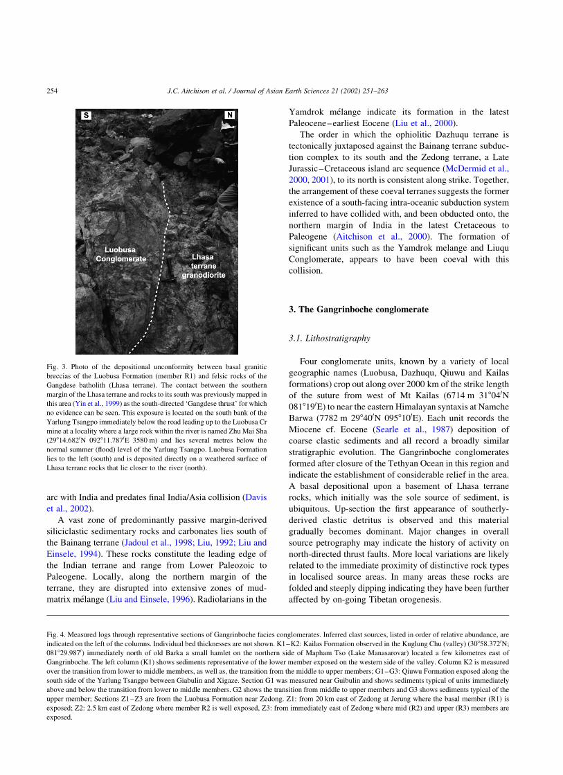
Fig. 3. Photo of the depositional unconformity between basal granitic
breccias of the Luobusa Formation (member R1) and felsic rocks of the
Gangdese batholith (Lhasa terrane). The contact between the southern
margin of the Lhasa terrane and rocks to its south was previously mapped in
this area (Yin et al., 1999) as the south-directed ‘Gangdese thrust’ for which
no evidence can be seen. This exposure is located on the south bank of the
Yarlung Tsangpo immediately below the road leading up to the Luobusa Cr
mine at a locality where a large rock within the river is named Zhu Mai Sha
(29814.6820N 092811.7870E 3580 m) and lies several metres below the
normal summer (flood) level of the Yarlung Tsangpo. Luobusa Formation
lies to the left (south) and is deposited directly on a weathered surface of
Lhasa terrane rocks that lie closer to the river (north).
Fig. 4. Measured logs through representative sections of Gangrinboche facies conglomerates. Inferred clast sources, listed in order of relative abundance, are
indicated on the left of the columns. Individual bed thicknesses are not shown. K1–K2: Kailas Formation observed in the Kuglung Chu (valley) (30858.3720N;
081829.9870) immediately north of old Barka a small hamlet on the northern side of Mapham Tso (Lake Manasarovar) located a few kilometres east of
Gangrinboche. The left column (K1) shows sediments representative of the lower member exposed on the western side of the valley. Column K2 is measured
over the transition from lower to middle members, as well as, the transition from the middle to upper members; G1–G3: Qiuwu Formation exposed along the
south side of the Yarlung Tsangpo between Giabulin and Xigaze. Section G1 was measured near Guibulin and shows sediments typical of units immediately
above and below the transition from lower to middle members. G2 shows the transition from middle to upper members and G3 shows sediments typical of the
upper member; Sections Z1–Z3 are from the Luobusa Formation near Zedong. Z1: from 20 km east of Zedong at Jerung where the basal member (R1) is
exposed; Z2: 2.5 km east of Zedong where member R2 is well exposed, Z3: from immediately east of Zedong where mid (R2) and upper (R3) members are
exposed.
J.C. Aitchison et al. / Journal of Asian Earth Sciences 21 (2002) 251–263254

J.C. Aitchison et al. / Journal of Asian Earth Sciences 21 (2002) 251–263 255

3.2. Luobusa Formation
The Luobusa Formation, which crops out along the
YTSZ south east of Lhasa, is a thick (1270 m at Luobusa)
succession of coarse clastic strata. Semi-continuous outcrop
can be traced eastwards for approximately 100 km along the
suture from Zedong township past Luobusa Cr-mine to
beyond Jindong. Rocks near Zedong are undeformed but as
the Namche Barwa syntaxis is approached the unit becomes
progressively more deformed. Distinct changes in sediment
sources are observed up-section. A depositional contact
upon a Lhasa terrane surface, represented by Late Cretac-
eous to Oligocene intrusives of the Gangdese batholith or
Late Jurassic to Early Cretaceous meta-sedimentary and
meta-volcanic units of the Sangri Group, can be observed
clearly (Fig. 3) at many localities (Badengzhu, 1979, 1981).
Coarse (boulder) conglomerates at the base of the formation
are dominated by clasts derived locally from the Lhasa
terrane such as Gangdese granites, porphyry volcanics,
limestone (marble), and chloritic meta-sediments and meta-
volcanics (lower member R1—360 m thick at Luobusa).
Up-section, overlying conglomerates (R2—270 m thick at
Luobusa) record the arrival of a conspicuous influx of
Dazhuqu and Bainang terrane-derived clasts (red chert,
ultramafic, diabase). While feldspar porphyritic volcanics of
Lhasa terrane origin are present they become less common
up-section (Fig. 4). Towards the top of the middle member
(R2) pebbly conglomerates, in which clasts are dominantly
Lhasa terrane-derived porphyritic volcanics (.75% of
clasts), are interbedded with finer-grained siltstones and
sandstones. Subordinate amounts of red chert and gabbro,
sourced from Bainang and Dazhuqu terranes, respectively,
are also present. Coarse conglomerates return in the
uppermost member (R3—640 m thick at Luobusa). This
member is polymict and sees the appearance of Indian
terrane-derived quartzite clasts. Clasts are derived from all
nearby terranes including the Zedong terrane. The upper
levels of the conglomerates are truncated by the north-
directed Renbu–Zedong thrust (Yin et al., 1994, 1999).
Luobusa Formation typically lies in the footwall of this fault
and locally exhibits asymmetrical folds associated with
north-directed thrusting. At some localities Luobusa
Formation is overthrust by constituent rocks of the YTSZ
such as those of the Zedong or Dazhuqu terranes (e.g. at
Luobusa; Zhou et al., 1996). Elsewhere shortening is greater
and it is overthrust by the Indian terrane.
3.3. Dazhuqu Formation
Dazhuqu Formation crops out to the southwest of
Lhasa and has its type area in the Yarlung Tsangpo
gorge near Renbung where it is over 1500 m thick. The
conglomerates were originally named Dazhuqu For-
mation by local geologists who mapped in this region as
part of a base metal exploration program along the
YTZS. They can be traced eastwards along strike to
south of Daga near the road bridge crossing the Yarlung
Tsangpo (Wei and Peng, 1984) where an extremely
small outcrop (a few m2) of these distinctive conglom-
erates occurs where the YTSZ passes through a small
col, Jiangdan Yako (visible from Lhasa airport). An
unconformable depositional contact upon rocks of the
Lhasa terrane (Sangri Group metamorphics) is particu-
larly obvious east of the summit of a major (6126 m)
glaciated peak (Burg, 1983) which, when not enveloped
in cloud, is clearly visible to the west of the main road
bridge over the Yarlung Tsangpo (Fig. 5A). Few
outcrops of Gangrinboche facies conglomerates or any
other suture zone rocks are seen between Lhasa Airport
and Zedong as the YTSZ is largely obscured by
Quaternary alluvium in the floor of the Yarlung
Tsangpo valley.
Dazhuqu Formation is dominated by coarse clastic strata
and was deposited directly on an eroded surface of Lhasa
terrane rocks such as intrusives of the Gangdese batholith or
Sangri Group metamorphics (Fig. 5B). Large boulder-sized
Lhasa terrane-derived clasts are common lower in the
formation and YTSZ ophiolitic, and subduction complex-
derived detritus then becomes abundant higher in the
section. Deposition was evidently very proximal. Near the
top of the preserved section Dazhuqu Formation grades
upwards into red and brown pebbly mudstones. Although
the northern contact is depositional upon the Lhasa terrane
all contacts with units to the south are faulted. Time and
weather constraints precluded the measurement of any
section through these rocks.
Fig. 5. A: Conglomerates of the Dazhuqu Formation observed on peak 6126 m looking west from the Lhasa–Xigaze highway a few km west of the main bridge
over the Yarlung Tsangpo. The other peak hidden in clouds to the left (south) of the pass is composed of Triassic rocks of Indian terrane affinity which have
been thrust northwards along the Great Counter (Renbu–Zedong) thrust system. Serpentinite and ultramafic rocks of the Dazhuqu terrane (um) crop out in the
saddle between the two peaks. The top of peak 6126 m consists of Dazhuqu Formation conglomerates which dip moderately to the south (left). A non-
conformable contact where these conglomerates rest depositionally upon an eroded surface of Sangri Group metamorphic rocks and granites (Lhasa terrane)
occurs on the slopes in shade below the summit of this peak. B: Dazhuqu Formation at 29818.3450N;089848.2620E east of Renbung observed looking up stream
(west) along the Yarlung Tsangpo. On the left hand (south) side of the photo a thick succession of Dazhuqu Formation unconformably overlies Sangri Group
metamorphic rocks (Lhasa terrane). Dazhuqu Formation dips gently to the south. The peak in the middle of the photo is capped by ophiolitic rocks of the
Dazhuqu terrane. C: Outcrop of Qiuwu Formation located on the south bank of the Yarlung Tsangpo east of Giabulin at 29819.7330N;088834.4380E observed
looking downstream (east). The contact between lower and middle members of the formation can be seen sloping from the saddle in the right of the photo down
towards the 4WD vehicle. D: Gangrinboche (6714 m—Mt Kailas), western Tibet. A thick succession of thickly-bedded conglomerate beds crops out as the flat-
lying horizons that form this holy mountain.
J.C. Aitchison et al. / Journal of Asian Earth Sciences 21 (2002) 251–263256

J.C. Aitchison et al. / Journal of Asian Earth Sciences 21 (2002) 251–263 257

3.4. Qiuwu Formation
Qiuwu Formation crops out from about 15 km east of
Xigaze (898E) and extends westwards for hundreds of km
beyond Saga (858E) (Zhang and Fu, 1982). The easternmost
outcrops of Qiuwu Formation are essentially continuous
with the westernmost outcrops of the Dazhuqu Formation
with the area intervening between these two units obscured
by Quaternary alluvium in the Yarlung Tsangpo valley. The
base of the formation lies at a depositional contact upon
rocks of the Lhasa terrane. The uppermost levels of the
formation lie in the footwall of a major north-directed thrust
fault with Cretaceous turbidites of the Xigaze terrane in the
hanging wall thrust northwards over the Qiuwu Formation.
A maximum thickness of over 4000 m is attained west of
Xigaze.
As with the Luobusa Formation, the Qiuwu Formation
can be subdivided into three distinctive members. Distinct
changes in sediment sources are observed up-section (Wang
et al., 2000). Above the basal unconformity, where beds are
characterised by locally derived boulder beds, the formation
consists of tabular horizons of sandstone and pebble
conglomerates occur in more or less equal proportions.
The lower member is approximately 650 m thick in the
Giabulin area west of Xigaze. Sandstones and conglomer-
ates contain clasts of serpentinite and mafic pebbles within
an arkosic matrix. The middle member of the formation
(2800 m thick) contains a series of fining-upward sequences
(Fig. 5C) with more or less equal proportions of conglom-
erate and finer-grained lithologies. A variety of clast types
are present with: gabbro, serpentinite, and diabase;
volcaniclastic sandstone, and tuffaceous mudstones; green
tuffaceous chert, and red chert; granite and porphyritic
volcanics derived from the Dazhuqu, Xigaze, Bainang and
Lhasa terranes, respectively. The upper member of the
formation (600 þ m thick) consists of fining-upward
sequences in which sandstone and red shale are predominant
and minor conglomerate also occurs. Conglomerates clasts
are mostly derived from the Bainang terrane and are
typically tuffaceous chert and red chert. Lesser amounts of
porphyritic volcanics, serpentinite, sandstone, mudstone,
limestone, quartzite, and vein quartz derived from Lhasa,
Dazhuqu, Xigaze, and Indian terranes are also present.
3.5. Kailas Formation
Conglomerates similar to those of the Qiuwu Formation
can be traced westwards from Xigaze at least as far
(1500 km) as the 6714 m peak of Gangrinboche (Mt Kailas)
where they outcrop spectacularly as thick flat-lying beds on
the upper slopes of the mountain (Fig. 5D). The Kailas
Formation is another thick succession of clastic strata with a
basal depositional contact, readily observed on the Kailas
Kora, upon the Gangdese batholith. It was first described by
Gansser (1964) who reported a thickness of approximately
4000 m. Distinct changes in sediment sources are obser-
vable up-section. Although lowermost sediments were
derived from the north, southerly-derived clasts become
increasingly dominant up-section.
As with other Gangrinboche conglomerate units, the
Kailas Formation can be subdivided into three members
(Yin et al., 1999). Locally derived Kailas granite boulders
occur in basal beds immediately above the unconformity. In
the lower member thick laterally extensive tabular beds of
sandstone and conglomerate predominate. Minor internal
unconformities are locally present. Clasts compositions are
dominated by porphyritic volcanics derived from the Lhasa
terrane to the north. A middle member consists of massive
conglomerates stacked in coarsening-upwards cycles.
Southerly-derived quartzose sandstone clasts of Indian
terrane origin are common and Lhasa terrane porphyritic
volcanics become subordinate up-section. A transition to the
upper member is observed with the gradual influx of beds of
extremely proximal breccia derived from terranes that lie to
the south of the Kailas Formation. Some clasts in the
breccias are more than 1 m in size and by the top of the
upper member breccias predominate. Most clasts are of
Tethyan origin with an abundance of Indian terrane-derived
boulders. Subordinate quantities of basalt, pelagic lime-
stone, and red siliceous mudstone clasts are also present.
Material derived from the Lhasa terrane is absent in the
upper member. The top of the formation is either faulted or
removed by erosion. The conglomerates are locally over-
thrust by the north-directed Great Counter thrust (Gansser,
1964; Heim and Gansser, 1939). This fault is also referred to
as the South Kailas thrust (Yin et al., 1999).
4. Age constraints
The ages of various Gangrinboche facies conglomerate
units along the YTSZ are of great significance to regional
tectonic models. The presence of these molasse units has
previously been used as geological evidence for the
development of relief associated with the India–Asia
collision and mass wasting of large volumes of coarse
sediments. These rocks have previously been accorded an
Eocene age and the timing of their accumulation has been
cited (Searle et al., 1987) as one of the main lines of
evidence in support of models invoking early Eocene
collision. Therefore any data which may better constrain the
ages of these rocks should provide important constraints for
testing the timing of collision inferred in models that are
based on more indirect geophysical lines of evidence
(Klootwijk et al., 1992; Molnar and Tapponnier, 1975;
Searle et al., 1987).
The age of the Luobusa Formation is constrained by the
presence of non-marine fossils reported by local workers on
map legends and in written reports accompanying these
maps. Fossils reported (Badengzhu, 1979, 1981) include:
Bivalvia Sphaerum aff. S. rivicolum Lamarck, Acuticosta
sp., Sphaerum sp., Lepidodesma sp; Gastropoda Planorbis
J.C. Aitchison et al. / Journal of Asian Earth Sciences 21 (2002) 251–263258

cf. P. rotundata Brong, Microlaminatus sp., Bitnynia sp.,
Planorbarius sp., Binynia? sp. cf. limbata (Deshayes),
Gyraulus sp., Fluminicola sp., Amnicola sp., Lymnaea sp;
Algae Charophyta gen. et sp. indet., Crofiella sp.,
Rhabdochara? sp., Ambnychara sp., Tectachara sp., and
Plantae Quecus cf. tofina, Colutea sp., Salix sp., Viburnum
spp. Palmocarpon? sp. and Rhododendron? sp. All known
fossils occurrences are in rocks of member R2 in the vicinity
of Luobusa and are regarded as indicative of an Oligocene–
Miocene depositional age (Badengzhu, 1981).
Stratigraphic relations can be used to further constrain
the age of the conglomerates. A basal depositional contact
where conglomerates are directly deposited upon strongly
foliated meta-sedimentary rocks within the Lhasa terrane, as
well as elements of the Gangdese batholith such as the Yaga
granodiorite, is clearly observable. This contact can be
walked for many kilometres in the field from east of Zedong
to beyond Luobusa. Emplacement of the Yaga granodiorite
at an estimated crustal depth of 13 km is constrained by
radiometric dates of 30.4 ^ 0.4 Ma (Harrison et al., 2000).
The deposition of the basal horizons of the Luobusa
Formation directly upon this mid Oligocene granodiorite
clearly indicates its surface exposure prior to sediment
accumulation. Harrison et al. (1992) and Copeland et al.
(1995) suggested that rapid cooling of Lhasa terrane plutons
occurred in this region between 29 and 24 Ma with uplift
completed by 23 Ma. Apatite fission track data indicate that
the nearby Dagze pluton passed through the apatite cooling
window (110 8C) by 22 Ma (Pan, 1993; Pan et al., 1993).
Thus development of the Luobusa Formation should
postdate this cooling event and deposition most likely
began in the Early Miocene. Additional radiometric
constraints on displacement along the Renbu Zedong thrust,
a structure that truncates the Luobusa Formation, indicate
that north-directed thrusting occurred between 18 and
10 Ma in this region (Yin et al., 1999). Fossil and
radiometric ages are therefore in accord with one another
and the best estimate for the timing of deposition of the
Luobusa Formation is during the Early Miocene.
No fossils have been reported from the Dazhuqu
Formation but the nature of its relationship to the Lhasa
terrane and the sedimentary succession within this unit
strongly support correlation with Luobusa, Qiuwu and
Kailas units. Were it not for the considerable quantity of
alluvium in the Yarlung Tsangpo valley the Dazhuqu
Formation would likely be continuous with Luobusa and
Qiuwu formations to the east and west, respectively.
Stratigraphy and sedimentology of rocks of the Qiuwu
Formation have been described in some detail (Wang et al.,
1999, 2000). On the basis of paleontological data they
excluded many rocks from the Qiuwu Formation referring
to them as a separate entity, the Giabulin Formation for
which a Cretaceous age was inferred. Wang et al. (1999,
2000) reported chert cobbles near the base of their Giabulin
Formation (lower Qiuwu Formation) that contain a
Turbocapsula costata zone (mid Cretaceous-Aptian) radi-
olarian fauna. They further reported Lower Cretaceous
gastropods from the upper part of the formation more than
3000 m above the lowermost reported cobbles containing
the radiolarian fauna. As the upper levels of the formation
cannot possibly be older than clasts in conglomerates within
the lower part of the formation we suggest that the presence
of older fossils at higher stratigraphic levels may be
explained by the fact that the gastropod fossils were
derived. The Qiuwu Formation contains red chert clasts
throughout and cannot be older than these clasts. The chert
clasts represent deep marine siliceous biogenic sediments
that must have experienced lithification, low-grade meta-
morphism and alteration prior to their being uplifted, eroded
and shed into a succession of fluvial sediments. Recent work
(Ziabrev et al., 2001; Zyabrev et al., 1999, 2000), which
provides new age constraints on various terranes and their
constituent lithologies within the YTSZ, indicates that the
ages of the radiolarian faunas in chert pebbles within the
Qiuwu Formation are entirely compatible with Bainang or
Dazhuqu terranes as possible sources for these clasts.
Lithologically, the clasts have greatest affinity with the
Bainang terrane in which red ribbon-bedded radiolarian
cherts are abundant. The presence of cobble-sized clasts of
serpentinite within the Qiuwu (Giabulin) Formation indi-
cates minimal transportation and the Dazhuqu terrane seems
an eminently likely local source candidate. Having
examined sections from west of Giabulin to east of Xigaze
we see no stratigraphical or sedimentological reason to
regard the so-called Giabulin Formation as anything other
than part of the Qiuwu Formation. We therefore suggest that
there is no longer any need to invoke a ‘paleo-ophiolite’
source (Wang et al., 1999, 2000) and the so-called Giabulin
Formation should be regarded, as it is by most other
workers, as an integral part of the Qiuwu Formation.
Age estimates for deposition of the Qiuwu Formation,
rather than the ages of clasts within it, that are based on the
presence of fossils are imprecise and best estimated within
the range of late Eocene to Early Miocene. Non-marine
fossils include the plant fossils Ficeus, Palacocycas,
Yuceites, Rhamnites emines, Viburnum esperum sp. Fossils
locally occur in association with thin carbonaceous horizons
and numerous conflicting age calls exist. A minimum age
can be constrained from felsic dikes, which intrude both the
Qiuwu Formation and the Xigaze terrane. These dikes have
been radiometrically (40Ar/39Ar) dated at 18.3 ^ 0.5 Ma
(Yin et al., 1994). The dikes cross-cut folds in the Qiuwu
Formation, as well as the major north-directed thrust that
truncates the top of the formation, thus indicating
deformation prior to their intrusion in the late Early
Miocene. Thus, based on correlation with Gangrinboche
conglomerates elsewhere, we suggest that the Qiuwu
Formation is also Lower Miocene.
The age of the Kailas Formation is constrained both
paleontologically and radiometrically. The upper member
contains mid Eocene foraminifera Fasciolites Sheng et
Zhang, Fasciolites tibeticus Sheng et Zhang, Fasciolites
J.C. Aitchison et al. / Journal of Asian Earth Sciences 21 (2002) 251–263 259

nuttalli Davies, Nummulites rotularius Deshayes (unpub-
lished data Tibet Geological Survey). These fossils occur
within limestone clasts and thus indicate the ages of rocks
within the source area rather than the timing of Kailas
deposition. Misunderstanding of this may be a reason for
previous incorrect assignment of an Eocene age. In situ
fossils occur in the form of plant fossils known from the
lower part of the formation and these include Populus
balsamoicles, Populus latior, Populus glanulifera, Populus
sp., Allbizzia sp., Lequminosites sp. (unpublished data Tibet
Geological Survey). Non-marine Unionidae bivalve fossils
reported from the middle part of the formation indicate
Miocene deposition (Miller et al., 2000).
Kailas conglomerates were deposited directly upon rocks
of the Kailas Igneous Complex which is dated radiometri-
cally at 38 ^ 1.3 Ma Rb–Sr; (Honegger et al., 1982).
Igneous clasts from this basement dominate conglomerates
low in the formation. Radiometric age constraints (Harrison
et al., 1993) indicate that these igneous rocks were not
uplifted, and thus not exposed and available for erosion,
until the late Oligocene. Thus fossil ages are in accord with
radiometric constraints on the timing of deposition.
Displacement on the South Kailas thrust, which truncates
the upper levels of the conglomerates, is bracketed between
20 and 4 Ma (Yin et al., 1999) thereby providing a minimum
age constraint. Thus the Kailas Formation must also be
Lower Miocene.
At all localities with fossil, radiometric or structural
constraints on the timing of deposition of the Gangrinboche
conglomerates a latest Oligocene to Early Miocene age is
indicated.
5. Discussion
Lower Miocene Gangrinboche facies conglomerates
within the Luobusa, Dazhuqu, Qiuwu and Kailas formations
are correlative molasse units that crop out in a narrow
elongate zone along the YTSZ and record aspects of the
history of the India/Asia collision. Sedimentary rocks in all
sections exhibit characteristics compatible with an interpret-
ation of their having accumulated in alluvial fan and braid-
plain environments (Wang et al., 1999, 2000; Yin et al.,
1999). Many of the sediments present are extremely
proximal and clast petrography is influenced strongly by
the nature of rocks in adjacent source terranes. A similar
stratigraphic history is recorded over a 1500 km strike
length. Each formation is subdivisible into three members
and the broad pattern of up-section evolution is correlative.
A depositional contact upon an eroded surface of Lhasa
terrane rocks with all sedimentary detritus being locally
derived from north of the suture zone is ubiquitous. Initial
clast derivation in all sections is very localised and is from
the north. Up-section the first arrival of clasts derived from
suture zone terranes and the northern margin of India, all of
which lie to the south of the Gangrinboche conglomerates, is
observed. Clasts derived from southern portions of, or south
of the suture zone, then become increasingly abundant until
they predominate in upper levels of the conglomerates. The
top of each unit either, lies at the present day erosional
surface or, is truncated by a north-directed thrust. This
structure is regionally extensive and constitutes part of the
Great Counter thrust system (Gansser, 1964; Heim and
Gansser, 1939). The same structure has been recognised
further east along the YTSZ where it is referred to as the
Renbu–Zedong thrust (Yin et al., 1994, 1999).
Late Oligocene regional uplift of the Lhasa terrane
(Harrison et al., 1992) must have created a landscape with
considerable relief with initial deposition of these conglom-
erates on alluvial fans and braided rivers that developed
along and parallel to the southern front of a cordilleran-type
mountain range. South-directed thrust faulting along a
structure referred to as the Gangdese thrust was suggested as
a mechanism to explain this uplift (Yin et al., 1994). This
hypothesis is of significance to any assessment of develop-
ment of the Gangrinboche conglomerates as, not only does it
suggest a mechanism for uplift of the Lhasa terrane, the
proposed Gangdese thrust reportedly places rocks of the
Lhasa terrane southwards over Tertiary conglomerates
(Harrison et al., 2000; Yin et al., 1994, 1999). Our
investigations (Aitchison et al., 2001) indicate, however,
that the conglomerates in question are not Tertiary. They are
pervasively foliated and metamorphosed, contain mostly
andesitic and limestone (marble) clasts, and constitute part
of an Upper Jurassic–Lower Cretaceous zone of meta-
sediments and meta-volcanics (Sangri Group) that com-
prises the basement of the southern part of the Lhasa terrane
(Burg, 1983). Observations along 1500 km strike length of
the Gangrinboche conglomerate indicate that the Gang-
rinboche conglomerates are everywhere in depositional
contact upon rocks of the Lhasa terrane. Detailed investi-
gations in the Zedong–Luobusa area indicate that this
depositional contact can be mapped along the entire strike
length of the proposed Gangdese thrust and we have not
seen Lhasa terrane rocks thrust over Gangrinboche
conglomerates at any locality. This observation is in
accordance with numerous other regional investigations
(Badengzhu, 1979, 1981; Bureau of Geology and Mineral
Resources of Xizang Autonomous Region, 1993; Burg,
1983; Gansser, 1964; Wei and Peng, 1984; Zhang and Fu,
1982) along the entire length of the suture zone. Thus,
although considerable relief must have been present within
the southern Lhasa terrane when Gangrinboche conglomer-
ates accumulated the mechanism for this uplift remains
enigmatic.
The gradual, then overwhelming, influx of detritus
derived from terranes that lie to the south of present day
outcrops of the Gangrinboche conglomerates provides
evidence for development of relief to the south of the
suture zone and is seen in all sections. While we see no
evidence for the existence of a south-directed ‘Gangdese
thrust’ we agree with the suggestion of Yin et al. (1999) that
J.C. Aitchison et al. / Journal of Asian Earth Sciences 21 (2002) 251–263260

these conglomerates, and coarse breccias in some localities
such as Mt Kailas, may reflect the development of north-
directed thrust systems such as the north-directed Great
Counter thrust or Renbu–Zedong thrust systems. Upper
levels of the Gangrinboche conglomerates presumably
developed in the foreland of a northward advancing
mountain front that lay to the south of the Lhasa terrane.
The elongate zone along which the Gangrinboche con-
glomerates are distributed reflects their original deposition
along a valley system axial to two sub-parallel, active,
mountain ranges.
It is presently a widely held, and remarkably unques-
tioned hypothesis that India–Asia collision occurred during
the latest Paleocene/early Eocene. The main lines of
evidence given in support of a latest Paleocene/early
Eocene collision (Searle et al., 1987) are: the slowdown in
the convergence rate between India and Asia; the initiation
of compressional tectonics along, and south of, the Indus–
Yarlung Tsangpo suture; a lack of data indicating subduc-
tion-related magmatic activity north of the suture between
India and Asia; and the accumulation of ‘Eocene’ molasse
deposits along the suture. From detailed studies of ‘molasse-
style’ conglomerate units that crop out along the YTSZ
(Aitchison and Davis, 2001a; Davis et al., 1999, 2002; this
paper) we recognize the existence of two discrete pulses of
sedimentation, one Paleogene, the other late Oligocene–
Early Miocene, but none of Eocene age. It is thus obvious
that not all conglomerates should, or can, be correlated.
Although a depositional contact of Indus Molasse upon
granitic rocks of the Ladahk Batholith can be observed in
Pakistan (Clift et al., 2001; Garzanti and Van Haver, 1988)
conglomerates in that area also rest depositionally upon
other terranes along and south of the Indus suture zone. We
therefore remain cautious about any direct correlation
between Indus and Gangrinboche conglomerates and
suggest further detailed work is required to resolve this
matter.
In other aspects of our investigations along the YTSZ we
have recognised evidence for the Late Cretaceous to
Paleocene collision of an intra-oceanic island arc with the
northern margin of India (Aitchison et al., 2000). We
suggest that the removal of the subduction zone associated
with this intra-oceanic island arc within Tethys would
provide an effective mechanism to slow what was an
anomalously high (20 cm/yr) convergence rate if a single
plate boundary existed between India and Asia. Paleogene
conglomerates of the Liuqu Formation are interpreted
(Aitchison et al., 2000; Davis et al., 1999, 2002) as having
developed in association with this collision which also
provides a plausible explanation for the initiation of
compressional tectonics along, and south of, the YTSZ.
If, as has been suggested by Searle et al. (1987), the
Gangrinboche conglomerates provide evidence for collision
between India and Asia then previous incorrect assumptions
of an Eocene age and potential misinterpretation of other
data may have lead to significant error in estimates of the
timing of collision between India and Eurasia. The timing of
deposition of these conglomerates can be well constrained
to the latest Oligocene–Early Miocene. Recently published
radiometric age data (Harrison et al., 2000) for granodiorites
in the southern Lhasa terrane indicate subduction-related
magmatism occurring as late as 30.4 ^ 0.4 Ma (end early
Oligocene), considerable later than previously known.
While the Gangrinboche conglomerates do not necessarily
constrain the timing of the initiation of collision they
certainly provide unequivocal evidence that it had hap-
pened. Their maximum age is considerably younger than
previously thought, as are the youngest known subduction-
related magmatic rocks in the Lhasa terrane and the
youngest known marine sediments in the Tethyan Himalaya
north of Qomolangma (the Zhaguo member of the Pengqu
Formation contains late Priabonian NP20 zone nannofos-
sils; Wang et al., 2002), thereby opening the possibility that
collision itself was later than presently believed. If two
continents were colliding in this region then we suggest
(Aitchison and Davis, 2001b) that the Eocene and much of
the Oligocene were times of remarkable sedimentary
quiescence in terms of the near absence of any succession
that could possibly be attributed to having developed in
association with collision. We further suggest that reassess-
ment of any models for the development of the India–Asia
collision should be on-going with no model more important
than any newly available data. Models for the tectonic
evolution of the India–Asia collision require on-going
modification to reflect complexity indicated by any newly
available data.
Acknowledgments
We thank members of the Tibetan Geological Survey
(Team 2) and Tibetan Geological Society whose efforts
have helped to make this research possible. Many of these
friends have assisted with arranging logistics and per-
mission. We thank Yani Najman, Erich Draganits and Kurt
Stuwe for their reviews and constructive comments on the
manuscript. The work described in this paper was supported
by grants from the Research Grants Council of the Hong
Kong Special Administrative Region, China (Project Nos.
HKU 7102/98P and HKU 7299/99P).
References
Aitchison, J.C., Davis, A.M., 2001a. Orogenic conglomerates indicate
timing of collision in Tibet. 16th Himalaya–Karakorum–Tibet work-
shop abstracts. Journal of Asian Earth Sciences 19/3A, 1–2.
Aitchison, J.C., Davis, A.M., 2001b. When did the India–Asia collision
really happen?, International Symposium and Field Workshop on the
Assembly and Breakup of Rodinia and Gondwana, and Growth of Asia.
International Symposium and Field Workshop on the Assembly and
Breakup of Rodinia and Gondwana, and Growth of Asia, Gondwana
Research, 4. Osaka City University, Japan, pp. 560–561.
J.C. Aitchison et al. / Journal of Asian Earth Sciences 21 (2002) 251–263 261

Aitchison, J.C., Badengzhu, Davis, A.M., Liu, J., Luo, H., Malpas, J.,
McDermid, I., Wu, H., Ziabrev, S., Zhou, M.F., 2000. Remnants of a
Cretaceous intra-oceanic subduction system within the Yarlung-Zangbo
suture (southern Tibet). Earth and Planetary Science Letters 183,
231–244.
Aitchison, J.C., Davis, A.M., Badengzhu, Luo, H., 2001. The ‘Gangdese
thrust’ was not responsible for uplift of southern Tibet. EOS,
Transactions, American Geophysical Union Fall Meeting Abstracts
Supplement, T12F-08.
Allegre, C.J., Courtillot, V., Tapponnier, P., Hirn, A., Mattauer, M.,
Coulon, C., Jaeger, J.J., Achache, J., Scharer, U., Marcoux, J., Burg,
J.P., Girardeau, J., Armijo, R., Gariepy, C., Gopel, C., Li, T., Xiao, X.,
Chang, C., Li, G., Lin, B., Teng, J.W., Wang, N., Chen, G., Han, T.,
Wang, X., Den, W., Sheng, H., Cao, Y., Zhou, J., Qiu, H., Bao, P.,
Wang, S., Wang, B., Zhou, Y., Ronghua, X., 1984. Structure and
evolution of the Himalaya–Tibet orogenic belt. Nature 307, 17–22.
Badengzhu, 1979. (Compiler) Xizang Autonomous Region Zhanang–
Sangri Regional Geology Reconnaissance Map 1:50,000. Xizang
Geological Survey Geological Team # 2, Group 2, Lhasa.
Badengzhu, 1981. (Compiler) Xizang Autonomous Region Sangri–Jiacha
Regional Geology Reconnaissance Map 1:50,000. Xizang Geological
Survey Geological Team # 2, Lhasa.
Bureau of Geology and Mineral Resources of Xizang Autonomous Region,
1993. Regional geology of Xizang (Tibet) autonomous region.
Geological Memoir of the Peoples Republic of China, Ministry of
Geology and Mineral Resources Series 1 31, 1–707.
Burg, J.P., 1983. Carte Geologique du Sud du Tibet, scale 1:500,000,
CNRS, Paris.
Chang, C., Chen, N., Coward, M.P., Deng, W., Dewey, J.F., Gansser, A.,
Harris, N.B.W., Jin, C., Kidd, W.S.F., Leeder, M.R., Li, H., Lin, J., Liu,
C., Mei, H., Molnar, P., Pan, Y., Pearce, J.A., Shackleton, R.M., Smith,
A.B., Sun, Y., 1986. Preliminary conclusions of the Royal Society and
Academia Sinica 1985 geotraverse of Tibet. Nature 323, 501–507.
Chang, C.F., Zeng, S.L., 1973. Tectonic features of the Mount Jolmo
Lungma region in southern Tibet, China. Dizhi Kexue, Scientia
Geologica Sinica 1, 1–12.
Clift, P.D., Shimizu, N., Layne, G.D., Blusztajn, J., 2001. Tracing patterns
of erosion and drainage in the Paleogene Himalaya through ion probe
Pb isotope analysis of detrital K-feldspars in the Indus Molasse, India.
Earth and Planetary Science Letters 188, 475–491.
Copeland, P., Harrison, T.M., Yun, P., Kidd, W.S.F., Roden, M., Zhang, Y.,
1995. Thermal evolution of the Gangdese Batholith, southern Tibet; a
history of episodic unroofing. Tectonics 14, 223–236.
Coward, M.P., Kidd, W.S.F., Pan, Y., Shackleton, R.M., Zhang, H., 1988.
The structure of the 1985 Tibet Geotraverse, Lhasa to Golmud.
Philosophical Transactions of the Royal Society of London, Series A:
Mathematical and Physical Sciences 327, 307–336.
Davis, A.M., Aitchison, J.C., Badengzhu, Luo, H., Malpas, J., Zyabrev, S.,
1999. Eocene oblique-slip basin development, Tibet: terrane tracks on
the roof of the world. In: Evenchick, C.A., Woodsworth, G.J., Jongens,
R. (Eds.), Terrane Paths 99 Terrane Conference, Okanagan Valley,
Canada, September 26–October 1, 1999, pp. 28.
Davis, A.M., Aitchison, J.C., Badengzhu, Luo, H., Zyabrev, S., 2002.
Paleogene island arc collision-related conglomerates, Yarlung Tsangpo
suture zone, Tibet. Sedimentary Geology 150, 247–273.
Dewey, J.F., Bird, J.M., 1970. Mountain belts and the new global tectonics.
Journal of Geophysical Research 75, 2625–2647.
Durr, S.B., 1996. Provenance of Xigaze fore-arc basin clastic rocks
(Cretaceous, South Tibet). Geological Society of America Bulletin 108,
669–684.
Einsele, G., Liu, B., Durr, S., Frisch, W., Liu, G., Luterbacher, H.P.,
Ratschbacher, L., Ricken, W., Wendt, J., Wetzel, A., Yu, G., Zheng, H.,
1994. The Xigaze forearc basin; evolution and facies architecture
(Cretaceous, Tibet). Sedimentary Geology 90, 1–2.
Gansser, A., 1964. The Geology of the Himalayas, Wiley, New York, pp.
289.
Gansser, A., 1977. The great suture zone between Himalaya and Tibet; a
preliminary account. Colloques Internationaux du Centre National de la
Recherche Scientifique 268, 181–191.
Garzanti, E., Van Haver, T., 1988. The Indus clastics: forearc basin
sedimentation in the Ladakh Himalaya (India). Sedimentary Geology
59, 237–249.
Girardeau, J., Marcoux, J., Zao, Y., 1984. Lithologic and tectonic
environment of the Xigaze ophiolite (Yarlung Zangbo suture zone,
southern Tibet, China), and kinematics of its emplacement. Eclogae
Geologicae Helvetiae 77, 153–170.
Girardeau, J., Mercier, J.C., Xibin, W., 1985a. Petrology of the mafic rocks
of the Xigaze ophiolite, Tibet; implications for the genesis of the
oceanic lithosphere. Contributions to Mineralogy and Petrology 90,
309–321.
Girardeau, J., Mercier, J.C.C., Yougong, Z., 1985b. Origin of the Xigaze
Ophiolite, Yarlung Zangbo suture zone, southern Tibet. Tectonophysics
119, 1–4.
Girardeau, J., Mercier, J.C.C., Zao, Y., 1985c. Structure of the Xigaze
Ophiolite, Yarlung Zangbo suture zone, southern Tibet, China; genetic
implications. Tectonics 4, 267–788.
Harrison, T.M., Copeland, P., Kidd, W.S.F., Yin, A., 1992. Raising Tibet.
Science 255, 1663–1670.
Harrison, T.M., Copeland, P., Hall, S.A., Quade, J., Burner, S., Ohja, T.P.,
Kidd, W.S.F., 1993. Isotopic preservation of Himalayan/Tibetan uplift,
denudation, and climate histories of two molasse deposits. Journal of
Geology 100, 157–175.
Harrison, T.M., Yin, A., Grove, M., Lovera, O.M., Ryerson, F.J., Zhou, X.,
2000. The Zedong window: a record of superposed Tertiary
convergence in southeastern Tibet. Journal of Geophysical Research
105, 19211–19230.
Heim, A., Gansser, A., 1939. Central Himalaya; Geological observations of
the Swiss Expedition 1936, Gebruder Fretz, Zurich, 246 pp.
Hebert, R., Beaudoin, G., Varfalvy, V., Huot, F., Wang, C.S., Liu, Z.F.,
2000. Yarlung Zangbo ophiolites, southern Tibet revisited, 15th
Himalaya–Karakorum–Tibet workshop, Chengdu, China abstracts.
Earth Science Frontiers 7, 124–126.
Hirn, A., Nercessian, A., Sapin, M., Jobert, G., Xu, Z.X., Gao, E.Y., Lu,
D.Y., Teng, J.W., 1984. Lhasa block and bordering sutures; a
continuation of a 500 km Moho traverse through Tibet. Nature 307,
25–27.
Hodges, K.V., 2000. Tectonics of the Himalaya and southern Tibet from
two perspectives. Geological Society of America Bulletin 112,
324–350.
Honegger, K., Dietrich, W., Frank, A., Gansser, M., Thoni, M.,
Trommsdoff, V., 1982. Magmatism and metamorphism in the Ladakh
Himalayas (the Indus–Tsangpo suture zone). Earth and Planetary
Science Letters 60, 253–292.
Jadoul, F., Berra, F., Garzanti, E., 1998. The Tethys Himalayan passive
margin from Late Triassic to Early Cretaceous (South Tibet). Journal of
Asian Earth Sciences 16, 173–194.
Klootwijk, C.T., Gee, J.S., Peirce, J.W., Smith, G.M., McFadden, P.L.,
1992. An early India–Asia contact; paleomagnetic constraints from
Ninety east Ridge, ODP Leg 121; with Suppl. Data 92-15. Geology 20,
395–398.
Liu, G., 1992. Permian to Eocene sediments and Indian passive margin
evolution in the Tibetan Himalayas. Tubinger Geowissenschaftliche
Arbeiten 13, 1–268.
Liu, G., Einsele, G., 1994. Sedimentary history of the Tethyan basin in the
Tibetan Himalayas. Geologische Rundschau 83, 32–61.
Liu, G.H., Einsele, G., 1996. Various types of olistostromes in a closing
ocean basin, Tethyan Himalaya (Cretaceous, Tibet). Sedimentary
Geology 104, 203–226.
Liu, J., Aitchison, J.C., Badengzhu, Davis, A.M., Ziabrev, S.V., Luo, H.,
McDermid, I., 2000. Yamdrok Melange, South Tibet, 15th Himalaya–
Karakorum–Tibet workshop, Chengdu, China abstracts. Earth Science
Frontiers 7, 127.
McDermid, I., Aitchison, J.C., Badengzhu, Davis, A.M., Liu, J., Luo, H.,
Wu, H., Ziabrev, S.V., 2000. Zedong Terrane, a mid Cretaceous
J.C. Aitchison et al. / Journal of Asian Earth Sciences 21 (2002) 251–263262

intra-oceanic arc, South Tibet, 15th Himalaya–Karakorum–Tibet
workshop, Chengdu, China abstracts. Earth Science Frontiers 7, 265.
McDermid, I., Aitchison, J.C., Badengzhu, Davis, A.M., 2001. The Zedong
Terrane: an intra-oceanic magmatic arc assemblage Tibet. 16th
Himalaya–Karakorum–Tibet workshop abstracts. Journal of Asian
Earth Sciences 19/3A, 44.
Mercier, J.L., Tapponnier, P., Proust, F., Andrieux, J., Armijo, R.,
Bassoullet, J.P., Brunel, M., Burg, J.P., Colchen, M., 1980. La collision
Inde–Asie cote Tibet. In: Mercier, J.L., Guangcen, L. (Eds.), Mission
Franco–Chinoise au Tibet 1980. Etude geologique et geophysique de la
croute terrestre et du manteau superieur du Tibet et de l’Himalaya,
CNRS, Paris, pp. 1–13.
Miller, C., Schuster, R., Klotzli, U., Frank, W., Grasemann, B., 2000. Late
Cretaceous–Tertiary magmatic and tectonic events in the Transhima-
laya batholith (Kailas area, SW Tibet). Schweizerische Mineralogische
und Petrographische Mitteilungen 80, 1–20.
Molnar, P., Tapponnier, P., 1975. Cenozoic tectonics of Asia; effects of a
continental collision. Science 189, 419–426.
Nicolas, A., Girardeau, J., Marcoux, J., Dupre, B., Wan, X., Cao, Y., Zheng,
H., Xiao, X., 1981a. The Xigaze ophiolite (Tibet); a peculiar oceanic
lithosphere. Nature 294, 414–417.
Nicolas, A., Girardeau, J., Wang, X.B., Cao, Y.G., Zheng, H.X., 1981b.
Complete ophiolitic sequences in southern Xizang (Tibet); discovery of
cumulates, dike and sill layers. Dizhi Lunping (Geological Review) 27,
457–459.
Pan, Y., 1993. Unroofing history and structural evolution of the southern
Lhasa Terrane, Tibetan Plateau. Implications for the continental
collision between India and Asia. PhD Thesis, State University of
New York, Albany, 395 pp.
Pan, Y., Copeland, P., Roden, M.K., Kidd, W.S.F., Harrison, T.M., 1993.
Thermal and unroofing history of the Lhasa area, southern Tibet—
Evidence from apatite fission track thermochronology. Nuclear Tracks
and Radiation Measurements 21, 543–554.
Pearce, J.A., Deng, W., 1988. The ophiolites of the Tibet Geotraverses,
Lhasa to Golmud (1985) and Lhasa to Kathmandu (1986). Philosophi-
cal Transactions of the Royal Society of London, Series A:
Mathematical and Physical Sciences 327, 215–238.
Searle, M.P., 1996. Cooling history, erosion, exhumation, and kinematics
of the Himalaya–Karakorum–Tibet orogenic belt. In: Yin, A.,
Harrison, M. (Eds.), The Tectonic Evolution of Asia, Cambridge
University Press, New York, pp. 110–137.
Searle, M.P., Windley, B.F., Coward, M.P., Cooper, D.J.W., Rex, A.J., Rex,
D., Li, T., Xiao, X., Jan, M.Q., Thakur, V.C., Kumar, S., 1987. The
closing of Tethys and the tectonics of the Himalaya. Geological Society
of America Bulletin 98, 678–701.
Shackleton, R.M., 1981. Structure of southern Tibet; report on a traverse
from Lhasa to Khatmandu organised by Academia Sinica. Journal of
Structural Geology 3, 97–105.
Tapponnier, P., Mercier, J.L., Proust, F., Andrieux, J., Armijo, R.,
Bassoullet, J.P., Brunel, M., Burg, J.P., Colchen, M., Dupre, B.,
Girardeau, J., Marcoux, J., Mascle, G., Matte, P., Nicolas, A., Li, T.,
Xiao, X., Chang, C., Lin, P., Li, G., Wan, N., Chen, G., Han, T., Wang,
X.b., Den, W., Zheng, H., Sheng, H., Cao, Y., Zhou, J., Qin, H., 1981.
The Tibetan side of the India–Eurasia collision. Nature 294, 405–410.
Wang, C.S., Liu, Z.F., et al., 1999. Xigaze Forearc Basin and Yarlung
Zangbo Suture Zone, Tibet, Geological Publishing House, Beijing, pp.
237.
Wang, C.S., Liu, Z.F., Herbert, R., 2000. The Yarlung-Zangbo paleo-
ophiolite, southern Tibet: implications for dynamic evolution of the
Yarlung-Zangbo Suture Zone. Journal of Asian Earth Sciences 18,
651–661.
Wang, C.S., Li, X.H., Hu, X.M., Jansa, L.F., 2002. Latest marine horizon
north of Qomolangma (Mt Everest): implications for closure of Tethys
seaway and collision tectonics. Terra Nova 14, 114–120.
Wang, X.B., Bao, P.S., Deng, W.M., Wang, F.G. (Eds.), 1987. Tectonic
Evolution of the Lithosphere of the Himalayas: Xizang (Tibet)
Ophiolite, People’s Republic of China Ministry of Geology and
Mineral Resources Geological Memoirs Series 3, 8. Geological
Publishing House, Beijing, p. 336.
Wei, B.J., Peng, Y.H., 1984. (Compilers) Xizang Autonomous Region
Xigaze — Qushui Geological Traverse Map 1:200,000. Xizang
Geological Survey Geological Team # 2, Lhasa.
Yin, A., Harrison, T.M., 2000. Geologic evolution of the Himalayan–
Tibetan orogen. Annual Review of Earth and Planetary Sciences 28,
211–280.
Yin, A., Harrison, T.M., Ryerson, F.J., Chen, W.J., Kidd, W.S.F.,
Copeland, P., 1994. Tertiary structural evolution of the Gangdese
thrust system in southeastern Tibet. Journal of Geophysical Research
99, 18175–18201.
Yin, A., Harrison, T.M., Murphy, M.A., Grove, M., Nie, S., Ryerson, F.J.,
Wang, X., Chen, Z., 1999. Tertiary deformation history of southeastern
and southwestern Tibet during the Indo-Asian collision. Geological
Society of America Bulletin 111, 1644–1664.
Zhang, S.M., Fu, X.L., 1982. (Compilers) Xizang Autonomous Region
Xigaze — Saga Geological Traverse Map 1:200,000. Xizang
Geological Survey Geological Team # 2, Lhasa.
Zhou, M.F., Robinson, P.T., Malpas, J., Li, Z., 1996. Podiform chromitites
in the Luobusa Ophiolite (southern Tibet); implications for melt-rock
interaction and chromite segregation in the upper mantle. Journal of
Petrology 37, 3–21.
Ziabrev, S.V., Aitchison, J.C., Badengzhu, Davis, A.M., Luo, H., Liu, J.,
2001. More about the missing Tethys: Bainang terrane Tibet. 16th
Himalaya–Karakorum–Tibet workshop abstracts. Journal of Asian
Earth Sciences 19/3A, 82–83.
Zyabrev, S.V., Aitchison, J.C., Badengzhu, Davis, A.M., Luo, H., Malpas,
J., 1999. Radiolarian biostratigraphy of supra-ophiolite sequences in the
Xigaze area, Yarlung Tsangpo suture, Southern Tibet (preliminary
report). Radiolaria 17, 13–19.
Zyabrev, S.V., Aitchison, J.C., Badengzhu, Davis, A.M., Luo, H., Liu, J.B.,
2000. Tethyan relics in the Yarlung Tsangpo suture, Tibet: structural
setting, radiolarian ages and their tectonic significance. Ninth Meeting
of the International Association of Radiolarian Paleontologists
INTERRAD 2000 Program with Abstracts 72.
J.C. Aitchison et al. / Journal of Asian Earth Sciences 21 (2002) 251–263 263