Stakeholders analysis of Mashhad House Manufacturing Factory
Upload
khangminh22Category
view
0download
0
15LAND AND WATER DIVISION WORKING PAPER
Negotiated territorial development in a multi-stakeholders participatory resource planning approachAn initial sustainable framework for the Near East region


Negotiated territorial development in a multi-stakeholders participatory resource planning approachAn initial sustainable framework for the Near East region
FOOD AND AGRICULTURE ORGANIZATION OF THE UNITED NATIONSRome, 2016
LAND AND WATER DIVISION WORKING PAPER15

The designations employed and the presentation of material in this information product do not imply the expression of any opinion whatsoever on the part of the Food and Agriculture Organization of the United Nations (FAO) concerning the legal or development status of any country, territory, city or area or of its authorities, or concerning the delimitation of its frontiers or boundaries. The mention of specific companies or products of manufacturers, whether or not these have been patented, does not imply that these have been endorsed or recommended by FAO in preference to others of a similar nature that are not mentioned.
The views expressed in this information product are those of the author(s) and do not necessarily reflect the views or policies of FAO.
© FAO, 2016
FAO encourages the use, reproduction and dissemination of material in this information product. Except where otherwise indicated, material may be copied, downloaded and printed for private study, research and teaching purposes, or for use in non-commercial products or services, provided that appropriate acknowledgement of FAO as the source and copyright holder is given and that FAO’s endorsement of users’ views, products or services is not implied in any way.
All requests for translation and adaptation rights, and for resale and other commercial use rights should be made via www.fao.org/contact-us/licence-request or addressed to [email protected].
FAO information products are available on the FAO website (www.fao.org/publications) and can be purchased through [email protected].
Cover photo: ©FAO/Marco Longari
iii
Preface VII
1. INTrODUcTION 11.1 The concept of participatory land use planning / negotiated territorial development 31.2.The iperatives for intervention: where? at what level? and by whom? 51.3 Why governing land and water matters 61.4 Why governing land and water matters 81.5 There can be no blueprint for change 9
2.The cONTexT aND BackgrOUNDs 102.1 The shared general characteristics 102.2 Difficult choices 112.3 food production and food imports 132.4 agricultural value added 162.5 arable land as a percentage of total land area and per capita 162.6 agricultural irrigated land 182.7 freshwater withdrawals and water productivity 19
3.The key elemeNTs Of The aPPrOach 263.1 access/use/management (of land and other natural resources) 263.2 Inclusive development 303.3 Why is gender relevant? 313.4 gender, culture and religious norms 353.5 gender in land/natural resources planning 383.6 Territory as an “entry Point” 39
3.7 governing territories with a socio-ecological approach 40
Table of contents

iv
4.ParTIcIPaTOry laND aND WaTer Use PlaNNINg/NegOTIaTeD TerrITOrIal DeVelOPmeNT: WITh sPecIal aTTeNTION TO The geNDer DImeNsION 42
4.1 Phase one: getting started 424.1.1 Establish goals and terms of reference 42
4.1.2 The planning assignment 42
4.1.2.1 Define the planning area 42
4.1.2.2 Contact the parties involved 43
4.1.2.3 Acquire initial information about the area 43
4.1.2.4 Establish the goals 43
4.1.2.5 Identify the problems and opportunities 43
4.1.2.6 Identify constraints to implementation 44 4.1.2.7 Establish the criteria by which land-use decisions will be made 44 4.1.2.8 Set the scope of the territorial Pact/Plan 44 4.1.2.9 Agree on the planning period 44 4.1.2.10 Agree on the content and format of the plan 44 4.1.2.11 Decide operational questions 44 4.1.2.12 Organize the work: what the work plan does 44 4.1.2.13 Why is it needed? 45
4.2 Phase two: the gender-sensitive diagnostic of the territory and its actors 454.2.1 Basic information about the area and initial economic-ecological zoning 45
4.2.2 Basic land units, water sources and land-use and water use systems 52
4.2.2.1 Problems of land use and water use 53
4.2.2.2 Group together issues that seem to be related 54
4.2.3 Deepening the EEZ: in-depth analysis of present land situation 55
4.2.3.1 Evaluate land suitability 55
4.2.3.2 Description of land-use types and water resources 55
4.2.3.3 Selection of land qualities and land characteristics 57
4.2.3.4 Mapping of land units and their characteristics 58
4.2.3.5 Setting limiting values for land-use requirements 58
4.2.3.5.1 The land should be able to support the land use on a sustained basis 59
4.2.3.5.2 The use should yield benefits that justify the inputs 59
4.2.3.6 Matching land use with land when water is available 61

v
4.2.3.7 Qualitative and quantitative land and natural resources evaluation 61
4.2.3.8 Land suitability classification 61
4.2.4 Development context Analysis 62
4.2.5 Stakeholders’ priorities’ analysis 65
4.2.6 Livelihood analysis toolkit 66
4.3 Phase three: scenario building 674.3.1 Dialogue and gender-responsive proposals/scenarios: identifying opportunities for change 67
4.3.1.1 Objectives 67
4.3.1.2 Opportunities 67
4.3.1.3 Options for change 70
4.3.1.4 Procedures 71
4.3.1.5 Public and executive discussion of problems and alternatives: dialogue and trust-building 72
4.3.2 Capacity development of leaders and/or local government representatives 73
4.3.2.1 Partnerships and strategic alliances 75
4.3.3 Scenarios planning: a land and water use plan proposal 75
4.3.3.1 Preparation of maps 76
4.3.3.2 Writing the scenarios 76
4.4 Phase four: negotiation process and consensus building 76 4.4.1 Appraise the alternatives and search of the best agreeable option 77
4.4.1.1 Interest-based negotiation 78
4.4.1.2 Power dynamics analysis 79
4.4.2 Composition of the working groups 80
4.4.3 Oobjectives of the working groups 82
4.4.4 Visioning 83
4.4.5 The territorial pact 85
4.4.6 The development portfolio 84
4.5 Phase five: the implementation 854.5.1 Assessment of the needs to implement the agreement (time, financial, human, social) 85
4.5.2 The role of the facilitation team 86
4.5.3 Mobilization of external resources 88
4.6 Phase six: monitoring and evaluation 89

vi
4.6.1 Participatory or conventional monitoring and evaluation? 89
4.6.1.1 M&E detailed actions as per the agreed territorial pact/plan 89
4.6.2 Evaluating the process 94
4.6.2.1 Suggested monitoring indicators for institutions 94
4.6.2.2 Suggested monitoring indicators for land-related technical issues 95
4.6.2.3 Suggested monitoring indicators for getting the message across 95
4.6.2.4 Suggested land indicators 95
4.6.2.5 Suggested gender-sensitive indicators in water resources management at the national level 95
4.6.2.6 Suggested educational attainment indicators 96
5.fINal cONsIDeraTIONs 97
BIBlIOgraPhy 99

viiPreface
Preface
The Near East Region covers a vast and highly heterogeneous area. In the nineteenth century, the Ottoman administration codified the prevailing land tenure systems into a set of norms some of which persist to this day. In parallel, a prevailing heritage of customary systems continue to strongly influence a large part of access, management and use of land and other natural resources.
Current land tenure systems are, however, failing to address long-standing problems in the region: smallholder farmers, landless households and most marginalized groups such as women continue to compete for shrinking natural recourses, and pastoralists are losing control of their traditional grazing areas. Use, management and access to land and water are becoming extremely sensitive matters as the number of users grows, resource availability shrinks and competition for the scarce resources intensifies. Governments and local actors have often perceived these major issues differently; concerted efforts have to be, therefore, undertaken to ensure a participatory approach to decision-making that effectively involves all or most of the local actors concerned in an equitable manner.
About 90% of the land area in the Region is subject to land degradation in different forms and over 45% of land suitable to farming is exposed to various types of land degradation which include soil nutrient depletion, salinity, water and wind erosion and water depletion. To address this vast array of challenges, FAO’s Regional Office for the Near East and North Africa (RNE) and FAO’s Land and Water Division (AGL) are engaged in providing technical assistance and policy level guidance to the countries in the Region.1
The Region’s critical shortage of water and cultivable land, including the pressure on these resources and their degradation make their efficient management a paramount task and a vital necessity. It will be necessary and critical to promote the engagement and participation of most, if not all, stakeholders in planning and managing water, land and agrobiodiversity.
Expected results include improved responses to global environmental challenges affecting water, agriculture and food security, as well as promoting gender equality in the management, use and access to natural resources, goods and services and in decision-making in rural areas.2
In this regard, RNE and AGL are engaging in a number of major activities such as: identifying sustainable land management practices, documenting and evaluating good practices for dissemination and scaling up; supporting countries to rehabilitate old, abandoned terraces for improving land productivity and water availability; mapping salt affected lands and proposing practices for their sustainable management;
1 The UN declared 2015 the International Year of Soils. FAO has embarked on a host of initiatives, including launching the Global Soil Partnership, which has rolled out the Healthy Soils Facility as its operational arm
2 FAO Regional Conference for the Near East 2012 http://www.fao.org/docrep/meeting/025/md799E01.pdf

viii Negotiated Territorial Development In A Multi-Stakeholders Participatory Resource Planning Approach
support the mainstreaming of the concept and principles of the Voluntary Guidelines for Responsible Governance of the Tenure of Land, Fisheries and Forests (VGGTs) in land and rural development policies; etc.3
In the Near East region, especially in rural areas, there is a very distinct segmentation of labor along gendered lines. Women undertake many of the household tasks including the collection of wood and water, and the provision of food. In degraded environments, these tasks become more difficult, adding to the time and work burden of women and girls. There is ample evidence that investing in opportunities for women and girls has strong benefit multiplier effects, with many positive spillover effects on the well-being of households, communities and the rural economy at large.
Historically men in the region have been involved in most of the paid labor while women are relegated to unpaid work in subsistence agriculture, the informal sector and the household. Most rural employment is closely linked to agriculture. Agriculture is, however, a sector that has the highest proportion of insecure jobs that are often informal, with low pay and little or no social and health protection. Women are more likely to work within the family-related farm or business, often without pay or in the informal sector. In the Region, currently 40% of women engage in agriculture as the primary source of rural employment, and this proportion is increasingly leading to a new phenomenon of feminization of agriculture. The percentage of female unpaid workers to total female agricultural workers is 79% in Yemen, 66% in Syria, 60% in Egypt and 45% in Gaza and the West Bank.
Women in dryland areas, as in other ecosystems, are an important source of knowledge related to environmental management and conservation of agrobiodiversity, predominantly in relation to traditional crops, aromatic and medicinal plants and more broadly to land and water management and conservation. Indigenous knowledge systems are particularly vital to the maintenance of these environments, in which residents have learned how to survive in harsh and variable environmental and climatic conditions. Through their responsibilities in relation to both traditional crop and wild varieties, women have developed valuable knowledge on environmental sustainability and critically in areas threatened by desertification, and have developed tested survival mechanisms during times of drought and famine. However, these knowledge systems are themselves currently under threat, as dryland areas are affected by modernizing forces that devalue traditional practices and the special roles of women in natural resource management.4
This initial document aims to support participatory decision-making processes and encourages social dialogue and partnerships between the actors within given territories. Comments/contributions are most welcome in order to improve it whilst also looking for possible testing in the field.
Eduardo Mansur Pasquale Steduto Director, AGL Deputy Regional Representative FAO Regional Office for Near East and North Africa
3 FAO. 2012. Voluntary Guidelines for Responsible Governance of the Tenure of Land, Fisheries and Forests.
4 IFAD. 2010. Gender and desertification. Expanding roles for women to restore dryland areas.

ixAcknowledgements
Acknowledgements
Many people over time have participated in the development of these guidelines, including FAO field staff from the Land and Water Division and the Regional Office for the Near East. Their contributions are gratefully acknowledged. This draft has been prepared (and/or commented) by a team of technical officers and consultants listed, in alphabetical order, here below.
Alfarra Amani, AGL
Biancalani Riccardo, AGL
Bicchieri Marianna, RAP
Carranza Francisco FAO-KE
Cenerini Carolina, Consultant
Dale Daniel, RNE
De la O Campos Ana Paula, ESP
Facon Thierry, RAP
Groppo Paolo, AGL
Kenney Naomi, ESP
Kubursi, Atif, Consultant
Lehel Szilvia, ESP
Martini Malika, RNE
Ogola Syprose, Consultant
Osorio Martha, ESP
Sisto Ilaria, ESP
Ziadat, Feras, AGL


11. Introduction
1. IntroductionThroughout the Near East, land and water shortages, land degradation, out of date land tenure systems and food insecurity are compounded by asymmetries in gender roles and power, by severe imbalances in the political-military structures within and between countries, by flagrant deficiencies in land and water management and control systems, and by the incessant increases in demand driven by high rates of population growth and urbanization. This interplay of forces and dynamics form a complex hydro socio-political web that governs the allocation of land and water, who benefits from their availability and their ultimate sustainability. The current allocation arrangements of the region's three major river basins - the Nile, the Euphrates-Tigris and the Jordan - are nascent sources of tension, and potential sources of conflict and violence. Political instability that characterizes the Near East continues to intensify scarcity, suppresses growth and engenders poverty and is being increasingly exacerbated by the impending consequences of climate change.
The Near East region is one of the most water poor and water stressed regions of the globe. While the region is home to 5.1% of the people of the world, it has about only 1% of the world renewable fresh water. Today's annual per capita availability of fresh water in the region is only one seventh of its 1960 level, falling from 3,300 cubic metres per person in 1960 to less than 500 cubic metres in 2015. This is the lowest per capita water availability in the world.
The current land tenure systems are also failing to address long-standing problems that include smallholder farmers, landless households and most marginalized groups such as women continue to compete for shrinking natural recourses, while pastoralists are losing control of their traditional grazing areas. Use, management and access to land and water are becoming extremely sensitive matters as the number of users grows. Governments and local actors have often perceived these major issues differently. This requires effort be made to ensure a participatory approach to decision-making that effectively involves all the local actors concerned in an equitable and balanced manner.
About 90% of the land area in this Region is subject to land degradation in different forms and over 45% of land suitable to farming is exposed to various types of land degradation that include soil nutrient depletion, salinity and wind and water erosion. Per capita arable land availability in the region is among the lowest in the world where many countries in the region show levels that are exceptionally low (on average less than 0.123 hectares per person) and the range varies between 0.01 hectares per person (Oman, Qatar, Palestine, Kuwait and Bahrain) to 0.34 hectares in the Sudan in 2015. Arable land as a percentage of land area in the region is also low ranging between 0.1% in Oman to 18.4% in Tunisia in 2013. Most of the countries in the region show shares below 10%. Only Morocco, Tunisia, and Iraq show percentages above 10%. Irrigated land areas in the region also represent a small share of total arable land areas. In many of the countries in the region, these shares are way below the world average. Only Iran (17.4%) and the UAE (12.5%) show high relative shares in the period 2011-2015.
The Region’s critical shortage of water and cultivable land, including the increasing pressure on these resources and their degradation makes their efficient management a

2 Negotiated Territorial Development In A Multi-Stakeholders Participatory Resource Planning Approach
paramount task. It will be necessary in this regard to promote the engagement of all concerned stakeholders in planning and managing land, water and agrobiodiversity.
Actual physical scarcity of land and water, even in the Near East region, is not the only key issue. Conditions of economic scarcity seem to be equally pressing; there is perhaps enough land and water to meet society's need, but there are few incentives for wise, efficient and egalitarian use of these critical resources. Climate change will impinge on this region’s fragile water balances, suitable land for cultivation, grazing land and food production capacities and will exacerbate the problems and issues of food security. Measures, policies, strategies and developing institutional capacities to mitigate the impending catastrophic consequences of climate change and to improve the societies’ resilience and adaptation to its consequences are critically needed now. The sooner the regulatory and institutional setups are put in place the easier the task to deal with climate and other risks would become.
It is necessary and vital to rise up to this challenge by enlisting the stakeholders in the initiatives to promote sustainability and efficiency of land and water use and the management of food security issues. An active engagement of concerned stakeholders in planning and managing water, land and agrobiodiversity necessitates first and foremost the engagement of and participation of particularly women and girls and marginalized groups in all water and food aspects as these groups constitute the main agricultural labour force and the most deprived segments of society.
Gender and the water and land nexus in the Arab region is an area where there is still relative little information. There is little systematic knowledge about the many means by which women and men manage water and land in the region. Evidence shows that while women in Egypt have a significant role to play in water use in the process of food production by controlling and managing water flows in the fields and supervising workers during irrigation, they rarely own the land they cultivate. Rural women in Yemen spend huge amounts of time collecting and transporting water, often up and down steep slopes and coordinate water allocation and distribution for the various needs of the family and the household but they are rarely involved in decision making and management councils that govern land and water uses. Women everywhere in the Near East evaluate water quantity and quality and prioritize water for drinking and health and sanitation purposes but they rarely share equally in the benefits of their labor or in the ownership of the land and water resources.
Integrated water and land management system anchored on a genuine participation of stakeholders will be crucial in determining whether the Near East achieves the Sustainable Development Goals (SDGs) and aspirations for reducing poverty and enhancing shared prosperity. Water and land are the common currency which links nearly every SDG, and they will be a critical determinant of success. Abundant water supplies and cultivable land are vital for the production of food and will be essential to attaining SDG 2 on food security; clean and safe drinking water and sanitation systems are necessary for health as called for in SDGs 3 and 6; and water is needed for powering industries and creating the new jobs identified in SDGs 7 and 8. None of this is achievable without adequate and safe water and sufficient suitable land to nourish the planet’s life-sustaining ecosystem services identified in SDGs 13, 14 and 15.

31. Introduction
1.1 ThE CONCEPT Of PARTICIPATORy LAND USE PLANNING / NEGOTIATED TERRITORIAL DEVELOPmENTClassic rural development approaches do not respond to the complexity of rural contexts. Current changes occurring in rural areas further test the capacities of these approaches to promote rural development.
The demands for arable land, grazing, forestry, wildlife, tourism and urban development are greater than the available land resources. In the developing countries, these demands become more pressing every year. Even where land is still plentiful, many people may have inadequate access to land or to the benefits from its use. In the face of scarcity, the degradation of farmland, forest and water resources may be clear for all to see but individual land users lack the incentive or resources to deal with it or halt it.
Participatory Land-use Planning / Negotiated Territorial Development is the systematic assessment of land and water potential, alternatives for land use and economic and social conditions in order to select and adopt the best land-use options. Its purpose is to select and put into practice those land uses that will best meet the needs of the people while safeguarding resources for the future. The driving force in planning is the need for change, the need for improved management and efficiency, the need for equitable access and distribution of benefits or the need for a quite different pattern of land use dictated by changing circumstances.
The territorial development process involves the whole society where the role of the state is to provide a strategic plan to set up a coherent normative framework and to guarantee effective support to decentralized government offices. Decentralization assigns to local governments (municipalities, communes, governorates, etc.) the responsibility to guide and facilitate the encounter of the different interests of the actors on the territory - civil society organizations and public and private actors – which might be in competition or conflict. The goal is to promote environmental, economic and social sustainable development where local governments take the responsibility for articulating the different sectoral orientations that are consistent with regional and national objectives.
Decentralization is increasingly seen as an option to unlock the development potential of territories and to increase the capacity of local actors to engage in the promotion of effective uses of local resources to tackle regional challenges, including territorial inequalities.5
In this context, the local administration provides a meeting place between the state that undergoes a process of reorganization - including administrative, technical, decision-making and financial decentralization - and the various local actors. However, such an ideal process is often faulty in the implementation phase with the effect of further stressing the social gap and eroding the confidence between civil society and local institutions. In fact, some local governments are often considered by their population as unreliable. Furthermore, when emphasis is placed on making local institutions more responsible and responsive, they are not provided with the necessary capacities or the resources to exercise their new duties.
5 OECD. 2006. The new rural paradigm: Policies and governance

4 Negotiated Territorial Development In A Multi-Stakeholders Participatory Resource Planning Approach
One of the defining endeavours of a decentralized state involves merging the demands and actions of the relevant actors in order to make the territorial planning process a democratic process. This requires that local populations have the willingness and capacity to participate, which raises the question as to how to promote such capacity of informed participation when serious odds are stacked against.
Another important aspect of this democratic process is the relationship between the public and the private sectors. This relationship should steer towards concerted actions of both sectors, but guided principally by public institutions (at both the local and central levels) in order to achieve a rational and sustainable use of public and private lands while taking into account available natural, human and social resources. It is crucial here to orient the developmental efforts towards serving public interest, inclusive development and ensuring equitable outcomes and benefits
Whether at the level of the national, regional or local government, the state must assume the leading role in the promotion, guidance and implementation of a concerted strategy of territorial development in a given area and where it is possible to integrate both civil society and the private sector. The key challenge is to avoid fragmentation, duplication and to ensure coordination among multi-level actors, thereby eliminating the risk of clientelism and corruption. The international community (development agencies and INGOs) can assist local governments in this endeavour by structuring and coordinating local development interventions that aim at building local capacities.
The proposed approach was developed on the basis of FAO Guidelines for Land Use Planning (LUP)6, as well as the good practices and lessons learnt from FAO’s Participatory and Negotiated Territorial Development (PNTD)7, Participatory Land Use Development (PLUD)8, Improving Gender Equality in Territorial Issues (IGETI)9and Socio-Economic and Gender Analysis (SEAGA)10promoted by FAO.
The key elements of the proposed approach as a process that leads to concerted solutions of local problems can be listed as follows:
• Decentralization policy;
• Increased participation of civil society organizations in order to establish common interests;
• Greater autonomy in the management of local resources for land administration;
• Redistribution of resources toward gender equality and sustainable local development;
• Integration of gender equality and women’s empowerment issues in the agenda of local policymakers working on addressing the linkages between natural resource use and conflicts.
6 FAO.1993. Guidelines for Land Use Planning
7 FAO. 2005. An approach to rural development: Participatory and Negotiated Territorial Development (PNTD)
8 FAO. 2004. Participatory Land Use Development in the Municipalities of Bosnia and Herzegovina
9 FAO. 2012. Improving Gender Equality in Territorial Issues (IGETI)
10 FAO. 2001. Socio-Economic and Gender Analysis Field Level Handbook.

51. Introduction
The territory represents the space in which social relationships interact and are expressed. It is therefore interpreted and defined as a geographical space where historical and social relationships are produced and reproduced.
This can be interpreted to represent the process where human beings and their capacity for action is placed at the centre of the process. One of the main preoccupations in the territorial diagnostic is to (re)-establish dialogue between the different actors and to renew social ties that are often strained by relationships of power and inequality. This technical intervention proposal does not only answer the need to formulate integrated land management plans, it is also mainly focused on creating the preconditions for dialogue by offering wide opportunities to all the stakeholders to take active part at the negotiation table in order to achieve a joint formulation of local development projects.
Through the negotiation process, the stakeholders will reach an agreement or contract regarding the interventions to be implemented in the short- or medium-term, or a “pact” corresponding to a minimum declaration of understanding, defining lines of common action and proposals for implementation (portfolio) (“Social Territorial Agreement”). The pact can be agreed to at different levels (village, small watershed, etc.).
1.2 ThE ImPERATIVES fOR INTERVENTION: WhERE? AT WhAT LEVEL? AND by WhOm?Two conditions must be met for participatory planning to be useful, First, the need for change in land use, or action to prevent some unwanted change, must be accepted by all (or majority) of the people involved. Second, there must be a political will and an ability to put the plan into effect.
“The geographical space is made up of superimpositions, interferences more than boundaries.” Nevertheless, the notion of the territorial boundaries might never be indisputably defined. To explore a territory it is advisable to start with an empirical and historical analysis of the contending areas including an investigation of the historical settlement processes, areas of influence and their perimeters, patterns of land use, etc., and then, if it is still necessary, tackle directly the boundary question.
Thus, at any level of analysis, the initial questions to be answered refer to the interactions among the various land use systems (agricultural, urban, tourism, industry, etc.), to the relationships that exist between the various groups of actors, and to the exchange flows that they generate.
The territory is known as a place where decisions are made. Decentralization, de-concentration and local development policies, influence and transform local management and planning systems as well as actors’ activities on the territory. In this context the term “local” refers to the decentralized administrative units that are asked to play a direct intermediary role between central institutions and the actors on the territory.
The creation of new urban areas (and peri-urban areas) raises the question of how to set up an adequate administrative model based on local institutions and actors. Such decentralized decision-making bodies are faced with territorial problems, which can exceed their field of competence in strategic planning/management. The solution would be to redefine the territorial dimension of local institutions, identifying

6 Negotiated Territorial Development In A Multi-Stakeholders Participatory Resource Planning Approach
a supra-local level (industrial district? local rural system?), and strengthening communication and training of local administrations and community confidence in them.11In this way, the administrations are able to dialogue and collaborate within a given space (inter-communal = inter-local). There are many examples of this, such as the metropolitan areas or industrial districts and watersheds or ethnic territories, like for instance the Bolivian example of Community Territories of Origin, etc.
The identification of territorial management problems will lead to a definition of problematic areas where it is possible to target the intervention. The actors themselves constitute one of the key entries in identifying such critical areas. They will be the one to explain why and how their territorial system has evolved. Their territorial history will be taken into account based on their different points of view. Finally, the assessment of the causes of the problem through the territorial diagnostic will assist in the formulation of strategic options, which will be the key subjects for discussion among the participants at the negotiation table.
As observed in the field, the actors do not act according to only one interest; the actors might implement different strategies, depending on the different activities they carry out on the territory (e.g. the notion of territory varies depending on whether professional or free-time activities and interests are taken into account). As a consequence, an actor might be willing to negotiate over a particular “territory”, while giving up discussion on another one (prioritization of interests in relation to the problem at stake on the given territory).
1.3 Why GOVERNING LAND AND WATER mATTERSLand and water are the single greatest resource in most countries. People require land and water for the production of food and to sustain basic livelihoods. The land and water rights of the poor and vulnerable are increasingly affected by climate change, violent conflicts and natural disasters, population growth and urbanization, and demands for new energy sources such as bio-fuels.
There is an emerging recognition that land and water are critical governance issues. The following definition for land governance has been proposed:
“land governance concerns the rules, processes and structures through which decisions are made about access to land and its use, the manner in which the decisions are implemented and enforced, the way that competing interests in land are managed.”12
Land governance encompasses statutory, customary and religious institutions, as well as informal institutions. It includes state structures such as land agencies, courts,
11 “The term ‘reconstitution of territories’ expresses the need for new institutional forms of concerted action, coordination, management or, simply, government of agglomerations and micro-regions. In both cases, new institutional forms must replace old, local power structures and promote cooperation among existing political and administrative units. Inter-communal cooperation or simply ‘inter-communality’ is a challenge in many countries. In Brazil, this process involves the promotion of inter-municipal cooperation at micro-regional level in the form of various pacts, associations and consortiums spread all over the country.” In many developed countries, a regional administrative structure is built to mediate between the provincial (state) government and the municipalities, particularly when common interests unite the constituent municipalities. This serves to add to the negotiating power of local areas with the higher levels of governments.
12 FAO, UN-HABITAT. 2009. Towards Improved Land Governance. Land Tenure Working Paper 11

71. Introduction
and ministries and municipalities responsible for land. It also includes informal land developers and traditional bodies. It covers the legal and policy framework for land, as well as traditional practices governing land transactions, inheritance and dispute resolution. In short, it includes all relevant institutions from the state, civil society and private sectors. Land governance is fundamentally about power and the political economy of land.
Water governance is subject to a variety of interpretations and methodological approaches.13 In particular, two broad approaches can be distinguished. In the first perspective, governance is understood as a tool or application that needs to be designed and tailored to produce specified desired outcomes. Water governance has been used to refer to a more instruments-oriented approach targeted at moving towards governance arrangements and processes, which seek to enhance efficiency, equity and effectiveness of water management (good governance).
A very recent FAO document states the following: “Governance of water resources embraces the formal and informal rules, organizations, and processes through which public and private actors articulate their interests; frame and prioritize issues; and make, implement, monitor, and enforce decisions in relation to water resources.” Governance is concerned with how the available water resources are divided and shared in a given context. Water governance is concerned not only with the decisions made regarding the use and protection of water resources, but also with how those decisions are made and implemented.
The same author underscore that “the true subject matter of water governance is the relationship, whether legally or customarily defined between people, as individuals or groups, with respect to water resources.”14
Weak governance has adverse consequences for society. The poor are particularly vulnerable to the effects of weak governance as they lack the ability to protect their rights to land and other natural resources. Weak governance promotes gender inequality as poor women tend to be less able to secure their rights. Within any jurisdiction, whether in a community or a country, there are multiple development objectives and multiple stakeholders who have interests that range from basic survival to personal enrichment to societal well-being.
The proposed approach presented in this paper argues that since the quality of land and water governance is an important determinant of the number and scale of land-related problems, a possible way to tackle it is to engage concerned stakeholders through a bottom-up inclusive people-centered and process oriented approaches, with a specific “honest broker” role for technical agencies like FAO.
13 Following paras are taken from: UNESCO – Water Governance https://www.unesco-ihe.org/chair-groups/water-governance
14 FAO. 2016. Exploring the concept of water tenure http://www.fao.org/3/a-i5435e.pdf

8 Negotiated Territorial Development In A Multi-Stakeholders Participatory Resource Planning Approach
1.4 WhAT IS ThE PURPOSE Of ThE PROPOSED INTERVENTION? mAKING ThE bEST USE Of LImITED RESOURCESOur basic needs of food, water, fuel, clothing and shelter must be met from the land, which is in limited supply. As population and aspirations increase, the land becomes an increasingly scarce resource, particularly when a wide array of other stakeholders, notably those from the non-agricultural sector who compete for the same resources.
Land use must change to meet new demands, yet change brings new conflicts between competing uses of the land and between the interests of individual land users and the common good. Land taken for towns and industry is no longer available for farming; likewise, the development of new farmland competes with forestry, water supplies and wildlife.
Planning to make the best use of land is not a new idea. Over the years, farmers have made plans season after season, deciding what to grow and where to grow it. Their decisions have been made according to their own needs, their knowledge of the land, expected market conditions and the technology, labour and capital available. As the size of the area, the number of people involved and the complexity of the problems increase, so does the need for information and rigorous methods of analysis and planning, as well as more inclusive and socially legitimized ways of negotiating and agreeing on the future choices and how to implement them.
Land-use planning is, however, not just farm planning on a different scale; it has a further dimension, namely the interest of the whole community. Planning involves anticipation of the need for change as well as reactions to it. Its objectives are set by social and political imperatives and must take into account the existing situation. In many places, the existing situation cannot continue because the land itself is being degraded. However, efforts should be made to go beyond the more visible effects and analyzing the deep causes. Degradation is just a part of the picture, and often is the result of choices, not the leading force. Demographic and economic pressures are likely to be the real drivers of change, that can lead to degradation of land and water (but also social) resources if not properly tackled.
The Participatory Land-use Planning / Negotiated Territorial Development aims to make the best use of limited resources by:
• Assessing present and future needs and systematically evaluating the land and water availability and capacity to satisfy them;
• Identifying and resolving conflicts between competing uses, between the needs of individuals and those of the community, and between the needs of the present generation and those of future generations;
• Seeking sustainable options and negotiating/agreeing on those that best meet identified needs;
• Planning to bring about desired changes;• Learning from own experience and best practice;• Building capacities for the participation of the widest group of stakeholders,
particularly women and disenfranchised groups and promoting equitable distribution of benefits
• Providing and implementing methods and tools to assist decision makers in planning for large and complex areas through biophysical and socio-economic assessments.

91. Introduction
1.5 ThERE CAN bE NO bLUEPRINT fOR ChANGE The initial diagnostic should therefore offer a coherent reconstruction of the events on the territory. Such process will allow for the identification of the problems to be discussed and the formulation of possible solutions (i.e. a plan by objectives and an agreement). The methodology is based on the following principles:
• RIGOROUS, COHERENT and PERTINENT, in order for the process to be as efficient and effective as possible given available resources (financial resources and time). This does not mean the pursuit of in-depth observations and exact data per se, but that sufficient attention is paid not to neglect anything important for understanding problem causes and territorial trends.
• REITERATIVE, in order to be able to come back to a question and draw up new hypotheses, analyses, evaluations, adding new elements to the diagnostic little by little and allowing for a renegotiation of the outcome. The Iterative Approach and the thorough analysis of the actors are methodological key concepts in this process.
• SIMPLE and PRACTICAL, in order to be easily understood and to allow actors’ involvement in each phase, while respecting their pace of learning and expression modalities. As well, in order to ensure that the resulting plans are feasible and sustainable.
• FLEXIBLE and REPLICABLE, both in space (i.e. applicable to different geopolitical, agro-ecological and socio-economic contexts) and in time.
• ADDRESS OPEN QUESTIONS, i.e. a methodological approach that does not have a pre-ordinate outcome but is able to guide the process towards a negotiated Social Territorial Agreement that effectively takes into consideration and attempts to involve all the actors.

10 Negotiated Territorial Development In A Multi-Stakeholders Participatory Resource Planning Approach
2. The context and backgrounds
2.1 ThE ShARED GENERAL ChARACTERISTICSThe Near East Region is home to the largest set of water poor and water stressed countries of the world where water poverty is defined as less than 1000m3 per person per year. Actually, 15 countries of some 22 countries considered by the World Bank to be water poor are in this region. This scarcity of water, cultivable land and food has been on the rise. It is impossible to exaggerate the many manifestations of the triple deficits in the region; below only a small subset of the salient features of these ramifications is presented:
• The Near East represents about 11 percent of the world's area and about 5.7 percent of the total population; it has, however, less than 0.52 percent of the world's renewable fresh water resources. The region ranks as the world’s lowest rated water availability per capita (approximately 500 m3) per year compared to the global average of more than 7000 m3.
• Renewable water resources in the Region have shrunk by about 75 percent since 1950, and are expected to decrease by an additional 40 percent by 2050. Average water availability per capita in the Near east region stood at 4,000 m3
in 1950, declined to 1,000 m3 in 2000 and is expected to fall by more than 50 percent by the year 2050.
• The rate of population growth is currently 1.9 percent (compared to 1.2 percent globally), while the rate of urbanization rose at 3 percent per year during 1990–2010 (compared to 2.2 percent worldwide). These relatively high rates of population growth and urbanization do not augur well for the future water demand and food security in the Region.
• Climate change will make water shortages even more acute. Global warming is expected to reduce precipitation further notwithstanding the fact that this rate in the region is already one of the lowest in the world (about 67 percent of the total area of the Near East receives less than 100 mm/year of rainfall, and is classified as desert and semi-desert, not suitable for rain-fed agriculture). It is also expected to increase evapotranspiration, reduce the length of the growing season, and unleash pests and serious diseases.
• Water (ground or surface water) in the region is typically shared with other riparian countries. Over 60 percent of this water is shared with others and in some cases (Tigris and Euphrates, the Nile and the Jordan rivers) this proportion exceeds 85 percent.
• The non-regional riparian countries (Israel and Turkey) whether downstream or upstream have in the past showed no hesitation to use their asymmetrical power to claim more than their fair share of this water. The asymmetrical balance of power has, on a number of occasions, conflicted with the balance of water interests in the region.
• Water reliability defined as the average secure amount available 9 out of 10 years is less than 5 percent in the Region; in Canada this amount is over 30 percent.

112. The context and backgrounds
• Quantity shortages are accompanied by quality scarcity. Pollution, salinity, intrusion and depletion are compromising the available clean water supply in the Region.
• Physical scarcity is joined by economic scarcity. The water tariffs (prices) in all of the countries of the region are below the true scarcity value of water (shadow price) and in many countries fall short of the marginal product in agriculture or what is needed to recover the full cost of operation and maintenance. There exists no single case in the region where the water tariff per one m3 of water reflects the full supply price let alone the opportunity cost of this water.
• The agriculture sector claims the lion’s share of available water exceeding 87 percent of the total available supply.
• Land availability per person is quite low and in many countries in the region these levels that are the lowest in the world. Land degradation is escalating resulting in significant reductions in the arable area as climate change effects are becoming more pronounced and mismanagement of land remains rampant.
• Water in the Gulf sub-region is mainly produced by desalination that consumes a good portion of their energy supplies. The nexus tying water to energy is a complex one and is a major characteristic of the Region which houses about 25% of the World desalination capacity.
2.2 DIffICULT ChOICESMost countries of the Region must choose between using scarce water and land resources to grow grain, and thereby enhance domestic food supplies, or to grow high-value fruits and vegetables for export, which delivers much higher value per drop of water but which can put food security at risk. They must also choose to store and stockpile food supplies or produce them at higher costs at home. These are not simple choices and there are no simple answers. The increased uncertainty about availability and new restrictions imposed by suppliers raise questions about the functioning of international food markets and increase the costs of being caught short of supplies and provisions.
The criticality of the situation for countries in the Near east is becoming more intense and the expanding gap between their growing needs and dwindling supplies for food commodities is exacerbated by their inability to increase agricultural production to a level that is sufficient to meet the increasing food demands.
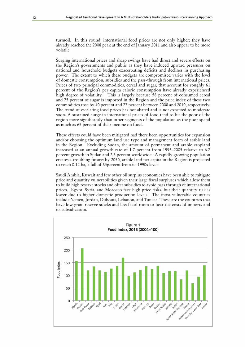
Near Eastern countries, with minimum variation, tend to import about half of their food requirements, and are considered to be the major importers of grain in the world. Three countries in the Region (Egypt, Algeria and Morocco), although among the most important producers of grain in the region, are also among the top ten importers of wheat in the world. The Near Eastern countries, as a group, import more than half of their grain, about 72 percent of sugar demand, 68 percent of vegetable oil, 31percent of dairy products, and 14 percent of meat needs. As a result, the food gap has increased, and so has the net value of food imports; the latter increased from $10.2 billion U.S. in 1980 to $28 billion U.S. in 2009, and out of the $16.3 billion U.S. of Arab grain imports, more than half was wheat. It is expected that the value of this gap will reach $80 billion U.S. by the year 2030.
Recent recurrence of sharp increases in food prices after the episode of 2008 has again triggered grave concerns about food security, malnutrition and increased poverty in the Near East Region. The current round of price escalation is cause for more concern as it is occurring at a time when the Region is undergoing political
12 Negotiated Territorial Development In A Multi-Stakeholders Participatory Resource Planning Approach
turmoil. In this round, international food prices are not only higher; they have already reached the 2008 peak at the end of January 2011 and also appear to be more volatile.
Surging international prices and sharp swings have had direct and severe effects on the Region’s governments and public as they have induced upward pressures on national and household budgets exacerbating deficits and declines in purchasing power. The extent to which these budgets are compromised varies with the level of domestic consumption, subsidies and the pass-through from international prices. Prices of two principal commodities, cereal and sugar, that account for roughly 61 percent of the Region’s per capita caloric consumption have already experienced high degree of volatility. This is largely because 58 percent of consumed cereal and 75 percent of sugar is imported in the Region and the price index of these two commodities rose by 40 percent and 77 percent between 2008 and 2010, respectively. The trend of escalating food prices has not abated and is not expected to moderate soon. A sustained surge in international prices of food tend to hit the poor of the region more significantly than other segments of the population as the poor spend as much as 65 percent of their income on food.
These effects could have been mitigated had there been opportunities for expansion and/or choosing the optimum land use type and management form of arable land in the Region. Excluding Sudan, the amount of permanent and arable cropland increased at an annual growth rate of 1.7 percent from 1995–2005 relative to 6.7 percent growth in Sudan and 2.3 percent worldwide. A rapidly growing population creates a troubling future: by 2050, arable land per capita in the Region is projected to reach 0.12 ha, a fall of 63percent from its 1990s level.
Saudi Arabia, Kuwait and few other oil surplus economies have been able to mitigate price and quantity vulnerabilities given their large fiscal surpluses which allow them to build high reserve stocks and offer subsidies to avoid pass through of international prices. Egypt, Syria, and Morocco face high price risks, but their quantity risk is lower due to higher domestic production levels. The most vulnerable countries include Yemen, Jordan, Djibouti, Lebanon, and Tunisia. These are the countries that have low grain reserve stocks and less fiscal room to bear the costs of imports and its subsidization.
Figure 1 food Index, 2013 (2004=100)
0
50
100
150
200
250
Iraq
Algeria
Bahrain
Arab World
Djibouti
Egypt
Iran
Jordan
Kuwait
LebanonLibya
Mauritania
Oman
Morocco
Quatar
Saudi Arabia
SomaliaSudan
Syrian Arabic R
epublic
Tunisia
United Arab Emira
tes
West Bank a
nd Gaza
Yemen
Food
inde
x

132. The context and backgrounds
Land constraints despite the limited availability of arable land in the region are less binding than water constraints. Every drop of water counts in the Near East Region as shadow prices (scarcity prices) of water are relatively high. Water productivity defined as value added after subtracting farming costs has been estimated in the Region as follows:
• An average of $0.1 U.S./m3 from flood-irrigated cereals, $0.5 U.S./m3 from flood-irrigated cash crops and $0.75 U.S./m3 from modern-irrigated cash crops.
• These estimates are higher in Lebanon where water productivity from modern-irrigated cash crops can reach $1 to $2 U.S./m3. It is also estimated that the irrigation net diversions/year is around 150 billion m3/year. If the same volume of water is used in exporting cash crops rather than grain, the net value added to the Arab World will be at least $75 billion U.S./year.15 There is a cost to pursuing self-sufficiency and higher food security. These estimates show that the Region will forgo high value added if it uses its scarce water to grow more cereals at $0.1 U.S./m3. But there are costs and significant risks for the countries in the Region to expose themselves to quantity shortages given the recent experience of export controls exercised by some large producers of grain. It pays to balance higher value added returns against food shortages risks.
It is to be expected that more water will be diverted from agriculture to meet the growing demand from priority sectors such as households and the industrial sector. As a result, agriculture’s share of water in the region will drop from the current 87 percent to about 50 percent in 2050. This reduction will seriously threaten food security and the already fragile environment. With declining water for agriculture the only solution to enhance food security or even to maintain current production levels is to sustainably and substantially increase the productivity of water. 2.3 fOOD PRODUCTION AND fOOD ImPORTS
With the exception of Lebanon and the West Bank and Gaza every country in the region shows a higher food production index in 2013 than in 2004 (Table 1 and Figure 1). This is a bit misleading as it conveys a picture where food production is satisfying a larger share of the food consumption needs in the Region. This is not
15 150 billion m3/year multiplied by an inter-sectoral shadow value of water of at least $0.5 U.S./m3.
TAbLE 1Table 1: food Index 2013 (2004=100)
Country name 2013
ALGERIA 158
BAHRAIN 207
ARAB WORLD 119
DJIBOUTI 134
EGYPT 119
IRAN 113
IRAQ 126
JORDAN 137
KUWAIT 170
LEBANON 96
LIBYA 110
MAURITANIA 120
MOROCCO 134
OMAN 124
QATAR 137
SAUDI ARABIA 108
SOMALIA 117
SUDAN 115
SYRIAN ARAB REPUBLIC, 82
TUNISIA 119
UNITED ARAB EMIRATES 68
WEST BANK AND GAZA 93
YEMEN 138
Source: HTTP://Databank.woldbank.org/data/reports.aspx? cource:=world-development-indicators

14 Negotiated Territorial Development In A Multi-Stakeholders Participatory Resource Planning Approach
the case as food consumption in the Region is rising faster than food production.
Food imports of most countries in the Region have increased, but particularly on a per capita basis. Even when these food imports are taken as a share of total imports merchandise imports, their shares are either constant (rising proportionately with total imports) or increasing. In the case of Algeria, Wfood imports in 2004 were 21.9 percent of total merchandise imports and were 20.1 percent in 2014 (Table 2). In the case of Kuwait the same share in 2004 was 11.0 percent but increased to 15.9 percent in 2014.
TAbLE 2food Imports as a Percent of merchandise Imports
Country Name 2004 2010 2013 2014
ALGERIA 21.9 16.3 19.1 20.1
BAHRAIN 8.1 7.6 9.3 9.5
DJIBOUTI - - - -
EGYPT 22.5 19.1 17.7 21.1
IRAQ - - - -
IRAN 8.9 15.4 - -
JORDAN 17.2 16.2 17.5 18.2
KUWAIT 11.0 - 15.3 15.9
LEBANON 16.1 16.3 16.5 17.8
LIBYA 16.8 12.1 - -
MAURITANIA 10.8 19.4 11.0 12.0
MOROCCO 10.9 11.4 10.8 12.2
OMAN 13.3 12.1 9.3 12.4
QATAR 7.5 8.2 9.1 9.4
SAUDI ARABIA 15.0 15.7 14.9 -
SOMALIA - - - -
SUDAN 14.4 25.9 - -
SYRIAN ARAB REPUBLIC 16.7 21 - -
TUNISIA 8.6 9.3 10.6 -
TAbLE 3Agriculture, value added (% of GDP)
Country Name 1981 2011 2012 2013 2014
ALGERIA 9.2 8.6 9.4 10.6 11.1
BAHRAIN 1 - - - -
DJIBOUTI - - - - -
EGYPT 20.1 14.5 11.1 11 11.1

152. The context and backgrounds
IRAN 13.9 5.9 7.9 9 9.3
IRAQ - - - - -
JORDAN 6.1 3.3 3.1 3.4 3.8
KUWAIT - 0,4 0.3 0.3 0.4
LEBANON - 4.1 6.1 7.2 5.5
LIBYA - - - - -
MAURITANIA 31.9 20.3 20.7 20.5 22.8
MOROCCO 13 14.2 13.4 14.7 13
OMAN 2.5 1.3 1.2 1.2 1.3
QATAR - 0.1 0.1 0.1 0.1
SAUDI ARABIA 1 1.9 1.8 1.9 1.9
SOMALIA 68.3 - - - -
SUDAN 36.4 25.4 28.8 29.2 29.2
SYRIAN ARAB REPUBLIC - - - - -
TUNISIA 15.6 9.1 9.4 8.8 8.8
UNITED ARAB EMIRATES 0.5 0.7 0.7 0.7 0.7
WEST BANK AND GAZA - 6.9 5.3 4.8 -
YEMEN - - - - -
Source: HTTP://dwatabank.woldbank.org/Indicators/NV.AGR.TOTLZS/ countries
figure 2
Agriculture Value Added, 2013
5
10
15
20
25
30
35
00
Algeria
Bahrain
Djibouti
Egypt
Iran
Iraq
Jordan
Kuwait
LebanonLibya
Mauritania
Oman
Morocco
Quatar
Saudi Arabia
SomaliaSudan
Syrian Arabic R
epublic
Tunisia
United Arab Emira
tes
West Bank a
nd GazaYemen
% of
GDP

16 Negotiated Territorial Development In A Multi-Stakeholders Participatory Resource Planning Approach
2.4 AGRICULTURAL VALUE ADDEDEqually relevant is the share of the agricultural sector in total value added (GDP). Many countries in the Region show a decline in this share (Table 3 and Figure 2). Most notable among these is Egypt. In 1981, Egyptian agriculture constituted 21.1percent of total GDP. By 2014 this share had declined to 11%. In Iran the decline of the share of agricultural value added in total GDP was less pronounced falling from 13.9 percent in 1981 to 9.3 percent in 2014. In Mauritania this decline is noticeably severe it fell from 31.9 percent in 1981 to 22.8 percent in 2014. Similar rates of decline in this share are observed in Tunisia, West Bank and Gaza, and the Sudan. While the decline in the share of agriculture in total value added may not reflect a decline in production per se, it still suggests that agricultural production and income did not keep pace with general economic activity.
2.5 ARAbLE LAND AS A PERCENTAGE Of TOTAL LAND AREA AND PER CAPITA
What is perhaps more indicative of difficulties in agriculture is the decline in share of arable land in the total land area of some of the countries of the Region. Few countries in the Region show an increase in this share, albeit typically small increases are observed. The list of countries experiencing a rising share of arable land in the total land area includes Morocco, Algeria, Egypt, Iran, Saudi Arabia, Mauritania, UAE and Kuwait (Table 4). In the rest of the countries in the region the share of arable land in the total land area has declined; most noticeably in Lebanon, Syria, the West Bank and Gaza, Yemen, and Tunisia. The decline in this share is indicative in part of land losses and/or land degradation.
A number of countries in the Region show increases in the share of food imports in total merchandise imports between 2004 and 2014. This is the case where the rate of growth of food imports exceeded the rate of growth of total merchandise imports. Jordan, Iran, Lebanon, Morocco, Qatar, Syria, Tunisia, and Yemen are among these countries (Table 2).
Table 4Arable Land as a Percent of Land Area
Country Name 1981 2011 2012 2013
ALGERIA 2.9 3.1 3.2 3.1
BAHRAIN 2.9 2.1 2.1 2.1
DJIBOUTII - 0,1 0.1 -
EGYPT 2.3 2.8 2.8 2.8
IRAN 8.3 9.3 9.2 9.1
IRAQ 12 9.9 10 11.5
JORDAN 3.3 2 2.4 2.6
KUWAIT 0.1 0.6 0.6 0.6
LEBANON 20.5 12.2 12.9 12.9
LIBYA 1 1 1 1
MAURITANIA 0.2 0.4 0.4 0.4

172. The context and backgrounds
UNITED ARAB EMIRATES - - - -
WEST BANK AND GAZA - - - -
YEMEN 28.5 30.8 28.7 40.4
figure 3 Arable Land as a Percent of Land Area, 2013
Algeria
Bahrain
DjboutiEgyp
tIra
n Ira
qJordan
Kuwait
LebanonLibya
MoroccoOman
Qatar
Saudi Arabia
SomaliaSudan
Syrian Arab Rebublic
Tunisia
United Arab Emira
tes
West Bank a
nd Gaza
Yemen
% of
Tot
al L
and
30
25
20
15
10
5
0
Mauritania
TAbLE 5Arable Land (hactares per person)
Country Name 1981 2011 2012 2013
ALGERIA 0.35 0.2 0.2 0.2
BAHRAIN 0.01 - - -
DJIBOUTI - - - -
EGYPT 0.05 0.03 0.03 0.03
IRAN 0.34 0.2 0.2 0.2
IRAQ. 0.37 0.14 0.13 0.15
JORDAN 0.13 0.03 0.03 0.04
KUWAIT 0 0 0 0
LEBANON 0.08 0.03 0.03 0.03
LIBYA 0.53 0.27 0.27 0.27
MAURITANIA 0.15 0.11 0.11 0.12
MOROCCO 0.37 0.24 0.24 0.24
OMAN 0.02 0.01 0.01 0.01

18 Negotiated Territorial Development In A Multi-Stakeholders Participatory Resource Planning Approach
When population growth is introduced a gloomy picture emerges. There is a general state of decrease in the per capita availability of arable land in every country of the Region between 1981 and 2013. The per capita number of hectares is exceptionally low (lowest in the world) in the Region and has been decreasing (Table 5 and Figure 4).
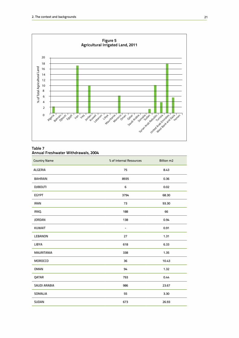
2.6 AGRICULTURAL IRRIGATED LANDThe scarcity of arable land is only exceeded by the paucity of irrigated land. Only a few countries in the Region appear to have developed a consistent use of irrigation systems. Iran, the UAE, Syria and Jordan have used irrigation at a significant scale
figure 4 Arable Land, 2013
Source: HTTP:://Databank.woldbank.org/data/reports.aspx? cource:=world-development-indicators
QATAR 0.02 0.01 0.01 0.01
SAUDI ARABIA 0.18 0.11 0.11 0.1
SOMALIA 0.16 0.1 0.1 0.11
SUDAN 0.63 0.36 0.43 0.34
SYRIAN ARAB REPUBLIC 0.57 0.22 0.22 0.21
TUNISIA 0.48 0.27 0.26 0.26
UNITED ARAB EMIRATES 0.2 0.01 - -
WEST BANK AND GAZA - 0.01 0.01 0.01
YEMEN 0.16 0.05 0.5 0.05
Source: HTTP:://databank.woldbank.org/indicator//AG.LND.ARBLZS
Hec
tare
s pe
r Per
son
0.4
0.35
0.3
0.25
0.2
0.15
0.1
0.05
0
Algeria
Bahrain
Djibouti
Egypt
Iran Ira
qJordan
Kuwait
LebanonLibya
Mauritania
Mauritania
OmanQatar
Saudi Arabia
SomaliaSudan
Syrian Arab Republic
Tunisia
United Arab Emira
tes
West Bank a
nd Gaza
Yemen

192. The context and backgrounds
(Table 6). Morocco and Egypt have developed irrigation schemes but the data is not consistently reliable. At the same time, a good number of countries in the Region have not developed a modern system of irrigation.
Modern irrigation systems, such as drip and sprinklers, generally deliver higher water application efficiency than traditional surface irrigation. The lower efficiency of surface systems in the Region is due to higher deep percolation and runoff losses. These losses occur at the field level but may be fully or partially recovered at the scheme or basin levels by recycling drainage and runoff losses or by pumping deep percolation losses from groundwater aquifers. This encourages countries to convert from traditional systems to modern ones.
A more serious issue in the Region is irrigation losses; a few countries, however, have been able to deal with this problem successfully. The irrigation losses in Egypt, for example, are recycled through the drainage systems several times before becoming too saline for agricultural use. These modern systems can only be efficient if they are managed properly. In many areas the efficiency of modern systems is as low as that of surface systems because of poor management. Modern systems do not guarantee high efficiency; surface systems may be better under certain circumstances especially as farmers know them well. The selection of the appropriate system depends on the physical, managerial and socioeconomic conditions at the site. The involvement of farmers and the reliance on local knowledge is crucial in guaranteeing higher efficiency and less waste.
Drip and Sprinklers and other modern irrigation systems increase productivity not because they reduce system losses in deep percolation and runoff, but due to better control, higher irrigation uniformity and frequency, better fertilization and other factors. The benefits, however, come at a cost: capital, energy and maintenance. Successful conversion requires developed industry, skilled engineers, technicians and farmers, and effective maintenance. These are the factors that are in short supply in the Region. They are most successful in areas where water is scarce and expensive, so that farmers can recover the system cost by reducing irrigation losses and increasing productivity. General water scarcity in the Region when reflected in higher prices could act as an incentive to reduce system waste. When water is ample and low in cost, farmers have little incentive to convert to modern systems. In fact improving surface irrigation systems through land leveling and better control may be more appropriate for most of the farmers in the Near East Region. The vast majority of irrigation systems in the world are surface and assuming that this will change in the near future is unrealistic. A wise strategy is to invest more in improving surface irrigation but opt for modern systems when conditions are favorable.
In many countries of the Region, investment is directed to conversion to modern irrigation systems. But the increased efficiency is obtained from the improved performance of the system—not the performance of the water. It is possible to have very high irrigation efficiency but low agricultural productivity. Irrigation efficiency and productivity are not synonymous. Investment should, therefore, also be directed to increase water productivity.
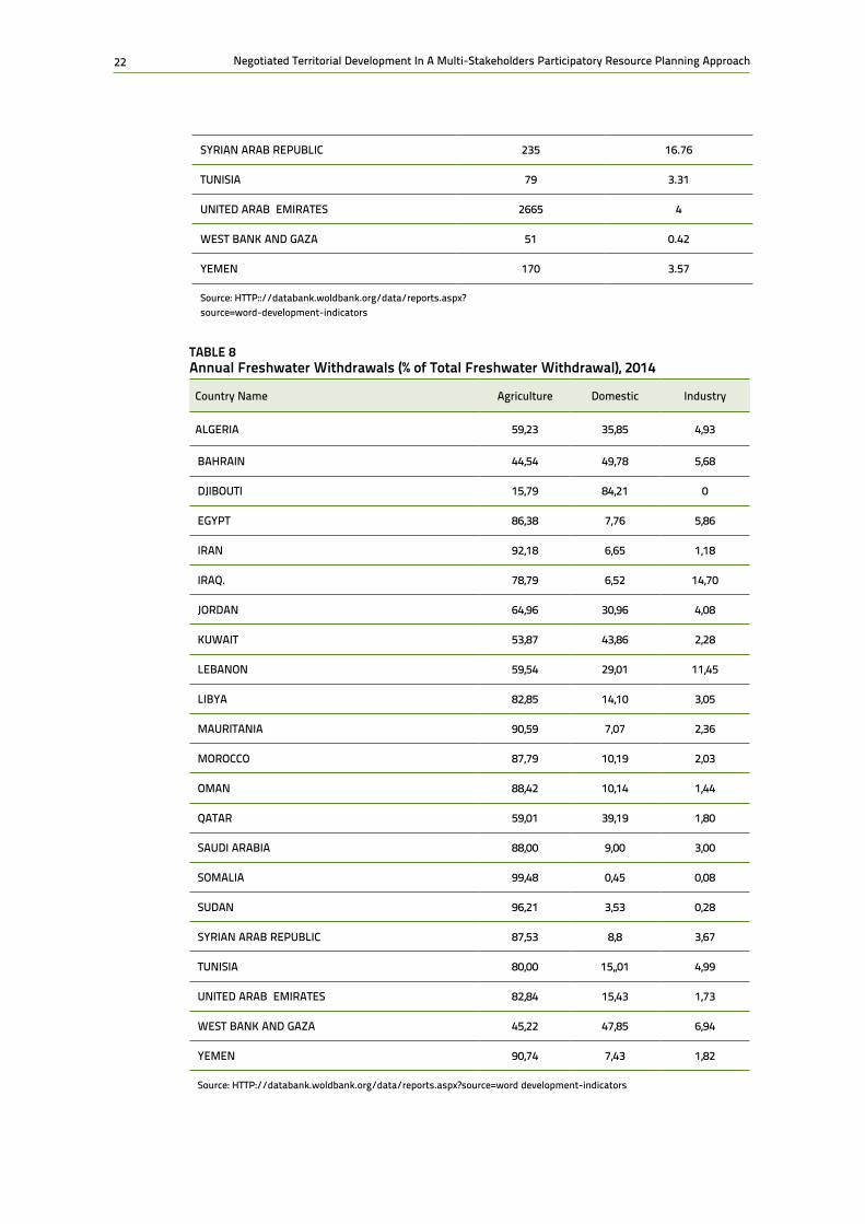
2.7 fREShWATER WIThDRAWALS AND WATER PRODUCTIVITyThere are a number of countries in the Region that do not have access to fresh water. They rely heavily on desalination. This is why a few percentage numbers in Table 7 are abnormally high, particularly those in the Gulf sub-region. There are also a few

20 Negotiated Territorial Development In A Multi-Stakeholders Participatory Resource Planning Approach
non-oil dependent countries where the annual freshwater withdrawals are very high and therefore unsustainable.
The largest use of fresh water is in agriculture. The share of agriculture in annual freshwater withdrawals is quite high in a number of countries in the Region. With the exception of Djibouti, the Gulf countries, Lebanon, Jordan and the West Banks & Gaza, these shares are close to 90 percent (Table 8). The limited industrial development and low household use gives agricultural uses a distorted magnitude.
The per capita water uses of fresh water are exceptionally low and are, as a matter of fact, the lowest in the world. There are a few countries in Table 9 with less than
Table 6Agricutural Irrigated Land (% of total agricoltural land)
Country Name 2011 2012 2013
ALGERIA 2.4 2.5 2.6
BAHRAIN - - -
DJIBOUTI - - -
EGYPT - - -
IRAN 17.4 17.4 17.4
IRAQ. - - -
JORDAN 9.9 9.2 9.8
KUWAIT - - -
LEBANON - - -
LIBYA - - -
MAURITANIA - - -
MOROCCO 4.6 - -
OMAN - - -
QATAR - - -
SAUDI ARABIA - - -
SOMALIA - - -
SUDAN 1.4 - -
SYRIAN ARAB REPUBLIC 10.1 10.3 9.4
TUNISIA 3.8 3.8 3.9
UNITED ARAB EMIRATES 18.1 12.6 12.5
WEST BANK AND GAZA 5.5 - -
YEMEN - - -
Source: HTTP://databank.woldbank.org/indicator//AG.LND.ARBLZS
212. The context and backgrounds
figure 5 Agricultural Irrigated Land, 2011
18
16
14
12
10
8
6
4
2
0
% o
f Tot
al A
gric
ultu
ral L
and
20
BahrainAlgeria
DjboutiEgyp
tIra
n Ira
qJordan
Kuwait
LebanonLibya
Mauritania
MoroccoOman
Qatar
Saudi Arabia
SomaliaSudan
Syrian Arab Rebublic
Tunisia
United Arab Emira
tes
West Bank a
nd Gaza
Yemen
Table 7Annual freshwater Withdrawals, 2004
Country Name % of Internal Resources Billion m2
ALGERIA 75 8.43
BAHRAIN 8935 0.36
DJIBOUTI 6 0.02
EGYPT 3794 68.30
IRAN 73 93.30
IRAQ. 188 66
JORDAN 138 0.94
KUWAIT - 0.91
LEBANON 27 1.31
LIBYA 618 6.33
MAURITANIA 338 1.35
MOROCCO 36 10.43
OMAN 94 1.32
QATAR 793 0.44
SAUDI ARABIA 986 23.67
SOMALIA 55 3.30
SUDAN 673 26.93
22 Negotiated Territorial Development In A Multi-Stakeholders Participatory Resource Planning Approach
TAbLE 8Annual freshwater Withdrawals (% of Total freshwater Withdrawal), 2014
Country Name Agriculture Domestic Industry
ALGERIA 59,23 35,85 4,93
BAHRAIN 44,54 49,78 5,68
DJIBOUTI 15,79 84,21 0
EGYPT 86,38 7,76 5,86
IRAN 92,18 6,65 1,18
IRAQ. 78,79 6,52 14,70
JORDAN 64,96 30,96 4,08
KUWAIT 53,87 43,86 2,28
LEBANON 59,54 29,01 11,45
LIBYA 82,85 14,10 3,05
MAURITANIA 90,59 7,07 2,36
MOROCCO 87,79 10,19 2,03
OMAN 88,42 10,14 1,44
QATAR 59,01 39,19 1,80
SAUDI ARABIA 88,00 9,00 3,00
SOMALIA 99,48 0,45 0,08
SUDAN 96,21 3,53 0,28
SYRIAN ARAB REPUBLIC 87,53 8,8 3,67
TUNISIA 80,00 15,,01 4,99
UNITED ARAB EMIRATES 82,84 15,43 1,73
WEST BANK AND GAZA 45,22 47,85 6,94
YEMEN 90,74 7,43 1,82
Source: HTTP://databank.woldbank.org/data/reports.aspx?source=word development-indicators
SYRIAN ARAB REPUBLIC 235 16.76
TUNISIA 79 3.31
UNITED ARAB EMIRATES 2665 4
WEST BANK AND GAZA 51 0.42
YEMEN 170 3.57
Source: HTTP:://databank.woldbank.org/data/reports.aspx? source=word-development-indicators

232. The context and backgrounds
a 1000 m3 per person which is the water poverty line. Iran, Iraq and Lebanon are the only exceptions. Even though they show per capita availability of fresh water above the poverty line, they are barely above it.
Water productivity (WP) should not be restricted to higher output levels per unit of water. The return or the benefits derived from each cubic meter of water consumed has many dimensions. This return may be biophysical (grain, meat, milk, fish etc.), socio-economic (employment, income), environmental (carbon sequestration, ecosystem services) or nutritional (protein, calories etc.). Most of the water is consumed through evapotranspiration and is therefore “unrecoverable.” Recycled water is not considered to be consumed or depleted. Improving WP depends on the objective of the user and on the scale of operations. At the field level it is desirable to maximize the biophysical WP of a specific crop or product. At the farm level, the farmer would seek to maximize the economic returns from the whole farm which could involve multiple crops or products. At the country level the drivers for improved WP are food security and exports. At the basin level, competition between sectors, equity issues and conflicts may drive WP issues. Research has shown that it is within reach to, at least, double the current productivity of water used in agriculture in the Region. This is equivalent to doubling the amount of water available at the current productivity level.
WP can be improved in many different ways but particularly through implementing modern technologies, adopting more efficient water management methods such as supplemental irrigation and water harvesting, improved cropping patterns and agribusiness practices, and using improved germplasm. It can also be improved through greater participation of the local farmers and the rural community. Rain-fed agriculture still has the highest potential for increases in water productivity and food production in the Region’s agro-ecosystem given its extensive use.
There is an obvious trade-off needs to be made in the Region in order to optimize the use of both water and land resources. This will require substantial changes in the way we think and undertake agricultural development. These changes include adopting new irrigation guidelines using deficit irrigation, changing cropping patterns, reforming water policies to value water appropriately to encourage conservation and rational use, increasing the support for agricultural research and development, but above all we need to encourage people’s participation, the involvement of all stakeholders, tapping local knowledge and experience and promoting regional cooperation.
Productivity indices measuring GDP per cubic meter of water show very low productivity values for most countries of the Region except the Gulf oil producing and exporting countries. The latter counties have very little water and their GDP is high on account of high oil prices.
Exceptionally low productivity is noted in Iraq for obvious reasons of political instability reasons, Sudan, Egypt and Morocco given their low GDP and relatively large water supplies, Iran and Libya on account of the sanctions and political instability. When the inverse measure is used it shows the low values put on water per unit of GDP (Table 10).

24 Negotiated Territorial Development In A Multi-Stakeholders Participatory Resource Planning Approach
TAbLE 9Renewable Internal freshwater Resource
Country Name Per Capita (m3) Total Million (m3)
ALGERIA 289 11,250
BAHRAIN 3 4
DJIBOUTI 342 300
EGYPT 20 1,8
IRAN 1644 128,500
IRAQ. 1011 35,200
JORDAN 103 682
KUWAIT 0 0
LEBANON 1056 4,800
LIBYA 112 700
MAURITANIA 101 400
MOROCCO 855 29,00
OMAN 330 1,400
QATAR 26 56
SAUDI ARABIA 78 2,400
SOMALIA 570 6,00
SUDAN 102 4,00
SYRIAN ARAB REPUBLIC 322 7,132
TUNISIA 381 4,195
UNITED ARAB EMIRATES 17 150
WEST BANK AND GAZA 189 812
YEMEN 80 2,100
Source: HTTP://databank.woldbank.org/data/reports.aspx?source=word development-indicators

252. The context and backgrounds
TAbLE 10Water Productivity,Total (Constant 2005 US$ GDP per cubic meter of Total freshwater Withdrawal), 2014
Country Name $GDP per m3 m3 per $GDP
ALGERIA 15,67 0,064
BAHRAIN 68,21 0,015
DJIBOUTI 57,59 0,017
EGYPT 1,92 0,520
IRAN 1,29 0,777
IRAQ. 2,97 0,337
JORDAN 20,20 0,050
KUWAIT 109,05 0,009
LEBANON 25,19 0,040
LIBYA 6,75 0,148
MAURITANIA 2,58 0,388
MOROCCO 8,42 0,119
OMAN 35,29 0,028
QATAR 304,13 0,003
SAUDI ARABIA 22,15 0,045
SOMALIA - N/A
SUDAN 1,42 0,70
SYRIAN ARAB REPUBLIC - N/A
TUNISIA 13.15 0,076
UNITED ARAB EMIRATES 62,43 0,016
WEST BANK AND GAZA 14,28 0,070
YEMEN - N/A
Source: HTTP://databank.woldbank.org/data/reports.aspx?source=word development-indicators

26 Negotiated Territorial Development In A Multi-Stakeholders Participatory Resource Planning Approach
3. The key elements of the approach
The proposed approach focuses on five key elements: access/use/management, inclusive development and gender sensitivity. This introductory section examines each of these concepts individually and concludes by weaving them into a coherent whole with the intention of providing a solid foundation upon which to build the description of the methodology that follows.
3.1 ACCESS/USE/mANAGEmENT (Of LAND AND OThER NATURAL RESOURCES)Among the most fundamental of human behaviours is the occupation and employment of a territory to gain a livelihood.
Throughout history, land has been recognized as a primary source of wealth, social status, and power. Access to land is governed through land tenure systems. Land tenure is the relationship, whether legally or customarily defined, among people, as individuals or groups, with respect to land. For convenience, “land” is used here to include other natural resources such as soil, water and vegetation/crops. Rules of tenure define how property rights in land are to be distributed within society, along with the associated responsibilities and restraints. In simple terms, land tenure systems determine who can use what resources, for how long, and under what conditions.16
Access to land for most marginalized groups is often based on custom. Customary rights to natural resources in indigenous societies, for example, are usually created following their traditions and through the ways in which community leaders assign land use rights to community members. These rights of access may have their origin in the use of the land over a long period. They are often rights developed by ancestral occupation and by the use of land by ancestral societies. In such cases, it is through the act of original clearance of the land and settlement by ancestors that rights are claimed.17
Land use is the term that describes the patterns in the landscape that emerge from these activities. More formally, as the FAO describes it:
“Land use is characterized by the arrangements, activities and inputs by people to produce, and change or maintain a certain land cover type. Land use defined in this way establishes a direct link between land cover and the actions of people in their environment.”18
16 FAO. 2002. Gender and Access to Land17 FAO. 2002. Land Tenure and Rural Development18 FAO,UNEP. 1999. The Future of Our Land: Facing The Challenge, Rome. p. 7

273. The key elements of the approach
A variety of other definitions of the term land use can be found in the relevant literature, but the common central theme is the concept of human intervention in the processes that shape the land. Human intervention is inevitably a complex topic, involving the systematic interaction of intricate variables. It is important to consider that multiple land uses can occur over the same land. For example, in a natural reserve we can have:
• Controlled logging (and even hunting)
• Tourism and sport
• Biodiversity and other environmental services
Land and natural resources management in its narrow sense is the actual practice of using the land by the local human population in a sustainable manner.19
Over time, FAO has developed a series of both cross-sectoral as well as tailored frameworks to specific sectors. These frameworks are continuously evolving in order to adapt to a changing global context and growing knowledge base. In an effort to putting them together, a common vision for Sustainable Food and Agriculture has been proposed equally addressing social, economic and environmental dimensions to ensure sustainability.20
Neglecting any one area jeopardizes the attainment of sustainability in others. The principles which collectively guide the process of transition to greater sustainability are summarized below to include:
• Improving efficiency in the use of resources is crucial to sustainable agriculture;• Sustainability requires direct action to conserve, protect and enhance natural
resources;• Agriculture that fails to protect and improve rural livelihoods and social well-
being is unsustainable;• Enhanced resilience of people, communities and ecosystems are keys to
sustainable agriculture;• Sustainable food and agriculture requires responsible and effective governance
mechanisms. Human Intervention is a complex topic involving the systematic interaction of intricate variables. The diagram shown in Figure 6 illustrates one possible articulation of this complexity as it relates to use/management of land/natural resources.21This model depicts use/management as a function of five interrelated variables: policies,
19 FAO/Netherlands . 1991. Den Bosch Conference 20 FAO http://www.fao.org/sustainability/background/en/ 21 This model is derived from the approach to natural resource management developed by the
Department of Resource Development at Michigan State University. Many other formulations that illustrate the inherent complexity are possible. The main advantage of this particular model is the author’s familiarity with it. There was considerable discussion between the author and the FAO consultants on the exact terminology to employ in this model, but in the end there was agreement that this formulation adequately represents the concept of complexity in the formation of land use patterns.

28 Negotiated Territorial Development In A Multi-Stakeholders Participatory Resource Planning Approach
legislation, social norms, markets and natural environment, each of which is the focus of different disciplinary experts.
While its position does not indicate any special importance, the variable at the top of the model is Policy. A land/natural resources policy process never has a beginning or an end. It might have phases, each of which can be identified with specific changes in the society to which it is being applied. But it is a grave mistake to pretend that somehow a new policy can be started from scratch, starting with the ´slate wiped clean´. This observation applies to all aspects of the policy process: the concepts and tools available to policy makers; the many diverse interests that will be affected by the policy process (most are the same as those affected by earlier policies); and the external pressures that impinge on it (the international community, the ´Cold War’, globalization, and today, climate change).22
Closely related to this, are the governing Legislations or their lack. This refers to the web of laws (formal and informal) and regulations that societies enact to control and direct the activities of their members. A wide variety of laws that affect the way land is used emerge from local, regional, state and international government organizations. Evaluation of their impact on land use involves the expertise of the political scientist and the lawyer.
A third variable in the model is labelled Markets. The term Market, as used here, is meant to include economic activity in its broadest sense, at all scales (local, regional, state and international) and all types of outputs and inputs (commodities, physical assets, and financial assets). They all have an influence on land use. Thus, the
22 FAO. 2009, Land Policy Development in an African context
figure 6 Variables That Determine Land/Natural Resources Use/management
Policies (national, international)
Market forces
Legislation Natural environment (soil, climate, geology,
infrastructure)
Social Norms (gender roles, attitudes, custom,
education...)
Land and other natural resource
Use/Mgt

293. The key elements of the approach
discipline of economics has a role to play in the analysis of the arrangements humans create by interacting with the land.
A fourth variable (originally referred to as Social Norms) is described as (formal/informal) Institutions that can be defined as a set of widely shared values and interests pertaining to areas of strategic and social importance. These values and interests are served by specific organizations through the allocation of status and roles, and are internalized by individuals through lengthy socialization carried out by organizations. Through a process of internalization, the individual becomes acquainted with what is the established order. Institutions, therefore, have controlling effects on the individual in resource utilization and management. In traditional societies in Africa, institutions form the basis for natural resource management. 23In recent decades, the number of social actors (formal institutions) interested in managing natural resources has increased as a result of widespread socio-political changes, including governments’ decentralization processes, the privatization of previously state-controlled initiatives, the emergence of new democratic institutions, and the proliferation of NGOs, and associations. Many such “new actors” perceive environmental or social problems as opportunities and believe that they can adequately respond to them if they are allowed to participate in management decisions and actions. As a result, decentralization and participation in resource management are widely seen as increasing effectiveness, although for these to be realized, locally accountable representation and power of decision – i.e., a domain of independent local decision-making – must be present.
The final model variable is the Natural Environment itself. This variable is meant to represent all of the tangible elements upon which the resident humans act, including natural phenomena like soils, geology, climate, vegetation, wildlife and hydrology, as well as culturally derived physical elements like roads, irrigation canals, power grids, pipelines, buildings and other infrastructure. The realm here is that of the natural scientists and technologists, consisting of such experts as the agronomists, biologists, cartographers, foresters, hydrologists and engineers.
The image that emerges from this model is one of dynamic equilibrium. Each of these variables interacts with all of the others to generate a particular land use pattern in a given territory.
Of all the variables listed above, only Legislation and Policy can be changed deliberately. All the other variables are external forces, which change at different speed and independently from any land use plan. In an ideal world, policy and legislation should just stay as buffer and support to stakeholders to adapt to the ever changing other circumstances
Most importantly, changes in land use/management should not be viewed as being made only directly, but can derive from manipulating one or more of the variables that work together to form the land use pattern including water systems, legal tenure systems in place, and technology. Given the wide variety of knowledge required to fully understand the system as a whole, it is unlikely that one can intercede with complete confidence of achieving any particular outcome. In addition, the complex interrelationships between the variables make it extremely difficult to precisely
23 Bacho, Z.L F. 2004. Can I Sell One of My Cows?. Institutions, Assets and Gender Based Poverty. Ghana Journal of Development studies, vol. 1 No. 1, GILLBT Printing Press, Tamale, Ghana.

30 Negotiated Territorial Development In A Multi-Stakeholders Participatory Resource Planning Approach
predict the total effects that disturbing the prevailing dynamic equilibrium might produce. Thus, the probability is high that the law of unintended consequences will be fully operational during any attempt to manipulate such a system. The end result of this uncertainty is that intervention into the use/management system inevitably involves an evolutionary approach in which modifications that work are retained and those that do not are discarded.
3.2 INCLUSIVE DEVELOPmENTInclusive development consists of ensuring that all marginalized and excluded groups are stakeholders in the development processes.24 There is growing consensus in the literature on inequalities that globalization, increased trade and unmanaged economic growth have generated. These inequalities involve also persistent spatial and interpersonal inequalities, the marginalization of specific social and racialized groups, and manifesting itself in income, wealth and non-pecuniary (i.e. non-income based) inequalities, such as disparities in education, political voice, health outcomes, etc.
Many actors are excluded from development and decision-making processes because of their gender, ethnicity, religion, age, sexual orientation or disability. The effects of such marginalization are increasing levels of inequality, particularly in rural areas.
Development actions cannot have a strong impact on the ground unless all groups contribute to the creation of opportunities, are in the position to effectively participate in decision-making processes and to share equally in the benefits of development. The goal of inclusive development is to achieve an inclusive society, able to accommodate differences and to recognize the dignity, importance and value of each person.
Supporting the empowerment of weaker actors is, therefore, a precondition for them to become part of the decision-making mechanism. At the country level, questions related to access, use and management of natural resources is more and more an issue of power thus recognizing that many of the stakeholders do not have the same role and influence as other more privileged groups. The methodology proposes a gender-sensitive and human rights approach to development in order to face up to these challenges, which implies challenging the existing power asymmetries and dynamics.
The main purpose of the process is to strengthen dialogue and mutual trust among the various actors and between the actors and the institutions. Decentralized institutions (whether local or municipal) represent the main entry point in a collaborative attempt to influence social, cultural and political change and to improve the design of and coordination between the interventions at the different decision levels (from civil society and organizations related to the state and its decentralized bodies). Recognizing at the same time that most changes (at peri-urban/peri-rural level) take place outside administrative and political borders.
24 Development can be inclusive - and reduce poverty - only if all groups of people contribute to creating opportunities, share the benefits of development and participate in decision-making. Inclusive development follows UNDP's human development approach and integrates the standards and principles of human rights: participation, non-discrimination and accountability. UNDP
http://www.undp.org/content/undp/en/home/ourwork/povertyreduction/focus_areas/focus_
inclusive_development.html

313. The key elements of the approach
FAO has been, and still is, involved in several field projects dealing with complex crisis related to natural resources: starting from Mozambique, Angola, Guinea Bissau, Bosnia Herzegovina and, more recently, Colombia, Sudan, South-Sudan, Somalia, Central African Republic, Kenya, DRC-Goma and Palestine.
All of these processes have structural natural resources related problems that are not easy to tackle. Promoting a culture of dialogue, respect, and reinstalling minimum trust amongst actors is a long-term goal that faces many constraints and challenges. Despite the inherent difficulties described above, human optimism persists and we continue in our attempts at promoting such a culture of rights and responsibilities, dialogue and negotiation in order to increase the legitimacy and the sense of ownership of concerned stakeholders on the planning process and its outcomes.
In addition, the process is described as systematic and iterative. This has at least two major implications. First, systematic application requires the participants have some basic level of skill at executing the procedures. Second, an ongoing, iterative procedure demands at least a minimum investment of time and interest by the individuals and institutions concerned.
Finally, this definition also speaks out as to how the procedure is supposed to operate. It is to assess the variables, create an enabling environment and support the empowerment of weaker actors in order for them to participate in the decision making processes where decisions are taken about how to allocate their resources to achieve the goals that have been agreed to.
In the proposed approach this means placing the people, who are concerned with a particular territory, at the centre of the decision making process regarding the use/ management of the resources in that territory. Such people are referred to as stakeholders. The concept of stakeholder is defined by the FAO as:
“Anyone or any institution who has interests in, or is affected by, an issue or activity or transaction and, therefore, has a natural right to participate in decisions relating to it.”25
3.3 Why IS GENDER RELEVANT? As indicated by the Convention on the Elimination of All Forms of Discrimination against Women (CEDAW), Article 14:
1. States Parties shall take into account the particular problems faced by rural women and the significant roles which rural women play in the economic survival of their families, including their work in the non-monetized sectors of the economy, and shall take all appropriate measures to ensure the application of the provisions of the present Convention to women in rural areas.
2. States Parties shall take all appropriate measures to eliminate discrimination against women in rural areas in order to ensure, on a basis of equality of men and women that they participate in and benefit from rural development and, in particular, shall ensure to such women the right:
3. (a) To participate in the elaboration and implementation of development planning at all levels;
25 FAO, UNEP. 1999: p.19

32 Negotiated Territorial Development In A Multi-Stakeholders Participatory Resource Planning Approach
Article 16 is about marriage and family life. It recalls:
1. States Parties shall take all appropriate measures to eliminate discrimination against women in all matters relating to marriage and family relations and in particular shall ensure, on a basis of equality of men and women:
a. The same right to enter into marriage;
b. The same right freely to choose a spouse and to enter into marriage only with their free and full consent;
c. The same rights and responsibilities during marriage and at its dissolution;
d. The same rights and responsibilities as parents, irrespective of their marital status, in matters relating to their children; in all cases the interests of the children shall be paramount;
e. The same rights to decide freely and responsibly on the number and spacing of their children and to have access to the information, education and means to enable them to exercise these rights;
f. The same rights and responsibilities with regard to guardianship, stewardship, trusteeship and adoption of children, or similar institutions where these concepts exist in national legislation; in all cases the interests of the children shall be paramount;
g. The same personal rights as husband and wife, including the right to choose a family name, a profession and an occupation;
h. The same rights for both spouses in respect of the ownership, acquisition, management, administration, enjoyment and disposition of property, whether free of charge or for a valuable consideration.
When women are denied equal property rights, they experience reduced social, economic, and political status. By contrast, equality in land rights increase rural women’s power in these areas. Gender-equitable policies, laws and programmes for land tenure can strengthen women’s access to land, increase their bargaining power within the household, reduce their vulnerability to economic destitute and set minimum standards for women’s participation and representation in decision-making processes26.
As highlighted by a study conducted by FAO-RNE, “[r]ural women in the Near East contribute to food security at household level and participate actively in agricultural production. As in other regions, women’s participation is significant in subsistence food production for household consumption, while most of them hold small-scale plots.” […] Gender roles in agriculture vary from one country to another one within the region.
In 1980, women contributed 28 percent of the agricultural workforce; this has risen to 40 percent in 2010, but with wide variation between countries: there are virtually no women in agriculture in the Gulf States but 60.2 percent in Jordan, Libya 69.9 percent, and Syria 60.7 percent. The same phenomenon is observed in North Africa.
26 FAO (no date). A Gender perspective on land rights (http://www.fao.org/3/a-y3495e.pdf)

333. The key elements of the approach
In Algeria, women contributed 41.5 percent of the agricultural labour force in 1980 but 52.7 percent in 2010. In Egypt female labour force share was 25.9 percent in 2010 but 40.3 percent in 40.3 percent in 2010. In the case of Libya the female share in the agricultural labour force jumped from 37.2 percent in 1980 to 69.9 percent in 2010.Arab Spring brought devastation to both urban and rural area. Data for 2011 and beyond are not reliable given the levels of devastation experienced in most of the Near Eastern countries.
Agriculture plays a critical role in the entire life of a given economy. In countries where in addition to supplying food, agriculture also provides employment opportunities to very large percentage of the population, secured access and/or ownership of natural resources is directly linked to power dynamics. As a matter of fact, women are in a weaker position when it comes to property rights. This historical inequality in access to and control over land and natural resources is an obstacle to the sustainable management of natural resources and socio-economic development.
For this reason, strengthening and securing women’s land rights is essential in promoting gender equality and a precondition for sustainable development. Access to natural resources facilitates women’s bargaining power within their household, as well as their representation and participation in decision-making processes at the community level.27
Rural women face enormous challenges and are often left behind to find solutions, even if they are proven to be active agents of change. The achievement of greater equality implies a strong engagement of both men and women. Social and cultural changes significantly influence intra- and extra-household dynamics, and are prerequisites for gender equality. In some cases, gender gaps are reversed, with men and boys experiencing marginalization or missing potential. Thus, engaging women, men, girls and boys in the development process is key to a balanced and symmetrical participation in production, employment and benefits.28
The Near East Region has made progress in promoting gender equality but disparities are still very high, particularly in the rural areas where women's empowerment is often limited due to social, cultural and political barriers. Social indicators reveal that women in the Region are on average more disadvantaged politically, economically, and socially than are women in other areas, and certainly more so than in regions with similar income levels or at similar stages of economic development (e.g., Latin America, Southeast Asia, East Asia). Arab, in particular and Near Eastern in general, women’s share in the formal non-agricultural labour force is relatively small, as is their share of earned income. More efforts have to be undertaken to promote an effective integration of wthe equality dimension in policy-making processes at all levels. Gender-based differentiations can be found in the legal frameworks of most Near Eastern countries. This is particularly true in the area of family law and laws relating to the personal status which place restrictions on women’s rights within marriage, divorce and share of inheritance.
Although the rigidity of the gendered division of labour and low labour mobility of the rural poor persists to varying degrees in most of the world, it is particularly
27 FAO (no date). A Gender perspective on land rights (http://www.fao.org/3/a-y3495e.pdf)28 FAO. 2012. FAO Policy on Gender Equality

34 Negotiated Territorial Development In A Multi-Stakeholders Participatory Resource Planning Approach
resilient in the Near East countries. Women remain associated primarily with their family roles and responsible for day-to-day household tasks.29 In this area, changes are complex and many customary practices and social barriers are still obstructing the implementation of legal system reforms introduced in some Arab countries.
Land and other natural resources continue to remain a fundamental part of people’s cultural identity social relations, livelihood strategies and economic well-being. Women’s lack of access to essential productive resources does not only increase their vulnerability to hardships, but it places an extra burden on the agriculture sector, the broader economy and society as a whole.30 In addition, farming production is increasingly technology intensive, often requiring both higher levels of education and significant up-front investment, which disproportionately marginalize poor farming families and landless household, and women in particular. Adequate attention to gender equality and the empowerment of rural women is key to the achievement of FAO’s mandate to eliminate food insecurity and malnutrition.
There is therefore a clear need to continuously adapt approaches, instruments and activities to the changing requirements imposed by current social and economic dynamics and their related impacts.
A holistic vision of the territory takes into account these factors, as it relates to a system for identifying the interactions between different stakeholders (including analysis of coalitions, dialogue, negotiations, consultations, conflicts, and temporary alliances) and their environment in relation to land and other natural resources. In line with this, the territory is seen as a social product and a negotiation arena to strengthen dialogue and mutual trust, and increase bargaining power of weaker actors. Territory is more than an agronomic – related concept. It means human beings, water, forestry, soil, and services, social and productive relations.
The social dimension is rooted in human beings and includes key issues like education, health, political participation and gender equality. In this sense, social sustainability means the ability of a community to develop processes and structures which not only meet the needs of its current members, but also support the ability of future generations to maintain a healthy community.31
Women do not have equal access to natural resources, productive assets and employment opportunities which impacts their level of productivity and prevents them from achieving their full economic potential.32 Governments, International Organizations and NGOs/CSOs need to work in close collaboration to ensure that agricultural policies, programmes and legal frameworks are gender-responsive and support the progressive realisation of gender equality; guarantee equal access to and control over productive resources; strengthen women’s representation in decision-making bodies and women’s meaningful participation in decision-making processes. Evidence shows that an approach to policies, programmes and projects based on gender equality can lead to substantial gains in agricultural and total economic productivity and provide broader economic and social benefits for the most marginalized male and female stakeholders.
29 UNDP. 2004. Towards Gender Equality in the Arab/Middle East Region. Islam, Culture and Feminist Activism
30 In Africa land belongs to vast family of which many are dead, a few are living and the rest are not yet born
31 Nile Basin Action Program: Management Response to Gender Audit Recommendations. (October 2013)
32 FAO. 2011, State of Food and Agriculture (SOFA)

353. The key elements of the approach
In view of this, there is a need to reshape the agenda of international organizations to better address the various cross-cutting issues of natural resources management and gender.33 This is particularly relevant and essential for progress and development in the Near East where cultural, old traditions and legal impediments constrain women’s full representation and participation in decision making and in deriving their full and equal shares from the benefits of development. This calls for improved gender mainstreaming and the formulation of specific gender action plans for the region. A gender audit of the Near East region will identify critical areas for intervention and feasible programs to address gender inequality issues. It will also result in gender action planning, and the identification of challenges and opportunities for increasing gender skills and organizational capacity in mainstreaming gender into natural resources management.
Some broad observations that a quick gender audit had revealed include the following:34 (i) Gender issues are addressed by chance as opposed to by intention, indicating a complexity in internalizing gender and integrating it as a crosscutting issue in programming and practice; (ii) The translation of gender mainstreaming concepts into practical actions at project levels is very limited. The absence of concise gender action plans highlights the difficulty in implementing gender mainstreaming both at institutional and project levels. This is aggravated by a lack of resource allocation to gender activities, also attributed to a lack of gender activities; and (iii) Monitoring of gender outcomes and impacts is practically nonexistent. Gender disaggregated data and indicators are neither considered during project or program evaluation processes nor have appropriate tools been developed for this use. In the absence of gender sensitive monitoring and evaluation (M&E) tools, it is impossible to have progress reports reflecting issues of gender.
3.4 GENDER, CULTURE AND RELIGIOUS NORmSGender refers to social, economic and cultural attributes and opportunities associated with being man or women at a particular point in time. The emphasis is upon the recognition of interdependency between men and women in the social structure. Gender is a cultural construction, which means that masculine and feminine have different connotations (and associated behaviours) in different cultures.
Gender mainstreaming aims to achieve social justice and in parallel is a fundamental prerequisite for ensuring sustainable human development. The long-term outcome of gender mainstreaming will be the achievement of greater and more sustainable human development for all.35
Gender mainstreaming is the globally recognized strategy for achieving gender equality.
Though there is a body of Islamic legal and policy literature dealing with property and land rights, there is no unified field of legal doctrines or dedicated discipline of ‘Islamic land law ’. Instead there is a set of overlapping themes or domains which
33 FAO. 2012. Improving Gender Equality in Territorial Issues (IGETI)34 Nile Basin Action Program: Management Response to Gender Audit Recommendations. (October
2013)35 Arenas, M.C. and Lentisco, A. 2011. Mainstreaming gender into project cycle management in the
fisheries sector. Bangkok, FAO. 92 pp.

36 Negotiated Territorial Development In A Multi-Stakeholders Participatory Resource Planning Approach
legal practitioners will recognize as such. Land rights in Islam do not exist in isolation and are best understood with reference to other parts of Islamic law. Property rights in general are to be exercised in accordance with foundational concepts in Islamic dogma and the Shari ’a. Likewise, Islamic laws relating specifically to the property rights of women pervade a variety of fields such as family law (marriage/mahr, inheritance, and guardianship), property law (gifts, waqf, sale and hire) and economic law (right to work, income), as well as public law36.
A woman's right to property is shaped by her social status, place in the lifecycle and dynamics within her household and family. Property is a matter of implicit and explicit bargaining and negotiation within the family. Muslim women in general have found room to articulate their differing, often dissenting, standpoints while pragmatically embracing selected Western strategies. Caught between the extremes of Western cultural imperialism and the intractable conservative absolutism, Muslim women generally work to neutralize both kinds of prejudices and misconceptions while resetting their priorities and tactics to contend with a varied religious, socio-cultural and political context.
Muslim countries are increasingly ratifying international human rights treaties thereby acknowledging their legal obligation to grant, to respect and to protect women’s equal rights with men in the political, economic, social, cultural and civil fields. Beyond treaties, it is not contested that basic human rights arising out of the 1948 Universal Declaration of Human Rights have become the yardstick for the legitimacy of every government and the demand in all societies. Most constitutions and national laws do formally accept them. With respect to land rights, there are equally a plethora of international standards. Rather than negotiate with States or devise programmes and projects on the basis of States' willingness to accept, expectations regarding advancement of land tenure rights must be articulated as enforceable and actionable rights.
A number of international interventions, as well as state programs are deferential towards existing socio-cultural gender deprecating norms. The root of the differential treatment towards women arises out of their exclusion from public spaces where they can be a part of the decisions which affect them, their families and communities. Despite the democratic deficit in several Muslim countries, there is now an increasing role for civil society in asserting an indigenous framework of gender rights. Just as anti-poverty and microfinance programmes recognize the potential for women to be part of their own solutions and empowerment, opportunities for women to participate need to be strengthened both under the law and in practice.
The lack of equal opportunity and access to principal assets and resources remains an obstacle to both women and men in the region, as a whole, and to a greater degree for women, in general, and rural women, in particular. Women still suffer from fewer entitlements, benefits and opportunities than men, particularly in accessing assets
36 Siraj Sait J. 2008. The relevance of Islamic Land Law for policy and project design. The World Bank Conference for Land Policy and Administration. 2008

373. The key elements of the approach
and resources such as land funding, political authority and education.37 The situation is particularly exacerbated and protracted by several factors, the most important of which include rural poverty, the effects of economic liberalization propagated by neoliberal economics, and social practices and codes. Deeply rooted gender roles and stereotypes remain profoundly entrenched and continue to limit employment and other opportunities for women, as well as women’s participation in the labour force and decision-making processes, which remain amongst the lowest rates in the world.
Due to a lack of official or recognized land titles and property deeds, it is very difficult for women to access or obtain credit or bank loans. They also suffer from being dominated by tribal traditions and notions of communal property that invariably discriminate against women.38
Despite their important role in agriculture, women’s access, control and ownership of land is still limited which prevents them from accessing credit, productive resources and income generating opportunities, as well as diminishes their representation in land administration and other land-related institutions. Women represent only 5% of landholders in Egypt and Syria, and own 24% of land in Egypt and 14% in Morocco. Women usually hold smaller land plots, of inferior quality and with less secure tenure rights than men, and women who work on land owned by others depend on male relatives to maintain infrastructure and invest in the land. Land fragmentation into small parcels, at times quite distant from each other is an additional constraint for women producers with little mobility. The parcel size impedes mechanization and the development of infrastructure such as irrigation, which could improve yields. Legal frameworks and customary rules that prevent women’s land ownership and address women as dependents have serious implications for women‘s adaptive capacity to improve agricultural productivity and sustain their livelihoods. In several countries in the region, women may own and use land but they must be represented by men to manage it or engage in any type of contractual or financial agreement in relation to the land. They may have access to their husband’s land on which they work and which provides the family with a livelihood. They inherit land, often at half the share of male relatives, which they may hand over to their male relatives or hand over to the management of their husbands.
Since land and water rights are closely related, women’s access to water is limited. In the context of climate change, the lack of water rights also precludes their membership in water user associations and rural organizations, often restricted to heads of household and landowners. This can cut women off from decision-making processes, support systems, new technology or techniques, rural services and training.
Sustainable land use cannot be achieved without women having an equitable share of the benefits, and cannot materialize without the full involvement of women in the development process by acknowledging their roles at home and in the field: reproductive, production and community development and networking.
37 The Commission for Human Rights, Resolutions 2000/13 and 2001/34, stresses that the impact of gender-based discrimination and violence against women on women’s equal ownership of access to and control over land and the equal rights to own property is acute. It affirms discrimination in law against women with respect to having access to, acquiring and securing land, property and housing, and financing for land, property and housing. The Commission urged states to design and revise laws to ensure that women are accorded full and equal rights to own land and other property, and the right to adequate housing, including through the right to inheritance.
38 Helouas, Ghorbel and Chokri, 2012

38 Negotiated Territorial Development In A Multi-Stakeholders Participatory Resource Planning Approach
In addition, men and women possess unique vulnerabilities to climate change impacts, largely based on their respective roles in society that needs to be addressed. Climate change will further affect rural livelihoods, and more men will feel obligated to move to cities to seek paid employment. As a result, on top of their already heavy workload of domestic tasks and local natural resource management, rural women assume the departed male‘s community role, but with additional challenges. Effective adaptation can only be achieved if the many barriers to gender equity are removed and, in particular, women are empowered to contribute, benefit from the fruits of their labour and participate in the management and decision making councils.
Climate change makes it more urgent to tackle specific drivers of gender-based vulnerability, such as barriers to women‘s land ownership, low awareness of climate change, and limited skills for livelihood diversification and adaptation. (World Bank, 2012, Adaptation to a Changing Climate in the Arab Countries, World Bank 2012)
3.5 GENDER IN LAND/NATURAL RESOURCES PLANNINGPlanning policies and processes can unintentionally exclude or discriminate against groups in the community. Planning policies can ignore the fact that women and men use public space differently. For many years it has been considered that the application of participatory methods in the planning process negotiates and takes automatically into account the interests of all stakeholders. In practice, however, experience has shown that the needs of women are often not integrated into the discussion process, unless this is specifically proposed in the project design.39
It has been argued that urban and suburban spaces support stereotypically male activities and planning methodologies reflect a male dominated society.40 Development agents involved in land use planning are becoming more sensitive to gender perspectives in response to the past tendency to exclude the experiences of women in urban space when defining and acting upon planning issues. Planning courses include now subjects such as gender and planning that aim to explore, analyse and challenge conventional planning thought and practice from a gender perspective.
Despite this increased awareness and recognition of gender issues in planning, there is still room for many steps to be undertaken in order to effectively include gender perspectives and improve inclusiveness into land use planning, especially in most remote rural areas where gender-based discrimination is evident.41 The integration of women into the planning process requires special considerations and additional efforts in order to overcome social barriers. Women are often not organized. Due to basic social conventions women are generally not used to express their interests and opinion in public and are therefore overlooked. Women often do not perceive their central role in agriculture; they often see themselves in the role as "an assistant" to the man. Therefore, they do not consider it as necessary to participate in the planning process. In addition, the fact that they have a heavy workload makes it difficult for them to participate in planning workshops.42 Policies, laws and programmes need
39 GTZ. 1999. Land Use Planning – Methods, Strategies and Tools40 Victorian Councils. Gender Equity in Local Government Partnerships. 2012. Land use planning
and design41 Bell Planning Associates. 1998. Women and community safety42 GTZ. 1999. Op. cit

393. The key elements of the approach
to acknowledge women’s essential contribution to the agriculture sector and target them as individuals, producers, decision makers and beneficiaries.
All countries in the Region have either specific land and water use plans or have land related activities incorporated into their national development plans. Many have formulated land use policies and/or regulations to govern the management of this scarce resource. Several national land and resources management plans in the Region call for measures to reduce the negative effects of land degradation; encourage community involvement and private sector initiatives; increase attention to environmental roles and functions of forests; minimize waste and water depletion, and expand protected area systems and ensure their proper management. They rarely incorporate the interests and inputs of their women in the formulation of these plans.
3.6 TERRITORy AS AN “ENTRy POINT” In order to plan for a better access/use/management of a given natural resource based on the principles highlighted above, means also considering these spaces or territories as open systems constantly influenced internally and externally (environmentally, socially, culturally, economically and politically) by processes that take place at the local, regional and global levels. For instance, policy changes and adjustments at the national and regional levels invariably influence the dynamics and functioning of rural areas with regards to equal management, use and access to land and other natural resources for men and women of all ages.
Territorial dynamics can vary and be affected by many factors. In the Near East Region rangelands are a major land use and the land users are mostly Bedouins. The region is also characterised by semiarid and arid lands where physical demarcation of territory could be very challenging. For instance in Syria, as in a number of Near East countries where the land is State-owned, there has been a breakdown of traditional systems of management such as the Hema system. The increase in population and stocks of livestock, and together with a higher degree of mechanization, have increased pressure on the rangelands and resulted in a severe deterioration of large areas of the Al-Badia rangelands.43
The introduction of a new set of rules and management practices (in the face of exogenous and endogenous perturbations) have altered the existing governance/regulations/policies in a manner that could affect the entire system (i.e. emerging land markets on usufruct rights leading to exclusion of women, men, boys and girls).
It is important to recognize that, when the degree of complexity increases significantly, new methods are needed to cope with the systems as a whole taking into account their internal and external dynamics within the countries and the households. For instance:
• Instabilities in the household’s structure created by conflicts are frequent phenomena for household heads to contend with.
43 FAO. 1999. Bass S. Batello, C. Reynolds S. Rangeland Management and Conservation.
Lessons learned from a planner’s point of view

40 Negotiated Territorial Development In A Multi-Stakeholders Participatory Resource Planning Approach
• The emergence increase in the number of female-headed households (FHHs) and child headed households (CHHs), partly due to diseases such as HIV, AIDS or violent conflicts have often changed the composition and roles of household members and traditional decision making mechanisms in terms of territorial development.
3.7 GOVERNING TERRITORIES WITh A SOCIO-ECOLOGICAL APPROAChSustainability can no longer be defined as a unidimensional system. Sustainability issues are multidimensional problems; therefore it needs to be conceptualized at the environmental, economic and social (cultural) dimensions.44 These three dimensions are, for the most part, equal and they are strictly interrelated. Bruntland (1987:43) suggests that sustainable development “meets the needs of the present without compromising the ability of future generations to meet their own needs”. The theory of intergenerational equity argues that humans 'hold the natural and cultural environment of the Earth in common both with other members of the present generation and with other generations, past and future' (Weiss, 1990: 8). It means that we inherit the Earth from previous generations and have an obligation to pass it on, in reasonable condition, to future generations.45 Hence, sustainability addresses the major challenges facing society while ensuring that human well-being is undiminished and ecosystems continue to operate. Sustainability is considered as a process, rather than an end product, a dynamic process that requires adaptive capacity for societies to deal with change (Berkes, Colding and Folke 2003).
Intergenerational equity presupposes intra-generational equity. It does not make sense to worry about future inequities if the present is rife with inequalities. Gender equity is as much an issue of sustainability as equity among generations.
Why is the Territory used as an “entry point” for gender sensitive land use and management to promote inclusive development?
Exclusion forced on certain marginalized groups to access, use and manage natural resources is an example of structural inequality that can undermine a society. This is most evident with regard to land, but also extends to access to other renewable resources, such as water and forest or non-renewable resources such as oil. Gender is an important part of understanding these dynamics, as men and women tend to use the natural resources according to the roles and responsibilities determined by their gender, as well as economic and social status.
Land and other natural resources related issues are very complex and should be dealt with extreme sensitivity. At the same time, all activities carried out in the name of resolving land and natural resources issues should be mindful of the local socio-cultural context.
Looking at these open spaces as social constructs, it becomes evident that we need to better understand the logic behind these stakeholders, who they are and why they act as they are doing.
44 The first FAO report on the State of the World’s Land and Water Resources for Food and Agriculture identified major agricultural production systems at risk and advocated for a paradigm shift towards sustainable agriculture.
45 http://www.uow.edu.au/~sharonb/STS300/equity/meaning/integen.html

413. The key elements of the approach
In this context, the on-going FAO internal reflection originated from several methodological approaches (like LUP, PNTD, PLUD, SEAGA and other methodologies) such as Participatory Watershed Management, have aimed at proposing a better integrated learning guidelines to help practitioners in their daily work.46
This document is part of this ongoing process, susceptible of revision/modification on the basis of the different context and stakeholders. Flexibility and adaptability is needed in the face of changing reality. Rural areas face changing economic, social and political environments, which requires a redefinition of the parameters of their development.
The approach proposes the following phases:
• Getting started (establishing goals, terms of reference and method of work).
• Diagnostic of the territory (Economic Ecological Zoning) and its actors using a gender sensitive lens (individual and collective stakeholders, public and private) to assess their strategies, visions and interests.
• Scenarios building (identifying opportunities for change).
• Supporting the negotiation process amongst them in order to get into possible Territorial Pact/Plan (negotiation process and consensus building).
• Implementing the Territorial Pact/Plan.
• Monitoring and evaluating the process.
46 FAO. 1983. Management of upland watersheds: participation of the mountain communities

42 Safeguarding and enhancing land-based livelihoods: Social protection and land governance in Mozambique
4. Participatory land and water use planning/negotiated territorial development: with special attention to the gender dimension
4.1 PhASE ONE: GETTING STARTED4.1.1 Establish goals and terms of reference
The process is launched by discussions between those who see the need for a Territorial Pact/Plan (land users, water users and government) and the Team responsible for conducting the process. This crucial first step should be a mutual exchange of ideas and information.
The decision-makers and representatives of different concerned stakeholders of the given territory have to meet and discuss with the Team the problems of the area and what they globally want to achieve.
The Team should, however, be aware of the existing asymmetries of power and information existing amongst concerned stakeholders. The diversity of rural people comprises a wide array of actors (public-private, groups and individuals) and does not limit itself to the agricultural sector. Powerful actors influence decisions and peoples’ survival strategies within a territory but they are often not participating in social dialogue, which is essential for sustainable local development. These actors include, for instance, the private sector, powerful policy-makers, community groups and landlords. The diversity of actors, their values, and the interdependencies between them often lead to conflicting interests resulting in the improper use and inefficient management of local resources.
4.1.2 The planning assignment
The following tasks may be part of the initial discussions (to be further developed once the work starts).
4.1.2.1 Define the planning area
Determine and map its location, size, boundaries, available resources, access and centres of population. Territorial delineation is not an easy task since territories are social products conditioned by their history. Territorial resources are limited

434. Partecipatory land and water use planning/negotiated teritorial development
which leads to competition over their use among the actors. Another dimension is the competition between territories reinforcing the marginalization of some of them. The dynamics and exchange flows within a territory and between territories (permeability of the territory) also make it very difficult to limit the scope and scale of a territorial intervention.
4.1.2.2 Contact the parties involved
Before any decisions are taken, representatives of the farmers, other land users and water consumers and producers likely to be affected by the Territorial Pact/Plan should be contacted and their views obtained. This serves two purposes: first, it provides the planning team with an inside view of the real situation; second, it means that the resource users are aware that changes are being considered instead of being confronted with them subsequently as something imposed from above. The Team must make sure that all groups of people are contacted, including women's organizations, ethnic minorities, pastoralists, as well as cultivators. Particular attention should be given to ways in which minorities depend on land and water resources, e.g. through the collection of minor forest products or accessing a water source. The Team should recall that dialogue and negotiation among the actors occurs already without external support. In view of the growing competition over limited resources among actors and territories and a decreasing credibility of Public Administration, this approach focuses on establishing and maintaining social dialogue within the territory and restructuring and/or strengthening territorial institutions. Intermediary level institutions have an important role in integrating the territory and its actors in the existing governance framework (aggregation of demands, differentiation of policies, etc.).
4.1.2.3 Acquire initial information about the area
This is a first stage of gathering information which will be dealt with in more detail in phases that follow. The kinds of information needed are outlined in the following sections.
4.1.2.4 Establish the goals
The goals may arise from local problems (e.g. low crop yields, fodder shortages, drying wells, etc.) or from national policy and development priorities (e.g. crops for export). At any particular level, the goals may have been derived from higher levels (from national to district and local) or lower levels (by the amalgamation of local needs) - top-down and bottom-up planning, respectively. List the problems of the area and the benefits sought; distinguish between long-term goals and those that can be achieved in the planning period; and isolate those goals of higher-level plans that apply to the area from those that do not.
4.1.2.5 Identify the problems and opportunities
Illustrate the present land-use and other resources situation. Identify the problems that the plan is intended to tackle and the opportunities for improvement.
44 Safeguarding and enhancing land-based livelihoods: Social protection and land governance in Mozambique
4.1.2.6 Identify constraints to implementation
Constraints to the implementation of the proposed plan may be legal, economic, institutional, political, social or environmental. The design of any intervention must explicitly recognize the capacity of government, other organizations and land and water users to implement them. The resources available must be identified and quantified at the outset.
4.1.2.7 Establish the criteria by which land-use decisions will be made
For example, the option chosen may be the one which promises the highest return on investment, or the one which will sustain the largest rural population. Where there are several criteria, decide on their relative importance.
4.1.2.8 Set the scope of the territorial pact/plan
How much is it supposed to cover; how extensive is its scope? Will other plans still be in effect? For example, will roads or other basic services be covered by the plan?
4.1.2.9 Agree on the planning period
This is the length of time for which the plan will operate. It could be three or five years or longer, and may be broken down into phases for review and revision.
4.1.2.10 Agree on the content and format of the plan
What will the plan contain? How will it be presented? For example, will it include new crops, new sources of water, and the introduction of improved techniques of land management, extension services, different water tariffs or improvements in infrastructure or new legislation? The format depends on the people who have to be informed and involved; identify the different groups of people concerned.
4.1.2.11 Decide operational questions
These include the funding of the planning operation, the authority and organization of the Team, facilities, cooperation with other agencies, record-keeping and reporting arrangements, key people who can help or who need to be informed and the plan's production schedule.
4.1.2.12 Organize the work: what the work plan does
Work planning is not exciting. If it is not done thoroughly, however, the consequences can be a lack of coordination, frustration and needless delays. Of course, unpredictable events will occur but good organization can forestall many problems and help everyone to work together by focusing their energies.
This step transforms the general planning procedure into a specific programme of work. It says what needs to be done, decides on the methods, identifies who will do it, specifies the responsibilities of each team member, schedules personnel and activities and allocates resources for the ensuing steps in the planning process.

454. Partecipatory land and water use planning/negotiated teritorial development
4.1.2.13 Why is it needed?
Coordination of the very diverse activities involved in this process is important because:
• Many tasks have a long lead time. For example, gathering information must begin as early as possible - some surveys take many months to complete.
• Supporting services must be organized; for example, transport, labour, cartography, and printing. These must be scheduled so they are available when needed, to make the best use of staff as well as to avoid unnecessary costs.
• Supplies and materials must be obtained. Security clearance may be required for maps, air photographs and satellite imagery. More mundane but equally essential items such as stationery and motor spare parts also take time to get.
• Training, travel, review meetings and consultancies must be scheduled months ahead.
4.2 PhASE TWO: ThE GENDER-SENSITIVE DIAGNOSTIC Of ThE TERRITORy AND ITS ACTORS47
4.2.1 Basic information about the area and initial economic-ecological zoningTo get started, the Team will need some basic information about the land, water and other natural resources, the people and the organization of administration and services. At this moment, the Team must find out what is available and where to get it, and must identify the people who can serve as contacts. The Team must also find out which essential data are not available, so that surveys can be scheduled and costed. The range of information and amount of detail needed will vary according to the level of details.
The main product of this step is the preparation of an initial Economic-Ecological Zoning (EEZ), which is specific to land and water use development as opposed to other types of community development. In the context of the specific and defining characteristics of the Region, water and land are for all practical purposes joint inputs. With over 80% of the water in the region is allocated to agriculture despite its acute water scarcity condition, it is inconceivable to separate land use from water use. The EEZ framework for this Region, unlike perhaps most other regions of the world, must be anchored on the crucial premise of the inseparability of the analysis of the land tenure system from the water allocation system.
The initial EEZ is a tool to aggregate available data and information in a simple, easily understandable and readily usable form. The initial EEZ provides a rough, holistic picture of land and natural resource use in the given area. Often it indicates likely options related to the development potentials of the area, but this is not a quality that should be intentionally sought after by the Team at this stage.
47 SEAGA’s qualitative and participatory toolkits are used for gender sensitive participatory territorial diagnostics. FAO. 2001. SEAGA Field Level Handbook http://www.fao.org/sd/seaga/downloads/En/FieldEn.pdf

46 Safeguarding and enhancing land-based livelihoods: Social protection and land governance in Mozambique
The intention in creating the initial EEZ is to produce a “straw man”, purposely established to be easily contradicted. It is a tool to initiate the participatory process, providing a framework for the discussion on the development options. As such, it is intended to provide an important catalyst to induce debate. The function of the initial EEZ is to provide the stakeholders with a starting point in their negotiations. It should be crude enough so that the stakeholders are easily able to discover areas where they have disagreements with the way it is constructed so they gain confidence in the fact that they have something to contribute to the process.
Given the purpose of the initial EEZ, there are a few general observations which can be made as to the criteria for establishing it. The Initial EEZ is a map that should divide the area into zones of similar economic-ecologic characteristics. At this stage it is intended to be a highly subjective view of the territory’s reality. The expectation is that it be compiled from readily available data which can be compiled rapidly. Since accuracy and precision are not exceedingly important at this stage, the Team should not spend a great deal of time looking for any particular data set.48 Remember, the objective is to develop something that is provocative and creative with the express purpose of stimulating discussion. Box 1 below presents a listing of the types of data that could prove useful in creating the initial EEZ, if they are readily available.
In addition to the documentary data listed above in Box 1, the Team should incorporate information obtained from a territorial reconnaissance into the initial EEZ. There is no substitute for personal contact with the territory in gaining an appreciation of its reality. Field observations serve to complement, confirm and challenge knowledge that is available from documents. The reconnaissance also serves to introduce the Team members to key stakeholders and help make the population aware of the process. Such contact can play an important role in initiation of stakeholder participation and generating local responsibility for the development efforts that emerge.
Another task to be accomplished during the reconnaissance is to field check the interpretations derived from the remotely sensed imagery (when available). The Team should also be aware of the possibility of encountering data and information that is only stored locally and may not be found at the local offices or in the capital city: family records, religious records, etc. Such sources could provide useful insights into the local conditions that may otherwise be overlooked. Finally, the Team should consider the possibility of using participatory data collection techniques which can be useful in finding out information on the population of a territory in the absence of a reliable census.
A case study where the EEZ approach was used is presented a Box 2. This example covers an area in Yemen. It details the mapping exercise of the Zone. It identifies potentials, problems and challenges by sub-zone.
Some basic facts about the area were assembled at the beginning of the work. Now, depending upon the detailed type of work that has been requested and the resources/time available, it is necessary to gather information on the existing situation in much more detail, to provide the factual basis for all subsequent steps, up to implementation. Much of this information should be shown on maps.
48 This will obviously also depend on the specific nature of the problem to be tackled, as well as the resources made available.

474. Partecipatory land and water use planning/negotiated teritorial development
BOX 1 Used Social Protection Terms
Land resources. Climate, hydrology, geology, landforms, soils, vegetation (including forest and pasture resources), fauna, pests and diseases. Sources include topographic base maps, air photographs and satellite imagery, existing surveys and departmental records.
Present and potential land use. Surveys and departmental records of land use, farming systems, forestry, production levels and trends, land evaluation and land suitability mapping (rarely available although imperative for land use planning).
Water resources. Conventional and non-conventional water resources; their quantity, quality and present and potential uses and users. Water tariffs, allocations between sectors and regions, water irrigation systems and technologies, waste water, water harvesting schemes and conservation programs.
Other natural resources. Surveys and records of the availability of other natural resources that can be accessed and used on the land.
Present infrastructure. Transport, water conveyance infrastructure, communication and services to agriculture, livestock management and forestry.
Population. Numbers, demographic trends, location of settlements, the role of women, ethnic groups, class structure, leadership.
Land tenure. Legal and traditional ownership and user rights for land, trees and grazing; forest reserves, national parks.
Water rights system. Who allocates water to whom and for what uses. Who collects water. What are the current water problems and challenges.
Social structure and traditional practices. Land use is tied up with the history and culture of the people and has usually evolved over a long period. Understanding the present situation is a prerequisite for devising improvements.
Government. Administrative structure and key authorities; services provided and demands placed upon them. Ask representatives of the various agencies active in the area to brief the planning team.
Legislation. Laws and regulations that affect land use; traditional law and custom; and whether laws are enforced.
Non-governmental organizations (NGOs). Find out about NGOs in the planning area, for example farming and marketing cooperatives that may have roles in planning or implementing a land-use plan.
Commercial organizations. Contact any commercial organizations, e.g. mining companies, whose interests may be affected.
48 Safeguarding and enhancing land-based livelihoods: Social protection and land governance in Mozambique
Assuming that data on the administrative structure, legal framework and interested organizations has been gathered in previous moments, the information now needed includes:
• Population. Analyze the numbers, age and sex structure, population trends and distribution. Plot these data - towns, villages and dispersed rural settlements - on the base map.
• Land resources. Obtain, compile or, where necessary, survey land resource data relevant to the planning task. This may include landforms, climate, agro-climatic regions, soils, vegetation, pasture resources, forests and wildlife. Land evaluation is needed in most cases to provide information in a format that supports the decision making process, i.e. transform land resources data into land suitability for different uses.
• Water and other natural resources, their availability, quality, tariffs, allocations, infrastructure, irrigation technologies and conveyance systems.
• Employment and income. Summarize data by area, age, social and ethnic groups.
• Present land and water use. Existing information will often be out of date or unreliable. Make an up-to-date land-use map. Map also the available water resources and the patterns of their use, Identify any shortages, waste and inappropriate uses or any imbalances in their use whether sectoral or interest groups. This is an essential basis for planning changes. Gender disaggregated information will be needed for a better understanding of the situation.
• Production and trends. Tabulate production data; graph production trends and economic projections for the planning period. This information should be as quantitative as possible.
• Infrastructure. Plot roads, market and service centres on the base map.

494. Partecipatory land and water use planning/negotiated teritorial development
bOX 2 Sanski Economic Ecological Zones
EEZ A1
A2
Assets and Problems Road corridor agricultural development area (A1a) with a major extension north of this axis (A1b). The stretch along the main road can be considered as a special planning area (A1a) Landscape and soils: slightly undulating to undulating lands with high quality soils for agricultural production (bonity class 2-1?) Land occupation and farming systems: mainly an agricultural area with an emphasis on cattle raising for milk production; concentration of better off farmers; large patches of pasture land and forest remnants in the northern part; important stretches of agricultural land in the northern part are left fallow or are not being used. Population: major population concentration along the main road; less in the northern part Infrastructure: well developed infrastructure along the main road with several villages; northern part ill developed Accessibility: easily accessible along the main-road corridor, but only minor rural roads in the northern part Tenure: medium to small sized land parcels irregularly distributed, mainly privately owned Investment: well developed area with high investment from the private sector Agricultural land of the major Sana valley.This unit can be divided into 4 subclasses
A2a: northern valley bottom and lower slopes Landscape and soils: alluvial soils with some drainage problems and flooding risks, but with high potential soils when managed (drainage/irrigation)
Vision, opportunities and action Development of commercial agriculture along the main road corridor and semi –commercial activities in the northern part. Investigate why land is abandoned in A1b Possibilities for diversification of agricultural produce. Infrastructure and access roads required in the northern part Is there a problem of land mines?
Commercial agriculture

50 Safeguarding and enhancing land-based livelihoods: Social protection and land governance in Mozambique
Land occupation and farming systems: mainly an agricultural area of mixed farming; large tracts of abandoned or fallow agricultural land; some patches of forest and pasture lands mainly on the valley slopes Population: some minor villages at the edges of the valley Infrastructure: good provision (close vicinity of Sanski Most Accessibility: easy access with major roads Tenure: medium to small sized plots with a regular distribution; mixture of private and public land (50/50)Investment: average A2b: valley bottom south of Sanski Most Shows roughly the same natural characteristics as the previous subunit, but is more densely populated and used. The major road including infrastructure and settlement development follows the valley bottom. More intensively used (much less abandoned land) with higher population concentrations; mainly private ownership A2c: upper alluvial and lower colluvial lands of the Sana valley. Landscape and soils: slightly undulating landscape with some reasonable soils for agriculture (bonity class4 and 3) Land occupation and farming systems: mainly big patches of forest remnants and abandoned agricultural land Population; originally dispersed without clear village structure Infrastructure Accessibility; somewhat difficult Tenure: mainly very small dispersed plots; mixture of private and public (probably forest) ownershipInvestment: very little A2d: southern upper reaches of the Sana river Landscape and soils: slightly undulating to undulating land with good soils (bonity 2-4), locally some more shallow soils on a more undulating landscape Land occupation and farming systems: mainly abandoned agricultural land with extensive pastures and some forest remnants Population: concentrated in some villages along a main rural road (Vrhpolje) Infrastructure: developed along the main road; much less developed in the western part. Accessibility: easily accessible, but less in western part Tenure: mainly small plots; mixed private and public ownership (50/50) Investment: poor.
Abandoned and poorly developed agricultural land on karst Landscape and soils: flat karst plateau with some undulating slopews at the edges giving way to steep slopes and mountain area (unit F2); good potential for agriculture (bonity class 2-3 on flat part, 4 on slopes) Land occupation and farming systems: mainly abandoned agricultural land with abandoned pastures on the edges Population: mainly abandoned; very little return from refugees; in the northwestern part some smaller new settlements
Area is not developed according to its ptential; why? Possibilities for more intensive agricultural use, including irrigated farming. Need to develop drainage/irrigation system Land privatization and consolidation Commercial agriculture Intensification of agriculture – irrigation/drainage works Services required: extension, credit, Land consolidation Problem area why? Land mines??? Major opportunities for the development of fruit production Privatization of land and consolidation Services and investment required Major area for poverty reduction and encouragement for resettlement
Special study on recovery options, including land ownership, land restitution The new resettlements require some examination in the northern part (access to agricultural land, research on livelihood strategies)
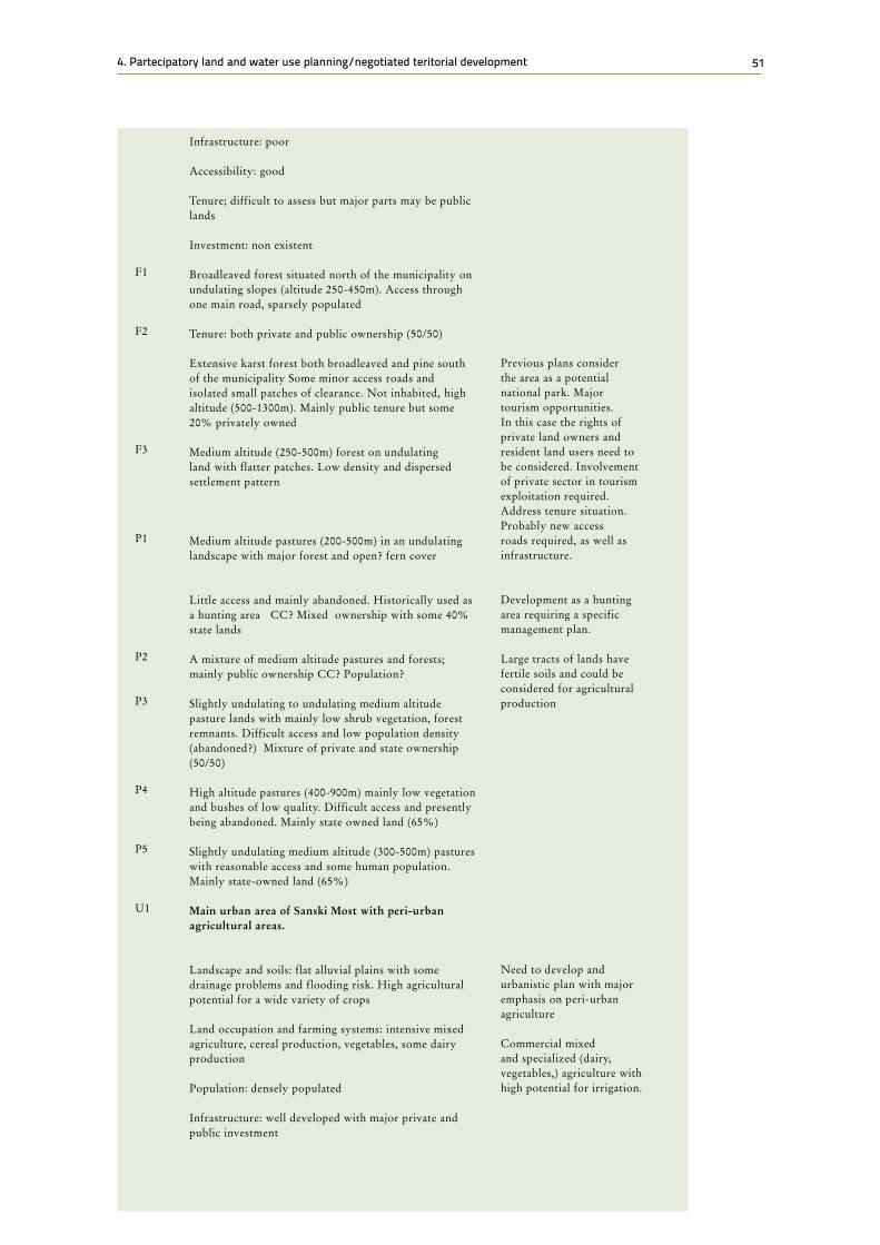
514. Partecipatory land and water use planning/negotiated teritorial development
Infrastructure: poor Accessibility: good Tenure; difficult to assess but major parts may be public lands Investment: non existent Broadleaved forest situated north of the municipality on undulating slopes (altitude 250-450m). Access through one main road, sparsely populated Tenure: both private and public ownership (50/50) Extensive karst forest both broadleaved and pine south of the municipality Some minor access roads and isolated small patches of clearance. Not inhabited, high altitude (500-1300m). Mainly public tenure but some 20% privately owned Medium altitude (250-500m) forest on undulating land with flatter patches. Low density and dispersed settlement pattern Medium altitude pastures (200-500m) in an undulating landscape with major forest and open? fern cover Little access and mainly abandoned. Historically used as a hunting area CC? Mixed ownership with some 40% state lands A mixture of medium altitude pastures and forests; mainly public ownership CC? Population? Slightly undulating to undulating medium altitude pasture lands with mainly low shrub vegetation, forest remnants. Difficult access and low population density (abandoned?) Mixture of private and state ownership (50/50) High altitude pastures (400-900m) mainly low vegetation and bushes of low quality. Difficult access and presently being abandoned. Mainly state owned land (65%) Slightly undulating medium altitude (300-500m) pastures with reasonable access and some human population. Mainly state-owned land (65%) Main urban area of Sanski Most with peri-urban agricultural areas. Landscape and soils: flat alluvial plains with some drainage problems and flooding risk. High agricultural potential for a wide variety of crops Land occupation and farming systems: intensive mixed agriculture, cereal production, vegetables, some dairy production Population: densely populated Infrastructure: well developed with major private and public investment
F1 F2 F3 P1 P2 P3 P4 P5 U1
Previous plans consider the area as a potential national park. Major tourism opportunities. In this case the rights of private land owners and resident land users need to be considered. Involvement of private sector in tourism exploitation required. Address tenure situation. Probably new access roads required, as well as infrastructure. Development as a hunting area requiring a specific management plan. Large tracts of lands have fertile soils and could be considered for agricultural production Need to develop and urbanistic plan with major emphasis on peri-urban agriculture Commercial mixed and specialized (dairy, vegetables,) agriculture with high potential for irrigation.

52 Safeguarding and enhancing land-based livelihoods: Social protection and land governance in Mozambique
Most of this information will be obtained from existing sources, supplemented by field reconnaissance to check how up –o-date and reliable these are. Gaps of importance may need filling in by methods of rapid rural appraisal, remote sensing and field surveys as well as talking with people who know the area, e.g. agricultural or forestry extension staff.
4.2.2 Basic land units, water sources and land-use and water use systems
To analyze the present situation it will be necessary to break the area down into major land units, areas that are relatively homogeneous with respect to climate, landforms, soils, vegetation and available water. Each land or territorial unit presents similar problems and opportunities and will respond in similar ways to management.
Appropriate land units at the national level might be agro-climatic regions; at the district level, land systems; and, at the local level, land facets, soil series or other soil mapping units. Soil-landscape modelling is among the available modern tools to support the mapping and identification of land/soil units to aid the land evaluation and land suitability analysis (Al-Shamiri and Ziadat, 2012; Ziadat et al., 2015).
The next step is to identify the more common land-use systems, areas with similar land use, climate, water availability and economy. These may be farming systems or systems based on forestry, etc. Land-use systems are frequently defined in terms of dominant crops, e.g. a maize/tobacco system. Other common criteria for differentiating land-use systems within a land unit are large and small farms or those with and without livestock.
One practical difficulty is that neither land units nor land-use systems will correspond to the administrative units or watersheds for which economic and population data are usually available and by which many planning decisions are taken. There is no easy solution: planners have to work simultaneously with land units, land-use systems and administrative units seeking their cooperation and the sharing of information
U2
Accessibility: Easy with access to major market places Tenure: regular laid out medium sized plots; mainly private land Western peri-urban area with industrial development and former mine exploitation Landscape and soils: flat valley land on good soils with some drainage and flooding problems Land occupation mixed agriculture with industrial development and some abandoned mine exploitation Population: densely populate Accessibility: situated along the main national road Tenure: mainly privately owned agricultural lands
Need for agricultural services: credit, agricultural extension, farmers organization. Mainly an area for industrial development but with possibilities for commercial agriculture Reconsidering the rehabilitation of mine exploitation, but with an environmental impact assessment. Possibilities for intensification of semi-urban agriculture with irrigation. Delivery of necessary services such as extension, credit, farmers organization

534. Partecipatory land and water use planning/negotiated teritorial development
and redefining of jurisdiction to arrive at the most appropriate concordance between administrative units and the economic-ecological units.
4.2.2.1 Problems of land use and water use
To define a problem it is necessary to establish the present situation, judge the ways in which it is unsatisfactory and identify ways in which it might be made better.
Apart from when planning new settlements on unoccupied land, this stage of diagnosis of problems is of the highest importance. Without identifying problems and analyzing their causes, one is in no position to plan for improving the situation. Three closely related methods, any of which can be used at this stage, are the agrarian systems diagnosis49, the farming systems approach50 and the (participatory) rapid rural appraisal51.
The fundamental field survey method may be summarized as:
• Talk to the people;
• Look at the land
• Inventory its resources.
"People" include the farmers and other land users, local leaders, extension staff and agencies active in the area (all concerned stakeholders). Where time allows, a set of interviews and focus groups should be conducted with farmers and other stakeholders sampled from each land-use system. At the same time, diagnose the causes of the problems identified. For example, a fodder shortage may be caused by cultivation encroaching on former grazing land, coupled with a lack of rotational grazing and/or control of livestock numbers on the latter. The effects may be indirect: a labour shortage on farms at a critical period might be made worse by the fact that women have to travel long distances to collect fuelwood or water.
Field observation is complementary to interviews. Ask to be shown around farms and travel about the area. This will reveal physical problems such as soil erosion, overgrazing and forest degradation.
Taking present land use as the basis, ask:
• How are the land and water resources managed now?
• What will happen if the present management continues unchanged?
• Why is it the way it is? Is it the best available system of land and water use or is it followed because of tradition, insufficient labour, lack of capital, a need for staple food, a need for cash, a need for time for communal activities and leisure, a desire to retain landownership, a lack of skill or technical knowledge or poor planning or even administrative derision?
49 FAO.1999. Guidelines for Agrarian Systems Diagnosis
50 FAO. 1995. The farming systems approach to development and appropriate technology generation51 FAO. 1996. Rapid rural appraisal, participatory rural appraisal and aquaculture
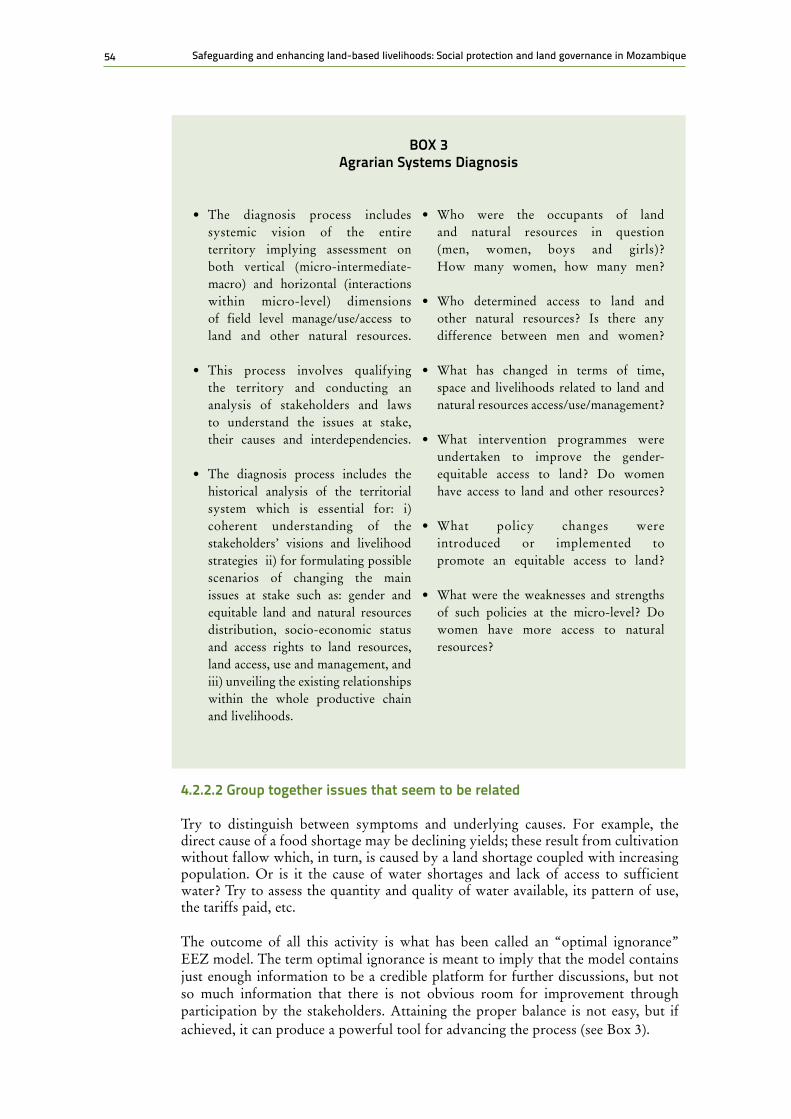
54 Safeguarding and enhancing land-based livelihoods: Social protection and land governance in Mozambique
4.2.2.2 Group together issues that seem to be related
Try to distinguish between symptoms and underlying causes. For example, the direct cause of a food shortage may be declining yields; these result from cultivation without fallow which, in turn, is caused by a land shortage coupled with increasing population. Or is it the cause of water shortages and lack of access to sufficient water? Try to assess the quantity and quality of water available, its pattern of use, the tariffs paid, etc.
The outcome of all this activity is what has been called an “optimal ignorance” EEZ model. The term optimal ignorance is meant to imply that the model contains just enough information to be a credible platform for further discussions, but not so much information that there is not obvious room for improvement through participation by the stakeholders. Attaining the proper balance is not easy, but if achieved, it can produce a powerful tool for advancing the process (see Box 3).
bOX 3 Agrarian Systems Diagnosis
• The diagnosis process includes systemic vision of the entire territory implying assessment on both vertical (micro-intermediate-macro) and horizontal (interactions within micro-level) dimensions of field level manage/use/access to land and other natural resources.
• This process involves qualifying the territory and conducting an analysis of stakeholders and laws to understand the issues at stake, their causes and interdependencies.
• The diagnosis process includes the historical analysis of the territorial system which is essential for: i) coherent understanding of the stakeholders’ visions and livelihood strategies ii) for formulating possible scenarios of changing the main issues at stake such as: gender and equitable land and natural resources distribution, socio-economic status and access rights to land resources, land access, use and management, and iii) unveiling the existing relationships within the whole productive chain and livelihoods.
• Who were the occupants of land and natural resources in question (men, women, boys and girls)? How many women, how many men?
• Who determined access to land and other natural resources? Is there any difference between men and women?
• What has changed in terms of time, space and livelihoods related to land and natural resources access/use/management?
• What intervention programmes were undertaken to improve the gender-equitable access to land? Do women have access to land and other resources?
• What policy changes were introduced or implemented to promote an equitable access to land?
• What were the weaknesses and strengths of such policies at the micro-level? Do women have more access to natural resources?

554. Partecipatory land and water use planning/negotiated teritorial development
4.2.3 Deepening the EEZ: in-depth analysis of present land situation
A more in-depth diagnostic of land suitability might be sometimes needed, and possible. Depending upon resources availability, the following part of the diagnostic will be done accordingly.
4.2.3.1 Evaluate land suitability
This is the central part of land evaluation, a procedure which answers the following questions:
For any specified kind of land use, which areas of land are best suited; are complementary resources available to make this a feasible use?
For any given area of land, for which kind of use is it best suited; are complementary resources available to make this a feasible use?
A systematic way of doing this is set out in “A framework for land evaluation (FAO, 1976)” and detailed procedures are given in guidelines on evaluation for rain-fed agriculture, irrigated agriculture, forestry and extensive grazing. In simplified form, the procedure is:
• Describe promising land-use types;
• For each land-use type, determine the requirements, e.g. for water, nutrients, avoidance of erosion;
• Conduct the surveys necessary to map land units and to describe their physical properties, e.g. climate, slope, soils;
• Compare the requirements of the land-use types with the properties of the land units to arrive at a land suitability classification.
Land cannot be graded from "best" to "worst" irrespective of the kind of use and management practiced because each kind of use has special requirements. For example:
• Rice has high water requirements and most varieties grow best in standing water; no other cereal crop will tolerate water logging during its period of active growth.
• Tea, sugar cane and oil-palm need efficient transport to processing plants; most crops grown for subsistence do not.
• For mechanical operations, stones and rock outcrops are limiting; with oxen or hand implements, cultivation can work round these obstacles.
4.2.3.2 Description of land-use types and water resources
A land-use type is defined in terms of its products and management practices (see Table 11). Highly generalized descriptions may be sufficient for reconnaissance surveys at the national level, e.g. "sorghum production", "conservation forestry." At more local levels, however, it is necessary to specify the use in more detail. For example, will the sorghum production be mechanized or based on animal traction? Will fertilizers be used? What irrigation method will be used?

56 Safeguarding and enhancing land-based livelihoods: Social protection and land governance in Mozambique
Where will the water come from? Will the conservation forests be managed by the government forestry service or by local communities?
Such descriptions serve two purposes. First, they are the basis for determining the requirements of a use. Second, the management specifications can be used as a basis for extension services and for planning necessary inputs.
Table 11Description of Land-Use Types
Title Grain and rice cultivation by smallholders
Production, Marketing Arrangements, Yields
Grain for subsistence, surplus sold in local market. Straw fed to draught animals. Average yield, 2.6 t/ha. When water is not limited, wet-season yield may be 4 t/ha and dry-season yield may be 5 t/ha
Management Units Size, Configuration, Ownership
Family-owned plots from 0.2 to 2 ha, usually associated with as many as 4 ha of upland which may be up to 2 or 3 km distant
Cultivation Practices and Inputs, Labour, Skill, Power, Varieties, Seeds, AgrochemicalsDJIBOUTI
.
Labour requirements from 200 person-days/ha without mechanization to 150 person-days/ha where buffaloes or tractors are used Terraced fields need extra labour to maintain bunds and waterways
Power requirements. Power for ploughing, harrowing and threshing may be provided by two-wheeled tractors. Alternatively, buffaloes may be used for land preparation or all work may be manual. Tractors may reduce tillage time by 60% and total time between crops by 30%
Land preparation seeks to control weeds, create a good physical medium for rooting and reduce water seepage loss. This is achieved by ploughing or hoeing twice, followed by harrowing under flooded conditions
Recommended varieties. Varieties are selected locally to suit specific sites and according to the season. The growing period must be long enough to span the flood period and to allow cultivation and harvesting under favourable conditions.
Planting rates are 20 to 40 kg/ha, seedlings are spaced from 20x20 to 25x25 cm depending on tillering capacity and length of stalks
Fertilizer. To replace nutrients removed by a crop of 4 t/ha requires 60 kg N. 30 kg P2O5
Weed control by maintaining adequate water depth and hand weeding until the crop canopy is closed
Pests and diseases. Chemicals used to control rice blast and stem borers. Good husbandry and resistant varieties control other fungal diseases
Cropping Characteristics Rice is grown as a monoculture, one or two crops per year. Fallow land is grazed by draught buffaloes and other domestic livestock
Water Most crops are rain fed, with water stored in level, bunded fields. Irrigation, from tanks or by stream diversion, enables a second crop to be grown in the dry season
Source: Guidelines for Land Use planning, FAO, 1993
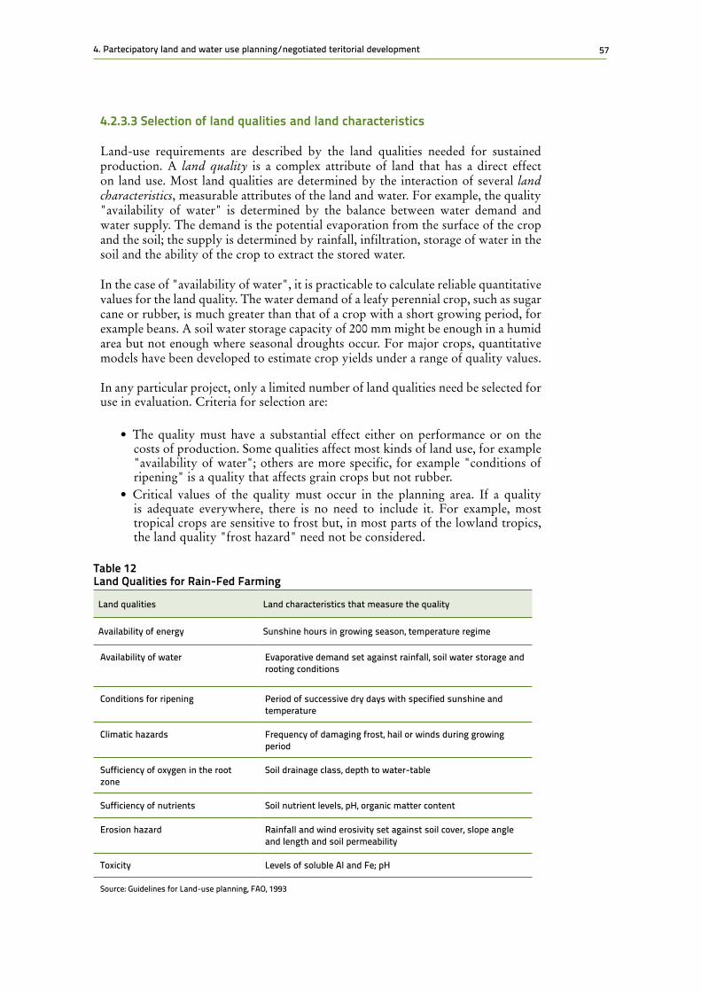
574. Partecipatory land and water use planning/negotiated teritorial development
4.2.3.3 Selection of land qualities and land characteristics
Land-use requirements are described by the land qualities needed for sustained production. A land quality is a complex attribute of land that has a direct effect on land use. Most land qualities are determined by the interaction of several land characteristics, measurable attributes of the land and water. For example, the quality "availability of water" is determined by the balance between water demand and water supply. The demand is the potential evaporation from the surface of the crop and the soil; the supply is determined by rainfall, infiltration, storage of water in the soil and the ability of the crop to extract the stored water.
In the case of "availability of water", it is practicable to calculate reliable quantitative values for the land quality. The water demand of a leafy perennial crop, such as sugar cane or rubber, is much greater than that of a crop with a short growing period, for example beans. A soil water storage capacity of 200 mm might be enough in a humid area but not enough where seasonal droughts occur. For major crops, quantitative models have been developed to estimate crop yields under a range of quality values.
In any particular project, only a limited number of land qualities need be selected for use in evaluation. Criteria for selection are:
• The quality must have a substantial effect either on performance or on the costs of production. Some qualities affect most kinds of land use, for example "availability of water"; others are more specific, for example "conditions of ripening" is a quality that affects grain crops but not rubber.
• Critical values of the quality must occur in the planning area. If a quality is adequate everywhere, there is no need to include it. For example, most tropical crops are sensitive to frost but, in most parts of the lowland tropics, the land quality "frost hazard" need not be considered.
Table 12Land Qualities for Rain-fed farming
Land qualities Land characteristics that measure the quality
Availability of energy Sunshine hours in growing season, temperature regime
Availability of water Evaporative demand set against rainfall, soil water storage and rooting conditions
Conditions for ripening Period of successive dry days with specified sunshine and temperature
Climatic hazards Frequency of damaging frost, hail or winds during growing period
Sufficiency of oxygen in the root zone
Soil drainage class, depth to water-table
Sufficiency of nutrients Soil nutrient levels, pH, organic matter content
Erosion hazard Rainfall and wind erosivity set against soil cover, slope angle and length and soil permeability
Toxicity Levels of soluble Al and Fe; pH
Source: Guidelines for Land-use planning, FAO, 1993
58 Safeguarding and enhancing land-based livelihoods: Social protection and land governance in Mozambique
Having selected relevant land qualities, it is necessary to decide which land characteristics are to be used for measuring them. For example, the quality "erosion hazard" requires information on rainfall intensity, slope angle and soil properties.
A compromise must be reached between characteristics that most closely define the land quality and those that are less precise but on which information is more readily available. Out of necessity, the choice is limited to those characteristics for which information is already available or can be gathered quickly. If there is no information on a critical land quality, surveys must be carried out or research initiated.
Land evaluations are sometimes conducted directly in terms of land characteristics, e.g. by using rainfall instead of availability of water, and slope angle instead of erosion hazard. There is, in fact, a hidden use of land qualities in this way of doing things, since plants do not actually require rainfall but do require water (which might alternatively be obtained from a high water-table in a dry area, for example). In practice, evaluations carried out carefully using either qualities or characteristics give quite similar results.
4.2.3.4 mapping of land units and their characteristics
Initial land units were identified as a basis for the diagnosis of problems. It may now be necessary to map these units in more detail, e.g. by dividing land systems into land facets or complex soil mapping units into soil series. The criterion for choice of land units is that they are expected to respond to management in a relatively similar way at the scale of the study.
Whether, it is now necessary, as part of the land-use plan to conduct original surveys, depends on the requirements of the plan and the detail and reliability of the information available. Soil surveys, agro-climatic studies, forest inventories, pasture resource inventories and water resources are major sources. For land-use planning at the national level, reconnaissance surveys at scales of about 1:250,000 may be adequate; district-level planning will need at least semi-detailed surveys at a scale of about 1:50,000.
Natural resource surveys take a substantial amount of time and will delay the planning procedure. However, past experience has shown that proceeding with land development projects without adequate resource data can lead to disasters, both for production and conservation. In practice, resource surveys and studies, particularly of land-use types and available water can proceed at the same time, with frequent interchanges of information.
Note: There is no standard system for letter designations of limitations; first-letter reminders should be used where possible.
4.2.3.5 Setting limiting values for land-use requirements
Limiting values are the values of a land quality or land characteristic that determine the class limits of land suitability for a certain use. The standard FAO land suitability classification is shown in Table 13.
The first and most important decision is to separate land that is suitable from that which is not. Important criteria for deciding on the suitability of land for a specific use are sustainability and ratio of benefits to costs.

594. Partecipatory land and water use planning/negotiated teritorial development
4.2.3.5.1 The land should be able to support the land use on a sustained basis
This means that the use must not progressively degrade the land or drain the water by annual drawing rates that exceed natural recharge rates. Many changes of land use cause an initial loss of land resources: for example, when forest is cleared for tea plantations or for arable farming, there is always a loss of forest habitat and wildlife as well as of soil and accumulated plant nutrients.
From then on, a good level of productivity must be maintained by the new system of management. For example, if soil erosion is not controlled, the new land-use type cannot be sustained. According to the land-use type, the upper limit of the land quality "erosion hazard" might be set in terms of slope, as follows:
– Plantation tea, high level of management: 20
– Smallholder tea, average level of management: 15
– Rain-fed arable crops with simple soil conservation practices: 8
4.2.3.5.2 The use should yield benefits that justify the inputs
The user has to make a reasonable living from the land. Local experience will usually be the best guide. Alternatively, a financial analysis can be undertaken.
It is then possible to distinguish up to three classes of suitability, although this is not always necessary.
Table 13Structure of the fAO Land Suitability Classification
S SUITABLE The land can support the land use indefinitety and beneficts justify inputs
S1 Highly suitable Land without significant limitations. Include the best 20-30% of suitable land as S1. This land is not perfect but is the best that can be hoped for
S2 Moderately suitale
Land that is clearly suitable but which has limitation that either reduce productivity or increase the inputs needed to sustain productivity compared with those neede on S1 land
S3 Marginally suitable
Land with limitations so severe that benefits are recuded and/or the imputs needed to sustain production are increased so that cost is only marginally justified
N NOT SUITABLE Land that cannot support the land use on a susteained basis, or land which benefits do not justify necessary inputs
N1 Currenttly not suitable
Land with limitations to sustained use that cannot be overcome at a currently acceptable cost
N2 Permantly not suitable
Land with limitations to sustained use that cannot be overcome
Examples of classes in the third category
S2e Land assessed asm S2 on account of limitation of erosion hazard
S2w Land assessed asm S2 on account of inadequate availability
N2e Land assessed asm S2 on account of limitation of erosion hazard
Source: Guidelines for Land Use planning, FAO, 1993

60 Safeguarding and enhancing land-based livelihoods: Social protection and land governance in Mozambique
Land classed as highly suitable is the best land for the specified use; moderately suitable land is clearly fit for the use but has limitations; while marginally suitable land falls near to (but above) the limit for suitability. Land that is not suitable may be subdivided into permanently not suitable, where there are limitations to sustained use that are clearly impractical to overcome; and currently not suitable, where such limitations could be overcome but not at a currently acceptable cost.
The construction of a table of limiting values for each land suitability class is a central operation in land evaluation. To do this, information is needed on the performance of a land-use type over a range of sites, taken either from trials or the experience of land users. The land requirements for several individual crops can be combined to assess the needs of a land-use type that includes several crops grown together or in rotation.
4.2.3.6 matching land use with land when water is available
Table 14Example of Land Requirements for a Specified Land-Use Type (bunded Rice)
Land qualities Land characteristics
Limiting values for land characteristics
S1 S2 S3 N
Sufficiency of energy
Mean annual temperature, (°C) or
>24 21-24 18-21 <18
Elevation (m)* 0-600 600-1200 1200-1800 >1800
Sufficiency of water 75% probability rainfall (mm)
>1300 900-1300 500-900 <500
Soil drainage class
Poorly drained
Imperfectly drained
Moderately well drained
Excessively drained
Soil texture C, ZC, ZCL, L
SC, SCL, ZL, Z SL S, LS
Soil depth (cm) >80 60-80 40-60 <40
Sufficiency of nutrients
PH of flooded soil 6-7 5 6 4.5-5 <4.5
7-8 8-8.5 >8.5
Salinity hazard ECe (mS cm-1) <3 3-5 5-7 >7
Ease of water control
Slope angle (degrees)
<1 1 -2 2-6 >6
Ease of cultivation Stones and rock outcrops (%)
Nil 1-5 5-10 10
* Elevation is used to assess sufficiency of energy where temperature data are not available; these values apply to Sri Lanka. Source: Guidelines for Land Use planning, FAO, 1993

614. Partecipatory land and water use planning/negotiated teritorial development
The first stage in matching is to compare the requirements of each land-use type with the land qualities of each land unit. The simplest procedure is to:
• Check measured values of each land quality or characteristic against the class limits;
• Allocate each land unit to its land suitability class according to the most severe limitation.
For cases in which at least one limitation is enough to render the land unsuitable for the use, the method of taking the most severe limitation is valid. For example, for maize cultivation, it is of no use having level land and sufficient rainfall if the soils are highly saline. For less severe values of limitations, alternative methods of combining ratings for individual qualities can be used.
Matching, however, can become a wider process than the simple comparison of requirements with qualities. Wherever this initial comparison shows certain land units to be unsuitable for a given use, the specification of the land-use type can be examined to see if, by modifying it, the suitability of those land units can be raised.
Thus, if suitability has been downgraded owing to erosion hazard, a new land-use type could be designed with the addition of contour-aligned hedgerows or other soil conservation measures. The use of fast-maturing crop varieties in areas with a short growing season is another example. By adapting the land-use types to meet the limitations present in the area in this way, higher overall suitability can be achieved.
A further possibility is the introduction of land improvements, inputs which bring about relatively permanent improvements in the characteristics of the land. Examples are drainage of land that is too wet or terracing of steep lands. In this way, the land is adapted to the requirements of the land use. Land improvements invariably require maintenance as well as capital expenditure.
4.2.3.7 Qualitative and quantitative land and natural resources evaluation
Some decisions need only qualitative land evaluation: for example, identifying the critical importance of certain areas for important land uses such as for an export crop. Quantitative economic evaluations, however, require estimates of crop yields, rates of tree growth, or other measures of performance. It is not realistic to predict the performance of each land suitability class unless data are available on plant growth (or other measures of performance) and the relevant inputs (i.e., water) from well-characterized sites, and unless the physical characteristics of the land mapping units are equally well known. Quantitative models have been developed for several major crops but these demand good data. Even when predictions are based on carefully controlled trials, they may be confounded in practice by variations in management. Therefore, try to estimate a range of performance under the likely standards of management.
4.2.3.8 Land suitability classification
The comparison of requirements of land-use types with properties of land units is brought together in a land suitability classification. Suitability is indicated separately for each land-use type, showing whether the land is suitable or not suitable, including - where appropriate - degrees of suitability (see Table 13). The major reasons for lowering the classifications, i.e. the land limitations, should be indicated

62 Safeguarding and enhancing land-based livelihoods: Social protection and land governance in Mozambique
(because of erosion hazard in one area or a high water-table in another, for instance). In large or complex surveys involving many mapping units land evaluation can be assisted by the use of geographic information systems. A major facility is that, if the land suitability data are entered into such system, when a change is made to one or more limiting values, new maps of land suitability can be rapidly produced.
The outputs are:
• Land suitability maps, showing the suitability of each land unit for each land-use type;
• Descriptions of these land-use types.
The descriptions of land-use types are given in the degree of detail appropriate to the level of planning. At the national level, only outline descriptions of major kinds of land use may be needed. At district and local levels, land-use type descriptions should specify the management, inputs (e.g. seeds, fertilizer, and fuel) and estimated production. Such information will be later needed to make provision for the supply of inputs and for storage, distribution and marketing (see Box 4).
4.2.4 Development context analysis
Irrespective of the level and accuracy of the land analysis, it is crucial for the target users to be aware of the different socio-economic patterns (environmental, institutional, political, economic, demographic, etc.) that influence stakeholders management/use/access to land and to water, livelihood strategies and options for improving gender-equitable rights to land and other natural resources in a given territory for men and women, young and elders.
bOX 4 Checklist for Land Suitability Evaluation
Responsibilities of the Team
• Describe land-use types in sufficient detail for subsequent analysis.• Select land qualities and land characteristics to be used in comparisons of land-use
requirements with land.• Map the land units and determine their relevant land characteristics and qualities.• Set limiting values to land-use requirements, to be used for determining class limits
for land suitability. Take into account sustainability and the ratio of benefits to inputs.• Match land use with land:
– Compare land-use requirements with land qualities or characteristics to determine provisional land suitability classes;
– Consider modifications to land-use types, in order that they become better suited to the land;
• Consider land improvements that could make the land better suited to the land use.• Map land suitability for each land-use type.• Plan for research needed: additional surveys, research by outside agencies or within the
land-use plan.
634. Partecipatory land and water use planning/negotiated teritorial development
In addition, this tool will allow the target users to have a deep understanding of the existing inequalities between men and women within the considered territory in three ways. First, it helps determining the issues that women and men have in managing, using and accessing land and other natural resources. Second, it retraces the history of the territory distinguishing women’s and men’s livelihood strategies. Meanwhile it allows understanding of the origins of the existing inequalities between men and women. Finally, a development gender-sensitive context analysis takes into account the impacts of existing policies and programmes on gender equality. Development context analysis helps the user of these guidelines to understand how socio-economic, environment patterns interact in determining gender equitable use, management and access to land and other resources at field level (horizontally) and analyzes existing linkages with intermediate/ macro levels (vertically).
At the same time, it is important to note that participatory diagnosis on use/management/access to natural resources varies within contexts and at different levels. In certain socio-cultural contexts gender roles, responsibilities and relationships within the social system or subsystem on access to land and water are strongly determined by socio-economic factors that in turn influence the legal property rights. For example, the access to land among different households and within households is strongly influenced or determined by social-cultural structures/ family /lineage (through marriage and inheritance systems).
Diagnosis in any development context should pay special attention to: i) the role of women and men, girls and boys as members of households within social structures, ii) the interactions among members (men and women) in terms of equitable access to land and water, and iii) intra-and inter household dynamics and power relationships which affect access to and control of decision making over land and water, productivity and the well- being of individuals.
Furthermore, gender sensitive diagnosis should include historical analysis and understanding of the stakeholders’ visions and livelihood strategies in relation to the contexts and patterns of the territory (see Box 5).
The analysis must capture the views and perceptions of both men and women. The history of the territory helps in defining social organizations and dynamics regarding access to land and water based on the relationships with the environment. It is important to understand the history of land occupation and water shares and allocations and the manner in which local people exploit their environment before deciding whether or not rights exist over an unoccupied area or untapped resource. Moreover, the historical analysis will help understanding the origins of the existing inequalities between men and women in the use/management/access to land and other natural resources (see Box 6).
At the same time, historical diagnosis describes which institutional frameworks existed in a given context regarding gender equality and territorial development, current dynamics and probable future trends, systems of social differentiation and the adaptation/modification of social practises, stakeholders’ livelihood strategies, and modalities for territorial administration and exploitation of resources. For instance, an analysis of historical changes such as migration, demographic transition, resource depletion and agro-industrialization will be needed for a fuller appreciation of the governing forces of inequalities between men and women. In addition, gender sensitive diagnosis addresses development contexts and patterns in terms of:

64 Safeguarding and enhancing land-based livelihoods: Social protection and land governance in Mozambique
• Changes and processes that continuously impact on gender dynamics, such as changes in government policies or programmes, transition to market economy and introduction of new technologies at the intermediate/national levels. The diagnosis reveals specific driving forces that affect interventions seeking to improve equitable access to land and water. It is important to understand the internal and external forces/ changes that impact on gender;
• Territorial dynamics are greatly influenced by climatic disasters (e.g. drought, erratic rainfall, landslides, floods, etc.) can all offer opportunities to stimulate change. Participatory territorial diagnosis can help in taking into account the risks of these calamities;
• Emerging family alignments different from the traditional types of households’ heads: i) resident married men; ii) absentee married men whose land is managed by male kin; iii) married women who practice subsistence
bOX 6 An Example of historical Analysis in mozambique
For instance, in Mozambique rural communities have their own laws, established by culture, environment, traditions, history, and different from other national laws. A deep sense of mistrust has developed among small farmers with laws and governmental programs. This happens for several reasons: lack of education, political oppression determined by war, violence, huge number of internal displaced people, and also, during the seventies, a production system based on state owned cooperatives imposed by the government. This perception has been reinforced by the fact that historical communities have been informed only about their negative rights or rather potential sanctions or penalties. As a result, Mozambican rural communities are prone to work more like small self - government nations than a wider Mozambique state. But, as the 1997 Land Law protects communities land rights and has been adapted to each local cultural system and traditions, communities are beginning to include and accept state law as their own law
Sources: Knight, R. 2002. Camponeses’ Realities: Their Experiences and Perceptions of the 1997 Land Law
bOX 5 Gender Audit
– Does the legal (formal or customary law) framework recognize the role and the position of women within the society?
– What types of social relationships and interdependencies exist regarding equitable access to land and water?
– How gender roles affect men’s and women’s access to land and water? – How much men’s and women’s time allocations of productive and reproductive work
differ? – Do gender inequality dynamics and unequal power relations affect access to land and
water? – How do social patterns like population growth affect gender sensitive access to land
and other natural resources?

654. Partecipatory land and water use planning/negotiated teritorial development
agriculture and manage household land in the absence of migrant spouses; iv) women alone who have no permanent connection with a primary adult male;
• Households headed by women alone are sharply distinguished from other categories by their smaller number, limited access to resources, vulnerabilities and greater poverty;
• Household heads include widows who often support children, separated women and women in changing consensual unions with men who contribute little to the household; children and elderly headed household. Child-headed households can therefore be described as households where the older child/children assume most of the parental responsibilities due to the death, illness, or incapacitation of that child/children’s parent/s or other adult caregiver;
• Widowhood (often caused by HIV/Aids and/or political violence) contributes significantly to the formation of female-headed households with no access to land or water and HIV/AIDS. Traditionally widows were absorbed/ inherited into extended families but as land resources diminish in response to population increase fewer families are able to provide such assistance.
4.2.5 Stakeholders’ priorities’ analysis
Women and men at the household or community level have different opportunities for social interactions, relationships, interdependencies and inter-linkages within the intermediate and macro levels. Identification of stakeholders (internal and external) in gender-sensitive diagnosis analysis provides their views/perspectives regarding interventions on improving equal access to land and water and livelihood activities. This analysis will allow understanding of the differences between women and men in terms of priorities, opportunities and bargaining power.
Due to falling prices for export crops (which is the main source of male income) and trade liberation of food crops (women’s main source of income) households’ financial relationships are changing in favour of women. However, even though
bOX 7 The Typology of Actors and Classes
What are the typologies/classes of actors within a given territory? Who are the powerful stakeholders? (such as private entrepreneurs who claimed parts of land and agreater share of water formerly occupied by local, influential landowners, etc.) communities. What are their interests? How men’s and women’s interests differ?What are their strengths and weaknesses (differences between men and women)? What kinds of opportunities and constraints exist for the different stakeholders? (even in this case it is important to distinguish men and women).How do they relate toother stakeholders within the same territory?What are the causes and impacts (social, economic and environmental) of such changes in access to land and water? Do they impact differently on men and women?How to deal with challenges posed by change in terms of access to land and water?What are the triggers of such changes?How have the emerging changes affected women and men, boys and girls differently?

66 Safeguarding and enhancing land-based livelihoods: Social protection and land governance in Mozambique
women’s source of income is increasing, men have always had disposal rights over land and water while women retained mostly usufruct rights.
4.2.6 Livelihood analysis toolkit
Gender sensitive territorial diagnosis provides information on livelihoods and available resources including land and water for different stakeholders (women and men), involved in the activities that ensures food security and provides income for the households .52
Livelihoods activities and responsibilities are heavily influenced by gender roles and responsibilities. Men and women’s social relations vary from one household to another. For example, household members have different access to land, labour allocation, control and decision-making power over land and other resources. In addition to that, women are in charge of the domestic and low skilled work (care, cooking, cleaning, collecting water and fuel, etc.), meaning that they face not only an unequal access to resources, but also an unequal distribution of tasks and exposure to risks. These could create obstacles to projects aiming at improving gender sensitive access to land and other natural resources.
A gender-sensitive livelihoods analysis is useful for:
• Comparing households’ socio-economic activities;
• Understanding who makes decisions on access to land and water, and the existing power relationships;
• Vulnerabilities in the current livelihoods.
Gender sensitive diagnosis on livelihoods analysis therefore:
• Examines and assesses the land tenure systems – both under customary or statutory law and how they affect livelihood activities like farming and livestock keeping.
• Examines and assess the water allocation system and access to water and how this system affects livelihood and shared risks and responsibilities.
52 Vulnerable, marginalized, ethnic minorities, HIV/AIDS infected and affected, poor, weak, wealthy and the elderly
bOX 8 Livelihood and Access to Land and Water
What types of livelihoods are derived from land and water access in the territory? What are the alternatives or coping mechanisms for people without access to land and water?How sustainable are these coping mechanisms in regard to land and water resources?Who are the most vulnerable in terms of livelihoods and why? Are there any opportunities and constraints in diversifying the livelihoods?What are the hazards and shocks experienced in certain livelihoods that affect access to land, water and productivity?

674. Partecipatory land and water use planning/negotiated teritorial development
• Identifies men’s and women’s roles and responsibilities in the households, or intra-households levels and highlights their needs, perceptions and interests.
• Assesses the stakeholders (women and men) commitments, priorities and opportunities and how people respond to or are impacted by new interventions aimed at improving the equal access to land.
Land and water access, whatever rights to these resources, exists within any development context (physical, biological, technical, economic and institutional) sharply shapes the land tenure arrangements and livelihoods.53
4.3 PhASE ThREE: SCENARIO bUILDING4.3.1 Dialogue and gender-responsive proposals/scenarios: identifying opportunities for change
4.3.1.1 Objectives
Now that the problems needing attention are better known, the next phase is to start preparing scenarios to deal with them. The objective of this phase is to initiate a discussion among stakeholders to identify opportunities for change, how to take advantage of them, having in mind that an improved and sustainable use of natural resources (land and water in particular) implies also promoting gender equality in access to and use/management of these resources (along the three pillars of technical feasibility, political opportunity and social legitimacy). It is impractical to involve all stakeholders; there is a happy medium where the number of representatives is small for efficiency’s sake but large enough to include key stakeholders (those most affected by the plan and those most capable of providing useful inputs).
4.3.1.2 Opportunities
Planning involves seeking and appraising opportunities for closing the gap between the present situation and the goals. Opportunities are presented by untapped human, land resources and other complementary natural resources, new technology and accommodating economic or political circumstances.
The stakeholders present opportunities in the form of labour, skills, capital and culture and, not least, the ability to adjust to change and to survive adversity. Cooperation at the local level may be promoted by encouraging the participation of land-use groups, water users and other community groups in the planning process and through buyer and producer organizations.
The land may have underdeveloped regions or unexploited resources such as water power, economic minerals or scenery and wildlife. The location of the planning area may give it a strategic advantage for trade or defense. The land nearly always has the potential for greater or more diverse production, given investment in management and complementary resources.
New crops and land uses may be available. Circumstances may have changed so much, e.g. through population growth, that it is no longer possible to solve problems
53 FAO. 2012. IGETI

68 Safeguarding and enhancing land-based livelihoods: Social protection and land governance in Mozambique
by improving the existing land use. A completely new use may be necessary, e.g. irrigation.
Improved technology can transform the productive potential of the land - for example fertilizers, pesticides, improved drainage or irrigation practices, new ways to store or process products, improved crop and livestock varieties. Research and extension services play key roles in developing, adapting and introducing new technology.
Economic opportunities include new sources of capital, new or improved markets, changes in the price structure of either inputs or outputs or both, and the improvement of transport and communications. Often, the application of improved technology to land is rendered difficult or impossible by the relative prices of inputs and products.
Government action may create opportunities, for example by the reform of land tenure and the administrative structure or through the provision of services and through policies of taxation, pricing, subsidies and investment.
At this stage, the opportunities considered need not be specified in great detail but should be wide-ranging to include all possibilities that appear feasible and realistic.
The participatory process of this phase aims mainly at: i) supporting actors in drawing coherent and feasible perspectives for the future development of the territory ii) helping the actors (women and men) become aware of all issues at stake within the territory iii) supporting the formulation of possible proposals for territorial development as a common ground for negotiation iv) setting up a negotiation table according to the actors’ willingness to negotiate, their bargaining power and the ability to access the negotiation arena (see Box 9).
It is worth noticing that even though women are willing to negotiate, they face several difficulties in participating in the negotiations. First, women have to be accepted at the negotiation table as an equal participant by all the other stakeholders involved (meaning that men have embedded the idea that women and men have the same right to sit at the negotiation table to claim their rights and serve their interests). Second, women are in charge of domestic tasks. For this reason they may not want to quit the household. Moreover, if negotiations are taking place far from the household, women face transportation issues (linked with the poor quality of infrastructures, the high probability of being victim of violence, etc.).
bOX 9 The Participatory Process
• What are the historical interrelations and dependencies on land and water access and territorial development among stakeholders (men and women)?
• What were the challenges to the historical issues mentioned in the diagnosis? • Are the stakeholders (men and women) still facing similar challenges or not?• How useful are the current opportunities and weaknesses in i) building scenarios and ii)
the future trend in gender equality in access to land, water and territorial development?

694. Partecipatory land and water use planning/negotiated teritorial development
This is why, in order to achieve gender equality, it is crucial to consider what the constraints that women face are and to start addressing those issues before starting the negotiation process.
Once the stakeholders have accepted the different views of those concerned with regard to gender equality in land and water access and preconditions for dialogue are met, concrete proposals can be then elaborated by the stakeholders and the Territorial Facilitator in order to meet the specific needs of various socio-economic groups.
The proposals should include alternative scenarios that will eventually ease the consensus building process once a common ground has been established. The scenarios should not only focus on the land dimension but should also focus on other productive resources (such as water, forestry, technologies, etc.) (See Box 10).
Dialogue and proposal building is continuous, interactive, and, should follow validated results through available tools to better understand: i) functioning of a territorial system and its development patterns and ii) historical interrelations and interdependencies within and between territories regarding gender equality and land and water access.
The validation process should enable the stakeholders and the (Facilitation) Team to be aware of the issues at stake within their territory, problems/needs and opportunities arising from issues (social, cultural, environmental and economic) related to gender sensitive access to land and water and to start formulating possible proposals on the identified common grounds.
The (Facilitator) Team has the responsibility of joining the threads of the analysis, adding elements to the reflections on the territorial system, and to initiate the dialogue. In fact, she/he has the task of organizing and examining the key information to ensure the analysis is consistent with and adequate to the context.
bOX 10 building Scenarios
• Building scenarios are useful processes for telling future histories to ensure gender equality in terms of land and water access and territorial development. It is important here to compare the scenarios proposed by men and women of different ages and economic status. Identifying the most important aspects of the scenario in a few lines, what will happen? What will the future be? It is important to use names that quickly create an idea of content because scenarios are easily remembered by names. Which scenario would benefit more men and women or can address the existing inequalities in access or benefits?
• The history of the future must be focused on the main dynamics (driving forces) and on their consequences, images, pictures, and anecdotes. Graphics could be used but must be kept short and simple.
• What must happen? Who must act? Share the scenario with others and evaluate it by their reaction; a good scenario is both unexpected and realistic and should help others to rethink. It should be thought-provoking, not predictive and for making recommendations.

70 Safeguarding and enhancing land-based livelihoods: Social protection and land governance in Mozambique
Development context analysis validated diagnosis should assist stakeholders (women and men) in building scenarios based on their understanding. Scenario buildings focuses mainly on time and space, on the “most likely and unlikely /alternative” scenarios. It is important for the stakeholders, both women and men, to understand and share ideas on scenario building: why it’s the most likely to continue the scenario with no intervention? In addition to that, it is crucial that those scenarios – proposed by men and women- have the objective to achieve gender equality in the access, use and management of land and the other natural resources.
4.3.1.3 Options for change
There is usually more than one way to tackle a problem. Alternatives may be needed to give due attention to the varying interests of competing groups and to serve as a starting point for negotiations. The final Territorial Pact/Plan may include aspects of more than one option.
The options developed will depend on the goals, the strategy pursued to reach these goals, opportunities and problems presented by the people, the land and the finance and other resources available (water). For example, problems of food production will demand agricultural processes or economic action; opportunities for tourism will depend on ways of attracting and accommodating tourists.
Options can be described in terms of ways and means:
• Non-land-use planning options. Population policy and food aid are beyond the scope of land-use planning.
• Allocations of land use. Land-use types are allocated to specific areas of land; for example, irrigated farming to bottomlands, forestry to steep slopes and stream reservations. This option is widely applied in new settlement schemes but is more difficult to apply where land is already occupied.
• New land uses. A complete change is made by introducing new kinds of land use not previously practiced in the area, for example irrigation. It is clear that water is a determining variable of land use patterns everywhere but particularly in the Near East Region.
• Improvements to land-use types. Improvements are made to existing farming systems or other land-use types in order to make them more productive or sustainable. The improvements must be brought about through extension services, often combined with improved infrastructure and services (e.g. supplies of inputs and provision of sufficient water). This option follows directly from the analysis of problems. It is one of the principal means of bringing about change in areas that have already been settled.
• Standards. Standards may consist of planning guidelines or limits. For example, conservation standards might specify "no cultivation within 40 m of streams or on slopes greater than 12°"; limits to safeguard life and property might specify "no housing or industrial development in designated flood hazard or landslide zones". Standards of this kind, however, are hard to enforce, unless the problems that have led to their being broken are addressed. Other standards refer to land management, for example standards for terrace construction, fertilization or land drainage. Interest rates on

714. Partecipatory land and water use planning/negotiated teritorial development
loans for farm improvement may be limited, to 5 percent for instance. For subsequent land evaluation, these management standards are built into the defined land-use types.
4.3.1.4 Procedures
The more inclusive way to proceed for selection of alternatives for change is a fair negotiation process involving all concerned stakeholders, and this is discussed more thoroughly in the next phase. What is essential here is to keep all interested stakeholders informed and seek their views. Some guidelines include the following:
• Focus on questions regarding what action can be taken within the plan. Some decisions may have been made already at a higher level of planning. For example, it may have been decided at the national level to build a road through the planning area. The choice to be made locally is the route, based on how it will best serve the existing or planned settlements.
• Consider alternative land-use strategies. None of the following strategies are likely to be followed alone. They represent extremes to be used as a basis for an analysis and comparison of different courses of action.
– No change. Continue the present systems of land and water use. Since there are problems, this is unlikely to be adopted, but examination of its consequences is useful to see if the suggested improvements are any better.
– Maximum production. This may be for all products, for selected products (e.g. food crops), for maximum financial benefit or to support the greatest number of people on the land.
– Minimum public investment. To bring about improvements which benefit the people while making the lowest demands on scarce public investment funds.
– Maximum conservation. Maximum production in the short term may lead to accelerating erosion, depletion of water or pollution. The alternative of maximum conservation may be costly or may imply a lower level of production.
– Maximum equity. A deliberate attempt to give added benefits to poorer sections of the community, vulnerable groups, particularly to minority groups.
• Identify a range of possible solutions. Options may be built around various themes. The planner must find the theme that is most relevant to the goals and the planning area. Again, a compromise between extremes will be necessary.
– Types of production. Which type of production should be encouraged: commercial, subsistence or a combination of the two? How should land and water resources be allocated among the different kinds of production?
– Production or conservation? A trade-off between these alternatives is often necessary in the short term. Standards, and hence allocation of land

72 Safeguarding and enhancing land-based livelihoods: Social protection and land governance in Mozambique
and water to different uses, may differ between these alternatives. For example, the maximum slope angle of cultivated land may be 20° in the "production" alternative and 8° in the "conservation" alternative.
– Self-reliance or outside investment? An alternative favouring self-reliance would be based on traditional crops, intermediate technology, low water intensity and local credit. An alternative requiring outside assistance could introduce more sophisticated technology, perhaps new crops and outside finance.
• Identify a wide range of possible solutions that meet each of the demands in the planning area. For example, if a shortage of fuelwood is a problem, then all the land not already cultivated could be put into fuelwood plantations, even though much of the area is grazed and there is also a shortage of pasture. Alternatively, fuel could be imported, if this is feasible, without planning for any change in fuelwood production.
• Develop options within the extremes. Develop options that have a realistic chance of being implemented. Moderate the maximum range of options by social imperatives, budgetary and administrative constraints, the demands for competing land and water uses and an initial assessment of land suitability. Thus, the Team addressing the fuelwood and grazing problems may develop three options: to allocate 20 percent of the area to fuelwood plantations, retain 30 percent of the area in grazing and import fuel to meet the continuing but reduced need; to meet the fuelwood demand by having 30 percent of the area under plantations, with a reduction in pasture; or the same as the second option, but with a parallel extension effort in intensive livestock production to compensate for the reduction in grazing area.
Compatible land and water uses can be combined to satisfy a number of demands. For example, multiple forest management methods can be developed that combine elements of wood production, watershed protection, wildlife and recreation. Agroforestry technologies are available which permit the production of fuelwood or fodder with food crops on the same land, or an alternative that combines soil conservation with production.
4.3.1.5 Public and executive discussion of problems and alternatives: dialogue and trust-building
The most important aspect of this phase is dialogue and trust building between and among all the stakeholders. It is necessary to:
• Address critical aspects of gender equality in land and water access and ownership (economic, social, cultural and environment) (i.e. property and inheritance rights for men and women; social and cultural norms linked with the vision of empowering women within the household and the community; the difference between men’s and women’s time allocation in the productive and reproductive work; etc.);
• Establish relationships to promote gender equality and equitable access to land and water and territorial development (relationships should not only promote gender equality, but include women in the negotiation process, in order to be sure that women’s interests are also represented);

734. Partecipatory land and water use planning/negotiated teritorial development
• Strengthen and empower the weaker stakeholders (usually women because of their lower status or lack of bargaining power) to enable them to actively participate in dialogue and trust building processes aimed at promoting gender equality in land access and territorial development.
However, the stakeholders’ willingness to participate in establishing a dialogue is related to their perceptions and ability to start the dialogue, and their experiences of obstacles and limitations of such processes. Usually women underestimate themselves and their bargaining capacities. The role of the Facilitator becomes therefore, critical in empowering women and establishing dialogue and building trust among the stakeholders to find a common ground for territorial dialogue where women and men are comfortable with.
The lack of access to reliable information is profoundly disempowering. It undermines people’s capacity to make decisions and defend their own interests, and it makes them easy prey to deliberate manipulation.
Ensuring transparency and information sharing throughout the process is key to guaranteeing its quality. Indeed, all data and information collected, as well as the studies developed, should be accountable to the public involved in peer-reviewing.
Transparent communication and good relationships are equally important to the stakeholders’ (women and men) comfort in sharing their fears and interests, as well as to giving them the courage to seek various possibilities of making their goals coincide with those of other stakeholders. An atmosphere of mutual trust is the basis for constructive cooperation and of reaching a compromise. Transparency will help avoiding hidden agendas and suspicion amongst the different parties, and thus, to prevent situations in which the stakeholders try to protect solely their own interests rather than finding the most suitable compromise for all the parties involved.
4.3.2 Capacity development of leaders and/or local government representatives
Capacity development should be interpreted as a means to enable institutions to perform specified activities, and also as a process of building awareness, attitudinal change, creation of leadership, increasing the involvement of the most vulnerable groups, such as women or indigenous peoples, and fostering communication as an end in itself, (for example, strengthening the quality of representation and decision-making within local organizations and their involvement in socio-political processes).
Two specific areas of capacity development can be leadership (managing culture, setting direction, supporting human resource development, and ensuring tasks are done) and strategic planning, (scanning the environment, and developing tactics to attain objectives and goals).

74 Safeguarding and enhancing land-based livelihoods: Social protection and land governance in Mozambique
bOX 11 Soulaliyate Women in morocco: Leaders of a Grassroots mobilization for
Land Rights
The Soulaliyates movement is a grassroots women’s social movement launched in 2007 that advocates for recognition of the land rights of Soulaliyates (women of collective lands). The majority of Soulaliyate women are illiterate, poor and economically dependent on male members of families despite their own substantial contributions to land productivity. This being principally due to lack of recognition of their rights to collective lands.With the support of the Democratic Association of Moroccan Women (ADFM) NGO and UN Women, the Soulaliyates women organized themselves into interest groups and got empowered to promote and protect women’s rights to collective land. Started from the interest group, the Soulatiyates women have managed to transform themselves into a national social movement that fights against injustice, gender-based discrimination and patriarchal customs and traditions in access to land.
Initiatives of the movement persuaded the Government of Morocco to bring legal changes in terms of ensuring formal access of the Soulaliyates women to land by issuing the relevant rulings. With thanks for the contribution and input of the long-term advocacy and sensitization campaign, the Soulaliyates women from urban districts of Mahdia received land plots of the equal size and were entitled to the equal land rights as men in March 2013 for the first time in Morocco. As a result 867 females benefited from distribution of 128 hectares of land and thus, became landowners and attained control over land.The success of the Soulaliyates is based on the well-structured methodology and holistic approach adopted by the ADFM which include coalition-building, mobilization, capacity-building, and advocacy. This enabled them to achieve the following outcomes:
• The rights of the Soulaliyates women to collective lands have been recognized by the Ministry of Interior which had issued ministerial decrees on the matter;
• The capacities of the Soulaliyates women have been strengthened and with improved skills and better knowledge of their rights they are enabled to be the change-makers who can mobilize and reach out effectively the decision makers.
• The Soulaliyates’ movement helped to initiate a discussion over collective lands as a national heritage and contributed to reveal the complexity and difficulty of issues related to the management of collective lands such as diversity of practices, the flawed legislation, and the alarming loss of land and natural resources. The Soulaliyates movement has prompted the Government to ensure that these issues are reflected in concrete solutions, mechanisms and actions.
• The Soulaliyates’ ability to work in solidarity in order to constitute an influential force and to interact with officials for the purpose of making their voices heard, has allowed the emergence of an exceptional leadership.
• Partners: Forum Marocain de l’Action Social, ANARUZ: the National Network of Counseling Centers for women survivors of gender-based violence, Local coalitions of Soulalyates.
Source: Evrard, A. Y. 2014. The Moroccan Women's Rights Movement
754. Partecipatory land and water use planning/negotiated teritorial development
4.3.2.1 Partnerships and strategic alliances
In order to encourage a wider participation, to accompany the process by communication and training programs, and reinforce vertical and horizontal trust, it is essential to foster the creation of alliances among cooperation agencies, governmental institutions, civil society and their representatives (farmers’ organizations, research institutes, trade unions, etc.). Thanks to their direct field experience and the results achieved during field work, practitioners, NGOs (etc.) can put into action capacity-building programs targeted at specific population groups, especially weaker and more marginalized groups.
Strengthening women’s organizations has been crucial to women’s’ improved access to land in Nicaragua. In 1980 women gained access through cooperative movements what enabled them to engage in agriculture on a more independent basis than has been the case previously.
4.3.3 Scenarios planning: a land and water use plan proposal
What follows is an example of how a specific scenario that could be prepared for further dialogue and negotiation at the next phase. The proposed scenarios for change must be put into a form in which they can be discussed, negotiated and, when approved, acted on. A specific land-use plan, intended to be implemented as a development project, is a quite common (although not the unique) way of doing this. However, depending on the level and purposes of the planning study, the results may also be implemented as guidelines for priorities or by being incorporated into legislation, development budgets, agency programmes, management standards and extension programmes.
bOX 12 The Advocacy Role of feminist NGOs in mozambique
In relation to gender equality studies in sub-Saharan Africa, Mozambican case is paradigmatic. There is a large number of women organizations in Mozambique, registered as NGOs, that are specialized in different issues or professions (rural women, businesswomen, jurist etc.). Among them, the Fórum Mulher - Coordenação para a Mulher no Desenvolvimento em Moçambique – created in 1992 as a women association platform, has played an important role during the national debate on 1997 Land Law approval.
Furthermore, through intensive advocacy work, Forum Mulher achieved major influence on the country's family law securing women’s legal position. The Gender and Land project set up in 2010 worked mostly with the Forum to identify participants for trainings among their network. Despite the initial difficulties, the result was positive as the participation of women kept growing over a four-year period: from 18% in 2009 to 46% in 2013. Women participation in the trainings from 2010 to 2013 averaged 48%
Source: Bicchieri, M. 2013. ‘Rafforzare i diritti sulla terra (di uomini e donne) in Mozambico: l’esperienza della FAO con i paralegali’, in Donne, terre, e mercati: Ripensare lo sviluppo rurale in Africa sub-sahriana.

76 Safeguarding and enhancing land-based livelihoods: Social protection and land governance in Mozambique
The following discussion relates mainly to results being incorporated into a specific land-use plan scenario that is implemented as a development project. The three elements in the plan that guide the scenarios are:
• What should be done? - The selected changes to land use and where they should be applied or recommended.
• How should it be done? - Logistics, costs and timing.
• Who should lead the process? – Who else supports and how are they monitoring.
• Reasons for the decisions taken.
4.3.3.1 Preparation of maps
Participatory Land-use planning / Negotiated Territorial Development is critically concerned with what should be done, where and by whom. The planning procedure so far has been based on the fact that land conditions are highly variable and so land-use types that will be sustainable and economically viable on one land unit will fail, in either or both of these respects, on other kinds of land. Hence, maps form a key element in the presentation of results.
Several sets of maps have been prepared as part of the planning procedure: base maps, summaries of available data and possibly maps based on original surveys; land suitability maps; and allocations or recommendations of land use to areas of land. These are now drawn up and printed so that they can be used as a basis for further dialogue and negotiation and further revision.
Maps are in no way a supplementary part of the report. On the contrary, it may be nearer the truth to say that the text supplements the maps, although they in fact complement each other. The map showing land-use allocations and recommendations is the focal point of the land-use plan.
4.3.3.2 Writing the scenarios
The first need is to set out, in summary form and then in more detail, the land-use allocations or recommendations for this specific scenario. An important part is a description of the selected land-use types, including their management specifications and the land units for which they are recommended.
Following this, reasons for the choices and decisions made must be given, again both in outline and in some detail, in order to facilitate next step (the negotiation and final agreement).
4.4 PhASE fOUR: NEGOTIATION PROCESS AND CONSENSUS bUILDING4.4.1 Appraise the alternatives and search of the best agreeable option
4.4.1.1 Interest-based negotiation

774. Partecipatory land and water use planning/negotiated teritorial development
The objective of this Phase is to articulate a continuous multi-level (micro/intermediate /macro) and multi-stakeholders (internal and external) gender sensitive dialogue through negotiation and consensus building by seeking to promote gender responsive territorial development based on scenarios elaborated under the previous phase. There are many practical conflicting claims over natural resources that need a negotiated approach as depicted in Box 13 below.
In interest-based negotiation, the first principle is to deal separately with the demands of the individuals and the issues debated by the parties. However, the process requires:
figure 8: mapping Development Possibilities (Kaduna Plains, Nigeria)

78 Safeguarding and enhancing land-based livelihoods: Social protection and land governance in Mozambique
• Frank, open discussions and recognition of the legitimacy of each actor/party (women and men) to defend their interests are essential;
• Mutual respect and confidence by the participants to the negotiation;
• Respect of local social norms affecting men and women.
Factors that constitute the cornerstones of interest-based negotiation processes consist of:
• Focus on the interests at stake instead of concentrating on the positions of stakeholders;
• Analysis on the multiple interests that lay behind each of the stakeholders’ positions i.e. it is the stakeholders’ interests that define the problem and open the way for solution.
Another basic principle of interest-based negotiations consists of formulating a vast range of options prior to making decisions attributed to promoting men and women equality in access to land and territorial development.
4.4.1.2 Power Dynamics Analysis
Further useful information on the stakeholders can be generated through the analysis of their relative power and interest.54 These two variables (power and
54 Other sources refer to Power as “Influence” and Interest as ”Potential.”
bOX 13 The Interest-based Negotiation
• Land-use competition between agriculture, forestry, grazing and minerals. • Disagreements over the size, location, and composition of a permanent forest estate. • Gender inequalities in terms of access, use and management of natural resources• Conflicts between de jure (legal) and de facto (traditional) tenure. • Competition between commercial and subsistence interests. • Gender blind policies and outdated laws on lands and forests, and conflicts among these
laws. • Absence of women and gender experts in teams charged with developing policies
and other governance tools around natural resource management in peace-building contexts.
• Overlapping concessions on public forest lands. • Impractical laws and regulations for trees and forests on private lands. • Concentration of land and forest use rights in the hands of politically influential
persons. • Forced relocation of communities when lands are set aside for national parks,
infrastructure projects, and other developments. • Disagreements about use rights for timber, water, game, fuelwood, and other forest
resources. • Inadequate consultation with women as land rights holders and users at the community
level. Source:Adapted from: FAO, 1996. Planning for Forest use and Conservation: Guidelines for Improvement. http://www.
fao.org/docrep/w3210e/w3210e00.htm#Contents

794. Partecipatory land and water use planning/negotiated teritorial development
Table 15Types of Development
Type of development
Summary definition of development
1. Integrated agriculture
(a) In densely cultivated areas
Establishment of integrated agricultural development projects aimed at increasing existing agricultural production per hectare by improving infrastructure (communications, supply of agricultural inputs, produce marketing, credit facilities and extension service coverage). Run by a semi-autonomous project authority, making use of self-help wherever possible. Allied to general improvement of social services
(b) In sparsely cultivated areas
As above but also able to increase production by increasing the area under cultivation and/or introducing "mixed farming".
2. Mechanized farming Establishment of large mechanized farms (>1000 ha), requiring a high level of management expertise and mechanization of all stages of production from land preparation to harvest. Good planning and adequate conservation measures are essential. Limited to sparsely cultivated areas.
3. Traditional grazing Improvement of traditional grazing, including control of stock numbers, the elimination of unregulated burning and the introduction of forage species into natural grassland. These measures, together with the establishment of grazing reserves and the allocation of grazing rights, are components of a suggested programme to be organized at the interstate level. Limited to sparsely cultivated areas.
4. Grazing reserves Establishment of reserves in the major traditional wet and dry-season grazing areas and along migration routes, with additional reserves within areas freed or being freed by the tsetse eradication programme. Provision of adequate water supplies, veterinary services and improved natural grassland coupled with strict control of stock numbers. Limited to sparsely cultivated areas.
5. Cattle ranches and dairy farming Establishment of ranches for "growing out" cattle drawn from Fulani herds. Stock numbers restricted to 2000 head until the viability of the ranch is established. Area not less than 2000 ha per 1000 head of cattle with 1200 ha for wet-season and early dry season grazing and 800 ha for fodder grass to provide additional dry-season roughage Supplementary dry season feeding by cottonseed. Cottonseed cake, groundnut cake, brewer's grains or molasses as available. Limited to sparsely cultivated areas.
Establishment of dairy herds of not more than 100 milking cows. Total area not less than 250 ha with 130 ha improved pastures for wet- and early dry-season grazing and 50 ha to provide additional dry-season feed, supplemented by locally available concentrates and crop residues
6/7. Production forestry
6 Development for production of timber
Development financed and managed by government and covering a few to 100 ha in one location, usually for sawn timber production for local use Alternatively, run by a commercial company at a minimum annual planting rate of 400 ha for sawn timber or pulp confined to forest reserves
7. Development for production of fuelwood and poles
(a) Production by state and federal departments in forest reserves
(b) Production by farmers on small woodlots, backed by extension service
(c) Extraction from areas of natural vegetation in forest reserves.
80 Safeguarding and enhancing land-based livelihoods: Social protection and land governance in Mozambique
interest) are defined as follows: power is the ability a stakeholder has to facilitate or impede the achievement of an activity’s objectives and interest is the degree to which the stakeholder is willing to participate in the process. It is crucial here that all stakeholders agree on the information collected, this would help to level asymmetries of information power.
The following questions could be useful in assessing the power and interest of the stakeholders:
• Who is dependent on whom?
• Which stakeholders are organized? How can that organization be influenced or built upon?
• Who has control over resources?
• Who has control over information?
• Which problems, affecting which stakeholders, are the priorities to address or alleviate?
• Which stakeholders’ needs, interests and expectations should be given priority attention with respect to the process?
A variety of techniques are available to analyze these variables, but one useful procedure involves subjectively assigning a score of 1 to 5 to each stakeholder’s power and interest based on the answers to the questions above and any other relevant criteria.55Table 16 illustrates a hypothetical example, where the first column represents stakeholders and the second and third columns are their scores for power and interest, respectively.
These scores can then be plotted on a two dimensional graph, as shown in Figure 8. The location of the dividing lines between “high” and “low” for both power and interest can be determined by the distribution of the points on the graph. The practitioner
should never forget that this is a very subjective procedure and the use of numeric methods does not make it any less so.
Table 17 presents a matrix that can be used to interpret the power relations revealed in the plot of power/interest relationships. The information in the cells describes how each type of stakeholder relates to the process.
Once the stakeholders have been classified in the Power/Interest Matrix, the Facilitation Team should try to develop strategies that encourage movement of all who fall into either the low power or low interest categories into the high interest/power cell.56
55 Wilcox, D. 1994 The Guide to Effective Participation: pp. 2.3-2.11 56 FAO. 2004. Participatory Land Use Development in the Municipalities of Bosnia and Herzegovina

814. Partecipatory land and water use planning/negotiated teritorial development
4.4.2 Composition of the working groups
For local (municipal/district) interventions, it might be advisable to work through Working Groups.
There are a number of reasons for dividing the stakeholders into working groups. First, smaller groups are more easily managed—easier to get together, arrange logistics for and facilitate. A group size of between seven to fifteen participants is usually considered appropriate. It is hard to achieve the desired diversity in groups smaller than seven. Groups larger than fifteen become difficult to manage. Note that it is possible for one stakeholder to participate in more than one working group. In fact, it is essential that the key stakeholder, the district/municipality administration, be represented in all of the working groups.
Next, since each operates independently, multiple small groups will likely produce a wider variety of ideas, avoiding the problem of “groupthink” wherein there is often an uncritical acceptance or conformity to prevailing points of view. Working in smaller groups also helps to empower weaker stakeholders who would be less likely to venture an opinion in a larger meeting. Finally, since the working groups are organized around some land use theme or spatial zone, there will be a greater focus of interest amongst its members than would be the case in a more general discussion group.
In forming the working groups there are two important parameters to keep in mind. First, the working groups are organized around a land use theme or spatial zone.
Table 16Stakeholder Power/Interest Data Table
Stakeholder Power Importance
A-Farmer 1 1
B-Business Group 4 3
C-Municipal official 2 3
D-Municipal official 3 4
E-Shepard 1 4
F-Housewife 2 2
G-Farmer 4 5
H-Tourist Guide 3 2
I-Policeman 4 1
figure 8: Plot of Power/Interest Relationships
Low
High
1
2
3
4
5
I
A
H
F
B
C
D
G
E
Low High
Interest
1 2 3 4 5
Powe
r

82 Safeguarding and enhancing land-based livelihoods: Social protection and land governance in Mozambique
They are not organized according to institutions, professions or disciplines. This is because land use issues by their very nature are “crosscutting”: they do not neatly fit into traditional bureaucratic categories but in reality cut across departments, institutions, professions, levels of government, etc.
Second, to ensure active participation of all the actors whose cooperation is required the membership of the working group should be as broadly based as possible; drawn from the full range of stakeholder interests, organizations and groups. This point is significant because land use issues affect and are influenced and affected by a wide variety of different people and groups. The membership of each working group is drawn from all the different stakeholders who:
– Have expertise or information about;
– Have responsibilities and authority over; or
– Are effected by and/or affect the particular land use theme or spatial zone.
The working group should also include representatives from the public sector, the private sector, community groups and the public at large. With such diversity a meaningful consensus can be built based on participation in the decision making process
4.4.3 Objectives of the Working Groups
The overall objective of each working group is to discuss/negotiate and agree on the scenario most adapted to and consistent with their common needs for that specific spatial zone.
The working groups map the assets of the territory as they relate to their land use theme or spatial zone. The assets’ mapping will be based on the diagnostic done in the previous Phase, and completed by other needed information like:
– Social Norms: What are the characteristics (habits, customs, skills, education, practices, beliefs, etc.) of the people who inhabit the municipality? Are they uniform or diverse? Are they deep rooted and stable or in a state of flux? What social, cultural and religious institutions exist? How do they occupy their time?
– Markets: Where do people buy and sell things? What do they buy and sell? What type of businesses exists: Are they retail, manufacturing, service, agricultural, financial, etc.? How many people do they employ?
Table 17Power / Interest Cross Tabulation
Low Power high Power
High Interest Stakeholders in this segment may prove helpful if they can be empowered.
Natural allies of the process.
Low Interest Stakeholders will have little impact on the process
Stakeholders may become dangerous to the process if alienated or very supportive of the process if they can be induced to participate.

834. Partecipatory land and water use planning/negotiated teritorial development
Who owns them?
– Legislation: What legal or political advantages does the municipality have? Influential politicians, specially protected resources, state subsidies, special tax advantages, etc.?
The community asset mapping exercise is the start of the negotiations that will ultimately produce the Territorial Pact (the Plan) and the consensus EEZ.
The most important input to this procedure, however, is the knowledge, attitudes and understanding of the territory that the working group participants bring to the meetings. These are the ingredients of the process that can be obtained from no other source and will ultimately govern the success of the participatory land use development process.
4.4.4 Visioning
Once the working group has developed a conception of the asset of the municipality as they relate to the particular land use theme or spatial zone the next step is to use that information to formulate a vision statement. A vision is the answer to the question, “What is our preferred future?" As such, a vision is a guiding image of the group’s perception of successful outcomes for the municipality’s activities. The vision statement is a description, in words, that conjures up a similar picture for each group member of the destination of the group's work together as it pertains to the municipality’s prospects. It also describes the group’s consensus regarding the direction in which the municipality should be headed in the next ten to fifteen years.
Ingredients of a vision statement include:
– Positive, present-tense language;
– Qualities that provide the reader with a feeling for the region's uniqueness;
– Inclusiveness of the region's diverse population;
– A depiction of the highest standards of excellence and achievement;
– A focus on people and quality of life; and
– A stated time period.
The process and outcomes of visioning create a number of short and long term benefits, among which are that visioning:
– Identifies direction and purpose;
– Alerts stakeholders to needed change;
– Promotes interest and commitment;
– promotes focus;
– Encourages openness to unique and creative solutions;
– Encourages and builds confidence;
– Builds loyalty through involvement (ownership); and
– Results in efficiency and productivity.

84 Safeguarding and enhancing land-based livelihoods: Social protection and land governance in Mozambique
4.4.5 The territorial pact
After the working groups have reached a consensus for each of their land use themes or spatial zones the results of their efforts must be combined into an overall vision of the territory (district/municipality). The negotiations to combine the working group visions take place in a plenary workshop in which each group will present the results of their deliberations. The task of the workshop is to sensitize the stakeholders to the different visions of all the groups, harmonize these visions, identify and resolve any conflicts between them and formulate a single, unified consensus that incorporates them all.
The consensus reached in this workshop is referred to as the Territorial Pact. The Territorial Pact consists of the basic following components:
– An opening narrative to capture the identity of the entire municipality, combining all of the elements identified in the groups.
– The consensus EEZ, in which all of the physical, social, ecological, political and economic zones recognized as important by the working groups, the service providers and the practitioner are identified and described. As was discussed in the previous chapter, the EEZ is intended to provide a tool to aggregate available data and information in a simple, easily understandable and readily usable form. The EEZ provides a holistic picture of land and natural resource use in the municipality. To repeat the goal established at the beginning of this chapter, the Consensus EEZ delineates areas where particular land uses may be encouraged through development programmes, services, financial and tax incentives or other intercessions. The EEZ classification partitions the landscape into areas that show approximately the same constraints, potentials and challenges for socio-economic development as it pertains to the use of land and natural resources. Areas grouped into a zone would be expected to respond similarly to approximately the same kind of interventions. The Consensus EEZ often indicates likely options related to the development potentials of the municipality
– A synthesis and harmonization of the working groups’ descriptions of the future shape of the municipality to reflect the aspirations of all its inhabitants.
– An integration of the working groups’ growth narratives to develop an overall perspective on the stakeholders’ conception of how the municipality should reshape itself in the future.
Formulation of the Territorial Pact components should be done by consensus. If there is disagreement or conflicting ideas, the working groups may wish to revise their asset maps and/or vision statements. New ideas that arise in the course of the negotiations may lead to a similar result. As in all of the previous activities, the negotiations must be conducted as an iterative, organic process rather than a series of fixed steps. Clearly, the conduct of this exercise also depends on the application of the most proficient skills of the Facilitation Team to achieve a successful outcome.
4.4.6 The development portfolio
The territorial pact provides the stakeholders with a shared conceptualization of their aspirations for land use in the municipality. The next step in the process is

854. Partecipatory land and water use planning/negotiated teritorial development
to translate these aspirations into a concrete action plan. The goal of the plan is to establish a combination of activities that transform the municipality’s current land use into land use patterns that match the community’s vision as expressed in the territorial pact. The product of this activity, as shown in Figure 9, might be a development portfolio consisting of a list of well-defined project ideas which have been formulated as project proposals for implementation. As part of the portfolio the stakeholders develop a consensus which prioritizes these project proposals. The development portfolio, therefore, establishes the master plan that is used to guide the municipality in its efforts to achieve the vision set forth in the territorial pact.
4.5 PhASE fIVE: ThE ImPLEmENTATION
4.5.1 Assessment of the needs to implement the agreement (time, financial, human, social)
The objective of the entire exercise so far has been to identify, negotiate and agree on beneficial land-use changes. Hence, implementation is included as a "step" in the planning process, albeit a step of a different nature.
At the national level, implementation is likely to be through policy guidelines which may also serve as a framework for the selection of possible interventions (projects, programs, other…) at the local level. In this sense, the Team continues, throughout the initial implementation period, to supply information to government as well as to other concerned stakeholders as a basis for decisions.
At the local level, implementation is sometimes carried out almost contemporaneously with planning. The planning team may move from one locality to another and draw up detailed plans for implementation (within the framework set at the district level), while leaving the local extension staff, village agricultural committees or other local agencies to put the plan into practice. At the district/municipal level, the agreement/plan will frequently be implemented by means of a development project. There may be a time gap between planning and implementation for financial, bureaucratic or political reasons. The responsibility for putting the agreement/plan into effect rests with the decision-makers, the implementing agencies and the people of the area.
Initiation Actions
Actors and states
Information
Agreements
Negotiation
Information ImplementationNegotiation
Information
Negotiation
Initial state StakeholdersConsensus building
TerritorialPact
ConsensusEEZ
Practitioner
Legislation
Land UseAssets
Visions
MarketsSocial Norms
Landscape
Outcome
RevisedLegislation
ImprovedLand Use
ModifiedMarkets
Altered Social Norms
Variables
ChangedLandscape
Preparation and support
Workinggroups
figure 9: The Development Portfolio

86 Safeguarding and enhancing land-based livelihoods: Social protection and land governance in Mozambique
4.5.2 The role of the facilitation team
The Facilitation Team has several important contributions to make to implementation. The first is simply to ensure that the measures recommended in the plan are correctly understood and put into practice by the responsible stakeholders. Representatives of the Facilitation Team form an essential link between planning and implementation.
Related to this, the Facilitation Team can take the lead in coordinating the activities of the implementing agencies and should generally maintain communications between all parties to the plan. It can assist in institution-building, the strengthening of existing institutions or, where necessary, the formation of new ones. This can include staff education and training.
A further activity regards public relations. This may include explaining the land-use situation and plan to the media, at public meetings and in schools. The Facilitation Team is in a particularly good position to organize research related to the plan, since they are aware of the problems likely to be encountered. Finally, the Facilitation Team will monitor and evaluate the success of the plan.
Much time may be needed to ensure the comprehension, participation and satisfaction of the people of the area as well as that of the local and national government authorities. This is clear in the case of the more socially oriented activities such as pasture management committees, cooperatives and credit for small farmers, yet it applies at all levels. Public relations should not be a one-way process of government "explaining" actions to the people, but a two-way interchange of ideas. If members of the local community say, for example, that it would be unwise to graze cattle in a particular area during the dry season, they may have excellent reasons which the implementation team should take into account.
Implementation will often depend on efficient project management. The time, finance and other resources devoted to it will often considerably exceed those of the
bOX 14 Logistics Planning and Staffing Considerations
To complete the information needed, it should then consider the practical details of implementing it: decide the means, assign responsibility for getting the job done and lay down a timetable for implementation. Set targets that are realistically obtainable, not those based on optimistic assessment. It may be possible to use experience from previous development programmes to indicate the rate of change that can be achieved in practice. Certainly, the plan must be in accordance with what the people concerned are prepared to do.As one form of summary of the logistic planning, list the requirements for implementation in terms of:Staffing: specialists, technical staff, labor.
• Timing: the intended scheduling of changes, drawn up as tables.• Costs: the finance needed to implement the plan, its scheduling year by year and
proposed sources of funding.• Financial control, including independent audit.

874. Partecipatory land and water use planning/negotiated teritorial development
entire planning process preceding it. Implementation involves many aspects that are beyond the scope of these guidelines, hence the brevity of this section.
The proposals formulated by the actors for the negotiation outline the needed financial and human resources for their implementation and requests for external assistance. Once an agreement is found on the kind of activity or projects to carry on, the discussion between the actors should move on to cover all the aspects of the implementation phase: this includes a verification of the requirements, the resources and also the technical capacities (fund management, community banks, etc.) the actors need for carrying out all the components of the Territorial Pact/Plan. This assessment is followed by the identification of the source of needed resources and technical assistance and by a clear definition of the roles (revenues, responsibilities, rights, and relations) of each of the actors. All of these aspects will form part of the final agreement.
When conjugating different forms of organization (new introduced forms of association and based on local institutions), the conformity of the agreement to the local leadership and social codes of reference, allow for better integration of the different systems.
In the community Based Regional Development Program in Yemen, the process of change from individual to institutional-based leadership was, in most of the cases, pretty smooth and without harming the already existing social setting. Thus, the assessment’s hypothesis of having negative competitive relationship between the Community Development Organizations’ Executive Boards on one hand, and the traditional leader, local politicians and social codes of reference, on the other hand, did not emerge and proved to be invalid. This can be attributed to the following factors:
• Tribal leaders and social codes of reference were the entry point of the program in the local communities. This maintained the honorable socio-cultural position of those leaders, proved the program’s goodwill and won the leaders’ confidence and support;
• Tribal leaders are represented in the Executive Boards in about 45% of the Community Development Organizations;
• According to the tied extended-family relations, tribal leaders considered EBs’ members as their sons to whom they owe encouragement, support and transfer of experiences, and credit delivery where tribal leaders act as collaterals for credit recipients. Tribal leaders also provide EB’s members ongoing advisory support on certain issues.
In implementing the agreement local actors as well as government administrations need to develop organizational capacity and technical and entrepreneurial skills (financial planning management). The building or strengthening of technical capacities of all the actors in development is a necessary precondition to make sure that decentralization does not give rise to diminishing support services, and that, in view of the growing responsibilities of local administrations, decentralized functions can still be carried out.
At the same time, decentralization and disengagement of the state, determine the redefinition of the roles of higher government levels. For example in Morocco,

88 Safeguarding and enhancing land-based livelihoods: Social protection and land governance in Mozambique
the technical support role government officials had previously provided has been substituted by a guidance and leading role. Activities to accustom them to their new duties included mainly awareness raising and sensitization activities by which a learning-by-doing approach was relied upon. The aim was to sensitize them on the consequences of change processes and to the need to adopt more participatory approaches in planning and strategic decision-making.
4.5.3 Mobilization of external resources
At all the stages of the formulation and enactment of the agreement, the actors should look for and develop adequate instruments and mechanisms to maximize the use of local resources. This means that local resources, practices, capacities should have been identified and valorized before attempts are made towards the mobilization of external resources.
When external resources need to be tapped, the identification of the resources needed and the potential provider should be done with an eye to encouraging forms of collaboration within the international community (donors, agencies, and international NGOs) and promote synergies.
The implementation of the agreement should be flexible and open to redirect programming and action in order to take advantage of new opportunities arising and of the lessons learnt. The precondition for this ability to adjust the direction of the implementation process is a monitoring system that focuses as much on outputs as on process indicators.
In many cases traditional project set-up does not allow financing additional activities not foreseen by the project document. This limitation does not orient traditional projects for instance to:
• Learn from each other;
• Analyze the indirect and the intangible impact they had;
• Establish links with higher (or lower) government levels than the one they are embedded in.
The way the work was conducted in traditional projects did not allow the project personnel to look beyond the defined project outputs, as they are often over-ambitious. In addition, success of project management is often only measured by their visible results rather than by the process that generated the outcomes.
In addition, to maximizing the use of local resources and mobilizing additional ones, supplementary resources might be made available through the creation and management of credit funds for income generating activities.
Finally, appropriate actions must be set up, both in terms of capacity building and definition of adequate rules, for levelling the asymmetries in the organizational capacities of the various actors so that the better organized ones do not gain control over the actions agreed upon by the groups for implementing the agreement.
The RED-IFO model points the attention to the risk of local elites taking over the process. 57This risk is more likely where the typical form of resource allocation in
57 Bonnal, J. 1997. RED-IFO: an Analytical Model.

894. Partecipatory land and water use planning/negotiated teritorial development
centralized policy nourishes clients of the state who are, in turn, in a perfect position to exert control over development activities. These elites are the most capable of clearly communicating their needs in terms of projects and programs, and have a level of organization enabling them to put pressure on the state to obtain the lion's share of public expenditure set aside for rural development. Clientelism gives rise to attempts at capturing institutional income and de facto solidarity between the central governments and large producers, who being the sole interlocutors of the state, are the only beneficiaries of its interventions. This asymmetry in levels of organization in rural populations can translate into the capture of functions and resources transferred under decentralization, by local elites, municipalities, and the most organized and richest organizations.
4.6 PhASE SIX: mONITORING AND EVALUATION4.6.1 Participatory or conventional monitoring and evaluation?
Now the planning process comes full circle. Information is needed on how well the plan is being implemented and on whether it is succeeding, so that the implementation entities can improve the way in which the plan is being applied and so that the planning team may learn from experience and respond to changing conditions.
Participatory monitoring and evaluation must be integrated into the development process not left as a task to be accomplished after the intervention is completed. The following are key considerations:
• Early consultation with community members and stakeholders about intervention design: the problem(s) to be addressed, potential courses of action, community resources which can be brought to bear and the role of
bOX 15 What's Different About Participatory monitoring and Evaluation?
Participatory Monitoring and Evaluation
Conventional Monitoring and Evaluation
Broad range of stakeholders participate Stakeholders often don't participate
Stakeholders often don't participate
Focus is on learning Focus is on accountability
Flexible design Predetermined design
Rapid appraisal methods Formal methods
Outsiders are facilitators Outsiders are evaluators
Participant focus and ownership of evaluation
Funding source focus and ownership of evaluation

90 Safeguarding and enhancing land-based livelihoods: Social protection and land governance in Mozambique
external support;
• Participatory research to compile baseline information;
• Participatory definition and agreement on project concept;
• Consensus about objectives and activities; and
• Establishment of a monitoring and evaluation plan, including roles and responsibilities of community members and other participants.
Figure 10 illustrates the steps which are frequently included in the participatory monitoring and evaluation process:
1).Identify who will participate in the process. The stakeholder analysis which was developed in the preparation and support phase is useful at this point.
a. Who is interested?
b. Who has the needed skills?
2).Determine what the participants want from the process and how they want to go about it. It is important to remember that this is a process that belongs to the
1. Identify who should and wants to be
involved
3. Define the
priorities for monitoring and
evaluating
4. Identify indicators that will provide the information
needed
5. Agree on the
methods, responsibilities and timing of information
collection
6. Collect the
information
7. Analyse the information
8. Agree on how
the findings are to be used and
by whom
9. Clarify if the
PM&E process needs to be
sustained, and if so, how
2. Clarify participants expectations of the
process, and in what way each person or group wants to contribute
Participatory Monitoring and
Evaluation Steps
figure 10: Participatory monitoring and Evaluation Steps 58
58 Guijt, I. and J. Gaventa. 1998. Participatory Monitoring and Evaluation: Learning From Change. Institute of Development Studies (IDS), UK.

914. Partecipatory land and water use planning/negotiated teritorial development
stakeholders. Their concerns and interests may not be the same as those of an outside expert.
a. Why is the monitoring and evaluation being done?
b. When is it done?
3). Define the priorities for monitoring and evaluating.
a. What is important to the stakeholders?
b. What is unimportant?58
4). Identify the indicators to be measured.
a. If the implementation is going according to plan and meeting the objectives, how will we know?
b. What are the key indicators that the project is working as desired?
c. How do the key indicators tell us if it is not working?
5) Agree on how, when and by whom the information is to be collected. Consider the full range of PRA tools.
6). Collect the information
7). Analyze the information.
a. Is the implementation keeping to the time schedule?
b. Do adjustments have to be made?
c. Are the activities proceeding successfully?
d. What is proving to be less than successful?
e. Is there new information or are there influencing factors (threats, opportunities) that need to be taken into account?
f. Are the assumptions realistic?
g. What actions and strategies need to be taken to address the new conditions and reform unsuccessful aspects?
8). Agree on how the findings are to be used.
a. How are the results transmitted to the stakeholders?
i.Written reports?
ii.Performance review meetings?
b.What needs to be changed?
58

92 Safeguarding and enhancing land-based livelihoods: Social protection and land governance in Mozambique
9). Determine if there is a need for another round of monitoring and evaluation.
a. Is the project done?
b. If not, at what point should the next round take place?
Several dimensions can be highlighted in the M&E:
– The first one refers to the concrete actions agreed amongst the concerned stakeholders in the Territorial Pact/Plan.
– The second aims at evaluating the process used and, in particular, the work of the Territorial Facilitator: how he/she leads the entire process, meetings, the attention he/she pays to each party, taking in consideration also a gender perspective, his/her capacity to bring out the everyone’s needs and to facilitate the search for solutions, etc. Such an evaluation is possible if there is a co-facilitator, a person in a position to observe, intervene, and advise the Territorial Facilitation Team.
– The third one is related to the evaluation of the "secondary" effects of the negotiation process. This type of evaluation is essential if one considers the process not only for the purpose of signing an agreement, but also for the strengthening of social bonds, democracy and/or equality. The ultimate goal, and thus the emphasis of the approach, is not the preparation of a development plan or a territorial pact in itself, but, rather, facilitating the dynamics that lead to such agreements.
– Finally, the fourth one focuses on the effects of the negotiation process on gender equality and women’s empowerment. This is crucial in order to understand if women have increased their bargaining power within the household and the community. Do women feel more comfortable in claiming for their interests and rights? Do the other stakeholders take into account women’s voice? The answers to those questions will allow determining whether the negotiation process has been effectively gender sensitive.
4.6.1.1 m&E Detailed Actions as per the Agreed Territorial Pact/Plan
Concerning the first one, it is necessary to know:
• Are the land-use activities being carried out as planned?
• Are the effects as predicted?
• Are the costs as predicted?
• Have the assumptions on which the plan was based proved to be correct?
• Are the goals still valid?
• How far are the goals being achieved?
Data is needed to answer all of these questions, but data collection must not be allowed to become an end in itself. The more time spent gathering data, the less time is available for analysis and action. Focus on readily measurable outputs or land conditions relevant to the planning goals and use established methods of data collection such as product sales records. Rank the importance of items to

934. Partecipatory land and water use planning/negotiated teritorial development
be measured, so that time and budget constraints do not prevent important data from being acquired. Crop yield, rates of tree growth and livestock production are obvious indicators. Other critical data sets are linked to the nature of the plan; for example, the monitoring of water availability in irrigation projects or of river sediment load in projects intended to check erosion.
Monitoring may involve observations at key sites, regular extension visits and discussions with officials and land users. A checklist and periodic meetings in the planning area may serve the purpose. Those responsible for plan implementation should list the tasks needed to correct problems as they arise and should also take action.
After analyzing the data collected, compare what has been achieved with what was intended. Identify problems in the implementation of the plan, or in the data or assumptions on which the plan is based.
There are a wide variety of reasons for failure. The first is that the plan was found to be based on incorrect assumptions; for example, that low crop yields were caused by a lack of fertilizers when in fact the major constraint is water. There may be changes in economic circumstances, such as when the world price of a cash crop falls. Often, failures occur in the logistics of implementation; if monitoring finds that fertilizers are not reaching farmers, is this a result of inefficiencies in the distribution system? Lastly, there may be problems of communication and participation, such as farmers who are not in fact planting the multipurpose trees that were recommended. Such problems should first be approached by finding out the reasons through talking to farmers.
Try to find solutions to the problems and discuss them with those who have to initiate corrective action. For minor changes, this can be at the level of the implementing agencies, for example in the form of revised extension advice. More substantial changes, amounting to a revision of the plan, must be referred to decision-makers. Continuous minor revisions are to be preferred where possible, since the attempt to make more substantial changes can lead to delays. However, there is no point in persisting with methods that are clearly failing to achieve their objectives.
This is the point at which benefits can be derived from the research initiated as part of, or in association with, the plan. If some of the problems encountered were anticipated, the research results should be made available. This applies both to technical problems, for example of plant nutrition or water quality or social difficulties. Where new problems arise, additional research will have to be undertaken.
There will usually be a change of emphasis over the lifetime of a development plan. In the beginning there will be an investment-intensive phase in which the results become visible in the shape of roads, water supplies, job opportunities, credit and material inputs. The second stage, consisting of extension and maintenance and operation of capital works, is harder to monitor. Day-to-day management is in the hands of individual farmers; credit repayments have to be administered, supplies of inputs maintained and marketing arrangements reviewed. The transition from the politically popular investment phase to the phase of ongoing maintenance and improvement is difficult, as the latter calls for even more effective and willing cooperation between implementing agencies and land users.

94 Safeguarding and enhancing land-based livelihoods: Social protection and land governance in Mozambique
4.6.2 Evaluating the Process
Concerning the following dimensions of M&E, it is fundamental to recognize that each situation is unique, with different circumstances, problems and participants. No single set of techniques or methodologies is appropriate in every case. Much depends, therefore, on the skills of the Facilitation Team whose ability to facilitate the process is critical.59
Several assessment criteria can be offered on the following topics:
Social ties: mutual understanding and acceptance of the otherness (concerning also difference between men and women), trust building (not only between men, but also between men and women), the ability to act together, building awareness of territorial identity, number of conflicts, etc.;
Participation in public life: overall perception of reality, awareness of the collective interest, strength of citizens’ proposals, initiatives and actions, involvement of new stakeholders, active participation of women, enhanced self-esteem of themselves;
Changing balance of power, balancing power relations: for example, people who had the habit of leading found themselves marginalized, or women gaining more bargaining power to claim for their rights.
4.6.2.1 Suggested monitoring indicators for institutions
• % of women and men in central land administration and management institutions.
• % of women and men in district land administration and management institutions.
• % of women and men in local land administration and management institutions.
• % of women and men in customary land institutions and other land-related local institutions.
• Number of land officials receiving gender sensitization and training.• Number of customary land institutions and other land-related local institutions
trained and sensitized on gender and land issues.• Number of initiatives for removing barriers to land justice for women.• % of women and men receiving legal support in land cases in the formal
justice system.• % of disputes regarding women’s land and property rights before the courts
and alternative dispute resolution mechanisms.
4.6.2.2 Suggested monitoring indicators for land-related technical issues
• % of women and men working in the technical professions of land
59 FAO. 2004. Participatory Land Use Development in the Municipalities of Bosnia and Herzegovina

954. Partecipatory land and water use planning/negotiated teritorial development
administration• (surveying, valuation, geodetics, GPS, etc.).• Number of women enrolled in and graduating from technical courses in
higher education and scientific subjects at secondary school.• % of women and men receiving advocacy and legal literacy training focusing
on land.• Number of gender-sensitive technologies used in land administration activities.
For instance, make agriculture institutions gender-responsive by: i) training staff in gender analysis approaches; and ii) enabling staff to access and use gender-disaggregated data to understand and apply gender-differentiated information in the identification, dissemination and transfer of technology.
• % of women and men attending training on use of new land-related technologies.
4.6.2.3 Suggested monitoring indicators for getting the message across
• Number of gender sensitization and awareness-raising initiatives focusing on land and other natural resources.
• Number of gender-sensitive advocacy and legal literacy training sessions focusing on land and other natural resources.
• % of women and men receiving advocacy and legal literacy training focusing on land.
• Number of communication tools and media used to get the message across on gender equality
• Land tenure governance.• Numbers of women and men reached by the messages.60
4.6.2.4 Suggested land indicators
• % of farms managed by women;• % of cultivated area managed by women;• Distribution of farm sizes between men and women.
4.6.2.5 Suggested gender-sensitive indicators in water resources management at the national level
• Number of men and women with access to drinking water in relation to the total population.
• Proportion of rural households (male and female headed) connected to reticulated water.
• Proportion of people (families) dependent on a community pump for drinking water of total population.
60 FAO.2013. Governing Land for Women and Men: A Technical Guide to Support the Achievement of Responsible Agriculture.

96 Safeguarding and enhancing land-based livelihoods: Social protection and land governance in Mozambique
4.6.2.6 Suggested Educational Attainment Indicators
• Number of rural boys and girls enrolled in schools. • Number of men and women employed in the irrigation sector who received
training. • Number of men and women with each education level working in agriculture
sectors ratio men/women of extension staff involved in the irrigation sector.61
61 FAO. 2012. Women in Agriculture, Gender and Water Indicators. FAO Support to the African Ministers Council on Water (AMCOW) Gender Strategy.

975. Final considerations
5. Final considerations
The objective of this document is to support bottom-up and participatory decision-making processes and to encourage social dialogue and partnerships between the actors within a territory. The aim of the methodology is not to give yet another answer to preconceived problems but to help insert technical assistance related to agricultural production, activities for local income generation or natural resource use, access and management into the wider framework of development. Furthermore, it proposes an inclusive methodology that combines technical interventions with a systemic vision of territorial development.
Lack of access to and rights over land and other natural resources lie at the heart of most marginalized groups’ exclusion, limiting their possibility to benefit equally from development processes and to invest in community welfare. Legal protection of rights to productive assets and resources (property, control, access and user rights) ensure that women and men can successfully transform natural resources into economic opportunity. For legal protection to effectively yield improved economic opportunity, both women and men must be aware of the law and are empowered to use it. Hence, increasing women’s awareness of their rights to resources is considered key to their success in participating and benefiting from these resources and equally to improved overall productivity in agriculture.
Rural development is sustainable when it is ecologically sound, economically viable, socially just, culturally appropriate, humane and based on a proper understanding of the territorial system.62
The document proposes a holistic methodology to implement a participatory land and water use planning process that integrates land, water, tenure and gender together. Since these components are tightly interrelated, the disconnected approach of finding individual solutions to deal with each “sector” separately is not sustainable. It is vital; however, to identify the level at which these components could be integrated successfully in order to ensure the sustainable use of natural resources in the region.
The three dimensions (economic, social and environmental) of sustainability provide the guiding framework for any activity. To be sustainable, development interventions need also to address the issue of power asymmetries that are determined by unequal access to and control over resources and information, as well as that of unequal capacities.
Therefore, the purpose of this approach is to reduce these asymmetries in supporting a process that aims at the creation of socially legitimized agreements by involving all stakeholders and which leads to actors’ commitment and ownership over the development process.
Rebuilding trust between social actors is a means to and an end of the process and
62 Adapted from: http://www.fao.org/wssd/sard

98 Safeguarding and enhancing land-based livelihoods: Social protection and land governance in Mozambique
is achieved by reducing asymmetries between the actors, while leading them to negotiate territorial development activities. Successful rural territorial development approaches need to mobilize sufficient participation from local stakeholders, civil society and coordinate multi-level actors’ awareness of the various social, economic and institutional assets of the region that can be exploited to drive development forward in an equitable manner.
The approach is the result of a dialogue started between Land and Water Division (AGL) and Regional Office for the Near East (RNE) and has included significant inputs from within and outside FAO.
We wish to emphasize that, in presenting this approach, our objective has been to enable anyone who can make use of the ideas, to adapt them to their needs, e.g. to any specific issue of concern whether at a regional or local setting. Furthermore, the aim is to remove barriers and create enabling conditions to build local actors’ capacity for productive and sustainable use of natural resources.
After decades, investment in most marginalized actors, particularly women, as agents of change, remain inadequate. With this approach, we invite the international community, national governments and civil society organizations to close up this gap.
Political instability in the Near East Region is one of its most defining characteristics. The effects of conflict further exacerbate the food and water deficits in a number of countries by weakening public institutions, creating parallel or extra-legal economies, and unabated and rampant violence, destruction and forced displacement. The effects of conflict, both at the national and at the household level put many people at risk of poverty and food insecurity, especially in rural areas where people are highly dependent on agriculture, for both food and livelihoods.
Given the vulnerability of the poor to food insecurity and their exposure to the negative effects of conflicts, rural development interventions - which are specifically directed towards rural poor and marginalized groups – could help reduce the vulnerability of communities to conflict.
This is possible through a wide range of actions, which include: microfinance and credit, creation of off-farm job opportunities for rural youth, an integrated biophysical and socio-economic and an inclusive land and water resources’ management and strategies to reduce vulnerability to climate change. Without empowerment of all segments within society and their inclusive participation in all processes that affect their lives and livelihoods, it is impossible to engender sustainable development.

99Bibliography
Bibliography
Al-Shamiri, A. and Ziadat, F. M. 2012. Soil-landscape Modelling and Land Suitability Evaluation: The Case of Rainwater Harvesting in a Dry Rangeland Environment, International Journal of Applied Earth Observation and Geoinformation, 18, pp. 157-164.
Arenas, M.C., Lentisco, A. 2011. Mainstreaming gender into project cycle management in the fisheries sector. Bangkok, FAO. 92 pp. (www.rflp.org/mainstreaming_gender/Mainstreaming_gender_handbook.pdf).
Bacho, Z.L F. 2004. Can I Sell One of My Cows?. Institutions, Assets and Gender Based Poverty. Ghana Journal of Development studies, vol. 1 No. 1, GILLBT Printing Press, Tamale, Ghana
Bell Planning Associates. 1998. Women and community safety
Bicchieri, M. 2013. ‘Rafforzare i diritti sulla terra (di uomini e donne) in Mozambico: l’esperienza della FAO con i paralegali’, in Donne, terre, e mercati: Ripensare lo sviluppo rurale in Africa sub-sahriana. Istituto Agronomico per l’Oltremare (IAO). Firenze. http://www.iao.florence.it/events/iaogender_donneterreemercati-it.pdf
Bonnal, J. 1997. RED-IFO: an Analytical Model. FAO, Rome.(http://www.ciesin.org/decentralization/French/Tools/REDIFO.html )
Evrard, A. Y. 2014. The Moroccan Women's Rights Movement. Syracuse, NY: Syracuse University Press http://southsouthworld.org/en/socialfactory-profile?task=page.display&view=page&page_id=49&user_id=163
FAO. 2016. Exploring the concept of water tenure http://www.fao.org/3/a-i5435e.pdf
FAO. 2013. Governing Land for Women and Men: A Technical Guide to Support the Achievement of Responsible Agriculture.
FAO. 2012. FAO Policy on Gender Equality
FAO. 2012. Improving Gender Equity in Territorial Issues (IGETI)
FAO. 2012. Voluntary Guidelines for Responsible Governance of the Tenure of Land, Fisheries and Forests http://www.fao.org/docrep/016/i2801e/i2801e.pdf
FAO. 2012. Regional Conference for the Near East http://www.fao.org/docrep/meeting/025/md799E01.pdf

100 Safeguarding and enhancing land-based livelihoods: Social protection and land governance in Mozambique
FAO. 2012. Women in Agriculture, Gender and Water Indicators. FAO Support to the African Ministers Council on Water (AMCOW) Gender Strategy.
FAO. 2011. State of Food and Agriculture (SOFA)
FAO. 2009, Land Policy Development in an African context
FAO, UN-HABITAT. 2009. Towards Improved Land Governance. Land Tenure Working Paper 11
FAO. 2005. An approach to rural development: Participatory and Negotiated Territorial Development (PNTD) http://www.fao.org/sd/dim_pe2/docs/pe2_050402d1_en.pdf
FAO. 2004. Participatory Land Use Development in the Municipalities of Bosnia and Herzegovina http://www.fao.org/fileadmin/user_upload/Europe/documents/Publications/BAguidelines_en.pdf
FAO. 2002. Gender and Access to Land
FAO. 2002. Land Tenure and Rural Development
FAO. 2001. Socio-Economic and Gender Analysis Field Level Handbook http://www.fao.org/sd/seaga/downloads/En/FieldEn.pdf
FAO. 1999. Guidelines for Agrarian Systems Diagnosis
FAO. 1999. Rangeland Management and Conservation. Lessons learned from a planner’s point of view
FAO, UNEP. 1999. The Future of Our Land: Facing The Challenge, Rome. p. 7
FAO. 1996. Planning for Forest use and Conservation: Guidelines for Improvement. http://www.fao.org/docrep/w3210e/w3210e00.htm#Contents
FAO. 1996. Rapid rural appraisal, participatory rural appraisal and aquaculture
FAO. 1995. The farming systems approach to development and appropriate technology generation
FAO. 1993. Guidelines for Land Use Planning
FAO. 1983. Management of upland watersheds: participation of the mountain communities
FAO. 1976. A framework for land evaluation
FAO (no date). A Gender perspective on land rights (http://www.fao.org/3/a-y3495e.pdf)
FAO/Netherlands. 1991. Den Bosch Conference

101Bibliography
GTZ. 1999. Land Use Planning – Methods, Strategies and Tools https://www.mpl.ird.fr/crea/taller-colombia/FAO/AGLL/pdfdocs/gtz-lup.pdf
Guijt, I., Gaventa, J. 1998. Participatory Monitoring and Evaluation: Learning From Change. Institute of Development Studies (IDS), UK.
(http://www.ids.ac.uk/ids/bookshop/briefs/Brief12.html
Hill, I.D., ed. 1979. Land resources of central Nigeria. Agricultural development possibilities. Surbiton, UK, Land Resources Development Centre, Overseas Development Administration.
IFAD. 2010. Gender and desertification. Expanding roles for women to restore dryland areas
Knight, R. 2002. Camponeses’ Realities: Their Experiences and Perceptions of the 1997 Land Law http://www.mokoro.co.uk/files/13/file/lria/camponeses_realities_mozambique.pdf
OECD. 2006. The new rural paradigm: Policies and governance
Siraj Sait J. 2008. The relevance of Islamic Land Law for policy and project design. The World Bank Conference for Land Policy and Administration.
UN. 1987. Brundtland Commission. Report of the World Commission on Environment and Development
UNDP. 2004. Towards Gender Equality in the Arab/Middle East Region. Islam, Culture and Feminist Activism
Victorian Councils. 2012. Gender Equity in Local Government Partnerships. Land use planning and design
Wilcox, D. 1994. The Guide to Effective Participation. http://phobos.ramapo.edu/~vasishth/Readings/Wilcox-Guide_To_Effective_Participation.pdf
Ziadat, F. M., Dhanesh, Y., Shoemate, D., Srinivasan, R., Narasimhan, B. and Tech, J. 2015. Soil-Landscape Estimation and Evaluation Programme (SLEEP) to PredictSpatial Distribution of Soil Attributes for Environmental Modelling, InternationalJournal Agricultural and Biological Engineering, 8 (3), p. 151-165.

Negotiated territorial development In a multi-stakeholders participatory resource planning approachAn initial sustainable framework for the Near East region
The MENA region is known for its water scarcity situation and competition over the limited natural resources to grow grain in order to enhance domestic food supplies, or to grow high-value fruits and vegetables for export is intense and escalating. The choice between food security and lucrative exports is not simple because land and water continue to remain a fundamental part of people’s cultural identity, social relations, livelihood strategies and economic well-being. The trade-offs are critical and many aspects and may stakeholders need to be brought to the decision table.
The proposed approach helps stakeholders to select and put into practice those land uses that will best meet the needs of the people while safeguarding resources for the future. The driving force in planning is the need for change, the need for improved management and efficiency, the need for equitable access and distribution of benefits and the need for a quite different pattern of land use dictated by changing circumstances. Good planning is about good choices.
I613
3E/1
/09.
16
Copyright © 2022 FDOKUMEN