National Weather Forecasting Centre - India Meteorological ...
76
-
Upload
khangminh22 -
Category
Documents
-
view
0 -
download
0
Transcript of National Weather Forecasting Centre - India Meteorological ...


1
Government of India
Ministry of Earth Sciences
India Meteorological Department
Dated: 16 July 2020
Current Weather Status and Outlook for next two weeks (16 July-29 July 2020)
Significant Features of current week ended on 15 July 2020 During 9-12 July 2020, Shifting of the eastern end of monsoon trough northwards and its
positioning close to the foot hills of Himalayas and convergence of strong southwesterly to southerly winds from the Bay of Bengal over the region, have caused widespread rainfall/thundershowers along with Heavy to very heavy rainfall with Extremely heavy falls at isolated places over Assam & Meghalaya on four days; over Arunachal Pradesh, Sub-Himalayan West Bengal & Sikkim and Bihar on one day.
An offshore trough at mean sea level along south Maharashtra-Kerala coast, cyclonic circulations over north Konkan in the lower levels and an east-west shear zone across peninsular India in the lower and middle tropospheric levels have caused fairly widespread to widespread rainfall/thundershowers along with intense rainfall activity over parts of Peninsular India during the 2nd half of the week.
As the Western end of the monsoon trough shifted to foot hills during 9 to 11 July and then remained as a week trough till 15 July, so there was subdued rainfall activities over many parts of north-western and western parts of central Parts of India in most dates of the weeks.
Heavy Rainfall: Heavy to very heavy rainfall with Extremely heavy falls at isolated places had been
occurred over Assam & Meghalaya on four days; over Arunachal Pradesh, Sub-Himalayan West Bengal & Sikkim and Bihar on one day during the week.
Heavy to very heavy rain occurred at isolated places over Bihar and Konkan & Goa on five days; over Sub-Himalayan West Bengal & Sikkim on four days; over Coastal Andhra Pradesh on three days; over Arunachal Pradesh, Assam & Meghalaya, Nagaland, Manipur, Mizoram & Tripura, East Uttar Pradesh, Telangana and Coastal Karnataka on two days and over Odisha, Uttarakhand, Punjab, Haryana & Delhi, East Madhya Pradesh, Gujarat Region, Rayalaseema, South Interior Karnataka and Tamilnadu, Puducherry & Karaikal on one day during the week.
Heavy rain occurred at isolated places over Jharkhand, Madhya Maharashtra and Chhattisgarh on five days; over Telangana and Tamilnadu, Puducherry & Karaikal on four days; over Uttar Pradesh, Odisha, Marathwada, Rayalaseema and Coastal Karnataka on three days; over Uttarakhand, Punjab, Rajasthan, Sub-Himalayan West Bengal & Sikkim, Madhya Pradesh, Gujarat State, Vidarbha, Coastal Andhra Pradesh and Andaman & Nicobar Islands on two days and over Himachal Pradesh, Haryana, Chandigarh & Delhi, Arunachal Pradesh, Nagaland, Manipur, Mizoram & Tripura, Konkan & Goa, South Interior Karnataka and Kerala & Mahe.
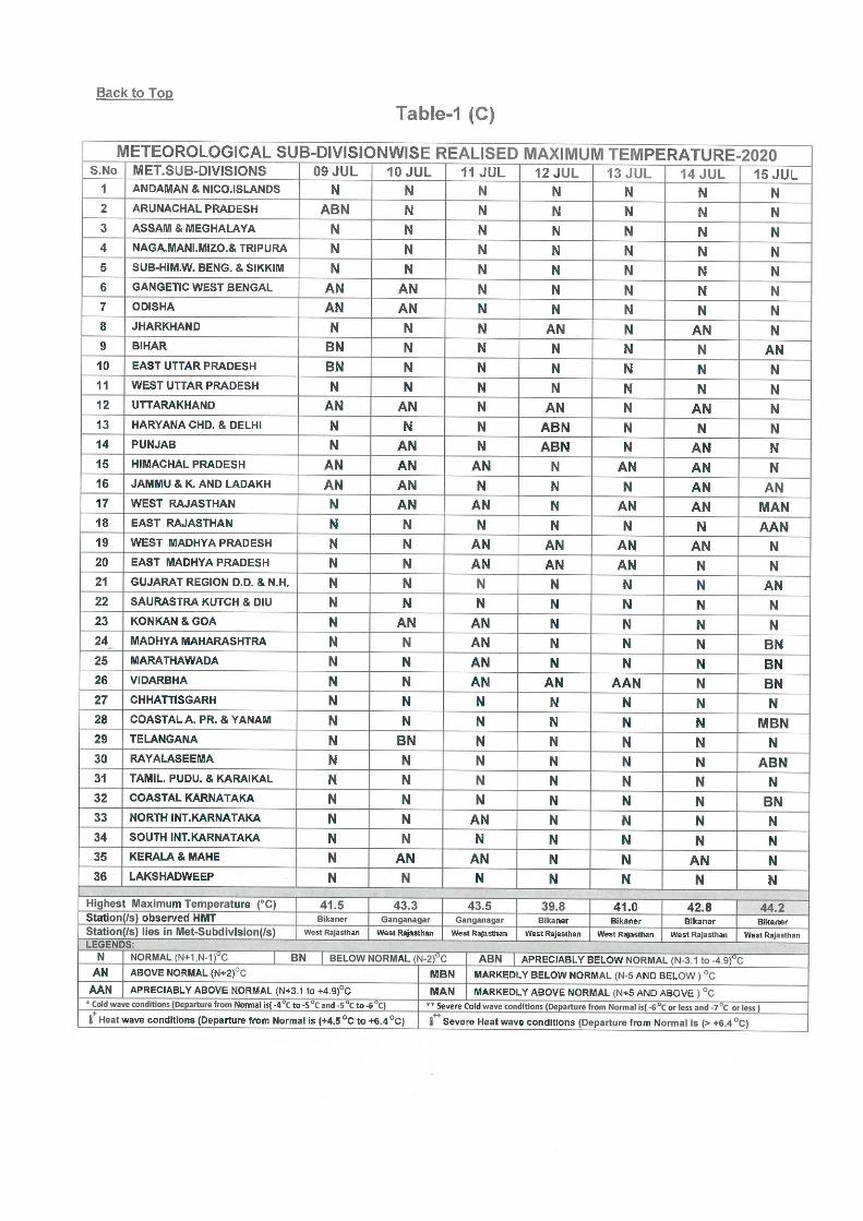
Temperature Scenario and Heat wave conditions: No Heat wave conditions reported during the week.The highest maximum temperature of 44.2oC had been recorded at Bikaner (West Rajasthan) on 15th July 2020, over the plains of the country during the week.

2
LEGEND: A few days- 3 days, Many days- 4 to 5 days and Most days- 6 to 7 days during the week.
Weekly Rainfall Scenario (for week ended on 15 July 2020): During the week, rainfall was
normal with % departure from above Long Period Average (LPA) by 1% over the country as a
whole. Details are given below:
Regions
Actual
Rainfall(mm)
Normal
Rainfall(mm)
%Departure from
LPA
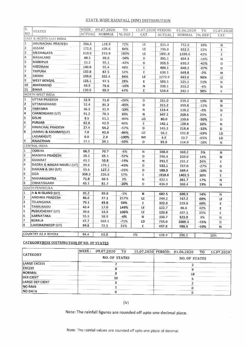
Country as a whole 64.4 63.8 1% Northwest India 28.9 50.8 -43%
Central India 54.2 67.2 -19% South Peninsula
64.6 47.6 36% East & northeast India 153.9 101.6 51%
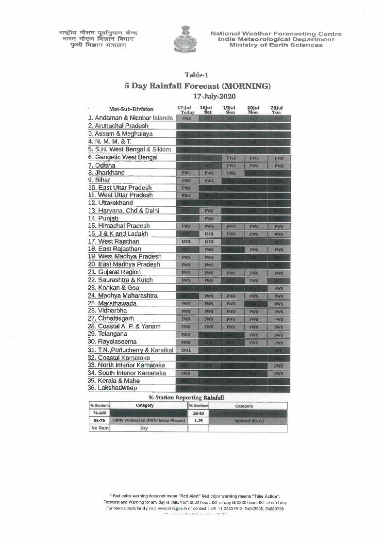
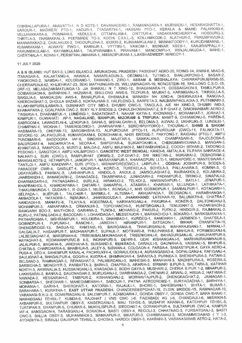
The Meteorological sub-division-wise rainfall for the week is given in Annexure I.
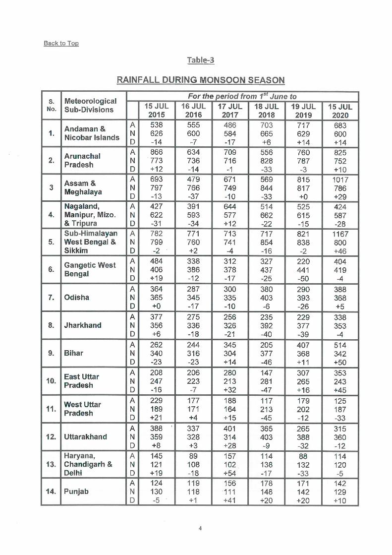
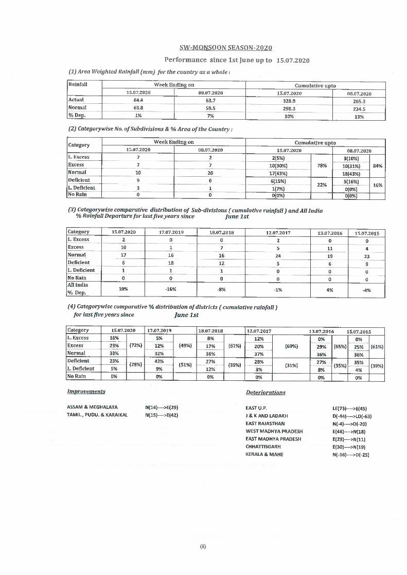
Seasonal Rainfall Scenario for Monsoon Season of 2020 ( 1 June-15 July 2020)
For the country as a whole, Seasonal cumulative rainfall during this year’s southwest
monsoon season upto 15 July 2020 was above Long Period Average (LPA) by 10%.
Details of the rainfall distribution over the four broad geographical regions of India are
given below:
Regions
Actual
Rainfall(mm)
Normal
Rainfall(mm)
%Departure from LPA
Country as a whole 328.9 298.3 10%
Northwest India 143.1 167.2 -14% Central India 367.4 315.7 16%
South Peninsula 297.7 259.7 15% East & northeast India 643.9 562.5 14%
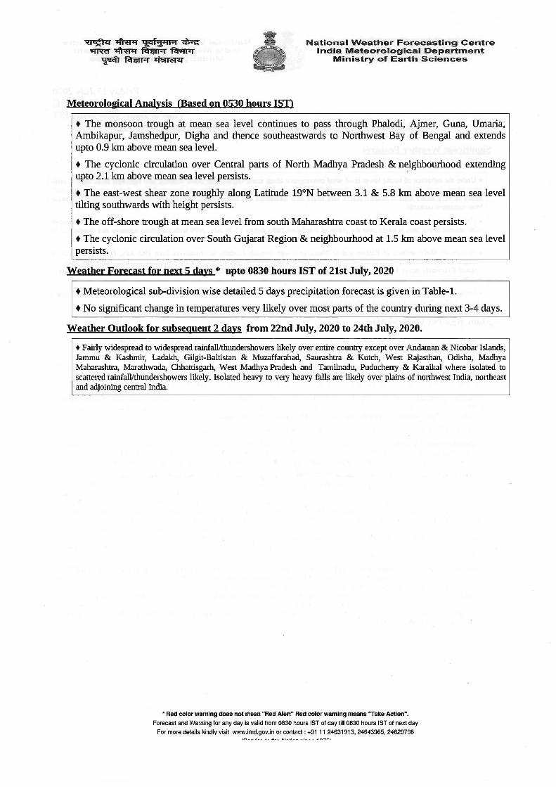
Cumulative seasonal rainfall is given in Annexure II. Chief synoptic conditions as on 16 July 2020 ♦ The monsoon trough at mean sea level now passes through Phalodi, Ajmer, Guna, Umaria,
Ambikapur, Jamshedpur, Digha and thence southeastwards to Northwest Bay of Bengal and
extends upto 0.9 km above mean sea level.
♦ A cyclonic circulation over south Uttar Pradesh & neighbourhood lies over Central parts of
North Madhya Pradesh & neighbourhood and extends upto 2.1 km above mean sea level.
♦ An east-west shear zone now runs roughly along Latitude 19°N between 3.1 & 5.8 km above
mean sea level tilts southwards with height.
♦ Off shore trough at mean sea level runs from south Maharashtra coast to Kerala coast.
♦ A cyclonic circulation lies over over South Gujarat Region & neighbourhood at 1.5 km above
mean sea level.
.Large scale features as on 16 July 2020

3
The Madden Julian Oscillation (MJO) index lies currently in Phase 2 with amplitude more than
1. It will continue in same phase with slight eastward propagation during the entire forecast
period with amplitude more than 1.
Currently, ENSO-neutral conditions are prevailing over equatorial Pacific Ocean and the latest
MMCFS forecast indicates these conditions are likely to continue for the entire forecast period.
At present, near neutral IOD conditions are observed over Indian Ocean and the latest MMCFS
forecast indicates same IOD conditions are likely to continue during the entire forecast period.
Forecast for next two week
Week 1: (16-22 July 2020)
• Under the influence of strong lower level wind convergence along south Gujarat and North
Konkan and east-west shear zone in midtropospheric levels, fairly widespread to widespread
rainfall very likely over Gujarat State and Konkan & Goa during next 2 days with heavy to very
heavy falls at isolated places very likely over Konkan & Goa on today, the 16th July; over
Saurashtra & Kutch on 16th-17th July. Isolated Extremely heavy falls also very likely over
Gujarat Region on today, 16th July. Rainfall intensity very likely to decrease thereafter.
• Under the influence of strengthening of lower level easterlies over northwest India and the
Monsoon trough, Fairly widespread rainfall with isolated heavy falls is likely over the plains of
Northwest India during 17-20 July, 2020 with maximum intensity and distribution of rainfall on
18th to 20th July.
• There has been a Model consensus of shifting of eastern end of the monsoon trough close to the
foothills of the Himalayas from 19 July and under tis impact, fairly widespread to widespread
rainfall with isolated heavy to very heavy falls is likely over Northeast & adjoining East India
with from 19th July onwards. Isolated Extremely heavy falls also very likely over Sub-
Himalayan West Bengal & Sikkim, Arunachal Pradesh and Assam & Meghalaya on 20th and
21st July.
• Significant rainfall with daily rainfall amounts exceeding 20.45 cm very likely over
Arunachal Pradesh, Assam, Meghalaya, sub-Himalayan west Bengal, Nagaland lead to
Flood situations during 20 and 21 July(Ref Annex III for subdivision wise and date wise
rainfall).
• Cumulatively rainfall during week 1: Normal to above normal rainfall activity over north-
eastern parts of India and Indo-Gangetic plains and interior parts of Peninsula India.
Deficient rainfall likely over eastern parts of central India. Near normal rainfall over
remaining parts of the country. (Ref Annexure IV for model forecasts
(http://nwp.imd.gov.in/cfs_rf.php) for cumulative and anomalies for Week 1.

4
Week 2: (23-29 July 2020):
• Cumulatively rainfall during week 2: Due to no low pressure system likely to form over
Bay of Bengal and Monsoon trough likely to be north of its normal position or near
normal position, East central India continue to get below normal rainfall during the week.
Deficient rainfall also likely over Konkan areas. It would be Normal to rainfall over rest
parts of country. (Annexure IV).
Maximum Temperature for week 1 & 2: (16-29 July, 2020):
During week 1 Most parts of India likely to have above normal maximum temperature during the
week except north-eastern parts of India and parts of south eastern peninsula India (Annexure V).
During week 2, Most parts of India is expected to have normal to below normal maximum
temperature except western parts of plains of Northwest India where. It is likely to be above
normal by 1-3 degree C over these latter areas (Annexure V).
Cyclogenesis: Most of the numerical models including IMD GFS, NCEP GFS, GEFS, ECMWF,
NEPS, NCUM are not indicating any cyclogenesis over the region during the period. IITM CFS is
also not predicting any Cyclogenesis during weeks 1 & 2. IMD GPP is not indicating any
probability of cyclogenesis over the region during week 1. Considering all the above, there is no
probability of cyclogenesis over the north Indian Ocean during the period. (for details on
cyclogenesis pls see http://www.rsmcnewdelhi.imd.gov.in /images/bulletin/eroc.pdf)
Next weekly update will be issued on next Thursday i.e. 22 July 2020