NASA and NOAA space missions for Ozone Research
37
NASA and NOAA space missions for Ozone Research Ken Jucks NASA HQ, Earth Science Division
-
Upload
khangminh22 -
Category
Documents
-
view
1 -
download
0
Transcript of NASA and NOAA space missions for Ozone Research

NASA and NOAA space missions for Ozone Research
Ken JucksNASA HQ, Earth Science Division

40 Years of BUV Observations
20101970 1980 1990 2000
NOAA-9 SBUV-2NOAA-11
NOAA-14
Nimbus-4 BUVNimbus-7 SBUVNimbus-7 TOMS
Meteor-3 TOMS
NOAA-16Earth Probe TOMS
EOS Aura OMISCIAMACHY
GOME-2
GOME
OMPS
1977 Amendment of Clean Air Act
Discovery of Polar O3 Depletion

Long-term data sets as a test of ozone photochemistry-transport model predictions
Model simulation using Goddard 3D CTM including CFCs, solar cycle, and volcanic aerosols.
Satellite data record is constructed from Nimbus 7 TOMS, Earth Probe TOMS, Nimbus 7 SBUV, NOAA 9, 11, 14, 16, 17, 18 SBUV/2, and OMI instruments.


NASA - NOAA SBUV Cooperation
• Under a memorandum of understanding (MOU) between NASA and NOAA agreed to in ~1984– NOAA launches and operates a series of SBUV/2 instruments
for ozone monitoring– NOAA is responsible for data production and archival– NASA is responsible for prelaunch and in orbit calibration– NASA supports development of new ozone retrieval algorithms
• JPSS OMPS will be the next generation ozone monitoring instrument. OMPS consists of 3 modules:– The OMPS nadir total column mapper is a TOMS-like ozone
mapping instrument– The OMPS nadir profiler is an SBUV-like vertical profile
instrument– The OMPS limb profiler makes high vertical resolution ozone
profile measurements (currently on NPP only, likely to not change)

OMPS Instrument Design
Total Ozone Mapper• UV Backscatter, grating spectrometer, 2-D
CCD• TOMS, SBUV(/2), GOME(-2), OMI,
SCIAMACHY• 110 deg. cross track, 300 to 380 nm spectral
Limb Profiler • UV/Visible Limb Scatter, prism, 2-D CCD
array• SOLSE/LORE, OSIRIS, SAGE III,
SCIAMACHY• Three 100-KM vertical slits, 290 to 1000 nm
spectral
Nadir Profiler • UV Backscatter, grating spectrometer, 2-D
CCD• SBUV(/2), GOME(-2), SCIAMACHY, OMI• Nadir view, 250 km cross track, 270 to 310 nm
spectral
Due to launch in November 2012
• The calibration concept uses working and reference solar diffusers.

OMPS Sensor characteristics compared to heritage
•Improved ozone profile, temperature and climatologies.•Improved ozone profile correction •Use of surface UV reflectivity database. •Use of co-located UV Cloud pressure determination using OMI data
•Multiple Triplets•Cloud top pressure•Others (see presentation).
Algorithm improvements
QVD and AluminumAluminumAluminumMultiple Diffusers
110 degreesScanning = 53 degrees110 degreesIFOV
CCDPMTCCDDetectors
6 Channels and DOAS6 wavelengths22 channelsChannel selection
1nm - .45nm THIS DOESN’T Look right.Discrete bands.41nmSpectral resolution
307nm to 383nm
308.6, 313.5,317.5, 322.3331.2, 360.4 nm300nm to 380 nmBands Range
OMITOMSOMPS
OMPS sensor and algorithm design include improvements to enhanceperformance (green indicates design improvement)

OMPS Limb Algorithm Status• Limb Profile Algorithm Technical
Content– Ozone Limb Profiles (LP) are
successfully retrieved from four systems today (GOMOS, SCIAMACHY,OSIRIS & SAGE III)
– NASA has developed an Ozone LP algorithm, and data from these systems are processed for ozone research
• Operational Production– POES SBUV/2 provides a model
for NASA/NOAA cooperation to process OMPS LP data.
• Instrument calibration, data cal/val, performance monitoring, algorithm adjustments, and operational processing
OMPS-NPOMPS-LP
Ozone Profile ComparisonOctober 10, 2002

Expected Applications of OMPS EDRs, SDRs, Intermediate and other Products
Operational• Assimilation into NWP• Ozone Hole Monitoring• UV Index Forecast• Air Quality Forecasts• Hazards (Volcanic Ash)• Space Environment (Mg II)
Climate• Ozone Trends• Cloud Reflectivity• Surface UV Trends• Aerosol Trends• Atmospheric Chem.• Process Studies

Space–Based Remote Sensing for Atmospheric Ozone Measurements
UV/Vis Backscatter or IR/MW Emissions
UV/Vis Limb Scatter or IR/MW Emissions
Solar, Stellar or Lunar Occultation
Earth
Sun
SAGE III LINEAGEExperiment Era Orbit/Platform Channels Science
Highlight
SAM 1975 Apollo-Soyuz Single channel @
1 µm
Demonstration
SAM II 1978-1993 Sun-synch / Nimbus 7
Polar Coverage
Single channel @
1 µm
Polar
Stratospheric
Clouds
SAGE I 1979-1981 Inclined/AEM-2
Global Coverage
Ozone, Aerosol,
NO2
Pre-decline
ozone baseline
SAGE II 1984-2005 Inclined/ ERBS
Global Coverage
Added Water
Vapor, Improved
NO2
Ozone Trends,
Extreme aerosol
variability
SAGE III
• Meteor
• ISS
• FOO
2001- 2006
2014-?
?
Sun-synch /Meteor 3M
Inclined/ISS
?
Added NO3,
Night-time
Ozone,
Mesospheric
Ozone
Tropospheric
measurements,
Lunar
occultation &
Limb Scattering
SAGE Science Results• SAGE produces vertical profiles of aerosols and gases in the
stratosphere and upper troposphere
• The multi-decadal SAGE ozone and aerosol data sets have undergone intense scrutiny and have become the international standard for accuracy and stability.
• SAGE ozone data has been used to monitor the effectiveness of the Montreal Protocol

Stratospheric Aerosols• SAGE aerosol data has been recognized as a critical
measurement for long-term climate studies.

EOS Aura• Launched VAFB, July 15, 2004
• Orbit: Polar: 705 km, sun-synchronous, 98o incl., ascending 1:45 PM equator crossing time.
– Aura follows Aqua in the same orbit by <7 minutes. Orbit position moved closer to Aqua to improve science – crossing time unchanged.
• Main science objectives: stratospheric ozone recovery; air quality; climate change
• Four Instruments:– HIRDLS (High Resolution Dynamics Limb Sounder, Univ. Of
Col/NCAR./ Oxford U. K.)– MLS (Microwave Limb Sounder, JPL)– OMI (Ozone Monitoring Instrument, Netherlands/ Finland)– TES (Tropospheric Emission Spectrometer, JPL)
• Level 1 mission success requirements have been met
• All instruments have delivered data to the DAAC– Some teams are reprocessing based on validation measurements
• First Senior Review in 2009, 2nd in 2011
• Main data validation program is complete. Some residual validation activities are ongoing.
• Spacecraft in reasonable shape– Dec 2007 formatter anomaly – recovered all data– Fuel sufficient for 2015 or later orbit lowering
Aura
Aura instrumentfields of view Aura instrumentfields of view
HIRDLSMLSOMITES
HIRDLSMLSOMITES

EOS Aura (cont)
• Instrument status shows various status of “health”.
• HIRDLS is no longer operating– The chopper motor froze in 2009. Test to unfreeze have been unsuccessful
– The team is still working to produce retrievals of more difficult species like CH4.
• TES is now operating with a lower duty cycle.– The FTS mirror carriage current is rising toward a level that will result in freezing.
– Techniques are being employed now in an attempt to prolong the TES operations.
• MLS has now lost two channels, one (the THz channel) was expected.– Recently the electronics for the “scene selection pointing mirror” had an anomaly
that shut the instrument down. It is now operating on the redundant electronics.
• OMI now has a blockage over the middle of it’s field of view. – This blockage changes with time.
– The cause of the blockage is not completely understood.– Right now, data within these footprints are not scientifically useful.

HIRDLS• Limb sounding filter IR radiometer 6.12 - 17.76 µm range, 1 km vertical
resolution• Joint U.S., U.K. science team.
• Instrument is currently off due to recent chopper wheel stall (March, 2008)
• Kapton® has been blocking part of the aperture since launch• HIRDLS team has delivered data to the DAAC using new algorithm
– Ozone, HNO3, CFCs, aerosols, temperature, cloud top heights
– Currently working on H2O, CH4, N2O
• HIRDLS high vertical resolution is revealing structures in the lower stratosphere not seen before…
01-26-2006~ 248° Lon
HIRDLS GMI Chemical Model
MLS
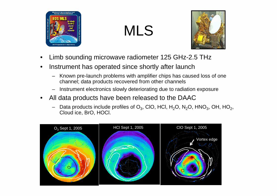
• Limb sounding microwave radiometer 125 GHz-2.5 THz• Instrument has operated since shortly after launch
– Known pre-launch problems with amplifier chips has caused loss of one channel; data products recovered from other channels
– Instrument electronics slowly deteriorating due to radiation exposure
• All data products have been released to the DAAC– Data products include profiles of O3, ClO, HCl, H2O, N2O, HNO3, OH, HO2,
Cloud ice, BrO, HOCl.
O3 Sept 1, 2005 HCl Sept 1, 2005 ClO Sept 1, 2005
Vortex edge
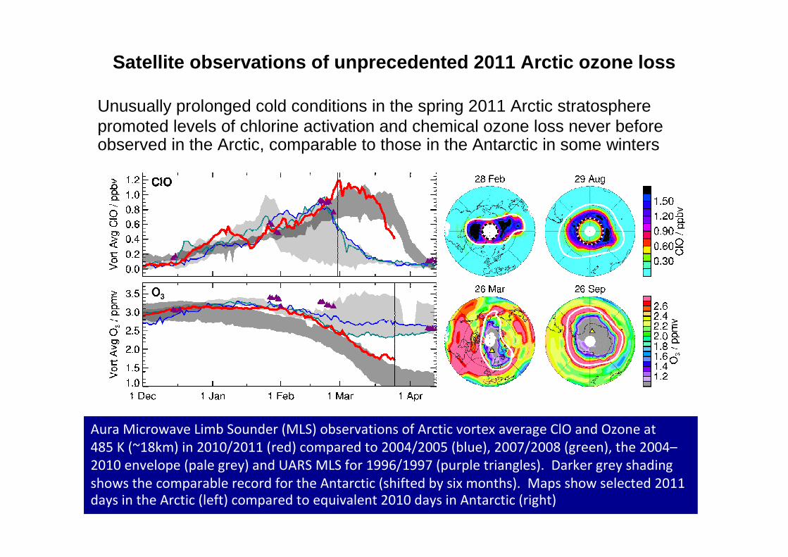
Satellite observations of unprecedented 2011 Arctic ozone loss
Unusually prolonged cold conditions in the spring 2011 Arctic stratosphere promoted levels of chlorine activation and chemical ozone loss never before observed in the Arctic, comparable to those in the Antarctic in some winters
Aura Microwave Limb Sounder (MLS) observations of Arctic vortex average ClO and Ozone at
485 K (~18km) in 2010/2011 (red) compared to 2004/2005 (blue), 2007/2008 (green), the 2004–
2010 envelope (pale grey) and UARS MLS for 1996/1997 (purple triangles). Darker grey shading
shows the comparable record for the Antarctic (shifted by six months). Maps show selected 2011
days in the Arctic (left) compared to equivalent 2010 days in Antarctic (right)

OMI
• UV-Vis hyperspectral imager, 280-500 nm, 13x24 km footprint at nadir, swath width 2600 km
• Joint US, Dutch, Finish Science Team
• Direct broadcast capability• Radiation damage is increasing the dark current
• All data products being delivered to the DAAC, some new products under development. Ozone, Cloud heights, NO2, Aerosols, SO2 have been validated.
SO2 over Europe and China
Global NO2
Sept. 24, 2006

TES
• Fourier transform spectrometer with nadir and limb modes, 3.3 - 15.4 µm , 5.3x8.5 km spatial footprint
• Translator bearing wear will limit instrument life, currently using nadir mode only to preserve instrument life. TES is predicted to fail ~2010
• Trop. O3, CO, H2O, T have been validated and are on DAAC
• More recent data products– HDO, CH3OH, NH3, CO2, CH4
Observation Number
0 5 10 15 20 25 30 35 40
Eff
ectiv
e C
olum
n M
ixin
g R
atio
, ppb
v
0
1
2
3
4
5
6
Latitude, deg
38 39 40 41 42
NH3
Observation Number
0 5 10 15 20 25 30 35 40
Eff
ectiv
e C
olu
mn
Mix
ing
Rat
io, p
pbv
0
1
2
3
4
5
6
Terr
ain
Hei
ght,
km
0
1
2
3
4
5
6
Latitude, deg
38 39 40 41 42
CH3OH
Bejing
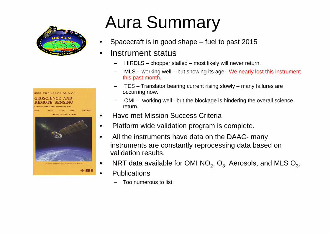
Aura Summary• Spacecraft is in good shape – fuel to past 2015
• Instrument status– HIRDLS – chopper stalled – most likely will never return.
– MLS – working well – but showing its age. We nearly lost this instrument this past month.
– TES – Translator bearing current rising slowly – many failures are occurring now.
– OMI – working well –but the blockage is hindering the overall science return.
• Have met Mission Success Criteria
• Platform wide validation program is complete.
• All the instruments have data on the DAAC- many instruments are constantly reprocessing data based on validation results.
• NRT data available for OMI NO2, O3, Aerosols, and MLS O3.• Publications
– Too numerous to list.

Aura in context with other Earth Science satellite observations
NASA’s Earth Science Decadal Survey
• The US National Research Council recommended 15 new space missions to be done over a 10 year time frame (in 2007).
• The launch order was grouped into 3 tiers based on priority, cost, and technology readiness.
• Missions evolved from chapters that discussed “societal objectives”as opposed to “science questions”, and over 120 responses to requests for information from the community.
• This resulted in the merging of missions for some traditionally separated scientific fields.
• 4 proposed missions will make measurements applicable to Ozone research and monitoring.
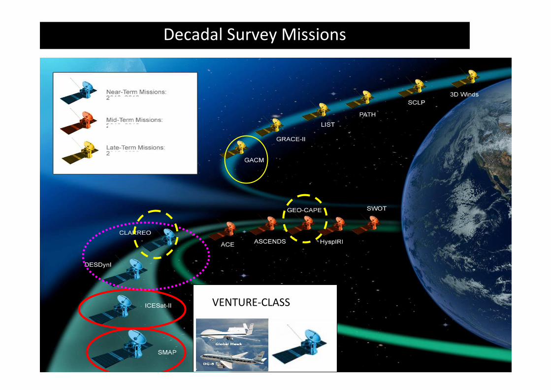
Decadal Survey Missions
VENTURE-CLASS

Climate Absolute Radiance and Refractivity Observatory (CLARREO)

CLARREO Characteristics
• Spectrally resolved nadir instruments in the IR and solar backscatter designed for setting “Climate Benchmarks” as opposed to being used for atmospheric sounding.
• Stability and simplicity take priority over the complexity needed to properly sound the atmosphere. Accuracy over Precision.
• Baseline instrumentation include 2 thermal FTS instrument packages with roughly 100 km footprints and 1 cm-1 spectral resolution from 200 to 2000 cm-1.
– Each is on a separate polar precessing orbit to cover semi-diurnal radiances.– To cover spectral range, 1 or 2 FTS spectrometers may be needed.
• 1 or 2 of the satellites will have a solar backscatter instrument.• Both IR and UV will have Ozone bands.• All instruments will have on-board NIST traceable calibration sources to understand
any instrument drift over time.• The budget for development of this mission was removed from NASA’s budget by the
2012 budget submission to Congress. – The future of this mission is very much in doubt.– The project is looking at potential low cost alternatives to meeting the science objectives.
• This is a Tier 1 mission

GEOSTATIONARY COASTAL AND AIR POLLUTION EVENTS (GEO-CAPE)

GEO-CAPE Characteristics• Geosynchronous orbit
– Will observe most of North and South America and coastal regions.
• Suite of air quality observing instrumentation– CO sensors in near infrared and mid infrared.
– Tropospheric O3 sensor in UV or potentially near IR.– NO2, formaldehyde and aerosols retrieved in UV.
– All would have footprint sizes of roughly 5 to 8 km.
– This has strong technical overlap with Sentinel 4.
• High spatial resolution imager– Roughly 250 m resolution to observe coastal ocean biology activity and
“special events” over land.
– Enough spectral filter bands to properly separate the radiances from the ocean or land from the atmospheric opacity of aerosols and NO2.
– The knowledge of the atmospheric opacity is required to fully characterize the ocean radiances.
• This is a Tier 2 mission (some time after 2020)

Aerosol-Cloud-Ecosystems (ACE)

Characteristics of ACE
• Low Earth Orbit– The lower the better for the lidars…
• Scanning aerosol polarimeters (next generation GLORY)– The GLORY mission failed to reach orbit this January…
• Clouds radar imager (next generation CloudSat)• Aerosol and cloud lidar (next generation CALIPSO)• Global Ocean Color mapper
– Like GEO-CAPE, ocean color is tied to atmosphere sounders to better determine atm. effects on the ocean leaving radiances.
• No “direct” Ozone observations, but will see stratospheric aerosols.
• This is a tier 2 mission

Global Atmospheric Chemistry Mission (GACM)

GACM Characteristics• Low Earth Orbit
• UV nadir sounder for O3 columns and potential profiling, NO2, formaldehyde, aerosols, BrO, etc.
• Mid to near IR sounder for potential CO, tropospheric O3, CH4…
• Scanning microwave limb sounder to get daily global maps of profiles for O3, ClO, HCl, N2O, H2O, etc.
• This mission is very much a next generation Aura and has many similarities to the ESA Sentinal 5.
• This is designated as a Tier 3 mission (probably not launching until after 2025), and the odds are high for a significant gap in profile information of global data sets.

Future Orbital Flight Missions – 2010 – 2021
BU
DG
ET
($M
)
✕

SAGE III on ISS• 2014 launch opportunity
• ISS Inclined orbit provides excellent global measurement coverage
• SAGE III on ISS will extend the SAGE climate record of ozone, aerosols and water vapor providing scientists with data necessary for:
– Long term climate studies
– Modeling geophysical variability
– Understanding how to combine various methods for measuring aerosols
– Assimilation and Reconstruction of fields of long-lived species
• Solar and Lunar occultation measurements will be augmented by limb scatter measurements
SAGE III ISS in GSE
Decadal Survey – Venture-Class
Recommendation: … As part of this strategy, to restore more frequent launch opportunities and to facilitate the demonstration of innovative ideas and higher-risk technologies, NASA should create a new Venture class of low-cost research and application missions (~$100M to $200M). These missions should focus on fostering revolutionary innovation and on training future leaders of space-based Earth science and applications.
Priority would be given to cost-effective, innovative missions rather than those with excessive scientific and technological requirements. The Venture class could include stand-alone missions that use simple, small instruments, spacecraft, and launch vehicles; more complex instruments of opportunity flown on partner spacecraft and launch vehicles; or complex sets of instruments flown on suitable suborbital platforms to address focused sets of scientific questions. These missions could focus on establishing new research avenues or on demonstrating key application-oriented measurements.
Key to the success of such a program will be maintaining a steady stream of opportunities for community participation in the development of innovative ideas, which requires that strict schedule and cost guidelines be enforced for the program participants.

Venture Class – ESD Objectives
• ESD considers establishment and sustained, successful implementation of Venture-class to be a “Tier-1” priority from the Decadal Survey– Advances science/applications and promotes community involvement through
frequent, regular proposal opportunities– Ensures overall program scientific flexibility and responsiveness through constrained
development schedules
• ESD Venture-class characteristics – Science-driven, involving sustained (> seasonal) data acquisition
– Technology development/demonstration are not sufficient justifications
– Regular solicitations
– Bi-annual minimum frequency accommodated in President’s budget– Competitively selected
– PI-led– Cost and schedule constrained
– Explicit total cost caps per investigation defined in each solicitation
– 5-year total investigation term (data acquisition and analyses) for suborbital investigations
– 5-year development time-to-launch for space missions – all investigation activities must be completed within nominal (typically 3-year) mission
– 4-year development , through Phase C, for Instrument of Opportunity call (EV-I)

Data Gaps from space issues• Observations of Ozone related species like ClO, HCl,
H2O, N2O, CFCs in the stratosphere may end after Aura with a near certainty that GACM will not overlap (Aura did overlap with UARS).– MLS is starting to show it’s age.
• Space observations have many advantages over ground based and spot field campaign observations that are required for understanding the climate coupling with the stratosphere.
• A “gap filler” set of observations may be required, either by NASA or through a collaboration with a partner country.
• The Decadal Survey also calls out for “Venture Class”missions, this may be an opportunity to deploy such instruments.