GIS-based recharge estimation by coupling surface–subsurface water balances
Upload
independentCategory
view
1download
0
Journal of Hydrology 379 (2009) 81–91
Contents lists available at ScienceDirect
Journal of Hydrology
journal homepage: www.elsevier .com/ locate / jhydrol
Multi-year landscape-scale assessment of lakewater balances in the Slave RiverDelta, NWT, using water isotope tracers
Bronwyn E. Brock a,*, Yi Yi a, Kenneth P. Clogg-Wright a, Thomas W.D. Edwards a, Brent B. Wolfe a,b
a Department of Earth and Environmental Sciences, University of Waterloo, Waterloo, ON, N2L 3G1 Canadab Department of Geography and Environmental Studies, Wilfrid Laurier University, Waterloo, ON, N2L 3C5 Canada
a r t i c l e i n f o
Article history:Received 12 February 2009Received in revised form 21 September2009Accepted 27 September 2009
This manuscript was handled by L. Charlet,Editor-in-Chief, with the assistance of JuskeHorita, Associate Editor
Keywords:Isotope hydrologyLakewater balanceLandscape hydrologyWater resource managementNorthern freshwater ecosystems
0022-1694/$ - see front matter � 2009 Elsevier B.V. Adoi:10.1016/j.jhydrol.2009.09.046
* Corresponding author. Tel.: +1 519 888 4567x339E-mail address: [email protected] (B.E. Brock).
s u m m a r y
We apply a coupled-isotope tracer model to quantify end-of-thaw-season (fall) lakewater balances in theSlave River Delta (SRD), Canada, during 2003–2005, which effectively differentiates the relative impor-tance of hydrological processes across this complex northern freshwater landscape. The model incorpo-rates Great Slave Lake evaporated vapour to the ambient atmospheric vapour pool and is thus tailored tothe hydroclimatic setting of the delta, which experiences onshore winds. Results, expressed as evapora-tion-to-inflow ratios (E/I) for 41 delta lakes, reflect the role of spring break-up flooding and local hydro-logical setting. Fall E/I ratios for lakes where water balances are dominated by exchange with the SlaveRiver or Great Slave Lake are low (0.06–0.53) and do not vary substantially during the three-year mon-itoring period. E/I ratios for flood-dominated lakes in the active delta are moderate (0.26–0.98) and havelow inter-annual variability, even in the absence of spring flooding. This suggests that annual floodingduring the spring break-up period is not necessary to maintain positive (E/I < 1) water balances inflood-dominated lakes, but multiple years without flooding would clearly lead to greater cumulativeevaporation. Fall E/I ratios are generally higher and more variable in evaporation-dominated lakes inthe relict delta (0.42 to >1), although greater snowmelt runoff tends to occur in sub-sectors with maturespruce forest and offsets open-water vapour loss. Our results indicate that spring inputs (river floodingand snowmelt runoff) are key components of the hydrological evolution of SRD lakes during the open-water season, and distinguish regions of the delta where expected declines in river discharge and climatewarming will likely cause lake-level drawdown. Such findings have particular relevance for informedecosystem management in the Peace-Athabasca-Slave watershed, where unprecedented industrial devel-opment is imposing substantial additional pressure on freshwater resources.
� 2009 Elsevier B.V. All rights reserved.
Introduction
Lakes, wetlands and other riparian freshwater ecosystems areubiquitous in Canada’s north. Freshwaters cover �350,000 km2 inarctic and subarctic North America (Rouse et al., 1997), while wet-lands are estimated to cover �3.5 million km2 in the circumpolarArctic (Huntington and Weller, 2005). These ecosystems providea rich diversity of habitats, which support biota that have devel-oped a wide range of adaptations for survival in sometimes-severenorthern environments (Wrona et al., 2005). Northern freshwaterecosystems provide important permanent and migratory habitatsfor fish and wildlife populations, notably for migrating waterfowl(Townsend, 1984; Prowse and Conly, 2000; Huntington and Wel-ler, 2005; Wrona et al., 2005). These populations are in turn of vitalimportance to northern indigenous populations (Rouse et al., 1997;
ll rights reserved.
66; fax: +1 519 746 7484.
Huntington and Weller, 2005; Wrona et al., 2005), who have beenusing these resources to support traditional lifestyles for millennia.
Recent studies have highlighted the potential consequences ofclimate change on lake levels in northern Canadian freshwater eco-systems. Smol and Douglas (2007) documented the disappearanceof high Arctic ponds on Ellesmere Island that had existed for thou-sands of years, as a result of climate change. Emmerton et al.(2007) concluded that water storage in Mackenzie Delta lakesand channels is likely to decline, resulting in lower lake levels, asreductions in spring break-up flood stage and increases in open-water evaporation continue. In the Peace-Athabasca Delta, thecombined effects of declining headwater snowpacks and glacialstorage, decreased river discharge and changes in local climateare leading to drying in delta lakes (Wolfe et al., 2008a). Theseand other studies (e.g., Smith et al., 2005) provide compelling evi-dence that profound changes are occurring in the hydrology ofnorthern freshwater ecosystems.
The Slave River Delta (SRD) is a key hydrological node at theterminus of the Peace-Athabasca-Slave river corridor, and is

82 B.E. Brock et al. / Journal of Hydrology 379 (2009) 81–91
subject to multiple stressors, including flow regulation and waterextraction, in addition to climate change. Hundreds of shallowlakes in the SRD are part of an important ecosystem that providessignificant migratory, breeding and year-round habitats for birdsand mammals (Townsend, 1984), upon which the residents ofnearby Fort Resolution depend for both recreation and income(Wesche, 2007). Since the mid-1970s, declining snowpacks havebeen observed in key tributaries of the Peace River (Romoloet al., 2006), which provides �66% of annual flow to the Slave River(English et al., 1997). Because melting of the winter snowpack is animportant factor influencing spring river discharge, decliningsnowpacks will alter the hydrograph of both the Peace and Slave
Fig. 1. Location of the Slave River Delta, NWT
rivers during the spring break-up period (Prowse and Conly,1998; see also Fig. 3 in Wolfe et al., 2008a). Flow regulation inthe northern headwaters of the Peace River system by the WACBennett Dam, established in 1968, may also have affected the geo-morphological and botanical evolution of the SRD (English et al.,1997), although paleolimnological studies do not indicate thatflood frequency has declined over the past �40 years (Brocket al., in review). Continued water diversion and extraction fromthe upstream Athabasca River to support the Alberta oil sandsindustry may threaten the ecological integrity of the SRD, as maypotential hydroelectric development along the Slave River nearFort Smith, NWT (Fig. 1). Incomplete knowledge of the conse-
, including lake and river sampling sites.

Table 1Evaporation-flux-weighted thaw season temperature and relative humidity for theSRD in 2003, 2004 and 2005, and 1971–2000 Canadian Climate Normals for Hay River(Environment Canada, 2002, 2005).
Temperature (�C) Relative humidity (%)
2003 13.4 62.82004 12.6 63.22005 11.9 63.0Climate normal 13.4 69.2
B.E. Brock et al. / Journal of Hydrology 379 (2009) 81–91 83
quences of these stressors on the SRD ecosystem hampers in-formed water resource management.
In response to this need, research activities in the SRD havebeen focused on understanding the crucial role of water in the eco-system (Wolfe et al., 2007a). Stable isotope analysis of water col-lected in 2003 from a suite of study lakes spanning the activeand relict SRD revealed the dominant hydrological factors control-ling delta lakewater balances (Brock et al., 2007). These includeevaporation, river flooding during the spring break-up period,and exchange with the Slave River, via direct channel connections,or with Great Slave Lake via seiche events. These results providedthe basis for a lake classification scheme comprising evaporation-,flood- and exchange-dominated lakes (Brock et al., 2007). Contin-ued monitoring of delta lakes during the 2003,2004 and 2005spring break-up period revealed a positive relationship betweenSlave River spring discharge and the spatial extent of river floodingin the SRD, and highlighted the importance of upstream runoffgeneration, relative to several other factors (e.g., local snowmeltrunoff, ice thickness, temperature), in producing downstream floodevents (Brock et al., 2008).
Here, we employ water isotope tracers to quantify the effect ofriver floodwater and snowmelt input on end-of-thaw-season (fall)SRD lakewater balances and identify areas of the delta susceptibleto lake-level drawdown due to expected changes in river dischargeand local climate. The isotope mass-balance model uniquely ac-counts for the varying role of local Great Slave Lake vapour onthe individual lakewater balances. These results provide the basisfor anticipating future evolution of the delta, and for informedwater resource management decisions.
The Slave River Delta and Great Slave Lake
The SRD (61�150N, 113�300W) is an actively prograding fluvialdelta (Fig. 1) (Smith, 1991; Vanderburgh and Smith, 1988). The ac-tive delta, which occurs downstream of a major bifurcation of theSlave River into secondary distributary channels, currently coversapproximately 400 km2 (English et al., 1997), while relict alluvialand deltaic sediments extend approximately 250 km upstream toFort Smith, NWT (Vanderburgh and Smith, 1988). The SRD is infill-ing the southern arm of Great Slave Lake, the second largest lake inCanada. Great Slave Lake has a surface area of 28,400 km2, a vol-ume of 2088 km3 and a maximum depth of 614 m (CNCID, 1978).
Lakes in the SRD are typically small (<3 km2) and shallow (<4 mdeep). Water isotope tracers, total inorganic suspended sedimentconcentrations and field observations have been used to character-ize the dominant hydrological processes affecting lakewater bal-ances and thus classify SRD lakes into three groups: flood-dominated, exchange-dominated and evaporation-dominated(Brock et al., 2007). Flood-dominated are lakes situated in the ac-tive delta, where levee heights separating the lake from the distrib-utary channel network are typically 0.5–2.5 m above low summerGreat Slave Lake water levels (English et al., 1997). These lakes aresusceptible to spring flooding, which introduces isotopically-de-pleted Slave River water and high concentrations of total inorganicsuspended sediment to the lake basin. Evaporation-dominatedlakes are found in the relict delta, and have higher levee heightsthan flood-dominated lakes (2.5–3 m above low summer GreatSlave Lake water levels (English et al., 1997)). Because of their sillelevations, evaporation-dominated lakes are rarely flooded by theSlave River, and instead receive inputs of catchment-sourcedsnowmelt in the spring. Water balances in these lakes during theopen-water season are dominated by evaporation, leading to in-creased end-of-season isotopic enrichment in evaporation-domi-nated lakes when compared with flood-dominated lakes.Exchange-dominated lakes are situated along the Slave River and
the delta front. Lakes with direct channel connections to the SlaveRiver receive river water throughout the thaw season (with thestrength of the channel connection controlling the amount of riverwater input to the lake). Exchange-dominated lakes along the out-er edges of the delta receive periodic inputs of Great Slave Lakewater during seiche events (Gardner et al., 2006). Groundwater ex-change is minimal because of the low hydraulic conductivity of thealluvial sediments of the delta, and the occurrence of discontinu-ous permafrost (Day, 1972).
The SRD experiences cold winters (mean January tempera-ture = �23.1 �C) and cool summers (mean July tempera-ture = 15.9 �C). Precipitation is evenly divided between rain andsnow, with a total of 320 mm falling annually, based on 1971–2000 Canadian Climate Normals for Hay River (Environment Can-ada, 2002). Similar thaw season conditions prevailed during2003–2005. While thaw season temperature during the monitor-ing period was comparable to climate normal conditions, evapora-tion-flux-weighted relative humidity was several percent lower(Table 1). Spring flood conditions were also different in each yearof the monitoring period. Aerial distribution maps of the spatial ex-tent of flooding, determined using water isotope tracers, were pre-sented in Brock et al. (2008) and show that a moderate springbreak-up flood occurred in 2003 and a significant spring ice-jamflood in 2005. No flooding occurred in 2004.
Water sample collection and meteorological data
Lakewater samples were collected for oxygen and hydrogen sta-ble isotope analysis from 40 SRD lakes, which included all threehydrological lake types (flood-dominated lakes = 12; evaporation-dominated lakes = 24; exchange-dominated lakes = 4), as well asGreat Slave Lake and the Slave River (Fig. 1), on multiple occasionsduring the 2003–2005 ice-free seasons. Results from samples col-lected near the end of the thaw season, on 15 August 2003, 20 Sep-tember 2004 and 22 September 2005, are the focus here, and buildupon previously published datasets (Brock et al., 2007, 2008). Sam-ples were collected by helicopter from approximately 10 cm belowthe surface at the centre of each lake, and were sealed in 30 mLhigh density polyethylene bottles for analysis of 18O/16O and2H/1H ratios at the University of Waterloo’s Environmental IsotopeLaboratory following standard procedures (Drimmie and Heems-kerk, 1993; Morrison et al., 2001). Results are reported as d values,representing deviations in per mil (‰) between the sample and theV-SMOW standard on a scale normalized to Standard Light Antarc-tic Precipitation (d18O, d2H = �55.5‰, �428‰) (Coplen, 1996).Analytical uncertainties are ±0.2‰ for d18O and ±2‰ for d2H.
Thaw season temperature and relative humidity data were col-lected from Hay River, NWT (Environment Canada, 2002, 2005),where data records are more complete than at Fort Resolution air-port. To reflect climate conditions during which open-water evap-oration occurs from delta lakes (following recommendations byGibson (2002)), temperature and relative humidity data wereevaporation-flux-weighted prior to their inclusion in isotopemass-balance calculations. Evaporation-flux-weighted values weredetermined from potential evapotranspiration using methods

84 B.E. Brock et al. / Journal of Hydrology 379 (2009) 81–91
described by Malmstrom (1969) and Dingman (1993). The isotopiccomposition of yearly amount-weighted precipitation was esti-mated from data collected at a Canadian Network for Isotopes inPrecipitation (CNIP) station at Fort Smith, NWT (Birks et al., 2004).
Results and discussion
Spring and fall 2003–2005 lakewater isotopic compositions
Results from isotopic analysis of water samples collected fromSRD lakes in the spring and fall of 2003–2005 capture early andlate thaw-season lake water balance conditions (Fig. 2). Theearly-season isotopic composition of delta lakes that were floodedby the Slave River in 2003 and 2005 show distinct clusters of lakesthat are more isotopically-depleted than non-flooded lakes (Fig. 2aand c). In the absence of spring flooding in 2004, lakewater resultsform a continuous gradient in d–d space (Fig. 2b).
Fall lakewater isotopic compositions in the SRD have beenlinked to spring break-up conditions, which influence subsequent
Fig. 2. Water isotope results from SRD lakes in the spring of: (a) 2003, (b) 2004 and (c) 2by the Slave River in the spring of each monitoring year are shown in black circles, whiIsotope results are shown relative to the Local Meteoric Water Line (LMWL: d2H = 6.7d18
d2H in local precipitation. Great Slave Lake and Slave River values are shown as open tr
evaporative enrichment as the thaw season progresses (Brocket al., 2007). In the fall, lakes that were flooded during the springof 2003 and 2005 continue to be more isotopically-depleted thannon-flooded lakes, and are more tightly clustered (Fig. 2d and f).For all lakes in 2004, and for non-flooded lakes in 2003 and2005, isotopically-depleted snowmelt from each lake’s catchmentwas the dominant input during the spring break-up period (Brocket al., 2008). By fall, although these lakes have undergone evapora-tive enrichment, they continue to form a gradient in d–d space, inpart reflecting the persistent influence of snowmelt from the pre-ceding spring. Lakes with more isotopically-depleted lakewatersignatures likely received more spring snowmelt, while moreevaporatively enriched lakewater signatures likely reflect lakesthat received less spring snowmelt input. Those lakes with themost isotopically-enriched signatures are not exclusively thesmallest lakes in the dataset, thus volumetric differences are unli-kely to account for patterns in isotopic data. Rather, these patternsreflect a lake’s hydrologic setting in the delta landscape, as dis-cussed in more detail below.
005 (Brock et al., 2008), and the fall of the same years (d–f). Lakes that were floodedle lakes that did not flood are shown in grey circles. No flooding occurred in 2004.O � 19.2; Birks et al., 2004), which approximates the relationship between d18O andiangles and squares, respectively. Lakes identified in the text are labelled.

B.E. Brock et al. / Journal of Hydrology 379 (2009) 81–91 85
In addition to the hydrological influence of spring break-up con-ditions, direct channel connections between SRD lakes and the dis-tributary channel network (SD10, SD17 and SD28; Fig. 1) or GreatSlave Lake via seiche events (SD39 and SD41; Fig. 1) also exertstrong controls on late-season lakewater isotopic compositions.In 2003, 2004 and 2005, lakewater compositions of some ex-change-dominated SRD lakes (SD39 and SD41) are close to the iso-topic compositions of the Slave River and Great Slave Lake (Fig. 2),reflecting the isotopically-depleted dominant input water sourceto these lakes (i.e., Slave River or Great Slave Lake water). However,in some exchange-dominated SRD lakes, channel connections arelong and shallow (SD10, SD17 and SD28) and low late-summerwater levels and emergent vegetation growing in the connectingchannels impede exchange with the Slave River. This allows formore evaporative enrichment in these lakes than in other lakeswhere more direct connections to the Slave River are maintained(Brock et al., 2007; Fig. 2c).
Quantifying lakewater balances using water isotope tracers
An isotope-mass-balance model was used to quantify lakewaterbalances during the late-season sampling period. The evaporation-to-inflow (E/I) ratio of a well-mixed lake at isotopic steady-state is
E=I ¼ dI � dL
dE � dLð1Þ
This equation reflects the isotopic compositions of key waterbudget components, including input water (dI), lakewater (dL)and the evaporating flux (dE). This approach has been applied fre-quently to assess water balances of lakes (Gonfiantini, 1986; Gib-son and Edwards, 2002; Wolfe et al., 2007b; Yi et al., 2008). Massand isotope conservation dictate that E/I ratios calculated for bothd18O- and d2H-based parameters should be identical, therebyestablishing the relationship (Yi et al., 2008).
d18OI � d18OL
d18OE � d18OL¼ d2HI � d2HL
d2HE � d2HLð2Þ
Solving Eqs. (1) and (2) requires values for dL, dI and dE. The iso-topic composition of lakewater can be readily measured. The com-position of input water is more difficult to quantify, as it canoriginate from several different water sources, but can be esti-mated from the intersection of a regression through a series oflakewater samples and the Local Meteoric Water Line, whichapproximates the relationship between d18O and d2H in local pre-cipitation (Gibson et al., 1993). Alternatively, dI can be calculatedusing a variation of the isotope-mass-balance model presentedhere (Yi et al., 2008). dE is commonly estimated from the linearresistance model of Craig and Gordon (1965), using (Gonfiantini,1986)
dE ¼ðdL � e�Þ=a� � hdA � eK
1� hþ eKð3Þ
Equations expressed here are formulated for d and e values indecimal notation. d-values are multiplied by 1000 and expressedin per mil (‰). a*, the equilibrium liquid–vapour fractionation,can be calculated using empirical equations given by Horita andWesolowski (1994). e* and eK describe equilibrium and kinetic sep-aration, respectively, between the liquid and vapour phases. Theformer is related to a* by e* = a* � 1, while the latter is defined ase18
K = 0.0142 (1 � h) and e2K = 0.0125 (1 � h) (Gonfiantini, 1986;
Araguás-Araguás et al., 2000). (Note that we are referring specifi-cally to liquid–vapour fractionation; i.e., a* > 1.) In cold regions thatexperience extended periods of ice cover, the isotopic compositionof atmospheric vapour (dA) is commonly assumed to be in isotopic
equilibrium with the isotopic composition of summer precipitation(dPS), and can therefore be estimated as dA = (dPs � e*)/a* (Gibson,2002; Gibson and Edwards, 2002).
This approach to quantifying lakewater balances assumes lakesare well-mixed, and are at isotopic and hydrologic steady-state(Gonfiantini, 1986). By late fall, the water balances of most SRDlakes are more likely to approximate isotopic steady-state, thusjustifying the use of this approach to model seasonal water bal-ances as ‘quasi-steady-state’.
Resolving isotope-mass-balance calculations using a vapour mixingmodel
To quantify the effect of river flooding on late-season SRD lake-water balances and to identify areas of the delta undergoing lake-level drawdown, evaporation-to-inflow (E/I) ratios were calculatedfor delta lakes using Eq. (1) incorporating the measured fall 2003,2004 and 2005 lakewater isotopic compositions (dL). As presentedabove, this required defining the isotopic compositions of inputwater (dI) and evaporated vapour (dE), as well as the isotopic com-position of atmospheric vapour (dA). Proper characterization ofthese parameters required careful consideration of the hydrologi-cal setting and synoptic climatology of the SRD and surroundingregion, as detailed below.
The isotopic composition of input water (dI)For the SRD, the amount-weighted annual precipitation compo-
sition (dP) measured at the closest CNIP station in Fort Smith, NWT(Fig. 1) provides one possible value for dI (d18O = �19.0‰;d2H = �148‰; Birks et al., 2004). Based on a regression throughall samples collected in fall 2003–2005 from SRD lakes, this inter-section lies at �20.0‰ for d18O (d2H = �153‰), which is very sim-ilar to the CNIP-measured dP. The slightly more depletedregression-based input estimate probably reflects contributionsof early spring snowmelt input to delta lakes, described in the pre-vious section, which can influence lakewater balances into mid-summer (Brock et al., 2007). Here we apply the CNIP-measureddP value to our analysis, because of the close agreement betweenthe CNIP dP value and the regression-based dI estimate. This valueis also reasonable for flood- and exchange-dominated lakes,although other key input sources have been identified for theselakes (Brock et al., 2007). The average spring Slave River isotopiccomposition, the input source for flood-dominated lakes, is verysimilar to that of dP (average Slave River d18O = �17.4‰, d2H = -141), which becomes the input water source for flood-dominatedlakes in the absence of flooding and following the spring break-up period. Slave River inputs are also strongest in exchange-dom-inated lakes in the spring, before vegetative growth in connectingchannels later in the thaw season impedes water flow (Brocket al., 2007). In these lakes, and in seiche-affected lakes, end-of-thaw-season input waters are a mixture of dP and Slave River orGreat Slave Lake water (d18OGSL = �17.5‰; d2HGSL = �141‰). Be-cause the proportion of both input sources will vary for each ex-change-dominated lake, reflecting local catchment characteristicsand the spatial distribution of late-season rainfall, it is difficult toestimate the exact input composition to these lakes, although itshould be similar to CNIP dP.
The isotopic composition of atmospheric moisture (dA)Careful consideration is also required in the quantification of dA
because E/I results are sensitive to this parameter (Gibson et al.,1993). In the SRD, the proximity of the delta to Great Slave Lakesuggests that the development of local dA may be more complexthan the simple formation of vapour in equilibrium with local dP,as Great Slave Lake evaporate contributes isotopically-depletedatmospheric vapour. The contributions of isotopically-depleted

Fig. 3. Conceptual diagram showing lake-specific ambient vapour (dA-amb) for lake dL as a function of mixing between evaporate from Great Slave Lake (dE-GSL) and advectedvapour (dA-adv). dE-GSL is calculated using Eq. (3), incorporating dA-adv. The local meteoric water line (LMWL) approximates the relationship between d18O and d2H in localprecipitation, while a lake (dL) with input dP undergoing evaporation plots along the local evaporation line (LEL). This conceptual diagram incorporates climate normal (1971–2000) conditions measured at Hay River, NWT (Environment Canada, 2002), and vapour compositions are in equilibrium with amount-weighted (yearly) precipitation (dP;Birks et al., 2004).
86 B.E. Brock et al. / Journal of Hydrology 379 (2009) 81–91
local evaporate have also been observed in the Amazon Basin ofSouth America (Gat and Matsui, 1991), the Great Lakes region ofNorth America (Gat et al., 1994), the Mediterranean (Gat et al.,2003), Madagascar (Vallet-Coulomb et al., 2006, 2008), and Califor-nia and Nevada (Ingraham and Taylor, 1991). For the present study,this notion is supported by evidence for lake-effect precipitationevents, which have been observed in the SRD and Fort Resolution(Brock et al., 2007). Additionally, wind-forced seiche events pro-mote water exchange between Great Slave Lake and lakes alongthe outer fringes of the SRD (e.g., SD39, SD41; Fig. 1), where leveeheights are at or within 0.1 m of Great Slave Lake low summerwater levels (English et al., 1997). Wind-forced seiche events aremost common in late summer and early autumn, and are typicallyset up by northwesterly winds (Gardner et al., 2006).
Given that vapour from Great Slave Lake (dE-GSL) is transportedto the delta by prevailing northwest winds, ambient atmosphericvapour (dA-amb) in the SRD would then comprise contributions fromboth advected atmospheric vapour (dA-adv) and dE-GSL, and thusshould fall along a mixing line between the two (Fig. 3). It is alsoreasonable to expect local variability in dA-amb in response to anumber of factors, including distance from Great Slave Lake, pre-vailing wind patterns and synoptic climate conditions. Mixing be-tween these two potential sources of vapour can be described as
d18OA-amb � f d18OE-GSL þ ð1� f Þd18OA-adv ð4aÞ
Table 2Isotopic composition of advected atmospheric vapour (dAS-adv and dA-adv) in equilib-rium with evaporation-flux-weighted (thaw season) precipitation (d18OPS,d2HPS = �17.0‰; �132‰; Gibson and Edwards, 2002) and amount-weighted (yearly)precipitation (d18OP, d2HP = �10.0‰; �148‰; measured at the Fort Smith, NWT, CNIPstation (Birks et al., 2004)), respectively.
dAS-adv dA-adv
d18O (‰) d2H (‰) d18O (‰) d2H (‰)
2003 �27.0 �204 �28.9 �2192004 �27.1 �205 �29.1 �2202005 �27.1 �206 �29.1 �221
d2HA-amb � fd2HE-GSL þ ð1� f Þd2HA-adv ð4bÞ
where dA-amb represents ambient atmospheric vapour for each SRDstudy lake as a function of the fraction of mixing (f) between thetwo potential vapour sources, dE-GSL and dA-adv. A linear system ofEqs. (2), (4a), and (4b) can be developed, thus producing a uniquesolution for d18OA-amb, d2HA-amb and f for each SRD study lake. Werefer to this approach as the coupled-tracers method, which is avariation of the approach applied by Yi et al. (2008) to the upstreamPeace-Athabasca Delta.
In an isotopic survey of lakes in northern Canada, Gibson andEdwards (2002) defined the isotopic composition of dA-adv as beingin equilibrium with thaw season precipitation (dPS; Birks et al.,2004), assuming evaporation-flux-weighted temperature, therebyreflecting conditions under which evaporation occurs. This defini-tion of dA-adv was initially used to calculate the advected vapourcomposition (Table 2). However, when this value is applied usingEqs. (4a) and (4b) to calculate lake-specific ambient atmosphericvapour conditions for SRD lakes, results span a large isotopic rangeand are poorly constrained around the LWML (Fig. 4a), and manyare not positioned between the two likely sources of vapour(Fig. 3). These results signify that this definition of dA-adv, in equilib-rium with local dPS, does not properly characterize atmosphericconditions in the SRD. However, when dA-adv is defined by equilib-rium with amount-weighted (yearly) precipitation (dP) (Table 2),dA-amb results cluster around the LMWL (Fig. 4b) and are muchmore effectively constrained by the two end-member vapoursources (Fig. 3). These results indicate that vapour comprisingvarying mixtures of advected vapour in approximate equilibriumwith dP and locally derived vapour from Great Slave Lake is a moreappropriate characterization of atmospheric conditions in the SRD.
These results also suggest that advected vapour in the SRDdevelops in an area where dPS is isotopically similar to the delta’sdP. Dominant northwesterly winds, especially in the later part of

Fig. 4. Ambient vapour mixing results (dA-amb) for fall 2003–2005 calculated using advected vapour (dA-adv) in equilibrium with: (a) evaporation-flux-weighted (thaw season)precipitation (dPS, Gibson and Edwards, 2002) and (b) amount-weighted (yearly) precipitation (dP, Birks et al., 2004). Also shown are the isotopic compositions of SRD studylakes (dL), Great Slave Lake (dGSL) and Great Slave Lake vapour (dE-GSL). In (a), the definition of dA-adv in equilibrium with dPS does not properly characterize atmosphericconditions in the SRD, and dA-amb results are poorly constrained between dA-adv and dE-GSL. Improved characterization of atmospheric conditions is achieved in (b), when dA-adv
is defined as being in equilibrium with dP.
Table 3The percent contribution of recycled or re-evaporated vapour to atmospheric vapourpools in isotope-based studies of atmospheric vapour compositions.
Recycledvapourcontribution (%)
Location Source
20–40 Amazon Basin Gat and Matsui (1991)�20 Northern and central California Ingraham and Taylor (1991)5–16 North American Great Lakes Gat et al. (1994)P16–50 Lake Ihorty, Madagascar Vallet-Coulomb et al. (2008)0–45 Slave River Delta, NWT This study
B.E. Brock et al. / Journal of Hydrology 379 (2009) 81–91 87
the thaw season (Gardner et al., 2006), likely introduce atmo-spheric vapour to the SRD that originates in areas having more iso-topically-depleted thaw season precipitation. Data interpolatedfrom northern CNIP stations show areas where dPS � �19‰ ford18O span a swath from south-central Yukon across the NorthwestTerritories, including Great Bear Lake, and north to the southwesttip of Victoria Island (Fig. 5; Gibson and Edwards, 2002). Whendominant wind directions are considered, it is probable that themajority of advected vapour introduced to the SRD originates inthe central Northwest Territories.
Results for lake-specific dA-amb are very similar in the threemonitoring years (Fig. 4b) because thaw season temperature andrelative humidity conditions were remarkably similar (Table 1).In all three years, advected atmospheric vapour is the dominantsource of ambient vapour for SRD lakes, accounting for �55–100% of dA-amb, while evaporate from Great Slave Lake contributes�0–45%. These results are similar to other aforementioned studiesexamining recycling of evaporated vapour from large water bodies
0 400
Kilometres
N
200 -14
-15-16
-17-18
-19
-18
Fig. 5. d18O composition of average precipitation for northern Canada, reproducedfrom Gibson and Edwards (2002). Isolines are interpolated from Canadian Networkfor Isotopes in Precipitation stations, shown as black dots. Similar trends are notedfor d2H. The black arrow represents the direction of dominant winds affecting theSRD in the fall.
(Table 3). While dA-amb likely represents the greatest uncertainty inour isotope mass-balance calculations, results described beloweffectively capture hydrological differences across this complexlandscape.
Quantification of E/I ratios for SRD lakes, 2003–2005
E/I ratios calculated for SRD lakes using lake-specific dA-amb re-veal systematic patterns in late-season lakewater balances associ-ated with the different hydrological categories (Fig. 6). Allexchange-dominated lakes, where connectivity is facilitated via di-rect channel connections to the Slave River, or by seiche events onGreat Slave Lake, have E/I ratios less than 1 for all three monitoringyears (Fig. 6). However, results are typically lower in lakes whereseiche events are the primary mechanism controlling water ex-change. The consistency of low E/I ratios in seiche-affected lakesduring the fall monitoring period (E/I range = 0.06–0.18) is likelyrelated to the increased frequency of seiche events in the SRD dur-ing this part of the ice-free season (Gardner et al., 2006). In river-connected lakes, the strength of the channel connection likely con-trols the degree of variability in E/I ratios at each lake over themonitoring period. Dense stands of emergent aquatic vegetationgrow in the channel connections of SD17 and SD28, and are likelyalso present in the channel connecting SD10 and the Slave River,which impedes Slave River inputs to each lake. However, exchangecontinues to be the dominant hydrological process controllingthese lakes, which is reflected by their low E/I ratios (E/Irange = 0.17–0.53).
E/I ratios for flood-dominated lakes are also consistently below1, reflecting the dominance of flood inputs to lakewater balances(with the exception of SD38 in 2004 (E/I = 0.98); Fig. 6), even
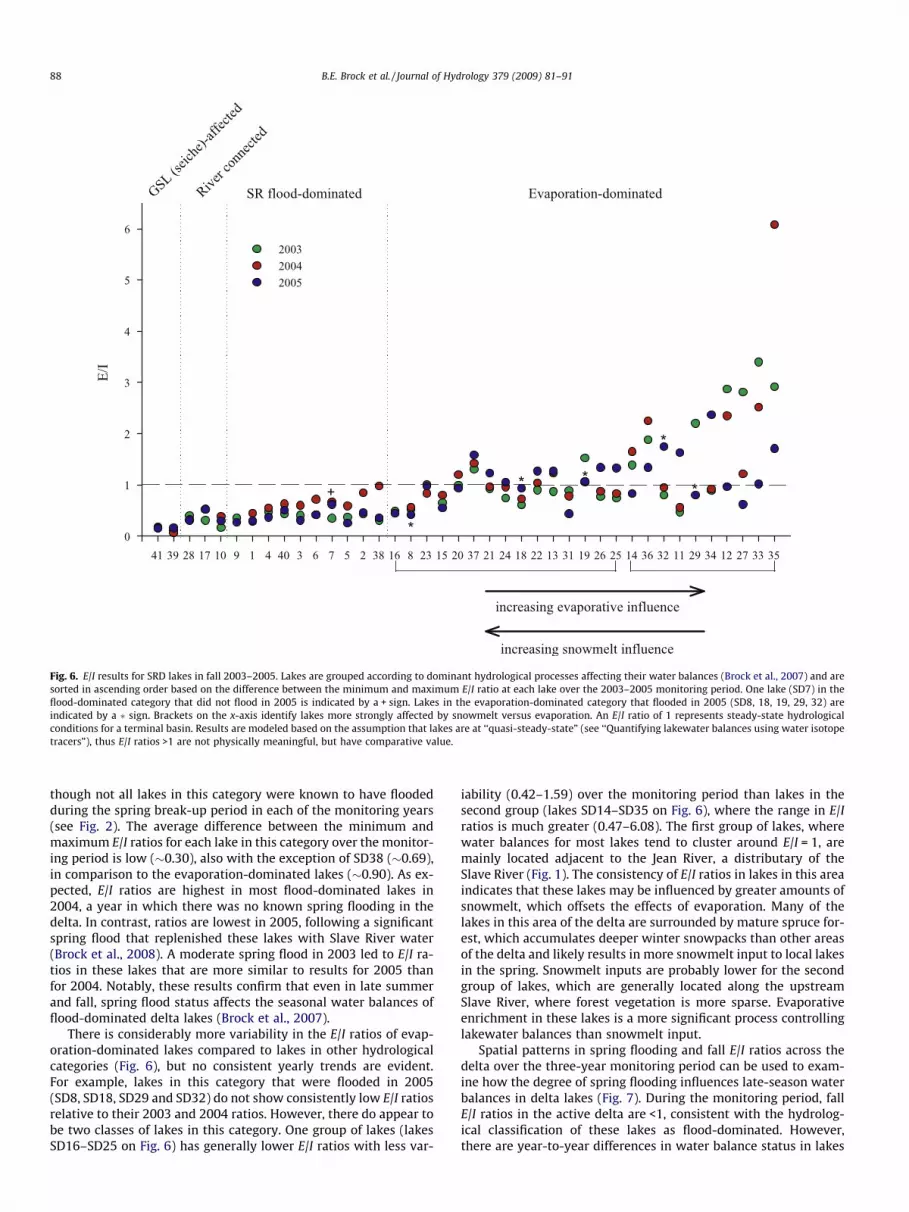
Fig. 6. E/I results for SRD lakes in fall 2003–2005. Lakes are grouped according to dominant hydrological processes affecting their water balances (Brock et al., 2007) and aresorted in ascending order based on the difference between the minimum and maximum E/I ratio at each lake over the 2003–2005 monitoring period. One lake (SD7) in theflood-dominated category that did not flood in 2005 is indicated by a + sign. Lakes in the evaporation-dominated category that flooded in 2005 (SD8, 18, 19, 29, 32) areindicated by a � sign. Brackets on the x-axis identify lakes more strongly affected by snowmelt versus evaporation. An E/I ratio of 1 represents steady-state hydrologicalconditions for a terminal basin. Results are modeled based on the assumption that lakes are at ‘‘quasi-steady-state” (see ‘‘Quantifying lakewater balances using water isotopetracers”), thus E/I ratios >1 are not physically meaningful, but have comparative value.
88 B.E. Brock et al. / Journal of Hydrology 379 (2009) 81–91
though not all lakes in this category were known to have floodedduring the spring break-up period in each of the monitoring years(see Fig. 2). The average difference between the minimum andmaximum E/I ratios for each lake in this category over the monitor-ing period is low (�0.30), also with the exception of SD38 (�0.69),in comparison to the evaporation-dominated lakes (�0.90). As ex-pected, E/I ratios are highest in most flood-dominated lakes in2004, a year in which there was no known spring flooding in thedelta. In contrast, ratios are lowest in 2005, following a significantspring flood that replenished these lakes with Slave River water(Brock et al., 2008). A moderate spring flood in 2003 led to E/I ra-tios in these lakes that are more similar to results for 2005 thanfor 2004. Notably, these results confirm that even in late summerand fall, spring flood status affects the seasonal water balances offlood-dominated delta lakes (Brock et al., 2007).
There is considerably more variability in the E/I ratios of evap-oration-dominated lakes compared to lakes in other hydrologicalcategories (Fig. 6), but no consistent yearly trends are evident.For example, lakes in this category that were flooded in 2005(SD8, SD18, SD29 and SD32) do not show consistently low E/I ratiosrelative to their 2003 and 2004 ratios. However, there do appear tobe two classes of lakes in this category. One group of lakes (lakesSD16–SD25 on Fig. 6) has generally lower E/I ratios with less var-
iability (0.42–1.59) over the monitoring period than lakes in thesecond group (lakes SD14–SD35 on Fig. 6), where the range in E/Iratios is much greater (0.47–6.08). The first group of lakes, wherewater balances for most lakes tend to cluster around E/I = 1, aremainly located adjacent to the Jean River, a distributary of theSlave River (Fig. 1). The consistency of E/I ratios in lakes in this areaindicates that these lakes may be influenced by greater amounts ofsnowmelt, which offsets the effects of evaporation. Many of thelakes in this area of the delta are surrounded by mature spruce for-est, which accumulates deeper winter snowpacks than other areasof the delta and likely results in more snowmelt input to local lakesin the spring. Snowmelt inputs are probably lower for the secondgroup of lakes, which are generally located along the upstreamSlave River, where forest vegetation is more sparse. Evaporativeenrichment in these lakes is a more significant process controllinglakewater balances than snowmelt input.
Spatial patterns in spring flooding and fall E/I ratios across thedelta over the three-year monitoring period can be used to exam-ine how the degree of spring flooding influences late-season waterbalances in delta lakes (Fig. 7). During the monitoring period, fallE/I ratios in the active delta are <1, consistent with the hydrolog-ical classification of these lakes as flood-dominated. However,there are year-to-year differences in water balance status in lakes

Fig. 7. Percent dilution in SRD lakes by Slave River water or snowmelt in spring of: (a) 2003, (b) 2004 and (c) 2005. Percent dilution for each lake was calculated by dividingthe difference between a lake’s isotopic composition in the spring and the preceding fall by the difference between the isotopic composition of the diluting source water(Slave River water or snowmelt) and the preceding fall’s lakewater composition (see Brock et al., 2008). The observed spatial extent of flooding in 2003 and 2005 correspondswith the 70% dilution isoline, shown as a grey contour in (a) and (c). Fall E/I ratios for (d) 2003, (e) 2004 and (f) 2005 show lakes with positive water balances (E/I < 1) as blueareas and lakes with negative water balances (E/I ratios >1) as red areas. The grey contour on (d–f) represents an E/I ratio of 1.
B.E. Brock et al. / Journal of Hydrology 379 (2009) 81–91 89
in this area of the delta. Spring flooding in 2005 was more spa-tially extensive than in 2003 (Fig. 7a and c), which is reflectedin lower fall E/I ratios in 2005 in several lakes adjacent to theSlave River upstream of the active delta. In the absence of springflooding in 2004 (Fig. 7b), flood-dominated lakes in the active del-ta attained slightly higher fall E/I ratios, although they are lowerthan those for evaporation-dominated lakes in the relict delta.This suggests the hydrological effects of flooding on lakewaterbalances in the active delta may persist in years following a floodevent.
Under these circumstances, annual flooding may not be neces-sary to maintain the low, input-dominated water balances of
flood-dominated lakes. However, because the monitoring periodonly included one flood-free year, it is unclear how long flood-dominated lakes would be capable of maintaining positive waterbalance conditions, particularly over several subsequent seasonswith no spring break-up flooding. In the Mackenzie Delta, model-ing studies have suggested that high-closure lakes could disappearwithin 10 years in the absence of flooding (Marsh and Lesack,1996), depending on precipitation and catchment contributions.Elsewhere, in the Athabasca Delta, areas that have become less sus-ceptible to river flooding in recent decades have undergone drying(Wolfe et al., 2008b), whereas other lakes have persisted for hun-dreds of years (Wolfe et al., 2008a).

90 B.E. Brock et al. / Journal of Hydrology 379 (2009) 81–91
In contrast to the active delta, E/I ratios consistently exceed 1along upstream reaches of the Slave River, and in some areas alongthe Jean River (northeast area of maps in Fig. 7), reflecting thedominance of evaporation on lakewater balances in these regionsof the delta (Fig. 7d–f). The number of evaporation-dominatedlakes with E/I ratios >1 increased from 2003 (n = 10) to 2005(n = 14). These results, showing persistent non-steady-state evapo-ration along the Jean and upstream Slave rivers during the moni-toring period, reveal that these areas may be most susceptible todrying, especially if snowmelt or thaw season precipitation inputsto these lakes decline over the course of several consecutive sea-sons, or if evaporation increases.
Conclusions and management recommendations
Quantifying fall lakewater balances provides important insightabout landscape-scale hydrological processes that control SRDlakes and reveals that broad patterns are related to spring break-up flooding and hydrological setting. Low E/I ratios in exchange-dominated lakes in the active delta throughout the 2003–2005monitoring period reflect both the strength of the lake–river chan-nel connection and the increasing frequency of seiche events onGreat Slave Lake in late summer and fall (Gardner et al., 2006).Although isotopic results from lakewater samples examined herewere collected at the end of the thaw season, flood-dominatedlakes in the active delta have persistently low E/I ratios. This re-flects the role of spring flooding in re-setting the starting pointfor hydrological evolution of flood-dominated lakes throughoutthe thaw season. In 2004, in the absence of a spring break-up flood,lakewater balances in flood-dominated lakes continue to be posi-tive. These results suggest that the hydrological influence of theprevious year’s flood persists in lakes in the absence of springflooding, although several consecutive years with no floodingwould likely lead to increased cumulative evaporation.
In contrast to flood-dominated lakes in the active delta, falllakewater balances in evaporation-dominated lakes in the relictdelta are highly variable and do not show consistent inter-annualtrends. Rather, two classes of lakes appear to comprise this cate-gory of lakes. In lakes in the northeast sector of the delta, wherelake catchments are largely composed of mature forest andentrainment of winter snowpacks is likely high, generally low var-iability is evident in lakewater balances at the end of the thaw sea-son and over successive years. Snowmelt input may be lower forlakes along the upstream reaches of the Slave River, where matureforest is less prevalent, resulting in a greater range in E/I ratios inthese lakes. Declining snowmelt inputs and increased evaporationin both classes of evaporation-dominated lakes have the potentialto increase lake-level drawdown, and may promote drying of therelict delta. As we have demonstrated here and elsewhere (Brocket al., 2007, 2008), multi-seasonal and multi-annual surveys oflakewater isotope compositions have been extremely effective indeciphering the relative roles of hydrological processes on lake-water balances in this large, remote, northern freshwaterlandscape.
Results from these studies provide important context for policyregarding water resource management in the delta and along theupstream Slave River and its tributaries. For example, hydroelectricdevelopment on the Slave River and continued or increased waterextraction and diversion associated with the Alberta oil sands pro-duction have the potential to alter the amount and timing of SlaveRiver discharge. Because river discharge is positively correlated tospring flooding in the active delta (Brock et al., 2008), a decline inriver discharge, particularly during the spring break-up period, willresult in less frequent and less widespread flooding in the activedelta. A decline in flood frequency and magnitude will cause the
water balances of flood-dominated lakes in the active delta to,eventually, become increasingly influenced by evaporation, result-ing in drier conditions in the active SRD. Increases in northern airtemperatures, extending the ice-free season (ACIA, 2004), couldexacerbate such conditions. Careful management of water re-sources in the Peace-Athabasca-Slave river corridor requires recog-nition of such stressors and their potential impacts.
Acknowledgements
The authors are grateful for support provided by the principaland staff of Deninu School, the Deninu K’ue First Nation, the FortResolution Environmental Working Committee, and the residentsof Fort Resolution. G. Lafferty and L. Norn provided local field assis-tance. M. Sokal, M. Adam and T. Barkhouse also provided fieldassistance. P. Schaus provided assistance with figures. Fundingand logistical support were provided by the Natural Sciences andEngineering Research Council, through an Alexander Graham BellCGS-D and the Northern Research Chair Program, and by the Gar-field Weston Foundation. Additional funding and support was pro-vided by the Northern Scientific Training Program, the PolarContinental Shelf Project, the Government of Ontario Premier’s Re-search Excellence Award, the Canada Foundation for Innovation,the Ontario Innovation Trust, the University of Waterloo, the Uni-versity of Waterloo Environmental Isotope Laboratory, and WoodBuffalo Helicopters. This manuscript benefited from the careful re-views of two anonymous reviewers.
References
ACIA, 2004. Impacts of a Warming Arctic: Arctic Climate Impact Assessment.Cambridge University Press.
Araguás-Araguás, L., Froelich, K., Rozanski, K., 2000. Deuterium and oxygen-18isotope composition of precipitation and atmospheric moisture. HydrologicalProcesses 14, 1341–1355.
Birks, S.J., Edwards T.W.D., Gibson, J.J., Drimmie, R.J., Michel, F.A., 2004. CanadianNetwork for Isotopes in Precipitation. <http://www.science.uwaterloo.ca/~twdedwar/cnip/cniphome.html>.
Brock, B.E., Wolfe, B.B., Edwards, T.W.D., 2007. Characterizing the hydrology ofshallow floodplain lakes in the Slave River Delta, NWT, using water isotopetracers. Arctic, Antarctic and Alpine Research 39, 388–401.
Brock, B.E., Wolfe, B.B., Edwards, T.W.D., 2008. Spatial and temporal perspectives onspring break-up flooding in the Slave River Delta, NWT. Hydrological Processes22, 4058–4072.
Brock, B.E., Martin, M.E., Mongeon, C.L., Sokal, M.A., Wesche, S.D., Armitage, D.,Wolfe, B.B., Hall, R.I., Edwards, T.W.D., in review. Flood frequency variability inthe Slave River Delta, NWT, over the past 80 years from multi-proxypaleolimnological analysis. Canadian Water Resources Journal.
Canadian National Committee for the International Decade, 1978. HydrologicalAtlas of Canada. Fisheries and Environment Canada, Ottawa.
Coplen, T.B., 1996. New guidelines for reporting stable hydrogen, carbon andoxygen isotope-ratio data. Geochimica et Cosmochimica Acta 60, 3359–3360.
Craig, H., Gordon, L.I., 1965. Deuterium and oxygen 18 variations in the ocean andmarine atmosphere. In: Tongiorgi, E. (Ed.), Stable Isotopes in OceanograpicStudies and Paleotemperatures. Laboratorio di Geologia Nucleare, Pisa, Italy, pp.9–130.
Day, J.H., 1972. Soils of the Slave River Lowland in the Northwest Territories.Research Branch Canada Department of Agriculture, Ottawa.
Dingman, S.L., 1993. Physical Hydrology. Prentice-Hall, New Jersey.Drimmie, R.J., Heemskerk, R.A., 1993. Water 18O by CO2 Equilibration. Technical
Procedure 13.0, Rev. 02. Environmental Isotope Laboratory, Department ofEarth Sciences, University of Waterloo.
Emmerton, C.A., Lesack, L.F.W., Marsh, P., 2007. Lake abundance, potential waterstorage, and habitat distribution in the Mackenzie River Delta, westernCanadian Arctic. Water Resources Research 43, W05419.
English, M., Hill, R., Stone, M., Ormson, R., 1997. Geomorphological and botanicalchange on the outer Slave River Delta, NWT, before and after impoundment ofthe Peace River. Hydrological Processes 11, 1707–1724.
Environment Canada, 2002. Canadian Climate Normals 1971–2000. EnvironmentCanada.
Environment Canada, 2005. Climate Data Online. Environment Canada.Gardner, J.T., English, M.C., Prowse, T.D., 2006. Wind-forced seiche events on Great
Slave Lake: hydrologic implications for the Slave River Delta, NWT, Canada.Hydrological Processes 20, 4051–4072.
Gat, J.R., Matsui, E., 1991. Atmospheric water balance in the Amazon Basin: anisotopic transpiration model. Journal of Geophysical Research 96, 13179–13188.

B.E. Brock et al. / Journal of Hydrology 379 (2009) 81–91 91
Gat, J.R., Bowser, C.J., Kendall, C., 1994. The contribution of evaporation from theGreat Lakes to the continental atmosphere: estimate based on stable isotopedata. Geophysical Research Letters 21, 557–560.
Gat, J.R., Klein, B., Kushnir, Y., Roether, W., Wernli, H., Yam, R., Shemesh, A., 2003.Isotope composition of air moisture over the Mediterranean Sea: an index of theair–sea interaction pattern. Tellus 55B, 953–965.
Gibson, J.J., 2002. A new conceptual model for predicting isotopic enrichment inlakes in seasonal climates. PAGES News 10, 10–11.
Gibson, J.J., Edwards, T.W.D., 2002. Regional water balance trends and evaporation–transpiration partitioning from a stable isotope survey of lakes in NorthernCanada. Global Biogeochemical Cycles 16. doi:10.1029/2001GB001839.
Gibson, J.J., Edwards, T.W.D., Bursey, G.G., Prowse, T.D., 1993. Estimatingevaporation using stable isotopes: quantitative results and sensitivity analysisfor two catchments in northern Canada. Nordic Hydrology 24, 79–94.
Gonfiantini, R., 1986. Environmental isotopes in lake studies. In: Fritz, P., Fontes, J.C.(Eds.), Handbook of Environmental Isotope Geochemistry, The TerrestrialEnvironment, vol. 2. Elsevier, New York, pp. 113–168.
Horita, J., Wesolowski, D., 1994. Liquid–vapour fractionation of oxygen andhydrogen isotopes of water from the freezing to the critical temperature.Geochimica et Cosmochimica Acta 58, 3425–3497.
Huntington, H., Weller, G., 2005. Chapter 1: an introduction to the arctic climateimpact assessment. In: Symon, C., Arris, L., Heal, B. (Eds.), Arctic Climate ImpactAssessment Scientific Report. Cambridge University Press, pp. 1–20.
Ingraham, N.L., Taylor, B.E., 1991. Light stable isotope systematics of large-scalehydrologic regimes in California and Nevada. Water Resources Research 27, 77–90.
Malmstrom, V.H., 1969. A new approach to the classification of climate. Journal ofGeography 68, 351–357.
Marsh, P., Lesack, L.F.W., 1996. The hydrologic regime of perched lakes in theMackenzie Delta: potential responses to climate change. Limnology andOceanography 41, 849–856.
Morrison, J., Brockwell, T., Merren, T., Fourel, F., Phillips, A.M., 2001. A new on-linemethod for high precision stable-hydrogen isotopic analyses on nanolitre watersamples. Analytical Chemistry 73, 3570–3575.
Prowse, T.D., Conly, F.M., 1998. Effects of climatic variability and flow regulation onice-jam flooding of a northern delta. Hydrological Processes 12, 1589–1610.
Prowse, T.D., Conly, F.M., 2000. Multiple-hydrologic stressors of a northern deltaecosystem. Journal of Aquatic Ecosystem Stress and Recovery 8, 17–26.
Romolo, L.A., Prowse, T.D., Blair, D., Bonsal, B.R., Martz, W.L., 2006. The synopticclimate controls on hydrology in the upper reaches of the Peace River Basin.Part I: snow accumulation. Hydrological Processes 20, 4097–4111.
Rouse, W.R., Douglas, M.S.V., Hecky, R.E., Hershey, A.E., Kling, G.W., Lesack, L.,Marsh, P., McDonald, M., Nicholson, B.J., Roulet, N.T., Smol, J.P., 1997. Effects ofclimate change on the freshwaters of Arctic and subarctic North America.Hydrological Processes 11, 873–902.
Smith, D., 1991. Lacustrine Deltas. The Canadian Geographer 35, 311–316.Smith, L.C., Sheng, Y., MacDonald, G.M., Hinzman, L.D., 2005. Disappearing Arctic
lakes. Science 398, 1429.Smol, J.P., Douglas, M.S.V., 2007. Crossing the final ecological threshold in high
Arctic Ponds. Proceedings of the National Academy of Sciences 104, 12395–12397.
Townsend, G.H., 1984. Wildlife resources of the Slave River and Peace-AthabascaDelta. Journal of the National and Provincial Parks Association of Canada 20, 5–7.
Vallet-Coulomb, C., Gasse, F., Robinson, L., Ferry, L., 2006. Simulation of the waterand isotopic balance of a closed tropical lake at a daily time step (Lake Ihotry,South-West of Madagascar). Journal of Geochemical Exploration 88, 153–156.
Vallet-Coulomb, C., Gasse, F., Sonzogni, C., 2008. Seasonal evolution of the isotopiccomposition of atmospheric water vapour above a tropical lake: deuteriumexcess and implication for water recycling. Geochimica et Cosmochimica Acta72, 4661–4674.
Vanderburgh, S., Smith, D., 1988. Slave River Delta: geomorphology, sedimentology,and Holocene reconstruction. Canadian Journal of Earth Science 25, 1990–2004.
Wesche, S., 2007. Adapting to change in Canada’s north: voices from FortResolution, NWT. Meridian Spring/Summer 2007, 19–25.
Wolfe, B.B., Armitage, D., Wesche, S., Brock, B.E., Sokal, M.A., Clogg-Wright, K.P.,Mongeon, C.L., Adam, M.E., Hall, R.I., Edwards, T.W.D., 2007a. From isotopes toTK interviews: towards interdisciplinary research in Fort Resolution and theSlave River Delta, NWT. Arctic 60, 75–87.
Wolfe, B.B., Karst-Riddoch, T.L., Hall, R.I., Edwards, T.W.D., English, M.C., Palmini, R.,McGowan, S., Leavitt, P.R., Vardy, S.R., 2007b. Classification of hydrologicregimes of northern floodplain basins (Peace-Athabasca Delta, Canada) fromanalysis of stable isotopes (d18O, d2H) and water chemistry. HydrologicalProcesses 21, 151–168.
Wolfe, B.B., Hall, R.I., Edwards, T.W.D., Jarvis, S.R., Sinnatamby, R.N., Yi, Y., Johnston,J.W., 2008a. Climate-driven shifts in the quantity and seasonality of riverdischarge over the past 1000 years from the hydrographic apex of NorthAmerica. Geophysical Research Letters 35, L24402. doi:10.1029/2008GL036125.
Wolfe, B.B., Hall, R.I., Edwards, T.W.D., Vardy, S.R., Falcone, M.D., Sjunneskog, C.,Sylvestre, F., McGowan, S., Leavitt, P.R., van Driel, P., 2008b. Hydroecologicalresponses of the Athabasca Delta, Canada, to changes in river flow and climateduring the 20th century. Ecohydrology 1, 131–148.
Wrona, F., Prowse, T.D., Reist, J.D., 2005. Chapter 8: freshwater ecosystems andfisheries. In: Symon, C., Arris, L., Heal, B. (Eds.), Arctic Climate ImpactAssessment Scientific Report. Cambridge University Press, pp. 353–452.
Yi, Y., Brock, B.E., Falcone, M.D., Wolfe, B.B., Edwards, T.W.D., 2008. A coupledisotope tracer method to characterize input water to lakes. Journal of Hydrology350, 1–13.
Copyright © 2022 FDOKUMEN