Mud volcanism and morphology of impact craters in Utopia Planitia on Mars: Evidence for the ancient...
20
Mud volcanism and morphology of impact craters in Utopia Planitia on Mars: Evidence for the ancient ocean Mikhail A. Ivanov a,b,⇑,1 , H. Hiesinger b,1 , G. Erkeling b,1 , D. Reiss b,1 a Vernadsky Institute, Russian Academy of Sciences, Kosygin St., 19, Moscow 119991, Russia b Institut für Planetologie, Westfälische Wilhelms-Universität, Münster, Wilhelm-Klemm-Str. 10, 48149 Münster, Germany article info Article history: Received 15 January 2013 Revised 27 August 2013 Accepted 23 September 2013 Available online 8 October 2013 Keyword: Mars Utopia Planitia Mud volcanism Ocean abstract Results of our detailed geological mapping and interpretation of the nature and relative and absolute model ages of units and structures in the SW portion of Utopia Planitia (20–45°N, 100–120°E) suggest the following. (1) The size–frequency distribution (SFD) of craters that both are buried by materials of the Vastitas Borealis units (VB) and superpose its surface indicate that the absolute model ages of terrain predating the emplacement of the VB is 3.7 Ga. (2) Lack of craters that are partly embayed by materials of the VB in the SW portion of Utopia Planitia implies that the emplacement of the VB was faster than the rate of accumulation of impact craters and is consistent with the geologically short time of emplacement of the VB due to catastrophic release of water from outflow channels (e.g., Carr, M.H. [1996]. Water on Mars. Oxford University Press, New York, p. 229). (3) The SFD of craters that superpose the surface of the VB indicates an absolute model age of 3.6–3.5 Ga. The absolute model ages of etched flows, which represent the upper stratigraphic limit of the VB, are estimated to be 3.5 Ga. (4) The majority of the lar- ger (i.e., >1 km) impact craters show ejecta morphologies (rampart and pancake-like ejecta) that are indicative of the presence of ice/water in the target materials. The distal portions of the pancake-like ejecta are heavily degraded (not due to embayment). This suggests that these craters formed in targets that contained higher abundances of volatiles. (5) The diameter ranges of the craters with either rampart- or pancake-like ejecta are overlapping (from 2 to 60 km). Craters with pancake-like ejecta are concen- trated within the central portion of the Utopia basin (less than 1000 km from the basin center) and rampart craters occur at the periphery of the basin. This pattern of the crater spatial distribution suggests that materials within the center of Utopia Planitia contained more ice/water. (6) Etched flows around the central portion of Utopia Planitia were erupted from beneath of the surface of the VB. Their morphology and pattern of degradation, however, are inconsistent with lava and, instead, indicate formation of the flows due to mud volcanism. (7) Etched flows are spatially associated with giant polygons and there is evidence that these features populated the center portion of Utopia Planitia before it was covered by the Elysium-derived units. The outer (southern) edge of the zone of polygonal troughs and etched flows approximately corresponds to the transition from pancake-like ejecta to rampart ejecta. This suggest that the outer edge of the zone of the polygons and flows may outline the deeper portions of the large body (2000 km across) of water/ice that likely existed in the center of Utopia Planitia in late Hesperian. Ó 2013 Elsevier Inc. All rights reserved. 1. Introduction The ancient, Early Noachian, age of the northern lowlands on Mars (Wilhelms, 1973; McGill, 1989; Frey and Schultz, 1988; Frey et al., 2002; Solomon et al., 2005) implies that the lowlands must have served as a major sink for materials formed and redistributed by volcanic, fluvial, glacial, and wind processes (Scott and Tanaka, 1986; Greeley and Guest, 1987; Kargel et al., 1995; Carr, 1996; Head et al., 2002; Tanaka et al., 2003a,b, 2005). The interpretation of the MOLA topographic data have shown that the northern low- lands have been covered by ridged plains of Early Hesperian age (Kreslavsky and Head, 2000) that resemble those in the upland vol- canic provinces such as Hesperia and Lunae Planum (Head et al., 2002). In contrast to these expanses of ridged plains, the plains in the northern lowlands are characterized by systematically lower and more widely spaced ridges and by the presence of strongly de- graded craters that have almost no discernible morphologic signa- tures and represent shallow topographic depressions (McGill, 1986; Buczkowski and McGill, 2002; Head et al., 2002). 0019-1035/$ - see front matter Ó 2013 Elsevier Inc. All rights reserved. http://dx.doi.org/10.1016/j.icarus.2013.09.018 ⇑ Corresponding author at: Vernadsky Institute, Russian Academy of Sciences, Kosygin St., 19, Moscow 119991, Russia. Fax: +7 495 938 2054. E-mail addresses: [email protected] (M.A. Ivanov), hiesinger@ uni-muenster.de (H. Hiesinger), [email protected] (G. Erkeling), [email protected] (D. Reiss). 1 Fax: +49 251 83 36301. Icarus 228 (2014) 121–140 Contents lists available at ScienceDirect Icarus journal homepage: www.elsevier.com/locate/icarus
Transcript of Mud volcanism and morphology of impact craters in Utopia Planitia on Mars: Evidence for the ancient...
Icarus 228 (2014) 121–140
Contents lists available at ScienceDirect
Icarus
journal homepage: www.elsevier .com/locate / icarus
Mud volcanism and morphology of impact craters in Utopia Planitiaon Mars: Evidence for the ancient ocean
0019-1035/$ - see front matter � 2013 Elsevier Inc. All rights reserved.http://dx.doi.org/10.1016/j.icarus.2013.09.018
⇑ Corresponding author at: Vernadsky Institute, Russian Academy of Sciences,Kosygin St., 19, Moscow 119991, Russia. Fax: +7 495 938 2054.
E-mail addresses: [email protected] (M.A. Ivanov), [email protected] (H. Hiesinger), [email protected] (G. Erkeling),[email protected] (D. Reiss).
1 Fax: +49 251 83 36301.
Mikhail A. Ivanov a,b,⇑,1, H. Hiesinger b,1, G. Erkeling b,1, D. Reiss b,1
a Vernadsky Institute, Russian Academy of Sciences, Kosygin St., 19, Moscow 119991, Russiab Institut für Planetologie, Westfälische Wilhelms-Universität, Münster, Wilhelm-Klemm-Str. 10, 48149 Münster, Germany
a r t i c l e i n f o a b s t r a c t
Article history:Received 15 January 2013Revised 27 August 2013Accepted 23 September 2013Available online 8 October 2013
Keyword:MarsUtopia PlanitiaMud volcanismOcean
Results of our detailed geological mapping and interpretation of the nature and relative and absolutemodel ages of units and structures in the SW portion of Utopia Planitia (20–45�N, 100–120�E) suggestthe following. (1) The size–frequency distribution (SFD) of craters that both are buried by materials ofthe Vastitas Borealis units (VB) and superpose its surface indicate that the absolute model ages of terrainpredating the emplacement of the VB is �3.7 Ga. (2) Lack of craters that are partly embayed by materialsof the VB in the SW portion of Utopia Planitia implies that the emplacement of the VB was faster than therate of accumulation of impact craters and is consistent with the geologically short time of emplacementof the VB due to catastrophic release of water from outflow channels (e.g., Carr, M.H. [1996]. Water onMars. Oxford University Press, New York, p. 229). (3) The SFD of craters that superpose the surface ofthe VB indicates an absolute model age of �3.6–3.5 Ga. The absolute model ages of etched flows, whichrepresent the upper stratigraphic limit of the VB, are estimated to be �3.5 Ga. (4) The majority of the lar-ger (i.e., >1 km) impact craters show ejecta morphologies (rampart and pancake-like ejecta) that areindicative of the presence of ice/water in the target materials. The distal portions of the pancake-likeejecta are heavily degraded (not due to embayment). This suggests that these craters formed in targetsthat contained higher abundances of volatiles. (5) The diameter ranges of the craters with either rampart-or pancake-like ejecta are overlapping (from �2 to �60 km). Craters with pancake-like ejecta are concen-trated within the central portion of the Utopia basin (less than �1000 km from the basin center) andrampart craters occur at the periphery of the basin. This pattern of the crater spatial distribution suggeststhat materials within the center of Utopia Planitia contained more ice/water. (6) Etched flows around thecentral portion of Utopia Planitia were erupted from beneath of the surface of the VB. Their morphologyand pattern of degradation, however, are inconsistent with lava and, instead, indicate formation of theflows due to mud volcanism. (7) Etched flows are spatially associated with giant polygons and there isevidence that these features populated the center portion of Utopia Planitia before it was covered bythe Elysium-derived units. The outer (southern) edge of the zone of polygonal troughs and etched flowsapproximately corresponds to the transition from pancake-like ejecta to rampart ejecta. This suggest thatthe outer edge of the zone of the polygons and flows may outline the deeper portions of the large body(�2000 km across) of water/ice that likely existed in the center of Utopia Planitia in late Hesperian.
� 2013 Elsevier Inc. All rights reserved.
1. Introduction
The ancient, Early Noachian, age of the northern lowlands onMars (Wilhelms, 1973; McGill, 1989; Frey and Schultz, 1988; Freyet al., 2002; Solomon et al., 2005) implies that the lowlands musthave served as a major sink for materials formed and redistributed
by volcanic, fluvial, glacial, and wind processes (Scott and Tanaka,1986; Greeley and Guest, 1987; Kargel et al., 1995; Carr, 1996;Head et al., 2002; Tanaka et al., 2003a,b, 2005). The interpretationof the MOLA topographic data have shown that the northern low-lands have been covered by ridged plains of Early Hesperian age(Kreslavsky and Head, 2000) that resemble those in the upland vol-canic provinces such as Hesperia and Lunae Planum (Head et al.,2002). In contrast to these expanses of ridged plains, the plainsin the northern lowlands are characterized by systematically lowerand more widely spaced ridges and by the presence of strongly de-graded craters that have almost no discernible morphologic signa-tures and represent shallow topographic depressions (McGill,1986; Buczkowski and McGill, 2002; Head et al., 2002).
122 M.A. Ivanov et al. / Icarus 228 (2014) 121–140
The subdued morphology of the ridges and craters has beeninterpreted to mean that materials of the Vastitas Borealis units,which are exposed over almost the entire floor of the northern low-lands (Scott and Tanaka, 1986; Greeley and Guest, 1987; Tanakaand Scott, 1987) overlay the ridged plains (Head et al., 2002). Thesurface of the Vastitas Borealis units shows a number of featuresthat are consistent with the presence of a large reservoir ofwater/mud/ice within the northern lowlands. These features in-clude thumbprint terrains that consist of curvilinear chains of pit-ted cones (e.g., Carr and Schaber, 1977; Lucchitta, 1981; Hiesingeret al., 2009), giant polygons (e.g., Lucchitta, 1981; McGill and Hills,1992; Hiesinger and Head, 2000), assemblages of low sinuous/cur-vilinear ridges that resemble moraines and eskers (e.g., Kargelet al., 1995), impact craters with rampart- and pancake-like ejecta(e.g., Mouginis-Mark, 1979, 1987). In many studies, the VB hasbeen interpreted either as sedimentary deposits formed by mas-sive erosion from the southern highlands (Jons, 1985; Tanakaet al., 2001), or as materials deposited from a large standing bodyof water (an ocean) (e.g., Parker et al., 1989, 1993), or as a sublima-tion residue of such an ocean (e.g., Kreslavsky and Head, 2002), oras sedimentary deposits from the large outflow channels (e.g.,Tanaka et al., 2005).
The existence of the ocean is an important and still open is-sue in the martian geology. This hypothesis is supported by sev-eral boundaries that can be traced over large distance(thousands of kilometers) and separate morphologically distin-guishable units within the VB at the periphery of the northernlowlands. These boundaries have interpreted as possible shore-lines of the ancient ocean (Parker et al., 1989, 1993; Cliffordand Parker, 2001). Some of these boundaries (e.g., Arabia contact(Clifford and Parker, 2001)) show topographic variations that ex-ceed several kilometers and, thus, are inconsistent with theshoreline (Head et al., 1999; Carr and Head, 2003). The otherboundary (Deuteronilus contact (Clifford and Parker, 2001)) ischaracterized by much smaller topographic fluctuations,�3792 ± 236 (Carr and Head, 2003), which is consistent withthe shoreline interpretation. In some models, however, thelong-wavelength trend of topographic variations along Arabiashoreline is explained as the result of true pole wander (Perronet al., 2007). The mean elevation of the Deuteronilus contact isclose to both the mean elevation of the southern edge of theVB (�3658 ± 282) (Carr and Head, 2003) and the morphologictermini of large outflow channels in Chryse Planitia(�3724 ± 153) (Ivanov and Head, 2001). The channels, whichthat are thought to be carved by large-scale floods (Carr,1979), are opening into the lowlands and are commonly consid-ered as the primary sources of water that may have filled thenorthern lowlands in the late Hesperian (e.g., Parker et al.,1989, 1993; Baker et al., 1991; Clifford and Parker, 2001; Tanakaet al., 2005). The very large topographic depression of UtopiaPlanitia (�2000 km in diameter and 1.5–2 km deep) could poten-tially contain a significant portion of the effluents of the outflowchannels because the majority of Utopia Planitia is below thecontour line of �3658 m (Smith et al., 2001) and materials ofthe VB cover almost the entire surface of Utopia (e.g., Greeleyand Guest, 1987; Tanaka et al., 2005).
Three types of features that occur in Utopia Planitia suggest thepresence of a large reservoir of water in this region. (1) Heavily de-graded/buried (ghost) craters (Carr, 1981; McGill, 1986) occurthroughout Utopia Planitia. The morphology and topographic char-acteristics of these features have been interpreted as evidence ofcompaction of possibly sedimentary materials of the VB againstthe rims of buried craters (e.g., Buczkowski and McGill, 2002). (2)The southern edge of Utopia is one of the sites where thumbprintterrain (TPT) occurs (Lockwood et al., 1992). A variety of hypothe-ses, ranging from glacial (e.g., Grizzaffi and Schultz, 1989) to volca-
nic origin (e.g., Ghent et al., 2012), were proposed to explain thenature of TPT. In most of these hypotheses the presence of largeamounts of ice/water is a requirement. (3) Giant polygons occurperipheral to the center of the Utopia basin (e.g., McGill, 1986).The key elements in many models of formation of these terrainsare either wet sediments or the presence of a large standing bodyof water or ice (see (Hiesinger and Head, 2000) for the summary ofthe models).
The large impact basin of Utopia Planitia (McGill, 1989) plays animportant role in the geologic history of the northern lowlands,which has been portrayed in geological maps and correlationcharts since the Mariner-9 and Viking missions (Scott and Carr,1978; Scott and Tanaka, 1986; Greeley and Guest, 1987; Tanakaand Scott, 1987). The most recent map of this region (Tanakaet al., 2005) incorporates the data sets of the Mars Global Surveyor(MOLA gridded topography and dispersed MOC images) and Mars-Odyssey (THEMIS infrared (IR), 100 m/px, and visible (vis), 17–40 m/px, images) missions.
The map shows that an extensive Vastitas Borealis interior unit(ABvi) covers the majority of Utopia Planitia and a suite of theyounger volcanic and fluvial units and debris flows derived fromthe Elysium Mons region overlays the central portion of the Utopiabasin. The interior unit, which appears to be homogeneous at thescale of the mapping, hosts both the giant polygons (closer to thecenter of the basin) and the occurrences of TPT near the southernedge of Utopia Planitia. These landforms probably reflect differentenvironments that have occurred during their formation. These dif-ferences, however, were probably not obvious in the THEMIS IRimages that have provided the most contiguous photobase forthe mapping (the higher-resolution THEMIS–vis images were toosparse during the compilation of the map).
In our study, we mapped the SW portion of Utopia Planitia(Fig. 1). The giant polygons characterize the northern portionof this area and TPT is concentrated in its southern segment.Thus, the selected area provides the possibility to trace changesof the sets of specific landforms and their morphology as a func-tion of the distance from the edge of the Utopia basin. We haveconducted our mapping using mostly images with higher resolu-tion (THEMIS–vis, 17–40 m/px, HRSC, 12–50 m/px, and CTX,�6 m/px) that cover about 80–85% of the selected area. Gapsin the high-resolution coverage were filled by the daytime andnighttime THEMIS-IR images. The units and landforms have beenfirst identified and mapped on the base of the high-resolutiondata and the characteristic morphologies of the mapped featureswere extrapolated to the medium-resolution images and tracedwithin the data gaps of the high-resolution images. All availableHiRISE images (0.25–0.5 m/px) were used to clarify the possiblenature of some units and landforms. The topographic data werecollected from the MOLA DEM (resolution 1/128 of a degree).
In our study we addressed three major questions: (1) how spe-cific landforms that characterized the VB are changed from theedges toward the center of the Utopia basin? (2) What thesechanges may tell about the presence or absence of a large putativewater reservoir in Utopia Planitia? (3) Which features that werenot seen previously in the lower-resolution data sets may providean additional support (or contradiction) to the hypothesis of thelarge standing body of water/ice within the Utopia topographicdepression?
2. Topographic configuration of our study area
The study area covers a portion of the inner wall of the Utopiabasin and is characterized by a very small and steady slope towardthe northeast (Fig. 2a). The topographic profile from the edge ofUtopia Planitia toward its center (Fig. 2a) shows that specific types

Fig. 1. Regional context of our study area with major physiographic features. Thestudy area extends from 20�N to 45�N and from 100�E to 120�E and portrays the SWportion of Utopia Planitia. The base is a MOLA shaded relief map (a); upper portion,resolution is 1/64 of a degree and color-coded gridded topographic map (b), lowerportion, resolution is 1/128 of a degree; simple cylindrical projection. (Forinterpretation of the references to color in this figure legend, the reader is referredto the web version of this article.)
Fig. 1c. Location of figures discussed in the text. The base is a MOLA shaded reliefmap, resolution is 1/64 of a degree; simple cylindrical projection.
Fig. 2. Topographic profiles taken in the SW portion of Utopia Planitia. (a)Topographic profile across the study area from its lower left corner (20�N to100�E) to the upper right corner, which is near the geographic center of UtopiaPlanitia (45�N to 120�E). (b) Topographic profile along the contact of the VastitasBorealis units with smooth plains in our study area. Topographic data are MOLAgridded topography, resolution is 1/128 of a degree; ‘v.e.’ is for verticalexaggeration.
M.A. Ivanov et al. / Icarus 228 (2014) 121–140 123
of features in the SW portion of the floor of Utopia Planitia occur atdifferent elevations, which was noted previously by McGowan(2011). The pitted cones, which define the TPT in Utopia, occurnear the periphery of Utopia at relatively higher elevations andthe giant polygons and etched flows (the new type of landformsthat is described in the following sections) are topographicallylower. Such a difference in the topographic position may reflectthe different environments at which these features formed. Thesouthern edge of the Vastitas Borealis units in this region occurs al-most at a constant elevation of about �3599 m (±54 m, one sigma)over a distance of about 1500 km and shows no detectable long-wavelength (100s of kilometers) topographic trends, but local fluc-tuation around the mean elevation (Fig. 2b). In the area betweenthe southern edges of both the VB and the younger Elysium-de-rived materials in the central portion of Utopia Planitia (Tanakaet al., 2005), the elevation changes from about �3600 to about�4700 m over a distance of about 600 km (the average slope isabout 0.1�). At the northern boundary of the VB, there is a regionalbreak of slope and the surface becomes nearly horizontal (the aver-age slope is about 0.02�) in the central portions of the basin thatare occupied by the younger (Amazonian) materials derived fromElysium Mons (e.g., Tanaka et al., 2005). The mean elevation in this
portion of the basin is changed for about 0.3 km over a distance ofabout 900 km (Fig. 2a).
3. Units and structures in the SW portion of Utopia Planitia
Many of the units and structures, which we observe in the SWportion of Utopia Planitia, have been described in previous studies(e.g., McGill, 1986; McGill and Hills, 1992; Buczkowski and McGill,
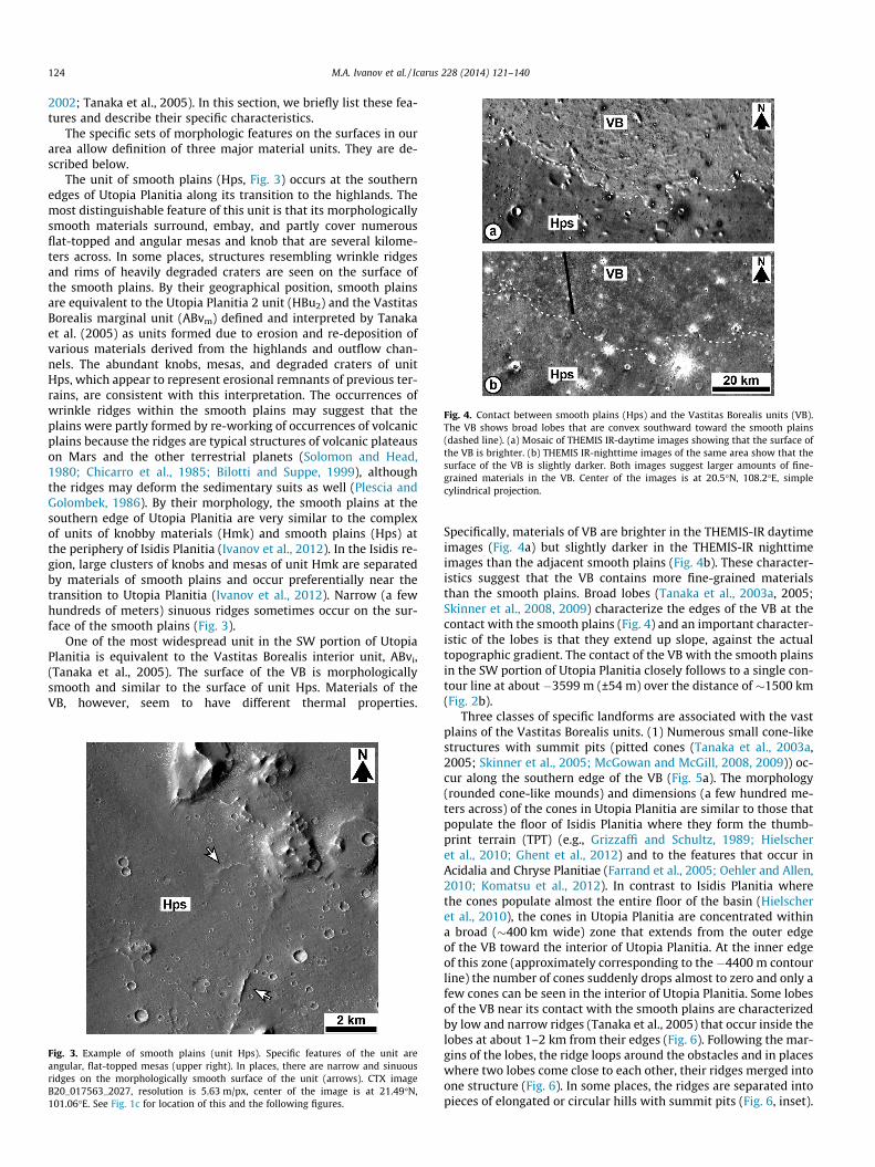
Fig. 4. Contact between smooth plains (Hps) and the Vastitas Borealis units (VB).The VB shows broad lobes that are convex southward toward the smooth plains(dashed line). (a) Mosaic of THEMIS IR-daytime images showing that the surface ofthe VB is brighter. (b) THEMIS IR-nighttime images of the same area show that thesurface of the VB is slightly darker. Both images suggest larger amounts of fine-grained materials in the VB. Center of the images is at 20.5�N, 108.2�E, simplecylindrical projection.
124 M.A. Ivanov et al. / Icarus 228 (2014) 121–140
2002; Tanaka et al., 2005). In this section, we briefly list these fea-tures and describe their specific characteristics.
The specific sets of morphologic features on the surfaces in ourarea allow definition of three major material units. They are de-scribed below.
The unit of smooth plains (Hps, Fig. 3) occurs at the southernedges of Utopia Planitia along its transition to the highlands. Themost distinguishable feature of this unit is that its morphologicallysmooth materials surround, embay, and partly cover numerousflat-topped and angular mesas and knob that are several kilome-ters across. In some places, structures resembling wrinkle ridgesand rims of heavily degraded craters are seen on the surface ofthe smooth plains. By their geographical position, smooth plainsare equivalent to the Utopia Planitia 2 unit (HBu2) and the VastitasBorealis marginal unit (ABvm) defined and interpreted by Tanakaet al. (2005) as units formed due to erosion and re-deposition ofvarious materials derived from the highlands and outflow chan-nels. The abundant knobs, mesas, and degraded craters of unitHps, which appear to represent erosional remnants of previous ter-rains, are consistent with this interpretation. The occurrences ofwrinkle ridges within the smooth plains may suggest that theplains were partly formed by re-working of occurrences of volcanicplains because the ridges are typical structures of volcanic plateauson Mars and the other terrestrial planets (Solomon and Head,1980; Chicarro et al., 1985; Bilotti and Suppe, 1999), althoughthe ridges may deform the sedimentary suits as well (Plescia andGolombek, 1986). By their morphology, the smooth plains at thesouthern edge of Utopia Planitia are very similar to the complexof units of knobby materials (Hmk) and smooth plains (Hps) atthe periphery of Isidis Planitia (Ivanov et al., 2012). In the Isidis re-gion, large clusters of knobs and mesas of unit Hmk are separatedby materials of smooth plains and occur preferentially near thetransition to Utopia Planitia (Ivanov et al., 2012). Narrow (a fewhundreds of meters) sinuous ridges sometimes occur on the sur-face of the smooth plains (Fig. 3).
One of the most widespread unit in the SW portion of UtopiaPlanitia is equivalent to the Vastitas Borealis interior unit, ABvi,(Tanaka et al., 2005). The surface of the VB is morphologicallysmooth and similar to the surface of unit Hps. Materials of theVB, however, seem to have different thermal properties.
Fig. 3. Example of smooth plains (unit Hps). Specific features of the unit areangular, flat-topped mesas (upper right). In places, there are narrow and sinuousridges on the morphologically smooth surface of the unit (arrows). CTX imageB20_017563_2027, resolution is 5.63 m/px, center of the image is at 21.49�N,101.06�E. See Fig. 1c for location of this and the following figures.
Specifically, materials of VB are brighter in the THEMIS-IR daytimeimages (Fig. 4a) but slightly darker in the THEMIS-IR nighttimeimages than the adjacent smooth plains (Fig. 4b). These character-istics suggest that the VB contains more fine-grained materialsthan the smooth plains. Broad lobes (Tanaka et al., 2003a, 2005;Skinner et al., 2008, 2009) characterize the edges of the VB at thecontact with the smooth plains (Fig. 4) and an important character-istic of the lobes is that they extend up slope, against the actualtopographic gradient. The contact of the VB with the smooth plainsin the SW portion of Utopia Planitia closely follows to a single con-tour line at about �3599 m (±54 m) over the distance of �1500 km(Fig. 2b).
Three classes of specific landforms are associated with the vastplains of the Vastitas Borealis units. (1) Numerous small cone-likestructures with summit pits (pitted cones (Tanaka et al., 2003a,2005; Skinner et al., 2005; McGowan and McGill, 2008, 2009)) oc-cur along the southern edge of the VB (Fig. 5a). The morphology(rounded cone-like mounds) and dimensions (a few hundred me-ters across) of the cones in Utopia Planitia are similar to those thatpopulate the floor of Isidis Planitia where they form the thumb-print terrain (TPT) (e.g., Grizzaffi and Schultz, 1989; Hielscheret al., 2010; Ghent et al., 2012) and to the features that occur inAcidalia and Chryse Planitiae (Farrand et al., 2005; Oehler and Allen,2010; Komatsu et al., 2012). In contrast to Isidis Planitia wherethe cones populate almost the entire floor of the basin (Hielscheret al., 2010), the cones in Utopia Planitia are concentrated withina broad (�400 km wide) zone that extends from the outer edgeof the VB toward the interior of Utopia Planitia. At the inner edgeof this zone (approximately corresponding to the �4400 m contourline) the number of cones suddenly drops almost to zero and only afew cones can be seen in the interior of Utopia Planitia. Some lobesof the VB near its contact with the smooth plains are characterizedby low and narrow ridges (Tanaka et al., 2005) that occur inside thelobes at about 1–2 km from their edges (Fig. 6). Following the mar-gins of the lobes, the ridge loops around the obstacles and in placeswhere two lobes come close to each other, their ridges merged intoone structure (Fig. 6). In some places, the ridges are separated intopieces of elongated or circular hills with summit pits (Fig. 6, inset).
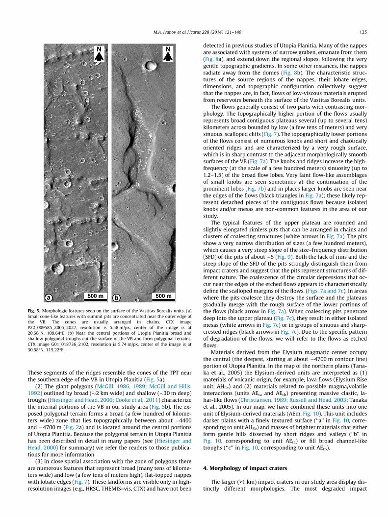
Fig. 5. Morphologic features seen on the surface of the Vastitas Borealis units. (a)Small cone-like features with summit pits are concentrated near the outer edge ofthe VB. The cones are usually arranged in chains. CTX imageP22_009585_2005_2027, resolution is 5.58 m/px, center of the image is at20.56�N, 109.64�E. (b) Near the central portions of Utopia Planitia broad andshallow polygonal troughs cut the surface of the VB and form polygonal terrains.CTX image G01_018736_2102, resolution is 5.74 m/px, center of the image is at30.58�N, 115.22�E.
M.A. Ivanov et al. / Icarus 228 (2014) 121–140 125
These segments of the ridges resemble the cones of the TPT nearthe southern edge of the VB in Utopia Planitia (Fig. 5a).
(2) The giant polygons (McGill, 1986, 1989; McGill and Hills,1992) outlined by broad (�2 km wide) and shallow (�30 m deep)troughs (Hiesinger and Head, 2000; Cooke et al., 2011) characterizethe internal portions of the VB in our study area (Fig. 5b). The ex-posed polygonal terrain forms a broad (a few hundred of kilome-ters wide) zone that lies topographically between about �4400and �4700 m (Fig. 2a) and is located around the central portionsof Utopia Planitia. Because the polygonal terrain in Utopia Planitiahas been described in detail in many papers (see (Hiesinger andHead, 2000) for summary) we refer the readers to those publica-tions for more information.
(3) In close spatial association with the zone of polygons thereare numerous features that represent broad (many tens of kilome-ters wide) and low (a few tens of meters high), flat-topped nappeswith lobate edges (Fig. 7). These landforms are visible only in high-resolution images (e.g., HRSC, THEMIS–vis, CTX) and have not been
detected in previous studies of Utopia Planitia. Many of the nappesare associated with systems of narrow graben, emanate from them(Fig. 8a), and extend down the regional slopes, following the verygentle topographic gradients. In some other instances, the nappesradiate away from the domes (Fig. 8b). The characteristic struc-tures of the source regions of the nappes, their lobate edges,dimensions, and topographic configuration collectively suggestthat the nappes are, in fact, flows of low-viscous materials eruptedfrom reservoirs beneath the surface of the Vastitas Borealis units.
The flows generally consist of two parts with contrasting mor-phology. The topographically higher portion of the flows usuallyrepresents broad contiguous plateaus several (up to several tens)kilometers across bounded by low (a few tens of meters) and verysinuous, scalloped cliffs (Fig. 7). The topographically lower portionsof the flows consist of numerous knobs and short and chaoticallyoriented ridges and are characterized by a very rough surface,which is in sharp contrast to the adjacent morphologically smoothsurfaces of the VB (Fig. 7a). The knobs and ridges increase the high-frequency (at the scale of a few hundred meters) sinuosity (up to1.2–1.5) of the broad flow lobes. Very faint flow-like assemblagesof small knobs are seen sometimes at the continuation of theprominent lobes (Fig. 7b) and in places larger knobs are seen nearthe edges of the flows (black triangles in Fig. 7a); these likely rep-resent detached pieces of the contiguous flows because isolatedknobs and/or mesas are non-common features in the area of ourstudy.
The typical features of the upper plateau are rounded andslightly elongated rimless pits that can be arranged in chains andclusters of coalescing structures (white arrows in Fig. 7a). The pitsshow a very narrow distribution of sizes (a few hundred meters),which causes a very steep slope of the size–frequency distribution(SFD) of the pits of about �5 (Fig. 9). Both the lack of rims and thesteep slope of the SFD of the pits strongly distinguish them fromimpact craters and suggest that the pits represent structures of dif-ferent nature. The coalescence of the circular depressions that oc-cur near the edges of the etched flows appears to characteristicallydefine the scalloped margins of the flows. (Figs. 7a and 7c). In areaswhere the pits coalesce they destroy the surface and the plateausgradually merge with the rough surface of the lower portions ofthe flows (black arrow in Fig. 7a). When coalescing pits penetratedeep into the upper plateau (Fig. 7c), they result in either isolatedmesas (white arrows in Fig. 7c) or in groups of sinuous and sharp-crested ridges (black arrows in Fig. 7c). Due to the specific patternof degradation of the flows, we will refer to the flows as etchedflows.
Materials derived from the Elysium magmatic center occupythe central (the deepest, starting at about �4700 m contour line)portion of Utopia Planitia. In the map of the northern plains (Tana-ka et al., 2005) the Elysium-derived units are interpreted as (1)materials of volcanic origin, for example, lava flows (Elysium Riseunit, AHEe) and (2) materials related to possible magma/volatileinteractions (units AEta and AEtb) presenting massive clastic, la-har-like flows (Christiansen, 1989; Russell and Head, 2003; Tanakaet al., 2005). In our map, we have combined these units into oneunit of Elysium-derived materials (AEm, Fig. 10). This unit includesdarker plains with a finely textured surface (‘‘a’’ in Fig. 10, corre-sponding to unit AHEe) and masses of brighter materials that eitherform gentle hills dissected by short ridges and valleys (‘‘b’’ inFig. 10, corresponding to unit AEta) or fill broad channel-liketroughs (‘‘c’’ in Fig. 10, corresponding to unit AEtb).
4. Morphology of impact craters
The larger (>1 km) impact craters in our study area display dis-tinctly different morphologies. The most degraded impact
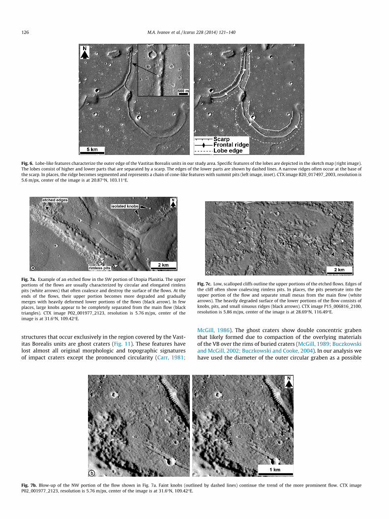
Fig. 6. Lobe-like features characterize the outer edge of the Vastitas Borealis units in our study area. Specific features of the lobes are depicted in the sketch map (right image).The lobes consist of higher and lower parts that are separated by a scarp. The edges of the lower parts are shown by dashed lines. A narrow ridges often occur at the base ofthe scarp. In places, the ridge becomes segmented and represents a chain of cone-like features with summit pits (left image, inset). CTX image B20_017497_2003, resolution is5.6 m/px, center of the image is at 20.87�N, 103.11�E.
Fig. 7a. Example of an etched flow in the SW portion of Utopia Planitia. The upperportions of the flows are usually characterized by circular and elongated rimlesspits (white arrows) that often coalesce and destroy the surface of the flows. At theends of the flows, their upper portion becomes more degraded and graduallymerges with heavily deformed lower portions of the flows (black arrow). In fewplaces, large knobs appear to be completely separated from the main flow (blacktriangles). CTX image P02_001977_2123, resolution is 5.76 m/px, center of theimage is at 31.6�N, 109.42�E.
Fig. 7c. Low, scalloped cliffs outline the upper portions of the etched flows. Edges ofthe cliff often show coalescing rimless pits. In places, the pits penetrate into theupper portion of the flow and separate small mesas from the main flow (whitearrows). The heavily degraded surface of the lower portions of the flow consists ofknobs, pits, and small sinuous ridges (black arrows). CTX image P15_006816_2100,resolution is 5.86 m/px, center of the image is at 28.69�N, 116.49�E.
126 M.A. Ivanov et al. / Icarus 228 (2014) 121–140
structures that occur exclusively in the region covered by the Vast-itas Borealis units are ghost craters (Fig. 11). These features havelost almost all original morphologic and topographic signaturesof impact craters except the pronounced circularity (Carr, 1981;
Fig. 7b. Blow-up of the NW portion of the flow shown in Fig. 7a. Faint knobs (outlinP02_001977_2123, resolution is 5.76 m/px, center of the image is at 31.6�N, 109.42�E.
McGill, 1986). The ghost craters show double concentric grabenthat likely formed due to compaction of the overlying materialsof the VB over the rims of buried craters (McGill, 1989; Buczkowskiand McGill, 2002; Buczkowski and Cooke, 2004). In our analysis wehave used the diameter of the outer circular graben as a possible
ed by dashed lines) continue the trend of the more prominent flow. CTX image
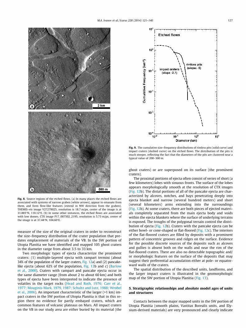
Fig. 8. Source regions of the etched flows. (a) In many places the etched flows areassociated with systems of narrow graben (white arrows), appear to emanate fromthem, and form flow-like features (extend in NW direction from the graben).THEMIS–vis image V27279025, resolution is 18.7 m/px, center of the image is at31.885�N, 110.12�E. (b) In some other instances, the etched flows are associatedwith low domes. CTX image P17_007502_2195, resolution is 5.73 m/px, center ofthe image is at 37.44�N, 104.60�E.
Fig. 9. The cumulative size–frequency distributions of rimless pits (solid curve) andimpact craters (dashed curve) on the etched flows. The distribution of the pits ismuch steeper, reflecting the fact that the diameters of the pits are clustered near atypical value of 200–300 m.
M.A. Ivanov et al. / Icarus 228 (2014) 121–140 127
measure of the size of the original craters in order to reconstructthe size–frequency distribution of the crater population that pre-dates emplacement of materials of the VB. In the SW portion ofUtopia Planitia we have identified and mapped 105 ghost cratersin the diameter range from about 3.5 to 33 km.
Two morphologic types of ejecta characterize the prominentcraters: (1) multiple-layered ejecta with rampart termini (about34% of the population of the larger craters, Fig. 12a) and (2) pancake-like ejecta (about 62% of the population, Fig. 12b and c) (Barlowet al., 2000). Craters with rampart and pancake ejecta occur inthe same diameter range (from about 2 to about 60 km) and bothtypes of ejecta have been interpreted to indicate the presence ofvolatiles in the target rocks (Head and Roth, 1976; Carr et al.,1977; Mouginis-Mark, 1979, 1987; Schultz and Lutz, 1988; Wrobelet al., 2006). An important characteristic of the larger (>1 km) im-pact craters in the SW portion of Utopia Planitia is that in this re-gion there no evidence for partly embayed craters, which arecommon features of volcanic plateaus on Mars. All impact craterson the VB in our study area are either buried by its material (the
ghost craters) or are superposed on its surface (the prominentcraters).
The proximal portions of ejecta often consist of series of short (afew kilometers) lobes with sinuous fronts. The surface of the lobesappears morphologically smooth at the resolution of CTX images(Fig. 12b). The distal portions of all of the pancake ejecta are char-acterized by alcoves, notches, and bays penetrating deeply intoejecta blanket and narrow (several hundred meters) and short(several kilometers) arms extending into the surroundings(Fig. 12b). At some craters, there are both pieces of ejected materi-als completely separated from the main ejecta body and voidswithin the ejecta blankets where the surface of underlying terrainsis exposed. The troughs of the polygonal terrain control the distri-bution of ejecta (Fig. 12b). Craters with the pancake ejecta can beeither bowl- or cone-shaped or flat-floored (Fig. 12c). The interiorsof the flat-floored craters are filled by deposits with a prominentpattern of concentric grooves and ridges on the surface. Evidencefor the possible discrete sources of the deposits such as alcovesand gullies is absent both on the walls and near the rim of theflat-floored craters. There are also no detectable topographic and/or morphologic features on the surface of the deposits that maysuggest their preferential accumulation either at pole- or equator-ward walls of the craters.
The spatial distribution of the described units, landforms, andthe larger impact craters is illustrated in the geomorphologicmap of the SW portion of Utopia Planitia (Fig. 13).
5. Stratigraphic relationships and absolute model ages of unitsand structures
Contacts between the major mapped units in the SW portion ofUtopia Planitia (smooth plains, Vastitas Borealis units, and Ely-sium-derived materials) are very pronounced and clearly indicate
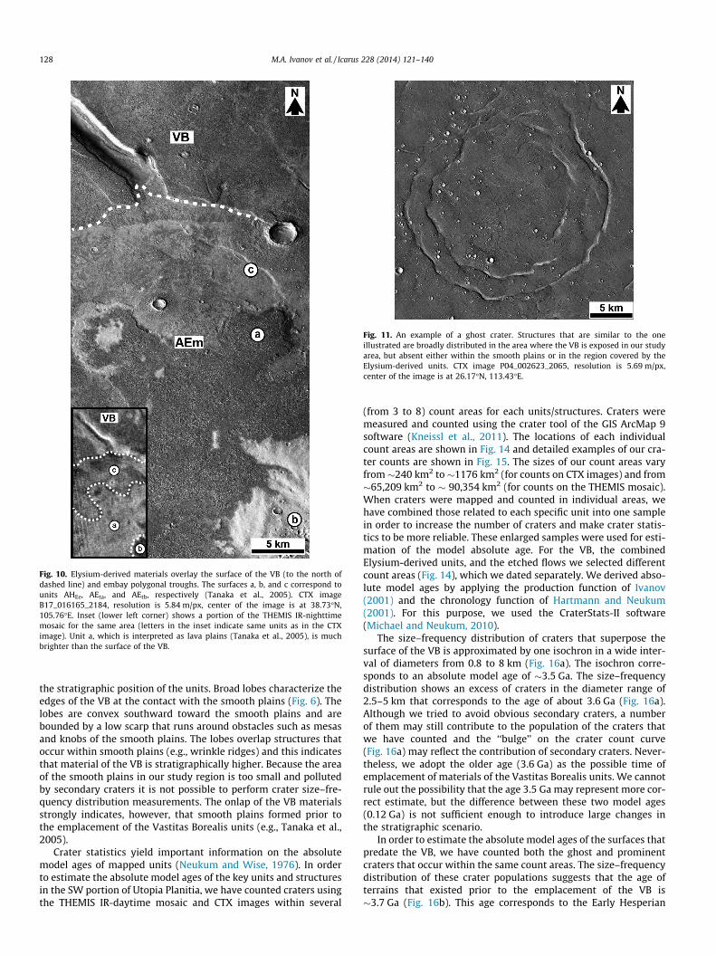
Fig. 10. Elysium-derived materials overlay the surface of the VB (to the north ofdashed line) and embay polygonal troughs. The surfaces a, b, and c correspond tounits AHEe, AEta, and AEtb, respectively (Tanaka et al., 2005). CTX imageB17_016165_2184, resolution is 5.84 m/px, center of the image is at 38.73�N,105.76�E. Inset (lower left corner) shows a portion of the THEMIS IR-nighttimemosaic for the same area (letters in the inset indicate same units as in the CTXimage). Unit a, which is interpreted as lava plains (Tanaka et al., 2005), is muchbrighter than the surface of the VB.
Fig. 11. An example of a ghost crater. Structures that are similar to the oneillustrated are broadly distributed in the area where the VB is exposed in our studyarea, but absent either within the smooth plains or in the region covered by theElysium-derived units. CTX image P04_002623_2065, resolution is 5.69 m/px,center of the image is at 26.17�N, 113.43�E.
128 M.A. Ivanov et al. / Icarus 228 (2014) 121–140
the stratigraphic position of the units. Broad lobes characterize theedges of the VB at the contact with the smooth plains (Fig. 6). Thelobes are convex southward toward the smooth plains and arebounded by a low scarp that runs around obstacles such as mesasand knobs of the smooth plains. The lobes overlap structures thatoccur within smooth plains (e.g., wrinkle ridges) and this indicatesthat material of the VB is stratigraphically higher. Because the areaof the smooth plains in our study region is too small and pollutedby secondary craters it is not possible to perform crater size–fre-quency distribution measurements. The onlap of the VB materialsstrongly indicates, however, that smooth plains formed prior tothe emplacement of the Vastitas Borealis units (e.g., Tanaka et al.,2005).
Crater statistics yield important information on the absolutemodel ages of mapped units (Neukum and Wise, 1976). In orderto estimate the absolute model ages of the key units and structuresin the SW portion of Utopia Planitia, we have counted craters usingthe THEMIS IR-daytime mosaic and CTX images within several
(from 3 to 8) count areas for each units/structures. Craters weremeasured and counted using the crater tool of the GIS ArcMap 9software (Kneissl et al., 2011). The locations of each individualcount areas are shown in Fig. 14 and detailed examples of our cra-ter counts are shown in Fig. 15. The sizes of our count areas varyfrom�240 km2 to �1176 km2 (for counts on CTX images) and from�65,209 km2 to � 90,354 km2 (for counts on the THEMIS mosaic).When craters were mapped and counted in individual areas, wehave combined those related to each specific unit into one samplein order to increase the number of craters and make crater statis-tics to be more reliable. These enlarged samples were used for esti-mation of the model absolute age. For the VB, the combinedElysium-derived units, and the etched flows we selected differentcount areas (Fig. 14), which we dated separately. We derived abso-lute model ages by applying the production function of Ivanov(2001) and the chronology function of Hartmann and Neukum(2001). For this purpose, we used the CraterStats-II software(Michael and Neukum, 2010).
The size–frequency distribution of craters that superpose thesurface of the VB is approximated by one isochron in a wide inter-val of diameters from 0.8 to 8 km (Fig. 16a). The isochron corre-sponds to an absolute model age of �3.5 Ga. The size–frequencydistribution shows an excess of craters in the diameter range of2.5–5 km that corresponds to the age of about 3.6 Ga (Fig. 16a).Although we tried to avoid obvious secondary craters, a numberof them may still contribute to the population of the craters thatwe have counted and the ‘‘bulge’’ on the crater count curve(Fig. 16a) may reflect the contribution of secondary craters. Never-theless, we adopt the older age (3.6 Ga) as the possible time ofemplacement of materials of the Vastitas Borealis units. We cannotrule out the possibility that the age 3.5 Ga may represent more cor-rect estimate, but the difference between these two model ages(0.12 Ga) is not sufficient enough to introduce large changes inthe stratigraphic scenario.
In order to estimate the absolute model ages of the surfaces thatpredate the VB, we have counted both the ghost and prominentcraters that occur within the same count areas. The size–frequencydistribution of these crater populations suggests that the age ofterrains that existed prior to the emplacement of the VB is�3.7 Ga (Fig. 16b). This age corresponds to the Early Hesperian
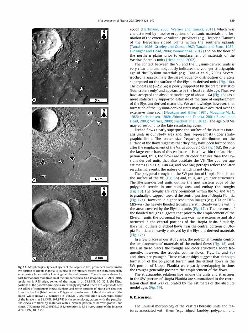
Fig. 12. Morphological types of ejecta of the larger (>1 km) prominent craters in theSW portion of Utopia Planitia. (a) Ejecta of the rampart craters are characterized bysuperposing lobes with a low ridge at the end (arrows). There is no evidence forpost-formational modification of the rampart ejecta. CTX image B21_017919_2015,resolution is 5.58 m/px, center of the image is at 23.38�N, 101.32�E. (b) Distalportions of the pancake-like ejecta are strongly degraded. There are large voids nearthe edges of contiguous ejecta blankets and some portions of ejecta are detachedfrom the blanket (black arrows). Polygonal troughs control the distribution of theejecta (white arrows). CTX image B18_016521_2109, resolution is 5.76 m/px, centerof the image is at 31.43�N, 107.97�E. (c) In some places, craters with the pancake-like ejecta are filled by materials with a circular pattern of narrow grooves andridges. CTX image B01_010139_2183, resolution is 5.94 m/px, center of the image isat 38.01�N, 103.12�E.
M.A. Ivanov et al. / Icarus 228 (2014) 121–140 129
epoch (Hartmann, 2005; Werner and Tanaka, 2011), which wascharacterized by massive eruptions of volcanic materials and for-mation of the extensive volcanic provinces (e.g., Hesperia Planum)of the Hesperian ridged plains within the southern uplands(Tanaka, 1986; Greeley and Guest, 1987; Tanaka and Scott, 1987;Hiesinger and Head, 2004; Ivanov et al., 2012) and on the floor ofthe northern plains prior to emplacement of materials of theVastitas Borealis units (Head et al., 2002).
The contact between the VB and the Elysium-derived units isvery clear and unambiguously indicates the younger stratigraphicage of the Elysium materials (e.g., Tanaka et al., 2005). Severalisochrons approximate the size–frequency distribution of craterssuperposed on the surface of the Elysium-derived units (Fig. 16c).The oldest age (�2.2 Ga) is poorly supported by the crater statistics(four craters only) and appears to be the least reliable age. Thus, wehave accepted the absolute model age of about 1 Ga (Fig. 16c) as amore statistically supported estimate of the time of emplacementof the Elysium-derived materials. We acknowledge, however, thatformation of the Elysium-derived units may have occurred over anextensive time span (Neukum and Hiller, 1981; Mouginis-Mark,1985; Christiansen, 1989; Skinner and Tanaka, 2001; Russell andHead, 2003; Werner, 2009; Pasckert et al., 2012). The age 578 Mamay correspond to the late resurfacing event.
Etched flows clearly superpose the surface of the Vastitas Bore-alis units in our study area and, thus, represent its upper strati-graphic limit. The crater size–frequency distribution on thesurface of the flows suggests that they may have been formed soonafter the emplacement of the VB, at about 3.5 Ga (Fig. 16d). Despitethe large error bars of this estimate, it is still within the late Hes-perian and, thus, the flows are much older features than the Ely-sium derived units that also postdate the VB. The younger ageestimates (2.97 Ga, 1.48 Ga, and 552 Ma) perhaps reflect the laterresurfacing events, the nature of which is not clear.
The polygonal troughs in the SW portion of Utopia Planitia cutthe surface of the VB (Fig. 5b) and, thus, are younger structures.The Elysium-derived units outline the northeastern edge of thepolygonal terrain in our study area and embay the troughs(Fig. 10). The troughs are very prominent within the VB and seemto gradually disappear toward the central portion of Utopia Planitia(Fig. 17a). However, in higher resolution images (e.g., CTX or THE-MIS–vis) the heavily flooded troughs are still clearly visible withinthe areas covered by the Elysium units (Fig. 17b). The presence ofthe flooded troughs suggests that prior to the emplacement of theElysium units the polygonal terrain was more extensive and alsooccurred in the central portions of the Utopia basin. Similarly,the small outliers of etched flows near the central portions of Uto-pia Planitia are heavily embayed by the Elysium-derived materials(Fig. 17c).
In a few places in our study area, the polygonal troughs controlthe emplacement of materials of the etched flows (Fig. 18) and,thus, in these places the troughs are older structures. More fre-quently, however, the troughs cut the flows (Figs. 7a, and 8a)and, thus, are younger. These relationships suggest that althoughformation of the polygonal terrain and the etched flows in theSW portion of Utopia Planitia were partly overlapping in time,the troughs generally postdate the emplacement of the flows.
The stratigraphic relationships among the units and structuresin the SW portion of Utopia Planitia are summarized in the corre-lation chart that was calibrated by the estimates of the absolutemodel ages (Fig. 19).
6. Discussion
The unusual morphology of the Vastitas Borealis units and fea-tures associated with them (e.g., ridged, knobby, polygonal, and
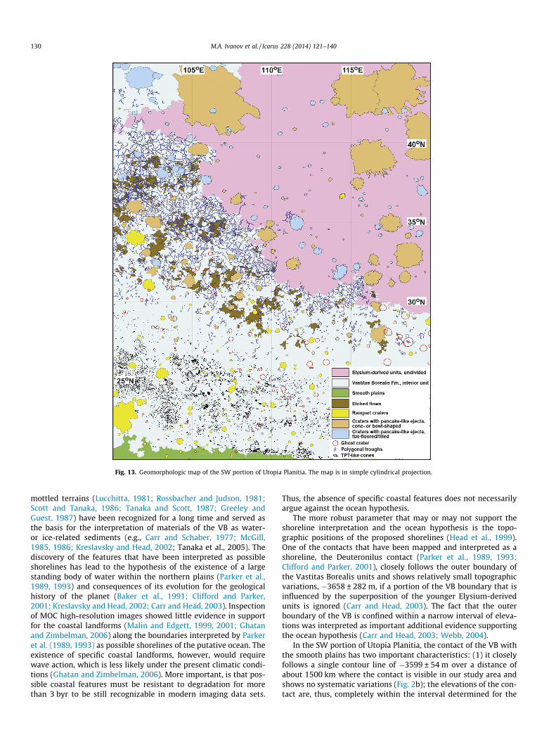
Fig. 13. Geomorphologic map of the SW portion of Utopia Planitia. The map is in simple cylindrical projection.
130 M.A. Ivanov et al. / Icarus 228 (2014) 121–140
mottled terrains (Lucchitta, 1981; Rossbacher and Judson, 1981;Scott and Tanaka, 1986; Tanaka and Scott, 1987; Greeley andGuest, 1987) have been recognized for a long time and served asthe basis for the interpretation of materials of the VB as water-or ice-related sediments (e.g., Carr and Schaber, 1977; McGill,1985, 1986; Kreslavsky and Head, 2002; Tanaka et al., 2005). Thediscovery of the features that have been interpreted as possibleshorelines has lead to the hypothesis of the existence of a largestanding body of water within the northern plains (Parker et al.,1989, 1993) and consequences of its evolution for the geologicalhistory of the planet (Baker et al., 1991; Clifford and Parker,2001; Kreslavsky and Head, 2002; Carr and Head, 2003). Inspectionof MOC high-resolution images showed little evidence in supportfor the coastal landforms (Malin and Edgett, 1999, 2001; Ghatanand Zimbelman, 2006) along the boundaries interpreted by Parkeret al. (1989, 1993) as possible shorelines of the putative ocean. Theexistence of specific coastal landforms, however, would requirewave action, which is less likely under the present climatic condi-tions (Ghatan and Zimbelman, 2006). More important, is that pos-sible coastal features must be resistant to degradation for morethan 3 byr to be still recognizable in modern imaging data sets.
Thus, the absence of specific coastal features does not necessarilyargue against the ocean hypothesis.
The more robust parameter that may or may not support theshoreline interpretation and the ocean hypothesis is the topo-graphic positions of the proposed shorelines (Head et al., 1999).One of the contacts that have been mapped and interpreted as ashoreline, the Deuteronilus contact (Parker et al., 1989, 1993;Clifford and Parker, 2001), closely follows the outer boundary ofthe Vastitas Borealis units and shows relatively small topographicvariations, �3658 ± 282 m, if a portion of the VB boundary that isinfluenced by the superposition of the younger Elysium-derivedunits is ignored (Carr and Head, 2003). The fact that the outerboundary of the VB is confined within a narrow interval of eleva-tions was interpreted as important additional evidence supportingthe ocean hypothesis (Carr and Head, 2003; Webb, 2004).
In the SW portion of Utopia Planitia, the contact of the VB withthe smooth plains has two important characteristics: (1) it closelyfollows a single contour line of �3599 ± 54 m over a distance ofabout 1500 km where the contact is visible in our study area andshows no systematic variations (Fig. 2b); the elevations of the con-tact are, thus, completely within the interval determined for the
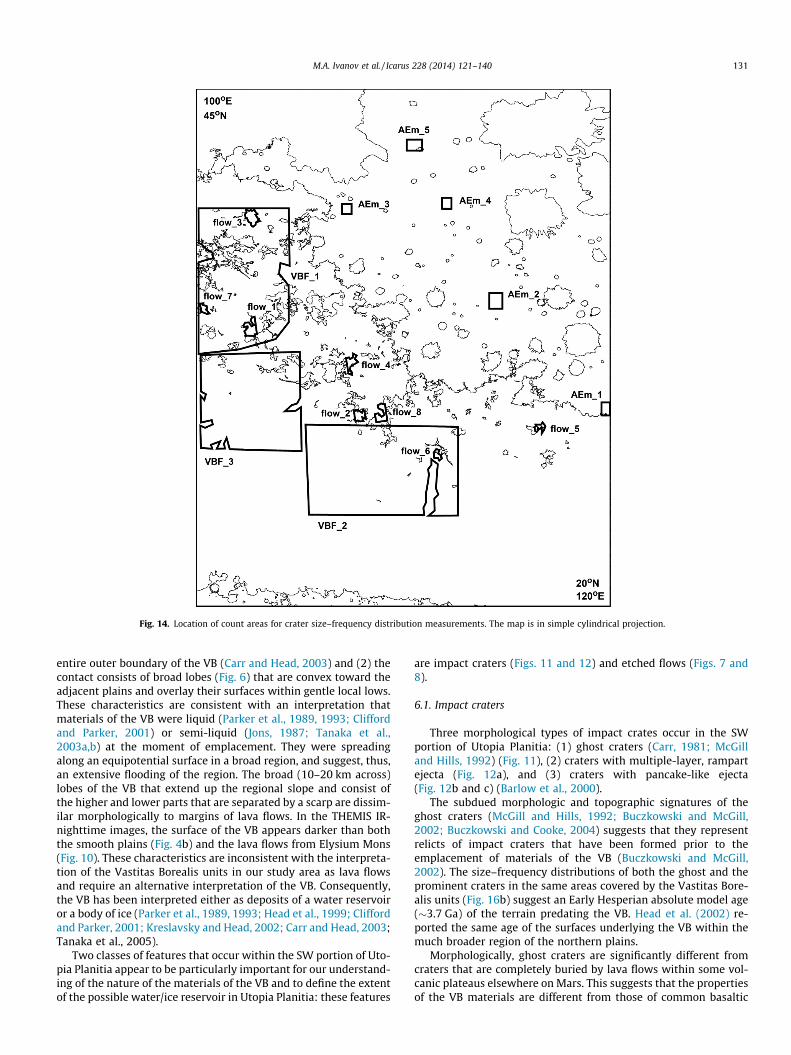
Fig. 14. Location of count areas for crater size–frequency distribution measurements. The map is in simple cylindrical projection.
M.A. Ivanov et al. / Icarus 228 (2014) 121–140 131
entire outer boundary of the VB (Carr and Head, 2003) and (2) thecontact consists of broad lobes (Fig. 6) that are convex toward theadjacent plains and overlay their surfaces within gentle local lows.These characteristics are consistent with an interpretation thatmaterials of the VB were liquid (Parker et al., 1989, 1993; Cliffordand Parker, 2001) or semi-liquid (Jons, 1987; Tanaka et al.,2003a,b) at the moment of emplacement. They were spreadingalong an equipotential surface in a broad region, and suggest, thus,an extensive flooding of the region. The broad (10–20 km across)lobes of the VB that extend up the regional slope and consist ofthe higher and lower parts that are separated by a scarp are dissim-ilar morphologically to margins of lava flows. In the THEMIS IR-nighttime images, the surface of the VB appears darker than boththe smooth plains (Fig. 4b) and the lava flows from Elysium Mons(Fig. 10). These characteristics are inconsistent with the interpreta-tion of the Vastitas Borealis units in our study area as lava flowsand require an alternative interpretation of the VB. Consequently,the VB has been interpreted either as deposits of a water reservoiror a body of ice (Parker et al., 1989, 1993; Head et al., 1999; Cliffordand Parker, 2001; Kreslavsky and Head, 2002; Carr and Head, 2003;Tanaka et al., 2005).
Two classes of features that occur within the SW portion of Uto-pia Planitia appear to be particularly important for our understand-ing of the nature of the materials of the VB and to define the extentof the possible water/ice reservoir in Utopia Planitia: these features
are impact craters (Figs. 11 and 12) and etched flows (Figs. 7 and8).
6.1. Impact craters
Three morphological types of impact crates occur in the SWportion of Utopia Planitia: (1) ghost craters (Carr, 1981; McGilland Hills, 1992) (Fig. 11), (2) craters with multiple-layer, rampartejecta (Fig. 12a), and (3) craters with pancake-like ejecta(Fig. 12b and c) (Barlow et al., 2000).
The subdued morphologic and topographic signatures of theghost craters (McGill and Hills, 1992; Buczkowski and McGill,2002; Buczkowski and Cooke, 2004) suggests that they representrelicts of impact craters that have been formed prior to theemplacement of materials of the VB (Buczkowski and McGill,2002). The size–frequency distributions of both the ghost and theprominent craters in the same areas covered by the Vastitas Bore-alis units (Fig. 16b) suggest an Early Hesperian absolute model age(�3.7 Ga) of the terrain predating the VB. Head et al. (2002) re-ported the same age of the surfaces underlying the VB within themuch broader region of the northern plains.
Morphologically, ghost craters are significantly different fromcraters that are completely buried by lava flows within some vol-canic plateaus elsewhere on Mars. This suggests that the propertiesof the VB materials are different from those of common basaltic
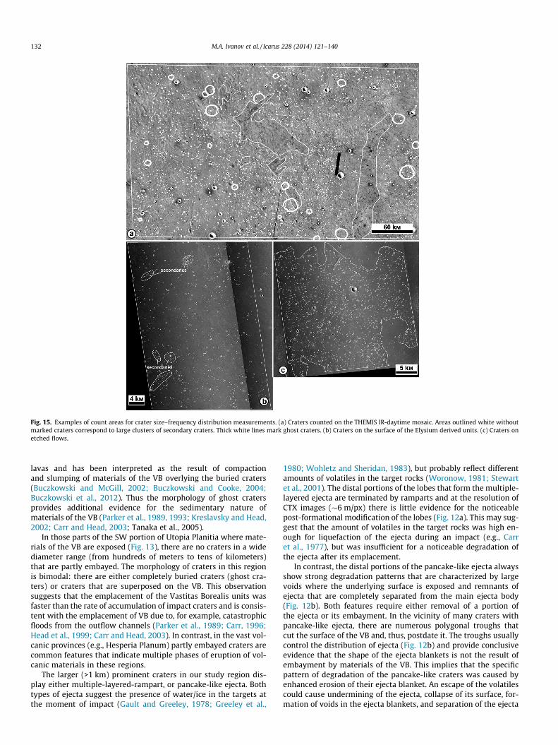
Fig. 15. Examples of count areas for crater size–frequency distribution measurements. (a) Craters counted on the THEMIS IR-daytime mosaic. Areas outlined white withoutmarked craters correspond to large clusters of secondary craters. Thick white lines mark ghost craters. (b) Craters on the surface of the Elysium derived units. (c) Craters onetched flows.
132 M.A. Ivanov et al. / Icarus 228 (2014) 121–140
lavas and has been interpreted as the result of compactionand slumping of materials of the VB overlying the buried craters(Buczkowski and McGill, 2002; Buczkowski and Cooke, 2004;Buczkowski et al., 2012). Thus the morphology of ghost cratersprovides additional evidence for the sedimentary nature ofmaterials of the VB (Parker et al., 1989, 1993; Kreslavsky and Head,2002; Carr and Head, 2003; Tanaka et al., 2005).
In those parts of the SW portion of Utopia Planitia where mate-rials of the VB are exposed (Fig. 13), there are no craters in a widediameter range (from hundreds of meters to tens of kilometers)that are partly embayed. The morphology of craters in this regionis bimodal: there are either completely buried craters (ghost cra-ters) or craters that are superposed on the VB. This observationsuggests that the emplacement of the Vastitas Borealis units wasfaster than the rate of accumulation of impact craters and is consis-tent with the emplacement of VB due to, for example, catastrophicfloods from the outflow channels (Parker et al., 1989; Carr, 1996;Head et al., 1999; Carr and Head, 2003). In contrast, in the vast vol-canic provinces (e.g., Hesperia Planum) partly embayed craters arecommon features that indicate multiple phases of eruption of vol-canic materials in these regions.
The larger (>1 km) prominent craters in our study region dis-play either multiple-layered-rampart, or pancake-like ejecta. Bothtypes of ejecta suggest the presence of water/ice in the targets atthe moment of impact (Gault and Greeley, 1978; Greeley et al.,
1980; Wohletz and Sheridan, 1983), but probably reflect differentamounts of volatiles in the target rocks (Woronow, 1981; Stewartet al., 2001). The distal portions of the lobes that form the multiple-layered ejecta are terminated by ramparts and at the resolution ofCTX images (�6 m/px) there is little evidence for the noticeablepost-formational modification of the lobes (Fig. 12a). This may sug-gest that the amount of volatiles in the target rocks was high en-ough for liquefaction of the ejecta during an impact (e.g., Carret al., 1977), but was insufficient for a noticeable degradation ofthe ejecta after its emplacement.
In contrast, the distal portions of the pancake-like ejecta alwaysshow strong degradation patterns that are characterized by largevoids where the underlying surface is exposed and remnants ofejecta that are completely separated from the main ejecta body(Fig. 12b). Both features require either removal of a portion ofthe ejecta or its embayment. In the vicinity of many craters withpancake-like ejecta, there are numerous polygonal troughs thatcut the surface of the VB and, thus, postdate it. The troughs usuallycontrol the distribution of ejecta (Fig. 12b) and provide conclusiveevidence that the shape of the ejecta blankets is not the result ofembayment by materials of the VB. This implies that the specificpattern of degradation of the pancake-like craters was caused byenhanced erosion of their ejecta blanket. An escape of the volatilescould cause undermining of the ejecta, collapse of its surface, for-mation of voids in the ejecta blankets, and separation of the ejecta
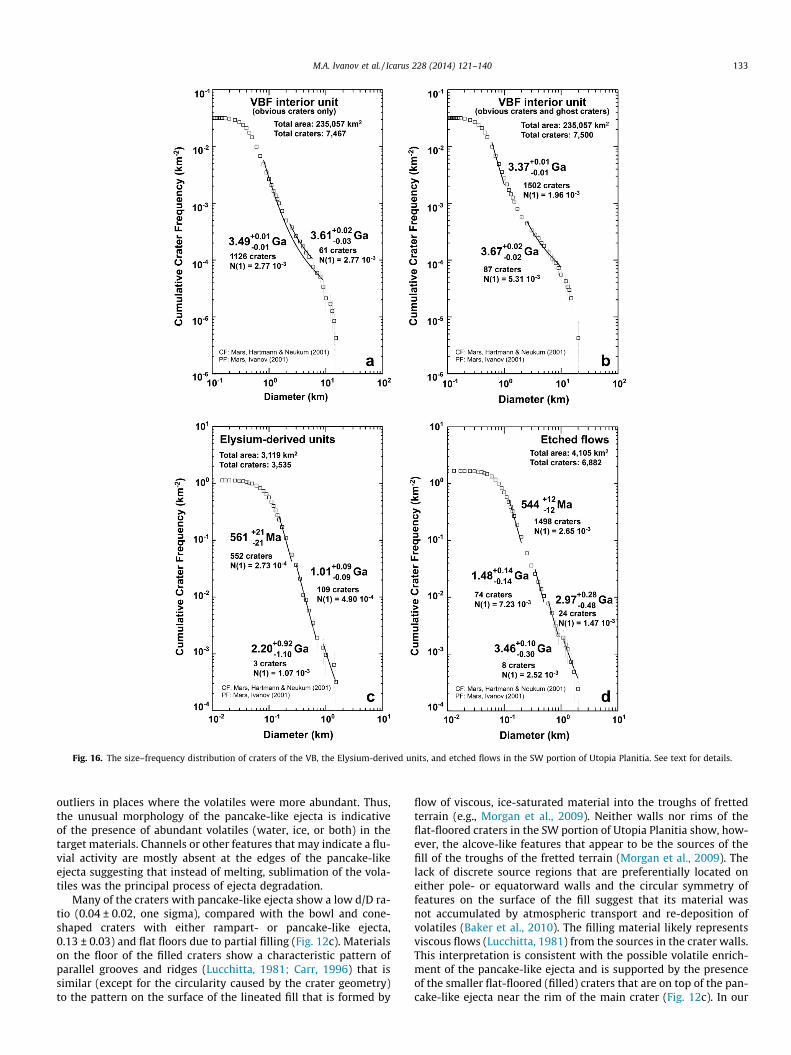
Fig. 16. The size–frequency distribution of craters of the VB, the Elysium-derived units, and etched flows in the SW portion of Utopia Planitia. See text for details.
M.A. Ivanov et al. / Icarus 228 (2014) 121–140 133
outliers in places where the volatiles were more abundant. Thus,the unusual morphology of the pancake-like ejecta is indicativeof the presence of abundant volatiles (water, ice, or both) in thetarget materials. Channels or other features that may indicate a flu-vial activity are mostly absent at the edges of the pancake-likeejecta suggesting that instead of melting, sublimation of the vola-tiles was the principal process of ejecta degradation.
Many of the craters with pancake-like ejecta show a low d/D ra-tio (0.04 ± 0.02, one sigma), compared with the bowl and cone-shaped craters with either rampart- or pancake-like ejecta,0.13 ± 0.03) and flat floors due to partial filling (Fig. 12c). Materialson the floor of the filled craters show a characteristic pattern ofparallel grooves and ridges (Lucchitta, 1981; Carr, 1996) that issimilar (except for the circularity caused by the crater geometry)to the pattern on the surface of the lineated fill that is formed by
flow of viscous, ice-saturated material into the troughs of frettedterrain (e.g., Morgan et al., 2009). Neither walls nor rims of theflat-floored craters in the SW portion of Utopia Planitia show, how-ever, the alcove-like features that appear to be the sources of thefill of the troughs of the fretted terrain (Morgan et al., 2009). Thelack of discrete source regions that are preferentially located oneither pole- or equatorward walls and the circular symmetry offeatures on the surface of the fill suggest that its material wasnot accumulated by atmospheric transport and re-deposition ofvolatiles (Baker et al., 2010). The filling material likely representsviscous flows (Lucchitta, 1981) from the sources in the crater walls.This interpretation is consistent with the possible volatile enrich-ment of the pancake-like ejecta and is supported by the presenceof the smaller flat-floored (filled) craters that are on top of the pan-cake-like ejecta near the rim of the main crater (Fig. 12c). In our
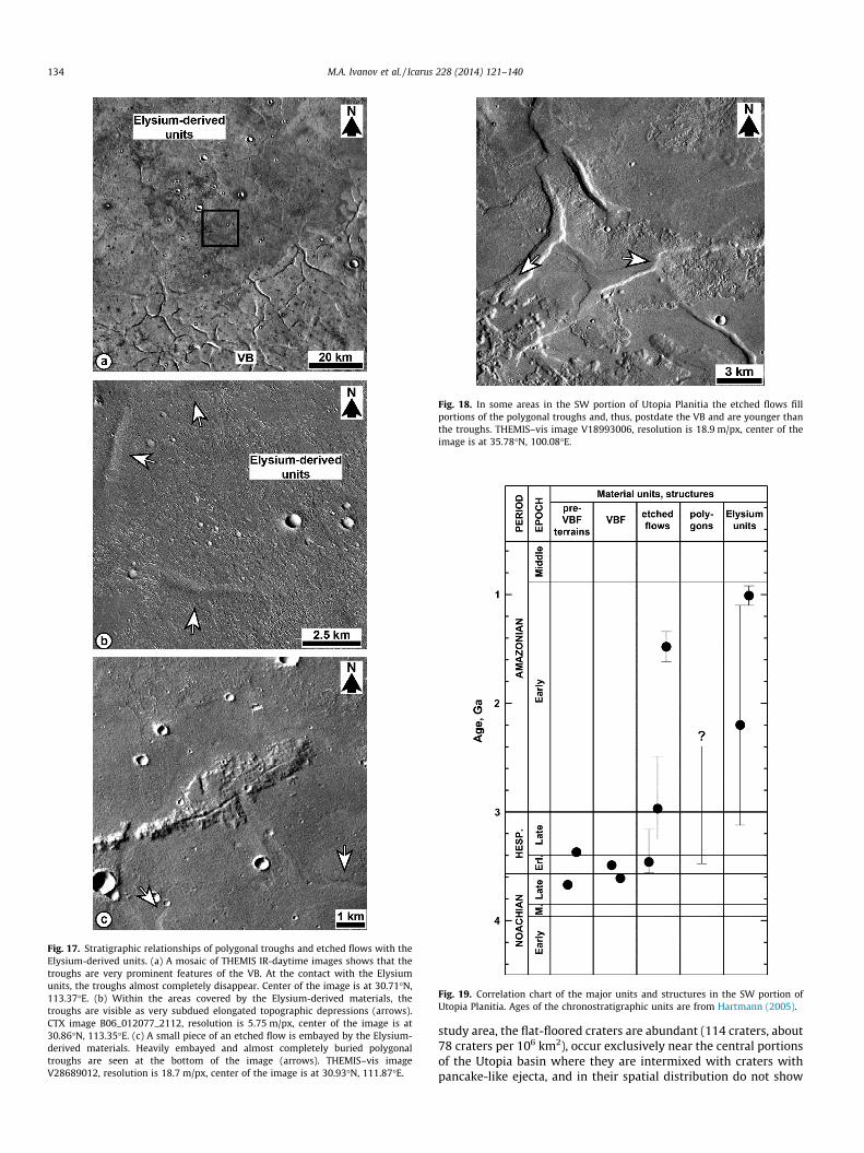
Fig. 17. Stratigraphic relationships of polygonal troughs and etched flows with theElysium-derived units. (a) A mosaic of THEMIS IR-daytime images shows that thetroughs are very prominent features of the VB. At the contact with the Elysiumunits, the troughs almost completely disappear. Center of the image is at 30.71�N,113.37�E. (b) Within the areas covered by the Elysium-derived materials, thetroughs are visible as very subdued elongated topographic depressions (arrows).CTX image B06_012077_2112, resolution is 5.75 m/px, center of the image is at30.86�N, 113.35�E. (c) A small piece of an etched flow is embayed by the Elysium-derived materials. Heavily embayed and almost completely buried polygonaltroughs are seen at the bottom of the image (arrows). THEMIS–vis imageV28689012, resolution is 18.7 m/px, center of the image is at 30.93�N, 111.87�E.
Fig. 18. In some areas in the SW portion of Utopia Planitia the etched flows fillportions of the polygonal troughs and, thus, postdate the VB and are younger thanthe troughs. THEMIS–vis image V18993006, resolution is 18.9 m/px, center of theimage is at 35.78�N, 100.08�E.
Fig. 19. Correlation chart of the major units and structures in the SW portion ofUtopia Planitia. Ages of the chronostratigraphic units are from Hartmann (2005).
134 M.A. Ivanov et al. / Icarus 228 (2014) 121–140
study area, the flat-floored craters are abundant (114 craters, about78 craters per 106 km2), occur exclusively near the central portionsof the Utopia basin where they are intermixed with craters withpancake-like ejecta, and in their spatial distribution do not show
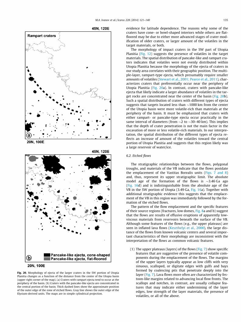
Fig. 20. Morphology of ejecta of the larger craters in the SW portion of UtopiaPlanitia changes as a function of the distance from the center of the Utopia basin(upper right corner of the map). (a) Craters with rampart ejecta tend to occur at theperiphery of the basin. (b) Craters with the pancake-like ejecta are concentrated inthe central portion of the basin. Thick dashed lines show the approximate positionof the outer edge of the zone of etched flows. Gray line shows the outer edge of theElysium-derived units. The maps are in simple cylindrical projection.
M.A. Ivanov et al. / Icarus 228 (2014) 121–140 135
evidence for latitude dependence. The reasons why some of thecraters have cone- or bowl-shaped interiors while others are flat-floored may be due to either more advanced stages of crater mod-ification of older craters, or larger amount of the volatiles in thetarget materials, or both.
The morphology of impact craters in the SW part of UtopiaPlanitia (Fig. 12) suggests the presence of volatiles in the targetmaterials. The spatial distribution of pancake-like and rampart cra-ters indicates that volatiles were not evenly distributed withinUtopia Planitia because the morphology of the ejecta of craters inour study area correlates with their geographic position. The multi-ple-layer, rampart-type ejecta, which presumably require smalleramounts of volatiles (Stewart et al., 2001; Pearce et al., 2011), char-acterizes craters that preferentially occur near the periphery ofUtopia Planitia (Fig. 20a). In contrast, craters with pancake-likeejecta that likely indicate a larger abundance of volatiles in the tar-get rocks are concentrated near the center of the basin (Fig. 20b).Such a spatial distribution of craters with different types of ejectasuggests that targets located less than �1000 km from the centerof the Utopia basin were more volatile-rich than materials at theperiphery of the basin. It must be emphasized that craters witheither rampart- or pancake-type ejecta occur practically in thesame interval of diameters (from �2 to �30–40 km). This impliesthat the depth of crater penetration is not the main factor in theexcavation of more or less volatile-rich materials. In our interpre-tation, the spatial distribution of the different types of ejecta re-flects an increase of amount of the volatiles toward the centralportion of Utopia Planitia and suggests that this region likely wasa large reservoir of water/ice.
6.2. Etched flows
The stratigraphic relationships between the flows, polygonaltroughs, and materials of the VB indicate that the flows postdatethe emplacement of the Vastitas Borealis units (Figs. 7 and 8)and, thus, represent its upper stratigraphic limit. The absolutemodel age of the formation of the flows is �3.46 Ga ago(Fig. 16d) and is indistinguishable from the absolute age of theVB in the SW portion of Utopia (3.49 Ga, Fig. 16a). Together withadditional stratigraphic evidence this suggests that the emplace-ment of the VB in this region was immediately followed by the for-mation of the etched flows.
The pattern of the flow emplacement and the specific featuresof their source regions (fractures, low domes, Fig. 8a and b) suggestthat the flows are results of effusive eruptions of apparently low-viscous materials from reservoirs beneath the surface of the VB.Although some features of the flows (e.g., the upper plateaus) areseen in inflated lava flows (Keszthelyi et al., 2000), the large dis-tance of the flows from known volcanic centers and several impor-tant characteristics of their morphology are inconsistent with theinterpretation of the flows as common volcanic features.
(1) The upper plateaus (layers) of the flows (Fig. 7) show specificfeatures that are suggestive of the presence of volatile com-ponents during the emplacement of the flows. The marginsof the upper layers typically appear as low cliffs with verysinuous, scalloped, or digitate edges with gulfs and baysformed by coalescing pits that penetrate deeply into thelayer (Fig. 7). Lava flows more often are characterized by fes-toon-like margins related to advancing local flow fronts. Thescallops and notches, in contrast, are usually collapse fea-tures that may indicate either undermining of the layeredges, low strength of the layer materials, the presence ofvolatiles, or all of the above.
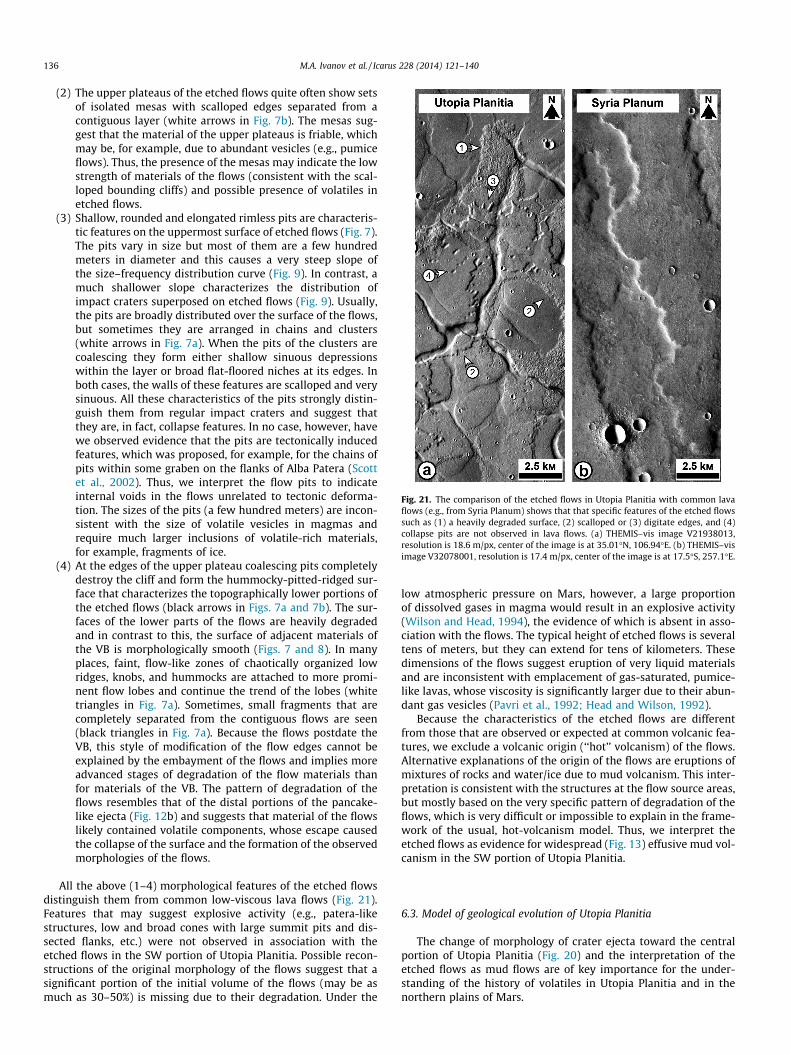
Fig. 21. The comparison of the etched flows in Utopia Planitia with common lavaflows (e.g., from Syria Planum) shows that that specific features of the etched flowssuch as (1) a heavily degraded surface, (2) scalloped or (3) digitate edges, and (4)collapse pits are not observed in lava flows. (a) THEMIS–vis image V21938013,resolution is 18.6 m/px, center of the image is at 35.01�N, 106.94�E. (b) THEMIS–visimage V32078001, resolution is 17.4 m/px, center of the image is at 17.5�S, 257.1�E.
136 M.A. Ivanov et al. / Icarus 228 (2014) 121–140
(2) The upper plateaus of the etched flows quite often show setsof isolated mesas with scalloped edges separated from acontiguous layer (white arrows in Fig. 7b). The mesas sug-gest that the material of the upper plateaus is friable, whichmay be, for example, due to abundant vesicles (e.g., pumiceflows). Thus, the presence of the mesas may indicate the lowstrength of materials of the flows (consistent with the scal-loped bounding cliffs) and possible presence of volatiles inetched flows.
(3) Shallow, rounded and elongated rimless pits are characteris-tic features on the uppermost surface of etched flows (Fig. 7).The pits vary in size but most of them are a few hundredmeters in diameter and this causes a very steep slope ofthe size–frequency distribution curve (Fig. 9). In contrast, amuch shallower slope characterizes the distribution ofimpact craters superposed on etched flows (Fig. 9). Usually,the pits are broadly distributed over the surface of the flows,but sometimes they are arranged in chains and clusters(white arrows in Fig. 7a). When the pits of the clusters arecoalescing they form either shallow sinuous depressionswithin the layer or broad flat-floored niches at its edges. Inboth cases, the walls of these features are scalloped and verysinuous. All these characteristics of the pits strongly distin-guish them from regular impact craters and suggest thatthey are, in fact, collapse features. In no case, however, havewe observed evidence that the pits are tectonically inducedfeatures, which was proposed, for example, for the chains ofpits within some graben on the flanks of Alba Patera (Scottet al., 2002). Thus, we interpret the flow pits to indicateinternal voids in the flows unrelated to tectonic deforma-tion. The sizes of the pits (a few hundred meters) are incon-sistent with the size of volatile vesicles in magmas andrequire much larger inclusions of volatile-rich materials,for example, fragments of ice.
(4) At the edges of the upper plateau coalescing pits completelydestroy the cliff and form the hummocky-pitted-ridged sur-face that characterizes the topographically lower portions ofthe etched flows (black arrows in Figs. 7a and 7b). The sur-faces of the lower parts of the flows are heavily degradedand in contrast to this, the surface of adjacent materials ofthe VB is morphologically smooth (Figs. 7 and 8). In manyplaces, faint, flow-like zones of chaotically organized lowridges, knobs, and hummocks are attached to more promi-nent flow lobes and continue the trend of the lobes (whitetriangles in Fig. 7a). Sometimes, small fragments that arecompletely separated from the contiguous flows are seen(black triangles in Fig. 7a). Because the flows postdate theVB, this style of modification of the flow edges cannot beexplained by the embayment of the flows and implies moreadvanced stages of degradation of the flow materials thanfor materials of the VB. The pattern of degradation of theflows resembles that of the distal portions of the pancake-like ejecta (Fig. 12b) and suggests that material of the flowslikely contained volatile components, whose escape causedthe collapse of the surface and the formation of the observedmorphologies of the flows.
All the above (1–4) morphological features of the etched flowsdistinguish them from common low-viscous lava flows (Fig. 21).Features that may suggest explosive activity (e.g., patera-likestructures, low and broad cones with large summit pits and dis-sected flanks, etc.) were not observed in association with theetched flows in the SW portion of Utopia Planitia. Possible recon-structions of the original morphology of the flows suggest that asignificant portion of the initial volume of the flows (may be asmuch as 30–50%) is missing due to their degradation. Under the
low atmospheric pressure on Mars, however, a large proportionof dissolved gases in magma would result in an explosive activity(Wilson and Head, 1994), the evidence of which is absent in asso-ciation with the flows. The typical height of etched flows is severaltens of meters, but they can extend for tens of kilometers. Thesedimensions of the flows suggest eruption of very liquid materialsand are inconsistent with emplacement of gas-saturated, pumice-like lavas, whose viscosity is significantly larger due to their abun-dant gas vesicles (Pavri et al., 1992; Head and Wilson, 1992).
Because the characteristics of the etched flows are differentfrom those that are observed or expected at common volcanic fea-tures, we exclude a volcanic origin (‘‘hot’’ volcanism) of the flows.Alternative explanations of the origin of the flows are eruptions ofmixtures of rocks and water/ice due to mud volcanism. This inter-pretation is consistent with the structures at the flow source areas,but mostly based on the very specific pattern of degradation of theflows, which is very difficult or impossible to explain in the frame-work of the usual, hot-volcanism model. Thus, we interpret theetched flows as evidence for widespread (Fig. 13) effusive mud vol-canism in the SW portion of Utopia Planitia.
6.3. Model of geological evolution of Utopia Planitia
The change of morphology of crater ejecta toward the centralportion of Utopia Planitia (Fig. 20) and the interpretation of theetched flows as mud flows are of key importance for the under-standing of the history of volatiles in Utopia Planitia and in thenorthern plains of Mars.
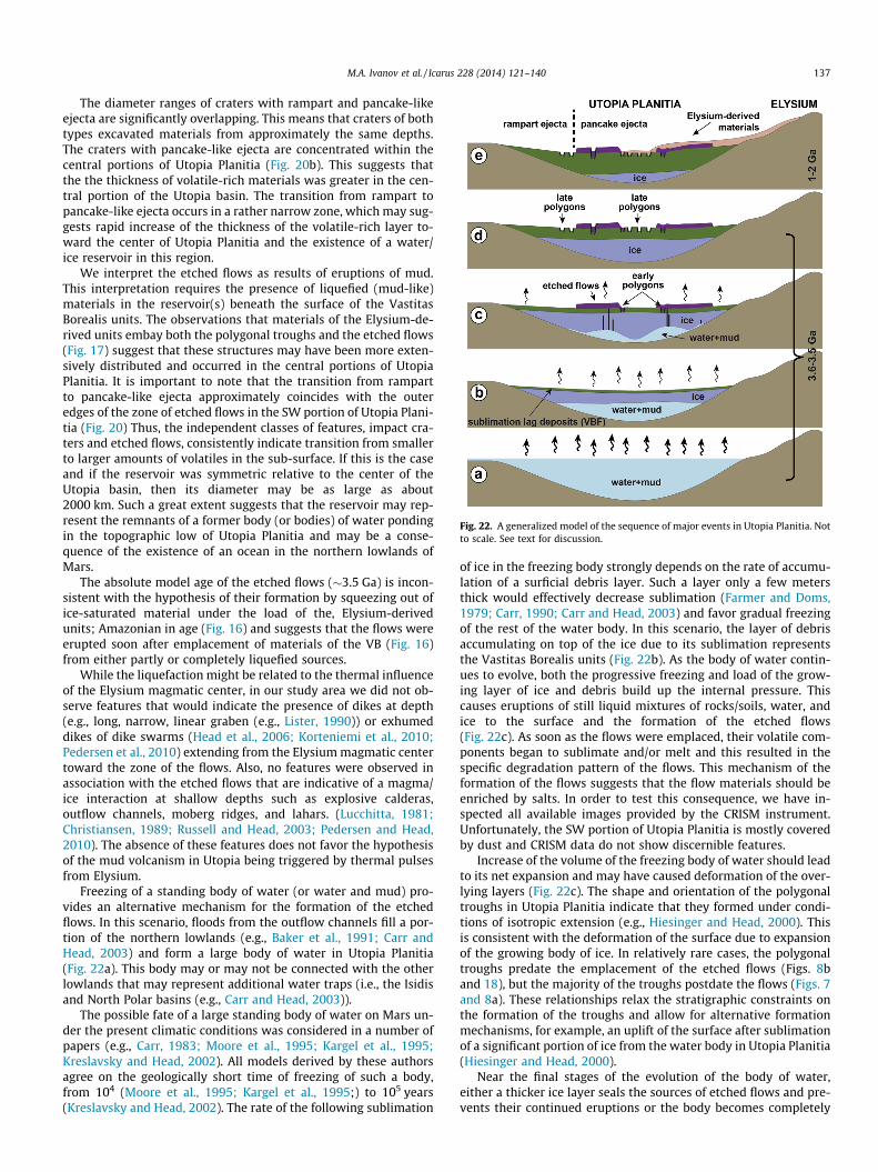
Fig. 22. A generalized model of the sequence of major events in Utopia Planitia. Notto scale. See text for discussion.
M.A. Ivanov et al. / Icarus 228 (2014) 121–140 137
The diameter ranges of craters with rampart and pancake-likeejecta are significantly overlapping. This means that craters of bothtypes excavated materials from approximately the same depths.The craters with pancake-like ejecta are concentrated within thecentral portions of Utopia Planitia (Fig. 20b). This suggests thatthe the thickness of volatile-rich materials was greater in the cen-tral portion of the Utopia basin. The transition from rampart topancake-like ejecta occurs in a rather narrow zone, which may sug-gests rapid increase of the thickness of the volatile-rich layer to-ward the center of Utopia Planitia and the existence of a water/ice reservoir in this region.
We interpret the etched flows as results of eruptions of mud.This interpretation requires the presence of liquefied (mud-like)materials in the reservoir(s) beneath the surface of the VastitasBorealis units. The observations that materials of the Elysium-de-rived units embay both the polygonal troughs and the etched flows(Fig. 17) suggest that these structures may have been more exten-sively distributed and occurred in the central portions of UtopiaPlanitia. It is important to note that the transition from rampartto pancake-like ejecta approximately coincides with the outeredges of the zone of etched flows in the SW portion of Utopia Plani-tia (Fig. 20) Thus, the independent classes of features, impact cra-ters and etched flows, consistently indicate transition from smallerto larger amounts of volatiles in the sub-surface. If this is the caseand if the reservoir was symmetric relative to the center of theUtopia basin, then its diameter may be as large as about2000 km. Such a great extent suggests that the reservoir may rep-resent the remnants of a former body (or bodies) of water pondingin the topographic low of Utopia Planitia and may be a conse-quence of the existence of an ocean in the northern lowlands ofMars.
The absolute model age of the etched flows (�3.5 Ga) is incon-sistent with the hypothesis of their formation by squeezing out ofice-saturated material under the load of the, Elysium-derivedunits; Amazonian in age (Fig. 16) and suggests that the flows wereerupted soon after emplacement of materials of the VB (Fig. 16)from either partly or completely liquefied sources.
While the liquefaction might be related to the thermal influenceof the Elysium magmatic center, in our study area we did not ob-serve features that would indicate the presence of dikes at depth(e.g., long, narrow, linear graben (e.g., Lister, 1990)) or exhumeddikes of dike swarms (Head et al., 2006; Korteniemi et al., 2010;Pedersen et al., 2010) extending from the Elysium magmatic centertoward the zone of the flows. Also, no features were observed inassociation with the etched flows that are indicative of a magma/ice interaction at shallow depths such as explosive calderas,outflow channels, moberg ridges, and lahars. (Lucchitta, 1981;Christiansen, 1989; Russell and Head, 2003; Pedersen and Head,2010). The absence of these features does not favor the hypothesisof the mud volcanism in Utopia being triggered by thermal pulsesfrom Elysium.
Freezing of a standing body of water (or water and mud) pro-vides an alternative mechanism for the formation of the etchedflows. In this scenario, floods from the outflow channels fill a por-tion of the northern lowlands (e.g., Baker et al., 1991; Carr andHead, 2003) and form a large body of water in Utopia Planitia(Fig. 22a). This body may or may not be connected with the otherlowlands that may represent additional water traps (i.e., the Isidisand North Polar basins (e.g., Carr and Head, 2003)).
The possible fate of a large standing body of water on Mars un-der the present climatic conditions was considered in a number ofpapers (e.g., Carr, 1983; Moore et al., 1995; Kargel et al., 1995;Kreslavsky and Head, 2002). All models derived by these authorsagree on the geologically short time of freezing of such a body,from 104 (Moore et al., 1995; Kargel et al., 1995;) to 105 years(Kreslavsky and Head, 2002). The rate of the following sublimation
of ice in the freezing body strongly depends on the rate of accumu-lation of a surficial debris layer. Such a layer only a few metersthick would effectively decrease sublimation (Farmer and Doms,1979; Carr, 1990; Carr and Head, 2003) and favor gradual freezingof the rest of the water body. In this scenario, the layer of debrisaccumulating on top of the ice due to its sublimation representsthe Vastitas Borealis units (Fig. 22b). As the body of water contin-ues to evolve, both the progressive freezing and load of the grow-ing layer of ice and debris build up the internal pressure. Thiscauses eruptions of still liquid mixtures of rocks/soils, water, andice to the surface and the formation of the etched flows(Fig. 22c). As soon as the flows were emplaced, their volatile com-ponents began to sublimate and/or melt and this resulted in thespecific degradation pattern of the flows. This mechanism of theformation of the flows suggests that the flow materials should beenriched by salts. In order to test this consequence, we have in-spected all available images provided by the CRISM instrument.Unfortunately, the SW portion of Utopia Planitia is mostly coveredby dust and CRISM data do not show discernible features.
Increase of the volume of the freezing body of water should leadto its net expansion and may have caused deformation of the over-lying layers (Fig. 22c). The shape and orientation of the polygonaltroughs in Utopia Planitia indicate that they formed under condi-tions of isotropic extension (e.g., Hiesinger and Head, 2000). Thisis consistent with the deformation of the surface due to expansionof the growing body of ice. In relatively rare cases, the polygonaltroughs predate the emplacement of the etched flows (Figs. 8band 18), but the majority of the troughs postdate the flows (Figs. 7and 8a). These relationships relax the stratigraphic constraints onthe formation of the troughs and allow for alternative formationmechanisms, for example, an uplift of the surface after sublimationof a significant portion of ice from the water body in Utopia Planitia(Hiesinger and Head, 2000).
Near the final stages of the evolution of the body of water,either a thicker ice layer seals the sources of etched flows and pre-vents their continued eruptions or the body becomes completely
138 M.A. Ivanov et al. / Icarus 228 (2014) 121–140
frozen (Fig. 22d). The net volume of the system, however, shouldincrease with freezing, and this creates favorable conditions forexpansion of the overlying surface and progressive formation ofthe majority of polygonal troughs (Fig. 22d) after the emplacementof the etched flows.
In the central portion of Utopia Planitia, the Elysium-derivedunits of the Amazonian age (Fig. 22e) have buried both the mudflows and the giant polygons (Fig. 17) and in of our study arealeft these features exposed along the edges of the deepest por-tions of the former water reservoir (Fig. 22e). This part of thereservoir may have retained greater amounts of volatiles, whichis reflected by the formation of craters with pancake-like ejecta(Fig. 20). Closer to the periphery of the basin where the originalbody of water was shallower, a significant portion of the vola-tiles could have been lost due to sublimation and this is mani-fested by rampart ejecta (Fig. 20).
7. Summary and conclusions
Results of our study of the SW portion of Utopia Planitia can besummarized as follows.
(1) The size–frequency distributions (SFD) of both ghost andprominent craters within the SW portion of Utopia Planitiasuggest that the absolute model ages of terrain predatingthe emplacement of the VB are about 3.7 Ga, which corre-sponds to the time of formation of vast volcanic plains inthe Early Hesperian (e.g., Tanaka, 1986).
(2) In the SW portion of Utopia Planitia there are no craters thatare partly embayed by materials of the VB. This implies thatthe emplacement of the Vastitas Borealis units was fasterthan the accumulation rate of impact craters and is consis-tent with the geologically short time of emplacement ofthe VB related to, for example, large floods from the outflowchannels (Parker et al., 1989, 1993; Head et al., 1999; Carrand Head, 2003; Tanaka et al., 2005).
(3) The SFD of prominent craters yields an absolute model age ofthe VB of �3.6–3.5 Ga. The ages of the etched flows thatoverlay the VB are �3.5 Ga. These absolute model ages sug-gest the geologically rapid emplacement of the VB, which isconsistent with the absence of partly embayed craters.
(4) The majority of the larger (>1 km) impact craters showejecta morphologies (rampart and pancake-like ejecta) thatare indicative of the presence of ice/water in the targetmaterials. The distal portions of the pancake-like ejecta areheavily degraded, however, their embayment by materialsof the VB as the cause of the degradation can be excludedbecause the craters postdate the VB. This means that thetarget properties were the main reason of the enhanceddegradation of the ejecta. We interpret the unusualmorphology of the distal portions of the pancake-like ejectaas evidence for a higher abundance of volatiles (ice and/orwater) in the target materials. Craters with rampart ejectado not show recognizable signs of the post-formationaldegradation. This suggests that the amount of volatiles inthe target materials was insufficient to cause noticeableejecta modification.
(5) Although the diameter ranges of the craters with either ram-part- or pancake-like ejecta are overlapping, the areal distri-butions of the craters appear mutually exclusive. Craterswith pancake-like ejecta are concentrated within the central,deepest, portion of the Utopia basin (less than about1000 km from the basin center) and rampart craters occurat the periphery of the basin. This spatial distribution of cra-ter types suggests that the materials within the center ofUtopia Planitia contained more ice/water.
(6) Etched flows around the central portion of Utopia Planitiawere erupted from beneath the surface of the VB. Their mor-phology and pattern of degradation, however, are inconsis-tent with lava and, instead, indicate a formation of theflows due to mud volcanism. Thus, etched flows provideadditional and important evidence for the existence of alarge body of water in the central portion of Utopia Planitia.
(7) Etched flows are spatially associated with giant polygonsand there is evidence that these features populated the cen-ter portion of Utopia Planitia before they were covered bythe Elysium-derived units. The outer (southern) edge ofthe zone of polygonal troughs and etched flows approxi-mately corresponds to the transition from pancake-likeejecta to rampart ejecta. This suggest that the outer edgeof the zone of the polygons and etched flows may indicatean edge of the deeper portions of a large body (�2000 kmacross) of water/ice that likely existed in the center of UtopiaPlanitia in the late Hesperian.
(8) The elevation of the outer edge of the zone of polygons/etched flows is very close to the height of the barrierbetween the Utopia basin and the North Polar basin, whichoccurs at �4350 m (Carr and Head, 2003). In Acidalia Plani-tia, which is the southern portion of the North Polar basin,the same set of morphologic features such as giant polygons(Lucchitta, 1981), craters with pancake-like ejecta, and smallcones interpreted as evidence of mud volcanism (Oehler andAllen, 2010; Komatsu et al., 2012) are abundant and occur atabout the same elevations as in Utopia Planitia. However,the presence of the etched flows in this region has not beenreported yet. This can be readily explained by the fact thatthe high-resolution/high-quality images that are necessaryfor detection of the etched flows were not available until rel-atively recently. In our future study, we plan to conduct asystematic search of the potential mudflows in the regionof Acidalia Planitia. The presence of the flows will imply thatthe complete set of features that may be indicative of thepresence of a large standing body of water/mud in UtopiaPlanitia is repeated in Acidalia Planitia and, thus, bothregions may have evolved in similar geological environment.In contrast, if the flows are absent in Acidalia Planitia, itwould suggest that the geologic histories of these regionswere probably different, which is poorly consistent withthe hypothesis of a single reservoir of water/mud that hasexisted within the northern lowlands in the geological pastof Mars.
Acknowledgments
The work was supported by Deutsche Forschungsgemeinschaft(DFG) Grant, HI 1410/7-1 and RFBR (Russian Foundation for BasicResearch) Grant 12-05-00383 (to M.A.I.). We deeply appreciatethe comprehensive and constructive reviews provided by Jim Skin-ner and an anonymous reviewer that significantly helped to im-prove the original manuscript.
References
Baker, V.R., Strom, R.G., Gulick, V.C., Kargel, J.S., Komatsu, G., Kale, V.S., 1991.Ancient oceans, ice sheets and the hydrological cycle on Mars. Nature 352, 589–594.
Baker, D.M.H., Head, J.W., Marchant, D.R., 2010. Flow patterns of lobate debrisaprons and lineated valley fill north of Ismeniae Fossae, Mars: Evidence forextensive mid-latitude glaciation in the Late Amazonian. Icarus 207, 186–209.
Barlow, N.G., Boyce, J.M., Costard, F.M., et al., 2000. Standardizing the nomenclatureof martian impact crater ejecta morphologies. J. Geophys. Res. 105, 26733–26738.
M.A. Ivanov et al. / Icarus 228 (2014) 121–140 139
Bilotti, F., Suppe, J., 1999. The global distribution of wrinkle ridges on Venus. Icarus139, 137–157.
Buczkowski, D.L., Cooke, M.L., 2004. Formation of double-ring circular grabens dueto volumetric compaction over buried impact craters: Implications for thicknessand nature of cover material in Utopia Planitia, Mars. J. Geophys. Res. 109,E02006. http://dx.doi.org/10.1029/2003JE002144.
Buczkowski, D.L., McGill, G.E., 2002. Topography within circular grabens:Implications for polygon origin, Utopia Planitia, Mars. Geophys. Res. Lett. 29,1155. http://dx.doi.org/10.1029/2001GL014100.
Buczkowski, D.L., Seelos, K.D., Cooke, M.L., 2012. Giant polygons and circular grabenin western Utopia basin, Mars: Exploring possible formation mechanisms. J.Geophys. Res. 117, E08010. http://dx.doi.org/10.1029/2011JE003934.
Carr, M.H., 1979. Formation of martian flood features by release of water fromconfined aquifers. J. Geophys. Res. 84, 2995–3007.
Carr, M.H., 1981. The Surface of Mars. Yale Uni. Press, New Haven, p. 232.Carr, M.H., 1983. Stability of streams and lakes on Mars. Icarus 56, 476–495.Carr, M.H., 1990. D/H on Mars: Effects of floods, volcanism, impacts, and polar
processes. Icarus 87, 210–227.Carr, M.H., 1996. Water on Mars. Oxford University Press, New York, p. 229.Carr, M.H., Head, J.W., 2003. Oceans on Mars: An assessment of the observational
evidence and possible fate. J. Geophys. Res. 108, 5042. http://dx.doi.org/10.1029/2002JE001963.
Carr, M.H., Schaber, G., 1977. Martian permafrost features. J. Geophys. Res. 82,4039–4054.
Carr, M.H., Crumpler, L.S., Cutts, J.A., Greeley, R., Guest, J.E., Masursky, H., 1977.Martian impact craters and emplacement of ejecta. J. Geophys. Res. 82, 4055–4065.
Chicarro, A.F., Schultz, P.H., Masson, P., 1985. Global and regional ridge patterns onMars. Icarus 63, 153–174.
Christiansen, E.H., 1989. Lahars in the Elysium region of Mars. Geology 17, 203–206.Clifford, S.M., Parker, T.J., 2001. The evolution of the martian hydrosphere:
Implications for the fate of primordial ocean and the current state of thenorthern plains. Icarus 154, 40–79.
Cooke, M., Islam, F., McGill, G., 2011. Basement controls on the scale of giantpolygons in Utopia Planitia, Mars. J. Geophys. Res. 116, E09003. http://dx.doi.org/10.1029/2011JE003812.
Farmer, C.B., Doms, P.E., 1979. Global seasonal variation of water vapor on Mars andthe implications for permafrost. J. Geophys. Res. 84, 2881–2888.
Farrand, W.H., Gaddis, L.R., Keszthelyi, L., 2005. Pitted cones and domes on Mars:Observations in Acidalia Planitia and Cydonia Mensae using MOC, THEMIS, andTES data. J. Geophys. Res. 110, E05005. http://dx.doi.org/10.1029/2004JE002297.
Frey, H., Schultz, R.A., 1988. Large impact basins and the mega-impact origin for thecrustal dichotomy on Mars. Geophys. Res. Lett. 15, 229–232.
Frey, H.V., Roark, J.H., Shockey, K.M., Frey, E.L., Sakimoto, S.E.H., 2002. Ancientlowlands on Mars. Geophys. Res. Lett. 29. http://dx.doi.org/10.1029/2001GL013832, 22-1.
Gault, D.E., Greeley, R., 1978. Exploratory experiments of impact craters formed inviscous-liquid targets: Analogs for martian rampart craters? Icarus 34, 486–495.
Ghatan, G.J., Zimbelman, J.R., 2006. Paucity of candidate coastal constructionallandforms along proposed shorelines on Mars: Implications for a northernlowlands-filling ocean. Icarus 185, 171–196.
Ghent, R.R., Anderson, S.W., Pithawala, T.M., 2012. The formation of small cones inIsidis Planitia, Mars, through mobilization of pyroclastic surge deposits. Icarus217, 169–183.
Greeley, R., Guest, J.E., 1987. Geologic map of the eastern equatorial region of Mars,1:15,000,000 scale. US Geological Survey Geol. Inv. Ser. Map I-1802-B.
Greeley, R., Fink, J., Gault, D.E., Snyder, D.B., Schultz, P.H., 1980. Impact cratering inviscous targets: Laboratory experiments. Proc. Lunar Sci. Conf. 11, 2075–2097.
Grizzaffi, P., Schultz, P.H., 1989. Isidis Basin: Site of ancient volatile-rich debrislayer. Icarus 77, 358–381.
Hartmann, W.K., 2005. Martian cratering 8: Isochron refinement and thechronology of Mars. Icarus 174, 294–320.
Hartmann, W.K., Neukum, G., 2001. Cratering chronology and the evolution of Mars.Space Sci. Rev. 96, 165–194.
Head, J.W., Roth, R., 1976. Mars pedestal crater escarpments: Evidence for ejectarelated emplacement. In: Symposium on Planetary Cratering Mechanics: LPIContrib., 259, pp. 50–52.
Head, J.W., Wilson, L., 1992. Magma reservoirs and neutral buoyancy zones onVenus: Implications for the formation and evolution of volcanic landforms. J.Geophys. Res. 97, 3877–3903.
Head, J.W., Hiesinger, H., Ivanov, M.A., Kreslavsky, M.A., Pratt, S., Thomson, B., 1999.Possible ancient oceans on Mars: Evidence from Mars Orbiter Laser Altimeterdata. Science 286, 2134–2137.
Head, J.W., Kreslavsky, M.A., Pratt, S., 2002. Northern lowlands on mars: Evidencefor widespread volcanic flooding and tectonic deformation in Hesperian Period.J. Geophys. Res. 107, 5003. http://dx.doi.org/10.1029/2000JE001445.
Head, J.W., Wilson, L., Dickson, J., Neukum, G., 2006. The Huygens–Hellas giant dikesystem on Mars: Implications for Late Noachian–Early Hesperian volcanicresurfacing and climatic evolution. Geology 34, 285–288.
Hielscher, F.J., Hiesinger, H., Erkeling, G., Ivanov, M.A., Reiss, D., 2010. Distributionand classification of thumbprint terrain in Isidis Planitia, Mars. Lunar Planet. Sci.41 (LPI CD-ROM #2394).
Hiesinger, H., Head, J.W., 2000. Characteristics and origin of polygonal terrain insouthern Utopia Planitia, Mars: Results from Mars Orbiter Laser Altimeter andMars Orbiter Camera data. J. Geophys. Res. 105 (E5), 11999–12022.
Hiesinger, H., Head, J.W., 2004. The Syrtis Major volcanic province, Mars: Synthesisfrom Mars Global Surveyor data. J. Geophys. Res. 109, E01004. http://dx.doi.org/10.1029/2003JE002143.
Hiesinger, H., Rohkamp, D., Sturm, S., Thiessen, F, Reiss, D., 2009. ThumbprintTerrain in Isidis Planitia, Mars: Geology, Ages, Morphology. Geophys. Res. Abstr.,EGU General Assembly 11, EGU2009-781.
Ivanov, B.A., 2001. Mars/Moon cratering rate ratio estimates. Space Sci. Rev. 96, 87–104.
Ivanov, M.A., Head, J.W., 2001. Chryse Planitia, Mars: Topographic configuration,outflow channel continuity and sequence, and tests for hypothesized ancientbodies of water using Mars Orbiter Laser Altimeter (MOLA) data. J. Geophys.Res. 106, 3275–3296.
Ivanov, M.A., Hiesinger, H., Erkeling, G., Hielscher, F.J., Reiss, D., 2012. Majorepisodes of geologic history of Isidis Planitia on Mars. Icarus 218, 24–46.
Jons, H.-P., 1985. Late sedimentation and late sediments in the northern lowlandson Mars. Lunar Planet. Sci. 16, 414–415.
Jons, H.-P., 1987. Large fossil mud lakes or giant mud sheet floods in Syrtis Major(Isidis Planitia) and Mare Australe. Mars. Lunar. Planet. Sci. 18, 470–471.
Kargel, J.S. et al., 1995. Evidence of ancient continental glaciation in the martiannorthern plains. J. Geophys. Res. 100, 5351–5368.
Keszthelyi, L., McEwen, A.S., Thordarson, T., 2000. Terrestrial analogs and thermalmodels for martian flood lavas. J. Geophys. Res. 105, 15027–15049.
Kneissl, T., van Gasselt, S., Neukum, G., 2011. Map-projection-independent cratersize–frequency determination in GIS environments – New software tool forArcGIS. Planet. Space Sci. 59, 1243–1254.
Komatsu, G., Okubo, C.H., Wray, J.J., Gallagher, R., Orosei, R., Cardinale, M., Chan,M.A., Ormo, J., 2012. Small mounds in Chryse Planitia, Mars: Testing a mudvolcano hypothesis. Lunar Planet. Sci. 43 (LPI CD-ROM #1103).
Korteniemi, J. et al., 2010. Dike indicators in the Hadriaca Patera–Promethei Terraregion, Mars. Earth Planet. Sci. Lett. 294, 466–478.
Kreslavsky, M.A., Head, J.W., 2000. Kilometer-scale roughness of Mars: Results fromMOLA data analysis. J. Geophys. Res. 105, 26695–26711.
Kreslavsky, M.A., Head, J.W., 2002. Fate of outflow channel effluents in the northernlowlands of Mars: The Vastitas Borealis Formation as a sublimation residuefrom frozen ponded bodies of water. J. Geophys. Res. 107, 5121. http://dx.doi.org/10.1029/2001JE001831.
Lister, J.R., 1990. Buoyancy-driven fluid fracture: Similarity solutions for thehorizontal and vertical propagation of fluid-filled cracks. J. Fluid Mech. 217,213–239.
Lockwood, J.F., Kargel, J.S., Strom, R.B., 1992. Thumbprint terrain on the northernplains: A glacial hypothesis. Lunar Planet. Sci. 23, 795–796.
Lucchitta, B.K., 1981. Mars and Earth: Comparison of cold-climate features. Icarus45, 264–303.
Malin, M.C., Edgett, K.S., 1999. Oceans or seas in the martian northern lowlands:High resolution imaging tests of proposed coastlines. Geophys. Res. Lett. 26,3049–3052.
Malin, M.C., Edgett, K.S., 2001. Mars Global Surveyor Mars Orbiter Camera:Interplanetary cruise through primary mission. J. Geophys. Res. 106, 23249–23570.
McGill, G.E., 1985. Age and origin of large martian polygons. Lunar Planet. Sci. 16,534–535.
McGill, G.E., 1986. The giant polygons of Utopia, northern martian plains. Geophys.Res. Lett. 13, 05–708.
McGill, G.E., 1989. Buried topography of Utopia, Mars: Persistence of a giant impactdepression. J. Geophys. Res. 94, 2753–2759.
McGill, G.E., Hills, L.S., 1992. Origin of giant martian polygons. J. Geophys. Res. 97,2633–2647.
McGowan, E.M., 2011. The Utopia/Isidis overlap: Possible conduit for mudvolcanism on Mars. Icarus 212, 622–628.
McGowan, E.M., McGill, G.E., 2008. Assessing the distribution and origin of water-related features in the northern lowland of Mars: A geographic informationsystem approach. Lunar Planet. Sci. 39 (LPI CD-ROM #1034).
McGowan, E.M., McGill, G.E., 2009. Putative water-related features: CydoniaMensae and Utopia Planitia, Mars. Lunar Planet. Sci. 40 (LPI CD-ROM #1295).
Michael, G.G., Neukum, G., 2010. Planetary surface dating from crater size–frequency distribution measurements: Partial resurfacing events andstatistical age uncertainty. Earth Planet. Sci. Lett. 294, 23–229.
Moore, J.M. et al., 1995. The circum-Chryse region as possible example of ahydrologic cycle on Mars: Geologic observations and theoretical evaluation. J.Geophys. Res. 100, 5433–5447.
Morgan, G.A., Head, J.W., Marchant, D.R., 2009. Lineated valley fill (LVF) and lobatedebris aprons (LDA) in the Deuteronilus Mensae northern dichotomy boundaryregion, Mars: Constraints on the extent, age and episodicity of Amazonianglacial events. Icarus 202, 22–38.
Mouginis-Mark, P.J., 1979. Martian fluidized crater morphology: Variations withcrater size, latitude, altitude, and target material. J. Geophys. Res. 84, 8011–8022.
Mouginis-Mark, P.J., 1985. Volcano/ground ice interactions in Elysium Planitia,Mars. Icarus 64, 265–284.
Mouginis-Mark, P.J., 1987. Water or ice in the martian regolith?: Clues fromrampart craters seen at very high resolution. Icarus 71, 268–286.
140 M.A. Ivanov et al. / Icarus 228 (2014) 121–140
Neukum, G., Hiller, K., 1981. Martian ages. J. Geophys. Res. 86, 3097–3121.Neukum, G., Wise, D.U., 1976. Mars: A standard crater curve and possible new time
scale. Science 194, 1381–1387.Oehler, D.Z., Allen, C.C., 2010. Evidence for pervasive mud volcanism in Acidalia
Planitia, Mars. Icarus 208, 636–657.Parker, T.J., Saunders, R.S., Schneeberger, D.M., 1989. Transitional morphology in
West Deuteronilus Mensae, Mars: Implication for modification of the Lowland/Upland boundary. Icarus 82, 111–145.
Parker, T.J., Gorsline, D.S., Saunders, R.S., Pieri, D.C., Schneeberger, D.M., 1993.Coastal geomorphology of the martian northern plains. J. Geophys. Res. 98,11061–11078.
Pasckert, J.H., Hiesinger, H.H., Reiss, D., 2012. Rheologies and ages of lava flows onElysium Mons, Mars. Icarus 219, 443–457.
Pavri, B., Head, J.W., Klose, K.B., Wilson, L., 1992. Steep-sided domes on Venus:Characteristics, geologic settings, and eruption conditions from Magellan data. J.Geophys. Res. 97, 13445–13478.
Pearce, G., Osinski, G.R., Soare, R.J., 2011. Intra-crater glacial processes in centralUtopia Planitia, Mars. Icarus 212, 86–95.
Pedersen, G.B.M., Head, J.W., 2010. Evidence of widespread degraded Amazonian-aged ice-rich deposits in the transition between Elysium Rise and UtopiaPlanitia, Mars: Guidelines for the recognition of degraded ice-rich materials.Planet. Space Sci. 58, 1953–1970.
Pedersen, G.B.M., Head, J.W., Wilson, L., 2010. Formation, erosion and exposure ofEarly Amazonian dikes, dike swarms and possible subglacial eruptions in theElysium Rise/Utopia Basin Region, Mars. Earth Planet. Sci. Lett. 294, 424–439.
Perron, T.J., Mitrovica, X., Manga, M., Matsuyama, I., Richards, M.A., 2007. Evidencefor an ancient martian ocean in the topography of deformed shorelines. Nature447, 840–843.
Plescia, J.B., Golombek, M.P., 1986. Origin of planetary wrinkle ridges based on thestudy of terrestrial analogs. Geol. Soc. Am. Bull. 97, 1289–1299.
Rossbacher, L.A., Judson, S., 1981. Ground ice on Mars: Inventory, distribution, andresulting landforms. Icarus 45, 39–59.
Russell, P.S., Head, J.W., 2003. Elysium–Utopia flows as mega-lahars: A model ofdike intrusion, cryosphere cracking, and water-sediment release. J. Geophys.Res. 108, 5064. http://dx.doi.org/10.1029/2002JE001995.
Schultz, P.H., Lutz, A.B., 1988. Polar wandering on Mars. Icarus 73, 41–91.Scott, D.H., Carr, M.H., 1978. Geologic map of Mars, 1:25,000,000 scale. US Geol.
Surv. Misc. Geol. Invest. Map I-1083.Scott, D.H., Tanaka, K.L., 1986. Geologic map of the western equatorial region of
Mars, 1:15,000,000 scale. US Geological Survey Geol. Inv. Ser. Map I-1802-A.Scott, E.D., Wilson, L., Head, J.W., 2002. Emplacement of giant dikes in the northern
Tharsis region of Mars. J. Geophys. Res. 107. http://dx.doi.org/10.1029/2000JE001431.
Skinner, J.A., Tanaka, K.L., 2001. Regional emplacement of the Utopia and Elysiumplains deposits, Mars. Lunar Planet. Sci. 32 (LPI CD-ROM #2154).
Skinner, J.A., Tanaka, K.L., Rodriguez, J.A.P., Kargel, J., 2005. The southern Utopiahighland–lowland boundary: Basin structural controls on aquifer developmentand volatile-driven resurfacing. Lunar Planet. Sci. 34 (LPI CD-ROM #2119).
Skinner, J.A., Tanaka, K.L., Fergason, R.L., 2008. Evidence for and implication ofliquefaction in the Vastitas Borealis marginal unit in southern Utopia Planitia,Mars. Lunar Planet. Sci. 39. Abstract 2418 (LPI CD-ROM #2418).
Skinner, J.A., Fergason, R.L., Tanaka, K.L., 2009. Occurrence and origin of lobatematerials in the highland–lowland boundary of southern Utopia Planitia, Mars.Lunar Planet. Sci. 40. Abstract 2459 (LPI CD-ROM #2459).
Smith, D.E. et al., 2001. Mars Orbiter Laser Altimeter: Experiment summary afterthe first year of global mapping of Mars. J. Geophys. Res. 106, 23689–23722.
Solomon, S.C., Head, J.W., 1980. Lunar mascon basins’ lava filling, tectonics, andevolution of the lithosphere. Rev. Geophys. Space Phys. 18, 107–141.
Solomon, S.C. et al., 2005. New perspectives on ancient Mars. Science 307, 1214–1220.
Stewart, S.T., O’Keefe, J.D., Ahrens, T.J., 2001. The relationship between rampartcrater morphologies and the amount of subsurface ice. Lunar Planet. Sci. 32 (LPICD-ROM #2092).
Tanaka, K.L., 1986. The stratigraphy of Mars. J. Geophys. Res. 91, E139–E158.Tanaka, K.L., Scott, D.H., 1987. Geologic map of the polar regions of Mars,
1:15,000,000 scale. US Geological Survey Geol. Inv. Ser. Map I-1802-C.Tanaka, K.L., Skinner, J.A., Hare, T.M., 2005. Geologic map of the Northern Plains of
Mars. US Geological Survey Sci. Inv, Map, p. 2888.Tanaka, K.L., Banerdt, W.B., Kargel, J.S., Hoffman, N., 2001. Huge, CO2-charged
debris-flow deposit and tectonic sagging in the northern plains of Mars.Geology 29 (5), 427–430.
Tanaka, K.L., Skinner, J.A., Hare, T.M., Joyal, T., Wenker, A., 2003a. Resurfacinghistory of the northern plains of Mars based on geologic mapping of MarsGlobal Surveyor data. J. Geophys. Res. 108, 8043. http://dx.doi.org/10.1029/2002JE001908.
Tanaka, K.L., Carr, M.H., Skinner, J.A., Gilmore, M.S., Hare, T.M., 2003b. Geology of theMER 2003 ‘‘Elysium’’ candidate landing site in southeastern Utopia Planitia,Mars. J. Geophys. Res. 108, 8079. http://dx.doi.org/10.1029/2003JE002054.
Webb, V.E., 2004. Putative shorelines in northern Arabia Terra, Mars. J. Geophys.Res. 109, E09010. http://dx.doi.org/10.1029/2003JE002205.
Werner, S.C., 2009. The global martian volcanic evolutionary history. Icarus 201,44–68.
Werner, S.C., Tanaka, K.L., 2011. Redefinition of the crater-density and absolute-ageboundaries for the chronostratigraphic system of Mars. Icarus 215, 603–607.
Wilhelms, D.E., 1973. Comparison of martian and lunar multiringed circular basins.Geophys. Res. Lett. 78, 4084–4095.
Wilson, L., Head, J.W., 1994. Mars: Review and analysis of volcanic eruption theoryand relationships to observed landforms. Rev. Geophys. 32, 221–263.
Wohletz, K.H., Sheridan, M.F., 1983. Martian rampart crater ejecta: Experiments andanalysis of melt–water interaction. Icarus 56, 15–37.
Woronow, A., 1981. Preflow stresses in martian rampart ejecta blankets: A means ofestimating the water content. Icarus 45, 320–330.
Wrobel, K., Schultz, P., Crawford, D., 2006. An atmospheric blast/thermal model forthe formation of high-latitude pedestal craters. Meteorit. Planet. Sci. 41, 1539–1550.