Morphotectonic setting of maar lakes in the Campo de Calatrava Volcanic Field (Central Spain, SW...
13
This article appeared in a journal published by Elsevier. The attached copy is furnished to the author for internal non-commercial research and education use, including for instruction at the authors institution and sharing with colleagues. Other uses, including reproduction and distribution, or selling or licensing copies, or posting to personal, institutional or third party websites are prohibited. In most cases authors are permitted to post their version of the article (e.g. in Word or Tex form) to their personal website or institutional repository. Authors requiring further information regarding Elsevier’s archiving and manuscript policies are encouraged to visit: http://www.elsevier.com/copyright
Transcript of Morphotectonic setting of maar lakes in the Campo de Calatrava Volcanic Field (Central Spain, SW...

This article appeared in a journal published by Elsevier. The attachedcopy is furnished to the author for internal non-commercial researchand education use, including for instruction at the authors institution
and sharing with colleagues.
Other uses, including reproduction and distribution, or selling orlicensing copies, or posting to personal, institutional or third party
websites are prohibited.
In most cases authors are permitted to post their version of thearticle (e.g. in Word or Tex form) to their personal website orinstitutional repository. Authors requiring further information
regarding Elsevier’s archiving and manuscript policies areencouraged to visit:
http://www.elsevier.com/copyright
Author's personal copy
Morphotectonic setting of maar lakes in the Campo de Calatrava Volcanic Field(Central Spain, SW Europe)
A. Martín-Serrano a, J. Vegas b,⁎, A. García-Cortés b, L. Galán a, J.L. Gallardo-Millán c, S. Martín-Alfageme a,F.M. Rubio a, P.I. Ibarra a, A. Granda d, A. Pérez-González e, J.L. García-Lobón a
a Instituto Geológico y Minero de España (IGME), E-28760-Tres Cantos, Madrid, Spainb Instituto Geológico y Minero de España (IGME), E-28003-Madrid, Spainc Department of Geological and Mining Engineering, Castilla-La Mancha University, E-13400-Almadén, Ciudad Real, Spaind International Geophysical Technology (IGT Inc.), E-28700-San Sebastián de los Reyes, Madrid, Spaine Centro Nacional de Investigación sobre la Evolución Humana (CENIEH), E-09004-Burgos, Spain
a b s t r a c ta r t i c l e i n f o
Keywords:Maar lakesPhreatomagmatic eruptionsElectrical tomographyNeogene
In the Campo de Calatrava Volcanic Field (CCVF, Central Spain), the eruption of Pliocene–Pleistocene maarcraters into two clearly distinct types of pre-volcanic rocks allows the observation and comparison of hard-substrate and soft-substrate maar lakes. Hard-substrate maars formed when phreatomagmatic processesaffected the jointed, Paleozoic igneous and metamorphic rocks (hard substrate), giving rise to funnel-likemaar lake basins. Soft-substrate maars resulted from phreatomagmatic volcanic processes affecting poorly-consolidated Pliocene sediments, forming bowl-like maar lake basins. Pre-volcanic bedrock determined thepost-eruptive lacustrine architecture in the craters and favored a higher preservation of hard-substrate maarsin comparison to soft-substrate maars. This is because the hard-substrate maars, surrounded by a deep stablecrater wall, are more capable of collecting sediments in their basins. These sediments could be preserved forlonger than similar deposits in broad, shallow maars with a soft substrate. Ancient soft-substrate maars donot usually preserve their original morphology well and can be identified only by their lacustrine deposits.Carbonate lacustrine/palustrine deposits surrounding a bowl-like depression are the remnants of this secondtype of maar lake, and allow reconstruction of the original morphology of ancient soft-substrate maar craters.Geophysical (electrical tomography ground surveys) and geomorphologic–geologic mapping techniqueswere combined with fieldwork and facies analysis in order to locate and accurately characterize the Pliocene–Pleistocene soft-substrate maar volcanic structures of the CCVF.
© 2009 Elsevier B.V. All rights reserved.
1. Introduction
Maars are a special type of volcanic structure formed by phreato-magmatic processes, characterized by circular craters, often filled withwater and sediments and surrounded by a ring of pyroclastic deposits(Schmincke, 1988; Büchel, 1993). The entire volcano, including thetephra ring surrounding the maar crater, is called a maar–diatremevolcano (Lorenz, 1975; Lorenz, 1985). All terms are used in a purelydescriptive, non-genetic way, and do not connote a specific emplace-ment process. More than any other type of volcanic activity, maarvolcanism is strongly affected by the near-surface geologic setting (e.g.Lorenz et al., 1970; Kienele et al., 1980; Self et al., 1980; Lorenz, 1986;White, 1991; Aranda-Gómez and Luhr,1996; Gevrek and Kazanci, 2000;Németh et al., 2001). Phreatomagmatic eruption mechanisms and thegeology of maar–diatreme structures have been comprehensivelydiscussed in several papers (e.g. Fisher and Schmincke, 1984; Lorenz,
1986; Lorenz et al., 2003;Wohletz and Zimanowski, 2000; Pirrung et al.,2003).
The detection of preserved maar structures is important not only forundergroundmapping, but also forpaleoclimate research, since laminatedmaar lake sediments may contain very detailed archives of climate andenvironmental history in continental areas (e.g. Dodson,1974;Negendankand Zolitschka, 1993; Creer and Thouveny, 1996; Roberts et al., 2001; Liuet al., 2001;Wagstaff et al., 2001; Caballero et al., 2003; Lücke and Brauer,2004; Mingram et al., 2004; Schulz et al., 2005; Crausbay et al., 2006;Garcin et al., 2006; Zolitschka et al., 2006; Pirrung et al., 2008). Theadvantage offered by maar lake records is their high temporal resolution;their morphology favors the rapid and continuous accumulation ofsediments (Gasse et al., 1997; Allen et al., 1999). Maar lake basins have arelatively small drainage basin, uniform geology, and a simple hydrologicregime. Most of them have sediments with annual lamination, which canbe employed as an independent chronologic system.
In general terms, volcanic eruption style is primarily controlled byeruption rate, magmatic gas content, viscosity of magma, and magmaticsource— basically the “source and en route” processes. Maar formation is
Sedimentary Geology 222 (2009) 52–63
⁎ Corresponding author. Fax: +34 913495834.E-mail address: [email protected] (J. Vegas).
0037-0738/$ – see front matter © 2009 Elsevier B.V. All rights reserved.doi:10.1016/j.sedgeo.2009.07.005
Contents lists available at ScienceDirect
Sedimentary Geology
j ourna l homepage: www.e lsev ie r.com/ locate /sedgeo

Author's personal copy
affectedbynear-surface conditions, namely thephysical parameters of theshallow substrate. Moreover, the potential eruption style (effusive versusphreatomagmatic) is strongly controlled by the host rock environmentwhich the mafic melt encounters (Connor et al., 2000). Pre-volcaniccountry rocks control themorphologyofmaar formation and their relatedmaar lake basins. Phreatomagmatic explosions take place simply becausemagma heats various groundwater aquifers. Two contrasting environ-ments exist with regard to groundwater availability for phreatomagmaticexplosions: (1) the “hard-rock” environment, which is a joint aquifer, and(2) the “soft-rock” environment, which is a pore aquifer (Lorenz, 2003).The water saturation (and style of water storage, e.g. porous media–softrock, or fracture-controlled–hard rock aquifers) of the substratewill affectthe potential for the occurrence of magma–water interaction, and, as aconsequence, the phreatomagmatism. The “soft-rock environment” is aterm used to refer to loose and water-saturated country rocks andsediments that the feeding dikes intrude, and which may enhancephreatomagmatism (Lorenz, 1985, 2002).
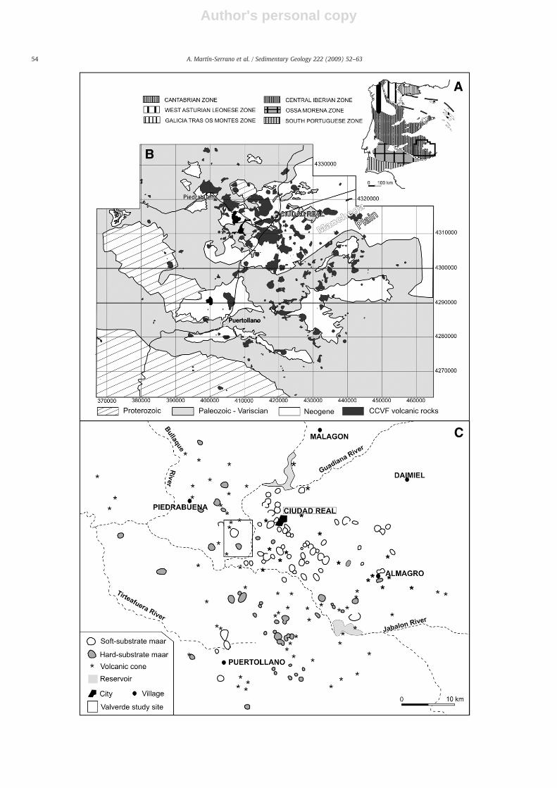
Bothmaar types (Figs.1 and 2) have been identified in the Campo deCalatrava Volcanic Field (CCVF) (Ancochea,1983; Poblete,1995;Martín-Serrano et al., 2007). In hard-substrate maars, the explosive volcanicprocesses affected the basement metasediments (Precambrian slatesand graywackes, Carboniferous sandstones, and Tremadocian–Areni-gian (early Ordovician) slates and quartzites) with magma interactingwith water in joint aquifers. On the other hand, in soft-substrate maars,the explosive volcanic processes affected the thick poorly-consolidated,fluvio-lacustrine Pliocene sediments (arkosic sands, marls, and silts).Thus, maar lake basins are controlled by the pre-volcanic environment.
Hard-substrate maars, surrounded by a deep stable crater wall, aremore capable of collecting sediments in their basins which could bepreserved for longer than similar lacustrine deposits in a broad, shallowmaar formed in a soft-substrate environment. This situation favors ahigher preservation of hard-substrate maar lakes because their countryrocks are more resistant to collapse and erosion, as opposed to soft-substrate maars where the less resistant materials can subside andcollapse into the newly-formed depression. Also, the surface morphol-ogy of soft-substrate maars is changed more easily, after eruption, byerosion and compaction, or is hidden by younger sediments. Ancientsoft-substrate maar basins can be identified by their lacustrine infill(Martín-Serrano et al., 2007; Németh et al., 2008), or their exposeddiatreme and peperitic zones (Auer et al., 2007; Németh and Martin,2007). Maar crater morphologies, and, thus, maar lake basin size,erosion–sedimentation processes, and lacustrine facies are clearlydetermined by the pre-volcanic country rocks.
The Valverde de Calatrava area of Central Spain is studied herebecause its Campo de Calatrava Volcanic Field features both types ofpre-volcanic maars and their related lakes. The post-eruptivesedimentation–erosion history of maars has not yet been studied indetail, and clues to the relationship between phreatomagmatism andsubsequent maar lake formation and evolution can confirm thedifferences in maar development in soft- and hard-substrate areas.
2. Site description and geology
The study site ismainly located in the CiudadReal Province of CentralSpain, in the area known as the Campo de Calatrava Volcanic Field(CCVF) in the Central Volcanic Region (Hernández-Pacheco, 1932;Ancochea, 1983) (Fig. 1). Volcanism of the CCVF developed individualsmall-volume mafic volcanoes in a continental monogenetic volcanicfield where maar craters, scoria cones, and lava flows are the mostabundant features. According to K–Ar and Ar–Ar ages from the lava(Ancochea, 1983; Bonadonna and Villa, 1984), there were at least twovolcanic stages. Thefirst stage involvesmafic extrusives of ultra-potassiccharacterandoccupies the centerof thevolcanic regionwith age rangingbetween8.7 and6.4Ma. The second stage contains an alkaline andultra-alkaline volcanism, with its main activity phase between 4.7 and1.75 Ma. Later, there was some volcanic activity in the early Pleistocene
that greatly extended the period of volcanic activity in the region,between 1.3Ma and 0.7Ma (Gallardo-Millán and Pérez-González, 2000;Gallardo-Millánet al., 2002;Gallardo-Millán, 2004). Large-scale tectonicprocesses in the CCVF, related to the Alpine Orogeny, affected thePaleozoic basement rocks, forming faults and overthrust faultswithNE–SW and SE–NW trends (Galindo-Zaldívar et al., 1993; Muñoz and deVicente,1998). Twomain tectonic stages are identified. The first stage iscompressional that originated faultswith aNE–SW trend, and conjugatefaults with a SE–NW trend, all during the Miocene. A second stage wasactive from the Pliocene to the present day, but was less compressivethan the previous one.
According to Lorenz (1985, 2002, 2003), formation of Pliocene–Pleistocene phreatomagmatic maars in the CCVF took place in hardrocks and soft rocks (Fig. 1). Maar craters are lined up according toNW–SE and NE–SW tectonic trends in Central Spain.
3. Methods
Geologic and geomorphologic maps at 1:25,000 scale werecomposed through field work and interpretation of aerial photographs(1:18,000). For each maar identified in the CCVF, values of maximumand minimum diameters have been measured (Dmax and Dmin,measured from the crest of the tephra ring). Mean radius (R) iscalculated as the half of the diameters. The average surface area (S) forcraters and their associated lakes (s) was estimated.
Electrical tomography (ET) methods were employed to character-ize the internal structure of the maar lake sediments (thickness,sedimentary facies, and sedimentary basin architecture) in twoselected maar lakes: i) Fuentillejo Lake, a hard-rock substrate maar,and ii) Galiana palaeolake, a soft-rock substrate maar. The apparentresistivity measurements for the ET study made on Fuentillejo Lakeused dipole–dipole electrode configurations. ET equipment consistedof an Iris VIP-3000 transmitter fed by a 4 KVA generator (0.04 and4 Amperes), Iris Elrec-6 and Elrec-10 transmitters, and steel electro-des. However, measurements for the ET study made on the Galinapaleolake used a Lund system (Abem) equipped with a dipole–dipoleand Wenner electrode configurations.
A boreholewasdrilled in 2002 in the sediments of Fuentillejo Lake torecover the 142.4 m-thick lacustrine sequence (FUENT-1 core). Coreswere stored in a core repository at 4 °C. Analyses of mineralogy of thelacustrine sedimentswere carried out by X-ray powder diffraction usinga copper Kα-tube on a XPERT Pro of PANalytical (PTE-RX-004) at IGMElaboratories. Authigenic minerals, particle morphologies, and texturalrelationships were observed by thin sections and scanning electronmicroscopy (SEM) at Luis Brú Microscopy Center (UniversidadComplutense de Madrid). SEM observations were performed with aJEOL JSM 6400 operated at 20 kV and equipped with a Link Systemenergy dispersive X-ray microanalyzer (EDX).
4. Maar lakes on CCVF hard-rock substrate
4.1. Basic features
A total of 60 hard-substrate maars have been identified on thecrystalline Paleozoic basement, and their craters usually are notcoalescent. This type originated as the explosive volcanic processesaffected the basement metasediments (Precambrian slates andgraywackes, Carboniferous sandstones and Tremadocian–Arenigianslates and quartzites) where magma interacted with water in jointaquifers. They commonly show tephra rings composed of pyroclasticdeposits with large exotic country rock fragments floating in a fine-grained matrix outside crater walls. Half of them are concentrated inthe southern part of the CCVF (Fig. 1), and 26 of them do not havelacustrine records because their craters are filled with rock falls.
Surface morphologic measurements of hard-rock substrate maarsare indicated in Table 1 and Fig. 3. The average crater radius (R) is
53A. Martín-Serrano et al. / Sedimentary Geology 222 (2009) 52–63
Author's personal copy
54 A. Martín-Serrano et al. / Sedimentary Geology 222 (2009) 52–63

Author's personal copy
339.4 m, and most of them have an R between 100 and 600 m. Lakebasins have a mean radius (r) of 254.7 m, and there is none greaterthan 500 m. Nevertheless, some craters of large, hard-rock substratemaars have R=750 m and S=1.77 km2 (e.g. La Nava and Caracuelmaars). The smallest crater (Cervera maar) has a radius of 88 m and asurficial area of 0.24 km2. Inner slopes dip towards the interior of thecrater, with nearly vertical crater walls comprising slopes of 30° oninterior alluvial fans. Normally in the CCVF, this type of maar basin hasa greater inner slope angle than a soft-substrate maar. The internalcrater wall usually has a height difference of 120–40 m. Formation ofrockfalls, rock slumps, and scree material is very common.
4.2. Maar lacustrine deposits
Hard-substrate maar craters have a circular shape and host lakes inthe post-eruptive stage with their funnel-like shape (Fig. 2). Suchcone-shaped structures cut sharply into the “hard rock” hills,providing a competent and stable substrate for lake basin develop-ment. These types of maar lakes are ephemeral closed systems todaywith the largest maar lakes drained for farming.
Fuentillejo Lake has been chosen here as a model for hard-substrate maar lakes in the CCVF (Fig. 4). This maar is associated witha pyroclastic flow that includes more than 5%, and rarely up to 30%, ofcountry rock fragments (quartzites and slates), indicating basementexcavation. Xenocrysts of olivine and amphibole are common in theentire pyroclastic succession, but large crystals of amphibole (N5 cm)are more common close to the crater rim.
Hard-substrate, lake basin morphology has been inferred by threeelectrical tomography profiles made on the Fuentillejo Lake basin(García-Cortés et al., 2007). The funnel-like morphology of the lakebasin was reconstructed using the ET profile and depth from the
Fig. 2. A. Diagram representative of a hard-substrate maar and related lake type fromthe CCVF (modified from Büchel, 1993 and Lorenz, 2000). B. Diagram representative of asoft-substrate maar and related lake type from the CCVF (modified from Büchel, 1993;Lorenz, 2000).
Fig. 1. A. Location map of the study area in the Iberian Peninsula. B. Simplified geologic map of the Campo de Calatrava Volcanic Field. C. Situation map of maar crater types of theCampo de Calatrava Volcanic Field. Valverde study site in Fig. 2 is marked by a rectangle.
Table 1Measurements made on hard-rock maar craters and their maar lakes from Campo deCalatrava Volcanic Field.
Dmax Dmin dmax dmin Mean R Mean r R / r S s S /s
1000 700 550 550 425 275 1.55 567,451.5 237,583.5 2.391150 1000 700 450 538 288 1.87 907,627.9 259,672.9 3.501000 900 550 250 475 200 2.38 708,823.5 125,664 5.64750 250 – – 250 – – 196,350.0 – –
250 225 – – 119 – – 44,264.2 – –
1250 1200 900 550 563 363 1.55 994,021.9 412,825.9 2.41400 250 – – 163 – – 82,957.9 – –
450 400 – – 213 – – 141,862.9 – –
1050 950 450 250 500 175 2.86 785,400.0 96,211.5 8.16550 475 – – 256 – – 206,290.2 – –
350 300 – – 163 – – 82,957.9 – –
450 450 – – 225 – – 159,043.5 – –
750 700 – – 363 – – 412,825.9 – –
1700 1500 1150 700 800 463 1.73 2,010,624.0 672,007.9 2.991000 550 600 300 388 225 1.72 471,730.9 159,043.5 2.97950 400 550 400 363 238 1.53 412,825.9 177,205.9 2.331050 900 850 550 488 350 1.39 746,620.9 384,846 1.94650 300 500 150 238 163 1.46 177,205.9 82957.9 2.14400 200 – – 150 – – 70,686.0 – –
1150 500 700 350 413 263 1.57 534,562.9 216,475.9 2.47275 250 – – 107 – – 35,632.8 – –
200 150 – – 88 – – 24,052.9 – –
1400 1350 500 400 438 225 1.94 601,321.9 159,043.5 3.781650 1575 1100 900 375 250 1.50 441,787.5 196,350 2.25500 450 – – 238 – – 177,205.9 – –
400 400 – – 200 – – 125,664.0 – –
1650 700 – – 588 – – 1,084,342.9 – –
1350 1000 800 600 588 350 1.68 1,084,342.9 384,846 2.821250 800 750 500 725 313 2.32 1,651,303.5 306,796.9 5.38650 450 400 200 275 150 1.83 237,583.5 70,686 3.36650 450 400 200 275 150 1.83 237,583.5 70,686 3.36350 325 250 200 169 113 1.50 89,409.0 39,760.9 2.25800 600 450 400 350 213 1.65 384,846.0 141,862.9 2.71650 400 300 250 263 138 1.91 216,475.9 59,395.9 3.641400 1250 950 750 663 425 1.56 1,378,867.9 567,451.5 2.431250 1150 1000 850 600 463 1.30 1,130,976.0 672,007.9 1.68600 500 350 200 275 138 2.00 237,583.5 59,395.9 4.00650 550 500 250 300 188 1.60 282,744.0 110,446.9 2.561050 950 600 500 500 275 1.82 785,400.0 237,583.5 3.31400 300 – – 175 – – 96,211.5 – –
600 550 – – 288 – – 259,672.9 – –
1600 800 650 600 600 288 2.09 1,130,976.0 259,672.9 4.361050 900 700 654 488 350 1.39 746,620.9 384,846 1.94650 600 350 250 313 150 2.08 306,796.9 70,686 4.34500 450 – – 238 – – 177,205.9 – –
1050 650 – – 425 – – 567,451.5 – –
1250 1250 750 750 625 375 1.67 1,227,187.5 441,787.5 2.781150 1100 500 500 563 250 2.25 994,021.9 196,350 5.061100 950 700 700 513 350 1.46 825,160.9 384,846 2.14900 950 – – 463 – – 672,007.9 – –
1750 1250 – – 750 – – 1,767,150.0 – –
650 650 – – 325 – – 331,831.5 – –
500 450 – – 238 – – 177,205.9 – –
1150 750 650 500 475 288 1.65 708,823.5 259,672.9 2.73300 250 – – 138 – – 59,395.9 – –
500 450 – – 238 – – 177,205.9 – –
700 575 – – 319 – – 319,191.5 – –
1350 1250 850 750 650 400 1.63 1,327,326.0 502,656 2.641000 800 – – 450 – – 636,174.0 – –
1600 1300 1150 750 725 475 1.53 1,651,303.5 708,823.5 2.33
For each hard-rock maar identified in the CCVF, values of maximum and minimumdiameters have been measured (Dmax and Dmin, measured from the crest of the tephraring). Mean radius (R) is calculated as the half of the diameters. dmax, dmin and r arevalues corresponding to their hard-rockmaar lakes. The average surface area (S) for cratersand their associated lakes (s) was estimated. Allmeasurementswere expressed onmeters.
55A. Martín-Serrano et al. / Sedimentary Geology 222 (2009) 52–63

Author's personal copy
FUENT-1 core (Fig. 5). Resistivity measurements provided the mostdetailed information about the internal structure of the maar lakesediments in this site (Fig. 5). An ET-FUENT-1 resistivity profile showedthis lacustrine basin to be 90 m deep, and has also permitted thededuction of interesting aspects of its sedimentary architecture(Fig. 5). Zones of very low resistivity represented distal fine-grainedfacies of the post-eruptive period.
Pirrung et al. (2003) generalized the lithofacies of maar structuresand described five lithozones of typical stages of maar formationwithin a diatreme structure (A: diatreme breccia, B: syn-eruptivecollapse breccia and the maar crater lake sediments, C: debris flowdeposits, D: lacustrine laminated sediments with interbeddedturbidites, E: peat and deltaic sediments). The 142.4 m deep researchborehole (FUENT-1 core) from the center of Fuentillejo Lake containeda complete lacustrine record corresponding to lithofacies C, D and E ofthe post-eruptive phases.
Major lithostratigraphic units (total of 23) have been identified inthe core, showing variations in clastic input, water chemistry andorganic fractions throughout the history of the lake during the upperPleistocene and Holocene (Vegas et al., 2006). The early lake period ischaracterized by coarse-grained debris flow and turbidites of higherresistivity values (Fig. 6). Distal lake sediments consist of siliciclasticand organic-carbonate mm-thick rhythmites deposited during highlake level stages. Ephemeral sedimentation periods are indicated byevaporites (mainly consisting in gypsum and carbonate minerals,including dolomite), units of bioturbated massive blue dolomicritesand silts with desiccation horizons. Thick, massive to laminated blackoil shale units also occur in units 17 and 20 where the principal sourceof organic matter is the microalgae Botriococcus braunii.
All carbonate phases are composed of euhedral crystals (2–10 μm),suggesting precipitation within the lake (Fig. 7). Dolomite (dolomi-crite) formation of primary origin indicates evaporative processes, lowlake level, and higher salinity, and is probably linked to a more aridclimate. Dolomite, calcite, and zeolites (mainly analcime and minorchabazite–merlinoite; Fig. 7) of primary or early diagenetic originwere identified in the FUENT-1 sequence. The presence of analcimeand other zeolites in lacustrine sediments has been interpreted toreflect changes in the salinity and alkalinity of the lake water, inducedby climatic shifts (Stoffers and Holdship, 1975).
LasHigueruelas is anexampleof anancient, hard-substratemaar lake inthe CCVF (Figs. 2 and 8). Outcrops representative of shoreline talus andlacustrine debris flow sediments can be observed in the western area(Fig. 8). The Higueruelas palaeontologic site contains mammalian fossils(mainlyAnancus arvernensis,Hipparion rocinantis,Cervus cf. cusanus,Cervuscf. perrieri and Equus df. stenonis) in the uppermost 3 m of the lacustrinesediments, corresponding to a palustrine mudflat environment (Alberdi,1984; Arribas and Antón, 1997). Dolomite and zeolites (phillipsite) are themain minerals identified at this site. This maar lake record is 3.5 Ma old,estimated by the application of K–Ar methods made on volcanic bombsassociated with the fossil bones (Bonadonna and Villa, 1984).
5. Maar lakes on CCVF soft-rock substrate
5.1. Basic features
Soft-substrate maars of the CCVF exploded within a thick Neogenesuccession of fluvio-lacustrine sediment, characterized by unconsoli-dated and water-saturated materials. There is clear evidence of 66
Fig. 3. Plots of frequency of maars with respect to mean radius of craters (R) and mean radius of lake basins (r). Mean radius is calculated as the half main value of maximum andminimum diameters. Dmax and Dminweremeasured from the crest of the tephra ring; dmax and dminweremeasured over modern lake surface. Black bars correspond tomaar lakebasins, and white bars correspond to maar craters.
56 A. Martín-Serrano et al. / Sedimentary Geology 222 (2009) 52–63

Author's personal copy
soft-substrate maars in this region (Fig. 1). Their craters usually have acircular shape, but some are elliptical, due to early post-eruptivesubsidence and inner wall erosion. Moreover, some of the soft-substrate craters are coalescent (Fig. 1), probably a consequence ofsurficial unconsolidated material that may provide connected sites forsteam release (White and McClintock, 2001; Sohn and Park, 2004). Athin tephra ring usually surrounds the maar craters. They can host alake basin that resembles a bowl-like shape, providing a good site forwater accumulation (Fig. 9).
Surfacemorphologicmeasurements (Table 2 and Fig. 3) indicate thatsoft-substrate craters are larger than hard-substrate craters. Soft-
substrate craters have an average radius (R) of 565.59m, and an averagesurface area (S) of 1.86 km2, while their average maar lake radius (r) is288.37 m with a mean surface area of 0.56 km2. The largest soft-substrate craters are significantly larger than hard-substrate craters andhave a radius (R) of 3079–2950 m, and S from 1.88 to 5.94 km2 (e.g.Torralba and Granátula maars). Seventy-two percent of craters have aradius ranging from 300 to 700 m (Fig. 3), and 39.4% of lakes have aradius of between 200 and 300 m. The radius (r) of the biggest lake is1485m,whereas the smallest lake is only 75m. Craters formwalls withshallower angles than the hard-substrate types, and they commonlyhave collapse structures and sand flows towards the crater center.
Fig. 4. Simplified geologic map of the pre-volcanic substrate in the Valverde area (selected study site). Fuentillejo and Valdurillo are examples of hard-substrate maars. Alcolea is apreserved, soft-substrate maar. Cantarranas, Peñalgatos, Galiana, and Las Parras paleolakes are examples of ancient, soft-substrate maar lakes. Las Higueruelas is an example of anancient, hard-substrate maar lake. Electrical tomography profiles were constructed across Fuentillejo (ET-F-3) and Galiana (ET-G-1) lake basins, and they are shown in Figs. 5 and 9,respectively.
57A. Martín-Serrano et al. / Sedimentary Geology 222 (2009) 52–63

Author's personal copy
5.2. Soft-substrate lacustrine deposits
Craters have a circular or elongated shape, and always contain alake basin with a bowl-like shape (Fig. 2), corresponding to the post-eruptive period. Circular dolostone rock outcrops outline the ancientsoft-substrate volcanic structures in the study site (Fig. 4) correspond-ing to soft-substrate maar craters filled with lacustrine sediments.Ancient soft-substrate maar lakes in the CCVF are almost filled bypost-eruptive sediments and, in some cases, tephra rims are eroded(Martín-Serrano et al., 2007). The surface morphology of the maarstructures is changed significantly by erosion and compaction or ishidden by younger sediments (Schulz et al., 2005). Surface measure-ments on selected dolostone lacustrine outcrops reveal radii (r) thatrange from 0.9 to 2.2 km, and surface areas from 2.54 to 15.20 km2.These ancient parameters are greater in size than those of modernmaars. This could be due to post-eruptive inner wall erosion whichenlarged maar craters. Moreover, in soft-substrate maars, compactionof the diatreme fill causes differential subsidence and marginaldragdown of suitable country rock sediments (Francis, 1962; Lorenz,1971, 2003; Suhr et al., 2006).
We choose Galiana paleolake as an example of an ancient soft-substrate maar lake (Fig. 4). The geologic cartography and ET profiles ofthe Galiana carbonate paleolake area clearly reveal the bowl-likestructureof themaar lakebasin (Fig. 9).Adetailedelectrical tomographysurvey was carried out to determine the depocenter of this lake basin,
where high resistivity values correspond to the lithified carbonate lakesediments. Results from theET profile indicate a lake depocenterof 60mdepth (Fig. 9). Subsidence processes can be identified by centripetaldipping angles of nearshore carbonate facies on the TE profile (Fig. 9).Surrounding this bowl-like structure, there are sediments from thePliocene age which represent the pre-volcanic setting.
The Galiana paleolake sedimentation model may be representativeof other soft-substrate maars; other circular carbonate lacustrineoutcrops with uncertain stratigraphy positions in the CCVF should becarefully re-examined in the near future. The lacustrine deposits atCantarranas record the development of another maar lake basin whichhas been eroded (Figs. 4 and 8). Lithified circular carbonate bodiesexhibit a wide variation in morphology as well as in depositional anddiagenetic fabric (Vegaset al., 2007). The carbonatemineral suite of soft-substrate maar lake basins consists mainly of dolomite and calcite, withsmaller amounts of hydromagnesite and magnesite (Hoyos et al., 1984;Vegas et al., 2007). Zeolites are also present in lacustrine distal facies(analcime and minor chabazite–merlinoite). High Mg content incarbonate minerals is related to the pyroclastic rocks from the erodedtephra rim. In addition to the carbonates in the distal deep-water facies,the lacustrine basins also contain a girdle of nearshore carbonate.Mottled dolostones from lake girdles reveal subaerial exposure,organisms, root traces, desiccation, and pedogenic features typical ofpalustrine environments (after Alonso-Zarza, 2003). Palustrine carbo-nates typically occur in lakes with low gradient, relatively flat surfaces,
Fig. 5. A. Resistivity profile using electrical tomography in the Fuentillejo hard-substrate lake basin (after García-Cortés et al., 2007). B. Fuentillejo maar lake morphology(intermittent line) has been reconstructed from the electrical tomography interpretation of ET-F-3 profile (in Fig. 4) and the F-1 core of 142.2 m deep (from Vegas et al., 2006).
Fig. 6. Stratigraphic section of the Fuentillejomaar lacustrine record that corresponds to core F-1 core (142.40m thick) (Vegas et al., 2006). A simplified description of facies and theirsedimentary environments is included. Relative lake level reconstruction is proposed on the base of facies interpretation (Vegas et al., 2006).
58 A. Martín-Serrano et al. / Sedimentary Geology 222 (2009) 52–63

Author's personal copy
59A. Martín-Serrano et al. / Sedimentary Geology 222 (2009) 52–63

Author's personal copy
low energy margins, and a carbonate provenance (Platt and Wright,1991). The primary micrite mud is composed of relatively euhedraldolomite crystals 1–3 μm across which were affected by pedogenicmodification as the lake level dropped. Cracks are visible under themicroscope, and theymay remain empty, or befilledwithmicrosparandsparry calcite. Moreover, there are abundant peloids and fenestralstructures identified in thin section.
6. Conclusions
Hard-substrate and soft-substrate maar volcanoes have beenidentified in the Campo de Calatrava Volcanic Field (CCVF) throughthe combination of electrical tomography ground surveys withgeomorphologic and sedimentary facies analysis. Maar formation inthe CCVF occurred over a long time range from the Pliocene to upperPleistocene with the resultant basins containing thick sedimentary
lacustrine records. Pre-volcanic setting determines maar morphologyand post-eruptive lacustrine architecture in the maar craters. Thepreservational potential of hard-substrate maar showing originalvolcanic features is greater than that of soft-substrate maars. Steep-sided maar lakes with a funnel-like basin form in the hard-substratesettings of Precambrian slates and graywackes, Carboniferous sand-stones, and Tremadocian–Arenigian slates and quartzite. In the CCVF,the crater is generally filled with limnic sediments of low density, andmainly fine-upward from meter-thick, detrital graded layers to finelylaminated dolomicrite facies.
Unlike hard-substrate maars, soft-substrate maars of the CCVFexploded within a thick succession of Neogene fluvio-lacustrinesediment that is not consolidated as well as water saturated. Cratershave a circular or elongated shape and host a lake basin with a bowl-like shape. Early lacustrine sedimentation phases contain to detritalgraded layers with abundant epiclastic fragments. Later facies
Fig. 7. SEM images: A. Analcime crystals. Blue massive carbonates of Unit 21 (17.42 m deep). B. Analcime crystal on a matrix of detrital kaolinite. Black mud facies of Unit 18 (22.69 mdeep). C. Minute primary dolomite rhombi, alternating with analcime and organic matter. Finely laminated carbonate rich sediments with mm-thick laminae from Unit 19 (23.71 mdeep). D. Minute dolomite rhombi on a matrix of detrital particles. Massive carbonate-rich layers of Unit 23 (8.10 m deep). E. Laminawith abundant analcime andmerlinoite crystals.Finely laminated carbonate-rich sediments withmm-thick laminae fromUnit 19 (23.71m deep). F. Minute dolomite rhombi interpreted as primary in origin. Bluemassive carbonatesof Unit 21 (15 m deep).
60 A. Martín-Serrano et al. / Sedimentary Geology 222 (2009) 52–63

Author's personal copy
comprise massive to laminated dolomicrites of a distal origin andmottled dolostones exhibiting subaerial exposure features typical of anearshore palustrine environment. Dolomite is the main carbonatemineral present in both maar lake types, due to a high influence ofvolcanic and carbonate catchments.
The shape of both crater types, primarily determined by substratetype, controls lake basin geometry and lacustrine sedimentationpatterns. The hard-substrate maars, surrounded by a deep and stablecrater wall, can collect sediments and preserve them moreeffectively. The soft-substrate maars, formed in a less cohesivesubstrate, contain broad shallow craters with collapse structures andare more exposed to erosive processes. This makes soft-substratemaars more difficult to identify in the landscape; circular outcrops oflacustrine dolostones in the CCVF revealed the location of ancientmaars.
The sedimentary records of the maar lakes are influenced by theirpre-volcanic substrate as well as climate. Fuentillejo Lake in a hard-substrate maar has thick black, finely laminated mud sedimentscorresponding to periods of high lake levels in a high-walled, stablecrater. Paleolakes Galiana and Cantarranas, forming in a soft-substratemaar crater, contain mostly shallow lacustrine and palustrinesediments in a shallow broad area with unstable, non-cohesive craterwalls.
Acknowledgments
This work was funded by the Spanish Inter-Ministry Commissionof Science and Technology (CICYT), project CGL2004-06212/BTE“Variabilidad climática y ambiental en el centro de la PenínsulaIbérica durante el Cuaternario. Estudio de alta resolución del registrolacustre del sondeo FU-1 (laguna de Fuentillejo, Ciudad Real)” andthe IGME through the project CC 54.020 “Estudio Paleoclimático delMaar de Fuentillejo (Ciudad Real)”. We thank Elizabeth Gierlowskifor her suggestions and language revision. Formal reviews by KárolyNémeth, an anonymous reviewer, and Lluís Cabrera (InvitedScientific Editor) significantly improved the manuscript, manythanks for it.
References
Alberdi, M.T. (Coord.), 1984. Geología y Paleontología del yacimiento del Villafran-quiense inferior de Las Higueruelas y su entorno (Campo de Calatrava, Ciudad Real).Actas de Castilla-La Mancha. Espacio y Sociedad 3, pp. 229–275.
Allen, J.R.M., Brandt, U., Brauer, A., Hubberten, H.W., Huntley, B., Keller, J., Kraml, M.,Mackensen, A., Mingram, J., Negendank, J.F.W., Nowaczyk, N.R., Oberhänsli, H., Watts,W.A., Wulf, S., Zolitschka, B., 1999. Rapid environmental changes in southern Europeduring the last glacial period. Nature 400, 740–743.
Alonso-Zarza, A., 2003. Palaeoenvironmental significance of palustrine carbonates andcalcretes in the geological record. Earth Sci. Rev. 60, 261–298.
Fig. 8. A. Stratigraphic section of Las Higueruelas Lake; an ancient hard-substrate maar lake (from Hoyos et al., 1984; Alberdi, 1984). B. Stratigraphic section of Cantarranas isrepresentative of an ancient soft-substrate maar lake. Valverde study site (CCVF, Ciudad Real).
61A. Martín-Serrano et al. / Sedimentary Geology 222 (2009) 52–63

Author's personal copy
Ancochea, E., 1983. Evolución espacial y temporal del volcanismo reciente de EspañaCentral. Ph-D. thesis, Ed. Complutense University, Madrid.
Aranda-Gómez, J.J., Luhr, J.F., 1996. Origin of the Joya Honda maar, San Luis Potosí,Mexico. J. Volc. Geotherm. Res. 74, 1–18.
Arribas, A., Antón,M.,1997. Los carnivoros de los yacimientos pliocenos de Las Higueruelasy Piedrabuena (Ciudad Real, España). Bol. Geol. Min. 108, 111–120.
Auer, A., Martin, U., Németh, K., 2007. The Fekete-hegy (Balaton Highland Hungary) “soft-substrate” and “hard-substrate” maar volcanoes in an aligned volcanic complex —implications for vent geometry, subsurface stratigraphy and the palaeoenvironmentalsetting. J. Volc. Geotherm. Res. 159, 225–245.
Bonadonna, F.P., Villa, J.M.,1984. Estudiogeocronológicodel vulcanismode lasHigueruelas.I Reunión Estratigrafía Regional Castilla-La Mancha (Albacete), vol. 3. Espacio ySociedad, pp. 249–253.
Büchel, G., 1993. Maars of the Westeifel, Germany. In: Negendank, J.F.K., Zolitschka, B.(Eds.), Paleolimnology of European Maar Lakes. Springer-Verlag, pp. 1–13.
Caballero, M., Vilaclara, G., Rodríguez, A., Juárez, D., 2003. Short-term climatic change inlake sediments from lake Alchichica, Oriental, Mexico. Geofís. Int. 42, 529–537.
Connor, C.B., Stamatakos, J.A., Ferrill, D.A., Hill, B.E., Ofoegbu, G.I., Conway, F.M., Sagar, B.,Trapp, J., 2000. Geological factors controlling patterns of small-volume basalticvolcanism: application to a volcanic hazards assessment at Yuca Mountain, Nevada. J.Geophys. Res. Sol. Earth 105, 417–432.
Crausbay, S.D., Russell, J.M., Schunurrenberger, D.W., 2006. A ca. 800-year lithologicrecord of drought from sub-annually laminated lake sediment, East Java. J. Paleolim.35, 641–659.
The EUROMAARS Project. In: Creer, K.M., Thouveny, N. (Eds.), Special Issue: Quat. Sci.Rev., vol. 15. 146 pp.
Dodson, J.R., 1974. Vegetation and climatic history near Lake Keilambete, WesternVictoria. Australian J. Botan. 22, 709–717.
Fisher, R.V., Schmincke, H.-U., 1984. Pyroclastic rocks. Springer Verlag, Berlin–Heidelberg–New York–Tokyo.
Francis, E.H., 1962. Volcanic neck emplacement and subsidence structures at Dunbar,southesat Scotland. Trans. R. Soc. Edin. 65, 41–58.
Galindo-Zaldívar, J., González-Lodeiro, F., Javaloy, A., 1993. Stress and paleostress in theBetic-Riff cordilleras (Miocene to the present). Tectono. 227, 105–126.
Gallardo-Millán, J.L., 2004. Evolución geodinámica de las cuencas neógenas del Campode Calatrava (Ciudad Real) y su relación con el volcanismo reciente. Ph-D. thesis.Complutense University, Madrid.
Gallardo-Millán, J.L., Pérez-González, A., 2000. Magnetoestratigrafía del relleno neógenoen las cuencas del Campo de Calatrava (Ciudad Real). Geotemas 1, 101–104.
Gallardo-Millán, J.L., Ancochea, E., Pérez-González, A., 2002. Secuencia magnetoestrati-gráfica y edad de los materiales volcánicos y sedimentarios de Poblete (CiudadReal). Geogaceta 32, 35–38.
García-Cortés, A., Vegas, J., Granda, A., Galán, L., Pérez-González, A., 2007. Reconstrucciónde la arquitectura lacustre cuaternaria del maar de Fuentillejo mediante tomografíaeléctrica. Campo de Calatrava. In: Lario, J., Silva, P.G. (Eds.),Contribuciones al estudio delperiodo Cuaternario. AEQUA, Ávila. Sección de Publicaciones de la Escuela TécnicaSuperior de Ingenieros Industriales. Universidad Politécnica de Madrid, pp. 191–192.
Garcin, Y., Williamson, D., Taieb, M., Vincens, A., Mathé, P.E., Majule, A., 2006. Centennial tomillennial changes inmaar-lakedepositionduring the last 45,000years in tropical SouthernAfrica (Lake Masoko, Tanzania). Palaeogeog. Palaeoclim. Palaeoecol. 239, 334–354.
Gasse, F., Oldfield, F., Kroepelin, S. (Eds.), 1997. PEP III: The Pole–Ecuator–Pole Transectthrough Europe and Africa. PAGES Reports, pp. 97–102. http://www.pages.unibe.ch/products/reports.html.
Gevrek, A.I., Kazanci, N., 2000. A Pleistocene, pyroclastic-poor maar from centralAnatolia, Turkey: influence of a local fault on a phreatomagmatic eruption. J. Volcan.Geotherm. Res. 95, 309–317.
Hernández-Pacheco, F., 1932. Estudio de la región volcánica central de España. Mem. R.Acad. Cienc. Exactas FiÂs. Nat. Madr., Ser. Cienc. Nat. 3, 1–235.
Hoyos, M., Bonadonna, F.P., Ancochea, E., de la Rubia, R., Marfil, R., 1984. Característicasgeológicas del yacimiento de Las Higueruelas (Ciudad Real). Actas de Castilla-LaMancha. Espacio y Sociedad, vol. 3, pp. 231–240.
Kienele, J., Kyle, P.R., Self, S.,Motyka, R.J., Lorenz, V.,1980.UkinrekMaars, Alaska: 1. April 1977eruption sequence, petrology, and tectonic settings. J. Volcan. Geotherm. Res. 7, 11–37.
Liu, J.Q., Liu, T.S., Negendank, J.F.W., 2001. The Chinese Maar Drilling Programme: aChinese–German cooperation for paleoclimatic reconstructions. PAGESNews 9,10–11.
Lorenz, V., McBirney, A.R., Williams, H., 1970. An investigation of volcanic depressions:part III. Maars, tuff rings, tuff-cones and diatremes. NASA Progress Rpt. (NGR-38-003 012), Houston, Texas, pp. 1–198.
Lorenz, V., 1971. Collapse structures in the Permian of Saar–Nahe-area, southwestGermany. Geol. Runds. 60, 924–948.
Lorenz, V., 1975. Formation of phreatomagmatic maar-diatreme volcanoes and itsrelevance to kimberlite diatremes. Phis. Chem. of the Earth 9, 17–27.
Lorenz, V., 1985. Maars and diatremes of phreatomagmatic origin: a review. Trans. Geol.Soc. South Africa 88, 459–470.
Lorenz, V., 1986. On the growth of maars and diatremes and its relevance to theformation of tuff-rings. Bull. Volcanol. 48, 265–274.
Lorenz, V., 2000. Formation of maar-diatreme volcanoes. Terra Nostra 2000/6, 284–291.Lorenz, V., 2002. Hard rock and soft rock environments of explosive phreatomagmatic
monogenetic volcanism. In: Ulrych, J., Cajz, V., Adamovic, J., Bosak, P. (Eds.), Hibsch2002 Symposium. Czech Geological Survey, Prague, Tepla near Trebenice, Usti nadLabem, Marianske Lazne (Czech Republic), p. 89.
Lorenz, V., 2003. Maar-diatreme volcanoes, their formation, and their setting in hard-rock and soft-rock environments. Geolines-Journal of the Geological Institute of ASCzech Republic 15, 72–83.
Fig. 9. A. Galiana maar lake basin (intermittent line) was reconstructed from electrical tomography interpretation of the ET-G-1 profile showed in Fig. 4. B. Subsidence of maar–diatreme is interpreted by the TE profile. Galiana circular carbonate (dolostone) outcrop is a well-preserved example of an ancient soft-substrate maar lake sedimentary succession.
62 A. Martín-Serrano et al. / Sedimentary Geology 222 (2009) 52–63

Author's personal copy
Lorenz, V., Goth, K., Suhr, P., 2003. Maar-Diatrem-Vulkanismus – Ursachen und Folgen.Die Guttauer Vulkangruppe in Ostsachsen als Beispiel für die komplexenZusammenhänge. Z. geol. Wiss., Berlin 31, 267–312.
Lücke, A., Brauer, A., 2004. Biogeochemical and micro-facial fingerprints of ecosystemresponse to rapid Late Glacial climatic changes in varved sediments of MeerfelderMaar (Germany). Palaeogeogr. Palaeoclimatol. Palaeoecol. 211, 139–155.
Martín-Serrano, A., Vegas, J., García-Cortés, A., Granda, A., Galán, L., Martín-Alfageme, S.,Rubio, F.M., García-Lobón, J.L., Ibarra, P.I., Pérez-González, A., Gallardo-Millán, J.L.,2007. Tipología de los maares del Campo de Calatrava mediante criteriosgeomorfológicos, geofísicos y sedimentarios de sus registros lacustres asociados.In: Lario, J., Silva, P.G. (Eds.), Contribuciones al estudio del periodo Cuaternario.AEQUA, Ávila. Sección de Publicaciones de la Escuela Técnica Superior de IngenierosIndustriales. Universidad Politécnica de Madrid, pp. 205–206.
Mingram, J., Schettler, G., Nowaczyk, N., Luo, X., Lu, H., Liu, J., Negendank, J., 2004. TheHuguang maar lake—a high resolution palaeoenvironmental and palaeoclimaticchanges over the last 78,000 years from South China. Quat. Int. 122, 85–107.
Muñoz, A., de Vicente, G.,1998. Origen y relación entre las deformaciones y esfuerzos alpinosde la zona centro-oriental de la Península Ibérica. Rev. Soc. Geol. España 11, 57–70.
Negendank, J.F.K., Zolitschka, B. (Eds.), 1993. Paleolimnology of European Maar Lakes.Springer-Verlag.
Németh, K., Martin, U., 2007. Shalow sill and dyke complex in western Hungary as apossible feeding system of phreatomagmatic volcanoes in “soft-rock” environment.J. Volcan. Geotherm. Res. 159, 138–152.
Németh, K., Martin, U., Harangi, S.Z., 2001. Miocene phreatomagmatic volcanism atTihany (Pannonian Basin, Hungary). J. Volcan. Geotherm. Res. 111, 111–135.
Németh, K., Goth, K., Martin, U., Csillag, G., Suhr, P., 2008. Reconstructing paleoenviron-mental, eruption mechanism and paleomorphology of the Pliocene Pula maar,(Hungary). J. Volcan. Geotherm. Res. 177, 441–456.
Pirrung, M., Fischer, C., Büchel, G., Gaupp, R., Lutz, H., Neuffer, F.O., 2003. Lithofaciessuccession ofmaar craterdeposits in theEifel area (Germany). TerraNova 15,125–132.
Pirrung, M., Büchel, G., Lorenz, V., Treutler, H.C., 2008. Post-eruptive development of theUkinrek East Maar since its eruption in 1977 A.D. in the periglacial area of south-west Alaska. Sed. 55, 305–334.
Platt, N.H., Wright, V.P., 1991. Lacustrine carbonates: facies models, facies distribution andhydrocarbonaspects. In:Anadón, P., Cabrera, L., Kelts, K. (Eds.), Lacustrine FaciesAnalysis:Special Publication International Association of Sedimentologists, vol. 13, pp. 57–74.
Poblete, M.A., 1995. El relieve volcánico del Campo de Calatrava (Ciudad Real). Junta deComunidades de Castilla-La Mancha Ed., Gijón.
Roberts, N., Reed, J.M., Leng, M.J., Kuzucuoglu, C., Fontugne, M., Bertaux, J., Woldring, H.,Bottema, S., Black, S., Hunt, E., Karabiyikoglu,M., 2001. The tempoofHolocene climaticchange in eastern Mediterranean region: new high-resolution crater-lake sedimentdata from central Turkey. The Holocene 11, 721–736.
Schmincke, H.-U., 1988. Vulkane im Laacher See-Gebiet, ihre Entstehung und heutigeBedeutung. Bode, Haltern, pp. 1–119.
Schulz, R., Buness, H., Gabriel, G., Pucher, R., Rolf, C., Wiederhold, H., Wonik, T., 2005.Detailed investigation of preservedmaar structures by combined geophysical surveys.Bull. Volcan. 68, 95–106.
Self, S., Kienle, J., Huot, J.-P., 1980. Ukinrek Maars, Alaska: II. Deposits and formation ofthe 1977 crater. J. Volcan. Geotherm. Res. 7, 39–65.
Sohn, Y.K., Park, K.H., 2004. Composite tuff ring/cone complexes in Jeju Island, Korea: possibleconsequences of substrate collapse and ventmigration. J. Volcan. Geotherm. Res.141,157–175.
Stoffers, P., Holdship, S.A., 1975. Diagenesis of sediment in an alkaline lake: LakeManyara, Tanzania. Proc. IXth Int. Conf. of Sedimentology. Nice 7, 211.
Suhr, P., Goth, K., Lorenz, V., Suhr, S., 2006. Long lasting subsidence and deformation in andabovemaar–diatreme volcanoes— anever ending story. Zeitsch.Gessells. Geowissens.157, 491–511.
Vegas, J., García-Cortés, A., Galán, L., Pérez-González, A., Martín-Serrano, A., 2006. Elregistro sedimentario lacustre delmaar de Fuentillejo (Ciudad Real). Bol. Geol. Min.117, 339–349.
Vegas, J., Martín-Serrano, A., García-Cortés, A., Granda, A., Martín-Alfageme, S., Rubio, F.M.,García-Lobón, J.L., Ibarra, P.I., Galán, L., Pérez-González, A., Gallardo-Millán, J.L., Bernat,M., 2007. Morphotectonic setting of maar lakes in central Spain (Campo de CalatravaVolcanic Field). Abstracts of 4th International Limnogeology Congress (ILIC 2007):Limnogeology: Tales of an Evolving Earth, p. 155.
Wagstaff, B.E., Kershaw, A.P., O Sullivan, P.B., Harle, K.J., Edwards, J., 2001. An Early toMiddle Pleistocene palynological record from volcanic crater of Pejark Marsh,Western Plain of Victoria, southeastern Australia. Quat. Int. 83–85, 211–232.
White, J.D.L., 1991. The depositional record of small, monogenetic volcanoes withinterrestrial basins. SEPM Spec. Pub. 45, 155–171.
White, J.D.J.,McClintock,M.K., 2001. Immensevent complexmarksflood-basalt eruption ina wet, failed rift: Coombs Hills, Antarctica. Geol. 29, 935–938.
Wohletz, K.H., Zimanowski, B., 2000. Physics of phreatomagmatism; Part 1: Explosionphysics. Terra Nostra 2000/6, 515–523.
Zolitschka, B., Schäbitz, F., Lücke,A., Corbella,H., Ercolano, B., Fey,M.,Haberzettl, T., Janssen, S.,Maidana, N., Mayr, C., Ohlendorf, C., Oliva, G., Paez, M.M., Schleser, G.H., Soto, J., Tiberi, P.,Wille, M., 2006. Crater lakes of the Pali Aike next term Volcanic Field as key sites forpaleoclimatic and paleoecological reconstructions in southern Patagonia, Argentina. J.South Am. Earth Sci. 21, 294–309.
Table 2Measurements made on soft-rock maar craters and their maar lakes from Campo deCalatrava Volcanic Field.
Dmax Dmin dmax dmin Mean R Mean r R / r S s S / s
1200 800 750 300 500 262 1.91 785,400 216,476 3.631500 1250 950 550 688 375 1.83 1,487,058 441,787 3.371350 850 750 400 580 288 2.01 950,334 260,577 3.651250 1000 600 500 566 275 2.06 1,006,430 237,584 4.241250 1000 400 400 566 200 2.83 1,006,430 125,664 8.011400 1250 800 300 663 275 2.41 1,380,950 237,584 5.81700 650 300 250 338 138 2.45 358,909 59,829 6.001500 1300 650 600 700 313 2.24 1,539,384 307,779 5.001350 1050 400 350 600 188 3.19 1,130,976 111,037 10.19750 700 400 300 363 175 2.07 413,965 96,212 4.30750 550 300 250 325 138 2.36 331,831 59,829 5.551100 950 600 500 513 275 1.87 826,772 237,584 3.481100 900 600 450 500 263 1.90 785,400 217,301 3.612000 1500 1000 750 888 425 2.09 2,477,290 567,451 4.371800 1500 700 600 825 325 2.54 2,138,251 331,831 6.441250 950 550 400 550 238 2.31 950,334 177,953 5.341000 650 650 450 413 150 2.75 535,850 70,686 7.581200 1000 950 650 550 325 1.69 950,334 331,881 2.861050 950 550 400 500 238 2.10 785,400 177,953 4.411000 700 650 450 425 275 1.55 567,451 237,584 2.39550 400 250 100 238 88 2.70 177,953 24,329 7.31850 800 400 350 413 188 2.20 535,860 111,037 4.831600 1250 1150 700 713 463 1.54 1,597,092 673,462 2.37900 800 600 550 425 288 1.48 567,451 260,577 2.181300 1100 950 750 600 425 1.41 1,130,976 567,451 1.991200 1000 700 650 550 338 1.63 950,334 472,949 2.01650 550 500 450 300 175 1.71 282,744 96,211 2.94800 700 500 450 375 238 1.58 441,787 177,953 2.481000 650 350 250 413 200 2.07 535,860 125,664 4.261000 850 500 400 463 223 2.08 673,462 156,229 4.31700 600 400 350 325 188 1.73 331,881 111,037 2.991100 750 550 400 466 238 1.96 682,217 177,953 3.831250 1100 800 700 588 376 1.56 1,086,189 444,147 2.451400 1050 550 450 613 250 2.45 1,180,516 196,350 6.01550 500 350 250 263 150 1.75 217,301 70,686 3.071600 850 1050 350 613 350 1.75 1,180,516 384,846 3.07750 350 150 150 275 75 3.67 237,584 17,672 13.44750 650 500 350 350 213 1.64 384,846 303,592 1.271550 1100 850 600 663 363 1.83 1,380,950 413,965 3.341000 900 650 450 475 275 1.73 708,823 237,583 2.981250 600 900 250 463 288 1.61 673,462 260,577 2.582250 1750 1400 500 1000 480 2.08 3,141,600 723,825 4.341000 600 400 300 400 175 2.29 502,656 96,212 5.221550 1350 700 500 730 300 2.43 1,674,159 282,744 5.92900 600 600 300 375 225 1.67 441,787 159,043 2.78750 750 400 250 375 163 2.30 441,787 83,469 5.292500 1400 1550 800 975 588 1.66 2,986,483 1,086,189 2.75950 600 600 200 388 200 1.94 472,949 125,664 3.761100 750 650 400 463 263 1.76 673,462 217,301 3.101600 1350 650 500 737 363 2.03 1,706,420 413,965 4.121350 1100 800 650 625 288 2.17 1,227,187 260,577 4.711300 1100 800 650 550 363 1.52 950,334 413,965 2.301050 1000 650 600 513 313 1.64 826,772 307,779 2.69650 600 600 350 313 238 1.32 307,779 177,953 1.731250 1150 1000 450 600 363 1.65 1,130,976 413,965 2.731400 900 1000 650 575 413 1.39 1,038,691 535,860 1.94900 450 600 300 338 225 1.50 177,953 159,043 1.121600 1550 650 650 788 325 2.42 1,950,758 331,831 5.882000 1550 800 650 888 368 2.41 2,477,290 411,688 6.022750 1600 1600 1150 1088 688 1.58 3,718,850 1,487,057 2.501150 850 550 500 500 263 1.90 785,400 217,301 3.612932 1000 1000 900 1966 950 2.07 8,809,258 2,835,294 3.114433 1725 1724 1250 3079 1487 2.07 21,883,112 6,946,608 3.154300 1600 1600 1250 2950 1425 2.07 19,820,831 6,379,411 3.111890 800 800 500 1345 650 2.07 4,124,002 1,327,326 3.112358 850 850 700 1604 775 2.07 5,862,671 1,886,923 3.11
For each soft-rock maar identified in the CCVF, values of maximum and minimumdiameters have beenmeasured (Dmax and Dmin, measured from the crest of the tephraring). Mean radius (R) is calculated as the half of the diameters. dmax, dmin and r arevalues corresponding to soft-rock maar lakes. The average surface area (S) for cratersand their associated lakes (s) was estimated. All measurements were expressed onmeters.
63A. Martín-Serrano et al. / Sedimentary Geology 222 (2009) 52–63