Montana Indians - Their History and Location - SharpSchool
83
Indian Education for All Montana Indians Their History and Location April 2009
-
Upload
khangminh22 -
Category
Documents
-
view
1 -
download
0
Transcript of Montana Indians - Their History and Location - SharpSchool
Indian EducationforAll
Montana Indians
Their Historyand
Location
April 2009

Montana IndiansTheir History and Location
Division of Indian Education
April 2009
Montana Office of Public Instruction Denise Juneau, Superintendent In-state toll free 1-888-231-9393 www.opi.mt.gov/IndianEd

Table of ConTenTs
PageIntroduction ..................................................................................................................................................... 1Foreword ........................................................................................................................................................ 2Montana Indian Reservations (Map) .............................................................................................................. 5Montana Tribal Information ............................................................................................................................. 6 Blackfeet Reservation ................................................................................................................................. 7 Crow Reservation ..................................................................................................................................... 17 Flathead Reservation ................................................................................................................................ 22 Fort Belknap Reservation ......................................................................................................................... 33 Fort Peck Reservation .............................................................................................................................. 40 Little Shell Tribe of Chippewa ................................................................................................................... 45 Northern Cheyenne Reservation .............................................................................................................. 50 Rocky Boy’s Reservation .......................................................................................................................... 55 Montana’s Urban Indians .......................................................................................................................... 61Chronologies ................................................................................................................................................ 66Miscellaneous ............................................................................................................................................... 76Tribal Councils of Montana ........................................................................................................................... 78

InTroduCTIon
In this handbook we are attempting to give a brief look at Indians in Montana. We have organized the material by reservation areas, even though in some cases, more than one tribe is located on one reservation. There are also many Indians who reside on reservations not their own. A section on Montana’s “Landless” Indians, the Little Shell Tribe of Chippewa, is included. A section on urban Indians is also included.
We are especially interested in providing information on the contemporary status of Indians in Montana. Much has been written about their history, but many people don’t know who they are and how they live today. For those readers who want more information, we have included a chronology of important events and dates, a bibliography for children and adults, maps, and a miscellaneous section.
Please be advised this booklet is not meant to be all inclusive, but should be used merely as a guide. If there are any questions about this information or content, please do not hesitate to contact us for clarification. You may also check with the local tribal authorities or Indian educa-tion committees. For additional information you may contact the Indian Education Division at the Office of Public Instruction, Helena, Montana 59620, (406) 444-3694 or see the website at http://www.opi.mt.gov/IndianEd.
We wish to thank the following individuals for their help with this publication:
Lea Whitford (text), David Nolt (photography)—Blackfeet Reservation Sharon Peregoy (text), Nick Nolte (photography)—Crow Reservation Julie Cajune (text), Annie Warren (photography)—Flathead Reservation Minerva Allen (text), Louisa Kirby (photography)—Fort Belknap Reservation Dr. Joseph McGeshick (text)—Fort Peck Reservation Stan Strom (text)—Little Shell Tribe of Chippewa Conrad Fisher (text)—Northern Cheyenne Reservation Russell Gopher (text), Garrett Cheen (photography)—Rocky Boy’s Reservation Murton McCluskey (text), Joan Franke (photography) —Urban Indians Denise Juneau and Julie Cajune—Editing of Text
-1-
foreword
Linda McCulloch, State Superintendent of Schools
The First Best Place
Long before Montana became known as the “last best place,” Indian nations and Indian people knew this area as “the first best place.” Before there was a state called Montana, several tribal nations called this area “home.” In addition to the tribal nations that are currently located in the state, the Mandan, Hidatsa, Arikira, Nez Perce, and Shoshone, among many other, also have historical roots in this territory.
Indian people lived here, raised their families here, taught their children here, and knew this land and its seasons intimately. They knew their homeland was extraordinary and that the terrain could be both generous and unforgiving. This is a sacred place. Their stories are tied to this land. Their histories, religions, and philiosophies are connected to this location. Their contemporary lives are still united with the landscape of this locale. This place remains, to the tribes and tribal citizens who live within the boundaeies of what is now known as Montana, the first best place to live and carry on their way of life and traditions.
Indian Reservations
The introduction to the saga of this state, and indeed the nation, is focused on the land. Conflicts, battles, and struggles over land posses-sion ensued when very different and inconsistent value systems and cultures collided. The issue of who would control and define the terms of “ownership” guided much of the relationship, and clashes, between tribal nations, the federal government, state government and individual Euro-Americans. During the late 1800’s, the fledgling U.S. Government and the established tribal nations located in this area entered into treaties that created, among other things, boundaries for each of their respective citizens. The premise that land could be acquired from the Indian nations only with their consent through the negotiated terms of treaties involved three assumptions: 1) that both parties to the treaty were sovereign powers; 2) that the Indian tribes had some form of transferable title to the land; and 3) that the acquisition of Indian lands was solely a government matter not to be left to individual colonists/settlers.
It is under these three assumptions that treaties were constructed. As such, treaties created a system whereby, in theory, tribes reserved por-tions of their homeland for themselves. Hence, the term “reservations.” It was not land that was “given” to them. In fact, tribes ceded particular tracts of their homeland to the U.S. Government for settlement by U.S. citizens, which were called “homesteads,” as well as for railroads and for gold exploration and other resources needed by this new government. The reality, of course, is that there were very few negotiated treaty terms. The U.S. Government “negotiated” with the tribes under coerced conditions in order to establish a larger land base for itself, states, and its citizens.
-2-

And now, the rest of the story. It was said by Mahpiya-Luta, or Red Cloud, an Oglala and Brule’ (Lakota Sioux): “They made us many promises, more than I can remember, but they only kept one; they promised to take our land, and they took it.” The U.S. Government did not keep its promises. The terms of the treaties were broken - in every instance. The negotiated reservations of land continued to shrink as more and more immigrants discovered this first best place. Indian people were left with very few choices; they learned to live with new neighbors, their different way of life, and their contrasting worldviews.
The story of Montana, at its beginning, is one simply about survival for tribal people. Each tribe has its own stories about the U.S. Government’s failed attempts to “fix the Indian problem” through policies that were meant to assimilate their people into an American way of life, and, in some cases, terminate tribal governments and cultures entirely. Tribes have their own stories about surviving the slaughter of the bison - their primary food source. And today, they still acknowledge the destruction brought on by disease epidemics. Still, they remain. Still, they govern themselves through their sovereign status as nations within a nation. Still, they tell their own stories that tie them to this first best place. The brief histories in this publication, written by tribal people, tell a part of their stories.
The Contemporary Landscape
Twelve tribal nations eventually came to rest within the boundaries of Montana. Eleven of these nations reside within their reserved homelands - reserved either through treaties or executive order. One, the Little Shell Band of Chippewa, is “landless,” but it currently seeks federal recognition and to establish its own land base. These tribal nations govern seven reservations that comprise nine percent of Montana’s land base. There are also many Indian people, from all of the tribes, who live off-reservations in towns and cities across Montana.
Indian people, whether they live on or off reservations, contribute economically, culturally, socially, and politically to Montana’s landscape and history. Each tribe has its respective government that establishes services for its citizens. Each tribal government, as does any government, continues to assert its sovereignty to create a better future for its members. Tribes and tribal citizens continue to play a vital role in the chronicles of Montana.
This state remains the first best place to many of its citizens. These 12 tribal nations lend their voices to the chorus of stories that has become Montana. There is much more to know and understand about these first Montanans, however, the narratives that follow provide a brief insight into these 12 tribal nations.*
* More specific information about tribal nations located within the boundaries of Montana is available from a variety of sources, including tribal colleges and tribal cultural committees.
-3-

MonTana IndIans
Montana is the home of approximately 66,000+ people of Indian heritage. The majority of these people reside on one of the seven large Indian reservations while many others live in the major cities of Missoula, Bill-ings, Great Falls, Butte, Helena and Miles City. The Indian population in our state has grown steadily and significantly as the U.S. Census Bureau improves procedures for identification of our Indian citizens. There are about 16,324 Indian students enrolled in public and private schools in Montana.
Each of the seven Indian reservations in Montana is governed by a group of elected officials called a Tribal Council. The Tribal Council works in cooperation with the Bureau of Indian Affairs (BIA), and local, county and state governments to carry on tribal business.
In addition to having both public and private elementary and secondary schools on or near each reservation, there are Head Start programs and tribal community colleges located there also. These tribal colleges allow a great number of reservation-based residents the opportunity to secure quality training or complete two-year degree programs without leaving their home area. As a result, educational training on reservations can begin at age three in Head Start and continue up to four years after high school graduation in the tribal college. Unfortunately, this is not always the case, since the dropout rate of Indian students is still three-times higher than that of white students . However, many Indian people have done tremendously well in the education system and many communi-ties now employ school superintendents, principals, and many teachers and paraprofessionals of Indian descent. Tribal Council members have college degrees and BIA and tribal employees are highly trained. Some reservations employ Indian doctors, nurses, lawyers, engineers, social workers, and other highly skilled professionals.
Economically, Indian tribes have made remarkable strides in improving the financial conditions of each reservation. Major employers on all reservations are the local tribe, the Bureau of Indian Affairs and local school districts. Although these provide employment for a great number of Indian people, the unemployment rate is still staggering–running any
where from 50-80 percent. To deal with this, tribes have sought economic development through industry and several reservations now operate industrial plants. Other tribes have used natural resources like water, timber, coal, oil and land to stimulate the economy of their reservations. Tribes are also beginning to access gaming and are opening casinos for economic development purposes.
To obtain more information about the Montana Indian tribes, their reser-vations, cultural ceremonies, powwows, schools, etc., please feel free to write directly to the addresses in the directory section pages 99-100.
-4-
The Montana tribes and the headquarters of their reservations are listed below.
Reservation & Date Name ofHeadquarters Established Tribes
Blackfeet 1851 BlackfeetBrowning, MT
Crow 1851 CrowCrow Agency, MT
Flathead 1855 ConfederatedRonan, MT Salish and Kootenai (and Pend d’ Oreille)
Fort Belknap 1888 Assiniboine andFort Belknap Agency Gros VentreHarlem, MT
Fort Peck 1888 AssiniboinePoplar, MT and Sioux
Northern Cheyenne 1884 NorthernLame Deer, MT Cheyenne
Rocky Boy’s 1916 Chippewa/CreeRocky Boy, MT
NOTE: The Little Shell Band of Chippewa-Cree is, at present, seeking federal recognition. The tribe is headquartered in Montana, but does not have a reservation.

MonTana IndIan reservaTIons
-5-

Montana
Tribal Information
-6-
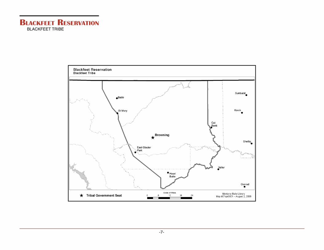
blaCkfeeT reservaTIonBLACKFEET TRIBE
-7-

blaCkfeeT reservaTIon
loCaTIon
The Blackfeet Reservation is located in Northwestern Montana along the eastern slopes of the Rocky Mountains. It is bounded on the north by the United States-Canadian boundary and extends 52 miles south to Birch Creek. The foothills of the Rockies form the western boundary and the eastern boundary approximates an imaginary line, which starts near the junction of Cut Bank Creek and the Marias River and extends northward. Within these boundaries, the land is mainly high, rolling prai-ries interspersed with rivers and creeks. The mountains found along the western border range in altitude between 4,400 to 9,600 feet.
Browning, the gateway to Glacier National Park, is an incorporated town on the reservation. It has been the headquarters of the Blackfeet Indian Agency since 1894 and is the principal shopping center on the reserva-tion. Other communities located throughout the reservation include East Glacier, Babb, St. Mary, Starr School, and Heart Butte.
PoPulaTIon
Enrolled Members living on or near the Blackfeet Reservation 8,485
Enrolled Members living off the Blackfeet Reservation 6,633
Total number of enrolled Tribal members 15,118
The CreaTIon
Chewing Black Bones, a respected Blackfeet elder, told Ella E. Clark the following creation myth in 1953. Clark later published the account in her book, “Indian Legends from the Northern Rockies.”
Old Man came from the south, making the mountains, the prairies, and the forests as he passed along, making the birds and the animals also. He traveled northward making things as he went, putting red paint in the ground here and there—arranging the world as we see it today.
He made the Milk River and crossed it; being tired, he went up on a little hill and lay down to rest. As he lay on his back, stretched out on the grass with his arms extended, he marked his figure with stones. You can see those rocks today; they show the shape of his body, legs, arms and hair.
Going on north after he had rested, he stumbled over a knoll and fell down on his knees. He said aloud, “You are a bad thing to make me stumble so.” Then he raised up two large buttes there and named them the Knees. They are called the Knees to this day. He went on farther north, and with some of the rocks he carried with him he built the Sweet Grass Hills.
Old Man covered the plains with grass for the animals to feed on. He marked off a piece of ground and in it made all kinds of roots and berries to grow: camas, carrots, turnips, bitterroot, serviceberries, bull-berries, cherries, plums, and rosebuds. He planted trees, and he put all kinds of animals on the ground.
When he created the bighorn sheep with its big head and horns, he made it out on the prairie. But it did not travel easily on the prairie; it was awkward and could not go fast. So Old Man took it by its horns, led it up into the mountain, and turned it loose. There the bighorn skipped about among the rocks and went up fearful places with ease. So Old Man said to it, “This is the kind of place that suits you; this is what you are fitted for, the rocks, and the mountains.”
-8-

-9-
While he was in the mountains, he made the antelope out of dirt and turned it loose to see how it would do. It ran so fast that it fell over some rocks and hurt itself. Seeing that the mountains were not the place for it, Old Man took the antelope down to the prairie and turned it loose. When he saw it running away fast and gracefully, he said, “This is what you are suited to, the broad prairie.”
One day Old Man decided that he would make a woman and a child. So he formed them both of clay, the woman and the child, her son.
After he had molded the clay in human shape, he said to it, “You must be people.” And then he covered it up and went away. The next morning he went to the place, took off the covering, looked at the images, and said “Arise and walk.” They did so. They walked down to the river with their maker, and then he told them that his name was Napi, Old Man.
This is how we came to be people. It is he who made us.
The first people were poor and naked, and they did not know how to do anything for themselves. Old Man showed them the roots and berries and said “You can eat these.” Then he pointed to certain trees, “When the bark of these trees is young and tender, it is good. Then you can peel it off and eat it.”
He told the people that the animals also should be their food. “These are your herds,” he said. “All these little animals that live on the ground — squirrels, rabbits, skunks, beavers, are good to eat. You need not fear to eat their flesh. All the birds that fly, these too, I have made for you, so that you can eat of their flesh.”
Old Man took the first people over the prairies and through the forests, then the swamps to show them the different plants he had created. He told them what herbs were good for sicknesses, saying often, “The root
of this herb or the leaf of this herb, if gathered in a certain month of the year, is good for certain sickness.” In that way the people learned the power of all herbs. Then he showed them how to make weapons with which to kill the animals for their food. First, he went out and cut some serviceberry shoots, brought them in, and peeled the bark off them. He took one of the larger shoots, flattened it, tied a string to it, and thus made a bow. Then he caught one of the birds he had made, took feathers from its wing, split them, and tied them to a shaft of wood.
At first he tied four feathers along the shaft, and with this bow sent the arrow toward its mark. But he found that it did not fly well. When he used only three feathers, it went straight to the mark. Then he went out and began to break sharp pieces off the stones. When he tied them at the ends of his arrows, he found that the black flint stones, and some white flint, made the best arrow points.
When the people had learned to make bow and arrows, Old Man taught them how to shoot animals and birds. Because it is not healthful to eat animals’ flesh raw, he showed the first people how to make fire. He gathered soft, dry rotten driftwood and made a punk of it. Then he found a piece of hardwood and drilled a hole in it with an arrow point. He gave the first man a pointed piece of hardwood and showed him how to roll it between his hands until sparks came out and the punk caught fire. Then he showed the people how to cook the meat of the animals they had killed and how to eat it.
He told them to get a certain kind of stone that was on the land, while he found a harder stone. With the hard stone he had them hollow out the softer one and so make a kettle. Thus, they made their dishes.
Old Man told the first people how to get spirit power: “Go away by yourself and go to sleep. Something will come to you in your dream that will help you. It may be some animal. Whatever this animal tells you in your sleep, you must do. Obey it. Be guided by it. If later you want help, if you are traveling alone and cry aloud for help, your prayer will be answered. It may be by an eagle, perhaps by a buffalo, perhaps by a bear. Whatever animal hears your prayer you must listen to it.”
That was how the first people got along in the world, by the power given to them in their dreams.
-10-
After this, Old Man kept on traveling north. Many of the animals that he had created followed him. They understood when he spoke to them, and they were his servants. When he got to the north point of the Porcupine Mountains, he made some more mud images of people, blew his breath upon them, and they became people, men and women. They asked him, “What are we to eat?”
By way of answer, Old Man made many images of clay in the form of buffalo. Then he blew breath upon them and they stood up. When he made signs to them, they started to run. Then he said to the people, “Those animals—buffalo—are your food.”
“But how can we kill them?” the people asked.
“I will show you,” he answered.
He took them to a cliff and told them to build rock piles: “Now hide behind these piles of rocks,” he said. “I will lead the buffalo this way. When they are opposite you, rise up.”
After telling them what to do, he started toward the herd of buffalo. When he called the animals, they started to run toward him, and they followed him until they were inside the piles of rock. Then Old Man dropped back. As the people rose up, the buffalo ran in a straight line and jumped over the cliff.
“Go down and take the flesh of those animals,” said Old Man.
The people tried to tear the limbs apart, but they could not. Old Man went to the edge of the cliff, broke off some pieces with sharp edges, and told the people to cut the flesh with these rocks. They obeyed him. When they had skinned the buffalo, they set up some poles and put the hides on them. Thus they made a shelter to sleep under.
After Old Man had taught the people all these things, he started off again, traveling north until he came to where the Bow and Elbow Rivers meet. There he made some more people and taught them the same things. From there he went farther north. When he had gone almost to the Red Deer River, he was so tired that he lay down on a hill. The form of his body can be seen there yet, on the top of the hill where he rested.
When he awoke from his sleep, he traveled farther north until he came to a high hill. He climbed to the top of it and there he sat down to rest. As he gazed over the country, he was greatly pleased by it. Looking at the steep hill below him, he said to himself, “This is a fine place for sliding. I will have some fun.” And he began to slide down the hill. The marks where he slid are to be seen yet, and the place is known to all the Blackfeet tribes as “Old Mans Sliding Ground.”
Old Man can never die. Long ago he left the Blackfeet and went away toward the west, disappearing in the mountains. Before he started, he said to the people, “I will always take care of you, and some day I will return.”
Even today some people think that he spoke the truth and that when he comes back he will bring with him the buffalo, which they believe the white men have hidden. Others remember that before he left them he said that when he returned he would find them a different people. They would be living in a different world, he said, from that which he had cre-ated for them and had taught them to live in.
land sTaTus
Total acres within the Reservation’s Boundary 1,525,712 acres
Individually allotted lands 701,815.57 acres
Tribally owned lands 311,174.98 acres
Government lands 1,654.46 acres
Fee title or state lands 511,067.10 acres
Presently, the land is used for ranching, farming, oil and gas development, and harvesting timber. The principal crops are wheat, barley, and hay.
It is believed that traditional territorial lands of the Blackfoot Confederacy extended from the North Saskatchewan River south to Yellowstone Park, their western boundary being the Rocky Mountains and extending to the eastern boundary of Montana following the Missouri River.

hIsTorICal baCkground
The present day Blackfeet are descended from tribes known as the Blackfeet (Siksika), Kainah or Bloods, and Piegans, all of Algonquin linguistic stock. These three tribes shared a common culture, spoke the same language, and held a common territory. Members of these tribes lived in the present Province of Saskatchewan until 1730, when they started to move southwestward where the buffalo and other game were more abundant. Although there is some controversy over the origin of their name, “Blackfeet” is thought to refer to the characteristic black color of their moccasins, possibly painted by the Indians themselves or darkened by fire ashes.
Prior to the 1800s the Blackfeet had little opportunity to engage in con-flicts with either the white man or other Indians. The location of their territory was such that the Blackfeet were relatively isolated and, thus, they encountered the white man later than most tribes. During the first half of the 19th century, white settlers began entering the Blackfeet ter-ritory bringing with them items for trade.
The Blackfeet were indirectly introduced to a great variety of trade mate-rial through Cree and Assiniboine traders who traded furs and buffalo hides to traders of the Hudson’s Bay Company in the northeast. Realizing the efficiency of the white man’s metal tools, utensils, and weapons, the Indians were eager to trade for wares that made life easier.
The horse and gun soon revolutionized the Blackfeet culture. The white man’s guns offered a formidable new defense against their enemies. Competition for the better hunting territories and the desire to acquire horses led to intertribal warfare. The Blackfeet quickly established their reputation as warriors and demanded the respect of other Indian tribes and the white man alike.
Although they were not officially represented or even consulted, a vast area was set-aside for the Blackfeet Tribes by the Fort Laramie Treaty of 1851. In 1855, the government made a treaty with the Blackfeet and several of their neighboring tribes, which provided for use of a large por-tion of the original reservation as a common hunting territory.
In 1865 and 1868, treaties were negotiated for their lands south of the Mis-souri, but were not ratified by Congress. In 1873 and 1874, the Blackfeet southern boundary was moved 200 miles north by Presidential orders and Congressional Acts. The land to the south was opened to settle-ment. During the winters of 1883 and 1884, the Blackfeet experienced unsuccessful buffalo hunts. After the disappearance of the buffalo, the Blackfeet faced starvation and were forced to accept reservation living and dependence upon rationing for survival.
In 1888, additional lands were ceded and separate boundaries estab-lished for the Blackfeet, Fort Belknap, and Fort Peck Reservations. In 1896 an agreement was once again made between the United States government and the Blackfeet Tribe. This time the United States govern-ment was asking for the sale of the Rocky Mountains, which bordered the reservation to the west. It was believed that there were valuable minerals there. A commission was sent out to negotiate and heated disagreements ensued with tribal members over how much land and money this agreement would involve. The end result was a cession of land that now makes up Glacier National Park and the Lewis and Clark National Forest. Today this agreement is still in dispute over how much land and money was agreed upon. The Blackfeet Tribe still holds some rights in Glacier National Park and in the Lewis and Clark National For-est. As long as the people continue to appreciate what the Creator gave them, there will continue to be disagreement over stewardship of the land once occupied by this great nation.
organIzaTIonal sTruCTure
The Blackfeet Indian Tribe was organized in 1935 under the Indian Reorganization Act. It exists both as a political entity and a business corporation. All tribal members are shareholders in the corporation. The Blackfeet Tribal Business Council is made up of nine members, selected from four districts on the reservation: Browning, Seville, Heart Butte and Old Agency. The nine Blackfeet Tribal Business Council members conduct both the political and business affairs of the tribe and corporation. The councilmen are elected by secret ballot of eligible tribal members and serve staggered four and two-year terms. The four council members that win
-11-

by majority vote serve a four-year term, the other five councilmen serve a two-year term. The tribal council elects and appoints its own officers and hires its own staff. In the past, the Council has been granted broad political powers. Today the Blackfeet Tribal Business Council oversees 62 tribal programs and departments, and is one of the major employers on the reservation.
The following is a list of Blackfeet Tribal Programs and Depart-ments:
• Blackfeet Tribal Business Council • Council Staff • Finance Department • Legal Department • Human Resources/Personnel Department • Self-Insurance Program • Enrollment Department • Tribal Security • Documents Department • Procurement Department • Land Department • Forestry Department • Forest Development Department • Margie Kennedy Center • Survey • Tribal Employment Rights Office-TERO • Low Income Housing Energy Assistance Program -LIHEAP • Agriculture Department • Veteran’s Program • Higher Education Program • Community Services/Hardship Program • Facility Management and Maintenance Department • Glenn Heavy Runner Memorial Swimming Pool • Blackfeet Youth Initiative Program - BYI • Blackfeet Utilities Commission-BUC • Nurturing Center • Commodity Program • WIC Program • Health & Safety Program (AmeriCorps) • Medicine Bear Shelter
• Heart Butte Senior Citizens Center • Oil & Gas Department • Southern Piegan Diabetes Program • Pikuni Family Healing Center • Indian Health Service Security • EMS Program • Tribal Health Program • Community Health Representatives Program • Chemical Dependency Program • Mineral Management Program • Water Resources Program • Fish & Wildlife Program • Transportation Program • Home Improvement Program-HIP • Johnson O’Malley Program-JOM • Law Enforcement • Juvenile Program • Tribal Credit • Tribal Court • Geographic Information Systems Program-GIS • Chief Mountain Hot Shots • Welfare Reform Program • Family Services Program • Indian Child Welfare Act Program-ICWA • Environment Program-EPA • JTPA/Welfare to Work Program • Eagle Shields Center • Personal Care Attendant Program-PCA • Planning and Economic Development • Blackfeet Transit • Head Start Program
The Bureau of Indian Affairs office is located in a new building on the edge of Browning, coming in from the east on Highway 89.
Bureau Operated Programs:
• Executive Direction (Superintendent) • Administrative Services • Natural Resources
-12-

• Forestry • Real Estate Services (Realty) • Facility Management • Social Services • Roads Maintenance • Irrigation
housIng
The Blackfeet Indian Housing Authority was created in the 1960s in order to address the need for affordable housing on the reservation. Currently the Blackfeet Housing Authority manages 1,395 units, with 32 under construction. The units are either rentals or home ownerships. Home ownership programs have made it possible for families to have decent, safe, and affordable housing. Due to the large unemployment rate on the reservation and the continuous population growth, affordable housing is an issue that the staff of the Blackfeet Housing continues to strive for.
The Blackfeet Tribe and Blackfeet Housing are committed to provide decent, safe, sanitary, and affordable housing.
eduCaTIon
In contrast to half a century ago, a great percentage of Blackfeet today are fluent English speakers. Several of the modern schools on the res-ervation are administered by a locally elected school board, under the Board of Public Education, and subject to compulsory school laws.
Elementary and high school students attend public schools located in Browning, Heart Butte, East Glacier, Babb and Croff Wren. In addition, the Blackfeet Boarding Dormitories are operated to provide homes dur-ing the school year for elementary children from isolated districts. Heart Butte has built a new high school with a gymnasium to serve the students located on the southern portion of the reservation. Another option for elementary students is the Nizipuhwahsin (Real Speak) schools created in 1994. They offer K-8 education taught in the Blackfoot Language. Ap-proximately 60 students attend the school during the standard academic
year. The Piegan Institute operates the schools. The Piegan Institute is a private non-profit organization. The Ni zi puh wah sin schools are located in Browning.
Students and community members have the opportunity to further their education by attending the Blackfeet Community College. The college is a fully accredited, two-year, higher education institution. The Northwest Association of Schools and Colleges accredits it.
eMPloyMenT and InCoMe
Unemployment is a major problem on the Blackfeet Reservation. Cur-rently the unemployment rate ranges between 60 and 80 percent. Much of the labor force depends on firefighting and other seasonal type jobs. In order to bring the high employment rate down, 3,000 new jobs must be created.
In recent years all agencies on the Blackfeet Reservation have pulled together to address the unemployment issue. Most recently the Black-feet Tribe formed an economic development corporation to establish enterprises that will create jobs and boost the economy. Currently Siyeh Development Corporation has started several enterprises which employs 20 people and is in the process of constructing a wind farm that will not only generate renewable power but will create many long term technical jobs. A 67-acre industrial park has been developed which houses a pencil factory and Pikuni Industries, a corporation owned by the Blackfeet Tribe. Pikuni Industries builds modular homes and produces steel frames for construction. This industry provides full-time employment for 40 employ-ees. A new casino, “Glacier Peaks”, recently opened in Browning.
Income for tribal members is derived from agriculture, livestock produc-tion, timber, light industry, tourism, and construction. The leading job providers on the reservation are Indian Health Service, School District No. 9, Blackfeet Tribe, and the Bureau of Indian Affairs. Local craftsmen supplement their income by selling crafts to the summer tourists.
-13-
ConTeMPorary Issues
The future of the Blackfeet Tribe is looking positive. The warriors are the young and old who feel it necessary to maintain our cultural integrity and identity.
According to Blackfeet Tribal Business Chairman Earl Old Person, the main issues facing the tribe today are “the high unemployment rate and water rights.” The Blackfeet Tribal Business Council is looking at ways to create permanent employment opportunities rather than relying on government programs for employment. The Siyeh Development Corporation, and the industrial park and the new tribal casino were established to assist with creating employment opportunities. The issue of water rights has a long history with the Blackfeet Tribe. Due to the location of the Blackfeet Reservation they are in the unique situation of sitting at the crest of the continental divide which feeds three major bodies of water: Hudson Bay, Gulf of Mexico, and the Pacific Ocean. The headwaters supply many of the rivers and streams that flow through the state of Montana. The water is of great value to wildlife, agriculture, and municipalities of the state. The tribe must define water rights for all parties involved. This process will require a great deal of reason and thoughtful consideration. Chief Old Person advises students “to be a part of the change” that takes place in life. “There was a time we could sit on the side, it’s a must for our young to do what they can. They are our future. Truly the warriors of this time will be those who understand both the old ways and the new, keeping in mind, culture can strengthen.”
Other tribal councilmen feel major issue facing the tribe, are water rights, due to the recent drought, and the “disputed strip.” The recent drought has resurrected the age-old question of who has ownership of the water and how much should they be entitled to. Eventually, the Blackfeet Tribe will have to decide this or face the possibility of other governmental agencies doing so for them. The other issue facing the Blackfeet people is the land in question along the Rocky Mountains, the Backbone of the World, according to Blackfeet. In 1896, the United States sent out commissioners to the Blackfeet to negotiate once again for land. This time it would be for the rocks or mountains that served as the eastern boundary for the Blackfeet for centuries. The Agreement states the land was ceded to the United States with the Blackfeet Tribe
entitled to three reserved rights: the right to enter, the right to hunt and fish, and the right to gather timber. From the beginning there has been the question raised by some members of the tribe whether this was a lease or an actual sale. The dispute is further complicated when the northern portion became a national park (Glacier National Park) and the southern part became a national forest (Lewis & Clark National Forest) changing the status of the land. Again questions were raised, this time in regard to the boundary line between the “disputed strip” and the reservation. The agreement reads from summit to summit, but this does not seem to be the case as one looks at a topographical map. These discrepancies, raised by members of the tribe in the past, have surfaced again as we recently passed the 100-year anniversary of this agreement.
As the new millennium begins, we must be ready for the changes as Mr. Old Person states, whether it is teaching our people about academics or our tribal traditions, which set us apart from others but can enrich our lives. A holistic approach can be accomplished by having a firm under-
standing of the Blackfeet language, traditions, and stories as well as having strong reading and writing skills. The warriors of today must work hard to make certain they are prepared for the challenges of to-morrow.
reCreaTIon
The Blackfeet Tribe con-tinues to address the de-
velopment of tourist trade on the Blackfeet Reservation. The potential for outdoor recreational developments on the reservation has always been exceptional. Over 175 miles of rivers and streams and eight major lakes offer some of Montana’s best fishing. The possibilities are greatly enhanced by virtue of the reservation’s close proximity to Glacier Na-tional Park.
The town of Browning is the center of activity on the Blackfeet Reservation. The major businesses are located in Browning: Blackfeet Tribal Business
-14-

Office, Bureau of Indian Affairs, Indian Health Service, Blackfeet Housing Authority, Browning Public Schools, and Blackfeet Community College along with the industrial park located adjacent to Browning.
A principal attraction on the Blackfeet Reservation is the Museum of the Plains Indians operated under the direction of the Indian Arts and Crafts Board. Since opening in 1941, thousands of visitors have stopped at the museum. The museum features Native American artists and their work throughout the year.
A camping facility called Chewing Blackbones is located on the eastern shore of Lower St. Mary’s Lake, which was opened in 1978. It is situated near the entrance to Glacier National Park on U.S. Highway 89 near St. Mary’s and four miles south of Babb. Facilities include camping grounds with hook-ups for RV motor homes and a general store. Visitors are wel-come to camp at any of the lakes located on the Blackfeet Reservation; however, most are without facilities for RV trailers.
Things To Do: Fishing Horseback Riding/Trail Rides Guided Tours Rodeos Hiking and Camping Cross Country Skiing Boating Pow Wows
annual fesTIvITIes
Throughout the year there are many celebrations and other activities taking place on the Blackfeet Reservation. These are events that allow communities to come together and celebrate, visit, and enjoy. The larg-est of the celebrations takes place the second week of July, the North American Indian Days Celebration. The Indian Days celebration includes a parade in Browning and other activities such as dancing, singing, drum-ming, special dance contests, feasts, stick games, give-a-ways, and a rodeo. This has always been a time for family and friends to get together and have some fun. Following is a list of annual events that take place on the Blackfeet Reservation.
Community Sponsored Events
• Baker Massacre Memorial January 23 • Blackfeet Community College Pow Wow June • Blackfeet Days May • Christmas Pow Wow December • Head Start Mini Pow Wow Fall • Heart Butte Indian Days August • Hell’s Half Acre Memorial Rodeo May • North American Indian Days July • Thanksgiving Pow Wow November • The Flood of 1964 Memorial June
School Sponsored Events
• Native American Heritage Week September • Eagle Claw Society Inductions September/ October • Homecoming parade/dance September/ October • Red Ribbon Week October • Prom Dance Spring • Graduation Commencement May/June
resourCes abouT The blaCkfeeT TrIbe
for sTudenTs/eduCaTors
Books
The Blackfeet: An Annotated Bibliography / Johnson, Bryan,1965, Garland Pub.
Blackfeet and Buffalo: Memories of Life Among the Indians, Schultz, James Willard, 1859-1947, University of Oklahoma Press.
Blackfeet Indian Stories, Grinnell, George Bird, 1849-1938, C. Scribner’s Sons.
-15-

Blackfoot Lodge Tales; The Story of a Prairie People, Grinnell, George Bird, 1849-1938, University of Nebraska.
The Blackfeet: Raiders of the Northwestern Plains, Ewers, John Canfield, 1967, University of Oklahoma Press.
Crowfoot, Chief of the Blackfeet, Dempsey, Hugh Aylmer, 1924, University of Oklahoma Press.
The Old North Trail; Life, Legends, and Religion of the Blackfeet Indians, McClintock, Walter, 1870, University of Nebraska Press.
A Dictionary of Blackfoot, Frantz, Donald and Norma Jean Russell,1989, University of Toronto Press.
Mythology of the Blackfoot Indians, Wissler, Clark and D.C. Duvall,1870-1947, University of Nebraska Press.
The Sun Came Down, BullChild, Percy, 1985, Harper & RowPublishers.
The Ways of My Grandmothers, Hungry Wolf, Beverly, 1980, Quill, New York, NY.
-16-
Web sites
Blackfeet Nationhttp://www.blackfeetnation.com
Browning Public Schoolshttp://www.bps.k12.mt.us/
Bureau of Indian Affairshttp://www.doi.gov/bureau-indian-affairs.html

-17-
Crow reservaTIonCROW TRIBE
-18-
Crow reservaTIon
loCaTIon
The Crow Indian Reservation encompasses a 4,989 square mile area or 3.8 million acres mainly in Big Horn County, in south central Montana. The Crow Reservation is nearly the same size as the entire state of Con-necticut. The Crow Reservation is divided into six districts for cultural and Crow governmental purposes. They are: Reno, Lodge Grass, Pryor, St. Xavier, Wyola, and Black Lodge districts.
The Crow Reservation has three mountainous areas, the Big Horn Mountains and the Pryor Mountains to the south/southwest, and the Wolf Teeth Mountains to the southeast. These mountain ranges meet the plains and valleys producing varied topography. In addition to the high mountains, the reservation includes gravely or stony slopes, broad hilltops with soils generally capable of supporting and maintaining excel-lent vegetative cover, level and productive irrigated valleys along the Big Horn and Little Big Horn Rivers and Pryor Creek, deep canyons, and extensive areas of rolling plateau.
The nearest service center is Hardin, Montana, immediately adjacent to the reservation’s northern boundary where restaurants, shops, and motels are available. However, the biggest retail and business center for the Crow Tribe is Billings located 90 miles north of Crow Agency, Montana.
PoPulaTIon
Tribal Members living on or near the Crow Reservation 7,153
Tribal Members living off the Crow Reservation 3,180
Total number of enrolled Tribal members 10,333
land
Total acres within the Reservation’s boundary 2,464,914 acres
Individually allotted lands 1,166,406 acres
Tribally owned lands 404,172 acres
Fee title or state lands 709,167 acres
Government lands 1,135 acres
In 1973 over 31 percent of the land was owned by non-Indians. The Crow Indians operate only a small portion of their irrigated or dry farm acreage and only about 30 percent of their grazing land. More authority for the leasing of land without supervision has been extended to the Crow Tribe than to any other Indian tribe in Montana. Special legislation regarding Crow land in 1920, known as the Crow Act, and subsequent modifications occurring in 1926, 1948, and 1949, allowed most Crow tribal members to contract independent leases for individually owned land.
hIsTorICal baCkground
The ancestors of the Crow Indians came from a “land of many lakes” probably in the headwaters of the Mississippi or further north in the Win-nipeg Lake region. They eventually settled along the Missouri River in what are now the states of North and South Dakota. The people lived in semi-permanent villages of lodges covered with earth. They became known as the “people who lived in earthen lodges.”
Nearly 400 years ago, the people divided into two factions. One group, the Hidatsa, remained along the Missouri. The other group, the Apsaalooke, migrated westward and eventually claimed most of what is now eastern Montana and northern Wyoming as homeland. At the time of the breakup, this group, numbering about 500, was made up of several families. Its population reached about 8,000 before the smallpox epidemic of the middle 1800s. At that time, the Apsaalooke or Crow Tribe traveled in two or three groups or bands.

-19-
In 1825, the Crow Tribe and the United States signed a treaty of friend-ship. In 1851, the Fort Laramie Treaty established the boundaries for several tribes, including an area of 38,531,147 acres designated for the Crow Indians. This was followed by the Fort Laramie Treaty of 1868, which reduced the Crow holdings to 8,000,409.20 acres.
An Act of Congress in 1882 resulted in a further reduction of the land. For compensation, the government committed to buy livestock and build houses for them. By this time, the tribe had been settled within the boundaries of the reservation for about ten years. In 1890, more land was ceded to the government for which they received $946,000. In 1905, the last large land cession was made leaving about three million acres of land for the tribe.
The Crow Indians have always felt the government failed to give them adequate compensation for the land it acquired. The estimated value was far more that the five cents per acre they received. In 1904, the Crow Tribe first initiated legal proceedings for just compensation for lands taken. In 1962, the Court of Indian Claims finally awarded a $10,242,984.70 judgment to the Crow Indians.
Since 1905, further attempts have been made to reduce the Crow Res-ervation. Sen. Dixon in 1910, Sen. Meyers in 1915, and Sen. Walsh in 1919, all sponsored legislation in Congress to open the balance of the Crow Reservation for settlement by the public. All attempts failed. An Act of Congress passed on June 4, 1920, sponsored by the tribe itself, divided the remainder of the reservation into tracts which were allotted to every enrolled member of the tribe. The titles to these lands are held in trust by the federal government and allottees may not dispose of their lands without the consent and approval of the government. The rough mountain areas were withheld from such allotment and remain in com-munal tribal ownership.
organIzaTIonal sTruCTure
The Crow Tribe chose not to organize under the Indian Reorganization Act of 1934. Rather, they adopted a written constitution on June 24, 1948, and subsequently amended the constitution on December 18,1961. Under that constitution, the tribe had a general council form of government in which every enrolled member has one vote if they were present during the general council meeting. The Crow Constitution stipulated that 100 or more tribal members established a quorum, and a quorum had to be present before a vote could be taken on any important matter of tribal business. There was no representative tribal council. Under the constitu-tion, the general adult membership, 18 years or older, elected its tribal officials, Chairman, Vice-chairman, Secretary and Vice-Secretary every two years. The general council of the Crow Tribe met quarterly to conduct tribal business. Recently, the Crow Tribe voted for a new constitution that establishes three branches of government; 1) Executive, 2) Legislative, and 3) Judicial.Various represen-tative committees such as law and order, education, enrollment, land resource, credit, health, minerals, economic devel-opment, and rec-reation were es-tablished in 1962 through resolution and election ordi-nance. These ten committees’ members are elected by their constituents in each of the six districts to represent them. Committee members are elected for two-year terms. It is the responsibility of these committees to ensure that the voice and preferences of the Crow people are heard and implemented.

-20-
housIng
Housing conditions on the Crow Reservation are poor. Currently, there are 1,223 housing units across the reservation. Unfortunately, 75 percent of these housing units are considered to be substandard. Since 1971, approximately 250 HUD financed housing units have been constructed on the Crow Reservation. Another 534 cluster homes were built in 1987 in the towns of Crow Agency, Lodge Grass, Pryor, and Wyola. Over-crowding continues to be a serious problem on the reservation with two to three families living in one home. However, an estimated 2,500 new homes are needed to meet the current needs for new and replacement construction.
MedICal faCIlITIes
The Indian Health Service operates a new 50-bed hospital with complete inpatient care located one mile south of the Crow Agency. In addition, the outpatient facilities provide dental, vision, surgical, and special clinics once a month. Satellite outpatient services are available at the Lodge Grass and Pryor Clinics. Also, a dialysis center and a 30-patient nursing home are adjacent to the hospital. The health care facilities also serve members of the Northern Cheyenne Tribe located 30 miles east of the Crow Reservation.
eduCaTIon
Since 1900, the Crow Tribe of Indians preferred public education for its children. Around 1920, the Crow Tribe of Indians set aside land to “pay” for the privilege of having public schools on the reservation. Currently, there are four elementary (K-8) districts and three high school (9-12) districts on or adjacent to the Crow Reservation. These school facilities are situated at Crow Agency, Lodge Grass, Ft. Smith, Wyola, Pryor, and Hardin. In addition, Crow students attend two private parochial schools, St. Xavier Mission at St. Xavier and St. Charles Mission at Pryor, Mon-tana. The total on-reservation Indian student population is estimated at 1,500 students.
In 1980, the Crow Tribe charted Little Big Horn College which is located in Crow Agency, Montana. The college received candidacy for accredita-tion in 1984. The college received full accreditation in 1990 by Northwest Accreditation Commission for Schools and Colleges.
eMPloyMenT and InCoMe
According to the Bureau of Indian Affairs Labor report for 1999, there were 3,965 individuals in the potential labor force. Of these, 1,531 people (16 to 64 years of age) were employed, while 2,371, or 60 percent were unemployed. Unemployment reaches its peak of an estimated 85 percent during the winter months. The average annual unemployment rate on the reservation has held above 60 percent in recent years and has not dropped below 39 percent since 1976.
The economy of the Crow Reservation remains based almost entirely upon government services to the people and agriculture, farming, and ranching, although few tribal members are self-sustaining in these ac-tivities. The high winter unemployment is relieved to some extent in the spring and summer with farming, ranching, and construction work. The curtailment of the federal public service job programs in the 1980s has contributed to a sustained rise in the annual unemployment rate. Over 75 percent of the on-reservation Indian population has income below the current federally established poverty levels.
Principal employers in the existing economy are the Bureau of Indian Affairs, Indian Health Service, Tribal Government, coal mining opera-tions, farming, ranching, and education related services. Income from leasing of trust lands represents the major income resource for most on-reservation tribal members.
reCreaTIonal aTTraCTIons
The building of the Yellowtail Dam, a 525-foot high, thin arch dam, resulted in the creation of a 70-mile long lake of spectacular scenic beauty in the Big Horn Canyon. The land and some of the surrounding area has been

-21-
designated a National Recreation Area. The Secretary of the Interior has approved a Memorandum of Agreement between the Crow Tribe and the National Park Service to facilitate the development, administration, and public use of the Big Horn Canyon Recreation Area. Much of this national recreation area lies within the boundaries of the reservation.
The Big Horn River, which runs north and south through the reservation, was opened to fishing by non-tribal members in 1981.
annual fesTIvITIes
Each year during the third week in August the Crow Fair Celebration and Powwow is held. Indians from around the United States and Canada travel to the Crow Reservation to set up as many as 500 teepees. The festivi-ties include a parade, dances, Indian relay races, feasts, “give-aways,” and the Annual All-Indian Rodeo and Race Meet. The celebration of this event has led to the national recognition of the Crow Reservation as the “Tipi Capital of the World.”
PoInTs of InTeresT
Bighorn Canyon National Recreation Area and Yellowtail Dam, Fort Smith, Montana, (406) 666-2412
The canyon features spectacular scenery, wildlife viewing, boating, fishing, and camping. There are two visitor centers - one at Fort Smith and one at Yellowtail Dam.
Little Bighorn Battlefield National Monument/Reno-Benteen Battle-field, Crow Agency, Montana, (406) 638-2621
These monuments commemorate the Indian victory over the Seventh Cavalry. The Little Bighorn Battlefield National Monument features museum exhibits, interpretive center, and ranger-led programs.
Chief Plenty Coups State Park, Pryor, Montana, (406) 252-1289This is the home of the well-known Crow Chief, Plenty Coups. There is a display of Crow artifacts and scenic picnic area.
Little Big Horn College, Crow Agency, Montana, (406) 638-3100The college offers associate degrees in eight areas and integrates Crow Studies in all aspects of the plan of study to comply with its mission of maintaining and preserving the Crow language and cul-ture. In addition, the college operates the Institute for Micro-Business Development and Little Big Horn Tours for the Crow Reservation. Group or individual tours and lectures are available during the sum-mer, and on special arrangement all year long.

-22-
flaThead reservaTIonCONFEDERATED SALISH-KOOTENAI TRIBES

-23-
flaThead reservaTIon
loCaTIon
The Flathead Indian Reservation is located in northwestern Montana on the western slope of the Continental Divide. The exterior boundaries of the reservation include portions of four counties—Flathead, Lake, Mis-soula, and Sanders. The Flathead Reservation land base consists of approximately 1,243,000 acres. The eastern border of the reservation is at the top of the Mission Range of the Rocky Mountains. Flathead Lake and the Cabinet Mountain Range are to the north; the Lower Flathead River runs through the heart of the reservation; and to the west are the Salish Mountains and rolling prairie lands.
PoPulaTIon
The three tribes of the Flathead Indian Reservation are the Salish, Pend d’Oreille, and Kootenai. Seliñ is the proper name for the Salish, who refer to themselves as Sqéliö—the People. The Salish have often been referred to as “Flatheads,” but this name is a misnomer and, in actual-ity, there are no Flatheads. Qæispé is the proper name for the Pend d’Oreille. The aboriginal name of the Kootenai Tribe is Kutanaxa, a name that means “licks the blood” in reference to a traditional hunting custom. The term Ktunaxa describes the Kootenai political sovereignty as a nation and all citizens who identify themselves as Kootenai. “Ksanka” refers to the name of the Ktunaxa band of the Flathead Reservation. Kasanka translates, “Standing Arrow,” which is a traditional warring technique. The tribes today are known by the contemporary title of The Confederated Salish and Kootenai Tribes. For the purposes of this document and for reader understanding, the terms Salish, Pend d’Oreille, and Kootenai will be used.
After the reservation period, when lands were allotted and then subse-quently opened to homesteading in 1910, many non-Indians moved to the reservation. The influx of homesteaders and the continuing movement of non-Indians onto the reservation have resulted in the Confederated
Salish and Kootenai People being the minority population on their own reservation. Presently there are many Indian people from other tribes that live on the Flathead Reservation. Many are attending Salish Kootenai College or Kicking Horse Job Corps. Some have intermarried with tribal members and live among the community with their families. Both Salish Kootenai College and local K-12 public schools have identified over 40 different tribal nations represented within the student populations.
There are 6,961 enrolled members of the Confederated Salish and Koo-tenai Tribes. Of this population, 4,244 live on the reservation.
land
The Hellgate Treaty of 1855 created the Flathead Reservation. The treaty defined the boundaries of the reservation. A formal survey by the government actually diminished the reservation both on the northern and southern ends. The lands that remained as reserved by the treaty are approximately 1,243,000 acres. This land base was soon to change, however, with the passing of the Allotment Act (Dawes Act) of 1887, and the subsequent Homestead Act that opened the reservation to non-Indians in 1910. This resulted in the tribes becoming the minority landowners on their own reservation.
While much of the prime agricultural land remains in non-Indian hands, the tribes have been aggressively buying back land. At this time they have become the majority landowners at roughly 56 percent. Following is a breakdown of the current status of reservation lands:
Area in Acres Status 613,273.50 Tribal Trust 58,728.98 Tribal Fee 39,940.56 Individual Trust 4,248.89 Off-Reservation Tribal Fee 76,159.25 Water 22,466.46 Federal 40,742.57 State 346.42 Town sites 466,480.67 Fee

-24-
Reservation lands are comprised of 451,000 acres of forested land, agricultural lands, prairie habitats, and numerous watersheds, pristine mountain lakes, and the lower half of Flathead Lake, which is the largest freshwater lake west of the Mississippi River. Three hundred twenty-two thousand acres of forested lands are considered commercial forest. This forestland is managed as a whole to include reforestation, fire manage-ment, insect and disease control, timber, and economic opportunities for the tribes. The Wildland Recreation Division of the tribe’s Natural Re-source Department maintains a variety of trails in the Mission Mountains annually. Hiking and recreation on reservation lands by non-members requires a tribal recreation permit.
The Confederated Salish and Kootenai Tribes were the first tribal nation to designate a wilderness area. Much of the Mission Range falls under this category, and no development is allowed in this area. Both the northern and southern areas of the reservation have lands that are designated as “primitive.” The Jocko and Lozeau Primitive Areas are available only to tribal member use, and that use is restricted to certain activities. It is the intent of the tribes that tribal members have access to pristine lands for gathering plants, ceremonial use, and solitude.
The Confederated Salish and Kootenai Tribes believe in their role as stewards of the land and its resources as articulated in the following statement from the Salish Culture Committee:
The earth is our historian; it is made of our ancestor’s bones. It provides us with nourishment, medicine, and comfort. It is our source of our independence; it is our Mother. We do not dominate Her, but harmonize with Her.
hIsTorICal baCkground
Pre-reservation history provided by the Salish and Pend d’Oreille Culture CommitteeSalish and Pend d’Oreille.
The Salish and Pend d’Oreille tell of having lived in what is now Montana from the time when Coyote killed off the Naçisqéliö—the giants. The tribes’ oral histories tell that the Salish and Pend d’Oreille were placed
here in their aboriginal homelands. Their beginning and history in this place is a story of genesis, not of migration. The late Clarence Woodcock told this beginning:
Our story begins when the Creator put the animal people on this earth. He sent Coyote ahead as this world was full of evils and not yet fit for mankind. Coyote came with his brother Fox, to this big island, as the elders call this land, to free it of these evils. They were responsible for creating many geographical formations and providing good and special skills and knowledge for man to use. Coyote, however left many faults such as greed, jealousy, hunger, envy and many other imperfections that we know of today.
Many of the Coyote stories contain what may be considered fairly precise descriptions of the geologic events of the last ice age. Anthropologists and other non-Indians have long been skeptical of this, thinking that there was little evidence that Salish and Pend d’Oreille people had been here that long ago. But recently, archaeologists have found sites in the South Fork of the Flathead River dating back 12,000 to 14,000 years, about the time of the end of the last ice age.
From the beginning of time, the Salish and Pend d’Oreille people made their living off the land through a complex pattern of seasonal hunting and gathering activities. The land provided all that the people needed. Elders say that life was hard, but good. Spring would yield a plentiful bitterroot harvest, followed by sweet camas bulbs in June.
The bloom of the wild rose signaled the people that the buffalo calves had been born and that it was time for the summer buffalo hunt. Through-out the rest of the summer, berries and fruits, including serviceberries, huckleberries, and chokecherries would be gathered, dried and stored. The Salish and Pend d’Oreille regularly gathered hundreds of different plants for food and medicinal uses.
In the fall, hunting began in earnest. Men hunted for large game, which the women butchered, dried and stored for winter. As the hunters brought home elk, deer, and moose, the women tanned hides for clothes, moc-casins and other items such as a par fleche. A par fleche is a rawhide container used for storing a variety of things like dried foods and clothing.

-25-
Fishing was also important throughout the year. Both fishhooks and fish weirs were used to catch fish. Elders tell of days when the fish were so plentiful that you could almost cross the creeks walking on their backs.
The winter season involved trapping, ice fishing, and some hunting. Cold weather brought families inside and women made and repaired clothing while the men made and repaired tools and weapons. Coyote stories were brought out with the first snow. This was a sacred and happy time when ceremonial dances would be held.
Salish and Pend d’Oreille history tells of the break-up of the one great Salish Tribe that existed long ago. As the tribe’s popu-lation became too great to be sus-tained by hunting, fishing, and gath-ering foods in one central location, the people split up into many smaller bands. Tribal elders say that tribes moved from the Montana area toward the west, breaking into smaller tribal groups that could be more easily supported by the seasonal supply of foods. Over time, the tribes’ languages developed dialectical differ-ences, though they are still mutually intelligible. This story explains why all through history and to the present day the Salish and Pend d’Oreille have kept close, friendly, and often intermarried relations with the tribes of eastern Washington and northern Idaho. During the 19th century, these tribes often banded together during their buffalo hunting expedi-tions to the plains.
The Salish have always considered the Bitterroot Valley their homeland, even though before the 17th or 18th century there were several Salish bands based east of the Continental Divide, in such areas as the Big Hole Valley, the Butte area, the Helena area, and the Three Forks vicinity. The Pend d’Oreille similarly occupied both sides of the mountains, with a
major band situated by the Sun River near Great Falls. Salish language place names are still remembered for numerous sites as far east as the Sweetgrass Hills, the Milk River, and the Bear Paw Mountains.
To the north, relations with the Ktunaxa or Kootenai, whose language is unrelated to Salish, were usually amicable, but not as close and familial as to the west. To the south, relations with the Shoshone people were varied and shifted over time. At times these tribes raided each other. At other times they traded, intermarried, and gambled together. A site in the far southern end of the Bitterroot Valley was known as SleÛi, a kind of neutral ground where the Salish and Shoshone would meet to play traditional gambling games.
To the east, inter-tribal relations were less friendly. Both the Salish and Pend d’Oreille have always had conflicts and skirmishes with tribes of the plains, including the various Blackfeet bands; the Gros Ventre, the Crow, the Cree, the Assiniboine, the Cheyenne, and other Sioux tribes. Before the advent of guns, however, intertribal warfare tended to be characterized by low mortality and was largely ceremonial in nature. Counting coup on the enemy was the most important aspect of warfare, which served to reaffirm longstanding boundaries between tribal territories and to establish the honor and bravery of men in their willingness to risk their lives in defense of their people. Even with this history of conflict, the Salish and Pend d’Oreille sometimes had amicable relations with eastern tribes, including trade and even occasional marriage.
During the 17th century intertribal conflicts became more violent and deadly. Perhaps for the first time since time immemorial, tribes found themselves in competition for resources. As tribes were being pushed westward, food sources were being subjected to more intensive har-vesting. Impacts of the movement of European trappers, traders, and settlers were also felt through waves of smallpox, influenza, measles and other contagious diseases. The greatest loss of life among Indian people occurred through disease.
Horses and guns also made their way west. Tribes that gained first ac-cess, like the Blackfeet, enjoyed a shifting balance of power before other tribal groups were able to secure similar armaments.
The combination of resource competition, loss of life from disease, and

-26-
the introduction of deadlier weapons influenced Salish and Pend d’Oreille leaders to move their main camps to the west side of the mountains. Horses would allow the people to continue to hunt buffalo, and the an-nual summer and winter hunts continued until the buffalo population was intentionally decimated in about 1883.
The Ksanka Band of KtunaxaHistoric information provided by the Kootenai Culture Committee
Ktunaxa history describes the evolution of The People from the time when the first sun rose in the sky and human beings were equal to the animals. From the beginning of time the Sun and the Moon were brothers and they produced the powerful life force for all earthly creations. The Sun and Moon transformed all beings who chose to live on this earth into physical forms and assigned them with a domain and complementary tools. The concept of interdependence that maintains the delicate balance of the natural world is intrinsic to Ktunaxa culture.
The aboriginal territory of the Ktunaxa Nation encompasses three major ecosystems: the Columbia River Basin, the Rocky Mountain Region, and the Northern Plains. Although an official census was never taken, eth-nographic studies estimate an historical population in excess of 10,000 Kootenai people.
With a massive homeland to protect and keen environmental skills, the Ktunaxa chose to live in distinct bands to maintain their unique life cycles. The seven bands of the Ktunaxa Nation are distinguished by the location they inhabited throughout the winter months. The Ksanka or the Fish Trap People reside in the Dayton, Elmo, Big Arm, and Nairada communities of Montana. The Wood Land People of St. Mary’s Band are in Cranbrook, British Columbia. The Two Lakes People of the Columbia Lake Band are at Windmere, BC. The People of the Place Where the Rock is Standing (the Lower Kootenai) reside in Creston, BC. The Meadow People live in Bonners Ferry, Idaho and the Tobacco Plains Band live in Grasmere, BC. The Not Shirt People (Upper Kootenai or Shushwap) live in Ivermere, BC.
Prior to reservation settlement, the Ktunaxa lived a bicultural life style, possessing cultural traits of both the Northern Plateau and Northern Plains tribal groups. Ktunaxa subsistence was based on seasonal
migrations that followed plant and animal production cycles, and coin-cidentally served to prevent an environmental degradation of aboriginal lands. Food preservation was an integral part of the Ktunaxa life cycle. Seasonal migrations for hunting and harvesting began in the early spring when bitterroots ripened and fisheries were bountiful. In early summer, they traveled east of the Rockies to hunt buffalo, returning in mid-sum-mer to process and store the meat. In summer, camas, huckleberries, serviceberries, chokecherries, and other plants were harvested. By fall, big game expeditions were organized and some of the hunters returned to the plains for more buffalo. The people preserved and processed food for the winter cache.
The Ktunaxa life cycle also depended on a commerce sector, which involved agriculture and aquaculture. The Ktunaxa cultivated a unique species of tobacco for personal use and trade with other tribes. They specialized in water, fisheries, bird hunting, trapping, and other aqua cultural activities that were ongoing in Kootenai society.
The most prominent distinction of the Ktunaxa is the isolated language they speak. While scientists classify most indigenous languages into family groups to determine origin and migratory patterns, the Kootenai language has never been likened to any other language in the world. It is an anomaly that effectively contradicts any migration theory for Ktu-naxa. Other distinctions of the Ktunaxa include their portable tulle-styled summer lodges called Tanat. They also held the distinction of being avid canoeists, trappers, and anglers. They excelled in engineering light craft to expedite navigation on some of the most treacherous waterways in the Northwest. Their hunting and fishing techniques were superior even by modern standards. They developed and utilized devices to augment their technique. Traditional Kootenai fish weirs and bird traps were widely sought after for their utility.
Since time immemorial, the Ktunaxa have coexisted with Mother Earth’s creations in their natural habitat. Kootenai stewardship prescribes the utmost respect and protection for all elements of the natural world. As guardians, Ktunaxa people believe that life has little value without a true appreciation for the environment and a genuine regard for all that is sacred.
The Confederation of the Salish, Pend d’Oreille, and Kootenai
The seasonal round patterned the existence of the tribes until the impact of European colonization made its way west. After the Lewis and Clark expedition, the fur trade exploded in the Northwest. With the fur trade came disease, alcohol, Christian teachings, guns, and goods that were said to “make life easier.” In retrospect, the fur trade took much more from tribes than it gave.
The westward movement of traders, homesteaders, and settlers, advanced the reservation period. In 1855, Isaac Stevens, Territorial Governor of Washington Territory, met with leaders of the Salish, Pend d’Oreille, and Kootenai Tribes at Council Groves near present day Missoula, Montana. Tribal leaders were under the assumption discussions would be centered on their problems with their encroaching enemies, the Blackfeet. The resulting discussion, however, ended with tribal leaders reluctantly sign-ing the Hellgate Treaty, ceding over 22 million acres to the United States government. The prominent Salish leader at this time was Plenty Horses, or Victor. The treaty provided for a survey to be done of the Bitterroot Valley for Victor and his people in Article XI. The survey was never done, however, and in 1871 President Grant sent Rep. James Garfield to negoti-ate for the removal of the Salish to the Jocko Reservation (present day Flathead Reservation). Victor had died during a summer buffalo hunt, and his son, Charlo—Small Grizzly Bear Claws—was chief. Charlo refused to sign the removal document, but when it was subsequently published, it showed his mark. Charlo asserted that this was a forgery and refused to move. He remained in his beloved homeland until 1891, when he and his remnant band of Salish were forcibly removed by military escort to the Jocko Reservation.
Confinement to the reservation made it difficult for the people to provide for their families by hunting and gathering. Allocations for provisions as outlined in the treaty were not fulfilled, and a series of corrupt Indian agents assigned to the reservation added to the hardship of the people. The United States Congress passed the Dawes Act (Allotment Act) in 1887 in an effort to further assimilate Indian people. This legislation provided for the survey and allotment of individual lands to tribal members. In 1904 the Dawes Act reached the reservation with the passing of the Flathead Allotment Act. Under this act, lots of 40, 80, and 160 acres were assigned to individual tribal members and families. An underlying intention was
to encourage the transition from a hunting and gathering economy to an agricultural one. There was a pervasive attitude that Indian people must assimilate to white life ways. Tribal leaders were active opponents of this legislation, traveling to Washington, D.C. to give testimony of their opposition. Their efforts were futile and the breaking up of the Flathead Reservation became a reality. Lands that were not allotted were deemed “surplus,” and in 1910 the reservation was opened up to homesteading. The resulting land loss made the Confederated Salish and Kootenai Tribes the minority landowners on their own reservation.
The next major impact on the tribes was the Indian Reorganization Act, or Wheeler Howard Act, of 1934. This act ended the allotment era and allowed tribes to adopt a constitution and charter of incorporation. Participation under this legislation was left up to the decision of each tribe. The Confederated Salish and Kootenai Tribes made the decision to incorporate under this act and in 1935 adopted a Tribal Constitution and Corporate Charter, becoming the first tribe in the nation to do so. Tribal government became formalized under Article III of the Constitu-tion, creating the Tribal Council, which at that time included Chief Martin Charlo and Chief Eneas Paul Koostahtah. Charlo and Koostahtah were the last chiefs to serve as part of the Tribal Council.
From the inception of the reservation system, Indian people lost control over their own destiny. The administrators and policies of the Bureau of Indian Affairs controlled governance decisions for the tribes. The Indian Reorganization Act began the slow transition back to tribal con-trol over tribal affairs. Incorporation under this act allowed the tribes to again determine their own path. This journey was to be challenging, as evidenced in the government’s movement to terminate tribes during the 1950s. Termination policy was initiated with various tribes, beginning with the Menomonee of Wisconsin. Their final termination took place in 1961. Though the Salish, Pend d’Oreille, and Kootenai were targeted, they were not terminated. Termination policy ended during the admin-istration of President Richard M. Nixon. Since then a number of tribes have successfully sought reinstatement.
The Indian Self-Determination Act of 1976 bolstered the tribes’ capacity to manage their own affairs. Tribes were given authority to manage fed-eral programs that had historically been under the direction and control of the Bureau of Indian Affairs. Initially the tribes contracted programs,
-27-

but a more recent amendment to the Self-Determination Act allows the tribes to negotiate compacts with federal agencies on a government-to-government basis. Since 1994, the tribes have shifted from contracting federal programs to compacting them.
Today the Confederated Salish and Kootenai Tribes are still faced with many challenges. However, the historic and contemporary commitment to tribal sovereignty provides hope and confidence in a sound future. The vision and mission of the Confederated Salish and Kootenai Tribes, the Sovereign People of the Flathead Reservation, are articulated in a formal statement adopted by the Tribal Council in May of 1996:
Vision—The traditional principles and values that served our people in the past are imbedded in the many ways that we serve and invest in our people and communities, in the ways we have regained and restored our homelands and natural resources, in the ways we have built a self-sufficient society and economy, in the ways that we govern our Reservation and represent ourselves to the rest of the world and in the ways we continue to preserve our right to determine our own destiny.
Mission—Our mission is to adopt traditional principles and val-ues into all facets of tribal operations and service. We will invest in our people in a manner that ensures our ability to become a completely self-sufficient society and economy. We will strive to regain ownership and control of all lands within our reservation boundaries. And we will provide sound environmental stewardship to preserve, perpetuate, protect, and enhance natural resources and ecosystems.
governMenT
The Secretary of the Interior, Hubert Work, authorized a survey in 1926 to assess the economic status of Indians. This survey came to be known as the Meriam Report. Findings of the survey “Shocked the administration since it called for radical revisions in almost every phase of Indian affairs” (Deloria and Lytle, American Indians, American Justice, p12). Response
and reform to the Meriam findings came under the Interior Department administration of John Collier. Under Collier’s administration, the Indian Reorganization Act (IRA), or Wheeler Howard Act, was passed in 1934. This legislation provided for the cessation of allotments and the oppor-tunity for tribes to regain unallotted lands. The IRA also enabled tribes to reorganize their governmental structures and adopt a Tribal Constitution and Bylaws. It was under this provision that the Confederated Salish and Kootenai Tribes adopted their Constitution and Bylaws that were ratified by the United States in 1953.
Article III of the Constitution and bylaws of the Confederated Salish and Kootenai Tribes established the Tribal Council as the formal governing body along with Chiefs Martin Charlo and Eneas Paul Koostahtah.
Initially, Tribal Council meetings were held quarterly. Presently, meetings are held every Tuesday and Thursday at the Tribal Complex in Pablo, Montana. Quarterly meetings are still held with these meeting days des-ignated for the community to attend and address issues of concern. All council meetings are open to the public unless the council is meeting in executive session. Visits can be formally arranged by calling the Tribal Administrative Office at (406) 675-2700. Tribal Council members will visit classrooms upon request and as their schedules allow.
The Tribal Council is more than just a policy-making body. Unlike most legislative bodies, they are expected to deal with everything from fiscal management to assisting individuals in personal crisis. While the welfare of tribal members is the single-most influencing factor of Tribal Council decisions, other interests weigh heavily on the future of the tribes. At the forefront of tribal interests are future generations, preservation of tribal resources, tribal rights, environmental protection, fiscal management, legal issues, and community support. The Tribal Council depends on expert staff for accurate information to guide decisions on important issues.
Tribal membership is an example of such an important issue. At present, Tribal Ordinance 35A, as enacted by the Tribal Council in 1961, outlines the criteria for enrollment as a member of the Confederated Salish and Kootenai Tribes. Formal enrollment procedures require application re-questing enrollment; proof of the child’s parental tribal membership, and evidence the child possesses one quarter or more blood of the Salish and/or Kootenai Tribes, of the Flathead Indian Reservation, and proofs
-28-
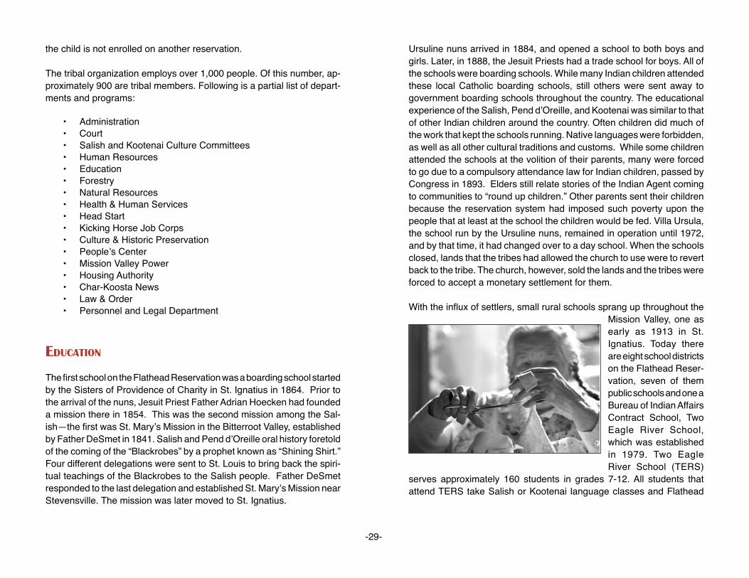
the child is not enrolled on another reservation.
The tribal organization employs over 1,000 people. Of this number, ap-proximately 900 are tribal members. Following is a partial list of depart-ments and programs:
• Administration • Court • Salish and Kootenai Culture Committees • Human Resources • Education • Forestry • Natural Resources • Health & Human Services • Head Start • Kicking Horse Job Corps • Culture & Historic Preservation • People’s Center • Mission Valley Power • Housing Authority • Char-Koosta News • Law & Order • Personnel and Legal Department
eduCaTIon
The first school on the Flathead Reservation was a boarding school started by the Sisters of Providence of Charity in St. Ignatius in 1864. Prior to the arrival of the nuns, Jesuit Priest Father Adrian Hoecken had founded a mission there in 1854. This was the second mission among the Sal-ish—the first was St. Mary’s Mission in the Bitterroot Valley, established by Father DeSmet in 1841. Salish and Pend d’Oreille oral history foretold of the coming of the “Blackrobes” by a prophet known as “Shining Shirt.” Four different delegations were sent to St. Louis to bring back the spiri-tual teachings of the Blackrobes to the Salish people. Father DeSmet responded to the last delegation and established St. Mary’s Mission near Stevensville. The mission was later moved to St. Ignatius.
Ursuline nuns arrived in 1884, and opened a school to both boys and girls. Later, in 1888, the Jesuit Priests had a trade school for boys. All of the schools were boarding schools. While many Indian children attended these local Catholic boarding schools, still others were sent away to government boarding schools throughout the country. The educational experience of the Salish, Pend d’Oreille, and Kootenai was similar to that of other Indian children around the country. Often children did much of the work that kept the schools running. Native languages were forbidden, as well as all other cultural traditions and customs. While some children attended the schools at the volition of their parents, many were forced to go due to a compulsory attendance law for Indian children, passed by Congress in 1893. Elders still relate stories of the Indian Agent coming to communities to “round up children.” Other parents sent their children because the reservation system had imposed such poverty upon the people that at least at the school the children would be fed. Villa Ursula, the school run by the Ursuline nuns, remained in operation until 1972, and by that time, it had changed over to a day school. When the schools closed, lands that the tribes had allowed the church to use were to revert back to the tribe. The church, however, sold the lands and the tribes were forced to accept a monetary settlement for them.
With the influx of settlers, small rural schools sprang up throughout the Mission Valley, one as early as 1913 in St. Ignatius. Today there are eight school districts on the Flathead Reser-vation, seven of them public schools and one a Bureau of Indian Affairs Contract School, Two Eagle River School, which was established in 1979. Two Eagle River School (TERS)
serves approximately 160 students in grades 7-12. All students that attend TERS take Salish or Kootenai language classes and Flathead
-29-

Reservation History. The core curriculum is augmented with cultural and historic content.
In 1977 Salish Kootenai College was established. The college is located in Pablo, Montana across the highway from the Tribal Complex. The mission of the college is to provide quality postsecondary opportunities for Native Americans locally and throughout the United States.
Salish Kootenai College (SKC) offers 11 associate degree programs, and three baccalaureate degree programs. Financial aid and scholarships are available to assist students in attending. Cultural classes are offered free to tribal members.
Beyond providing postsecondary opportunities, SKC offers many other services to the local communities. Many cultural and educational activities scheduled throughout the school year are open to the public. The media center and library are available to all community members free of charge. The college also operates a PBS television station that broadcasts local events and programs. SKC Press has published several volumes of oral literature, historical pieces, and native language dictionaries.
eConoMICs
Historically, the tribes have been the largest employers on the reserva-tion. As tribal departments and programs have expanded and evolved, this has held true. K-12 school districts employ over 400 staff and Sal-ish Kootenai College has a full-time staff and faculty of 178 employees. SKC also houses the Tribal Business Assistance Center. This office provides workshops related to business management, creating a busi-ness infrastructure and entrepreneurship. The Char-Koosta Loan Fund being developed by the center, will offer loans of $5,000 - $35,000 to tribal members for entrepreneurial or business ventures.
S & K Electronics, Inc. is a minority-owned company on the reservation that specializes in assembly of electronic and electro-mechanical com-ponents for the United States government and commercial industry. The company was established in 1984 as an enterprise and was incorporated under tribal and federal law in 1985 by the Confederated Salish and Koo-
tenai Tribes, who are the sole shareholders of the company. However, S & K is separate from the tribal organization and functions under its own board of directors. The company employs between 40 and 70 people depending on the amount and size of contracts it secures.
ConTeMPorary Issues
• Native Language Restoration and Preservation • Stewardship of Natural Resources • Tribal Sovereignty • Repatriation and Cultural Resource Protection • Relationships with County and State Government • Responsible Economic Development • Improving the Education of Indian Children
reCreaTIon / TourIsM / PoInTs of InTeresT
Flathead Indian Museum, St. Ignatius, Montana, (406) 745-2951 American Indian artifacts are displayed in a museum that adjoins a
trading post that sells beadwork, art, and other items made by local Indian artists. It is owned and operated by a tribal member.
Four Winds Historic Village, St. Ignatius, Montana, (406) 745-4336 Historic log buildings that make up the village date back to the 1800s.
Moccasins, beadwork, and other crafts are sold as well as beading supplies, hides, etc. The village also houses a toy train museum.
St. Ignatius Mission, St. Ignatius, Montana, (406) 745-2768 Established in 1854, the mission was constructed by Indian people
under the direction of Catholic missionaries. There are 58 original murals painted by Brother Joseph Carignano on its walls and ceil-ings.
Ninepipe Museum, Ronan, Montana, (406) 544-3435 This recently constructed museum has a good display of artifacts
and photographs of local families.
-30-

Ninepipe National Wildlife Refuge, Ronan, Montana, (406) 644-2211
This is one of Montana’s designated Wildlife Viewing Sites. It is an exceptional wetland complex, prime for bird watching. The refuge has its namesake of the Ninepipe family. Brothers Louie, Andrew and Adolph, were well known for their talent and knowledge of traditional songs.
National Bison Range, Moiese, Montana, (406) 644-2211 Approximately 500 readily visible bison roam nearly 20,000 acres
of natural grassland. Visitors may also see elk, deer, antelope, and bighorn sheep.
Salish Kootenai College, Pablo, Montana, (406) 675-4800 The college has an attractive 66-acre campus. Several unique
metal sculptures mark the campus, as well as a number of beautiful art pieces that are housed in the D’Arcy McNickle Library. Campus tours are available by appointment.
Sqéliö Aqçsmaknik—The People’s Center, Pablo, Montana, (406) 675-0160 The People’s Center houses a permanent museum exhibit as well as
a gallery for Native American artists. A gift shop offers books, audio and videotapes, as well as traditional and contemporary works of local Indian artists. A variety of events are scheduled for the public throughout the year. Each September the center hosts local schools during Native American Week, providing a variety of cultural exhibi-tions and activities.
Kerr Dam, Polson, Montana Located just southwest of the town of Polson, the Kerr Dam Vista
Site offers a spectacular overhead view of the dam and the Lower Flathead River. This area was considered sacred to the Salish, Pend d’Oreille, and Kootenai people. The tribes opposed the construction of the dam due to the significance of the site. Construction went ahead and currently the dam is leased from the tribe for approximately $13 million annually. A locally produced video, Place of the Falling Waters, provides an in-depth look at the history of the dam.
Kwataqnuk Resort, Polson, Montana, (406) 883-3636 Kwataqnuk is a tribally owned resort on the shore of Flathead Lake.
The resort hosts boat tours of the lake during summer months, as well as boat rentals.
Flathead Lake, Montana There are a variety of state parks along the shores of the lake. Fin-
ley Point, Elmo, Yellow Bay, and Big Arm all offer camping, fishing, boating, and swimming.
Blue Bay Campground, Montana, (406) 675-2700 Blue Bay is located on the east shore of the lake and is owned and
operated by the tribe. Campsite areas are available and offer electri-cal hookups, bathrooms, and shower facilities.
Flathead Raft Company, Polson, Montana, 1-800-654-4359 Owned and operated by a tribal member, the company offers white-
water raft tours of the Lower Flathead River and canoe and kayak lessons.
Calendar of evenTs
January Jump DancesApril /May Bitterroot FeastMay River HonoringJune Vanderburg CampJuly Arlee Celebration (Pow Wow)July Standing Arrow Celebration (Pow Wow)September Native American Week—The People’s CenterSeptember Reservation Wide Teacher In-ServiceNovember Kicking Horse Job Corps Celebration Pow WowDecember St. Ignatius Community Center Celebration Pow Wow
-31-
resourCes abouT The ConfederaTed salIsh and kooTenaI TrIbes
Salish Culture Committee Publications:
• A Brief History of the Flathead Tribes • Eagle Feathers the Highest Honor • Buffalo of the Flathead • Common Names in the Salish Language • Stories From Our Elders • The Salish People and the Lewis & Clark Expedition
Salish Kootenai College Press Publications:
• The Politics of Allotment • Coming Back Slow—Agnes Vanderburg Interview • Over a Century of Moving to the Drum • Coyote Stories of the Montana Salish Indians • In the Name of the Salish & Kootenai Nation: The Hellgate Treaty & The Origin of the Flathead Indian Reservation • Challenge to Survive: Volume I and II
-32-
Videos:
• The River Lives—SKC Media • Changing Visions—SKC Media • Place of the Falling Waters—Native Voices • Without Reservations: Notes on Racism in Montana— Native Voices • The People Today—University of Washington, DeSmet Project • Seasons of the Salish—University of Washington, DeSmet Project

-33-
forT belknaP reservaTIonGROS VENTRE AND ASSINIBOINE TRIBES

-34-
forT belknaP reservaTIon
loCaTIon
The Fort Belknap Reservation is located in north central Montana, south of the Milk River, within Phillips and Blaine Counties. Nearly 92 percent of the reservation is found in Blaine County with the remainder located along the western edge of Phillips County. The reservation’s boundar-ies contain an area of approximately 675,336 acres. In addition, there are 29,731 acres of tribal land outside the reservation’s boundaries. The north to south boundary extends 40 miles in length. The width is approximately 26 miles.
Most of the northern portion of the reservation consists of the glacial plains and alluvial bottomlands. The southern portion of the reservation drains into the Missouri River and consists of rolling grasslands, river “breaks,” and two principle mountain ranges, the Bearpaws and the Little Rocky Mountains. These mountains reach an elevation of approximately 6,000 feet.
PoPulaTIon
Enrolled members living on or near the Fort Belknap Reservation 5,771
Enrolled members living off the Fort Belknap Reservation 1,532 Total number of enrolled tribal members 7,303
There are also Indians from other tribes, mostly Chippewa and Cree, living on the reservation, although they have no interests in tribal as-sets. Over the years, the reservation’s resident Indian population has been decreasing. Some of the decline is due to the rural-urban shift, but a large proportion is a result of young people seeking off-reservation employment and educational pursuits.
land sTaTus
Total acres within the reservation’s boundaries 645,576 acres
Individually allotted lands 406,533 acres
Tribally owned lands 210,954 acres
Fee title or state lands 19,000 acres
Government lands 592 acres
Non-Indian owned 9,000 acres
hIsTorICal baCkground
Today the descendants of two distinct tribes, the Assiniboine and Gros Ventre Indians, make their home on the Fort Belknap Indian Reserva-tion. The Gros Ventre were living in present day Montana when the first white men entered the region. Both the Gros Ventre and the Assini-boine were originally plains tribes, but the Gros Ventre were of the Algonquian stock, closely related to the Arapaho, whereas the Assiniboine were once part of the Sioux.
The name Gros Ven-tre, interpreted as “big belly,” was given by early French traders to two separate tribes, the Atsina (Gros Ventre of the Prairie) and the Hidatsi (Gros Ventre of the Missouri). It seemed necessary, when taking the 1930 census, to separate the two Gros Ventre groups geographically; those living in Montana were designated Atsina and those living in the Dakotas were called the Hidatsa. The Gros Ventre of the Prairie called themselves “The White Clay People” or “Ahaninin.”

-35-
The Assiniboine (from the Chippewa, meaning one who cooks by use of stone) tribe is a detachment from the Sioux tribe. They left their mother tribe shortly before 1640. This band of Assiniboine Indians followed the Cree northward from the headwaters of the Mississippi between Lake Superior and Hudson Bay. It is believed they settled first in the vicinity of the Lake of the Woods, then moved northwest to the region around Lake Winnipeg. They ranged in Canada and along the Milk River. Until 1838, they were estimated to be a large tribe from 1,000 to 1,200 lodges. Subsequently, small pox reduced them to less than 400 lodges.
Both the Gros Ventre and the Assiniboine Indians shared the Blackfeet Hunting Territory, which was set aside by the Fort Laramie Treaty of 1855. This treaty granted hunting grounds, with defined boundaries, for the tribes of the Blackfeet, Blood, Crow, and Piegan as well. The boundaries roughly extended from the Yellowstone River north to the United States-Canadian border and from the Rocky Mountains of western Montana to the junction of the Yellowstone and Missouri Rivers. This area was to be used in common by Indians receiving rations from Fort Browning, Milk River, and Fort Belknap for a period of 99 years. These lands were reduced in size in 1873. Eventually three separate reservations—the Blackfeet, the Fort Belknap, and the Fort Peck—were established by the Act of May 1, 1888.
One of the first trading posts was established near the present town of Dodson in 1868. A year later the new post, Fort Belknap, was established on the south side of the Milk River, about one mile southwest from the present town site of Chinook. The fort, named for William W. Belknap, who was the Secretary of War at the time, was a substantial fort combined with a trading post and it became the government agency for the Gros Ventre and Assiniboine Indians living in the area.
In the early 1880s, the Fort Belknap Agency was moved from Chinook to the present site five miles east of Harlem on the northwest corner of the reservation. In 1921, the United States government allotted 539,065 acres to 1,171 Indians who were then enrolled on the Fort Belknap Res-ervation. Thereafter, settlement of non-Indians took place much more rapidly and did so partly in response to the availability of land for cattle and sheep ranching.
In 1888, completion of the Great Northern Railroad helped the expan-sion of the livestock industry. Malta became a major shipping yard for cattle and sheep. It was about this same time that gold was discovered in the Little Rocky Mountains, bringing people to Montana. Because of the variety of people attracted to the area by the gold discovery, the towns of Landusky and Zortman became famous as the “two toughest towns in the territory.”
The discovery of gold brought with it another problem for the Fort Belknap Indians. Mining claims appeared throughout the area of the Little Rocky Mountains apparently in disregard of the fact it was Indian reservation land. After the United States government appointed a commission to negotiate with the Fort Belknap Indians for surrender of the Little Rock-ies, an agreement was signed in 1896 which ceded a portion of the Fort Belknap Reservation back to the United States.
In 1969, the Fort Belknap Community Council began proceedings to recover that portion of the Little Rocky Mountains ceded by the Act of June 10, 1896, and thus restore the reservation boundaries described in the Act of May 1, 1888. As of the year 2003, this proceeding is still not settled and is in the process of being recovered.
organIzaTIonal sTruCTure
The Fort Belknap Community was organized in 1935 under the Indian Reorganization Act and its constitution and bylaws were approved on December 13 of that year. A corporate charter was ratified August 25, 1937. In 1974, the Fort Belknap Community Council modified the con-stitution to elect a membership of six councilmen to the tribal council on a staggered basis every two years. The constitution states the Fort Belknap Indian Community Council shall have two Gros Ventre and two Assiniboine members, every two years. The people elect the Tribal Council Officers at large for a term of four years.
-36-
new ConsTITuTIon
The new constitution and bylaws of the Fort Belknap Community were ratified in 1994 by popular referendum. The duties and structure objec-tives, territory, membership, powers of the community council, initiative referendum, land and adoption stand as the organization in 1935 under the Indian Reorganization Act.
Section 1 Composition: The Community Council shall be composed of four (4) members all of whom shall be chosen every second year by popular vote, a president and vice-president shall be chosen every four (4) years by popular vote, and a secretary-treasurer who shall be ap-pointed in accordance with Section 4 of this Article. Every candidate for elected office shall pay a filing fee of $10.
Section 2 Creation of District Apportionment: This shall be created by the Community Council two (2) Gros Ventre and two (2) Assiniboine voting districts on the reservation. The president and vice-president shall be a team of one (1) Gros Ventre and one (1) Assiniboine.
Section 3 Tenure: The Gros Ventre and Assiniboine candidates for each district shall be elected for a two (2) year term, they succeed themselves at will. The president and vice-president shall be elected for a four (4) year term and may succeed themselves at will.
Section 4 Officers: The officers of the Community Council shall consist of a president and vice-president, and secretary-treasurer who shall be appointed by the president. They shall be enrolled members of the Gros Ventre or Assiniboine Tribes. The secretary-treasurer of the Community Council, as a non-elected officer, shall not be entitled to vote on matters before the Community Council.
arTICle vII eleCTIons
Section 1 Right to Vote: All tribally enrolled members of the Fort Belknap Community, of either sex, eighteen (18) years of age or over, shall be entitled to one vote.
Section 2 Time of Elections: A primary election shall be held in each district. The two candidates for each office in each district receiving the most votes shall progress to a general election in which the candidates receiving the majority of the votes shall be elected and seated. Primary election for memberships on the Community Council shall be held on the first Tuesday in November of the second year and general elections shall be held on the first Tuesday in December of the same year. Duly elected Council Members shall take office immediately upon certification of election results.
Section 3 Manner and Place of Elections: Elections by ballot and polling places in each district. Absentee ballots, including those of non-residents shall be counted in their district. The council appointed three (3) election judges to serve at each polling place.
Section 4 Nomination: Candidates for election to membership on the Community Council shall give public notice of such intention at least thirty (30) days prior to the primary election date, and file with secretary-treasurer of the Council, their statement of residency in the district - endorsed by five (5) duly qualified electors from the same district, other than immediate relatives. President and vice-president shall give public notice of such intention same as the other candidates. A statement of affiliation of one (1) member of Gros Ventre and one (1) Assiniboine.
MedICal faCIlITIes
The Fort Belknap Community Council created a Tribal Health Depart-ment in 1976 in response to P.L. 93-638. The Tribal Health Department is responsible for the administration of the following programs:
• Chemical Dependency Treatment Program • Community Health Representative Program • Family Planning Program • Health Education Program • Women, Infant and Child Nutrition Program • Tribal Health Diabetes Program
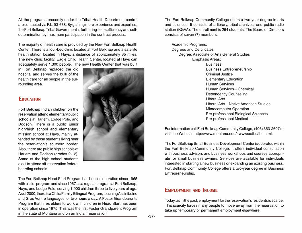
-37-
All the programs presently under the Tribal Health Department control are contacted via P.L. 93-638. By gaining more experience and expertise, the Fort Belknap Tribal Government is furthering self-sufficiency and self-determination by maximum participation in the contract process.
The majority of health care is provided by the New Fort Belknap Health Center. There is a four-bed clinic located at Fort Belknap and a satellite health station located in Hays, a distance of approximately 35 miles. The new clinic facility, Eagle Child Health Center, located at Hays can adequately serve 1,300 people. The new Health Center that was built in Fort Belknap replaced the old hospital and serves the bulk of the health care for all people in the sur-rounding area.
eduCaTIon
Fort Belknap Indian children on the reservation attend elementary public schools at Harlem, Lodge Pole, and Dodson. There is a public junior high/high school and elementary mission school at Hays, mainly at-tended by those students living near the reservation’s southern border. Also, there are public high schools at Harlem and Dodson (grades 9-12). Some of the high school students elect to attend off-reservation federal boarding schools.
The Fort Belknap Head Start Program has been in operation since 1965 with a pilot program and since 1967 as a regular program at Fort Belknap, Hays, and Lodge Pole, serving 1,900 children three to five years of age. As of 2000, there is a Child/Family Bilingual Program, teaching Assiniboine and Gros Ventre languages for two hours a day. A Foster Grandparents Program that hires elders to work with children in Head Start has been in operation since 1975. This was the first Foster Grandparent Program in the state of Montana and on an Indian reservation.
The Fort Belknap Community College offers a two-year degree in arts and sciences. It consists of a library, tribal archives, and public radio station (KGVA). The enrollment is 254 students. The Board of Directors consists of seven (7) members.
Academic Programs:Degrees and Certificates Degree: Associate of Arts General Studies Emphasis Areas: Business Business Entrepreneurship Criminal Justice Elementary Education Human Services Human Services—Chemical Dependency Counseling Liberal Arts Liberal Arts—Native American Studies Microcomputer Operation Pre-professional Biological Sciences Pre-professional Medical
For information call Fort Belknap Community College, (406) 353-2607 or visit the Web site http://www.montana.edu/~wwwse/fbc/fbc.html.
The Fort Belknap Small Business Development Center is operated within the Fort Belknap Community College. It offers individual consultation with business advisors and business workshops and courses appropri-ate for small business owners. Services are available for individuals interested in starting a new business or expanding an existing business. Fort Belknap Community College offers a two-year degree in Business Entrepreneurship.
eMPloyMenT and InCoMe
Today, as in the past, employment for the reservation’s residents is scarce. This scarcity forces many people to move away from the reservation to take up temporary or permanent employment elsewhere.

The Bureau of Indian Affairs and the tribe itself are the major employ-ers on the reservation. Some of the Indians are successful in obtaining jobs in the nearby communities of Harlem, Havre, Chinook, and Malta. Some of the Indian people are supporting themselves by farming, ranch-ing and other jobs in agriculture, while others derive some income from these sources.
The Fort Belknap Indian Reservation has the highest rate of unemploy-ment among the seven reservations in the state of Montana and is virtu-ally undeveloped in every aspect. Fort Belknap is heavily dependent upon federally subsidized programs to alleviate this problem. Seasonal monies are received for fighting forest fires.
Unemployment fluctuates between a low of 40 percent and a high of 75 percent depending upon the season of the year. As of January 1, 1999, the unemployment level was over 70 percent (Employment Assistance Statistics, January 1, 1999, Fort Belknap Agency).
PublIC assIsTanCe PrograMs
Fort Belknap Tribes on the reservation will be operating some of the public assistance programs that serve its low-income families. The tribal government of the Assiniboine and Gros Ventre Indians will open a tem-porary assistance office to needy families (TANF) in the former federal hospital building. The TANF offices will be open October 1 with four (4) case managers employed by the tribes. The program will administer the federal cash assistance to more than 200 families on the reservation.
The Montana Department of Public Health and Human Services, which will move its Chinook office to Fort Belknap, will still carry out food stamps and Medicaid functions.
ConTeMPorary Issues
TrIbal sovereIgnTy
Sovereignty has been a critical issue with Indian Nations. Since the independence of the United States, policies affecting Tribal sovereignty have been a grave concern. From the Indian Removal Act of 1830, federal policy has impacted the tribal right of self-governance. As Indian people repeatedly ceded lands in exchange for the United States’ guarantee of their sovereignty over the lands they reserved, they continued to find themselves in a struggle to retain that guarantee.
The United States continued to assume authority over and to involve itself in tribal affairs. Federal policies have continued to chip away at tribal sovereignty. The Assiniboine and Gros Ventre of the Fort Belknap Reservation hope that in the future the concept of Indian sovereignty will remain a determining issue in future policies. This can only be possible if the Indian people protect the sovereignty cause from those who would seek to undermine it.
waTer rIghTs ClaIMs and The wInTers doCTrIne
The Winters Doctrine gave tribes a special type of reserved Water Rights. In the court case dealing with Indian Rights, Henry Winters vs. the United States, the Supreme Court, in effect, held that rights to use of water for irrigation of Fort Belknap Indian Reservation lands have been reserved. Moreover, the water rights reserved are not limited to that necessary for irrigation at the time reservation was established. The International Boundary Treaty and agreement between the United States and Canada is an agreement to share the water supply of the Milk River.
The Madison limestone aquifer is considered the greatest economical potential on the reservation. During the last ten years the Gros Ventre and Assiniboine Tribes of Fort Belknap Reservation have been working on settling all existing water right claims.
The compact is entered into by and among the state of Montana, the Gros Ventre and Assiniboine Tribes of the Fort Belknap Reservation, and the
-38-
United States of America for purpose of settling all existing water right claims. It will be ongoing, until settled, or back to the Winter Doctrine.
zorTMan/landusky MInIng Issues
In the early 1980s the Bureau of Land Management (BLM) and the De-partment of State Lands (DSL) allowed Pegasus Gold to start a leach gold mine in the Little Rocky Mountains on BLM management and private lands. Two mines were developed, one at Landusky and the other at Zort-man. Pegasus requested BLM/DSL to allow construction of Sullivan leach pad at the top of the watershed. The Environmental Protection Agency and Red Thunder, Inc. opposed the request. They told BLM/DSL that the mined oxide ore and heavy metals would allow acid mine drainage to flow from the mine into ground and surface waters. In August 1991 contaminated water and sediments were collected in Alder Gulch and cyanide contamination of ground water was verified.
The mines were shut down. The mines were designed and permitted only for mining oxide ore and waste rock. This is because the more danger-ous sulfide ores and waste rock generate acid mine drainage and heavy metals when exposed to water and weather.
Acid rock drainage appears at numerous locations in the mined area. The Canadian subsidiary went bankrupt and went back to Canada with a lot of controversies. Clean up is being done in Mission Canyon and Alder Gulch. Test wells done show how the groundwater will not be contaminated.
reCreaTIon
Along the Little Rockies, the reservation offers some scenic locations. One of the best known sites is in Mission Canyon south of Hays. Visitors will find tribal campground sites throughout the reservation. Non-tribal members must purchase a permit for overnight or extended camping.
annual fesTIvITIes
During the 1920s, caravans of Indians from surrounding areas traveled to the Fort Belknap Indian Reservation to participate in the Indian Fair. Today, a semblance of the fair and Pow Wow is held every year in late July. The celebration, today called the “Fort Belknap Indian Days,” fea-tures Indian dancing, singing, feasts, and “give-aways.” The New Year’s Pow Wow/Celebration is December 31 and has been held for 110 years in Lodge Pole. During the summer there are two Sundances: the sec-ond week in June the Gros Ventre have their Sundance in the Mission Canyon; on the fourth of July, the Assiniboine have their Sundance at Mouse Canyon Flats near Lodge Pole.
PoInTs of InTeresT
Fort Belknap Community CollegeFort Belknap Agency, Montana(406) 353-2607
Fort Belknap Tourism Office and Information CenterHarlem, Montana(406) 353-2205
The information center also houses the Fort Belknap Gift Shop, which features handcrafted Native American arts and crafts. Staff provides tours of the Mission, Snake Butte, ancient tepee rings, and the tribal buffalo pasture.
Tours are conducted and a public rest area and campground is located at Fort Belknap Agency.
-39-

-40-
forT PeCk reservaTIonASSINIBOINE AND SIOUX TRIBES

-41-
forT PeCk reservaTIon
The Fort Peck Indian Reservation is home to a number of different Na-koda (Assiniboine), Dakota, and Lakota (Sioux) communities that stretch along northeast Montana’s Hi-Line from the Big Porcupine Creek to the Big Muddy Creek. The reservation, Montana’s second largest in terms of land area, consists of 2,093,318 acres of which just under half is owned by individual tribal members or held in common by the Assiniboine and Sioux Tribes. Linguistically, the Nakoda, Dakota, and Lakota are related. Sometime in the late 16th century they resided in the region between the Mississippi River and Lake Superior. As pressure from eastern tribes increased, the Nakoda split from the other Dakota and Lakota groups and moved north into Cree country.
Today, bands of Nakoda, Dakota, and Lakota reside in Frazer, Oswego, Wolf Point, Poplar, Brockton, Riverside, and Ft. Kipp. These communi-ties lay along the Missouri River’s north bank, the reservation’s southern boundary. Wolf Point, with a population of 4,000, is the largest town on the reservation and serves as the reservation’s commercial center. Poplar, the next largest community, has a population of 3,200. Poplar is also the center of tribal government. The Ft. Peck Tribes, the BIA, and the Indian Health Service are headquartered there, as well as a number of other federally funded programs. The nearest primary trade centers are Billings, Great Falls (both approximately 300 miles from the reservation), and Williston, North Dakota, which lies some 75 miles east of Poplar.
PoPulaTIon
Enrolled Sioux members 6,962Enrolled Assiniboine members 4,209Total Ft. Peck tribal members 11,171
There are close to 1,000 members of other tribes living on Ft. Peck Res-ervation. One of the largest non-enrolled tribal groups is the Chippewa from the Turtle Mountain Reservation in North Dakota. The next largest
non-enrolled group is the Assiniboine from Ft. Belknap followed by indi-viduals from the Three Affiliated Tribes (Mandan, Hidatsa, and Arikiara) in North Dakota, and a number of Canadian Assiniboine.
land sTaTus
Total reservation acreage 2,093,124Total tribal acreage 413,020Total individually allotted acreage 516,092Total fee simple or state acreage 1,164,012
The Ft. Peck Tribes have instituted an active policy of land acquisition. Over the past 20 years the Tribes have acquired over 19,000 acres. Ft. Peck, like most reservations, experienced the allotment policy, which resulted in the loss of just over half of tribal land holdings. Although the Dawes Act was enacted in 1887, it wasn’t until the early 1900s when Ft. Peck was allotted. By 1922 the allotment process was near completion and lands not allotted were opened up for homesteading by non-Indians. Again, like most reservations, much of the better cropland passed into non-Indian hands. During the Depression, many non-Indian farms failed and the government repurchased the lands. An Act of Congress returned much of that land to the tribes in 1975.
hIsTorICal baCkground
In the mid-1600s, the Nakoda separated into two groups. One group moved further west to the upper Red River territory, where they and their ever-present Cree allies began refining their buffalo hunting skills. The other group moved north toward Lake Winnipeg and initiated a trading relationship with the Hudson Bay Company.
Soon after they established a foothold in the upper Red River region, the Nakoda and Cree found themselves engaged in a bitter dispute over hunting grounds with the Dakota bands who had also moved onto the Northern Plains. By the time the United States was forging a new nation east of the Appalachian Mountains, the Nakoda were engaged in a full-scale war against the various Dakota bands. Raids on each opposing

-42-
village became commonplace as Plains warfare evolved. The bound-ary differences between the United States and Britain over present-day Montana, North Dakota, and Canada also affected the Nakoda. By the time these disputes were settled, the Nakoda divided into bands that either moved west of Lake Manitoba or southwest toward the Missouri River. The bands that controlled the area north of the confluence of the Yellowstone and Missouri Rivers, found themselves in alliance with the United States political forces. In September 1825, the Nakoda met with Indian agents at the Mandan Indian Villages.
A few years later, trader James Kipp of the American Fur Company began trading with the Nakoda at newly established Ft. Union. As the demand for beaver pelts decreased, trade focused on buffalo hides and the Na-koda, Dakota, and Lakota became increasingly dependent on American trade items. Women welcomed metal pots, pans, skinning knives, manu-factured blankets and cloth, and beads. Men were more interested in guns, ammunition and tools.Trade enticed the southern Nakoda to move their lodges, some 1,200 strong, more permanently to the vicinity of Ft. Union. Unfortunately, as more contact occurred, disease decimated lower Nakoda populations. Smallpox, carried upriver on a steamboat, reduced their numbers by two-thirds. Similarly, Dakota groups fled their homes to escape the smallpox epidemic of 1837-38. Thousands perished and bodies were dumped into rivers or left where they had died.
In 1851, the United States government formalized its relationship with Nakoda, Dakota, and Lakota groups. Along with dozens of other Plains tribes, they met near Ft. Laramie and negotiated the first of many trea-ties between tribal leaders and government officials. The treaty involved acceptance of a set of tenuous boundaries. The Nakoda believed their designated territory lay in the northeast region of Montana, near Ft. Union. The Lakotas and some bands of Dakotas accepted much of present-day North and South Dakota.
During the first years of the Civil War, many eastern Dakota bands fled from reservation life. As the Civil War waned, exiled Dakota and Lakota groups battled American militiamen near the Killdeer Mountain, west of the Missouri River in Dakota Territory. This was one of the largest assemblies of American forces fighting in a single battle against Plains tribes. Dakota and Lakota bands continued moving further west, and leaders such as Sitting Bull, Medicine Bear, Standing Buffalo, and Waanatan, found the
country of the upper Missouri quite agreeable. Under the leadership of Red Stone, the Nakoda, Dakota and Lakota put old differences aside and began to participate in buffalo hunts and inter-marry with each other. Eventually, the bands of the southern Nakoda and their new Dakota and Lakota allies began inquiring about securing an agency of their own somewhere closer to the mouth of the Milk River. By 1871 the govern-ment established the Fort Peck Agency near the old Ft. Peck trading post on the Missouri River. Some 5,000 Nakoda and Dakota moved closer to this new agency. Sitting Bull, however, and most of his Hunk papas drifted back to Dakota Territory, nearer to his Lakota relatives. After the Battle of the Little Bighorn in 1876, soldiers hunted Dakota and Lakota refugees until they submitted or sought sanctuary with Sitting Bull and other leaders in Canada. By 1880 bands of Lakota following Sitting Bull, Gall, and Black Moon began to drift back into the United States, with most of those refugees surrendering at Ft. Buford. However, some of Sitting Bull and Gall’s people remained on Ft. Peck.
With the buffalo near extinction, the Nakoda, Dakota, and Lakota faced total dependence on the United States government. In 1885, they mounted a hunt in which they shot the last few buffalo left in Montana. The reservation period, marked by starvation and confinement, had begun. Tribal consolidation and land cessions became the fare of the day. After much suffering, the chiefs of the Blackfeet, Gros Ventre, Up-per and Lower Nakodas and Dakotas, along with a few refugee Lakota bands, signed an agreement in 1887. They surrendered about 17.5 mil-lion acres and accepted smaller reservations. The next year Congress ratified the agreement creating the Ft. Peck Reservation with its present boundaries.
At the turn of the century, the allotment process was in full swing, the Great Northern Railway was completed and towns began to emerge on and near the reservation. By 1911 allotment was completed and hundreds of thousands of acres were left over. Conveniently, homesteading by non-Indians seemed the answer. Most tribal allotments remained in trust for the next 25 years. When the Depression hit Ft. Peck, many non-Indian homesteads failed and the land reverted back to the government.
The building of the Ft. Peck Dam on the Missouri River provided some relief, however, most Indians remained dependent upon what little the government provided. Most Nakoda, Dakota, and Lakota families planted

-43-
gardens, worked on local farms, and hunted and trapped to supplement their livelihoods.
During World War II, Nakoda, Dakota, and Lakota men and women joined the armed forces. This was the first time many of them had left the res-ervation. Many served in European, African, and Asian campaigns.
Oil was discovered on the reservation in the early 1950s and over 50 wells were producing enough crude oil each year that the Ft. Peck Tribes became the leading oil producing tribe on the Northern Plains.
Economically, the Ft. Peck Tribes relied heavily on agriculture, tribal leases, and oil and gas production. However, in 1968, the A & S (As-siniboine and Sioux) Industries began, which refurbished M-1 rifles for the United States government. They soon expanded this venture to include other government contracts. A & S Industries was followed by West Electronics, which operated in the private sector. By 1990 A & S Industries went out of business; however, West Electronics continued to operate. In December 1998, a geographic zone within the boundaries of Ft. Peck was designated as an Enterprise Community. The intention was to encourage federal agencies in assisting Ft. Peck in efforts of empowerment toward social and economic growth.
housIng
Since 1962, the housing conditions of Ft. Peck have steadily improved through tribally sponsored programs. Extensive housing programs, both low-rent and mutual help, have been undertaken by the Ft. Peck Housing Authority. The BIA Home Improvement has also helped to bring Indian homes up to standard. The Indian Health Service also provides sewer and water facilities to Indian homes. The BIA’s road department has also built and paved new and existing roads and streets in the surrounding communities. Ft. Peck has approximately 1,391 housing units.
MedICal faCIlITIes
Indian Health Service clinics can be found in Wolf Point—The Chief Red-stone Medical Clinic, and Poplar—The Verne E. Gibbs Medical Clinic. The clinics serve over 7,300 patients regularly. The clinics offer outpatient services, dental care, X-rays, optometry care, pharmacy, mental health care, and field health and administration. Services provided through P.L. 93-639 contracts include alcohol treatment, community health representa-tives, nutrition, sanitation, health education, housekeeping, environmental health, and tribal health administration. At the Poplar clinic, the Indian Health Service also operates a tribal dialysis program; however, this is totally funded by the Tribes. Inpatient services are provided by the Com-munity Hospital in Poplar and the Trinity Hospital in Wolf Point. Many patients also see specialists in Billings and Williston, North Dakota.
eMPloyMenT and InCoMe
Unemployment on Ft. Peck reached catastrophic heights just after World War II and into the 1950s and ’60s. A & S Industries provided some relief through the 1970s and into the early 1980s. The oil boom that Ft. Peck initially experienced in the 1950s and later in the early 1980s waned after oil exploration dropped off soon after 1985. Ft. Peck has experienced tides of prosperity and economic slump. Currently, the Ft. Peck Tribes have been working with off-reservation communities in a water pipeline project which will provide water for human and livestock consumption over some 75,000 square miles, both on and off the reservation. The Enterprise Community, which receives $250,000 annually to promote economic development, is also a bright spot for Ft. Peck’s economic endeavors, while farming and ranching will continue to provide a sound foundation for the future.

-44-
annual fesTIvITIes
Poplar Wild West Days—two-day rodeo - First weekend in July
Oil Discovery Celebration—three-day Pow Wow. Last weekend in August - Poplar
Badlands Celebration—three-day Pow Wow. Third weekend in June - Brockton
Ft. Kipp Celebration—three-day Pow Wow. Fourth of July weekend - Ft. Kipp
Iron Ring Celebration—three-day Pow Wow. Third weekend in July - Poplar
Red Bottom Celebration—three-day Pow Wow. Second weekend in June - Frazer
Wadopana Celebration—three-day Pow Wow. First weekend in August - Wolf Point
Wolf Point Wild Horse Stampede—three-day rodeo (Montana’s oldest). Second weekend in July
PoInTs of InTeresT
Ft. Peck Assiniboine and Sioux Culture Center and Museum, Poplar, Montana, (406) 786-5155 Features permanent exhibits of local tribal culture. Arts and crafts
are for sale.
Ft. Peck Community College, Poplar, Montana, (406)768-5551 Offers many Associate of Arts and Associate of Science degrees and
certificates and also limited Bachelor of Science degrees. It has a library and wellness center.
Tiotka Tibi, Poplar, Montana, (406) 768-3213 Ft. Peck Community College bookstore and gift shop. Displays lo-
cal artists’ work, including beadwork, hide paintings, sculpture, star quilts, etc., most of which are for sale.

-45-
The lITTle shell TrIbe of ChIPPewa IndIans of MonTana

-46-
lITTle shell TrIbe of ChIPPewa IndIans of MonTana
loCaTIon
The Little Shell Chippewa Tribe is without a reservation or land base and members live in various parts of Montana. There are population concentrations in Great Falls, Havre, Lewistown, Helena, Butte, Chinook, Hays, Wolf Point, Hamilton, and Billings, as well as numerous other small communities in the state. Because the tribe has been without a land base for over 100 years, many members and their descendants live outside of Montana. Many changes are expected during the next decade as federal recognition is implemented.
PoPulaTIon
The name of the tribe is: “The Little Shell Tribe of Chippewa Indians of Montana,” and it is often shortened to “Little Shell.” The name “Métis” (pronounced may-tee) is often used, meaning “middle people” or “mixed blood.” The term Métis or more correctly Métifs, was first used during the 18th and 19th centuries, but at that time it identified a specific Northwest society with its own culture and economic traditions, living in the areas of the Red River, the Saskatchewan River, Turtle Mountain, North Dakota, and the area of present day Winnipeg and Pembina, North Dakota. A further discussion regarding this group is found in the subsequent sec-tion titled Ethnography and Historical Background.
The current population of enrolled tribal members in Montana is ap-proximately 3,850 and that number has not changed much in recent years. The tribe maintains only a rented office with volunteer staff, but continues to struggle for federal recognition. The Métis number in the thousands in the United States and south central Canada, and there
are many unenrolled Little Shell people in Montana. Exact population numbers are not available.
In the mid 1800s the tribe was numbered at several thousand in the Red River-Pembina region. At that time there was no formal enrollment procedure, no reservation and thus no documented population figure. After the 1892 renegotiation of the Treaty of 1863, (the infamous 10 cent treaty) many of the Métis, including the Band of Chippewa under Little Shell, were left without a land base or reservation, and many became nomadic.
eThnograPhy and hIsTorICal baCkground
The lack of a reservation or land base has been a profound determinant of the fate and destiny of the Little Shell Tribe of Chippewa—a defining part of their history.
The origins of the Métis date back to the late 17th century when the fur trade became a significant commercial endeavor. Before the establish-ment of the United States/Canada border in 1846, vast regions of the central and western parts of the continent in what are now known as Manitoba, Saskatchewan, Alberta, North Dakota, Montana, Idaho and Washington were unsettled, and under the chartered use of the Hudson’s Bay Company (Ruperts Land). Trapping and harvesting beaver pelts and other furs for return to Europe through eastern markets required the alli-ance and support of the native inhabitants of the areas west of the Great Lakes. Working for Hudson’s Bay Company and the competing Northwest Company, the trapping and trading was done largely by immigrant Irish, Scotch, and French (voyageurs) who formed liaisons with the northern tribes to trade for goods in exchange for the valuable animal pelts. Mar-riage “a la façon du pays” (according to local custom) was a basic part of the social interaction and liaison between the voyageurs and the local native inhabitants. Most of these unions involved Saulteaux (Ojibwa) and Cree women, although there were also many unions with the Chippewa, Blackfeet and Sarcee, the latter two living further west.
Thus, thousands of Métis or “mixed blood” people came to occupy the areas nearest the trading posts along with thousands of Chippewa and

-47-
Cree. This population increased to many thousand and took root in the region of the Red River in what is now southern Manitoba, and northern Minnesota. In the early 19th century they called themselves “Métifs,” “Bois-Brûlés,” and “les gens libres” (the free people).
The early generations were of Indian mothers and immigrant European fathers—parents who usually did not even share a common language. The resulting language, called “Mitchif” today by the Little Shell and Turtle Mountain people, was a unique blend of Chippewa native language, French, Cree, and a little English. By 1840 they had become a distinct and independent group, unique in the world with cultural ties to both French voyageurs and other Chippewa bands, but they also identified with their full blood parents’ communities.
They industriously trapped, hunted buffalo, and conducted trading busi-ness with the Hudson’s Bay Company, transporting goods from the far west to the trade centers at Fort Benton, Battleford, Red River, Batoche and Pembina. Their numbers grew and the settlements increased in size, containing both full-blooded Chippewa and Métis. Many lived in Northwest Company camps further west in Montana and southern Alberta. In 1867, New Brunswick, Quebec, Nova Scotia and Ontario merged to form a British Dominion called Canada. In the late 1860s and early 1870s when colonization of Canada continued westward from Quebec, and the Hudson’s Bay Company began to relinquish control of these vast territories, the Red River settlements occupied by the Métis were geographically annexed to Canada, although there was no political alignment to the newly formed dominion of Canada by the Métis people. The Métis and Chippewa people of the Red River settlements began resisting the colonization of what they perceived as their home territory and attempted to establish a sovereign nation in southern Canada to be known as “Assiniboia.” Louis Riel, their chosen political leader and representative to parliament for purposes of establishing the Metis-Indian nation, was only partly successful. Ultimately the movement for inde-pendence from Canada was denied, and over the next two decades, two military rebellions by Riel and the Metis were put down, the last in 1885. Riel’s military leader, Gabriel Dumont left for Montana. The execution of Louis Riel for treason marked the end of the Métis-Chippewa nation as they had conceived of it, and white settlers poured into the region.
A reservation in the Turtle Mountain Area had been set aside for the Chippewa and Métis who had taken up permanent residence in what is now North Dakota. The two principal chiefs of the tribe to be known as the Pembina Chippewa were Little Shell and Red Bear. Along with the United States government, these two chiefs were signators to the Treaty of 1863, which established a 10 million acre reservation. Many of the Chippewa and Métis engaged in agriculture and ranching on this reser-vation, while others continued to subsist on buffalo hunting and trading endeavors to the west where they had migrated to insulate themselves from the westward expansion of white settlements, which accelerated after Manitoba was annexed to the Dominion of Canada in 1869.
In a manner similar to what happened on many reservations, white settlers continued to migrate onto the Indian lands on both sides of the 49th parallel, which had become the United States -Canadian border, and seeing no industry, they erected permanent buildings, businesses, fences and roads, until the federal government moved to renegotiate the treaty. Chief Little Shell (son of the signator to the 1863 treaty) refused to sign. The new agreement provided approximately a million dollars for the 10 million acres of land ceded under the 1892 document, which became known as the “Ten-Cent Treaty” in reference to the 10 cents per acre being offered. In the wake of Little Shell’s refusal to sign the Ten Cent Treaty, and because many of the group were on a prolonged hunting expedition in Montana, tribal members were removed from the reservation list and federal recognition was lost. The resulting reservation was then less than 10 percent of its original size.
1892 was the beginning of a 120-year period of languishing as a tribe without a homeland and with little economic opportunity. Some took refuge in Montana, some migrated west to Alberta, in their traditional two- wheel “Red River Carts.” Some allied with other tribes, and some joined the Turtle Mountain Chippewa to the south in what is now North Dakota. Many wandered and hunted as a means to avoid drifting into poverty, as white settlers took over their settlements, fields and crops. As the buffalo disappeared, their subsistence and their way of life crumbled. Without federal recognition, they were without legal standing as citizens, without a land on which to live, and unable to qualify as homesteaders. There were instances of Little Shell Chippewa being rounded up by the United States military and deported to Canada.

-48-
Facing starvation, many survived this era by salvaging buffalo bones and skulls from the prairie and selling them at trading posts to be shipped eastward to fertilize rose gardens in the east. Many could not read or write and had no access to education, taking jobs as servants and ranch hands for the very settlers who occupied their former homeland. Some integrated with other Indians on other reservations (French surnames are common on Montana Reservations). And some lived in wandering destitution or in hovels on the perimeter of white communities. Many were poverty stricken, and without health care, many died during the harsh northern winters.
But efforts to reestablish their status as federally recognized Indians continued. After the third Chief Little Shell died in 1904, Joseph Dussome became a popular leader among the tribe, dedicating his life to efforts in locating members, enrolling members, meeting with officials in Washing-ton, D.C., and organizing the splintered tribe. In 1927 he was organizing under the name of the “Abandoned Band of Chippewa Indians.” In 1934 he incorporated a group known as the “Landless Indians of Montana,” and in that same year, under the Indian Reorganization Act, Congress offered land for a reservation for the Little Shell Tribe, but President Franklin Roosevelt vetoed the action, based on the tribe’s lack of federal recognition. Dussome continued in his efforts to restore hope for the tribe, even as the nation suffered through the Depression. Dussome has come to exemplify hope to the people of the tribe and spirit—that same spirit that has shown itself in the tribe’s relentless petitioning of the United States government for recognition—and the hope that one day they will be landless no longer. This hope began to be realized in the year 2000, under provisions of a 1978 program that established criteria under which a tribe may petition the federal government for acknowledgement. Preliminary recognition has been granted at the time of this writing.
governMenT/eduCaTIon
The Little Shell Tribe is governed by an elected Tribal Council, which has maintained its integrity throughout the 20th century. The constitution has been revised, most recently in 1977, and the central office location has moved a few times but the government, social structure and culture have been maintained. George Sinclair was elected president to succeed Joe Dussome, and served until 1976. Debbie Swanson of Havre was former
Tribal Chairman during the 1980s when Gov. Stan Stephens granted State Recognition to the tribe. It was then incorporated the Little Shell Tribe of Chippewa Indians of Montana. Four council seats are up for election every other year, in a largely mail-in balloting process. The tribal council meets regularly in Great Falls, at least monthly, and quarterly meetings are held in other communities in Montana where enclaves of Little Shell people live, in efforts to keep tribal members involved and informed. The Council and office staff are unpaid except for donations from individuals and organizations.
As a group, which is not federally recognized, the Little Shell do not qualify for any educational or government support services such as housing, medical facilities, or federally funded educational facilities, which are typically provided for recognized tribes by the United States government. The Little Shell Chippewa have obtained such services only through public services available in urban centers.
ConTeMPorary Issues
The principal concern of the Tribal Government and most of its members lies in the federal acknowledgement process.
The petition, as it existed in the late 1990s, represented many thousands of hours of work by the tribal government, volunteers, and consultants. This historical document consisted of over 300 pages, according to former Tribal Councilman Robert VanGunten, Director of Adult and Continuing Education at the Salish and Kootenai College in Pablo, and there are 10 boxes of attachments to the historical document. The current petition consists of numerous and lengthy reports submitted by the tribe to pro-vide the historical, anthropological and cultural evidence needed for the Interior Department’s Branch of Acknowledgment and Research (BAR) to review the petition. When BAR responded with a list of deficiencies and omissions, the tribe responded with further research. The supporting evidence of “community,” an important criterion, was strengthened by the report of Franklin et. al., of the Department of Anthropology of California State University, Long Beach, California, a report by Montana sociolo-gist Milton Colvin of the College of Great Falls (1957), and a 1941 report by Stephen Gray, a leader of a factional group known as the “Montana Landless Indians.”

-49-
Council Chairman Tim Zimmerman praised tribal leaders such as Van Gunten, former Tribal Chairman John Gilbert, and others who have worked tirelessly without compensation, to keep the petition alive when the announcement came in May 2000. The Native American Rights Fund, and particularly Robert Peregoy were also instrumental during the 1980s and 1990s as an advocate for the Little Shell Tribe.
Although the notice of preliminary recognition was issued in May of 2000, additional information is to be provided during a 180-day waiting period. Zimmerman and the current council members continue to search for records and documents to complete and finalize the recognition bid before the end of the year.
Affecting a change in public perceptions of the citizens of Montana about who the Little Shell people are is among the goals of the tribe as recogni-tion is now imminent. Economic opportunities, training and health care will now be increasingly available to the tribe and it is important that the citizens of Montana continue to support the efforts of the Little Shell Tribal Council and its members. Further information may be available from the Tribal Offices at 105 Smelter Avenue Northeast, in Great Falls.
evenTs of InTeresT
Joseph Dussome Day—An annual gathering of the tribe for cultural renaissance, social activities, election results, announcements and committee meetings, usually in September or October.
Back to Batoche Celebration—An annual gathering of the Little Shell Tribe of Chippewa and sister Tribes of Metis in Canada, commemo-rating the Riel Rebellion, and including cultural activities, dancing, art and socializing, at Batoche, Saskatchewan.
resourCes - for More InforMaTIon on ThIs TrIbe
The Great Falls Tribune, along with other area newspapers, has car-ried literally hundreds of stories, both current events and containing significant historical coverage during the period from 1930 to the present. The Tribune has often advocated federal recognition for the Little Shell Chippewa people.
A Brief Historical Overview Of The Little Shell Tribe of Pembina Chippewa, by Deward E. Walker, Jr., July 1990—This historical digest may be obtained from the Little Shell Tribal Offices in Great Falls.
The Free People—Otipemisiwak, by Diane Paulette Payment—This volume contains a detailed and articulate history of the Metifs and includes cultural issues, early photographs, political action descrip-tions and other historical data-from a Canadian perspective. May be available on inter-library loan from Canadian affiliates.
Waiting For A Day That Never Comes, by Verne Dusenberry—Published in “Montana Magazine of Western History.” This article highlights the efforts of Joseph Dussome and features easy reading cultural and historical information. May be available through the Montana Historical Society.
Buffalo Voices, compiled and published by Nicholas Churchin Peterson Vrooman — Stories told by Metis and Little Shell Elders, part of Turtle Island 1492-1992, North Dakota Quarterly Vol 59 No. 4, Fall 1991, Univ. of No. Dakota, Grand Forks. Vrooman also produced a record-ing (cassette tape) for Smithsonian/Folkways Recordings, entitled Plains/Chippewa/Metis Music from Turtle Mountain. The recording includes drumming, Chansons, and 1992 era Rock & Roll by Tribal Musicians. It is distributed by Koch Int’l for the Smithsonian, and can be ordered from music stores.
Strange Empire, by Joseph Kinsey Howard—The definitive but cum-bersome history of the Métis, Canadian Métis, Little Shell Tribe, Turtle Mountain and Pembina and related groups, reprinted in 1994 by Minnesota Historical Society Press with a new introduction by Nicholas Vrooman.
Medicine Fiddle—by Michael Loukinen, produced by Northern Michigan University, 1992. This film (videotape) features Metis and Chippewa music dancing and spirituality, and contains interviews with musi-cians from several tribes and bands in the Western Great Lakes Red River area. Available through Up North Films, Northern Michigan University, 331 Thomas, Fine Arts Bldg, Marquette MI 49855, tele-phone (906) 227-2041.

norThern Cheyenne reservaTIonNORTHERN CHEYENNE TRIBE
-50-

-51-
norThern Cheyenne reservaTIon
loCaTIon
The Northern Cheyenne Reservation, situated in southeastern Montana, lies within the counties of Big Horn and Rosebud. The Crow Reservation borders it on the west. The reservation consists of open ponderosa-pine plateau and valley country with an annual rainfall of approximately 16 inches. The topography ranges from about 4,800 feet to a low of a little less than 3,000 feet. The reservation headquarters and the center for business activities and population are in Lame Deer. The reservation itself is divided into five districts; Busby, Lame Deer, Ashland, Birney, and Muddy.
PoPulaTIon
Total number of enrolled tribal members Approximately 7,374
Even though there are over 7,000 enrolled members, about 4,199 members live on the reservation scattered through the five district communities. There is also a relatively small population of non-Indians and other tribal members living on the reservation.
land sTaTus
Total acres within the reservation’s boundary 444,774.50 acres
Individually allotted lands 113,277.70 acres
Tribally owned lands 326,546.81 acres
Fee title or state lands 4,827.70 acres
Non-Indians own about 30 percent of the fee or state lands on the North-ern Cheyenne Reservation. The Tribal Council has selected a Land Acquisitions Committee whose primary policy is directed to the purchase of land into Tribal ownership. The Committee thus assures that Indian land is retained in Indian ownership.
hIsTorICal baCkground
The Cheyenne Indians are part of a linguistic group of the Algonquian language stock. Originally, it is believed that the ancestors of the Cheyenne lived south of the Hudson Bay and James Bay areas and slowly moved west into what is now northwestern Minnesota where the Red River forms a border between Minnesota and the Dakotas. During the late 1600s, they settled among the Tribes of the upper Missouri River and began farming rather than subsisting as small game hunters and fishermen. During the early 1700s, they were still primarily farmers growing corn, but they also hunted buffalo. The Cheyenne acquired the horse around 1750, and made the transition from a horticultural existence to a horse culture within a matter of several generations. Hunting buffalo became a way of life as they migrated as far south as New Mexico and Texas.
The Cheyenne participated in the treaty making in 1825 near what is now Fort Pierre, South Dakota. A few years later, the larger part of the tribe (now the southern Cheyenne) moved southward and occupied much of the Arkansas River in Colorado and Kansas. The remainder continued to inhabit the plains from the headwaters of the North Platte up on to the Yellowstone River in Montana. The division of the tribe was recognized by the Fort Laramie Treaty of 1851.
In the Battle of the Little Bighorn in 1876, the Northern Cheyenne joined the Sioux in what the Cheyenne call “where Long Hair was wiped away forever.” Cheyenne oral history recalls a time when George A. Custer smoked a Cheyenne pipe and vowed never to fight the Cheyenne again. The ashes from the pipe dropped on his boot and scattered on the ground. These ashes were wiped away signaling Custer’s commitment never to fight the Cheyenne again. Although the Cheyenne won the battle it was the beginning of the end for them as they were exiled to Indian Territory in Oklahoma to be colonized with the Southern Cheyenne. A small band

-52-
escaped in a desperate effort led by Chief Dull Knife (Morning Star) and Chief Littlewolf. These two chiefs, in one of the most heroic episodes of western history, bravely fought against overwhelming odds, leading a small band of men, women, and children back to their homelands. The Northern Cheyenne call themselves “the Morning Star people.” The name is taken and used in respect of Chief Dull Knife who was also known as Morning Star. Chief Littlewolf and Chief Dull Knife are buried side by side in the Lame Deer cemetery.
By Executive Order of November 26, 1884, a tract of country east of the Crow Reservation was set apart as a reservation for the Northern Cheyenne. The reservation was expanded by another Executive Order in 1900 to its present boundaries.
organIzaTIonal sTruCTure
The Northern Cheyenne Tribe was organized in 1936 under the Indian Reorganization Act. Today, the tribe is a federally chartered organization with both governmental and corporate responsibilities. The governing body is a tribal council headed by a President (elected at-large) to serve a term of four (4) years. Other members of the Council include the vice-president (elected at-large) and ten (10) council representatives from the five (5) districts on the reservation and serve four (4) year staggered terms.
The Constitution and Bylaws of the Northern Cheyenne Tribe were amended and approved by the Secretary of the Interior in July 1950. Tribal membership has gone through a number of stages. Today tribal membership is based on descent and those that are able to provide documentation and lineage to the 1935 census rolls are eligible for enrollment.
housIng
The availability of housing on the Northern Cheyenne Reservation has improved in recent years because of federal housing programs similar to other tribes in Montana. To date, the Northern Cheyenne HUD program
has been transformed into the Native American Housing Self-Determina-tion Act (NAHSDA). This Act allows the Northern Cheyenne to become more self-sufficient through block grants from HUD. There are 525 mu-tual help homes and 299 low rent homes that have been built since the inception of federal programs on the reservation. Currently, the tribal housing authority is looking into tax credit homes and home ownership rather than continuing with mutual and low rent homes. Through NAHSDA, the Housing Authority on the Northern Cheyenne operates on an annual budget of $3.1 million.
The Northern Cheyenne Tribe also houses a Senior Citizen’s Complex that was built in 1978 with a maximum capacity of 35 apartments. Cur-rently, the complex has 29 occupants with the majority of them being elders. The other units are for people with disabilities. Several units have been converted as public service offices.
MedICal faCIlITIes
An Indian Health Service (IHS) clinic was recently built to replace the old clinic lost to fire. The new clinic opened in 1999 and is located in Lame Deer, Montana. The clinic provides medical doctors, dentists, nurses, sanitation personnel, nutritionists, Well Child personnel, and others. It has been modified and expanded to include the mental and physical needs of the reservation and non-Indian communities. The nearest Indian Health Service hospital is at Crow Agency, 45 miles west of Lame Deer, Montana. The nearest specialized facility, other than the Crow hospital is at Billings (110 miles from Lame Deer). Other medical facilities not on the reservation include places such as Colstrip, Hardin, and Forsyth.
eduCaTIon
Elementary students are served by six schools: St. Labre Indian School and Ashland Public School, both in Ashland; Lame Deer Public High and Elementary School, Lame Deer; Northern Cheyenne Tribal School, Busby; Hardin Public School, Hardin; and Colstrip Public School, Colstrip, Montana. Both St. Labre Indian School and Ashland Public School border the eastern part of the reservation approximately 20 miles from Lame

-53-
Deer. The Northern Cheyenne Tribal School is located 16 miles west of Lame Deer near the western border of the reservation in the community of Busby. Hardin Public School is approximately 55 miles west of Lame Deer. Colstrip Public School is located approximately 25 miles north of Lame Deer. All schools that serve the Northern Cheyenne Reservation have buses that run on a daily basis to and from school. Increasingly, culture and language are being emphasized at most schools that serve reservation students.
Chief Dull Knife College (CDKC) serves as the tribal community college on the Northern Cheyenne Reservation. The college is named after one of two chiefs instrumental in returning the northern group back to Mon-tana from Oklahoma. The college was originally chartered in September 1975 by Tribal Ordinance as the Northern Cheyenne Indian Action Pro-gram Incorporated (IAP). Funding was granted by the Indian Technical Assistance Center of the Bureau of Indian Affairs. Today, CDKC is an open-admission, community-based, comprehensive, tribally controlled community college and land grant institution designed to provide quality educational opportunities to reservation and surrounding communities. CDKC’s financial support includes Bureau of Indian Affairs’ funds, grants foundations, and partnerships with other institutions.
eMPloyMenT and InCoMe
Major employers on the reservation include St. Labre Indian School, the federal government, tribal government, PP & L (an electrical power pro-ducing plant formerly operated by Montana Power Company) of Colstrip, Western Energy Company, and the local and surrounding public schools including CDKC. The branch of Forestry of the Bureau of Indian Affairs is another source of employment, particularly during the fire season. Unemployment fluctuates and is usually anywhere from 60 to 75 percent. On average, reservation income is at poverty level.
Tribal income or operating funds for the Northern Cheyenne tribal gov-ernment includes grazing fees, farm and pasture leases, and timber and stumpage fees. The tribe also operates under federal monies through
the Bureau of Indian Affairs. The funds are administered through the tribal council to provide many tribal services via tribal programs including tribal health, social services, TERO, Tribal Court, Natural Resources, and others.
naTural resourCes
The Northern Cheyenne Reservation has one of the largest coal reserves of any tribe in Indian Country. Under a unanimous decision rendered by the U.S. Supreme Court in 1976, the Northern Cheyenne Tribe now owns all minerals underlying the reservation.
Approximately 30 percent of the reservation is covered with timber, mostly ponderosa pine that has commercial value.
Methane gas has been discovered recently on the reservation and the question of whether or not to develop it has been controversial. No deci-sion has been made yet by the tribal membership.
reCreaTIon
The Northern Cheyenne Reservation and its surrounding area offer a variety of activities. There are a number of fishing and camping areas. Non-Indians can purchase permits that allow fishing in all ponds and streams.
POINTS OF INTEREST on the Northern Cheyenne Reservation include:
• Headchief/Crazymule Monument
• Two Moons Monument at Busby This historic monument was built in 1936 in memory of Chief
Two Moons, a participant in the Battle of the Little Big Horn.

-54-
• Northern Cheyenne Chamber of Commerce in Lame Deer
• Buffalo Pasture The pasture is located next to Crazyhead Springs.
• Crazyhead Springs Camp Area Located between Lame Deer and Ashland on U.S. Highway 212,
the area is used for swimming, fishing, and camping.
• Chief Dull Knife College, Lame Deer, Montana, (406) 477-6215
• St. Labre Indian School, Ashland, Montana, (406) 784-4500
Established in 1884 by the Franciscan Order. The visitors’ center, museum, and gallery are important showplaces of Cheyenne heritage and art.
annual fesTIvITIes
• 4th of July Pow Wow, Lame Deer, Montana • Ashland Labor Day Pow Wow • Memorial Day Pow Wow and Rodeo, Lame Deer, Montana
For more information about the Northern Cheyenne Reservation, contact: Northern Cheyenne Tribe, (406) 477-6285 or Chief Dull Knife College, (406) 477-6215.

-55-
roCky boy’s reservaTIonCHIPPEWA - CREE TRIBE
-56-
roCky boy’s reservaTIon
loCaTIon
The Rocky Boy’s Indian Reservation is located in north central Montana, taking in portions of both Hill and Choteau counties.The reservation lies 90 miles south of the United States-Canadian border near the boundary separating the provinces of Alberta and Saskatchewan.The city of Havre (pop. 12,000) is located 26 miles to the north. U.S. Highway 87 between Havre and Great Falls intersects the reservation at Box Elder. Reserva-tion roads total 216 miles with 62 providing well-paved, easy access to major points throughout the reservation. Airport facilities in Havre and Great Falls provide commercial airline services. Rail service, including Amtrak, is available in Havre on the main east/west line of the Burlington Northern Railroad; a south spur adjoins the reservation.
Mt. Baldy, Mt. Centennial and Haystack Mountain are the more promi-nent landmarks found within the boundaries of the reservation. All three maintain significance in one way or another for the Chippewa Cree. East Fork and Bonneau Dams are also popular recreational areas.
There is no town site on the reservation. The community of Rocky Boy is truly rural in every sense of the word. Rocky Boy’s Agency is the hub of all reservation activity and serves as headquarters for the Chippewa Cree Tribe. The Rocky Boy Reservation is the smallest reservation in the state of Montana and the last to be established.
PoPulaTIon
The reservation’s unusual name comes from the leader of a band of Chippewa Indians. Translated from the Chippewa language it means Stone Child, but the original translation was lost and the name Rocky Boy evolved. The reservation was established by Executive Order in April of 1916, when Congress set aside 56,035 acres for the Chippewa and Cree Bands of Chief Rocky Boy. In 1947 the reservation was expanded by 45,523 acres, bringing it to nearly its current size. None of the land has been allotted, though some individual assignments have been made.
The ethnic origin of the residents of the Rocky Boy’s Reservation has remained complex, with the reservation becoming home to a diverse group of Cree, Chippewa, Metis, and Assiniboine peoples. The Cree represent one of the largest Native American groups in North America. While primarily residing in Canada today, a group of Cree settled in northern Montana after the Riel Rebellion in 1885. Led by Little Bear, these Cree eventually, after some three decades, became associated with a band of landless Chippewa under the leadership of Stone Child or Rocky Boy.
The principal use of lands within the reservation is grazing and dryland farming. There is no substantial industry with the exception of a few small family-owned businesses. Although the reservation is isolated from larger metropolitan areas, community residents are avid participants in church; community and school related activities, such as basketball games. This extreme isolation also accounts for the rich cultural heritage continuing on the Rocky Boy’s Reservation.
land
Rocky Boy’s Reservation was established by Executive Order in 1916. Along with the passage of the 1934 Indian Reorganization Act, the Chippewa Cree Tribe had the opportunity to acquire the remaining land base, which consisted of area farm operations that had been abandoned during the depression era, thereby bringing the reservation land base to the current 122,259 surface acres.
Rocky Boy’s Reservation is unallotted and is held in trust for the entire tribe. The reservation’s resource base consists of farm and range lands, minerals, timber stands, and the Bear Paw mountains which sustain wild game, fish, waterfowl, and springs and creeks that converge to form seven major drainages.
The reservation has three distinct topographic zones including the Bear Paw Mountains in the southeastern portion, central rolling foothills and semi-arid plains in the north. The reservation is also split by Hill County covering the northeast and Choteau County covering the southwest por-tion of the reservation. Reservation topography is dissected, showing

-57-
glacial plains and volcanic outcroppings. Small perennial streams arise in the Bear Paw Mountains, cutting steep sloped valleys. Elevation on the reservation ranges from 2,500 on the plains to 6,916 feet on top of Baldy Mountain. The average annual precipitation ranges from 10 inches at the lower elevations to 20 plus inches at the higher elevations. Temperature extremes are commonly from 110 degrees to -35 degrees Fahrenheit. Winters are long and cold and the roads are narrow and treacherous, particularly in the winter months.
hIsTorICal baCkground
Chippewa lived in bands on both sides of what now divides their aborigi-nal homelands, the Canadian border and the Great Lakes region. The Cree territory extended from eastern Canada into the Saskatchewan and Alberta provinces. The Tribes began their migrations in the 1700s and 1800s and by the early 1890s had united in a search for a permanent home - a place where children could be brought up in peace, where their religion would be uninterrupted and flourish.
Rocky Boy’s Indian Reservation was named after Ah-se-ne-win, or Chief Stone Man; “Rocky Boy” evolved from the non-Indian misinterpretation. The reservation was established through the persistent efforts of Chief Rocky Boy (Chippewa) and Chief Little Bear (Cree). The two chiefs and their followers, numbering 450 at the time, had sought refuge in sizable Montana towns, cities, and even other Montana Indian reservations including the Blackfeet, Flathead, and Fort Belknap Reservations.
Three non-Indians were instrumental in assisting Chief Rocky Boy and Little Bear’s efforts: William Bole, editor of the Great Falls Tribune, Frank Linderman, and Charles Gibson, son of Montana Sen. Paris Gibson. Gibson also applied much political pressure in both Montana and Wash-ington, D.C., and gained supporters for the establishment of a reservation on the Fort Assiniboine lands for Rocky Boy and Little Bear.
The first years on the reservation were difficult ones. There were few jobs and many people had to go off the reservation to find work. Those who stayed tried to garden, hunt, pick rock, and collect bones, wool, tin and other metals.
The population of the Rocky Boy’s Reservation is about 5,000 with 3,750 of the residents being enrolled members of the Chippewa Cree Tribe. By the year 2045, the reservation population is expected to reach 16,000 people. The birth rate for the community is three times that of the
national average and over 60 percent of the tribal membership is under 25 years of age. The reservation resident population is comprised from approximately 450 families. There are 675 homes located in 11 low-income clustered housing sites and scattered housing sites throughout the 81,000 acres in the lower reservation elevations.
governMenT
The Chippewa Cree Tribe of the Rocky Boy’s Reservation was organized in accordance with the Indian Reorganization Act of June 18, 1934 (34 Stat. P. 984) as amended by the Act of June 15, 1935 (74th Congress, Pub. No. 147). The governing document is the Constitution and Bylaws of the Chippewa Cree Tribe of the Rocky Boy’s Reservation, Montana, which was signed in 1935 and amended in 1973; the Charter was ratified in 1936. The Chippewa Cree governing body is the Tribal Business Com-mittee comprised of a Chairman, Vice Chairman, and seven members who are elected at large by the tribal membership and serve four year staggered terms.

-58-
The Tribe entered into a Bureau of Indian Affairs Self-Governance Compact Agreement with the U.S. Department of the Interior in October 1993 and assumed all the functions, services, and activities that were previously a governmental function at the Rocky Boy’s BIA agency. The mission of the Chippewa Cree Tribe is to conduct all business in the best interest and understanding of the tribal members.
Tribal Business Committee members serve on 18 subcommittees that have direct oversight and decision-making authority for tribal depart-ments and programs. The subcommittees include: Administration, Stone Child College, Water Resources, Health Board, Gaming, Housing, Social Services, Senior Citizens, Tribal Employment Rights Ordinance, Enroll-ment, Housing Improvement Program, Development Company, Imasees Land and Cattle, Self-Governance, Public Works, Public Safety & Law & Order, Risk Management, and Natural Resources.
In accordance with Ordinance No. 1-77, applications for new enrollment are presented with supporting documents and the necessary proof of tribal enrollment. The tribal Enrollment Committee then reviews applicants fulfilling the requirement of one-fourth Chippewa-Cree blood. Enrollment meetings are held throughout the year to review and approve any and all applications.
eduCaTIon
The first school on Rocky Boy’s reservation was a small log building built by members of the local community in 1918. The school and teacher were provided by funds from the Bureau of Indian Affairs (BIA). Children on the reservation were educated through the sixth grade. In 1926, the Rocky Boy school system expanded with the addition of a two-story brick school. Eventually the school system included four elementary schools across the reservation: Haystack, Parker, Sangrey, and the Agency school. The Indian Affairs Administration controlled all of the schools.
In June 1960, a new school opened near the agency. The new school was constructed under the jurisdiction of the Havre school board and designed for children in kindergarten through sixth grade. If they wished to continue school beyond the 6th grade, the students were sent to Havre,
Box Elder, BIA or parochial boarding schools far from the reservation in South Dakota, Oklahoma, Oregon, and Kansas. In February 1970, a petition signed by 163 Chippewa-Cree to the Hill County Superintendent requested the creation of a new elementary school district for Rocky Boy’s Reservation. In less than a month, a separate school district was approved for Rocky Boy’s Reservation. Rocky Boy Elementary School became the second Indian-controlled school in the nation and the first in Montana.
Transporting school children from the many homes requires an extensive busing system. The total number of students in grades K-12, is 550. In addition, at least 200 attend off-reservation schools either in nearby Havre or Box Elder. The Rocky Boy educational system is located in the Agency proper and includes Head Start, Kindergarten, Junior and Senior High School and Stone Child College. Box Elder School, whose enrollment is nearly all Indian, is located 14 miles to the west of the Agency in the unincorporated town of Box Elder.
The Chippewa-Cree Business Committee chartered Stone Child College (SCC) on May 17, 1984. Operating as a satellite site for Dull Knife Com-munity College and Salish-Kootenai College for many years thereafter, SCC finally was on its own in 1989. Stone Child College coordinates and regulates all higher education on Rocky Boy’s Indian Reservation. SCC is authorized to develop and operate programs granting degrees and certificates and/or enters into agreements with public or private agen-cies to offer postsecondary education on the Rocky Boy Reservation. Degree programs are offered in the areas of: Associate of Arts, General Studies/Liberal Arts Option, Human Services Associate of Applied Sci-ence, Secretarial Science, Computer Science, Business Certification of Completion, and Building Trades. Construction of a new college campus in the Bonneau Area is a possibility, considering potential funding.
The accomplishments of all reservation educational institutions are critical in meeting a tremendous need for training to prepare our tribal members for employment to benefit the reservation and the membership.

eConoMICs
Although substantial advances have been made in the area of education, Rocky Boy’s Reservation continues to encounter economic distressed conditions. Unemployment averages 70 percent during the winter months when household expenses are the greatest. Virtually all available jobs are government related with most of the income generated at Rocky Boy’s derived from federal government sources. This income is then spent in Havre, with little evidence of the recirculation of reservation dollars. The reservation’s isolation and distance from major highways impedes gain from the state’s tourism industry. The beauty of the reservation, while offering spiritual sustenance to the Chippewa Cree, goes unnoticed by the mainstream.
Major employers include the Chippewa-Cree Health Board, the Chip-pewa-Cree Tribal Office, Rocky Boy Schools, Stone Child College and Box Elder Schools. In 1998, there were a total of 31 small businesses with active files at the Tribal Employment Rights Organization (TERO) office on Rocky Boy’s Reservation. The Chippewa-Cree Tribe operates the 4C’s Casino, Chippewa-Cree Meats and a propane delivery service. Through the passage of tribal Ordinance No.1-91, the Chippewa-Cree Tribal Business Committee adopted the Enterprise Zone Act of 1991. The purpose of this act is to create employment and business growth on the Rocky Boy’s Reserva-tion. Through this Act, the tribal government is able to offer very flexible economic incentive pack-ages to new businesses and industries that would like to locate on the Rocky Boy’s Reservation.
The passage of the Self-Governance Act by Congress in 1994 empow-ered the Rocky Boy’s Business Committee to place funds where they are most needed and increased the financial ability of the committee to deal with the increase in population. Rocky Boy’s negotiates yearly for
a financial lump sum from the government that it is free to use as the business committee sees fit to meet the needs of the people.
Prior to the passage of the Self-Governance Act by Congress, the Bureau of Indian Affairs and Indian Health Services controlled the availability of service to Rocky Boy community members. The two agencies employed a total of about 120 government employees with 85 percent of all the money appropriated went to pay the salaries of the government em-ployees. Only 15 percent of the funds were available for roads, forestry projects, or health services, or other reservation needs.
Rocky Boy’s now employs about 210 people in Health Services instead of the 60 the government used to employ and about 160 in other areas of the reservation. This allows the reservation to decide what and how many health services will be offered with the capacity to offer treatments such as acupuncture and traditional Indian medicine.
ConTeMPorary Issues
In the summer of 1998, Rocky Boy community programs and organiza-tions met to discuss the current status of the tribe and the needs to be faced in the new millennium. Through a process of group discussion and data collection, the following issues were determined to be of greatest importance.
• Elders and Cultural Preservation • Cultural Preservation Office • Enforcement of codes and the Constitution • Memorandum of Understanding between departments • Self-sufficiency • Tribal sovereignty • Representation on county government and appropriate commit-
tees • Trust land • Code revision • Financial management relevant to fees, leases, and loans • Sacred site protection and the development of relevant tribal
ordinances
-59-

reCreaTIon
Many recreation areas are accessible on and near the reservation. Winter skiers are within a half-hour drive to the Bear Paw Ski Bowl on the Rocky Boy’s Reservation. Camping is permitted on Beaver Creek, at the base of the scenic Bear Paw Mountains. Beaver Creek Park, a 10,000-acre strip of the Bear Paw Mountains, is the largest county park in the nation. Camping, fishing, swimming, and canoeing are enjoyed spring through fall. The Natural Resources Department has made considerable strides in promoting tourism through the development of campsites. These campsites are scattered throughout the accessible areas beginning near Mt. Baldy and continuing through the Mt. Centennial area.
PoInTs of InTeresT
Major points of interest for outsiders include Chief Rocky Boy’s gravesite, Mt. Baldy, Chief Kennawash’s oratory hillside, the Bear Paw Ski Bowl, ceremonial grounds located three miles north of the Agency, Stone Child College, Rocky Boy Schools, and Box Elder School.
Calendar of evenTs
The more notable public events on Rocky Boy’s Indian Reservation are the Annual Chippewa-Cree Pow Wow held during the first weekend in August, community-wide Native American Week events held during the fourth week in September and the Christmas Pow Wow held during the Christmas season at the Stone Child College gym. The community prides itself in its respect of traditional ceremonies and thus limits the information related to their occurrence.
ChIPPewa-Cree TrIbal resourCes
The Rocky Boy Internet Co-Op E-Mail Addresses http://www.cct.rockyboy.org/email.html
Rocky Boy Indian Reservation—Montana Online Highways http://www.lewisclark.org/r/rocboyir.htm
HighWired.com: ROCKY BOY JR/SR HIGH SCHOOL http://highwired.com/School/0%2C2067%2C24171%2C00.html
Rocky Boy School District 87-J Information http://www.nmp.umt.edu/netday/schools/rockyBoyDistrict.htm
Geochemical, Rocky Boy’s Indian Reservation, Montana http://snake1.cr.usgs.gov/demr/niemr/geochem/text/rockyboy.htm
H.R. 3658—Settlement of the water rights claims of Rocky Boy’s Reservation
http://commdocs.house.gov/committees/resources/hii51141.000/hii51141_0.htm
The Rocky Boy Area http://www.rbclinic.rockyboy.org/rbarea.html
2000 Rocky Boy’s Pow Wow—Havre Daily News http://www.havredailynews.com/powwow/powwow.html
Stone Child College http://www.montana.edu/~wwwai/scc.html
Boys & Girls Club of the Bear Paws—Rocky Boy Reservation His-tory
http://www.bearspaw.org/rbhist.html
Chippewa-Cree Health Center Home Page http://www.rbclinic.rockyboy.org/
-60-

-61-
MonTana’s urban IndIans

-62-
MonTana’s urban IndIans
The following section addresses the subject of Montana’s Urban Indians. It must be understood that this is as complex as any area dealing with Montana’s Native people. The information stated is not all-inclusive, for the individual history and circumstances of Montana’s Urban Indian people are as diverse as the people themselves. However, some commonalities do emerge, which include and transcend individual tribal affiliation.
defInITIon
The term Urban Indian is sometimes confusing and complex, even among Indian people themselves. Because of the divisions and disenfranchise-ment, Indian people in Montana have been split into many communities, social structures, cultural groups and economic strata. This has resulted in reservation and off-reservation Indians, enrolled and non-enrolled Indians, treaty and non-treaty Indians, Indian reservations and Indian country, trust and non-trust lands, etc. This condition has sometimes caused strained relationships between the various groups and has led to confusion for young people.
According to the 1980 Profile of Montana Native American and the 1980 U.S. Census, the definition of Urban is: “The Census definition of Urban means 2,500 or more inhabitants in incorporated places, and places closely surrounding these cities. The only city counted as ‘urban’ in Mon-tana would be Wolf Point, which had a 1980 population of 3,074. Hardin and Cut Bank are the only two urban areas immediately adjacent to a reservation under this definition. All other areas are defined as rural.”
In order to uncomplicate this phenomenon, this report will defer to the aforementioned definition of Urban.
hIsTorICal baCkground
Transition from reservation to city life has often been a shock for the nation’s Native population. Consequently, Urban Indians are an almost forgotten segment of America’s Indian population.
Most of the urban Indian populations were created after World War II, when the federal government embarked on a policy to terminate federal recognition and services to reservations. This resulted in terrible economic conditions and high unemployment in these rural areas. Many Indian people were forced to leave the reservation, because of the tremendously high level of unemployment, and little chance to provide for their families. During World War II 25,000 Indians served in the military, and another 100,000 left reservations to work on farms and in factories.
Native American’s service during World War II prompted the Bureau of Indian Affairs to decide that Indians were ready for assimilation. Later, during the ’40s and ’50s, the government followed their termination policy with the disastrous Relocation Program. This policy moved several hun-dred thousand Indian people from the reservations to the cities, hoping to provide them with training that would ensure that they would seek a better life, and therefore abrogating the government’s responsibility for their welfare. However, the policy did not work for all participants, and many returned to the reservations with little or no skills for off-reserva-tion employment and more disillusioned about government programs. However, large populations of Indian people left the reservations to find employment in large cities such as Portland, Seattle, Los Angeles, Denver and Minneapolis.
Many Indian people who remained in the cities did not fare any better than those remaining on the reservations. They ended up with poor health, inadequate housing, unemployed, and surrounded by prejudice or discrimination. Most of the support promised by the government failed to materialize, and in many cases Indian people were left to survive on their own. Contrary to government intentions, many urban Indians main-tained their cultural identity and beliefs, but lacked strong community or tribal support. However, much of their ties to tribal identity and cultural practices were either isolated or fragmented.

-63-
Many of the people who migrated to the cities became assimilated into the mainstream culture, it is unsure just how many, or to what degree the assimilation process affected the urban Native population. In their article entitled Urban Indian Adjustment by Joseph Stauss and Bruce Chadwick, they state, “In addition, (Vogt (1957) in an article summarizing the level of acculturation for groups of Indians in various sections of the United States, argues that the acceptance of white material culture is often mistakenly equated with total acculturation. Just because Indians move to the city, live in modern houses, or watch colored television does not guarantee that they give up important aspects of their culture, such as native religion, ties to the land, core values, kinship ties, or language. This caution is especially applicable to urban Indians who appear to ac-cept some material aspects of middle-class culture but who may maintain significant portions of their traditional culture.”
Historically, many of Montana’s Urban Indians originated with the result of two dramatic events. First, in 1885, Riel’s Rebellion in Canada resulted in an influx of Canadian Cree and Metis. Secondly, the “10 Cent Treaty” of 1892 displaced the Little Shell Chippewas of North Dakota. Many of these people settled on the outskirts of several Montana communities. The Hill 57 Indians of Great Falls were an example of the “pocket com-munities” of “Landless Indians” which developed in the urban areas of Great Falls, Helena, Butte, and other Montana communities.
In more recent times, Indian people have left the reservations for many reasons; employment and educational opportunities, professional ac-cess, inter-marriage, etc. They have left the reservations for a myriad of reasons, and many decided not to return.
loCaTIon
Even though Indian people are concentrated in reservations and larger cities, they are scattered all over the state of Montana, probably in every city and town in the state. Most, however, are concentrated on the seven Indian reservations and cities such as Billings, Butte, Helena and Mis-soula, and the largest contingent located in Great Falls. While Indians live in all 56 counties in the state, those with the largest Native American
populations are Glacier, Big Horn, Lake, Roosevelt, Yellowstone, Blaine, Rosebud and Hill.
Smaller, off-reservation towns in Montana with significant Indian popula-tions include, Lewistown, Cut Bank, Hardin, Havre, Choteau, Chinook, and Augusta.
Although a large percentage of Indian people living in the larger Montana communities, have ties to the Little Shell or Metis, off-reservation Indians represent a considerable mixture of tribes from throughout the United States. The Population Division of the U.S. Census Bureau reported in 1990 that there are over 275 Indian tribes represented in the state of Montana. An example of this diversity is illustrated by a 1995 report by the Great Falls Public Schools who indicated they had 45 different tribal groups represented in their school population.
land
Most off-reservation Indians do not have a land base, however, many live in small clusters in the towns and cities of the state. The exception might be that many Indians, with association to the Turtle Mountain Chippewas, were allotted lands throughout eastern Montana, from the North Dakota border to the edge of the Rocky Boy Reservation. This was partly due to lack of eligible land for allotees, when allotments were made during the early 1900s. Much of the land was sold off for meager prices, or left abandoned because of the remoteness from the Turtle Mountain Reservation. Through the years, there have been attempts to secure a land base for off-reservation Indians. For example, in the 1930s 40 acres of land was secured for the Little Shell people on the outskirts of Great Falls. There was such a public outcry for this gesture that the land was mysteriously sold and the Little Shells had to seek enrollment in the Rocky Boy Tribe.
-64-
PoPulaTIon
In 1940, only 7 percent of the country’s Native Americans lived in urban areas. Most lived on reservations or federal trust lands. Today, over 63 percent of Native Americans live off the reservations, in small rural communities or large urban areas
According to the 1999 Montana Commerce Census Estimate, the Indian population in Montana was 57,225, out of 808,346, the total population of the state of Montana. While Montana’s overall population increased only 1.6 percent from 1980 to 1990, the Indian population increased by 27.9 percent. Those counties with the largest urban populations are: Big Horn, Blaine, Cascade, Hill, Missoula, Roosevelt and Yellowstone.
organIzaTIonal sTruCTure
Native people have lost most of the federal services and tribal privileges when they left the reservation, and there is no official government or organizational structure on a statewide basis for Urban Indians. There are local committees and organizations whose functions are to provide a forum for economic, social, medical and cultural concerns. Among these are organizations such as: Montana United Indian Association, the Great Falls Indian Action Council, the Helena Indian Alliance, Montana Indian Peoples Action and Voice of Indian Communities for Education.
Organizations such as the Montana United Indian Association was es-tablished in 1971 to be an advocate for Montana’s off-reservation urban Indian people. Their objective was to provide urban Indians with an even chance for education, employment, social and cultural opportunities.
Most of the off-reservation and urban schools have Title IX (Now Title VII) Indian Education Programs, which may be the center of cultural ac-tivities, projects and programs for the Native populations. They may be the lone organization available to promote and carry on Indian culture in the schools, as well as the communities. The Indian Education Program at the Montana Office of Public Instruction provides a forum for both reservation and off-reservation education.
housIng
There are no official housing programs specifically for Indian people; they are entitled to federally sponsored housing, as are non-Indians who are economically qualified. There is, however, housing areas where large numbers of Indian people reside, such as the Parkdale housing in Great Falls.
MedICal faCIlITIes
Although more than half of Montana’s Indians live off the reservation, a very small amount of the IHS budget goes to urban clinics. Some urban communities have Indian Health Service facilities that provide for minor medical care and referrals to regular hospitals and clinics.
The Billings Area Indian Health Service contracts five non-profit corpo-rations to provide a variety of levels of health care services to Indians living in the Billings, Butte, Great Falls, Helena and Missoula urban areas. Among the services provided by the Urban Programs are; limited primary medical care, in addition to outreach referral, health education, limited health care, and substance abuse counseling. The transportation component also transports patients to reservation-based health programs that are in daily travel distance from the Urban Program.
eMPloyMenT and InCoMe
One of the most difficult problems facing Indian people who leave the reservation is unemployment. The rate can vary from 20 percent to 50 percent during the course of a year. Many of the families who move to the cities seeking employment may move to and from the reservation depending on the availability of work.
Per capita income in reservation communities is disparate when com-pared to most urban communities. For example, according to the 1998

-65-
Department of Commerce, the average income in Glacier County, loca-tion of the Blackfeet Reservation, was $15,374, which was ranked 49th in the state. However, the average income in Cascade County (Great Falls) was $23,721, which ranked 3rd in Montana. This is a 35 percent differential in personal income. Given this disparage, the motivation to relocate to an urban area can be quite compelling.
reCreaTIon aTTraCTIons/annual fesTIvITIes/ PoInTs of InTeresT
Off-reservation and urban Indians have made a concerted effort to promote and provide for activities that would help them retain their cultural identity and pass the traditions along to their children. Some urban areas include Indian archeological sites, museums, pow wows, college and public school activities. Examples of these activities are as follows:
• College Pow Wows
University Montana, MSU Bozeman University Great Falls, Carroll College Montana State University—Billings University of Montana—Missoula Montana State University—Northern
• Community Pow Wows
Great Falls, Helena, Butte, Hamilton, Missoula
• Metis Days - Lewistown • Metis Cabin and Displays - Choteau • Native American Art Show - Great Falls • Ulm Pishkin Buffalo Jump - Great Falls • Bear Paw Battle Field - Chinook • Montana Historical Museum - Helena • Wahkpa Chu’gen Bison Kill Archeological Site-Havre

Chronologies
-66-
general aMerICan IndIan Chronology
(October 12, 1492)Christopher Columbus landed in the Americas, discovering an alterna-tive route to the home of Native American tribal peoples, instead of an alternate route to the Asian Indies.
(1568)Native Americans became the recipients of the Anglo-Europeans’ formal education, with the establishment of a French Jesuit mission school in Havana for the Indians of what is now Florida.
(March 24, 1617)The Anglican clergy were directed by King James I to raise funds for the establishment of churches and schools for “Christianizing and civilizing” the Indian children of the current state of Virginia.
(1625)First American deed executed between Indians and English colonists. Some of the newly arrived immigrants requested 12,000 additional acres of Pemaquid land from Samoset, who ceremoniously made his mark on a piece of paper, thereby contradicting his land concept and transferring the land.
(1691)The College of William and Mary chartered for the secular and religious education of certain young Indian males.
(17th Century)Dartmouth College and Harvard College (University) chartered for the express purposes of educating Indian and English youths. The former were to be molded into the image of the newly arrived foreigners.
(1775)The Second Continental Congress organized three departments of Indian affairs: Northern, Middle and Southern.
-67-
(1775)Dartmouth College appropriated funds ($500) by the Continental Con-gress for the education of Indians.
(1778)Articles of Confederation became effective providing among other things for Indian trade regulation and management of Indian affairs.
The United States Constitution empowered Congress “to regulate com-merce with foreign nations and among the several states, and with the Indian Tribes.” The states were also prohibited from dealing with any Indians within their respective boundaries.
(August 7, 1786)Ordinance establishing, within the Department of War, an Indian De-partment with Henry Knox, then Secretary of War, charged with the responsibility for Indian affairs.
(1789)Northwest Ordinance, a statute continuing then existent Indian policy.
THE UTMOST GOOD FAITH shall always be observed towards the Indians; their land and property shall never be taken from them without their consent; and in their property, rights and liberty, they shall never be invaded or disturbed unless in justified and lawful wars authorized by Congress; but laws founded in justice and humanity shall from time to time be made, for preventing wrongs being done to them, and for preserving peace and friendship with them.
—An Ordinance for the Government of the Territory of the United States northwest of the river Ohio, 1789[Quoted from Vine Deloria, Jr., Of Utmost Good Faith]
(1789-1871)Treaty Policy Period of Federal-Indian Relations—Indian tribes were treated as foreign nations with whom approximately 400 treaties were negotiated of which 371 were ratified by the U.S. Senate.
Article VI of the U.S Constitution addressing itself and ALL treaties states that they “shall be the supreme law of the land; . . . anything in the Con-stitution or laws of any State to the contrary notwithstanding.”

-68-
(1790s)Beginning of annuity payments as agreed to in treaties. Payments were for services, such as education and health, as well as for annuities in the form of money or goods for a specified period of time or in perpetuity.
(1794)Treaty with the Oneida, Stockbridge and Tuscarora nations, the first treaty in which education for Indians was specifically mentioned.
(1819)An act passed marking the beginning of the period of federal support for the education of Native Americans, which until 1873 provided for a “Civilization Fund” on an annual basis.
(1824)The Bureau of Indian Affairs, with personnel of three, established with the War Department.
(May 28, 1830)The Indian Removal Act mandated the removal of the Indian tribes west of the Mississippi, supposedly to save them from contamination by the Anglo-Europeans and from extinction. In actuality, it facilitated westward expansion.
The Cherokee’s “Trail of Tears” was the result of this removal policy, in which approximately 4,000 died on their forced march west.
(1831)In the case of The Cherokee Nation vs. Georgia, Chief Justice John Mar-shall, handed down the decision that tribes were “domestic dependent nations” subject to the U.S. Congress, but not to state law.
(1832)A Supreme Court decision in the case of Worcester vs. Georgia reaf-firming the sovereignty of the United States and the tribe, and that the removal of the tribe by the state of Georgia was illegal.
(June 30, 1834)The Indian Trade and Intercourse Act as its names implies, regulated trade and intercourse with Indian tribes, as well as provided for the or-ganizational operation of a Department of Indian Affairs.
(1849)The Bureau of Indian Affairs was transferred from the Department of War to the Department of the Interior.
(1852)Successful Indian control of education exemplified by the “Five Civilized Tribes,” specifically the Cherokees who operated 21 schools and two academies for their then 1,100 student body.
(December 24, 1864)Sand Creek Massacre of the Cheyenne and Arapaho.
(1868)Congressional committee report disclosed abysmally low socio-economic and educational conditions of the Native American tribal peoples.
(1868)Washita Massacre of the Cheyenne.
(1868)Ratification of the 14th Amendment extending citizenship in the United States and respective states to those born in this country.
Indians were not included in this action because of being born in a tribe, which was considered to be a foreign nation.
(January 23, 1870)Baker Massacre of the Blackfeet.
(1871)Treaty Policy Period of Federal-Indian Relations ended.
(March 3, 1871)Appropriations Act ended the policy of making treaties with Indians and inaugurated policy of domestic affairs relationships with Indians.
(1871-1887)Reservation Policy Period of Federal-Indian Relations, Land areas reserved by tribes within which boundaries they were expected to live. Created by treaties, Congressional Act and Executive Orders, 286 such land areas remain ranging in size from the tiny Strawberry Valley Ran-cheria in California to the gigantic Navajo Reservation.

-69-
(June 25, 1876)The Battle of the Little Big Horn at which Native American resistance to Anglo-European domination resulted in the defeat and death of George Armstrong Custer and 264 of the men under his command.
(September 9, 1878)The beginning of the six week march from Oklahoma back north of the Northern Cheyennes led by Little Wolf and Morning Star. Of the 297 men, women and children who began their walk back home, less than one-third were young men.
(1879)General R.H. Pratt established at Carlisle, Pennsylvania the first Indian boarding school located off a reservation. The Pratt philosophy of removal of student from family and tribe and imposition of rigid military discipline characterized Indian education for the ensuing 50 years.
(November 16, 1884)Tongue River Indian Reservation for the Northern Cheyennes created by Executive Order signed by President Chester A. Arthur.
(1885)Major Crimes Act in which Indian cases regarding major crimes are to be tried in federal courts. The seven original major crimes were: arson, assault with intent to kill, burglary, larceny, manslaughter, murder and rape. There are currently 14 such crimes.
(February 8, 1887)Passage of the General Allotment Act, also known as The Dawes Sev-eralty Act for its sponsor Sen. Henry L. Dawes of Massachusetts. This legislation called for the compulsory individual allotment of land to Indians, and essentially broke up the cohesiveness of tribes.
This act did not apply on all reservations, among them the Apache, Navajo, Papago and Hopi. All reservations in Oklahoma, however, were allotted, although it took the 1898 Curtis Act to mandate the allotment of the lands of the “Five Civilized Tribes.”
Within this specific Congressional Act alone, the Indian land base was decreased from 140 million acres to approximately 50 million acres.
(November 2, 1921)Snyder Act authorized funds to be expended for Indians regardless of Indian blood quantum, tribe or residence, so long as it is within the boundaries of the United States.
(1887-1934)The Allotment Policy Period of Federal-Indian Relations—The Dawes Severalty Act was viewed by those that were pro-Indian as a much needed reform, but before allotment was finally halted, it was seen as only one other means of coercive assimilation and as a failure.
(October 18, 1888)Amendments to the General Allotment Act
(1889-1891)The Ghost Dance Religious Movement, which held forth promise to the Indian that he would be released from the bonds of oppression, that the white man would be destroyed, and the old world of the Indian would be restored in all its beauty.
(December 29, 1890)Massacre at Wounded Knee of the Miniconjou.
(February 28, 1891)Amendments to the General Allotment Act pertinent to the number of acres of land to be allotted.
(March 3, 1893)Appropriation Act with Secretary of the Interior authorized to:“. . . prevent the issuing of rations or the furnishing of subsistence either in money or in kind to the head of any Indian family for or on account of any Indian child or children between the ages of eight and 21 years who shall not have attended school during the preceding year in accordance with such regulations.”
(1908)“Winters Doctrine” in the case of Winters vs. United States decided by the Supreme Court in which the right of Indian water use was defined.

(1924)The Indian Citizenship Act enacted into law, which extended American citizenship to those Indians who had not become citizens through the allotment process; however, in no way were property rights, tribal or otherwise, to be affected.
(1928)Lewis Meriam’s Report prepared by the Institute for Government Research (now Brookings Institution), Washington, D.C., which surveyed Indian social and economic conditions. This report disclosed federal paternalism and exceptionally poor quality medical and educational services.
(1934)Enactment of the Indian Reorganization Act, which is also referred to as the Wheeler-Howard Act. This Act provided for tribal self-government, land and resource conservation and development, and other reforms.
The IRA (as it is commonly referred to) did not apply within the states of Oklahoma and Alaska. Special supplements to the IRA had to be enacted in 1936 to accommodate the Indians of Oklahoma and Alaska.
(April 16, 1934)Johnson-O’Malley Act became effective, which granted contracting au-thority with the states to the Secretary of the Interior for Indian education, health, social welfare, and agricultural assistance.
(1934 to today)Reorganization Policy Period of Federal-Indian Relations.
(1936)Johnson-O’Malley Act amended to its current state. It expanded the contracting authority of the Secretary of the Interior to include schools, colleges, universities, and other appropriate agencies.
(November 15, 1944)National Congress of American Indians organized in Denver, Colorado, by Indian delegates representing 50 tribes.
(1946)Indian Claims Commission created to hear, investigate and rule on compensation claims for injustices and wrongs committed by the federal
-70-
government against American Indians. Only monetary awards based upon the market value of the land when it was taken made to those few victorious tribes.
(1950)Dillon S. Myer, formerly in charge of Japanese Concentration Camps in the United States, appointed as Commissioner of Indian Affairs. He was responsible for reinstituting pre-Meriam Federal policies such as assimila-tion, as well as introducing policies of termination and relocation.
(September 23, 1950)Public Law 81-815, School Facilities Construction Act, authorized federal assistance in public school construction in those schools attended by Indian students.
(September 30, 1950)Public Law 81-874, The federally Impacted Areas Act, authorized funds for general operational expenses in those school districts which lost taxes because of the proximity of federal property.
(1952)Discontinuation of loans for Indian college students, formerly authorized by the 1934 Indian Reorganization Act.
(1952)Governmental closure of all federal schools located in the four states of Michigan, Wisconsin, Idaho and Washington.
(1953)Public Law 280 enacted, which transferred to individual states from the federal government jurisdiction on reservations regarding law and order.
(1953)House Concurrent Resolution 108 adopted, which called for the withdrawal of federal services to Indians, thereby, terminating its trust responsibili-ties to American Indians.
(1954)Introduction of ten termination bills in Congress, six of which were passed into law.

high. ... There are more than 2,000 regulations; 400 (389) treaties; 5,000 statutes; 2,000 Federal court decisions; and 500 opinions of the Attorney General which state, interpret, apply, or clarify some aspect of Indian.
(1969-1970)Occupation of Alcatraz Island in the middle of the San Francisco Bay by the Indians of All Tribes.
(December 15, 1970)Sacred Blue Lake restored to the Taos Pueblos for religious purposes, the 48,000 acres to remain forever in a natural state.
(July 8, 1970)President Richard M. Nixon’s special message on Indian affairs, calling for Indian self-determination and a new House Concurrent Resolution repealing the termination policy contained in HCR 108.
(1971)Publication of An Even Chance, which disclosed the gross abuse and misuse of federal funds specifically earmarked for Indian children.
(November 3-9, 1972)Trail of Broken Treaties occupation of the Washington, D.C., Bureau of Indian Affairs building.
(1972)Indian Education Act (Title IV of Public Law 92-318, Educational Amend-ments of 1972) enacted to serve the unique educational needs of American Indians.
(1972)Adoption of the new Montana State Constitution, Article X, Section 1(2), which recognizes the unique and distinct cultures of American Indians, and is dedicated in its educational goals to preserving their cultural integrity.
(1973)Indian Studies Law of the state of Montana codified as Sections 75-6129 through 75-6132 of the Revised Codes of Montana, 1947, which requires all public school teaching personnel employed on or in the vicinity of Indian reservations to have a background in American Indian studies by July 1, 1979.-71-
(September 18, 1958)Announcement by Secretary of the Interior Fred Seaton that Indian tribes would be terminated only with their consent, which partially halted the termination policy.
(1961)Fund for the Republic Report issued, which was critical of the Bureau of Indian Affairs, termination, and the inadequate federal services. It called for Indian involvement and for Bureau of Indian Affairs educational program reorganization.
(1961)“The Declaration of Indian Purpose” formulated at the Chicago, Illinois, conference of more than 400 American Indians representing 67 tribes.
(1965)Passage of the Elementary and Secondary Education Act, which provided funds for the improvement of educational programs for the disadvan-taged child.
(1968)Indian Civil Rights Act assuring certain rights against infringement, which are similar to those contained in the Bill of Rights.
(March 6, 1968)President Lyndon B. Johnson’s message on Indian affairs, “The Forgotten American,” in which he advocated Indian tribal self-determination and rejected the federal policy of termination.
(1969)The report “Indian Education: A National Tragedy—A National Challenge,” published by the Special Subcommittee on Indian Education of the Committee on Labor and Public Welfare, U.S. Senate (91st Congress, 1st Session).
(1969)Publication of Our Brother’s Keeper: The Indian in White America edited by Edgar S. Cahn, from which the following is an excerpt:
The Indian Affairs Manual, which explains and sets forth the procedures and rules that govern Indians, fills 33 volumes which stack some six feet

-72-
(February 7, 1973-May 8, 1973)The Wounded Knee Siege, an assertion of sovereignty based upon the 1868 Fort Laramie Treaty.
(December 22, 1973)Menominee Restoration Act passed, which reversed termination for the Menominee and restored them to federal recognition as a tribe.
(June 8-16, 1974)First International Treaty Conference meeting at the Standing Rock Sioux Reservation in South Dakota.
(1975)Public Law 93-638, the Indian Self-Determination and Education As-sistance Act mandating maximum Indian community participation in quality educational programs as well as in other federal programs and services.
(January 1977)Consultative Status in the United Nations granted to the International Indian Treaty Council of the Western Hemisphere.
(August 5, 1977)Approval by Environmental Protection Agency of Class I air quality stan-dard on the Northern Cheyenne Reservation.
(September 20-23, 1977)“International NGO Conference on Discrimination Against Indigenous Populations-1977-In the Americas” held at the United Nations in Geneva, Switzerland.
Consultative Status in the United Nations is granted to the International Indian Treaty Council of the Western Hemisphere.
Final report of the American Indian Policy Review Commission recom-mended Indian self-determination and opposed forced assimilation.
(1978)Bill to create Indian Community Colleges.Native American Indian Religious Freedom Act passed.The Longest Walk, a protest march organized by activists opposed to government policy, is mustered for a march to Washington, D.C.
Indian Claims Commission ends, unfinished cases go to the U.S. Tenure of Court Claims.
Indian Child Welfare Act was enacted to oversee the adoption and cus-tody procedures so that extended family, tribal members, or other Indian families are given adoption preferences so that child, family and tribal rights are honored.
(1979)Washington vs. Washington State Commercial Fisheries, etc.; Supreme Court affirms district court orders implementing Boldt decision in U.S. Washington; 1955 treaties did reserve Indian rights to harvest specific share of Puget Sound fishery resources.
(1980)President Ronald Reagan appointed James Watt as Secretary of the Interior, an act described as “hiring the fox to guard the chickens.” Dur-ing Watt’s two-year regime, public lands came under rapid development and public resources were sold at bargain prices.
Death of Jay Silver Heels who played Tonto in the Lone Ranger series and movies.
The Passamaquoddy and Penobscot tribes of Maine receive a settlement of their land claims after a long and difficult legal battle.According to the U.S. Census, the Native American population was almost 1.5 million.
President Reagan advocated a policy of cutting back on funds and pro-grams for Native Americans. Funds were cut almost in half.
(1985)The National Tribal Chairman’s Association rejected President Reagan’s Commission, which they felt was another attempt at termination.
(1988)Public Law 100-297, a bill to reauthorize the Indian Education Act. It consolidated several Indian education programs. Name was changed from Title IV to Title V.
The Indian Gaming Act was passed by Congress. This opened up reser-vations to venture in the area of high stakes gambling. Many reservations across the country took advantage of this opportunity.

-73-
The Bureau of Indian Affairs reorganization process, is still ongoing.
(1989)Department of Education Secretary commissioned the “Indian Nations At Risk” study.
Public Law 100-297 The Indian Education Amendment enacted.
(1990)Public Law 100-292 authorized the White House Conference on Indian Education.
Congress passed the Native American Graves Protection Act, which gave protection to ancient burial grounds and archeological sites.
The U.S. Census indicated that the population of the Native Americans was almost two million.
(1991)“Indian Nations at Risk” is reported by the White House Conference on Indian Education.
(1992)White House Conference on Indian Education.
Many Native Americans throughout the United States express their opposition to Columbus Day and protest the Columbus Quincentennial Celebration.
(1993)The National Trust placed the Sweet Grass Hills, a holy place for Montana Indians, on its list of the Eleven Most Endangered Historic Places list.
MonTana IndIan eduCaTIon Chronology
The following chronology is a summary of some of the major events in Montana Indian education, from 1972 to 1999. Listed are major events and legislation that have made a significant impact on the education of Indian people in our state. This document was prepared by the Office of Public Instruction and the Montana Advisory Council for Indian Educa-tion. In addition to historical information, we have listed events that have happened more recently.
(June 1972)Montana Constitutional Convention adopts Article X, Section I, Paragraph 2, of the new constitution indicating the “State of Montana recognizes the distinct and unique cultural heritage of the American Indian, and is committed in its educational goals to the preservation of their cultural heritage.”
(March 1973)House Bill 343 passed the Montana Legislature. This bill set up a re-quirement that all teachers in Montana, who teach on or near an Indian reservation, have a background in Indian studies. The bill also encouraged all schools in Montana to comply with the provisions of the law.
(February 1974)House Joint Resolution 60 passed the Montana Legislature. This legisla-tion instructed the Board of Public Education and the Board of Regents to devise a Master Plan for enriching the background of all public school teachers in American Indian culture.
(March 1975)Senate Joint Resolution 17 passed the Montana Legislature. The reso-lution encouraged public schools to include courses on Indian history, culture, and contemporary affairs in their curricula, and also encouraged teacher training institutions to provide programs specifically designed to prepare teachers to teach Indian children.
(March 1975) House Joint Resolution 57 passed the Montana Legislature. This resolu-tion designated the fourth Friday in September of every year as “Native American Day,” and invited the people of Montana to observe the day with appropriate ceremonies and activities.
(December 1975)The Indian Culture Master Plan - A plan for enriching the background of public school personnel in American Indian culture, was adopted by the State Board of Education.
(April 1979) House Bill 219 passed the Montana Legislature. This bill amended Montana statute to make the law requiring that certain teachers obtain instruction in American Indian studies, permissive rather than mandatory.
(April 1984)The Board of Public Education adopts a Policy Statement on American Indian Education, which encourages programs and services to meet the unique educational needs of American Indian youth and adults, and also called for the establishment of a statewide Indian Education Advisory Council.
(June 1984)The Board of Public Education and the Office of Public Instruction establish the Montana Advisory Council for Indian Education, to advise the Board and the State Superintendent in educational matters involving Indian students. The Council is to consist of delegates from all reservations and major Indian educational organizations.
(March 1990)Superintendent of Public Instruction Nancy Keenan issues a Position Paper—Commitment to American Indian Education in Montana. This paper reaffirms her support for Article X, Section 1, paragraph 2 of the Montana Constitution, and her commitment to work closely with Indian people in order to increase the educational attainment level of Indian students. She also states her opposition to using Public Law 81-874 for state equalization.
-74-

(March 1990)Montana Forum for Indian Education is held in Helena. The one day fo-rum sponsored by the Board of Public Education and the Office of Public Instruction gave Indian tribes and Indian education organizations an op-portunity to provide testimony and recommendations aimed at improving the state educational system for the benefit of Indian people.
(May 1990)“Opening the Montana Pipeline Conference: American Indian Higher Education in the Nineties,” is held at Montana State University in Boze-man. A major focus of the conference is to propose strategies and an educational action plan for the state of Montana.
(June 1990)Policy on minority achievement on submission to the State Board of Regents.
(September 1990)Montana Indian Education Retreat is held at Fairmont Hot Springs to allow participants to plan a legislative agenda, and draft a series of rec-ommendations for state educational decision-makers.
(September 1990) State Board of Education holds meeting at Salish Kootenai College in Pablo.
(September 1990)Policy on Minority Achievement: Montana University System, passed by the Board of Regents.
(September 1990)Indian educators meet with the Legislative Committee on Indian Affairs to discuss legislative agenda developed at the Retreat.
(January 1991)State Plan for Indian Education made available for public comment. This plan will summarize all of the recommendations of the “Opening the Pipeline Conference,” the Montana Forum for Indian Education, and the Indian Education Retreat. It will be reviewed yearly to determine if progress is being made in the education of Montana Indians.
(January 1991)The Montana Legislature approves a line item budget in the Office of Public Instruction to fully fund an Indian Education Specialist on state funds.
(1997)Governor Racicot signs Senate Bill 117, which renames the fourth Friday of each September as American Indian Heritage Day.
(1999)House Bill 412 passes authorizing removal of the work “squaw” from place name designations.
The Montana Legislature passed and the governor signed into law House Bill 528 (MCA 20-1-501) outlining the legislative intent of Article X, sec-tion 1(2) of the Montana Constitution and mandating instruction for all students regarding the distinct and unique heritage of American Indians in a culturally responsive manner.
(2004)Article X, Section 1(2) of Montana Constitution included in Columbia Falls School District v. State.
(2005)Montana Supreme Court affirms Disrict Court’s findings in Columbia Falls School District v. State that the State is defenseless on any imple-mentation of Indian Education For All and has shown no commitment to implementing that constitutional provision.
(2005)Montana Legislature appropriates funds to both the OPI and local schools to assist in Indian Education For All implmentation efforts.
(2005)Montana Legislature appropriates funds to local districts to assist their efforts to close the achievement gap that exists between Indian and white students in Montana.
(2005) Superintendent of Public Instruction Linda McCulloch creates a Division of Indian Education to assist both Indian Education For All and Indian student achievement efforts.
-75-

-76-
Miscellaneous

Indian PopulationsLiving on Montana Reservations
Reservation 1980 1990 2000
Blackfeet 5,525 7,025 8,507Crow 3,953 4,724 5,165Flathead 3,771 5,130 6,999Fort Belknap 1,870 2,338 2,790Fort Peck 4,273 5,782 6,391Northern Cheyenne 3,101 3,542 4,029Rocky Boy’s 1,549 1,882 1,542
Total PopulationsLiving on Montana Reservations
Reservation 1980 1990 2000
Blackfeet 6,660 8,549 10,100Crow 5,973 6,370 6,894Flathead 19,628 21,259 26,172Fort Belknap 2,060 2,508 2,959Fort Peck 9,921 10,595 10,321Northern Cheyenne 3,664 3,923 4,470Rocky Boy’s 1,650 1,954 1,605
Populations in Montanafor Select Ethnic Racesby Indian Reservation
in 2000
Black or Two or Indian African MoreReservation White American Indian Asian Other Races
Blackfeet 1,359 8 8,507 4 23 199Crow 1,551 1 5,165 7 33 137Flathead 17,814 24 6,999 76 173 1,086Fort Belknap 136 4 2,790 1 5 23Fort Peck 3,622 4 6,391 44 25 235N. Cheyenne 350 1 4,029 2 8 80Rocky Boy’s 42 1 1,542 2 2 16
Reservation Tot. 24,874 43 35,423 136 269 1,776Montana Total 819,416 2,713 56,075 4,522 6,331 15,375
Sources: U.S. Census Bureau (1990) U.S. Census Bureau (2000)Profile of the Montana Native American (1994)
-77-

ASSINIBOINE and SIOUX TRIBESFort Peck TribesPO Box 1027Poplar, MT 59255(406) 768-5155(406) 768-5478 (fax)www.fortpecktribes.orgwww.mtwytlc.com/fortpeck.htm
BLACKFEET TRIBEBlackfeet Tribal Business CouncilPO Box 850Browning, MT 59417(406) 338-7521 (406) 338-7530 (fax)www.blackfeetnation.comwww.mtwytlc.com/blackfeet.htm
CHIPPEWA-CREE TRIBEChippewa Cree Business CommitteeRR 1 Box 544Box Elder, MT 59521(406) 395-4478(406) 395-4497 (fax)www.rockyboy.orgwww.mtwytlc.com/chippewa.htm
CONFEDERATED SALISH & KOOTENAI TRIBESSalish & Kootenai Tribal CouncilPO Box 278Pablo, MT 59855(406) 675-2700(406) 675-2806 (fax)www.cskt.orgwww.mtwytlc.com/salish.htm
CROW TRIBECrow Tribal CouncilPO Box 159Crow Agency, MT 59022(406) 638-3700(406) 638-3881 (fax)www.crowtribe.comwww.mtwytlc.com/crow.htm
GROS VENTRE and ASSINIBOINE TRIBESFort Belknap Indian CommunityRR 1, Box 66Harlem, MT 59526(406) 353-2205(406) 353-2797 (fax)www.ftbelknap-nsn.gov/www.mtwytlc.com/fort.htm
TRIBAL COUNCILS OF MONTANA
-78-

LITTLE SHELL TRIBELittle Shell TribeBox 1384Great Falls, MT 59403(406) 452-2892(406) 452-2982 (fax)www.littleshellmt.com/www.mtwytlc.com/little.htm
NORTHERN CHEYENNE TRIBENorthern Cheyenne Tribal CouncilPO Box 128Lame Deer, MT 59043(406) 477-6284(406) 477-6210 (fax)www.cheyennenation.comwww.mtwytlc.com/northern.htm
MONTANA-WYOMINGTRIBAL LEADERS COUNCILGordon Belcourt, Executive Director222 North 32nd Street, Ste 401Billings, MT 59101(406) 252-2550(406) 254-6355 (fax)www.mtwytlc.com
-79-

Montana Office of Public Instruction Denise Juneau, Superintendent In-state toll free 1-888-231-9393 www.opi.mt.gov/IndianEd