
Against Green minority government: themes and traditions in Tasmanian politics’
Upload
independentCategory
view
0download
0
Monitoring and Management of Streambank Erosionand Natural Revegetation on the Lower Gordon River,Tasmanian Wilderness World Heritage Area, AustraliaJASON BRADBURY
PHILLIP CULLENGRANT DIXON
MICHAEL PEMBERTON*Parks and Wildlife Service
A Division of the Department of Environment and Land
ManagementGPO Box 44A
Hobert, Tasmania 7001, Australia
ABSTRACT/The wash from high-speed tourist cruiselaunches causes erosion of the formerly stable banks ofthe lower Gordon River within the Tasmanian Wilderness
World Heritage Area. Speed and access restrictions on the
operation of commercial cruise vessels have considerablyslowed, but not halted erosion, which continues on the
now destabilized banks. To assess the effectiveness of
restrictions, bank erosion and natural revegetation are
monitored at 48 sites using erosion pins, survey transacts,and vegetation quadrats. The subjectively chosen sites aregrouped on the basis of geomorphology and bankmaterials. The mean measured rate of erosion of estuarine
banks slowed from 210 to 19 mm/year with theintroduction of a 9 knot speed limit. In areas where cruise
vessels continue to operate, alluvial banks were eroded ata mean rate of 1 1 mm/yr during the three-year period ofthe current management regime. Very similar alluvialbanks no longer subject to commercial cruise boat traffic
eroded at the slower mean rate of 3 mm/yr. Sandy leveebanks have retreated an estimated maximum 10 m duringthe last 10-15 years. The mean rate of bank retreat slowedfrom 112 to 13 mm/yr with the exclusion of cruise vessels
from the leveed section of the river. Revegetation of theeroded banks is proceeding slowly; however, since themajor bank colonizers are very slow growing tree species,it is likely to be decades until revegetation can contributesubstantially to bank stability.
The Tasmanian Wilderness World Heritage Areawas inscribed on the UNESCO World Heritage list in1982 and expanded in 1989 to its present size of13, 800 kmz. The Gordon River has the third largestannual discharge of any Australian river (9, 350 x 10m3) and the 5,207 km2 catchment is almost whollyreserved within the World Heritage Area. With theexception of the middle Gordon hydroelectric devel-opment, some historic, highly selective logging(Flanagan 1985, Townrow 1991), the introduction ofseveral trout species, and the erosion problem de-scribed herein, the catchment is essentially undis-
turbed by the activities of postpaleolithic humans.The lower Gordon River, defined as the navigable
40 km of estuarine reaches downstream from the
Franklin River confluence, is the only Australian riverwith levee bank and flood basin deposits in'a cooltemperate rain forest environment. The system con-tains exceptional examples ofmeromictic lakes, that is
KEY WORDS: River; Bank erosion; Revegetation; Environmentalmonitoring; World Heritage Area: Tourism
*Authur to whom correspondence should be addressed.
Environmental Management Vol. 19. No. 2, pp. 259-272
displaying saline microstratification and a sharp aero-bic-anoxic boundary (King and Tyler 1981), a veryrare limnological phenomenon. These small lakesprovide an unusual habitat that supports in excess of200 invertebrate taxa (P. Tyler personal communica-tion) and potentially contain an extremely high-reso-lution palynological record of the Holocene (Bowlingand Tyler 1984). The levee bank-ftood basin-mero-
mictic lake system has been assessed as an outstandinggeoheritage feature at a global level (Dixon 1991).Outside of the meromictic lakes, several rare or
threatened plant species (Cullen 199 la) and rare,threatened, or undescribed invertebrate species (Hor-witz 1991) occur in the study area.
There is evidence that extensive bank erosion on
the lower Gordon River is a recent, anthropogenicphenomenon and concern that continued erosionwould result in significant environmental degrada-tion. This study reports the results of an on-goingmonitoring program that provides the informationbase for attempts to reconcile the somewhat conflict-ing World Heritage Area management objectives ofconservation and presentation.
© 1995 Spnnger-Verlag New York Inc.
260 J. Bradburv and others
f,-. '"'
; »J,, ^-". -fe^.'.'^y:-'
-T ^k,:-'. ^\
..^!-^ , ^ .'.?" -'\
^'^
"T^
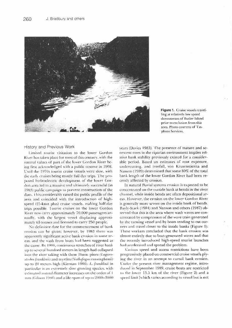
Figure 1. Cruise vessels travel-ting at relatively low speeddownstream of Butler Island
prior to exclusion from thisarea. Photo courtesy of Tas-
photo Services.
History and Previous WorkLimited tourist visitation to the lower Gordon
River has taken place for most of this century, with thenatural values of part of the lower Gordon River be-ing First acknowledged with a public reserve in 1908.Until the 1970s tourist cruise vessels were slow, with
tlie early cruises being mostly full day trips. The pro-posed hyclroelcctric development of the lower Gor-don area led co a massive and ultimately successful (in
1983) public campaign to prevent construction of theclam. This considerably raised the public profile ot'thearea and coincided with the introduction of high-speed (25-knot plus) cruise vessels. making half-daytrips possible. Tourist cruises on the lower GordonRiver now carrv approximately 70, 000 passengers an-nually, with the largest vessel displacing approxi-mately 65 tonnes and licensed to carry 250 people.
No cletinitive date for the commencement of bank
erosion can be given; however. by 1983 there wasapparently significant active bank erosion in some ar-eas, and the wash from boats had been suggested asthe cause. Bv 198fi. continuous stretches of river bank
iip to several hundred metei-s in length had collapsedinto the river taking with them Huon pines 'Lagaro-<[r'i!m. fmnklinii) and myrtles (\'oth<ifagus cunnmghamii)lip to 20 meters hii^h (Kiernan 1986). L. franklinii inparticular is ail extremely slow growing species, withcslimatfd ;iiiniial diameter increases on the order of 1
iDiii (C. ibson lc>.Sti) cincl a life-.span of up to 2000-3000
years (Davies 1983). The presence of mature and se-nescent trees in the riparian environment implies rel-ative bank stability previously existed for a consider-able period. Based on estimates of root exposure,undercutting, and treefall, von Krusenstierna andNanson (1989) determined that some 80% of the totalbank length of the lower Gordon River had been re-centlv at'tected by erosion.
In natural fluvial systems erosion is expected to beconcentrated on the outside bank at bends in the river
channel, while inside bends are often depositional ar-eas. However, the erosion on the lower Gordon River
is generally more severe on the inside bank of bends.Bavlv-Stark (1984) and Nanson and others (1987) ob-served that this is the area where wash waves are con-
cernrated by compression of the wave train generatedby the turning vessel and by boats tending to cut cor-ner.s and travel closer to the inside banks (Figure 1).These workers concluded that the bank erosion was
almost entirely due to boat-generated waves and thatthe recently introduced high-speed tourist launcheshad accelerated and spread the problem.
Various speed and access restrictions have beenprogressively placed on commercial cruise vessels ply-ing the river in an attempt to curtail bank erosion.Liicler the present river management regime, intro-ducecl in September 1989, cruise boats are restrictedto the lower 13. 5 kin of the river (Figure 2) and aspeed limit [which varies according to vessel but is not

Gordon River Erosion and Revegetation 261
MacquarieHarbour
^
a-
Horseshoe ?Bend" ~ "
ManniqansInltt ' ^ .
0°-E°" f,
Tim msEddy
-~Q' ;~~ q . '. ~~-.
FirsfGorge
Pine
Represenrative Bank Profiles
HANNIGANS INLET
HORSESHOE BEND
Undftrcut root mot-
OPPOSITE EA6LE CREEK
."""""t~TO87
.1990
DOWNSTBEAM FROM HAflBLE CLIFFS1?t71990
<:::. :. :::^:.^^-:tcTOn31^. ai profile ?BLOCKADE CAMP
Root' mass offallen tret
WALLABY EDDY
1m [_
Approximate summerwater level
p-resCTr_ c.upstrecm ,^"5limit of 'Ecruise r a£»essel.
Landing operanons
^
MarbleCliffs
0
pl-'?.
Is.?"Lake
t:;:: .::; Fidlei
t.:;.'.'
>::::
ButlerIsland-
BlockadeCamp
WailabyEddy
.. /c*- 0 0
Location Map
^
Won d
Heri+ugeArea
Pieman R.franklin R.
?iacquanaHarbour
MAIN MAPLOCATION
Gordon dam &power station
Gordon Ft.ca+chment area
TASMANIA
Legend* Monitoring siteDominant bank type(modified after von Krusenstierna 1990)
Palaeozoic limestone andsandstone.
:^
\o "'o Qj Poorly sorted coikmum, includingo na -i cobble beaches in Sea Reach
area.
Sandy levee banks
^ddd°e"rt t--------l Fine Srolned alluvialimpoundment? ^- --- -?
Fine grained estuarine.
2345
Km
Figure 2. Location of the studyarea, showing the distribution ofbank types (width not to scale),representative bank profilesfrom surveyed transacts, and the
location of monitoring sites. Alllocalities referred to in the text
are indicated on the map. Estua-rine and alkivial bank depositsmay be up to 500 m wide andalluvial flats up to 2 km- occur atthe conOuence of major tribu-taries. The levee bank-back-
swamp system ranges from 100to 500 in in width.
greater than 9 knots (16. 65 km/hr)] applies from theriver mouth. Experimental evidence (Matthews andothers 1992) indicates that potential erosion is notcontrolled simply by maximum wave height and thatother wave train parameters, in particular averagewave height or total wash energy, must be considered.
Unfortunately, [he wash generated by different craftvaries even when travelling at the same speed; how-ever, the overall size of the wash is generally reducedat very slow speeds. Wash generation is a neglectedsubject in naval engineering (Warren 1991); however,the possibilities of either design modifications toexist-
262 J. Bradbury and others
vgtleyslope backswamp le"ee
lee ;rest stoss
backswamp
fcedrcck. andCOlluV!Olslope
prevrojs flood
present' flcod
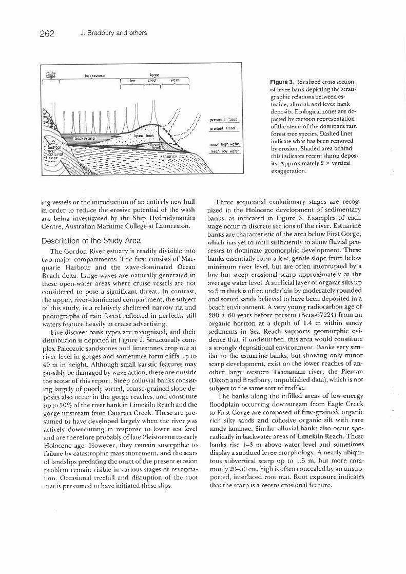
Figure 3. Idealized cross sectionof levee bank depicting the strati-graphic relations between es-tuaine, alluvial, and levee bank
deposits. Ecological zones are de-picted by cartoon representationof the stems of the dominant rain
forest tree species. Dashed linesindicate what has been removedbv erosion. Shaded area behind
this indicates recent slump depos-its. Approximately 2 x verticalexaggeration.
ing vessels or the introduction of an entirely new hullin order to reduce the erosive potential of the washare being investigated by the Ship HydrodynamicsCentre, Australian Maritime College at Launceston.
Description of the Study AreaThe Gordon River estuary is readily divisible into
two major compartments. The first consists of Mac-quarie Harbour and the wave-dominated OceanBeach delta. Large waves are naturally generated inthese open-water areas where cruise vessels are notconsidered to pose a significant threat. In contrast,the upper, river-dominated compartment, the subjectof this study, is a relatively sheltered narrow ria andphotographs of rain forest reflected in perfectly stillwaters feature heavily in cruise advertising.
Five discreet bank types are recognized, and theirdistribution is depicted in Figure 2. Structurally com-plex Paleozoic sandstones and limestones crop out atriver level in gorges and sometimes form cliffs up to40 m in height. Although small karstic features maypossibly be damaged by wave action, these are outsidethe scope of this report. Steep colluvial banks consist-ing largely of poorly sorted, coarse-grained slope de-posits also occur in the gorge reaches, and constituteup to 50% of the river bank in Limekiln Reach and thegorge upstream from Cataract Creek. These are pre-sumed to have developed largely when the river wasactively downcutting in response to lower sea Feveland are therefore probably of late Pleistocene to earlyHolocene age. However, they remain susceptible tofailure by catastrophic mass movement, and the scarsof landslips predating the onset of the present ei osionproblem remain visible in various stages of revegeta-lion. Occasional treefall and disruption of the rootmat is presumed to have initiated these slips.
Three sequential evolutionary stages are recog-nized in the Holocene development of sedimentarybanks, as indicated in Figure 3. Examples of eachstage occur in discrete sections of the river. Estuarinebanks are characteristic of the area below First Gorge,which has yet to infill sufficiently to allow fluvial pro-cesses to dominate geomorphic development. Thesebanks essentially form a low, gentle slope from belowminimum river level, but are often interrupted by alow but steep erosional scarp approximately at theaverage water level. A surficial layer of organic silts upto 5 m thick is often underlain by moderately roundedand sorted sands believed to have been deposited in abeach environment. A very young radiocarbon age of280 ± 60 years before present (Beta-67224) from anorganic horizon at a depth of 1.4 m within sandysediments in Sea Reach supports geomorphic evi-dence that, if undisturbed, this area would constitute
a strongly depositional environment. Banks very sim-ilar to the estuarine banks, but showing only minorscarp development, exist on the lower reaches of an-other large western Tasmanian river, the Pieman(Dixon and Bradbury, unpublished data), which is notsubject to the same sort of traffic.
The banks along the infilled areas of low-energyfloodplain occurring downstream from Eagle Creekto First Gorge are composed of fine-grained, organicrich silty sands and cohesive organic silt with raresandy laminae. Similar alluvial banks also occur spo-radically in backwater areas ofLimekiIn Reach. Thesebanks rise 1-3 m above water level and sometimes
display a subdued levee morphology. A nearly ubiqui-tous subvertical scarp up to 1. 5 m, but more com-monly 20-50 cm, high is often concealed by an unsup-ported, intertaced root mat. Root exposure indicatesthat the scarp is a recent erosional feature.

Gordon River Erosion and Revegetation 263
Commencing with postglacial sea level rise, estua-rine deposition of silts would have continued untilchannel narrowing allowed fluvial processes to domi-nate. A radiocarbon age of 2640 ±110 years beforepresent (Beta-67225) from a thin paleosol markingthe boundary between sands and overlying silty sedi-ments at a depth of 3. 4 m in the Horseshoe Bend areasuggests a maximum age for this transition. This datealso allows the calculation of a mean long-term verti-cal accretion rate of approximately 1 .4 mm/yr. At leastduring channel narrowing, lateral progradation isconsidered likely to have occurred at a similar rate.
Late Holocene levee banks occur along the 10 kmsection of meandering river from below CataractCreek downstream to Lake Fidler. These consist al-most exclusively of moderately sorted. massive, un-consolidated sand several meters in thickness. Leveesare underlain by sandv silt similar to that of the allu-
via! banks or, less commonly, fluvioglacial gravels andcobble-boutder beds. Radiocarbon ages from the baseof levees indicate that they commenced to form nearCataract Creek approximately 2400 years beforepresent (van Krusenstierna 1990) and that levee for-
mation had migrated downstream to the vicinity ofLake Fidler by 1160 ±130 years before present(Beta-67221). Levee development appears to haveprecluded extensive lateral channel migration (Sout-berg 1991).
Rare, undisturbed examples display a classic leveeprofile, with a steep river bank, a crest just back fromthe bank at a height of 1-A m above mean water level,and a gentle lee slope, with an overall width of some25 m. More commonly however, these formerly stablelandforms are interrupted by a recent erosion scarpwith a base approximately at the average water level.In some areas erosion has breached the crest of the
levee, thus reducing the overall elevation of the land-form. Beyond the levees, often on both sides of theriver, are well-developed flood basins containing sev-eral small waterbodies, including the meromicticlakes. These are believed to have formed bv the cut-ting off of inner bend river inlet channels duringlevee development (King and Tyler 1981. Soutberg1991).
The surface layer of the levee and alluvial banks,and to a lesser extent the colluvial banks, consists of a
thin (10-25 cm) fibrous organic horizon stronglybound by an interlaced root network. Prior to ctistur-bance, this layer effectively armoured the banks
against erosion. Fine organic matter may darken theupper sections of the levees, and minor highly convo-kited f'erruginous horizons occur ill places, but theyoung soils generally show only shallow profile devel-
opment. The vegetation includes cool temperate rainforest communities, wet sclerophyll forests andscrubs, and aquatic communities in the meromicticlakes (Cullen 199 la) and offshore from the low gradi-ent estuarine banks. The river banks support rainforests dominated by Nothofagiis cunninghamii, Alhro-spernui moschutum, Lagarostrobos franklinii, and Acacia
melanoxylon or riverine scrub dominated by Leptosper-mum, Melaleuca, or Acacia species where there havebeen past localized disturbances. Melaleuca squarrosaand L. franklinii-dommated thamnic swamp forests(Pannell 1992) occur in the coastally influenced areasdownstream of First Gorge.
Eleven discreet vegetation communities (excludingspecialized habitats) have been recognized on thelevee bank section of the river, including one that isunique to the lower Gordon River (Cullen 199 la).Historical photographs such as Figure 4A indicatethat the levee banks were generally completely vege-tated up until the early 1980s, implying that most ofthe vegetation dieback and treefall so apparent in Fig-ure 4B has occurred in the past 10-15 years.
Monitoring Methods
Many of the methods employed in other stream-bank erosion studies (Thorne 1981, Miller 1985, Reid1985, Clarke and Geary 1987, Lawler 1992) are eithernot possible or appropriate on the Gordon River dueto the wilderness location, lack of accurate baseline
data, and large scale (approximately 80 bank km) ofthe study area. The monitoring sites are only accessi-ble by water, since movement along the banks is se-verely restricted by the dense vegetation. The regularmonitoring program was established by Nanson andothers (1987) with 19 erosion pin (Wolman 1959,Haigh 1977) and survey cross-section sites. The pro-gram was expanded and comprehensively modifiedby the then Department of Lands, Parks and Wildlifefrom 1989. It now consists of 48 erosion pin sites, 31survey sections, and 38 revegetation monitoringquadrats.
Erosion pins are 1 m lengths of 10 mm (or finer)steel rod driven into the bank perpendicular to thesurface, with multiple pins being installed at each site.Sites are inspected and pins measured at six-monthintervals. Changes in the exposed length of pins indi-cate net erosion or deposition at the pin. The moni-toring interval is timed to differentiate the major sea-sonal events, that is, Hooding in winter and peaktourist cruise frequency in summer.
Permanent bank profile survey transects (see ex-amples iii Figure 2) have been established at most

.
"j%%^::
->^<-5^
<B.c
1(0
Zl.a"0re)
CD
^1-U3r\j
F- ^.. .k
';-:>-}'^ f'^ y"yk < . t
^'-^. rr '7'
.. ^^''. ' ;^/r^."i .y:..., '- .".'.J^1'".̂ "^''
i- 2.s ?
j2 5. o-s ^"5 ^2 s ^-§1§.U^i i 1111111^N-i^<t S"'^ S ^
MillE '£ S 2 8
"11">< 2 -^ 2SHls~- M^ I I 2'§ s ^§ -§ < iI is iu , 5 snw yFi
Ill:3'| §1 li,"
.c-t "
l.s
?̂ 0SP
I2a. -?'
:i
1i" ^-Ssi ¥Ill'11.1
y ^i
liiSH
lL> 0u . 1: C
Hii III s1Ill
iJIll
.5-=
^ '£rS111^
-a 3 c
" -a £ -Q-=. 'S 5c 5
u -t F.
IWU-i t- <L> G
bc13.. 3 1..5 £ Y-. £~
'.f'.
-'. - x^"~^'^
> f
,
^ii ^'yc
'^iyiSK^- ,< KK),,, "'.1 ^
Vl, i ^' A i f
-ffl-^
^ 2vi U
iiiiill
a- '-(D Q Q
Q c;
rt U
Isii11
^ 5 .2 &
-£. '5^
m'.-- £ ~s
-a 3'°-^ -?.^ 5 ^?il
I ^ra ^c ^u o
o .a
11u
o £-? .-
u
I y<U , r1
s ;sr? r/s
.a -^
11
.1^
.:: .3-tJ '?C! 0
.
0- ^on .-
"0 c/l
i"l
£:.3
c s0
0--= §-. 2 rti^ ^'3 be ^
!=
i;i-'-s. c -^ ^
C 3
.^5 3
u '- ^
-u -c el ^ "p ^ '^
~-1^ -; y -:
'J-:
-' ^
.J ^) f- ^
'^£. .=3C "^ T3
= ix v.ill I^ ^ 2 .5
.^,
-.J - . :=
-J
^ £
~! . 2 r=
^ -r- = ^ 2
.. i s . ~ ^.-; .- "
./
:r
.f. -J .,= S;
-jTi . ^ ./: ~z^
5 '..- =
^ = 3 :- . - -y: . = . y -. ~.J .>. '- '^- ~-. .J
/ , - n - 'z
/ - -
/-. ^

Gordon River Erosion and Revegetation 265
lively located in areas apparently undergoing rapiderosion. Later sites were located to provide a some-what more representative coverage, and particular at-tention was paid to pairing sites on similar banks onthe inside and outside of bends. The erosion pin dataare not normally distributed and do not have similar
variability in each section or time period and only verybasic statistical tests may be applied. The test em-ployed is a sign-based, distribution-free analysis ofmedians and assumes a random distribution of sites
(McPherson 1990), although access problems meanthat truly random site selection is dif'Ficult to achieve.
In November 1988, Fifteen 1m x 1 m permanentquadrats were established to monitor the naturalrevegetation on severely eroded sections of the bank.These quadrats were subjectively located so as to sam-pie areas that had little or no preexisting vegetationand therefore represent the worst-case scenario. Lim-ited resources precluded a more extensive sampling.Ten quadrats were located on levee banks and five oncolluvial banks. Due to the lack of light penetrationthrough the overhanging root mat, revegetation mon-itoring of the undercut alluvial and estuarine banks isnot appropriate. At each quadrat total projected veg-etation cover was estimated, as was the projectedcover for each species (moss species were not identi-fied). The number of seedlings of each species in10-cm height classes was recorded. Slope, aspect, sedi-ment type, and the height above the low-water markwas recorded for each quadrat. Quadrat location ismarked by steel pins placed in the top corners, whichalso provide an approximation ofon-going erosion ordeposition of bank sediment at the quadrat. In De-cember 1990, 14 more revegetation monitoring quad-rats were established adjacent to the 14 remainingquadrats (one was destroyed by further erosion) toimprove the statistical validity of the data base. Thesequadrats were located either 2 m to the right or left(alternatively for each successive site) of the preexist-ing one at the same height above the river. If theterrain at this point was unsuitable, then the quadratwas positioned at the closest possible location. A fur-ther 12 sites were subjectively located on bank typesthat were under represented or not represented in theoriginal survey, that is. colluvial banks, alluvial banks(where appropriate), and levee banks, which supportslumped, preexisting vegetation mats and A horizonsoil material. Problems with further erosion and highwater levels have restricted results to 12 quadrats oncolluvial banks and 26 quadrats on levees.
The data were analyzed over the two-year period(1990-1992) for the complete set of revegetationmonitoring quadrats and for a fbur-year period
(1988-1992) for the original quadrats located on themost extremely eroded sites. Mann-Whitney U testswere used to determine the statistical significance ofchanges at the revegetation monitoring sites between1988 and 1992. Nonparameti-ic statistical tests pro-vide a conservative yet robust method of assessing thesigniHcance of the results. They are not affected byextreme outliers in the data (as is the case here), andthey do not assume the data follows a specific proba-bility distribution (Potuin and Roff 1993).
Results
Since the introduction of the present river manage-ment regime, six full half-yearly erosion monitoringperiods have occurred. Several seasonal and longer-term trends are also now apparent in both the erosionpin and revegetation monitoring data. Figure 5 showsthe measured rate of bank retreat at each site under
the previous management regime and the extent towhich this has been reduced by the current restric-tions on cruise vessels. Table 1 summarizes the ero-
sion pin data available and also indicates the highdegree of variability that exists within the data set.
Colluvial Banks
There are an inordinate number of very recentlandslips that appear to have been induced by thewash from river traffic eroding the foot of the slope(van Krusenstierna 1990). In some areas the lower
part of the bank has collapsed over distances of up to100 m, leaving extensive areas of the upper slopeextremely susceptible to slipping. Qualitative moni-coring during the program suggests that once initi-atecl. the headwall of a landslip may progressively mi-grate a considerable distance upslope, and lateralenlargement is also possible, especially in areas of ex-isting low bank collapse, where the toe of the slope hasbeen truncatecl. Further undercutting of these slopesmay therefore lead to the development of landslipslarger than any of those in the known geomorphicrecord of the lower Gordon River.
Even in areas without substantial river traffic, re-
cently eroded colluvial banks remain prone to reacti-vation and further failure during periods of relativelyhigh water levels. This appears to be associated withsaturation of the banks at higher flood levels anddrawdown-induced piping or sapping processes (en-trainment of exposed sediment by the outflow ofgroundwater) following the reduction in water level.The surfaces of many of the recent landslips remainunstable due to a lack of vegetation cover and aresubject to sheetwash, rilling. aiid gully erosion. Due to

266 J. Bradbury and others
500
i. 50 -|
i.00-1-I
353-
e 300:|E -1
y 250-]
= 200-3o 3
I.so I-00 -<
50 ^
0
-50
. - FeS-jary W >o fay 19B9OecenDer 19E9 TO .icw'rcer 1992
Estuarine Alluvial* cruisevessels
AUuvial-no cruisevesse. s since
1 SesteTine- 1969
Levees
-M......
15 20 25r3ist'snca froin 'no^t'h (km)
I1
i.G
Figure 5. Mean rate of bank retreatrecorded at each site throughout thestudy area during the previous (Feb-ruary 1987 to May 1989) and present(December 1989 to November 1992)river management regimes. Erosionpin measurements from the upperbank zone only of the levee banks areused as the best indication of bank
retreat, being relatively unaffected byseasonal variations and deposition ofmaterial slumped from higher up thebank.
Table 1. Summary of erosion pin monitoring dataa
Summarv of leveebank data
Sample size-silesSample size-pinsMe;m rate
Median rateMinimum rate
Maximum rate
Standard deviation
Surnmarv of estujrine;md alluvial bank data
Sample size-sitesSample size-pinsMean rate
Median rate
Minimuir; rate
Maximum rate
Standard deviation
Previous m;>nagement regime,February iyH7-Mav 1989
L'pper levee
Ill3:»
1128
0
890219
Esiuanne banks.
Sea Re;ich to
First Crorge
4
22210
100
104043
Middle levee Lower levee
9 B
32 29Ki.-> 16725 U
0 -HO
1210 25UO281 474
Alluvial banks
Pine Uinding toHorseshoe Bend
;!13w
10
I.)
ill);>2
L'pstream fromHorseshoe Bend
61;
:!(>
ISOB.-i
Present management regime,December 1989-1992
Upper levee
12Ill
!30
-59216
41
Esluarine bunks.Sea Reach 10First Gur^e
s
S519
8
-6383
46
Middle levee Lower levee
13 1395 105
-21 -4-6 0
-602 -596
513 350!10 ;04
Alluvial banks
Pine Landing toHorseshoe Bend
6
34116
-6
i 4926
Upstream fromHorseshoe Bend
7
493
0
-1144
8
"Calculated erosion rates in mm/vr derived from approxim. ilely n-moiuh nieasurcmeiit of erosion pins. Negative rates indicate deposition of sediment. As [hechange in management regime occurred in the mitldle ol'a monilorins; |)eri<><l (Sepleiiibcr 1 1989), data from that period are excluded from consideration.
the qualitative nature of the data and the fact thatrelatively few colluvial banks occur in areas that arestill heavilytrafficked, the effectiveness of restrictionson cruise boat operations in halting colluvial bankerosion cannot be accurately assessed.
Sandy Levee Banks
[t was in the levee bank sections of the river that the
problem of bank erosion was and is most graphicallydemonstrated and severe erosion has occurred here
diiring the past decade. Recorded erosion rates ex-ceeded 2 m/yr during the peak cruise season whentourist vessels were operating on this section of the
river (van Krusenstierna 1990), and in some areas anestimated total of up to 10 m of bank retreat hasoccurred. The present program contains 13 teveebank erosion monitoring sites. Geomorphological ob-servations made during monitoring have led to anincreased understanding of the processes of, and theresponse of the banks to, erosion. At each site a three-fold vertical zonation of the bank is generally recog-nized. with upper (scarp), mid (slope), and lower(beach) zones being distinguished. This zonation issimilar to that displayed on the eroded noncohesivebanks of other rivers (Twidale 1964, Hagerty and oth-ers 1981) and lakes (Palmer 1973).

Gordon River Erosion and Revegetation 267
A dramatic decrease in the rate of erosion and
bank retreat occurred following the exclusion ofcom-mercial cruise vessels from this section of the river.However, visually the levee banks remain the most
degraded of bank types, with abundant vegetationdieback and treefall, the result of undercutting andcatastrophic bank collapse. Two major mechanisms oferosion are inferred to have occurred. Wave action
has breached the armouring root mat and undercutthe readily credible sands, leading to tensional upperbank failure and toppling of undercut vegetation.The collapse of undercut trees tends to produce large(to 5 m or more) blocks bound together by the rootsystem. These tilt blocks often retain the armouringsoil and root mat layer and, in some badlv erodedsections with extensive treefall, are sufficiently com-man to form an almost continuous barrier between
the river and the remaining bank. These areas cur-rently record the lowest erosion rates, which are com-monlv close to zero.
The other major erosion mechanism still operatesto a limited extent, even though the active agent ofdisturbance has been removed. Following the breach-ing of the root mat, there has been no barrier to theentrainment of sediment by outflowing groundwaterand there is evidence for piping and sapping (Hagerty1991) at many sites. This had led to further undercut-
ting and rotational stumping, very similar to that oc-curring on other eroding rivers (Hooke 1979). Pinmeasurements indicate that this slumped material isslowly breaking up and is being redepositecl on thebeachlike lower banks after limited transport and re-working. However, this is subject to seasonal varia-tions with lower bank erosion rates being higher dur-ing summer (low river level) monitoring periods,while depositional activity is becoming increasinglyimportant during winter periods when the lowerlevee is more likely co be submerged. These measure-merits are encouraging as, together with qualitativeobservations, they indicate a trend towards a more
stable angle of repose.Rainsplash, evidenced by considerable fluting at
many sites, rilling, and sheet erosion are additionalimportant erosion mechanisms on these banks nowthat the vegetation cover has been removed'' This"natural" erosion is likely to continue until the vegeta-tion has reestablished.
The erosion rate recorded by upper bank pins isregarded as the best overall indicator of bank retreat.since the data from mid and lower bank pins may bedistorted by the (often temporary) deposition of 'sanderoded from higher up the bank. Statistical analysis ofupper bank erosion measurements indicates that
within the 95% confidence limits, exclusion of cruisevessels from the levee bank reaches has reduced ero-
sion rates by between 1 and 31 mm/vr.
Fine-Grained Alluvial Banks
The small scarps and exposed roots present onthese banks are assumed to result from recent washerosion. Alluvial banks on untrafficked tributaries
such as the Spence River and Eagle Creek usually lackthese scarps and only very rarely show exposed roots.In most cases, scarp development has breached theinterlocked root mat, thus exposing the more readilycredible material beneath. An indication of the maxi-
mum extent of erosion is provided by the presence ofsmall erosional embayments extending up to 10 mlandwards. Once initiated, erosion of these embay-ments may be accelerated in what is essentially a posi-tive feedback effect whereby the embayment acts as afunnel, concentrating the erosive energy of washwaves onto the landward eroded bank (P. Augustinuspersonal communication).
Perhaps the most important mechanism ofalluvialand estuarine bank erosion is the incremental under-
cutting of the root mat for distances of up to severalmeters into the bank before eventual catastrophic fail-ure. As deeply undercut areas are inaccessible, pinsites cannot be established where erosion is most ac-
live. Since measured erosion rates commonly accountfor only approximately 10% of the undercutting anderosion indicated by the size of erosional embaymentsand believed to have occurred in the last decade, it is
therefore possible that the monitoring method leadsto an order of magnitude underestimation of the ex-tent of erosion occurring. This evaluation is sup-ported by the tact that, although erosional scarps arealmost ubiquitous, they are commonly hidden be-neath exposed root mats and accessible sedimentarybank materials in which pin sites can be establishedare rare. As such sites are often exposed as smallheadlands. it appears likely that they are inherentlyless susceptible to erosion. After the removal of soiland bank material, the undercut interlaced root mat
may float if detached and be completely removedfrom the system during periods of peak flow, thusleaving little obvious visual evidence of the extent oferosion occurring. This hypothesis is supported bysurvey [ransects recording the disappearance of up to1 m of root mat over a one-year period.
Since the closure of the levee bank sections of the
ri\ er to commercial vessels, a major aim of the moni-toring program has been to attempt an assessment ofthe impact of cruise vessel wash on the rate of alluvialbank erosion. Statistical analysis suggests that for the
268 J. Bradbury and others
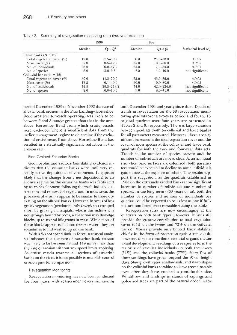
Table 2. Summary of revegetation monitoring data (two-year data set)
1990 1992
Median QI-Q3 Median Q1-Q3
Levee banks (N = 26)Total vegetation cover (%) 15. 0 7. 5-40. 0 6. 0 25. 0-80.0Moss cover (%) 5.0 0.5-22.5 25.0 10. 0-60.0No. of individuals 26.0 6. 8-47.0 25.0 7.0-63.0No. of species 6.0 3.0-9. 3 7.0 4. 0-10.0
Colluvial banks (N = 12)Total vegetation cover (%) 50.0 11.3-70.0 65.0 45.0-85.0Moss cover (%) 17. 5 0. 1-40. 0 40. 0 10. 0-80.0No. of individuals 74. 5 29. 3-214. 2 74. 0 42. 0-224.0No. of species 8. 0 6. 0-10. 0 9.0 8. 0-11.0
Statistical level (P)
«). 05<0. 05<0. 01
not significant
<0.05<0.05
not significantnot significant
period December 1989 to November 1992 the rate ofalluvial bank erosion in the Pine Landing-HorseshoeBend area (cruise vessels operating) was likely to bebetween 2 and 8 mm/yr greater than that in the areaabove Horseshoe Bend from which cruise vesselswere excluded. There is insufficient data from the
earlier management regime to determine if the exclu-sion of cruise vessel from above Horseshoe Bend has
resulted in a statistically significant reduction in theerosion rate.
Fine-Grained Estuarine Banks
Geomorphic and radiocarbon dating evidence in-dicates that the estuarine banks were until very re-cently active depositional environments. It appearslikely that the change from a net depositional to anerosive regime on the estuarine banks was facilitatedby scarp development following the wash-induced de-struction and removal of vegetation. In most areas theprocesses of erosion appear to be similar to those op-crating on the alluvial banks. However, in areas of lowgrassy vegetation (predominantly Isolepis sp. ) croppedshort by grazing marsupials, where the sediment isnot strongly bound by roots, wave action may dislodgeblocks up to several kilograms in mass. While most ofthese blocks appear to fall into deeper water, they aresometimes found washed up on the bank.
With a 9-knot speed limit in force, statistical analy-sis indicates that the rate of estuarine bank erosion
was likely to be between 59 and 149 mm/yr less thanthe rate of erosion without any speed limits applyrtig.As cruise vessels traverse all sections of estuarine
banks on the river, it is not possible to establish controlerosion pins for comparison.
Revegetation Monitoring
Revegetation monitoring has now been conductedfor four years, with reassessment every six months
until December 1991 and yearly since then. Details oftrends in revegetation for the 38 revegetation moni-toring quadrats over a two-year period and for the 15original quadrats over four years are presented inTables 2 and 3, respectively. There is large variationbetween quadrats (both on colluvial and levee banks)for all parameters measured. However, there are sig-nificant increases in the total vegetation cover and thecover of moss species at the colluvial and levee bankquadrats for both the two- and four-year data sets.Trends in the number of species present and thenumber of individuals are not so clear. After an initial
rise when bare surfaces are colonized, both parame-ters would be expected to decline as some individualsgain in size at the expense of others. The results sup-port this suggestion, as the quadrats established in1988 on the extremely eroded banks show significantincreases in number of individuals and number of
species. In the long term (300 years or so), both thenumber of species and number of individuals perquadrat could be expected to be as low as one if fullymature rain forest trees reestablish along the banks.
Revegetation rates are now encouraging at thequadrats on both bank types. However, mosses stillprovide the greatest contribution to total vegetationcover (65% on the levees and 73% on the colluvialbanks). Mosses provide only limited bank stability,chiefly in the form of protection against rainsplash;however, they do contribute essential organic matterto soil development. Seedlings of tree species form themajority of vascular individuals on both the levees(51%) and the colluvial banks (77%). Very few ofthese seedlings have grown beyond the 10-cm heightclass. Slow growth rates, shallow soils, and steep slopeson the colluvial banks combine to leave trees unstable
even after they have reached a considerable size.Windthrow and landslips in stands of saplings andpole-sized trees are part of the natural order in the
Gordon River Erosion and Revegetation 269
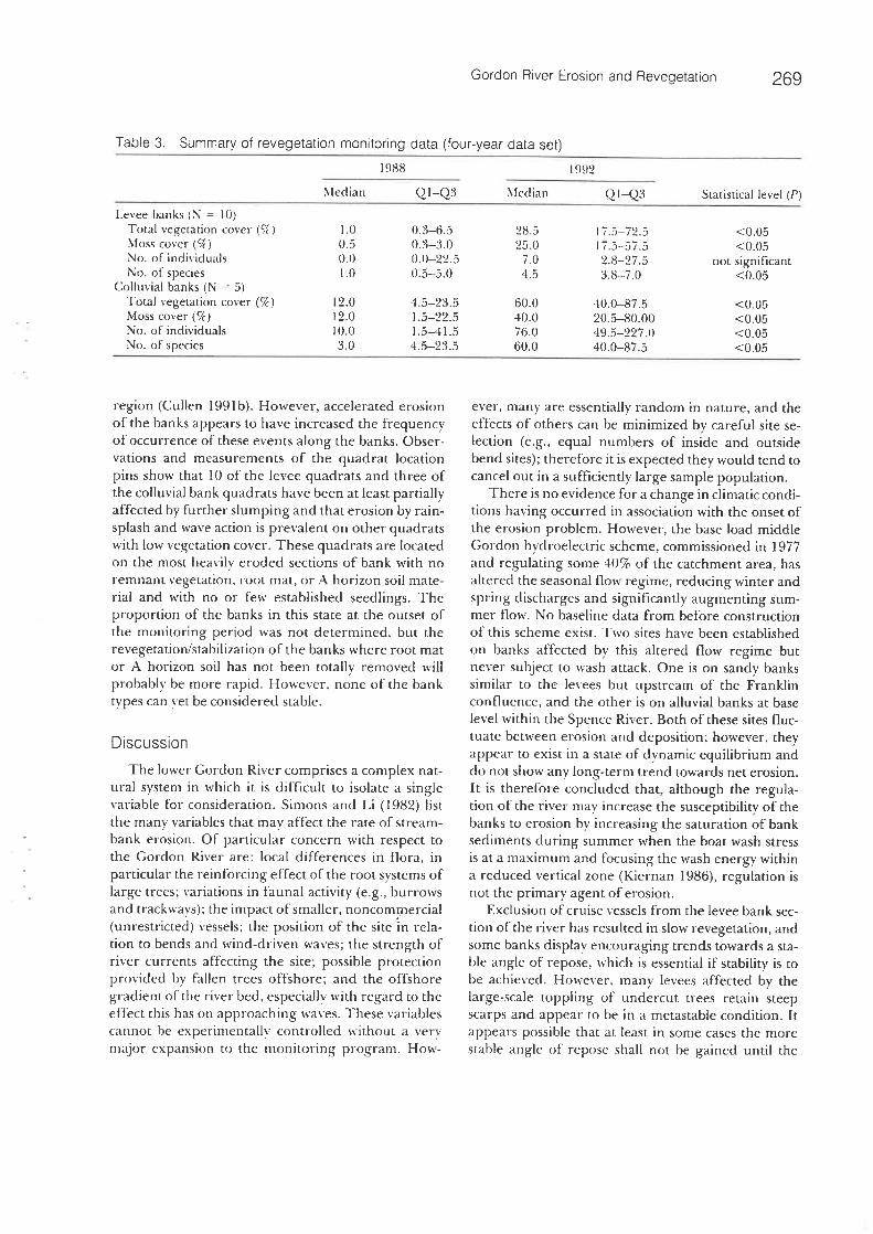
Table 3. Summary of revegetation monitoring data (four-year data set)198S 1992
Median Q1-Q3 Median Q1-Q3Levee banks (N = 10)
Total vegetation cover (%) 1. 0 0. 3-6.5 28.5 17.5-72.5Moss cover (%) 0. 5 0. 3-3. 0 25. 0 17. 5-57.5No. of individuals 0. 0 0. 0-22. 5 7. 0 2. 8-27.5No. of species 1.0 0.5-5.0 4. 5 3. 8-7.0
Colluvial banks (N = 5)Total vegetation cover (%) 12.0 4.5-23.5 60.0 40.0-87.5Moss cover (%) 12.0 1. 5-22.5 40.0 20.5-80.00No. of individuals 10. 0 1. 5-41. 5 76. 0 49. 5-227.0No. of species 3. 0 4. 5-23.5 60.0 40.0-87.5
Statistical level (P)
<0. 05<0. ()5
not significant<0.05
<0. 05<0.05<0.05<0. 05
region (Cullen 1991b). However, accelerated erosionof the banks appears to have increased the frequencyof occurrence of these events along the banks. Obser-vations and measurements of the quadrat locationpins show that 10 of the levee quadrats and three ofthe colluvial bank quadrats have been at least partiallyaffected by further slumping and that erosion by rain-splash and wave action is prevalent on other quadratswith low vegetation cover. These quadrats are locatedon the most heavily eroded sections of bank with no
remnant vegetation, root mat, or A horizon soil mate-rial and with no or few established seedlings. Theproportion of the banks in this state at the outset ofthe monitoring period was not determined, but therevegetation/stabilization of the banks where root mator A horizon soil has not been totally removed will
probably be more rapid. However, none of the banktypes can yet be considered stable.
Discussion
The lower Gordon River comprises a complex nat-ural system in which it is difficult to isolate a singlevariable for consideration. Simons and Li (1982) listthe many variables that mav affect the race of stream-
bank erosion. Of particular concern with respect tothe Gordon River are: local differences in flora, in
particular the reinforcing effect of the root systems oflarge trees; variations in faunal activity (e. g., burrowsand trackways); the impact of smaller, noncommercial(unrestricted) vessels; the position of the site in rela-tion to bends and wind-driven waves; the strength ofriver currents affecting the site; possible protectionprovided by fallen trees offshore; and the offshoregradient of the river bed, especially with regard to theeffect this has on approaching waves. These variablescannot be experimentally controlled without a verymajor expansion to the monitoring program. How-
ever, many are essentially random in nature, and theeffects of others can be minimized by careful site se-lection (e. g., equal numbers of inside and outsidebend sites); therefore it is expected they would tend tocancel out in a sufficiently large sample population.
There is no evidence for a change in climatic condi-tions having occurred in association with the onset ofthe erosion problem. However, the base load middleGordon hydroelearic scheme, commissioned in 1977and regulating some 40% of the catchment area, hasaltered the seasonal flow regime, reducing winter andspring discharges and significantly augmenting sum-mer flow. No baseline data from before constructionof this scheme exist. Two sites have been established
on banks affected by this altered flow regime butnever subject to wash attack. One is on sandy bankssimilar to the levees but upstream of the Franklinconfluence, and the other is on alluvial banks at baselevel within the Spence River. Both of these sites fluc-tuate between erosion and deposition; however, theyappear to exist in a state of dynamic equilibrium anddo not show any long-term trend towards net erosion.It is therefore concluded that, although the regula-tion of the river may increase the susceptibility of thebanks to erosion by increasing the saturation of banksediments during summer when the boat wash stressis at a maximum and focusing the wash energy withina reduced vertical zone (Kiernan 1986), regulation isnot the primary agent of erosion.
Exclusion of cruise vessels from the levee bank sec-
tion of the river has resulted in slow revegetation, andsome banks display encouraging trends towards a sta-ble angle of repose, which is essential if stability is tobe achieved. However, many levees affected by thelarge-scale toppling of undercut trees retain steepscarps and appear to be in a metastable condition. Itappears possible that at least in some cases the morestable angle of repose shall not be gained until the
270 J. Bradbury and others
350-)
300-)4
250
200
150
100
50
0
-50
Sea Reach - 'first gorge
f.Tst gcrge-Horseshoe Bend
Above Horseshce Bend
1587 198S 1989 1990
Time (year)i591 1992
Figure 6. Alluvial and estuarinebank erosion rates recorded since
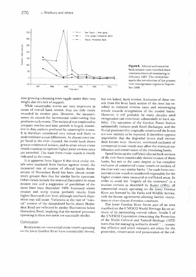
commencement of monitoring inFebruary 1987. The vertical linemarks the introduction of the presentriver management regime in Septem-ber1989.
slow-growing colonizing trees topple under their ownweight due to a lack of support.
While catastrophic events are very important interms of overall bank retreat, they are only rarelyrecorded by erosion pins. However, the measure-ments do record the incremental undercutting thatproduces such events. The statistical test employed tocompare reaches and time periods is largely insensi-tive to data outliers produced by catastrophic events.It is therefore considered very robust and likely tounderestimate actual differences. At almost every ma-jor bend in the river channel, the inside bank showsgreater evidence of erosion, and in areas where cruisevessels continue to operate higher mean erosion ratesare recorded. The wash from cruise vessels is clearlyimlicated as the cause.
It is apparent from Figure 6 that since cruise ves-sels were restricted from further upriver travel, themeasured rate of erosion of alluvial banks down-stream of Horseshoe Bend has been almost consis-
tently greater than that for similar banks upstream.Other trends include the seasonal fluctuation in mean
erosion rate and a suggestion of parallelism of thethree lines since December 1989. Increased winter
erosion and scarp retreat probably results fromhigher flows and river level, although overbank depo-sition may still occur. Variations in the rate of "natu-ral" erosion of the destabilized banks above Hofse-shoe Bend are reflected bv similar fluctuations below
Horseshoe Bend, implying that the natural processesoperating in these two areas are essentially siniilar.
Condusion
Restrictions on commercial cruise vessels operatingon the lower Gordon River have considerably slowed,
but not halted, bank erosion. Exclusion of these ves-sels from the levee bank section of the river has re-
suited in reduced erosion rates and encouragingtrends towards revegetation of the eroded banks.However, it will probably be many decades untilrevegetation can contribute substantially to bank sta-bility. The operation of the Gordon Power Stationsubstantially reduces peak flood discharges, and thefluvial processes that originally constructed the leveesare now unlikely to be repeated. It therefore appearsimprobable that the degraded levees shall recovertheir former state. However, continued exclusion ofcommercial cruise vessels may allow the eventual sta-
bilization and conservation of the remaining banks.Speed limits on the trafficked alluvial bank sections
of the river have considerably slowed erosion of thesebanks, but not to the same degree as has completeexclusion of commercial cruise vessels on sections ofthe river with very similar banks. The wash from com-mercial cruise vessels is considered responsible for thehigher erosion rates measured in trafficked areas. Inorder to avoid the "tragedy of the commons" in atourism context as described by Butler (1991), allcommercial vessels operating on the lower GordonRiver are licensed by the Parks and Wildlife Service,with the license agreements allowing further restric-tions or river closure if erosion continues.
The lower Gordon River forms part of an areainscribed on the UNESCO World Heritage list on ac-count of its outstanding natural values. Article 5 ofthe UNESCO Convention concerning the Protectionof the World Cultural and Natural Heritage (1972)states that the managing authority should "... ensurethat effective and active measures are taken for theprotection, conservation and presentation of the cul-
Gordon River Erosion and Revegetation 271
tural and natural heritage situated on its territory. ."Given these management objectives, and economicconsiderations, neither large-scale artificial stabiliza-tion of the banks nor closure of the river to touristcruise traffic are considered desirable. The extensivemonitoring program outlined above has been de-
signed to provide information relevant to planningfor the somewhat conflicting objectives of presenta-tion and protection.
Note Added in Proof
Results from continued monitoring (as of May1994) are consistent with those reported here. In afurther attempt to minimize wash induced erosion,the maximum speed limit for commercial cruise ves-sels was reduced from 9 knots to 6 knots on fuly 1,1994.
Acknowledgments
This work is published with the permission of theDirector, National Parks and Wildlife, Tasmania.Parks and Wildlife staff, in particular Tas Donovan,Cheryl Nagel, Kelvin Barrett, Mike Comfort, and BobCurley together with volunteer David Parker have allprovided valuable field assistance. Dr. Glen McPher-son. Mathematics Department, University of Tasma-nia, provided advice on statistical analysis. The fig-ures were drafted by Carol Edwards.
Literature Cited
Bayly-Stark. J. 1984. Wave action and bank erosion. Austra-lian Ranger Bulletin 3:27.
Bowling L. C and P. A. Tyler. 1984. Endangered lakes ofscientific and cultural value in the World Heritage area ofsouth-west Tasmania. Biological Coweniation 30:201-209.
Butler, R. W. 1991. Tourism, environment and sustainabledevelopment. Environmental Conseivatton 18:201-209.
Clarke, M. N., and M. G. Geary. 1987. Channel geometry,morphological changes and bank erosion. HawkesburvRiver hydraulic and sediment transport processes. PublicWorks Department, New South Wales. Report PWD87067.
Cullen, P. 199 la. A survey of the vegetation of the riverbanks and environs. Pages 33-54 in'G. Dixon (ed. ), Gor-don river ecological survey 1-levee banks and noodba-sins. Department of Parks, Wildlife and Heritage, Hobart.
Cullen, P. 199 Ib. The regeneration of Athrotaxis selaginoidesand other tree species on landslide faces in Tasmania.Pages 191-200 in M. R. Banks, et al. (eds. ), Aspects ofTasmanian botanv-a tribute to VV'iiiifred Curtis. RovalSociety of Tasmania. Hobart.
Davies. J. 1983. Huon pine survey 1983. National Parks andWildlife Service Tasmania, Hobart.
Dixon, G. 1991. Earth resources of the Tasmanian Wilder-ness World Heritage Area: A preliminary inventory ofgeological, geomorphological and soil features. TasmaniaDepartment of Parks, Wildlife and Heritage OccasionalPaper No. 25.
Flanagan. R. 1985. A terrible beauty: History of the GordonRiver country. Greenhouse Publications, Melbourne.
Gibson, N. 1986. Huon pine conservation and management.National Parks and Wildlife Service Tasmania. Hobart.
Hageriy^D. J. 1991. Piping/sapping erosion. II: Identifica-tmn~dlaSm~ls[s-Journal of Hydraulic Engineering 117:1009-
Hagerty, D. J., M.F. Spoor, and C. R. Ullrich. 1981. Bankfailure and erosion on the Ohio River. Eneineerir17:141-158.
Hajgh, M. J 1977. The use of erosion pins in the study ofslope evolution. British Geomorphological ResearchGroup Technical Bulletin 18.
Hooke, J. M. 1979. An analysis of the processes of bankerosion. Journal of Hydrology 42:39-62.
Horwitz P. 1991. Aspects of the zoological resoures and thepotential impact oflevee bank erosion on these resources.Pages 5o-80 in G. Dixon (ed. ), Gordon river ecologicalsurvey 1-levee banks and floodbasins. Department ofParks, Wildlife and Heritage, Hobart.
Kiernan, K. 1986. Bank erosion on the lower Gordon River.Interoffice memo. National Parks and Wildlife Service,Tasmania.
King, R. D., and P. A. Tyler. 1981. Meromictic lakes ofsouth-west Tasmania. Australian Journal of Marine andFreshwater Research 32:741-756.
Lawler. D. M. 1992. Design and installation of a novel auto-matic erosion monitoring system. Earth Surface Processesand Laiidforms 17:455-^63.
Matthews, B., P. Augustinus, and D. Hannan. 1992. Interimreport for Gordon River low wake hull project-geomor-phology component. University of Tasmania at Launces-toil unpublished report to Tasmanian Department ofParks, Wildlife and Heritage.
McPherson G. 1990. Statistics in scientific investigation.Springer Verlag.
Miller, A. J. 1985. Shore erosion as a sediment source to thetidal Potomac River, Maryland and Virginia. UnitedStates Geological Survey Water-Supply Paper 2234-E.
Nanson, G. C., E. A. Bryantand A. van Krusentiema. 1987.Bank erosion study of the Gordon River below the Fran-klin junction, southwest Tasmania. Uniadvice, UniversityofWollongong. Unpublished report.
Palmer, H. D.J973. Shoreline erosion in the Upper Chesa-peake Bay: The role of groundwater. Shore and Beach Oc-tober1973:19-22.
Pannell. J. R. 1992. Swamp forests of Tasmania. ForestryCommission, Tasmania, Hobart.
Potuin, C., and D. A. Roff. 1993. Distribution-free and ro-bust statistical methods: Viable alternatives to parametricstatistics. Ecology 74:1617-1628.
272 J. Bradbury and others
Reid, J. R. Jr. 1985. Bank erosion processes in a cool, tem-perate environment. Orwell Lake, Minnesota. GeologicalSociety of America Bulletin 96:781-792.
Simons, D. B.. and R. M. Li. 1982. Engineering and analysisoffluvial systems. Simons, Li and Associates, Colorado.
Soutberg, T. L. 1991. A geomorphological investigation.Pages 7-32 in G. Dixon (ed. ), Gordon river ecologicalsurvey 1-levee banks and floodbasins. Department ofParks, Wildlife and Heritage, Hobart.
Thorne. C. R. 1981. Field measurements of rates of bank
erosion and bank material strength. Pages 503-512 inErosion and Sediment Transport Measurement. Proceed-ings of the Florence symposium, 22-26 June 1981.
Townrow, K. 1991. Archeology. Pages 81-86 in G. Dixon(ed. ), Gordon river ecological survey 1-levee banks andfloodbasins. Department of Parks, Wildlife and Heritage,Hobart.
Twidale. C. R. H)64. Erosion of an alluvial bank at Bird-
wood. South Australia. Zeitschrift fur Geomorpkotogie7:189-211.
UNESCO. 1972. The UNESCO convention concerning theprotection of the world cultural and natural heritage(1972). Paris.
von Krusentierna, A. 1990. River bank erosion by boat gen-eratecl waves on the lower Gordon River, Tasmania.
University of Wollongong MSc (Hons). thesis (unpub-lished).
van Krusentierna, A., and G. C. Nanson. 1987. Bank ero-sion and rehabilitation. Progress report and preliminaryrecommendations. Uniadvice, University of Wollongong.Unpublished report.
Warren, N. 1991. Wash from fast ferries. Ship and Boat Inter-national April 1991:11-13.
Wolman, M. G. 1959. Factors influencing erosion of acohesive river bank. American Journal of Science 257:204-216.
Copyright © 2022 FDOKUMEN