Modeling aquifer–river interactions under the influence of groundwater abstraction in the Mancha...
13
Modeling aquifer–river interactions under the influence of groundwater abstraction in the Mancha Oriental System (SE Spain) David Sanz & Santiago Castaño & Eduardo Cassiraga & Andrés Sahuquillo & Juan José Gómez-Alday & Salvador Peña & Alfonso Calera Abstract The Mancha Oriental System (MOS, 7,260km 2 ) is one of the largest aquifers within Spain, and is encompassed by the Jucar River Basin. Over the past 30years, socioeconomic development within the region has been largely due to intensive use of groundwater resources for irrigating crops (1,000km 2 ). Groundwater pumping (406 million m 3 /year) has provoked a steady drop in the groundwater level and a reduction of MOS discharge to the Jucar River. The study aims to character- ize the river–aquifer relationship, to determine the influence that groundwater abstraction has on the river discharge. This research has advanced a three-dimensional large-scale numerical groundwater-flow model (MOD- FLOW 2000) in order to spatially and temporally evaluate, quantify and predict the river–aquifer interac- tions that are influenced by groundwater abstraction in MOS. It is demonstrated that although groundwater abstraction increased considerably from the early 1980s to 2000, the depletion of water stored in the aquifer was lower than might be expected. This is mainly due to aquifer recharge from the Jucar River, induced by ground- water abstraction. The area of disconnection between the river and the water table (i.e. where groundwater head is lower than the riverbed) is found to have spread 20km downstream from its position before pumping started. Keywords Numerical modeling . MODFLOW . Groundwater/surface-water relations . Groundwater abstraction . Spain Introduction The interactions between rivers and aquifers in semiarid climates are an essential part of the hydrologic cycle (Nemeth and Solo-Gabriele 2002; Rodríguez et al. 2005). Models have been the focus of research for several decades (Tóth 1970; Gorelick 1986; Winter 1995; Younger 1995; Langhoff et al. 2006) and they are of interest not only from a scientific perspective but are also important in water-resource management. Groundwater pumping has repercussions on river discharge and is a critical subject that must be resolved due to the admin- istrative, economic, legal and environmental implications that occur on a local and basin scale (Pulido-Velazquez et al. 2005). Zume and Tarhule (2008) suggest there is a need to understand the river–aquifer interactions in the context of anthropogenic water use, given that this knowledge would facilitate the development of manage- ment programs for a collective use of surface water and groundwater that ensures maintenance of ecological flows and discharge levels without causing conflicts between users and managers. In this sense, river–aquifer interac- tions can be established using different methods (see a brief theoretical background of river–aquifer interaction in Osman and Bruen 2002). Spatial and temporal evaluation, quantification and prediction are usually performed using numeric models due to their capacity to represent the complexity of hydrogeological systems (Sophocleous 2002; Fleckenstein et al. 2006; Pisinaras et al. 2007). Despite the fact that the Mancha Oriental System (MOS) is located in a semiarid climate, over the past 30 years, 1,000 km 2 of the area has been transformed from dry agriculture to irrigated agriculture through generalized use of groundwater, which has stimulated significant socioeconomic growth in the region. In this context, the MOS presents itself as a magnificent example of the problem with using groundwater for agriculture in terms of sustainable development of water resources and associated surface-water ecosystems. According to Estrela Received: 15 March 2010 / Accepted: 7 December 2010 Published online: 5 January 2011 * Springer-Verlag 2010 D. Sanz ()) : S. Castaño : J. J. Gómez-Alday : A. Calera Remote Sensing & GIS Group, Regional Development Institute, Universidad de Castilla-La Mancha, Campus Universitario, s/n, 02071, Albacete, Spain e-mail: [email protected] Tel.: +34-967599200 Fax: +34-967599233 E. Cassiraga : A. Sahuquillo : S. Peña Hydrogeology Group, Hydraulic and Environmental Engineering Department, Universidad Politécnica de Valencia, C/. Camino de Vera, s/n, 46022, Valencia, Spain Hydrogeology Journal (2011) 19: 475–487 DOI 10.1007/s10040-010-0694-x
-
Upload
independent -
Category
Documents
-
view
4 -
download
0
Transcript of Modeling aquifer–river interactions under the influence of groundwater abstraction in the Mancha...
Modeling aquifer–river interactions under the influenceof groundwater abstraction in the Mancha Oriental System (SE Spain)
David Sanz & Santiago Castaño & Eduardo Cassiraga &
Andrés Sahuquillo & Juan José Gómez-Alday &
Salvador Peña & Alfonso Calera
Abstract The Mancha Oriental System (MOS, 7,260km2)is one of the largest aquifers within Spain, and isencompassed by the Jucar River Basin. Over the past30years, socioeconomic development within the regionhas been largely due to intensive use of groundwaterresources for irrigating crops (1,000km2). Groundwaterpumping (406 million m3/year) has provoked a steadydrop in the groundwater level and a reduction of MOSdischarge to the Jucar River. The study aims to character-ize the river–aquifer relationship, to determine theinfluence that groundwater abstraction has on the riverdischarge. This research has advanced a three-dimensionallarge-scale numerical groundwater-flow model (MOD-FLOW 2000) in order to spatially and temporallyevaluate, quantify and predict the river–aquifer interac-tions that are influenced by groundwater abstraction inMOS. It is demonstrated that although groundwaterabstraction increased considerably from the early 1980sto 2000, the depletion of water stored in the aquifer waslower than might be expected. This is mainly due toaquifer recharge from the Jucar River, induced by ground-water abstraction. The area of disconnection between theriver and the water table (i.e. where groundwater head islower than the riverbed) is found to have spread 20kmdownstream from its position before pumping started.
Keywords Numerical modeling . MODFLOW .Groundwater/surface-water relations .Groundwater abstraction . Spain
Introduction
The interactions between rivers and aquifers in semiaridclimates are an essential part of the hydrologic cycle(Nemeth and Solo-Gabriele 2002; Rodríguez et al. 2005).Models have been the focus of research for severaldecades (Tóth 1970; Gorelick 1986; Winter 1995;Younger 1995; Langhoff et al. 2006) and they are ofinterest not only from a scientific perspective but are alsoimportant in water-resource management. Groundwaterpumping has repercussions on river discharge and is acritical subject that must be resolved due to the admin-istrative, economic, legal and environmental implicationsthat occur on a local and basin scale (Pulido-Velazquezet al. 2005). Zume and Tarhule (2008) suggest there is aneed to understand the river–aquifer interactions in thecontext of anthropogenic water use, given that thisknowledge would facilitate the development of manage-ment programs for a collective use of surface water andgroundwater that ensures maintenance of ecological flowsand discharge levels without causing conflicts betweenusers and managers. In this sense, river–aquifer interac-tions can be established using different methods (see abrief theoretical background of river–aquifer interaction inOsman and Bruen 2002). Spatial and temporal evaluation,quantification and prediction are usually performed usingnumeric models due to their capacity to represent thecomplexity of hydrogeological systems (Sophocleous2002; Fleckenstein et al. 2006; Pisinaras et al. 2007).
Despite the fact that the Mancha Oriental System(MOS) is located in a semiarid climate, over the past30 years, 1,000 km2 of the area has been transformed fromdry agriculture to irrigated agriculture through generalizeduse of groundwater, which has stimulated significantsocioeconomic growth in the region. In this context, theMOS presents itself as a magnificent example of theproblem with using groundwater for agriculture in termsof sustainable development of water resources andassociated surface-water ecosystems. According to Estrela
Received: 15 March 2010 /Accepted: 7 December 2010Published online: 5 January 2011
* Springer-Verlag 2010
D. Sanz ()) : S. Castaño : J. J. Gómez-Alday :A. CaleraRemote Sensing & GIS Group, Regional Development Institute,Universidad de Castilla-La Mancha,Campus Universitario, s/n, 02071, Albacete, Spaine-mail: [email protected].: +34-967599200Fax: +34-967599233
E. Cassiraga :A. Sahuquillo : S. PeñaHydrogeology Group,Hydraulic and Environmental Engineering Department,Universidad Politécnica de Valencia,C/. Camino de Vera, s/n, 46022, Valencia, Spain
Hydrogeology Journal (2011) 19: 475–487 DOI 10.1007/s10040-010-0694-x
(2004), 406 million (M) m3/year are pumped fromgroundwater, 98% of which are used in irrigated agricul-ture. The volume of water withdrawal is not compatiblewith the amount of aquifer recharge, estimated at320 Mm3/year by the Hydrologic Plan for the Jucar RiverBasin (JRB). This situation is provoking two largeimpacts: a steady drop in the regional groundwater leveland a reduction in discharge from the aquifer to the JucarRiver. In fact, the quantitative analysis performed on theriver basin for the European Water Framework Directive(WFD, 2000/60/EC) clearly indicates that the environ-mental objectives set are not being reached at the presenttime and there is a certain risk of not meeting them by 2015.
The aim of this study was to broaden the knowledge ofthe river–aquifer relationship in order to determine theinfluence that groundwater abstraction has on the JucarRiver discharge. This information will assist watershedauthorities in making decisions related to reaching theenvironmental objectives set by the European Water Frame-work Directive (WFD) for the year 2015. Vázquez-Suñeet al. (2006) point out that the methodology used to define anaquifer-management program in accordance with theWFD is to a great degree equivalent to developinggroundwater flow models. In fact, modeling is usuallyone of the best ways to administrate, integrate, validateand quantify hydrogeological information. In order toaccomplish this, a three-dimensional large-scale numer-ical groundwater-flow model was developed usingMODFLOW-2000 (McDonald and Harbaugh 1988;Harbaugh et al. 2000). The results of this research willbecome a useful tool for planning and sustainable manage-ment of water resources in the MOS and can be used indecision-making by water authorities and stakeholders.
Area of study and hydrogeological behaviour
The MOS is located in the southeast of the IberianPeninsula and is completely encompassed within the JucarRiver Basin (Fig. 1). It is one of the most extensivecarbonate aquifers in Spain (7,260 km2). The MOS isformed by the superposition of three hydrogeological units(HU), aquifers HU2, HU3 and HU7, separated byaquitards/aquifers that make up HU6, HU5, HU4 andHU1 (upper and lower). HU8 is composed of marl, clayand gypsum which are the impermeable base and thesouthwest border of the MOS (IGME 1980; Sanz et al.2009). HU7, present throughout the MOS, is composed oflimestone and fractured and karstified dolostone from theMiddle Jurassic Age. HU3, which occupies half of thenortheastern sector of the MOS, is composed of fracturedlimestone and dolostones from Upper Cretaceous Age.The thickness of HU3 ranges from 50 and 200 m.HU2 (mid Miocene) which occupies the central area ofthe MOS, is composed of an alternating sequence ofmarl-lime and marl. HU2 is about 150 m in thickness(IGME 1980; Sanz et al. 2009).
Hydrogeological behaviour of the MOS is directed by aseries of interrelated elements (recharge and discharge
zones, relations between aquifer units, interactions betweenHUs and rivers). The aquifer system is described in moredetail in Sanz et al. (2009). The recharge zones coincidewith Mesozoic outcrops from HU7 and HU3 on the borderof the MOS. These aquifer units gradually insert under theplains of Albacete due to the presence of vertical displace-ment fractures. There are discordant Cenozoic units (HU1(upper and lower) and HU2) which represent the Tertiaryinfilling of a horst-and-graben structure in the Mesozoiccover. Another recharge zone is the channels of the Jardinand Lezuza Streams as well as the Maria Cristina Channel(DMCC; Fig. 1). The Jardin and Lezuza Streams enter theMOS from the southwest edge and completely infiltrateinto the aquifer system. The DMCC is a network of shallowchannels built at the turn of the nineteenth century to drainstagnant water associated with marshes in order to preventhealth problems (malaria epidemics). Currently, the DMCCis used for discharging urban waste from the city ofAlbacete, which infiltrates into the aquifer before connect-ing to the Jucar River.
The main discharge area of groundwater is the JucarRiver. HU2, which is an unconfined aquifer unit, naturallyyields its resources into the Jucar River. According to theconceptual model of hydrogeological behaviour of theMOS, water entrance into HU2 is produced through directrecharge of rain water and discharge from the Mesozoicaquifers through the semipermeable material of HU1. Theaquifer system is divided into six hydrogeologicaldomains (HDs): Northern (ND), Central (CD), El Salo-bral-Los Llanos (SLD), Moro-Nevazos (MND), PozoCañada (PCD) and Montearagón-Carcelén (MCD)domains (Fig. 1). The degree of hydraulic connectivitybetween these domains is variable: the stratigraphiccontinuity of the aquifer material and the absence ofbreaks in the water table suggest that there is undergroundresource transfer between the ND, CD and SLD domains(IGME 1980; Sanz 2005). However, there is no hydraulicconnection between MND, PCD and MCD or betweenthese three and ND, CD and SLD. A detailed descriptionof the regional geology and the hydrogeological contextcan be found in Sanz et al. (2009).
Previous models
There are three mathematical groundwater flow models ofthe MOS that were developed before this one. Fernández-Sanchez et al. (1983) describe the first model and theresults of its application. It was developed by the SpanishGeology and Mining Institute (IGME) on a rectangularmesh of 867 elements of 2 km×2 km over an area of3,468 km2. It is a one-layer model that simulated thesteady state in 1975 and the transient state from 1976 to1978 on a monthly time step. This model was the firstadvance in understanding the behaviour of the MOS,despite its lack of vertical discretion and modeling onlyhalf the area.
The second model (DGOH 1988, 1993) is made up ofa mesh with various dimensions, with the largest node of
476
Hydrogeology Journal (2011) 19: 475–487 DOI 10.1007/s10040-010-0694-x

Fig. 1 Simplified geological map and cross section of the Mancha Oriental System (MOS) with hydrostructural domains shown: NorthernDomain (ND), Central Domain (CD), El Salobral-Los Llanos Domain (SLD), Moro-Nevazos Domain (MND), Pozocañada Domain (PCD),and Montearagón-Carcelén Domain (MCD). Hydraulic infrastructures are the Tajo-Segura Channel (TSC) and Doña Maria Cristina Channel(DMCC). JRB is the Jucar River Basin. (Modified from Sanz et al. 2009)
477
Hydrogeology Journal (2011) 19: 475–487 DOI 10.1007/s10040-010-0694-x
12 km×18 km and the smallest 3 km×3 km. The surfacearea modeled is 6,370 km2. Vertically it consists of threedifferent layers: the lower layer is represented byMesozoic aquifer formations; the intermediate, or semi-confining, layer is not explicitly represented in the model;and the upper layer is made up of Miocene carbonatematerials. It was designed using software developed bythe Unites States Geological Survey (Trescott 1975). Thesimulation periods were 1974 to 1986 (later updated to1993), with a 6-month time step. This second modelimproved regional understanding of the aquifer and theevolution of groundwater levels, although the simulationresults must be interpreted according to the sources ofuncertainty introduced including elements such as thesmall mesh size and the data on groundwater pumping,among others.
The third model was developed by the HydrologicPlanning Office of the Jucar Water Authority (CHJ; Font2004) and was updated by the IGME (2006) using MOD-FLOW (McDonald and Harbaugh 1988). This project usedmonthly time steps to simulate aquifer function and therelationship with the Jucar River over a period of 60 years(1940–2000), before the beginning of intensive exploitationof groundwater. The system was divided into 1-km-widecells in a mesh of 126 columns and 131 rows, covering over7,000 km2. The vertical differentiation considered fourlayers parallel to the land surface. This model was animprovement upon the overall knowledge of the system andan update on the hydrogeological information up to the year2000. Nevertheless, there were still uncertainties in theconstruction which were reflected in poor calibration of thegroundwater levels because the model did not incorporatethe geometry of the MOS aquifer units.
In critical analysis of the previous work, the modelpresented here takes into account the following additionalaspects: (1) definition of the different hydrologic units andestablishment of their geometry in three dimensions, (2)quantification of hydrogeological, permeability and stor-age coefficient parameters, establishing a flow system ineach unit, (3) assignment of boundary conditions and theirinterrelationships, (4) more rigorous or precise spatial andtemporal quantification of recharge and (5) preciseestimation of the number and volume of groundwaterabstractions in time and space.
Model development
MODFLOW 2000 was used to simulate groundwater flowin the MOS (McDonald and Harbaugh 1988; Harbaugh etal. 2000), which resolves the flow equation in a porousmedium in three dimensions using an approximation byfinite differences.
Conceptual model and spatial and temporaldiscretizationThe conceptual model of the MOS was developed fromwork published by Sanz et al. (2009) which contains a
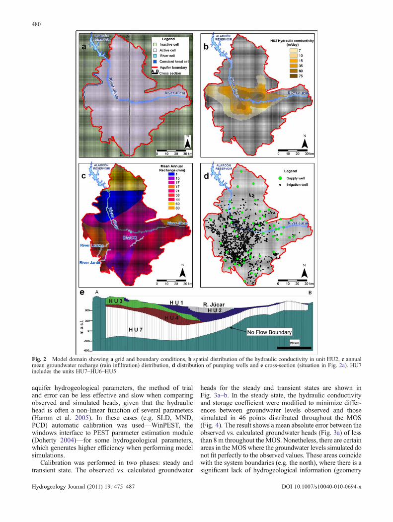
three-dimensional hydrostratigraphic description and aconceptual model of groundwater flow in the MOS. Thearea of study was divided horizontally in three dimensionsinto square cells of 1 km, lined up in a northerly directionwith 126 columns and 131 rows for a total of 16,506 cellsper layer. The mesh size is large enough for dealing withfractured media and karstic/carbonate aquifers as contin-uous media. The fractures are small relative to cell size, sothe use of MODFLOW is appropriate (Jagelke and Barthel2005). The geometry of the lithostratigraphic layers hasalso been incorporated, generating a model of six layerswith three aquifer units (HU7/HU6/HU5, HU3 and HU2)and three semipermeable units (HU4, lower HU1 andupper HU1) (Fig. 2a–e). The surfaces corresponding to thetop and bottom of each hydrogeological unit weremodeled using geostatistical models with geographicinformation system (GIS) tools (Sanz et al. 2009) andincorporated into the model. The “empty spaces” leftbetween them corresponded with the semipermeable units.The temporal discretization was defined for a period of23 years (1982–2005), with stress periods taken on amonthly time step.
Model domain, initial and boundary conditionsThe active model domain was defined by making modellimits coincide with the physical limits of the system(Sanz et al. 2009). There is still a degree of uncertainty inflow exchanges between the system modeled and theneighboring Western Mancha (Mancha Occidental) Sys-tem (Fig. 2a). This unit is located immediately to the westof the MOS and has a similar degree of development interms of the groundwater resources used in irrigation(Martínez-Santos et al. 2008). For model calibrationpurposes, this boundary was dealt with through defininga time variant specified-head boundary. Fluctuationscorrespond to water-table measurement carried out from1982 to recent times (Sanz 2005). The Jucar River wasrepresented as a head-dependent boundary condition interms of limits within the area of study (Fig. 2a). Theparameters incorporated into the model were the follow-ing: (1) riverbed elevation (obtained via topographicsurveying at a series of points in the channel), (2) theheight of the water level (obtained from the level recordedin operating gauge stations) and (3) conductance of thematerials in the riverbed (obtained from Calver (2001) andlater calibrated so that results were reasonable, given thatthe in situ measurement of this parameter is veryimprecise). The starting heads used in the MOS modelcorrespond with the water-table contour maps obtained bySanz (2005).
Hydrogeological parametersTo hydraulically characterize the hydrogeological units inthe MOS, data were reviewed on transmissivity, specificdischarge and storage coefficient from 587 boreholes(Sanz et al. 2009; Table 1). The degree of permeabilityin aquifer unit HU2 is spatially differentiated (Fig. 2b) due
478
Hydrogeology Journal (2011) 19: 475–487 DOI 10.1007/s10040-010-0694-x
to (1) the homogeneous distribution in space of perme-ability values, (2) the volume of groundwater abstractionfrom it and, (3) the direct relationship that this reservoirhas with the Jucar River.
RechargeIn this study, rain-derived recharge values have been takenfrom different sources. First, values given by Font (2004)were used for recharge values from rainfall infiltration inthe MOS which were obtained using the distributedSIMPA model (Ruiz 1999). These recharge values aredistributed homogeneously over a series of areas—according to their hydrogeological characteristics (Sanzet al. 2009; Fig. 2c—on a monthly time step for the period1982–2000. After 2000, the data include results from theHydromore recharge model developed by the RemoteSensing and GIS Group within the context of theHidroMORE project (UCLM 2008)
Other sources of recharge in the MOS are the Jardinand Lezuza streams and Maria Cristina Channel (Fig. 2c).The two streams come from the Campo de Montiel(southwest of the area studied) and are lost by infiltrationin the MOS, to the west of the city of Albacete. TheLezuza and Jardín streams contain water only whenCampo de Montiel has excess surface water. Determiningthe amount of infiltration for this type of stream is notalways easy to evaluate given that the values measured aresometimes smaller than the margin of error of gaugestations. To include these data in the model, existinggauge station data have been used. These data have beenregistered with a monthly time step for the whole periodof simulation. Mathematically they were included asthough they were injection or recharge wells in theaquifer, due to rapid infiltration and an almost immediateresponse in groundwater levels. Another surface-waterbody in the MOS is the Maria Cristina Channel (DMCC),which served as a wastewater outlet from the city ofAlbacete, reaching 15 Mm3/year. These values have beencalculated by applying a percentage of city water supplies.
Groundwater pumpingTo determine the amount of groundwater pumping forirrigation, a multi-temporal and multi-spectral analysis ofLandsat 5-TM and Landsat 7-ETM+satellite images wasused, according to the method presented by Calera et al.
(1999) and Castaño et al. (2009). This approach facilitatesquantification of the amount of area irrigated for differentcrops and therefore estimates the amount of groundwaterused for the minimum crop needs. GIS tools are used tocross the volumes of water used (spatially distributed)with the locations of existing wells. This offers informa-tion on the volume of groundwater pumped from eachwell for irrigation (Fig. 2d). The area of water entry(filters, grates) for all pumping wells used in agriculture(2,400) has been located for each aquifer unit defined(Fig. 2d). This process of estimating the amount ofwithdrawal considers the pumped volumes as net valuesbecause if groundwater pumps are placed near the aquiferuptake, the water returned will go back into the aquifer.
A different situation is present in crops that aresupplied with water from outside the MOS. In 2001, partof the groundwater pumped from the El Salobral-LosLlanos Domain (SLD) was substituted with surface waterfrom the Tajo-Segura Channel (TSC), which carries waterfrom the Alarcon Reservoir (Fig. 1) and increased thevolume of water brought by infiltration into the aquifer asa new recharge source. The substituted volume of waterhas resulted in an efficiency of 80–90%. Water suppliedbut not consumed by crops infiltrates into the aquifer’s so-called irrigation return. Aquifer returns in the areas of thissubstitution are considered additional recharge during themonths of groundwater pumping.
Estimating groundwater pumping for urban and indus-trial uses has been performed by relating the volume ofwater used in supply areas in the MOS with populationdata. The “water consumption per capita” relationship wasobtained, in which urban and industrial consumption wasapproximately 280 L/person/day. For each town suppliedwith groundwater (45) supply meters were read (57;Fig. 2d) and related to the volumes needed for supply.Special attention was paid to the volumes pumped by thecity of Albacete until the year 2003, when intake changedand the city began using surface water.
Model calibration
The calibration process consisted of adjusting the dataentered into the model (within reasonable ranges) so thatthe groundwater levels calculated in head observationswere close to the real measurements. This was accom-plished by a trial and error method. The model was runwith initial estimates of the input parameter values(hydraulic conductivity, storage coefficient and riverbedconductance) and the differences between observed(reality) and simulated (model) values were related to thegroundwater level. This method is typically used todetermine optimal development of a groundwater flowmodel and reasonably good results are obtained in areaswhere enough hydrogeological information is available.This is the case in the central part of the MOS (close to theJucar River), where there is sufficient spatial knowledge ofthe 3D geology and hydraulic parameters (e.g. Fig. 2b).However, in areas which are less understood in terms of
Table 1 Values for hydraulic conductivity (K), storage coefficient(Ss) and specific yield (Sy) for the different layers of the model.(HU) Hydrogeological Unit
Unit Layer K (m/day) Ss (1/m) Sy
HU1 (upper) 1 0.05–21 1E-05–1E-04 0.2–0.008HU2 2 7–75 1E-05–1E-04 0.06–0.008HU1 (lower) 3 0.05–15 1E-05–1E-04 0.008–0.2HU3 4 14–800 1E-05 0.008–0.06HU4 5 0.005–800 1E-05 0.2–0.06HU5-HU7 6 0.05–500 1E-05–9E-05 0.008–0.04
479
Hydrogeology Journal (2011) 19: 475–487 DOI 10.1007/s10040-010-0694-x
aquifer hydrogeological parameters, the method of trialand error can be less effective and slow when comparingobserved and simulated heads, given that the hydraulichead is often a non-linear function of several parameters(Hamm et al. 2005). In these cases (e.g. SLD, MND,PCD) automatic calibration was used—WinPEST, thewindows interface to PEST parameter estimation module(Doherty 2004)—for some hydrogeological parameters,which generates higher efficiency when performing modelsimulations.
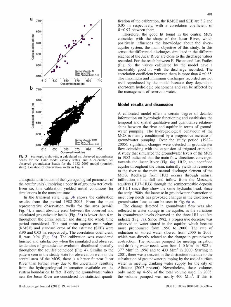
Calibration was performed in two phases: steady andtransient state. The observed vs. calculated groundwater
heads for the steady and transient states are shown inFig. 3a–b. In the steady state, the hydraulic conductivityand storage coefficient were modified to minimize differ-ences between groundwater levels observed and thosesimulated in 46 points distributed throughout the MOS(Fig. 4). The result shows a mean absolute error between theobserved vs. calculated groundwater heads (Fig. 3a) of lessthan 8 m throughout the MOS. Nonetheless, there are certainareas in theMOSwhere the groundwater levels simulated donot fit perfectly to the observed values. These areas coincidewith the system boundaries (e.g. the north), where there is asignificant lack of hydrogeological information (geometry
Fig. 2 Model domain showing a grid and boundary conditions, b spatial distribution of the hydraulic conductivity in unit HU2, c annualmean groundwater recharge (rain infiltration) distribution, d distribution of pumping wells and e cross-section (situation in Fig. 2a). HU7includes the units HU7–HU6–HU5
480
Hydrogeology Journal (2011) 19: 475–487 DOI 10.1007/s10040-010-0694-x
and spatial distribution of the hydrogeological parameters ofthe aquifer units), implying a poor fit of groundwater levels.Even so, this calibration yielded initial conditions forsimulations in the transient state.
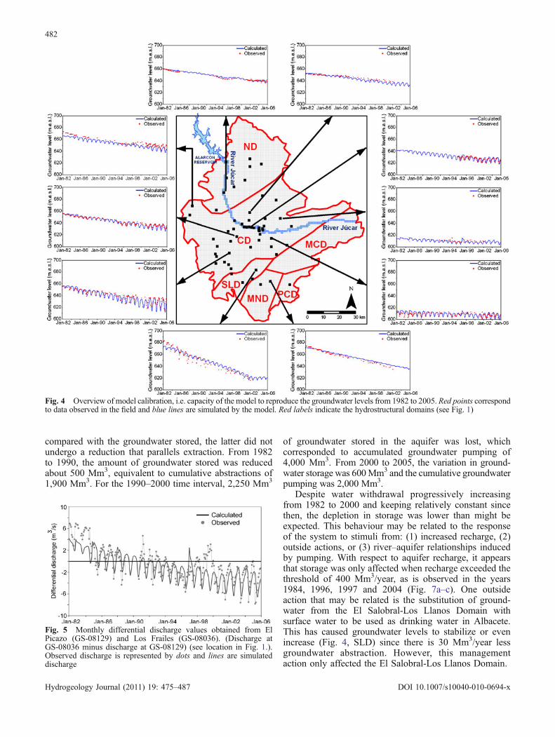
In the transient state, Fig. 3b shows the calibrationresults from the period 1982–2005. From the mostrepresentative observation wells for the area (n=46;Fig. 4), a mean absolute error between the observed andcalculated groundwater heads (Fig. 3b) is lower than 6 mthroughout the entire aquifer and during the whole timeperiod considered. The root mean square error values(RMSE) and standard error of the estimate (SEE) were8.90 and 0.03 m, respectively. The correlation coefficient,R, was 0.94 (Fig. 3b). The calibration was consideredfinished and satisfactory when the simulated and observedtendencies of groundwater evolution distributed spatiallythroughout the aquifer coincided (Fig. 4). Similar to thepattern seen in the steady state for observation wells in thecentral area of the MOS, there is a better fit near JucarRiver than further away due to the uncertainty resultingfrom the hydrogeological information available on thesystem boundaries. In fact, if only the groundwater valuesnear the Jucar River are considered for statistical quanti-
fication of the calibration, the RMSE and SEE are 3.2 and0.05 m respectively, with a correlation coefficient ofR=0.97 between them.
Therefore, the good fit found in the central MOScoincides with the shape of the Jucar River, whichpositively influences the knowledge about the river–aquifer system, the main objective of this study. In thissense, the differential discharges simulated in the differentreaches of the Jucar River are close to the discharge valuesrecorded. For the reach between El Picazo and Los Frailes(Fig. 5), the values calculated by the model have areasonably good fit with the discharge recorded. Thecorrelation coefficient between them is more than R=0.85.The maximum and minimum discharges recorded are notwell reproduced by the model because they depend onshort-term hydrologic phenomena and can be affected bythe management of reservoir water.
Model results and discussion
A calibrated model offers a certain degree of detailedinformation on hydrologic functioning and establishes thetemporal and spatial qualitative and quantitative relation-ships between the river and aquifer in terms of ground-water pumping. The hydrogeological behaviour of theMOS is mainly conditioned by a progressive increase ingroundwater pumping. Over the study period (1982–2005), significant changes were detected in groundwaterflow coinciding with the expansion of irrigated cropland.A study that simulated the groundwater levels of the MOSin 1982 indicated that the main flow directions convergedtowards the Jucar River (Fig. 6a). HU2, an unconfinedaquifer throughout the basin, naturally yields its resourcesto the river as the main natural discharge element of theMOS. Recharge from HU2 occurs through naturalinfiltration of rainfall and inflow from the Mesozoicaquifers (HU7–HU3) through the semipermeable depositsof HU1 since they show the same hydraulic head. Sincethe early 1980s, the increase in groundwater abstraction tomeet crop needs has provoked changes in the direction ofgroundwater flow, as can be seen in Fig. 6a–c.
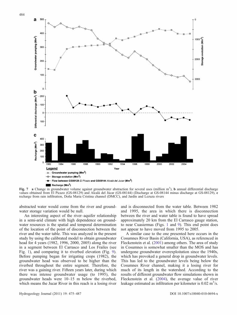
The change detected in groundwater flow was alsoreflected in water storage in the aquifer, as the variationsin groundwater levels observed in the three HU aquifersindicate (Fig. 7a). Since 1982, a progressive decrease wasobserved in water stored in the aquifer, which becamemore pronounced from 1990 to 2000. The rate ofreduction of stored water slowed from 2000 to 2005,which was directly related to the change in groundwaterabstraction. The volumes pumped for meeting irrigationand drinking water needs went from 140 Mm3 in 1982 to377 Mm3 in 1996 and to 433 Mm3 in 2000. Starting in2001, there was a descent in the abstraction rate due to thesubstitution of groundwater pumping by the use of surfacewater in meeting drinking water supply for the city ofAlbacete (2003–present). Nevertheless, these volumesonly made up 4–5% of the total volume used. In 2005,the volume pumped was nearly 400 Mm3. If this is
Fig. 3 Scatterplots showing a calculated vs. observed groundwaterheads for the 1982 model (steady state), and b calculated vs.observed groundwater heads for the 1982–2005 model (transientstate). Location of observation wells in Fig. 4
481
Hydrogeology Journal (2011) 19: 475–487 DOI 10.1007/s10040-010-0694-x
compared with the groundwater stored, the latter did notundergo a reduction that parallels extraction. From 1982to 1990, the amount of groundwater stored was reducedabout 500 Mm3, equivalent to cumulative abstractions of1,900 Mm3. For the 1990–2000 time interval, 2,250 Mm3
of groundwater stored in the aquifer was lost, whichcorresponded to accumulated groundwater pumping of4,000 Mm3. From 2000 to 2005, the variation in ground-water storage was 600Mm3 and the cumulative groundwaterpumping was 2,000 Mm3.
Despite water withdrawal progressively increasingfrom 1982 to 2000 and keeping relatively constant sincethen, the depletion in storage was lower than might beexpected. This behaviour may be related to the responseof the system to stimuli from: (1) increased recharge, (2)outside actions, or (3) river–aquifer relationships inducedby pumping. With respect to aquifer recharge, it appearsthat storage was only affected when recharge exceeded thethreshold of 400 Mm3/year, as is observed in the years1984, 1996, 1997 and 2004 (Fig. 7a–c). One outsideaction that may be related is the substitution of ground-water from the El Salobral-Los Llanos Domain withsurface water to be used as drinking water in Albacete.This has caused groundwater levels to stabilize or evenincrease (Fig. 4, SLD) since there is 30 Mm3/year lessgroundwater abstraction. However, this managementaction only affected the El Salobral-Los Llanos Domain.
Fig. 4 Overview of model calibration, i.e. capacity of the model to reproduce the groundwater levels from 1982 to 2005. Red points correspondto data observed in the field and blue lines are simulated by the model. Red labels indicate the hydrostructural domains (see Fig. 1)
Fig. 5 Monthly differential discharge values obtained from ElPicazo (GS-08129) and Los Frailes (GS-08036). (Discharge atGS-08036 minus discharge at GS-08129) (see location in Fig. 1.).Observed discharge is represented by dots and lines are simulateddischarge
482
Hydrogeology Journal (2011) 19: 475–487 DOI 10.1007/s10040-010-0694-x
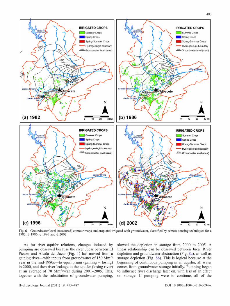
As for river–aquifer relations, changes induced bypumping are observed because the river Jucar between ElPicazo and Alcala del Jucar (Fig. 1) has moved from againing river—with inputs from groundwater of 150 Mm3/year in the mid-1980s—to equilibrium (gaining = losing)in 2000, and then river leakage to the aquifer (losing river)at an average of 70 Mm3/year during 2001–2005. This,together with the substitution of groundwater pumping,
slowed the depletion in storage from 2000 to 2005. Alinear relationship can be observed between Jucar Riverdepletion and groundwater abstraction (Fig. 8a), as well asstorage depletion (Fig. 8b). This is logical because at thebeginning of continuous pumping in an aquifer, all watercomes from groundwater storage initially. Pumping beganto influence river discharge later on, with less of an effecton storage. If pumping were to continue, all of the
Fig. 6 Groundwater level (measured) contour maps and cropland irrigated with groundwater, classified by remote sensing techniques for a1982, b 1986, c 1996 and d 2002
483
Hydrogeology Journal (2011) 19: 475–487 DOI 10.1007/s10040-010-0694-x
abstracted water would come from the river and ground-water storage variation would be null.
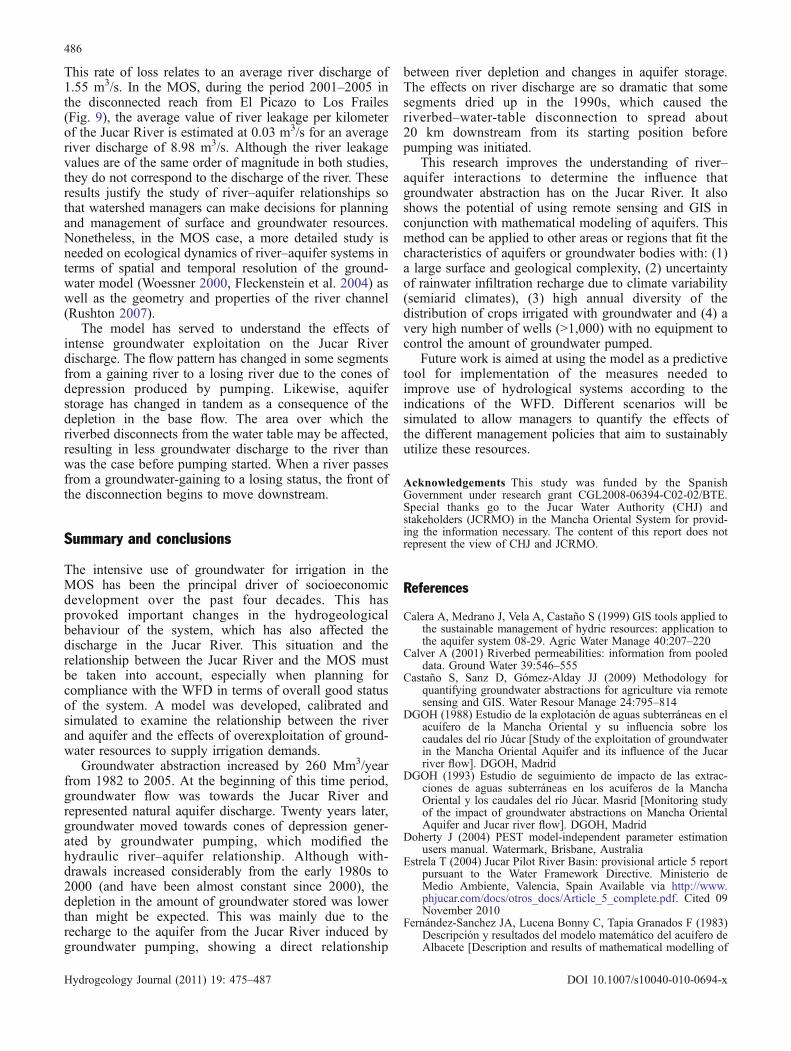
An interesting aspect of the river–aquifer relationshipin a semi-arid climate with high dependence on ground-water resources is the spatial and temporal determinationof the location of the point of disconnection between theriver and the water table. This was analyzed in the presentstudy by using the calibrated model to obtain groundwaterhead for 4 years (1982, 1996, 2000, 2005) along the riverin a segment between El Carrasco and Los Frailes (seeFig. 1), and comparing it to riverbed elevation (Fig. 9).Before pumping began for irrigating crops (1982), thegroundwater head was observed to be higher than theriverbed throughout the entire segment. Therefore, theriver was a gaining river. Fifteen years later, during whichthere was intense groundwater usage (to 1995), thegroundwater heads were 10–15 m below the riverbed,which means the Jucar River in this reach is a losing river
and is disconnected from the water table. Between 1982and 1995, the area in which there is disconnectionbetween the river and water table is found to have spreadapproximately 20 km from the El Carrasco gauge station,to near Cuasiermas (Figs. 1 and 9). This end point doesnot appear to have moved from 1995 to 2005.
A similar case to the one presented here occurs in theCosumnes River Basin (California, USA), as referenced inFleckenstein et al. (2001) among others. The area of studyin Cosumnes is somewhat smaller than the MOS and hasundergone groundwater overexploitation since the 1940s,which has provoked a general drop in groundwater levels.This has led to the groundwater levels being below theCosumnes River channel, making it a losing river formuch of its length in the watershed. According to theresults of different groundwater flow simulations shown inFleckenstein et al. (2004), the average value of riverleakage estimated as infiltration per kilometer is 0.02 m3/s.
Fig. 7 a Change in groundwater volume against groundwater abstraction for several uses (million m3), b annual differential dischargevalues obtained from El Picazo (GS-08129) and Alcalá del Júcar (GS-08144) (Discharge at GS-08144 minus discharge at GS-08129), crecharge from rain infiltration, Doña Maria Cristina channel (DMCC), and Jardín and Lezuza rivers
484
Hydrogeology Journal (2011) 19: 475–487 DOI 10.1007/s10040-010-0694-x
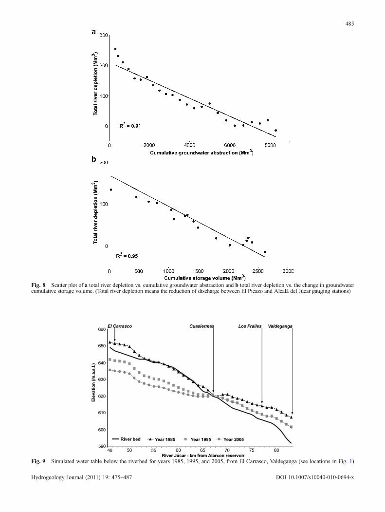
Fig. 8 Scatter plot of a total river depletion vs. cumulative groundwater abstraction and b total river depletion vs. the change in groundwatercumulative storage volume. (Total river depletion means the reduction of discharge between El Picazo and Alcalá del Júcar gauging stations)
Fig. 9 Simulated water table below the riverbed for years 1985, 1995, and 2005, from El Carrasco, Valdeganga (see locations in Fig. 1)
485
Hydrogeology Journal (2011) 19: 475–487 DOI 10.1007/s10040-010-0694-x
This rate of loss relates to an average river discharge of1.55 m3/s. In the MOS, during the period 2001–2005 inthe disconnected reach from El Picazo to Los Frailes(Fig. 9), the average value of river leakage per kilometerof the Jucar River is estimated at 0.03 m3/s for an averageriver discharge of 8.98 m3/s. Although the river leakagevalues are of the same order of magnitude in both studies,they do not correspond to the discharge of the river. Theseresults justify the study of river–aquifer relationships sothat watershed managers can make decisions for planningand management of surface and groundwater resources.Nonetheless, in the MOS case, a more detailed study isneeded on ecological dynamics of river–aquifer systems interms of spatial and temporal resolution of the ground-water model (Woessner 2000, Fleckenstein et al. 2004) aswell as the geometry and properties of the river channel(Rushton 2007).
The model has served to understand the effects ofintense groundwater exploitation on the Jucar Riverdischarge. The flow pattern has changed in some segmentsfrom a gaining river to a losing river due to the cones ofdepression produced by pumping. Likewise, aquiferstorage has changed in tandem as a consequence of thedepletion in the base flow. The area over which theriverbed disconnects from the water table may be affected,resulting in less groundwater discharge to the river thanwas the case before pumping started. When a river passesfrom a groundwater-gaining to a losing status, the front ofthe disconnection begins to move downstream.
Summary and conclusions
The intensive use of groundwater for irrigation in theMOS has been the principal driver of socioeconomicdevelopment over the past four decades. This hasprovoked important changes in the hydrogeologicalbehaviour of the system, which has also affected thedischarge in the Jucar River. This situation and therelationship between the Jucar River and the MOS mustbe taken into account, especially when planning forcompliance with the WFD in terms of overall good statusof the system. A model was developed, calibrated andsimulated to examine the relationship between the riverand aquifer and the effects of overexploitation of ground-water resources to supply irrigation demands.
Groundwater abstraction increased by 260 Mm3/yearfrom 1982 to 2005. At the beginning of this time period,groundwater flow was towards the Jucar River andrepresented natural aquifer discharge. Twenty years later,groundwater moved towards cones of depression gener-ated by groundwater pumping, which modified thehydraulic river–aquifer relationship. Although with-drawals increased considerably from the early 1980s to2000 (and have been almost constant since 2000), thedepletion in the amount of groundwater stored was lowerthan might be expected. This was mainly due to therecharge to the aquifer from the Jucar River induced bygroundwater pumping, showing a direct relationship
between river depletion and changes in aquifer storage.The effects on river discharge are so dramatic that somesegments dried up in the 1990s, which caused theriverbed–water-table disconnection to spread about20 km downstream from its starting position beforepumping was initiated.
This research improves the understanding of river–aquifer interactions to determine the influence thatgroundwater abstraction has on the Jucar River. It alsoshows the potential of using remote sensing and GIS inconjunction with mathematical modeling of aquifers. Thismethod can be applied to other areas or regions that fit thecharacteristics of aquifers or groundwater bodies with: (1)a large surface and geological complexity, (2) uncertaintyof rainwater infiltration recharge due to climate variability(semiarid climates), (3) high annual diversity of thedistribution of crops irrigated with groundwater and (4) avery high number of wells (>1,000) with no equipment tocontrol the amount of groundwater pumped.
Future work is aimed at using the model as a predictivetool for implementation of the measures needed toimprove use of hydrological systems according to theindications of the WFD. Different scenarios will besimulated to allow managers to quantify the effects ofthe different management policies that aim to sustainablyutilize these resources.
Acknowledgements This study was funded by the SpanishGovernment under research grant CGL2008-06394-C02-02/BTE.Special thanks go to the Jucar Water Authority (CHJ) andstakeholders (JCRMO) in the Mancha Oriental System for provid-ing the information necessary. The content of this report does notrepresent the view of CHJ and JCRMO.
References
Calera A, Medrano J, Vela A, Castaño S (1999) GIS tools applied tothe sustainable management of hydric resources: application tothe aquifer system 08-29. Agric Water Manage 40:207–220
Calver A (2001) Riverbed permeabilities: information from pooleddata. Ground Water 39:546–555
Castaño S, Sanz D, Gómez-Alday JJ (2009) Methodology forquantifying groundwater abstractions for agriculture via remotesensing and GIS. Water Resour Manage 24:795–814
DGOH (1988) Estudio de la explotación de aguas subterráneas en elacuífero de la Mancha Oriental y su influencia sobre loscaudales del río Júcar [Study of the exploitation of groundwaterin the Mancha Oriental Aquifer and its influence of the Jucarriver flow]. DGOH, Madrid
DGOH (1993) Estudio de seguimiento de impacto de las extrac-ciones de aguas subterráneas en los acuíferos de la ManchaOriental y los caudales del río Júcar. Masrid [Monitoring studyof the impact of groundwater abstractions on Mancha OrientalAquifer and Jucar river flow]. DGOH, Madrid
Doherty J (2004) PEST model-independent parameter estimationusers manual. Watermark, Brisbane, Australia
Estrela T (2004) Jucar Pilot River Basin: provisional article 5 reportpursuant to the Water Framework Directive. Ministerio deMedio Ambiente, Valencia, Spain Available via http://www.phjucar.com/docs/otros_docs/Article_5_complete.pdf. Cited 09November 2010
Fernández-Sanchez JA, Lucena Bonny C, Tapia Granados F (1983)Descripción y resultados del modelo matemático del acuífero deAlbacete [Description and results of mathematical modelling of
486
Hydrogeology Journal (2011) 19: 475–487 DOI 10.1007/s10040-010-0694-x
the aquifers in Albacete]. III Simposio de Hidrogeología,IGME, Madrid, pp 125–131
Fleckenstein JH, Suzuki E, Fogg G (2001) Options for conjunctivewater management to restore fall flows in the Consumnes Riverbasin, California. In: Mariño MA, Simnovic SP (eds) Integratedwater resources management. IAHS publication 272, IAHS,Wallingford, UK, pp 175–182
Fleckenstein JH, Anderson M, Fogg G, Mount J (2004) Managingsurface water-groundwater to restore fall flows in the CosumnesRiver. J Water Resour Plann Manage 130(4):301–310
Fleckenstein JH, Niswonger RG, Fogg G (2006) River–aquiferinteractions, geologic heterogeneity, and low-flow management.Ground Water 44:837–852
Font E (2004) Colaboración y desarrollo de un modelo matemáticodistribuido de flujo subterráneo de la Unidad Hidrogeológica08.29 Mancha Oriental en las provincias de Albacete, Cuenca yValencia [Collaboration and development of a distributedmathematical model of groundwater flow in the hydrogeologicalunit 08.29, Eastern Mancha in Albacete, Cuenca and Valenciaprovinces]. MSc Thesis, Polytechnical University of Valencia,Spain. http://www.chj.es/medioambiente/planificacionhidrologica/Documents/Mejora%20del%20Conocimiento/MEMORIAPFCOPH.pdf. Cited 09 November 2010
Gorelick SM (eds) (1986) Conjunctive water use: understandingand managing surfacewater-groundwater interactions. IAHSpublication no. 156, IAHS, Wallingford, UK
Hamm SY, Cheong JY, Kim HS (2005) Comparing inversion andtrial-and-error methods to determine optimum yield at ariverbank filtration site, Korea. Salt Lake City Annual Meeting.Geol Soc Am Abst 37(7)1–66
Harbaugh AW, Banta ER, Hill MC, McDonald MG (2000) MOD-FLOW-2000, The U.S. Geological Survey modular groundwatermodel-User guide to modularization concepts and thegroundwater flow process. US Geol Surv Open-File Rep00–92, 121 pp
IGME (1980) El sistema hidrogeológico de Albacete (ManchaOriental): sus recursos en aguas subterráneas, utilización actualy posibilidades futuras [The Albacete hydrogeological system(Mancha Oriental): groundwater resources, actual uses andfuture scope]. IGME, Madrid
IGME (2006) Modelo Matemático de flujo de la Unidad Hidrogeo-lógica 08.29, Mancha Oriental [Mathematical modeling of flowof the hydrogeological unit 08.29, eastern Mancha]. IGME,Madrid
Jagelke J, Barthel R (2005) Conceptualization and implementationof a regional groundwater model for the Neckar catchment inthe framework of an integrated regional model. ADGEO 5:105–111
Langhoff JH, Rasmussen KR, Christensen S (2006) Quantificationand regionalization of groundwater–surface water interactionalong an alluvial stream. J Hydrol 320:342–358
Martínez-Santos P, Llamas MR, Martínez-Alfaro P (2008) Vulner-ability assessment of groundwater resources: a modelling-basedapproach to the Mancha Occidental aquifer, Spain. EnvironModell Softw 23:1145–1162
McDonald MG, Harbaugh AW (1988) A modular three-dimensionalfinite-difference groundwater flow model. US GeologicalSurvey Technical Manual of Water Resources Investigation,Book 6, US Geological Survey, Reston, Va, 586 pp
Nemeth MS, Solo-Gabriele HM (2002) Evaluation of the use ofreach transmissivity to quantify exchange between groundwaterand surface water. J Hydrol 274:145–159
Osman YZ, Bruen MP (2002) Modelling stream-aquifer seepage inalluvial aquifer: an improved loosing-stream package forMODFLOW. J Hydrol 264:60–86
Pisinaras V, Petalas C, Tsihrintzis VA, Zagana E (2007) Agroundwater flow model for water resources management in theIsmarida plain, north Greece. Environ Model Assess 12:75–89
Pulido-Velazquez AM, Sahuquillo A, Ochoa-Rivera C, Pulido-Velazqueza D (2005) Modeling of stream–aquifer interaction:the embedded multireservoir model. J Hydrol 313:166–181
Rodríguez LB, Cello PA, Vionnet CA (2005) Modeling stream-aquifer interactions in a shallow aquifer, Choele Choel Island,Patagonia, Argentina. Hydrogeol J 14:591–602
Ruiz JM (1999) Modelo distribuido para la evaluación de recursoshídricos [Distributed model for water resource assessment].CEDEX, Madrid, 245 pp
Rushton K (2007) Representation in regional models of saturatedriver–aquifer interaction for gaining/losing rivers. J Hydrol334:262–281
Sanz D (2005) Contribución a la caracterización geométrica de lasunidades hidrogeológicas que integran el sistema de acuíferosde la Mancha oriental [Contribution to the geometricalcharacterization of the hydrogeological unit which forms theMancha Oriental aquifers system]. PhD Thesis, Univ. Complu-tense de Madrid, Spain
Sanz D, Gómez-Alday JJ, Castaño S, Moratalla A, De las Heras J,Martínez Alfaro PM (2009) Hydrostratigraphic framework andhydrogeological behaviour of the Mancha Oriental System (SESpain). Hydrogeol J 17:1375–1391
Sophocleous M (2002) Interactions between groundwater andsurface water: the state of the science. Hydrogeol J 10:52–67
Tóth J (1970) A conceptual model of the groundwater regime andthe hydrogeological environment. J Hydrol 10:164–176
Trescott PC (1975) Documentation of a finite difference model forsimulation of three dimensional ground-water flow. US GeolSurv Open-File Rep 75-438, 48 pp
UCLM (2008) Hydrological model for estimation recharge andevapotranspiration by remote sensing and GIS. UCLM, Albacete,Spain. http://www.hidromore.es/. Cited 12 November 2010
Vázquez-Suñe E, Abarca E, Carrera J, Capino B, Gámez D, PoolM, Simó T, Batlle F, Niñerota JM, Ibáñez X (2006) Ground-water modelling as a tool for the European Water FrameworkDirective (WFD) application: the Llobregat case. Phys ChemEarth 31:1015–1029
Winter TC (1995) Recent advances in understanding the interactionof groundwater and surface water. In: U.S. National report toInternational Union of Geodesy and Geophysics 19911994. RevGeophys 33(Suppl):985–994
Woessner WW (2000) Stream and fluvial plain ground waterinteractions: rescaling hydrogeological thought. Ground Water38:423–429
Younger PL (1995) Modelling river–aquifer interactions. In: YoungerPL (ed) Proc BHS National Meeting. British Hydrological SocietyOccasional Paper no. 6, BHS, London
Zume J, Tarhule A (2008) Simulating the impacts of groundwaterpumping on stream–aquifer dynamics in semiarid northwesternOklahoma, USA. Hydrogeol J 16:797–810
487
Hydrogeology Journal (2011) 19: 475–487 DOI 10.1007/s10040-010-0694-x