Thermal structure and exhumation history of the Lesser Himalaya in central Nepal
Upload
independentCategory
view
3download
0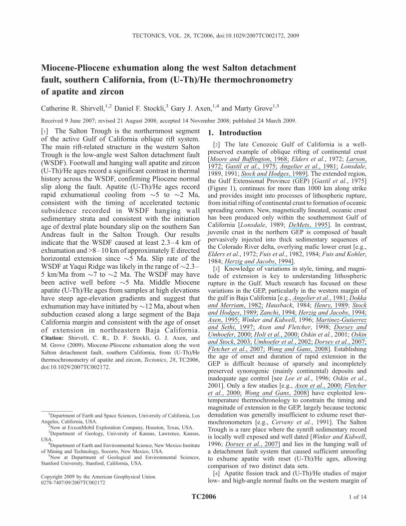
Miocene-Pliocene exhumation along the west Salton detachment
fault, southern California, from (U-Th)/He thermochronometry
of apatite and zircon
Catherine R. Shirvell,1,2 Daniel F. Stockli,3 Gary J. Axen,1,4 and Marty Grove1,5
Received 9 June 2007; revised 21 August 2008; accepted 14 November 2008; published 24 March 2009.
[1] The Salton Trough is the northernmost segmentof the active Gulf of California oblique rift system.The main rift-related structure in the western SaltonTrough is the low-angle west Salton detachment fault(WSDF). Footwall and hanging wall apatite and zircon(U-Th)/He ages record a significant contrast in thermalhistory across the WSDF, confirming Pliocene normalslip along the fault. Apatite (U-Th)/He ages recordrapid exhumational cooling from �5 to �2 Ma,consistent with the timing of accelerated tectonicsubsidence recorded in WSDF hanging wallsedimentary strata and consistent with the initiationage of dextral plate boundary slip on the southern SanAndreas fault in the Salton Trough. Our resultsindicate that the WSDF caused at least 2.3–4 km ofexhumation and >8–10 km of approximately E directedhorizontal extension since �5 Ma. Slip rate of theWSDF at Yaqui Ridge was likely in the range of�2.3–5 km/Ma from �7 to �2 Ma. The WSDF may havebeen active well before �5 Ma. Middle Mioceneapatite (U-Th)/He ages from samples at high elevationshave steep age-elevation gradients and suggest thatexhumation may have initiated by�12Ma, about whensubduction ceased along a large segment of the BajaCalifornia margin and consistent with the age of onsetof extension in northeastern Baja California.Citation: Shirvell, C. R., D. F. Stockli, G. J. Axen, and
M. Grove (2009), Miocene-Pliocene exhumation along the west
Salton detachment fault, southern California, from (U-Th)/He
thermochronometry of apatite and zircon, Tectonics, 28, TC2006,
doi:10.1029/2007TC002172.
1. Introduction
[2] The late Cenozoic Gulf of California is a well-preserved example of oblique rifting of continental crust[Moore and Buffington, 1968; Elders et al., 1972; Larson,1972; Gastil et al., 1975; Angelier et al., 1981; Lonsdale,1989, 1991; Stock and Hodges, 1989]. The extended region,the Gulf Extensional Province (GEP) [Gastil et al., 1975](Figure 1), continues for more than 1000 km along strikeand provides insight into processes of lithospheric rupture,from initial rifting of continental crust to formation of oceanicspreading centers. New, magnetically lineated, oceanic crusthas been produced only within the southernmost Gulf ofCalifornia [Lonsdale, 1989; DeMets, 1995]. In contrast,juvenile crust in the northern GEP is composed of basaltpervasively injected into thick sedimentary sequences ofthe Colorado River delta, overlying mafic lower crust [e.g.,Elders et al., 1972; Fuis et al., 1982, 1984; Fuis and Kohler,1984; Herzig and Jacobs, 1994].[3] Knowledge of variations in style, timing, and magni-
tude of extension is key to understanding lithosphericrupture in the Gulf. Much research has focused on thesevariations in the GEP, particularly in the western margin ofthe gulf in Baja California [e.g., Angelier et al., 1981; Dokkaand Merriam, 1982; Hausback, 1984; Henry, 1989; Stockand Hodges, 1989; Zanchi, 1994; Herzig and Jacobs, 1994;Axen, 1995; Winker and Kidwell, 1996; Martinez-Gutierrezand Sethi, 1997; Axen and Fletcher, 1998; Dorsey andUmhoefer, 2000; Holt et al., 2000; Oskin et al., 2001; Oskinand Stock, 2003; Umhoefer et al., 2002; Dorsey et al., 2007;Fletcher et al., 2007; Wong and Gans, 2008]. Establishingthe age of onset and duration of rapid extension in theGEP is difficult because of sparsely and incompletelypreserved synorogenic (mainly continental) deposits andinadequate age control [see Lee et al., 1996; Oskin et al.,2001]. Only a few studies [e.g., Axen et al., 2000; Fletcheret al., 2000; Wong and Gans, 2008] have exploited low-temperature thermochronology to constrain the timing andmagnitude of extension in the GEP, largely because tectonicdenudation was generally insufficient to exhume reset ther-mochronometers [e.g., Cerveny et al., 1991]. The SaltonTrough is a rare place where the synrift sedimentary recordis locally well exposed and well dated [Winker and Kidwell,1996; Dorsey et al., 2007] and lies in the hanging wall ofa detachment fault system that caused sufficient unroofingto exhume apatite with reset (U-Th)/He ages, allowingcomparison of two distinct data sets.[4] Apatite fission track and (U-Th)/He studies of major
low- and high-angle normal faults on the western margin of
TECTONICS, VOL. 28, TC2006, doi:10.1029/2007TC002172, 2009
1Department of Earth and Space Sciences, University of California, LosAngeles, California, USA.
2Now at ExxonMobil Exploration Company, Houston, Texas, USA.3Department of Geology, University of Kansas, Lawrence, Kansas,
USA.4Department of Earth and Environmental Science, New Mexico Institute
of Mining and Technology, Socorro, New Mexico, USA.5Now at Department of Geological and Environmental Sciences,
Stanford University, Stanford, California, USA.
Copyright 2009 by the American Geophysical Union.0278-7407/09/2007TC002172
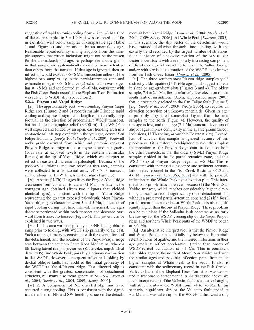
TC2006 1 of 14
the GEP document similar magnitudes (�5–7 km) andinitiation ages (�12–10 Ma) of footwall exhumationalcooling in north central and southern Baja California [Axenet al., 2000; Fletcher et al., 2000]. The purpose of this studyis to constrain the timing and magnitude of exhumation inthe footwall of a major low-angle normal fault, the westSalton detachment fault (WSDF), in the western SaltonTrough, the northernmost segment of the GEP [Axen, 1995].[5] Knowledge of the slip history of the WSDF is relevant
to understanding the opening of, and strain partitioningwithin, the strongly oblique Gulf of California rift, in thecontext of the largely dextral Pacific-North American plateboundary. For example, how did extensional processes in thenorthern rift (the Salton Trough) respond to the increaseddextral strain rates when the southern San Andreas faultbegan to slip there? Was plate boundary strain partitionedevenly between approximately east-west extension onnormal faults and dextral slip on northwest striking faults
or did the fault system evolve in a more complex way?What was the spatial and temporal interplay betweenclockwise vertical axis rotations [e.g., Housen et al.,2005] and the various fault systems?
2. Tectonic Setting of the Western Salton
Trough
[6] Existing regional tectonic models conclude that exten-sion in the GEP began at �12 Ma [e.g., Stock and Hodges,1989; Oskin et al., 2001] when subduction ceased off thesouthwestern margin of Baja California [Mammerickx andKlitgord, 1982; Hausback, 1984] and the NW directedvelocity of the Pacific plate relative to the North Americanplate increased from�33mm/a to�52mm/a [Atwater, 1989;Atwater and Stock, 1998]. From �12 to �6 Ma, obliquetranstension between the North American and Pacific platesis hypothesized to have been partitioned between ENEextension in the Gulf of California [e.g., Angelier et al.,1981] and dextral slip on the Tosco-Abreojos fault (Figure 1)[Spencer and Normark, 1979] in the offshore continentalmargin west of Baja California [Stock and Hodges, 1989].At �8 Ma, the direction of Pacific-North American relativeplate motion rotated clockwise �15� [Atwater and Stock,1998], which likely increased the dextral component oftranstension in the GEP. By 5.5 ± 0.4 Ma, strike-slip motionbecame prevalent within the GEP, initiating the currentstrongly transtensional regime [Crowell, 1982; Oskin et al.,2001; Oskin and Stock, 2003].[7] Parts of this model have been challenged in recent
years, raising questions about the age of initial extensionand dextral deformation and how strain partitioning evolvedin the GEP. For example, a significant dextral component ofPacific-North American relative plate motion may havebeen accommodated within the GEP between �12 and�6 Ma [Gans, 1997; Gans et al., 2006; Fletcher et al.,2007]. Dating the onset of extension in various localities isrequired to evaluate these possibilities. Extension in theSalton Trough may have begun well before �12 Ma,because at this latitude (1) subduction ceased earlier (at�18–20 Ma), (2) the continental borderland west of SanDiego and Los Angeles, California was rapidly extendedfrom �17–12 Ma (and experienced transtension until�5 Ma) [e.g., Nicholson et al., 1994], and (3) Oligoceneto mid-Miocene, northeast directed extension occurred alonglow-angle brittle detachment faults northeast of the study area[e.g., Spencer and Reynolds, 1989; Jacobson et al., 2002,2007], which was then located near Yuma, Arizona (restoring�300 km of post-5 Ma dextral slip on the southern SanAndreas fault system). The stratigraphic record in the SaltonTrough is interpreted to record onset of extension inmiddle or late Miocene time [e.g., Winker and Kidwell,1996; Dorsey et al., 2007].[8] The main rift-related structure exposed in the western
Salton Trough is the NNW striking, NE dipping, westSalton detachment fault (WSDF) (Figure 2), which boundsthe eastern Peninsular Ranges and roots eastward beneathsedimentary and basement rocks of the Salton Trough.Different strands of the WSDF have been interpreted by
Figure 1. Simplified tectonic map of the Gulf ofCalifornia rift system. The box shows the study area andthe location of Figure 2. Unextended crust is light gray. TheGulf Extensional Province is dark gray (northeasternboundary with the basin and range is poorly defined). Whitecircles show the locations of four low-temperature thermo-chronology studies at Mount San Jacinto (MSJ) [Wolf et al.,1997; Luther et al., 2008], the Santa Rosa Mountains (SRM)[Luther et al., 2008], the Sierra El Mayor (SEM) [Axen et al.,2000], and the Los Cabos block [Fletcher et al., 2000;Lovera et al., 2007]. Colo Plat, Colorado Plateau; Pen Rgs,Peninsular Ranges; SAF, San Andreas fault; SMO, SierraMadre Occidental; TAB Flt, Tosco-Abreojos fault [after Axenand Fletcher, 1998; Axen et al., 2000].
TC2006 SHIRVELL ET AL.: PLIOCENE EXHUMATION ALONG THE WSDF
2 of 14
TC2006
different researchers in a variety of ways: (1) Cretaceousthrusts [Sharp, 1967; Erskine, 1985], (2) Cretaceous thrustsreactivated by normal slip [Sharp, 1979], (3) Late Cretaceousnormal faults [Erskine and Wenk, 1985], (4) mid-Mioceneextensional detachment faults [Schultejann, 1984; Engel andSchultejann, 1984; Lough, 1993; Stinson and Gastil, 1996],and (5) late Miocene-Pleistocene extensional detachmentfaults [Axen and Fletcher, 1998]. In the study area theWSDFis generally a single strand but locally thin middle plateslices are preserved between double strands (Figure 2).[9] The fault certainly was active in latest Miocene to
early Pleistocene time, controlling deposition of latestMiocene to Pleistocene marine and fluvial strata in thewestern Salton Trough [Axen and Fletcher, 1998; Kairouz,2005; Steely, 2006; Matti et al., 2002, 2006; Cox et al.,2002; King et al., 2002; Dorsey et al., 2007], but the ageof initial WSDF slip and magnitude of WSDF-relatedexhumation are unknown. The timing of rapid slip on theWSDF is best constrained by the subsidence history of theupper plate Fish Creek–Vallecito Basin (Figure 2), whichis dated magnetostratigraphically [Dorsey et al., 2007],
demonstrating that rapid pulses of upper plate sedimentationbegan at�5.5 and�4.6 Ma. Housen et al. [2005] concludedthat �24� of clockwise vertical axis rotation affected theFish Creek Basin between 3 and 2 Ma, which may haveoccurred above the WSDF.[10] Evidence for earlier onset of WSDF slip exists but is
not compelling. Stinson and Gastil [1996] suggested that theWSDF accommodated �1–2 km of vertical fault displace-ment, beginning before 17.2 ± 0.4 Ma (the K/Ar age of ahighly fractured but little altered hornblende-bearing dikeintruded into chloritically altered footwall plutonic rocks andcut by the WSDF). Frost and Shafiqullah [1989] argued thatWSDF slip began between �17 and �10 Ma. Kairouz et al.[2003] (also Kairouz [2005]) dated fault rock and pseudo-tachylyte from two localities along the WSDF by the40Ar/39Ar step-heating method and obtained total gas agesranging from 25 to 6 Ma. Release spectra are hump-shapedindicating preservation of older gas in more retentivedomains, but the youngest steps from all samples are<10Ma, suggesting late Miocene slip. The oldest upper platestrata that are possibly syntectonic with the WSDF (Elephant
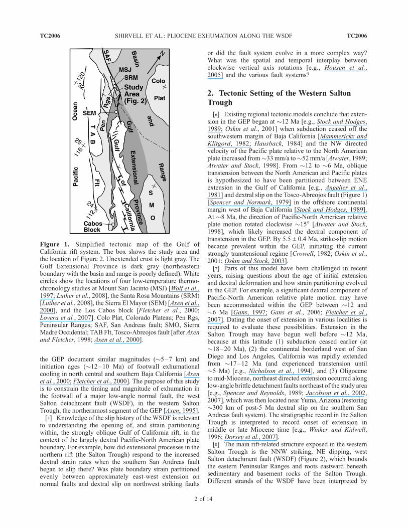
Figure 2. Simplified tectonic and geologic map of the western Salton Trough. BV, Blair Valley; FCVB,Fish Creek–Vallecito Basin; Klb, igneous and metasedimentary basement rock, lower plate of WSDF;Kub, igneous and metasedimentary basement rock, upper plate of WSDF; MC, Mine Canyon; PR, PinyonRidge; PV, Pinyon Mountain Valley; Qb, Borrego Formation; Qo, Ocotillo Conglomerate; SFF, San Felipefault; SM, Sunset Mountain; SY, Mount San Ysidro; TB, Tierra Blanca Mountains; TQc, CanebrakeConglomerate (includes coarse facies of the Hueso Formation and Mesa Conglomerate in the Fish CreekBasin); TQip, Imperial and Palm Springs groups; Tsm, Split Mountain Group; VF, Vallecito fault; VM,Vallecito Mountains; WP, Whale Peak; WSDF, west Salton detachment fault; YR, Yaqui Ridge; ZF, Zoselfault. Modified from Dorsey et al. [2006a].
TC2006 SHIRVELL ET AL.: PLIOCENE EXHUMATION ALONG THE WSDF
3 of 14
TC2006
Trees Formation of the Split Mountain Group (Figure 2)) are�8.1 ± 0.4 Ma [Dorsey et al., 2006a, 2006b, 2007]. TheElephant Trees Formation comprises proximal, fault scarp-facies conglomerate and breccia shed from the steep Vallecitonormal fault (Figure 2). It records rapid marine inundationof the basin [Winker, 1987; Winker and Kidwell, 1996;Shirvell, 2006] (Figure 2). The Vallecito fault currently liesin the WSDF hanging wall and ceased controlling sedimen-tation (and presumably stopped slipping) at�5Ma, althoughit has had minor Quaternary reactivation [Shirvell, 2006].The Vallecito fault can be interpreted as (1) a pre-WSDFstructure, (2) an early, but significant, upper plate fault, or(3) an early WSDF breakaway that was subsequentlytransferred to the upper plate. Our new (U-Th)/He resultslead us to favor option 2slightly.[11] The WSDF apparently accumulated �10–20 km of
late Miocene to Pliocene slip [see Axen and Fletcher, 1998],but the slip direction is not well constrained and may havechanged through time. The WSDF is exposed in several ESEplunging arches that can be interpreted as initial corrugationsand/or younger folds [e.g., Frost et al., 1996a, 1996b; Axenand Fletcher, 1998]. Detachment striae trend from N to ESEbut cluster in the E to ENE directions [Stinson and Gastil,1996; Kairouz, 2005; Steely, 2006; Steely et al., 2009]. Thedetachment is cut, offset, and locally folded by youngerstrike-slip faults [Dorsey, 2002; Kairouz, 2005; Steely,2006; Steely et al., 2009].
3. Thermal Evolution of the Northern
Peninsular Ranges and GEP
[12] The crust of the region shown in Figure 2 is composedof Paleozoic and early Mesozoic metamorphic countryrocks that are pervasively intruded by the predominatelymid-Cretaceous Peninsular Range Batholith (PRB) [Silverand Chappell, 1988; Kistler et al., 2003; Todd et al., 2003;Langenheim et al., 2004]. Late Cretaceous cooling of thePRB is well documented by K-Ar and 40Ar/39Ar ages ofhornblende, micas, and K-feldspar [Krummenacher et al.,1975; Grove et al., 2003; Ortega-Rivera, 2003] and byfission track ages of apatite and zircon [e.g., George andDokka, 1994; Naeser et al., 1996]. Within our study area,the youngest plutons crystallized at �100–88 Ma at 11–18 km depths [Ague and Brimhall, 1988; Silver andChappell, 1988; Kistler et al., 2003; Todd et al., 2003].The initial phase of rapid cooling overlapped with batholithemplacement, and additional rapid cooling between 80 and70 Ma was simultaneous with Laramide shallow subductionbeneath southwestern North America [George and Dokka,1994; Snee et al., 1994; Naeser et al., 1996; Grove et al.,2003]. Most K/Ar, 40Ar/39Ar, and apatite fission track agesfrom the eastern PRB [Krummenacher et al., 1975; Cervenyet al., 1991; George, 1993; Naeser et al., 1996; Ortega-Rivera et al., 1997] record widespread late Cretaceous–earlyTertiary erosional unroofing of the PRB, probably inresponse to continued flat slab subduction [e.g., Dumitru,1990; Grove et al., 2003]. Paleocene-Eocene extraregionalriver systems flowed west from southwestern Arizona and
northwestern Sonora, across a low-relief erosion surfacecut across the PRB, and to the Pacific ocean [Minch, 1979;Abbott and Smith, 1989]. Locally, late Eocene–earlyOligocene rapid cooling [Axen et al., 2000] coincided withabrupt shutoff of these rivers [Abbott and Smith, 1989;Walsh, 1997; Walsh and Demere, 1991], and may recordlate Laramide deformation similar to that in Arizona andSonora, east of the study area.[13] Late Cenozoic cooling of GEP rocks is recorded by
the footwall of the Canada David detachment in the Sierra ElMayor, east of Laguna Salada, northeastern Baja California(Figure 1). Apatite fission track and apatite (U-Th)/He agesfrom the footwall average �5 Ma and �4 Ma, respectively[Axen et al., 2000]. Thermal-kinematic modeling suggeststhat exhumation by the detachment began at �12–10 Ma,and continued until at least 2 Ma [Axen et al., 2000; Stockli,2005]. Fault scarps within the alluvium suggest LatePleistocene activity [Axen et al., 1999; Spelz et al., 2008].Total exhumation along the Canada David detachment isestimated to be �5–7 km, with average exhumation rates of�1.0 mm/a and total horizontal extension of �10–12 km[Axen et al., 2000].[14] A similar cooling/exhumation history is exhibited by
footwall rocks of the GEP �1000 km farther south in theLos Cabos block located at the southern tip of the BajaCalifornia Peninsula (Figure 1). Apatite fission track agesfrom the footwall of the high-angle San Jose del Cabo fault,which forms the GEP margin in the Los Cabos block(Figure 1), record rapid cooling beginning at �12–10 Ma[Fletcher et al., 2000]. Total exhumation is estimated tohave been as great as �5–7 km, with rates as high as 1.5–2.0 mm/a [Fletcher et al., 2000]. However, more recentresults integrating K-feldspar 40Ar/39Ar thermochronologysuggest somewhat less denudation along the San Jose delCabo fault, largely occurring after 8Ma [Lovera et al., 2007].[15] North of the study area, Wolf et al. [1997] reported a
17.1 Ma (U-Th)/He apatite age at the base of the �3 kmhigh Mount San Jacinto escarpment and a 35 Ma age nearits top. More recently, Luther et al. [2008] obtained six(U-Th)/He apatite ages ranging from 18.6 ± 1.1 to 10.6 ±0.6 Ma from the lower �1300 m of the eastern Mount SanJacinto escarpment. The younger ages come from eleva-tions similar to the 17.1 Ma sample of Wolf et al. [1997],suggesting problems with that age. Luther et al. also reportfive apatite ages of 25.7 ± 1.5–6.0 ± 0.4 Ma from samplesfrom the eastern escarpment of the Santa Rosa Mountains(Figure 1), in the immediate footwall of the Zosel fault(Figure 2). Both sample sets yield steep age gradients intheir lower parts, suggesting that exhumation was ongoingin the time frame �12–6 Ma, but additional work isneeded to identify inflection points that might constrainthe onset of exhumation.
4. Sampling and Analytical Methods
[16] Apatite and zircon (U-Th)/He ages from the footwalland hanging wall of theWSDF provide additional constraintson the thermal history of extended crust in the northwestern
TC2006 SHIRVELL ET AL.: PLIOCENE EXHUMATION ALONG THE WSDF
4 of 14
TC2006
GEP. A total of 42 samples from the footwall and hangingwall of the WSDF were analyzed by (U-Th)/He thermo-chronometry (Table 1). The regional distribution of samplesites and transects are shown in Figure 2. Footwall andhanging wall basement rocks are typical of the easternPRB, including coarse- to fine-grained biotite tonalite, mylo-nitized biotite tonalite, biotite-hornblende tonalite, quartzdiorite, and metasedimentary rocks. Thirty-two footwall sam-ples were analyzed from three areas. Topographic relief isrelatively small at the Yaqui-Pinyon ridge, so upper and lowerplate crystalline basement was sampled in a horizontal array.Mount San Ysidro and Whale Peak exhibit the greatesttopographic relief in the study area and were sampled as‘‘vertical’’ transects, with the former ending at the top of therift-flank escarpment. Additional hanging wall samples fromthe northern Vallecito Mountains, and north of Whale Peakwere also analyzed. Adjacent pairs of samples were collectedacross basal strands of the WSDF in upper Mine Canyon,Pinyon Mountain Valley, and Moonlight Canyon in thenorthern Tierra Blanca Mountains (Table 1 and Figure 2).One sample from Blair Valley was collected from thefootwall well west of the trace of the WSDF (Figure 2 andTable 1).[17] Apatite and zircon grains were separated using con-
ventional density and magnetic techniques at UCLA andselected by hand under a high-magnification, polarizingmicroscope at the Isotope Geochemistry Laboratory at theUniversity of Kansas. Two to four aliquots per samplecontaining one to five similar-sized apatite grains wereloaded in platinum tubes. Similarly, two to three single-grainzircon aliquots were selected and analyzed from eachsample. A total of 114 aliquots of apatite from 41 samplesand 27 aliquots of zircon from 11 samples were analyzed.[18] (U-Th)/He age determinations were carried out at the
University of Kansas laboratory using analytical proceduresdescribed by Stockli et al. [2000] and House et al. [2000]for apatite and Biswas et al. [2007] for zircon. Inclusion-free apatite grains were wrapped in acid-treated Pt foil andheated for 5 min at 1070�C and subsequently reheated toensure complete degassing. Zircons were wrapped in Pt foil,heated for 10 min at �1300�C and reheated until >99% ofthe He was extracted from the crystal. After laser heating,apatite aliquots were dissolved (HNO3) and spiked using anenriched 235U-230Th tracer, while zircons were unwrappedfrom Pt foil and dissolved using HF-HNO3 and HClpressure vessel digestion procedures. U and Th concentra-tions were determined by isotope dilution ICP-MS analysisat the University of Kansas. Ages were calculated using thestandard age equation [e.g., Farley and Stockli, 2002] andcorrected for alpha particle emission during radioactivedecay, assuming homogenous U and Th distribution [Farleyet al., 1996]. All ages were calculated using standard ejectioncorrections based on morphometric analyses and assuming ahomogeneous U and Th distribution [Farley et al., 1996;Farley, 2000]. Reported age uncertainties reflect the repro-ducibility of replicate analyses of laboratory standardsamples and are �6% (2s) for apatite and �8% (2s) forzircon He ages [Farley et al., 2001]. If the standarddeviation of aliquot ages for a sample is higher than these
analytical uncertainties, we assign the standard deviationas the error; both are shown in Table 1.
5. (U-Th)/He Thermochronometry Results
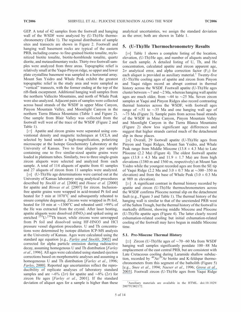
[19] Table 1 shows a complete listing of the location,elevation, (U-Th)/He age, and number of aliquots analyzedfor each sample. A detailed listing of U, Th, and Heconcentration, calculated apatite and zircon apparent age,2s analytical error, and alpha correction factor (FT) foreach aliquot is provided as auxiliary material.1 Twenty-five(U-Th)/He cooling ages of apatite and zircon from Pinyonand Yaqui ridges record an abrupt contrast in thermalhistory across the WSDF. Footwall apatite (U-Th)/He agescluster between�7 and�2Ma, whereas hanging wall apatiteages are much older, from �44 to �25 Ma. Seven zirconsamples at Yaqui and Pinyon Ridges also record contrastingthermal histories across the WSDF, with footwall agesrange of �51 to �35 Ma and one hanging wall age of�73 Ma (Figure 3). Sample pairs from across basal strandsof the WSDF in Mine Canyon, Pinyon Mountain Valleyand Moonlight Canyon in the Tierra Blanca Mountains(Figure 2) show less significant age differences andsuggest that higher strands carried much of the detachmentslip in those places.[20] Overall, 29 footwall apatite (U-Th)/He ages from
Pinyon and Yaqui Ridges, Mount San Ysidro, and WhalePeak range from Middle Miocene (13.8 ± 4.3 Ma) to LatePliocene (2.2 Ma) (Figure 4). The oldest footwall apatiteages (13.8 ± 4.3 Ma and 11.9 ± 1.7 Ma) are from highelevations (1380 m and 1560 m, respectively) at Mount SanYsidro while the youngest recorded ages are from the SE tipof Yaqui Ridge (2.2 Ma and 3.0 ± 0.7 Ma at �300–350 melevation) and from the base of Whale Peak (3.0 ± 0.3 Maat 989 m elevation).[21] A significant contrast in thermal history recorded by
apatite and zircon (U-Th)/He thermochronometers acrossthe WSDF confirms Pliocene normal slip on the detachmentfault (e.g., Figure 3 and Table 1). The thermal history of thehanging wall is similar to that of the unextended PRB westof the Salton Trough, but the thermal history of the footwall ismarkedly different, showing middle Miocene and Pliocene(U-Th)/He apatite ages (Figure 4). The latter clearly recordexhumation-related cooling but initial exhumation-relatedcooling of the footwall may have begun in middle Miocenetime.
5.1. Pre-Miocene Thermal History
[22] Zircon (U-Th)/He ages of �70–60 Ma from WSDFhanging wall samples significantly postdate 100–88 Maemplacement of the east central PRB, but are consistent withLate Cretaceous cooling during Laramide shallow subduc-tion, recorded by 40Ar/39Ar biotite and K-feldspar thermo-chronometers from this segment of the batholith (Figure 5)[e.g., Snee et al., 1994; Naeser et al., 1996; Grove et al.,2003]. Footwall zircon (U-Th)/He ages from Yaqui Ridge
1Auxiliary materials are available in the HTML. doi:10.1029/2007TC002172.
TC2006 SHIRVELL ET AL.: PLIOCENE EXHUMATION ALONG THE WSDF
5 of 14
TC2006
(�51–31 Ma) are similar to apatite fission track ages (�60–40 Ma) from the eastern PRB [George, 1993; Naeser et al.,1996]. These ages presumably record slow cooling duringregional early Cenozoic erosional beveling of the east centraland western PRB [e.g., Minch, 1979; Abbott and Smith,
1989]. Strata inferred to have been deposited by the EocenePoway river that traversed the area are preserved in channelsincised into theWSDF hangingwall in the study area [Lough,1993; G. J. Axen, unpublished maps, 2004; M. Grove,unpublished detrital zircon U-Pb data, 2005].
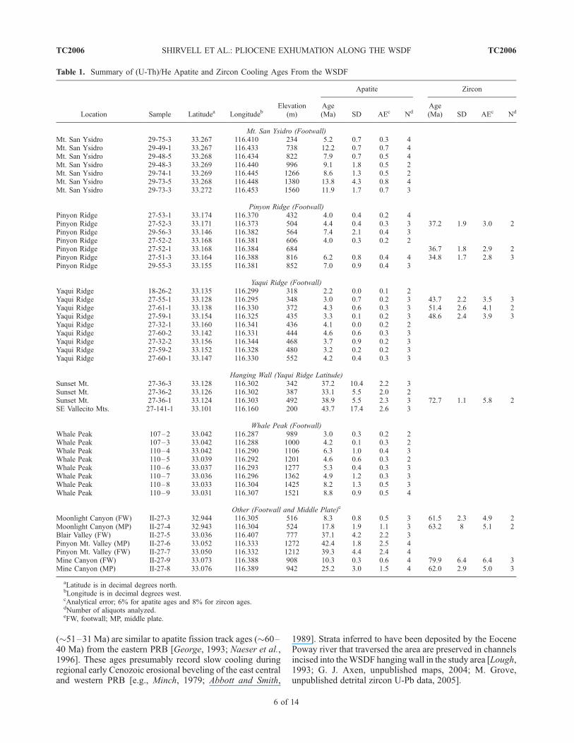
Table 1. Summary of (U-Th)/He Apatite and Zircon Cooling Ages From the WSDF
Location Sample Latitudea LongitudebElevation
(m)
Apatite Zircon
Age(Ma) SD AEc Nd
Age(Ma) SD AEc Nd
Mt. San Ysidro (Footwall)Mt. San Ysidro 29-75-3 33.267 116.410 234 5.2 0.7 0.3 4Mt. San Ysidro 29-49-1 33.267 116.433 738 12.2 0.7 0.7 4Mt. San Ysidro 29-48-5 33.268 116.434 822 7.9 0.7 0.5 4Mt. San Ysidro 29-48-3 33.269 116.440 996 9.1 1.8 0.5 2Mt. San Ysidro 29-74-1 33.269 116.445 1266 8.6 1.3 0.5 2Mt. San Ysidro 29-73-5 33.268 116.448 1380 13.8 4.3 0.8 4Mt. San Ysidro 29-73-3 33.272 116.453 1560 11.9 1.7 0.7 3
Pinyon Ridge (Footwall)Pinyon Ridge 27-53-1 33.174 116.370 432 4.0 0.4 0.2 4Pinyon Ridge 27-52-3 33.171 116.373 504 4.4 0.4 0.3 3 37.2 1.9 3.0 2Pinyon Ridge 29-56-3 33.146 116.382 564 7.4 2.1 0.4 3Pinyon Ridge 27-52-2 33.168 116.381 606 4.0 0.3 0.2 2Pinyon Ridge 27-52-1 33.168 116.384 684 36.7 1.8 2.9 2Pinyon Ridge 27-51-3 33.164 116.388 816 6.2 0.8 0.4 4 34.8 1.7 2.8 3Pinyon Ridge 29-55-3 33.155 116.381 852 7.0 0.9 0.4 3
Yaqui Ridge (Footwall)Yaqui Ridge 18-26-2 33.135 116.299 318 2.2 0.0 0.1 2Yaqui Ridge 27-55-1 33.128 116.295 348 3.0 0.7 0.2 3 43.7 2.2 3.5 3Yaqui Ridge 27-61-1 33.138 116.330 372 4.3 0.6 0.3 3 51.4 2.6 4.1 2Yaqui Ridge 27-59-1 33.154 116.325 435 3.3 0.1 0.2 3 48.6 2.4 3.9 3Yaqui Ridge 27-32-1 33.160 116.341 436 4.1 0.0 0.2 2Yaqui Ridge 27-60-2 33.142 116.331 444 4.6 0.6 0.3 3Yaqui Ridge 27-32-2 33.156 116.344 468 3.7 0.9 0.2 3Yaqui Ridge 27-59-2 33.152 116.328 480 3.2 0.2 0.2 3Yaqui Ridge 27-60-1 33.147 116.330 552 4.2 0.4 0.3 3
Hanging Wall (Yaqui Ridge Latitude)Sunset Mt. 27-36-3 33.128 116.302 342 37.2 10.4 2.2 3Sunset Mt. 27-36-2 33.126 116.302 387 33.1 5.5 2.0 2Sunset Mt. 27-36-1 33.124 116.303 492 38.9 5.5 2.3 3 72.7 1.1 5.8 2SE Vallecito Mts. 27-141-1 33.101 116.160 200 43.7 17.4 2.6 3
Whale Peak (Footwall)Whale Peak 107–2 33.042 116.287 989 3.0 0.3 0.2 2Whale Peak 107–3 33.042 116.288 1000 4.2 0.1 0.3 2Whale Peak 110–4 33.042 116.290 1106 6.3 1.0 0.4 3Whale Peak 110–5 33.039 116.292 1201 4.6 0.6 0.3 2Whale Peak 110–6 33.037 116.293 1277 5.3 0.4 0.3 3Whale Peak 110–7 33.036 116.296 1362 4.9 1.2 0.3 3Whale Peak 110–8 33.033 116.304 1425 8.2 1.3 0.5 3Whale Peak 110–9 33.031 116.307 1521 8.8 0.9 0.5 4
Other (Footwall and Middle Plate)e
Moonlight Canyon (FW) II-27-3 32.944 116.305 516 8.3 0.8 0.5 3 61.5 2.3 4.9 2Moonlight Canyon (MP) II-27-4 32.943 116.304 524 17.8 1.9 1.1 3 63.2 8 5.1 2Blair Valley (FW) II-27-5 33.036 116.407 777 37.1 4.2 2.2 3Pinyon Mt. Valley (MP) II-27-6 33.052 116.333 1272 42.4 1.8 2.5 4Pinyon Mt. Valley (FW) II-27-7 33.050 116.332 1212 39.3 4.4 2.4 4Mine Canyon (FW) II-27-9 33.073 116.388 908 10.3 0.3 0.6 4 79.9 6.4 6.4 3Mine Canyon (MP) II-27-8 33.076 116.389 942 25.2 3.0 1.5 4 62.0 2.9 5.0 3
aLatitude is in decimal degrees north.bLongitude is in decimal degrees west.cAnalytical error; 6% for apatite ages and 8% for zircon ages.dNumber of aliquots analyzed.eFW, footwall; MP, middle plate.
TC2006 SHIRVELL ET AL.: PLIOCENE EXHUMATION ALONG THE WSDF
6 of 14
TC2006
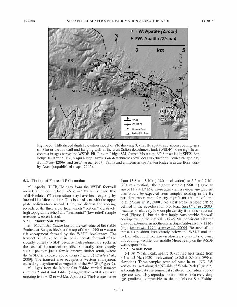
5.2. Timing of Footwall Exhumation
[23] Apatite (U-Th)/He ages from the WSDF footwallrecord rapid cooling from �5 to �2 Ma and suggest thatWSDF-related (?) exhumation may have been ongoing bylate middle Miocene time. This is consistent with the upperplate sedimentary record. Here, we discuss the coolingrecords of the three areas from which ‘‘vertical’’ (relativelyhigh topographic relief) and ‘‘horizontal’’ (low-relief) sampletransects were collected.5.2.1. Mount San Ysidro[24] Mount San Ysidro lies on the east edge of the stable
Peninsular Ranges block at the top of the �1300 m westernrift escarpment formed by the WSDF breakaway. Thetransect is inferred to lie in the immediate footwall of the(locally buried) WSDF because metasedimentary rocks atthe base of the transect are offset sinistrally from exactlysuch a position just a few kilometers farther south, wherethe WSDF is exposed above them (Figure 2) [Steely et al.,2009]. The transect also occupies a western embaymentcaused by a synformal corrugation of the WSDF (Figure 2).[25] Ages from the Mount San Ysidro vertical transect
(Figures 2 and 4 and Table 1) suggest that WSDF slip wasongoing from �12 to �5 Ma. Apatite (U-Th)/He ages range
from 13.8 ± 4.3 Ma (1380 m elevation) to 5.2 ± 0.7 Ma(234 m elevation); the highest sample (1560 m) gave anage of 11.9 ± 1.7 Ma. These ages yield a steeper age gradientthan would be expected from samples residing in the Hepartial-retention zone for any significant amount of time[e.g., Stockli et al., 2000]. No clear break in slope can bedefined in the age-elevation plot [e.g., Stockli et al., 2003]because of relatively low sample density from this structurallevel (Figure 4), but the data imply considerable footwallcooling during the interval �12–5 Ma, consistent with theonset of extension in northeastern Baja California at�12 Ma[e.g., Lee et al., 1996; Axen et al., 2000]. Because of thetransect’s position immediately below the WSDF and thelack of other suitable, known structures or events to causethis cooling, we infer that middle Miocene slip on the WSDFwas responsible.5.2.2. Whale Peak[26] At Whale Peak, apatite (U-Th)/He ages range from
8.2 ± 1.3 Ma (1430 m elevation) to 3.0 ± 0.3 Ma (990 melevation). These samples were collected in an �NE–SWvertical transect along the NE side of Whale Peak (Figure 2).Although the data are somewhat scattered, individual aliquotages are reasonably reproducible and define a relatively steepage gradient, comparable to that at Mount San Ysidro,
Figure 3. Hill-shaded digital elevation model of YR showing (U-Th)/He apatite and zircon cooling ages(in Ma) in the footwall and hanging wall of the west Salton detachment fault (WSDF). Note significantcontrast in ages across the WSDF. PR, Pinyon Ridge; SM, Sunset Mountain; SF, Sunset fault; SFFZ, SanFelipe fault zone; YR, Yaqui Ridge. Arrows on detachment show local dip direction. Structural geologyfrom Steely [2006] and Steely et al. [2009]. Faults and antiform in the Pinyon Ridge area are from workby Axen (unpublished maps, 2005).
TC2006 SHIRVELL ET AL.: PLIOCENE EXHUMATION ALONG THE WSDF
7 of 14
TC2006
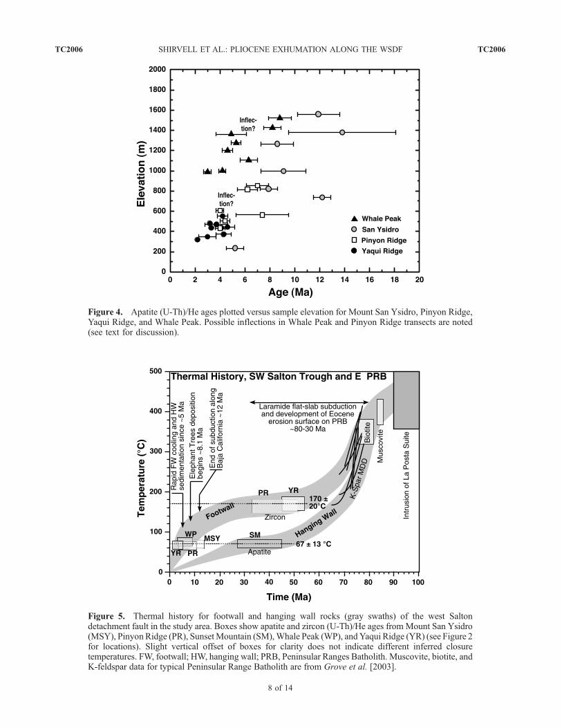
Figure 5. Thermal history for footwall and hanging wall rocks (gray swaths) of the west Saltondetachment fault in the study area. Boxes show apatite and zircon (U-Th)/He ages from Mount San Ysidro(MSY), Pinyon Ridge (PR), SunsetMountain (SM),Whale Peak (WP), andYaqui Ridge (YR) (see Figure 2for locations). Slight vertical offset of boxes for clarity does not indicate different inferred closuretemperatures. FW, footwall; HW, hanging wall; PRB, Peninsular Ranges Batholith. Muscovite, biotite, andK-feldspar data for typical Peninsular Range Batholith are from Grove et al. [2003].
Figure 4. Apatite (U-Th)/He ages plotted versus sample elevation for Mount San Ysidro, Pinyon Ridge,Yaqui Ridge, and Whale Peak. Possible inflections in Whale Peak and Pinyon Ridge transects are noted(see text for discussion).
TC2006 SHIRVELL ET AL.: PLIOCENE EXHUMATION ALONG THE WSDF
8 of 14
TC2006
suggestive of rapid tectonic cooling from �8 to �3 Ma. Oneof the older samples (6.3 ± 1.0 Ma) was collected at 1106m elevation, well below samples of comparable age (Table1 and Figure 4) and appears to be an anomalous age.Reasonable reproducibility among aliquots from this sam-ple suggests that zircon inclusions might not be the reasonfor the anomalously old age, so perhaps the apatite grainsin that sample are systematically zoned or more retentivethan others from the transect. If that age is ignored, then aninflection would exist at �5–6 Ma, suggesting either (1) thehighest two samples lay in the partial-retention zone andexhumation began �5–6 Ma, or (2) exhumation was ongo-ing at �8 Ma and accelerated at �5–6 Ma, consistent withthe Fish Creek Basin record, if the Elephant Trees Formationwas related to WSDF slip (see section 2).5.2.3. Pinyon and Yaqui Ridges[27] The approximately east–west trending Pinyon-Yaqui
Ridge area (Figures 2 and 3) records mainly Pliocene rapidcooling and exposes a significant length of structurally deepfootwall in the direction of predominant WSDF transport,but has little topographic relief (�300 m). The WSDF iswell exposed and folded by an open, east trending arch in acontractional left step over within the younger, dextral SanFelipe fault zone [Steely, 2006; Steely et al., 2009]. Footwallrocks grade eastward from schist and plutonic rocks atPinyon Ridge to migmatitic orthogneiss and paragneiss(both rare at exposed levels in the eastern PeninsularRanges) at the tip of Yaqui Ridge, which we interpret toreflect an eastward increase in paleodepth. Because of thepost-WSDF folding and low relief of this area, sampleswere collected in a horizontal array of �N–S transectsspread along the E–W length of the ridge (Figure 3).[28] Apatite (U-Th)/He ages from the Pinyon-Yaqui ridge
area range from 7.4 ± 2.1 to 2.2 ± 0.1 Ma. The latter is theyoungest age obtained (from two aliquots that yieldedidentical ages), consistent with the tip of Yaqui Ridgerepresenting the greatest exposed paleodepth. Most Pinyon-Yaqui ridge ages cluster between 3 and 5 Ma, indicative ofrapid cooling during that time interval. In general, the agesdecrease northward within each transect and decrease east-ward from transect to transect (Figure 6). This pattern can beexplained in two ways.[29] 1. This area was occupied by an �NE facing oblique
ramp prior to folding, with WSDF slip primarily to the east.Such a ramp geometry is consistent with the overall form ofthe detachment, and the location of the Pinyon-Yaqui ridgearea between the southern Santa Rosa Mountains, where aSE facing lateral ramp is preserved (S. Janecke, unpublisheddata, 2005), and Whale Peak, possibly a primary corrugationin the WSDF. However, subsequent offset and folding bydextral oblique faults has modified the initial geometry ofthe WSDF at Yaqui-Pinyon ridge. East directed slip isconsistent with the greatest concentration of detachmentstriations, but many also trend generally NE–SW [Axen etal., 2004; Steely et al., 2004, 2009; Steely, 2006].[30] 2. A component of NE directed slip may have
occurred during cooling. This is consistent with the signif-icant number of NE and SW trending striae on the detach-
ment at both Yaqui Ridge [Axen et al., 2004; Steely et al.,2004, 2009; Steely, 2006] and Whale Peak [Kairouz, 2005].In this scenario, the slip vector of the detachment wouldhave rotated clockwise through time, ending with theeasterly trend recorded by the largest number of striations.Such a history of clockwise rotation of the WSDF slipvector is consistent with a temporally increasing componentof distributed dextral wrench tectonics in the Salton Troughand/or with vertical axis rotation of the WSDF, as is knownfrom the Fish Creek Basin [Housen et al., 2005].[31] The three southernmost Pinyon ridge samples yield
distinctly older apatite (U-Th)/He ages, and suggest a breakin slope on age-gradient plots (Figures 3 and 4). The oldestsample, 7.4 ± 2.1 Ma, lies at relatively low elevation on thesouth limb of an antiform (Axen, unpublished maps, 2005)that is presumably related to the San Felipe fault (Figure 3)[e.g., Steely et al., 2004, 2009; Steely, 2006], so requires anelevation correction of unknown magnitude. Given its age,it probably originated somewhat higher than the nextsamples to the north (Figure 4). However, the quality ofthis age is low, and the large (2.1 Ma) standard deviation ofaliquot ages implies complexity in the apatite grains (zirconinclusions, U-Th zoning, or variable He retentivity). Regard-less of whether this sample is ignored because of thisproblem or if it is restored to a higher elevation the simplestinterpretation of the Pinyon Ridge data, in isolation fromthe other transects, is that the older (>6 Ma) Pinyon Ridgesamples resided in the He partial-retention zone, and thatWSDF slip at Pinyon Ridge began at �5 Ma. This isconsistent with increased subsidence and sediment accumu-lation rates reported in the Fish Creek Basin at �5.5 and4.6 Ma [Dorsey et al., 2006b, 2007] and with the possibleinflection in the Whale Peak age-elevation plot. This inter-pretation is problematic, however, because (1) theMount SanYsidro transect, which reaches considerably higher eleva-tions, appears to record significantly older detachment slipwithout a preserved partial-retention zone and (2) if a fossilpartial-retention zone exists at Whale Peak, it is also signif-icantly higher than the one at Pinyon Ridge. These problemscan be explained if the Vallecito fault operated as an earlybreakaway for the WSDF, causing slip on the Yaqui-Pinyonridge and northern Whale Peak parts of the WSDF to beganat �5 Ma.[32] An alternative interpretation is that the Pinyon Ridge
and Whale Peak samples initially lay below the He partial-retention zone of apatite, and the inferred inflections in theirage gradients reflect acceleration (rather than onset) ofWSDF-related denudation at �5 Ma. This is consistentwith older ages to the north at Mount San Ysidro and withthe similar ages and possible inflection point from muchhigher samples at Whale Peak to the south. It also isconsistent with the sedimentary record in the Fish Creek–Vallecito Basin if the Elephant Trees Formation was depos-ited in response to detachment slip. As discussed above, wefavor interpretation of the Vallecito fault as an active hangingwall structure above the WSDF from �8 to �5 Ma. In thisscenario, significant slip on the Vallecito fault ended at�5 Ma and was taken up on the WSDF farther west along
TC2006 SHIRVELL ET AL.: PLIOCENE EXHUMATION ALONG THE WSDF
9 of 14
TC2006
the N side of Whale Peak and at Yaqui-Pinyon ridge,accelerating rapid cooling in those places, contemporaneouswith accelerated subsidence of the Fish Creek–VallecitoBasin [Dorsey et al., 2007].[33] Stratigraphic and crosscutting relationships between
the WSDF, dextral fault systems, and Pliocene to EarlyPleistocene sedimentary rocks of the western Salton Troughsuggest that slip continued on the WSDF until �1.1 Ma[Axen and Fletcher, 1998; Winker and Kidwell, 2002;Dorsey and Janecke, 2002; Kairouz, 2005; Dorsey et al.,2006b; Steely et al., 2009]. In addition, Late Pleistocene andQuaternary reactivation of portions of the WSDF by strike-slip and high-angle normal faults has been documented south
of Yaqui Ridge and in the Tierra Blanca Mountains [Kairouz,2005; Steely et al., 2009].
5.3. Magnitude of Exhumation, Extension, and FaultSlip Rate
[34] Using both vertical and horizontal reference frames,the minimum amount of exhumation and minimum slip ratealong the WSDF from �5 to 2 Ma can be estimated. At�5 Ma, the footwall of the WSDF at Yaqui Ridge wasrapidly cooling through the apatite He partial-retention zone.At geologically fast cooling rates, the effective bulk closuretemperature of He in apatite is near the base of the partial-retention zone, at �70�C [Wolf et al., 1996, 1998; Farley,
Figure 6. (a) Apatite He cooling ages of samples from Yaqui and Pinyon ridges, projected onto a‘‘horizontal’’ transect parallel to the ridge crest and subparallel to the dominant eastward transport direction.Distance is measured from the trace of theWSDF at the east end of Yaqui Ridge. Note eastward decrease inages. Linear regressions are shown separately for samples north and south of the transect line (solid anddashed lines, respectively) with 95% confidence regions in gray. Pinyon Ridge samples that may haveresided in the apatite helium partial-retention zone were included in the regression for the southern line, butexcluding them does significantly affect the slope of the line. (b) Apatite cooling ages versus distanceperpendicular to the transect line (dashed line at zero distance). Note general northward decrease in ages,both for all samples andwithin most individual sample transects. (c) Shaded relief digital elevationmodel ofPinyon-Yaqui ridge showing locations of sample sites (black dots) and the transect line (white). Arrows onWSDF show dip direction.
TC2006 SHIRVELL ET AL.: PLIOCENE EXHUMATION ALONG THE WSDF
10 of 14
TC2006
2000; Farley and Stockli, 2002; Ehlers and Farley, 2003].Assuming geothermal gradients of 20–30�C/km, the foot-wall of the WSDF at Yaqui Ridge has been exhumed at least�2.3–3.5 km in the last 5 Ma. This is a minimum becausethe initial depth of the samples below the partial-retentionzone is unknown.[35] An alternative method to determine magnitude of
footwall exhumation comes from comparison of adjacentfootwall and hanging wall ages. Apatite ages from thehanging wall at Sunset Mountain are �33–39 Ma, compa-rable to zircon ages from the footwall at Pinyon-Yaqui ridgeof �35–51 (Figure 3). Assuming that these record resi-dence in the respective horizontal He partial-retention zonesof �45�–70�C for apatite and �150–190�C for zircon(because the PRB region was relatively quiescent tectoni-cally at those times) allows us to calculate the minimumvertical distances between footwall and hanging wall rocksprior to onset WSDF slip. Using geothermal gradients of 20and 30�C/km puts the base of the apatite partial-retentionzone at 2.3–3.5 km depth and the top of the zircon partial-retention zone at 5–7.5 km depth. This implies that thefootwall and hanging wall in the vicinity of Yaqui Ridgewere separated vertically by a minimum of �2.7–4 km, ingood agreement with the exhumation determined indepen-dently above.[36] Fault slip rates can be estimated using the inverse
slope of a linear regression through apatite cooling agesbelow the He partial-retention zone plotted against theirdistance from the detachment trace parallel to the slipdirection [e.g., Foster et al., 1993]. Although measurementsof slicken lines on the WSDF are quite scattered [Axen et al.,2004; Steely et al., 2004, 2009; Kairouz, 2005; Steely, 2006],the greatest concentration at Yaqui Ridge clusters at anazimuth of �090� [Steely, 2006; Steely et al., 2004, 2009].Because the WSDF is folded at Yaqui-Pinyon ridge, apatitecooling ages are projected onto a line trending �110�(subparallel to the ridge and the antiformal fold axes)(Figure 6a). This azimuth introduces �7% overestimaterelative to slip toward 090�. Samples north of the projec-tion line are older and their best fit age gradient is higherthan those to the south (Figures 6a and 6b). Linearregression through the two trends yields best fit horizontalage gradients of 0.20 ± 0.04 Ma/km (north of projectionline) and 0.40 ± 0.1 Ma/km (south of projection line). Notethat excluding the three oldest samples from Pinyon Ridge,which originally may have lain within the apatite-He partial-retention zone, does not alter the best fit slope of the southernline significantly, consistent with those samples initiallybeing below the partial-retention zone.[37] The inverse of these gradients yields average WSDF
slip rates of 5 +1.3/�0.8 km/Ma north of the projection lineand 2.5 +0.8/�0.5 km/Ma south of the projection line, or4.7 +1.2/�0.8 km/Ma and 2.3 +0.8/�0.4 km/Ma, respec-tively, toward 090. These rates are valid for slip along theWSDF from �4.5 to 2.5 Ma (north side) and �7 to �3 Ma(south side). Multiplying the slip rates by the relevantdurations of slip for the north and south sides gives totalslip toward 110� of 9.2 km (north) and 10 km (south), or, fora slip vector trending 090, 8.6 km (north) and 9.3 km
(south). These numbers are minima because (1) the initialdepth of the samples below the partial-retention zone isunknown, (2) WSDF slip may have begun earlier, and(3) WSDF slip at Yaqui Ridge continued until �1.1–1.3 Ma[Steely et al., 2004, 2009].
6. Implications for the Tectonic Evolution
of the GEP
[38] In both northernmost and southernmost BajaCalifornia, the bulk of GEP tectonic exhumation recordedby low-temperature thermochronmeters occurred after8–6 Ma [Axen et al., 2000; Fletcher et al., 2000; Lovera etal., 2007]. Similarly, apatite (U-Th)/He ages from the foot-wall of the WSDF clearly record rapid exhumational coolingfrom at least �5 to 2 Ma, possibly starting earlier. Rapidcooling after �5–6 Ma is consistent with the timing ofregional plate boundary reorganization and the transfer ofmost Pacific-North America dextral slip into the GEP[e.g., Crowell, 1982; Oskin et al., 2001]. However, initialexhumation by the WSDF may date to Middle Miocenetime [Luther et al., 2008]. The onset of exhumation byboth the Canada David detachment (northeastern BajaCalifornia) and the San Jose del Cabo fault (southern BajaCalifornia) was �12–10 Ma [Axen et al., 2000; Fletcheret al., 2000; Stockli, 2005; Lovera et al., 2007], suggestingthat, in general, initial exhumation along major structuresin the western GEP may have begun simultaneously alongthe rift axis over a distance of �1000 km, at about thetime that subduction ceased along most of the southwesternBaja California margin [e.g., Spencer and Normark, 1979;Fletcher et al., 2007]. Other indicators of the onset ofextension in the GEP are consistent with this [e.g., Stockand Hodges, 1989; Stock and Lee, 1994; Lee et al., 1996;Lewis and Stock, 1998; Nagy et al., 1999]. Regional relationssuggest that even older extension may have affected thestudy area, when it was located south of Yuma, AZ. Theseevents include late Oligocene to mid-Miocene detachment-related extension in southwestern Arizona and southeasternCalifornia [Spencer and Reynolds, 1989; Jacobson et al.,2002, 2007], extension in the southern California continentalborderland [Nicholson et al., 1994], and mid-Miocene to lateMiocene extension in northwest mainland Mexico [e.g.,Gans, 1997; Oskin and Stock, 2003; Gans et al., 2006].North of the study area, Wolf et al. [1997] and Luther et al.[2008] report middle and lateMiocene ages from the footwallof the WSDF.[39] The magnitude of detachment-related exhumation of
the footwall of the WSDF is a minimum of �2.3 km since�7 Ma = , which is approximately half of the exhumation(�5–7 km) estimated by low-temperature thermochronom-eters for large normal fault systems farther south in BajaCalifornia [e.g., Axen et al., 2000; Fletcher et al., 2000;Lovera et al., 2007]. The WSDF accommodated at least�10 km of horizontal extension since �7 Ma (and probablymore), which is similar to estimates of horizontal extensionfarther south in the GEP (e.g., the Canada David detachmentaccommodated about �10–12 km of horizontal extension).Significantly greater exhumation and translation are likely
TC2006 SHIRVELL ET AL.: PLIOCENE EXHUMATION ALONG THE WSDF
11 of 14
TC2006
since our estimates do not take earliest (�12–7 Ma) or latest(�2–3–1.1–1.3 Ma) slip into account.
7. Conclusions
[40] Footwall and hanging wall (U-Th)/He apatite andzircon ages record a significant contrast in thermal historyacross the WSDF, confirming Pliocene normal slip on thedetachment fault. Latest Miocene to Pliocene apatite agesconstrain the timing of rapid cooling along the WSDF from�5 to 2 Ma, consistent with the age of regional plateboundary reorganization that initiated dominantly dextral slipin the GEP. Thus, fault-accommodated strain partitioning,between �E directed detachment slip and NW strikingdextral faults, occurred in the Salton Trough until recently(�1 Ma), with the E directed slip component probablyaccelerating but also probably accommodating a decreasingfraction of the net deformation since�5Ma. For much of this
time, plate boundary strain in the Salton Trough also wasaccommodated by mafic-sedimentary crustal addition in thecentral trough [e.g., Elders et al., 1972; Fuis and Kohler,1984;Herzig and Jacobs, 1994]. MiddleMiocene (U-Th)/Heapatite ages from high elevations and steep age-elevationgradients suggest that extension in the Salton Trough mayhave begun earlier, in Middle Miocene time, similar to otherparts of the GEP and at about the time that subduction ceasedalong a large segment of the Baja California margin.
[41] Acknowledgments. This study was funded by National ScienceFoundation (Tectonics Program) grants EAR-0125307 and EAR-0337775(Axen) and by an AAPG Foundation 2005 Grant-in-Aid (Shirvell). Wethank G. Jefferson of the Anza-Borrego Desert State Park for helpfuldiscussions, lodging, Internet access, and sampling permits. D. Gingrich,G. Glesener, and J. Wykes assisted sample collection. R. Dorsey, B. Housen,S. Janecke, and M. Kairouz provided thoughtful discussions of the data set.The manuscript benefited greatly from review by A. Blythe, M. Oskin, andassociate editor, M. Rusmore.
ReferencesAbbott, P. L., and T. E. Smith (1989), Sonora, Mexico,
source for the Eocene Poway Conglomerate of south-ern California, Geology, 17, 329–332, doi:10.1130/0091-7613[1989]017<0329:SMSFTE>2.3.CO;2.
Ague, J., and G. H. Brimhall (1988), Magmatic arcasymmetry and distribution of anomalous plutonicbelts in the batholiths of California: Effects of assim-ilation, crustal thickness, and depth of crystallization,Geol. Soc. Am. Bull., 100, 912–927, doi:10.1130/0016-7606[1988]100<0912:MAAADO>2.3.CO;2.
Angelier, J. B., B. Colletta, J. Chorowicz, L. Ortlieb,and C. Rangin (1981), Fault tectonics of the BajaCalifornia peninsula and the opening of the Sea ofCortez, Mexico, J. Struct. Geol., 3, 347 – 356,doi:10.1016/0191-8141(81)90035-3.
Atwater, T. (1989), Plate tectonic history of the north-east Pacific and western North America, in The
Geology of North America, vol. N, The EasternPacific Ocean and Hawaii, edited by E. L. Winterer,D. M. Hussong, and R. W. Decker, pp. 499–522,Geol. Soc. of Am., Boulder, Colo.
Atwater, T., and J. M. Stock (1998), Pacific-NorthAmerica plate tectonics of the Neogene southwes-tern United States: An update, Int. Geol. Rev., 40,375–402.
Axen, G. J. (1995), Extensional segmentation of themain Gulf escarpment, Mexico and United States,Geology, 23, 515 – 518, doi:10.1130/0091-7613[1995]023<0515:ESOTMG>2.3.CO;2.
Axen, G. J., and J. M. Fletcher (1998), Late Miocene-Pleistocene extensional faulting, northern Gulf ofCalifornia, Mexico and Salton Trough, California,Int. Geol. Rev., 40, 217–244.
Axen, G. J., J. M. Fletcher, E. Cowgill, M. Murphy,P. Kapp, I. MacMillan, E. Ramos Velazquez, andJ. Aranda Gomez (1999), Range-front fault scarpsof the Sierra El Mayor, Baja California: Formedabove an active low-angle normal fault?, Geology,27, 247 –250, doi:10.1130/0091-7613[1999]027<0247:RFFSOT>2.3.CO;2.
Axen, G. J., M. Grove, D. Stockli, O. M. Lovera, D. A.Rothstein, J. M. Fletcher, K. Farley, and P. L.Abbott (2000), Thermal evolution of Monte Blancodome: Low-angle normal faulting during Gulf ofCalifornia rifting and late Eocene denudation ofthe eastern Peninsular Ranges, Tectonics, 19,197–212, doi:10.1029/1999TC001123.
Axen, G., M. Kairouz, A. N. Steely, S. U. Janecke, andR. J. Dorsey (2004), Structural expression of low-angle normal faults developed in wrench settings:
An example from the west Salton detachment sys-tem, Geol. Soc. Am. Abstr. Programs, 36, 548.
Biswas, S., I. Coutand, D. Grujic, C. Hager, D. Stockli,and B. Grasemann (2007), Exhumation and uplift ofthe Shillong plateau and its influence on the easternHimalayas: New constraints from apatite and zircon(U-Th-[Sm])/He and apatite fission trace analyses,Tectonics, 26, TC6013, doi:10.1029/2007TC002125.
Cerveny, P. F., R. J. Dorsey, and B. A. Burns (1991), Apa-tite and zircon fission-track ages from the Sierra SanPedroMartir, eastern Peninsula Range, BajaCalifornia,Mexico, Geol. Soc. Am. Abstr. Programs, 23, 12.
Cox, B. F., J. C. Matti, T. King, and D. M. Morton(2002), Neogene strata of southern Santa RosaMountains, California, and their significance fortectonic evolution of western Salton Trough, Geol.Soc. Am. Abstr. Programs, 34, 124.
Crowell, J. C. (1982), The tectonics of Ridge Basin,southern California, in Geologic History of RidgeBasin, edited by J. C. Crowell and M. H. Link,pp. 25 –42, Pac. Sect., Soc. of Econ. Paleontol. andMineral., Los Angeles, Calif.
DeMets, C. (1995), A reappraisal of seafloor spreadinglineations in the Gulf of California: Implications forthe transfer of Baja California to the Pacific plate andestimates of Pacific-North America motion, Geophys.Res. Lett., 22, 3545–3548, doi:10.1029/95GL03323.
Dokka, R. K., and R. H. Merriam (1982), Late Cenozoicextension of northeastern Baja California, Mexico,Geol. Soc. Am. Bull., 93, 371 – 378, doi:10.1130/0016-7606[1982]93<371:LCEONB>2.0.CO;2.
Dorsey, R. J. (2002), Stratigraphic record of Pleistoceneinitiation and slip on the Coyote Creek fault, lowerCoyote Creek, southern California, inContributionsto Crustal Evolution of the Southwest United States,edited by A. P. Barth, pp. 251–269, Geol. Soc. ofAm., Boulder, Colo.
Dorsey, R. J., and S. U. Janecke (2002), Late Mioceneto Pleistocene west Salton detachment system andbasin evolution, southern California: New insights,Geol. Soc. Am. Abstr. Programs, 34, 248.
Dorsey, R. J., and P. J. Umhoefer (2000), Tectonic andeustatic controls on sequence stratigraphy of thePliocene Loreto Basin, Mexico, Geol. Soc. Am.Bull., 112, 177 – 199, doi:10.1130/0016-7606[2000]112<0177:TAECOS>2.3.CO;2.
Dorsey, R. J., A. L. Fluette, B. A. Housen, K. A.McDougall, S. U. Janecke, G. J. Axen, and C. R.Shirvell (2006a), Chronology of late Miocene toearly Pliocene sedimentation at Split Mt. Gorge,
western Salton Trough: Implications for develop-ment of the Pacific-North America plate boundary,paper presented at Lithospheric Rupture in the Gulfof California –Salton Trough Region, MARGINS,Ensenada, Mexico, 9– 13 Jan.
Dorsey, R. J., B. A. Housen, S. U. Janecke, K.McDougall,M. Fanning, A. Fluette, G. J. Axen, and C. R. Shirvell(2006b), Chronostratigraphy of the Fish Creek-Vallecito Basin, SW Salton Trough: A high-fidelityrecord of slip on the west Salton detachment faultand subsidence in its upper plate, Eos Trans. AGU,87(52), Abstract T41D-1600.
Dorsey, R. J., A. Fluette, K. McDougall, B. A. Housen,S. U. Janecke, G. J. Axen, and C. R. Shirvell (2007),Chronology of Miocene-Pliocene deposits at SplitMountain Gorge, southern California: A record ofregional tectonics and Colorado River evolution,Geology, 35, 57– 60, doi:10.1130/G23139A.1.
Dumitru, T. A. (1990), Subnormal Cenozoic geothermalgradients in the extinct Sierra Nevada magmatic arc:Consequences of the Laramide and post-Laramideshallow-angle subduction, J. Geophys. Res., 95,4925–4941, doi:10.1029/JB095iB04p04925.
Ehlers, T. A., and K. A. Farley (2003), Apatite (U-Th)/He thermochronometry: Methods and applicationsto problems in tectonic and surface processes,Earth Planet. Sci. Lett., 206, 1 –14, doi:10.1016/S0012-821X(02)01069-5.
Elders, W. A., R. W. Rex, T. Meidav, P. T. Robinson,and S. Biehler (1972), Crustal spreading in southernCalifornia, Science, 178, 15–24, doi:10.1126/science.178.4056.15.
Engel, A. E. J., and P. A. Schultejann (1984), LateMesozoic andCenozoic tectonic history of south cen-tral California, Tectonics, 3, 659–675, doi:10.1029/TC003i006p00659.
Erskine, B. G. (1985), Constraints on low-angle fault-ing kinematics in the eastern Peninsular Rangesmylonite zone, and implications on southern Cali-fornia tectonics, Geol. Soc. Am. Abstr. Programs,17, 575.
Erskine, B. G., and H. R. Wenk (1985), Evidence forLate Cretaceous crustal thinning in the Santa Rosamylonite zone, southern California, Geology, 13,274 – 277, doi:10.1130/0091-7613[1985]13<274:EFLCCT>2.0.CO;2.
Farley, K. A. (2000), Helium diffusion from apatite:General behavior as illustrated by Durango fluor-apatite, J. Geophys. Res., 105, 2903 – 2914,doi:10.1029/1999JB900348.
TC2006 SHIRVELL ET AL.: PLIOCENE EXHUMATION ALONG THE WSDF
12 of 14
TC2006
Farley, K. A., and D. F. Stockli (2002), (U-Th)/Hedating of phosphates: Apatite, monazite, and xeno-time, in Phosphates: Geochemical, Geobiological,andMaterials Importance,Rev. Mineral. Geochem.,vol. 48, edited by M. J. Kohn, J. Rakovan, andJ. M. Hughes, pp. 559–577, Mineral. Soc. of Am.,Washington, D. C.
Farley, K. A., R. A. Wolf, and L. T. Silver (1996), Theeffects of long alpha-stopping distances on (U-Th)/He ages, Geochim. Cosmochim. Acta, 60, 4223–4229, doi:10.1016/S0016-7037(96)00193-7.
Farley, K. A., M. E. Rusmore, and S. W. Bogue (2001),Post-10 Ma uplift and exhumation of the northernCoast Mountains, British Columbia, Geology, 29,99– 102.
Fletcher, J. M., B. P. Kohn, D. A. Foster, and A. J. W.Gleadow (2000), Heterogeneous Neogene coolingand exhumation of the Los Cabos block, southernBaja California: Evidence from fission-track thermo-chronology, Geology, 28, 107 –110, doi:10.1130/0091-7613[2000]28<107:HNCAEO>2.0.CO;2.
Fletcher, J. M., M. Grove, D. Kimbrough, O. Lovera,and G. E. Gehrels (2007), Ridge-trench interactionsand the Neogene tectonic evolution of the Magdalenashelf and southern Gulf of California: Insights fromdetrital zircon U-Pb ages from the Magdalena fan andadjacent areas,Geol. Soc. Am. Bull., 119, 1313–1336,doi:10.1130/B26067.1.
Foster, D. A., A. J.W.Gleadow, S. J. Reynolds, and P. G.Fitzgerald (1993), Denudation of metamorphic corecomplexes and the reconstruction of the TransitionZone, west central Arizona: Constraints from apatitefission track thermochronology, J. Geophys. Res.,98, 2167–2185, doi:10.1029/92JB02407.
Frost, E. G., and M. Shafiqullah (1989), Pre-SanAndreas opening of the Salton Trough as an exten-sional basin: K-Ar ages on regional detachmentfaults along the western margin of the SaltonTrough, Geol. Soc. Am. Abstr. Programs, 21, 81.
Frost, E. G., M. J. Fattahipour, and K. L. Robinson(1996a), Neogene detachment and strike-slip fault-ing in the Salton Trough region and their geometricand genetic interrelationships, in Field ConferenceGuidebook and Volume for the AAPG/SEPMAnnualConvention, San Diego, CA, edited by P. L. Abbottand J. D. Cooper, pp. 263 –294, Pac. Sect., Am.Assoc. of Pet. Geol., Bakersfield, Calif.
Frost, E. G., S. C. Suitt, and M. Fatahipour (1996b),Emerging perspectives of the Salton Trough regionwith an emphasis on extensional faulting and itsimplications for later San Andreas deformation, inSturzstroms and Detachment Faults, Anza-BorregoDesert State Park, California, edited by P. L. Abbottand D. C. Seymour, pp. 81–121, South Coast Geol.Soc., Santa Ana, Calif.
Fuis, G. S., and W. M. Kohler (1984), Crustal structureand tectonics of the Imperial Valley region, Cali-fornia, in The Imperial Basin: Tectonics, Sedimenta-tion, and Thermal Aspects, edited by C. A. Rigsby,pp. 1– 13, Pac. Sect., Soc. of Econ. Paleontol. andMineral., Los Angeles, Calif.
Fuis, G. S., W. D. Mooney, J. H. Healey, G. A.McMechan, and W. J. Lutter (1982), Crustal struc-ture of the Imperial Valley region, U.S. Geol. Surv.Prof. Pap., 1254, 25 –49.
Fuis, G. S., W. D. Mooney, J. H. Healy, G. A.McMechan, andW. J. Lutter (1984), A seismic refrac-tion survey of the Imperial Valley region, California,J. Geophys. Res., 89, 1165–1189.
Gans, P. B. (1997), Large-magnitude Oligo-Mioceneextension in southern Sonora: Implications for thetectonic evolution of northwest Mexico, Tectonics,16, 388–408, doi:10.1029/97TC00496.
Gans, P. B., K. Blair, I. MacMillin, M. Wong, C. Till,S. Herman, and J. Roldan (2006), Structural andmagmatic evolution of the Sonoran rifted margin,paper presented at Lithospheric Rupture in the Gulfof California-Salton Trough Region, MARGINS,Ensenada, Mexico, 9 –13 Jan.
Gastil, R. G., R. P. Phillips, and E. C. Allison (1975),Reconnaissance Geology of the State of Baja Cali-
fornia, Mem. Geol. Soc. Am., vol. 140, 170 pp.
George, P. G. (1993), Tectonic implications of fission-track thermochronology and amphibole thermobar-omentry studies of the northern Peninsular Rangesbatholith, southern California, Ph.D. thesis, 195 pp.,La. State Univ., Baton Rouge.
George, P. G., and R. K. Dokka (1994), Major LateCretaceous cooling events in the eastern PeninsulaRanges, California, and their implications forCordilleran tectonics, Geol. Soc. Am. Bull., 106,903–914, doi:10.1130/0016-7606[1994]106<0903:MLCCEI>2.3.CO;2.
Grove, M., O. Lovera, and M. Harrison (2003), LateCretaceous cooling of the east-central PeninsulaRanges batholith (33�N): Relationship to La Postapluton emplacement, Laramide shallow subduction,and forearc sedimentation, in Tectonic Evolution ofNorthwestern Mexico and the Southwestern USA,edited by S. E. Johnson et al., Spec. Pap. Geol.Soc. Am., 374, 355–379.
Hausback, B. P. (1984), Cenozoic volcanic and tectonicevolution of Baja California, Mexico, in Geology
of the Baja California Peninsula, edited by V. A.Frizzell, pp. 219–236, Pac. Sect., Soc. of Econ.Paleontol. and Mineral., Bakersfield, Calif.
Henry, C. D. (1989), Late Cenozoic basin and rangestructure in western Mexico adjacent to the Gulf ofCalifornia, Geol. Soc. Am. Bull., 101, 1147–1156,doi:10.1130/0016-7606[1989]101<1147:LCBARS>2.3.CO;2.
Herzig, C. T., and D. C. Jacobs (1994), Cenozoic vol-canism and two-stage extension in the SaltonTrough, southern California and northern BajaCalifornia, Geology, 22, 991–994, doi:10.1130/0091-7613[1994]022<0991:CVATSE>2.3.CO;2.
Holt, J. W., E. W. Holt, and J. M. Stock (2000), An ageconstraint on Gulf of California rifting from theSanta Rosalıa Basin, Baja California Sur, Mexico,Geol. Soc. Am. Bull., 112, 540–549, doi:10.1130/0016-7606[2000]112<0540:AACOGO>2.3.CO;2.
House, M. A., K. A. Farley, and D. Stockli (2000),Helium chronometry of apatite and titanite usingNd-YAG laser heating, Earth Planet. Sci. Lett.,183, 365 – 368, doi:10.1016/S0012-821X(00)00286-7.
Housen, B. A., R. J. Dorsey, S. U. Janecke, and G. J.Axen (2005), Rotation of Plio-Pleistocene sedimen-tary rocks in the Fish Creek Vallecito Basin, westernSalton Trough, CA, Eos Trans. AGU, 86(52), FallMeet. Suppl., Abstract GP13A-0039.
Jacobson, C. E.,M. Grove,M.M. Stamp, A. Vucic, F. R.Oyarzabal, G. B. Haxel, R. M. Tosdal, and D. R.Sherrod (2002), Exhumation history of the Orocopiaschist and related rocks in the Gavilan Hills area ofsoutheasternmost California, in Contributions toCrustal Evolution of the Southwestern UnitedStates, edited by A. P. Barth, Spec. Pap. Geol.Soc. Am., 365, 129–154.
Jacobson, C. E., M. Grove, A. Vucic, and J. Pedrick(2007), Exhumation of the Orocopia schist andcrystalline hanging wall rocks of southeasternCalifornia: Relative roles of erosion, synsubductiontectonic denudation, and middle Cenozoic exten-sion, in Convergent Margin Terranes and Asso-ciated Regions: A Tribute to W. G. Ernst, edited byM. Cloos et al., Spec. Pap. Geol. Soc. Am., 419,1 –37.
Kairouz, M. E. (2005), Geology of the Whale Peakregion of the Vallecito Mountains: Emphasis onthe kinematics and timing of the west Salton detach-ment fault, southern California, M.S. thesis, 166 pp.,Univ. of Calif., Los Angeles.
Kairouz, M., G. J. Axen, M. Grove, O. Lovera, andD. F. Stockli (2003), Late Cenozoic 40Ar/39Ar agesof fault rocks formed along the west Salton detach-ment system, southern California, Geol. Soc. Am.Abstr. Programs, 35, 629.
King, T., B. F. Cox, J. C. Matti, C. L. Powell, L. E.Osterman, and L. M. Bybell (2002), Previouslyunreported outcrops of Neogene Imperial Formationin southern Santa Rosa Mountains, California, andimplications for tectonic uplift, Geol. Soc. Am.Abstr. Programs, 34, 124.
Kistler, R. W., J. L. Wooden, and D. M. Morton(2003), Isotopes and ages in the northern PeninsularRanges batholith, southern California, U.S. Geol.Surv. Open File Rep., 03-489.
Krummenacher, D., R. G. Gastil, J. Brushee, andJ. Doupont (1975), K-Ar apparent ages, PeninsularRanges batholith, southern California and BajaCalifornia, Geol. Soc. Am. Bull., 86, 760 – 768,doi:10.1130/0016-7606[1975]86<760:KAAPRB>2.0.CO;2.
Langenheim, V. E., R. C. Jachens, D. M. Morton, R. W.Kistler, and J. C. Matti (2004), Geophysical andisotopic mapping of preexisting crustal structuresthat influenced the location and development ofthe San Jacinto fault zone, southern California,Geol.Soc. Am. Bull., 116, 1143 – 1157, doi:10.1130/B25277.1.
Larson, R. L. (1972), Bathymetry, magnetic anomalies,and plate tectonic history of the mouth of the Gulf ofCalifornia, Geol. Soc. Am. Bull., 83, 3345–3360,doi:10.1130/0016-7606[1972]83[3345:BMAAPT]2.0.CO;2.
Lee, J., M. M. Miller, R. Crippen, B. Hacker, andJ. Ledesma-Vasquez (1996), Middle Miocene ex-tension in the Gulf Extensional Province, BajaCalifornia: Evidence from the southern Sierra Juarez,Geol. Soc. Am. Bull., 108, 505–525, doi:10.1130/0016-7606[1996]108<0505:MMEITG>2.3.CO;2.
Lewis, C. J., and J. M. Stock (1998), Late Miocene torecent transtensional tectonics in the Sierra SanFermin, northeastern Baja California, Mexico,J. Struct. Geol., 20, 1043–1063, doi:10.1016/S0191-8141(98)00038-8.
Lonsdale, P. (1989), Geology and tectonic history ofthe Gulf of California, in The Geology of North
America, vol. N, The Eastern Pacific Ocean andHawaii, edited by E. L. Winterer, D. M. Hussong,and R. W. Decker, pp. 499 – 522, Geol. Soc. ofAm., Boulder, Colo.
Lonsdale, P. (1991), Structural patterns of the Pacificfloor offshore of peninsular California, in The Gulfand Peninsular Province of the Californias, editedby J. P. Dauphin and B. T. Simoneit, AAPG Mem.,47, 87 –125.
Lough, C. F. (1993), Structural evolution of the Valle-citos Mountains, in Colorado Desert and Salton
Trough Geology, edited by J. Corones, pp. 91 –109, San Diego Assoc. of Geol., San Diego, Calif.
Lovera, O. M., M. Grove, B. Kohn, J. Fletcher,D. Kimbrough, P. Umhoefer, T. Schwennicke, andA. J. Gleadow (2007), Thermo-kinetic interpretativemodel for couple basement-detrital thermochronol-ogy, Eos Trans. AGU, 88(23), Jt. Assem. Suppl.,Abstract T41C-04.
Luther, A., G. Axen, D. Stockli, S. Kelley, andM. Grove(2008), Preliminary apatite (U-Th)/He thermochro-nology of the eastern Santa Rosa and San Jacintoblocks, Peninsular Ranges, southern California,Geol. Soc. Am. Abstr. Programs, 40, 444.
Mammerickx, J., and K. D. Klitgord (1982), NorthernEast Pacific Rise: Evolution from 25 m.y. B.P. tothe present, J. Geophys. Res., 87, 6751 – 6759,doi:10.1029/JB087iB08p06751.
Martinez-Gutierrez, G., and P. A. Sethi (1997), Miocene-Pleistocene sediments within the San Jose del CaboBasin, Baja California Sur, Mexico, in PlioceneCarbonates and Related Facies Flanking the Gulf
of California, Baja California, Mexico, edited byM. E. Johnson and J. Ledesma-Vazquez, Spec. Pap.Geol. Soc. Am., 318, 141–166.
Matti, J. C., B. F. Cox, D. M. Morton, R. V. Sharp, andT. King (2002), Fault-bounded Neogene sedimen-tary deposits in the Santa Rosa Mountains, southernCalifornia: Crustal stretching or transpressionaluplift?, Geol. Soc. Am. Abstr. Programs, 34, 124.
Matti, J. C., D. M.Morton, B. F. Cox, G. P. Landis, V. E.Langenheim, W. R. Premo, R. Kistler, and J. R.Budahn (2006), Fault-bounded late Neogene sedi-mentary deposits in the Santa Rosa Mountains,southern CA: Constraints on the evolution of theSan Jacinto fault, Eos Trans. AGU, 87(52), FallMeet. Suppl., Abstract T21B-0407.
TC2006 SHIRVELL ET AL.: PLIOCENE EXHUMATION ALONG THE WSDF
13 of 14
TC2006
Minch, J. A. (1979), The late-Mesozoic-early Tertiaryframework of continental sedimentation, northernPeninsular Ranges, Baja California, Mexico, inEocene Depositional Systems: San Diego, editedby P. L. Abbott, pp. 43 –68, Pac. Sect., Soc. ofEcon. Paleontol. and Mineral., San Diego, Calif.
Moore, D. G., and E. C. Buffington (1968), Transformfaulting and growth of the Gulf of California sincethe late Pliocene, Science, 161, 1238 – 1241,doi:10.1126/science.161.3847.1238.
Naeser, C. W., N. D. Naeser, V. R. Todd, and R. G.Bohannon (1996), Thermochronology of thePeninsular Ranges batholith, southern California,from fission-track and 40Ar/39Ar analysis, Geol.Soc. Am. Abstr. Programs, 28, 513.
Nagy, E. A., M. Grove, and J. M. Stock (1999), Ageand stratigraphic relationships of pre- and syn-riftvolcanic deposits in the northern Puertecitos volca-nic province, Baja California, Mexico, J. Volcanol.Geotherm. Res., 93, 1 – 30, doi:10.1016/S0377-0273(99)00080-3.
Nicholson, C., C. C. Sorlien, T. Atwater, J. C. Crowell,and B. P. Luyendyk (1994), Microplate capture,rotation of the western Transverse Ranges, and in-itiation of the San Andreas transform as a low-anglefault system, Geology, 22, 491–495, doi:10.1130/0091-7613[1994]022<0491:MCROTW>2.3.CO;2.
Ortega-Rivera, A. (2003), Geochronological con-straints on the tectonic history of the PeninsularRanges batholith of Alta and Baja California: Tec-tonic implications for western Mexico, in TectonicEvolution of Northwestern Mexico and the South-
western USA, edited by S. E. Johnson et al., Spec.Pap. Geol. Soc. Am., 374, 297–335.
Ortega-Rivera, A., E. Farrar, J. A. Hanes, D. A. Archi-bald, R. G. Gastil, D. L. Kimbrough, M. Zentilli,M. Lopez-Martinez, G. Feraud, and G. Ruffet(1997), Chronological constraints on the thermaland tilting history of the Sierra San Pedro Martirpluton, Baja California, Mexico, from U/Pb,40Ar/39Ar, and fission-track geochronology, Geol.Soc. Am. Bull., 109, 728–745, doi:10.1130/0016-7606[1997]109<0728:CCOTTA>2.3.CO;2.
Oskin, M., and J. Stock (2003), Pacific-North Americaplate motion and opening of the upper Delfın Basin,northern Gulf of California, Mexico,Geol. Soc. Am.Bull., 115, 1173–1190, doi:10.1130/B25154.1.
Oskin, M., J. M. Stock, and A. Martın-Barajas (2001),Rapid localization of Pacific-North America platemotion in the Gulf of California, Geology, 29,459–462, doi:10.1130/0091-7613[2001]029<0459:RLOPNA>2.0.CO;2.
Schultejann, P. A. (1984), The Yaqui Ridge antiformand detachment fault: Mid-Cenozoic extensionalterrane west of the San Andreas fault, Tectonics,3, 677–691, doi:10.1029/TC003i006p00677.
Sharp, R. V. (1967), San Jacinto fault zone in thePeninsular Ranges of southern California, Geol.Soc. Am. Bull., 78, 705 –730, doi:10.1130/0016-7606[1967]78[705:SJFZIT]2.0.CO;2.
Sharp, R. V. (1979), Some characteristics of the easternPeninsular Ranges mylonite zone, in Proceedingsof Conference VIII: Analysis of Actual Fault Zonesin Bedrock, edited by R. Speed, R. Sharp, and J. F.Evernden, U.S. Geol. Surv. Open File Rep., 79-1239, 258 –267.
Shirvell, C. R. (2006), Pliocene exhumation along thewest Salton detachment system and tectonic evolu-tion of the Fish Creek-Vallecito supradetachmentbasin, Salton Trough, southern California, M.S.thesis, 133 pp., Univ. of Calif., Los Angeles.
Silver, L. T., and B. Chappell (1988), The PeninsularRanges batholith: An insight into the evolution ofthe Cordilleran batholiths of southwestern North
America, Trans. R. Soc. Edinburgh Earth Sci.,79, 105–121.
Snee, L. W., C. W. Naeser, N. D. Naeser, V. R. Todd,and D. M. Morton (1994), Preliminary 40Ar/39Arand fission-track cooling ages of plutonic rocksacross the Peninsular Ranges batholith, southernCalifornia, Geol. Soc. Am. Abstr. Programs, 26, 94.
Spelz, R. M., J. M. Fletcher, L. A. Owen, and M. W.Caffee (2008), Quaternary alluvial-fan develop-ment, climate and morphologic dating of faultscarps in Laguna Salada, Baja California, Mexico,Geomorphology, 102, 578 – 594, doi:10.1016/j.geomorph.2008.06.001.
Spencer, J. E., and W. R. Normark (1979), Tosco-Abreojos fault zone: A Neogene transform plateboundary within the Pacific margin of southern BajaCalifornia, Mexico, Geology, 7 , 554 – 557,doi:10.1130/0091-7613[1979]7<554:TFZANT>2.0.CO;2.
Spencer, J. E., and S. J. Reynolds (1989), Middle Ter-tiary tectonics of Arizona and adjacent areas, inGeo-logic Evolution of Arizona, edited by J. P. Jenneyand S. J. Reynolds, pp. 539–574, Ariz. Geol. Soc.,Tucson.
Steely, A. N. (2006), The evolution from Pliocene westSalton detachment faulting to Pleistocene cross cut-ting oblique strike slip faults in the SW SaltonTrough, southern California, M.S. thesis, 246 pp.,Utah State Univ., Logan.
Steely, A. N., S. J. Janecke, R. Dorsey, and G. J. Axen(2004), Evidence for late Miocene-Quaternary low-angle oblique strike-slip faulting on the west Saltondetachment fault, southern California, Geol. Soc.Am. Abstr. Programs, 36, 37.
Steely, A. N., S. U. Janecke, R. J. Dorsey, and G. J.Axen (2009), Pleistocene reorganization of thesouthern San Andreas fault system: Initiation andstructures of the San Felipe fault zone, Geol. Soc.Am. Bull., in press.
Stinson, A. L., and R. G. Gastil (1996), Mid- to Late-Tertiary detachment faulting in the Pinyon Moun-tains, San Diego County, California: A setting forlong-runout landslides in the Split Mountain gorgearea, in Sturzstroms and Detachment Faults, Anza-Borrego Desert State Park, California, edited byP. L. Abbott and D. C. Seymour, pp. 99 – 115,South Coast Geol. Soc., Santa Ana, Calif.
Stock, J. M., and K. V. Hodges (1989), Pre-Plioceneextension around the Gulf of California and thetransfer of Baja California to the Pacific plate, Tec-tonics, 8, 99 –115, doi:10.1029/TC008i001p00099.
Stock, J. M., and J. Lee (1994), Do microplates insubduction zones leave a geological record?, Tec-tonics, 13, 1472–1488.
Stockli, D. F. (2005), Application of low-temperaturethermochronometry to extensional settings, in Low-Temperature Thermochronology: Techniques, In-
terpretations, and Applications, edited by P. W.Reiners and T. A. Ehlers, Rev. Mineral. Geochem.,58, 411–448, doi:10.2138/rmg.2005.58.16.
Stockli, D. F., K. A. Farley, and T. A. Dumitru (2000),Calibration of the apatite (U-Th)/He thermochron-ometer on an exhumed fault block, White Moun-tains, Calif. Geol., 28, 983–986.
Stockli, D. F., T. A. Dumitru, M. O. McWilliams, andK. A. Farley (2003), Cenozoic tectonic evolutionof the White Mountains, California and Nevada,Geol. Soc. Am. Bull., 115, 788–816, doi:10.1130/0016-7606[2003]115<0788:CTEOTW>2.0.CO;2.
Todd, V. R., S. E. Shaw, and J. M. Hammarstrom(2003), Cretaceous plutons of the PeninsularRanges batholith, San Diego and westernmost Im-perial counties, California: Intrusion across a LateJurassic continental margin, in Tectonic Evolution
of Northwestern Mexico and the SouthwesternUSA, edited by S. E. Johnson et al., Spec. Pap.Geol. Soc. Am., 374, 185–235.
Umhoefer, P. J., L. Mayer, and R. J. Dorsey (2002),Evolution of the margin of the Gulf of Californianear Loreto, Baja California peninsula, Mexico,Geol. Soc. Am. Bull., 114, 849–868, doi:10.1130/0016-7606[2002]114<0849:EOTMOT>2.0.CO;2.
Walsh, S. L. (1997), New specimens of Metanoiamys,Pauromys, and Simimys (Rodentia: Myomorpha)from the Uintan (middle Eocene) of San DiegoCounty, California, and comments on the relation-ships of selected Paleogene Myomorpha, Proc.San Diego Soc. Nat. Hist., 32, 1 – 20.
Walsh, S. L., and T. A. Demere (1991), Age and strati-graphy of the Sweetwater and Otay formations, SanDiego County, California, in Eocene Geologic His-tory of San Diego Region, edited by P. L. Abbott andJ. A. May, pp. 131–148, Pac. Sect., Soc. of Econ.Paleontol. and Mineral., Los Angeles, Calif.
Winker, C. D. (1987), Neogene stratigraphy of the FishCreek-Vallecito section, southern California: Impli-cations for early history of the northern Gulf ofCalifornia and Colorado Delta, Ph.D. dissertation,494 pp., Univ. of Ariz., Tucson.
Winker, C. D., and S. M. Kidwell (1996), Stratigraphyof a marine rift basin: Neogene of the western Salt-on Trough, California, in Field Conference Guide-
book and Volume for the American Association ofPetroleum Geologists Annual Convention, editedby P. L. Abbott and J. D. Cooper, pp. 295–336,Pac. Sect., Am. Assoc. of Pet. Geol., Bakersfield,Calif.
Winker, C. D., and S. M. Kidwell (2002), Stratigraphicevidence for ages of different extensional styles inthe Salton Trough, southern California, Geol. Soc.Am. Abstr. Programs, 34, 884.
Wolf, R. A., K. A. Farley, and L. T. Silver (1996), Heliumdiffusion and low-temperature thermochronometryof apatite, Geochim. Cosmochim. Acta, 60,4231–4240, doi:10.1016/S0016-7037(96)00192-5.
Wolf, R. A., K. A. Farley, and L. T. Silver (1997),Assessment of (U-Th)/He thermochronometry:The low-temperature history of the San JacintoMountains, Calif. Geol., 25, 65–68.
Wolf, R. A., K. A. Farley, and D. M. Kass (1998), Mod-eling of the temperature sensitivity of the apatite(U-Th)/He thermochronometer, Chem. Geol., 148,105 –114, doi:10.1016/S0009-2541(98)00024-2.
Wong, M. S., and P. B. Gans (2008), Geologic, struc-tural, and thermochronologic constraints on the tec-tonic evolution of the Sierra Mazatan core complex,Sonora, Mexico: New insights into metamorphiccore complex formation, Tectonics, 27, TC4013,doi:10.1029/2007TC002173.
Zanchi, A. (1994), The opening of the Gulf of Californianear Loreto, Baja California, Mexico: From basinand range extension to transtentional tectonics,J. Struct. Geol., 16, 1619–1639, doi:10.1016/0191-8141(94)90131-7.
���������G. J. Axen, Department of Earth and Environ-
mental Science, New Mexico Institute of Mining andTechnology, Socorro, NM 87801, USA. ([email protected])
M. Grove, Department of Geological and Environ-mental Sciences, Stanford University, Stanford, CA94305-2115, USA. ([email protected])
C. R. Shirvell, ExxonMobil Exploration Company,Houston, TX 77060, USA. ([email protected])
D. F. Stockli, Department of Geology, University ofKansas, Lawrence, KS 66045-7613, USA. ([email protected])
TC2006 SHIRVELL ET AL.: PLIOCENE EXHUMATION ALONG THE WSDF
14 of 14
TC2006
Copyright © 2022 FDOKUMEN