ministry of road transport & highway - World Bank Document
283
MINISTRY OF ROAD TRANSPORT & HIGHWAY GOVERNMENT OF INDIA June – 2014 CONSULTANCY SERVICES FOR PREPARATION OF DETAILED PROJECT REPORT FOR REHABILITATION AND UPGRADING TO 2 LANE/2 LANE WITH PAVED SHOULDERS CONFIGURATION AND STRENGTHENING OF BANKURA TO PURULIA SECTION (KM 0 TO 84) OF NH-60A WEST BENGAL (PACKAGE SP/B/6) SOCIAL IMPACT ASSESSMENT& RAP REPORT Public Disclosure Authorized Public Disclosure Authorized Public Disclosure Authorized Public Disclosure Authorized Public Disclosure Authorized Public Disclosure Authorized Public Disclosure Authorized Public Disclosure Authorized
-
Upload
khangminh22 -
Category
Documents
-
view
5 -
download
0
Transcript of ministry of road transport & highway - World Bank Document

MINISTRY OF ROAD TRANSPORT & HIGHWAY
GOVERNMENT OF INDIA
June – 2014
CONSULTANCY SERVICES FOR PREPARATION OF DETAILED PROJECT REPORT FOR REHABILITATION AND UPGRADING TO 2 LANE/2 LANE WITH PAVED SHOULDERS CONFIGURATION AND
STRENGTHENING OF BANKURA TO PURULIA SECTION (KM 0 TO 84) OF NH-60A WEST BENGAL (PACKAGE SP/B/6)
SOCIAL IMPACT ASSESSMENT& RAP REPORT
Pub
lic D
iscl
osur
e A
utho
rized
Pub
lic D
iscl
osur
e A
utho
rized
Pub
lic D
iscl
osur
e A
utho
rized
Pub
lic D
iscl
osur
e A
utho
rized
Pub
lic D
iscl
osur
e A
utho
rized
Pub
lic D
iscl
osur
e A
utho
rized
Pub
lic D
iscl
osur
e A
utho
rized
Pub
lic D
iscl
osur
e A
utho
rized
wb371432
Typewritten Text
RP1245 V13
wb371432
Typewritten Text
wb371432
Typewritten Text
wb371432
Typewritten Text
wb371432
Typewritten Text

(i)
TABLE OF CONTENTS
Sl. No. Description Page Nos.
FINAL DETAILED PROJECT REPORT (MODIFIED) - (VOLUME V: SOCIAL IMPACT ASSESSMENT AND REHABILITATION ACTION PLAN)
List of Acronyms L-I to L-IV
EXECUTIVE SUMMARY Es-1 to Es-5
1. INTRODUCTION AND METHODOLOGY 1-1 to 1-6
1.1 Introduction 1-1
1.2 Project Road Description 1-2
1.3 Existing Road Condition 1-4
1.4 Objectives and Study Methodology 1-5
1.4.1 Objectives 1-5
1.4.2 Methodology 1-5
1.5 Structure of the Report 1-6
2. SOCIO ECONOMIC PROFILE OF PROJECT INFLUENCE AREA 2-1 to 2-8
2.1 West Bengal at a Glance 2-1
2.2 Project Influence Area (PIA) 2-4
2.3 Socio-Economic Profile of Direct Impact Zone (DIZ) 2-7 to 2-8
3. MINIMIZING ADVERSE SOCIAL IMPACT 3-1 to 3-8
3.1 Introduction 3-1
3.2 Right of Way 3-1
3.3 Designs and R&R Coordination 3-2
3.4 Widening Option 3-3
3.5 Minimizing of Land Acquisition 3-3
3.6 Analysis of Alternatives 3-4
3.6.1 Recommendation 3-6
3.7 Improvement in other Built-up Location 3-7 to 3-8
4. PROPOSED IMPROVEMENT PLAN 4-1 to 4-6
4.1 Average Daily Traffic (ADT) 4-1
4.2 Design Considerations 4-1
4.2.1 Proposed Design Standards for Highway 4-1
4.3 Summaries of Improvement Proposals 4-2
4.4 Junction Improvements 4-4

(ii)
Sl. No. Description Page Nos.
4.5 Addressal of Safety Issues in Design for Minimising the Adverse Impact
4-4 to 4-6
5 SOCIO-ECONOMIC PROFILING & SOCIAL IMPACT ASSESSMENT OF PAHs
5-1 to 5-12
5.1 Social and Cultural Profile 5-1
5.1.1 Economic Profile 5-4
5.2 Social Impact Assessment 5-7
5.2.1 Impact on Structures . 5-8
5.2.2 Type of Affected Structures 5-8
5.2.3 Use of Affected Structures 5-9
5.2.4 Severity of Impacts 5-10
5.2.5 Impact on Community Structures 5-11
5.2.6 Impacts on Land and Land Holders 5-11
5.2.7 Impact on Scheduled Tribe Households 5-12
6 PUBLIC INFORMATION AND CONSULTATIONS 6-1 to 6-19
6.1 Introduction 6-1
6.2 Methodological Framework 6-1
6.3 Public Consultation Process 6-2
6.4 Details of Public Consultation Meetings 6-2
6.4.1 Consultation with Project Affected Persons 6-3
6.4.2 Consultation with Communities for Relocation/ Enhancement of Religious and other CPRs
6-9
6.4.3 Consultation with Women’s and it’s Outcomes 6-17
6.4.4 Consultation with Project Officials and Govt. Departments 6.18
6.5 Mechanism for Continuation of Public Consultations 6-18 to 6-19
7. R&R PRINCIPLES, POLICY FRAMEWORK & ENTITLEMENT MATRIX
7-1 to 7-20
7.1 Introduction 7-1
7.2 Applicable GOI and World Bank Requirements 7-1
7.2.1 The National Highway Act, 1956 7-2
7.2.2 National Rehabilitation and Resettlement Policy, 2007 7-3
7.2.3 World Bank Guidelines for Involuntary Resettlement 7-4
7.2.4 The Right to Information Act, 2005 7-5
(iii)
Sl. No. Description Page Nos.
7.2.5 The World Bank’s Disclosure Policy 7-5
7.3 Purpose of Resettlement Policy Framework 7-5
7.4 Objectives and Scope of Resettlement Policy Framework, NHIP 7-6
7.5 Definitions 7-7
7.6 Resettlement Principles and Eligibility Criteria 7-9
7.7 Entitlement Matrix 7-11
7.8 Methods for Assessment of Replacement Cost 7-19
7.9 Direct Purchase of Land 7-20
8 INSTITUTIONAL FRAMEWORK FOR RAP IMPLEMENTATION 8-1 to 8-6
8.1 Introduction 8-1
8.2 Central Level 8-1
8.3 State Level 8-2
8.4 Sub-project Level 8-3
8.5 Rap Implementation Support Agency (Consultancy Firm) 8-4
8.6 Replacement Cost Committee at District Level 8-5
8.7 Mechanism for Implementation of RAP, Training and Capacity Building – at Project and Sub-Project Level
8-6
9 DISCLOSURE AND CONSULTATION PLAN 9-1 to 9-3
9.1 Introduction 9-1
9.2 Consultation & Participation Plan 9-1
9.3 Suggestion and Complaint Handling Mechanism (SCHM) 9-2
9.4 Public Hearing 9-3
10 GRIEVANCE REDRESSAL MECHANISM (GRM) 10-1 to 10-2
10.1 Introduction 10-1
10.2 Grievance Redressal Committee (GRC) 10-1 to 10-2
11 MONITORING AND EVALUATION (M&E) 11-1 to 11-6
11.1 Introduction 11-1
11.2 Institutional Arrangement for M&E 11-1
11.3 Monitoring and Evaluation (M&E) at Project and Sub-Project Level 11-1
11.4 Process & Performance Monitoring 11-2
11.5 Evaluation 11-4
11.6 Reporting 11-6
(iv)
Sl. No. Description Page Nos.
12 IMPLEMENTATION ARRANGEMENT AND SCHEDULE 12-1 to 12-9 12.1 Introduction 12-1
12.2 The Implementation Procedure 12-1
12.3 The Basis of Implementation 12-1
12.4 General Activities 12-1
12.5 Land Acquisition 12-2
12.6 Resettlement 12-2
12.7 Rehabilitation 12-3
12.8 Resettlement Action Plan (RAP) Completion 12-3
12.9 Implementation Schedule 12-3 to 12-8
12.10 Compilation and Submission of Reports 12-9
13 INCOME RESTORATION 13-1 to 13-2 13.1 Introduction 13-1
13.2 Disruption of Livelihood of HHs 13-1
13.3 Income Restoration Measures under the Project 13-2
14 GENDER ISSUES & WOMEN’S PARTICIPATION 14-1 to 14-4 14.1 Introduction 14-1
14.2 Women Headed Households 14-1
14.3 Potential Project Impacts on Women 14-1
14.4 Women Involvement in Development Process 14-1
14.5 Involvement of Women in Construction Activities 14-2
14.6 Provisions for Women in Construction Camp 14-3
14.7 Women as Members of the Consultant Teams for RAP Evaluation 14-4
15 R&R BUDGET 15-1 to 15-7 15.1 Introduction 15-1
15.2 Estimated R & R Budget 15-1
15.2.1 Cost of Structure 15-1
15.2.2 Cost of the Land 15-2
15.2.3 Relocation and Enhancement of Religious, Community and Government Properties
15-2
15.2.4 Cost of RAP Implementation Agency 15-3
15.2.5 Budget on R&R Assistance and Implementation Support 15-4
15.2.6 Compensation for Trees & Standing Crops 15-6
15.2.7 Total R & R cost 15-6 to 15-7
16 Compliance to Client’s Comments 16-1 to 16-9
(v)
ANNEXURES Page Nos.
Annexure 1.1 to Annexure 1.2 A-1 to A-8
Annexure 2.1 to Annexure 2.2 A-9 to A-26
Annexure 3.1 to Annexure 3.3 A-27 to A-38
Annexure 4.1 to Annexure 4.3 A-39 to A-51
Annexure 5.1 to Annexure 5.4 A-52 to A-98
Annexure 6.1 to Annexure 6.4 A-99 to A-123
Annexure 9.1 A-124 to A-126
Annexure 11.1 A-127 to A-131
Annexure 12.1 A-132 to A-142
Annexure 15.1 to Annexure 15.3 A-143 to A-154

L - I
LIST OF ACRONYMS
AIDS - ACQUIRED IMMUNODEFICIENCY SYNDROME (HIV/AIDS)
ANNEX - ANNEXURE
APL - ABOVE POVERTY LINE
BL&LRO - BLOCK LAND AND LAND REFORM OFFICER
BPL - BELOW POVERTY LINE
BSR - BASIC SCHEDULE OF RATES
CA - COMPETENT AUTHORITY
CD - COMMUNITY DEVELOPMENT
CE - CHIEF ENGINEER
CH. - CHAINAGE
CL - CENTRE LINE
COI - CORRIDOR OF IMPACT
CPRS - COMMON PROPERTY RESOURCES
DIZ - DIRECT IMPACT ZONE
DLC - DISTRICT LEVEL COMMITTEE
DLRO - DISTRICT LAND REVENUE OFFICER
DPR - DETAILED PROJECT REPORT
DL&LRO - DISTRICT LAND AND LAND REFORM OFFICER
DWCRA - DEVELOPMENT OF WOMEN & CHILDREN IN RURAL AREAS
EAP - EXTERNALLY AIDED PROJECT
EC - ENVIRONMENTAL CLEARENCE
EE - EXECUTIVE ENGINEER
EIA - ENVIORNMENTAL IMPACT ASSESSMENT
EPS - ENTITLED PERSONS
GOW - GOVERNMENT OF WEST BENGAL
GOI - GOVERNMENT OF INDIA
GRC - GRIEVANCE REDRESSAL COMMITTEE
GRM - GRIEVANCE REDRESSAL MECHANISM
GSDP - GROSS STATE DEMOSTIC PRODUCT
HA - HECTARE
HFL - HIGH FLOOD LEVEL
HH - HOUSEHOLD
L - II
HIV - HUMAN IMMUNODEFICIENCY VIRUS
IAY - INDIRA AWAS YOJANA
ICDS - INTEGRATE CHILD DEVELOPMENT SCHEME
IEC - INFORMATION, EDUCATION AND COMMUNICATION
IL - INTERMEDIATE LANE
IMR - INFANT MORTALITY RATE
ITI - INDUSTRIAL TRAINING INSTITUTE
JGSY - JAWAHAR GRAM SAMRIDHI YOJANA
JNNURM - JAWAHARLAL NEHRU NATIONAL URBAN RENEWABLE MISSION
KM - KILO METER
LA - LAND ACQUISITION
LHS - LEFT HAND SIDE
LPG - LIQUID PETROLEUM GAS
M & E - MONITORING AND EVALUATION
MCW - MOTHER AND CHILD WELFARE
MDR - MAJOR DISTRICT ROADS
MMR - MATERNAL MORTALITY RATE
MNREGS - MAHATAMA GANDHI RURAL EMPLOYMENT GUARANTEE SCHEME
MOEF - MINISTRY OF ENVIRONMENT AND FOREST
MOM - MINUTES OF MEETING
MORT&H - MINISTRY OF ROAD TRANSPORT & HIGHWAYS
NGO - NON GOVERNMENTAL ORGANISATION
NH - NATIONAL HIGHWAY
NHDP - NATIONAL HIGHWAYS DEVELOPMENT PROGRAM
NHIIP - NATIONAL HIGHWAYS INTER-CONNECTIVITY IMPROVEMENT PROGRAM
NO. - NUMBERS
NRRP - NATIONAL REHABILITATION AND RESETTLEMENT POLICY, 2007
NTH - NON-TITLEHOLDER
OBC - OTHER BACKWARD CASTE
OP - OPERATIONAL POLICY
PA - PROJECT AUTHORITY

L - III
PAF - PRJECT AFFECTED FAMILY
PAHs - PROJECT AFFECTED HOUSEHOLDS
PAPs - PROJECT AFFECTED PERSONS
PCI - PER CAPITA INCOME
PCU - PROJECT CORDINATION UNIT
PDPs - PROJECT DISPLACED PERSONS
PDs - PUBLIC DISTRIBUTION SYSTEM
PIA - PROJECT INFLUENCE AREA
PIU - PROJECT IMPLEMENTATION UNIT
PWD - PUBLIC WORKS DEPARTMENT
R&R - RESETTLEMENT AND REHABILITATION
RAP - RESETTLEMENT ACTION PLAN
RAP IA - RESETTLEMENT ACTION PLAN IMPLEMENTATION AGENCY
RHS - RIGHT HAND SIDE
ROW - RIGHT OF WAY
RPF - RESETTLEMENT POLICY FRAMEWORK
RRO - RESETTLEMENT AND REHABILITATION OFFICER
SACO - STATE AIDS CONTROL ORGANISATION
SC - SCHEDULE CASTE
SCHM - SUGGESTION AND COMPLAINT HANDLING MECHANISM
SDO - SUB DIVISIONAL OFFICER
SDS - SOCIAL DEVELOPMENT SPECIALIST
SGSY - SWARNAJAYANTI GRAMEEN SWAROZGAR YOJANA
SH - STATE HIGHWAY
SHGs - SELF HELP GROUPS
SIA - SOCIAL IMPACT ASSESSMENT
SL - SINGLE LANE
SPIU - STATE PROJECT IMPLEMENTATION UNIT
SQMT - SQUARE METER
ST - SCHEDULE TRIBE
STDS - SEXUALLY TRANSMITTED DISEASES
THS - TITLE HOLDERS
TOR - TERMS OF REFERENCE

L - IV
TRYSEM - TRAINING OF RURAL YOUTHS FOR SELF EMPLOYMENT
WB - WORLD BANK
WHH - WOMEN HEADED HOUSEHOLD
Consultancy Services for Preparation of Detailed Project Report for Rehabilitation and Upgrading to 2 lane / 2 lane with Paved Shoulders Configuration and Strengthening of
Bankura – Purulia Section (km 0 to 84) of NH-60A in the State of West Bengal (Package No. SP/B/6)
Final Detailed Project Report (Modified) (Volume V: Social Impact Assessment and Rehabilitation Action Plan)
Es - 1
EXECUTIVE SUMMARY
0.1 Ministry of Road Transport and Highways (MoRT&H), Government of India has taken up National Highways Improvement Inter-Connectivity Improvement Project (NHIIP) for strengthening and upgrading of various single/ intermediate/ substandard two lane National Highways to 2 lane/ 2 lane with paved shoulders. NH-60 A is one of the 33 project roads, which have been selected by MoRT&H for improvements. Project roads covered under Phase I of NHIIP are likely to be implemented with World Bank (WB) assistance. The objective of the NHIIP is to provide better connectivity of various existing National Highways in the country and induce socio-economic development in the project area.
0.2 There are stretches, where the intensity of traffic has increased, and where there is a requirement of augmentation of capacity for safe and efficient movement of traffic. It is a fact that if roads and highways in an area are well-developed and properly maintained, travel time is reduced and access to local markets, work places, educational institutions, and health services are improved. Bankura-Purulia (83.562 Km) Road section of NH-60A in the State of West Bengal is one such stretch.
0.3 The project road, NH-60A starts from Dholdanga ‘T’ intersection at Km 225 of existing NH-60 near Bankura town and ends at intersection with existing NH-32 at Km 83.562 in Purulia town in West Bengal. The initial 6 Kms of the project road is maintained by PWD (Road Division).The next 27.7 kms (Km.6 to Km.33.700) is maintained by PWD NH Sub-Division, Bankura and balance 50.3 kms (Km.33.700 to 84.000) is maintained by PWD NH Sub-Division Purulia. Both the sub-division are under PWD NH division Durgapur. The important places, through which the project road traverses, are Dhaldanga, Poabagan, Kumidhya, Harigram (Saluni) in Bankura district and Rokhera, Bispuria, Hura, Lalpur, Joynagar and Purulia town in Purulia district. It traverses through the boundaries of 66 census villages spread over two districts viz., Bankura and Purulia. For the purpose of the study, administrative boundaries of the districts, through which the project road traverses, has been considered as the Project Influence Area (PIA) whereas boundaries of villages and towns in which upgrading of project road is likely to affect land, structure and other properties have been considered as Direct Impact Zone (DIZ).
The primary aim of Resettlement Action Plan is to mitigate adverse impacts on livelihoods, structures and other aspects of life of the people, caused by the project. Widening/up gradation of road in the present case may cause a number of adverse impacts on the life of those who are either living or carrying out business within COI. The cut-off date for eligibility of entitlements for non-title holders is 31.03.2013 i.e. the closing date of the census and socio-economic survey. For titleholders, the date of publication of Notification u/s 3A of NH Act, 1956 will be the cut-off date.
0.4 RAP has been prepared to compensate the impacted people as well as to seek their cooperation in implementation of the project.
0.5 Socio-economic profile of the project affected households has been worked out on the basis of Census & Socio-economic survey carried out. PAHs comprise both Hindus and Muslims. Hindus constitute about 93.46% of the total PAHs. Social category of PAHs indicate majority (39.80%) from other backward castes. PAHs from General Category and SC constitute 33.85% and 23.80% respectively and ST family are 1.46%.

Executive Summary
Final Detailed Project Report (Modified) (Volume V: Social Impact Assessment and Rehabilitation Action Plan)
Es - 2
0.6 A total of 6220 PAPs comprising 3482 males (55.98%) and 2738 (44.02%) females from 1025 households are likely to be affected by the proposed widening and upgrading of the project road. The total PAHs include 294 land losers comprising of 78 PAHs who are losing only land and 216 PAHs who are losing both land and structures. There are 783 females per thousand males which is less than the sex ratio figure as of Census 2001 (941) of project affected area. PAHs have been categorized based on the number of family members. It varies from upto four members to more than ten members. 27.51% of the households have less than equal to 4 members. The average size of the household works out to be 6.06.
0.7 Of the total 1025 PAHs, 778 households likely to lose land/structure, 83 households identified as tenants and 164 kiosks. As per the findings of the survey 13.46% of the head of the households are illiterate. The majority of household have completed primary schooling (35.71%) followed by high school (30.44%) and higher secondary 12.00%.
0.8 Occupational profile indicates that 55.90% of the households are engaged in business activities followed by daily wage labour, agriculture labour. Salaried comprise 8% of the total households. The reason for high level of business occupation is impact on kiosks (small and petty shops) who earn their livelihood by providing services to road users and people from surrounding areas. It may be summarized that the economy of the area is largely dependent on agriculture, allied activities and business activities which are all low income activities.
0.9 Households having monthly income of less than Rs. 2500 per month comprise 42.15% of the total PAHs whereas 33.07% of the PAHs indicated monthly income of Rs. 2501 to 6000. The income level of almost 75% of the households is less than equal to Rs. 6000 per month. Out of the total households (1025) who indicated their monthly income of less than equal to Rs. 2500, 30.79% are SC and majority (38.19%) are OBC. Clearly there is a linkage between social category and income.
0.10 Vulnerable households have been identified based on certain criteria. They include head of the household who is 65 years & above in age, households covered under below poverty line (BPL)/ Antyodaya and other poverty alleviation scheme, SC, ST, WHH, etc. Of the total of 1025 households (including kiosks) 357 households (34.82%) are classified as vulnerable households. Of these vulnerable households SC category constitute 49.02% of the households.
0.11 Additional land area is needed for various purposes namely, widening of project road, junction improvement, realignment, etc. Additional land is needed only at 7 locations where available RoW is limited land, and is required for the widening and strengthening including improvement of curves etc. The land required for the project will be acquired under NH Act, 1956 and government land will be transferred by standard intergovernmental procedure. Approximately 2.5976 hectare of additional land area (including 0.1337 ha of Govt. Land) would be required for the project road from 8 revenue villages
0.12 Efforts have been made to minimize the adverse impacts of the project by (i) utilising available ROW as much as possible, (ii) limiting the land width requirement at critical locations e.g., at Bispuria and Hura the design has been fit in 13 m of land width, (iii) proposing concentric widening in 63% of the project stretch, (iv) adopting the principle of actual land requirements in open sections of project stretch instead of having a uniform land width throughout the road stretch, and (vi) provision of bypasses for Bishpuria and Hura have been dropped at
Consultancy Services for Preparation of Detailed Project Report for Rehabilitation and Upgrading to 2 lane / 2 lane with Paved Shoulders Configuration and Strengthening of
Bankura – Purulia Section (km 0 to 84) of NH-60A in the State of West Bengal (Package No. SP/B/6)
Final Detailed Project Report (Modified) (Volume V: Social Impact Assessment and Rehabilitation Action Plan)
Es - 3
present. Overall impacts of the project has been reduced substantially i.e., by more than 45% identified at social screening stage as part of Feasibility Study.
0.13 Adverse impacts of the project are distributed all along the project stretch. However, major impacts would be experienced at Rokhera, Bishpuria, M. Lalpur, Madhuban, Ladhurka and Purulia Town. A total of 1001 structures including CPRs and Kiosks have been identified which are likely to be affected. Out of these 1001 structures, 21.58% are privately owned, 16.18% are encroachers and 32.17% are squatters. 137 CPRs – Community, religious and government structures together constitute 13.69% of the total structures. Kiosks constitute 16.38% of the total structures that are likely to be affected. A large majority of them would be partially affected.
0.14 Structures likely to be affected have been also been categorized by its present use and 50.71% of them are used for residential purpose. This is followed by structures used for commercial purposes (43%); a large majority of them are small business units. Structures used for mixed and other purposes (6.29%) include mainly, residential cum commercial whereas structures used for other purposes are cattle sheds, fire wood, garage, etc.
0.15 Kiosks locally called "Gumti" constitute 16.38% of the total affected structures. It has been identified as a separate category. Kiosks are small structures, fixed on four legs and are made of similar kind of temporary materials viz., wood, bamboo and or galvanized iron sheets.
0.16 Extent of impacts on structures/ properties has been assessed measuring its area with respect to widening proposals. Structures affected by more than 50% would most likely require relocation but in the present road no displacement has been observed. 95.43% of the affected structures are having impact on less than 10%, while only 0.29% structures are affected more than 25% to 50%. The actual position would be known at the time of implementation by taking into consideration the viability of the structure.
0.17 Public information and consultations were held during the social screening and census and socio-economic survey stages which covered individual consultations, public meeting, focus group discussion, in-depth interviews, etc. It ensured participation of potential project affected persons (PAPs), local community and other stakeholders. People were informed in advance, and allowed to participate in free and fair manner. This resulted in active participation by the people in making meaningful contribution during project preparation stage. Specific consultations were held at Kumidya, Golghoriya, Harigram/Saluni, Rokhera, Sinyara, Bishpuria, Hura, M. Lalpur, Ladhuraka, Joynagar/Hutmura, Surulia, Raghabpur and Purulia. In Bishpuria and Hura people were initially in favour of a bypass but later Chief Engineer, MoRTH visited the project and decided to revise the alignment at both the location and follow the existing carriageway. Repeat consultations were held at Bishpuria and Hura to inform and re-assessment of social impact in both the habitation. Consultation with women was held at Sinyara, M. Lalpur, Haraliyadih (Jabbrah) to understand their perspective.
0.18 During consultations brief description about the project, road development agency, involvement of the funding agency, likely adverse impacts and positive impacts, employment generation, etc were discussed and initial opinion of people were solicited. Hand drawn sketches were used to explain broadly the proposed improvement plan and likely adverse impacts. Concerns, views and suggestions expressed by the participants during these consultations have been shared with

Executive Summary
Final Detailed Project Report (Modified) (Volume V: Social Impact Assessment and Rehabilitation Action Plan)
Es - 4
design team for minimizing the impacts wherever possible. Consultations were held at 48 places during the project preparation.
0.19 Concerns and apprehensions expressed by the community covered compensation amount for land, structure and other assets, impacts on structures, impact on religious structures, impacts on sources of earning, livelihood of being displaced, road accidents, etc. Overall, people in general and other stakeholders are in favour of the proposed project. Likely project affected persons were also found in favour of the proposed project. The community perceives that the project will help development in the area and also generate employment opportunities.
0.20 A Resettlement Policy Framework (RPF) has been finalized by the Ministry of Road Transport & Highways, Government of India for National Highways Inter-Connectivity Improvement Project (NHIIP) considering NRRP 2007 and in line with World Bank’s resettlement Policy. This RPF includes resettlement and rehabilitation principles and approach to be followed in minimizing and mitigating adverse impacts likely to be caused by the project implementation, entitlement matrix, census and socio-economic survey, preparation of SIA and RAP, institutional arrangements at Central, State and Sub-project levels. Institutional arrangements for RAP implementation include engagement of RAP Implementation Agency (NGO/Consultancy Firm), designated R&R Officer at sub-project level, formation of District Level Replacement Cost Committee and Grievance Redressal Committee, appointed and or designated Land Acquisition cum Social Development Officer at State Level, and engagement of PMC and M&E agencies at Central Level. The resettlement and rehabilitation assistance to project affected persons shall be provided in accordance with the entitlement matrix contained in the RPF.
0.21 Besides, capacity building plan have been proposed for all staffs involved in the implementation of RAP at all three levels. Training to implementation agency staff will be provided from time to time as part of capacity building plan.
0.22 The GRC will be constituted by the Project Authority with the aim to settle as many disputes as possible on LA and R&R through consultations and negotiation. There will be one GRC for each PIU/PST. The GRC will comprise five members headed by a retired Magistrate not below the rank of SDM. Other members of the GRC will include a retired PWD Officer (not below the rank of Executive Engineer), RRO, representative of PAPs and Sarpanch (Elected Head of Village) of the concerned village. Grievances of PAPs in writing will be brought to GRC for redressal by the RAP implementation agency. The RAP implementation agency will provide all necessary help to PAPs in presenting his/her case before the GRC. The GRC will respond to the grievance within 15 days. The GRC will normally meet once in a month but may meet more frequently, if the situation so demands. A time period of 45 days will be available for redressing the grievance of PAPs.
0.23 Internal monitoring will be carried out by the Social Officer of Project Coordination Unit (PCU) with assistance from R&R officer and RAP implementation agency whereas external monitoring and evaluation will be carried by the third party engaged for the purpose.
0.24 Disclosure of RAP: The Resettlement Policy Framework has already been disclosed. Further Draft Resettlement Action Plan (RAP) shall be disclosed on MoRTH website as well at the World Bank Info shop/ Public Information Centre. Feedback, if any would be incorporated into the final RAP document, following which the final RAP will be re-disclosed. Further to enhance transparency in implementation, the list of PAPs for disbursement of benefits shall be separately

Consultancy Services for Preparation of Detailed Project Report for Rehabilitation and Upgrading to 2 lane / 2 lane with Paved Shoulders Configuration and Strengthening of
Bankura – Purulia Section (km 0 to 84) of NH-60A in the State of West Bengal (Package No. SP/B/6)
Final Detailed Project Report (Modified) (Volume V: Social Impact Assessment and Rehabilitation Action Plan)
Es - 5
disclosed at the concerned Panchayat Offices/ Urban Local Bodies,, District Collector Offices, Block development Offices, District Public Relations Offices (at the state and district levels), Project office, and any other relevant offices, etc. The Resettlement Policy Framework, Executive Summary of the SIA and RAP translated into vernacular language and the list of PAPs will be placed in the District Collector’s Office.
0.25 Given the area of land acquisition and extent of impacts on structures and kiosks, it is recommended that RAP implementation agency will be mobilized at site at least six months in advance before the mobilization of contractor. It is estimated that resettlement assistance to kiosks and temporary structures in government land can be disbursed by first year. It is estimated that a time period of 24 months will be required for the implementation of RAP.
0.26 Information and education campaign on HIV/AIDS and other sexually transmitted diseases (STDs) will be conducted by the RAP implementation agency during the RAP implementation period. The campaign will target the construction workers at labour camps, truckers at parking places, general people near markets/haats and other strategic locations along the road. The RAP implementation will network with State AIDS Control Society and other relevant agencies working for the prevention of HIV/AIDS. Hand bills, brochures, leaflets meant to create awareness about HIV/AIDS and risk/danger involved shall be printed in vernacular language and distributed to target groups. Posters, hoardings indicating prevention from HIV/AIDs shall be displayed at suitable locations for the benefit of general people. Detailed location, size and other budgetary provision have been made in RAP.
0.27 The project will provide income restoration opportunities by way of skill development training and linkage with the on-going government schemes. RAP implementation agency with support from PIU will assist PAPs in making a choice for feasible income generation activities. Market feasibility study and training need assessment shall be undertaken by the RAP implementation agency to choose the most viable and promising income restoration programs for PAPs. The RAP implementation agency will play a proactive role to mobilize various government schemes in the concerned districts for the benefit to PAPs, particularly BPL, WHH and other vulnerable groups through self-help groups (SHGs) and project beneficiary groups (PBGs) or individually.
0.28 During RAP implementation all project affected women would be consulted from time to time by the women members of the RAP implementation agency. Compensation for land and assets lost being same for all the affected or displaced families, women headed households would be provided adequate attention and counselling by the RAP implementation agency during RAP implementation. Women's participation should be initiated through Self-Help Group formation/association in each of the villages affected by the project. These groups would then be linked to special development schemes of the Government, like DWCRA. There will be involvement of local women also in the local labour force. Foreseeing the involvement of women both directly and indirectly in the construction activities, certain provisions would be made for the welfare of women and children, in particular during the road construction work.
0.29 The estimated resettlement budget is Rs. 22.92 Crore, which covers compensation for land, structure, other assets & resettlement and rehabilitation assistances, institutional cost, awareness programme and training, etc. Estimated budget shall be updated according to Consumer Price Index (CPI) bi-annually.

Consultancy Services for Preparation of Detailed Project Report for Rehabilitation and Upgrading to 2 lane / 2 lane with Paved Shoulders Configuration and Strengthening of
Bankura – Purulia Section (km 0 to 84) of NH-60A in the State of West Bengal (Package No. SP/B/6)
Final Detailed Project Report (Modified) (Volume V: Social Impact Assessment and Rehabilitation Action Plan)
1 - 1
1. INTRODUCTION AND METHODOLOGY
1.1 INTRODUCTION
The Ministry of Road Transport & Highways (MoRTH), Government of India has decided to up-grade all the existing single lane/intermediate lane National Highways, not covered under National Highways Development Program (NHDP) to at least 2-lane standards through National Highways Inter-connectivity Improvement Program (NHIIP). The NHIIP comprises of 33 project roads of non-NHDP National Highways across 7 states and 1 Union Territory of which 11 projects are implemented by MoRTH with World Bank Assistance.
The present RAP report is concerned with Bankura to Purulia section of NH-60A (Km 0.00 to Km 84.000) in the State of West Bengal. The rehabilitation and up-gradation of NH-60A between Bankura and Purulia to 2-lane/2-lane with paved shoulders configuration will be implemented by MoRTH with World Bank assistance. The World Bank is agreed to funding this project in-principle, provided the implementation conforms to environmental and social safeguard policies of the World Bank and the legal framework of the country.
The project road originates from NH-60 near Dholdanga (Jagdalla Gram Panchayat, Bankura) (Km 0.00) in Bankura district and terminates at Purulia (Km 84.000) near DM Bungalow in Purulia district on NH-232 and covers a total length of 84 km.
The project requires World Bank, Government of India (GOI) and the State Government (GoWB) clearances and approvals before the construction work take place. The project road falls under the preview of EIA Notification 2006, amended in 2009. Since the project road is not located in a legally defined eco-sensitive area, and there is no wildlife sanctuary and national park within 10 km from the project road, no environmental/wildlife clearance is required to be sought from the NBWL/MOEF.
The MoRTH has appointed Intercontinental Consultants and Technocrats Pvt. Ltd. (ICT) as Design consultant to assist the ministry for all aspects of project preparation and implementation linked to the engineering, environment and social aspects of the project as detailed in the Terms of Reference (TOR) and in accordance with the applicable guidelines.
The present project National Highway No. 60A (0.00 Km. to 84.000 Km.) aims to:
• Improve and strengthen the existing quality of the pavement to take heavy loads so that pavement failure, maintenance etc. are minimized.
• Improve the horizontal and vertical alignment of the existing road.
• Improve the condition of existing traffic flow by removing all bottlenecks at various locations.
• Increase the carrying capacity of the existing traffic volume and enable it to cater to the future traffic.
• Improve accessibility of the existing highway.
• Provide highway amenities like Lay-bye, bus stop/shelters etc.
• Improve the numerous intersections on entire stretch of the highway linkage of the NH-60A within the section (0.00 Km. to 83.562 Km).
Introduction and Methodology
Final Detailed Project Report (Modified) (Volume V: Social Impact Assessment and Rehabilitation Action Plan)
1 - 2
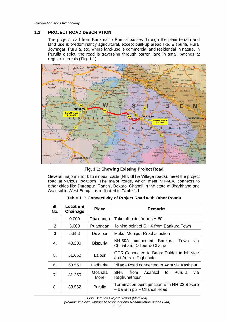
1.2 PROJECT ROAD DESCRIPTION The project road from Bankura to Purulia passes through the plain terrain and land use is predominantly agricultural, except built-up areas like, Bispuria, Hura, Joynagar, Purulia, etc, where land-use is commercial and residential in nature. In Purulia district, the road is traversing through barren land in small patches at regular intervals (Fig. 1.1).
Fig. 1.1: Showing Existing Project Road
Several major/minor bituminous roads (NH, SH & Village roads), meet the project road at various locations. The major roads, which meet NH-60A, connects to other cities like Durgapur, Ranchi, Bokaro, Chandil in the state of Jharkhand and Asansol in West Bengal as indicated in Table 1.1.
Table 1.1: Connectivity of Project Road with Other Roads
Sl. No.
Location/ Chainage Place Remarks
1 0.000 Dhaldanga Take off point from NH-60
2 5.000 Puabagan Joining point of SH-6 from Bankura Town
3 5.883 Dulalpur Mukut Monipur Road Junction
4. 40.200 Bispuria NH-60A connected Bankura Town via Chinabari, Dallpur & Chatna
5. 51.650 Lalpur ODR Connected to Bagra/Daldali in left side and Adra in Right side
6. 63.550 Ladhurka Village Road connected to Adra via Kashipur
7. 81.250 Goshala More
SH-5 from Asansol to Purulia via Raghunathpur
8. 83.562 Purulia Termination point junction with NH-32 Bokaro – Balram pur - Chandil Road

Consultancy Services for Preparation of Detailed Project Report for Rehabilitation and Upgrading to 2 lane / 2 lane with Paved Shoulders Configuration and Strengthening of
Bankura – Purulia Section (km 0 to 84) of NH-60A in the State of West Bengal (Package No. SP/B/6)
Final Detailed Project Report (Modified) (Volume V: Social Impact Assessment and Rehabilitation Action Plan)
1 - 3
A large number of brick and earthen roads also meet the project road. These access roads connect a group of villages (10-12) in the project area. The nature and type of traffic on these access roads is primarily light vehicles and slow moving.
The project road traverses through 72 revenue villages including 3 small & 1 major towns i.e. Bispuria, Hura, Jaynagar and Purulia. The major settlements along the project road are Puabagan, Hatagram, Harigram, Gholgoria, Bishpuria, Hura, Lalpur, Jaynagar, Lakhanpur, Ladhurka, Bhangra more, Gengara, Surulia & Purulia, (Table 1.2). In these settlements, there is a high degree of encroachment of the RoW. Upgrading work of the project road would require clearing of encroachments. The squatters and kiosks in these settlements are concentrated on either side of the road in built-up locations. The project road would also have an indirect positive impact on the people living in the surrounding villages. List of revenue villages, with corresponding blocks and districts, is provided in Annexure 1.1.
Table 1.2: Settlements along the Project Road
Sl. No. Chainage Length
(m) Town/village Name From To
1 4.800 5.200 400 Puabagan
2 11.100 12.500 1.400 Kumudiya
3 20.250 20.630 380 Golghara More
4 21.600 22.100 500 Bhagbanpur
5 27.500 28.700 1200 Harigram
6 32.200 32.500 300 Payarachali
7 36.100 37.600 1500 Rakhera
8 38.500 39.000 500 Siyanra
9 39.300 42.200 2900 Bispuria
10 47.300 50.600 3300 Hura
11 51.200 53.000 1800 Lalpur
12 54.900 55.700 800 Chakalta / Madhuban
13 58.600 59.400 800 Lakhanpur
14 60.900 61.300 400 Harliadih
15 61.800 62.200 400 Bhuiyandih
16 63.400 64.000 600 Ladhurka
17 67.800 69.400 1600 Joynagar
18 71.200 71.500 300 Bhangra more
19 74.100 74.500 400 Gangera
20 77.400 77.800 400 Surulia
21 78.600 83.562 4962 Purulia
Introduction and Methodology
Final Detailed Project Report (Modified) (Volume V: Social Impact Assessment and Rehabilitation Action Plan)
1 - 4
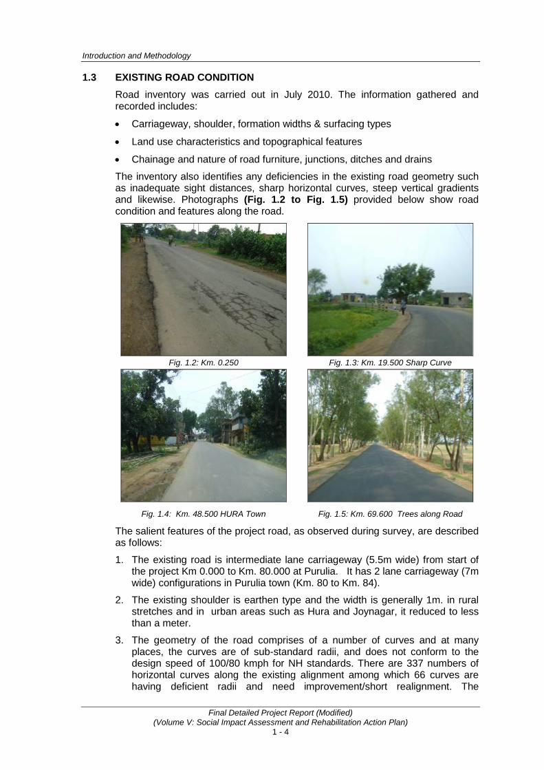
1.3 EXISTING ROAD CONDITION Road inventory was carried out in July 2010. The information gathered and recorded includes:
• Carriageway, shoulder, formation widths & surfacing types
• Land use characteristics and topographical features
• Chainage and nature of road furniture, junctions, ditches and drains
The inventory also identifies any deficiencies in the existing road geometry such as inadequate sight distances, sharp horizontal curves, steep vertical gradients and likewise. Photographs (Fig. 1.2 to Fig. 1.5) provided below show road condition and features along the road.
Fig. 1.2: Km. 0.250 Fig. 1.3: Km. 19.500 Sharp Curve
Fig. 1.4: Km. 48.500 HURA Town Fig. 1.5: Km. 69.600 Trees along Road
The salient features of the project road, as observed during survey, are described as follows:
1. The existing road is intermediate lane carriageway (5.5m wide) from start of the project Km 0.000 to Km. 80.000 at Purulia. It has 2 lane carriageway (7m wide) configurations in Purulia town (Km. 80 to Km. 84).
2. The existing shoulder is earthen type and the width is generally 1m. in rural stretches and in urban areas such as Hura and Joynagar, it reduced to less than a meter.
3. The geometry of the road comprises of a number of curves and at many places, the curves are of sub-standard radii, and does not conform to the design speed of 100/80 kmph for NH standards. There are 337 numbers of horizontal curves along the existing alignment among which 66 curves are having deficient radii and need improvement/short realignment. The

Consultancy Services for Preparation of Detailed Project Report for Rehabilitation and Upgrading to 2 lane / 2 lane with Paved Shoulders Configuration and Strengthening of
Bankura – Purulia Section (km 0 to 84) of NH-60A in the State of West Bengal (Package No. SP/B/6)
Final Detailed Project Report (Modified) (Volume V: Social Impact Assessment and Rehabilitation Action Plan)
1 - 5
prominent deficient curves are at chainages 5+879, 19+515, 79+255 and 82+622 which have radii of than 30m and needs improvement. There is a reverse curve at Chainage 28+690 which has to be realigned.
4. There are a total of 168 minor intersections and 5 major intersections on the project road.
1.4 OBJECTIVES AND STUDY METHODOLOGY 1.4.1 Objectives
The main objectives of the study is to assess the adverse impact on property and population and also to prepare a time bound resettlement action plan (RAP) to compensate and assist the project affected persons (PAPs) in getting their applicable entitlements to enable them in improving or at least restoring their living standards and income earning capacity.
Specific objectives of the Resettlement Action Plan are:
• Collect information using suitable tools regarding project impacts;
• Differentiate the properties and assets likely to be affected by type of ownership and construction, etc.
• Assess the extent loss of properties and loss of livelihood and community assets etc.;
• Conduct meaningful consultations with likely PAPs, community and other stakeholders;
• Establish a baseline profile of population, social structures, employment, sources of income, assess to social services and facilities etc. against which impacts of RAP implementation on the PAPs can be measured.
1.4.2 Methodology The document in hand has been prepared on the basis of information collected from both primary and secondary sources. Structured questionnaires and formats (Annexure 1.2) were prepared and used to collect information relevant to the study as a primary source of information, while information were also collected through secondary sources consulting various documents/literature and consultation with various stakeholders in the course of social impact assessment and resettlement planning.
Following finalization of alignment, cross-sections designs and land acquisition requirements, a detailed census of all assets and households being affected by the project was conducted with an aim to measure potential adverse impacts, establish monetary allowances and determine various categories of entitlement. This census was confined to the proposed RoW i.e. final alignment area irrespective of legal property holders including encroachers and squatters.
The Census survey was carried out of 100.00 % of affected persons and was intended to:
• Identification of PAPs
• Identification of Social Impacts
• Identification of Land Requirement
• Identification of encroachers/ squatters
• Preparation of time bound Resettlement Action Plan
Introduction and Methodology
Final Detailed Project Report (Modified) (Volume V: Social Impact Assessment and Rehabilitation Action Plan)
1 - 6
Besides, a socio economic survey was also conducted on 25% of the project affected households to create database and develop indicators for the evaluation of the RAP. Considering the importance of people’s participation in the project planning, public consultation and FGDs were also carried out at different levels at various stages of project preparation. The consultation focuses on identification of issues raised by the PAPs and its integration in the Resettlement Action Plan
To carry out census survey and consultation, a social survey team has been constituted comprising Social Expert and enumerators experienced in social work and NGOs background. The survey work was completed up to March 2013; hence, 31st March 2013 is the cut-off date for the eligibility of R&R benefit.
1.5 STRUCTURE OF THE REPORT The social impact assessment and preparation of RAP report has been prepared as per the National laws, guideline and World Bank operation polices (OPs) relating to social safeguards. It consists of 15 chapters as under:
Chapters Descriptions
Chapter 1 Introduction and Methodology
Chapter 2 Socio-Economic Profile of Project Influence Area
Chapter 3 Minimizing Negative Social Impact
Chapter 4 Proposed Improvement Plan
Chapter 5 Socio-Economic Profiling & Social Impact Assessment of PAHs
Chapter 6 Public Information and Consultations
Chapter 7 R & R Principles, Policy Framework & Entitlement Matrix
Chapter 8 Institutional Arrangements for RAP Implementation
Chapter 9 Disclosure And Consultation Plan
Chapter 10 Grievances Redressal Mechanism (GRM)
Chapter 11 Monitoring and Evaluation (M&E)
Chapter 12 Implementation Arrangements and Schedule
Chapter 13 Income Restoration
Chapter 14 Gender Strategy and Women Participation
Chapter 15 R&R Budget
• • •
Annexure 1.1
A - 1
LIST OF VILLAGES AFFECTED IN NH-60A
SL. No. DISTRICT
BLOCK DEVELOPMEN
T OFFICE GRAM
PANCHAYAT VILLAGE CHAINAGE
FROM TO
1 BANKURA
BANKURA-I
JAGDALLA-I DHALDANGA 0.000 1.400
JAGDALLA-II KRISHNA NAGAR 4.900 5.000 DULALPUR 5.600 6.210 JETHIA 6.210 7.430
ANDHARTHOL
KANKRADIHI 7.430 8.400 GOLAMITARA 8.400 9.200 TARIBATERDIHI 9.200 10.170 SIARBADA 10.520 10.800 KUMIDYA 10.800 12.000 AMLATARA 12.000 13.300
KALPATHAR
DINARGAN 12.800 13.300 GANGATARA 13.300 13.500 KALPATHAR 14.000 14.600 PATAHARKATA 14.600 15.300 NEKRAGARIA 15.300 16.000 KASHIBEDYA 16.000 17.000 PORYASOL 17.200 18.500
CHHATNA
TEGHORI
TEGHORI 18.500 19.400 JAGANNATHPUR 19.400 19.500 GHOLGORE 18.500 21.000 KENDSAER 21.000 22.400 NISCHINTAPUR 21.900 22.400 LARI 22.800 23.800 BHIMPUR 23.780 24.800 GOBINDAPUR 24.800 26.500
METYALA
GARA 26.500 27.200 JAMBEDE 27.200 28.500 PAINSABAD 28.200 28.500 NABAGRAM 28.500 29.500 NAWADA 29.500 29.800
INDPUR HATGRAM
HATGRAM 29.300 31.300 BELDANGA 31.000 31.300 AMBEDYA 31.000 32.600 UTTAR-PAIRACHALI 32.600 33.100
NUTANDIHI 33.100 33.500 NIYASA 32.600 33.600

Annexure 1.1
A - 2
SL. No. DISTRICT
BLOCK DEVELOPMEN
T OFFICE GRAM
PANCHAYAT VILLAGE CHAINAGE
FROM TO
2 PURULIA
HURA
RAKHERA-BISPURIA
PARSIYA 33.480 36.780 RAKHYARA 36.780 38.590 DIMBAD 37.750 38.280 SINARA 38.280 38.700 MAJHLDANGA 38.590 38.750 BISPURIYA 38.750 41.000 KUNARDI 41.000 42.650
HURA
SAMUKGORIYA 42.650 44.200 PAKHURIYA 42.200 47.370 HURA 47.380 49.590 MATIPUR 48.340 49.250 MAGURIA LAIPUR 49.590 51.490
MAGURIA LALPUR
BHAGAHBAND 51.490 53.120 CHAKALTA 53.120 54.800 KAPASGORA 54.200 54.800
LAKHANPUR
MADHUBAN 54.800 56.300 KULGARA 56.200 56.600 LAIKDI 56.600 58.200 LAKHANPURA 57.800 59.570
JABARRAH GURDA 59.570 61.400
LADHURKA LADHURKA 61.400 64.500 SAHANADI 64.500 64.650 JAMBAD 64.650 66.470
PURULIA-II
HUTMURA
KUNDHURKA ALIAS BHAWANIPUR
66.470 67.650
HUTMURA 66.950 69.300 SIDPUR 69.200 71.100
BHANGRA BHANGRA 71.100 71.850 KARCHA 71.440 71.900 SINGHBAZAR 71.850 73.120
RABHABPUR
GENGRA 73.120 75.560 LATULYA 73.750 74.150 BIRGIRI 75.600 76.900 SURULIA 76.900 78.300 RAGHABPUR 82.100 83.240
PURULIA-I PURULIA MUNICIPALITY
PURULIA 78.300 82.200 BHATBAND 83.300 83.430
Annexure 1.2
A - 3
METHODOLOGY FOR PREPARATION OF SIA AND RAP
PROJECT BACKGROUND Ministry of Road Transport & Highways (MoRT&H), Government of India has decided to take up the work of upgrading all the single lane / intermediate lane National Highways to at-least two lane standards or Two Lane with provision of Paved Shoulders depending upon requirement on up-gradation corridor concept in order to have a better facility in a long continuous stretch. The Project is likely to be financed by World Bank. The project envisages the following advantages of having a well-developed network of highways:
• Savings in vehicle operating costs
• Faster, comfortable journeys
• Reduced fuel consumption
• Safer travel
• Benefits to trade especially in movement of perishable goods
• Reduced maintenance costs
• Safe travel
• All round development of areas
A total 33 No. of different National Highway Stretches with approx. total length 3770 Km. have been selected by MoRTH for up-gradation which has been divided under four main groups. The under consideration project package pertains to the preparation of Detailed Project Report for Rehabilitation and Upgrading to 2 lane/2 lane with paved shoulders configuration and strengthening of Bankura - Purulia Section (Km. 0 to Km. 84.000) of NH-60A in the State of West Bengal which falls under “Group B” and the package no. is SP/B/6.
The present project National Highway No. 60A (0.00 Km. to 84.000 Km.) aims to:
• Improve and strengthen the existing quality of the pavement to take heavy loads so that pavement failure, maintenance etc. are minimized.
• Improve the horizontal and vertical alignment of the existing road.
• Improve the condition of existing traffic flow by removing all bottlenecks at various locations.
• Increase the carrying capacity of the existing traffic volume and enable it to cater to the future traffic.
• Improve accessibility of the existing highway.
• Provide highway amenities like Lay-bye, bus stop/shelters etc.
• Improve the numerous intersections on entire stretch of the highway linkage of the NH-60A within the section (0.00 Km. to 84.000 Km.)
IMPORTANCE OF NATIONAL HIGHWAY-60A The National Highway-60A originates at Dhaldanga (Jagdalla Gram Panchayat, Bankura) Junction Point of NH-60 and terminates at Purulia where it meets NH-32. The region traversed by NH-60A is economically backward and is neglected in terms of effective and efficient mode of communication like Roadways. Hence the major thrust of vehicular traffic is on N.H– 60A for goods as well as for passenger transport. The area is also completely lagging behind in good Technical and General
Annexure 1.2
A - 4
Institutions, Hospitals, Industrial Set-up and efficient connectivity.
The Sectors that are likely to grow rapidly with up-gradation of NH-60A are Agro based Industries, Health and Education Sector. Keeping in view the settlement of dense population along the NH-60A generation of huge opportunity of employment can be assessed.
Objectives Objectives of assignment are derived from ToR, Operational Policies1 (safeguard instruments) of the World Bank and NRRP 2007. These objectives are
1. Avoid resettlement, if not, minimize involuntary resettlement, exploring all viable project alternatives;
2. Where involuntary resettlement is unavoidable, assess the magnitude of adverse social impacts and propose mitigation measures;
3. Hold consultations with the project stakeholders and ensure that the outcome of these consultations are assimilated in social impact assessment report;
4. Develop institutional mechanism for planning, implementing and monitoring the process and the R&R activities; and
5. Address other social issues (resulting from the proposed project interventions) related to vulnerable groups (including tribal),
Objective one to three will be part of social assessment process; objective four & five deals with preparation of RAP. Merits of preparation of Tribal development Plan (IPDP) will be ascertained after assessment of impacts on Scheduled Tribe. To fulfill above mentioned objectives following methodologies have been developed.
Methodology for Social Assessment Social impact assessment is critical step taken to incorporate social analyses and participatory processes into project design and implementation for optimizing development outcomes. Specific tasks for social assessment and methodologies adopted have been summarized in the following Table.
Specific Tasks Methodologies Conforming of zone of Impact through review of data
The zone of impact will be confirmed by (i) Review of land width data of PWD/Revenue dept., (ii) Estimate land acquisition village wise, (iii) Identification of critical segments, (iv) Review of efforts made by highway engineer towards
minimizing resettlement, (v) Review of technical measures adopted for proposed
alignments especially in bypasses and congested stretches. (vi) Number and Type of structures being acquired at particular
location (km/village), (vii) Categorization of stretches in terms of degree of impacts (a)
low, (b) moderate and (c) high
1 Applicable Operational Policies(safeguards instruments) are Involuntary Resettlement(O.P.4.10) and ndigenous Peoples(O.P. 4.12), environmental assessment(4.01)

Annexure 1.2
A - 5
Specific Tasks Methodologies Understanding socio-economic profile of the people
Based on identification of impacts (as mentioned above), a census and baseline socio-economic survey will be carried. While census survey will enumerate all the project affected families recording lands and assets possessed and likely to lose because of proposed road, and the baseline survey will emphasize detailed assessment of impact on vulnerable families2. For this purpose following steps will be taken. (i) Preparation of list of project Affected Families: As mentioned
earlier also, consultant has prepared land acquisition plan as per NH Act, 1956. The land plan includes affected survey number (zone of direct impact) and owner of the land and properties.
(ii) Training to enumerators: Enumerators will be selected from sociological research background from local area (Purulia and nearby villages). Enumerators will undergo one weeks of intensive training Social Expert of Consultants. Explanation of terms, meaning etc. in the questionnaires, methods of getting information from potential PAPs, mechanism of social behavior, and strategy of communication with respondents etc. will be part of training program. During training sessions, enumerators will be exposed to role play of PAPs, enumerators, public to make them conversant with the approach required for collection of information through questionnaires, understanding and appreciating local situations etc. The survey team will be mobilized in the field after testing of questionnaire in the project area.
(iii) Survey of Potential Affected Structures and land: In order to assess impact, structures coming within the proposed land width will be marked, measured and recorded on a strip map. This also included the typology of construction (such as pucca, semi-pucca, and katcha) based on construction materials used and the usage of structure like residential, commercial and others. Extent of loss will be determined by measuring the distance of the structure from the proposed centerline of proposed alignment in the following manner. (a) Measure the distance of each affected structure from the
existing CL (b) Measure the entire structure including length & breadth of
the structure. At the same time measure the area affected (i.e., portion of the structure coming within proposed RoW) to calculate the degree of loss.
(c) Examine the construction typology of each structure with respect to walls, roof and floor. Note down number of rooms, verandah (if any), sanitation facility, kitchen, etc.
(d) This will help in categorization of loss of plots or buildings: Less than 10% of the total area
Between 10 to 25% of the total area
2 Vulnerable families in the present context will include (but not limited to) small and marginal farmers, socially (SC,ST) and economically disadvantaged(BPL),widow and physically challenged.

Annexure 1.2
A - 6
Specific Tasks Methodologies Between 25 to 50% of the total area
More than 50% of the total area This will help in identifying project displaced families. (It is pertinent to inform that all project displaced families are project affected families but all project affected families need not be project displaced families.) Similarly for loss of land (impacts) will be categorized into:
a. Impact on affected plots will be done by measuring severity of impact (up to 250 sqm. or more than 250 sqm. and landless etc.)
b. Based on severity of impact the plots will be classified as economically viable or not.
c. In bypasses people will lose accessibility if residual land (after acquisition) is on the other side of proposed road. A study will be conducted about impact on plots. The plot impact analysis will help in formulating policy about minimum left out land area need to be acquired so that land owner will not have adverse impact.
(iv) Census and Baseline Socio-Economic Survey: To conduct the census survey an exhaustive interview schedule has been prepared and tested in the field. The format will be approved from the PCC. Census and baseline survey will be conducted for the establishment of impacts on the people. The information collected from census survey are Type of land or structure or both, usage of land and structure, household profile with family structure, literacy level, occupation and marital status of each member of the family. The survey will also provide information on income of the family; debt status and social information to determine whether project affected persons as per categorization of NRRP 2007. Loss of other assets such as boundary wall, public property, and common resources being lost will also be recorded. Enumerators will be directed to make an objective assessment of the loss of property and type of loss based on their field observation.
(v) Data Analysis: The interview schedules filled up every day will be scrutinized and verified on the spot (project corridor) and the data-sheets will coded. A coding manual will be prepared for consistency in data entry. The MS-Excel software package will be used for the data feeding and its analysis. Wherever applicable, Statistical Package for the Social Sciences (SPSS) will also be used to generate tables. As a measure of final confirmation about the correctness of the data, random manual calculations and checking will also be done
(vi) Outcome: Socio-economic profile of the PAFs, type of losses etc.
Annexure 1.2
A - 7
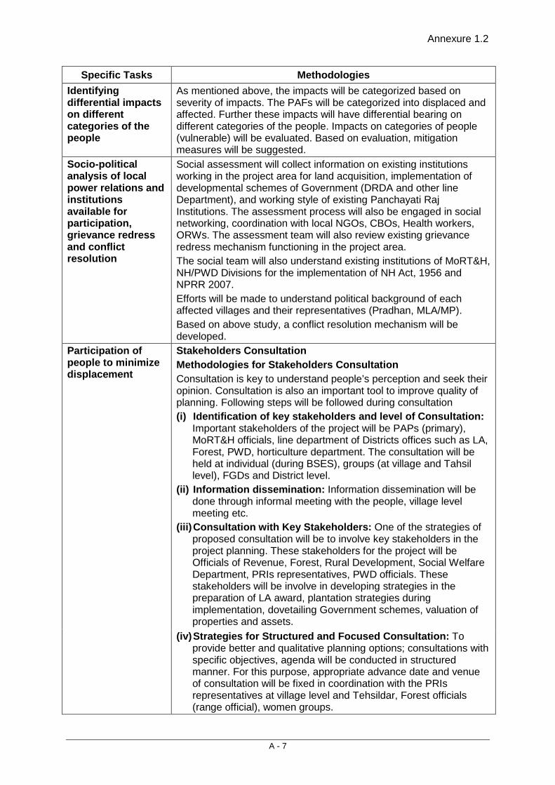
Specific Tasks Methodologies Identifying differential impacts on different categories of the people
As mentioned above, the impacts will be categorized based on severity of impacts. The PAFs will be categorized into displaced and affected. Further these impacts will have differential bearing on different categories of the people. Impacts on categories of people (vulnerable) will be evaluated. Based on evaluation, mitigation measures will be suggested.
Socio-political analysis of local power relations and institutions available for participation, grievance redress and conflict resolution
Social assessment will collect information on existing institutions working in the project area for land acquisition, implementation of developmental schemes of Government (DRDA and other line Department), and working style of existing Panchayati Raj Institutions. The assessment process will also be engaged in social networking, coordination with local NGOs, CBOs, Health workers, ORWs. The assessment team will also review existing grievance redress mechanism functioning in the project area. The social team will also understand existing institutions of MoRT&H, NH/PWD Divisions for the implementation of NH Act, 1956 and NPRR 2007. Efforts will be made to understand political background of each affected villages and their representatives (Pradhan, MLA/MP). Based on above study, a conflict resolution mechanism will be developed.
Participation of people to minimize displacement
Stakeholders Consultation Methodologies for Stakeholders Consultation Consultation is key to understand people’s perception and seek their opinion. Consultation is also an important tool to improve quality of planning. Following steps will be followed during consultation (i) Identification of key stakeholders and level of Consultation:
Important stakeholders of the project will be PAPs (primary), MoRT&H officials, line department of Districts offices such as LA, Forest, PWD, horticulture department. The consultation will be held at individual (during BSES), groups (at village and Tahsil level), FGDs and District level.
(ii) Information dissemination: Information dissemination will be done through informal meeting with the people, village level meeting etc.
(iii) Consultation with Key Stakeholders: One of the strategies of proposed consultation will be to involve key stakeholders in the project planning. These stakeholders for the project will be Officials of Revenue, Forest, Rural Development, Social Welfare Department, PRIs representatives, PWD officials. These stakeholders will be involve in developing strategies in the preparation of LA award, plantation strategies during implementation, dovetailing Government schemes, valuation of properties and assets.
(iv) Strategies for Structured and Focused Consultation: To provide better and qualitative planning options; consultations with specific objectives, agenda will be conducted in structured manner. For this purpose, appropriate advance date and venue of consultation will be fixed in coordination with the PRIs representatives at village level and Tehsildar, Forest officials (range official), women groups.

Annexure 1.2
A - 8
Specific Tasks Methodologies Such planned consultation will bring out issues of proposed
DFCCIL improvement in the agenda for discussion and some of the suggestion given by the community may help in project planning. This will also help in generating sense of ownership through community participation.
(v) Opening of Field Offices: Field offices will be opened at Purulia, which will act as information centre for the project. Besides that. All LA offices, MoRT&H offices, project engineers office will also be centre of information. Exchange of information about the project will be ensured at these field offices.
(vi) Strategies for Future course of Communication: Several additional rounds of consultations with PAPs will be done through active participation of social survey team. These consultations will involve agreements on compensation and assistance options and entitlement package. The next round of consultation will be held when compensation and R&R assistance have been finalized. The R&R entitlements will be displayed on billboards along the project corridor in local language. Participation of PAPs in implementation will also be ensured through their involvements in various local meeting with line department. Further, strategies will be developed to involve local people in implementation.
Assessment of construction Phase impacts
Though this is very special case to understand social issues of proposed project during construction phase. However efforts will be made to categorize these impacts. These impacts will be categorized as (a) community conflict to access their cultural properties (b) Loss of access roads to the agricultural field (c) Dust and other pollutant (d) Cutting of trees and afforestation strategies: Many of the
implementation issues get resolved by involving local community in the project. For example afforestation by community.
These effects of construction may largely be gathered from consultation in the villages, with Project official involved in construction earlier.
Suggesting broad strategies for mitigation of adverse impacts
Based on findings of surveys and consultation, social impacts of the project will be established. Based on operational policies of the World Bank, NH Act, 1956 and NRRP 2007, the social assessment will suggest mitigation measures These mitigation measures will also focus on institutions likely to involve in implementation of managing social issues.
Resettlement Action Plan Based on above mentioned social impact analysis, consultation, Resettlement Policy Framework, a Resettlement Action Plan will be prepared. This Resettlement Action Plan will be prepared by adopting a social assessment process at different stages. Output of Social impact Assessment Report and agreement reached after feedback of disclosure on RPF will be input for the preparation of Resettlement Action Plan. This will be the document which will be followed during implementation.
Consultancy Services for Preparation of Detailed Project Report for Rehabilitation and Upgrading to 2 lane / 2 lane with Paved Shoulders Configuration and Strengthening of
Bankura – Purulia Section (km 0 to 84) of NH-60A in the State of West Bengal (Package No. SP/B/6)
Final Detailed Project Report (Modified) (Volume V: Social Impact Assessment and Rehabilitation Action Plan)
2 - 1
2. SOCIO-ECONOMIC PROFILE OF PROJECT INFLUENCE AREA
This section of the report briefly provides the socio-economic profile of the State (West Bengal), Project Influence Area (PIA) and Direct Impact Zone (DIZ). The project influence area has been considered as the administrative boundaries of the districts through which the project road traverses. Bankura and Purulia are two districts under project influence area and the Direct Impact Zone are the boundaries of villages and towns in which upgrading of project road is likely to affect land, structure and other properties. Village’s through which the project road traverses is marked on the census maps, Annexure 2.1. List of census villages, concerned CD Blocks, Districts and village data (population, SC, ST etc.) are provided as Annexure 2.2 respectively.
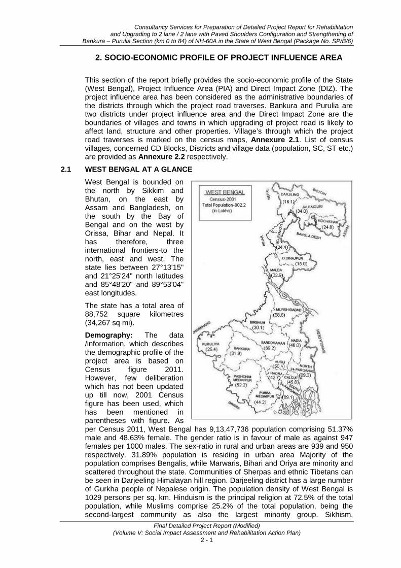
2.1 WEST BENGAL AT A GLANCE West Bengal is bounded on the north by Sikkim and Bhutan, on the east by Assam and Bangladesh, on the south by the Bay of Bengal and on the west by Orissa, Bihar and Nepal. It has therefore, three international frontiers-to the north, east and west. The state lies between 27°13'15" and 21°25'24" north latitudes and 85°48'20" and 89°53'04" east longitudes.
The state has a total area of 88,752 square kilometres (34,267 sq mi).
Demography: The data /information, which describes the demographic profile of the project area is based on Census figure 2011. However, few deliberation which has not been updated up till now, 2001 Census figure has been used, which has been mentioned in parentheses with figure. As per Census 2011, West Bengal has 9,13,47,736 population comprising 51.37% male and 48.63% female. The gender ratio is in favour of male as against 947 females per 1000 males. The sex-ratio in rural and urban areas are 939 and 950 respectively. 31.89% population is residing in urban area Majority of the population comprises Bengalis, while Marwaris, Bihari and Oriya are minority and scattered throughout the state. Communities of Sherpas and ethnic Tibetans can be seen in Darjeeling Himalayan hill region. Darjeeling district has a large number of Gurkha people of Nepalese origin. The population density of West Bengal is 1029 persons per sq. km. Hinduism is the principal religion at 72.5% of the total population, while Muslims comprise 25.2% of the total population, being the second-largest community as also the largest minority group. Sikhism,
Socio-economic Profile of Project Influence Area
Final Detailed Project Report (Modified) (Volume V: Social Impact Assessment and Rehabilitation Action Plan)
2 - 2
Christianity and other religions make-up the remainder. The state contributes 7.8% (2001) of India's population.
Literacy: The literacy rate in West Bengal is always higher than the all-India average, and it ranks sixth among the major states. The literacy rate of West Bengal is 77.1% higher than the national rate of 74.04%. In 2011, the male and female literacy rates in West Bengal were 82.67 percent and 59.61 percent respectively, a difference of 11.51 percent.
Health: West Bengal ranks third in India with respect to infant mortality rates. Even in terms of reduction over time, such as between 1982-1992 and 1992-2002, West Bengal appears to have done much better than India as a whole, which clearly suggests a gradual improvement in health facilities over the years in the state. West Bengal has a better record of ensuring the lives of girl infants than India as a whole. Since within aggregate infant mortality, nearly 42 per cent of the deaths occur within the first week, the control of early neonatal mortality would lead to a much improved IMR.
Infrastructure (Roads): The state of West Bengal is served by 92,023 km of roads within which, the National Highways cover a span of 2578 kms and State Highways 2,393 Km. The road density is 1.04 km per sq km, which is considerably higher than the national average of 0.75 km. Keeping in mind the need for speed and quality in connectivity and a vehicle population that is growing at over 11% per annum, the GoWB has taken up an ambitious infrastructure renewal and expansion program
• Some of the key initiatives in the roads sector are:
• The North South Economic Order developed with the support of ADB at a cost of US$ 210 million with a view to link the southern ports of Haldia and Kolkata with the northern hinterland of the State.
• The North -South Corridor
• Dankuni - Kolaghat, Dankuni – Kharagpur National Highway project. Vivekananda Bridge, which is an approach to NH-2, has been completed.
• Four laning of NH41 from Kolkaghat to Haldia, NH31 passing through North Bengal, NH-117 from Kona to Netaji Subhas Docks, NH35 from Barasat to Petrapole and NH31 from Kolkata to Dalkhola.
• The State Government has also taken up Eastern link Highway project (100km) connecting Barasat to Raichak.
• 31 km long State Highway linking NH31 from Siliguri to Jalpaiguri via Falakata to be upgraded to National Highway
• Some major stretches of the Golden Quadrilateral project undertaken by the National Highway Authority of India (NHAI) will pass through major North Bengal Districts.
• Entire stretch of roads connecting Bengal with the North Eastern States and Bihar has been strengthened and improved.
• Entire stretch of NH2 connecting Kolkata to New Delhi is being widened to 4 lanes. The Durgapur and Kona Expressways are fully operational and provide easier access to Kolkata from NH2
• Under the Jawaharlal Nehru National Urban Renewal Mission, the State Government has taken the initiative to come up with a Rs. 27 billion action plan which includes extension and widening of arterial roads, widening and

Consultancy Services for Preparation of Detailed Project Report for Rehabilitation and Upgrading to 2 lane / 2 lane with Paved Shoulders Configuration and Strengthening of
Bankura – Purulia Section (km 0 to 84) of NH-60A in the State of West Bengal (Package No. SP/B/6)
Final Detailed Project Report (Modified) (Volume V: Social Impact Assessment and Rehabilitation Action Plan)
2 - 3
strengthening of secondary roads, construction of pedestrian underpasses, bridges, flyovers, elevated roads, traffic and transportation systems including modern passenger dispersal systems. Several foreign companies are already in the fray to partner the GoWB in its efforts for improvement of roads. Indonesia based Salim Group would be constructing the Eastern Link Highway from Barasat to Raichak, and two Four Lane Road Bridges across the Hooghly and Haldi rivers facilitating connectivity between Kolkata and the port city of Haldia.
Economy: In 2009–10, the tertiary sector of the economy (service industries) was the largest contributor to the gross domestic product of the state, contributing 57.8% of the state domestic product compared to 24% from primary sector (agriculture, forestry, mining) and 18.2% from secondary sector (industrial and manufacturing).
The main occupation of West Bengal is predominantly agriculture. Rice, potato, jute, sugarcane and wheat are the top five crops of the state in which rice is the state's principal food crop. Tea is produced commercially in northern districts in the region, wherein Darjeeling produces higher quality of tea. State industries are localized in the Kolkata region, the mineral-rich western highlands, and Haldia port region. The Durgapur–Asansol colliery belt is a home of a number of major steel plants. Manufacturing industries, which are playing an important role in economic growth of the state, are engineering products, electronics, electrical equipment, cables, steel, leather, textiles, jewellery, frigates, automobiles, railway coaches, and wagons. The Durgapur has established a number of industries for tea, sugar, chemicals and fertilisers manufacturing and processing. Natural resources like tea and jute in and nearby parts has made West Bengal a major centre for the jute and tea industries.
A large parts of six northern districts of Cooch Behar, Darjeeling, Jalpaiguri, Malda, North Dinajpur and South Dinajpur; three western districts of Purulia, Bankura, Birbhum; and the Sundarbans are considered economically backward.. Years after independence, West Bengal was still dependent on the central government for meeting its demands for food; however, there has been a significant spurt in food production since the 1980s, and the state now has a surplus of grains.
In terms net state domestic product (NSDP), West Bengal has the sixth largest economy (2009–2010) in India, with an NSDP of 366,318 crores. In the period 2004–2005 to 2009–2010, the average gross state domestic product (GSDP) growth rate was 13.9% (calculated in Indian rupee term), lower than 15.5%, the average for all states of the country. The state’s per capita GSDP at current prices in 2009–10 was US$ 956.4, improved from US$ 553.7 in 2004–05, but lower than the national per capita GSDP of US$ 1,302. The state's total financial debt stood at 191,835 crore (US$34.91 billion) as of 2011.
Below Poverty Line: The poverty line of India is defined by income or rupees earned by a person per month. The poverty lines of West Bengal in rural and urban areas are Rs.350.17 and Rs. 409.22 respectively. In West Bengal the population living below poverty line is 27.02 percent (2000) of the total population, which is slightly higher than the all India percentage of 26.10 percent. In comparison to 35.66 percent in the year 1993 – 94 the poverty level in the state has reduced considerably. According to the 2001, Human Development Report statistics, 31.85 percent of the rural and 14.86 percent of the urban population lives below poverty line level. The poverty in this state is especially concentrated in the rural area with around 84% of the absolutely poor population living in rural areas compared to 74% in India as a whole.

Socio-economic Profile of Project Influence Area
Final Detailed Project Report (Modified) (Volume V: Social Impact Assessment and Rehabilitation Action Plan)
2 - 4
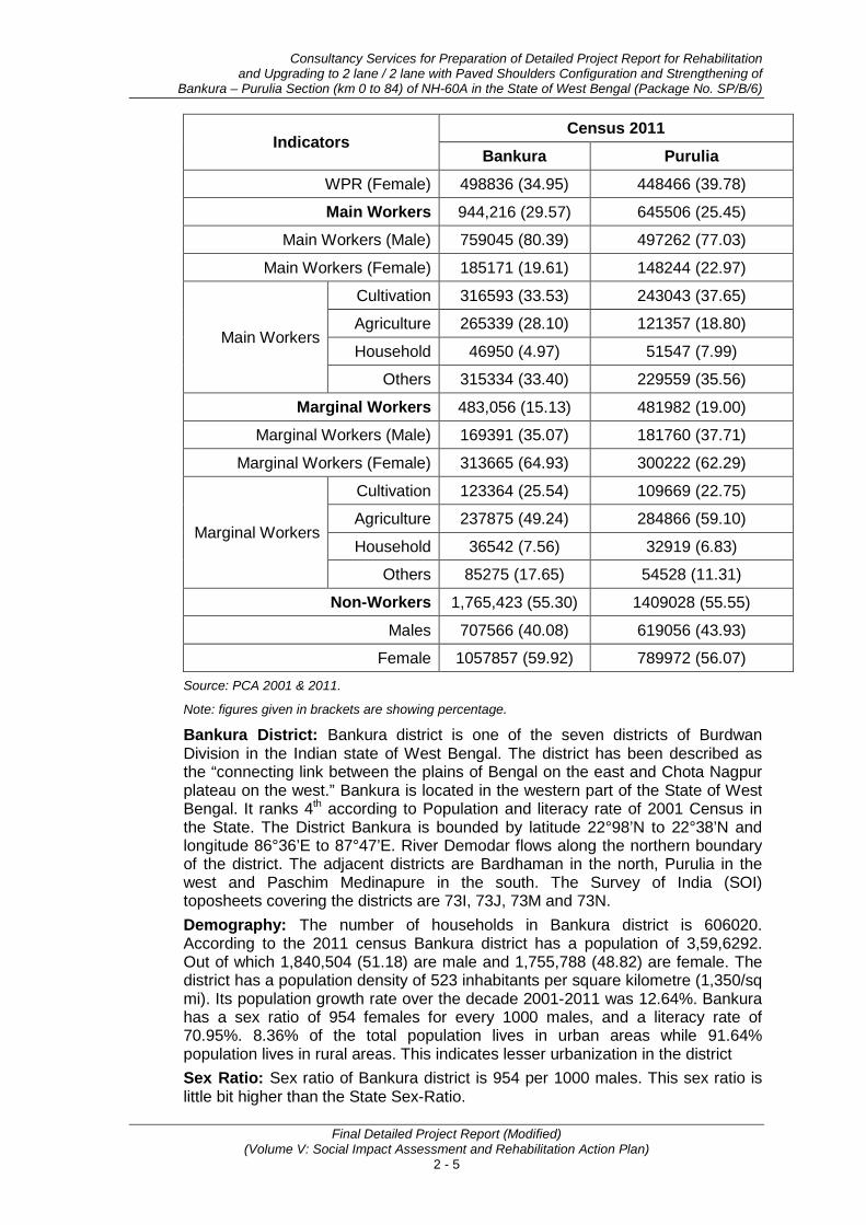
2.2 PROJECT INFLUENCE AREA (PIA) The Project influence districts are Bankura and Purulia. Districts at a glance are presented in the Table 2.1.
Table 2.1: Districts at a Glance
Indicators Census 2011
Bankura Purulia
Latitude 22°98’ & 22°38’ 22°42’-35” and 23°42’-0”
Longitude 86°36’ & 87°47’ 85°49’-25” and 86°54’-37”
Area (Sq. Km) 6882 6259
Blocks (No.) 22 20
Census Village (No.) 3,577 2,468
Households (No.) (Census 2001) 606020 449895
Population (No.) 3596292 2,927,965
Male 1840504 (51.18) 1,497,656 (51.15)
Female 1755788 (48.82) 1,430,309 (48.85)
Urban Population 300679 (8.36) 373,381 (12.75)
Rural Population 3295613 (91.64) 2,554,584 (87.25)
SC (Census 2001) 997,408 (31.24) 463956 (19.35)
ST (Census 2001) 330,783 (10.36) 463452 (19.22)
Population Growth Rate 12.64% 15.43%
Population Density (per Sq. km) 523 468
Sex Ratio (Female/ 1000 males) 954 955
Child Sex Ratio (F/1000 males) 943 947
Literacy (6+)
Overall (Combined) 2264013 (70.95) 1656940 (65.38)
Males 1321794 (81.00) 1021455 (78.85)
Female 942219 (60.44) 635485 (51.29)
Overall (Rural) 2028958 (69.6) 1404686 (63.75)
Males (Rural) 1193636 (80.06) 876728 (77.96)
Females (Rural) 835322 (58.66) 527958 (48.93)
Overall (Urban) 235055 (80.23) 252254 (76.24)
Males (Urban) 128158 (90.97) 144727 (84.68)
Females (Urban) 106897 (79.24) 107527 (67.21)
Census 2001
Work Participation Rate (WPR) 1427272 (44.70) 1127488 (44.45)
WPR (Male) 928436 (65.05) 679022 (60.22)
Consultancy Services for Preparation of Detailed Project Report for Rehabilitation and Upgrading to 2 lane / 2 lane with Paved Shoulders Configuration and Strengthening of
Bankura – Purulia Section (km 0 to 84) of NH-60A in the State of West Bengal (Package No. SP/B/6)
Final Detailed Project Report (Modified) (Volume V: Social Impact Assessment and Rehabilitation Action Plan)
2 - 5
Indicators Census 2011
Bankura Purulia
WPR (Female) 498836 (34.95) 448466 (39.78)
Main Workers 944,216 (29.57) 645506 (25.45)
Main Workers (Male) 759045 (80.39) 497262 (77.03)
Main Workers (Female) 185171 (19.61) 148244 (22.97)
Main Workers
Cultivation 316593 (33.53) 243043 (37.65)
Agriculture 265339 (28.10) 121357 (18.80)
Household 46950 (4.97) 51547 (7.99)
Others 315334 (33.40) 229559 (35.56)
Marginal Workers 483,056 (15.13) 481982 (19.00)
Marginal Workers (Male) 169391 (35.07) 181760 (37.71)
Marginal Workers (Female) 313665 (64.93) 300222 (62.29)
Marginal Workers
Cultivation 123364 (25.54) 109669 (22.75)
Agriculture 237875 (49.24) 284866 (59.10)
Household 36542 (7.56) 32919 (6.83)
Others 85275 (17.65) 54528 (11.31)
Non-Workers 1,765,423 (55.30) 1409028 (55.55)
Males 707566 (40.08) 619056 (43.93)
Female 1057857 (59.92) 789972 (56.07) Source: PCA 2001 & 2011.
Note: figures given in brackets are showing percentage.
Bankura District: Bankura district is one of the seven districts of Burdwan Division in the Indian state of West Bengal. The district has been described as the “connecting link between the plains of Bengal on the east and Chota Nagpur plateau on the west.” Bankura is located in the western part of the State of West Bengal. It ranks 4th according to Population and literacy rate of 2001 Census in the State. The District Bankura is bounded by latitude 22°98’N to 22°38’N and longitude 86°36’E to 87°47’E. River Demodar flows along the northern boundary of the district. The adjacent districts are Bardhaman in the north, Purulia in the west and Paschim Medinapure in the south. The Survey of India (SOI) toposheets covering the districts are 73I, 73J, 73M and 73N. Demography: The number of households in Bankura district is 606020. According to the 2011 census Bankura district has a population of 3,59,6292. Out of which 1,840,504 (51.18) are male and 1,755,788 (48.82) are female. The district has a population density of 523 inhabitants per square kilometre (1,350/sq mi). Its population growth rate over the decade 2001-2011 was 12.64%. Bankura has a sex ratio of 954 females for every 1000 males, and a literacy rate of 70.95%. 8.36% of the total population lives in urban areas while 91.64% population lives in rural areas. This indicates lesser urbanization in the district Sex Ratio: Sex ratio of Bankura district is 954 per 1000 males. This sex ratio is little bit higher than the State Sex-Ratio.
Socio-economic Profile of Project Influence Area
Final Detailed Project Report (Modified) (Volume V: Social Impact Assessment and Rehabilitation Action Plan)
2 - 6
Literacy: As of 2011 India census, average literacy rate of Bankura district is 70.95%. Male constitutes 81.00% of the literate population and female 60.44%. District rural literacy rate is 69.6% and while in urban population literacy rate is 80.23%. Similarly, the rural male literacy is 80.06% compared to urban male literacy rate of 90.97%. Working Population (2001): The total working population of the district is 44.70% of the total population. Women workers constitute 34.95% of the total workers of the district. Among main workers, women workers comprise only 19.61% indicating dominance of men workers among the main workers. Cultivation and agriculture together constitute 61.63% of the main workers clearly indicating that a large percentage of population still continues to depend for their livelihood on cultivation and agriculture related activities. Household workers constitute merely 4.97% indicating absence of household economic activities. Marginal workers constitute about 15.13% of the workers indicating lack of employment opportunities round of year. However, among marginal workers percentage share of men are less than the women workers. Among marginal workers also 74.78% are occupied in cultivation and agriculture. Economy: Agriculture is the mainstay of the district. Paddy is the principal crop, followed by wheat, oilseed, potato and vegetables are the main agricultural crops. The economic infrastructure of Bankura is basically agriculture dependent. Being one of the draught prone districts of West Bengal, Bankura supports 4.58% of the state's population on nearly 7.8% of the land. Agriculture accounts for almost 70% of the district's income whereas 80% of the farmers are small & marginal. However, due to protective irrigation system, land reforms and use of high fertile & hybrid crops the district is now not so poor as it was. Also, cottage and small-scale industries, e.g. Stone-crushing, Weaving, Oilseed-crushing, handicraft units like Dokra, Terra-cotta, Baluchari Sari etc. play a key economic role of the district. Purulia District: Purulia, also known as "Manbhum City", is located in West Bengal state, India. Purulia is located on the north of the Kasai River. Purulia lies between 22°42’-35” and 23°42’-0” north latitudes and 85°49’-25” and 86°54’-37” east longitudes. The geographical area of the district is 6259 km². This district is bordered on the east by Bankura, Paschim Medinipur districts, on the north by Bardhaman district of West Bengal state and Dhanbad district of Jharkhand state, on the west by Bokaro and Ranchi districts of Jharkhand state and on the south by West Singhbhum and East Singhbhum districts of Jharkhand state. Demography: The number of households in Purulia district is 449895. As per 2011 census total population of the district is 2,927,965 out of which 87.25% are residing in rural areas and 19.35% are in urban areas. About 51.15 % of the populations are males and 48.85% are female. According to the 2001 census, the percentage of Scheduled Caste and Scheduled Tribes are 19.35% and 18.21% respectively. Total no of BPL families in rural areas of this district are 197381 (43.65%). Out of which SC families are 40645 (20.59%) and ST families are 47666 (24.15 %). Total no. of BPL families in Purulia and Jhalda Municipality are 2573 (11.31 %) and 571 (15.98 %) respectively.

Consultancy Services for Preparation of Detailed Project Report for Rehabilitation and Upgrading to 2 lane / 2 lane with Paved Shoulders Configuration and Strengthening of
Bankura – Purulia Section (km 0 to 84) of NH-60A in the State of West Bengal (Package No. SP/B/6)
Final Detailed Project Report (Modified) (Volume V: Social Impact Assessment and Rehabilitation Action Plan)
2 - 7
Sex Ratio: According to the census 2011, sex ratio of Purulia district is 955 per 1000 males. This sex ratio is higher than the State Sex-Ratio. Moreover, 87.25 percent population of the district lives in rural areas while 12.75 percent are living in urban areas. This indicates lesser urbanization in the district. The growth rate of the district has recorded 15.43%.
Literacy: As of 2011 India census, average literacy rate of Purulia district is 65.38%. If things are looked out at gender wise, male and female literacy are 78.85% and 51.29% respectively. Out of rural population of the district, rural literacy rate is 63.75% and out of urban population of the district, urban literacy rate is 76.24%. Similarly, the rural male literacy is 77.96% as compared to urban male literacy rate of 84.68%.
Working Population (2001): The total working population of the district is 44.45% of the total population. Women workers constitute 39.78% of the total workers of the district. Workers are divided into main workers and marginal workers. Among main workers, women workers comprise only 22.97% indicating dominance of men workers among the main workers. Workers are further classified into four broad categories viz., cultivation, agriculture, household and others. Cultivation and agriculture together constitute 56.45% of the main workers clearly indicating that a large percentage of population still continues to depend for their livelihood on cultivation and agriculture related activities. Household workers constitute merely 7.99% indicating absence of household economic activities. Marginal workers constitute about 19.0% of the workers indicating lack of employment opportunities round of year. However, among marginal workers percentage share of men are less than the women workers. Among marginal workers also 81.85% are occupied in cultivation and agriculture. Economy: The economy of Purulia district is solely dependent on the industy. In fact large scale industries are the base of the district economy. There are medium scale and small scale industries in the region. Some of the populations of the district are also engaged in cultivation and fishing activities. Cultivation of this district is predominantly mono-cropped. About 60% of the total cultivated land is upland. Out of the total agricultural holding about 73% belongs to small and marginal farmers having scattered and fragmented smallholding. Paddy is the primary crop of the district. 50% of the total land is under net-cropped area and only 17% of the net cropped area is under multi crop cultivation. 77% of the net-cropped area is under Aman paddy cultivation. The crops are grown mostly under rain fed condition; generally with low fertilizer consumption per unit area The percentage of main working class has been reduced from 35.35% in 1991 to 25.45% in 2001 census whereas marginal working class has been increased from 7.8% in 1991 to 19.00% in 2001 census. Cultivators have been shifted to other working classes.
2.3 SOCIO-ECONOMIC PROFILE OF DIRECT IMPACT ZONE (DIZ) As mentioned in chapter 1, the project road passes through the boundaries of 72 villages in project influence area (38 in Bankura and 34 in Purulia). The table below describes the socio-economic profile of the villages/ settlements through which project road traverses based on 2011 and 2001 census data. Summary of relevant data of these villages is presented in Table 2.2.
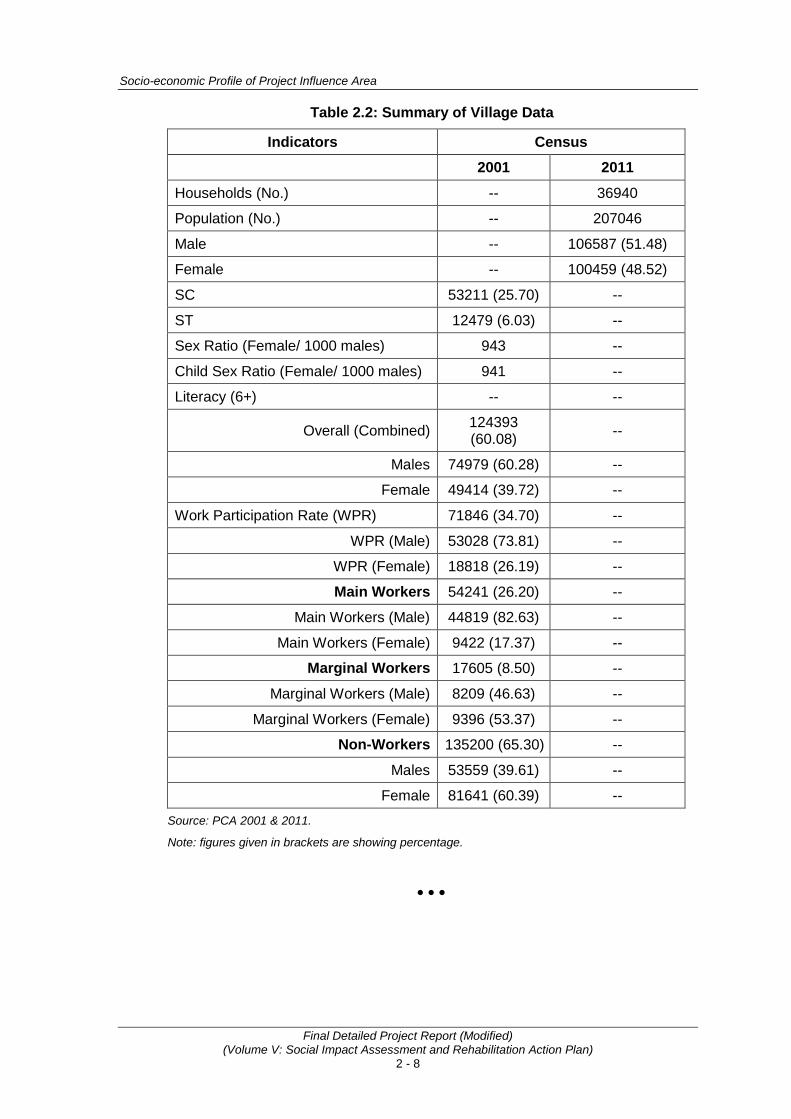
Socio-economic Profile of Project Influence Area
Final Detailed Project Report (Modified) (Volume V: Social Impact Assessment and Rehabilitation Action Plan)
2 - 8
Table 2.2: Summary of Village Data
Indicators Census 2001 2011
Households (No.) -- 36940
Population (No.) -- 207046
Male -- 106587 (51.48)
Female -- 100459 (48.52)
SC 53211 (25.70) --
ST 12479 (6.03) --
Sex Ratio (Female/ 1000 males) 943 --
Child Sex Ratio (Female/ 1000 males) 941 --
Literacy (6+) -- --
Overall (Combined) 124393 (60.08) --
Males 74979 (60.28) --
Female 49414 (39.72) --
Work Participation Rate (WPR) 71846 (34.70) --
WPR (Male) 53028 (73.81) --
WPR (Female) 18818 (26.19) --
Main Workers 54241 (26.20) --
Main Workers (Male) 44819 (82.63) --
Main Workers (Female) 9422 (17.37) --
Marginal Workers 17605 (8.50) --
Marginal Workers (Male) 8209 (46.63) --
Marginal Workers (Female) 9396 (53.37) --
Non-Workers 135200 (65.30) --
Males 53559 (39.61) --
Female 81641 (60.39) -- Source: PCA 2001 & 2011.
Note: figures given in brackets are showing percentage.
• • •

Annexure 2.1
A - 9
Project Influence Area (1 Km either side from project road)
Start from Km. 0.00 to Km. 10.000
From Km. 10.000 to Km. 19.000
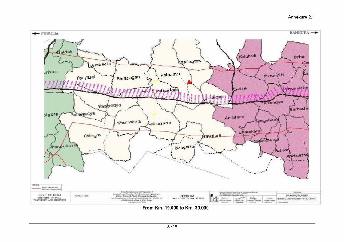
Annexure 2.1
A - 10
From Km. 19.000 to Km. 30.000
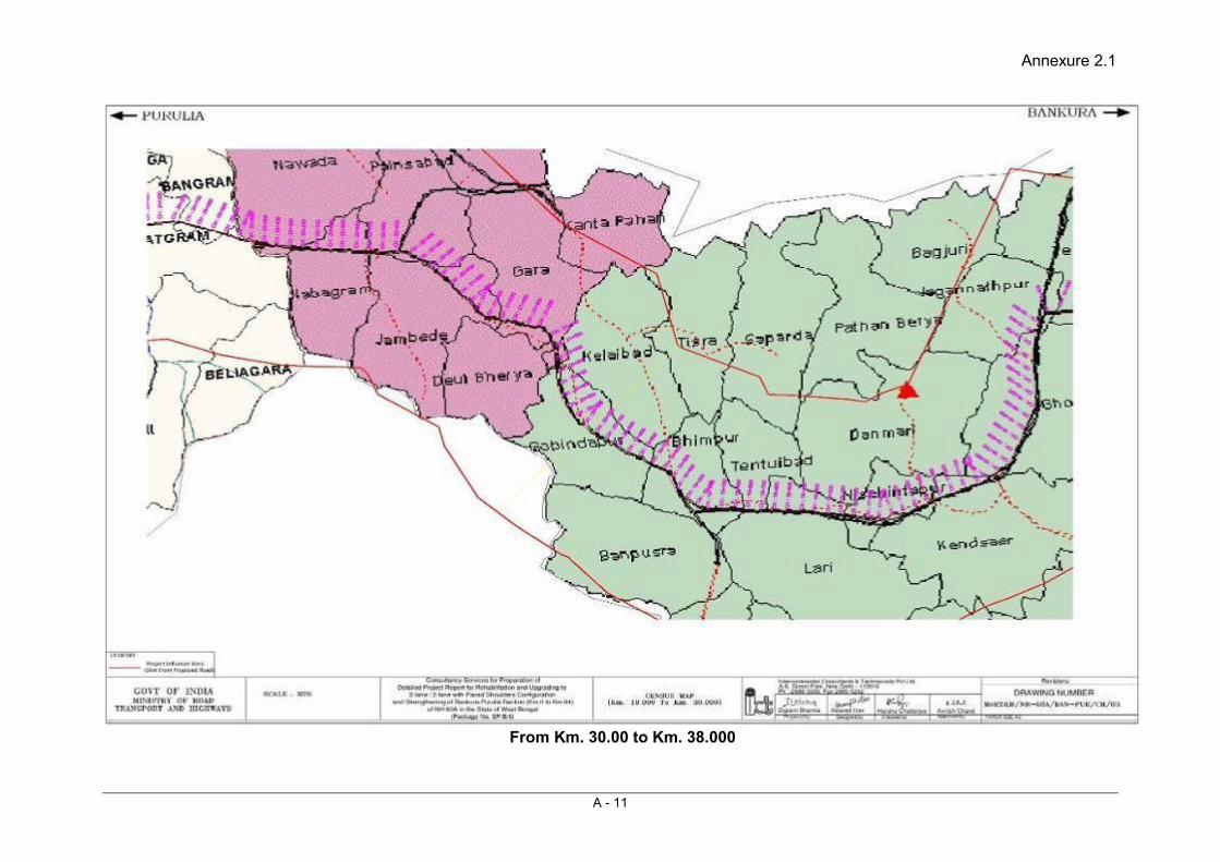
Annexure 2.1
A - 11
From Km. 30.00 to Km. 38.000

Annexure 2.1
A - 12
From Km. 380.00 to Km. 45.000

Annexure 2.1
A - 13
From Km. 45.000 to Km. 51.000
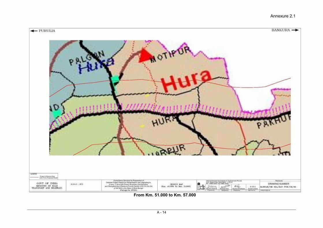
Annexure 2.1
A - 14
From Km. 51.000 to Km. 57.000
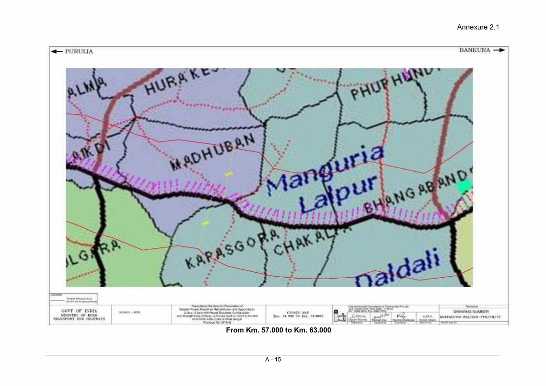
Annexure 2.1
A - 15
From Km. 57.000 to Km. 63.000

Annexure 2.1
A - 16
From Km. 63.000 to Km. 69.000
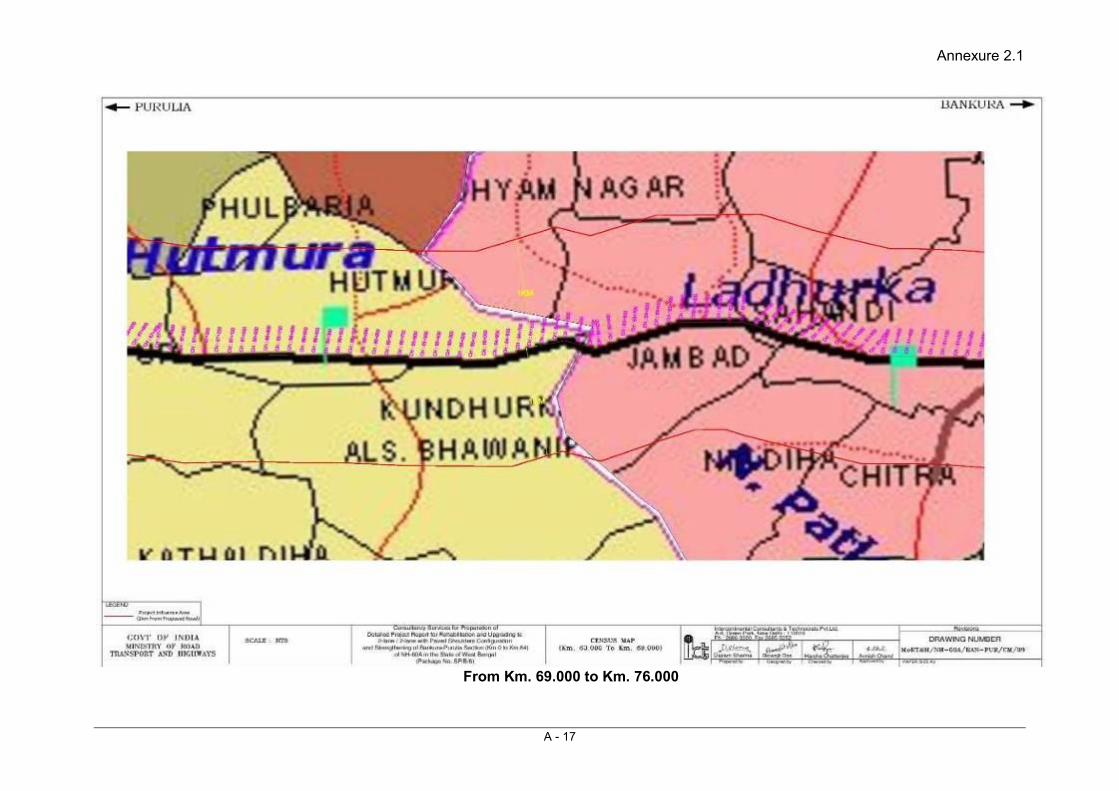
Annexure 2.1
A - 17
From Km. 69.000 to Km. 76.000
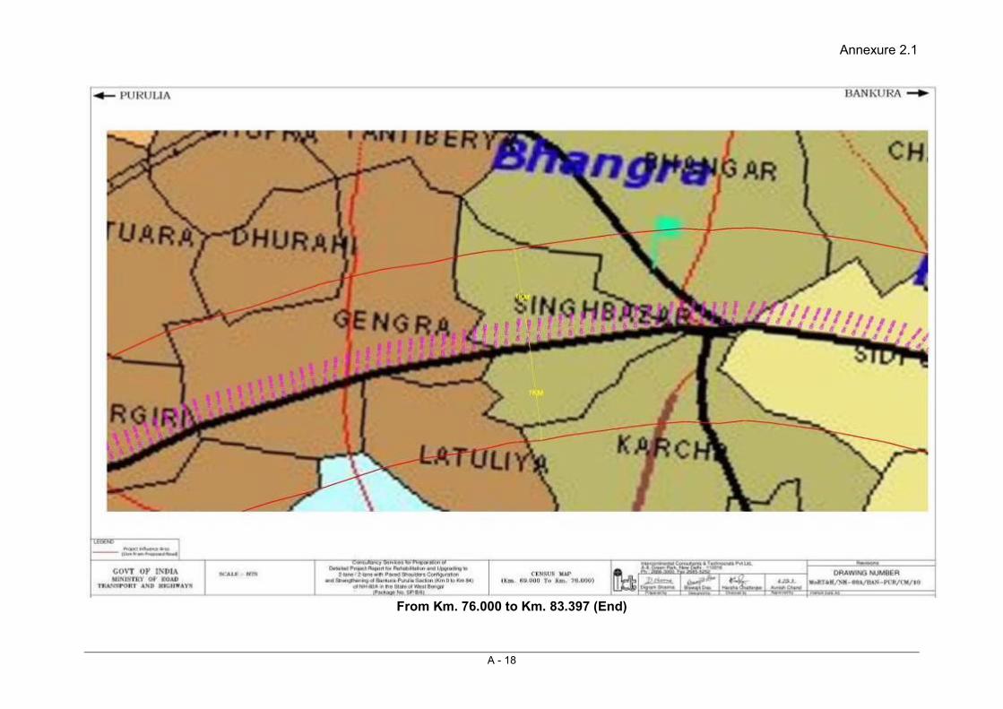
Annexure 2.1
A - 18
From Km. 76.000 to Km. 83.397 (End)

Annexure 2.1
A - 19

Annexure 2.2
A - 20
Socio-Economic Statistics of project affected villages falling under direct influence zone
Sl. No.
Block/ Tehsil
Direct/ Indirect
Name of the Town/Village
Total Population
Population Schedule Cast Schedule Tribe Literacy Working
Population Non-Working
Population Male Female Male Female Male Female Male Female Male Female Male Female
1 Bankura - I Direct Jagadalla 2400 1215 1185 521 522 0 0 736 524 711 323 504 862 2 Bankura - I Direct Krishnanagar 213 117 96 84 70 0 0 29 10 70 42 47 54 3 Bankura - I Direct Dulalpur 21 8 13 3 5 0 0 5 5 5 4 3 9 4 Bankura - I Direct Jethia 258 146 112 0 1 0 0 86 37 84 47 62 65 5 Bankura - I Direct Kankaradihi 193 108 85 0 0 0 0 92 59 54 0 54 85 6 Bankura - I Direct Bhagbanpur 300 159 141 120 110 0 0 99 47 111 86 48 55 7 Bankura - I Direct Golamitara 30 16 14 0 0 0 0 12 8 8 1 8 13 8 Bankura - I Direct Taribaterdihi 279 146 133 146 133 0 0 90 32 85 48 61 85 9 Bankura - I Direct Saarbada 137 70 67 0 0 70 67 41 23 26 31 44 36
10 Bankura - I Direct Kumidya 504 275 229 4 3 73 75 162 78 170 90 105 139 11 Bankura - I Direct Amlatara 674 351 323 173 167 35 27 228 141 207 91 144 232 12 Bankura - I Direct Dinargaon 125 68 57 0 0 68 57 31 8 41 40 27 17 13 Bankura - I Direct Gangatara 831 420 411 263 254 40 42 267 118 243 171 177 240 14 Bankura - I Direct Kalpathar 1094 581 513 379 358 96 79 391 174 346 274 235 239 15 Bankura - I Direct Patharkata 283 147 136 127 120 16 15 93 52 82 26 65 110 16 Bankura - I Direct Nekaragaria 425 213 212 48 42 73 75 135 62 128 63 85 149 17 Bankura - I Direct Kashibedia 643 339 304 111 99 10 4 217 37 213 56 126 248 18 Bankura - I Direct Jambedia 240 130 110 33 37 0 0 96 58 70 26 60 84 19 Bankura - I Direct Poryasol 430 213 217 210 213 0 0 131 93 126 16 87 201 20 Chhatna Direct Gholgore 1383 702 681 425 425 19 19 422 209 398 159 304 522 21 Chhatna Direct Teghori 1432 727 705 218 223 0 0 460 274 438 284 289 421 22 Chhatna Direct Pankhuria 937 485 452 161 153 83 75 317 130 330 101 155 351 23 Chhatna Direct Khendsar 1272 639 633 34 29 69 72 406 185 367 293 272 340 24 Chhatna Direct Nischintapur 329 172 157 20 21 0 0 125 93 94 49 78 108 25 Chhatna Direct Lari 801 379 422 74 89 0 0 281 160 188 146 191 276 26 Chhatna Direct Bhimpur 16 9 7 0 0 0 0 9 3 7 4 2 3
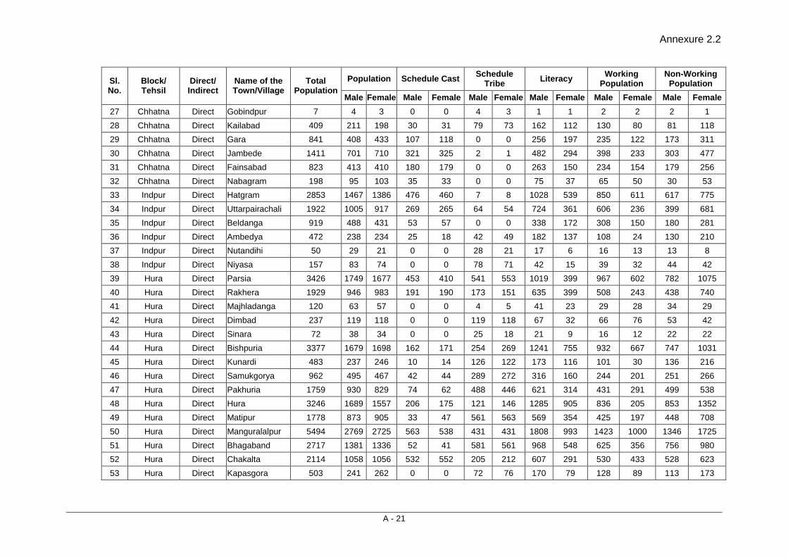
Annexure 2.2
A - 21
Sl. No.
Block/ Tehsil
Direct/ Indirect
Name of the Town/Village
Total Population
Population Schedule Cast Schedule Tribe Literacy Working
Population Non-Working
Population Male Female Male Female Male Female Male Female Male Female Male Female
27 Chhatna Direct Gobindpur 7 4 3 0 0 4 3 1 1 2 2 2 1 28 Chhatna Direct Kailabad 409 211 198 30 31 79 73 162 112 130 80 81 118 29 Chhatna Direct Gara 841 408 433 107 118 0 0 256 197 235 122 173 311 30 Chhatna Direct Jambede 1411 701 710 321 325 2 1 482 294 398 233 303 477 31 Chhatna Direct Fainsabad 823 413 410 180 179 0 0 263 150 234 154 179 256 32 Chhatna Direct Nabagram 198 95 103 35 33 0 0 75 37 65 50 30 53 33 Indpur Direct Hatgram 2853 1467 1386 476 460 7 8 1028 539 850 611 617 775 34 Indpur Direct Uttarpairachali 1922 1005 917 269 265 64 54 724 361 606 236 399 681 35 Indpur Direct Beldanga 919 488 431 53 57 0 0 338 172 308 150 180 281 36 Indpur Direct Ambedya 472 238 234 25 18 42 49 182 137 108 24 130 210 37 Indpur Direct Nutandihi 50 29 21 0 0 28 21 17 6 16 13 13 8 38 Indpur Direct Niyasa 157 83 74 0 0 78 71 42 15 39 32 44 42 39 Hura Direct Parsia 3426 1749 1677 453 410 541 553 1019 399 967 602 782 1075 40 Hura Direct Rakhera 1929 946 983 191 190 173 151 635 399 508 243 438 740 41 Hura Direct Majhladanga 120 63 57 0 0 4 5 41 23 29 28 34 29 42 Hura Direct Dimbad 237 119 118 0 0 119 118 67 32 66 76 53 42 43 Hura Direct Sinara 72 38 34 0 0 25 18 21 9 16 12 22 22 44 Hura Direct Bishpuria 3377 1679 1698 162 171 254 269 1241 755 932 667 747 1031 45 Hura Direct Kunardi 483 237 246 10 14 126 122 173 116 101 30 136 216 46 Hura Direct Samukgorya 962 495 467 42 44 289 272 316 160 244 201 251 266 47 Hura Direct Pakhuria 1759 930 829 74 62 488 446 621 314 431 291 499 538 48 Hura Direct Hura 3246 1689 1557 206 175 121 146 1285 905 836 205 853 1352 49 Hura Direct Matipur 1778 873 905 33 47 561 563 569 354 425 197 448 708 50 Hura Direct Manguralalpur 5494 2769 2725 563 538 431 431 1808 993 1423 1000 1346 1725 51 Hura Direct Bhagaband 2717 1381 1336 52 41 581 561 968 548 625 356 756 980 52 Hura Direct Chakalta 2114 1058 1056 532 552 205 212 607 291 530 433 528 623 53 Hura Direct Kapasgora 503 241 262 0 0 72 76 170 79 128 89 113 173

Annexure 2.2
A - 22
Sl. No.
Block/ Tehsil
Direct/ Indirect
Name of the Town/Village
Total Population
Population Schedule Cast Schedule Tribe Literacy Working
Population Non-Working
Population Male Female Male Female Male Female Male Female Male Female Male Female
54 Hura Direct Madhuban 1010 530 480 88 87 0 0 341 168 291 250 239 230 55 Hura Direct Kulgara 1793 886 907 20 28 109 124 569 289 569 572 317 335 56 Hura Direct Layekdi 463 226 237 142 150 0 0 132 49 117 68 109 169 57 Hura Direct Lakshanpur 2510 1276 1234 423 409 39 18 970 642 511 186 765 1048 58 Hura Direct Gurda 564 284 280 284 280 0 0 164 78 136 139 148 141 59 Hura Direct Ladhurka 3873 1993 1880 780 762 3 3 1300 792 1003 529 990 1351 60 Hura Direct Jambad 1488 754 734 125 122 0 0 355 115 399 324 355 410
61 Purulia - II Direct Kandhurka Alias Bhabanipur 1508 782 726 226 212 0 0 470 217 382 186 400 540
62 Purulia - II Direct Hutmura 4408 2259 2149 394 342 12 13 1190 571 1044 276 1215 1873 63 Purulia - II Direct Sidpur 829 412 417 227 237 0 0 254 133 194 94 218 323 64 Purulia - II Direct Singhbazar 1184 616 568 380 346 0 0 380 183 313 185 303 383 65 Purulia - II Direct Karcha 1215 632 583 429 386 0 0 436 203 266 62 366 521 66 Purulia - II Direct Bhangra 2054 1061 993 291 266 0 0 719 383 525 67 536 926 67 Purulia - II Direct Gengra 2002 1005 997 425 442 19 8 751 407 496 99 509 898 68 Purulia - II Direct Latuliya 637 323 314 15 11 19 19 206 115 177 9 146 305 69 Purulia - II Direct Birgiri 1112 562 550 183 175 30 24 317 153 290 269 272 281 70 Purulia - II Direct Surulia 2141 1118 1023 797 710 68 64 607 290 591 278 527 745 71 Purulia - II Direct Raghabpur 4769 2438 2331 1305 1291 62 58 1355 643 1171 319 1267 2012 72 Purulia Direct Purulia Town 113806 59092 54714 12790 12225 1102 997 44296 32508 28135 5683 30957 49031
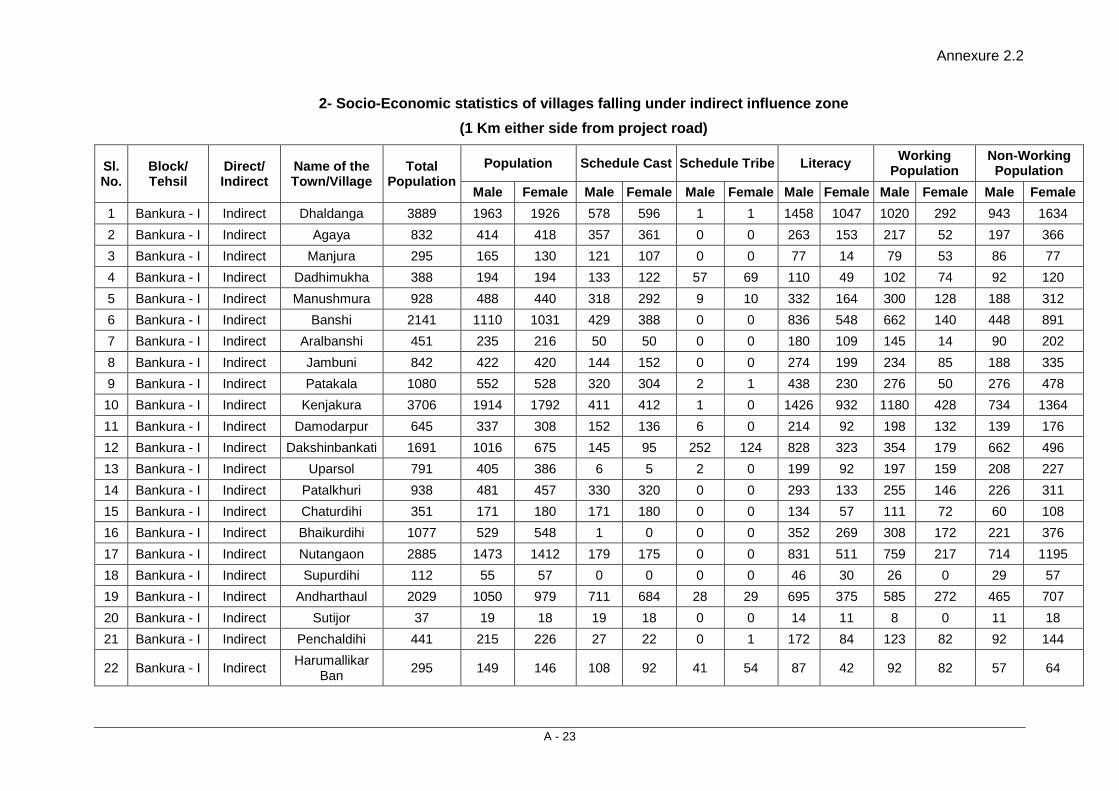
Annexure 2.2
A - 23
2- Socio-Economic statistics of villages falling under indirect influence zone (1 Km either side from project road)
Sl. No.
Block/ Tehsil
Direct/ Indirect
Name of the Town/Village
Total Population
Population Schedule Cast Schedule Tribe Literacy Working Population
Non-Working Population
Male Female Male Female Male Female Male Female Male Female Male Female 1 Bankura - I Indirect Dhaldanga 3889 1963 1926 578 596 1 1 1458 1047 1020 292 943 1634 2 Bankura - I Indirect Agaya 832 414 418 357 361 0 0 263 153 217 52 197 366 3 Bankura - I Indirect Manjura 295 165 130 121 107 0 0 77 14 79 53 86 77 4 Bankura - I Indirect Dadhimukha 388 194 194 133 122 57 69 110 49 102 74 92 120 5 Bankura - I Indirect Manushmura 928 488 440 318 292 9 10 332 164 300 128 188 312 6 Bankura - I Indirect Banshi 2141 1110 1031 429 388 0 0 836 548 662 140 448 891 7 Bankura - I Indirect Aralbanshi 451 235 216 50 50 0 0 180 109 145 14 90 202 8 Bankura - I Indirect Jambuni 842 422 420 144 152 0 0 274 199 234 85 188 335 9 Bankura - I Indirect Patakala 1080 552 528 320 304 2 1 438 230 276 50 276 478 10 Bankura - I Indirect Kenjakura 3706 1914 1792 411 412 1 0 1426 932 1180 428 734 1364 11 Bankura - I Indirect Damodarpur 645 337 308 152 136 6 0 214 92 198 132 139 176 12 Bankura - I Indirect Dakshinbankati 1691 1016 675 145 95 252 124 828 323 354 179 662 496 13 Bankura - I Indirect Uparsol 791 405 386 6 5 2 0 199 92 197 159 208 227 14 Bankura - I Indirect Patalkhuri 938 481 457 330 320 0 0 293 133 255 146 226 311 15 Bankura - I Indirect Chaturdihi 351 171 180 171 180 0 0 134 57 111 72 60 108 16 Bankura - I Indirect Bhaikurdihi 1077 529 548 1 0 0 0 352 269 308 172 221 376 17 Bankura - I Indirect Nutangaon 2885 1473 1412 179 175 0 0 831 511 759 217 714 1195 18 Bankura - I Indirect Supurdihi 112 55 57 0 0 0 0 46 30 26 0 29 57 19 Bankura - I Indirect Andharthaul 2029 1050 979 711 684 28 29 695 375 585 272 465 707 20 Bankura - I Indirect Sutijor 37 19 18 19 18 0 0 14 11 8 0 11 18 21 Bankura - I Indirect Penchaldihi 441 215 226 27 22 0 1 172 84 123 82 92 144
22 Bankura - I Indirect Harumallikar Ban 295 149 146 108 92 41 54 87 42 92 82 57 64

Annexure 2.2
A - 24
Sl. No.
Block/ Tehsil
Direct/ Indirect
Name of the Town/Village
Total Population
Population Schedule Cast Schedule Tribe Literacy Working Population
Non-Working Population
Male Female Male Female Male Female Male Female Male Female Male Female 23 Bankura - I Indirect Kaludihi 374 190 184 108 109 77 70 64 20 106 89 84 95 24 Bankura - I Indirect Fengabasa 377 190 187 65 60 18 29 135 95 114 47 76 140 25 Bankura - I Indirect Shyamdanga 2 1 1 1 1 0 0 1 0 0 0 1 1 26 Bankura - I Indirect Deba 422 225 197 25 25 0 0 142 82 99 24 126 173 27 Bankura - I Indirect Purundihi 648 320 328 164 164 58 72 185 94 180 36 140 292 28 Bankura - I Indirect Chamkara 61 34 27 34 27 0 0 15 3 18 13 16 14 29 Bankura - I Indirect Ekaira 553 272 281 43 46 3 4 208 152 168 74 104 207 30 Bankura - I Indirect Kamlagara 106 52 54 0 0 52 54 23 8 31 37 21 17 31 Bankura - I Indirect Dhagaria 358 187 171 79 63 106 106 115 47 118 104 69 67 32 Bankura - I Indirect Khenkriara 480 246 234 229 226 0 0 165 71 128 60 118 174 33 Bankura - I Indirect Chingra 928 454 474 288 314 104 101 301 128 256 177 198 297 34 Bankura - I Indirect Barabagan 89 45 44 17 23 26 20 25 6 28 18 17 26 35 Bankura - I Indirect Baraleedya 310 154 156 61 68 91 87 61 12 108 112 46 44 36 Chhatna Indirect Daldali 243 122 121 0 0 0 0 83 37 66 2 56 119 37 Chhatna Indirect Jaganathpur 259 132 127 52 52 0 0 69 39 79 38 53 89 38 Chhatna Indirect Bagjuri 788 383 405 248 256 0 0 233 125 231 45 152 360 39 Chhatna Indirect Pathan Berya 142 72 70 70 70 0 0 17 1 35 49 37 21 40 Chhatna Indirect Dan Mari 1312 664 648 131 135 60 72 390 166 396 305 268 343 41 Chhatna Indirect Tenduibad 669 333 336 133 148 99 80 202 128 187 91 146 245 42 Chhatna Indirect Banpusra 700 358 342 28 25 288 283 238 96 196 126 162 216 43 Chhatna Indirect Sarpada 472 247 225 65 61 0 0 130 54 159 146 88 79 44 Chhatna Indirect Tisra 511 232 279 20 27 37 50 149 65 127 115 105 164 45 Chhatna Indirect Deul Bherya 184 101 83 0 0 0 0 58 26 58 40 43 43 46 Chhatna Indirect Bahirdya 455 236 219 117 111 0 0 156 72 129 62 107 157 47 Chhatna Indirect Nawada 351 171 180 118 112 0 0 89 29 96 111 75 69
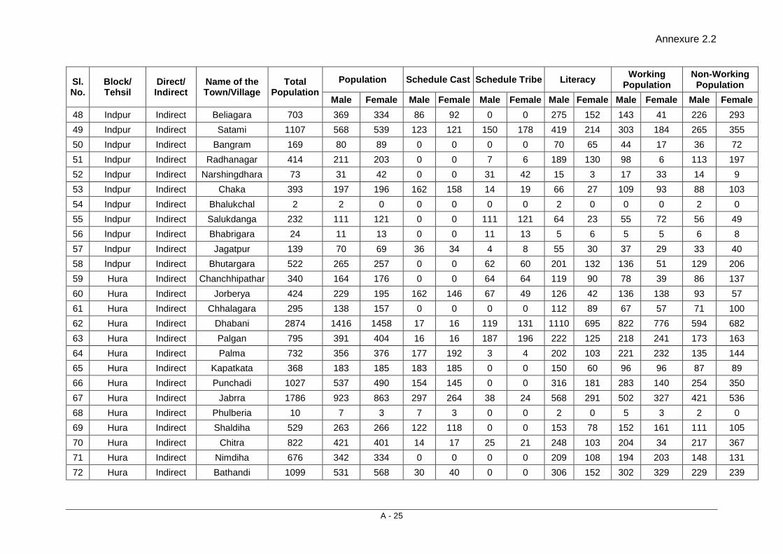
Annexure 2.2
A - 25
Sl. No.
Block/ Tehsil
Direct/ Indirect
Name of the Town/Village
Total Population
Population Schedule Cast Schedule Tribe Literacy Working Population
Non-Working Population
Male Female Male Female Male Female Male Female Male Female Male Female 48 Indpur Indirect Beliagara 703 369 334 86 92 0 0 275 152 143 41 226 293 49 Indpur Indirect Satami 1107 568 539 123 121 150 178 419 214 303 184 265 355 50 Indpur Indirect Bangram 169 80 89 0 0 0 0 70 65 44 17 36 72 51 Indpur Indirect Radhanagar 414 211 203 0 0 7 6 189 130 98 6 113 197 52 Indpur Indirect Narshingdhara 73 31 42 0 0 31 42 15 3 17 33 14 9 53 Indpur Indirect Chaka 393 197 196 162 158 14 19 66 27 109 93 88 103 54 Indpur Indirect Bhalukchal 2 2 0 0 0 0 0 2 0 0 0 2 0 55 Indpur Indirect Salukdanga 232 111 121 0 0 111 121 64 23 55 72 56 49 56 Indpur Indirect Bhabrigara 24 11 13 0 0 11 13 5 6 5 5 6 8 57 Indpur Indirect Jagatpur 139 70 69 36 34 4 8 55 30 37 29 33 40 58 Indpur Indirect Bhutargara 522 265 257 0 0 62 60 201 132 136 51 129 206 59 Hura Indirect Chanchhipathar 340 164 176 0 0 64 64 119 90 78 39 86 137 60 Hura Indirect Jorberya 424 229 195 162 146 67 49 126 42 136 138 93 57 61 Hura Indirect Chhalagara 295 138 157 0 0 0 0 112 89 67 57 71 100 62 Hura Indirect Dhabani 2874 1416 1458 17 16 119 131 1110 695 822 776 594 682 63 Hura Indirect Palgan 795 391 404 16 16 187 196 222 125 218 241 173 163 64 Hura Indirect Palma 732 356 376 177 192 3 4 202 103 221 232 135 144 65 Hura Indirect Kapatkata 368 183 185 183 185 0 0 150 60 96 96 87 89 66 Hura Indirect Punchadi 1027 537 490 154 145 0 0 316 181 283 140 254 350 67 Hura Indirect Jabrra 1786 923 863 297 264 38 24 568 291 502 327 421 536 68 Hura Indirect Phulberia 10 7 3 7 3 0 0 2 0 5 3 2 0 69 Hura Indirect Shaldiha 529 263 266 122 118 0 0 153 78 152 161 111 105 70 Hura Indirect Chitra 822 421 401 14 17 25 21 248 103 204 34 217 367 71 Hura Indirect Nimdiha 676 342 334 0 0 0 0 209 108 194 203 148 131 72 Hura Indirect Bathandi 1099 531 568 30 40 0 0 306 152 302 329 229 239
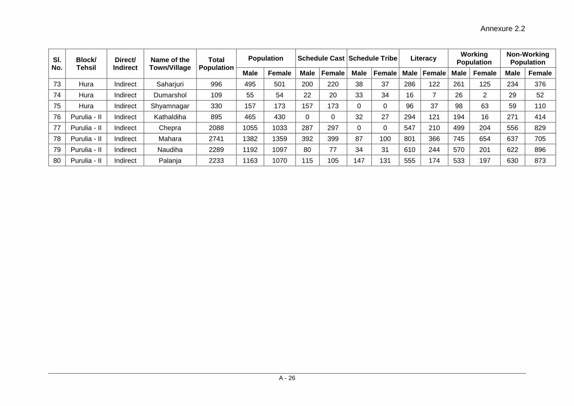
Annexure 2.2
A - 26
Sl. No.
Block/ Tehsil
Direct/ Indirect
Name of the Town/Village
Total Population
Population Schedule Cast Schedule Tribe Literacy Working Population
Non-Working Population
Male Female Male Female Male Female Male Female Male Female Male Female 73 Hura Indirect Saharjuri 996 495 501 200 220 38 37 286 122 261 125 234 376 74 Hura Indirect Dumarshol 109 55 54 22 20 33 34 16 7 26 2 29 52 75 Hura Indirect Shyamnagar 330 157 173 157 173 0 0 96 37 98 63 59 110 76 Purulia - II Indirect Kathaldiha 895 465 430 0 0 32 27 294 121 194 16 271 414 77 Purulia - II Indirect Chepra 2088 1055 1033 287 297 0 0 547 210 499 204 556 829 78 Purulia - II Indirect Mahara 2741 1382 1359 392 399 87 100 801 366 745 654 637 705 79 Purulia - II Indirect Naudiha 2289 1192 1097 80 77 34 31 610 244 570 201 622 896 80 Purulia - II Indirect Palanja 2233 1163 1070 115 105 147 131 555 174 533 197 630 873

Consultancy Services for Preparation of Detailed Project Report for Rehabilitation and Upgrading to 2 lane / 2 lane with Paved Shoulders Configuration and Strengthening of
Bankura – Purulia Section (km 0 to 84) of NH-60A in the State of West Bengal (Package No. SP/B/6)
Final Detailed Project Report (Modified) (Volume V: Social Impact Assessment and Rehabilitation Action Plan)
3 - 1
3. MINIMIZING NEGATIVE SOCIAL IMPACT
3.1 INTRODUCTION The need for resettlement arises when a proposed infrastructure project displaces a number of people and households for a defined public purpose which, in this case, is the widening and upgrading of the existing National Highway 60A. The R&R component of the project has been prepared according to the Resettlement Policy Framework for this project that in turn is based on existing national laws and the World Bank’s Policy on Involuntary Resettlement ‘OP 4.12’. The Bank’s Policy on Involuntary Resettlement OP 4.12, emphasizes the need to avoid or minimise involuntary resettlement on development projects. The MoRTH policy, also, acknowledges the importance of avoiding adverse socio-economic impacts in road design and construction.
The success of a project depends to a large extent on the improvement that it brings about in the living standards of the people, both in the short and the long term. While preparing the engineering design, the prime consideration has been to minimise the social negative impacts within the limitations of technical requirements and cost effectiveness and to enhance the benefits. Despite the best efforts to minimise the negative social impact, however, land take at few places and resettlement have been unavoidable.
In general, the design considerations adopted by MoRTH to minimize the land acquisition within the project are as below:
• The proposed right of way for bypasses will be 30 meters if the projected traffic is less than 15,000 Passenger Car Units (PCUs) in 2030 and 45 meters if the traffic is more than 15,000 PCUs in 2030.
• The corridor of impact (CoI)/proposed cross-section would be restricted within the existing right of way in forest areas. In case of exception, both options (within the existing right of way and the alignment proposal with forest land diversion) would be analyzed before a final decision is made.
• The corridor of impact (CoI) for the project would broadly range between 15 m to 18 m to fit the typical cross sections, space for drains, roadside furniture and utilities. However, in specific locations, CoI of less than 15m would also be considered to minimize the impact on properties and environmental features. Whereas, in urban areas, if the available land width is found more than the required to fit the cross section, entire available space may be paved from building line to building line to facilitate pedestrian movements, parking etc.
• Decision on bypasses and realignments will be taken based on a comparison of options with or without the proposed change in design on a case-to-case basis.
3.2 RIGHT OF WAY The project road NH 60A has its own history and has been upgraded to NH level in the past by elevating state road/village road, considering the importance and local demand to cater the traffic. Keeping in mind the geometric propagation, and availability of ROW, the road can be categorized into three sections:
1. The first section of the road i.e. Dhaldanga to Dulalpur/Puabagan (0.00 Km to 5.750) takeoff from NH-60 at Dhaldanga and the average available RoW is 60 metre.
Minimizing Negative Social Impact
Final Detailed Project Report (Modified) (Volume V: Social Impact Assessment and Rehabilitation Action Plan)
3 - 2
2. From Dulalpur to Bishpuria is the second section of the project road. In this section i.e. from km 5.750 to km 40.100, the available ROW just meet the required width with constraints. However, people living along this section of road have some grievances on title-holding.
It is pertinent to mention here that the present road, which has been proposed for up-gradation work is different from the original one, which traverses from Bankura to Purulia via Chhatna, Kamalpur and meet at Bispuria (Km. 40.100) with the present road. The present road, which has been selected for up-gradation was primarily a village road and being used for non-motorized traffic/ rural traffic. Since 1960-70s onwards, this road came into existence in present form and later on, this bullock cart road was upgraded and subsequently notified as National Highway 60A. Therefore, in this section, the available ROW is limited and on an average it varies from 6 m to 16 m. PWD (RoW) pillars exist at 50 metre interval on both side, however, no authentic records are available with the local PWD division on ROW. During consultations villagers from Kumidya, Golghoria, Ambediya, Kasibdediya, Rakhera and Bishpuria pointed out that PWD have fixed RoW pillar in private land without having land Record of Rights in their name.
3. From Bishpuria to Purulia (up to end of the project) is third section of the project road, having the RoW of 12 m to 24 m, except at few locations, i.e., Hura and Joynagar (Hutmura), where existing ROW varies between 8-24 mtrs
Final ‘Revisional Settlement’ (RS) Maps (sheets 1, 2 & 3 of 3 Annexure 3.1) indicates very limited RoW at Bishpuria, Hura and Manguria Lalpur villages. The available RoW in the 3 sections is presented in Table 3.1.
Table 3.1: Availability of Existing RoW
Sl. No. Chainage
RoW (in Metres) From To
1. 0.00 5.750 60
2. 5.750 40.100 6 to 16 (as per RoW pillars)
3. 40.100 83.562 12 to 24 Note: Based on RS maps available with BL& LRO’s
3.3 DESIGNS AND R&R COORDINATION There are three key elements in designing in any road network improvement/ strengthening project. These are widening options, alternative alignments/ bypasses and junction improvements. The design features and the development options were finalized by technical team in consultation with the R&R team and the process continued throughout the planning process where inputs from the R&R team were incorporated in the engineering design by the design team. The broad parameters considered by the design team based on the inputs from the R&R surveys were: • Minimize the impact on roadside settlements
• Minimize impact on agricultural land • Minimize land acquisition • Minimize impact on community assets • Avoid the adverse impacts of the crowded areas on the highway along the
project stretch

Consultancy Services for Preparation of Detailed Project Report for Rehabilitation and Upgrading to 2 lane / 2 lane with Paved Shoulders Configuration and Strengthening of
Bankura – Purulia Section (km 0 to 84) of NH-60A in the State of West Bengal (Package No. SP/B/6)
Final Detailed Project Report (Modified) (Volume V: Social Impact Assessment and Rehabilitation Action Plan)
3 - 3
The three key elements are discussed here with respect to the possible options and provide a social input for the decision making in the designing process.
3.4 WIDENING OPTION Due importance has been given to environmental and social issues while road designing. The coordination between social and design team helped in minimizing the number of PAPs and affected PAHs. Concentric widening has been proposed in 62.53% of total stretch to avoid extra land acquisition and minimize the social impact. Eccentric widening option (one side widening) has been proposed in 5.7% of total project stretch, for geometrical correction and improvement of existing road alignment. Typical cross section applied in presented in Table 3.2.
Table 3.2: Typical Cross Section (TCS)
Proposal TCS Type*
(with the minimum Land width)
Length
(Km) %
Concentric I (20-30 mtrs) 52.240 62.5%
Eccentric widening II (20-30 mtrs) 4.750 5.7%
Raising III (20-30 mtrs) 1.370 1.6%
Realignment IV (25-30 mtrs) 0.520 0.6%
Urban V (13 mtrs) 24.682 29.5%
Total 83.562 100% * see Annexure 3.2.
In view of safety requirements as well as segregation of the fast moving traffic from the local slow moving traffic, paved shoulder has been proposed in the entire project road.
3.5 MINIMIZING LAND ACQUISITION Land acquisition is involved only in 9.8 % (8.23 km out of 83.562 km) of the project road length. Total 90.2% of the project length is free from land acquisition. Keeping in view the above, eight (8) such sections, varying in length from 0.300 km to 27.720 km, have been identified with no land acquisition. Since, the project likely to be executed on EPC, above 90% of the project stretch is free from land acquisition. The project road with or without LA is presented in Table 3.3.
Table 3.3: Project road section with/without LA
Sl. No.
Chainage Length (Km) %
From (Km) To (Km)
A- Sections without LA
1 0.000 19.300 19.300 23.1
2 20.700 28.400 7.700 9.2
3 28.700 36.300 7.600 9.1
4 37.200 39.300 2.100 2.5
5 41.200 47.300 6.100 7.3

Minimizing Negative Social Impact
Final Detailed Project Report (Modified) (Volume V: Social Impact Assessment and Rehabilitation Action Plan)
3 - 4
Sl. No.
Chainage Length (Km) %
From (Km) To (Km)
6 50.600 78.320 27.720 33.2
7 78.600 79.000 0.400 0.5
8 79.150 83.562 4.412 5.3
Total-A 75.332 90.2
B- Sections with LA
1 19.300 20.700 1.400 1.7
2 28.400 28.700 0.300 0.4
3 36.300 37.100 0.800 1.0
4 37.100 37.200 0.100 0.1
5 39.300 41.200 1.900 2.3
6 47.300 50.600 3.300 3.9
7 78.320 78.600 0.280 0.3
7 79.000 79.150 0.150 0.2
Total-B 8.230 9.8
Total ( A+ B) 83.562 100.0
3.6 ANAYLISIS OF ALTERNATIVES
Analysis of alternatives is very important activities, which leads to minimize the negative impacts on population and properties and meet the technical requirement. Initially bypasses were proposed at 2 locations namely Bishpuria and Hura keeping in view the likely impact on about 450 structures (approx. 600 HH) and 7 religious structures by considering CoI of 15 metres. The provision of bypasses was weighed upon by the technical team, considering the outcome of public consultation as well as the suggestion of people along the project road. Accordingly alternatives were explored and assessment was made. The initial assessment suggested that if we could go for bypass option, an additional 18 hectares of land will be acquired with impact on about 475 land-holders.
Analysis of Alternatives was done considering rehabilitation of existing road and proposing bypasses as 2 options:
1. Alternative -1: Rehabilitation of existing road
2. Alternative-2: Provision of Bypass.
Considering the above alternatives the bypass option was appraised on two specified locations in the subsequent paragraphs:
Bishpuria:
The existing project road in Bishpuria village/market area passes through congested area, poor geometry and availability of insufficient ROW along the existing road, i.e., about 8-12 meters.
Consultancy Services for Preparation of Detailed Project Report for Rehabilitation and Upgrading to 2 lane / 2 lane with Paved Shoulders Configuration and Strengthening of
Bankura – Purulia Section (km 0 to 84) of NH-60A in the State of West Bengal (Package No. SP/B/6)
Final Detailed Project Report (Modified) (Volume V: Social Impact Assessment and Rehabilitation Action Plan)
3 - 5
Parameters Alternative 1 Alternative 2 Remarks/desirable alternative
Description of Alternatives
Rehabilitation of existing Alignments
Bypass towards LHS of existing Road from Km. 39+350, km 41+200, inviting heavy amount of land acquisition
Alternative 1
Length 2.2 km 1.850 Km No preference
Land to be acquired
0.064 ha 4.750 ha Alternative 1
Type of Land Residential/ commercial
Fertile agricultural land
No preference
Type of Structure Affected
91 structures of different kind (51 residential and 29 commercial and 11 others) and 4 others type of structures
No-Structures but has impact on significant number of land-holders
Alternative -2
No of APs 80 TH,(Titleholders) and 15 NTH (Non-titleholders)
150 TH (Titleholders)
Alternative 1
Issues of Resettlement / Displacement
Partial impact no displacement
acquisition may make people marginalized
Alternative-1
Impact on Livelihood
Loss of livelihood of 29 families
Loss of livelihood on 150 families
Alternative 1/ Alternative 2
Public Opinion less preferred by the people along the existing road
less preferred by the people in bypass area
No preference
Technical Need Poor geometry and insufficient ROW necessities alternatives
Technically feasible Alternative 2
MoRTH Decision Chief Engineer, MoRTH decision during his visit in the month of February 2013 and subsequent letter/ observation received by Project Director. (copy attached as Annexure 3.3 )
Sensitive issue in acquisition of fertile land, people’s opposition and time taking activities by revenue department in land acquisition
Alternative 2
Suggestion Preferred option Alternative-1 as per MoRTH decision
Hura Bypass: The existing alignment of the project road, passes through Hura town area, is congested and having restricted ROW, however at some places the ROW is up to 24 mtrs. Geometry of the road is not up to the mark.
Minimizing Negative Social Impact
Final Detailed Project Report (Modified) (Volume V: Social Impact Assessment and Rehabilitation Action Plan)
3 - 6
Parameters Alternative 1 Alternative 2 Remarks/desirable alternative
Description of Alternatives
Rehabilitation of existing Alignments
Bypass towards RHS of existing Road from Km. 47+500, km 50+550, inviting heavy amount of land acquisition
Alternative 1
Length 3.050 km 3.400 km No preference
Land to be acquired
0.0934 ha 9.850 ha Alternative 1
Type of Structure Affected
181 residential, 112 commercial structures and 9 others
16 residential, 2 commercial
No of APs 137 TH,(Titleholders) and 184 NTH (Non-titleholders)
320 TH (Titleholders)
Alternative 1 or Alternative-2
Issues of Resettlement / Displacement
Displacement of 16 squatters
Partial impact with no displacement but acquisition of land may make people marginalized
Alternative-1
Impact on Livelihood
Loss of livelihood of 16 families
livelihood impact may have on 320 families
Alternative 1
Public Opinion less preferred by the people along the existing road
less preferred by the people in bypass area
No preference
Technical Need Poor geometry and insufficient ROW necessities alternatives
Technically feasible Alternative 2
MoRTH Decision Chief Engineer, MoRTH decision during his visit in the month of February 2013 and subsequent letter/ observation received by Project Director. (copy attached as Annexure 3.3)
Sensitive issue in acquisition of fertile land, people’s opposition and time taking activities by revenue department in land acquisition
Alternative 2
Suggestion Preferred option Alternative-1 as per MoRTH decision
3.6.1 Recommendation The assessment with regard to upgrading of existing alignment and proposed bypasses at Bishpuria and Hura and associated constraints related to land acquisition was discussed with project authority. After repeated discussion with project authority on this issue, The Chief Engineer, MoRTH with technical,

Consultancy Services for Preparation of Detailed Project Report for Rehabilitation and Upgrading to 2 lane / 2 lane with Paved Shoulders Configuration and Strengthening of
Bankura – Purulia Section (km 0 to 84) of NH-60A in the State of West Bengal (Package No. SP/B/6)
Final Detailed Project Report (Modified) (Volume V: Social Impact Assessment and Rehabilitation Action Plan)
3 - 7
environmental and social team visited the Bankura - Purulia road (NH-60A) on 13th Feb 2013. The CE during his site visit discussed the options of bypass with the local PAPs at Bishpuria and Hura. Based on the site assessment and discussion with DPR Consultant, the project authority decided to drop the bypasses at both the locations and directed the DPR consultant to follow existing alignment at Bishpuria and Hura for upgrading work.
The decision of MoRTH on Bypass was also communicated to the people of Bishpuria and Hura through consultation, where they were told that the ministry has decided to defer the construction of bypasses at identified locations for the time being and with an aim to avoid the complication of land acquisition. This decision will be helpful in implementing the project on fast track. The upgrading of existing alignment will be done by fully utilizing existing RoW and restricting CoI to 13 m. Restricting CoI to 13 m would have partial or limited impacts on structures and other properties on either side of the Centre line, as outlined in the Table 3.3.
3.7 IMPROVEMENT IN OTHER BUILT-UP LOCATION In context of present project improvement of NH-60A as 2-lane/2 lane with paved shoulders configuration, the Corridor of Impact was the most important parameter in determining the number of PAPs. The requirement of the project demands that the entire corridor of impact should be free from encroachments, human habitation and structure, causing hindrances to traffic. Removing the encroachers and the squatters from the RoW does not guarantee that they would not reoccupy the area.
Therefore, all estimations were limited to the CoI only and the project will not displace any person outside the corridor of impact, even if within the RoW. In the present road there are 21 locations where 13 metres CoI has been considered.
In these 21 habitats, the impacts have been minimized by limiting the corridor of impacts to 13 metre including safety measures. Improvement in these locations would require removal of few squatters and encroachers. The chainage-wise locations of built-up areas along the project road is charted in Table 3.4.
Table 3.4: Built-up locations along the project road
Sl. No. Chainage
Length (m) Town/village Name From To
1 4.800 5.200 400 Poabagan
2 11.100 12.500 1400 Kumudiya
3 20.250 20.630 380 Golghara More
4 21.600 22.100 500 Bhagbanpur
5 27.500 28.700 1200 Harigram
6 32.200 32.500 300 Payarachali
7 36.100 37.600 1500 Rakhera
8 38.500 39.000 500 Siyanra
9 40.000 41.200 1200 Bishpuria
10 47.500 50.000 2500 Hura
11 51.200 53.000 1800 Lalpur

Minimizing Negative Social Impact
Final Detailed Project Report (Modified) (Volume V: Social Impact Assessment and Rehabilitation Action Plan)
3 - 8
Sl. No. Chainage
Length (m) Town/village Name From To
12 54.900 55.700 800 Chakalta / Madhuban
13 58.600 59.400 800 Lakhanpur
14 60.900 61.300 400 Harliadih
15 61.800 62.200 400 Bhuiyandih
16 63.400 64.000 600 Ladhurka
17 67.800 69.400 1600 Joynagar
18 71.200 71.500 300 Bhangra more
19 74.100 74.500 400 Ganegra
20 77.400 77.800 400 Surulia
21 78.600 83.562 4962 Purulia
• • •

Annexure 3.1
A - 27
Annexure 3.1
A - 28
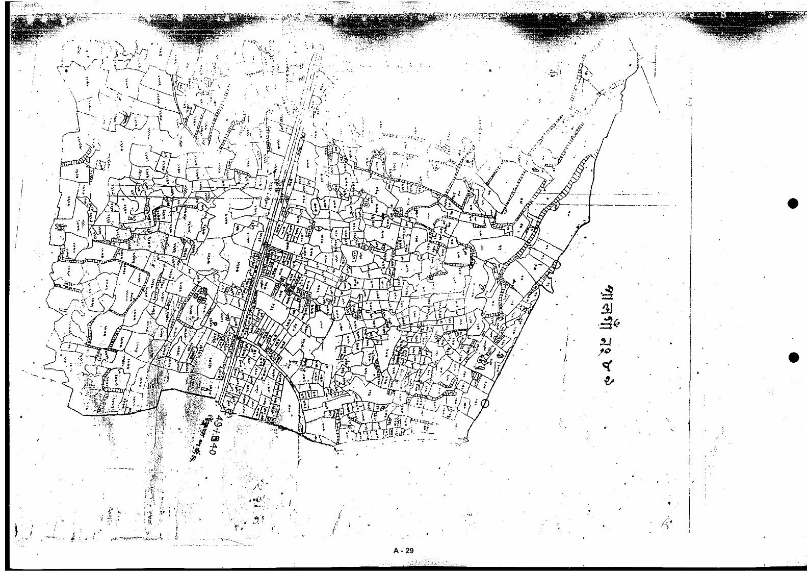
Annexure 3.1
A - 29
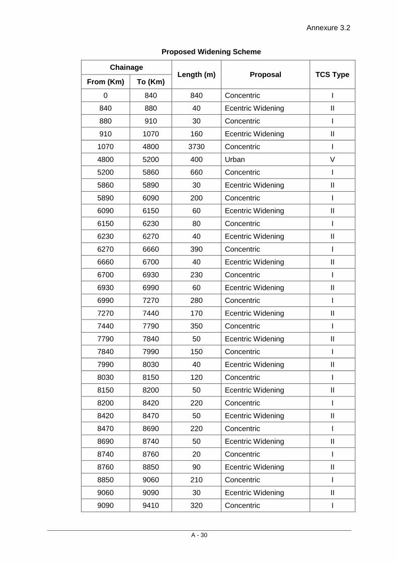
Annexure 3.2
A - 30
Proposed Widening Scheme
Chainage Length (m) Proposal TCS Type
From (Km) To (Km)
0 840 840 Concentric I
840 880 40 Ecentric Widening II
880 910 30 Concentric I
910 1070 160 Ecentric Widening II
1070 4800 3730 Concentric I
4800 5200 400 Urban V
5200 5860 660 Concentric I
5860 5890 30 Ecentric Widening II
5890 6090 200 Concentric I
6090 6150 60 Ecentric Widening II
6150 6230 80 Concentric I
6230 6270 40 Ecentric Widening II
6270 6660 390 Concentric I
6660 6700 40 Ecentric Widening II
6700 6930 230 Concentric I
6930 6990 60 Ecentric Widening II
6990 7270 280 Concentric I
7270 7440 170 Ecentric Widening II
7440 7790 350 Concentric I
7790 7840 50 Ecentric Widening II
7840 7990 150 Concentric I
7990 8030 40 Ecentric Widening II
8030 8150 120 Concentric I
8150 8200 50 Ecentric Widening II
8200 8420 220 Concentric I
8420 8470 50 Ecentric Widening II
8470 8690 220 Concentric I
8690 8740 50 Ecentric Widening II
8740 8760 20 Concentric I
8760 8850 90 Ecentric Widening II
8850 9060 210 Concentric I
9060 9090 30 Ecentric Widening II
9090 9410 320 Concentric I
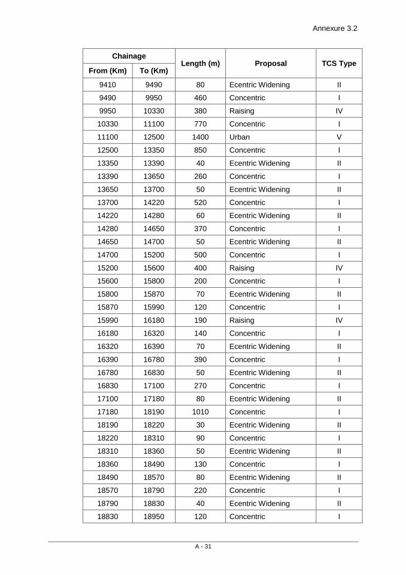
Annexure 3.2
A - 31
Chainage Length (m) Proposal TCS Type
From (Km) To (Km)
9410 9490 80 Ecentric Widening II
9490 9950 460 Concentric I
9950 10330 380 Raising IV
10330 11100 770 Concentric I
11100 12500 1400 Urban V
12500 13350 850 Concentric I
13350 13390 40 Ecentric Widening II
13390 13650 260 Concentric I
13650 13700 50 Ecentric Widening II
13700 14220 520 Concentric I
14220 14280 60 Ecentric Widening II
14280 14650 370 Concentric I
14650 14700 50 Ecentric Widening II
14700 15200 500 Concentric I
15200 15600 400 Raising IV
15600 15800 200 Concentric I
15800 15870 70 Ecentric Widening II
15870 15990 120 Concentric I
15990 16180 190 Raising IV
16180 16320 140 Concentric I
16320 16390 70 Ecentric Widening II
16390 16780 390 Concentric I
16780 16830 50 Ecentric Widening II
16830 17100 270 Concentric I
17100 17180 80 Ecentric Widening II
17180 18190 1010 Concentric I
18190 18220 30 Ecentric Widening II
18220 18310 90 Concentric I
18310 18360 50 Ecentric Widening II
18360 18490 130 Concentric I
18490 18570 80 Ecentric Widening II
18570 18790 220 Concentric I
18790 18830 40 Ecentric Widening II
18830 18950 120 Concentric I
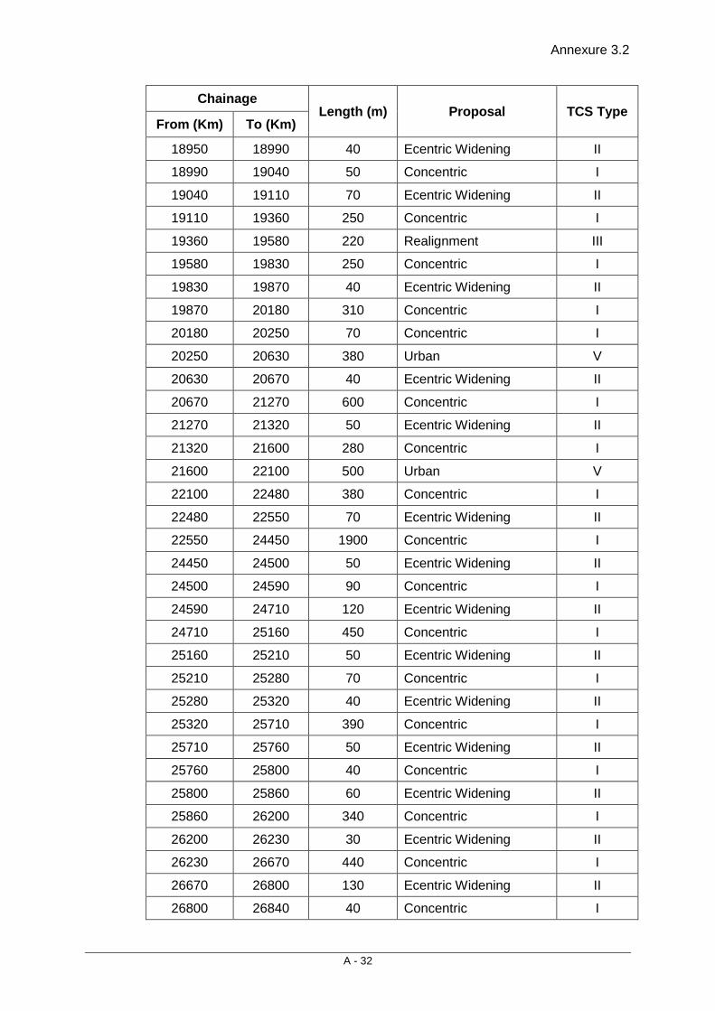
Annexure 3.2
A - 32
Chainage Length (m) Proposal TCS Type
From (Km) To (Km)
18950 18990 40 Ecentric Widening II
18990 19040 50 Concentric I
19040 19110 70 Ecentric Widening II
19110 19360 250 Concentric I
19360 19580 220 Realignment III
19580 19830 250 Concentric I
19830 19870 40 Ecentric Widening II
19870 20180 310 Concentric I
20180 20250 70 Concentric I
20250 20630 380 Urban V
20630 20670 40 Ecentric Widening II
20670 21270 600 Concentric I
21270 21320 50 Ecentric Widening II
21320 21600 280 Concentric I
21600 22100 500 Urban V
22100 22480 380 Concentric I
22480 22550 70 Ecentric Widening II
22550 24450 1900 Concentric I
24450 24500 50 Ecentric Widening II
24500 24590 90 Concentric I
24590 24710 120 Ecentric Widening II
24710 25160 450 Concentric I
25160 25210 50 Ecentric Widening II
25210 25280 70 Concentric I
25280 25320 40 Ecentric Widening II
25320 25710 390 Concentric I
25710 25760 50 Ecentric Widening II
25760 25800 40 Concentric I
25800 25860 60 Ecentric Widening II
25860 26200 340 Concentric I
26200 26230 30 Ecentric Widening II
26230 26670 440 Concentric I
26670 26800 130 Ecentric Widening II
26800 26840 40 Concentric I

Annexure 3.2
A - 33
Chainage Length (m) Proposal TCS Type
From (Km) To (Km)
26840 26880 40 Ecentric Widening II
26880 27260 380 Concentric I
27260 27310 50 Ecentric Widening II
27310 27500 190 Concentric I
27500 28540 1040 Urban V
28540 28650 110 Realignment III
28650 29425 775 Concentric I
29425 29825 400 Raising IV
29825 31160 1335 Concentric I
31160 31210 50 Ecentric Widening II
31210 32200 990 Concentric I
32200 32500 300 Urban V
32500 32990 490 Concentric I
32990 33040 50 Ecentric Widening II
33040 33100 60 Concentric I
33100 33150 50 Ecentric Widening II
33150 33530 380 Concentric I
33530 33640 110 Ecentric Widening II
33640 33680 40 Concentric I
33680 33730 50 Ecentric Widening II
33730 33900 170 Concentric I
33900 33960 60 Ecentric Widening II
33960 34050 90 Concentric I
34050 34120 70 Ecentric Widening II
34120 34210 90 Concentric I
34210 34280 70 Ecentric Widening II
34280 36100 1820 Concentric I
36100 37600 1500 Urban V
37600 38120 520 Concentric I
38120 38210 90 Ecentric Widening II
38210 38300 90 Concentric I
38300 38350 50 Ecentric Widening II
38350 38500 150 Concentric I
38500 39000 500 Urban V

Annexure 3.2
A - 34
Chainage Length (m) Proposal TCS Type
From (Km) To (Km)
39000 39300 300 Concentric I
39300 42200 2900 Urban V
42200 42930 730 Concentric I
42930 43250 320 Ecentric Widening II
43250 45840 2590 Concentric I
45840 45870 30 Ecentric Widening II
45870 47220 1350 Concentric I
47220 47300 80 Ecentric Widening II
47300 50600 3300 Urban V
50600 50780 180 Concentric I
50780 50830 50 Ecentric Widening II
50830 51200 370 Concentric I
51200 53000 1800 Urban V
53000 53980 980 Concentric I
53980 54110 130 Ecentric Widening II
54110 54290 180 Concentric I
54290 54400 110 Ecentric Widening II
54400 54780 380 Concentric I
54780 54900 120 Ecentric Widening II
54900 55700 800 Urban V
55700 58600 2900 Concentric I
58600 59400 800 Urban V
59400 60150 750 Concentric I
60150 60190 40 Ecentric Widening II
60190 60900 710 Concentric I
60900 61300 400 Urban V
61300 61800 500 Concentric I
61800 62200 400 Urban V
62200 62680 480 Concentric I
62680 62760 80 Ecentric Widening II
62760 63400 640 Concentric I
63400 64000 600 Urban V
64000 65930 1930 Concentric I
65930 65970 40 Ecentric Widening II
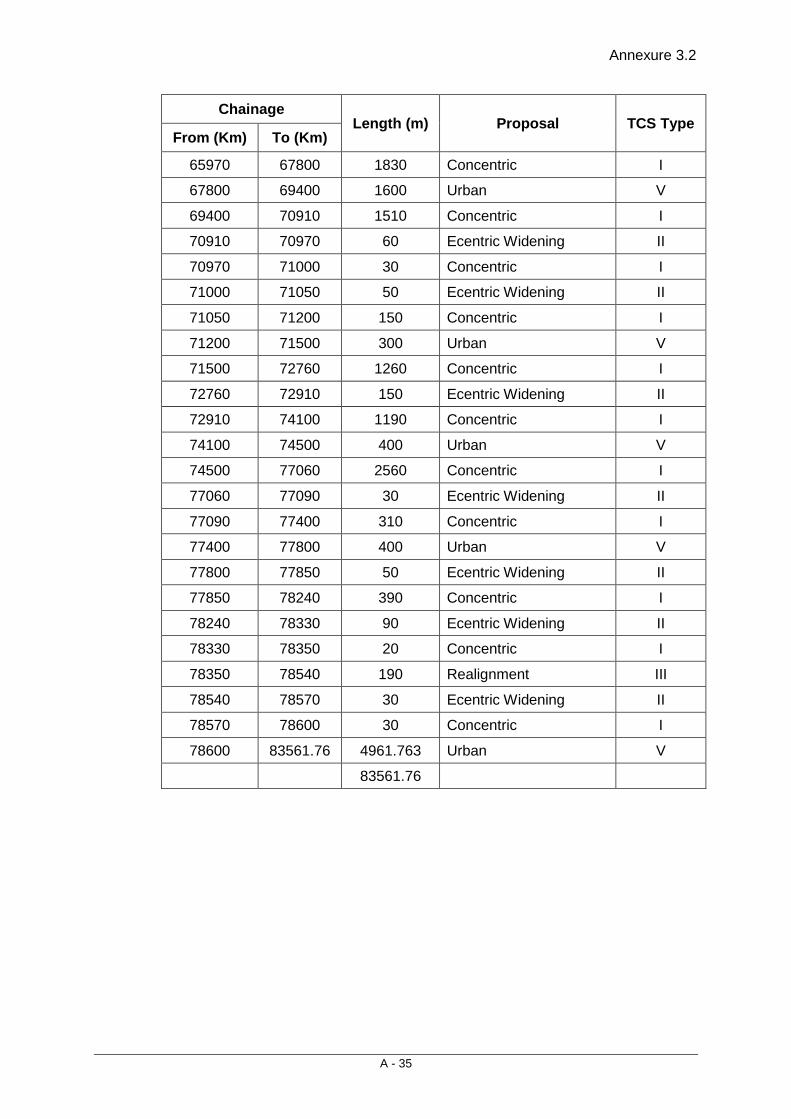
Annexure 3.2
A - 35
Chainage Length (m) Proposal TCS Type
From (Km) To (Km)
65970 67800 1830 Concentric I
67800 69400 1600 Urban V
69400 70910 1510 Concentric I
70910 70970 60 Ecentric Widening II
70970 71000 30 Concentric I
71000 71050 50 Ecentric Widening II
71050 71200 150 Concentric I
71200 71500 300 Urban V
71500 72760 1260 Concentric I
72760 72910 150 Ecentric Widening II
72910 74100 1190 Concentric I
74100 74500 400 Urban V
74500 77060 2560 Concentric I
77060 77090 30 Ecentric Widening II
77090 77400 310 Concentric I
77400 77800 400 Urban V
77800 77850 50 Ecentric Widening II
77850 78240 390 Concentric I
78240 78330 90 Ecentric Widening II
78330 78350 20 Concentric I
78350 78540 190 Realignment III
78540 78570 30 Ecentric Widening II
78570 78600 30 Concentric I
78600 83561.76 4961.763 Urban V
83561.76
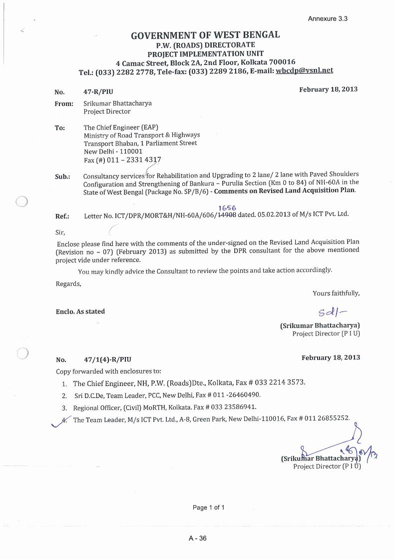
Annexure 3.3
A - 36
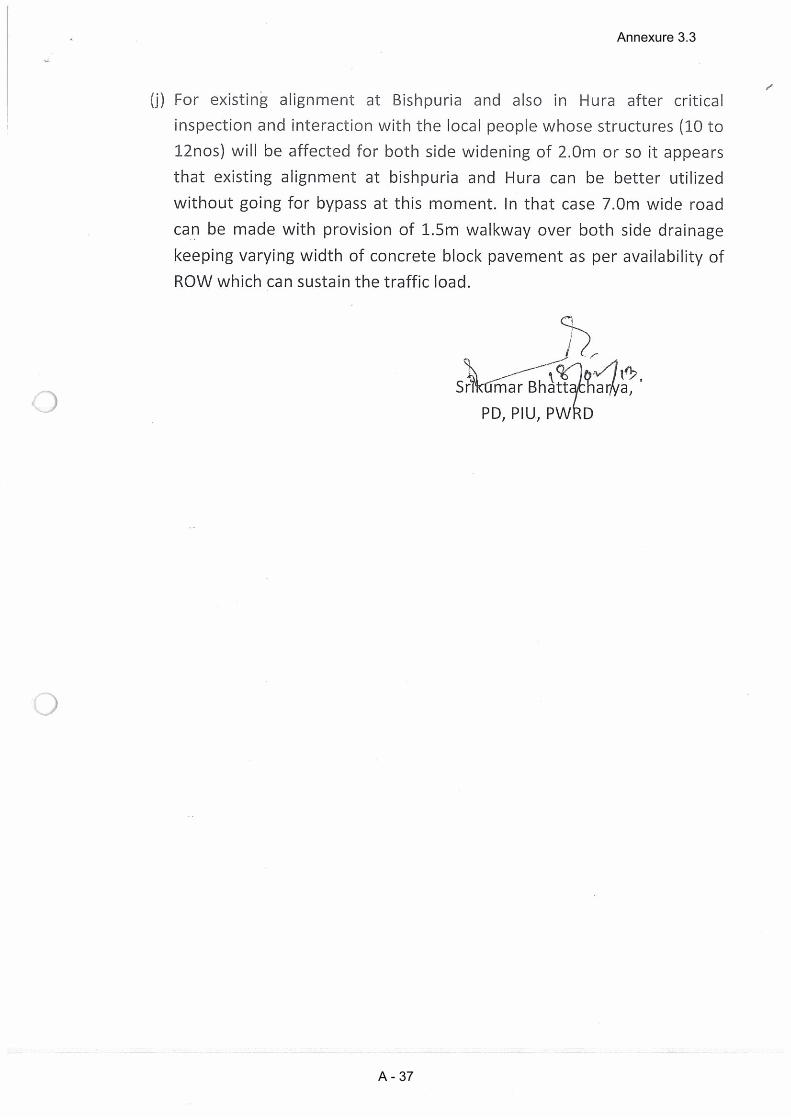
Annexure 3.3
A - 37
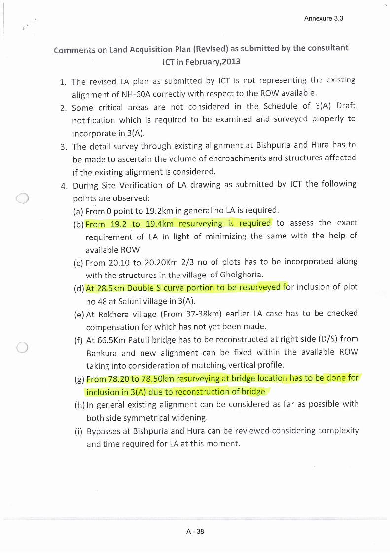
Annexure 3.3
A - 38
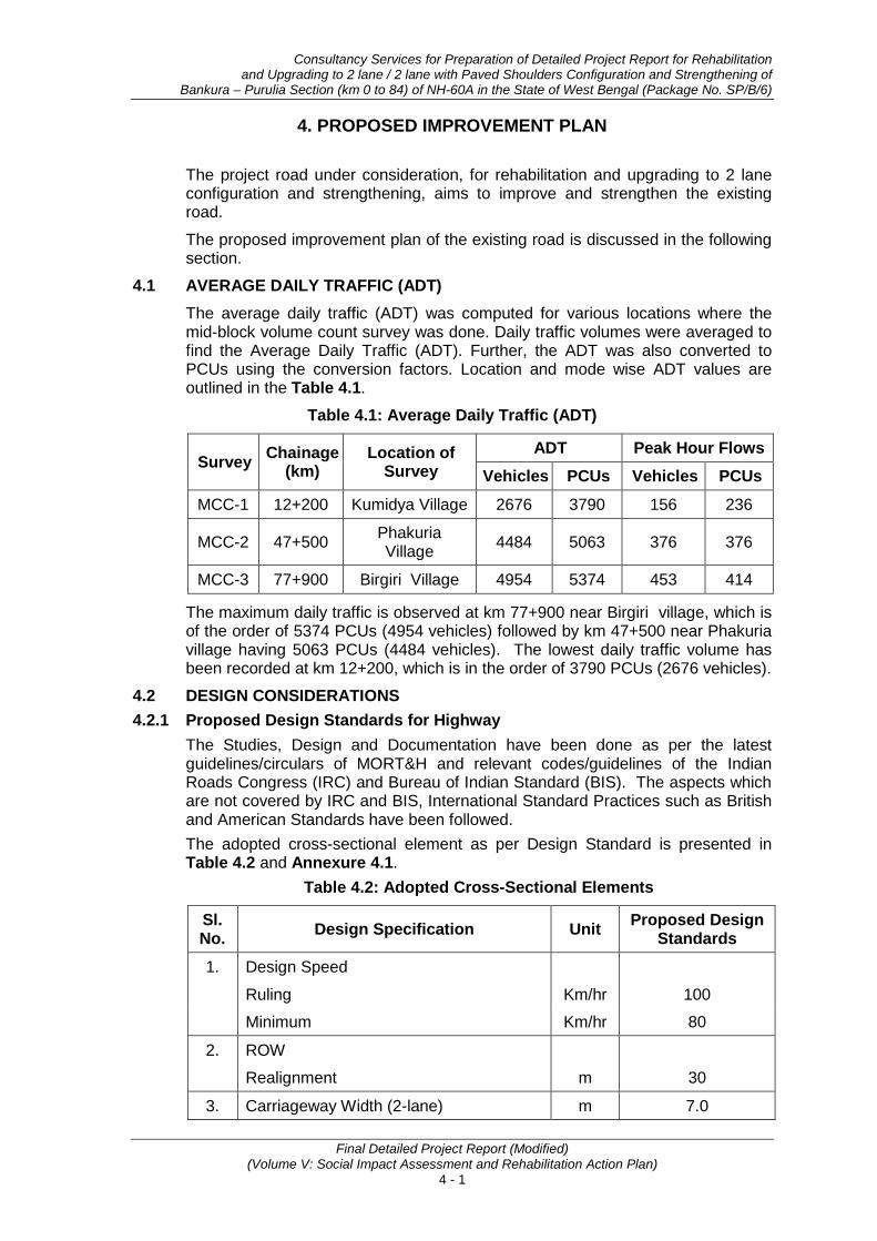
Consultancy Services for Preparation of Detailed Project Report for Rehabilitation and Upgrading to 2 lane / 2 lane with Paved Shoulders Configuration and Strengthening of
Bankura – Purulia Section (km 0 to 84) of NH-60A in the State of West Bengal (Package No. SP/B/6)
Final Detailed Project Report (Modified) (Volume V: Social Impact Assessment and Rehabilitation Action Plan)
4 - 1
4. PROPOSED IMPROVEMENT PLAN
The project road under consideration, for rehabilitation and upgrading to 2 lane configuration and strengthening, aims to improve and strengthen the existing road.
The proposed improvement plan of the existing road is discussed in the following section.
4.1 AVERAGE DAILY TRAFFIC (ADT) The average daily traffic (ADT) was computed for various locations where the mid-block volume count survey was done. Daily traffic volumes were averaged to find the Average Daily Traffic (ADT). Further, the ADT was also converted to PCUs using the conversion factors. Location and mode wise ADT values are outlined in the Table 4.1.
Table 4.1: Average Daily Traffic (ADT)
Survey Chainage (km)
Location of Survey
ADT Peak Hour Flows Vehicles PCUs Vehicles PCUs
MCC-1 12+200 Kumidya Village 2676 3790 156 236
MCC-2 47+500 Phakuria Village 4484 5063 376 376
MCC-3 77+900 Birgiri Village 4954 5374 453 414
The maximum daily traffic is observed at km 77+900 near Birgiri village, which is of the order of 5374 PCUs (4954 vehicles) followed by km 47+500 near Phakuria village having 5063 PCUs (4484 vehicles). The lowest daily traffic volume has been recorded at km 12+200, which is in the order of 3790 PCUs (2676 vehicles).
4.2 DESIGN CONSIDERATIONS 4.2.1 Proposed Design Standards for Highway
The Studies, Design and Documentation have been done as per the latest guidelines/circulars of MORT&H and relevant codes/guidelines of the Indian Roads Congress (IRC) and Bureau of Indian Standard (BIS). The aspects which are not covered by IRC and BIS, International Standard Practices such as British and American Standards have been followed. The adopted cross-sectional element as per Design Standard is presented in Table 4.2 and Annexure 4.1.
Table 4.2: Adopted Cross-Sectional Elements
Sl. No. Design Specification Unit Proposed Design
Standards 1. Design Speed
Ruling Km/hr 100
Minimum Km/hr 80
2. ROW
Realignment m 30
3. Carriageway Width (2-lane) m 7.0

Proposed Improvement Plan
Final Detailed Project Report (Modified) (Volume V: Social Impact Assessment and Rehabilitation Action Plan)
4 - 2
Sl. No. Design Specification Unit Proposed Design
Standards 4. Shoulder width
(a) Paved shoulders on both sides m 1.5
(b) Earthen Shoulders on both sides m 1.0
5. Camber / cross fall %
Carriageway 2.5
Paved Shoulders 2.5
Earthen Shoulders 3.0
6. Gradients a) Ruling b) Limiting
% %
3.3 5.0
7. Super elevation Maximum % 5.0
8. Minimum Horizontal Curve Radius Ruling Absolute
m m
360 230
Note: in the above table is the algebraic difference in grades expressed as percentage
4.3 SUMMARY OF IMPROVEMENT PROPOSALS Based on outcome of various survey / investigation, design consideration, road safety audit and required social and environmental survey of existing project section, the summary of proposed improvement plan is presented in Table 4.3.
Table 4.3: Proposed Improvement Plan
Sl. No. Improvement Description
1. Total Project Length 83.562 Kms
2. Improvement of Highway Geometric
Improvement of all the deficient Horizontal and vertical curves
3. Provision of Paved Shoulder
Paved Shoulder (width 1.5 mtr- 2.5 mtr) in a total length of 83.562 Km.
4. Proposed By-Pass NIL
5. Raising of Highway Formation
Proposed at following locations: Ch. 9.950-10.330, 15.200-15.600, 15.990- 16.180 and 29.425-29.825, total 1.370 Kms
6. Major Bridges 01
7. Minor Bridges 10
8. Culverts 131 Nos.
9. ROB Not Proposed
10. Fly Over Not Proposed
Consultancy Services for Preparation of Detailed Project Report for Rehabilitation and Upgrading to 2 lane / 2 lane with Paved Shoulders Configuration and Strengthening of
Bankura – Purulia Section (km 0 to 84) of NH-60A in the State of West Bengal (Package No. SP/B/6)
Final Detailed Project Report (Modified) (Volume V: Social Impact Assessment and Rehabilitation Action Plan)
4 - 3
Sl. No. Improvement Description
11. Grade Separated Structures
Not Proposed
12. Service Roads Not Proposed
13. Road Side Covered RCC Drains
Proposed in Built-up Section totaling 28.68 Kms.
14. Major Junctions 5 Nos.
15. Minor Junctions 168 Nos.
16. Road Boundary Stones
Proposed
17. Truck lay bye 2 Nos. at Km. 2.600 and Km. 62.540
18. Bus Stops 15 Nos. Proposed
19. Parking Areas Not Proposed
20. Toll Plaza Not Proposed
21. Road Safety Guard Rails
At Culvert & Bridge approaches
22. Road Side Plantation
33335 trees of various species
23. Provision of Traffic Signage
Type Size Nos.
1. Reassurance Sign
(800mmx600mm) 20
2. Advance Direction Sign 28
3. Direction Sign (600mm x 450mm) 312
4. Direction Sign (300 x 900) 484
5. Informatory Sign
(750mmx900mm) 532
(900mm triangle) 270
(600dia circular) 50
6. (Directional Sign)
(2.5 sqm) 28
(900 octagonal) 126
7. Over-head Cantilever Gantry 9
24. Foot Path and Pedestrian Guard Rails in Built-up sections
From Ch. 4.800 to 5.200, 20.250 to 20.630, 27.710 to 28.600, 37.100 to 37.600, 39.950 to 41.250, 47.500 to 50.250, 51.394 to 52.824, 68.214 to 69.114 and 78.454 to 83.562
Proposed Improvement Plan
Final Detailed Project Report (Modified) (Volume V: Social Impact Assessment and Rehabilitation Action Plan)
4 - 4
Sl. No. Improvement Description
25. Road marking (Lane/center line/edge line/ transverse marking /Zebra Crossing and any other markings)
For safety of road user during night travel, retro-refectories road delineators have been proposed at identified locations approach to Bridge, culverts & structure, speed restricted section, curved sections, built-up sections etc.
26. Hoardings/ Wall painting for awareness of HIV/AIDS
It is proposed at 2 locations near- Truck Lay bye.
4.4 JUNCTION IMPROVEMENTS There are 5 major and 168 minor (T, Y and (+)) Junctions (state highway, major district roads & village roads) in the specified section of project road. Most of these junctions are located in the built-up sections. All major and minor junctions shall be improved as at grade junctions as per guidelines of IRC. A complete list of the junction is presented in Annexure 4.2.
4.5 ADDRESSAL OF SAFETY ISSUES IN DESIGN FOR MINIMISING THE NEGATIVE IMPACT Outcomes of series of public consultations and suggestion of participants on safety issues were given due consideration in project design. Pedestrian Guard Railings and Pillar Guards Pedestrian guard railing has been proposed in built-up sections/urban areas to safeguard against stray pedestrians moving onto the carriageway. This has been provided at inner edge of footpath. The total length of Guard Rails works out to be 24.682 Kms. Pillar guards painted with alternate black and white stripes shall be placed at intervals of 1.5 m with and offset of 2 m from carriageway edge. Traffic Signs Traffic signs have been provided at suitable locations all along the project road in order to provide proper direction and warning to the driver as well as direct them the route they want to follow. The traffic signs will be as per IRC Standard as will be of “Retro Reflection Type”.

Consultancy Services for Preparation of Detailed Project Report for Rehabilitation and Upgrading to 2 lane / 2 lane with Paved Shoulders Configuration and Strengthening of
Bankura – Purulia Section (km 0 to 84) of NH-60A in the State of West Bengal (Package No. SP/B/6)
Final Detailed Project Report (Modified) (Volume V: Social Impact Assessment and Rehabilitation Action Plan)
4 - 5
Road Markings and Delineators For Safety of road user during night travel, retro-refectories road delineators have been proposed at identified locations (Approach to Bridge, culverts & structure, speed restricted section, curved sections, built-up section etc. All the trees on highway flanks shall be fixed with retro-refectories plates marking for clear identification during night travel.
Crash Barrier W-Beam Metal Crash Barrier has been proposed on approaches to Bridges, high embankment Zone where height of embankment is more than 3 m and at sharp curve locations. Total 9.663 km length has been identified in the project section for provision of W-Beam Metal Crash Barrier.
Truck Lay-bye Presently the project road is of intermediate lane (5.5 m wide) with earthen shoulder, except a small section from km 80+000 to km 84+000 where it is 2 lane undivided highway. Due to absence of any proper parking facility along the stretch, road side parking of trucks and MAVs have been observed near dhabas and other eateries outlet at different locations. In view of these, two Truck Lay-bys are proposed at km 11+800 and km 63+000, with a parking of minimum 50 trucks at each location on either side of the project road. No additional land will be required for providing truck lay byes as it shall be constructed within available ROW.
Passenger sheds
A total of 15 passenger sheds have been identified along the project road and are likely to be affected. These passenger sheds will be demolished and new sheds will be constructed within the existing RoW. Location of passenger sheds is provided in Table 4.4. Draft standard design of passenger shed has been provided below and is also included in detailed design report:
Table 4.4: Passenger sheds likely to be affected
Sl. No. Chainage Place Side
1. 3.450 Damodarpur L
2. 5.160 Puabagan R
Proposed Improvement Plan
Final Detailed Project Report (Modified) (Volume V: Social Impact Assessment and Rehabilitation Action Plan)
4 - 6
Sl. No. Chainage Place Side
3. 8.450 Natungram R
4. 10.900 Kumidiya R
5. 12.960 Domnipara R
6. 14.275 Kalpathar R
7. 16.960 Kasibediya L
8. 22.800 Nischintpur R
9. 32.440 Pairachali L
10. 40.067 Bishpuria L
11. 58.425 Lakhanpur L
12. 59.635 Lakhanpur L
13. 65.450 Jambed R
14. 70.300 Sidpur R
15. 73.120 Gengara R
Spread messages of HIV/AIDS For generating awareness about HIV/AIDS among road users in particular and local community in general, large size hoardings (10x8 ft.) at 8 locations (truck lay bye, start and end point of project) and wall paintings (8x8 ft.) at 30 locations (near school market area and hospitals etc.) have been proposed. Hoarding would be placed at near the both truck lay byes, take off and termination point of project road and 2 in Hura market area. Wall painting shall be done by RAP implementation agency in consultation with local Panchayat. Design of hoarding and wall painting has been provided as Annexure 4.3.
• • •

5500
Roadway Width=12.0 m
C
L
Existing Carriageway
TYPICAL CROSS SECTION FOR RURAL AREAS (OVERLAY) - CONCENTRIC WIDENING (TYPE-I)
PROW 20000-30000
VariesVaries
WMM
DBM
BC
GSB
SUBGRADE 500mm
WMM
Toe Berm
GL
Toe Berm
Bituminous Layer (30-220mm)
CBR - 8%
7000
New CarriagewayEarthen
Shoulder
2.5%
3.0%
1
2
1500
Paved
Shoulder
Earthen
Shoulder
2.5%
3.0%
1
2
1500
Paved
Shoulder
10001000
'A'
Unlined Toe Drain
SCALE - 1:500
GL
Unlined Toe Drain
500500
Granular Base (100-370mm)
Sand/Mooram Layer (90-290mm)
Existing Road Crust
GL GL
DETAIL-'A' : UNLINED TOE DRAIN
SCALE 1:25
(1V)
(1.5H)
(1V)
(1.5H)
15
0
500
45
0
2300
Notes :-
1. All Dimensions are in mm unless otherwise mentioned.
2. For Details of Pavement Composition, Refer Dwg. No. MoRT&H/NH-60A/PAV./01/R0
3. The Section Ulined Drain Has been Prepared based on the Hydraulic Design.
As Indicated Above
Approved by
Checked byDesigned byPrepared by
Avnish ChandHarsha ChatterjeeBiswajit DasDigram Sharma
DRAWING NUMBER
Revisions
Checked byDescriptionDateRevisions
Initial DrawingsSep. 2010
R0
Ph : 2686-3000, Fax 2685-5252
A-8, Green Park, New Delhi - 110016
Intercontinental Consultants & Technocrats Pvt.Ltd,
Scale:
GOVT OF INDIA
MINISTRY OF ROAD
TRANSPORT AND HIGHWAYS
Consultancy Services for Preparation of
Detailed Project Report for Rehabilitation and Upgrading to
2-lane / 2-lane with Paved Shoulders Configuration
and Strengthening of Bankura-Purulia Section (Km 0 to Km 84)
of NH-60A in the State of West Bengal
(Package No. SP/B/6)
Modified DrawingsJan. 2011
R1
TYPICAL CROSS SECTION FOR
RURAL AREAS (OVERLAY) -
CONCENTRIC WIDENING (TYPE - I)
Annexure 4.1
A - 39

5500
7000
Roadway Width=12.0 m
2
1
2.5%
2.5%
New Carriageway
Existing Carriageway
TYPICAL CROSS SECTION FOR RURAL AREAS (OVERLAY) - ECCENTRIC WIDENING (TYPE-II)
WMM
DBM
BC
1
2
PROW 20000 - 30000
VariesVaries
WMM
Profile Corrective
Course (DBM)
C
L
SUBGRADE 500mm
GSB
CBR - 8%
Earthen
Shoulder
1500
Paved
Shoulder
1000
Earthen
Shoulder
1500
Paved
Shoulder
1000
3.0% 3.0%
'A'
SCALE - 1:500
GLGL
Toe Berm
Unlined Toe Drain
500
Toe Berm
Unlined Toe Drain
500
Bituminous Layer (30-220mm)
Granular Base (100-370mm)
Sand/Mooram Layer (90-290mm)
Existing Road Crust
GL GL
DETAIL-'A' : UNLINED TOE DRAIN
SCALE 1:25
(1V)
(1.5H)
(1V)
(1.5H)
15
0
500
45
0
2300
Notes :-
1. All Dimensions are in mm unless otherwise mentioned.
2. For Details of Pavement Composition, Refer Dwg. No. MoRT&H/NH-60A/PAV./01/R0
3. The Section Ulined Drain Has been Prepared based on the Hydraulic Design.
As Indicated Above
Approved by
Checked byDesigned byPrepared by
Avnish ChandHarsha ChatterjeeBiswajit DasDigram Sharma
DRAWING NUMBER
Revisions
Checked byDescriptionDateRevisions
Initial DrawingsDec. 2010
R0
Ph : 2686-3000, Fax 2685-5252
A-8, Green Park, New Delhi - 110016
Intercontinental Consultants & Technocrats Pvt.Ltd,
Scale:
GOVT OF INDIA
MINISTRY OF ROAD
TRANSPORT AND HIGHWAYS
Consultancy Services for Preparation of
Detailed Project Report for Rehabilitation and Upgrading to
2-lane / 2-lane with Paved Shoulders Configuration
and Strengthening of Bankura-Purulia Section (Km 0 to Km 84)
of NH-60A in the State of West Bengal
(Package No. SP/B/6)
TYPICAL CROSS SECTION FOR
RURAL AREAS (OVERLAY) -
ECCENTRIC WIDENING (TYPE - II)
Annexure 4.1
A - 40
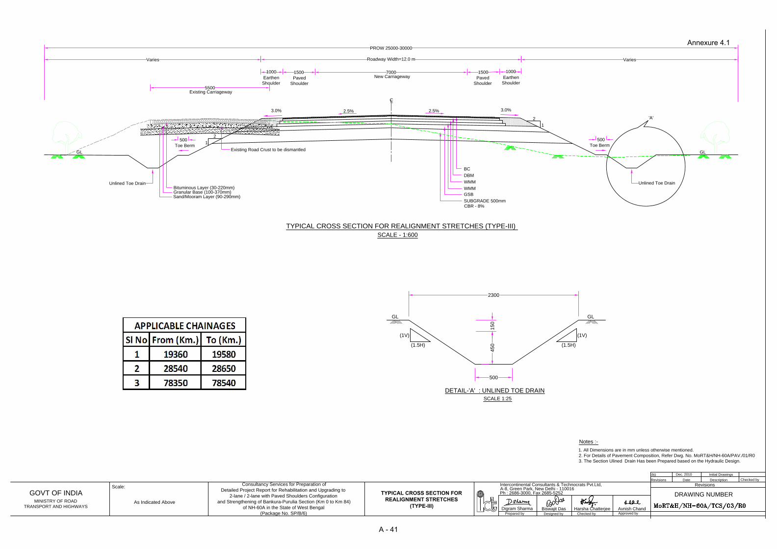
7000
Roadway Width=12.0 m
C
L
New Carriageway
2.5%
1
2
5500
Existing Carriageway
Varies
PROW 25000-30000
Varies
TYPICAL CROSS SECTION FOR REALIGNMENT STRETCHES (TYPE-III)
DBM
BC
WMM
WMM
SUBGRADE 500mm
GSB
CBR - 8%
Earthen
Shoulder
1500
Paved
Shoulder
1000
3.0%2.5%
1
2
Earthen
Shoulder
1500
Paved
Shoulder
1000
3.0%
Existing Road Crust to be dismantled
SCALE - 1:600
'A'
GLGL
Toe Berm
Unlined Toe Drain
500
Toe Berm
Unlined Toe Drain
500
Bituminous Layer (30-220mm)
Granular Base (100-370mm)
Sand/Mooram Layer (90-290mm)
GL GL
DETAIL-'A' : UNLINED TOE DRAIN
SCALE 1:25
(1V)
(1.5H)
(1V)
(1.5H)
150
500
450
2300
As Indicated Above
Approved by
Checked byDesigned byPrepared by
Avnish ChandHarsha ChatterjeeBiswajit DasDigram Sharma
DRAWING NUMBER
Revisions
Checked byDescriptionDateRevisions
Initial DrawingsDec. 2010
R0
Ph : 2686-3000, Fax 2685-5252
A-8, Green Park, New Delhi - 110016
Intercontinental Consultants & Technocrats Pvt.Ltd,
Scale:
GOVT OF INDIA
MINISTRY OF ROAD
TRANSPORT AND HIGHWAYS
Consultancy Services for Preparation of
Detailed Project Report for Rehabilitation and Upgrading to
2-lane / 2-lane with Paved Shoulders Configuration
and Strengthening of Bankura-Purulia Section (Km 0 to Km 84)
of NH-60A in the State of West Bengal
(Package No. SP/B/6)
TYPICAL CROSS SECTION FOR
REALIGNMENT STRETCHES
(TYPE-III)
Notes :-
1. All Dimensions are in mm unless otherwise mentioned.
2. For Details of Pavement Composition, Refer Dwg. No. MoRT&H/NH-60A/PAV./01/R0
3. The Section Ulined Drain Has been Prepared based on the Hydraulic Design.
Annexure 4.1
A - 41

7000
Roadway Width=12.0 m
C
L
DBM
BC
TYPICAL CROSS SECTION FOR NEW CONSTRUCTION (RAISING) STRETCHES (TYPE IV)
WMM
WMM
SUBGRADE 500mm
GSB
2.5%
1
2
5500
Varies
PROW 20000-30000
Varies
Existing Carriageway
New Carriageway
h (Height of Raising)
D/S SIDE
U/S SIDE
Detail 'B'
CBR - 8%
3.0%2.5%
1
2
3.0%
Earthen
Shoulder
1500
Paved
Shoulder
1000
Earthen
Shoulder
1500
Paved
Shoulder
1000
'A'
SCALE - 1:600
GLGL
Toe Berm
Unlined Toe Drain
500
Toe Berm
Unlined Toe Drain
500
Bituminous Layer (30-220mm)
Granular Base (100-370mm)
Sand/Mooram Layer (90-290mm)
Existing Road Crust
GL GL
DETAIL-'A' : UNLINED TOE DRAIN
SCALE 1:25
(1V)
(1.5H)
(1V)
(1.5H)
15
0
500
45
0
2300
New FRL
New Subgrade Level
150mm Thick Filter Materials
300mm Thick Stone Pitching
(Hand Placed) Over Slope
300mm x 2 Layers of Hand Placed
Stone Protection on apron
10
00
500
Cut off Wall
O
L
D
S
E
C
T
I
O
N
R
A
I
S
E
D
S
E
C
T
I
O
N
D/S SIDE U/S SIDE
DETAIL - B
60
0
300
Notes:
1. Details of Protection works shall be followed for both side, wherever applicable.
2. All Dimensions are in mm unless otherwise mentioned.
3. For Details of Pavement Composition, refer dwg. No. MoRT&H/NH-60A/PAV./01/RO
4. The Section Ulined Drain Has been Prepared based on the Hydraulic Design.
2000
Design HFL
SCALE - 1:600
As Indicated Above
Approved by
Checked byDesigned byPrepared by
Avnish ChandHarsha ChatterjeeBiswajit DasDigram Sharma
DRAWING NUMBER
Revisions
Checked byDescriptionDateRevisions
Initial DrawingsMarch 2013
R0
Ph : 2686-3000, Fax 2685-5252
A-8, Green Park, New Delhi - 110016
Intercontinental Consultants & Technocrats Pvt.Ltd,
Scale:
GOVT OF INDIA
MINISTRY OF ROAD
TRANSPORT AND HIGHWAYS
Consultancy Services for Preparation of
Detailed Project Report for Rehabilitation and Upgrading to
2-lane / 2-lane with Paved Shoulders Configuration
and Strengthening of Bankura-Purulia Section (Km 0 to Km 84)
of NH-60A in the State of West Bengal
(Package No. SP/B/6)
TYPICAL CROSS SECTION FOR
NEW CONSTRUCTION (RAISING)
STRETCHES (TYPE IV)
Annexure 4.1
A - 42

C
L
2.5 %
5500
Existing Carriageway
LINED DRAIN
7000
Widened Carriageway
2.5 %
3.0%
1500
Covered Drain
Cum Footpath
TYPICAL CROSS SECTION FOR URBAN STRETCH (TYPE-V)
Property Boundary
/Building Line
Property Boundary
/Building Line
1500
Covered Drain
Cum Footpath
'A'
SCALE - 1:500
Proposed ROW 13000
DBM
BC
WMM (IN 2 LAYERS)
GSB
SUBGRADE
1500
Paved Shoulder
(With Concrete Blocks)
1500
Paved Shoulder
(With Concrete Blocks)
LINED DRAIN
3.0%
Bituminous Layer (30-220mm)
Granular Base (100-370mm)
Sand/Mooram Layer (90-290mm)
Existing Road Crust
WMM (250 mm)
Sand Layer (150 mm)
Concrete Block (100 mm)
Granular Base (200 mm)
150150
700
100
60
0 T
o 1
20
0
(V
AR
YIN
G)
1000
150
175
100m.m. RCC SLAB
100 DIA @2000 C/C
TO BE PROTECTED WITH FILTER
WEEP HOLES
2.5%
RCC M-20
SCALE - 1:100
M-15 CONCRETE PCC
150
100
100
As Indicated Above
Approved by
Checked byDesigned byPrepared by
Avnish ChandHarsha ChatterjeeBiswajit DasDigram Sharma
DRAWING NUMBER
Revisions
Checked byDescriptionDateRevisions
Initial DrawingsDec. 2010R0
Ph : 2686-3000, Fax 2685-5252
A-8, Green Park, New Delhi - 110016
Intercontinental Consultants & Technocrats Pvt.Ltd,
Scale:
GOVT OF INDIA
MINISTRY OF ROAD
TRANSPORT AND HIGHWAYS
Consultancy Services for Preparation of
Detailed Project Report for Rehabilitation and Upgrading to
2-lane / 2-lane with Paved Shoulders Configuration
and Strengthening of Bankura-Purulia Section (Km 0 to Km 84)
of NH-60A in the State of West Bengal
(Package No. SP/B/6)
Modified DrawingsJan. 2011
R1
Modified DrawingsMar. 2013
R2
Notes :-
1. All Dimensions are in mm unless otherwise mentioned.
2. For Details of Pavement Composition, Refer Dwg. No. MoRT&H/NH-60A/PAV./01/R0
TYPICAL CROSS SECTION
FOR URBAN STRETCH
(TYPE-V)
3. The Section Lined Drain Has been Prepared based on the Hydraulic Design.
Annexure 4.1
A - 43

5500
Roadway Width=12.0 m
C
L
Existing Carriageway
TYPICAL CROSS SECTION FOR RURAL AREAS (OVERLAY) - CONCENTRIC WIDENING (TYPE-I)
PROW 20000-30000
VariesVaries
WMM
DBM
BC
GSB
SUBGRADE 500mm
WMM
Toe Berm
GL
Toe Berm
Bituminous Layer (30-220mm)
CBR - 8%
7000
New CarriagewayEarthen
Shoulder
2.5%
3.0%
1
2
1500
Paved
Shoulder
Earthen
Shoulder
2.5%
3.0%
1
2
1500
Paved
Shoulder
10001000
'A'
Unlined Toe Drain
SCALE - 1:500
GL
Unlined Toe Drain
500500
Granular Base (100-370mm)
Sand/Mooram Layer (90-290mm)
Existing Road Crust
GL GL
DETAIL-'A' : UNLINED TOE DRAIN
SCALE 1:25
(1V)
(1.5H)
(1V)
(1.5H)
15
0
500
45
0
2300
Notes :-
1. All Dimensions are in mm unless otherwise mentioned.
2. For Details of Pavement Composition, Refer Dwg. No. MoRT&H/NH-60A/PAV./01/R0
3. The Section Ulined Drain Has been Prepared based on the Hydraulic Design.
As Indicated Above
Approved by
Checked byDesigned byPrepared by
Avnish ChandHarsha ChatterjeeBiswajit DasDigram Sharma
DRAWING NUMBER
Revisions
Checked byDescriptionDateRevisions
Initial DrawingsSep. 2010
R0
Ph : 2686-3000, Fax 2685-5252
A-8, Green Park, New Delhi - 110016
Intercontinental Consultants & Technocrats Pvt.Ltd,
Scale:
GOVT OF INDIA
MINISTRY OF ROAD
TRANSPORT AND HIGHWAYS
Consultancy Services for Preparation of
Detailed Project Report for Rehabilitation and Upgrading to
2-lane / 2-lane with Paved Shoulders Configuration
and Strengthening of Bankura-Purulia Section (Km 0 to Km 84)
of NH-60A in the State of West Bengal
(Package No. SP/B/6)
Modified DrawingsJan. 2011
R1
TYPICAL CROSS SECTION FOR
RURAL AREAS (OVERLAY) -
CONCENTRIC WIDENING (TYPE - I)

5500
7000
Roadway Width=12.0 m
2
1
2.5%
2.5%
New Carriageway
Existing Carriageway
TYPICAL CROSS SECTION FOR RURAL AREAS (OVERLAY) - ECCENTRIC WIDENING (TYPE-II)
WMM
DBM
BC
1
2
PROW 20000 - 30000
VariesVaries
WMM
Profile Corrective
Course (DBM)
C
L
SUBGRADE 500mm
GSB
CBR - 8%
Earthen
Shoulder
1500
Paved
Shoulder
1000
Earthen
Shoulder
1500
Paved
Shoulder
1000
3.0% 3.0%
'A'
SCALE - 1:500
GLGL
Toe Berm
Unlined Toe Drain
500
Toe Berm
Unlined Toe Drain
500
Bituminous Layer (30-220mm)
Granular Base (100-370mm)
Sand/Mooram Layer (90-290mm)
Existing Road Crust
GL GL
DETAIL-'A' : UNLINED TOE DRAIN
SCALE 1:25
(1V)
(1.5H)
(1V)
(1.5H)
15
0
500
45
0
2300
Notes :-
1. All Dimensions are in mm unless otherwise mentioned.
2. For Details of Pavement Composition, Refer Dwg. No. MoRT&H/NH-60A/PAV./01/R0
3. The Section Ulined Drain Has been Prepared based on the Hydraulic Design.
As Indicated Above
Approved by
Checked byDesigned byPrepared by
Avnish ChandHarsha ChatterjeeBiswajit DasDigram Sharma
DRAWING NUMBER
Revisions
Checked byDescriptionDateRevisions
Initial DrawingsDec. 2010
R0
Ph : 2686-3000, Fax 2685-5252
A-8, Green Park, New Delhi - 110016
Intercontinental Consultants & Technocrats Pvt.Ltd,
Scale:
GOVT OF INDIA
MINISTRY OF ROAD
TRANSPORT AND HIGHWAYS
Consultancy Services for Preparation of
Detailed Project Report for Rehabilitation and Upgrading to
2-lane / 2-lane with Paved Shoulders Configuration
and Strengthening of Bankura-Purulia Section (Km 0 to Km 84)
of NH-60A in the State of West Bengal
(Package No. SP/B/6)
TYPICAL CROSS SECTION FOR
RURAL AREAS (OVERLAY) -
ECCENTRIC WIDENING (TYPE - II)

7000
Roadway Width=12.0 m
C
L
New Carriageway
2.5%
1
2
5500
Existing Carriageway
Varies
PROW 25000-30000
Varies
TYPICAL CROSS SECTION FOR REALIGNMENT STRETCHES (TYPE-III)
DBM
BC
WMM
WMM
SUBGRADE 500mm
GSB
CBR - 8%
Earthen
Shoulder
1500
Paved
Shoulder
1000
3.0%2.5%
1
2
Earthen
Shoulder
1500
Paved
Shoulder
1000
3.0%
Existing Road Crust to be dismantled
SCALE - 1:600
'A'
GLGL
Toe Berm
Unlined Toe Drain
500
Toe Berm
Unlined Toe Drain
500
Bituminous Layer (30-220mm)
Granular Base (100-370mm)
Sand/Mooram Layer (90-290mm)
GL GL
DETAIL-'A' : UNLINED TOE DRAIN
SCALE 1:25
(1V)
(1.5H)
(1V)
(1.5H)
150
500
450
2300
As Indicated Above
Approved by
Checked byDesigned byPrepared by
Avnish ChandHarsha ChatterjeeBiswajit DasDigram Sharma
DRAWING NUMBER
Revisions
Checked byDescriptionDateRevisions
Initial DrawingsDec. 2010
R0
Ph : 2686-3000, Fax 2685-5252
A-8, Green Park, New Delhi - 110016
Intercontinental Consultants & Technocrats Pvt.Ltd,
Scale:
GOVT OF INDIA
MINISTRY OF ROAD
TRANSPORT AND HIGHWAYS
Consultancy Services for Preparation of
Detailed Project Report for Rehabilitation and Upgrading to
2-lane / 2-lane with Paved Shoulders Configuration
and Strengthening of Bankura-Purulia Section (Km 0 to Km 84)
of NH-60A in the State of West Bengal
(Package No. SP/B/6)
TYPICAL CROSS SECTION FOR
REALIGNMENT STRETCHES
(TYPE-III)
Notes :-
1. All Dimensions are in mm unless otherwise mentioned.
2. For Details of Pavement Composition, Refer Dwg. No. MoRT&H/NH-60A/PAV./01/R0
3. The Section Ulined Drain Has been Prepared based on the Hydraulic Design.
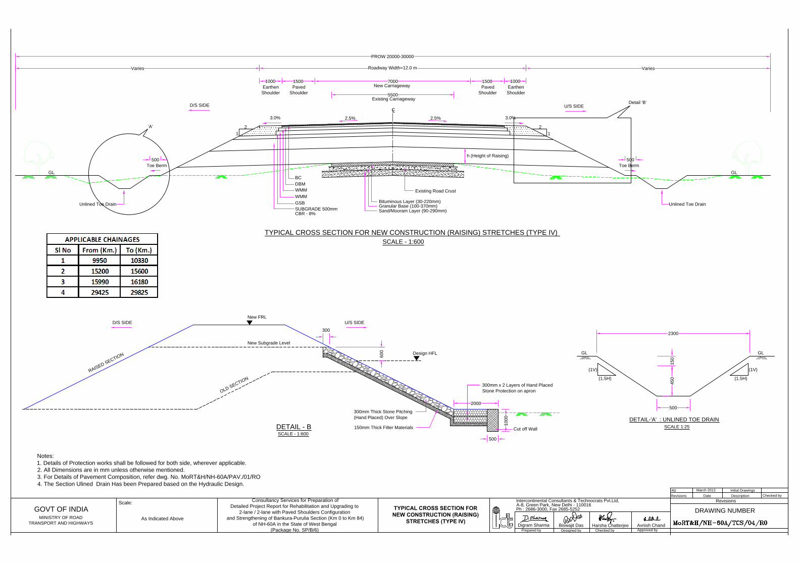
7000
Roadway Width=12.0 m
C
L
DBM
BC
TYPICAL CROSS SECTION FOR NEW CONSTRUCTION (RAISING) STRETCHES (TYPE IV)
WMM
WMM
SUBGRADE 500mm
GSB
2.5%
1
2
5500
Varies
PROW 20000-30000
Varies
Existing Carriageway
New Carriageway
h (Height of Raising)
D/S SIDE
U/S SIDE
Detail 'B'
CBR - 8%
3.0%2.5%
1
2
3.0%
Earthen
Shoulder
1500
Paved
Shoulder
1000
Earthen
Shoulder
1500
Paved
Shoulder
1000
'A'
SCALE - 1:600
GLGL
Toe Berm
Unlined Toe Drain
500
Toe Berm
Unlined Toe Drain
500
Bituminous Layer (30-220mm)
Granular Base (100-370mm)
Sand/Mooram Layer (90-290mm)
Existing Road Crust
GL GL
DETAIL-'A' : UNLINED TOE DRAIN
SCALE 1:25
(1V)
(1.5H)
(1V)
(1.5H)
15
0
500
45
0
2300
New FRL
New Subgrade Level
150mm Thick Filter Materials
300mm Thick Stone Pitching
(Hand Placed) Over Slope
300mm x 2 Layers of Hand Placed
Stone Protection on apron
10
00
500
Cut off Wall
O
L
D
S
E
C
T
I
O
N
R
A
I
S
E
D
S
E
C
T
I
O
N
D/S SIDE U/S SIDE
DETAIL - B
60
0
300
Notes:
1. Details of Protection works shall be followed for both side, wherever applicable.
2. All Dimensions are in mm unless otherwise mentioned.
3. For Details of Pavement Composition, refer dwg. No. MoRT&H/NH-60A/PAV./01/RO
4. The Section Ulined Drain Has been Prepared based on the Hydraulic Design.
2000
Design HFL
SCALE - 1:600
As Indicated Above
Approved by
Checked byDesigned byPrepared by
Avnish ChandHarsha ChatterjeeBiswajit DasDigram Sharma
DRAWING NUMBER
Revisions
Checked byDescriptionDateRevisions
Initial DrawingsMarch 2013
R0
Ph : 2686-3000, Fax 2685-5252
A-8, Green Park, New Delhi - 110016
Intercontinental Consultants & Technocrats Pvt.Ltd,
Scale:
GOVT OF INDIA
MINISTRY OF ROAD
TRANSPORT AND HIGHWAYS
Consultancy Services for Preparation of
Detailed Project Report for Rehabilitation and Upgrading to
2-lane / 2-lane with Paved Shoulders Configuration
and Strengthening of Bankura-Purulia Section (Km 0 to Km 84)
of NH-60A in the State of West Bengal
(Package No. SP/B/6)
TYPICAL CROSS SECTION FOR
NEW CONSTRUCTION (RAISING)
STRETCHES (TYPE IV)
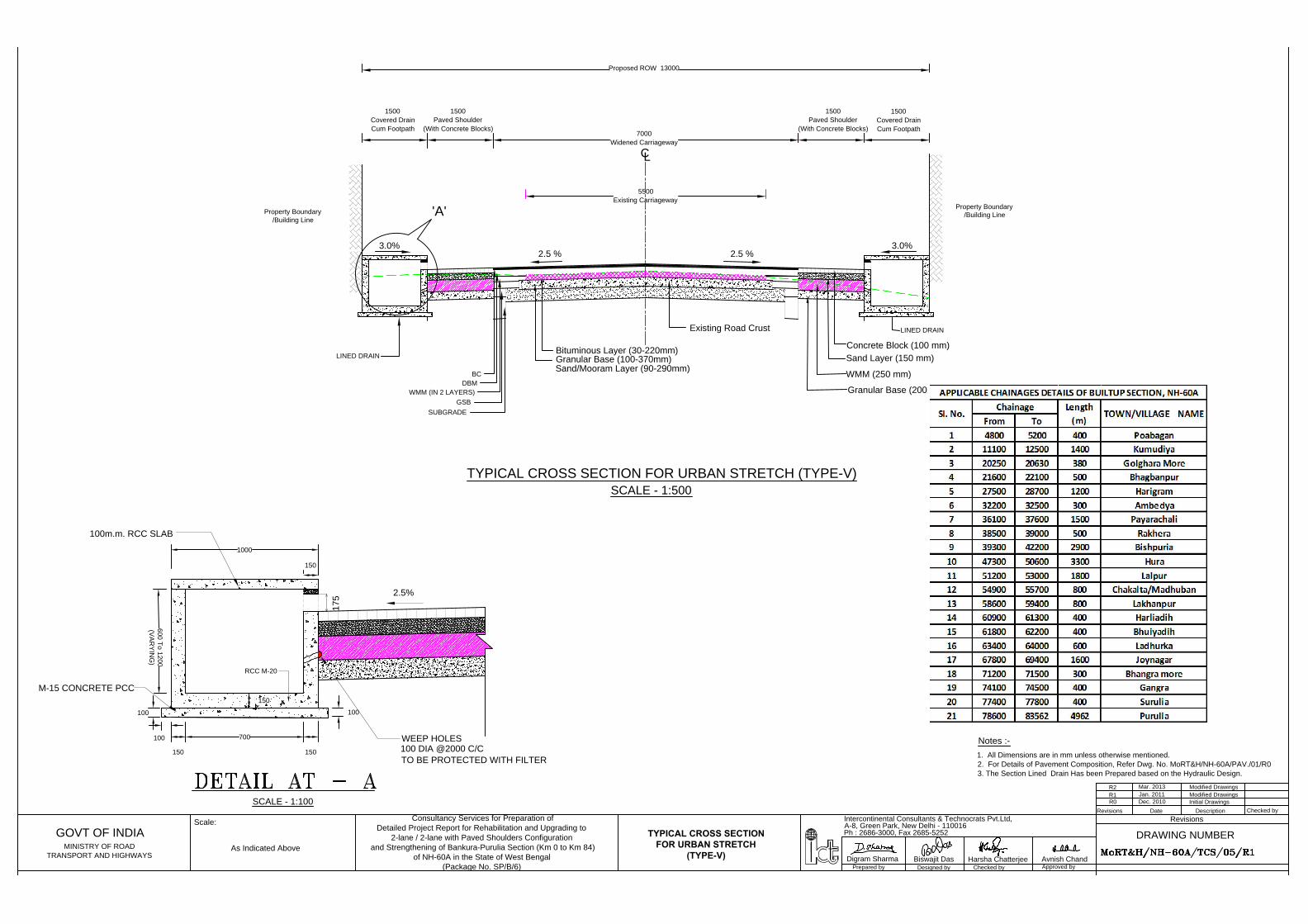
C
L
2.5 %
5500
Existing Carriageway
LINED DRAIN
7000
Widened Carriageway
2.5 %
3.0%
1500
Covered Drain
Cum Footpath
TYPICAL CROSS SECTION FOR URBAN STRETCH (TYPE-V)
Property Boundary
/Building Line
Property Boundary
/Building Line
1500
Covered Drain
Cum Footpath
'A'
SCALE - 1:500
Proposed ROW 13000
DBM
BC
WMM (IN 2 LAYERS)
GSB
SUBGRADE
1500
Paved Shoulder
(With Concrete Blocks)
1500
Paved Shoulder
(With Concrete Blocks)
LINED DRAIN
3.0%
Bituminous Layer (30-220mm)
Granular Base (100-370mm)
Sand/Mooram Layer (90-290mm)
Existing Road Crust
WMM (250 mm)
Sand Layer (150 mm)
Concrete Block (100 mm)
Granular Base (200 mm)
150150
700
100
60
0 T
o 1
20
0
(V
AR
YIN
G)
1000
150
175
100m.m. RCC SLAB
100 DIA @2000 C/C
TO BE PROTECTED WITH FILTER
WEEP HOLES
2.5%
RCC M-20
SCALE - 1:100
M-15 CONCRETE PCC
150
100
100
As Indicated Above
Approved by
Checked byDesigned byPrepared by
Avnish ChandHarsha ChatterjeeBiswajit DasDigram Sharma
DRAWING NUMBER
Revisions
Checked byDescriptionDateRevisions
Initial DrawingsDec. 2010R0
Ph : 2686-3000, Fax 2685-5252
A-8, Green Park, New Delhi - 110016
Intercontinental Consultants & Technocrats Pvt.Ltd,
Scale:
GOVT OF INDIA
MINISTRY OF ROAD
TRANSPORT AND HIGHWAYS
Consultancy Services for Preparation of
Detailed Project Report for Rehabilitation and Upgrading to
2-lane / 2-lane with Paved Shoulders Configuration
and Strengthening of Bankura-Purulia Section (Km 0 to Km 84)
of NH-60A in the State of West Bengal
(Package No. SP/B/6)
Modified DrawingsJan. 2011
R1
Modified DrawingsMar. 2013
R2
Notes :-
1. All Dimensions are in mm unless otherwise mentioned.
2. For Details of Pavement Composition, Refer Dwg. No. MoRT&H/NH-60A/PAV./01/R0
TYPICAL CROSS SECTION
FOR URBAN STRETCH
(TYPE-V)
3. The Section Lined Drain Has been Prepared based on the Hydraulic Design.
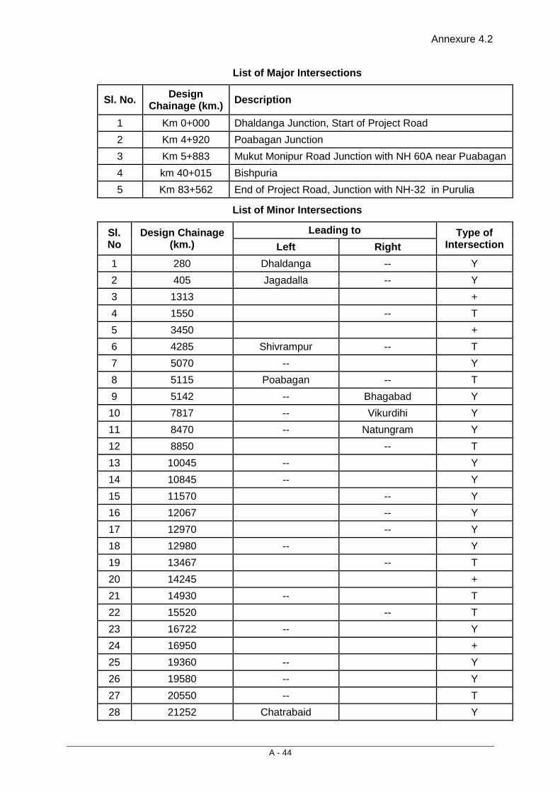
Annexure 4.2
A - 44
List of Major Intersections
Sl. No. Design Chainage (km.) Description
1 Km 0+000 Dhaldanga Junction, Start of Project Road 2 Km 4+920 Poabagan Junction 3 Km 5+883 Mukut Monipur Road Junction with NH 60A near Puabagan 4 km 40+015 Bishpuria 5 Km 83+562 End of Project Road, Junction with NH-32 in Purulia
List of Minor Intersections
Sl. No
Design Chainage (km.)
Leading to Type of Intersection Left Right
1 280 Dhaldanga -- Y 2 405 Jagadalla -- Y 3 1313 + 4 1550 -- T 5 3450 + 6 4285 Shivrampur -- T 7 5070 -- Y 8 5115 Poabagan -- T 9 5142 -- Bhagabad Y 10 7817 -- Vikurdihi Y 11 8470 -- Natungram Y 12 8850 -- T 13 10045 -- Y 14 10845 -- Y 15 11570 -- Y 16 12067 -- Y 17 12970 -- Y 18 12980 -- Y 19 13467 -- T 20 14245 + 21 14930 -- T 22 15520 -- T 23 16722 -- Y 24 16950 + 25 19360 -- Y 26 19580 -- Y 27 20550 -- T 28 21252 Chatrabaid Y

Annexure 4.2
A - 45
Sl. No
Design Chainage (km.)
Leading to Type of Intersection Left Right
29 21920 + 30 23260 -- Y 31 23290 -- Y 32 24400 -- Y 33 24660 -- Y 34 25095 -- T 35 27145 + 36 28295 -- Y 37 28495 -- Y 38 28585 -- T 39 28640 -- T 40 29630 -- Y 41 29740 -- Y 42 29885 + 43 30250 -- T 44 30325 -- T 45 30470 -- T 46 30720 -- Y 47 31395 + 48 31560 -- T 49 32350 + 50 32670 -- Y 51 33533 -- T 52 33545 -- T 53 33695 -- T 54 34557 -- T 55 35095 -- T 56 35497 -- T 57 36180 -- Sampur Y 58 36300 Paradihi -- Y 59 37035 Chakaltara -- T 60 37450 Bispuria -- Y 61 38882 -- T 62 39265 -- Y 63 39540 -- Y 64 40230 -- T 65 40250 -- T
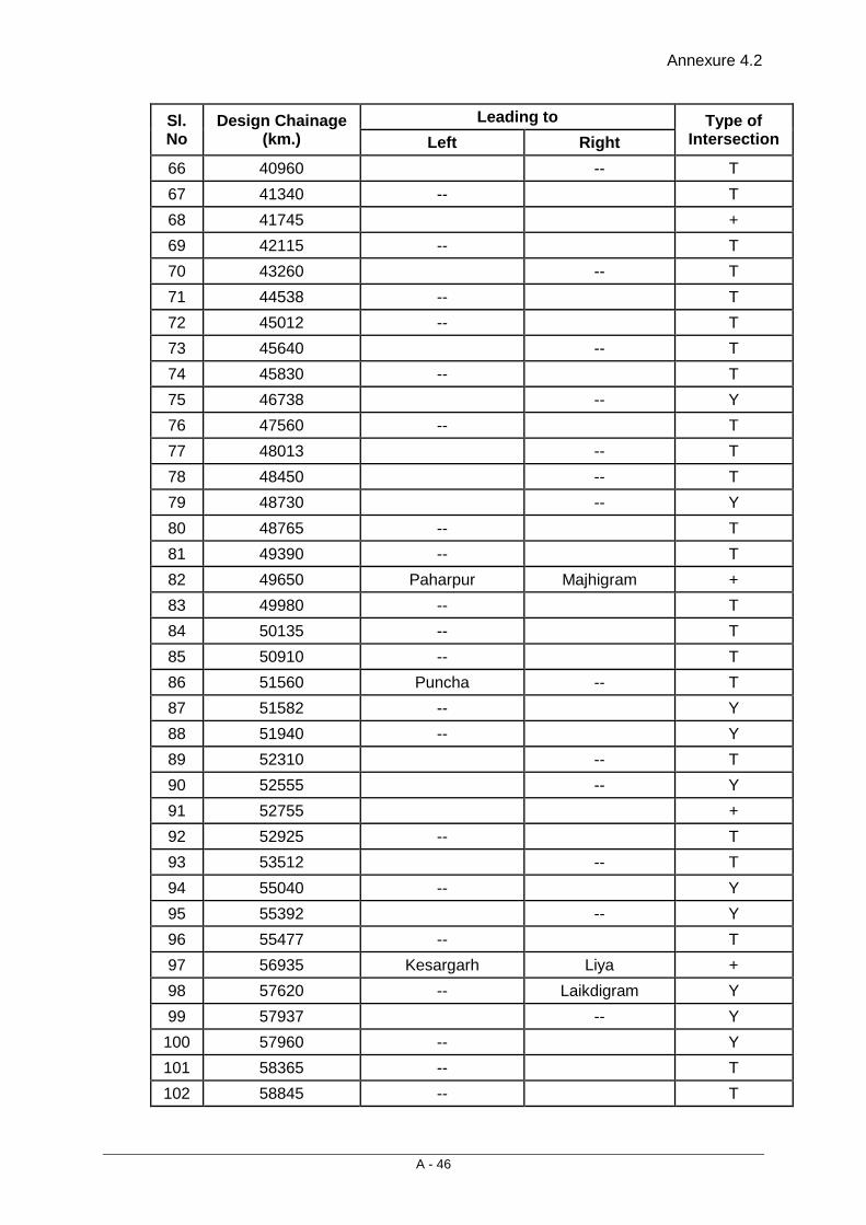
Annexure 4.2
A - 46
Sl. No
Design Chainage (km.)
Leading to Type of Intersection Left Right
66 40960 -- T 67 41340 -- T 68 41745 + 69 42115 -- T 70 43260 -- T 71 44538 -- T 72 45012 -- T 73 45640 -- T 74 45830 -- T 75 46738 -- Y 76 47560 -- T 77 48013 -- T 78 48450 -- T 79 48730 -- Y 80 48765 -- T 81 49390 -- T 82 49650 Paharpur Majhigram + 83 49980 -- T 84 50135 -- T 85 50910 -- T 86 51560 Puncha -- T 87 51582 -- Y 88 51940 -- Y 89 52310 -- T 90 52555 -- Y 91 52755 + 92 52925 -- T 93 53512 -- T 94 55040 -- Y 95 55392 -- Y 96 55477 -- T 97 56935 Kesargarh Liya + 98 57620 -- Laikdigram Y 99 57937 -- Y
100 57960 -- Y 101 58365 -- T 102 58845 -- T
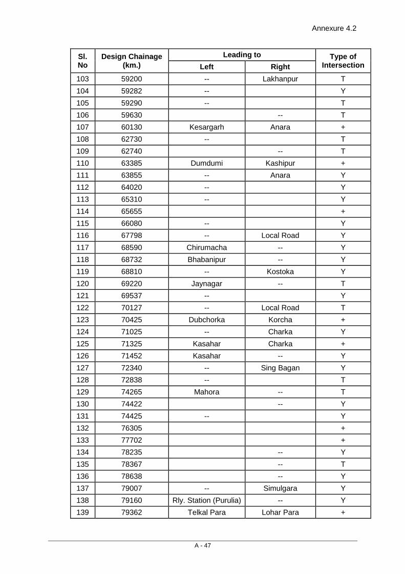
Annexure 4.2
A - 47
Sl. No
Design Chainage (km.)
Leading to Type of Intersection Left Right
103 59200 -- Lakhanpur T 104 59282 -- Y 105 59290 -- T 106 59630 -- T 107 60130 Kesargarh Anara + 108 62730 -- T 109 62740 -- T 110 63385 Dumdumi Kashipur + 111 63855 -- Anara Y 112 64020 -- Y 113 65310 -- Y 114 65655 + 115 66080 -- Y 116 67798 -- Local Road Y 117 68590 Chirumacha -- Y 118 68732 Bhabanipur -- Y 119 68810 -- Kostoka Y 120 69220 Jaynagar -- T 121 69537 -- Y 122 70127 -- Local Road T 123 70425 Dubchorka Korcha + 124 71025 -- Charka Y 125 71325 Kasahar Charka + 126 71452 Kasahar -- Y 127 72340 -- Sing Bagan Y 128 72838 -- T 129 74265 Mahora -- T 130 74422 -- Y 131 74425 -- Y 132 76305 + 133 77702 + 134 78235 -- Y 135 78367 -- T 136 78638 -- Y 137 79007 -- Simulgara Y 138 79160 Rly. Station (Purulia) -- Y 139 79362 Telkal Para Lohar Para +
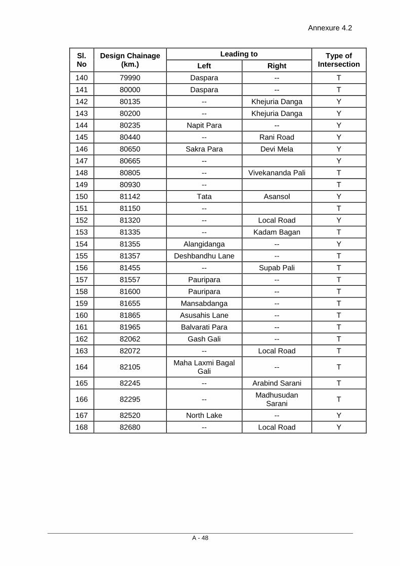
Annexure 4.2
A - 48
Sl. No
Design Chainage (km.)
Leading to Type of Intersection Left Right
140 79990 Daspara -- T 141 80000 Daspara -- T 142 80135 -- Khejuria Danga Y 143 80200 -- Khejuria Danga Y 144 80235 Napit Para -- Y 145 80440 -- Rani Road Y 146 80650 Sakra Para Devi Mela Y 147 80665 -- Y 148 80805 -- Vivekananda Pali T 149 80930 -- T 150 81142 Tata Asansol Y 151 81150 -- T 152 81320 -- Local Road Y 153 81335 -- Kadam Bagan T 154 81355 Alangidanga -- Y 155 81357 Deshbandhu Lane -- T 156 81455 -- Supab Pali T 157 81557 Pauripara -- T 158 81600 Pauripara -- T 159 81655 Mansabdanga -- T 160 81865 Asusahis Lane -- T 161 81965 Balvarati Para -- T 162 82062 Gash Gali -- T 163 82072 -- Local Road T
164 82105 Maha Laxmi Bagal Gali -- T
165 82245 -- Arabind Sarani T
166 82295 -- Madhusudan Sarani T
167 82520 North Lake -- Y 168 82680 -- Local Road Y
Annexure 4.3
A - 49
Rate & Design of hoarding and wall painting
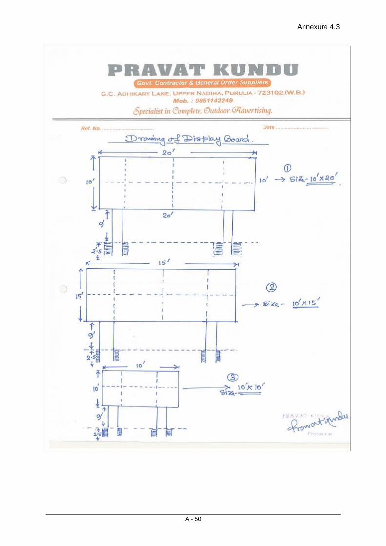
Annexure 4.3
A - 50

Annexure 4.3
A - 51
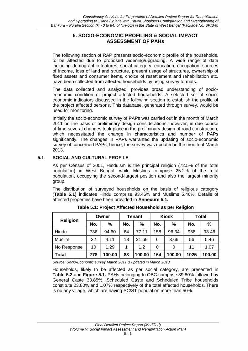
Consultancy Services for Preparation of Detailed Project Report for Rehabilitation and Upgrading to 2 lane / 2 lane with Paved Shoulders Configuration and Strengthening of
Bankura – Purulia Section (km 0 to 84) of NH-60A in the State of West Bengal (Package No. SP/B/6)
Final Detailed Project Report (Modified) (Volume V: Social Impact Assessment and Rehabilitation Action Plan)
5 - 1
5. SOCIO-ECONOMIC PROFILING & SOCIAL IMPACT ASSESSMENT OF PAHs
The following section of RAP presents socio-economic profile of the households, to be affected due to proposed widening/upgrading. A wide range of data including demographic features, social category, education, occupation, sources of income, loss of land and structure, present usage of structures, ownership of fixed assets and consumer items, choice of resettlement and rehabilitation etc. have been collected from affected households by using survey formats.
The data collected and analyzed, provides broad understanding of socio-economic condition of project affected households. A selected set of socio-economic indicators discussed in the following section to establish the profile of the project affected persons. This database, generated through survey, would be used for monitoring.
Initially the socio-economic survey of PAPs was carried out in the month of March 2011 on the basis of preliminary design considerations; however, in due course of time several changes took place in the preliminary design of road construction, which necessitated the change in characteristics and number of PAPs significantly. The changes in PAPs warranted the updating of socio-economic survey of concerned PAPs, hence, the survey was updated in the month of March 2013.
5.1 SOCIAL AND CULTURAL PROFILE As per Census of 2001, Hinduism is the principal religion (72.5% of the total population) in West Bengal, while Muslims comprise 25.2% of the total population, occupying the second-largest position and also the largest minority group.
The distribution of surveyed households on the basis of religious category (Table 5.1) indicates Hindu comprise 93.46% and Muslims 5.46%. Details of affected properties have been provided in Annexure 5.1.
Table 5.1: Project Affected Household as per Religion
Religion Owner Tenant Kiosk Total
No. % No. % No. % No. % Hindu 736 94.60 64 77.11 158 96.34 958 93.46 Muslim 32 4.11 18 21.69 6 3.66 56 5.46 No Response 10 1.29 1 1.2 0 0 11 1.07 Total 778 100.00 83 100.00 164 100.00 1025 100.00
Source: Socio-Economic survey March 2011 & updated in March 2013
Households, likely to be affected as per social category, are presented in Table 5.2 and Figure 5.1. PAHs belonging to OBC comprise 39.80% followed by General Caste 33.85%. Scheduled Caste and Scheduled Tribe households constitute 23.80% and 1.07% respectively of the total affected households. There is no any village, which are having SC/ST population more than 50%.
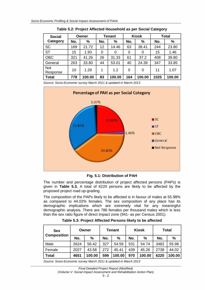
Socio-Economic Profiling & Social Impact Assessment of PAHs
Final Detailed Project Report (Modified) (Volume V: Social Impact Assessment and Rehabilitation Action Plan)
5 - 2
Table 5.2: Project Affected Household as per Social Category
Social Category
Owner Tenant Kiosk Total No. % No. % No. % No. %
SC 169 21.72 12 14.46 63 38.41 244 23.80 ST 15 1.93 0 0 0 0 15 1.46 OBC 321 41.26 26 31.33 61 37.2 408 39.80 General 263 33.80 44 53.01 40 24.39 347 33.85 Not Response 10 1.29 1 1.2 0 0 11 1.07
Total 778 100.00 83 100.00 164 100.00 1025 100.00 Source: Socio-Economic survey March 2011 & updated in March 2013
Fig. 5.1: Distribution of PAH
The number and percentage distribution of project affected persons (PAPs) is given in Table 5.3. A total of 6220 persons are likely to be affected by the proposed project road up-grading. The composition of the PAPs likely to be affected is in favour of males at 55.98% as compared to 44.02% females. The sex composition of any place has its demographic implications which are extremely vital for any meaningful demographic analysis. There are 786 females per thousand males which is less than the sex ratio figure of direct impact zone (941- as per Census 2001).
Table 5.3: Project Affected Persons likely to be affected
Sex Composition
Owner Tenant Kiosk Total
No. % No. % No. % No. % Male 2624 56.42 327 54.59 531 54.74 3482 55.98 Female 2027 43.58 272 45.41 439 45.26 2738 44.02 Total 4651 100.00 599 100.00 970 100.00 6220 100.00
Source: Socio-Economic survey March 2011 & updated in March 2013
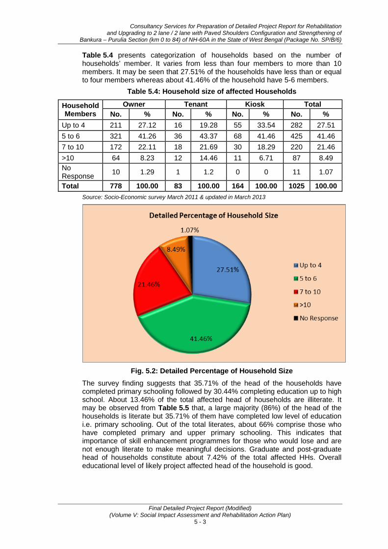
Consultancy Services for Preparation of Detailed Project Report for Rehabilitation and Upgrading to 2 lane / 2 lane with Paved Shoulders Configuration and Strengthening of
Bankura – Purulia Section (km 0 to 84) of NH-60A in the State of West Bengal (Package No. SP/B/6)
Final Detailed Project Report (Modified) (Volume V: Social Impact Assessment and Rehabilitation Action Plan)
5 - 3
Table 5.4 presents categorization of households based on the number of households’ member. It varies from less than four members to more than 10 members. It may be seen that 27.51% of the households have less than or equal to four members whereas about 41.46% of the household have 5-6 members.
Table 5.4: Household size of affected Households
Household Members
Owner Tenant Kiosk Total No. % No. % No. % No. %
Up to 4 211 27.12 16 19.28 55 33.54 282 27.51 5 to 6 321 41.26 36 43.37 68 41.46 425 41.46 7 to 10 172 22.11 18 21.69 30 18.29 220 21.46 >10 64 8.23 12 14.46 11 6.71 87 8.49 No Response 10 1.29 1 1.2 0 0 11 1.07
Total 778 100.00 83 100.00 164 100.00 1025 100.00 Source: Socio-Economic survey March 2011 & updated in March 2013
Fig. 5.2: Detailed Percentage of Household Size
The survey finding suggests that 35.71% of the head of the households have completed primary schooling followed by 30.44% completing education up to high school. About 13.46% of the total affected head of households are illiterate. It may be observed from Table 5.5 that, a large majority (86%) of the head of the households is literate but 35.71% of them have completed low level of education i.e. primary schooling. Out of the total literates, about 66% comprise those who have completed primary and upper primary schooling. This indicates that importance of skill enhancement programmes for those who would lose and are not enough literate to make meaningful decisions. Graduate and post-graduate head of households constitute about 7.42% of the total affected HHs. Overall educational level of likely project affected head of the household is good.
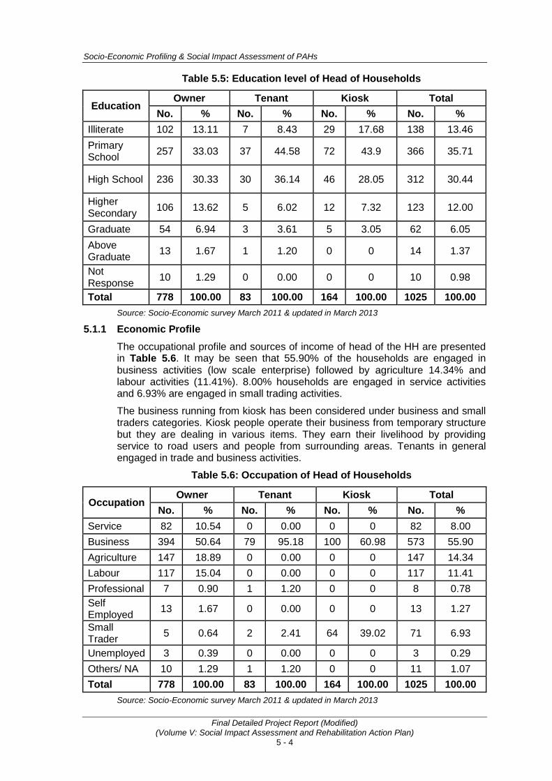
Socio-Economic Profiling & Social Impact Assessment of PAHs
Final Detailed Project Report (Modified) (Volume V: Social Impact Assessment and Rehabilitation Action Plan)
5 - 4
Table 5.5: Education level of Head of Households
Education Owner Tenant Kiosk Total
No. % No. % No. % No. % Illiterate 102 13.11 7 8.43 29 17.68 138 13.46 Primary School 257 33.03 37 44.58 72 43.9 366 35.71
High School 236 30.33 30 36.14 46 28.05 312 30.44
Higher Secondary 106 13.62 5 6.02 12 7.32 123 12.00
Graduate 54 6.94 3 3.61 5 3.05 62 6.05 Above Graduate 13 1.67 1 1.20 0 0 14 1.37
Not Response 10 1.29 0 0.00 0 0 10 0.98
Total 778 100.00 83 100.00 164 100.00 1025 100.00 Source: Socio-Economic survey March 2011 & updated in March 2013
5.1.1 Economic Profile The occupational profile and sources of income of head of the HH are presented in Table 5.6. It may be seen that 55.90% of the households are engaged in business activities (low scale enterprise) followed by agriculture 14.34% and labour activities (11.41%). 8.00% households are engaged in service activities and 6.93% are engaged in small trading activities.
The business running from kiosk has been considered under business and small traders categories. Kiosk people operate their business from temporary structure but they are dealing in various items. They earn their livelihood by providing service to road users and people from surrounding areas. Tenants in general engaged in trade and business activities.
Table 5.6: Occupation of Head of Households
Occupation Owner Tenant Kiosk Total
No. % No. % No. % No. % Service 82 10.54 0 0.00 0 0 82 8.00 Business 394 50.64 79 95.18 100 60.98 573 55.90 Agriculture 147 18.89 0 0.00 0 0 147 14.34 Labour 117 15.04 0 0.00 0 0 117 11.41 Professional 7 0.90 1 1.20 0 0 8 0.78 Self Employed 13 1.67 0 0.00 0 0 13 1.27
Small Trader 5 0.64 2 2.41 64 39.02 71 6.93
Unemployed 3 0.39 0 0.00 0 0 3 0.29 Others/ NA 10 1.29 1 1.20 0 0 11 1.07 Total 778 100.00 83 100.00 164 100.00 1025 100.00
Source: Socio-Economic survey March 2011 & updated in March 2013
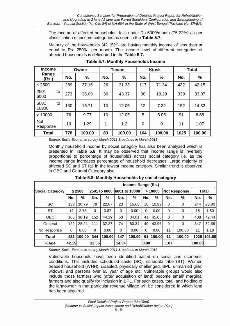
Consultancy Services for Preparation of Detailed Project Report for Rehabilitation and Upgrading to 2 lane / 2 lane with Paved Shoulders Configuration and Strengthening of
Bankura – Purulia Section (km 0 to 84) of NH-60A in the State of West Bengal (Package No. SP/B/6)
Final Detailed Project Report (Modified) (Volume V: Social Impact Assessment and Rehabilitation Action Plan)
5 - 5
The income of affected households’ falls under Rs 6000/month (75.22%) as per classification of income categories as seen in the Table 5.7. Majority of the households (42.15%) are having monthly income of less than or equal to Rs. 2500/- per month. The income level of different categories of affected households is delineated in the Table 5.7.
Table 5.7: Monthly Households Income
Income Range (Rs.)
Owner Tenant Kiosk Total
No. % No. % No. % No. %
≤ 2500 289 37.15 26 31.33 117 71.34 432 42.15 2501 to 6000 273 35.09 36 43.37 30 18.29 339 33.07
6001 to 10000 130 16.71 10 12.05 12 7.32 152 14.83
> 10000 76 9.77 10 12.05 5 3.05 91 8.88 Not Response 10 1.29 1 1.2 0 0 11 1.07
Total 778 100.00 83 100.00 164 100.00 1025 100.00 Source: Socio-Economic survey March 2011 & updated in March 2013
Monthly household income by social category has also been analyzed which is presented in Table 5.8. It may be observed that income range is inversely proportional to percentage of households across social category i.e. as the income range increases percentage of household decreases. Large majority of affected SC and ST fall in the lowest income category. Similar trend is observed in OBC and General Category also.
Table 5.8: Monthly Households by social category
Social Category Income Range (Rs.)
≤ 2500 2501 to 6000 6001 to 10000 > 10000 Not Response Total No. % No. % No. % No. % No. % No. %
SC 133 30.79 78 22.67 23 15.65 10 10.99 0 0 244 23.80
ST 12 2.78 3 0.87 0 0.00 0 0.00 0 0 15 1.50
OBC 165 38.19 152 44.19 50 34.01 41 45.05 0 0 408 42.44
General 122 28.24 111 32.27 74 50.34 40 43.96 0 0 347 32.58
No Response 0 0.00 0 0.00 0 0.00 0 0.00 11 100.00 11 1.18 Total 432 100.00 344 100.00 147 100.00 91 100.00 11 100.00 1025 101.50 %Age 42.15 33.56 14.34 8.88 1.07 100.00
Source: Socio-Economic survey March 2011 & updated in March 2013
Vulnerable household have been identified based on social and economic conditions. This includes scheduled caste (SC), schedule tribe (ST); Women headed household (WHH), disabled, physically challenged, BPL, unmarried girls; widows; and persons over 65 year of age etc. Vulnerable groups would also include those farmers who (after acquisition of land) become small/ marginal farmers and also qualify for inclusion in BPL. For such cases, total land holding of the landowner in that particular revenue village will be considered in which land has been acquired.

Socio-Economic Profiling & Social Impact Assessment of PAHs
Final Detailed Project Report (Modified) (Volume V: Social Impact Assessment and Rehabilitation Action Plan)
5 - 6
Table 5.9 presents the vulnerability status of all likely affected households. Total 357 household including tenants have been identified as vulnerable. The percentage distribution of specified categories of Vulnerable population under affected households are given in the Table 5.9.
Table 5.9: Vulnerable Households
Vulnerability group Owner Tenant Total
No. % No. % No. % Aged persons
above 65 years 65 20.31 1 2.70 66 18.49
BPL/ Antyodaya / Annapurna 36 11.25 24 64.86 60 16.81
SC 163 50.94 12 32.43 175 49.02 ST 15 4.69 0 0.00 15 4.20
WHH 31 9.69 0 0.00 31 8.68 NA/NR 10 3.13 0 0.00 10 2.80 Total 320 100.00 37 100.00 357 100.00
Source: Socio-Economic survey March 2011 & updated in March 2013
Number of livestock owned by the people used to be an indicator of wealth earlier. Nevertheless, livestock continues to be a source of livelihood to many households as milk, milk products, meat, eggs etc. are in demand in the rural and urban areas. Land holding in area is low and plots in general are small in size. Generally, ox and buffalo are being used for cultivation purpose in agriculture. Use of tractors has been observed in village’s villages for agriculture and transportation of form products and building materials. Goats, poultry, ducks and pigs are mainly (SC/ST) reared by poor families for livelihood purposes. Ducks are mainly reared for production of eggs and oblation during ‘Mansa Devi’ puja in this area. Ducks are in high demand during Mansa Devi puja time and fetch good price. Livestock owned by affected households and livestock per household are presented in Table 5.10.
Table 5.10: Livestock owned by Households
Livestock No. of livestock owned by
Owner Average/ HH Cow 239 0.31 Ox 63 0.08
Buffaloes 247 0.32 Sheep 22 0.03 Goats 532 0.68
Poultry Birds (Duck) 1076 1.38 Pig 203 0.26
Others 51 0.07 Total 2433 3.13
Total HH 778 Source: Socio-Economic survey March 2011 & updated in March 2013

Consultancy Services for Preparation of Detailed Project Report for Rehabilitation and Upgrading to 2 lane / 2 lane with Paved Shoulders Configuration and Strengthening of
Bankura – Purulia Section (km 0 to 84) of NH-60A in the State of West Bengal (Package No. SP/B/6)
Final Detailed Project Report (Modified) (Volume V: Social Impact Assessment and Rehabilitation Action Plan)
5 - 7
Economic condition of households can also be assessed through the consumer items. Possession of television, radio/ tape recorder, fridge, mobile, cycle, two wheeler, availability of cooking gas etc. indicated better economic condition. Average number of consumer items per household is presented in Table 5.11. It has been observed that, in general, one mobile phone is owned by each household. Television, which is one of the major sources of entertainment and is considered basic necessity, is owned by 34% of the affected households. Hence, availability of TV per household works out to be very less (0.34) i.e. 34% per 100 households, much less than the national average. Commuting is primarily by cycle followed by 2 wheelers and three wheelers. Possession of these items indicates that a large no of household are not economically strong.
Data collected on various consumer items from households will be used to compare the economic changes among affected households after the implementation of the project by the monitoring and evaluation agency.
Table 5.11: Consumer items owned by Households
Ownership of consumer items
No. of consumer items owned by Owner Average/ HH
TV 267 0.34 Radio/Tape recorder 63 0.08
Fridge 217 0.28 Mobile 622 0.80 Cycle 472 0.61
Tow wheeler 75 0.10 Three wheeler 44 0.06
Tractor 11 0.01 Hand barrow 23 0.03 Motor Van 17 0.02
Four wheeler 43 0.06 Gas 207 0.27 VCD 193 0.25
Total HH 778 Source: Socio-Economic survey March 2011 & updated in March 2013
5.2 SOCIAL IMPACT ASSESSMENT Development projects generate not only positive impact/ benefits but also cause adverse social impacts in terms of loss of land, assets and livelihood etc. The magnitude of impacts becomes more piercing when it takes vulnerable sections of the society under its ambit that are susceptible to socio-economic risks. Identification of such anticipated adverse impacts and developing appropriate mitigation measures during project planning, design and implementation is essential for achieving social sustainability of any development project.
The assessment of perceived impact can be carried out through Census and Socio-economic survey of the affected properties/persons. The objectives of the census and socio-economic survey are to prepare the list of the project-affected households and prepare the socio-economic profile of the project affected persons for assessing the magnitude of impact.

Socio-Economic Profiling & Social Impact Assessment of PAHs
Final Detailed Project Report (Modified) (Volume V: Social Impact Assessment and Rehabilitation Action Plan)
5 - 8
Census and socio-economic survey carried out as per COI, defined by the engineering design. The cut-off date for eligibility of entitlements for non-title holders is 31.03.2013 i.e. the closing date of the census and socio-economic survey. For titleholders, the date of publication of Notification u/s 3A of NH Act, 1956 will be the cut-off date.
5.2.1 Impact on Structures . As per the revised plan total of 1001 structures including Kiosks & Common Property Resources are likely to be affected. Out of these 1001 structures, 21.58% are privately owned, 16.18% are encroachers and 32.17% are squatters. Community, religious and government structures together constitute 13.69% of the total structures. Kiosks constitute 16.38% of the total structures that are likely to be affected. Table 5.12 presents the distribution of affected structures likely to be affected.
Table 5.12: Structures likely to be affected by ownership
Type of Structure by ownership Structure No. %
Title holders (structures only) 216 21.58 Encroacher 162 16.18 Squatter 322 32.17 Kiosk/Hut 164 16.38 Community Property Resources (CPRs) (Religious, well, statue, Passenger Shed, hand pumps, water taps and water tank etc etc.)
137 13.69
Total 1001 100.00 Source: Socio-Economic survey March 2011 & updated in March 2013
5.2.2 Type of Affected Structures Construction type of affected structures is presented in Table 5.13. Pucca structures constitute 56.72%, while Kutcha structures constitute 15.71% of the structures likely to be affected. Kutcha structures are generally constructed by locally available materials like bamboo, paddy straws, wood, mud etc.
Table 5.13: Status & typology of structures likely to be affected
Status of Structure w.r.t.
to RoW
Owners Total Kiosk
Pucca Semi-Pucca Kutcha (Temporary) No. % No.
Titleholder (structures only)
151 48 17 216 30.86 0
Encroacher 99 57 6 162 23.14 0 Squatter 147 88 87 322 46.00 0 Kiosk 0 0 0 0 0.00 164 Total 397 193 110 700 100.00 164
% 56.72 27.57 15.71 100.00 100.00 Source: Socio-Economic survey March 2011 & updated in March 2013
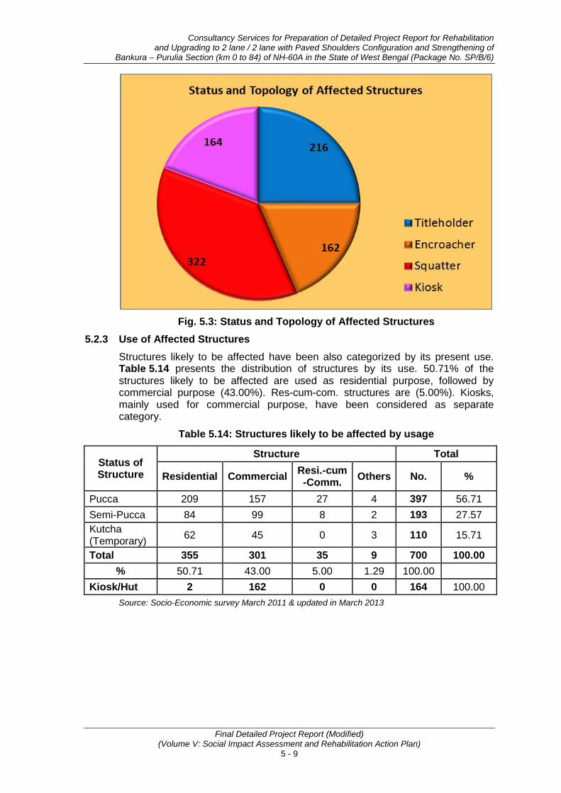
Consultancy Services for Preparation of Detailed Project Report for Rehabilitation and Upgrading to 2 lane / 2 lane with Paved Shoulders Configuration and Strengthening of
Bankura – Purulia Section (km 0 to 84) of NH-60A in the State of West Bengal (Package No. SP/B/6)
Final Detailed Project Report (Modified) (Volume V: Social Impact Assessment and Rehabilitation Action Plan)
5 - 9
Fig. 5.3: Status and Topology of Affected Structures
5.2.3 Use of Affected Structures Structures likely to be affected have been also categorized by its present use. Table 5.14 presents the distribution of structures by its use. 50.71% of the structures likely to be affected are used as residential purpose, followed by commercial purpose (43.00%). Res-cum-com. structures are (5.00%). Kiosks, mainly used for commercial purpose, have been considered as separate category.
Table 5.14: Structures likely to be affected by usage
Status of Structure
Structure Total
Residential Commercial Resi.-cum -Comm. Others No. %
Pucca 209 157 27 4 397 56.71 Semi-Pucca 84 99 8 2 193 27.57 Kutcha (Temporary) 62 45 0 3 110 15.71
Total 355 301 35 9 700 100.00 % 50.71 43.00 5.00 1.29 100.00
Kiosk/Hut 2 162 0 0 164 100.00 Source: Socio-Economic survey March 2011 & updated in March 2013
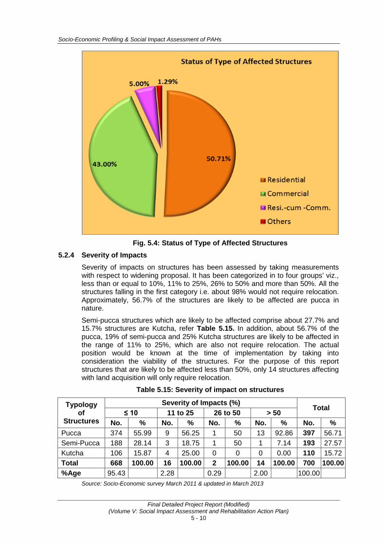
Socio-Economic Profiling & Social Impact Assessment of PAHs
Final Detailed Project Report (Modified) (Volume V: Social Impact Assessment and Rehabilitation Action Plan)
5 - 10
Fig. 5.4: Status of Type of Affected Structures
5.2.4 Severity of Impacts Severity of impacts on structures has been assessed by taking measurements with respect to widening proposal. It has been categorized in to four groups’ viz., less than or equal to 10%, 11% to 25%, 26% to 50% and more than 50%. All the structures falling in the first category i.e. about 98% would not require relocation. Approximately, 56.7% of the structures are likely to be affected are pucca in nature.
Semi-pucca structures which are likely to be affected comprise about 27.7% and 15.7% structures are Kutcha, refer Table 5.15. In addition, about 56.7% of the pucca, 19% of semi-pucca and 25% Kutcha structures are likely to be affected in the range of 11% to 25%, which are also not require relocation. The actual position would be known at the time of implementation by taking into consideration the viability of the structures. For the purpose of this report structures that are likely to be affected less than 50%, only 14 structures affecting with land acquisition will only require relocation.
Table 5.15: Severity of impact on structures
Typology of
Structures
Severity of Impacts (%) Total
≤ 10 11 to 25 26 to 50 > 50 No. % No. % No. % No. % No. %
Pucca 374 55.99 9 56.25 1 50 13 92.86 397 56.71 Semi-Pucca 188 28.14 3 18.75 1 50 1 7.14 193 27.57 Kutcha 106 15.87 4 25.00 0 0 0 0.00 110 15.72 Total 668 100.00 16 100.00 2 100.00 14 100.00 700 100.00 %Age 95.43 2.28 0.29 2.00 100.00
Source: Socio-Economic survey March 2011 & updated in March 2013
Consultancy Services for Preparation of Detailed Project Report for Rehabilitation and Upgrading to 2 lane / 2 lane with Paved Shoulders Configuration and Strengthening of
Bankura – Purulia Section (km 0 to 84) of NH-60A in the State of West Bengal (Package No. SP/B/6)
Final Detailed Project Report (Modified) (Volume V: Social Impact Assessment and Rehabilitation Action Plan)
5 - 11
5.2.5 Impact on Community Structures Apart from individual assets, social survey also identified 137 Common Property Recourses (CPRs) within the proposed ROW. Efforts were made to minimize the impact on these CPRs by reducing Corridor of impact (COI). As a result 137 CPRs are likely to be affected due to proposed project, see Table 5.16. Religious structures comprising 14.60% of the total CPRs, while 35.77% are hand pumps. Other CPRs includes Traffic Police Post, Hostel Gate, ICDC Center etc. CPRs list has been provided in Annexure 5.2 and Annexure 5.3.
Table 5.16: Community Properties Resources (CPRs) likely to be affected Sl. No. Details of CPRs Number %
1 Hand Pump 49 35.77 2 Well 7 5.11 3 Water Tank 3 2.19 4 Water Tap 23 16.79 5 Passenger Shed 15 10.95 6 Urinal 3 2.19 7 Bore Well 1 0.73 8 Religious 20 14.60 9 Govt. Boundary Walls 6 4.38 10 School 2 1.46 11 PHC/Hospital 1 0.73 12 Statue 1 0.73
13 Others
Traffic Police Post 1 0.73 Hostel Gate 1 0.73 ICDS Centre 1 0.73 Pump House 1 0.73 W.B Adibasi Unnayan Nigam 1 0.73 MCD Building 1 0.73
Total 137 100.00 Source: Socio-Economic survey March 2011 & updated in March 2013
5.2.6 Impacts on Land and Land holders Utmost efforts have been made to design the project road by utilizing the available RoW. Nonetheless; additional land would be required at 7 locations (refer Table 3.3 in Chapter 3), where available RoW is limited and the alignment includes a curves. Additional land, required for the widening and strengthening including improvement of curves etc, has been worked out by superimposing the alignment on the revenue maps. Approximately 2.5976 ha of land from 8 revenue Mauza/ villages (see Annexure 5.4) will be required for upgrading the project road. Additional land, required for the project road by present land uses and respective owner, are presented in Table 5.17. The landholders, who are losing their structures and land, were also assessed and it was established that 294 landholders will be affected by the project. In the list of 294 affected land holders annexed as Annexure 5.1, 216 PAPs, who are losing the structures, are also included. The details of affected Landholders are presented in Table 5.18.

Socio-Economic Profiling & Social Impact Assessment of PAHs
Final Detailed Project Report (Modified) (Volume V: Social Impact Assessment and Rehabilitation Action Plan)
5 - 12
Table 5.17: Impact on Land
District Category of land required in ha.
Private Govt. Total Residential Agriculture
Bankura 0.0741 0.7057 0 0.7798 Purulia 0.7852 0.8989 0.1337 1.8179
Total 0.8593 1.6046 0.1337 2.5976 % 33.08 61.77 5.15 100.00
Source: Socio-Economic survey March 2011 & updated in March 2013
Table 5.18: Details of Land holders affected by the project
Sl. No. District
Category of Private Land Holders (Titleholder) Losing Land
with Structures Losing Land
Only Total Percentage
1 Bankura 6 30 36 12.2 2 Purulia 210 48 258 87.8
Total 216 78 294 100.0 Percentage 73.5 26.5 100.0
Source: Socio-Economic survey March 2011 & updated in March 2013
In addition, the purpose of land acquisition is also delineated in Table 5.19, which has categorical explanation of land acquisition:
Table 5.19: Land Acquisition Required for Various Purposes
Description (Km) % ha % No LA 75.332 90.2 0 0 Widening of existing road 7.380 8.8 1.5765 60.7 Curve improvement 0.850 1.0 1.0211 39.3 Total 83.562 100.0 2.5976 100.0
Source: Socio-Economic survey March 2011 & updated in March 2013
Private land or the project shall be acquired as per the NH Act, 1956 and its subsequent amendments, while Government land shall be transferred after following standard inter departmental procedures.
5.2.7 Impact on Scheduled Tribe Households 15 Scheduled Tribes (2 TH and 13 Squatters) households are being affected due to impact on land and structure. These ST household are scattered all along the project corridor and are in the main stream. The demographic profile, income, marital and occupation status of these ST households are not distinct and are following the rites and rituals of main stream population.
Consultation and socio-economic survey indicates that none of these ST HHs can be classified as ‘indigenous people’ in the strict sense. Therefore, the proposed intervention doesn’t trigger OP 4.10 - Indigenous Peoples. Para 2 of the World Bank’s OP 4.10 states that “the identities and cultures of Indigenous Peoples are inextricably linked to the lands on which they live and the natural resources on which they depend”.
However, the Entitlement Matrix contains special provisions to safeguard their rights.
• • •
Residential Agriculture
Bankura 0.0741 0.7057 0 0.7798Purulia 0.7852 0.8989 0.1337 1.8179Total 0.8593 1.6046 0.1337 2.5976
% 33.08 61.77 5.15 100.00
District
Category of land required in ha.Private
Govt. Total
Description (Km) % ha %No LA 75.332 90.2 0 0
Widening of existing road 7.380 8.8 1.5765 60.7
Curve improvement 0.850 1.0 1.0211 39.3Total 83.562 100.0 2.5976 100.0

Annexure 5.1(b)
A - 53
Total Male Female Length Width Area of Structure
30 (a) Affected: 1.
¼ 2. ½ 3. ¾
4.Full
30 (b) Will require
displacement? 1. Yes 2. No
1. Illiterate 2 Primary
3. 10th 4. 12th
5. Graduate 6. Above
1. Service2. Business
3. Agriculture4. Labour
5. Professional6. Rural Artisan 7. Small Trader
8. Self Employed9. Unemployed
a b c d e f g h 1 2 3 4 6 6 (i) 7 7(i) 8 9 11 12 13 14a 14a (i) 14a (ii) 15 16 17 18 19 20 21 22 22 (1) 22 (2) 23 26 29 30 (a) 30 (b) 30 (c) 30 (d) 31 33 34 35
203 WB 151 SP/B/6 GHOLGORE GHOLGORE CHHATNA BANKURA 19.300+20.700 Rural LHS 1349 SK. SALIM SON LATE SALEHA 55 123 SK. ILIYAS APL Muslim General 3 1 2 Non-Cultivable Non-Irrigated Private No Use 1051.178 63.28 1.5 Land Illiterate Self Employed 2 3 4 2000
204 WB 151 SP/B/6 GHOLGORE GHOLGORE CHHATNA BANKURA 19.300+20.700 Rural RHS 1349, 3165, 3166, 3164 ARUN PARAMANIK SON PRAHALLAD PARAMANIK 49 25 NAKUL PARAMANIK Antodaya Hindu General 3 2 1 Cultivable Non-Irrigated Private Cultivation 42.855 63.28 Small Land Primary Agriculture 2 3 4 1500
205 WB 151 SP/B/6 GHOLGORE GHOLGORE CHHATNA BANKURA 19.300+20.700 Rural LHS 1213, 1212 SK. MOKSED SELF SK. MOKSED 58 3 LT. SK. BHIKU Antodaya Muslim General 8 4 4 Cultivable Irrigated Private Cultivation 136.498 0.06 2 Marginal Land Primary Self Employed 2 3 4 2000
206 WB 151 SP/B/6 GHOLGORE GHOLGORE CHHATNA BANKURA 19.300+20.700 Rural LHS 279 ADASI MANDAL SON GAURA MANDAL 60 2 LT. NADA MANDAL BPL Hindu SC 7 2 5 Cultivable Irrigated Private Cultivation 163.463 0.01 3 BPL Land Illiterate Agriculture 2 3 4 3000
207 WB 151 SP/B/6 GHOLGORE GHOLGORE CHHATNA BANKURA 19.300+20.700 Rural LHS 800, 3048, 3049, 2290 GAITRI SINGH THAKUR HUSBAND ANANDI PRASAD SINGH
THAKUR 65 17 LT. AMARNATH SINGH THAKUR APL Hindu General 5 2 3 Non-Cultivable Non-Irrigated Private Residential 138.465 0.17 Aged Person Land &
Structure 10 7 70 1/4 No 10th Agriculture Semi-Pucca 2 3 4 1500
208 WB 151 SP/B/6 GHOLGORE GHOLGORE CHHATNA BANKURA 19.300+20.700 Rural RHS956, 2263,
2256, 963, 961, 2296
KAVITA MANDAL BROTHER-IN-LAW ADITYA MANDAL 59 94 LT. ASUTOSH
MANDAL APL Hindu SC 4 3 1 Non-Cultivable Non-Irrigated Private No Use 534.651 0.69 4 2 2 Small Land Primary Agriculture 2 3 4 3000
209 WB 151 SP/B/6 GHOLGORE GHOLGORE CHHATNA BANKURA 19.300+20.700 Rural RHS 927 RABILOCHAN MANDAL SELF RABILOCHAN MANDAL 52 3 LT. RADHANATH MANDAL BPL Hindu SC 13 6 7 Cultivable Irrigated Private Cultivation 42.204 0.05 5 5 Marginal BPL Land Primary Agriculture 2 3 4 2000
210 WB 151 SP/B/6 GHOLGORE GHOLGORE CHHATNA BANKURA 19.300+20.700 Rural Re-Align/ Bypass 962 ANJALA HANSDA WIFE BAIDYANATH HANSDA 32 20 KHOKAN HANSDA BPL Hindu ST 7 5 2 Cultivable Irrigated Private Cultivation 63.682 0.02 3 Small BPL Land 10th Agriculture 2 3 4 1000
211 WB 151 SP/B/6 GHOLGORE GHOLGORE CHHATNA BANKURA 19.300+20.700 Rural LHS 958, 331, 928, 924 BIJOY MANDAL SELF BIJOY MANDAL 82 12 LT. ANKUR MANDAL APL Hindu SC 6 4 2 Cultivable Irrigated Private Cultivation 179.252 0.35 2 Marginal Aged Person Land 10th Agriculture 2 3 4 3000
212 WB 151 SP/B/6 GHOLGORE GHOLGORE CHHATNA BANKURA 19.300+20.700 Rural RHS 957 ANIL MANDAL SON NAGENDRA MANDAL 39 2 LT. RISHIKESH MANDAL Others Hindu SC 8 5 3 Cultivable Non-Irrigated Private Cultivation 38.519 0.04 4 Land Primary Self Employed 2 3 4 1500
213 WB 151 SP/B/6 GHOLGORE GHOLGORE CHHATNA BANKURA 19.300+20.700 Rural LHS 955, 2161 GITA MANDAL HUSBAND ASHWANI MANDAL 60 5 LT. BECHARRAM MANDAL BPL Hindu SC 6 4 2 Cultivable Irrigated Private Cultivation 100.961 0.18 2 BPL Land Illiterate Agriculture 2 3 4 3000
214 WB 151 SP/B/6 GHOLGORE GHOLGORE CHHATNA BANKURA 19.300+20.700 Rural LHS 987 TARAPADA SHARMA SON LATE BASANTA SHARMA 59 2 KALIPADA SHARMA APL Hindu General 8 5 3 Cultivable Irrigated Private Cultivation 20.509 0.01 3 Marginal Land Illiterate Agriculture 2 3 4 3000
215 WB 151 SP/B/6 GHOLGORE GHOLGORE CHHATNA BANKURA 19.300+20.700 Rural RHS 965 SUDHIR MANDAL SELF SUDHIR MANDAL 62 4 LT. HARIPADA MANDAL APL Hindu SC 5 2 3 Cultivable Irrigated Private Commercial 19.761 0.56 3 2 1 Small Land 10th Agriculture 2 3 4 3000
216 WB 151 SP/B/6 GHOLGORE GHOLGORE CHHATNA BANKURA 19.300+20.700 Rural Re-Align/ Bypass 335 SK. JAKIR HUSSAIN SON HANIJUDDIN SHEKH 51 12 HANIJUDDIN SHEKH Others Muslim General 7 3 4 Cultivable Irrigated Private Cultivation 3.303 0.01 2 Small Land Primary Agriculture 2 3 4 2000
217 WB 151 SP/B/6 GHOLGORE GHOLGORE CHHATNA BANKURA 19.300+20.700 Rural LHS 923, 3075 MANJU MANDAL HUSBAND DURGADAS MANDAL 48 6 LT. BHOLANATH MANDAL APL Hindu SC 3 2 1 Non-Cultivable Non-Irrigated Private Residential 109.07 0.09 1 Land &
Structure 10 7 70 1/4 No 12th Agriculture Pucca 2 3 4 3000
218 WB 151 SP/B/6 GHOLGORE GHOLGORE CHHATNA BANKURA 19.300+20.700 Rural LHS 966, 881, 3053, 955 RINA MANDAL HUSBAND APURBA MANDAL 46 37 SANKAR MANDAL Others Hindu SC 5 2 3 Cultivable Irrigated Private Residential 109.149 0.3 8 Marginal Land Primary Service 2 3 4 6000
219 WB 151 SP/B/6 GHOLGORE GHOLGORE CHHATNA BANKURA 19.300+20.700 Rural Re-Align/ Bypass 2161 BIPADTARAN MANDAL SELF BIPADTARAN MANDAL 45 14 BANKA MANDAL Others Hindu SC 9 4 5 Cultivable Irrigated Private Cultivation 79.234 0.16 5 Land 10th Service 2 3 4 10000
220 WB 151 SP/B/6 GHOLGORE GHOLGORE CHHATNA BANKURA 19.300+20.700 Rural RHS 2257, 2885, 2880 SALI MOHAMMAD SELF SALI MOHAMMAD 33 25 LT ILIYAS BPL Muslim General 4 3 1 Cultivable Irrigated Private Cultivation 187.405 0.57 1.5 Small BPL Land Primary Self Employed 2 3 4 2000
221 WB 151 SP/B/6 GHOLGORE GHOLGORE CHHATNA BANKURA 19.300+20.700 Rural LHS 522, 2860 SUSARI MANDAL HUSBAND LATE HABULAL MANDAL 38 2 LT. DWARIKA MANDAL BPL Hindu SC 6 3 3 Cultivable Irrigated Private Cultivation 30.106 0.04 3 BPL Land Illiterate Agriculture 2 3 4 3000
222 WB 151 SP/B/6 GHOLGORE GHOLGORE CHHATNA BANKURA 19.300+20.700 Rural RHS 2838 BISHWAJIT MANDAL SON ABANI MANDAL 78 7 LT. BHUBAN MANDAL APL Hindu SC 8 3 5 Non-Cultivable Non-Irrigated Private Cultivation 38.397 0.18 6 Aged Person Land 10th Agriculture 2 3 4 3000
223 WB 151 SP/B/6 GHOLGORE GHOLGORE CHHATNA BANKURA 19.300+20.700 Rural RHS 2289 MANUNA HUSSAIN SELF MANUNA HUSSAIN 41 3 LT. HARIJUDDIN Others Muslim General 7 3 4 Non-Cultivable Non-Irrigated Private Commercial 40.254 0.04 8 6 2 Land Illiterate Labour 2 3 4 3000
224 WB 151 SP/B/6 GHOLGORE GHOLGORE CHHATNA BANKURA 19.300+20.700 Rural RHS 2295 JOBACHAND MANDAL SELF JOBACHAND MANDAL 62 10 LT. MAHUDER MANDAL Antodaya Hindu SC 1 1 0 Cultivable Irrigated Private Cultivation 45.245 0.03 1 Land Primary Agriculture 2 3 4 2000
225 WB 151 SP/B/6 JAMBED JAMBED CHHATNA BANKURA 28.400+28.700 Rural LHS 362 DIPAK PRAMANIK SON TARAPADA PRAMANIK 70 7 LATE BANKA PRAMANIK APL Hindu General 11 6 5 Cultivable Irrigated Private Cultivation 112.531 0.1 Aged Person Land Primary Business 2 3 4 3000
226 WB 151 SP/B/6 JAMBED JAMBED CHHATNA BANKURA 28.400+28.700 Rural LHS 360 SUDHIR KUMAR MANDAL SELF SUDHIR KUMAR MANDAL 84 3 LATE BANKE BIHARI
MANDAL BPL Hindu SC 9 4 5 Cultivable Irrigated Private Cultivation 118.787 0.21 4 3 1 BPL Land Primary Agriculture 2 3 4 3000
227 WB 151 SP/B/6 JAMBED JAMBED CHHATNA BANKURA 28.400+28.700 Rural LHS 359 DURGABALA KUNDU SELF DURGABALA KUNDU 45 2 SHYAMAPADA KUNDU Others Hindu General 3 2 1 Cultivable Irrigated Private Cultivation 111.288 0.08 2 1 Land 10th Agriculture 2 3 4 3000
228 WB 151 SP/B/6 JAMBED JAMBED CHHATNA BANKURA 28.400+28.700 Rural LHS 371 KALIPADA RAKSHIT SELF KALIPADA RAKSHIT 55 9 SURYANARAYAN RAKSHIT Others Hindu General 5 3 2 Cultivable Irrigated Private Cultivation 23.107 0.16 5 Land Illiterate Agriculture 2 3 4 3000
229 WB 151 SP/B/6 JAMBED JAMBED CHHATNA BANKURA 28.400+28.700 Rural LHS 358 ANATH MANDAL SELF ANATH MANDAL 68 2 LATE SADAI MANDAL APL Hindu SC 6 4 2 Cultivable Irrigated Private Cultivation 110.867 0.09 7 6 1 Aged Person Land 10th Agriculture 2 3 4 3000
230 WB 151 SP/B/6 JAMBED JAMBED CHHATNA BANKURA 28.400+28.700 Rural LHS 357 LAXMAN PRAMANIK SELF LAXMAN PRAMANIK 65 2 LATE GAHIRAM PRAMANIK APL Hindu General 5 3 2 Cultivable Irrigated Private Cultivation 90.279 0.27 1 Aged Person Land 12th Agriculture 2 3 4 1000
231 WB 151 SP/B/6 JAMBED JAMBED CHHATNA BANKURA 28.400+28.700 Rural LHS 368 SWAPAN KUMAR MANDAL SELF SWAPAN KR MANDAL 39 5 LATE HANDU MANDAL APL Hindu SC 8 1 7 Cultivable Irrigated Private Cultivation 110.112 0.03 5 5 Land 10th Agriculture 2 3 4 3000
232 WB 151 SP/B/6 JAMBED JAMBED CHHATNA BANKURA 28.400+28.700 Rural LHS 348, 352 TULSI MANDAL DIL LATE PASHUPATI MANDAL 65 10 LATE DINU MANDAL BPL Hindu SC 3 2 1 Cultivable Irrigated Private Cultivation 693.046 0.06 5 5 BPL Land Illiterate Agriculture 2 3 4 3000
233 WB 151 SP/B/6 JAMBED JAMBED CHHATNA BANKURA 28.400+28.700 Rural LHS 81 NITAI MANDAL SON LATE KRISHNAPADA MANDAL 64 1 LATE SARADA
MANDAL APL Hindu SC 6 3 3 Cultivable Irrigated Private Cultivation 75.676 0.03 8 8 Land Illiterate Service 2 3 4 25000
234 WB 151 SP/B/6 JAMBED JAMBED CHHATNA BANKURA 28.400+28.700 Rural LHS 1571, 2134 GANESH RAKSHIT SON LATE KASHINATH RAKSHIT 56 2 LATE KASHINATH RAKSHIT Others Hindu General 10 3 7 Cultivable Non-Irrigated Private Cultivation 10.012 0.1 3 3 Land Illiterate Labour 2 3 4 3000
235 WB 152 SP/B/6 PARSIYA PARSIYA HURA PURULIA 36.300+37.100 Rural Re-Align/ Bypass 3991 SANJAY KUMAR PAL SON LATE NITYA GOPAL PAL 47 4 LATE CHANDRA
MOHAN PAL APL Hindu OBC 10 5 5 Cultivable Non-Irrigated Private Cultivation 113.362 0.3 3 2 1 Small Land Illiterate Agriculture N.A 2 3 4 3000
236 WB 152 SP/B/6 PARSIYA PARSIYA HURA PURULIA 36.300+37.100 Rural Re-Align/ Bypass
2596, 2578, 3990, 2699 GOPINATH GORAIN GRAND
FATHER LATE SARADA GORAIN 45 1 LATE NILKANTHA GORAIN Others Hindu General 10 5 5 Cultivable Irrigated Private Cultivation 489.708 0.4 8 5 3 Small Land Illiterate Agriculture N.A 2 3 4 3000
237 WB 152 SP/B/6 PARSIYA PARSIYA HURA PURULIA 36.300+37.100 Rural Re-Align/ Bypass 3213 GURU CHARAN PATI SON LATE PRAFULHYA PATI 34 1 LATE GAYARAM PATI APL Hindu General 3 2 1 Cultivable Irrigated Private Cultivation 88.95 0.22 N.A N.A N.A Small Land Illiterate Agriculture N.A 2 3 4 2000
238 WB 152 SP/B/6 PARSIYA PARSIYA HURA PURULIA 36.300+37.100 Rural Re-Align/ Bypass 2548, 3197 TARAPADA MANDAL SON LATE AMALAYA MANDAL 51 5 LATE DOPU MANDAL BPL Hindu SC 3 2 1 Cultivable Non-Irrigated Private Cultivation 4 773.02 0.56 N.A N.A N.A Small BPL Land Illiterate Agriculture N.A 2 3 4 3000
239 WB 152 SP/B/6 PARSIYA PARSIYA HURA PURULIA 36.300+37.100 Rural Re-Align/ Bypass 3194 AMBANISH GORAIN SON LATE BHUBAN GORAIN 49 2 LATE KUNJU GORAIN Others Hindu General 5 4 1 Cultivable Irrigated Private Cultivation 157.75 0.16 N.A 1 4 Small Land Illiterate Agriculture N.A 2 3 4 1500
240 WB 152 SP/B/6 PARSIYA PARSIYA HURA PURULIA 36.300+37.100 Rural Re-Align/ Bypass 3192 NANOJ PAUL GRAND
FATHER LATE RAMAN PAUL 44 10 ANANT PAUL Others Hindu OBC 4 2 2 Cultivable Irrigated Private Cultivation 205.221 0.22 1.5 N.A 0 Small Land Illiterate Agriculture N.A 2 3 4 8000
241 WB 152 SP/B/6 PARSIYA PARSIYA HURA PURULIA 36.300+37.100 Rural Re-Align/ Bypass 3191 ANIRUDDHA SARKAR SON BIBHUTI SARKAR 50 1 LATE MAHENDER
SARKAR Others Hindu General 3 3 0 Non-Cultivable Non-Irrigated Private Cultivation 122.91 0.18 12 8 4 Small Land Primary Agriculture N.A 2 3 4 2000
242 WB 152 SP/B/6 PARSIYA PARSIYA HURA PURULIA 36.300+37.100 Rural Re-Align/ Bypass 3190 NIMOI BAVMI SON LATE MULYA BAVMI 46 2 LATA JAGU BAVMI BPL Hindu SC 3 3 0 Cultivable Irrigated Private Cultivation 68.09 0.10 N.A 3 N.A Small BPL Land Illiterate Service N.A 2 3 4 15000
243 WB 152 SP/B/6 PARSIYA PARSIYA HURA PURULIA 36.300+37.100 Rural Re-Align/ Bypass 3188, 2617 SMT. BADALI MANDAL WIFE LATE SAFAL MANDAL 51 3 LATE GOKUL MANDAL BPL Hindu SC 8 4 4 Cultivable Non-Irrigated Private Cultivation 238.61 0.11 N.A 3 N.A Small BPL Land Illiterate Agriculture N.A 2 3 4 3000
244 WB 152 SP/B/6 PARSIYA PARSIYA HURA PURULIA 36.300+37.100 Rural Re-Align/ Bypass 3181 SHYAMAPADA PATI SON LATE GOBINDAPATI 35 1 LATE SURYA
NARAYAN PATI APL Hindu General 8 3 5 Non-Cultivable Non-Irrigated Private Residential 6 27.488 0.12 5 3 2 Marginal Land Illiterate Agriculture N.A 2 3 4 3000
245 WB 152 SP/B/6 PARSIYA PARSIYA HURA PURULIA 36.300+37.100 Rural Re-Align/ Bypass 3179 DAYAMANY PATIL SON RABI LOCHAN PATI 50 4 LATE AMBIKACHARAN
PATI APL Hindu General 6 4 2 Cultivable Irrigated Private Cultivation 343.463 0.49 49 N.A N.A Marginal Land 10th Agriculture N.A 2 3 4 11000
246 WB 152 SP/B/6 PARSIYA PARSIYA HURA PURULIA 36.300+37.100 Rural Re-Align/ Bypass 3016 CHAKRADHAR GHOSH SON H. PANI BHUSAN GHOSH 56 1 MRITUNJAY GHOSH Others Hindu General 3 2 1 Cultivable Irrigated Private Cultivation 1326 0.32 5 N.A N.A Small Land Primary Agriculture N.A 2 3 4 3000
247 WB 152 SP/B/6 PARSIYA PARSIYA HURA PURULIA 36.300+37.100 Rural Re-Align/ Bypass
3015, 3026, 3017 SACHIDDANANDAN PATI BROTHER LATE BHAGWAN PATI 41 2 LATE MRITUNJAY PATI APL Hindu General 12 6 6 Cultivable Irrigated Private Cultivation 834.492 0.94 22 20 2 N.A Land Illiterate Service N.A 2 3 4 55000
248 WB 152 SP/B/6 PARSIYA PARSIYA HURA PURULIA 36.300+37.100 Rural Re-Align/ Bypass 3021 DIPTIMAN PATI SON LATE CHAITANYA PATI 54 1 LATE
GANGANARAYAN PATI APL Hindu General 5 2 3 Cultivable Irrigated Private Cultivation 175.782 0.09 22 20 2 N.A Land Illiterate Service N.A 2 3 4 15000
249 WB 152 SP/B/6 PARSIYA PARSIYA HURA PURULIA 36.300+37.100 Rural Re-Align/ Bypass 3002, 3003 SMT. SHISHUBALA PATI WIFE LATE VIJAY PATI 48 3 LATE PAWAR PATI APL Hindu General 5 2 3 Non-Cultivable Irrigated Private Residential 3 207.82 0.36 N.A N.A N.A N.A WHH Land Illiterate Service N.A 2 3 4 15000
250 WB 152 SP/B/6 PARSIYA PARSIYA HURA PURULIA 36.300+37.100 Rural Re-Align/ Bypass 2988, 3001 HARI PATI SELF HARI PATI 93 1 LATE MADHAW PATI APL Hindu General 9 6 3 Cultivable Irrigated Private Cultivation 426.32 0.24 N.A N.A N.A N.A Aged Person Land Primary Agriculture N.A 2 3 4 4000
251 WB 152 SP/B/6 PARSIYA PARSIYA HURA PURULIA 36.300+37.100 Rural Re-Align/ Bypass 2986 ASHOK PATI SON LATE PARMANANDAN PATI 51 3 LATE PARMANANDA
PATI APL Hindu General 9 6 3 Cultivable Irrigated Private Cultivation 67.59 0.40 N.A N.A N.A N.A Land Illiterate Self Employed N.A 2 3 4 3000
252 WB 152 SP/B/6 PARSIYA PARSIYA HURA PURULIA 36.300+37.100 Rural Re-Align/ Bypass 2989 ROHIT KUMAR PATI GIS LATE SURDHANI DEBYA 45 1 HUMANI W/O LATE
RAM PATI APL Hindu General 6 4 2 Cultivable Irrigated Private Cultivation 606.08 0.29 N.A N.A N.A N.A Land Illiterate Agriculture N.A 2 3 4 7000
253 WB 152 SP/B/6 PARSIYA PARSIYA HURA PURULIA 36.300+37.100 Rural Re-Align/ Bypass 2990, 2980 ANANDA BAURI SON LATE PATI BAURI 52 1 LATE CHANDI BAURI APL Hindu General 16 13 3 Non-Cultivable Non-Irrigated Private Cultivation 539.508 0.43 8 6 2 Marginal Land Illiterate Agriculture N.A 2 3 4 3000
254 WB 152 SP/B/6 PARSIYA PARSIYA HURA PURULIA 36.300+37.100 Rural Re-Align/ Bypass 2977 SHANTI PADA BAURI FATHER LATE SRIPATI BAURI 43 2 LATE DAINIK BAURI BPL Hindu SC 6 2 4 Cultivable Non-Irrigated Private Residential 274.769 0.16 10 N.A N.A Small BPL Land Illiterate Agriculture N.A 2 3 4 3000
255 WB 152 SP/B/6 PARSIYA PARSIYA HURA PURULIA 36.300+37.100 Rural Re-Align/ Bypass 2699 NARESH MANDAL GRAND SON LATE GOKUL MANDAL 55 44 LATE CHAITAN
MANDAL APL Hindu SC 9 4 5 Cultivable Irrigated Private Commercial 48.72 0.1 7 4 3 Small Land Illiterate Agriculture N.A 2 3 4 3000
256 WB 152 SP/B/6 PARSIYA PARSIYA HURA PURULIA 36.300+37.100 Rural Re-Align/ Bypass 2623 NARU MANDAL SON H. KHANKU MANDAL 48 6 H. TANU MANDAL Others Hindu SC 7 6 1 Cultivable Irrigated Private Commercial 453.37 0.1 2 N.A N.A Small Land Primary Agriculture N.A 2 3 4 2000
257 WB 152 SP/B/6 PARSIYA PARSIYA HURA PURULIA 36.300+37.100 Rural Re-Align/ Bypass 2972 GOPAL DAS SON CHANDRA DEB 43 1 H. MAKHAN DAS BPL Hindu SC 8 6 2 Cultivable Irrigated Private Residential 453.297 0.08 2 1 1 Small BPL Land 10th Agriculture N.A 2 3 4 3000
258 WB 152 SP/B/6 PARSIYA PARSIYA HURA PURULIA 36.300+37.100 Rural Re-Align/ Bypass 2620 TAPAN MANDAL GRAND SON LATE KALIPADA MANDAL 51 3 LATE KANGALI
MANDAL BPL Hindu SC 4 3 1 Cultivable Non-Irrigated Private Cultivation 205.885 0.34 2 1 1 Small BPL Land Illiterate Agriculture N.A 2 3 4 3000
259 WB 152 SP/B/6 PARSIYA PARSIYA HURA PURULIA 36.300+37.100 Rural Re-Align/ Bypass 2603 SHYAM PANDA SON LATE MOHINI MOHAN
PANDA 45 1 LATE SHRI CHARAN PANDA Others Hindu General 3 2 1 Cultivable Irrigated Private Cultivation 455.773 0.17 3 N.A N.A Small Land Illiterate Agriculture N.A 2 3 4 3000
260 WB 152 SP/B/6 PARSIYA PARSIYA HURA PURULIA 36.300+37.100 Rural Re-Align/ Bypass 2621 SMT. DIPALI MANDAL DOUGHTER
IN LAW LATE AKUL MANDAL 50 2 LATE BANAMALI MANDAL BPL Hindu SC 6 2 4 Cultivable Non-Irrigated Private Cultivation 50.427 0.21 3 N.A N.A Small BPL Land Illiterate Agriculture N.A 2 3 4 3000
261 WB 152 SP/B/6 ROKHERA ROKHERA HURA PURULIA 36.000+37.000 Rural Re-Align/ Bypass 2598 AMIT KUNDU SON BHARAT KUNDU 70 2 LATE SANATAN
KUNDU APL Hindu General 4 2 2 Non-Cultivable Non-Irrigated Private Residential 244.716 0.09 2 2 Aged Person Land 10th Agriculture 2 3 4 8500
262 WB 152 SP/B/6 ROKHERA ROKHERA HURA PURULIA 36.000+37.000 Rural Re-Align/ Bypass 2596 KRISHNAPATI DOUGHTER UDHAB PATI 45 4 LATE AMBIKA PATI APL Hindu General 4 2 2 Non-Cultivable Non-Irrigated Private Others 32.033 0.05 1 1 Land 10th Agriculture 2 3 4 3000
263 WB 152 SP/B/6 ROKHERA ROKHERA HURA PURULIA 36.000+37.000 Rural Re-Align/ Bypass 2553, 2554 GOPINATH GORAIN SELF GOPINATH GORAIN 39 3 LATE RABILOCHAN
GORAIN APL Hindu General 10 5 5 Non-Cultivable Non-Irrigated Private Residential 153.6 0.09 4 2 2 Land 10th Business 2 3 4 3000
264 WB 152 SP/B/6 ROKHERA ROKHERA HURA PURULIA 36.000+37.000 Rural Re-Align/ Bypass 2578, 2552 CHANDRA SHEKHAR
PATI SELF CHANDRA SHEKHAR PATI 75 58 LATE CHAITANA PATI APL Hindu General 11 7 4 Non-Cultivable Irrigated Private Cultivation 404.508 0.27 10 Aged Person Land 12th Agriculture 2 3 4 5000
265 WB 152 SP/B/6 ROKHERA ROKHERA HURA PURULIA 36.000+37.000 Rural Re-Align/ Bypass 2551 SK. UMAR ALI SELF SK. UMAR ALI 55 9 LATE SK KHUDEN APL Muslim OBC 8 5 3 Non-Cultivable Non-Irrigated Private Commercial 105.598 0.02 2 2 Land 10th Business 2 3 4 3000
266 WB 152 SP/B/6 ROKHERA ROKHERA HURA PURULIA 36.000+37.000 Rural Re-Align/ Bypass 2541 KARALI PATI SELF KARALI PATI 73 7 LATE MADAN MOHAN
PATI APL Hindu General 6 3 3 Cultivable Irrigated Private Cultivation 36.54 0.03 10 10 Aged Person Land 10th Agriculture 2 3 4 50000
267 WB 152 SP/B/6 BISPURIYA BISPURIYA HURA PURULIA 39.300+41.200 Rural RHS 3813 URMILA HUSBAND VISWA REB MAHAB 60 4 CHATUR BHY MAHAB Others Hindu OBC 3 2 1 Non-Cultivable Non-Irrigated Private Residential 21.123 0.2 5 Small Land Illiterate Agriculture 2 3 4 3000
268 WB 152 SP/B/6 BISPURIYA BISPURIYA HURA PURULIA 39.300+41.200 Rural LHS 3942 AJIT MAHATO SELF AJIT MAHATO 50 4 BHAGAT SINGH APL Hindu OBC 5 3 2 Non-Cultivable Non-Irrigated Private Commercial 1.392 0.17 1 Small Land 10th Labour 2 3 4 2000
269 WB 152 SP/B/6 BISPURIYA BISPURIYA HURA PURULIA 39.300+41.200 Rural LHS 3944 SANTOSH KUNDU SELF SANTOSH KUNDU 68 6 LT.GAGAN KUNDU APL Hindu General 4 2 2 Non-Cultivable Non-Irrigated Private Commercial 23.232 0.18 6 Small Aged Person Land & Structure 7 7 49 1/4 No Primary Labour Pucca 2 3 4 3000
270 WB 152 SP/B/6 BISPURIYA BISPURIYA HURA PURULIA 39.300+41.200 Rural LHS 3945, 4006, 4003, 4005 SANTOSH KUNDU FATHER LATE GAGAN KUNDU 68 1 LT. ISHWAR KUNDU APL Hindu General 4 2 2 Non-Cultivable Non-Irrigated Private Others 55.536 0.5 Small Aged Person Land Illiterate Agriculture 3 3 4 2000
271 WB 152 SP/B/6 BISPURIYA BISPURIYA HURA PURULIA 39.300+41.200 Rural Re-Align/ Bypass 4683, 6594 S.K MURSED SELF S.K MURSED 70 2 LT.S.K LAKHU BPL Muslim OBC 2 2 0 Non-Cultivable Non-Irrigated Private Others 46.745 0.02 3 Small BPL Land &
Structure 10 3 30 1/4 No Primary Agriculture Pucca 2 3 4 3000
272 WB 152 SP/B/6 BISPURIYA BISPURIYA HURA PURULIA 39.300+41.200 Rural LHS 4691 DIPAK DUTTA SON KANAI DUTTA 80 4 GUHIRAM DUTTA Others Hindu OBC 4 2 2 Non-Cultivable Non-Irrigated Private Residential 4.22 0.17 N.A N.A N.A Small Aged Person Land & Structure 3 2 6 1/4 No Primary Agriculture Pucca 2 3 4 2000
273 WB 152 SP/B/6 BISPURIYA BISPURIYA HURA PURULIA 39.300+41.200 Rural LHS 4692 DILIP KR.DUTTA SON DILIP KR.DUTTA 50 1 KANAI LAL DUTTA Others Hindu OBC 2 1 1 Non-Cultivable Non-Irrigated Private Residential 2.57 0.05 N.A N.A N.A Small Land Primary Agriculture 2 3 4 2000
274 WB 152 SP/B/6 BISPURIYA BISPURIYA HURA PURULIA 29.300+41.200 Rural LHS 4909, 4715, 4714, 4713 ARABINA PATI HUSBAND CHAKRADHAN PATI 42 40 SHARENDRA PATI Others Hindu SC 8 4 4 Non-Cultivable Non-Irrigated Private Residential 34.493 0.19 5 Marginal Land &
Structure 5 10 50 1/4 No Illiterate Agriculture Pucca 2 3 4 3000
275 WB 152 SP/B/6 BISPURIYA BISPURIYA HURA PURULIA 39.300+41.200 Rural RHS 4019 SHYAMAPADA SELF SHYAMAPADA 50 4 LT. SUDHIR MAHATO APL Hindu OBC 13 7 6 Non-Cultivable Non-Irrigated Private Commercial 9.085 0.06 12 8 4 Small Land & Structure 7 5 35 1/4 No 10th Agriculture Pucca 2 3 4 3000
276 WB 152 SP/B/6 BISPURIYA BISPURIYA HURA PURULIA 39.300+41.200 Rural LHS 4725 MAMTA PATI HUSBAND LATE KAMLA PATI 48 3 LT. MAHADEV PATI BPL Hindu General 5 4 1 Non-Cultivable Non-Irrigated Private Residential 42.075 0.13 5 3 2 Small BPL Land & Structure 8 13 104 1/4 No Illiterate Agriculture Pucca 2 3 4 3000
277 WB 152 SP/B/6 BISPURIYA BISPURIYA HURA PURULIA 39.300+41.200 Rural LHS 5147 SHYAMAL KR. MAHATO SELF SHYAMAL KR. MAHATO 29 1 PURNA CHANDRA Others Hindu OBC 5 1 4 Non-Cultivable Non-Irrigated Private Cultivation 26.213 0.17 15 Small Land 10th Agriculture 2 3 4 2500
278 WB 152 SP/B/6 HURA TOWN HURA HURA PURULIA 47.300+50.600 Semi-Urban RHS 2257 TUSARKANTI MANDAL SELF TUSARKANTI MANDAL 32 2 MADAN MOHAN
MANDAL Others Hindu SC 5 2 3 Non-Cultivable Non-Irrigated Private Residential 0.24 0.02 N.A N.A N.A Marginal Land & Structure 3 4 12 1/4 No Primary Service Pucca 2 3 4 2000
279 WB 152 SP/B/6 HURA TOWN HURA HURA PURULIA 47.300+50.600 Semi-Urban RHS 351, 2364 MAMANI KAR HUSBAND LATE AMAR NATH KAR 53 5 LT. SURENDRA NATH
KAR APL Hindu General 4 3 1 Non-Cultivable Non-Irrigated Private Residential 47.273 0.02 12 8 4 Marginal WHH Land & Structure 11 10 110 1/4 No Illiterate Labour Pucca 2 3 4 5000
280 WB 152 SP/B/6 HURA TOWN HURA HURA PURULIA 47.300+50.600 Semi-Urban LHS 1917 GOURA CH KAR SON LATE BHAJAHARI KAR 39 1 LT. ATUL CH. KAR APL Hindu General 5 3 2 Non-Cultivable Non-Irrigated Private Residential 1.148 0.19 7 7 Marginal Land &
Structure 15 15 225 1/4 No Illiterate Service Pucca 2 3 4 20000
281 WB 152 SP/B/6 HURA TOWN HURA HURA PURULIA 47.300+50.600 Semi-Urban LHS 2411/3248 MANIK PARAMANIK SELF MANIK PARMANIK 52 3 NITAY PARAMANIK Others Hindu General 4 3 1 Non-Cultivable Non-Irrigated Private Commercial 14.434 0.02 Marginal Land Primary Labour 2 3 4 5000
282 WB 152 SP/B/6 HURA TOWN HURA HURA PURULIA 47.300+50.600 Semi-Urban RHS 308 DURGA DAS KUNDU SON LATE RAM RATAN KUNDU 54 4 LT. RAM RATAN
KUNDU Others Hindu General 4 2 2 Non-Cultivable Non-Irrigated Private Residential 0.792 1.59 Land & Structure 10 6 60 1/4 No Illiterate Agriculture Pucca 2 3 4 2000
283 WB 152 SP/B/6 HURA TOWN HURA HURA PURULIA 47.300+50.600 Semi-Urban LHS 730 PRADIP DEY SON GOUTAM KR DEY 49 6 AMULYA RATAN DEY Others Hindu OBC 6 3 3 Non-Cultivable Non-Irrigated Private Residential 2.025 0.12 8 Land &
Structure 10 13 130 1/4 No Illiterate Agriculture Pucca 2 3 4 2000
PROPERTY DETAILS
Sl. N
o.
Stat
e
Dis
tric
t Cod
e
Pack
age
No.
Mau
za /
Villa
ge
Rev
anue
Mau
za
Blo
ck/T
aluk
a
Dis
tric
t
Cha
inag
e/K
m
Ration card type (1. BPL
2. APL 3. Annapurna 4. Antodaya
5. other)
Loca
tion
(1. R
ural
2.
Urb
an 3
. Sem
i-Urb
an)
Side
(1. L
HS
2. R
HS
3. R
e-al
igne
/Byp
ass)
Khasra No. Survey / Dag
No.Name of Respondent Relation with
Land holder Name of Land Holder (s) age
No. of share holder
(s)
Father's/Husband Name
Use of land 1. Cultivation
2. Orchard 3. Residential 4. Commercial5. Forestation
6. Others7. No Use
Trees within
affected land
Affected Area of plot (in Acre)
Total Area the Affected plot
(in Acre)
Number of Family Members
Religion 1. Hindu
2. Muslim 3. Sikh
4. Christian 5.other
(Specify)
Social Category
1. SC 2. ST
3. OBC 4. GEN
Category of Land
1. Cultivable 2. Non-
Cultivable
Type of Land 1. Irrigated
2. Non-Irrigated 3. Barren 4. Fallow 5. Forest
Type of Structure 1. Kachha
2.Semi Pucca
3. Pucca
Willing to shift:
1. Voluntarily 2. Non-
voluntarily
Compensation Option 1. Land for land loss
2. House/Shop for House/ Shop loss,
3. Cash Compensation
Assistance and other help
required from the project
1. Shifting Allowance,
2. Employment during
Construction 3. Training for Upgradation of
Monthly Income
Impact Category 1. Land
2. Land & Structures
3. Structure
If any structure, area of the affected structure (in mtrs), Literacy LevelDetails of Structures
Total Land Holding (in
Acre)
Ownership of the land
1. Private 2. Govt.
3. Religious 4. Community
5. Other
Occupation Primary
Irrigated
Vulnerable group 1. WHH 2. PHs
3. Aged Person (65+) 4. BPL
5. Rural Artisan
30
Non-Irrigated
Category of farmers 1. Small
2. Marginal
Annexure 5.1(b)
A - 54
Total Male Female Length Width Area of Structure
30 (a) Affected: 1.
¼ 2. ½ 3. ¾
4.Full
30 (b) Will require
displacement? 1. Yes 2. No
1. Illiterate 2 Primary
3. 10th 4. 12th
5. Graduate 6. Above
1. Service2. Business
3. Agriculture4. Labour
5. Professional6. Rural Artisan 7. Small Trader
8. Self Employed9. Unemployed
a b c d e f g h 1 2 3 4 6 6 (i) 7 7(i) 8 9 11 12 13 14a 14a (i) 14a (ii) 15 16 17 18 19 20 21 22 22 (1) 22 (2) 23 26 29 30 (a) 30 (b) 30 (c) 30 (d) 31 33 34 35
PROPERTY DETAILS
Sl. N
o.
Stat
e
Dis
tric
t Cod
e
Pack
age
No.
Mau
za /
Villa
ge
Rev
anue
Mau
za
Blo
ck/T
aluk
a
Dis
tric
t
Cha
inag
e/K
m
Ration card type (1. BPL
2. APL 3. Annapurna 4. Antodaya
5. other)
Loca
tion
(1. R
ural
2.
Urb
an 3
. Sem
i-Urb
an)
Side
(1. L
HS
2. R
HS
3. R
e-al
igne
/Byp
ass)
Khasra No. Survey / Dag
No.Name of Respondent Relation with
Land holder Name of Land Holder (s) age
No. of share holder
(s)
Father's/Husband Name
Use of land 1. Cultivation
2. Orchard 3. Residential 4. Commercial5. Forestation
6. Others7. No Use
Trees within
affected land
Affected Area of plot (in Acre)
Total Area the Affected plot
(in Acre)
Number of Family Members
Religion 1. Hindu
2. Muslim 3. Sikh
4. Christian 5.other
(Specify)
Social Category
1. SC 2. ST
3. OBC 4. GEN
Category of Land
1. Cultivable 2. Non-
Cultivable
Type of Land 1. Irrigated
2. Non-Irrigated 3. Barren 4. Fallow 5. Forest
Type of Structure 1. Kachha
2.Semi Pucca
3. Pucca
Willing to shift:
1. Voluntarily 2. Non-
voluntarily
Compensation Option 1. Land for land loss
2. House/Shop for House/ Shop loss,
3. Cash Compensation
Assistance and other help
required from the project
1. Shifting Allowance,
2. Employment during
Construction 3. Training for Upgradation of
Monthly Income
Impact Category 1. Land
2. Land & Structures
3. Structure
If any structure, area of the affected structure (in mtrs), Literacy LevelDetails of Structures
Total Land Holding (in
Acre)
Ownership of the land
1. Private 2. Govt.
3. Religious 4. Community
5. Other
Occupation Primary
Irrigated
Vulnerable group 1. WHH 2. PHs
3. Aged Person (65+) 4. BPL
5. Rural Artisan
30
Non-Irrigated
Category of farmers 1. Small
2. Marginal
284 WB 152 SP/B/6 HURA TOWN HURA HURA PURULIA 47.300+50.600 Semi-Urban RHS 361 SANTIRAM CHIL SELF SANTIRAM CHIL 83 9 LT. NIBARAN CH. CHIL APL Hindu General 3 1 2 Non-Cultivable Non-Irrigated Private Residential 6.05 0.361 13 Aged Person Land 10th Labour 2 3 4 5000
285 WB 152 SP/B/6 HURA TOWN HURA HURA PURULIA 47.300+50.600 Semi-Urban RHS 417 RAJIT KAR SON LATE SUDHIR KR. KAR 52 2 LT. RAJENDRA KAR APL Hindu General 9 4 5 Non-Cultivable Non-Irrigated Private Residential 38.603 0.14 10 Land Illiterate Agriculture 2 3 4 4000
286 WB 152 SP/B/6 HURA TOWN HURA HURA PURULIA 47.300+50.600 Semi-Urban RHS 638 NIMAI CHARAN DUTTA SELF NIMAI CHARAN DUTTA 68 8 INDRANARAYAN
DUTTA APL Hindu OBC 8 5 3 Non-Cultivable Non-Irrigated Private Residential 11.973 0.28 Aged Person Land & Structure 6 12 72 1/4 No Illiterate Service Pucca 2 3 4 9000
287 WB 152 SP/B/6 SURULIA SURULIA PURULIA MUFASIL PURULIA 78.320+78.600 Rural Re-Align/
Bypass 2558 BARUN RAJWAR SELF LATE JOGINDRA RAJWAR 75 1 LATE RITU RAJWAR BPL Hindu SC 4 3 1 Cultivable Non-Irrigated Private Cultivation 416.386 1.05 2.5 2 0.5 BPL Land Illiterate Agriculture 2 3 4 2000
288 WB 152 SP/B/6 SURULIA SURULIA PURULIA MUFASIL PURULIA 78.320+78.600 Rural Re-Align/
Bypass 2559 HARADHAN RAJWAR SON LATE SITU RAJWAR 45 4 LATE HARADHAN RAJWAR BPL Hindu SC 2 1 1 Cultivable Irrigated Private Cultivation 10.413 1.05 16 16 BPL Land Illiterate Business 2 3 4 1000
289 WB 152 SP/B/6 SURULIA SURULIA PURULIA MUFASIL PURULIA 78.320+78.600 Rural Re-Align/
Bypass 2557 SUDHIR RAJWAR SELF SUDHIR RAJWAR 72 1 LATE DRAPU RAJWAR BPL Hindu SC 10 6 4 Cultivable Irrigated Private Cultivation 11.474 1.04 4 2 2 BPL Land Primary Agriculture 22 3 4 2000
290 WB 152 SP/B/6 SURULIA SURULIA PURULIA MUFASIL PURULIA 78.320+78.600 Rural Re-Align/
Bypass 2555 MASURA RAJWAR WIFE ARJUN RAJWAR 70 3 LATE HARI RAJWAR BPL Hindu SC 4 1 3 Non-Cultivable Non-Irrigated Private Cultivation 475.092 1.05 2 BPL Land 10th Labour 2 3 4 3000
291 WB 152 SP/B/6 SURULIA SURULIA PURULIA MUFASIL PURULIA 78.320+78.600 Rural Re-Align/
Bypass 2556 SMT CHEPI RAJWAR DIL LATE GATI RAJWAR 55 2 LATE KAJAN RAJWAR BPL Hindu SC 4 2 2 Cultivable Non-Irrigated Private Cultivation 1513.899 1.04 3 BPL Land Illiterate Labour 2 3 4 3000
292 WB 152 SP/B/6 SURULIA SURULIA PURULIA MUFASIL PURULIA 78.320+78.600 Rural Re-Align/
Bypass 2552 HARADHAN RAJWAR SELF HARADHAN RAJWAR 70 2 LATE JANAKI RAJWAR Others Hindu SC 5 3 2 Cultivable Irrigated Private Cultivation 330.485 1.06 1.06 Small Aged Person Land Illiterate Agriculture 2 3 4 2000
293 WB 152 SP/B/6 SURULIA SURULIA PURULIA MUFASIL PURULIA 78.320+78.600 Rural Re-Align/
Bypass 2544 RAKHAHARI RAJWAR GRAND MOTHER
LATE KULADABALS RAJWAR 37 4 LATE RAJENDRA
RAJWAR APL Hindu SC 7 4 3 Cultivable Irrigated Private Cultivation 350.584 1.53 15 10 5 Land Illiterate Agriculture 2 3 4 15000
294 WB 152 SP/B/6 PURULIA PURULIA PURULIA-1 PURULIA 79.000+79.150 Rural LHS 2530, 2564 MANOJ KR. FOGLA SELF MANOJ KR. FOGLA 40 2 LATE DURGADUTT FOGLA APL Hindu General 4 2 2 Non-Cultivable Non-Irrigated Private Commercial 588.709 1.336 21 21 Land 10th Business 1 3 4 200000
Annexure 5.3
A - 75
OUTCOME OF CONSULTATIONS FOR SHIFTING/MODIFICATION OF RELIGIOUS STRUCTURES
Sl. No. Chainage Place Date Particip
ants Relocation / Enhancement
Proposal of CPR Suggestion from Participants Mitigation Measures
1. 0.610 Jagdalla 27.05.12 (24-30)
Relocation of Temple (Hari
Mandir)
The local people have convinced in the consultation to shift the temples for road widening reasons.
Hari Mandir will be shifted in front of existing Temple near pond away from COI. The land belongs to panchayat and local people have no objection. Villagers Unanimously requested that similar temple should be constructed before demolition.
2. 0.620 Dhaldanga 27.05.12 (24-30)
Relocation of Nag Temple
(Manju Kali Mandir)
The local people have convinced along with the owner (who have constructed the temple) in the consultation to shift the temples for road widening reasons.
Villagers have no objection for relocation of the place. The temple will be constructed before demolition and the cost of construction and relocation will be borne from the project.
Annexure 5.3
A - 76
Sl. No. Chainage Place Date Particip
ants Relocation / Enhancement
Proposal of CPR Suggestion from Participants Mitigation Measures
3. 19.350 Bhagbanpur
Relocation of Kali Temple
Distance from centre line is 9.5 m but due to re-alignment this structure will be affected.
the similar type and size, temple shall be reconstructed
beyond COI.
4. 20.580 Gholgharia 27.05.12 (45-50)
Relocation of Shiv Temple
Shiv Temple along with well will be affected due to road widening and new Temple with new well have to be constructed at new suggested place. There is a youth club namely ‘New Netaji Club’ also being affected by the project. Secretary of club told to the social team that the land is available and we will agree to relocate the old structure.
During public consultation for relocation of Shiv Temple, adjoined Well and Kali Temple, all the 3 CPRs will be constructed at your suggested place and cost of new construction shall be borne by the project.
Youth club will be relocated as per R&R policy.
5. 28.650 Harigram 29.05.12 (30-35)
Relocation of Laxami Temple
Laxmi Temple and Hari Temple is very old temple in Saluni village. Both are exists at sharp curve. The curve improvement has been proposed. Laxmi temple will be partially affected and Hari temple will come to very close to the proposed highway.
Laxmi temple along with Hari temple will be affected due to proposed curve improvement. It is proposed by the local community to shift both of the structures near pond, which is panchayat land and also connected with village approach road.

Annexure 5.3
A - 77
Sl. No. Chainage Place Date Particip
ants Relocation / Enhancement
Proposal of CPR Suggestion from Participants Mitigation Measures
Laxami Temple
6. 40.135 Bishpuria 04.03.13 (35-40)
Partially affection of
Sarvajanik Kali Temple
As this temple likely to be affected partially (only tin shed), we people request the authority that they must construct/modify the existing structure/part prior the demolition.
This Sarvajanik Kali Temple exists within RoW. In view of non-availability of land in Bishpuria for relocation of Kali Temple, it’s better to modify within the same structure. The tin shed will be reconstructed in the same structure.
7. 40.385 Bishpuria 05.03.13 (35-40)
Shri Vishnu Temple, Bishpuria
This Vishnu Temple has been constructed on his own land, dag/survey no. 2347. Earlier, the worship of lord ‘shaligram’ was offered individual house. After some time the land donated by Mrs. Nunibala Pati w/oLate Rati Ranjan Pati.
if partially affected temple will not be viable than the new temple with the same size and type must be constructed by road authority prior to demolition. The suggested place for the temple is on the bund of pond, situated near the temple. Ownership of pond is belongs to this community and
At this place LA has been proposed and replacement value with the cost of land shall be paid to Vishnu temple. Including the amount paid and if required more than that, project authority shall take the responsibility to construct the same temple as suggested place.

Annexure 5.3
A - 78
Sl. No. Chainage Place Date Particip
ants Relocation / Enhancement
Proposal of CPR Suggestion from Participants Mitigation Measures
no objection shall be raised.
8. 48.490 Hura 28.02.13 (10-12)
Partially affected, Hura Thana
Sarvajanik Kali Temple
As this temple likely to be affected partially, we people request the authority that they must construct/modify the existing structure part prior the demolition.
In view of non-availability of land in Hura, it’s better to modify within the same structure. The same gate and temple arch will be reconstructed in the same structure.
9. 48.690 Hura 11.03.13 (20-25)
Relocation of Hari Mandir
This temple is one of the oldest temple in Hura village. Examination of HS is going on for that the members of committee are not available in majority. So we people cannot suggest anything. But we will assure you that we will give you a feasible location for the temple.
As the existing structure established on government land. If residents are not able to provide the land this temple can be made on vacant land available opposite side of the road near Durga/Shiv temple.
10. 49.360 Hura 02.03.13 (32-35)
As this Hanuman Temple has been constructed in memory of a monkey died in an accident. The land for relocation of Hanuman Mandir is available. According to policy if, temple will be constructed prior to demolition, we will agreed to
Community consultation done and according to RPF the temple will be shifted first and the old temple shall be demolished.

Annexure 5.3
A - 79
Sl. No. Chainage Place Date Particip
ants Relocation / Enhancement
Proposal of CPR Suggestion from Participants Mitigation Measures
Relocation of Hanuman Temple
shift the temple.
11. 49.990 Jabjabi Gora, M. Lalpur
09.03.13 (12-15)
Relocation of Hari Mandir
This Hari Mandir is the only temple in this hamlet and every year at the time of Hari Bole festival we people organising a grand fair. The RoW is at this point is very less and temple is in the title area. Khatian (RoR) is attached herewith for ready reference.
The Temple possesses its own land in the same plot so as per the R&R policy new temple will be constructed in the same plot after COI.
12. 56.880 Kulgora 24.05.12 (10-15)
Relocation of Hanuman
Temple
The person who had constructed this temple has no objection to shift the temple to his own land and he would be providing an appropriate land for the resettlement of the temple.
Appropriate location for relocation would be provided by the person who had constructed this temple at the time of road temple relocation.
13. 57.965 Laikadih 24.05.12 (12-15)
The construction of this Hari temple is going on with donation of local people. We people are planning to complete the slab and other pending work. But now due to road widening the temple will be affected.
The temple is exist much close to the existing highway. The Hari temple is also under construction, however, every festival especially in ‘Hari Bol’ season a local festival is being organised. It is proposed that the same temple will be
Annexure 5.3
A - 80
Sl. No. Chainage Place Date Particip
ants Relocation / Enhancement
Proposal of CPR Suggestion from Participants Mitigation Measures
Relocation of Hari Temple relocated after proposed Right of way (RoW). It is unanimously agreed.
14. 59.200 Lakhanpur 26.05.12 (20-22)
Relocation of Bajrangbali
Temple
The construction of this Hanuman temple has been done through donation of local people.
The temple is exists much close to the existing highway. It is proposed that the same temple will be relocated after proposed Right of way (RoW). It is unanimously agreed.
15. 68.780 Jaynagar (Hutmura)
25.05.12 (20-25)
Relocation of Durga Mandir
Durga Mandir in Joynagar is located very close to the existing road and will be affected due to proposed project. Durga Pooja celebrated here in every year during ‘Durga Pooja’ festival. Please relocate the temple as suggested place.
Pooja Committee with other local residents it was decided that we have no objection if new temple will be constructed before shifting of old temple.
Annexure 5.3
A - 81
Sl. No. Chainage Place Date Particip
ants Relocation / Enhancement
Proposal of CPR Suggestion from Participants Mitigation Measures
16. 68.820 Jaynagar (Hutmura)
25.05.12 (20-25)
Relocation of Boundary Wall
of Kali Mandir
This is the oldest temple available in the village area. Every day morning and evening prayer/worship is being done by the villager. As per proposed TCS at this section, only boundary wall of the temple will be affected. 1 shrine of Devi Kali may also be affected. Local people along with Mr BN Chaudhary (owner of the Kali temple), whose grandsire had constructed this temple has requested that please save the shrine, if possible.
The person whose grandsire had constructed this temple has no objection to shift the boundary wall of temple. Boundary wall along with the gate will be reconstructed and cost will be borne by the project. All efforts will be made to protect the shrine. If shrine will be affected, new shrine with covered shed shall be constructed at the same temple compound.
17. 70.360 Sidpur 26.05.12 (12-16)
Relocation of Hanuman
Temple
The existing Hanuman temple was constructed to collect the donation. Worship and prayer is being done daily. We are requesting to the road officers that please build new temple before demolishing the old deity.
It is proposed that the new temple will be constructed around the tree adjoined the temple as proposed by the local villager. The cost of construction shall be borne by the road authorities.
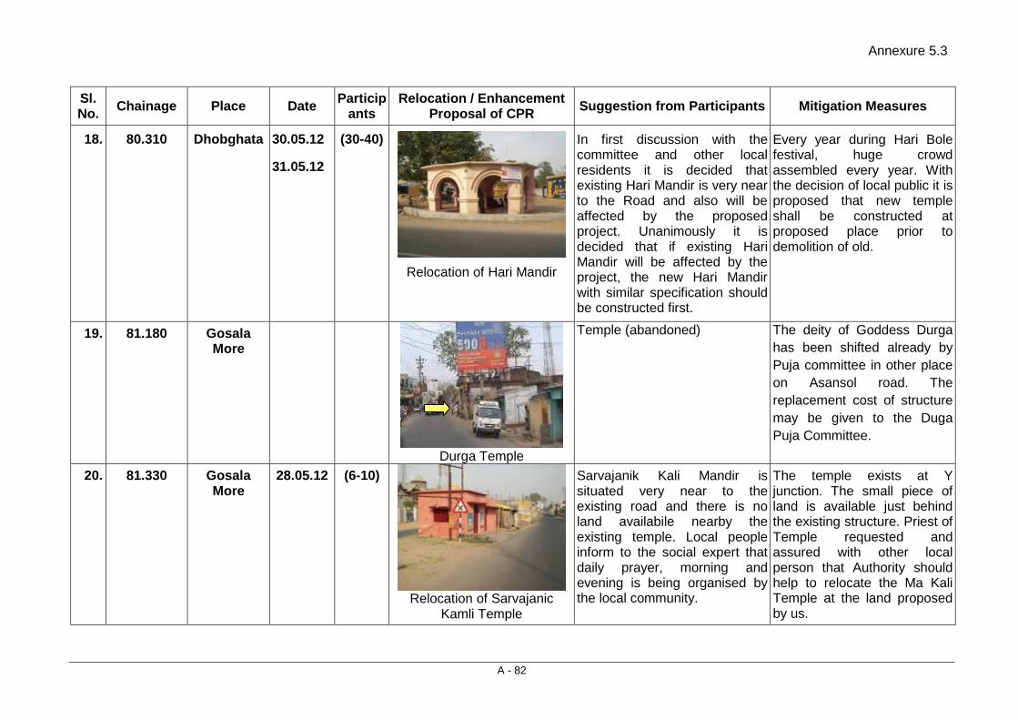
Annexure 5.3
A - 82
Sl. No. Chainage Place Date Particip
ants Relocation / Enhancement
Proposal of CPR Suggestion from Participants Mitigation Measures
18. 80.310 Dhobghata 30.05.12
31.05.12
(30-40)
Relocation of Hari Mandir
In first discussion with the committee and other local residents it is decided that existing Hari Mandir is very near to the Road and also will be affected by the proposed project. Unanimously it is decided that if existing Hari Mandir will be affected by the project, the new Hari Mandir with similar specification should be constructed first.
Every year during Hari Bole festival, huge crowd assembled every year. With the decision of local public it is proposed that new temple shall be constructed at proposed place prior to demolition of old.
19. 81.180 Gosala More
Durga Temple
Temple (abandoned) The deity of Goddess Durga has been shifted already by Puja committee in other place on Asansol road. The replacement cost of structure may be given to the Duga Puja Committee.
20. 81.330 Gosala More
28.05.12 (6-10)
Relocation of Sarvajanic
Kamli Temple
Sarvajanik Kali Mandir is situated very near to the existing road and there is no land availabile nearby the existing temple. Local people inform to the social expert that daily prayer, morning and evening is being organised by the local community.
The temple exists at Y junction. The small piece of land is available just behind the existing structure. Priest of Temple requested and assured with other local person that Authority should help to relocate the Ma Kali Temple at the land proposed by us.
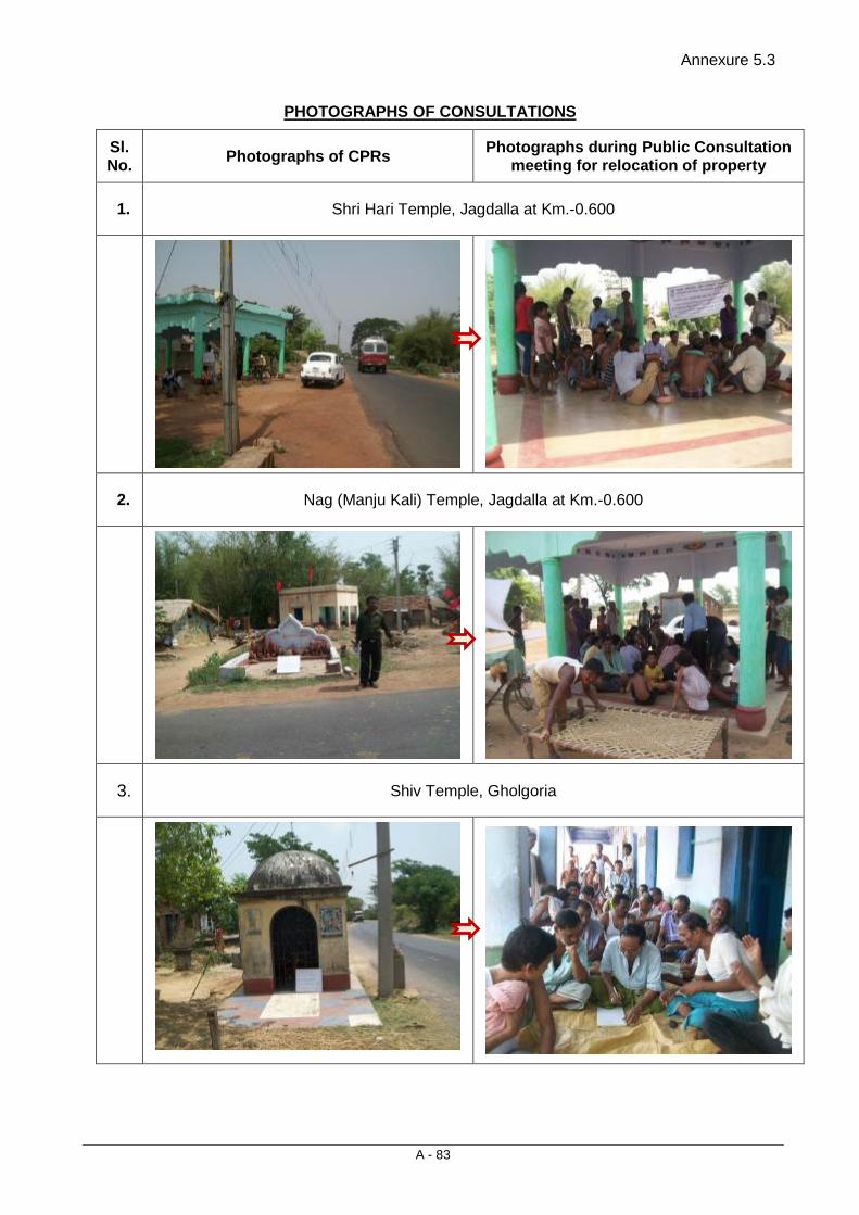
Annexure 5.3
A - 83
PHOTOGRAPHS OF CONSULTATIONS
Sl. No. Photographs of CPRs Photographs during Public Consultation
meeting for relocation of property
1. Shri Hari Temple, Jagdalla at Km.-0.600
2. Nag (Manju Kali) Temple, Jagdalla at Km.-0.600
3. Shiv Temple, Gholgoria

Annexure 5.3
A - 84
Sl. No. Photographs of CPRs Photographs during Public Consultation
meeting for relocation of property
4. Ma Kali Mandir, Bhagbanpur (Golghoriya) ch. 19.300 km
Distance from centre line is 9.5 m but due to re-alignment this structure will be affected. the similar type and size, temple shall be
reconstructed beyond COI.
5. Ma Laxmi and Hari Temple, Saluni at Km.-
6. Sarvajanik Kali, Mandir, Bishpuria
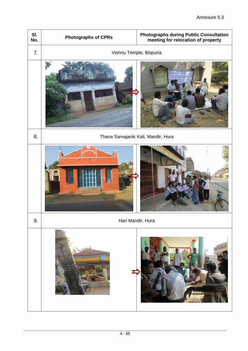
Annexure 5.3
A - 85
Sl. No. Photographs of CPRs Photographs during Public Consultation
meeting for relocation of property
7. Vishnu Temple, Bispuria
8. Thana Sarvajanik Kali, Mandir, Hura
9. Hari Mandir, Hura
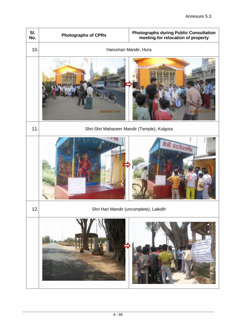
Annexure 5.3
A - 86
Sl. No. Photographs of CPRs Photographs during Public Consultation
meeting for relocation of property
10. Hanuman Mandir, Hura
11. Shri-Shri Mahaveer Mandir (Temple), Kulgora
12. Shri Hari Mandir (uncomplete), Laikdih
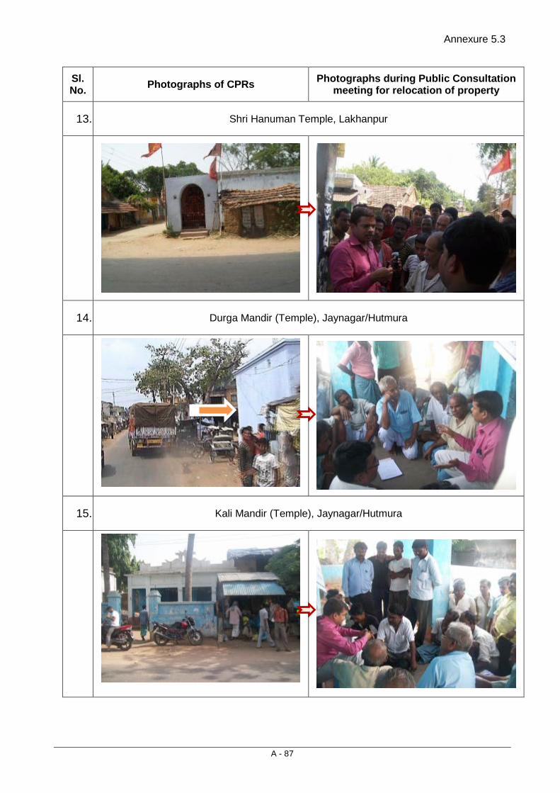
Annexure 5.3
A - 87
Sl. No. Photographs of CPRs Photographs during Public Consultation
meeting for relocation of property
13. Shri Hanuman Temple, Lakhanpur
14. Durga Mandir (Temple), Jaynagar/Hutmura
15. Kali Mandir (Temple), Jaynagar/Hutmura

Annexure 5.3
A - 88
Sl. No. Photographs of CPRs Photographs during Public Consultation
meeting for relocation of property
16. Shri Hanuman Mandir, Sidpur
17. Shri Hari Mandir, Rany Road, Dhobaghat Purulia
18. Sarvjanik Kali Mandir, Ghosla More, Purulia
Temple (abandoned)

Annexure 5.3
A - 89
Sl. No. Photographs of CPRs Photographs during Public Consultation
meeting for relocation of property
19. Sarvjanik Kali Mandir, Ghosla More, Purulia
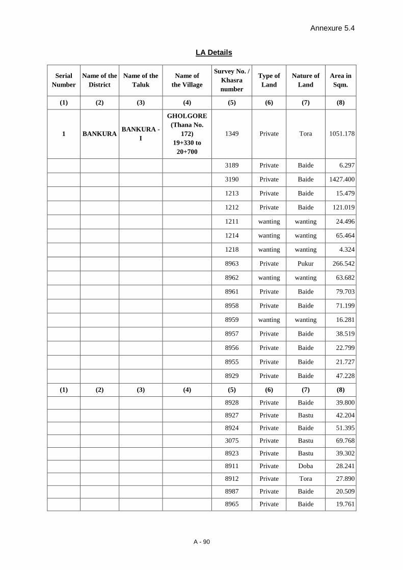
Annexure 5.4
A - 90
LA Details
Serial Number
Name of the District
Name of the Taluk
Name of the Village
Survey No. / Khasra number
Type of Land
Nature of Land
Area in Sqm.
(1) (2) (3) (4) (5) (6) (7) (8)
1 BANKURA BANKURA -
I
GHOLGORE (Thana No.
172) 19+330 to
20+700
1349 Private Tora 1051.178
3189 Private Baide 6.297
3190 Private Baide 1427.400
1213 Private Baide 15.479
1212 Private Baide 121.019
1211 wanting wanting 24.496
1214 wanting wanting 65.464
1218 wanting wanting 4.324
8963 Private Pukur 266.542
8962 wanting wanting 63.682
8961 Private Baide 79.703
8958 Private Baide 71.199
8959 wanting wanting 16.281
8957 Private Baide 38.519
8956 Private Baide 22.799
8955 Private Baide 21.727
8929 Private Baide 47.228
(1) (2) (3) (4) (5) (6) (7) (8)
8928 Private Baide 39.800
8927 Private Bastu 42.204
8924 Private Baide 51.395
3075 Private Bastu 69.768
8923 Private Bastu 39.302
8911 Private Doba 28.241
8912 Private Tora 27.890
8987 Private Baide 20.509
8965 Private Baide 19.761

Annexure 5.4
A - 91
8966 Private Baide 25.187
8952 wanting wanting 7.939
8955 Private Baide 29.731
8956 Private Baide 17.761
2160 Private Bastu 40.840
2161 Private Bastu 79.234
2165 Private Doba 24.880
3164 Private Sole 23.918
3165 Private Baide 12.143
3166 Private Sole 6.794
2256 Private Baide 48.613
6367 wanting wanting 14.423
6365 wanting wanting 3.214
2254 Private Pukur 150.099
2279 Private Baide 163.463
2332 Private Sole 95.729
2331 Private Baide 16.858
2335 Private Baide 3.303
3056 Private Bastu 7.809
3051 Private Bastu 34.025
3053 Private Bastu 54.231
3049 Private Bastu 19.57
3048 Private Bastu 31.547
880 Private Bastu 2.029
2860 Private Baide 30.106
2838 Private Baide 38.397
2885 Private Baide 18.63
2257 Private Bastu 94.498
2880 Private Baide 73.777
2289 Private Baide 40.254
2290 Private Baide 87.348
2295 Private Baide 45.245
2296 Private Baide 122.008
SUB TOTAL 5145.810
(1) (2) (3) (4) (5) (6) (7) (8)
2 CHHATNA JAMBEDE (Thana No.
362 Private Baide 112.531
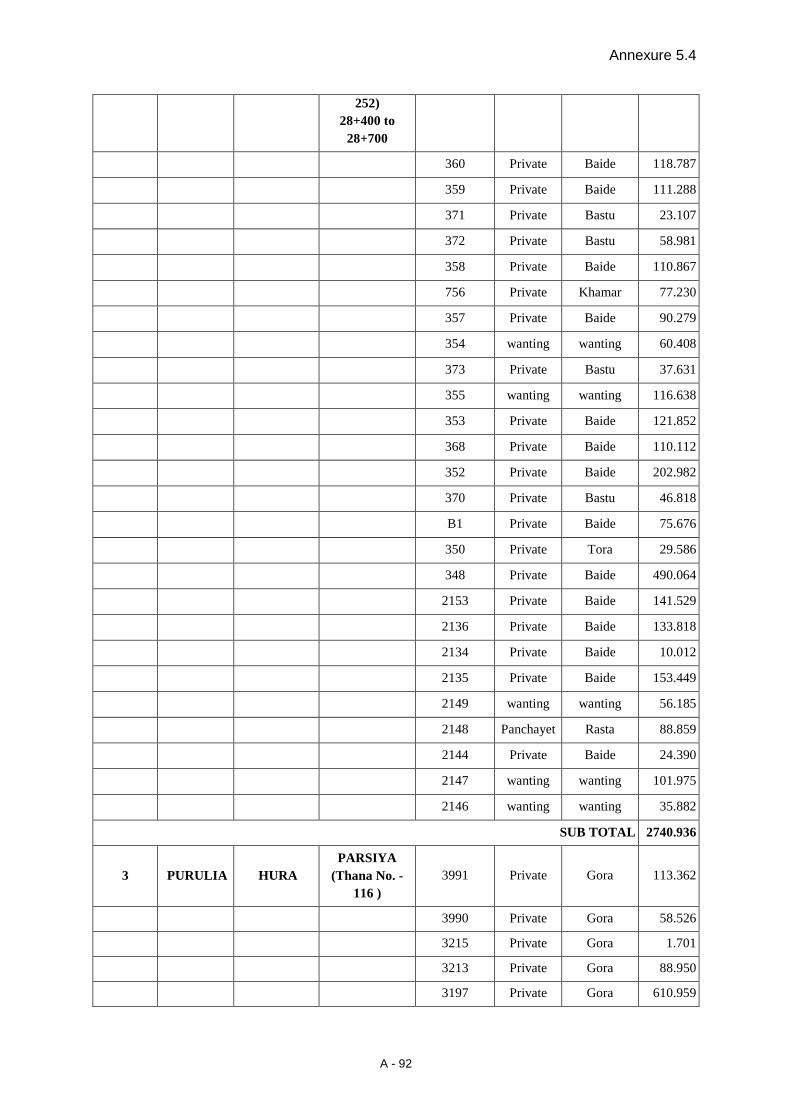
Annexure 5.4
A - 92
252) 28+400 to
28+700
360 Private Baide 118.787
359 Private Baide 111.288
371 Private Bastu 23.107
372 Private Bastu 58.981
358 Private Baide 110.867
756 Private Khamar 77.230
357 Private Baide 90.279
354 wanting wanting 60.408
373 Private Bastu 37.631
355 wanting wanting 116.638
353 Private Baide 121.852
368 Private Baide 110.112
352 Private Baide 202.982
370 Private Bastu 46.818
B1 Private Baide 75.676
350 Private Tora 29.586
348 Private Baide 490.064
2153 Private Baide 141.529
2136 Private Baide 133.818
2134 Private Baide 10.012
2135 Private Baide 153.449
2149 wanting wanting 56.185
2148 Panchayet Rasta 88.859
2144 Private Baide 24.390
2147 wanting wanting 101.975
2146 wanting wanting 35.882
SUB TOTAL 2740.936
3 PURULIA HURA PARSIYA
(Thana No. - 116 )
3991 Private Gora 113.362
3990 Private Gora 58.526
3215 Private Gora 1.701
3213 Private Gora 88.950
3197 Private Gora 610.959

Annexure 5.4
A - 93
3195 Private Gora 258.332
3194 Private Gora 157.750
3193 Private Gora 110.504
3192 Private Gora 205.221
3191 Private Gora 122.910
3190 Private Baide 68.085
3188 Private Gora 161.251
(1) (2) (3) (4) (5) (6) (7) (8)
3189 wanting wanting 295.398
3180 wanting wanting 277.640
3181 Private Baide 27.488
3179 Private Baide 343.463
3016 Private Baide 537.792
3015 Private Baide 232.126
3017 Private Baide 32.635
3018 Govt. Baide 289.383
3021 Private Baide 175.782
3026 Private Baide 569.731
3003 Private Baide 84.791
3002 Private Baide 123.027
3001 Private Baide 230.965
3000 Private Baide 441.936
2986 Private Not found 67.586
2988 Private Baide 195.356
2989 Private Baide 606.080
2980 Private Baide 248.616
2990 Private Baide 290.892
2976 wanting wanting 101.445
2977 Private Baide 274.769
2972 Private Baide 44.650
SUB TOTAL 7449.102
4 PURULIA HURA RAKHYARA (Thana No. -
113 ) 2617 Private Bahal 77.36
2620 Private Baide 205.885
2623 Private Danga 408.582

Annexure 5.4
A - 94
2621 Private Danga 50.427
2603 Private Baide 455.773
2600 Govt. Motasayal 185.314
2699 Private Danga 48.72
2598 Private Bahal 244.72
2597 Road Govt. Land 352.93
2596 Private Kanali 32.03
2554 Private Baide 69.72
2553 Private Bahal 83.88
2552 Private Baide 54.079
2551 Govt. Baide 105.6
2550 Private Baide 114.56
2549 Govt. Baide 65.65
2548 Godia Private 62.79
(1) (2) (3) (4) (5) (6) (7) (8)
2547 Private Baide 11.67
2541 Govt. Patit 36.54
SUB TOTAL 2666.230
4 PURULIA HURA
BISPURIA (Thana No.107)
39+300 to 41+200
3813 Private Bastu 21.123
3813 Private Bastu 65.595
3813 Private Bastu 7.429
3686 wanting wanting 12.189
3937 Private Bastu 1.989
3942 Private Baide 1.392
3943 wanting wanting 8.724
3944 Private Baide 23.232
3945 Private Baide 37.836
3997 wanting wanting 1.438
4003 Private Khamar 2.811
4006 Private Bastu 3.178
2849 wanting wanting 52.365
4005 Private Bastu 11.711
4017 Private Baid 5.913
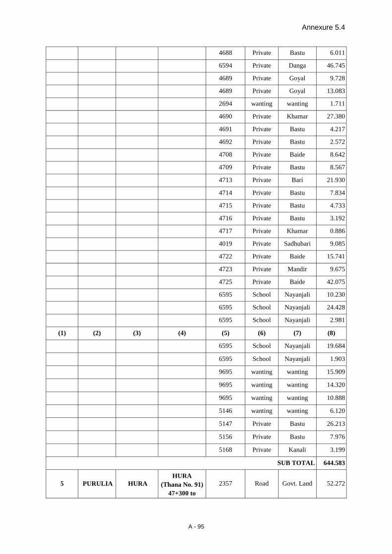
Annexure 5.4
A - 95
4688 Private Bastu 6.011
6594 Private Danga 46.745
4689 Private Goyal 9.728
4689 Private Goyal 13.083
2694 wanting wanting 1.711
4690 Private Khamar 27.380
4691 Private Bastu 4.217
4692 Private Bastu 2.572
4708 Private Baide 8.642
4709 Private Bastu 8.567
4713 Private Bari 21.930
4714 Private Bastu 7.834
4715 Private Bastu 4.733
4716 Private Bastu 3.192
4717 Private Khamar 0.886
4019 Private Sadhubari 9.085
4722 Private Baide 15.741
4723 Private Mandir 9.675
4725 Private Baide 42.075
6595 School Nayanjali 10.230
6595 School Nayanjali 24.428
6595 School Nayanjali 2.981
(1) (2) (3) (4) (5) (6) (7) (8)
6595 School Nayanjali 19.684
6595 School Nayanjali 1.903
9695 wanting wanting 15.909
9695 wanting wanting 14.320
9695 wanting wanting 10.888
5146 wanting wanting 6.120
5147 Private Bastu 26.213
5156 Private Bastu 7.976
5168 Private Kanali 3.199
SUB TOTAL 644.583
5 PURULIA HURA HURA
(Thana No. 91) 47+300 to
2357 Road Govt. Land 52.272

Annexure 5.4
A - 96
50+600
2257 Private Vita 0.238
2364 Private Path 13.913
2249 Private Baide/Bastu 6.234
2356 wanting wanting 5.828
2242 Govt. Thana 42.983
1922 Private Bastu 22.907
1923 D.Board Bastu 0.928
1924 Private Bastu 1.267
1916 Private Bastu 1.021
1917 Private Goria 1.148
2389 D.Board Dokan 24.856
2396 D.Board Bastu 2.228
2400 Private Bari 14.664
2402 Private Bastu 6.949
1910 Private Bastu 15.307
2408 Private Gora 2.711
2409 Private Bahal 4.311
2410 Private Bastu 5.129
2410 Private Bastu 9.071
2411 Private Bari 3.853
3248 wanting wanting 10.581
1901 Private Vita 3.594
K wanting wanting 4.084
L wanting wanting 18.263
M wanting wanting 1.785
1893 Private Bastu 3.711
1892 Private Bastu 6.741
1892 Private Bastu 2.658
1889 Private Bastu 3.568
(1) (2) (3) (4) (5) (6) (7) (8)
1876 Private Bastu 6.694
1873 wanting wanting 1.768
1873 Govt. Hospital 6.394
N wanting wanting 3.763
O wanting wanting 13.592
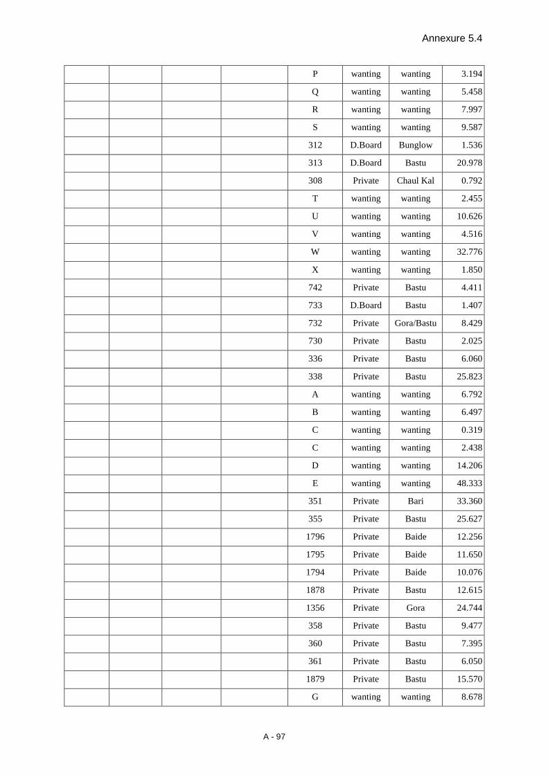
Annexure 5.4
A - 97
P wanting wanting 3.194
Q wanting wanting 5.458
R wanting wanting 7.997
S wanting wanting 9.587
312 D.Board Bunglow 1.536
313 D.Board Bastu 20.978
308 Private Chaul Kal 0.792
T wanting wanting 2.455
U wanting wanting 10.626
V wanting wanting 4.516
W wanting wanting 32.776
X wanting wanting 1.850
742 Private Bastu 4.411
733 D.Board Bastu 1.407
732 Private Gora/Bastu 8.429
730 Private Bastu 2.025
336 Private Bastu 6.060
338 Private Bastu 25.823
A wanting wanting 6.792
B wanting wanting 6.497
C wanting wanting 0.319
C wanting wanting 2.438
D wanting wanting 14.206
E wanting wanting 48.333
351 Private Bari 33.360
355 Private Bastu 25.627
1796 Private Baide 12.256
1795 Private Baide 11.650
1794 Private Baide 10.076
1878 Private Bastu 12.615
1356 Private Gora 24.744
358 Private Bastu 9.477
360 Private Bastu 7.395
361 Private Bastu 6.050
1879 Private Bastu 15.570
G wanting wanting 8.678
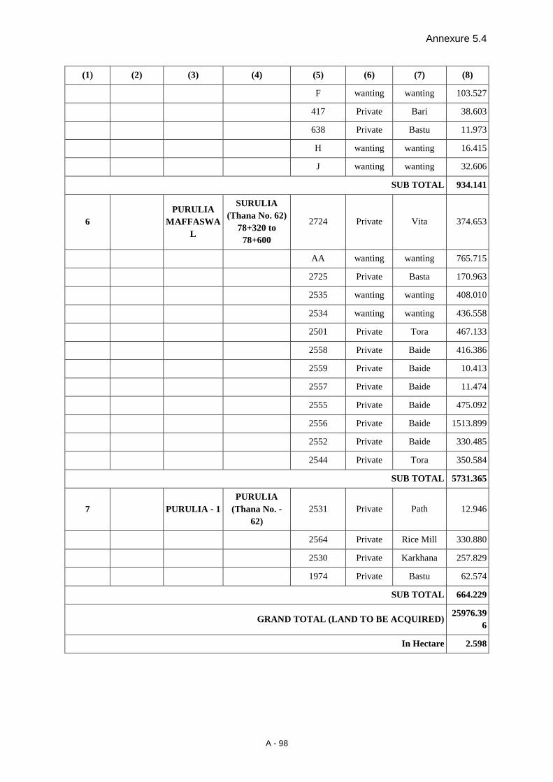
Annexure 5.4
A - 98
(1) (2) (3) (4) (5) (6) (7) (8)
F wanting wanting 103.527
417 Private Bari 38.603
638 Private Bastu 11.973
H wanting wanting 16.415
J wanting wanting 32.606
SUB TOTAL 934.141
6 PURULIA
MAFFASWAL
SURULIA (Thana No. 62)
78+320 to 78+600
2724 Private Vita 374.653
AA wanting wanting 765.715
2725 Private Basta 170.963
2535 wanting wanting 408.010
2534 wanting wanting 436.558
2501 Private Tora 467.133
2558 Private Baide 416.386
2559 Private Baide 10.413
2557 Private Baide 11.474
2555 Private Baide 475.092
2556 Private Baide 1513.899
2552 Private Baide 330.485
2544 Private Tora 350.584
SUB TOTAL 5731.365
7 PURULIA - 1 PURULIA
(Thana No. - 62)
2531 Private Path 12.946
2564 Private Rice Mill 330.880
2530 Private Karkhana 257.829
1974 Private Bastu 62.574
SUB TOTAL 664.229
GRAND TOTAL (LAND TO BE ACQUIRED) 25976.39
6
In Hectare 2.598
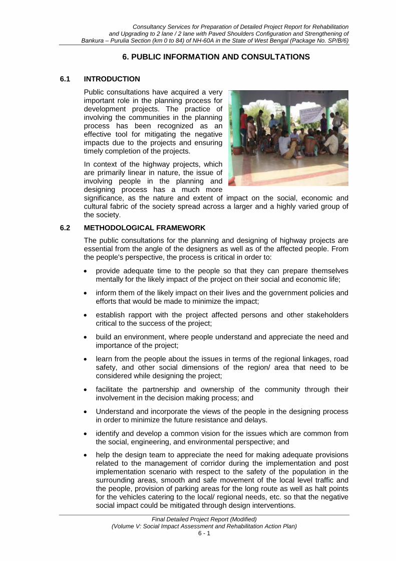
Consultancy Services for Preparation of Detailed Project Report for Rehabilitation and Upgrading to 2 lane / 2 lane with Paved Shoulders Configuration and Strengthening of
Bankura – Purulia Section (km 0 to 84) of NH-60A in the State of West Bengal (Package No. SP/B/6)
Final Detailed Project Report (Modified) (Volume V: Social Impact Assessment and Rehabilitation Action Plan)
6 - 1
6. PUBLIC INFORMATION AND CONSULTATIONS
6.1 INTRODUCTION
Public consultations have acquired a very important role in the planning process for development projects. The practice of involving the communities in the planning process has been recognized as an effective tool for mitigating the negative impacts due to the projects and ensuring timely completion of the projects.
In context of the highway projects, which are primarily linear in nature, the issue of involving people in the planning and designing process has a much more significance, as the nature and extent of impact on the social, economic and cultural fabric of the society spread across a larger and a highly varied group of the society.
6.2 METHODOLOGICAL FRAMEWORK The public consultations for the planning and designing of highway projects are essential from the angle of the designers as well as of the affected people. From the people's perspective, the process is critical in order to:
• provide adequate time to the people so that they can prepare themselves mentally for the likely impact of the project on their social and economic life;
• inform them of the likely impact on their lives and the government policies and efforts that would be made to minimize the impact;
• establish rapport with the project affected persons and other stakeholders critical to the success of the project;
• build an environment, where people understand and appreciate the need and importance of the project;
• learn from the people about the issues in terms of the regional linkages, road safety, and other social dimensions of the region/ area that need to be considered while designing the project;
• facilitate the partnership and ownership of the community through their involvement in the decision making process; and
• Understand and incorporate the views of the people in the designing process in order to minimize the future resistance and delays.
• identify and develop a common vision for the issues which are common from the social, engineering, and environmental perspective; and
• help the design team to appreciate the need for making adequate provisions related to the management of corridor during the implementation and post implementation scenario with respect to the safety of the population in the surrounding areas, smooth and safe movement of the local level traffic and the people, provision of parking areas for the long route as well as halt points for the vehicles catering to the local/ regional needs, etc. so that the negative social impact could be mitigated through design interventions.

Public Information and Consultations
Final Detailed Project Report (Modified) (Volume V: Social Impact Assessment and Rehabilitation Action Plan)
6 - 2
Public participation was undertaken to make explicit the social factors that will affect the development impacts of planned highway improvements and mediate project results. Through public participation, stakeholders and key social issues were identified and strategy was formulated. It included socio-cultural analysis and design of social strategy, institutional analysis and specifically addressed the issue of how poor and vulnerable groups may benefit from the project.
As a part of the public consultation, an effort was made to gradually build a relationship with the key stakeholders through a planned consultative process. The purpose of public consultations at various stages of the SIA/RAP preparation was two-fold, first, to create awareness about the project, it‘s intent and the likely benefits amongst the likely project affected persons and key stakeholders, to facilitate the process of understanding of likely social impacts for the members of the engineering team.
The key elements of the public consultation process have been:
• identification of socially critical sections in the project stretch through reconnaissance survey and observation of the activity pattern at the identified critical sections;
• identification of key persons, who would act as resource persons at various stages of the project, through informal discussions with the local people in these sections;
• sharing about the project and its significance for the nation and region with the key persons, responding to their questions and apprehensions to gain their confidence;
• initial interactions in small groups using key persons as facilitators from amongst the project affected persons to understand the local level issues;
6.3 PUBLIC CONSULTATION PROCESS The objectives of local level consultations were to inform the affected persons about the project, applicable Land Acquisition Act/procedure of LA, R&R policy of GOI/WB, to incorporate their views in the design and mitigation measures as suggested by them. For organizing the local level consultations, Consultation team was framed-up which includes one Socio-Economic Analyst specialized in qualitative data collection, two women community organizers, two investigators and one moderator. Group discussions were carried out by using a semi-structured format. Efforts were made to cover all those villages having significant social issues viz., relocation of some religious structures or impact on residential /commercial structres A combination of small and big habitations were covered as apart of stakeholder’s consultation in order to provide representation of all the segments of affected population. At least one-group discussions were held in every affected village. The size of group was about 12-18 persons and everybody gets the chance to express their views on the project. In addition, separate group meetings for women were also organized in almost 10 important affected villages.
6.4 DETAILS OF PUBLIC CONSULTATION MEETINGS It is already mentioned in the introductory paragraph that Public consultation has been carried out in this project with the objectives of minimizing probable adverse impacts of the project by providing engineering solutions (alignment and cross-section) and to achieve speedy implementation of the project through bringing in awareness among the community on the benefits of the project. Several meetings were organized at various locations at the different stages of project designing to inform the people regarding the proposed project and to facilitate them to come-

Consultancy Services for Preparation of Detailed Project Report for Rehabilitation and Upgrading to 2 lane / 2 lane with Paved Shoulders Configuration and Strengthening of
Bankura – Purulia Section (km 0 to 84) of NH-60A in the State of West Bengal (Package No. SP/B/6)
Final Detailed Project Report (Modified) (Volume V: Social Impact Assessment and Rehabilitation Action Plan)
6 - 3
up with their suggestions and views to minimize the negative impact of the project. During social screening stage such consultations were carried out in the month of Sept. 2011 to Dec. 2011, while at DPR stage a number of consultations were carried out during May. 2012 to June 2012. In addition, 18 consultations were made to solicit the views of communities especially on relocation of CPRs. Apart from above issues other necessary social issues i.e. issues related to road safety, gender and HIV/AIDS were also discussed during consultations. The pictorial presentation of such consultation along with list of the villages where consultation were made, date of consultation, and number and distinctiveness of participants has been annexed as Annexure 6.1 and Annexure 6.2 for ready reference.
The details of various consultations at various level, issues of discussion, perception and views of the people and recommendations of the Expert after assessing the outcome of the discussion will be outlined in subsequent paragraph.
6.4.1 Consultation with Project Affected Persons The general issues raised by the PAPs in most of these consultations were related to the compensation package, rehabilitation of Non-titleholders, provision of passenger shelters along with drinking water and toilet facilities, provision of safety measures (like providing underpass, zebra crossing, proper signs etc.), employment generation schemes by the project authority to restore the livelihood of the affected household etc. However, the location and people specific issues were also discussed and documented in the consultation process. The location-wise consultation details, issues discussed, people’s perception and recommendation are documented in Table 6.1:
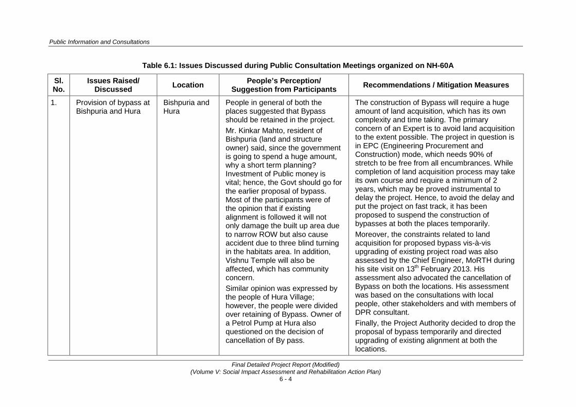
Public Information and Consultations
Final Detailed Project Report (Modified) (Volume V: Social Impact Assessment and Rehabilitation Action Plan)
6 - 4
Table 6.1: Issues Discussed during Public Consultation Meetings organized on NH-60A
Sl. No.
Issues Raised/ Discussed Location People’s Perception/
Suggestion from Participants Recommendations / Mitigation Measures
1. Provision of bypass at Bishpuria and Hura
Bishpuria and Hura
People in general of both the places suggested that Bypass should be retained in the project. Mr. Kinkar Mahto, resident of Bishpuria (land and structure owner) said, since the government is going to spend a huge amount, why a short term planning? Investment of Public money is vital; hence, the Govt should go for the earlier proposal of bypass. Most of the participants were of the opinion that if existing alignment is followed it will not only damage the built up area due to narrow ROW but also cause accident due to three blind turning in the habitats area. In addition, Vishnu Temple will also be affected, which has community concern. Similar opinion was expressed by the people of Hura Village; however, the people were divided over retaining of Bypass. Owner of a Petrol Pump at Hura also questioned on the decision of cancellation of By pass.
The construction of Bypass will require a huge amount of land acquisition, which has its own complexity and time taking. The primary concern of an Expert is to avoid land acquisition to the extent possible. The project in question is in EPC (Engineering Procurement and Construction) mode, which needs 90% of stretch to be free from all encumbrances. While completion of land acquisition process may take its own course and require a minimum of 2 years, which may be proved instrumental to delay the project. Hence, to avoid the delay and put the project on fast track, it has been proposed to suspend the construction of bypasses at both the places temporarily. Moreover, the constraints related to land acquisition for proposed bypass vis-à-vis upgrading of existing project road was also assessed by the Chief Engineer, MoRTH during his site visit on 13th February 2013. His assessment also advocated the cancellation of Bypass on both the locations. His assessment was based on the consultations with local people, other stakeholders and with members of DPR consultant. Finally, the Project Authority decided to drop the proposal of bypass temporarily and directed upgrading of existing alignment at both the locations.
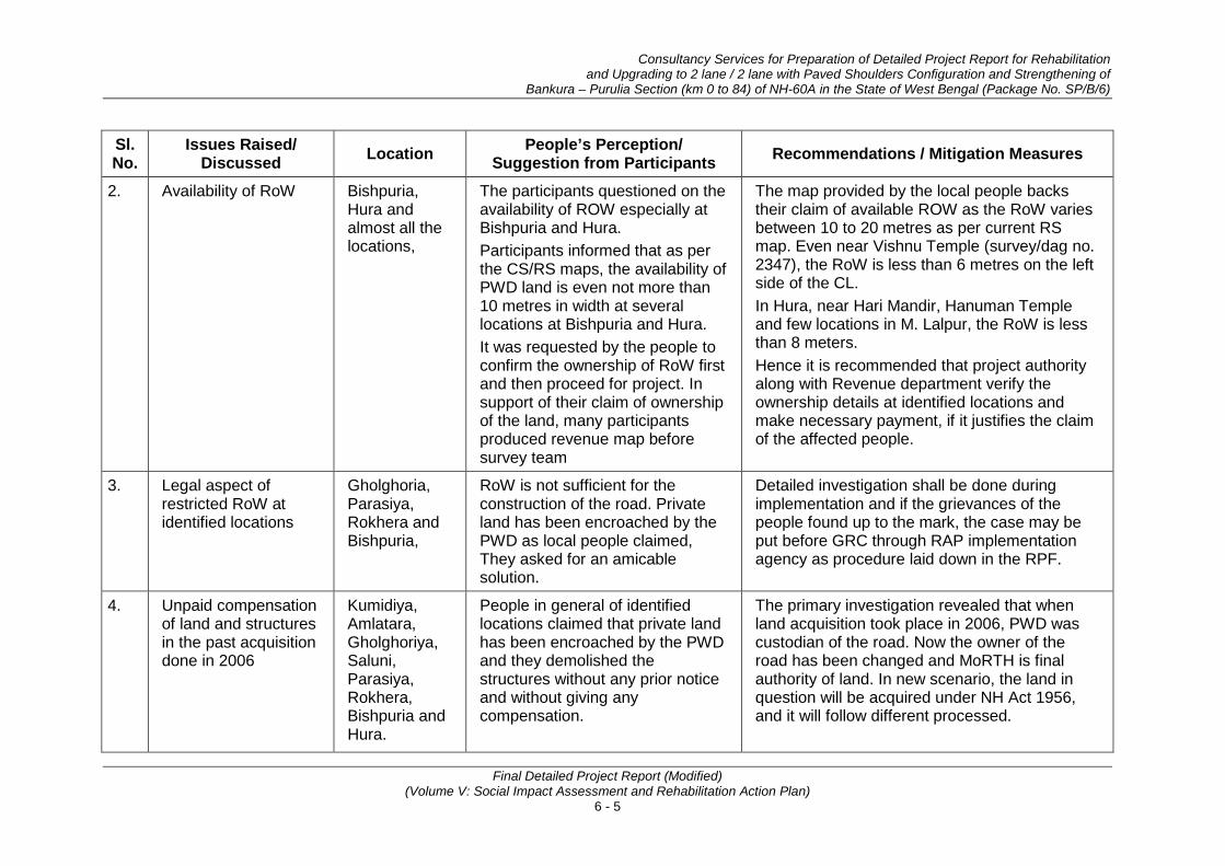
Consultancy Services for Preparation of Detailed Project Report for Rehabilitation and Upgrading to 2 lane / 2 lane with Paved Shoulders Configuration and Strengthening of
Bankura – Purulia Section (km 0 to 84) of NH-60A in the State of West Bengal (Package No. SP/B/6)
Final Detailed Project Report (Modified) (Volume V: Social Impact Assessment and Rehabilitation Action Plan)
6 - 5
Sl. No.
Issues Raised/ Discussed Location People’s Perception/
Suggestion from Participants Recommendations / Mitigation Measures
2. Availability of RoW Bishpuria, Hura and almost all the locations,
The participants questioned on the availability of ROW especially at Bishpuria and Hura. Participants informed that as per the CS/RS maps, the availability of PWD land is even not more than 10 metres in width at several locations at Bishpuria and Hura. It was requested by the people to confirm the ownership of RoW first and then proceed for project. In support of their claim of ownership of the land, many participants produced revenue map before survey team
The map provided by the local people backs their claim of available ROW as the RoW varies between 10 to 20 metres as per current RS map. Even near Vishnu Temple (survey/dag no. 2347), the RoW is less than 6 metres on the left side of the CL. In Hura, near Hari Mandir, Hanuman Temple and few locations in M. Lalpur, the RoW is less than 8 meters. Hence it is recommended that project authority along with Revenue department verify the ownership details at identified locations and make necessary payment, if it justifies the claim of the affected people.
3. Legal aspect of restricted RoW at identified locations
Gholghoria, Parasiya, Rokhera and Bishpuria,
RoW is not sufficient for the construction of the road. Private land has been encroached by the PWD as local people claimed, They asked for an amicable solution.
Detailed investigation shall be done during implementation and if the grievances of the people found up to the mark, the case may be put before GRC through RAP implementation agency as procedure laid down in the RPF.
4. Unpaid compensation of land and structures in the past acquisition done in 2006
Kumidiya, Amlatara, Gholghoriya, Saluni, Parasiya, Rokhera, Bishpuria and Hura.
People in general of identified locations claimed that private land has been encroached by the PWD and they demolished the structures without any prior notice and without giving any compensation.
The primary investigation revealed that when land acquisition took place in 2006, PWD was custodian of the road. Now the owner of the road has been changed and MoRTH is final authority of land. In new scenario, the land in question will be acquired under NH Act 1956, and it will follow different processed.

Public Information and Consultations
Final Detailed Project Report (Modified) (Volume V: Social Impact Assessment and Rehabilitation Action Plan)
6 - 6
Sl. No.
Issues Raised/ Discussed Location People’s Perception/
Suggestion from Participants Recommendations / Mitigation Measures
The participants of Gholghoria village communicated that they have already filed cases against Executing Agency in district court and matters are under judicial investigation.
It is recommended that since the matter is sub judice, hence a final decision on this issue be taken after a final decision comes from of the court. In addition, it is also advised that all the related matters should be raised through Suggestion and Complaint Handling Mechanism (SCHM) provided in RPF.
5. Proposal on Road widening
Bishpuria, Hura and almost all the urban / habitation locations.
Minimum and equal land width should be taken on both side of the road. The people also opined that the executing agency should be firm on the design consideration, which has been disclosed before the people, i.e., the widening proposal within 13 metre of 6.5 m of either side of the road in urban area.
The corridor of impact (CoI) for the project would broadly range between 15-18 m to fit the typical cross sections, space for drains, roadside furniture and utilities. However, in specific locations, CoI is less than 15m which may produce some sort of constraint to meet the requirement of formation width. It is recommended to minimize the impact on properties, even if more width is required in congested area. The entire available space in the urban areas be paved from building line to building line to facilitate pedestrian movements, parking etc and providing space for drain, road side furniture and utilities.
6. Compensation payment procedure
At all the locations
The land rates are very high in this area so it’s requested to pay the compensation at market rate. In addition, employment for at least 1 person should also be given.
Compensation for the Land, structure and other properties shall be paid as per the NH Act, 1956. To make the compensation amount equivalent to market rate suitable formula has been including in the RPF, which will be paid by the project authority separately. Employment in the road construction work as

Consultancy Services for Preparation of Detailed Project Report for Rehabilitation and Upgrading to 2 lane / 2 lane with Paved Shoulders Configuration and Strengthening of
Bankura – Purulia Section (km 0 to 84) of NH-60A in the State of West Bengal (Package No. SP/B/6)
Final Detailed Project Report (Modified) (Volume V: Social Impact Assessment and Rehabilitation Action Plan)
6 - 7
Sl. No.
Issues Raised/ Discussed Location People’s Perception/
Suggestion from Participants Recommendations / Mitigation Measures
semi-skilled and unskilled workers to be made available to eligible person.
7. Relocation of Religious structures
As listed in subsequent table of CPRs.
Participants suggested that every affected property (partially or fully) must be modified /relocated and enhanced properly, prior to the commencement of road construction work at suggested locations.
It is recommended that all the CPRs likely to be affected, need to be repaired or relocated at new places as the case is in consultation with local community. The cost of construction/relocation to be borne by the project. The Policy Framework document of the project has a provision that advocates that the Community Infrastructure / Common Property Resources affected will be reconstructed
8. Compensation packages to Non-title holders (squatters and Kiosks)
At all the locations
Persons who are having structures/shops etc on the govt. land (RoW) should be compensated as it is the only source of livelihood to squatters. Proper rehabilitation and resettlement should be ensured by the project authority.
All squatters would be paid cash assistance for their structures at replacement costs which will be determined as per RPF. Besides, Only replacement cost of structures to be paid to vulnerable encroachers as per the EM. Shifting assistance to the DPs of non-titleholders of defined categories would also be provided.
9. Provisions for community properties (Bus stop, hand pumps, toilets (at least urinal) and other common properties) likely to be affected / relocated
At all the locations
All the affected existing properties / resources must be restored, enhanced or constructed. In addition, urinals and drinking water facilities should be provided to the passenger sheds etc.
All the existing community resources shall be restored as suggested places from the project. Necessary steps would be taken to include the construction cost of CPRs at designated places in BOQ including provision of drinking water and toilet facilities near passenger shelter and truck lay-byes. RPF provides for restoration/reconstruction of /
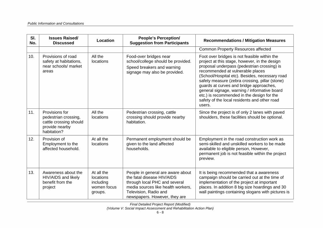
Public Information and Consultations
Final Detailed Project Report (Modified) (Volume V: Social Impact Assessment and Rehabilitation Action Plan)
6 - 8
Sl. No.
Issues Raised/ Discussed Location People’s Perception/
Suggestion from Participants Recommendations / Mitigation Measures
Common Property Resources affected
10. Provisions of road safety at habitations, near schools/ market areas
All the locations
Food-over bridges near school/college should be provided. Speed breakers and warning signage may also be provided.
Foot over bridges is not feasible within the project at this stage, however, in the design proposal underpass (pedestrian crossing) is recommended at vulnerable places (School/Hospital etc). Besides, necessary road safety measure (zebra crossing, pillar (stone) guards at curves and bridge approaches, general signage, warning / informative board etc.) is recommended in the design for the safety of the local residents and other road users.
11. Provisions for pedestrian crossing, cattle crossing should provide nearby habitation?
All the locations
Pedestrian crossing, cattle crossing should provide nearby habitation.
Since the project is of only 2 lanes with paved shoulders, these facilities should be optional.
12. Provision of Employment to the affected household.
At all the locations
Permanent employment should be given to the land affected households.
Employment in the road construction work as semi-skilled and unskilled workers to be made available to eligible person, However, permanent job is not feasible within the project preview.
13. Awareness about the HIV/AIDS and likely benefit from the project
At all the locations including women focus groups.
People in general are aware about the fatal disease HIV/AIDS through local PHC and several media sources like health workers, Television, Radio and newspapers. However, they are
It is being recommended that a awareness campaign should be carried out at the time of implementation of the project at important places. In addition 8 big size hoardings and 30 wall paintings containing slogans with pictures is

Consultancy Services for Preparation of Detailed Project Report for Rehabilitation and Upgrading to 2 lane / 2 lane with Paved Shoulders Configuration and Strengthening of
Bankura – Purulia Section (km 0 to 84) of NH-60A in the State of West Bengal (Package No. SP/B/6)
Final Detailed Project Report (Modified) (Volume V: Social Impact Assessment and Rehabilitation Action Plan)
6 - 9
Sl. No.
Issues Raised/ Discussed Location People’s Perception/
Suggestion from Participants Recommendations / Mitigation Measures
willing to know more about the reasons, consequences and remedies of the specified diseases.
also proposed at suitable locations. (See Detailed Risk Assessment and Implementation Strategy are provided as Annexure 6.3)
14. Arrangements of street lights.
Joynagar (Hutmura)
Street light should be provided within the Joynagar (Hutmura) village
Provision of street lighting at important urban areas is recommended and cost of installation of street light be included in BOQ
15. Provision of road side drains
At all the locations
Roadside drains are not working properly as it has been damaged /chocked. Cross drainage should also be provided.
At every urban location proper drainage system has been recommended.
6.4.2 Consultation with Communities for Relocation/ Enhancement of Religious and Other CPRs After making consultation with primary stakeholders (PAPs and Communities), a focus group discussion was made with community leaders, religious leader, key informants and other stakeholders to find out the solution, if there is any relocation issues of religious and communities structures.. Relocation of religious structures and other CPRs are very sensitive issues and it needs endorsement of community and religious leader so that relocation issues could be handled peacefully with community’s support. There are at least 20 locations, where religious structures / other CPRs, which need to be relocated/ modified. The outcome of the discussion has been delineated in the subsequent Table 6.2.

Public Information and Consultations
Final Detailed Project Report (Modified) (Volume V: Social Impact Assessment and Rehabilitation Action Plan)
6 - 10
Table 6.2: Consultations for Religious Structures and Its Outcome
Sl. No.
Chain-age Place Date Participants Relocation / Enhancement
Proposal of CPR Suggestion from
Participants Mitigation Measures
1 0.610 Jagdalla 27.05.12 (24-30)
Hari Mandir
The local people were agreed to shift the temple as required to new location.
The Existing Hari Mandir to be shifted near pond beyond the COI. The land belongs to Panchayat and local people are agreed to this suggestion. However, villagers were of the firm opinion that similar type of temple should be constructed before demolition.
2 0.620 Dhaldanga 27.05.12 (24-30)
Nag Temple
(Manju Kali Mandir)
The caretaker of the temple along with local people has suggested to relocate the temple near to the care taker’s house.
Villagers have no objection in relocating the temple near caretakers house.
3 19.350 Bhagbanpur
Kali Temple
As this temple is in deserted place far from habitation, no consultation was feasible at this location
Distance from centre line is 9.5 m but due to re-alignment, this structure will be affected. Temple of similar type and size, shall be reconstructed beyond COI.

Consultancy Services for Preparation of Detailed Project Report for Rehabilitation and Upgrading to 2 lane / 2 lane with Paved Shoulders Configuration and Strengthening of
Bankura – Purulia Section (km 0 to 84) of NH-60A in the State of West Bengal (Package No. SP/B/6)
Final Detailed Project Report (Modified) (Volume V: Social Impact Assessment and Rehabilitation Action Plan)
6 - 11
Sl. No.
Chain-age Place Date Participants Relocation / Enhancement
Proposal of CPR Suggestion from
Participants Mitigation Measures
4 20.580 Gholgharia 27.05.12 (45-50)
Shiv Temple
Shiv Temple with well will be affected due to road widening and new Temple with new well to be constructed at new suggested place.
Temple be relocated in consultation with local community at suggested place at project cost.
5 28.650 Harigram 29.05.12 (30-35)
Laxmi Temple
Laxmi Temple and Hari Temple are very old temples in Saluni village, exists at a sharp curve. The curve improvement has been proposed in the project design. Laxmi temple is directly coming within formation width of proposed widening and will be partially affected, while Hari Mandir will be coming very close to the proposed highway. It is pertinent to mention here that the periphery of Hari Mandir involve a lot of activities to perform ‘Haribol Festival’ and need extra space to continue these activities, the additional land will be required to facilitate the widening proposal and to avoid the accident. Hence, shifting of Hari Mandir is also warranted.
Both the temple be relocated at vacant land available near pond of the village, which belongs to Panchayat and is also connected with village approach road.

Public Information and Consultations
Final Detailed Project Report (Modified) (Volume V: Social Impact Assessment and Rehabilitation Action Plan)
6 - 12
Sl. No.
Chain-age Place Date Participants Relocation / Enhancement
Proposal of CPR Suggestion from
Participants Mitigation Measures
6 40.135 Bishpuria 04.03.13 (35-40)
Sarvajanik Kali Temple
As this temple likely to be affected partially (only tin shed), the people requested the project authority to construct and enhance the existing shed/structure.
This temple exists within RoW. In view of non-availability of land in Bishpuria for relocation of Temple, it is recommended that only tin shed be reconstructed with some enhancement proposal at same location.
7 40.385 Bishpuria 05.03.13 (35-40)
Shri Vishnu Temple,
Bishpuria
Shri Vishnu Temple exists in private land at dag (survey) no. 2347. Since the temple is likely to be affected partially, the villagers requested to allow the temple remains at the same location with proper repair and enhancement. In case shifting of temple is inevitable, a new temple should be constructed on the bund of pond near the temple.
Based on the extent of actual impact, a suitable decision is required to be taken in consultation with community at the time of RAP implementation.
8 48.490 Hura 28.02.13 (10-12)
Hura Thana Sarvajanik Kali
Temple
This temple has partial impact; the people requested that the project authority must consider the construction / suitable modification of temple before making any demolition work of the temple.
In view of non-availability of land in Hura relocation of temple is not feasible. However, minor modification seems to be practical to retain the existing temple by reconstructing the gate and arch of the temple.

Consultancy Services for Preparation of Detailed Project Report for Rehabilitation and Upgrading to 2 lane / 2 lane with Paved Shoulders Configuration and Strengthening of
Bankura – Purulia Section (km 0 to 84) of NH-60A in the State of West Bengal (Package No. SP/B/6)
Final Detailed Project Report (Modified) (Volume V: Social Impact Assessment and Rehabilitation Action Plan)
6 - 13
Sl. No.
Chain-age Place Date Participants Relocation / Enhancement
Proposal of CPR Suggestion from
Participants Mitigation Measures
9 48.690 Hura 11.03.13 (20-25)
Hari Mandir
This temple is one of the oldest temples in Hura village. Majority of Temple committee member were not presents due to ongoing higher secondary school examination. However, they informally informed and assured that another site/location will be provided for the construction of temple.
The existing temple is on the government land. Local community/residents have suggested alternate vacant land site near Durga/ Shiv temple.
10 49.360 Hura 02.03.13 (32-35)
Hanuman Temple
Hanuman Temple, located in Hura village has been constructed in memory of a monkey died in an accident. The land for relocation of Hanuman Mandir is available. People demanded construction of new temple before demolition.
The temple will require relocation. As the land for reconstruction is available, hence, it is recommended that a new temple should be constructed before demolition of old demolished.
11 49.990 Jabjabi Gora, M. Lalpur
09.03.13 (12-15)
Hari Mandir
Hari Mandir is the only temple in this hamlet and every year at the time of ‘Hari Bol’ festival,a grand fair is organized. The RoW at this point is very less.
The Temple has its own land. It can be relocated in the same land plot/ survey no.

Public Information and Consultations
Final Detailed Project Report (Modified) (Volume V: Social Impact Assessment and Rehabilitation Action Plan)
6 - 14
Sl. No.
Chain-age Place Date Participants Relocation / Enhancement
Proposal of CPR Suggestion from
Participants Mitigation Measures
12 56.880 Kulgora 24.05.12 (10-15)
Hanuman Temple
The temple was constructed by an individual and he has no objection if it required relocation. He was agreed to provide appropriate land for relocation of temple.
The temple to be relocated in alternate location as suggested by the individual.
13 57.965 Laikadih 24.05.12 (12-15)
Hari Temple
The construction of Hari temple is under construction with donation from local people. People were planning to complete the slab and other pending work at the time of consultation.
The temple is very close to the existing carriageway, local fiesta is cognized during ‘Hari bol’ festival every year. it will require relocation for which people were agreed
14 59.200 Lakhanpur 26.05.12 (20-22)
Bajrangbali Temple
The construction of Hanuman temple has been done from donation of local people.
The temple exists very close to the existing highway. It will be relocated beyond proposed right of way as agreed by the people.
15 68.780 Jaynagar (Hutmura)
25.05.12 (20-25)
Durga Mandir
Durga Mandir in Joynagar is located very close to the existing road and need relocation due to proposed project. Durga Puja function is celebrated every year. People demanded relocation of temple at another site.
Puja Committee member along with local residents agreed for relocation at new site.

Consultancy Services for Preparation of Detailed Project Report for Rehabilitation and Upgrading to 2 lane / 2 lane with Paved Shoulders Configuration and Strengthening of
Bankura – Purulia Section (km 0 to 84) of NH-60A in the State of West Bengal (Package No. SP/B/6)
Final Detailed Project Report (Modified) (Volume V: Social Impact Assessment and Rehabilitation Action Plan)
6 - 15
Sl. No.
Chain-age Place Date Participants Relocation / Enhancement
Proposal of CPR Suggestion from
Participants Mitigation Measures
16 68.820 Jaynagar (Hutmura)
25.05.12 (20-25)
Boundary Wall of Kali Mandir
This is an oldest temple in nearby area and worship is offered by a large number of villagers every day. As per proposed Typical Cross Section (TCS) at this section, boundary wall of this temple will be affected. Besides, one shrine of Devi Kali was also affected but now the impact on temple has been avoided. Local people along with Mr BN Chaudhary (owner of the Kali temple), whose grandsire had constructed this temple, had requested to save the shrine, if possible at the time of consultation..
The person whose grandsire had constructed this temple has no objection to shift the boundary wall of temple. Boundary wall along with the gate will be reconstructed at project cost. Moreover, as per latest revision design team has saved the Devi Kali Temple.
17 70.360 Sidpur 26.05.12 (12-16)
Hanuman Temple
This Hanuman temple was constructed with the help of donations. Worship and prayer is being offered every day.. Community demanded construction of new temple before demolition of the old one.
A new temple should be constructed near the adjoining tree as suggested by the villages.

Public Information and Consultations
Final Detailed Project Report (Modified) (Volume V: Social Impact Assessment and Rehabilitation Action Plan)
6 - 16
Sl. No.
Chain-age Place Date Participants Relocation / Enhancement
Proposal of CPR Suggestion from
Participants Mitigation Measures
18 80.310 Dhobghata 30.05.12 31.05.12
(30-40)
Hari Mandir
People suggested that if the existing temple is affected then a new one with similar specifications must be constructed before demolishing the old one.
Every year during ‘Hari Bol’ festival, huge crowd assemble here to offer the devotion. As per the demand of local community, a new temple shall be constructed at alternate place prior to demolition of old one.
19 81.180 Gosala More
Durga Temple
Temple (abandoned) The deity of Goddess Durga has been shifted already by Puja committee at other place on Asansol road. The replacement cost of structure shall be borne by the EA to the Durga Puja Committee.
20 81.330 Gosala More 28.05.12 (6-10)
Sarvajanic Kamli Temple
‘Sarvajanik Kali Mandir’ is situated very near to the existing road and no land is availabile nearby the existing temple. Priest along with local people requested to relocate the Ma Kali Temple near the existing one.
The temple exists at Y junction. A small area is available just behind the existing temple. The temple shall be relocated to identified place as per people’s request.

Consultancy Services for Preparation of Detailed Project Report for Rehabilitation and Upgrading to 2 lane / 2 lane with Paved Shoulders Configuration and Strengthening of
Bankura – Purulia Section (km 0 to 84) of NH-60A in the State of West Bengal (Package No. SP/B/6)
Final Detailed Project Report (Modified) (Volume V: Social Impact Assessment and Rehabilitation Action Plan)
6 - 17
6.4.3 Consultation with Women’s and it’s Outcomes The participation of women in FGDs and during the census survey was not encouraging because of their shy nature and ignorance. However, the survey team was successful in conducting 10 FGDs at several places such as Jagdalla, Lalpur, Haraliadih and Siyanra etc. during August 2010 to March 2013 as detailed in Annexure 6.2. Some of their specific concerns are summarized below which need an attention by project authority. • Majority of the people living along the project corridor depends on hand-
pumps for drinking water and the replacement of hand-pumps will especially affect the women folk. As per design proposal a total of 49 hand pumps need to be relocated/ installed. A thoughtful consideration is required by the project authority to relocate/install required number of hand pumps at identified locations.
FGD with working womens in M.Lalpur FGD with SC working womens in Harliyadih
FGD with working ST womens in village siyara
• Along the existing road only primary health centers (PHCs) are located in villages and the quality of medical facilities and treatment are not up to the mark. In emergency, most of the women-folk need to reach hospitals at district headquarters for treatment. A proper public transport is required to access the hospital.
• Majority of the women felt good anticipating improved Health facilities once the road is completed and access to hospital will be easy for them, especially in emergency situation when they fall sick and especially during pregnancy..
• The women feel that their mobility will increase and market & relative’s places will be easily accessible for them as better road condition will induce more transport vehicles to operate. More shops, markets are expected to be open within the approach of the village area and as a result they will get quality

Public Information and Consultations
Final Detailed Project Report (Modified) (Volume V: Social Impact Assessment and Rehabilitation Action Plan)
6 - 18
commodities at cheaper rate. • The girl students will be able to attain higher education at colleges, since
travel time and cost will be greatly reduced and the girls can commute from home all by themselves free of hazard.
• Women from poor families will get job opportunity during construction work as casual labour or at office. Besides, women can operate individual / family enterprise by opening small tea stalls, shops/eateries to provide meals to the construction laborers..
• Women labourers feel that improved road network will provide them with better job opportunity even after construction of road work is completed as they will be able to travel further and even can commute to places of work from their home.
• There is a lack of public toilets in market area as well as near the bus-stops. They demanded ladies urinals in major/main market places and at every bus stop.
6.4.4 Consultation with Project Officials and Govt. Departments As per the process of information propagation and collecting relevant information for the social requirements of the project, various government officials and Non Govt organizations were consulted during the social survey. The aim of the consultation during survey was aim to find feasible alternatives to minimize the adverse impacts on the target population.
Social Expert discussing R&R & Social
Development issues with Dy. Collector at purulia
Social Expert with local MLA, social workers and panchayat menbers during consultation at
Bispuria.
Issues discussed included: Minimization of adverse social impacts. Dis-Information dissemination to make people aware of the objective of the project; Resettlement and rehabilitation issues including income restoration; Bypasses, service lanes, lay byes, truck parking including vehicular underpasses; Wayside amenities and maintenance infrastructure including toll plaza and toll collection system; Relocation of the potential project displaced \families and households; Facilities for pedestrians and non-motorized transport; Road safety measures; Information on socio-economic and demographic features of the project influence area and potential PAPs; Ongoing developmental schemes and programmes in project influence districts; Socially viable alternatives for the critical locations of the project road; BPL level of rural and urban population in accordance with the annual income of the family as per state government norms. The details of the consultation and the officials contacted during the consultation

Consultancy Services for Preparation of Detailed Project Report for Rehabilitation and Upgrading to 2 lane / 2 lane with Paved Shoulders Configuration and Strengthening of
Bankura – Purulia Section (km 0 to 84) of NH-60A in the State of West Bengal (Package No. SP/B/6)
Final Detailed Project Report (Modified) (Volume V: Social Impact Assessment and Rehabilitation Action Plan)
6 - 19
Consultation is in progress at Joynagar-Hutmura Panchayat
are listed in Annexure 6.4. 6.5 MECHANISM FOR CONTINUATION OF PUBLIC CONSULTATIONS
The base work has already been done during the planning phase to sensitize the PAPs. The RAP Implementation Support Agency (RAP, IA) require to be deployed for the purpose of implementation of RAP. The RAP implementation support unit would need to simply carry forward the base work using the consultations already carried out during planning. The consultations at the implementation stage would need to be focused around formation of SHGs and livelihood options exploration as quite a large percentage of PAPs are generally marginal laborer, who primarily work in the agricultural fields during the season. The key message to develop the mechanism of continued consultation is making project people’s friendly, which would benefit them through the inputs provided by them during consultation.
• • •
Annexure 6.1
A - 99
SNAPS OF PUBLIC CONSULTATION MEETING
Public Consultation Meeting at Bhagbanpur Gram Panchayat (G.P.)
Public Consultation Meeting at Gholgoria
Public Consultation Meeting at Hatgram Gram Panchayat

Annexure 6.1
A - 100
Public Consultation Meeting at Maguria Lalpur Gram Panchayat
Public Consultation Meeting at Saluni (Hatgram GP)
Public Consultation Meeting at Siyara Village, Bishpuruia
Annexure 6.1
A - 101
Public Consultation Meeting at Jabarrah Gram Panchayat
Public Consultation Meeting at Haraliadih
Public Consultation Meeting at Hutmura (Jaynagar)
Annexure 6.1
A - 102
Public Consultation Meeting at Raghabpur, Gram Panchayat ,Purulia
Public Consultation Meeting at Dhobaghat Purulia
Annexure 6.1
A - 103
SNAPS OF FOCUS GROUP DISCUSSION WITH WOMEN, NH-60A
Focused Group Discussion with Women Groups (Labor) in Village Haraliyadih
Focused Group Discussion with Women Groups in Village Siyara
Focused Group Discussion with Working Women Groups in Village Maguria Lalpur
Annexure 6.1
A - 104
Photographs of CPRs Photographs during Public Consultation meeting for relocation of CPRs
1. Shri Hari Temple, Jagdalla at Km.-0.600
2. Nag (Manju Kali) Temple, Jagdalla at Km.-0.600
Distance from centre line is 9.5 m but due to re-alignment, kali temple will be affected. the
similar type and size, temple shall be reconstructed after COI.
3. Ma Kali Mandir, Bhagbanpur (Golghoriya) ch. 19.300 km

Annexure 6.1
A - 105
Photographs of CPRs Photographs during Public Consultation meeting for relocation of CPRs
4. Shiv Temple, Gholgoria
5. Ma Laxmi and Hari Temple, Saluni at Km.-
6. Sarvajanik Kali, Mandir, Bishpuria
Annexure 6.1
A - 106
Photographs of CPRs Photographs during Public Consultation meeting for relocation of CPRs
7. Vishnu Temple, Bispuria
8. Thana Sarvajanik Kali, Mandir, Hura
9. Hari Mandir, Hura
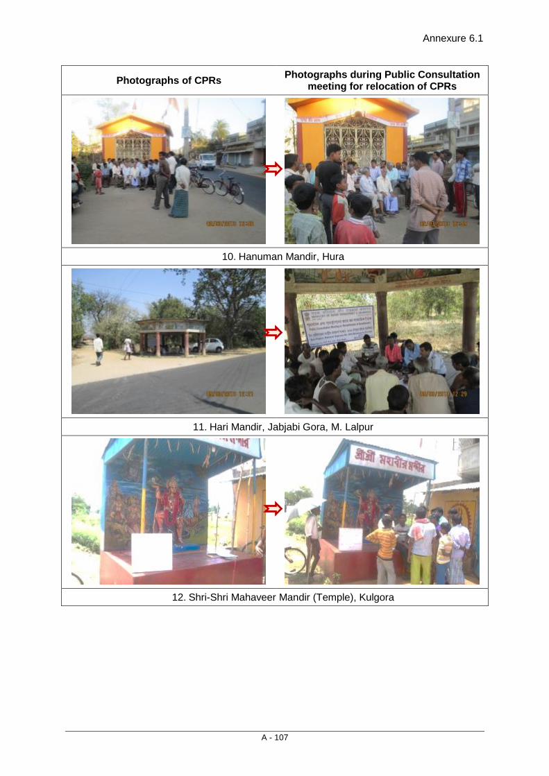
Annexure 6.1
A - 107
Photographs of CPRs Photographs during Public Consultation meeting for relocation of CPRs
10. Hanuman Mandir, Hura
11. Hari Mandir, Jabjabi Gora, M. Lalpur
12. Shri-Shri Mahaveer Mandir (Temple), Kulgora

Annexure 6.1
A - 108
Photographs of CPRs Photographs during Public Consultation meeting for relocation of CPRs
13. Shri Hari Mandir (uncomplete), Laikdih
14. Shri Hanuman Temple, Lakhanpur
15. Durga Mandir (Temple), Jaynagar/Hutmura
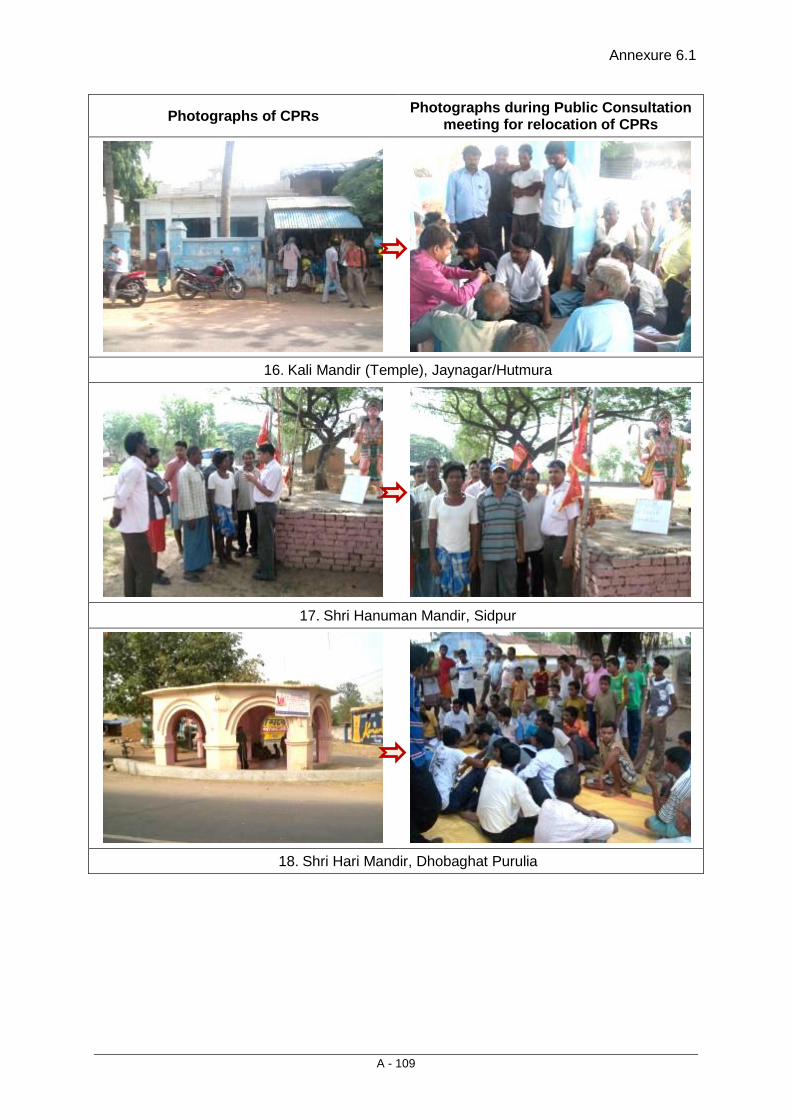
Annexure 6.1
A - 109
Photographs of CPRs Photographs during Public Consultation meeting for relocation of CPRs
16. Kali Mandir (Temple), Jaynagar/Hutmura
17. Shri Hanuman Mandir, Sidpur
18. Shri Hari Mandir, Dhobaghat Purulia

Annexure 6.1
A - 110
Photographs of CPRs Photographs during Public Consultation meeting for relocation of CPRs
Temple (abandoned)
19. Durga Temple (abandoned)
20. Sarvjanik Kali Mandir, Ghosla More, Purulia

Annexure 6.2
A - 111
List of Public Consultation Meetings conducted on NH-60A
Sl. No. Date Place Type of
Consultation No. of
Participants Participants
In year 2013 1 04.03.13
09.03.13 10.03.13
Bispuria Re-location of Religious property and Public Consultation Meeting on R&R issue
30-35 Gram Pradhan, Members and PAFs etc. at Govt. Library, Bishpuria
2 28.02.13 04.03.13 10.03.13
Hura Re-location of Religious properties and Public Consultation Meeting on R&R issue
35-40 PAFs and Committee members of Puja/Mandir samiti
3 09.03.13 Jabjabi gora, M. Lalpur
Re-location of Religious property and Public Consultation Meeting on R&R issue
PAFs and Committee members of Puja/Mandir samiti
In year 2012 1 01.06.12 Raghabpur
(Purulia) Public Consultation Meeting
30 Gram Pradhan, Members and PAFs etc. at Raghabpur Gram Panchayat
2 31.05.12 Rany Road Relocation of Religious Property
41 Relocation of Hari Mandir and Shiv Mandir
3 30.05.12 Jabarrah Public Consultation Meeting
61 Gram Pradhan, Members and PAFs etc. at Jabarrah Gram Panchayat
4 30.05.12 Maguria Lalpur
Public Consultation Meeting
19 Gram Pradhan, Members and PAFs etc. at M. Lalpur Gram Panchayat
5 30.05.12 Maguria Lalpur
Focused Group Discussion (FGD)
12 FGD with working women's as working through 'Self Help Group' (SHG) with in the village
6 29.05.12 Teghori Public Consultation Meeting
18 Gram Pradhan, Members and PAFs etc. at Teghori Gram Panchayat

Annexure 6.2
A - 112
Sl. No. Date Place Type of
Consultation No. of
Participants Participants
7 29.05.12 Metyala Public Consultation Meeting
35 Gram Pradhan, Members and PAFs etc. at Metyala Gram Panchayat
8 29.05.12 Hotgram Public Consultation Meeting
22 Gram Pradhan, Members and PAFs etc. at Hotgram Gram Panchayat
9 28.05.12 Deshbandhu road
Relocation of Religious Property
8 Relocation of Sarvjanic Kali Temple
10 28.05.12 Haraliyadih Relocation of Religious Property and Focused Group Discussion (FGD)
48 Relocation of Mansa Temple and FGD with Labor Women group
11 27.05.12 Gholgare Relocation of Religious and Community (Netaji Youth Club)
24 Relocation of Shiv, Kali and shifting of community club namely 'Netaji Youth Club'
12 27.05.12 Ladhurka Relocation of Kali & Mahakal Temple & Shifting of statue of Mrs. Indira Gandhi
37 Relocation of Kali & Mahakal Temple and Shifting of statue of Mrs. Indira Gandhi at Ladhurka
13 26.05.12 Lakhanpur Shifting/Relocation of Hanuman Mandir
20 Shifting/Relocation of Hanuman Mandir
14 26.05.12 Siyara Focused Group Discussion (FGD)
18 FGD with agriculture labors belongs to ST families
15 25.05.12 Jagdalla Relocation of Nag Mata Devsthan and Hari Mandir
24 Relocation of Nag Mata Devsthan and Hari Mandir
16 25.05.12 Jaynagar (Hutmura)
Shifting/Relocation of Durga Temple and Kali Temple
28 Shifting/Relocation of Durga Temple and Kali Temple
17 24.05.12 Kulgora More
Relocation of Hanuman Temple
15 Relocation of Hanuman Temple
18 24.05.12 Siyara Public Consultation Meeting
19 Villager and other stakeholders,
19 24.05.12 Liyekdih Public Consultation Meeting
50 Villager and other stakeholders,
20 24.05.12 Sidpur Relocation of Hanuman Temple
15 Relocation of Hanuman Temple
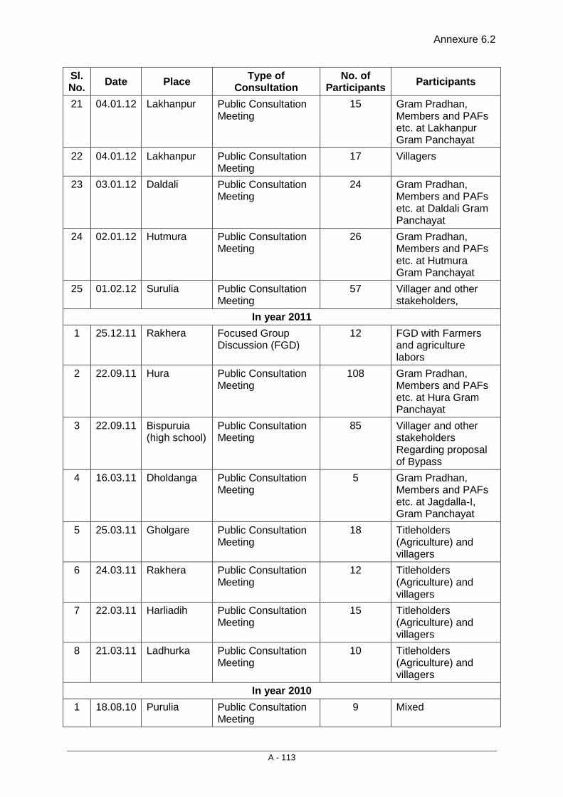
Annexure 6.2
A - 113
Sl. No. Date Place Type of
Consultation No. of
Participants Participants
21 04.01.12 Lakhanpur Public Consultation Meeting
15 Gram Pradhan, Members and PAFs etc. at Lakhanpur Gram Panchayat
22 04.01.12 Lakhanpur Public Consultation Meeting
17 Villagers
23 03.01.12 Daldali Public Consultation Meeting
24 Gram Pradhan, Members and PAFs etc. at Daldali Gram Panchayat
24 02.01.12 Hutmura Public Consultation Meeting
26 Gram Pradhan, Members and PAFs etc. at Hutmura Gram Panchayat
25 01.02.12 Surulia Public Consultation Meeting
57 Villager and other stakeholders,
In year 2011 1 25.12.11 Rakhera Focused Group
Discussion (FGD) 12 FGD with Farmers
and agriculture labors
2 22.09.11 Hura Public Consultation Meeting
108 Gram Pradhan, Members and PAFs etc. at Hura Gram Panchayat
3 22.09.11 Bispuruia (high school)
Public Consultation Meeting
85 Villager and other stakeholders Regarding proposal of Bypass
4 16.03.11 Dholdanga Public Consultation Meeting
5 Gram Pradhan, Members and PAFs etc. at Jagdalla-I, Gram Panchayat
5 25.03.11 Gholgare Public Consultation Meeting
18 Titleholders (Agriculture) and villagers
6 24.03.11 Rakhera Public Consultation Meeting
12 Titleholders (Agriculture) and villagers
7 22.03.11 Harliadih Public Consultation Meeting
15 Titleholders (Agriculture) and villagers
8 21.03.11 Ladhurka Public Consultation Meeting
10 Titleholders (Agriculture) and villagers
In year 2010 1 18.08.10 Purulia Public Consultation
Meeting 9 Mixed

Annexure 6.2
A - 114
Sl. No. Date Place Type of
Consultation No. of
Participants Participants
2 16.08.10 Jaynagar (Hutmura)
Public Consultation Meeting
44 Resident of Hutmura/Jaynagar and other stakeholders
3 13.08.10 Bhuiyadih Public Consultation Meeting
12 shopkeepers and labors
4 11.08.10 Maguria Lalpur
Public Consultation Meeting
17 M. Lalpur Bazar samiti
5 10.08.10 Bispuruia Public Consultation Meeting
13
6 10.08.10 Hura Focused Group Discussion (FGD)
12 FGD with mixed group like working women, labor and farmers etc.
7 10.08.10 Hura Public Consultation Meeting
123 Hura Nagrik Committee regarding proposal of Bypass
8 08.08.10 Rakhera Focused Group Discussion (FGD)
12 FGD with land holders
9 07.08.10 Harigram Focused Group Discussion (FGD)
12 FGD with Farmers
10 07.08.10 Bhagbanpur Focused Group Discussion (FGD)
12 FGD with shop keepers and Kiosks owners
11 06.08.10 Kumidya Focused Group Discussion (FGD)
18 FGD with residents of villages
12 05.08.10 Dholdanga Focused Group Discussion (FGD)
12 FGD with shop keepers

Annexure 6.3
A - 115
Risk Assessment and Implementation Strategy
Background: HIV Scenario in India Available evidence on HIV epidemic in India is showing a stable trend at national level. The 2009 estimated adult HIV prevalence in India was 0.31% (0.25% – 0.39%) with prevalence of 0.25% among women and 0.36% among men. Estimates place the number of people living with HIV (PLHIV) in India in 2009 at 24,00,000 (19.3 –30.4) in 2009. Children (<15 yrs) account for 3.5% of all infections, while 83% are the in age group 15-49 years. Of all HIV infections, 39% (9,30,000) are among women.
The primary drivers of HIV epidemic in India are:
• Unprotected paid sex (with female sex workers)
• Unprotected sex between men (men having sex with men- MSM)
• Injecting drug users (IDU).
Heterosexual route of transmission accounts for 87% of HIV cases detected.
HIV estimates in the NHIIP project states
States HIV Estimates
West Bengal 100,000 HIV infections
These state of West Bengal in spite of low HIV prevalence have large number of PLHIV due to the large population size.
Desk review exercise was conducted and district wise information was assessed from the likely candidate states of Bihar, Orissa, Rajasthan, West Bengal, and Karnataka. The information about the districts and the overall HIV scenario is provided as annexure.
General Factors that contribute to the vulnerability of a particular state include:
• High level of migration both inflow and outflow of people
• Low levels of literacy
• High incidence of poverty
• Low status of women
• Large presence of groups seen to practice high-risk behavior are known as High Risk Groups (HRGs) and are divided into:
Core Groups comprising of:
Female Sex Workers (FSW),
Injecting Drug Users (IDUs),
Men having Sex with Men (MSM)
Bridge Population (Men who had visited sex workers can act as a potential 'bridge' for HIV transmission to the rest of the population, either through their wives or other sexual partners). The bridge populations being focused on include:
Single men (not married or men who leave their wife/ partner at home) and are going to other states and countries for livelihood (Single male migrants)
Transport Sector Workforce (Truckers, Helpers, Head Load Carriers, Road Construction Workers)
Annexure 6.3
A - 116
Implementation Strategy: Overall objective is to implement behavior change interventions to promote and sustain behaviour change among the key project audiences. Sub project specific HIV awareness and Prevention plans shall be prepared as part of the Resettlement Action Plan by the DPR consultants based on the risk assessment in their respective project area. Step 1: Situational assessment: Identify population groups and locations vulnerable to risks along the project road along with factors contributing to vulnerability such as in and out migration, presence of sex workers community etc. Target Audience: The HIV prevention interventions would initially aim to spread awareness and sensitize the different audiences that include:
• Road Construction workers
• Local villages where construction workers live and villages adjacent to the project road reaching out to youth, women and young men with messages
• Highway communities: Dhabas, Truckers, Petrol pump staff
• Identified high risk behaviour groups, migrant work force, rural women and adolescent school & college going and out of school youth.
• Adolescent and youth though education sessions in schools, colleges etc.
Intervention Sites: The behavior change intervention activities will largely be carried out at the company camp sites and at the community level in the project influence area.
• Colonies of construction workers
• Local villages where construction workers live
• Petrol pumps
• Nearby Highway Dhabas
• Places where Sex worker’s operate from
Step 2: Intervention planning: Identify available resources that can be used as part of the HIV prevention work such as STI management Facilities, ICTC centers, and care and support centers. Access available IEC materials and condoms from the concerned AIDS control societies at state and district level.
The sub projects could be divided into packages. The NGO implementing the RAP will also address the issues around the HIV in the project area through communication and referrals.
The contractor will also play an active role by creating an enabling environment for their workforce to attend workplace prevention sessions which will be conducted by the RAP NGO. Refer Environmental Management Plan (EMP) for details.
Support of local NGOs active in HIV awareness and prevention strategy could be sought to cover the project area. Inputs will be taken from the State AIDS Control Society when identifying the active NGOs in the project area.
The implementation of HIV plan should be synchronized with the peak construction time, when maximum workforce is expected on the sites and camp sites are operational.
Annexure 6.3
A - 117
The implementation of the HIV awareness and prevention plan shall be supervised by the state PCU with the support of a short term Consultant with experience in HIV program management may be hired for the initial six months (for each road stretch) for a period of 5 to 7 days a month. The Consultant will report to the state PCU and will provide hand-holding and supportive supervision of the NGOs so as to ensure that the program is planned and implemented effectively.
The cost of the activities shall be built into the RAP implementing NGO contract.
The following activities are expected of the implementing NGO.
Project Activities: Output 1: Generate awareness about precautionary measures against HIV/AIDS among the identified project audiences (road construction workers and the general population) with specific focus on identified high risk behaviour groups, migrant work force, rural women and adolescent school & college going and out of school youth.
1.1 Create an Enabling Environment a. Mobilize support of contractors/companies that are engaged in road
development work and strengthen their capacity to undertake HIV prevention activities for their regular and contractual work force.
b. identify and build working relationship and capacities of local level NGO’s/Civil Society organizations and Self Help Groups/ Mahila Mandals/ Youth Clubs so as mobilize their support to take forward the campaign building local capacity in the communities.
1.2 Conduct behavior change communication (BCC) activities: Common Issues which need to be addressed
• Providing basic education on HIV/AIDS focusing on specific behaviours which increase vulnerability to HIV (unsafe sexual practices, MSM and IDU)
• Increase risk perception
• Addressing concerns around Sexuality and prevailing myths
• Men having sex with men
• Sexually transmitted infections
• Condom use
• Care and support of people living with HIV
• Stigma and discrimination
Behavior change communication constitutes one of the key program components of the project. The BCC interventions will focus on increasing risk perception by providing information on HIV/AIDS and STI, clearing myths and misconceptions, providing information on VCT and making referrals for STI, VCT and care and support services. For effective behavior and attitude change, repeated and reinforcing messages will be provided to the different project audiences.
If there are IDU’s identified in the intervention areas the project team will work with the NGO’s implementing TI’s so as implement the needle exchange program for them.
Annexure 6.3
A - 118
Communication Approaches: a. One-to-one Interaction: The Outreach Team and Peer Educators will carry out one-to-one interactions. As part of the one-to-one interactions, the target audiences will be reached with messages on HIV and AIDS issues and correct usage of condoms. Information on where STI treatment and VCTC services can be availed will be provided. b. One-to-group interactions:
The Outreach Team and Peer Educators will conduct group interactions on a daily basis with the different audiences. These sessions will be in smaller groups of five to seven people, where the health educators will facilitate discussions on issues around HIV/AIDS and STIs. The communication support materials especially flip charts would be used and besides giving key messages alongside the visuals, audience participation would be a key aspect. Condom education will include condom demonstrations highlighting correct and consistent usage. Condom-fliers giving pictorial messages on condom usage will also be distributed along with free condoms.
c. Mid media programs: Mid media programs will be organized to increase awareness, sensitize the communities on the needs of PLHIV and address issues of stigma and discrimination. Puppet shows, video shows, local folklore like and street theatre will be used for reaching communities. The project will take steps in involving other local CBOs who will be invited to participate in the mass awareness events.
The project would observe World AIDS day, Migrants day and the International Candle Light Memorial day by organizing large community events which include rallies, seminars and the candle light march.
1.3 Condom promotion: Ensuring condom availability and imparting condom usage skills: As part of the BCC activities, condom demonstrations will be conducted to build skills among the community for correct usage. These sessions would attempt to address the myths associated with condom usage. Messages on dual protection would be emphasized. Condom supply will be increased and condoms would be made accessible by creating outlets in strategic locations. Availability will be ensured through various mechanisms like accessing free condoms from different sources especially the State AIDS Control Society and from government hospitals.
Output 2: Provide increased access to preventive services which includes STI treatment and Integrated Testing & Counseling Service 2.1 Ensure linkages for quality STI care services and VCT referrals The BCC activities would stress on seeking early treatment for STI. STI services will be made available through referral clinics linked to the project.
The project will build linkages with the government Voluntary Counseling and testing Centre (VCTC) and refer Clients who perceive risk and want to undergo the test. Referral slips will be provided to people being refereed from the project areas.
Linkages will be built with the Community Care Center’s (CCC’s), ART center and other NGOs and health care providers implementing care, support and treatment projects and other services to increase access to health care and improve quality of life for people living with HIV/AIDS (PLHIV) and their children.
Annexure 6.3
A - 119
Monitoring plan: The project management team will develop and operationalize a monitoring system to track the progress of the project. Progress against output indicators will be assessed during monthly meetings in order to make sure that project activities are resulting in the desired outputs within the allotted timeframe.
The means of verification includes the reports of NGOs engaged, medical records of the patients that are maintained by the Doctor, field reports, meeting minutes, anecdotes, case studies, focus group discussions, and feedback from the community. The Outreach team will prepare their daily reports which will be consolidated into a monthly activity report. The outreach monthly report will be shared with the social/ safety officer of the Contractor who will include the details of the work done by him and will consolidate and make available quarterly reports to the PIU and PCU for review and inputs.
The PCU will monitor the program by visiting the project site to assess the project progress.
Some of the indicators against which the project progress will be measured include:
• Number and Type of stakeholders who are sensitized
• Number of peers trained as peer educators this quarter;
• Number of target population reached through one-on-one and in small-groups by peer education;
• Number of members from PLHIV networks who participated in the project activities
• Number of mid media events organized in the quarter;
• Number of target population reached by other IEC events;
• Number of new and old BCC contacts made;
• Number and types of STIs treated;
• Number of referral slips distributed;
• Number and kind of BCC materials developed/ and distributed;
• Number of condoms distributed;
• Number of people who accessed STI Services
• Number of people who accessed STI Services VCT services;
• Number of PLHIV provided/ referred for care, support and treatment by type; and
• Number of support group meetings held.
The Third Party Audit consultants for RAP implementation will review and assess the progress and overall quality of the intervention. The review would look into the aspects of organization, project management, personnel, financial, service delivery, and beneficiaries. This will also include site visits to review the project progress with project staff and participating NGOs, associations and reviewing referral systems for availability, accessibility, appropriateness, and quality of prevention to care services for each site.

Annexure 6.4
A - 120
Consultation with Government Officials
Name of Officer Designation Department Contact No. Issues Discussed
Mr.Avanindera Singh, IAS
District Magistrate & District Collector, Purulia
District Administration
03252-222302(O)
• Information dissemination to make people aware of the objective of the project
• Resettlement and rehabilitation issues including income restoration.
• Bypasses, service lanes, lay byes, truck parking including vehicular underpasses.
• Wayside amenities and maintenance infrastructure including toll plaza and toll collection system.
• Social issues including loss of livelihood and compensation for affected people.
• Relocation of the potential project displaced \families and households.
• Facilities for pedestrians and non-motorized transport.
• Road safety measures • Information on socio-
economic and demographic features of the project influence area and potential PAPs.
• Ongoing developmental schemes and programmes in project influence districts.
• Socially viable alternatives for the critical locations of the project road.
• BPL level of rural and urban population in accordance with the annual income of the family as per state government norms.
• Minimization of adverse social impacts
• Discussion about NGOs and other local voluntary organizations working on
Mr. Hrishikes Mudi WBCS (Executive)
Addl. District Magistrate, Purulia
General 03252-222120
Ms. Antara Acharya IAS
Addl. District Magistrate, Bankura
General 03242-251076
Mr. Anup Kumar Din District Social Welfare Officer, Purulia
Social Welfare 03252-223278
Mr. Rahul Majumdar Dist. Panchayat & R.D. Officer, Purulia
Rural Development
03252-222695
Mr. Kasinath Makur Dy.Dist. Panchayat & R.D. Officer, Purulia
Rural Development
Mr. Biswanath Dey Dist. Sub-Registrar, Purulia
Land Acquisition
09002670600
Mr. Asim Roy Ex. Engg. PWD, Purulia Division
Construction Board Directorate
Mr. Satrughan Bauri Asst. Engg. Purulia
PWD Civil (Construction)
09474540555
Mr. Dhrujati Prasad Singh Mura
Sub. Asst. Engg. Purulia
Estimation (SOR)
09679788179
Mr.Subash Ch. Mahato
MLA, Purulia 09434422846
Mr. A. K. Singh Asst. Engg. Purulia
NH Division 09434196809
Mr. Sanjeeb Gorai Asst. Engg. Bankura
NH Division 09434254210
Mr. Dahas Dist. Sub Registrar Bankura
Revenue Deptt.
Mr. N.C. Paramanic R.I. Hura Revenue
Mr. S.N. Nandi UDC, Purulia Stamp Duty 03252-222252
Mr. Abhijeet Singh PWD Engineer, Purulia
PWD Sub Division
09474506962
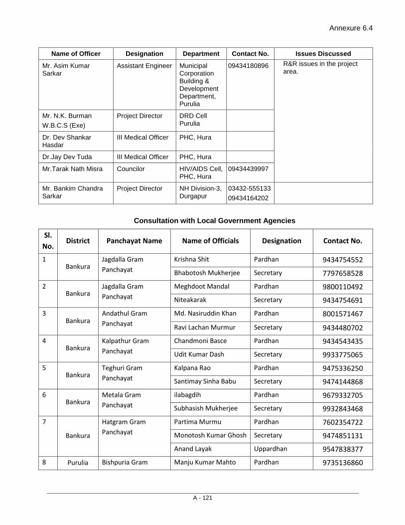
Annexure 6.4
A - 121
Name of Officer Designation Department Contact No. Issues Discussed
Mr. Asim Kumar Sarkar
Assistant Engineer Municipal Corporation Building & Development Department, Purulia
09434180896 R&R issues in the project area.
Mr. N.K. Burman W.B.C.S (Exe)
Project Director DRD Cell Purulia
Dr. Dev Shankar Hasdar
III Medical Officer PHC, Hura
Dr.Jay Dev Tuda III Medical Officer PHC, Hura
Mr.Tarak Nath Misra Councilor HIV/AIDS Cell, PHC, Hura
09434439997
Mr. Bankim Chandra Sarkar
Project Director NH Division-3, Durgapur
03432-555133 09434164202
Consultation with Local Government Agencies
Sl. No.
District Panchayat Name Name of Officials Designation Contact No.
1 Bankura
Jagdalla Gram Panchayat
Krishna Shit Pardhan 9434754552
Bhabotosh Mukherjee Secretary 7797658528
2 Bankura
Jagdalla Gram Panchayat
Meghdoot Mandal Pardhan 9800110492
Niteakarak Secretary 9434754691
3 Bankura
Andathul Gram Panchayat
Md. Nasiruddin Khan Pardhan 8001571467
Ravi Lachan Murmur Secretary 9434480702
4 Bankura
Kalpathur Gram Panchayat
Chandmoni Basce Pardhan 9434543435
Udit Kumar Dash Secretary 9933775065
5 Bankura
Teghuri Gram Panchayat
Kalpana Rao Pardhan 9475336250
Santimay Sinha Babu Secretary 9474144868
6 Bankura
Metala Gram Panchayat
ilabagdih Pardhan 9679332705
Subhasish Mukherjee Secretary 9932843468
7
Bankura
Hatgram Gram Panchayat
Partima Murmu Pardhan 7602354722
Monotosh Kumar Ghosh Secretary 9474851131
Anand Layak Uppardhan 9547838377
8 Purulia Bishpuria Gram Manju Kumar Mahto Pardhan 9735136860
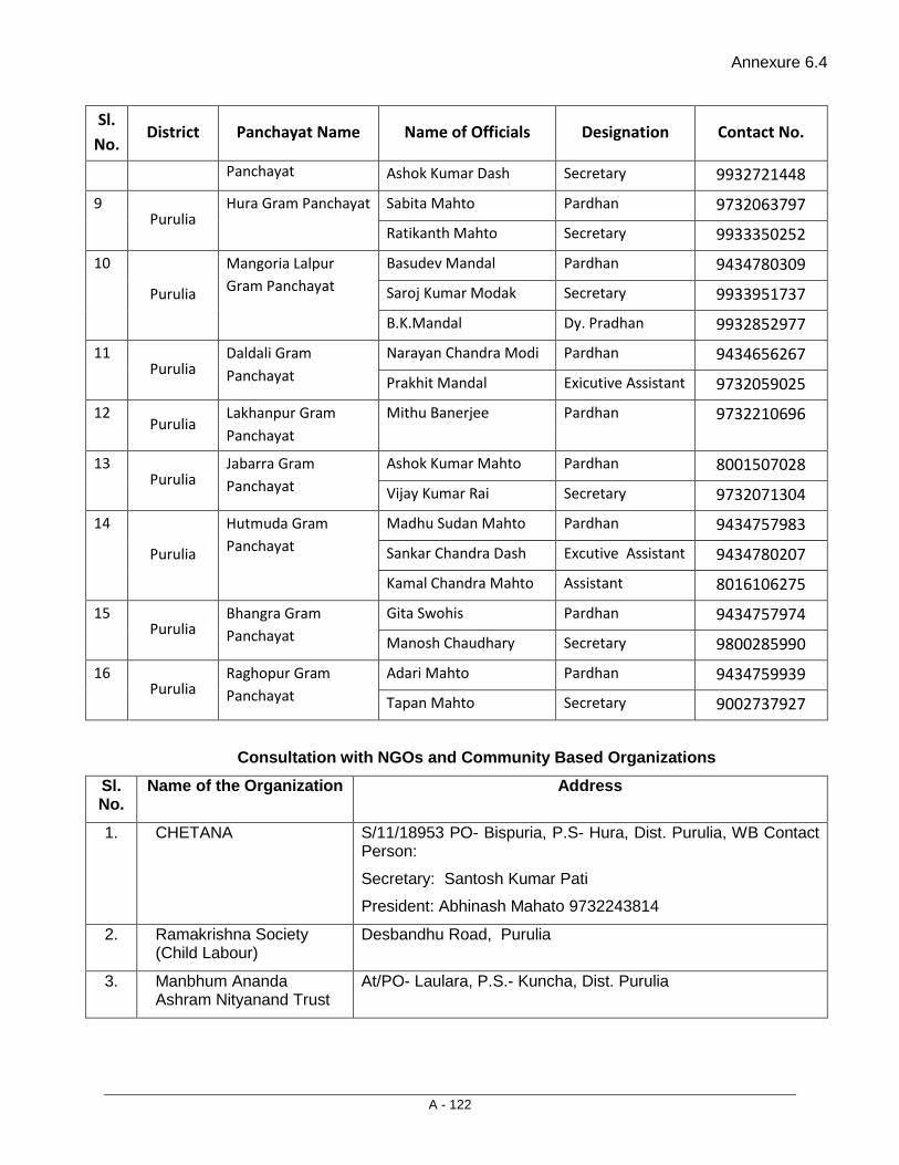
Annexure 6.4
A - 122
Sl. No.
District Panchayat Name Name of Officials Designation Contact No.
Panchayat Ashok Kumar Dash Secretary 9932721448
9 Purulia
Hura Gram Panchayat Sabita Mahto Pardhan 9732063797
Ratikanth Mahto Secretary 9933350252
10
Purulia
Mangoria Lalpur Gram Panchayat
Basudev Mandal Pardhan 9434780309
Saroj Kumar Modak Secretary 9933951737
B.K.Mandal Dy. Pradhan 9932852977
11 Purulia
Daldali Gram Panchayat
Narayan Chandra Modi Pardhan 9434656267
Prakhit Mandal Exicutive Assistant 9732059025
12 Purulia
Lakhanpur Gram Panchayat
Mithu Banerjee Pardhan 9732210696
13 Purulia
Jabarra Gram Panchayat
Ashok Kumar Mahto Pardhan 8001507028
Vijay Kumar Rai Secretary 9732071304
14
Purulia
Hutmuda Gram Panchayat
Madhu Sudan Mahto Pardhan 9434757983
Sankar Chandra Dash Excutive Assistant 9434780207
Kamal Chandra Mahto Assistant 8016106275
15 Purulia
Bhangra Gram Panchayat
Gita Swohis Pardhan 9434757974
Manosh Chaudhary Secretary 9800285990
16 Purulia
Raghopur Gram Panchayat
Adari Mahto Pardhan 9434759939
Tapan Mahto Secretary 9002737927
Consultation with NGOs and Community Based Organizations Sl. No.
Name of the Organization Address
1. CHETANA S/11/18953 PO- Bispuria, P.S- Hura, Dist. Purulia, WB Contact Person:
Secretary: Santosh Kumar Pati
President: Abhinash Mahato 9732243814
2. Ramakrishna Society (Child Labour)
Desbandhu Road, Purulia
3. Manbhum Ananda Ashram Nityanand Trust
At/PO- Laulara, P.S.- Kuncha, Dist. Purulia

Annexure 6.4
A - 123
Sl. No.
Name of the Organization Address
4. Socio Economic Development Programme
At/Po- Ranibandh, Dist. Bankura Contact No. 03243-250287
5. Society for Movement & Action for Rural Development
At/Po- Kamalpur, Dist. Bankura Contact No. 03242-274286
6 Purulia District Agra GamiMahila Shishu Mangal Samiti
Jargo-Jhaldah, Purulia
09932102949
7 Gandhi Memorial Foundation
Mr.Duryodhan Nayak, Balrampur, Purulia
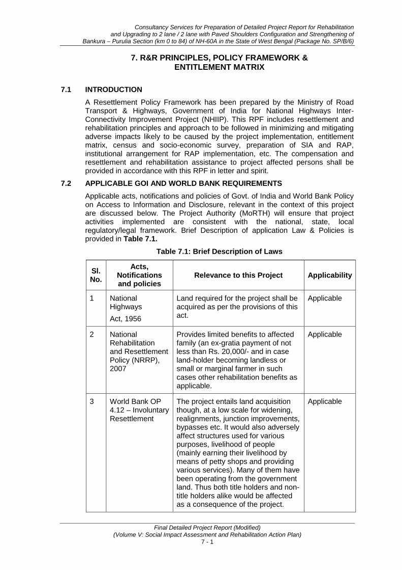
Consultancy Services for Preparation of Detailed Project Report for Rehabilitation and Upgrading to 2 lane / 2 lane with Paved Shoulders Configuration and Strengthening of
Bankura – Purulia Section (km 0 to 84) of NH-60A in the State of West Bengal (Package No. SP/B/6)
Final Detailed Project Report (Modified) (Volume V: Social Impact Assessment and Rehabilitation Action Plan)
7 - 1
7. R&R PRINCIPLES, POLICY FRAMEWORK & ENTITLEMENT MATRIX
7.1 INTRODUCTION A Resettlement Policy Framework has been prepared by the Ministry of Road Transport & Highways, Government of India for National Highways Inter-Connectivity Improvement Project (NHIIP). This RPF includes resettlement and rehabilitation principles and approach to be followed in minimizing and mitigating adverse impacts likely to be caused by the project implementation, entitlement matrix, census and socio-economic survey, preparation of SIA and RAP, institutional arrangement for RAP implementation, etc. The compensation and resettlement and rehabilitation assistance to project affected persons shall be provided in accordance with this RPF in letter and spirit.
7.2 APPLICABLE GOI AND WORLD BANK REQUIREMENTS Applicable acts, notifications and policies of Govt. of India and World Bank Policy on Access to Information and Disclosure, relevant in the context of this project are discussed below. The Project Authority (MoRTH) will ensure that project activities implemented are consistent with the national, state, local regulatory/legal framework. Brief Description of application Law & Policies is provided in Table 7.1.
Table 7.1: Brief Description of Laws
Sl. No.
Acts, Notifications and policies
Relevance to this Project Applicability
1 National Highways Act, 1956
Land required for the project shall be acquired as per the provisions of this act.
Applicable
2 National Rehabilitation and Resettlement Policy (NRRP), 2007
Provides limited benefits to affected family (an ex-gratia payment of not less than Rs. 20,000/- and in case land-holder becoming landless or small or marginal farmer in such cases other rehabilitation benefits as applicable.
Applicable
3 World Bank OP 4.12 – Involuntary Resettlement
The project entails land acquisition though, at a low scale for widening, realignments, junction improvements, bypasses etc. It would also adversely affect structures used for various purposes, livelihood of people (mainly earning their livelihood by means of petty shops and providing various services). Many of them have been operating from the government land. Thus both title holders and non-title holders alike would be affected as a consequence of the project.
Applicable
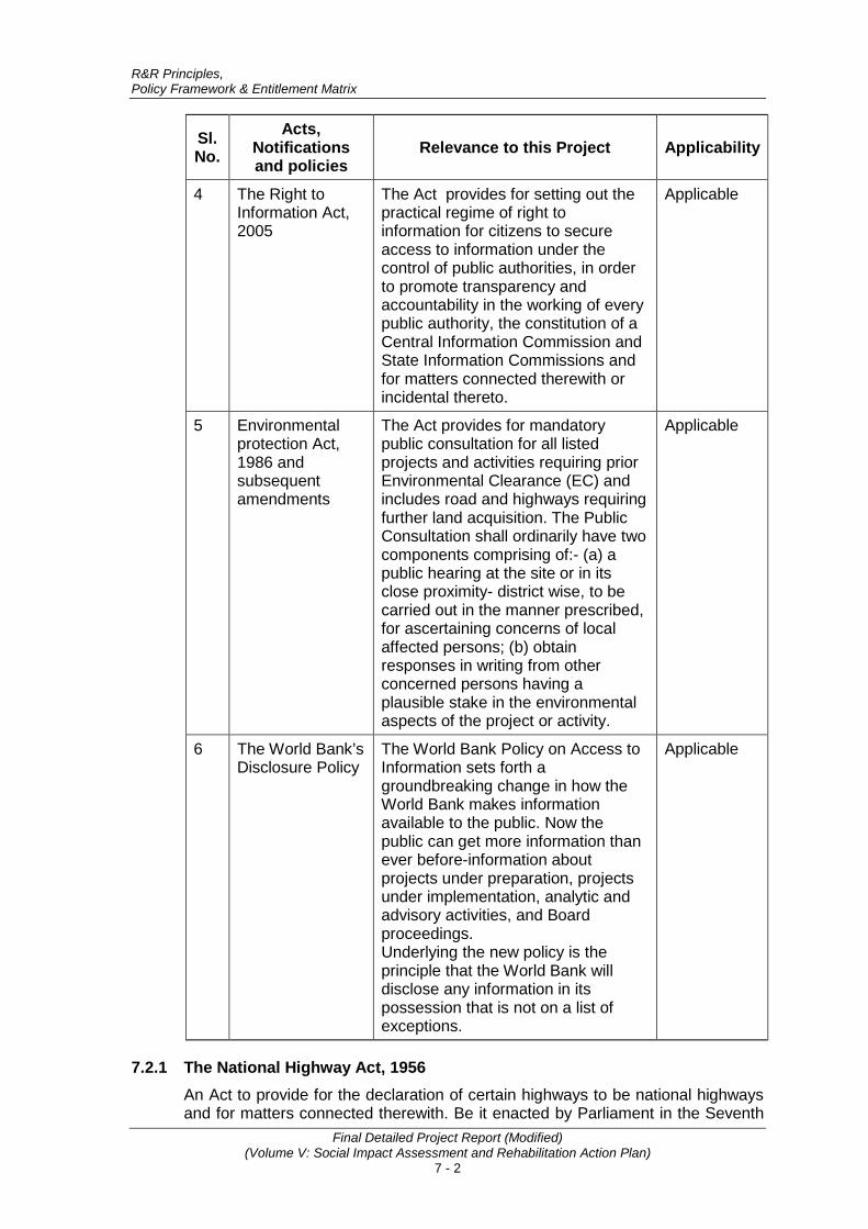
R&R Principles, Policy Framework & Entitlement Matrix
Final Detailed Project Report (Modified) (Volume V: Social Impact Assessment and Rehabilitation Action Plan)
7 - 2
Sl. No.
Acts, Notifications and policies
Relevance to this Project Applicability
4 The Right to Information Act, 2005
The Act provides for setting out the practical regime of right to information for citizens to secure access to information under the control of public authorities, in order to promote transparency and accountability in the working of every public authority, the constitution of a Central Information Commission and State Information Commissions and for matters connected therewith or incidental thereto.
Applicable
5 Environmental protection Act, 1986 and subsequent amendments
The Act provides for mandatory public consultation for all listed projects and activities requiring prior Environmental Clearance (EC) and includes road and highways requiring further land acquisition. The Public Consultation shall ordinarily have two components comprising of:- (a) a public hearing at the site or in its close proximity- district wise, to be carried out in the manner prescribed, for ascertaining concerns of local affected persons; (b) obtain responses in writing from other concerned persons having a plausible stake in the environmental aspects of the project or activity.
Applicable
6 The World Bank’s Disclosure Policy
The World Bank Policy on Access to Information sets forth a groundbreaking change in how the World Bank makes information available to the public. Now the public can get more information than ever before-information about projects under preparation, projects under implementation, analytic and advisory activities, and Board proceedings. Underlying the new policy is the principle that the World Bank will disclose any information in its possession that is not on a list of exceptions.
Applicable
7.2.1 The National Highway Act, 1956 An Act to provide for the declaration of certain highways to be national highways and for matters connected therewith. Be it enacted by Parliament in the Seventh
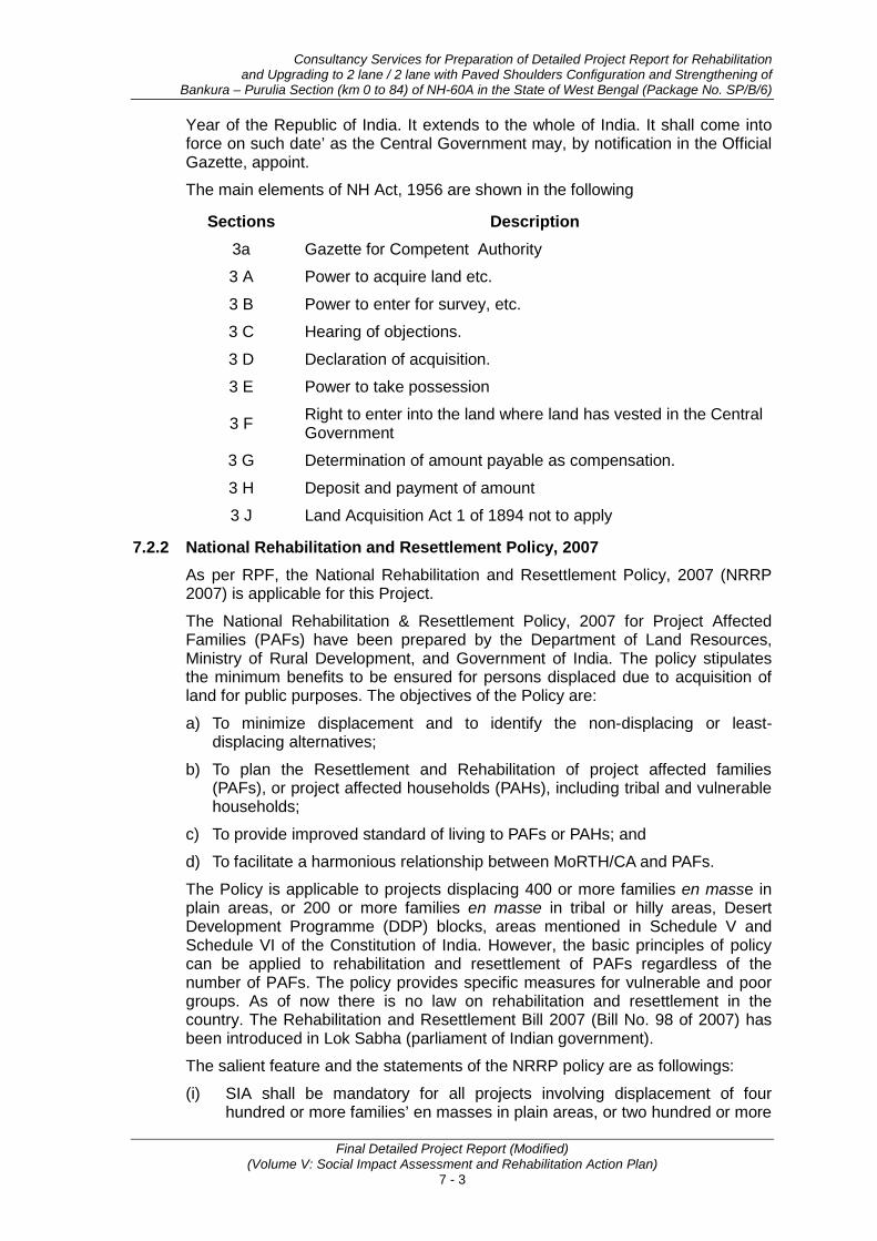
Consultancy Services for Preparation of Detailed Project Report for Rehabilitation and Upgrading to 2 lane / 2 lane with Paved Shoulders Configuration and Strengthening of
Bankura – Purulia Section (km 0 to 84) of NH-60A in the State of West Bengal (Package No. SP/B/6)
Final Detailed Project Report (Modified) (Volume V: Social Impact Assessment and Rehabilitation Action Plan)
7 - 3
Year of the Republic of India. It extends to the whole of India. It shall come into force on such date’ as the Central Government may, by notification in the Official Gazette, appoint.
The main elements of NH Act, 1956 are shown in the following
Sections Description
3a Gazette for Competent Authority
3 A Power to acquire land etc.
3 B Power to enter for survey, etc.
3 C Hearing of objections.
3 D Declaration of acquisition.
3 E Power to take possession
3 F Right to enter into the land where land has vested in the Central Government
3 G Determination of amount payable as compensation.
3 H Deposit and payment of amount
3 J Land Acquisition Act 1 of 1894 not to apply
7.2.2 National Rehabilitation and Resettlement Policy, 2007 As per RPF, the National Rehabilitation and Resettlement Policy, 2007 (NRRP 2007) is applicable for this Project.
The National Rehabilitation & Resettlement Policy, 2007 for Project Affected Families (PAFs) have been prepared by the Department of Land Resources, Ministry of Rural Development, and Government of India. The policy stipulates the minimum benefits to be ensured for persons displaced due to acquisition of land for public purposes. The objectives of the Policy are:
a) To minimize displacement and to identify the non-displacing or least-displacing alternatives;
b) To plan the Resettlement and Rehabilitation of project affected families (PAFs), or project affected households (PAHs), including tribal and vulnerable households;
c) To provide improved standard of living to PAFs or PAHs; and
d) To facilitate a harmonious relationship between MoRTH/CA and PAFs.
The Policy is applicable to projects displacing 400 or more families en masse in plain areas, or 200 or more families en masse in tribal or hilly areas, Desert Development Programme (DDP) blocks, areas mentioned in Schedule V and Schedule VI of the Constitution of India. However, the basic principles of policy can be applied to rehabilitation and resettlement of PAFs regardless of the number of PAFs. The policy provides specific measures for vulnerable and poor groups. As of now there is no law on rehabilitation and resettlement in the country. The Rehabilitation and Resettlement Bill 2007 (Bill No. 98 of 2007) has been introduced in Lok Sabha (parliament of Indian government).
The salient feature and the statements of the NRRP policy are as followings:
(i) SIA shall be mandatory for all projects involving displacement of four hundred or more families’ en masses in plain areas, or two hundred or more

R&R Principles, Policy Framework & Entitlement Matrix
Final Detailed Project Report (Modified) (Volume V: Social Impact Assessment and Rehabilitation Action Plan)
7 - 4
families’ en masses in tribal or hilly areas etc. Co-ordination with EIA in the context of the public hearing done in the project affected area for EIA shall also cover issues related to SIA.
(ii) Consultations with project affected people and disclosure of relevant information to them at various stages of resettlement planning;
(iii) Affected people without legal rights also need to be assisted (affected people categorized landless agricultural workers, forest dwellers, tenants and artisans who are critically dependent on the acquired assets for their subsistence/ livelihoods);
(iv) Prepare resettlement plans that are disclosed to the project affected people in draft form, and reviewed and approved by competent authorities;
(v) Collection of socio economic base line data for project affected households;
(vi) Vulnerable project affected people will get extra cash/kind assistance;
(vii) A monitoring cell should be constituted under the project.
(viii) Each project affected family comprising of rural artisan/small trader and self-employed person shall get one-time financial assistance for construction of working shed/shop for livelihood support.
7.2.3 World Bank Guidelines for Involuntary Resettlement OP/BP 4.12 - Involuntary Resettlement: The key objective of the Bank’s safeguard Policy 4.12 is to “ensure that displaced persons are assisted in their efforts to improve their livelihoods and standards of living or at least to restore them, in real terms, to pre-displacement levels or to levels prevailing prior to the beginning of project implementation, whichever is higher”. The important clauses of the World Bank Policy in preparation of resettlement plan and policy framework includes the following:
(a) Ensure that the displaced persons are informed about their options and rights pertaining to resettlement;
(b) Consulted on, offered choices among, and provided with technically and economically feasible resettlement alternatives;
(c) Prompt and effective compensation at full replacement cost for losses of assets;
(d) Provide assistance and allowances;
(e) Provide equivalent productive assets for the loss of residential house, agricultural land etc.;
(f) Provide support for the transition period (between displacement and livelihood restoration);
(g) Provide land related development assistance (credit facilities, training and job opportunities);
(h) Preference should be given to land based resettlement strategies for displaced persons whose livelihoods are land-based;
(i) Cash compensation level should be sufficient to replace the lost land and assets at full replacement cost in local markets;
(j) Depreciation and salvage value will not be deducted from the compensation value.
Consultancy Services for Preparation of Detailed Project Report for Rehabilitation and Upgrading to 2 lane / 2 lane with Paved Shoulders Configuration and Strengthening of
Bankura – Purulia Section (km 0 to 84) of NH-60A in the State of West Bengal (Package No. SP/B/6)
Final Detailed Project Report (Modified) (Volume V: Social Impact Assessment and Rehabilitation Action Plan)
7 - 5
(k) Eligibility of Benefits should include the PAPs who have formal legal rights to land (including customary and traditional land rights recognized under law), the PAPs who do not have formal legal rights to land at the time of census but have a claim to such land or assets and the PAPs who have no recognizable legal right to the land they are occupying;
(l) Particular attention will be paid to the needs of vulnerable groups among those displaced, especially those below the poverty line, landless, elderly, women and children, ethnic minorities etc.;
(m) The displaced persons and their communities will be provided timely and relevant information, consulted on resettlement options, and offered opportunities to participate in planning, implementing, and monitoring resettlement. Appropriate and accessible grievance mechanisms will be established for these groups;
(n) A Grievance Redressal Mechanism will be made functional to resolve all complaints and grievances of PAPs.
7.2.4 The Right to Information Act, 2005 The Right to Information Act, 2005 provides for setting out the practical regime of right to information for citizens to secure access to information under the control of public authorities, in order to promote transparency and accountability in the working of every public authority, the constitution of a Central Information Commission and State Information Commissions and for matters connected therewith or incidental thereto. The process for obtaining information and details of designated officials is posted on the MoRTH and Project website. During the project implementation phase the relevant information related to impacts, compensation measures, rehabilitation measures, etc. will be shared with the PAPs in appropriate language in the form of resettlement leaflet. The monitoring report will also be disclosed to the PAPs.
7.2.5 The World Bank’s Disclosure Policy The World Bank Policy on Access to Information sets forth a groundbreaking change in how the World Bank makes information available to the public. Now the public can get more information than ever before-information about projects under preparation, projects under implementation, analytic and advisory activities, and Board proceedings. Underlying the new policy is the principle that the World Bank will disclose any information in its possession that is not on a list of exceptions. The policy also includes a clear process for making information publicly available and a right to appeal if information seekers believe they were improperly or unreasonably denied access to information or there is a public interest case to override an exception that restricts certain information.
7.3 PURPOSE OF RESETTLEMENT POLICY FRAMEWORK The Resettlement Policy Framework for the NHIIP has been prepared based on the findings of Social Screening Report covering initial impact assessment and review of applicable legal and policy framework discussed above. Review of Social Screening Reports (SSRs) reveal that applicable legal and administrative procedures vary from State to State and also there are gaps between Resettlement and Rehabilitation Policies of the country and certain states and the Bank’s Safeguard Policies. Hence, MoRTH felt the need to understand the critical elements of the existing legal and policy framework and agree on a mechanism that will address the key social issues.
R&R Principles, Policy Framework & Entitlement Matrix
Final Detailed Project Report (Modified) (Volume V: Social Impact Assessment and Rehabilitation Action Plan)
7 - 6
A specific policy framework for the project has been formulated to bridge the gaps to conform to the provisions of World Bank’s operational policies related to Involuntary Resettlement and Indigenous Peoples. This policy framework will help expedite the process and facilitate consistent preparation of social management plans which will include RAPs across all project roads in different states.
The purpose of preparing a RPF is to:
(a) Bring commonality in resettlement and rehabilitation benefits under the project.
(b) Bridge the gap between Bank’s policy on Involuntary Resettlement, Indigenous People and NRRP 2007.
(c) Bring together and built upon the current good practices in terms of procedures to address more systematic and institutional issues.
(d) Establish institutional arrangements at project, state and central level (MoRTH) for the implementation of social management plans including RAP.
(e) Establish mechanism for redressal of grievances; and monitoring and evaluation, etc.
7.4 OBJECTIVES AND SCOPE OF RESETTLEMENT POLICY FRAMEWORK, NHIIP This Framework has been formulated to lay down the principles and procedures for management of social impacts caused by the project and guide the social impact assessment and preparation of mitigation plans including Resettlement Action Plans and Tribal Development Plans for the project. This Framework shall apply to all project roads under NHIIP whether partly or fully funded by World Bank during the entire period of loan assistance. Overall objective of this Framework is to guide the preparation and implementation of NHIIP based on the following principles:
• Take due precautions to minimize disturbance to human habitations, tribal areas and places of cultural significance.
• Ensure that the Project Affected Persons (PAPs) are not negatively affected by the project.
• Involve affected people from inception stage to operation and maintenance.
• Consult affected people in issues of ROWs, land acquisition or loss of livelihood
• Encourage consultation with communities in identifying environmental and social implications of projects.
• Pay special attention to marginalized and vulnerable groups and secure their inclusion in overall public participation.
• Provide compensation and assistance to PAPs prior to any displacement or start of civil works.
• Guarantee entitlements and compensation to affected people as per the R&R policy as established in this document. This would ensure compensation and assistance sufficient to improve or at least restore livelihoods to levels experienced before the project.
• Share information with local communities about environmental and social implications.

Consultancy Services for Preparation of Detailed Project Report for Rehabilitation and Upgrading to 2 lane / 2 lane with Paved Shoulders Configuration and Strengthening of
Bankura – Purulia Section (km 0 to 84) of NH-60A in the State of West Bengal (Package No. SP/B/6)
Final Detailed Project Report (Modified) (Volume V: Social Impact Assessment and Rehabilitation Action Plan)
7 - 7
• Broad community support is ascertained based on free, prior and informed consultation.
Revision/Modification of the RPF: This RPF will be an “up-to-date” or a “live document” enabling revision, when and where necessary. Unexpected situations and/or changes in the project or sub-component design would therefore be assessed and appropriate management measures will be incorporated by updating the Resettlement Policy Framework to meet the requirements of country’s legislations and Bank safeguards policies. Such revisions will also cover and update any changes/modifications introduced in the legal/regulatory regime of the country/ state. Also, based on the experience of application and implementation of this framework, the provisions and procedures would be updated, as appropriate in consultation with the World Bank and the implementing agencies/departments.
7.5 DEFINITIONS Following definitions that will be applicable unless otherwise stated specifically.
• Agricultural labourers: means a person primarily resident in the affected area for a period of not less than five years immediately before the declaration of the affected area, who does not hold any land in the affected area but who earns his livelihood mainly by manual labour on agricultural land therein immediately before such declaration and who has been deprived of his livelihood;
• Agricultural land: Denotes land used or capable of being used for the purpose of agriculture or horticulture, dairy farming, poultry farming, pisciculture, sericulture, breeding of livestock or nursery growing medicinal herbs, raising of crops, grass or garden produce and land used by an agriculturist for the grazing of cattle, but does not include land used for cutting of wood only;
• Below poverty line (BPL) or BPL family: means below poverty line families as defined by the Planning Commission of India, from time to time and those included in the BPL list for the time-being in force;
• Corridor of impact (COI): Refers to the minimum land width required for construction including embankments, facilities and features such as approach roads, drains, utility ducts and lines, fences, green belts, safety zone, working spaces etc. Additional land width would be acquired/purchased or taken on temporary lease if the Corridor of Impact extends beyond the available Right of Way;
• Cut-off date: Refers to the date on which the census survey of PAPs starts in that road section/stretch. For entitlement purpose, the PAPs would be those who have been in possession of the immovable or movable property within the affected area/zone on or prior to cut off date. However, the cut-off date for land acquisition purpose is the date on which the notification under section 3A will be issued under the NH Act, 1956;
• Encroacher: A person who has extended their building, agricultural lands, business premises or work places into public/government land without authority;
• Entitled person (EP): A person who is adversely impacted by the project and is entitled to assistance as per the project entitlement framework is considered to be an Entitled Person.
R&R Principles, Policy Framework & Entitlement Matrix
Final Detailed Project Report (Modified) (Volume V: Social Impact Assessment and Rehabilitation Action Plan)
7 - 8
• Holding: means the total land held by a person as an occupant or tenant or as both;
• Kiosk: A kiosk is a booth/stall/cabin/cubicle made of wood or iron or any other building material which could be shifted to another location as a single unit without much damage and is used for carrying out petty business/ commercial activities and has been in operation/existence prior to cut off date;
• Land acquisition" or "acquisition of land": means acquisition of land under the NH Act, 1956 for the time being in force;
• Landowner: A person who is an allottee or a grantee of any land under any scheme of the Government under which such allotment or grant is to mature into ownership, who has mortgaged his land (or any portion thereof) or who has permanent rights and interest in land;
• Marginal farmer: Refers to a cultivator with an un-irrigated land holding up to one hectare or irrigated land holding up to half hectare;
• Non-agricultural labourer: means a person who is not an agricultural labourer but is primarily residing in the affected area for a period of not less than five years immediately before the declaration of the affected area and who does not hold any land under the affected area but who earns his livelihood mainly by manual labour or as a rural artisan immediately before such declaration and who has been deprived of earning his livelihood mainly by manual labour or as such artisan in the affected area;
• Non-titleholder: Affected persons/families/ households with no legal title to the land, structures and other assets adversely affected by the project. Non-titleholders include encroachers, squatters, etc;
• Notification: means a notification published in the Gazette of India;
• Occupier: means a member of a Scheduled Tribes community in possession of forest land prior to the 13th day of December, 2005;
• Project: Refers to the National Highways Interconnectivity Improvement Project (NHIIP).
• Project affected area: Refers to the area of village or locality under a project for which land will be acquired under NH Act 1956 through declaration by Notification in the Official Gazette by the appropriate Government or for which land belonging to the Government will be cleared from obstructions;
• Project affected family: includes a person, his or her spouse, minor sons, unmarried daughters, minor brothers, unmarried sisters, father, mother and other relatives residing with him or her and dependent on him or her for their livelihood; and includes "nuclear family" consisting of a person, his or her spouse and minor children;
• Project affected person (PAP): Any tenure holder, tenant, Government lessee or owner of other property, or non-titleholder who on account of the project has been affected from such land including plot in the abadi or other property in the affected area will be considered as PAP;
• Project displaced person (PDP): Any tenure holder, tenant, Government lessee or owner of other property, or non-titleholder who on account of the project has been involuntarily displaced from such land including plot in the abadi or other property will be considered as PDP. A displaced will always be a PAP but all PAP may not be PDP;

Consultancy Services for Preparation of Detailed Project Report for Rehabilitation and Upgrading to 2 lane / 2 lane with Paved Shoulders Configuration and Strengthening of
Bankura – Purulia Section (km 0 to 84) of NH-60A in the State of West Bengal (Package No. SP/B/6)
Final Detailed Project Report (Modified) (Volume V: Social Impact Assessment and Rehabilitation Action Plan)
7 - 9
• Project affected household (PAH): A social unit consisting of a family and/or non-family members living together, and is affected by the project negatively and/or positively;
• Replacement cost: A replacement cost/value of any land or other asset is the cost/value equivalent to or sufficient to replace/purchase the same land or other asset;
• Small farmer: Refers to a cultivator with an un-irrigated land holding up to two (2) hectares or with an irrigated land holding up to one (1) hectare;
• Squatter: A person who has settled on public/government land, land belonging to institutions, trust, etc and or someone else’s land illegally for residential, business and or other purposes and/or has been occupying land and building/asset without authority;
• Tenant: A person who holds/occupies land-/structure of another person and (but for a special contract) would be liable to pay rent for that land/structure. This arrangement includes the predecessor and successor-in-interest of the tenant but does not include mortgage of the rights of a landowner or a person to whom holding has been transferred; or an estate/holding has been let in farm for the recovery of an arrear of land revenue; or of a sum recoverable as such an arrear or a person who takes from Government a lease of unoccupied land for the purpose of subletting it;
• Titleholder: A PAP/PAF/PAH who has legal title to land, structures and other assets in the affected zone;
• Vulnerable group: This includes Scheduled Caste. ST, family/household headed by women/female, disabled, handicapped, orphans, destitute, BPL, abandoned woman; unmarried girls; widows; and persons above the age of 65 years irrespective of their status of title (ownership). Vulnerable groups would also include those farmers who (after acquisition of land) become small/marginal farmers and also qualify for inclusion in BPL. For such cases, total land holding of the landowner in that particular revenue village will be considered in which land has been acquired;
• Wage earner: Wage earners are those whose livelihood would be affected due to the displacement of the employer. The person must be in continuous employment for at least six months prior to the cut-off date with the said employer and must have reliable documentary evidence to prove his/her employment.
7.6 RESETTLEMENT PRINCIPLES AND ELIGIBILITY CRITERIA Based on the above analysis of government provisions and requirements as per World Bank IR policy the broad resettlement principle for this project shall be the following:
• Proposed highway improvement and strengthening work will take place mostly on the existing alignment and within the available RoW except at locations where bypass is proposed or at locations were realignment is necessary to incorporate required safety measures;
• The involuntary resettlement and adverse impacts on persons affected by the project would be avoided or minimized as much as possible exploring viable alternative project design;
• Where it is not feasible to avoid resettlement, resettlement activities should be conceived and executed as sustainable development programs, providing
R&R Principles, Policy Framework & Entitlement Matrix
Final Detailed Project Report (Modified) (Volume V: Social Impact Assessment and Rehabilitation Action Plan)
7 - 10
sufficient investment resources to enable the persons displaced by the project to share in project benefits;
• Efforts should be made to improve their livelihoods and standards of living or at least to restore them, in real terms, to pre-displacement levels or to levels prevailing prior to the beginning of project implementation, whichever is higher;
• Displaced persons should be meaningfully consulted and should have opportunities to participate in planning and implementing resettlement programs;
• Replacement land shall be an option for compensation in the case of loss of land. In case of unavailability of replacement land, cash-for-land with compensation on replacement cost option will be made available to the PAPs;
• Compensation for loss of land, structures and other assets will be based on full replacement cost and will be paid before physical displacement of PAPs including transaction costs;
• In the event of necessary relocation, PAPs shall be assisted to integrate into host communities;
• All land acquisition for the project would be done as per the National Highways Act, 1956. Additional assistance would be provided to the PAPs for meeting the replacement cost of the property;
• Compensation and all R&R assistance shall be disbursed except skill enhancement entitlements before initiating civil works;
• The uneconomic residual land remaining after land acquisition will be acquired by the project. The owner of such land/property will have the option to seek acquisition of his entire contiguous holding/ property provided the residual land is less than the average land holding of the district;
• Any structure/asset rendered unviable/unsafe because of the project shall also be considered as affected and entitlements shall be extended accordingly;
• The affected persons who does not own land or other properties, but have economic interests or lose their livelihoods will be assisted as per the policy principles described in this document;
• Cut-off date for titleholders will be the date of publication of notification under Section 3A of the National Highways Act, 1956. For non-titleholders who has not any legal holding of the occupied land such as squatters and encroachers the date of project census survey or a similar designated date declared by the executing agency will be considered as cut-off date;
• An entitlement matrix for different categories of people affected by the project has been prepared and provisions will be kept in the budget for those who were not present at the time of census survey. However, people moving in the project area after the cut-off date will not be entitled to any compensation or assistance;
• Vulnerable groups (PAPs below poverty line (BPL), the landless, disabled, elderly persons, women and children, indigenous peoples) will be identified and given additional support and assistance under the project;
• All common property resources (CPR) lost due to the project will be reconstructed or compensated by the project;
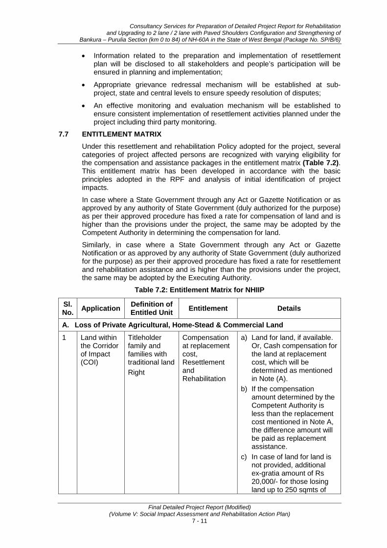
Consultancy Services for Preparation of Detailed Project Report for Rehabilitation and Upgrading to 2 lane / 2 lane with Paved Shoulders Configuration and Strengthening of
Bankura – Purulia Section (km 0 to 84) of NH-60A in the State of West Bengal (Package No. SP/B/6)
Final Detailed Project Report (Modified) (Volume V: Social Impact Assessment and Rehabilitation Action Plan)
7 - 11
• Information related to the preparation and implementation of resettlement plan will be disclosed to all stakeholders and people’s participation will be ensured in planning and implementation;
• Appropriate grievance redressal mechanism will be established at sub-project, state and central levels to ensure speedy resolution of disputes;
• An effective monitoring and evaluation mechanism will be established to ensure consistent implementation of resettlement activities planned under the project including third party monitoring.
7.7 ENTITLEMENT MATRIX Under this resettlement and rehabilitation Policy adopted for the project, several categories of project affected persons are recognized with varying eligibility for the compensation and assistance packages in the entitlement matrix (Table 7.2). This entitlement matrix has been developed in accordance with the basic principles adopted in the RPF and analysis of initial identification of project impacts.
In case where a State Government through any Act or Gazette Notification or as approved by any authority of State Government (duly authorized for the purpose) as per their approved procedure has fixed a rate for compensation of land and is higher than the provisions under the project, the same may be adopted by the Competent Authority in determining the compensation for land.
Similarly, in case where a State Government through any Act or Gazette Notification or as approved by any authority of State Government (duly authorized for the purpose) as per their approved procedure has fixed a rate for resettlement and rehabilitation assistance and is higher than the provisions under the project, the same may be adopted by the Executing Authority.
Table 7.2: Entitlement Matrix for NHIIP
Sl. No. Application Definition of
Entitled Unit Entitlement Details
A. Loss of Private Agricultural, Home-Stead & Commercial Land
1 Land within the Corridor of Impact (COI)
Titleholder family and families with traditional land Right
Compensation at replacement cost, Resettlement and Rehabilitation
a) Land for land, if available. Or, Cash compensation for the land at replacement cost, which will be determined as mentioned in Note (A).
b) If the compensation amount determined by the Competent Authority is less than the replacement cost mentioned in Note A, the difference amount will be paid as replacement assistance.
c) In case of land for land is not provided, additional ex-gratia amount of Rs 20,000/- for those losing land up to 250 sqmts of

R&R Principles, Policy Framework & Entitlement Matrix
Final Detailed Project Report (Modified) (Volume V: Social Impact Assessment and Rehabilitation Action Plan)
7 - 12
Sl. No. Application Definition of
Entitled Unit Entitlement Details
land. The affected person will get Rs.80 per sqmt for any area acquired above 250 sqmt. (para 7.19 NRRP 2007)
d) If as a result of land acquisition, the land holder becomes landless or is reduced to the status of a “small” or “marginal” farmer, rehabilitation allowance equivalent to 750 days of minimum agricultural wages would also be given. (para 7.14, NRRP-2007).
e) Policy for acquisition/ compensation for residual land will be as per note B.
f) In case of allotment of land, one time financial assistance of minimum Rs. 15000/- per hectare for land development. (para 7.9.1 of NRRP-2007)
g) Refund of stamp duty and registration charges incurred for replacement land to be paid by the project; replacement land must be bought within a year from the date of payment of compensation to project affected persons.
B. Loss of Private Structures (Residential/Commercial) 2 Structure
within the Corridor of Impact (CoI)
Title Holder/ Owner
Compensation at replacement rate, Resettlement & Rehabilitation Assistance
a) Cash compensation for the structure at replacement cost which would be determined as per Note (C).
b) Right to salvage material from the demolished structures.
c) Three months’ notice to vacate structures.
d) Refund of stamp duty and registration charges for purchase of new
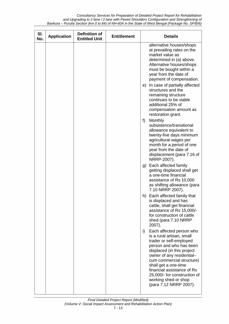
Consultancy Services for Preparation of Detailed Project Report for Rehabilitation and Upgrading to 2 lane / 2 lane with Paved Shoulders Configuration and Strengthening of
Bankura – Purulia Section (km 0 to 84) of NH-60A in the State of West Bengal (Package No. SP/B/6)
Final Detailed Project Report (Modified) (Volume V: Social Impact Assessment and Rehabilitation Action Plan)
7 - 13
Sl. No. Application Definition of
Entitled Unit Entitlement Details
alternative houses/shops at prevailing rates on the market value as determined in (a) above. Alternative houses/shops must be bought within a year from the date of payment of compensation.
e) In case of partially affected structures and the remaining structure continues to be viable additional 25% of compensation amount as restoration grant.
f) Monthly subsistence/transitional allowance equivalent to twenty-five days minimum agricultural wages per month for a period of one year from the date of displacement (para 7.16 of NRRP-2007).
g) Each affected family getting displaced shall get a one-time financial assistance of Rs 10,000 as shifting allowance (para 7.10 NRRP 2007).
h) Each affected family that is displaced and has cattle, shall get financial assistance of Rs 15,000/- for construction of cattle shed (para 7.10 NRRP 2007).
i) Each affected person who is a rural artisan, small trader or self-employed person and who has been displaced (in this project owner of any residential–cum commercial structure) shall get a one-time financial assistance of Rs 25,000/- for construction of working shed or shop (para 7.12 NRRP 2007).
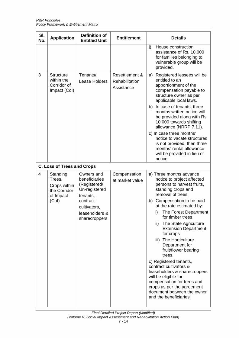
R&R Principles, Policy Framework & Entitlement Matrix
Final Detailed Project Report (Modified) (Volume V: Social Impact Assessment and Rehabilitation Action Plan)
7 - 14
Sl. No. Application Definition of
Entitled Unit Entitlement Details
j) House construction assistance of Rs. 10,000 for families belonging to vulnerable group will be provided.
3 Structure within the Corridor of Impact (CoI)
Tenants/ Lease Holders
Resettlement & Rehabilitation Assistance
a) Registered lessees will be entitled to an apportionment of the compensation payable to structure owner as per applicable local laws.
b) In case of tenants, three months written notice will be provided along with Rs 10,000 towards shifting allowance (NRRP 7.11).
c) In case three months’ notice to vacate structures is not provided, then three months’ rental allowance will be provided in lieu of notice.
C. Loss of Trees and Crops
4 Standing Trees, Crops within the Corridor of Impact (CoI)
Owners and beneficiaries (Registered/ Un-registered tenants, contract cultivators, leaseholders & sharecroppers
Compensation at market value
a) Three months advance notice to project affected persons to harvest fruits, standing crops and removal of trees.
b) Compensation to be paid at the rate estimated by: i) The Forest Department
for timber trees ii) The State Agriculture
Extension Department for crops
iii) The Horticulture Department for fruit/flower bearing trees.
c) Registered tenants, contract cultivators & leaseholders & sharecroppers will be eligible for compensation for trees and crops as per the agreement document between the owner and the beneficiaries.
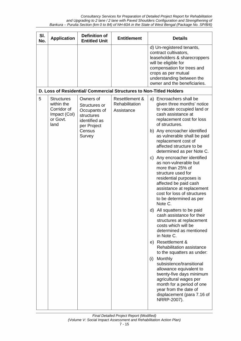
Consultancy Services for Preparation of Detailed Project Report for Rehabilitation and Upgrading to 2 lane / 2 lane with Paved Shoulders Configuration and Strengthening of
Bankura – Purulia Section (km 0 to 84) of NH-60A in the State of West Bengal (Package No. SP/B/6)
Final Detailed Project Report (Modified) (Volume V: Social Impact Assessment and Rehabilitation Action Plan)
7 - 15
Sl. No. Application Definition of
Entitled Unit Entitlement Details
d) Un-registered tenants, contract cultivators, leaseholders & sharecroppers will be eligible for compensation for trees and crops as per mutual understanding between the owner and the beneficiaries.
D. Loss of Residential/ Commercial Structures to Non-Titled Holders 5 Structures
within the Corridor of Impact (CoI) or Govt. land
Owners of Structures or Occupants of structures identified as per Project Census Survey
Resettlement & Rehabilitation Assistance
a) Encroachers shall be given three months’ notice to vacate occupied land or cash assistance at replacement cost for loss of structures.
b) Any encroacher identified as vulnerable shall be paid replacement cost of affected structure to be determined as per Note C.
c) Any encroacher identified as non-vulnerable but more than 25% of structure used for residential purposes is affected be paid cash assistance at replacement cost for loss of structures to be determined as per Note C.
d) All squatters to be paid cash assistance for their structures at replacement costs which will be determined as mentioned in Note C.
e) Resettlement & Rehabilitation assistance to the squatters as under:
(i) Monthly subsistence/transitional allowance equivalent to twenty-five days minimum agricultural wages per month for a period of one year from the date of displacement (para 7.16 of NRRP-2007).

R&R Principles, Policy Framework & Entitlement Matrix
Final Detailed Project Report (Modified) (Volume V: Social Impact Assessment and Rehabilitation Action Plan)
7 - 16
Sl. No. Application Definition of
Entitled Unit Entitlement Details
(ii) Shifting allowance of Rs 10,000 per family (para 7.11 NRRP 2007).
(iii) Assistance of Rs 15,000/- for loss of cattle shed (para 7.10 NRRP 2007).
(iv) Each affected person who is a rural artisan, small trader or self-employed person assistance of Rs 25,000/- for construction of working shed or shop (para 7.12 NRRP 2007).
(v) House construction assistance of Rs. 10000/- for those belonging to vulnerable groups.
E. Loss of Livelihood 6 Families
living within the Corridor of Impact (CoI)
Title Holders/ Non-Title holders/ sharecroppers, agricultural labourers and employees
Resettlement & Rehabilitation Assistance
a) Monthly subsistence/transitional allowance equivalent to twenty-five days minimum agricultural wages per month for a period of one year from the date of displacement (para 7.16 of NRRP-2007). (PAPs covered under 1(f), 2 (f) and 5 (e)(i) above would not be eligible for this assistance).
b) Training Assistance of Rs 10,000/- for income generation per family.
c) Temporary employment in the project construction work to project affected persons with particular attention to vulnerable groups by the project contractor during construction, to the extent possible.
F. Additional Support to Vulnerable Group 7 Families
within the Corridor of Impact (CoI)
Vulnerable families
Resettlement & Rehabilitation Assistance
One time additional financial assistance equivalent to 300 days of minimum wages to all vulnerable including STs as Economic Rehabilitation Grant.
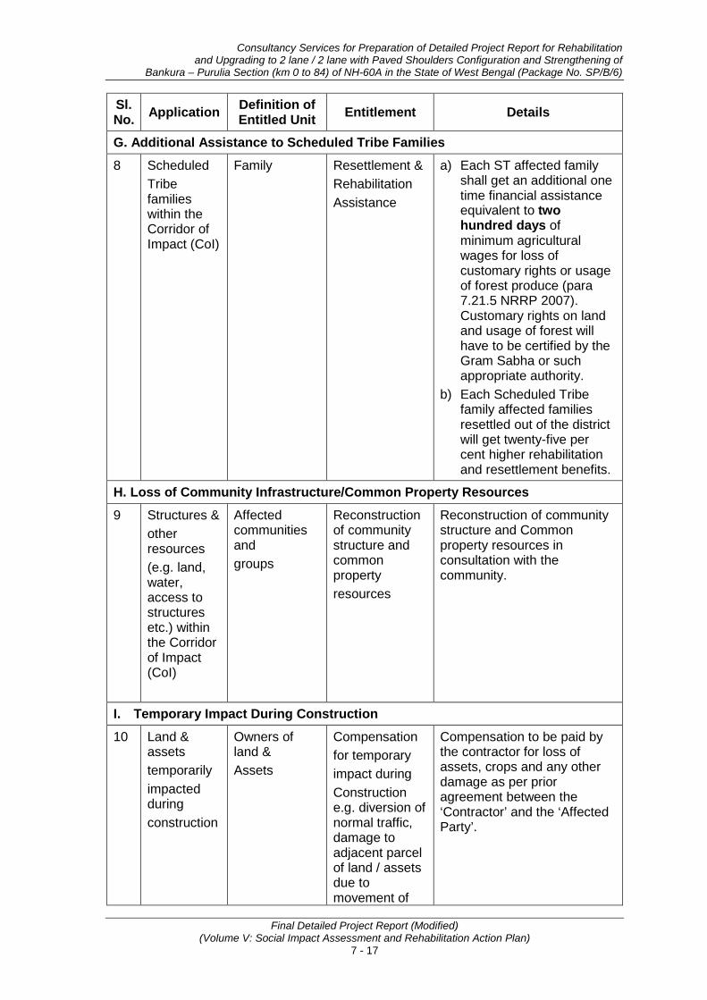
Consultancy Services for Preparation of Detailed Project Report for Rehabilitation and Upgrading to 2 lane / 2 lane with Paved Shoulders Configuration and Strengthening of
Bankura – Purulia Section (km 0 to 84) of NH-60A in the State of West Bengal (Package No. SP/B/6)
Final Detailed Project Report (Modified) (Volume V: Social Impact Assessment and Rehabilitation Action Plan)
7 - 17
Sl. No. Application Definition of
Entitled Unit Entitlement Details
G. Additional Assistance to Scheduled Tribe Families
8 Scheduled Tribe families within the Corridor of Impact (CoI)
Family Resettlement & Rehabilitation Assistance
a) Each ST affected family shall get an additional one time financial assistance equivalent to two hundred days of minimum agricultural wages for loss of customary rights or usage of forest produce (para 7.21.5 NRRP 2007). Customary rights on land and usage of forest will have to be certified by the Gram Sabha or such appropriate authority.
b) Each Scheduled Tribe family affected families resettled out of the district will get twenty-five per cent higher rehabilitation and resettlement benefits.
H. Loss of Community Infrastructure/Common Property Resources
9 Structures & other resources (e.g. land, water, access to structures etc.) within the Corridor of Impact (CoI)
Affected communities and groups
Reconstruction of community structure and common property resources
Reconstruction of community structure and Common property resources in consultation with the community.
I. Temporary Impact During Construction
10 Land & assets temporarily impacted during construction
Owners of land & Assets
Compensation for temporary impact during Construction e.g. diversion of normal traffic, damage to adjacent parcel of land / assets due to movement of
Compensation to be paid by the contractor for loss of assets, crops and any other damage as per prior agreement between the ‘Contractor’ and the ‘Affected Party’.

R&R Principles, Policy Framework & Entitlement Matrix
Final Detailed Project Report (Modified) (Volume V: Social Impact Assessment and Rehabilitation Action Plan)
7 - 18
Sl. No. Application Definition of
Entitled Unit Entitlement Details
heavy machinery and plant site.
J. Resettlement Site 11 Loss of
residential and commercial structures
Displaced titleholders and non-titleholders
Provision of resettlement site/ vendor market
Resettlement sites will be developed as part of the project, if a minimum of 25 project displaced families opt for assisted resettlement. Vulnerable PAPs will be given preference in allotment of plots/flats at the resettlement site. Plot size will be equivalent to size lost subject to a maximum of 250 sqmt in rural area and 150 sqmt in urban areas (7.2 of NRRP 2007). Similarly, if at least 25 displaced commercial establishments (small business enterprises) opt for shopping units, the Project Authority will develop the vendor market at suitable location in the nearby area in consultation with displaced persons. Shopping unit size will be equivalent to size lost subject to a maximum of 100 in urban and 150 sq.ft. in rural areas. Vulnerable PAPs will be given preference in allotment of shops in vendor market. One displaced family will be eligible for only one land plot at resettlement site or shop in the vendor market. Basic facilities such as approach road, electricity connection, water and sanitation facility, etc shall be provided at resettlement site and in vendor market, as applicable by the Project Authority at project cost. Any other basic facilities shall be provided at the time of implementation in consultation

Consultancy Services for Preparation of Detailed Project Report for Rehabilitation and Upgrading to 2 lane / 2 lane with Paved Shoulders Configuration and Strengthening of
Bankura – Purulia Section (km 0 to 84) of NH-60A in the State of West Bengal (Package No. SP/B/6)
Final Detailed Project Report (Modified) (Volume V: Social Impact Assessment and Rehabilitation Action Plan)
7 - 19
Sl. No. Application Definition of
Entitled Unit Entitlement Details
with displaced persons depending on the requirements. Budget for the development of resettlement sites and vendor markets will be included in the overall project cost. In case of self-relocation, PAPs will be eligible for additional support for the construction of structure@ 15% of the financial assistance provided for new construction of house under IAY and JNNURM, subject to the condition that the PAP uses the assistance money for construction only within a period of one year from the date full payment of compensation and assistance amount in the concerned state. The PAP will be required to provide documentary evidence to that effect. Self-relocating displaced PAPs will not be eligible for land plots at resettlement site or shop in the vendor market. For development of the resettlement sites (including vendor markets, approach roads, etc.) the World Bank operational policy OP 4.12 will be applied.
7.8 METHODS FOR ASSESSMENT OF REPLACEMENT COST The methods for assessment of replacement cost and determination of compensation for loss of land, structure, and other assets are discussed in the notes provided below:
Note A 1. Compensation would be determined by Competent Authority:
a) Calculate the base cost by adding 50% of the latest guideline value/circle rate for the indented use of the land;
b) Add 60% solatium to the base cost of land.
Or

R&R Principles, Policy Framework & Entitlement Matrix
Final Detailed Project Report (Modified) (Volume V: Social Impact Assessment and Rehabilitation Action Plan)
7 - 20
2. Engage/Hire an Independent Valuer registered with Government, who can assist to assess the replacement cost of land as follows and provide inputs to the competent authority by:
a) Appraising recent sales and transfer of title deeds and registration certificates for similar type of land in the village or urban area and vicinity
b) Appraising circle rate in urban and rural areas of the district
c) Appraising agricultural productivity rate for land – 20 years yield.
Or
3. Compensation as per the state approved procedure.
Replacement cost of land shall be the highest of the above three options.
Note B - Compensation for unviable residual land If the residual plot(s) is (are) not economically viable, the Executing Agency (EA) will follow the rules and regulations applicable in the state and compensate accordingly; if there are no state specific rules and regulations available regarding residual land and the residual land is less than average land holding of the district after acquisition, then the EA in agreement with the project affected person will follow one of the following:
(i) The EA will buy the residual land for the project following the entitlements listed in the entitlement matrix; or
(ii) The EA will pay the project affected person 25% of the base cost of land as hardship compensation for that portion of land (residual) without its acquisition.
Note C - Replacement cost of houses, buildings and other structures The replacement cost of houses, buildings and other immovable properties will be determined on the basis of replacement cost by referring to relevant Basic Schedule of Rates (BSR) as on date without depreciation. In case of partial impact, if the residual structure is rendered structurally unsafe or unviable the entire structure to be considered affected and compensated accordingly. In case of displacement and the valuation amount is less than the amount provided under IAY/JNNURM as applicable, compensation equivalent to provisions under IAY/JNNURM shall be provided.
Note D - Compensation for Trees/Crops Compensation for trees will be based on their market value. Loss of timber trees will be compensated at their replacement cost while the compensation for the loss of fruit bearing trees will be calculated as annual produce value calculated for the number of years (as per standard procedure followed by concerned department) depending on the nature of trees/crops.
7.9 DIRECT PURCHASE OF LAND Provision of direct purchase of land from land owners in case of sub-project where additional land requirement is very less (minimal) may also be considered. However, resettlement and rehabilitation benefits available to affected persons whose land would be acquired under the statute shall also be available to those affected persons whose land would be acquired through direct purchase.
Consultancy Services for Preparation of Detailed Project Report for Rehabilitation and Upgrading to 2 lane / 2 lane with Paved Shoulders Configuration and Strengthening of
Bankura – Purulia Section (km 0 to 84) of NH-60A in the State of West Bengal (Package No. SP/B/6)
Final Detailed Project Report (Modified) (Volume V: Social Impact Assessment and Rehabilitation Action Plan)
7 - 21
• • •

Consultancy Services for Preparation of Detailed Project Report for Rehabilitation and Upgrading to 2 lane / 2 lane with Paved Shoulders Configuration and Strengthening of
Bankura – Purulia Section (km 0 to 84) of NH-60A in the State of West Bengal (Package No. SP/B/6)
Final Detailed Project Report (Modified) (Volume V: Social Impact Assessment and Rehabilitation Action Plan)
8 - 1
8. INSTITUTIONAL ARRANGEMENTS FOR RAP IMPLEMENTATION
8.1 INTRODUCTION Institutional arrangements for the implementation of RAP have been ensured by including it part of the RPF. The Institutional Arrangements will be set up at three levels viz., MoRT&H (Central Govt.)., State Level and Sub-Project Level on partnership model wherein concerned agencies at different levels supplement and complement each other efforts. The key elements of institutional arrangements are co-operation/ support, collaboration and sharing of responsibilities with clearly defined roles, involvement of key stakeholders and vertical and horizontal linkages amongst different agencies. The institutional arrangement is discussed below and depicted in Fig. 8.1.
Fig. 8.1: Institutional Arrangement for RAP Implementation
8.2 CENTRAL LEVEL At Central Level, the Chief Engineer (EAP), MoRTH, Govt. of India will be overall responsible for the implementation of RAP. Chief Engineer (EAP) will have all delegated administrative and financial decisions with regard to implementation of the project as well as land acquisition, RAP implementation.
Institutional arrangement at Central Level will include augmenting the capacity of MoRTH with regard to resettlement and rehabilitation. A team comprising Superintending Engineer designated as Social Development Specialist (SDS)
SE (Designated Social Officer),
MoRTH
Project Authority CE (EAP), MoRTH
Social Development Specialist (SDS)
Regional Officer, MoRTH
PCU (State PWD, headed by CE NH wing and designated Nodal Officer) Supported by Land Acquisition cum
Social Development Officer
SCHM (CE) (general
project related issues) M&E Agency
(Third party)
GRC at District Level (RPF
related issues)
PIU -- SDE/AE (Designated as R&R Officer)
District Level Replacement Cost
Committee
NGO / Consultancy Firm (RAP Implementation
Agency)

Institutional Arrangements for RAP Implementation
Final Detailed Project Report (Modified) (Volume V: Social Impact Assessment and Rehabilitation Action Plan)
8 - 2
and a suitable number of Technical and Secretarial Staff will assist CE (EAP). The designated SDS will be directly involved in the implementation of RAP. The SDS will ensure that all resettlement and rehabilitation issues are complied with as per the RPF. The roles and responsibilities of the SDS would broadly include the following: • Ensure preparation and disclosure of SIA, RAP and Land Acquisition Plan for
sub projects as per RPF. • Ensure adequate staffing at state and sup project level to ensure timely
implementation of RAP. • Guide and supervise in matters related to resettlement and rehabilitation to
state and sub-project level offices. • Compile data related to resettlement and rehabilitation activities received from
field offices and update Chief Engineer (CE) and suggest suitable measures to be taken.
• Interact with implementation agencies at state and sup project level on a regular basis.
• Undertake field visits as and when required.
• Facilitate necessary help needed at site with regard to LA and R&R issues. • Co-ordinate with state government department in matters related to
implementation of R&R.
• Ensure budgetary provision for resettlement and rehabilitation of PAPs and relocation, rehabilitation and reconstruction of common property resources (CPRs).
• Ensure timely release of budget for implementation of RAP. • Monitor implementation of RAP carried out by the agency through RRO. • Perform other roles and responsibilities related to implementation of RAP as
assigned by the CE (EAP) from time to time. • Ensure free, prior and informed consultation with vulnerable groups along the
project and also ensure that sufficient supporting documentation is maintained.
• Ensure third party audit of RAP implementation. 8.3 STATE LEVEL
At State Level, a Land Acquisition cum Social Development Officer will be appointed to provide assistance to the designated Nodal Officer of PIU, Road Construction Department, Govt. of Bihar. The roles and responsibilities of the LA cum SDO would broadly include the following: • Facilitate preparation and implementation of land acquisition and RAP in
compliance with RPF, • Ensure consultation and stakeholder participation in finalisation of RAP, • Guide and supervise RAP implementation at sub-project level,
• Interact with RAP implementation support agencies and undertake field visits for first-hand information,
• Guide and supervise the RAP implementing agency to roll out HIV prevention activities,
Consultancy Services for Preparation of Detailed Project Report for Rehabilitation and Upgrading to 2 lane / 2 lane with Paved Shoulders Configuration and Strengthening of
Bankura – Purulia Section (km 0 to 84) of NH-60A in the State of West Bengal (Package No. SP/B/6)
Final Detailed Project Report (Modified) (Volume V: Social Impact Assessment and Rehabilitation Action Plan)
8 - 3
• Compile data on LA progress and RAP implementation activities received from field offices and update SE (Designated Social Officer), MoRTH and suggest suitable measures to be taken,
• Co-ordinate with various government departments in matters related to implementation of RAP,
• Check implementation of RAP carried out by the agency from time to time by undertaking site visits and consultations with PAPs,
• Perform other roles and responsibilities related to implementation of RAP as assigned by the SE (Designated Social Officer), MoRTH from time to time,
• Facilitate and cooperate in Third party Audit of RAP implementation.
8.4 SUB-PROJECT LEVEL A Project Implementation Unit (PIU) comprising officials of State PWD will be constituted at sub- project level headed by the Superintending Engineer/ Executive Engineer designated as Project Director. The PIU will be responsible for the project execution including RAP implementation. There will be a designated or appointed Resettlement & Rehabilitation Officer (RRO) at respective PIUs who will be responsible only for the implementation of RAP at site. No other roles and responsibilities will be assigned to RRO other than resettlement and rehabilitation. RRO will assist Project Director at PIU and SDS at Central Level in all matters related to resettlement and rehabilitation.
The roles and responsibilities of the Resettlement and Rehabilitation Officer are as under:
• Ensure RAP implementation with assistance from implementation agency as per the time line agreed upon.
• Interact with RAP implementation agency on a regular basis.
• Undertake field visits with implementation agency from time to time.
• Facilitate necessary help needed at site with regard to LA and R&R, HIV issues to implementation agency.
• Co-ordinate with district administration and other departments in matters related to implementation of R&R.
• Ensure distribution of Resettlement and Rehabilitation Policy and entitlement matrix for the project to PAPs.
• Ensure preparation and distribution of photo identity cards.
• Ensure and attend meetings organised by implementation agency on thematic areas related to resettlement and rehabilitation policy and entitlements and awareness generation.
• Ensure inclusion of PAPs who could not be enumerated during census but have documentary evidence to be included in the list of PAPs.
• Ensure preparation of identity cards, and approval from the Head Office and distribution of the same to PAPs.
• Ensure timely preparation of micro-plan from RAP implementation agency and approval from Head Office.

Institutional Arrangements for RAP Implementation
Final Detailed Project Report (Modified) (Volume V: Social Impact Assessment and Rehabilitation Action Plan)
8 - 4
• Ensure disbursement of resettlement and rehabilitation assistance in a transparent manner.
• Participate in meetings related to resettlement and rehabilitation issues.
• Facilitate in opening of joint account of PAPs.
• Prepare monthly progress report related to physical and financial progress of implementation of RAP & submit to Head Office.
• Ensure release of compensation and assistance before taking over the possession of land for start of construction work.
• Ensure relocation, rehabilitation and reconstruction of CPRs before dismantling through proper mechanism.
• Attend and participate in Grievance Redress Committee meetings for redressal of grievances of PAPs and other committees involving R&R matters,
• Liaison with government and other agencies for inclusion of PAPs in employment and income generation programme/scheme.
• Carry out any other work related to resettlement and rehabilitation that may be entrusted from time to time by the PCU for compliance of R&R.
• Provide all necessary information and data related to R&R on monthly basis to Designated Social Officer at Central Level through Project Director.
• Ensure that vulnerable families get equal opportunity to participate during implementation and become overall beneficiaries in the project.
Besides, other institutional arrangements required for the implementation of RAP include engagement of RAP IA for the implementation of RAP, formation of District level committee to fix the replacement cost of affected properties, Grievance redressal mechanism, Suggestion and Complaint handling mechanism, engagement of monitoring and evaluation agency, etc. Roles and responsibilities of each agency are discussed below.
8.5 RAP IMPLEMENTATION SUPPORT AGENCY (CONSULTANCY FIRM) To implement RAP, the Project Authority [CE (EAP), MoRTH] will engage the services of one or multiple agencies having experience in resettlement and rehabilitation issues through standard bidding process. The implementation agency will work in close co-ordination with RRO and report to PIU. Financial matters related to services of the RAP implementation agency will be dealt by Project Authority. Broad roles and responsibilities of implementation agency would be as:
• The RAP implementation agency will be the main link between the Project Authority and PAPs,
• Shall be responsible for verification of PAPs as prepared by the DPR consultants,
• Undertake public information campaign along with RRO at the commencement of the RAP,
• Develop rapport with PAPs,
• Distribute pamphlets of R&R Policy to PAPs, Panchayat Raj Institutions, and concerned Govt. Offices in the project area, etc.

Consultancy Services for Preparation of Detailed Project Report for Rehabilitation and Upgrading to 2 lane / 2 lane with Paved Shoulders Configuration and Strengthening of
Bankura – Purulia Section (km 0 to 84) of NH-60A in the State of West Bengal (Package No. SP/B/6)
Final Detailed Project Report (Modified) (Volume V: Social Impact Assessment and Rehabilitation Action Plan)
8 - 5
• Include PAPs who could not be enumerated during census cum socio-economic survey and certification from R&R Officer,
• Distribute identity cards for PAPs,
• Preparation of micro-plan,
• Submission of micro-plan to RRO for approval from Head Office,
• Organize consultations at regular interval with PAPs with regard to resettlement and rehabilitation,
• Organize training program for skill up gradation of the PAPs,
• Assist PAPs in all matters related to compensation and R&R,
• Assist and facilitate aggrieved PAPs (for compensation and assistance) by bringing their cases to GRC,
• Facilitate in opening of joint account of PAPs,
• Generate awareness about the alternative economic livelihood and enable PAPs to make informed choice,
• Consultations with PAPs regarding the choice of resettlement (i.e. self or assisted), development of resettlement site, participation of women, etc.
• Identify training needs of PAPs for income generation and institutions for imparting training,
• Undertake outreach activities for HIV prevention for awareness and behaviour change as per RAP
• Consultations with local people and Panchayat Raj Institutions with regard to relocation, rehabilitation, reconstruction of affected CPRs as well as provision of new facilities under the project,
• Participate in various meetings,
• Submit monthly progress report, and
• Any other activities that may be required for the implementation of RAP, etc.
8.6 REPLACEMENT COST COMMITTEE AT DISTRICT LEVEL A committee at district level will be constituted to fix the replacement cost of land, structures and other properties (trees, crops and other assets, tube well, hand pump, etc). The committee may comprise seven (7) members chaired by the District Collector/ Dy. Commissioner or his designated representative (not below the rank of SDM), Executive Engineer of the concerned District, District Agriculture Officer, Range Officer (Forest Department), an independent certified valuer and elected representative (MLA) of the concerned area and Team Leader of RAP implementation agency.
The highest value of land obtained by the three methods mentioned in Section 9.4 of RPF will be presented by the Project Authority approved by the committee as the replacement cost. Similarly, latest schedule of rates of the concerned districts shall be used for obtaining replacement cost of structures. For items not available in the schedule of rates for those items market rates shall be collected from three different sources and then replacement cost shall be fixed by the committee. For replacement costs of crops, trees and other such items similar methods will be followed.
Institutional Arrangements for RAP Implementation
Final Detailed Project Report (Modified) (Volume V: Social Impact Assessment and Rehabilitation Action Plan)
8 - 6
For titleholders the difference of replacement amount and the compensation paid by the Competent Authority (CA) as per the NH Act shall be paid by the Project Authority to the entitled persons as assistance. The differential amount will be included in the micro plan to be prepared by the RAP IA.
The committee will be constituted through an executive order and or other suitable instrument within one month (30 days) from the date of mobilization of RAP implementation agency at site.
8.7 MECHANISM FOR IMPLEMENTATION OF RAP, TRAINING AND CAPACITY BUILDING – AT PROJECT AND SUB-PROJECT LEVEL Training and development of project staff is an integral part for implementation NHIIP. A training needs identification shall carried out at Central, Regional and Site level, based on which focused training modules will be developed in the first six months of project implementation;
• Strengthening in house capacity to implement the provisions of RPF/RAP,
• Creating Awareness, providing the tools for implementation of RAP, and accompanying set of management procedures to all departments,
• Developing competence within key officials to provide training in their respective level.
Based on skill requirement/improvement at all levels for proper implementation of RPF, a training programme focusing project implementing partners at Centre, State and field PIUs has been developed which will be implemented by the Project Authority (MoRTH) in the next two years. These training programs, which will be zeroed down after a quick training needs assessment, are to be conducted with the help of local and national training institutions and experts in various aspects of social management. MoRTH will also identify courses offered by the premier institutions in India and abroad on social management and inter-phase these with identified programme.
Provision for separate budget has been made for this activity. The budget reported under “institutional” head includes the cost estimates of training programs discussed above.
• • •

Consultancy Services for Preparation of Detailed Project Report for Rehabilitation and Upgrading to 2 lane / 2 lane with Paved Shoulders Configuration and Strengthening of
Bankura – Purulia Section (km 0 to 84) of NH-60A in the State of West Bengal (Package No. SP/B/6)
Final Detailed Project Report (Modified) (Volume V: Social Impact Assessment and Rehabilitation Action Plan)
9 - 1
9. DISCLOSURE AND CONSULTATION PLAN
9.1 INTRODUCTION The Right to Information Act, 2005 provides for setting out the practical regime of right to information for citizens to secure access to information under the control of public authorities, in order to promote transparency and accountability in the working of every public authority, the constitution of a Central Information Commission and State Information Commissions and for matters connected therewith or incidental thereto. The process for obtaining information and details of designated officials is posted on the MoRTH website http://www.morth.nic.in.
The Resettlement Policy Framework has already been disclosed. Further Draft Resettlement Action Plan (RAP) shall be disclosed on MoRTH website as well at the World Bank Info shop/ Public Information Centre. Feedback, if any would be incorporated into the final RAP document, following which the final RAP will be re-disclosed. Further to enhance transparency in implementation, the list of PAPs for disbursement of benefits shall be separately disclosed at the concerned Panchayat Offices/ Urban Local Bodies,, District Collector Offices, Block development Offices, District Public Relations Offices (at the state and district levels), Project office, and any other relevant offices, etc. The Resettlement Policy Framework, Executive Summary of the SIA and RAP translated into vernacular language and the list of PAPs will be placed in the District Collector’s Office.
9.2 CONSULTATION & PARTICIPATION PLAN To ensure peoples’ continued participation in the implementation phase and aiming at promotion of public understanding and fruitful solutions of developmental problems such as local needs of road users and problem and prospects of resettlement, various sections of PAPs and other stakeholders will be engaged in implementation. Key actions would be as follows:
• Communicating and informing PAPs and beneficiary households in the project area of resettlement policy provisions and grievance redress mechanism through village level public meetings;
• Holding one to one meeting with the PAPs to explain their eligibility;
• Placing of micro plan in affected villages for review and minimize grievances;
• Payment of R&R assistance to PAPs during public meetings to maintain transparency; and
• Household consultation to identify skill improvement training needs, counseling for usage of assistance amount and other activities towards livelihood restoration.
Information dissemination would be carried out through printed leaflets/ information booklets that would be prepared by the RAP Implementation Support Agency in local language. These would be distributed not only to PAPs but also to people (residents, businessmen and others) within the immediate project influence area and the local community in advance so that people discuss issues among themselves and prepare themselves for the meeting. On the day of public meeting, once again leaflets would be distributed among the people present for dissemination of information so as to ensure that all present at the meeting, get to know about the project in case they did not get the leaflet/ information booklet.
The leaflet/ information booklet would provide the following:

Disclosure and Consultation Plan
Final Detailed Project Report (Modified) (Volume V: Social Impact Assessment and Rehabilitation Action Plan)
9 - 2
• brief description of the project and its objectives;
• a summary of adverse impacts (including land acquisition, and impacts on common property resources, etc);
• act under which land has been acquired;
• resettlement & rehabilitation provisions of the project and specific benefits available to vulnerable communities;
• ways and means of involving local communities;
• expectations from local communities;
• role of RAP IA and RRO; and
• Grievance redresses mechanisms, suggestion and complain handling mechanism, etc.
Information dissemination would be carried out at least once in a month by organising public meetings at suitable locations involving PAPs, local communities, institutions and line departments at people’s door step on a pre-decided date and time. Wide publicity for the meeting would be carried out by beating of drums and announcement through loud speakers in the adjoining areas. The LA cum Social Development Officer & RRO with assistance from RAP implementation agency would describe all aspects of the project, importance of consultations and also seek their participation and co-operation in the project. In these public meetings various aspects of the project would be explained and also the status of the project (technical, social & environmental) would be revealed. People in general and PAPs in particular, would be given opportunity to provide suggestions and raise issues which concern them and as a consequence maintain good rapport with local community. Land Acquisition cum Social Development Officer (State level), RRO, and RAP Implementation Support Agency shall be present in these meetings.
After the public meeting, Minutes of Meeting (MoM)/ resolution would be prepared and read out to people present in the meeting. The MoM would be signed by the officials and participants present at the meeting. The MoM would be kept in project file for documentation purpose.
9.3 SUGGESTION AND COMPLAINT HANDLING MECHANISM (SCHM) The MoRTH recognizes the importance of this and hence intends to establish a SCHM for the NHIIP. The communication channels to report project related complaints/concerns will be disclosed at all levels of institutions - MoRTH, State, Project/site level.
Though the Right to Information Act, 2005 an Act of the Parliament of India provides for setting out the practical regime of right to information for citizens. The Act applies to all States and Union Territories of India except the State of Jammu and Kashmir. Under the provisions of the Act, any citizen may request information from a "public authority" (a body of Government or "instrumentality of State") which is required to reply expeditiously or within thirty days. The Act also requires every public authority to computerize their records for wide dissemination and to pro-actively publish certain categories of information so that the citizens need minimum recourse to request for information formally. In other words under the act, citizens have right to seek information from concerned agencies by following the set procedures. However, it is quite likely that many people may not use the provisions of this Act, only in limited cases covering serious concerns. Being an inter-state project involving several states and large scale of civil works along with

Consultancy Services for Preparation of Detailed Project Report for Rehabilitation and Upgrading to 2 lane / 2 lane with Paved Shoulders Configuration and Strengthening of
Bankura – Purulia Section (km 0 to 84) of NH-60A in the State of West Bengal (Package No. SP/B/6)
Final Detailed Project Report (Modified) (Volume V: Social Impact Assessment and Rehabilitation Action Plan)
9 - 3
R&R and Environment issues, the project is likely to receive many suggestions, complaints, inquiries, etc through the project implementation period. Therefore, MoRTH has agreed to establish SCHM as a good practice to address public concerns pertaining to various issues. SCHM will report all project related LA and R&R of the PAPs for redressal through the concerned PIU or GRC as appropriate. Several communication channels viz., toll free phone number, dedicated email, mechanism for on line submission of suggestions/complaints/inquiries, provision of suggestion/complaint box (at site and project office), post and other suitable means shall be set up for suggestion and complaint handling. The detailed SCHM is provided as an Annexure 9.1. From the initial stage of the RAP implementation, the RAP IA will also disseminate information regarding SCHM to local people and road users by organising consultations, distributing fliers, announcement by loud speakers, hoardings, etc. During consultations the RAP IA personnel will explain the process of SCHM in detail.
9.4 PUBLIC HEARING Public Hearing for the project road was conducted by the West Bengal State Pollution Control Board, Kolkata, (WBSPC) at Puabagan, Bankura district on 24 August, 2012 and at Hura, District Purulia on 23 August, 2012.
• • •

Annexure 9.1
A - 124
Suggestion and Complaint Handling Mechanism (SCHM)
The design of NHIIP is complex and its geographical scale is immense, and the project is expected to have a wide array of enquiries, comments, suggestions as well as face some operational risks. MORTH is working to establish a sound Suggestion and Complaint Handling Mechanism (SCHM) for NHIIP to address and handle external and internal inquiries, suggestions and comments, and concerns/complaints/ grievances as well as improve accountability and service delivery under NHIIP.
SCHM Users The users of SCHM could be anyone from the project stakeholders, including civil servants (from MORTH, State PWDs, or from other State Departments) contractors, consultants, project affected people (communities), road users, CSOs/NGOs, any other public, who realizes either impact from or relation to the concerned project.
Management of SCHM The overall responsibility for the operation and management of NHIIP’s SCHM will rest with the PIC MoRTH. The NHIIP’s SCHM will be handled at three levels: at the State’s, MORTH’s level, and project level.
Since all pre-construction and civil works will be implemented and managed by the States, all enquiries, suggestions and complaints related to a specific road will be submitted to the concerned implementing agency at the State Level. Each PCU at the State level is to set up a toll free number and/or email account for the project stakeholders and general public to submit their enquiries, suggestions and complaints. The toll free number and email account are to be displayed at the sign boards at the start and end of each project road. The bidding documents will have a requirement for the contractor to put in place signs at the start and end of the project road which will display the toll free number and email account to submit enquiries, suggestions and complaints to the concerned implementing government agency. Similarly, inquiries, suggestions, or complaints related to specific roads can also be submitted to project authority as well, but the project authority will encourage complainants to send their queries/concerns directly to the PCU or PIC authorities. In whichever level the queries are submitted, a due recording and documentation will be carried out by the respective authorities.
The PIC head will be in charge of assigning the responsible person/entity to address and handle enquiry, suggestion or complaint submitted at the MORTH’s level. However, within his/her team he/she will assign an officer (engineer) who will be responsible for coordinating inquiries/comments and complaints/ concerns/grievances. His/her responsibilities will include:
• To respond to as many inquiries/comments as possible
• To receive and sort concerns/grievances
• To forward them to appropriate team members for resolution as per recommendation of the PIC Head
• To track/monitor complaint/grievance acknowledgement and resolution
• To review and report on complaint/grievance data and trends to the MORTH PIC Head, who in turn will report to MORTH CVO, NHIIP Project Oversight Committee, and WB
After receiving complaints, the complainants will be informed within three weeks about the status of the complaints and what action will be taken further.
Annexure 9.1
A - 125
Channels The following channels should be established to receive inquiries/comments and concerns /grievances:
• Toll free phone
• On-line form
• Regular post/mail
• Suggestion box/Walk-ins
It is critical to assign a specific e-mail ID and a phone/fax number, and to set up an easy-to-access suggestion box and walk-in office. The project website will have a permanent sub-window that will contain an on-line form and facilitates grievance/complaint collection.
On-line Form for Suggestions and Complaints The on-line form for suggestions and complaints will be provided on the NHIIP website. The form will contain only three entries as outlined below.
Subject: ______________________
NHIIP Road: ____________________
Content: _______________________
Your email: _____________________
Suggestions/complaints submitted through this on-line form is to go directly to (a) the PIC Head’s email account and (b) internal reporting system for SCHM (excel file).
SCHM Reporting Format The internal reporting system for SCHM (excel file) will have the following entries/columns:
1. Date
2. Subject
3. Road
4. Content
5. Email (of the complainant)
6. Acknowledgment date (Date when PIC sent an email to the complainant to acknowledge that the email has been received, the issue will be handled within that period of time and the response/feedback will be provided to the complainant by that deadline)
7. Responsible Person
8. Deadline for Feedback
9. Actual Date for Feedback
10. Solution/Feedback on the Suggestion/Complaint
Annexure 9.1
A - 126
11. Additional Comment (e.g., if the person was unsatisfied with the feedback/solution provided and indicated that he/she will go to another authority to complain).
The entries 1-5 should be filled in automatically once an on-line form is submitted. The other entries are to be entered manually by the PIC and each State-level PIU. All SCHM-related reports are to be consolidated by the PIC.

Consultancy Services for Preparation of Detailed Project Report for Rehabilitation and Upgrading to 2 lane / 2 lane with Paved Shoulders Configuration and Strengthening of
Bankura – Purulia Section (km 0 to 84) of NH-60A in the State of West Bengal (Package No. SP/B/6)
Final Detailed Project Report (Modified) (Volume V: Social Impact Assessment and Rehabilitation Action Plan)
10 - 1
10. GRIEVANCE REDRESSAL MECHANISM (GRM)
10.1 INTRODUCTION The Resettlement Policy Framework mandates formation of Grievance Redressal Mechanism in order to resolve disputes in an effective manner and at the door steps of the PAPs. Compensation and assistance as per eligibility is provided in the entitlement matrix of the approved RPF. Grievance of PAPs will be brought to the grievance redress committee for redressal. The decision of the GRC will be binding, unless vacated by court of law.
10.2 GRIEVANCE REDRESSAL COMMITTEE (GRC) The GRC will be constituted by the Project Authority with the aim to settle as many disputes as possible on LA and R&R through consultations and negotiation. The GRC will comprise five members headed by District Magistrate or his representative not below the rank of SDM. Other members of the GRC will include a retired PWD Officer (not below the rank of Executive Engineer), RRO, representative of PAPs and Sarpanch (Elected Head of Village) of the concerned village. Grievances of PAPs in writing will be brought to GRC for redressal by the RAP implementation agency. The RAP implementation agency will provide all necessary help to PAPs in presenting his/her case before the GRC. The GRC will respond to the grievance within 15 days. The GRC will normally meet once in a month but may meet more frequently, if the situation so demands. A time period of 45 days will be available for redressing the grievance of PAPs. The decision of the GRC will not be binding to PAPs. This means the decision of the GRC does not debar PAPs taking recourse to court of law, if he/she so desires. Broad functions of GRC are as under:
• Record the grievances of PAPs categorize and prioritize them and provide solution to their grievances related to resettlement and rehabilitation assistance.
• The GRC may undertake site visit, ask for relevant information from Project Authority and other government and non-government agencies, etc in order to resolve the grievances of PAPs.
• Fix a time frame within the stipulated time period of 45 days for resolving the grievance.
• Inform PAPs through implementation agency about the status of their case and their decision to PAPs and Project Authority for compliance.
The GRC will be constituted within 3 months by an executive order from competent authority (centre/ state) from the date of mobilization of RAP implementation agency. The RRO will persuade the matter with assistance from implementation agency in identifying the suitable persons from the nearby area for the constitution of GRC. Secretarial assistance will be provided by the PIU as and when required. The flow diagram (Figure 10.1) shows the entire process of grievance redressal.
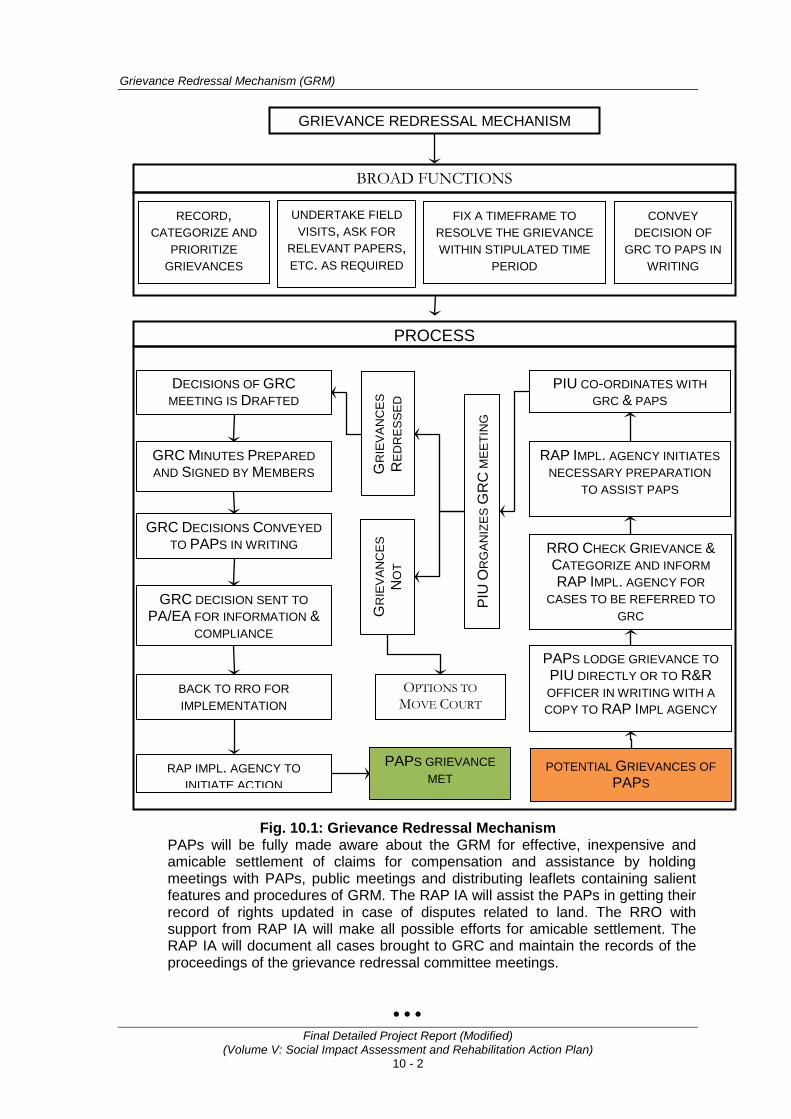
Grievance Redressal Mechanism (GRM)
Final Detailed Project Report (Modified) (Volume V: Social Impact Assessment and Rehabilitation Action Plan)
10 - 2
Fig. 10.1: Grievance Redressal Mechanism
PAPs will be fully made aware about the GRM for effective, inexpensive and amicable settlement of claims for compensation and assistance by holding meetings with PAPs, public meetings and distributing leaflets containing salient features and procedures of GRM. The RAP IA will assist the PAPs in getting their record of rights updated in case of disputes related to land. The RRO with support from RAP IA will make all possible efforts for amicable settlement. The RAP IA will document all cases brought to GRC and maintain the records of the proceedings of the grievance redressal committee meetings.
• • •
GRIEVANCE REDRESSAL MECHANISM
BROAD FUNCTIONS
RECORD, CATEGORIZE AND
PRIORITIZE GRIEVANCES
CONVEY DECISION OF
GRC TO PAPS IN WRITING
UNDERTAKE FIELD VISITS, ASK FOR
RELEVANT PAPERS, ETC. AS REQUIRED
FIX A TIMEFRAME TO RESOLVE THE GRIEVANCE WITHIN STIPULATED TIME
PERIOD
PROCESS
DECISIONS OF GRC MEETING IS DRAFTED
GR
IEV
AN
CE
S
RE
DR
ES
SE
D
PIU
OR
GA
NIZ
ES
GR
C M
EETI
NG
PIU CO-ORDINATES WITH GRC & PAPS
GR
IEV
AN
CE
S
NO
T
RAP IMPL. AGENCY INITIATES NECESSARY PREPARATION
TO ASSIST PAPS
RRO CHECK GRIEVANCE & CATEGORIZE AND INFORM RAP IMPL. AGENCY FOR
CASES TO BE REFERRED TO GRC
PAPS LODGE GRIEVANCE TO PIU DIRECTLY OR TO R&R OFFICER IN WRITING WITH A COPY TO RAP IMPL AGENCY
POTENTIAL GRIEVANCES OF PAPS
GRC MINUTES PREPARED AND SIGNED BY MEMBERS
GRC DECISIONS CONVEYED TO PAPS IN WRITING
GRC DECISION SENT TO PA/EA FOR INFORMATION &
COMPLIANCE
BACK TO RRO FOR
IMPLEMENTATION
RAP IMPL. AGENCY TO INITIATE ACTION
PAPS GRIEVANCE MET
OPTIONS TO MOVE COURT

Consultancy Services for Preparation of Detailed Project Report for Rehabilitation and Upgrading to 2 lane / 2 lane with Paved Shoulders Configuration and Strengthening of
Bankura – Purulia Section (km 0 to 84) of NH-60A in the State of West Bengal (Package No. SP/B/6)
Final Detailed Project Report (Modified) (Volume V: Social Impact Assessment and Rehabilitation Action Plan)
11 - 1
11. MONITORING AND EVALUATION (M&E)
11.1 INTRODUCTION Monitoring and evaluation are important activities of infrastructure development project particularly, those involving involuntary resettlement. It helps making suitable changes, if required during the course of implementation of RAP and also to resolve problems faced by the PAPs. Monitoring is periodical checking of planned activities and provides midway inputs, facilitates changes, if necessary and provides feedback to project authority for better management of the project activities. Evaluation on the other hand assesses the resettlement effectiveness, impact and sustainability of R&R activities. In other words, evaluation is an activity aimed at assessing whether the activities have actually achieved their intended goals and purposes. Thus monitoring and evaluation of resettlement action plan implementation are critical in order to measure the project performance and fulfillment of project objectives. The monitoring and evaluation of RAP implementation will ensure monitoring of key indicators on inputs, outputs, project processes and evaluation of impact indicators. The overall purpose of the monitoring is to keep track of the implementation processes and progress, achievement of performance targets fixed in the annual work plans, learning lessons and taking corrective actions to deal with emerging constraints and issues. Monitoring and evaluation will constitute the following: • Implementation progress (physical and financial aspects), monitoring of
inputs, and outputs; • Process documentation (case studies and lessons learnt); • Impact evaluation based on sample survey and consultations; and • Thematic studies.
11.2 INSTITUTIONAL ARRANGEMENT FOR M&E The Resettlement Policy Framework (RPF) stipulates hiring services of an external agency (third party) for monitoring and evaluation of RAP implementation. This means the project authority through an external agency will carry out monitoring and evaluation from the subsequent month of the mobilization of RAP IA at project site. Internal monitoring will be carried out by the Social Officer of Project Coordination Unit (PCU) with assistance from R&R officer and RAP IA whereas external monitoring and evaluation will be carried by the third party engaged for the purpose. This will help monitor project activities closely. Regular monitoring by undertaking site visits and consultations with PAPs will help identify potential difficulties and problems faced in the implementation and accordingly help take timely corrective measures including deviations, if needed. Components of monitoring includes performance monitoring i.e., physical progress of the work and impact monitoring and external evaluation. Indicative indicators to be monitored related to performance are provided in the following sections. In case during the project implementation, if some other indicators are found relevant they will also be considered for monitoring.
11.3 MONITORING AND EVALUATION (M&E) AT PROJECT AND SUB-PROJECT LEVEL The Resettlement Action Plan will contain indicators and benchmarks for achievement of the objectives under the resettlement programme. These indicators and benchmarks will be of three kinds:
Monitoring and Evaluation (M&E)
Final Detailed Project Report (Modified) (Volume V: Social Impact Assessment and Rehabilitation Action Plan)
11 - 2
1. Proposed indicators, indicating project inputs, expenditures, staff deployment, etc.
2. Output indicators, indicating results in terms of numbers of affected People compensated and resettled, training held, credit disbursed, etc,
3. Impact indicators, related to the longer-term effect of the project on People’s lives.
The benchmarks and indicators is limited in number, and combine quantitative and qualitative types of data. Some of these indicators include, percentage of PAPs actually paid compensation before any loss of assets; percentage of PAPs whose incomes after resettlement are better than, or at least same as before resettlement; percentage of assets valued at replacement cost compensation; percentage grievances resolved; and/or percentage of cases to court. The first two types of indicators, related to process and immediate outputs and results, will be monitored to inform project management about progress and results, and to adjust the work programme where necessary if delays or problems arise. The results of this monitoring will be summarized in reports which will be submitted to the World Bank on a regular basis. Provision will be made for participatory monitoring involving the project affected people and beneficiaries of the resettlement programme in assessing results and impacts. The Project Authority will engage services of an external agency (third party), which will undertake independent concurrent evaluations at least twice a year during the project implementation period. At the end of the project an impact evaluation will be carried out as part of the project completion report. Such independent evaluation will focus on assessing whether the overall objectives of the project are being met and will use the defined impact indicators as a basis for evaluation. Specifically, the evaluation will assess: (i) The level of success (including the constraints and barriers) in land acquisition programme, resettlement plan, and income recovery of the PAPs after they have been displaced from the project affected area, and, (ii) the types of complaints/ grievances and the success of the handling of grievance and public complaints towards the construction of project’s infra-structures, means of redress for assets and lands and the amount of compensation, resettlement, and other forms of complaints. Summarizing, M&E is carried out for regular assessment of both process followed and progress of the RAP implementation. The internal monitoring is carried out by the State PCU by the Land Acquisition cum Social Development Officer with assistance from RAP Implementation Support Agency and a quarterly report will be submitted to MoRTH. Each quarterly report would also be uploaded on the MoRTH website. The external agency (third party) however, would conduct assessment six monthly for each sub-project by undertaking field visits and all other necessary activities including consultations. The six monthly reports would cover detailed information on process and progress of RAP implementation. The report would highlight issues, if any that need attention of the Project Authority and suggest corrective measures that may be followed for better implementation of RAP.
11.4 PROCESS & PERFORMANCE MONITORING Process monitoring would enable the project authority to assess the whether the due process are being followed or not, whereas performance monitoring would mainly relate to achievement in measurable terms against the set targets. Monitoring report will also provide necessary guidance and inputs for any changes, if required during the course of the implementation. A list of indicators is given in Table 11.1.
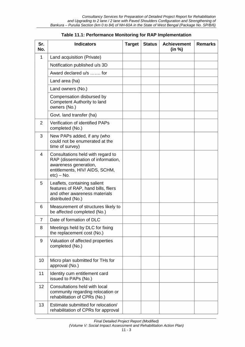
Consultancy Services for Preparation of Detailed Project Report for Rehabilitation and Upgrading to 2 lane / 2 lane with Paved Shoulders Configuration and Strengthening of
Bankura – Purulia Section (km 0 to 84) of NH-60A in the State of West Bengal (Package No. SP/B/6)
Final Detailed Project Report (Modified) (Volume V: Social Impact Assessment and Rehabilitation Action Plan)
11 - 3
Table 11.1: Performance Monitoring for RAP Implementation
Sr. No.
Indicators Target Status Achievement (in %)
Remarks
1 Land acquisition (Private)
Notification published u/s 3D
Award declared u/s ……. for
Land area (ha)
Land owners (No.)
Compensation disbursed by Competent Authority to land owners (No.)
Govt. land transfer (ha)
2 Verification of identified PAPs completed (No.)
3 New PAPs added, if any (who could not be enumerated at the time of survey)
4 Consultations held with regard to RAP (dissemination of information, awareness generation, entitlements, HIV/ AIDS, SCHM, etc) – No.
5 Leaflets, containing salient features of RAP, hand bills, fliers and other awareness materials distributed (No.)
6 Measurement of structures likely to be affected completed (No.)
7 Date of formation of DLC
8 Meetings held by DLC for fixing the replacement cost (No.)
9 Valuation of affected properties completed (No.)
10 Micro plan submitted for THs for approval (No.)
11 Identity cum entitlement card issued to PAPs (No.)
12 Consultations held with local community regarding relocation or rehabilitation of CPRs (No.)
13 Estimate submitted for relocation/ rehabilitation of CPRs for approval
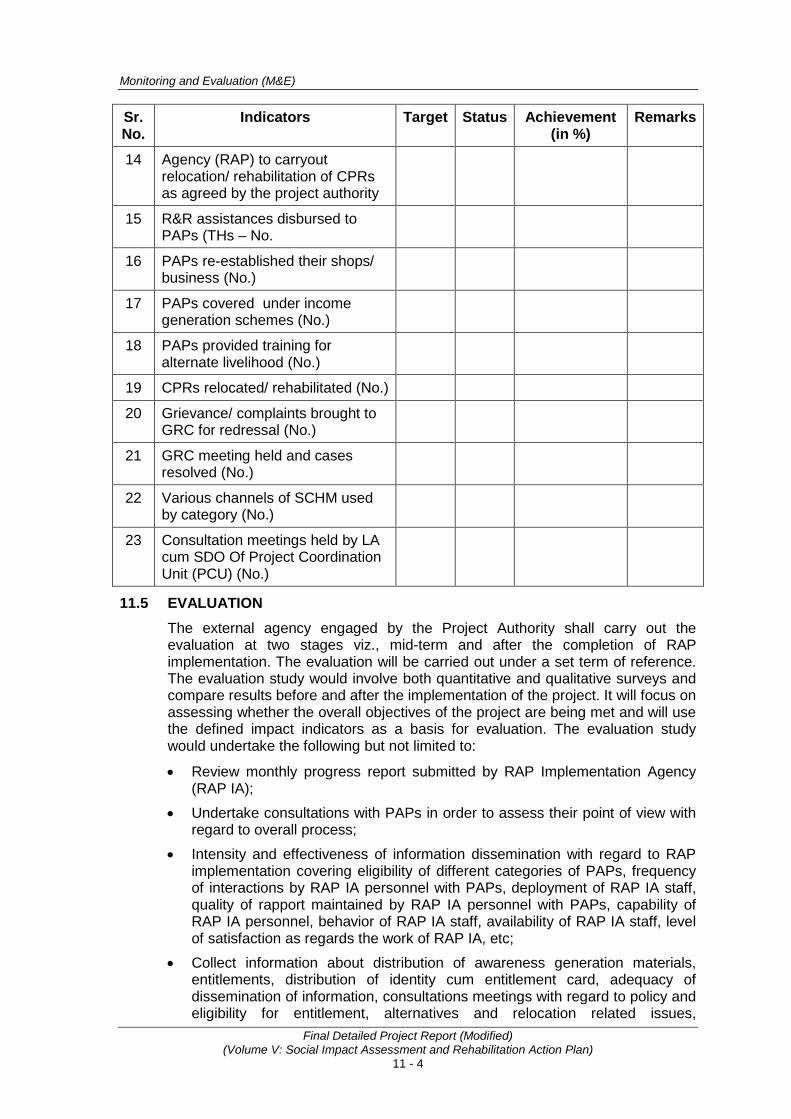
Monitoring and Evaluation (M&E)
Final Detailed Project Report (Modified) (Volume V: Social Impact Assessment and Rehabilitation Action Plan)
11 - 4
Sr. No.
Indicators Target Status Achievement (in %)
Remarks
14 Agency (RAP) to carryout relocation/ rehabilitation of CPRs as agreed by the project authority
15 R&R assistances disbursed to PAPs (THs – No.
16 PAPs re-established their shops/ business (No.)
17 PAPs covered under income generation schemes (No.)
18 PAPs provided training for alternate livelihood (No.)
19 CPRs relocated/ rehabilitated (No.)
20 Grievance/ complaints brought to GRC for redressal (No.)
21 GRC meeting held and cases resolved (No.)
22 Various channels of SCHM used by category (No.)
23 Consultation meetings held by LA cum SDO Of Project Coordination Unit (PCU) (No.)
11.5 EVALUATION The external agency engaged by the Project Authority shall carry out the evaluation at two stages viz., mid-term and after the completion of RAP implementation. The evaluation will be carried out under a set term of reference. The evaluation study would involve both quantitative and qualitative surveys and compare results before and after the implementation of the project. It will focus on assessing whether the overall objectives of the project are being met and will use the defined impact indicators as a basis for evaluation. The evaluation study would undertake the following but not limited to:
• Review monthly progress report submitted by RAP Implementation Agency (RAP IA);
• Undertake consultations with PAPs in order to assess their point of view with regard to overall process;
• Intensity and effectiveness of information dissemination with regard to RAP implementation covering eligibility of different categories of PAPs, frequency of interactions by RAP IA personnel with PAPs, deployment of RAP IA staff, quality of rapport maintained by RAP IA personnel with PAPs, capability of RAP IA personnel, behavior of RAP IA staff, availability of RAP IA staff, level of satisfaction as regards the work of RAP IA, etc;
• Collect information about distribution of awareness generation materials, entitlements, distribution of identity cum entitlement card, adequacy of dissemination of information, consultations meetings with regard to policy and eligibility for entitlement, alternatives and relocation related issues,
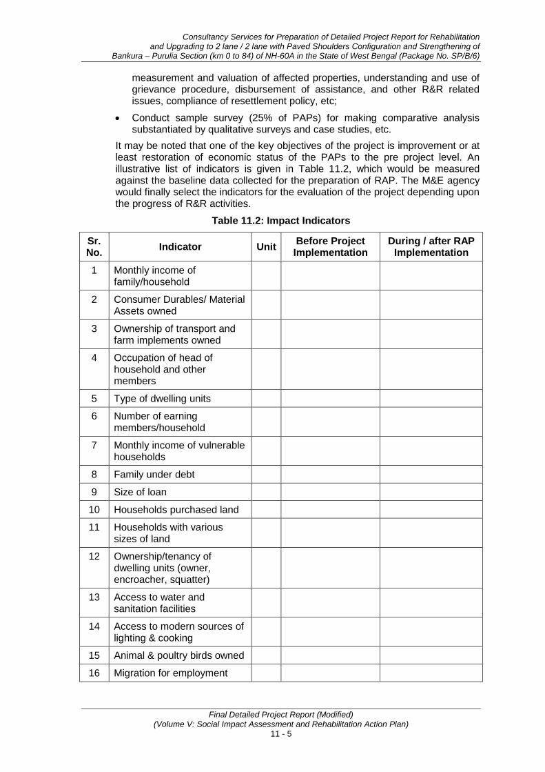
Consultancy Services for Preparation of Detailed Project Report for Rehabilitation and Upgrading to 2 lane / 2 lane with Paved Shoulders Configuration and Strengthening of
Bankura – Purulia Section (km 0 to 84) of NH-60A in the State of West Bengal (Package No. SP/B/6)
Final Detailed Project Report (Modified) (Volume V: Social Impact Assessment and Rehabilitation Action Plan)
11 - 5
measurement and valuation of affected properties, understanding and use of grievance procedure, disbursement of assistance, and other R&R related issues, compliance of resettlement policy, etc;
• Conduct sample survey (25% of PAPs) for making comparative analysis substantiated by qualitative surveys and case studies, etc.
It may be noted that one of the key objectives of the project is improvement or at least restoration of economic status of the PAPs to the pre project level. An illustrative list of indicators is given in Table 11.2, which would be measured against the baseline data collected for the preparation of RAP. The M&E agency would finally select the indicators for the evaluation of the project depending upon the progress of R&R activities.
Table 11.2: Impact Indicators
Sr. No. Indicator Unit Before Project
Implementation During / after RAP
Implementation
1 Monthly income of family/household
2 Consumer Durables/ Material Assets owned
3 Ownership of transport and farm implements owned
4 Occupation of head of household and other members
5 Type of dwelling units
6 Number of earning members/household
7 Monthly income of vulnerable households
8 Family under debt
9 Size of loan
10 Households purchased land
11 Households with various sizes of land
12 Ownership/tenancy of dwelling units (owner, encroacher, squatter)
13 Access to water and sanitation facilities
14 Access to modern sources of lighting & cooking
15 Animal & poultry birds owned
16 Migration for employment
Monitoring and Evaluation (M&E)
Final Detailed Project Report (Modified) (Volume V: Social Impact Assessment and Rehabilitation Action Plan)
11 - 6
11.6 REPORTING Monthly Progress Reports on the progress of RAP implementation including mobilization of staff members, opening of site offices, etc of the project would be prepared by RAP IA and submitted to the R&R Officer at sub-project level.
Quarterly Monitoring Reports shall be compiled by the LA cum SDO of Project Coordination Unit (PCU) and submitted to MoRTH.
Six monthly reports shall be prepared by the M&E agency by undertaking site visits and review of progress report, consultations, etc.
Evaluation Report shall be prepared by the M&E agency both at mid and end term of the project implementation as part of the project completion report.
Annexure 11.1 presents the reporting format in detailed.
• • •
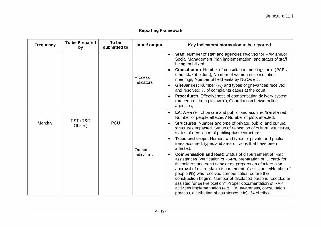
Annexure 11.1
A - 127
Reporting Framework
Frequency To be Prepared by
To be submitted to Input/ output Key indicators/information to be reported
Monthly PST (R&R Officer) PCU
Process indicators
• Staff: Number of staff and agencies involved for RAP and/or Social Management Plan implementation; and status of staff being mobilized.
• Consultation: Number of consultation meetings held (PAPs, other stakeholders); Number of women in consultation meetings; Number of field visits by NGOs etc.
• Grievances: Number (%) and types of grievances received and resolved; % of complaints cases at the court
• Procedures: Effectiveness of compensation delivery system (procedures being followed); Coordination between line agencies;
Output indicators
• LA: Area (%) of private and public land acquired/transferred; Number of people affected? Number of plots affected.
• Structures: Number and type of private, public, and cultural structures impacted. Status of relocation of cultural structures, status of demolition of public/private structures.
• Trees and crops: Number and types of private and public trees acquired; types and area of crops that have been affected.
• Compensation and R&R: Status of disbursement of R&R assistances (verification of PAPs, preparation of ID card- for titleholders and non-titleholders; preparation of micro plan, approval of micro-plan, disbursement of assistance/Number of people (%) who received compensation before the construction begins. Number of displaced persons resettled or assisted for self-relocation? Proper documentation of RAP activities implementation (e.g. HIV awareness, consultation process, distribution of assistance, etc), % of tribal
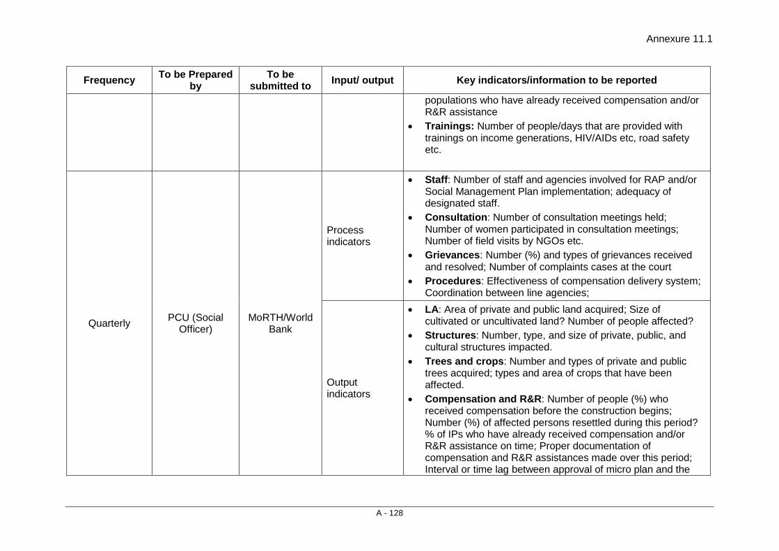
Annexure 11.1
A - 128
Frequency To be Prepared by
To be submitted to Input/ output Key indicators/information to be reported
populations who have already received compensation and/or R&R assistance
• Trainings: Number of people/days that are provided with trainings on income generations, HIV/AIDs etc, road safety etc.
Quarterly PCU (Social Officer)
MoRTH/World Bank
Process indicators
• Staff: Number of staff and agencies involved for RAP and/or Social Management Plan implementation; adequacy of designated staff.
• Consultation: Number of consultation meetings held; Number of women participated in consultation meetings; Number of field visits by NGOs etc.
• Grievances: Number (%) and types of grievances received and resolved; Number of complaints cases at the court
• Procedures: Effectiveness of compensation delivery system; Coordination between line agencies;
Output indicators
• LA: Area of private and public land acquired; Size of cultivated or uncultivated land? Number of people affected?
• Structures: Number, type, and size of private, public, and cultural structures impacted.
• Trees and crops: Number and types of private and public trees acquired; types and area of crops that have been affected.
• Compensation and R&R: Number of people (%) who received compensation before the construction begins; Number (%) of affected persons resettled during this period? % of IPs who have already received compensation and/or R&R assistance on time; Proper documentation of compensation and R&R assistances made over this period; Interval or time lag between approval of micro plan and the
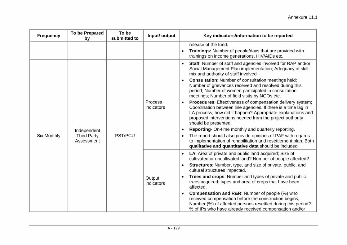
Annexure 11.1
A - 129
Frequency To be Prepared by
To be submitted to Input/ output Key indicators/information to be reported
release of the fund. • Trainings: Number of people/days that are provided with
trainings on income generations, HIV/AIDs etc.
Six Monthly Independent Third Party
Assessment PST/PCU
Process indicators
• Staff: Number of staff and agencies involved for RAP and/or Social Management Plan implementation; Adequacy of skill-mix and authority of staff involved
• Consultation: Number of consultation meetings held; Number of grievances received and resolved during this period; Number of women participated in consultation meetings; Number of field visits by NGOs etc.
• Procedures: Effectiveness of compensation delivery system; Coordination between line agencies. If there is a time lag in LA process, how did it happen? Appropriate explanations and proposed interventions needed from the project authority should be presented.
• Reporting- On-time monthly and quarterly reporting. • The report should also provide opinions of PAF with regards
to implementation of rehabilitation and resettlement plan. Both qualitative and quantitative data should be included.
Output indicators
• LA: Area of private and public land acquired; Size of cultivated or uncultivated land? Number of people affected?
• Structures: Number, type, and size of private, public, and cultural structures impacted.
• Trees and crops: Number and types of private and public trees acquired; types and area of crops that have been affected.
• Compensation and R&R: Number of people (%) who received compensation before the construction begins; Number (%) of affected persons resettled during this period? % of IPs who have already received compensation and/or

Annexure 11.1
A - 130
Frequency To be Prepared by
To be submitted to Input/ output Key indicators/information to be reported
R&R assistance on time; Proper documentation of compensation and R&R assistances made over this period; Interval or time lag between approval of micro plan and the release of the fund.
• Trainings: Number of people/days that are provided with trainings on income generations, HIV/AIDs etc.
Twice a year Independent third party evaluation
MoRTH/PIU/PST/World Bank
Includes both process and output indicators
• Staff- number of staff dedicated to RAP and/or SMP implementation; Adequacy of staff and their skills;
• Consultations- Is there adequate evidence of proper consultation being carried out with PAPs for R&R assistance? How well the consultations with community members are going in implementing RAP/SMP?
• LA- Has the LA been carried out prior to civil works? Were there adequate compensation, processes, and documentation followed for LA, structures, trees, crops etc?
• R&R – Has the R&R been adequately and timely carried out for both titleholders and non-titleholders?
• Gender- How well gender is mainstreamed? Is there adequate gender disaggregated data available?
• Indigenous Peoples- How well IPs has been consulted? Is there adequate evidence of proper IP consultations?
• Grievance- Has the GRM been adequately functioning? Are the PAPs happy with the GRM mechanism?
• Sample survey—A sample survey should be conducted to measure whether project affected people’s economic situation have improved. This exercise should clearly spell out before and after economic conditions of the displaced households.
• Reporting—how well the monitoring reports- monthly, quarterly, and six-monthly-- have been submitted to relevant authorities?

Annexure 11.1
A - 131
Frequency To be Prepared by
To be submitted to Input/ output Key indicators/information to be reported
At the end of project
Impact Evaluation-
Independent party
MoRTH/ PIU/World Bank
Includes both process and output indicators
• LA and R&R- % of PAPs who have more income now compared to their before LA status; Growth in market areas; Good practices and lessons learned on LA and R&R.
• Grievance- Success in conflict handling practices at different level of project implementation- PIC, PCU, and PST/PIU level.
• Consultations- Change in community consultation practices/behavior; Improvement in institutional coordination/consultations.
• Gender- % increase in women’s participation in community meeting; % decrease in gender gap in education, health, employment status.
• Tribal Peoples- % increase in household income of IPs; • Survey: A survey consisting both quantitative and qualitative
will be applied, to verify or derive above mentioned information.
• Accountability—how adequately the monitoring reports have been submitted to relevant authorities?

Consultancy Services for Preparation of Detailed Project Report for Rehabilitation and Upgrading to 2 lane / 2 lane with Paved Shoulders Configuration and Strengthening of
Bankura – Purulia Section (km 0 to 84) of NH-60A in the State of West Bengal (Package No. SP/B/6)
Final Detailed Project Report (Modified) (Volume V: Social Impact Assessment and Rehabilitation Action Plan)
12 - 1
12. IMPLEMENTATION ARRANGEMENT AND SCHEDULE
12.1 INTRODUCTION The implementation of the Resettlement Action Plan (RAP will consist of land acquisition and R & R activities. The programme schedule for the major tasks of the RAP is shown in Table 12.1. This schedule will be updated as the project progresses.
It is expected that the R&R activities of the project will be completed in approximately 24 months’ time
The implementation schedule as presented in Table 12.1 is linked with the estimated timing of the contractor’s mobilisation as the beginning of Year 1 of the project implementation.
12.2 THE IMPLEMENTATION PROCEDURE The implementation of the RAP consists of five major stages:
A. Deployment and training of staff at PIU Level;
B. Consulting Firm /NGO as RAP Implementation Agency;
C. Issuing of legal notification for land acquisition and the cut-off date;
D. Verification of entitled persons (EP) and estimation of their type and level of losses;
E. Preparation of list of EPs for relocation;
F. Relocation and rehabilitation of EPs.
The need for training of the MoRTH officials responsible for R&R activities and the RAP Implementation Agency (RIA) and the training contents have been addressed in Chapter- 8. As indicated therein, in addition to in-house capacity building, RAP IA and other professional organisations shall be hired for the R&R implementation.
12.3 THE BASIS OF IMPLEMENTATION The basis of RAP implementation is the PAP database. A PAP database in Microsoft Excel format has been developed containing census and socio-economic information.
The list of affected PAPs and assets needs to be verified prior to construction/upgrading works and adjustments made to the PAP database. There is a likelihood of the number of EPs increasing or decreasing. Increasing – by way of persons turning 18 or a shopkeeper hiring new employees on the date of the particular land acquisition. Decreasing – by way of death of an EP, or a shop employee leaving an affected establishment before land acquisition.
12.4 GENERAL ACTIVITIES • Appointment of staff at the PIU
• Contracting RAP Implementation Agency (Consulting Firm)
• District level committees set-up by the District Administration
• Training of the R&R managers and staff of RAP implemention agency for the implementation of the RAP

Implementation Arrangement and Schedule
Final Detailed Project Report (Modified) (Volume V: Social Impact Assessment and Rehabilitation Action Plan)
12 - 2
• Translation and printing of the R&R policy in local language. Preparing pamphlets of R&R policy in local language
• Distributing the R&R policy to the EPs
• Verification of the EPs
• Updating the census data base to include those who may have been left out during the census survey
• Distribution of Identity Cards
• Opening of joint accounts in the name of EP, representative of RAP implemention agency and the construction package level R&R officer
• Public consultations and creating awareness about the project amongst the PAPs
• Monitor physical and financial progress
• Prepare monthly progress reports.
12.5 LAND ACQUISITION Land will be permanently and temporarily affected by the project. (a) Permanent acquisition will be under the National Highways Act, 1956 and will
comprise the following activities: • Preparing land plans and land schedules for acquisition with details about
the total holding and the area affected
• Appointment of the competent authority
• Issue of notices as per the Land Acquisition Act for acquisition;
• Announcement of compensation award as per the Act;
• Issue of cheques in public places prior to taking possession;
(b) Temporarily affected land will facilitate civil works on the project roads by providing diversion routes for traffic and for earth works from borrow areas: • Contractor negotiates with owners the area to be leased;
• The contract signed between the owner and the contractor will include the terms of payment and return of the land to the owner;
• Complete payments will be made to the Contractor after the PIU is satisfied that the terms and conditions of the contract have been met;
• Returning the land after restoring to its original condition.
12.6 RESETTLEMENT • Civil works will begin only after compensation is paid • Verification of the displaced population – agriculture, residential and
commercial; • Identification of alternate plots in consultation with the people, if and where
required; • Disbursement of the R&R allowance to cover shifting, rental and wage loss; • Announcement and disbursement of the replacement value of the property
affected of EPs and payment through cheques in public places; • Building/relocating the community facilities in consultation with the
community;
Consultancy Services for Preparation of Detailed Project Report for Rehabilitation and Upgrading to 2 lane / 2 lane with Paved Shoulders Configuration and Strengthening of
Bankura – Purulia Section (km 0 to 84) of NH-60A in the State of West Bengal (Package No. SP/B/6)
Final Detailed Project Report (Modified) (Volume V: Social Impact Assessment and Rehabilitation Action Plan)
12 - 3
• Enhancement of the existing facilities identified in the RAP and any other during the course of implementation by the community.
12.7 REHABILITATION • Verification of EPs entitled to transitional allowance, alternative economic
rehabilitation support and economic rehabilitation grant; • Providing information to EPs to make informed choice about income
generation (IG) programme; • Training for upgrading of skills for IG programme; • Income generating activity for each EP to be planned by the EPs in
consultation with the RAP implemention agency. 12.8 RESETTLEMENT ACTION PLAN (RAP) COMPLETION
The resettlement action plan will be considered completed if all the activities mentioned/ envisioned in the RAP is implemented before demobilization of RAP implementation agency and the intended objectives of the RAP are achieved.
12.9 IMPLEMENTATION SCHEDULE Implementation schedule for resettlement, which is linked to the civil works contract, is presented in Table 12.1, which shows the scheduled activities linked to Resettlement and land acquisition procedures to indicate clearly what steps and actions will be taken at different stages of the project implementation cycle. As indicated, the Implementation schedule has been provided below (refer Table 12.1). The RAP will be implemented over a period of 24 months.

Implementation Arrangement and Schedule
Final Detailed Project Report (Modified) (Volume V: Social Impact Assessment and Rehabilitation Action Plan)
12 - 4
Table 12.1: Activity wise Implementation Schedule - Flow Chart
Sl. No. Preparatory Activities Month wise implementation Programme
1 2 3 4 5 6 7 8 9 10 11 12 13 14 15 16 17 18 19 20 21 22 23 24 Key Actions A Appointment and
Mobilization of Implementing Agency and Constitution of Grievance Redress Mechanisms
1. Appointment and Mobilization of RAP Implementation Agency (Consulting Firm)
2. Constitution/ Establishment of Grievance Redress Mechanisms
3. Constitution/Operationalization of Grievance Redress Mechanisms
4. Collection and review of RAP Report & other relevant documents by RAP Implementation Agency (RIA)
5. Initial consultations with MoRTH team for firming up the activity plan
6. Reconnaissance survey and rapport building with community & district
7. Mobilization of local level Technical support professional staff including Program Officer
8 Preparation and submission of inception report to the MoRTH

Consultancy Services for Preparation of Detailed Project Report for Rehabilitation and Upgrading to 2 lane / 2 lane with Paved Shoulders Configuration and Strengthening of
Bankura – Purulia Section (km 0 to 84) of NH-60A in the State of West Bengal (Package No. SP/B/6)
Final Detailed Project Report (Modified) (Volume V: Social Impact Assessment and Rehabilitation Action Plan)
12 - 5
Sl. No. Preparatory Activities Month wise implementation Programme
1 2 3 4 5 6 7 8 9 10 11 12 13 14 15 16 17 18 19 20 21 22 23 24 9. Training of RRO and project
staff for familiarization with RAP report
10. Orientation training of project staff (Program Officer Technical support professional staff) on the RAP
B Updating and implementation of RAP
11. Identification and Verification ( I & V) of PAPs and properties
12. Submission of Identification and Verification Report for NTH
13. Evolving land and building valuation methods
14. Measurement & valuation of land and structures (private/community etc.)
15. Preparation of entitlement/ assistance compensation for the TH
16. Preparation and submission of Micro Plans (NTH & TH)
17. Opening of bank account in joint names for disbursement
18. Preparation and Distribution of ID Cards
19. Disbursement of entitlement/ compensation/ assistance
C Resettlement Activities

Implementation Arrangement and Schedule
Final Detailed Project Report (Modified) (Volume V: Social Impact Assessment and Rehabilitation Action Plan)
12 - 6
Sl. No. Preparatory Activities Month wise implementation Programme
1 2 3 4 5 6 7 8 9 10 11 12 13 14 15 16 17 18 19 20 21 22 23 24 20. Consultation for shifting/
relocation of community / religious structures
21. Shifting/ self-relocation of community / religious structures
22. Encumbrance free site handing over to contractor
D Income restoration / livelihood generation activities
23. Training for skill upgradation 24. Temporary employment during
construction to the extent possible
E IEC and Awareness Campaign
25. Preparation and distribution of R&R policy document to the PAPs
26. Confidence building measures and awareness campaign for sharing information on RAP through participatory process
27. Consultation meetings with project staff, contractors and labours

Consultancy Services for Preparation of Detailed Project Report for Rehabilitation and Upgrading to 2 lane / 2 lane with Paved Shoulders Configuration and Strengthening of
Bankura – Purulia Section (km 0 to 84) of NH-60A in the State of West Bengal (Package No. SP/B/6)
Final Detailed Project Report (Modified) (Volume V: Social Impact Assessment and Rehabilitation Action Plan)
12 - 7
Sl. No. Preparatory Activities Month wise implementation Programme
1 2 3 4 5 6 7 8 9 10 11 12 13 14 15 16 17 18 19 20 21 22 23 24 28. Developing messages and
training material for awareness on HIV/ AIDS, Gender Issues, Child labour, Human Trafficing etc.
29. HIV / AIDS hoarding installation
30. Organize Health awareness campaign and programme on HIV/ AIDS for construction labours and others
F Monitoring and Reporting 31. Internal Monitoring Report 32. External Monitoring Report 33. Submission of Completion
Report
Full Time
Intermittent
Deliverables
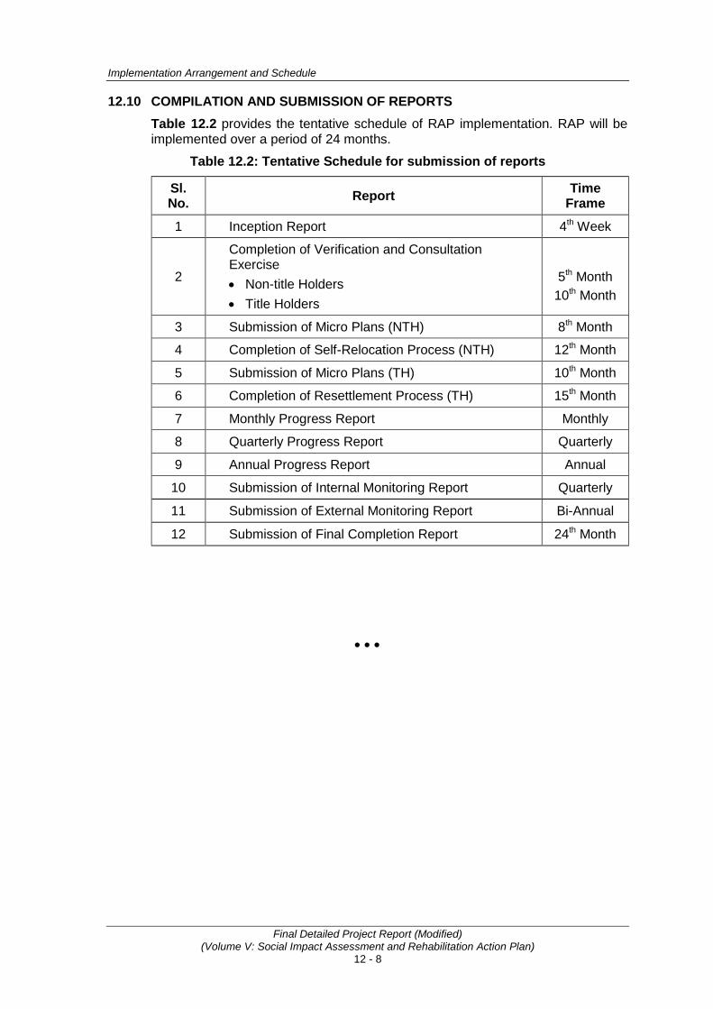
Implementation Arrangement and Schedule
Final Detailed Project Report (Modified) (Volume V: Social Impact Assessment and Rehabilitation Action Plan)
12 - 8
12.10 COMPILATION AND SUBMISSION OF REPORTS Table 12.2 provides the tentative schedule of RAP implementation. RAP will be implemented over a period of 24 months.
Table 12.2: Tentative Schedule for submission of reports
Sl. No. Report Time
Frame
1 Inception Report 4th Week
2
Completion of Verification and Consultation Exercise • Non-title Holders • Title Holders
5th Month
10th Month
3 Submission of Micro Plans (NTH) 8th Month
4 Completion of Self-Relocation Process (NTH) 12th Month
5 Submission of Micro Plans (TH) 10th Month
6 Completion of Resettlement Process (TH) 15th Month
7 Monthly Progress Report Monthly
8 Quarterly Progress Report Quarterly
9 Annual Progress Report Annual
10 Submission of Internal Monitoring Report Quarterly
11 Submission of External Monitoring Report Bi-Annual
12 Submission of Final Completion Report 24th Month
• • •
Annexure 12.1
A - 132
Draft Terms of References (TOR) for the RAP Implementation Agency (Consulting Firm) to Implement
the Resettlement Action Plan (RAP)
1. Project Background Ministry of Road Transport & Highways (MoRTH), Government of India has decided to take up the work of upgrading all the single lane / intermediate lane National Highways to at-least two lane standards or Two Lane with provision of Paved Shoulders depending upon requirement on up-gradation corridor concept in order to have a better facility in a long continuous stretch. The Project is likely to be financed by World Bank. The project envisages the following advantages of having a well-developed network of highways:
• Savings in vehicle operating costs
• Faster, comfortable journeys
• Reduced fuel consumption
• Safer travel
• Benefits to trade especially in movement of perishable goods
• Reduced maintenance costs
• Safe travel
• All round development of areas
A total 33 No. of different National Highway Stretches with approx. total length 3770 Km. have been selected by MoRTH for up-gradation which has been divided under four main groups. The under consideration project package pertains to the preparation of Detailed Project Report for Rehabilitation and Upgrading to 2 lane/2 lane with paved shoulders configuration and strengthening of Bankura - Purulia Section (Km. 0 to Km. 84.000) of NH-60A in the State of West Bengal which falls under “Group B” and the package no. is SP/B/6.
The present project National Highway No. 60A (0.00 Km. to 84.000 Km.) aims to:
• Improve and strengthen the existing quality of the pavement to take heavy loads so that pavement failure, maintenance etc. are minimized.
• Improve the horizontal and vertical alignment of the existing road.
• Improve the condition of existing traffic flow by removing all bottlenecks at various locations.
• Increase the carrying capacity of the existing traffic volume and enable it to cater to the future traffic.
• Improve accessibility of the existing highway.
• Provide highway amenities like Lay-bye, bus stop/shelters etc.
• improve the numerous intersections on entire stretch of the highway linkage of the NH-60A within the section (0.00 Km. to 84.000 Km.)
2. Objectives of the Assignment The RAP IMPLEMENTING AGENCY (CONSULTING FIRM) shall be responsible for the following, according to the Resettlement Plan:
• Educating the PAPs on their rights to entitlements and obligations.
Annexure 12.1
A - 133
• To ensure that the PAPs are given the full entitlements due to them, according to the entitlements in the RAP.
• To provide support and information to PAPs for income restoration.
• Assist the PAPs in relocation and rehabilitation, including counseling, and coordination with local authorities.
• Assist the PAPs in redressing their grievances (through the grievance redress committee set up by the subproject)
• Impart information to all the PAPs about the functional aspects of the various set up by the project, and assist them in benefiting from such institutional mechanisms.
• To assist the Project Management Unit (PMU) and Project Implementation Unit (PIU) with social responsibilities of the subproject, such as compliance with labour laws, prohibition of child labour, and gender issues.
• To conduct awareness program for HIV/AIDs, Human Trafficking.
• To collect data and submit progress reports on a monthly and quarterly basis for PIU to monitor the progress of RAP implementation.
3. Scope of Work The RAP IMPLEMENTING AGENCY (CONSULTING FIRM) shall play the role of a secondary stakeholder in implementation of the RAP and in mitigating adverse effects of the project. The RAP IMPLEMENTING AGENCY (CONSULTING FIRM) shall be responsible for the development of a comprehensive livelihood restoration system to facilitate the PAPs to take advantage of the options available (as per the RAP).
3.1 Administrative Responsibilities of the RAP IMPLEMENTING AGENCY (CONSULTING FIRM) The administrative responsibilities of the RAP IMPLEMENTING AGENCY (CONSULTING FIRM) will include:
• Working in co-ordination with the Project Resettlement Officer (RO) in the PMU and Resettlement Officer in the PIU;
• Assist the RO in carrying out the implementation of the RAP;
• To co-ordinate with the GRCs in implementing the RAP;
• Assist the RO in conducting all public meetings, information campaigns at the commencement of the project and give full information to the affected community;
• Translate the summary RAP in local language to implement actions for mitigating adverse impacts on the PAPs;
• To assist the PIU/Engineers (Construction Supervision Consultants) to ensure that the Contracts comply with the applicable labour laws (including prohibition of child labour) and gender issues;
• To assist the PIU and /or the Engineers in ensuring compliance with the safety, health and hygiene norms, and the conduct HIV/AIDS and Human Trafficking awareness/prevention campaigns.
• Report to the RO on a monthly and quarterly basis. The report should include physical and financial progress, both in quantitative and qualitative terms. The report should prominently feature the problems and issues addressed and tackled with the PAPs and the solutions found. The report should have a
Annexure 12.1
A - 134
separate chapter on women's issues, their problems and what has been done (within the framework of the RAP) to ensure their participation in decision-making as well as the options made available to them to access economic opportunities, marketing and credit. The report should clearly indicate the number of field visits made by the RAP IMPLEMENTING AGENCY (CONSULTING FIRM) staff and the outcome of consultations with people.
• Data base management of the PAPs.
• The displaced persons will be assisted in the Income Generation Scheme training through the RAP IMPLEMENTING AGENCY (CONSULTING FIRM) i.e. the provision made for training will be best utilized through the active support and involvement of the RAP IMPLEMENTING AGENCY (CONSULTING FIRM).
3.2 Responsibilities for Implementation of the RAP 3.2.1 Identification PAPs and Verification of Database from RAP
• RAP IMPLEMENTING AGENCY (CONSULTING FIRM) shall verify the information already contained in the RAP and the individual losses of the PAPs. They should validate the data provided in the RAP and make suitable changes if required. The RAP IMPLEMENTING AGENCY (CONSULTING FIRM) shall establish rapport with PAPs, consult and provide information to them about the respective entitlements as proposed under the RAP, and distribute entitlement cum Identity Cards to the eligible PAPs. The identity card should include a photograph of the PAP, the extent of loss suffered due to the project, and the choice of the PAP with regard to the mode of compensation and assistance.
• The RAP IMPLEMENTING AGENCY (CONSULTING FIRM) shall develop rapport between the PAPs and the Project Authority, particularly the RO. This will be achieved through regular meetings with both the RO and the PAPs. Meetings with the RO will be held at least fortnightly, and meetings with the PAPs will be held monthly, during the entire duration of the assignment. All meetings and decisions taken shall be documented by the RAP IMPLEMENTING AGENCY (CONSULTING FIRM).
• Prepare monthly action plans with targets in consultation with the RO.
• The RAP IMPLEMENTING AGENCY (CONSULTING FIRM) shall prepare a list of the project-displaced persons/families for relocation, enlisting the losses and the entitlements, after verification. It shall also prepare a list of the displaced persons (PAPs) enlisting the losses and the entitlement as per the RAP, after verification. Verification shall include actual measurement of the extent of total property loss/damage, and valuation of the loss/damage/affect along with the RO. The RAP IMPLEMENTING AGENCY (CONSULTING FIRM) shall display the list of eligible PAPs in prominent public places like villages, Panchayat Offices, Block/Tehsil headquarters, and the District Headquarters.
• During the identification and verification of the eligible PAPs, the RAP IMPLEMENTING AGENCY (CONSULTING FIRM) shall ensure that each of the PAPs are contacted and consulted either in groups or individually. The RAP IMPLEMENTING AGENCY (CONSULTING FIRM) shall specially ensure consultation with women from the PAP families especially women headed households.
• Participatory methods should be adopted in assessing the needs of the PAPs, especially with regard to the vulnerable groups of PAPs. The methods of contact may include village level meetings, gender participation through group’s interactions, and Individual meetings and interactions.
Annexure 12.1
A - 135
• While finalizing the entitled persons (EPs) for compensation/assistance the RAP IMPLEMENTING AGENCY (CONSULTING FIRM) shall make a list of entitled PAPs, and distribute Identity Cards to each and every verified eligible PAP.
3.2.2 Counseling the Entitled Persons The counseling shall include the following activities:
• The RAP IMPLEMENTING AGENCY (CONSULTING FIRM) shall explain to the PAPs the provisions of the policy and the entitlements under the RAP. This shall include communication to the roadside squatters and encroachers about the need for their eviction, the timeframe for their removal and their entitlements.
• The RAP IMPLEMENTING AGENCY (CONSULTING FIRM) shall disseminate information to the PAPs on the possible consequences of the project on the communities' livelihood systems and the options available, so that they do not remain ignorant.
• The RAP IMPLEMENTING AGENCY (CONSULTING FIRM) shall prepare micro-level plans for income restoration, in consultation with the PAPs. Women's perceptions are important to be incorporated in the development of these plans.
• RAP IMPLEMENTING AGENCY (CONSULTING FIRM) will monitor the involvement of child labour in the civil construction work in each package.
• In all of these, the RAP IMPLEMENTING AGENCY (CONSULTING FIRM) shall consider women as a special focus group, and deal with them with care and sympathy.
3.2.3 Disbursing the Assistance • Prepare micro plans indicating category of entitlement. • Prepare micro plans for livelihood indicating alternative livelihood options, land
identification, skills up grading and institutions responsible for training for eligible PAPs.
• The RAP IMPLEMENTING AGENCY (CONSULTING FIRM) shall assist the project authorities in ensuring a smooth transition (during the part or full relocation of the PAPs), helping the PAPs to take salvaged materials and shift. In close consultation with the PAPs, the RAP IMPLEMENTING AGENCY (CONSULTING FIRM) shall inform the RO about the shifting dates agreed with the PAPs in writing and the arrangements desired by the PAPs with respect to their entitlements.
• The RAP IMPLEMENTING AGENCY (CONSULTING FIRM) shall assist the PAPs in opening bank accounts explaining the implications, the rules and the obligations of a joint account and how s/he can access the resources s/he is entitled to.
• The RAP IMPLEMENTING AGENCY (CONSULTING FIRM) shall ensure proper utilisation of the R&R budget available for each of the packages. The RAP IMPLEMENTING AGENCY (CONSULTING FIRM) shall ensure that the PAPs have found economic investment options and are able to restore the losses of land and other productive assets. The RAP IMPLEMENTING AGENCY (CONSULTING FIRM) shall identify means and advise the RO to disburse the entitlements to the eligible persons/families in a manner that is transparent, and shall report to the BSRDC on the level of transparency achieved in the project.

Annexure 12.1
A - 136
3.2.4 Accompanying and Representing the EPs at the Grievance Committee Meetings • The RAP IMPLEMENTING AGENCY (CONSULTING FIRM) shall nominate a
suitable person (from the staff of the RAP IMPLEMENTING AGENCY (CONSULTING FIRM)) to be a member of the GRCs for the respective contract packages.
• The RAP IMPLEMENTING AGENCY (CONSULTING FIRM) shall make the PAPs aware of the grievance redress committees (GRCs)
• The RAP IMPLEMENTING AGENCY (CONSULTING FIRM) shall train the PAPs on the procedure to file a grievance application and to confirm that a statement of claim from the concerned PAP accompanies each grievance application. The RAP IMPLEMENTING AGENCY (CONSULTING FIRM) shall help the PAPs in filling the grievance application and also in clearing their doubts about the procedure as well as the context of the GRC award.
• The RAP IMPLEMENTING AGENCY (CONSULTING FIRM) shall record the grievance and bring it to the notice of the GRCs within seven days of receipt of the grievance from the PAPs. It shall submit a draft resolution with respect to the particular grievance of the AP, suggesting multiple solutions, if possible, and deliberate on the same in the GRC meeting through the RAP IMPLEMENTING AGENCY (CONSULTING FIRM) representative in the GRC.
• To accompany the PAPs to the GRC meeting on the decided date, help the PAP to express his/her grievance in a formal manner if requested by the GRC and again inform the PAPs of the decisions taken by the GRC within 3 days of receiving a decision from the GRC. (The time frame for the GRC to take a decision is 15 days).
3.2.5 Assisting the EPs and the RO to Identity and Negotiate for New Land for Resettlement As part of the RAP, it is proposed that a sizable number among the eligible PAPs will receive alternative land (commercial) building structures. Some of the more vulnerable among the PAPs will be eligible to receive these free of cost. Regarding these the RAP IMPLEMENTING AGENCY (CONSULTING FIRM) shall, • Obtain the PAPs choice in terms of Land identification, Site for relocation, Shifting
plan and arrangements, Grant utilization plan and Community asset building plan and institutional arrangements in maintaining the assets.
• Assist squatters whose structures needs to be shifted to the remaining government land for continuation of earning their livelihood before construction of road starts.
• Assist the PAPs/ RO in identifying suitable land for relocation and for agriculture, ensuring the replacement of the land lost in terms of quality and quantity.
• Identify suitable government land in consultation with the Revenue Department officials and assist in negotiating its transfer to the PAPs/ RO at reasonable prices and motivate them to appreciate and welcome the new neighbors.
3.2.6 Assisting Eligible PAPs to take advantage of the existing Government Housing and Employment Schemes With regard to the above, the RAP IMPLEMENTING AGENCY (CONSULTING FIRM) shall, • Co-ordinate (and impart wherever required) the training and capacity building of
the PAPs, for upgrading their skills for income restoration. This will include the training to be given by the RAP IMPLEMENTING AGENCY (CONSULTING
Annexure 12.1
A - 137
FIRM) to women self-help-group members in accounting, record maintenance, skill acquisition in the chosen enterprise, and marketing, etc.
• Help the PAPs in realizing and optimizing the indigenous technology knowledge (ITK) through use of local resources.
• Define, evolve, and explore alternative methods of livelihood using the local skill and resources.
• Contact financial institutions like NABARD, DIC, and the Lead Bank of the area in accessing the credit required by the individual as well as groups of PAPs and the women's groups from the PAPs. The RAP IMPLEMENTING AGENCY (CONSULTING FIRM) shall maintain a detailed record of such facilitation, and plan for each PAP to repay the loan.
• Establish linkages with the district administration to ensure that the PAPs are benefited from the schemes available and those they are entitled to. The focus for this component of the RAP IMPLEMENTING AGENCY (CONSULTING FIRM) work shall be the vulnerable PAPs for their income restoration. The RAP IMPLEMENTING AGENCY (CONSULTING FIRM) shall maintain a detailed record of such facilitation.
3.2.7 Inter-Agency Linkages for Income Restoration and other R&R Services The RAP IMPLEMENTING AGENCY (CONSULTING FIRM) shall be responsible for establishing linkages with,
• Financial institutions to assist the PAPs to access credit. • Government departments, district administration, etc., to ensure that the PAPs
are included in the development schemes, as applicable; • Training institutes to impart skills and management training for enterprise creation
and development. • RAP IMPLEMENTING AGENCY (CONSULTING FIRM) shall conduct training
programs for income restoration for PAPs. • RAP IMPLEMENTING AGENCY (CONSULTING FIRM) should prepare an
income restoration plan. 3.2.8 Assisting the Supervision Consultant with the Project’s Social Responsibilities
The RAP IMPLEMENTING AGENCY (CONSULTING FIRM) shall assist the Engineers (Supervision Consultants) to ensure that the Contractors are abiding by the various provisions of the applicable laws, concerning the worker's safety, health and hygiene; women's issues and the child labor issues. The applicable laws include (A) the maternity benefit Act, 1951; (B) the contract labor (Regulation and Abolition) Act, 1948; (C) the Minimum Wagers act, 1948. (D) The Equal Remuneration Act, 1979. (E) the industrial Employment (Standing Order) Act, 1946; (F) the Child Labor (Prohibition and Regulation ) Act, 1986; (G) the Building and Other Construction Workers (Regulation of Employment and Conditions of Service) Act 1996; (H) the Act of 1996 and (I) the Factories Act, 1948. any divergence from the (workers welfare and remuneration, safety, health, hygiene, women's issues, and child labor issues) provisions of these laws should be brought to the notice of the supervision consultant and the RO. According to these laws, there are specifications regarding the facilities/requirements at the construction camp/site, including basic health care facilities, Mother and Child Welfare units and facilities for vaccinations, day crèche facilities, etc. The RAP IMPLEMENTING AGENCY (CONSULTING FIRM) shall work in co-ordination of the Lady Inspector of Works or the Resident engineers of the Contractor, or any other representative of the Contractors, to ensure these facilities are provided in a

Annexure 12.1
A - 138
satisfactory manner, and all social responsibilities of the Contract is implemented satisfactorily. Coordinate with the Environmental Officer to facilitate consultation on rehabilitation of borrow areas.
3.2.9 Assisting the PMU/Supervision Consultant in HIV/AIDS Awareness/Prevention Campaigns Information campaigns/advertisements in collaboration with line agencies (such as NACO, DFID, etc), including provision of signage/hoardings at suitable locations, distribution of vehicle stickers, and provision of condom vending machines at suitable locations (rest areas, truck parking lay-byes, etc.). The RAP IMPLEMENTING AGENCY (CONSULTING FIRM) shall assist the PMU to implement these measures, including collaboration with the line agencies. The contractors are required to provide condom vending machines at the construction camps, provide for medical facilities and regular medical checkups especially for detecting/curing STD/AIDS. The RAP IMPLEMENTING AGENCY (CONSULTING FIRM) shall ensure, in collaboration with the Engineer that such facilities and medical checkups are provided to the workers at the construction camps.
3.2.10 Monitoring and Reporting The RAP includes provision for monthly internal monitoring by RAP IMPLEMENTING AGENCY (CONSULTING FIRM)/ RO and quarterly, mid-term, and post-project monitoring and Reporting by external agency. The RAP IMPLEMENTING AGENCY (CONSULTING FIRM) involved in the implementation of the RAP will be required to supply all information, documents to the external monitoring and Reporting consultants. To this end, the RAP IMPLEMENTING AGENCY (CONSULTING FIRM) shall keep proper documentation of their work and the R&R process involved in the project, and shall be responsible for the upkeep and updating of such documents periodically and regularly. The documentation shall include photographs and videotapes of the pre-intervention and post-intervention scenario of all the properties, structures, and assets affected by the project. 72
3.2.11 Recommending Improvement of R&R Services • Extend all services recommended by any additional studies to be undertaken by
the project, in respect to the R&R services to be provided as part of the project. • Recommend and suggest techniques and methods for improvement of services
extended by the concerned government departments and other agencies and committees in disbursement/extension of R&R services in the project.
• Document implementation of the R&R process and services, including difficulties faced and corresponding solutions.
• Discuss, with the PMU/PIU on contingency management and other improvement of R&R services, within the project period.
• Documenting of tasks carried out by the RAP IMPLEMENTING AGENCY (CONSULTING FIRM) and Reporting of the achievements of RAP.
3.3 Documentation and Reporting by RAP IMPLEMENTING AGENCY (CONSULTING FIRM) The RAP IMPLEMENTING AGENCY (CONSULTING FIRM) selected for the assignments shall be responsible to: • Submit an inception report within three weeks; on signing up of the contract
including a work plan for the whole contract period, staffing and personnel

Annexure 12.1
A - 139
deployment plan, and a withdrawal plan at the end of the period of contract. The withdrawal plan shall be detailed and reflect how the PAPs will maintain the assets created and transferred to the PAPs.
• Prepare monthly progress reports to be submitted to the RO, with weekly progress and work charts as against the scheduled timeframe of RAP implementation.
• Prepare and submit quarterly reports on a regular basis, to be submitted to the RO.
• Submit a completion report at the end of the contract period summarizing the actions taken during the project, the methods and personnel used to carry out the assignment, and a summary of support/assistance given to the PAPs.
• All other reports/documentation as described in these terms of reference. • Record minutes of all meetings. All progress reports shall include data on input and output indicators as required by the RO. Reporting in writing as well as photographs, videotapes etc., taken during the assignment shall be submitted in support of the reports, along with an electronic copy of the documents in a floppy or a CD. All reports should be in English only. Accounts reports both on expenditure on administration as well as training and other heads shall be submitted with the quarterly and the completion reports. In addition to these above, the RAP IMPLEMENTING AGENCY (CONSULTING FIRM) shall prepare and submit separate descriptive reports on participatory micro-plans with full details of the Participatory Rapid Appraisal exercises conducted. The RAP IMPLEMENTING AGENCY (CONSULTING FIRM) shall document in full detail, the consultation/counseling processes, the process of identification of the resettlement sites, and a full description of the training imparted (on facilitated) as part of the assignment.
3.4 Condition of Services The RAP IMPLEMENTING AGENCY (CONSULTING FIRM) shall ensure that the RAP is implemented in an effective and proper manner. The prime responsibility of the RAP IMPLEMENTING AGENCY (CONSULTING FIRM) shall be to ensure that each and every eligible PAP receives appropriate and due entitlement (within the Entitlement Framework) and that, at the end of the project R&R services, the eligible PAPs have improved (or at least restored) their previous standard of living. Additionally the RAP IMPLEMENTING AGENCY (CONSULTING FIRM) shall help the PMU/PIU in all other matters deemed to be required to implement the RAP in its spirit and entirely including activities involving some financial implications. All documents created, generated or collected during the period of contract, in carrying out the services under this assignment will be the property of the PMU/PIU. No information gathered or generated during and in carrying out this assignment shall be disclosed by the RAP IMPLEMENTING AGENCY (CONSULTING FIRM) without explicit permission of the PMU/PIU.
3.5 Timeframe for Services The RAP IMPLEMENTING AGENCY (CONSULTING FIRM) will be contracted for a period of 24 months from the date of commencement, with a withdrawal methodology built in to the proposals from the RAP IMPLEMENTING AGENCY (CONSULTING FIRM).

Annexure 12.1
A - 140
3.6 Data, Services and Facilities to be provided by the Client The PMU/PIU will provide to the RAP IMPLEMENTING AGENCY (CONSULTING FIRM) the copies of the SIA/RAP report/ PAPs' Census, the strip plan final design report and any other relevant reports/data prepared by the project preparation consultants. The PMU/PIU will assist the RAP IMPLEMENTING AGENCY (CONSULTING FIRM) in collaborating with the Supervision Consultants. All facilities required in the performance of the assignment, including office space, office stationery, transportation and accommodation for staff of the RAP IMPLEMENTING AGENCY (CONSULTING FIRM), etc., shall be arranged by the RAP IMPLEMENTING AGENCY (CONSULTING FIRM).
3.7 Payment Schedule: The following payment milestone is proposed for making the payment to the RAP IMPLEMENTING AGENCY (CONSULTING FIRM). The payment will be made subject to the submission of a certificate from the PMU/PIU/RO that the targets have been achieved in a satisfactory manner.
Sl. No. Payment Milestone Payment (% of
contract Value)
1.
On submission of the inception Report complete in all respects 20%
2.
On completion of the identification, verification of PAPs and initial consultation sessions, and submission of updated data on PAPs (Identification and Verification report) and review of the same by the PMU/PIU.
20%
3.
On submission and approval of the Micro Plan of PAPs 20%
4.
On completion of the rehabilitation process and implementation of I.R. Plan 20%
5.
On submission of the Final Completion Report 20%
Total 100%
The above remuneration includes all costs related to carrying out the services, including overhead. The service tax or any other tax component shall be reimbursed/ paid to RAP IMPLEMENTING AGENCY (CONSULTING FIRM) on production of documents. The insurance cost will be separate of the total project cost; the client shall be billed for this.
3.8 Team for the Assignment The RAP IMPLEMENTING AGENCY (CONSULTING FIRM) shall assign a team of professionals to the site. The constitution of the team and the qualification for the team members is given below:
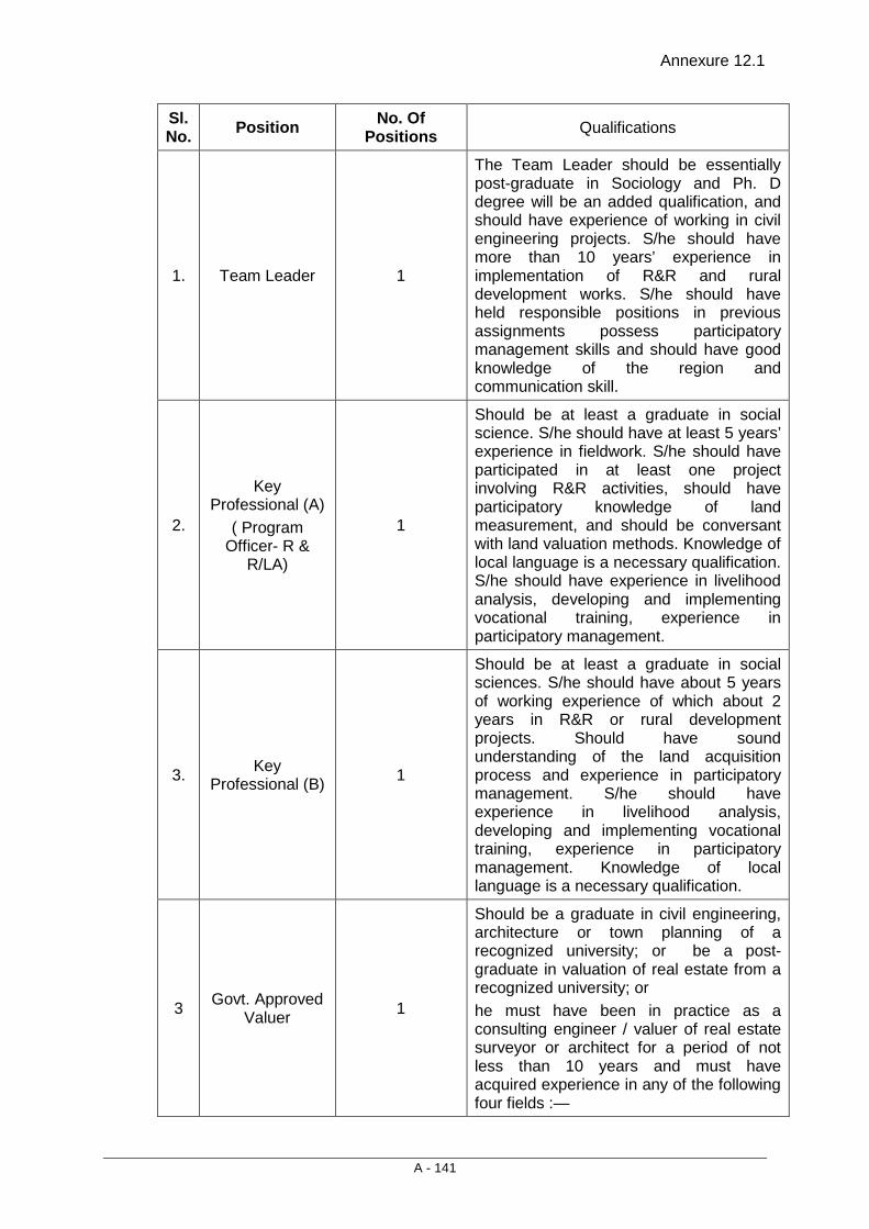
Annexure 12.1
A - 141
Sl. No. Position No. Of
Positions Qualifications
1.
Team Leader 1
The Team Leader should be essentially post-graduate in Sociology and Ph. D degree will be an added qualification, and should have experience of working in civil engineering projects. S/he should have more than 10 years’ experience in implementation of R&R and rural development works. S/he should have held responsible positions in previous assignments possess participatory management skills and should have good knowledge of the region and communication skill.
2.
Key Professional (A)
( Program Officer- R &
R/LA)
1
Should be at least a graduate in social science. S/he should have at least 5 years’ experience in fieldwork. S/he should have participated in at least one project involving R&R activities, should have participatory knowledge of land measurement, and should be conversant with land valuation methods. Knowledge of local language is a necessary qualification. S/he should have experience in livelihood analysis, developing and implementing vocational training, experience in participatory management.
3.
Key Professional (B) 1
Should be at least a graduate in social sciences. S/he should have about 5 years of working experience of which about 2 years in R&R or rural development projects. Should have sound understanding of the land acquisition process and experience in participatory management. S/he should have experience in livelihood analysis, developing and implementing vocational training, experience in participatory management. Knowledge of local language is a necessary qualification.
3 Govt. Approved Valuer 1
Should be a graduate in civil engineering, architecture or town planning of a recognized university; or be a post-graduate in valuation of real estate from a recognized university; or he must have been in practice as a consulting engineer / valuer of real estate surveyor or architect for a period of not less than 10 years and must have acquired experience in any of the following four fields :—
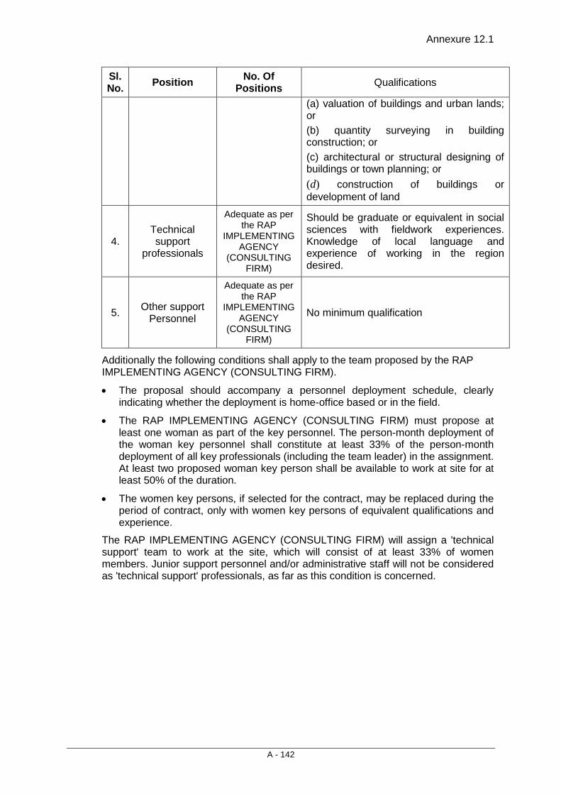
Annexure 12.1
A - 142
Sl. No. Position No. Of
Positions Qualifications
(a) valuation of buildings and urban lands; or (b) quantity surveying in building construction; or (c) architectural or structural designing of buildings or town planning; or (d) construction of buildings or development of land
4.
Technical support
professionals
Adequate as per the RAP
IMPLEMENTING AGENCY
(CONSULTING FIRM)
Should be graduate or equivalent in social sciences with fieldwork experiences. Knowledge of local language and experience of working in the region desired.
5.
Other support Personnel
Adequate as per the RAP
IMPLEMENTING AGENCY
(CONSULTING FIRM)
No minimum qualification
Additionally the following conditions shall apply to the team proposed by the RAP IMPLEMENTING AGENCY (CONSULTING FIRM).
• The proposal should accompany a personnel deployment schedule, clearly indicating whether the deployment is home-office based or in the field.
• The RAP IMPLEMENTING AGENCY (CONSULTING FIRM) must propose at least one woman as part of the key personnel. The person-month deployment of the woman key personnel shall constitute at least 33% of the person-month deployment of all key professionals (including the team leader) in the assignment. At least two proposed woman key person shall be available to work at site for at least 50% of the duration.
• The women key persons, if selected for the contract, may be replaced during the period of contract, only with women key persons of equivalent qualifications and experience.
The RAP IMPLEMENTING AGENCY (CONSULTING FIRM) will assign a 'technical support' team to work at the site, which will consist of at least 33% of women members. Junior support personnel and/or administrative staff will not be considered as 'technical support' professionals, as far as this condition is concerned.

Consultancy Services for Preparation of Detailed Project Report for Rehabilitation and Upgrading to 2 lane / 2 lane with Paved Shoulders Configuration and Strengthening of
Bankura – Purulia Section (km 0 to 84) of NH-60A in the State of West Bengal (Package No. SP/B/6)
Final Detailed Project Report (Modified) (Volume V: Social Impact Assessment and Rehabilitation Action Plan)
13 - 1
13. INCOME RESTORATION
13.1 INTRODUCTION
Involuntary resettlement is an inevitable outcome of development-induced displacement, which disrupts livelihood and sometimes sources of livelihood lost permanently. In many cases, impacts on existing properties, assets and resources lead to impoverishment. One of the main objectives of the RAP is to restore livelihood conditions of the PAPs at pre-project level; if not enhanced. It is, therefore, important that the project includes income restoration mechanism. Generally, R&R has been limited to payment of compensation and some training for skill up-gradation to support income generation activities, which usually provide relief for a short duration. There has been an increasing realisation of the fact that livelihood assistance under the project is not enough and R&R activities must endeavor for income restoration measures aimed at long term sustainability. The RPF provides for livelihood restoration and also covers strategy to be adopted for income generation on a long term basis.
13.2 DISRUPTION OF LIVELIHOOD OF HHs
Consultations and interactions with these PAPs indicated that majority of squatters and kiosks operate from temporary structure and, hence, they would shift their structures back or to a nearby locality and be able to re-establish their activities within a short period of time. Majority of the PAPs, whose livelihood is likely to be disrupted, preferred cash grant as income restoration options during consultations. Several of them pointed out that it is very difficult to enter into a new profession and, therefore, continue with the existing occupation instead of entering into new vocation. Further, the cash grant would help re-establish their business in nearby locality.
Disruption of livelihood under this sub-project will not be significant as it has, in general, impact on frontage of most of commercial structures and hardly has dislocation risk. It is also reflected in the analysis of impact severity, where 95.43% of such structures have impact less than 10 percent on the total structures.
Severity of impacts on structures has been assessed by taking measurements with respect to widening proposal. It has been categorized in to four groups’ viz., less than or equal to 10%, 11% to 25%, 26% to 50% and more than 50%. All the structures falling in the first category i.e. about 98% would not require relocation. Approximately, 56.7% of the structures are likely to be affected are pucca in nature.
Table 13.1: Severity of impact on structures
Typology of
Structures
Severity of Impacts (%) Total ≤ 10 11 to 25 26 to 50 > 50
No. % No. % No. % No. % No. % Pucca 374 55.99 9 56.25 1 50 13 92.86 397 56.71 Semi-Pucca 188 28.14 3 18.75 1 50 1 7.14 193 27.57 Kutcha 106 15.87 4 25.00 0 0 0 0.00 110 15.72 Total 668 100.00 16 100.00 2 100.00 14 100.00 700 100.00 %Age 95.43 2.28 0.29 2.00 100.00
Source: Socio-Economic March 2011 and updated in March 2013
Income Restoration
Final Detailed Project Report (Modified) (Volume V: Social Impact Assessment and Rehabilitation Action Plan)
13 - 2
13.3 INCOME RESTORATION MEASURES UNDER THE PROJECT The entitlement matrix in the RPF provides for income restoration for those whose livelihoods are likely to be affected. Both THs and NTHs including sharecroppers, agricultural, labourers and employees will be eligible for livelihood assistance as under:
• Monthly subsistence/transitional allowance equivalent to twenty-five days minimum agricultural wages per month for a period of one year from the date of displacement (para 7.16 of NRRP-2007). (PAPs covered under 1(f), 2 (f) and 5 (e) (i) above would not be eligible for this assistance).
• Training Assistance of Rs 10,000/- for income generation per family.
• Temporary employment in the project construction work to project affected persons with particular attention to vulnerable groups by the project contractor during construction, to the extent possible.
According to resettlement policy framework (RPF), the training assistance will only be provide, if any person engaged in business activity and will be displaced due to project widening. Hence in this project no training or training assistance has been proposed. However, implementation agency will help to get employment opportunity during construction for the households, who are falling under vulnerable category.
• • •

Consultancy Services for Preparation of Detailed Project Report for Rehabilitation and Upgrading to 2 lane / 2 lane with Paved Shoulders Configuration and Strengthening of
Bankura – Purulia Section (km 0 to 84) of NH-60A in the State of West Bengal (Package No. SP/B/6)
Final Detailed Project Report (Modified) (Volume V: Social Impact Assessment and Rehabilitation Action Plan)
14 - 1
14. GENDER STRATEGY & WOMEN’S PARTICIPATION
14.1 INTRODUCTION The socio-economic profile of project affected households in project area of the two districts reveal significant gender gap in literacy, sex ratio, work participation and access to basic facilities. Low awareness level coupled with insignificant role in decision making at household and community level further poses constraints for women and other vulnerable groups to access the opportunities created by the project equitably.
Like many other infrastructure projects, this project is also likely to have different impact on women and other vulnerable groups such as disruption due to relocation may have diverse impact on member of both sexes in which women member of the family may face greater inconvenience. Due to disturbance in established commercial activities, reduction in assets like land and livestock etc. a situation arises when women are marginalized and may face unwanted and undesirable challenges in running the house on limited income and resources. This may force women as well as children to participate in involuntary work to supplement household income, which may further make their life vulnerable.
It is, therefore, important to assess the status of project affected women, potential impacts on them, and accordingly, design an appropriate strategy/plan to mitigate those impacts.
14.2 WOMEN HEADED HOUSEHOLDS As per the census and socio-economic survey 31 women headed households (WHHs) are likely to be affected by upgrading the project road. All of them are losing structures with partial impact and need no to be relocated from their original place.
14.3 POTENTIAL PROJECT IMPACTS ON WOMEN The status of women in project districts as compared to men is marginalized. Women are dependent on male members of the households. Households headed by women do not enjoy similar status as their counterpart enjoy. Indian society is male dominated and women have very little say in any decision making. Marginalization of women was observed during social survey and public consultation meetings. Only in the absence of male members of the household women members responded to survey people, while in public consultation meetings women’s presence is very low. Group consultations with women also bring out some specific concerns like lack of toilets, limited availability of drinking water sources, compensation and financial help from government, and possibility of increased number of accidents, etc. Similarly, it was also pointed out that upgrading of project road will facilitate access to health and education facilities for women and girl child.
It is obvious that the project would have different impacts on men and women. Women being the marginalized group have been considered vulnerable and hence provision of additional assistance has been made in the project.
14.4 WOMEN INVOLVEMENT IN DEVELOPMENT PROCESS Besides, participation of women in the project has been envisaged from the project preparation to implementation stage. It has been envisaged in the following areas:
Gender Strategy & Women’s Participation
Final Detailed Project Report (Modified) (Volume V: Social Impact Assessment and Rehabilitation Action Plan)
14 - 2
• In the project preparation stage, participation of women was at lower scale during survey and consultation.
• During RAP implementation all project affected women would be consulted from time to time by the women members of the RAP implementation agency. At least one third members of the RAP implementation agency shall be female. The ToR for engagement of RAP implementation agency shall include this clause as mandatory.
• Compensation for land and assets lost being same for all the affected or displaced households, women headed households shall be provided adequate attention and counseling by the RAP implementation agency during RAP implementation.
• The RAP implementation agency will take pro-active initiatives so that women are properly consulted and also invited to participate in group-based activities to gain access to the resources.
• The RAP implementation agency shall make sure that women take part in RAP implementation processes such as issuance of identity cards, opening of bank account, receipt of compensation, etc.
• The entitlement framework has provisions for compensation and assistances towards the losses incurred upon the impacted women headed households by the project.
• Women's participation shall also be ensured for monitoring and evaluation activities.
• The assistances to be provided to women as a vulnerable group should create alternative livelihood for them to ensure their sustainable socio-economic upliftment.
• The implementing agencies should provide trainings for upgrading the skill in the alternative livelihoods and assist throughout till the beneficiaries start up with production and business.
• Women's participation should be initiated through Self-Help Group formation in each of the villages affected by the project. However, it has been noticed during survey/consultation that in all the affected villages SHG are working properly. It is the responsibility of RAP implementation agency, affected women headed household shall be linked to special development schemes of the Government, like DWCRA etc.
• Monitoring of project inputs concerning benefit to women will invite their participation that will make the process more transparent to them. Women must be encouraged to evaluate the project outputs from their point of view and their useful suggestions shall be noted for taking necessary actions for further modifications in the project creating better and congenial situation for increasing participation from women.
14.5 INVOLVEMENT OF WOMEN IN CONSTRUCTION ACTIVITIES A limited number of high-skilled labour forces will be required for the construction activities. These skilled labour forces are mainly involved in machinery work of road construction. Most of these workers are regular employee with the civil contractor and or work with the contractor on a long term basis. So these labour forces move with the contractor. The requirement of un-skilled labour forces will be met from the project influence area. Majority of un-skilled labour forces will be from the local area. It is important to mention that seasonal migration from the
Consultancy Services for Preparation of Detailed Project Report for Rehabilitation and Upgrading to 2 lane / 2 lane with Paved Shoulders Configuration and Strengthening of
Bankura – Purulia Section (km 0 to 84) of NH-60A in the State of West Bengal (Package No. SP/B/6)
Final Detailed Project Report (Modified) (Volume V: Social Impact Assessment and Rehabilitation Action Plan)
14 - 3
project influence area to other states take place for employment. Employment in road construction works will be taken by both men and women. Local labour forces are not likely to stay in labour camps as majority of them will be travelling from their home. Whereas, women members of the skilled and semi-skilled labourers will be staying in the construction camps and some of them will also be directly/indirectly involved in the construction. The families of labourer will include their children also. There will be involvement of local women also in the local labour force. Foreseeing the involvement of women both directly and indirectly in the construction activities, certain provisions have been made made for the welfare of women and children, in particular during the road construction work.
14.6 PROVISIONS FOR WOMEN IN CONSTRUCTION CAMP The provisions mentioned under this section will specifically help all the women and children living in the construction camp. These are:
Temporary Housing - Families of labourers /workers shall be provided suitable accommodation during the construction work at labour camp site. The size of the room shall be as per the standard. In case of non-availability of standards, a design for the same will be prepared by the contractor. The design will be duly approved by the construction supervision consultant. Rooms for such families will be constructed as per the approved design.
Health Centre - Health problems of the workers should be taken care of by providing basic health-care' facilities through health centres temporarily set up for the construction camp. The health centre should have at least a visiting doctor, nurses, general duty staff, free medicines and minimum medical facilities to tackle first-aid requirements or minor accidental cases, linkage with nearest higher order hospital to refer patients of major illnesses and critical cases. The health centre should have MCW (Mother and Child Welfare) units for treating mothers and children in the camp. Apart from this, the health centre should provide with regular vaccinations required for children.
Day Creche Facilities - It is expected that among the women workers there will be mothers with infants and small children at the construction site. Provision of a day creche may solve the problems of such women who can leave behind their children in such creche and work for the day in the construction activities. The creche should be provided with at least a trained ICDS (Integrated Child Development Scheme) worker with 'ayahs' to look after the children. The ICDS worker, preferably women, may take care of the children in a better way and can manage to provide nutritional food (as prescribed in ICDS and provided free of cost by the government) to them. In cases of emergency, she, being trained, can tackle the health problems of the children and can organize treatment linking the nearest health centre.
Proper Scheduling of Construction Works - Owing to the demand of a fast construction work it is expected that a 24 hours- long work schedule would be in operation. Women should be exempted from night shifts as far as possible. Exploitation of young unmarried women is very common in these kinds of camps. A strong vigilance mechanism should be created to check this and ensure ceasing of such exploitation.
Education Facilities - The construction workers are mainly mobile groups of people. They are found to move from one place to another taking along their families with them. Thus there is a need for educating their children at the place of their work. For this, access to primary schools at least should be ensured for these children. Wherever feasible, day creche facilities could be extended with primary educational facilities.
Gender Strategy & Women’s Participation
Final Detailed Project Report (Modified) (Volume V: Social Impact Assessment and Rehabilitation Action Plan)
14 - 4
Control on Child Labour - Minors i.e., persons below the age of 15 years should be restricted from getting involved in the constructional activities. Measures should be taken to ensure that no child labourer will engaged in the activities.
Measures for Controlling STD and AIDS - Solitary adult males usually dominate the labour force of construction camps. They play a significant role in spreading sexually transmitted diseases. In the construction camps as well as in the neighboring areas they are found to indulge in physical relations with different women. This unhealthy sexual behavior gives rise to STDs and AIDS. While it is difficult to stop such activities, it is wise to make provisions for means of controlling the spread of such diseases. Awareness camps for the target people, both in the construction camp and neighboring villages as well, and supply of condoms at concession rate to the male workers may help to a large extent in this respect for controlling the deadly disease.
The Civil Works Contractor shall be responsible for the above interventions to the maximum extent possible and suitable provisions in this regard are incorporated in the bid document.
Women in RAP Implementation Agency - The services of RAP implementation agency will be procured to implement the RAP. It is proposed that the quality to be considered and/or selected for such contracts, the RAP implementation agency must fulfill the following conditions.
• That the RAP implementation agency must propose at least one woman as part of the key personnel. The proposed women key person shall be available to work at site for at least 50% of the duration of the contract.
• That the women key persons, if selected for the contract, may be replaced during the period of contract, only with women key persons of equivalent or better qualifications and experience.
• That the RAP implementation agency will depute a 'technical/sub-professional' team to work at the site, which will consist at least 33% of women members. Junior support personnel and administrative staff will not be considered as technical/professional.
14.7 WOMEN AS KEY PERSONAL OF THE CONSULTANT TEAMS FOR RAP EVALUATION Mid and end term evaluation of the RAP component will be carried out by the external agency engaged by the MoRTH. It will be ensured that the external agency engaged to carry out monitoring and evaluations have at least 1 women member should among the key personnel.
• • •

Consultancy Services for Preparation of Detailed Project Report for Rehabilitation and Upgrading to 2 lane / 2 lane with Paved Shoulders Configuration and Strengthening of
Bankura – Purulia Section (km 0 to 84) of NH-60A in the State of West Bengal (Package No. SP/B/6)
Final Detailed Project Report (Modified) (Volume V: Social Impact Assessment and Rehabilitation Action Plan)
15 - 1
15. R&R BUDGET
15.1 INTRODUCTION A consolidated overview of the budget is provided and the cost estimates given below shall be viewed accordingly. The cost estimates for structures are based on ‘Basic schedule of Rates’ of the structure of the West Bengal PWD (copy of BSR, Purulia enclosed as Annexure 15.1). The total land to be acquired has been estimated on the basis of prudent design and census survey of affected household. Over and above, the affected households will be entitled for compensation and R&R assistance as per the Entitlement Matrix. The budget is indicative of outlays for the different expenditure categories and will be updated and adjusted to the inflation rate as the project continues. Unit cost of the items may need to be updated if the findings of the district level committee on market value assessment justify it.
15.2 ESTIMATED R & R BUDGET The R&R budget includes the replacement cost of structure, land cost, R&R assistance to be provided to the affected people, replacement cost of religious and government property etc. The following tables show the item wise cost estimates of resettlement.
15.2.1 Cost of Structure The estimated area of structures has been finalized on the basis of census survey of the properties likely to be affected. The owners will be compensated at replacement cost for their loss of building structures. It shall be noted here that only the affected area of the structures has been considered for calculating their replacement cost of the structures. The estimated cost of the properties/ structures being affected has been figured out in the Table 15.1 for TH and NTH households.
Table 15.1: Estimated Cost of the Structures A- Title Holders
Construction
type Nos. Rate
Residential Commercial Residential-Commercial Other Total
Area Amount Area Amount Area Amount Area Amount Area Amount
Pucca 151 4591 1841 8452031 493 2263363 127 583057 2 9182 2463 11307633
Semi-pucca 48 3443 338 1163734 119 409717 76 261668 1 3443 534 1838562
Kuccha 17 2582 262 676484 0 0 0 0 17 43894 279 720378 Total 216 10616 2441 10292249 612 2673080 203 844725 20 56519 3276 13866573
B- Non- Title Holders
Construction type Nos. Rate
Residential Commercial Residential-Commercial Other Total
Area Amount Area Amount Area Amount Area Amount Area Amount
Pucca 246 4591 1364 6262124 1658 7611878 86 394826 13 59683 3121 14328511
Semi-pucca 145 3443 568 1955624 707 2434201 13 44759 17 58531 1305 4493115
Kuccha 93 2582 556 1435592 402 1037964 0 0 11 28402 969 2501958 Total 484 10616 2488 9653340 2767 11084043 99 439585 41 146616 5395 21323584
Grand Total ( A+ B) 35190157
R&R Budget
Final Detailed Project Report (Modified) (Volume V: Social Impact Assessment and Rehabilitation Action Plan)
15 - 2
15.2.2 Cost of the Land The rate of land varies considerably throughout the stretch and also there is sharp difference between government rate and market land rate. Somewhere it is 2 to 3 times and somewhere it is 5 to 6 times higher than the government rate. The rates of land are based on the ‘Registry Rate’ 2010-11 provided by District Sub-registrar, Purulia and Bankura districts. For estimation of land cost under acquisition, a detailed analysis was done, which is annexed, here as Annexure 15.2 for an understanding. Here, the rate of the land has been fixed on the basis of average government rate with 60% solatium charges. In brief, a tentative cost of acquired land for the proposed road has been assessed in Table 15.2.
Table 15.2: Estimated Land Acquisition Cost
District Area (Ha.)*
Base rate of Land / Ha.
Rate after additions 50% in Base rate / Ha. Total Cost (Rs.)
Bankura 0.7798 12616049.38 18924074.07 14756046.76 Purulia 1.8179 15816584.36 23724876.54 43128266.82
2.5976 57884313.57 60% solatium Charges 34730588.14
10 % stamp duty on basic land rate (provisional Estimates) 9261490.172 12% revenue Charges 11113788.21
Grand Total 112990180.10
15.2.3 Relocation and Enhancement of Religious, Community and Government Properties The relocation and enhancement of affected CPRs are very important as it involves community concern. The applicable Entitlements have adequate provision to assess and pay cost of the CPRs. The estimated cost of CPRs is outlined in Annexure 15.3 and Table 15.3.
Table 15.3: Relocation and Enhancement Cost of Community infrastructures / Govt. structures / CPRs
Sl. No. Details of CPRs Unit Number Rate Total
1 Replacement of Hand Pumps Per HP 49 50000 2450000 2 Well Lump Sum 7 150000 1050000 3 Water Tank Lump sum 3 50000 150000 4 Water Tap Lump sum 23 2500 57500 5 Passenger Shed/ Bus Shelter Lump sum 15 50000 750000 6 Urinal (Existing) Lump sum 3 50000 150000
7 Urinals proposed at near passenger shelter Lump sum 15 50000 750000
8 Bore Well Lump sum 1 200000 200000
9 Relocation of Religious Structures including enhancement cost
Lump sum 20 200000 4000000
10 Boundary Walls (in running metre) 327.7 mtrs 6 1450 475165
11 School Lump sum 2 100000 200000 12 PHC/ Hospital Lump sum 1 100000 100000 13 Statue Lump sum 1 25000 25000 13 Other Traffic Police Post Lump sum 1 30000 30000

Consultancy Services for Preparation of Detailed Project Report for Rehabilitation and Upgrading to 2 lane / 2 lane with Paved Shoulders Configuration and Strengthening of
Bankura – Purulia Section (km 0 to 84) of NH-60A in the State of West Bengal (Package No. SP/B/6)
Final Detailed Project Report (Modified) (Volume V: Social Impact Assessment and Rehabilitation Action Plan)
15 - 3
Sl. No. Details of CPRs Unit Number Rate Total
CPRs Hostel Gate Lump sum 1 75000 75000 ICDS Centre Lump sum 1 75000 75000 Pump House Lump sum 1 200000 200000 W.B Adibasi Unnayan Nigam Lump sum 1 75000 75000
MCD Building Lump sum 1 75000 75000 Total 152 10887665
15.2.4 Cost for RAP Implementation Agency
The involvement of RAP implementation support agency is required to help in implementation of the project, especially when the compensation is distributed among the affected household. The estimated budget which includes salary of the key professionals, sub-professionals, office staff, field staff, vehicle cost, vehicle running cost, training and workshop expenses, office equipment expenses, rent of the office, stationery, overhead expenses and miscellaneous expenses etc. for RAP implementation support agency is 12721500.00 for the project road and the details are presented in Table 5.4.
Table 15.4: Cost of RAP Implementation Agency
Sl. No. Particulars Estimated Budget
1 SALARIES Unit Unit costs Qty Amount
Key Persons Project Coordinator/Team Leader/ Social Development Specialist
Man months 200,000 12 2,400,000
Program Officer R&R/LA Man months 75,000 24 1,800,000
Program Officer Communication/HIV/AIDS
Man months 65,000 8 520,000
Govt. Approved Valuer Man months 150,000 3 450,000
Outreach Workers/ Community Educators could vary based on the field situations
Man months 20,000 72 1,440,000
Support Staff Accountant/Program Assistant & Data Entry
Man months 25,000 24 600,000
Office Attendant Man months 12,000 24 288,000
7,498,000
2 EQUIPMENT / PROCUREMENT Unit Unit Costs Qty
Desk Top Computer/Laptop with printer No. 50000 2 100,000
Fax cum scanning Machine No. 7000 1 7,000 107,000
3 TRAVEL / TRANSPORTATION Unit Unit Costs Qty
R&R Budget
Final Detailed Project Report (Modified) (Volume V: Social Impact Assessment and Rehabilitation Action Plan)
15 - 4
Sl. No. Particulars Estimated Budget
Travel within the Project Area for Outreach Work and Monitoring visits
lump sum/month 5000 72 360,000
Hiring of Vehicle and fuel cost/ Month No. 40,000 24 960,000
1,320,000
4 OFFICE EXPENSES Unit Unit Costs Qty
Office Rent at Project site Month 10000 24 240,000 Utilities (Electricity, Water, Cleaning) Month 5000 24 120,000
Communication (Telephone, Fax, Internet, Courier) Month 5000 24 120,000
Printing Reports lump sum 5000 24 120,000 Miscellaneous Month 5000 24 120,000
720,000
5 OTHER DIRECT COSTS Unit Unit Costs Qty
Community Mobilization
Public Consultations /Group Discussions/Workshop on HIV/AIDS and Road Safety (Cost includes the hiring charges of Resource Persons)
No. 20000 96 1,920,000
1,920,000 Total Budget 11,565,000 Miscellaneous 10% of total budget 1,156,500 G. Total Budget 12,721,500
15.2.5 Budget on R&R Assistance and Implementation Support
With the acquisition of land and the demolition of the residential and commercial structure, many families would be adversely affected. National Resettlement and Rehabilitation Policy (NRRP) 2007 and Entitlement Matrix have provisions for several type of assistance to be provided to the affected people to restore their livelihood.
The R & R assistance and other estimated budget for affected households has been calculated and briefed in the Table 15.5. This shall be updated during the later stage of the project. Entire budget will be updated as per CPI annually.
Table 15.5: Budget on R&R Assistance and Implementation Support
Sl. No. Items Unit
Cost / unit in
Rs. Total Units
Assistance in Rs.
A Additional ex-gratia amount for the affected person losing any land area beyond 250 sqm. @ Rs.80 per sqmt (para 7.19 NRRP 2007)
Sqm 80 15376 1230085.44
Additional ex-gratia amount of Rs 20,000/- for those losing land up to
No. 20000 294 5880000
Consultancy Services for Preparation of Detailed Project Report for Rehabilitation and Upgrading to 2 lane / 2 lane with Paved Shoulders Configuration and Strengthening of
Bankura – Purulia Section (km 0 to 84) of NH-60A in the State of West Bengal (Package No. SP/B/6)
Final Detailed Project Report (Modified) (Volume V: Social Impact Assessment and Rehabilitation Action Plan)
15 - 5
Sl. No. Items Unit
Cost / unit in
Rs. Total Units
Assistance in Rs.
250 sqmt. (para 7.19 NRRP 2007)
Sub Total - A 7110085.44
B Assistance for Structures (TH)
House construction assistance for those belong to vulnerable will be provided
Family 10000 89 890000
25% Restoration grant for partially affected Structures (Rs. 13866573.00)
Cost of structures
(TH)
3466643.25
Sub Total - B 4356643.25
C Assistance for Tenants
Shifting allowance to PAFs as one-time financial assistance of Rs 10,000 as per (para 7.11 NRRP 2007).
Family 10000 83 830000
Sub Total - C 830000
D Assistance to Vul. Encroachers
Assistance of Rs. 15,000/- for loss of cattle shed (para 7.10 NRRP 2007).
Family 15000 7 105000
House construction assistance for those belong to vulnerable will be provided
Family 10000 170 1700000
Sub Total - D 1805000
E Additional support to vulnerable group
One time Additional financial assistance equivalent to 300 day of minimum wages to all vulnerable including STs.
45000 314 14130000
Sub Total - E 14130000
F Additional Assistance to ST Families
One time Additional financial assistance equivalent to 200 day of minimum wages to STs.
30000 15 450000
Sub Total - F 450000
G Assistance to Kiosks
Shifting allowance for Kiosks 10000 164 1640000
Sub Total - G 1640000
H Support for RAP Implementation
Fee for M&E Consultants Estd. 1000000

R&R Budget
Final Detailed Project Report (Modified) (Volume V: Social Impact Assessment and Rehabilitation Action Plan)
15 - 6
Sl. No. Items Unit
Cost / unit in
Rs. Total Units
Assistance in Rs.
Fee for RAP Implementation Agency
Refer Table 15.4
12721500
Sub Total - H 13721500
I Training
Training of MoRTH, PIU, Supervision Consultants and RAP implementation agency staff
lump sum
5000000
Sub Total - I 5000000
J Additional Studies including awareness campaigns for social compliance
HIV / AIDS awareness Hording (H10'xW20)
Sqm 25000 8 200000
Wall Paintings (market area, School & Hospital Area) (H8'xW8)
Nos/ sqm
1500 30 45000
Sub Total - J 245000
TOTAL (Sum A to J) 49288228.69
15.2.6 Compensation for Trees & Standing Crops Compensation for trees and damage to standing crops in private land will be in accordance with the NH Act. Loss of timber trees will be compensated at their replacement cost while the compensation for the loss of fruit bearing trees will be calculated as annual produce value calculated for the number of years (as per standard procedure followed by concerned department) depending on the nature of trees/crops.
15.2.7 Total R & R cost The R&R budget for this proposed are Rs. 22.92 Crore. The total R & R cost includes the cost of land, replacement cost of religious and Government structures and R& R Assistance to the affected people. The details of tentative budget are given in Table 15.6.
Table 15.6: Total Rehabilitation & Resettlement Budget
Sl. No. ITEMS Reference Budget (Rs.)
1 Estimated Cost of the Structures Table 15.1 35190157.00
2 Estimated Land Acquisition Cost Table 15.2 112990180.10
3 Relocation and Enhancement Cost of Community infrastructures / Govt. structures / CPRs
Table 15.3 10887665.00
4 R&R Assistance to Affected Families and other estimated budget (The cost mentioned in Table 15.4 is included in this
Table 15.5 49288228.69

Consultancy Services for Preparation of Detailed Project Report for Rehabilitation and Upgrading to 2 lane / 2 lane with Paved Shoulders Configuration and Strengthening of
Bankura – Purulia Section (km 0 to 84) of NH-60A in the State of West Bengal (Package No. SP/B/6)
Final Detailed Project Report (Modified) (Volume V: Social Impact Assessment and Rehabilitation Action Plan)
15 - 7
Sl. No. ITEMS Reference Budget (Rs.)
table)
Sub-Total 208356230.8 Contingencies @ 10% 20835623.08 Grand Total 229191853.9
• • •

Sl. No. ITEMS Reference Budget (Rs.)
1 Estimated Cost of the Structures Table 15.1 35190157.00
2 Estimated Land Acquisition Cost Table 15.2 112990180.10
3
Relocation and Enhancement Cost of Community infrastructures / Govt. structures / CPRs
Table 15.3 10887665.00
4R&R Assistance to Affected Families and other estimated budget
Table 15.4 49288228.69
Sub-Total 208356230.8Contingencies @ 10% 20835623.08Grand Total 229191853.9
Table 15.6: Total Rehabilitation & Resettlement Budget
Annexure 15.1
A - 143
Annexure 15.1
A - 144
Annexure 15.1
A - 145
Annexure 15.1
A - 146

Annexure 15.2
A- 147
Land Rate obtained from Office of the Sub-Registrar, Purulia & Bankura
Sl. No. Name of Village Category of Land
Rate per decimal (1 dec.=40.5 Sqm) Average Rate
/Decimal Rate/per
Sqm Base rate
Rate/Ha. ba Maximum Minimum
Bankura 1 Dulaalpur Bastu 46053 46053 46053 1137 11371111 2 Golgaria Bastu 53616 53616 53616 1324 13238519 3 Golmitara Bastu 53616 53616 53616 1324 13238519 Average 51095 51095 51095 1262 12616049
Purulia 4 Purulia Bastu 500000 116119 308059.5 7606 76064074 5 Hura Bastu 97200 97200 97200 2400 24000000 6 Pakhudia Bastu 19602 19602 19602 484 4840000 7 Bispuria Bastu 35640 35640 35640 880 8800000 8 Rakhera Bastu 45489 45489 45489 1123 11231852 9 Manguria Laalpur Bastu 81000 81000 81000 2000 20000000 10 Kulgora Bastu 19602 19602 19602 484 4840000 11 Layekdi Bastu 23166 23166 23166 572 5720000 12 Lakhanpur Bastu 72900 72900 72900 1800 18000000 13 Ladhurka Bastu 35640 35640 35640 880 8800000 14 Gengada Bastu 17364 10419 13891.5 343 3430000 15 Sarulia Bastu 17364 15628 16496 407 4073086 Average 80414 47700 64057 1582 15816584
Note: Rates have been obtained from office of the Registrar/Sub-Registrar Bankura and Purulia.
Annexure 15.2
A- 148
Rate of Buildings
Type of Structure
Structural Cost in 2010 Sanitary and Other work @35% Base Cost in
2010 Current Rate with Escalation @
10% /year
Pucca 2490 959 3449 4591
Semi- Pucca The rate estimated less than 25% of the Pucca Structure rate 3443
Kutcha The rate estimated less than 25% of Semi-Pucca Structure rate 2582
Note: 1. Rate has been received from Executive Engineer, PWD Purulia (See Annexure 15.1) 2. Rates are only available for Pucca Structures and last revised by PWD in 2010. 3. No rates are available for Semi-Pucca and Kutcha (Temporary) Buildings.
• • •
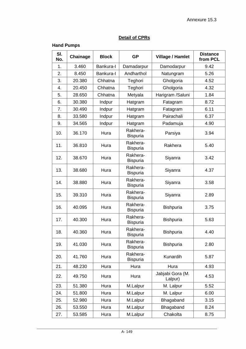
Annexure 15.3
A- 149
Detail of CPRs Hand Pumps
Sl. No. Chainage Block GP Village / Hamlet Distance
from PCL 1. 3.460 Bankura-I Damadarpur Damodarpur 9.42 2. 8.450 Bankura-I Andharthol Natungram 5.26 3. 20.380 Chhatna Teghori Gholgoria 4.52 4. 20.450 Chhatna Teghori Gholgoria 4.32 5. 28.650 Chhatna Metyala Harigram /Saluni 1.84 6. 30.380 Indpur Hatgram Fatagram 8.72 7. 30.490 Indpur Hatgram Fatagram 6.11 8. 33.580 Indpur Hatgram Pairachali 6.37 9. 34.565 Indpur Hatgram Padamuja 4.90
10. 36.170 Hura Rakhera-Bispuria Parsiya 3.94
11. 36.810 Hura Rakhera-Bispuria Rakhera 5.40
12. 38.670 Hura Rakhera-Bispuria Siyanra 3.42
13. 38.680 Hura Rakhera-Bispuria Siyanra 4.37
14. 38.880 Hura Rakhera-Bispuria Siyanra 3.58
15. 39.310 Hura Rakhera-Bispuria Siyanra 2.89
16. 40.095 Hura Rakhera-Bispuria Bishpuria 3.75
17. 40.300 Hura Rakhera-Bispuria Bishpuria 5.63
18. 40.360 Hura Rakhera-Bispuria Bishpuria 4.40
19. 41.030 Hura Rakhera-Bispuria Bishpuria 2.80
20. 41.760 Hura Rakhera-Bispuria Kunardih 5.87
21. 48.230 Hura Hura Hura 4.93
22. 49.750 Hura Hura Jabjabi Gora (M. Lalpur) 4.53
23. 51.380 Hura M.Lalpur M. Lalpur 5.52 24. 51.800 Hura M.Lalpur M. Lalpur 6.00 25. 52.980 Hura M.Lalpur Bhagaband 3.15 26. 53.550 Hura M.Lalpur Bhagaband 8.24 27. 53.585 Hura M.Lalpur Chakolta 8.75

Annexure 15.3
A- 150
Sl. No. Chainage Block GP Village / Hamlet Distance
from PCL 28. 55.170 Hura Lakhanpur Madhuban 5.28 29. 55.410 Hura Lakhanpur Madhuban 5.91 30. 56.960 Hura Lakhanpur Kulgora 9.48 31. 57.980 Hura Lakhanpur Laikadih 8.42 32. 58.900 Hura Lakhanpur Lakhanpur 5.12 33. 59.300 Hura Lakhanpur Lakhanpur 5.84 34. 61.080 Hura Jabarrah Haraliyadih 3.80 35. 61.920 Hura Ladhurka Bhuyadih 7.11 36. 63.410 Hura Ladhurka Ladhurka 5.41
37. 68.800 Purulia-II Hutmura (Joynagar) Joynagar 5.19
38. 68.910 Purulia-II Hutmura (Joynagar) Joynagar 3.67
39. 69.180 Purulia-II Hutmura (Joynagar) Joynagar 4.13
40. 69.200 Purulia-II Hutmura (Joynagar) Joynagar 4.84
41. 69.410 Purulia-II Hutmura (Joynagar) Joynagar 8.47
42. 71.325 Purulia-II Bhangra Bhangra 4.20 43. 74.570 Purulia-II Raghabpur Gengara 5.99 44. 76.250 Purulia-II Raghabpur Birgiri 7.71
45. 78.975 Purulia (M)
Purulia Municipality Telkalpara 3.60
46. 79.110 Purulia (M)
Purulia Municipality Dhabghata 5.28
47. 80.300 Purulia (M)
Purulia Municipality Dhabghata 1.77
48. 81.330 Purulia (M)
Purulia Municipality Gosala More 6.05
49. 82.235 Purulia (M)
Purulia Municipality Raghabpur More 6.00
Well
Sl. No. District Village Name No. of Well
1. Bankura Gholgoria 1
2. Bankura Harigram /Saluni 1
3. Bankura Kankaradih 1
4. Bankura Kumidiya 1
5. Bankura Pairachali 1
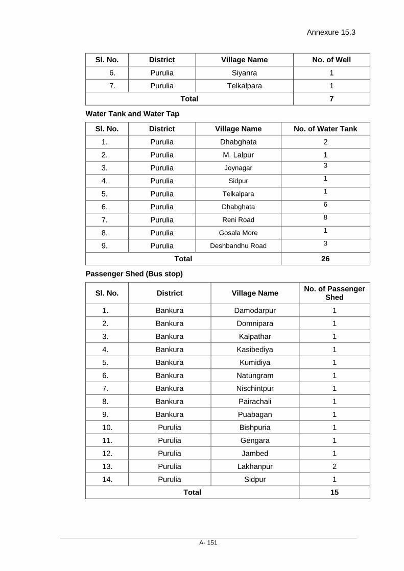
Annexure 15.3
A- 151
Sl. No. District Village Name No. of Well
6. Purulia Siyanra 1
7. Purulia Telkalpara 1
Total 7
Water Tank and Water Tap
Sl. No. District Village Name No. of Water Tank
1. Purulia Dhabghata 2
2. Purulia M. Lalpur 1
3. Purulia Joynagar 3
4. Purulia Sidpur 1
5. Purulia Telkalpara 1
6. Purulia Dhabghata 6
7. Purulia Reni Road 8
8. Purulia Gosala More 1
9. Purulia Deshbandhu Road 3
Total 26
Passenger Shed (Bus stop)
Sl. No. District Village Name No. of Passenger Shed
1. Bankura Damodarpur 1
2. Bankura Domnipara 1
3. Bankura Kalpathar 1
4. Bankura Kasibediya 1
5. Bankura Kumidiya 1
6. Bankura Natungram 1
7. Bankura Nischintpur 1
8. Bankura Pairachali 1
9. Bankura Puabagan 1
10. Purulia Bishpuria 1
11. Purulia Gengara 1
12. Purulia Jambed 1
13. Purulia Lakhanpur 2
14. Purulia Sidpur 1
Total 15

Annexure 15.3
A- 152
Public Toilet (Urinal)
Sl. No. District Village Name No. of Public Toilet (Urinal) 1. Bankura Kumidiya 1
2. Purulia Lakhanpur 1
3. Purulia Sidpur 1
Total 3
Bore Well
Sl. No. District Village Name No. of Bore Well
1. Purulia Manguria Lalpur 1
Total 1
Religious Structure
Sl. No. District Village Name No. of Religious Structure
1. Bankura Dholdanga 2
2. Bankura Gholgoria 1
3. Bankura Harigram /Saluni 1
4. Bankura Jaganathpur 1
5. Purulia Bishpuria 2
6. Purulia Dhabghata 1
7. Purulia Gosala More 2
8. Purulia Hura 3
9. Purulia Jabjabi Gora (M. Lalpur) 1
10. Purulia Joynagar 2
11. Purulia Kulgora 1
12. Purulia Laikadih 1
13. Purulia Lakhanpur 1
14. Purulia Sidpur 1
Total 20
Boundary Wall
Sl. No. District Village Name Name of Structure Area
(in Rmt.) 1. Bankura Puabagan School (Boundary Wall) 106.14
2. Purulia Hura Forest Range Office, Hura 61.52
3. Purulia Dhabghata Govt. Boundary wall 44.56
4. Purulia Hura Hura Police Station, Boundary 70.56
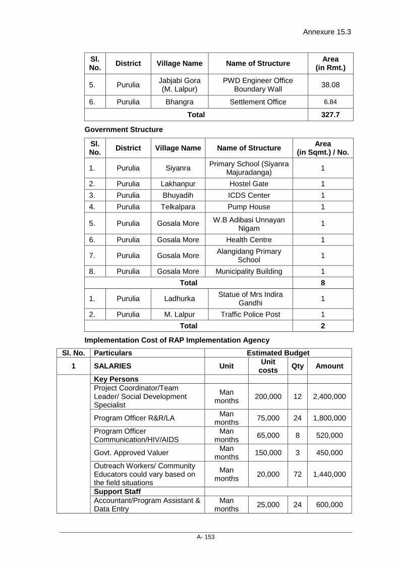
Annexure 15.3
A- 153
Sl. No. District Village Name Name of Structure Area
(in Rmt.)
5. Purulia Jabjabi Gora (M. Lalpur)
PWD Engineer Office Boundary Wall 38.08
6. Purulia Bhangra Settlement Office 6.84
Total 327.7
Government Structure
Sl. No. District Village Name Name of Structure Area
(in Sqmt.) / No.
1. Purulia Siyanra Primary School (Siyanra Majuradanga) 1
2. Purulia Lakhanpur Hostel Gate 1 3. Purulia Bhuyadih ICDS Center 1 4. Purulia Telkalpara Pump House 1
5. Purulia Gosala More W.B Adibasi Unnayan Nigam
1
6. Purulia Gosala More Health Centre 1
7. Purulia Gosala More Alangidang Primary School 1
8. Purulia Gosala More Municipality Building 1 Total 8
1. Purulia Ladhurka Statue of Mrs Indira Gandhi 1
2. Purulia M. Lalpur Traffic Police Post 1 Total 2
Implementation Cost of RAP Implementation Agency Sl. No. Particulars Estimated Budget
1 SALARIES Unit Unit costs Qty Amount
Key Persons Project Coordinator/Team Leader/ Social Development Specialist
Man months 200,000 12 2,400,000
Program Officer R&R/LA Man months 75,000 24 1,800,000
Program Officer Communication/HIV/AIDS
Man months 65,000 8 520,000
Govt. Approved Valuer Man months 150,000 3 450,000
Outreach Workers/ Community Educators could vary based on the field situations
Man months 20,000 72 1,440,000
Support Staff Accountant/Program Assistant & Data Entry
Man months 25,000 24 600,000
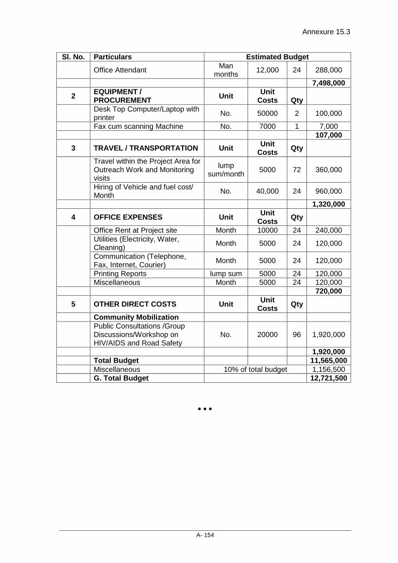
Annexure 15.3
A- 154
Sl. No. Particulars Estimated Budget
Office Attendant Man months 12,000 24 288,000
7,498,000
2 EQUIPMENT / PROCUREMENT Unit Unit
Costs
Qty
Desk Top Computer/Laptop with printer No. 50000 2 100,000
Fax cum scanning Machine No. 7000 1 7,000 107,000
3 TRAVEL / TRANSPORTATION Unit Unit Costs Qty
Travel within the Project Area for Outreach Work and Monitoring visits
lump sum/month 5000 72 360,000
Hiring of Vehicle and fuel cost/ Month No. 40,000 24 960,000
1,320,000
4 OFFICE EXPENSES Unit Unit Costs Qty
Office Rent at Project site Month 10000 24 240,000 Utilities (Electricity, Water, Cleaning) Month 5000 24 120,000
Communication (Telephone, Fax, Internet, Courier) Month 5000 24 120,000
Printing Reports lump sum 5000 24 120,000 Miscellaneous Month 5000 24 120,000
720,000
5 OTHER DIRECT COSTS Unit Unit Costs Qty
Community Mobilization
Public Consultations /Group Discussions/Workshop on HIV/AIDS and Road Safety
No. 20000 96 1,920,000
1,920,000 Total Budget 11,565,000 Miscellaneous 10% of total budget 1,156,500 G. Total Budget 12,721,500
• • •

Consultancy Services for Preparation of Detailed Project Report for Rehabilitation and Upgrading to 2 lane / 2 lane with Paved Shoulders Configuration and Strengthening of
Bankura – Purulia Section (km 0 to 84) of NH-60A in the State of West Bengal (Package No. SP/B/6)
Final Detailed Project Report (Modified) (Volume V: Social Impact Assessment and Rehabilitation Action Plan)
16 - 1
16. COMPLIANCE TO CLIENT’S COMMENTS
Sl. No. Comments Response
Overall the report is reads well. Major and other chapter wise comments are provided below
All comments complied as per specification
Major comments
• Section 5.2.6, how many landholders are impacted? They are not listed in the annexures. Were any covered in Socio-economic survey?
The list of affected person is already there in the report as Annexure-5.1. However, the list is not segregated in the category of Titleholder (land holder) and non-titleholder (encroachers, squatters and Kiosk). Moreover, as per requirement the same are being segregated in different categories as Annexure-5.1(a) to 5.1(f) which will have separate list who are losing land and structures. The landholders have been covered in socio-economic survey as per required sample.
• Presentation of Analysis of alternatives on provision/ dropping of bypasses (See comment on section 3.6 below)
A table having analysis of alternative has been inserted in appropriate place in chapter-3, which has justification of dropping of bypass of Hura and Bispuria. This table has all the details of impact on structures, PAPs and quantum of Land on which the analysis has been done. Moreover, the letter of MORT&H decision to dropping of Bypasses is also attached as Annexure-3.3.
• Implementation schedule in Chapter 12 needs reworking as per comments below
• Complied the comments in concerned chapter
• List community welfare measures in villages with more than 50% SC population along with an indicative budget figure, if there are any such villages.
• No Such measures are required as there are no villages which are having more than 50% of SC population.
• Check the total budget as it seems to double count the cost for RAP IA
• Of course the IA cost was double counted. Now it has been corrected.

Compliance to Client’s comments
Final Detailed Project Report (Modified) (Volume V: Social Impact Assessment and Rehabilitation Action Plan)
16 - 2
Sl. No. Comments Response
Chapter-wise comments Executive Summary • 0.4, rather than say pretty long time,
state the cut-off date of the census survey
• Modified accordingly.
Chapter 1 Section 1.1:
• The NHIIP comprises of 33 project roads….. with World Bank Assistance.. In this sentence remove “with a total length of 3769 km. Out”
• Removed accordingly
• Add the word section in “Bankura to Purulia section of NH 60 A (km…)
• Added accordingly
• In the para “The MORTH has appointed…. Remove the sentence “these tasks will be undertaken throughout the period of consultancy agreement”
• Removed accordingly
1.4.1:
• Under “Establish a baseline…” Add “against which to measure impacts of RAP implementation on the PAPs”
• Added accordingly
1.4.2
• Sentence unclear. Rephrase to read as “Structures and properties to be affected within the proposed corridor of impact were identified by following proposed road design. Structures likely to be affected by typology (pucca, semi-pucca, katcha etc.) and their present use were marked and provided a unique identity number.”
• This section methodology part of this chapter has been re-written and appropriate flow was maintained
• Reorder sentences in these three paras in this section to ensure appropriate flow
• Appropriate flow was maintained
Chapter 3 • Section 3.1 Introduction, Bank Policy,
specify Bank’s Policy on Involuntary Resettlement OP 4.12
• Modified at appropriate place
• 3.3 Designs and R&R coordination: Remove the following as they are not relevant
• Removed the irrelevant part
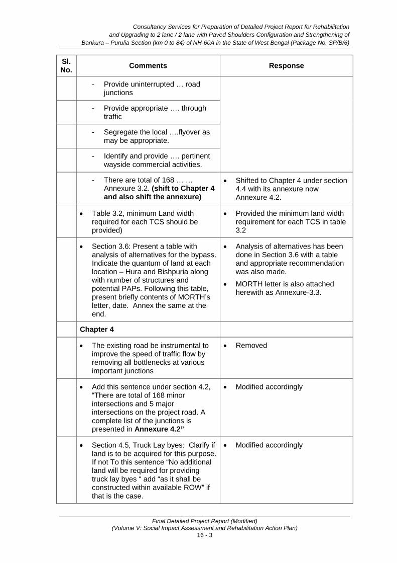
Consultancy Services for Preparation of Detailed Project Report for Rehabilitation and Upgrading to 2 lane / 2 lane with Paved Shoulders Configuration and Strengthening of
Bankura – Purulia Section (km 0 to 84) of NH-60A in the State of West Bengal (Package No. SP/B/6)
Final Detailed Project Report (Modified) (Volume V: Social Impact Assessment and Rehabilitation Action Plan)
16 - 3
Sl. No. Comments Response
- Provide uninterrupted … road junctions
- Provide appropriate …. through traffic
- Segregate the local ….flyover as may be appropriate.
- Identify and provide …. pertinent wayside commercial activities.
- There are total of 168 … … Annexure 3.2. (shift to Chapter 4 and also shift the annexure)
• Shifted to Chapter 4 under section 4.4 with its annexure now Annexure 4.2.
• Table 3.2, minimum Land width required for each TCS should be provided)
• Provided the minimum land width requirement for each TCS in table 3.2
• Section 3.6: Present a table with analysis of alternatives for the bypass. Indicate the quantum of land at each location – Hura and Bishpuria along with number of structures and potential PAPs. Following this table, present briefly contents of MORTH’s letter, date. Annex the same at the end.
• Analysis of alternatives has been done in Section 3.6 with a table and appropriate recommendation was also made.
• MORTH letter is also attached herewith as Annexure-3.3.
Chapter 4
• The existing road be instrumental to improve the speed of traffic flow by removing all bottlenecks at various important junctions
• Removed
• Add this sentence under section 4.2, “There are total of 168 minor intersections and 5 major intersections on the project road. A complete list of the junctions is presented in Annexure 4.2”
• Modified accordingly
• Section 4.5, Truck Lay byes: Clarify if land is to be acquired for this purpose. If not To this sentence “No additional land will be required for providing truck lay byes “ add “as it shall be constructed within available ROW” if that is the case.
• Modified accordingly
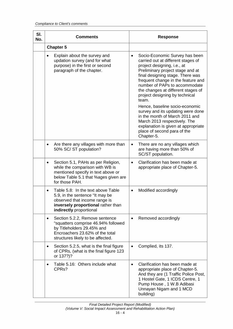
Compliance to Client’s comments
Final Detailed Project Report (Modified) (Volume V: Social Impact Assessment and Rehabilitation Action Plan)
16 - 4
Sl. No. Comments Response
Chapter 5
• Explain about the survey and updation survey (and for what purpose) in the first or second paragraph of the chapter.
• Socio-Economic Survey has been carried out at different stages of project designing, i.e., at Preliminary project stage and at final designing stage. There was frequent change in the feature and number of PAPs to accommodate the changes at different stages of project designing by technical team. Hence, baseline socio-economic survey and its updating were done in the month of March 2011 and March 2013 respectively. The explanation is given at appropriate place of second para of the Chapter-5.
• Are there any villages with more than 50% SC/ ST population?
• There are no any villages which are having more than 50% of SC/ST population.
• Section 5.1, PAHs as per Religion, while the comparison with WB is mentioned specify in text above or below Table 5.1 that %ages given are for those PAH.
• Clarification has been made at appropriate place of Chapter-5.
• Table 5.8: In the text above Table 5.9, in the sentence “It may be observed that income range is inversely proportional rather than indirectly proportional
• Modified accordingly
• Section 5.2.2, Remove sentence “squatters comprise 46.94% followed by Titleholders 29.45% and Encroachers 23.62% of the total structures likely to be affected.
• Removed accordingly
• Section 5.2.5, what is the final figure of CPRs, (what is the final figure 123 or 137?)?
• Complied, its 137.
• Table 5.16: Others include what CPRs?
• Clarification has been made at appropriate place of Chapter-5. And they are (1 Traffic Police Post, 1 Hostel Gate, 1 ICDS Centre, 1 Pump House , 1 W.B Adibasi Unnayan Nigam and 1 MCD building)
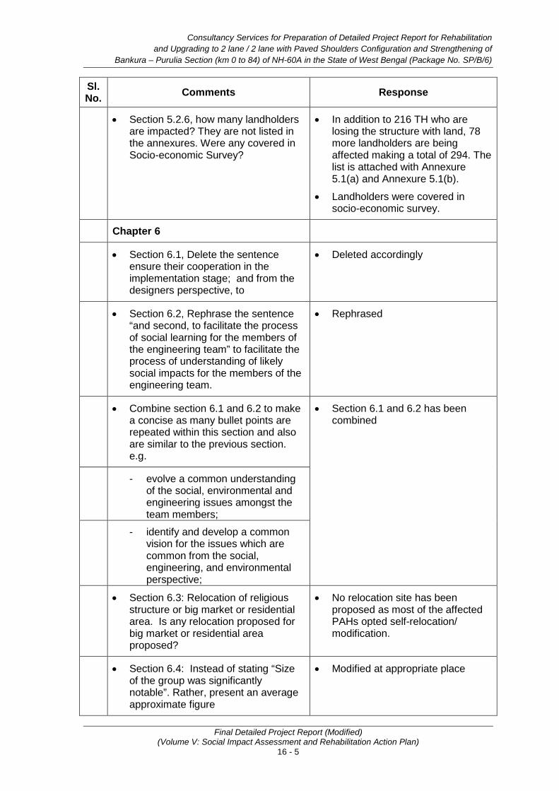
Consultancy Services for Preparation of Detailed Project Report for Rehabilitation and Upgrading to 2 lane / 2 lane with Paved Shoulders Configuration and Strengthening of
Bankura – Purulia Section (km 0 to 84) of NH-60A in the State of West Bengal (Package No. SP/B/6)
Final Detailed Project Report (Modified) (Volume V: Social Impact Assessment and Rehabilitation Action Plan)
16 - 5
Sl. No. Comments Response
• Section 5.2.6, how many landholders are impacted? They are not listed in the annexures. Were any covered in Socio-economic Survey?
• In addition to 216 TH who are losing the structure with land, 78 more landholders are being affected making a total of 294. The list is attached with Annexure 5.1(a) and Annexure 5.1(b).
• Landholders were covered in socio-economic survey.
Chapter 6
• Section 6.1, Delete the sentence ensure their cooperation in the implementation stage; and from the designers perspective, to
• Deleted accordingly
• Section 6.2, Rephrase the sentence “and second, to facilitate the process of social learning for the members of the engineering team” to facilitate the process of understanding of likely social impacts for the members of the engineering team.
• Rephrased
• Combine section 6.1 and 6.2 to make a concise as many bullet points are repeated within this section and also are similar to the previous section. e.g.
• Section 6.1 and 6.2 has been combined
- evolve a common understanding of the social, environmental and engineering issues amongst the team members;
- identify and develop a common vision for the issues which are common from the social, engineering, and environmental perspective;
• Section 6.3: Relocation of religious structure or big market or residential area. Is any relocation proposed for big market or residential area proposed?
• No relocation site has been proposed as most of the affected PAHs opted self-relocation/ modification.
• Section 6.4: Instead of stating “Size of the group was significantly notable”. Rather, present an average approximate figure
• Modified at appropriate place
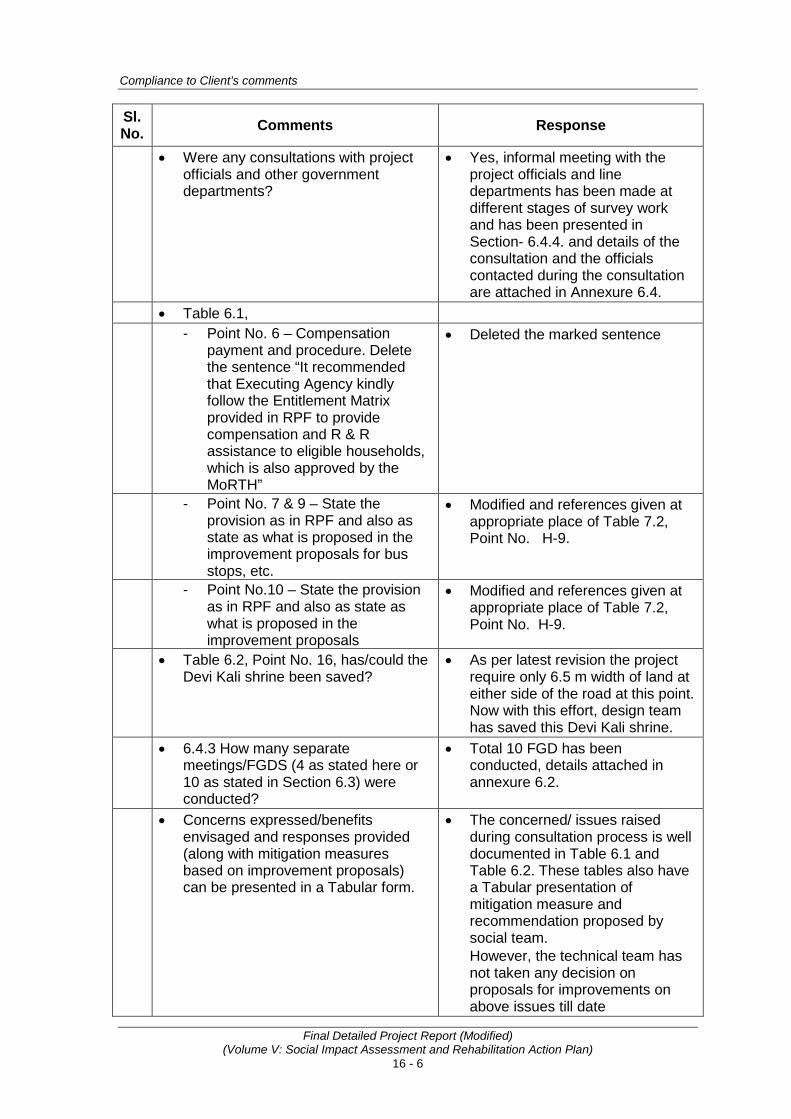
Compliance to Client’s comments
Final Detailed Project Report (Modified) (Volume V: Social Impact Assessment and Rehabilitation Action Plan)
16 - 6
Sl. No. Comments Response
• Were any consultations with project officials and other government departments?
• Yes, informal meeting with the project officials and line departments has been made at different stages of survey work and has been presented in Section- 6.4.4. and details of the consultation and the officials contacted during the consultation are attached in Annexure 6.4.
• Table 6.1, - Point No. 6 – Compensation
payment and procedure. Delete the sentence “It recommended that Executing Agency kindly follow the Entitlement Matrix provided in RPF to provide compensation and R & R assistance to eligible households, which is also approved by the MoRTH”
• Deleted the marked sentence
- Point No. 7 & 9 – State the provision as in RPF and also as state as what is proposed in the improvement proposals for bus stops, etc.
• Modified and references given at appropriate place of Table 7.2, Point No. H-9.
- Point No.10 – State the provision as in RPF and also as state as what is proposed in the improvement proposals
• Modified and references given at appropriate place of Table 7.2, Point No. H-9.
• Table 6.2, Point No. 16, has/could the Devi Kali shrine been saved?
• As per latest revision the project require only 6.5 m width of land at either side of the road at this point. Now with this effort, design team has saved this Devi Kali shrine.
• 6.4.3 How many separate meetings/FGDS (4 as stated here or 10 as stated in Section 6.3) were conducted?
• Total 10 FGD has been conducted, details attached in annexure 6.2.
• Concerns expressed/benefits envisaged and responses provided (along with mitigation measures based on improvement proposals) can be presented in a Tabular form.
• The concerned/ issues raised during consultation process is well documented in Table 6.1 and Table 6.2. These tables also have a Tabular presentation of mitigation measure and recommendation proposed by social team. However, the technical team has not taken any decision on proposals for improvements on above issues till date
Consultancy Services for Preparation of Detailed Project Report for Rehabilitation and Upgrading to 2 lane / 2 lane with Paved Shoulders Configuration and Strengthening of
Bankura – Purulia Section (km 0 to 84) of NH-60A in the State of West Bengal (Package No. SP/B/6)
Final Detailed Project Report (Modified) (Volume V: Social Impact Assessment and Rehabilitation Action Plan)
16 - 7
Sl. No. Comments Response
Chapter 7
• Add “World Bank Policy on Access to Information and Disclosure” and a brief write up to the table
• Added in appropriate place in table 7.1 and briefly described in section 7.2.5.
Chapter 8
• In figure 8.1, instead of Consultancy firm (RAP implementation agency), state as NGO / Consultancy Firm (RAP Implementation agency) to be consistent with RPF
• Changed according.
Chapter 11
• Sections 11. 2 and 11.3: Change all references from ‘will include’, etc. to ‘include(s)
• Modified according.
• Check Table Nos. They should be 11 and not 13
• Checked and corrected accordingly.
• Table 13.1, Check Point No. 13: What is this agency proposed? Is it not RAP IA?
• Checked and corrected as…”Agency (RAP, IP)…project authority”.
• Section 11.6, Reporting: Evaluation Report is to be both at mid and end –term. Correct the same.
• Modified accordingly.
Chapter 12
• Section 12.1, Mobilization date is effect from January 2006? Why? Correct
• Typographical mistake corrected, ‘March 2014’
• Delete sentence “If environmental clearance is required or there are other unforeseen problems, land acquisition will take longer.
• Deleted
• Section 12.2: Point B Change to as NGO / Consultancy Firm
• Changed
• Section 12.6: Is relocation proposed. Check and correct
• Changed accordingly
• Table 12.1: Point No. 3 & 6, Delete reference to NHAI, it is MORTH
• Rectified and updated in point no. 5 & 8.
• Verification of all PAPs is getting completed. Indicate till 3rd or 4th month
• Complied and it will start 2nd month and completed in 4th month in point no. 11
• Delete points 10, 11, 12 • Deleted

Compliance to Client’s comments
Final Detailed Project Report (Modified) (Volume V: Social Impact Assessment and Rehabilitation Action Plan)
16 - 8
Sl. No. Comments Response
• List the income restoration activities. However as in Chapter 13, none are proposed/required, list provision of information on and provision of construction work opportunities as one intermittent activity
• Listed (Point No. 23-Training for skill up gradation and Point No. 24-Temporary employment)
• Add encumbrance free site handing over too.
• Added on point no. 22 after disbursement. However, about 95% site is free from encumbrance with respect to. land acquisition.
• Combine B, D & E to ensure complete listing of all activities in sequence
• Modified accordingly and all the activities arranged in sequence.
• Points 14, 15, 16 – these are limited to only 1 or 2 months. Show it as an intermittent process nearly throughout the project till about 3-4 months from completion.
• Modified in Point No. 25, 26 and 27.
• Point F- Establishment of GRM: Take it to point A
• Moved at Sl. No. A Point No. 2 and 3
• Add HIV/Aids hoarding to the point below No. 17
• Added in Point No. 29
• Point 27: Add consultations for relocation of CPRs: Again private structures are mentioned. Check if relocation is proposed to any resettlement site. If not state clearly.
• Consultation for CPRs activities has been added in Point No. 20 accordingly the relocation of CPRs will be required.
• Match Table 12.2 to the schedule above.
• Matched
Chapter 13
• List community welfare measures in villages with more than 50% SC population along with an indicative budget figure.
• No Such measures are required as there are no villages, which are having more than 50% of SC population.
Chapter 14
• Engaging women inspector works: Delete, it might be difficult to implement
• Deleted accordingly
• Women as managers in RAP IA: change heading to Women in RAP IA
• Changed accordingly
• 14.7 Evaluation: 1 member should among the key personnel.
• Complied

Consultancy Services for Preparation of Detailed Project Report for Rehabilitation and Upgrading to 2 lane / 2 lane with Paved Shoulders Configuration and Strengthening of
Bankura – Purulia Section (km 0 to 84) of NH-60A in the State of West Bengal (Package No. SP/B/6)
Final Detailed Project Report (Modified) (Volume V: Social Impact Assessment and Rehabilitation Action Plan)
16 - 9
Sl. No. Comments Response
Chapter 15 • Does Table 15.3 include 6 other
CPRs as listed in Table 5.16 in Chapter 5
• Yes. 6 No. of Other type of CPR includes: 1 Traffic Police Post, 1 Hostel Gate, 1 ICDS Centre, 1 Pump House, 1 W.B Adibasi Unnayan Nigam & 1 MCD Building
• Table 15.4 heading needs to be changed as the table contains other details on i) M&E consultants, RAP IA, Training and HIV Hoardings. Likewise change Table 15.6
• Changed as ‘Budget on R&R Assistance and Implementation Support’.
• Check the total budget as it seems to double count the cost for RAP IA
• Checked and rectified.
• • •