Minero-petrographical features of weathering profiles in Calabria, southern Italy
12
Minero-petrographical features of weathering profiles in Calabria, southern Italy L. Borrelli a , F. Perri b, ⁎, S. Critelli b , G. Gullà a a CNR-IRPI_U.O.S. di Cosenza, Via Cavour n. 4/6, 87030 Rende (CS), Italy b Università degli Studi della Calabria, Dip. Scienze della Terra, 87030 Rende (CS), Italy abstract article info Article history: Received 15 January 2011 Received in revised form 9 January 2012 Accepted 11 January 2012 Available online xxxx Keywords: Weathering Clay minerals Petrography Soil micromorphology Gneiss The paper reports interdisciplinary research of weathering profile stages on gneiss with regard to tectonic and landscape evolutions of the western Sila Grande Massif (Southern Italy). The outcropping rocks consist of medium- to coarse-grained biotite–garnet and sillimanite gneiss (BGS-G), and medium- to coarse- grained biotite–muscovite migmatitic gneiss (M-G). The BGS-G rocks are fractured and weathered with either massive or foliated texture, whereas the M-G rocks are intensely weathered and fractured with a mas- sive texture and frequent pegmatite veins. Petrographical and mineralogical variations show that both gneissic rocks (BGS-G and M-G samples) underwent weathering processes characterized by a progressive chemical attack on the labile minerals with generation of neoformed minerals and substitution of the original rock fabric. The weathering processes produced phyllosilicates and Fe-oxides; neoformed clay minerals and ferruginous products replaced feldspars and biotite during the most advanced weathering stage. Microfrac- tures and morphological variations occur on the original rock and, thereby, affect the surrounding landscape processes. The weathering profile mineralogy and rock textures viewed in the context of landscape evolution provide useful insights into the widespread slope movement phenomena in the Sila Grande Massif gneiss. © 2012 Elsevier B.V. All rights reserved. 1. Introduction Certain Italian regions (e.g., Alps, Calabria and Sardinia) are occu- pied with crystalline rocks which have undergone intense weathering processes. Due to the combination of several predisposing morpho- lithological, tectonic and climatic factors, intense weathering and related slope instability are very common. Generally, weathering pro- duces mineralogical and petrographical transformations and, thus, a considerable decay of the physical–mechanical properties of the orig- inal rock, predisposing the slope instability processes (e.g., Borrelli, 2008; Borrelli et al., 2007; Brand and Phillipson, 1985; Calcaterra et al., 1996, 2004; Cascini and Gullà, 1993; Cascini et al., 1992, 1994; Critelli et al., 1991; Deere and Patton, 1971; Gullà et al., 2004; Hencher et al., 1984; Lacerda and Santos, 2000; Nishida and Aoyama, 1985). The weathering phenomena are, furthermore, closely related to geological engineering projects and anthropic interven- tions (e.g., Gullà et al., 2008). The main mountainous massifs of the Calabria region (southern Italy) are characterized by outcropping of crystalline rocks. In partic- ular, intense weathering processes have developed in the crystalline rocks characterized by granitic and gneissic compositions (Guzzetta, 1974). Weathering and erosion vary markedly across the Sila Massif (northern Calabria) according to the topographic setting. The central portion of the massif is dominated by a broad upland plateau where weathering exceeds the rate at which slope processes can remove de- tritus (Le Pera et al., 2001). A thick soil cover is present here in flat de- pressions, gentle slopes and flat hilltops (Le Pera and Sorriso-Valvo, 2000b). The highland plateau abruptly passes into valley slopes with sharp slope gradient. The steeper slopes are subject to frequent landslides (Borrelli, 2008; Cascini et al., 1992), and mechanical ero- sion is more pronounced than chemical weathering (Le Pera and Sorriso-Valvo, 2000a). In these positions, the dynamics of weathering is strongly controlled by relief characteristics (e.g., Teeuw et al., 1994; Thomas, 1994). This paper presents results of a multidisciplinary study (e.g., Borrelli, 2008; Borrelli et al., 2007) on the weathering profile evolu- tion, carried out in the area of ca. 70 km 2 , situated in the central sec- tor of the Mucone River basin, on the north-western slopes of the Sila Massif (northern Calabria) (Fig. 1). This work aims to examine the physical, mechanical and mineralogical–petrographical properties of both parent/fresh rocks and weathered rocks of the gneissic slopes of the Sila Massif. The application of soil micromorphology (Stoops, 2003) to weathering phenomena proved to be useful. The studied area is chiefly formed by weathered gneiss characterized by signifi- cant instability phenomena, although sometimes recognizable with difficulty. Weathering of rocks involves several processes such as dis- solution of primary phases, deposition of authigenic minerals, ionic exchange and sorption. These processes are dependent on the chem- istry and mineralogy of the rocks, chemical features of the interacting Catena 92 (2012) 196–207 ⁎ Corresponding author. E-mail addresses: [email protected], [email protected] (F. Perri). 0341-8162/$ – see front matter © 2012 Elsevier B.V. All rights reserved. doi:10.1016/j.catena.2012.01.003 Contents lists available at SciVerse ScienceDirect Catena journal homepage: www.elsevier.com/locate/catena
-
Upload
independent -
Category
Documents
-
view
0 -
download
0
Transcript of Minero-petrographical features of weathering profiles in Calabria, southern Italy
Catena 92 (2012) 196–207
Contents lists available at SciVerse ScienceDirect
Catena
j ourna l homepage: www.e lsev ie r .com/ locate /catena
Minero-petrographical features of weathering profiles in Calabria, southern Italy
L. Borrelli a, F. Perri b,⁎, S. Critelli b, G. Gullà a
a CNR-IRPI_U.O.S. di Cosenza, Via Cavour n. 4/6, 87030 Rende (CS), Italyb Università degli Studi della Calabria, Dip. Scienze della Terra, 87030 Rende (CS), Italy
⁎ Corresponding author.E-mail addresses: [email protected], perri@u
0341-8162/$ – see front matter © 2012 Elsevier B.V. Alldoi:10.1016/j.catena.2012.01.003
a b s t r a c t
a r t i c l e i n f oArticle history:Received 15 January 2011Received in revised form 9 January 2012Accepted 11 January 2012Available online xxxx
Keywords:WeatheringClay mineralsPetrographySoil micromorphologyGneiss
The paper reports interdisciplinary research of weathering profile stages on gneiss with regard to tectonicand landscape evolutions of the western Sila Grande Massif (Southern Italy). The outcropping rocks consistof medium- to coarse-grained biotite–garnet and sillimanite gneiss (BGS-G), and medium- to coarse-grained biotite–muscovite migmatitic gneiss (M-G). The BGS-G rocks are fractured and weathered witheither massive or foliated texture, whereas the M-G rocks are intensely weathered and fractured with a mas-sive texture and frequent pegmatite veins. Petrographical and mineralogical variations show that bothgneissic rocks (BGS-G and M-G samples) underwent weathering processes characterized by a progressivechemical attack on the labile minerals with generation of neoformed minerals and substitution of the originalrock fabric. The weathering processes produced phyllosilicates and Fe-oxides; neoformed clay minerals andferruginous products replaced feldspars and biotite during the most advanced weathering stage. Microfrac-tures and morphological variations occur on the original rock and, thereby, affect the surrounding landscapeprocesses. The weathering profile mineralogy and rock textures viewed in the context of landscape evolutionprovide useful insights into the widespread slope movement phenomena in the Sila Grande Massif gneiss.
© 2012 Elsevier B.V. All rights reserved.
1. Introduction
Certain Italian regions (e.g., Alps, Calabria and Sardinia) are occu-pied with crystalline rocks which have undergone intense weatheringprocesses. Due to the combination of several predisposing morpho-lithological, tectonic and climatic factors, intense weathering andrelated slope instability are very common. Generally, weathering pro-duces mineralogical and petrographical transformations and, thus, aconsiderable decay of the physical–mechanical properties of the orig-inal rock, predisposing the slope instability processes (e.g., Borrelli,2008; Borrelli et al., 2007; Brand and Phillipson, 1985; Calcaterra etal., 1996, 2004; Cascini and Gullà, 1993; Cascini et al., 1992, 1994;Critelli et al., 1991; Deere and Patton, 1971; Gullà et al., 2004;Hencher et al., 1984; Lacerda and Santos, 2000; Nishida andAoyama, 1985). The weathering phenomena are, furthermore, closelyrelated to geological engineering projects and anthropic interven-tions (e.g., Gullà et al., 2008).
The main mountainous massifs of the Calabria region (southernItaly) are characterized by outcropping of crystalline rocks. In partic-ular, intense weathering processes have developed in the crystallinerocks characterized by granitic and gneissic compositions (Guzzetta,1974). Weathering and erosion vary markedly across the Sila Massif
nibas.it (F. Perri).
rights reserved.
(northern Calabria) according to the topographic setting. The centralportion of the massif is dominated by a broad upland plateau whereweathering exceeds the rate at which slope processes can remove de-tritus (Le Pera et al., 2001). A thick soil cover is present here in flat de-pressions, gentle slopes and flat hilltops (Le Pera and Sorriso-Valvo,2000b). The highland plateau abruptly passes into valley slopeswith sharp slope gradient. The steeper slopes are subject to frequentlandslides (Borrelli, 2008; Cascini et al., 1992), and mechanical ero-sion is more pronounced than chemical weathering (Le Pera andSorriso-Valvo, 2000a). In these positions, the dynamics of weatheringis strongly controlled by relief characteristics (e.g., Teeuw et al., 1994;Thomas, 1994).
This paper presents results of a multidisciplinary study (e.g.,Borrelli, 2008; Borrelli et al., 2007) on the weathering profile evolu-tion, carried out in the area of ca. 70 km2, situated in the central sec-tor of the Mucone River basin, on the north-western slopes of the SilaMassif (northern Calabria) (Fig. 1). This work aims to examine thephysical, mechanical and mineralogical–petrographical properties ofboth parent/fresh rocks and weathered rocks of the gneissic slopesof the Sila Massif. The application of soil micromorphology (Stoops,2003) to weathering phenomena proved to be useful. The studiedarea is chiefly formed by weathered gneiss characterized by signifi-cant instability phenomena, although sometimes recognizable withdifficulty. Weathering of rocks involves several processes such as dis-solution of primary phases, deposition of authigenic minerals, ionicexchange and sorption. These processes are dependent on the chem-istry and mineralogy of the rocks, chemical features of the interacting

Fig. 1. Geologic sketch of the Sila Massif (modified from Messina et al., 1991) with location of the study area. Legend: 1) predominantly clastic deposits (Recent to Tortonian). 2 to6=Sila Unit: 2) Mesozoic to Tertiary sedimentary cover; 3) plutonic rocks (Sila Batholith; Carboniferous–Permian); 4) low-grade metamorphic rocks (Bocchiglero Complex; LateCambrian to Early Carboniferous); 5) low- to medium-grade metamorphic rocks (Mandatoriccio Complex; Late Cambrian to Early Carboniferous); 6) medium- to high-grademetamorphic rocks (Monte Gariglione–Polia-Copanello Complex; pre-Triassic); 7) Lower Alpine thrust nappes of the Sila Massif including Castagna, Bagni and Ophhiolitic Units(phyllite+schist and ophiolitic rocks); 8) thrust fault; 9) stratigraphic contact; 10) studied area.
197L. Borrelli et al. / Catena 92 (2012) 196–207
waters and on physical and biological factors such as topography,climate, and biological activity.
The approach used and the results proposed in this paper providesa valuable support for the study of mass movement phenomena relat-ed to different geological contexts mainly characterized by weatheredcrystalline rocks, and for the mechanical characterization of weather-ing profiles.
2. Geological and geomorphological features
The studied area is located on the western side of the Sila Massif(Fig. 1). This area represents a section of the Hercynian orogenicbelt of western Europe, were allochthonous crystalline basementrocks are exposed to form the highest tectonic units (Calabrian Arc)
of the southern Italy fold–thrust belt (Amodio-Morelli et al., 1976).The Sila Massif consists of Paleozoic intrusive and metamorphicrocks, locally unmetamorphosed, with a Mesozoic sedimentarycover. The Paleozoic rocks consist of gneiss, amphibolite, schist andphyllite, affected by various Alpine metamorphic events and intrudedby the Late Hercynian Sila Batholith (Messina et al., 1991, 1994).Gneissic rocks consist of biotite–sillimanite–garnet-rich layers withboth massive and migmatitic structures. Contacts among gneissicrocks and Sila Batholith are marked by a network of pegmatite dikesand by an irregular thermal aureole with amphibolite facies(Caggianelli et al., 1994). The Sila Batholith consists of multipleintersecting intrusions, heterogeneous in texture and fabric, with acomposition ranging from granodiorite to gabbro and leucomonzo-granite (Messina et al., 1991). Fission track analyses of apatite and
198 L. Borrelli et al. / Catena 92 (2012) 196–207
zircon from the basement rocks of the Sila Massif indicate a major pe-riod of exhumation ranging from ca. 35 Myr to ca. 15 Myr (Thomson,1994).
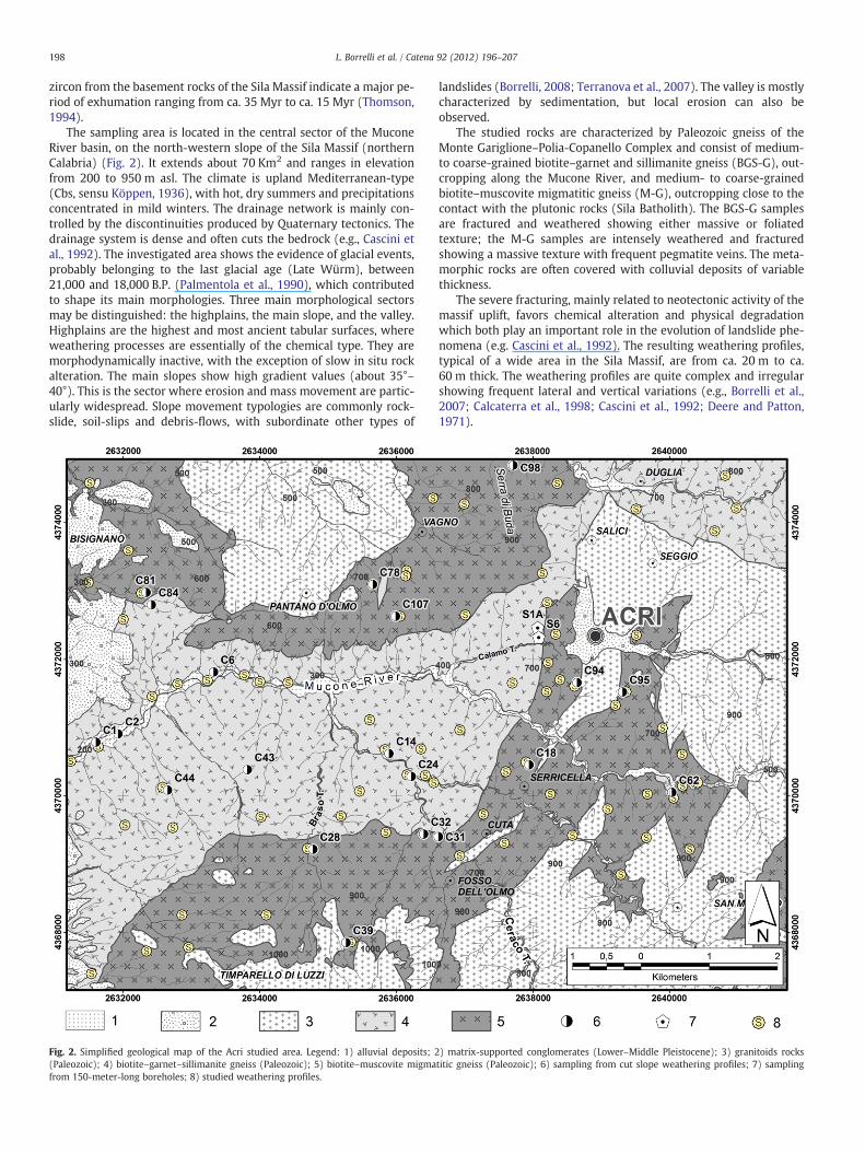
The sampling area is located in the central sector of the MuconeRiver basin, on the north-western slope of the Sila Massif (northernCalabria) (Fig. 2). It extends about 70 Km2 and ranges in elevationfrom 200 to 950 m asl. The climate is upland Mediterranean-type(Cbs, sensu Köppen, 1936), with hot, dry summers and precipitationsconcentrated in mild winters. The drainage network is mainly con-trolled by the discontinuities produced by Quaternary tectonics. Thedrainage system is dense and often cuts the bedrock (e.g., Cascini etal., 1992). The investigated area shows the evidence of glacial events,probably belonging to the last glacial age (Late Würm), between21,000 and 18,000 B.P. (Palmentola et al., 1990), which contributedto shape its main morphologies. Three main morphological sectorsmay be distinguished: the highplains, the main slope, and the valley.Highplains are the highest and most ancient tabular surfaces, whereweathering processes are essentially of the chemical type. They aremorphodynamically inactive, with the exception of slow in situ rockalteration. The main slopes show high gradient values (about 35°–40°). This is the sector where erosion and mass movement are partic-ularly widespread. Slope movement typologies are commonly rock-slide, soil-slips and debris-flows, with subordinate other types of
Fig. 2. Simplified geological map of the Acri studied area. Legend: 1) alluvial deposits; 2(Paleozoic); 4) biotite–garnet–sillimanite gneiss (Paleozoic); 5) biotite–muscovite migmafrom 150-meter-long boreholes; 8) studied weathering profiles.
landslides (Borrelli, 2008; Terranova et al., 2007). The valley is mostlycharacterized by sedimentation, but local erosion can also beobserved.
The studied rocks are characterized by Paleozoic gneiss of theMonte Gariglione–Polia-Copanello Complex and consist of medium-to coarse-grained biotite–garnet and sillimanite gneiss (BGS-G), out-cropping along the Mucone River, and medium- to coarse-grainedbiotite–muscovite migmatitic gneiss (M-G), outcropping close to thecontact with the plutonic rocks (Sila Batholith). The BGS-G samplesare fractured and weathered showing either massive or foliatedtexture; the M-G samples are intensely weathered and fracturedshowing a massive texture with frequent pegmatite veins. The meta-morphic rocks are often covered with colluvial deposits of variablethickness.
The severe fracturing, mainly related to neotectonic activity of themassif uplift, favors chemical alteration and physical degradationwhich both play an important role in the evolution of landslide phe-nomena (e.g. Cascini et al., 1992). The resulting weathering profiles,typical of a wide area in the Sila Massif, are from ca. 20 m to ca.60 m thick. The weathering profiles are quite complex and irregularshowing frequent lateral and vertical variations (e.g., Borrelli et al.,2007; Calcaterra et al., 1998; Cascini et al., 1992; Deere and Patton,1971).
) matrix-supported conglomerates (Lower–Middle Pleistocene); 3) granitoids rockstitic gneiss (Paleozoic); 6) sampling from cut slope weathering profiles; 7) sampling
199L. Borrelli et al. / Catena 92 (2012) 196–207
3. Weathering grade surveys
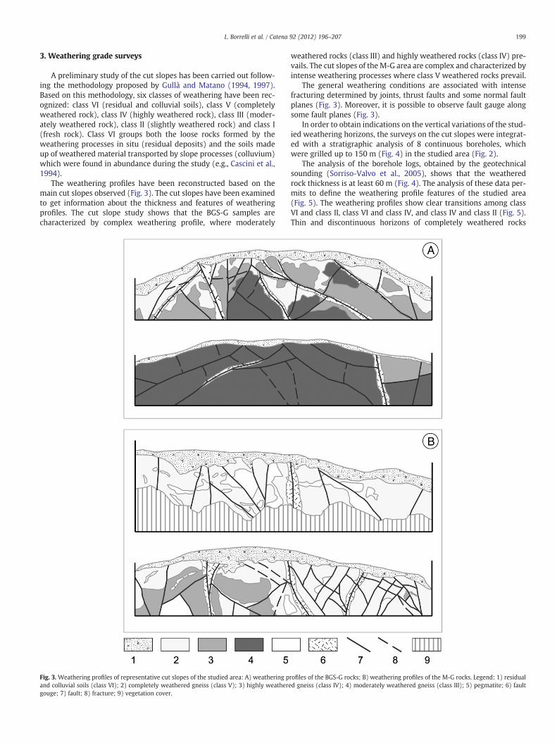
A preliminary study of the cut slopes has been carried out follow-ing the methodology proposed by Gullà and Matano (1994, 1997).Based on this methodology, six classes of weathering have been rec-ognized: class VI (residual and colluvial soils), class V (completelyweathered rock), class IV (highly weathered rock), class III (moder-ately weathered rock), class II (slightly weathered rock) and class I(fresh rock). Class VI groups both the loose rocks formed by theweathering processes in situ (residual deposits) and the soils madeup of weathered material transported by slope processes (colluvium)which were found in abundance during the study (e.g., Cascini et al.,1994).
The weathering profiles have been reconstructed based on themain cut slopes observed (Fig. 3). The cut slopes have been examinedto get information about the thickness and features of weatheringprofiles. The cut slope study shows that the BGS-G samples arecharacterized by complex weathering profile, where moderately
Fig. 3. Weathering profiles of representative cut slopes of the studied area: A) weathering pand colluvial soils (class VI); 2) completely weathered gneiss (class V); 3) highly weatheregouge; 7) fault; 8) fracture; 9) vegetation cover.
weathered rocks (class III) and highly weathered rocks (class IV) pre-vails. The cut slopes of the M-G area are complex and characterized byintense weathering processes where class V weathered rocks prevail.
The general weathering conditions are associated with intensefracturing determined by joints, thrust faults and some normal faultplanes (Fig. 3). Moreover, it is possible to observe fault gauge alongsome fault planes (Fig. 3).
In order to obtain indications on the vertical variations of the stud-ied weathering horizons, the surveys on the cut slopes were integrat-ed with a stratigraphic analysis of 8 continuous boreholes, whichwere grilled up to 150 m (Fig. 4) in the studied area (Fig. 2).
The analysis of the borehole logs, obtained by the geotechnicalsounding (Sorriso-Valvo et al., 2005), shows that the weatheredrock thickness is at least 60 m (Fig. 4). The analysis of these data per-mits to define the weathering profile features of the studied area(Fig. 5). The weathering profiles show clear transitions among classVI and class II, class VI and class IV, and class IV and class II (Fig. 5).Thin and discontinuous horizons of completely weathered rocks
rofiles of the BGS-G rocks; B) weathering profiles of the M-G rocks. Legend: 1) residuald gneiss (class IV); 4) moderately weathered gneiss (class III); 5) pegmatite; 6) fault

Fig. 4.Weathering grade in the borehole logs. Legend: class VI (colluvial cover); class V(completely weathered rock); class IV (highly weathered rock); class III (moderatelyweathered rock); class II (slightly weathered rock); class I (fresh rock).
200 L. Borrelli et al. / Catena 92 (2012) 196–207
(class V), highly weathered rocks (class IV) and moderately weath-ered rocks (class III) occur in the studied profiles (Fig. 5).
The weathering profile of the studied area shows horizons charac-terized by completely degraded rocks, sometimes argillified, associat-ed with thrust planes (Fig. 5). Furthermore, the studied profiles arecharacterized by cataclastic zones in correspondence of normal faults;in these zones the rocks range from very fractured to heavily frac-tured with completely weathered portions (Fig. 5).
4. Sampling and methods
Samples were collected from both 150-meter-long boreholes(4 samples at various borehole depths; Table 1) and along weathering
Fig. 5. Schematic distribution of the typical
profiles during the field survey (20 samples; Table 1), around the Acrivillage, on the western slope of the Sila Massif (northern Calabria),which provides a continuous record from fresh metamorphic rocksto weathered soil profiles (Fig. 2).
Samples were thin sectioned for petrographic analysis. The pro-gress of weathering has been characterized through calculation ofthe decomposition index (Xd; Lumb, 1962), indicating the extent towhich the rock microfabric and composition are affected by weather-ing, leading to soil formation. This index, according to Lumb (1962),has been defined as Xd=Nq−Nq0/1−Nq0, where Nq is the weightratio of quartz and feldspar in the soil sample, Nq0 is the weightratio of quartz and feldspar in the original rock. Nq has been deter-mined by separating the grains by hand picking under an optical mi-croscope using the soil fraction retained on a 500-μm aperture sieve.Nq was obtained by artificial crushing of the original bedrock. This ar-tificially crushed rock was successively dry sieved to obtain the samesand fraction (500 μm) as the associated soil samples.
A selection of the original uncrushed bedrock samples was alsoused for calculating the micropetrographic index (Ip; Irfan andDearman, 1978), to assess different stages of weathering (e.g., Irfanand Dearman, 1978; Tsidzi, 1986). This index is defined as Ip=%sound constituents/% unsound constituents, where sound constitu-ents are primary and accessory unaltered minerals, and unsound con-stituents are secondary minerals such as clay minerals, chlorite,sericite, iron-oxides, together with microcracks and voids.
The studied samples have been also investigated by scanning elec-tron microscope (SEM) on the fractured surfaces; analyses were per-formed on a FEI Quanta 200 Scanning Electron Microscope equippedwith EDAX Genesis 4000, at the Università della Calabria (Italy).
Furthermore, mineral composition was determined for both freshand completely weathered rock samples, using X-ray powder diffrac-tion (XRD; Bruker D8 Advance diffractometer, with CuKα radiationin the range of 5°–60° 2θ, with steps of 0.02° 2θ and step-times of1 s/step) at the Università della Calabria (Italy). X-ray diffractionanalyses were carried out according to Moore and Reynolds (1997).The occurrence of phyllosilicates in the bulk rock was split on thediffraction profile of the random powder, according to the followingpeak area: 10–15 Å (interstratified clay minerals), 10 Å (illite+micas),and 7 Å (kaolinite+chlorite) minerals (e.g., Cavalcante et al., 2007;Perri, 2008).
weathering profiles of the study area.
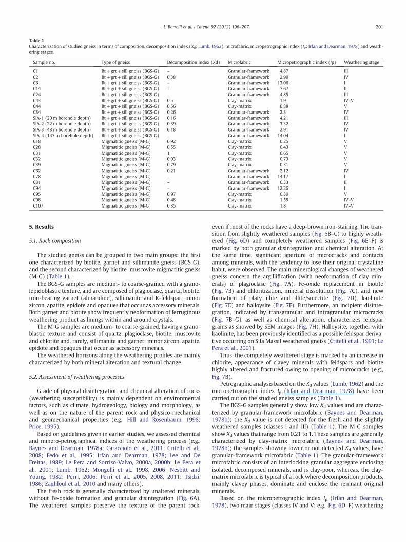
Table 1Characterization of studied gneiss in terms of composition, decomposition index (Xd; Lumb, 1962), microfabric, micropetrographic index (Ip; Irfan and Dearman, 1978) and weath-ering stages.
Sample no. Type of gneiss Decomposition index (Xd) Microfabric Micropetrographic index (Ip) Weathering stage
C1 Bt+grt+sill gneiss (BGS-G) – Granular-framework 4.87 IIIC2 Bt+grt+sill gneiss (BGS-G) 0.38 Granular-framework 2.99 IVC6 Bt+grt+sill gneiss (BGS-G) – Granular-framework 13.06 IC14 Bt+grt+sill gneiss (BGS-G) - Granular-framework 7.67 IIC24 Bt+grt+sill gneiss (BGS-G) – Granular-framework 4.85 IIIC43 Bt+grt+sill gneiss (BGS-G) 0.5 Clay-matrix 1.9 IV–VC44 Bt+grt+sill gneiss (BGS-G) 0.56 Clay-matrix 0.88 VC84 Bt+grt+sill gneiss (BGS-G) 0.26 Granular-framework 2.8 IVSIA-1 (20 m borehole depth) Bt+grt+sill gneiss (BGS-G) 0.16 Granular-framework 4.21 IIISIA-2 (22 m borehole depth) Bt+grt+sill gneiss (BGS-G) 0.39 Granular-framework 3.32 IVSIA-3 (48 m borehole depth) Bt+grt+sill gneiss (BGS-G) 0.18 Granular-framework 2.91 IVSIA-4 (147 m borehole depth) Bt+grt+sill gneiss (BGS-G) – Granular-framework 14.04 IC18 Migmatitic gneiss (M-G) 0.92 Clay-matrix 0.25 VC28 Migmatitic gneiss (M-G) 0.55 Clay-matrix 0.43 VC31 Migmatitic gneiss (M-G) 1 Clay-matrix 0.65 VC32 Migmatitic gneiss (M-G) 0.93 Clay-matrix 0.73 VC39 Migmatitic gneiss (M-G) 0.79 Clay-matrix 0.31 VC62 Migmatitic gneiss (M-G) 0.21 Granular-framework 2.12 IVC78 Migmatitic gneiss (M-G) – Granular-framework 14.17 IC81 Migmatitic gneiss (M-G) – Granular-framework 6.33 IIC94 Migmatitic gneiss (M-G) – Granular-framework 12.26 IC95 Migmatitic gneiss (M-G) 0.97 Clay-matrix 0.39 VC98 Migmatitic gneiss (M-G) 0.48 Clay-matrix 1.55 IV–VC107 Migmatitic gneiss (M-G) 0.85 Clay-matrix 1.8 IV–V
201L. Borrelli et al. / Catena 92 (2012) 196–207
5. Results
5.1. Rock composition
The studied gneiss can be grouped in two main groups: the firstone characterized by biotite, garnet and sillimanite gneiss (BGS-G),and the second characterized by biotite–muscovite migmatitic gneiss(M-G) (Table 1).
The BGS-G samples are medium- to coarse-grained with a grano-lepidoblastic texture, and are composed of plagioclase, quartz, biotite,iron-bearing garnet (almandine), sillimanite and K-feldspar; minorzircon, apatite, epidote and opaques that occur as accessory minerals.Both garnet and biotite show frequently neoformation of ferruginousweathering product as linings within and around crystals.
The M-G samples are medium- to coarse-grained, having a grano-blastic texture and consist of quartz, plagioclase, biotite, muscoviteand chlorite and, rarely, sillimanite and garnet; minor zircon, apatite,epidote and opaques that occur as accessory minerals.
The weathered horizons along the weathering profiles are mainlycharacterized by both mineral alteration and textural change.
5.2. Assessment of weathering processes
Grade of physical disintegration and chemical alteration of rocks(weathering susceptibility) is mainly dependent on environmentalfactors, such as climate, hydrogeology, biology and morphology, aswell as on the nature of the parent rock and physico-mechanicaland geomechanical properties (e.g., Hill and Rosenbaum, 1998;Price, 1995).
Based on guidelines given in earlier studies, we assessed chemicaland minero-petrographical indices of the weathering process (e.g.,Baynes and Dearman, 1978a; Caracciolo et al., 2011; Critelli et al.,2008; Fedo et al., 1995; Irfan and Dearman, 1978; Lee and DeFreitas, 1989; Le Pera and Sorriso-Valvo, 2000a, 2000b; Le Pera etal., 2001; Lumb, 1962; Mongelli et al., 1998, 2006; Nesbitt andYoung, 1982; Perri, 2006; Perri et al., 2005, 2008, 2011; Tsidzi,1986; Zaghloul et al., 2010 and many others).
The fresh rock is generally characterized by unaltered minerals,without Fe-oxide formation and granular disintegration (Fig. 6A).The weathered samples preserve the texture of the parent rock,
even if most of the rocks have a deep-brown iron-staining. The tran-sition from slightly weathered samples (Fig. 6B–C) to highly weath-ered (Fig. 6D) and completely weathered samples (Fig. 6E–F) ismarked by both granular disintegration and chemical alteration. Atthe same time, significant aperture of microcracks and contactsamong minerals, with the tendency to lose their original crystallinehabit, were observed. The main mineralogical changes of weatheredgneiss concern the argillification (with neoformation of clay min-erals) of plagioclase (Fig. 7A), Fe-oxide replacement in biotite(Fig. 7B) and chloritization, mineral dissolution (Fig. 7C), and newformation of platy illite and illite/smectite (Fig. 7D), kaolinite(Fig. 7E) and halloysite (Fig. 7F). Furthermore, an incipient disinte-gration, indicated by transgranular and intragranular microcracks(Fig. 7B–G), as well as chemical alteration, characterizes feldspargrains as showed by SEM images (Fig. 7H). Halloysite, together withkaolinite, has been previously identified as a possible feldspar deriva-tive occurring on Sila Massif weathered gneiss (Critelli et al., 1991; LePera et al., 2001).
Thus, the completely weathered stage is marked by an increase inchlorite, appearance of clayey minerals with feldspars and biotitehighly altered and fractured owing to opening of microcracks (e.g.,Fig. 7B).
Petrographic analysis based on the Xd values (Lumb, 1962) and themicropetrographic index Ip (Irfan and Dearman, 1978) have beencarried out on the studied gneiss samples (Table 1).
The BGS-G samples generally show low Xd values and are charac-terized by granular-framework microfabric (Baynes and Dearman,1978b); the Xd value is not detected for the fresh and the slightlyweathered samples (classes I and III) (Table 1). The M-G samplesshow Xd values that range from 0.21 to 1. These samples are generallycharacterized by clay-matrix microfabric (Baynes and Dearman,1978b); the samples showing lower or not detected Xd values, havegranular-framework microfabric (Table 1). The granular-frameworkmicrofabric consists of an interlocking granular aggregate enclosingisolated, decomposed minerals, and is clay-poor, whereas, the clay-matrix microfabric is typical of a rock where decomposition products,mainly clayey phases, dominate and enclose the remnant originalminerals.
Based on the micropetrographic index Ip (Irfan and Dearman,1978), two main stages (classes IV and V; e.g., Fig. 6D–F) weathering
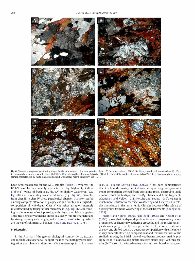
Fig. 6. Photomicrographs of weathering stages for the studied gneiss (crossed polarized light). A) fresh rock (class I) (10×); B) slightly weathered sample (class II) (10×);C) moderately weathered sample (class III) (10×); D) highly weathered sample (class IV) (10×); E) completely weathered sample (class V) (10×); F) completely weatheredsample characterized by clasts in an oxidized and argillaceous matrix (classes V–VI) (10×).
202 L. Borrelli et al. / Catena 92 (2012) 196–207
have been recognized for the M-G samples (Table 1), whereas theBGS-G samples are mainly characterized by higher Ip indices(Table 1) typical of fresh (e.g., Fig. 6A) or slightly weathered (e.g.,Fig. 6B) and moderately weathered rocks (e.g., Fig. 6C). Samplesfrom class III to class IV show petrological changes characterized bya nearly complete alteration of plagioclase and biotite and a slight de-composition of K-feldspar. Class V comprises samples intenselymicrofractured by transgranular microcracks (e.g., Fig. 7G), contribut-ing to the increase of rock porosity, with clay-coated feldspar grains.Thus, the highest weathering stages (classes V–VI) are characterizedby strong petrological changes, and extreme microfracturing, whichare typical of soil material behavior (Irfan and Dearman, 1978).
6. Discussion
In the Sila massif the geomorphological, compositional, texturalandmechanical evidence all support the idea that both physical disin-tegration and chemical alteration affect metamorphic rock masses
(e.g., Le Pera and Sorriso-Valvo, 2000a). It has been demonstratedthat, in a humid climate, chemical weathering acts vigorously on sed-iment composition derived from crystalline rocks, destroying labileminerals, such as feldspar and Fe–Mg phases, and lithic fragments(Grantham and Velbel, 1988; Nesbitt and Young, 1989). Quartz ismuch more resistant to chemical weathering and it increases in rela-tive abundance in the more humid climates because of the release ofquartz grains from the weathering of the rock fragments (Young et al.,1975).
Nesbitt and Young (1996), Fedo et al. (1995) and Nesbitt et al.(1996) show that feldspar depletion becomes progressively morepronounced as chemical weathering proceeds, and the resulting sam-ples become progressively less representative of the source rock min-eralogy, and shifted toward a quartzose composition with enrichmentin clay minerals. Based on compositional and textural features of thestudied samples, the initial stage of weathering produces mainly pre-cipitates of Fe-oxides along biotite cleavage planes (Fig. 8A); thus, fer-rous (Fe2+) iron of the iron-bearing silicates is combined with oxygen

203L. Borrelli et al. / Catena 92 (2012) 196–207

Fig. 8. Stages of mineral (biotite and plagioclase) alteration (crossed polarized light). A) Early stage of biotite alteration characterized by incipient clay mineral formation andFe-oxides along cleavage planes (20×); B) more advance stage of biotite alteration replaced by Fe-oxides and abundant clay minerals along rims and lamellae (20×); C) earlystage of plagioclase alteration showing fine-grained sericite along twin planes (20×); D) more advance stage of plagioclase alteration with pervasive sericite and neoformedclay minerals (20×).
204 L. Borrelli et al. / Catena 92 (2012) 196–207
to form ferric (Fe3+) iron oxides (e.g., hematite) (Fig. 8B). Further-more, newly formed clay minerals (chlorite), replacing biotite alongrims and lamellae (Fig. 8B), has also been observed in a later stageof biotite weathering (e.g., Stoch and Sikora, 1976).
Fine-grained sericite often occurs within plagioclase, preferential-ly along twin planes (Fig. 8C), or more pervasively, as bright yellow-ish birefringent laths a few microns in size. A pre-weathering originfor sericite has been considered (Dixon and Young, 1981; James etal., 1981; Velbel, 1983), even if a formation during deep weatheringconditions cannot be ruled out (Irfan and Dearman, 1978; Ollier,1983, 1984, 1988). As weathering advances, clay minerals replacefine-grained sericite, preferentially along mineral rims (Fig. 8D).
Furthermore, these newly formed phases along cleavage planesexpand the mineral, thereby producing a wedge effect which frac-tures adjacent grain (e.g., Baynes and Dearman, 1978a; Eggler et al.,1969). The advanced stage of weathering is marked by chemicalbreakdown and weathering of feldspar. Feldspars have an opaque,brownish appearance, due to a microcrystalline secondary product,that is probably a clay mineral replacement during weathering (e.g.,Le Pera et al., 2001; Tazaki and Fyfe, 1987; Velbel, 1983). All theseprocesses influence the rock microfabric, increasing crystal microfrac-turing and rock disaggregation with a decrease of the physical–mechanical properties (e.g., Cascini et al., 1994; Heins, 1995; Le Peraet al., 2001 and references therein).
The X-ray diffraction pattern of the completely weathered sampleshows the occurrence of neoformed clay minerals, typically largeamounts of interstratified clay minerals (both 2:1 and 2:1:1 clay
Fig. 7. SEM photographs of weathering features. A) argillification (neoformed clay mineraD) neoformed platy illite minerals; E) booklets of kaolinite; F) tabular morphology of hallocracks; H) feldspar grain chemical alteration.
minerals), chlorite, micas and 1:1 clay minerals (Fig. 9). The differ-ence between the fresh rock and the completely weathered rockXRD pattern is mainly related to the abundance of feldspars, whichdecrease from fresh to completely weathered samples, and clay min-erals, that are neoformed in the completely weathered sample(Fig. 9). These observations confirm the minero-petrographic consid-erations mentioned above.
As observed in this study, the lower values of the decompositionindex (Xd), that mainly characterize the BGS-G samples (Table 1), re-flect a granular framework microfabric of the gneiss, consisting ofdominant sand and silt fraction, and a lower percentage of clay. Theprogressive weathering stage is outlined by the occurrence of aclay-matrix microfabric, as showed by the M-G samples having com-monly higher Xd values and lower Ip values (Table 1). However, in thestudied samples (BGS-G and M-G) occur both granular frameworkand clay-matrix microfabric; the contemporaneous presence of bothgranular- and clay-matrix microfabric reflects a complex weatheringprofile development, combined with a varying amount of eluviation(e.g., Baynes and Dearman, 1978a; Teeuw et al., 1994).
The gneiss framework microfabric is mainly related to the severefracturing and faulting that occur in the studied weathering profiles(Figs. 3–4). These processes furthermore produce the loss of resis-tance in the rock that is one of the most factors predisposing themass movement phenomena in the Sila gneiss (e.g. Borrelli et al.,2007; Cascini et al., 1994). The relationship between mass movementand weathering state regards also the presence of neoformed clayminerals; among these the presence of abundant halloysite, that is a
ls) of plagioclase; B) Fe-oxide replacement in biotite; C) mineral dissolution process;ysite; G) incipient disintegration indicated by transgranular and intragranular micro-
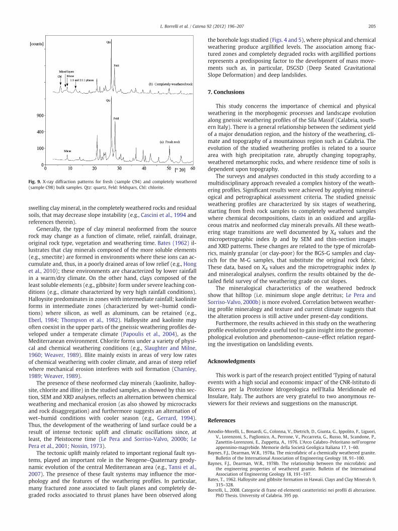
Fig. 9. X-ray diffraction patterns for fresh (sample C94) and completely weathered(sample C98) bulk samples. Qtz: quartz, Feld: feldspars, Chl: chlorite.
205L. Borrelli et al. / Catena 92 (2012) 196–207
swelling clay mineral, in the completely weathered rocks and residualsoils, that may decrease slope instability (e.g., Cascini et al., 1994 andreferences therein).
Generally, the type of clay mineral neoformed from the sourcerock may change as a function of climate, relief, rainfall, drainage,original rock type, vegetation and weathering time. Bates (1962) il-lustrates that clay minerals composed of the more soluble elements(e.g., smectite) are formed in environments where these ions can ac-cumulate and, thus, in a poorly drained areas of low relief (e.g., Honget al., 2010); these environments are characterized by lower rainfallin a warm/dry climate. On the other hand, clays composed of theleast soluble elements (e.g., gibbsite) form under severe leaching con-ditions (e.g., climate characterized by very high rainfall conditions).Halloysite predominates in zones with intermediate rainfall; kaoliniteforms in intermediate zones (characterized by wet–humid condi-tions) where silicon, as well as aluminum, can be retained (e.g.,Eberl, 1984; Thompson et al., 1982). Halloysite and kaolinite mayoften coexist in the upper parts of the gneissic weathering profiles de-veloped under a temperate climate (Papoulis et al., 2004), as theMediterranean environment. Chlorite forms under a variety of physi-cal and chemical weathering conditions (e.g., Slaughter and Milne,1960; Weaver, 1989). Illite mainly exists in areas of very low ratesof chemical weathering with cooler climate, and areas of steep reliefwhere mechanical erosion interferes with soil formation (Chamley,1989; Weaver, 1989).
The presence of these neoformed clay minerals (kaolinite, halloy-site, chlorite and illite) in the studied samples, as showed by thin sec-tion, SEM and XRD analyses, reflects an alternation between chemicalweathering and mechanical erosion (as also showed by microcracksand rock disaggregation) and furthermore suggests an alternation ofwet–humid conditions with cooler season (e.g., Gerrard, 1994).Thus, the development of the weathering of land surface could be aresult of intense tectonic uplift and climatic oscillations since, atleast, the Pleistocene time (Le Pera and Sorriso-Valvo, 2000b; LePera et al., 2001; Nossin, 1973).
The tectonic uplift mainly related to important regional fault sys-tems, played an important role in the Neogene–Quaternary geody-namic evolution of the central Mediterranean area (e.g., Tansi et al.,2007). The presence of these fault systems may influence the mor-phology and the features of the weathering profiles. In particular,many fractured zone associated to fault planes and completely de-graded rocks associated to thrust planes have been observed along
the borehole logs studied (Figs. 4 and 5), where physical and chemicalweathering produce argillified levels. The association among frac-tured zones and completely degraded rocks with argillified portionsrepresents a predisposing factor to the development of mass move-ments such as, in particular, DSGSD (Deep Seated GravitationalSlope Deformation) and deep landslides.
7. Conclusions
This study concerns the importance of chemical and physicalweathering in the morphogenic processes and landscape evolutionalong gneissic weathering profiles of the Sila Massif (Calabria, south-ern Italy). There is a general relationship between the sediment yieldof a major denudation region, and the history of the weathering, cli-mate and topography of a mountainous region such as Calabria. Theevolution of the studied weathering profiles is related to a sourcearea with high precipitation rate, abruptly changing topography,weathered metamorphic rocks, and where residence time of soils isdependent upon topography.
The surveys and analyses conducted in this study according to amultidisciplinary approach revealed a complex history of the weath-ering profiles. Significant results were achieved by applying mineral-ogical and petrographical assessment criteria. The studied gneissicweathering profiles are characterized by six stages of weathering,starting from fresh rock samples to completely weathered sampleswhere chemical decompositions, clasts in an oxidized and argilla-ceous matrix and neoformed clay minerals prevails. All these weath-ering stage transitions are well documented by Xd values and themicropetrographic index Ip and by SEM and thin-section imagesand XRD patterns. These changes are related to the type of microfab-rics, mainly granular (or clay-poor) for the BGS-G samples and clay-rich for the M-G samples, that substitute the original rock fabric.These data, based on Xd values and the micropetrographic index Ipand mineralogical analyses, confirm the results obtained by the de-tailed field survey of the weathering grade on cut slopes.
The mineralogical characteristics of the weathered bedrockshow that hilltop (i.e. minimum slope angle detritus; Le Pera andSorriso-Valvo, 2000b) is more evolved. Correlation between weather-ing profile mineralogy and texture and current climate suggests thatthe alteration process is still active under present-day conditions.
Furthermore, the results achieved in this study on the weatheringprofile evolution provide a useful tool to gain insight into the geomor-phological evolution and phenomenon–cause–effect relation regard-ing the investigation on landsliding events.
Acknowledgments
This work is part of the research project entitled ‘Typing of naturalevents with a high social and economic impact’ of the CNR-Istituto diRicerca per la Protezione Idrogeologica nell'Italia Meridionale edInsulare, Italy. The authors are very grateful to two anonymous re-viewers for their reviews and suggestions on the manuscript.
References
Amodio-Morelli, L., Bonardi, G., Colonna, V., Dietrich, D., Giunta, G., Ippolito, F., Liguori,V., Lorenzoni, S., Paglionico, A., Perrone, V., Piccarreta, G., Russo, M., Scandone, P.,Zanettin-Lorenzoni, E., Zuppetta, A., 1976. L'Arco Calabro–Peloritano nell'orogeneappennino-magrebide. Memorie della Società Geoligica Italiana 17, 1–60.
Baynes, F.J., Dearman, W.R., 1978a. The microfabric of a chemically weathered granite.Bulletin of the International Association of Engineering Geology 18, 91–100.
Baynes, F.J., Dearman, W.R., 1978b. The relationship between the microfabric andthe engineering properties of weathered granite. Bulletin of the InternationalAssociation of Engineering Geology 18, 191–197.
Bates, T., 1962. Halloysite and gibbsite formation in Hawaii. Clays and Clay Minerals 9,315–328.
Borrelli, L., 2008. Categorie di frane ed elementi caratteristici nei profili di alterazione.PhD Thesis. University of Calabria. 395 pp.
206 L. Borrelli et al. / Catena 92 (2012) 196–207
Borrelli, L., Greco, R., Gullà, G., 2007. Weathering grade of rock masses as a predisposingfactor to slope instabilities: reconnaissance and control procedure. Geomorpholo-gy 87, 158–175.
Brand, E.W., Phillipson, H.B., 1985. Sampling and testing of residual soils: a review ofinternational practice: 1–194. Technical Committee on Sampling and Testing of Re-sidual Soils, International Society for Soil Mechanics and Foundation Engineering.Scorpion Press.
Caggianelli, A., Del Moro, A., Piccarreta, G., 1994. Petrology of basic and intermediateorogenic granotoids from the Sila Massif (Calabria, southern Italy). GeologicalJournal 29, 11–28.
Calcaterra, D., Bruno, D.E., Parise, M., Silvestri, F., Critelli, S., Capparelli, G., 2004. Effectsof weathering on slope instability in gneissic rocks at Luzzi (Calabria, Italy).Proceedings of the 9th International Symposium on Landslides, Rio de Janeiro,pp. 1233–1239.
Calcaterra, D., Parise, M., Dattola, L., 1998. Weathering processes in crystalline rocks ofthe Sila Massif, Calabria, southern Italy, as predisposing factor for the developmentof debris flows. Proc. 2nd Int. Symp. In: Evangelista, A., Picarelli, L. (Eds.), TheGeotechnics of Hard Soils, pp. 73–84. Naples, Italy.
Calcaterra, D., Parise, M., Dattola, L., 1996. Caratteristiche dell'alterazione e franosita dirocce granitoidi nel bacino del Torrente Alaco (massiccio delle Serre, Calabria).Bollettino. Societa Geologica Italiana 115, 3–28.
Caracciolo, L., Le Pera, E., Muto, F., Perri, F., 2011. Sandstone petrology and muddstonegeochemistry of the Peruc-Korycany Formation (Bohemien Cretaceous Basin,Czech Republic). International Geology Review 53, 1003–1031.
Cascini, L., Critelli, S., Di Nocera, S., Gullà, G., Matano, F., 1994. Weathering and landslid-ing in Sila Massif gneiss (Northern Calabria, Italy). Proceedings of the 7th Interna-tional IAEG Congress, Lisboa, Portugal, pp. 1613–1622.
Cascini, L., Gullà, G., 1993. Caratterizzazione fisico-meccanica dei terreni prodottidall'alterazione di rocce gneissiche. Rivista Italiana di Geotecnica 2, 125–147.
Cascini, L., Critelli, S., Di Nocera, S., Gulla, G., Matano, F., 1992. Grado di alterazione efranosita negli gneiss del massiccio silano: l'area di San Pietro in Guarano (CS).Geología Applicata e Idrogeología 27, 49–76.
Cavalcante, F., Fiore, S., Lettino, A., Piccarreta, G., Tateo, F., 2007. Illite–smectite mixedlayer in Sicilide shales and piggy-back deposits of the Gorgoglione Formation(Southern Apennines): geological inferences. Bollettino. Societa Geologica Italiana103, 241–254.
Chamley, H., 1989. Clay Sedimentology. Springer, Heidelberg. 623 pp.Critelli, S., Mongelli, G., Perri, F., Martìn-Algarra, A., Martìn-Martìn, M., Perrone, V.,
Dominici, R., Sonnino, M., Zaghloul, M.N., 2008. Compositional and geochemicalsignatures for the sedimentary evolution of the Middle Triassic–Lower Jurassiccontinental redbeds from Western-Central Mediterranean Alpine Chains. Journalof Geology 116, 375–386.
Critelli, S., Di Nocera, S., Le Pera, E., 1991. Approccio metodologico per la valutazionepetrografica del grado di alterazione degli gneiss del Massiccio Silano (Calabria set-tentrionale). Geología Applicata e Idrogeología 26, 41–70.
Deere, D.U., Patton, F.D., 1971. Slope stability in residual soils. Proceedings of the 4thPan American Conference on Soil Mechanics and Foundation Engineering, SanJuan, Puerto Rico, pp. 87–170.
Dixon, J.C., Young, R.W., 1981. Character and origin of deep arenaceous weatheringmantles on the Bega Batholith, southeastern Australia. Catena 8, 97–109.
Eberl, D.D., 1984. Clay mineral formation and transformation in rocks and soils.Philosophical Transactions of the Royal Society of London 311, 241–257.
Eggler, D.H., Larson, E.E., Bradley, W.C., 1969. Granites, grusses, and the Sherman ero-sion surface, southern Laramie Range, Colorado–Wyoming. American Journal ofScience 267, 510–522.
Fedo, C.M., Nesbitt, H.W., Young, G.M., 1995. Unraveling the effect of potassium meta-somatism in sedimentary rocks and paleosols, with implications for paleoweather-ing conditions and provenance. Geology 23, 921–924.
Gerrard, J., 1994. Weathering of granitic rocks: environment and clay mineral forma-tion. In: Robinson, D.A., Williams, R.B.G. (Eds.), Rock Weathering and LandformEvolution. Wiley, New York, pp. 3–20.
Grantham, J.H., Velbel, M.A., 1988. The influence of climate and topography on rock-fragment abundance in modern fluvial sands of the southern Blue Ridge Moun-tains, North Carolina. Journal of Sedimentary Petrology 58, 219–227.
Gullà, G., Critelli, S., Aceto, L., Perri, F., 2008. Geotechnical and mineralogical character-isation of fine-grained soils affected by soil slips. In: Chen, et al. (Ed.), Landslidesand Engineered Slopes. Taylor & Francis Group, London, pp. 373–379.
Gullà, G., Borrelli, L., Greco, R., 2004. Weathering of rock-mass as possible characteriz-ing factor of predisposition to slope instabilities. Proceedings of the IX Internation-al Symposium on Landslides, Rio de Janeiro, pp. 103–108.
Gullà, G., Matano, F., 1997. Surveys of weathering profile on gneiss cutslopes inNorthern Calabria, Italy. Proceedings of the International Symposium on Engineer-ing Geology and the Environment, IAEG, Athens, Greek, pp. 133–138.
Gullà, G., Matano, F., 1994. Proposta di una procedura per il rilievo del grado di altera-zione di gneiss su fronti rocciosi. Geologica Romana 30, 227–238.
Guzzetta, G., 1974. Ancient tropical weathering in Calabria. Nature 251, 302–303.Hencher, S.R., Massey, J.B., Brand, E.W., 1984. Application of back analysis to some
Hong Kong landslides. Proceedings of the 4th International Symposium onLandslides, Toronto, pp. 631–638.
Heins, W.A., 1995. The use of mineral interfaces in sand-sized rock fragments to inferancient climate. Geological Society of America Bulletin 107, 113–125.
Hill, S.E., Rosenbaum, M.S., 1998. Assessing the significant factors in a rock weatheringsystem. Quarterly Journal of Engineering Geology 31, 85–94.
Hong, H., Zhang, K., Li, Z., 2010. Climatic and tectonic uplift evolution since ~7 Ma inGyirong basin, south-western Tibet plateau: clay mineral evidence. InternationalJournal of Earth Sciences (Geol. Rundsch) 99, 1305–1315.
Irfan, T.Y., Dearman, W.R., 1978. The engineering petrography of a weathered granite inCornwall, England. Quarterly Journal of Engineering Geology 11, 223–244.
James, W.C., Mack, G.H., Suttner, L.J., 1981. Relative alteration of microcline and sodicplagioclase in semi-arid and humid climates. Journal of Sedimentary Petrology51, 151–164.
Köppen, W., 1936. Das geographische System der Klimate. In: Köppen, W., Geiger, R.(Eds.), Handbuch der Klimatologie, Band 5, Teil C. Gebrüder Bornträger, Berlin,pp. 1–46.
Lacerda, W.A., Santos, J.R., 2000. Water table fluctuation — a cause of slide initiation inresidual and colluvial soils in tropical regions. Proceedings of the 8th InternationalSymposium on Landslides, Cardiff, pp. 877–880.
Lee, S.G., De Freitas, D.H., 1989. A revision of the description and classification ofweathered granite and its application to granite in Korea. Quarterly Journal ofEngineering Geology 22, 31–48.
Le Pera, E., Critelli, S., Sorriso-Valvo, M., 2001. Weathering of gneiss in Calabria,Southern Italy. Catena 42, 1–15.
Le Pera, E., Sorriso-Valvo, M., 2000a. Weathering and morphogenesis in a mediterra-nean climate, Calabria, Italy. Geomorphology 34, 251–270.
Le Pera, E., Sorriso-Valvo, M., 2000b. Weathering, erosion and sediment composition ina high-gradient river, Calabria, Italy. Earth Surface Processes and Landforms 25,277–292.
Lumb, P., 1962. The properties of decomposed granite. Geotecnique 12, 226–243.Messina, A., Russo, S., Borghi, A., Colonna, V., Compagnoni, R., Caggianelli, A., Fornelli,
A., Piccarreta, G., 1994. Il Massiccio della Sila Settore settentrionale dell'ArcoCalabro-Peloritano. Bollettino. Societa Geologica Italiana 113, 539–586.
Messina, A., Barbieri, M., Compagnoni, R., De Vivo, B., Perrone, V., Russo, S., Scott, B.A.,1991. Geological and petrochemical study of the Sila Massif plutonic rocks(Northern Calabria, Italy). Bollettino. Societa Geologica Italiana 110, 165–206.
Mongelli, G., Critelli, S., Perri, F., Sonnino, M., Perrone, V., 2006. Sedimentary recycling,provenance and paleoweathering from chemistry and mineralogy of Mesozoiccontinental redbed mudrocks, Peloritani Mountains, Southern Italy. GeochemicalJournal 40, 197–209.
Mongelli, G., Cullers, R.L., Dinelli, E., Rottura, A., 1998. Elemental mobility during theweathering of exposed lower crust: the kinzigitic paragneisses from the Serre,Calabria, Southern Italy. Terra Nova 10, 190–195.
Moore, D.M., Reynolds, R.C., 1997. X-Ray Diffraction and the Identification and Analysisof Clay Minerals, Second Edition. Oxford University Press, New York. 378 pp.
Nesbitt, H.W., Young, G.M., McLennan, S.M., Keays, R.R., 1996. Effects of chemicalweathering and sorting on the petrogenesis of siliciclastic sediments, with implica-tions for provenance studies. Journal of Geology 104, 525–542.
Nesbitt, H.W., Young, G.M., 1996. Petrogenesis of sediments in the absence of chemicalweathering: effects of abrasion and sorting on bulk composition and mineralogy.Sedimentology 43, 341–358.
Nesbitt, H.W., Young, G.M., 1989. Formation and diagenesis of weathering profiles.Journal of Geology 97, 129–147.
Nesbitt, H.W., Young, G.M., 1982. Early Proterozoic climates and plate motions inferredfrom major element chemistry of lutites. Nature 299, 715–717.
Nishida, K., Aoyama, C., 1985. Weathered residual soil properties and failure mecha-nism of slope. Proceedings of the 4th International Conference and Field Workshopon Landslides, Tokyo, pp. 289–294.
Nossin, J.J., 1973. Use of air photos in studies of slope stability in the Crati basinCalabria, Italy. Geología Applicata e Idrogeología 8, 261–287.
Ollier, C., 1988. The regolith in Australia. Earth-Science Reviews 25, 355–361.Ollier, C., 1984. Weathering, 2nd ed. Longman, New York.Ollier, C., 1983. Weathering or hydrothermal alteration? Catena 10, 57–59.Palmentola, G., Acquafredda, P., Fiore, S., 1990. A new correlation of the glacial mo-
raines in the southern Appennines, Italy. Geomorphology 3, 1–8.Papoulis, D., Tsolis-Katagas, P., Katagas, C., 2004. Progressive stages in the formation of
kaolin minerals of different morphologies in the weathering of plagioclase. Claysand Clay Minerals 52, 275–286.
Perri, F., Cirrincione, R., Critelli, S., Mazzoleni, P., Pappalardo, A., 2008. Clay mineral as-semblages and sandstone compositions of the Mesozoic Longobucco Group(north-eastern Calabria): implication for burial history and diagenetic evolution.International Geology Review 50, 1116–1131.
Perri, F., Critelli, S., Mongelli, G., Cullers, R.L., 2011. Sedimentary evolution of the Meso-zoic continental redbeds using geochemical and mineralogical tools: the case ofUpper Triassic to Lowermost Jurassic Monte di Gioiosa mudrocks (Sicily, southernItaly). International Journal of Earth Sciences 100, 1569–1587.
Perri, F., Mongelli, G., Sonnino, M., Critelli, S., Perrone, V., 2005. Chemistry and miner-alogy of mesozoic continental redbed mudrocks from the Calabrian Arc, SouthernItaly: implication for provenance, paleoweathering and burial history. AttiTicinensi di Scienze della Terra 10, 103–106.
Perri, F., 2006. Analisi geochimica, mineralogia e petrografia di successioni sedimen-tarie triassico-giurassiche del rifting tetideo, dell'Arco Calabro-Peloritano: implica-zioni sulla loro storia evolutiva. [unpubl. Ph.D. thesis]: Università della Basilicata,210 pp.
Perri, F., 2008. Claymineral assemblage of theMiddle Triassic–Lower Jurassicmudrocks fromWestern-Central Mediterranean Alpine Chains. Periodico di Mineralogia 77, 23–40.
Price, D.G., 1995. Weathering and weathering processes. Quarterly Journal ofEngineering Geology 28, 243–252.
Slaughter, M., Milne, I.H., 1960. The formation of chlorite-like structures frommontmo-rillonite. Clays and Clay Minerals 5, 114–124.
Sorriso-Valvo, M., Gabriele, S., Gullà, G., Antronico, L., Tansi, C., Aceto, L., Dodaro, F.,Greco, R., Niceforo, D., Fantucci, R., 2005. Studio geologico–geomorfologico–geotecnico e monitoraggio della frana di Serra di Buda (Acri). CNR-IRPI, RegioneCalabria LL.PP. e Acque, Autorità di Bacino Regione Calabria. Rubbettino Editore.

207L. Borrelli et al. / Catena 92 (2012) 196–207
Stoch, L., Sikora, W., 1976. Transformation of micas in the process of kaolinization ofgranites and gneiss. Clays and Clay Minerals 24, 156–162.
Stoops, J., 2003. Guidelines for Analysis and Description of Soil and Regolith ThinSections. Soil Science Society of America, Inc., Madison, Wisconsin USA.
Tansi, C., Muto, F., Critelli, S., Iovine, G., 2007. Neogene–Quaternary strike-slip tectonicsin the central Calabrian Arc (southern Italy). Journal of Geodynamics 43, 393–414.
Tazaki, K., Fyfe, W.S., 1987. Primitive clay precursors formed on feldspar. CanadianJournal of Earth Sciences 24, 506–527.
Teeuw, R.M., Thomas, M.F., Thorp, M.B., 1994. Regolith and landscape development inthe Koidu basin of Sierra Leone. In: Robinson, D.A., Williams, R.B.G. (Eds.), RockWeathering and Landform Evolution. Wiley, New York, pp. 303–320.
Terranova, O., Antronico, L., Gullà, G., 2007. Landslide triggering scenarios in homoge-neous geological contexts: the area surrounding Acri (Calabria, Italy). Geomorphology87, 250–267.
Thomas, M.F., 1994. Geomorphology in the Tropics: A Study of Weathering andDenudation in Low Latitudes. John Wiley and Sons, New York. 460 pp.
Thompson, G.R., Fields, R.W., Alt, D., 1982. Land-based evidence for Tertiary climaticvariations: Northern Rockies. Geology 10, 413–417.
Thomson, S.N., 1994. Fission-track analysis of the crystalline basement rocks of theCalabrian Arc, southern Italy: evidence of Oligo-Miocene late-orogenic extensionand erosion. Tectonophysics 238, 331–352.
Tsidzi, K.E.N., 1986. A quantitative petrofabric characterization of metamorphic rocks.Bulletin of the International Association of Engineering Geology 33, 3–12.
Velbel, M.A., 1983. A dissolution–reprecipitation mechanism for the pseudomorphousreplacement of plagioclase feldspar by clay minerals during weathering. Petrologiedes Alterations et des Sols, vol. I. In: Nahon, D., Noack, Y. (Eds.), Sc. Geol. Mem.(Strasbourg), 71, pp. 139–147.
Weaver, C.E., 1989. Clays, muds, and shales. Developments in Sedimentology, vol. 44.Elsevier, Amsterdam. 819 pp.
Young, S.W., Basu, A., Mack, G.H., Darnell, N., Suttner, L.J., 1975. Use of size±composition trends in Holocene soil and fluvial sand for paleoclimate inter-pretation. Proceedings of the 9th International Sedimentological Congress,Theme 1, Nice, France, pp. 201–209.
Zaghloul, M.N., Critelli, S., Perri, F., Mongelli, G., Perrone, V., Sonnino, M., Tucker, M.,Aiello, M., Ventimiglia, C., 2010. Depositional systems, composition and geochem-istry of Triassic rifted-continental margin redbeds of Internal Rif Chain, Morocco.Sedimentology 57, 312–350.