MINE OWNER/LESSEE Geo Exploration and Mining Solutions,
86
` (Under Rule 18 (2) of Granite Conservation and Development Rules, 1999) Patta Land / Scheme Period (2015-16 to 2019-20) IN LOCATION OF THE QUARRY LEASE AREA EXTENT : 1.08.5 Ha S.F.Nos. : 816/1, 817/2, 817/3, 817/4, 817/5, 817/7, 819/20 and 819/24A VILLAGE : IRUTHUKOTTAI TALUK : DENKANIKOTTAI DISTRICT : KRISHNAGIRI STATE : TAMIL NADU FOR MINE OWNER/LESSEE S/o. Omvati Chahal D-1, Sraddha Green Meadows, 4 th Cross Rustan Bagh, Bangalore, Karnataka state - 560 017. PREPARED BY Recognized Qualified Person Reg. No: RQP/MAS/019/87/A Valid Upto: 17.11.2021 Geo Exploration and Mining Solutions, Old No.260-B, New No.17, Advaitha Ashram Road, Alagapuram, Salem – 636 004, Tamilnadu State, Cell: 9443356539, 9442278601. E-mail: [email protected], [email protected]
-
Upload
khangminh22 -
Category
Documents
-
view
1 -
download
0
Transcript of MINE OWNER/LESSEE Geo Exploration and Mining Solutions,
`
(Under Rule 18 (2) of Granite Conservation and Development Rules, 1999)
Patta Land / Scheme Period (2015-16 to 2019-20)
IN
LOCATION OF THE QUARRY LEASE AREA
EXTENT : 1.08.5 Ha
S.F.Nos. : 816/1, 817/2, 817/3, 817/4, 817/5,
817/7, 819/20 and 819/24A
VILLAGE : IRUTHUKOTTAI
TALUK : DENKANIKOTTAI
DISTRICT : KRISHNAGIRI
STATE : TAMIL NADU
FOR
MINE OWNER/LESSEE
S/o. Omvati Chahal
D-1, Sraddha Green Meadows,
4th Cross Rustan Bagh,
Bangalore,
Karnataka state - 560 017.
PREPARED BY
Recognized Qualified Person
Reg. No: RQP/MAS/019/87/A
Valid Upto: 17.11.2021
Geo Exploration and Mining Solutions, Old No.260-B, New No.17, Advaitha Ashram Road,
Alagapuram, Salem – 636 004,
Tamilnadu State,
Cell: 9443356539, 9442278601. E-mail: [email protected], [email protected]
R. Vishal Chahal,
S/o. Omvati Chahal,
D-1, Sraddha Green Meadows,
4th Cross, Rustan Bagh,
Bangalore,
Karnataka state – 560017.
CONSENT LETTER FROM LESSEE
The Scheme of quarrying in respect of Iruthukottai Black Granite
Quarry over an extent of 1.08.5 Ha Patta land in S.F.Nos. 816/1, 817/2,
817/3, 817/4, 817/5, 817/7, 819/20 and 819/24A in Iruthukottai
village, Denkanikottai Taluk, Krishnagiri District, Tamilnadu State has
been prepared by
A. JAGANNATHAN, B.E., F.C.C., M.M.E.A.,
Recognized Qualified Person
RQP/MAS/019/87/A
I request the Commissioner, Department of Geology and Mining,
Chennai to make further correspondence regarding the modification of
the Scheme of quarrying with the said recognized qualified person at his
following address.
A. JAGANNATHAN, B.E., F.C.C., M.M.E.A.,
Geo Exploration and Mining Solutions,
Old No.260-B, New No.17, Advaitha Ashram Road,
Alagapuram,
Salem – 636 004.
Cell: +91 94422 78601, 94433 56539.
I hereby undertake that all the modifications, if any made in the
Scheme of Quarrying by the Recognized qualified person may be
deemed to have been made with my knowledge and consent and shall
be acceptable to me and binding on me in all respects.
Signature of the lessee
(R.Vishal Chahal)
Proprietor
Place: Bangalore
Date : 27.02.2015
R. Vishal Chahal,
S/o. Omvati Chahal,
D-1, Sraddha Green Meadows,
4th Cross, Rustan Bagh,
Bangalore,
Karnataka state – 560017.
DECLARATION OF MINE OWNER
The Scheme of Quarrying in respect of Iruthukottai Black
Granite quarry over an extent of 1.08.5Ha Patta land in S.F.Nos. 816/1,
817/2, 817/3, 817/4, 817/5, 817/7, 819/20 and 819/24A in
Iruthukottai village, Denkanikottai Taluk, Krishnagiri District, Tamilnadu
State has been prepared in full consultation with me by
A. JAGANNATHAN, B.E., F.C.C., M.M.E.A.,
Recognized Qualified Person
RQP/MAS/019/87/A
I have understood its contents and agree to implement the
same in accordance with Laws applicable to Mines.
Signature of the lessee
(R.Vishal Chahal)
Proprietor
Place: Bangalore
Date: 27.02.2015
A. JAGANNATHAN, B.E., F.C.C., M.M.E.A.,
Geo Exploration and Mining Solutions,
Old No.260-B, New No.17, Advaitha Ashram Road,
Alagapuram, Salem – 636 004.
Cell: 94433 56539.
CERTIFICATE FROM THE RECOGNIZED QUALIFIED PERSON
This is to certify that the Provisions of Granite Conservation and
Development Rules, 1999 as amended in Tamil Nadu Minor Mineral
Concession Rules, 1959 have been observed in the preparation of
Scheme of Quarrying for Iruthukottai Black Granite quarry over an
extent of 1.08.5Ha Patta land in S.F.Nos. 816/1, 817/2, 817/3, 817/4,
817/5, 817/7, 819/20 and 819/24A in Iruthukottai village,
Denkanikottai Taluk, Krishnagiri District, Tamilnadu State has been
prepared for
Thiru. R. Vishal Chahal,
S/o. Omvati Chahal,
D-1, Sraddha Green Meadows,
4th Cross, Rustan Bagh,
Bangalore,
Karnataka state – 560017.
Whenever specific permissions/exemptions/ relaxations and
approvals are required, the lessee will approach the concerned
authorities of Commissioner of Geology and Mining, Government of
Tamilnadu, Guindy, Chennai– 600 032 for such permissions/
exemptions /relaxations and approvals.
It is also certified that information furnished in the above Scheme
of Quarrying are true and correct to the best of my knowledge.
RQP SIGNATURE
A. JAGANNATHAN, B.E., F.C.C., M.M.E.A.,
RQP/MAS/019/87/A
Place: Salem
Date: 03.03.2015
A. JAGANNATHAN, B.E., F.C.C., M.M.E.A.,
Geo Exploration and Mining Solutions,
Old No.260-B, New No.17, Advaitha Ashram Road,
Alagapuram, Salem – 636 004.
Cell: 94433 56539.
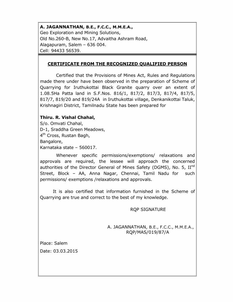
CERTIFICATE FROM THE RECOGNIZED QUALIFIED PERSON
Certified that the Provisions of Mines Act, Rules and Regulations
made there under have been observed in the preparation of Scheme of
Quarrying for Iruthukottai Black Granite quarry over an extent of
1.08.5Ha Patta land in S.F.Nos. 816/1, 817/2, 817/3, 817/4, 817/5,
817/7, 819/20 and 819/24A in Iruthukottai village, Denkanikottai Taluk,
Krishnagiri District, Tamilnadu State has been prepared for
Thiru. R. Vishal Chahal,
S/o. Omvati Chahal,
D-1, Sraddha Green Meadows,
4th Cross, Rustan Bagh,
Bangalore,
Karnataka state – 560017.
Whenever specific permissions/exemptions/ relaxations and
approvals are required, the lessee will approach the concerned
authorities of the Director General of Mines Safety (DGMS), No. 5, IInd
Street, Block – AA, Anna Nagar, Chennai, Tamil Nadu for such
permissions/ exemptions /relaxations and approvals.
It is also certified that information furnished in the Scheme of
Quarrying are true and correct to the best of my knowledge.
RQP SIGNATURE
A. JAGANNATHAN, B.E., F.C.C., M.M.E.A.,
RQP/MAS/019/87/A
Place: Salem
Date: 03.03.2015
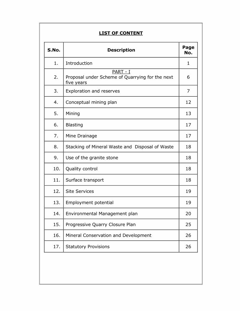
LIST OF CONTENT
S.No. Description Page
No.
1. Introduction 1
2.
PART - I
Proposal under Scheme of Quarrying for the next
five years
6
3. Exploration and reserves 7
4. Conceptual mining plan 12
5. Mining 13
6. Blasting 17
7. Mine Drainage 17
8. Stacking of Mineral Waste and Disposal of Waste 18
9. Use of the granite stone 18
10. Quality control 18
11. Surface transport 18
12. Site Services 19
13. Employment potential 19
14. Environmental Management plan 20
15. Progressive Quarry Closure Plan 25
16. Mineral Conservation and Development 26
17. Statutory Provisions 26
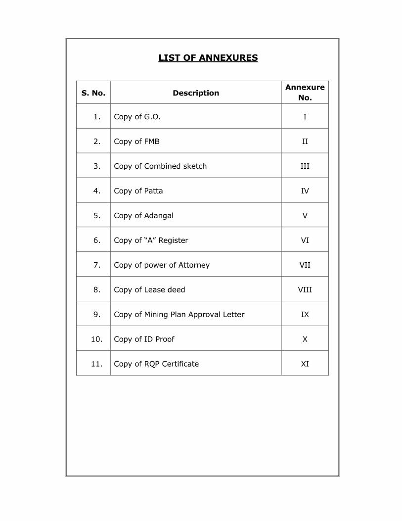
LIST OF ANNEXURES
S. No. Description Annexure
No.
1. Copy of G.O. I
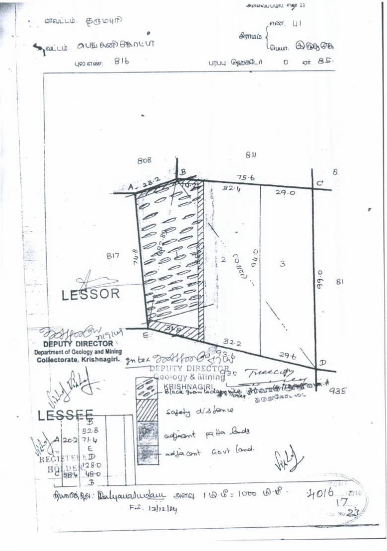
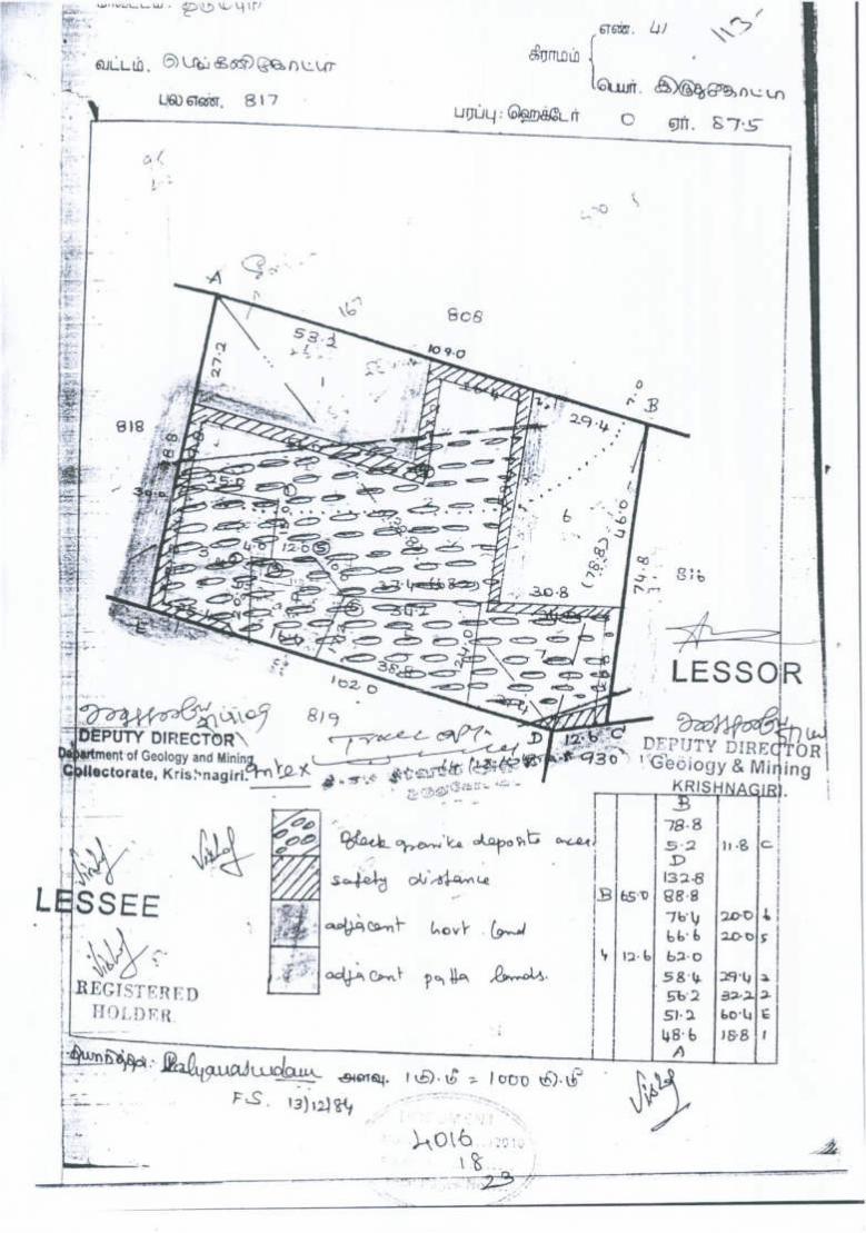
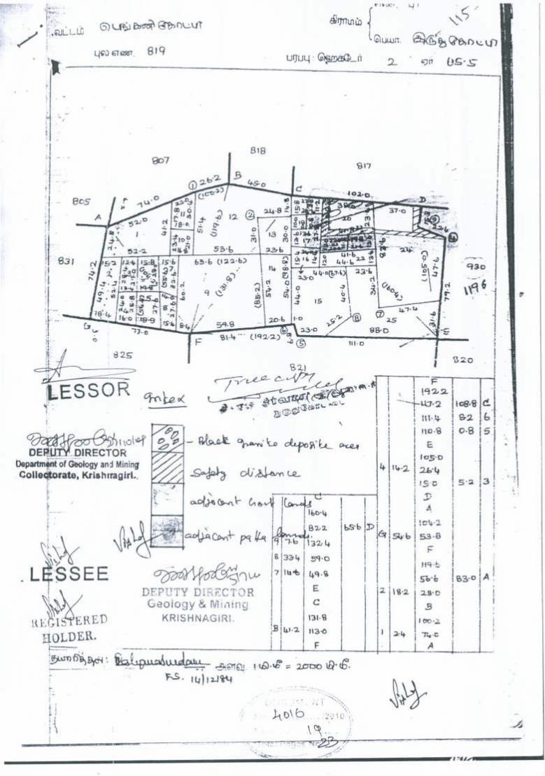
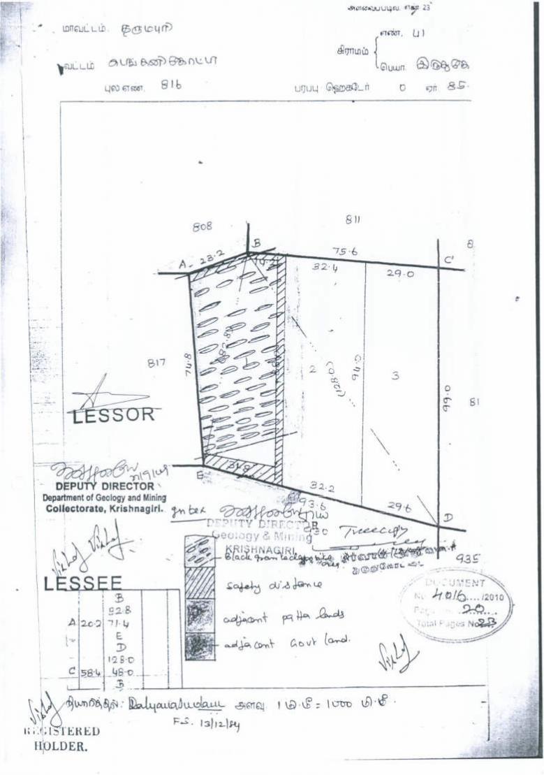
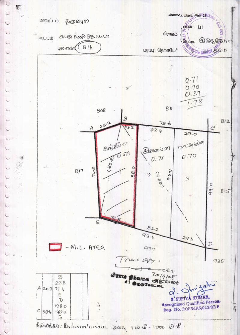
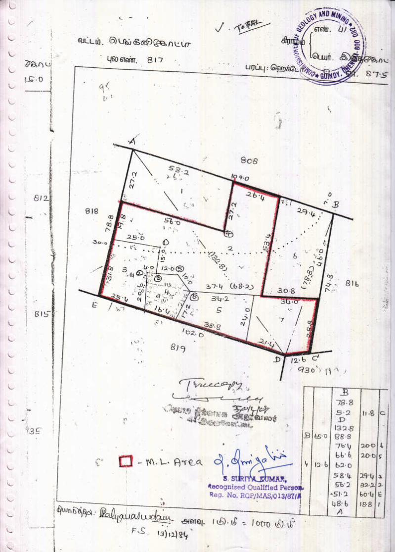
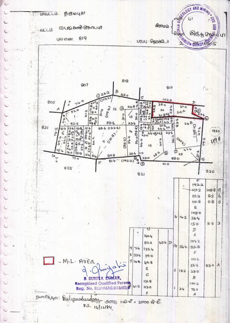
2. Copy of FMB II
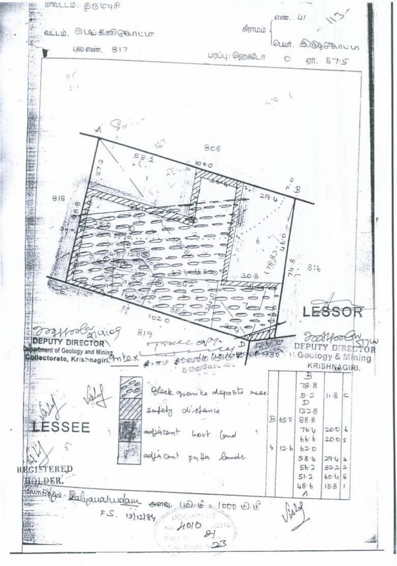
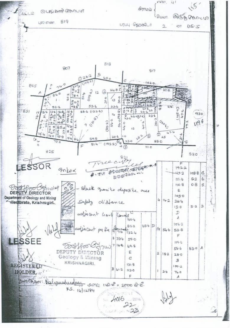
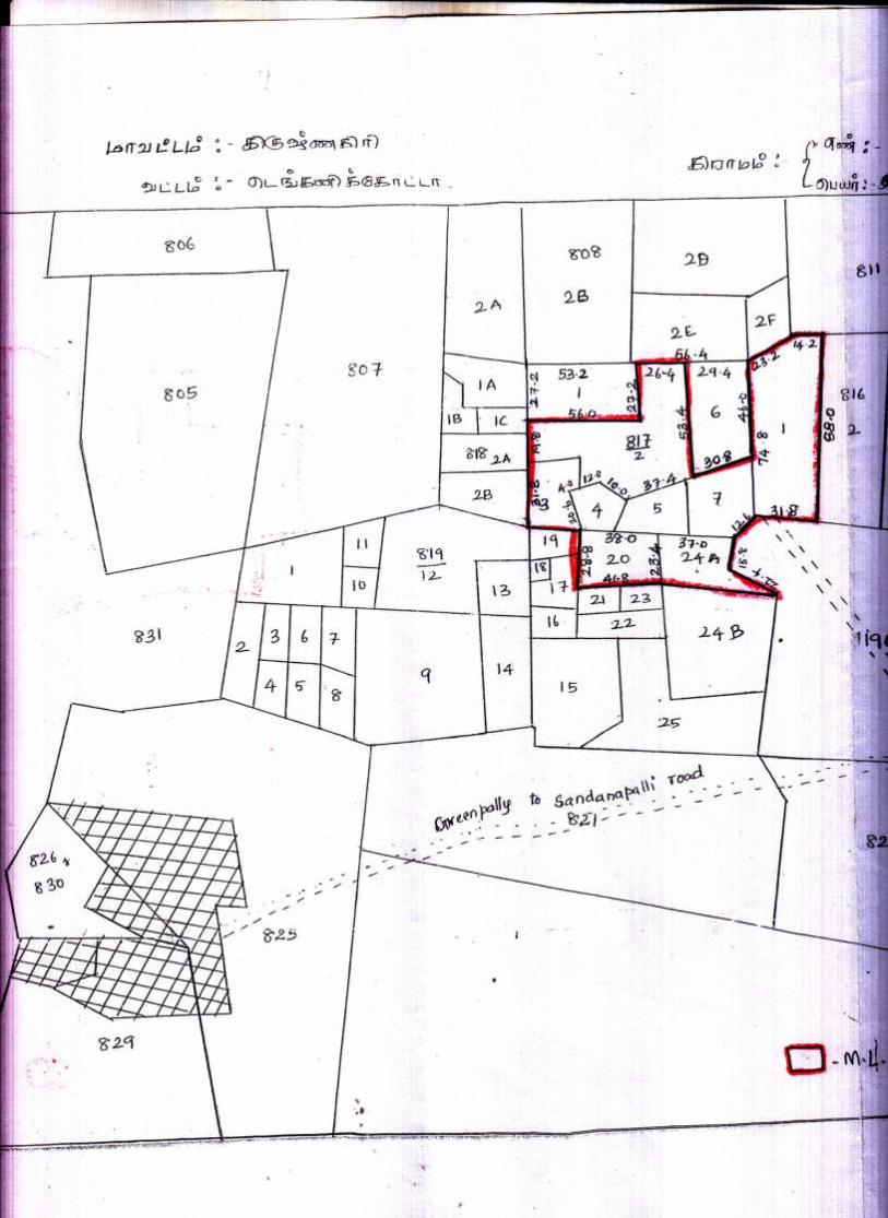
3. Copy of Combined sketch III
4. Copy of Patta IV
5. Copy of Adangal V
6. Copy of “A” Register VI
7. Copy of power of Attorney VII
8. Copy of Lease deed VIII
9. Copy of Mining Plan Approval Letter IX
10. Copy of ID Proof X
11. Copy of RQP Certificate XI
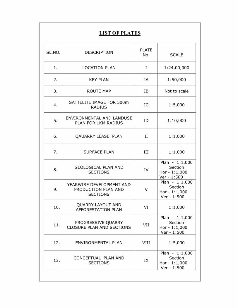
LIST OF PLATES
SL.NO. DESCRIPTION PLATE
No.
SCALE
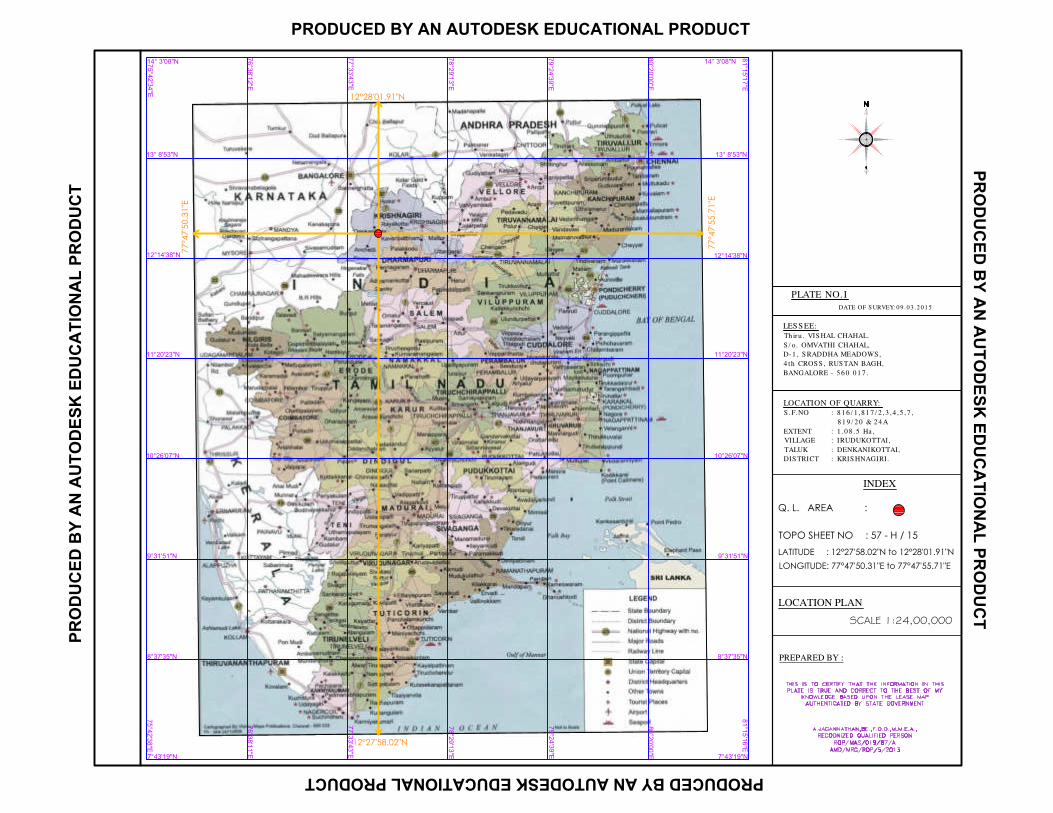
1. LOCATION PLAN I 1:24,00,000
2. KEY PLAN IA 1:50,000
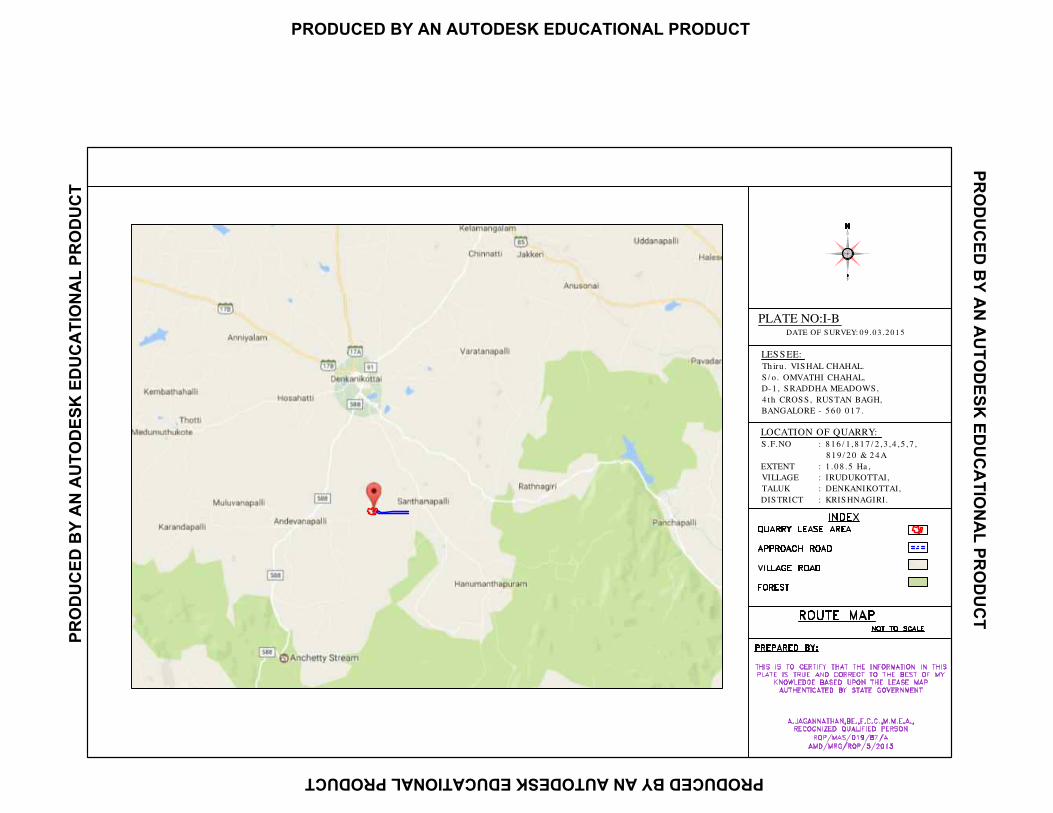
3. ROUTE MAP IB Not to scale
4. SATTELITE IMAGE FOR 500m
RADIUS IC 1:5,000
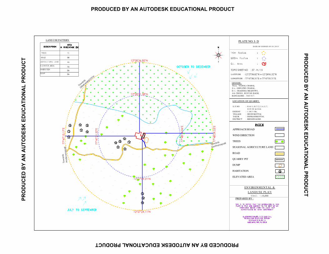
5. ENVIRONMENTAL AND LANDUSE
PLAN FOR 1KM RADIUS ID 1:10,000
6. QAUARRY LEASE PLAN II 1:1,000
7. SURFACE PLAN III 1:1,000
8. GEOLOGICAL PLAN AND
SECTIONS IV
Plan - 1:1,000
Section Hor - 1:1,000
Ver - 1:500
9. YEARWISE DEVELOPMENT AND
PRODUCTION PLAN AND SECTIONS
V
Plan - 1:1,000 Section
Hor - 1:1,000
Ver - 1:500
10. QUARRY LAYOUT AND AFFORESTATION PLAN
VI 1:1,000
11. PROGRESSIVE QUARRY
CLOSURE PLAN AND SECTIONS
VII
Plan - 1:1,000
Section Hor - 1:1,000
Ver - 1:500
12. ENVIRONMENTAL PLAN VIII
1:5,000
13. CONCEPTUAL PLAN AND
SECTIONS IX
Plan - 1:1,000 Section
Hor - 1:1,000
Ver - 1:500
Scheme of Quarrying Iruthukottai Black Granite
1
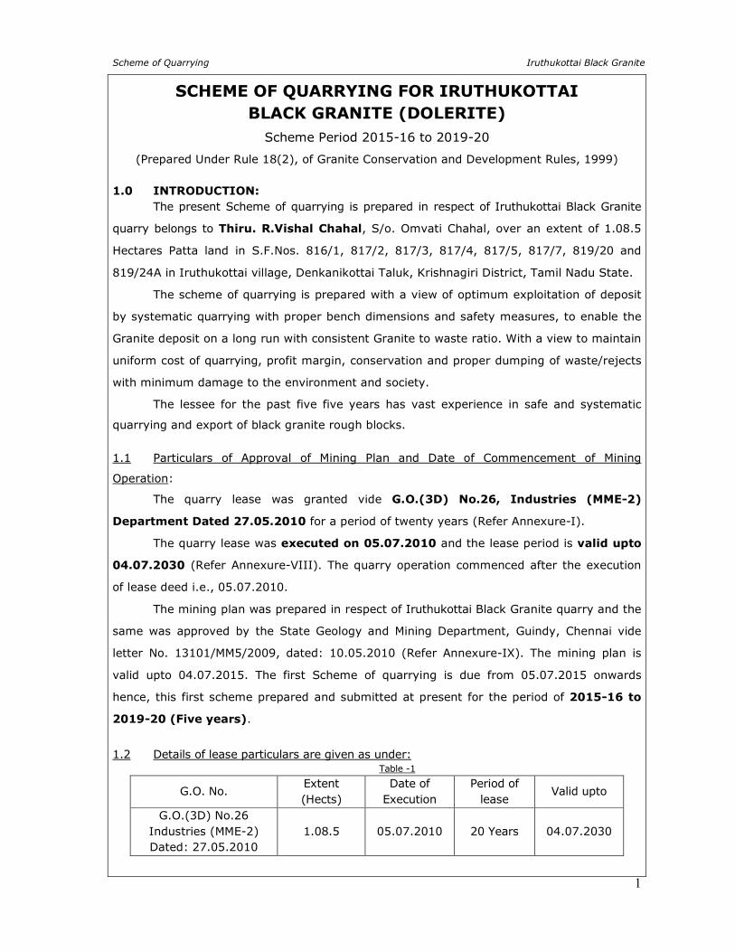
SCHEME OF QUARRYING FOR IRUTHUKOTTAI
BLACK GRANITE (DOLERITE)
Scheme Period 2015-16 to 2019-20
(Prepared Under Rule 18(2), of Granite Conservation and Development Rules, 1999)
1.0 INTRODUCTION: The present Scheme of quarrying is prepared in respect of Iruthukottai Black Granite
quarry belongs to Thiru. R.Vishal Chahal, S/o. Omvati Chahal, over an extent of 1.08.5
Hectares Patta land in S.F.Nos. 816/1, 817/2, 817/3, 817/4, 817/5, 817/7, 819/20 and
819/24A in Iruthukottai village, Denkanikottai Taluk, Krishnagiri District, Tamil Nadu State.
The scheme of quarrying is prepared with a view of optimum exploitation of deposit
by systematic quarrying with proper bench dimensions and safety measures, to enable the
Granite deposit on a long run with consistent Granite to waste ratio. With a view to maintain
uniform cost of quarrying, profit margin, conservation and proper dumping of waste/rejects
with minimum damage to the environment and society.
The lessee for the past five five years has vast experience in safe and systematic
quarrying and export of black granite rough blocks.
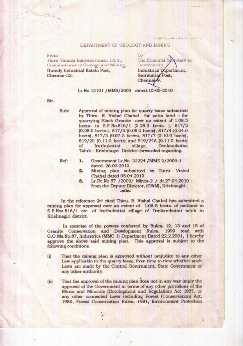
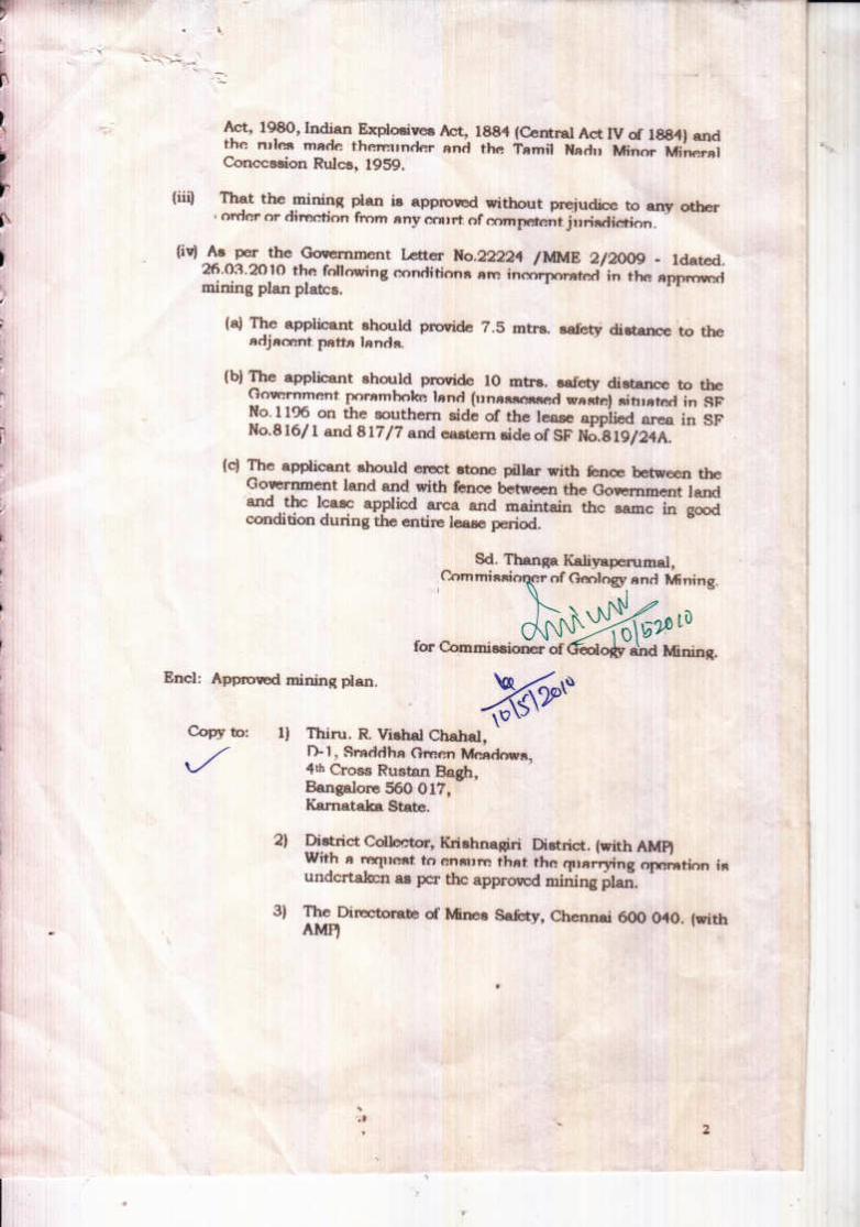
1.1 Particulars of Approval of Mining Plan and Date of Commencement of Mining
Operation:
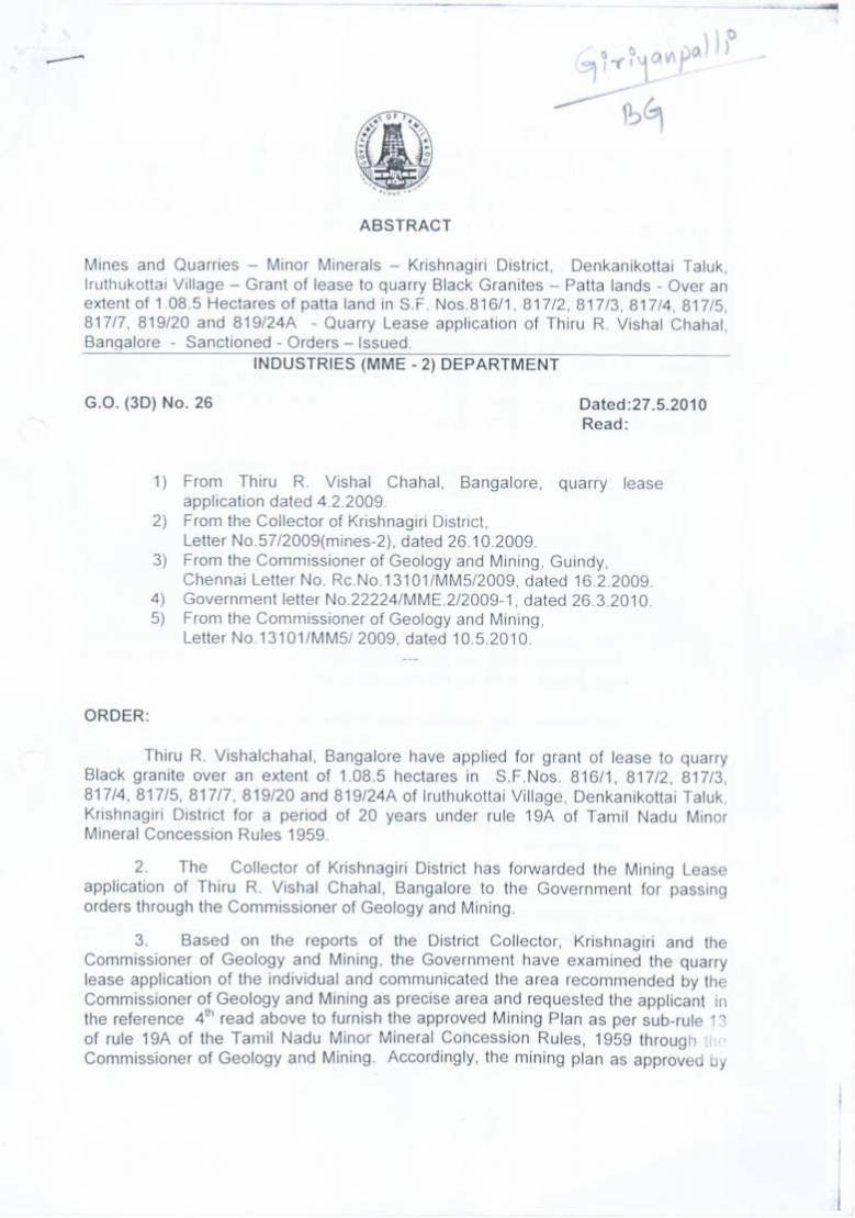
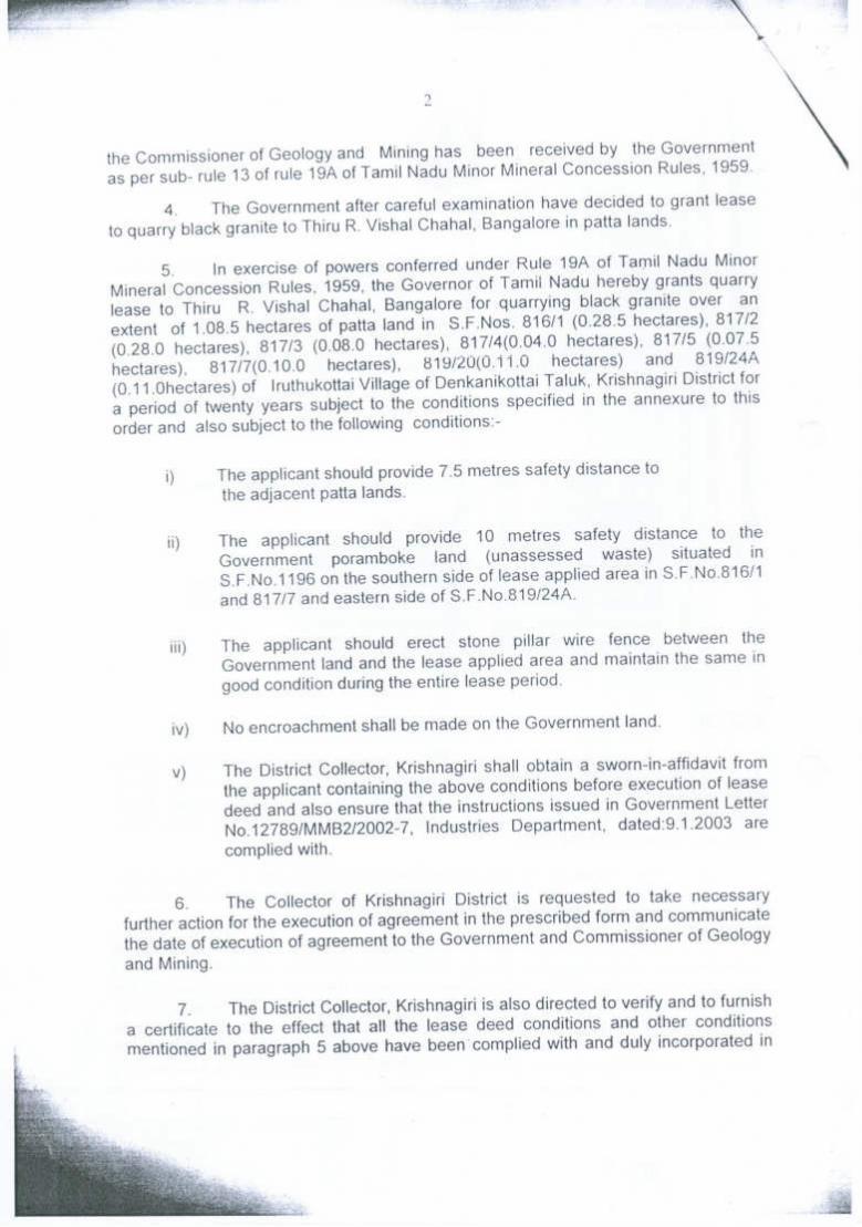
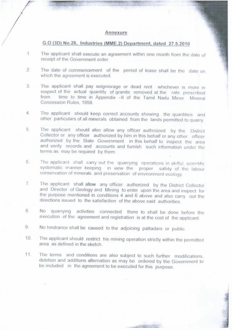
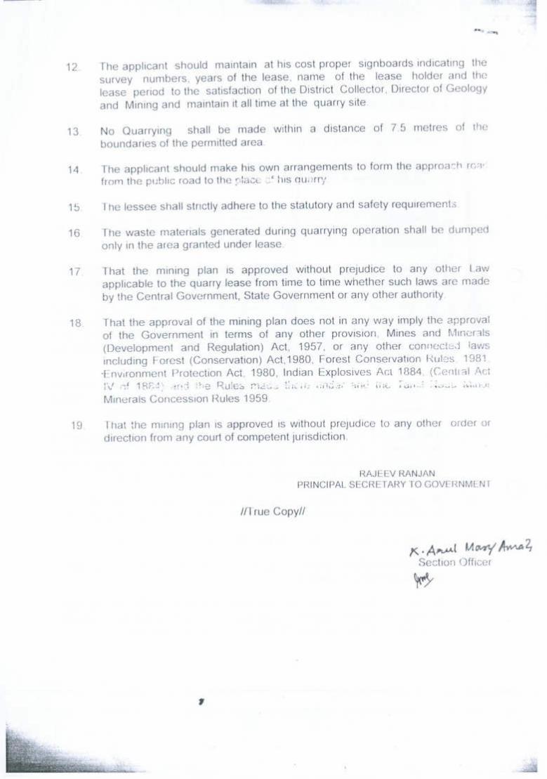
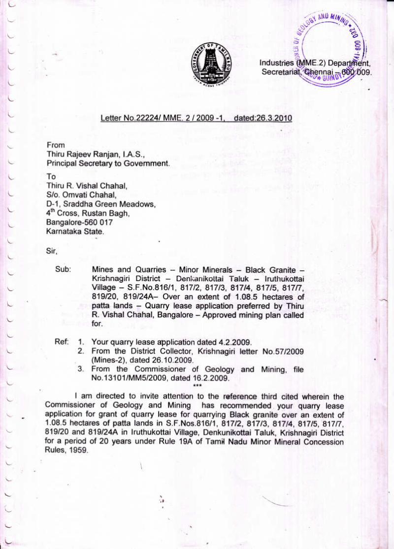
The quarry lease was granted vide G.O.(3D) No.26, Industries (MME-2)
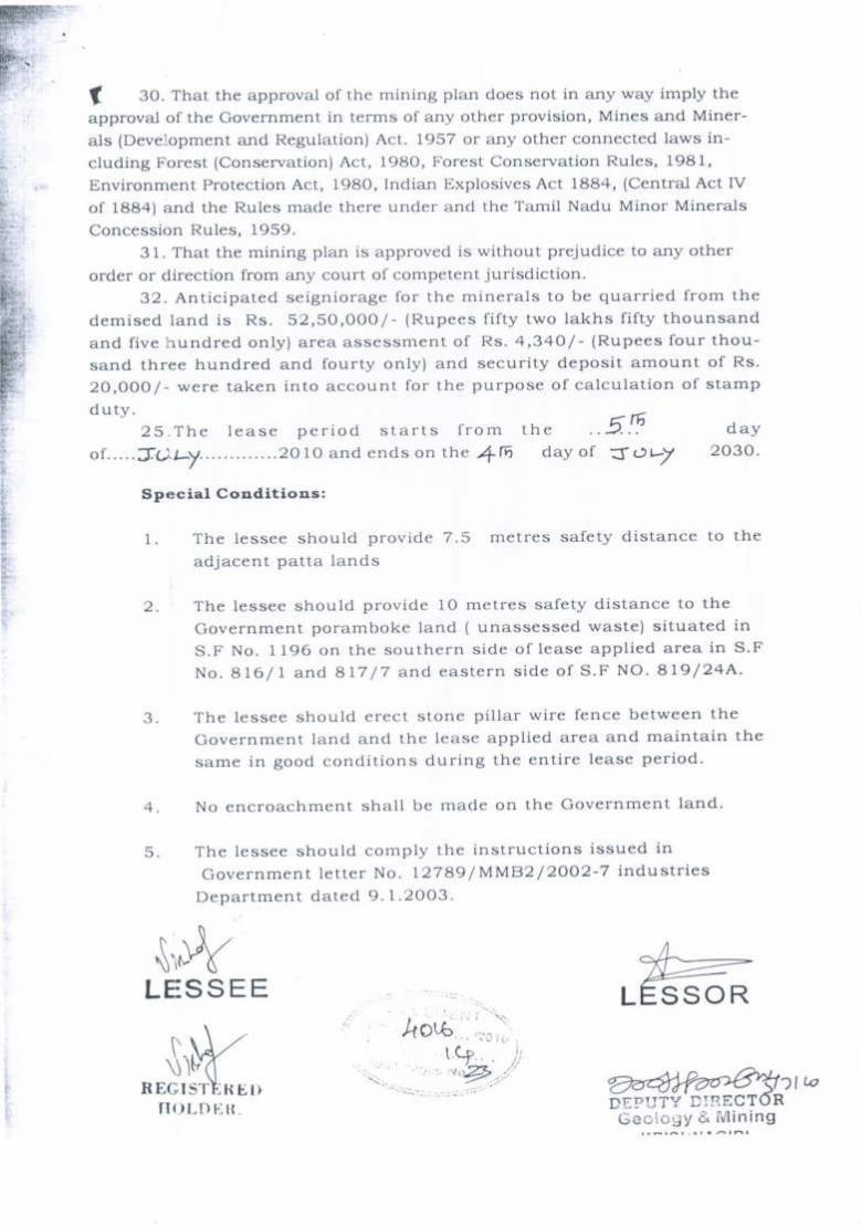
Department Dated 27.05.2010 for a period of twenty years (Refer Annexure-I).
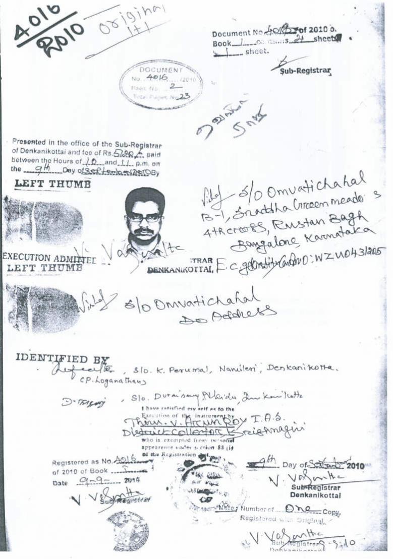
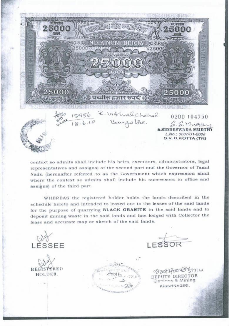
The quarry lease was executed on 05.07.2010 and the lease period is valid upto
04.07.2030 (Refer Annexure-VIII). The quarry operation commenced after the execution
of lease deed i.e., 05.07.2010.
The mining plan was prepared in respect of Iruthukottai Black Granite quarry and the
same was approved by the State Geology and Mining Department, Guindy, Chennai vide
letter No. 13101/MM5/2009, dated: 10.05.2010 (Refer Annexure-IX). The mining plan is
valid upto 04.07.2015. The first Scheme of quarrying is due from 05.07.2015 onwards
hence, this first scheme prepared and submitted at present for the period of 2015-16 to
2019-20 (Five years).
1.2 Details of lease particulars are given as under: Table -1
G.O. No. Extent (Hects)
Date of Execution
Period of lease
Valid upto
G.O.(3D) No.26 Industries (MME-2) Dated: 27.05.2010
1.08.5 05.07.2010 20 Years 04.07.2030
Scheme of Quarrying Iruthukottai Black Granite
2
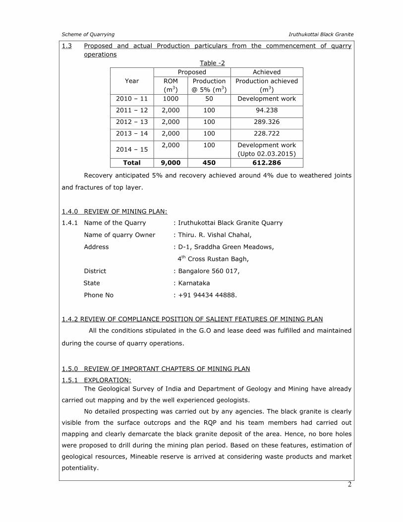
1.3 Proposed and actual Production particulars from the commencement of quarry operations
Table -2
Year Proposed Achieved
ROM (m3)
Production @ 5% (m3)
Production achieved (m3)
2010 – 11 1000 50 Development work
2011 – 12 2,000 100 94.238
2012 – 13 2,000 100 289.326
2013 – 14 2,000 100 228.722
2014 – 15 2,000 100 Development work
(Upto 02.03.2015) Total 9,000 450 612.286
Recovery anticipated 5% and recovery achieved around 4% due to weathered joints
and fractures of top layer.
1.4.0 REVIEW OF MINING PLAN:
1.4.1 Name of the Quarry : Iruthukottai Black Granite Quarry
Name of quarry Owner : Thiru. R. Vishal Chahal,
Address : D-1, Sraddha Green Meadows,
4th Cross Rustan Bagh,
District : Bangalore 560 017,
State : Karnataka
Phone No : +91 94434 44888.
1.4.2 REVIEW OF COMPLIANCE POSITION OF SALIENT FEATURES OF MINING PLAN
All the conditions stipulated in the G.O and lease deed was fulfilled and maintained
during the course of quarry operations.
1.5.0 REVIEW OF IMPORTANT CHAPTERS OF MINING PLAN
1.5.1 EXPLORATION: The Geological Survey of India and Department of Geology and Mining have already
carried out mapping and by the well experienced geologists.
No detailed prospecting was carried out by any agencies. The black granite is clearly
visible from the surface outcrops and the RQP and his team members had carried out
mapping and clearly demarcate the black granite deposit of the area. Hence, no bore holes
were proposed to drill during the mining plan period. Based on these features, estimation of
geological resources, Mineable reserve is arrived at considering waste products and market
potentiality.
Scheme of Quarrying Iruthukottai Black Granite
3
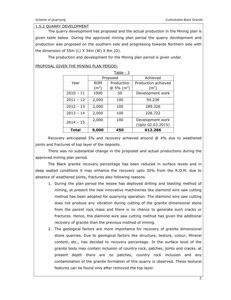
1.5.2 QUARRY DEVELOPMENT The quarry development has proposed and the actual production in the Mining plan is
given table below. During the approved mining plan period the quarry development and
production was proposed on the southern side and progressing towards Northern side with
the dimension of 55m (L) X 34m (W) X 8m (D).
The production and development for the Mining plan period is given under.
PROPOSAL GIVEN THE MINING PLAN PERIOD:
Table - 3
Year Proposed Achieved
ROM (m3)
Production @ 5% (m3)
Production achieved (m3)
2010 – 11 1000 50 Development work
2011 – 12 2,000 100 94.238
2012 – 13 2,000 100 289.326
2013 – 14 2,000 100 228.722
2014 – 15 2,000 100 Development work
(Upto 02.03.2015)
Total 9,000 450 612.286
Recovery anticipated 5% and recovery achieved around @ 4% due to weathered
joints and fractures of top layer of the deposits.
There was no substantial change in the proposed and actual productions during the
approved mining plan period.
The Black granite recovery percentage has been reduced in surface levels and in
deep seated conditions it may enhance the recovery upto 30% from the R.O.M. due to
absence of weathered joints, fractures also following reasons.
1. During the plan period the lessee has deployed drilling and blasting method of
mining, at present the new innovative machineries like diamond wire saw cutting
method has been adopted for quarrying operation. The diamond wire saw cutting
does not produce any vibration during cutting of the granite dimensional stone
from the parent rock mass and there is no chance to generate such cracks or
fractures. Hence, the diamond wire saw cutting method has given the additional
recovery of granite than the previous method of mining.
2. The geological factors are more importance for recovery of granite dimensional
stone quarries. Due to geological factors like structure, texture, colour, Mineral
content, etc., has decided to recovery percentage. In the surface level of the
granite body may contain inclusion of country rock, patches, joints and cracks. at
present depth there are no patches, country rock inclusion and any
contamination of the granite formation of this quarry is observed. These textural
features can be found only after removed the top layer.
Scheme of Quarrying Iruthukottai Black Granite
4
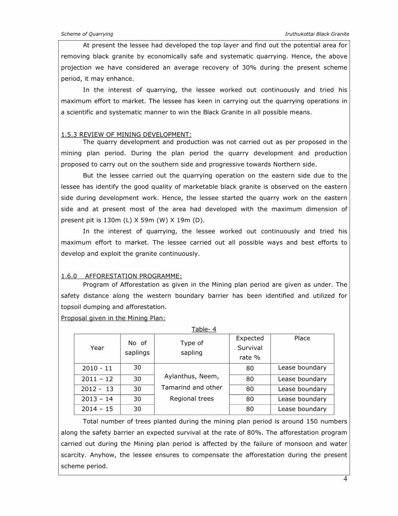
At present the lessee had developed the top layer and find out the potential area for
removing black granite by economically safe and systematic quarrying. Hence, the above
projection we have considered an average recovery of 30% during the present scheme
period, it may enhance.
In the interest of quarrying, the lessee worked out continuously and tried his
maximum effort to market. The lessee has keen in carrying out the quarrying operations in
a scientific and systematic manner to win the Black Granite in all possible means.
1.5.3 REVIEW OF MINING DEVELOPMENT: The quarry development and production was not carried out as per proposed in the
mining plan period. During the plan period the quarry development and production
proposed to carry out on the southern side and progressive towards Northern side.
But the lessee carried out the quarrying operation on the eastern side due to the
lessee has identify the good quality of marketable black granite is observed on the eastern
side during development work. Hence, the lessee started the quarry work on the eastern
side and at present most of the area had developed with the maximum dimension of
present pit is 130m (L) X 59m (W) X 19m (D).
In the interest of quarrying, the lessee worked out continuously and tried his
maximum effort to market. The lessee carried out all possible ways and best efforts to
develop and exploit the granite continuously.
1.6.0 AFFORESTATION PROGRAMME: Program of Afforestation as given in the Mining plan period are given as under. The
safety distance along the western boundary barrier has been identified and utilized for
topsoil dumping and afforestation.
Proposal given in the Mining Plan:
Table- 4
Year No of
saplings
Type of
sapling
Expected
Survival
rate %
Place
2010 - 11 30 Aylanthus, Neem,
Tamarind and other
Regional trees
80 Lease boundary
2011 – 12 30 80 Lease boundary
2012 - 13 30 80 Lease boundary
2013 – 14 30 80 Lease boundary
2014 – 15 30 80 Lease boundary
Total number of trees planted during the mining plan period is around 150 numbers
along the safety barrier an expected survival at the rate of 80%. The afforestation program
carried out during the Mining plan period is affected by the failure of monsoon and water
scarcity. Anyhow, the lessee ensures to compensate the afforestation during the present
scheme period.
Scheme of Quarrying Iruthukottai Black Granite
5
1.7.0 LAND RECLAMATION AND REHABILITATION: Due to nature of occurrence of the granite body in this quarry is beyond the
workable limits. During the approved mining plan period the quantum of waste is proposed
about 8550m3 (Granite Rejects) the same was proposed to dumped in the eastern side with
dimension of L 40m x W 21.37m x H 10.0m and excavated topsoil (3750m3) are proposed
to dumped on the safety barrier and utilized for road and afforestation purpose. Dumps are
properly terraced systematically by multi-level dumping. When the dump becomes inactive
part of the excavated topsoil will be preserved over and sides of the waste dump and planting
tree sapling for increasing the stability of the waste dumps and to prevent erosion during rainy
season. During the Mining plan period 14m(2m Topsoil + 12m Black granite) depth has
been considered as economically safe and scientific quarrying, now the quarry attained a
maximum depth of 19m.
During this scheme period 32m depth has been considered as economically viable
for safe and systematic quarrying at present market scenario. Immediate backfilling does not
arise. When the quarry reach the ultimate pit limit or at the end of life of quarry, quarried
out waste will be backfilled.
1.8.0 CONTROL OF DUST, NOISE AND VIBRATION: The quarrying operation was carried out by semi mechanized means and HEMM were
deployed occasionally. Hence, the effects due to dust, noise and vibration were minimal.
Anyhow the Ambient quality of Air respect of dust concentration, respirable dust, SO2, NO2
were tested periodically for every season around 1 kms radius for core and buffer zones as
per the guidance of TNPCB. The dust prone areas of the Quarry are Blasting site, Loading,
Hauling and dumping. All such areas were closely monitored as per the guidelines.
The quarry operation was carried out by semi mechanized method with drilling and
blasting. Dressing carried out manually with portable compressor and Jack Hammers.
Hence, the effects due to dust (only development and bench formation), noise and vibration
were minimal.
NOISE: The ambient Noise Level ranges must be <80 dB. As the compressors are, keep at
high levels the impact of noise to the workers is less. Expanding Chemical is used for
cracking the rough blocks and therefore noise of blasting is minimal.
VIBRATION: Blasting induced ground vibration is the only source of vibration in quarrying area.
Since chemicals @ 1kg for 3 feet is used for 8 hours retention time for cracking the solid
rock along the line of drilling. Vibration is observed in this quarry is negligible.
Scheme of Quarrying Iruthukottai Black Granite
6
1.9.0 SIGNIFICANT FEATURES: Being an individual lessee who is much concerned above the environment, he
closely monitored the environmental factors systematically without degrading the land,
water and air. However, tests have to be carried out to show the actual performance of
quarry on environmental issues which will be compiling in the present scheme period.
PART - I
2.0 PROPOSAL UNDER SCHEME OF QUARRYING FOR THE NEXT FIVE YEARS:
2.1 NAME OF THE LESSEE WITH ADDRESS
Name of Quarry : Iruthukottai Black Granite Quarry
Name of the lessee : Thiru. R.Vishal Chahal,
D-1, Sraddha Green Meadows,
4th Cross Rustan Bagh,
Bangalore 560 017,
State : Karnataka
Phone No : +91 94434 44888
2.2 NAME, ADDRESS AND REGISTRATION NUMBER OF THE RECOGNIZED
QUALIFIED PERSON WHO PREPARED THE MINING PLAN
Name : A. JAGANNATHAN, B.E., F.C.C., M.M.E.A.,
Recognized Qualified Person,
Address : Geo Exploration and Mining Solutions,
Old No.260-B, New No.17, Advaitha Ashram Road,
Alagapuram, Salem – 636 004,
Tamil Nadu.
Mobile : +91 94433 56539, 94422 78601.
Telephone : +91 427 2431989(Office).
Registration No. : RQP/MAS/019/87/A
Date of Grant/Renewal : 20.11.1987
Valid up to : 17.11.2021
E-Mail : [email protected], [email protected].
2.3 DETAIL Of LEASE PARTICULARS ARE GIVEN AS UNDER
Table -5
GO. No. Extent (Hects)
Date of Execution
Period of lease
Valid upto
G.O.(3D) No. 26 Dated: 27.05.2010
1.08.5 05.07.2010 20 Years 04.07.2030
The quarry lease was granted vide G.O.(3D) No. 26 Industries (MME-2) Department
Dated 27.05.2010 for a period of twenty years. The quarry lease was executed on
05.07.2010 and the lease period is valid upto 04.07.2030.
Scheme of Quarrying Iruthukottai Black Granite
7
2.4 DETAILS OF THE AREA
a. The area is marked in the Geological Survey of India, Topo sheet no. 57- H/15.
b. The details of the land covered by the area are given below.
c. There is no change in the extent as mentioned in the approved mining plan.
Table - 6
The area lies between the Latitudes of 12°27'57.81"N to 12°28'01.75"N and Longitudes
of 77°47'50.28"E to 77°47’55.63 in WGS Datum-1984 (Refer Plate No. I & IA).
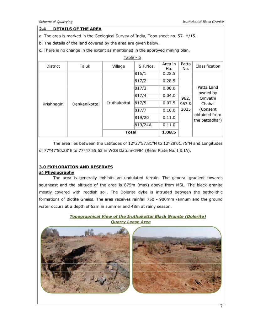
3.0 EXPLORATION AND RESERVES a) Physiography The area is generally exhibits an undulated terrain. The general gradient towards
southeast and the altitude of the area is 875m (max) above from MSL. The black granite
mostly covered with reddish soil. The Dolerite dyke is intruded between the batholithic
formations of Biotite Gneiss. The area receives rainfall 750 - 900mm /annum and the ground
water occurs at a depth of 52m in summer and 48m at rainy season.
Topographical View of the Iruthukottai Black Granite (Dolerite)
Quarry Lease Area
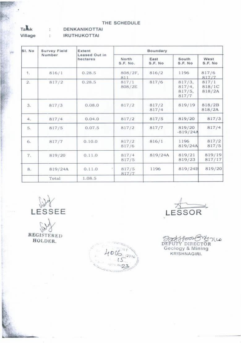
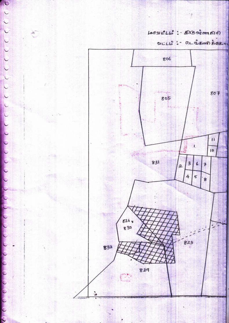
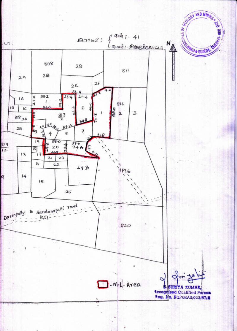
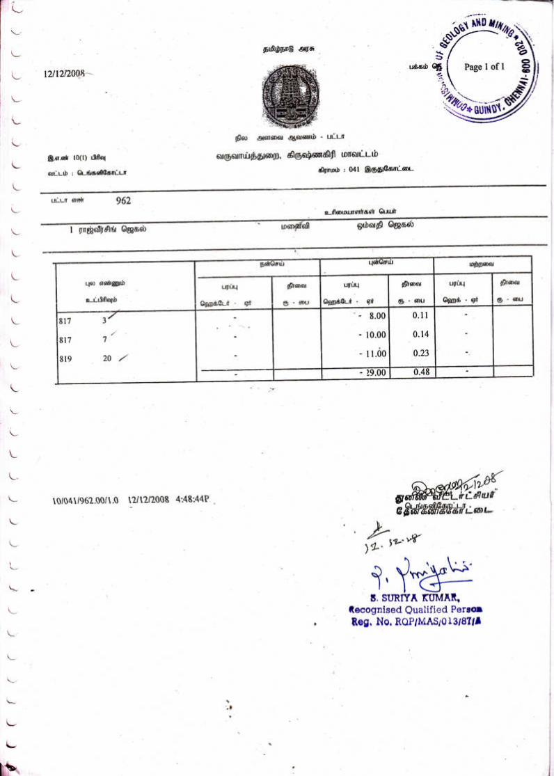
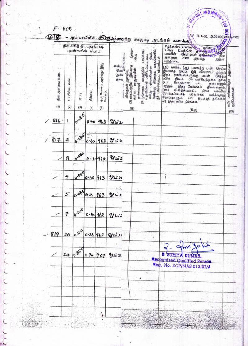
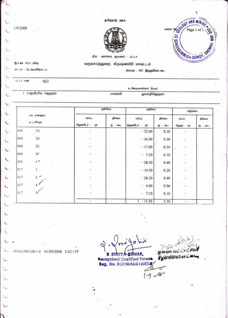
District Taluk Village S.F.Nos. Area in
Ha. Patta No.
Classification
Krishnagiri Denkanikottai
Iruthukottai
816/1 0.28.5
962, 963 & 2025
Patta Land owned by Omvathi Chahal
(Consent obtained from the pattadhar)
817/2 0.28.5
817/3 0.08.0
817/4 0.04.0
817/5 0.07.5
817/7 0.10.0
819/20 0.11.0
819/24A 0.11.0
Total 1.08.5
Scheme of Quarrying Iruthukottai Black Granite
8
b) Regional geology The hard rock terrain of Achaean to late Proterozoic groups comprises of
predominantly Charnockite, Khondalite group of rocks and their magmatic derivatives,
supracrustal sequences intruded by ultramafic complexes, basic dykes and granites.
Granites were formed from molten rock referred to as “Magma” formed at great
depths within the crust of the earth. During the cooling process, some of the minerals grow
into larger crystals of colours peculiar to those minerals or get aligned along certain
preferred directions giving rise to beautiful colors and patterns. Such rocks that were
formed at great depths during the Archaean age are now exposed at the surface of the
earth as a result of the combined actions of wind, air, sun and water and weathering and
denudation over the past several million years.
c) Geology of the area.
The area for quarry lease contains pre-existing rock of Biotite Gneiss and intruded by
dolerite. The dyke is covered by 2m thickness of topsoil followed by fresh marketable black
granite. The dyke rock is hard, compact and sheet in nature at the middle and boundary along
the contacts due to geological disturbances.
The Biotite Gneiss is the host rock with trending of North - South and dipping towards
West. The dolerite dyke intruded between the country rock of Biotite Gneiss in a width of 85m
which stretches about entire lease area with trending of N65oW – S65oE with vertical dipping.
The black granite (dolerite) exhibits sub-ophitic texture, which is the special type of poikilitic
texture. The Dolerite composed of laths of plagioclase embedded in the plates of Augite.
Apatite, magnetite and Ilmenite form the secondary constituents.
STRUCTURAL SETTINGS OF THE AREA
AGE FORMATION
Recent - Top soil
---------Unconformity--------
Pegmatite and Quartz veins,
Proterozoic to Late Archean Dolerites, Migmatites,
Peninsular Gneissic Complex,
Charnockite.
It is a type of ferro – magneisan dyke rock comprised of mineral constituents such as
pyroxene (Augite and Hypersthene) and plagioclase more plagioclase and augite provide
Grey/Greenish Black Colour Upon polishing to this rock. The texture is a typical Porphyritic,
with phenocrysts of plagioclase embedded over pyroxene matrix. The rock is fine to medium
grained melanocratic and without any segregation or textural defects, but little boulders due to
spheroidal weathering. This spheroidal weathering cause for more rejection.
The color of the rock changes depending upon the texture of the rock. The Dykes is
fine grained at the contact of country rock.
Strike Direction - N65oW – S65oE
Dip - Vertical dipping.
Scheme of Quarrying Iruthukottai Black Granite
9
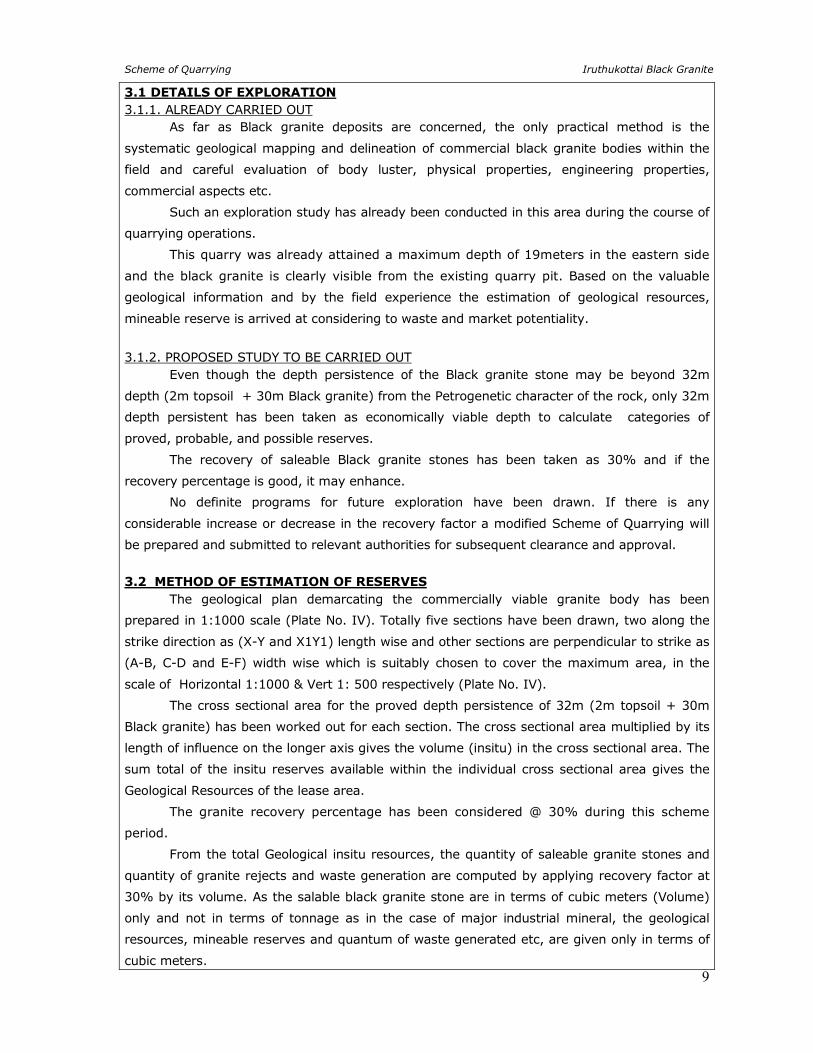
3.1 DETAILS OF EXPLORATION
3.1.1. ALREADY CARRIED OUT As far as Black granite deposits are concerned, the only practical method is the
systematic geological mapping and delineation of commercial black granite bodies within the
field and careful evaluation of body luster, physical properties, engineering properties,
commercial aspects etc.
Such an exploration study has already been conducted in this area during the course of
quarrying operations.
This quarry was already attained a maximum depth of 19meters in the eastern side
and the black granite is clearly visible from the existing quarry pit. Based on the valuable
geological information and by the field experience the estimation of geological resources,
mineable reserve is arrived at considering to waste and market potentiality.
3.1.2. PROPOSED STUDY TO BE CARRIED OUT Even though the depth persistence of the Black granite stone may be beyond 32m
depth (2m topsoil + 30m Black granite) from the Petrogenetic character of the rock, only 32m
depth persistent has been taken as economically viable depth to calculate categories of
proved, probable, and possible reserves.
The recovery of saleable Black granite stones has been taken as 30% and if the
recovery percentage is good, it may enhance.
No definite programs for future exploration have been drawn. If there is any
considerable increase or decrease in the recovery factor a modified Scheme of Quarrying will
be prepared and submitted to relevant authorities for subsequent clearance and approval.
3.2 METHOD OF ESTIMATION OF RESERVES
The geological plan demarcating the commercially viable granite body has been
prepared in 1:1000 scale (Plate No. IV). Totally five sections have been drawn, two along the
strike direction as (X-Y and X1Y1) length wise and other sections are perpendicular to strike as
(A-B, C-D and E-F) width wise which is suitably chosen to cover the maximum area, in the
scale of Horizontal 1:1000 & Vert 1: 500 respectively (Plate No. IV).
The cross sectional area for the proved depth persistence of 32m (2m topsoil + 30m
Black granite) has been worked out for each section. The cross sectional area multiplied by its
length of influence on the longer axis gives the volume (insitu) in the cross sectional area. The
sum total of the insitu reserves available within the individual cross sectional area gives the
Geological Resources of the lease area.
The granite recovery percentage has been considered @ 30% during this scheme
period.
From the total Geological insitu resources, the quantity of saleable granite stones and
quantity of granite rejects and waste generation are computed by applying recovery factor at
30% by its volume. As the salable black granite stone are in terms of cubic meters (Volume)
only and not in terms of tonnage as in the case of major industrial mineral, the geological
resources, mineable reserves and quantum of waste generated etc, are given only in terms of
cubic meters.
Scheme of Quarrying Iruthukottai Black Granite
10
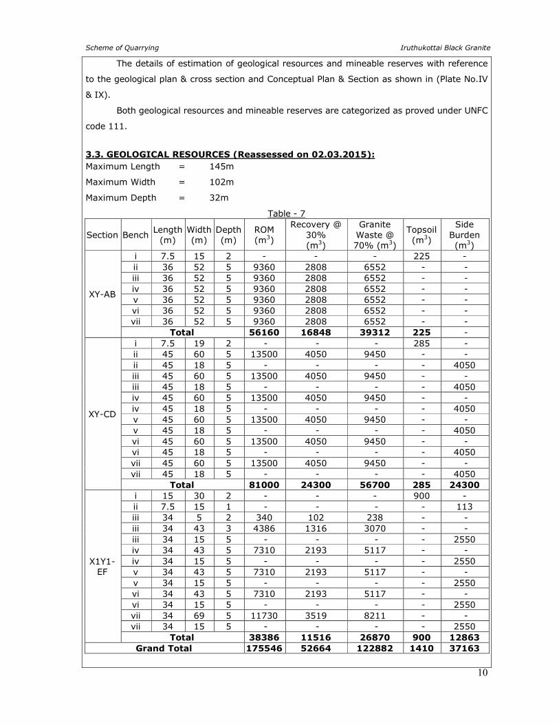
The details of estimation of geological resources and mineable reserves with reference
to the geological plan & cross section and Conceptual Plan & Section as shown in (Plate No.IV
& IX).
Both geological resources and mineable reserves are categorized as proved under UNFC
code 111.
3.3. GEOLOGICAL RESOURCES (Reassessed on 02.03.2015):
Maximum Length = 145m
Maximum Width = 102m
Maximum Depth = 32m
Table - 7
Section Bench Length
(m) Width (m)
Depth (m)
ROM (m3)
Recovery @ 30% (m3)
Granite Waste @ 70% (m3)
Topsoil (m3)
Side Burden (m3)
XY-AB
i 7.5 15 2 - - - 225 - ii 36 52 5 9360 2808 6552 - - iii 36 52 5 9360 2808 6552 - - iv 36 52 5 9360 2808 6552 - - v 36 52 5 9360 2808 6552 - - vi 36 52 5 9360 2808 6552 - - vii 36 52 5 9360 2808 6552 - -
Total 56160 16848 39312 225 -
XY-CD
i 7.5 19 2 - - - 285 - ii 45 60 5 13500 4050 9450 - - ii 45 18 5 - - - - 4050 iii 45 60 5 13500 4050 9450 - - iii 45 18 5 - - - - 4050 iv 45 60 5 13500 4050 9450 - - iv 45 18 5 - - - - 4050 v 45 60 5 13500 4050 9450 - - v 45 18 5 - - - - 4050 vi 45 60 5 13500 4050 9450 - - vi 45 18 5 - - - - 4050 vii 45 60 5 13500 4050 9450 - - vii 45 18 5 - - - - 4050
Total 81000 24300 56700 285 24300
X1Y1-EF
i 15 30 2 - - - 900 - ii 7.5 15 1 - - - - 113 iii 34 5 2 340 102 238 - - iii 34 43 3 4386 1316 3070 - - iii 34 15 5 - - - - 2550 iv 34 43 5 7310 2193 5117 - - iv 34 15 5 - - - - 2550 v 34 43 5 7310 2193 5117 - - v 34 15 5 - - - - 2550 vi 34 43 5 7310 2193 5117 - - vi 34 15 5 - - - - 2550 vii 34 69 5 11730 3519 8211 - - vii 34 15 5 - - - - 2550
Total 38386 11516 26870 900 12863
Grand Total 175546 52664 122882 1410 37163
Scheme of Quarrying Iruthukottai Black Granite
11
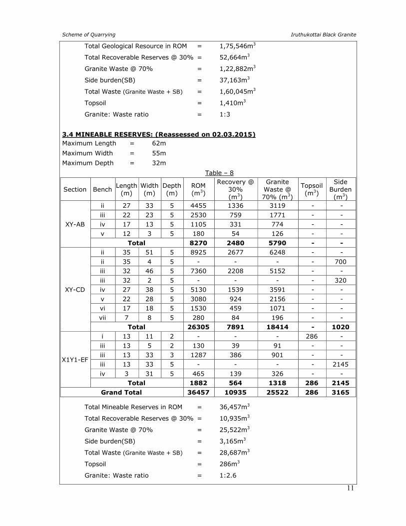
Total Geological Resource in ROM = 1,75,546m3
Total Recoverable Reserves @ 30% = 52,664m3
Granite Waste @ 70% = 1,22,882m3
Side burden(SB) = 37,163m3
Total Waste (Granite Waste + SB) = 1,60,045m3
Topsoil = 1,410m3
Granite: Waste ratio = 1:3
3.4 MINEABLE RESERVES: (Reassessed on 02.03.2015)
Maximum Length = 62m
Maximum Width = 55m
Maximum Depth = 32m
Table – 8
Section Bench Length
(m) Width (m)
Depth (m)
ROM (m3)
Recovery @ 30% (m3)
Granite Waste @ 70% (m3)
Topsoil (m3)
Side Burden (m3)
XY-AB
ii 27 33 5 4455 1336 3119 - -
iii 22 23 5 2530 759 1771 - -
iv 17 13 5 1105 331 774 - -
v 12 3 5 180 54 126 - -
Total 8270 2480 5790 - -
XY-CD
ii 35 51 5 8925 2677 6248 - -
ii 35 4 5 - - - - 700
iii 32 46 5 7360 2208 5152 - -
iii 32 2 5 - - - - 320
iv 27 38 5 5130 1539 3591 - -
v 22 28 5 3080 924 2156 - -
vi 17 18 5 1530 459 1071 - -
vii 7 8 5 280 84 196 - -
Total 26305 7891 18414 - 1020
X1Y1-EF
i 13 11 2 - - - 286 -
iii 13 5 2 130 39 91 - -
iii 13 33 3 1287 386 901 - -
iii 13 33 5 - - - - 2145
iv 3 31 5 465 139 326 - -
Total 1882 564 1318 286 2145
Grand Total 36457 10935 25522 286 3165
Total Mineable Reserves in ROM = 36,457m3
Total Recoverable Reserves @ 30% = 10,935m3
Granite Waste @ 70% = 25,522m3
Side burden(SB) = 3,165m3
Total Waste (Granite Waste + SB) = 28,687m3
Topsoil = 286m3
Granite: Waste ratio = 1:2.6
Scheme of Quarrying Iruthukottai Black Granite
12
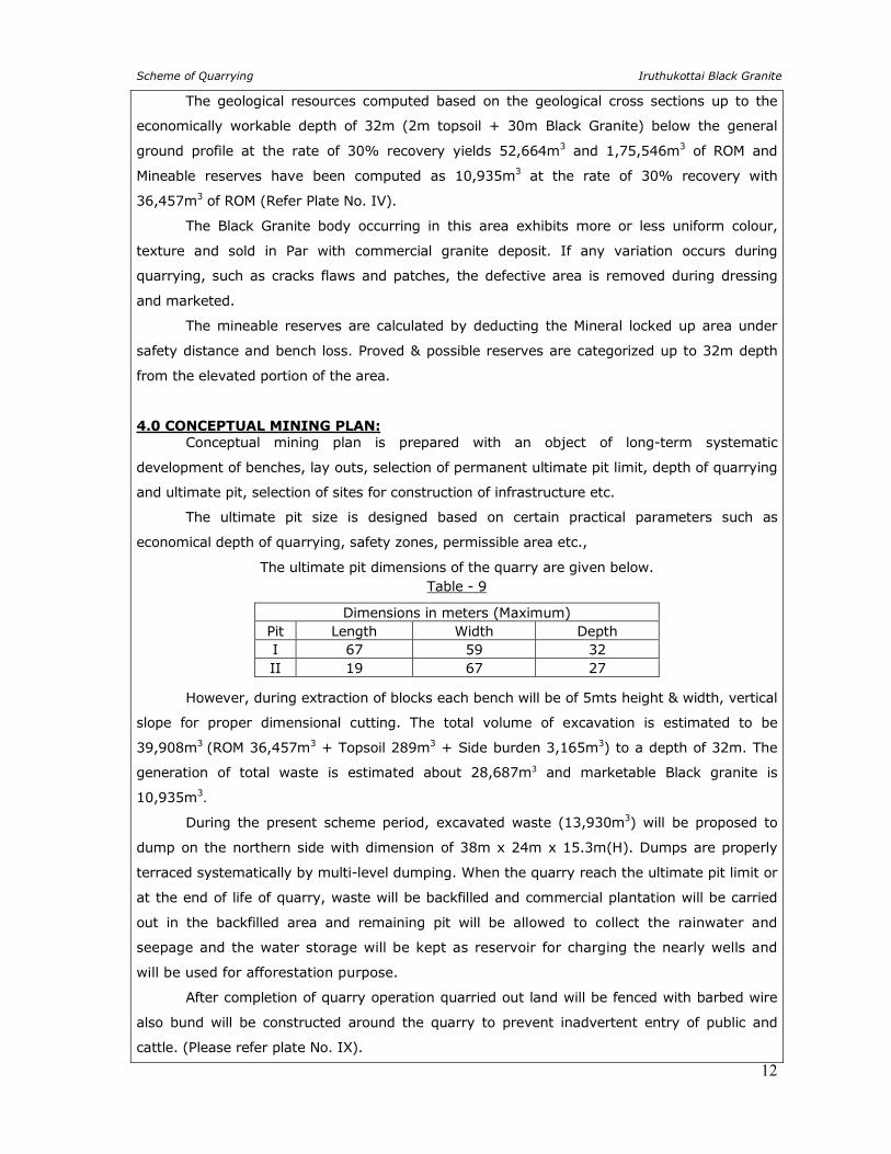
The geological resources computed based on the geological cross sections up to the
economically workable depth of 32m (2m topsoil + 30m Black Granite) below the general
ground profile at the rate of 30% recovery yields 52,664m3 and 1,75,546m3 of ROM and
Mineable reserves have been computed as 10,935m3 at the rate of 30% recovery with
36,457m3 of ROM (Refer Plate No. IV).
The Black Granite body occurring in this area exhibits more or less uniform colour,
texture and sold in Par with commercial granite deposit. If any variation occurs during
quarrying, such as cracks flaws and patches, the defective area is removed during dressing
and marketed.
The mineable reserves are calculated by deducting the Mineral locked up area under
safety distance and bench loss. Proved & possible reserves are categorized up to 32m depth
from the elevated portion of the area.
4.0 CONCEPTUAL MINING PLAN:
Conceptual mining plan is prepared with an object of long-term systematic
development of benches, lay outs, selection of permanent ultimate pit limit, depth of quarrying
and ultimate pit, selection of sites for construction of infrastructure etc.
The ultimate pit size is designed based on certain practical parameters such as
economical depth of quarrying, safety zones, permissible area etc.,
The ultimate pit dimensions of the quarry are given below. Table - 9
Dimensions in meters (Maximum) Pit Length Width Depth I 67 59 32 II 19 67 27
However, during extraction of blocks each bench will be of 5mts height & width, vertical
slope for proper dimensional cutting. The total volume of excavation is estimated to be
39,908m3 (ROM 36,457m3 + Topsoil 289m3 + Side burden 3,165m3) to a depth of 32m. The
generation of total waste is estimated about 28,687m3 and marketable Black granite is
10,935m3.
During the present scheme period, excavated waste (13,930m3) will be proposed to
dump on the northern side with dimension of 38m x 24m x 15.3m(H). Dumps are properly
terraced systematically by multi-level dumping. When the quarry reach the ultimate pit limit or
at the end of life of quarry, waste will be backfilled and commercial plantation will be carried
out in the backfilled area and remaining pit will be allowed to collect the rainwater and
seepage and the water storage will be kept as reservoir for charging the nearly wells and
will be used for afforestation purpose.
After completion of quarry operation quarried out land will be fenced with barbed wire
also bund will be constructed around the quarry to prevent inadvertent entry of public and
cattle. (Please refer plate No. IX).
Scheme of Quarrying Iruthukottai Black Granite
13
5.0 MINING
No change in the method of mining. The same open cast semi mechanized mining with
5mt vertical bench with a bench width of 5 mtr has been followed.
Under the regulation 106 (2) (b) of the Metalliferous Mines Regulation 1961, in all open
cast mining, the bench height should not exceed 5 mtr and bench width should not be less
than bench height. The slope of the bench should not exceed 60˚from horizontal.
But as far as the quarrying of granite dimensional stones are concerned, observance of
the provisions of Regulation 106(2) (b) as above is seldom possible due to various inherent
petro genetic & mining difficulties. Hence, it is proposed to obtain relaxation to the provisions
of the above regulation from the Director of Mines Safety, Chennai for which necessary
provision is available with the Regulation 106 (2) (b).
The production of Black granite dimensional stone in this quarry involves the following
method typical for granite stone mining in contrast to other major mineral mining.
Splitting of rock mass of considerable volume from the parent sheet rock is carefully
removed by avoiding any kind of damage in the form of cracks adopting the method of
diamond wire cutting along the horizontal as well as two vertical sides along the width direction
and the third vertical face behind the front face.
This liberation of huge volume of granite body from the parent sheet rock is called
primary cutting. The Blocks splitted above are toppled and removed from the pit to the
dressing yard, by using hydraulic cranes.
Removing the defective portion and dressing into the dimensional blocks are done
manually using feather, wedges, and chiseling respectively by the labours that are skilled in
this work. The defect free, dimensional stone of different sizes is marketed in domestic and
international market by the well experienced marketing personnel of the lessee.
The waste material generated during quarrying activity includes rock fragments of
different sizes and waste chips during dressing of the blocks.
The total quantity of wastes is proposed to temporarily dump on the northern side.
When the quarry reach the ultimate pit limit or at the end of life of quarry, quarried out waste
will be backfill. Excavated topsoil will be preserved all along the safety barrier and utilized
for construction of bund, haul road and afforestation purpose (refer Plate No. VI and IX).
Scheme of Quarrying Iruthukottai Black Granite
14
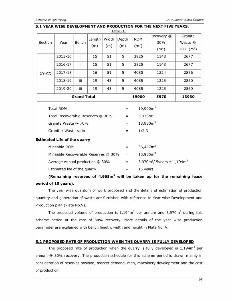
5.1 YEAR WISE DEVELOPMENT AND PRODUCTION FOR THE NEXT FIVE YEARS:
Table -10
Section Year Bench Length
(m)
Width
(m)
Depth
(m)
ROM
(m3)
Recovery @
30%
(m3)
Granite
Waste @
70% (m3)
XY-CD
2015-16 ii 15 51 5 3825 1148 2677
2016-17 ii 15 51 5 3825 1148 2677
2017-18 ii 16 51 5 4080 1224 2856
2018-19 iii 19 43 5 4085 1225 2860
2019-20 iii 19 43 5 4085 1225 2860
Grand Total 19900 5970 13930
Total ROM = 19,900m3
Total Recoverable Reserves @ 30% = 5,970m3
Granite Waste @ 70% = 13,930m3
Granite: Waste ratio = 1:2.3
Estimated Life of the quarry
Mineable ROM = 36,457m3
Mineable Recoverable Reserves @ 30% = 10,935m3
Average Annual production @ 30% = 5,970m3/ 5years = 1,194m3
Estimated life of the quarry = 15 years
(Remaining reserves of 4,965m3 will be taken up for the remaining lease
period of 10 years).
The year wise quantum of work proposed and the details of estimation of production
quantity and generation of waste are furnished with reference to Year wise Development and
Production plan (Plate No.V).
The proposed volume of production is 1,194m3 per annum and 5,970m3 during this
scheme period at the rate of 30% recovery. More details of the year wise production
parameter are explained with bench length, width and height in Plate No. V.
5.2 PROPOSED RATE OF PRODUCTION WHEN THE QUARRY IS FULLY DEVELOPED
The proposed rate of production when the quarry is fully developed is 1,194m3 per
annum @ 30% recovery. The production schedule for this scheme period is drawn mainly in
consideration of reserves position, market demand, men, machinery development and the cost
of production.
Scheme of Quarrying Iruthukottai Black Granite
15
5.3 MINEABLE RESERVES AND ANTICIPATED LIFE OF QUARRY:
The dolerite dyke is deep seated in nature as they have been formed by basic
intrusions from depth as dyke. The depth persistence of the dyke will be beyond the
economically workable depth. The method of extraction of rock mass from dyke sheet rock is
highly expensive at greater depth.
An optimum depth of 32mts has been established as economically viable depth.
Eventually this depth is optimum for safe and scientific quarrying.
The Mineable Reserves are calculated by excluding the mining loss due to formation of
benches with suitable height & width, ultimate depth of quarry, the Mineral Reserve held up
within the safety distances all along the lease boundary.
The Mineable Reserves for this Black granite quarry is thus arrived as 10,935m3 at the
rate of 30% recovery and 36,457m3 for an assumed depth of 32meters from the elevated
portion of the area. The details of estimation of year wise development and production plan
(plate no. IV).
The average rate of production of Black Granite from this quarry is 1,194m3 per year
and 5,970m3 during this scheme period considering 30% recovery and remaining
recoverable reserves of 4,965m3 will be taken up for the remaining lease periods of 10
years.
Based on the above, and taking into consideration of the available Mineable reserves,
the life of quarry will be about 15 years (considering all the safety factors) at 30%
recovery, if the quarry is being worked continuously with an average annual production of
1,194m3. This calculation is based on the plan approved by Director of Mines Safety leaving
Benches and Safety barriers. If the annual production increases considerably and consistently
a modified scheme of quarrying will be prepared under Granite Conservation and Development
Rules-1999 the same will be submitted to the relevant authorities for subsequent clearance
and approval.
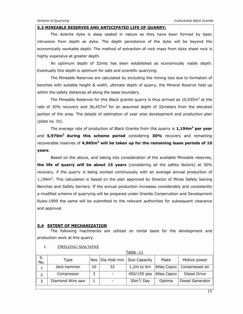
5.4 EXTENT OF MECHANIZATION
The following machineries are utilized on rental basis for the development and
production work at this quarry.
I. DRILLING MACHINE
Table -11
S. No.
Type Nos Dia Hole mm Size Capacity Make Motive power
1 Jack hammer 10 32 1.2m to 6m Atlas Copco Compressed air
2 Compressor 3 - 450/150 psa Atlas Capco Diesel Drive
3 Diamond Wire saw 1 - 30m3/ Day Optima Diesel Generator
Scheme of Quarrying Iruthukottai Black Granite
16
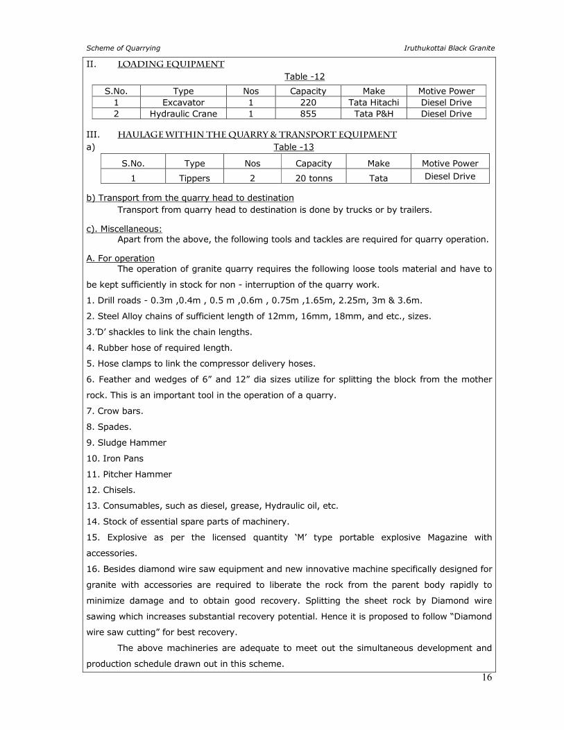
II. LOADING EQUIPMENT Table -12
III. HAULAGE WITHIN THE QUARRY & TRANSPORT EQUIPMENT a) Table -13
S.No. Type Nos Capacity Make Motive Power
1 Tippers 2 20 tonns Tata Diesel Drive
b) Transport from the quarry head to destination Transport from quarry head to destination is done by trucks or by trailers.
c). Miscellaneous: Apart from the above, the following tools and tackles are required for quarry operation.
A. For operation The operation of granite quarry requires the following loose tools material and have to
be kept sufficiently in stock for non - interruption of the quarry work.
1. Drill roads - 0.3m ,0.4m , 0.5 m ,0.6m , 0.75m ,1.65m, 2.25m, 3m & 3.6m.
2. Steel Alloy chains of sufficient length of 12mm, 16mm, 18mm, and etc., sizes.
3.’D’ shackles to link the chain lengths.
4. Rubber hose of required length.
5. Hose clamps to link the compressor delivery hoses.
6. Feather and wedges of 6” and 12” dia sizes utilize for splitting the block from the mother
rock. This is an important tool in the operation of a quarry.
7. Crow bars.
8. Spades.
9. Sludge Hammer
10. Iron Pans
11. Pitcher Hammer
12. Chisels.
13. Consumables, such as diesel, grease, Hydraulic oil, etc.
14. Stock of essential spare parts of machinery.
15. Explosive as per the licensed quantity ‘M’ type portable explosive Magazine with
accessories.
16. Besides diamond wire saw equipment and new innovative machine specifically designed for
granite with accessories are required to liberate the rock from the parent body rapidly to
minimize damage and to obtain good recovery. Splitting the sheet rock by Diamond wire
sawing which increases substantial recovery potential. Hence it is proposed to follow “Diamond
wire saw cutting” for best recovery.
The above machineries are adequate to meet out the simultaneous development and
production schedule drawn out in this scheme.
S.No. Type Nos Capacity Make Motive Power 1 Excavator 1 220 Tata Hitachi Diesel Drive 2 Hydraulic Crane 1 855 Tata P&H Diesel Drive
Scheme of Quarrying Iruthukottai Black Granite
17
6.0 BLASTING
a. Broad Blasting Parameters: In general for granite quarrying primary (deep hole drill) blasting is not practiced, only
secondary blasting is practiced coupled with jackhammer drilling (30-35mm dia). These
blasting are carried out for splitting the blocks from parent sheet mass.
The granite industry needs blocks for about 3m x 2m x 2m for International buyers
hence small blocks blasting pattern is not followed. The blasting pattern depends upon the
texture of the rocks in the case of granite quarrying which in-turn depends upon the bedding
plane, presence of fractures, fissures and cracks hence it is difficult to decide the definite
particular pattern of holes in each blast.
Nowadays Diamond wire saws are used for splitting the blocks from parent sheet mass.
It is a new innovative Eco-friendly splitting technique without involving blasting. This is
increase the recovery percentage of granite blocks and reduced from induce fissures due to
blasting.
Hence, it is difficult to pronounce a definite pattern of holes with regard to spacing,
burden and depth. Hence, only blasting is deployed for secondary fragmentation for handling
the wastes and not for production.
b. Type and use of explosives In granite quarries, only heaving effect is required and not the shattering effect. The
aim is to recovery as large a block as possible.
Hence only low intense explosives like D-Cord and Gelatin sticks are used.
In granite quarrying it is very difficult to prescribe the charge/ hole as it depends upon
the various factors like type of rock, texture, planes of weakness, required size of block, etc.
c) Storage of explosives: Authorized explosive dealers supply the explosive at site as per the day’s requirement.
Hence question of storage of explosives does not arise at present.
However, the lessee has been advised to install one portable magazine of ‘M’ type at
the earliest possible opportunity.
Splitting within the sheet rock is affected by diamond wire sawing which increases
substantial recovery potential. Hence it is proposed to follow diamond wire saw cutting for
better recovery of granite dimensional stone.
During future development of quarrying, removal of over burden will be done by
blasting with explosives in small dia holes drilled by Jackhammer.
The explosive that will be used are D-Cord and Gelatin sticks that are indicated below.
D Cord - 5mg
Gelatin Sticks.
7.0 MINE DRAINAGE
The water table in this area is 52m as observed in nearby bore wells. Working expected
to well above the water table. If water is encountered at depth due to rainwater seepage, the
same may be drained out by 5HP motor pumps and drained out water will be utilized for
afforestation.
Scheme of Quarrying Iruthukottai Black Granite
18
8.0 STACKING OF MINERAL WASTE AND DISPOSAL OF WASTE
a) Topsoil: There is no topsoil generated during this scheme period.
b) Granite waste and Land chosen for disposal of waste: The total waste to be produced during this scheme period is around 13,930m3 70% of
Granite Waste the same will be proposed to dump on the northern side with dimension of 38m
x 24m x 15.3m(H), which will act as temporary waste dump. Dumps are properly terraced
systematically by multi-level dumping.
c) Manner of disposal of waste: As and when there is accumulation of waste, the same is loaded into the tipper by
loading machines and dumped in the respective places ear-marked for the purpose.
The waste management plan with reference to the quantum of waste generated is
shown in quarry layout and Afforestation plan (Plate No.VI).
9.0 USE OF THE GRANITE STONE
The quarried out Black granite rough blocks are exported as raw blocks and also
processed as value added products such as slabs, tiles, fancy items, Monuments, precision
surface plates for engineering application.
The export market for black granite blocks is European Country, North America, Middle
East, Far East, Japan, Taiwan & Canada besides catering local markets.
10.0 QUALITY CONTROL
The granite deposit occurring in this quarry shows uniform quality throughout the
granite body, hence Granite will be quarried and market as a single variety.
The excavated blocks are carefully examined for any natural defects such as joints,
cracks, xenoliths growth etc and such defects is removed manually using feather and wedges
and the blocks are then shaped into perfect rectangular dimensional stone blocks by chiseling.
Different price for each quality material have been fixed and the entire production quantity is
marketed accordingly.
11.0 SURFACE TRANSPORT
The produced granite rough blocks are transported by road to various customer
destinations and granite processing units located at different parts of the country. The blocks
and slabs approved for export market are shipped from Chennai Port to various countries and
if required the blocks may be shifted to Thoothukudi Port depends upon the exporter’s
destination from time to time.

Scheme of Quarrying Iruthukottai Black Granite
19
12.0 SITE SERVICES The simple methods adopted and the limited scale of activities involved in granite
dimensional stone quarrying does not require high tension electric power supply or huge
workshop facilities. The quarry operation is restricted to one general shift during day time only.
Machinery repair works are attended at Denkanikottai (7km) on the Northern side. Minor
repairs can be rectified at the quarry site itself by the lessee’s experienced personnel.
Potable drinking water is supplied from the nearby approved water vendors in
Denkanikottai town. Quarry office, First-Aid Room, Store Room, Rest shed, Toilet etc, will be
provided on semi - permanent structures within the lease hold area (Plate No - V - VII).
13.0 EMPLOYMENT POTENTIAL The following manpower is proposed for the Black Granite quarry to look after and
carryout the day-to-day quarrying activities, aimed at the proposed production target and also
to comply with the statutory provisions of the Metalliferous Mines Regulations, 1961.
1. Mines manager (with valid statutory qualification) : 1
2. Mines foreman (with valid statutory qualification) : 1
3. Machinery operators (Certified) : 2
WORKERS:
a. Skilled labour : 6
b. Semi-skilled : 17
c. Unskilled : 3
Total : 30
Allowing for 10% absenteeism, the no. of men of roll will be around 27.
ORGANIZATION CHART
The above manpower is adequate to meet out the production schedule and the
machinery strength envisaged in the mining plan and to comply with the statutory provisions
of the Mines Safety Regulations.
PART-TIME MINING ENGINEER
CLERK
MINES MANAGER
OPERATORS
HELPERS
CLEANERS
BLASTER
DRILLERS
CHISELMEN
OWNER
Scheme of Quarrying Iruthukottai Black Granite
20
14.0 ENVIRONMENTAL MANAGEMENT PLAN
14.1 BASELINE INFORMATION
The following observations are made for environmental management plan.
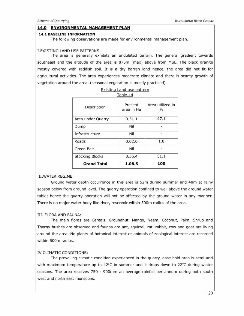
I.EXISTING LAND USE PATTERNS: The area is generally exhibits an undulated terrain. The general gradient towards
southeast and the altitude of the area is 875m (max) above from MSL. The black granite
mostly covered with reddish soil. It is a dry barren land hence, the area did not fit for
agricultural activities. The area experiences moderate climate and there is scanty growth of
vegetation around the area. (seasonal vegetation is mostly practiced).
Existing Land use pattern Table-14
Description
Present
area in Ha
Area utilized in %
Area under Quarry 0.51.1 47.1
Dump Nil -
Infrastructure Nil -
Roads 0.02.0 1.8
Green Belt Nil -
Stocking Blocks 0.55.4 51.1
Grand Total 1.08.5 100
II.WATER REGIME:
Ground water depth occurrence in this area is 52m during summer and 48m at rainy
season below from ground level. The quarry operation confined to well above the ground water
table; hence the quarry operation will not be affected by the ground water in any manner.
There is no major water body like river, reservoir within 500m radius of the area.
III. FLORA AND FAUNA: The main floras are Cereals, Groundnut, Mango, Neem, Coconut, Palm, Shrub and
Thorny bushes are observed and faunas are ant, squirrel, rat, rabbit, cow and goat are living
around the area. No plants of botanical interest or animals of zoological interest are recorded
within 500m radius.
IV.CLIMATIC CONDITIONS: The prevailing climatic condition experienced in the quarry lease hold area is semi-arid
with maximum temperature up to 42°C in summer and it drops down to 22oC during winter
seasons. The area receives 750 - 900mm an average rainfall per annum during both south
west and north east monsoons.
Scheme of Quarrying Iruthukottai Black Granite
21
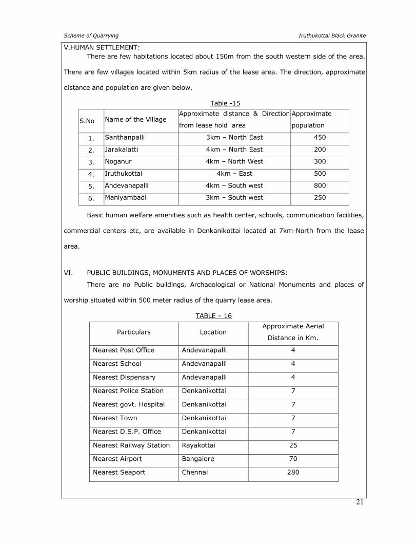
V.HUMAN SETTLEMENT: There are few habitations located about 150m from the south western side of the area.
There are few villages located within 5km radius of the lease area. The direction, approximate
distance and population are given below.
Table -15
S.No Name of the Village Approximate distance & Direction
from lease hold area
Approximate
population
1. Santhanpalli 3km – North East 450
2. Jarakalatti 4km – North East 200
3. Noganur 4km – North West 300
4. Iruthukottai 4km – East 500
5. Andevanapalli 4km – South west 800
6. Maniyambadi 3km – South west 250
Basic human welfare amenities such as health center, schools, communication facilities,
commercial centers etc, are available in Denkanikottai located at 7km-North from the lease
area.
VI. PUBLIC BUILDINGS, MONUMENTS AND PLACES OF WORSHIPS:
There are no Public buildings, Archaeological or National Monuments and places of
worship situated within 500 meter radius of the quarry lease area.
TABLE – 16
Particulars Location Approximate Aerial
Distance in Km.
Nearest Post Office Andevanapalli 4
Nearest School Andevanapalli 4
Nearest Dispensary Andevanapalli 4
Nearest Police Station Denkanikottai 7
Nearest govt. Hospital Denkanikottai 7
Nearest Town Denkanikottai 7
Nearest D.S.P. Office Denkanikottai 7
Nearest Railway Station Rayakottai 25
Nearest Airport Bangalore 70
Nearest Seaport Chennai 280
Scheme of Quarrying Iruthukottai Black Granite
22
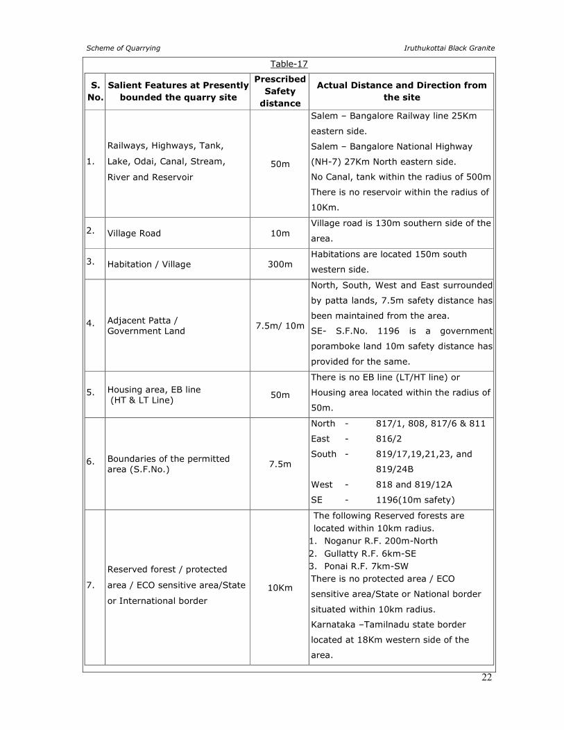
Table-17
S.
No.
Salient Features at Presently
bounded the quarry site
Prescribed
Safety
distance
Actual Distance and Direction from
the site
1.
Railways, Highways, Tank,
Lake, Odai, Canal, Stream,
River and Reservoir
50m
Salem – Bangalore Railway line 25Km
eastern side.
Salem – Bangalore National Highway
(NH-7) 27Km North eastern side.
No Canal, tank within the radius of 500m
There is no reservoir within the radius of
10Km.
2. Village Road 10m Village road is 130m southern side of the
area.
3. Habitation / Village 300m Habitations are located 150m south
western side.
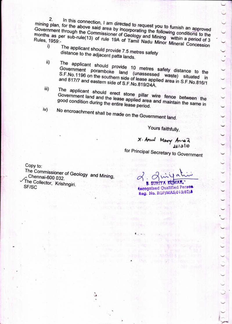
4. Adjacent Patta / Government Land
7.5m/ 10m
North, South, West and East surrounded
by patta lands, 7.5m safety distance has
been maintained from the area.
SE- S.F.No. 1196 is a government
poramboke land 10m safety distance has
provided for the same.
5. Housing area, EB line (HT & LT Line)
50m
There is no EB line (LT/HT line) or
Housing area located within the radius of
50m.
6. Boundaries of the permitted area (S.F.No.)
7.5m
North - 817/1, 808, 817/6 & 811
East - 816/2
South - 819/17,19,21,23, and
819/24B
West - 818 and 819/12A
SE - 1196(10m safety)
7.
Reserved forest / protected
area / ECO sensitive area/State
or International border
10Km
The following Reserved forests are
located within 10km radius.
1. Noganur R.F. 200m-North
2. Gullatty R.F. 6km-SE
3. Ponai R.F. 7km-SW There is no protected area / ECO
sensitive area/State or National border
situated within 10km radius.
Karnataka –Tamilnadu state border
located at 18Km western side of the
area.
Scheme of Quarrying Iruthukottai Black Granite
23
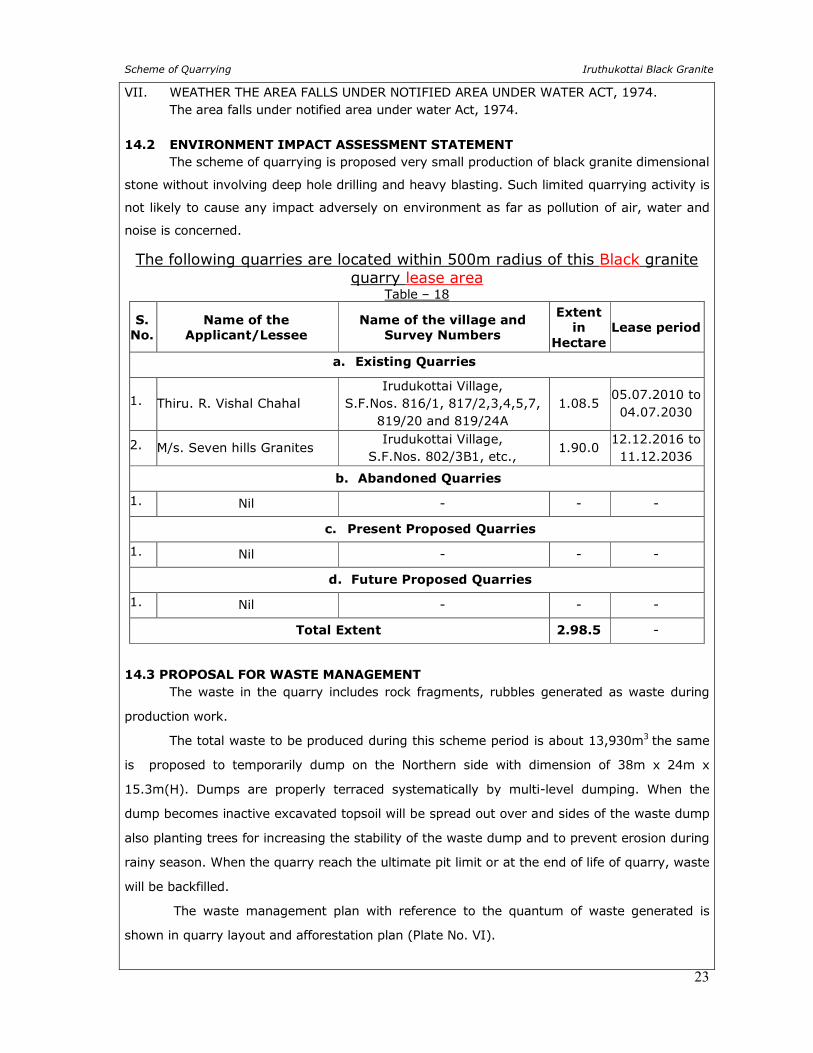
VII. WEATHER THE AREA FALLS UNDER NOTIFIED AREA UNDER WATER ACT, 1974. The area falls under notified area under water Act, 1974. 14.2 ENVIRONMENT IMPACT ASSESSMENT STATEMENT
The scheme of quarrying is proposed very small production of black granite dimensional
stone without involving deep hole drilling and heavy blasting. Such limited quarrying activity is
not likely to cause any impact adversely on environment as far as pollution of air, water and
noise is concerned.
The following quarries are located within 500m radius of this Black granite quarry lease area
Table – 18
S.
No.
Name of the
Applicant/Lessee
Name of the village and
Survey Numbers
Extent
in
Hectare
Lease period
a. Existing Quarries
1. Thiru. R. Vishal Chahal Irudukottai Village,
S.F.Nos. 816/1, 817/2,3,4,5,7, 819/20 and 819/24A
1.08.5 05.07.2010 to 04.07.2030
2. M/s. Seven hills Granites Irudukottai Village,
S.F.Nos. 802/3B1, etc., 1.90.0
12.12.2016 to 11.12.2036
b. Abandoned Quarries
1. Nil - - -
c. Present Proposed Quarries
1. Nil - - -
d. Future Proposed Quarries
1. Nil - - -
Total Extent 2.98.5 -
14.3 PROPOSAL FOR WASTE MANAGEMENT The waste in the quarry includes rock fragments, rubbles generated as waste during
production work.
The total waste to be produced during this scheme period is about 13,930m3 the same
is proposed to temporarily dump on the Northern side with dimension of 38m x 24m x
15.3m(H). Dumps are properly terraced systematically by multi-level dumping. When the
dump becomes inactive excavated topsoil will be spread out over and sides of the waste dump
also planting trees for increasing the stability of the waste dump and to prevent erosion during
rainy season. When the quarry reach the ultimate pit limit or at the end of life of quarry, waste
will be backfilled.
The waste management plan with reference to the quantum of waste generated is
shown in quarry layout and afforestation plan (Plate No. VI).
Scheme of Quarrying Iruthukottai Black Granite
24
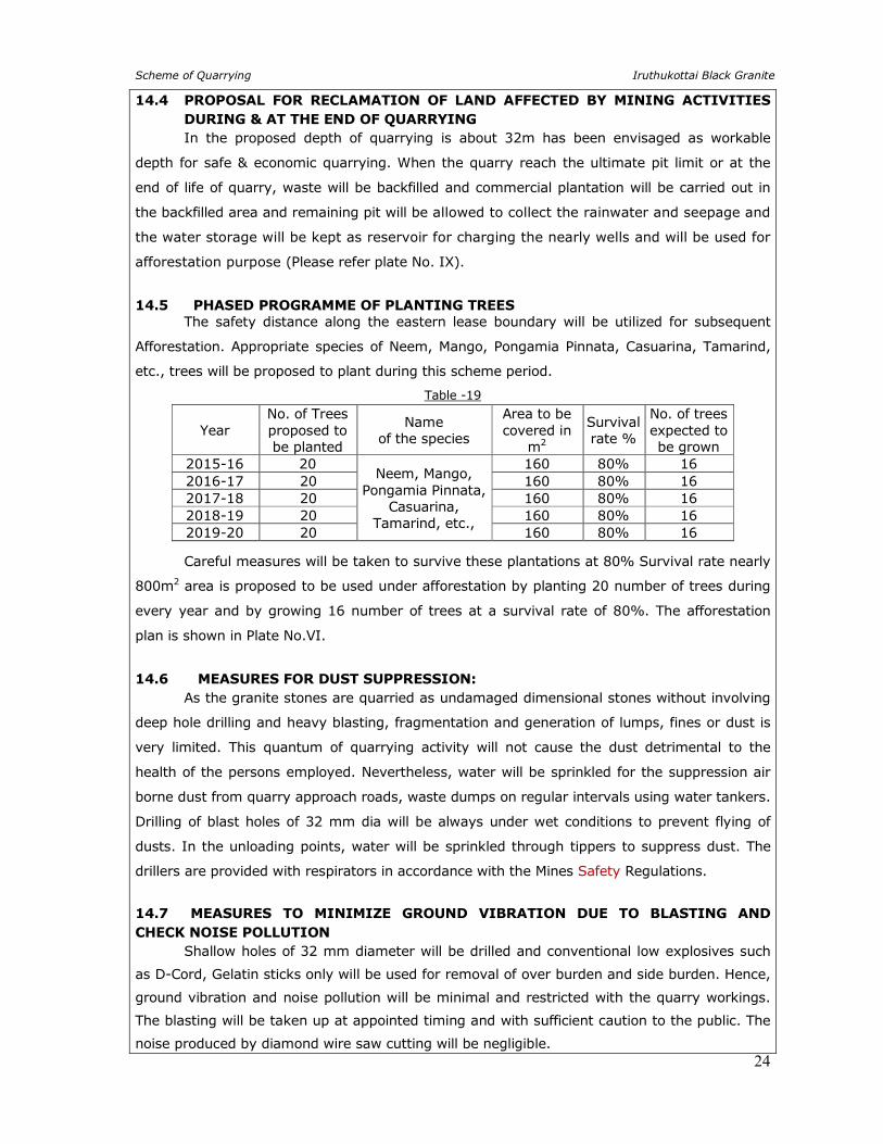
14.4 PROPOSAL FOR RECLAMATION OF LAND AFFECTED BY MINING ACTIVITIES
DURING & AT THE END OF QUARRYING
In the proposed depth of quarrying is about 32m has been envisaged as workable
depth for safe & economic quarrying. When the quarry reach the ultimate pit limit or at the
end of life of quarry, waste will be backfilled and commercial plantation will be carried out in
the backfilled area and remaining pit will be allowed to collect the rainwater and seepage and
the water storage will be kept as reservoir for charging the nearly wells and will be used for
afforestation purpose (Please refer plate No. IX).
14.5 PHASED PROGRAMME OF PLANTING TREES The safety distance along the eastern lease boundary will be utilized for subsequent
Afforestation. Appropriate species of Neem, Mango, Pongamia Pinnata, Casuarina, Tamarind,
etc., trees will be proposed to plant during this scheme period.
Table -19
Year No. of Trees proposed to be planted
Name of the species
Area to be covered in
m2
Survival rate %
No. of trees expected to be grown
2015-16 20 Neem, Mango,
Pongamia Pinnata, Casuarina,
Tamarind, etc.,
160 80% 16 2016-17 20 160 80% 16 2017-18 20 160 80% 16 2018-19 20 160 80% 16 2019-20 20 160 80% 16
Careful measures will be taken to survive these plantations at 80% Survival rate nearly
800m2 area is proposed to be used under afforestation by planting 20 number of trees during
every year and by growing 16 number of trees at a survival rate of 80%. The afforestation
plan is shown in Plate No.VI.
14.6 MEASURES FOR DUST SUPPRESSION: As the granite stones are quarried as undamaged dimensional stones without involving
deep hole drilling and heavy blasting, fragmentation and generation of lumps, fines or dust is
very limited. This quantum of quarrying activity will not cause the dust detrimental to the
health of the persons employed. Nevertheless, water will be sprinkled for the suppression air
borne dust from quarry approach roads, waste dumps on regular intervals using water tankers.
Drilling of blast holes of 32 mm dia will be always under wet conditions to prevent flying of
dusts. In the unloading points, water will be sprinkled through tippers to suppress dust. The
drillers are provided with respirators in accordance with the Mines Safety Regulations.
14.7 MEASURES TO MINIMIZE GROUND VIBRATION DUE TO BLASTING AND
CHECK NOISE POLLUTION Shallow holes of 32 mm diameter will be drilled and conventional low explosives such
as D-Cord, Gelatin sticks only will be used for removal of over burden and side burden. Hence,
ground vibration and noise pollution will be minimal and restricted with the quarry workings.
The blasting will be taken up at appointed timing and with sufficient caution to the public. The
noise produced by diamond wire saw cutting will be negligible.
Scheme of Quarrying Iruthukottai Black Granite
25
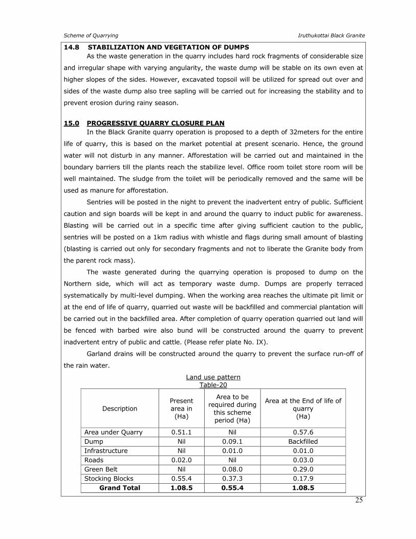
14.8 STABILIZATION AND VEGETATION OF DUMPS
As the waste generation in the quarry includes hard rock fragments of considerable size
and irregular shape with varying angularity, the waste dump will be stable on its own even at
higher slopes of the sides. However, excavated topsoil will be utilized for spread out over and
sides of the waste dump also tree sapling will be carried out for increasing the stability and to
prevent erosion during rainy season.
15.0 PROGRESSIVE QUARRY CLOSURE PLAN
In the Black Granite quarry operation is proposed to a depth of 32meters for the entire
life of quarry, this is based on the market potential at present scenario. Hence, the ground
water will not disturb in any manner. Afforestation will be carried out and maintained in the
boundary barriers till the plants reach the stabilize level. Office room toilet store room will be
well maintained. The sludge from the toilet will be periodically removed and the same will be
used as manure for afforestation.
Sentries will be posted in the night to prevent the inadvertent entry of public. Sufficient
caution and sign boards will be kept in and around the quarry to induct public for awareness.
Blasting will be carried out in a specific time after giving sufficient caution to the public,
sentries will be posted on a 1km radius with whistle and flags during small amount of blasting
(blasting is carried out only for secondary fragments and not to liberate the Granite body from
the parent rock mass).
The waste generated during the quarrying operation is proposed to dump on the
Northern side, which will act as temporary waste dump. Dumps are properly terraced
systematically by multi-level dumping. When the working area reaches the ultimate pit limit or
at the end of life of quarry, quarried out waste will be backfilled and commercial plantation will
be carried out in the backfilled area. After completion of quarry operation quarried out land will
be fenced with barbed wire also bund will be constructed around the quarry to prevent
inadvertent entry of public and cattle. (Please refer plate No. IX).
Garland drains will be constructed around the quarry to prevent the surface run-off of
the rain water.
Land use pattern Table-20
Description
Present area in (Ha)
Area to be required during
this scheme period (Ha)
Area at the End of life of quarry (Ha)
Area under Quarry 0.51.1 Nil 0.57.6
Dump Nil 0.09.1 Backfilled Infrastructure Nil 0.01.0 0.01.0
Roads 0.02.0 Nil 0.03.0 Green Belt Nil 0.08.0 0.29.0 Stocking Blocks 0.55.4 0.37.3 0.17.9
Grand Total 1.08.5 0.55.4 1.08.5
Scheme of Quarrying Iruthukottai Black Granite
26
16.0 MINERAL CONSERVATION AND DEVELOPMENT The Scheme of Quarrying proposed has fully covered the aspects of Granite
Conservation and development rules 1999, with a future plan to extend the proposed working
of the quarry to the maximum possible workable depth of the deposit. Extreme care is taken to
ensure proper supervision of quality control of the Granite dimensional stone aimed at the
recovery of the maximum saleable quality and quantity of granite dimensional stones suitable
for full utilization of the consumers.
Care is been taken for each process just to safeguard the material quarried in an
economical and efficient manner by adopting systematic and scientific quarrying with the
consultation and supervision of well experienced quarry persons.
17.0 STATUTORY PROVISIONS
The provisions of the Mines Act, Rules and Regulations and orders made there under
shall be complied with, so that the safety of the quarry, machinery and person will be ensured.
Permission, relaxation or exemption wherever required for the safe and scientific quarrying of
the deposit will be obtained from the Department of Mines Safety, Chennai. Any violation
pointed out by the inspecting authorities shall be rectified as per the guidelines of the
department.
Certified that this scheme of quarrying has been prepared in accordance with the Mines
Act, Rules and Regulations and orders made there under and also in conformity with the
provisions sub rule (13) of Rule 19A of Tamilnadu Minor Mineral Concession Rules, 1959 and
Rule 12,13,16 of Granite Conservation and Development rules 1999.
RQP SIGNATURE
A. JAGANNATHAN, B.E., F.C.C., M.M.E.A.,
Recognized Qualified Person RQP/MAS/019/87/A.
Place: Salem Date: 03.03.2015


SCALE 1:24,00,000
Q. L. AREA :
TOPO SHEET NO : 57 - H / 15
PLATE NO.I
DATE OF S URVEY: 0 9 .0 3 .2 0 1 5
LES S EE:
Th iru . VIS HAL CHAHAL.
S / o . OMVATHI CHAHAL,
D-1 , S RADDHA MEADOWS ,
4 th CROS S , RUS TAN BAGH,
BANGALORE - 5 6 0 0 1 7 .
LOCATION OF QUARRY:
S .F.NO : 8 1 6 / 1 ,8 1 7 / 2 ,3 ,4 ,5 ,7 ,
8 1 9 / 2 0 & 2 4 A
EXTENT : 1 .0 8 .5 Ha ,
VILLAGE : IRUDUKOTTAI,
TALUK : DENKANIKOTTAI,
DIS TRICT : KRIS HNAGIRI.
PR
OD
UC
ED
BY
AN
AU
TO
DE
SK
ED
UC
AT
ION
AL
PR
OD
UC
T
PRODUCED BY AN AUTODESK EDUCATIONAL PRODUCT
PR
OD
UC
ED
BY
AN
AU
TO
DE
SK
ED
UC
AT
ION
AL
PR
OD
UC
T
PRODUCED BY AN AUTODESK EDUCATIONAL PRODUCT
ee
e
eee
e
e ee
e
ee
e
e
e
e
e
e
e
e
e
e
e
e
e
e
e
e
ee
e
e
e
e
e
e
e
e
e e
e
e
e
e
e
e
e ee
e
e
e
e
e
e
e
e
e
e
e
e
e
e e
e
e
e
e
e
e
e
e
ee
e
e
e
e
e
ee
e
e
e
e
e
e
e
e
e
e
e
e
e
e
ee
e e
e
e
e
e
e
e
e
e
e
e
e
e
e
e
e
ee
e
e
ee
ee
TOPO SHEET NO : 57 - H / 15
bbb
ee e
bbb
bbb
Towards
Santhanapalli
Tow
ard
s
An
de
va
na
pa
lli
Tow
ards
DEN
KAN
IKKO
TTA
I
DATE OF S URVEY: 0 9 .0 3 .2 0 1 5
LES S EE:
Th iru . VIS HAL CHAHAL.
S / o . OMVATHI CHAHAL,
D-1 , S RADDHA MEADOWS ,
4 th CROS S , RUS TAN BAGH,
BANGALORE - 5 6 0 0 1 7 .
LOCATION OF QUARRY:
S .F.NO : 8 1 6 / 1 ,8 1 7 / 2 ,3 ,4 ,5 ,7 ,
8 1 9 / 2 0 & 2 4 A
EXTENT : 1 .0 8 .5 Ha ,
VILLAGE : IRUDUKOTTAI,
TALUK : DENKANIKOTTAI,
DIS TRICT : KRIS HNAGIRI.
PR
OD
UC
ED
BY
AN
AU
TO
DE
SK
ED
UC
AT
ION
AL
PR
OD
UC
T
PRODUCED BY AN AUTODESK EDUCATIONAL PRODUCT
PR
OD
UC
ED
BY
AN
AU
TO
DE
SK
ED
UC
AT
ION
AL
PR
OD
UC
T
PRODUCED BY AN AUTODESK EDUCATIONAL PRODUCT
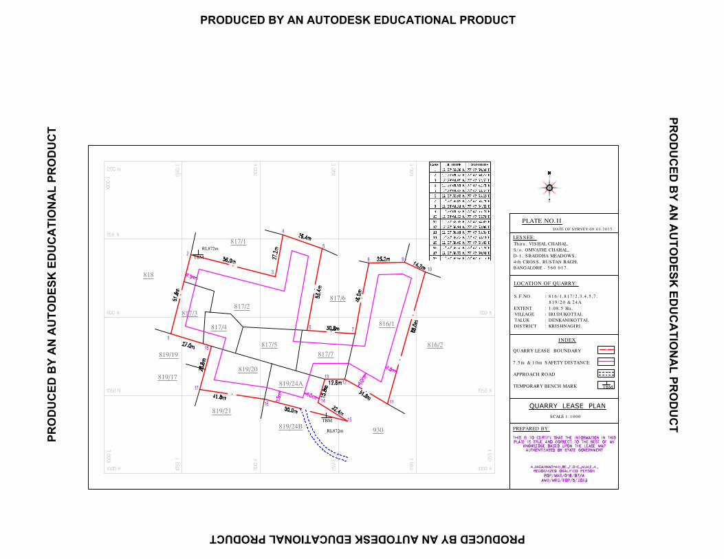
QUARRY LEAS E BOUNDARY
7 .5 m & 1 0 m S AFETY DIS TANCE
APPROACH ROAD
TEMPORARY BENCH MARK
INDEX
S CALE 1 : 1 0 0 0
PLATE NO.II
DATE OF S URVEY: 0 9 .0 3 .2 0 1 5
PREPARED BY:
LOCATION OF QUARRY:
S .F.NO : 8 1 6 / 1 ,8 1 7 / 2 ,3 ,4 ,5 ,7 ,
8 1 9 / 2 0 & 2 4 A
EXTENT : 1 .0 8 .5 Ha ,
VILLAGE : IRUDUKOTTAI,
TALUK : DENKANIKOTTAI,
DIS TRICT : KRIS HNAGIRI.
LES S EE:
Th iru . VIS HAL CHAHAL.
S / o . OMVATHI CHAHAL,
D-1 , S RADDHA MEADOWS ,
4 th CROS S , RUS TAN BAGH,
BANGALORE - 5 6 0 0 1 7 .
PR
OD
UC
ED
BY
AN
AU
TO
DE
SK
ED
UC
AT
ION
AL
PR
OD
UC
T
PRODUCED BY AN AUTODESK EDUCATIONAL PRODUCT
PR
OD
UC
ED
BY
AN
AU
TO
DE
SK
ED
UC
AT
ION
AL
PR
OD
UC
T
PRODUCED BY AN AUTODESK EDUCATIONAL PRODUCT
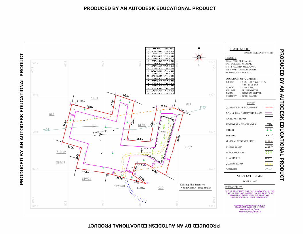
S CALE 1 : 1 0 0 0
PLATE NO.III
DATE OF S URVEY: 0 9 .0 3 .2 0 1 5
PREPARED BY:
LOCATION OF QUARRY:
S .F.NO : 8 1 6 / 1 ,8 1 7 / 2 ,3 ,4 ,5 ,7 ,
8 1 9 / 2 0 & 2 4 A
EXTENT : 1 .0 8 .5 Ha ,
VILLAGE : IRUDUKOTTAI,
TALUK : DENKANIKOTTAI,
DIS TRICT : KRIS HNAGIRI.
LES S EE:
Th iru . VIS HAL CHAHAL.
S / o . OMVATHI CHAHAL,
D-1 , S RADDHA MEADOWS ,
4 th CROS S , RUS TAN BAGH,
BANGALORE - 5 6 0 0 1 7 .
QUARRY LEAS E BOUNDARY
7 .5 m & 1 0 m S AFETY DIS TANCE
APPROACH ROAD
TEMPORARY BENCH MARK
S HRUB
TOPS OIL
MINERAL CONTACT LINE
S TRIKE & DIP
BLACK GRANITE
QUARRY PIT
QUARRY ROAD
CONTOUR
INDEX
PR
OD
UC
ED
BY
AN
AU
TO
DE
SK
ED
UC
AT
ION
AL
PR
OD
UC
T
PRODUCED BY AN AUTODESK EDUCATIONAL PRODUCT
PR
OD
UC
ED
BY
AN
AU
TO
DE
SK
ED
UC
AT
ION
AL
PR
OD
UC
T
PRODUCED BY AN AUTODESK EDUCATIONAL PRODUCT
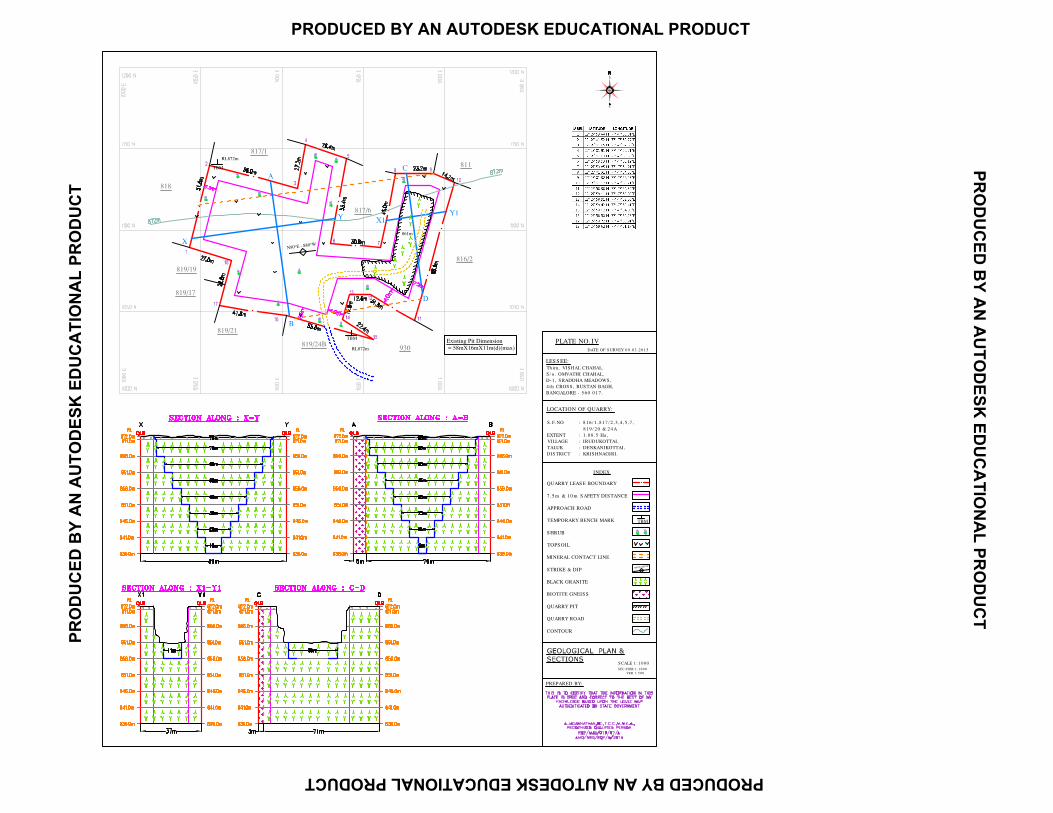
PLATE NO.IV
DATE OF S URVEY: 0 9 .0 3 .2 0 1 5
PREPARED BY:
LOCATION OF QUARRY:
S .F.NO : 8 1 6 / 1 ,8 1 7 / 2 ,3 ,4 ,5 ,7 ,
8 1 9 / 2 0 & 2 4 A
EXTENT : 1 .0 8 .5 Ha ,
VILLAGE : IRUDUKOTTAI,
TALUK : DENKANIKOTTAI,
DIS TRICT : KRIS HNAGIRI.
LES S EE:
Th iru . VIS HAL CHAHAL.
S / o . OMVATHI CHAHAL,
D-1 , S RADDHA MEADOWS ,
4 th CROS S , RUS TAN BAGH,
BANGALORE - 5 6 0 0 1 7 .
QUARRY LEAS E BOUNDARY
7 .5 m & 1 0 m S AFETY DIS TANCE
APPROACH ROAD
TEMPORARY BENCH MARK
S HRUB
TOPS OIL
MINERAL CONTACT LINE
S TRIKE & DIP
BLACK GRANITE
BIOTITE GNEIS S
QUARRY PIT
QUARRY ROAD
CONTOUR
INDEX
S CALE 1 : 1 0 0 0
S EC-HOR 1 : 1 0 0 0
VER 1 : 5 0 0
PR
OD
UC
ED
BY
AN
AU
TO
DE
SK
ED
UC
AT
ION
AL
PR
OD
UC
T
PRODUCED BY AN AUTODESK EDUCATIONAL PRODUCT
PR
OD
UC
ED
BY
AN
AU
TO
DE
SK
ED
UC
AT
ION
AL
PR
OD
UC
T
PRODUCED BY AN AUTODESK EDUCATIONAL PRODUCT
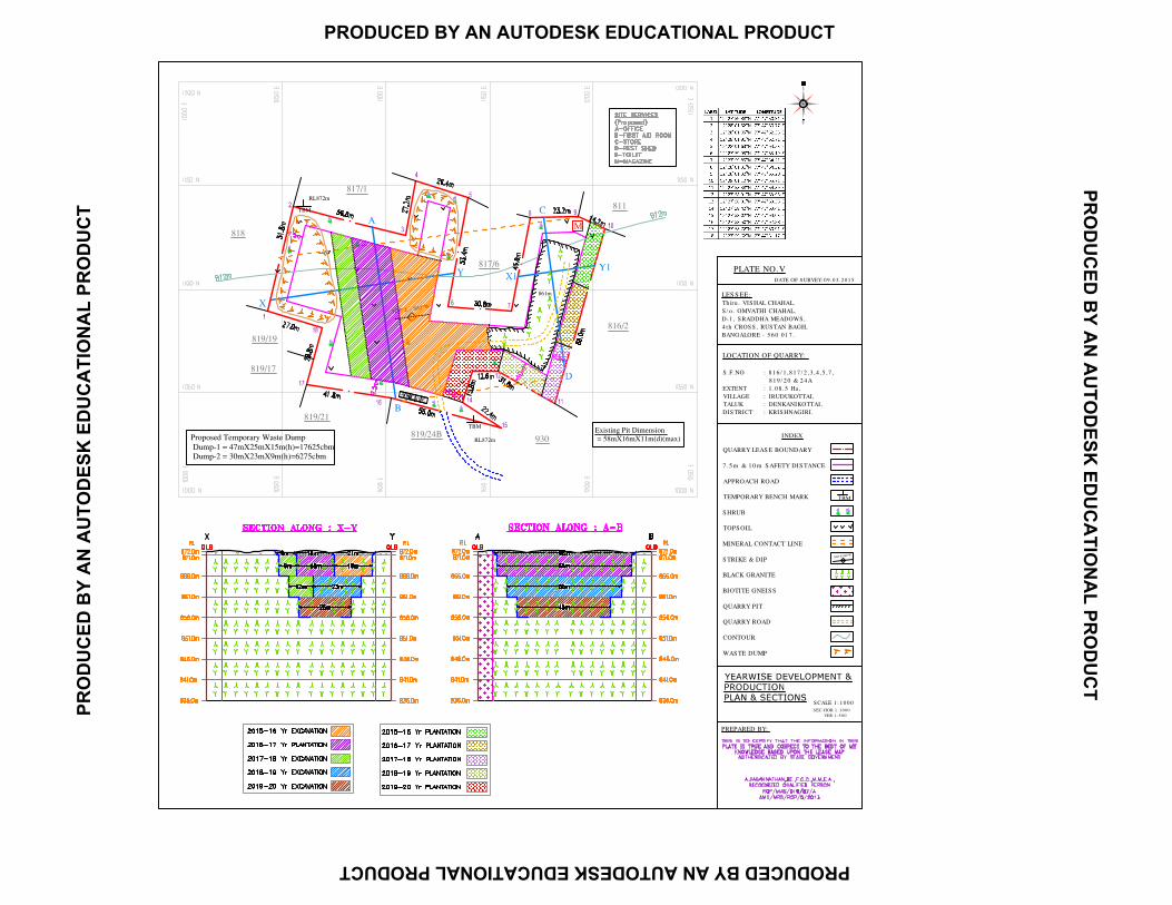
PLATE NO.V
DATE OF S URVEY: 0 9 .0 3 .2 0 1 5
PREPARED BY:
LOCATION OF QUARRY:
S .F.NO : 8 1 6 / 1 ,8 1 7 / 2 ,3 ,4 ,5 ,7 ,
8 1 9 / 2 0 & 2 4 A
EXTENT : 1 .0 8 .5 Ha ,
VILLAGE : IRUDUKOTTAI,
TALUK : DENKANIKOTTAI,
DIS TRICT : KRIS HNAGIRI.
LES S EE:
Th iru . VIS HAL CHAHAL.
S / o . OMVATHI CHAHAL,
D-1 , S RADDHA MEADOWS ,
4 th CROS S , RUS TAN BAGH,
BANGALORE - 5 6 0 0 1 7 .
QUARRY LEAS E BOUNDARY
7 .5 m & 1 0 m S AFETY DIS TANCE
APPROACH ROAD
TEMPORARY BENCH MARK
S HRUB
TOPS OIL
MINERAL CONTACT LINE
S TRIKE & DIP
BLACK GRANITE
BIOTITE GNEIS S
QUARRY PIT
QUARRY ROAD
CONTOUR
WAS TE DUMP
INDEX
S CALE 1 : 1 0 0 0
S EC-HOR 1 : 1 0 0 0
VER 1 : 5 0 0
c
c
c
c
c
c
c
c
c
c
c
cc
c
cc
c
M
PR
OD
UC
ED
BY
AN
AU
TO
DE
SK
ED
UC
AT
ION
AL
PR
OD
UC
T
PRODUCED BY AN AUTODESK EDUCATIONAL PRODUCT
PR
OD
UC
ED
BY
AN
AU
TO
DE
SK
ED
UC
AT
ION
AL
PR
OD
UC
T
PRODUCED BY AN AUTODESK EDUCATIONAL PRODUCT
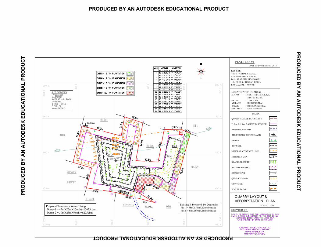
PLATE NO.VI
DATE OF S URVEY: 0 9 .0 3 .2 0 1 5
PREPARED BY:
LOCATION OF QUARRY:
S .F.NO : 8 1 6 / 1 ,8 1 7 / 2 ,3 ,4 ,5 ,7 ,
8 1 9 / 2 0 & 2 4 A
EXTENT : 1 .0 8 .5 Ha ,
VILLAGE : IRUDUKOTTAI,
TALUK : DENKANIKOTTAI,
DIS TRICT : KRIS HNAGIRI.
LES S EE:
Th iru . VIS HAL CHAHAL.
S / o . OMVATHI CHAHAL,
D-1 , S RADDHA MEADOWS ,
4 th CROS S , RUS TAN BAGH,
BANGALORE - 5 6 0 0 1 7 .
QUARRY LEAS E BOUNDARY
7 .5 m & 1 0 m S AFETY DIS TANCE
APPROACH ROAD
TEMPORARY BENCH MARK
S HRUB
TOPS OIL
MINERAL CONTACT LINE
S TRIKE & DIP
BLACK GRANITE
BIOTITE GNEIS S
QUARRY PIT
QUARRY ROAD
CONTOUR
WAS TE DUMP
INDEX
S CALE 1 : 1 0 0 0
c
c
c
c
c
c
cc
c
cc
c
c
c
c
c
c
QUARRY LAYOUT &
AFFORESTATION PLAN
M
PR
OD
UC
ED
BY
AN
AU
TO
DE
SK
ED
UC
AT
ION
AL
PR
OD
UC
T
PRODUCED BY AN AUTODESK EDUCATIONAL PRODUCT
PR
OD
UC
ED
BY
AN
AU
TO
DE
SK
ED
UC
AT
ION
AL
PR
OD
UC
T
PRODUCED BY AN AUTODESK EDUCATIONAL PRODUCT
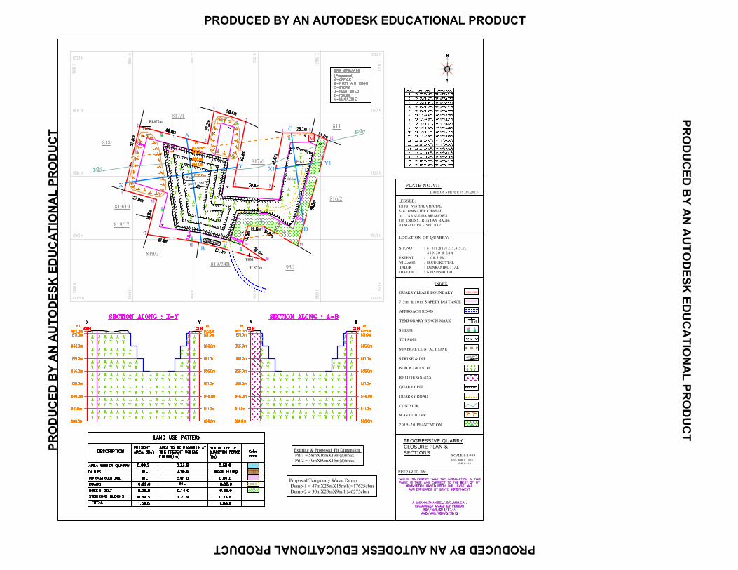
PLATE NO.VII
DATE OF S URVEY: 0 9 .0 3 .2 0 1 5
PREPARED BY:
LOCATION OF QUARRY:
S .F.NO : 8 1 6 / 1 ,8 1 7 / 2 ,3 ,4 ,5 ,7 ,
8 1 9 / 2 0 & 2 4 A
EXTENT : 1 .0 8 .5 Ha ,
VILLAGE : IRUDUKOTTAI,
TALUK : DENKANIKOTTAI,
DIS TRICT : KRIS HNAGIRI.
LES S EE:
Th iru . VIS HAL CHAHAL.
S / o . OMVATHI CHAHAL,
D-1 , S RADDHA MEADOWS ,
4 th CROS S , RUS TAN BAGH,
BANGALORE - 5 6 0 0 1 7 .
S CALE 1 : 1 0 0 0
S EC-HOR 1 : 1 0 0 0
VER 1 : 5 0 0
c
c
c
c
c
cc
c
cc
c
M
QUARRY LEAS E BOUNDARY
7 .5 m & 1 0 m S AFETY DIS TANCE
APPROACH ROAD
TEMPORARY BENCH MARK
S HRUB
TOPS OIL
MINERAL CONTACT LINE
S TRIKE & DIP
BLACK GRANITE
BIOTITE GNEIS S
QUARRY PIT
QUARRY ROAD
CONTOUR
WAS TE DUMP
2 0 1 5 -2 0 PLANTATION
INDEX
ac
PR
OD
UC
ED
BY
AN
AU
TO
DE
SK
ED
UC
AT
ION
AL
PR
OD
UC
T
PRODUCED BY AN AUTODESK EDUCATIONAL PRODUCT
PR
OD
UC
ED
BY
AN
AU
TO
DE
SK
ED
UC
AT
ION
AL
PR
OD
UC
T
PRODUCED BY AN AUTODESK EDUCATIONAL PRODUCT
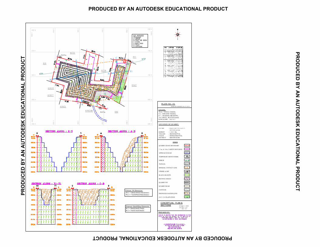
PLATE NO. IX
DATE OF S URVEY: 0 9 .0 3 .2 0 1 5
PREPARED BY:
LOCATION OF QUARRY:
S .F.NO : 8 1 6 / 1 ,8 1 7 / 2 ,3 ,4 ,5 ,7 ,
8 1 9 / 2 0 & 2 4 A
EXTENT : 1 .0 8 .5 Ha ,
VILLAGE : IRUDUKOTTAI,
TALUK : DENKANIKOTTAI,
DIS TRICT : KRIS HNAGIRI.
LES S EE:
Th iru . VIS HAL CHAHAL.
S / o . OMVATHI CHAHAL,
D-1 , S RADDHA MEADOWS ,
4 th CROS S , RUS TAN BAGH,
BANGALORE - 5 6 0 0 1 7 .
S CALE 1 : 1 0 0 0
S EC-HOR 1 : 1 0 0 0
VER 1 : 5 0 0
c
c
c
c
c
cc
c
cc
c
M
QUARRY LEAS E BOUNDARY
7 .5 m & 1 0 m S AFETY DIS TANCE
APPROACH ROAD
TEMPORARY BENCH MARK
S HRUB
TOPS OIL
MINERAL CONTACT LINE
S TRIKE & DIP
BLACK GRANITE
BIOTITE GNEIS S
QUARRY PIT
QUARRY ROAD
CONTOUR
PROPOS ED BACKFILLING
2 0 1 5 -2 0 PLANTATION
INDEX
PR
OD
UC
ED
BY
AN
AU
TO
DE
SK
ED
UC
AT
ION
AL
PR
OD
UC
T
PRODUCED BY AN AUTODESK EDUCATIONAL PRODUCT
PR
OD
UC
ED
BY
AN
AU
TO
DE
SK
ED
UC
AT
ION
AL
PR
OD
UC
T
PRODUCED BY AN AUTODESK EDUCATIONAL PRODUCT