File #### - Owner (Applicant) - CA.gov
156
Issued by the City Manager REPORT TO MAYOR AND COUNCIL Template rev. 03/07 NO: 08-331 November 18, 2008 SUBJECT: 2006-0712 – Trumark Companies [Applicant] Ray Street Office, LLC. [Owner]: Application for related proposals on a 6.63 acre site located at 1275 and 1287 Lawrence Station Road (near Elko Drive) in an M-S (Industrial & Service) Zoning District. (APNs: 110-15-045, 110-15-044) Resolution General Plan Amendment to change the land use designation from Industrial to Very High Density Residential, Ordinance Rezone the site from M-S (Industrial & Service) to R-5/MU (High Density Residential and Office/Mixed Use), Resolution Statements of Overriding Consideration for air quality impacts associated with the effects of diesel particulate matter on future project residents and related to the project’s contribution to cumulative regional air quality impacts. Motion Special Development Permit to allow development of 338 condominium units and 16,000 square feet of commercial space, Motion Vesting Tentative Map for condominium purposes. REPORT IN BRIEF Existing Site Conditions Industrial and office buildings Surrounding Land Uses North Highway 237/Baylands Park South Gas Station East Industrial and Fire Station West Lawrence Expressway/Industrial POA/Hotel Issues Land use, open space, architecture, mixed use Environmental Status An Environmental Impact Report has been prepared in compliance with California Environmental Quality Act provisions for the Luminaire/Lawrence Station Road Industrial to Residential/Mixed Use General Plan Amendment and Rezoning (2008). Planning Commission’s Action Recommended adoption of the Statements of Overriding Consideration, approval of General Plan Amendment, Rezoning, Special Development Permit, and Vesting Map with modified conditions. Staff Recommendation Denial of all related applications, not in accordance with Planning Commission’s recommendation.
-
Upload
khangminh22 -
Category
Documents
-
view
0 -
download
0
Transcript of File #### - Owner (Applicant) - CA.gov

Issued by the City Manager
REPORT TO MAYOR AND COUNCIL
Template rev. 03/07
NO: 08-331
November 18, 2008
SUBJECT: 2006-0712 – Trumark Companies [Applicant] Ray Street Office, LLC. [Owner]: Application for related proposals on a 6.63 acre site located at 1275 and 1287 Lawrence Station Road (near Elko Drive) in an M-S (Industrial & Service) Zoning District. (APNs: 110-15-045, 110-15-044)
Resolution General Plan Amendment to change the land use designation from Industrial to Very High Density Residential,
Ordinance Rezone the site from M-S (Industrial & Service) to R-5/MU (High Density Residential and Office/Mixed Use),
Resolution Statements of Overriding Consideration for air quality impacts associated with the effects of diesel particulate matter on future project residents and related to the project’s contribution to cumulative regional air quality impacts.
Motion Special Development Permit to allow development of 338 condominium units and 16,000 square feet of commercial space,
Motion Vesting Tentative Map for condominium purposes. REPORT IN BRIEF Existing Site Conditions
Industrial and office buildings
Surrounding Land Uses North Highway 237/Baylands Park
South Gas Station
East Industrial and Fire Station
West Lawrence Expressway/Industrial POA/Hotel Issues Land use, open space, architecture, mixed use
Environmental Status
An Environmental Impact Report has been prepared in compliance with California Environmental Quality Act provisions for the Luminaire/Lawrence Station Road Industrial to Residential/Mixed Use General Plan Amendment and Rezoning (2008).
Planning Commission’s Action
Recommended adoption of the Statements of Overriding Consideration, approval of General Plan Amendment, Rezoning, Special Development Permit, and Vesting Map with modified conditions.
Staff Recommendation
Denial of all related applications, not in accordance with Planning Commission’s recommendation.

2006-0712 – Trumark Companies November 18, 2008 Page 2 of 37
General Plan Amendment Rezoning from M-S to R-5/MU Special Development Permit Vesting Tentative Map

2006-0712 – Trumark Companies November 18, 2008 Page 3 of 37
PROJECT DATA TABLE
EXISTING PROPOSED
REQUIRED/ PERMITTED
(Per staff recommendation on
new MU District)
General Plan Industrial Very High
Density Residential
Pending approval of GPA
Zoning District
Industrial and Service (M-S)
High Density Residential and
Office/Mixed Use (R-5/MU)
Pending approval of GPA
Lot Size (s.f.) 6.63 (288,802) Same N/A Gross Floor Area (s.f.) 74,316 439,418 N/A Lot Coverage (%) 26% 51.7 % 40% max. Floor Area Ratio (FAR) 13% 1.52 N/A
No. of Units N/A 338 349 max.
(304 + 45 w/ 15% density bonus)
Density (units/acre) N/A 51 du/ac 53 du/ac max. Meets 75% min? N/A Yes 228 min. Lockable Storage/Unit N/A 300 cu. ft. 300 cu. ft. min. No. of Buildings On-Site 2 1 N/A Distance Between Buildings (ft.) N/A N/A 26’ min.
Building Height (ft.) 35’ 66.5’ 65’ max No. of Stories 1 6 5 max. Mixed Use Commercial (s.f.) N/A
22,152
(16,000– Retail) (6,152– Live/Work)
28,802 min. 72,200 max.
Commercial (%) N/A 7.67% 10% min. 25% max.
Setbacks (First & Second Stories Facing Property) • Front on Lawrence
Expressway 70’ 32’ 20’ min.
• Front on Hwy. 237 Ramp 40’ 32’ 20’ min.
• Front on Elko Drive 70’ 20’ 20’ min. • Front on Lawrence
Station Road
60’ 20’ 20’ min.

2006-0712 – Trumark Companies November 18, 2008 Page 4 of 37
EXISTING
REQUIRED/ PERMITTED
PROPOSED (Per staff recommendation on
new MU District) Landscaping (s.f.) • Total Landscaping 75,750 148,097 126,750 min. • Landscaping/Unit N/A 438 375 min. • Total Usable Open
Space ** N/A 128,440 128,440 min.
• Usable Open Space/Unit N/A 380 380 min.
• Private Usable Open Space/Unit N/A 80 min. 80 min.
• Frontage Width (ft.) 40’ min. 20’ min. 15’ min. • Parking Lot Area
Shading (%) N/A 50% 50% min. in 15 years
• Water Conserving Plants (%) N/A 70% 70% min.
• Clubhouse (s.f.) N/A 3,000
(including kitchen and restrooms)
450 (plus kitchen and
restrooms) Parking
• Total Spaces 1,391 667 667 min.
(using ULI shared parking standards for
mixed use projects) • Compact Spaces/ %
of Total N/A 9/ 1.3 % 115/ 35% max. of unassigned spaces
Per ADA requirements • Accessible Spaces N/A 20
• Bicycle Parking N/A
Bike storage room that will
accommodate the minimum
required spaces
Residential: 112 Class I, 23 Class II
Commercial:
1 Class I per 30 employees,
1 Class II per 6,000 s.f.
Starred items indicate deviations from Sunnyvale Municipal Code requirements.
** Staff believes there is sufficient justification for to support certain front yard areas as Usable Open Space which requires a deviation from SMC requirements.

2006-0712 – Trumark Companies November 18, 2008 Page 5 of 37
ANALYSIS Description of Proposed Project Present Site Conditions: The project site includes two parcels totaling 6.63 acres with two industrial/office buildings that were developed in 1970. Use: The proposed project consists of 338 mid-rise condominium units (including 16 live/work units) and 16,000 square feet of commercial retail space. Site Layout: The site is bound on four sides by roadway or highway on-ramp. Vehicle access cannot be taken from the Lawrence Expressway or the Highway 237 sides. Project Applications: The proposed project consists of six components: 1) an Environmental Impact Report (EIR) for the project; 2) an amendment to Title 19 of the Sunnyvale Municipal Code (Zoning) to create a new Mixed Use Zoning Combining District (MU); 3) a General Plan Amendment to change the land use on the site from Industrial to Very High Density Residential; 4) a Rezone of this site from M-S (Industrial and Service) to R-5/MU (High Density Residential and Office/Mixed Use); 5) a Special Development Permit application; and 6) a Vesting Tentative Map. These six components are described in more detail below. 1) Environmental Impact Report: An EIR (Luminaire/Lawrence Station Road Project) is being processed concurrently with this application. The EIR is addressed under a separate staff report and needs to be considered prior to any other actions under consideration. 2) New Mixed Use Combining District: An amendment to Title 19 of the Sunnyvale Municipal Code (SMC) to create a Mixed Use Zoning Combining District is being processed concurrently with this application. The amendment is addressed under a separate staff report and should be considered prior to any other actions addressed in this report. The existing Title 19 zoning designations currently utilized by the City do not adequately address the type of development currently proposed for this site. The new Mixed Use District will contain the new development requirements and criteria for use with sites throughout the City. 3) General Plan Amendment: The project includes a request for an amendment to the City’s General Plan Land Use Map designation from Industrial to Very High Density Residential in order to allow for redevelopment of the site. The primary goal of the proposed land use change is to allow the development of the site with residential mixed use combined with commercial development. 4) Rezone: Associated with the General Plan Amendment and Title 19 amendment is a proposal to rezone the site from M-S (Industrial and Service) to R-5/MU (High

2006-0712 – Trumark Companies November 18, 2008 Page 6 of 37
Density Residential and Office/Mixed Use). This designation would allow development of the site under the newly adopted Mixed Use Combining District. 5) Special Development Permit (SDP): The applicant is also requesting approval of an SDP to allow construction of 338 mid-rise rental units (which includes 16 live/work units) and 16,000 square feet of commercial space. The project will include the required 15% of Below Market Rate (BMR) housing rental units (46 units), which is based on the number of units allowed without a density bonus, pursuant to SMC Section 19.66.020 (see BMR Conditions of approval in Attachment B). 6) Vesting Tentative Map: The applicant is requesting approval of a Vesting Tentative Map to merge two parcels, totaling approximately 6.63 acres, into one common lot with 338 residential condominium units and 16,000 square feet of commercial space. The applicant has stated the project will be constructed for rental units but may be converted to ownership units in the future. BackgroundThis development application is being processed concurrently with the Luminaire/Lawrence Station Road Project Environmental Impact Report and a Title 19 amendment to create a new Mixed Use Combining District. This development proposal, if approved, will allow a General Plan Amendment change for Industrial to Very High Density Residential, a Rezoning of the property from Industrial and Service to High Density Residential and Office/Mixed Use, a Special Development Permit and Vesting Tentative Map. The decision on the Environmental Impact Report and new Mixed Use zone will precede this application. This application was heard before the Planning Commission at their October 13, 2008 meeting. The Commission voted 7-0 to recommend approval to the City Council with modified conditions as follows:
1. A condition of approval was added to mitigate the air quality impacts stating that the 14 units, identified as impacted by the diesel particulate matter, shall not be occupied for at least 5 years and until further air quality testing determines they can be occupied without impacting the health of the residents.
2. Remove condition of approval 2.b that requires the project to be redesigned to be the maximum of 40% lot coverage (allows 51.7% lot coverage as requested by the developer).
General Plan Initiation: In 2003 a General Plan Amendment Initiation request was submitted by The Riding Group to convert the site from Industrial to Medium Density Residential (RTC 03-0425). Staff noted concerns that the proposal included the loss of industrial land and the lack of proximity to neighborhood parks, schools and shopping centers. It was also noted that the edges of the neighborhood were not appropriate for residential uses. The streets are wider in

2006-0712 – Trumark Companies November 18, 2008 Page 7 of 37
an industrial neighborhood as they are defined to serve industrial uses. Specifically, the site is designated within the Community Development Strategy as an area that needs reinvestment and should be preserved for industrial uses. The General Plan Amendment Study was not initiated by the City Council on a 4-3 vote at their December 2, 2003 meeting. In 2006 a subsequent General Plan Initiation request was received from Trumark Companies requesting a change in the existing Land Use designation from Industrial to Residential High Density. The preliminary plans called for the development of a mixed use project including retail, office, and residential uses. At the February 14, 2006 City Council meeting the applicant stated more specifically that preliminary plans for the project included:
• Mixed use development with office (10,000 sf.), retail (15,999 sf.), and housing components,
• 300 housing units ranging in size from 1,200 to 1,400 square feet, • Underground parking, • Building heights below 50 feet, • Ownership housing units.
At the meeting the Council authorized the General Plan Amendment Study on a 5-2 vote (see Council Meeting Minutes in Attachment C for additional details). As part of the study the Council directed staff to examine the following:
• Explore a Mixed Use zoning designation, • Examine the appropriateness of different residential densities, including
R-3 (medium density), R-4 (high density), and R-5 (high density with office),
• Examine the appropriateness of new residential uses in a predominately industrial region of the city,
• Consider the advantages of increased residential, retail, and office opportunities,
• Evaluate noise and traffic impacts to the proposed development, • Examine the opportunities to provide additional affordable housing
units. In July 2006 the developer formally submitted this application for review. The applicant’s team and staff worked through key site plan and project design changes until both parties believed the environmental review could begin. The initial scoping of the EIR (Notice of Preparation) was released in April 2007. Between April 2007 and September 2008 the project undertook numerous changes based on information from the EIR consultant; suggested changes from City staff; changes from the applicant’s project team; and information received from the applicant’s legal council. Major changes to this project have occurred in the past six months, in part, delaying the release of the EIR and the scheduling of

2006-0712 – Trumark Companies November 18, 2008 Page 8 of 37
public hearings. In August 2008 staff received the current site plan and architectural elevations from the applicant. Environmental ReviewAn EIR (Luminaire/Lawrence Station Road Project) is being processed concurrently with this application. The EIR addresses the impacts of the conversion of 6.63 acres from industrial to residential/ mixed use and the impacts to the surrounding area. The EIR also evaluates potential impacts associated with creation of a new Mixed Use Combining District, project alternatives, and future impacts to the residents of the project. The EIR would need to be certified prior to this action. EXISTING POLICY RELATED TO GENERAL PLAN AMENDMENT AND REZONING The following General Plan Goals and Policies are related to this request for a General Plan Amendment and Rezoning: Housing and Community Revitalization Sub-element Goal A: Foster the expansion of housing supply to provide greater
opportunities for current and future residents within limits imposed by environmental, social fiscal, and land use constraints.
Action Statements A.3.a: Maintain provisions of the zoning code that permit
housing to be constructed in commercial districts after planning review.
Policy B.3: Continue to permit and encourage a mix of residential and job-
producing land uses, as long as there is neighborhood compatibility and no unavoidable environmental impacts.
Policy C.1: Continue efforts to balance the need for additional housing with
other community values, such as preserving the character of established neighborhoods, high quality design, and promoting a sense of identity in each neighborhood.
Goal D: Maintain diversity in tenure, type, size, and location of housing to
permit a range of individual choices for all current residents and those expected to become city residents.
Policy D.1: Encourage innovative types of housing in existing residential zoning
districts.

2006-0712 – Trumark Companies November 18, 2008 Page 9 of 37
Land Use and Transportation Element Goal C1: Preserve and enhance an attractive community, with a positive
image and a sense of place that consists of distinctive neighborhoods, pockets of interest, and human-scale developments.
C3.2.3: Encourage mixed use developments that provide pedestrian scale
and transit oriented services and amenities. The intent is to provide opportunities for mixed use.
C4.3: Consider the needs of business as well as residents when making
land use and transportation decisions. Policy N1.1: Protect the integrity of the City’s neighborhoods; whether
residential, industrial or commercial. Action Statement N1.1.1: Limit the intrusion of incompatible uses and
inappropriate development into city neighborhoods. Policy N1.2: Require new development to be compatible with the neighborhood,
adjacent land uses and the transportation system. Community Design Sub-element Policy A.2: Ensure that new development is compatible with the character of
special districts and residential neighborhoods. General Plan Amendment General Plan Change Under Consideration: Amend the City’s General Plan Land Use Map designation from Industrial to Very High Density Residential. Discussion of General Plan Amendment: The site currently has a General Plan Land Use designation of Industrial. A change in land use to Very High Density Residential would cause this site to be the only such land use in the area. There are a number of impacts and challenges associated with changing the land use of a property to be unique to its area, including proximity to schools, proximity to commercial services, access to parks and open space area, other residential amenities, and livability of the site. These potential impacts are discussed in detail below. 2003 Community Development Strategy: The project site is located in an industrial area called “The Woods.” This area is considered one of the four “Office and Industrial Action Areas”, as described in the Community Development Strategy presented to the City Council in 2003.
The Woods encompasses approximately 96 acres and is predominately made up of Class C buildings on small lots. The area serves primarily support services and

2006-0712 – Trumark Companies November 18, 2008 Page 10 of 37
start-up businesses. The smaller industrial buildings lend themselves to lower rent and the recent condominium conversions in the area provide for ownership opportunities. Most of the properties are well maintained. This site, however, consists of the only Class B type structures in this industrial neighborhood. The Community Development Strategy designates the Woods as an area for the following strategies:
• Review current zoning to make sure it encourages and supports the retention of small business.
• Marketing and promotion of the Woods as a location for support services and start-up companies
• Outreach to small businesses in the area to assist in problem solving.
The Community Development Strategy also points out the need for increased housing opportunities within the City. Due to the lack of vacant land within City limits, this goal can only be achieved through the conversion of existing uses on certain parcels. The strategy also stresses the need to appropriately locate sites where housing opportunities should be pursued. The City of Sunnyvale has in 1994 selected areas as Industrial to Residential (ITR) Zones in which specific industrial sites are recommended for the eventual conversion to residential uses. In 2007, approximately 68 additional acres (up to 1,488 units) were rezoned from Industrial to ITR. The Community Development Strategy does not identify the Woods as a suitable location for residential or mixed use projects. Expected Impact on the Surroundings: The Woods area is home to many diverse businesses ranging in use from research and development, warehouse and storage, printers, manufacturing, and some restaurant uses. These businesses employ approximately 2,100 employees. During Fiscal Year 2007-2008, there were about 200 sales tax generating businesses located in the Woods. The total sales tax generated by businesses located in the Woods area increased by about 4% from FY 2006-2007. The increase in sales tax may be related to the limited number of vacant buildings in 2008 versus 2007. As of the first quarter 2008, the vacancy rate for the Woods was 4%, totaling approximately 140,000 square feet of space available. The average lease per square foot is $1.14 for research and development and $1.23 per square foot for warehouse, distribution, and manufacturing. This is about 15-20% less than in other areas of the City where larger tenant spaces and Class A/B buildings can be found. This makes the Woods area an attractive location for industrial and warehouse type businesses. Sunnyvale’s capacity to support diverse local industries and its capacity to support business retention and expansion are central to the issue of retaining industrial land. As more industrial activities are pressured out of Sunnyvale, workers in Sunnyvale will have to commute larger distances to communities that attract industrial jobs or professional jobs.

2006-0712 – Trumark Companies November 18, 2008 Page 11 of 37
In conversation with commercial real estate brokers, they have stated that some of their industrial clients are starting to have difficulty finding adequate industrial space. This is more apparent with manufacturing and R&D operations which utilize potentially hazardous materials, such as semiconductor and solar manufacturers. It is also a challenge to find locations for users that operate in a manner that may create excessive noise, dust, traffic or other conditions that are not compatible with a residential use. For example, some industrial operations have large delivery vehicles associated with their businesses that operate 24 hours a day. This condition is particularly true in the Woods area. Currently, there is a Federal Express distribution center across the street from the proposed development with operating hours up to 24 hours a day, and a UPS facility on Hammerwood Avenue further east of the site. It is difficult to fully quantify the potential financial impact to the existing businesses in the Woods since their operations will not cease as a result of this land use change. Their operations may be required to be scaled back and future expansions may not be allowed. It is also difficult to predict the fiscal impact to the City due to the loss of a future industrial/office uses in this location. A future business that is a point of sales would generate sales tax revenue, while a future office use likely would not generate the same revenue, yet indirectly support retailers. This site constitutes the only Class B type structures in this industrial neighborhood, with the remainder of the industrial/office buildings in the Woods 96 acres being Class C. A transition of this site from industrial to residential land use would result in a 7% decrease in the total industrial/commercial area of the Woods. Workspace Demand Analysis Summary: In 2006, a Sunnyvale Workspace Demand and Capacity Analysis was prepared for the City by Economic and Planning Systems to assess whether the re-zoning of industrial land to permit residential uses would affect the City’s ability to compete for and accommodate future demand for workspace (i.e., office, research and development [R&D], warehouse and manufacturing buildings). The report compares projected demand for industrial workspace to the development capacity in each of the City’s industrial sub-areas to draw conclusions and estimate likely demand for workspace in the next 20 years and the City’s capacity to provide new workspace through its existing supply of land and buildings. The Workspace Demand Analysis notes that Sunnyvale is a major Silicon Valley employment center with a few prominent company headquarters as well as small and medium-sized firms. Like other cities in the region, Sunnyvale has been experiencing a growing shift away from manufacturing and heavy R&D uses. At the same time, the City’s housing supply has not kept up with job growth, resulting in an overall jobs/housing imbalance and a lack of affordable housing.

2006-0712 – Trumark Companies November 18, 2008 Page 12 of 37
In 1993 and again in 2007, the City made major land use changes that would facilitate the transformation of obsolete industrial space into higher-valued workspace and provide additional housing: • Designation of ITR Districts: The City rezoned several industrial areas into
ITR districts. These ITR sites were selected by the City based on several criteria, including suitability for residential development (proximity to other residential development/market interest), ability to support high-density development along existing transit lines, and ability to provide commercial uses, parks and elementary schools to the residents.
• Increased Industrial Development Densities: The City also increased the
permitted floor-area ratios in selected industrial areas to between 50 and 100 percent from typical levels of 35 percent. This increase permits and encourages intensified workspace development or commercial uses consistent with the changing patterns of workspace need. These industrial intensification sites were selected based on how well these areas could support public transit (especially the light rail), their prominence in terms of location, and how much additional work or commercial space they can provide (i.e., parcel size).
• AMD ITR District: The City Council reviewed a General Plan Amendment and
Rezoning for an approximately 130-acre site located in east Sunnyvale that is currently developed with a variety of industrial and office uses including the AMD corporate headquarters and the Spansion fabrication plant. The Council ultimately approved a new ITR zone of approximately 68 acres.
The key findings of the Workspace Demand Analysis indicate that the Silicon Valley economy will continue to shift from manufacturing jobs towards high-value research, professional, and technical service sector jobs. This shift will result in an overall intensification of use, and a shift away from lower density R&D buildings towards office and new types of R&D buildings. An optimistic evaluation of future job growth in Sunnyvale indicates potential demand for about 8.1 million square feet of workspace over the next 20 years. The City has limited vacant industrial land to accommodate future growth, but a surplus of vacant buildings, and significant underutilized industrial land with redevelopment potential. Redevelopment would provide an opportunity for over 20 million square feet of new workspace development under permitted industrial development densities. The large majority of future workspace development potential will come from three industrial sub-areas: Moffett Park, Peery Park, and Oakmead (AMD area). The overall capacity for workspace in the City of Sunnyvale is estimated at 23 million square feet, including vacant buildings, vacant land, and redevelopment potential. This represents close to three times the expected workspace demand

2006-0712 – Trumark Companies November 18, 2008 Page 13 of 37
over the next 20 years. About 27 percent of the projected workspace demand over the next 20 years could be accommodated in existing vacant building space. The remaining workspace need of about 6 million square feet must be accommodated primarily through redevelopment. As the market improves, redevelopment will occur in the most competitive and financially feasible locations, with Moffett Park likely to capture the majority of redevelopment. A significant portion of the new workspace is likely to be Class A office and R&D space in buildings with three or more stories as the economy continues to shift away from product testing and production to higher end research and services. As workspace needs shift increasingly to higher density office and R&D product types, the City’s ability to attract new workspace development and users will depend, in part, on the opportunities provided for such development. These developments will increasingly require FARs greater than the traditional 35 percent industrial density. A large number of new workspace developments will require densities in the 40 to 60 percent range, with mid-rise office building served by structured parking reaching densities as high as 250 percent. Although not part of this application, the City could consider expanding the number, size, and permitted density of its intensification sites in order to maximize its attractiveness to future workspace developments and businesses. The Workspace Demand Analysis concludes that, given the level of redevelopment potential, the City could rezone some industrial land to allow for residential development without reducing its competitiveness for workspace development. The City could strategically reserve the most competitive workspace locations while allowing residential conversions of industrial areas in less competitive locations. The Workspace Demand Analysis findings indicate that in order to make the optimum use of the City’s existing industrial areas, intensification is needed in other industrial areas to achieve the type of Class A and R&D workspace that will be in demand over the next 20 years. Rezoning Rezoning Change Under Consideration: Rezone the site from M-S (Industrial and Service) to R-5/MU (High Density Residential and Office/Mixed Use). Discussion of Rezoning: The site is currently zoned to allow for a variety of commercial and industrial uses such as office, R&D, retail, hotels, and restaurants. It is not zoned to allow for residential uses, except incidental uses. The surrounding area is similarly zoned and contains predominately industrial/office, although residential mobile home parks are located across Lawrence Expressway. The properties to the west are currently zoned Industrial and Service (some sites are also zoned with a Places of Assembly (POA) Combining District); there is an existing 72 room hotel and several

2006-0712 – Trumark Companies November 18, 2008 Page 14 of 37
industrial/office buildings. To the north is Highway 237 and Baylands Park. The properties to the east are zoned Industrial and Service and are occupied by a number of industrial/office buildings. There is also a City Fire Station fronting on Lawrence Station Road. The property to the south (across Elko Drive) is zoned Industrial and Service (MS) and is currently occupied by a Chevron self-service gas station. All adjoining sites have a General Plan Land Use of Industrial. The City Council directed staff to explore a range of possible housing densities, including R-3 (medium density), R-4 (high density), and R-5 (high density with office). To determine an appropriate density for an area with no existing residential projects staff reviewed the closest residential projects and similar multi-family projects near transit corridors. Adjacent Residential Projects: The nearest residential developments are Casa de Amigos, Plaza del Rey, and Adobe Wells mobile home parks. They are in the R-MH Zoning District that allows single-family or duplex mobile home dwelling units at an approximate density of twelve units per acre. South of the R-MH zones are the Lakewood and Fairwood neighborhoods at an approximate density of seven to eight units per acre. Projects Near Transit: In reviewing the density and other multi-family projects located near transit corridors staff found the following similar large scale developments: Essex (Fair Oaks and Tasman) will contain 50,000 square feet of commercial and 290 residential units at a density of 45 units per acre; Avalon Apartments (Lawrence Expressway and Highway 101) currently contains 2,000 square feet of commercial and 709 residential units at a density of 45 units per acre; Four Points Sheraton site (Lawrence Expressway an Lakeside) is approved for a 255 room hotel and 244 residential units at a density of 46 units per acre; and Taylor-Morrison (Duane and Lawrence Expressway) contains 304 residential units at a density of 42 units per acre (R-4 District). Smaller scale residential projects near transit corridors are zoned R-3 (Medium Density) and are developed with townhomes at a density of 18-24 units per acre. These include two projects on Aster Avenue at Lawrence (KB Home and Citation Home) and multiple projects near Tasman and Fair Oaks (Pulte Homes, Classic Communities, Toll Brothers, and Standard Pacific Homes). Appropriate Site Density: The developer has requested the City Council approve a zoning district that would allow them to construct a project of similar density to the other large scale projects outlined above. The proposed housing type is multi-level condominiums at a density of 51 units per acre. One alternative to the requested Rezoning is to consider designating the site for Medium Density Residential. Medium density would most likely result in a townhouse project with residential (or three story flats) and commercial components separated on-site. A density of up to 24 units per acre could be achieved (with a 75% minimum density of 18 units per acre). At 24 units per acre, 159 units would be achieved; with a 15% density bonus 179 units could be achieved. This density would result

2006-0712 – Trumark Companies November 18, 2008 Page 15 of 37
in a significantly different project. Small unit projects at an R-3 density of 24 units per acre would be similar to the KB Home or Citation Homes projects on Aster Avenue at Lawrence Expressway. A second alternative is to consider a Rezoning that would allow them to construct a project under the High Density (R-4) category. This would likely result in a multi-level condominium project with residential and commercial components vertically mixed, similar to the proposed development. A density of up to 36 units per acre could be achieved (with a 75% minimum density of 27 units per acre). The total number of units would be a maximum of 238 without the density bonus and 273 with the bonus. This density could result in a different project with the total number of hosing units significantly lowered. A reduced number of units from the developer’s perspective may make the project financially infeasible, depending on the value of the land. Expected Impact on the Surroundings: The majority of the area around the site is zoned Industrial and is occupied by general office or research and development uses. The City is currently experiencing some compatibility issues in the existing ITR conversion areas. Businesses are trying to address adjacent residents’ concerns of noise, parking, aesthetics, while continuing to operate in the same manner they were operating prior to the adjacent residential use. The zoning use conflicts between residential and industrial uses may lead to disinvestment in these industrial areas as businesses face uncertainty about their ability to continue operating in an area that is being converted to other uses. If residential uses are allowed in the Woods area, staff expects similar impacts to the surrounding businesses to occur. Excepted Noise Impact on the Surroundings: Businesses in industrial and commercial zone areas are allowed to operate under a higher noise standard (75 dBA on a 24-hour basis) standard than businesses adjacent to residential properties (60 dBA/day and 50 dBA/night). If the subject site is redeveloped with a residential use, the more restrictive SMC noise standard of 60 dBA/day and 50 dBA/night will apply to the adjacent businesses. There is no provision in SMC to grandfather in existing industrial noise levels when an adjacent residential development occurs. A noise issue associated with outdoor industrial activities has been raised in two locations in the City’s ITR zones: Pine Cone Lumber and Calstone/Peninsula Building Supply. In both cases, the businesses applied for Variances from the City’s noise standards in order to continue their normal operations. The Variances were granted due to the unique uses which are necessary outdoor activities. Staff believes noise issues may arise with the current businesses operating adjacent to the subject site. In particular, the Federal Express distribution center located at 1286 Lawrence Station Road, which can operate on a 24-hour basis.

2006-0712 – Trumark Companies November 18, 2008 Page 16 of 37
Special Development Permit Staff is not recommending a change in the General Plan Land Use Designation or Rezoning to a residential zoning district, although this report discusses and analyses the proposed project, should the City Council change the General Plan Land Use Designation and Zoning for the site to High Density Residential and Office/Mixed Use (R-5/MU). Present Site Conditions: The project site includes two parcels totaling 6.63 acres with two industrial/office buildings that were developed in 1970. Use: The proposed project consists of 338 mid-rise condominium units (including 16 live/work units) and 16,000 square feet of commercial retail space. Site Layout: The site is bound on four sides by roadway or highway on-ramp. Vehicle access cannot be taken from the Lawrence Expressway or the Highway 237 sides. All access will be from the Lawrence Station Road frontage. Three driveways will serve the project leading into two separate parking structures and one small surface parking lot. The surface lot is intended to serve primarily the commercial tenants. The site is configured so the commercial portion of the project is located along the south end of the site near Elko Drive. There is 16,000 square feet of commercial retail and/or restaurant proposed on the first floor of this part of the building. There are four stories of residential units above the retail area. The 338 residential units surround two parking structures and three primary courtyard areas. The two parking structures will provide residential occupant and guest parking spaces. Each parking level will have access into the adjoining level of the condominium building. Average floor heights of 10-11 feet high are typical for both parking structure levels and residential floor to ceiling heights. Open space areas and residential serving site amenities are placed throughout the site. Lot Coverage: The maximum lot coverage under the R-5/MU zoning standards is 40%. The applicant is requesting 51.7% lot coverage based on the difficulty of designing a project that both meets SMC requirements and takes advantage of the City’s 15% density bonus program. Staff and the applicant have worked together to resolve this issue through several significant redesigns of the site plan but have been unable to reach an obvious solution to this issue. Staff concurs with the applicant’s assertion that meeting both SMC requirements and the City’s offered density bonus is a challenge but also acknowledges that deviations from the maximum lot coverage are rarely granted. In cases where lot coverage exceptions have been granted, applicants (typically single-family projects) have been able to demonstrate a hardship or unique situation that would allow the lot coverage requirement to be relaxed. While staff acknowledges that this is a difficult project to design under City development requirements, it does not meet the classification of a hardship or unique circumstance. The decision to place

2006-0712 – Trumark Companies November 18, 2008 Page 17 of 37
parking within free-standing structures rather than underground parking or podium style parking, results in greater lot coverage. Therefore staff is recommending a condition of approval for the project to be modified to meet the 40% maximum lot coverage requirement with an option to include below grade parking. Percentage of Commercial Square Footage: Staff is recommending the new Mixed Use Combining district require a minimum of 10% FAR for commercial and office square footage. The developer is proposing both commercial retail area and live/work units. The 16,000 square feet of commercial area proposed totals 5.5%. For this project, the ground floor of the live/work units will be commercial (approximately 800 sf.) and the second floor loft area will be the residential living area (approximately 400 sf.). Staff considered a portion of the live/work units as commercial square footage, as allowed under the Mixed Use District. Staff recommends that a maximum of 50% of the non-residential area for each live/work unit shown on the unit plans (primarily ground floor areas only) can count towards this requirement. The reasoning is that many cities have found that only a portion of live/work units end up being true live/work spaces and instead the commercial area is used as additional residential space. The 50% allowance is consistent with the new Mixed Use District standards. If 100% of the non-residential floor area is counted towards the commercial requirement the site would meet the minimum required 10% commercial/office FAR. The total commercial percentage from the live/work units equals 6,152 square feet which totals 2.1% FAR. The total of both the live/work units and commercial retail is 22,125 square feet or 7.67% of the site. This amount is short of the new Mixed Use District’s requirement of 10% FAR. The applicant has stated the reason for the reduced commercial space is due to the projected market demand. They believe any commercial space over 16,000 square feet will be difficult to lease and will likely remain vacant. Staff understands this concern but believes the minimum 10% commercial FAR should be applied if this site is to be Rezoned to a Mixed Use Combining District. If market demands are not sufficient to fill the minimum 10% FAR, this site may not be appropriate for a mix of uses. Staff is recommending a condition of approval that the project be required to incorporate a minimum of 10% commercial FAR space, allowing 50% of the live/work areas discussed above to be included in the 10% FAR. Parking: The project provides a total of 667 parking spaces on-site, including 329 customer/guest spaces and 338 reserved resident spaces. The total number of parking spaces was determined by using 2005 Urban Land Institute (ULI) shared parking standards for mixed use projects. The standards tabulate parking totals based on peak-hour trips generated by the different uses in the mixed use project.

2006-0712 – Trumark Companies November 18, 2008 Page 18 of 37
On February 26, 2008, the City Council made a series of policy decisions as part of a study issue to enhance parking requirements for residential and commercial zoning districts (RTC 08-061). This policy requires a number of conditions of approval be incorporated into multi-family projects. These have been included under condition of approval Enhanced Parking section in Attachment B. Pedestrian Circulation: Pedestrian access to the site will come from Elko Drive as well as Lawrence Station Road. Pedestrian facilities in the project area will include new sidewalks on Elko, Lawrence Expressway, and Lawrence Station Road. The surrounding industrial area contains only a minimum of sidewalks and crosswalks that can be utilized by pedestrians. Across Lawrence Station Road from the project site there is an existing sidewalk leading approximately half way from Elko Drive northward towards Highway 237. The City’s Transportation and Traffic Division has reviewed the project and recommends a new lighted crosswalk be installed to connect the new sidewalk to the portion of the existing sidewalk on the east side of Lawrence Station Road. This has been included as a Recommended Condition of Approval. On-site pedestrian circulation will be extensive throughout the development. Residents will have access to the walkways and sidewalks leading around the periphery of the site. The pathways will connect the large open space area on the northern part of the project with the eastern landscape area and new public sidewalk on Lawrence Station Road. The landscaped courtyard areas will include short internal paths leading to usable outdoor areas. VTA Opportunity Zone: The project site is also located within one-third mile of a light rail transit station, which is defined by the Valley Transportation Authority (VTA) as an opportunity zone for transit-oriented development. The VTA uses a criterion of one-quarter to one-half of mile when locating high density projects adjacent to or near transit. The VTA has several recommended design guidelines, such as internal pathways providing convenient pedestrian access through the project site to the transit stop, which facilitate the use of mass transit and information kiosks on-site. Staff will continue to work with the applicant to incorporate these guidelines where feasible. The City has a Council policy on “Residential Transportation Demand Management” to promote a range of transportation options in the City. The City endorses location of high density development within one-third of a mile along major transportation corridors and transit lines. The Tasman/Fair Oaks Light Rail Corridor area is a targeted action area for implementation of Transportation Demand Management guidelines in the City. Connection Plan: The applicant has offered a VTA Light Rail connection plan that includes off-site construction of sidewalks, lighted crosswalks, and landscaping (see Attachment E for details). The connection plan is intended to eliminate gaps in the pedestrian path of travel between the project and the Vienna Light Rail

2006-0712 – Trumark Companies November 18, 2008 Page 19 of 37
station on Tasman. In addition, the applicant is offering every apartment (not each resident) a one year VTA Eco Pass, which allows unlimited access to all VTA services. The applicant’s connection plan has been included in the conditions of approval. The following Guidelines were considered in analysis of the project site design:
Design Policy or Guideline (Site Layout) Comments
City-Wide Design Guidelines Site Design B9: Residential projects may have a primarily internal orientation for privacy, providing the site is visually linked with its surroundings by appropriate use of landscaping and building siting.
The proposed project offers private open space (courtyard/balcony areas) to each unit and internal circulation through private drives. Additional landscaping throughout the site will provide an attractive overall streetscape. A visual link between this project and adjacent parcels is difficult since the surrounding uses are industrial/office.
Site Design: New development shall adhere to the character of the existing neighborhood and be integrated into the surrounding development. New development shall not dominate or interfere with the established character of its neighborhood. Site design of projects shall be cohesive both functionally and visually.
The adjacent properties are industrial/office in character and this project will be residential and commercial in character. It is located at a major intersection and near a major public transportation (Light Rail) and bus stop.
Site Organization B1: Locate site components such as structures, parking, driveways, walkways, landscaping and open spaces to maximize visual appeal and functional efficiency.
The project was designed with the commercial retailers on the side of the project with the highest visibility. Other site components have been designed accordingly.
Architecture: The architect’s plans propose a modern/contemporary style of architecture that is broken into three similar but distinctive building themes. Detailed information on the proposed architecture (streetscape views, elevations, enlarged details, and materials) can be found in the plan set in Attachment F. The structures will consist of stucco materials for the exterior siding combined with a variety of colors, textured siding materials, wood trellises, and metal trim railings.

2006-0712 – Trumark Companies November 18, 2008 Page 20 of 37
The first floor units that front on Lawrence Station Road will have entrances presenting towards the street to help create a more traditional residential streetscape. These units will be the live/work units and leasing offices, helping to tie into the industrial/office uses across the street. Based on comments received at the Planning Commission study session and from the City’s consulting architect, the architect has completed a number of revisions to the initial architecture. Staff and the developer have worked extensively on this issue, and staff believes the architecture is closer to meeting the goals of the City-Wide Design Guidelines. Staff is recommending the following detail revisions as conditions of approval:
• The building elevation fronting on Lawrence Station Road shall be redesigned to incorporate additional rooflines, awnings, tower features, or other elements, with the intent of breaking-up the appearance of a long, repeating building form.
• The pedestrian and vehicle entrances shall redesigned and enhanced to be stronger and more architecturally interesting features, similar to the red-arched pedestrian entrance proposed on Lawrence Station Road.
• The split face CMU/block wall proposed for the Lawrence Station Road frontage shall be improved with an enhanced material (stone or enhanced landscaping).
• The upper-story residential unit railing design (guardrails) shall be enhanced to be more architecturally interesting and significant. The final design shall be subject to review and approval of the Director of Community Development.
• The interior (courtyard) building elevations shall be the same quality and detailing as the exterior elevations.
• All exposed parking structure elevations (not directly attached to residential units) shall have the same design as the north parking structure elevation shown on page 13 or Attachment F.
• The design of the sound wall on Lawrence Expressway and Highway 237 shall be subject to review and approval of the Director of Community Development.
Building Height: The maximum height of the buildings, as measured from the top of curb of the nearest public street is up to 66½ feet to the highest point of the retail/condominium building. This building is five stories high, including four levels of residential over one level of retail. The condominium/parking structure building is up to 55 feet high with four levels of residential and six levels of parking structure. Under the R-5/MU zoning district, the maximum height is 65 feet high and a maximum of five stories. While the retail/condominium building is exceeding the maximum allowed height limit of 65 feet by 1½ feet, it is possible to redesign the building to comply with SMC. This would likely result in a reduction of the first floor retail ceiling heights

2006-0712 – Trumark Companies November 18, 2008 Page 21 of 37
by from 20 feet down to 18½ feet high. Staff is not recommending this modification since 20 feet retail floor to ceiling heights are important in creating strong, viable retail tenant spaces. Staff is supporting this deviation. Building Stories: The project also exceeds the required number of stories by one in the condominium/parking structure building. It is possible to redesign the building to comply with SMC, but would likely require a reduction in the overall number of units to correspond a reduction in one level of parking area (~70 spaces). If the number of units remains the same, compliance with SMC would likely create a reduction in the number of two bedroom units and a corresponding increase in the number of one bedroom units. Staff is not recommending a modification at this time since the Mixed Use Combining District allows building heights to be up to 65 feet high. The actual number of stories within the 65 feet is typically not a determining factor when assessing height impact. In addition, staff believes the structured parking is an important component of the project’s livability for the future residents and any significant reduction in parking spaces could result in a loss of approximately 35 units. Therefore staff is supporting the one story deviation. Parking Structures: The parking structures are internally located within the condominium buildings in a “wrap” design. Under this design residents and guests can access the individual residential floors from the adjacent parking structure level. This is intended to create a more convenient lifestyle by making access to and from parking areas simpler. The northern elevation of the north structure is the only exposed side of the garages. The elevation can be viewed from Highway 237 and the large open space area near Highway 237. The architect is proposing that the structure have a hanging garden system that incorporates vines and shrubs on the exterior. This design will create the effect of softening and greening the structures. This planted wall will tie into the mature trees directly adjacent to the structures and to the extensive landscaping proposed for the rest of the project. Staff believes the hanging garden will make the structures architecturally significant and be compatible with the design for other elevations of the project. Staff also finds that this design will help to reduce the high visibility of the structure from the ground level open space area. However, if the landscaping is not maintained properly the garden wall can easily fail. A condition of approval has been included to require the hanging garden feature. Residential Floor Plans: The residential floor plans include four levels of living units. The units are accessible from the interior of the building, the parking structures, and the exterior. All units above the first floor have 80 square foot balconies, off of which are 181 cubic foot enclosed storage closets. There are three, third floor open space recreation areas accessible to residents.

2006-0712 – Trumark Companies November 18, 2008 Page 22 of 37
The following is a summary of the proposed sizes and square footages for the units. The unit sizes do not include the any garage areas:
Unit Type Number of Units Unit Type Unit Sizes
(excluding garages) Plan A 24 Studio 583 sf. Plan B 180 1 Bedroom & Jr. 723 sf. Plan C 118 2 Bedrooms 977 sf. Live-Work 13 1 Bedroom 1,553 sf. Live-Work 3 2 Bedrooms 2,047 sf. Totals 338
The following Guidelines were considered in the analysis of the architecture:
Design Policy or Guideline (Architecture) Comments
City-Wide Design Guidelines Scale and Character B1: Break up large buildings into groups of smaller segments whenever possible, to appear smaller in mass and bulk.
The proposed building design with the conditions of approval incorporated, will have articulation, colors, material, and multiple exterior designs in order to visually break up the building.
Scale and Character B2: Adjacent buildings shall be compatible in height and scale.
There are no other adjacent multi-family projects at this time. Industrial buildings are allowed up to eight stories and 75 feet high, with up to 45% lot coverage.
Architecture and Design C1: Maintain diversity and individuality in style but be compatible with the character of the neighborhood.
The architectural styles of the project with the conditions of approval incorporated, will be unique relative to the adjacent industrial/office buildings. Since the adjacent buildings were designed for industrial uses, the proposed residential architecture will not be architecturally compatible with the surrounding industrial neighborhood.
Architecture C9: Include decorative building elements in the design of all buildings. Add more interest to buildings by incorporating changes in wall plane and height, etc.
The architecture of the buildings with the conditions of approval incorporated, will have a number of design elements that create a high-quality product, including enhanced entryways, strong retail character, metal railings, and cornice rooftop features.

2006-0712 – Trumark Companies November 18, 2008 Page 23 of 37
Green Building Requirements: In 2008 the City Council approved a framework for sustainability to encourage and require sustainable development practices. The ordinance is expected to become effective in early 2009. The developer has submitted a letter as part of the EIR stating they have an internal policy to provide green building features on all new projects. The letter also states that due to the uncertainty of the green building certification industry at this time, they are not offering that the project will achieve a certification at this time. Based on the recent City Council action, staff is recommending a condition of approval for the project achieve either a basic US Green Building Council LEED silver certification level or a Build It Green Rated Checklist of 70 points. Landscaping: Residential uses within the R-5 Zoning District are required to provide a minimum of 380 square feet of usable open space and 375 square feet of landscaping per unit. The project does not meet the minimum requirements for usable open space and deviations from this requirement have been requested, as discussed below. The project does, however, meet the landscaping requirements with 438 square foot of landscaping per unit. Under SMC open space areas located in the required front yard areas are not counted towards the minimum usable open space. In this case, the project site has a 20 foot front yard requirement for most sides of the project. The developer has requested a deviation from SMC for two areas. The first area is the landscaping along Lawrence Expressway and the Highway 237 on-ramp. This area will have a sound wall at least eight feet high and will function as a usable open area for residents. The second area is the front patios of the live/work units. The patios will be used by future residents as passive recreation zones. Understanding the constraint of the site, staff believes there is sufficient justification for counting two landscape areas in the 20 foot front yards as usable open space as a deviation from SMC. Trees: The applicant has submitted an arborist’s report showing there are 129 trees representing 8 species on site, of which 78 are considered protected trees under SMC (greater than 38 inches in circumference measures at four and a half feet high). Most of the trees are in fair health and located internally to the existing project. The arborist’s report identifies a number of trees (approximately 25) located on the periphery of the site that are in good health and which can be saved. Most of the trees to be saved are on the Lawrence Station Road and Elko Road frontages. The applicant’s landscape plan is a significant upgrade compared to the existing landscaping. The project includes the installation of numerous new trees of varying species and the addition of bushes/shrubs throughout the site. A landscaping/irrigation plan with types, quantities, and sizes of trees and shrubs has been submitted and can be found in Attachment F. Staff is recommending a

2006-0712 – Trumark Companies November 18, 2008 Page 24 of 37
condition of approval that all new street trees and new trees along the Lawrence Expressway/Highway 237 frontage are at least 24-inch box trees. The following Guidelines were considered in analysis of the project landscaping:
Design Policy or Guideline (Landscape) Comments
City-Wide Design Guidelines Landscaping A2: Preserve and incorporate existing natural features, particularly trees, on a site into the landscape design of projects.
The project proposes to save a number of existing trees and to add numerous new trees and other landscaping throughout the site.
Landscaping A4: Properly landscape all areas not covered by structures, driveways, and parking.
The site meets the total landscaping requirement for each unit and will provide landscaping in all areas not devoted to structures, driveways, and parking. With the requested deviations, the project will meet the minimum required usable open space requirement.
Site Organization B14: Design multi-building residential complexes to differentiate between private, semi-private, and common spaces through building placement, landscaping, etc. Delineate each space for proper use and access by residents.
The site design creates a combination of private, semi-private, and common landscape areas. The areas are properly delineated through the use of low patio walls, pathways, and private balconies, to allow proper use and access by residents.
Open Space C8: Provide direct access to common useable open space from buildings. Common open spaces shall be useable for recreational purposes.
The internal pathways provide direct access between buildings, parking areas, and open spaces. The common open spaces provide recreational opportunities including a clubhouse for community meetings, children’s playground area, and pool.
Use of Separation Wall: The Sunnyvale Municipal Code requires a decorative masonry/sound wall separating residential uses and highways. In this case, only the eastern property line adjacent to Highway 237 and the on-ramp would be required to have a masonry sound wall. The EIR has identified an additional wall placement and height to mitigate the noise from both Lawrence Expressway and Highway 237.

2006-0712 – Trumark Companies November 18, 2008 Page 25 of 37
Clubhouse: All multifamily residential projects over 50 units are required to provide a community room. To meet this requirement, the applicant is proposing a clubhouse of 3,000 square feet and separate fitness room. Required Storage: SMC 19.38.040 requires multi-family residential projects to provide a minimum of 300 cubic feet of separate, lockable, and weatherproof storage space. The project meets this requirement by providing storage closets located on the private balconies and consolidated storage closet rooms in two locations in the parking structures. Residential Transit Demand Management (TDM): The City of Sunnyvale has adopted Transportation Demand Management site design guidelines for areas near major transit stops. The subject site is near the VTA Light Rail Vienna and Reamwood Stations and is subject to the site development standards. The project is in conformance with the requirements and staff is recommending a condition of approval that the project include an informational kiosk/information display on site to identify transit and rideshare opportunities. Bicycle Parking: Based on the VTA Bicycle Technical Guidelines, the recommended bicycle parking supply is one Class I space per three residential units and one Class II (secured) space per 15 units. For the commercial uses, the recommended supply is one Class I per 30 employees and one Class I per 6,000 square feet. For this project the following bicycle parking supply is recommended by the VTA: Residential: 112 Class I and 23 Class II
Commercial: 1 Class I per 30 employees and 1 Class II per 6,000 s.f. The applicant is proposing to meet these requirements with racks throughout the site and a central bicycle room. The final number and location of bicycle parking spaces will be determined prior to building permit issuance. The following Guidelines were considered in analysis of the bicycle parking:
VTA Bicycle Technical Guidelines (Bicycle Parking) Comments
Residential: 112 Class I and 23 Class II Commercial: 1 Class I per 30 employees and 1 Class II per 6,000 s.f.
Provision of bicycle parking helps promote alternative modes of transportation. The projects will meet the VTA suggested guidelines

2006-0712 – Trumark Companies November 18, 2008 Page 26 of 37
Trash Enclosure: The applicant is proposing a multi-chute system to accommodate trash and recycling for the residential units. The chutes will be accessible from all levels of the buildings and will lead to bins at the base of the building. The trash and recycling bins will be stored in the trash enclosure areas under and outside of the building and led out to a trash staging area on pick-up day. Moving the bins out to the staging areas will be the responsibility of the on-site management or the residential homeowners association in the future. The proposed trash enclosure recommended placements were determined by a consensus of the Traffic Division, Solid Waste Division, and Planning Division. Final solid waste and recycling plan will be approved by the Solid Waste Division prior to building permit issuance. All commercial waste and recycling will be colleted in large volume bins and will be located near the back of the retail area, nearest Lawrence Expressway. Stormwater Management: Although the impervious surface of the site is proposed to be reduced by approximately 12%, the project still exceeds 43,560 square feet of impervious surface and is classified as a Group 1 project. The project is therefore required to manage post construction stormwater runoff on the site through the inclusion of Best Management Practices (BMP). BMPs either reduce the amount of impervious surface on the site or provide methods of treatment and reduced flow rates of stormwater. The applicant has included a variety of treatment methods including the use of grasscrete type paving for the fire access drive around the project, drainage to landscaped areas, mechanical in ground devices intended help reduce stormwater runoff. Art in Private Development: As a non-residential project (commercial portion) located on a site greater than two acres in size the project is subject to the inclusion of art in private development as requirement in SMC. The project is required to include art at a value of 1% of the commercial construction valuation of the project. The applicant is proposing a “history walk” along Lawrence Station Road. This will consist of approximately ten interpretative stations that will lead visitors through an experience of Sunnyvale’s history and past accomplishments. It is not known at this time if the “history walk” will qualify as the public artwork requirement for the project. This decision will be made by the City’s Arts Coordinator and Arts Commission at a later date. If the walk does not qualify, or cannot be modified so that it will qualify, the developer will be required to submit another proposal to meet this requirement. Staff has included as a Recommended Condition of Approval to require 1% of the construction valuation for the live/work unit portion of the project as well. This recommendation is based on acceptance of the live/work units as a portion of the minimum commercial requirement under the Mixed Use Combining District.

2006-0712 – Trumark Companies November 18, 2008 Page 27 of 37
Below Market Rate (BMR): This project will require a total of 46 Below Market Rate (BMR) Units, to meet the City’s requirement of allocating 15% of rental housing units as BMR units. The 15% is based on the maximum allowed number of units (304) calculated before the 15% density bonus is utilized. The BMR units will be selected in accordance with the City of Sunnyvale Below Market Rate Housing Program Administrative Procedures. The applicant has signed a BMR Standard Permit Conditions document with the Community Development Department. Transition from Apartments to Ownership Units. While the developer is not proposing ownership units at this time, the project does include an application for a Vesting Tentative Map for condominium purposes. The map will allow conversion from rental to ownership housing in the future. If and when the condominium map is exercised and there is a change from rental to ownership, the project will be affected in three ways:
1. Change in the number of required BMR units. If in the future the dwelling units are sub-divided and sold as separate ownership units, the BMR requirement for the ownership units at the time of the application will apply.
2. Triggers the Condominium Conversion section of the Subdivision Map Act when apartments are ultimately sold to individuals.
3. Requires the filing of CC&Rs with the final map. The methods for transitioning from the 15% BMR rate for apartments to the current BMR rate for for-sale units shall be in accordance with the terms of Sunnyvale Municipal Code 19.66 and be detailed in a Deed restriction on the property. The deed restriction is intended to assure that tenants and potential buyers are afforded the same protection as would be required for a condominium conversion. Compliance with Development Standards: The applicant is requesting five deviations from SMC through the SDP permit. The following table outlines these deviations and the applicant’s justification. For more information on the applicant’s justification, see Attachment D.
Requested Deviations Justifications
• Building stories of six where five is the maximum allowed in MU Districts.
• Building height of 66’6”
where 65’ is the maximum allowed in the R-5/MU District.
• The number of stories is secondary to maximum height limit measure.
• Building heights in the surrounding Industrial
Zone can be up to 75 feet high and eight stories. Additional height helps meet other required standards.

2006-0712 – Trumark Companies November 18, 2008 Page 28 of 37
Requested Deviations Justifications
• Lot coverage of 51.7% where 40% is allowed.
• Minimum commercial
square footage of 7.6% where 10% is the minimum allowed under the Mixed Use Combining District.
• Usable Open is permitted
to be counted in the required front yard areas.
• The project is proposing a wrap style parking garage which creates additional lot coverage relative to underground parking or podium style buildings.
• The project has been designed to meet the
projected market demand for commercial tenants in this area, which is estimated at approximately 7%.
• Greater consolidated open space is provided in
the common open space areas and a larger clubhouse is provided.
Expected Impacts on the Surroundings A complete discussion of the expected impacts can be found under the General Plan and Rezoning discussions. Expected Impacts on Sunnyvale Schools The project site is located within the Santa Clara Unified School District. The students generated from the proposed project would likely attend George Mayne Elementary School in San Jose (Alviso approximately three miles northeast of the project site), Peterson Middle School in Sunnyvale (approximately five miles south of the project site), and Wilcox High School in Santa Clara (approximately three miles north of the project site). Based on the District’s student generation rates, the proposed project would generate between 38 and 47 kindergarten through twelfth grade (K-12) students (approximately 24 to 30 kindergarten through fifth grade students, seven to nine sixth through eighth grade students, and seven to nine ninth through twelfth grade students). Implementation of the proposed project would incrementally increase the number of school children in the project area. This would result in increases in school children attending the local public schools. Currently, George Mayne Elementary School and Peterson Middle School have sufficient capacity to accommodate project generated students. Wilcox High School is currently over capacity. The District would need to add portable classrooms to Wilcox High School to accommodate the project generated high school students. The addition of portable classrooms is not anticipated to result in significant environmental

2006-0712 – Trumark Companies November 18, 2008 Page 29 of 37
impacts. State law requires that impacts to schools are mitigated through payment of fees. Development associated with the proposed project would not result in the need to construct a new school. Tentative Map General Description: The proposed project requires a Vesting Tentative Map to merge the two parcels, totaling 6.63 acres into one parcel with 338 condominium lots. The developer is not proposing to create ownership units at this time and has stated the units will be for rental purposes. The Vesting Map will however, allow the project to be converted from rental to ownership housing at any time after the condominium conversion process is completed. Easements/Undergrounding: There are no overhead utilities located at the site. All new services are required to be undergrounded. Park Dedication In-Lieu Fee This project is subject to Park Dedication In-Lieu Fees. The park dedication fees for this project are estimated to be $9,408.96 per unit. This fee shall be collected prior to action on a Final Map. Transportation Impact Fee As required by City code when there are new PM peak hour trips, Traffic Impact Fees will be required for this project. The final fee is calculated at the time of Building Permit issuance. Based on the applicant’s proposed project the fee is estimated at $338,114. Fiscal Impact Property Tax: Relative to the redevelopment of the site and subsequent reassessment of property taxes; it is a generally accepted notion that residential property taxes only cover the increase in services the City must now provide to the new residents. This concept is true in the case of single-family residential developments, where the City is responsible for maintaining the streets, infrastructure, and other services necessary for the new residential units. The concept is not as relevant for multi-family types of housing units, particularly in the instance where a project is high-density housing. These types of developments are less land intensive and require a minimal amount of new streets and physical infrastructure. Although multi-family housing will require a similar amount of services from Public Safety, they will require fewer City services for such items as street sweeping, street tree service, solid waste service, etc. Retail Sales Tax: The project will contain between 16,000 and 28,000 square feet of commercial/office uses. The tenants that will occupy these spaces are not

2006-0712 – Trumark Companies November 18, 2008 Page 30 of 37
known at this time. The preliminary market demand studies indicate there would likely be neighborhood serving food uses and service oriented businesses. These uses will likely generate some sales tax revenue for the City but it is not anticipated to be an appreciable amount. Public Contact The applicant held a neighborhood meeting on October 4, 2007 at the project site where property owners and residents within a 300 foot radius were sent invitations. Approximately five interested members of the public attended this meeting. The applicant gave a brief overview of the project and fielded questions from the public. In general, most questions concerned the timing of the development. Planning Commission Hearing: The application was heard before the Planning Commission at their October 13, 2008 meeting. At the hearing, the Commission discussed numerous issues related to the project including; environmental mitigation measures, lot coverage, minimum commercial percentage, live/work units, impact to the surrounding businesses, suitability of the site for residential use, and underground parking. Seven speakers spoke on the project, with most comments in favor of the development. The Commission initially made a motion to approve the EIR statement of overriding consideration, but the motion failed on a 3-4 vote. The Commission then voted 6-1 to adopt the statement of overriding consideration with the following condition:
A condition of approval was added to mitigate the air quality impacts stating that the 14 units, identified as impacted by the diesel particulate matter, shall not be occupied for at least 5 years and until further air quality testing determines they can be occupied without impacting the health of the residents.
The Commission voted 7-0 to recommend approval to the City Council for the General Plan Amendment, Rezoning, SDP, and Vesting Tentative Map, with a modified condition as follows:
Remove condition of approval 2.b that requires the project to be redesigned to be the maximum of 40% lot coverage (allows 51.7% lot coverage as requested by the developer).
The Commission stated they were able to recommend approval of the project to Council by making the following Findings; the project achieves the goals of the General Plan by providing additional housing units, the housing units are near public transit, the project site will not have an impact on the surrounding businesses since it is separated by Lawrence Station Road, the project will create its own island neighborhood, and the site is an appropriate transition to a residential use based on the surrounding uses.

2006-0712 – Trumark Companies November 18, 2008 Page 31 of 37
See the DRAFT Planning Commission Minutes in Attachment L for additional details. Since the Planning Commission hearing, staff has made two minor modifications of the conditions of approval based on requests from the applicant. The first relates to the condition for the addition of a natural stone on the block wall (approximately four feet high) fronting on Lawrence Station Road. Due to cost issues the applicant requested that a portion of the wall can have landscaping to screen the wall rather than a stone veneer or wainscoting. Staff has agreed to and suggests the following condition:
7.A.3: The split face CMU/block wall proposed for the Lawrence Station Road
frontage shall be enhanced with a stone material for a minimum of 2/3 of the entire frontage on Lawrence Station Road. A maximum of 1/3 of the frontage may consist of split face block with landscaping planted in front, intended to screen the block wall, including climbing vines with appropriate structural vine climbing system, subject to final review and approval by the Director of Community Development. The maximum 1/3 landscaping area must be located so as to be consistent with the differentiation in architecture of the project elevations.
The second condition relates to the requirement that the developer utilize the City’s solid waste hauler. The applicant has stated this requirement may conflict with certain requirements under LEED or Build-It-Green, although is has not been fully determined at this time. Staff has agreed to and suggests the following condition to provide flexibility:
23.G: Construction & Demolition Waste, Code Compliance: Mixed debris of any type must be disposed of in containers provided and serviced by the City's franchised hauler, Specialty Solid Waste & Recycling (except for exclusion 8.16.110(j), granted where applicable) (Ord. 2614-99 § 1 (part)). Project must maintain and use Specialty debris boxes onsite for duration of work. The Director of Public Works has discretion to modify this condition if there is found to be a discrepancy caused by sustainability (LEED or Build-It-Green) obligations and this condition.
Notice of Public Hearing Staff Report Agenda
• Published in the Sun newspaper
• Posted on the site • 990 notices mailed to the
property owners, tenants, and residents within 300 ft. of the project site
• Posted on the City of Sunnyvale's Website
• Provided at the Reference Section of the City of Sunnyvale's Public Library
• Posted on the City's official notice bulletin board
• City of Sunnyvale's Website

2006-0712 – Trumark Companies November 18, 2008 Page 32 of 37
Conclusion Generally, staff believes the developer proposes a quality project but the location selected for the project is inappropriate. Based on the character and use of the existing neighborhood, staff believes the project will change the character of the existing neighborhood and will impact the surrounding businesses, as previously discussed in the General Plan and Rezoning sections. Additionally, future residents would be exposed to significant air quality and noise impacts. Staff also believes that this project provides a high quality residential project with the following benefits to the City: mixed use project; 338 new residential units; 46 Below Market Rate housing units; high density housing adjacent to a major transportation corridor; and additional rental housing opportunities. Staff is able to support several of the deviations from SMC requested but is requiring the project meet the 40% lot coverage and the 10% minimum commercial square footage. In a recent communication from the applicants they indicate that underground parking is not feasible at this location due to shallow ground water. Staff was has not received any information to this end and has suggested the applicant may want to provide this additional information for Planning Commission and City Council consideration. If the information supports the infeasibility of underground parking at this site, there may be justification to allow greater lot coverage for a project of this density. Alternatively, there may be justification for taller buildings at this location (with parking provided in structures at grade below the residential units). Findings and General Plan Goals: Staff was not able to make the required Findings based on the justifications for the Special Development Permit. Findings and General Plan Goals are located in Attachment A. Recommended Conditions of Approval: Conditions of Approval are located in Attachment B.

2006-0712 – Trumark Companies November 18, 2008 Page 33 of 37
Alternatives
If the Luminaire/Lawrence Station Road Environmental Impact Report and Title 19 Amendment for the Mixed Use Combining District are approved by the City Council, then take the following action:
Alternative #1:
• Do not introduce a Resolution to adopt the Statements of Overriding Consideration for air quality impacts associated with the effects of diesel particulate matter on future project residents and related to the project’s contribution to cumulative regional air quality impacts.
• Do not introduce a Resolution to amend the General Plan land use designation from Industrial to Very High Density Residential,
• Do not introduce an ordinance to amend Sunnyvale Municipal Code Title 19 to Rezone the site from M-S (Industrial & Service) to R-5/MU (High Density Residential and Office/Mixed Use),
• Do not approve the Special Development Permit and Vesting Tentative Map.
Alternative #2:
• Introduce a Resolution to adopt the Statements of Overriding Consideration for air quality impacts associated with the effects of diesel particulate matter on future project residents and related to the project’s contribution to cumulative regional air quality impacts.
• Introduce a Resolution to amend the General Plan land use designation from Industrial to Very High Density Residential,
• Introduce an ordinance to amend Sunnyvale Municipal Code Title 19 to Rezone the site from M-S (Industrial & Service) to R-5/MU (High Density Residential and Office/Mixed Use),
• Approve the Special Development Permit and Vesting Tentative Map with the attached findings and conditions.
Alternative #3:
• Introduce a Resolution to adopt the Statements of Overriding Consideration for air quality impacts associated with the effects of diesel particulate matter on future project residents and related to the project’s contribution to cumulative regional air quality impacts.
• Introduce a Resolution to amend the General Plan land use designation from Industrial to Very High Density Residential,
• Introduce an ordinance to amend Sunnyvale Municipal Code Title 19 to Rezone the site from M-S (Industrial & Service) to R-5/MU (High Density Residential and Office/Mixed Use),
• Approve the Special Development Permit and Vesting Tentative Map with modified findings and conditions.

2006-0712 – Trumark Companies November 18, 2008 Page 34 of 37
Recommendation Staff recommends Alternative #1:
• Do not introduce a Resolution to adopt the Statements of Overriding Consideration for air quality impacts associated with the effects of diesel particulate matter on future project residents and related to the project’s contribution to cumulative regional air quality impacts.
• Do not introduce a Resolution to amend the General Plan land use designation from Industrial to Very High Density Residential,
• Do not introduce an ordinance to amend Sunnyvale Municipal Code Title 19 to Rezone the site from M-S (Industrial & Service) to R-5/MU (High Density Residential and Office/Mixed Use),
• Do not approve the Special Development Permit and Vesting Tentative Map.
Land Use Change: The continuing loss of industrial land throughout the City is a significant on-going issue. The land use change to residential would mean an irreversible change away from strictly industrial/office uses in another area of the City. In general, staff does not support the continuing loss of the industrial areas, but may support a land use change in cases where it has been found to be compatible with the surrounding area, such as adjacent to existing residential uses or ITR zones. In this case, staff believes, as a result of this project, there will be impacts to the surrounding businesses, schools, and the City’s long range plans for the industrial areas. The change of land use to residential may also cause health impacts to future tenants of this project, as indicated in the project EIR. These are the result of air quality impacts from vehicles on the adjacent highway. As previously discussed, staff also believes there will be noise impacts to residents resulting from incompatible land use. While the economy is uncertain at this time, the demand for high quality Class A buildings is still active. Eventually, there will be a market demand for conversion and reinvestment in Class C sites. In the interim time, the Woods industrial area should remain available for Class C buildings and available for service and start-up businesses to locate in this area should be encouraged. The Woods area is ideally situated for higher concentrations of jobs since it is adjacent to transit. Although the development includes new commercial opportunities for the site and surrounding area, staff does not feel that conversion of the site to residential uses is warranted. The site is noted within the Community Development Strategy as a site needing reinvestment as well as retention for industrial uses. Staff finds that the preservation of industrial uses at this location is essential to long-term sustainability within the City. Sites currently zoned for conversion from

2006-0712 – Trumark Companies November 18, 2008 Page 35 of 37
Industrial to Residential are considered more appropriate for a similarly proposed redevelopment. The City’s ITR zones total 313.41 acres of land for a total possible unit count of 5,923 units. As of August 2008, only 29.3% or 92 acres of ITR zoned properties have been utilized (constructed or approved). A total of 221.56 acres or 70.7% remain today as available for housing (see table below). The total number of housing units in the 221.56 acres is 3,966 units, assuming the lowest density of 18 units per acre. At the maximum allowed density of 24 units per acre the total is 5,317 units available. The following table summarizes the City’s ITR zone buildout status:
ITR Status Acres Percent of Total
Approved 46.86 15.0% Under Construction 34.04 10.9% Finaled 10.95 3.4% No Action (70%) 221.56 70.7%
TOTAL 313.41 100% Impact to the Wood: Staff is concerned with the compatibility of a new residential use in the Woods. The land use and zoning in this area are predominately industrial, office, R&D, manufacturing, and warehouse use oriented; new residential uses could realistically impede the existing uses being made of the surrounding properties. As previously discussed in this report there may likely be impacts resulting from incompatible uses, noise levels, hours of operation, etc. Staff’s concern is related not to the proposed project (architecture, etc.), but rather with the site where the developer has chosen to locate. Staff finds the character of the area clearly industrial and does not find a residential use appropriate for this site. Staff believes there are other more appropriate locations for residential mixed use projects throughout the City. Staff is also concerned with potentially unforeseen impacts to the existing business as a result of this land use change. The future expansion of these businesses and existing operations may be in jeopardy if conflicts between residential and industrial uses arise. These land conflicts, as found in other ITR areas of the City, may lead to disinvestment in these industrial areas as businesses face uncertainty about their ability to continue operating in an area that is being converted to other uses. If residential uses are allowed in the Woods area, staff expects similar impacts to the surrounding businesses to occur. Suitability of the Project Site for Residential Use: In addition to consideration of the fiscal and economic impacts of the proposed land use change, the general suitability or livability of the project area as a residential neighborhood requires

2006-0712 – Trumark Companies November 18, 2008 Page 36 of 37
consideration. The Woods is approximately 172 acres in size and is separated from Moffett Park by Highway 237. It is bound by major roads on the west and south sides, with mobile home parks across these roads. To the east of the Woods is an industrial area in the City of Santa Clara. It is located away from the Civic Center services, parks, and the Community Center and convenient schools. Although Baylands Park is across Highway 237, the park requires a five dollar entrance fee most of the year and is typically utilized for larger organized events. It is not a park easily accessed by pedestrians. The north area of Sunnyvale has also been identified as an area lacking in commercial and retail services to support residential uses. Although the Woods has some features (proximity to transit and potential for development of supporting commercial) that might support a transition to a residential area, portions of the Woods area have recently been rezoned by the City as appropriate for Places of Assembly. Portions of the Woods have also been identified as appropriate to protect and encourage for the location of services uses needed to support a well balanced economy and to provide locally available services. Alternatives: If the proposed General Plan amendment and Rezoning are not approved, the likely project alternative for this site would be a remodel of the existing structures or redevelopment of the site. The applicant has stated that significant reinvestment in the existing facility is not a realistic option, since its physical condition is not suited to long-term investment. The buildings have been vacant for several years. If redevelopment of the site occurred under the existing Industrial designation, it could be with an industrial/office or commercial use. If industrial/office, there would likely be multiple buildings with multiple stories. The remainder of the site would be used as landscaping and parking if the parking is not located in a structure. At 25% FAR, buildings would total approximately 100,000 square feet. Maximum allowed building heights in the M-S zone up to 75 feet (eight stories plus 25 feet for roof top features) are allowed under the current General Plan and Zoning regulations. An industrial/office use could produce business-to-business taxes for the City as well as an additional 300 jobs. If commercial, the square footage would typically be configured into one large retail building (generally one story), with the remainder of the site as landscaping and parking. This building could be a large retailer that could produce sales tax revenue for the City. Given the site’s location on a major transportation corridor, it is conceivable a retailer would select this site. Staff believes that in the near future, there is a high likelihood the site will be redeveloped with industrial, office, or hotel uses. This belief is based on several factors including: size of the site; the existing improvements on the parcel; proximately to Highway 237; and, the close proximity of the site to the Moffett Park area, where higher square footage buildings are allowed. Staff acknowledges

2006-0712 – Trumark Companies November 18, 2008 Page 37 of 37
the real estate market for industrial/office has decreased in the last year and is uncertain at this time, but it is not anticipated that the market slump will preclude redevelopment in the near future. Conclusion: Based on the above discussions of the advantages and disadvantages of the project, staff believes the proposed development will not have a beneficial impact to the City. Staff believes that housing and mixed use projects are highly desirable in the community, but the site selected by the developer is not suitable for the proposed use. In addition, the project as currently proposed includes exceptions to lot coverage, building heights, and the minimum commercial MU Zone requirement, which staff cannot make the appropriate Findings to support. Staff was not able to make the required Findings, based on the General Plan, to recommend approval of this project. Reviewed by: Hanson Hom Director of Community Development Reviewed by: Trudi Ryan, Planning Officer Prepared by: Steve Lynch, Project Planner Approved by: Amy Chan City Manager Attachments: A. Recommended Findings B. Recommended Conditions of Approval C. City Council Meeting minutes from February 14, 2006 D. Letter of Justification from Applicant E. Applicant’s Off-Site Improvements Offering Letter F. Site and Architectural Plans G. GP Map H. Rezone Map I. Draft Resolution to Amend the General Plan J. Draft Rezoning Ordinance K. Draft Ordinance for Statements of Overriding Consideration L. Planning Commission Meeting Minutes of October 13, 2008

2006-0712 – Trumark Companies Attachment A Page 1 of 4
General Plan Goals and Policies Housing and Community Revitalization Sub-element Goal A: Foster the expansion of housing supply to provide greater
opportunities for current and future residents within limits imposed by environmental, social, fiscal and land use constraints.
The project will provide 338 new housing units but may have an
impact on future City fiscal and land use plans. Policy B.3: Continue to permit and encourage a mix of residential and job-
producing land uses, as long as there is neighborhood compatibility and no unavoidable environmental impacts.
The project provides a mix of residential and commercial units
but is not compatible with the existing industrial/office neighborhood. The EIR for this project requires Statement of Overriding Consideration for significant unavoidable impacts.
Policy C.1: Continue efforts to balance the need for additional housing with
other community values, such as preserving the character of established neighborhoods, high quality design, and promoting a sense of identity in each neighborhood.
The project will provide new housing units in an existing
industrial neighborhood that does not currently have a residential identity. This project, if approved, will significantly alter the neighborhood character.
Goal D: Maintain diversity in tenure, type, size, and location of housing to
permit a range of individual choices for all current residents and those expected to become city residents.
The project provides additional rental opportunities within a
multi-family style of residential development. Policy D.1: Encourage innovative types of housing in existing residential
zoning districts. The project will provide a new/innovative type of housing
through the introduction of live/work units. Goal E: Maintain and increase housing units affordable to households of
all income levels and ages.

2006-0712 – Trumark Companies Attachment A Page 2 of 4
The proposal meets this goal with 304 market rate units and 46
new BMR rental units. Land Use and Transportation Element Goal C1: Preserve and enhance an attractive community, with a positive
image and a sense of place that consists of distinctive neighborhoods, pockets of interest, and human-scale developments.
The project’s architecture is a high quality design that will be
distinctive but it will not be contribute towards the existing character of the neighborhood.
Policy C2.2: Encourage the development of ownership housing to maintain a
majority of housing in the city for ownership choices. This project proposes rental housing units, not ownership
units, although a map is being requested and the developer may sell ownership units at any time.
C3.2.3: Encourage mixed use developments that provide pedestrian scale
and transit oriented services and amenities. The intent is to provide opportunities for mixed use.
The project will provide a mixed use project that is located
adjacent to transit. While the project does not provide transit services it will provide an on-site kiosk for transit and ride share information.
C4.3: Consider the needs of business as well as residents when
making land use and transportation decisions. As previously stated, the conversion of this site to residential
may have a negative impact to the surrounding businesses. Policy N1.1: Protect the integrity of the City’s neighborhoods; whether
residential, industrial or commercial. Action Statement N1.1.1: Limit the intrusion of incompatible uses and
inappropriate development into city neighborhoods. The majority of the existing neighborhood is zoned Industrial
and is occupied by general office or research and development uses. The introduction of a residential use may interrupt the

2006-0712 – Trumark Companies Attachment A Page 3 of 4
operations and future expansion capabilities of the existing businesses in the neighborhood.
Policy N1.2: Require new development to be compatible with the
neighborhood, adjacent land uses and the transportation system. The project site is situated in an industrial zone and is not
compatible with the adjacent land uses. Community Design Sub-element Policy A.2: Ensure that new development is compatible with the character of
special districts and residential neighborhoods.
The project site is situated in an industrial zone and is not compatible with the adjacent land uses.
Policy C.4: Encourage quality architectural design, which improves the City’s
identity, inspires creativity, and heightens individual as well as cultural identity.
The proposed architecture incorporates high quality design and
is creative, unique (mixed use), and will call attention to its design.
Recommended Findings - Special Development Permit 1. The proposed use attains the objectives and purposes of the General Plan of
the City of Sunnyvale. Staff cannot make the first Finding based on the goals and policies of the General Plan, as enumerated above.
2. The proposed use ensures that the general appearance of proposed structures, or the uses to be made of the property to which the application refers, will not impair either, the orderly development of, or the existing uses being made of, adjacent properties.
Staff cannot make the second Finding based on concerns that the proposed project will impair the orderly development of (expansion), and existing uses being made of (noise), the adjacent industrially zoned properties. Staff finds that this use, at this location, where the land use and zoning is predominately industrial, office, R&D, manufacturing, and warehouse use oriented, could realistically impede the existing uses being made of the surrounding properties. Staff’s concern is related not to the proposed project

2006-0712 – Trumark Companies Attachment A Page 4 of 4
(architecture, etc.), but rather concerned only with the site where the developer has chosen to locate. Staff believes there are other more appropriate locations for residential mixed use projects throughout the City.
Recommended Findings - Tentative Map Staff is able to make the findings as enumerated (1-8) for the Tentative Map that it is not in conformance with the Sunnyvale Municipal Code and recommends denial of the map as attached. The condominium subdivision, together with the provisions for its design and improvements, is not consistent with the objectives, policies, general land uses and programs of the General Plan. The project, in conjunction with an approved Special Development Permit, meets the overall density allowed in the proposed R-5 Zoning District but supports a land use that is not compatible with the surrounding neighborhood. The project does not meet the goals and policies of the General Plan, as enumerated above. However, the approving authority shall approve the Tentative Map if it cannot make any of the following findings:
1. That the subdivision is not consistent with the General Plan. 2. That the design or improvement of the proposed subdivision is not
consistent with the General Plan. 3. That the site is not physically suitable for the proposed type of
development. 4. That the site is not physically suitable for the proposed density of
development. 5. That the design of the subdivision or proposed improvements are likely to
cause substantial environmental damage or substantially and avoidably injure fish or wildlife or their habitat.
6. That the design of the subdivision or type of improvements is likely to cause serious public health problems.
7. That the design of the subdivision or the type of improvements will conflict with easements, acquired by the public at large, for access through or use of property within the proposed subdivision.
8. That the map fails to meet or perform one or more requirements or conditions imposed by the "Subdivision Map Act" or by the Municipal Code.

2006-0712 – Trumark Companies Attachment B Page 1 of 18
Recommended Conditions of Approval - Special Development Permit In addition to complying with all applicable City, County, State and Federal Statutes, Codes, Ordinances, Resolutions and Regulations, Permittee expressly accepts and agrees to comply with the following conditions of approval of this Permit: Unless otherwise noted, all conditions shall be subject to the review of approval of the Director of Community Development. 1. GENERAL CONDITIONS
A. Project shall be in conformance with the plans approved at the public hearing(s). Minor changes may be approved by the Director of Community Development; major changes may be approved at a public hearing by the Planning Commission.
B. The Special Development Permit shall be null and void two years from the date of approval by the final review authority at a public hearing if the approval is not exercised, unless a written request for an extension is received prior to expiration date and is approved by the Director of Community Development. Specific Deviations allowed with this Special Development Permit are as follows:
1. Building stories of six where five is the maximum allowed. 2. Usable Open is permitted to be counted in the required front
yard areas. C. This Special Development Permit shall not be valid until the General
Plan Amendment Resolution, Rezoning Ordinance, and Mixed Use Combining District Ordinance becomes effective after the second reading by the City Council.
D. Submit a complete plan check for the first Building Permit submittal; no partial sets are allowed.
E. Building Permit plans shall be accompanied by an annotated set of the conditions of approval indicating how the project complies with each condition.
F. A deed restriction shall be recorded on each live/work unit parcel (airspace condominium) restricting the commercial space from residential use. The deed restriction shall state that the Homeowner’s Association is responsible for enforcement of this restriction.
G. The Conditions of Approval shall be reproduced on the cover page of the plans submitted for a Building Permit for this project.
H. To address storm water runoff pollution prevention requirements, an Impervious Surface Calculation worksheet is required to be completed and submitted for the California Regional Water Quality Control Board prior to issuance of a Building Permit.
I. A final Stormwater Management Plan is subject to the review of the Director of Community Development prior to issuance of a building permit.

2006-0712 – Trumark Companies Attachment B Page 2 of 18
2. SITE PLAN A. The project shall be required to incorporate a minimum of 10%
commercial uses. B. The project shall be redesigned to be the maximum 40% lot coverage
allowed under the R-5/MU standards, with an option to include below grade parking.
3. COMPLY WITH OR OBTAIN OTHER PERMITS
A. Obtain necessary development permit from the Department of Public Works for all proposed off-site improvements.
4. ENVIRONMENTAL MEASURES
A. In addition to complying with applicable City Codes, Ordinances, and Resolutions, the Luminaire/Lawrence Station Road Project EIR includes mitigation measures that are incorporated into the project’s approval. The Mitigation Monitoring and Reporting Program, adopted by the City Council must be complied with as a condition of approval.
B. The developer (Trumark Companies or descendant developer) shall sign an agreement with the City indemnifying the City from any claim, action, or proceeding against the City or its agents, officers, or employees to attack, set aside, void, or annul, an approval of the City, and the City shall promptly notify the developer of any claim, action, or proceeding and shall cooperate fully in the defense.
5. BELOW MARKET RATE UNITS
A. This project (2006-0712) will comply with Below Market Rate Housing (BMR) requirements as noted in SMC 19.66.
B. The project will provide 46 Below Market Rate rental dwelling units in compliance with SMC 19.66.
C. The developer shall submit a site plan to the Housing Officer for review. The plan will include a description of the number, type, size and location of each unit on the site. The Housing Officer will then determine the specific units to be obligated as Below Market Rate (BMR) unit(s). (BMR Administrative Guidelines)
D. Prior to issuance of a building permit, the developer shall execute a Development Agreement with the City to establish the units. The rental/sale price of the BMR unit(s) is established at the time of the execution of the Development Agreement. (BMR Administrative Guidelines)
E. All BMR dwelling units shall be constructed concurrently with non-BMR units, and shall be dispersed throughout the property and shall reflect the range in numbers of bedrooms provided in the total project and shall not be distinguished by exterior design, construction or materials. (SMC 19.66.020(c))

2006-0712 – Trumark Companies Attachment B Page 3 of 18
F. Sixty days (60) days prior to the estimated occupancy date, the developer shall notify the Housing Division of the BMR units to be available. (BMR Administrative Guidelines)
G. BMR rental units - Record a “Deed of Trust” Prior to Occupancy Permit. (BMR Administrative Guidelines)
H. BMR Ownership Program – If units are converted from rental to ownership units, the Developer and Buyer to execute “Addendum to Purchase Offer” prior to Occupancy Permit and provide copy to City. (BMR Administrative Guidelines)
I. Ownership Units - If units are converted from rental to ownership units, prior to Close of Escrow, a Deed of Trust between the City and the Buyer of the BMR unit shall be recorded to establish resale and occupancy restrictions for a 30-year period.
J. The original sale/rental price of BMR dwelling units shall comply with sales prices established by the City, which is revised annually. (SMC 19.66.040 (c))
K. Below Market Rate dwelling units shall be offered for sale/rent only to persons qualified under the terms described in SMC 19.66.040 and 19.66.050 and described more fully in the Administrative Guidelines. (BMR Rental Units / BMR Ownership Program)
L. Resale of BMR dwelling units shall comply with procedures set forth in SMC 19.66.060.
M. In the event of any material breach of the Below Market Rate Program requirements and conditions, the City may institute appropriate legal actions or proceedings necessary to ensure compliance. (SMC 19.66.140)
N. In the event that any of the Below Market Rate dwelling units or a portion thereof is destroyed by fire or other cause, all insurance proceeds therefrom shall be used to rebuild such units. Grantee hereby covenants to cause the City of Sunnyvale to be named additional insured party to all fire and casualty insurance policies pertaining to said assisted units. (BMR Administrative Guidelines)
6. CC&Rs (CONDITIONS, COVENANTS AND RESTRICTIONS)
A. Any proposed deeds, covenants, restrictions and by-laws relating to the subdivision are subject to review by the Director of Community Development and the City Attorney.
B. The Homeowner’s Association shall be responsible for enforcement of all provisions of the CC&Rs and enforcement of the project requirements listed in the these Conditions of Approval.
C. The Homeowner’s Association shall be responsible for implementation and enforcement of the parking management plan.
D. These Conditions of Approval shall be included as an attachment into the Final CC&R document.
E. The developer/Owner shall create a Homeowner’s Association that

2006-0712 – Trumark Companies Attachment B Page 4 of 18
comports with the state law requirements for Common Interest Developments. Covenants, conditions and restrictions (CC&Rs) relating to the development are subject to approval by the City Attorney and Director of Community Development prior to approval of the Final Map. In addition to requirements as may be specified elsewhere, the CC&Rs shall include the following provisions:
A. Membership in and support of an association controlling and maintaining all common facilities shall be mandatory for all property owners within the development.
B. The homeowners association shall obtain approval from the Director of Community Development prior to any modification of the CC&Rs pertaining to or specifying the City.
C. The developer shall maintain all utilities and landscaping for a period of three years following installation of such improvements or until the improvements are transferred to a homeowners association, following sale of at least 75% of the units, whichever comes first.
D. The Conditions of Approval of this SDP. F. The CC&Rs shall contain the following language:
A. “Right to Remedy Failure to Maintain Common Area. In the event that there is a failure to maintain the Common Area so that owners, lessees, and their guests suffer, or will suffer, substantial diminution in the enjoyment, use, or property value of their Project, thereby impairing the health, safety and welfare of the residents in the Project, the City, by and through its duly authorized officers and employees, will have the right to enter upon the subject Property, and to commence and complete such work as is necessary to maintain said Common Area. The City will enter and repair only if, after giving the Association and Owners written notice of the failure to maintain the Common Area, they do not commence correction of such conditions in no more than thirty (30) days from the giving of the notice and proceed diligently to completion. All expenses incurred by the City shall be paid within thirty (30) days of written demand. Upon a failure to pay within said thirty (30) days, the City will have the right to impose a lien for the proportionate share of such costs against each Lot in the Project.
G. It is understood that by the provisions hereof, the City is not required to take any affirmative action, and any action undertaken by the City will be that which, in its sole discretion, it deems reasonable to protect the public health, safety and general welfare, and to enforce it and the regulations and ordinances and other laws.
H. It is understood that action or inaction by the City, under the provisions hereof, will not constitute a waiver or relinquishment of

2006-0712 – Trumark Companies Attachment B Page 5 of 18
any of its rights to seek redress for the violation of any of the provisions of these restrictions or any of the rules, regulations and ordinances of the City, or of other laws by way of a suit in law or equity in a court of competent jurisdiction or by other action.
I. It is further understood that the remedies available to the City by the provision of this section or by reason of any other provisions of law will be cumulative and not exclusive of the maintenance of any other remedy. In this connection, it is understood and agreed that the failure to maintain the Common Area will be deemed to be a public nuisance and the City will have the right to abate said condition, assess the costs thereof, and cause the collection of said assessments to be made on the tax roll in the manner provided by appropriate provisions of the Sunnyvale Municipal Code or any other applicable law.
J. No Waiver. No failure of the City of Sunnyvale to enforce any of the covenants or restrictions contained herein will in any event render them ineffective.
K. Third-Party Beneficiary: The rights of the City of Sunnyvale pursuant to this Article will be the rights of an intended third party beneficiary of a contract, as provided in Section 1559 of the California Civil Code, except that there will be no right of Declarant, the Association, or any Owner(s) to rescind the contract involved so as to defeat such rights of the City of Sunnyvale.
L. Hold Harmless. Declarant, Owners, and each successor in interest of Declarant and said Owners, hereby agree to save, defend and hold the City of Sunnyvale harmless from any and all liability for inverse condemnation which may result from, or be based upon, City’s approval of the Development of the subject Property.”
M. The Homeowners Association shall be required to maintain and keep up to date transit information and rideshare information for display in an on site kiosk. The display shall include current VTA transit map, Caltrain station map, contact information websites and phone number for Caltrain, VTA, www.511.org, etc.
7. DESIGN/EXTERIOR COLORS AND MATERIALS
A. The architect elevations shall be revised to include the following: 1. The building elevation fronting on Lawrence Station Road shall
be redesigned to incorporate additional rooflines, awnings, tower features, or other elements, with the intent of breaking-up the appearance of a long, repeating building form.
2. The pedestrian and vehicle entrances shall redesigned and enhanced to be stronger and more architecturally interesting features, similar to the red-arched pedestrian entrance proposed on Lawrence Station Road.

2006-0712 – Trumark Companies Attachment B Page 6 of 18
3. The split face CMU/block wall proposed for the Lawrence Station Road frontage shall be enhanced with a stone material for a minimum of 2/3 of the entire frontage on Lawrence Station Road. A maximum of 1/3 of the frontage may consist of split face block with landscaping planted in front, intended to screen the block wall, including climbing vines with appropriate structural vine climbing system, subject to final review and approval by the Director of Community Development. The maximum 1/3 landscaping area must be located so as to be consistent with the differentiation in architecture of the project elevations.
4. The upper-story residential unit railing design (guardrails) shall be enhanced to be more architecturally interesting and significant. The final design shall be subject to review and approval of the Director of Community Development.
5. The interior (courtyard) building elevations shall be the same quality and design (compatible design acceptable) as the exterior elevations.
6. All exposed parking structure elevations (not directly attached to residential units) shall have the same design as the north parking structure elevation shown on page 13 or Attachment F.
7. The design of the sound wall on Lawrence Expressway and Highway 237 shall be subject to review and approval of the Director of Community Development.
B. All metal railings shown on the elevations of the condominium
building and townhomes (i.e. balcony railings) shall be retained as integral features of the architecture and shall be incorporated into the Building Permit plans.
C. High quality materials shall be used on the exterior (e.g. no low grade foam trim, EIFS, etc., unless the materials proposed can be shown to be of a quality, appearance, and longevity equivalent to real wood).
D. The fabric awnings shall be retained as integral features of the live/work units.
E. All vertical and horizontal bands or lines shown on the exterior elevations shall be at least one inch wide by one inch deep by one inch tall, unless in can be demonstrated that another dimension will meet the intent of creating sharp, deep, distinctive lines or scoring.
F. Residential ventilation shall be taken from the rooftops (as shown on the approved plans) and shall not be placed on the exterior walls. (SMC 19.38.020(c))
G. Final exterior building materials and color scheme are subject to review and approval of the Director of Community Development

2006-0712 – Trumark Companies Attachment B Page 7 of 18
prior to issuance of a building permit, but shall have only minor alterations over the approved elevations.
8. GREEN BUILDING REQUIREMENTS
A. This project shall achieve either a basic US Green Building Council LEED Silver certification level or a Build It Green Rated Checklist of 70 points.
9. EASEMENTS AND DEDICATIONS
A. Dedicate public utility easement on site, in accordance with the approved Tract Map. Install these facilities per Department of Public Works requirements.
B. Dedicate all private streets as emergency vehicle ingress-egress easements.
C. The westbound Elko Drive curb lane shall be widened by five feet between Lawrence Expressway and Lawrence Station Road to create a 22-foot wide curb lane. Right-of-way shall be dedicated accordingly, and traffic signal modifications made to allow right turning vehicles to utilize the widened lane to bypass queues at the Lawrence Expressway/Elko Drive traffic signal.
10. EXTERIOR EQUIPMENT
A. There shall be no roof or window mounted air conditioner units allowed.
B. All air conditioning units (on the roof or on the ground) shall be screened with architectural features. This screening shall be shown on the building plans.
C. If air conditioner units are not installed by the developer, appropriate locations shall be identified for future units for each unit on the Building Permit plans.
11. FEES
A. Pay Park In-lieu fees estimated at $9,408.96 per unit, for a total of $3,180,228.48 prior to approval of the Final Map or Vesting Tentative Map. (SMC 18.10)
B. The final fee is calculated at the time of Building Permit issuance. Based on the applicant’s proposed project the fee is estimated at $338,114. Since there are a number of possible alternatives to the total commercial square footage and unit count, the final Traffic Impact Fee will be determined prior to the issuance of Building Permits and may be greater than the two estimates listed above.

2006-0712 – Trumark Companies Attachment B Page 8 of 18
12. ART IN PRIVATE DEVELOPMENT A. Comply with the art in private development requirements as noted
in Sunnyvale Municipal Code Section 19.52 for the commercial portion of the site.
B. The construction valuation of 50% the commercial portion of the live/work units shall be included.
C. Submit an Art in Private Development application to the Director of Community Development for approval by the Arts Commission, prior to issuance of a Building Permit.
13. FENCES
A. Design and location of all proposed fencing and/or walls are subject to the review and approval by the Director of Community Development.
B. The landscape/patio walls shall not be higher than three feet, unless otherwise approved by the Director of Community Development.
C. Any front yard fence between the building and the public right-of-way shall not exceed three feet in height.
D. Chain link and barb wire are not allowed. E. Install and maintain a minimum ten-foot solid decorative masonry
wall, measured from the highest adjoining grade, of a design approved by the Director of Community Development along the eastern and northern property lines where the property abuts Lawrence Expressway and Highway 237 (location as show on the approved plans). The wall shall minimize the impact to the existing trees on the subject or adjacent parcels. An acoustical consultant shall verify the wall mitigates the noise to the level indicated in the EIR.
14. TREE PRESERVATION
A. Prior to issuance of a Demolition Permit, a Grading Permit or a Building Permit, whichever occurs first, obtain approval of a tree protection plan from the Director of Community Development. Two copies are required to be submitted for review.
B. A new City sidewalk will need to be installed with a continuous piece of root barrier installed per City specifications.
C. All new street trees and new trees along the Lawrence Expressway/Highway 237 frontage shall be at least 24 inch box trees.
D. The tree protection mitigation shall be installed prior to commencement of any construction activities on-site, subject to the on-site inspection and approval by the City Arborist.
E. The tree protection plan shall remain in place for the duration of construction.

2006-0712 – Trumark Companies Attachment B Page 9 of 18
F. Overlay Civil plans including utility lines to ensure that the tree root system is not damaged.
15. LANDSCAPING
A. The children’s play areas (tot lot) shall contain age appropriate playground features. Final design is subject to approval by the Director of Community Development prior to issuance of a building permit.
B. Street landscaping plans are required as part of the off-site improvement plans and are subject to review and approval by the Public Works City Landscape Section.
C. Install street trees to City standard along all project frontages. D. All new street trees shall be at least 24-inch box trees. E. Decorative paving as required by the Director of Community
Development to distinguish entry driveways, building entries, pedestrian paths and common areas shall be installed to a depth of 10 feet at the entrances of all private streets (three total) leading from the public streets.
F. Landscape and irrigation plans are subject to approval by the Director of Community Development prior to issuance of a Building Permit. Landscaping and irrigation shall be installed prior to occupancy. The landscape plan shall be consistent with the approved plan.
G. Provide separate meter for domestic and irrigation water systems. H. All landscaping shall be installed in accordance with the approved
landscape plan and shall thereafter be maintained in a neat, clean, and healthful condition.
I. Trees shall be allowed to grow to the full genetic height and habit (trees shall not be topped). Trees shall be maintained using standard arboriculture practices.
J. Ground cover shall be planted so as to ensure full coverage eighteen months after installation.
K. All areas not required for parking, driveways or structures shall be landscaped.
L. New trees shall be native trees as large a species as appropriate for placement on the site.
16. LIGHTING
A. Prior to issuance of a Building Permit submit an exterior lighting plan, including fixture and pole designs, for approval by the Director of Community Development. Driveway and parking area lights shall include the following: 1. Sodium vapor (of illumination with an equivalent energy
savings). 2. Pole heights to be uniform and compatible with the areas,

2006-0712 – Trumark Companies Attachment B Page 10 of 18
including the adjacent residential areas. Light standards shall be of pedestrian scale and not be greater than eight feet in height on the periphery of the project.
3. Provide photocells for on/off control of all security and area lights.
4. All exterior security lights shall be equipped with vandal resistant covers.
5. Lights shall have shields to prevent glare onto residential units. B. Prior to issuance of a Building Permit submit a contour photometric
plan for approval by the Director of Community Development. C. Install lights at a minimum of 50 foot intervals along all private
streets.
17. ON-SITE AMENITIES A. Swimming pools, pool equipment structures, play equipment and
other accessory structures, in addition to the approved plans, may be allowed by the Director of Community Development subject to approval of design, location and colors.
B. At least one on-site kiosk or display case is required to provide transit and rideshare information. The case needs to be a minimum of 34 inches wide to accommodate a VTA map and may be located on a building, wall, trellis, or other on-site feature to the approval of the Community Development Director.
C. Knox Box system (key switch) shall be located in accordance with the Fire Prevention Bureau requirements at all locked gates.
18. OFF-SITE TRANSIT CONNECTION PLAN
A. A VTA Eco Passes shall be provided to all units for at least one year free of charge.
B. The western edge of Lawrence Expressway between Elko Drive and Tasman Drive shall be improved by installing a 42” high decorative fence (railing) intended to separate pedestrians from vehicular traffic. The fence is subject to Santa Clara County review.
C. The western edge of Lawrence Expressway between Elko Drive and Tasman Drive shall be improved by installing trees, ground cover, and vines.
D. An in-ground lighted crosswalk shall be installed on Tasman Drive adjacent to the Vienna Light Rail Station. The design and type of crosswalk shall be subject to the review and approval of the Director of Public Works.
19. PARKING
A. A minimum of 192 spaces shall be left unsecured and outside of any gates.
B. 25% of the unassigned spaces shall be marked as “commercial

2006-0712 – Trumark Companies Attachment B Page 11 of 18
patron or residential guest only” spaces. Indicate these parking spaces on building plans. Such spaces shall be clearly designated prior to occupancy in a manner approved by the Director of Community Development.
C. All uncovered spaces shall be reserved as residential guest/commercial patron spaces and unassigned residential parking spaces and shall remain unassigned.
D. No parking spaces shall be sold, rented, or leased to individual homeowners (by the developer or subsequent HOA), except the attached two car garages which shall be for the exclusive use of the attached unit.
E. Garage spaces shall be maintained at all times so as to allow parking only.
F. Specify compact parking spaces on Building Permit plans. All such areas shall be clearly marked prior to occupancy, as approved by the Director of Community Development.
G. Unenclosed storage of any vehicle intended for recreation purposes, including land conveyances, vessels and aircraft, but excluding attached camper bodies and motor homes not exceeding 18 feet in length, is prohibited on the premises.
H. Gates at driveways entrances leading from the public streets are not permitted.
I. Any on-site gates shall be located to provide sufficient on-site vehicle queuing during gate operations, as determined by the Director of Public Works.
J. The design for the northern most driveway shall be reviewed and approved by the Director of Public Works to assure adequate design for trucks and adequate signing and striping.
20. ENHANCED PARKING REQUIREMENTS A. The following measures shall be incorporated:
1. Compact spaces shall be clearly marked in order to discourage larger cars from parking in smaller spaces.
2. Parking lot striping and markings (e.g. compact, guest) shall accurately and adequately maintained.
3. Signs to direct vehicles to additional parking spaces on-site shall be installed at appropriate locations.
4. Adequate lighting shall be available in parking lots to keep them safe and desirable for use.
5. Of the total number of unassigned spaces, there shall be a maximum of 10% compact spaces.
6. A Parking Management Plan shall be created that shall describe how property managers or homeowner’s associations meet the following requirements:

2006-0712 – Trumark Companies Attachment B Page 12 of 18
a. Limit the amount of unassigned spaces that are reserved for specific tenants.
b. Give property managers/homeowner’s association (with approval by the Director of Community Development) the latitude to define “guest,” since ultimate enforcement is the responsibility of that entity.
c. Specify that 25%-75% of unassigned spaces be reserved for guest use only, at the discretion of the property owner or homeowners association.
d. Note that property owners and HOA’s cannot rent unassigned spaces, except that a nominal fee may be charged for parking management.
e. Require tenants to use their assigned parking spaces prior to using the unassigned parking spaces.
f. Confirm the responsibility of the property owner or homeowner’s association to enforce provisions of the parking management plan. Planning staff may provide the associations with tools for property owners and homeowners associations to carry out their responsibility to enforce provisions of the parking management plan.
g. Require tenants to maintain assigned spaces for parking of automobiles and motorcycles (e.g. do not allow RVs, trailers, boats, etc.)
h. Clearly notify potentially residents of the number of parking spaces provided for each unit on-site in order to reduce overuse by specific residents.
i. Employee parking locations shall be away from the building, in parking spaces that are the least used.
j. Delineate the location and term of short-term parking. k. Allow the use of valet parking when appropriate on sites with
limited parking. 21. TRANSPORTAION DEMAND MANAGEMENT
A. The following TDM measures shall be incorporated into the project: 1. Include an on-site kiosk that contains current VTA and Caltrain
transit schedules and other information. The kiosk shall also contain rideshare opportunity information. The case needs to be a minimum of 34 inches wide to accommodate a VTA and Caltrain map and may be located on a building, wall, trellis, or other on-site feature to the approval of the Community Development Director.
22. BICYCLE PARKING
A. Residential: Provide 112 Class I (secured) bicycle spaces 23 Class II (unsecured) bicycle parking spaces (per VTA Bicycle Technical

2006-0712 – Trumark Companies Attachment B Page 13 of 18
Guidelines) as approved by the Director of Community Development. These spaces should be dispersed into separate areas on site.
B. Commercial: Provide one Class I (secured) bicycle space for every 30 employees and one Class II (unsecured) bicycle space for every 6000 square feet.
C. Permanent signage shall be included in the secured bicycle parking area to prevent the area from being used for other uses.
23. RECYCLING AND SOLID WASTE
A. A design for Waste and Recycling Management facilities shall be submitted to the Director of Community Development prior to building permit issuance. The plan shall: 1. Identify and plan for types and quantities of waste and recycling
projected for construction and after occupancy. 2. Provide a detailed layout of facilities. 3. Design collection systems for operational efficiency & safety. 4. Integrate recycling and waste diversion systems into design. 5. Design to minimize visual and traffic impacts of collection
vehicles and garbage/recycling facilities. B. Final architectural plan shall illustrate Waste and Recycling service
facilities in elevations. Per municipal code section 19.38.030, all waste and recycling service and storage areas shall be fully screened from public view, with all gates, doors, and lids kept closed at all times. Site will comply with City requirements for Waste and Recycling Management.
C. Waste and Recycling service areas shall be designed for safe and efficient access for service vehicles and adequate space allotment for facilities.
D. Waste and Recycling facilities and other receiving/delivery areas must be designed to avoid conflicting with each other’s normal operations.
E. The property management and/or account holders will be responsible for ensuring adequate services and that all locations, sidewalks and streets are kept free of litter and stains. Requirements for both commercial and residential occupants shall be specified in CC&Rs or other appropriate documents, with draft documents provided to the City for approval.
F. To mitigate the impacts of large projects on local waste disposal and recycling levels, construction and demolition weights/volumes for all waste and recycling are to be reported to the City, per City’s “Waste & Recycling Reporting Form” (electronic copy available) or a similar chart. As part of the project’s demolition and construction specifications, the developer shall record the type, quantity, and disposition of materials generated, and forward a complete report

2006-0712 – Trumark Companies Attachment B Page 14 of 18
the Department of Public Works, Solid Waste Division both periodically during project work and at project completion.
G. Construction & Demolition Waste, Code Compliance: Mixed debris of any type must be disposed of in containers provided and serviced by the City's franchised hauler, Specialty Solid Waste & Recycling (except for exclusion 8.16.110(j), granted where applicable) (Ord. 2614-99 § 1 (part)). Project must maintain and use Specialty debris boxes onsite for duration of work. The Director of Public Works has discretion to modify this condition if there is found to be a discrepancy caused by sustainability (LEED or Build-It-Green) obligations and this condition.
H. Recyclable material that is separated from mixed debris on the job site may be hauled by an independent recycling company holding a current Sunnyvale Business License, provided that the following conditions are met: 1. On-site containers for mixed debris disposal are provided and
hauled by the franchised waste company for all non-recycled material.
2. The recyclable material is separated onsite from non-recyclable material
3. The material is actually recycled or reused, and is not disposed of or used for 'alternative daily cover' at any landfill.
I. The chute system is subject to final approval of the Director of Public Works and must include a chute cleaning and maintenance plan. In addition to one chute for refuse, two chutes are to be provided for recycling (one for newspaper and the other for containers).
J. The enclosure shall be of masonry construction and shall match the exterior design, materials and color of the adjacent main building.
K. All recycling and solid waste containers shall be metal or State Fire Marshall listed non-metallic.
24. RIGHT-OF-WAY IMPROVEMENTS
A. Submit a separate off-site improvement package on 24”x36” sized sheets for Public Works review and approval.
B. Obtain a Development Permit from the Department of Public Works for all off-site improvements.
C. Obtain necessary encroachment permit through Caltrans for work along Highway 237.
D. Prior to issuance of building permits, execute a deferred improvement agreement with the County of Santa Clara committing the project owner to future sidewalk construction on the Lawrence Expressway frontage of the project site, at such time determined by the County of Santa Clara. Right-of-way shall be dedicated accordingly.

2006-0712 – Trumark Companies Attachment B Page 15 of 18
E. Streetlights shall be upgraded to the new City Standard and shall also include new pullbox, conduits, and conductors and necessary. Additional streetlights may be require to bring spacing up to current City standards. Streetlight poles shall be placed behind the sidewalk.
F. A warning/control system shall be installed to stop traffic on Lawrence Station Road and the subject project driveway from blocking the Fire Station driveway when they are exiting to go on emergency calls.
G. An in-road lighted crossing system shall be established at the crosswalk which will serve the project. Location of the crosswalk, type of the lighted crossing system, as well as all relevant design and construction details shall be reviewed and approved by the Director of Public Works. New ADA curb ramps shall also be installed at the new lighted crossing location.
H. Existing PG&E poles shall be undergrounded to provide clear sidewalk space, as determined necessary by the Director of Public Works.
I. Replace all existing ADA curb ramps at the intersection of Lawrence Station Road/Elko Drive with new current ADA curb ramps.
J. Remove and replace any existing uplifted and damaged curb, gutter, or sidewalk along the project frontage.
K. New City standard curb, gutter and sidewalk, shall be installed where none exists, along the project frontage.
L. New City standard driveway approaches shall be installed. M. Traffic control plans shall be included with off-site improvement
plans for any work that impacts the public right of way. Traffic plans will be designed per 2006 CA MUTCD.
N. Grind and overlay up to the centerline along Lawrence Station Road and Elko Drive.
O. Underground all overhead utility lines along the project frontage. P. Install new double check detector assemblies in place of existing
below ground fire pits. Q. All private wet utilities (water, sanitary sewer, storm drain) shall be
privately maintained. For water lines, install master water meter(s) in the public right-of-way. For each master water meter installation, a double check detector assembly is required. For private sanitary sewer and storm, install a manhole or cleanout at the right-of-way line. Install a separate irrigation meter with a backflow prevention device.
R. Contact the utility companies for their review/approval requirements and/or procedures for site development and existing easement vacation/removal.

2006-0712 – Trumark Companies Attachment B Page 16 of 18
S. Record by map or by separate instruments the new sewer easement, abandonment of existing sewer easement, and removal of property line.
T. Pay all applicable Public Works development fees associated with the project, including but not limited to, utility frontage and/or connection fees and off-site improvement plan check and inspection fees.
U. This project shall comply with all standard PW/Engineering conditions of approval (available upon request).
25. PUBLIC SAFETY – FIRE PREVENTION
A. Provide fire access roads with a minimum width of 26 feet and a minimum inside turning radius of 25 feet along the west and north side of the project. The access road shall be constructed to include access off of Lawrence Expressway and at a point on the north side of the project.
B. Pedestrian access shall be provided along Lawrence Station Road near the northern end of the project in order to provide firefighter access.
C. Provide a fully automatic fire sprinkler system in accordance with NFPA 13 / 13D depending on construction type. (16.52.270 SMC)
D. Provide a standpipe system in accordance to the Sunnyvale Municipal Code.
E. Onsite fire hydrants shall be provided per SMC. F. An electronic version of the site plan and individual buildings
diagrams shall be provided by the applicant to the Department of Public Safety to assist with the creation of the ‘pre-fire survey’. The survey must be in an electronic format that is convertible to Microsoft Visio software program. The documents shall be delivered to the Fire Prevention Unit no less than three months before the site is open to the public (including models and sales trailers).
G. This project shall comply with all standard Public Safety conditions of approval (available upon request).
26. TRAILERS
A. The temporary sales and construction trailer(s) shall be subject to following requirements: 1. Trailer(s) shall be placed on the premises not sooner than 15
days following the date of City approval and shall be removed 30 days after the final unit is sold.
2. Trailer entrance(s) shall be oriented towards the nearest building.
3. Any variation from the location of the trailer(s), as represented by the submitted plan, shall be subject to approval by the Director of Community Development.

2006-0712 – Trumark Companies Attachment B Page 17 of 18
4. Area lighting shall be provided in the vicinity of the trailer(s).
27. UNDERGROUND UTILITIES A. All proposed utilities shall be undergrounded.
28. VEHICLES A. No vehicles or trailers shall be advertised for sale or rent on the site
and nor vehicle sales, leasing or rentals shall be conducted at the site.
29. MISCELLANEOUS
A. The clubhouse/recreation room and all other common room water heaters shall be tankless water heaters.
30. VESTING TENTATIVE MAP CONDITIONS
A. The existing median island and the intersection of Elko Drive/Lawrence Expressway shall be reconfigured as necessary to accommodate the new intersection geometry, subject to the final review and approval of the Director of Public Works.
B. The developer shall sign an agreement with the City indemnifying the City from any claim, action, or proceeding against the City or its agents, officers, or employees to attack, set aside, void, or annul, an approval of the City, and the City shall promptly notify the developer of any claim, action, or proceeding and shall cooperate fully in the defense.
C. Execute a Subdivision Agreement and provide improvement securities and/or cash deposits as outlined in the Subdivision Agreement prior to map recordation.
D. Full development fees shall be paid for each project parcel or lot shown on the Final Tract Map and the fees shall be calculated in accordance with City Resolutions current at the time of payment.
E. Comply with all applicable code requirements as noted in the Standard Development Requirements.
F. Remove/replace/upgrade/install to City standards and spacing all streetlight, conduits, and conductors along entire project frontage. Add new street lights where necessary to bring up to City spec along project frontage.
G. Replace existing curb ramp with new ADA curb ramps. H. Applicant will be required to implement all traffic study
recommendations pertaining to this development. I. Provide a current (within 90 days of submittal) preliminary title
report and copies of any record maps of this and adjacent parcels. Comply with Map Act and City standard requirements for final map.
J. Confirm by preparation of a domestic and fire flow water demand analysis that the existing domestic water system is adequately sized

2006-0712 – Trumark Companies Attachment B Page 18 of 18
and has adequate pressure to meet the increased fire and domestic demand from this development. Any changes to or deficiencies in the existing water system in the immediate vicinity of the project will need to be addressed at the expense of the developer. A master (City water) meter(s) to the property will be required in addition to private meters for each unit. A storm water discharge analysis is required for this development.
K. The adequacy of existing public storm drainage system will need to be assessed and any changes to or deficiencies in the existing system in the immediate vicinity of the project will need to be addressed at the expense of the developer.
L. Provide a copy of the geotechnical and environmental report for the property and adjacent streets.
M. Any changes to or deficiencies in the adjacent public streets are to be rectified at the expense of the developer. The half-street of public streets adjacent to the development are to be grind and overlaid and restriped/marked after completion of improvements and installation of utilities, prior to final acceptance of public improvements.
N. A Vesting Tentative Map for parcel 1 & 2 as indicated on the Vesting Tentative Map is acceptable as an interim step in developing the property as proposed. However subsequent final maps are required for both parcels when final approval for more than five ownership units is sought. Since the two parcels, when developed, are interdependent in regards to utilities, internal access streets, on-site parking, and amenities, all such improvements must be completed prior to final occupancy approval of any of the proposed dwelling units.
O. The project is to meet all City development standards, post improvement securities for off-site improvements, execute a subdivision agreement, and pay all appropriate development fees prior to recordation of the final map.
P. Provide will-serve and R/W clearance letters from utility companies, and a clearance letter from Santa Clara County regarding interfaces with Lawrence Expressway and from VTA regarding any affected County Transit facilities.

SunnyvaleRTC
Council Meetings > 2006 > 2006Ccbruary > Minutes > fei>ruary H, 2006
APPROVED MINUTES SUNNYVALE CITY COUNCIL
February 14, 2006
Page 1 of 8
The City Council of the City of Sunnyvale adjourned from a 5:30 p.m. Closed Session pertainmg to Conference with Labor Negotiators pursuant to Government Code 54957.6. Negotiator: Amy Chan, City Manager; Non-represented Employees, Management and Executives and a 6:00 p.m. Spectal Meeting (Study Session) pertaining to Long Range Land Use and Transportation Plans - Mary Avenue Extension, Lawrence Expressway Grade Separations, and Citywide Intersection, Bike and Sidewalk Improvements and met in Regular Session in the City Counctl Chambers, 456 West Olive Avenue, Sunnyvale, California at 7:00 p.m., with Mayor Swegles presiding,
SALUTE TO THE FLAG
Mayor Swegles lad the salute to the flag.
ROLL CALL
PRESENT:
ABSENT:
STAFF PRESENT:
ClOSED SESSION REPORT
Mayor Swegles Vice Mayor Otto Lee Councilmember John Howe Councilmember Dean J. Chu Councilmember Melinda Hamiltorl Councilmember Anthony Spltalerl Councilmember Christopher Moylan
None
Amy Chan, City Manager Robert Walker, Assistant City Manager David Kahn, City Attorney Robert Paternoster, Director of Community Development Trudl Ryan, Planning Officer Caryn Campbell, Neighborhood and Community Resources Manager Katherine Bradshaw Chappelear, City Clerk
Vice Mayor Lee reported that Council met In Closed Session immediately after the February 7, 2006 Council Meeting and continued with a Closed Session this evening pertaining to Conference with Labor Negotiators pursuant to Government Code 54957.6, Negotiator: Amy Chan, City Mar~ager; Nor~-represented Employees, Management and Executives.
Vice Mayor Leo stated that direction was given but no action was taken.
_f_U!)J.,_I_C .;NNOUNCEMENTS
Coundlmember Chu stated that appltcatmns are being taken for serving on the Civil Grand Jury and encouraged Sunnyvale residents to apply. He stated 19 candidates will be sworn on July 1, 2006 and must make a commitment to serve a minimum of three days per week for
http :/(sunnyvale.ca .gov/City+Councii/Councii+Meetings/2006/2006February /Minu... 8/6/2008

SunnyvaleRTC Page 2 of 8
ATTACHMENT_£/- _ l"f1ga,_..,_,""_Z:_or~L
one year (through June 30, 2007). Counc1lmember Chu stated that lntemsted parties should call (408) 882-2721 or download an application at www.sccsuperlorcourt.org/Jury/gi.html. Deadline for applicatiOns IS Friday, Febru<Jry 24, 2006.
Councilmember Chu stated that applications are being accepted for an opening on the Planning CommiSSIOn with application deadline at 5 p.m. on February 28, 2006. He stated applications can be downloaded from the website - www.cLsunnyvale.ca.us or by calling the City Clerk's Office at (408) 730-7595,
Councilmember Chu announced that registration IS now being accepted for spring enrollment of City Skills. He stated that the City Skills program is a basic tr<lining progr01m on how lo<:ill government works, and is a partnership between the City of Sunnyv01le 01nd Silicon Valley Leadership. Councilmember Chu stated that partidpants attend dasses on<:e a week over a four-week period and the cost is $15.00 for the program. He st<~ted that the next class will begin on April 5, 2006 and for more information, interested parties may contact Michelle Bromstoad at (408) 730-7472 or <Jt www.le<ldershipsunnyv<~le.org (City Skills) and he encouraged all to register early as the progr01m fills up quickly.
Mayor Swogles expressed his Valentine's Day wishes to all and wished City Clerk, Katherine Bradshaw Chappelear a Happy Birthd<~y.
CONSENT CALENDAR
Vice Mayor Lee moved and Councilmember Howe seconded to approve the Consent calendar. Motion mrried 7-0.
LA. Approval of Draft Minutes of Regular Meeting of February 7, 2006
Council approved as submitted.
1.8. Approval of Information/ Action Items ~ Council Directions to Staff Council approved iiS submitted.
Fiscalltems
l.C. RTC 06-050 List of Claims and Sills Approved for Payment by the City Manager (List No. 285)
Coundl approved as submitted.
1.0. RTC 06-052 Justice Assistance Grand (JAG) Program ~ Fiscal Year 2006/2007 Grant Application
Council approved as submitted.
Contracts
l.E. RTC 06-047 Authorization to Increase Expenditures under an Existing Contract for Grounds Maintenance Products {F0501-43)
Council approved as submitted.
1.F. RTC 06-028 League of American Bicyclists Bicycle Friendly Community Program Authorization to Submit Application
Council approved as submitted.
http :f/sunnyvale.ca.gov/City+Councii/Councii+Meetings/2006/2006February /Minu... 8/6/2008

SunnyvaleRTC Page 3 of 8
1\TTJ\Cf-!MLNT CL Pugq~ .:::2 of - :2S::--
1.G. RTC 06-053 2006 Boarrls and Commissions Master Work Plans ~ ·-- ~~ --Council approved ;>s submitted.
STAFF RESPONSES TO P!tiOR PUBLIC_t;:Qt'l_f1ENTS None
PUBLIC COM!IIIENTS Mayor Swegles opened Public Comments. No one wished to speak and Mayor Swegles closed Public Comments.
PUB!,.I_C HEARINGS/GENERAL B!JSINESS
2. RTC 06-051 Application to Initiate a General Plan Amendment for two parcels at 521 East Weddell Drive and 539 East Weddell Drive form Industrial to Neighborhood Commercial or Civic Center designation {continued from January 31, 2006}
Mayor Swcgles asked if any Councilmember wished to make any disclosures regarding this matter.
Councilmember Chu stated that he met with developer and some interested parties last month and also approximately six months ago for information purposes only.
Vice Mayor Lee stated th<>t he hild tillked with the applicant by phone approximately s1x-weeks ago.
Councilmember Howe stated that approximately a month ;>go he had a brlof convers<~tion with tho applicant and other members of the public regilrdlng this Item.
Councllmember Hamilton stated that she h<>d a meeting with the applicant several monlhs ago about a related agenda item, not specifically this Item.
Plannmg Officer, Trudi Ryiln presented the staff report to Council. She stated th<>t only City Council mily initiate a General Plan amendment and is not a noticed public hearing. She stated should Council Initiate a study for this item, and then staff may accept an applk<>tion and review tho request in detail.
Councilmember Hamilton asked staff for clarification on a section of the staff report (pilge 2.). The applicant had Initially approached staff seeking ilpproval for a religious place of assembly for the 521 E. Weddell site ilnd il day care center for the 539 E. Weddell site. However, the Sunnyvale Municipal Code only recognizes businesssponsored on-site centers tn Industrial zoned area and only through a Use Permit process) whereas the church would not be considered a "business" because they are non-profit; therefore, the Municipal Code would not recognize this child care center and that is why 1t requires a General Pliln ilmendment.
Planning Officer Ryan staled that was correct and further explained that " business d<>y cilre center is one that provtdes a child care center for the employees of the business. She stated it appears that the intention of the church Is to open the child care center to members of the church, not just the employees. Coune~lmember Chu asked if the stiltement (consider Neighborhood Commercial and Civic Center as new l<>nd use design<>tions) was a new zoning description. Planning Officer Ryan stated th<>t was an error and should read: {consider Neighborhood Commercial and/or Civic Center).
http:/ jsunnyvale.ca.govjCity+Coundi/Councii+Meetings/2006/2006February /Minu... 8/6/2008

SunnyvaleRTC
Mayor Swegles opened the Public Hearing at 7:13p.m.
Scott Ward, representing Classic Communities {applicant), stated although they own the buildings, it is not their intention to occupy the buildings or bnng tenants into them; rather they wish to transfer the buildmgs to South Bay Christian Center. Mr. Ward stated that his organization felt the use at this location is more appropriate for community service and would make the Industrial to Residential (!TR) zone into more of a residential district.
John Christenson, Pastor of South Bay Christian Center, stated that his church is asking Council to consider initiating this study. He stated that South Bay Christian Center has provided pre-school facilities for the community for number of years and 1t IS a viable and desired service.
No one else wished to speak and Mayor Swegles closed the Public Hearing at 7;17 p.m.
Vice Mayor Lee asked If they have heard any comments from the owners of the property In the middle of this site. Planning Officer Ryan stated they did advise that properly owner; however, staff did not receive any comments from them.
Vice Mayor Lee motioned and Coundlmember Howe seconded to approve Alternative No. 1: Initiate a General Plan Amendment study of Neighborhood Commercial and Civic Center or Similar designations for the entire 3 parcel block consisting of 521 East Weddell Drive, 531 East Weddell Drive, and 53g East Weddell Dnve.
Vice Mayor Lee stated to his motion that staff was correct about the importance of looking at the whole area, not just the two parcels
Councilmember Chu stated he is in support of the motion because the area adjoins the Industrial to Residential {IGR) zone and that childcare-related facilities will be necessary in the future. He stated that it is also a good service for employers to provide to employees within the Moffett Park area and could reduce traffic tnps.
Motion carried 7-0.
3. RTC 06-048 Application to initiate a General Plan Amendment Study to change the Land Use Designation for 1275 - 1287 Lawrence station Road from Industrial to High Density Residential
Mayor Swegles asked if any Councilmembers wished to make any disclosures regarding this matter.
Councilmember Spitaleri stated he met with the applicant and their legal counsel approximately a week ago.
Vice Mayor Lee stated he met with the applicant approximately a month ago. Coundlmember Chu stated he met with the applicant twice over the past six months to review what they wanted to do with this site.
Councilmember Moylan stated he met with the applicant team tw1ce over two different versions of what was planned for this project {once as a Planning Commissioner and once as Councllmember).
Mayor Swegles stated he met with the applicant team twice over the last six months
http://sunnyvale.ca.gov /City+CounciljCouncii+Meetings/2006/2006February /Minu... 8/6/2008

SunnyvaleRTC Pages of 8
and reviewed their plans. ~:~~CH~~~T {"" Planning Officer, Trudi Ryan presented the staff report to Council. She stated that only City Council may initiate a General Plan amendment and is not a noticed public hearing. She stated should Council initiate a study for this Item, and then staff may accept an application and review the request in detail.
Vlco Mayor Lee asked wh<lt the current and past uses of this site have been. Planning Officer Ryan stated that the applicant should answer that question, but that she believes at least one and possibly both buildmgs are vacant.
Mayor swegles opened the Public Hearing at 7:2.5 p.m.
Aaron Yakliglan, representing applicant Trumark Companies, passed out copies of a homd-delivered Iotter from the applicant's attorney, Nadia Holober. He presented a rer1dering of some of their projects and spoke in support of the project and presented a summary of their revised mixed-use proposal.
Counc1lmember Hamiltor1 clarified with Mr. Yakligian that they are plar1ning for 300 housmg units ranging In size from 1,2.00 to 1,400 square feet. She asked Mr. Yakligian what the height of the buildings will be, and he stated they must be below SO-feet and will be 4 and 5 stories over underground parking.
Counc1lmember Chu asked Mr. Yakllgian if the housmg units will be re11tal or for-sale units. Mr. Yakligian stated they would all be for-sale units at market rate with the exception of the 35 below market rate units.
No one else wished to speak and Mayor Swegles closed the Public Heanng at 7:33 p.m.
Councllmembor Howe asked where the R-5 existing proJects were located in the City (not where zoned but where built). Planning Officer Ryan stated that at the corner of Lawrence and 101 IS a project of similar density (but on the low end of an R-5 density) which are the Avalon apartments. She stated there is a single room
occupancy facility at the corner of Borregas and Weddell, which is zoned R-5, but because it is single room occupancy the density is higher as the units are much smaller. Planning Officer Ryan stated that the only other locations that would accommodate similar density are in the Downtown area, but those are not yet built.
Councllmomber Howe asked Ms. Ryan if she meant the mall or Town and Country area when speakmg about the Downtown area. Planning Officer Ryan stated that her meaning of the Downtown area (with similar density) mcluded the properties along Mathilda; and the three blocks between Charles and Mathilda up to Washington. She stated that it would be higher density In tho Town and Country area, and that the mall is difficult to measure due to its size and concentration among a few streets. Councilmember Howe asked how large lhe mall was m acres and Planr1ing Officer Ryan stated it was 35-acres. Counc1lmember Howe confirmed with staff that there will be 2.92. units on 35-acres and that it is of a very high dens1ty style and character.
V1ce Mayor Lee stated that he shows R-5 as 46 units per acre and asked what R-4 encompasses. Planning Officer Ryan st'!ted that R-4 ts up to 36 per acre, but that all zonmg districts can go a little higher with denstty bonuses afforded.
Vice Mayor Lee asked staff If the staff recommendation not to authorize the study on
http:/ jsunnyvale.ca.gov/City+Councii/Councii+Meetings/2006/2006February/Minu... 8/6/2008

SunnyvaleRTC ATTACJ-/J~?J-f ~f 1:.~~
Pago~.C _o!~-~ thiS site was based on Council's vote on the last application by this applicant. Plannmg Officer stated that was partially correct, but in addition staff has not seen a change in circumstance that would make this appropriate for residential. She stated the applicant has expressed that they have a different character of a project, but she cautioned Council that from a General Plan stand point there are no guarantees and once the General Plan IS changed projects could appear that are residential without the other components. She confirmed that st<>ff recommended against this change previously.
Vice Mayor Lee asked what Alternative No. 3 {Initiate a General Plan Amendment study for a range of densities) entailed. Planning Officer Ryan stated that It would entail what other densities Council wished to pursue for the site or CounCil could ask staff to study all the zoning densities.
Counc1lmember Hamilton asked for clarification of a section in the letter from the applicant's attomey, who staled, {the City likely has the option to process Trumark's application without a General Plan amendment). As pointed out by staff, tha site is ~oned "MS". Under the City's Municipal Code, each of the uses proposed as part of the project {offrce, retail and residential) are permitted In the MS District either by right or With a conditional use permit.). Planning Officer Ryan stated that the MS zoning district does allow residential use, primarily when there IS a caretaker facility associated with another use and not as a primarily residential site. She stated that option is available, but staff has routinely advised the property owner to approach the City Council for a General Plan amendment if resrdentml is the true intent of the site.
Councilmember Hamilton asked If the uses {office, retail omd residential) are permitted by right as noted in the letter. Planning Office stated that only "office" use would be permitted by nght.
Councilmember Chu asked about the density of the Cherry Orchard apartments. Planning Officer Ryan stated the site is at the high end of an R,J {medium density), but Is not actually zoned R-3 and that it looks higher density due to the large areas around it and the open spaces on the interior. Planning Officer Ryan stated that the open spaces wore calculated into the overall land count In order for the project to qualify as medium density, which is what was allowed at that s1te.
Counc1lmember Chu asked about the density of the housing project under construction across the street form the Cherry Orchard. Planning Officer Ryan stated that she was not sure, but believed it was about 18-2.2 units per acre, which was the low end of medium density. She stated that medium density (R-3) ranges from 15 to 27 and (R-2} Is about 8 to 14 units per acre.
Counc1lmember Spitaleri asked for clarification about the changes from the last applicatien as he understand the original application was for all residential versus mixed use which is what is currently being proposed. Planning Officer Ryan stated what she meant by stating that there were no changes in circumstances, She acknowledged th<Jt the irttent for the character of the site was definitely different, but that City policy has not changed In terms of the surrounding area. Planning Officer Ryan stated that the only real change was that there is more demand for Industrial space which only strengthens the argument against changing the land use.
Councilmember Spitaleri stated that staff had mentioned there was not any guarantee that the type of plan proposed would exist after the study was done; therefore, he asked If Council could add a condition which identified what type of
http://sunnyvale.ca .gov/City+Councii/Councii+Meetingsj2006/2006February /Minu .. . 8/6/2008

SunnyvaleRTC -ATTAcJ-fr~{frJt 8_ c_......; Pag<:>~~-'1 "_qt __ ¥':.,. -=
plan was required at that site. Planning Officer Ryan stated Council could adopt a General Plan Amendment which required a mixed-use project on the site and that Council could adopt and add mixed use zoning to the City (currently none exists).
Coundlmember Spitaleri moved and Vice Mayor Lee seconded to approve Alternative No. 2: Authorize the initiation of the General Plan Amendment study for the subject site from Industrial to Residential Very High Density.
Vice Mayor Lee made a friendly amendment to Include sludymg R-3 and R-4 zoning for the site. Councilmember Spltalerl accepted the fnendly amendment.
Councilmember Hamilton stated she will not support tho motion because she feels this is the wrong location for residential because It has only 1.5 acres of open space for 300 units and that is not enough open space. She stated that this was the only Class B office space in the area and that Class B renls easier than Class C. She further stated that although tho project looks good there IS no guarantee that it will be built and feels this IS lhe wrong use for th1s parcel of land.
Vice Mayor Lee stated that this property has been vacant for four years and that Council should at least allow the study to see what else can be done With the land. He restated that Council would not be approving any project rather JUSt looking at potential use of the space.
Councilmember Chu stated he previously voted to deny the application because it was a residential use only, but he Is now encouraged as this is a mixed-use proposal.
Councilmember Chu made a fnendly amendment to explore a Mixed Use zoning designation. Councllmember Spitaleri and Vice Mayor Lee accepted the friendly amendment.
Councilmember Moylan stated he has seen three favorable proposals for this s1te and that he 1s m full support of this study.
Councilmember Howe stated that Attachment B which shows the surrounding zoning and the two parcels as an island, He stated this map clearly Identifies that a change to this area IS a perfect example of "spot zoning", which he feels will deteriorate the mdustrial area.
Motion carried 5-2 (Councilmember Howe and Hamilton dissented)
4. RTC 06-055 Intergovernmental Assignment to the Peninsula Policy Partnership Grand Boulevard Task Force
Neighborhood and Community Resources Manager, Caryn Campbell presented the staff report.
Councilmember Howe asked If the Director of Community Development, Robert. Paternoster would be the Individual that would be the staff representative for this assignment with the Councllmember. Manager Campbell confirmed this was accurate and stated that there are two different committees, one being a working committee which has a staff representative and the other a policy committee that would have a Councilmember as representative.
Mayor Swegles opened the Public Hearing at 7:55p.m. No one Wished to speak and Mayor Swegles closed the Public Hearing at 7:56p.m.
http:( /sunnyvale.ca .gov/City+CounciljCouncii+Meetings(2006/2006February /Minu. .• 8/6/2008

SunnyvaleRTC
Cmmcilmember Howe moved and Councllmembcr Chu Councilmomber Spitaleri.
P,lTi\Ci !r,~f~11t0_~-~-P'I!JrJ. ___ , .01.--~ --,
seconded to nominate
Councilmember Chu made a friendly amendment to nominate an alternate to this assignment and nominated Councilmember Moylan. Councilmember Howe accepted the friendly amendment.
Motion carried 7-0.
NON-AGENDA _ITEMS & COMMENTS
COUNCIL:
STAFF:
Councilmember Howe asked City Manager Chan to provide a bnef overview of who is eligible for the varying housing programs within the City and to also identify what type of outreach (who and how 1s the mformation given out} is occurring for each one of the housmg programs.
None
l_f'!'_fORMATIQ!'I ONLY lTEMS- Received and Filed
•2006 Tentative Council Meeling Agenda Calendar (.doc) • Draft Minutes of the Library Board of Trustees Meeting of February 6, 2006
ADJOURNMENT- Mayor Swegles adjourned the Council Meatlng at 8:05p.m.
Katherine Bradshaw Chappele<Jr City Clerk
•• · ,00_\ 2~U> LllY o! ~cOt'YV>IO, (.aiJIOI "'-'- Nl l HJOll• ccc,,oc,•o•U_ Ttl>> WOU'"(C >S bcO: <I?.W€1 US>•'~ Hl<TOOO!t 1"1 mlcC £'p'O"OC "'""""' '. 0
'"' "'"'''" P1ivacy Poli'Y aod Legol Qjscloimec
http://sunnyvale.ca .gov/City+Councii{Councii+Meetings/2006/2006February /Minu... 8/6/2008

Angus! IS, 2008
Mr. Steve Lynch Senior Planner City ofSullllyvalc 45& West Olive Avenlle Sunnyvale, CA 94088·3707
Trumark Companies
RE: Luminairc (Pr<Jpused Mixed-Use Development at 1277-1287 Lawrence Station Road)
Dear Stev":
Tn the two and a half years since the Sunnyvale City Council's approval of the GeJH~ral Plan Amendment initiation request in February 2006, Tmmark Companies >md City S!aiThavc worked together closely and tirelessly to create the final Luminairc proposal. This mixed-use development for the assemblage of 1275 and 1287 Lawrence Station Road embodies both the original project goals and various adapta!ions to mcci the goals of City decision makers, planning slaLI, local employment organizations and the sunuunding Sunnyvale community.
At your request, we have prepared the enclosed report outlining the lamlLc~e proposal, the underlying reasoning for the change in land usc, and a discussion of the associated benefits to the local Sunnyvale community, and the region as a whole. Also inc! udell are numtrrous endor.~cmcnt letters from local organi7..ations who suppm·t the Lumina ire vision.
We appreciate Staff's ongoing efforts over the last few y~r~ to work with '"~ to rc1lnc this proposal and improve the project in a way that remains consistent with the original direction from the City Council in 2006. We are also very pleased that "l"rumark had the opportunity to help create a new land use planning tool for the City ··the Mixed-Usc Combining District- that can be used throughout the City for years to wme.
Thank you for your review of this material and we look forward to making this exciting proposal a reality for the City of Sunnyvale.
Sincerely, TRUMARKCOMPANIES
IJ--.-~ Aaron Yakligian Directnr of Development
41U5 BLACK!IAWK PLAZA CIRCLE • SUITE 200 • DANV!Ll.ll. CA 91>06··4M·~ • {92~) H8-81fi0 • PAX (921) M8 .~1.10
"j

LUMTNAJRE at Lawrence Station
[f'<!
'ATTACHMENT_j)_;;_. ;.f'ag, ;. - _- -~ Z ='of : -z...~,, ~: -- ., '- - ~'--·""'"",..,.._.._
' Provertv Description >t<.t.
The proposed Luminairc community is located on an assemblage ofiwo parcels totaling 6.63 ac1-es, bounded by Lawrence Expressway In the west, Elko Drive to the south and Lawrence Station Road to the cast. The majority of the existing office and light industrial space has been empty !Or 7 years, and the remainder has been unoccupied !Or approximately 4 years. We are requesting that the General Plan be amended to change the land use designation ofthe.w sites /Tom MS (h1dustria! & Service) to an appropriate zoning that will allow for the designed 338 residential homes, 16 LivcfWork oflices, and 16,000 square 1001 or neighborhood retail services.
The Vision Given the diverse demands of land planning in !he Bay Area, Tmrnark has the advantage over many developers in the regard that we have a deep pool of diverse land ll8e experience we use to assess a potential opportunity site. While Trumark Companies develops a!l dcmitics of residential communllles, lx>th fo•·-sale and for-rent, Trumark Commercial has a long history of successfully entitling, building, and managing commercial, office, and retail developments throughout the Day Area.
The l .uminaire p•uperty was originally assessed by our commercial team as a possible office opportunity. As discussed, both of the site buildings have been vacant for many years, and given their obsolete construction and technological amenities, are likely to remain unoccupied, TJpon furthe•· assessment of the Sunnyvale industrial trends and the pending "Class A" office space coming on-line in an impressive synergy of employment growth, il became clear that il was a complimenting development plan that was dictated fur our site, rather than a competing one.
Ovel"the yean•, the gmwth ofjohs in the technology sector have drawn people to the Santa Clara Valley from all over the world. This pattern has created traffic congestion and longer commutes, forcing people to ;pend valuable lime away lfom their homes and lilmilics. The dependency on cars lOr even the smaUest e•Tands has almost become 1tt1 accepted way of life in the Ray Area. The future growth of the local economy and our responsible stewardship of the environment demands smart and appropriate planning now ami in the future. It is anticipated thal Sunnyvale alone will increase in population fi11m 135,721 to 150,800 over the next 20 years.
Trumark: A Sunnvvale Community Member Trumark has been a community member of the San Francisco 1\ay Area for decades. Many ofTrmnark's members were born, raisc<l, and now live in the surrounding Bay Area cities. We believe in Sunnyv~le, and continue to invest in he•· •·ich identity as the Hea1t of Si Iicon V~lley. Trumark currently holds title to 5.07 of the 6.63 acres of the subject property, and is scheduled to close on the remaining 1.56 acres in December orthls year.
In addition, Trumark also owns a 40,000 square foot huilding on2.58 acres at 374-378 West Maude Ave. When we purchased this aging building iu 2006, it WllS vacant and not performing as tax generator for the City. We invested over $1.6 million dollars in tenant improvements to bring !he building up to today's leasing standa,.,:ls. As a result, we were ahle to engage F.lectric Cloud in a three-year lease, and court them into moving their headquarters from Mountain View to the new Sunnyvale location. We are actively markc!lng the J1nal20,000 square ICct, and arc conlidcnt that we will be able to lease the remaining space shortly.
I

ATTACHMENTfl _ . P~fJ~5 of '7-L ... .-- -_
We mention our inveslmcnts in the City to demonstrate our commitment und oonlideflt;e in s~YV!ii'e:--' and to re~d ~e City planners and leaders that we arc not just an app~cant, but also a city stakeholder, now and m the !ulmc. t~, ~
the City goals for improved and better air
quality. Six· · 1 to ll.J;lsidential designation, or "ITR" site. The purpose of this new zoning designation was to allow industrial, office, commercial and re;~dtm!lal uses within the same zoning district, and to allow existing non-residential sites to gradually convert to a residential use. Ove•· the past 15 yem-s, several other fiR sites have been "J'Pr<>ved in response to Sunnyvale's Cvei-changing employment needs and higher intensity industrial expectations.
~\mnyvale's Generall'lan reflects the Jillurc challenge of accommodating an anticipated population increase of 18,000, a jobs increase of24,800, and a related 7,200 homes buill between 2005 and 2025. The ITR program is seen as the solution to much of the pending housing need, but that assumes that the redefined zoning areas are ready and wi!Hng lo redevelop. With the current resetting of the housing market, Bay Area property owners have set expectations for the value of their land. Tl is not uru:ommon for property owners to ask for per acre purchase prices that fur =eed the potential value provided by today's housing market. Many potential "sellers" are willing tu wail again lOr the llllsdy inllated prices briefly experienced in 2004 and 2005 to retum, and until then will land bank their properties and delay its redevelopment for housing. This expectation is likely to exacerbate an imbalance of jobs to housing, as the planning and construction of millions of commercial square feet is already underway.
In addition, a project that wi!J significantly help dose the housing needs gap requires the economy of scale usually crealed with the assemblage of parcels. The coordination of such an effmt is challenging and infrequent, however, when succeo;sJUI, can make a significant contribution to the housing goals set by the City. As proposed, the Trumark Luminaire community a~semhles tw" parcels totaling over 6.6 acres. A site this large, if used at a re>.ponsible intensity, can provide for an exciting mixed-use p•uject that many other locations in Sunnyvale cannot accommodate due to neighborhood opposition or incompatible housing densill~s.
With !h~ expected increase in population, jobs, and housing, logically corn~s more tra!lic and congestion. As properties are intensi lied as expected and required, the City's surface streets remain virtually unchanged. Many organi7.ations on local, state, and J;,dcrallcvc!s arc promoting "smart growth" planning of the remaining lands, and the lands in redevelopment. l'<ltentinl sites are evaluated today by their location with respect to public transit, major arterial freeways, and adjacency to jobs. The days of urban sprawl arc over in the Hay A•-ea, and the tim~ to deal with !oday's realities and plan tomorrow's future is here. The City of Sunnyvale is no stranger to this challenge. Stmnyvale has a distinct and responsible history of meeting il' employment driven housing needs, and pmvosefully providing appropriately designed homes for an expanding workJOrcc. From the agriculturaUy driven housing provided for the orchard and cannery workers in the late 1800's, to the future accommoda!ions for the internet businesses employing today's 21" century workforce, Sunnyvale must continue t<l meet the increasing housing demand that is vital to the health ol"lhc City's growing employment base.
Sunnyvale's Housing Response to Changing Workforce Inmands The fol!owing is a brief overview of the history of housing in Sunnyvale as di1-ect!y related to the transforming workforce and employment growth that has made Sunnyvale what it is today:
2

Before the mid 1700's:
Mid-1700's:
1860's:
1880's:
1900's:
1907-1913:
1917:
1930- 1945:
1945-1956:
----·~ ATTACHMENT-,;0:"'--'
The Ohlone Tndians chose lo live in the Sun~~~J1~?L~~· abundance of food from natura! vegetation, wild game, small animals and shellfish. They lived here !Or hundrcds[({£,ycars before the Spanish-arrived.
Native American villages were trunsfmmed by the Spanish into mnches surrounding the Missions. Housing was built for ranch and domestic labor.
The transcontinental mikoad brought Chinese workers who became lahmers for local wheal farming and more outbuildings were huill to hou.w the migrant wo•-kers.
Wheat fa1111ing <kclined and was replaced by fruit nrchards and canneries. N> fruit production and canueries grew, so did the need fo•· housing for the influx of Southern European immigrants familiar with wine and fruit pi"Oduction,
Japanese men Jell their wives and Jilmilics in Japan and Hawaii to lind work in the Hay Area. Eventually, their families joined them,
Over the wurse of 50 years, farm lalmr, cannery workers and local merchants combined to form an emerging town a•uund the Murphy train station.
Following the devastating San Francisco earthquake, Walter Crossman bought 200-acres from Marlin Mmphy near the Murphy !rain slop and created a subdivision of varying housing si7es. Crossman entiC<.ld major indu;try to relocate from San Francisco thus providing a greater need !Or housing and Sunnyvale blossomed into a middle-si7.e town.
War in Europe caused two local industries !o increase activity and employment. Naval equipment and weaponry added 900 workers, mnning shi fls armmd lhc clock, while canned and preserved fruits and vegetables were in need for troops. More neighhorho<Jd~ emerged in Sunnyvale as a direct result of increase productivity. California bungalow.J were developed in the McKinley tract and occupied by the town's new worlu::rs. The hou.ws hud single-cur detached garages and Ji-onl porches under gabled overhangs.
Congress approved Sunnyvale over San Diego as the location for a n~w 1000-acre Naval Air !lase in 1930. l >uring WWH, one-and-a-half mi Ilion military personnel passed thru the llay Area on their way to or fi"Om war in the l'acific and many eventually came backaHcr the war to live. Besides service men, thousands of defense industry workeru came to Slmnyvale to work at Hendy Iron Works or Moffett l'ield. l Jendy Iron Works swel!ed ITom 60 to 7,500 employees.
Posl WWII Sunnyv:Uc saw the transformation from orchards to an industrial city. The original 6 square mile City incorporated in 1912 grew to the present day 25 square mile City with a whirlwind of annexations in
3

1956 -· 1970:
1971 to 1994:
1995' 2008:
ATTACHMENT:._J2 ·-Pag<;>,. __ ..J-5: _,nL .?, ?:::::-~~
the 1960's. Ry the SWTimer of 1954, twenty-nine residential housing developments with four thousand houses ~re under_construction including 1100 homes by builder JoHeph Eichler who sought to build aftOrdablc tract houses using modern architecturally designed plans. Gavello Glen Homes also buiH in Sunnyvale, bear some similarities to Eichler homes and won the Merit Award from the American institute of Architects' "Homes for .Better Living" contest in 1956.
Lockheed Aircraft relocates to Smmyvale. 600 Lockheed Aircratl employees IOrmcd a 350 vehicle caravan on labor day weekend and moved to the Sunnyvale area from Los Angeles. Ove•·the next 6-weeks another 2,000 co-workers joined the initial transferees. Due to the 'space race', jobs in Sunnyvale continued to rise, as did the JXlpulalion, growing from less than 53,000 in 1960 to over 95,000 in 1970.
The rnkro-prooessor WdS introduced in 1971 by Intel Corporation. In 1977, Apple C'AJmputer i11troduced the pen;onal computer. Allied businesses and electronic products sprouted and replaced the bounty of orchards and vineyards that remained in Sunnyvale. Silicon Valley flourished partly because of a new method of amassing capitol to finance husiness ventures and start-up companies who nc longer needed to rely on bank loans, but venture capitalists. I .and for holllling in Sunnyvale was gone and employees began commuting to Sunnyvale from outlying communities.
Tnternet researeh and devdopment start-ups, clean energy, and Nanotechnology begin the next cycle of innovation centered in Sunnyvale.
As shown throughout Sunnyvale's history above, the City's leaders responded with uppropriate housing actions that permitted and encouraged the mindful growth of the City. They realized that you can't have one without the other and still successflllly meet the desired balance ol"thc population.
Lund use hus ulwuys had a changing assigruncnt. As Housing .Elements and General Plans are revised and updated to meet current conditions and future predictions, the most ''perfectly planned" lund wres are uguin evaluated. Is this because the previous visioning was wrong? Not at all. In fact, it is more likely than not that the past lund use assignment was appropria!c for the lime and space in which it was determined. It is clear to see from the lengthy City history li;1ed above, however, ihut situations change, and the City must continue to adapt. Whether accommodating a railway attety through an infant town, or redeveloping an underperfmming retail huh in the middle of tho City, Sunnyvale has the responsibility to assess the needs ofits employment bsse and residents on u frequent husis.
'l'he Sunnyvale Community Vision as adopted by the City Council in.May of2007, once again points to a need for innovative housing 1mlutions to balance the demands of Sunnyvale's employees and employers.
Jobs I Housing Balance It is interesting to note that according to the Sunnyvale Community Vision us adopk"<i by the City Council in May of 2007, the City that historically has strived to be the "complete ciiy", ha• foree<l employees to reside in other Bay Area cities.
4

"Of the nearly 90,000 jobs in Sunnyvale in 2000, tmly 18% were held by Sunnyvale re.•·ident.,·. San J1•-•·e held 31% fl[jflh.,·lornted in Sunnyvale, and other cities (pritmiFify f!J.Ifla Clara, Mountain View, Fremont, Cupertino, and Milpita.'<) held the remaining 51% •if the jtJb.,·."
Clearly, incomes arc available in Sunnyvale with over 8,500 companies generating approximately $2.45 hi I! ion in gross sales, and over 85,000 jobs, however, the employees decide to live elsewhere. With 94% of residents rating Sunnyvale as a "good place to live". and fimr out of five residents stating that they were "pmud ttJ call Sunnyvale their home", it is unlikely the local workforce intentionally avoids living within the City in which they work. J[ is even more tmlikely that the employees wmtld rather spend their oll~hours commuting on our crowded Bay A1-ea mads, paying $4 to $5 per gallon for gasoline. It is perhi!Jls more plausible that it is the lack of housing choice and availability that pushes them across the City's boundarie._~. Unfin1unalely, this loss of residents to oth.,- cities also lakes away ~pending dol!ars needed for the success of the local retail businesses like those of the redeveloping Town Center. It is a trend that can be slowed and eventually reversed with the allowance of smart growth developments such as Trumark's J .uminaire community.
Outside of the retail dollars and civic pride, another looming responsibility exists tOr the City planners. It is a responsibility to tbe 8,500 employen; referenced above, of which six are Fm1une 1000 companies employing more than a thousand employees each. The !argcst20 private cmploycrs employ over 30,000 people. To once again quote the Sunnyrmle Community Vi,ion, "New hmtsing near job.' enmurage!i empluyee.1· ttJ taAe job!i in the City and helps focal hll!iinesses reeruit new employee&" 'Jbis is precisely why you will '"e the numerous diverse business endorsements listed in this project summary. It is understood that employers are .... !ling a li l'estyle rather than simply a position. The more accommodating the overall employment package is, the more likely the company will draw the employee away from a competing business. These Sunnyvale busines»es are the heartbeat of the City's fiscal health and every advantage must be provided to them in order to compete with the adjacent cities.
Currently, there is over 6.7 million square feet ofad:ive and planned office and R&D development in the City ofSunnyvale. Almost all of the new growth is developing in Moffett Park and Perry Park, with the exception of the Town Center development. The majority ofthis ollice development is located along the Tasman West VTA Light Rail line, however, most of Sunnyvale's resideots are miles away fium any of the .... ven train stations !hal connect throughout the business campuses. There is little opportunity tOr today's environmeotally con.«eimc~ employee to live within the Sunnyvale city boundaries, sby out of their cars, and utilize the Light Rail as purposely designed.
Santa Clara Valley Transportation Anthority Light Rail Valley Transportation Authority's 42.2-mile Light Rail line began its first leg of service in December 1987. Twelve years later, in December 1999, VTA opened the 7.6-milc Tasman West line, connecting Mountain View with existing Light Rail service. '!'he final phase of the Tasman East Extension was completed in June 2004.
Less than 2% of Sunnyvale's poplllation (2,150 people) ose the Light-Rail system on a daily basis, yet the trains continue to run under capacity and undenrtilized. While there a•-e many explanations fm the lack of ridership sllch 11s inconvenience or station locations, there arc opportunities to draw people from tbelr cars and introduce them to the advantages of a simpler and more a!lUrdable daily commute.
The Santa Clam Valley Transportation Authority Community Design & Transportation Manual provides criteria and qualities for "Station Areas~. There me several criteria listed in the manual such as "lntegraiinx bus anti rail transit facilities with development~, and "l'roviding well-designed buildings organized with though!fUlsile and projecl pltmninx", yet the guideline that was most influential in the vision for the Luminaire community WllS the VT A criteria regarding density and proximity to I .ight Rai I
5

,~,., AfT.-'\CJ--IME:N-r~J2 .. ~ Y"'>l">--:-'1 ___ nc 2L-.:-
stations. The VTA Manual of Best Practices for lntcgrating Transportation and Land Usc states an essential element to making a station a highly valued community asset is "f,r~widing higher density mixed land uses wilhin ;;.1o Yz mile around the station area". The Luminaire cmhlli'unity meets this requirement on both counts, and us earlier diS<:ussed, is the reason some of the areas largest employers have chosen to endorse the project, as reflected in the many attached letters of support. There is an overwhelming concurrence lhallhc proximity of diverse housing opportunities to VTA Light Rail i~ a key ingredient to the success of Sunnyvale businesses.
The V1A Liglrt Rail weaves it's way through the many Mo!Tetll'ark btc,iness campuses, with four of Sunnyvale's seven stations located in the Moffett Park Specific Plan area. Unfortunately the rail line is limi!e<i <mly to the very northern tip of Sunnyvale, and with the majority oflhc residential neighborhoods located farther south, it makes it <ii ITicult for a Sunnyvale employee to utilize the I .ight Rail if they are residing within the City boundaries.
In addition, if someone wants to live in a newer home adjacent to Sunnyvale l.ight Rail line, his or her options arc limited to purchasing a home in the Fair Oaks area, which even in a soft housing market, arc valued at approximately $650,000 to $750,000. As Ji"cqucnlly reported in !he local and nationwide news, financing is getting more difficult with down payment and credit requirements increasing, Assuming consumer eonlidence returns and housing is once again viewed as a stable investment, homcowncrship stil! remains much more difficult to obtain than it was even as recently as nne year ago. It is onrealistic to expect a new hire at Moffett Park to have a $100,000 to $150,0W deposit, and the required credit and income level to qualify fm a new Sunnyvale home the day they sign their employment agreement.
For modem rental housing, a )Xlten!ial resident will have to expand their housing search to the adjacent cities of Mountain View and Santa Clara, and perhaps even as far a~ San Jose, While this may be acccp1ab!c to the individual satisfied having found housing adjacent to the Light Rail line, it should he unacceptable filr the City to allow that Sunnyvale employee to take his or her spending dollars to a competing retail market. Rather than facilitating dinner in Mountain View, shopping at VaHey Jtair, and a car purt:hase at Santa C!ura's Auto Row, let's enable these employees to live and work in Sunnyvale, spend more time with their friends and family, and experience the town that existing residents are proud to call home.
To assist with the familiarity of the VTA Light Rail system, Lumina ire is e<1mmitting to supplying each new Lumina ire tenant with the VTA Residential Eeo Pass for at least one year. The Eco Pass is good !Or unlimited use ofVTA Bus and Light Rail services, seven days a week. Where bei!Jre only available to the employees of the largest Silicon Valley companies, our residents will enjoy stress free commutes, uo parking hassles, and doing something good for the environment. The Eco Pass compliments the "green" building fea~~ ofthe community and completes the journey I!Jr today's tmvironmentally respon~~ble community member.
Affordable Housing The Bay Area's desire and need fm· affordable housing is undeniable, Tlor decades, local employees have been IOrocd to move further and farther away from their jobs in order to find housing they can afford. The impacts from this necessity ripple through our community, Jfum congested roadways to loss or Sunnyvale retail dollars. The City mll~t he able to provide housing fm public and City employees such as public sa!Cly oJTiccrs, as wei! as local teachers and nurses.
In addition, the Association of "Bay Area Governments assigns each Bay Area city a required production allotment of affordable homes. Under California housing law, in order for the City of Sunnyvale to qualify for various community development grants, the City must be in compliance with the ABAG
6

-ATTACH M EN'l'__:_:..:_j):_-;-Pagc_$~.o~-~?:L--~~
housing requirements. With the re~'ellt housing market decline, builders are delaying hnt.sing starts and slowing production of the needed lllVIR homes. L .. ,.
Adding to Sunnyvale's affordable housing difficulties is the reality that the number of affordable rental homes is declining every year due to the expiration of the deed restrictions on existing homes. In 2000, there were over 400 affor-dahle rental h0111es in the City. Today, that number has been reduced to 247, and with its current inventory, that number is project to be just over 100 rental homes by 2010. Trumark Companies has worhd closely with the Sunnyvale Housing Division's Housing O!lket and Affimlable Housing Manager to formali7e l.umirmire's helow market rate housing commitment. The addition of 46 affordable rental homes supplied by the Luminaire community will be an increase of over 20% to the City's affor-dable rental housing stock, and a signilieant ollCring toward the City's and ABAG's goals.
In Sunnyvale's 2006/2007 Consolidated Annual Performance Evaluation Report (CAPER), substantial conclusions were made regarding afTordahlc rental housing. The Executive Summary addresses Sunnyvale's overall housing and community development ueeds. Included in the rep{lft was a City conducted Housing mul Community Development Need;; Survey to determine community's overall priorities. The report listed the top tw~nly tanked '"Need Category" responses in order of priority to the members of the community. While obvious needs were found on the Jist such as "Fire Stations ami Equipment" ra11king 12"', and "Park and Recreational Faciliti<w"ranking s"', il was "Affi•rdahle Rental Hoa~·ing" that ranked 2"" in the eyes of the community, second only to "Senior Centers".
Nancy Tivo!, Executive Oiredor ofStmnyvale O!mmunity Services has also endorsed the pmpt>sed Luminairc community and its provision of 46 affordable homes. Director Tivol states, 'The two ways to obtain qffordahle housing are higher den,ity and smaller units. Your project includes both. Furthermore, it is located near light rail and bu.Y lines, vital to low-income residents, and residcnis in the proposed complex could walk to jobs in Moffet/ Park"'. Luminairc's affordable rental housing is just one more meaningful reason the community needs this devdopmenllo he a reality.
Appropriateness of Project Location Earlier this year, the Silicon VaUey I San Jose llosiness Journal featured u fu:mt page article about a highdensity retail and housing development pro]K!scd in Santa Clara called Santo Claro Square. The project received opposition arrd criticism from local re'idenb and even the City or Sunnyvale on the basis thattbe proposal is too dense and too taU for its adjacencies. "J "he Santu Clara Planning Director·, Kevin Riley, supported the application and beHoved it is a way to deal wilh the City's housiog issue. Director Rllcy is quoted saying, "We can "f .Yay, 'lluildup the hillsides,' because we won't huild on the valley floor, and if you believe we are nat a rust-belt city, and that more jobs are going to bring mvre people, our choice;; lire to house them in Tra~y and brinK them in or build housing(or them heN."
This is the residential development challenge today and for years to come. It is rare that in-fill development doesn't impose on existing residents. Anytime a city attempts lo respond to scl!~dircelcd or ADAO housing goal requir..,ments, they will likely be faced with c0111patibilily issues as experienced at Son/a Clara Square. How does a city address the concerns ofu homeowner living in a post World War II, single story home lllcing the prospect of even the most responsibly pllUllled multi-story, high-density building? It is difficult to accommodate all agendas when faced with looming housing roquin.wenL~ that can't be met with the large !ot single family detached barnes of ye;terday.
The Lumina ire community proposal was purposely planned and envisioned to deal with such compatibility issues. "lbe City of Sunnyvale i.• faced with the unique opportunity to appruve a needed high-density housing community that is compatible with its surroundings on all sides. On October 9th, 2001 in a joint session to discuss industrial rezoning, the City Omndl discussed criteria lOr an appropriateness for housing. Uuder ~looatiou consideration~, staff states, "Proximity to jobs, fight rail,
7

ATTAO!MENT ~_{).:....,.;• Pa\.l"---·.1_. p!_.?,-_?,-___ '"'
muj"r fremMy.t and arterial roads. Not next W sensitive single family neighborhoods." After visiting the subject property, it clearly meets every one ofthe criteria for a compa~pl;e location. As discussed ..:· earlier, the site is a unique opportunity property bounded by I ,awrence Expressway, llighway 237, Lawrence Station Road, and a service slallon on Elko Road, andjusl walking distance from two VTA Light Rail stations.
While this argument can he made from a simple aerial photograph, the real test is when you ask for community input at an advertised community meeting. A neighborhood meeting was held on-site on Octoher 4'', 2007, and attended by City Planner Gerri Caruso. Only JOur people in all attended the meeting, all of whom were commercial landowners in the neighbmhood, and their feedback was very positive. The owner of the restaurant across the street was glad to see apartment and retail uses and believed it would draw more trallle to his establishment. Another comment voiced was the support for our preservation ofthe exi~ting trees and established tree canopies along T A~y,yence Station Road. In addition, at the July !4, 2008 Planning Commission meeting, the City opened public comment !Or the D1-aft Rnvimnmentul Impact Report (DElR). While the pablic had 55 days to pmvide comment on the D.ElR, this gave the community another foram to voice concern for the project proposal. No one attended and &poke in opposition.
The reality that no one showed up in opposition to our high-density proposal at the neighborhood meeting or Planning Commission meeting is a testament to its design and appropriately chosen location. In !ad, it is that location that has enabled I.uminnire to receive the commercia! endorsements fi11m The Moffett Park Business and Transportation Association and the Silicon Valley Leadership Group, rather than opposition from an anti-development organization.
We sympathi7.e with Santa Clara's struggle to meet its housing requirements, and we also understand and agree with concerns of impact to the Sunnyvale residents. It is a continuous challenge to appease the competing land usc interests when attempting meaningful in-fill development. We respectfully request that the Sunnyvale city leaders consider this challenge when considering the location o!"this proposed community. We hope you will agree that based on its adjacencies, it was purposefully designed and located.
Luminaire Building Design As important as the proper!. y lo<:alion is the design oflhc building. Luminairc's building design responds to spccitic site conditions combined with lifestyle conveniences prefetTed by today's 1-esidents. 1 )ue to the signi!ic;ml visibility !Tom all but one side of the Luminairc community, by design, the parking was designed to be screened from the public by stl!TIIunding the two conveoienlly located parking garages by mixed-usc buildings. Podium-style buildings have visible parkiog at the Jl"destrian level with residential units above, thus podium projects tend to be taller at similar densities.
Luminaire's 'Wrap-Style' design allows ground level uses with stoop-style walk-up residential and Livt1Work units, as well as street facing retail shops at the pedestrian level, instead of visible parking. "I he design also allows residents and guests to park on the same level as their units. This direct connection allows convenient access for h1inging home groceries and other daily items, while also creating a strong sense of security fur guests and residents.
Finally, Wrap design also provides all mttd<x>r recreation areas on-grade. Podium-Style buildings have recreation areas above parking garages on a concrete deck, thus limiting the depth of planting areas. The design permits deeper po<>ls, na!ural drainage, less concrete hardscape, unrestricted root growth and overall, a healthier landscaped environment.
8

Live I Work Office Space Complementing the City's rich history, the Silicon Valley is known arou~ the world as the birthplace of incubator office space. Apple Computer, for example, started in a garage; While the Atari Corpwation started in the 2"d bedroom of an innovator's home. Today, the need for incubator space is as high as ever and the Live/Work mode! provides a modern version of yesterday's incubator gurdgt'S ami bedrooms. One and two-bedroom apartments with direct access ubove large, conditioned workspaces will be popular in Sunnyvale and a modernized reflection of~'unnyvalc's past.
A variety ofbusin.,;ses thrive in a Live/Work setting. Accountants, Physical Therapisl~. Personal Trainers, Architects, Graphic De.<rigners, Travel Services, Web De.~igners, Personal Counselors, Hair Stylists, Artists, and Music Teachers, are only a ltlw examples of the potential tenants. These businesses provide professional and neighborhood services without leaving home. Lawrence Station Road and its canopy of existing street trees provide the ideal Live/Work setting.
The Celebration of Sunnyvale's History In the full of this year, the Sunnyvale Historical Socicly and Museum AswciaHon will Jinally be realizing a dream that begun over forty years ago. On September 27, 2008, the Association will dedicate the uew Heritage Park Museum, constructed as a near replica of the earlier Murphy l'amily home. The museum wi! I provide exhibit• with valuable local artilliCts, pnrrnotc city pride, and educate today's community with yesterday's significant City accomplishments. When Martin Murphy established the foundation for what has become the proud Clly ci'Smmyvalc back in lhc mid-! 9th century, it is unlikely even he imagined bow this valley would influence ami change lives worldwide. It is that importaHI history that we must remember and celebrate through the tenacious efforts of the Sunnyvale Historical Society.
The Luminairc community will be home to many members oftoday's hi-tech workforce seeking executive living in a modern "green" building close to their employment campuses. While those residents desire modern amenities and contemporary home specilications as they work on tomorrow's advanccmcnls, Trumark decided it would be the perfect opportunity to link them back to the history of the City. The Sunnyvale Historical Society and Museum Association agreed wilh cur vision, and has since worked closely with us to develop the J.uminaire Historic Walking Tour.
The Luminaire Historic Walking Tour will comprise often stations with monwnenL~, sculpl•n·es and stories celebrating Sunnyvale's past, and educating its visitors. An outline of the complete walking tour hmchure was created with a joint c!lOrt between Trumark Companies and the Sunnyvale Historical Society. Ibis brochure will serve as a guide to members ofthe public visiting the walking tour, and it will also be available at the new Heritage Park Museum, in a cross-pollination effort for the new museum location exhibits. The hmchure is available Ji"om stall' lOr your review.
Luminaire Community Endorsements As part of a resp<msib!e development process, Trummk has reached cut toils neighbors, both in the ncar community and the greater Bay Area. Our effort has heen to understand the needs or the surrounding business and non-profit communities and to build consensus by responding to those need• thi"Ough a proactive dcvclopmcntapprcach. From exemplifying environmental sustainability to promoting Silicon Vu!!ey business growth and from laking a big step towards Sunnyvale's allOrdablc housing goals to meeting the criteria for a logical industrial conve•-sioo, l.um inaire has garnered strong endo1·.wments li:om a variety o!'kcy local and regional organizations.
The endorsement process is quite involved in that each ofthese organizations must detennine how its own needs and agendas arc mel through Luminairc as a whole. Trumark presented the proposed dcvclcpmcnt in depth to organization executives and review committees. We then stepped aside and allowed each
9

ATTP.CI-IMENT:., P~·· .'Pagv_~JL. oi_ .. ll::,~j.
organization to conduct further analysis by discw;sing the pmpnsal wi!h Sunnyvale decision mak.irs, talking with other neighbors and stakeholders, evaluating the overall impaq'IS and benefits of the development and fma!ly reaching !Ill independent conclusion lo collectivelf61.dorse the proposal.
lt would be simple to provide endorsements limn companies and organiwlions in lhc bllilding trades, however, upon review of the endorsement list you will :;ee the eclectic range of well respooted community members supporting Luminalrc. From the beginning, Trumark has made our point clear; we believe in this project for it's appmpriate density, Hs proximlty to Light Rail, Hs large supply of affordable housing, its suppml oflocal Sunnyvale businesses, its needed neighborhood retail, Live/Work, and its cclcbralion of Sunnyvale's rich history, to name only a few of the community bcnc!ils.
We ask you now lo listen to the voices of those that chose to endorse this proposed community and ask yourse!f"Why?'' Why would an organization that represents industry, support a land usc change from industrial to resldential'l Why would commercial businesses ca•-e enough about the success of a residential application to perfOrm their own internal research, then issue a docnmcnt of support? Why would such an eclectic group of organizations, with such diverse agendas, stand up together in support of this project? Perhaps the approval and success of this pi"Oject means mm-e than just a color on a Land Use map, o•·the desire of a developer. Perhaps it is a responsible proposal that has been successfully planned to meet the various needs of the community. We ask that you take the time to read the attached endorsements and again, ask yourself these questions. We hope you will agt-ee that the years spent on the Luminaire community development have heen pmposel"ul and appropriate.
Below nre some oftbewritten statemwtll about J,uminaire from our endorsemcntll:
"The l.eader.,·hip Group i.,. also concerned about/and use conversions in terms of compatibility. in this case, although thi,Y site was not originally identified in the City's ITR pmces.,"jiJr conversion, we believe Trumark 's mixed use and hoWling development proposal is a good fit for this gatew.zy location in Sunnyvale. We support a mixed u.,·e and housinx project far this site ... --Silicon Valley Leadership Group
""Une of the bWiiness concern.< that affect MPBTA members is the availability of local, quality housinx fUr members' employees. The Ml'BTA supports the additional of qua/ily housing unit< within the City of Sunnyvale to help meet/hi< neell Further, we strongly support the development of hoWling proximate to mass lronsit. This is why the MI'RTA supports the dewlopment ofTrumark's Luminaire mixed housing lmd retail prlifecl. The innovative design provides quality housing near moss transit and the Moffett l'ark area, and offirs retail to the tenant.< and community. As MPBTA discerns, these complex needs arc smarlly addressed in your development. " --Mll/Jett Park Bu.•ine.\',\' & Tronsportmion Association
"The Luminairc project scored extremely highly in all the criteria we employ to ""alua/e proposed hou.<ing pr<!jed.,·, namely; transit orientation, project size, efficient me of land, adaptive re-use of land. promotion of a.!Ji>rdabilily, environmental design, mixed Ufle, and the promotion of community input to the design process. The Hou.<ing Endor.•ement Committee fi~eL< that thi>· is precisely the type of dem1e, transil-oriented, inji!l hoWling that 8unnyvale and the re.'it of the Hay Area .•hould be promoting and building if we are to preserve the health of our ccotwmy and our physical environment." --Bay Area Council
"For 50 years, Greenbelt Alliance has protected the region's working farms and natural areas while making the Bay Area "s cities better place.< Ia live. A key component '!I our work is identijj>inx where new gmwth should O<:cur and which development proposals be.Yt meet the need< tif the region. Our Compact Development Team (CDT) endorses and advoca!es fOr livable, transit-accessible communities with a wide
10

'ATTAGI- I M ENT _::-.:.:..Q,---~ P "iLo• 7--"" • ' .. ,. ">l"'~----~ '"'""'~~~-
range of housing opliuns for families of all sizes and income levels. The CDT evaluated the Luminairo project proposed by Trumark Companieo· usinr; an established set of p;uidplines. We write in supporl of !his developmeni because we feel it will be a gainji>r thi< neighborhood. 'ffile to its location, it,· pedestrian-friendly a.-peels, and its inclusiveness, /he Sunnyvale Planninf; Commission and City Council should approve the Luminaire propo.•al." --Greenbelt AlfUmce
"The two ways to obtain affordable hou<ing are higher density m'ld.<maller unit,,_ Your project includes both. Furthermore, it islucaled near light rail and bus lines, vital to low-income residents, and residents in the proposed complex could walk lo Jobs in Muf!ell Park". --Sunnyvale Community Services
':As long time advocates for more homes, /he HousinxAction Coalition believe., this development proposol ;., <m oppropriofe fit for this site. Finding land .Yuitahle for more homes can often be the most c/mllenging element<ifhousingdewlapmenl. 11 is our lwpe that/he City will view this property as a goad place to convert underuti/ized industrial lund Ia a new mixed use community !hat will provide new lwmes ji>r those wlw mntribute Ia our cammw1ity and economy. In pmticu/ar, we are pleased to .we a rental product proposed .•ince renlallwu.l·inx is a much needed lwWiing product type."' --Santa a,.,.,, C.mnly Hottsing Action Coalition
"We believe that sharing the History <!/Sunnyvale with new residents will e.,labh'h a sense<!/ pride with Sunnyvale and encourage them Ia become further invested in the City of Sunnyvale. Furthermore, the llistaric Walking Tour will aLw educate and connect exislinK adjacent business employees and residenis in the North Sunnyvale area with the rich history of Sunnyvale." --Smmyvate llistorical Society
Conclusion This project report summary provides our point or view for the appropriateness of this project. We have "xplain.,dthc path we have taken to get here, and we nave worked closely with staff and made many accommodations along the way. Even with all of the tremendous details of this application and community design, we always comeback to lh" same conclusion; this proposed community simply makes sense. Tl is the right project in the right location, at the ri1,>ht time to meet the City's needs. The benefrts are extensive, and the suppmt is legitimate.
This entitlem.,nt proL-ess started with the broadest of departmental review, to the finely discussed details for solid waste chute locations and disposal. We have accommodated the needs of the lire department's access, and creatively designed the artistic elements of the m:tiw community spaces. Stomge, parking, noise, and sewer capacity have been studied and solved. We have worked with Sunnyvale's Department of Community Development- Housing Divi~~on to soHdHY an inclusionary housing commitment ol"46 below market mte homes within the project. This community is no l<mger a vision or an id~a; in fad, in our eyes, it is poised to serve the needs of the community.
While this report only touches on a handful of project talking points, we have additional information that we are eager to share with those further interested. The uftimate pUipose of this report summary is to demonstrate that the Lumina ire community proposal is not conceptual, and hasn't been since the City Council's approval of a Genen1l Plan Amendment Initiation over two and a half years ago. Trumark Companies has worked in good faith to accommodate the various departmental interests with creative problem solving and prompt attention to City needs, a!! the while never losing tlle overall vision, purpose, and meaning of this valuable addition to the wmmunity. Th" Lmninairc proposal is supported by diven<e and resp.,de<l members ofSuunyva!e's community. We ask you to embrace T,uminaire as the exciting example of a sustainable, green, transit oriented, and purposeful City gateway landmark project that it is.
"
_,_

11
ATTACHMENT _:Q_: __ P,,w __ :L?~.-"r~ ·2 ?-- --~.-
As always, oar development team is available to discuss project concerns or,explain additional benefits. •!-There have been years of work invested into !his project, and we apprcdate-!Wil countless hours the City F_.,., has slmred towards !he successful processing of our application.
12

MaW. 'fl, 2008
Aaron Y..Jdigi~n ProjE'd Leader Trumarl< Compmies 4185 Blackhawk P1a"l> Circle, Suite 200 Danville, CA 94506
O,ar Mr. Y•kligian,
• AT1ACHMENT __ Q ___ ~_..;; _l'a!J~.Ll{~,.of,.,}:"1i___:.
On bohall of the S!licrm Valley Leadership Group, 1 am writing to ""P'""" uur .upport of your development propo""l in S.mnyvale calle.cl!.uminaire """'Lawrence fu:preosway and237.
Dy way of background, th~Sil\con Valley Leadership Group, fuundedin 197tl by David Packard ofllewlettPackatd, rcproscnls more fuon 250 of Silicon Valley's mru;t rospe<lod employ=. Leadership Gronp membero cuJiedively proviM n<Mrly 250,000 localjobs, or 0'11\J Qf wrny four in the private strlor in Silkon Valliey.
On an ann11al basis, the Leadership G'roup SUJ:V~'Y" it; mcmbero to find oullh~ lop impcdimcn!s to doing business in .'lilicrm Valley. Ev"'y year hou,ing- >tffotdahillty tops the list. Mure "P"'-'ifically, we ar~Jnl~wslod in !he pmdu.;lion ofl1omes U1at= land ll10l'f' efficiently and provldeshouslng cltolces drum to Job9 and scrvkcs.
'l11e City of SUnnyvale hils been proactive in identifying areas appropriate to convert from industrml to rosidenlial. The L~ade<.hip Grmtp h •!oo cunC<Jmed about land U>e ronv~rskms in terms of mmpotfuiHty. Tn this oa,-.,, although fhi• site wa• not miginallyidenlifitod In the Clty'siTR p!OOOSS for convorsion, we bclieve Trumarl<'s •nixed use and bouslng development proposall.'l a good ill fur this galCW"J' location ill Sunnyvale>.
We suppmt ~mixed U!le and hou•lng project for thls sire. I'leasele.t us "know howW<l c•n be h~lpfol in >:heph•rding !he development propooal through the process.
Sinrel"f'ly,
carl Gttardino President & CEO

Momili 14,2008
Aaron Yakligian Trumllrl< Crnl:lpanies -
MOFFETT PARK BUlWlS!_ ~ TIAHSPOITAilOH AS$0~1All0N
-4185 Il!ackhawk Plazo Circle, Suite 200 Danville, CA 94506
De<lr Mr. Y~k!igian;
AT"fACHiv1ENT.J2 .... :o P~goc,_~_l.:£~m2X' -'~-
-The Moffett Parle: Busin""s and Transportation A.sDciation (MPBTA) would like to express our support f<il: Trumark's Lmninairo dcvclopmont.
By way of reference, tlroMl'BTA is a non-profit, member~hip-ba&l'<i orgoni•ation. Our -membership includes such compankls as Cgrafx, lufin<1111, Jay Paul, Juniper Networks, Labcyte, _Lockl;<:cd M.rlill Spaoo Systems, Network Appllanoo lno.,_\Uld Yahoo, and runploys approximately 14,00(), Sunnywle-hlos0d emp_!oyees, TheMPBTA's objectives are to address
-'local busines:s coru:erns th~t-affect th,e memheisbip, reduce ltaffic congeslimt in tho Moffut~ Park area, and advo~te foJ: better tramporta!ion ~o!ution~ fQt our memhero, -
One of the business concen'" that affect MPBTA members ls the avallahilily of!ocal, •in•lity lmmllng for nwmhers' employees. The MPBTA support. the additi_on of quality housing units within the City ofSunnyvnk> to h<>lp meet thl~ nood. Further, we strongly support the development oflmu!;ing proxima!o to nws trans[!. Thls is why ihe MPBTA supports the. develupment ofTrumark'a Lwnlnaire mixed houslng ;md retail piOjccl, T~ innovatiw design provhl~s <JU.tlly hou~lng ncarm~ee traru!lt and the Moffett Park area, and offon< retail [0 the )enants and OOil111l_Unity, As MPBTA discerns, these complex needs aro smartly address¢ in your development.
For these reasons MPBT A :finda the Lnminaire pmjoot uligns wilh the gual$ ufMPDTA and warumts th~ SujljlOt! of aur "'"""'latiou. - -
Sin~
~y~ywood El«:culivc Director
Cc: MPBTA l!oard ofDlrecton
r.g. h• ~~~~~, s,..,,.t,, u !lOie·l!!l
-Plio"'' _lli,UI,illl I F"' 40!-12Uli3

. '" .,,,..,;,.,., ,.. -· ~,.....,""""'r"'"'"' ("<)901.<000 --'"""' """""""' -....... ~~"""""'" ... 1\EWII.W.
""""" • cro --· W.OOOill.O!I<tL ""'-'~"''"~em "'"~'"" MOCH.-O.A, CO>:.•-•• cow-~~'"' -M"""'""''"'"" -....., ___ "" I.LO\b U. '"""' ,..,...,.o """"""""""w"' "'"" '· """""" -· '"''"""""•C»-R=h&"" """IITL. OOEFY
""' "'·""-·'"' '""" .. """"' v~""'"-~ _._.., ... ,., """'" GFm<< O.llAOl111tSON ""-·~Cf)} ................ """"'"""" """'""'" -·-·--JMl'FIA.IIO>T
"""'"-""Y="""" -"'"'"""'~"-'"· '''""'"" '"'"'""""_ ..... """'-""'= ...,., .. """""'"~ ""'"'"""""'"" """""" .. "" """''"""""'"'"'" '""''""'l'AMUCIE
"""'"' .... "'""""" ---JA .. ti..\""'" --"""'""'"""' :r!;I:;::!..VOCIIT,J~
""'"""""" EIERA.M.iGOWMi
rrn"""'"-"""""'"'"''-"""' DUIO.""" L, ., • .,.,.,.,. ·-... _., __ "'''"""'"'"m: ··-'"""='"""' "~""""'""' "'"""' ......... "" --""'·"'M '"""""' '"""""&''"' ""'"""~""'"' T.r.>•v"""""'" ""'"'"''"'ro __.. . .., ... """' KAOL,CIII!.OOOEil
"""-u."""""" "'"""" ""''oo "-·~= Sil!WIOJ.8iL=«<"
""-""""-·->-.S< ........... ll
'""""'~"" '"''"""-"" -""'" "'"""' -~'"" "'""" V"~ ,_, "-"""'~' ""'·"· ·~ "" ~~"-<<&CEO .....,,......, """"''~ ,_,_
··-
March 11, 2008
.Mr. SWvom Huang AICP Trumark CompaniC-'l 4185 Blackhawk Plaza Circle, Suite 200 Danville CA, 945(}6
Dear Mr. Ilnn11g,
The Bay Area Council endon;<:S the Luminaire project.
'l11e J ,uminairo project scored extremely highly in nll the criteriA we employ to evaluate proposed housing projcclll, namely; transit oricnlalion, ptQject size, eii1cient """ of llllld, adaptive 1'<'-Use of land, promotion of affordability, environmt:ntul design, mixed u,'tl, 1md the promotion of community input to the dc.•ign process.
The Hol"'ing Endorsement Committee feels !hal this is precisely the type of deme, transitoriented, inflll hou•ing that Sunnyvale and tho root of tha nay Area should be promoting and building lfwe om: to preserve the health of our economy a"d our physical environment.
l11e lack of all types of hmming at all levels of nffm-dnhility hns heoome n major throat to the economy of tha Hay Area. Tha region's employers llfll finding it increasingly difficult to attract and koop the lop laleni in the Bay Area b-ecause the high cost of housing hen:. With our population Cl<jWC!etl to grow by 20% in the next 25 years, !hi" h<>using shortuge, nloug with a.•socialed l"ohlelll'l of sprawl, coug<!stion aold ouvironmc,.tal polluli011, aro going to gel much woroo uulc.ss more projcclll like Luminairo aro approved and buill.
We congrntnlate you, and Tmmark Companie., for producing a well dc.signcd and well situated project that will provide much needed housing fur the l~nts of Sunnyvale.
Sincerely,
J1!!1~ Director ofHOllsing B"Y Aren Council
The Bay Aiea Council h a busin"""'!lorn;ored, publiqmlicy odvocacy organization fur the nine--<:oruo!y !lay Area. The Couucil proac!ively rniVOOI\Ies fur a •troug eounomy, a viM busin<liiHliiVinmnum~ and a
bd!cr qualhy ofllfb fur cvcryrmo who !lvM hctc.

Fri<l•y, February 22, 2008
Mayot'J'<>"¥ Spit~leri And City Crnmcilmombor., Plilllning Cotnru.issk>nc:ts Suntryvnl~ City Hall 456 We>t Olivo Avenue 8\1hnyW<I<, Cl\ %006
GREENBELT ALLIANCE Open Spoces & Vibroot rloces
RE: Lumin<dte Devclaptncnt Ptopos~l " SUPl'Oit'l'
Dear Mayo.t: Spimlcrl oncl Members of <he Ci•y Council •nd Phnning Comnli.,k>n:
I '"'
I'm 50 yeoro, Greenbelt Alli>nce lo•s protected the ttglo.n's wmklng f=us and naru<al oreo.< while moking the Jlay A""''' cities botto.t p~.u:e< to live_ A koy comj><ltlent of""' wmk i< idontifylngwhere new groW1h shoui<l oe<ur ~nd whklo development proposals be"' moct the needs of the tcgion. Ouc Compact Development 'l'o•m (CIYI) cn~<>«O< ~n.J ll<lvncatcs for lival.Je, tfllnslt-accossiblc cOUllnunltleo with a wkle '""1'1' o[looe>$ing option• ful: fsmlHe< of nll sizes •rul iJtcome levdo. The CDT eva!uat<:d the Lu<ninaire project proposed by 'J'rum~rk Companies using all established oct of guidclinc>. We write ln support ofthi. dc:vdopmcnt bccau«: we fuel itwlll be O)lolll fur this ndghburbood. Duo tv its luc•tion, its pt:dest<fu!l-ftierully .op<-<!8, ~rul it8 inclusiveitc,, the Sunnyvale Phnning r.omml"i<>n •IK! City Cnundl •hoohl 'PI'"""' the I .,m;.,.;,.. p;orosal.
Tho Lutninake P"'jed !<born><! by State Route 237 to d!c 110rtlt, Uw<cnce S!~tion Rood to the"""~ Elko Dri~e to the "'utl>, ~nd T.~Wfen<:e Exp.<essway to ~>e W<ot, A nelwO<k ofexlstlng hike hnes """"'""!' it 'J'mmark pmposos 348 re11W homes, 16,000 ><!"ntc foet of tctail, lliilCnitks such os n swlmlnfug pool and Hi<tmy Wolk, ru>J "''•n <f>lee. Ithos been s.old many thnc• that dtc key to tcol estate h location. Ttu!nS<k's sclcctlon of this site shows they nte awa.-.: of thi< impor"'-nt prindple. fly "<lding romp"<:t new hom<S to •
jobs-rlcb mea well ocmxl by VT A, Trnm.rk is en•uring that l'l:sidents ofLunoin•ite will not havdo jump in the cru: fut evo.ty "''""cl ~><I will hwe ~"' optio.n o[ taking"""""'~ m even walkllig, to wotl. "J'Inl p.tojool is aloo oeat doWl\l<>WH, me•ning that tl>is ls on appmptiate place fo< Sunnyv<:lc to be gmwing.
Evety new devclo~ment Is ""oppo<mnlty to remedy the cat· rulcntcd growth of the pnst. Rcolizing this, "lhmt>tk ha< propooc<l ~ pmjcct that ad<ls o pcde11uhn-frlondly cdll"> wlfu wcloorulng front stoop., olonr, Law<= Il~ptc•OWliJ'· Cl,...er clesigt' feo< ures, ind«ding interior <Xno<(yatds, will hdp buffer the noio-e ftutn
the E~prcsswny. Other amel'litios, including a kui p.mrt, •culpture phc""- •nrt <'<<<t fnmiture, will <:<mlrihute ~' the neighh<>thood's liv~billiy. A Hlstnty Walk cncitcllng the p.tojcct will shcrw<:osc the pmud past of Sunnyvale 0< weU ~' link np :he project'• open •J>•ccs, giving residents an <>P>'O<~>nity fur rce1oation. Sktcc thi• !>«>joct L• mi~cd-usc, fcaturin)l16,000 ;quru:o feet af rct:ill space, fittutc tccidcnts •• wcll "' tho•c who currently work •rul ;;,.., ne~<rby will hav~ a chan~-.. \o ~-~'"' net:dt:d service• on foot or via ttan•it_ t'utthermore, :;]1 of tho pt,j=<'• po.rking ;, wrnppe<l hy the .tovclopmcnt itsolf, moaning !hat peJe.lri""' will no lOOf,Ot have to =vlr,atc the kind of vn•tp>tklog lots tl>nt cu..-ently e>ist on•Jt<:.
The rlovdoper'• commilmet>< oo huildi<l)l ~ !Jgh·quilily community is enh:tncod by Jr. plan to =ccd the l'e'J'•irod P<"'''"l•ge ofhmno• to t,., :tented nt hclow-mod:.et tate•. Ily pmpasing 15% of :he homes in this project be :.JTmdohle, 'I'rullliltkls hclplngthc City a£ Sunnyvolo meet it8 obHg;.tiOO> to provide honle.'l we <:>n
illl~ OfRU • ~J! llowor!l ~"'~ Sollo S\0, Son F""'tli<o, lA ~4\0S • )4!SJ SU6711 • F., (m) S4367!1 SOUW MY Uf/111 • 19~2100 Alam..lo, S•ll• ~!!, SOli Jo10, CA 9'>126 • (lOi) 9!11-0i% • fox (40B) 18!-1001
E~Sl B.!.¥ OffiCE • lMl Hortlt Molo Slroo!, Sullo 16S, Wohwl (rook, CA 94596 • (921) 932-Jm • fo< (921) 9l'l·\!10 WHOW.-MARIII Off!(£ • m ilh 11r<ot, Slllle 300B, Son!O los~ U 95401 • {707) 51~61i1 • Iii• (101)515-4215
Sll!AHO-HhPA OfF!{! • 125lno> Slroc~ l~bfiolil, (A 9m3 • (107] 42H30B • f" (761) 4U·2315 !!!fli®GR~ill!lnl.ORG • WWW,GRUII!'IRT.ORG
I " I
!

ATTAC! ~C:I"rr __ -~- ."-" P"go_ .. ___ ! ______ ,)! ___ n"-~
.n ~ffnrd_ 'fhis mnve ""'"""" fuot people who wotk ln Sunnyv.Jc con .!so ~ffozd to live there, redncillgtho o<nouatof time people h•vo ru spend •tuck in traffic rather than rcllll<llljl;w.ifu fulldy and friendo.
' Greenbelt Alliance e.ncuur.g<:8 Trum~rk to permanently prcwid~ VT 1\ lko P..oc• tu rcskknts of fuj, devclopmcnt, tu m•ke •u"' bike rn~k• and ""'-"""'bicycle p.tking cncl up in the project, ond to rontitme to exploxo the idea of shared p.ikillg •• a w:ty to ptovldc only"' mU<h parking"-< is nee.le.1.
In closlng, Greenbelt Alliatlec applaud• the City of Sunnywl<'o focuo on existing infillsites for new holt1es, jobs, and •hops. n;, kind of clot'<:l"!'menl CD!ttbats climale cha"',<c .nd allcvlatcs pressure to pave ovet n:rtutalatc., and worl<ing farms while providing hw:n<~t fm the p;:oplc who Eve .nd WDtk Jn fuc community. Greenbelt Alliance is partieul<rly frlc"cd fullt the dcvcloi"'< is olso <eeking I.P.Hl l oertilic•tion from the U.S. Green BuikHng t.ouncil (USGBC). NatlonwiJc, 65% of clco!ricityco"•umption ond 30% of g:teenhO\l<c gas cmiO>iooS conte fro.tn buildings thcm•clv<O, occording to USI.TllC'. By ochicvillg LEED ce.<tifkati!lu, th< devd<:>pcr will grcody lower lhc footpti<rt of thi.l project, and fu"" fuc lm_pact of S~c, on gk>bal dimate ch•nge. Fu< the•e ;e"'""'• Greenbelt Allia<>ee stro.ngly U<ge• the Plonning Commi•ci<>n and dty COllncil's supp<>tt <>f the T .umin•ire dovoloptuen~
Rcgords,
M.thWHron I jv:tble Communili<> Outteach Cotmlinotor


Sunnyvale Community Services 715 Kifer ~o~d, Srnmyrola, CA 9~086 (408) nB-4321
L--'=--~ Wo1kinglo Prewnl Homl'lessness and Hungw
March 25, 2008
Aaron Yak!igi1m Senior Project Leader Trumark Companies 4185 Blackhawk Plaza Circle, Suite 200 Danville CA 94506
Dear Mr. Yakligion:
i('
ATTACHMENT D_ -'-~~ :ra9e_~_:.?r.~&;:j--
Following our convel"llntion, I am writing {o endorse strongly Trumark's proposed mixed-use development called Lumlnaire at 12$.7 Lawrence Station Road.
All the Executive Director ofSnnuyvale Community ServicM, I know that the most pressing need ~~mfronting the low-income familie.~ and seniors we sorvc is affordable housing (and that the te!m "affordable housing" is usually an oxymoron in Sunnyvale). According to the City's 2005-2010 Consolidated Plan, 27 3% of Sunnyvale residents falls equally in ex.tremely low, ve!'Y low, aud low income categories. The two ways to obtain affordable homsing are higher density and smaller unit~. Your project includes both. Furthermore, it is located near Hghtrai! and lms lines, vital to low"incomc residents, and residents in the proposed complex could walk to job~ in Moffett Park.
1 know that when higher density housing crnnplexe.~ arc proposed in or ncar residenti~! nfeos, there is widespread opposition. Your complex, however, is not located In u residential area nnd is vhtually a Nelf-cuntained uislaud." Prom what! understand, the d=t neighbors are retail stores eager to have the comple~ built to re.<mll in more customers. J.uminaire would provide mnch needed affordable housing and 52 BMR units I hal would be a great benefit to those who arc on the waitiug list.
Please let me know ifl can anything else to support theLuminaire project.
Nancy S. Tivol Executive Director

'ATTACHMENL9' ., ~l'afw,;·-' ~L:.?i~:~~ ~-- ~
Santa Clara caanty Housing Aotion COalition rno """'" "'"" """""'HoloslngA<IIwl~!s~otobrosd,._of_"""'"' ___ h_ """""""'""'"""""'_(]/_)){e,we/koo-·""-·faly--.....
March 25, 2008
Aaron Yakligian Trumark Compnnie~ 4185 Blackhawk Plw:a Cirt:k:, Suite 200 Danville, CA 94506
De.r Mr. Y akligian,
On behalf of the Housing Action Coalition of Santa Clara County, we me writing to support ym1r development proposal neao· f ,awrence and 237 in Sunnyvnlo called Luminairo.
Dy way ofbavkgmund, the Homing Action Coalition includes more than 1 00 ol'ganizuticms and individuals. Its goal is the production of well-built, appropriut<;lylocatcd homes that are affimiahle to families and wmkcrs in Silicon Valley. Organizations participating in the HAC include tho Silicon Valley Lcadcrnhip Grm1p, the Home Builders Asso~iu(ion, Greenbelt Alliance, the Sierru Club, the l.eague of Women Votera, Santa Clara County Association of Realturs, and the Culifmnia Apurtment Ammeiution Tri-Cmmty Division.
Mlongtime advocate" for more homes, the Housing Action Coalition beHeves this development propmml is an appropriate fit fur this site. l1inding land suituble for more homes can oficn be the most challenging clement of hoi!Sing development. It is our hope lim! !he City will view this properly us a good placo to convert undcrutilizcd industrial land to a new mixed u•e community that will provide new home.• fm· thru;e who conh'ibute to our community and economy. In particular, Wtl al."e pleased to seo a rental prod net proposed since renti!l holliling i" a much needed !musing product type.
Please let w; know how wo can be of assistance as this prop<>Su! mnkes its way through the development procells.
Sincert'ly,
Mwgaret Bard HAC Co-Chair
Chris Block IIAC Co-Chair
HousingAclitm CM/11/on, do SYJ.G. 124 Alrtwrl Parkuey, Suite 610, &mJose, C.A. 9$110

Sunnyvale, California
f'.O.Box 61301 SLrrn>yvale, CA 94088
March 17,2008
To: TRUMARK COMPANIES 4185 illackhawk Plaza Circle Suite200 Danville, CA 94506
l'rom: Sunnyvale Historical Society lllld Museum Association Swmyvale, C..A 94087
Saf}i:a Clara County _ (,-... ,;
(408) 749-02:20
RE: ENDORSEMENT for Luminllirc's Historre Walking Tour and Brochure
Dear Trumark Onnpanies,
On_ behalf .ot: til\> I$U,ll.!IY.V;tlc Hi$(9rical Sq>;iely ~ijd,Mus= AS¥Jcjatj,on, ·IV'l-'l:lw-E;<,e<;~~live !Jmud, fully en<lonie •!JW' ·p;opo·;.;;r hlill>IIe walking ji}m- a..~ di.igne(f to be an intellial park of the proposed mixed-use n~il!,hbothood known as Luminairc by-1:rumark C<.>1npanics.
' . "' ' We lllld"lli!and that Lumlnalro propos"' 348 rental apartments and 16,000 sqnarc feet of neighborhood ~-~tifi•)itln-g retail shops, restaurants and oervices !!I tl1e i~tersection {lf I,.aw_rcllC\l)lxprC{Isway l\lld ~~o llrivfo. The' 'ilis\oi:jc milk is a 00Hcction of 10 stories ,i SwiuyV:ile's histoiy"displaied fn the-public SpaceS fronting L'uninaii'e along La\vi-ence Stati011 road and within the proposed publicly accessible JIClghborhood park.
We believe that -sharing the Ilistory of Sunnyvale with new 1esidents wlll estllblish a scnst\ of pride with Sunnyvale and encourage them to become :further inve.sted in the Clty of Sunnyvale. Furthermore, U1c !listoric Walking Tour will also educate and coone<-1 existing adj=thusiness employees and re.•idcn\S in the NOrth Sunnyvale area with the !ich history of Stmnyvale.
Thi• Jette•· also provides Trumark Ccmpanie.s with the Sunnyvale Ilistotlcal Society and Museum Associati<:m's approvlli to prod""e the Historic Walk Brochure.'! as designed for public di•tribution. "fl•e brochures ru:e inrended to tell the 10 ..elected stories uf Smmyvale's history, while alw directlng the public tc the Historic Walking Tunrand new Museum.
The SUnnyvale Historical Society and Muse,um Association. is grafd'nl to_ 'llumark. ~ompanie.s for the c"oonlinat,ed OOd ~~pW.Iive _J?Ib,= to Create the Sunnyvale Histor!~. Yf~lkJog _1;"0or ail<\ broch~m> to .our Mtis:fucl'[~ .. :,i·•l• .. ,: . .. -.-' -.:-:- . . - ,; -· -·· :'• .. - ·.:,;·_ ..
,, '- . :i/<-te. .AM:~ - ' "-; ---- - •]' _,,_ . .. ' - -~Qsa. ~o;m~uio, Pre.sl,dent,,

S"J>!ember 19, 2008
Me. Stove Ly11ch Seoioc Planner City ofSuno}'Vale
RE: Lnminaire UgM Rail Connection Plan Offer
Dear Steve:
Trumatk Companies is proud to present the City of Sunnyvale with the attached 21)-page Light Rail Connection Plan offer. This pl!m offucs on- and off· site improvements to be implemem:ed by all reasonable efforts in a3Sociario:n with t:he Ltlrnffiaire mixed-use neighborhood.
Plan C<!al: • The g-oal afthe Lurninaire Light Rail Coonoction Plan isto pmmott and encourage use of the VTA light rail system.
Plan Obj<:Sti''!'E
• Educ.tc residen\S, guests and retail palrons about VTA by providing an informoriooal Kiosk at Luminairo sllow:ing tile transit system map,
directio>tS to Vienna Station, and the variety of regional attractions accessible by light raiL
• Encourage use of:he light rail system by providing wery apartment with an ECOPASS for the fiTSt year. • Improve podestr.an safety along the West edge of Lawrence Expressv.-ay by instaiUng a 42" high decora..~ve mili~g to separate pedestrians from
travel lanes l;>etween Elko Dri\'e and Tasman Drh-e.
o Improve pedestrian safety by instalting a butron"activared fle•hing light crosswalk on Tasman Drive on the F.ast end of the Vienna Station
platfonr .. • Improve the pedestrian experience l>y installing additional trees., groundcover and vines on the West edge of Lawrence Expressway_
The Luminairo Light Rail Connection Plan wil1 encourage the use of light mil by educating re>idents, guests and retail patrons, and by improving the ae<thetio' and pedes:rian safety to and from the Vienna Light RaB Station.
Siilcerely,
TRID1ARK CO:\lPANIES
,.~q.~f-1-~ {~~:UcP~. '-Z '
Direc:or of Archltecnrre 41~5 BlACJQWNK PlA7__.A C1RClE- Sl1TE 7.l>O · DANVILLE. CA 94500 · (~l.S) 64~-~l~O- fAX(9".!0) 6<&.0!30

Enlargement Plan Area Detail B
PrC!posed Mid·block
Proposed luminaire light Rail Connection Plan
>-
"", "
2'i );! Cl
' -;:: C1 z ...,
·~h (-'-. j ' ' J . I
' _,

\ '
i
\
I ! ' I I
' I ' I I I
\
' \ \
I \
' ' h
\
I, , ,

j r~-E-X_l_S_T_IN_G_L_A_W-.RE-N_C_E~EX-PRE_S_S_W-.A~Y~l
' .---.-'--•''-

----'7'
'""---;._-
EXISTING LAWRENCE EXPRESSWAY LANDSCAPED SETBACK
. !
;;-

i
I ' '
I l
I '
( ' !
! \
i \
)
I
I i I


Proposed Mid-Block Button-Activated Flashing Light
Crosswalk Location
VTA VIENNA STATIOK Existing Tasman Drive

i
I
) ,'
\
'' v
-
T A -s /Vl A ./V
( V;J!!F"'!'T /? O.e-',VP)
I tfO?OSEP J11JP~/3t.!JUJL
0 v
' ' !
B/oew,.cn_.k.-. .a.0 1// /Je C.Vue:::P£0 w~
?-lc:;/-1- -r f2-A!t- C O;c;/\.-1 G'Cf/0 AJ PC-.- /TN
)
I I
' I
I I
\
I


EXAMPLE BUTTON -ACTIVATED JrLASHING LiGHT CROSSWALK
San Ramon, Califonia
LIGHTS
I .
POLE

I EXAMPLE BUTTON -ACTIVATED FLASHING LIGHT CROSSWALK
Palo Alto, Califonia
SOLAR LIGHT ACTWATION
BUTTON-ACTIVATED :::N-GROt""NlD FLASHING LIGHTS
'<---·,--- ---
"> --, __ -''--'-'---

j 1 FREE ECOPASS PROVIDED to EACH 1
i residential ec pass
Benefits
I UNIT for FIRST YEAR
Eco Pass helps crea1e a sense of communicy a~d de1ive;s valuable benefits that can make a dFfference when renters and buyers are looking for a place to call home.
Health
Residents can also feel secure w~h 24-hour patrols by VfA peace officers and deputy sheriffs at stations and on board bus and light rail. They'll also likely to be safer zipping along on light rail rather than creeping dol'vn the freeway, Le$$ cars on the road mean less pollution which promotes better heatlh.
Wealth
Fewer miles driven also extends the life of your car as well as lower maintenaf\ce, fuel ar1d pa(King costs, and possibly, insurance rates.
Happiness
NDtr.ing can be more valuable than peace of mlnd. Eco Pass o';;ers residents the reliability to get where they need to go 'Nhen they warrt to get there_ It means freedom from problems s~cr. as traffic and parkir-.g and provides access for people with disabilities.
,,-:co
'
' -~"'
;" :-o ,;; ~ '-;·
bo; . CJ I
' ~ !.;:: j, ·. m .- Q, z l ..... t.· j-C - ~rr~ I i :' '
' ::. '- ;
.,
~·1

REGIONAL EMPLOYERS, LIGTH RAIL STATIONS and
·: .. ·~

ProJect Descr~ption
-~~'"' "~"""''' '~"'· -'""' '"'""'"""'"' "'"'
"""" ·~-"'""'~ o,,,..m '""'
Lawrence Station for
Sunnyvale, CA
Trumark Companies
Project Summary
--1"- -·
'"' "''"" "'~'' ""'" gmif'.!,, ·""-~'"
Schematic Design
"
'"""' '~"""
~ ""'"" ""'" '"""""'~ ... ,_ ~, .. ,, .. , ~..,...._, __ "'ro'"'"""
.,,_,,~'""""
""''~ ~ .. -"'"' '"
-·-~ "'""""' """" . ,..,.,_ "
Sheet Index
"""~'"
~-'""·""" """'""" """"'"" •. ,..., .. ··-·· .. '~"'"''"'" ~''''"'"'···~ ...•.. ~..,.. ~ """"'""'""' '"'-""'"'"·""' 11 ,__,__
"~ .. -.. , 11 ··---··-,. ·--··" """ "'"'" ,., """""''-'''"
UJ '"""'""""' U2 ""'"'" '""'
........... _. "" ,, ~·- ~'"'""' """ ~· ,.,, ... ,, ... "'"""''"" "'>ii"" ''· '"""

Survey
Lawrence Station S"nn)'Vale, California
, I TRUMARK COMPANI~S ""'"'· ""'

'-i___
Site I 1st Floor Plan Lawrence Station S"nn)'Vale, California
TRUMARK COMPANIES
r· ',, ' ,_-tL __ _ ----,
----
Lawrertc_e_ Station Road
"
'
"'''~'~"~"' -·--~~·-;:::.:~:\~ • .-.ooM ""
1
( ' ' "
1

2nd Floor Plan Lawrence Station Sunnyvale, Colrfomia
TRUMARK COMPANIES
Lawrence Station Road
lilli,l ,:,:·.;11111
2
~~~c'::'c!o;::;.'/.:.--'" ,. "" ... , .. ., .,. -· "" , ....

3rd Floor Plan
Lawrence Station Sunnyvale, Cal1fomia
TRUMARK COMPANIES
Lawrence Station Road
3 F

4th Floor Plan
Lawrence Station Sunnyvale, Galiforn1a
TRUMARK COMPANIES
Lawrence Station Road
4 F
111'1
'

I
5th Floor
Lawrence Station Sunnyvale, Cal1f0mia
TRUMARK COMPANIES
Lawrence Station Road
5 F

6th Floor
Lawrence Station Sunnyvale, Califomia
TRU,Ail.K CO"'PANIES
Lawrence Station Road
6
':: "'·'':" ~~-~.':,':"= "'"" "" "' .,. """ , .. ... ,.,,., ... ~ ..

-_.-.,·~·-· >,_,,.--;------~.-- ,,._,.
Typical Unit Plans
Lawrence Station Sunnyvala, california
TRUMARK COMPANIES
------" -o)"
Unit B {180 un1ts)
1bedl1bath&Jr UnftC (118unlts)
I' '
977 nsf
7
····~-~"-"""" ·-·-·"'-·"''' ''"'' ~" '"'ru"_,_,,.,,.,

Live I Work Unit Plans Lawrence Station Sunnyvale, Calif<>mia
TRUMARK COMPANIES
"""'! Dloo'M" cj --- ( ~_,.,., "' -( _-
---------+
___1J -- r-"""""' ,);_· ' """~ ,.
(':::·
\(_.__-jr
c-1 !. -- J;s L
Li'le I Work Unit- B {13 units) 807 nsf
+--,._, ..
I C.l•g I Dlelo,._
,.,.~.-
,. --'
I
1,0591\51
I ·I -c::OlUJl )ITII'I r-~ Il
8
... ,,,_, __ .. ,, .. -·~~ """"";' jg·::: :::: '" ·-"""'0<'"
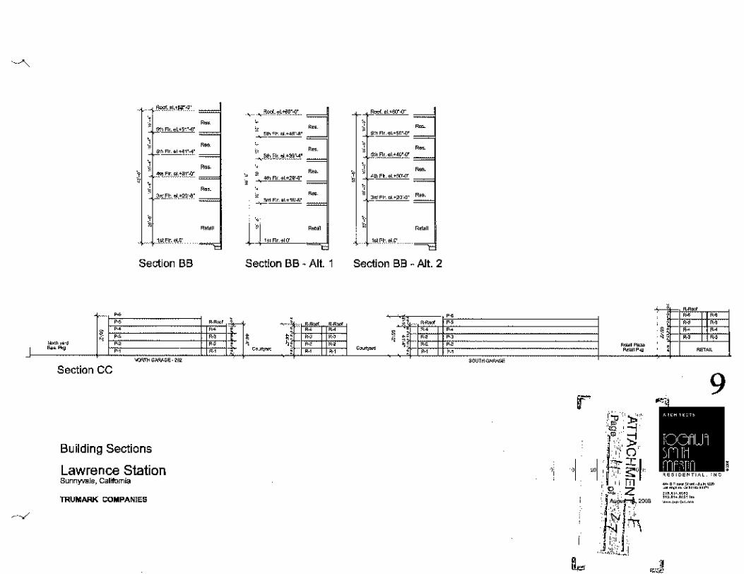
'
i %!',,,,•F"'
' ' "" "'-.,., .. '"" ~
~- "' ""'1!:-1·
j ~ ,1'ln,~,ce.r1'
' ' _)_~_t ._,.,~·
' ' l~<r- e~o·
Section BB
'' " " ' " ' " ,...,~_,
" .. , ''
"""""''"''"" Section CC
Building Sections
Lawrence Station Sunnyvale, Calrfom"'
TRUMARK COMPANIES
~ ""'-'-'"'"-""'--' ~~0'"'""''~"
~-~<!>.0''-"-'"""~-'
' ~"" "' ,.,.~-' _,____""Fe .,.,,._..
'
l'l -· "'""'" Section BB ·Alt.
'"' ' ' ,.
± ~!: " ' ' " + ' " "~ '
1
.. " ,, ' "
-;I *"-~,,~g = -~1 ' ,.,. """'"' -
1 ' '~"" 0 •CM' ""'
""'" '~""'' ~
Section BB -Alt. 2
~· .. Jl:" ~ ~lf:·. "' "- "~ ·~ " '
,. " " " " .,
""'""'"""' -·-' "'~"~
F
' ""
!: '' ' ' ' " " ' " ' -"
9
-·--"~-·-·= -~ .. -~ .. ~ .. ~ '""qm '" "' "'' "' '"" ,,,, 1-'-MO

Exterior Elevation Lawrence Station Sunnyvale, Calrlomia
TRUMARK COMPANIES
'""'Worl<Uort-C
Partial Residential Over Live!Work Elevation ·A (from Lawranoe Station Rd)
10
-·-·-·--···= ----~~-·-,,. ... M. '" "' ·~· ... ······-"·-~·

Exterior Elevation Lawrence Station Sunnyvale, Gal~ornia
TRUMARK COMPANIES
"""'"""'""''"' ···------ - --'"'''""'~""' -~--
Partial ResOlen~al Over Live!Work Elevation • 8 {lrnm Lawrenre Station Rd)
'
11
,., .. ~" ... ·-· "" -~ ·-"'"'" ....

Exterior Elevation Lawrence Station Sunnyvale, Galrfomra
TRUMARK COMPANIES
""""" "'"' """' ""•""' '""' """" """"' ""'""
Partral Retarl Etevatroo (from Elko Drrve)
"'""'v"~ ''""""' "'"
12
-"~"~-.. ·= -~ .. ·~·-"~ "'""m "' ... '" "'

Exterior Elevation Lawrence Station Sunnyvale, California
'rnUMAAK CQMPAN!ES
North Garage Elevation {!rorn Fwy 237 On Ramp)
13
-",f""'HU" '--"'---'" I I
;fl!LI nf'''f 'q!
'=!Z'7~l:'.o'.w,= "'"' ·~· "''" ·~· '" ... ,,._.,._N.

l""""""" S<.t,on Rood ~""""' Elevation Lawrence Station o.~,-~ o.oc.-~ I ' '

""''"""' i'O>o"""""')'l fW/ 2a7 On Ramp Exl<lflor """'"'~" Lawrenoe Shltion """"'' .. ,., .
r·
I~
15
'"i i';ri: ~·;
·~~ ' ! () ,J:
' s: , .m 'a .. z
' ,.; ~I·'
"I~ ' . . ' ' ' ,,. ·._ ,;J:; ... 1
.J

\,
.. .. \ I
Lawrence Station Sunnyvala, C<>llfomlo
TRUMARK COMPANIES
•"' GUl~O PARTNERSHIP1No. ..... ~ .. """"'"' ''""'"'""'" ·~""""'"""" ~""'"'~-"'~m
'"""~~ '"""'""
• •
,..,._,
'
,,
'"' "-····-·· .. '" -•~" »m'"'" ::: :.: :::\ ~ ... """'' ....

PODIUM CHARACTER
PLAZA CHARACTER
2.1 Landscape Imagery
Lawrence Station Sunnyvolo, Colr!omla
TRUMARK COMPANIES
•'"' GUZZARDO PAIITNER5HIPING ..... ~ .. - ...... ,. .... ...... ._.,_ ... ~··="-"" ""'~~~ '"'~"""
' + Ai>112fl, 2<107

FAN PALM GROUPING
PlAlA fOUNTAIN
2.2 Landscape Imagery
Lawrence Station Sunn)'\'&le. C..ljfomia
TRUMARK COMPANIES
EXISTING LAWRENCE STN. RO STREET TREES
PRESIDIO SERIES SITE FURNITURE
UPRIGHT FLOWERING PEARS LOOP BIKE RACK
SPECTRA SERIES POlE AND BOllARD liGHTS

I 'NOOl'l"'" "'-""''!!
A>~'""'~" ~~., '
!, l~,o;,qr:r'~~
~~; ' ' !'r""'.l'- ' ~f.t~,Mllif"' ~: ·; ' '?.·- .. -~,
.! JJ.~'Jil. ' ou " ili ' .. .,.~, ' :t !~!r;~:::"~- -~i:l!i
\MJ:I'JW;,:~;?' ~""'
... ,~'"'~"'
"'W "' 0F'"'M
1\!!NOHM,BK•
I
,_ :~l:!i
··~· ." .. ,
VESTJNG 'TENTATIVE MAP FOR CCNDOM!Nil.tv! Pl:RPOSES
"". "' "'"'"'""'
-~='<·•• ~ ·-· ---~
·~- .. ~,-., --,-""''···~ ~~·-·"~ -~~-· -,._, --~"'--~ ,.~~ " "' "" -.,_
' ··~ • '"" "" ··~~ " m~•- ,, uO~"
ililt::.'ID~'!..":J:I'J'; " ·=~,··~· ,_., •• ~~~~··
--~-
-·-'
' " "
" "'
-~ .. ,.,.., ""'' ~~·~"--~'
'""'"'' """ """'""'
IOr<! '"'
'"" '""
~U£~ru~~
~~·.~00
e.-·!!>-"'-"~· It;'"~ =••"" ·~
,, ' '
j:
·······J,t

"

... ..
.. ..
.. . ---· ,,
\ \

I~ -i ·····~~-~--i ( _, .. ,, ...... .
" "
.~.- ~-· '
·- ,_, .•. -~· "" ...
\

,_ " "
1:"..:-.:~l\tlk""""- ,_,., "·-~
i,'."lt."'-L"~,\'l:l''!'f'!.=•;,\l~ro ~~ ·= =· =~ ~ ··~"' ~~- ~-· -w. "m" = •» ~ ""= ''"'~ ''"'- =-~~.1;,-J'?-' ··~ ~· ''" ~ .. =~~· ~ ~M'!" ~"' ···~-= .,~ ~·-
' ",., .. '" ' ·' ~' ,.,,,,,_
·~·" ""'""''
~ ·-··-·-· ,-,,,_,.,

'><::, /.---
,_/ _,/
-::--·
:

~·~--- •'
- ... , '"' ,_,.;,.~.;.~:,. m,,_

~·· ""'"""""'.'"'~' .... ,~. ""~ ~· ,,_, , ,,., ,;"~~•mW'"""~'~' 9 '""~'"'"'0'0·~· 1111~, ,.,~ru•m·,..,•~
""~ """ ""~" --~·"''"~" -~""'""'" ' ' ..... ..,.,'"-'" --"'""'"''""' --~~ .... ""' ,., =·~·'""'""'~"'"~ ""'"''

~·
~· "
~· JIO'l M'C
""'
Density I I I <lnd Usc)
7!l0Fool

RESOLUTION NO.
AlTAC! !i·e1ENT :£ l'ctg<",_ ____ t ____ o( _-z;~·:~~~--
A RESOLUTION OF THE CITY COUNCIL OF m:,,E CITY OF SUNNYVALE AMENDING THE GENERAL PLAN CHANGING TilE LAND USE DESIGNATION FROM "INDUSTRIAl}' TO "VERY HIGH Dl!:NSITY RESIDENTIAL"
WllliRRAS, Tmmark Companies has requested a General Plan Am.endment for a project site comprised of two parcels with a combined total area of 6.63 acres located at 1275 and 12~7 Lawrence Station Road, Sunnyvale, Califi1mia to change the land usc designation from "Tnduslrial" to "V cry High Density Residential" and
'WHRRRAS, an analysis of the cnvirolllllcntal effect of approval of !his Plan Amemlmtmt was conducted, and an Environmental Impact Report and Statement of Ovcuiding Consideration have been prcpamd in compliance Wlth lht> Calili>mia Environmental Quality Act of 1970, as amended, and City Council Resolution No. ; and
WHEREAS, a draft and final Environmental Tmpad Report was prepared to assess the potential tmvimnmcntal impacts of the General Plan Amendment, de;cribed allernativ"'~ to the proposal ;md po\tmtial mitigation measures. On November 18, 2008, after a public hearing duly held, the City Council reviewed the documents comprising the ElR and found that the ElR rellccts the independent judgment of the City Cmmcil and its starr, and is an adequate and extensive a-~sessmcnt of the envirolllllental impacts of the Amendment. The City Council certified l.ht> RTR as having been prepared in compliance with the requirements of the Calif(unia Envirolllllental Quality Act ("CEQA"), made necessary findings and adopted the mitigation and monitoring program (Resolulion No. The potential environmental impacts of the pmposcd rL--zoning were considered within the scope of the F.TR; accordingly, an addendum lo the RTR has been prepared pursuant to CEQA guideline section 15164lo aid in ils review; and
WHEREAS, tl1e Planning Commission considered the proposed amendments at a duly noticed hearing held on Q_etober 13 2008, <1nd lms recommended approval of the amendments to the General Plan; and
WHElffiAS, lhe City Council held a public hearing on November 18 2008, and considered the reports and doctJments presented by City staff, the Planning Commission's recommendation, and the written and oral commenl~ rrresented at the public hearing.
NOW, THEREFORE, BE 1T RESOLVED, by the City Council of the City ol" Sunnyvale that it hereby adnpl' the following findings and actions:
l. The City Council finds and dctcnnines that the Ucncml Plan Amendment conforms with the requirements provided for in lhe Sunnyvale Municipal Code, that it is a suitable and logical <,;hange or the General Plan for the development of the City ofSu1myvale, and that it is in tho public mlerer;\.
2. The City Council linds and determines that the proposed changes to the General l:'Jan lo change the land use designation from Industrial to Very High Density Residential with appropliale General Plan residential densities and related wning designations is in the interest ol"
1

I!''" ='iJ '· ~
ATTACHMENT.-±~ Page_~ ~nf __ .£:: ___ _
the puhlic as adequate industrial land will he retained within the city limits to supp01i the local economy. The legally-required environnwntal review has been cond~~\l(l. '·"-'
3. The rev1~ed General Plan Amendment, as adopted, a copy of which is on file in the Office of the City Clerk oflhe City of Sunnyvale, is hereby incorplrraled into the 1972 General Plan of the City of Sunnyvale.
4. The Mayor and City Clerk are \heeled kl endorse tlx: amendment to trn 1972 (Jenera! Plan of the City of Surmyvalc and to show that lh" same has been adopted by the City CounciL
5. The City Clerk is directed lo file a cortillcd copy of the amendment lo the 1972 (Jenera! Plan of the City of Sunnyvale with the Board of Supervisors and the Planning Commission of the County of Santa Clara and the planning agency of each city within lhc County of Santa Clara. The City Clerk is directed further lo lil" "- certilicd copyofthe amendment with the legislative body of each city, the l>md ol'which may be included in 8aid plan.
Adopted by \he City Council at a reb'Uiar meeting held on November 18, 2008, by the li1llowing vote:
AYES: NORS: AJ1STATN: AllSEl\'T:
ATTEST:
City Clerk (SEAL)
APPROVED AS 1D FORM AND LEGALlTY:
David E. Kahn, City Attorney
~"""'"'~ ;cnelomllll~l DSP Amend lnt<llSity
APPROVED:
Mayor
2

ORDINANCE NO. ___ _
ATTACHMENT ;::;! Pago __ l_ -~'>L2:: __ -
I AN ORDINANCE Ott TllE CITY COUNCIL oi"TTJR CITY OF SUNNYVALE AMENDING THE ZONING PLAN, ZONING DISTRICTS MAP, TO REZONE CERTAIN PROPERTY LOCATED AT 1275 and 1287 LA Willi NCR STATION ROAD :FROM M"S (INDUSTRIAL AND SERVU:E) TO R-5/MU (HIGH DENSITY RESIDENTIAL AND OFF1CFJMIXRD USE COMBINING DISTRICT) ZONING DISTRICT
THE ClTY COUNCIL OF THE CITY OF SIJNNYVA.LJJ DOES ORDATN AS FOLLOWS:
SECTlON_.L_ AMENDMENT OF L:ONING PLAN. The ZDning Plan, Zoning Districts Map, City of Sunnyvale {Section 19.16.050 of the Sunnyvale Municipal Code) hereby is amended in order lo include cc!tain propertie~ within the R-5/MU (HIGH DENSITY RE.'.:;JD.ENTlAL AND OFF1CFJM!XED US.E COMBTNING D!STRlCl} ZONTNG DISTRiCT which properties are J1Te;;en!ly zoned M-S (INDUSTRIAL AND SERV1CE) ZONING DlSTlUCT. Th"' locution of the propc!tics is set foT(h <m the scale drawing allached as Exhibit "A"
SECTION 2 CEQA- These nmcndments to \he General Plan me subject \o a resolution of !hidings based on the Envirolllllental Impact Report. As part of the process or amending the General Plan, the City has analyzed the environmental effects of this ordinance, certified an Environmental Impact Report ami adopted A Statement of Overriding Considerations and made necessary lindings as reqllired hy the California Environmental Quality Act (Pub he Res. Code §§ 21 ()()() ot seq.; "CEQA"). The City finds that the adoption of this ordinance is within the scope of the program FUR and no new environmental documentation is reqt<ircd.
SECTION 3. "EFFECTIVE DATE. This ordinance shall be in full lOree and effect thirty (30) days from and allcrthe date of its adoption.
SECTION 4. l'UBUCATlON. The City Clerk is directed \o cause copies of this ordinance to be posted in three (3) pwminGilt places in the City or Sunnyvale and to call.-;e publication once in Th~ S\l.n. \he ollicial newspaper for publication of legal notices of the City of Sunnyva!G, or a notice selling forth the date of adoption, the title of this ordinance, and a list of places whore copies of this ordinance are posted, within fifteen (15) days allcr adoption of this ordinance.

-ATTACHMENT. SPurJu_.~ .. ~or __ ,~"~-
lnlrmhtecd at a regular meeting of the Cily Council held on NovcJ)tber 18, 2008, ami adopted as an ordinance of the City ofStmnyvalc at a regular meeting of the dt}i'Council held on November _, 2008, by the following vote:
AYES: NORS: ABSTAIN: ABSENT:
ATTEST:
City Clerk Date of Allesllltion• ___ _ SEAL
APPROVED AS TO FORM AND LEGALITY:
David E. Kahn, City Attorney
APPROVED:
-~-----
Mayor

ATTACHMENT. K Page ____ J __ ="_of~.Q, ____ ~
RESOLUTION NO. __ _
RESOLUTION 01<' THE CITY COLJNClL OF TTTR CJTY OF SUNNYVALE MAKING A STATEMENTS 01<' OVERRIDING CONSIDERATION FOR THE TRUMARK DEVELOPMENT l'ROJJ<:CT IN THE CITY OF SUNNYVALE
WHEREA:>;, !he Lnminairc!Lawrcncc Station Road Project ("ProJect") requires the City of Sunnyvale ("City") tu approve m1 am~ndmenl to the City nfSunnyvale Uenerall'lan and Zomng Ordinance (1llc no. , SCH no. 2007042068); and
WHEREAS, the project analyzed under the l'EIR consisted of: J) developing a new Mhed [he (M\J) romhinin~t Dis/riel zoning de>~gnalion fur !he City; 2) am@<.ling !he General Plan J .and use designation on an approximately 6.91-acre site from Industrial to VeJJ' Il1gh Density Residrntia/ (45-60 dwelling units per acre), wllich includes a new General Plan policy statement limiting the use of the northern 0.28 a~res of the -project >ite near Stale Route (SR) 237 to open space only (i.e .• the northern 0.28 acres of the project site cannot be utilized !o inn-case !he maxtmtlm allowable number of dwelling umis or commen:ial development); and J) t"e7<:ming the project site from Industrial and Service (M,S) to /Jigh Denwty Residential and OUice with a Mixed Uw< Combining Dlslnct (R-5/MU); and
W"HEREAS, the City Counc!l of the City of Sunnyvale IS the dcctsion-making body for the Luminaim/Lawrence Station Roadl'mject; and
WHEREAS, the City Council oftlle City of Sunnyvale approved not only the creation of the Mixed Use (MU) Combining lJ[<tricl zoning designati<m as a new zoning tool within the City of Sunnyvale, but also wishes to approve actions related to the development ProJect "APPROVAL OF TilE PROPOSED UJMINAIREILA WRENCE STATION ROAD PROJECT"; and
WHEREAS, CRQA require-.~ thai in wnneclion with the appmval "fa development proJect for wh!eh a FEIR has been prepared which identllics one or more sigmlleant environmental effects, the <.le~i>i<m-making body "f ~responsible agen~y mtc<t first make certain findings regarding those significant effects on the environment identified in the I'EIR, aml where the FEIR idcnl!llcs one of more signilieanl, unavoidable environmental eilCds then the decision-making body of a =poru;ible nmst fim1 balan~e econmnic, legal, social technological, or other benefits of the proposed project against its unavoidable environmental risks when determrning whether to approve the development project and make linding.< of nve1Tiding: cnnsidemiion.
NOW THEREFORE BE IT RESOLVED BY THE CITY COUNCTL OF THE CITY OF SUNNYVAT,R:
The City C"uncil ofthc City of Sunnyvale ado-pts and makes the following Statement ofOveni<.ling Omsiderations regarding the significant, unavoidable impacts of the Project and the antJCipatcd bcncllts ofthe Project.

ATTACHMENT_K ... Page_:!::______ ul_~5~~ .
SECTION l. Significant Unavoidable Impacts
W!lh respect to findings and in rewgnition oflh<>SC !lids that are included in the record, the City has determined that the project would result in the tOll owing significant and unavoidable impacts:
o Diesel !'articulate Matter Expusure Impact {land usc compatibility and air quality impact) -Tile proposed pmject, with the implemenlalion of the idL"IJiificd milig<llion mea"urcs, would reduce impacts related to diesel pa•ticulate maller exposure, hut not to a less than significanllcvcl. The project could aloo delay occupancy ofthe units where sigruilcant health risks are identified for al least five yean (unlit approximate! y 2015), howevm, the City considers this to be difficult to enforce and implement Fnr these reasons, the impad is consid~red >~gnificanl and unavmdablc.
• Cumulative Regional Air Quality lmpnci- The CillUula!ivc eJlCcl of approving and impl~mcnlmg all ofthe proposed General Plan Amendments would add r~siJ~nlial units that wtrre not accounted for in the Ozone S/ralegy, which would result in cumulatively significant increases in traffic e<mgesii<m in the area. The proposed land use amendment for the project site would contribute to this cumulatively considerable regional air quality impacL
These impacts would not he reduced to a less than sigmficant level by feasible changes or altemlions to the development Project.
SECTION 2. Overriding Considerations
With respect to \he signillcant and unavoidable environmental impacts identified tn Section l above. the Coun<.-il finds that all feasible mitigation measures and alternatives have been adopted and that, pursuant to Public Resources Code section 21081(h) and Guideline 15093, there are specific overriding economic and social benefits of Lhe following Project outweigh the significant effects on the envmmmcnt. These benefits. which will accmc to the City of Smmyvale mul the general public, warrant approval of the Project notWJ\hslanding the Project's remaining significant impacts, rnul include the benefits outline below in Sed ion 3.
• General Plan Amendment to change the land use designation from Industrial to Vtrry H1gh Density Residential,
• R~wne the site from M-S (industrial & Service) lo R-5/MU (High Density Residential and Office/Mixed Use),
• Special Development Penni\ to allow dovclopmcnt of 338 condominium units and 16,000 square fee( of commercial space,
• Vesting Tentative Map !Or condominium purposes.

ATTACHMENTL Page, ,---~- ~·", ul., __ .f?____ ~ 0~
SECTION 3. Benefits of Project
The Project des<.-ribed in the above section will meet the following General Plan goals:
A. Hou_~i!tg [l.lld Comml)nily Revilali<:aliun Sub element
• Goal A: l'oster the expansion of hot1sing SLtpply to provide greater opportunities tOr current and flllllre residents within limits imposed by environmental, social, fiscal and land use constraints. The projed will provide 338 new housing units.
• Policy B.3: Continue to ptlmlil and "ncmtragc a mix or residential and job-producing l311d Uses, as long as there is neighbmhood compatibility and no unavoidable cnvirolllllental impacts. 17w pnyect provides a mix of residential and commercial units.
• Policy C.l: Continlle efforts to balanctl the need lOr additional housing with other community values, such us preserving the character or established neighborhoods, high quality design, and promoting a sense of identity in t>acb neighborhood.
The project will provide new housing unit.< in an ex is ling industrial neir:hborhood thai does no/ currently have a residential identity. The projecl is m/e,jualely separaled hy a streel from the existing industrial neighborhood ami provide.,· rts own separate idenlity.
• Goal D: Maintain diversity in tenure, type, si~e, and location ol'housing to permit a range of individual choices for all current residenl~ and !hose expected to hemmc city residents. The project provides additional rental opportunities within a multi-family style of residential development.
• Policy D.1: Encourage innovative types of housing in existing residential wning districts. The project will provide a new/innovalive typ<- of housinr; through the introduclion of live/work units.
• Goal E: Maintain and increase housing mllts affonlable (o houst>holds of all incom~ levtls and ages. l'lw proposal meets this goal with 304 markel rale units and 46 new lJMR rental unils.
B. !,<llld Use and Transportation R!emen(

ATTACHMENLK. __ P<~ge~-~-:f-~-ul ~~5-~~
• Goal Cl: Preserve and enhance an aUraclive commtmity, with a positive image and a sense or place that consists of distinctive neighborhoods, pockets of interest, and human-scale developments.
The pr[!ject's architecture is a high quality design that will be distinctive.
• Policy C2.2: RncOtmJ.ge the development of ownership housing to maintain a majority of housing in the city lOr ownership choices.
This project proposes rental housing units, no/ ownership units. although a m«p is beinr; requested and the developer may sell owners hLp units at any lime.
• C3.2.3: Rnco(lrage mixed usc developments that provide pedestrian scale and transit oriented swviccs and amenities. The intent is to provide opportunities for mixed usc.
The project will provide a mixed use pro.wcl that ;., located adjm:enl lo transit. While the project does no/ pr011ide transit servicP-S it will provtde an onsite kiosk for tr(m.l"ll and ride share in forma/ion.
• C4.3: Consider the needs of business as well as residents when making land usc ami transportation decisions.
• As previoWI(Y stated, the pro] eel is adequately separated from the adjacent industrial neij;hborhood by a street.
• Policy Nl.l: Protect the integrity of the City's neighborhoods; whether residential, industrial or commercial.
• Action Statement N !.1.1: Limit the intrusion of incompatible uses and inapprupriale development into city neighborhoods.
The majority of the existing neighborhood is zoned Industrial mul i.< occupied by general office or resean:h and dew!upment uses. As previously stale<£ the project is adequately separated Ji"om the culjacent industrial nezghhorhuod by a sir eel.
• Policy N 1.2: Require new devtlupmen! to he compatible with the neighborhood, adjacent land uses and the transportation sy>;(em.
The project site is situated in an industrwl ume on an ""island"" lot J:rea/er that 6 acre., and has il.s own separate design and identity.
C. CommunityDcsiw Sllll-ckment
• l'olicy A.2: Ensure that new development is compatible with the character of special districts and residentialneighborhuods.
77w project site is situated in an industrial zone on an ""island"" fol ;:realer that 6 acres and has 1/s own separate desiKn and identity.
• Policy C.4: Eneomage quality archilecluntl design, which improves the City's identity, inspires creativity, and heightens individual as well as culh1ral identity.

The proposed architecture im:mporates high quali(y design and is creative, unique { mhed use), and will call attention to its design.
Adopted by the City Council at a regular meeting held on 200!\, by the following vole:
AYES: NOES: ABSTAIN: ABSENT:
ATTEST:
City Clerk (SEAL)
APPROVED AS TO l'ORM AND LEGALiTY:
David Kahn, City AUomey
APPROVED:
Mayor

2006-0712 1275 and 1287 Lawrence Statfon Rosd Statements of Overndmg Consideration GPA, Rezone, SDP, Vesting TentatFve Map
ATTACHMENT __h_ Approved Minutes October 13,2008
Page1of15
I PLANNING COMMISSION MINUTES OF OCTOBER 13, 2008
2006-0712- Trumark Companies [Applicant] Ray Street Office, LLC. [Owner]: Application for related proposals on a 6.63 acre site located at 1275 and 1287 Lawrence Station Road (near Elko Drive) in an M-S (Industrial & Service) Zoning District. (APNs: 110-15-045, 110-15-044) GC, SL
• Resolution to Certify the Environmental Impact Report • Introduction of an Ordinance to Amend Tille 19 of the Sunnyvale Municipal
Code (Zoning) to create a Mixed Use Zoning Combining District {MU), which may be combined with the R-3, R-4, and R-5 Residential Zoning Districts.
• General Plan Amendment to change the land use designation from Industrial to Very High Density Residential,
• Rezone the site from M-S (Industrial & Service) to R-5/MU (High Density Residential and Office/Mixed Use),
• Special Development Permit to allow development of 338 condominium units and 16,000 square feet of commercial space,
• Vesting Tentative Map for condominium purposes.
Steve Lynch, Senior Planner, presented the staff report. He explained that this is the third of three related reports tonight that will be presented regarding this development He said that there are several interrelated applications and that there would be several motions to consider: the Statements of Overriding Considerations; a General Plan Amendment; a Rezone; and a Special Development Permit and Vesting Tentative Map. Mr. Lynch encouraged the Commission to stay focused on the fundamental issue, which is the conversion of this site from Industrial to a Residential use. He said staff's fundamental concern is the site that the applicant has chosen. He said that staff could not make the findings and is recommending denial of the General Plan Amendment, Rezoning, Special Development Permit (SDP), and the Vesting Tentative Tract Map.
Comm. Klein asked staff to talk about the feasibility of underground parking for this project and what staffs opinion is on this issue. Mr. Lynch said that the applicant has submitted information that indicates that underground parking is not possible because of a high water table. Mr. Lynch said that if the applicant says that constructing underground parking would be very expensive due to water that he believes them as they are not the first applicant to have said this. Mr. Lynch said that there is something to be said for underground parking as well as a podium-style development where the units are on top of the parking which reduces lot coverage.

2006-0712 1275 and 1287 Lawrence Station Road Statements of Overriding Consideration GPA, Rezone, SOP, Vesting Tentative Map
ATTACI·IMENL& _ Approved Minutes October 13,2008
Page2of15
Hanson Hom, Director of Community Development, said that staff recently had a discussion with the applicant regarding the underground parking issue. He said they discussed Community Values to promote open space and underground parking. He said he thinks the applicant may discuss information this evening that might prove to be an exception finding for coverage, and might help better explain why underground parking at this specific site might pose a significant constraint
Comm, Sulser confirmed with staff that the main concern is the compatibility of this use with the surrounding area. He discussed this site and surrounding area wtth staff and possible other uses in the area that could affect the Industrial uses including Places of Assembly (POAs). Ms. Ryan described the area, known as the Woods, and explained some of the surrounding uses including some nearby residential.
Corum. McKenna said she agrees that building underground parking in an area that has a high water table is not a very good idea. She asked what does staff need to know to verify that the water table is high and that the parking garage should not go low. Mr. Hom said perhaps if an engineering feasibility analysis were submitted to Planning staff before hand that staff could discuss tt with the engineering staff. Mr. Hom added that other projects in town do have water table issues and it is expensive to underground parking when you have water table issues. Comm. McKenna and staff further discussed what the Commission would need to do tonight to deal with this particular issue. Staff suggested they listen to the testimony, if they make an exception, state the finding that led to the exception. He said that the Commission does have some flexibility in judgment by the Commission. Comm. McKenna said if new information was presented tonight that she would not feel comfortable making a decision regarding this issue without staff having the opportunity to review the new information. Mr. Hom said that the Commission could refer the matter for further staff analysis.
Chair Rowe asked staff if there is any problem with liquefaction in this area. John Schwartz, David J. Powers and Associates (Environmental Consultants) said that there was some liquefaction and expansion at this site, but nothing that could not be dealt with by standard practices. Chair Rowe said she recalls the review of the ITR (Industrial to Residential) areas and asked of the identified ITR areas if there were any sties that would take a project of this size. Mr. Lynch said there are some enormous sites out near Duane Avenue.
Chair Rowe opened public hearing.

2006-0712 1275 and 1287 Lawrence S!atioo Road Statements of Overriding Considerntion GPA, Rezone, SOP, Vesting Tentative Map
ATTACHMENL~" Approved Minutes October 13,2008
Page3of15
Aaron Yakligian, Director of Development with Trumark Companies, presented the timeline, history, and information about the project, also referred to as Luminaire, through a DVD (Digital Video Disc) presentation and a PowerPoint presentation. He said this is a cutting edge development in one of the most appropriate locations in west Sunnyvale. He said they have responded to the most recent comments from the fourth Study Session in September by including additional rounded windows and architectural elements, enhanced parking garage details, line of site concerns, and revised the colors, heights, and mass1ng. He said the project team is present this evening to answer any questions. He addressed land issues and said that this is the area where the applicant has fundamental differences with staff on the appropriateness of the project location. He addressed the aspects of the land use and their justification for the requested change from the existing use. He said the proposed land use makes sense, the existing buildings are vacant and have been vacant for years so the existing use is clearly not working. He addressed a need for retail in this area, housing goals, and demand from local employers for quality rental units. He said in 2006 they presented plans to City Council for this site for a mixed use development near employment, transportation, recreation, and existing residential. He said this site has no immediate neighbors to impact. He said the EIR studied the impacts and found the impacts were less than significant. He said this development would not compete with the nearby Industrial uses, but would complement them by providing housing and retail opportunities for employers. He said based on this information they received the Silicon Valley Leadership Group's endorsement He said staff pointed out this location is not one of the original ITR sites, adding that there has been no action on 70% of the ITR sites. He said that this project is ready to go today, and an opportunity that is irresponsible to ignore. He discusses the General Plan goals and how this project addresses those. He discussed further benefits of the project including, the design, 338 apartment homes, 16,000 square feet of neighborhood serving retail, and over 13,000 square feet of live/work space. He noted residents can park on the same level they live on, and there are over three acres of useable open space. He said Luminaire will be a green development built to LEED (Leadership in Energy and Environmental Design) and Build-it-Green standards. He said this development will benefit BMR (Below Market Rate) housing in Sunnyvale by adding 46 units to the BMR units. He said this new development would generate new fees for the community, including approximately $3 million towards parks and $2 million for schools. He said the have worked closely with the Sunnyvale Historical Society to develop a unique on-site amenity that will educate residents and point them towards the newly opened museum. He said Luminaire will provide exciting new live/work opportunities. He said he 1s proud of the endorsements that Luminaire has gained from a diverse group of supporters

2006-0712 1275 and 1287 Lawrence Sllltion Road Statements of Oveniding Consideration GPA, Rezone, SOP, Vesting Tentative Map
ATTACHMENT.Jc~ Approved Minutes October 13,2008
Page4of15
including Maffei! Park Business and Transportation Association, Bay Area Council, Greenbelt Alliance, Sunnyvale Community Services, and the Santa Clara County Housing Action Coalition. He said they are excited about Luminaire and said that this is a purposeful land use. He said tonight he is requesting that the Commission recommend approval of the Luminaire applications as proposed and as presented in Alternative 3, on page 32 of the staff report.
Comm. Sulser asked Mr. Yakligian about the 14 housing units that have a problem with diesel particulate matter (DPM) and asked why they did not put another use in this area that would not have had the problem. Mr. Yakligian explained that their research shows the best location for the live/work units is on Lawrence Station Road and Lawrence Expressway at Elko. Comm. Sulser further discussed this issue with the applicant.
Comm. Klein asked the applicant to comment about the underground parking. Mr. Yakligian said that it is a shame that he is having to reproduce a report that is in the package. He said there is geotechnical information in the EIR from ENGEO that clearly states challenges with underground parking including, dewatering and groundwater. Mr. Yakligian said that this site is in the flood zone and it makes no sense to put underground parking in a flood zone. He submitted a page from the EIR that discusses the issues with the groundwater and some of the engineering concerns. He said that this information has been in the public record for nearly 2 years. Comm. Klein asked the applicant to comment about how they are achieving LEED standards and what the applicant is doing regarding green building. Mr. Yakligian said they have been working with staff, worked through checklists with green consultants (LEED and Build It Green) and are proposing specific features for the development. He said they are working to design this project to a LEED silver level or to 70 points for Build It Green.
Chair Rowe further discussed green building with the applicant with the applicant stated that when the actual construction begins they would use the most appropriate green certification that there is. Mr. Yakligian presented a document to the Commission which is their specific requests regarding modifications to the conditions and the findings. Comm. Rowe asked the applicant if the proposal includes a new lighted cross walk to the east side of Lawrence Station Road as suggested by the Traffic Division. Mr. Yakligian said that the lighted crosswalk was originally proposed with a park, and after review with staff, it was determined that the park and the lighted crosswalk are not the best approach at this time. He said that would no longer be the best place to cross the street. Chair Rowe said originally these units were to be sold and now the proposal is for them to be rentals. Mr. Yakligian said they reviewed their

2Q0&-0712 1275 and 1287 Lawrence Station Road Statements of Ovmriding Consideration GPA, RezDile, SDP, Vesting TentatiVe Map
ATTACfiMHlT 1,__ .. Approved Minutes October 13, 2008
Page5of15
needs and the market and felt like rentals were the better choice. He said they are doing a condo map with this application as well, so the units could be converted to homeowner units at a later time. Chair Rowe asked about how the applicant plans to protect the live/work units from becoming residential. Mr. Yakligian said there would be an on-site manager and there would be a lease restriction that the commercial space needs to remain commercial space.
Nancy Tivol, Director of Sunnyvale Community Services, spoke in support of the development. She said that she does not think anything is needed more in Sunnyvale than affordable rental housing and the problem is that no one wants it in their neighborhood. She said what appealed to her about this particular project is that it creates tts own neighborhood and no one to argue against it. She said it is difficult to find a site like this one that can provide quality affordable housing with high density and no opposition from the community.
Jeanine Stanek and Johan Koning with the Sunnyvale Historical Society spoke in support of this idea of the History Walk portion of this project Ms. Stanek said that they appreciate the efforts of Trumark to help the Historical Society tell the Sunnyvale story. Ms. Stanek said that Trumarl< came to the Historical Society and presented the idea of the History Walk. She said it is in an area that does not often get to hear the Sunnyvale story, as it is located away from the new Heritage Park Museum. She said that she appreciates the creative efforts of the History Walk. Mr. Koning sa!d the history of Sunnyvale is very important to himself and others.
Matt Regan, Director of Housing and Sustainable Development for the Bay Area Council. He described the work the Bay Area Council does. He said they regularly poll their members and one of the top issues facing many employers is finding sufficient housing stock for their employees. He said they formed a commftlee and housing endorsement program with the intent of promoting the right kind of infill in urban development and protecting industrial land. He said the commftlee whole-heartedly endorsed this project. He spoke about the land use portion of the project. He provided statistics regarding green house gases and traffic, job nexus of Sunnyvale jobs held by Sunnyvale residents. He said, regarding the DPM that he would encourage the Commission to "think globally and act locally" as particulates move around. He said this is a good site, not a perfect site. He said staff seems to be focused on preserving industrial land, and their members feel finding housing for those who work in industria! land is more important

2006-0712 1275 and 1287 Lawrence Station Road Statements of Overriding Consideration GPA, Rezone, SDP, Vesting Tentative Map
~TTACflMENT_oL~
Approved Minutes October 13, 2008
Page6of15
Comm. McKenna asked Mr. Regan about job statistics in Sunnyvale. Mr. Regan said he thinks there are about 90,000 jobs in Sunnyvale and about 18% of those jobs are held by Sunnyvale residents. He said his information comes from the sponsor's packet.
Larry Alba, a long time Sunnyvale resident, commented that over the past five years Sunnyvale has grown a lot. He said he is worried about the water and sewer capacity being able to meet the demands of new high density developments. He said he has tried to get information about the potential affects of high density development and has not had much luck in getting the information_ He said the project looks nice, but he thinks it is too big and may impact the water and sewer Situation of Sunnyvale. He said he opposes the project as he thinks it is too big and thinks that Sunnyvale needs to slow down a little bit for the sake of the infrastructure.
Chair Rowe commented that it is her understanding that when the developer would have to take care of the new piping to meet the needs of the development.
Shiloh Ballard with the Silicon Valley Leadership Group said that a lot of what she was going to say has been covered by Nancy Tivol and Matt Regan. She said they also survey their members and the members have said that the top impediment to doing business in Silicon Valley is housing availability and affordability. She said they are careful about endorsing conversions from industrial to other uses as they are concerned about new uses affecting existing businesses. She said when this developer came to their group for an endorsement they made the developer jump through hoops to assure that this conversion would be a good action. She said ultimately the Silicon Valley Leadership Group concluded this is a developmental proposal that they support.
Steve Rayhawk, a Sunnyvale resident, said he was walking by this site recently and commented that as an alternative use that he might suggest an educational project that is looking for a site. He said this area may have some historical value from the computer industry standpoint, has a welcoming f8el, and said he could imagine it would be a good site for educational purposes. He questioned an earlier statement by the applicant regarding the length of time the site has been vacant and asked when the site went from being rental properly versus redevelopment.
Ms. Ryan commented on material submitted tonight by Mr. Yakligian from the ENGEO study. She referred to the technical appendix which has the entire ENGEO report. She said essentially the report was prepared to provide direction for construction of a project which has living levels over one level of

2006-0712 1275 and 1287 Lawrenw Station Raad Statements of Overriding Consideratioo GPA, Rezone, SOP, Vesting Tentative Map
ATTACHMENT _L Approved Minutes October 13,2008
Page7of15
subterranean and one ground level parking. Ms. Ryan said the design of the proJect has changed as the project evolved. Ms. Ryan said this particular report was to help provide direction on how to construct the site based on the original design. She said she did not want the Commission to think that the information provided was giving the level of detail on feasibility or cost of underground parking. She said she is saying this now so the applicant would know what the staff analysis is.
Mr. Yakligian commented that the site has been vacant since 2001 and the leasing sign is still there. He said regarding the shallow groundwater study, they looked at the study and that it is for future construction. He said when they reviewed the study they found there were constraints. He said this sfte has a lot of benefits and features with the development as proposed. He said they are asking that the Commission recommend Alternative 3 on page 32 of the report and that the SOP and Vesting Tentative Map be approved with modified findings and conditions. He said they would like condition 2.8 be removed and confirmed that condition 1.8.2 remain. He said regarding the live/work area, that to allow the proposal to go forward as planned, they would like 75% of the live/Work area applied toward the Commercial requirement.
Chair Rowe closed the public hearing.
Comm. Hungerford discussed with staff the process that was gone through to determine ITR areas for the City. He asked if the Woods area was one of the areas considered and why this area was rejected for ITR. Ms. Ryan said that before the ITR study there was the Futures study. She said the Woods neighborhood was one of nine areas reviewed and was ultimately dropped from the category. Ms. Ryan said the 1993 Futures study determined which sites to select to rezone for ITR designation. Ms. Ryan said it was determined that the neighborhood should be preserved for industrial and service type uses.
Comm. Klein asked staff about the conditions that the applicant referred to and staff's comment about the removal of 2.8 and 1.8.2. Mr. Lynch said 1.8.2 is a mistake. Comm. Klein asked if staff could talk about BMRs. Mr. Hom discussed the BMR situation in the City confirming that soon the City will be losing a fair number of BMR units, or at-risk units. Mr. Lynch commented about the ITR units, and said the majority have been ownership units versus rental units. Ms. Ryan commented about the applicant's suggestion to change to 75% percentage of square feet from the live/work units that would be applied to commercial. She advised that the Commission has already passed a motion that the 50% amount be applied to Commercial and lf the Commission wants to change it to 75% staff

1\TTACHrflENT~.b . 2006-(}712 1275 and 1287 Lawrence Station Road Statements of Oveniding Consfderation GPA, Rezone, SOP, Vesting Tentative Map
Approved Minutes Octob<lr 13, 2008
Page 8 of 15
would suggest this be a modification to the previous recommendation on the Mixed Use Combining District.
Comm. Klein asked staff about very high denstty versus high density residential. Mr. Lynch said that staff is supporting the R-5 residential if the site is approved for residential.
Consideration of Statements of Overriding Consideration
Comm. McKenna moved for Alternative 2 to introduce a Resolution to adopt the Statements of Overriding Consideration for air quality impacts associated with the effects of diesel particulate matter on future project residents and related to the project's contribution to cumulative regional air quality impacts as shown in Attachment K. Vice Chair Chang seconded the motion.
Comm. McKenna said she thinks the Commission questlons of both staff and applicant have dealt with the concerns of air quality impacts and the affects of diesel particulate matter.
Vice Chair Chang said the EIR addresses the particulates and the mitigation and said he would support the motion.
Comm. Klein asked staff if the Commission is to make recommendations to Council for which mitigations should be entertained. Ms. Caruso said there were three mitigations and she restated those. Ms. Caruso said if the Commission is making the Statements of Overriding Consideration then the mitigation measure to not rent out the units does not need to be considered. Comm. Klein said that the making of this motion says that the filtration system is adequate. Ms. Caruso said that the Commission would be saying that the filtration system helps, but it does not mitigate the problem.
Comm. Hungeriord said he is not going to be supporting the motion as he is uncomfortable with the Statements of Overriding Considerations. He said the Bay Area Quality Management Districts standard is a standard that applies uniformly to permits and other authorizations to emit air pollutants and he is not comfortable waiving it or finding it unimportant in this situation as we are talking about excess cancer rates for people in these units.
Comm. Klein said he would not be supporting the motion as staff was saying the effects of diesel particulate matter is outside of the information presented to us today.

2006-D712 1275 and 1287 Lawrence Station Road Statements of Overriding Consideration GPA, Rezone, SOP, Vestmg Tentative Map
ATTACHMENT _L_, Approved Minutes October 13, 2008
PageSof15
Comm. Sulser said he would not be supporting the motion. He said he can make the findings for the Statements of Overriding Consideration for regional air quality, but not for the diesel particulate matter issue.
Chair Rowe said she also has a problem with the diesel particulate matter so she will be opposing this motion.
ACTION: Comm. McKenna made a motion on 2008·0712 to recommend to City Council to introduce a Resolution to adopt the Statements of Overriding Consideration for air quality impacts associated with the effects of diesel particulate matter on future project residents and related to the project's contribution to regional air quality impacts as shown in Attachment K. Vice Chair Chang seconded. Motion failed 3-4, with Chair Rowe, Comm. Hungertord, Comm. Klein and Comm. Sulser dissenting.
Ms. Caruso said that as an alternative to the motion that just failed the Commission could consider approving the project with the mitigation not to rent the affected units and with that mitigation the Statements of Overriding Consideration are not needed except for Regional Air QuaHty, but not for the diesel particulate matter.
Chair Rowe asked if that would mean not renting the units forever or just the suggested five years. Ms. Caruso said for at least five years and the units would have to be evaluated to see if the standards can be met.
Comm. Hungertord referred to page 99 of the Draft EIR and con finned there are nine units on the ground floor and five units on the second ftoor.
Comm. McKenna asked if this is the same standard for 70 years being outside that we are worried about Ms. Caruso said yes that is the correct standard.
Ms. Ryan said that the Commission does not need to make Statements of Overriding Consideration if the direction is to not approve any of the subsequent changes in land use and development but if there is an inclination to approve the change in land use and the development proposal the Commission would need to make a recommendation for Statements of Overriding Consideration for the cumulative air quality and need to adopt the mitigation measure to not occupy the fourteen units.
Comm. Hungertord moved that the Commission recommend to City Council to adopt as a mitigation measure to not occupy the fourteen units in question for five years, and to adopt Statements of Overriding Consideration for the cumulative regional air quality impacts. Comm. Klein seconded the motion.

2006-0712 1275 and 1287 Lawrence Station Road Statements of Overriding Consrderat1on GPA, Rezone, SDP, Vesting Tentative Map
ATTACHMENT.,Lo~o Approved Minutes October 13, 2008
Page10of15
Chair Rowe asked staff the reason why we would be waiting for five years. Ms. Caruso said that the DPM levels are projected to fall during that time.
Comm. McKenna said she will be voting against the motion as it does not make sense. She said she has a hard time with the standard of 70 years and having to be outside and having 14 units not occupied. She said this just does not make sense.
ACTION: Comm. Hungerford made a motion on 2008·0712 to recommend to City Council to adopt as a mitigation measure that the fourteen units in question not be occupied for five years, and to adopt Statements of Overriding Consideration for the cumulative regional air quality impacts. Comm. Klein seconded. Motion carried, 6·1, with Comm. McKenna dissenting.
General Plan Amendment to change the land use designation from Industrial to Vel)' High Density Residential; Rezone the site from M-S (Industrial & SeNice) to R-5/MU (High Density Residential and Offire!Mixed Use); Special Development Permit to allow development of 338 condominium units and 16,000 square feet of commercial space; Vesting Tentative Map for condominium purposes.
Ms. Ryan said the next action to consider is the General Plan Amendment.
Comm. McKenna made a motion to recommend to City Council to change the land use designation for Industrial to very High Density Residential. She said it makes more sense to go to the high density residential for this particular location. Comm. Klein seconded the motion.
Comm. McKenna said she understands the issues that staff raised in the report and their recommendation however she thinks that the location of this site with transit, location to jobs, on the edge of the Woods, is relatively self-contained and she thinks that this would be a good land use there.
Comm. Klein said he would be supporting the motion. He said definitely there are issues regarding the contmued loss of Industrial zones in the City. He said this is on the edge of the zone, has set idle for many years and is near residential. He said there are issues with this location, including infrastructure, and services provided to the new residential. He said there are ongoing issues in Sunnyvale to provide support to this area of the City. He said he agrees that the loss of Industrial Class B is difficult. He said this will provide rental units and BMR units.

2006-0712 1275 and 1267 Lawrem:e Statton Road Statements of OverrkJing Consideration GPA, Rezone, SDP, Vesting Tentative Map
Approved Minutes October 13, 2008
Page 11 of15
Comm. Sulser said he thinks this is an appropriate rezone. He wants to differentiate this from some of the ITR districts. He said this residential is on the edge of the Industrial park. He said the second point is the mixed use nature of this project relates more to the surrounding industrial than in the ITR case. He said the live/work units on the side potentially do have commercial or live/work next to the industrial. He said this project is better than some of the past ITR proJects.
Comm. Hungerlord said he was set to vote with the staff recommendation. He said he thinks good planning is taking a look at land uses in the City and dispassionately looking at where different land uses make sense, given existing uses, support services, given the transportation looking at all the variables. He said they have done that and come up with the ITR zones. He said this was not one of the places that was deemed appropriate to transition to residential, but he was impressed with those who endorse the project and by the comments of the Commissioners. He said, like Comm. McKenna said, this is a relatively self contained area, and it is on the edge of the Woods. He said what tipped the balance for him is the consideration of the live/work units. He said for those reasons it makes it more palatable and considering the various factors he would be supporting the motion.
Chair Rowe said that this is a difficult decision to her. She said this is what she thinks of when she thinks of an exciting project. She said she agrees with Nancy Tivol when she said that this is a community unto itself. Chair Rowe said if you affect one you will affect another. She said she has a unique situation on this Commission as a Commissioner who would be speaking with a forked tongue because for years before she would holler when anyone gave away the Industrial Land. She said she was ready to say no to this project and now she said both arguments are strong so she thinks this contained unit could sort of serve as a transitional area between the industrial areas, the commercial areas, and the housing areas. She discussed her reasoning.
ACTION; Comm. McKenna made a motion on 2008-0712 to recommend to City Council to change the land use designation for Industrial to very High Density Residential. Comm. Klein seconded. Motion carried unanimously, 7-0.
Rezone
Comm. Klein moved to introduce an ordinance to amend Sunnyvale Municipal Code Title 19 to Rezone the site from M-S (Industrial & Service) to R-5/MU (High Density Residential and Office/Mixed Use) Comm. Sulser seconded the motion.

2006-0712 1275 and 1287 Lawrenoe Statton Road Statements of Overriding Consideratioo GPA, Rezone, SOP, Vesting Tentative Map
ATTACHMENLL_~ Approved Minutes October 13,2008
Page12of15
Comm. Klein said this is the rezoning of the siTe as earlier created this evening. He said he thinks this is appropriate and, as staff said, they prefer the high density residential and office/mixed use to a lower density.
ACTION: Corum. Klein made a motion on 2008-0712 to recommend to City Council to introduce an ordimmce to amend Sunnyvale Municipal Code Title 19 to Rezone the site from M-S (Industrial & Service to R-5/MU (High Density Residential and Office/Mixed Use. Corum. Sulser seconded. Motion carried unanimously, 7-0.
SOP and Vesting Tentative Map
Comm. Hungerford moved to approve the Special Development Permit to allow development of 338 condominium units and 16,000 square feet of commercial space. Comm. Klein seconded the motion and offered a friendly amendment clarifying several conditions of approval and discussed condition 1.8.2 and condition 2.8. with Comm. Hungerford. The Commissioners and staff further discussed the lot coverage the pros and cons of the percentage of lot coverage. Ms. Ryan said that 40% is a considerable decrease in the coverage as the design is near 50% and going to 40% would require necessary redesign. She said if the Council were to aCcept the recommendation to reduce the lot coverage to 40% there would need to be some redesign. Comm. Hungerford said we are hitting the applicant already with the removal of the 14 units. Mr. Hom said the likely impact would be the loss of some units to free up some open space on the site. Comm. Klein and Comm. Hungerford further discussed the lot coverage. Comm. Hungerford said he is inclined to allow the 51.7% because he has seen what the project looks like at this percentage. He said that the alternative would be to remove some of the units next to the freeway that have air quality issues. Comm. Klein said he is concerned that with the newly created Mixed Use district there are quite a number of deviations from it. A compromise to cut the lot coverage to 50% was suggested. Comm. McKenna said she has a problem with compromising on the number as you have no idea what that number is and there is no basis in fact for why a certain number is selected. She said to her you either go 40% or 51.7% and picking in the middle is arbitrary. She suggested going with the 40% or 51.7% and said she would like to go with the 51.7% since it is a high density project.
Comm. Sulser said he was going to suggest 50%, but that now feels very arbitrary.
Comm. Travis said he cannot imagine how to justify the 1.7% decrease as it seems negligible and arbitrary to get to 50% just because it is a round number.

2006-0712 1275 and 1287 Lawrence Station Road Statements of Overriding Consideration GPA, Razono, SOP, Vesting Tentative Map
Vice Chair Chang said he is in favor of the 51. 7%.
Approved Minutes October 13, 2008
Page 13 of 15
Corum. Hungerford and Corum. Klein agreed that the motion would include a modification to omit condition 2.8, the 40% lot coverage.
Comm. Travis asked staff about the issue of the 75% non residential livelworl< and would it be appropriate to discuss this now as it is not in the motion. Ms. Ryan said the motion could be tabled to consider the issue and that the Commission cannot make that as a deviation as part of the Special Development Permit. Comm. Travis asked why they cannot breakout on a per project basis raising that percentage. Ms. Ryan said the Special Development Permit provisions give some flexibility on certain zoning standards, i.e. parl<ing, lot coverage, bulk FAR (Floor Area Ratio}, and open space, but for other zoning provisions, i.e. number of BMR units, general use, it does not afford the opportunity to have a deviation through the SOP. Ms. Ryan said some items can be considered through the Variance process, but that is not before the Commission this evening. Comm. Travis discussed the live/work units with Ms. Ryan. He said he is concerned as everyone on the Commission has expressed admiration for the live/work units, and he gets a feeling from the applicant's presentation that by reducing this by 25% it will adversely affect the number of the those units that can be placed on-site. They further discussed and restated that the applicant has requested that the live work units have a threshold of 75%. Mr. Hom said perhaps another option that might allow a little more flexibility is to amend the Mixed Use District adopted to allow flexibility on the exception to minimum commercial space so if amended, then when the Commission recommends approval of this project a condition can be included that allows the minimum 75% or whatever the project proposes if that is the wish of the Commission. He said he would suggest that. Ms. Ryan said procedurally the Commission would have to have another motion to reconsider the other motion regarding the Mixed Use. Ms. Ryan said the Commission cannot do that without dropping the current motion, or take an action on this motion and go back and reconsider the other.
Comm. Klein commented that he thinks the 10% Commercial requirement is fine and we are trying to make a big exception for the livelworl< units that we do not know how they are going to be used in Sunnyvale. He said he understands staff's reasoning and this developer says that they can make them work and that they will make sure they are monitored and rented out properly. However the next developer down the line might not do the same. He said he thinks the 10% Commercial is adequate.
Comm. McKenna sakJ she thought when she read the report that the amount of commercial space went anywhere from 3% to 15% so she did not see anything magic in 10%. She asked if she read this incorrectly. Mr. Lynch said there was a portion of the report that addressed how staff arrived at the

2006-0712 1275 and 1287 Lawrence Station Road Statements of Overriding Conskleration GPA, Rezone, SOP, Vesting Tentative Map
ATTACHMENL~
Approved Minutes October 13, 2008
Page14of15
minimum of 10% figure and briefly explained staffs research. She said she would agree with Comm. Klein that if our goal is a minimum of 10% that the Commercial is adequate. Comm. McKenna further discussed this with staff. She said if we go with 50% of the live/work units towards the commerclal, then the developer would have to expand the commercial.
Comm. Travis said he does not have a problem with the 10%, but does have a problem with the arbitrary numbers and would like flexibility on this to look at projects on an individual basis for future projects.
Comm. McKenna discussed the percentages of the live/work issue.
Mr. Hom said the calculation of the live/work unit has a portion of square footage that is residential and portion that is commercial. He said what we are saying is the commercial portion would only count 50% of the square footage to be counted towards commercial credit He said there are two reasons why only 50% would count towards rt, one, the difficulty of enforcement making sure the units have a commercial use, and second that live/work space may not be the same level of commercial space as desired. He said staff felt these reasons make this area not the same as retail store fronts.
Comm. Klein said the commercial use could become more office which is not retail and that is why he feels it is adequate.
Ms. Ryan said that the 10% can be retail or office. Mr. Hom said if the Commission wants to maintain the 10% for this project, they have two options. He said they can increase the amount of actual retail space or increase the number of live/work unrts.
Vice Chair Chang he said he thinks there is confusion because this if the first time we have had live/work units in Sunnyvale and we are trying to define them. He said he thinks this kind of project has worked before and he agrees WJth Comm. Travis that there needs to be some flexibiHty as the Commission will see more of these types of projects in the future. He asked if there could be language that 50% needs to be retail and 50% office space. Mr. Lynch said that could be requested, but the enforceability would fall back on the City. He said he does not see this being a problem with this project, but could be with future projects. Vice Chair Chang confirmed with staff that for this project the Property Management Company on site will be responsible for enforcement
Comm. Hungerford said the report indicates that 50% allowance is consistent with the new Mixed Use Districts standards and asked if that means that the 50% figure came from other comparable Cities or locations. Mr. Lynch said there really is no baseline available for the Mixed Use

2006-0712 1275 and 1287 Lawrence Statton Road Statements of Overriding Consideration
Approved Minutes October 13, 20()8
Page15of15 GPA, Rezone, SOP, Vesting Tentative Map
Districts. He said this is staffs best attempt and staff is saying that we want to give some credit for live/wort< units, but we do not want a full live/work credit.
After discussion the maker and seconder of the motion decided to stay with the staff recommendation and keep the 10% requirement and counting 50% of the live/work units square footage toward the commercial requirement.
Comm. Travis said he would be supporting the motion and that 51.7% coverage is the right number. He said this will be a great addition to this area. He said he would prefer to see the live/worl< units.
Comm. Hungerford said that parts of this project are complicated, that the package is good, and recommends a vote in favor of the project.
Ms. Ryan asked if the motion was to include the Vesting Tentative Map. The maker and the seconder agree they were including the Vesting Tentative Map with modified conditions.
ACTION: Comm. Hungerford made a motion on 2008-0712 to recommend to City Council to approve the Special Development Permit and Vesting Tentative Map with modified conditions: to remove condition 2.8 {requiring
' redesign to be the maximum of 40% lot coverage). Motion carried unanimously, 7-0.
APPEAL OPTIONS: This recommendation will be forwarded to City Council for consideration at the November 18, 2008 City Council meeting.