Meteor Downs South - Mining Data Online
295
Meteor Downs South Revised Strategic Cropping Land Restoration Plan February 2018 prepared for Endocoal Ltd
-
Upload
khangminh22 -
Category
Documents
-
view
0 -
download
0
Transcript of Meteor Downs South - Mining Data Online

Meteor Downs South Revised Strategic Cropping Land Restoration Plan
February 2018 prepared for Endocoal Ltd

© Northern Resource Consultants, 2017
Contact Information Details
Organisation Northern Resource Consultants Pty Limited
Contact Person Marty Costello
Phone 07 4772 6500
Email [email protected]
Mail 12 Cannan Street, South Townsville QLD, 4810
ABN 55 126 894 693
Document Control Details including responsible party and date
Version 1 Final – Approved for release. M Costello 02/02/2018.
Version 2 Final – Amended areas, Approved for release, M Costello 09/02/2018

© Northern Resource Consultants, 2017
Limitations and Qualifications Client: Endocoal Ltd
Prepared by Northern Resource Consultants (NRC)
This document has been prepared for the sole and exclusive use of Endocoal Ltd (the Client). It may not be updated, amended, distributed or disclosed to any third party without the express written consent of Northern Resource Consultants (NRC).
NRC makes no representation or warranty (whether express or implied), undertakes no duty and accepts no responsibility to any third party who may use or rely upon this document or any part of it. If any reliance is placed on this document, or any part of it, by any third party, NRC hereby disclaims any and all liability for such reliance.
This document has been prepared on the basis of instructions provided to NRC by the Client. It is limited by the scope of those instructions and any qualifications which have been agreed between NRC and the Client or otherwise communicated to the Client prior to the date of this document (Date), whether verbally or in writing. The scope of those instructions may have been limited by a range of factors including, but not limited to, time, budget and access constraints.
Any statements, opinions, conclusions, advice or recommendations contained in this document (Conclusions) must be read and relied upon only in the context of the document as a whole.
This document is current as at the Date and the Conclusions may differ if further investigation, observation or analysis is undertaken by NRC or if any data, information, designs, plans or analysis (Data) relied upon by NRC when preparing this document is subsequently found to be incorrect or incomplete.
Unless otherwise specified in this document, NRC is not responsible for revising or updating this document if additional Data is obtained after the Date, through further investigation, observation, analysis or otherwise, which indicates that the content of this document, including any Conclusion, is inaccurate or incomplete.
Unless otherwise stated in this document, where Data used in this document, or upon which the Conclusions were based, was obtained from the Client or any third party, the accuracy and completeness of that Data has not been independently verified by NRC. Such Data was used in good faith and NRC is not responsible for its quality, accuracy or completeness, nor does NRC warrant or represent that such Data is accurate, up-to-date or complete.
Neither the Conclusions nor any part of this document constitutes legal advice, nor do they represent the opinions of the government or regulatory agencies responsible for the administration of the relevant legislation or regulatory regimes.

METEOR DOWNS SOUTH – REVISED STRATEGIC CROPPING LAND RESTORATION PLAN prepared by: Northern Resource Consultants Pty Ltd
Contents Overview ....................................................................................................... 1
1. Introduction .................................................................................................................1
2. Project description ......................................................................................................1
3. Project location ...........................................................................................................1
3.1 Tenement and property description ..................................................................2 3.2 Current land uses .............................................................................................2 3.3 Current approvals .............................................................................................7
Legislative context ...................................................................................... 10
1. Overview .................................................................................................................. 10
2. Strategic Cropping Land requirements .................................................................... 10
2.1 Strategic cropping areas ................................................................................ 11
Site Environment......................................................................................... 12
1. Climate ..................................................................................................................... 12
2. Hydrology and topography ....................................................................................... 13
3. Geology and geomorphology ................................................................................... 14
4. Land units................................................................................................................. 14
4.1 Land unit 105 ................................................................................................. 14 4.2 Land unit 107 ................................................................................................. 14 4.3 Land unit 108 ................................................................................................. 14 4.4 Land unit 10 ................................................................................................... 15
5. Strategic cropping land ............................................................................................ 15
5.1 Meteor Downs South trigger map .................................................................. 15 5.2 Meteor Downs South infrastructure ............................................................... 15
Restoration Plan ......................................................................................... 20
1. Overview .................................................................................................................. 20
2. Proposed disturbance .............................................................................................. 20
3. Activities to restore SCL to pre-disturbance condition ............................................. 21

METEOR DOWNS SOUTH – REVISED STRATEGIC CROPPING LAND RESTORATION PLAN prepared by: Northern Resource Consultants Pty Ltd
3.1 Land suitability assessment ........................................................................... 21 3.2 Defining restoration criteria ............................................................................ 23
4. Restoration methods – Mitigation of impacts to SCL ............................................... 24
4.1 Previous studies ............................................................................................ 24 4.2 Soil stripping .................................................................................................. 25 4.3 Soil management ........................................................................................... 25 4.4 Re-establishment of disturbed areas mapped as SCL .................................. 26 4.5 Monitoring activities – demonstration that impacted SCL has been restored 26
References ................................................................................................. 29
List of Tables
Table 1: Tenure of lands existing under ML70452. .............................................................................. 9
Table 2: Extent of mapped SCL in relation to the MDS project. ......................................................... 15
Table 3: Definitions of resource activities proposed and associated disturbance to SCL. ................. 16
Table 4: Areas of impacted SCL in relation to the MDS project mine infrastructure. ......................... 20
Table 5: Land suitability classification scheme. .................................................................................. 22
Table 6: Land units and limitations of SCL trigger mapped areas within the MDS project. ................ 23
Table 7: Restoration criteria for mapped SCL proposed to be disturbed by MDS.............................. 23
Table 8: Topsoil management procedures to be applied to disturbed SCL areas of the MDS project. ............................................................................................................................................................ 27
List of Figures
Figure 1: Location of the MDS project. ................................................................................................. 2
Figure 2: Land use for Lot 1 SP 164068 as demonstrated in GSS Environmental, 2013. ................... 3
Figure 3: Land use for Lot 4 SP 170740 as demonstrated in GSS Environmental, 2013. ................... 4
Figure 4: Land use for Lot 2 RP 616045 as demonstrated in GSS Environmental, 2013. ................... 5
Figure 5: Land use for Lot 4 RP 617701 as demonstrated in GSS Environmental, 2013. ................... 6
Figure 6: Land use for Lot 4 RP 617701 as provided by U & D Mining Pty Ltd October 2017. ............ 6
Figure 7: Infrastructure layout for the MDS project. .............................................................................. 8
Figure 8: Average monthly rainfall at Rolleston (BOM station 035059). ............................................. 12
Figure 9: Average monthly temperature at Rolleston BOM station 035059. ...................................... 13
Figure 10: Strategic Cropping Land proposed to be disturbed by the MDS project. .......................... 18
Figure 11: Strategic Cropping Land proposed to be disturbed by MDS project infrastructure. .......... 19

METEOR DOWNS SOUTH – REVISED STRATEGIC CROPPING LAND RESTORATION PLAN prepared by: Northern Resource Consultants Pty Ltd
List of Appendices
Appendix A
Appendix B
Appendix C
Appendix D
Maps
Meteor Downs South Soil, Land, Overburden and Process Waste Study
Approved RIDA RPI14/002
Approved RIDA RPI17/008

Overview 1
METEOR DOWNS SOUTH – REVISED STRATEGIC CROPPING LAND RESTORATION PLAN prepared by: Northern Resource Consultants Pty Ltd
Overview 1. Introduction The Regional Planning Interests Act, 2014 (RPI Act) identifies and protects areas of regional interest from inappropriate resource or regulated activities. A strategic cropping area (SCA) is an area of regional interest under the RPI Act and consists of the areas shown in the strategic cropping land (SCL) trigger map as SCL (Department of Infrastructure, Local Government and Planning (DILGP), 2014).
A resource activity or regulated activity located within an SCA will be required to obtain a regional interests development approval (RIDA) under the RPI Act, unless exempt under section 22, 23, 24 or 25 of the Act (DILGP, 2014).
Endocoal Ltd previously received an approved RIDA (RPI17/008) in relation to proposed disturbance to SCL within the Meteor Downs South Project. Due to site requirements, an additional area of 1.095 ha is required to provide adequate infrastructure to support the Meteor Downs South project activities. This Restoration Plan is provided in support of a SCA RIDA to demonstrate how permanent impacts to proposed by additional disturbance to SCL shall be avoided.
2. Project description The Meteor Downs South (MDS) project is a single open cut coal operation to be developed over nine years. The coal strike length is up to 1.5km long and will result in a final void depth of 80m below ground level. The project has 13 million tonnes in reserves with a projected production rate of 500ktpa during the first two years of export grade thermal coal. The MDS project plans to ramp up to production of 1.5mtpa by Year 4. Standard open pit mining is proposed using truck and shovel methods (with dozer assist) to target an average seam depth of 6m and an average strip ratio of 6:1 during the life of mine.
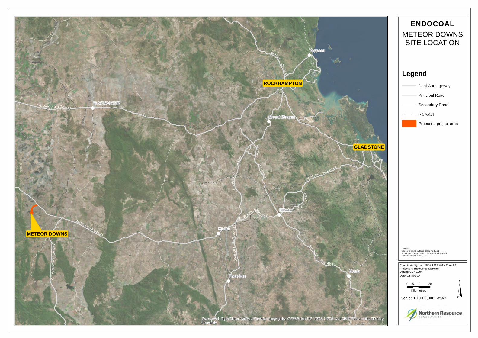
3. Project location The MDS project is located along the Dawson Highway, approximately 25km west of Rolleston and 45km south east of Springsure in Central Queensland as shown in Figure 1. There will be a main access road from the highway leading southwest to the mining workshop and offices. A haul road linking the pit and ROM will be constructed on the south-eastern boundary of the Mining Lease (ML). The pit is in the southern corner of the ML with out-of-pit overburden stockpiling to the north and west.

Overview 2
METEOR DOWNS SOUTH – REVISED STRATEGIC CROPPING LAND RESTORATION PLAN prepared by: Northern Resource Consultants Pty Ltd
Figure 1: Location of the MDS project.
3.1 Tenement and property description
The MDS project is located on mining lease (ML) 70452, granted 27 September 2015 and expires 30 November 2030. The ML is located on several freehold parcels detailed in Table 1. Figure 7 provides an overview of infrastructure associated with the MDS project.
3.2 Current land uses
Lot 1 SP 164068
The current land use for Lot 1 SP 164068 is grazing of cattle. Proposed activities by the Meteor Downs South project on Lot 1 SP 164068 include the following:
- haul road and site access - tank farm - Dirty Water Dam

Overview 3
METEOR DOWNS SOUTH – REVISED STRATEGIC CROPPING LAND RESTORATION PLAN prepared by: Northern Resource Consultants Pty Ltd
- Mine Infrastructure Area (MIA) - borefield maintenance track and access to groundwater bore - AB Triple contractor compound.
Figure 2 demonstrates land use for the Lot and Plan as detailed in GSS Environmental, 2013.
Figure 2: Land use for Lot 1 SP 164068 as demonstrated in GSS Environmental, 2013.
Lot 4 SP 170740
The current land use for Lot 4 SP 170740 is grazing of cattle. Proposed activities by the Meteor Downs South project on Lot 4 SP 170740 include the following:
- haul road and site access. Figure 3 demonstrates land use for the Lot and Plan as detailed in GSS Environmental, 2013.

Overview 4
METEOR DOWNS SOUTH – REVISED STRATEGIC CROPPING LAND RESTORATION PLAN prepared by: Northern Resource Consultants Pty Ltd
Figure 3: Land use for Lot 4 SP 170740 as demonstrated in GSS Environmental, 2013.
Lot 2 RP 616045
The current land use for Lot 2 SP 616045 is grazing of cattle. Proposed activities by the Meteor Downs South project on Lot 2 SP 616045 include the following:
- haul road and site access. Figure 4 demonstrates land use for the Lot and Plan as detailed in GSS Environmental, 2013.

Overview 5
METEOR DOWNS SOUTH – REVISED STRATEGIC CROPPING LAND RESTORATION PLAN prepared by: Northern Resource Consultants Pty Ltd
Figure 4: Land use for Lot 2 RP 616045 as demonstrated in GSS Environmental, 2013.
Lot 4 RP 617701
The current land use for Lot 4 RP 617701 is cropping and grazing of cattle. Proposed activities by the Meteor Downs South project on Lot 4 SP 617701 include the following:
- haul road and site access - tank farm - Dirty Water Dam - borefield maintenance tracks and access to groundwater bores - topsoil stockpile - active pit operations (including high wall and low wall) - mine water dam - overburden dump plateau (including external batters) - Run of Mine (ROM) pad - borefield pipe.
Endocoal Ltd previously received an approved RIDA for Priority Agricultural Areas (PAAs) in November 2014 for Lot 4 RP 617701 (Appendix C). The approved RIDA is RPI14/002

Overview 6
METEOR DOWNS SOUTH – REVISED STRATEGIC CROPPING LAND RESTORATION PLAN prepared by: Northern Resource Consultants Pty Ltd
UDMeteor – Meteor Downs South Coal Mine Project (MDS). Figure 5 demonstrates land use for the Lot and Plan as detailed in GSS Environmental, 2013. Figure 6 demonstrates land use as of September 2017 (provided by U & D Mining Pty Ltd).
Figure 5: Land use for Lot 4 RP 617701 as demonstrated in GSS Environmental, 2013.
Figure 6: Land use for Lot 4 RP 617701 as provided by U & D Mining Pty Ltd October 2017.

Overview 7
METEOR DOWNS SOUTH – REVISED STRATEGIC CROPPING LAND RESTORATION PLAN prepared by: Northern Resource Consultants Pty Ltd
Lot 1 SP 174071
The current land use for Lot 1 SP 174071 is extractive industries (coal mining) as conducted by CRA Rolleston Pty Ltd, Sumisho Coal Australia Pty Ltd and Xstrata Coal Queensland Pty Ltd.
There are no proposed activities by the Meteor Downs South project on Lot 1 SP 174701.
3.3 Current approvals
Endocoal Ltd previously received an approved RIDA for Priority Agricultural Areas (PAAs) in November 2014 for Lot 4 RP 617701 (Appendix C). The approved RIDA is RPI14/002 UDMeteor – Meteor Downs South Coal Mine Project (MDS).
Approval was also received for RIDA application RPI17/008 U & D Mining – Meteor Downs South Project (Appendix D).
Areas already approved under RPI14/002 and RPI17/008 are included for the purpose of determining proposed impact to trigger mapped SCL on currently unapproved property with common ownership (as defined under the RPI Act).

Overview 8
METEOR DOWNS SOUTH – REVISED STRATEGIC CROPPING LAND RESTORATION PLAN prepared by: Northern Resource Consultants Pty Ltd
Figure 7: Infrastructure layout for the MDS project.

Overview 9
METEOR DOWNS SOUTH – REVISED STRATEGIC CROPPING LAND RESTORATION PLAN prepared by: Northern Resource Consultants Pty Ltd
Table 1: Tenure of lands existing under ML70452.
LOT PLAN PREDOMINATE LANDUSE TENURE TYPE OWNER
Lot 1 SP 164068 Grazing Freehold Xstrata Coal Queensland Pty Ltd (as trustee)
Lot 4 SP 170740 Grazing Freehold Xstrata Coal Queensland Pty Ltd (as trustee)
Lot 2 RP 616045 Grazing Freehold Xstrata Coal Queensland Pty Ltd (as trustee)
Lot 4 RP 617701 Grazing/cropping Freehold Xstrata Coal Queensland Pty Ltd (as trustee)
Lot 1 SP 174071 Extractive Freehold CRA Rolleston Pty Ltd, Sumisho Coal Australia Pty Ltd and Xstrata Coal Queensland Pty Ltd

Legislative context 10
METEOR DOWNS SOUTH – REVISED STRATEGIC CROPPING LAND RESTORATION PLAN prepared by: Northern Resource Consultants Pty Ltd
Legislative context 1. Overview The RPI Act identifies and protects areas of Queensland that are of regional interest. The intent of the RPI Act is to manage the impact and support coexistence of resource activities and other regulated activities in areas of regional interest. The RPI Act is supported by the Regional Planning Interests Regulation 2014 (RPI Regulation).
The RPI Act and RPI Regulation seek to establish an appropriate balance between protecting priority land uses and delivering economic projects for Queensland regions.
The RPI Act protects: - living areas in regional communities - high-quality agricultural areas from dislocation - strategic cropping land - regionally important environmental areas.
Areas of Regional Interest are defined under the RPI Act as follows: - a priority agricultural area - a priority living area - the strategic cropping area - a strategic environmental area.
The RPI Act restricts the carrying out of resource or regulated activities where the activity is not exempt from the provisions of the RPI Act, or a regional interests development approval (RIDA) has not been granted. A resource activity (as applicable to the MDS project) is defined under the section 12 (2) of the RPI Act as follows:
- an activity for which a resource authority is required to lawfully carry out - for a provision of a resource authority or proposed resource authority – an authorised
activity for the authority or proposed authority (if granted) under the relevant resource act.
2. Strategic Cropping Land requirements A resource activity or regulated activity located within an SCA will be required to obtain a regional interests development approval (RIDA) under the RPI Act, unless exempt under section 22, 23, 24 or 25 of the Act (DILGP, 2014). It is considered on this basis that the MDS project is not exempt from the requirement for a RIDA for SCL.

Legislative context 11
METEOR DOWNS SOUTH – REVISED STRATEGIC CROPPING LAND RESTORATION PLAN prepared by: Northern Resource Consultants Pty Ltd
2.1 Strategic cropping areas
The SCA covers the area mapped as SCL on the DNRM SCL trigger map and is updated by DNRM periodically to indicate ‘potential strategic cropping land.’ There are three required outcomes for the SCA when applying for a RIDA:
- no impact on SCL in the SCA - no material impact on SCL on the property - no material impact on SCL in an area in the SCA.
A number of prescribed solutions are encouraged when assessing outcomes of RIDA applications in relation to SCL and include:
- voluntary agreement with land owners - locating the resource activity on land not used for SCL - minimising the construction and operation footprint of a resource activity - no permanent impact on more than two (2) percent of the SCL on the ‘property’.
Definition – property
As defined under the RPI Regulation, a property in the SCL area is considered to be: - a single lot, or - otherwise – all the lots that are owned by the same person or have one (1) or more
common owners and: - are managed as a single agricultural enterprise, or - form a single discrete area because 1 lot is adjacent, in whole or part, to another lot in
that single discrete area (other than for any road or watercourse between any of the lots).
Definition – permanent impact
As defined under the RPI Regulation, a resource activity or regulated activity has a permanent impact on SCL if because of carrying out the activity, the land can not be restored to its pre-activity condition.

Site Environment 12
METEOR DOWNS SOUTH – REVISED STRATEGIC CROPPING LAND RESTORATION PLAN prepared by: Northern Resource Consultants Pty Ltd
Site Environment 1. Climate The MDS project is located in a sub-tropical region of Queensland with moderately dry winters and wetter summers (Bureau of Meteorology (BOM), 2017). Annual average rainfall is 635.8mm with the majority of this rainfall occurring in the months of December to February (Rolleston BOM station 035059, 2017) as shown in Figure 8. Mean maximum temperatures range from 22.9°C in July to 34.8°C in January as shown in Figure 9.
Figure 8: Average monthly rainfall at Rolleston (BOM station 035059).

Site Environment 13
METEOR DOWNS SOUTH – REVISED STRATEGIC CROPPING LAND RESTORATION PLAN prepared by: Northern Resource Consultants Pty Ltd
Figure 9: Average monthly temperature at Rolleston BOM station 035059.
2. Hydrology and topography GSS Environmental (GSSE) (2013) provides the following detail regarding hydrology and topography for the MDS project site.
The Fitzroy Basin is a major Queensland catchment incorporating 9.1% of the area of the state, including major towns Biloela, Blackwater, Clermont, Dysart, Emerald, Gladstone, Injune, Moranbah, Mount Morgan, Moura and Rockhampton. The MDS project is located in one of eleven sub-basins, the Comet sub-basin.
Spring Creek is situated to the southeast of MDS and Alderbaran Creek to the northeast. Spring Creek and Alderbaran Creek are tributaries of Comet River and drain into the Mackenzie River. The Mackenzie River is the dominant river along with the Nogoa River within the Fitzroy Basin. Tributaries and drainage lines within the MDS project area predominantly flow in a south-easterly direction draining to Spring Creek in the south. Drainage from the northern part of the ML is to tributaries of Alderbaran Creek.
The topography of the MDS project area comprises undulating plains, lowlands and low hills at the base of the Carnarvon National Park. The Carnarvon National Park (a mountain range with a height of 770m above sea level) is approximately 30km to the south-west of MDS. The Carnarvon National Park is a part of the Great Dividing Range, with underlying Upper and Lower Permian shale, sandstone and volcanics.

Site Environment 14
METEOR DOWNS SOUTH – REVISED STRATEGIC CROPPING LAND RESTORATION PLAN prepared by: Northern Resource Consultants Pty Ltd
3. Geology and geomorphology GSSE (2013) provides the following detail regarding geology and geomorphology for MDS.
Geological descriptions for MDS were made from were made from 1:100,000 web-based mapping (https://webgis.dme.qld.gov.au/webgis/webqmin/viewer.htm). The local landscape comprises Tertiary Basalts (Tb) that overly Permian Rangal Coal Measures, Bandanna Formation, Baralaba Coal Measures (Pwj, sandstone, siltstone, mudstone, coal, tuff, conglomerate), late Permian age Black Alley Shale (Pbs, mudstone, siltstone, tuff, sandstone), Peawaddy Formation (Pbp, mudstone, siltstone, sandstone, coquinite), Cattle Creek Formation (Pbk, quartzose to sub-labile sandstone and mudstone) sloping gently (1–3%) to the floodplain of Spring Creek (Qa, comprising quaternary clay, silt and gravels). Remnants of formerly more widespread basalt flows occur extensively around Rolleston.
Geomorphic domains described refer to land system mapping (Story et al., 1967). The geomorphology is associated with erosional surfaces on fresh rock below the Tertiary weathered zone. The MDS ML traverses undulating hills and plain sequences of two land systems: (i) Oxford Undulating Lowlands, and (ii) Waterford Low Hills.
4. Land units Land units identified from regional land system mapping (Gunn, R.H, 1974) have been confirmed as present by GSSE (2013). Land units which have been identified to include trigger mapped SCL (revised since GSSE, 2013) are detailed below.
4.1 Land unit 105
Crests and steep slopes and benches, (slopes < 40% to 100%), eucalypt woodland and softwood thicket, skeletal soils very shallow loams, Rugby soil family (Um1.4, Uf1.4), Rudosols, generally stony with extensive basalt outcrop.
4.2 Land unit 107
Crests and upper slopes on mesas and slope benches (slopes 2% - 60%), mountain coolabah and grassy woodland, skeletal soils and very shallow loams. Rugby soil family (Um1.4, Uf1.4), Rudosols, generally gravelly or stony with extensive basalt outcrop.
4.3 Land unit 108
Crests and upper slopes on ridges (slopes 2% - 10%), mountain coolabah and grassy woodland, cracking clay soils, shallow, Bruce soil family (Ug5.12, 5.13, 5.14, 5.32, 5.37). Vertisols, generally stony with extensive basalt outcrop.
Site Environment 15
METEOR DOWNS SOUTH – REVISED STRATEGIC CROPPING LAND RESTORATION PLAN prepared by: Northern Resource Consultants Pty Ltd
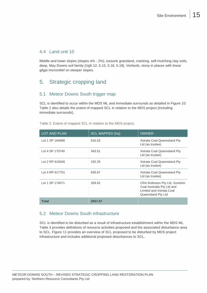
4.4 Land unit 10
Middle and lower slopes (slopes o% - 2%), tussock grassland, cracking, self-mulching clay soils, deep, May Downs soil family (Ug5.12, 5.15, 5.16, 5.18), Vertisols, stony in places with linear gilgai microrelief on steeper slopes.
5. Strategic cropping land
5.1 Meteor Downs South trigger map
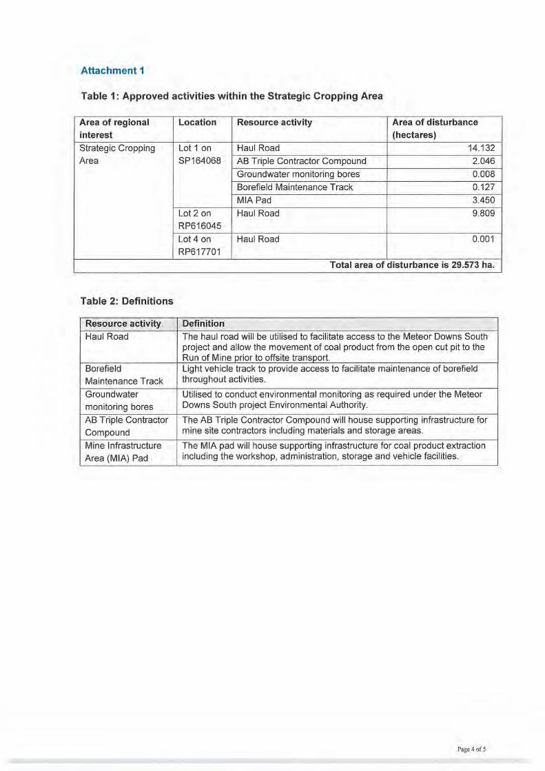
SCL is identified to occur within the MDS ML and immediate surrounds as detailed in Figure 10. Table 2 also details the extent of mapped SCL in relation to the MDS project (including immediate surrounds).
Table 2: Extent of mapped SCL in relation to the MDS project.
LOT AND PLAN SCL MAPPED (ha) OWNER
Lot 1 SP 164068 616.52 Xstrata Coal Queensland Pty Ltd (as trustee)
Lot 4 SP 170740 343.51 Xstrata Coal Queensland Pty Ltd (as trustee)
Lot 2 RP 616045 192.25 Xstrata Coal Queensland Pty Ltd (as trustee)
Lot 4 RP 617701 635.67 Xstrata Coal Queensland Pty Ltd (as trustee)
Lot 1 SP 174071 269.62 CRA Rolleston Pty Ltd, Sumisho Coal Australia Pty Ltd and Limited and Xstrata Coal Queensland Pty Ltd
Total 2057.57
5.2 Meteor Downs South infrastructure
SCL is identified to be disturbed as a result of infrastructure establishment within the MDS ML. Table 3 provides definitions of resource activities proposed and the associated disturbance area to SCL. Figure 11 provides an overview of SCL proposed to be disturbed by MDS project infrastructure and includes additional proposed disturbances to SCL.

Site Environment 16
METEOR DOWNS SOUTH – REVISED STRATEGIC CROPPING LAND RESTORATION PLAN prepared by: Northern Resource Consultants Pty Ltd
Table 3: Definitions of resource activities proposed and associated disturbance to SCL.
MINE INFRASTRUCTURE DESCRIPTION
APPROVED UNDER RPI17/008 PROPOSED ADDITIONAL DISTURBANCE
Infrastructure type
Description Infrastructure area (ha)
SCL proposed to be disturbed (ha)
Additional SCL proposed to be disturbed (ha)
Contractor compound
Compound and laydown area for contractor use.
2.077 2.046 -
Open cut pit Open cut mining location and area of primary extractive activities.
2.836 0.000 -
Borefield maintenance track
Borefield maintenance track to facilitate access to bores.
0.945 0.127 0.045
Borefield (MW18) Dewatering bore location.
0.008 0.000 -
Borefield pipe Pipeline for access to dewatering bore.
0.051 0.000 -
Borefield test Borefield testing area (associated with MW18 and Borefield pipe).
0.024 0.000 -
Dirty water dam Mine dam for managing sediment laden water.
0.534 0.000 -
Dump plateau Overburden and waste rock dump plateau and storage.
17.096 0.000 -
External batters Batters associated with Dump plateau.
14.293 0.000 0.012
Groundwater monitoring bores
Compliance monitoring bores for groundwater.
0.031 0.000 -

Site Environment 17
METEOR DOWNS SOUTH – REVISED STRATEGIC CROPPING LAND RESTORATION PLAN prepared by: Northern Resource Consultants Pty Ltd
MINE INFRASTRUCTURE DESCRIPTION
APPROVED UNDER RPI17/008 PROPOSED ADDITIONAL DISTURBANCE
Haul road Haul road providing access to and from site and movement of extracted material from Run of Mine (ROM) pad.
72.645 23.942 1.037
High wall Open cut pit infrastructure.
7.402 0.000 -
Low wall Open cut pit infrastructure.
13.166 0.000 -
Mine Infrastructure Area (MIA) Pad
MIA pad includes associated administration buildings, workshop facilities and storage areas.
3.450 3.450 -
Mine water dam Mine dam for managing mine affected water.
2.891 0.000 -
Run of Mine (ROM) Pad
Pad for storage of coal product prior to transport off site.
5.580 0.000 -
Tank farm Hydrocarbon storage area.
0.100 0.000 -
Topsoil stockpile Stockpile of topsoil resource for use in restoration and rehabilitation.
6.385 0.000 -
Water Infrastructure Area
Location of infrastructure for managing site water.
0.237 0.000 -
Total 149.751 29.573 1.095

Site Environment 18
METEOR DOWNS SOUTH – REVISED STRATEGIC CROPPING LAND RESTORATION PLAN prepared by: Northern Resource Consultants Pty Ltd
Figure 10: Strategic Cropping Land proposed to be disturbed by the MDS project.

Site Environment 19
METEOR DOWNS SOUTH – REVISED STRATEGIC CROPPING LAND RESTORATION PLAN prepared by: Northern Resource Consultants Pty Ltd
Figure 11: Strategic Cropping Land proposed to be disturbed by MDS project infrastructure.

Restoration Plan 20
METEOR DOWNS SOUTH – REVISED STRATEGIC CROPPING LAND RESTORATION PLAN prepared by: Northern Resource Consultants Pty Ltd
Restoration Plan 1. Overview A Restoration Plan is required to demonstrate how permanent impacts to SCL as a result of a resource activity will be avoided. The Restoration Plan is required to demonstrate the capacity for SCL disturbed by the resource activity to be returned to pre-activity status.
2. Proposed disturbance As required under the RPI Act, no more than 2% of SCL may be permanently impacted. The total area of the mapped SCL is calculated as the area of a polygon that covers one or more lot and plans under the ownership of a single landholder. Disturbance to that mapped SCL under the ownership of that single landholder cannot exceed 2% of that mapped area.
The area of impact is considered to be the area of that mapped SCL which will potentially be impacted by the activity, whether or not the land can be restored to its pre-activity condition after the activity ceases.
The proposed disturbance to SCL as a result of the MDS project is presented in Figure 10 and Appendix A. Table 4 details areas of impacted SCL and associated Lot and Plans. The total proposed disturbance to the mapped SCL in possession of Xstrata Coal Queensland Pty Ltd, CRA Rolleston Pty Ltd and Sumisho Coal Australia Pty Ltd currently approved is 29.57ha. An additional 1.095 ha is proposed to be disturbed as outlined in Table 4.
Table 4: Areas of impacted SCL in relation to the MDS project mine infrastructure.
LOT AND PLAN
IMPACTED SCL (ha)
IMPACTED SCL (%)
OWNER PROPOSED ADDITIONAL IMPACTED SCL (ha)
Lot 1 SP 164068
19.771 3.207 Xstrata Coal Queensland Pty Ltd (as trustee)
0.972
Lot 4 SP 170740
0.000 0.000 Xstrata Coal Queensland Pty Ltd (as trustee)
-
Lot 2 RP 616045
9.801 5.098 Xstrata Coal Queensland Pty Ltd (as trustee)
-

Restoration Plan 21
METEOR DOWNS SOUTH – REVISED STRATEGIC CROPPING LAND RESTORATION PLAN prepared by: Northern Resource Consultants Pty Ltd
LOT AND PLAN
IMPACTED SCL (ha)
IMPACTED SCL (%)
OWNER PROPOSED ADDITIONAL IMPACTED SCL (ha)
Lot 4 RP 617701
0.001 0.000 Xstrata Coal Queensland Pty Ltd (as trustee)
0.124
Lot 1 SP 174071
0.000 0.000 CRA Rolleston Pty Ltd, Sumisho Coal Australia Pty Ltd and Limited and Xstrata Coal Queensland Pty Ltd
-
Total 29.573 1.437 1.095
As the proposed percentage of impacted SCL is below 2 percent, it is considered that the prescribed outcome that no permanent impact on more than two (2) percent of the SCL on the property is able to be met.
3. Activities to restore SCL to pre-disturbance condition
3.1 Land suitability assessment
GSSE (2013) conducted an assessment of land units, land suitability and SCL (as defined by SCL trigger mapping at the time of study). Since this study, the SCL trigger map has been amended at government level, resulting in a net increase in mapped SCL for the MDS project. In order to establish restoration criteria to return proposed disturbed SCL areas to pre-disturbance activities, comparison to land suitability criteria determined by GSSE (2013) is recommended.
Land suitability has been previously assessed for the MDS project according to the Queensland Technical Guidelines for Mining (DME, 1995). The method accounts for climate, soils, geology, geomorphology, soil erosion, topography and past land uses. The classification may not reflect the existing land use, rather it indicates the potential of the land for crop production, pasture improvement and grazing. Table 5 provides an overview of the land suitability classification scheme as reproduced from GSSE (2013).

Restoration Plan 22
METEOR DOWNS SOUTH – REVISED STRATEGIC CROPPING LAND RESTORATION PLAN prepared by: Northern Resource Consultants Pty Ltd
Table 5: Land suitability classification scheme.
ORDERS CLASS CLASS DESCRIPTOR
DESCRIPTION
S (Suitable)
1 S1 None/Minor limitations (Highly suitable)
Land with negligible limitations, which is highly productive requiring only simple management practices to maintain economic production.
2 S2 Minor limitations (Moderately suitable)
Land with minor limitations which either reduce production or require more than the simple management practices of Class 1 land to maintain economic production.
3 S3 Moderate limitations (Marginally suitable)
Land with moderate limitations which either further lower production or require more than those management practices of Class 2 land to maintain economic production.
N (Not suitable)
4 N1 (or S4) Marginal land (Presently unsuitable)
Marginal lands with severe limitations which make it doubtful whether the inputs required to achieving and maintaining production outweigh the benefits in the long term (presently considered unsuitable due to the uncertainty of the land to achieve sustained economic production).
5 N2 (or S5) Unsuitable
Unsuitable land with extreme limitations that preclude its use for the proposed purpose.
Soil type characteristics (e.g. Plant Available Water Capacity and pH) of land units identified within the MDS project have been cross-referenced against DME, 1995 for ‘rainfed broadacre cropping’ and ‘beef cattle grazing’.
The most severe limitations as defined under Attachment 2 of DME, 1995 have been identified by GSSE (2013) for land units within the MDS project, with a land suitability ranking applied to each limitation. The overall land suitability for a land unit is defined based on the most severe limitation for the identified land unit.
Table 6 provides an overview of land units, associated soil type and limitations to rainfed cropping for SCL trigger mapped areas within the MDS project.

Restoration Plan 23
METEOR DOWNS SOUTH – REVISED STRATEGIC CROPPING LAND RESTORATION PLAN prepared by: Northern Resource Consultants Pty Ltd
Table 6: Land units and limitations of SCL trigger mapped areas within the MDS project.
LAND UNIT SOIL TYPE MAIN LIMITATIONS TO RAINFED CROPPING (DME, 1995)1,2,3,4
LAND SUITABILITY FOR RAINFED CROPPING
105 Haplic, self-mulching, Black Veritsol, non-gravelly, fine, fine, moderate
P3 N3 E3 3
107 Haplic, self-mulching, Brown Vertisol, slightly gravelly, fine, fine, moderate
P2 N3 E3 3
108 Haplic, self-mulching, Brown Vertisol, non-gravelly, fine, fine, moderate
P5 N3 E3 5
110 Haplic, self-mulching, Brown Vertisol, non-gravelly, fine, fine, deep
P2 N3 E3 3
1Limitation class ranked from 1 (most suitable) to 5 (least suitable) in accordance with DME (1995) and Table 5. 2P – Plant available water capacity. 3N – Soil nutrient levels. 4E – Water erosion (water erosion susceptibility).
3.2 Defining restoration criteria
As there has been a net increase in mapped SCL since GSSE (2013), restoration criteria proposed to return land to a pre-activity condition are based on rainfed cropping land suitability classes for land units identified to be associated with disturbance of SCL for the MDS project. Specific physical and chemical characteristics of representative land unit soil types are detailed in GSSE (2013) provided in Appendix B. Table 7 provides restoration criteria for relevant land units and associated tenures.
Table 7: Restoration criteria for mapped SCL proposed to be disturbed by MDS.
LAND UNIT LOT AND PLAN LAND SUITABILITY CLASS FOR RAINFED CROPPING
LIMITATIONS TO RAINFED CROPPING (DME, 1995)
PREVIOUSLY CONFIRMED SCL (GSSE, 2013)
105 Lot 4 RP617701 3 P3 N3 E3 Not SCL

Restoration Plan 24
METEOR DOWNS SOUTH – REVISED STRATEGIC CROPPING LAND RESTORATION PLAN prepared by: Northern Resource Consultants Pty Ltd
LAND UNIT LOT AND PLAN LAND SUITABILITY CLASS FOR RAINFED CROPPING
LIMITATIONS TO RAINFED CROPPING (DME, 1995)
PREVIOUSLY CONFIRMED SCL (GSSE, 2013)
107 Lot 1 SP164068 Lot 2 RP616045
3 P2 N3 E3 SCL
108 Lot 1 SP164068 Lot 2 RP616045
5 P5 N3 E3 Not SCL
110 Lot 1 SP164068 3 P2 N3 E3 Not SCL
4. Restoration methods – Mitigation of impacts to SCL Trigger mapped SCL has been identified for the MDS project on the following tenures:
- Lot 4 RP 617701 - Lot 1 SP 164068 - Lot 2 RP 616045.
Associated land units for each tenure are detailed in Table 7 and include restoration criteria (outlined as land suitability criteria for rainfed cropping) that will be required to be met in order to establish pre-activity land uses. Pre-activity land suitability’s to be achieved are:
- Rainfed Cropping Class 3 (Land unit 105, 107, 110) - Rainfed Cropping Class 5 (Land unit 108).
Methodologies for restoration are contained herein and include previous studies undertaken in the MDS project region. Methodologies for restoration are considered to be appropriate to mitigate impacts to mapped SCL.
Additionally, Appendix 2 of GSSE (2013) includes a Topsoil Management Plan for MDS. Implementation of restoration methods should be undertaken with reference to GSSE (2013) and in accordance with the Topsoil Management Plan. A synopsis of soil management methodologies detailed in GSSE (2013) is provided in this restoration plan.
4.1 Previous studies
A number of studies have been conducted previously to describe and assess soils encountered within the MDS project region and include:
- Meteor Downs South Soils, Land, Overburden and Process Waste study (GSS Environmental (GSSE), 2013)
- Lands of the Isaac – Comet Area, Queensland, (Story, R et al. 1967) - Land units of the Fitzroy Region, Queensland (Gunn, R.H. and Nix, H.A,1977) - A soil catena of weathered basalt in Queensland (Gunn, R.H, 1974)

Restoration Plan 25
METEOR DOWNS SOUTH – REVISED STRATEGIC CROPPING LAND RESTORATION PLAN prepared by: Northern Resource Consultants Pty Ltd
- Characterisation of basaltic clay soils (Vertisols) from the Oxford Land System (Department of Primary Industries, 1990).
Studies detailed above have been utilised as the basis for developing restoration plan methodologies.
4.2 Soil stripping
Charman and Murphy (2010) describes activities to promote and preserve soil materials during stripping and handling with machinery. As a general rule, the handling of soil materials by machinery should be undertaken in slightly moist conditions (e.g. soil moisture content between shrinkage limit and plastic limit) so as to minimise both brittle failure that may occur in dry soil and compressive failure that may occur in soils that are too wet.
Mine machinery and equipment is designed to move large volumes of material at low unit costs and is inappropriate in many instances for removal and emplacement of topsoil materials because of the high potential for structural damage, compaction and inadequate precision or high wastage while excluding non-desirable materials.
Grading or pushing soil into windrows with light graders or track-driven bulldozers are examples of less aggressive soil handling systems that will be implemented. Tracking over stripped areas and stockpiled soils following stripping should be avoided to minimise degradation of the soil resource.
Soil stripping activities shall be undertaken with particular regard to mapped SCL within the following areas:
- Mine Infrastructure Area (MIA) Pad - groundwater monitors - borefield maintenance track - haul road.
Figure 11 provides an overview of SCL areas impacted by infrastructure that will require soil stripping prior to construction.
4.3 Soil management
As a general rule, a maximum soil stockpile height of 2m will be maintained. Clay soils should be stored in lower stockpiles for shorter periods of time compared to sandy soils (GSSE, 2013).
Impacted SCL, which has been stripped, will be stockpiled and batters should be constructed with a 3:1 slope to prevent slumping and allow the establishment of protective cover crop vegetation. Where stockpiles are to be maintained for extensive periods (six months or longer), seed and fertiliser will be applied on establishment. An annual cover crop species that produces sterile florets or seed will be sown (e.g. Japanese millet or Rye grass).
A soil management register will be developed and include details of impact SCL soils that have been stripped and stockpiled, including the date of stripping, location of storage, volume stripped, soils type and source location.

Restoration Plan 26
METEOR DOWNS SOUTH – REVISED STRATEGIC CROPPING LAND RESTORATION PLAN prepared by: Northern Resource Consultants Pty Ltd
Soil stripped for the preservation of pre-activity condition for mapped SCL will be stored in a position removed from the area of operation, away from concentrated overland flow with exclusion of access and adequate signage maintained.
Regular monitoring of stockpiles shall be undertaken to ensure that nutrient status of soil types is maintained and degradation of soil does not occur under stockpiled conditions.
4.4 Re-establishment of disturbed areas mapped as SCL
Replacement of soil over stripped areas will be undertaken in a similar manner to original stripping activities. Sampling of the stockpiled resource should be undertaken prior to respread of materials to understand the nutrient status and amelioration requirements (e.g. application of gypsum, NPK fertilisers, etc.) if required.
Additionally, any foreign material brought in (e.g. gravel, road stabilisers, etc.) should be removed from the area to be restored and ripping of sub-soils should be undertaken to alleviate compaction and allow for the “keying in” of topsoil resources into subsoil.
Replacement of stripped SCL materials over the restoration area should result in an area “left rough” to promote infiltration of water and aeration. SCL soils stripped will be returned to be same general location that SCL soils were initially stripped from. Consultation with the land holder will be undertaken to determine required activities to facilitate a return to agricultural activities (e.g. ploughing and target crop requirements).
4.5 Monitoring activities – demonstration that impacted SCL has been restored
Table 8 details monitoring procedures to be applied to disturbed SCL areas and should be read in conjunction with the MDS project Topsoil Management Plan to ensure the condition of stockpiled resources is maintained.
Monitoring activities proposed will be undertaken to demonstrate that disturbed areas are returned to designated land-uses identified in Section 4 and that impacts to mapped SCL have been successfully mitigated.

Restoration Plan 27
METEOR DOWNS SOUTH – REVISED STRATEGIC CROPPING LAND RESTORATION PLAN prepared by: Northern Resource Consultants Pty Ltd
Table 8: Topsoil management procedures to be applied to disturbed SCL areas of the MDS project.
PARAMETER ACTION MONITORING FREQUENCY
Approvals and clearances Updated and relevant to activity.
Checking validity of approvals and clearance permits as per protocol. Prior to clearance activities
Hostile soils Identification of dispersive, sodic, saline, highly acidic or highly alkaline soils.
Use soil survey information and continued observations to avoid any stripping of hostile material.
Prior to and during clearance activities
Stripping depths Strip to depths advised. Clearance operators to constantly ensure stripping depths are as per recommendations in GSSE (2013).
Prior to and during clearance activities
Topsoil condition Ensure prior to stripping that soil has appropriate moisture content. Must be slightly moist during stripping.
Visually inspect soil to be stripped to ensure that soil is in a slightly moist condition. Prior to and during clearance activities
Stripped material placement *Place directly in a position away from operations and concentrated flow paths.
Investigate influential parameters including mining sequencing, equipment scheduling and weather when determining placement of soil, ensuring that stripped soil is placed in such a way as to avoid ongoing operations and concentrated water flow paths.
Prior to clearance activities
Stockpile surface condition Keep surface condition as coarse as possible.
Visually monitor activity to ensure no unnecessary handling or smoothing occurs. Avoid unnecessary shaping and compaction of stockpile.
During and following stripping activities
Waterway contamination Prevent sediments from stockpiles reaching waterways.
Ensure stockpiles are designed and protected as per the practical standards detailed in Section 2.2 (of GSSE, 2013) and established in appropriate locations.
Prior to, during and following stripping activities
Stockpile height Stockpiles to be a maximum of 2m in height.
Machinery operators to visually gauge height of stockpiles upon establishment, to be confirmed by appropriately qualified person (e.g. surveyor).
During stripping activities
Soil stockpile treatment Seed and fertilise stockpiles intended for extended duration.
The duration of the stockpile will be predicted upon establishment and seeding and fertiliser will be applied where necessary.
Following stripping activities

Restoration Plan 28
METEOR DOWNS SOUTH – REVISED STRATEGIC CROPPING LAND RESTORATION PLAN prepared by: Northern Resource Consultants Pty Ltd
PARAMETER ACTION MONITORING FREQUENCY
Soil fertility Soil sampling and analysis to monitor soil fertility and quality.
Representative soil samples to be collected from stockpiled soils by an appropriately qualified person (e.g. Environmental Advisor) and analysed by a NATA accredited laboratory for soil fertility and quality. Parameters to be analysed to include:
- pH
- Electrical conductivity (EC) - Chloride - Cation exchange capacity - Total nitrogen
- Colwell potassium
- Colwell phosphorous - Total organic carbon.
Laboratory results should be compared to representative land unit soils types and Hazelton and Murphy (2016) and ameliorants to be applied (e.g. gypsum) to maintain stripped soil quality (if required).
Annually
*Differs from Table 2.2.3 of the MDS Topsoil Management Plan.

References 29
METEOR DOWNS SOUTH – REVISED STRATEGIC CROPPING LAND RESTORATION PLAN prepared by: Northern Resource Consultants Pty Ltd
References Bureau of Meteorology (BOM). (2017). Climate statistics – Rolleston Station (035065). http://www.bom.gov.au/climate/averages/tables/cw_035059.shtml.
Charman, Peter E. V. and Murphy, Brian W. (2010). Soils their properties and management. Third Edition. Oxford University Press Australia and New Zealand.
Department of Infrastructure, Local Government and Planning (DILGP). (2014). How to demonstrate that land in the Strategic Cropping Area does not meet the criteria for Strategic Cropping Land.
Department of Primary Industries. (1990). Characterisation of Basaltic Clay Soils (Vertisols) from the Oxford Land System in Central Queensland. Queensland Department of Primary Industries. A. A. Webb, A. J. Dowling, CSIRO Publishing.
GSS Environmental. (2013). Meteor Downs South Soils, Land, Overburden and Process Waste Study.
Gunn, R.H. (1974). A Soil Catena on Weathered Basalt in Queensland. Division of Land Use Research. CSIRO Publishing.
Gunn, R.H. and Nix, H.A. (1977). Land units of the Fitzroy Region, Queensland. Land Research Series No. 30. Division of Land Resources. CSIRO Publishing.
Hazelton, P and Murphy, B. (2016). Interpreting soil test results – What do all the numbers mean?. Third Edition. CSIRO Publishing.
Story, R, Calloway R.W, Gunn, R. H and Fitzpatrick, E. A. (1967). Lands of the Isaac – Comet Area, Queensland. Land Research Series No. 19. CSIRO Melbourne.

METEOR DOWNS SOUTH – REVISED STRATEGIC CROPPING LAND RESTORATION PLAN prepared by: Northern Resource Consultants Pty Ltd
Appendix summary
Appendix A
Appendix B
Appendix C
Appendix D
Maps
Meteor Downs South Soil, Land, Overburden and Process Waste Study
Approved RIDA RPI14/002
Approved RIDA RPI17/008

METEOR DOWNS SOUTH – REVISED STRATEGIC CROPPING LAND RESTORATION PLAN prepared by: Northern Resource Consultants Pty Ltd
Appendix A
Maps
!
!
!
!
!
!!
!!
!
!
!
METEOR DOWNS
ROCKHAMPTON
GLADSTONE
Yeppoon
Mount Morgan
Biloela
TheodoreMonto
Moura
BLACKWATER
BURNETT
HIG HWAY
BRUCEHIGHWAY
DA WSON HIGH WAY
LEICH
HARD
THI
GHWAY
DAWSON HIGHWAY
DAWSON HIGHWAY
BURNETTHIGHWAY
LEICHHARDTHIGHW
AY
CAPRICORN HIGHWAY
CARN
ARVO
NHI
GHW
AY
C OA LRO
AD
Source: Esri, DigitalGlobe, GeoEye, Earthstar Geographics, CNES/Airbus DS, USDA, USGS, AeroGRID, IGN, and the GIS UserCommunity
Date: 13-Sep-17
Coordinate System: GDA 1994 MGA Zone 55Projection: Transverse MercatorDatum: GDA 1994
§0 10 205
Kilometres
ENDOCOAL
Credits:Cadastre and Strategic Cropping Land© State of Queensland (Department of NaturalResources and Mines) 2016.
METEOR DOWNSSITE LOCATION
LegendDual Carriageway
Principal Road
Secondary Road
Railways
Proposed project area
1:1,000,000Scale: at A3

1SP164068
4SP170740
1SP174071
2RP616045
4RP617701 Source: Esri, DigitalGlobe, GeoEye, Earthstar Geographics, CNES/Airbus DS, USDA, USGS, AeroGRID, IGN, and the GIS UserCommunity
637000
637000
638000
638000
639000
639000
640000
640000
641000
641000
642000
642000
643000
643000
644000
644000
645000
645000
646000
646000
7298
000
7298
000
7299
000
7299
000
7300
000
7300
000
7301
000
7301
000
7302
000
7302
000
7303
000
7303
000
7304
000
7304
000
7305
000
7305
000
Date: 09-Feb-18
Coordinate System: GDA 1994 MGA Zone 55Projection: Transverse MercatorDatum: GDA 1994
§0 0.5 10.25
Kilometres
ENDOCOAL
Credits:Cadastre and Strategic Cropping Land© State of Queensland (Department of NaturalResources and Mines) 2016.
METEOR DOWNSSTRATEGIC
CROPPING LAND
LegendSCL disturbed withinboundary
Infrastructure not thesubject of RIDAapplication
Cadastral Boundaries
Strategic CroppingLand
1:30,000Scale: at A3
Lot and Plan Area of SCL within Lot and Plan Area of Disturbed SCL within Lot Plan Area as a precentage of total SCL areaLot 1 SP 164068 616.520 20.743 3.364Lot 4 SP 170740 343.506 0.000 0.000Lot 2 RP 616045 192.252 9.801 5.098Lot 4 RP 617701 635.671 0.124 0.020Lot 1 SP 174071 269.617 0.000 0.000
TOTALS 2057.566 30.668 1.491

HAUL ROAD
BOREFIELDMAINTENENCE
TRACK
HAUL ROAD
1SP164068
4SP170740
1SP174071
2RP616045
4RP617701
AB TRIPLECONTRACTOR
COMPOUND
BOREFIELDMAINTENENCE
TRACK
EXTERNAL BATTERS
HAUL ROAD
MIA PAD
Source: Esri, DigitalGlobe, GeoEye, Earthstar Geographics, CNES/Airbus DS, USDA, USGS, AeroGRID, IGN, and the GIS UserCommunity
63500063
5000
63600063
6000
63700063
7000
638000
638000
639000
639000
640000
640000
641000
641000
642000
642000
643000
643000 644000
6440
00
645000
6450
00
646000
6460
00
7295000
7296
000
7297
000
7297000
7298
000
7299
000
7300
000
7301
000
7301
000
7302
000
7302
000
7303000
7303
000
7305000
7305
000
Date: 29-Jan-18
Coordinate System: GDA 1994 MGA Zone 55Projection: Transverse MercatorDatum: GDA 1994
§0 0.5 10.25
Kilometres
ENDOCOAL
Credits:Cadastre and Strategic Cropping Land© State of Queensland (Department of NaturalResources and Mines) 2016.
METEOR DOWNSSTRATEGIC
CROPPING LANDAFFECTED BY
INFRASTRUCTURE
LegendMining Lease
SCL disturbed withinboundary
Infrastructure not thesubject of thisapplication
Cadastral Boundaries
Strategic CroppingLand
1:30,000Scale: at A3
HAUL ROAD
EXTERNAL BATTERS
BOREFIELD MAINTENENCE TRACK
Source: Esri, DigitalGlobe, GeoEye, EarthstarGeographics, CNES/Airbus DS, USDA, USGS,AeroGRID, IGN, and the GIS User Community
See inset 1
Inset 1
0 10 20 30 405Metres

1SP164068
4SP170740
1SP174071
2RP616045
4RP617701
Source: Esri, DigitalGlobe, GeoEye, Earthstar Geographics, CNES/Airbus DS, USDA, USGS, AeroGRID, IGN, and the GIS UserCommunity
637000
637000
638000
638000
639000
639000
640000
640000
641000
641000
642000
642000
643000
643000
644000
644000
645000
645000
646000
646000
7298
000
7298
000
7299
000
7299
000
7300
000
7300
000
7301
000
7301
000
7302
000
7302
000
7303
000
7303
000
7304
000
7304
000
7305
000
7305
000
Date: 09-Feb-18
Coordinate System: GDA 1994 MGA Zone 55Projection: Transverse MercatorDatum: GDA 1994
§0 0.5 10.25
Kilometres
ENDOCOAL
Credits:Cadastre and Strategic Cropping Land© State of Queensland (Department of NaturalResources and Mines) 2016.
METEOR DOWNSSTRATEGIC
CROPPING LANDMAP 1 of 2
LegendMining Lease
SCL disturbed withinboundary
Infrastructure not thesubject of thisapplication
Cadastral Boundaries
Strategic CroppingLand
1:30,000Scale: at A3
!!! !!
!
!
!
!
!
!
!
!
!
!
!
!
9
87
6
543
2
1
17
16
15
14
13
12
11
10
Source: Esri, DigitalGlobe, GeoEye, EarthstarGeographics, CNES/Airbus DS, USDA, USGS,AeroGRID, IGN, and the GIS User Community
See inset 1
Inset 1
0 10 20 30 405Metres
Lot and Plan Area of SCL within Lot and Plan Area of Disturbed SCL within Lot Plan Area as a precentage of total SCL areaLot 1 SP 164068 616.520 20.743 3.364Lot 4 SP 170740 343.506 0.000 0.000Lot 2 RP 616045 192.252 9.801 5.098Lot 4 RP 617701 635.671 0.124 0.020Lot 1 SP 174071 269.617 0.000 0.000
TOTALS 2057.566 30.668 1.491

1SP164068
4SP170740
1SP174071
2RP616045
4RP617701
Source: Esri, DigitalGlobe, GeoEye, Earthstar Geographics, CNES/Airbus DS, USDA, USGS, AeroGRID, IGN, and the GIS UserCommunity
637000
637000
638000
638000
639000
639000
640000
640000
641000
641000
642000
642000
643000
643000
644000
644000
645000
645000
646000
646000
7298
000
7298
000
7299
000
7299
000
7300
000
7300
000
7301
000
7301
000
7302
000
7302
000
7303
000
7303
000
7304
000
7304
000
7305
000
7305
000
Date: 09-Feb-18
Coordinate System: GDA 1994 MGA Zone 55Projection: Transverse MercatorDatum: GDA 1994
§0 0.45 0.90.225
Kilometres
ENDOCOAL
Credits:Cadastre and Strategic Cropping Land© State of Queensland (Department of NaturalResources and Mines) 2016.
METEOR DOWNSSTRATEGIC
CROPPING LANDMAP 2 of 2
LegendSCL disturbed withinboundary
Infrastructure not thesubject of thisapplication
Mining Lease
Cadastral Boundaries
Strategic CroppingLand
1:30,000Scale: at A3
!
!
!!!!
!!
!
!
27
2625
24
23
22
21
2019
18
Source: Esri, DigitalGlobe, GeoEye, EarthstarGeographics, CNES/Airbus DS, USDA, USGS,AeroGRID, IGN, and the GIS User Community
See inset 1
Inset 1
0 20 40 60 8010Metres
Lot and Plan Area of SCL within Lot and Plan Area of Disturbed SCL within Lot Plan Area as a precentage of total SCL areaLot 1 SP 164068 616.520 20.743 3.364Lot 4 SP 170740 343.506 0.000 0.000Lot 2 RP 616045 192.252 9.801 5.098Lot 4 RP 617701 635.671 0.124 0.020Lot 1 SP 174071 269.617 0.000 0.000
TOTALS 2057.566 30.668 1.491

!
!
!
!
!
!
!
!
AB TRIPLE CONTRACTOR LAYDOWN PAD
HAUL ROAD
MIA PAD
BOREFIELD MAINTENENCE TRACK
1
2
3
4
5
6
7
8
Source: Esri, DigitalGlobe, GeoEye, Earthstar Geographics, CNES/Airbus DS, USDA, USGS, AeroGRID, IGN, and the GIS UserCommunity
63730063
7300
63740063
7400
63750063
7500
63760063
7600
6377
00
6377
00
6378
00
6378
00
6379
00
6379
00
638000
6380
00
638100
6381
00
638200
6382
00
638300
6383
00
638400
6384
00
7301100
7301300
7301300
7301500
7301500
7301700
7301700
7301900
7301
900
7302
000
7302100
7302
100
Date: 09-Feb-18
Coordinate System: GDA 1994 MGA Zone 55Projection: Transverse MercatorDatum: GDA 1994
§0 50 10025
Meters
ENDOCOALMETEOR DOWNS
AB TRIPLE CONTRACTOR LAYDOWN PADAND MIA PAD! Edge coordinates
Year 1 InfrastructureAB TRIPLECONTRACTORCOMPOUND
BOREFIELDMAINTENENCE TRACK
GROUNDWATERMONITORS
HAUL ROAD
MIA PAD
1:3,000Scale: at A3
Point Name Easting Northing1 637701 73014332 637763 73016553 637907 73016154 637846 73013935 637891 73012766 637952 73014997 638073 73014658 638047 7301369

ACTIVE PIT
AB TRIPLECONTRACTOR
COMPOUND
BOREFIELDMAINTENENCE TRACK
BOREFIELDMAINTENENCE
TRACK
BOREFIELDMAINTENENCE
TRACK
BOREFIELDMAINTENENCE
TRACK
BOREFIELD PIPE
BOREFIELD PIPE
BOREFIELDPIPE
DUMPPLATEAU
EXPLOSIVESMAGAZINE
EXTERNAL BATTERS
GROUNDWATERMONITORS
GROUNDWATER MONITORS
HAUL ROAD
HAUL ROAD
HIGHWALLLOWWALL
MIA PAD
MINEWATER DAM
MINEWATER DAM
ROMPAD
TOPSOILDUMP
270
260
250240
270
260
250
240
260
250
250
240
280
260
270250
230
240
260260
240
240230
Source: Esri, DigitalGlobe, GeoEye, Earthstar Geographics, CNES/Airbus DS, USDA, USGS, AeroGRID, IGN, and the GIS UserCommunity
636000
636000
637000
637000
638000
638000
639000
639000
640000
640000
641000
641000
642000
642000
643000
643000
644000
644000
645000
645000
7298
000
7298
000
7299
000
7299
000
7300
000
7300
000
7301
000
7301
000
7302
000
7302
000
7303
000
7303
000
7304
000
7304
000
7305
000
7305
000
Date: 09-Feb-18
Coordinate System: GDA 1994 MGA Zone 55Projection: Transverse MercatorDatum: GDA 1994
§0 0.5 10.25
Kilometres
ENDOCOAL
Credits:Cadastre and Strategic Cropping Land© State of Queensland (Department of NaturalResources and Mines) 2016.
METEOR DOWNSSTRATEGIC
CROPPING LAND AFFECTED BY
INFRASTRUCTURE
LegendStrategic Cropping LandMining LeaseContours (10m)
Year 1 InfrastructureAB TRIPLE CONTRACTORCOMPOUNDACTIVE PITBOREFIELD MAINTENENCETRACKBOREFIELD MW18BOREFIELD PIPEBOREFIELD TESTDIRTY WATER DAMDUMP PLATEAUEXPLOSIVES MAGAZINEEXTERNAL BATTERSGROUNDWATER MONITORSHAUL ROADHIGHWALLLOW WALLMIA PADMINE WATER DAMROM PADTANK FARMTOPSOIL DUMPWATER INFRASTRUCTUREAREA
1:30,000Scale: at A3
Site FeatureArea of SCL impacted by Infrastructure
Total area of Infrastructure
AB TRIPLE CONTRACTOR COMPOUND 2.05 2.08ACTIVE PIT 0.00 2.84BOREFIELD MAINTENENCE TRACK 0.180 1.56BOREFIELD MW18 0.00 0.01BOREFIELD PIPE 0.00 0.05BOREFIELD TEST 0.00 0.00DIRTY WATER DAM 0.00 0.53EXPLOSIVES MAGAZINE 0.00 0.71EXTERNAL BATTERS 0.01 31.65GROUNDWATER MONITORS 0.00 0.02HAUL ROAD 24.98 74.68HIGH WALL 0.00 7.41LOW WALL 0.00 13.16MIA PAD 3.45 3.45MINE WATER DAM 0.00 5.78ROM PAD 0.00 5.58TANK FARM 0.00 0.10TOPSOIL DUMP 0.00 5.87TOTAL: 30.668 155.48

ACTIVE PIT
AB TRIPLECONTRACTOR
COMPOUND
BOREFIELDMAINTENENCE TRACK
BOREFIELDMAINTENENCE
TRACK
BOREFIELDMAINTENENCE
TRACK
BOREFIELDMAINTENENCE
TRACK
BOREFIELD PIPE
BOREFIELD PIPE
BOREFIELDPIPE
DUMPPLATEAU
EXPLOSIVESMAGAZINE
EXTERNAL BATTERS
GROUNDWATERMONITORS
GROUNDWATER MONITORS
HAUL ROAD
HAUL ROAD
HIGHWALLLOWWALL
MIA PAD
MINEWATER DAM
MINEWATER DAM
ROMPAD
TOPSOILDUMP
Source: Esri, DigitalGlobe, GeoEye, Earthstar Geographics, CNES/Airbus DS, USDA, USGS, AeroGRID, IGN, and the GIS UserCommunity
636000
636000
637000
637000
638000
638000
639000
639000
640000
640000
641000
641000
642000
642000
643000
643000
644000
644000
645000
645000
7298
000
7298
000
7299
000
7299
000
7300
000
7300
000
7301
000
7301
000
7302
000
7302
000
7303
000
7303
000
7304
000
7304
000
7305
000
7305
000
Date: 09-Feb-18
Coordinate System: GDA 1994 MGA Zone 55Projection: Transverse MercatorDatum: GDA 1994
§0 0.5 10.25
Kilometres
ENDOCOAL
Credits:Cadastre and Strategic Cropping Land© State of Queensland (Department of NaturalResources and Mines) 2016.
METEOR DOWNSSTRATEGIC
CROPPING LAND AFFECTED BY
INFRASTRUCTURE
LegendStrategic Cropping Land
Year 1 InfrastructureAB TRIPLE CONTRACTORCOMPOUNDACTIVE PITBOREFIELD MAINTENENCETRACKBOREFIELD MW18BOREFIELD PIPEBOREFIELD TESTDIRTY WATER DAMDUMP PLATEAUEXPLOSIVES MAGAZINEEXTERNAL BATTERSGROUNDWATER MONITORSHAUL ROADHIGHWALLLOW WALLMIA PADMINE WATER DAMROM PADTANK FARMTOPSOIL DUMPWATER INFRASTRUCTUREAREA
1:30,000Scale: at A3

METEOR DOWNS SOUTH – REVISED STRATEGIC CROPPING LAND RESTORATION PLAN prepared by: Northern Resource Consultants Pty Ltd
Appendix B
Meteor Downs South Soil, Land, Overburden and Process Waste Study


March 2013
Meteor Downs South Coal Project, EPC 1517, Dawson Highway, Rolleston Soils, Land, Overburden and Process Waste Study
Endocoal Limited

Prepared on behalf of McCollum Environmental Management Services Pty Ltd for Endocoal Limited
Michael Boland
Malvin Manueli
Scott Hayes-Stanley
Ian Hollingsworth
ISSUE AND AMENDMENT CONTROL HISTORY
Issue Date Description Author QA/QC

Meteor Downs SouthSoil, Land, Overburden and Process Waste Study Executive Summary
EXECUTIVE SUMMARY

Meteor Downs SouthSoil, Land, Overburden and Process Waste Study Executive Summary
Strategic Cropping Land Act

Meteor Downs SouthSoils, Land, Overburden and Process Waste Study Table of Contents
TABLE OF CONTENTSEXECUTIVE SUMMARY ..................................................................................................................................................................... 2 1.0 INTRODUCTION ......................................................................................................................................................................10
1.1 PROJECT DESCRIPTION AND MDS PROJECT AREA................................................................................................................ 10
1.2 ASSESSMENT OBJECTIVES .................................................................................................................................................. 10
1.3 SCOPE OF WORK................................................................................................................................................................ 11
1.3.1 Soils and Land Assessment................................................................................................. 11 1.3.2 Overburden Analysis ............................................................................................................12
2.0 EXISTING ENVIRONMENT......................................................................................................................................................16 2.1 HYDROLOGY AND TOPOGRAPHY .......................................................................................................................................... 16
2.2 CLIMATE............................................................................................................................................................................. 16
2.3 GEOLOGY AND GEOMORPHOLOGY ....................................................................................................................................... 16
2.4 SOILS................................................................................................................................................................................. 17
2.5 LAND UNITS........................................................................................................................................................................ 17
2.5.1 Waterford Low Hills, .............................................................................................................17 2.5.2 Oxford Undulating Lowlands and Plains, .............................................................................17 2.5.3 Potentially Acid Forming Soils..............................................................................................18
2.6 VEGETATION....................................................................................................................................................................... 18
2.7 LAND USE ........................................................................................................................................................................... 18
3.0 SOIL SURVEY..........................................................................................................................................................................20 3.1 METHODOLOGY .................................................................................................................................................................. 20
3.1.1 Background Information .......................................................................................................20 3.1.2 Field Survey Methodology....................................................................................................20 3.1.3 Mapping Sampling and Classification ..................................................................................20
3.2 SOIL SURVEY RESULTS................................................................................................................................................. 23
3.2.1 Soil Map Units ......................................................................................................................23 3.2.3 Soil Properties ......................................................................................................................26
4.0 OVERBURDEN ASSESSMENT ...............................................................................................................................................56 4.1 BACKGROUND..................................................................................................................................................................... 56

Meteor Downs SouthSoils, Land, Overburden and Process Waste Study Table of Contents
4.2 OVERBURDEN ASSESSMENT METHODOLOGY........................................................................................................................ 56
4.2.1 pH.........................................................................................................................................61 4.2.2 Electrical Conductivity ..........................................................................................................61 4.2.3 Exchangeable Cations & Exchangeable Sodium Percentage (ESP) ..................................61 4.2.4 Acid Base Accounting ..........................................................................................................62
4.2.5 Metal Scans..........................................................................................................................64
4.3 GEOCHEMICAL CHARACTERISATION RESULTS OF OVERBURDEN MATERIAL ............................................................................ 65
4.3.1 pH.........................................................................................................................................65 4.3.2 Electrical Conductivity ..........................................................................................................66 4.3.3 Cation Exchange Capacity and Sodicity ..............................................................................66 4.3.4 Acid Base (NAPP) Results ...................................................................................................68 4.3.5 Metal Scans..........................................................................................................................77 4.3.6 Volume Estimates for Overburden and Interburden (Reject) NAF and PAF Material .........80
4.4 CHEMICAL CHARACTERISATION OF INTERBURDEN (REJECT MATERIALS) AND TAILINGS ........................................................... 83
5.0 LAND SUITABILITY ASSESSMENTS.....................................................................................................................................85 5.1 METHODS........................................................................................................................................................................... 85
5.1.1 Strategic Cropping Land Assessment..................................................................................85 5.1.2 Land Suitability .....................................................................................................................86 5.1.3 Agricultural Land Classes ....................................................................................................88 5.1.4 Good Quality Agricultural Land (GQAL)...............................................................................90
5.2 RESULTS ............................................................................................................................................................................ 90
5.2.1 Plant Available Water Content .............................................................................................90 5.2.2 Strategic Cropping Land (SCL) ............................................................................................90 5.2.3 Confirmed SCL.....................................................................................................................92 5.2.4 Agricultural Land Classes (ALC) ..........................................................................................92 5.2.5 Good Quality Agricultural Land (GQAL)...............................................................................92 5.2.6 Land Suitability .....................................................................................................................93
6.0 DISTURBANCE MANAGEMENT...........................................................................................................................................101 6.1 DISTURBANCE FOOTPRINT................................................................................................................................................. 101
6.2 SOIL RESOURCE ASSESSMENT .......................................................................................................................................... 101
6.2.1 Soil Stripping Assessment ................................................................................................. 101

Meteor Downs SouthSoils, Land, Overburden and Process Waste Study Table of Contents
6.2.2 Topdressing Volumes.........................................................................................................102 6.3 TOPDRESSING MANAGEMENT ............................................................................................................................................ 103
6.4 REHABILITATION OBJECTIVE AND POST-DEVELOPMENT AGRICULTURAL LAND CLASS ............................................................ 103
6.5 SOIL EROSION HAZARD ..................................................................................................................................................... 104
6.5.1 Methodology.......................................................................................................................104 6.5.2 Soil Erosion Hazard Assessment.......................................................................................104 6.5.3 Results ...............................................................................................................................106
7.0 CONCLUSIONS .....................................................................................................................................................................114 7.1 STRATEGIC CROPPING LAND CONSTRAINTS ....................................................................................................................... 114
7.2 GOOD QUALITY AGRICULTURAL LAND CONSTRAINTS .......................................................................................................... 114
7.3 LAND SUITABILITY ............................................................................................................................................................. 115
7.4 OVERBURDEN MATERIAL.................................................................................................................................................... 115
7.4.1 Overburden Material...........................................................................................................115 7.4.2 Interburden (Reject) Material Summary and Recommendations.......................................116
7.5 EROSION AND SEDIMENT CONTROL RECOMMENDATIONS .................................................................................................... 117
7.5.1 Minimising Disturbance ......................................................................................................117 7.5.2 Surface Water Diversion ....................................................................................................117 7.5.3 Stockpiles ...........................................................................................................................118
7.6 MONITORING .................................................................................................................................................................... 118
7.7 LANDFORM STABILITY........................................................................................................................................................ 119
7.8 DISTURBANCE MANAGEMENT............................................................................................................................................. 120
7.8.1 Topsoil Management Recommendations...........................................................................120 8.0 GLOSSARY............................................................................................................................................................................122 9.0 LIMITATIONS .........................................................................................................................................................................125 10.0 REFERENCES .......................................................................................................................................................................126 11.0 APPENDICES.........................................................................................................................................................................129 APPENDIX 1 – SOIL LABORATORY RESULTS
APPENDIX 2 – TOPSOIL MANAGEMENT PLAN
APPENDIX 3 – OVERBURDEN TESTING LABORATORY RESULTS
PLATES
Plate 5-1 Strategic Cropping Land at S11 ................................................................................................. 92

Meteor Downs SouthSoils, Land, Overburden and Process Waste Study Table of Contents
TABLES
Table 3-1 Field Survey Observations.........................................................................................................21
Table 3-2 Laboratory Analysis Parameters ...............................................................................................21
Table 3-3 Soil Map Legend..........................................................................................................................23
Table 4-1 Overburden Samples Selected for Geochemical Testing (ORD130HC1) ..............................58
TABLE 4-2 Overburden samples selected for geochemical testing (ORD133HC1) ..............................60
Table 4-3 Sample Classification of Acid producing potential ................................................................. 64
Table 4-4 pH Ratings Results .....................................................................................................................65
Table 4-5 EC Ratings Results .....................................................................................................................66
Table 4-6 Reference Ratings for Cation Exchange Capacity ..................................................................66
Table 4-7 Reference Ratings for Exchangeable Sodium Percentage (ESP) ..........................................66
Table 4-8 Overburden Ratings Summary for CEC and ESP ....................................................................67
Table 4-9 Meteor Downs Interburden (Reject Solids) Chemistry............................................................83
Table 4-10 Meteor Downs Interburden (Reject) Leachate Chemistry .....................................................84
Table 5-1 Scheme for Classifying Land Suitability ..................................................................................87
Table 5-2 Effective Rooting Depth Criteria (DERM 2011c) .......................................................................87
Table 5-3 Current and draft Land Suitability PAWC Guidelines .............................................................88
Table 5-4 Agricultural Land Class System ................................................................................................89
Table 5-5 Broadacre Cropping Land Suitability Ranking and Agricultural Land Class Correlation...89
Table 5-6 Land Suitability Ranking and Agricultural Land Class Correlation.......................................89
Table 5-7 Effective Rooting Depth and Plant Available Water Capacity ................................................90
Table 5-8 SCL Assessment Criterion.........................................................................................................91
Table 5-9 Land Suitability Assessment .....................................................................................................93
Table 6-1 Growth Media Stripping Depths ..............................................................................................102
Table 6-2 Topsoil and Subsoil Volumes for Rehabilitation works........................................................103
Table 6-3 Erosion Hazard Assessment....................................................................................................105
Table 6-4 Primary Media RUSLE Results ................................................................................................107
Table 6-5 Secondary Media RUSLE Results ...........................................................................................107
Table 7-1 Comparison of Trigger Maps to Survey Findings..................................................................114
Table 7-2 Salinity and pH criteria for assessment of coal and mining waste materials.....................115

Meteor Downs SouthSoils, Land, Overburden and Process Waste Study Table of Contents
Table 7-3 Proposed Success Criteria for Erosion ..................................................................................119
Table 7-4 Proposed Success Criteria for Land Stability........................................................................120
Figures
Figure 1-1 Project Locality ..........................................................................................................................14
Figure 1-2 Project Layout............................................................................................................................15
Figure 2-1 Geomorphic Domains ...............................................................................................................19
Figure 3-1 Sample Sites ..............................................................................................................................24
Figure 3-2 Soil Distribution Map.................................................................................................................25
Figure 4-1 Overburden Sampling Sites .....................................................................................................57
Figure 4-2 Exchangeable Sodium Percentage Depth Profile ..................................................................68
Figure 4-3 Correlation between Overburden TOS and NAPP values, all samples................................70
Figure 4-4 Correlation between Overburden TOS and NAPP values, Basalt Overburden Samples ...71
Figure 4-5 Correlation between Overburden TOS and NAPP values, Tertiary Overburden Samples . 72
Figure 4-6 Correlation between Overburden TOS and NAPP values, Permian Overburden Samples73
Figure 4-7 Correlation between Overburden TOS and NAPP values, Permian Interburden Samples 74
Figure 4-8 NAF-PAF Signatures of Overburden Horizons, Core ORD130HC1 ......................................75
Figure 4-9 NAF-PAF Signatures of Overburden Horizons, Core ORD133HC1 ......................................76
Figure 4-10 Graph of projected NAF-PAF generation within the operating life of mine.......................82
Figure 5-1 SCL Trigger Zones.....................................................................................................................94
Figure 5-2 Slope Analysis ...........................................................................................................................95
Figure 5-3 Good Quality Agricultural Land ...............................................................................................96
Figure 5-4 Agricultural Land Classes ........................................................................................................97
Figure 5-5 Suitable Rainfed Cropping Land..............................................................................................98
Figure 5-6 Suitable Beef Cattle Grazing Land...........................................................................................99
Figure 5-7 Strategic Cropping Ground Truthing.....................................................................................100
Figure 6-1 Project Disturbance Footprint................................................................................................108
Figure 6-2 Primary Media Recommended Stripping Depths ................................................................. 109
Figure 6-3 Secondary Media Recommended Stripping Depths ............................................................110
Figure 6-4 Primary Media Erosion Hazard Map ......................................................................................111
Figure 6-5 Secondary Media Erosion Hazard Map .................................................................................112

Meteor Downs SouthSoils, Land, Overburden and Process Waste Study Table of Contents
Figure 6-6 Proposed Post Development Agricultural Land Classes....................................................113
(This section of the page has intentionally been left blank)

Meteor Downs SouthSoils, Land, Overburden and Process Waste Study
1.0 INTRODUCTION
1.1 Project Description and MDS Project area
Figure 1-1.
Figure 1-2
1.2 Assessment Objectives

Meteor Downs SouthSoils, Land, Overburden and Process Waste Study
1.3 Scope of Work
1.3.1 Soils and Land Assessment

Meteor Downs SouthSoils, Land, Overburden and Process Waste Study
Strategic Cropping Land Act
Best Practice Erosion and Sediment Control
Erosion Control
Erosion Control
1.3.2 Overburden Analysis

Meteor Downs SouthSoils, Land, Overburden and Process Waste Study
Assessment and Management of Acid Drainage
Erosion Control;
Leading Practice Sustainable Development Program for the Mining Industry Managing Acid and Drainage

FIGURE 1.1
V:\MEM08-001\Figures\Final\CAD\Fg1.1_MEM08-001_ProjectLocality_130221.dwgTo be printed A4

260270280
290
290
280
270
260 250
240230
220
210
200
190
180170
260270
280
290
V:\MEM08-001\Figures\Final\CAD\Fg1.2_MEM08-001_ProjectLayout_130306.dwg
FIGURE 1.2

Meteor Downs SouthSoils, Land, Overburden and Process Waste Study
2.0 EXISTING ENVIRONMENT
2.1 Hydrology and Topography
2.2 Climate
2.3 Geology and Geomorphology
TbPwj Pbs
PbpPbk
Qa
Figure 2-1.

Meteor Downs SouthSoils, Land, Overburden and Process Waste Study
Domain 1: Oxford Land System Undulating Lowlands and Plains
Domain 2: Waterford Low Hills
2.4 Soils
2.5 Land Units
2.5.1 Waterford Low Hills, Land unit 105:
2.5.2 Oxford Undulating Lowlands and Plains, Land unit 107:
Land unit 108:

Meteor Downs SouthSoils, Land, Overburden and Process Waste Study
Land unit 109:
Land unit 110:
Land unit 111:
2.5.3 Potentially Acid Forming Soils
2.6 Vegetation
Dichanthium sericeum Heteropogon contortus
2.7 Land use
(This section of the page has intentionally been left blank)

FIGURE 2.1
V:\MEM08-001\Figures\Final\CAD\Fg2.1_MEM08-001_GeomorphicDomains_130221.dwgTo be printed A4

Meteor Downs SouthSoils, Land, Overburden and Process Waste Study
3.0 SOIL SURVEY
3.1 Methodology
3.1.1 Background Information
Lands of the Isaac-Comet Area, Queensland Land Units of the Fitzroy Region, QLD
Characterisation of Basaltic Clay Soils (Vertosols) from the Oxford Land System in Central Queensland
A Soil Catena on Weathered Basalt in Queensland
3.1.2 Field Survey Methodology
3.1.3 Mapping Sampling and Classification
Table 3-1
Figure 3-1
Table 3-1)

Meteor Downs SouthSoils, Land, Overburden and Process Waste Study
Table 3-1 Field Survey Observations
Class Observations
Land Suitability GQAL SCL Actual for Project
Appendix 1
Table 3-2)
Table 3-2 Laboratory Analysis Parameters
Property Application Testing Program
Physical:
Chemical:

Meteor Downs SouthSoils, Land, Overburden and Process Waste Study
Property Application Testing Program
(This section of the page has intentionally been left blank

Meteor Downs SouthSoils, Land, Overburden and Process Waste Study
3.2 SOIL SURVEY RESULTS
3.2.1 Soil Map Units
Lands of the Isaac-Comet Area, Queensland
Table 3-3 Figure 3.2
Section 5.2.2
Table 3-3 Soil Map Legend
Map unit/soil family
Soil survey
reference site #
Australian Soil Classification MDS Project area
ha %
Oxford undulating lowlands and plains107, Rugby
108, Bruce
109, Arcturus
110, May Downs
Waterford Low Hills105, Rugby
Minor Haplic, Eutrophic Brown Dermosol; Slightly Gravelly, Fine, Fine, Shallow
Total 1606 100
(This section of the page has intentionally been left blank)

LEGEND
Version Date: Author: Checked: Approved:
FIGURE 3.1 Project:
Client:
File:
Projection:
V:\MEM08-001\Figures\Final\CAD\Fg3.1_MEM08-001_SampleSites_130221.dwgTo be printed A4
21/02/2013
0 2km1km
Base Plan Data Source: Google Earth Pro
Scale 1:45 000

LEGEND
Version Date: Author: Checked: Approved:
FIGURE 3.2 Project:
Client:
File:
Projection:21/02/2013
0 2km1km
Base Plan Data Source: Google Earth Pro
To be printed A4
Scale 1:45 000

Meteor Downs SouthSoils, Land, Overburden and Process Waste Study
3.2.3 Soil Properties
3.2.3.1 Oxford – Rugby Land Unit 107 (Rugby 107) – Haplic, Self-Mulching, Brown Vertosols;Slightly Gravelly, Fine, Fine, Shallow - Moderate
Meteor Downs South Topsoil Management Plan
Site Description
Landscape (Site 1)
ASC Soil Type
Representative Pit
Dominant Geology Association
Dominant Slope Association
Land Use and Vegetation
Land Suitability Class
Erosion Risk Class
Soil Stripping RecommendationPrimary Media Depth (m) Secondary Media Depth (m)

Meteor Downs SouthSoils, Land, Overburden and Process Waste Study
Profile
Physical Characteristics
Horizon Depth (m) Description
-0.70
-0.60
-0.50
-0.40
-0.30
-0.20
-0.10
0.00
-0.70
-0.60
-0.50
-0.40
-0.30
-0.20
-0.10
0.000 5 10
Dept
h (m
)
Dept
h (m
)
EC and pH
ECpH
0% 50% 100%
0.6-0.7
0.3-0.6
0.1-0.3
0.0-0.1
Mineral Fraction (%)
Dept
h (m
)
Particle Size Analysis clay
Silt
f. Sand
c. Sand
gravel
Clay
Clay
Clay Loam
Loam 0% 50% 100%
0.6-0.7
0.3-0.6
0.1-0.3
0.0-0.1
Exchangeable Cations (%)
Dept
h (m
)
Exchangeable Cations
CaKMgNa

Meteor Downs SouthSoils, Land, Overburden and Process Waste Study
Analytical Description1
Analyte Units A1 B2 C
(This section of the page has intentionally been left blank)

Meteor Downs SouthSoils, Land, Overburden and Process Waste Study
Site Description
Landscape (Site 3)
ASC Soil Type
Representative Pit
Dominant Geology Association
Dominant Slope Association
Land Use and Vegetation
Land Suitability Class
Erosion Risk Class
Soil Stripping RecommendationPrimary Media Depth (m) Secondary Media Depth (m)

Meteor Downs SouthSoils, Land, Overburden and Process Waste Study
Profile
Physical Characteristics
Horizon Depth (m) Description
Analytical Description1
-0.90
-0.80
-0.70
-0.60
-0.50
-0.40
-0.30
-0.20
-0.10
0.00
-0.90
-0.80
-0.70
-0.60
-0.50
-0.40
-0.30
-0.20
-0.10
0.000 5 10
Dept
h (m
)
Dept
h (m
)
EC and pH
ECpH
0% 50% 100%
0.6-0.9
0.2-0.6
0.0-0.2
Mineral Fraction (%)
Dept
h (m
)
Particle Size Analysis clay
Silt
f. Sand
c. Sand
gravel
Clay
Clay
Clay Loam 0% 50% 100%
0.6-0.9
0.2-0.6
0.0-0.2
Exchangeable Cations (%)
Dept
h (m
)
Exchangeable Cations
CaKMgNa

Meteor Downs SouthSoils, Land, Overburden and Process Waste Study
Analyte Units A1 B2 C
(This section of the page has intentionally been left blank)

Meteor Downs SouthSoils, Land, Overburden and Process Waste Study
3.2.3.2 Oxford – Bruce Land Unit 108 (Bruce 108) – Haplic, Self-Mulching, Brown Vertosols; Non-Gravelly, Fine, Fine, Moderate
Meteor Downs South Topsoil Management Plan
Site Description
Landscape (Site 12)
ASC Soil Type
Representative Pit
Dominant Geology Association
Dominant Slope Association
Land Use and Vegetation
Land Suitability Class
Erosion Risk Class
Soil Stripping RecommendationPrimary Media Depth (m) Secondary Media Depth (m)

Meteor Downs SouthSoils, Land, Overburden and Process Waste Study
Profile
Physical Characteristics
Horizon Depth (m) Description
Analytical Description1
-0.80
-0.70
-0.60
-0.50
-0.40
-0.30
-0.20
-0.10
0.00
-0.80
-0.70
-0.60
-0.50
-0.40
-0.30
-0.20
-0.10
0.000 5 10
Dept
h (m
)
Dept
h (m
)
EC and pH
ECpH
0% 50% 100%
0.5-0.8
0.1-0.5
0.0-0.1
Mineral Fraction (%)
Dept
h (m
)
Particle Size Analysis clay
Silt
f. Sand
c. Sand
gravel
Clay
Sandy Loam
Clay
0% 50% 100%
0.5-0.8
0.1-0.5
0.0-0.1
Exchangeable Cations (%)
Dept
h (m
)
Exchangeable Cations
CaKMgNa

Meteor Downs SouthSoils, Land, Overburden and Process Waste Study
Analyte Units A1 B2 B3
(This section of the page has intentionally been left blank)

Meteor Downs SouthSoils, Land, Overburden and Process Waste Study
3.2.3.3 Oxford – Arcturus Land Unit 109 (Arcturus 109) – Haplic, Self-Mulching, Grey Vertosols; Non-Gravelly, Fine, Fine, Moderate
Meteor Downs South Topsoil Management Plan
Site Description
Landscape (Site 10)
ASC Soil Type
Representative Pit
Dominant Geology Association
Dominant Slope Association
Land Use and Vegetation
Land Suitability Class
Erosion Risk Class
Soil Stripping RecommendationPrimary Media Depth (m) Secondary Media Depth (m)

Meteor Downs SouthSoils, Land, Overburden and Process Waste Study
Profile
Physical Characteristics
Horizon Depth (m) Description
Analytical Description1
-0.90
-0.80
-0.70
-0.60
-0.50
-0.40
-0.30
-0.20
-0.10
0.00
-0.90
-0.80
-0.70
-0.60
-0.50
-0.40
-0.30
-0.20
-0.10
0.000 5 10
Dept
h (m
)
Dept
h (m
)
EC and pH
ECpH
0% 50% 100%
0.6-0.9
0.4-0.6
0.1-0.4
0.0-0.1
Mineral Fraction (%)
Dept
h (m
)
Particle Size Analysis clay
Silt
f. Sand
c. Sand
gravel
Clay
Clay Loam
Clay
Clay
0% 50% 100%
0.6-0.9
0.4-0.6
0.1-0.4
0.0-0.1
Exchangeable Cations (%)
Dept
h (m
)
Exchangeable Cations
CaKMgNa

Meteor Downs SouthSoils, Land, Overburden and Process Waste Study
Analyte Units A1 B2 B3
(This section of the page has intentionally been left blank)

Meteor Downs South Soils, Land, Overburden and Process Waste Study
Site Description
Landscape (Site 11)
ASC Soil Type
Representative Pit
Dominant Geology Association
Dominant Slope Association
Land Use and Vegetation
Land Suitability Class
Erosion Risk Class
Soil Stripping RecommendationPrimary Media Depth (m) Secondary Media Depth (m)

Meteor Downs South Soils, Land, Overburden and Process Waste Study
Profile
Physical Characteristics
Horizon Depth (m) Description
Analytical Description1
-1.00
-0.90
-0.80
-0.70
-0.60
-0.50
-0.40
-0.30
-0.20
-0.10
0.00
-1.00
-0.90
-0.80
-0.70
-0.60
-0.50
-0.40
-0.30
-0.20
-0.10
0.000 5 10
Dept
h (m
)
Dept
h (m
)
EC and pH
ECpH
0% 50% 100%
0.6-1.0
0.5-0.6
0.1-0.5
0.0-0.1
Mineral Fraction (%)
Dept
h (m
)
Particle Size Analysis clay
Silt
f. Sand
c. Sand
gravel
Clay
Loam
Clay
Clay
0% 50% 100%
0.6-1.0
0.5-0.6
0.1-0.5
0.0-0.1
Exchangeable Cations (%)
Dept
h (m
)
Exchangeable Cations
CaKMgNa

Meteor Downs South Soils, Land, Overburden and Process Waste Study
Analyte Units A1 B2 B3
(This section of the page has intentionally been left blank)

Meteor Downs SouthSoils, Land, Overburden and Process Waste Study
Site Description
Landscape (Site 14)
ASC Soil Type
Representative Pit
Dominant Geology Association
Dominant Slope Association
Land Use and Vegetation
Land Suitability Class
Erosion Risk Class
Soil Stripping RecommendationPrimary Media Depth (m) Secondary Media Depth (m)

Meteor Downs SouthSoils, Land, Overburden and Process Waste Study
Profile
Physical Characteristics
Horizon Depth (m) Description
-1.20
-1.00
-0.80
-0.60
-0.40
-0.20
0.00
-1.20
-1.00
-0.80
-0.60
-0.40
-0.20
0.000 5 10
Dept
h (m
)
Dept
h (m
)
EC and pH
ECpH
0% 50% 100%
0.8-1.1
0.5-0.8
0.2-0.5
0.0-0.2
Mineral Fraction (%)
Dept
h (m
)
Particle Size Analysis clay
Silt
f. Sand
c. Sand
gravel
Clay
Clay Loam
Clay
Clay
0% 50% 100%
0.8-1.1
0.5-0.8
0.2-0.5
0.0-0.2
Exchangeable Cations (%)
Dept
h (m
)
Exchangeable Cations
CaKMgNa

Meteor Downs SouthSoils, Land, Overburden and Process Waste Study
Analytical Description1
Analyte Units A1 B2 B3
(This section of the page has intentionally been left blank)

Meteor Downs SouthSoils, Land, Overburden and Process Waste Study
3.2.3.4 Oxford – May Downs Land Unit 110 (May Downs 110) – Haplic, Self-Mulching, BrownVertosols; Non-Gravelly, Fine, Fine, Deep
Meteor Downs South Topsoil Management Plan
Site Description
Landscape (Site 8)
ASC Soil Type
Representative Pit
Dominant Geology Association
Dominant Slope Association
Land Use and Vegetation
Land Suitability Class
Erosion Risk Class
Soil Stripping RecommendationPrimary Media Depth (m) Secondary Media Depth (m)

Meteor Downs SouthSoils, Land, Overburden and Process Waste Study
Profile
Physical Characteristics
Horizon Depth (m) Description
-1.60
-1.40
-1.20
-1.00
-0.80
-0.60
-0.40
-0.20
0.00
-1.60
-1.40
-1.20
-1.00
-0.80
-0.60
-0.40
-0.20
0.000 5 10
Dept
h (m
)
Dept
h (m
)
EC and pH
ECpH
0% 50% 100%
0.9-1.5
0.5-0.9
0.1-0.5
0.0-0.1
Mineral Fraction (%)
Dept
h (m
)
Particle Size Analysis clay
Silt
f. Sand
c. Sand
gravel
Clay
Clay
Clay
Clay
0% 50% 100%
0.9-1.5
0.5-0.9
0.1-0.5
0.0-0.1
Exchangeable Cations (%)
Dept
h (m
)
Exchangeable Cations
CaKMgNa

Meteor Downs SouthSoils, Land, Overburden and Process Waste Study
Analytical Description1
Analyte Units A1 B21 B22 B3
(This section of the page has intentionally been left blank)
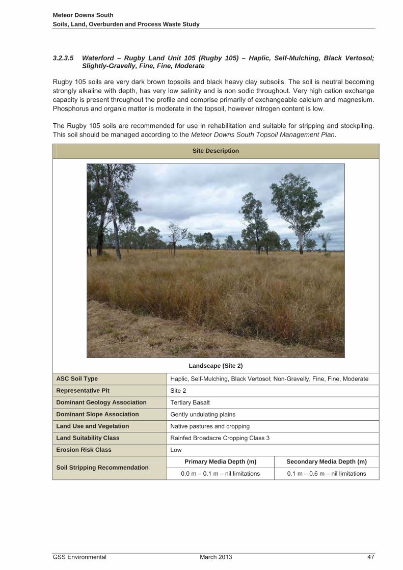
Meteor Downs SouthSoils, Land, Overburden and Process Waste Study
3.2.3.5 Waterford – Rugby Land Unit 105 (Rugby 105) – Haplic, Self-Mulching, Black Vertosol;Slightly-Gravelly, Fine, Fine, Moderate
Meteor Downs South Topsoil Management Plan
Site Description
Landscape (Site 2)
ASC Soil Type
Representative Pit
Dominant Geology Association
Dominant Slope Association
Land Use and Vegetation
Land Suitability Class
Erosion Risk Class
Soil Stripping RecommendationPrimary Media Depth (m) Secondary Media Depth (m)

Meteor Downs SouthSoils, Land, Overburden and Process Waste Study
Profile
Physical Characteristics
Horizon Depth (m) Description
-1.20
-1.00
-0.80
-0.60
-0.40
-0.20
0.00
-1.20
-1.00
-0.80
-0.60
-0.40
-0.20
0.000 5 10
Dept
h (m
)
Dept
h (m
)
EC and pH
ECpH
0% 50% 100%
0.8-1.0
0.5-0.8
0.1-0.5
0.0-0.1
Mineral Fraction (%)
Dept
h (m
)
Particle Size Analysis clay
Silt
f. Sand
c. Sand
gravel
Clay
Clay
Clay
Clay 0% 50% 100%
0.8-1.0
0.5-0.8
0.1-0.5
0.0-0.1
Exchangeable Cations (%)
Dept
h (m
)
Exchangeable Cations
CaKMgNa

Meteor Downs SouthSoils, Land, Overburden and Process Waste Study
Analytical Description1
Analyte Units A1 B21 B22
(This section of the page has intentionally been left blank)

Meteor Downs SouthSoils, Land, Overburden and Process Waste Study
Site Description
Landscape (Site 7)
ASC Soil Type
Representative Pit
Dominant Geology Association
Dominant Slope Association
Land Use and Vegetation
Land Suitability Class
Erosion Risk Class
Soil Stripping RecommendationPrimary Media Depth (m) Secondary Media Depth (m)

Meteor Downs SouthSoils, Land, Overburden and Process Waste Study
Profile
Physical Characteristics
Horizon Depth (m) Description
-0.70
-0.60
-0.50
-0.40
-0.30
-0.20
-0.10
0.00
-0.70
-0.60
-0.50
-0.40
-0.30
-0.20
-0.10
0.000 5 10
Dept
h (m
)
Dept
h (m
)
EC and pH
ECpH
0% 50% 100%
0.6+
0.4-0.6
0.1-0.4
0.0-0.1
Mineral Fraction (%)
Dept
h (m
)
Particle Size Analysis clay
Silt
f. Sand
c. Sand
gravel
Clay
Clay
Clay
Clay
0% 50% 100%
0.6+
0.4-0.6
0.1-0.4
0.0-0.1
Cation Exchange Capacity (%)
Dept
h (m
)
Exchangeable Cations
Ca

Meteor Downs SouthSoils, Land, Overburden and Process Waste Study
Analytical Description1
Analyte Units A1 B2 C
(This section of the page has intentionally been left blank)

Meteor Downs SouthSoils, Land, Overburden and Process Waste Study
Site Description
Landscape (Site 9)
ASC Soil Type
Representative Pit
Dominant Geology Association
Dominant Slope Association
Land Use and Vegetation
Land Suitability Class
Erosion Risk Class
Soil Stripping RecommendationPrimary Media Depth (m) Secondary Media Depth (m)

Meteor Downs SouthSoils, Land, Overburden and Process Waste Study
Profile
Physical Characteristics
Horizon Depth (m) Description
-0.60
-0.50
-0.40
-0.30
-0.20
-0.10
0.00
-0.60
-0.50
-0.40
-0.30
-0.20
-0.10
0.000 5 10
Dept
h (m
)
Dept
h (m
)
EC and pH
ECpH
0% 50% 100%
0.4-0.6
0.1-0.4
0.0-0.1
Mineral Fraction (%)
Dept
h (m
)
Particle Size Analysis clay
Silt
f. Sand
c. Sand
gravel
Silty Clay Loam
Loam
Clay Loam
0% 50% 100%
0.4-0.6
0.1-0.4
0.0-0.1
Cation Exchange Capacity (%)
Dept
h (m
)
Exchangeable Cations
Ca

Meteor Downs SouthSoils, Land, Overburden and Process Waste Study
Analytical Description1
Analyte Units A1 B21 B22
(This section of the page has intentionally been left blank)

Meteor Downs SouthOverburden Assessment
4.0 OVERBURDEN ASSESSMENT
4.1 Background
4.2 Overburden Assessment Methodology
Figure 4-1
Table 4-1Table 4-2

LEGEND
Version Date: Author: Checked: Approved:
FIGURE 4.1 Project:
Client:
File:
Projection:
V:\MEM08-001\Figures\Final\CAD\Fg4.1_MEM08-001_OverburdenSamplingSites_130221.dwgTo be printed A4
21/02/2013
0 2km1km
Base Plan Data Source: Google Earth Pro
Scale 1:45 000

Meteor Downs SouthOverburden Assessment
Table 4-1 Overburden Samples Selected for Geochemical Testing (ORD130HC1)

Meteor Downs SouthOverburden Assessment

Meteor Downs SouthOverburden Assessment
Table 4-2 Overburden samples selected for geochemical testing (ORD133HC1)
Sample ID
Sample Code
Depth from (m)
Depth to (m)
Stratum Lithology
Horizon Analytes
Analytes assessed for all collected samples as follows:

Meteor Downs SouthOverburden Assessment
Sample ID
Sample Code
Depth from (m)
Depth to (m)
Stratum Lithology
Horizon Analytes
Appendix 3
4.2.1 pH
4.2.2 Electrical Conductivity
4.2.3 Exchangeable Cations & Exchangeable Sodium Percentage (ESP)

Meteor Downs SouthOverburden Assessment
4.2.4 Acid Base Accounting
in lieu
4.2.4.1 Total Sulfur
4.2.4.2 Maximum Potential Acidity
4.2.4.3 Acid Neutralising Capacity

Meteor Downs SouthOverburden Assessment
4.2.4.4 Net Acid Producing Potential
4.2.4.5 Net Acid Generation (NAG) Test
4.2.4.6 Single Addition NAG Test
4.2.4.7 Sample Classification
Table 4-3

Meteor Downs SouthOverburden Assessment
Table 4-3 Sample Classification of Acid producing potential
Total Oxidisable Sulfur NAPP Sample Classification
TOS
TOS NAPP
TOS
TOS NAPP
*Modified from the Managing Acid and Metalliferous Drainage, Leading Practice Sustainable Development Program for the Mining Industry, 2007
4.2.5 Metal Scans

Meteor Downs SouthSoils, Land, Overburden and Process Waste Study
4.3 Geochemical Characterisation Results of Overburden Material
Appendix 3
4.3.1 pH
53 31Table 4-4
Appendix 3 Laboratory Results Table 4-4
Table 4-4 pH Ratings Results
Drill Core/Overburden
HorizonStandard pH Range Average OX pH
Range Average

Meteor Downs SouthSoils, Land, Overburden and Process Waste Study
4.3.2 Electrical Conductivity
(Table 4-5)
7.4.1
Table 4-5 EC Ratings Results
Drill Core/Overburden
Horizon
Measured EC Range (μS/cm)
AverageStandardized
EC Range (dS/m)
Average
4.3.3 Cation Exchange Capacity and Sodicity
Table 4-6) Table 4-7)
Table 4-8.
Table 4-6 Reference Ratings for Cation Exchange Capacity
CEC Rating CEC meq/100g
Table 4-7 Reference Ratings for Exchangeable Sodium Percentage (ESP)
ESP Characteristic ESP Average (%)

Meteor Downs SouthSoils, Land, Overburden and Process Waste Study
Table 4-8 Overburden Ratings Summary for CEC and ESP
Drill Core/Overburden
Horizon
Measured CEC Range (meq/100g)
CEC Average
(meq/100g)CEC
RatingESP Range
(%) ESP
Average (%)
Characteristic
Figure 4-2
(This section of the page has intentionally been left blank)

Meteor Downs SouthSoils, Land, Overburden and Process Waste Study
Figure 4-2 Exchangeable Sodium Percentage Depth Profile
4.3.4 Acid Base (NAPP) Results
Figure 4-3 Figure 4-9

Meteor Downs SouthSoils, Land, Overburden and Process Waste Study
Figure 4-3
Figure 4-4
Figure 4-5
Table 4-1
Figure 4-6
Figure 4-7
Figure 4-8 Figure 4-9
(This section of the page has intentionally been left blank)

Met
eor D
owns
Sou
thSo
ils, L
and,
Ove
rbur
den
and
Proc
ess
Was
te S
tudy
Figu
re 4
-3 C
orre
latio
n be
twee
n O
verb
urde
n TO
S an
d N
APP
valu
es, a
ll sa
mpl
es

Met
eor D
owns
Sou
thSo
ils, L
and,
Ove
rbur
den
and
Proc
ess
Was
te S
tudy
Figu
re 4
-4 C
orre
latio
n be
twee
n O
verb
urde
n TO
S an
d N
APP
valu
es, B
asal
t Ove
rbur
den
Sam
ples

Met
eor D
owns
Sou
thSo
ils, L
and,
Ove
rbur
den
and
Proc
ess
Was
te S
tudy
Figu
re 4
-5 C
orre
latio
n be
twee
n O
verb
urde
n TO
S an
d N
APP
valu
es, T
ertia
ry O
verb
urde
n Sa
mpl
es

Met
eor D
owns
Sou
thSo
ils, L
and,
Ove
rbur
den
and
Proc
ess
Was
te S
tudy
Figu
re 4
-6 C
orre
latio
n be
twee
n O
verb
urde
n TO
S an
d N
APP
valu
es, P
erm
ian
Ove
rbur
den
Sam
ples

Met
eor D
owns
Sou
thSo
ils, L
and,
Ove
rbur
den
and
Proc
ess
Was
te S
tudy
Figu
re 4
-7 C
orre
latio
n be
twee
n O
verb
urde
n TO
S an
d N
APP
valu
es, P
erm
ian
Inte
rbur
den
Sam
ples

Meteor Downs SouthSoils, Land, Overburden and Process Waste Study
Figure 4-8 NAF-PAF Signatures of Overburden Horizons, Core ORD130HC1

Meteor Downs SouthSoils, Land, Overburden and Process Waste Study
Figure 4-9 NAF-PAF Signatures of Overburden Horizons, Core ORD133HC1

Meteor Downs SouthSoils, Land, Overburden and Process Waste Study
4.3.5 Metal Scans
Table 4-9
(This section of the page has intentionally been left blank)

Met
eor D
owns
Sou
thSo
ils, L
and,
Ove
rbur
den
and
Proc
ess
Was
te S
tudy
Tabl
e 4-
9: M
eteo
r Dow
ns O
verb
urde
n an
d In
terb
urde
n M
etal
Sca
n R
esul
ts
Met
al
Ove
rbur
den
Res
ults
Inte
rbur
den
Resu
ltsH
ealth
In
vest
igat
ion
Leve
ls
(HIL
's)
(Exp
osur
e Se
tting
E -
NEP
C 19
99)
(mg/
kg)
Envi
ronm
enta
l In
vest
igat
ion
Leve
ls (Q
LD
AMAD
,199
5)(m
g/kg
)
Bas
alt H
oriz
onTe
rtia
ry H
oriz
onPe
rmia
n Ho
rizon
Inte
rbur
den
Horiz
on
Rang
e (m
g/kg
)Av
erag
e(m
g/kg
)Ra
nge
(mg/
kg)
Aver
age
(mg/
kg)
Rang
e (m
g/kg
)Av
erag
e (m
g/kg
)Ra
nge
(mg/
kg)
Aver
age
(mg/
kg)

Met
eor D
owns
Sou
thSo
ils, L
and,
Ove
rbur
den
and
Proc
ess
Was
te S
tudy
Met
al
Ove
rbur
den
Res
ults
Inte
rbur
den
Resu
ltsH
ealth
In
vest
igat
ion
Leve
ls
(HIL
's)
(Exp
osur
e Se
tting
E -
NEP
C 19
99)
(mg/
kg)
Envi
ronm
enta
l In
vest
igat
ion
Leve
ls (Q
LD
AMAD
,199
5)(m
g/kg
)
Bas
alt H
oriz
onTe
rtia
ry H
oriz
onPe
rmia
n Ho
rizon
Inte
rbur
den
Horiz
on
Rang
e (m
g/kg
)Av
erag
e(m
g/kg
)Ra
nge
(mg/
kg)
Aver
age
(mg/
kg)
Rang
e (m
g/kg
)Av
erag
e (m
g/kg
)Ra
nge
(mg/
kg)
Aver
age
(mg/
kg)

Meteor Downs SouthSoils, Land, Overburden and Process Waste Study
4.3.6 Volume Estimates for Overburden and Interburden (Reject) NAF and PAF Material
Table 4-10
Figure 4-10
(This section of the page has intentionally been left blank)

Met
eor D
owns
Sou
thSo
ils, L
and,
Ove
rbur
den
and
Proc
ess
Was
te S
tudy
Tabl
e 4-
10M
eteo
r Dow
ns E
stim
ated
NAF
and
PAF
Mat
eria
l Gen
erat
ion
Bas
ed o
n M
ine
Sche
dule
Mat
eria
l Cat
egor
yUn
itsVo
lum
e of
mat
eria
l gen
erat
ed p
er y
ear
Tota
l Vo
lum
e20
1320
1420
1520
1620
1720
1820
1920
2020
2120
2220
23
Estim
ated
ava
ilabl
e ov
erbu
rden
was
te m
ater
ial
BC
M7,
470,
178
7,52
6,95
89,
344,
247
7,95
4,64
17,
964,
548
8,27
2,66
48,
185,
432
7,73
6,99
66,
419,
779
3,49
3,90
614
3,53
374
,512
,883
NAF
(Ove
rbur
den
Mat
eria
l co
mpo
site
, in
clud
es B
asal
t, Te
rtia
ry S
edim
enta
ry a
nd
non-
PAF
Perm
ian
Hor
izon
)B
CM
6,14
5,64
76,
287,
659
5,36
0,92
84,
197,
230
3,82
2,03
53,
714,
621
3,84
7,76
43,
767,
812
3,23
0,12
11,
406,
267
0 41
,780
,085
UC
-PAF
(Ove
rbur
den
Mat
eria
l Adj
acen
t to
Inte
rbur
den)
BC
M1,
324,
531
1,23
9,29
93,
983,
319
3,75
7,41
14,
142,
513
4,55
8,04
34,
337,
668
3,96
9,18
43,
189,
658
2,08
7,63
914
3,53
332
,732
,798
UC
-PAF
(All
Inte
rbur
den/
Reje
ct M
ater
ial)
BC
M93
,959
45,8
7796
,137
123,
994
160,
685
179,
299
167,
561
129,
761
114,
518
59,0
3810
,297
1,18
1,12
7

Met
eor D
owns
Sou
thSo
ils, L
and,
Ove
rbur
den
and
Proc
ess
Was
te S
tudy
Figu
re 4
-10
Gra
ph o
f pro
ject
ed N
AF-P
AF g
ener
atio
n w
ithin
the
oper
atin
g lif
e of
min
e

Meteor Downs SouthSoils, Land, Overburden and Process Waste Study
4.4 Chemical Characterisation of Interburden (Reject Materials) and Tailings
Table 4-9 Table 4-10
Table 4-9 Meteor Downs Interburden (Reject Solids) Chemistry
Analytes Units
SampleORD130HC1
9991 INTERBURDEN
ORD130HC1 9992
INTERBURDEN
ORD133HC1 117363
INTERBURDEN

Meteor Downs SouthSoils, Land, Overburden and Process Waste Study
Analytes Units Sample
Table 4-10 Meteor Downs Interburden (Reject) Leachate Chemistry
Analyte Units
SampleORD130HC1
9991 INTERBURDEN
ORD130HC1 9992
INTERBURDEN
ORD133HC1 117363
INTERBURDEN
Figure 4-7
(This section of the page has intentionally been left blank)

Meteor Downs SouthSoils, Land, Overburden and Process Waste Study
5.0 LAND SUITABILITY ASSESSMENTS
5.1 Methods
Planning Guidelines: The Identification of Good Quality Agricultural Land
5.1.1Strategic Cropping Land Assessment
Figure 5-1
Strategic Cropping Land Act 2011.
Criterion 1
Criterion 2 -
Criterion 3 -
Criterion 4 -
Criterion 5 -
Criterion 6 -
Criterion 7 -
Criterion 8 -

Meteor Downs SouthSoils, Land, Overburden and Process Waste Study
5.1.2 Land Suitability
Table 5-1
(This section of the page has intentionally been left blank)

Meteor Downs SouthLand Suitability Assessments
Table 5-1 Scheme for Classifying Land Suitability
Orders Class Class Descriptor Description
Table 5-2Table 5-3.
Table 5-2 Effective Rooting Depth Criteria (DERM 2011c)
Descriptor ERD occurs where:

Meteor Downs SouthLand Suitability Assessments
Table 5-3 Current and draft Land Suitability PAWC Guidelines
Guideline Source
Land Suitability ranking for rain fed cropping
1 2 3 4 5
DME (1995)
Burgess 2010
Guideline Source Land suitability ranking for beef cattle grazing
1 2 3 4 5
DME (1995)
Burgess 2010
5.1.3 Agricultural Land Classes
Planning Guidelines: The Identification of Good Quality Agricultural Land .
Table 5-4
Table 5-5.Table 5-6

Meteor Downs SouthLand Suitability Assessments
Table 5-4 Agricultural Land Class System
Class Description
A
B
C
D
Table 5-5 Broadacre Cropping Land Suitability Ranking and Agricultural Land Class Correlation
LS Ranking Description ALC
Table 5-6 Land Suitability Ranking and Agricultural Land Class Correlation
LS Class
LS Description (DME, 1995) ALC
Pastoral Management and Typical Vegetative Cover

Meteor Downs SouthLand Suitability Assessments
5.1.4 Good Quality Agricultural Land (GQAL)
5.2 Results 5.2.1 Plant Available Water Content
Table 5-7
Table 5-7 Effective Rooting Depth and Plant Available Water Capacity
GSSE Representative Soil Type ERD Depth Limitation PAWC
Site# Map unit/soil family
ASC m mm
Oxford Land System
Waterford Land System
5.2.2 Strategic Cropping Land (SCL)
Appendix 1Table 5-8

Meteor Downs SouthLand Suitability Assessments
Figure 5-2
Table 5-8.
Table 5-8 SCL Assessment Criterion
Map Unit/Soil Family
Site # Comments
SCL Criterion
SCL
1-sl
ope
(s)
2-ro
ckin
ess
(r)
3-gi
lgai
mic
rore
lief
(g)
4- s
oil d
epth
(d)
5- w
etne
ss (w
)
6= p
H (p
)
7- s
alin
ity (e
)
8- w
ater
sto
rage
(w)
P P P P P P P F No
P P P F No
P P P P P P P F No
P P P F No
P P P P P P P P Yes
P P P P P P P P Yes
P P P F No
P P P P P P P P Yes

Meteor Downs SouthLand Suitability Assessments
5.2.3 Confirmed SCL
Plate 5-1
Table 3-3
Plate 5-1 Strategic Cropping Land at S11
Strategic Cropping Land Act
5.2.4 Agricultural Land Classes (ALC)
Table 5-9
Figure 5-3
5.2.5 Good Quality Agricultural Land (GQAL)
Figure 5-4

Meteor Downs SouthLand Suitability Assessments
5.2.6 Land Suitability
Table 5-9
Figure 5-5Figure 5-6
Table 5-9 Land Suitability Assessment
GSSE Representative Soil TypeMain
Limitation(s)1
Rainfed Cropping
Main Limitation
(s)1
Beef Cattle
Grazing
ALC
Clas
s
Site #
Map Unit/Soil Family
ASC Description Class Description Class
Oxford Land System
Waterford Land System

FIGURE 5.1
V:\MEM08-001\Figures\Final\CAD\Fg5.1_MEM08-001_SCLTriggerZones_130221.dwgTo be printed A4

LEGEND
Version Date: Author: Checked: Approved:
FIGURE 5.2 Project:
Client:
File:
Projection:
V:\MEM08-001\Figures\Final\CAD\Fg5.2_MEM08-001_SlopeAnalysis_130221.dwgTo be printed A4
21/02/2013
0 2km1km
Base Plan Data Source: Google Earth Pro
Scale 1:45 000

LEGEND
Version Date: Author: Checked: Approved:
FIGURE 5.3 Project:
Client:
File:
Projection:
V:\MEM08-001\Figures\Final\CAD\Fg5.3_MEM08-001_GoodQualityAgLand_130221.dwgTo be printed A4
Good Quality Agricultural Land
21/2/2013
0 2km1km
Scale 1:45 000
Base Plan Data Source: Google Earth Pro

LEGEND
Version Date: Author: Checked: Approved:
FIGURE 5.4 Project:
Client:
File:
Projection:
V:\MEM08-001\Figures\Final\CAD\Fg5.4_MEM08-001_AgriculturalLandClasses_130221.dwgTo be printed A4
Agricultural Land Classes
21/02/2013
0 2km1km
Scale 1:45 000
1

LEGEND
Version Date: Author: Checked: Approved:
FIGURE 5.5 Project:
Client:
File:
Projection:
V:\MEM08-001\Figures\Final\CAD\Fg5.5_MEM08-001_RainfedCropping_130221.dwgTo be printed A4
Rainfed Cropping Land
Base Plan Data Source: Google Earth Pro
21/02/2013
0 2km1km
Scale 1:45 000

LEGEND
Version Date: Author: Checked: Approved:
FIGURE 5.6 Project:
Client:
File:
Projection:
V:\MEM08-001\Figures\Final\CAD\Fg5.6_MEM08-001_BeefCattleGrazing_130221.dwgTo be printed A4
Beef Cattle Grazing Land
Base Plan Data Source: Google Earth Pro
21/02/2013
0 2km1km
Scale 1:45 000

FIGURE 5.7
V:\MEM08-001\Figures\Final\CAD\Fg5.7_MEM08-001_SCGroundTruthing_130222.dwgTo be printed A4

Meteor Downs SouthSoils, Land, Overburden and Process Waste Study
6.0 DISTURBANCE MANAGEMENT
Figure 6-1
6.1 Disturbance Footprint
6.2 Soil Resource Assessment
6.2.1 Soil Stripping Assessment
primary media secondary media Table 6-1
Figure 6-2Figure 6-3
(This section of the page has intentionally been left blank)

Meteor Downs SouthDisturbance Management
Table 6-1 Growth Media Stripping Depths
Representative Soil Type
Primary Media Recommended
Stripping Depth
Secondary Media
Recommended Stripping
Depth
Main Limitation(s) Suitability1
Site #
Map Unit/ Soil Type ASC m m Description
Oxford Land System
Waterford Land System
6.2.2 Topdressing Volumes
Table 6-2

Meteor Downs SouthDisturbance Management
Appendix 2
Table 6-2 Topsoil and Subsoil Volumes for Rehabilitation works
521 683,000 2,469,000
6.3 Topdressing Management
TopsoilManagement Plan Appendix 2
6.4 Rehabilitation Objective and Post-development Agricultural Land Class
Figure 6-6
Meteor Downs SouthDisturbance Management
6.5 Soil Erosion Hazard
6.5.1 Methodology
Section 6.2.1Section 6.2.2
6.5.2 Soil Erosion Hazard Assessment
Figure 6-4 Figure 6-5Table 6-3

Met
eor D
owns
Sou
thD
istu
rban
ce M
anag
emen
t
Tabl
e 6-
3 Er
osio
n H
azar
dAs
sess
men
t
Soil
Type
Area
Dom
inan
t Slo
pePr
imar
yM
edia
K
Fact
or
Prim
ary
Med
ia
Eros
ion
Haz
ard
Seco
ndar
y M
edia
K
Fact
or
Seco
ndar
y M
edia
Er
osio
n H
azar
d
Soil
type
#
Map
U
nit/S
oil
Type
ASC
(ha)
%
D
escr
iptio
nR
atin
gR
atin
g
Oxf
ord
undu
latin
g lo
wla
nds
and
plai
ns
Wat
erfo
rd L
ow H
ills
Tota
l16
0610
0

Meteor Downs SouthSoils, Land, Overburden and Process Waste Study
6.5.3 Results
Table 6-4Table 6-5.
(This section of the page has intentionally been left blank)

Met
eor D
owns
Sou
thSo
ils, L
and,
Ove
rbur
den
and
Proc
ess
Was
te S
tudy
Tabl
e 6-
4 Pr
imar
y M
edia
RU
SLE
Res
ults
Fact
orR
epre
sent
ativ
e So
il Ty
pes
1 2
3 7
8 9
1014
1211
A (fl
ats)
= (t
onne
/ha/
yr)
4536
4338
4974
3833
3833
A (s
lope
s) =
(ton
ne/h
a/yr
)28
122
527
023
630
346
123
620
223
620
2
Tabl
e 6-
5 Se
cond
ary
Med
ia R
USL
E R
esul
ts
Fact
orR
epre
sent
ativ
e So
il Ty
pes
1 2
3 7
8 9
1014
1211
A (fl
ats)
= (t
onne
/ha/
yr)
4745
3836
6554
3647
3840
A (s
lope
s) =
(ton
ne/h
a/yr
)29
228
123
622
540
433
722
529
223
624
7

V:\MEM08-001\Figures\Final\CAD\Fg6.1_MEM08-001_ProjectDisturbanceFootprint_130306.dwg
FIGURE 6.1

LEGEND
Version Date: Author: Checked: Approved:
FIGURE 6.2 Project:
Client:
File:
Projection:
Fg6.2_MEM08-001_PrimaryMediaRecStrippingDepth_Infra_130221
V:\MEM08-001\Figures\Final\CAD\Fg6.2_MEM08-001_PrimaryMediaRecStrippingDepth_Infra_130221.dwgTo be printed A4
Primary MediaRecommended Stripping depth
21/02/2013
0 2km1km
Scale 1:45 000

LEGEND
Version Date: Author: Checked: Approved:
FIGURE 6.3 Project:
Client:
File:
Projection:
V:\MEM08-001\Figures\Final\CAD\Fg6.3_MEM08-001_SecondaryMediaRecStrippingDepth_130221.dwgTo be printed A4
Secondary MediaRecommended Stripping Depth
21/02/2013
0 2km1km
Scale 1:45 000
Base Plan Data Source: Google Earth Pro

LEGEND
Version Date: Author: Checked: Approved:
FIGURE 6.4 Project:
Client:
File:
V:\MEM08-001\Figures\Final\CAD\Fg6.4_MEM08-001_PrimaryMediaErosionHazrdMap_130221.dwgTo be printed A4
Primary MediaErosion Hazard Map
21/02/2013
Base Plan Data Source: Google Earth Pro
0 2km1km
Scale 1:45 000

LEGEND
Version Date: Author: Checked: Approved:
FIGURE 6.5 Project:
Client:
File:
Projection:
V:\MEM08-001\Figures\Final\CAD\Fg6.5_MEM08-001_SecondaryMediaErosionHazrdMap_130221.dwgTo be printed A4
Secondary MediaErosion Hazard Map
21/02/2013
Base Plan Data Source: Google Earth Pro
0 2km1km
Scale 1:45 000

LEGEND
Version Date: Author: Checked: Approved:
FIGURE 6.6 Project:
Client:
File:
Projection:
V:\MEM08-001\Figures\Final\CAD\Fg6.6_MEM08-001_PostDevAgLandClasses_130306.dwgTo be printed A4
Proposed Post DevelopmentAgricultural Land Classes
06/03/2013
0 2km1km
Scale 1:45 000
1

Meteor Downs SouthSoils, Land, Overburden and Process Waste Study
7.0 CONCLUSIONS
7.1 Strategic Cropping Land Constraints
Figure 5.7
Table 7-1
Table 7-1 Comparison of Trigger Maps to Survey Findings
Area Ha %
7.2 Good Quality Agricultural Land Constraints

Meteor Downs SouthSoils, Land, Overburden and Process Waste Study
7.3 Land Suitability
7.4 Overburden material
7.4.1 Overburden Material
Table 7-2 Salinity and pH criteria for assessment of coal and mining waste materials

Meteor Downs SouthSoils, Land, Overburden and Process Waste Study
Table 4-3
7.4.2 Interburden (Reject) Material Summary and Recommendations
Table 4-10

Meteor Downs SouthSoils, Land, Overburden and Process Waste Study
7.5 Erosion and Sediment Control Recommendations
Erosion and Sediment Control PlanErosion and Sediment Control Plan
7.5.1 Minimising Disturbance
7.5.2 Surface Water Diversion

Meteor Downs SouthSoils, Land, Overburden and Process Waste Study
7.5.3 Stockpiles
Topsoil Management Plan Appendix 2).
7.6 Monitoring
Table 7-3

Meteor Downs SouthSoils, Land, Overburden and Process Waste Study
Table 7-3 Proposed Success Criteria for Erosion
Rehabilitation Objective
Indicator Success Criteria
7.7 Landform Stability
Table 7-4

Meteor Downs SouthSoils, Land, Overburden and Process Waste Study
Table 7-4 Proposed Success Criteria for Land Stability
Rehabilitation Objectives
Indicators Success Criteria
7.8 Disturbance Management
7.8.1 Topsoil Management Recommendations

Meteor Downs SouthSoils, Land, Overburden and Process Waste Study
(This section of the page has intentionally been left blank)

Meteor Downs SouthSoils, Land, Overburden and Process Waste Study
8.0 GLOSSARY
Term/Abbreviation Description

Meteor Downs SouthSoils, Land, Overburden and Process Waste Study
Term/Abbreviation Description
Strategic Cropping Land Act

Meteor Downs SouthSoils, Land, Overburden and Process Waste Study
Term/Abbreviation Description

Meteor Downs SouthSoils, Land, Overburden and Process Waste Study
9.0 LIMITATIONS

Meteor Downs SouthSoils, Land, Overburden and Process Waste Study
10.0 REFERENCES

Meteor Downs SouthSoils, Land, Overburden and Process Waste Study
What do all the numbers mean?

Meteor Downs SouthSoils, Land, Overburden and Process Waste Study
(This section of the page has intentionally been left blank)

Meteor Downs SouthSoils, Land, Overburden and Process Waste Study
11.0 APPENDICES
Appendix 1
Soil Laboratory Results
Soil Site Sampling Location Number Conversion Table
Field site number. as per ALS Laboratory Certificate of Analysis
Equivalent site number used in this report.
001 S1002 S2004 S3006 S4007 S5008 S6009 S7011 S8012 S9014 S10034 S11035 S12036 S13037 S14038 S15040 S16041 S17


Experienced people protecting your resources
Page 1 of 2
709 Gundy Road, Scone NSW 2337PO Box 283, Scone NSW 2337
P: 02 6545 1666F: 02 6545 2520M: 0408 446 132
Australian Laboratory Services32 Shand StreetStafford Qld 4053
17 July 2012 SCO12/174R1
Dear Sir/Madam
Soil erodibility factor – Twenty eight soil samples (EB1213989)
The soil erodibility factor (K factor) has been determined (as described by Rosewell 1993) for soil test report SCO12/174R1 (Ref: 1213989) using the particle size analysis-mechanical dispersion (clay, silt, fine sand, coarse sand and gravel) and the organic carbon (OC). The surface soil structure was assumed to be medium granular and the profile permeability was assumed to be slow to moderate.

SCO12/174R1 Page 2 of 2
Lab No Sample Id K factor Rating1 8 0.019 Low2 9 0.020 Low3 10 0.018 Low4 21 0.020 Moderate5 22 0.025 Moderate6 23 0.025 Moderate7 24 0.028 Moderate8 32 0.025 Moderate9 33 0.026 Moderate
10 34 0.034 Moderate11 35 0.038 Moderate12 51 0.027 Moderate13 52 0.036 Moderate14 53 0.032 Moderate15 54 0.029 Moderate16 62 0.020 Moderate17 63 0.022 Moderate18 64 0.033 Moderate19 71 0.021 Moderate20 72 0.020 Moderate21 73 0.019 Low22 74 0.018 Low23 81 0.041 High24 82 0.030 Moderate25 83 0.025 Moderate26 93 0.024 Moderate27 94 0.021 Moderate28 95 0.031 Moderate
This interpretation was based on the soil samples being representative, and literature guidelines. If you have any queries, please contact me on (02) 6545 1666.
Yours sincerely
SR Young
References
Rosewell CJ (1993) Soiloss – A program to assist in the selection of management practices to reduce erosion. Department of Conservation and Land Management.

SOIL TEST REPORT
Scone Research Centre

SOIL
CO
NSE
RV
AT
ION
SE
RV
ICE
Sc
one
Res
earc
h Se
rvic
e C
entr
e

SOIL
CO
NSE
RV
AT
ION
SE
RV
ICE
Sc
one
Res
earc
h Se
rvic
e C
entr
e


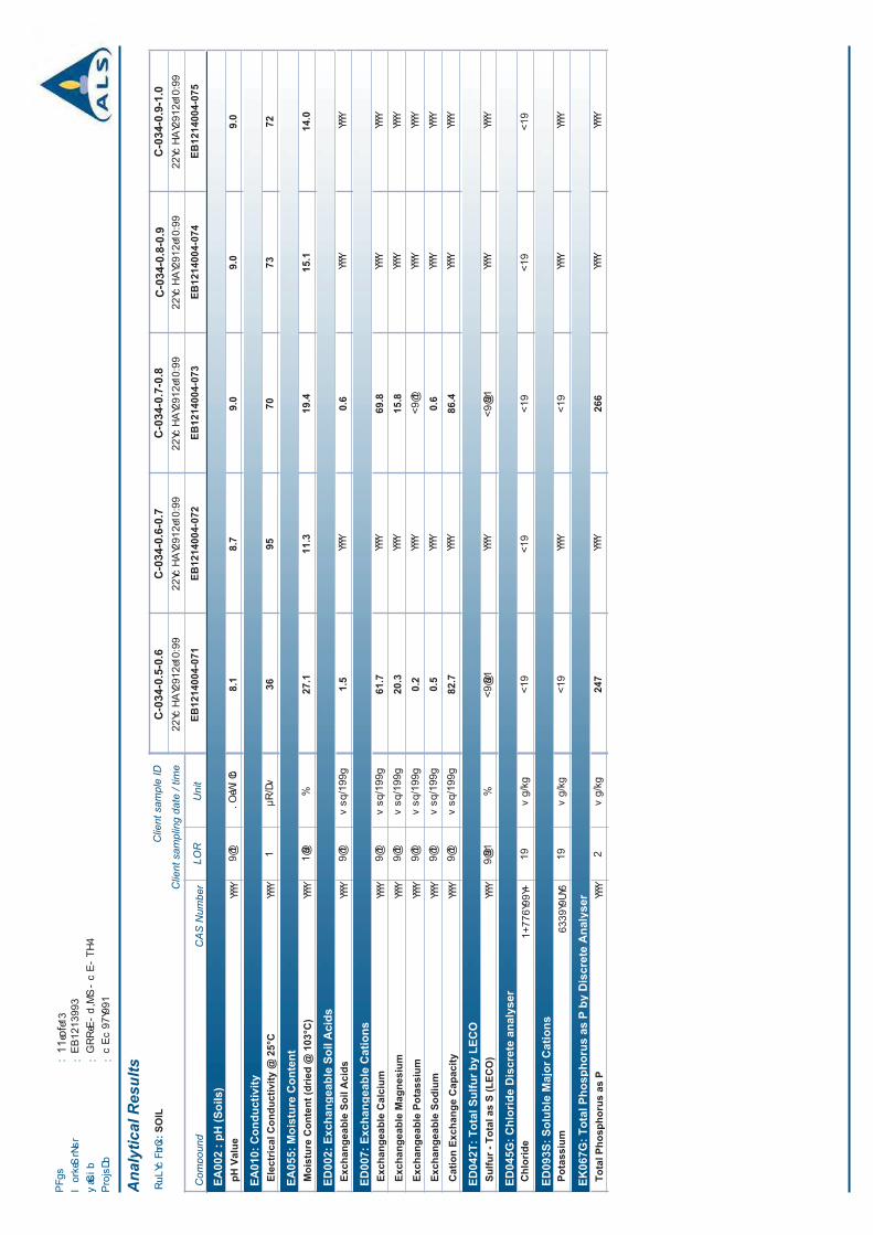


Experienced people protecting your resources
Page 1 of 2
709 Gundy Road, Scone NSW 2337PO Box 283, Scone NSW 2337
P: 02 6545 1666F: 02 6545 2520M: 0408 446 132
Australian Laboratory Services32 Shand StreetStafford Qld 4053
19 July 2012 SCO12/175R1
Dear Sir/Madam
Soil erodibility factor – Fifteen soil samples (EB1214004)
The soil erodibility factor (K factor) has been determined (as described by Rosewell 1993) for soil test report SCO12/175R1 (Ref: EB1214004) using the particle size analysis-mechanical dispersion (clay, silt, fine sand, coarse sand and gravel) and the organic carbon (OC). The surface soil structure was assumed to be medium granular and the profile permeability was assumed to be slow to moderate.
Lab No Sample Id K factor Rating
1 26 0.026 Moderate2 27 0.027 Moderate3 28 0.036 Moderate4 29 0.049 High5 39 0.024 Moderate6 40 0.025 Moderate7 41 0.031 Moderate8 42 0.038 Moderate9 76 0.026 Moderate10 77 0.024 Moderate11 78 0.024 Moderate12 79 0.049 High13 88 0.025 Moderate14 89 0.026 Moderate15 90 0.061 Very high
This interpretation was based on the soil samples being representative, and literature guidelines. If you have any queries, please contact me on (02) 6545 1666.

SCO12/175R1 Page 2 of 2
Yours sincerely
SR Young
References
Rosewell CJ (1993) Soiloss – A program to assist in the selection of management practices to reduce erosion. Department of Conservation and Land Management.

SOIL TEST REPORT
Scone Research Centre

SOIL
CO
NSE
RV
AT
ION
SE
RV
ICE
Sc
one
Res
earc
h Se
rvic
e C
entr
e

Meteor Downs SouthSoils, Land, Overburden and Process Waste Study
Appendix 2
Topsoil Management Plan

Meteor Downs South Topsoil Management Plan

Meteor Downs SouthSoil, Land, Overburden and Process Waste Study Topsoil Management Plan
GSS Environmental March 2013 2
1. Introduction
1.1.Description
1.2.Scope
Meteor Downs SouthSoil, Land, Overburden and Process Waste Study Topsoil Management Plan
GSS Environmental March 2013 3
2. Management
2.1. Environmental Aspects
2.2. Management Actions
2.2.1. Vegetation Clearance prior to Soil Stripping
2.2.2. Soil Stripping Procedure
Table 2.1

Meteor Downs SouthSoil, Land, Overburden and Process Waste Study Topsoil Management Plan
GSS Environmental March 2013 4
Table 2.1
Table 2.1 Stripping Recommendations
Soil Type Primary Media Secondary Media
Site #
Map Unit/ Soil Type ASC m m
2.2.3. Stockpile Establishment and Maintenance

Meteor Downs SouthSoil, Land, Overburden and Process Waste Study Topsoil Management Plan
GSS Environmental March 2013 5
Table 2.2
Table 2.2.3 Monitoring Procedure
Parameter Action Monitoring

Meteor Downs SouthSoil, Land, Overburden and Process Waste Study Topsoil Management Plan
GSS Environmental March 2013 6
Table 2.2.3 Monitoring Procedure
Parameter Action Monitoring
2.3. Objective and Performance Criteria
Table 2.3
Table 2.3. Key Performance Indicators
Parameter Target KPI

Meteor Downs SouthSoil, Land, Overburden and Process Waste Study Topsoil Management Plan
GSS Environmental March 2013 7
Table 2.3. Key Performance Indicators
Parameter Target KPI
3. Contingency Actions
3.1. Trigger/Action Tables
Table 3.1
Table 3.1 Triggers and Response Action
Trigger Action

Meteor Downs SouthSoil, Land, Overburden and Process Waste Study Topsoil Management Plan
GSS Environmental March 2013 8
4. Reporting of Performance Criteria

Meteor Downs SouthSoils, Land, Overburden and Process Waste Study
Appendix 3
Overburden Testing Laboratory Results


METEOR DOWNS SOUTH – REVISED STRATEGIC CROPPING LAND RESTORATION PLAN prepared by: Northern Resource Consultants Pty Ltd
Appendix C
Approved RIDA RPI14/002


METEOR DOWNS SOUTH – REVISED STRATEGIC CROPPING LAND RESTORATION PLAN prepared by: Northern Resource Consultants Pty Ltd
Appendix D
Approved RIDA RPI17/008